District Plan Main Modifications Consultation - October
220
Mid Sussex District Council District Plan Main Modifications Consultation 2 nd October – 13 th November 2017 Consultation Responses – Summary Report
-
Upload
khangminh22 -
Category
Documents
-
view
2 -
download
0
Transcript of District Plan Main Modifications Consultation - October

Mid Sussex District Council
District Plan Main Modifications Consultation 2nd October – 13th November 2017
Consultation Responses – Summary Report

District Plan Main Modifications: Consultation Responses
Following hearing sessions held to examine the soundness of the Mid Sussex District Plan, the Inspector indicated that a number of modifications were required in order for the Plan to be found ‘sound’. These modifications and the reasoning behind them are set out in examination documents ref MSDC8a-8e and MSDC20.
Consultation on the Main Modifications District Plan was held between 2nd October and 13th November 2017. In total, 1,223 representations were received, generating around 1,370 separate comments from individuals and organisations.
Full copies of every response have been sent to the Inspector for his consideration.
The response rates for each Main Modification were as follows:
Mod# Policy Comments GEN General comments/general objection/general support 7 HRA Habitats Regulations Assessment 6 SA Sustainability Appraisal 6
MM01 DP1: Sustainable Development in Mid Sussex 4 MM02 DP2: Sustainable Economic Development 7 MM03 DP3: Town Centre Development 1 MM04 DP5: Housing 35 MM05 DP5a: Planning to meet Future Housing Need 16 MM06 DP6: Settlement Hierarchy 160 MM07 DP7: General Principles for Strategic Development at Burgess Hill 4 MM08 DP8: Strategic Allocation to the east of Burgess Hill at Kings Way 2 MM09 DP9: Strategic Allocation to the north and north-west of Burgess Hill 4 MM10 DP9a: Strategic Allocation to the east of Pease Pottage 4 MM11 DP9b: Strategic Allocation to the north of Clayton Mills, Hassocks 1,037 MM12 DP13: New Homes in the Countryside 3 MM13 DP18: Securing Infrastructure 2 MM14 DP19: Transport 7 MM15 DP21: Communication Infrastructure 1 MM16 DP24: Character and Design 6 MM17 DP24a: Housing Density 8 MM18 DP26: Accessibility 4 MM19 DP27: Noise, Air and Light Pollution 1 MM20 DP28: Housing Mix 6 MM21 DP29: Affordable Housing 6 MM22 DP30: Rural Exception Sites 3 MM23 DP31: Gypsies, Travellers and Travelling Showpeople 4 MM24 DP32: Listed Buildings and Other Heritage Assets 1 MM25 DP33: Conservation Areas 2 MM26 DP35: Archaeological Sites 2 MM27 DP37: Biodiversity 6 MM28 DP38: Green Infrastructure 6 MM29 DP39: Sustainable Design and Construction 2 MM30 DP40: Renewable Energy Schemes 3 MM31 DP41: Flood Risk and Drainage 1 MM32 Chapter 5: Implementation and Monitoring of the District Plan 3
TOTAL 1,370
The following pages comprise summary reports for each Main Modification MM01 – MM32.

Summaries of the responses received during the consultation are published within this document, broken down into separate comments. In most cases, the full text of each representation has been included, but in some instances it has been necessary to summarise each response. In any case, the Inspector has been provided with a copy of the full, original response.
Note: technical reports/appendices may not always be included within the summary reports due to their length/format. In accordance with regulation (36) of The Town and Country Planning (Local Planning) (England) Regulations 2012, all responses, in full, are available to view at the District Council offices – Oaklands, Oaklands Road, Haywards Heath, RH16 1SS and individual responses can be requested by emailing [email protected].
Balcombe Residents – Responses to MM06
A total of 160 comments were made to MM06: DP6 Settlement Hierarchy of which 124 were made by Balcombe residents supporting the objection made by Balcombe Parish Council. A summary of the points made, and a list of the 124 individuals that responded to this Main Modification is included alongside the MM06 summary report that follows.
Hassocks Residents – Responses to MM11
A total of 1,037 comments were made to MM11: DP9b: Strategic Allocation to the north of Clayton Mills, Hassocks of which 1,018 were made by residents. A summary of the points made, and a list of the 1,018 individuals that responded to this Main Modification is included alongside the MM11 summary report that follows.

District Plan Main Modifications Consultation - Index of Organisations / Key Participants
Ref# Respondent Organisation Behalf Of 56 Ms S Mamoany Ardingly Parish Council 57 Ms C Leet Ashurst Wood Village Council 58 Mrs R Robertson Balcombe Parish Council 59 Mrs D Thomas Bolney Parish Council 61 Ms S Heynes Cuckfield Parish Council 63 Ms J Holden East Grinstead Town Council 65 Mr I Cumberworth Hassocks Parish Council 67 Mrs B O'Garra Horsted Keynes Parish Council
68 Mr S Hoyles Hurstpierpoint & Sayers Common Parish Council
69 Mrs C Irwin Lindfield Parish Council 70 Mrs V Grainger Lindfield Rural Parish Council 76 Mrs D Langston Twineham Parish Council 77 Mrs H Schofield West Hoathly Parish Council 87 Ms L Hobden Brighton and Hove City Council 89 Mr N Johnston Southern Gas Network 99 Ms E Brigden Crawley Borough Council
108 Ms H Hyland Environment Agency 116 Ms C Tester High Weald AONB Unit 117 Mr D Bowie Highways England 119 Mrs B Childs Horsham District Council 164 Ms S Solbra Southern Water 180 Ms L Brook Sussex Wildlife Trust 189 Mrs M Brigginshaw Wealden District Council 192 Ms C West West Sussex County Council 245 Ms G Kennedy Lindfield Preservation Society 415 Ms K Harrison Surrey County Council Surrey County Council 451 Mr R M Nailard The Greenfield Guardians 680 Mr M Pritchard NHS Horsham and Mid Sussex
2229 Mr D Evans 14681 Ms J Ashton Judith Ashton Associates Wates Developments LTD
14901 Mr D Wilson Savills (UK) Limited (Thames Water)
Thames Water Utilities Ltd (Thames Water)
14982 Mr M Brown CPRE - Mid Sussex
15135 Mr A Yarwood National Federation of Gypsy Liaison Groups
15175 Mrs L Howard South Downs National Park Authority
15279 Ms M Ashdown Natural England 15308 Mr N Kerslake 15616 Mr D Maher Barton Willmore Linden Homes (Hill Place Farm) 15663 Ms C Organ Barton Willmore Hallam Land Management
15705 Mr L Challenger Nexus Planning Gleeson Developments Ltd and Rydon Homes (Burgess Hill Northern Arc Development)
16412 Dr I Gibson 16427 Mr E Fielding 16436 Mr S Molnar Terence O'Rourke St Modwen 16449 Mr E Hanson Barton Willmore Glenbeigh Developments Ltd
(Hanlye Road Cuckfield)
16451 Mr A Fox Quod Mayfield Market Towns (MMT) Ltd.
16548 Ms L Mould Reigate and Banstead Borough Council
16766 Mr N Greenhalgh Village developments plc
17488 Mr C McClea Savills Wates - Burgess Hill Northern Arc
20110 Mr B Nam GL Hearn Anstone Development Limited 20117 Mr R Cartwright Mid Sussex Liberal Democrats 20140 Mrs A Moir 20271 Ms L Hutson Sport England 20317 Mr M Evans Gladman 20319 Mr A Ross Nexus Gleeson Developments Ltd
20327 AB Planning & Development Ltd Mr David Crowther
20338 Rt Hon N Herbert MP 20527 Mr W Cobley Terence O Rourke Gleeson
20534 Ms K Lamb DMH Stallard Welbeck Strategic Land LLP (Imberhorne Farm)
20771 Ms J Onuh Thakeham 20785 Miss A Harper PRP
21042 Mr C Wilsdon Hassocks and Hurst Liberal Democrats
21055 Mr W Matthews Labour Party - Hurstpierpoint and Hassocks
21118 Mr P Allin Boyer Barratt Southern Counties
21121 Ms K Lamb DMH Stallard Consortium 'Land West of Copthorne'
21137 Mr T Davies Planning Potential Welbeck Strategic Land II LLP 21142 Mr C Austin-Fell RPS Thakeham Homes 21143 Ms S Heron Rydon Homes 21148 Mr C Noel Strutt and Parker Mr P Rayner
21149 Ms J Onuh Thakeham Land west of Old Brighton Road south
21150 Ms K Munro Thakeham Land at Great Harwoods Farm
21151 Ms J Onuh Thakeham Land at Kemps Farm, Hurstpierpoint
21217 Ms R French The Gatwick Diamond Initiative Ltd
21218 Mr A Hodgson Star Planning and Development Welbeck Strategic Land III LLP

District Plan - Main Modifications Consultation - Responses GEN General Comments
Ref#
70
Respondent:Mrs V Grainger
Organisation:Lindfield Rural Parish Council
Behalf Of:Comment#1
The modifications were necesarry and important to be in place in order to reinforce the Lindfield and Lindfield Rural Neighbourhood Plan.
SupportMod: GEN
Ref#
77
Respondent:Mrs H Schofield
Organisation:West Hoathly Parish Council
Behalf Of:Comment#1
West Hoathly Parish Council considered the modifications to the Mid Sussex District plan at their meeting held on 30th October.
The Parish Council believe the modifications to be sound and legal.
SupportMod: GEN
Ref#
89
Respondent:Mr N Johnston
Organisation:Southern Gas Network
Behalf Of:Comment#1
Having carried out a high level assessment of the Mid Sussex Local Development Plan and its effect on gas network infrastructure in advance of this consultation period, SGN can confirm that the Main Modifications to the District Plan are sound and will not have any adverse consequences on our planned strategy for the infrastructure within the Mid Sussex Council area. However, should large scale development be identified outwith the documents available at this present time, it would be advantageous if this information was relayed to SGN as early as possible.
SupportMod: GEN
Ref#
108
Respondent:Ms H Hyland
Organisation:Environment Agency
Behalf Of:Comment#1
The Environment Agency will not be providing any further comments.
SupportMod: GEN
Ref#
415
Respondent:Ms K Harrison
Organisation:Surrey County Council
Behalf Of:Surrey County Council
Comment#1
I am writing to confirm that Surrey County Council do not have any comments to make on the Schedule of Main Modifications to the Mid Sussex District Plan. Thank you for consulting Surrey County Council.
SupportMod: GEN
GEN General Comments

District Plan - Main Modifications Consultation - Responses GEN General Comments
Ref#
16548
Respondent:Ms L Mould
Organisation:Reigate and Banstead Borough Council
Behalf Of:Comment#1
Reigate and Banstead Borough Council have not raised any objection to your plan previously and therefore would not wish to raise any matters of objection to MMs at this point as a matter of course.
However a couple of points to mention. Firstly we would wish your Council well in advancing thus far and trust that matters progress satisfactorily through the final stages to allow you to move forward with confidence to adopt your Local Plan. We then look forward to hearing further as you prepare your Site Allocations DPD and on other cross-boundary issues and matters of mutual interest.
Secondly, you will recall that we helpfully met for a Duty to Cooperate meeting recently. I note that the ambitions for Sustainable Economic Development (DP2) at Burgess Hill in the MSDP have now been scaled back and assume that what you have previously reported to your Inspector relating to other employment proposals in the wider area, and in nearby LPAs and which might interrelate, will be updated for his purposes.
We are forwarding to you a copy of the Reigate and Banstead Development Management Plan Reg 19 version, approved by our Executive and as going forward to full Council, and we look forward to receiving any comments from you in line with our ongoing engagement provisions.
NeutralMod: GEN
Ref#
20271
Respondent:Ms L Hutson
Organisation:Sport England
Behalf Of:Comment#1
Thank you for consulting Sport England on the above named document. Sport England has no further comments to make, beyond saying that since our last response was made we are pleased to note that Mid Sussex is in the early stages of putting together a Playing Pitch Strategy. This document will form a vital part of the local plan evidence base and inform future allocations for potential new playing field land.
SupportMod: GEN
GEN General Comments

District Plan - Main Modifications Consultation - Responses MM1 DP1: Sustainable Development in Mid Sussex
Ref#
451
Respondent:Mr R M Nailard
Organisation:The Greenfield Guardians
Behalf Of:Comment#1
Under Environmental the first two bullet points require amendment to strengthen environmental consideration to any proposed development. > protects, enhances, restores and utilises natural and environmental assets, including special protections for irreplaceable habitats and areas of general open countryside currently providing roosting and hunting sustenance to wildlife of value.
This shows conformity to NPPF para 17 (bullet 9) which recognises the multifunctional value of open land as a core planning principle. It also provides a reference point for the Council to be able to measure development applications against the clause provision in NPPF para 113 which states that:- ‘Local planning authorities should set criteria based policies against which proposals for any development on or affecting protected wildlife or geodiversity sites or landscape areas will be judged’. > respects the intrinsic character and beauty of the countryside with due regard given to publicly held perception of the value of surrounding sections of countryside.
This re-inforces one of the aims of the Core Planning Principles contained in the guidance NPPF Guidance as shown below, which is considered necessary to refer planners to this requirement when considering the many development applications they receive outside those considered in Local or Neighbourhood Plans.
This re-inforces one of the aims of the Core Planning Principles contained in the guidance NPPF Guidance as shown below, which is considered necessary to refer planners to this requirement when considering the many development applications they receive outside those considered in Local or Neighbourhood Plans. Core planning principle.17. ‘Within the overarching roles that the planning system ought to play, a set of core land-use planning principles should underpin both plan-making and decision-taking. One of these principles states that planning should’ :- (the relevant wording requiring conformity is highlighted in yellow and underlined as follows)……..‘be genuinely plan-led, empowering local people to shape their surroundings, with succinct local and neighbourhood plans setting out a positive vision for the future of the area. Plans should be kept up-to-date, and be based on joint working and co-operation to address larger than local issues. They should provide a practical framework within which decisions on planning applications can be made with a high degree of predictability and efficiency’.
NeutralMod: MM1
Ref#
14982
Respondent:Mr M Brown
Organisation:CPRE - Mid Sussex
Behalf Of:Comment#1
In the first bullet under the Environmental heading of the Plan Text please add at the end: “and areas of general open countryside currently providing roosting and hunting sustenance to wildlife of value.” This gives effect to the provision in NPPF para 17 (bullet 9) that recognises as a core planning principle the multi-functional value of open land. It also provides a reference point for the Council to be able to measure development applications against the yardstick in NPPF para 113 which states: “Local planning authorities should set criteria based policies against which proposals for any development on or affecting protected wildlife or geodiversity sites or landscape areas will be judged.”
NeutralMod: MM1
MM1 DP1: Sustainable Development in Mid Sussex

District Plan - Main Modifications Consultation - Responses MM1 DP1: Sustainable Development in Mid Sussex
Ref#
15663
Respondent:Ms C Organ
Organisation:Barton Willmore
Behalf Of:Hallam Land Management
Comment#1
The removal of DP1 and its re-writing is welcomed. As stated by the Inspector in February 2017, the previous iteration of this policy was not sound as it was not consistent with national policy or justified by evidence. The updated version of this policy aspites to align with para 10 of the NPPF which requires Local Plans and decisions to take local circumstances into account. However, we would emphasise the need for Local Plans to also align with paragraph 8 of the NPPF and that the mutual dependency of the social, economic and environmental aspirations of Local Plans should not be undertaken in isolation.
ObjectMod: MM1
Ref#
20117
Respondent:Mr R Cartwright
Organisation:Mid Sussex Liberal Democrats
Behalf Of:Comment#1
We welcome this modification to the origin flawed policies. We have long advocated the necessity to produce a plan which builds an economy base on skills and high educational achievement. Which will lead to:Social:Growth, wellbeing, strengthen commitment to the local community.Economic:Building a more sustainable local economy where people choose to work with clearly defined and adaptable career pathways. Which also generates a local well balanced supporting economy.Environmental:Reduction in travel time and the environmental benefits associated with a lowered travel carbon footprint and costs. Enabling the retention of more value to the local economy. In part this can then be reapplied to enhance and protect ecologically sensitive areas. In addition, it will also open-up areas and increase opportunity for more residents to interact with their locality.Much of this is set out in the councils Employment Land Study document which the Liberal Democrat Council Group of the time spent considerable time helping officers develop. It seems to have been overall disregarded throughout this plan process. The ELSD was not perfect, but seems to in recent years been a starting point to work backwards from!It is a shame a Planning Inspector has had to defer, yet again a decision on where the Local Plan meets its tests, and has had to insist on a rewording on something so basic and fundamental.
SupportMod: MM1
MM1 DP1: Sustainable Development in Mid Sussex
District Plan - Main Modifications Consultation - Responses MM2 DP2: Sustainable Economic Development
Ref#
63
Respondent:Ms J Holden
Organisation:East Grinstead Town Council
Behalf Of:Comment#1
No additional comment on this policy
SupportMod: MM2
Ref#
68
Respondent:Mr S Hoyles
Organisation:Hurstpierpoint & Sayers Common Parish Council
Behalf Of:Comment#1
The Parish Council Neighbourhood Plan allocated employment land at the West End Farm site in Goddards Green, south of the A2300. The reallocation of this area for housing is therefore contrary to our Neighbourhood Plan policies. Whilst acknowledging the need to meet housing targets we are concerned that this will increase opportunities for further housing development south of Gatehouse Lane and into the area west of Burgess Hill, imposing on the vital local gap between Burgess Hill and Hurstpierpoint. Therefore, before the Planning Authority confirms any layout design for this development, we would be seeking safeguards and appropriate protections to inhibit such possible future development south of Gatehouse Lane.
ObjectMod: MM2
Ref#
180
Respondent:Ms L Brook
Organisation:Sussex Wildlife Trust
Behalf Of:Comment#1
Please note that the modifications to DP2 Sustainable Economic Development make reference to Policy DP38 Green Infrastructure in the new text. We ask why this is when later MM28 proposes to remove Policy DP38 Green Infrastructure.
NeutralMod: MM2
Ref#
15705
Respondent:Mr L Challenger
Organisation:Nexus Planning
Behalf Of:Gleeson Developments Ltd and Rydon Ho
Comment#1
We understand from discussions with Officers that the District Plan Policy DP9 Key Diagram will be updated at a later stage to reflect the change in the quantum of employment land proposed to the south of the A2300 and illustrate an area of ‘Mixed Use’ development. Officers have advised that this change to the Key Diagram does not require consultation and will be reflected in the adopted version of the District Plan.
Mod: MM2
MM2 DP2: Sustainable Economic Development

District Plan - Main Modifications Consultation - Responses MM2 DP2: Sustainable Economic Development
Ref#
16427
Respondent:Mr E Fielding
Organisation: Behalf Of:Comment#1
•213 Extra jobs are to be made each year but this is to be done in 5 Hectares less business park. How will this be achieved? Is this a viable plan for the duration of this DistrictPlan which is 17 years long and to date we are not on target with no new business park even in application phase. This approach and policy are not sound or deliverable by theDistrict Council.When will the jobs be available?When will the science park apply for planning permission?When will the science park be up and running?How has this been aligned to housing numbers which have significantly increased at a faster pace?
ObjectMod: MM2
Ref#
20117
Respondent:Mr R Cartwright
Organisation:Mid Sussex Liberal Democrats
Behalf Of:Comment#2
We welcome this modification to the origin flawed policies. We have long advocated the necessity to produce a plan which builds an economy base on skills and high educational achievement. Which will lead to:Social:Growth, wellbeing, strengthen commitment to the local community.Economic:Building a more sustainable local economy where people choose to work with clearly defined and adaptable career pathways. Which also generates a local well balanced supporting economy.Environmental:Reduction in travel time and the environmental benefits associated with a lowered travel carbon footprint and costs. Enabling the retention of more value to the local economy. In part this can then be reapplied to enhance and protect ecologically sensitive areas. In addition, it will also open-up areas and increase opportunity for more residents to interact with their locality.Much of this is set out in the councils Employment Land Study document which the Liberal Democrat Council Group of the time spent considerable time helping officers develop. It seems to have been overall disregarded throughout this plan process. The ELSD was not perfect, but seems to in recent years been a starting point to work backwards from!It is a shame a Planning Inspector has had to defer, yet again a decision on where the Local Plan meets its tests, and has had to insist on a rewording on something so basic and fundamental.
SupportMod: MM2
MM2 DP2: Sustainable Economic Development

District Plan - Main Modifications Consultation - Responses MM2 DP2: Sustainable Economic Development
Ref#
21217
Respondent:Ms R French
Organisation:The Gatwick Diamond Initiative Ltd
Behalf Of:Comment#1
It is Sound.Since 2005, the Gatwick Diamond Initiative has lobbied for employment land to accommodate a science/ technology/ innovationpark in the Gatwick Diamond. There have been many disappointments along the way but the Initiative wholeheartedly supports the modifications to the Mid Sussex Local Plan to allocate 25 hectares of land as a high quality business park at Burgess Hill to theeast of Cuckfield Road.
What is not clear in the modifications is whether all 25 hectares will be actual science park? The two subjects seem disconnected in the modifications?
Firstly it says:Provision for new employment land and premises will be made by:• Allocating 25 hectares of land as a high quality business park at Burgess Hill to the east of Cuckfield Road;And then in a separate paragraph six lines later it says: The development of a Science and Technology Park has beenproposed to support research and development and provide high quality employment for the wider area.It is not clear if these are one and the same park?Nor is it clear whether there is a desire for a physical university presence which would be normal in a science park scenario. However, 25 hectares (or 62 acres) is not a large amount of land (Surrey Research Park is 247 acres excluding the university) and it would be difficult to accommodate a significant university presence. One simple solution would be to propose a Technology park and drop Science which would which would give Mid Sussex more flexibility and not potentially mislead investors. And it would still enable the university connectivity at a distance but will also open Mid Sussex to link the park to an anchor tenant, say in medical technology devices, which is a strength of the Gatwick Diamond?
SupportMod: MM2
MM2 DP2: Sustainable Economic Development

District Plan - Main Modifications Consultation - Responses MM3 DP3: Town Centre Development
Ref#
20117
Respondent:Mr R Cartwright
Organisation:Mid Sussex Liberal Democrats
Behalf Of:Comment#3
We feel that overall the comments and modifications relating to Haywards Heath and East Grinstead are correct. However there does need to be an oversight view of the purposes Town Centres have in serving their communities and leveraging in the surrounding villages and smaller towns populations and how it also serves them going forward and a regular review of their ‘offer’. This may need some seeding ideas to regenerate and refresh some locations during the plans lifetime from what is meant to be the community authority in control of the areas wellbeing, Mid Sussex District Council.That said we find it extremely difficult to relate DP3 rewording in relation to Burgess Hill Town Centre. The mix of retail provision is being decimated by the redevelopment plan which has already been passed. The community facilities are being bulldozed to make way for a large and yet to be proven concept for a 10-screen cinema as well as the introduction of fast food, drinking establishments and restaurant chain (Use Classes A3, A4 & A5) dominated centre which dislocates itself from the Market Place Centre in the Town. The District Council used specifically flawed data to justify its decision and has actively withdrawn from replacement provision of much needed community facilities. The abandonment of any community benefit down to the exclusion of any social affordable homes in this development belies any lip service this plan seeks to achieve. Furthermore, the relocation of a major food retailer from the town centre to an out of town centre location designated in the Neighbourhood plan for socially affordable housing, beggar’s belief and further reduces the stated aim of 30% affordable homes within the plan (within a month of it being voted on in a referendum, this was actively being promoted by the Town Council as its preferred option). No sites have been identified to make up this shortfall and it means other developers will have to pick up the bill to achieve the 30% target. The excuse given for this town centre plan was it wasn’t economically viable without the exclusion of socially affordable homes. Our view is this wasn’t the right plan in the first place due to its shortcomings and should have been rejected as not meeting the Councils Planning Policies objectives.The relocation of the Food Retailer to a ‘significant out of town centre site’ which fails the sequential test, in our view, even at the margins set out in the housing allocation document. That is within 20 minutes walking distance, we have an aging population which moves slower, and we can find no reference to speed walking in these papers. There is a significant hill between the site and the town centre, it has narrow footpaths in places and is now best suited to a cycle route, having a moderately narrow road and poor sightlines in places. It is not well served by public transport, insufficient to make the outlet commercially viable, and there, as far as we have seen on any plans, a controlled pedestrian crossing to assist crossing an, at times, busy road.
Once breached it is extremely difficult to re-establish a planning policy.This doesn’t bode well for the rest of the plan. The District Council must stop being a friend to some developers and start doing its job as a planning authority.Our original comments regarding this section, Jan 15 submission, still stand and we feel are relevant in setting out our response to this consultation.We are assuming MSDC still has those comments, but are happy to resubmit them if needed.
NeutralMod: MM3
MM3 DP3: Town Centre Development
District Plan - Main Modifications Consultation - Responses MM4 DP5: Housing
Ref#
61
Respondent:Ms S Heynes
Organisation:Cuckfield Parish Council
Behalf Of:Comment#1
Cuckfield Parish Council consider that Proposed Main Modification MM04 is not sound as it is neither justified or consistent with national policy
The Inspector’s interim letter of 20 February 2017 states that:… the spatial strategy should be clarified by establishing the approximate number of dwellings expected in each settlement or groups of settlements. The District Plan is a strategic plan and should contain this information.In accordance with the test of soundness, the appropriate distribution of development and the number of dwellings appropriate for each settlement must be based on evidence. Correspondence from the District Council to the Parish Council states that distribution of additional housing has been proportionate to settlement size (i.e. population and number of households) with some (unknown) adjustment for location within the Area of Outstanding Natural Beauty. Such a basis for assessing development potential can only be partial and incomplete. It must also be the case that sufficient suitable, available and achievable sites can be developed in order to deliver the development allocated to a town or village. The new targets have not been tested for Cuckfield against the relevant SHLAA evidence; the Cuckfield Landscape Character Assessment, 2012 or the Capacity of Mid Sussex to Accommodate Development report which support the Local Plan. In terms of the overall distribution of development, clearly the most sustainable primary settlements of Burgess Hill, East Grinstead and Haywards Heath should accommodate the vast majority of development. However, Haywards Heath has a residual dwelling requirement of less than Cuckfield (127 dwellings) despite the Mid Sussex SHLAA, 2016 indicating a capacity of 639 dwellings. An evidence based assessment of capacity would lead to an appropriate distribution of development and a sound plan. Cuckfield Parish Council are disappointed that there has been no reappraisal of the capacity of Cuckfield to accommodate the additional dwellings proposed in MM04. In the case of Cuckfield, this would reveal that there is insufficient capacity to accommodate an additional 200 dwellings (Cuckfield’s share of 838 dwellings allocated to Category 2 settlements) without resulting in development which would be inconsistent with the District Council’s definition of sustainable development and the National Planning Policy Framework. In preparing the adopted Cuckfield Neighbourhood Plan, the Parish Council recently conducted a Parish Housing Land Availability Assessment following a Call for Sites exercise. A total of 34 sites were tested for their suitability around the village and there are no known additional sites which are likely to come forward as a result of the District Council’s current call for sites.From the Parish Council’s Call for Sites exercise, apart from the brownfield sites allocated, the Parish Council has no knowledge of any further significant contribution of housing from this source is available. This is confirmed by the SHLAA, 2016. This means that almost all of the proposed 200 dwellings would need to be constructed on greenfield sites. The topography of the village means that views to the landscape and countryside around the village are of particular importance. As part of the evidence base for the Cuckfield Neighbourhood Plan, the Parish Council commissioned landscape consultants to appraise the landscape value, landscape sensitivity and capacity of the landscape surrounding the village (Cuckfield Landscape Character Assessment, 2012). The conclusions correlate well with the Capacity of Mid Sussex to Accommodate Development report (EP47) and may therefore be considered to be robust. Landscape capacity is a major constraint at the edge of Cuckfield. Of the potential sites assessed but not allocated in the Neighbourhood Plan, all have high landscape sensitivity (Cuckfield Landscape Character Assessment, 2012).The High Weald Area of Outstanding Beauty immediately abuts the north and west of the defined Built Up Area Boundary of Cuckfield. Whilst this does not preclude all development, in accordance with the NPPF, such development should conserve the landscape and scenic beauty and should be restricted. In accordance with the NPPG, the SHLAA examines carefully whether the landscape constraints may be overcome even in this sensitive location
ObjectMod: MM4
MM4 DP5: Housing

District Plan - Main Modifications Consultation - Responses MM4 DP5: Housing
Although landscape capacity is a major constraint at the edge of Cuckfield, landscape mitigation measures have been considered and tested in the SHLAA. There is no other realistic way in which the impact on valued landscapes can be overcome in order that they can be protected and enhanced. In proposing to allocate 200 dwellings to Cuckfield, robust up to date evidence confirms that it would not be possible to protect and enhance natural and environmental assets or respect the intrinsic character and beauty of the countryside around Cuckfield in accordance with MM01. Proposed MM04 is clearly therefore not the most appropriate strategy, as it conflicts with the Local Plan’s own definition of sustainable development when assessed against the available landscape evidence. Sites in other settlements may be reviewed to determine how constraints may be overcome through, for example, highways and footway improvements; sewerage infrastructure or the provision of additional education facilities. In conclusion, an assessment of the MSDC SHLAA, 2016 reveals that even after applying mitigation measures to attempt to achieve further housing development, only two sites are considered suitable for development with a total capacity of 55 dwellings. Whilst the Parish Council disagree with this conclusion, it shows that the evidence indicates that the capacity of the village is simply not 200 dwellings.
Not consistent with national policyA key objective for Cuckfield Parish Council and the community it represents in producing the Cuckfield Neighbourhood Plan has been a plan-led system for the Cuckfield area. The Mid Sussex Local Plan was adopted in 2004. In the absence of an up-to-date development plan, most recent development has been achieved through ad-hoc planning applications and ‘planning by appeal’. The Parish Council was therefore keen to take advantage of the powers introduced by the Localism Act 2011 which were specifically designed to empower local communities to shape their own future. The development of the Cuckfield Neighbourhood Plan involved, to use the Examiner’s words, extensive community engagement over a considerable period of time. The Neighbourhood Plan has overwhelming support from within the neighbourhood area with 94% of the ballot papers counted recording ‘yes’ votes. The Cuckfield Neighbourhood Plan was made on 24 September 2014.An unintended consequence of the proposed Modification MM04 will be that developers will seek to argue that, until the recently made Cuckfield Neighbourhood Plan is reviewed or the Site Allocations DPD is adopted (currently projected to be 2020), the Neighbourhood Plan is out of date and that in such circumstances its policies should carry little weight. Developers will seek to argue that any application for planning permission which is not in accordance with the recently made Neighbourhood Plan should benefit from the ‘presumption in favour of sustainable development’ as defined in the NPPF. This is the antithesis of the plan-led system which both the legislative framework and national policy promote, and which the District and Parish Council has been striving to achieve.This modification as currently proposed will have a damaging impact on the credibility of both the plan-led system and localism. Monitoring of the Cuckfield Neighbourhood Plan indicates that there have been 78 completions (2014/15 – 2016/17); extant planning permissions for 21 dwellings at April 2017 and residual Neighbourhood Plan allocations for 25 dwellings. A total of 124 dwellings are therefore committed at Cuckfield which, with the expected windfall contribution, meets the minimum requirement of 125 dwellings to 2023/24. The made Cuckfield Neighbourhood Plan has already identified sufficient housing supply to 2023/24. This clearly illustrates that additional housing supply in Cuckfield would not be required until 2024.
The Parish Council considers that retaining the status of the locally supported and recently made Cuckfield Neighbourhood Plan as an up to date plan for a 5 year period until 2022 is important to retaining the credibility of localism and is consistent with the NPPF core planning principle that planning should be ‘genuinely plan-led, empowering local people to shape their surroundings’. In addition, amending the adoption date of a Site Allocations DPD to 2022 would be consistent with this approach and allow greater scope for Neighbourhood Plans to be reviewed by Parish and Town Councils.
MM4 DP5: Housing

District Plan - Main Modifications Consultation - Responses MM4 DP5: Housing
Ref#
63
Respondent:Ms J Holden
Organisation:East Grinstead Town Council
Behalf Of:Comment#2
The Supporting Text is absent on any comment relating to Infrastructure Plans to solve the Severe Transport Constraint on the A22 /A26 Strategic Road Network which has also been subject to considerable comment recently by Tandridge District Council in relation to A22/A264 Junction Felbridge. This absence of comment is in a background where :-
1. The MSDC DP Submitted Version 2014-2031 of 13,600 dwellings (which included the made EGNP housing number of 515 dwellings) has been increased by 2,790 to 16,390 with EG allocated a further increase to a total of 2445.2. No adequately funded highway infrastructure plans are in place to create adequate highway capacity to mitigate any further EG major scale development such as now allocated by the District Plan as well as overcoming the known present severe traffic congestion in EG.3. No mention or recognition of point 2 above is made in DP5 even though the further 1,100 houses have been allocated to EG as though there is no infrastructure problem to solve in EG and its Surrounding Area with no action plan proposed to do so
We would recommend that a new paragraph is ADDED to the DP5 'Supporting Text' Script, after the paragraph commencing “The district council will prepare a Site Allocations Development Plan Document (DPD)”, as follows:“There are public concerns that further development will exacerbate infrastructure deficits particularly in East Grinstead due to the severe transport constraints along the A22/A264 Strategic Road Network (SRN) which lead to the M23 and M25. East Grinstead is a significant contributor to the Site Allocation DPD to meet the stepped trajectory of 1,090 dpa from 2024/25 onward and requires new planned road network investment to provide an adequate long term A22/A264 SRN Area solution to overcome the acknowledged congestion problems, and provide adequate capacity to meet the District Plans requirements.”
ObjectMod: MM4
MM4 DP5: Housing
District Plan - Main Modifications Consultation - Responses MM4 DP5: Housing
Ref#
87
Respondent:Ms L Hobden
Organisation:Brighton and Hove City Council
Behalf Of:Comment#1
The council supports the increased housing delivery figures set out in MMO4 and note that this increase reflects a requirement for an uplift of 20% ( or 146dpa) to account for ‘market signals’ in accordance with Planning Practice Guidance. This establishes the Objectively Assessed Need for Mid Sussex as 876 dwellings per year.
The council also welcomes the consequent increase in allowance from 105 to 1500 dwellings to go towards meeting neighbouring authorities’ housing need and note the proposed changes to paragraph 3.18 which removes the reference that this would principally be directed to Crawley and instead the main modification indicates that any supply in excess of local need is most likely to be absorbed by those authorities which have the strongest economic and functional links with Mid Sussex.
However note main modifications elsewhere seem to indicate that the provision of housing identified within Policy DP5: Housing seeks to meet the Objectively Assessed Need identified for the Northern West Sussex Housing Market Area.
Evidence continues to show the strong functional economic relationships between Mid Sussex and Brighton & Hove that exist in the south of the District - not just the Northern West Sussex Housing Market Area.
The council considers that MMO4 is sound subject to the caveat above.
NeutralMod: MM4
MM4 DP5: Housing
District Plan - Main Modifications Consultation - Responses MM4 DP5: Housing
Ref#
99
Respondent:Ms E Brigden
Organisation:Crawley Borough Council
Behalf Of:Comment#1
Paragraph 3.18: Crawley Borough Council strongly supported the previous recognition in the District Plan, through the Focused Amendments (January 2016) to paragraph 3.18, that the increased figure (at that stage from 650dpa to 800dpa) allowed for Mid Sussex to contribute towards meeting neighbouring authorities’ housing needs, and the emphasis on the additional dwellings meeting the unmet needs from within the Northern West Sussex housing market area, principally highlighting Crawley’s unmet needs. However, subsequently, the explicit reference to Crawley was removed, and the amended wording set out in MM04, referring to the evidence which indicates that any supply in excess of local need is most likely to be absorbed by those authorities which have the strongest economic and functional links with Mid Sussex, was proposed instead at the further proposed modifications stage ahead of the submission of the District Plan for examination (summer 2016). CBC formally responded to the Inspector’s Questions (November 2016) to confirm that this evidence was understood to be EP14 Sustainability Assessment of Cross-Boundary Options for the Mid Sussex District Plan (February 2015) and the Northern West Sussex Strategic Housing Market Assessment (2009, 2012 and 2014) which clearly highlight the strength of links between Mid Sussex and Crawley as part of the same Housing Market Area and cross-boundary commuting between all of the main towns within Mid Sussex and Crawley. This evidence has been subsequently reaffirmed and strengthened by the completion of the GL Hearn work undertaken on behalf of the Coastal West Sussex and Greater Brighton board which identifies the Northern West Sussex Housing Market Area as the area the majority of Mid Sussex lies within (as referred to in MSDC4). On this basis, the reference to economic and functional links evidence by technical studies is supported. Paragraph 3.42: Crawley Borough Council note the revised figure of 1,500 total dwellings towards the unmet needs of neighbouring authorities. This figure, and the associated consequences in terms of total housing provision over the Plan periods, has been considered as part of strategic planning discussions held between the three authorities which primarily form the Northern West Sussex (NWS) Housing Market Area (HMA). This is set out in more detail below, in response to modifications to Policy DP5.Supporting Text:Meeting Crawley’s Unmet NeedsAt the Inspector’s Questions stage (November 2016), CBC continued to advocate that the previous commitment from MSDC to accept some of Crawley’s unmet housing needs should be explicit in the MSDP and continued through the planning policy work in relation to the Site Allocations DPD. On this basis, CBC strongly support the expansion of the second paragraph of the Supporting Text to Policy DP5, which confirms the contribution towards unmet needs of neighbouring authorities, primarily arising in the Northern West Housing Market Area.Stepped TrajectoryThe second sentence of the second paragraph of the Supporting Text to Policy DP5 refers to a ‘stepped trajectory’ which sets a housing requirement at the OAN for the first nine years of the MSDP period, until 2023/24, beyond which it increases to include annual provision to meet the HMAs unmet housing needs. CBC supports the principle of the “stepped trajectory”. This reflects the representations made by CBC throughout the MSDP preparation stages in relation to the Crawley Borough Housing Trajectory and timing of when unmet needs are predicted to occur following the first five years of the MSDP period:•Focused Amendments to the Pre-Submission MSDP (letter dated 15 January 2016)•CBC Written Statement to the MSDP Inspector’s Questions (8 November 2016)•CBC verbal contribution to the MSDP Examination Hearing Sessions held on 1 and 9 December 2016 and 12 and 13 January 2017.•CBC letter to MSDC dated 9 May 2017 (enclosed as part of MSDC 16)•CBC verbal contribution to the MSDP Examination Hearing Sessions held on 25 and 26 July 2017.In the CBC Written Statement to the Inspector’s Questions, in November 2016, the calculations confirmed the Crawley Borough Local Plan (CBLP) housing trajectory recognises
SupportMod: MM4
MM4 DP5: Housing

District Plan - Main Modifications Consultation - Responses MM4 DP5: Housing
that there is a significant decline in sites with development potential to meet the requirements for new housing beyond year 10 of the CBLP period (2024/2025). The April 2016 CBC Housing Trajectory, when combined with 150dpa contribution as allocated by the Horsham District Planning Framework (HDPF) for the period from 2011, shows 2025/26 to be the point at which the shortfall arising from Crawley cannot be accommodated without contributions from Mid Sussex. The proposed “step up” at 2024/25 means the annual increase doesn’t have to be as great and is more credible in terms of the ability of the construction industry to increase output locally. This is supported as a sound and rational approach to ensuring the delivery of housing within the HMA comes forward at a time when it will realistically be needed by the new households emerging within the HMA. Furthermore, the stepped trajectory is particularly supported in that it allows for work to be undertaken on identifying the further sites, including in relation to infrastructure capacity and Habitats Regulations Assessment. The reference to the stepped trajectory in the second paragraph of the supporting text may benefit from some brief explanation as to the justification of the timing of the stepped increase (i.e. in relation to the timing of the emerging unmet needs).Site Allocations DPD CBC supports the commitment to the Site Allocations DPD in the Supporting Text to Policy DP5 and its aim to identify the nature, scale and location of development to meet the full plan requirement (inclusive of the uplift). This reflects the representations made by the council in relation to the Crawley Borough Housing Trajectory and anticipated timing of when unmet needs are predicted to occur following the first five years of the MSDP period, throughout the preparation of the MSDP at the following stages:•Focused Amendments to the Pre-Submission MSDP (letter dated 15 January 2016)•CBC Written Statement to the MSDP Inspector’s Questions (8 November 2016)•CBC verbal contribution to the MSDP Examination Hearing Sessions held on 1 and 9 December 2016 and 12 and 13 January 2017.•CBC letter to MSDC dated 9 May 2017 (enclosed as part of MSDC 16)•CBC verbal contribution to the MSDP Examination Hearing Sessions held on 25 and 26 July 2017•CBC letter to MSDC dated 27 September 2017 (enclosed as part of MSDC 23).Joint WorkingCBC supports the reference to continued close working with neighbouring authorities and particularly those within the NWS HMA in preparing the Site Allocations DPD. CBC maintain the request to be fully involved and engaged (not just “consulted”) in the preparation of the Site Allocations DPD, particularly in relation to strategic sites which are, or could be, accessible to and from Crawley, or which lie close to the borough’s administrative boundaries and/or would impact on the town’s infrastructure. The intention for this to be carried out across the NWS HMA is welcomed. This will support the work to understand the strategic site opportunities across the whole HMA in terms of urban extensions to any existing settlements and potential new settlement options, jointly between the three authorities (and including the county council), and identify the cross-boundary impacts and cumulative effects of planned and speculative developments.MSDP Plan ReviewCBC supports the commitment to the review of the MSDP. Further comments are provided in the CBC response to MM05.
The proposed “step up” at 2024/25 means the annual increase doesn’t have to be as great and is more credible in terms of the ability of the construction industry to increase output locally. This is supported as a sound and rational approach to ensuring the delivery of housing within the HMA comes forward at a time when it will realistically be needed by the new households emerging within the HMA. Furthermore, the stepped trajectory is particularly supported in that it allows for work to be undertaken on identifying the further sites, including in relation to infrastructure capacity and Habitats Regulations Assessment. The reference to the stepped trajectory in the second paragraph of the supporting text may benefit from some brief explanation as to the justification of the timing of the stepped increase (i.e. in relation to the timing of the emerging unmet needs).
MM4 DP5: Housing
District Plan - Main Modifications Consultation - Responses MM4 DP5: Housing
Site Allocations DPD CBC supports the commitment to the Site Allocations DPD in the Supporting Text to Policy DP5 and its aim to identify the nature, scale and location of development to meet the full plan requirement (inclusive of the uplift). This reflects the representations made by the council in relation to the Crawley Borough Housing Trajectory and anticipated timing of when unmet needs are predicted to occur following the first five years of the MSDP period, throughout the preparation of the MSDP at the following stages:•Focused Amendments to the Pre-Submission MSDP (letter dated 15 January 2016)•CBC Written Statement to the MSDP Inspector’s Questions (8 November 2016)•CBC verbal contribution to the MSDP Examination Hearing Sessions held on 1 and 9 December 2016 and 12 and 13 January 2017.•CBC letter to MSDC dated 9 May 2017 (enclosed as part of MSDC 16)•CBC verbal contribution to the MSDP Examination Hearing Sessions held on 25 and 26 July 2017•CBC letter to MSDC dated 27 September 2017 (enclosed as part of MSDC 23).Joint WorkingCBC supports the reference to continued close working with neighbouring authorities and particularly those within the NWS HMA in preparing the Site Allocations DPD. CBC maintain the request to be fully involved and engaged (not just “consulted”) in the preparation of the Site Allocations DPD, particularly in relation to strategic sites which are, or could be, accessible to and from Crawley, or which lie close to the borough’s administrative boundaries and/or would impact on the town’s infrastructure. The intention for this to be carried out across the NWS HMA is welcomed. This will support the work to understand the strategic site opportunities across the whole HMA in terms of urban extensions to any existing settlements and potential new settlement options, jointly between the three authorities (and including the county council), and identify the cross-boundary impacts and cumulative effects of planned and speculative developments.MSDP Plan ReviewCBC supports the commitment to the review of the MSDP. Further comments are provided in the CBC response to MM05.
Policy DP5 Text:CBC support the commitment to provision of 1,498 dwellings over the MSDP period to ensure unmet need is addressed in the Northern West Sussex Housing Market Area, and note this is reflected in the total minimum District housing requirement of 16,390 dwellings between 2014 and 2031. This was supported by CBC by letter to MSDC dated 27 September 2017 (enclosed as part of MSDC 23).Plan-based Housing Delivery PositionMSDC 23 sets out the factual, numerical consequences and background to the final figure proposed. This rationale and approach is supported by CBC (as confirmed in the letter dated 27 September 2017 and further set out in the CBC response to MM05). The approach favoured by MSDC and taken forward into the Main Modifications (referred to as Scenario 2b at the examination hearing session on 26 July) involves an assumption of need and delivery based upon the adopted Plan requirements against the combined total OANs for the NWS HMA
The figure set out in the CBLP is a supply-led figure which has been tested at Examination and is the figure against which CBC will be monitored in relation to the delivery of housing within the borough. On this basis, in relation to the position taken in MSDC 23 which has translated into the calculations for addressing the HMAs unmet needs through the District housing requirement in Policy DP5, CBC confirms it supports taking the Plan figures as the starting point for calculating the remaining unmet need. This is the position confirmed verbally at the MSDP examination hearing sessions held on 25 and 26 July 2017.CBC supports the commitment in the Policy text to the preparation and timings of the Site Allocations DPD and review of the District Plan.
From the Schedule of Main Modifications it is not clear whether the reference to “proposed provision figure” in the first sentence of paragraph 3.18 relates to anything set out
MM4 DP5: Housing

District Plan - Main Modifications Consultation - Responses MM4 DP5: Housing
previous to it, due to the deletion of paragraph 3.17. It doesn’t appear from the modifications set out that paragraph 3.17 is to be replaced with any new text, and without this there seems to be a jump from the reference to the OAN of 876dpa in paragraph 3.12 to the contribution of 1,500 dwellings to meet neighbouring authorities’ housing needs. It is not clear whether there will be a reference between these paragraphs to the proposed total District Plan housing target figure (16,390 in Policy DP5) – the “provision figure”. This could be rectified by amending the sentence simply to state “The consequence of this the proposed provision figure, as established by Policy DP5, of 16,390 dwellings, and the latest DCLG 2014-based household projections, adjusted to take account of vacancies and market signals, is that Mid Sussex is able to contribute approximately 1,500 dwellings towards meeting neighbouring authorities’ housing needs”. Alternatively paragraph 3.16 could be modified, alongside the reference of the delivery of 12,600 homes within Mid Sussex.This proposed change does not relate to the soundness of the Plan, but is suggested in order to improve clarity and consistency within the document, and possibly to correct an error created by the other amendments.
Also, for clarity and the avoidance of doubt, reference to the Northern West Sussex Housing Market Assessment and the GL Hearn work undertaken on behalf of the Coastal West Sussex and Greater Brighton board should be included in the evidence base documents list at the start of the policy.This proposed change does not relate to the soundness of the Plan, but is suggested in order to improve justification for the policies in the Plan.
Ref#
119
Respondent:Mrs B Childs
Organisation:Horsham District Council
Behalf Of:Comment#1
Joint WorkingHorsham District Council supports the reference in the eighth paragraph of the Supporting Text that “The Council will continue to work closely with its neighbouring authorities, particularly those which form the Northern West Sussex (NWS) Housing Market Area (HMA), in exploring opportunities and resolving infrastructure and environmental constraints in order to meet housing need in sustainable locations”. Horsham District Council considers it important that the issue of future housing need is addressed across the entire North West Sussex Housing Market Area and, together with West Sussex County Council, that the cross-boundary impacts and potential effects of future developments are identified and examined.
Horsham District Council supports the commitment in Policy DP5 to the preparation and timings of the Site Allocations DPD and review of the District Plan.
SupportMod: MM4
MM4 DP5: Housing
District Plan - Main Modifications Consultation - Responses MM4 DP5: Housing
Ref#
245
Respondent:Ms G Kennedy
Organisation:Lindfield Preservation Society
Behalf Of:Comment#1
The proposed housing targets (876 per year until 2023/24, then 1,090 per year until 2030/31) would force development up to an unprecedented and implausible level.
The historical average completion rate in Mid Sussex until 2014 was 497 units per year. Completions in 2015/16 (868 units) and 2016/17 (912 units) were unusually high, during a somewhat frenetic attempt to demonstrate Mid Sussex District Council’s ability to deliver higher housing numbers. There is no reason, based on historical precedent, to presume that these levels can be sustained longer term. Furthermore, even factoring in the last two years’ totals, average completions over the last twelve years are on the order of 560 per year. The plan’s proposed targets ask us to believe that this historical rate can be uplifted by more than 50%, sustained at this level year after year until 2023/24, and then uplifted again to nearly double the current completion rate.
It is possible to test how likely this is by considering the ratio of current completions to planning permissions – i.e. are developers being held back by a lack of approvals? There are currently approved sites for more than 5,000 dwellings in Mid Sussex, most of which already have planning permission, and where in most cases not one brick is being laid on another. Clearly then, developers could already be building substantially more if they chose to do so. That they choose not to is based on commercial logic. They have an interest in accumulating planning permissions, which greatly increase land values, in their “land banks”. This enhances the value of their balance sheets, which pleases their shareholders. They are then free to trickle out housing at a level below demand, keeping prices high. There is no reason to believe that this behaviour would change simply because even more planning permissions were granted. Even worse, developers would be in a position to ensure that the council fails to meet its housing target, leaving Mid Sussex in default with a failed plan. This would in turn leave developers effectively in control of housing decisions, prolonging indefinitely the district’s current dire position.
For these reasons, the proposed housing targets are fundamentally implausible and therefore unsound. The people of Mid Sussex deserve a complete re-think of what the housing target should be, based on real needs and unaffected by developers’ interests or political pressure.
ObjectMod: MM4
Ref#
451
Respondent:Mr R M Nailard
Organisation:The Greenfield Guardians
Behalf Of:Comment#2
Restore some of the environmental safeguard wording from Paragraph 3.17 to the end of the wording of Paragraph 3.12 to say the following:- > ...in response to vacancies. Housing provision above this would lead to environmental effects which were not outweighed by positive benefits in a District epitomised for its rural character.
This is required to restore the balance required when considering the merits of housing provision against environmental or rural damage which would make the Policy more sound.
ObjectMod: MM4
MM4 DP5: Housing

District Plan - Main Modifications Consultation - Responses MM4 DP5: Housing
Ref#
680
Respondent:Mr M Pritchard
Organisation:NHS Horsham and Mid Sussex
Behalf Of:Comment#1
Horsham & Mid Sussex Clinical Commissioning Group (CCG) has reviewed MSDC’s schedule of main modifications to the District Plan 2014—2031 and with specific reference to pages 10—17 regarding the District Plan’s minimum requirement of number of dwellings planned to be built.In this respect, allowing for the number of completions from 2014 to March 2017 we assume that the figures for new housing is just short of 14,000 across the district for the remainder of the District Plan to 2031 or from the NHS perspective, some 35,000 potential new residents/patients for the district. This population growth will present a very major challenge to the CCG.Accordingly, we will need to develop our strategic plans for Mid Sussex not only in terms of healthcare practitioners but also for suitable accommodation/buildings as an integral component for delivering high class NHS Services. This with particular focus on the areas destined for the greatest growth such as Burgess Hill but also in areas like Haywards Heath, East Grinstead, Hassocks and Crawley Down. This to ensure that there is no dilution of NHS Services to the detriment of existing patients.It is however pertinent to mention that as a CCG and within the context of the NHS 5 Year Forward View and GP Forward View and current economic and workforce challenges, it is no longer sustainable to commission new small or even medium scale free-standing general practices in isolation of existing practices.
We value the long association we have with MSDC regarding direct consultations with the CCG on all significant new planning applications going back to 2004 with predecessor NHS Trusts This has enabled us to secure Section 106 funding for healthcare capital infrastructure improvements where appropriate, which mollifies the limited budgets which the NHS has.The projected volume of new housing will therefore concentrate our need for continued developer contributions via Section 106 as a pre-requisite towards new buildings; or extended existing buildings; or necessary internal redesign to better manage the influx of new residents/patients.It will be appreciated that GP practices are the gatekeeper to the wider NHS therefore our direction here will be the primary focus.The CCG and Primary Care providers would appreciate early consultation with the Council and Developers about potential sites and / or finances for the primary care facilities and also ensure that there is flexibility in the terms of future Section 106 agreements so that rather than limit them to a specific practice they cover a wider geographic area which new residents/patients from those developments will access.Should MSDC adopt the Community Infrastructure Levy in the future as opposed to the present Section 106 system then the CCG would wish to work closely with the council to secure a vital share of developer funding from the charging authority if Section 106 ceases for NHS contributions.Experience here from other areas seems to be that it takes some time for the charging authority to build up its CIL fund for distribution via a bidding process and that might be a concern for the CCG.
NeutralMod: MM4
MM4 DP5: Housing

District Plan - Main Modifications Consultation - Responses MM4 DP5: Housing
Ref#
868
Respondent:Mr P Brooks
Organisation: Behalf Of:Comment#1
The plan in outline is sound - but the comments I have made below make specific parts of policy DP5 unsound and must be rectified
The modifications increase the housing required in East Grinstead from 515 to 2445. No adequately funded highway infrastructure plans are in place to create adequate highway capacity to mitigate the increase noted above. I have consistently argued through this Plan process that whilst MSDC recognise the traffic congestion problems in EG - they do not add anything positive in the plan to mitigate even more housing
Something should be added to the policy text to ensure that investment in road infrastructure must be provided to overcome theacknowledged congestion problems I fully support the EG Town Council proposals in regard to this
ObjectMod: MM4
Ref#
2229
Respondent:Mr D Evans
Organisation: Behalf Of:Comment#1
Housing to the south of the A2300 Hurstpierpoint and Sayers Common of about 170 houses, which will be a breach of the Neighbourhood Plan. The Parish should be given a permanent gap between any development and Gatehouse Lane to stop coalescence between Burgess Hill and Hurstpierpoint and Sayers Common and some of the land in the gap to be handed over to Hurstpierpoint Parish Council. Gatehouse Lane needs special protection because it is a green lung for Burgess Hill residents to the countryside.
ObjectMod: MM4
MM4 DP5: Housing

District Plan - Main Modifications Consultation - Responses MM4 DP5: Housing
Ref#
14681
Respondent:Ms J Ashton
Organisation:Judith Ashton Associates
Behalf Of:Wates Developments LTD
Comment#1
1.1 Our objections to MM04 are multifaceted:
1.2 The proposed modification to policy DP5 only looks to achieve the minimum housing requirement of 16,390 dwellings across the plan period. This position is in our opinion totally unjustified and does not demonstrate a plan that is positively prepared. To look to plan positively for the acute housing needs of this area MSDC should be looking to provide for more than the minimum, factoring in the potential for some consents to lapse, and others to be subject to delay.
1.3 The NLP report (Start to Finish- How Quickly do Large-Scale Housing Sites Deliver?) (November 2016)1 makes the following statement in terms of lapse rates:‘At the national level, the Department for Communities and Local Government has identified a 30-40% gap between planning permissions granted for housing and housing starts on site2. DCLG analysis suggested that 10-20% of permissions do not materialise into a start on site at all and in addition, an estimated 15-20% of permissions are re-engineered through a fresh application, which would have the effect of pushing back delivery and/or changing the number of dwellings delivered’
1.4 Given the above, it is in our opinion foolhardy of MSDC to expect all commitments to deliver. Utilizing MSDC 15b – the latest 5 year Housing Land Supply Position Statement released by MSDC in July 2017, we would suggest that an element of flexibility - i.e. the provision of additional allocations in the region of 218 dwellings (10% of the Large sites with planning permission where development has not commenced) is necessary if the plan is to be robust and consistent with national policy.
1.5 Policy DP5 continues to suggest that all 3,500 dwellings will be delivered at Burgess Hill during the plan period, a point hotly contested by those promoting the site and debated at length at the Local Plan Examination. The best estimate – as set out in the letter of 27th Feb 2017 from Nexus Planning is, assuming planning permissions being granted in August 2017 (which has not happened – indeed applications have yet to be submitted let alone determined), 2,930 dwellings by 2033/34, and only 2,755 by 2031 i.e. 745 dwellings less than suggested in policy DP5. This shortfall needs to be addressed to ensure the housing requirement is met and the plan is to be robust and consistent with national policy.
1.6 The evidence base should include the full list of commitments relied upon in policy DP5 so that the robustness of the figure suggested can be assessed. There is nothing in the evidence base setting out what the 7,091 figure entails and MSDC15b is similarly unclear in this regard. As this was an issue, especially in terms of the 5 year housing land supply at the Local Plan Examination it is something that needs to be resolved before the plan can move forward to adoption.
1.7 There is no updated housing trajectory (appendix 1 of the Plan) to accompany the proposed mods to policy DP5. MSDC need to demonstrate that they do have a 5 year Housing Land Supply based upon the proposed mods, without the trajectory the plan cannot be sound.
1.8 MSDC22 which has been produced to support the proposed mods makes it clear in para 1 that: ‘In his concluding comments to the District Plan Examination on 26th July 2017, the Inspector identified that the Council has a 5.2 year housing land supply. The Inspector noted that the housing land supply is not ‘hugely comfortable’, and that the Council should consider how its five year position could be strengthened.’ My emphasis.
1.9 At para 35 MSDC22 goes on to comment upon sites that are the subject of call-in by the Secretary, and advises that: ‘There are currently sites with a combined capacity of approximately 714 dwellings at appeal or called-in, with the vast majority expected to be determined by mid-December……It is likely that some of the applications still at
ObjectMod: MM4
MM4 DP5: Housing

District Plan - Main Modifications Consultation - Responses MM4 DP5: Housing
appeal/call-in will be approved, and therefore could make a significant contribution towards the five year supply’ My emphasis. This suggests that MSDC are relying on a proportion of the appeal/ call ins to improve their 5 year Housing Land Supply position
1.10 It was clear from the examination that the 5 year Housing Land Supply situation was at best marginal, and nothing has been produced to support the main mods to demonstrate that is has improved. In fact nothing has been produced, despite the fact the new supporting text to policy DP9B: Strategic allocation to the north of Clayton Mills, Hassocks (MM11) advises that: ‘This site can deliver homes within the first five years of the Plan period and therefore will make an important contribution to the housing supply in the early part of the Plan period’. There is no evidence to support how many homes from Clayton Mills will be delivered in the first 5 years of the plan – MSDC22 merely suggests 150.
1.11 The fact no evidence has been produced to demonstrate a 5 year Housing Land Supply given the proposed main modifications is in our opinion, a significant failing of this consultation and MSDC should be required to release the evidence to address this point and re-consult on it before they return the plan to the inspector for his final consideration/ ratification.
1.12 Whilst we are pleased to see that policy DP5 ‘commits to commencing preparation of a Site Allocations DPD in 2017 to be adopted in 2020.’ And that ‘The Council will review the District Plan, starting in 2021, with submission to the Secretary of State in 2023’ we remain concerned as to what happens if this does not occur. In order to plan positively for the needs of the area we believe that if the Site Allocations DPD has not been adopted in 2020, the housing target should in 2021/22 increase to 1090dpa; and fall back to 876 in 2030/31. Such an approach would help to incentivize the plan making process and demonstrate a positive attitude to housing delivery. In this respect it is worth noting that recent data (as set out in the tables accompanying the current DCLG consultation ‘Planning for the Right Homes in the Right Places’ published 14 September 2017) shows that the housing need in Mid Sussex for the period 2016 to 2026 is over 1,000 new homes per annum. This figure does not take into account meeting the needs of neighbouring authorities, such that the housing requirement in Mid Sussex is, on the basis of the current DCLG consultation significantly higher than that being promoted in the main mods.
1.13 Whilst not opposing the proposed allocation of the land at Clayton Mills, we are concerned that MSDC continue to look to only allocate strategic sites of 500 dwellings or more. The rational for this threshold was a matter of considerable debate at the Local Plan Examination, the Inspector making it clear in ID11 that in his opinion:‘The self-imposed threshold for strategic sites should be lowered significantly from the current 500 dwellings. This will not only help with the identification of sites, it will enable a range of sites of different sizes to come forward at different times, and will limit exposure to delivery issues that can arise from the identification of only two or three very large sites, a subject which is particularly relevant to 5 year housing land supply’
1.14 Not only does MSDC22 in considering further strategic allocations only look at sites of 500 dwellings or more, but in doing so relies on out of date evidence on the capacity of those sites previously assessed in the strategic sites assessment of 2016 – which was heavily criticised at the Local Plan Examination. Furthermore neither MSD22 nor the SA of the main mods explains why, in the light of the inspectors comments at the Local Plan Examination, MSDC have not looked at a lower threshold for strategic site allocations – this is surely a reasonable alternative that should have been assessed in the light of the debate at the Local Plan Examination and, in our opinion, demonstrates a failure on MSDC’s behalf to plan positively of the housing needs of the area.
MM4 DP5: Housing

District Plan - Main Modifications Consultation - Responses MM4 DP5: Housing
Ref#
14982
Respondent:Mr M Brown
Organisation:CPRE - Mid Sussex
Behalf Of:Comment#2
1.CPRESx has come to the regretful opinion that the evidence does not justify a conclusion that an initial housing target of 876 dpa is sound and deliverable in a manner compatible with the Council’s legal obligation to protect the EU sites on Ashdown Forest in compliance with the mandatory requirements of articles 102 etc. of the Conservation of Habitats & Species Regulations 2010 that development that could significantly impact those sites must be prohibited unless that harm can demonstrably be avoided. The stand alone appendix to this submission explains our concerns on this issue. Our other comments in this document need to be read in the context of our representations on this core point.2.Please amend proposed paragraph 3.42 of the Plan Text as indicated here:“As noted above, the Plan’s housing provision includes a contribution of approximately 1,500 dwellings towards the unmet needs of neighbouring authorities. The strategic allocation at Pease Pottage is [DELETE: “proposed as”] a direct response to those future needs of Crawley Borough Council, and is part of that contribution.” The purpose of this change is to ensure consistency with statements elsewhere as to the Council’s purpose in having granted planning permission for the Pease Pottage site and to ensure that there is no future confusion as to whether that early-delivery site is to be counted towards the District’s delivery of housing to meet Crawley’s upcoming need to which the Plan will commit the Council.3.In the supporting text please amend the final sentence of the ninth paragraph as indicated here in order to be factually correct: “The two European sites of interest are [DELETE “is”] on Ashdown Forest, and are [DELETE: “which is”] located in neighbouring Wealden district.4.In the second paragraph of the Policy Text please explain its intent by amending the following sentence as indicated here: Thereafter an average of 1,090 dpa will be delivered between 2024/25 and 2030/31, subject to this authority having ascertained that the additional level of development will not adversely affect [DELETE: “there being no further harm to”] the integrity of European Habitat Sites in Ashdown Forest.
ObjectMod: MM4
Ref#
15175
Respondent:Mrs L Howard
Organisation:South Downs National Park Authority
Behalf Of:Comment#1
We note that the increase in housing per annum post 2031 is subject to the outcomes of a Habitats Regulations Assessment. We await with interest the study and its assessment of the in combination effects. It is anticipated that this will be shared with the Ashdown Forest Officer Working Group, which includes representatives of many Local Planning Authorities in the area.
The SDNPA Housing and Economic Development Needs Assessment (HEDNA) shows a housing need in the SDNP part of Mid-Sussex of 5 dwellings per annum, and within the SDNP part of the Northern West Sussex HMA of 14 dwellings per annum. We note that the Mid-Sussex figure is broadly consistent with these calculations.
The SDNPA supports the recognition in MM04 that there is a modest housing need arising in the National Park part of Mid-Sussex, and that this is addressed along with the wider objectively assessed needs for Mid-Sussex. Delivery of new housing within the National Park is focused on addressing local housing needs, in accordance with its statutory Duty, and in line with the English National Parks Vision and Circular.
SupportMod: MM4
MM4 DP5: Housing

District Plan - Main Modifications Consultation - Responses MM4 DP5: Housing
Ref#
15308
Respondent:Mr N Kerslake
Organisation: Behalf Of:Comment#1
A full analysis is necesarry as there was no time to consider the maths or analyse the numbers at the last Examination hearing (July 2016). MSDC favoured option 2(b) of MSDC19.
At the time of the hearing I tabled a paper showing the maths in the Horsham Inspector's report were wrong as were MSDC's housing figures in the Inspector's interim report of February 2017. Everyone agreed with my analysis that the correct figure should be 17,067 homes over the plan period to cover the OAN of 876dpa and outstanding 2,175 homes required to meet Crawley's need by 2029/30 as the need should not be spread to 2030/31 as it is beyond Crawley's plan period. Crawley are likely to declare more unmet need for 2030/31 in their next review.
I have reached the conclusion that the numbers reached in DP5 (MM4) are incorrect.Crawley's examined unmet need is 5025 homes over 15 years. Horsham are contributing 2,850. This leaves 2,175 for MSDC to provide by 2029/30. MSDC is only providing 16,390 homes minus its OAN (876 = 1498 homes). This is a shortfall of 677 homes comprising of 35dpa which MSDC have simply chosen not to provide. There is an additional shortfall as MSDC assume 150 from Horsham in 2030/31 but the need for Crawley should be met by 2029/30.
MSDC is proposing to meet Crawleys' shortfall over a short 7 year period from 2024/25.
The 35dpa elsewhere is unsound. Plans must be evidence based and there is no evidence whatsoever that any identifiable local authority to pick up 525 homes towards Crawleys' unmet need. The NPPF doesn't say boundaries are fuzzy (a term used to describe HMA boundaries at the examination) and the NPPF does not require an adjacent authority to an HMA assume fuzzy HMA boundaries and to pick up unmet need on the basis of a fuzzy boudnary. It is a case of wishful/unsound thinking. Leaving the 35dpa to a review (in CBC/HDC or MSDC plans) is unsound and incompatible with the NPPF.
HDC is providing 57% towards CBC's unmet need, MSDC is only providing 26%, MSDC are deliberately not providing 18% of CBC's unmet need.
The NPPFPara 47 says authorities must use their evidence base to ensure Local Plans meet the full OAN for the HMA. We know from the Interim Conclusions by the Inspector that he considered 17,442 homes could be provided. MSDC have provided no further evidence about site constraints to support their decision to reduce housing numbers to 16,390.
CBC has no idea who, if anyone, will provide its outstanding unmet need of 891 homes and this will also impact on affordabile homes provision.
In the absence of CBC's unmet need being met in full Horsham will come under pressure from developers to provide additional sites to make up the shortfall in Crawleys' unmet need (891 homes). It is unfair to put Horsham in this position when MSDC could provide it within their District.
MSDC policy DP5 should be changed to provide for 17,067 homes over its 17 year period but with 2,175 being provided to meet Crawley's unmet need by 2029/30.
ObjectMod: MM4
MM4 DP5: Housing

District Plan - Main Modifications Consultation - Responses MM4 DP5: Housing
Ref#
15616
Respondent:Mr D Maher
Organisation:Barton Willmore
Behalf Of:Linden Homes (Hill Place Farm)
Comment#1
The supporting text to this policy refers to the proposed "stepped trajectory" of delivering 876dpa until 2023/24 and 1,090 thereafter. This is proposed to respond to the needs of the Northern West Sussex HMA and in particular the needs of Crawley which are considered to arise following the fifth year of the Plan.
The policy text refers to the "stepped trajectory" as commencing a year later (2024/25) and therefore inconsistency prevails on this matter, rendering the policy "unsound". It is considered that the policy should plan for the earlier step to occur in anticipation of potential for delivery delays/shortages at sites within the HMA. The earlier delivery will also help to seek to maintain a supply of housing land in the short-term. Moreover it is considered that the proposed stepped trajectory should be assessed against other reasonable alternatives, such as seeking to meet the need of the HMA in the current 5-year period. This would therefore render the Sustainability Appraisal for the Plan as legally compliant.
ObjectMod: MM4
Ref#
15663
Respondent:Ms C Organ
Organisation:Barton Willmore
Behalf Of:Hallam Land Management
Comment#2
HLA welcome that the OAN has seen an uplift to accommodate for market signals. However, as set out in evidence throughout the examination process we consider this uplift to be on the low side. DCLG have published its consultation on the new methodology for OAN. This would be 1,016 if applied in Mid Susex which is more in line with the Developer Forum conslusion on OAN (1,026).
Given MSDC's history of not meeting their plan programmes we remain concerned that further delay in testing the stepped trajectory approach and higher housing figures pushes back the dealing with local and wider unmet need rather than dealing with it as soon as possible. We remain unconvinced this is justified and that the work could not have been undertaken as part of this Local Plan.
Testing has not been carried out to justify why a higher figure cannot be adopted. The delays that have ocurred in the examination process have allowed ample time for an updated HRA to be carried out. Broad locations for development could have been tested while waiting for the Wealden court case outcome.
There remain soundness issues related to the stepping-up in the trajectory in MM04. The later the step the harder it is to ensure it is fully achieved within the plan period. The District is in danger of not dealing with Crawley's unmet need within this plan period. This is not consistent with NPPF para 17.
No evidence has been provided to justify the later step up. It is unlcear why the step in housing cannot happen in line with the adoption of the Site Allocations DPD in 2020. This would reduce the size of the step.
We recommend that MM04 us adjusted to link the step up to the 2020 dates.
ObjectMod: MM4
MM4 DP5: Housing

District Plan - Main Modifications Consultation - Responses MM4 DP5: Housing
Ref#
16427
Respondent:Mr E Fielding
Organisation: Behalf Of:Comment#2
•Paragraph 3.12 – there is no definition for Market signals or for other market indicators, this leads me to ask what are there factors that increase housing number and how will they be reviewed during the plan?•Paragraph 3.18 – there is DCLG 2014 based household projections but in paragraph 3.11 it is DCLG published July 2016 – which are being used by MSDC. This leads me to conclude there is no continuity in the numbers or basis for this plan hence it is not sound.•Paragraph 3.42 – 600 houses at Pease Pottage but the need is 1500 so where are the other 900 houses going? This is not a plan but a loose collection of needs with a limited planned supply that will never match. The District of MSDC will be turned into a huge housing estate with no AONB left to enjoy. This is not in accord with the NPPF since the Pease Pottage is already a major development and not in accord with National policy. This is not a sound plan.•Supporting text – the 16,390 houses is based on 17 years at 876 +1500 = 16392 this has not taken into account the stepped trajectory shown on later in the supporting text to be “The annual provision in this stepped trajectory is 876 dwellings per annum (dpa) for years 2014/15 until 2023/24 and thereafter, from 1st April 2024 1,090 dpa until 2030/31.” This leads to true plan of 9 years x 876 + 7 years x 1090 =15514876 x 9 = 7884 7 x 1090 = 76307884+7630 = 15,514The need has been shown to be 16,390 not 15,514 so this approach is already -876 making this plan not sound.
•The plan states: “The start date of the Plan is 1st April 2014. A total of 2,410 new homes (dwellings) were built between 1st April 2014 and 31st March 2017...” this indicates a shortfall on the target of 876 a year in the first three years of the plan, before it has even been published. The deficit at this stage is already target = 2628 (3x876 houses) actual = 2410 therefore shortfall against target = 2628-2410= 218 houses.This shortfall has not been recognized and so the plan will fail before it is in place making it not a sound plan.•The Spatial Distribution of housing Requirement table in the Policy Text shows that the Category 4 Settlements (Ansty, Staplefield, Slaugham, Twineham and Warninglid) have a minimum requirement over the plan period of 82 dwellings, yet the footnote 6, although annotated as foot note 4 on the table in DP6, Mod Ref.#: MM06 show that both Slaugham and Warninglid will not be required to identify further growth through the plan process on top of windfall growth due to the strategic development at Pease Pottage. This cannot be delivered when the minimum residual from 2017 onwards accounting for completions and commitments is shown to be 19 when as shown below there have only been 46 completions/commitments to April 1st 2017 not the 63 shown in MM04 resulting in an incorrect residual of 19 dwellings not the true residual of 36 if one uses the data shown in MSDC District Plan the evidence base. This misrepresentation and poor numerical analysis leads this plan to be both incorrect, undeliverable and not sound.
ObjectMod: MM4
MM4 DP5: Housing

District Plan - Main Modifications Consultation - Responses MM4 DP5: Housing
Ref#
16436
Respondent:Mr S Molnar
Organisation:Terence O'Rourke
Behalf Of:St Modwen
Comment#1
MM04, whilst addressing the need for additional new homes in the plan period, and explaining steps to prepare a Site Allocations plan immediately and a full plan review commencing in 2021, has not provided evidence that MSDC has considered the potential at this stage for existing unimplemented commitments to contribute more towards the housing need identified. For example, land west of Copthorne has outline permission for 500 new homes (ref: 13/04127/OUTES), but has potential capacity to accommodate more. It would be possible to identify this now and include this in the main modifications. St Modwen has recently submitted information to the SHELAA process regarding this potential (see attached document). Making best use of this land would make a valuable contribution towards meeting the identified housing need. The plan is not sound because it has not taken this opportunity through the main modifications, in advance of the measures explained in MM04. It is not positively prepared because it has not done all it can to achieve the development needs in the plan period. It is not justified because the reasonable alternative of looking at maximising opportunities at existing commitments has not been addressed adequately. It is not effective because this shortcoming affects the ability for the plan’s strategy to be achieved. It is not consistent with national policy on this basis.
The plan would be made sound by including provision for an additional 100 units at the land west of Copthorne as a contribution from maximisation of existing commitments. The following wording should be added to the explanatory text:“The Council has considered the ability for large existing commitments to deliver additional new homes. It has determined that land committed for 500 new homes on land west of Copthorne has potential to provide about 100 additional homes”.
The following should be added to the table in the DP5 policy text:Additional new homes at committed site (land west of Copthorne) 100. The table titled ‘spatial distribution of housing requirement’ should be adjusted accordingly with respect to Copthorne.
ObjectMod: MM4
Ref#
16449
Respondent:Mr E Hanson
Organisation:Barton Willmore
Behalf Of:Glenbeigh Developments Ltd (Hanlye Road
Comment#1
Following the examination, Policy DP5 sets a revised District housing figure of 14,892 homes to be built in the period 2014 – 2031. This equates to 876 dwellings per annum (dpa).MSDC has allocated a total of 4,000 dwellings on strategic sites to the north and north-west of Burgess Hill (3,500 dwellings) and at land north of Clayton Mills, Hassocks (500 dwellings). The windfall allowance is 450 dwellings. This leaves 2,439 dwellings to be identified elsewhere in the District, as allocated through neighbourhood plans and the Site Allocations document.While Glenbeigh welcomes an increase in the housing target, it is not considered that the revised target is sufficient to meet the OAN of the District. Firstly, and as set out in our previous representations, the housing target does not seek to address the previous backlog of housing. MSDC has historically under-provided housing for a number of years against Local Plan (2003) and Regional Spatial Strategy (2009) requirements. However, the draft District Plan fails to acknowledge or include for this ongoing under-provision. The start date of the Plan does not mean that past under-provision can be ignored and we therefore reiterate that the backlog must be included in the housing figures and made up through the revised Plan.
ObjectMod: MM4
MM4 DP5: Housing

District Plan - Main Modifications Consultation - Responses MM4 DP5: Housing
Ref#
16451
Respondent:Mr A Fox
Organisation:Quod
Behalf Of:Mayfield Market Towns (MMT) Ltd.
Comment#1
The scale of unmet need in the Coastal West Sussex HMA is significant and cannot be ignored. It is therefore in this context that the District Plan should have been prepared. It evidences a real life, severe housing shortage and a serious lack of affordability caused by chronic under provision and a serious failure of local plans to address their obligations.
Whilst Mid Sussex District has a number of nationally important designations, including the South Downs National Park, the High Weald Area of Outstanding Natural Beauty (AONB) and various heritage designations and is within the 7 kilometre zone of influence of Ashdown Forest, which is a Special Protection Area (SPA), significant areas of the District are not covered by national designations and have more potential for development.
MSDC’s evidence base demonstrates that the central band of the district between the AONB and the National Park is the area with the least constraints in terms of area-based designations.
The evidence shows that the area around and to the west of Sayers Common and Hickstead is a less constrained area of the District. There is only one secondary constraint: low to medium Landscape Capacity and only one primary constraint, i.e. some limited areas within Flood Zone 3. By reference to allocations proposed by MSDC elsewhere, these type of constraints are not by themselves sufficient to rule out the development of the land. The Examination has demonstrated that the District Council has not sought to test the capacity of the area to accommodate a higher levels of development.
ObjectMod: MM4
MM4 DP5: Housing

District Plan - Main Modifications Consultation - Responses MM4 DP5: Housing
Ref#
17488
Respondent:Mr C McClea
Organisation:Savills
Behalf Of:Wates - Burgess Hill Northern Arc
Comment#1
2.1. MSDC has updated its housing requirements to reflect the most recent DCLG district-level household projections for the period to 2039, which were published in July 2016. During the examination, the need for a further 20% uplift to housing needs was identified to account for ‘market signals’. Wates supports the use of an evidence base which is up to date, and the utilisation of ‘market signals’ to help determine the housing requirements across the District over the plan period.
2.2. The Objectively Assessed Need (OAN) for MSDC lies at 876 dwellings per annum, which is an increase of 220 dwellings per annum on the originally suggested OAN of 656 dwellings per annum. The total minimum housing requirement is 16,390 across the District Plan period, and the plan proposes to deliver an average of 876 dwellings per annum until 2023/24. Thereafter, an average of 1,090 dpa will be delivered between 2024/25 and 2030/31 subject to, we understand, Habitat Regulations Assessment.
2.3. It is noted that a new Strategic Allocation on Land north of Clayton Mills, Hassocks has been added to deliver an additional 500 dwellings. This allocation, along with the BHNA and housing commitments and completions, make up the majority of the housing needs, leaving an unmet need of 2,889 dwellings to be delivered through windfall sites and elsewhere in the District. It is noted that the remainder of the unmet need will be delivered in accordance with the Settlement Hierarchy, and further sites are likely to be allocated in the future Site Allocations document and Neighbourhood Plans.
2.4. As set out in the past, Wates has concerns over the delivery of the BHNA, namely surrounding the lack of certainty over the delivery of the Northern Link Road, which is fundamental to support the proposed housing numbers at the BHNA. Our concerns over delivery are set out further below, and make reference to past submissions from Nexus Planning on behalf of Gleeson and Rydon.
2.5. At the beginning of 2017, Nexus Planning addressed a letter to MSDC on 27 February 2017, to collaboratively agree a way forward in the delivery of the BHNA. We have provided an extract from the letter (Fig 1), showing the timescale considered achievable by Gleeson, relating to the early delivery of residential land ‘south of the A2300’ for an additional 175 dwellings.
2.6. We are now in November 2017, and a resolution to grant planning permission has not been achieved, never mind a land sale this month. Thus, time has confirmed that Gleeson’s proposed timescales for ‘land south of the A2300’ were unachievable.
2.7. The timescales noted above were reflected in an Indicative Housing Trajectory prepared by Gleeson
2.8. Gleeson’s Indicative Housing Trajectory suggests that 605 units will be delivered by 2022, which is proven to be unachievable with the slip in timescales of ‘land south of the A2300’ in the first instance,never mind the lack of certainty over the delivery of the Northern Link Road to deliver the remaining units.
2.9. Wates wants to progress a planning application at the earliest opportunity, however this hinges on certainty over the delivery of the Northern Link Road. Wates therefore does not support the latest Indicative Housing Trajectory for BHNA which was provided by Nexus Planning on behalf Gleeson, and believes the Housing Trajectory which supports the District Plan should be updated to reflect the latest findings.
2.10. A Hearing Statement was prepared by Gleeson and Rydon in July 2017 to outline the collaborative working arrangements between MSDC and the BHNA developers, and
ObjectMod: MM4
MM4 DP5: Housing

District Plan - Main Modifications Consultation - Responses MM4 DP5: Housing
progress in planning applications. Gleeson and Rydon confirmed in this statement that a number of planning applications are being prepared, as summarised below:
October 2017.
Northern Link Road to be submitted in April 2018.
2.11. The submission of the final application is fundamental, as it will include details of the Northern Link Road, which must be delivered, to subsequently deliver the majority of houses at the BHNA. The timescales for the submission of the first two applications (East Parcel and Land south of the A2300) has slipped. It is therefore extremely likely that the timescales, for arguably the most important application comprising the Northern Link Road, will also slip beyond April 2018. This will in turn, have an impact on the Indicative Hosing Trajectory for the BHNA and the Housing Trajectory which supports the District Plan.
2.12. Wates would draw MSDC’s attention to the deliverability issues outlined above. Throughout the District Plan Examination process, Wates has been consistent in its views on the delivery of the much needed housing at BHNA. The delivery of the BHNA centres around the delivery of the Northern Link Road, which is no closer to being delivered than before.
2.13. The Examination Statement on Housing, which was prepared by Savills in July 2017, recognises the differences in opinion over delivery trajectories. Appendix 4 of the Examination Statement confirmed that Gleeson anticipated the BHNA would deliver 605 units at the BHNA by 2022, as per the Nexus Letter dated 27 February. The Developers Forum disagreed and anticipated that the BHNA could deliver 350 units by 2022.
2.14. However, further time has elapsed since this Examination Statement was published in July 2017, and no further progress has been made with planning application submissions, nor determination of planning applications under consideration. Wates therefore revises its views on the anticipated delivery of the BHNA by 2022 to 300 units, which will be challenging yet achievable, when based on information which has been provided to date.
2.15. Without having sight of a revised Housing Trajectory which takes into consideration the time which has elapsed and includes the new allocation at Clayton Mills, we cannot comment on the soundness of the five year housing supply projections. However, as outlined above, the Housing Trajectory was already considered unachievable, and is likely to be further out of date considering the time which has elapsed and the lack of progress at BHNA.
2.16. Wates has suggested in the past that the allocated land at BHNA, in its entirety (i.e. including land outside the control of Wates, Gleeson and Rydon), has a realistic capacity of ‘up to’ 3,500 dwellings, and has sought to amend the reference within the Policy and the supporting text to “up to 3,500 dwellings”. Wates remains concerned that the Council has over estimated the land capacity of BHNA, and wants to avoid a situation whereby development density is unduly increased within the land. However, not withstanding the total capacity of the BHNA, only 2,755 dwellings will be delivered within the plan period i.e. by 2031, and not the 3,500 dwellings as suggested by MSDC.
2.17. Recently, the Government has published a new methodology for assessing housing needs which is currently out for consultation. The purpose of this is to try to standardise the existing system for calculating housing need, which varies widely between each Local Authority across the country. When applying the proposed standardised methodology to MSDC, the indicative housing need increases to 1,016 dwellings per annum. This is a difference of 140 dwellings per annum, when compared to the currently agreed need of 876 dwellings per annum. This further confirms the need to undertake a Plan Review as soon as possible (as outlined in MM04).
MM4 DP5: Housing

District Plan - Main Modifications Consultation - Responses MM4 DP5: Housing
2.18. Wates supports the main modification to demonstrate increased housing needs across the District, and suggests that a revised and realistic Housing Trajectory is issued to support these numbers. A revised Housing Trajectory is necessary to reflect the current progress of the BHNA since the last trajectory was prepared some time ago, and to include the new allocation at Clayton Mills. Wates considers the BHNA has the ability to deliver a maximum of 300 units by 2022.
Ref#
20110
Respondent:Mr B Nam
Organisation:GL Hearn
Behalf Of:Anstone Development Limited
Comment#1
MM04, MM06: The methodology of distribution of housing requirement to different areas in each Settlement Category is not justified. In particular, no up-to-date and clear evidence prepared by MSDC can be found that supports the housing target of 113 dwellings in Bolney. The housing capacity in Bolney is considered to be greater than is suggested, this is especially given the distance from the village to the Ashdown Forest. MSDC has failed to satisfactorily demonstrate how it arrived at the latest housing target of 113 dwellings in Bolney.
MM04, MM06: The methodology of distribution of housing requirement to different areas in each Settlement Category should be justified for the modifications to be sound. In particular, MSDC should provide up-to-date evidence to justify the housing target of 113 dwellings in Bolney.
ObjectMod: MM4
MM4 DP5: Housing
District Plan - Main Modifications Consultation - Responses MM4 DP5: Housing
Ref#
20117
Respondent:Mr R Cartwright
Organisation:Mid Sussex Liberal Democrats
Behalf Of:Comment#4
The opening statement in this section states:Amended in accordance with MSDC20. Neighbourhood Plan Strategy and housing distribution to Parishes moved to DP6: Settlement Hierarchy to improve readability.NOTE: Due to the number of changes to this policy as a result of the examination, the supporting text and policy wording is shown ‘clean’ (i.e. with no track changes) for ease of reading.All the text below is subject to Main Modifications consultation.It then goes on to show all changes, score throughs and underlined text.We are unclear if this has been done on purpose to further confuse the consultees, the community invited to comment, or just laziness or lack of time to read through what is published. It demonstrates again a level of incompetence which leaves a further impression of doubt and mistrust in setting a plan fit for use, and one that has more than just lip service paid to it for a few weeks.This section is extremely worrying in respect of its content and context.We feel the total number of dwellings is in line with our estimations of a few years ago, which we promoted and were pilloried over at the time for being to many and unrealistic in its number. We remain sceptical that this is the final number and that other windfall sites will increase these numbers significantly.Our specific concerns are set out below:
1) The number of dwellings identified as in respect of the three main towns of Burgess Hill, East Grinstead and Haywards Heath, which are stated in the Housing Site Allocationdocument as being completed in respect of consents granted and built to 2017 will all fall outside of this plan. The significant ‘North of Burgess Hill’ allocation has a strongpossibility of coming for planning permission before the local plan is signed off.As with the other sites and builds, this means the Community Infrastructure Levy (CIL) cannot be factored in as helping to mitigate the infrastructure deficit in their respectiveplans. It cannot be applied retrospectively. The wording around Clinical and Educational provision is so weak it leaves the development prospects of these coming to fruition ina great deal of doubt.It is worrying that under the proposals the vision of developers not wanting to come forward with other plans before the plan period to 2031 in and around the three towns,leaves a further doubt of the plans serious intent to deliver a structured community. It tends to favour and promote piecemeal development.
2) It also talks about sustainable communities, yet fails to set out how an open and recreational environment will be achieved. Policy on this is very weak if it exists at all. Thereis a growing body of evidence that shows that when communities and people are restricted into tight packed developments with little or no outside casual recreation space orrestricted access to it (connectivity links for all, including those with disabilities, the stresses and impact on mental health are profound. It is all very well to possibly provideclinical services, but when the developments promote mental ill health. It must be a major concern. Mental health in many respects has a far greater potential to limiteconomic performance as well as the social and physical health negative impacts. None of this is addressed in this section. The wording also promotes greater dwellingdensities in smaller footprints to preserve low grade agricultural land. We feel this is short sighted, if to be taken as a serious policy.
3) Windfall sites: If windfall sites can be restricted to 45 we would be very surprised. The issue of a windfall site on land North of Clayton Mills, Hassocks delivering 500 dwellingbeing accepted to make up a shortfall in numbers speaks volumes for the disparity in this paragraph. As this was not a site identified for housing it cannot be described asanything less than ‘windfall’. The carrot of a primary school being delivered within the development without a fully costed proposal leads us to believe there will be an elementof cake today and cake tomorrow scenario. Little or no thought has been given to the sustainability and environmental impact of this application and its adherence to the
ObjectMod: MM4
MM4 DP5: Housing
District Plan - Main Modifications Consultation - Responses MM4 DP5: Housing
councils own stated criteria. We can see no projections which factor in incremental impact of this additional large development on either Hassocks or Burgess Hill and further erosion of the council’s earlier commitment of not exacerbating the problems of community identification and restriction of coalescence. Set out in earlier versions of this plan. We may be prepared to modify our view if the council can point to any published statement or document which abandons these earlier commitments in the Local Plan process.
We note also that the current district plan minimum requirement for dwellings built within the period of the plan is 16,390. No upper limit is expressed. This tends to reinforce our belief that windfall sites will deliver a far higher figure.
Ref#
20317
Respondent:Mr M Evans
Organisation:Gladman
Behalf Of:Comment#1
The uplift in the OAN for Mid Sussex proposed under MM04 is noted, in particular the 20% uplift for affordability and market signals factors and the additional text noting that the Council will continue to work closely with its neighbouring authorities in neighbouring HMAs to further consider issues arising from unmet housing needs. The step in the requirement from 876 to 1,090 after 2024/25 is also noted.Whilst Gladman recognise that there has been a positive change in the plan, in terms of an increased housing requirement to meet needs, we consider that the issues of unmet housing need in the region are still going largely unresolved. For this reason we consider that the wording added to the text that Mid Sussex will continue to work closely with surrounding authorities, and the proposed review mechanism, is insufficient to make the plan sound.Since the last examination sessions were concluded the government has published and consulted upon Planning for the right homes in the right places, a consultation document which amongst other things sets out the governments approach to the standardisation of OAN calculation and the way in which unmet housing needs and the Duty to Cooperate need to be improved. Whilst Gladman are not suggesting that the examination be reopened on this particular issues it is clear that the proposals will see a significant increase in the housing requirement for Mid Sussex and its surrounding HMA, clearly one of the key factors in this increase is the uplift for market signals and affordability. Gladman therefore consider that given the pressing housing needs in Mid Sussex and the wider HMA there will be a need for a review of the plan prior to the normal 5 year review period considered in the Housing White Paper.We would therefore suggest that MM05 is changed to indicate a review commencing within 12 months of adoption and being submitted to the Secretary of State by 2020. There is no reason that such a document could not take in or be developed alongside the Site Allocations work the Council has already programmed into its LDS.
ObjectMod: MM4
Ref#
20527
Respondent:Mr W Cobley
Organisation:Terence O Rourke
Behalf Of:Gleeson
Comment#1
Our client supports the revised housing policy, which recognises the urgent need for new housing in Mid Sussex and the neighbouring authority of Crawley. The inclusion of the higher Objectively Assessed Need (OAN) figure and the stepped trajectory will ensure that the Plan fully meets its obligation ‘To boost significantly the supply of housing’ as set out in paragraph 47 of the National Planning Policy Framework (NPPF). Our client welcomes the proactive approach that the Council is now taking towards housing delivery in the Plan.
SupportMod: MM4
MM4 DP5: Housing

District Plan - Main Modifications Consultation - Responses MM4 DP5: Housing
Ref#
20534
Respondent:Ms K Lamb
Organisation:DMH Stallard
Behalf Of:Welbeck Strategic Land LLP (Imberhorne F
Comment#1
Crawley Borough Council’s Unmet Housing Need4.1 The matter of OAN was discussed in length during the Examination. Welbeck are satisfied that the OAN identified within MM04 is within the range submitted by Welbeck and the Developers Forum during the Examination.
4.2 However, Welbeck are concerned that MSDC are failing to meet the remaining unmet housing need of Crawley Borough Council (CBC).
4.3 MSDC submit that 35dpa of CBC’s unmet need can be met ‘elsewhere’, however, it is not clear where this shortfall can be delivered. CBC adjoins Horsham District Council (HDC) and MSDC to the south, these authorities are also considered to be in the same housing market area (HMA). CBC also adjoins Tandridge District Council (TDC), Mole Valley District Council (MVDC) and Reigate and Banstead Borough Council (RBBC), however these authorities are Green Belt authorities outside the HMA, it cannot be sound to expect these authorities to release Green Belt to meet the unmet needs of CBC when authorities such as MSDC could accommodate additional housing without the loss of Green Belt. The HMA is required to meet the full HMA OAN as set out in paragraph 47 of the NPPF, to expect Green Belt authorities outside the HMA to deliver 35dpa for the unmet needs of CBC would beinconsistent with the NPPF and therefore unsound.
4.4 Furthermore, CBC’s housing need must be met within their Plan Period (by 2030), MSDC propose to meet CBC’s housing need over a longer period (by 2031). This cannot be sound. CBC have a calculated housing need up to the period 2030, this need must be met within this period. A further housing need will arise in 2031 (it is acknowledged that this is not yet known), ofwhich it is likely there will be some element of unmet need. Surrounding authorities (largely MSDC and HDC, if not exclusively) will be required to meet any additional unmet housing need in 2031. The NPPF (paragraph 47) requires HMA’s to meet housing needs within the Plan Period, whilst it is not explicit there is an assumption that these should be met during the period theneed arises. It is accepted that MSDC cannot account for any unmet need arising in CBC in 2031, as this has not been calculated, but it cannot be acceptable for MSDC to allow identified unmet housing need to be ‘rolled over’.
4.5 On this basis, the District Plan, MM04 is unsound as it is inconsistent with national policy which seeks for the full OAN to be met within the HMA. The approach taken to MM04 is also unjustified and ineffective as it is based in unsound evidence (there is no demonstration of how 35dpa can be met elsewhere). It also fails to be ‘positively prepared’ as the Plan fails to meet the HMA’s unmet housing need or demonstrate why it cannot be met.
Introduction of a Land North of Clayton Mills, Hassocks4.6 Policy DP5 has been amended to include an additional site allocation on land north of Clayton Mills, Hassocks. Welbeck Strategic have no objection in principle to this site allocation, however, the evidence base underpinning the site selection process requires updating in accordance with the submissions we have made in Sections 2 and 3 above. Updating the site assessmentsresults in a different site hierarchy, which suggests that there are other sites, such as land west of Imberhorne Lane, East Grinstead, which could have been considered for allocation in addition to land north of Clayton Mills, or as an alternative to.
ObjectMod: MM4
MM4 DP5: Housing
District Plan - Main Modifications Consultation - Responses MM4 DP5: Housing
4.7 During the District Plan Examination MSDC submitted that there were no alternative sites capable of being allocated in the District Plan, however, a strategic site is now allocated. This site is close to the Stonepound Crossroad AQMA and traffic generated from the development is likely to impact the AQMA. The draft policy DP9b suggests that the development must give consideration to the impacts on the AQMA and how this can be successfully mitigated. Welbeck do not object to the allocation on this basis,however, it is a good example of where a site can be allocated in the absence of a final solution on known site constraints, these details can be and should be dealt with through the submission of a planning application. Land at west of Imberhorne Lane has been dismissed only on the basis that it would have an impact on existing road congestion in East Grinstead, however, there will be a suitable package of mitigation which could be proposed, MSDC could allocate land west of Imberhorne Lane with a similarpolicy restriction, to provide adequate highways mitigation (a process which is already being undertaken in consultation with WSCC).
4.8 On the basis of the above, land west of Imberhorne Lane could have been allocated in addition to, or instead of, land north of Clayton Mills. The assessment of the site is further advanced and a planning application could be progressed imminently, allowing for a significant contribution to be made within the 5 year HLS. Furthermore, East Grinstead is a Tier 1 Settlement,with residual housing need of 1,272, the site could be allocated within the District Plan to meet an identified housing need in a Tier 1 Settlement.
4.9 Early discussions are taking place with WSCC in respect of the consolidation of Imberhorne Secondary Schools onto a single site at Imberhorne Lane. Welbeck’s proposals include land for Imberhorne School and would enable the consolidation of the schools. Imberhorne Lower School is allocated in the East Grinstead Neighbourhood Plan for 200 houses, however, this relies onthe consolidation of schools onto a single campus at Imberhorne Lane which is likely to only be achievable through mixed use development of the site west of Imberhorne Lane. In order to achieve residential development on land at Imberhorne Lower School, the schools will need to have been moved to the Imberhorne Lane campus, as such, there is a need to make earlyprovision for expansion of the school, which could be achieved through the allocation of land west of Imberhorne Lane with in the District Plan.
4.10 MM04 is unjustified and therefore unsound. MM04 and the evidence base unpinning it (MSDC22 and EP23a) fail to consider all the strategic development options. It is also ineffective as it fails to provide adequate housing sites to meet the HMA’s housing need. In order to make the District Plan sound, we submit that Policy DP5 should be redrafted to include: Land west of Imberhorne Lane, East Grinstead 550 homes
Spatial Distribution of Housing4.11 Welbeck support the inclusion of a spatial distribution of housing within Policy DP5. This provides guidance to neighbourhood planning groups on the required distribution of housing to meet the strategic aims of the District Plan, including meeting housing needs. In particular, it is welcomed that the Council recognise the importance of delivering housing where it is needed. East Grinstead is the second largest town in the District, as such, it has a local housing need as well as the services and facilities to accommodate growth. It is acknowledged that there are highways constraints, but these are rarely insurmountable. Furthermore, East Grinstead has not taken strategic growth for decades, the Town Centre is struggling to attract highstreet chains and has recently lost interest from major companies such as Marks and Spencers, Wilkinsons and Cotês, there is a risk that without development, the town will become fossilised and unattractive to new investment. As such, Welbeck support MSDC’s recognition (in Policy DP5) of the need to deliver housing in Tier 1 Settlements, including East Grinstead.
MM4 DP5: Housing
District Plan - Main Modifications Consultation - Responses MM4 DP5: Housing
Ref#
20771
Respondent:Ms J Onuh
Organisation:Thakeham
Behalf Of:Comment#1
We are pleased to see that Mid Sussex District Council (MSDC) have increased their housing target from 800 dwellings per annum (dpa) to 876dpa in the first part of the plan period (2014/15 – 2023/24) rising to 1,090dpa between 2024/25 and 2030/31, subject to there being no further harm to the integrity for the Ashdown Forest Special Area of Conservation (SAC) or Special Protection Area (SPA). We do however believe that MSDC should accommodate the remaining full amount of Crawley’s unmet need (i.e. the 35dpa) and should incorporate the uplift earlier on in the plan period to reduce the amount of the uplift later on in the plan period which potentially could impact upon the deliverability of the District Plan in the later stages of the plan period.
MSDC’s reasoning for not increasing the housing figure earlier on was the need to undertake a Habitats Regulation Assessment (HRA) which would need to be based upon specific sites in order to assess traffic movements and potential impacts upon the Ashdown Forest SAC. The Planning Inspector was clear in his Interim Findings, dated 20th February 2017, that further work is required to identify sites or broad areas of land, stating “there needs to be a positive and pro-active re-assessment of known sites and the identification of potential areas of growth”.
At the reconvened Hearings in July 2017, the Council suggested that further work was needed to establish the deliverability of the sites and therefore was unable to assess specific sites or broad locations.
Despite the Inspector’s recommendation and 4-months to undertake the work, MSDC did not produce any further evidence in advance of the reconvened Examination Hearings. If this had been produced as requested by the Inspector, a HRA could have been undertaken based on specific sites or broad locations in order for the District Plan to meet the full housing need from the beginning of the plan period. Arguably delaying the step up in the housing trajectory means that the District Plan is not positively prepared in accordance with National Planning Policy Framework (NPPF, para 182).
Whilst it is noted that the Government’s standardised approach for calculating housing need is only subject to consultation at the current time, it is understood it is likely to be brought into force Spring 2018. Accompanying the consultation is a table showing the indicative figure for each local planning authority (for the period 2016 – 2026), for Mid Sussex the objectively assessed housing need figure increases to 1,016 dpa. Whilst the stage of the District Plan and the time of submission to the Secretary of State means unless adoption of the Plan is significantly delayed this methodology will not be utilised, however it does show the direction of travel in Mid Sussex, and any Local Plan Review will need to consider this approach.
MSDC in the ‘Implications of Main Modifications on Ashdown Forest on the Strategic and Local Road Network’ document (Ref: MSDC24) state that there is “no net additional traffic through the Ashdown Forest from the MSDP……and that there will actually be net overall reductions on the Forest roads…”. Whilst it is noted that the Mid Sussex Transport Study identifies that some roads are to have a reduction in transport movements (i.e. A22, A26 and B2110), the A275 would see an increase of 267 movements, in this respect MSDC would need to consider the “in-combination” effects of these increased transport movements on the Ashdown Forest SAC.
The accompanying ‘Habitats Regulations Assessment for the Mid Sussex District Plan’ (September 2017) states “the modelling approach used for the Mid Sussex Transport Study is an in combination assessment which incorporates growth assumptions for surrounding local authority areas” (paragraph 5.5.1). It would be helpful to understand the local authority areas included in the model and any growth assumptions to ensure a robust assessment.
ObjectMod: MM4
MM4 DP5: Housing

District Plan - Main Modifications Consultation - Responses MM4 DP5: Housing
We support MSDC’s intentions to produce a Site Allocations DPD and undertake an early plan review, starting in 2021, with submission to the Secretary of State in 2023, albeit we believe this section of the policy should be amended to include some form of consequence if MSDC fail to meet the specified timeframes. For instance, the housing target increased automatically to the stepped up figure of 1,090dpa in 2023/24, provided the updated HRA supports the increase. A similar approach was adopted in the Vale of White Horse where if the Council had not adopted Part 2 (which would contain unmet need from Oxford) within two years, the housing figure would automatically increase to accommodate the agreed quantum of Oxford’s unmet housing need.
Furthermore, we believe the Council should include safeguarded land in the MSDP which could be released in the event that the Site Allocations or Local Plan Review are not successfully progressed in accordance with the timeframes set out in Policy DP5. This would provide sufficient flexibility within the MSDP and ensure the delivery of the overall housing requirement.
Shortfall of Supply against Current NeedIn the lead up to the Modifications, the Council’s shortfall against the plan provision was 3,388 dwellings. In recognition of the Inspector’s comments that the land supply was not ‘hugely comfortable’, the Council has proposed an additional allocation through the Main Modifications at Clayton Mills, Hassocks for 500 dwellings (Policy DP9B).
Even with this additional allocation, the Council faces significant shortfalls in deliverable housing land. As indicated in the revised table clarifying the components of the Council’s supply, 450 dwellings are expected to come forward from windfall sites in the District and a further 2,439 dwellings are expected as part of future Neighbourhood Plans/Site Allocations Document. In total, this presents an unallocated contingent of 2,888 dwellings, which represents 17.6% of the total 16,390dpa identified as the housing requirement for the District.
It is acknowledged that Authorities can defer extant housing need to subsequent Development Plan documents, however we consider that 17.6% is a significant element of the need and one which we do not consider can be delegated in its entirety to a subsequent plan.
In the concluding paragraphs of the Council’s Options to Strengthen the Five Year Housing Supply document (Ref: MSDC22), the Council indicates that the provision of this additional allocation and recently approved schemes will increase supply to around 5.47 years (paragraph 41 refers). The Council goes on to state (paragraph 43) that this position should ensure the Council can maintain a land supply until the Site Allocations Document is adopted in 2020. Notwithstanding reservations about the Council’s suggested timeframes for delivering the Site Allocations Document, we would expect to see further flexibility built into the District Plan, as the key driver for strategic growth in the District.
MM4 DP5: Housing
District Plan - Main Modifications Consultation - Responses MM4 DP5: Housing
Ref#
21118
Respondent:Mr P Allin
Organisation:Boyer
Behalf Of:Barratt Southern Counties
Comment#1
The Council’s commitment to immediately commence work on a Site Allocations DPD (with adoption by the end of 2020) is supported. It is important that this DPD identifies not only a sufficient number of potential sites to deliver the stated (minimum) housing requirement but also achieves sufficient flexibility to enable a higher level of supply, subject to an HRA, to reflect the fact that there currently remains unmet housing need within the HMA of 35 dpa and significant unmet need from the coastal authorities whilst also taking into account the likelihood of non-delivery from sites allocated in Neighbourhood Plans. Taking such an approach would help to ‘future proof’ the DPD given that adoption of this Plan will be immediately followed by a Local Plan review. This is considered important as early indications are that housing need in the District is likely to rise (e.g. based on the Government’s recently published standard methodology housing need increases from 876 dpa to 1,016 dpa). The added benefit of this approach would mean that the DPD could assist the Local Plan review process by identifying required additional sites at an early stage.
In light of the above, we consider that the following amendment is necessary to the following paragraph of the supporting text:“The District Council will prepare a Site Allocations Development Plan Document (DPD). This will allocate sufficient non-strategic and strategic sites of any size over 5 dwellings (with no upper limit), in order to meet the remaining housing requirement over the rest of the Plan period as reflected in the ‘stepped trajectory’ of 876dpa until 2023/24 and 1,090dpa. The DPD will also seek to allocate additional sites to meet unmet need from elsewhere and provide sufficient flexibility to provide certainty on housing delivery. tThereafter, and with the aim of the DPD will be to maintaining a 5 year housing land supply to meet thisese requirements. Town and Parish Council’s may also bring forward revisions to their Neighbourhood Plans”.
It is noted that there a number of references to the housing requirement being a minimum target however it is not considered that this is fully reflected in the policy itself. To ensure consistency, we consider that it is necessary for the policy to be amended as follows:“The Plan will deliver an minimum average of 876 dwellings per annum (dpa) until 2023/24. Thereafter an minimum average of 1,090 dpa will be delivered between 2024/25 and 2030/31…..”
ObjectMod: MM4
MM4 DP5: Housing

District Plan - Main Modifications Consultation - Responses MM4 DP5: Housing
Ref#
21121
Respondent:Ms K Lamb
Organisation:DMH Stallard
Behalf Of:Consortium 'Land West of Copthorne'
Comment#1
Crawley Borough Council’s Unmet Housing Need3.1 It is noted that DP5 fails to account for all of the outstanding unmet need of Crawley Borough Council (CBC). MSDC submit that 35 dwellings per annum (dpa) of CBC’s unmet need can be met ‘elsewhere’.3.2 It is not clear where MSDC believe this shortfall can be delivered. CBC is within the same housing market area (HMA) as Horsham District Council (HDC) and MSDC. The HMA is required to meet the full HMA OAN as set out in paragraph 47 of the NPPF. CBC adjoins other authorities including Tandridge District Council, Mole Valley District Council and Reigate and Banstead Borough Council, however, these authorities are struggling to meet their own OAN, therefore to assume that Green Belt authorities outside the HMA are able to deliver 35dpa for the unmet needs of CBC is not only inconsistent with the NPPF, but is deeply flawed.3.3 Furthermore, CBC’s housing need must be met within their Plan Period (by 2030), MSDC propose to meet CBC’s housing need over a longer period (by 2031). This cannot be sound. A further housing need will arise in 2031 (yet to be calculated) of which it is likely there will be some element of unmet need. The HMA will be required to meet any additional unmet housing need arising in 2031. It is accepted that MSDC cannot account for any unmet need arising in CBC in 2031, as this has not been calculated, but it cannot be acceptable for MSDC to allow identified unmet housing need to be ‘rolled over’, particularly when an additional amount will need to be met in 2031.3.4 It should be noted that the land west of Copthorne is likely to contribute towards the unmet housing needs of Crawley, being directly adjacent to the town and only separated by the M23. Further development of the site would enable MSDC to contribute more towards the unmet housing needs of Crawley without the need to consider high quality landscapes such as AONB. Therefore, the District Plan is able to accommodate additional development to meet CBC’s unmet housing need.3.5 The Consortium submit that District Plan should and could provide for all of CBC’s unmet housing needs and that land west of Copthorne should be allocated for ‘around’ 700 dwellings (200 more than the extant permission) which would provide towards these unmet housing needs. Furthermore, as set out in the submissions made by Terence O’Rourke on behalf of St. Modwen Developments, the site has further potential to delivery a total of c800 dwellings, should other community uses proposed, not be required.
Spatial Distribution of Housing3.6 The Consortium support the inclusion of a spatial distribution of housing within Policy DP5. This provides guidance to neighbourhood planning groups on the required distribution of housing to meet the strategic aims of the District Plan, including meeting housing needs.3.7 The Consortium support the acknowledgement that Copthorne is a tier 2 settlement, as one of the largest villages in the District. Furthermore, the number of units to be delivered in tier 2 settlements is supported and acknowledged, recognising the level of services and facilities within each settlement.3.8 It is noted that the inclusion of Policy DP9b (Land north of Clayton Mills Hassocks), as well as Policy DP9 (Northern Arc, Burgess Hill) results in the majority of settlements within tier 2, accommodating significant development, as such, settlements such as Copthorne will be required to accommodate the majority of the 838 units set out in Policy DP5.
ObjectMod: MM4
MM4 DP5: Housing
District Plan - Main Modifications Consultation - Responses MM4 DP5: Housing
Ref#
21137
Respondent:Mr T Davies
Organisation:Planning Potential
Behalf Of:Welbeck Strategic Land II LLP
Comment#1
Our client is supportive of the minimum requirement to provide 2,200 dwellings within Category 3 Settlements over the plan period (2031), in which Sayers Common is identified (MM04). Albeit, we consider that more numbers could be attributed to the Category 3 Settlement, particularly as part of the forthcoming site allocations document owing to the sustainability of some of these settlements.
Our client supports the Council’s commitment to deliver some homes within Sayers Common over the plan period (MM06). However, we consider that Sayers Common has the ability to deliver many more dwellings than is currently being suggested (23 homes). Sayers Common is considered to be a sustainable village and has a range of facilities including a Community shop, Public House, Community centre/village hall and a number of existing employment sites. Two Schools are located within Albourne and at Hurstpierpoint, both of which are located within the 5km distance threshold as set out in the Settlement Sustainability Review (May 2015) of which Sayers Common is identified as a Limited Local Service Centre. There is also a number of bus services that run through Sayers Common providing access to Burgess Hill, Henfield, Steyning and Palborough. There is also additional school services during terms providing access to Downlands Community School in Keymer. Furthermore, Hurstpierpoint’s is within an accessible walking distance of 30 minutes, or a 7 minutes cycle ride providing access to additional services.
Indeed, Sayers Common has been considered a sustainable location as set out in recent appeal decision decisions. Paragraph25 of Appeal decision APP/D3830/W/16/3163801 states “Any future occupiers of the proposed dwellings would have a reasonable level of access to local services and facilities which would not require their over reliance on the private motor vehicle…. Moreover, on the basis that the Council, an Inspector and the Secretary of State considered Sayers Common offers a reasonably sustainable location for new housing development”.
Similarly, Appeal decision APP/D3830/A/12/2189451, which has been returned again to the Secretary of State for a decision, confirmed at paragraph 12.38 that “All in all, it seems to me that residents of Sayers Common have access to a reasonable range of services and that it would be appropriate to permit further development here, both in terms of there being a range of services and facilities to support an increased population, and in terms of the potential that the increased population itself would have in helping maintain the viability of those services and facilities”.
In light of the above we consider that Sayers Common has the potential to deliver more dwellings than is currently suggested and therefore the number of dwellings proposed to be provided within Category 3 Settlements over the plan period could be increased. Specifically, we consider that Land to the South of Sayers Common would help to achieve this, through being allocated as part of the of the forthcoming Site Allocations Document.
ObjectMod: MM4
MM4 DP5: Housing
District Plan - Main Modifications Consultation - Responses MM4 DP5: Housing
Ref#
21142
Respondent:Mr C Austin-Fell
Organisation:RPS
Behalf Of:Thakeham Homes
Comment#1
RPS is concerned that the Council’s modification, as currently drafted, does not give sufficient certainty over the allocations strategy and considers that there are risks to the delivery of the Mid Sussex District Plan (MSDP). There are a number of factors which bear consideration as part of the Main Modifications, which are detailed below.
Housing TargetsThrough the Examination of the MSDP, the overall provision of housing need has increased from 800 dwellings per annum (dpa) to 876dpa, which will increase to 1,090dpa from 2024/25 onwards in the plan period to account for unmet need arising from Crawley. There is still a remaining unmet need from Crawley, amounting to 35dpa which is not currently accounted for and there does not appear to be provisions elsewhere in the HMA to meet this need. It is therefore proposed that this additional 35dpa should be added to the housing requirement, which should be brought forward in advance of the 2024/25 date, to ensure that the need is not pushed towards the end of the plan, where there may be further risks to the strategy being delivered.
Shortfall of Supply against Current NeedIn the lead up to the Modifications, the Council’s shortfall against the plan provision was 3,388 dwellings. In recognition of the Inspector’s comments that the land supply was not ‘hugely comfortable’ , the Council has proposed an additional allocation through the Main Modifications at Clayton Mills, Hassocks for 500 dwellings (Policy DP9B).Even with this additional allocation, the Council faces significant shortfalls in deliverable housing land. As indicated in the revised table clarifying the components of the Council’s supply, 450 dwellings are expected to come forward from windfall sites in the District and a further 2,439 dwellings are expected as part of future Neighbourhood Plans/Site Allocations Document. In total, this presents an unallocated contingent of 2,888 dwellings, which represents 17.6% of the total 16,390dpa identified as the housing requirement for the District.Following the Dacorum judgement1, it is acknowledged that Authorities can defer extant housing need to subsequent Development Plan documents, however RPS considers that 17.6% is a significant element of the need and one which RPS does not consider can be delegated in its entirety to a subsequent plan.In the concluding paragraphs of the Council’s Options to Strengthen the Five Year Housing Supply document [Exam MSDC22], the Council indicates that the provision of this additional allocation and recently approved schemes will increase supply to around 5.47 years (paragraph 41 refers). The Council goes on to state (paragraph 43) that this position should ensure the Council can maintain a land supply until the Site Allocations Document is adopted in 2020. Notwithstanding reservations about the Council’s suggested timeframes for delivering the Site Allocations Document, RPS would expect to see further flexibility built into the District Plan, as the key driver for strategic growth in the District.
Delivery of Burgess Hill Northern ArcIn addition to this, RPS has a number of concerns with the expected level of delivery from the Northern Arc of Burgess Hill (Policy DP9). Although RPS does not attest the soundness of including this allocation, the policy needs to be grounded against expectations about what can reasonably be delivered within the remainder of the plan period. The Council has included the full allocation of 3,500 dwellings within the plan period, which accounts for a significant component of the proposed supply.The latest matter statement from the promoters of the site (POL/2019) indicates that there are existing challenges for the Northern Arc, including the delivery of a link road between the A2300 and the A273. Funding to accelerate the delivery of this project is currently being sought from the HCA, though it is clear that this remains a matter for the proponents of the site to overcome.These issues are not uncommon, however it is expected that the delays in progressing this site will continue and take a considerable amount of time to resolve. As such, the expectations that the site can deliver 3,500 dwellings in the plan period are not considered realistic and should be re-evaluated against what can feasibly be delivered, taking
ObjectMod: MM4
MM4 DP5: Housing

District Plan - Main Modifications Consultation - Responses MM4 DP5: Housing
into account lead in times and build out rates.RPS would expect that the Council should investigate with a greater degree of certainty, the likely build out rates of the Northern Arc, in order to understand what can realistically be delivered within the plan period, and the extent of any shortfall airing from the difference in the figures proposed.In the Council’s current housing land supply analysis, the Northern Arc is currently included for 650 dwellings in the next five years of the plan. RPS considers that these figures are overly optimistic. Whilst there is currently an outline application for 130 dwellings pending with the Council, the majority of the site remains without an application before them which, given the scale of development will need to be supported by an Environmental Statement. Given the size and complexity of the site, it would be more realistic to adjust the delivery of the Northern Arc, to reflect a more conservative estimate of delivery, which will ensure that the Plan remains resistant should potential delays arise.
Factors affecting Review of the Mid-Sussex District PlanThe Council will be aware that the Government has recently published its proposed methodology for a standardised OAN calculation. It is recognised that this methodology has no bearing for the Main Modifications, as this matter has already been determined by the Inspector. This will, however, have a bearing on subsequent iterations of the Local Plan, as future development plan documents will need to account for the new methodology. The draft methodology indicates that the need for Mid-Sussex will increase from 876 dwellings per annum (dpa) to 1,016dpa.This is a significant increase, fuelled by affordability pressures in the District, which presents a housing need which is not dissimilar to the Council’s current requirement accounting for unmet need from Crawley. This is a pertinent consideration, as this will be an issue the Council will need to grapple with as part of the review of the Local Plan, expected to be submitted for Examination in 2023.In addition to this, the Council acknowledges (through MM05) its role as part of the Coastal West Sussex and Greater Brighton Strategic Planning Board, and in particular the challenges in meeting unmet need arising from Brighton and Hove. This modification does not quantify the current extents of the shortfall in the Brighton and Hove area, however the modification does link to the Local Strategic Statement 3, published in January 2016, which sets out the strategic intentions for growth in the Coastal West Sussex and Brighton/Hove (CWSBH) area. A considerable part of the CWSBH area is either constrained by the availability of housing land or the location of the South Downs National Park. In Brighton and Hove in particular, there is an identified shortfall of 16,920 dwellings in the 2016 Core Strategy against the District’s Objectively Assessed Need (OAN) for housing. The MSDP does not currently include any certainty that the plan can accommodate any unmet need from the CWSBH area and such a request would be delegated to a review of the plan. The MSDP should instead look to be more proactive, in order to position itself to accommodate this need.
Consideration of Additional Sites – Land to the West of Burgess HillPrior to the publication of the Main Modifications the Council published the evidence paper ‘Consideration of Options to Strengthen the Five Year Housing Supply’ [MSDC22], which was used to support the inclusion of the new allocation at Hassocks. This document considered a number of potential housing sites, under the remit two options, 1) to increase the threshold of windfall sites and 2) to allocate a further strategic site for delivery in the short term. The Council did not consider a third option of potential sites for safeguarded land, which is considered to be an omission in the options process.What this evidence did do however, was consider further options for growth, including 18 land parcels in total. As part of these options, the Council considered Land to the West of Burgess Hill (referred to as Site D) for a potential capacity of 1,500 dwellings. The Council has opted not to include this site, pointing to an updated assessment of the Site Selection Paper [EP23a] as justification for this decision.Turning to this paper, published in September 2017, the only discernible change to this document is the inclusion of Clayton Mills, Hassocks as part of the assessment. No other changes to the others sites have been made. In particular RPS would have expected the Council to reconsider Site D – Land to the West of Burgess Hill, following evidence submitted to the Council as part of the response to the July Hearing Sessions, which included a deliverability document indicating how the site could come forward. As part of the scoring for this site EP23a indicates that Land to the West of Burgess Hill is ranked as one of the higher scoring sites with a number of very positive scores attached to the site. There are however factors which have pulled the score down, including impact on heritage assets, flooding and deliverability. Further to the submission of the Deliverability Document in July 2017, RPS would have expected to see the Council re-evaluate the scores for West of Burgess Hill and it is disappointing to see that this has
MM4 DP5: Housing

District Plan - Main Modifications Consultation - Responses MM4 DP5: Housing
been ignored through the process.
The July 2017 Deliverability Document has drawn upon evidence to create an indicative framework for the site, which demonstrates that technical issues such as heritage and flooding can be effectively addressed through a comprehensive strategy to the West of Burgess Hill and accordingly, the Council’s evidence should be amended to reflect this. Additionally, the Council has assigned negative scores to the site relating to the immediate delivery of the site and progress in discussing proposals with the Council. RPS would consider that these scores have not been consistently applied throughout the considered sites and the ‘very negative’ scores against these two objectives are unfounded. Consequently, the Council should reconsider Land to the West of Burgess Hill in light of this information. The Council’s updated Strategic Site Selection Paper also indicates that the in-combination impacts with the Northern Arc would make the site unacceptable, particularly in terms of highways and sewerage. This is not considered to be the case.RPS is aware of the sensitivities surrounding transport, which has been discussed in the MSDP in relation to the Ashdown Forest Special Area of Conservation (SAC). In this regard EAD have reviewed MSDC Air Quality Assessment (Impact of Mid Sussex District Council Plan Traffic at Ashdown Forest – Air Quality Assessment) and consider that there are a number of areas which need to be revisited. More information related to this is included as part of Appendix 2.In the supporting text to the policy, the Council reasonably anticipates that the uplift in the housing requirement to 1,090dpa from 876dpa in the latter part of the Plan period will be possible without causing further harm to the integrity of the SAC. In terms of the transport impacts related to Ashdown Forest SAC, development on Land to the West of Burgess Hill would be able to utilise the good connectivity to the town and also align with the new employment development proposed to the north of the site. Thakeham Homes has submitted a Sustainable Vision Document to the Examination library, which sets out how the site responds to the local context and can deliver key social and economic benefits, including the provision of new education facilities, a mix of house types and tenures deliverable within the plan period, and the creation of significant new public open space and play areas.There are a number of factors contributing towards this, which can be realised as part of a planned comprehensive scheme, which are detailed below:
potential safeguarded land for a secondary school) to help reduce the need to travel from the site;
o existing and proposed facilities in Burgess Hill such as leisure, sports, culture, education and health;o planned employment (‘The Hub’ and ‘Science and Technology Park’) on the A2300;o planned community and sports area on the A2300;
pedestrian routes, such as the Green Circle; network and NCN20 providing wider benefit to the existing residents at Burgess Hill and improving accessibility and quality of foot and cycle provision;
and Technology Park’) improving the attractiveness of bus services. The two-way demands from residential and employment will improve the commercial viability of services; and
International and Luton Airport Parkway, as well central London termini, attracting rail use.
Need for Safeguarded LandIn terms of how this site should be considered, as indicated earlier, RPS consider that the Council should also look to include safeguarded land as an additional measure of
MM4 DP5: Housing

District Plan - Main Modifications Consultation - Responses MM4 DP5: Housing
security of the immediate land supply and ensure that the plan remains flexible to account with any delays in the expected delivery of housing, in accordance with NPPF, paragraph 14.A similar mechanism was successfully introduced as part of the Examination of the Stratford-on-Avon Core Strategy, which was adopted in July 2016. As part of this Examination, the Inspector identified the need for additional strategic ‘reserve sites’ to account for factors which could frustrate the delivery of the plan. Consequently, the Inspector saw it fit that the Council should allocate reserve sites equivalent to 20% of the total housing requirement, which could come forward in response to a number of potential conditions:
At the time of the Examination, the Stratford Core Strategy Inspector did not have evidence of other potential strategic sites before him, and as such, advised that the reserve sites should be identified as part of a Site Allocations Document (SAD), which would also pick up any other non-strategic allocations in the plan. The position is somewhat different in Mid-Sussex, as there are other available sites known to the Council which are capable of performing this role which should be considered as part of this Examination.The inclusion of Land to the West of Burgess Hill as a safeguarded site would allow provision of a strategic site at Burgess Hill, should the Northern Arc continue to experience delays.
MM4 DP5: Housing

District Plan - Main Modifications Consultation - Responses MM4 DP5: Housing
Ref#
21149
Respondent:Ms J Onuh
Organisation:Thakeham
Behalf Of:Land west of Old Brighton Road south
Comment#1
Housing TargetsWe are pleased to see that Mid Sussex District Council (MSDC) have increased their housing target from 800 dwellings per annum (dpa) to 876dpa in the first part of the plan period (2014/15 – 2023/24) rising to 1,090dpa between 2024/25 and 2030/31, subject to there being no further harm to the integrity for the Ashdown Forest Special Area of Conservation (SAC). We do however believe that MSDC should accommodate the remaining full amount of Crawley’s unmet need (i.e. the 35dpa) and should incorporate the uplift earlier on in the plan period to reduce the amount of the uplift later on in the plan period which potentially could impact upon the deliverability of the District Plan in the later stages of the plan period.
MSDC’s reasoning for not increasing the housing figure earlier on was the need to undertake a Habitats Regulation Assessment (HRA) which would need to be based upon specific sites in order to assess traffic movements and potential impacts upon the Ashdown Forest SAC. The Planning Inspector was clear in his Interim Findings, dated 20th February 2017, that further work is required to identify sites or broad areas of land, stating “there needs to be a positive and pro-active re-assessment of known sites and the identification of potential areas of growth”.
At the reconvened Hearings in July 2017, the Council suggested that further work was needed to establish the deliverability of the sites and therefore was unable to assess specific sites or broad locations.
Despite the Inspector’s recommendation and 4-months to undertake the work, MSDC did not produce any further evidence in advance of the reconvened Examination Hearings. If this had been produced as requested by the Inspector, a HRA could have been undertaken based on specific sites or broad locations in order for the District Plan to meet the full housing need from the beginning of the plan period. Arguably delaying the step up in the housing trajectory means that the District Plan is not positively prepared in accordance with National Planning Policy Framework (NPPF, para 182).
Whilst it is noted that the Government’s standardised approach for calculating housing need is only subject to consultation at the current time, it is understood it is likely to be brought into force Spring 2018. Accompanying the consultation is a table showing the indicative figure for each local planning authority (for the period 2016 – 2026), for Mid Sussex the objectively assessed housing need figure increases to 1,016 dpa. Whilst the stage of the District Plan and the time of submission to the Secretary of State means unless adoption of the Plan is significantly delayed this methodology will not utilised, however it does show the direction of travel in Mid Sussex, and any Local Plan Review will need to consider this approach.
MSDC in the ‘Implications of Main Modifications on Ashdown Forest on the Strategic and Local Road Network’ document (Ref: MSDC24) state that there is “no net additional traffic through the Ashdown Forest from the MSDP……and that there will actually be net overall reductions on the Forest roads…”. Whilst it is noted that the Mid Sussex Transport Study identifies that some roads are to have a reduction in transport movements (i.e. A22, A26 and B2110), the A275 would see an increase of 267 movements, in this respect MSDC would need to consider the “in-combination” effects of these increased transport movements on the Ashdown Forest.
The accompanying ‘Habitats Regulations Assessment for the Mid Sussex District Plan’ (September 2017) states “the modelling approach used for the Mid Sussex Transport Study is an in combination assessment which incorporates growth assumptions for surrounding local authority areas” (paragraph 5.5.1). It would be helpful to understand the local authority areas included in the model and any growth assumptions to ensure a robust assessment.
ObjectMod: MM4
MM4 DP5: Housing

District Plan - Main Modifications Consultation - Responses MM4 DP5: Housing
We support MSDC’s intentions to produce a Site Allocations DPD and undertake an early plan review, starting in 2021, with submission to the Secretary of State in 2023, albeit we believe this section of the policy should be amended to include some form of consequence if MSDC fail to meet the specified timeframes. For instance, the housing target increased automatically to the stepped up figure of 1,090dpa in 2023/24, provided the updated HRA supports the increase. A similar approach was adopted in the Vale of White Horse where if the Council had not adopted Part 2 (which would contain unmet need from Oxford) within two years, the housing figure would automatically increase to accommodate the agreed quantum of Oxford’s unmet housing need.
Furthermore, we believe the Council should include safeguarded land in the MSDP which could be released in the event that the Site Allocations or Local Plan Review are not successfully progressed in accordance with the timeframes set out in Policy DP5. This would provide sufficient flexibility within the MSDP and ensure the delivery of the overall housing requirement.
Spatial StrategyMM04 sets out the main spatial strategy for the district which seeks to direct the majority of development towards Burgess Hill, ‘as it has a greater potential to deliver sustainable communities and to benefit from the opportunities that new development can deliver’. Whilst we are in agreement with the above approach, it is our view that the Council should also be assessing and allocating a wide range of sites across the district to ensure that the emerging local plan is sufficiently flexible, resilient and able to adapt to rapid change in accordance with NPPF, para 14.
Pease Pottage, is a medium sized village (Category 3) within the district. The modifications to the policy show that Category 3 settlements now have a minimum requirement of 2,200 units over the plan period, and a residual requirement from 2017 onwards of 311 dwellings. It is our view that that this figure should be increased to account for Crawley’s outstanding unmet housing need (35dpa) and current housing shortfall within the District.
Shortfall of Supply against Current Need
In the lead up to the Modifications, the Council’s shortfall against the plan provision was 3,388 dwellings. In recognition of the Inspector’s comments that the land supply was not ‘hugely comfortable’, the Council has proposed an additional allocation through the Main Modifications at Clayton Mills, Hassocks for 500 dwellings (Policy DP9B).
Even with this additional allocation, the Council faces significant shortfalls in deliverable housing land. As indicated in the revised table clarifying the components of the Council’s supply, 450 dwellings are expected to come forward from windfall sites in the District and a further 2,439 dwellings are expected as part of future Neighbourhood Plans/Site Allocations Document. In total, this presents an unallocated contingent of 2,888 dwellings, which represents 17.6% of the total 16,390dpa identified as the housing requirement for the District.
It is acknowledged that Authorities can defer extant housing need to subsequent Development Plan documents, however we consider that 17.6% is a significant element of the need and one which we do not consider can be delegated in its entirety to a subsequent plan.
In the concluding paragraphs of the Council’s Options to Strengthen the Five Year Housing Supply document (Ref: MSDC22), the Council indicates that the provision of this additional allocation and recently approved schemes will increase supply to around 5.47 years (paragraph 41 refers). The 5.47 year supply assumes the rapid/early availability of windfall sites and neighbourhood plan allocations being delivered from 2018 onwards. The Council goes on to state (paragraph 43) that this position should ensure the Council can maintain a land supply until the Site Allocations Document is adopted in 2020. Notwithstanding reservations about the Council’s suggested timeframes for
MM4 DP5: Housing

District Plan - Main Modifications Consultation - Responses MM4 DP5: Housing
delivering the Site Allocations Document, we would expect to see further flexibility built into the District Plan, as the key driver for strategic growth in the District.
MM4 DP5: Housing

District Plan - Main Modifications Consultation - Responses MM4 DP5: Housing
Ref#
21150
Respondent:Ms K Munro
Organisation:Thakeham
Behalf Of:Land at Great Harwoods Farm
Comment#1
Housing TargetsWe are pleased to see that Mid Sussex District Council (MSDC) have increased their housing target from 800 dwellings per annum (dpa) to 876dpa in the first part of the plan period (2014/15 – 2023/24) rising to 1,090dpa between 2024/25 and 2030/31, subject to there being no further harm to the integrity for the Ashdown Forest Special Area of Conservation (SAC) or Special Protection Area (SPA). We do however believe that MSDC should accommodate the remaining full amount of Crawley’s unmet need (i.e. the 35dpa) and should incorporate the uplift earlier on in the plan period to reduce the amount of the uplift later on in the plan period which potentially could impact upon the deliverability of the District Plan in the later stages of the plan period.
MSDC’s reasoning for not increasing the housing figure earlier on was the need to undertake a Habitats Regulation Assessment (HRA) which would need to be based upon specific sites in order to assess traffic movements and potential impacts upon the Ashdown Forest SAC. The Planning Inspector was clear in his Interim Findings, dated 20th February 2017, that further work is required to identify sites or broad areas of land, stating “there needs to be a positive and pro-active re-assessment of known sites and the identification of potential areas of growth”.
At the reconvened Hearings in July 2017, the Council suggested that further work was needed to establish the deliverability of the sites and therefore was unable to assess specific sites or broad locations.
Despite the Inspector’s recommendation and four months to undertake the work, MSDC did not produce any further evidence in advance of the reconvened Examination Hearings. If this had been produced as requested by the Inspector, a HRA could have been undertaken based on specific sites or broad locations in order for the District Plan to meet the full housing need from the beginning of the plan period. Arguably delaying the step up in the housing trajectory means that the District Plan is not positively prepared in accordance with National Planning Policy Framework (NPPF, para 182).
Whilst it is noted that the Government’s standardised approach for calculating housing need is only subject to consultation at the current time, it is understood that it is likely to be brought into force Spring 2018. Accompanying the consultation is a table showing the indicative figure for each local planning authority (for the period 2016 – 2026), for Mid Sussex the objectively assessed housing need figure increases to 1,016 dpa. Whilst the stage of the District Plan and the time of submission to the Secretary of State means unless adoption of the Plan is significantly delayed this methodology will not be utilised, however it does show the direction of travel in Mid Sussex, and any Local Plan Review will need to consider this approach.
MSDC in the ‘Implications of Main Modifications on Ashdown Forest on the Strategic and Local Road Network’ document (Ref: MSDC24) state that there is “no net additional traffic through the Ashdown Forest from the MSDP……and that there will actually be net overall reductions on the Forest roads…”. Whilst it is noted that the Mid Sussex Transport Study identifies that some roads are to have a reduction in transport movements (i.e. A22, A26 and B2110), the A275 would see an increase of 267 movements, in this respect MSDC would need to consider the “in-combination” effects of these increased transport movements on the Ashdown Forest SAC.
The accompanying ‘Habitats Regulations Assessment for the Mid Sussex District Plan’ (September 2017) states “the modelling approach used for the Mid Sussex Transport Study is an in combination assessment which incorporates growth assumptions for surrounding local authority areas” (paragraph 5.5.1). It would be helpful to understand the local authority areas included in the model and any growth assumptions to ensure a robust assessment.
ObjectMod: MM4
MM4 DP5: Housing

District Plan - Main Modifications Consultation - Responses MM4 DP5: Housing
We support MSDC’s intentions to produce a Site Allocations DPD and undertake an early plan review, starting in 2021, with submission to the Secretary of State in 2023, albeit we believe this section of the policy should be amended to include some form of consequence if MSDC fail to meet the specified timeframes. For instance, the housing target increased automatically to the stepped up figure of 1,090dpa in 2023/24, provided the updated HRA supports the increase. A similar approach was adopted in the Vale of White Horse where if the Council had not adopted Part 2 (which would contain unmet need from Oxford) within two years, the housing figure would automatically increase to accommodate the agreed quantum of Oxford’s unmet housing need.
Furthermore, we believe the Council should include safeguarded land in the MSDP which could be released in the event that the Site Allocations or Local Plan Review are not successfully progressed in accordance with the timeframes set out in Policy DP5. This would provide sufficient flexibility within the MSDP and ensure the delivery of the overall housing requirement.
Spatial StrategyMM04 sets out the main spatial strategy for the district which seeks to prioritise Burgess Hill over East Grinstead and Haywards Heath:“The spatial strategy of the District Plan is to focus the majority of housing and employment development at Burgess Hill as it has greater potential to deliver sustainable communities and to benefit from the opportunities that new development can deliver than at East Grinstead and Haywards Heath.”
East Grinstead, alongside Burgess Hill and Haywards Heath are the most sustainable settlements in the District (Category 1 settlements). The modifications to the policy now include a spatial distribution across settlement categories, with Category 1 settlements having a minimum requirement of 10,653 dwelling over the plan period, and a residual requirement from 2017 over the remainder of the plan period of 1,272 dwellings. We believe this figure should be increased to ensure flexibility of the District Plan to adapt to rapid change in accordance with the NPPF, paragraph 14.
As set out in our previous representations, East Grinstead, being one of the three main settlements in the District, is a suitable location for growth offering a range of services and facilities, with main line connections to London. Despite the acknowledged sustainable nature of East Grinstead, MSDC has not allocated any sites in the settlement. In addition to Thakeham, many other parties made representations to the Planning Inspector regarding the suitability of East Grinstead for new residential development.
Five-Year Housing Land SupplyDuring the Examination process the 5-year housing land supply (HLS) was discussed. The Council stipulated a range of 5-year HLS figures based on a 5 or 20% buffer, or calculated using the Liverpool or Sedgefield approach (Ref:MSDC15b). Our view is that the most appropriate methodology for calculating 5-year HLS is Sedgefield. The National Planning Policy Guidance (NPPG) is clear that “local planning authorities should aim to deal with any undersupply within the first 5-years of the plan period where possible” (Ref ID: 3-035-20140306). The Council’s figure is 5.04-years based on a 20% buffer using Sedgefield, this figure rises to 5.2-years using the Liverpool methodology.
We would argue that neither figure allowed sufficiently flexibility to adapt to rapid change in accordance with the NPPF, para 14.
In this regard, the Council has produced a document titled “Consideration of Options to Strengthen the Five Year Housing Supply” (Ref: MSDC22) to see whether there was an opportunity to strengthen the supply position. MSDC have proposed to take forward a further Strategic Site (Land North of Clayton Mills, Hassocks). To support this position we note the Council have updated their Strategic Site Selection Paper (Ref EP23a) and Sustainability Appraisal. In the Strategic Site Selection Paper MSDC conclude that this site is only strategic site that at this time is deliverable and performs well in sustainability terms. We disagree with this position, as set out previously Land at Harwood’s Farm is deliverable, being able to help contribute to the Council’s 5-year HLS.
MM4 DP5: Housing

District Plan - Main Modifications Consultation - Responses MM4 DP5: Housing
In the Inspector’s Interim Findings, the Inspector refers to MSDC evidence (Ref: MSDC5, SA and SHLAA) noting these documents fall “well short of demonstrating that harm would be caused to the AONB or other important designations through a higher housing requirement”. It is acknowledged that Great Harwoods Farm is located in an AONB, the updated MSDC Strategic Site Selection Paper (Ref: EP23a) considers the site not suitable due to its location within the AONB and that it is constrained by other designations. As set out in our previous representations, the Promotional Document demonstrates that subject to appropriate mitigation, there are no constraints to development. The site is discussed further below.
MM4 DP5: Housing

District Plan - Main Modifications Consultation - Responses MM4 DP5: Housing
Ref#
21151
Respondent:Ms J Onuh
Organisation:Thakeham
Behalf Of:Land at Kemps Farm, Hurstpierpoint
Comment#1
Housing TargetsWe are pleased to see that Mid Sussex District Council (MSDC) have increased their housing target from 800 dwellings per annum (dpa) to 876dpa in the first part of the plan period (2014/15 – 2023/24) rising to 1,090dpa between 2024/25 and 2030/31, subject to there being no further harm to the integrity for the Ashdown Forest Special Area of Conservation (SAC) or Special Protection Area (SPA). We do however believe that MSDC should accommodate the remaining full amount of Crawley’s unmet need (i.e. the 35dpa) and should incorporate the uplift earlier on in the plan period to reduce the amount of the uplift later on in the plan period which potentially could impact upon the deliverability of the District Plan in the later stages of the plan period.
MSDC’s reasoning for not increasing the housing figure earlier on was the need to undertake a Habitats Regulation Assessment (HRA) which would need to be based upon specific sites in order to assess traffic movements and potential impacts upon the Ashdown Forest SAC. The Planning Inspector was clear in his Interim Findings, dated 20th February 2017, that further work is required to identify sites or broad areas of land, stating “there needs to be a positive and pro-active re-assessment of known sites and the identification of potential areas of growth”.
At the reconvened Hearings in July 2017, the Council suggested that further work was needed to establish the deliverability of the sites and therefore was unable to assess specific sites or broad locations.
Despite the Inspector’s recommendation and four months to undertake the work, MSDC did not produce any further evidence in advance of the reconvened Examination Hearings. If this had been produced as requested by the Inspector, a HRA could have been undertaken based on specific sites or broad locations in order for the District Plan to meet the full housing need from the beginning of the plan period. Arguably delaying the step up in the housing trajectory means that the District Plan is not positively prepared in accordance with National Planning Policy Framework (NPPF, para 182).
Whilst it is noted that the Government’s standardised approach for calculating housing need is only subject to consultation at the current time, it is understood it is likely to be brought into force Spring 2018. Accompanying the consultation is a table showing the indicative figure for each local planning authority (for the period 2016 – 2026), for Mid Sussex the objectively assessed housing need figure increases to 1,016 dpa. Whilst the stage of the District Plan and the time of submission to the Secretary of State means unless adoption of the Plan is significantly delayed this methodology will not be utilised, however it does show the direction of travel in Mid Sussex, and any Local Plan Review will need to consider this approach.
MSDC in the ‘Implications of Main Modifications on Ashdown Forest on the Strategic and Local Road Network’ document (Ref: MSDC24) state that there is “no net additional traffic through the Ashdown Forest from the MSDP……and that there will actually be net overall reductions on the Forest roads…”. Whilst it is noted that the Mid Sussex Transport Study identifies that some roads are to have a reduction in transport movements (i.e. A22, A26 and B2110), the A275 would see an increase of 267 movements, in this respect MSDC would need to consider the “in-combination” effects of these increased transport movements on the Ashdown Forest SAC.
The accompanying ‘Habitats Regulations Assessment for the Mid Sussex District Plan’ (September 2017) states “the modelling approach used for the Mid Sussex Transport Study is an in combination assessment which incorporates growth assumptions for surrounding local authority areas” (paragraph 5.5.1). It would be helpful to understand the local authority areas included in the model and any growth assumptions to ensure a robust assessment.
ObjectMod: MM4
MM4 DP5: Housing

District Plan - Main Modifications Consultation - Responses MM4 DP5: Housing
We support MSDC’s intentions to produce a Site Allocations DPD and undertake an early plan review, starting in 2021, with submission to the Secretary of State in 2023, albeit we believe this section of the policy should be amended to include some form of consequence if MSDC fail to meet the specified timeframes. For instance the housing target increased automatically to the stepped up figure of 1,090dpa in 2023/24, provided the updated HRA supports the increase. A similar approach was adopted in the Vale of White Horse where if the Council had not adopted Part 2 (which would contain unmet need from Oxford) within two years, the housing figure would automatically increase to accommodate the agreed quantum of Oxford’s unmet housing need.
Furthermore, we believe the Council should include safeguarded land in the MSDP which could be released in the event that the Site Allocations or Local Plan Review are not successfully progressed in accordance with the timeframes set out in Policy DP5. This would provide sufficient flexibility within the MSDP and ensure the delivery of the overall housing requirement.
Shortfall of Supply against Current NeedIn the lead up to the Modifications, the Council’s shortfall against the plan provision was 3,388 dwellings. In recognition of the Inspector’s comments that the land supply was not ‘hugely comfortable’, the Council has proposed an additional allocation through the Main Modifications at Clayton Mills, Hassocks for 500 dwellings (Policy DP9B).
Even with this additional allocation, the Council faces significant shortfalls in deliverable housing land. As indicated in the revised table clarifying the components of the Council’s supply, 450 dwellings are expected to come forward from windfall sites in the District and a further 2,439 dwellings are expected as part of future Neighbourhood Plans/Site Allocations Document. In total, this presents an unallocated contingent of 2,888 dwellings, which represents 17.6% of the total 16,390dpa identified as the housing requirement for the District.
It is acknowledged that Authorities can defer extant housing need to subsequent Development Plan documents, however we consider that 17.6% is a significant element of the need and one which we do not consider can be delegated in its entirety to a subsequent plan.
In the concluding paragraphs of the Council’s Options to Strengthen the Five Year Housing Supply document (Ref: MSDC22), the Council indicates that the provision of this additional allocation and recently approved schemes will increase supply to around 5.47 years (paragraph 41 refers). The Council goes on to state (paragraph 43) that this position should ensure the Council can maintain a land supply until the Site Allocations Document is adopted in 2020. Notwithstanding reservations about the Council’s suggested timeframes for delivering the Site Allocations Document, we would expect to see further flexibility built into the District Plan, as the key driver for strategic growth in the District.
MM4 DP5: Housing

District Plan - Main Modifications Consultation - Responses MM4 DP5: Housing
Ref#
21251
Respondent:Mr A McNaughton
Organisation:Rymack properties Ltd
Behalf Of:Comment#1
The housing numbers referred to do not reflect those recommended by the Inspector. A target of 1,026 dwellings per year for 17 years was advised...providing 17,442. This should be a minimum figure. The three years covering g 2014-17 provide a total of 2,410 which is 668 dwellings below the total required.Furthermore a recent appeal decision 3149456 stated that using a figure of 876 would result in an equivalent 3.76-years housing supply. It seems pointless to propose a figure that does not address the FOAN.
Increasing the housing target to accommodate the recommendations. The numbers identified for the Burgess Hill (Northern Arc) are 3,500, yet the three developers for the site suggested in their representation in July 2017 that a realistic figure for this area would be 2,930. This shortfall is reflected in other strategic locations would severely undermine future delivery rates.
ObjectMod: MM4
MM4 DP5: Housing

District Plan - Main Modifications Consultation - Responses MM5 DP5a: Future Housing Need
Ref#
63
Respondent:Ms J Holden
Organisation:East Grinstead Town Council
Behalf Of:Comment#3
The Council believe that this is a very important matter. We would like the plan to commit to the setting up of formal protocol for consultation and collaboration between the District Council and the Towns and Parishes concerning future housing numbers and site allocations. In addition we would like a separate commitment encompassing the duty to co-operate where MSDC set up a more formalised North Mid Sussex infrastructure strategic delivery group to include the District Council, County Council and significant Town/Parish Council stakeholders for strategic solutions to cross boundary infrastructure issues. We believe these are a legal necessity to ensure that District Council has an inbuilt mechanism for planning consultation above that included in the Councils over-arching community engagement plan.
NeutralMod: MM5
Ref#
87
Respondent:Ms L Hobden
Organisation:Brighton and Hove City Council
Behalf Of:Comment#2
The council supports the commitment set out in MM05 to work together with neighbouring authorities to narrow the gap between the planned housing provision and the assessed needs of the wider area, and recognition of the high level of unmet need in Brighton & Hove. The recognition of ongoing Duty to Cooperate work is welcomed and the commitment to proactively participate in the production of a revised Local Strategic Statement is supported.
However we query the proposed wording: The Council recognises that there is also a shortfall of housing in the neighbouring coastal West Sussex area, caused in particular by the inability of Brighton & Hove, and some of the other coastal authorities, to meet their own needs. The level of unmet need is high and the Council is taking steps, with its neighbouring authorities and those in the sub-region, to address the issue. The scale of the issue requires a sub-regional response.
Suggest: The Council recognises that there is also a shortfall of housing in the neighbouring coastal West Sussex area, as Brighton & Hove, and some of the other coastal authorities, are unable to meet their own needs due to specific constraints.
Subject to proposed amendment the Council considers the MM05 to be sound.
NeutralMod: MM5
MM5 DP5a: Future Housing Need

District Plan - Main Modifications Consultation - Responses MM5 DP5a: Future Housing Need
Ref#
99
Respondent:Ms E Brigden
Organisation:Crawley Borough Council
Behalf Of:Comment#2
Paragraph 3.41:The Schedule of Main Modifications appears to only refer to the refreshing of the Local Strategic Statement for Coastal West Sussex and Greater Brighton, and no longer includes reference to the refreshing of the Local Strategic Statement (LSS) for the Gatwick Diamond, as had been the case at the further modifications stage (August 2016). It is queried whether this deletion simply reflects the completion of the refreshed Gatwick Diamond LSS or an intention to focus the longer term opportunities to meet the Duty to Cooperate towards Coastal West Sussex and Greater Brighton, rather than also considering strategic planning as part of the Gatwick Diamond. It is noted that the earlier content of the paragraph does not appear to be subject to any modifications, in which case reference to the Gatwick Diamond Initiative remains as being one of the main mechanism for cooperation to be carried out. In addition, the proposed Main Modifications considered below, also confirm the Gatwick Diamond will be a key forum for meeting the ongoing duty to cooperate and for future joint work. Supporting Text:As explained in MSDC 23, the calculation of the HMAs unmet need used to inform the proposed District housing requirement is based on an approach which ‘fixes’ three interchangeable variables (discussed at the examination hearing sessions held on 25 and 26 July 2017). The first of these (Plan supply position v. current plan supply monitoring position) is considered in the CBC representation to MM04. The second two (Plan period – 2030 or 2031; and an allowance of 35dpa to be met “elsewhere”) are addressed by modifications proposed to new policy DP5a and therefore are considered in more detail below. Plan PeriodsCBC supports the commitment in the Supporting Text to DP5a to working with the neighbouring authorities in the HMA to resolve unmet needs over the full plan period. It is important that there is understanding of the different lengths of the Plan periods for the three local plans (MSDP: 2014 – 2031; HDPF: 2011 – 2031; CBLP: 2015 – 2030). If the Plan periods are not accounted for, the calculations for the total unmet need arising within the HMA over the full Plan periods does not include the unmet need anticipated to occur from Crawley in 2030/31 and potentially allows for the housing provision to address unmet need to be spread over an additional year, which in itself is likely to have further unmet need arising. While the level of unmet need arising from Crawley during the year 2030/31 has not yet been formally identified, it is unrealistic to assume that household growth will simply stop at the end of the CBLP period. The land supply constraints will have increased as the last neighbourhood within the borough boundary is built out. There are a number of approaches that might be taken to measuring housing need for the year 2030-31, which all indicate that there will be unmet need arising from Crawley, over and above the 5,075 dwellings relating to the period 2015-2030 as established by the CBLP. On the basis of the above, CBC support the reference in the MSDP supporting text to Policy DP5a in relation to housing need generated in Crawley for 2031. CBC further support the explicit recognition that this falls within the District Plan period but is not being planned for at present. CBC welcomes the commitment for this need, and any further unmet need arising within the HMA, to be addressed within the review of the District Plan. CBC confirms it will support MSDC in undertaking this work as part of the review and will ensure the understanding of the future housing need and supply within the borough will be up-to-date and meet the recognised ‘sound’ approach at the time of the review.35dpa “elsewhere”CBC supports the recognition in the Supporting Text to Policy DP5a of the potential residual unmet need of 35dpa within the Northern West Sussex HMA. CBC supports the commitment in the MSDP proposed Main Modifications to monitoring the amount of outstanding unmet need and account for it in the future review of the District Plan to ensure the HMA can meet its housing need as far as is consistent with the policies set out in the National Planning Policy Framework. Annual monitoring of housing delivery levels in Crawley borough and Horsham and Mid Sussex districts will indicate whether higher housing provision against the current Plan requirements are being achieved.
SupportMod: MM5
MM5 DP5a: Future Housing Need
District Plan - Main Modifications Consultation - Responses MM5 DP5a: Future Housing Need
As both HDC and MSDC Plans are subject to a Review, and CBC has recently published a Local Development Scheme which commits the council to undertaking a review of the CBLP in order to meet the government’s requirement for all adopted Plans to be maintained up-to-date and subject to review at least every five years, matters of housing need and housing supply will be reconsidered as part of these reviews. CBC confirms it will work closely and cooperatively in supporting the preparation of the Reviews and any necessary joint technical evidence to underpin them. On this basis, CBC supports MSDC’s commitment in the MSDP to manage this through annual monitoring. CBC confirm it will support this work to be undertaken jointly through continual duty to cooperate across the NWS HMA.Policy Text:CBC support the commitment of MSDC to continue to work under duty to cooperate with all neighbouring local authorities on an ongoing basis to address the OANs for housing across the HMAs, and particularly the prioritisation of the NWS HMA as the primary HMA. Again, as with the response to MM04, for clarity and the avoidance of doubt, reference to the Northern West Sussex Housing Market Assessment and the GL Hearn work undertaken on behalf of the Coastal West Sussex and Greater Brighton board should be included in the evidence base documents list at the start of the policy. CBC support the reference to working jointly and proactively with the Gatwick Diamond along with the West Sussex and Greater Brighton Strategic Planning Board in order to address unmet housing need in the sub region. CBC support the commitment to the production of and reference to a timetable for the District Plan review.
Reference to the Northern West Sussex Housing Market Assessment and the GL Hearn work undertaken on behalf of the Coastal West Sussex and Greater Brighton board should be included in the evidence base documents list at the start of the policy.This proposed change does not relate to the soundness of the Plan, but is suggested in order to improve justification for the policies in the Plan.
Ref#
119
Respondent:Mrs B Childs
Organisation:Horsham District Council
Behalf Of:Comment#2
Horsham District Council supports the new policy DP5a, which sets out that Mid Sussex will continue to work under duty to cooperate with neighbouring local authorities to address the objectively assessed need for housing across the Housing Market Areas, prioritising the Northern West Sussex HMA, as this is the established HMA.
Horsham District Council also welcomes the reference in the policy to the fact that Mid Sussex will work jointly and proactively with the Gatwick Diamond and the West Sussex and Greater Brighton Strategic Planning Board to address unmet housing need in the sub-region.
Supporting Text
Horsham District Council supports the clarification in the Supporting Text that Mid Sussex “commits to working with the neighbouring authorities in the HMA to resolve unmet housing needs over the full plan period”.
SupportMod: MM5
Ref#
15175
Respondent:Mrs L Howard
Organisation:South Downs National Park Authority
Behalf Of:Comment#2
The SDNPA is content with the additional text being proposed.
SupportMod: MM5
MM5 DP5a: Future Housing Need
District Plan - Main Modifications Consultation - Responses MM5 DP5a: Future Housing Need
Ref#
15308
Respondent:Mr N Kerslake
Organisation: Behalf Of:Comment#2
Both the supporting text and policy are no more than rhetoric and present no more than the 'duty to co-operate' requirement of the NPPF. The wording provides no certainty that the Crawley unmet need will be met.
The text talks of "may result in 35dpa being unmet" but in reality it WILL result in this being unmet because no other authority is likely to pick it up.
ObjectMod: MM5
Ref#
15616
Respondent:Mr D Maher
Organisation:Barton Willmore
Behalf Of:Linden Homes (Hill Place Farm)
Comment#2
The policy text refers to sites as being teted through a review of the District Plan but it should also refer to sites as being planned for the Site Allocations DPD which will also be able to respond to the housing needs within the HMA.
The minimum residual requirement for East Grinstead is identified as 1,145 dwellings. The East Grinstead NP has already been made and only allocates 515 units for the Town. There is no programme in place in place for the NP to be reviewed or for a new NP to be formulated and therefore this presents uncertainty as to the delivery of the residual requirement for the Town.
It is therefore considered important that sites (particularly in East Grinstead) come forward either as windfall development or as allocations in the Site Allocations DPD. In terms of windfall, policy EG5 of the EGNP seeks to positively 'facilitate' the delivery of such, subject to a number of development control criteria.
The Appeal proposals (at Hill Place Farm) were addressed against such criteria at the Public Inquiry (Oct/Nov16) and common ground was established between Linden and MSDC concerning matters of highways, biodiversity, heritage, sustainability and meeting housing needs. Accordingly, it is considered that windfall development can come forward in the context of DP5a and the plan should be amended to reflect this to be sound.
ObjectMod: MM5
Ref#
16427
Respondent:Mr E Fielding
Organisation: Behalf Of:Comment#3
•As detailed in the supporting text: “The amount of this outstanding unmet need will be monitored throughout the plan period and, if necessary, accounted for in future reviews of the District Plan to ensure the HMA can meet its housing need as far as is consistent with the policies set out in the National Planning Policy Framework.” Who does the monitoring and will the district be consulted on any increase to housing numbers as a result? If this will just be done to us the plan is not sound.•“The Council recognises that there is also a shortfall of housing in the neighbouring coastal West Sussex area, caused in particular by the inability of Brighton & Hove, and some of the other coastal authorities, to meet their own needs. The level of unmet need is high and the Council is taking steps, with its neighbouring authorities and those in the sub-region, to address the issue. The scale of the issue requires a sub-regional response.” This is telling us the actual need and resultant number of new houses is not yet known, how can a plan be considered sound when it is not fully aware of what it will have to deliver – as a result this plan is not sound.
ObjectMod: MM5
MM5 DP5a: Future Housing Need

District Plan - Main Modifications Consultation - Responses MM5 DP5a: Future Housing Need
Ref#
16451
Respondent:Mr A Fox
Organisation:Quod
Behalf Of:Mayfield Market Towns (MMT) Ltd.
Comment#2
3.5 The revised OAN (876 dpa) compares to Draft Policy 5 of District Plan setting a minimum housing provision figure of 964 dpa. As such, MSDC state that this surplus housing provision set out in the District Plan (through the Main Modifications) can contribute towards meeting some of the unmet need of neighbouring authorities. This contribution equates to an average contribution of 88 dpa over the plan period. However, over the first ten years, because of the stepped trajectory approach put forward by MSDC through the Main Modifications, no contribution will be made to unmet needs. Meeting even these needs depends on a reviewof the plan.
3.6 This unmet need in the Northern West Sussex HMA is acknowledged in the supporting text to Draft Policy DP5a, which identifies a shortfall of 35 dpa over the Plan period.
3.7 Paragraph 14 of the NPPF is clear in stating that local plans should meet objectively assessed needs unless any adverse impacts of doing so would significantly and demonstrably outweigh the benefits, when assessed against the policies in the NPPF taken as a whole. Such an assessment continues to not be fully addressed by MSDC.
3.8 Correspondence from Crawley Borough Council (CBC) to MSDC5 in May 2017 in relation to this specific matter highlighted a number of notable concerns with MSDC’s approach. This continues to be relevant to the Main Modifications.
3.9 In their correspondence with MSDC, CBC noted the following:
In particular, CBC noted that given the Inspector’s conclusion regarding thecapacity of Mid Sussex to accommodate housing, they would expect MSDC to be able to address Crawley’s unmet needs and that it was anticipated that there would be a zero shortfall across the HMA. As a result CBC has confirmed that it does not supportdelaying the address of this shortfall under the preparation of a later District Plan / Plan Review;
Furthermore, the correspondence from CBC to MSDC stated that:“We would like to see a commitment in the Statement of Common Ground and in the District Plan or joint working within this Plan period, to address the housing requirement in full and to understand strategic site opportunities across the whole HMA, in terms of urban extensions to any existing settlements and potential new settlement options.”
These concerns have simply not been fully addressed by MSDC. Instead, in response to the matters raised by CBC, MSDC6 states that:“Mid Sussex does not consider it can demonstrate a sound plan to meet Crawley’s unmet needs on totality at the current time. This is particularly based on transport and habitats considerations at the required level of supply.”
The approach of MSDC is one that fails to meet the identified OAN in the Northern West Sussex HMA (or attempt to meet some of the unmet needs in the wider area) and such an approach is one that is not supported by neighbouring authorities.
MSDC’s approach to addressing unmet needs in the sub-region is through a new draft policy (Policy DP5a), as put forward in the Main Modifications.
ObjectMod: MM5
MM5 DP5a: Future Housing Need

District Plan - Main Modifications Consultation - Responses MM5 DP5a: Future Housing Need
3.15 The proposed wording of the Draft Policy 5a fails to provide any commitment or comfort that the unmet need, will be met. The proposed wording simply notes that MSDC will continue to work with neighbouring authorities on an ongoing basis to address the OAN across the HMAs. There is no suggestion that this will be addressed in the Plan period, and there is absolutelyno recognition that all strategic site opportunities need to be considered, which should include the potential for a new settlement or settlements.
3.16 A simple acknowledgement of unmet needs and a generalised statement that MSDC will work with others represents a continuation of the approach to the Duty to Cooperate which has been in place for the past ten tear or more. Not one house has been planned or delivered as a result of that approach.
3.17 The policy fails to put in place a clear and strong mechanism to ensure that these needs are actually addressed. No timetable is committed to and no mechanism proposed to make the ‘commitment’ a reality.
3.18 The supporting text to Draft Policy DP5a makes reference to MSDC’s role as a participant in the Strategic Planning Board as a mechanism to address the issue of unmet housing need through the Local Strategic Statement 3 (LSS3). Reliance cannot be placed solely on the LSS3 process, however, to reach a timely and comprehensive conclusion on this very importantmatter. For example, the supporting text to new Draft Policy DP5a itself recognises that: “The exact timing of the LSS process is difficult to predict but the Council is committed to a proactive role within it.”
3.19 Correspondence from the Examination Inspector when considering the suitability of LSS3, raised concerns with regard to its inappropriateness as a reliable mechanism to meet the needs of Crawley, due to it being at a ‘very early stage’, there being ‘little substantive progress’ and no ‘indication of any timetable’. This position has not changed. There has been no entry on the Coastal West Sussex and Greater Brighton Strategic Planning Board website since July 2016, which was the minute of a Board Meeting that took place on the 18 July 2016. This highlighted the need to make a decision on progressing LSS3. However, there remains no evidence that it is an active, funded programme working to an agreed timescale.
3.20 Matters as important as this cannot be left like that – to do so would condone a complete failure of the local plan system to meet its principal purpose.
3.21 The NPPF is clear that the Duty to Cooperate is not simply a duty to discuss matters. Paragraph 180 requires authorities to work collaboratively to enable delivery, whilst paragraph 179 makes clear that the purpose of collaboration is to meet development needs. Whilst the authorities in the sub-region, including Mid Sussex District, can demonstrate some evidence that they have met on a number of occasions, they cannot show how their joint work has been effective in actually making any meaningful provision to addressing the unmet need. The proposed wording in Draft Policy 5a fails to provide an appropriate mechanism. An unsound and unsatisfactory local plan cannot be made sound or satisfactory without absolute clarity about how the plan’s obligations under the NPPF are to be met.
3.22 Both Draft Policy DP5 and Draft Policy DP5a refer to a review of the Plan starting in 2021, with submission to the Secretary of State in 2023. Whilst a timescale for a review is welcome, the approach suggested is to wait four years to commence the review and a further two years to submit to the Secretary of State. This timescale is proposed despite the scale of unmet needin the sub-region, including within the Northern West Sussex HMA, being known, urgent – it is a need which should have been addressed in the current Plan. Equally, there is no commitment to the scope of the review.
MM5 DP5a: Future Housing Need

District Plan - Main Modifications Consultation - Responses MM5 DP5a: Future Housing Need
3.23 Whether progress is made with neighbouring authorities or not, Mid Sussex should be perfectly capable of undertaking a local plan assessment to test the capacity of the district to meet some or all of the unmet need from its neighbours and it should clearly commit to do so.
3.24 There remains no basis, consistent with the NPPF for deferring any action to address the clear need.
3.25 Precedent has established that an unsound plan can be made sound by the terms of a commitment to an early review, but only if the review is one that commits the authority to a very specific review with identified intended outcomes. Draft Policy 5a fails to meet that test.
Ref#
20117
Respondent:Mr R Cartwright
Organisation:Mid Sussex Liberal Democrats
Behalf Of:Comment#5
We can find no objections to planning to meet future need, providing it is done in a sustainable way and isn’t just a knee jerk reaction where the council is dragged to the table. It will need, not only a firm commitment from the council, but also adequate funding to produce a viable options scenario.That said, we feel that the necessity of the establishment of a new settlement in Mid Sussex moves closer and the planning for that to take place is the strategic location of Crabbet Park, South of Crawley, but within Mid Sussex, becomes a reality rather than something to be disregarded.The wording around the Brighton & Hove and Crawley overspill (our wording) in respect of planning for the future should also be referring to the situation of Lewes, which is building up to the Mid Sussex boarder, but with no apparent funding to meet the needs in facilitating the increased population we have no control over. The situation where access to facilities in Mid Sussex from these developments is leading to further overstretch on already limited resources. Both in Burgess Hill and Haywards Heath. It does need addressing urgently. This situation is going to get worse if nothing is done to address the developing problem.
NeutralMod: MM5
Ref#
20317
Respondent:Mr M Evans
Organisation:Gladman
Behalf Of:Comment#2
The uplift in the OAN for Mid Sussex proposed under MM04 is noted, in particular the 20% uplift for affordability and market signals factors and the additional text noting that the Council will continue to work closely with its neighbouring authorities in neighbouring HMAs to further consider issues arising from unmet housing needs. The step in the requirement from 876 to 1,090 after 2024/25 is also noted.Whilst Gladman recognise that there has been a positive change in the plan, in terms of an increased housing requirement to meet needs, we consider that the issues of unmet housing need in the region are still going largely unresolved. For this reason we consider that the wording added to the text that Mid Sussex will continue to work closely with surrounding authorities, and the proposed review mechanism, is insufficient to make the plan sound.Since the last examination sessions were concluded the government has published and consulted upon Planning for the right homes in the right places, a consultation document which amongst other things sets out the governments approach to the standardisation of OAN calculation and the way in which unmet housing needs and the Duty to Cooperate need to be improved. Whilst Gladman are not suggesting that the examination be reopened on this particular issues it is clear that the proposals will see a significant increase in the housing requirement for Mid Sussex and its surrounding HMA, clearly one of the key factors in this increase is the uplift for market signals and affordability. Gladman therefore consider that given the pressing housing needs in Mid Sussex and the wider HMA there will be a need for a review of the plan prior to the normal 5 year review period considered in the Housing White Paper.We would therefore suggest that MM05 is changed to indicate a review commencing within 12 months of adoption and being submitted to the Secretary of State by 2020. There is no reason that such a document could not take in or be developed alongside the Site Allocations work the Council has already programmed into its LDS.
ObjectMod: MM5
MM5 DP5a: Future Housing Need

District Plan - Main Modifications Consultation - Responses MM5 DP5a: Future Housing Need
Ref#
20771
Respondent:Ms J Onuh
Organisation:Thakeham
Behalf Of:Comment#2
We support MSDC’s intentions to continue to work under the ‘Duty to Cooperate’ on an ongoing basis, including working proactively with not just Horsham and Crawley, but also the Gatwick Diamond and West Sussex and Greater Brighton Strategic Planning Board to address unmet housing need in the sub region. In this regard, as stipulated above, we believe MSDC should seek to include the additional 35dpa to help meet Crawley’s unmet need.
SupportMod: MM5
Ref#
21118
Respondent:Mr P Allin
Organisation:Boyer
Behalf Of:Barratt Southern Counties
Comment#2
The Council’s commitment to working proactively with neighbouring authorities to address unmet housing need is supported and it is acknowledged that the wording of this policy has been prepared in partnership with Horsham District Council and Crawley Borough Council. In our view, though, there is a risk that these warm words remain just that. To ensure, therefore, that this policy iseffective, we consider that additional sites should be assessed as part of the forthcoming Site Allocations DPD as in our view there is no good reason to delay this process until 2021 as the basic facts have already been established and will not change in the short term (i.e. a number of coastal authorities [e.g. Brighton & Hove and Adur] are only able to meet in the region of 50% of their OAN). On this basis, we consider that the policy should be amended as follows to illustrate that the Councilare committed to assisting in remedying this unmet need: “The Council’s approach will ensure that sites are considered and planned for in a timely manner and will be tested through a robust plan-making process, as part of the Site Allocations DPD (to be adopted in 2020) and a review of the Plan starting in 2021, with submission to the Secretary of State in 2023.”
ObjectMod: MM5
Ref#
21149
Respondent:Ms J Onuh
Organisation:Thakeham
Behalf Of:Land west of Old Brighton Road south
Comment#2
We support MSDC’s intentions to continue to work under the ‘Duty to Cooperate’ on an ongoing basis, including working proactively with not just Horsham and Crawley, but also the Gatwick Diamond and West Sussex and Greater Brighton Strategic Planning Board to address unmet housing need in the sub region. In this regard, as stipulated above, we believe MSDC should seek to include the additional 35dpa to help meet Crawley’s unmet need.
SupportMod: MM5
Ref#
21150
Respondent:Ms K Munro
Organisation:Thakeham
Behalf Of:Land at Great Harwoods Farm
Comment#2
We support MSDC’s intentions to continue to work under the ‘Duty to Cooperate’ on an ongoing basis, including working proactively with not just Horsham and Crawley, but also the Gatwick Diamond and West Sussex and Greater Brighton Strategic Planning Board to address unmet housing need in the sub region. In this regard, as stipulated above, we believe MSDC should seek to include the additional 35dpa to help meet Crawley’s unmet need.
SupportMod: MM5
MM5 DP5a: Future Housing Need

District Plan - Main Modifications Consultation - Responses MM5 DP5a: Future Housing Need
Ref#
21151
Respondent:Ms J Onuh
Organisation:Thakeham
Behalf Of:Land at Kemps Farm, Hurstpierpoint
Comment#2
We support MSDC’s intentions to continue to work under the ‘Duty to Cooperate’ on an ongoing basis, including working proactively with not just Horsham and Crawley, but also the Gatwick Diamond and West Sussex and Greater Brighton Strategic Planning Board to address unmet housing need in the sub region. In this regard, as stipulated above, we believe MSDC should seek to include the additional 35dpa to help meet Crawley’s unmet need.
SupportMod: MM5
MM5 DP5a: Future Housing Need

District Plan - Main Modifications Consultation - Responses MM6 DP6: Settlement Hierarchy
Ref#
56
Respondent:Ms S Mamoany
Organisation:Ardingly Parish Council
Behalf Of:Comment#1
Ardingly Parish Council have considered the Mid Sussex District Plan Main Modifications Consultation at their meeting on the 7th November 2017 following concerns raised by other Parishes in the area.
The Parish Council fundamentally support the principles of Localism which means that the Parish should retain the ability, through its Neighbourhood Plan to determine planning and that any allocation should be carried out giving regard to sustainability and the AONB.
Specifically, we make the following objections which together mean the proposals are not sound and in our view are not legal.(i) We object to the proposed increase in housing in Ardingly above the amount laid out in our Neighbourhood Plan. This objection is on the basis of AONB guidance which requires a clear allocation methodology and site assessment. The “need” of the village also has to be determined (as we did in our Neighbourhood Plan). This has not been carried out in this plan.
(ii) The proposal to provide for an unlimited number of houses being built in the village i.e.through the ten house smaller site clause contravenes established rules on countryside development and settlement boundaries. It is not in accordance with the NPPF in relation to the AONB. This policy lacks any additional protection to settlements in the AONB. This policy does not dovetail with the Neighbourhood Plan and will create tension between District and Parish.
(iii) The plans around sites for up to 10 dwellings allows for the affordable element to be commuted to elsewhere in the District. This will decrease affordable housing in the Parish, giving rise to even greater need for larger development.
In summary, we do not believe these polices are well thought through and cut across the principles of Localism and Neighbourhood planning. We therefore believe they are neither sound or legal. Finally, we would like to note our support of the comments also put forward by Balcombe Parish Council.
ObjectMod: MM6
MM6 DP6: Settlement Hierarchy
District Plan - Main Modifications Consultation - Responses MM6 DP6: Settlement Hierarchy
Ref#
57
Respondent:Ms C Leet
Organisation:Ashurst Wood Village Council
Behalf Of:Comment#1
In the Pre-Submission draft version of the Plan, this Policy supported the expansion of settlements outside defined built-up areas where:1.The site is allocated in the District Plan, a Neighbourhood Plan or subsequent Development Plan Document; and 2.The site adjoins an existing settlement edge; and 3.The development is demonstrated to be sustainable, having regard to the settlement hierarchy.
The removal of the word “and” and the addition of the words “or where the proposed development is for fewer than 10 dwellings” to category 1 makes this policy unsound.
The Ashurst Wood Neighbourhood Plan was made on the 30th June 2016. The Plan provides for the development of a minimum of 62 homes on allocated and windfall sites. The housing target was arrived at in collaboration with Mid Sussex District Council and after consideration of a number of factors including Government population projections, MSDC’s Objectively Assessed Need figures, evidence of housing need in the village (affordable and market housing) and the constraints to development arising from the location of the village within the High Weald Area of Outstanding Natural Beauty and within 7 km of the Ashdown Forest Special Area of Conservation and Special Protection Area.
The supporting text to DP6 confirms that Ashurst Wood has already identified sufficient commitments/completions to meet its minimum housing requirement for the full Plan period and will not be expected to identify further sites within its Neighbourhood Plan (although this does not preclude the identification of further sites within the Neighbourhood Plan).
The Ashurst Wood Neighbourhood Plan supports housing development within the built up area. The Village Council recognised that limited space is available for new development within the built up area and included a policy (ASW 12) to allow for development outside the built up area in circumstances where:(a)The site is a contained or infill site surrounded by existing development and would not generate additional encroachment into the countryside; and(b)The proposal would not lead to an increased coalescence between the Plan area and East Grinstead and Forest Row; and(c)The proposal is for up to three dwellings.
The Village Council considers that the new words in category 1 could allow multiple developments of 9 houses encircling Ashurst Wood and in many other settlements within the District. Such developments would not be required to include a percentage of affordable homes, would be additional to any Neighbourhood Plan allocations and could be on sites that have been submitted and rejected during the Neighbourhood Plan process. In Ashurst Wood this could lead to encroachment into the countryside, which Policy ASW12 is designed to prevent. This would undermine residents’ confidence in Neighbourhood Plans and the concept of localism.
The extra words in category 1 mean that Policy DP10 is also unsound as it will no longer be effective in its objectives of protecting and enhancing the countryside.
The requirement in category 3 for any such proposal to be demonstrated to be sustainable is noted, however this requirement only confirms that policy DP6 is unsound, since most proposals for development outside built up areas fail to satisfy the environmental definition of sustainability. This should mean that the majority of applications under the amendment to category 1 will be rejected under the requirement in category 3, however the Village Council is not convinced that this will be the case.
ObjectMod: MM6
MM6 DP6: Settlement Hierarchy

District Plan - Main Modifications Consultation - Responses MM6 DP6: Settlement Hierarchy
The proposed amendment to category 1 means that DP6 fails to comply with paragraph 116 of the National Planning Policy Framework in the case of settlements within the AONB, such as Ashurst Wood.
Further, the requirement for a developer to satisfy the Council (MSDC) that “a large site is not being brought forward in phases that individually meet the threshold but cumulatively do not” would not necessarily prevent the situation where two adjacent fields are in, or are put into, separate ownership and are developed separately, perhaps with a gap of one year between planning applications.
The Village Council therefore proposes that the phrase “or where the proposed development is for fewer than 10 dwellings” should be deleted from the policy so that sites to meet future need can be identified through Neighbourhood Plan reviews or through MSDC’s Site Allocations DPD.
MM6 DP6: Settlement Hierarchy

District Plan - Main Modifications Consultation - Responses MM6 DP6: Settlement Hierarchy
Ref#
58
Respondent:Mrs R Robertson
Organisation:Balcombe Parish Council
Behalf Of:Comment#1
DP 6 : Settlement Hierarchy - Increased allocationWe wish to object to the policy allocating a ‘minimum’ of 79 houses to Balcombe. Our objection is on grounds of Area of Outstanding Beauty (AONB) guidance, discord with the made Balcombe Neighbourhood Plan, the method of calculation of allocation and the lack of assessment of suitable sites. We believe that the policy as set out is neither sound nor legal.
AONB – Local NeedThe parish lies entirely within the Area of Outstanding Beauty (AONB) and in accordance with guidance set out in the Management Plan for the AONB and in NPPF legislation, development must be to meet local need. Major development in the AONB must assess the need for the development, the ability to provide this need elsewhere, the detrimental effect on the landscape.The Settlement Sustainability Review : May 2015 undertaken by MSDC which set out the hierarchy states that development in Balcombe should be for local need. MSDC’s Sustainability Assessment clause 5.8 states that there is no need to access need separately in the settlements, this is unsound and unlawful in the AONB.
Made Neighbourhood Plan –local needThe Parish has a made Neighbourhood Plan (NP) which assessed local need by a variety of methods. Methods were as set out in that NP and included District OAN, predicted population growth in the Parish, a housing needs survey, and assessed the MSDC housing need register. This was then compared to recent growth patterns in the Parish as a guide for sustainable growth.
MSDC have not shown the local need for Balcombe, they have shown a proportion of need throughout the District and the unmet needs of Crawley.
By allocating a proportion of the unmet need of Crawley to Balcombe MSDC have stepped outside legislation and guidance. It is questionable as to whether strategic need should also be being met by settlements in the AONB. For MSDC to allocate development in the AONB it must satisfy the assessment in NPPF 116 that this need cannot be provided elsewhere. MSDC has not demonstrated that the additional need cannot be met elsewhere or that there is a necessity to site this additionalneed in the AONB settlements. This policy is not legal in regard to AONB policy.
Made Neighbourhood Plan - OAN and unmet needUnmet need should not be being allocated by MSDC in the settlements of the AONB. Recent guidance from DCLG on housing number calculation, currently under consultation (to 9th Nov), states that unmet need from outside the plan area should not in fact be being allocated in NP’s calculation of numbers, (section 100 of the consultation document).
However if we were to accept the apportionment of housing from OAN to Balcombe, by removing the unmet need from Crawley we are left with 34 units 2014-24 and 24 units from 2024 -2031, a resultant 58 homes. As Balcombe has already established its affordable requirement in the NP as 14 units and these are provide by the made NP commitments the uplift of 20% for affordable housing can be further removed resulting in 27 units from 2014-2024 and 19 units from 2024-2031, a total of 46 homes, which is in fact almost exactly what the NP provides currently and reflects the increase in the OAN. If 46 or even 58 were to be set as the minimum for Balcombe this does not prohibit the allocation of an additional site or slight enlargement of others, however, it would encourage a sustainable approach to increasing numbers which, following extensive
ObjectMod: MM6
MM6 DP6: Settlement Hierarchy

District Plan - Main Modifications Consultation - Responses MM6 DP6: Settlement Hierarchy
assessment during formation of the NP, we know the current allocation of 79 does not.
We note than MSDC has made no detailed assessment of the requirement for affordable housing in the Parish.
Lack of site assessmentAssessment has not yet been made by MSDC to show that the 79 units minimum can be met. The policy is therefore unsound.Land has been called for with a deadline of 30th Oct but the lists of sites are not yet available for review (BPC has asked for the list) and the work is entirely incomplete. MSDC made the allocation in absence of knowledge of any sites being available. No new assessment on sustainability or viability has yet been made on any additional sites in the Parish and so the provision for 79 isunsubstantiated. The Balcombe NP made a full sustainability assessment on 27 sites and the suitable sites were selected for development, yet that work has not as far as we are aware been revisited. In its allocation of sites in document 8c several settlements are discounted merely because they have fulfilled the new numbers, whilst others will have to find in some cases double the numbers allocated in their NPs. Settlements may have restriction limiting development. It should be notedthat the Parishes falling below the new allocations are largely in the undulating rural areas of the AONB and face constraints due to the landscape that others do not.
The lack of assessment of additional capacity in each settlement in document 8c is unsound. Document 8c is unclear and decisions in it are made subjectively. The allocation of housing by numbers prior to assessment of capacity in settlements is unsound. By merely allocating houses between settlements in this way before detailed assessment of viable sites rather than allocate an overall figure the DC will provide no more surety of provision than if it allocates an overall figure for distribution at a later date. In fact at this stage it may reduce delivery by discounting some settlements too early. This approach is entirely unsound.
DP6 : Settlement Hierarchy - Contiguous development.This policy contravenes established rules on countryside development and settlement boundaries. It is not in accordance with the NPPF in relation to the AONB. The policy allows for multiple sites to be brought forward of less than 10 units in any settlement. Thepolicy risks development encircling established settlements by making all land adjacent to the current established built-up boundary effectively available for development. Policy DP6 is compounded by policy DP29 whereby affordable provision is limited on this size of development. As this policy allows for multiple sites around any settlement the situation is likely to occur where perhaps 10s of houses are built providing no affordable element. This policy lacks any additional protection to settlements in the AONB (other than a subjective assessment on sustainability), and the policy is in disjoint with the AONB Management Plan and contrary to AONB aims and law.This policy is neither sound nor legal.
AONB issuesNPPF 116 states that ‘major development’ in the AONB should not be allowed unless there is an overriding need or there are benefits resulting from that development and it has been demonstrated why the development cannot be sited elsewhere and provide those same benefits/needs. It must assess the detrimental effect on the landscape in that determination. The presumption in favour of sustainable development does not therefore automatically apply in the AONB.
The Planning Practice Guidance (PPG) states that judgement on what constitutes a major development must be made in the context of that development. Ie that what constitutes a ‘major development’ for a small village or hamlet would not constitute a major development for a larger town. (Whilst the Town and Planning Act defines 10 houses as a limit the NPPF/PPG sets no limit and allows judgement to become the deciding factor.)
MM6 DP6: Settlement Hierarchy

District Plan - Main Modifications Consultation - Responses MM6 DP6: Settlement Hierarchy
In determining the size of development permitted in the countryside of the AONB the District Council is by policy DP6 removing this ability for a decision maker to make a contextual judgement. It is prejudging this assessment. This is not legal. Recent case law reflects this. MSDC’s sustainability assessment on DP6 rightly makes the observation in relationship to the setting of the 10 house limit that what might be small in the context of a larger town could be ‘significant’ for a smaller village. This observation is however not carried into the Policy itself. There is no mention made in the policy or in the sustainability assessment of the specific effect in the AONB.
There must also be some weight given to the cumulative effect of a policy. In setting DP6 with no cumulative limit on developments of up to 10 houses in the ‘countryside’ surrounding settlements the effect is almost certain to be ‘major’. Whilst there is some attempt to mitigate this in the policy, by stating that developments that could be deemed to be single development are not broughtforward as piecemeal smaller units, this is not the full story. It matters not that a single development is sub-divided, the cumulative effect of this policy will allow the same degree of development in any one settlement on sequential sites. This is true in larger and smaller settlements however the effect could be considerable for smaller villages. The cumulative effect is ‘major’ development. This policy is not sound.
In addition villages are already allocating housing through their Neighbourhood Plans. In the AONB those numbers are relatively small by reason of environmental constraint and the overriding requirement to protect the landscape. In combination with the under 10 unit policy the cumulative effect of allocations could be excessive and unsustainable. By not differentiating the policy on AONB or size of settlement MSDC is not complying with legislation. The policy is not legal.
The DC should reconsider the policy. It must allow NPPF law to preside and the assessment of development relative to the context of its setting to remain. Settlements in the AONB should be excluded from this policy.
Affordable housing and DP6Policy DP6 is compounded by policy DP29 whereby affordable provision is limited on this size of development. In the AONB developments of 6-10 units would require a commuted sum to be paid to MSDC however this could be used anywhere in the District and will not necessarily lead to affordable housing in the settlements of the AONB. For developments outside the AONB there will be no requirement to provide either a sum or onsite affordable units. As this policy allows for multiple sites around any settlement the situation is likely to occur where perhaps 10s of houses are built providing no affordable element. This policy is unsound.
MM6 DP6: Settlement Hierarchy

District Plan - Main Modifications Consultation - Responses MM6 DP6: Settlement Hierarchy
Ref#
59
Respondent:Mrs D Thomas
Organisation:Bolney Parish Council
Behalf Of:Comment#1
Bolney Parish Council have considered the proposed modifications to the District Plan and fully support the detailed comments made by Balcombe Parish Council in their response to the Consultation on the Proposed Modifications to the District Plan.
The following additional comments apply to Bolney in particular:
1 Modification Reference # MM06 DP6: Settlement Hierarchy - Increased allocation
We wish to object to the policy allocating a 'minimum' of 113 houses to Bolney. We believe that the policy is neither sound nor legal on the same basis as Balcombe PC.
2 Modification Reference # MM06 DP6: Settlement Hierarchy - Contiguous Development
Bolney is only partly within the AONB and the built-up area boundary is entirely outside it. So the comments made by Balcombe PC about how this modification effects development within the AONB do not apply to Bolney. However all the comments about the effect of multiple developments of up to 9 dwellings on a small settlement are valid.Since making the Neighbourhood Plan, 7 individual windfall houses have been given planning permission out of a total of 10 assumed in the Plan. These are all, apart from one, 4 or 5 bedroom houses. It was very clear from the consultation period that there was a great need in the parish for small affordable housing. This policy does not require the developer to provide any affordable dwellings.As this policy allows for multiple sites around any settlement, the situation is likely to occur where perhaps 10's of houses are built providing no affordable element. This policy is unsound.
ObjectMod: MM6
MM6 DP6: Settlement Hierarchy

District Plan - Main Modifications Consultation - Responses MM6 DP6: Settlement Hierarchy
Ref#
61
Respondent:Ms S Heynes
Organisation:Cuckfield Parish Council
Behalf Of:Comment#2
Cuckfield Parish Council consider that Proposed Main Modification MM06 is not sound as it is neither justified or consistent with national policy
The Inspector’s interim letter of 20 February 2017 states that:… the spatial strategy should be clarified by establishing the approximate number of dwellings expected in each settlement or groups of settlements. The District Plan is a strategic plan and should contain this information.In accordance with the test of soundness, the appropriate distribution of development and the number of dwellings appropriate for each settlement must be based on evidence. Correspondence from the District Council to the Parish Council states that distribution of additional housing has been proportionate to settlement size (i.e. population and number of households) with some (unknown) adjustment for location within the Area of Outstanding Natural Beauty. Such a basis for development can only be partial and incomplete. It must also be the case that sufficient suitable, available and achievable sites can be developed in order to deliver the development allocated to a town or village. The new targets have not been tested for Cuckfield against the relevant SHLAA evidence; the Cuckfield Landscape Character Assessment, 2012 or the Capacity of Mid Sussex to Accommodate Development report which support the Local Plan. In terms of the overall distribution of development, clearly the most sustainable primary settlements of Burgess Hill, East Grinstead and Haywards Heath should accommodate the vast majority of development. However, Haywards Heath has a residual dwelling requirement of less than Cuckfield (127 dwellings) despite the Mid Sussex SHLAA, 2016 indicating a capacity of 639 dwellings. An evidence based assessment of capacity would lead to an appropriate distribution of development and a sound plan. Cuckfield Parish Council are disappointed that there has been no reappraisal of the capacity of Cuckfield to accommodate the additional dwellings proposed in MM04. In the case of Cuckfield, this would reveal that there is insufficient capacity to accommodate an additional 200 dwellings without resulting in development which would be inconsistent with the District Council’s definition of sustainable development and the National Planning Policy Framework. In preparing the adopted Cuckfield Neighbourhood Plan, the Parish Council recently conducted a Parish Housing Land Availability Assessment following a Call for Sites exercise. A total of 34 sites were tested for their suitability around the village and there are no known additional sites which are likely to come forward as a result of the District Council’s current call for sites.From the Call for Sites exercise, apart from the brownfield sites allocated, the Parish Council has no knowledge of any further significant contribution of housing from this source is available. This is confirmed by the SHLAA, 2016. This means that almost all of the proposed 200 dwellings would need to be constructed on greenfield sites. The topography of the village means that views to the landscape and countryside around the village are of particular importance. As part of the evidence base for the Cuckfield Neighbourhood Plan, the Parish Council commissioned landscape consultants to appraise the landscape value, landscape sensitivity and capacity of the landscape surrounding the village (Cuckfield Landscape Character Assessment, 2012). The conclusions correlate well with the Capacity of Mid Sussex to Accommodate Development report (EP47) and may therefore be considered to be robust. Landscape capacity is a major constraint at the edge of Cuckfield. Of the potential sites assessed but not allocated in the Neighbourhood Plan, all have high landscape sensitivity (Cuckfield Landscape Character Assessment, 2012).The High Weald Area of Outstanding Beauty immediately abuts the north and west of the defined Built Up Area Boundary of Cuckfield. Whilst this does not preclude all development, in accordance with the NPPF, such development should conserve the landscape and scenic beauty and should be restricted. In accordance with the NPPG, the SHLAA examines carefully whether the landscape constraints may be overcome even in this sensitive location
Not consistent with national policyA key objective for Cuckfield Parish Council and the community it represents in producing the Cuckfield Neighbourhood Plan has been a plan-led system for the Cuckfield area.
ObjectMod: MM6
MM6 DP6: Settlement Hierarchy
District Plan - Main Modifications Consultation - Responses MM6 DP6: Settlement Hierarchy
The Mid Sussex Local Plan was adopted in 2004. In the absence of an up-to-date development plan, most recent development has been achieved through ad-hoc planning applications and ‘planning by appeal’. The Parish Council was therefore keen to take advantage of the powers introduced by the Localism Act 2011 which were specifically designed to empower local communities to shape their own future. The development of the Cuckfield Neighbourhood Plan involved, to use the Examiner’s words, extensive community engagement over a considerable period of time. The Neighbourhood Plan has overwhelming support from within the neighbourhood area with 94% of the ballot papers counted recording ‘yes’ votes. The Cuckfield Neighbourhood Plan was made on 24 September 2014.An unintended consequence of the proposed Modification MM04 will be that developers will seek to argue that, until the recently made Cuckfield Neighbourhood Plan is reviewed or the Site Allocations DPD is adopted (currently projected to be 2020), the Neighbourhood Plan is out of date and that in such circumstances its policies should carry little weight. Developers will seek to argue that any application for planning permission which is not in accordance with the recently made Neighbourhood Plan should benefit from the ‘presumption in favour of sustainable development’ as defined in the NPPF. This is the antithesis of the plan-led system which both the legislative framework and national policy promote, and which the District and Parish Council has been striving to achieve.This modification as currently proposed will have a damaging impact on the credibility of both the plan-led system and localism. Monitoring of the Cuckfield Neighbourhood Plan indicates that there have been 78 completions (2014/15 – 2016/17); extant planning permissions for 21 dwellings at April 2017 and residual Neighbourhood Plan allocations for 25 dwellings. A total of 124 dwellings are therefore committed at Cuckfield which, with the expected windfall contribution, meets the minimum requirement of 125 dwellings to 2023/24. The made Cuckfield Neighbourhood Plan has already identified sufficient housing supply to 2023/24. This clearly illustrates that additional housing supply in Cuckfield would not be required until 2024.
The Parish Council considers that retaining the status of the locally supported and recently made Cuckfield Neighbourhood Plan as an up to date plan fo0r a 5 year period until 2022 is important to retaining the credibility of localism and is consistent with the NPPF core planning principle that planning should be genuinely plan-led, empowering local people to shape their surroundings. In addition, amending the adoption date of a Site Allocations DPD to 2022 would be consistent with this approach and allow greater scope for Neighbourhood Plans to be reviewed by Parish and Town Councils.
MM06 proposes a subtle but extremely detrimental change which would allow development outside all defined built-up area boundaries provided it were for fewer than 10 dwellings. The proposed amended policy includes no limit to the number of sites to which it could apply or where it would apply at the edge of any settlement. The policy may be applied to several developments of up to 10 homes in each settlement which would be able to gain consent in this way.Cuckfield Parish Council consider that Proposed Main Modification MM06 is not sound as it is not justified or consistent with national policy
Not JustifiedThe indiscriminate application of this proposed ‘planning free for all’ at the defined edges of all towns and villages cannot represent the most appropriate strategy, when considered against the reasonable alternatives. In fact, the policy as proposed to be modified is the antithesis of strategy and could result in settlements growing by large numbers in undetermined locations. There is no justification for a threshold of 10 dwellings and this represents an arbitrary figure for determining the impact of development. The policy would undermine achieving the Local Plan’s own definition of sustainable development which means that which:•protects, enhances, restores and utilises natural and environmental assets, including special protections for irreplaceable habitats;•respects the intrinsic character and beauty of the countryside…
Not consistent with national policy
MM6 DP6: Settlement Hierarchy

District Plan - Main Modifications Consultation - Responses MM6 DP6: Settlement Hierarchy
A key objective for Cuckfield Parish Council and the community it represents in producing the Cuckfield Neighbourhood Plan has been a plan-led system for the Cuckfield area. The Mid Sussex Local Plan was adopted in 2004. In the absence of an up-to-date development plan, most recent development has been achieved through ad-hoc planning applications and ‘planning by appeal’. The Parish Council was therefore keen to take advantage of the powers introduced by the Localism Act 2011 which were specifically designed to empower local communities to shape their own future. The development of the Cuckfield Neighbourhood Plan involved, to use the Examiner’s words, extensive community engagement over a considerable period of time. The Neighbourhood Plan has overwhelming support from within the neighbourhood area with 94% of the ballot papers counted recording ‘yes’ votes. The Cuckfield Neighbourhood Plan was made on 24 September 2014.The consequence of the proposed Modification MM06 will be to allow development of up to 10 dwellings on every site outside the recently adopted Built Up Area Boundary. This will not only undermine adopted Neighbourhood Plans at a stroke but will also be contrary to the core planning principle of plan-led development. In accordance with the NPPF (Para 17), Local Plans:‘… should provide a practical framework within which decisions on planning applications can be made with a high degree of predictability and efficiency.’MM06 is simply not practical nor would it facilitate predictability and efficiency. As proposed it would add significant uncertainty concerning the location of future development for residents, developers, parish councils and others involved in the planning process. This is the antithesis of the plan-led system which both the legislative framework and national policy promote, and which the Parish Council has been striving to achieve.This modification is also indiscriminate concerning specific policies in the NPPF which indicate development should be restricted. Importantly, as worded it is indiscriminate towards and would override specific policies in adopted Neighbourhood Plans which indicate development should be restricted. Thus Neighbourhood Plan policies seeking to protect defined valued landscapes; important open space or views or coalescence between settlements would all be undermined by the proposed Modification. If applied singularly or cumulatively, the policy would have a severe impact on Neighbourhood Plan policies and a local area.The Policy as proposed to be modified cannot be a sound strategic policy and would have a damaging impact on the credibility of both the plan-led system and localism. There may be local justification if Neighbourhood Plans wish to apply a flexible approach to development at the edge of a settlement. However, as a strategic policy within a District Plan, this proposed modification is not sound.
Ref#
63
Respondent:Ms J Holden
Organisation:East Grinstead Town Council
Behalf Of:Comment#4
The policy will require MSDC to formalise an engagement process with all parishes as to how the elevated numbers are delivered. It is known that 1930 additional housing to the EGNP made figure of 515 are expected to be delivered in EG to 2031, yet the inspector has recognised the traffic restraints and other constraints of the EG parish. Therefore transparent discussions via an approved process needs to be put in place.
NeutralMod: MM6
Ref#
68
Respondent:Mr S Hoyles
Organisation:Hurstpierpoint & Sayers Common Parish Council
Behalf Of:Comment#1
Neighbourhood Plan Strategy: Policy text: “1. …or where the proposed development is for fewer than 10 dwellings;” : The Parish Council considers that this does not make the policy sound. The policy context could permit any number of small developments, each up to 9 dwellings, to be appended to the existing built-up area. This could have the effect of incrementally eroding the valuable countryside at the edge of the built-up area, reducing the effectiveness of designated local gaps, and creating unattractive and unsustainable settlement patterns. The further policy text is not sufficiently robust to resist these requirements and all proposed developments should be subject to the substantive policy tests of defined built-up areas, countryside and environment
ObjectMod: MM6
MM6 DP6: Settlement Hierarchy

District Plan - Main Modifications Consultation - Responses MM6 DP6: Settlement Hierarchy
Ref#
69
Respondent:Mrs C Irwin
Organisation:Lindfield Parish Council
Behalf Of:Comment#1
We are uneasy about the DP6 modified proposal to allow up to 10 houses to be built ‘contiguous’ with the Built-up boundary, even if not allocated in a Neighbourhood Plan. The wording on this policy has been modified with an ‘and’ changed to an ‘or’ and we are concerned that if a site is proved to be sustainable then permission will be given, whether in the Neighbourhood Plan or not. Further, that the policy applies multiple times i.e. several developments of up to 10 homes in each settlement would be able to gain consent this way.
ObjectMod: MM6
Ref#
76
Respondent:Mrs D Langston
Organisation:Twineham Parish Council
Behalf Of:Comment#1
Twineham Parish Council wishes to support the points raised by other local councils with regards to the DP6 modifications to the District Plan. In particular, there are concerns that the overall housing numbers for Twineham have been raised and, although the number of additional dwellings is modest, no consultation has been undertaken with the Parish Council and, as a consequence, no consultation had been undertaken with residents. Given the high level of local interest, this undermines the whole of the Neighbourhood Plan process. DP5 Hierarchy of Settlements appears to be incorrect as although Twineham is shown as a Category 4 settlement, the hamlet of Hickstead is shown as n/a. However, to date planning applications for a total of 26 dwellings (more than the total allocation for the whole of the parish) have been received with approval to date for 2 dwellings.
ObjectMod: MM6
MM6 DP6: Settlement Hierarchy

District Plan - Main Modifications Consultation - Responses MM6 DP6: Settlement Hierarchy
Ref#
78
Respondent:Ms J Nagy
Organisation:Worth Parish Council
Behalf Of:Comment#1
The addition of the phrase “or where the proposed development is for fewer than 10 dwellings” to sub-para 1. of the policy text is unsound because it conflicts with the overall aim of ensuring that all development is ‘plan led’. It will lead to unsustainable enclaves of purely 4 or 5 bedroom executive housing around villages such as Crawley Down and Copthorne. Evidence that developers will take advantage of the policy to ‘salami slice’ contentious larger developments is provided by DM/17/1148 for 9 homes on part of the site for application DM/15/3979 (30 homes) which has been Called-In by the Secretary of State. The proposed policy wording will not provide sufficient protection to prevent such ‘additive development’.
The Crawley Down Neighbourhood Plan identifies a local need for 109 one and two bed properties to provide affordable homes to own for young people and to enable downsizing to release larger properties in the village centre. An analysis of the Council Tax Band of 208 new homes completed in Crawley Down in the last three years shows that there were only 45 in Bands A to C, compared with 110 in Bands E to G. The majority of the 45 in Band A to C have been passed to housing associations for rent, leaving only 12 for purchase on the open market. The balance between affordable and executive homes in the village will only worsen if developers are allowed to build enclaves of 9 properties without the checks that the neighbourhood plan policies provide.
Ideally the phrase “or where the proposed development is for fewer than 10 dwellings” should be deleted to restore the focus of the policy to purely plan led development. If the retention of a more permissive approach is considered necessary for the plan to be consistent with para 47 of the NPPF for example, then the wording should be revised to set the threshold at 3 or 5 dwellings. The latter figure would be consistent with policy CDNP05 p) of the made Crawley Down Neighbourhood Plan. The modification would become “or where the proposed development is for fewer than 6 dwellings” In order to ensure that a large site is not brought forward in phases that individually meet the threshold but cumulatively does not, the proposed policy text should be amended to include a time delay before a further application could be brought forward in the same vicinity or part of the settlement. The delay should be at least 5 years after the completion and occupancy of the last property of the permitted development.“4. At least 5 years have elapsed since the completion and occupancy of the last property of a permitted development adjacent to, or in the same vicinity or part of the settlement as the proposed development”
ObjectMod: MM6
MM6 DP6: Settlement Hierarchy

District Plan - Main Modifications Consultation - Responses MM6 DP6: Settlement Hierarchy
Ref#
116
Respondent:Ms C Tester
Organisation:High Weald AONB Unit
Behalf Of:Comment#1
Section 85 of the Countryside and Rights of Way Act 2000 requires local authorities to have regard to ‘the purpose of conserving and enhancing the natural beauty of AONBs’ in making decisions that affect the designated area. The National Planning Policy Framework paragraph 115 requires great weight to be given to conserving landscape and scenic beauty in Areas of Outstanding Natural Beauty, which have the highest status of protection in relation to landscape and scenic beauty. The conservation of wildlife and cultural heritage are important considerations in all these areas. Paragraph 116 requires that “Planning permission should be refused for major developments in these designated areas except in exceptional circumstances and where it can be demonstrated they are in the public interest. Consideration of such applications should include an assessment of:
MM06 proposes modifications to DP6: Settlement Hierarchy which effectively sets targets for each settlement / parish in order to meet the 2,439 figure in the modified DP5 for ‘Elsewhere in the District, as allocated through future Neighbourhood Plans and the Site Allocations document’.
Five of the settlements allocated additional homes beyond existing commitments are entirely within the High Weald AONB (Ardingly, Balcombe, Horsted Keynes, West Hoathly and Sharpthorne) and a total of 128 additional homes have been allocated to these places. A further 1,592 additional homes are in parishes where the main settlement area borders or is bisected by the AONB boundary, making it likely that at least some of these will be within the AONB.
The exact impact on the AONB is impossible to judge because, in most cases, these numbers are not based on any evidence in the public domain which shows that there are deliverable, developable and suitable sites to locate these homes on. So, for instance, in Ardingly and Balcombe a total of 59 additional homes have been allocated even though there are no suitable sites in the SHLAA that are not already committed. Similarly in Turners Hill, a settlement bisected by the AONB boundary, 29 additional homes have been allocated even though the SHLAA shows no suitable sites not already committed. East Grinstead, which is bordered by the AONB to the south and west and Green Belt / administrative boundaries to the north, has been allocated 1,145 homes, again with no suitable sites in the SHLAA. All of these parishes have recently made neighbourhood plans which provided opportunities for sites to be put forward, and all of the sites submitted to these plans were assessed through the District Council’s SHLAA as well as the neighbourhood plan process. It seems unlikely that many more suitable sites will emerge over the next few years that can be developed in way that would conserve and enhance the AONB.
In the absence of evidence that these numbers can be accommodated on suitable sites it is hard to see how the duty to have regard to the purpose of conserving and enhancing the AONB can have been met. There is no assessment of the options for distributing the 2,439 figure in the Sustainability Appraisal and no other justification has been provided to show why the need for this development cannot be met elsewhere in the District, outside of the AONB. It is considered therefore that the proposal to allocate numbers to settlements within or affected by the AONB is contrary to paragraph 116 of the NPPF.
It should be noted that Canterbury City Council published modifications to its Local Plan this time last year at a similar stage in its examination, including the allocation of a site for 40 homes at Bridge in the Kent Downs AONB. In his response of 15th December 2016 the Local Plan Inspector, Mike Moore, recommended the deletion of this allocation on the grounds that he was “not satisfied that the inclusion of this site has been justified, particularly in terms of its effect on the Kent Downs AONB in which it is located”. It is
ObjectMod: MM6
MM6 DP6: Settlement Hierarchy

District Plan - Main Modifications Consultation - Responses MM6 DP6: Settlement Hierarchy
recommended that an equally robust approach be taken in assessing the impact of the Mid Sussex District Plan on the High Weald AONB, especially given the 600 home allocation within the AONB at Pease Pottage.
Either:a) The table in the section entitled ‘Neighbourhood Planning Strategy’ should be deleted; orb) Evidence should be put in the public domain to demonstrate that the figures allocated to each settlement within or affected by the AONB can be delivered in a way that conserves and enhances the AONB and that the scope for developing elsewhere outside the designated area has been thoroughly explored and discounted for good planning reasons.
Ref#
245
Respondent:Ms G Kennedy
Organisation:Lindfield Preservation Society
Behalf Of:Comment#2
The distribution of the proposed housing targets places an unreasonable and unsustainable burden on communities that have already been overdeveloped.
Lindfield provides an example. The Settlement Hierarchy stipulates a “minimum residual from 2017 onwards” of 540 dwellings. No SHLAA or other housing allocation study has identified any potential sites for these. This number could be reached only by allowing development on sites classed by MSDC as unsuitable (e.g. due to flood risk) or on sites not proposed by anyone. This is implausible and therefore unsound.
Moreover, Lindfield’s Neighbourhood Plan expressly excludes further large-scale development. This should not be surprising. The village has already absorbed three major developments (420 dwellings) over the last five years. Permission has been granted for two more (179 dwellings) and a third (180 dwellings) is the subject of a planning appeal. The cumulative result: 779 additional dwellings, 1,795 new residents (a 36% population increase) and 987 more cars on narrow local roads. No new infrastructure (e.g. classrooms or health care facilities) has been added. The proposed District Plan takes no account of the cumulative impact of what is clearly overdevelopment already carried out. In the absence of any analysis of this context, the assignment of a further 540 dwellings is unsupported by justifying evidence and is, for this reason also, unsound.
Other communities will be in the same position. The Settlement Hierarchy should be made more reasonable in tandem with a revised overall housing target.
ObjectMod: MM6
MM6 DP6: Settlement Hierarchy
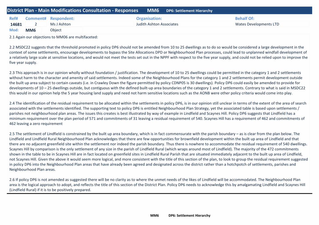
District Plan - Main Modifications Consultation - Responses MM6 DP6: Settlement Hierarchy
Ref#
14681
Respondent:Ms J Ashton
Organisation:Judith Ashton Associates
Behalf Of:Wates Developments LTD
Comment#2
2.1 Again our objections to MM06 are multifaceted:
2.2 MSDC22 suggests that the threshold promoted in policy DP6 should not be amended from 10 to 25 dwellings as to do so would be considered a large development in the context of some settlements, encourage developments to bypass the Site Allocations DPD or Neighbourhood Plan processes, could lead to unplanned windfall development of a relatively large scale at sensitive locations, and would not meet the tests set out in the NPPF with respect to the five year supply, and could not be relied upon to improve the five year supply.
2.3 This approach is in our opinion wholly without foundation / justification. The development of 10 to 25 dwellings could be permitted in the category 1 and 2 settlements without harm to the character and amenity of said settlements. Indeed some of the Neighbourhood Plans for the category 1 and 2 settlements permit development outside the built up area subject to certain caveats (i.e. in Crawley Down the figure permitted by policy CDNP05 is 30 dwellings). Policy DP6 could easily be amended to provide for developments of 10 – 25 dwellings outside, but contiguous with the defined built-up area boundaries of the category 1 and 2 settlements. Contrary to what is said in MSDC22 this would in our opinion help the 5 year housing land supply and need not harm sensitive locations such as the AONB were other policy criteria would come into play.
2.4 The identification of the residual requirement to be allocated within the settlements in policy DP6, is in our opinion still unclear in terms of the extent of the area of search associated with the settlements identified. The supporting text to policy DP6 is entitled Neighbourhood Plan Strategy, yet the associated table is based upon settlements / parishes not neighbourhood plan areas. The issues this creates is best illustrated by way of example in Lindfield and Scaynes Hill. Policy DP6 suggests that Lindfield has a minimum requirement over the plan period of 571 and commitments of 31 leaving a residual requirement of 540. Scaynes Hill has a requirement of 462 and commitments of 462 leaving a zero requirement
2.5 The settlement of Lindfield is constrained by the built up area boundary, which is in fact commensurate with the parish boundary – as is clear from the plan below. The Lindfield and Lindfield Rural Neighbourhood Plan acknowledges that there are few opportunities for brownfield development within the built up area of Lindfield and that there are no adjacent greenfield site within the settlement nor indeed the parish boundary. Thus there is nowhere to accommodate the residual requirement of 540 dwellings. Scaynes Hill by comparison is the only settlement of any size in the parish of Lindfield Rural (which wraps around most of Lindfield). The majority of the 472 commitments shown in the table to be in Scaynes Hill are in fact located on greenfield sites in Lindfield Rural Parish that are situated immediately adjacent to the built up area of Lindfield, not Scaynes Hill. Given the above it would seem more logical, and more consistent with the title of this section of the plan, to look to group the residual requirement suggested in policy DP6 into the Neighbourhood Plan areas that have already been agreed and designated across the district rather than a hotchpotch of settlements, parishes and Neighbourhood Plan areas.
2.6 If policy DP6 is not amended as suggested there will be no clarity as to where the unmet needs of the likes of Lindfield will be accommodated. The Neighbourhood Plan area is the logical approach to adopt, and reflects the title of this section of the District Plan. Policy DP6 needs to acknowledge this by amalgamating Lindfield and Scaynes Hill (Lindfield Rural) if it is to be positively prepared.
ObjectMod: MM6
MM6 DP6: Settlement Hierarchy

District Plan - Main Modifications Consultation - Responses MM6 DP6: Settlement Hierarchy
Ref#
14982
Respondent:Mr M Brown
Organisation:CPRE - Mid Sussex
Behalf Of:Comment#3
The problem with simply inserting into the Policy Text an authority here to build up to 9 dwellings in order to boost housing expansion is that this authority cuts right across other Plan policies in DP 10 to DP14 and DP30. Those policies (positively expressed in their own right) nuance the circumstances in which any new development outside existing settlement boundaries would or would not be acceptable. All of those policies are ones which the Planning Inspector expressed himself satisfied with during the draft Plan’s examination. To give two examples: DP30 would only permit affordable homes to be built on rural exception sites; and DP14 (quite rightly) limits new small scale development within the High Weald AONB to cases “which support the economy and social well-being of the AONB that are compatible with the conservation and enhancement of its natural beauty”. So, whilst we recognise the value of the additional language inserted into para 1 of the Policy Text of DP6, we consider it essential to qualify the “up to 9 dwellings” proposition so that it is expressly made to subject to its compatibility in any given case with other Plan policies. Otherwise it would drive a coach and horses through them and undermine all the work that has gone into their careful drafting and soundness approval. We therefore propose adopting language used elsewhere and adding the words “and is not in conflict with other Plan policies” at the end of paragraph 1 after “where the proposed development is for fewer than 10 dwellings”.
ObjectMod: MM6
Ref#
15308
Respondent:Mr N Kerslake
Organisation: Behalf Of:Comment#3
The text shows adopted Neighbourhood Plans contribute 1,770 homes to the District housing supply and that the settlement hierarchy requires a minimum residual figure of 2,494 homes from 1 April onwards.
The text does not address the realities of the figures for some settlements set out. It is obvious East Grinstead will not be able to meet its requirement of 1,145homes and neither will Lindfield be able to meet its 540. This is because East Grinstead is adjacent to the Ashdown Forest and its attendent HRA problems. Lindfield has very little land left available. There is no realistic possibility that large shortfalls declared by East Grinstead and Lindfield will be able to be met by other Category 2 or 3 settlements.
DP6 should be made clear that "any residual housing not met by a settlement will ultimately be imposed somewhere within the District by MSDC identifying other housing sites, including new strategic sites if necessary, to meet the total shortfall declared by settlements against their residual requirements". This would be in accordance with the NPPF.
ObjectMod: MM6
MM6 DP6: Settlement Hierarchy

District Plan - Main Modifications Consultation - Responses MM6 DP6: Settlement Hierarchy
Ref#
15663
Respondent:Ms C Organ
Organisation:Barton Willmore
Behalf Of:Hallam Land Management
Comment#3
We believe it is premature to decide that the Neighbourhod Plans within the District do not need to take more development. This is especially given the District's need to find more sites through the Site Allocations DPD.
Several settlements are listed as N/A which is not a figure and indicates that a cap has been applied to these settlements where no further housing will be applicable over the plan period. This is not sound or justified by the evidence. The methodology makes no consideration of the relative sustainability merits of these areas within the category of settlement, which is likely to be high given the strategic decsion to location growth therein the plan. This potentially results in development being pushed to less sustainable settlements within the District despite there being capacity at more sustainable locations.
This approach of proportioning growth is not tested in the Sustainability Appraisal and does not accord with the plan's spatial strategy. No needs assessments have been undertaken.
This decision is unjustified and unsound as it has not been informed by the future HRA work, which will be done as part of the Site Allocations DPD. A number of these capped settlements not only among the most sustainable settlements in the District, they are also at settlements that are further from the Ashdown Forest SAC and likely to have lesser impact on it.
For this to becoem sound:- Only figures should be shown in the table. NA is not a minimum instead it implies development at those locations are not applicable for the rest of the plan period.- The table should have clearer caveats to show it is indicative and will be informed by further testing and availability of sites- A clearer encouragement of sustainabel growth above these figures to help support a robust plan led system- Remove strategic local plan allocations from the calculations - a strategic plan-led decision was made to allocate these sites to meet wider needs. They should not be discounted from the distribution of the residual figure.
ObjectMod: MM6
MM6 DP6: Settlement Hierarchy

District Plan - Main Modifications Consultation - Responses MM6 DP6: Settlement Hierarchy
Ref#
16412
Respondent:Dr I Gibson
Organisation: Behalf Of:Comment#1
The addition of the phrase “or where the proposed development is for fewer than 10 dwellings” to sub-para 1. of the policy text is in principle unsound because it conflicts with the Neighbourhood Planning Act 2017 which is intended to strengthen the role of local communities in planning.
Sub-para 2 of the revised policy text is unsound because it is ambiguous and permits ‘spoke development’ outside a built-up area boundary which conflicts with national policy on the protection of the countryside. As currently worded, the policy will permit the development of green fields which lie beyond development that is itself outside a built-up area boundary, when only the access is “contiguous with an existing built up area of settlement”. This will lead to development ‘spokes’ radiating away from a settlement into open countryside.
DP6 sub paras 2 and 3 should be amended to read:2. The site is contiguous with the defined built up area boundary of the settlement; and3. The development is demonstrated to be sustainable, including by reference to the settlement hierarchy and any local infrastructure requirements and housing needs set out in a neighbourhood plan.and a footnote should be added to clarify the interpretation of “contiguous”“At least one eighth (12.5%) of the perimeter of the site must be adjacent to the defined built up area boundary of the settlement.”This will permit the development of unallocated sites while ensuring, through the one eighth criteria, that they do not extend an unreasonable distance beyond the existing built up area of a settlement, and that any development that is brought forward on the site has not been allocated will address local infrastructure requirements and housing needs as part of the sustainability test.
ObjectMod: MM6
MM6 DP6: Settlement Hierarchy

District Plan - Main Modifications Consultation - Responses MM6 DP6: Settlement Hierarchy
Ref#
16427
Respondent:Mr E Fielding
Organisation: Behalf Of:Comment#4
•The data shown in the supporting text is not accurate and so one can only conclude that this plan and policy are not sound.e.g. Category 4 settlements, Staplefield is shown to have had three commitments/completions as at April 1st 2017 but the evidence base shows 2 completions
Please note 13/00988/FUL was for a replacement dwelling not a new dwelling and hence there was no additional net completion for this property. The table above that has used data shown in the MSDC evidence base clearly shows that Staplefield has only had one new dwelling and has not commitments not the three shown in the supporting text section of DP6, Mod Ref.#: MM06. This makes this plan not sound since it has been based on incorrect base data.•With a minimum requirement over the plan period of 3 for Staplefield and as demonstrated above only 1 completed or committed there should be a residual of 2 dwellings for the plan period as a minimum rather than the N/A shown.•The table below shows the number of completions and commitments for the settlement of Ansty, this has been extracted from the evidence base supporting this draft District Plan
The evidence base details the number of completions and commitment shown for Ansty settlement total 43 new dwellings yet the table in Mod Ref.#: MM06 claim to have 54 with no residual. This finding is incorrect when one uses the evidence base hence the plan is not sound.
These continued incorrect numbers are attempting to claim the district has more new houses than it has either completed or built to the 1st of April 2017, this can only lead to a conclusion that this policy and plan are not sound or built on correct or true data. •The statement in the text on Mod ref.#: MM06 Supporting Text claims that “some settlements …. have already identified sufficient commitments/completions to meet their minimum housing requirement for the full plan period……” can only be incorrect when the settlements of Ansty and Staplefield have been shown to be incorrect and to actually have residual requirements that have not been included in this plan so will never be in a position to meet their identified requirements. This plan is therefore not correct, based on evidence or sound. It leads one to question every other number in it when those looked at were so wrong and different from the evidence base that has its own known and reported flaws.
ObjectMod: MM6
MM6 DP6: Settlement Hierarchy

District Plan - Main Modifications Consultation - Responses MM6 DP6: Settlement Hierarchy
Ref#
16449
Respondent:Mr E Hanson
Organisation:Barton Willmore
Behalf Of:Glenbeigh Developments Ltd (Hanlye Road
Comment#2
The Main Modification state that adopted Neighbourhood Plans have contributed 1,770 new dwellings to the housing supply, with many of these allocations delivering completions during the first 5 years.Policy DP6 also sets out the District housing requirement and the role of individual Neighbourhood Plans in meeting the targets. It shows the minimum residual amount of development for each settlement over the rest of the plan period, as at April 2017. For Cuckfield, the residual target is 200 dwellings. However, the supporting text states that the “majority of settlements have sufficient commitments to meet their need until at least 2021/22. Therefore, the District Plan requirement at 876dpa to 2023/24 does not suggest that Neighbourhood Plans will necessarily need to be reviewed within the next 5 years (as at April 2017) to meet housing supply, although Town and Parish Councils may choose to do so in order to boost supply, or to meet need for the full plan period to 2031”.Glenbeigh strongly disagree with this approach. As set out in our previous representations, Cuckfield is defined within the District Plan as a Larger Village (Category 2 Settlement). Despite this no housing sites are allocated within the Cuckfield Neighbourhood Plan (CNP) and it is therefore proposed that new housing will only be met through windfall sites within the settlement boundary and through existing commitments.As a Larger Village, Cuckfield and its immediate surroundings should be a key location for the provision of new housing. There should therefore be an explicit requirement for new housing sites to be identified in Cuckfield to meet the identified but, as yet, unmet housing needs of the District.
Glenbeigh has been actively promoting the site and note that it is included within the 2013 MSDC Housing Supply Document (HSD) (CU/16). It is described as follows:‘The site has road frontage with available footways and is in proximity to local facilities. Site is well connected to the village centre and surrounding residential areas by public footpaths that cross the site east-west. The upper field only has a localised impact, given the topography and surrounding landscape, including development that has already breached the ridgeline. However, the southern section of this site is not related to the existing built-up-area at and would have a greater visual impact on the wider landscape amenity. The Cuckfield Parish Housing Land Availability Assessment (refs E1/E2) identified several landscape constraints for this site including impact on separation between Cuckfield and Haywards Heath and extensive views of the Downs’.The site is identified as being available and achievable. With regard to constraints, MSDC state the following: archaeological/ historical/historic landscape desk-based and field assessment and appropriate mitigation (including any buried industrial remains of the former brick kiln and brickworks buildings in the west of the site). Careful siting and design of development. Landscaping scheme including strengthening of southern boundary.In conclusion, the HSD states that ‘whilst there will only be localised impact upon landscape from the upper field, the southern part of the site would have a greater visual impact on the wider landscape amenity. When considered as a whole site it is not suitable for development.’In light of the above, substantial revisions were made to the proposed scheme, including the removal of the southern part of the site from the proposed development area. It is now proposed that only the northern parcel of land will be developed and the southern section will provide an extensive area of public open space which can be managed and controlled by the Parish in perpetuity. This information has been submitted to both MSDC and Cuckfield Parish Council.
Further an updated Ecological Assessment was undertaken in February 2017. This confirms that there are no statutory designated sites of nature conservation interest within or adjacent to the site. The majority of the habitats within the site generally hold very limited ecological value, with the site primarily comprising intensively horse grazed grassland fields and scattered scrub. The assessment summarises that there is no evidence to suggest that there are any overriding ecological constraints to the development of the site.The site is therefore not only achievable and available, but is also considered entirely suitable for residential development.
ObjectMod: MM6
MM6 DP6: Settlement Hierarchy

District Plan - Main Modifications Consultation - Responses MM6 DP6: Settlement Hierarchy
Ref#
16766
Respondent:Mr N Greenhalgh
Organisation:Village developments plc
Behalf Of:Comment#1
The last District Plan Examination was held on the 26 July 2017. The Council were advised by the Inspector to give further consideration to options to strengthen the five year housing land supply. It was agreed at this hearing that the Council have a 5.2 year housing land supply which the Inspector noted was not enough to be resilient .
I was represented by the Forum, but unhappy toward the end of the hearings at the dominance of larger house builder’s strategic sites ,with very little emphasis on the smaller house builders such as my company . As I was party to the discussions I can assure the Inspector and the Council , that the delivery rates are just not sustainable on the large sites . The infrastructure costs for the Northern Arc are stated by Wates and others as being very high . With the softening of the market in particular in areas like Haywards Heath and Burgess Hill that are saturated with new homes, either being built ,under construction or planned ,the reliance of high delivery rates is unreliable . Moreover the Council’s Business Unit Leader for Planning Policy and Economyadvised us at a Call for Sites meeting , that Hurstpierpoint was not being considered for smaller sites , because the Northern Arc falls within the parish boundary of Hurstpierpoint .
The Main Modifications (ID:BP1b) published in September 2017 did not propose changes to the policy wording of DP6, but insteadallocated a further strategic site at Land north of Clayton Mills for 500 dwellings.
In retaining a low threshold within Policy DP6, the Council have taken an inflexible approach to not only maintaining a robust five year housing land supply, but also risk hampering the delivery of affordable housing. It is our opinion that this approach is inconsistent with the aims and objectives of the NPPF, particularly in the context of paragraph 47 which states, to boost significantly the supply of housing, local authorities to use their evidence base to ensure that their Local Plan meets the full, objectively assessed needs for market and affordable housing in the market area.
Draft Policy DP29 of the MSDC District Plan, requires 30% affordable housing for all residential developments, providing a net increase of 11 dwellings and above or a maximum combined gross floorspace of more than 100m2. In disregarding a higher threshold within Policy DP6, the Council now risk a significant number of sites coming forward in the District which are not required to provide affordable housing under Policy DP29.
At paragraph 43 of the Council's statement, Consideration of Options to Strengthen the Five Year Housing (MSDC22), the Council believe that the additional allocation, in addition to the sites currently called-in by the Secretary of State or at appeal which are due to be determined shortly, will make the 5.2 years supply position more robust. We raise serious concerns the Council are being far too reliant on sites wherethere is absolutely no certainty the decision will be favourable to housing delivery. There are currently approximately 714 units on sites that are the subject of call-in by the Secretary of State awaiting determination. These are decisions out of the control of the LPA. If the Secretary of State chooses to dismiss a number of large sites currently in the appeals system, the Council's five year housing land supply would slip significantly.
Having disregarded a higher unit threshold within Policy DP6, the Council have instead decided to allocate a further strategic site, Land north of Clayton Mills which the Council anticipates could deliver over 500 homes in Hassocks. Paragraph 010 of Planning Practice Guidance states that where sites are proposed for allocation, sufficient detail should be given to provide clarity to developers, local communities and other interests about the nature and scale of development (addressing the 'what, where, when and how' questions).
ObjectMod: MM6
MM6 DP6: Settlement Hierarchy
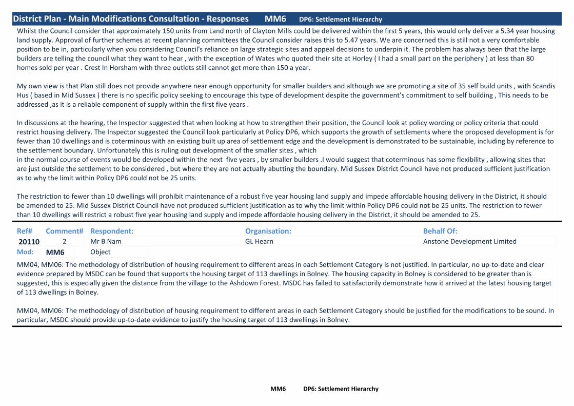
District Plan - Main Modifications Consultation - Responses MM6 DP6: Settlement Hierarchy
Whilst the Council consider that approximately 150 units from Land north of Clayton Mills could be delivered within the first 5 years, this would only deliver a 5.34 year housing land supply. Approval of further schemes at recent planning committees the Council consider raises this to 5.47 years. We are concerned this is still not a very comfortable position to be in, particularly when you considering Council's reliance on large strategic sites and appeal decisions to underpin it. The problem has always been that the large builders are telling the council what they want to hear , with the exception of Wates who quoted their site at Horley ( I had a small part on the periphery ) at less than 80 homes sold per year . Crest In Horsham with three outlets still cannot get more than 150 a year.
My own view is that Plan still does not provide anywhere near enough opportunity for smaller builders and although we are promoting a site of 35 self build units , with Scandis Hus ( based in Mid Sussex ) there is no specific policy seeking to encourage this type of development despite the government’s commitment to self building , This needs to be addressed ,as it is a reliable component of supply within the first five years .
In discussions at the hearing, the Inspector suggested that when looking at how to strengthen their position, the Council look at policy wording or policy criteria that could restrict housing delivery. The Inspector suggested the Council look particularly at Policy DP6, which supports the growth of settlements where the proposed development is for fewer than 10 dwellings and is coterminous with an existing built up area of settlement edge and the development is demonstrated to be sustainable, including by reference to the settlement boundary. Unfortunately this is ruling out development of the smaller sites , whichin the normal course of events would be developed within the next five years , by smaller builders .I would suggest that coterminous has some flexibility , allowing sites that are just outside the settlement to be considered , but where they are not actually abutting the boundary. Mid Sussex District Council have not produced sufficient justification as to why the limit within Policy DP6 could not be 25 units.
The restriction to fewer than 10 dwellings will prohibit maintenance of a robust five year housing land supply and impede affordable housing delivery in the District, it should be amended to 25. Mid Sussex District Council have not produced sufficient justification as to why the limit within Policy DP6 could not be 25 units. The restriction to fewer than 10 dwellings will restrict a robust five year housing land supply and impede affordable housing delivery in the District, it should be amended to 25.
Ref#
20110
Respondent:Mr B Nam
Organisation:GL Hearn
Behalf Of:Anstone Development Limited
Comment#2
MM04, MM06: The methodology of distribution of housing requirement to different areas in each Settlement Category is not justified. In particular, no up-to-date and clear evidence prepared by MSDC can be found that supports the housing target of 113 dwellings in Bolney. The housing capacity in Bolney is considered to be greater than is suggested, this is especially given the distance from the village to the Ashdown Forest. MSDC has failed to satisfactorily demonstrate how it arrived at the latest housing target of 113 dwellings in Bolney.
MM04, MM06: The methodology of distribution of housing requirement to different areas in each Settlement Category should be justified for the modifications to be sound. In particular, MSDC should provide up-to-date evidence to justify the housing target of 113 dwellings in Bolney.
ObjectMod: MM6
MM6 DP6: Settlement Hierarchy

District Plan - Main Modifications Consultation - Responses MM6 DP6: Settlement Hierarchy
Ref#
20117
Respondent:Mr R Cartwright
Organisation:Mid Sussex Liberal Democrats
Behalf Of:Comment#6
We understand the stated aims regarding the ‘Plan Text’ section of this item, but fail to see the relevance when talking to the Neighbourhood Plan Strategy section.For example, in Burgess Hill the Neighbourhood Plan focuses almost exclusively on the Martlets redevelopment. One site outside of the town centre, the former gas holder site on Leylands Road in Burgess Hill was designated for Affordable Social Housing. Within a few weeks of the NP being ‘made’ the Town Council actively promoted the site for out of town centre food retail. To date we are unaware of any proposal from the Town Council to redress this, now, deficient, shortfall in the housing numbers. This may have also been the case in many other locations across the district where NP’s have also been ‘made’. As they also promoted the Martlets redevelopment knowing it had removed the Affordable Housing element from the plan it is difficult to see that the BHTC has any wish to engage with the need to provide any Affordable Homes in its NP or promote the need to provide any.It does need investigating as to the validity of any NP currently in existence in Mid Sussex.About the published figures in this section, it is impossible to say whether they are relevant or not due to the ambiguity.We also feel strongly that any further development which compromises and promotes coalescence of Communities and an erosion of their unique identities must be resisted.
ObjectMod: MM6
Ref#
20140
Respondent:Mrs A Moir
Organisation: Behalf Of:Comment#1
Many of our comments are supported in this section.We wish it to be put on record that we strongly recommend in the establishment of a ‘Developer Panel’ the terms of reference are published and advertised and that a high, but not majority percentage of representation from outside of the Developer network are integral to the Panel. A ‘Job Specification’ and terms of reference must be advertised locally, and an independent recruitment panel/agency is enlisted to make the appointment to prevent any accusations of collusion being made. This is in line with other consultee panels and similar bodies in other public forums. The terms of reference must not however fetter outside appointees with unnecessary and erroneous confidentiality clauses.We note that the issue of further Neighbourhood Plans is broached in this section, Paragraph 5.2, 3rd bullet point. We would seek a clarification statement regarding the existing NP’s which are already ‘made’. Will, for instance, the existing plans, which have been found ‘sound’ be remodelled and if so and as the first ones were ‘made’ following a (Town and) Parish referendum, be subject to further referenda until they fit what the Planning Authority wishes them to do. This seems a waste of local tax payer’s money and resources if so and a diminishing of local democracy in its most basic form, or put another way, a pointless Public Relations exercise.
ObjectMod: MM6
MM6 DP6: Settlement Hierarchy

District Plan - Main Modifications Consultation - Responses MM6 DP6: Settlement Hierarchy
Ref#
20207
Respondent:Mr A Bateson
Organisation:AB Planning & Development Ltd
Behalf Of:David Crowther
Comment#1
The suggestion that Haywards Heath only accommodates 2,511 of the 10,653 required at the three principle settlements is far too low and should be increased to make the Plan more sustainable. Even with the current artificially low figure of just 2,511 new dwellings, the Plan fails to make provision for 127 of those dwellings and Proposals Map 13 - Haywards Heath still retains a built-up settlement boundary that is overly constraining and does not accurately reflect areas that have and/or will soon be developed.
Because MM06 now permits small-scale settlement growth according to the defined settlement hierarchy, where such development would be sustainable, less than 10 dwellings in scale and where a proposal would be contiguous with existing built areas, the Plan's Proposals Map 13 for the town of Haywards Heath should be corrected to include all those areas that either have been developed and/or have been approved for new development in the vicinity of Sunte House, as well as its full curtilage. A plan showing where the settlement boundary to the north of Haywards Heath ought to be amended is attached to this representation.
ObjectMod: MM6
MM6 DP6: Settlement Hierarchy

District Plan - Main Modifications Consultation - Responses MM6 DP6: Settlement Hierarchy
Ref#
20319
Respondent:Mr A Ross
Organisation:Nexus
Behalf Of:Gleeson Developments Ltd
Comment#1
MM04 sets out the spatial distribution of the housing requirement across the settlement categories (Tier 1, Tier 2 etc), including a minimum housing requirement over the Plan period and minimum residual figure from 2017 onwards, taking into account completions and commitments.MM06 then breaks down the figures identified in MM04 on a settlement by settlement basis in the ‘Neighbourhood Plan Strategy’ section. Whilst we note that this follows the general direction of travel in the context of providing neighbourhood planning groups with a housing need figure (having regard to the ‘Planning for the right homes in the right places’ consultation in September 2017), it is important to ensure that this approach does not become overly prescriptive and retains flexibility to respond to changing circumstances. Accordingly, whilst the settlement by settlement figures may act as a helpful guide to neighbourhood planning groups, the Council’s monitoring of housing delivery should be assessed against Policy DP5 (MM04) i.e. the minimum housing requirement at a broader settlement category level. This additional flexibility will ensure that housing in the District is met in a sustainable way i.e. having regard to the settlement hierarchy / settlement categories, but that housing delivery in the Distict is not frustrated in the event that a particular settlement / Parish chooses not to provide for the minimum level of housing required of it by MM04.Alternatively, should the Inspector be minded to retain housing delivery monitoring against the Neighbourhood Plan Strategy figures, we consider that it is critical that the acknowledgement that these figures are likely to change over the Plan period remains. One such scenario where changes may arise (as identified in the Modifications) is the under / over-delivery at a particular settlement. However, as the District Plan housing requirement is expressed as a minimum, reference to ‘over-delivery’ should be deleted. We also consider that the wording should be expanded to explain that where a shortfall in housing delivery exists against one settlement’s minimum requirement, the expectation is that this will be addressed through additional housing delivery in another settlement(s) within the same settlement category - to ensure that housing delivery accords with the spatial distribution established within Policy DP5.Without the above suggested changes, we consider that MM06 is unsound on the basis that it is not effective i.e. it would be so rigid as to potentially result in a failure to deliver the required level of housing in the District as a whole.
In order to make MM06 sound, we consider that additional wording should be inserted into the supporting text to the Neighbourhood Plan Strategy section to advise that notwithstanding the settlement by settlement minimum figures identified (which shall be used as a starting point for neighbourhood planning groups), these are not ceiling figures and any under-provision in any settlement should be made up in that Category of settlement to ensure that delivery takes place in a way that is consistent with the Council’s settlement hierachy.The reference to settlement housing requirements changing in response to under or over-delivery by settlement should be changed to remove reference to ‘over-delivery’ but if settlement by settlement figures do remain, this section should be expanded to make it clear that under-delivery will be addressed through appropriate provision within the relevant settlement category, in accordance with Policy DP5.
ObjectMod: MM6
MM6 DP6: Settlement Hierarchy

District Plan - Main Modifications Consultation - Responses MM6 DP6: Settlement Hierarchy
Ref#
20327
Respondent:
Organisation:AB Planning & Development Ltd
Behalf Of:Mr David Crowther
Comment#1
The suggestion that Haywards Heath only accommodates 2,511 of the 10,653 required at the three principle settlements is far too low and should be increased to make the Plan more sustainable. Even with the current artificially low figure of just 2,511 new dwellings, the Plan fails to make provision for 127 of those dwellings and Proposals Map 13 - Haywards Heath still retains a built-up settlement boundary that is overly constraining and does not accurately reflect areas that have and/or will soon be developed.
Because MM06 now permits small-scale settlement growth according to the defined settlement hierarchy, where such development would be sustainable, less than 10 dwellings in scale and where a proposal would be contiguous with existing built areas, the Plan's Proposals Map 13 for the town of Haywards Heath should be corrected to include all those areas that either have been developed and/or have been approved for new development in the vicinity of Sunte House, as well as its full curtilage
ObjectMod: MM6
Ref#
20534
Respondent:Ms K Lamb
Organisation:DMH Stallard
Behalf Of:Welbeck Strategic Land LLP (Imberhorne F
Comment#2
4.12 Welbeck support the inclusion of a neighbourhood plan strategy within the supporting text to Policy DP6. Neighbourhood planning has become very important to local residents of Mid Sussex, with one of the highest numbers of Neighbourhood Plans in the country. However, neighbourhood plan forums have limited resources and should be given guidance on the level of housingneed required within their settlements, in order to meet the strategic objectives of the District Plan. It allows neighbourhood plan forums the opportunity to consider reviews of their Neighbourhood Plans, or to work with MSDC, to allocate additional development to meet the numbers identified within the supporting text.
4.13 Welbeck support the identification of East Grinstead as a tier 1 settlement which should accommodate a large proportion of the District’s housing need. It is acknowledged that these figures need to be balanced against the constraints of the town, which includes Green Belt and AONB as well as highways constraints, however, there are sites, such as land west of Imberhorne Lane which are capable of accommodating a significant proportion of this identified housing need.
ObjectMod: MM6
Ref#
20771
Respondent:Ms J Onuh
Organisation:Thakeham
Behalf Of:Comment#3
The Inspector in his Interim Findings recommended that the spatial strategy should clarify the approximate number of dwellings expected in each settlement or groups of settlements. In response to this, MSDC have included a Neighbourhood Plan Strategy within draft Policy DP6. This includes growth for a number of settlements however limits the amount of additional growth to other settlements within the District beyond commitments and allocations.
We are concerned that the proposed modification effectively caps additional growth in other small to medium sized settlements during the plan period. Although, the supporting text does identify that the settlement requirements will change in response to a number of matters and that the position will be updated annually within the Authority Monitoring Report (AMR). It is our view is that MSDC should allocate sites that are situated close to the most sustainable settlements.
ObjectMod: MM6
MM6 DP6: Settlement Hierarchy

District Plan - Main Modifications Consultation - Responses MM6 DP6: Settlement Hierarchy
Ref#
20785
Respondent:Miss A Harper
Organisation:PRP
Behalf Of:Comment#1
At the last District Plan Examination held on the 26 July 2017, the Council were advised by the Inspector to give further consideration to options to strengthen the five year housing land supply. It was agreed at this hearing that the Council have a 5.2 year housing land supply which the Inspector noted was not hugely comfortable and that the Council should consider how to improve this position.
In discussions at the hearing, the Inspector suggested that when looking at how to strengthen their position, the Council look at policy wording or policy criteria that could restrict housing delivery. The Inspector suggested the Council look particularly at Policy DP6, which supports the growth of settlements where the proposed development is for fewer than 10 dwellings and is coterminous with an existing built up area of settlement edge and the development is demonstrated to be sustainable, including by reference to the settlement boundary.
The Main Modifications (ID:BP1b) published in September 2017 did not propose changes to this policy wording but instead allocated a further strategic site at Land north of Clayton Mills for 500 dwellings.
In retaining a low threshold within Policy DP6, the Council have taken an inflexible approach to not only maintaining a robust five year housing land supply, but also risk hampering the delivery of affordable housing. It is our opinion that this approach is inconsistent with the aims and objectives of the NPPF, particularly in the context of paragraph 47 which states, to boost significantly the supply of housing, local authorities to use their evidence base to ensure that their Local Plan meets the full, objectively assessed needs for market and affordable housing in the market area.
Draft Policy DP29 of the MSDC District Plan, requires 30% affordable housing for all residential developments, providing a net increase of 11 dwellings and above or a maximum combined gross floorspace of more than 100m2. In disregarding a higher threshold within Policy DP6, the Council now risk a significant number of sites coming forward in the District which are not required to provide affordable housing under Policy DP29.
At paragraph 43 of the Council's statement, Consideration of Options to Strengthen the Five Year Housing (MSDC22), the Council believe that the additional allocation, in addition to the sites currently called-in by the Secretary of State or at appeal which are due to be determined shortly, will make the 5.2 years supply position more robust. We raise serious concerns the Council are being far too reliant on sites where there is absolutely no certainty the decision will be favourable to housing delivery. There are currently approximately 714 units on sites that are the subject of call-in by the Secretary of State awaiting determination. These are decisions out of the control of the LPA. If the Secretary of State chooses to dismiss a number of large sites currently in the appeals system, the Council's five year housing land supply would slip significantly.
Having disregarded a higher unit threshold within Policy DP6, the Council have instead decided to allocate a further strategic site, Land north of Clayton Mills which the Council anticipates could deliver over 500 homes in Hassocks. Paragraph 010 of Planning Practice Guidance states that where sites are proposed for allocation, sufficient detail should be given to provide clarity to developers, local communities and other interests about the nature and scale of development (addressing the 'what, where, when and how' questions).
Whilst the Council consider that approximately 150 units from Land north of Clayton Mills could be delivered within the first 5 years, this would only deliver a 5.34 year housing land supply. Approval of further schemes at recent planning committees the Council consider raises this to 5.47 years. We are concerned this is still not a very comfortable
ObjectMod: MM6
MM6 DP6: Settlement Hierarchy
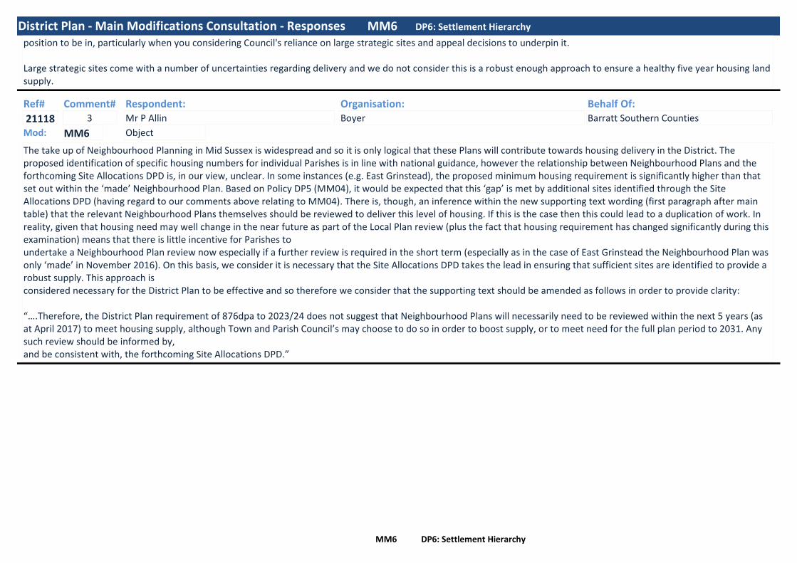
District Plan - Main Modifications Consultation - Responses MM6 DP6: Settlement Hierarchy
position to be in, particularly when you considering Council's reliance on large strategic sites and appeal decisions to underpin it.
Large strategic sites come with a number of uncertainties regarding delivery and we do not consider this is a robust enough approach to ensure a healthy five year housing land supply.
Ref#
21118
Respondent:Mr P Allin
Organisation:Boyer
Behalf Of:Barratt Southern Counties
Comment#3
The take up of Neighbourhood Planning in Mid Sussex is widespread and so it is only logical that these Plans will contribute towards housing delivery in the District. The proposed identification of specific housing numbers for individual Parishes is in line with national guidance, however the relationship between Neighbourhood Plans and the forthcoming Site Allocations DPD is, in our view, unclear. In some instances (e.g. East Grinstead), the proposed minimum housing requirement is significantly higher than that set out within the ‘made’ Neighbourhood Plan. Based on Policy DP5 (MM04), it would be expected that this ‘gap’ is met by additional sites identified through the Site Allocations DPD (having regard to our comments above relating to MM04). There is, though, an inference within the new supporting text wording (first paragraph after main table) that the relevant Neighbourhood Plans themselves should be reviewed to deliver this level of housing. If this is the case then this could lead to a duplication of work. In reality, given that housing need may well change in the near future as part of the Local Plan review (plus the fact that housing requirement has changed significantly during this examination) means that there is little incentive for Parishes toundertake a Neighbourhood Plan review now especially if a further review is required in the short term (especially as in the case of East Grinstead the Neighbourhood Plan was only ‘made’ in November 2016). On this basis, we consider it is necessary that the Site Allocations DPD takes the lead in ensuring that sufficient sites are identified to provide a robust supply. This approach isconsidered necessary for the District Plan to be effective and so therefore we consider that the supporting text should be amended as follows in order to provide clarity:
“….Therefore, the District Plan requirement of 876dpa to 2023/24 does not suggest that Neighbourhood Plans will necessarily need to be reviewed within the next 5 years (as at April 2017) to meet housing supply, although Town and Parish Council’s may choose to do so in order to boost supply, or to meet need for the full plan period to 2031. Any such review should be informed by,and be consistent with, the forthcoming Site Allocations DPD.”
ObjectMod: MM6
MM6 DP6: Settlement Hierarchy

District Plan - Main Modifications Consultation - Responses MM6 DP6: Settlement Hierarchy
Ref#
21137
Respondent:Mr T Davies
Organisation:Planning Potential
Behalf Of:Welbeck Strategic Land II LLP
Comment#2
Our client is supportive of the minimum requirement to provide 2,200 dwellings within Category 3 Settlements over the plan period (2031), in which Sayers Common is identified (MM04). Albeit, we consider that more numbers could be attributed to the Category 3 Settlement, particularly as part of the forthcoming site allocations document owing to the sustainability of some of these settlements.
Our client supports the Council’s commitment to deliver some homes within Sayers Common over the plan period (MM06) However, we consider that Sayers Common has the ability to deliver many more dwellings than is currently being suggested (23 homes). Sayers Common is considered to be a sustainable village and has a range of facilities including a Community shop, Public House, Community centre/village hall and a number of existing employment sites. Two Schools are located within Albourne and at Hurstpierpoint, both of which are located within the 5km distance threshold as set out in the Settlement Sustainability Review (May 2015) of which Sayers Common is identified as a Limited Local Service Centre.
There is also a number of bus services that run through Sayers Common providing access to Burgess Hill, Henfield, Steyning and Palborough. There is also additional school services during terms providing access to Downlands Community School in Keymer. Furthermore, Hurstpierpoint’s is within an accessible walking distance of 30 minutes, or a 7 minutes cycle ride providing access to additional services.
Indeed, Sayers Common has been considered a sustainable location as set out in recent appeal decision decisions. Paragraph 25 of Appeal decision APP/D3830/W/16/3163801 states “Any future occupiers of the proposed dwellings would have a reasonable level of access to local services and facilities which would not require their over reliance on the private motor vehicle…. Moreover, on the basis that the Council, an Inspector and the Secretary of State considered Sayers Common offers a reasonably sustainable location for new housing development”.
Similarly, Appeal decision APP/D3830/A/12/2189451, which has been returned again to the Secretary of State for a decision, confirmed at paragraph 12.38 that “All in all, it seems to me that residents of Sayers Common have access to a reasonable range of services and that it would be appropriate to permit further development here, both in terms of there being a range of services and facilities to support an increased population, and in terms of the potential that the increased population itself would have in helping maintain the viability of those services and facilities”.
In light of the above we consider that Sayers Common has the potential to deliver more dwellings than is currently suggested and therefore the number of dwellings proposed to be provided within Category 3 Settlements over the plan period could be increased. Specifically, we consider that Land to the South of Sayers Common would help to achieve this, through being allocated as part of the of the forthcoming Site Allocations Document.
ObjectMod: MM6
MM6 DP6: Settlement Hierarchy

District Plan - Main Modifications Consultation - Responses MM6 DP6: Settlement Hierarchy
Ref#
21142
Respondent:Mr C Austin-Fell
Organisation:RPS
Behalf Of:Thakeham Homes
Comment#2
To support the direction of how the District’s unmet housing need will be directed, the Council proposes a Neighbourhood Plan strategy as part of MM06, designed to accommodate the shortfall of 2,439 dwellings. To meet this requirement, the Council sets out the amount of development to be distributed to each of the settlements in the Mid Sussex District Plan (MSDP) hierarchy. This includes growth for a number of settlements however, importantly, this limits the amount of additional growth to be directed to Burgess Hill beyond commitments and allocations.It is recognised that Burgess Hill is expected to take a large amount of the District’s growth, a decision which has been determined on the basis of the role of the town and the sustainability of the settlement. RPS is however concerned that the proposed modification effectively caps growth in the town during the plan period, which may be required if a consensus is not reached on how the shortfall should be delivered, or if the shortfall grows as a result of non-delivery of strategic sites.This is further compounded through the changes to the supporting policy text of this policy, which indicates that outside of subsequent Development Plans or Neighbourhood Plans, development will be restricted to windfall sites less than 10 dwellings. The Council is placing great weight in the ability of emerging plans and windfall sites to meet a significant shortfall in the overall housing need and RPS consider this can only be done if safeguards are put in place to ensure that the plan is resilient to unexpected changes in housing delivery.
ObjectMod: MM6
MM6 DP6: Settlement Hierarchy

District Plan - Main Modifications Consultation - Responses MM6 DP6: Settlement Hierarchy
Ref#
21149
Respondent:Ms J Onuh
Organisation:Thakeham
Behalf Of:Land west of Old Brighton Road south
Comment#3
The Inspector in his Interim Findings recommended that the spatial strategy should clarify the approximate number of dwellings expected in each settlement or groups of settlements. In response to this, MSDC have included a Neighbourhood Plan Strategy within draft Policy DP6. This includes growth for a number of settlements however limits the amount of additional growth to be directed to Pease Pottage beyond commitments and allocations.
We are concerned that the proposed modification effectively caps growth in the settlement during the plan period, albeit the supporting text does identify that the settlement requirements will change in response to a number of matters and that the position will be updated annually within the Authority Monitoring Report (AMR). Our view is that MSDC should allocate sites that are situated close to the most sustainable settlements.
Land to the West of Old Brighton Road South, Pease Pottage
AvailabilityThe PPG provides the following guidance when considering whether a site is available for development:“A site is considered available for development, when, on the best information available, there is confidence that there are no legal or ownership problems, such as unresolved multiple ownerships, ransom strips tenancies or operation requirements of landowners. This will often mean that land is controlled by a developer or landowner who has expressed an intention to develop”PPG Paragraph 021 Ref. 3-020-20140306
The site has been submitted to the Council as part of the recent ‘Call for Sites’ exercise which concluded on the 30th October 2017. Thakeham Homes Ltd are actively promoting the site for the delivery of circa 150 dwellings. We consider that the site has the ability to be delivered within the first five years, and on the basis the site could make a significant contribution to the district’s housing land supply trajectory.
SuitabilityThe PPG provides the following guidance when considering whether a site is suitable for development:“Sites in existing development plans or with planning permission will generally be considered suitable for development although it may be necessary to assess whether circumstances have changed which would alter their suitability”PPG Paragraph 019 Ref. 3-019-20140306
One of the core planning principles, as set out at paragraphs 17 and 111 of the NPPF, is the need to encourage the effective use of previously developed land providing it is not of high environmental value. The site is partially brownfield, containing residential properties and a livery. The A23 also runs close to the eastern boundary, resulting in the partially urbanised character of the site.
The site is also in close proximity to the settlement of Pease Pottage and a recently consented Outline scheme to the east of the A23, for 619 dwellings, which includes a primary school and community facilities. Development on this site could allow for the extension of the proposed bus service at Pease Pottage to loop along the site frontage with Old Brighton Road South.
ObjectMod: MM6
MM6 DP6: Settlement Hierarchy

District Plan - Main Modifications Consultation - Responses MM6 DP6: Settlement Hierarchy
Whilst we note that the site falls within the High Weald Area of Outstanding Natural Beauty (AONB), the partly urban characteristics of the site, and previously developed nature of part of the site, means that it contributes little to the purposes or integrity of the AONB. Nevertheless, a landscape led scheme will be developed for the site that will seek to mitigate any impacts in respect of the AONB.
We consider the site to be a sustainable, logical and viable choice for the siting of development and therefore appropriate for allocation.
AchievabilityIn determining whether a site is achievable for development, the PPG provides the following guidance:“A site is considered achievable for development where there is a reasonable prospect that the particular type of development will be developed on the site at a particular point in time. This is essentially a judgement about the economic viability of the site and the capacity of the developer to complete and let or sell the development over a certain period”PPG, Paragraph 021 Ref. 3-021-20140306
Thakeham has a proven track record for delivering schemes of a similar size and scale throughout the South East, and has the capacity to deliver the development of the site to provide much needed new homes within the first 5 years of the plan period. Given that the site is in close proximity to a consented Outline application to the east, providing significant infrastructure and community facilities it is considered that there is a strong prospect of residential development being achieved on this site within the plan period.
It is our view that Land to the West of Old Brighton Road South, Pease Pottage should be allocated for residential development and additional sites within the District allocated for residential development to ensure that the plan is in accordance with National Policy. We consider that the allocation of the site could provide much needed housing within the village that help meets local needs.
As such for the reasons outlined above, we confirm that Land to the West of Old Brighton Road South, Pease Pottage is available, suitable and achievable and therefore deliverable in accordance with the NPPG.
MM6 DP6: Settlement Hierarchy
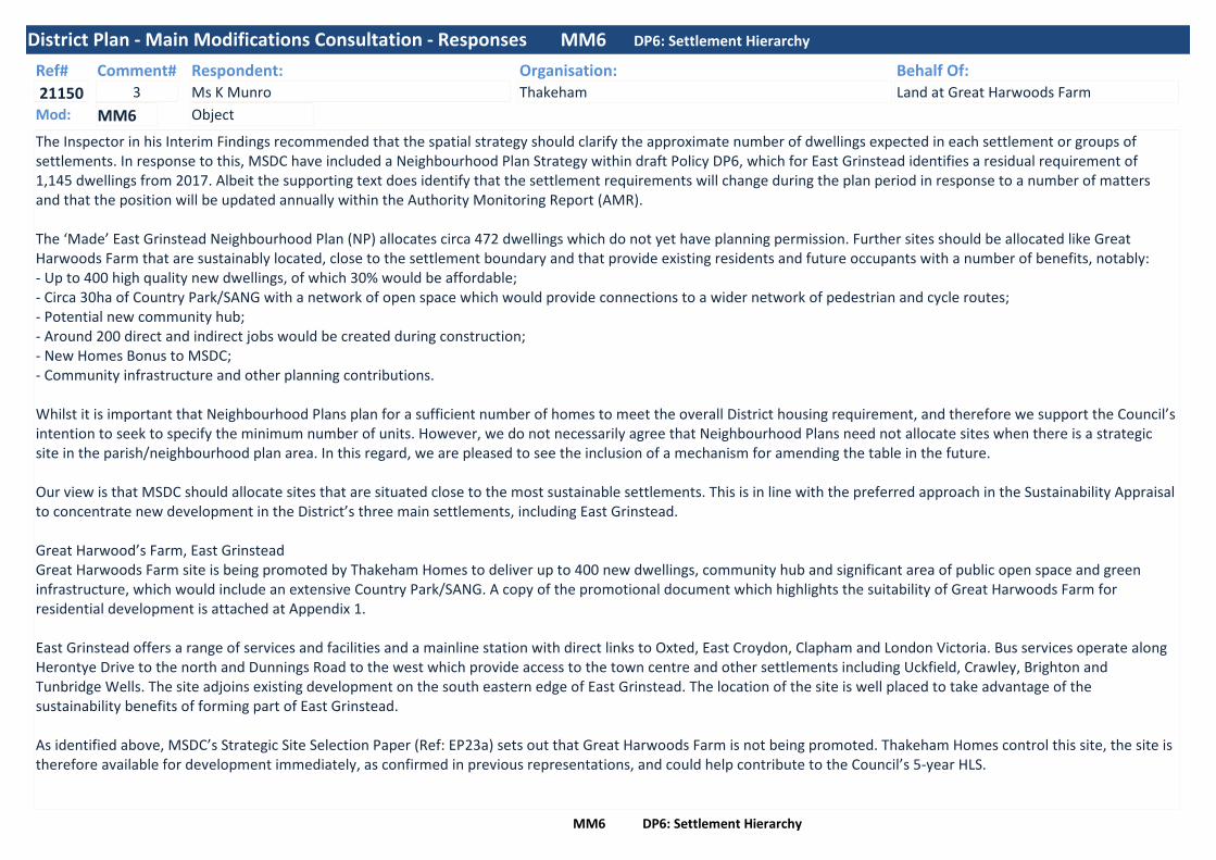
District Plan - Main Modifications Consultation - Responses MM6 DP6: Settlement Hierarchy
Ref#
21150
Respondent:Ms K Munro
Organisation:Thakeham
Behalf Of:Land at Great Harwoods Farm
Comment#3
The Inspector in his Interim Findings recommended that the spatial strategy should clarify the approximate number of dwellings expected in each settlement or groups of settlements. In response to this, MSDC have included a Neighbourhood Plan Strategy within draft Policy DP6, which for East Grinstead identifies a residual requirement of 1,145 dwellings from 2017. Albeit the supporting text does identify that the settlement requirements will change during the plan period in response to a number of matters and that the position will be updated annually within the Authority Monitoring Report (AMR).
The ‘Made’ East Grinstead Neighbourhood Plan (NP) allocates circa 472 dwellings which do not yet have planning permission. Further sites should be allocated like Great Harwoods Farm that are sustainably located, close to the settlement boundary and that provide existing residents and future occupants with a number of benefits, notably:- Up to 400 high quality new dwellings, of which 30% would be affordable;- Circa 30ha of Country Park/SANG with a network of open space which would provide connections to a wider network of pedestrian and cycle routes;- Potential new community hub;- Around 200 direct and indirect jobs would be created during construction;- New Homes Bonus to MSDC;- Community infrastructure and other planning contributions.
Whilst it is important that Neighbourhood Plans plan for a sufficient number of homes to meet the overall District housing requirement, and therefore we support the Council’s intention to seek to specify the minimum number of units. However, we do not necessarily agree that Neighbourhood Plans need not allocate sites when there is a strategic site in the parish/neighbourhood plan area. In this regard, we are pleased to see the inclusion of a mechanism for amending the table in the future.
Our view is that MSDC should allocate sites that are situated close to the most sustainable settlements. This is in line with the preferred approach in the Sustainability Appraisal to concentrate new development in the District’s three main settlements, including East Grinstead.
Great Harwood’s Farm, East GrinsteadGreat Harwoods Farm site is being promoted by Thakeham Homes to deliver up to 400 new dwellings, community hub and significant area of public open space and green infrastructure, which would include an extensive Country Park/SANG. A copy of the promotional document which highlights the suitability of Great Harwoods Farm for residential development is attached at Appendix 1.
East Grinstead offers a range of services and facilities and a mainline station with direct links to Oxted, East Croydon, Clapham and London Victoria. Bus services operate along Herontye Drive to the north and Dunnings Road to the west which provide access to the town centre and other settlements including Uckfield, Crawley, Brighton and Tunbridge Wells. The site adjoins existing development on the south eastern edge of East Grinstead. The location of the site is well placed to take advantage of the sustainability benefits of forming part of East Grinstead.
As identified above, MSDC’s Strategic Site Selection Paper (Ref: EP23a) sets out that Great Harwoods Farm is not being promoted. Thakeham Homes control this site, the site is therefore available for development immediately, as confirmed in previous representations, and could help contribute to the Council’s 5-year HLS.
ObjectMod: MM6
MM6 DP6: Settlement Hierarchy

District Plan - Main Modifications Consultation - Responses MM6 DP6: Settlement Hierarchy
The Council in the Strategic Site Selection Paper stipulate that the site is not suitable due to its location in the AONB and being constrained by other designations. In regards to the AONB, technical work undertaken confirms that the site’s visual envelope is restricted by the local landform and woodland cover and the proposed development will be located within the most contained parts of the site that are well related to existing development. Other parts of the site would provide publicly accessible open space, which would retain the character of the AONB landscape.
The proposed Country Park/SANG associated with Great Harwood Farm would provide mitigation for the proposed 400 new dwellings and, importantly, significant strategic SANG to enable other residential development coming forward within the northern part of the District. With a potential area of up to 30ha, the proposed SANG could enable such development within 5km of the SANG boundary.
Great Harwoods Farm represents an example of a suitable, available and achievable site for a residential-led scheme that would result in significant benefits for the local community, and we therefore believe should be allocated to ensure sufficient sites are provided in the most sustainable settlements, like East Grinstead.
Ref#
21151
Respondent:Ms J Onuh
Organisation:Thakeham
Behalf Of:Land at Kemps Farm, Hurstpierpoint
Comment#3
The Inspector in his Interim Findings recommended that the spatial strategy should clarify the approximate number of dwellings expected in each settlement or groups of settlements. In response to this, MSDC have included a Neighbourhood Plan Strategy within draft Policy DP6. This includes growth for a number of settlements however limits the amount of additional growth to be directed to Hurstpierpoint beyond commitments and allocations.
We are concerned that the proposed modification effectively caps growth in the settlement during the plan period, albeit the supporting text does identify that the settlement requirements will change in response to a number of matters and that the position will be updated annually within the Authority Monitoring Report (AMR). Our view is that MSDC should allocate sites that are situated close to the most sustainable settlements.
Kemps Farm, HurstpierpointKemps Farm, Hurstpierpoint is being promoted by Thakeham Homes to deliver circa 90 new dwellings, public open space and green infrastructure.
Hurstpierpoint offers a range of local services and amenities, which includes a health centre, library and primary school. Bus services operate along Orchard Way to the south and Cuckfield Road to the west which provide access to Burgess Hill rail station and town centre and to other settlements including Crawley, Brighton and Haywards Heath. The site adjoins existing development on the western edge of Hurstpierpoint. The location of the site is well placed to take advantage of the sustainability benefits of forming part of Hurstpierpoint.
Land at Kemps Farm, Hurstpierpoint represents an example of a suitable, available and achievable site for a residential scheme and we therefore believe should be allocated to help ensure sufficient sites are provided in the most sustainable settlements.
ObjectMod: MM6
MM6 DP6: Settlement Hierarchy
District Plan - Main Modifications Consultation - Responses MM6 DP6: Settlement Hierarchy
Ref#
21218
Respondent:Mr A Hodgson
Organisation:Star Planning and Development
Behalf Of:Welbeck Strategic Land III LLP
Comment#1
1. By reason of being part of the consortium of developers who have engaged in the examination in public process the objectivelyassessed housing need and overarching strategy, this representation by Welbeck Strategic Land III LLP (Welbeck) is not concerned with these wider matters. Instead, this representation is focused on the dwellings to be delivered outwith the strategic allocations and the level of growth indicated at Settlement Category 3. These matters related to MM04 and MM06.
2. Welbeck is supportive of the requirement to deliver new homes across the District at sustainable locations, includingHandcross which is identified as Category 3 Settlement (MM04). It is also welcomed that the housing requirement for Category 3Settlements is a ‘minimum’ rather than a target or maximum.
3. Objection is made to MM06. Handcross is the only Category 3 Settlement which is not proposed for some additional housinggrowth during the plan period. It is considered that MM06, in respect of Handcross, is unsound because it is not consistent with achieving sustainable development and it is not the most appropriate strategy.
4. Welbeck propose that some of the more sustainable Category 3 Settlements, such as Handcross, should be properly reassessed to determine their ability to accommodate new homes, over and above just local needs, to effectively contribute towards meeting the District’s wider housing requirement. These Category 3 Settlements are those which have a good range of local services and facilities and are geographically located near to major employment centres.
5. The explanation for the omission of housing at Handcross is that, amongst other settlements, it is considered to have alreadyidentified sufficient commitments/completions to meet its minimum housing requirements. However, this is only achieved by reason of the permission granted for circa 600 dwellings at Pease Pottage which, although in Slaugham Parish, is identified as a separate Category 3 Settlement. Handcross is a separate settlement to Pease Pottage and as a location for some housing growth its sustainability credentials have not been properly assessed in their own right. A minimum housing requirement greater than ‘0’ is wholly inappropriate at Handcross.
6. It is welcomed that Handcross has not been discounted as a location for growth because of concerns about the impact on the High Weald Area of Outstanding Natural Beauty (AONB). This approach equally applied at other settlements within the same category where a minimum housing requirement is identified (e.g. Ardingly, Ashurst Wood and Balcombe).
7. However, what is clear and irrespective of the AONB designation, Handcross is better placed as a sustainable location forgrowth when compared to most of the other settlements within Category 3. This is evident in the Settlement Sustainability Review(May 2015) and by the fact that Handcross is the only Category 3 settlement to have a full complement of all 10 key local services as identified below:• Regular bus services to employment areas• Nursery School• Primary School• Public House
ObjectMod: MM6
MM6 DP6: Settlement Hierarchy

District Plan - Main Modifications Consultation - Responses MM6 DP6: Settlement Hierarchy
• Post Office• Convenience Store• Café• ATM facility• Community Centre• Health Centre
8. Based on the above list, it is somewhat surprising that Handcross has not been identified as a Category 2 Settlement.Handcross has:• 5 or more retail uses;• Pre-school facilities;• A community centre;• A health centre;• Recreation facilities (two football pitches, a petanque piste, playgrounds designed for age groups from 2 – 14, a half basketballpitch, bowls club and other play areas); • 26.9% of its residents travel to work at or within 5km of home;• Peak and off-peak bus services between to Crawley which includes the significant employment area at Tilgate Business Parkwhich is within 5km;• A built-up area boundary; and• No significant environmental constraints. The fact that Cuckfield is within the AONB has not precluded it being identified as aCategory 2 Settlement and the same logic should apply to Handcross. There is scope to accommodate growth to the east of the A23 without impacting upon Ancient Woodland (which are principally to the west of Handcross) or the SSSI to the south east.9. The criteria referred to above are those contained in the Settlement Sustainability Review (paragraphs 3.12 and 4.5) for asettlement to qualify as a ‘Main Service Centre’. Welbeck submit that Handcross should be reclassified as a Category 2 Settlement and should accommodate more than local needs housing.
10. If Handcross is retained as a Category 3 Settlement then other settlements with only 8 of the 10 services, such as Turners Hilland Ashurst Wood, are proposed for 167 and 102 dwellings respectively as a minimum requirement. This assessment highlightsthat the sustainability credentials of Handcross (in its own right) as a settlement have not been fully taken into account.
11. With the exception of Handcross, other settlements within a population range of between 1,000 and 1,500 people, and which do not have insurmountable planning circumstances (e.g. Scaynes Hill), possess minimum housing requirements of between 73 and 167 dwellings. Such a level of growth would be capable of accommodating local housing needs generated by the existingpopulation of the settlements which, in the case of Handcross, is not being taken into account.
The changes sought to MM06 by Welbeck are either:• By reference to the approach adopted at other Category 3 Settlements and taking into account the sustainability credentials ofthe settlement, Welbeck advocate that MM06 should include a minimum residual housing requirement from 2017 of 140 dwellings at Handcross above those already
MM6 DP6: Settlement Hierarchy

District Plan - Main Modifications Consultation - Responses MM6 DP6: Settlement Hierarchy
consented; or• Handcross should be reclassified as a Category 2 Settlement with a level of housing development to reflect its status as a MainService Centre – circa 250 dwellings above those already consented.
MM6 DP6: Settlement Hierarchy

MM06: Settlement Hierarchy - Balcombe Residents Responses In addition to the responses received by Organisations and Key Individuals, 124 responses were received from Balcombe residents objecting to the settlement hierarchy policy (DP6). The responses received are as a result of the objections raised by Balcombe Parish Council, and support the issues with the policy that the Parish Council raises. Copies of these responses have been sent, in full, to the Inspector for his consideration. Many of the responses received raised the same issues, which are summarised below. Balcombe Resident’s Comments
• Balcombe Neighbourhood Plan has been made, the revised ‘minimum residual’ numbers in policy DP6 are not in accordance with this.
• Changes to this policy undermine the good work by the village on the Neighbourhood Plan. • Balcombe Neighbourhood Plan allocates sites for housing, it doesn’t need any more. • The methodology for calculating the village housing requirement is not adequate/robust. • The number for Balcombe does not take into account constraints – the Parish is within the
High Weald Area of Outstanding Natural Beauty. • Homes in the AONB should be for local need, not meeting unmet need of neighbouring
authorities. • There are insufficient sites in Balcombe – the latest SHLAA doesn’t show enough to meet
the housing requirement for the village. • The need in Balcombe cannot be met in a sustainable manner. • Infrastructure cannot cope. • Roads would not be able to cope with additional traffic – Haywards Heath Road is
dangerous at rush hour. • Allowing “fewer than 10” dwellings where contiguous with the built-up area boundary is not
in accordance with the NPPF re the AONB, causes tension with the Neighbourhood Plan, and would get around affordable housing requirements.

MM06: DP6: Settlement Hierarchy – Balcombe Resident’s Responses
Ref# Respondent 21170 Mr I Albert 21539 Mr C Archibald 21643 Dr K Archibald 21592 Ms P Bailey 21198 Mr and Mrs J Bates 21358 Mr B Bolland 21589 Mr K Bottomley 21629 Mrs J Bottomley 21624 Mr G Boxall 21465 Mr C Brooks 21632 Mr S Burbidge 21152 Ms H Butcher 21668 Mr N Buttle 21619 Miss E Campbell 19607 M Carter 21621 Mr S Chen
1860 J Cheung 20998 Ms A Cooper 21156 Mr C Cornwell 21347 Mrs J Cottell 21667 Mr G Cramp 21017 Mr and Mrs Curry 20997 Mrs R Davies 21264 Mrs R Dinneen 21463 Mr L Dixon 21466 Mrs E Dixon 21633 Mr T Dove-Wallington 21517 Mrs S Dowdall 21603 Professor L Dunne 21246 Mrs H Dunstan-Lee 21538 Mr A Dunstan-Lee 21212 Mrs J Dutton 21213 Mr T Dutton
21573 Mrs C Dutton 21395 Ms J Emery 21507 Mr and Mrs RP Evans 21401 Mrs W Farrant 21411 Mr K Farrant 21636 Mr J Fitzsimons 21665 Ms E Fortescue 21587 Mrs G Fry 21631 Mrs G Fry 21291 Mrs S George 21483 Mr A Gough 21660 Mrs N Gould 21231 Mr LJF Harris
1693 Mr A P Henderson 1718 Mrs P J Henderson
21449 Mr C Hirst 21563 Mrs S Hirst 21200 Mrs M Hopkins 21134 Mr and Mrs N Howard 21535 Mr P Huxley 21638 Mr J Illsley 21607 Mrs C Jackson 21306 Mrs C Jarvest 21557 Mr M Kenward 21579 Mrs M Kenward 21388 Mr M Leech 21206 Ms M Lewis 21642 Mrs G Lewis Tupper 21690 Mrs G Lewis Tupper 21146 Ms S Mackrill 21356 Mrs S Mackrill 21268 Miss & Mr JD Malijaars & Somers 21669 Ms J McCarthy 21228 Mr Owen McDonough
21663 Mr J McLarin 21310 Mr M Mergler 21153 Ms K Metcalfe 21424 Mr C Metcalfe 21018 Ms J Newton 21402 Mrs C Nixon 21404 Mr J Nixon 21492 Mr P Nolan 21390 Mr P Nower 21528 Mr D Paul 21509 Mrs J Perrin 21515 Mrs N Preston Bell 21230 Mrs H Pring 21282 Mrs E Randall 21288 Mr J Randall 21292 Mr P Randall 21294 Mr E Randall 21655 Mr M Record 21452 Ms S Reynolds 21561 Mr P Reynolds 21585 Mrs J Reynolds 21609 Miss K Reynolds 21441 Mrs J Rezac 21648 Mr S Rhodes 21140 Ms R Robertson 21504 Mrs L Robinson 21602 Mr P Robinson 21171 Mr and Mrs J Rothman 21309 Mt T.P. Rusk 21666 Mr R Saunders 10813 Mr and Mrs J Scates 21296 Ms K Schulte 21661 Mr C Sheldon 21521 Ms S Shephard

MM06: DP6: Settlement Hierarchy – Balcombe Resident’s Responses
21429 Mr P Smith 21616 Mr M Southern 21532 Mrs R Stillwell 21331 Mr D Stoneham 21277 Ms S Taylor 21141 Ms R Telford 21623 Mr O Tester 21253 Mr L Thompsett 21549 Mr J Thompson 21163 H+G Thomson 21630 Dr A Visscher 21284 Mr M Wall 10254 Mrs M Warburton 21197 Mr A Warburton 21650 Mr M Whybrow 21208 Mr and Mrs R Wiginton 21266 Mr J Wilkins 21662 Mr R Williamson 21482 Mr P Wiltshire 21300 Miss E Wones 21488 Ms M Woodfield-Bailey 21293 Mr R Worrall 21664 Mr and Mrs P Wren

District Plan - Main Modifications Consultation - Responses MM7 DP7: General Principles for Strategic Development at Burgess Hill
Ref#
164
Respondent:Ms S Solbra
Organisation:Southern Water
Behalf Of:Comment#1
We are unable to support this policy as sound on the grounds that:1. it is not positively prepared as it does not reflect the evidence we provided on infrastructurerequirements,2. it is not effective as it does not support delivery of necessary infrastructure, and3. it is not consistent with national policy.
Southern Water's comments relate to the removal of the bullet point from Policy DP7 requiring development 'not to be occupied until necessary improvements at Goddards Green Waste Water Treatment Works and connecting pipework and pumping stations to increase the capacity and environmental quality are implemented'.
Strategic infrastructure such as extensions to wastewater treatment works can be planned and funded through the price review process, and coordinated with new development, and the adopted Mid Sussex District Plan will inform Southern Water’s investment planning. Adoption provides the planning certainty required to support investment proposals to Ofwat, the water industry’s economic regulator. Investment proposals are prepared every five years through the price review process. The last price review was in 2014. Ofwat’s price determination funds the investment programme for the period to 2020. There will be another price review in 2019, covering the investment period 2020 to 2025. Therefore any further improvements to Goddards Green Wastewater Treatment Works (WTW) necessary as a result of the level of development set out in the adopted Mid Sussex District Plan will be put forward for inclusion in the 2019 price review.
Southern Water therefore request that this provision be reinstated, having regard to overall levels of development proposed in the Goddards Green WTW catchment, which includes the new allocation in Policy DP9b for a further 500 dwellings, as well as the existing allocations in Burgess Hill. This is not a constraint to development, but relates to the timing of delivery and ensures that development will not be occupied ahead of the infrastructure required to serve it.
Without this provision, there could be a risk that development may be delivered ahead of the infrastructure required to service it, unless delivery is supported by planning policies and subsequently in planning conditions. This is supported by the core planning principles identified in the NPPF, notably to: ‘proactively drive and support sustainable economic development to deliver the homes, business and industrial units, infrastructure and thriving local places that the country needs’ and ensure that plans ‘provide a practical framework within which decisions on planning applications can be made with a high degree of predictability and efficiency’ . Our approach is also supported by paragraph 21 of the NPPF, which requires that planning policies should recognise and seek to address any lack of infrastructure. The National Planning Practice Guidance specifies that ‘Adequate water and wastewater infrastructure is needed to support sustainable development’.
To ensure the policy's soundness and consistency with the NPPF and Planning Practice Guidance, we propose the following bullet point be reinstated (new text underlined) to Policy DP7 : Strategic development will;'Not to be occupied until necessary improvements at Goddards Green Waste Water Treatment Works and connecting pipework and pumping stations to increase the capacity and environmental quality are implemented'.
ObjectMod: MM7
MM7 DP7: General Principles for Strategic Development at Burgess Hill

District Plan - Main Modifications Consultation - Responses MM7 DP7: General Principles for Strategic Development at Burgess Hill
Ref#
16427
Respondent:Mr E Fielding
Organisation: Behalf Of:Comment#5
•I support the identification of the need for improved public transport, walking and cycling infrastructure but need to understand the extent of this improvement. Will it extend to the surrounding settlements and provide true sustainable access to the new Science park where a large number of employment opportunities are to be located and to the new schools and sports and leisure facilities that are shown to be part of the new developments? If this is a true District approach I applaud this beneficial policy inclusion, if not why is it not rolled beyond the edge of Burgess Hill?•There is no requirement for provision for electric vehicles and charging points as detailed in policy Dp9b which would enable MSDC to progress its plans for a reduced carbon footprint or to improve or maintain the air quality in the District. This policy is not sustainable or sound.•Why has the policy point re the Waste Water Treatment works at Goddards Green been removed – will the new houses not have any additional sewage to be treated? Will these new homes not have toilets, baths or connection to mains drainage let alone surface water drainage from this vast increase in paved land? Will this removal blight our environment making it a large cesspit for years to come?DP8: Strategic Allocation to the east of Burgess Hill at Kings Way, Mod Ref.#: MM08:•I applaud the inclusion of identifying the education needs but question why it is only a financial contribution – will new schools actually be built in line with the increase in housing?•Will Education facilities extend to secondary schools?•Will Education facilities extend to sixth form provision since the District has limited sixth form provision since the college was closed in Haywards Heath yet the demand increased dye to government policy to keep children in education until they are 18. Many of the distict’s children are disadvantaged by having to travel to either Horsham, Crawley or Brighton if they can secure a place on the courses they require. Only a few are in a position to pay for their childrens’ private education which is discrimination from a District level.•There is no requirement for provision for electric vehicles and charging points as detailed in policy Dp9b which would enable MSDC to progress its plans for a reduced carbon footprint or to improve or maintain the air quality in the District. This policy is not sustainable or sound.•This policy neglects to include reference to the needs of the SSI at Ditchling common? This SSI is adjacent to Burgess Hill yet given no protection and hence the District Plan fails to be sound.
ObjectMod: MM7
MM7 DP7: General Principles for Strategic Development at Burgess Hill

District Plan - Main Modifications Consultation - Responses MM7 DP7: General Principles for Strategic Development at Burgess Hill
Ref#
17488
Respondent:Mr C McClea
Organisation:Savills
Behalf Of:Wates - Burgess Hill Northern Arc
Comment#2
3.1. Modifications made to Policy DP7 are set out below, with Savills comments provided in relation to themodification.
including a new public square;’ 3.2. Savills comment: The deletion of this bullet point is welcomed, as the BHNA strategic development cannot directly contribute to the improvement of Burgess Hill town centre. Burgess Hill town centre does not form part of the BHNA strategic allocation, and is not within the control of the other major land interests, therefore this modification is supported.
of, or contributions to enhancing transport interchanges;’
3.3. Savills comment: As part of developing proposals for the delivery of the BHNA, Wates, Gleeson and Rydon (the Developers) have commissioned ongoing assessments of transport impacts and associated infrastructure requirements based upon the emerging development schemes. The Developers anticipate that the findings of these assessments, in conjunction with the MSDC’s evidence relating to Burgess Hill transport interchanges, will establish the nature and size of any required contributions. Should CIL be adopted in Mid Sussex, dependent upon the adopted charging schedule, the BHNA strategic development may make CIL contributions towards connectivity improvements to Burgess Hill and Wivelsfield railway stations and Burgess Hill Town Centre.
3.4. Savills comment: We welcome the deletion of the affordable housing percentage, as this was considered a duplication as it is stated within Policy DP29. We question whether this bullet point should be deleted in full, as this development will be in accordance with Policy DP29 anyway.
and environmental quality are implemented;’
3.5. Savills comment: We welcome the deletion of this bullet point, as any restriction on the occupation of BHNA would be a threat to its delivery. We note that the Sustainability Appraisal confirms there is currently capacity at Goddards Green for the amount of development being planned for.
3.6. Wates does not object to the changes proposed to Policy DP7, however, has concerns over the implication these changes could have on the overall infrastructure delivery and delivery of the Northern Link Road. Thus, a strict policy requirement for certainty over the delivery of the Northern Link Road is vital within Policy DP9.
ObjectMod: MM7
MM7 DP7: General Principles for Strategic Development at Burgess Hill

District Plan - Main Modifications Consultation - Responses MM7 DP7: General Principles for Strategic Development at Burgess Hill
Ref#
20117
Respondent:Mr R Cartwright
Organisation:Mid Sussex Liberal Democrats
Behalf Of:Comment#7
We find the deletion of a 30% minimum provision of affordable housing unacceptable. 30% was a very poor level of provision in the first place and to remove the number indicates to developers the lack of commitment expected from them to build diverse communities. It does however reflect the poor decision of the council’s planning committee when allowing the town centre development consent in the first place and seems to let not only the developers, but the council off the hook when making planning decisions. We ask if this is to become the norm. We also ask how the council plans to mitigate the now shortfall in affordable home to meet the overall 30% target figure.The rewording which excludes the improvements to the Goddards Green Waste Water Treatment site addresses the issue we had previously where the council was putting up barriers to any development on the presumption of another statutory organisations forward planning. We know the issue for the Water Treatment Works capacity was being held back due to the lack of commitment with the council planning policy. We welcome this change of position.Please cross reference to our comments in MM10 ‘Strategic Allocation to the East of Pease Pottage’.
ObjectMod: MM7
MM7 DP7: General Principles for Strategic Development at Burgess Hill
District Plan - Main Modifications Consultation - Responses MM8 DP8: Strategic Allocation to the east of Burgess Hill at Kings Way
Ref#
180
Respondent:Ms L Brook
Organisation:Sussex Wildlife Trust
Behalf Of:Comment#2
We are concerned that the removal of the reference to the Keymer Tile Works SNCI (now referred to as a Local Wildlife Site) is not in line with paragraphs 114 and 117 of the National Planning Policy Framework.
We understand that the majority of the Keymer Tile Works Local Wildlife Site is currently under construction, however the proposals for this site includes a large ‘ecological park’ with areas of habitat creation. Additionally condition 23 of planning permission 09/03697/OUT states that:
‘Prior to the commencement of construction, an Ecological Management Plan shall be submitted to and approved in writing by the local planning authority and shall include detailed specifications and management regimes as appropriate for the following: a) Wetland habitats, construction and maintenance.b) Terrestrial habitats, planting and maintenance.c) Protected species and their habitats (including proposals for licensing applications where necessary).d) Provision of educational facilities, viewing platform and path/broadwalk.Reason : To ensure protect and enhancement of the ecological value of the site and to accord with Policies C5 and SSH/14 of the Mid Sussex Local Plan.’
We recognise that the modified policy includes a requirement consider the opportunities with the Keymer Tile Works site, however, to our knowledge the site has not been de-designated and as such we would support the continued reference to the site as a LWS. We accept the removal of the text regarding the joint development of community infrastructure, but would encourage a policy that ensures the Kings Way development specifically creates links for biodiversity between the SSSI and the LWS.
We recommend that bullet point 8 is amended to:
‘Consider the opportunities with the Keymer Tile Works site, particularly the Local Wildlife Site, and other developments in the vicinity to ensure complementary provision of biodiversity enhancements, infrastructure and facilities for the east side of Burgess Hill;’
This positive wording would better conform to paragraph 114 of the NPPF.
ObjectMod: MM8
Ref#
20117
Respondent:Mr R Cartwright
Organisation:Mid Sussex Liberal Democrats
Behalf Of:Comment#8
We note this section and the rewording which better reflects what has and is happening in this Strategic Allocation. We raise concerns that there is a need to emphasize the necessary provision of informal open space as it was a key factor in determining the original outline application of the Keymer Tile site and the reasons it was such a key factor. It suggests that there is developer pressure to walk retrospectively away from this key commitment and aspect of the development. This must be resisted in the strongest possible way.
ObjectMod: MM8
MM8 DP8: Strategic Allocation to the east of Burgess Hill at Kings Way
District Plan - Main Modifications Consultation - Responses MM9 DP9: Strategic Allocation to the north and north-west of Burgess Hill
Ref#
15705
Respondent:Mr L Challenger
Organisation:Nexus Planning
Behalf Of:Gleeson Developments Ltd and Rydon Ho
Comment#2
We support the following proposed modifications to Policy DP9:• The reduction of the proposed employment floorspace allocation from 30 to 25 hectares (bullet point 2); and• The simplification of the wording related to the implementation of the masterplan and related documents which we consider improves the effectiveness of the policy (bullet point 7).
In relation to bullet point 6 however, we note the wording of policy DP9 remains unchanged despite issues being raised previously about the clarity of wording in relation to the provision of a road link across the river corridor to facilitate a public transport route to Maple Drive.
We further support the reference to the road link however, we have previously sought that this sentence should be expanded to refer to an all vehicle link to Maple Drive in order to support a sustainable transport and access strategy for the proposed development.
Following previous representations made on this point the land forming the eastern portion of the Northern Arc is currently movingforward with an outline planning application submitted on an initial phase of development comprising 130 units with a further application to follow on the wider area that will deliver 460 units. The bridge crossing referred to in the policy will be included in a future full planning application for the wider site.
Discussions with the Council have been based around the fact that this bridge crossing will not only accommodate a public transport link but also general vehicle traffic. We consider that such proposals would be consistent with this policy and that the policy does not seek to prevent an all vehicle link being established. However, the wording is somewhat unclear on this point.
Therefore, in the interests of clarity we propose the following expanded wording in the fifth paragraph of supporting text:
“The area between Maple Drive and the ‘Northern Arc’ is included within the allocation because it is important that the new development is integrated with the existing town and that there are good public transport and pedestrian links between the development and Wivelsfield station. In this regard the road link across the river corridor will ensure that an all vehicle link including a public transport route, is provided from Maple Drive to the wider Strategic Allocation Area. Planning application(s) for the Strategic Allocation Area, informed by discussions with West Sussex County Council, will determine the precise quantum of housing units to be accessed from Maple Drive.”
ObjectMod: MM9
MM9 DP9: Strategic Allocation to the north and north-west of Burgess Hill

District Plan - Main Modifications Consultation - Responses MM9 DP9: Strategic Allocation to the north and north-west of Burgess Hill
Ref#
16427
Respondent:Mr E Fielding
Organisation: Behalf Of:Comment#6
•How can a plan be considered sound when it is not clear on key facts such as the details of the cornerstone site and how it is to be developed? Words such as “If it is the subject of multiple planning applications, it is important that these are led by and accord with an allocation wide masterplan, infrastructure delivery strategy, including a fair and reasonable mechanism for apportioning the in-kind provision of infrastructure and/or costs, and an allocation wide phasing strategy.” How will the District Council be able to do this if they come over many years and do not wish to provide a holistic plan for the proposed separate developments that form this large strategic allocation? This approach is neither sustainable, deliverable, enforceable or sound. The plan is accordingly not sound since there is no mechanism the District Council has to ensure delivery of policy DP9.•In the policy text I applaud the new secondary school campus but when will this be built – before the extra primary places progress to secondary or when they are in University? There is also a worrying lack of 6th form education provision in the district as detailed above. Do the District Council not want to deliver suitable skilled, educated young people for the proposed science park?•With regards to the Gypsies and Travelers – the identified need of 23 households identified in DP31, when read into DP9 does not enable mixed site or even provision for these minority groups close to the employment of new facilities provided at Burgess Hill.•Although to be applauded that there is now a mention of Custom or self-build homes in DP9 it is not appropriate to propose these to be provided in Burgess Hill Strategic development, MSDC custom and self-build housing register enables those on it to identify where they need to have their home, I doubt anyone has the strategic development in Burgess Hill as their desired location.•There is no requirement for provision for electric vehicles and charging points as detailed in policy Dp9b which would enable MSDC to progress its plans for a reduced carbon footprint or to improve or maintain the air quality in the District. This policy is not sustainable or sound.•It is not acceptable that for the larger strategic site of north and north west of Burgess Hill as detailed in policy DP9 does not have the same level of planning requirement as the smaller Pease Pottage sit in DP9A which details: “Provide infrastructure, as set out in the Council’s infrastructure Delivery Plan and identified in technical assessments, implemented before or alongside development to an agreed programme of delivery. Given the proximity of site to Crawley consideration should be given to where future occupiers are likely to access services. This is particularly important when considering secondary education, library and health services, where the nearest provision is within Crawley….”; Without this level of supporting infrastructure planning DP9 is not deliverable, sustainable enforceable or sound.
ObjectMod: MM9
MM9 DP9: Strategic Allocation to the north and north-west of Burgess Hill

District Plan - Main Modifications Consultation - Responses MM9 DP9: Strategic Allocation to the north and north-west of Burgess Hill
Ref#
17488
Respondent:Mr C McClea
Organisation:Savills
Behalf Of:Wates - Burgess Hill Northern Arc
Comment#3
4.1. Savills confirms our client’s continued support towards Policy DP9: Strategic Allocation to the north and north-west of Burgess Hill. We have set out the policy changes below and suggested some policy text changes where necessary, to provide clarity and certainty on deliverability.
on the inset map, is allocated to the north and north-west of Burgess Hill for the phased development of:’
4.2. Savills comment: We support the policy’s reference to ‘phased development’ which reflects the likelihood that a number of planning applications will be received for the BHNA, and enables the swift delivery of the site.
Gypsy and Traveller Provision
overall scale of residential development proposed by the strategic development; or the provision of an equivalent financial contribution towards the off-site provision of pitches towards the additional total identified need within the District (or part thereof if some on-site provision is made) commensurable with the overall scale of residentialdevelopment proposed by the strategic development, if it can be demonstrated that a suitable, available and achievable site (or sites) can be provided and made operational within an appropriate timescale; unless alternative requirements are confirmed within any Traveller Sites Allocations Development Plan Document or such other evidence base as is available at the time the Allocationwide Masterplan is approved (as appropriate);’
4.3. As outlined with respect of other Main Modifications, Wates continues to object to the inclusion of a Gypsy and Traveller pitch requirement as part of the BHNA, as this Strategic Allocation is necessary to provide the majority of the remaining housing supply and supporting infrastructure for the District during the period up to 2031. As MSDC is currently preparing a "Traveller Sites Allocations Document" in order to allocate land within the District for Traveller sites, we consider the need for pitches should beestablished by MSDC, before any provision or obligation towards Gypsies and Travellers pitches is required. Once the need is established, Wates welcomes the ability to provide commuted sums as an alternative delivery mechanism of Gypsy and Traveller provision.
4.4. As such, we suggest the following wording is used instead:
Document or such other evidence base prepared by MSDC. This evidence will establish the requirement for permanent pitches for settled Gypsies and Travellers in the District and the need for the provision of pitches within the BHNA or the provision of an equivalent financial contribution towards the off-site provision of pitches towards the additional total identified need within the District (or part thereof if some on-site provision is made) commensurable with the overall scale of residential development proposed by the strategic development, if the DPD or evidence base can be demonstrated that a suitable, available and achievable site (or sites) can be provided and made operational within an appropriate timescale.
Northern Arc Link Road4.5. Wates supports the delivery of the Northern Arc Link Road, however, considers that the potential deliverability issues surrounding this key piece of infrastructure should
SupportMod: MM9
MM9 DP9: Strategic Allocation to the north and north-west of Burgess Hill

District Plan - Main Modifications Consultation - Responses MM9 DP9: Strategic Allocation to the north and north-west of Burgess Hill
be reflected in the District Plan as a key policy requirement. The District Plan needs to reflect the Infrastructure Delivery Strategy (IDS) of the BHNA, particularly in respect of the requirement for external funding sources which may be sought to enable the prompt delivery of the Northern Arc Link Road. Additionally, a fall-back position should be recognised within the District Plan that assistance may be required from West Sussex County Council (WSCC) to forward fund and/or deliver the road. The continued support of MSDC and WSCC would be welcomed to achieve/ enable the delivery of the Northern Arc Link road, including the potential option for forward funding, perhaps from the Homes and Communities Agency (HCA) Housing Infrastructure Fund, or Local Growth Fund. As it stands, the key impediment to the swift delivery of Northern Arc is the lack of co-ordination regarding the delivery of the Link Road. As Wates has consistently communicated, the Link Road elements through land controlled by Wates, will be designed and delivered as part of the planning proposals.
Financial Appraisals4.6. Wates supports, in principle, the provision of an Allocation-wide Financial Appraisal and applicationspecific Financial Appraisals, on the basis that such appraisals are provided by every developer within the BHNA and are produced to a level of detail appropriate for the stage of planning. Where Financial Appraisals are required to report on the financial viability of the Strategic Allocation, we highlight that these will contain confidential information and, as such, will be provided on a commercially confidentialbasis. We welcome the inclusion of a statement in the supporting text, confirming that appropriate confidentiality measures will be put in place
Changes sought to policy text:4.7. Amend the reference to Gypsy and Traveller pitch provision within Policy DP9. 4.8. Include the potential need for future funding from WSCC and the HCA for the prompt delivery of the Northern Arc Link Road.
Ref#
20117
Respondent:Mr R Cartwright
Organisation:Mid Sussex Liberal Democrats
Behalf Of:Comment#9
The deletion of a number of permanent pitches for settled Gypsies and Travellers should not be allowed to lead to not providing the necessary number needed, which must be assessed to the current criteria of the day. The revised wording round ‘equivalent financial contribution’ requires additional clarification as to whether it will be ring fenced or hypothecated funding contributions’. Our concerns are if this is not done the moneys will be expended on other projects which show a shortfall in funding. These should be addressed in other ways rather than have a convenient pot to dip into, which has sometimes happened or perceived to have happened in the past. The wording in this section needs strengthening.The second paragraph under ‘Strategic mixed-use development in this allocation will: Delete the wording ‘unless otherwise agreed by the local planning authority’. There is either a planning policy or there isn’t. You cannot cherry pick a policy for the convenience of a developer and retain a semblance of control over planning.
Mod: MM9
MM9 DP9: Strategic Allocation to the north and north-west of Burgess Hill

District Plan - Main Modifications Consultation - Responses MM10 DP9A: Strategic Allocation to the east of Pease Pottage
Ref#
14901
Respondent:Mr D Wilson
Organisation:Savills (UK) Limited (Thames Water)
Behalf Of:Thames Water Utilities Ltd (Thames Water
Comment#1
We support the change in relation to Crawley Waste Water/Sewage Treatment Works in principal, but consider that this requires improvement in line with our previous representations.
As previously indicated, we have concerns regarding waste water infrastructure in relation to this site. Specifically, the waste water/sewerage network capacity in this area is unlikely to be able to support the demand anticipated from this development. Upgrades to the existing drainage infrastructure are likely to be required to ensure sufficient capacity is brought forward ahead of the development. Where there is a capacity constraint the Local Planning Authority should require the developer to provide a detailed drainage strategy informing what infrastructure is required, where, when and how it will be delivered. At the time planning permission is sought for development at this site we are also highly likely to request an appropriately worded planning condition to ensure the recommendations of the strategy are implemented ahead of occupation of the development. It is important not to under estimate the time required to deliver necessary infrastructure. For example: local network upgrades can take around 18 months to 3 years to design and deliver.
Proposed Change (proposed changes underlined)There are known sewage treatment capacity issues at Crawley Waste Water Treatment Works (CWWTW). It must be demonstrated that the CWWTW has sufficient capacity to deal with the waste from the development taking into account the development that already has planning consent, as well as planned growth that will be and is served by CWWTW. The development must not occupied until any necessary improvements at CWWTW and connecting pipework/sewerage and pumping stations to increase the capacity and environmental quality are implemented - a Drainage Strategy must be submitted with an application to demonstrate how this will be achieved.
NeutralMod: MM10
Ref#
14982
Respondent:Mr M Brown
Organisation:CPRE - Mid Sussex
Behalf Of:Comment#4
No textual comment. It is a matter of record that a principal exceptional circumstance justification for the Council’s decision to grant planning permission for development of this site was to assist Crawley DC with its upcoming unmet need. That rationale must not be forgotten now
ObjectMod: MM10
Ref#
16427
Respondent:Mr E Fielding
Organisation: Behalf Of:Comment#7
•As detailed in Policy Text – there is a need to consider secondary education but how and when will it be delivered to meet the increased need from these new dwellings?•There is no mention of 6th form education which does not enable the District to satisfy the Government requirement to enable children to remain in education until they are 18 – this is not a sound policy.•It is to be applauded that public transport, safe pedestrian /cycling connectivity with surrounding settlements is being required but there are no details of what or when this will improve. Nor is there requirement for provision for electric vehicles and charging points as detailed in policy Dp9b which would enable MSDC to progress its plans for a reduced carbon footprint or to improve or maintain the air quality in the District.
ObjectMod: MM10
MM10 DP9A: Strategic Allocation to the east of Pease Pottage

District Plan - Main Modifications Consultation - Responses MM10 DP9A: Strategic Allocation to the east of Pease Pottage
Ref#
20117
Respondent:Mr R Cartwright
Organisation:Mid Sussex Liberal Democrats
Behalf Of:Comment#10
The issue of the Gypsy and Travellers pitches needs further work. The location must be granted the same accessibility regarding connectivity to Neighbourhood centres, medical and educational facilities as any other settlement areas and not stuck out as far from other areas as possible, which could be seen to be the silent proposal in this section.This is also the case for any other G & T site allocations across the district.We fail to see how the issue of CWWTW can be used as a barrier to development in this area when it has been disregarded in the Burgess Hill North, North West proposals? We understand the must be negotiations and CWWTW made aware of the situation in the strongest terms, but this is far different to it blocking the development and would lead to other unallocated sites having to be found to make up the shortfall of some 600 units.Please cross-reference back to our comments in MM07 ‘General Principals for Strategic Development at Burgess Hill’.From discussions regarding Burgess Hill Water Treatment Works in previous years the lack of planned capacity from the utility provider is down to the lack of commitment from Mid Sussex District Council when deciding where to put development.
ObjectMod: MM10
MM10 DP9A: Strategic Allocation to the east of Pease Pottage
District Plan - Main Modifications Consultation - Responses MM11 DP9B: Strategic Allocation to the north of Clayton Mills, Hassocks
Ref#
63
Respondent:Ms J Holden
Organisation:East Grinstead Town Council
Behalf Of:Comment#5
It is in recognition of this additional site that the Council believe that full and transparent engagement with the parishes is essential to ensure that local support and understanding is in place once sites are identified and plans start to emerge. Piecemeal imposed sites absorb time and resources, collaboration to ease the path where development is needed, should be planned and accompanied by appropriate infrastructure.
NeutralMod: MM11
MM11 DP9B: Strategic Allocation to the north of Clayton Mills, Hassocks

District Plan - Main Modifications Consultation - Responses MM11 DP9B: Strategic Allocation to the north of Clayton Mills, Hassocks
Ref#
65
Respondent:Mr I Cumberworth
Organisation:Hassocks Parish Council
Behalf Of:Comment#1
These representations have been prepared following consideration of the consultation documents by Members of the Hassocks Parish Neighbourhood Plan Working Group; meetings between Hassocks Parish Council, their representatives and Officers of Mid Sussex District Council; and deliberations and resolutions reached at an Extraordinary Parish Council Meeting held on Tuesday 31st October 2017. This meeting in public was attended by an estimated circa 350 members of the local community. All attendees at the meeting were afforded an opportunity to speak. All those who elected to do so, set out their concerns and objections to the Main Modifications to the emerging District Plan, with particular reference to the proposed strategic housing allocation on land north of Clayton Mills (Main Modification MM11) (Policy DP9b: Strategic Allocation to the North of Clayton Mills, Hassocks).
CONSIDERATION OF OPTIONS TO STRENGTHEN THE FIVE YEAR HOUSING LAND SUPPLYMSDC22 summarises the five year housing land supply position following the conclusion of the District Plan Examination Hearing on 26th July 2017. There is no reasoning given within the document for the threshold of ‘fewer than 10 dwellings.’ The policy thus establishes the principle for expansion of settlements, but without a clear reasoning for the upper number cap.
The threshold increase is unlikely to boost supply in the first five years – the Parish Council submit that the LPA have not underpinned this assertion with evidence. The LPA has been operating for many years without a five year housing land supply. As such, a significant quantum of recent residential development has come forward on the edge of existing settlements as windfall development, unallocated with an adopted Development Plan. Such delivery has occurred in the absence of specific Development Plan policy support. It is therefore reasonable to conclude that a positive Development Plan policy environment, that facilitates such development, would ensure a meaningful and achievable supply over the next five years. As discussed in further detail below, the strategic allocation is envisaged to deliver 150 dwellings within the next five years. It is not considered reasonable for the LPA to conclude that Option 1 of MSDC22 would result in a lower housing delivery level than 150 dwellings over the next five years.
A threshold of 25 dwellings would be considered a large development in the context of some settlements particularly in categories 3, 4 and 5 of the settlement hierarchy – the settlement hierarchy seeks to group settlements according to their scale and level of service provision. On this basis, it would be readily achievable to ensure that delivery of Option 1 in MSDC22, via an amendment to Policy DP6, has regard to the quantum of housing and its impact on smaller settlements.
Indeed, this is the approach already advocated in the Submission Version of DP6 which requires development to be demonstrably sustainable, including by reference to the settlement hierarchy.
It is submitted that this could be strengthened further by, for example, facilitating development of up to 25 dwellings where they are contiguous with an existing settlement boundary and where they are demonstrably sustainable, within Category 1 and Category 2 settlements. The existing threshold of fewer than 10 dwellings, could continue to subsist for Category 3, 4 and 5 settlements.
On this basis, the Council’s assertion that the increase in threshold may be harmful for smaller scale settlements would not arise; the existing threshold the Council have advocated for these settlements in Policy DP6 would be maintained.
An increase in threshold would encourage developments to bypass the Site Allocations or Neighbourhood Plan process – It is submitted that Policy DP6 will be part of the
ObjectMod: MM11
MM11 DP9B: Strategic Allocation to the north of Clayton Mills, Hassocks

District Plan - Main Modifications Consultation - Responses MM11 DP9B: Strategic Allocation to the north of Clayton Mills, Hassocks
Development Plan, which would also be made up of the Site Allocations DPD and Neighbourhood Plan. The LPA consider that the principle of 9 or less dwellings is acceptable, and thus consider it would not be representative of an unacceptable approach in bypassing control through other DPDs.
It is respectfully submitted, particularly in relation to Category 1 and 2 settlements, that increasing the threshold would not represent an inappropriate bypassing of the Development Plan process; indeed, its inclusion within DP6 would comprise a specific provision within the Development Plan. Furthermore, it is submitted that the late inclusion of the proposed Strategic Allocation on land north of Clayton Mills, is representative of a large-scale bypassing of the Site Allocations and Neighbourhood Plan process.
Fails to meet NPPF tests and could not be relied upon to improve the five year supply – Paragraph 48 of the NPPF states that Local Planning Authorities may make an allowance for windfall sites in their five year supply if they have compelling evidence that such sites have consistently become available in the local area and will continue to provide a reliable source of supply.
Windfall development has contributed to a significant number of housing completions and commitments over the last few years. This comprises the compelling evidence that sites have consistently become available in the local area. The provision of support for further windfall development within Policy DP6 provides the evidence that this will continue to provide a reliable source of supply; given the more positive permissive regime that this would establish over the remainder of the Plan period.
The Council would be in a better position to secure the necessary infrastructure required through the allocation of a strategic site – For the reasons set out below, it is submitted that the allocation of 500 dwellings on land to the north of Clayton Mills would not deliver any materially greater infrastructure benefits than would be secured through the proposed Neighbourhood Plan allocation on the site.
For the above reasons, it is submitted that the District Councils reasoning for not pursuing Option 1 is unjustified. It has not been demonstrated that Option 1 would fail to comply with the requirements for the Plan to be positively prepared; it has not been demonstrated that it would be ineffective; and it has not been demonstrated it would be inconsistent with national policy It has not been demonstrated that Option 2 is a better strategy.
It is respectfully submitted that should the Local Planning Authority seek to strengthen the five year housing land supply option in the short term, ahead of the adoption of a Site Allocations DPD, this should be achieved via the application of Option 1 set out in MSDC22, or as modestly varied in accordance with the above Submissions (i.e. cascade approach in respect of settlement hierarchy).
LACK OF ROBUST ASSESSMENT AND JUSTIFICATION OF PROPOSED STRATEGIC ALLOCATION ON LAND TO THE NORTH OF CLAYTON MILLS, HASSOCKSWithin EP23a (Strategic Site Selection Paper), under ‘constraints’, the LPA conclude that ‘this site is remote from high status protected areas (AONB/National Park).’ As a result, they award the site a Green N/A rating against this constraint. This is factually incorrect. The South Downs National Park has a boundary in close proximity to the proposed allocation site, a short way to the east and southeast of the site, close to the cul-de-sac of Sweetlands. The site is not ‘remote’ from the South Downs National Park.
EP23a explicitly states it is a collection of information contained within other documents, including the SHLAA. The conclusion the site is ‘very likely’ to be delivered within the first five years is incompatible with the background documents upon which this conclusion is reliant.
The District Council recently held meetings with representatives of Hassocks Parish Council to inform them of the intention to allocate land north of Clayton Mills as a strategic housing allocation site within the Main Modifications to the emerging District Plan. At these meetings requests were repeatedly made for the District Council to disclose the evidence base upon which the decision to allocate the site had been made. The LPA advised that the evidence base at that time was still ‘emerging.’ Since then, further
MM11 DP9B: Strategic Allocation to the north of Clayton Mills, Hassocks

District Plan - Main Modifications Consultation - Responses MM11 DP9B: Strategic Allocation to the north of Clayton Mills, Hassocks
requests have been made for the release of supporting information. This culminated in the release of the site promoters Transport Assessment on Monday 30th October 2017.
It is thus submitted that there is a wholly inadequate evidence base to justify the allocation of land north of Clayton Mills as a strategic housing development within the District Plan.
Having regard to this, it is submitted that the strategic allocation of land to the north of Clayton Mills is wholly unjustified. It has not been evidentially considered against reasonable alternatives (i.e. other sites that would deliver 150 dwellings within the next 5 years); and is not based on an adequate, proportionate evidence. It is not consistent with national policy, and in particular the requirement that plan making is to be based on early and meaningful engagement and collaboration with neighbourhoods to ensure a wide section of the community are proactively engaged to ensure Local Plans, as far as possible, reflect a collective vision and set of agreed priorities for the sustainable development of the area. 6 Instead, the allocation of the site, within the context of the overall Plan preparation, appears to have been considered at the ‘eleventh hour’; is based on an extremely limited, flawed evidence base; and has failed to be brought forward in conjunction with engagement with the local community. It is not demonstrably consistent with achieving sustainable development, and is not consistent with national planning policy.
EFFECT ON STRATEGIC ALLOCATION OF LAND TO THE NORTH OF CLAYTON MILLS ON FIVE YEAR HOUSING LAND SUPPLYMSDC22 sets out that the District Council have a 5.2 year supply, and that this has been strengthened between July 2017 and September 2017 by the approval of further housing applications (understood to total 146 dwellings on three sites). This thus now represents a 5.33 year supply. The District Council state that the 150 dwellings envisaged to be delivered on land north of Clayton Mills within the next five years would strengthen this further to 5.47 years.
The proposed strategic site encapsulates along its southern parts, land allocated for residential development within the Submission Version Neighbourhood Plan. Policy 15 of the Neighbourhood Plan allocates the site for residential development of up to 140 units subject to compliance with a range of criteria. This allocation was made in discussion with the site promoters, Gleeson. They engaged with the Parish Council, and in particular the Neighbourhood Plan Working Group, to promote the site for development. This included the submission of a concept masterplan, setting out how 140 dwellings might be delivered on the site. This plan, attached at Appendix 4, details the extent of development, including the provision of an extensive area of public open space and landscaping to provide a new robust edge to the village.
This proposal was favourably considered by the Parish Council, given the delivery of housing together with the benefits of, amongst other things, a robust edge to the settlement without extending significantly into the undeveloped land to the north of the village, currently defined by the edge of the rear gardens on Mackie Avenue. In particular, development did not propose to be extended beyond the Public Right of Way which travels in a westerly direction from Ockley Lane, a short way to the north of Mackie Avenue.
It is material to note that the Parish Council have prepared a Neighbourhood Plan wholly in accordance with the guidance set out in the National Planning Policy Framework, and within the spirit of localism. They have actively engaged with the community at each stage of the Plan preparation. The extensive collaboration with the local community and wider stakeholders is detailed in the Consultation Statement that accompanies the Submission Version Plan. Had the District Council progressed the Neighbourhood Plan, it is wholly conceivable, that it would now have been ‘made.’ In that scenario, the 140 dwellings envisaged to be delivered on land to the north of Clayton Mills (in part incorporating the proposed district allocation site) would have been deemed to be a ‘commitment’ and would thus have been included within the five year housing land supply position. The District Council would therefore have secured a similar quantum of housing that they now envisage will be delivered within the first five years of the Plan period through the allocation of 500 dwellings on the site.
This serves to emphasise that a proposed delivery of circa 140 dwellings would achieve the purpose that is to be sought by the strategic allocation as set out in MSDC22 (i.e.
MM11 DP9B: Strategic Allocation to the north of Clayton Mills, Hassocks
District Plan - Main Modifications Consultation - Responses MM11 DP9B: Strategic Allocation to the north of Clayton Mills, Hassocks
strengthening the five year housing land supply position over the first two years up till 2020). There is no requirement to allocate a greater quantum of housing than is envisaged within the Neighbourhood Plan to achieve this.
If the District Council consider that they wish to strengthen the five year housing land supply position beyond 2020, then this explicitly conflicts with the stated purpose of the allocation as detailed in MSDC22. The strengthening of the five year housing land supply position beyond 2020 proposed to be achieved via the preparation of a Site Allocations DPD.
The preparation of a Site Allocations DPD would enable consideration of a much wider range of housing sites than has thus far been considered (on the basis that the Council has solely considered strategic sites of 500 units and above within the District Plan preparation process). The District Council state that the Site Allocations DPD will consider non-strategic and strategic sites of any size over 5 dwellings, with no upper limit.
It is submitted that the proposed allocation of 500 dwellings to achieve the strengthening of the five year housing land supply over the next two years is wholly unjustified (given only 150 dwellings would come forward over the next 5 years). The allocation envisaged in the Neighbourhood Plan that has been prepared over many years and completed its Submission Version consultation stage in September 2016 would deliver the requisite and desired strengthening of the five year housing land supply sought by the District Council.
It is noted that the District Plan Inspector’s letter of 20th February 2017 recommended to the District Council that ‘the self-imposed threshold for strategic sites should be lowered significantly from the current 500 dwellings. This will not only help with the identification of sites, it will enable a range of sites of different sizes to come forward at different times, and will limit exposure to delivery issues that can arise from the identification of only two or three very large sites, a subject which is particularly relevant to five year housing land supply.’ The District Council appear to have ignored this recommendation. The consequence, has been their endeavour to allocate an unnecessarily large site on land to the north of Clayton Mills in clear conflict with the carefully considered and conceived Neighbourhood Plan, in order to achieve a benefit that would have been delivered by the proposed Neighbourhood Plan allocation.
CLAIMED BENEFITS OF THE STRATEGIC ALLOCATION
Comprehensive verses Piecemeal Development – The plan attached at Appendix 4 sets out the proposed concept masterplan for the delivery of 140 dwellings on the smaller site. It is respectfully submitted that this demonstrates a cohesive and comprehensive approach to the development of the site. There is no indication that the site would lack any planned infrastructure required to support it. It is respectfully noted that this masterplan is more detailed than the masterplan that the Local Planning Authority have confirmed to be in receipt of for the larger development.
Delivery of a new Primary School – The Parish Council have held numerous and extensive discussions with the County Council over the requirement and delivery of a new primary school. This has included a review of potential sites. It culminated in the inclusion of Policy 12 of the Neighbourhood Plan which sets out support for the provision of a new two-form entry primary school within the Parish. In support of this policy approach, the promoters of the large housing site on land at Hassocks Golf Club (Policy 14 of the Neighbourhood Plan) identified land within that scheme for a new school. It is thus submitted that the identification of a site for a new primary school has been advanced on an alternative site and has policy support within the Neighbourhood Plan.
Good relationship with existing Clayton Mills/Mackie Avenue Developments – The indicative layout plan, attached at Appendix 4, shows the proposed delivery of a landscape buffer between the rear gardens of properties in Clayton Mills and the edge of the proposed housing development site. Furthermore, a robust landscape screen is indicated
MM11 DP9B: Strategic Allocation to the north of Clayton Mills, Hassocks
District Plan - Main Modifications Consultation - Responses MM11 DP9B: Strategic Allocation to the north of Clayton Mills, Hassocks
along the rear boundaries of Mackie Avenue, adjacent to proposed lower density housing. It is thus submitted that the proposed Neighbourhood Plan allocation demonstrably enabled the provision of a good relationship with existing Clayton Mills/Mackie Avenue developments.
Better Management of the relationship of the Site with the Listed Building – It is understood that the listed building referred to in this clause relates to Ockley Manor. This is located to the east of the site, and on the east side of Ockley Lane. The masterplan for the strategic allocation, provided by the District Council to the Parish Council indicates a much greater quantum of development in close proximity to Ockley Manor than was envisaged within the concept masterplan submitted for the smaller, 140 unit development. The same access point is proposed for both schemes. It is therefore submitted that it cannot be claimed the larger development will provide a better relationship to the listed building. The concept masterplan for the smaller scheme would have less development in proximity to the listed Ockley Manor.
Better Access Arrangement on to Ockley Lane – The masterplan attached at Appendix 4, together with the more recent masterplan attached at Appendix 5, confirm that the access points for the two proposed developments are the same. It cannot therefore be claimed that the larger scheme would result in a ‘better access arrangement on to Ockley Lane’.For all of the above reasons, it is submitted that the LPA are unable to evidence and justify their assertion in MSDC22 that the strategic allocation would achieve the material benefits listed in paragraph 22 of MSDC22 compared to the Neighbourhood Plan allocation. It is submitted this is factually incorrect, and further serves to undermine the merits for the allocation asserted by the District Council.
LANDSCAPE AND VISUAL HARMThe proposed strategic allocation is contained within a Strategic Gap, as defined within the adopted Mid Sussex District Local Plan. This reflects the importance and vulnerability of the undeveloped area between the northern edge of Hassocks, and the southern edge of Burgess Hill. The sensitivity of the site is acknowledged by the District Council’s evidence base that supports the emerging District Plan. The District Council’s Landscape Capacity Study (July 2007) identifies the land upon which the strategic allocation is contained as being of ‘substantial landscape sensitivity’; ‘substantial landscape value’, and having ‘negligible/low landscape capacity’.
The Neighbourhood Plan was prepared with the assistance of a Neighbourhood Plan Working Group. This included a number of co-opted members who are qualified Landscape Architects. Their views were integral to the assessment of the potential visual effect of housing sites, as part of the deliberations on the allocation of residential development sites within the Neighbourhood Plan. One of the Landscape Architects, David Withycombe, has prepared an Appraisal of Landscape and Visual Matters in respect of the proposed strategic allocation.
It notes that the development of the site would result in the loss of open countryside, and have a significant impact on the ability of local residents to gain access to open countryside. It would extend the built development on the northern edge of Hassocks by an estimated 600m at a point where the existing gap measured from the northern edge of Hassocks (Mackie Avenue) and the southern point of Burgess Hill (Greenlands Drive) is estimated to be some 1500m. Development of the allocation site would thus reduce the width of the gap by between 25% and 33%.
It concludes this is a significant reduction in the gap and would contribute substantially to a perception of coalescence. The report notes that there will be a substantial change to the perception of Hassocks in views from the north; from Ockley Lane, from Public Rights of Way, and also in views from the adjacent railway line. It also notes that the development would replace much of the current open rural setting to Ockley Manor.
The conclusions of the report are endorsed by the Parish Council, and it is submitted that this emphasises the landscape and visual harm that would result from the proposed strategic allocation, both in its own right, and in comparison, to the proposed Neighbourhood Plan allocation. It is submitted that this report should be given due weight,
MM11 DP9B: Strategic Allocation to the north of Clayton Mills, Hassocks

District Plan - Main Modifications Consultation - Responses MM11 DP9B: Strategic Allocation to the north of Clayton Mills, Hassocks
particularly in the absence of any comparable study by the District Council as part of their decision to allocate the site.
TRAFFICIn discussion with the District Council, the Parish Council requested release of information in respect of the traffic impact of the proposed strategic allocation on the local road network. In response to this, on 30th October 2017, the District Council released a copy of the scheme proponents Transport Assessment (and noted that this had been reviewed and endorsed by the County Highway Authority).Given the timing of the release of the report, in particular well after the commencement of the consultation period, and some 24 hours prior to the Parish Councils consideration of the site at their EGM, it has not been possible for the Parish Council to have fully appraised this information. They remain disappointed that this information was not released at the time of the commencement of the statutory consultation period on the Main Modifications of the emerging District Plan.
Of the information that the Parish Council have been able to review, strong concerns are raised at the potential traffic impact of the strategic allocation. It has been notedthat it is stated that there will be 300 movements in and out of the proposed site on to Ockley Lane at peak times. The Parish Council question this level of movement and consider it may be substantially greater.
It is also noted that the report concludes the majority of traffic from the site, when travelling southbound, would use Lodge Lane and New Road, rather than travelling through Hassocks to Stonepound Crossroads. It is considered that this assumption is unlikely to have adequately considered or acknowledged the complexity and difficulty of the junction between Lodge Lane and New Road. It is submitted that greater traffic may travel through Stonepound Crossroads than has been assumed.It is also considered that the report fails to take adequate account of alignment, width restriction and speed limits on Ockley Lane and other roads in the local area, including Keymer Road.There is also concern at a lack of detail in respect of the prospect of use of the local bus stops. Concern was raised that there is poor and inadequate pedestrian access to bus stops in vicinity of the site.Concerns are also raised that there is an unmanned pedestrian crossing of the railway line a short way to the west of the proposed strategic allocation. It is considered that inadequate consideration had been given to the potential increase in pedestrian footfall across this crossing, and its effect on safety. This concern is, in particular, expressed in respect of school aged children and the proposed allocation of a school on the site, and the likely catchment area for the school which would include numerous residents on the west side of the railway line.Overall, concern is raised that the Transport Assessment may not represent an adequate and robust assessment of transport and traffic impacts arising from the proposed development.
Ref#
68
Respondent:Mr S Hoyles
Organisation:Hurstpierpoint & Sayers Common Parish Council
Behalf Of:Comment#2
The Parish Council objects to the principle of allocations of large housing sites alongside existing settlements, without a clear District-wide strategic direction. We are concerned that such large allocations distort the existing settlement patterns, leading to less sustainable developments stretching existing infrastructure, and eroding the valuable countryside between settlements which damages the countryside characteristics. We suggest that the District Council undertakes a District-wide review to identify a single larger strategic allocation, in a location which does not distort the fragile gaps between settlements and which can deliver the required homes along with the necessary planned infrastructure.
ObjectMod: MM11
MM11 DP9B: Strategic Allocation to the north of Clayton Mills, Hassocks

District Plan - Main Modifications Consultation - Responses MM11 DP9B: Strategic Allocation to the north of Clayton Mills, Hassocks
Ref#
164
Respondent:Ms S Solbra
Organisation:Southern Water
Behalf Of:Comment#2
We are unable to support this policy as sound on the grounds that:1. it is not positively prepared as it does not reflect the evidence we provided on infrastructurerequirements,2. it is not effective as it does not support delivery of necessary infrastructure, and3. it is not consistent with national policy.
Southern Water's comment relates to sewerage network capacity to support the new proposed development of 500 dwellings at north of Clayton Mills, Hassocks. In line with paragraph 162 of the National Planning Policy Framework (NPPF) and the National Planning Practice Guidance, we have undertaken a preliminary assessment of the existing capacity of our infrastructure and its ability to meet the forecast demand for this proposal. Our assessment reveals that the local sewerage system currently has limited capacity to accommodate additional development. This is not a constraint to development however, provided planning policy for this site ensures that proposed development makes a connection to the sewerage network at the nearest point of adequate capacity.
If development is permitted to proceed without such policy provision where there is inadequate capacity in the sewerage network, Southern Water has limited powers to prevent connection and the system could becomeoverloaded, leading to pollution of the environment. This situation would be contrary to paragraph 109 of theNPPF, which requires the planning system to prevent both new and existing development from contributing topollution.
Furthermore, there could be a risk that the necessary local sewerage infrastructure will not be delivered in time to service the proposed development, unless delivery is supported by planning policies and subsequently in planning conditions. This is supported by the core planning principles identified in the NPPF, notably to:
‘proactively drive and support sustainable economic development to deliver the homes, business and industrial units, infrastructure and thriving local places that the country needs’ and ensure that plans ‘provide a practical framework within which decisions on planning applications can be made with a high degree of predictability and efficiency’ . Our approach is also supported by paragraph 21 of the NPPF, which requires that planning policies should recognise and seek to address any lack of infrastructure. The National Planning Practice Guidance specifies that ‘Adequate water and wastewater infrastructure is needed to support sustainable development’.
The principle relating to the recognition of sewerage requirements in site specific planning policies was tested at the examination of Ashford Urban Sites and Infrastructure DPD. The Inspector (Patrick T. Whitehead DipTP(Nott) MRTPI) concluded in his report (paragraph 84): ‘The NPPF (para. 157) makes it clear that local plans should plan positively for the infrastructure required in the area. In the context provided by this new guidance I agree with SW that the requirement to upgrade the existing sewerage infrastructure where necessary should be included within policy wording’. The Inspector’s Report can be accessed online at the following link: http://www.ashford.gov.uk/urban-sites-dpd.
We note that a provision of this policy is for development to 'Provide infrastructure, as set out in the Council's Infrastructure Delivery Plan...' however this plan remains in draft format and, as stated above, Southern Water relies on the planning system, through the application of planning conditions, to control when development connects into our
ObjectMod: MM11
MM11 DP9B: Strategic Allocation to the north of Clayton Mills, Hassocks

District Plan - Main Modifications Consultation - Responses MM11 DP9B: Strategic Allocation to the north of Clayton Mills, Hassocks
infrastructure.
The inclusion of our infrastructure within the IDP provides information to support the delivery of the Local Plan but does not in itself provide the mechanism for control over the delivery of infrastructure. That control comes from the implementation planning policy and other regulatory regimes and therefore our request that the express need for additional infrastructure at specific sites is recognised within each policy allows the planning authority to maintain control of when development connects to the network which Southern Water itself is unable to do. This is in line with Planning Practice Guidance (Paragraph: 003 Reference ID: 23b-003-20150326) which states:
'Policies for seeking planning obligations should be set out in a Local Plan [...] to enable fair and open testing of the policy at examination.'
Furthermore, it should be noted that this new site would connect to the Goddards Green Wastewater Treatment Works catchment, therefore the policy provision that we have requested be reinstated for Policy DP7: General Principles for Strategic Development at Burgess Hill would also be relevant to this Policy for development in Hassocks, for the reasons set out in our representation on that policy. Southern Water therefore request that this provision also be added to Policy DP9B.
To ensure soundness and consistency with the NPPF and Planning Practice Guidance, we propose the following bullet point (new text underlined) is added to Policy DP9B :In addition to conforming to other relevant policies in the District Plan, strategic mixed-use development in this location will;· Provide a connection to the nearest point of adequate capacity in the sewerage network, as advised by the service provider· Not be occupied until necessary improvements at Goddards Green Waste Water Treatment Works and connecting pipework and pumping stations to increase the capacity and environmental quality are implemented.
MM11 DP9B: Strategic Allocation to the north of Clayton Mills, Hassocks

District Plan - Main Modifications Consultation - Responses MM11 DP9B: Strategic Allocation to the north of Clayton Mills, Hassocks
Ref#
192
Respondent:Ms C West
Organisation:West Sussex County Council
Behalf Of:Comment#1
HighwaysThe County Council has considered the Mid Sussex Transport Study Stage 3: Technical Note of Model Procedures and Outcomes (Nov 2017). It is apparent from this work that the cumulative impact of development may lead to traffic reassignment between north-south corridors between Hassocks and Burgess Hill. In order to avoid impacts on the Stonepound Crossroads AQMA, the County Council consider that junction improvements in the South East of Burgess Hill should be investigated at the planning application stage. Therefore, it is considered that reference should be made in policy DP9B to the need for improvements to highway junctions in the South East of Burgess Hill, in order to mitigate traffic impacts from the proposed development.
The requirement in policy DP9B (Strategic Allocation to the north of Clayton Mills, Hassocks) for a dedicated electrical socket suitable for charging vehicles at each residential unit is overly prescriptive and would require parking spaces to be allocated to each dwelling. It is also unclear why this clause is proposed for inclusion in DP9B but is not included in the other strategic site allocations. If this requirement is due to the proximity of the Stonepound crossroads AQMA, it is suggested that the clause be amended to clarify that the requirement for electric vehicle charging facilities at this site is due to the proximity of the Stonepound Crossroads AQMA and also to allow sufficient flexibility to design the parking arrangements to be consistent with policy DP19 (Transport). It is suggest that the clause is amended to; “Due to the proximity of the Stonepound Crossroads AQMA, make provision for charging electric vehicles through a combination of active (i.e. ready to use) and passive (i.e. can be bought into use at a later date) provision to suit the parking arrangements”.
EducationRequest additional wording is added to policy DP9B (Strategic Allocation to the north of Clayton Mills, Hassocks), as in the other site allocation policies, after the reference to the requirement for a new primary school that “(including co-location of nursery provision and community facilities as appropriate)”.
NeutralMod: MM11
MM11 DP9B: Strategic Allocation to the north of Clayton Mills, Hassocks
District Plan - Main Modifications Consultation - Responses MM11 DP9B: Strategic Allocation to the north of Clayton Mills, Hassocks
Ref#
451
Respondent:Mr R M Nailard
Organisation:The Greenfield Guardians
Behalf Of:Comment#5
The formation of such a substantial development area to a small village will impact hugely on the current settlement characteristic and rural feel for residents. The countryside selected currently provides a valuable rural landscape to the north and contains some distinctive wildlife including toads, grass snakes, slow-worms, adders and dormice. It also is part of the fairly flimsy green countryside buffer that remains separating Hassocks from Burgess Hill. To erode it further in this way will create near coalescence.
The impact on the rural infrastructure will be considerable with a current large deficit of school places, narrow rural roads and already problematic traffic congestion through Hassocks and the
neighbouring settlement of Hurstpierpoint for the inevitable increase in traffic volume. With minimal local employment opportunities, almost all the new residents would be travelling out of Hassocks to connect with major roads to get them to their places of employment.
The astonishing prediction of only 30 additional traffic movements at peak hours through the Stone Pound crossroads that this will cause is horrendously unrealistic. It will result in significantly more than this and its impact will be of major detriment to existing commuters. Currently these crossroads cause major delay problems at peak times. This is extended to other periods due to the volume of school traffic created by the shortage of Hassocks school places which forces parents to transport under 11 year old children to the surrounding settlements of Hurstpierpoint, Albourne, Burgess Hill and Ditchling for the start and finish of the school day.
Stone Pound crossroads has already got extremely high levels of air pollution which exceed safe tolerance levels and which forces drivers waiting in the queues to shut their windows and switch off their car ventilation. It also impacts badly on the residents of the surrounding area and promotes harmful health issues for them. This must be taken into account before any decision is made on this development allocation. See NPPF Policies 120 and 124 below.
Paragraph 120 of the NPPF states:- (the relevant wording requiring conformity is highlighted in yellow and underlined as follows)……..To prevent unacceptable risks from pollution and land instability, planning policies and decisions should ensure that new development is appropriate to its location. The effects (including cumulative effects) of pollution on health, the natural environment or general amenity, and the potential sensitivity of the area or proposed development to adverse effects from pollution, should be taken into account.
Paragraph 124 of the NPPF states:- (the relevant wording requiring conformity is highlighted in yellow and underlined as follows)……..Planning policies should sustain compliance with and contribute towards EU limit values or national objectives for pollutants, taking into account the presence of Air Quality Management Areas and the cumulative impacts on air quality from individual sites in local areas. Planning decisions should ensure that any new development in Air Quality Management Areas is consistent with the local air quality action plan.
An additional factor relating to this and the current inadequacy of local services to keep abreast with the current population demand, is that many NHS patients currently wait up to 3 weeks to get an appointment to see a doctor in some of the Local Health Trust Surgeries, results in these patients travelling to surgeries in adjoining settlements to get any urgent attention they need. This inevitably causes increased traffic volumes that will be significantly worsened by a massive population rise.
ObjectMod: MM11
MM11 DP9B: Strategic Allocation to the north of Clayton Mills, Hassocks

District Plan - Main Modifications Consultation - Responses MM11 DP9B: Strategic Allocation to the north of Clayton Mills, Hassocks
A full consultation with Hassocks Parish Council is needed to reveal all the problems such a proposal would generate before any final decision is made. A clause within the District Plan to ensure this should be inserted.
Ref#
14982
Respondent:Mr M Brown
Organisation:CPRE - Mid Sussex
Behalf Of:Comment#5
We have noted that this allocation is proposed in the context of the Inspector-required increase in the Plan’s overall housing delivery target and the Council’s comparative analysis of the District’s potential strategic site options. We agree that option 2 is the preferable of the two options canvassed in MSDC22 for the reasons given there and also because an increase from 10 to 25 dwellings as an acceptable threshold would involve a long-term change to DP6 to resolve what the Council sees as a short-term problem.However (a)no evidence is provided that the overall impact on Hassocks and its infrastructure capacity has been considered of the cumulative level of development already allowed and now proposed within the community. Only the need for a new primary school is mentioned. This site allocation policy should reference a study or all the village’s infrastructure needs and plan for their provision. Accordingly the Policy Text should include an additional stand-alone paragraph at the end on the lines of: “The Council will, in conjunction with Hassocks Parish Council, undertake an early study of the village’s infrastructure needs to support the enlarged community envisaged via this Plan, and will take into account the results of that study in the consideration of any strategic development application for this site in accordance with DP18.”. This would also give force to assurances given at paras 38 and 39 of MSDC22 as to ongoing discussions between the Council and Hassocks PC.
(b)The Council should publish the evidence justifying the Council’s surprising assumption that a 500 dwelling new settlement will only generate 30 traffic movements at peak hour through the Stonepound Crossroads and the conclusion that it will consequently have no significant impact on the Stonepound Crossroads AQMA so that it can be tested. In any case any deterioration in the air quality at a populated location where the level of pollution already exceeds safe tolerance levels must be regarded as significant: a sound policy must require and plan for a reduction in emission levels to below minimum critical levels, and the requirements of NPPF paras 120 and 124 must given due weight. We draw to your attention a High Court decision this week that a Council was justified in rejecting a planning application where developer financial contributions did not demonstrably translate into measurable mitigation of adverse effects on an AQMA. (Gladman Developments v SSCLG and CPRE Kent [2017] EWHC 2768 (Amin));
(c)The anticipated wider traffic impacts on neighbouring communities in Hurstpierpoint, Keymer and Ditchling as well as Burgess Hill should also be made public;
(d)The supporting text misleadingly implies that there are no environmental or heritage issues associated with development of this site. It appears that no analysis has yet been undertaken as to whether a strategic development on this site could be implemented without harm to the setting of the South Downs National Park or of the two nearby listed heritage assets. In our view the supporting text needs amendment (i)to DELETE the misleading paragraph: “There are no significant environmental designations on-site or in proximity that would be negatively affected by development.” And all the following paragraph beginning “The eastern area of the site …..”, and(ii)by adding a new sentence in its place on the lines of “In determining any application to develop this site the appropriate weight required by the NPPF will be given to protecting the setting of the South Downs National Park and to any harm it would cause to heritage assets, including the setting of Ockley Manor (Grade II*) and Ockley Manor Barn (Grade II). Prospective developers will be required to take appropriate measures to ensure that harm to their settings is avoided.”
ObjectMod: MM11
MM11 DP9B: Strategic Allocation to the north of Clayton Mills, Hassocks

District Plan - Main Modifications Consultation - Responses MM11 DP9B: Strategic Allocation to the north of Clayton Mills, Hassocks
Ref#
15175
Respondent:Mrs L Howard
Organisation:South Downs National Park Authority
Behalf Of:Comment#3
The SDNPA and all relevant authorities (which includes Mid-Sussex District Council) are required to have regard to the Purposes of the South Downs National Park under Section 62 of the Environment Act 1995. These purposes are ‘to conserve and enhance the natural beauty, wildlife and cultural heritage of the area’ and ‘to promote opportunities for the understanding and enjoyment of the special qualities of the national park by the public.’ However, we have concerns in regard to this duty arising from analysis of the Strategic Site Selection paper, which provides supporting evidence for the emerging Local Plan In particular the following errors have been identified:
whilst located less than 300m as the crow flies from the National Park boundary.
areas whilst located s just over 200m from the National Park boundary at its closest point. In addition, our maps show that there are areas to the north-west of the site that are susceptible to surface water flooding, The maps also show a number of field drains and springs within the site. The assessment only considers fluvial flood risk.
This assessment of Site R has followed through in terms of the SA/SEA whereby no flood risk is identified and the site is not considered to be in close proximity to the National Park. Ultimately a change in the scoring may not alter the proposal to allocate the site, but it does not, as it stands, appear to fulfil the requirements of Section 62.
In terms of the allocation of the site north of Clayton Mills (Site R), we have the following comments to make:
We do not consider that there are likely to be significant and direct (landscape or visual) impacts upon the National Park. However, we do consider that there will be a number of indirect impacts and as a result opportunities for significant benefits for wildlife and green infrastructure should be sought. This would also help to improve the visual impact of the new scheme in any glimpsed or long distance views from within the National Park. Recognising these issues early, and requiring a strong rural edge with significant green infrastructure, will lead to a better quality of development.
Other matters that should also be addressed include:
and support the National Park’s tranquillity.
As a result, if the allocation remains in the Plan, the proximity to the National Park should be included within the supporting text as well as the policy. As currently drafted there is a very broad statement in the policy that we believe does not go far enough to demonstrate how MSDC and any applicant will engage with the SDNPA. We request that the following (or similar) wording be included within the supporting text:
‘Pre-application advice and/or any planning application/s submitted in respect of this site, shall include a detailed landscape and visual impact assessment (LVIA) in relation to
NeutralMod: MM11
MM11 DP9B: Strategic Allocation to the north of Clayton Mills, Hassocks

District Plan - Main Modifications Consultation - Responses MM11 DP9B: Strategic Allocation to the north of Clayton Mills, Hassocks
the setting and special qualities of the South Downs National Park (SDNP). The LVIA (or any EIA required at application stage) shall be prepared following full engagement and discussion with the SDNPA to enable it to reflect specialist advice relating to landscaping, design, cultural heritage, accessibility, green infrastructure, wildlife and dark night skies. This will ensure that any development in this sensitive location provides suitable mitigation including a strong rural edge with significant green infrastructure designed to reduce its visual and overall impact on this designated.’
Ref#
16427
Respondent:Mr E Fielding
Organisation: Behalf Of:Comment#8
•This policy is not sound since there is no secondary or sixth form education provision. The children who go to the primary schools will not have secondary schools to go to.•There is no mention of 6th form education which does not enable the District to satisfy the Government requirement to enable children to remain in education until they are 18 – this is not a sound policy.•It is to be applauded that there is a requirement for improvements to public transport, safe pedestrian /cycling connectivity with surrounding settlements is being required but there are no details of what or when this will improve but they do not extend beyond Burgess Hill and so the wider District will not benefit.•It is to be applauded that there is a requirement for provision for electric vehicles and charging points which will enable MSDC to progress its plans for a reduced carbon footprint and to improve or maintain the air quality in the District. •This policy has negated to cover the impact on the SSSI at Ditchling Common or the proximity to the South Downs National Park, these will both be negatively impacted by such a development as detailed in DP8 for the strategic development at Burgess Hill at Kings Way
ObjectMod: MM11
MM11 DP9B: Strategic Allocation to the north of Clayton Mills, Hassocks

District Plan - Main Modifications Consultation - Responses MM11 DP9B: Strategic Allocation to the north of Clayton Mills, Hassocks
Ref#
17488
Respondent:Mr C McClea
Organisation:Savills
Behalf Of:Wates - Burgess Hill Northern Arc
Comment#4
5.1. A further Strategic Allocation to the north of Clayton Mills, Hassocks, is included in the District Plan. This allocation comprises approximately 500 new homes, a primary school and provision towards permanent pitches for settled Gypsies and Travellers/or contributions.
5.2. We have reviewed the proposed policy text for DP9B Strategic Allocation to the north of Clayton Mills, Hassocks, with particular regard to consistency in relation to the allocation of land to the north and northwest of Burgess Hill.
5.3. We note that MSDC will work with the promoter/ developer of the site, and the Parish Council, over the preparation of an allocation-wide masterplan to guide the future development of the site. It is not specified whether this allocation-wide masterplan is to be approved and adopted by MSDC prior to a planning application being submitted for this site. We suggest the wording in Policy DP9b is expanded to provide clarification.
5.4. Unlike BHNA, this allocation is not required to provide an Infrastructure Delivery Strategy (IDS), Phasing Strategy (if necessary) and Financial Appraisal. Although we appreciate that this allocation is smaller than BHNA, we consider this strategic development will still contribute important infrastructure to the District, and thus, should be required to prepare similar overarching documents to guide the delivery of infrastructure and demonstrate viability. This will help to ensure the necessary infrastructure to supportthe development is set out clearly and delivered in a timely manner. Should this site be under single ownership, it is likely an outline application would be submitted on the entire site, therefore, an IDS may not be necessary. Policy DP9B should either require a single planning application for the entire site to be submitted, or an IDS to be prepared in the event of multiple applications.
5.6. The following requirements are included in proposed Policy DP7 (General Principles for Strategic Development at Burgess Hill), which are not required for Strategic Allocation to the north of Clayton Mills, Hassocks. Whilst we appreciate some of these requirements are specific to Burgess Hill, we have underlined those parts of the requirements which we believe should also be incorporated into Policy DP9B, to ensure a consistent approach across all Strategic Allocations:
of, or contributions to enhancing transport interchanges;
communities and encourage healthy lifestyles;
areas of informal open space around the town along with its associated network of multi-functional5 paths, the Green Circle network, and links into the town centre;
ObjectMod: MM11
MM11 DP9B: Strategic Allocation to the north of Clayton Mills, Hassocks

District Plan - Main Modifications Consultation - Responses MM11 DP9B: Strategic Allocation to the north of Clayton Mills, Hassocks
infrastructure in and around the town in accordance with policies elsewhere in the Plan including DP37:Biodiversity and DP38:Green Infrastructure;
5.7. We consider the inclusion of these requirements will ensure this Strategic Allocation provides the necessary housing and supporting infrastructure in a timely and achievable manner.
Ref#
20117
Respondent:Mr R Cartwright
Organisation:Mid Sussex Liberal Democrats
Behalf Of:Comment#11
We have previously tried to address the issues with this site earlier in our response. However, it must be stated we see this as an opportunistic windfall site by a developer rather than a well-researched site which benefits our district and Hassocks in terms of sustainability criteria as set out in the council’s assessments for other sites. We judge this as a windfall site as it was brought to council by a developer as a complete scheme without negotiation as a ‘fait accompli’, and without satisfactorily mitigation of transport access and safe pedestrian connectivity to the rest of Hassocks.Furthermore, we fail to see how a site can be consulted on in any meaningful way when the site has already been voted on and agreed by the clear majority of councillors, with the notable exception of a new ward councillor. To then say it is being included in a consultation is beyond patronising.Hassocks and Hurstpierpoint Liberal Democrat Local Party Branch has submitted a more comprehensive document on this issue (Clayton Mills). Please accept it as part of our overall response to the consultation. It has already been forwarded to the Inspector. However, we have reattached it to this broader response in case there is a problem in locating it.
Mod: MM11
MM11 DP9B: Strategic Allocation to the north of Clayton Mills, Hassocks

District Plan - Main Modifications Consultation - Responses MM11 DP9B: Strategic Allocation to the north of Clayton Mills, Hassocks
Ref#
20338
Respondent:Rt Hon N Herbert MP
Organisation: Behalf Of:Comment#1
I am writing in response to the consultation on the Main Modification to the Mid Sussex District Local Plan. I wish to object to proposal DP9b: Strategic Allocation to the north of Clayton Mills, Hassocks, Modification Reference MM11, about which I have serious concerns.
I do not believe that the arbitrary allocation of a strategic site of 500 houses in Hassocks is necessary given that Mid Sussex District Council can already demonstrate a 5-year housing land supply. As the Council itself notes, this proposal would increase the land supply from 5.2 to 5.47 years (equivalent to a surplus of 506 dwellings). This does not appear to me to be a sufficient or necessary gain to justify the impact on Hassocks and its neighbourhood plan. I have written to the Secretary of State for Communities and Local Government asking him to confirm that additional provision above the current 5.2 years is not a formal requirement to find the plan ‘sound’.
An allocation of this size in the village would be unsustainable. The Parish has 3,382 households, and taken together the proposed new strategic allocation, neighbourhood plan allocation and additional housing from windfall sites would amount to 1,200 dwellings, increasing the size of the village by a third over two decades. Quite apart from the impact on the character of the village, the already insufficient local infrastructure will be completely inadequate to support development on this scale. An increase in the size of the village on the proposed scale, by this means and outside its neighbourhood plan, is not the right way forward.
I believe it is important to maintain the green space between settlements and to avoid the random creation of a suburban sprawl. A development of 500 houses in this location would be a major step towards eroding the gap between Burgess Hill and Hassocks, which would reduce to just over half a mile.
The draft Hassocks neighbourhood plan proposed 140 houses on this site, yet proposal DP9b is for a three and a half times this number. The neighbourhood planning process allows for careful local consultation over a period of years about proposed sites for housing, culminating with a referendum to validate it. By contrast, the current modification process runs roughshod over this process, requiring the village in a very short period of time to accept the housing as a ‘strategic allocation’ on a site opportunistically proposed a developer. My concern is that through this proposed modification to the neighbourhood planning process is being seriously undermined. Instead of plan-led housing, the Council’s proposed modification licenses random, developer-led housing which has not been properly considered.
While there is an argument that issues such as infrastructure requirements (a new primary school, for example) could be better dealt with by such an allocation, my strong view is that this should not be at the expense of neighbourhood planning, which across the country has delivered more housing than expected through a consultative process. It is regrettably true that Hassocks started its neighbourhood plan too late, leaving the village behind others such as Hurstpierpoint (which made its plan two and half years ago) and more vulnerable than it would otherwise be. It has been suggested that if a planning application was made for the 500 houses, irrespective of the proposed strategic allocation by the Council, it might succeed. However, this is a specious argument, since the proposed allocation would impose 500 houses on Hassocks anyway. The village will have a chance to resist such a speculative planning application as being contrary to its draft neighbourhood plan. It will have no chance if the development is imposed.
I recognise the need to increase the supply of homes nationally, and that Mid Sussex must meet local housing need. Clearly Hassocks will have to play its part in this regard, and I believe most local people understand that. However, an increase in the size of the village on the proposed scale, by this means and outside its neighbourhood plan, is not the right way forward. It is very strongly opposed in the village. The strategic allocation should be rejected.
ObjectMod: MM11
MM11 DP9B: Strategic Allocation to the north of Clayton Mills, Hassocks

District Plan - Main Modifications Consultation - Responses MM11 DP9B: Strategic Allocation to the north of Clayton Mills, Hassocks
Ref#
20527
Respondent:Mr W Cobley
Organisation:Terence O Rourke
Behalf Of:Gleeson
Comment#2
Our client supports the inclusion of this housing allocation, which will provide an important contribution to Mid Sussex District’s housing supply. Our client is committed to working with the Council and the local stakeholders to deliver this strategic development. It is their intention to enter into a collaborative agreement with officers to determine the future working arrangements, public consultation and application programme. This will be formalised through a Planning Performance Agreement (PPA) in order to provide the Council with further certainty over the delivery of the scheme. Subject to obtaining planning permission it is estimated that the site could deliver at least 150 dwellings within five years. In order to assist your consideration of the site’s potential contribution to the Council’s supply, we have set out the anticipated delivery in Appendix 1.
The site is in single ownership and is available for development without encumbrances. Our client’s work on the site to date indicates that the delivery of the proposed development is not predicated on the need for any private third party land. Our client has appointed a full consultant team to undertake all of the necessary technical work to advance an acceptable planning application and to bring the site forward for implementation. The initial assessments have confirmed that the site is suitable, available and achievable for development comprising 500 new homes and a primary school. This work is summarised below.
Master PlanningOur client’s Master Planner has started to consider the layout of a scheme, having regard to existing constraints and the local context. This work has shown that the site can accommodate the proposed quantum of housing and a school, whilst also incorporating the necessary landscape buffers, open space, access and infrastructure. It is the intention that this work will now be developed with the Council and local stakeholders to inform the layout for a future planning application.
Housing mixOur client believes that the site can meet the Council’s full affordable housing requirement on-site and will provide a broad range of homes to meet identified local needs. Discussions are on-going with officers to determine the precise level and location of permanent pitches for settled Gypsies and Travellers, which may be on or off-site dependent on the outcome of these discussions.
EducationInitial discussions have been held with West Sussex County Council as Education Authority, who has confirmed the need for a two-form entry primary school and the suitability of the site. These discussions are now continuing to determine the precise location and specification of the school, which will be included in the forthcoming planning application.
TransportOur client’s transport consultant has undertaken an outline transport assessment and initial consultation with relevant officers from both MSDC and WSCC. The site is considered to be accessible to a range of destinations and facilities by a choice of travel methods, including sustainable transport options. A safe and suitable access to the site can be achieved via a simple priorityjunction on the west side of Ockley Lane, with a secondary access point for emergency vehicles only. The development will also provide improved pedestrian and cycle connectivity along Ockley Lane and the northern side of Hassocks. Consideration has also been given to local concerns raised in respect of the development’s proximity to the unmanned railway crossing to the west of the site. Options surrounding this will be fully explored with Network Rail, local residents and the Council.
SupportMod: MM11
MM11 DP9B: Strategic Allocation to the north of Clayton Mills, Hassocks

District Plan - Main Modifications Consultation - Responses MM11 DP9B: Strategic Allocation to the north of Clayton Mills, Hassocks
Initial transport modelling of the development flows (including committed development) show that the local highway network within Hassocks will continue to operate satisfactorily and the residual cumulative impacts are not severe. It is anticipated that the development will only have a negligible effect on the Stonepound Crossroads junction as southbound traffic is predicted to use themore direct route from the site via Lodge Lane. Although further assessment of the junctions within Burgess Hill is on-going, it is not anticipated that these will show any significant transport impacts that cannot be mitigated by the development.
LandscapeThe landscape architect appointed by our client has undertaken an initial site visit and identified suggested viewpoint locations in the wider area, which will be agreed with MSDC/WSCC landscape officers prior to further assessment being undertaken. Consideration will be given to nearby residential receptors and users of the footpath, Ockley Lane, the railway, other publically accessible points in the surrounding area and views from the South Downs National Park (including the elevated areas to the south). The proposed development will facilitate the improvement of the existing public open space to the south.
Archaeology and built heritageThe western part of the site lies within an archaeological notification area, designated in response to prehistoric and Roman remains found during the development of the land to the south. A geophysical survey will be undertaken to determine the archaeological interest of the site and inform any potential need for further investigations which will be agreed with the County Archaeologist. Our client’s heritage consultant has undertaken an initial appraisal of the site and surrounding area, which identified the field patterns within the site and considered the setting of the listed structures at Ockley Manor within the designprocess.
EcologyOur client’s ecologist has undertaken a phase 1 habitat survey of the site and subsequent phase 2 protected species surveys. The survey work identified the presence of great crested newts in the pond within Clayton Mills to the south, dormice within the woodland and hedgerows, low populations of reptiles in the field margins and skylark and yellowhammer utilising the site. Bat surveys to date have identified the following species including common and soprano pipistrelles, brown long eared bats, noctules, Leislers, serotine and myotis species.
Our client is committed to providing the necessary ecological mitigation and options for incorporating ecological enhancements within the design are being explored through the master planning process.
NoiseInitial noise monitoring carried out at the site records the passing of trains on the adjacent railway line as the dominant ambient noise source. This work has fed into the design process, in terms of proposed land uses and the consideration of positioning/orientation of buildings.
Air QualityConsideration has been given to the potential impact on Stonepound Crossroads Air Quality Management Area (AQMA) from any increase in vehicle emissions as a result of the development. The initial traffic modelling indicates that only a very small number of development vehicles will pass through the AQMA, which is unlikely to result in a significant effect on the air quality.However, a full air quality assessment (including cumulative considerations) will be undertaken in support of the application.
MM11 DP9B: Strategic Allocation to the north of Clayton Mills, Hassocks

District Plan - Main Modifications Consultation - Responses MM11 DP9B: Strategic Allocation to the north of Clayton Mills, Hassocks
Hydrology and flood riskThe site lies within flood zone 1 (low probability of flooding), although parts of the north and west are subject to medium to high risks of surface water flooding. Initial calculations in respect to the potential sizing of appropriate SuDS features for the proposed development have been undertaken and can be accommodated within the site area.
ConclusionOur client considers that the proposed amendments to the Plan, positively respond to the urgent housing need in the District and the unmet needs of Crawley. The strategic allocation at Clayton Mills is fully deliverable and will provide an important contribution to the District’s overall supply. The cumulative changes are considered to result in a Plan that fully meets the national tests of‘soundness’ as set out in the NPPF and national policy.
Ref#
20534
Respondent:Ms K Lamb
Organisation:DMH Stallard
Behalf Of:Welbeck Strategic Land LLP (Imberhorne F
Comment#3
4.14 Welbeck do not object in principle to the inclusion of Policy DP9b and the allocation of land north of Clayton Mills, Hassocks. However, Welbeck do submit that the evidence base used to identify this site for allocation is unsound, our representations in this regard are set out in Sections 2 and 3 above.
4.15 There are other sites capable of accommodating strategic development that would also deliver a similar level of development (if not more) within the 5 year HLS. Furthermore, MSDC are accepting within Policy DP9b that major constraints such as air quality can be written into policy to ensure they are dealt with as part of a planning application. On this basis, sites such as landwest of Imberhorne Lane, East Grinstead, could be allocated. It has been demonstrated that land west of Imberhorne Lane, East Grinstead is relatively free of constraint, and that the proposal would offer significant community benefits including (but not limited to) housing for older people and education facilities, a matter which MSDC accept in their SHLAA. It is only restrictedby the town-wide highways constraints, which could be successfully mitigated and required through the drafting of policy, in the same way air quality is dealt with in policy DP9b.
4.16 Welbeck submit that the evidence base unpinning Policy DP9b (EP23a and MSDC22) must be reviewed and amended as suggested in Section 3, without a full update to this evidence base, the District Plan remains unsound (ie. it is ineffective and is not positively prepared). This update would identify that land west of Imberhorne Lane is the most sustainable alternative forstrategic development. It is accepted that it is affected by highways constraints, but these could be dealt with successfully through any forthcoming policy.
ObjectMod: MM11
MM11 DP9B: Strategic Allocation to the north of Clayton Mills, Hassocks

District Plan - Main Modifications Consultation - Responses MM11 DP9B: Strategic Allocation to the north of Clayton Mills, Hassocks
Ref#
21042
Respondent:Mr C Wilsdon
Organisation:Hassocks and Hurst Liberal Democrats
Behalf Of:Comment#1
A: We consider that the Council has not fulfilled its obligations to consult and publish its proposals.http://www.midsussex.gov.uk/media/3417/sciplanningdecisionsadopted.pdf:
1. Under Stage 1 the Council are obliged to: collect evidence through various sources; notify and work with groups, organisations and residents; consider issues and alternatives; and prepare content of draft document and provide feedback where possible. Their efforts on this have been insufficient. In particular they have not carried out a full assessment of the site in relation toother sites or of other alternatives such as increasing the level of acceptability for windfall developments around existing settlements.
2. The Council did not ensure that the proposed modifications were displayed in public libraries. In particular papers were not displayed in Hurstpierpoint Library. The Council was slow to publicise it via a press release. The response form was obtuse and we received several complaints from members of the public that they were confused and didn’t know how to fill it in.
3. The updated transport assessment was not made available until October 26th, cutting the time available for comment on that element of the proposals to under three weeks, contravening the minimum 6 week requirement.
B: We consider that the modification to designate land to the north of Clayton Mills as a new strategic site with capacity for 500 houses is unsound for several reasons.
1. The large increase in the number of houses over what has previously been recommended in the nascent Hassocks Neighbourhood Plan will create a shock to the infrastructure of Hassocks and there is no evidence that preparation has been made for this in the proposals. In particular it is generally agreed that there will be a need for a new primary school but the proposals do not give any commitment to providing a school, only to setting aside land.2. The transport analysis produced by Gleesons was only made available at a very late stage. It suggests that traffic travelling south will use Lodge Lane to access New Road and the A273. No consideration has been given to the modifications that may be needed to the junction of Lodge Lane and New Road.3. The Council assessment states that “ Bus provision and frequency at this site is good”. There is only one regular bus service (no. 33) which is mainly an hourly bus service, terminating in the late afternoon. This is inadequate to encourage sustainable travel in the morning peak and unavailable for most workers in the evening peak.4.5. It is suggested in Gleesons Transport Study that South Haywards Heath, Burgess Hill, Ditchling and Hurstpierpoint are accessible by cycle from the site but mainly on the carriageway. Access to the north involves cycling up Ockley Lane which is a fast narrow link road between Hassocks and Burgess Hill with a challenging hill close to the site. Many cyclists would not use it. Thereare no proposals for an off-road route north to Burgess Hill. This is an example of the rushed character of the Designation and further undermines any suggestion that the site is sustainable from a transport perspective.6. The site significantly closes the gap between Hassocks and Burgess Hill and will make the two communities more vulnerable to coalescence in the future. Coalescence is not an adopted policy of MSDC at the moment. The coalescence of a downland village with a neighbouring town in the proximity of the National Park is a major development which needs to be consideredon its merits. The Designation preempts and weakens the possibility of such a consideration.
ObjectMod: MM11
MM11 DP9B: Strategic Allocation to the north of Clayton Mills, Hassocks

District Plan - Main Modifications Consultation - Responses MM11 DP9B: Strategic Allocation to the north of Clayton Mills, Hassocks
7. The supporting documentation underplays the location of the site in relation to the South Downs National Park. It states that the site is remote from any AONB/National Park. In fact the National Park boundary runs less than 300m to the east of the site.8. As viewed from the north the landscape setting of Hassocks, fronting the South Downs, will be seriously affected.
MM11 DP9B: Strategic Allocation to the north of Clayton Mills, Hassocks

District Plan - Main Modifications Consultation - Responses MM11 DP9B: Strategic Allocation to the north of Clayton Mills, Hassocks
Ref#
21055
Respondent:Mr W Matthews
Organisation:Labour Party - Hurstpierpoint and Hassocks
Behalf Of:Comment#1
At a recent branch meeting, and following consultation with key Branch Officers not in attendance, it was agreed to combine with the local Liberal Democrat and Green Parties to oppose the proposed ‘500 Houses’ development to the North of Clayton Mills, Hassocks. Our response takes account of the spirit of the guidelines that accompany the online document listing the main modifications to the District Plan, namely that the legality and soundness of the proposals be addressed.Firstly, we observe that the modification entirely ignores the outcome of the recent Hassocks Neighbourhood Planning process. The District Council has, with undue haste and with minimal debate, seized a chance to resolve its own difficulties regarding its previous lack of success in concluding a District Plan. Attention should be drawn to the likely corrosive effect on belief in the democratic process should this modification prevail over the Hassock’s Neighbourhood Plan.Secondly, as a branch we are committed to the principle of maintaining a significant strategic gap between the Hassocks and Burgess Hill settlements. The proposed development, incorporated into the plan just two months ago, and passed after a little over an hour’s debate in Council, will transgress the previously set development edges of the two settlements and reduce the strategic gap to a little over half a mile.Thirdly, MSDC had the option of either a strategic allocation or of additional “fringe” locations of up to 25 homes on the edge of existing settlements. By making just one such 25-home allocation within the District, in addition to the 140 houses proposed by the Hassocks Neighbourhood Plan (“HNP”), MSDC could have done more to boost the 5-year land supply than does the DP9b strategic allocation – because the latter has a greater infrastructure requirement. Therefore, MSDC has failed to identify how best to achieve a sound 5 year housing land supply and has failed to achieve the principal objective that DP9b purports to achieve. Therefore, the DP9b strategic allocation is prima facie not sound. Fourthly, we would highlight the adverse environmental effects of increased traffic in Ockley Lane, with a large number of additional car journeys each weekday using what is a B road. In time this would contribute to the likely development of another “Stonepound Crossroads”, already the most polluted junction in the district, to the East of the village at the Ockley Lane / Keymer Road / Lodge Lane junction. The outline Transport Assessment, referred to as the MSDC 24 study relied on by MSDC, fails to take account of several important factors that individually and collectively make the proposed development unsustainable:a.As the strategic site is designed to provide for housing “need” that arises outside of Hassocks means that the volumes of traffic that will be created will be significantly larger than if this development were simply to satisfy locally generated “need” from within the Parish.b.Ockley Lane was not built to carry this additional weight of traffic and would require significant upgrade to carry the traffic.c.There is a width restriction on Ockley Lane that the MSDC24 fails to take account of: Ockley Lane is too narrow, undulating and poorly lit to be suitable for cyclists especially with the additional volume of traffic that would be using this road.d.There is no public transport service of a frequency that supports travel to and from the development site at times required by workers, school children and shoppers.e.The walking distance from the sites exceeds that normally assumed to be the limit beyond which people will not walk, but will resort to cars.f.There is insufficient demand for employment in Hassocks to absorb (or indeed require) a housing estate of the size proposed.g.That part of the traffic heading for work in Brighton will (if It does not travel through Hassocks) have to travel down Lodge Lane and pass through the junction of Lodge Lane and New Road: the MSDC 24 transport study failed to model this critical junction which is already dangerous by virtue of the volume and speed of traffic using New Road.h.Such traffic heading south or west that does not use Lodge Lane, will pass through Hassocks and the Stonepound Crossroad. MSDC has failed to quantify and assess the impact of this additional traffic on the air quality management area (AQMA) at Stonepound which it has a legal duty not to exacerbate.To mitigate the burden on Ockley Lane, Lodge Lane, Stonepound and the centre of Hassocks, a new road could be provided east-west through the site linking Ockley Lane and the A273 through Friars Oak Fields. The fact that MSDC considers this unnecessary when the outline transport study has ignored the factors above, we consider negligent and points to the lack of soundness of the strategic site allocation.
ObjectMod: MM11
MM11 DP9B: Strategic Allocation to the north of Clayton Mills, Hassocks

District Plan - Main Modifications Consultation - Responses MM11 DP9B: Strategic Allocation to the north of Clayton Mills, Hassocks
Fifthly, MSDC has a legal duty set out in the National Planning Policy Framework (“NPPF”) paragraphs 132 to 137 with regard to heritage assets. Ockley Manor, a Grade II* listed building, is adjacent to the proposed site and the development would engulf the former estate and outlook of the Manor. The NPPF says “substantial harm to or loss of designated heritage assets of the highest significance, notably scheduled monuments, protected wreck sites, battlefields, grade I and II* listed buildings, grade I and II* registered parks and gardens, and World Heritage Sites, should be wholly exceptional. It further says that “Local planning authorities should make information about the significance of the historic environment gathered as part of plan-making or development management publicly accessible. They should also require developers to record and advance understanding of the significance of any heritage assets to be lost (wholly or in part) in a manner proportionate to their importance and the impact, and to make this evidence (and any archive generated) publicly accessible”. These things MSDC has wholly failed to do. Para 136 of the NPPF says “Local planning authorities should look for opportunities for new development within Conservation Areas and World Heritage Sites and within the setting of heritage assets to enhance or better reveal their significance. Proposals that preserve those elements of the setting that make a positive contribution to or better reveal the significance of the asset should be treated favourably.” We contend that the MSDC does not protect and enhance the setting of Ockley Manor but instead traduces it. Labour Party members are not immune to the value of history and tradition. We suggest that to protect and enhance the setting the development could be mitigated by keeping free from development the sightlines from Ockley Manor out to the west and from the railway line east to the façade of Ockley Manor, thus a triangular housing-free zone” fanning out 45 degrees either side of the east-west line from the facade of Ockley Manor. As MSDC has assured none of these things the strategic site proposed is in our view not sustainable.
Sixthly, there will be a huge impact on local infrastructural services arising from a development of the size proposed. Local schools, already over-subscribed, and the Doctor’s Surgery will particularly be under increasing and unsustainable pressure. We note the reference to a ‘new primary school’ in the modification but recall that the last major development locally, Clayton Mills, came with the promise of a new Health Centre that never materialised.In conclusion, the DP9b strategic allocation is wholly unsound and we consider legally unsustainable. The cumulative impact of this development on Hassocks, if it were to be accepted, would be to significantly alter the character of the village, and may ultimately lead to coalescence with Burgess Hill. There would also undoubtedly be resident resentment arising from the feeling that the District Council has behaved badly towards the one area which does not totally support the ruling group.
Ref#
21121
Respondent:Ms K Lamb
Organisation:DMH Stallard
Behalf Of:Consortium 'Land West of Copthorne'
Comment#2
The Consortium do not object to the inclusion of a new site allocation on land north of Clayton Mills, Hassocks. However, it demonstrates the ability of MSDC to identify further land to meet the housing requirement, and to make modifications to the District Plan within a short space of time. The Consortium wrote to MSDC in August 2017 suggesting that the land west of Copthorne be allocated for housing, identifying its ability to deliver more than the extant planning permission. Furthermore, the Consortium requested that in the absence of a site allocation, the settlement boundary be amended to include the site as once the District Plan is adopted, 500 units plus employment land will remain in the ‘countryside’. MSDC responded stating that they “ not able to start a review of settlement boundary at this relatively late stage of the District Plan making process”, no reference was made to the ability of the District Plan to include the site as a housing and mixed use allocation.
ObjectMod: MM11
MM11 DP9B: Strategic Allocation to the north of Clayton Mills, Hassocks

District Plan - Main Modifications Consultation - Responses MM11 DP9B: Strategic Allocation to the north of Clayton Mills, Hassocks
Ref#
21143
Respondent:Ms S Heron
Organisation:Rydon Homes
Behalf Of:Comment#1
1.0 The District Plan Examination 1.1 To assist Rydon in its response to this Modification it has tried to evaluate, in brief, the discussions held and the conclusions reached during the EiP in order to establish whether the Council’s decision is justified and whether it offers the most effective proposals that is consistent with national policy in line with Para 182 of the NPPF. 1.2 The Council submitted the District Plan and Focused Amendments 2016 to the SoS on 17 August 2016. The Inspector, Jonathan Bore, responded to the Council, prior to any hearings, with his initial concerns with regard to the proposed housing requirement and the 5 year housing land supply (ID1), which were subsequently discussed and considered at length during the EiP hearings in Nov 2016- through to Feb 2017. Throughout these hearings, Mid Sussex stood firm that the SHLAA had considered all available sites that had been brought forward by developers/landowners, tested all Strategic Sites over 500 units through its SA and had subsequently concluded that it did not have capacity to deliver a higher housing target either due to environmental constraints or delivery concerns. 1.3 In the Inspector’s interim conclusion letter to the Council dated 20 February 2017 (ID11), Johnathan Bore concluded that the Council needed to increase its annual housing target from 800dpa to 1,026dpa and in order to do such they needed to undertake the following: ‘Further work will be required to identify sites or broad areas of land for potential development. At the hearings the Council expressed a strong preference for undertaking this work now. In conjunction with other public bodies and the development industry, there needs to be a positive and proactive re-assessment of known sites and the identification of potential areas of growth. The self-imposed threshold for strategic sites should be lowered significantly from the current 500 dwellings. This will not only help with the identification of sites, it will enable a range of sites of different sizes to come forward at different times, and will limit exposure to delivery issues that can arise from the identification of only two or three very large sites, a subject which is particularly relevant to 5 year housing land supply. For the same reasons, as well as identifying strategic sites, the Council is strongly advised to bring the Site Allocations Plan forward to an earlier date – although that might not be so important if the strategic sites threshold is dropped substantially and a range of sites and locations is identified now. As part of this work, the spatial strategy should be clarified by establishing the approximate number of dwellings expected in each settlement or groups of settlements. The District Plan is a strategic plan and should contain this information. As submitted it is not sound because it provides inadequate guidance to neighbourhood plans and to the future Site Allocations Plan on the amounts of housing development they should aim to accommodate. Up to now, neighbourhood plans have been produced without sufficient guidance of this sort and indeed without the knowledge of the OAN and housing requirement. Future plans, both neighbourhood plans and the Site Allocations Plan, must take account of both the housing requirement and the numbers of new homes expected in each settlement otherwise they could well be at variance with the District Plan’s spatial strategy and be unsound themselves. The District Plan must state that all future rounds of planning at the level below the District Plan must take into account the District Plan’s spatial strategy and the amounts of development it expects at particular settlements. The 5 year housing land supply will need to be calculated against the minimum housing requirement of 1,026dpa once the site and land identification process has been undertaken. The methodology and trajectory can be discussed again at that time’. 1.4 Various correspondences were had between the Inspector and Mid Sussex following his initial recommendations. Of particular relevance is a letter dated 8 March from the Council to Mr Bore (MSDC12) which sets out the Council’s positions and concludes that it would be prepared to incorporate an OAN of 876dpa into the plan which would
ObjectMod: MM11
MM11 DP9B: Strategic Allocation to the north of Clayton Mills, Hassocks

District Plan - Main Modifications Consultation - Responses MM11 DP9B: Strategic Allocation to the north of Clayton Mills, Hassocks
be used for the basis of a five year supply. Despite the Inspectors reservations he indicated in his letter of the 17 March 2017 (ID18) that it maybe possible for the Council to modify the District Plan to incorporate a stepped housing requirement timed to coincide with the adoption of a site allocation DPD to ‘mop up’ any shortfall and in order to meet Crawley’s unmet needs. He consequently concluded that a potential way forward would be to set a plan requirement of 17,442 dwellings with an annualised figure of 876 for the first five years, stepped thereafter for the remaining plan period. He highlighted that a Site Allocation DPD would need to be adopted by 2020/21. It was shortly confirmed by Mid Sussex on 23 March 2017 (MSDC 14) that it was in agreement with this principle and based on 876dpa the letter stated that ‘the Council anticipated that it will be able to achieve a 5 year supply position without the need for any significant further assessment’. It updated its five year supply position (MSDC15b) which concluded a 5.05 year supply under the Sedgefield (20% buffer) and 5.20 years supply under the Liverpool (20% buffer) and confirmed a number of commitments to finding new sites and reviewing the Local Plan in MSDC18 and 18a. 1.5 To address the Inspector’s comments on the spatial strategy and numbers to settlements, highlighted in his interim conclusion letter of 20 Feb and based on the above agreement of a stepped trajectory, the Council produced MSDC20 which set out a revision to DP5 Housing. This paper sets out the minimum housing requirement for the Plan Period and identified a number that each Parish had to meet over the life time of the Plan. It further included the methodology to how they derived this figure. This set a remaining target of 334 to Hassocks to be met over the remaining plan period. 1.6 The EiP was reopened on 25 and 26 July 2017, the agenda of which is set out in ID25. While the Inspector did not issue any formal response to evaluate his conclusions during these two days, it is Rydon’s understanding that Mr Bore indicated that it would consider a plan, based on a plan requirement of 16,390 dwellings with an annualised figure of 876dpa for the first five years (based on the Liverpool method and 20% buffer) stepping up thereafter. In order to assist the delivery of the higher figure, Mr Bore directed that the Council needed to commence its Site Allocation DPD to assist the allocation of the additional sites required to deliver MSDC8c and a review of the District Plan thereafter. He further suggested that a five year supply was ‘fragile’ and that Mid Sussex should perhaps consider increasing the threshold in DP6 from 10 to 20 in order to allow for additional unallocated sites to come forward to help boost the five year requirement. 1.7 This brings us to the Main Modifications and the evidence base that supports it, which includes the District Plan Sustainability Appraisal, the Habitats Regulation Assessment MSDC22, 23 and 24. As above the key Modification that Rydon would like to take the opportunity to comment on is MM11. 1.8 Rydon Homes considers that the introduction of the Strategic Site at Clayton Mills, Hassocks at the Main Modification Stage cannot be considered sound in accordance with Para 182 for the following reasons: - 1.It is not justified. In reaching its conclusions to allocate the site, the Council has not considered all other reasonable alternatives to assist the five year housing land supply as set out in MSDC22, nor has it sufficiently justified why certain options have been discounted. 2.It is not consistent with national policy and does not enable the delivery of sustainable development in accordance with the policies in the National Planning Policy Framework (NPPF). 3.It does not offer the most sustainable options to assist the five year supply shortfall4.It does not reflect the strategic options of the District Plan, particularly with regard to the plans visions to promote well located and designed developments that reflects the District’s distinctive towns and villages, retain their separate identity and character and prevents coalescence. 5.It has not been produced in line with the Council’s Statement of Community Involvement in line with Section 19 of the Planning and Compulsory Purchase Act 20046.The options is supported by inconsistent evidence base 7.The SA is not consistent and has not considered all reasonable alternatives
MM11 DP9B: Strategic Allocation to the north of Clayton Mills, Hassocks

District Plan - Main Modifications Consultation - Responses MM11 DP9B: Strategic Allocation to the north of Clayton Mills, Hassocks
2.0 Is the option to allocate Clayton Mills Hassocks Justified? 2.1 The Council’s justification for the allocation of Clayton Mills is set out in MSDC22 and EP23a. This paper sets out the ‘Mechanisms Considered’ and confirms that the options presented are to strengthen the five year supply and is therefore focused on the short-term (next 2 years).. ‘Officers have assessed the policies with the District Plan to see whether alternative wording or policy criteria could strengthen the five year supply position, or whether another approach is required. Two approaches have been considered: 1.Amend Policy DP6: Settlement Hierarchy, to increase threshold for ‘windfall’ development from 10 to 25 - or2.Allocate another Strategic Site over 500 units that could deliver in the short-term and contribute directly to the five year supply. 2.2 Para 182 of the NPPF considers the examination of Local Plan. It stipulates clearly ‘Justified - the plan should be the most appropriate strategy, when considered against all other reasonable alternatives, based on proportionate evidence’. 2.3 In reaching its conclusion to allocate the 500 units at Hassocks, the Council rejects increasing the threshold for windfall sites, for the following reasons: 1.Limited number of sites of this size in the SHLAA therefore delivery unknown. 2.Could be seen as a considerable size of site for some of the settlements. 3.Encourage sites to bypass the Site Allocations DPD or Neighbourhood Plan process and would lead to unplanned development. 4.Would not meet the test of the NPPF with respect to the five year supply no compelling evidence 5.Will not constitute a plan lead approach. 2.7 Rydon has calculated that a site of 25 units would add between 3 and 9 % to category 3 settlements and between 19-22% on category 4 settlements, certainly not a significant increase particularly to category 3 settlements and given that a proposed site of 500 at Hassock will increase the settlement by 15% this should not be a reason for discounting this option. 2.8 Rydon consider that an increase in threshold to allow sites up to 25 units to come forward through the District Plan Policy will provide flexibility to assist delivery of smaller sites on the edge of settlements that could increase delivery in the first five years of the plan, as indicated by the Inspector during the EiP. This strikes an appropriate balance while not inadvertently undermining the integrity of the settlements within the District. It is therefore considered that the Council has disregarded this option without any proportionate evidence, which is contrary to the NPPF. 2.9 In its assessment of the site at Clayton Mills, the Council concludes the following: 1.It enables a comprehensive scheme to be developed rather than in a piecemeal manner.2.It can provide a much needed site for a new primary school.3.Provides a good relationship with the existing Clayton Mills development. 4.Can be designed to manage the relationship of the site and the listed building. 5.A better access onto Ockley Lane. 6.It is being promoted and can contribute to the five year supply.
MM11 DP9B: Strategic Allocation to the north of Clayton Mills, Hassocks

District Plan - Main Modifications Consultation - Responses MM11 DP9B: Strategic Allocation to the north of Clayton Mills, Hassocks
2.10 The Inspector specially indicated in his letter ID11 that the Council was leaving itself exposed by relying on strategic site over 500 units. It is therefore challenging to comprehend why, in an endeavour to bolster the five year supply that the Council has allocated another strategic site. It may offer some of the above benefits, although Rydon challenge some of these points below, but in reaching its conclusion to allocate an additional strategic site of 500 units, Mid Sussex has not identified the most appropriate strategy using robust evidence base to discount options and identify its preferred option for a new allocation and therefore the allocation of this site in the Proposed Modification cannot be considered sound. 2.11 Lastly, in the Inspectors letter 1D11, he specifically gave very clear suggestions to how the Council could improve its five year housing land supply, ‘The self-imposed threshold for strategic sites should be lowered significantly from the current 500 dwellings. This will not only help with the identification of sites, it will enable a range of sites of different sizes to come forward at different times. The Council has yet again failed to consider this option to assist the delivery of housing and as such has not considered all reasonable alternatives in accordance with the NPPF Policy. As such this option cannot be considered justified (para 182 of the NPPF). 3.0 Is the Option Constant with National Policy? 3.1 The proposed allocation at Clayton Mills is immediately adjacent to Grade II* Ockley Manor, and Grade II Ockley Manor Barn and Ockley Manor Dovecote and at its closest point only 200 metres from the Southdown National Park as such it conflicts with Chapters 11 and 12 of the NPPF. Para 132 of the NPPF is clear in its objective to protect heritage asset’s ‘When considering the impact of a proposed development on the significance of a designated heritage asset, great weight should be given to the asset’s conservation….Significance can be harmed or lost through alternation or destruction of the heritage asset or development within its setting (Rydon’s emphasis). 3.2 It is considered that development of 500 units at Clayton Mills will have a detrimental impact on the setting of the listed buildings, and in the absence of demonstrating that the substantial harm is necessary to achieve substantial public benefits its policy and allocation should be deleted. 4.0 Five Year Supply Contribution – Is this the most sustainable option to assist the Council in identifying a rolling five year housing land supply? 4.1 Rydon further expresses a concern with regard to the sites actually ability to positively contribute to the five year supply, consequently the Council are allocating a site, at the 11th hour without proper assessment and due consideration, that will ultimately not achieve what it is set out to do. The Council can currently demonstrate a 5.2 year supply, which the Inspector considers ‘fragile’. In allocating this site the Council considers that the five year supply position will increase to 5.47, not particularly ‘strong’ in Rydon’s view. 4.2 The Inspector in his letter ID11 clearly expressed his concerns to the Council’s ‘exposure to delivery issues that can arise from the identification of only two or three very large sites, a subject which is particularly relevant to 5 year housing land supply’. This raises questions to why the Council has therefore allocated another strategic allocation that in their view will ultimately only add an additional 150 units (although Rydon question whether this is realistic) towards its five year supply. 4.3 Mid Sussex is assuming delivery of 150 units during the first five year period from April 2017, 50 per annum in 19/20, 20/21 & 21/22. Rydon considers the following timescales are more realistic. •Screening Opinion registered Oct 2017 •Assume PA after District Plan Adopted Feb/March 2018 (based on no reopening of the Inquiry).
MM11 DP9B: Strategic Allocation to the north of Clayton Mills, Hassocks

District Plan - Main Modifications Consultation - Responses MM11 DP9B: Strategic Allocation to the north of Clayton Mills, Hassocks
•Decision Oct/Nov 2018•Average time from Planning Consent to Site Start - 21 months to allow for reserved matters application and the clearing of conditions. •Site Start July/August 2020 •First Completions April 2021•50 dwellings per annum thereafter •Conclude only 50 dwellings will contribute to five year period 4.4 Rydon feel it prevalent to further highlight that in allocating the 500 units, it has in affect deleted the 140 units that is currently in the submitted Neighbourhood Plan. This site, is currently not within the five year supply calculation as the NP is not made, but due to its size and the fact that it has been chosen by the local community through the NP process, which is awaiting examination, Rydon consider that the site is much more likely to deliver the 140 early within the five year period as currently allocated in the Neighbourhood Plan. 5.0 Does it reflect the vision for Mid Sussex? 5.1 The District Plan’s vision is underpinned by four priority themes that promote the development of sustainable communities one of these being: •Protecting and enhancing the environment In order to meet this strategic objective, the Council sets out that it will achieve the following: •To promote well located and designed development that reflects the District’s distinctive towns and villages, retains their separate identity and character and prevents coalescence 5.2 Para 1.18 of the SSSP (EP23a) bullet point 2 states ‘In the context with Category 2 settlements, a site for 500 units could represent a large increase (20-30%) in terms of overall growth of the settlement and would affect the character of the settlement’. 5.3 Mid Sussex seem to wash over this point in Para 20. of the SSSP (EP23a) which states ‘therefore, a site of 500 units would be significantly large to impact on the character of the majority of settlements within Mid Sussex and should be for the District Plan to allocate. Rydon questions how, through allocating the site in the District Plan it overcomes the conflict with the strategic policies and considers that the potential provision within the first five years should be a factor of very little weight given that it would be tainted by an excess, beyond the immediate five-year period, of 350 units that is in conflict with the settlement hierarchy and the policies with the District Plan. 6.0 Community Engagement 6.1 Section 19 of the Planning and Compulsory Purchase Act 2004 requires Local Plans to be produced in accordance with a Council’s adopted Statement of Community Involvement (SCI). Mid Sussex’s SCI, was adopted by the Council in October 2011, Principe 1 for community engagement states ‘The community should be involved as early as possible in the decision-making process when there is more potential to make a difference. Often, it is best to ‘front load’ consultation activity and use it to identify potential issues and options’. 6.2 Rydon did not previously raise significant concerns about the SCI process being followed up to the point of submission in 2016 nor through the EiP stage. However the
MM11 DP9B: Strategic Allocation to the north of Clayton Mills, Hassocks
District Plan - Main Modifications Consultation - Responses MM11 DP9B: Strategic Allocation to the north of Clayton Mills, Hassocks
scale and fundamental changes to the overall strategy of the Council’s Main Modifications, through the allocation of a new strategic site, has resulted in a very different plan to that which was originally consulted on prior to submission and throughout the EiP. In order to be consistent with the SCI, Rydon would expect that for such fundamental major changes to be made to the plan at this late stage, the Council should have stalled the EiP to carry out the necessary work, including a further call for sites as per the recommendations made by Mr Bore in his letter ID1, and carried out a site selection process, before issuing the Main Modification Paper. Rydon therefore concludes that consultation on the plan has not been adequate and has not been in accordance with the SCI. 7.0 Inconsistent Evidence Base 7.1 With reference to the SLHAA and site 742 Russell Nursery Hassocks, this site was considered unsuitable stating the following: •The South Downs National Park boundary runs along the southern boundary of the site and development at this location may have a detrimental impact on the setting of the National Park. Careful consideration will need to be given to the impact of the development on the wider landscape•This site is in open countryside. No evidence that the development will not have a detrimental impact of the setting of the South Downs National Park. A full landscape and Visual Impact Assessment would be required to determine such impact. 7.2 In contrast however the SHLAA assessment for this site concludes: •There are 3 listed buildings to the east of Ockley Lane. The South Downs National Park boundary lies to the east and south of the site, but not immediately adjacent to it. 7.3 The Landscape capacity study assesses the site as having low capacity for development. With reference to MSDC6 other strategic sites considered in the SHLAA as having low landscape capacity were discounted quoting •‘Low landscape capacity indicates that development is likely to have a significant and adverse effect on the character of the landscape area as a whole and is thus unsuitable for strategic scale development’. 7.4 It is evident that the Council has not taken a consistent approach when considering the suitability of the Strategic Site at Hassocks through its own evidence base and consequently the process has not been robust, justified or transparent.
MM11 DP9B: Strategic Allocation to the north of Clayton Mills, Hassocks

District Plan - Main Modifications Consultation - Responses MM11 DP9B: Strategic Allocation to the north of Clayton Mills, Hassocks
Ref#
21148
Respondent:Mr C Noel
Organisation:Strutt and Parker
Behalf Of:Mr P Rayner
Comment#1
This letter is written on behalf of our client Peter Rayner of Ockley Manor, Ockley Lane, Hassocks, BN6 8NX. Along with Ockley Manor, Mr Rayner has land interests located on the eastern side of Ockley Lane, south of Ockley Hill and with two land parcels immediately to the west of the road.
This representation constitutes an objection to the proposed strategic site allocation DP9b ‘Land to the north of Clayton Mills’ in Hassocks. This has been recently proposed within the main modifications to the draft Mid Sussex District Plan (2014 – 2031).
Having reviewed the background to the identification of this site, we consider that the process of selecting proposed site allocation DP9b has been neither legally compliant nor sound. It is inconsistent with national planning policy. This representation details the reasons why this is the case. It is requested that Mid Sussex DC remove this site allocation from their draft Local Plan.
Legal complianceThe Planning and Compulsory Purchase Act 2004 sets out the statutory provisions relating to Development Plan preparation. This requires (inter alia) that Plans are produced in compliance with a statement of community involvement (s19(3)), and there must be a sustainability appraisal of the proposal (s19(5). In addition, there is a duty to consult with prescribed bodies, including Historic England, under Reg.4 of the Town and Country Planning (Local Planning) (England) Regulations 2012.
The proposed strategic site allocation DP9b has been hastily prepared. The Council resolved to include it within the Main Modifications to the Plan on 27th September 2017, following its promotion to the Council in late July 2017, and the previous Examination hearings. The haste of preparation has meant that due process and procedure has not been correctly followed.
Mid Sussex DC’s Statement of community Involvement (October 2011) includes 6 “general principles”. These prescribe that Development Plan consultation should:(1) “Be timely” – specifically, “the community should be involved as early as possible in the decision-making process when there is more potential to make a difference…Reasonable timescales should be given to the distribution of information and for responses to consultation”; and(3) “Be transparent” – in particular, “The quality of information provided to potential consultees must be clear, honest, accurate and unbiased […] it needs to explain how and when decisions will be made following the end of the consultation period”.
Our client considers that the proposal for an additional strategic allocation has emerged very late in the process and that there has been inadequate time for effective consultation to take place on a proposal of such significance. To illustrate this complaint, the Outline Transport Assessment for the site, clearly a matter of particular concern for the local community, was not made available for review until the end of October 2017, despite the consultation commencing on 2nd October. The Council is required to demonstrate that it has complied with its Statement of Community Involvement by s.19(3) of the 2004 Act.
The late stage at which the Council has proposed the inclusion of a new Strategic allocation – and a site which had not previously been appraised or considered through the Local Plan Examination process has led to a very short time being available for consideration of the site – both by the Council (since July 2017) and by the public (since October 2017), and this in turn has given rise to a lack of proper, detailed consideration of the proposals by all parties. This is a major concern that there has been neither timeliness nor transparency as a result.
ObjectMod: MM11
MM11 DP9B: Strategic Allocation to the north of Clayton Mills, Hassocks
District Plan - Main Modifications Consultation - Responses MM11 DP9B: Strategic Allocation to the north of Clayton Mills, Hassocks
The emerging District Plan has relied upon the Mid Sussex Transport Study of December 2016 as the framework supporting the selection of sites for inclusion within the Plan. DP9b was not envisaged at the time this was produced, rendering it inaccurate, and an update to the MSTS has not been made available to support the Main Modification consultation.
The haste with which DP9b has been progressed has led to clear omissions in the assessment of relevant planning issues. For example, the draft policy requirement for mitigating the impact on heritage assets (7th bullet point) is that proposals should:-
“Incorporate a suitable buffer to protect the setting of Ockley Manor (Grade II*) and Ockley Manor Barn (Grade II), which lie to the east of the site”.
It is very surprising that there is no mention of the Ockley Manor dovecote, a Grade II listed building situated within the curtilage of Ockley Manor and situated within 120m of the proposed development. It seems unlikely that the Council consider the setting of the Manor and of the Barn as important, but not other associated heritage assets. This suggests that the assessment of heritage impact has been hurriedly dealt with. Indeed, given the duty to co-operate with Historic England in the preparation of the Plan, our client wonders if this policy has actually been shared in draft with that organisation before the publication of the Main Modifications.
In the ‘Consideration of Options’ report, Section 17 states in respect to ‘Land north of Clayton Mills’ that it was promoted to the Council in July 2017 and the SHLAA was updated accordingly (site reference ID: 753). It states: “Part of the site had already been identified as a potential housing site in the draft Hassocks Neighbourhood Plan for 140 homes”. This is incorrect as only approximately one third of the site coincides with that identified in the Neighbourhood Plan. The larger of two pieces of land in the Neighbourhood Plan at this location, called ‘Land north of Clayton Mills’, is not part of DP9b, and is already owned by another developer. However, the section of land contained within DP9b has been called ‘Land North of Clayton Mills’ despite the land buffer between it and Clayton Mills. The site is therefore incorrectly presented in a favourable context, and has caused confusion within the Hassocks community.
As a result of all these points above, the process has been neither timely nor indeed transparent, and is therefore inconsistent with the Statement of Community Involvement and therefore fails to comply with s19(3) of the 2004 Act. Nor does it appear that the duty to co-operate with prescribed organisations has been met, as evidenced by the rather obvious omission in the draft policy concerning heritage assets.
The submitted Sustainability Appraisal assesses the impact of the Clayton Mills site on heritage assets in the section headed “Broad Strategic Locations”. The table on page 37 considers the proposal against the objective to seek to protect and enhance the historic environment. The conclusion in this respect is that the site “could” have an impact on the setting of Listed Buildings. In the assessment, the likely impact is rated as “possible negative or slight negative impact on the sustainability objective”. This conclusion is contested. Draft Policy DP9b requires “a suitable buffer to protect the setting of Ockley Manor (Grade II*) and Ockley Manor Barn”. Such a buffer would not be required if there was significant doubt over the impact on the setting. The Sustainability Appraisal is therefore inconsistent with the draft Policy.
SoundnessNotwithstanding our client’s concerns with the procedure followed in presenting the Main Modifications for consultation, fundamental problems remain in terms of the soundness of the draft Plan incorporating site DP9b.To be found sound by the Inspector, the Plan must be positively prepared, justified, effective and consistent.
Is the revised Plan Justified?
MM11 DP9B: Strategic Allocation to the north of Clayton Mills, Hassocks

District Plan - Main Modifications Consultation - Responses MM11 DP9B: Strategic Allocation to the north of Clayton Mills, Hassocks
The relevant tests in the NPPF in this respect are that the proposal must be based on “proportionate” evidence, and be the most appropriate strategy for addressing the concerns expressed by Inspector Bore, when considered against the available alternatives.
The site for 500 dwellings at Clayton Mills, Hassocks is proposed as a Strategic Site, and the Council prefer this approach to adopting a criteria-based amendment to the Settlement Hierarchy in order to boost supply. As a Strategic site of some significant scale (MSDC consider just 25 dwellings to be “large development” in the context of some settlements), one ought reasonably to expect that the evidence base which supports the site to be proportionately comprehensive. However, this does not appear to be the case.
We note that the July 2017 SHLAA assessment for the site (under site reference 753) concluded that the site would not deliver dwellings in the next five-year period, but was developable in years 6-10. Nevertheless, Mid Sussex DC Examination Document 22 (2 October 2017) concludes that 150 dwellings would nevertheless be deliverable within the first 5 years of the plan period. Indeed, the Council go further to state that “land north of Clayton Mills is the only strategic site that, at this time, is deliverable (i.e. is available now…and can deliver new homes within the next five years)” (Mid Sussex DC 22 para. 18). Given the weight given to the deliverability of this site in determining the appropriate Strategy and the fact that the site in question has not previously been appraised or considered through the lengthy emergence of the Local Plan and its Examination process, the evidence appears contradictory at best, and certainly not “proportionate”.
The July 2017 SHLAA assessment identified significant constraints, which is why the site was not considered immediately developable. These constraints have not been satisfactorily, dealt with and overcome. For example, in the heritage section of the assessment form, nearby listed buildings to the development site are not considered to be significantly affected by potential development on site. However, there is no evidence of the correct heritage assessment regarding their setting. The proposed site allocation is therefore not properly justified.
Nor is the evidence base able to support the strategic site in relation to the potential impact on the Ashdown Forest.
In the Mid Sussex DC paper dealing with the Ashdown Forest issue (MSDC 18), the Council expressed the opinion that the submitted level of development (876 dwellings per year) could be considered sound in relation to the Habitats Regulations, but the level proposed by the developer’s consortium (1,026) could not. In addition, the document concluded that “windfall developments may need to be separately assessed by developers in combination with the District Plan and other plans and projects likely to affect the Ashdown Forest”.
As previously mentioned, Mid Sussex DC’s Mid Sussex Transport Study (MSTS) prepared in December 2016 supported the site allocations in the District Plan. Clayton Mills, Hassocks was not promoted until July 2017, and was only assessed to be included in the Main Modifications proposed to the District Plan on 27th September 2017. No update of the MSTS was available prior to the commencement of Public Consultation on the Main Modifications on 2nd October. The Outline Traffic Assessment that was eventually released cannot be relied upon to support reliable conclusions in relation to the Habitats Regulations, particularly given West Sussex County Council’s assertion that there has been insufficient analysis of the significant increase in traffic movement from the proposed site. The Appropriate Assessments report for the HRA in support of the Main Modifications acknowledges that Policy DP9b was likely to significantly impact the Ashdown Forest SPA/SAC. The Arup Air Quality Study which assesses the impact of the Main Modifications refers to traffic data provided by Amey.
MSDC 18 has since been updated by note MSDC 24. The assertion is that with the additional Strategic Site at Clayton Mills and development coming forward at 876 dwellings per year, there will be no adverse effects on the Ashdown Forest. However, there are doubts over the Outline Transport Assessment and these concerns flow through into the traffic data and in turn into the Appropriate Assessment. Again, the proposal is not properly justified by proportionate evidence.
MM11 DP9B: Strategic Allocation to the north of Clayton Mills, Hassocks

District Plan - Main Modifications Consultation - Responses MM11 DP9B: Strategic Allocation to the north of Clayton Mills, Hassocks
As to whether the strategy adopted is the most appropriate, we refer again to MSDC 22. This sets out the rationale adopted by the Council in deciding to adopt a new Strategic Site in the Main Modifications. The Council considered the only available alternative to be an amendment to the settlement hierarchy to increase the number of dwellings that might come forward under the windfall allowance. At present, sites for up to 10 dwellings may be supported adjacent to existing settlement boundaries. The Council considered the prospect of increasing this threshold to 25 dwellings through the Main Modifications to the Plan. This approach was rejected on the basis that 25 units would be considered a “large development” in the context of some settlements. However, no further permutations were considered. Given that the selection of Clayton Mills as a Strategic Site is underpinned by the decision taken in respect of “available alternatives”, there is a lack of robustness of approach here which does not bear scrutiny.
Inspector Bore’s conclusions in relation to housing land supply, voiced in July 2017, were that at 5.2 years, the supply position was not “comfortable”, given the likelihood that the Site Allocations DPD would not be brought forward until 2020 and uncertainties surrounding sites at appeal or subject to call-in. The focus therefore was in meeting a perceived short term “gap” in provision until site allocations could be expected to come forward. However, the Council has ignored all sites at appeal, or subject to call-in, and therefore sites where more detailed planning assessments are already available, in coming to a decision to identify an entirely new Strategic Site. There were available a large number of sites that had been under consideration for some period of time, that could have been promoted to the Plan, along with potential ‘windfall’ sites of less than 25 houses, and either would have been able to deliver additional housing within the first five years of the plan.
It is considered very unlikely that the Inspector intended his comments over the options available to Mid Sussex DC to increase the first five-year land housing supply to mean that Mid Sussex DC should go straight off and hastily find a new, previously un-considered Strategic Site. Your Council’s attempt to push it through to consultation within two months, without due process and a full consideration of the local impacts, detailed traffic evaluation and a comprehensive Heritage Impact Assessment being undertaken is ill-considered. Inspector Bore indicated in February 2017 that what was required was a “positive and pro-active reassessment of known sites and the identification of additional areas of growth”, not a single new strategic option.
Proposed site allocation DP9b is supported by an Outline Traffic Assessment which is based upon a new vehicular access joining on to the western side of Ockley Lane and with a separate pedestrian cycle access also taken from Ockley Lane. However, as confirmed in the Position Statement from West Sussex County Council’s Highways Department, there has been insufficient analysis of the significant increase in traffic movement from the proposed site as the majority of traffic is expected to route to and from the north. This means there needs to be assessments of the vehicular movements at junctions in Burgess Hill including Keymer Road / Folders Lane, in Keymer Road / Station Road / Junction Road. There must also be proper consideration of the cumulative impact with other developments in the area. These matters need to be examined as part of the site allocation selection process, as they are fundamental to the delivery of the proposed development. There has also been an insufficient treatment in the outline TA in terms of the impact on the public footpath FP5K to a bridleway or similar which will enable pedestrian and cycle access to the site from Ockley Lane, circa 160m to the south of the main access.
In any event, a new vehicular access that cuts across open land would have adverse landscape consequences to the detriment of local landscape character, and will inevitably open up the possibility of additional development in the future, served by the new road.
Is the new Plan consistent with national policy?The NPPF at Paragraphs 169 and 170 deals with the historic environment, in the context of the setting of heritage assets and historic landscape character. Paragraph 169 advises that “Local planning authorities should have up-to-date evidence about the historic environment in their area and use it to assess the significance of heritage assets and the contribution they make to their environment”.
MM11 DP9B: Strategic Allocation to the north of Clayton Mills, Hassocks

District Plan - Main Modifications Consultation - Responses MM11 DP9B: Strategic Allocation to the north of Clayton Mills, Hassocks
Paragraph 170 continues “landscape character assessments should also be prepared, integrated with assessment of historic landscape character, and for areas where there are major expansion options assessments of landscape sensitivity”.
The Ockley Estate, incorporating all the lands forming the DP9b site is first mentioned in 1242, as part of the Barony of Lewes as shown on the historic Ockley Estate map, and referred to in detail in the 1683 Indenture, held at East Sussex records office at The Keep, Brighton. It features in the Hassocks Neighbourhood Plan as a preserved gap of local interest. It has demonstrable historical associations, and is characterised by a notable absence of development.
There are a number of historic buildings within the ambit of the proposed Strategic Site. Within the Ockley Manor estate alone there are 3 (Grade II* and Grade II) listed buildings. Historic England’s ‘Historical environment and site allocations in Local Plans’ (Historic England Advice Note 3 2015) advises that “a positive strategy for the Historic Environment in Local Plans can ensure that site allocations avoid harming the significance of those designated and non-designated heritage assets, including effects on the setting.”
Given the location, size and scale of the Strategic Site allocation of DP9b, it seems inevitable that there will be adverse effects on the setting of the Listed Buildings in the Ockley Estate, which have not been properly assessed and evaluated. It is also considered that DP9b should be assessed as part of a locally valued landscape (in the sense described by Ouseley J in Stroud v Secretary of State for Communities and Local Government [2015] EWHC 488 (Admin), given its links with the historic Ockley Estate, its contribution to the setting of the Ockley Manor heritage, and its characteristic absence of development and its open form. It is considered that the landscape forms a vital connection with the views from within the heritage assets. A view that has existed in its current form for nearly 800 years. It is also considered that the landscape forms a relationship with the views from within the South Downs National Park, contributing to the setting of Hassocks as one of a number of very attractive Downland villages at the edge of the National Park.
Historic England described the Ockley Manor heritage buildings in 2015: “Due to mature landscaping on the southern boundary and that Ockley Farm and open countryside exist on the other sides, the Manor House enjoys a delightful secluded setting with few urban intrusions, reminiscent of its former historic role as a country estate”The DP9b site is entirely contained within the historic Ockley Estate, and forms the major part of it. The development area falls within the primary landscape context of each of the listed buildings within the estate.
Historic England’s Advice Note 3 (2015) goes on to state under Paragraph 1.1 (Page 5) that:-“The site allocation process is best informed by an up-to-date and robust historical environment evidence base. It is important that the gathering of this evidence begins prior to the commencement of work on the Plan, to provide baseline information at all stages in its preparation. A relevant Historical Environment Record (HER) and other evidence held by the Local Planning Authority will help establish the baseline information.”The fact that draft policy DP9b fails to refer to one of the Listed Buildings in the group suggests that the evidence base has not been properly interrogated in this instance. There has been no proper assessment of the archaeological fieldwork and no proper assessment undertaken of the significance of identified Heritage Assets.
When combined with its characteristically open landscape and its historic associations, the setting of these heritage assets is something that our client considers will be severely compromised by strategic scale development. It is therefore considered to be contrary to National Planning Policy and specifically Paragraph 151 of the NPPF. This requires that “Local Plans must be prepared with the objective of contributing to the achievement of sustainable development”. As such, significant adverse environmental impact (including heritage and other environmental impacts) should be avoided in the first instance.
There is also clear conflict between the DP9b site and the proposals map shown in the Hassocks Neighbourhood Plan, which identifies a significant part of the land as protected
MM11 DP9B: Strategic Allocation to the north of Clayton Mills, Hassocks

District Plan - Main Modifications Consultation - Responses MM11 DP9B: Strategic Allocation to the north of Clayton Mills, Hassocks
by Policy 1 which seeks to safeguard the land against development. The Hassocks Neighbourhood Plan carries increasing planning weight and reflects the intentions of the local community. The proposed strategic allocation by Mid Sussex DC will undermine Policy 1 of the Hassocks Neighbourhood Plan.
Given the irreplaceable and highly sensitive heritage context of the DP9b site, and its likely permanent harmful effect on the three very important local assets, our client intends to contest vigorously the proposed site allocation at Clayton Mills, Hassocks both on planning merits but also in relation to legal procedure. Sufficient concerns have already been identified such that in the unlikely event that Mid Sussex DC were to persuade the Inspector of the soundness of the proposals set out in the Main Modifications, a judicial review will be sought, and strongly pursued.
In summary, our client considers that the process of identification of a new Strategic Site under Policy DP9b is inconsistent with Mid Sussex DC’s SCI and that insufficient regard has been had to the duty to co-operate. The sustainability appraisal is flawed in the sense that it fails to have full regard to the likely heritage impact of the proposed allocation. Nor is the Plan “justified” or “consistent” for the reasons given, and the proposed Plan therefore fails the tests of soundness. As such, the allocation should be removed from the draft Mid Sussex District Plan.
MM11 DP9B: Strategic Allocation to the north of Clayton Mills, Hassocks

MM11: Strategic Allocation at Land north of Clayton Mills, Hassocks Residents Responses In addition to the responses received by Organisations and Key Individuals, 1,018 responses were received from residents objecting to the proposed allocation at Land north of Clayton Mills (MM11 – DP9b). Copies of these responses have been sent, in full, to the Inspector for his consideration. Many of the responses received raised the same issues, which are summarised below. Conflict with the draft Neighbourhood Plan
• The draft Neighbourhood Plan seeks to allocate part of the site for 140 units. This is a more appropriate/manageable number for the village and has been through public consultation.
• The District Plan proposal would undo the good work undertaken as part of the Neighbourhood Plan.
• The District Plan proposal is in direct conflict with the Neighbourhood Plan. Scale/Yield of Site (including combination with other proposals in the village)
• A site of this size is disproportionate for the village. • A site of 500 dwellings will have significant impact on infrastructure (see detailed comments
below) which a site of 140 would not. • This site should be assessed in combination with other proposals in Hassocks (e.g. Ham
Fields, Friars Oak, Hassocks Golf club which have either been approved or are subject to appeal/call-in).
• The site will have an unacceptable impact when considered alongside current commitments and potential commitments (i.e. those sites at appeal/call-in).
• A site of this size will turn Hassocks from a village into a town. • A site of this size is unsustainable in this location. • The District Plan only assesses and includes sites of 500+ units, this site has only been
included because it meets this criteria • The yield of this site has been increased to 500 just so that it fits the Council’s “500+ units”
criteria Council Process
• The Neighbourhood Plan has been worked on for 2 years. The decision by the Council has only taken 2 months.
• The decision by the Council to allocate this site has not followed due process. • The Council’s meetings did not scrutinise the site/proposal enough. • The site has been ‘rushed through’ – the developer only promoted the site two months
before consultation started. • The site has not been through the District Plan examination. • The community has not been consulted on the proposal. • The evidence base to support the allocation is insufficient (e.g. Sustainability Appraisal,
Transport Study are incorrect or not sufficiently detailed).
Alternative Sites
• Alternative sites exist [note: nothing specific suggested] • The Council has assessed better sites in the SA/Strategic Site Selection Paper

• Other sites have been through the examination and been rejected by the Inspector, this site has not been through the process
Five-Year Supply
• The site will only contribute 150 within the current five year supply period. • The proposed Neighbourhood Plan site (140 units) would deliver the same amount as the
District Plan site during the current five year supply period – the larger site is therefore not needed.
• The Council can demonstrate a 5.2 year supply, therefore doesn’t require an additional site to be allocated.
• Option 1 in MSDC22 – increase the windfall allowance in DP6 “contiguous with the built-up area boundary” (e.g. to 25 units) is preferred/more effective/a more sustainable option.
School Capacity
• Infant/Junior school in Hassocks are full and children are having to be admitted to schools in neighbouring towns/villages.
• The policy does not make a strong enough promise that the school will be delivered alongside the development.
• Who will deliver and run the primary school? Does it have West Sussex County Council support?
• The school (amongst other infrastructure) should be completed first before occupation of the residential units.
• An alternative site for a school exists, therefore a site of this size is not required. Infrastructure Capacity
• GP Surgery is full to capacity and there is currently an unacceptable waiting time for an appointment.
• The shops will not be able to cope. • Parking within the village centre will not be able to cope with the increased number of
residents. Transport
• The transport study is not comprehensive enough. • Local roads will not be able to cope • Not enough car parking in the village centre • Site is not sustainably located in terms of public transport – the train station is a 15+ minute
walk, bus service is not adequate/frequent. • Site will have a negative impact on traffic congestion through the village, particularly the
High Street. • Ockley Lane is already congested. • Unsafe access onto Ockley Lane, there is a dangerous bend to the south of Ockley Manor • Will have knock-on impacts on roads/junctions in Burgess Hill (e.g. Keymer Road/Folders
Lane). • Will encourage more traffic to use Lodge Lane. • Increased traffic will have a negative impact on Stonepound Crossroads, the District’s only
Air Quality Management Area. Countryside Gap / Coalescence with Burgess Hill

• Hassocks/Keymer will be just over half a mile from Burgess Hill. • Site will contribute to coalescence with Burgess Hill. • The Neighbourhood Plan proposed a countryside/strategic gap between the proposed
Neighbourhood Plan allocation (140 units) and Burgess Hill. This site would eat into the gap and erode it.
Visual Impact (including impact on South Downs National Park)
• Site will have a negative impact on the South Downs National Park • The National Park is only 100/200/300m away [note that different representors have quoted
different measurements]. • The evidence base (in particular, the Sustainability Appraisal and Strategic Site Selection
Paper) underestimate the impact the site will have on the South Downs National Park. • There will be both direct and indirect impacts. • Site can be viewed from the South Downs National Park, particularly the top of the South
Downs (e.g. at Jack and Jill Windmills). Listed Buildings
• The development will have a detrimental impact on local heritage – Ockley Manor is Grade II/II* listed
• The buffer proposed as part of the development is not adequate and will not mitigate negative impacts on the adjacent listed buildings
• The Sustainability Appraisal does not place enough emphasis/weight on the impact the site will have on the adjacent listed buildings

MM11: Land north of Clayton Mills, Hassocks – Resident’s Responses Ref# Respondent
21318 Ms H Abel 21540 Miss B Adair George 21731 Mrs K Airs 21858 Mr M Alder 21897 Mrs N Aldridge 20650 Mr N Allen 20999 Ms C Allen 21040 Ms C Allen 21191 Mrs I Allen 21073 Mr M Allred 21144 Ms S Allred 21008 Ms C Allwood 21913 Mr S Alrdridge 21366 Mrs W Anderson 21209 Mr D Andrews 21671 Mr A Andrews 21808 Mrs E Andrews 21827 Mrs T Andrews 21925 Mr P Andrews 20854 Mr NP Andrews-Faulkner 21233 Ms J Atkin 21275 Mrs K Austin 21299 Mr E Austin 20996 Mrs J Avery 21030 Mr J Avery 21377 Mr E Bailey 21732 Mrs K Bailey 21311 Mrs R Bairsto 21321 Mr A Bairsto 20835 Ms H Baker 21256 Mr P Baker 21279 Mrs J Baker 21343 Mrs R Baker
21584 Mr M Baker 21590 Mrs J Baker 21015 Mrs H Balchin
9617 Mrs B Baldwin 9618 Mr T Baldwin
20845 Mrs P Ballard 21839 Ms V Balloqui 21254 Mrs J Ballueder 21578 Mr C Barclay 20770 Mr P Bareham 21536 Mrs N Barkley 21613 Mr J Barkley 11127 Ms A Barnes 20849 Mrs J Barnes 20885 Mr R Barnett 21357 Mr G Bartlett 21203 Ms C Barton 21229 Mrs R Barton 20971 Mr and Mrs J Batchellor 20880 Mrs J Batchelor 21071 Ms S Battley 21273 Mrs A Beard 21280 Miss V Beard 21334 Miss V Beard 21734 Miss K Beckwith 21160 Mrs P Beeby 21473 Ms L Bell 21784 Mrs J Bellingham 20889 Mr K Belorgey 20925 Mr G Belton 20933 A Belton 20934 Ms K Belton 21736 Mrs K Belton 21605 Ms L Bennett
21611 Miss A Bennett 21783 Mr D Berman 21673 Mr A Bernascone 21131 Mrs M Binks 21847 Miss L Binns 21739 Ms K Bishop 21786 Mr J Bishop 21122 Ms E Black 21566 Dr R Black 21881 Dr R Black 20907 Mr S Blackaby 21738 Mr C Blackford 21330 Mr N Blake 21342 Mrs H Blake 21676 Mr A Bliss 21092 Mr S Bloomfield 21130 Ms L Bloomfield 21426 Miss M Boland 21679 Mr A Bonner 21649 Mrs J Bonny 21320 Mr C Boocock 20995 Mr N Booker 21023 Ms G Booker 21093 Mrs S Booker 21036 Mr and Mrs B Booth 21725 Mr B Bowen 21428 Mrs P Bowley 21430 Mr N Bowley 21239 Mrs J Boyd 21241 Mr R Boyd 21828 Mr T Brangwyn 20873 Mrs B Bravant 20688 Mr R Brewer 20936 Ms L Brewer

MM11: Land north of Clayton Mills, Hassocks – Resident’s Responses
21361 Mrs C Brittain 21329 Ms L Brock 21258 Mr O Brookes 20861 Mr T Brooks 20938 Ms M Brooks 20944 Mr R Brooks 21512 Mr A Brooks 15397 J Brown 21161 Mr T Brown 21634 Mr A Brown 21399 Mr M Bruce 21565 Ms M Bryant
2384 Mr KF Buckle 20867 Ms L Buckley 21317 Mrs T Bull 21659 Mrs S Bull 21730 Mr G Bull 20956 Mrs C Bullimore 20829 Mrs S Bunker-Fellingham 20837 Mr P Bunker-Fellingham 21568 Ms A Burch 21682 Mrs A Burholt 21487 Ms E Burman 21440 Mr M Burnett 21087 Mr RJ Burnham 21169 Mrs V Burnham 21186 Mr R Burnham 21138 Ms R Burrows 21364 Mr P Burt 21741 Mrs C Burt 21914 Mrs S Bussey 21050 Mr G Butcher 20847 Mr M Bygraves 20848 Mrs H Bygraves
21101 Mr A Camilleri 21647 Mrs S Camilleri 20990 Ms L Campbell 21113 Ms E Campbell 21829 Mrs T Campbell 21916 Miss S Carpenter 21588 Mrs J Carter 21593 Mr B Carter 21848 Mrs L Carter 21410 Mr J Carthew 21788 Mrs J Carthew 21474 Mr K Carver 21789 Mrs J Carver 21047 Mrs E Cash 21126 Mr J Cash 21365 Mr R Cassidy 21471 Mrs C Cassidy 20968 Mr E Casson
9758 Mrs H Castleton 20980 Ms L Castleton 21686 Mr A Catharine 21882 Mrs R Catharine 21840 Ms V Cavagnoli 20952 Mrs S Chambers 20953 Mr G Chambers 20673 Mr A Chapman 20674 Mrs L Chapman 20878 Mrs D Chapman 21007 Ms E Chapman 21513 Mr T Charman 21056 Mr I Cheeseman 21775 Mr I Cheeseman 21503 Mrs G Cheshire 21791 Mrs J Chewter
21651 Mr T Chin 20859 Mrs G Ciecierska 21499 Mrs J Clark 21644 Miss L Clark 21735 Mr G Clark 20888 Miss S Clarke 21883 Ms R Clarke 21597 Ms R Clews
9822 Mrs A Clifford 21918 Miss S Clifford 21188 Mr M Cockran 21189 Mrs N Cockran 20918 Mr A Coe 21195 Mrs M Cohen 21196 Mr B Cohen 21387 Mrs J Cohen 21859 Mrs M Cohen-Hamilton 21496 Mrs A Cole 20993 Mrs L Coleman 21066 Ms K Collins 21272 Mr A Collins 21295 Mrs S Collins 21341 Mrs A Collins 21344 Mrs Y Collins 21443 Mr R Coltherd 15356 Mr B Conway 20894 Mrs J Conway 20926 Mr and Mrs H Cook 20860 Mr M Coombe 21740 Mr G Coombs 21127 Mr and Mrs J Coop 21166 Miss A Coop 21319 Mr M Cooper 21594 Mrs S Cooper

MM11: Land north of Clayton Mills, Hassocks – Resident’s Responses
21785 Mrs D Copley 21124 Ms G Copus 21234 Mr R Corbett 21236 Miss C Corbett 21237 Mr E Corbett 21480 Dr C Corker 21182 Mr C Corless 21409 Mr B Corr 21461 Mr M Corr 21467 Mrs C Corr 21135 Mr P Cottrell 21145 Mrs S Cottrell 21123 Ms E Coumans 20937 Ms L Cowell 21745 Mrs C Cox 21793 Mr J Cox 21748 Mr C Coxshaw 20979 Ms J Crane 20981 Mr B Crane 20893 Mr A Crawley 21057 Mr I Credland 20879 Mr M Crisp 21742 Ms K Crisp 21637 Mrs A Croft-Kirkham 21289 Mr G Crosta 20982 Mrs G Dandridge 20868 Mrs R Daniels 20869 Mr I Daniels 21527 Mrs C Davey 21898 Mrs N David 21919 Mr S David 21102 Mr T Davies 21626 Ms C Davies 20855 Mr S Davis
21094 Ms S Davis 21079 Mr N Dawson 21689 Mrs A Dawson 21900 Mrs N Dawson 20884 Mrs J Day 21545 Mr M Day 21927 Mrs P Day 20872 Mr P Dayman 21457 Mr R De 21525 Mr R De 21550 Mr B de Laine 10669 Mrs S De Lamo 21506 Mr U de Lamo 21083 Mr P de Ste Croix 21305 Ms V Dean 21495 Mr PJ Denby 20904 Mr M Dennington 21751 Ms C Desilles 21795 Mr J Desilles 21849 Mr L Desilles 21274 Mrs D Di Giuseppe 21433 Mr V Di-Giuseppe 21058 Ms J Dillon 21787 Mrs D Dillon 20946 Ms S Dorman 21554 Sir Phillip Dorman
884 Mr T A Douglas 20840 Mrs I Douglas 21866 Mrs P Downard 21797 Mrs J Doyle 21798 Mr J Drake 21103 Mr T Drake-Lee 21675 Mrs E Drake-Lee 21214 Mrs N Drew
21627 Mrs S Duckett 21628 Mr J Duckett 21088 Ms R Dudley 21095 Ms S Dudley 21445 Ms A Dufour 21089 Mr R Dumbrill 21860 Mrs M Dumbrill
9666 Mr P Dummer 21165 JM & GA Dunster 20908 Mr J Durrand 21680 Mrs E Dutton 21799 Mr J Dutton 21067 Mr L Eade 21639 Mr D Earl 21640 Mrs S Earl 21884 Dr R Eastwood 21684 Mrs E Edmunds 21756 Mr C Edmunds 21157 Ms W Edwards 21380 Mr C Edwards 21801 Mrs J Edwards 11753 Mr P Egan 21510 Mr P Egan 21572 Mrs S Egan 21922 Mrs S Egan 21803 Miss J Elliott 21806 Mrs J Elphick 21546 Dr L Evans 20857 Mrs M Everest 21758 Mr C Everest 21810 Mrs J Everest 20911 Mrs M Fairhall 20916 Mrs M Fairhall 21158 Mr J Fallon

MM11: Land north of Clayton Mills, Hassocks – Resident’s Responses
21159 Ms C Fallon 21714 Mr F Faraneh 20822 Mr M Farmer 20862 Mr and Mrs W and B Farr 20834 Mr S Feaver 20891 Miss A Felix 20842 Mr P Fellingham 21845 Mr J Fensome 21337 Mr S Fenton 21464 Mrs G Fenton 21468 Miss E Fenton 21022 Ms E Ferreira 20838 Mrs H Fisher 20913 Mr C Floyd 20914 Mrs F Floyd 21215 Mrs M Foley
2452 M Folley 20841 Mr J Folley 21068 Ms J Foot 20895 Mr G Foster 21691 Mrs A Foster 21290 Mr J Fowler 20833 Miss A Fraser 21790 Mr D Fraser 20824 M Freestone 21019 T Freestone 21416 Mr N Frisby 21104 Mr T Fulford 21074 Ms M Fuller 21090 Mr R Fuller 21558 Mr D Fuller 21646 Mr A Funnell 21462 Mr F Gadsdon 21497 Mr A Gajewski
21586 Mrs E Gajewski 21478 Mr S Gallington 21028 Mrs L Gant 21029 Mr C Gant 20943 Ms J Gargett 21672 Mr J Garland 21096 Ms S Garner 21719 Ms F Gaudencio 21861 Ms M Geoghegan 20967 Mrs G Gerard 21885 Dr R Ghosh 21105 Mr T Gibson 21555 Ms P Gidney 21520 Miss E Gilbert 21723 Mrs F Gilbert 21283 Mr R Glaister 21185 Mr J Glass 21523 Miss L Godfrey-Brookes 21524 Mrs V Godfrey-Brookes 20989 Mrs R Goff 21743 Mr K Goodsell 21920 Mrs S Goodsell 21202 Mrs M Goodwin 21423 Mrs A Goulding 21862 Mr M Graham 21562 Mr S Grant 21571 Mrs L Grant 21674 Mrs J Grant 21500 Mrs J Greaves 20992 Mr M Greenhalgh 21615 Dr M Greenway 21863 Dr M Greenway 21091 Ms R Griffin 21447 Mr R Griffin
21014 Mr I Griffiths 21551 Mrs F Guevara 21552 Mr M Guevara 21281 Mr E Guy 21278 Mrs R Hales 21326 Mr H Hamilton 21336 Mr R Hamilton 21345 Mr A Hamilton 21369 Mrs K Hamilton 20897 Mrs H Handel 15443 Mr J F Handford 20658 Ms E Handford 20686 Mrs S Hanna 20905 Mr A Hardcastle 21688 Mrs E Hargreaves 20976 Mr M Harris 20977 Mrs D Harris 21397 Mr A Harris 21581 Mr K Harris 21604 Mrs D Harris 21240 Mrs P Hart 21830 Mr T Hart 21059 Ms J Hartley 21097 Ms S Hartley 21106 Mr T Hartley 11540 Mrs S Hatton 21037 Mr B Hatton 21359 Miss A Hatton 21187 Mr and Mrs D Haviland 21850 Ms L Hawkins 20827 Mr A Hay 21125 Mr G Hayhurst 21139 Ms R Hayhurst 21154 Mr D Haywood

MM11: Land north of Clayton Mills, Hassocks – Resident’s Responses
21887 Mr R Hearle 21339 Mrs J Helsdon 20856 Mr N Hemsley 20870 Mrs PE Hemsley 20994 Mrs H Henderson 21003 Mr J Henderson 21011 Mr J Henderson 21012 Mr A Henderson 21620 Mrs R Henderson 21346 Mr J Herbert
9692 Mrs J Hewer 21405 Mr E Hewton 21398 Mrs H Higgins 21622 Mr M Higgins 21245 Mr N Hill 21128 Ms J Hillier 21227 Mrs S Hilton 21608 Miss S Hinks 20716 Mrs J Hizzey 20876 Mr J Hizzey 20852 Mrs BC Hoad 21184 Mr K Hoad 20921 Mr C Hobbs 20928 Mr and Mrs J Hodgkin 21262 Mr W Hoey 21494 Dr C Hoey 21746 Mrs K Holden 21382 Mrs J Hollamby 21569 Mr C Hollamby 20881 Mr J Holland 21043 Mr D Hollingdale 21051 Mr G Horner 21107 Mr T Horner 21108 Mrs W Horner
1068 Mr & Mrs W G & S A Howard 20947 Mr WG Howard 20962 Mrs SA Howard 21210 Ms M Hoy 21313 Mrs P Hughes 21469 Mrs C Hughes 21516 Mr A Hughes 21155 Mr P Hunnisett 21333 Mr R Hunt 21261 Miss S Hunter 21285 Ms S Hunwick 21792 Dr D Hurry 21164 Mr B Hutson 21242 Mr D Hyndman 21168 Mrs H Ingle 21415 Mrs S Ingle 21458 Mr A Ingle 21728 Mrs B Ives 21864 Mr M Ives 21657 Mrs E Izzard 21614 Mr J Izzrd 21025 J Jackman 20961 Mrs C Jackson 20975 Mrs K Jackson 21024 Mr T Jackson 21831 Mrs T Jacobs 20896 Mrs S James 21370 Mr M James 20969 Miss M Jardine 21677 Mr J Jayal 21000 Ms E Jeal 21001 Mr V Jeal 21225 Mr and Mrs DJ Jeater 21693 Mrs E Jeavans
21652 Mr G Jeffcott 20877 Mr A Johanson 21678 Mrs J Johanson 20929 Mr J Johnson 21248 Mrs B Johnson 21002 Ms M Jones 21276 Mr J Jones 21287 Mr R Jones 21403 Mrs J Jones 21408 Mr R Jones 21595 Dr D Jones 21889 Mr R Jones 21892 Mrs R Jones 21894 Mr R Jones 21226 Mr P Jordan 21269 Miss C Jordan 21514 Mr P Jordan 21518 Miss E Jordan 21534 Mrs AM Jordan 20906 Mrs A Jouel 20986 Mrs B Jupp 20987 Mr P Jupp 21681 Mr J Jupp 21896 Mrs R Jupp 21865 Mr M Keen 21865 Mr M Keen 21683 Miss J Keighley 21744 Mrs G Keighley 21760 Mrs C Keighley 21867 Mr P Keighley 21060 Mr J Kelly 21247 Mrs J Kemp 21654 Mrs T Kemp 21442 Dr N Kendall

MM11: Land north of Clayton Mills, Hassocks – Resident’s Responses
21446 Mrs M Kendall 21694 Mrs A Kenhard 21899 Mr R Kenhard 21548 Mrs M Khoury 21324 Mrs K King 21374 Mr M King 21491 Ms P King 21493 Ms A King 21537 Miss T King 21794 Mrs D Kingsnorth 21244 Mrs K Kirby 21868 Mr P Kirkdale 21911 Mr R Kirkham 21805 Mr M Kitchen 21501 Mr D Knight 21508 Mrs C Knight 21749 Mr G Knott 21526 Mr G Knowles 21901 Mrs R Knowles 21448 Dr I Konrad 21583 Mr N Kos 21658 Mrs L Krigstein 21543 Mr A Kumar
1340 Mrs L Lai 20955 Mr A Lai 21368 Mr P Laidlaw 21601 Mrs K Laidlaw 20826 Mrs P Lambert 21041 Mr C Lambert 20930 Ms J Lane 20754 Mr M Langridge 21574 Mrs D Langston 21453 Mr P Lathsm 21903 Mrs N Lauterbach
21753 Mr G Lawson 21842 Mr Y Le Bouedec 21906 Mrs N Le Bouedec 21685 Mrs J Le Grys 21807 Mr M Le Grys 21301 Mrs E Leadsom 20919 Miss A Leitch 21687 Mrs J Leslie 21362 Mr M Lessacher 21363 Mrs S Lessacher 21327 Dr S Lewis 21338 Mr A Lewis 21505 Mrs J Lewis 21084 Mr P Liddell 21653 Mrs K Liddell 11399 Mrs M J Liston 21132 Mrs M Liston 21032 Mr G Lloyd 21771 Mrs H Lloyd 21560 Mrs J Longstaff-Tyrrell 21606 Mr R Longstaff-Tyrrell 20898 Miss M Lord 21129 Ms K Lord 21049 Ms E Loughton 21869 Mr P Loveday 21909 Mr N Loxton 20899 Mrs A Ludnow 21454 Mrs E Lunnon 21772 Mr H Lunnon 21809 Mrs M Lydon-Maatook 21381 Mrs L MacLeod 21564 Mr G Macleod 21851 Mr L Macleod 21692 Mrs J Maddison
15385 Ms M Maillardet 21005 Mr F Maillardet 21451 Mr D Major 21612 Mrs L Major 21737 Mr and Mrs B Marchant 21109 Miss T Marini 21052 G Marples 21414 Mr R Marsden-King 21610 Mrs S Marsden-King 21599 Mr N Martin 21080 Ms N Martinez 21111 Mrs V Martin-Gimenez 21110 Mr T Mason 21776 Mrs I Mason 21832 Mr T Mason 21567 Mr J Matthew 21250 Mr P May 21519 Miss T May 21635 Mr L McAleenan 21733 Mr B McCully 21852 Mrs L McCully
9451 Mrs E B McDonald 21194 CJ McDonald 21147 Mr S McFarlane 21757 Mr G McGee 21353 Mr D McGhee 21812 Mr M McGuire 21924 Dr S McGuire 20903 Mr P McHale 20959 Mrs J McKenzie 21902 Mr R McKenzie 21190 Mrs S McKim 21645 Mr A McKim 21450 Dr G Meadows
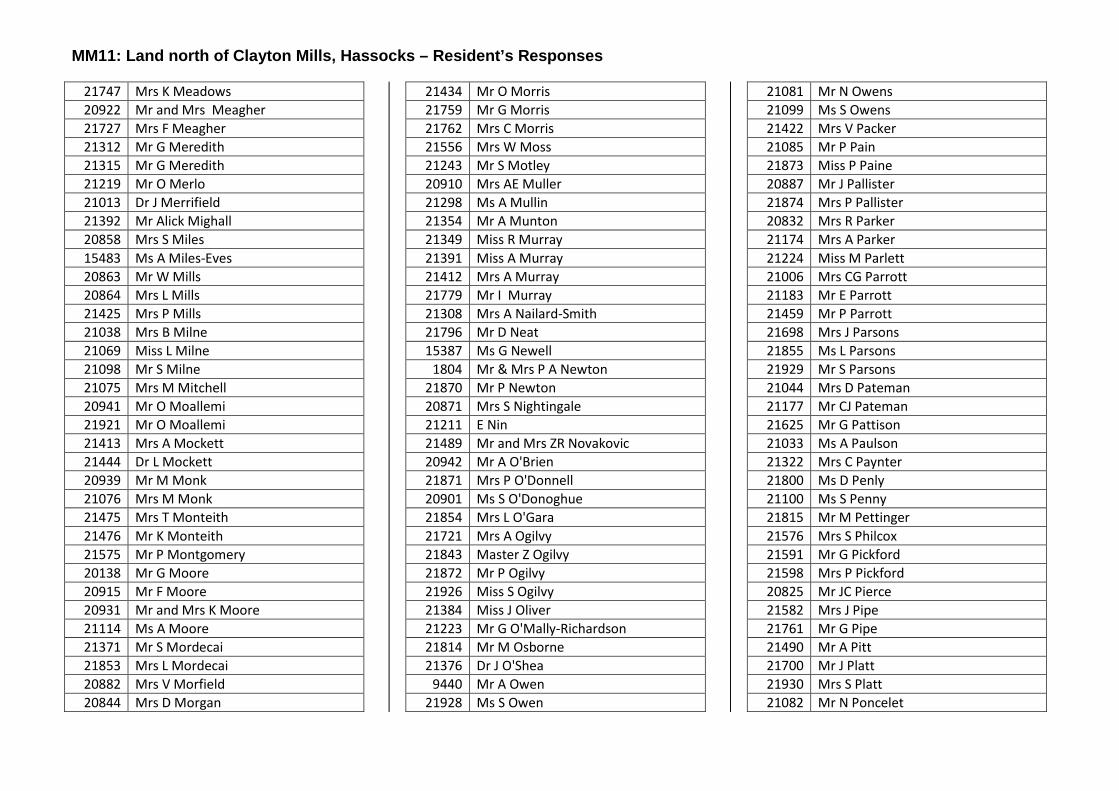
MM11: Land north of Clayton Mills, Hassocks – Resident’s Responses
21747 Mrs K Meadows 20922 Mr and Mrs Meagher 21727 Mrs F Meagher 21312 Mr G Meredith 21315 Mr G Meredith 21219 Mr O Merlo 21013 Dr J Merrifield 21392 Mr Alick Mighall 20858 Mrs S Miles 15483 Ms A Miles-Eves 20863 Mr W Mills 20864 Mrs L Mills 21425 Mrs P Mills 21038 Mrs B Milne 21069 Miss L Milne 21098 Mr S Milne 21075 Mrs M Mitchell 20941 Mr O Moallemi 21921 Mr O Moallemi 21413 Mrs A Mockett 21444 Dr L Mockett 20939 Mr M Monk 21076 Mrs M Monk 21475 Mrs T Monteith 21476 Mr K Monteith 21575 Mr P Montgomery 20138 Mr G Moore 20915 Mr F Moore 20931 Mr and Mrs K Moore 21114 Ms A Moore 21371 Mr S Mordecai 21853 Mrs L Mordecai 20882 Mrs V Morfield 20844 Mrs D Morgan
21434 Mr O Morris 21759 Mr G Morris 21762 Mrs C Morris 21556 Mrs W Moss 21243 Mr S Motley 20910 Mrs AE Muller 21298 Ms A Mullin 21354 Mr A Munton 21349 Miss R Murray 21391 Miss A Murray 21412 Mrs A Murray 21779 Mr I Murray 21308 Mrs A Nailard-Smith 21796 Mr D Neat 15387 Ms G Newell
1804 Mr & Mrs P A Newton 21870 Mr P Newton 20871 Mrs S Nightingale 21211 E Nin 21489 Mr and Mrs ZR Novakovic 20942 Mr A O'Brien 21871 Mrs P O'Donnell 20901 Ms S O'Donoghue 21854 Mrs L O'Gara 21721 Mrs A Ogilvy 21843 Master Z Ogilvy 21872 Mr P Ogilvy 21926 Miss S Ogilvy 21384 Miss J Oliver 21223 Mr G O'Mally-Richardson 21814 Mr M Osborne 21376 Dr J O'Shea
9440 Mr A Owen 21928 Ms S Owen
21081 Mr N Owens 21099 Ms S Owens 21422 Mrs V Packer 21085 Mr P Pain 21873 Miss P Paine 20887 Mr J Pallister 21874 Mrs P Pallister 20832 Mrs R Parker 21174 Mrs A Parker 21224 Miss M Parlett 21006 Mrs CG Parrott 21183 Mr E Parrott 21459 Mr P Parrott 21698 Mrs J Parsons 21855 Ms L Parsons 21929 Mr S Parsons 21044 Mrs D Pateman 21177 Mr CJ Pateman 21625 Mr G Pattison 21033 Ms A Paulson 21322 Mrs C Paynter 21800 Ms D Penly 21100 Ms S Penny 21815 Mr M Pettinger 21576 Mrs S Philcox 21591 Mr G Pickford 21598 Mrs P Pickford 20825 Mr JC Pierce 21582 Mrs J Pipe 21761 Mr G Pipe 21490 Mr A Pitt 21700 Mr J Platt 21930 Mrs S Platt 21082 Mr N Poncelet

MM11: Land north of Clayton Mills, Hassocks – Resident’s Responses
20966 Miss E Pope 21479 Miss A Pragnell 21817 Mrs M Preece 21112 Mrs V Prentice 20680 Mr D Price 21235 Mrs P Price 21257 Mr J Price 21263 Mrs S Price 21232 Mr R Pulham 21136 Mr P Pullan
2252 Mr G M Quantrill 21204 Miss F Raitt 21205 Mrs H Raitt 21207 Mr R Raitt 21764 Mrs C Rank 21833 Dr T Rank 21439 Mr J Rankin 20866 Miss K Rash 21020 Ms I Rayner 21249 Mr J Rayner 21511 Mrs J Rayner 21541 Mrs M Rea 21600 Dr D Rea 21375 Miss J Read 21427 Mrs J Redford 21529 Mr J Redford 21178 Mrs E Reece 21026 Mr B Reed 21027 Mrs C Reed 21021 Mrs R Rees 21061 Mr J Rees 15754 Mr P Reeve 15755 Mrs A Reeve 21695 Mr A Reeves
21834 Ms T Reilly 21931 Mr S Richards 21179 Mr B Richardson 21180 Mrs J Richardson 20932 Ms J Ridley 21702 Mrs J Ridley 21818 Mr M Ridley 20886 Mrs Greta Ripley 20958 Mrs P Ritchie 20909 Mrs J Ritson 21704 Mr J Ritter 20892 Mrs S Roberts 20945 Mr N Roberts 21394 Mrs S Roberts 21706 Mrs J Roberts 21910 Mr N Roberts 21255 Mr P Robinson 21259 Miss H Robinson 21265 Miss K Robinson 21820 Mrs M Robinson 20920 Mrs A Rogers 21436 Mr M Rogers 20828 Mr J Rolls 20831 Mrs A Rolls 21340 Mrs L Rose 15310 A W Rosewell 20715 Mrs J Rosewell 21641 Mr J Rosewell 21822 Miss M Ross 20839 Mr BA Rothwell 21221 Mrs K Roughton 21302 Mrs C Rouse-Mighall 21271 Ms J Rowan 21435 Mr C Ruffle
21766 Mrs C Ruffle 21823 Mr M Rummery 21932 Mrs S Rummery 21697 Mr A Rutherford 21933 Mr S Ryan 21701 Mr A Sabokbar 21438 Ms C Sackett 21034 Ms A Sampson 21559 Mrs M Sanders 21875 Mr P Sarmiento Roa 21705 Miss A Sarmiento-Carr 21763 Mrs G Sarmiento-Carr 21934 Miss S Sarmiento-Carr 21708 Mrs J Sawyer 21750 Miss K Sawyer 21835 Mr T Sawyer 20972 Mr B Sayers 21162 Mr C Sayers 21222 Miss L Sayers 16009 Mr and Mrs A Scotcher 21167 Ms D Scott 21172 Ms S Scott 21173 Ms A Scott 21417 Mr M Scuse 21498 Mrs J Sealey 20974 Mr G Sear 21825 Mr M Sendall 21856 Mrs L Sendall 21323 Ms D Sensier 21378 Mr K Seth 21379 Mrs C Seth 21836 Mr T Sexton 21765 Miss G Shardlow
732 Mr and Mrs J Sharp

MM11: Land north of Clayton Mills, Hassocks – Resident’s Responses
21297 Mr C Sharp 21406 Mr G Sharp 21841 Mr W Sharp 21886 Mr M Sharp 21481 Mr J Sheffield 21530 Mrs G Sheffield 20960 Mr J Sherrington 21876 Mr P Shoard 21912 Mrs N Shoard 21710 Mrs J Simmons 21712 Mr J Simmons 21752 Mrs K Simmons 21888 Mr M Simmons 21031 Rev D Sinclair 20983 Ms H Skelton 21035 Mrs A Skinner 21811 Mrs S Slark 20652 Mrs S Smith 20935 Ms K Smith 21048 Mrs E Smith 21077 Mr M Smith 21304 Mr C Smith 21385 Mrs H Smith 21455 Mr J Smith 21802 Mr D Smith 21877 Mr P Smith 21767 Mr G Smitherman 21904 Mr R Sobkowiak
1331 Mrs D Spicer 21696 Mrs E Spicer 21618 Mr M Sprange 21181 Mr R Spurrier 20900 Mr D Squire 15325 Mrs J Stacy
21314 Mrs M Staff 21238 Mrs S Standen 21570 Ms V Standfast 20963 Mrs H Stanton 20964 Mrs T Stanton 21844 Mrs Z Stedman 21039 Mr B Stephens 21542 Dr R Stoddart 21348 Mr O Stokes 21813 Mrs S Stokes 21485 Mr S Strange 21486 Mrs J Strange 21367 Mr B Streeter 21372 Mrs H Streeter 21707 Mrs A Stringfellow 21826 Mr and Mrs S Stroud 21711 Ms A Stubbs 20924 Miss F Studman 21837 Mr T Surridge 21890 Mrs M Surridge 21045 Mr D Surry 21046 Mrs D Surry 21355 Mrs R Swift 21547 Ms S Syms 21386 Mrs F Talijan 21768 Mrs C Tanner 20743 Mrs F Tanous 20843 Mrs J Taplin 20823 Mr MP Tarran 20830 Mrs K Tarran 21062 Mr J Tarran 21078 Mr M Tarran 21437 Miss A Tarrant 20836 Mr W Tarrat
20948 Mrs S Tarratt 20851 Mr GG Taylor 21070 Ms L Taylor 21072 Ms L Taylor 21350 Mr E Taylor 21360 Mr M Taylor 21389 Mrs J Taylor 21396 Mr D Taylor 21400 Mrs S Taylor 21715 Mr J Taylor 21716 Mr J taylor 21905 Mrs R Taylor 21053 Mr G Taylow 21328 Mr M Teager 20923 Mrs C Tester 20949 Mrs S Tester 21580 Ms J Thatcher 21176 Mr M Thomson 21373 Mr J Thomson 21774 Mr C Thomson 21063 Mr J Thorn 21286 Mr R Thornton 21923 Mr O Thriscutt 10690 Mr R Thurlow 20940 Mr M Thwaites 21064 Mrs J Thwaites
9662 Mr L Tilley 21522 Ms A Tomlin 20927 Mr I Tovey 21351 Mrs L Tovey 21781 Mr I Tovey 21782 Mr I Townsend 20957 Mrs K Trainer 21115 Ms A Troake
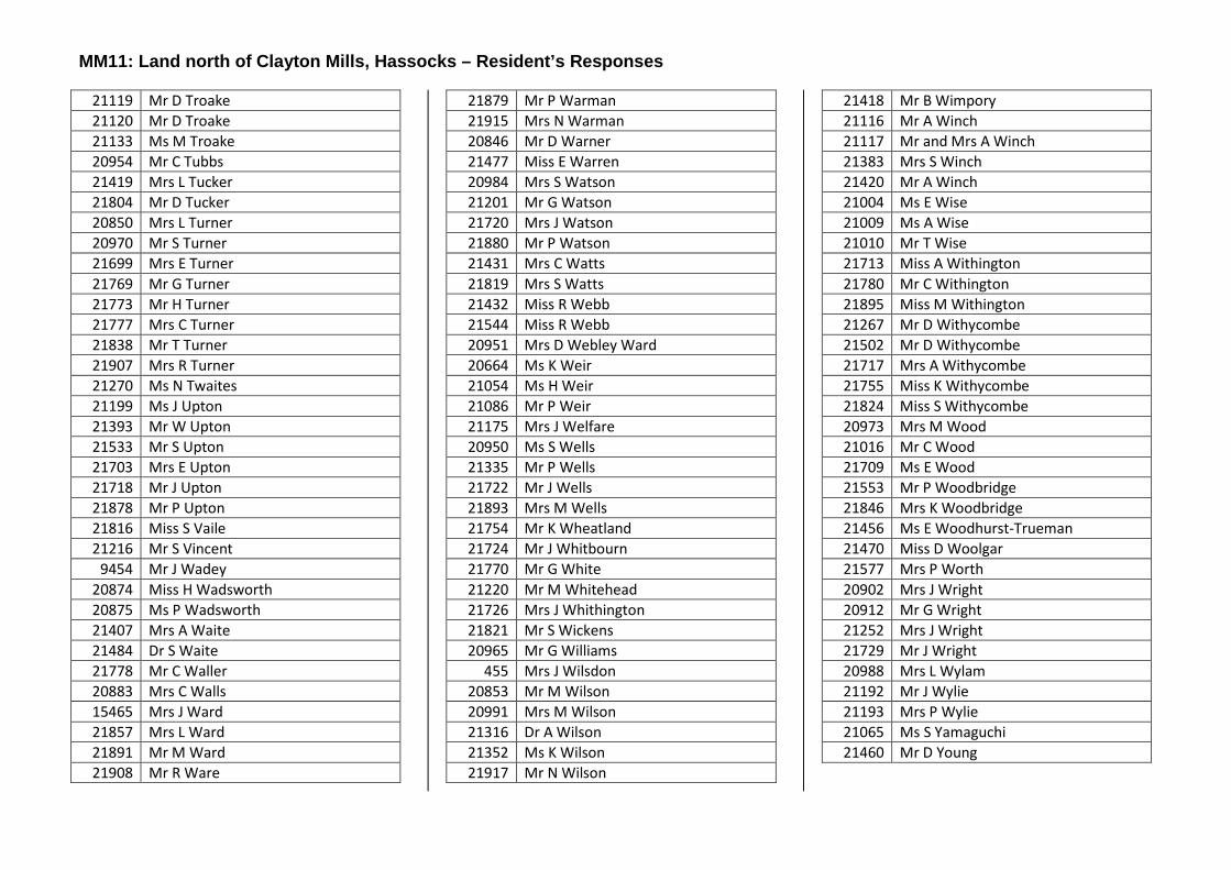
MM11: Land north of Clayton Mills, Hassocks – Resident’s Responses
21119 Mr D Troake 21120 Mr D Troake 21133 Ms M Troake 20954 Mr C Tubbs 21419 Mrs L Tucker 21804 Mr D Tucker 20850 Mrs L Turner 20970 Mr S Turner 21699 Mrs E Turner 21769 Mr G Turner 21773 Mr H Turner 21777 Mrs C Turner 21838 Mr T Turner 21907 Mrs R Turner 21270 Ms N Twaites 21199 Ms J Upton 21393 Mr W Upton 21533 Mr S Upton 21703 Mrs E Upton 21718 Mr J Upton 21878 Mr P Upton 21816 Miss S Vaile 21216 Mr S Vincent
9454 Mr J Wadey 20874 Miss H Wadsworth 20875 Ms P Wadsworth 21407 Mrs A Waite 21484 Dr S Waite 21778 Mr C Waller 20883 Mrs C Walls 15465 Mrs J Ward 21857 Mrs L Ward 21891 Mr M Ward 21908 Mr R Ware
21879 Mr P Warman 21915 Mrs N Warman 20846 Mr D Warner 21477 Miss E Warren 20984 Mrs S Watson 21201 Mr G Watson 21720 Mrs J Watson 21880 Mr P Watson 21431 Mrs C Watts 21819 Mrs S Watts 21432 Miss R Webb 21544 Miss R Webb 20951 Mrs D Webley Ward 20664 Ms K Weir 21054 Ms H Weir 21086 Mr P Weir 21175 Mrs J Welfare 20950 Ms S Wells 21335 Mr P Wells 21722 Mr J Wells 21893 Mrs M Wells 21754 Mr K Wheatland 21724 Mr J Whitbourn 21770 Mr G White 21220 Mr M Whitehead 21726 Mrs J Whithington 21821 Mr S Wickens 20965 Mr G Williams
455 Mrs J Wilsdon 20853 Mr M Wilson 20991 Mrs M Wilson 21316 Dr A Wilson 21352 Ms K Wilson 21917 Mr N Wilson
21418 Mr B Wimpory 21116 Mr A Winch 21117 Mr and Mrs A Winch 21383 Mrs S Winch 21420 Mr A Winch 21004 Ms E Wise 21009 Ms A Wise 21010 Mr T Wise 21713 Miss A Withington 21780 Mr C Withington 21895 Miss M Withington 21267 Mr D Withycombe 21502 Mr D Withycombe 21717 Mrs A Withycombe 21755 Miss K Withycombe 21824 Miss S Withycombe 20973 Mrs M Wood 21016 Mr C Wood 21709 Ms E Wood 21553 Mr P Woodbridge 21846 Mrs K Woodbridge 21456 Ms E Woodhurst-Trueman 21470 Miss D Woolgar 21577 Mrs P Worth 20902 Mrs J Wright 20912 Mr G Wright 21252 Mrs J Wright 21729 Mr J Wright 20988 Mrs L Wylam 21192 Mr J Wylie 21193 Mrs P Wylie 21065 Ms S Yamaguchi 21460 Mr D Young

District Plan - Main Modifications Consultation - Responses MM12 DP13: New Homes in the Countryside
Ref#
58
Respondent:Mrs R Robertson
Organisation:Balcombe Parish Council
Behalf Of:Comment#2
This policy refers to DP6, which in itself allows development in the countryside. The scale of restriction given in all other criteria in this policy and the large scale of development which will result from DP6 are clearly illustrated here.
There is no mention of the additional protection afforded to the AONB in the NPPF and this is anomission. It is also in breach of legislation.
MSDC have concluded that a review of the sustainability assessment for DP13 is not required as this policy has not changed since Submission stage. However this is not the case. The effect of fringe development of the countryside immediately adjoining villages built up boundaries in DP6 makes this change significant and a reassessment should be made on DP13 sustainability. Furthermore the District Plan monitoring section still sets the target as zero for countryside development which is clearly unachievable in light of DP6. A new target should be set that shows the effect of DP6 on protection of the countryside.This policy is not sound or legal in terms of the AONB and NPPF.
ObjectMod: MM12
Ref#
14982
Respondent:Mr M Brown
Organisation:CPRE - Mid Sussex
Behalf Of:Comment#6
Add to Policy Text after “The proposed development meets the requirements of Policy DP6 Settlement Hierarchy” the additional words “and of the relevant made Neighbourhood Plan (if any)”.
NeutralMod: MM12
Ref#
20117
Respondent:Mr R Cartwright
Organisation:Mid Sussex Liberal Democrats
Behalf Of:Comment#12
There is little to comment on in this section which has not been addresses in the past and we see this as only a small clarification of existing policy.
NeutralMod: MM12
MM12 DP13: New Homes in the Countryside

District Plan - Main Modifications Consultation - Responses MM13 DP18: Securing Infrastructure
Ref#
16427
Respondent:Mr E Fielding
Organisation: Behalf Of:Comment#9
In the policy text “The Levy will normally be spent on infrastructure needs in the locality of the scheme.” What is the definition of “Normally” and what is the definition of “locality” with neither of these vague terms set out this policy is not sound.
ObjectMod: MM13
Ref#
20117
Respondent:Mr R Cartwright
Organisation:Mid Sussex Liberal Democrats
Behalf Of:Comment#13
We feel this is stepping back from previous published schedule due to the council’s inability, to date, in delivering a Local Plan, and a reversal of the policy on Neighbourhood plans and how they were presented to their respective communities by the Town and Parish Councils. It is we feel, incumbent on the council to issue an indicative chart setting out in broad terms the amount of money which comes with the approximate dwelling size. Also, there is no reference as to how much of the CIL will be passed to the Town and Parish Councils where and when the homes are built. Which is potentially a large amount of money for them to provide community infrastructure. Neither is there a document setting out what the charging scale will be under these revised proposals. Is it to be the same as before or different? Is there to be an inflationary charging schedule based on RPI or CPI? This is critical as the amount otherwise brings a diminishing return to the community the further into the Plan period we get. It also encourages developers not to develop too early in the plans lifetime as it would be a diminishing fix cost and affect their bottom line on a balance sheet. It can also potentially lead to the failure to deliver on the stated figures in the plan to 2024/25.
Mod: MM13
MM13 DP18: Securing Infrastructure
District Plan - Main Modifications Consultation - Responses MM14 DP19: Transport
Ref#
63
Respondent:Ms J Holden
Organisation:East Grinstead Town Council
Behalf Of:Comment#6
The Council are pleased that DP19 has been included however the word significant is subjective and needs further clarification as to how this will be interpreted. In addition the EGTC neighbourhood plan includes an obligation for all new development to provide a robust traffic assessment. This will be in compliance with DP19, but must be recognised that its stronger requirements will be valid due to the severe transport constraints and that Policy EG11 of the East Grinstead Neighbourhood Plan “Mitigating Highway Impact” is taken fully into account in making EG planning decisions by MSDC Officers and Planning Committees.
This above recognises that:1. DP19 policy is written to apply to the varying wide range of Town and Parish transport/traffic conditions that exist across the district, and is written accordingly, requiring ONLY “Developments which generate significant amounts of movement to be supported by a Transport Assessment/Statement and a Travel Plan” whilst in comparison2. EG11 was approved by the EGNP Examining Inspector recognising that “Due to identified highway constraints within the Neighbourhood Plan Area ALL new planning proposals will be expected to be supported by an appropriate assessment of the impact of the proposal on the (A22/A264 ) highway network”Clearly the EG11 Policy was introduced to closely monitor and control using NPPF guidelines the traffic impact from new planning proposals on the severely congested EG traffic Network. It has been supported by the Neighbourhood Plan Examiner to address this significant concern and the District Plan must not allow this to be weakend.
ObjectMod: MM14
Ref#
117
Respondent:Mr D Bowie
Organisation:Highways England
Behalf Of:Comment#1
Highways England has been appointed by the Secretary of State for Transport as strategic highway company under the provisions of the Infrastructure Act 2015 and is the highway authority, traffic authority and street authority for the strategic road network (SRN). The SRN is a critical national asset and as such Highways England works to ensure that it operates and is managed in the public interest, both in respect of current activities and needs as well as in providing effective stewardship of its long-term operation and integrity. We will therefore be concerned with proposals that have the potential to impact the safe and efficient operation of the SRN.
Having reviewed the published documentation, Highways England is not content with the proposed rewording of policy DP19 in that it implies that only sites that generate a significant amount of traffic will be required to provide a Transport Assessment or Transport Statement, and therefore is fundamentally flawed. The previous wording is deemed to be appropriate - i.e. all development that increases traffic will be supported by a Transport Assessment or Transport Statement depending on its size and potential impact. As an example, the proposed rewording would allow a situation where 10 developments of 100 houses in a particular area may not be required to provide a Transport Assessment or Transport Statement, where a single development of 1,000 houses would be, yet the cumulative impact would be the same.
Please continue to consult Highways England as the plan progresses.
ObjectMod: MM14
MM14 DP19: Transport

District Plan - Main Modifications Consultation - Responses MM14 DP19: Transport
Ref#
192
Respondent:Ms C West
Organisation:West Sussex County Council
Behalf Of:Comment#2
The County Council request the reinsertion of “in accordance with parking standards as agreed by the Local Planning Authority” into policy DP19 to clarify which parking standards apply if there is no car parking standard included in an up-to-date Neighbourhood Plan.
NeutralMod: MM14
Ref#
14982
Respondent:Mr M Brown
Organisation:CPRE - Mid Sussex
Behalf Of:Comment#7
NPPF para 32 bullet 3 calls for improvements to the traffic network, not merely mitigation of adverse impacts. Accordingly, in order to ensure compliance with para 32 DELETE from the Policy Text, second paragraph, bullet 6, the words: “appropriate mitigation to support new development on” and substitute “opportunities effectively to limit significant impacts of the development through cost effective improvements to be undertaken to ….”. 2.Please DELETE all of Policy Text second paragraph, bullet 7 (beginning” The scheme avoids severe additional traffic congestion” and substitute: “the residual cumulative impact of all relevant development proposals and commitments on the local and surrounding road network is likely to be severe”. This language more closely follows that in NPPF para 32 and more accurately reflects the fact that what matters is the cumulative severity of all relevant development and not merely the incremental impact of any one development proposal. The suggested language also more clearly requires the Council to take into account (as it should) differing congestion conditions in different parts of the District (such as, for example, the well known severe conditions on the A22 and A264 in and around East Grinstead which led to a special policy (EG11) in East Grinstead’s Neighbourhood Plan).3.In the penultimate paragraph of Policy Text DELETE the words “and viable” in line 1. There is no viability test in NPPF para 35, from which this policy paragraph derives.
ObjectMod: MM14
Ref#
16427
Respondent:Mr E Fielding
Organisation: Behalf Of:Comment#10
•This policy is not sound because the opportunities to reduce carbon emission have not been applied consistently with most major developments having not requirements at all.•Why is DP19 only applied to DP9b which is the only strategic site that has to make provision for electric vehicles and charging points? This requirement should be required for all new developments or policy DP19 is not meaningful deliverable or sound.
ObjectMod: MM14
MM14 DP19: Transport

District Plan - Main Modifications Consultation - Responses MM14 DP19: Transport
Ref#
20117
Respondent:Mr R Cartwright
Organisation:Mid Sussex Liberal Democrats
Behalf Of:Comment#14
We see these alterations as a positive move forward in respect of environmental impact, but would draw the inspector’s attention to our comments regarding the Clayton Mills site, which seems to be counter to these alterations in many aspects.Our concerns remain regarding assess to public transport and its provision. Currently there has been a reduction in services across Mid Sussex due to the removal of some subsides. For example, the Triangle leisure centre in Burgess Hill has seen an issue developing where some clients, particularly, but not exclusively, older users, being unable to attend fitness courses due to the removal and cutting back of Public Transport Services. We know this is being looked at currently, but have no knowledge of the outcomes of any discussions to make further comment here. It does however run contra to parts of this policy as the Planning Authority has little say in the provision and we know does not, from historic knowledge, provide ongoing funding
NeutralMod: MM14
Ref#
21670
Respondent:Mr C Tweed
Organisation: Behalf Of:Comment#1
The transport plan repeatedly states the need for sustainable transport networks and provision for cycling, but fails to specify required standards.
The Transport plan states "It is designed to adoptable standards, or other standards as agreed by the Local Planning Authority.."
In order to achieve the aims with regard to sustainable transport the absolute minimum standards that should be used for road design should be Interim Advice Note 190/16 - Cycle Traffic and the Strategic Road Network. Otherwise cycling networks will be ineffective and the modal share will remain at sub 3% levels
ObjectMod: MM14
MM14 DP19: Transport

District Plan - Main Modifications Consultation - Responses MM15 DP21: Communication Infrastructure
Ref#
20117
Respondent:Mr R Cartwright
Organisation:Mid Sussex Liberal Democrats
Behalf Of:Comment#15
No further comments as it has already been set out in other central government papers.
SupportMod: MM15
MM15 DP21: Communication Infrastructure

District Plan - Main Modifications Consultation - Responses MM16 DP24: Character and Design
Ref#
245
Respondent:Ms G Kennedy
Organisation:Lindfield Preservation Society
Behalf Of:Comment#3
The policy requirements for high quality design and sensitivity to the countryside are in conflict with the housing distribution approach of DP 6.
DP 24 requires that “all development … will be well designed and reflect the distinctive character of the towns and villages while being sensitive to the countryside”. Lindfield provides an example of large-scale development that has been inimical to the character of the village and has eliminated large swathes of countryside unnecessarily. The crude mathematical assignment of further housing targets in DP6, without any consideration of this context, cannot therefore be seen to be consistent with DP 24. At the very least, a rationale would be required to demonstrate why additional large-scale development would not exacerbate the damage already done.
The conflict between DP6 and DP24 is logically inconsistent and therefore unsound. DP24 should be retained and DP6 radically revised to be in keeping.
ObjectMod: MM16
Ref#
14982
Respondent:Mr M Brown
Organisation:CPRE - Mid Sussex
Behalf Of:Comment#8
In bullet 9 of the Policy Text after the word “sustainability” DELETE “considerations” and substitute “and biodiversity opportunities”. Good building design provides potential opportunities to encourage wildlife (for example by incorporating nest boxes within the eaves fabric or planting space outside the building). In our view the word “opportunities” is more consistent with the positive planning requirements of the NPPF than “considerations”.2.In the last bullet, please add at the end the additional words ”having regard to DP28 (Housing Mix), to Neighbourhood Plans and to the appropriate level of housing density for the location of the site. The level of the District’s housing land supply will also be given weight.” It is important to clarify the main considerations that will determine optimal density for a given site location. An ambition to maximise housing numbers has to be tempered by the imperative of securing a policy compliant housing mix and by the landscape environment in which the site sits. Additionally, in a District Plan that seeks to assert the important role of Neighbourhood Plans, any policy there on appropriate site density should be a material factor. Lastly, we suggest that it is relevant to consider the state of the district’s housing land supply, as over-development should properly be resisted when there is no social need for it. As the proposed policy stands those tempering factors appear to be irrelevant. They should not be.
ObjectMod: MM16
MM16 DP24: Character and Design
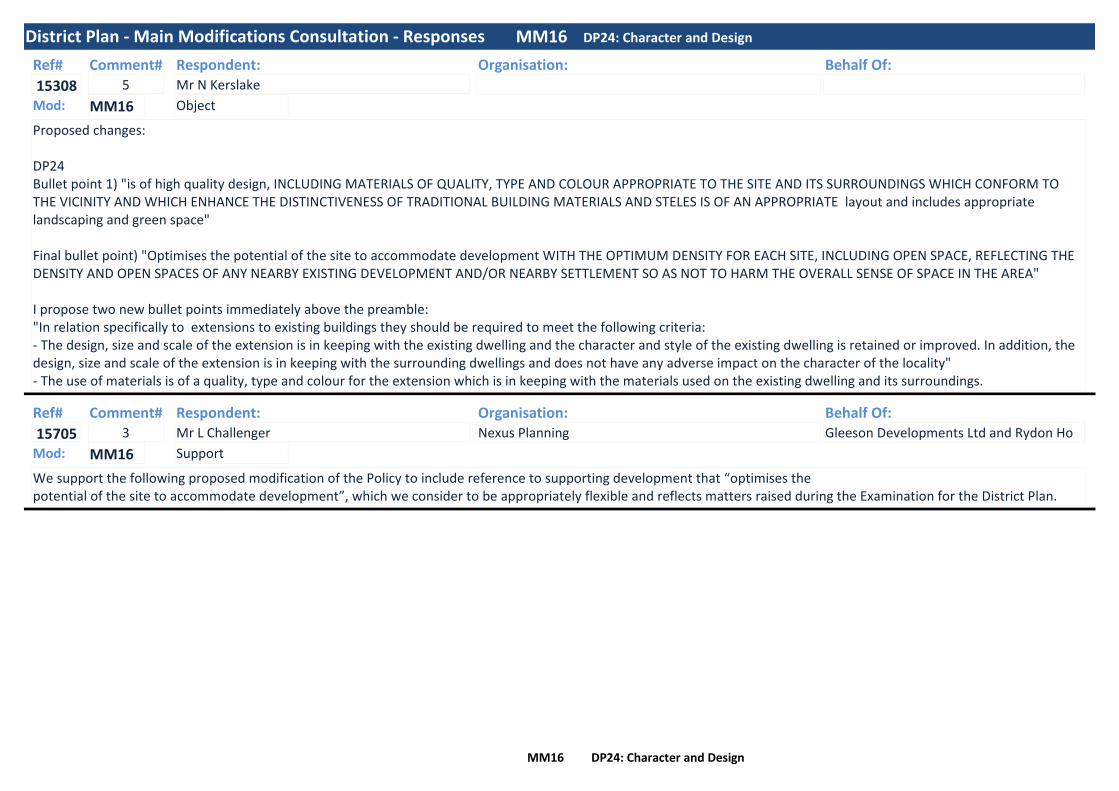
District Plan - Main Modifications Consultation - Responses MM16 DP24: Character and Design
Ref#
15308
Respondent:Mr N Kerslake
Organisation: Behalf Of:Comment#5
Proposed changes:
DP24Bullet point 1) "is of high quality design, INCLUDING MATERIALS OF QUALITY, TYPE AND COLOUR APPROPRIATE TO THE SITE AND ITS SURROUNDINGS WHICH CONFORM TO THE VICINITY AND WHICH ENHANCE THE DISTINCTIVENESS OF TRADITIONAL BUILDING MATERIALS AND STELES IS OF AN APPROPRIATE layout and includes appropriate landscaping and green space"
Final bullet point) "Optimises the potential of the site to accommodate development WITH THE OPTIMUM DENSITY FOR EACH SITE, INCLUDING OPEN SPACE, REFLECTING THE DENSITY AND OPEN SPACES OF ANY NEARBY EXISTING DEVELOPMENT AND/OR NEARBY SETTLEMENT SO AS NOT TO HARM THE OVERALL SENSE OF SPACE IN THE AREA"
I propose two new bullet points immediately above the preamble:"In relation specifically to extensions to existing buildings they should be required to meet the following criteria:- The design, size and scale of the extension is in keeping with the existing dwelling and the character and style of the existing dwelling is retained or improved. In addition, the design, size and scale of the extension is in keeping with the surrounding dwellings and does not have any adverse impact on the character of the locality"- The use of materials is of a quality, type and colour for the extension which is in keeping with the materials used on the existing dwelling and its surroundings.
ObjectMod: MM16
Ref#
15705
Respondent:Mr L Challenger
Organisation:Nexus Planning
Behalf Of:Gleeson Developments Ltd and Rydon Ho
Comment#3
We support the following proposed modification of the Policy to include reference to supporting development that “optimises thepotential of the site to accommodate development”, which we consider to be appropriately flexible and reflects matters raised during the Examination for the District Plan.
SupportMod: MM16
MM16 DP24: Character and Design

District Plan - Main Modifications Consultation - Responses MM16 DP24: Character and Design
Ref#
17488
Respondent:Mr C McClea
Organisation:Savills
Behalf Of:Wates - Burgess Hill Northern Arc
Comment#5
6.1. The BHNA is to be allocated as a mixed use development comprising approximately 3,500 dwellings with education, employment, community and recreational facilities, and it has been acknowledged that this site will be delivered in a phased approach through multiple planning applications. Therefore, the proposed main modification to Policy DP24, as set out below, will impact on the future phases of BHNA:‘All applicants will be required to demonstrate that development:
expected to incorporate a mixed use element;’
6.2. As acknowledged and provided for in Policy DP9, the BHNA allocation is likely to come forward through a series of planning applications, tied together by way of a Spatial Framework Plan (SFP) and IDS. A number of the applications will be larger than 300 units, but may not include areas of mixed use development. Given that the principle of development within the BHNA (including a mix of uses) will be established through the SFP, Policy DP24 should be amended to exclude reference to the Strategic Allocations.
6.3. We propose that a sentence is added to confirm that this requirement does not apply to Strategic Allocations, as set out below:‘All applicants will be required to demonstrate that development:
expected to incorporate a mixed use element (except in Strategic Allocations where a mix of uses is already agreed);’
ObjectMod: MM16
Ref#
20117
Respondent:Mr R Cartwright
Organisation:Mid Sussex Liberal Democrats
Behalf Of:Comment#16
We welcome these proposals, but hope it does not indicate a return to the past where poor design encouraged anti-social behaviour to go unreported by having poor visibility to the side and rear of properties.
SupportMod: MM16
MM16 DP24: Character and Design

District Plan - Main Modifications Consultation - Responses MM17 DP24A: Housing Density
Ref#
63
Respondent:Ms J Holden
Organisation:East Grinstead Town Council
Behalf Of:Comment#7
There is no additional comment on this policy
SupportMod: MM17
Ref#
451
Respondent:Mr R M Nailard
Organisation:The Greenfield Guardians
Behalf Of:Comment#3
Restore some of the deleted wording to the last bullet point of MM17 to restore awareness of impact on surrounding area. > optimises the potential of the site to accommodate development with due consideration given to the established character of surrounding areas and the potentially avoidable loss of open countryside beyond settlement boundaries.
This is necessary to ensure consideration is given to the landscape environment in which the proposed development sits and ensure that the building mix is appropriate whilst still being compliant with the wording of the Policy.
ObjectMod: MM17
Ref#
14982
Respondent:Mr M Brown
Organisation:CPRE - Mid Sussex
Behalf Of:Comment#9
In bullet 9 of the Policy Text after the word “sustainability” DELETE “considerations” and substitute “and biodiversity opportunities”. Good building design provides potential opportunities to encourage wildlife (for example by incorporating nest boxes within the eaves fabric or planting space outside the building). In our view the word “opportunities” is more consistent with the positive planning requirements of the NPPF than “considerations”.2.In the last bullet, please add at the end the additional words ”having regard to DP28 (Housing Mix), to Neighbourhood Plans and to the appropriate level of housing density for the location of the site. The level of the District’s housing land supply will also be given weight.” It is important to clarify the main considerations that will determine optimal density for a given site location. An ambition to maximise housing numbers has to be tempered by the imperative of securing a policy compliant housing mix and by the landscape environment in which the site sits. Additionally, in a District Plan that seeks to assert the important role of Neighbourhood Plans, any policy there on appropriate site density should be a material factor. Lastly, we suggest that it is relevant to consider the state of the district’s housing land supply, as over-development should properly be resisted when there is no social need for it. As the proposed policy stands those tempering factors appear to be irrelevant. They should not be.
ObjectMod: MM17
Ref#
15705
Respondent:Mr L Challenger
Organisation:Nexus Planning
Behalf Of:Gleeson Developments Ltd and Rydon Ho
Comment#4
We support the proposed deletion of this Policy and its replacement with additional wording in Policy 24.
SupportMod: MM17
MM17 DP24A: Housing Density

District Plan - Main Modifications Consultation - Responses MM17 DP24A: Housing Density
Ref#
17488
Respondent:Mr C McClea
Organisation:Savills
Behalf Of:Wates - Burgess Hill Northern Arc
Comment#6
7.1.1. Wates supports the removal of Policy DP24a: Housing Density.
SupportMod: MM17
Ref#
20117
Respondent:Mr R Cartwright
Organisation:Mid Sussex Liberal Democrats
Behalf Of:Comment#17
We are unclear on what this means in practical terms. Is it saying build to whatever density you feel like and don’t worry about the social consequences in our towns. Or is it saying the densities before were set to high/just right?
We campaign to retain our countryside and landscape, but there is a balance to be struck with the needs of people to live in a sustainable environment as well. Where their mental and physical health is not jeopardised by cramming. A major and as important part of the character of Mid Sussex is also our clean and pleasant town and village landscapes. Not exclusively what is outside of the built area. Neither must be compromised at the expense of the other. There is already a growing body of evidence of this taking place in Mid Sussex as well as nationally and a full environmental impact study of our built areas needs undertaking before the deletion of any of the wording covered in MM17 takes place.
NeutralMod: MM17
Ref#
20534
Respondent:Ms K Lamb
Organisation:DMH Stallard
Behalf Of:Welbeck Strategic Land LLP (Imberhorne F
Comment#4
4.17 Welbeck support the deletion of Policy DP24a. The NPPF removed the need to onerous density requirements, acknowledging that development should reflect local circumstances. Densities should reflect the characteristics of individual sites and locations and should not be prescribed.
SupportMod: MM17
Ref#
21121
Respondent:Ms K Lamb
Organisation:DMH Stallard
Behalf Of:Consortium 'Land West of Copthorne'
Comment#3
The consortium note the deletion of Policy DP24a: Housing Density but it is welcomed that a need to ensure best use of a site is retained throughout the District Plan. The extant planning permission for land west of Copthorne is a relatively low density (c30dph). The site has large areas of green space and densities could be maximised in parts of the site. To accord with MSDC’s aspiration to make best use of land, the site should be allocated, this would release pressure to release greenfield land elsewhere in Worth Parish.
NeutralMod: MM17
MM17 DP24A: Housing Density

District Plan - Main Modifications Consultation - Responses MM18 DP26: Accessibility
Ref#
58
Respondent:Mrs R Robertson
Organisation:Balcombe Parish Council
Behalf Of:Comment#4
This policy seeks to reduce the regulations set out in the Building Regulations for accessibility. Flatdevelopments for less than 10 units will be exempt from this regulation under this policy. ForBalcombe this would mean all proposed flat developments currently in the NP would be exemptfrom accessibility regulations. This policy disadvantages small settlements where developments are of a smaller scale. Yet many rural areas lack just this type of smaller, manageable accommodation for older people and those with accessibility issues. Balcombe’s NP encourages accessible accommodation and seeks its provision through the Design Guide.
There seems to be no reason for this relaxation other than viability and yet the regulations are not onerous and this cannot be justified. The requirement is that a proportion (20%) to have flat paved access, wider doors, larger bathrooms /toilets and slightly wider corridors. This could easily be accommodated on the ground floor of such blocks and the proposed policy is unsound andcontravenes the legislation set out in the Building Regulations. For conversions of existing buildings this may be acceptable but for new builds it is not. This policy is unsound and contrary to law (Building Regulations).
ObjectMod: MM18
Ref#
69
Respondent:Mrs C Irwin
Organisation:Lindfield Parish Council
Behalf Of:Comment#2
DP26 refers to Site Topography and Accessibility, but much of this area is very hilly and discourages walking, let alone for anyone with any disability. Walking/cycling is also mentioned in the Sustainable Development section DP1, but the roads and pavements are too narrow and dangerous. Unless these can be delivered, the words are meaningless.
ObjectMod: MM18
Ref#
16427
Respondent:Mr E Fielding
Organisation: Behalf Of:Comment#11
•It is unacceptable to reduce the amount of homes that will be wheelchair -user suitable from 5% to 4%. Have there been sudden reduced numbers of wheelchair users in the district? Does the council know of a cure that has yet to come to market or does it not recognize these needs especially with its detailed need for older people in the District? Those who do not use a wheelchair can easily live in a house suitable for a wheel chair user so why the reduction? •“Wheelchair-user dwellingsCategory 3 – Wheelchair-user dwellings under Building Regulations – Approved Document M Requirement M4(3) will be required for a reasonable proportion of affordable homes, generally 4%5%, dependent on the suitability of the site and the need at the time.The Requirement will also apply to private extra care, assisted living or other such schemes designed for frailer older people or others with disabilities and those in need of care or support services.” How can we have less provision when we know there is a larger demand espsically as detailed in policy DP28? This policy is not sound.
ObjectMod: MM18
MM18 DP26: Accessibility

District Plan - Main Modifications Consultation - Responses MM18 DP26: Accessibility
Ref#
20117
Respondent:Mr R Cartwright
Organisation:Mid Sussex Liberal Democrats
Behalf Of:Comment#18
We have no issues with this section as it stands, but would challenge any application which fails to meet these requirements.
SupportMod: MM18
MM18 DP26: Accessibility

District Plan - Main Modifications Consultation - Responses MM19 DP27: Noise, Air and Light Pollution
Ref#
20117
Respondent:Mr R Cartwright
Organisation:Mid Sussex Liberal Democrats
Behalf Of:Comment#19
We note this section, but question the lack of vision when addressing the light pollution issue. Many new developments do not fall under local authority highways jurisdiction and to address the problem of developers installing, as in the past, below highways standard lighting, needs a planning policy to enforce a minimum standard of street lighting in respect of light pollution. Non-conforming street lighting has a major environmental impact on many levels.
NeutralMod: MM19
MM19 DP27: Noise, Air and Light Pollution
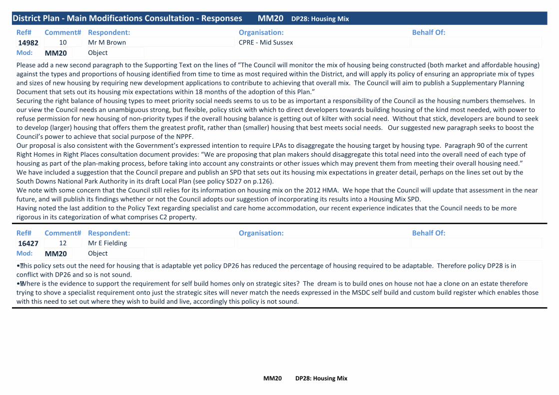
District Plan - Main Modifications Consultation - Responses MM20 DP28: Housing Mix
Ref#
14982
Respondent:Mr M Brown
Organisation:CPRE - Mid Sussex
Behalf Of:Comment#10
Please add a new second paragraph to the Supporting Text on the lines of “The Council will monitor the mix of housing being constructed (both market and affordable housing) against the types and proportions of housing identified from time to time as most required within the District, and will apply its policy of ensuring an appropriate mix of types and sizes of new housing by requiring new development applications to contribute to achieving that overall mix. The Council will aim to publish a Supplementary Planning Document that sets out its housing mix expectations within 18 months of the adoption of this Plan.” Securing the right balance of housing types to meet priority social needs seems to us to be as important a responsibility of the Council as the housing numbers themselves. In our view the Council needs an unambiguous strong, but flexible, policy stick with which to direct developers towards building housing of the kind most needed, with power to refuse permission for new housing of non-priority types if the overall housing balance is getting out of kilter with social need. Without that stick, developers are bound to seek to develop (larger) housing that offers them the greatest profit, rather than (smaller) housing that best meets social needs. Our suggested new paragraph seeks to boost the Council’s power to achieve that social purpose of the NPPF.Our proposal is also consistent with the Government’s expressed intention to require LPAs to disaggregate the housing target by housing type. Paragraph 90 of the current Right Homes in Right Places consultation document provides: “We are proposing that plan makers should disaggregate this total need into the overall need of each type of housing as part of the plan-making process, before taking into account any constraints or other issues which may prevent them from meeting their overall housing need.”We have included a suggestion that the Council prepare and publish an SPD that sets out its housing mix expectations in greater detail, perhaps on the lines set out by the South Downs National Park Authority in its draft Local Plan (see policy SD27 on p.126). We note with some concern that the Council still relies for its information on housing mix on the 2012 HMA. We hope that the Council will update that assessment in the near future, and will publish its findings whether or not the Council adopts our suggestion of incorporating its results into a Housing Mix SPD.Having noted the last addition to the Policy Text regarding specialist and care home accommodation, our recent experience indicates that the Council needs to be more rigorous in its categorization of what comprises C2 property.
ObjectMod: MM20
Ref#
16427
Respondent:Mr E Fielding
Organisation: Behalf Of:Comment#12
•This policy sets out the need for housing that is adaptable yet policy DP26 has reduced the percentage of housing required to be adaptable. Therefore policy DP28 is in conflict with DP26 and so is not sound.•Where is the evidence to support the requirement for self build homes only on strategic sites? The dream is to build ones on house not hae a clone on an estate therefore trying to shove a specialist requirement onto just the strategic sites will never match the needs expressed in the MSDC self build and custom build register which enables those with this need to set out where they wish to build and live, accordingly this policy is not sound.
ObjectMod: MM20
MM20 DP28: Housing Mix

District Plan - Main Modifications Consultation - Responses MM20 DP28: Housing Mix
Ref#
17488
Respondent:Mr C McClea
Organisation:Savills
Behalf Of:Wates - Burgess Hill Northern Arc
Comment#7
8.1. As outlined in separate representations, and in the earlier objection to Policy DP9, Wates objects to the requirement for all strategic sites to provide permanent pitches for Gypsy and Travellers, as set out within Policy DP28: Housing Mix. As expressed within these representations, the inclusion of Gypsy and Traveller sites can jeopardise the timely delivery of important residential schemes, which are vital for meeting the housing requirements for the District. Additionally, there are likely to be other, more suitable sites across the District and the supply of Gypsy and Traveller sites should not be grouped together in only a few locations across the strategic allocations. This method reduces the flexibility and choice for Gypsies and Travellers in respect of both location and size of site. This part of the Policy should therefore be removed and replaced with a criteria based policy for the provision of Gypsy and Traveller pitches across the District based upon the emerging evidence base.
8.2. The supporting text to Policy DP28 has been modified as follows: ‘Work on the Allocations Document has highlighted the difficulties in the delivery of permanent Gypsy and Traveller sites and underlined that there could be a shortage of suitable sites, should the identified need for such sites increase unexpectedly over the plan period; and underlines that the primary provision of permanent Gypsy and Traveller sites is best undertaken in a way that can be master planned into future, currently unplanned strategic sites. Policy provision for such an approach is already supported in this District Plan through Policy DP9: Strategic allocation to the north and north-west of Burgess Hill; Policy DP9A: Strategic Allocation to the east of Pease Pottage; Policy DP9b: Strategic Allocation to the north of Clayton Mills, Hassocks; and within the emerging Traveller Sites Allocations Document.’
8.3. Wates objects to this modification, which suggests Gypsy and Traveller sites will be master planned into future, currently unplanned strategic sites (including BHNA) in the first instance.
8.4. Savills considers that all efforts should be made by MSDC to identify land suitable for accommodating permanent Gypsy and Traveller pitches through preparation of an updated "Traveller Sites Allocations Document". Only once this exercise has been undertaken, should there be any suggestion of accommodating Gypsy and Traveller pitches on Strategic Allocations.
8.5. We propose the following changes to bullet point 3 of Policy DP28 and the inclusion of additional policy text:‘To support sustainable communities, housing development will:
Travelling Show people Accommodation Assessment or such other evidence as prepared by MSDC. Is available at the time; Should Strategic Allocations be assessed as the most suitable locations for Gypsy and Travellerpitches, or the provision of an equivalent financial contribution towards off-site provision (or part thereof if some on-site provision is made) will be accepted, if it can be demonstrated that a suitable, available and achievable site (or sites) can be provided and made operational within an appropriate timescale, commensurable with the overall scale of residential development proposed by the strategic development and serviced plots for self-build homes where a need for such accommodation is identified.’
ObjectMod: MM20
MM20 DP28: Housing Mix

District Plan - Main Modifications Consultation - Responses MM20 DP28: Housing Mix
Ref#
20110
Respondent:Mr B Nam
Organisation:GL Hearn
Behalf Of:Anstone Development Limited
Comment#3
MM20: It is evident that the LPA acknowledges the need for Use Class C2 units in the district but the District Plan does not allocate any such sites for Use Class C2 units. This approach is not sound.
MM20: It is noted that MSDC will consider allocating sites for Use Class C2 units through a Site Allocations DPD if a shortfall in supply is identified. However, MSDC acknowledges the clear demand at present. Therefore, this policy should be updated to say that MSDC will definitely allocate sites for Use Class C2 units through a Site Allocations DPD or deliver the units through acceptable planning applications for C2 units, which demonstrate need.
ObjectMod: MM20
Ref#
20117
Respondent:Mr R Cartwright
Organisation:Mid Sussex Liberal Democrats
Behalf Of:Comment#20
We find no substantial issues with these wording updates which in many ways reflect fact rather than assumption. We would caution that this mix tends to be fluid over a given period and the mix may need adjusting during the life of the plan.Our concern is around the presumption of older people not using personal transport and therefore reduction in carparking requirements. Anecdotally we see a higher usage of personal transport amongst the over 75 age group. Who need their cars to access shorter journeys due to reduced mobility.Organisations such as the RAC and AA should be consulted to see if their research supports the councils stated perception of lower vehicle use by the over 75 age group as compared to other age groups.Where we agree there will be an increased need for more care homes. There is also the fact that people are living healthy active lives for far longer than ever before. Many choose to move to assisted and sheltered accommodation, but retain their active, independent lives. With that increase comes the additional requirement to facilitate the pluses of their increased active life expectancy.Many remain in their family homes. It makes a nonsense to suggest due to moving to assisted living accommodation, intermittent public transport is the only way they would wish to travel outside of their homes.
NeutralMod: MM20
MM20 DP28: Housing Mix
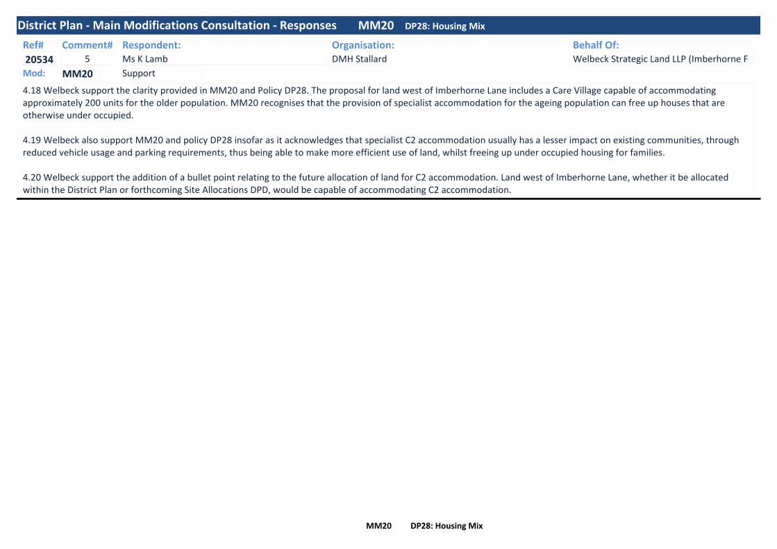
District Plan - Main Modifications Consultation - Responses MM20 DP28: Housing Mix
Ref#
20534
Respondent:Ms K Lamb
Organisation:DMH Stallard
Behalf Of:Welbeck Strategic Land LLP (Imberhorne F
Comment#5
4.18 Welbeck support the clarity provided in MM20 and Policy DP28. The proposal for land west of Imberhorne Lane includes a Care Village capable of accommodating approximately 200 units for the older population. MM20 recognises that the provision of specialist accommodation for the ageing population can free up houses that are otherwise under occupied.
4.19 Welbeck also support MM20 and policy DP28 insofar as it acknowledges that specialist C2 accommodation usually has a lesser impact on existing communities, through reduced vehicle usage and parking requirements, thus being able to make more efficient use of land, whilst freeing up under occupied housing for families.
4.20 Welbeck support the addition of a bullet point relating to the future allocation of land for C2 accommodation. Land west of Imberhorne Lane, whether it be allocated within the District Plan or forthcoming Site Allocations DPD, would be capable of accommodating C2 accommodation.
SupportMod: MM20
MM20 DP28: Housing Mix

District Plan - Main Modifications Consultation - Responses MM21 DP29: Affordable Housing
Ref#
57
Respondent:Ms C Leet
Organisation:Ashurst Wood Village Council
Behalf Of:Comment#2
Ashurst Wood Village Council notes that this policy has been modified to comply with National Planning Policy Guidance, following the Court of Appeal ruling in May 2016. The Village Council would like commuted payments made under DP29 (2) to be spent on affordable housing either within the settlement where the housing which generated the payment is located, or within the AONB.
NeutralMod: MM21
Ref#
58
Respondent:Mrs R Robertson
Organisation:Balcombe Parish Council
Behalf Of:Comment#3
This policy on its own is acceptable, however in conjunction with the proposed DP6 policy of contiguous developments of up to 10 homes this results in a loop hole for lack of provision of affordable housing in the District. For sites in the AONB a commuted sum is allowed on any sites of 6 to 10 units but this is not tied to use in the Parish where the development takes place but could beused anywhere in the District. For sites of up to 10 allowable under DP6 elsewhere no affordable provision is payable. This policy in conjunction with DP6 contiguous development is likely to be contrary to the aims of providing affordable housing in the District and is unsound on this point.
ObjectMod: MM21
Ref#
67
Respondent:Mrs B O'Garra
Organisation:Horsted Keynes Parish Council
Behalf Of:Comment#1
Hosted Keynes Parish Council supports the concerns raised by Balcombe Parish Council concerning Policy DP29. in that the policy states that in the AONB developments (less than 10) will have to provide a commuted sum rather than an element of affordable homes on site. Horsted Keynes Parish Council were also concerned that this policy would mean Parishes could see multiple sites of 9 houses in each village where funding for affordable housing is spent elsewhere in the district. For those outside the AONB there would be no contribution at all as sites would not meet the 11 homes criteria to levy an affordable element. Horsted Keynes Parish Council agreed that the Policy DP29 should reflect that any development which falls within the policy of 9 houses must include an element of affordable housing and result in affordable houses on site
ObjectMod: MM21
MM21 DP29: Affordable Housing

District Plan - Main Modifications Consultation - Responses MM21 DP29: Affordable Housing
Ref#
69
Respondent:Mrs C Irwin
Organisation:Lindfield Parish Council
Behalf Of:Comment#3
In the AONB these developments (less than 10) will have to provide a commuted sum rather than an element of affordable homes on site. This means that we could well see multiple sites of 9 houses in each village where funding for affordable housing is spent elsewhere in the district. For those outside the AONB there would be no contribution at all as sites would not meet the 11 homes criteria to levy an affordable element. The current rules of course mean sites can be sized after careful consideration and local consultation in Neighbourhood Plans to be larger than 11 and so attract 30% affordable housing built in the Parish as part of those developments. We fear that this will no longer be the case.
Further, the policy text appears unsound because it conflicts with the overall aim of ensuring that all development is ‘plan led’. It will lead to unsustainable enclaves of purely 4 or 5 bedroom executive housing around villages. Evidence that developers will take advantage of the policy to ‘salami slice’ contentious larger developments is provided by DM/17/1148 for 9 homes on part of the site for application DM/15/3979 (30 homes) which has been Called-In by the Secretary of State. The proposed policy wording will not provide sufficient protection to prevent such ‘additive development’.
ObjectMod: MM21
MM21 DP29: Affordable Housing

District Plan - Main Modifications Consultation - Responses MM21 DP29: Affordable Housing
Ref#
20117
Respondent:Mr R Cartwright
Organisation:Mid Sussex Liberal Democrats
Behalf Of:Comment#21
The figure of 44.2% of newly forming households is roughly in line with our view of several years ago. The situation has deteriorated since then and we understand the 44.2% is based on a far better resourced data set than we have access to.
Our concerns with the drafting of the rest of this section is the ambiguity around whether 30% can be provided in Mid Sussex and the way it would be assessed as being viable. It must be remembered that for every 1 unit which a developer can avoid building, then another would be expected to pick up the cost.It should also be considered that every Affordable and Social Affordable unit not built in Mid Sussex will, if the situation is to be improved, have to be built elsewhere and Mid Sussex has not taken this into consideration when writing this plan.Our principal concern is around the nondisclosure of how an application is assessed, and the parameters use to judge who can afford and who can’t to provide the 30%, which is already nearly 33% below the identified need.We note that the policy states it will have a supporting Supplementary Planning Document where the details for reducing the 30% exceptions to occur will be published later, but we find it difficult to understand why this does not already exist after many years and many failures of producing a Local Plan and cannot make judgement comments on information which is not available. Our questions on this are: When will the SSPD be produced and will the SSPD be open for consultation or will it just be produced without external scrutiny?
We feel that a policy which states 30% must mean 30%. It is all too easy to present a case which fails to meet this figure and then back it up with supportive arguments. It is equally easy to work to a design brief where the imperative is to meet the obligation to provide. It is easy to back away from a cost centre in a development where the policy has a get out clause. The choices to households who depend on Socially Affordable rented housing are limited anyway and the situation is already chronic. As a local authority which has responsibility to all its residents, it is incumbent on them to do their best for all rather than, in fairness, the majority. However, that majority, on the 44.2% figure may soon exceed the 50% tipping point. It is time for a robust defence of all the community which currently supports, through policy, the better off. At 30% Affordable Home Provision Mid Sussex falls even further behind year on year.In support of the comments above we point to the Governments most recent figures which show the scale of under provision in the Social Affordable Housing sector. Mid Sussex falls woefully below the median.Much of this position may seem idealistic or cynical, but local experience shows that the residents in Mid Sussex have been failed by the council on planning for many years. The problem will become worse if nothing is done to address it. Housing is not a quick fix, but something which lasts for many decades.
ObjectMod: MM21
MM21 DP29: Affordable Housing

District Plan - Main Modifications Consultation - Responses MM21 DP29: Affordable Housing
Ref#
21656
Respondent:Mr R Tullett
Organisation: Behalf Of:Comment#1
I have no comment on the legal compliance of the main modifications and have only one particular objection over soundness
The housing needs of local people on average or below average incomes cannot be met while the stock of social rented housing is allowed to diminish at the current rate through " conversion" and Right to Buy. The policy should be amended to ensure at least that existing social rented housing homes cannot be redeveloped for alternative tenures. Allowing loss of social housing through redevelopment should be resisted, the policy as currently set out allows change to other "affordable" tenures which are not in fact affordable to most local people in housing need. The Affordable Housing Report to MSDC Scrutiny Committee of 14/11/2017 clearly sets out the growing crisis in local homelessness and affordability. It is entirely proper that the District Plan should include policies to resist the loss of existing social housing stock.
Policy DP29 should be amended to include a specific statement to resist any loss of social rented housing through redevelopment or change in unit mix through conversion.
ObjectMod: MM21
MM21 DP29: Affordable Housing

District Plan - Main Modifications Consultation - Responses MM22 DP30: Rural Exception Sites
Ref#
57
Respondent:Ms C Leet
Organisation:Ashurst Wood Village Council
Behalf Of:Comment#3
The Village Council is pleased to see that the policy has been modified to allow an element of market housing, which could encourage landowners to put forward land for rural exception sites. The physical integration of market and affordable homes may be impractical in schemes where there are communal areas of land that are maintained by the registered social landlord. The Village Council would also like to see provision for self-building of affordable homes on single-plot exception sites (as in Shropshire).
SupportMod: MM22
Ref#
14982
Respondent:Mr M Brown
Organisation:CPRE - Mid Sussex
Behalf Of:Comment#11
Whilst acknowledging the statement within the Policy Text that rural exception site development will normally be local community led, we consider that this expectation should be supported by (i) adding a new sub-paragraph vi) on the lines of “it is consistent with DP6 (Settlement Hierarchy) and with the development locational policies in any relevant Neighbourhood Plan” and (ii) that the second bullet of the second paragraph should be amended by DELETING “and v)” and substituting “, v) and vi)”. These changes would reinforce the role of neighbourhood plans and local community involvement in the application of DP30.
ObjectMod: MM22
Ref#
20117
Respondent:Mr R Cartwright
Organisation:Mid Sussex Liberal Democrats
Behalf Of:Comment#22
This re-enforces our view regarding all Socially Affordable Homes. It is curious that this policy states it is necessary to demonstrate where the shortfall would be made up if the 100% target is not to be met, but fails to have a similar clause in MM21
ObjectMod: MM22
MM22 DP30: Rural Exception Sites

District Plan - Main Modifications Consultation - Responses MM23 DP31: Gypsies, Travellers and Travelling Showpeople
Ref#
192
Respondent:Ms C West
Organisation:West Sussex County Council
Behalf Of:Comment#3
It is considered, as in other allocation policies that policy DP31 should have a clause requiring suitable safe access to the site as a requirement in the new site or extensions section of the policy.
NeutralMod: MM23
Ref#
15135
Respondent:Mr A Yarwood
Organisation:National Federation of Gypsy Liaison Groups
Behalf Of:Comment#1
The deletion of the word “local” at modification MM23 at page 45, whilst welcomed, does not address the failure of the Local Plan to comply with national policy as set out in DCLG’s Planning Policy for Traveller Sites (PPTS) Paragraph 10 of PPTS requires that Local Plans set out criteria for dealing with applications even where no need has been identified. Thus the Plan remains unsound and to address this, the first criterion should be deleted.
ObjectMod: MM23
Ref#
17488
Respondent:Mr C McClea
Organisation:Savills
Behalf Of:Wates - Burgess Hill Northern Arc
Comment#8
9.1. Wates wishes to object to Policy DP31 which allocates 24 Gypsy and Traveller pitches within the strategic allocation to the north and north-west of Burgess Hill, for the reasons set out in the previous sections.‘To ensure that a sufficient amount of permanent culturally suitable housing for settled Gypsies, Travellers and Travelling Show people is delivered to meet identified needs within an appropriate timescale, the Council makes provision for:
provision of pitches if it can be demonstrated that a suitable, available and achievable site (or sites) can be provided and made operational within an appropriate timescale (Policy DP9 refers);’
9.2. We request that the following policy wording is removed:‘To ensure that a sufficient amount of permanent culturally suitable housing for settled Gypsies, Travellers and Travelling Show people is delivered to meet identified needs within an appropriate timescale, the Council makes provision for:REMOVE the off-site provision of pitches if it can be demonstrated that a suitable, available and achievable site (or sites) can be provided and made operational within an appropriate timescale (Policy DP9 refers);’
ObjectMod: MM23
MM23 DP31: Gypsies, Travellers and Travelling Showpeople

District Plan - Main Modifications Consultation - Responses MM23 DP31: Gypsies, Travellers and Travelling Showpeople
Ref#
20117
Respondent:Mr R Cartwright
Organisation:Mid Sussex Liberal Democrats
Behalf Of:Comment#23
We have already commented earlier on in this submission to the consultation regarding Gypsies, Travellers and Travelling Showpeople. We do however welcome the recognition of Traveling Showpeople in a policy, it is long overdue. Albeit that currently it seems there is no identified need to provide for any groups in this policy area if they cannot demonstrate a current permanency of residency. Which seems to be counter intuitive and somewhat prejudicial to a recognised ethnic population, which has roots in this country reaching back many hundreds of years. The test would be ‘is this be acceptable to any other ethnic group’ – the answer would come back - NO!The constraints to be applied in this policy if it goes forward are draconian when balance against any other population settlements.We point out that Travelling Showpeople can have a background of very different social traditions than other Gypsies and Travellers which must be a major consideration in any strategy which has to start at the planning stage. We do wish to re-enforce our earlier comments regarding pitches having connectivity to Town and Neighbourhood centres as well as education, social and health services which are equal to other population centres.
ObjectMod: MM23
MM23 DP31: Gypsies, Travellers and Travelling Showpeople

District Plan - Main Modifications Consultation - Responses MM24 DP32: Listed Buildings and Other Buildings of Merit
Ref#
20117
Respondent:Mr R Cartwright
Organisation:Mid Sussex Liberal Democrats
Behalf Of:Comment#24
We welcome changes to text which recognises the independent assessment of assets.
SupportMod: MM24
MM24 DP32: Listed Buildings and Other Buildings of Merit

District Plan - Main Modifications Consultation - Responses MM25 DP33: Conservation Areas
Ref#
15308
Respondent:Mr N Kerslake
Organisation: Behalf Of:Comment#4
Preamble to the policy should be amended to read:"Development in AND ABUTTING a conservation area will be required to conserve or enhance its special character, appearance and the range of activities which contribute to it INCLUDING SAFEGUARDING THE SETTING OF A LISTED BUILDING"
This wording is included in existing local plan policy B12.
First bullet point:"New buildings and extensions are sensitively designed to reflect the characteristics of the area in terms of scale, density, design AND COLOUR and through the use of TRADITIONAL MATERIALS (delete "complementary materials"). THE REPLACEMENT/INSTALLATION OF UPVC WINDOWS WILL BE STRONGLY RESISTED.
This wording is included in existing local plan policy B12. My Chambers Dictionary does not shed any light on the term "complementary" in context of DP33. Traditional materials coupled with resisting UPVC is commonplace across the country and is included in policy DP32 Listed Buildings.
In my view it would be better to expand the wording in DP33 and DP32 to make matters more clear. "The use of synthetic materials for the replacement or installation of windows and doors, including the use of UPVC and powder coated aluminium windows and doors will be strongly resisted"/
ObjectMod: MM25
Ref#
20117
Respondent:Mr R Cartwright
Organisation:Mid Sussex Liberal Democrats
Behalf Of:Comment#25
We feel the strengthening of the wording in this section is beneficial in that it actively promotes economic activity and tourism.
SupportMod: MM25
MM25 DP33: Conservation Areas

District Plan - Main Modifications Consultation - Responses MM26 DP35: Archaeological Sites
Ref#
16427
Respondent:Mr E Fielding
Organisation: Behalf Of:Comment#13
•Why has the council chosen to delete “Archaeological discoveries can be made on land where there are no previously known archaeological finds and assessments may berequired for sites that have archaeological potential but where no prior field investigations have been carried out.” This allows any discovery to be ignored and for the districtand Nation to be robbed of a potential rich discovery. This is not a sound deletion nor is it covered in policy DP32 so it is a developers charter at our expense.•The deletion of the policy text: “Sites of archaeological interest (such as scheduled Ancient Monuments) and their settings will be protected and enhanced.Development that would have a detrimental impact on sites of archaeological importance and their settings will only be permitted where the benefits of the proposal (whichcannot reasonably be located elsewhere) are so great as to outweigh the possible effects on the archaeological importance of the site.Where it appears that a development may impact upon heritage assets with archaeological interest, applicants will be required to carry out an appropriate archaeologicalassessment including, where necessary, a field evaluation.” Removes any protection that policy DP35 would have afforded our heritage accordingly this is not covered in otherpolicies or amendments to policies and so this plan is not sound.
ObjectMod: MM26
Ref#
20117
Respondent:Mr R Cartwright
Organisation:Mid Sussex Liberal Democrats
Behalf Of:Comment#26
We agree this is a logical deletion with respect of now being included in MM25.
SupportMod: MM26
MM26 DP35: Archaeological Sites

District Plan - Main Modifications Consultation - Responses MM27 DP37: Biodiversity
Ref#
180
Respondent:Ms L Brook
Organisation:Sussex Wildlife Trust
Behalf Of:Comment#3
The Sussex Wildlife Trust does not believe that simply adding the words ‘green infrastructure’ to the text of the Biodiversity Policy (DP37) is sufficient, it fails to recognise the multifunctional nature of green infrastructure and implies it can only be delivered by specific biodiversity measures.
The government quiet clearly state on their own gov.uk website that Green infrastructure is a network of multifunctional green space, urban and rural, which is capable of delivering a wide range of environmental and quality of life benefits for local communities.
Green infrastructure is not simply an alternative description for conventional open space. As a network it includes parks, open spaces, playing fields, woodlands, but also street trees, allotments and private gardens. It can also include streams, canals and other water bodies and features such as green roofs and walls.
We recommend that the Green Infrastructure Policy (DP38) is not deleted (please see our response to MM28). However, if the council are minded to adopt MM27 and 28 then we recommend that the multifunctional nature of green infrastructure delivery is also recognised within DP18 (Securing Infrastructure) with the specific inclusion of the term green infrastructure in the policy wording proposed in MM13.
ObjectMod: MM27
MM27 DP37: Biodiversity
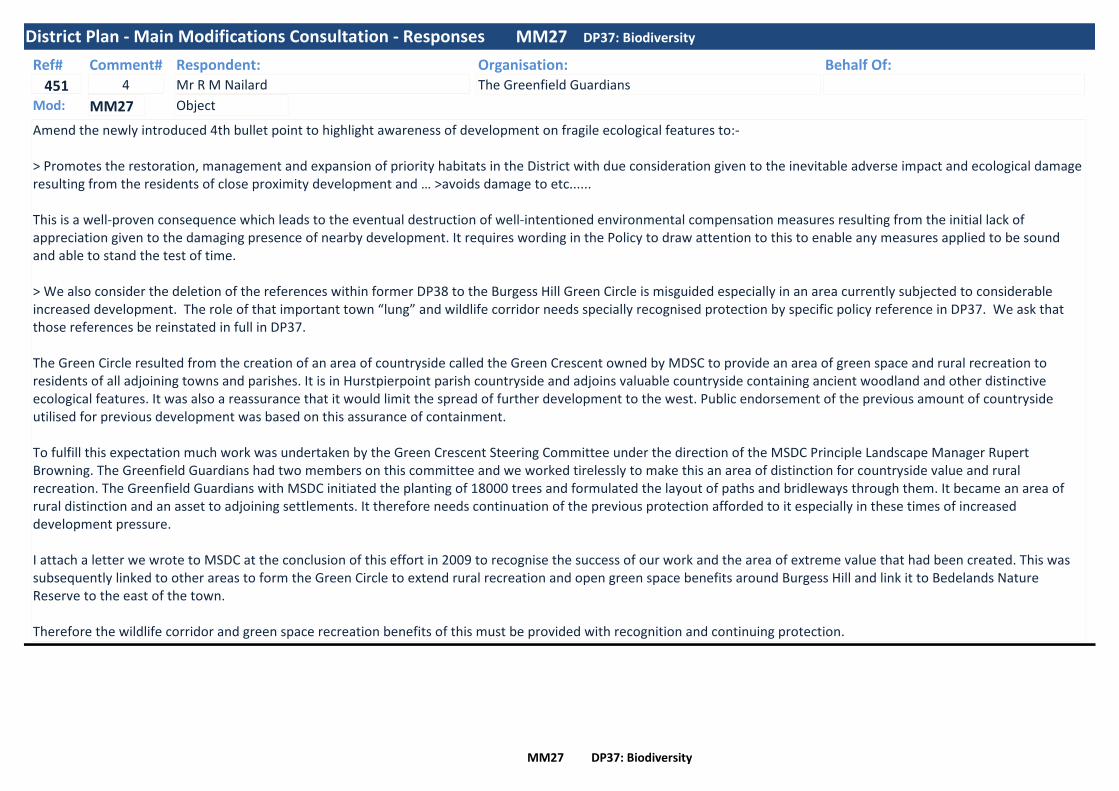
District Plan - Main Modifications Consultation - Responses MM27 DP37: Biodiversity
Ref#
451
Respondent:Mr R M Nailard
Organisation:The Greenfield Guardians
Behalf Of:Comment#4
Amend the newly introduced 4th bullet point to highlight awareness of development on fragile ecological features to:- > Promotes the restoration, management and expansion of priority habitats in the District with due consideration given to the inevitable adverse impact and ecological damage resulting from the residents of close proximity development and … >avoids damage to etc......
This is a well-proven consequence which leads to the eventual destruction of well-intentioned environmental compensation measures resulting from the initial lack of appreciation given to the damaging presence of nearby development. It requires wording in the Policy to draw attention to this to enable any measures applied to be sound and able to stand the test of time.
> We also consider the deletion of the references within former DP38 to the Burgess Hill Green Circle is misguided especially in an area currently subjected to considerable increased development. The role of that important town “lung” and wildlife corridor needs specially recognised protection by specific policy reference in DP37. We ask that those references be reinstated in full in DP37.
The Green Circle resulted from the creation of an area of countryside called the Green Crescent owned by MDSC to provide an area of green space and rural recreation to residents of all adjoining towns and parishes. It is in Hurstpierpoint parish countryside and adjoins valuable countryside containing ancient woodland and other distinctive ecological features. It was also a reassurance that it would limit the spread of further development to the west. Public endorsement of the previous amount of countryside utilised for previous development was based on this assurance of containment.
To fulfill this expectation much work was undertaken by the Green Crescent Steering Committee under the direction of the MSDC Principle Landscape Manager Rupert Browning. The Greenfield Guardians had two members on this committee and we worked tirelessly to make this an area of distinction for countryside value and rural recreation. The Greenfield Guardians with MSDC initiated the planting of 18000 trees and formulated the layout of paths and bridleways through them. It became an area of rural distinction and an asset to adjoining settlements. It therefore needs continuation of the previous protection afforded to it especially in these times of increased development pressure.
I attach a letter we wrote to MSDC at the conclusion of this effort in 2009 to recognise the success of our work and the area of extreme value that had been created. This was subsequently linked to other areas to form the Green Circle to extend rural recreation and open green space benefits around Burgess Hill and link it to Bedelands Nature Reserve to the east of the town.
Therefore the wildlife corridor and green space recreation benefits of this must be provided with recognition and continuing protection.
ObjectMod: MM27
MM27 DP37: Biodiversity

District Plan - Main Modifications Consultation - Responses MM27 DP37: Biodiversity
Ref#
2229
Respondent:Mr D Evans
Organisation: Behalf Of:Comment#2
I would like to see the Green Crescent policy placed back in policy DP37 which gives it a higher status.
ObjectMod: MM27
Ref#
14982
Respondent:Mr M Brown
Organisation:CPRE - Mid Sussex
Behalf Of:Comment#12
We support the comments and suggestions off the Sussex Wildlife Trust in respect of these proposed changes. In particular we agree with SWT that the deletion of DP38, albeit encouraged by the Inspector, is not necessary to secure the Plan’s soundness and, in our view, is incompatible with the encouragement given to LPAs by NPPF para 114 to “set out a strategic approach in their Local Plans, planning positively for the creation, protection, enhancement and management of networks of biodiversity and green infrastructure”.2.We consider misguided the deletion of the references within former DP38 to the Burgess Hill Green Circle. The role of that important town “lung” and wildlife corridor needs specially recognised protection by specific policy reference either within DP38 if restored as suggested above or, failing that, in DP37. We ask that those references be reinstated in full and that the corridor be shown on the appropriate Plan map. Doing so would give effect to NPPF para 117 (bullet 2) which provides that planning policies should identify and map wildlife corridors.3.Please insert the following additional words at the end of, but as part of, the (new) fourth bullet: “with due consideration given to the inevitable adverse impact and ecological damage resulting from the residents of nearby development.”
ObjectMod: MM27
MM27 DP37: Biodiversity

District Plan - Main Modifications Consultation - Responses MM27 DP37: Biodiversity
Ref#
15279
Respondent:Ms M Ashdown
Organisation:Natural England
Behalf Of:Comment#1
Natural England is extremely disappointed that Policy DP38 Green Infrastructure has been deleted from the District Plan.We note that the Inspectors comments (ID8 and ID9) indicate that some of the Policy wording could be incorporated in other policies and refers specifically to Policy DP36. However there is no amendment to Policy DP36 on the main modifications consultations document.
We note that Policy DP37 has had a minor wording change to include the term green infrastructure in the following sentence:
Contributes and takes opportunities to improve, enhance, manage and restore biodiversity and green infrastructure
Unfortunately this policy wording does not adequately promote the delivery of new green infrastructure that would have the benefits described in the wording of deleted Policy DP37 and in Mid Sussex District Council’s own supporting Policy text for DP37 as below
Green infrastructure’ is a connected network of multi-functional greenspace, both in urban and rural areas, that delivers a wide range of environmental, social and economic benefits, including improving quality of life. Some of the functions of green infrastructure include providing habitats for plants and animals and wildlife corridors from one habitat to another, increasing resilience to the effects and impacts of climate change, and improving the health and well-being of local communities with access to the countryside and green areas. Green infrastructure can also include areas of water and flood management and land for food production.
This is a wasted opportunity to deliver good quality joined up green infrastructure that would also deliver significant other benefits as described above.
We would urge the Inspector to reconsider this modification unless stronger policy wording can be incorporated elsewhere.
ObjectMod: MM27
Ref#
20117
Respondent:Mr R Cartwright
Organisation:Mid Sussex Liberal Democrats
Behalf Of:Comment#27
We see the logic in this, but fail to see the logic in a policy and document which sets out to expand priority habitats and yet constrains the urban areas, which has been stated earlier in this document. Nature is critical, but so equally are people, their health and wellbeing. There is nothing in here, which is disappointing, which sets out a necessity to increase access to these areas for all.
ObjectMod: MM27
MM27 DP37: Biodiversity

District Plan - Main Modifications Consultation - Responses MM28 DP38: Green Infrastructure
Ref#
180
Respondent:Ms L Brook
Organisation:Sussex Wildlife Trust
Behalf Of:Comment#4
The Sussex Wildlife Trust is unclear how this MM will make the plan sound. The NPPF clearly states in paragraph 114 that local plans should Set out a strategic approach in their Local plans, planning positively for the creation, protection, enhancement and management of networks of biodiversity and green infrastructure.
Further to this, the NPPF states in paragraph 99 that when determining a planning application a local authority should ensure Where new development is brought forward in areas vulnerable [to climate change], care should be taken to ensure that risks can be managed through suitable adaptation measures, including through the planning of green infrastructure.
The Sussex Wildlife Trust asks how Mid Sussex District Council can demonstrate this aspect of the NPPF when they proposed to strike out the Green Infrastructure Policy in favour of inadequate inclusions of the term ‘green infrastructure’ in other policies.
In particular, the addition of the words ‘and green infrastructure’ into policy DP37 with no further detail of what MSDC expects in regard to this element of the policy means we cannot see how this policy can be effectively or consistently applied. The deletion of policy DP38 along with the modification to DP37 means that the plan fails to recognise the multifunctional nature of green infrastructure and implies it can only be delivered by specific biodiversity measures.
The Sussex Wildlife Trust are concerned that this policy has been struck out because of the specific mention of sites for protection. We recognise the pressure on housing numbers, but do not feel that this policy should be lazily struck out as a result; time should be spent on developing a way forward for the Green Infrastructure Policy so Mid Sussex can effectively deliver the ethos of the NPPF for the population of Mid Sussex.
As a minimum the first half of the policy should be retained as this clearly reflects the requirement in the NPPF for LPA to plan positively for the creation, protection, enhancement and management of networks of biodiversity and green infrastructure (paragraph 114).
ObjectMod: MM28
Ref#
192
Respondent:Ms C West
Organisation:West Sussex County Council
Behalf Of:Comment#4
As policy DP38 (Green Infrastructure) is being deleted there will be no policy references to the role of the Public Rights of Way network in serving the transport needs arising from development. Therefore, the County Council consider that policy DP19 (Transport) should specifically refer to the Public Rights of Way network to ensure that the impacts on the network are understood and specific mitigation measures and improvements, listed in the IDP, can be brought forward as development takes place. It is suggested that the clause is amended to; “The scheme provides appropriate mitigation to support new development on the local and strategic road and Public Rights of Way networks, including the transport network outside of the district, secured where necessary through appropriate legal agreements.”
ObjectMod: MM28
MM28 DP38: Green Infrastructure

District Plan - Main Modifications Consultation - Responses MM28 DP38: Green Infrastructure
Ref#
2229
Respondent:Mr D Evans
Organisation: Behalf Of:Comment#3
I would like to see the Green Crescent policy placed back in policy DP37 which gives it a higher status.
ObjectMod: MM28
Ref#
14982
Respondent:Mr M Brown
Organisation:CPRE - Mid Sussex
Behalf Of:Comment#13
We support the comments and suggestions off the Sussex Wildlife Trust in respect of these proposed changes. In particular we agree with SWT that the deletion of DP38, albeit encouraged by the Inspector, is not necessary to secure the Plan’s soundness and, in our view, is incompatible with the encouragement given to LPAs by NPPF para 114 to “set out a strategic approach in their Local Plans, planning positively for the creation, protection, enhancement and management of networks of biodiversity and green infrastructure”.2.We consider misguided the deletion of the references within former DP38 to the Burgess Hill Green Circle. The role of that important town “lung” and wildlife corridor needs specially recognised protection by specific policy reference either within DP38 if restored as suggested above or, failing that, in DP37. We ask that those references be reinstated in full and that the corridor be shown on the appropriate Plan map. Doing so would give effect to NPPF para 117 (bullet 2) which provides that planning policies should identify and map wildlife corridors.3.Please insert the following additional words at the end of, but as part of, the (new) fourth bullet: “with due consideration given to the inevitable adverse impact and ecological damage resulting from the residents of nearby development.”
ObjectMod: MM28
MM28 DP38: Green Infrastructure

District Plan - Main Modifications Consultation - Responses MM28 DP38: Green Infrastructure
Ref#
15279
Respondent:Ms M Ashdown
Organisation:Natural England
Behalf Of:Comment#2
Natural England is extremely disappointed that Policy DP38 Green Infrastructure has been deleted from the District Plan.We note that the Inspectors comments (ID8 and ID9) indicate that some of the Policy wording could be incorporated in other policies and refers specifically to Policy DP36. However there is no amendment to Policy DP36 on the main modifications consultations document.
We note that Policy DP37 has had a minor wording change to include the term green infrastructure in the following sentence:
Contributes and takes opportunities to improve, enhance, manage and restore biodiversity and green infrastructure
Unfortunately this policy wording does not adequately promote the delivery of new green infrastructure that would have the benefits described in the wording of deleted Policy DP37 and in Mid Sussex District Council’s own supporting Policy text for DP37 as below
Green infrastructure’ is a connected network of multi-functional greenspace, both in urban and rural areas, that delivers a wide range of environmental, social and economic benefits, including improving quality of life. Some of the functions of green infrastructure include providing habitats for plants and animals and wildlife corridors from one habitat to another, increasing resilience to the effects and impacts of climate change, and improving the health and well-being of local communities with access to the countryside and green areas. Green infrastructure can also include areas of water and flood management and land for food production.
This is a wasted opportunity to deliver good quality joined up green infrastructure that would also deliver significant other benefits as described above.
We would urge the Inspector to reconsider this modification unless stronger policy wording can be incorporated elsewhere.
Mod: MM28
Ref#
20117
Respondent:Mr R Cartwright
Organisation:Mid Sussex Liberal Democrats
Behalf Of:Comment#28
We agree this is a logical deletion with respect of now being included in MM26.
SupportMod: MM28
MM28 DP38: Green Infrastructure

District Plan - Main Modifications Consultation - Responses MM29 DP39: Sustainable Design and Construction
Ref#
14982
Respondent:Mr M Brown
Organisation:CPRE - Mid Sussex
Behalf Of:Comment#14
Please consider adding the following sentence at the end of the second bullet of the Policy Text: “The Council will assume viability and feasibility of both affordable and market homes unless evidence from the developer at the time of application for full planning permission clearly demonstrates otherwise.”. The purpose of this proposed addition is self-evident.
NeutralMod: MM29
Ref#
20117
Respondent:Mr R Cartwright
Organisation:Mid Sussex Liberal Democrats
Behalf Of:Comment#29
We agree with the rewording, but would expect a reference to a nationally agreed Strategy and Standard. The council has not the resources to police all the latest technological advances and developers without a reference can come up with their own in many cases, which are cost based rather than the best available.We are unclear with the wording in this section if it is the intent to retain the Architects Panel as a consultee. We would recommend that the Panel is included in this section as a mandatory consultee. They have served the council well in the past and to include them within the planning policy is logical. It must be bore in mind this is a new District Plan and what is not specified can be done away with without reference back to scrutiny.We can see there is a reason for discussion with developers but there must be a reference point, which will evolve during the lifetime of the plan as technology evolves.We welcome the deletion of the specific wording regarding ‘biomass boilers, biomass/gas CHP or heat pumps’ for the reasons and demonstration of our views as set out above.
ObjectMod: MM29
MM29 DP39: Sustainable Design and Construction

District Plan - Main Modifications Consultation - Responses MM30 DP40: Renewable Energy Schemes
Ref#
58
Respondent:Mrs R Robertson
Organisation:Balcombe Parish Council
Behalf Of:Comment#5
This policy requires wind farm developments to be included in Neighbourhood Plans. With 16 out of 20 NPs already made in the District, without this policy having been in place, those plans are likely not to include sites for wind energy. This is a senseless and poorly thought through policy and will result in a reduction of provision of renewable energy contrary to current guidance.
ObjectMod: MM30
Ref#
16427
Respondent:Mr E Fielding
Organisation: Behalf Of:Comment#14
•The council have a negative stance on renewable energy that is not in keeping with either the nation or government’s drive to seek a greener and cleaner country. Thepotential of Neighborhood Plans to consider such a strategic energy option is above and beyond their capability, these sorts of decisions are a very complex and will not havecome to light during the Neighbourhood plan process. This policy is not sound or beneficial to the district.•This is a NIMBY policy and is not sound – how are the pollution problems in the district going to reduce if we do not promote green energy?
ObjectMod: MM30
Ref#
20117
Respondent:Mr R Cartwright
Organisation:Mid Sussex Liberal Democrats
Behalf Of:Comment#30
We agree with the view as set out under ‘Supporting text’. We find the additional wording regarding wind energy and its location. We believe this to be to be counter to the NPPF however.We are unclear if any Neighbourhood plans so far ‘made’ in Mid Sussex broached the topic. To revisit this specific area regarding Neighbourhood plans would mean further consultation and another referendum per plan. If NP’s are to be based on single individual topics we fail to see how a cohesive approach can be adopted. The plans would have to be voted on in every instance of change, or has that myth been laid to rest with the Burgess Hill Town Council promoting a site for out of town centre retail when it was designated under its ‘made’ NP for Affordable Housing?
NeutralMod: MM30
MM30 DP40: Renewable Energy Schemes

District Plan - Main Modifications Consultation - Responses MM31 DP41: Flood Risk and Drainage
Ref#
20117
Respondent:Mr R Cartwright
Organisation:Mid Sussex Liberal Democrats
Behalf Of:Comment#31
This seems somewhat bazaar. We feel all sites, regardless of size should have an assessment for risk of flooding and drainage management. It seems prudent to have a policy in place which calls on a development, even of one unit, to address the issue, even if the outcome is ‘no scheme of mitigation is found to be necessary’.
ObjectMod: MM31
MM31 DP41: Flood Risk and Drainage

District Plan - Main Modifications Consultation - Responses MM32 Chapter 5: Implementation and Monitoring
Ref#
14982
Respondent:Mr M Brown
Organisation:CPRE - Mid Sussex
Behalf Of:Comment#15
1.Transparency is crucial to the maintenance of public confidence in the planning process, as well as to the monitoring of effective implementation of the Plan. Unfortunatelythe District has a history of delayed publication of monitoring reports on its current Local Plan including the annual and 5 year status of development consents andcompletions. This final round of consultation provides an opportunity for the Council to address the importance of operating transparently by incorporating an undertaking touse its best efforts to publish a full annual Plan monitoring report, including annual and 5 year planning consent/completion data, no later than the date on which it publishesits annual financial and activity report.2.We are disappointed that proposed new para 5.2 does not include a promise to work with other organisations that can add value to the planning process especially inrelation to the sustainability and environmental aspects: bodies than can provide balance and expertise to process of developing strategic plans (including SPDs) and individualplanning applications. We ask you to demonstrate the Council’s professed inclusiveness by supplementing para 5.2 as suggested here.
ObjectMod: MM32
Ref#
16427
Respondent:Mr E Fielding
Organisation: Behalf Of:Comment#15
•As detailed in paragraph 5.2 “continue to work closely with developers, landowners and promoters of strategic sites to ensure delivery within agreed timescales;” Will thisinclude small scale developers who will deliver a vital part of the District’s housing requirement and many of the Neighbourhood Plans? If it is only the strategic sites then thedistrict is not proposing an equitable of sound policy.
ObjectMod: MM32
Ref#
20117
Respondent:Mr R Cartwright
Organisation:Mid Sussex Liberal Democrats
Behalf Of:Comment#32
Many of our comments are supported in this section.We wish it to be put on record that we strongly recommend in the establishment of a ‘Developer Panel’ the terms of reference are published and advertised and that a high, but not majority percentage of representation from outside of the Developer network are integral to the Panel. A ‘Job Specification’ and terms of reference must be advertised locally, and an independent recruitment panel/agency is enlisted to make the appointment to prevent any accusations of collusion being made. This is in line with other consultee panels and similar bodies in other public forums. The terms of reference must not however fetter outside appointees with unnecessary and erroneous confidentiality clauses.We note that the issue of further Neighbourhood Plans is broached in this section, Paragraph 5.2, 3rd bullet point. We would seek a clarification statement regarding the existing NP’s which are already ‘made’. Will, for instance, the existing plans, which have been found ‘sound’ be remodelled and if so and as the first ones were ‘made’ following a (Town and) Parish referendum, be subject to further referenda until they fit what the Planning Authority wishes them to do. This seems a waste of local tax payer’s money and resources if so and a diminishing of local democracy in its most basic form, or put another way, a pointless Public Relations exercise.
SupportMod: MM32
MM32 Chapter 5: Implementation and Monitoring

District Plan - Main Modifications Consultation - Responses HRA Habitats Regulations Assessment
Ref#
189
Respondent:Mrs M Brigginshaw
Organisation:Wealden District Council
Behalf Of:Comment#1
1.1 The Habitat Regulations Assessment (HRA) of the Mid Sussex District Plan (September 2017) identifies that, in relation to atmospheric pollution on Ashdown Forest SAC, there is an increase of predicted traffic flows of 267 AADT on the A275 as a result of development proposed in the District Plan in combination with growth assumptions for surrounding Local Authority areas (paragraph 0.3.1). It is also predicted that there is a decrease of 27 AADT, 197 AADT and 263 AADT on the A22, A26 and B2210 respectively. This information on traffic flows (AADT) is then translated, through modelling, into nitrogen deposition and nitrogen and sulphur acid deposition on Ashdown Forest SAC.
1.2 In Table 5.3 (page 25 of the HRA) the reference case at 2031 is compared to the development case at 2031 which results in the AADT identified in paragraph 1.1 above. It is understood that the development case relates to the delivery of the Mid Sussex District Plan without a stepped increase in housing delivery in the future. It is stated in paragraph 5.4.13 (Of the HRA) that the transport model includes completions, commitments and allocations in the Mid Sussex District Plan and Neighbourhood Development Plans, the delivery of growth in accordance with the settlement hierarchy and a proportionate windfall allowance at 2031. The reference case represents forecast baseline traffic flows at 2031. There is no specific mention as to what is included in the reference case or the development case within the HRA. Examination paper MSDC 18 (paragraphs 51 and 52) implies that consented development in Mid Sussex and NTEM forecasts for neighbouring authorities are used within the reference case, although it is not clear if this is the case within the work undertaken for the modifications. There is no mention of any completions, commitments, allocations or any other growth as relevant to other local authorities as part of the development case.
1.3 In general, in order to calculate the additional AADT from a plan alone, the modelled AADT without the plan at the end of the plan period is compared to the AADT at the end of the plan period with the plan. This appears to havetaken place as part of the HRA and is shown in Table 5.3. In this case the reference case and the development case at 2031 are compared and the resulting AADT is used within the assessment. Without specific knowledge of what is included within the reference case and the development case, the AADT used within the HRA appears to be of the plan alone.
1.4 If the reference case definition in MSDC 18 is used, which includes consents within Mid Sussex, and the development case also includes consents within Mid Sussex the resulting (AADT) figure would not include development with consent in the plan alone figure1. This requires further clarification as development with consent would not have been included in the assessment of the plan alone.
1.5 Notwithstanding the issues raised above as to what is included in the reference case and development case to determine additional AADT of the plan alone, using the traffic data from Mid Sussex District Council Impact of Mid Sussex District Council Plan Traffic at Ashdown Forest Air Quality Assessment (October 2017) the in combination (2031 do something data minus base line at 2014) would be: A275 = 1,535 AADT.
1.6 As the AADT used within the HRA is for the Mid Sussex District Plan alone, as opposed to in combination, then it follows that the air quality modelling is for the plan alone.
1.7 Further to this, the study shows that there are decreases of traffic flows on the A22 and A26. This is not in conformity with work undertaken by Wealden District with regards to its adopted Core Strategy (2013) or indeed Lewes District Council and South Downs National Park with regards to the Joint Lewes District Core Strategy. Both Plans contributed to an additional flow of 1,091 AADT on the A26. It is appreciated that development may change the patterns of traffic movement. However, it is not expected that the delivery of additional growth within Mid Sussex District and the resultant changes in traffic behaviours that take place as aresult of this would have a positive impact on traffic movements in Wealden District. It is certainly not expected that this would occur to the extent that an increase of over
ObjectMod: HRA
HRA Habitats Regulations Assessment
District Plan - Main Modifications Consultation - Responses HRA Habitats Regulations Assessment
1000 AADT (Wealden District traffic movements combined with Lewes District traffic movements) on the A26 would become -27 AADT as a result of the growth provided in the Mid Sussex District Plan. Therefore it can only be concluded that the AADT and the resulting air quality modelling results used within the HRA are for the plan alone and do not consider contributions from other local authorities.
1.8 Regulation 102 of the Conservation of Habitats and Species Regulations 2010 states that Where a land use plan (a) is likely to have a significant effect on a European site or a European offshore marine site (either alone or in combination with other plans or projects), and (b) is not directly connected with or necessary to the management of the site, the plan-making authority for that plan must, before the plan is given effect, make an appropriate assessment of the implications for the site in view of that site’s conservation objectives.
1.9 It is submitted that for both the consideration of whether the plan is likely to have a significant effect on a European site or where an appropriate assessment is carried out the plan either alone or in combination with other plans or projects must be considered. It can only be concluded that the HRA has not undertaken an in combination assessment as required.
2.0 Traffic flow conclusions2.1 Notwithstanding the fundamental issue of the need for an in combination assessment, there is also a query with regards to how traffic is distributed leading to an increase in AADT on the A275 and a decrease on the remaining roads. The attached plan shows that the A22 is the only main road that connects to the A275. Therefore it would be expected that the A22 would have increased traffic flows linked to the increase on the A275 as not all traffic would filter onto local roads bearing in mind the type of local roads involved. It is considered to be illogical that there would be no increases on the A22/ A26 and indeed a reduction. Further information with regards to traffic distribution is required.
3.0 Consideration of Likely Significant Effect3.1 It is not clear from the HRA what level of assessment has been undertaken. Paragraph 5.4.20 states that an increase of 0.4% of the minimum critical load is not considered to be ecologically significant. It is concluded that “The overall effect of the District Plan’s process contribution to pollution deposition within qualifying SAC habitats can be considered neutral”.
3.2 Notwithstanding the lack of in combination assessment, it appears that the assessment relies upon the Environment Agency’s derived 1% process contribution. However there is no specific conclusion that there would not be a likely significant effect. Even if this were the case, it is not explained as to why this increase in critical load does not have the potential to affect the SAC. It can only be concluded that in the absence of scientific certainty with regard the 1% process contribution that there is a likely significant effect.
4.1 Paragraph 5.7.1 of the HRA is a section that “assesses whether the District Plan can be expected to adversely affect the ecological integrity of the Ashdown Forest SAC as a result of atmospheric pollution impacts.” The phrasing of this sentence, with reference to Regulation 102 of the Conservation of Habitats and Species Regulations 2010, leads to a conclusion that an appropriate assessment is being undertaken. Therefore, it can only be assumed that there is a likely significant effect. The appropriate assessment is a page in length. In terms of the conservation objectives there is no analysis to explain how the conclusions that integrity is not affected have been made particularly when the critical load has been exceeded.
4.2 The David Tyldesley and Associates (DTA) Handbook identifies that European case law has established that in the circumstances of the cases considered, an assessment cannot be regarded as 'appropriate' if it:
HRA Habitats Regulations Assessment

District Plan - Main Modifications Consultation - Responses HRA Habitats Regulations Assessment
a. Is merely a summary or broad-brush assessment of the implications;b. Is a selective examination not taking account of all material points;c. Is incomplete;d. Leaves important matters still to be assessed;e. Does not contain a complete list of the qualifying features present in the site which are likely to be affected;f. Contains findings that are preliminary in nature, lacking definitive conclusions;g. Lacks sufficient precision;h. Fails to provide conclusions capable of removing all reasonable scientific doubt as to the effects on the sitewhere the competent authority is minded to proceed with the project;i. Lacks adequate information or reliable and updated data concerning the qualifying features.
4.3 Further, MANAGING NATURA 2000 SITES The provisions of Article 6 of the ‘Habitats’ Directive 92/43/EEC (European Commission) report states:In the first place, an assessment should be recorded. A corollary of the argument that the assessment should be recorded is the argument that it should be reasoned. Article 6(3) and (4) requires decision-makers to take decisions in the light of particular information relating to the environment. If the record of the assessment does not disclose the reasoned basis for the subsequent decision (i.e. if the record is a simple unreasoned positive or negative view of a plan or project), the assessment does not fulfil its purpose and cannot be considered ‘appropriate’. (European Commission Page 35).
4.4 Based on guidance identified above it is considered that the content of the appropriate assessment contained within the HRA is not ‘appropriate’ owing to the lack of any analysis and lack of reasoned arguments against the conservation objectives.
5.0 Further information to note5.1 Wealden District Council has placed in the public domain the methodology used to model the air quality arising from growth within the Wealden Local Plan. This data was not released until after the publication of the HRA of the Mid Sussex District Plan. This follows a bespoke methodology arising from extensive work on Ashdown Forest and looks at a wider range of pollutants. The work undertaken on behalf of Wealden District Council therefore cannot be compared to this study which uses a standard modelling methodology. In addition, habitat mapping has been produced by Wealden District Council, which differs significantly from the information provided by the conservators of Ashdown Forest and as presented within the Mid Sussex HRA. The habitat map commissioned by Wealden District Council has been in the public domain since December 2015 and was created using satellite imagery from two satellites, SPOT5 and Worldview2 for mapping the extent of heathland. This map has not been considered as part of the HRA. Wealden District considers this information to be more up to date and comprehensive than that contained within the Mid Sussex HRA. Please also note that Wealden District has also commissioned an update to its habitat map, however, this is not yet published.
5.2 It is also noted on 31st October that a consolidated version of “The Conservation of Species and Habitats Regulations 2017” was laid before Parliament. The new Regulations will cover England and Wales and their territorial waters out to 12nm.
5.3 The new Regulations will come into force on 30th November 2017 (after submission of this representation) and will replace the 2010 Habitats Regulations which will change the Regulations. Regulation 102 will become Regulation 105.
6.0 Conclusion6.1 In conclusion it is considered that:
HRA Habitats Regulations Assessment
District Plan - Main Modifications Consultation - Responses HRA Habitats Regulations Assessment
1) The assessment contained within the Habitat Regulations Assessment is of the plan alone and has not included an in combination assessment as required by The Conservation of Habitats and Species Regulations 2010. Therefore the Habitats Regulation Assessment is fundamentally deficient to that required by the legislation. Further information is also required to determine which parts of the plan have been included within the assessment of the plan alone.2) The reduction in trips on the A22/ A26 is not logical when there is an increase in trips on the A275 and further explanation or investigation is required.3) Even if the plan is considered alone it is submitted that there is not enough evidence to conclude there is not a likely significant effect. In the absence of an appropriate assessment the Plan does not meet the Conservation of Habitats and Species Regulations 2010 (as amended) and therefore should not progress.
Ref#
245
Respondent:Ms G Kennedy
Organisation:Lindfield Preservation Society
Behalf Of:Comment#4
The assessment refers to relevant recent case law, but fails to follow its requirements.
We refer to the judgement handed down by Mr Justice Jay on 20 March 2017 at the England and Wales High Court, ref EWHC 352 (Admin), in the case between Wealden District Council and the Secretary of State for Communities and Local Government, Lewes District Council and South Downs National Park Authority. Mr Justice Jay ruled that the effects of increased traffic from one source in combination with increased traffic from other sources is a decisive consideration (para 6). The Habitats Regulation Assessment presents no evidence of a “properly amalgamated” (Mr Justice Jay’s phrase, para 6) analysis of the District Plan’s polluting impact on the Ashdown Forest in combination with that of other Local Planning Authorities – notably Wealden District Council, Lewes District Council and South Downs National Park Authority. Indeed, the Habitats Assessment argues that “in any event, Mid Sussex District Council’s responsibility is limited to avoiding and mitigating the impacts of developments proposed within its own area.” (6.6.2) The proposed District Plan is therefore not compliant with the High Court decision above, which resulted in parts of the Lewes District Local Plan 2010-2030 being quashed.
We note furthermore that the Habitats Regulations Assessment is supported by an “Air Quality Assessment” which argues, improbably, that the mass development proposed in the District Plan would actually reduce the mass of nitrogen deposited in the Ashdown Forest (e.g. p. 30). It also considers only the interim scenario delivering 876 dwellings per year until 2013/24, ignoring the 1,090 proposed for subsequent years until 2030/31. It fails, therefore, to assess the full impact of the District Plan. These weaknesses must also compromise the viability of the Habitats Regulation Assessment.
ObjectMod: HRA
HRA Habitats Regulations Assessment

District Plan - Main Modifications Consultation - Responses HRA Habitats Regulations Assessment
Ref#
14982
Respondent:Mr M Brown
Organisation:CPRE - Mid Sussex
Behalf Of:Comment#16
Reluctantly CPRESx concludes that the evidence still does not justify a conclusion that an initial housing target of 876 dpa is sound and deliverable in a manner compatible with the Council’s legal obligation to protect the EU sites on Ashdown Forest in compliance with the mandatory requirements of articles 102 etc. of the Conservation of Habitats & Species Regulations 2010. This requires that development that could significantly impact those sites must be prohibited unless that harm can demonstrably be avoided. It has been known from a decade-old scoping report that the potential exists for the Plan and other development proposals around the two sites to affect them adversely and significantly by reason of traffic-induced nitrogen deposition and eutrophication (that has exceeded critical levels for a number of years), and by reason of increased visitor disturbance. 2.The latest evidence contradicts the Council’s conclusion that the nitrogen deposition and eutrophication problems for the SAC is insignificant enough (based on a housing target of 876 dpa) to permit that level of development to occur, or that visitor disturbance of the SPA will be avoided by the mitigation measures proposed in the Plan. The earlier evidence, such as it was, submitted by the Council to the Planning Inspectorate, and challenged by CPRE Sussex, was not tested in the course of the Plan’s examination. CPRE Sussex has been warning the Council for at least five years that its proposed Plan, in its various iterations, would (if adopted) breach the Habitats Regulations, and that the purported evidence relied on by the Council to support its Plan policies is not robust.3.The Council is legally bound under the Habitats Regulations to “exercise their functions which are relevant to nature conservation, including marine conservation, so as to secure compliance with the requirements of the Directives.” (Regulation 9(i) as amended) Adopting a Plan that is legally non-compliant would expose the Council to the real risk of judicial review proceedings based on the Aarhus Convention that could significantly delay the implementation of the new Plan, as it could impinge on the housing target proposed in the Plan and the distribution of new housing around the District as well as DP15 (Ashdown Forest Special Protection Area (SPA) and Special Area of Conservation (SAC)).
4.We recognise that NPPF para 158 calls for planning evidence to be proportionate (albeit without explaining what that term is meant to mean). We express concerns below as to the quality of evidence that has been put forward on the Council’s behalf, the correct interpretation of that evidence, and the absence of other evidence that is, in our view, needed for a robust conclusion as to whether a policy complies with the law. Such evidence must necessarily be proportionate.
Nitrogen Pollution
5.As regards the new October 2017 Air Quality Assessment by Ove Arup, when one cuts through all its jargon and acronyms, what can be deduced from that report is that
-NOx levels above 20 kg of nitrogen oxides per hectare per annum are likely to have significant adverse impacts on the protected SAC habitats; NOx levels of between 10 kg and 20 kg N/ha/yr may potentially do so but the science is uncertain; and that regulatory controls are accordingly set by reference to those maximum and minimum critical level standards (para 2.1.2);-current background levels of NOx eutrophication affecting SAC woodland environments exceed the higher 20 kg N/ha/yr critical level at which harm is likely by between 113% and 121% (para 5.2.1 bullet 1, and Table 8);-current background levels of NOx eutrophication affecting SAC heathland environments (for whose protection the SAC is primarily designated) exceed the lower 10 kg N/ha/yr critical level at which harm may be occurring by between 143% and 160%, thereby triggering the application of the precautionary principle by reason of the scientific uncertainty (para 5.2.1 bullet 2, and Table 8);-at the end of the Plan period (without even taking account of the proposed 214 dpa future step-up in the housing target) minimal change is predicted to the background
ObjectMod: HRA
HRA Habitats Regulations Assessment

District Plan - Main Modifications Consultation - Responses HRA Habitats Regulations Assessment
maximum and minimum critical threshold levels (para 5.2.2), which will therefore continue to be exceeded by a wide margin. This conclusion involves assuming that the traffic modelling relied on by Arup is itself sound and will be compatible with updated guidance on this issue awaited from Natural England;-inadequate analysis has been undertaken of the impact of NO2 emissions along roadsides where nitrogen depositions will be highest and their impact on protected habitats alongside the roads crossing the SAC will be most significant, and none of the diffusion tube monitoring sites is actually within the SAC (Figure 3).
6.The September 2017 Habitats Appropriate Assessment Report by Urban Edge Consulting (UEC) predates the Arup report, so it is unclear whether its conclusions even take Arup’s report into account. UEC’s Assessment:
-uses the same data as Arup in relation to excess NOx deposition levels, but also reports (which Arup does not) that the maximum acceptable critical loads for acid deposition from nitrogen oxides on the SAC’s heathlands (a separate issue from eutrophication that results in acidification of soil and water courses and spreading of more widespread heathland degradation) are exceeded by between 137% and 150% (table 5.2); -reaches the same conclusion as Arup that “The critical load for nitrogen deposition and acid (nitrogen (N) or sulphur (S)) deposition is already exceeded in parts of Ashdown Forest; Table 5.2 presents information on background critical load exceedances for these key pollutants on qualifying habitat types at a selection of grid references across the Forest close to the road network” (para 5.3.2)-points out that heathland habitat degradation is a contributing factor in the decline in populations of SPA-protected Dartford warblers (para 4.3.3); and-notes that “The parameters for any assessment of traffic impact are now unclear” (para 5.4.9) following the High Court decision in Wealden District Council v Secretary of State for Communities and Local Government & Ors [2017] EWHC 351 (Admin). 7.These reports have been produced without waiting for, and hence without regard to, new advice on cumulative traffic pollution measurement methodology promised from Natural England following the Wealden judgement.8.The reports rely for their conclusion that the Habitats Regulations will be complied with on the ground that new Plan policy MM04 will not (on their own limited calculations) significantly exacerbate the current NOx deposition levels (and may slightly reduce them in some spots by the end of the Plan period). But that is a specious conclusion. It is specious because:-the whole purpose of the Natura 2000 regime is to ensure a harm-free environment for designated rare habitats and birds, and so to prioritize their conservation over new development that could harm them significantly. When harm to a Natura 2000 site is demonstrated to be occurring (as the two reports demonstrate is the case on the Ashdown Forest SAC) steps have to be taken to avoid that harm. Maintenance of the harmful status quo, which is essentially what Arup is predicting for the new Plan, is not legitimate. So applying a test based on the fact that the situation will not significantly deteriorate further is a false test;-by measuring significance by reference to the degree of change in the predicted future levels of NOx pollution against current levels (their 1% test) they are misapplying the requirement of regulation 102 of the Habitats Regulations. This requires measurement of the degree of harm, not the degree of change. And significant harm is self-evident from the fact that critical background measurement levels of NOx pollution are exceeded, as the Arup and UEC reports both concede. Any new development that maintains that excess involves a breach of the Regulations;-the reports ignore NPPF paras 120 and 124. The latter requires that “Planning policies should sustain compliance with and contribute towards EU limit values or national objectives for pollutants …”. The draft Plan, as it is proposed to be modified, would breach these NPPF planning requirements as well as the Habitats Regulations;
-in summary, the reports amount to no more than an assertion that it is okay to continue the known significant harm to the SAC because it won’t get worse (or much better). Inconveniently, that is irreconcilable with the Council’s clear regulatory duty to avoid adverse impacts on the SAC.9.It is also a material failing of the two reports that neither even considers the potential impact of the SAC’s air quality problems on the SPA. There is an intimate inter-connection between habitat degradation and the health of bird populations. UEC explains the pollution impacts at section 5.3 of its report, but only in the context of the protected habitats not the protected birds, despite the inter-dependence of the two. UEC’s answers in paras 7.2 and 7.3 fly in the face of both UEC’s own conclusions, and
HRA Habitats Regulations Assessment

District Plan - Main Modifications Consultation - Responses HRA Habitats Regulations Assessment
Arup’s, that levels of acid deposition from nitrogen oxides and NOx eutrophication exceed critical levels at which degradation of habitats, and acidification of soil and watercourses, on which the protected bird species depend is occurring. Nor has the possibility been addressed of NO2 pollution – a killer of humans – having a direct effect on birds. These are material gaps in the evidence base.10.It is significant that Wealden DC, grappling with the same air quality issue is taking a different and more measured approach to assessing its impacts using its own data. It has not concluded that there will be no adverse effects on the ecological integrity of the SAC or SPA. We note that Wealden DC is still maintaining its interim policy, based on the need to protect the SAC, of not accepting larger scale development in its vicinity, and is continuing to work on finding a positive planning solution that addresses the need to remediate the existing serious harm to the protected SAC habitats. The level of intra-District co-ordination that this situation, and the NPPF’s duty to co-operate provisions (inc. NPPF para 182 bullet 3), both demand does not seem to be occurring. 11.Irrespective of the regulatory position, it is depressing that the LPAs surrounding Ashdown Forest are not making common cause in a collaborative effort to find a single common policy solution to the challenge of remediating, conserving and enhancing Ashdown Forest. Only a single unified cross-boundary approach can resolve its air quality problem. Visitor disturbance12.CPRESx has repeatedly asserted in its representations to the Council over the last 5 years and at the Plan examination that the method by which the Council has assessed the measure of harm to the Ashdown Forest SPA from increasing visitor numbers identified by the 2007/8 scoping report -is based on out of date and insufficient data in the scoping report (2007/8) itself and vis a vis housing numbers (2008/9), visitor behaviour (2008 to 2010) and impact on protected bird species (2007); data collected in an era when expectations as to the level of housing growth and increasing visitor numbers was far, far lower, -fails properly to implement the regulatory requirement for an assessment of potentially significant adverse impacts to the SPA based on a cumulative assessment of all relevant development plans and proposals affecting the SPA as a whole, as opposed just to the Mid Sussex slice of it, since the 2007/8 scoping report,-fails appropriately to consider whether the identified potential for harm to the SPA can be avoided as the regulations require and, if so, the most appropriate way to do so,-fails to assess whether the use in this case of a generic SANG or other mitigation measures will in practice achieve the unlikely but essential reduction in visitor numbers to the SPA required to achieve their sole purpose of avoiding significant harm to it,-mis-calculates, and thereby exaggerates by a factor of three, the compensatory effect of a SANG in terms of any reduction in visitor numbers.13.CPRESx’s submission to the Plan examination (Examination Library Ref: 14982/FH (CPRE Statement 2: http://www.midsussex.gov.uk/media/79656/14982_cpre-sussex-msdc18ii.pdf) and our earlier representations to the Council referred to in it fully explain our concerns.14.The Council has never refuted CPRESx’s concerns. Nor has it ever explained why it disagrees with them. It has simply ignored them. The respective merits of the opposing positions on this core issue were not tested by the Inspector in the course of the draft Plan’s examination, as is its purpose. So the soundness of the HR Assessment as a basis for those Plan’s policies that are dependent on compliance with the Habitats Regulations has not been examined in public; and any future finding by the Planning Inspector that this aspect of the Plan is sound must be seen in the context of that procedural vulnerability.15.The latest UEC Assessment Report on the main modifications is little more than a rehash of prior iterations in its earlier drafts going back to 2013. There is no new quantitative analysis in sections 6 and 7 of the cumulative impacts of additional visitor disturbance on Ashdown Forest if the Plan’s main modifications are adopted. We are not even told what assumptions are made as to the cumulative level of development and projected visitor increase being modeled. 16.Its conclusions in paras 7.2 and 7.3 that “there will be no adverse effects on the ecological integrity” of the Ashdown Forest SAC and SPA are based on subjective answers to a short set of simplistic questions that do not address core issues (see para 12 above), and are not evidence based or justified within the Report text in any way. Were the answers true, there would be no need for SANGS or other avoidance measures. Given that mitigation is viewed by the Council as necessary, the Appropriate Assessment should have addressed its appropriateness and effectiveness in the specific context of the Ashdown Forest SPA to stop harmful human and canine disturbance of the protected birds there; but it does not. It must, for example, be relevant to examine whether a given SANG proposal is likely to work in practice to achieve the level of visitor redirection away from the Forest that is necessary to achieve its purpose, but no such evidence has been gathered by survey or other means. It is not enough simply to assume without testing that a SANG solution used in different circumstances and in a different location will operate in the same way around Ashdown Forest that visitors go out of their way to
HRA Habitats Regulations Assessment

District Plan - Main Modifications Consultation - Responses HRA Habitats Regulations Assessment
visit for its own special qualities. The effectiveness of the Council’s avoidance proposals is unsupported by any evidence at all. 17.Nor does the Council appear to have grasped the nettle of correctly measuring the compensatory effect of a SANG. If CPRESx’s previous representations are right that the basis of computation used grossly exaggerates it, then it throws doubt on the Council’s whole SANGs strategy in DP15. Has CPRESx’s point even been looked into?Conclusions18.The only proper conclusion from the two reports is that the current Local Plan has demonstrably failed to prevent significant NOx harm to the SAC, and that the new Plan will do nothing to rectify that harm based on a housing target of 876dpa as proposed in MM04, the housing distribution hierarchy proposals in MM06 and DP15 . It is wholly insufficient that, in the words of UEC (para 5.8.1) “It can be concluded that the District Plan will not result in adverse effects on the conservation objectives of the Ashdown Forest SAC.” Not making the existing significant harm worse is NOT the point, nor is it the purpose of the Habitats Regulations. The point of the Habitats Regulations is that it requires the Council to plan for restoration of the sites to a level where their conservation objectives are met and the harm avoided; but there is no Plan policy designed to achieve it. 19.Nor does UEC’s Appropriate Assessment contain the evidential underpinning needed to justify its conclusion that “there will be no adverse effects on the ecological integrity” of the SAC and SPA as regards either pollution or visitor disturbance, to support the housing target. Such evidence as it does provide implies the opposite conclusion. 20.All in all the Arup and UEC Reports woefully fail to provide the robust evidence required to demonstrate that the Plan policies will enable the Council to avoid continuation of significant adverse impacts to the Ashdown Forest SAC and SPA, as the Council is legally obliged to do. This makes the Plan unsound.
Ref#
15279
Respondent:Ms M Ashdown
Organisation:Natural England
Behalf Of:Comment#3
Natural England is satisfied with the conclusions of the Habitats Regulations Assessment (HRA) based on the information within the report. However we have the following comments to make regarding the clarity of some of the conclusions.
Section 5 of the HRA examines the issue of atmospheric pollution impacts on Ashdown Forest Special Area of Conservation (SAC) and concludes that there will be no likely significant effect on the designated site. This conclusion is reached from information provided within the Mid Sussex District Council Air Quality Assessment (Arup Oct 17) that identifies that the contribution of the District Plan in combination with other plans and projects is negative on all roads except the A275.
The HRA could perhaps present the information in a clearer form by specifically stating that all roads other than A275 can be screened out from further assessment as there is no increase at all from the District Plan
The report subsequently identifies that the process contribution to the A275 from the plan in combination with other plans and projects will also not have a likely significant effect but notes this is because the contribution is minor and not expected to have an effect. This wording is ambiguous and the clearer way of presenting this would be to echo the Air Quality Assessment that the contribution to the A275 can be screened out as it is less than 1% of the critical level/load (1% being the level under which the contribution is considered significant). As there is no likely significant effect then air quality impacts do not need to be considered further with regard to the Habitats Regulations.
NeutralMod: HRA
HRA Habitats Regulations Assessment
District Plan - Main Modifications Consultation - Responses HRA Habitats Regulations Assessment
Ref#
15308
Respondent:Mr N Kerslake
Organisation: Behalf Of:Comment#6
The paper purports to have gone straight to Appropriate Assessment rather than analysed the likely significant efects or the commonly described "screening stage" to determine whether AA is necesarry. There is a potential problem in Urban Edge's (and MSDCs) methodology in terms of meeting the legal requirement to undertake and assessment of a development plan both 'alone and in combination with other local authority development plans' where an SAC is involved.
Urban Edge's paper asserts that their modelling has built in an 'in combination approach which incorporates growth assumptions for surrounding local authority areas'. The paper makes the assertion but does not show the other local authority development plans which have been included in their modelling and the rate of development modelled for each of those development plans. For example, the paper does not show what the Wealden, Lewes, Tunbridge Wells etc actually contribute in terms of the Annual Average Daily Traffic (AADTs) on each of the roads on the Ashdown Forest SAC. UE's paper does not show what levels of Nitrogen Dioxide that each District Plan actually contributes on each of the roads.
The public cannot see whether the 1000 AADT limit is breached on any road on the SAC and we cannot see whether the limit of a 1% annual deposition of Nitrogen Dioxide has been breached at any point on one of the roads on the SAC.
There is every reason, in line with Mr Justice Jay's High Court judgment re Wealden, to reveal the AADT and Nitrogen deposition numbers. The District Plan process is an evidence based examination and without proper disclosure of the development plans included in the 'in combination' modelling we, the public, cannot make a reasonable judgement or provide an evidence based comment on the HRA as set out in the Urban Edge paper.
In my view not only the public have no transparency in terms of actual AADT's and Nitrogen deposition rates on each road, but the Planning Inspector as the competent authority is also none the wiser other than having to accept Urban Edge's assertion that it has modelled the in combination approach.
AECOM have published a report for South Downs National Park and Lewes District. Unlike the Urban Edge report produced for Mid Sussex the AECOM HRA sets out specific detail the detail they have included in their methodology including specifying the housing numbers and broad locations in each of the 5 named local authorities adjacent to the Forest. Para 3.2.6 shows the very considerable precautionary approach they have assumed in terms of housing numbers. AECOM have used 1,026 for MSDC.
They have also used precautionary figures related to air quality. AECOM have cut off the 2% per annum improvement suggested by DMRB at 2023 (the mid point between base year and final year of assessment in 2033).
AECOM clearly show the 'in combination' effect of the 5 District Plans and show separately the effect of both the SDNP and Lewes plans which are then added to give a full in combination assessment. They show in combination and in isolation, correctly. AECOM have shown their housing assumptions very clearly.
My conclusion is that the AECOM study provides the evidence which, in my view, supports the HRA test is passed for the MSDC plan even if its housing numbers were to be set at 1,026 homes per annum or 17442 homes over its 17 year plan period. Indeed, the AECOM study in terms of comfortably meting the HRA test, supports a housing number of 17,067 homes for the MSDC plan which I advocate is the correct housing number taking account of the NPPF requirements in respect of providing the unmet needs of Crawley.
ObjectMod: HRA
HRA Habitats Regulations Assessment

District Plan - Main Modifications Consultation - Responses HRA Habitats Regulations Assessment
Ref#
15616
Respondent:Mr D Maher
Organisation:Barton Willmore
Behalf Of:Linden Homes (Hill Place Farm)
Comment#3
The increase of AADT on A275 (265aadt) is likely to arise owing to the planned development at Burgess Hill, Lewes and Uckfield and intervention mechanisms (public transport improvements etc) result in reduced levels on other Forest roads.
The HRA confirms that the above levels of traffic are unlikely to significantly affect the integrity of the SAC. In view of the above, the HRA confirms that there is capacityfor planned growth within the area of the Ashdown Forest in terms of potential for impacts with regard to nitrogen deposition. The HRA is considered to be positively prepared on this basis.
The appeal proposals demonstrate that development of the site will not result in "likely significant effects" and can be safely "screened out" from the requirement for an Appropriate Assessment. A number of factors are relevant here:- The proposed extent of the traffic generation and dsitribution of 73AADT on the A22 and 5 AADT on the A275. Moreover, there will be no additional movements on the A26 in Wealden District.- The development of the Site will secure the provision of a SANG and this will provide an alternative area to the Forest for dog walkers etc thereby limiting the potential for recreational pressure.- The development of the Site will secure obligations towards the SAMM. This will provide finance towards management measures on the Forest (information signage, etc) to reduce the potential for recreational pressure.
The approach to the deveelopment of the Site with regard to the Ashdown Forest has been accepted by MSDC and the proposed traffic distribution has been agreed by WSCC. The above, with regard to the HRA, can be positively addressed when considering the proposed growth as part of the emerging Site Allocations DPD. Development at the Site and at East Grinstead can be positively considered without "likely significant effects" upon the integrity of the SAC.
ObjectMod: HRA
HRA Habitats Regulations Assessment

District Plan - Main Modifications Consultation - Responses SA Sustainability Appraisal
Ref#
58
Respondent:Mrs R Robertson
Organisation:Balcombe Parish Council
Behalf Of:Comment#6
The aim of DP6 is to give certainty however it refers to NPs in preparation and no reference to those already made. By setting minimum allocations after NPs are made, in some cases resulting in up to 100% increase, there is actually less certainty. This is unsound.
Para 5.8 - We entirely disagree with this statement. Neighbourhood Plans have required an individual assessment of need or achievable development. To override this is unsound. In particular in the AONB where NPPF rules preside need must be assessed on a settlement by settlement basis. This statement is lazy and takes no account of Neighbourhood Plans.
DP 6 : Comments on context of development have not been carried through to the policy.DP 10 : The statement that there has been no change is incorrect. DP6 contiguous development makes a significant change.DP 13 : The statement that there has been no change is incorrect. DP6 contiguous development makes a significant changeDP 14 : The statement that there has been no change is incorrect. DP6 contiguous development makes a significant changeDP26 : it is unclear why the change has been made from 5 units to 10.DP29 : the cumulative effects of DP6 contiguous development has not been accounted for here.Conclusions Table : Shows no negative values where some exist, the table should be corrected.
ObjectMod: SA
SA Sustainability Appraisal

District Plan - Main Modifications Consultation - Responses SA Sustainability Appraisal
Ref#
14681
Respondent:Ms J Ashton
Organisation:Judith Ashton Associates
Behalf Of:Wates Developments LTD
Comment#3
3.1 MSDC must comply with Directive 2001/42/EC (the SEA Directive) and the Environmental Assessment of Plans and Programmes Regulations 2004 (the SEA Regulations) as required by the Planning and Compulsory Purchase Act 2004 while preparing the District Plan.
3.2 MSDC are required under Article 4 of the SEA Directive to ensure that their environmental assessment is carried out “during the preparation of the plan”. Therefore, any changes or modifications to the emerging District Plan prior to its adoption must be considered as part of the environmental assessment.
3.3 Regulation 12(2) SEA Regulations provide that the SA of the District Plan must identify, describe and evaluate the likely significant effects on the environment of implementing the particular development plan and reasonable alternatives taking into account the objectives and the geographical scope of the plan or programme.
3.4 Whilst the SA assesses the Housing Need and Housing Provision, and the Broad Strategic Locations, it does not assess the effects of the stepped trajectory promoted in policy DP5 (MM04). In our opinion the effects of a stepped trajectory and other reasonable alternatives such as a flat line of 946dpa, or an alternative step should have been assessed in the SA of the Main Mods, especially given the issues surrounding housing delivery and the impacts of said housing on the Ashdown Forest SAC. While para 6.16 of the SA states that ‘as the timing of housing provision matches the timing of need arising, this was deemed a sensible and logical approach. The Council does not believe that an appraisal related to the timing/stepped trajectory is required’ we are concerned that this approach is flawed and could create a serious issue if not properly addressed.
3.5 The purpose of allowing consultation on the Sustainability Appraisal is to ensure that the information is correct, it is not possible for people to respond in an informed way and to make judgements and informed comments on whether the analysis is correct if they do not have all of the information before them.
3.6 There are distinct legal principles set out in the case of Save Historic Newmarket v. Forest Heath District Council (2011) that have a clear bearing on how MSDC should undertake its Sustainability Appraisal. It is inadequate for MSDC to rely on an old analysis in order to draw the conclusions they do at para 6.16 of the SA. Paragraphs 15 to 18 of the Save Historic Newmarket judgment make it very clear that a Sustainability Appraisal, to be relied upon by a local planning authority, must collate the relevant information in one document and it should not be necessary to embark on a paper-chase in order to understand the environmental effects of a proposal. The case makes clear that although a final Sustainability Appraisal may rely on earlier material it must be clearly identified in the final report.
3.7 On the question of the need to assess alternatives where the underlying circumstances have changed it is also worth referring to the Save Historic Newmarket case. In paragraph 39 of the case the judge states the following “In her statement (paragraph 88 and 89), Ms Smith asserts that the increase in the scale of residential development did not alter the principle as to the choice of the proposed location compared to reasonable alternatives. She and other officers did consider the implication of the changes but concluded that there were no realistic alternatives to the spatial strategy that had already been identified. Whilst that view may have been justified, it should have been dealt with and the reasons given in the SAwhy it had been taken [emphasis added].” Such reasoning in respect of adopting the stepped trajectory is clearly lacking in the current form of SA produced by MSDC.
3. 8 Currently MSDC have failed to undertake an appropriate, up to date and not subject to a paper chase, sustainability appraisal that considers the stepped trajectory against other reasonable alternatives. This means that the SA is in breach of Regulation 12(2) of the SEA Regulations and therefore in breach of the legal requirement in section 20(5) Planning and Compulsory Purchase Act 2004. This also renders the emerging DP as unsound because it is not founded on a robust and credible evidence base and it has not
ObjectMod: SA
SA Sustainability Appraisal

District Plan - Main Modifications Consultation - Responses SA Sustainability Appraisal
been established that the proposed stepped trajectory is the most appropriate strategy when considered against reasonable alternatives.
Ref#
16451
Respondent:Mr A Fox
Organisation:Quod
Behalf Of:Mayfield Market Towns (MMT) Ltd.
Comment#3
Alongside the Main Modifications, MSDC has published an updated Sustainability Appraisal (SA). Additional housing options have been assessed, in light of the Inspector’s initial findings that the OAN is 876 dpa in the District and the need to meet some (964 dpa) and all (1,000 dpa) of the unmet need in the Northern West Sussex HMA.
3.2 Importantly, none of the four options considered in the updated SA (a reduction from the six options considered in the Submission Report SA (August 2016)) even consider meeting the pressing unmet housing needs in the wider sub-region. The updated SA simply limits the options considered to no more than 1,000 dpa. This is acknowledged in the updated SA toonly meet the OAN for Mid Sussex and the unmet needs in the Northern West Sussex HMA. It therefore does not attempt to test or make a contribution to the wider unmet need. The wider benefits of the need are simply not assessed within the overall strategy. It is not therefore possible to consider the (presumption in favour of) benefits of doing so against any adverse impacts – as required at Paragraph 14 of the NPPF or to meet the soundness tests set at Paragraph 182.
3.3 The Inspector has raised4 a number of significant concerns with the approach of the SA in considering housing numbers, including criticising a number of unjustified conclusions which purport to limit the District’s ability to deliver more housing. The same self-serving conclusions are apparent in the updated SA, which continues to fail to test a full range of locational strategy options or the capacity to meet wider needs. There is no assessment of the capacity of the district to meet acknowledged, pressing needs for development.
ObjectMod: SA
Ref#
20257
Respondent:Mrs C Loewy
Organisation: Behalf Of:Comment#1
Compliant subject to small amendment to 'Proximity' of Site No.503 Haywards Heath Golf Club and downgrade of grading to 'POOR'. Site is over 33 minutes walk to HH Town Centre and NOT 15-20 as stated in Assessment.
EP23a - Strategic Site Selection PaperSite No. 503 Haywards Heath Golf Club It is wrongly stated under 'Proximity' that the site is '15-20' minutes walk Haywards Heath Town Centre Please amend 'Proximity' to accurately reflect correct distance and amend grading to 'POOR' for following reason:the site is in excess of 30 minutes walk to Haywards Heath Town Centre being over 1.6 miles distant
SupportMod: SA
SA Sustainability Appraisal
District Plan - Main Modifications Consultation - Responses SA Sustainability Appraisal
Ref#
20534
Respondent:Ms K Lamb
Organisation:DMH Stallard
Behalf Of:Welbeck Strategic Land LLP (Imberhorne F
Comment#6
5.1 Welbeck submit that the Sustainability Appraisal (SA) of the Main Modifications Report is flawed and therefore unsound.
5.2 At page 23, the SA states that options for the delivery of housing of above 900dpa would require significantly more land of low landscape capacity and/or within the AONB, which could cause irreversible negative impacts. It is accepted that all options are likely to have a negative impact on the protection and enhancement of the countryside, however, this does not mean that options for housing of above 900dpa would result in the need to allocate high quality landscapes. Land west of Imberhorne Lane, for example, is located to the west of East Grinstead where the Council’s evidence base (the Landscape Capacity Study and Strategic Sites Paper) identifies the land to be of medium/high capacity for development. As such, the allocation of land to the west of East Grinstead, to meet a higher housing need, would not cause a further negative impact on this objective. However, MSDC’sallocation of land north of Clayton Mills, Hassocks, on land with a low capacity for development close to the South Downs National Park, would have a strong negative impact on this objective.
5.3 The SA gives further consideration to strategic site options. However, the SA is flawed in its appraisal of land west of Imberhorne Lane, East Grinstead. The following errors are identified:
i. (3) Education – Sites A and R (Northern Arc and Hassocks) receive a ++ for education as they provide primary schools on site. Site Q (Imberhorne Farm) only achieves a single +, acknowledging the ability of the site to provide for the consolidation of Imberhorne Schools onto a single campus. Sites A, R & Q should all therefore achieve the same assessment. Furthermore, Site Q also provides for early years provision and a primary school, and therefore provides more towards education than sites A and R. Site Q should receive a ++ assessment.ii. (8) Biodiversity – Site Q performs reasonably against other sites, however, it is given a negative score for having Ancient Woodland within the site. There is no Ancient Woodland within the site, it is adjacent to it. This reference (repeated in the Strategic Sites Paper) should be removed.iii. (15) Regeneration – All sites in Burgess Hill, Haywards Heath and Lindfield perform well in this category (++) as they would encourage additional footfall within the settlements. Sites in East Grinstead however, only achieve a single +. It is acknowledged that East Grinstead Town Centre is lacking inward investment and is at risk of being fossilised. As such, additional development within East Grinstead would have a significant positive impact on regeneration and in accordance with the assessment of sites within Burgess Hill, Haywards Heath and Lindfield, Site Q should also receive and positive assessment.
ObjectMod: SA
SA Sustainability Appraisal

District Plan - Main Modifications Consultation - Responses SA Sustainability Appraisal
Ref#
21143
Respondent:Ms S Heron
Organisation:Rydon Homes
Behalf Of:Comment#1
8.1 The Planning Policy Guidance clearly states that reasonable alternatives are the ‘different realistic options considered by the plan-maker in developing the policies in its plan’. The PPG states that the Sustainability Appraisal must consider all reasonable alternatives to highlight the different sustainability implications of each so that meaningful comparisons can be made. The Council has not undertaken this level of assessment with regard to its options to strengthen its five year supply as it has not considered lowing its threshold for strategic sites, as per the Inspectors recommendation to Mid Sussex (ID11). The PPG also states: ‘The sustainability appraisal should outline the reasons the alternatives were selected, the reasons the rejected options were not taken forward and the reasons for selecting the preferred approach in light of the alternatives’. 8.2 Put simply, the Council has not considered any alternatives and have not provided sufficient (if any) justification for failing to do so. 8.3 Furthermore, in determining that Clayton Mills Hassocks offers the most sustainable option for the Council to increase its five year supply, Rydon consider that the Sustainability Appraisal has not taken due consideration to the Policies contained within the NPPF, particularly policies 11 and 12. 8.4 The SA that supports the Clayton Mills site makes no reference to the location of the site to the South Down National Park and EP23a actually states that the site is remote from high status protected areas such as the AONB and National Parks and ranks the site as having a very positive impact to save guarding these designations. At its closest point the proposed site access is only 200 metres from the South Down National Park boundary and while the NPPF is clear that AONBs and National Parks are not embargos on development, having absolutely no regard to it could has resulted in an imbalanced ranking within the SA. 8.5 The SA also makes an imbalanced ranking with regard to the impact that the site could have on the listed buildings that sit immediately opposite the site. The SA states that the site is located in proximity of listed buildings and development here could have an impact upon their settings; however its performance when assessed against this is possible negative or slight negative impact on the sustainability objective, Rydon consider given the clear policies in the NPPF , particularly Para. 132 the Council has not given due consideration to the potential impact that the site could have on the heritage assets of Ockley Manor, especially given that the sites access is immediately opposite the listed building. Therefore the performance ranking should conclude a significant negative impact on the sustainability objectives. 8.6 To conclude Rydon submit that the proposed allocation of 500 units at Clayton Mills contained within the Proposed Modification is currently unsound as it has not been positively prepared 182, nor can the strategy be considered justified (para 182 of the NPPF).
ObjectMod: SA
SA Sustainability Appraisal