Angulo et al 2013 SPSP final
10
Evidence for Late Quaternary episodic uplift of the São Pedro and São Paulo Archipelago, Equatorial Atlantic Rodolfo José Angulo a, * , Maria Cristina de Souza a , Thomas F.C. Campos b , Francisco H.R. Bezerra b , Luiz Alberto Fernandes c , Paulo César Fonseca Giannini d , Fabio Bettini Pitombo e , Fernando Alvim Veiga a a Laboratório de Estudos Costeiros, Departamento de Geologia, Universidade Federal do Paraná, CentroPolitécnico Caixa Postal 19001, 81531-970 Curitiba, Paraná, Brazil b Departamento de Geologia, Universidade Federal do Rio Grande do Norte, Brazil c Laboratório de Estudos Sedimentológicos e Petrologia Sedimentar, Departamento de Geologia, Universidade Federal do Paraná, Brazil d Departamento de Geologia Sedimentar e Ambiental, Instituto de Geociências, Universidade de São Paulo, Brazil e Departamento de Biologia Marinha, Universidade Federal Fluminense, Brazil article info Article history: Available online 16 July 2013 abstract The São Paulo and São Pedro Archipelago (SPA) forms an emergent part of the São Paulo transform fault zone in the Equatorial Atlantic. In the present study, the uplift rate of this part of the transform in the Late Quaternary was investigated, in order to determine its origin. Uplift rates were determined by dating sedimentary and biological paleo-sea level indicators. The findings are: (a) paleo-sea level indicators yielded ages corresponding to the Late Pleistocene and Mid- to Late Holocene; (b) ages between 43.6 and 18.9 ka correspond to paleo-sea levels between >8.2 and >12.1 m above present sea-level, suggesting a maximum uplift rate of 3.3e2.9 and a minimum uplift rate of 0.8e1.2 mm/y; (c) the observation of a Pleistocene Megabalanus in the SPA provides a new piece of information for understanding the evolution and biogeography of the genus; (d) the ages of the Holocene sea-level indicators range between 6.2 ka and near-present (<100 years) and their altitudes range from 1.0 1.0 m to >13.3 m, which are higher values than for Mid- to Late Holocene eustatic sea-level, suggesting strong uplift for that period and (e) different rates of lowering of sea-level for the last 6.2 ka; (f) ages and paleo-sea level also suggest that almost instantaneous uplifts of 3 and 2 m could have occurred at approximately 2.5 and 0.2 ka; (g) the rates of change in sea-level indicate a clear pattern of episodic uplift, which is typical of related coseismic movements in a stick-slip mode; (h) this scenario implies that the area could be affected by medium to large earthquakes (mb > 5.4), where a vertical displacement of 2e3 m could occur. Ó 2013 Elsevier Ltd and INQUA. All rights reserved. 1. Introduction The São Pedro and São Paulo Archipelago (SPA) is an active seismic site located at the only emergent area of the active São Paulo transform fault zone. It is composed of mylonitized and ser- pentinized peridotites uplifted by compression (Hekinian et al., 2000). The SPA is located between 0 54 0 57 00 and 0 55 0 07 00 N and 29 20 0 39 00 and 29 20 0 47 00 W, and lies 1000 km east of the Brazilian coast and 1900 km west of the African coast (Fig. 1). The archipelago consists of five islets (Belmonte or Southwest, Chal- lenger or Southeast, Cabral or Northwest, Northeast and South), containing a diversity of metamorphic and sedimentary rocks (Figs. 1 and 2). The archipelago is approximately 350 m long and 300 m wide. The emergent area is 17,000 m 2 , and the maximum altitude is 19 m at Northeast Islet (Figs. 2 and 3). Motoki et al. (2009, 2010) described two topographic surfaces interpreted as wave-cut benches at 4e5 and 7e9 m on the three major islets (Fig. 3). Four islets enclose an embayment, the bottom of which is 4e18 m below sea-level (Figs. 1 and 2). In addition, seismicity in the vicinity of the archipelago and along the Saint Paul Transform Fault Zone is mainly characterized by strike-slip earthquakes. However, earthquakes * Corresponding author. Laboratório de Estudos Costeiros, Departamento de Geologia, Universidade Federal do Paraná, BR277 s/n Centro Politecnico, 81531-970 Curitiba, Paraná, Brazil. E-mail addresses: fi[email protected] (R.J. Angulo), cristinasouza2527@ gmail.com (M.C.de Souza), [email protected] (T.F.C. Campos), [email protected] (F.H.R. Bezerra), [email protected] (L.A. Fernandes), [email protected] (P.C.F. Giannini), [email protected] (F.B. Pitombo), [email protected] (F.A. Veiga). Contents lists available at SciVerse ScienceDirect Quaternary International journal homepage: www.elsevier.com/locate/quaint 1040-6182/$ e see front matter Ó 2013 Elsevier Ltd and INQUA. All rights reserved. http://dx.doi.org/10.1016/j.quaint.2013.06.023 Quaternary International 317 (2013) 102e111
-
Upload
independent -
Category
Documents
-
view
0 -
download
0
Transcript of Angulo et al 2013 SPSP final
at SciVerse ScienceDirect
Quaternary International 317 (2013) 102e111
Contents lists available
Quaternary International
journal homepage: www.elsevier .com/locate/quaint
Evidence for Late Quaternary episodic uplift of the São Pedro and SãoPaulo Archipelago, Equatorial Atlantic
Rodolfo José Angulo a,*, Maria Cristina de Souza a, Thomas F.C. Campos b,Francisco H.R. Bezerra b, Luiz Alberto Fernandes c, Paulo César Fonseca Giannini d,Fabio Bettini Pitombo e, Fernando Alvim Veiga a
a Laboratório de Estudos Costeiros, Departamento de Geologia, Universidade Federal do Paraná, Centro Politécnico Caixa Postal 19001, 81531-970 Curitiba,Paraná, BrazilbDepartamento de Geologia, Universidade Federal do Rio Grande do Norte, Brazilc Laboratório de Estudos Sedimentológicos e Petrologia Sedimentar, Departamento de Geologia, Universidade Federal do Paraná, BrazildDepartamento de Geologia Sedimentar e Ambiental, Instituto de Geociências, Universidade de São Paulo, BrazileDepartamento de Biologia Marinha, Universidade Federal Fluminense, Brazil
a r t i c l e i n f o
Article history:Available online 16 July 2013
* Corresponding author. Laboratório de EstudosGeologia, Universidade Federal do Paraná, BR277 s/n CCuritiba, Paraná, Brazil.
E-mail addresses: [email protected] (R.J. Agmail.com (M.C.de Souza), thomascampos@[email protected] (F.H.R. Bezerra),(L.A. Fernandes), [email protected] (P.C.F. Gian(F.B. Pitombo), [email protected] (F.A. Veiga).
1040-6182/$ e see front matter � 2013 Elsevier Ltd ahttp://dx.doi.org/10.1016/j.quaint.2013.06.023
a b s t r a c t
The São Paulo and São Pedro Archipelago (SPA) forms an emergent part of the São Paulo transform faultzone in the Equatorial Atlantic. In the present study, the uplift rate of this part of the transform in theLate Quaternary was investigated, in order to determine its origin. Uplift rates were determined by datingsedimentary and biological paleo-sea level indicators. The findings are: (a) paleo-sea level indicatorsyielded ages corresponding to the Late Pleistocene and Mid- to Late Holocene; (b) ages between 43.6 and18.9 ka correspond to paleo-sea levels between >8.2 and >12.1 m above present sea-level, suggesting amaximum uplift rate of 3.3e2.9 and a minimum uplift rate of 0.8e1.2 mm/y; (c) the observation of aPleistocene Megabalanus in the SPA provides a new piece of information for understanding the evolutionand biogeography of the genus; (d) the ages of the Holocene sea-level indicators range between 6.2 kaand near-present (<100 years) and their altitudes range from 1.0 � 1.0 m to >13.3 m, which are highervalues than for Mid- to Late Holocene eustatic sea-level, suggesting strong uplift for that period and (e)different rates of lowering of sea-level for the last 6.2 ka; (f) ages and paleo-sea level also suggest thatalmost instantaneous uplifts of 3 and 2 m could have occurred at approximately 2.5 and 0.2 ka; (g) therates of change in sea-level indicate a clear pattern of episodic uplift, which is typical of related coseismicmovements in a stick-slip mode; (h) this scenario implies that the area could be affected by medium tolarge earthquakes (mb > 5.4), where a vertical displacement of 2e3 m could occur.
� 2013 Elsevier Ltd and INQUA. All rights reserved.
1. Introduction
The São Pedro and São Paulo Archipelago (SPA) is an activeseismic site located at the only emergent area of the active SãoPaulo transform fault zone. It is composed of mylonitized and ser-pentinized peridotites uplifted by compression (Hekinian et al.,
Costeiros, Departamento deentro Politecnico, 81531-970
ngulo), [email protected] (T.F.C. Campos),
[email protected]), [email protected]
nd INQUA. All rights reserved.
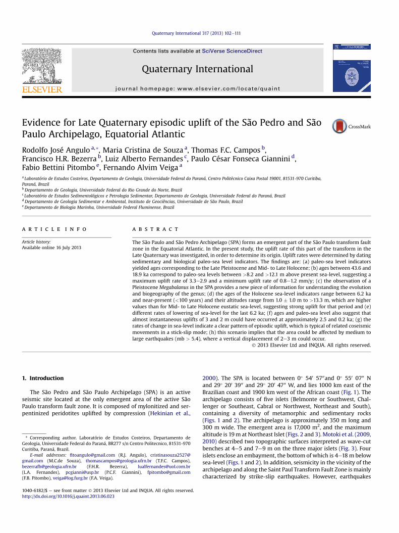
2000). The SPA is located between 0� 540 5700and 0� 550 0700 Nand 29� 200 3900 and 29� 200 4700 W, and lies 1000 km east of theBrazilian coast and 1900 km west of the African coast (Fig. 1). Thearchipelago consists of five islets (Belmonte or Southwest, Chal-lenger or Southeast, Cabral or Northwest, Northeast and South),containing a diversity of metamorphic and sedimentary rocks(Figs. 1 and 2). The archipelago is approximately 350 m long and300 m wide. The emergent area is 17,000 m2, and the maximumaltitude is 19m at Northeast Islet (Figs. 2 and 3). Motoki et al. (2009,2010) described two topographic surfaces interpreted as wave-cutbenches at 4e5 and 7e9 m on the three major islets (Fig. 3). Fourislets enclose an embayment, the bottom of which is 4e18 m belowsea-level (Figs. 1 and 2). In addition, seismicity in the vicinity of thearchipelago and along the Saint Paul Transform Fault Zone is mainlycharacterized by strike-slip earthquakes. However, earthquakes
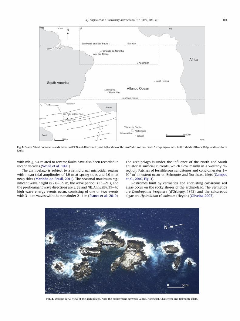
Fig. 1. South Atlantic oceanic islands between 0.9�N and 40.4�S and (inset A) location of the São Pedro and São Paulo Archipelago related to the Middle Atlantic Ridge and transformfaults.
R.J. Angulo et al. / Quaternary International 317 (2013) 102e111 103
with mb � 5.4 related to reverse faults have also been recorded inrecent decades (Wolfe et al., 1993).
The archipelago is subject to a semidiurnal microtidal regimewith mean tidal amplitudes of 1.9 m at spring tides and 1.0 m atneap tides (Marinha do Brasil, 2011). The seasonal maximum sig-nificant wave height is 2.6e3.9 m, the wave period is 15e21 s, andthe predominant wave directions are E, SE and NE. Annually, 35e40high wave energy events occur, consisting of one or two eventswith 3e4 mwaves with the remainder 2e4 m (Pianca et al., 2010).
Fig. 2. Oblique aerial view of the archipelago. Note the embaymen
The archipelago is under the influence of the North and SouthEquatorial surficial currents, which flow mainly in a westerly di-rection. Patches of fossiliferous sandstones and conglomerates 1e103 m2 in extent occur on Belmonte and Northeast islets (Camposet al., 2010, Fig. 3).
Biostromes built by vermetids and encrusting calcareous redalgae occur on the rocky shores of the archipelago. The vermetidsare Dendropoma irregulare (d’Orbigny, 1842) and the calcareousalgae are Hydrolithon cf. onkodes (Heydr.) (Oliveira, 2007).
t between Cabral, Northeast, Challenger and Belmonte islets.

Fig. 3. Topography and bathymetry of the archipelago and (inset A) upper (u) and lower (w) topographic surfaces identified byMotoki et al. (2009) at Belmonte and Northeast islets.The outcrop of fossiliferous sandstones and conglomerates (f) and scientific station (s) are also shown. At the South Islet and other smaller islets the topography is not indicated (n).
R.J. Angulo et al. / Quaternary International 317 (2013) 102e111104
Theuplift rate of the SPA is important for theunderstandingof theevolution of mid-oceanic intra-transforms, where fault kinematicsand slip rates are not fully quantified (Nunn, 1994; Bonatti et al.2005). For example, Campos et al. (2010) inferred an approximateminimumuplift rate ofw1.5mmper year (mm/y) for the SPA duringthe last 6.6 ka, based on fossil remains. This is consistent with thetranspression indicated by strike-slip and reverse fault earthquakesalong the Saint Paul Transform Fault Zone (Wolfe et al., 1993). Thisuplift rate was estimated using data from one islet (Belmont), how-ever, and did not take into account ages older than Holocene or thearea of any submerged sea-level indicators. The aim of the presentstudywas to estimate different uplift rates for the SPAduring the LateQuaternary and discuss the implications for the evolution of the ar-chipelago and the Saint Paul Transform Fault Zone.
2. Methods
Theworkwas basedon the analysis and 14Cdatingof emerged andsubmerged sea-level indicators, topographic levelling, thin-sectionpetrography, grain size analyses, and the identification of non-opaque heavy minerals. 14C dating was carried out at the 14C Labo-ratory of theUniversidade de São Paulo, at the Geochron Laboratoriesof Krueger Enterprises Inc, Cambridge MA, USA, and at Beta Analytic,Miami, Florida, USA. The results and ages published inpreviousworksand used herein were calibrated using the Calib Radiocarbon Cali-bration 6.0 program (Stuiver and Reimer, 1986). The ages presentedhere thus correspond to 14C calibrated years before present.
Five sediment samples were obtained from the SPA bay from 8to 18 m below sea-level. Grain size analyses were performed bypipetting at 1.0 phi class intervals, for the fraction finer than 62 mm(Galehouse, 1971b), and by sieving at 0.5 phi intervals for thecoarser fraction. Descriptive statistics (mean diameter, standarddeviation and skewness) were calculated according to Pearson’s
moments formulae. In the nominal classification of the samplesreferring to the weight proportions of gravel, sand and mud, thesubstantive term refers to themodal fraction and the adjective termrefers to the fraction present in a proportion greater than 20%.Heavy mineral grains of the fine sand class were separated bysinking in bromoform (CHBr3, density 2.85). The quantification ofopaque and semi-opaque (ferruginous-clay aggregate) compo-nents, as well as of specific transparent components, followed the“ribbon counting” method (Galehouse, 1971a; Mange and Maurer,1992), for a total of at least 100 transparent grains. The sedimen-tary analyses were performed at the laboratories of Sedimentologyand Sedimentary Petrography of the Instituto de Geociências,Universidade de São Paulo.
It is necessary to define a present sea-level bench mark in orderto estimate paleo-sea levels from biological indicators. To this end,conspicuous biostromes of living vermetids and calcareous algae inthese islets were adopted as the benchmark (Fig. 4). According toLaborel (1986), the vermetid biostrome reefs are close to mean sea-level on tideless coasts. However, vermetid reefs are close to meanlow tide level (MLTL) on mesotidal coasts, such as those in north-eastern Brazil (Fig. 5). Therefore, considering that the archipelagoislets are subject to 1.9 m amplitude spring tides, the tops of thebiostromes of living vermetids and calcareous algae can be used asan indicator ofMLTL. In coasts exposed to strongwaves such as thoseof the SPA, vermetid reefs can provide reconstructions of paleo-sealevels with a precision of�1.0 m (Laborel, 1986; Angulo et al., 1999).
3. Results
3.1. Sediments
We identified gravels and sandy sediments in the SPA. Theiroccurrence is limited to the bottom of the small embayment
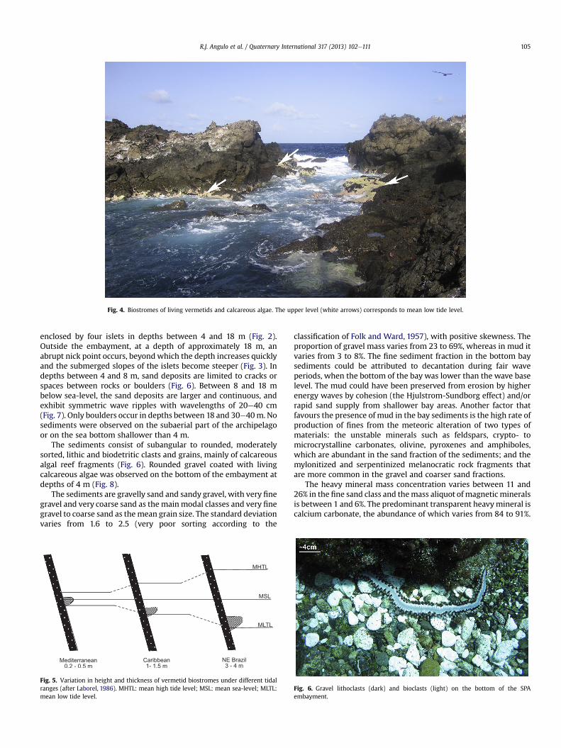
Fig. 4. Biostromes of living vermetids and calcareous algae. The upper level (white arrows) corresponds to mean low tide level.
R.J. Angulo et al. / Quaternary International 317 (2013) 102e111 105
enclosed by four islets in depths between 4 and 18 m (Fig. 2).Outside the embayment, at a depth of approximately 18 m, anabrupt nick point occurs, beyond which the depth increases quicklyand the submerged slopes of the islets become steeper (Fig. 3). Indepths between 4 and 8 m, sand deposits are limited to cracks orspaces between rocks or boulders (Fig. 6). Between 8 and 18 mbelow sea-level, the sand deposits are larger and continuous, andexhibit symmetric wave ripples with wavelengths of 20e40 cm(Fig. 7). Only boulders occur in depths between 18 and 30e40m. Nosediments were observed on the subaerial part of the archipelagoor on the sea bottom shallower than 4 m.
The sediments consist of subangular to rounded, moderatelysorted, lithic and biodetritic clasts and grains, mainly of calcareousalgal reef fragments (Fig. 6). Rounded gravel coated with livingcalcareous algae was observed on the bottom of the embayment atdepths of 4 m (Fig. 8).
The sediments are gravelly sand and sandy gravel, with very finegravel and very coarse sand as the mainmodal classes and very finegravel to coarse sand as themean grain size. The standard deviationvaries from 1.6 to 2.5 (very poor sorting according to the
Fig. 5. Variation in height and thickness of vermetid biostromes under different tidalranges (after Laborel, 1986). MHTL: mean high tide level; MSL: mean sea-level; MLTL:mean low tide level.
classification of Folk and Ward, 1957), with positive skewness. Theproportion of gravel mass varies from 23 to 69%, whereas in mud itvaries from 3 to 8%. The fine sediment fraction in the bottom baysediments could be attributed to decantation during fair waveperiods, when the bottom of the bay was lower than the wave baselevel. The mud could have been preserved from erosion by higherenergy waves by cohesion (the Hjulstrom-Sundborg effect) and/orrapid sand supply from shallower bay areas. Another factor thatfavours the presence of mud in the bay sediments is the high rate ofproduction of fines from the meteoric alteration of two types ofmaterials: the unstable minerals such as feldspars, crypto- tomicrocrystalline carbonates, olivine, pyroxenes and amphiboles,which are abundant in the sand fraction of the sediments; and themylonitized and serpentinized melanocratic rock fragments thatare more common in the gravel and coarser sand fractions.
The heavy mineral mass concentration varies between 11 and26% in the fine sand class and themass aliquot of magnetic mineralsis between 1 and 6%. The predominant transparent heavymineral iscalcium carbonate, the abundance of which varies from 84 to 91%.
Fig. 6. Gravel lithoclasts (dark) and bioclasts (light) on the bottom of the SPAembayment.
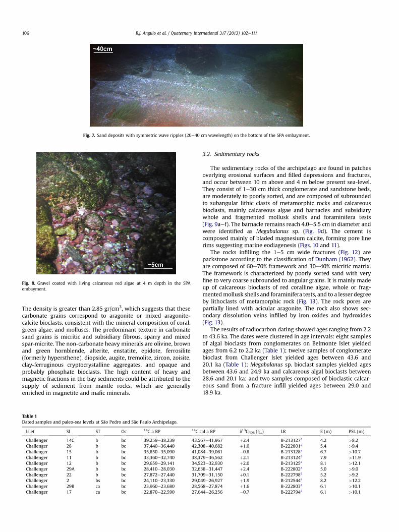
Fig. 7. Sand deposits with symmetric wave ripples (20e40 cm wavelength) on the bottom of the SPA embayment.
Fig. 8. Gravel coated with living calcareous red algae at 4 m depth in the SPAembayment.
R.J. Angulo et al. / Quaternary International 317 (2013) 102e111106
The density is greater than 2.85 gr/cm3, which suggests that thesecarbonate grains correspond to aragonite or mixed aragonite-calcite bioclasts, consistent with the mineral composition of coral,green algae, and molluscs. The predominant texture in carbonatesand grains is micritic and subsidiary fibrous, sparry and mixedspar-micrite. The non-carbonate heavy minerals are olivine, brownand green hornblende, alterite, enstatite, epidote, ferrosilite(formerly hypersthene), diopside, augite, tremolite, zircon, zoisite,clay-ferruginous cryptocrystalline aggregates, and opaque andprobably phosphate bioclasts. The high content of heavy andmagnetic fractions in the bay sediments could be attributed to thesupply of sediment from mantle rocks, which are generallyenriched in magnetite and mafic minerals.
Table 1Dated samples and paleo-sea levels at São Pedro and São Paulo Archipelago.
Islet SI ST Oc 14C a BP 14C c
Challenger 14C b bc 39,259e38,239 43,56Challenger 28 b bc 37,440e36,440 42,30Challenger 15 b bc 35,850e35,090 41,08Challenger 11 b bc 33,360e32,740 38,37Challenger 12 b bc 29,659e29,141 34,52Challenger 29A b bc 28,410e28,030 32,63Challenger 22 b bc 27,872e27,440 31,70Challenger 2 bs bc 24,110e23,330 29,04Challenger 29B ca bc 23,960e23,680 28,56Challenger 17 ca bc 22,870e22,590 27,64
3.2. Sedimentary rocks
The sedimentary rocks of the archipelago are found in patchesoverlying erosional surfaces and filled depressions and fractures,and occur between 10 m above and 4 m below present sea-level.They consist of 1e30 cm thick conglomerate and sandstone beds,are moderately to poorly sorted, and are composed of subroundedto subangular lithic clasts of metamorphic rocks and calcareousbioclasts, mainly calcareous algae and barnacles and subsidiarywhole and fragmented mollusk shells and foraminifera tests(Fig. 9aef). The barnacle remains reach 4.0e5.5 cm in diameter andwere identified as Megabalanus sp. (Fig. 9d). The cement iscomposed mainly of bladed magnesium calcite, forming pore linerims suggesting marine eodiagenesis (Figs. 10 and 11).
The rocks infilling the 1e5 cm wide fractures (Fig. 12) arepackstone according to the classification of Dunham (1962). Theyare composed of 60e70% framework and 30e40% micritic matrix.The framework is characterized by poorly sorted sand with veryfine to very coarse subrounded to angular grains. It is mainly madeup of calcareous bioclasts of red coralline algae, whole or frag-mentedmollusk shells and foraminifera tests, and to a lesser degreeby lithoclasts of metamorphic rock (Fig. 13). The rock pores arepartially lined with acicular aragonite. The rock also shows sec-ondary dissolution veins infilled by iron oxides and hydroxides(Fig. 13).
The results of radiocarbon dating showed ages ranging from 2.2to 43.6 ka. The dates were clustered in age intervals: eight samplesof algal bioclasts from conglomerates on Belmonte Islet yieldedages from 6.2 to 2.2 ka (Table 1); twelve samples of conglomeratebioclast from Challenger Islet yielded ages between 43.6 and20.1 ka (Table 1); Megabalanus sp. bioclast samples yielded agesbetween 43.6 and 24.9 ka and calcareous algal bioclasts between28.6 and 20.1 ka; and two samples composed of bioclastic calcar-eous sand from a fracture infill yielded ages between 29.0 and18.9 ka.
al a BP d13CPDB (&) LR E (m) PSL (m)
7e41,967 þ2.4 B-213127a 4.2 >8.28e40,682 þ1.0 B-222801a 5.4 >9.44e39,061 �0.8 B-213128a 6.7 >10.79e36,562 þ2.1 B-213124a 7.9 >11.93e32,930 þ2.0 B-213125a 8.1 >12.18e31,447 þ2.4 B-222802a 5.0 >9.09e31,150 þ0.1 B-222798a 5.2 >9.29e26,927 þ1.9 B-212544a 8.2 >12.28e27,874 þ1.6 B-222803a 6.1 >10.14e26,256 �0.7 B-222794a 6.1 >10.1

Table 1 (continued )
Islet SI ST Oc 14C a BP 14C cal a BP d13CPDB (&) LR E (m) PSL (m)
Challenger 27 b bc 21,660e21,420 25,738e24,872 þ1.6 B-222800a 7.5 >11.5Challenger 10 ca bc 19,530e19,150 23,298e22,187 þ2.2 B-212552a 7.6 >11.6Challenger 5 ca bc 17,960e17,520 21,341e20,123 þ1.2 B-212547a 6.2 >10.2Challenger 14A bs/b bc 16,500e16,260 19,414e18,867 þ2.5 B-222792a 4.3 >8.3Belmonte 4 ca bc 5650e5510 6175e5795 þ2.6 B-212546a 9.3 >13.3Belmonte 7 ca bc 5500e5380 5933e5655 þ1.5 B-212549a 7.9 >11.9Belmonte 9 ca bc 3880e3760 3939e3607 þ1.4 B-212551a 7.6 >11.6Belmonte 8 ca bc 3340e3220 3298e2942 þ1.3 B-212550a 7.0 >11.0Belmonte 16 ca bc 2530e2450 3289e2033 þ0.9 B-222793b 2.5 >6.5Belmonte 1 ca bc 3200e3100 3096e2789 þ1.5 B-212543a 7.8 >11.8Belmonte 3 ca bc 2950e2830 2780e2453 þ1.5 B-212545a 6.5 >10.5Belmonte 6 ca bc 2760e2620 2658e2209 þ1.1 B-212548a 3.5 >7.5Challengerc 2e2.1 b lp 2400e2280 2116e1816 þ3.2 GX-33617a 7.3 7.3 � 1.0Belmonte 4.2 v lp 455e315 508e293 þ1.7 CEN-1102a 3.3 3.3 � 1.0Belmonte 21A ca/v lp 110e30 267e18 0.8 B-222796b 0.9 �0.9Belmonte 21B b lp 114.1e113.1 257e64 þ0.1 B-222797b 0.9 0.9 � 1.0Belmonte 20 v lp 112.6e111.6 257e31 0.6 B-222795b 1.0 1.0 � 1.0Belmonte 24 b lp 110.1e109.1 256e31 þ1.1 B-222799b 1.0 1.0 � 1.0
References: Samples 1, 3, 4, 6, 7, 8, 9, 16, 20, 21A, 21B and 24 after Campos et al.,2010. Ages were recalibrated and sample nature reinterpreted. Notes: (SI) sample identi-fication, (ST) sample nature, (Oc) occurrence, (14C a BP) fourteen carbon years before present, (14C cal a BP) fourteen calibrated carbon years before present, (LR) laboratoryreference, (E) elevation above mean low sea-level, (PSL) paleo-sea level, (b) barnacles, (bs) calcareous bioclastic sand, (ca) calcareous algae, (v) vermetids, (bc) calcareousbioclast from conglomerates, (lp) in situ -living position- remains.
a Radiometric assay.b Accelerator mass spectrometry e AMS.c Northeastern coast.
R.J. Angulo et al. / Quaternary International 317 (2013) 102e111 107
3.3. In situ fossil remains
We identified three types of in situ fossil remains in the archi-pelago. These are (a) calcareous algal crusts, (b) barnacles, and (c)biostromes built by vermetids and calcareous algae.
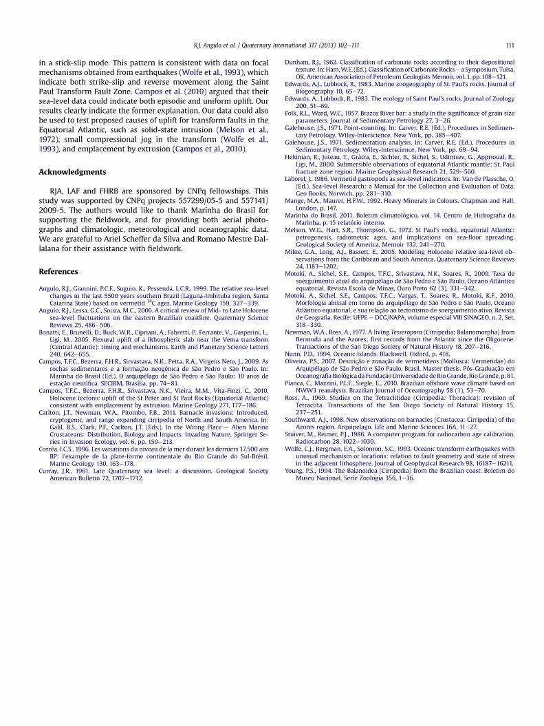
3.3.1. Calcareous algaeCrusts of calcareous algae on the archipelago were observed
between mean sea-level and a depth of 18 m. The deeper ones,occurring at depths of 15e18 m, are crusts 1e2 cm thick with thin(1e2 mm) subhorizontal laminations (Fig. 14a) and borings 1e2 mmwide and 1e2 cm long, probably made by polychaete worms(Fig. 14b). The ones that occur between low tide andmean sea-levelare composed mainly of Hydrolithon cf. onkodes associated with thevermetid D. irregulare (Oliveira, 2007) (Fig. 4).
3.3.2. BarnaclesAt Challenger Islet we identified a group of barnacle shells in life
positionwith surficial mineralization and erosion. The barnacles areTesseropora cf. atlantica (Newman and Ross, 1977) (Fig. 15a). Theuncertainty in the species identification is due to shell abrasion andmineralization and the lack of opercular plates. An occurrence ofT. atlantica in the SPA was described by Edwards and Lubbock(1983a). According to descriptions given by Southward (1998), Ross(1969) and Edwards and Lubbock (1983b), it is possible to inferthat T. atlantica occurred above the algal belt and the urchin domi-nated zone at the lower fringe of the intertidal zone, which corre-sponds approximatelywith levels betweenMLTL andmean sea-level(MSL). In the SPA the difference between these two levels isapproximately 1m. A dated sample of T. atlantica shells encrusted bycalcareous algae collected at Challenger Islet 7.3 m above the MLSTyielded an age of 2.1e1.8 ka, and two samples collected at BelmonteIslet at 0.9e1.0maboveMLSTyieldedagesbetween257and31years.
3.3.3. Vermetids and calcareous red algaeWe found remains of a fossil vermetid reef at 3.3 m above the
highest level with living vermetids at the exposed southeasternarea of Belmonte Islet. The reef is composed mainly of D. irregularetubes with subsidiary Hydrolithon crusts. A sample was dates with
an age of 508e293 years (Fig. 15b). At Belmonte Islet we foundremains of a fossil vermetid reef at 1.0 m above the highest levelwith living vermetids, which yielded an age of 257e31 years.
4. Discussion and conclusions
The lack of sediments on emerged areas up to 4m deep could beattributed to the removal of particles generated by weatheringthrough the action of breaking waves. The symmetrical ripplesobserved on the bottom of the bay between 4 and 18 m (Fig. 7)indicate oscillatory wave action. The rounded clasts observed atthis depth also suggest the effects of wave abrasion, probablyduring high wave energy events. However, the presence of clastscoated with calcareous algae observed at the same depth (Fig. 8)suggests the occurrence of periods without wave action. Thecalcareous crust of coated clasts probably corresponds to the initialstage of cementation of the conglomerates observed at the samedepth in the archipelago bay (Fig. 9b). It is therefore possible toinfer that the conglomerates and sandstones found at the Belmonteand Challenger islets were deposited under hydrodynamic condi-tions similar to present. Campos et al. (2009) also suggested thatsedimentary rockswere formed on the bottom of a bay (Fig.16). Theconglomerates and sandstones presently occur between 10 mabove and 4 m below mean low tide level. Therefore, assumingoceanographic conditions similar to present, it is possible to inferthat the sediments that now make up the sedimentary rocks weredeposited in the zone of wave action between at least 4 m belowmean low tide level down to a few tens of meters, depending on thepaleomorphology of the bottom of the bay. Therefore, the mini-mum paleo-sea level height during the time of depositionwould behigher than 4 m plus the altitude of the upper level of the sedi-mentary deposit. In this way, the paleo-sea level inferred fromconglomerate bioclasts was between >7.5 and >13.3 m abovepresent sea-level.
The calcareous sand and mud deposits infilling the 1e5 cmfractures were probably also deposited at the same depth as theconglomerates. This suggests paleo-sea levels between 8.2 and4.3 m (Table 1). However, their occurrence also implies that therock fractures were subject to weathering and wave erosion before

Fig. 9. (a) Moderately sorted sandstone with subangular to subrounded grains; (b, c and d) very poorly sorted conglomerates consisting of lithic clasts of metamorphic rocks (r) andlarge bioclasts of calcareous algal (al) and barnacle (Megabalanus sp.) remains (m); (e and f) moderately sorted conglomerates composed of lithic clasts of metamorphic rockswithout bioclasts. Specimens a, c, e and f are from Belmonte Islet, b is from the bottom of the archipelago bay, and d is from Challenger Islet.
R.J. Angulo et al. / Quaternary International 317 (2013) 102e111108
infilling. In similar oceanographic conditions, these processes couldoccur in subaerial conditions or as deep as 4 m below sea-level. Itcan therefore be inferred that paleo-sea levels had to be <8.3 mduring the time when the fractures were being enlarged by
Fig. 10. Matrix conglomerate. Lithoclasts (l); carbonatic (cb) and pho
weathering and wave erosion and >8.3 m during the time offracture infilling by sediments.
The paleo-sea level indicators yielded ages corresponding to theLate Pleistocene and Mid- to Late Holocene. The Late Pleistocene
sphatic (pb) bioclasts and bladed magnesium calcite cement (c).
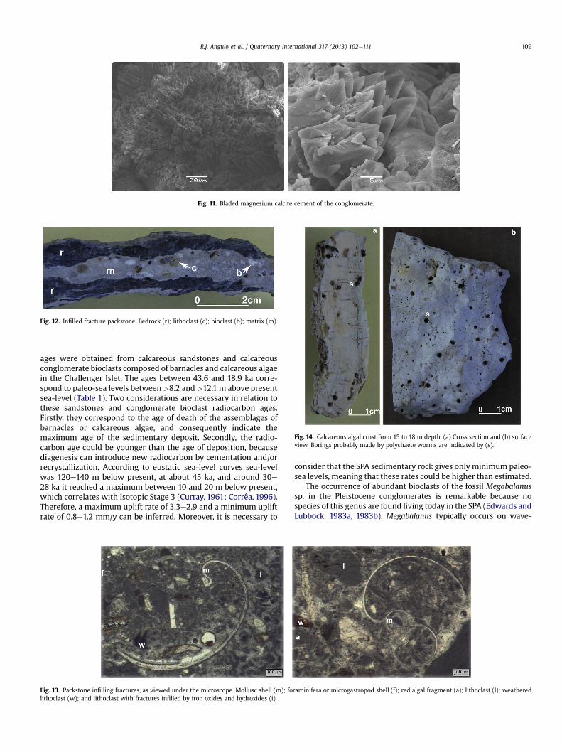
Fig. 11. Bladed magnesium calcite cement of the conglomerate.
Fig. 12. Infilled fracture packstone. Bedrock (r); lithoclast (c); bioclast (b); matrix (m).
Fig. 14. Calcareous algal crust from 15 to 18 m depth. (a) Cross section and (b) surfaceview. Borings probably made by polychaete worms are indicated by (s).
R.J. Angulo et al. / Quaternary International 317 (2013) 102e111 109
ages were obtained from calcareous sandstones and calcareousconglomerate bioclasts composed of barnacles and calcareous algaein the Challenger Islet. The ages between 43.6 and 18.9 ka corre-spond to paleo-sea levels between>8.2 and>12.1 m above presentsea-level (Table 1). Two considerations are necessary in relation tothese sandstones and conglomerate bioclast radiocarbon ages.Firstly, they correspond to the age of death of the assemblages ofbarnacles or calcareous algae, and consequently indicate themaximum age of the sedimentary deposit. Secondly, the radio-carbon age could be younger than the age of deposition, becausediagenesis can introduce new radiocarbon by cementation and/orrecrystallization. According to eustatic sea-level curves sea-levelwas 120e140 m below present, at about 45 ka, and around 30e28 ka it reached a maximum between 10 and 20 m below present,which correlates with Isotopic Stage 3 (Curray, 1961; Corrêa, 1996).Therefore, a maximum uplift rate of 3.3e2.9 and a minimum upliftrate of 0.8e1.2 mm/y can be inferred. Moreover, it is necessary to
Fig. 13. Packstone infilling fractures, as viewed under the microscope. Mollusc shell (m); folithoclast (w); and lithoclast with fractures infilled by iron oxides and hydroxides (i).
consider that the SPA sedimentary rock gives only minimum paleo-sea levels, meaning that these rates could be higher than estimated.
The occurrence of abundant bioclasts of the fossil Megabalanussp. in the Pleistocene conglomerates is remarkable because nospecies of this genus are found living today in the SPA (Edwards andLubbock, 1983a, 1983b). Megabalanus typically occurs on wave-
raminifera or microgastropod shell (f); red algal fragment (a); lithoclast (l); weathered
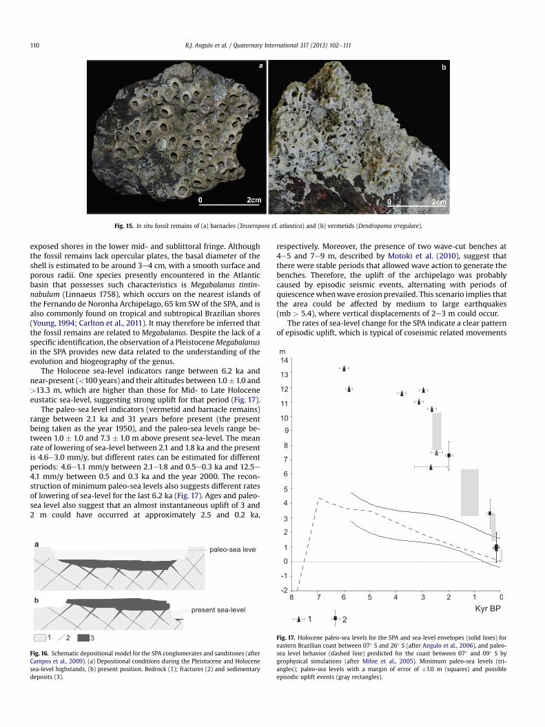
Fig. 15. In situ fossil remains of (a) barnacles (Tesseropora cf. atlantica) and (b) vermetids (Dendropoma irregulare).
R.J. Angulo et al. / Quaternary International 317 (2013) 102e111110
exposed shores in the lower mid- and sublittoral fringe. Althoughthe fossil remains lack opercular plates, the basal diameter of theshell is estimated to be around 3e4 cm, with a smooth surface andporous radii. One species presently encountered in the Atlanticbasin that possesses such characteristics is Megabalanus tintin-nabulum (Linnaeus 1758), which occurs on the nearest islands ofthe Fernando de Noronha Archipelago, 65 km SWof the SPA, and isalso commonly found on tropical and subtropical Brazilian shores(Young, 1994; Carlton et al., 2011). It may therefore be inferred thatthe fossil remains are related to Megabalanus. Despite the lack of aspecific identification, the observation of a PleistoceneMegabalanusin the SPA provides new data related to the understanding of theevolution and biogeography of the genus.
The Holocene sea-level indicators range between 6.2 ka andnear-present (<100 years) and their altitudes between 1.0� 1.0 and>13.3 m, which are higher than those for Mid- to Late Holoceneeustatic sea-level, suggesting strong uplift for that period (Fig. 17).
The paleo-sea level indicators (vermetid and barnacle remains)range between 2.1 ka and 31 years before present (the presentbeing taken as the year 1950), and the paleo-sea levels range be-tween 1.0 � 1.0 and 7.3 � 1.0 m above present sea-level. The meanrate of lowering of sea-level between 2.1 and 1.8 ka and the presentis 4.6e3.0 mm/y, but different rates can be estimated for differentperiods: 4.6e1.1 mm/y between 2.1e1.8 and 0.5e0.3 ka and 12.5e4.1 mm/y between 0.5 and 0.3 ka and the year 2000. The recon-struction of minimum paleo-sea levels also suggests different ratesof lowering of sea-level for the last 6.2 ka (Fig. 17). Ages and paleo-sea level also suggest that an almost instantaneous uplift of 3 and2 m could have occurred at approximately 2.5 and 0.2 ka,
Fig. 16. Schematic depositional model for the SPA conglomerates and sandstones (afterCampos et al., 2009). (a) Depositional conditions during the Pleistocene and Holocenesea-level highstands, (b) present position. Bedrock (1); fractures (2) and sedimentarydeposits (3).
respectively. Moreover, the presence of two wave-cut benches at4e5 and 7e9 m, described by Motoki et al. (2010), suggest thatthere were stable periods that allowed wave action to generate thebenches. Therefore, the uplift of the archipelago was probablycaused by episodic seismic events, alternating with periods ofquiescencewhenwave erosion prevailed. This scenario implies thatthe area could be affected by medium to large earthquakes(mb > 5.4), where vertical displacements of 2e3 m could occur.
The rates of sea-level change for the SPA indicate a clear patternof episodic uplift, which is typical of coseismic related movements
Fig. 17. Holocene paleo-sea levels for the SPA and sea-level envelopes (solid lines) foreastern Brazilian coast between 07� S and 26� S (after Angulo et al., 2006), and paleo-sea level behavior (dashed line) predicted for the coast between 07� and 09� S bygeophysical simulations (after Milne et al., 2005). Minimum paleo-sea levels (tri-angles); paleo-sea levels with a margin of error of �1.0 m (squares) and possibleepisodic uplift events (gray rectangles).
R.J. Angulo et al. / Quaternary International 317 (2013) 102e111 111
in a stick-slip mode. This pattern is consistent with data on focalmechanisms obtained from earthquakes (Wolfe et al., 1993), whichindicate both strike-slip and reverse movement along the SaintPaul Transform Fault Zone. Campos et al. (2010) argued that theirsea-level data could indicate both episodic and uniform uplift. Ourresults clearly indicate the former explanation. Our data could alsobe used to test proposed causes of uplift for transform faults in theEquatorial Atlantic, such as solid-state intrusion (Melson et al.,1972), small compressional jog in the transform (Wolfe et al.,1993), and emplacement by extrusion (Campos et al., 2010).
Acknowledgments
RJA, LAF and FHRB are sponsored by CNPq fellowships. Thisstudy was supported by CNPq projects 557299/05-5 and 557141/2009-5. The authors would like to thank Marinha do Brasil forsupporting the fieldwork, and for providing both aerial photo-graphs and climatologic, meteorological and oceanographic data.We are grateful to Ariel Scheffer da Silva and Romano Mestre Dal-lalana for their assistance with fieldwork.
References
Angulo, R.J., Giannini, P.C.F., Suguio, K., Pessenda, L.C.R., 1999. The relative sea-levelchanges in the last 5500 years southern Brazil (Laguna-Imbituba region, SantaCatarina State) based on vermetid 14C ages. Marine Geology 159, 327e339.
Angulo, R.J., Lessa, G.C., Souza, M.C., 2006. A critical review of Mid- to Late Holocenesea-level fluctuations on the eastern Brazilian coastline. Quaternary ScienceReviews 25, 486e506.
Bonatti, E., Brunelli, D., Buck, W.R., Cipriani, A., Fabretti, P., Ferrante, V., Gasperini, L.,Ligi, M., 2005. Flexural uplift of a lithospheric slab near the Vema transform(Central Atlantic): timing and mechanisms. Earth and Planetary Science Letters240, 642e655.
Campos, T.F.C., Bezerra, F.H.R., Sirvastava, N.K., Petta, R.A., Virgens Neto, J., 2009. Asrochas sedimentares e a formação neogênica de São Pedro e São Paulo. In:Marinha do Brasil (Ed.), O arquipélago de São Pedro e São Paulo: 10 anos deestação científica. SECIRM, Brasília, pp. 74e81.
Campos, T.F.C., Bezerra, F.H.R., Srivastava, N.K., Vieira, M.M., Vita-Finzi, C., 2010.Holocene tectonic uplift of the St Peter and St Paul Rocks (Equatorial Atlantic)consistent with emplacement by extrusion. Marine Geology 271, 177e186.
Carlton, J.T., Newman, W.A., Pitombo, F.B., 2011. Barnacle invasions: Introduced,cryptogenic, and range expanding cirripedia of North and South America. In:Galil, B.S., Clark, P.F., Carlton, J.T. (Eds.), In the Wrong Place e Alien MarineCrustaceans: Distribution, Biology and Impacts. Invading Nature, Springer Se-ries in Invasion Ecology, vol. 6, pp. 159e213.
Corrêa, I.C.S., 1996. Les variations du niveau de la mer durant les derniers 17.500 ansBP: l’example de la plate-forme continentale du Rio Grande do Sul-Brésil.Marine Geology 130, 163e178.
Curray, J.R., 1961. Late Quaternary sea level: a discussion. Geological SocietyAmerican Bulletin 72, 1707e1712.
Dunham, R.J., 1962. Classification of carbonate rocks according to their depositionaltexture. In:Ham,W.E. (Ed.), ClassificationofCarbonateRockse aSymposium.Tulsa,OK, American Association of Petroleum Geologists Memoir, vol. 1, pp. 108e121.
Edwards, A.J., Lubbock, R., 1983. Marine zoogeography of St. Paul’s rocks. Journal ofBiogeography 10, 65e72.
Edwards, A., Lubbock, R., 1983. The ecology of Saint Paul’s rocks. Journal of Zoology200, 51e69.
Folk, R.L., Ward, W.C., 1957. Brazos River bar: a study in the significance of grain sizeparameters. Journal of Sedimentary Petrology 27, 3e26.
Galehouse, J.S., 1971. Point-counting. In: Carver, R.E. (Ed.), Procedures in Sedimen-tary Petrology. Wiley-Interscience, New York, pp. 385e407.
Galehouse, J.S., 1971. Sedimentation analysis. In: Carver, R.E. (Ed.), Procedures inSedimentary Petrology. Wiley-Interscience, New York, pp. 69e94.
Hekinian, R., Juteau, T., Gràcia, E., Sichler, B., Sichel, S., Udintsev, G., Apprioual, R.,Ligi, M., 2000. Submersible observations of equatorial Atlantic mantle: St. Paulfracture zone region. Marine Geophysical Research 21, 529e560.
Laborel, J., 1986. Vermetid gastropods as sea-level indicators. In: Van de Plassche, O.(Ed.), Sea-level Research: a Manual for the Collection and Evaluation of Data.Geo Books, Norwich, pp. 281e310.
Mange, M.A., Maurer, H.F.W., 1992. Heavy Minerals in Colours. Chapman and Hall,London, p. 147.
Marinha do Brasil, 2011. Boletim climatológico, vol. 14. Centro de Hidrografia daMarinha, p. 15 relatório interno.
Melson, W.G., Hart, S.R., Thompson, G., 1972. St Paul’s rocks, equatorial Atlantic:petrogenesis, radiometric ages, and implications on sea-floor spreading.Geological Society of America, Memoir 132, 241e270.
Milne, G.A., Long, A.J., Bassett, E., 2005. Modeling Holocene relative sea-level ob-servations from the Caribbean and South America. Quaternary Science Reviews24, 1183e1202.
Motoki, A., Sichel, S.E., Campos, T.F.C., Srivastava, N.K., Soares, R., 2009. Taxa desoerguimento atual do arquipélago de São Pedro e São Paulo, Oceano Atlânticoequatorial. Revista Escola de Minas, Ouro Preto 62 (3), 331e342.
Motoki, A., Sichel, S.E., Campos, T.F.C., Vargas, T., Soares, R., Motoki, K.F., 2010.Morfologia abissal em torno do arquipélago de São Pedro e São Paulo, OceanoAtlântico equatorial, e sua relação ao tectonismo de soerguimento ativo. Revistade Geografia. Recife: UFPE e DCG/NAPA, volume especial VIII SINAGEO, n. 2, Set,318e330.
Newman, W.A., Ross, A., 1977. A living Tesseropora (Cirripedia; Balanomorpha) fromBermuda and the Azores; first records from the Atlantic since the Oligocene.Transactions of the San Diego Society of Natural History 18, 207e216.
Nunn, P.D., 1994. Oceanic Islands. Blackwell, Oxford, p. 418.Oliveira, P.S., 2007. Descrição e zonação de vermetídeos (Mollusca: Vermetidae) do
Arquipélago de São Pedro e São Paulo, Brasil. Master thesis. Pós-Graduação emOceanografia Biológicada FundaçãoUniversidadedeRioGrande,RioGrande,p. 81.
Pianca, C., Mazzini, P.L.F., Siegle, E., 2010. Brazilian offshore wave climate based onNWW3 reanalysis. Brazilian Journal of Oceanography 58 (1), 53e70.
Ross, A., 1969. Studies on the Tetraclitidae (Cirripedia: Thoracica): revision ofTetraclita. Transactions of the San Diego Society of Natural History 15,237e251.
Southward, A.J., 1998. New observations on barnacles (Crustacea: Cirripedia) of theAzores region. Arquipelago. Life and Marine Sciences 16A, 11e27.
Stuiver, M., Reimer, P.J., 1986. A computer program for radiocarbon age calibration.Radiocarbon 28, 1022e1030.
Wolfe, C.J., Bergman, E.A., Solomon, S.C., 1993. Oceanic transform earthquakes withunusual mechanism or locations: relation to fault geometry and state of stressin the adjacent lithosphere. Journal of Geophysical Research 98, 16187e16211.
Young, P.S., 1994. The Balanoidea (Cirripedia) from the Brazilian coast. Boletim doMuseu Nacional, Serie Zoologia 356, 1e36.