Lucke et al. 2013 caribbean report
38
Marine mammals in the Wider Caribbean – Current research and priorities for future studies Klaus Lucke 1 , Meike Scheidat 1 , Steve Geelhoed 1 , Dolfi Debrot 1 , Natalie Ward 2 , Leila Hatch 2 , Dave Wiley 2 , Craig McDonald 3 , John Reynolds 4 , Paul Hoetjes 5 , Jaime Bolaños 6 , Hélène Souan 7 , Gaëlle Vandersarren 7 , Nadège Gandhilon 8 Report number C007/14 IMARES Wageningen UR Institute for Marine Resources & Ecosystem Studies Client: Ministry of Economic Affairs Paul C. Hoetjes, Policy Coordinator Nature P.O. Box 20401, 2500 EK The Hague, The Netherlands BO-11-011.05-005 Publication date: January 2014
-
Upload
independent -
Category
Documents
-
view
2 -
download
0
Transcript of Lucke et al. 2013 caribbean report

Marine mammals in the Wider Caribbean – Current research and priorities for future studies
Klaus Lucke1, Meike Scheidat1, Steve Geelhoed1, Dolfi Debrot1,
Natalie Ward2, Leila Hatch2, Dave Wiley2, Craig McDonald3, John Reynolds4, Paul Hoetjes5, Jaime Bolaños6, Hélène Souan7, Gaëlle Vandersarren7, Nadège Gandhilon8
Report number C007/14
IMARES Wageningen UR Institute for Marine Resources & Ecosystem Studies
Client: Ministry of Economic Affairs Paul C. Hoetjes, Policy Coordinator Nature P.O. Box 20401, 2500 EK The Hague, The Netherlands
BO-11-011.05-005
Publication date: January 2014

2 of 38 Report number C007/14
IMARES is:
• an independent, objective and authoritative institute that provides knowledge necessary for an integrated sustainable protection, exploitation and spatial use of the sea and coastal zones;
• an institute that provides knowledge necessary for an integrated sustainable protection, exploitation and spatial use of the sea and coastal zones;
• a key, proactive player in national and international marine networks (including ICES and EFARO). 1 Institute for Marine Resources and Ecosystem Studies (IMARES), Wageningen UR, the Netherlands 2 Stellwagen Bank National Marine Sanctuary, U.S.A. 3 National Oceanic and Atmospheric Adminstration, U.S.A. 4 Mote Marine Laboratory, U.S.A. 5 Ministry of Economic Affairs, the Netherlands 6 Sociedad Ecológica Venezolana Vida Marina (Sea Vida), Venezuela 7 Regional Activity Center for Specially Protected Areas and Wildlife (RAC-SPAW), Guadeloupe 8 Biology Laboratoire DYNECAR, Université des Antilles et de la Guyane, Guadeloupe ©Photo’s title page: left T. Bervoets; middle IMARES; right F. Simal P.O. Box 68 P.O. Box 77 P.O. Box 57 P.O. Box 167
1970 AB IJmuiden 4400 AB Yerseke 1780 AB Den Helder 1790 AD Den Burg Texel
Phone: +31 (0)317 48 09 00 Phone: +31 (0)317 48 09 00 Phone: +31 (0)317 48 09 00 Phone: +31 (0)317 48 09 00
Fax: +31 (0)317 48 73 26 Fax: +31 (0)317 48 73 59 Fax: +31 (0)223 63 06 87 Fax: +31 (0)317 48 73 62
E-Mail: [email protected] E-Mail: [email protected] E-Mail: [email protected] E-Mail: [email protected]
www.imares.wur.nl www.imares.wur.nl www.imares.wur.nl www.imares.wur.nl
© 2014 IMARES Wageningen UR IMARES, institute of Stichting DLO is registered in the Dutch trade record nr. 09098104, BTW nr. NL 806511618
The Management of IMARES is not responsible for resulting damage, as well as for damage resulting from the application of results or research obtained by IMARES, its clients or any claims related to the application of information found within its research. This report has been made on the request of the client and is wholly the client's property. This report may not be reproduced and/or published partially or in its entirety without the express written consent of the client.
A_4_3_2-V13

Report number C007/14 3 of 38
Contents
Summary ................................................................................................................. 4
1 Introduction ..................................................................................................... 5
2 Survey techniques ............................................................................................ 7 2.1 Visual Cetacean Surveys ........................................................................... 8
2.1.1 Line-transect surveys .................................................................... 8 2.1.2 Opportunistic sighting scheme ........................................................ 9 2.1.3 Ship-based observations ................................................................ 9 2.1.4 Dedicated near-shore observations .................................................. 9 2.1.5 Land-based observations ............................................................. 10
2.2 Acoustic studies ..................................................................................... 11 2.2.1 Passive acoustic monitoring .......................................................... 11
2.3 Additional research aspects ..................................................................... 14 2.3.1 Determining the cause of marine mammal stranding ........................ 14 2.3.2 Genetic sampling and photo-identification study for humpback
whales ...................................................................................... 15 2.3.3 Photo identification and genetic study for marine mammals .............. 15 2.3.4 Studies on effects of contaminants on marine mammals ................... 16 2.3.5 Genetic studies ........................................................................... 17 2.3.6 Visual aerial surveys using digital imagery ...................................... 17
3 Current research ............................................................................................. 23 3.1 Visual surveys ....................................................................................... 23
3.1.1 AGOA sanctuary ......................................................................... 23 3.1.2 Aerial survey of the ABC islands, Dutch Caribbean ........................... 24 3.1.3 Whale watching workshops ........................................................... 24 3.1.4 Registration of cetacean sightings by the fishermen on Saba ............. 24 3.1.5 Registration of opportunistic sightings & stranding of cetaceans on
St.Eustatius ............................................................................... 25 3.1.6 Workshops on the identification of whales & dolphins in the
Caribbean ................................................................................. 25 3.2 Acoustic surveys .................................................................................... 25
3.2.1 Stationary acoustic monitoring of cetaceans – a pilot study on Saba Bank ........................................................................................ 25
3.2.2 Acoustic monitoring of humpback whales ........................................ 26 3.3 Satellite telemetry ................................................................................. 27 3.4 Other studies ........................................................................................ 27
3.4.1 Stranding response ..................................................................... 27 3.5 Management ......................................................................................... 29
3.5.1 Marine Spatial Planning ................................................................ 29 3.5.3 Data sharing .............................................................................. 30
4 Future research priorities ................................................................................. 31 4.1 General aspects ..................................................................................... 31 4.2 Priorities ............................................................................................... 31
Quality Assurance .................................................................................................... 34
References .............................................................................................................. 35
Justification ............................................................................................................. 38

4 of 38 Report number C007/14
Summary
Information on the distribution, abundance and ecology of marine mammal in the Wider Caribbean Region is scarce. This report aims at collating the on-going research in the Wider Caribbean Region, at identifying the most critical knowledge gaps that need to be addressed to inform and facilitate conservation actions and assess the most suitable research techniques to fill these knowledge gaps. Numerous research activities aiming at marine mammals have been commenced by individual organisations as well as regional or even international collaborations throughout the Wider Caribbean over the past years. These efforts, ranging from visual to acoustic surveys, satellite telemetry, stranding response, and many more, provide valuable insight into important aspects of the ecology of marine mammals and show that the motivation and need to conduct research on marine mammals in the Caribbean waters is high. Due to lack of funds and capacity most current and past cetacean research in the region can be characterised as small-scale, low in sophistication, opportunistic, temporary and local which is a great limitation to the understanding required for proper conservation of this increasingly important resource in this tourism-oriented region. Consequently, if continued with the current level of capacity and expertise, the results will continue to remain limited. There is an urgent need to combine forces, work on a larger geographic scale and use new and innovative techniques if we want to move beyond the current patchwork in activities and understanding. Ideally, all on-going and suggested future research efforts should become integral parts of a joint international research strategy for the wider Caribbean. The choice of research methods to be used, however, depends in large part on the questions to be answered. Knowledge on temporal and spatial scale of marine mammal occurrence in the Caribbean waters is essential for any effective management and conservation and should have first priority, followed by studies on the effect of anthropogenic activities on marine mammals. In the absence of adequate data on marine mammals in this region, but with cautious extrapolation of knowledge and experience gained in other parts of the world we suggest to concentrate research efforts on visual and acoustic surveys and monitoring, stranding networks and necropsy of stranded animals, along with photo ID and tissue sampling for genetic analysis. All these methods differ in terms of the aims for which they will be suitable. Therefore, the aims must be clear before choosing the method. Research on the diverse groups of marine mammals has to modular and collaborative such that it can be synergistic, provided that there is sufficient collaboration and communication between all parties involved. Public outreach by involvement of local institutions, marine parks, tour operators as well as communication of any research plan and results to local, regional and international regulators, policy makers and public representatives, plays an equally important role in achieving management and conservation goals. This report is part of the Wageningen University BO research program (BO-11-011.05-005) and has been financed by the Ministry of Economic Affairs (EZ) under project number 4308701020.
Report number C007/14 5 of 38
1 Introduction
The waters of the Wider Caribbean Region are populated by numerous marine mammal species, most of them belonging to the cetaceans (whales & dolphins). However, information on their distribution and abundance, and knowledge of key factors governing their ecology in the region is scarce. Dedicated passive acoustic and visual surveys to investigate the distribution of cetaceans have previously been conducted in the Eastern Caribbean in spring (International Fund for Animal Welfare 1995, 1996, 2000 and 2006) where 15 different species were encountered (Boisseau et al. 2006). The authors conclude that due to the absence of survey data for much of the region, and considering the long history of exploitation of some near-shore populations, there is much uncertainty regarding population structure, abundance and status, especially for small cetaceans in this area. In 2008, the United Nations Environment Programme (UNEP) published the current Action Plan for the Conservation of Marine Mammals (MMAP) in the wider Caribbean region. The main objective of the MMAP is to assist participating governments in the region in their efforts to develop and improve marine mammal conservation policies and practices. Based on studies covering regional scales (Swartz & Burks 2000, Yoshida et al. 2010), Debrot et al. (2011b) provided an overview of the current knowledge on the spatial and temporal distribution and abundance of marine mammal fauna in the waters of the Dutch Caribbean which amounts to a minimum of 19 species, and possibly up to more than 30.
Marine mammals in the Caribbean face a variety of anthropogenic threats (Debrot et al. 2011a, b). One of the most important threats is fisheries with direct (by-catch of cetaceans) or indirect (over-exploitation of prey fish) effects. In addition, shipping (which can result in collisions and which is a source of underwater noise), effects of contaminants (most notably organochlorine pesticides for agriculture and Polycyclic Aromatic Hydrocarbons (PAHs)) from oil and gas exploration, which leads to habitat degradation and causes immune-suppression), habitat degradation or behavioural disruption through noise (from sources such as airgun impulses for hydrocarbon exploitation research, military activities, offshore construction, destructive fishing, etc.), displacement by overzealous ecotourism as well as other factors have to be considered.
The Scientific Committee of the International Whaling Commission rekindled attention to several of these matters for the Caribbean region during the annual meeting held from 30 May-11 June 2011, in Tromsø, Norway (IWC 2012). In their report, which is used to help set policy and research priorities world-wide, Caribbean matters are specifically addressed for the first time in many years. In addition, approaches such as an interview-based approach used by Moore et al. (2010) may help to identify the locations and nature of factors that compromise marine mammal stocks (especially coastal stocks), to assess their impact and prioritise studies. Some of the studies could be done quickly and inexpensively in order to focus more rigorous scientific efforts.
To provide some immediate protection, several nations have already declared marine mammal sanctuaries within their waters in the Caribbean or intend to do so, such as, the Dominican Republic and France, or in waters linked with the Caribbean (USA, Stellwagen Bank summer grounds for Caribbean humpback whales). In cooperation with these neighbouring countries, the government of the Netherlands intends to proclaim a marine mammal sanctuary in the territorial sea and EEZ waters of Saba and St. Eustatius in 2014.
Ideally, effective management and conservation of marine fauna should be informed by good scientific information, i.e. based on sufficient information on the species occurring in the area, their seasonal and spatial distribution, as well as their ecology. However, in some cases, management and conservation cannot and should not await the development of the desired scientific knowledge. By delaying conservation until science occurs, some stocks could be depleted to the point of non-recovery. Conservation actions can, in fact occur even without much science at all, if the political and social will to conserve exists. Thus, research and conservation/management need to progress in parallel, not sequentially. The effectiveness of management can then be evaluated empirically through monitoring using an adaptive management approach.
6 of 38 Report number C007/14
Research initiatives to provide such information have been started on a local and regional scale. Some of the species concerned, such as the humpback whale, are known to migrate over large distances, covering entire ocean basins throughout the annual cycle. In this regard, creating sister sanctuaries will be needed to protect such species at a geographic scale representative of each species’ life history and covering relatively large ocean spaces (Hatch & Fristrup 2009). To manage sound pollution, whales in particular may require large protected areas (Wright et al. 2011).
This document aims at providing a joint research plan for the Wider Caribbean Region as discussed and requested at the Caribbean Marine Mammal Sanctuaries Cooperative Workshop in Philipsburg , St. Maarten (2012). As pointed out by several authors (see Debrot et al. 2011a, b), and emphasized at the workshop, there is a special need for dedicated, co-ordinated research efforts on the marine mammal species in the Wider Caribbean Region. The topics listed in this research plan can be implemented on a local or small regional scale, but ideally these efforts should be focussed on large scale, trans-boundary, international visual and acoustic survey efforts, combined with the improvement, expansion and coordination of local monitoring schemes. The sister sanctuary agreement is a perfect example of strategic, political and administrative support in this context, as it allows to enhance coordination of management efforts between the sanctuaries by promoting the exchange of information, research tools and technologies between the different sites.
This plan does not provide a comprehensive explanation of the methods suggested, as these can be found in the literature cited, but it does aim to highlight and discuss the most suitable methods and the application of promising new technologies. Case studies are added as examples where appropriate. This will be a living document and evolve in the process of on-going discussions with all parties involved. In this document we aim to prioritise the research that should be conducted in the Caribbean as seen by the authors (see final chapter) and should be useful as a guideline for researchers, regulators and other stakeholders in the region.

Report number C007/14 7 of 38
2 Survey techniques
Selection of the most appropriate survey method is a key task when designing a survey. However, before a survey can be designed adequately, the study objectives must be clearly defined. Does the study aim at a species inventory, recording seasonal patterns of occurrence, estimation of abundance, a comparison of densities across habitats or a temporal trend analysis? The study objectives determine how much surveying is needed, how surveying must be allocated temporally and spatially, and which surveying technique can best be used.
A species inventory is the least demanding and can be conducted using the entire suite of surveying techniques, from incidental sightings and stranding information, to visual and/or acoustic surveys from platforms of opportunity. These can make use of networks of volunteer observers although the wide variation in abilities and experience means that special attention must be paid to training and to data quality control.
Monitoring spatial and temporal patterns in cetacean abundance can involve a variety of approaches depending upon the target species and the resources available (Evans & Hammond 2004). As a first step, the species inventory aids the construction of a species list and a rough measure of status and seasonal variation in abundance. Monitoring of numbers requires quantification of effort and some correction for factors that influence detectability, such as sea state and type of observation platform.
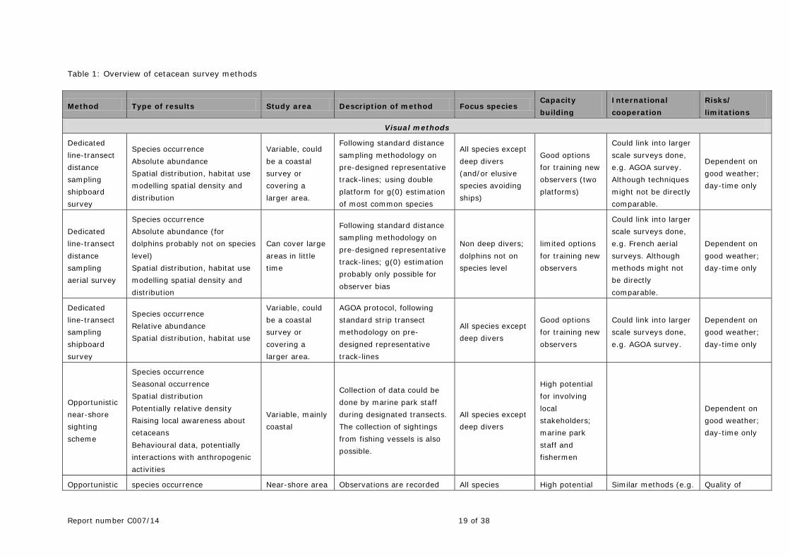
The presence of cetaceans may be recorded visually, or by acoustics. A detailed list of methods, the type of results, study area and focal species and related aspects can be found in table 1.
Each approach has advantages and disadvantages, and their applicability may vary between species. The use of fixed listening stations tends to allow sustained monitoring at relatively low cost but coverage is limited to the immediate vicinity of the hydrophones. For more extensive coverage, mobile platforms are necessary. Platforms of opportunity such as ferries, whale-watching boats, etc. are often used to survey areas at low cost. These may allow observations to be made repeatedly over time, but with no control over where the vessel goes, it is typically not possible to sample wide areas, thus limiting their utility for abundance estimation.
Line transect surveys using dedicated platforms allows representative coverage of areas from which abundance estimates can be made (either using indices or absolute numbers derived from density estimation). Assumptions relating to detectability and responsiveness need to be addressed and various methods (such as two-platform surveys) have been developed to accommodate these (e.g. Borchers et al. 1998a, Buckland et al. 2001).
For some cetacean species, mark-recapture estimation methods can be applied using photo-identification of recognizable individuals. Again, a number of assumptions are made, particularly relating to recognisability, representativeness of sampling and capture probabilities. Mark-recapture methods require at least two sampling occasions. If multiple sampling is employed, either open or closed population models can be used (e.g. Burnham et al. 1995).
Measuring population change is a challenge for mobile animals such as cetaceans. Changes in ranging patterns may have a large impact on abundance estimates unless very large areas are adequately covered. Using current regional/small-scale monitoring approaches, it is very difficult to detect even large changes in abundance. Such studies will most likely provide indices of abundance. Power analysis is a useful method to indicate the amount of data needed to detect an effect (or their ability to detect a trend) of a given magnitude. Increasingly, spatial modelling using GLMs (Generalized Linear Models) and GAMs (Generalized Additive Models) is being used to provide a better understanding of the biotic and hydrographic factors influencing cetacean distribution (Evans & Hammond 2004).
Realistically speaking, it is unlikely that absolute abundance of most marine mammal species in the Wider Caribbean will occur any time soon, even with lots of excellent research.
8 of 38 Report number C007/14
2.1 Visual Cetacean Surveys
General
2.1.1 Line-transect surveys
The most widely used visual survey method to estimate abundance is ‘line transect distance sampling’. Track-lines are predefined in a way that their coverage probability of the study area is known. Distances from the visual observation platform (airplane or ship) are recorded to all sightings to determine the effective strip width, taking into account a number of potential factors that can impact this value (e.g. sea state, turbidity, observer). The method also estimates a correction factor to address the fact that not all animals can be seen by the ship or aircraft observers (because animals are underwater or missed) and that some species will respond to the approaching survey ship (i.e. avoidance or attraction). This correction factor is called g(0) and describes the probability of sighting an animal that is present on the transect line (at distance 0 m). For aerial surveys two-engine survey planes with so called “bubble windows” are used to allow a free view of the transect line. This is important for the estimation of the effective strip width. To estimate g(0), for aircraft a method called “racetrack” is used (Hiby & Lovell 1998) and for vessels a primary and a tracker platform (“double platform”) are used (Borchers et al. 1998 a, b).
To determine the distribution and (relative or absolute) abundance of cetacean species, generally some kind of effort–corrected method is needed. This means that the effort (e.g. time spent: listening for whales, watching for whales, area covered watching) needs to be recorded, as well as any type of condition that could impact the chances of seeing a cetacean (e.g. sea state, wave height, fog, rain). Distance sampling methodology can also address the problems due to that animals might not always be detectable, or might react to the platform. Line-transect distance sampling thus provides a standardised methodological approach allowing to overcome these problems and allowing to provide reliable estimates of populations sizes, given that a minimum critical number of positive detections can be made.
The visual surveys should be carried out by trained observers to ensure a reliable quantification of the effort, but more importantly a proper identification of animals at species level. If conducted from a ship, visual surveys should ideally involve a double platform (see Buckland et al. 2001, Hammond et al. 2002, 2013). Following this approach, along with a thorough documentation of all environmental variables and other relevant variables, this will most often provide the necessary information to not only identify the species, but also – in the ideal case – to estimate the number of animals in the surveyed area. Depending on the quality of the survey design and the survey effort, the resulting data can range from a species list to relative abundance estimates or even density estimates with 95% confidence intervals.
Ship-based visual surveys have the advantage that they can be combined with e.g. oceanographic measurements as well as detections of other large marine fauna (sharks, turtle etc.). Depending on the choice of vessel, a towed hydrophone can be deployed during the survey transects allowing to collect additional information on the presence of vocally active marine mammal species. Ship based surveys, moreover, can cover wide areas.
Aerial surveys can cover a wide survey area in a short time. As in the case of ship-based surveys, aerial surveys are conducted on pre-designed tracks at a pre-defined speed and altitude to optimise the analysis. Aerial survey planning needs to consider potential limitations in range (fuel) and safety requirements (double-engine).
All visual surveys are strongly weather dependent and can only effectively be conducted in suitable conditions. They represent a snap-shot of the distribution and density of the observed species at that moment. Cetaceans differ in their diving behaviour, which leads to a change in probability of sighting different species. Using only visual methods the probability of sighting deep (and long) diving species such as beaked whales and sperm whales, is lower than for species that spend more time at the surface.

Report number C007/14 9 of 38
In summary, all these methods differ in terms of the aims for which they will be suitable. Therefore, the aims of any survey must be clear before choosing the method.
2.1.2 Opportunistic sighting scheme
There are many different approaches for how to monitor the occurrence, abundance and distribution of cetaceans. To obtain a first overview of the species that are occurring in an area, it is useful to conduct monitoring of strandings and so-called “opportunistic” sightings (see De Boer 2013), either from land, air or sea. Species identification might sometimes be difficult, but the use of digital photography and videos often makes it possible to verify species identifications at a later stage. This type of data can be collected with relatively low effort, but it needs follow-up work to compile the data and enter it into a standardized database. If the effort is more or less consistent in time, it is even possible to obtain information on seasonal patterns.
Opportunistic sighting schemes are compatible with two main general aims:
• provide first overview of spatial and temporal distribution of whales and dolphins around the islands and on local fishing grounds
• support capacity building; network building; training
2.1.3 Ship-based observations
Opportunistic sightings registration
Data can potentially be collected by a wide range of vessels, such as: marine park vessels, fishing boats, ferries, tug boats, vessels for diving, military, oil vessels and tourist vessels. Ideally, this should be done using standardized forms to record specifics of the sightings, such as position, species and group size. All the information needs to be checked for errors and collated in a common database.
Suitable to:
• provide an indication of species occurrence • provide an indication of seasonal occurrence • provide an indication of spatial distribution (nearshore/offshore) • to raise awareness about cetaceans
2.1.4 Dedicated near-shore observations
Collection of data could be done by the marine park staff during dedicated transects. The collection of sightings from fishing vessels (using fishing effort as proxy of actual sighting effort) is also possible.
Data quality could be improved by: designing representative track-lines in the study areas; adding continuous information on position of vessel, environmental (sighting) conditions and recording the distance of sightings to a track-line.
Suitable to:
• provide an indication of species occurrence • Potential photo-identification • Relative abundance • Potential absolute abundance • Spatial distribution • Raising awareness about cetaceans
10 of 38 Report number C007/14
2.1.5 Land-based observations
Opportunistic sighting and stranding registrations.
Any observation made from land could be used, such as sightings made by tourists, locals or children (e.g. integrated in the current school program to record whale sightings). Ideally, the position where the observation is made is noted as well as the (approximate) position of the sighting. Also, any stranded animal(s) should be collected and examined. Good photographs of the animal(s), taken from different vantage points, will best document the observation.
Aims:
• Indication of species occurrence • Indication of seasonal occurrence • Indication of (nearshore) spatial distribution • Raising awareness about cetaceans
Effort-corrected, land-based observations can be collected by following a standard protocol, which makes some level of quantitative inference possible. This protocol includes that observations are made from specific points, covering a specific search area for a certain time. Sightings are recorded with detailed information, such as position (e.g. determined by measuring the distance to the sighting and the angle to the sighting), group size, behaviour, presence of calves. If possible, high powered binoculars are used on a permanent tripod such that groups of animals can also be tracked and information on behaviour (e.g. swimming speed, interactions with other animals or vessels) can be obtained.
Report number C007/14 11 of 38
2.2 Acoustic studies
2.2.1 Passive acoustic monitoring
Passive acoustic monitoring (PAM) is increasingly used by the scientific community to study, survey and census marine mammals, especially cetaceans. Many of these happen to be easier to hear than to see. PAM is also used to support efforts to mitigate potential negative (noise-mediated) effects of human activities such as ship traffic, military and civilian sonar and offshore exploration (Zimmer 2011). This technique encompasses a suite of ‘listening’ tools that can answer scientific questions and provide critical input to marine management and/or mitigation applications over spatial scales ranging from <1km2 to whole regions and ocean basins.
In general, the tools that are available to acquire and analyse underwater sound data have undergone a revolutionary change over the last decade, and have substantially increased our abilities to both collect and apply acoustics to marine conservation questions (Van Parijs et al. 2009). Different strategies can be employed to detect the echolocation signals or vocalisations of cetaceans, in the use of static acoustic detectors such as noise loggers (handheld or moored) or click detectors and in the use of towed hydrophones used on mobile platforms such as survey vessels. These techniques allow detection of the presence of a cetacean, identification of the species concerned and ideally also the number of animals.
Passive acoustic arrays can be used to conduct large-scale monitoring of vocal marine life in all areas, but most beneficially in areas that are difficult to survey by traditional visual methods. Arrays of autonomous recording units (ARUs) can sample continuously for prolonged periods of time, allowing assessment of seasonal changes in distribution and acoustic behaviour of individuals without disturbance in contrast to e.g. using survey vessels. Passive acoustic technologies can survey in darkness and remain active during adverse weather conditions. Furthermore, the ability to retrieve and redeploy PAM devices provides a high level of flexibility in data acquisition. Units can be deployed for short periods (days to weeks) or longer periods (months to years) and sampling settings (sampling rate, duty cycle etc.) can be changed. When installed in relatively tight clusters, PAM devices also provide means to localise and track individual animals by triangulation, allowing to study their behaviour e.g. in relation to anthropogenic activities.
Passive acoustic devices can also be deployed as tethered (cable-linked) or radio-linked (GSM/ WiFi) systems, allowing to retrieve the data in real-time and reducing the need to visit the offshore positions. Lifting and redeploying the systems usually requires larger, offshore going vessels which usually come with a higher price-tag. These systems, however, have to be equipped with independent power generators (solar panels, wind turbine or else) or by power connection to land. The range of tethered systems is usually limited to a few km while radio-linked systems can range out to a few tens of km from shore. Sousa-Lima et al. (2013a, b) provided a very useful general overview of the types of passive acoustic monitoring devices and Dudzinski et al. (2011) discussed the issues related to the mooring and maintenance of these systems. IMARES (Wageningen UR, The Netherlands) is currently collating information on all available passive acoustic monitoring systems that could be used and deployed in the Wider Caribbean Region and will disseminate the results (Lucke, in prep.). It is clear, however, that passive acoustic monitoring systems vary widely in total cost (including deployment and need for maintenance), data availability, deployment longevity, flexibility and surface expression. Consequently, there is no single right answer as to which system should be ideally used, but rather the biology of the species of interest and other constraints have to be considered. Moreover, the bathymetry and oceanographic conditions of the deployment area have to be taken into account. The definition of the system specifications and configuration has ultimately to be based on clearly defined (research) questions.
Depending on the details of their operation, data collected using PAM systems allow one to conduct similar types of analysis as with visual data. Besides information on the mere presence of vocally active cetaceans within the detection range of the acoustic sensor, line transect surveys employing a towed
12 of 38 Report number C007/14
hydrophone system provide means for abundance and density estimation of vocally active cetacean species. This kind of analysis can, in principal, also be done with data from stationary PAM devices. However, the analysis is more complicated and algorithms to derive abundance or density estimates are only now in development. In general, PAM systems do initially detect only the presence of one or multiple animals based on their acoustic signals. Deducting the number of animals of the same species from a single acoustic sensor requires knowledge on various parameters (directionality of sound emissions, rate of sound production vs. silent periods) and sophisticated statistical processing. Acoustic cue counting is one possible way of analysing such data. A system consisting of multiple sensors (in one system or spread out over various locations) provides the means for localising individual animals thus allowing to analyse the data quantitatively. Several other aspects of the animals’ behaviour can be analysed using data from PAM systems (acoustic dive counting, density estimation of clustered or grouped objects, moving whales during line and point transects etc.), both for a quantitative as well as habitat and behavioural analysis. When it comes to monitoring rare and elusive species, PAM devices are especially useful as they provide a good cost-benefit ratio. Here, as with all monitoring approaches, the expected behaviour of the species of interest is key to determining the sampling strategy (Zimmer 2011).
In general, identification of every marine mammal call from numerous recording locations over an extended period of time would take experts a very long time to complete. In order to increase efficiency, automatic detection software is increasingly used to screen files initially for sounds of particular template types. These are then reviewed by trained analysts to make final determinations regarding species identity and call type. Levels of screening of sounds with automated detectors followed by trained evaluations can range from a sample of days in the monitoring period and a sample of PAM locations, up to all days and all locations depending upon the question being addressed by the analysis. In addition, the recordings allow assessing background noise conditions within frequency bandwidths utilized by marine mammals for communication. These noise levels can be grossly compared to metrics of human activity: numbers of vessels of different types in proximity to PAM locations, presence/absence of offshore construction activity in proximity to the PAM locations, etc.
This allows quantification of the specific contributions that different types of human activities make to noise levels within areas, time periods and within the frequency bandwidths utilized by marine mammals. It also allows assessing changes in animal behaviour relative to specific activities. All these types of analysis rely on specific location and timing information regarding the activities in question such that they can be matched to PAM data to identify acoustic signatures of identified events. All also vary widely in resolution. These analyses further require the application of sound propagation modelling tools to estimate the levels of sounds produced by sources based on the levels of sound recorded some distance away at receiving PAM devices. The examination of animal response can utilize metrics such as calling rates, levels or other changes in acoustic behaviour. They can also be based on movement of animals as measured through acoustic tracking of individuals. Again, all analyses require trained analysts and may require access to proprietary propagation modelling software as well as additional tools for localizing and/or tracking individual animals.
Besides the described potential for cross-correlation between biological and oceanographic data, and information on anthropogenic activities, the long duration over which vocal activity can be collected (without weather or light constraints) is a main advantage of using PAM technology. As several, especially deep diving cetaceans can be very cryptic in their surfacing behaviour and difficult to detect visually (e.g. beaked whales), this technology allows to get more reliable and reproducible information on their presence in the areas.
The detection range of all acoustic devices, however, is dictated by the sensitivity of the sensors (hydrophones) on the one hand, the source level of the animal and the sound propagation characteristics on the other hand. For singing humpback whales the detection range might extend to >10 km, while single dolphins (echolocating and/or whistling) would only be audible over <5 km.
Report number C007/14 13 of 38
Ideally a network of acoustic stations throughout the wider Caribbean should be installed. This would allow researchers to complement the visual surveys and also to conduct dedicated studies on e.g. the effect of cruise ships or shipping from the Panama Canal on the occurrence of cetaceans and their habitat use in specific regions.
The main aspects to consider when deploying PAM devices for biological applications are:
• Temporal • Spatial • Acoustic • Localising and tracking of individuals
The spatio-temporal aspects include effective acoustic range of device and the sensor density as well as the period of deployment and the duty cycle of recording. With regards of the technical aspects of the acoustic recording it is important to consider the sampling frequency, the dynamic range of the recording system and the detection/classification algorithms that are/will be used to identify different species.
General aims:
• Detect presence of marine mammals in the Wider Caribbean waters (over different ranges of spatial and temporal scales) and identify species
• Define habitat use • Assess effect of anthropogenic activities on whales
14 of 38 Report number C007/14
2.3 Additional research aspects
2.3.1 Determining the cause of marine mammal stranding
Animals that die at sea may be brought passively to shore by wind and wave action. Some animals strand alive if they can’t keep themselves afloat and survive at sea, but nearly all stranded animals die if unassisted. Certain patterns are exhibited in the strandings of particular species related to their distribution, migrations, and reproduction (Geraci & Lounsbury 2005). In extreme cases numerous marine mammals strand at the same time (“mass stranding”). Then a large number of animals may come ashore together for no apparent reason and in seeming good health. There is a variety of natural and unnatural causes of death and disablement leading to strandings: extreme environmental conditions, parasites, disease, biotoxins, entanglement associated with fisheries, starvation due to decreased food supply, collisions with vessels (Laist et al., 2001), contaminants, oil spills, and death or direct injury inflicted by predators, other marine mammals, or humans (Geraci & Lounsbury 2005). Determining the cause of a stranding of a marine mammal can be very difficult, especially when dealing with a decomposed carcass. The symptoms and pathology may be obscure, and two or more factors may be operating simultaneously. By the time the strandings are investigated, the ultimate cause may no longer be evident.
In all cases it is important to examine the cause of the stranding. This can provide valuable insight in the ecology of the marine mammals (in the case of a natural cause) or contribute to an improved protection of the animals in the future (if stranding is ‘unnatural’, likely to be caused by human activities). A coordinated stranding network would be a keystone in this context, as it would increase the likelihood that stranded animals are detected and subsequently handled in the most appropriate way to conduct further investigations. In order to enable locals in the Caribbean to conduct these examinations, dedicated training necropsy workshops need to conducted with leading experts in the field of veterinary pathology (specialised in marine mammal pathology) so as to teach the necessary skills (see also Debrot et al. 2013 and Scheidat & Geelhoed 2013). Such a workshop has recently already been held in Curacao for the Dutch Caribbean islands in November 2009 and Guadeloupe for the French Caribbean Territories in January 2010 (IWC 2011). These kind of workshops had been identified as priority actions by the UNEP’s Specially Protected Areas and Wildlife (SPAW) Programme’s Marine Mammal Action Plan for the Wider Caribbean.
Aims:
• Species occurrence (spatial and temporal pattern of stranding) • Understanding the natural or unnatural cause of stranding of marine mammals • Awareness • Capacity building
A training workshop on response to entanglement of marine mammals has been organised and held by the International Whaling Commission (IWC), and UNEP’s Caribbean Environment Programme through its Regional Activity Center for the Specially Protected Areas and Wildlife (SPAW) Protocol under the framework of the SPAW regional Action Plan for the Conservation of Marine Mammals in St. Martin in November 2013. This workshop included training in the forensic and practical criteria used to determine human impact (e.g. ship strike and entanglement) from stranded whales.

Report number C007/14 15 of 38
2.3.2 Genetic sampling and photo-identification study for humpback whales
(Including potential for fatty acids/stable isotopes) Genetic markers from skin biopsy samples from marine mammals allow the use of molecular analyses of small samples for the determination of sex and individual identification from genotypes provided by microsatellite loci. This technique, in combination with the individual photo-identification of humpback whales, was applied during a large-scale, ocean-basin-wide study of humpback whales in the North Atlantic in 1992 and 1993 (Smith et al. 1999). The same samples can be used to analyse the fatty acid and/or stable isotopes stored in the tissues of whales and dolphins and compare them to those of their prey as they are assimilated through the diet (Walker & Macko 1999, Iverson et al. 1997; Wetzel & Reynolds 2004; Budge et al. 2006). Stable isotopes and fatty acid analysis can be useful in reconstructing diets in time and space and in population studies of various marine mammal species using different feeding grounds (Barros & Clarke 2009, see also Debrot et al. 2013). The historical reconstruction of values through time can also yield intra-annual and inter-annual variability in feeding. The limitations of this method are that a reference database for the isotopic signature of prey is needed.
Aim:
• To investigate the migratory patterns within the Caribbean and between the Caribbean and the feeding grounds outside the Caribbean
• To investigate the stock identity of humpback whales from Dutch Caribbean waters.
2.3.3 Photo identification and genetic study for marine mammals
Individual identification is an important tool for studies of animal behaviour, ecology, and population biology. Much can be learned from recognition of individuals within a population or social unit, or from tracking or re-capturing individuals over large distances and long periods of time. Repeated observations of a recognizable individual can help to define its ranging patterns or site fidelity, or to quantify habitat use (Wells 2009).
Cetaceans exhibit a variety of individually distinctive natural features. In most cases, features appearing above the surface when breathing are most useful. In particular, heads, backs, dorsal fins, and flukes are most frequently used for individual identification, with variations occurring in colour patterns, skin patches, body scarring, and nicks and notches along fin edges (Hammond et al., 1990). Dorsal fins typically are prominent features that are visible to researchers during most cetacean surfacing. In many cetacean species dorsal fins develop distinctive shapes or acquire nicks and notches, often through intraspecific or interspecific interactions. These features allow for individual identification. Numerous studies based on dorsal fin identifications in delphinids and other small cetaceans have been conducted (Hammond et al. 1990 ; Würsig & Jefferson 1990; Wells et al. 1999). The frequency of occurrence of distinctive fin features varies from species to species and in some cases from population to population.
Selection of specific identification techniques depends on the research questions being addressed and the species under study. Most cetacean individual identification research involves the collection of permanent records of the distinctive features for subsequent detailed analysis, through a process generally referred to as photo-identification (Wells 2009). Large international databases exist e.g. for humpback whales. Though photo-identification can sometimes be accomplished from shore, these studies are typically conducted from research vessels, whale-watching boats, or aircraft. The aim is to attempt to place the scientist/photographer in a favourable position to obtain an image of interest. High-resolution digital cameras with high-speed autofocusing provide high-quality colour images in real-time with relatively low costs for image storage and retrieval. Digital images offer the capacity for post-hoc manipulation,

16 of 38 Report number C007/14
including cropping and enlarging identifying features to facilitate identification, electronic storage, or transmission over the internet and, moreover, facilitate computer-assisted automated analysis.
Aims:
• Photo identification and genetic sampling on local populations of bottlenose dolphins to investigate stock structure and residency patterns.
2.3.4 Studies on effects of contaminants on marine mammals
For factors such as contaminants, the issue is not the levels of contaminants found in body tissues, but rather the effects of such exposures on significant biological functions such as reproduction, immune function. Thus, research should include both measures of body burdens and biomarkers of genotoxicity, immune function, acute phase proteins and other possible measures of stress, and fertility. Such information is mostly or totally lacking for the Wider Caribbean region and the added value of research in this area will therefore be especially high. Instruments necessary to do these kinds of analyses are expensive and require well trained scientists and technicians. It may be a long time before some sorts of analyses can be done locally, but should be readily available through cooperation with specialised laboratories outside of the wider Caribbean region. In addition, a well-designed stranding program complemented by sampling of living animals (opportunistically or through a designed capture/release program) could build local capacity for sampling/monitoring while providing key information through international collaborations.
Report number C007/14 17 of 38
New approaches
2.3.5 Genetic studies
Pilot study to develop a monitoring method for marine mammals using environmental DNA (eDNA)
Genetic monitoring has been used as a tool for conservation and management in cetaceans before. Molecular tags can be used to identify taxa, species or individuals. Using samples of water, abundance of populations can be estimated, the biodiversity of species (or taxa) can be determined as well as the change thereof. Foote et al. (2012) was successful in detecting harbour porpoise DNA in water from facilities containing captive animals. However, their success in detecting DNA from harbour porpoises reliably under natural conditions remained uncertain. If this promising approach is to be applied in the monitoring under natural conditions, further development of the methods are required. A key issue lies with sampling sufficient amounts of water to ensure detection of DNA originating from a few cells. Accordingly, further development is required to enable filtering larger volumes of water while maintaining zero contamination levels. Developing a monitoring approach to detect the presence (or absence) of marine mammals would open a wide range of applications. Such a method could be used in combination with visual surveys to translate the relative occurrence of genetic material to absolute abundance estimate. It could also be used to monitor biodiversity and changes therein. The approach is easily adaptable to any specific target species. It can be extended to other taxa such as fish. It could be used in the tropics, temperate waters as well as in polar regions.
Aims:
• Detect the presence (or absence) of marine mammals. • Translate the relative occurrence of genetic material to absolute abundance estimate. • Monitor marine mammal biodiversity and changes therein
2.3.6 Visual aerial surveys using digital imagery
In recent years more and more marine mammal surveys are performed with new digital techniques (Thaxter & Burton, 2009). When using this new approach, transects are flown within a predefined study area similarly to the ship-based and visual aerial surveys. The sea surface is either photographed or filmed with multiple cameras with a predefined width on these transect, while the GPS on the plane is tracking the whole flight. Often an extra camera can be used by a dedicated observer to zoom in on phenomena outside the transect to gather additional information. All footage is stored digitally to be analysed afterwards in the lab by observers. In digital surveys it is assumed that within the strip width (field of view) of the cameras all marine mammals that are visible will be recorded.
Some of the strong points of digital aerial surveys are the high quality of identification and that observer effects on sighting probability (i.e. individual differences in performance) are minimal. As all analyses are done in the lab afterwards, data can easily be reviewed and re-analysed by others. Estimates of groups of animals is much more precise than during visual aerial surveys. Concerning detection and species identification there is also less effect of weather and sea state compared to the visual methods, but surveying in Beaufort 4 or more is not recommended. Similarly to other types of visual survey techniques, diving individuals are missed. Yet, by now the resolution of the cameras is so good that the survey plane can fly at a much higher altitude than during visual surveys. By doing so the disturbance effect of the observation platform (i.e. due to behavioural reaction of the animal to presence of the plane) is much smaller or absent compared to conventional visual surveys. By applying some more sophisticated analysis methods, absolute abundance estimates of marine mammals can be derived from these data. More on this subject will soon be available in Borchers et al. (in press), and Langrock et al. (2013). Some more general descriptions of digital aerial survey techniques and results were given in the reports of Mellor et al. (2007) and Mellor & Maher (2008) and in Buckland et al. (2012).
18 of 38 Report number C007/14
Several companies in the UK (e.g. HiDef, APEM) and one in Scandinavia (BLOM) offer these digital survey techniques in Europe. The costs are higher than a standard visual aerial survey but the quality of data is potentially better as observer effects are reduced and the quality assurance and repeatability of the surveys is much better.
Report number C007/14 19 of 38
Table 1: Overview of cetacean survey methods
Method Type of results Study area Description of method Focus species Capacity building
International cooperation
Risks/ limitations
Visual methods
Dedicated line-transect distance sampling shipboard survey
Species occurrence Absolute abundance Spatial distribution, habitat use modelling spatial density and distribution
Variable, could be a coastal survey or covering a larger area.
Following standard distance sampling methodology on pre-designed representative track-lines; using double platform for g(0) estimation of most common species
All species except deep divers (and/or elusive species avoiding ships)
Good options for training new observers (two platforms)
Could link into larger scale surveys done, e.g. AGOA survey. Although techniques might not be directly comparable.
Dependent on good weather; day-time only
Dedicated line-transect distance sampling aerial survey
Species occurrence Absolute abundance (for dolphins probably not on species level) Spatial distribution, habitat use modelling spatial density and distribution
Can cover large areas in little time
Following standard distance sampling methodology on pre-designed representative track-lines; g(0) estimation probably only possible for observer bias
Non deep divers; dolphins not on species level
limited options for training new observers
Could link into larger scale surveys done, e.g. French aerial surveys. Although methods might not be directly comparable.
Dependent on good weather; day-time only
Dedicated line-transect sampling shipboard survey
Species occurrence Relative abundance Spatial distribution, habitat use
Variable, could be a coastal survey or covering a larger area.
AGOA protocol, following standard strip transect methodology on pre-designed representative track-lines
All species except deep divers
Good options for training new observers
Could link into larger scale surveys done, e.g. AGOA survey.
Dependent on good weather; day-time only
Opportunistic near-shore sighting scheme
Species occurrence Seasonal occurrence Spatial distribution Potentially relative density Raising local awareness about cetaceans Behavioural data, potentially interactions with anthropogenic activities
Variable, mainly coastal
Collection of data could be done by marine park staff during designated transects. The collection of sightings from fishing vessels is also possible.
All species except deep divers
High potential for involving local stakeholders; marine park staff and fishermen
Dependent on good weather; day-time only
Opportunistic species occurrence Near-shore area Observations are recorded All species High potential Similar methods (e.g. Quality of
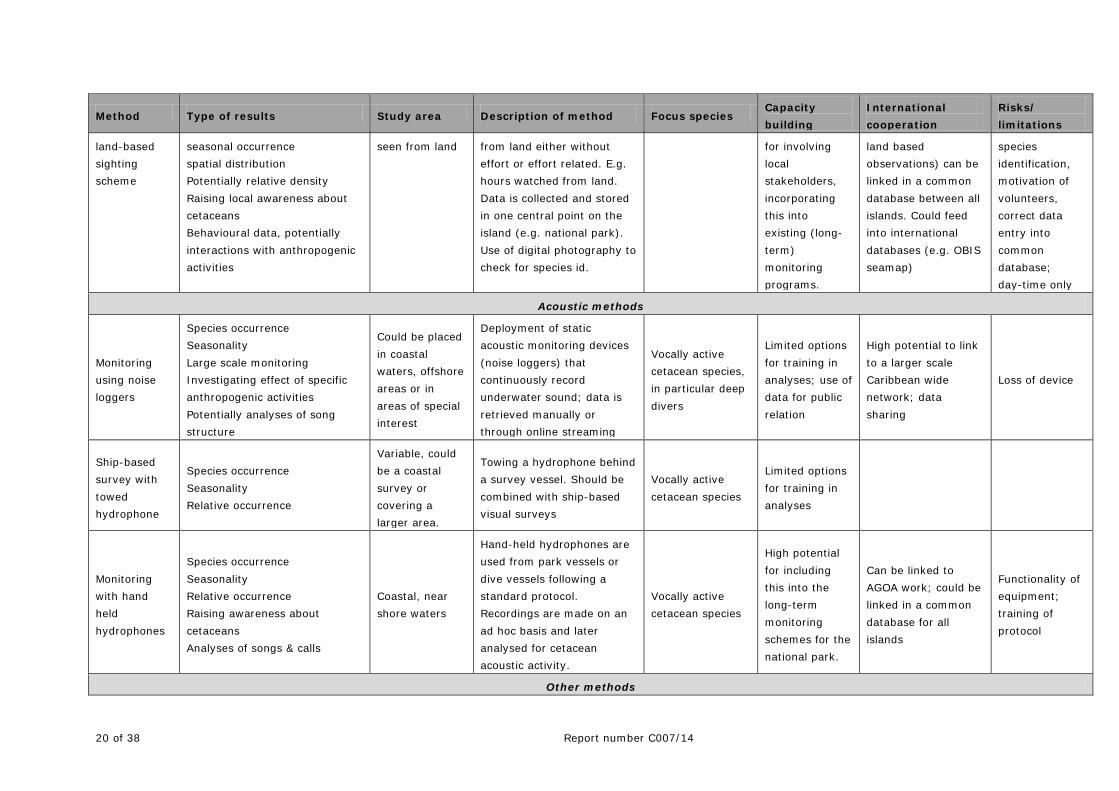
20 of 38 Report number C007/14
Method Type of results Study area Description of method Focus species Capacity building
International cooperation
Risks/ limitations
land-based sighting scheme
seasonal occurrence spatial distribution Potentially relative density Raising local awareness about cetaceans Behavioural data, potentially interactions with anthropogenic activities
seen from land from land either without effort or effort related. E.g. hours watched from land. Data is collected and stored in one central point on the island (e.g. national park). Use of digital photography to check for species id.
for involving local stakeholders, incorporating this into existing (long-term) monitoring programs.
land based observations) can be linked in a common database between all islands. Could feed into international databases (e.g. OBIS seamap)
species identification, motivation of volunteers, correct data entry into common database; day-time only
Acoustic methods
Monitoring using noise loggers
Species occurrence Seasonality Large scale monitoring Investigating effect of specific anthropogenic activities Potentially analyses of song structure
Could be placed in coastal waters, offshore areas or in areas of special interest
Deployment of static acoustic monitoring devices (noise loggers) that continuously record underwater sound; data is retrieved manually or through online streaming
Vocally active cetacean species, in particular deep divers
Limited options for training in analyses; use of data for public relation
High potential to link to a larger scale Caribbean wide network; data sharing
Loss of device
Ship-based survey with towed hydrophone
Species occurrence Seasonality Relative occurrence
Variable, could be a coastal survey or covering a larger area.
Towing a hydrophone behind a survey vessel. Should be combined with ship-based visual surveys
Vocally active cetacean species
Limited options for training in analyses
Monitoring with hand held hydrophones
Species occurrence Seasonality Relative occurrence Raising awareness about cetaceans Analyses of songs & calls
Coastal, near shore waters
Hand-held hydrophones are used from park vessels or dive vessels following a standard protocol. Recordings are made on an ad hoc basis and later analysed for cetacean acoustic activity.
Vocally active cetacean species
High potential for including this into the long-term monitoring schemes for the national park.
Can be linked to AGOA work; could be linked in a common database for all islands
Functionality of equipment; training of protocol
Other methods
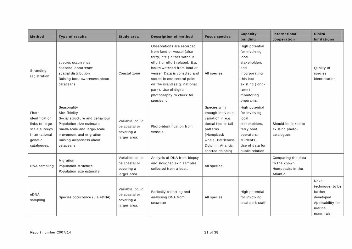
Report number C007/14 21 of 38
Method Type of results Study area Description of method Focus species Capacity building
International cooperation
Risks/ limitations
Stranding registration
species occurrence seasonal occurrence spatial distribution Raising local awareness about cetaceans
Coastal zone
Observations are recorded from land or vessel (also ferry, etc.) either without effort or effort related. E.g. hours watched from land or vessel. Data is collected and stored in one central point on the island (e.g. national park). Use of digital photography to check for species id.
All species
High potential for involving local stakeholders and incorporating this into existing (long-term) monitoring programs.
Quality of species identification
Photo identification links to large-scale surveys. International genetic catalogues.
Seasonality Site-fidelity Social structure and behaviour Population size estimate Small-scale and large-scale movement and migration Raising awareness about cetaceans
Variable, could be coastal or covering a larger area.
Photo-identification from vessels.
Species with enough individual variation in e.g. dorsal fins or tail patterns (Humpback whale, Bottlenose Dolphin, Atlantic spotted dolphin)
High potential for involving local stakeholders, ferry boat operators, students. Use of data for public relation
Should be linked to existing photo-catalogues
DNA sampling Migration Population structure Population size estimate
Variable, could be coastal or covering a larger area.
Analysis of DNA from biopsy and sloughed skin samples, collected from a boat.
All species
Comparing the data to the known Humpbacks in the Atlantic
eDNA sampling
Species occurrence (via eDNA)
Variable, could be coastal or covering a larger area.
Basically collecting and analysing DNA from seawater
All species High potential for involving local park staff
Novel technique, to be further developed. Applicability for marine mammals
22 of 38 Report number C007/14
Method Type of results Study area Description of method Focus species Capacity building
International cooperation
Risks/ limitations
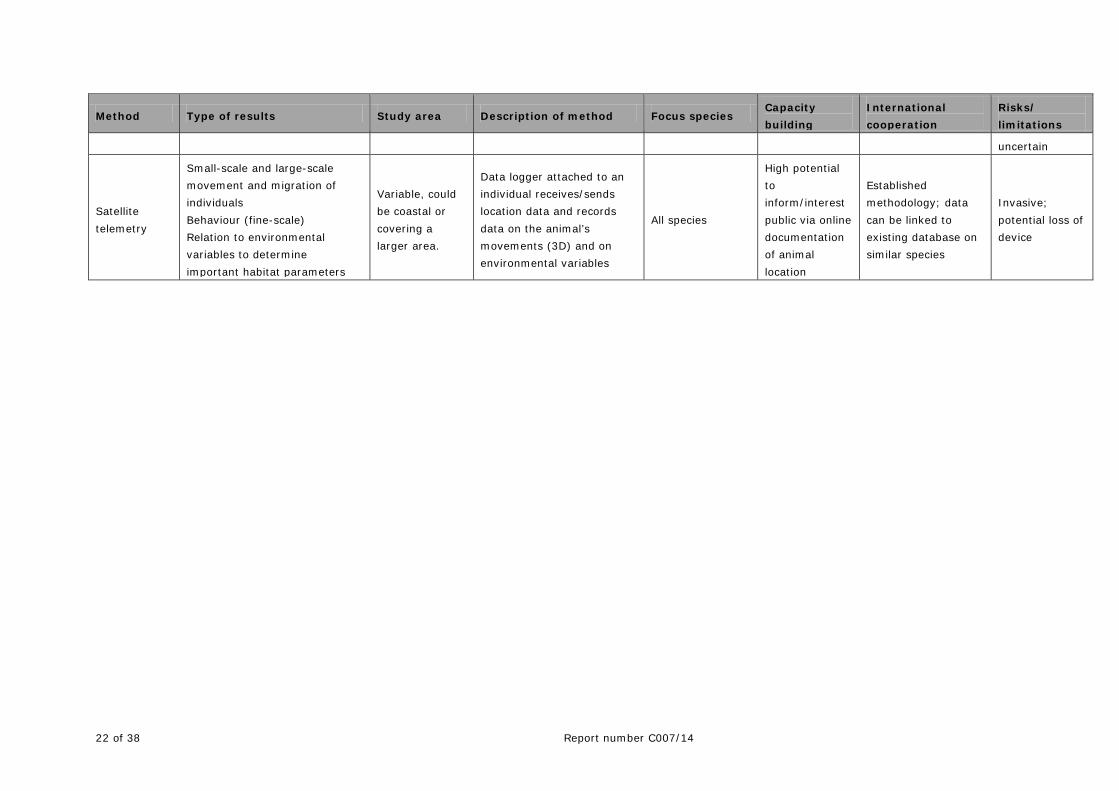
uncertain
Satellite telemetry
Small-scale and large-scale movement and migration of individuals Behaviour (fine-scale) Relation to environmental variables to determine important habitat parameters
Variable, could be coastal or covering a larger area.
Data logger attached to an individual receives/sends location data and records data on the animal’s movements (3D) and on environmental variables
All species
High potential to inform/interest public via online documentation of animal location
Established methodology; data can be linked to existing database on similar species
Invasive; potential loss of device
Report number C007/14 23 of 38
3 Current research
The studies listed in this section represent an important, but not exclusive compilation of on-going research efforts related to marine mammals in the wider Caribbean. They are based on initiatives by individual organisations as well as regional or even international collaborations. The research is mostly focussed on a single aspect and/or species and limited in its spatial and temporal coverage. All these efforts provide valuable insight into important aspects of the ecology of marine mammals and show that the motivation and need to conduct research on marine mammals in the Caribbean waters is high. However, if continued with the current level of capacity and expertise, the outcome will remain mostly limited. Ideally, all the on-going and suggested future research efforts could become integral parts of an international research strategy for the wider Caribbean thus ensuring strong synergistic effects and the optimal use of research funds and efforts.
Due to lack of funds and capacity most current and past cetacean research in the region can be characterised as small-scale, low in sophistication, opportunistic, temporary and local which is a great limitation to the degree of understanding that is required for proper conservation of this increasingly important resource in this tourism-oriented region. There is an urgent need to combine forces, work on a larger geographic scale and use new and innovative techniques if we want to move beyond the current patchwork.
At the same time, raising awareness for marine mammals in the wider Caribbean region will strongly increase the efficacy of most conservation measures. The active involvement of local stakeholders and the local public in the research as well as management and conservation activities can lead to a societal consensus on the value of the local marine fauna beyond a mere economical approach.
It is important to note, that effective management and conservation of marine mammals should be based on adequate information on the species occurring in the area, their seasonal and spatial distribution, as well as their ecology. Ideally, research and conservation/management need to progress in parallel, not sequentially. Hence, management and conservation cannot and should not await the development of desired databases. By delaying conservation until scientific knowledge becomes available, some stocks could be depleted to the point of non-recovery. Conservation actions can, in fact, occur even without much science at all, if the political and social will to conserve exist. The effectiveness of management can then be evaluated empirically through monitoring using an adaptive management approach. Effective management and conservation of marine fauna in general and marine mammals in particular is a huge task requiring long-term commitment by all parties involved, from personal to scientific involvement, but most importantly also the continued commitment by funding agencies and government.
3.1 Visual surveys
3.1.1 AGOA sanctuary
The management of the AGOA sanctuary is based on an ecosystem approach. Cooperation within the region is an important objective for AGOA. As part of the cooperation between sanctuaries, AGOA has already embarked on ship-based line-transect surveys with participation of the MPAs of the surrounding islands, including the Dutch Caribbean islands and Anguilla. Starting in 2013, these surveys will be further broadened to include more countries such as Dominica, St. Lucia and Trinidad, which have already been approached. At this stage, these surveys are limited in their spatial coverage and are not designed to provide data which are sufficient for abundance or density estimates of marine mammal populations in the Caribbean waters. However, they are extremely valuable helping to unite and harmonize the work of individual islands that in the past often worked in isolation. This type of joint
24 of 38 Report number C007/14
surveys can help build a “friendly network” and can help to bring aboard islands where whaling is still practiced.
3.1.2 Aerial survey of the ABC islands, Dutch Caribbean
In November 2013 aerial surveys were conducted for the first time in the Exclusive Economic Zone of Aruba, Curaçao and Bonaire to evaluate aerial surveys as a tool for marine mammal surveys in these waters, and to assess the distribution and abundance of marine mammals. A secondary goal of these surveys was to collect data on the occurrence of other (mega)fauna, e.g. sharks, rays, turtles and seabirds. Marine mammals were assessed using distance sampling methods; for other species the strip transect method was applied. In addition to four species of mammals, sharks, rays, turtles and seabirds were recorded. Noteworthy observations include the first record of a (living) Basking shark and records of seabirds that are scarcely documented in these waters: Red-billed Tropicbird and South Polar Skua (Geelhoed et al. 2014).
3.1.3 Whale watching workshops
Work of the ‘Specially Protected Areas and Wildlife’ (SPAW) Programme and its Regional Activity Center (RAC) with respect to marine mammals. During the last SPAW Convention of Parties (COP, October 2012), sustainable marine mammal watching was listed as one of the priorities of the SPAW workplan 2013-2014. Following the recommendations of the Regional Workshop on Marine Mammal Watching in the Wider Caribbean Region, Panama, 19-22 October 2011 and the priorities identified by participants, the following was proposed:
• Promote the national and regional implementation of the Overarching Principles and Best Practice Guidelines for Marine Mammal Watching in the Wider Caribbean Region;
• Develop a regional database and clearing house for marine mammal watching data; • Explore the possibility of developing a sub-group on marine mammal watching under the MMAP
E-Group; • Identify the equipment needed, and the costs associated, to collect data during marine mammal
watching tours, in an effort to provide tour operators with the necessary equipment; and • Develop Training of Trainers Workshops for captains/operators, naturalists/guides and local tour
guides in each of the three languages of the WCR.
3.1.4 Registration of cetacean sightings by the fishermen on Saba
In this monitoring project conducted by IMARES, 8 fishermen active around Saba are being interviewed when entering the port, among others to report where they have fished (Scheidat & Geelhoed 2013). Since July 2012 an additional question was added to the interviews, asking the fishermen if dolphins or whales were sighted and, if so, in which area. Fishermen were provided with a laminated guide of the most common cetaceans in the area to aid in identification of species. During the study period all eight vessels have had a minimum of one and a maximum of four cetacean sightings. Twenty dolphin sightings were registered, totalling 287 dolphins. Additionally, two sightings of single humpback whales were reported. This study gives an indication of the kind of data that can be collected within the existing fishery monitoring project. Identification of cetaceans at species level, in particular dolphins, is most likely still at a low level of confidence. Although effort was not equally distributed across the study area, by collecting sightings data in relation to fishing effort, preliminary information on the spatial and temporal distribution of dolphins and humpback whales can be obtained. This type of data might be used as part of a long-term monitoring program and/or towards future (more dedicated) research. These activities will

Report number C007/14 25 of 38
help to raise local awareness for marine mammals in the region and can increase the efficacy of any conservation measure.
3.1.5 Registration of opportunistic sightings & stranding of cetaceans on St.Eustatius
Sightings of cetaceans made from land or sea are recorded and collected at the STENAPA office. Information on each sighting is obtained by interviewing the observers and getting as much information as possible. From March 2011 to December 2012, 18 sightings of cetaceans were recorded. The information collected includes the observer, the observation site, date, time (first seen, last seen), position (if known as latitude/longitude), species, degree of certainty of species identification, group size (minimum and maximum), if photos or videos are available, group composition (numbers of adults/juveniles/calves), behaviour, associated sea birds, direction of movement, sea state, swell height, visibility and any additional notes. As for the previous activity, this type of data might be used as part of a long-term monitoring program and/or towards future (more dedicated) research. These activities will help to raise local awareness for marine mammals in the region and can increase the efficacy of any conservation measure.
3.1.6 Workshops on the identification of whales & dolphins in the Caribbean
In December 2012 IMARES conducted workshops on the identification of Caribbean whales & dolphins on Sint Maarten, Saba and Sint Eustatius (Scheidat and Geelhoed 2013). Local stakeholders such as fishermen, park rangers, tour operators, ferry operators, local NGOs and government representatives were invited to learn about the planned opportunistic data collection scheme and get an overview on the first results of the current monitoring program on Saba. An identification guide that can be used on the fishing vessels was presented. Apart from giving the workshops, on-going cetacean projects, future monitoring needs and possibilities for extending monitoring projects were discussed together with the staff of the marine parks, government representatives and other local stakeholders. As with other activities involving local stakeholders (see above), these workshops aim at raising local awareness for marine mammals in the region as this will help increasing the efficacy of conservation measures.
3.2 Acoustic surveys
3.2.1 Stationary acoustic monitoring of cetaceans – a pilot study on Saba Bank
In October 2011 an autonomous noise logger was deployed by IMARES northeast of Saba Bank at a water depth of 40 m. The noise logger (MARU, Cornell University, U.S.A.) was set to record underwater sounds between 10 Hz and 8 kHz, thus mainly focussing on the sounds produced by baleen whales and dolphin whistles. In order to maximise the deployment time, a duty cycle of 25% was chosen, i.e. the device recorded for a period of 30 minutes every two hours. The noise logger was to be retrieved in April 2012. Despite repeated attempts to trigger the acoustic release mechanism, the logger was not seen to float to the surface. Initially the logger was considered being lost due to unknown reasons. In fall 2012, however, the logger was found drifting in waters off Puerto Rico. The device has been returned and the data could be downloaded. A first inspection revealed numerous detections of humpback and Minke whales. Currently JASCO Applied Sciences, Canada, is conducting an automated rough analysis of the recorded sounds to identify the sections with potentially interesting sounds after which IMARES will subsequently conduct the detailed analysis.
26 of 38 Report number C007/14
3.2.2 Acoustic monitoring of humpback whales
Stellwagen Bank National Marine Sanctuary (SBNMS) and its sister sanctuary relationship with the Silver Banks Sanctuary. Despite incomplete information on the exact extent of the migratory routes of the entire North Atlantic humpback whale population, it is clear that Caribbean waters represent the southern end of the home range of a subpopulation of ~900 of these animals. The sister sanctuary agreement between Santuario de Mamiferos Marinos de la Republica Dominicana (SMMRD), by the Dominican Republic Ministry of Environment and Natural Resources (DR MENR) and the Stellwagen Bank National Marine Sanctuary (SBNMS), by the United States National Oceanic and Atmospheric Administration (US NOAA) provide the critical support for this subpopulation of ~900 humpback whales at either end of their migratory range. Beginning in 2004, scientists from SBNMS, US NOAA's Northeast Fisheries Science Center (NEFSC) and Cornell University's Bioacoustics Research Program (Cornell BRP) developed a comprehensive passive acoustic research program in the Stellwagen sanctuary. Due to the coincident abundances of commercial vessel activity and vocally-active baleen whales in the SBNMS, acoustic research efforts have focused on evaluating the potential impacts of chronic low-frequency noise on whale communication and behaviour (Hatch et al. 2008, 2012). Similar to Stellwagen Bank, within the SMMRD, Samana Bay is a focal point for both whales and vessel activity. This bay is part of the main humpback whale breeding grounds in the North Atlantic and the close proximity of the whales to the entrance of Samana Bay allows small to medium-sized vessels to provide multiple whale watching trips per day during prime conditions. In addition, the Bay of Samana is a well-established destination for cruise ships within the Caribbean routes. Because the humpback whale breeding season coincides with the winter cruise ship season in the Caribbean, concerns have been raised regarding possible disturbance to humpback whale breeding behaviour to vessel noise. Specifically, the use of song is of critical importance to the humpback breeding system (Payne & McVay 1971, Cholewiak 2008), and the impacts of low frequency noise from vessels on their ability to successfully communicate over biologically-important ranges is of concern (Hatch et al. 2008, Clark 2010). Consequently, a project was initiated to quantify low-frequency ambient noise levels within an important breeding habitat for North Atlantic humpback whales, Samana Bay, using methodologies developed to evaluate noise levels in the feeding/nursery area utilized by a subpopulation of these whales, at Stellwagen Bank. Contributions to ambient noise by large cruise vessels and smaller whale-watching boats to low-frequency background noise in Samana Bay are quantified and compared to noise contributions previously estimated for large commercial and small-medium sized vessels within the SBNMS (Hatch et al. 2008). Levels of singing activity are evaluated with respect to vessel activity (specifically cruise and whale-watch) and ambient noise conditions to assess whether vessel traffic may be negatively impacting humpback whale singing behaviour in Samana Bay. Finally, patterns of humpback whale song evolution between feeding/nursery and breeding sites are preliminarily evaluated. The goal of the SBNMS acoustic program has been to design transferable tools for assessing contributions from several sources of noise (anthropogenic and natural, both biotic and abiotic) to underwater noise budgets in an area of interest. By using SBNMS-derived tools to describe the acoustic environment of humpback whales in the SMMRD, this project will help managers in both countries to evaluate the impacts of marine transportation and ecotourism on spatial scales that are relevant to wide-ranging behaviour of marine mammals, the long-distance transmission of vessel noise, and the global operations of the maritime transport industry.
Report number C007/14 27 of 38
Similar activities are needed in collaboration with adjacent areas in the Caribbean as the currently investigated/protected areas do not cover the entire habitat of these animals. Moreover, other species require the same attention by scientists and regulators – an effort that can best be dealt with in a joint international effort.
3.3 Satellite telemetry
A study using satellite telemetry has been conducted in the Dominican Republic Marine Mammal Sanctuary in cooperation with the Stellwagen Bank Sanctuary. Satellite tracking data and thousands of biopsies and ID photos have been collected forming the basis for an important database for humpback whales and dolphins. Currently, it appears that the first appearance of humpback whales in the Dominican Republic waters has shifted slightly to the end of January instead of early January. The Dominican Republic is now working on a new management plan for the Sanctuary as part of the LifeWeb project. Ideally, these efforts should be complimented by similar efforts in adjacent areas throughout the wider Caribbean and also target other species. Satellite tracking of humpback whales also took place in the French Caribbean waters in a joint French/US project over a period of several years and provides valuable new insights into migration patterns and connectivity between populations of this species (Kennedy et al. 2011, 2013). At present satellite tracking based from French Caribbean waters continues in a project headed by the Réserve Naturelle de Saint-Martin (Réserve Naturelle de Saint-Martin 2014).
3.4 Other studies
3.4.1 Stranding response
Southern Caribbean Cetacean Network (SCCN) SCCN set up to promote research on cetaceans around Aruba, Bonaire, Curaçao (ABC islands) and beyond. They organized a Southern Caribbean Stranding Response training workshop (see above: Additional research aspects) with support from the US Marine Mammal Commission as part of a series of such regional trainings initiated by SPAW in English, French and Spanish. This training formed the basis of an electronic mailing group, the Dutch Caribbean Cetacean Network that now regularly exchanges information on strandings and sightings and brings together marine mammal experts from Venezuela, the USA, the Netherlands and the Eastern Caribbean and MPA managers. Work of SPAW and the RAC with respect to marine mammals: In keeping with the priorities identified at SPAW COP6 and the progress made to-date with activities implemented since the adoption of the MMAP in 2008, it was approved at the SPAW COP 7, concerning stranding of marine mammal, to:
• Reinforce local stranding network capacities, mainly through technical assistance, including equipment, training and contact lists and the creation of a regional database to enable the integration of stranding results, further to the sub-regional stranding workshops held in 2005, 2009 and 2010 in collaboration with the Regional Activity Center for Specially Protected Areas and Wildlife (SPAW-RAC) and US NOAA.
• Create a regional repository on stranding data.
In addition, the SPAW-RAC, in partnership with ECCN, NOAA and the Department of Natural Resources of Puerto Rico, is currently in the process of buying rescue & necropsy kits that will be distributed to several countries of the Wider Caribbean Region. To date, details concerning this project remain to be finalized. Conservation
28 of 38 Report number C007/14
Interest in conservation and research on marine mammals in Venezuela has increased remarkably during the last decade. Currently, several governmental agencies, academic institutions and non-governmental organizations regularly conduct conservation and research activities and projects in several regions. In 2008, the Bolivarian Republic of Venezuela endorsed SPAW's Marine Mammal Action Plan for Conservation of Marine Mammals of the Wider Caribbean Region (MMAP). Current research and conservation projects and activities: 1. Governmental institutions.
• Design and implementation of the National Strategy for Conservation of Biological Diversity, Biodiversity branch of the People's Ministry of Environment (ONDB-MINAMB).
• Annual Congress on Biological Diversity, hosted by the ONDB-MINAMB. • Attention to strandings and marine mammal contingencies, ONDB-INPARQUES-MINAMB. • National database on strandings, ONDB-MINAMB. • Strandings and Marine Mammal contingencies in Margarita Island, State of Nueva Esparta, DEA-
NE/MINAMB. • Venezuelan System for Information on Biological Diversity (ONDB-MINAMB) • National Scientific Observers Program for the Venezuelan Caribbean-Atlantic, National Institute
for Fisheries, INSOPESCA-PNOB. 2. Academic institutions.
• Offshore mapping of Venezuelan Islands Region. Personal initiative by Rodrigo Lazo, Verónica de los Llanos and Julián García.
• Traveling Marine Mammal Exhibition, AsoVEM, The Venezuelan Association for the Study of Mammals.
• Field research on the Guiana dolphin and Response to strandings in the Maracaibo System, western Venezuela. Ecology Lab of La Universidad del Zulia (LUZ).
• Intecmar-Funindes-USB-PDVSA. Baseline studies on marine mammals and setup of conservation goals for oil and gas operations.
• 3. NGOs.
• Status of Cetaceans in the State of Miranda, central coast of Venezuela (MARES Venezuela). • BIOTROPICA-GOLFO DE LA BALLENA and PROYECTO DELPHINUS. Identification of critical
habitats for cetaceans in central-northeastern waters. • Current status of manatee in the Gulf of Venezuela (Asociación Civil SIRENA de Venezuela). • Campaign for the re-entering of Venezuela to the International Whaling Commission in support
of the Buenos Aires Group (Venezuelan Coalition for Whales and Dolphins). • Venezuelan Wildlife Red Data Book 2013 and Wiki Eva Project on endangered species (Provita). • Baseline study on Population status of dolphins in the State of Aragua, Central Venezuela using
photo-ID techniques (Sea Vida). • Educational Expeditions for the conservation of cetaceans and marine habitats in Ocumare de la
Costa de Oro Municipality (Sea Vida-CITA with support and endorsement by Educational and Science authorities).
• Support to Asoc. Coop. RSIP Ocumare de la Costa de Oro for responsible dolphin-watching activities (A community-based project funded by the Ministry of Science, Technology and Innovation-Fundacite Aragua).
• Action Plan for Conservation of South American River Dolphins (FLASA Foundation, Fundación Omacha-Sea Vida).
• Caribbean-Wide Orca Project (CWOP) (Coordinated by Sea Vida and Aruba Marine Mammal Foundation).

Report number C007/14 29 of 38
3.5 Management
The Marine Mammal Action Plan (MMAP) was adopted by the SPAW Parties and the SPAW-RAC started work on implementation of the MMAP. This included supporting the various stranding response workshops, the whale watching workshops, and now also this partnership of marine mammal sanctuaries. Although the MMAP is being implemented at the regional level, it also needs implementation at the national level. SPAW-RAC is planning a contaminant workshop but the exact objectives and purpose have yet to be clarified. Recently the SPAW-RAC has been involved in the Life-Web project on marine spatial planning in marine corridors, specifically relevant to marine mammals. The Life-Web project provides a framework for regional action. Through Life-Web, for the first time, marine mammal regional distribution maps have been prepared as well as threats have been mapped. These maps will be available in pdf-format, but it will be possible on request, to log on to access the underlying datasets. Under the Life-Web project a management plan for the Dominican Republic (D.R.) is being developed and a visit to the D.R. by a six-country Eastern Caribbean delegation was realized to show the whale-watching going on in the D.R. Two areas in the Caribbean have been identified for further “scenario work”: One from the D.R. down to Grenada, to build upon on-going cooperation to identify joint measures/activities for trans-boundary conservation of marine mammals (with a focus on humpback whales, sperm whales and dolphins); a second one from Venezuela to the French Guiana/Brazil border along the coast of Latin America, encompassing Venezuela, Trinidad and Tobago, Suriname, Guiana and French Guiana. This could also include the ABC Islands. The “scenario work” still needs to be elaborated further and the meeting has an opportunity to participate in this.
3.5.1 Marine Spatial Planning
Marine Spatial Planning (MSP) is a key tool for management of marine mammal sanctuaries and requires the exchange between all parties involved. The Martinique Declaration is a crucial first step towards further cooperation in the region. The network in the Caribbean now being discussed and targeted in this report is the start which can eventually lead to an Atlantic Sanctuary. MSP should be used as an important tool that can lead to ship routing, ‘Particularly Sensitive Sea Areas’ (PSSAs) and ‘Areas To Be Avoided’ (ATBAs) under the International Maritime Organisation (IMO). The partners should continue to promote the partnership jointly at relevant events. The partners can also engage in joint communication action, cross-link websites, issue press releases, organize exhibits and joint marketing actions e.g. aimed at developing whale watching tourism by building on the N-S migration, targeting summer whale watching tourism in the North and stimulate them to watch the whales again in winter in the South.

30 of 38 Report number C007/14
3.5.2 Ship Strikes Joint IWC-SPAW workshop to address collisions between marine mammals and ships with a focus on the Wider Caribbean At IWC 64 (2012, Panama), IWC member countries: Dominican Republic, France, Mexico, Netherlands, Panama and USA, along with UNEP-CEP-SPAW, proposed three workshops to address human impacts to marine mammals in the Wider Caribbean. Two training workshops, focusing on the forensic detection of human impacts and the response to entangled large whales have been completed (La Paz, 2012 and St. Martin, 2013). A third workshop, to focus on understanding and mitigating ship strikes, was also proposed with a suggestion it be hosted by Panama. This joint IWC and UNEP-CEP-SPAW ship strike workshop, tentatively planned for September 2014, will focus on local and regional topics that may have broader global applications, while also focusing on global topics, especially those with applicability to the region. The workshop is intended to engage a wide array of interested stakeholders (including representatives from governments, scientists/academia, shipping and boating industries, the IMO, and environmental organizations) in order to incorporate their perspective on the utility and feasibility of existing or proposed mitigation measures. The workshop will conduct a concise review of current mitigation measures from around the globe and discuss their effectiveness, taking into consideration technological, operational, legal and educational tools and initiatives. The workshop will review regional data and data gaps, along with existing and planned research and mitigation actions. This will be discussed in the context of a concise review of global data (and data gaps) along with existing and planned research and mitigation actions.
3.5.3 Data sharing
Data sharing between different initiatives organizations is important but can get very complicated and require a lot of human resources. The ‘Caribbean Wide Orca Project’ (CWOP) is a good example of data-sharing at a regional level. CWOP started as a data sharing on orca sightings between Venezuela and Aruba. Then, more researchers were invited to share info with publication purpose. It is important to clearly define data sharing and identify what exactly will be shared. A standardized framework for this could be developed by this forum. At the least it would be helpful to harmonize the data formats and the methods used, although even that can be difficult because of the differences in capacities, available resources and objectives of different endeavours. A good start could be to attempt harmonization first in areas where there are data gaps or where data gathering methods still need to be developed. Common projects such as joint surveys make it easier to harmonize and share. A logical hub or clearing house for data sharing would be the SPAW-RAC.
Report number C007/14 31 of 38
4 Future research priorities
4.1 General aspects
This report is intended to provide information, tools and guidance for all parties involved in their efforts to protect marine mammals in the Wider Caribbean Region. However, science is not always the answer to conservation issues. Action needs to be taken in parallel with research. Research can be very time-consuming and when the data are finally in it may be too late to take action. Science does play a crucial role in conservation, but for many taxa, available scientific information is currently sufficient to understand and mitigate threats. Conservation requires much more than good science. Conservation strategies should achieve their objectives even with scientific uncertainty, i.e. follow the precautionary principle1, and using monitoring to empirically evaluate management effectiveness through an adaptive management approach. On the other hand, science can be necessary to clarify both threats and offer solutions. Research should be guided by such issues of documenting threats and relating them to species distributions. In this way it can be clarified whether contaminants, by-catch, or vessel strikes are or are not real and serious threats in the Caribbean. Lethal and sub-lethal effects also need to be clarified. It is important that the science is then translated into informed management policy and conservation action.
4.2 Priorities
1. Coordinate and conduct marine mammal monitoring efforts on an international level It is recommended to organise a Caribbean-wide workshop with (all relevant parties involved and) available experts and decision makers to discuss and initiate such collaborative efforts. This should not prevent the on-going regional activities from continuing their efforts, but use the existing momentum to reach out to a wider range of nations and stakeholders. A first step with regard to marine mammal research is certainly an inventory of marine mammal species in Caribbean waters and to monitor for cetacean occurrence by using the most adequate monitoring methods. As listed in the chapter on survey techniques and in table 1 there is a wide variety of methods at hand and there is no single best approach that is applicable to all monitoring objectives. The spatial and temporal scope of each monitoring effort has to be evaluated against the financial and logistical possibilities. In this respect, international and trans-boundary co-operation, potential synchronisation and in general a long-term planning might help to optimise both on-going and future efforts and also generate synergistic effects, not only in terms of funding (see also: IWC 2012, Debrot et al. 2013, Scheidat & Geelhoed 2013). In a step-wise process we propose to set the following objectives:
• Species inventory: Species composition; detect presence of marine mammals in the Wider Caribbean waters and consolidate data (i.e. full spatial and temporal coverage)
• First abundance estimates • First overview of spatial and temporal distribution of whales and dolphins around the islands
and in the local fishing grounds • Baseline data on cetacean distribution and seasonal occurrence • Density estimates • Define habitat use
1 In the real world, it is often more important to “stop the bleeding” than to document the rate of blood flow, so to speak.
32 of 38 Report number C007/14
2. Studies on the effects of anthropogenic threats on marine mammals
Which threat to target first can be defined on regional or based on acute predominance of certain stressors. Studies on anthropogenic threats to marine mammals should be defined based on the potential outcomes of a conflict situation and cost-benefit analyses should be conducted to help evaluate different options. The results should stimulate efforts to develop and implement mitigation measures. A second priority should be given to studying the threats to cetaceans in the Caribbean waters in more detail. Areas and periods with the highest potential for conflicts between the occurrence of marine mammals and the relevant anthropogenic activities/effects have to be identified. As this is a multi-faceted issue, a cost-benefit analysis should be conducted for these areas/times which takes into account the severity of the threat and the feasibility of different study or mitigation methods. As with the monitoring efforts, international and trans-boundary co-operation, potential synchronisation and long-term planning will help to optimise both on-going and future efforts. Synergistic effects, such as collaboratively using sampling efforts are of high importance in this context. Some examples are:
• Assessment of existence of fisheries by-catch at a local level (as compared to large international fleets operating long-lines, purse seines etc. with by-catch of marine mammals). This at the same time can lead to a raised awareness among fishermen and lead to valuable contributions through reports of incidental sightings. • Another example could be acoustic studies to assess the effect of anthropogenic sound on
marine mammals. In areas or periods without such stressors these studies not only provide valuable information on the occurrence of animals but also on their behaviour and ecology.
• A blubber sample taken from an individual for genetic analysis provides a potential means of analysing to which degree the animal is burdened with certain pollutants,
• If properly designed, an acoustical monitoring of cetaceans to study the effect of anthropogenic activities.
• By collectively analysing the samples taken or recordings made (etc.) synergistic effects can achieved.
The identification of potential mitigation measures should be an important aspect in these research efforts. Moreover, the timely dissemination of the results to the relevant authorities as well as the local counterparts and the public should be targeted key goal.
3. Involvement of local stakeholders and the public
Education and outreach with respect to marine mammal conservation issues form important cornerstones in conservation efforts, but should focus on more than just informing people, it should be aimed at stimulating involvement and action. Involvement and capacity building of local stakeholders as well as education and information of the public are important contributors to long-term acceptance and success of conservation efforts.
Report number C007/14 33 of 38
4. Standardisation of visual and acoustic monitoring efforts Following standard protocols during the design and analysis of visual surveys and using calibrated recording devices for acoustic surveys and monitoring will increase the quality of the resulting data and enhance their comparability. It also allows collaborative analysis of the data on a larger spatial scale.
34 of 38 Report number C007/14
Quality Assurance
IMARES utilises an ISO 9001:2008 certified quality management system (certificate number: 124296-2012-AQ-NLD-RvA). This certificate is valid until 15 December 2015. The organisation has been certified since 27 February 2001. The certification was issued by DNV Certification B.V. Furthermore, the chemical laboratory of the Fish Division has NEN-EN-ISO/IEC 17025:2005 accreditation for test laboratories with number L097. This accreditation is valid until 1th of April 2017 and was first issued on 27 March 1997. Accreditation was granted by the Council for Accreditation.
Report number C007/14 35 of 38
References
Barros N and Clarke MR (2009). Diet. Pp. 323-327, In: WF Perrin, B Wursig and JGM Thewissen (Eds.): Encyclopedia of Marine Mammals, second edition. San Diego, CA: Academic Press.
Boisseau O, Leaper R and Moscrop A (2006). Observations of small cetaceans in the Eastern Caribbean. SC/58/SM24. Paper presented to the International Whaling Commission (unpublished).
Borchers DL, Buckland ST, Goedhart PW, Clarke ED and Hedley SL (1998a). Horvitz–Thompson estimators for double-platform line transect surveys. Biometrics 54: 1221–1237.
Borchers DL, Zucchini W and Fewster RM (1998b). Mark-recapture models for line transect surveys. Biometrics 54: 1207–1220.
Borchers, D. L., Zucchini, W., Heide-Jørgensen, M. P., Cañadas, A., and Langrock, R. (in press), “Using hidden Markov models to deal with availability bias on line transect surveys. Biometrics.
Buckland ST, Anderson DR, Burnham KP, Laake JL, Borchers DL and Thomas L (2001). Introduction to Distance Sampling, Oxford University Press, Oxford.
Buckland ST, Burt ML, Rexstad EA, Mellor M, Williams AE and Woodward R (2012). Aerial surveys of seabirds: The advent of digital methods. Journal of Applied Ecology 49: 960-967.
Budge, S. M.; Iverson, S. J.; Koopman, H. N. 2006. Studying trophic ecology in marine ecosystems using fatty acids: a primer on analysis and interpretation. Marine Mammal Science 22: 759-801.
Burnham K, Anderson D and White G (1995). Selection among open population capture-recapture models when capture probabilities are heterogeneous. Journal of Applied Statistics 22: 5-6.
Cholewiak D (2008). Evaluating the role of song in the humpback whale Megaptera novaeangliae breeding system with respect to intra-sexual interactions. Dissertation, Cornell University, Ithaca, U.S.A.
Clark CW, Brown MW and Corkeron PJ (2010). Visual and acoustic surveys for North American right whales, Eubalaena glacialis, in Cape Cod Bay, Massachusetts, 2001-2005: Management implications. Marine Mammal Science 26: 837-854.
De Boer MN (2013). Elusive Marine Mammals Explored - Charting under-recorded areas to study the abundance and distribution of cetaceans using Multi-Method approaches and Platforms of Opportunity. PhD thesis, Wageningen University and Reaearch, Wageningen, 284 pages.
Debrot AO, Witte RH, Scheidat M and Lucke K (2011a). A Proposal Towards a Dutch Caribbean Marine Mammal Sanctuary. IMARES report number C149/11. 153 pages.
Debrot AO, Witte RH and Scheidat M (2011b). The marine mammals of the Dutch Caribbean: a comparison between EEZ sectors, contrasts and concerns. SC/63/E9. Paper presented to the International Whaling Commission. 8 pp.
Debrot AO, Esteban N, Bervoets T, Hoetjes PC and Scheidat M (2013). Marine Mammals of the north-eastern Caribbean Windward Dutch Islands: Saba, St. Eustatius, St. Maarten, and the Saba Bank. Caribbean Journal of Sciences 47: 159-172.
Dudzinksi K, Gitter S, Lammers M, Lucke K, Mann D, Simard P, Wall C, Rasmussen M, Magnúsdóttir EE, Tougaard J and Eriksen N (2011). Trouble-shooting deployment and recovery options for various stationary passive acoustic monitoring devices in both shallow and deep water applications. Journal of the Acoustical Society of America 129(1): 436-448.
Evans PGH and Hammond PS (2004). Monitoring Cetaceans in European Waters. Mammal Review, 34, 131-156.
Geelhoed SCV, Janinhoff N, Verdaat JP, van Bemmelen RSA & Scheidat M (2014). Aerial surveys of marine mammals and other fauna around Aruba, Curaçao and Bonaire, November 2013. IMARES report C012/14. 22 pp.
Geraci JR and Lounsbury VJ (2005). Marine Mammals Ashore: A Field Guide for Strandings, Second Edition. National Aquarium in Baltimore, Baltimore, MD. 371 pp.
Hammond PS, Mizroch SA and Donovan GP (1990). Individual recognition of cetaceans: Use of photoidentification and other techniques to estimate population parameters. Report of the International Whaling Commission, Special Issue 12: 3-17.

36 of 38 Report number C007/14
Hammond PS, Berggren P, Benke H, Borchers DL, Collet A, Heide-Jørgensen M-P, Heimlich S, Hiby AR, Leopold MFF and Øien N (2002). Abundance of harbour porpoise and other cetaceans in the North Sea and adjacent waters. Journal of Applied Ecology 39: 361–376.
Hammond PS, Macleod K, Berggren P, Borchers DL, Burt L, Cañadas A, Desportes G, Donovan GP, Gilles A, Gillespie D, Gordon J, Hiby L, Kuklik I, Leaper R, Lehnert K, Leopold M, Lovell P, Øien N, Paxton CGM, Ridoux V, Rogan E, Samarra F, Scheidat M, Sequeira M, Siebert U, Skov H, Swift R, Tasker ML, Teilmann J, Van Canneyt O and Vázquez JA (2013). Cetacean abundance and distribution in European Atlantic shelf waters to inform conservation and management. Biological Conservation 164: 107–122.
Hatch LT, Clark CW, Merrick R, Van Parijs SM, Ponirakis D, Schwehr K, Thompson M, and Wiley D (2008). Characterizing the relative contributions of large vessels to total ocean noise fields: a case study using the Gerry E. Studds Stellwagen Bank National Marine Sanctuary. Environmental Management 42: 735–752.
Hatch LT and Fristrup KM 2009. No barrier at the boundaries: implementing regional frameworks for noise management in protected areas. Marine Ecology progress Series 395: 223-244.
Hatch LT, Clark CW, Van Parijs SM, Frankel AS, Ponirakis DW (2012). Quantifying loss of acoustic communication space for right whales in and around a U.S. National Marine Sanctuary. Conservation Biology 26: 983-994.
Hiby AR and Lovell P (1998) Using aircraft in tandem formation to estimate abundance of harbour porpoises. Biometrics 54:1280–1289.
Iverson SJ, Frost KJ and Lowry LF (1997). Fatty acid signatures reveal fine scale structure of foraging distribution of harbor seals and their prey in Prince William Sound, Alaska. Marine Ecology Progress Series 151(1-3): 255-271.
IWC (International Whaling Commission) (2011). Report of the standing working group on environmental concerns. Report of the Scientific Committee, Annex K (annual meeting 2011, 30 May-11 June 2011, Agadir, Morocco). Journal of Cetacean Research and Management. 12 (suppl.): 238-266.
IWC (International Whaling Commission) (2012). Report of the Scientific Committee (annual meeting 2011, 30 May-11 June 2011, Trømso, Norway). Journal of Cetacean Research Management 13 (suppl.): 73 pp.
Kennedy AS, Zerbini AN, Vasquez OV, Gandilhon N, Clapham, PJ, and Adam O. (2013). Local and migratory movements of humpback whales (Megaptera novaeangliae) satellite tracked in the North Atlantic Ocean, Canadian Journal of Zoology, Can. J. Zool., 92: 8-17.
Kennedy A, Zerbini A, Vasquez O, Clapham P, Gandilhon N, Geyer Y, and Adam O. (2011). Individual variation in movements of Humpback whales (Megaptera novaeangliae) from two populations satellite-tracked in the Bering Sea and the West Indies, 19th Biennial Conference on the Biology of Marine Mammals, Florida.
Laist DW, Knowlton AR, Mead JG, Collet AS, and Podesta M (2001). Collisions between ships and whales. Marine Mammal Science 17(1): 35-75.
Langrock R , David L. Borchers DL & Skaug HJ. 2013. Markov-modulated nonhomogeneous Poisson processes for modeling detections in surveys of marine mammal abundance. Journal of the American Statistical Association 108: 840-851.
Mellor M, Craig T, Baillie D and Woolaghan P (2007). Trial of High Definition Video Survey and its Applicability to Survey of Offshore Windfarm Sites. HiDef Aerial Surveying Limited Report commissioned by COWRIE, UK.
Mellor M and Maher M. (2008). Full Scale Trial of High Definition Video Survey for Offshore Windfarm Sites. HiDef Aerial Surveying Limited Report commissioned by COWRIE, UK.
Moore JE, Cox TM, Lewison RL, Read AJ, Bjorkland R, McDonald SL, Crowder LB, Aruna E, Ayissi I, Espeut P, Joynson-Hicks C, Pilcher N, Poonian CNS, Solarin B, Kiszka J (2010). An interview-based approach to assess marine mammal and sea turtle captures in artisanal fisheries. Biological Conservation 143:795-805.
Payne RS and McVay S (1971). Songs of humpback whales. Science 173(3997): 585-597.

Report number C007/14 37 of 38
Réserve Naturelle de Saint-Martin. 2014. Mission de deployment de balises satellites dans les aires de reproduction des Balaines a Bosse (Magaptera novaengliae) du nord des Petites Antilles. MEGASAT Reproduction Area – North West Indies (N.W.I.). Réserve Naturelle de Saint-Martin, Saint Martin. 15 pp.
Scheidat M and Geelhoed S (2013). Cetaceans of Saba, Sint Eustatius & Sint Maarten: current knowledge and future monitoring. IMARES report C075/13. With contributions of: Tadzio Bervoets, Erik Boman, Michelle Boonstra, Dolfi Debrot, Roberto Hensen, Susan Hurrell, Klaus Lucke, Anna Maitz, Gaëlle Vandersarren and Kai Wulf, 30 p.
Smith TD, Allen J, Clapham PJ, Hammond PS, Katona S, Larsen F, Lien J, Mattila D, Palsboll PJ, Sigurjonsson J, Stevick PT and Oien N (1999). An ocean-basin-wide mark-recapture study of the North Atlantic humpback whale (Megaptera novaeangliae). Marine Mammal Science 15(1): 1-32.
Sousa-Lima RS, Norris TF, Oswald JN and Fernandes DP (2013a). A Review and Inventory of Fixed Autonomous Recorders for Passive Acoustic Monitoring of Marine Mammals. Aquatic Mammals 39(1): 23-53, DOI 10.1578/AM.39.1.2013.23
Sousa-Lima RS, Norris TF, Oswald JN and Fernandes DP (2013b). Errata – A Review and Inventory of Fixed Autonomous Recorders for Passive Acoustic Monitoring of Marine Mammals. Aquatic Mammals 39(1): 23-53, DOI 10.1578/AM.39.1.2013.23
Swartz SL and Burks C (2000). Cruise results: Windward humpback Megaptera novaeangliae survey. NOAA Ship Gordon Gunter, Cruise GU-00-01, 9 February to 3 April 2002. NOAA-NMFS-SEFSC Technical Memorandum 438, 31 pp.
Thaxter CB and Burton NHK (2009). High Definition Imagery for Surveying Seabirds and Marine Mammals: A Review of Recent Trials and Development of Protocols, British Trust for Ornithology Report commissioned by Cowrie Ltd.
Van Parijs SM, Clark CW, Sousa-Lima RS, Parks SE, Rankin S, Risch D and Van Opzeeland IC (2009). Management and research applications of real-time and archival passive acoustic sensors over varying temporal and spatial scales. Marine Ecology progress Series 395: 21-36.
Walker JL and Macko SA (1999). Dietary studies of marine mammals using stable carbon and nitrogen isotopic ratios of teeth. Marine Mammal Science 15(2): 314-334.
Wetzel DL and Reynolds JE III (2004). Definitive identification of fatty acid constituents in marine mammal tissues. Canadian Journal of Fisheries and Aquatic Sciences 61(4): 554-560.
Wright AJ, Deak T and Parsons ECM (2011). Size matters: Management of stress responses and chronic stress in beaked whales and other marine mammals may require larger exclusion zones. Marine Pollution Bulletin 63: 5-9.
Wells RS, Rhinehart HL, Cunningham P, Whaley J, Baran M, Koberna C and Costa DP (1999). Long-distance offshore movements of bottlenose dolphins. Marine Mammal Science 15: 1098-1114.
Wells RS (2009). Identification methods. Pp. 593-599 In: WF Perrin, B Wursig and JGM Thewissen (Eds.): Encyclopedia of Marine Mammals, second edition. Elsevier Academic Press, San Diego, CA.
Würsig B & Jefferson TA (1990). Methods of photo-identification for small cetaceans. Report of the International Whaling Commission, SC/A88/ID13, Spec. Iss. 12: 43-52.
Yoshida H, Compton J, Punnett S, Lovell T, Draper K, Franklin G, Norris N, Phillip P, Wilkins R and Kato H (2010) Cetacean Sightings in the Eastern Caribbean and Adjacent Waters, Spring 2004. Aquatic Mammals 36: 154–161. doi 10.1578/AM.36.2.2010.154.
Zimmer WMX (2011). Passive acoustic monitoring of cetaceans. Cambridge University Press. 356 pp.

38 of 38 Report number C007/14
Justification
Report C007/14 Project Number: 430.87010.20 The scientific quality of this report has been peer reviewed by a colleague scientist and the head of the department of IMARES. Approved: Dr.ir. H.V. Winter Senior Scientist Signature: Date: 23 January 2014 Approved: F.C. Groenendijk, MSc. Head of Department Signature: Date: 23 January 2014