Cipollari et al 2013 tubitak
19
820 http://journals.tubitak.gov.tr/earth/ Turkish Journal of Earth Sciences Turkish J Earth Sci (2013) 22: 820-838 © TÜBİTAK doi:10.3906/yer-1208-2 Middle-Upper Miocene paleogeography of southern Turkey: insights from stratigraphy and calcareous nannofossil biochronology of the Olukpınar and Başyayla sections (Mut-Ermenek Basin)* Paola CIPOLLARI 1,2 , Eva HALÁSOVÁ 3 , Kemal GÜRBÜZ 4 , Domenico COSENTINO 1,2, * 1 Department of Geological Sciences, Roma Tre University, Rome, Italy 2 Institute of Environmental Geology and Geoengineering (IGAG-CNR), Monterotondo, Rome, Italy 3 Department of Geology and Paleontology, Comenius University, Bratislava, Slovakia 4 Department of Geological Engineering, Faculty of Engineering and Architecture, Çukurova University, Balcalı, Adana, Turkey * Correspondence: [email protected] 1. Introduction e southern margin of the Central Anatolian plateau (CAP) is characterized by a postorogenic Oligocene- Miocene succession that unconformably overlies highly deformed Paleozoic and Meso-Cenozoic Central Tauride basement rocks. e Miocene marine deposits capping the southern margin of the CAP in the Mut-Ermenek Basin belong to the Köselerli and Mut formations, and show nearly underformed primary depositional geometry, suggesting a tectonic quiescence during their deposition (Bassant et al. 2005). In the Başyayla area (Figures 1A and 1B), the uppermost part of the Miocene marine succession of the Mut-Ermenek Basin horizontally caps (Cosentino et al. 2012) the highly deformed Mesozoic rocks of the Bozkır unit and the Hadim nappe (Akay & Uysal 1988). In the same area, the maximum elevation of those undeformed marine sediments is around 2000 m, suggesting substantial long-wavelength upliſt of the area aſter the deposition of those marine sediments (Cosentino et al. 2012; Schildgen et al. 2012a, 2012b). Several authors have provided biostratigraphic age constraints for those Miocene marine deposits. Bassant et al. (2005) identified the NN4 calcareous nannofossil biozone (late Burdigalian-early Langhian; Martini & Müller 1986) in the lower part of the marine succession on the eastern side of the Mut Basin. According to the same authors, the upper part of the same marine succession should be part of the NN5 biozone (Langhian). In the Mut-Ermenek Basin, Tanar and Gökçen (1990) identified marine deposits as young as Serravallian. Similar ages for the Miocene marine succession cropping out north of Ermenek were provided by Janson et al. (2010). ese authors identified 3 chronostratigraphic units within the mainly carbonate marine sediments of the Ermenek area. e first chronostratigraphic unit, which includes the lowermost part of the marine succession, is poorly dated as the upper part of the NN4 calcareous nannofossil biozone (latest Burdigalian-early Langhian). e second chronostratigraphic unit, which includes Abstract: e age of the marine succession capping the basement rocks of the central Taurides in the Mut-Ermenek Basin is constrained using calcareous nannofossil biochronology. e Olukpınar section, which correlates with the biozones between MNN5a and MNN6b (late Langhian-late Serravallian), represents a deeper marine environment developed lateral to the Ermenek platform. e long-term transgressive–regressive cycle of the Olukpınar section, which corresponds to the middle-upper part of the TB2 supercycle, can be subdivided into 2 large-scale (10 6 years) cycles (TB2.4 and TB2.5) based on the occurrence of 2 major debris flow deposits linked to sea-level drop. e younger late Tortonian Başyayla section represents a transgressive–regressive sedimentary cycle (TB3.2 cycle) responsible for the major transgressive event that occurred at the southern margin of the Central Anatolian Plateau during the Late Miocene. is major transgressive event is responsible for the migration of the coastal onlap of the Mediterranean Sea towards the interior of the Anatolian Peninsula, almost 100 km inland from the present Eastern Mediterranean coast line. e ~8 Ma age of the younger marine sediments deposited during the TB3.2 cycle, which onlap the basement rocks of the central Taurides at an elevation of ~2 km, represents a maximum age for the start of surface upliſt of the Central Anatolian Plateau’s southern margin. Key words: Stratigraphy, calcareous nannofossils biostratigraphy, Middle-Late Miocene, Mut-Ermenek Basin, southern Turkey Received: 08.08.2012 Accepted: 01.07.2013 Published Online: 26.08.2013 Printed: 25.09.2013 Research Article
-
Upload
independent -
Category
Documents
-
view
0 -
download
0
Transcript of Cipollari et al 2013 tubitak
820
http://journals.tubitak.gov.tr/earth/
Turkish Journal of Earth Sciences Turkish J Earth Sci(2013) 22: 820-838© TÜBİTAKdoi:10.3906/yer-1208-2
Middle-Upper Miocene paleogeography of southern Turkey: insights from stratigraphy and calcareous nannofossil biochronology of the Olukpınar and Başyayla sections
(Mut-Ermenek Basin)*
Paola CIPOLLARI1,2, Eva HALÁSOVÁ3, Kemal GÜRBÜZ4, Domenico COSENTINO1,2,*1Department of Geological Sciences, Roma Tre University, Rome, Italy
2Institute of Environmental Geology and Geoengineering (IGAG-CNR), Monterotondo, Rome, Italy3Department of Geology and Paleontology, Comenius University, Bratislava, Slovakia
4Department of Geological Engineering, Faculty of Engineering and Architecture, Çukurova University, Balcalı, Adana, Turkey
* Correspondence: [email protected]
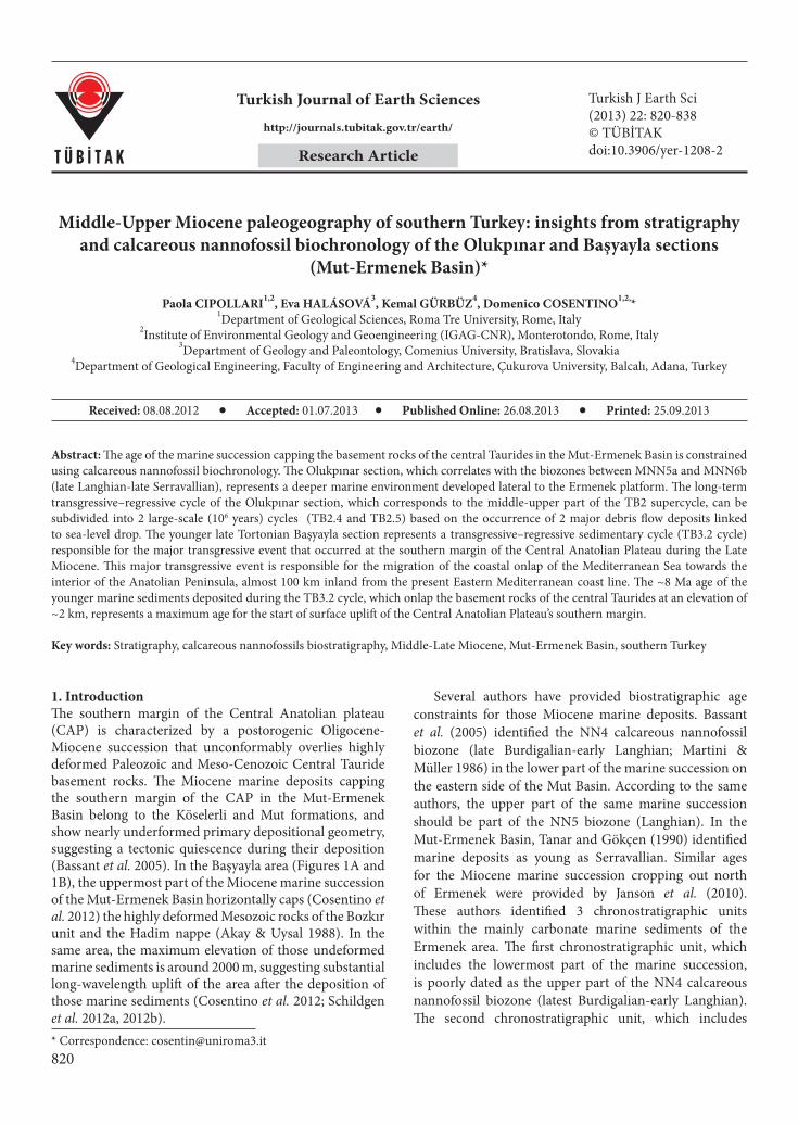
1. IntroductionThe southern margin of the Central Anatolian plateau (CAP) is characterized by a postorogenic Oligocene-Miocene succession that unconformably overlies highly deformed Paleozoic and Meso-Cenozoic Central Tauride basement rocks. The Miocene marine deposits capping the southern margin of the CAP in the Mut-Ermenek Basin belong to the Köselerli and Mut formations, and show nearly underformed primary depositional geometry, suggesting a tectonic quiescence during their deposition (Bassant et al. 2005). In the Başyayla area (Figures 1A and 1B), the uppermost part of the Miocene marine succession of the Mut-Ermenek Basin horizontally caps (Cosentino et al. 2012) the highly deformed Mesozoic rocks of the Bozkır unit and the Hadim nappe (Akay & Uysal 1988). In the same area, the maximum elevation of those undeformed marine sediments is around 2000 m, suggesting substantial long-wavelength uplift of the area after the deposition of those marine sediments (Cosentino et al. 2012; Schildgen et al. 2012a, 2012b).
Several authors have provided biostratigraphic age constraints for those Miocene marine deposits. Bassant et al. (2005) identified the NN4 calcareous nannofossil biozone (late Burdigalian-early Langhian; Martini & Müller 1986) in the lower part of the marine succession on the eastern side of the Mut Basin. According to the same authors, the upper part of the same marine succession should be part of the NN5 biozone (Langhian). In the Mut-Ermenek Basin, Tanar and Gökçen (1990) identified marine deposits as young as Serravallian. Similar ages for the Miocene marine succession cropping out north of Ermenek were provided by Janson et al. (2010). These authors identified 3 chronostratigraphic units within the mainly carbonate marine sediments of the Ermenek area. The first chronostratigraphic unit, which includes the lowermost part of the marine succession, is poorly dated as the upper part of the NN4 calcareous nannofossil biozone (latest Burdigalian-early Langhian). The second chronostratigraphic unit, which includes
Abstract: The age of the marine succession capping the basement rocks of the central Taurides in the Mut-Ermenek Basin is constrained using calcareous nannofossil biochronology. The Olukpınar section, which correlates with the biozones between MNN5a and MNN6b (late Langhian-late Serravallian), represents a deeper marine environment developed lateral to the Ermenek platform. The long-term transgressive–regressive cycle of the Olukpınar section, which corresponds to the middle-upper part of the TB2 supercycle, can be subdivided into 2 large-scale (106 years) cycles (TB2.4 and TB2.5) based on the occurrence of 2 major debris flow deposits linked to sea-level drop. The younger late Tortonian Başyayla section represents a transgressive–regressive sedimentary cycle (TB3.2 cycle) responsible for the major transgressive event that occurred at the southern margin of the Central Anatolian Plateau during the Late Miocene. This major transgressive event is responsible for the migration of the coastal onlap of the Mediterranean Sea towards the interior of the Anatolian Peninsula, almost 100 km inland from the present Eastern Mediterranean coast line. The ~8 Ma age of the younger marine sediments deposited during the TB3.2 cycle, which onlap the basement rocks of the central Taurides at an elevation of ~2 km, represents a maximum age for the start of surface uplift of the Central Anatolian Plateau’s southern margin.
Key words: Stratigraphy, calcareous nannofossils biostratigraphy, Middle-Late Miocene, Mut-Ermenek Basin, southern Turkey
Received: 08.08.2012 Accepted: 01.07.2013 Published Online: 26.08.2013 Printed: 25.09.2013
Research Article

821
CIPOLLARI et al. / Turkish J Earth Sci
most of the marine succession of the Ermenek area, corresponds to the NN5 calcareous nannofossil biozone (middle-late Langhian). The third chronostratigraphic unit, which includes the uppermost part of the local marine succession of the Ermenek area, pertains to the NN6 calcareous nannofossil biozone (early Serravallian). Finally, in the Başyayla area (Mut-Ermenek Basin), Cosentino et al. (2012) identified planktonic foraminifera assemblages that constrain the upper part of the section to the MMi 12a biozone (8.35–7.81 Ma; Iaccarino et al. 2007). Paleomagnetic and biostratigraphic results from the uppermost part of the marine deposits of the Başyayla section point to C4r.1r or C4r.2r chrons within the C4 magnetozone, limiting the potential age range of the upper part of the section to the interval of 8.35–8.108 Ma (late Tortonian; Cosentino et al. 2012).
In the late Burdigalian-Langhian deposits of the Mut area, Bassant et al. (2005) recognized 2 high-amplitude (100–150 m) sea-level cycles, which are interpreted as eustatic cycles (third-order cyclicity) driven by the 400-kyr orbital cyclicity (eccentricity). The progradational
geometries that characterize the carbonate deposits of the Mut Formation point to a regressive trend. This regressive trend led to the sedimentation of the carbonate ramp deposits of the Mut Formation throughout the Mut Basin (Tanar & Gökçen 1990).
In the Ermenek area, above a subtropical flat platform of late Burdigalian age (NN4), a platform-basin system developed during the Langhian (Janson et al. 2010). At that time, a composite platform system developed to the NE of the town of Ermenek, including an aggradational barrier at the platform edge and several platform-banks prograding into intraplatform depression deposits. In this paleogeographic framework, foreslope and basin deposits were deposited SW of the Langhian aggradational barrier that was developing in the vicinity of the present position of the town of Ermenek (Janson et al. 2010).
Due to the excellent exposure of the carbonate deposits of the Mut-Ermenek Basin (Mut Formation) and their tectonically undisturbed setting, recent studies focused mainly on the sequence stratigraphic architecture and carbonate sedimentology of the Mut Formation (Bassant
35°E30°E
30°E 35°E 40°EA
NAFNAF
EAF
Black Sea
MediterraneanSea
40°N
35°N 40°E 35°N
Bitlis-Zagros Suture
32°E 34°
32°E
37°N 37°N
36°N 36°
50 km
N
Fig. 2
33° 34°
33°
50 km
32°E 33° 34°
32°E 33° 34°36°N
N
B
Figs.1B, 1C
36°
Arabian Plate
37° 37°
C
Mut Basin
T a u r i d es
P o n t i d e s
Central
TauridesCentral
Taurides
CentralAnatolian Plateau
Bitlis-ZagrosCollision
ZoneWestern Aegean
Extensional Province
Başyayla section
Olukpınarsection
ErmenekBasin
2.0
1.0
1.5
0.5
00
Elevation((km)
Post-orogenic rocks
Pre-orogenic rocks
Miocene neritic limestones
Miocene cont. clastics
Miocene lake sediments and limestones
Cretaceous limestones and shales
Jurassic limestones
Triassic limestones, schist,tu�ite, basalt, cont. clactics Cambrian/Precambrianmarbles, dolomite, schist
Figure 1. Tectonic and geologic setting of field area. (A) Regional plate tectonic setting with major structures and topography (from Shuttle Radar Topography Mission 90-m resolution data; Jarvis et al. 2008). NAF: North Anatolian fault, EAF: East Anatolian fault. (B) Southern margin topography with location of Olukpınar and Başyayla sections. (C) Geology simplified from 1:500,000 scale geologic maps (Şenel 2002; Ulu 2002) with location of the study sections. Black lines delineate tectonic contacts within basement rocks. Modified from Cosentino et al. (2012).
Olukpınar section
Başyayla section

822
CIPOLLARI et al. / Turkish J Earth Sci
1999; Bassant et al. 2005; Janson et al. 2010; Pomar et al. 2012). Less attention was given to the deeper depositional environment at the slope-to-basin transition (Köselerli Formation), which in both the published maps (e.g., Gedik et al. 1979; Şenel 2002; Ulu 2002) and in the derived paleogeographical schemes (e.g., Bassant et al. 2005; Janson et al. 2010; Pomar et al. 2012) appears to be underestimated in terms of extent. To the south and to the west of the town of Ermenek, in the Olukpınar and Başyayla areas, deeper marine marls (Köselerli Formation) extensively crop out, challenging the extent of the Miocene carbonate platform in those areas.
The Miocene deeper marine deposits of the Mut-Ermenek Basin (Köselerli Formation) were dated upper Burdigalian-Serravallian by using ostracods, planktonic foraminifera, and calcareous nannofossils (Tanar & Gökçen 1990; Atabey et al. 2000). More recently, referring to the calcareous nannofossil biostratigraphy of Martini and Müller (1986), Bassant et al. (2005) identified the upper part of the marine succession on the east side of the Mut Basin to be part of the NN5 biozone, whereas Janson et al. (2010) identified in the uppermost strata of the Ermenek platform calcareous nannofossil assemblages of the NN6 biozone, confirming a Serravallian age for the topmost part of the Miocene marine deposits in the Mut-Ermenek Basin.
Here we present a micropaleontological analysis of calcareous nannofossils, by using an updated biostratigraphical scheme (Fornaciari et al. 1996), on samples from 2 marine sections, the Olukpınar section and the Başyayla section (Figures 1A and 1B), located south and northwest of the town of Ermenek, respectively. Our new analyses allow us to 1) better constrain the age of the marine succession capping the southern margin of the CAP (consequently constraining the maximum age for its uplift), 2) correlate the slope-to-basin deposits of the Mut-Ermenek Basin (Köselerli Formation) to the shallow-water limestones of the Mut Formation, and 3) improve the middle-late Miocene paleogeography at the southern margin of the CAP.
2. Geological settingThe Central Taurides (Figure 1B), which extend from the Ecemiş Fault in the east to the Antalya Miocene basin in the west, consist of oceanic- and continental-derived units of Cambrian to Tertiary age that were shortened and overthrust in latest Cretaceous-Eocene time, during the closure of the Mesozoic Neo-Tethyan Ocean and subsequent collision between the Taurus carbonate platforms and the crystalline complex of central Anatolia (Şengör & Yilmaz 1981; Dixon & Robertson 1984). The tectonostratigraphic units of the Central Taurides include 2 relatively autochthonous units (Geyikdağı and
Beydağlan) and several allochthonous units (Aladağı, Bolkardağı, Bozkır, Hadim, Alanya, and Antalya) (Akay & Uysal 1988; Bozkaya & Yalçin 2000). The Bozkır unit was thrust onto the Bolkardağı and Aladağı units in the Upper Cretaceous, and in the Middle-Late Eocene these 3 units were thrust, from north to south, onto the Geyikdağı unit (Akay & Uysal 1988; Özgül 1997; Bozkaya & Yalçin 2000).
In the Mut-Ermenek Basin, the fold-and-thrust belt of the central Taurides is characterized by some thrust planes within the Bozkır unit, which separate different subunits, and the lateral juxtaposition of the Hadim nappe with the Bozkır unit, along the NW-SE right-lateral strike-slip Bozkır fault (Akay & Uysal 1988). The tectonic units of this fold-and-thrust belt are unconformably overlain by continental clastic deposits (Yenimahalle and Fakırca formations) connected with the development of widespread land areas in southern Turkey, as a consequence of the general uplift induced by the Taurus orogeny during the Late Eocene-Early Oligocene in that area (Figure 1C).
According to some authors (Akay et al. 1985; Aksu et al. 1992; Görür 1992; Williams & Ünlügenç 1992; Robertson & Grasso 1995), intramontane extension was initiated throughout the Taurides during the Late Eocene-Early Miocene, which gave rise to suprasutural sedimentary basins (Manavgat, Mut, Adana, Karsantı, Maraş, etc.). This extensional phase, which may be linked to the retreat of the African plate (Kempler & Ben-Avraham 1987; Robertson 1998, 2000; Jolivet & Faccenna 2000), yielded mainly tectonically controlled sedimentary basins with the deposition of 2 second-order cycles (supercycles, sensu Haq et al. 1988), which consist of thick continental deposits of the Yenimahalle Formation (Lower Oligocene) and the Fakırca Formation (Upper Oligocene-Aquitanian) (Figure 2A).
The Yenimahalle Formation is mainly characterized by coarse clastic beds of a fluviolacustrine environment. The younger Fakırca Formation consists of fine-grained lacustrine deposits, with occasional coarser clastic intercalations (e.g., Gedik et al. 1979; Tanar & Gökçen 1990). These Oligocene-Lower Miocene continental deposits are generally tilted and faulted by mainly extensional tectonics. In the northwestern part of the Mut-Ermenek Basin (Başyayla area), this extensional tectonic phase reactivated an ancient strike-slip regional fault zone (Bozkır fault), which locally controlled the formation of an Oligocene-Early Miocene sedimentary basin (Cosentino et al. 2012).
In the Mut-Ermenek Basin, the mainly marine Mut and Köselerli formations, which rest unconformably above the Oligocene-Early Miocene continental deposits (Figure 2A), were deposited in a tectonically quiescent period, corresponding to the TB2 p.p. and TB3 p.p. supercycles of Haq et al. (1988). In some places, the lower part of

823
CIPOLLARI et al. / Turkish J Earth Sci
. . . . ..
. . . .. . . . .
Ru
pel
ian
Ch
att
ian
Aqu
itani
anBu
rdig
alia
nLa
nghi
anSe
rrav
all.
Tort
onia
nM
essin
.
Yeni
mah
alle
Fm
Fak
ırca F
mD
erin
çay
FmK
ösel
erli
Fm
Mu
t F
m
OL
IGO
CE
NE
MIO
CE
NE
Pre-o
roge
nic Fm
Pre-
Rupe
lian
PRE-
OLI
GOCE
NE
CHRONO-STRATIGR. LI
THO-
STRA
TIGR
.
STRATIGRAPHY OF MUT-ERMENEK BASIN
A
OLUKPINAR SECTION
0
5
10
15
20
mcm
lmmc
Depth(m)
Lithology Samples
EKN 1
EKN 5
25
30
35
40
45
50
55
OLUKPINAR SECTIONN 36° 29’ 40.46” E 33° 00’ 36.30” (base)
B
EKN 10
EKN 15
EKN 20
EKN 25
EKN 30
EKN 35
EKN 40
EKN 45
EKN 50
EKN 65
EKN 60
EKN 55
EKN 70
EKN 75
EKN 80
EKN 85
EKN 90
EKN 95
EKN 100
EKN 105
EKN 110
EKN 115
EKN 120
EKN 125
EKN 130
55
60
65
70
75
mcm
lmmc
Depth(m)
Lithology Samples nanno forams+Sr
80
85
90
95
100
105
110
N 36° 29’ 41.50” E 33° 00’ 31.94” (top)
EKN 135
EKN 140
EKN 145
EKN 150
EKN 155
EKN 160
EKN 165
EKN 170
EKN 175
EKN 180
EKN 185
EKN 190
EKN 195
EKN 200
EKN 205
EKN 210
EKN 215
EKN 220EKN 225EKN 230
EKN 235EK01451-P
EK01406-P
EK01361-P
EK01311-P
EK01258-P
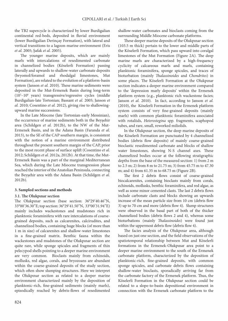
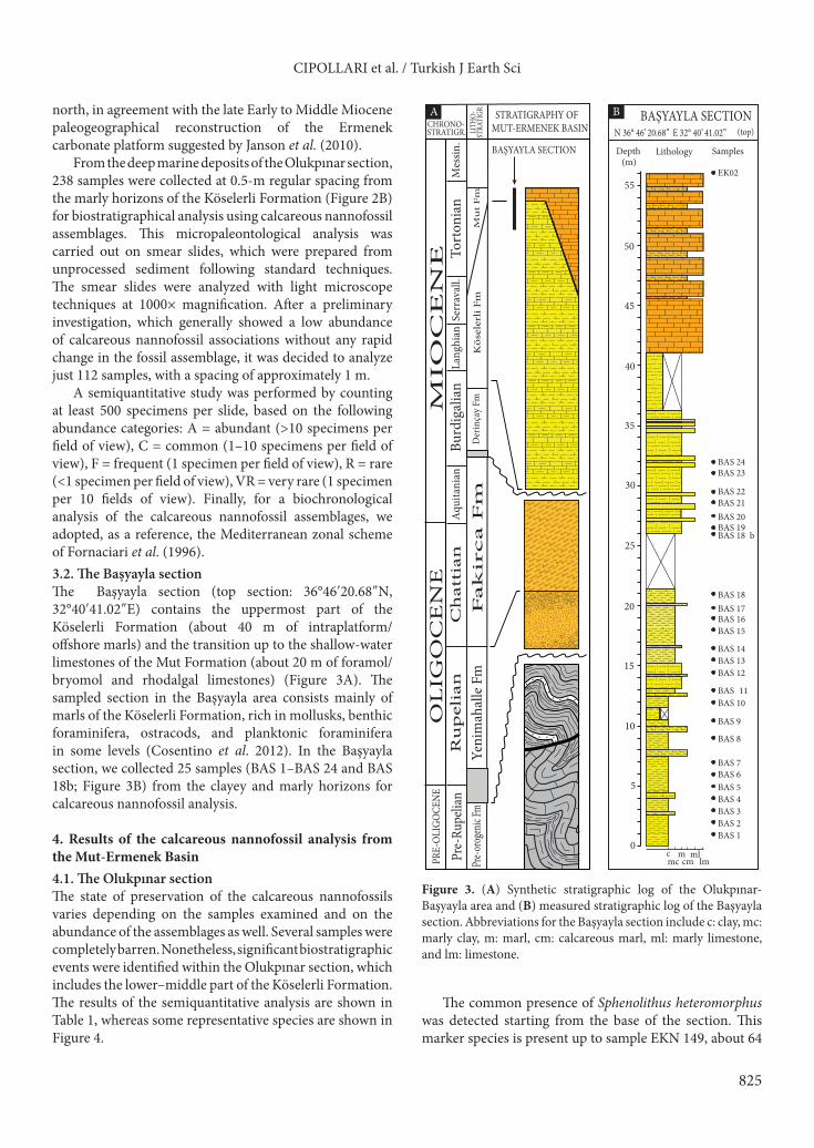
Figure 2. (A) Synthetic stratigraphic log of the Olukpınar-Başyayla area and (B) measured stratigraphic log of the Olukpınar section. Abbreviations for the Olukpınar section include mc: marly clay, m: marl, cm: calcareous marl, and lm: limestone.
824
CIPOLLARI et al. / Turkish J Earth Sci
the TB2 supercycle is characterized by lower Burdigalian continental red-beds, deposited in fluvial environment (lower Burdigalian Derinçay Formation), with lateral and vertical transitions to a lagoon-marine environment (Eris et al. 2005; Şafak et al. 2005).
The younger marine deposits, which are mainly marls with intercalations of resedimented carbonate in channelized bodies (Köselerli Formation) passing laterally and upwards to shallow-water carbonate deposits (bryomol/foramol and rhodalgal limestones, Mut Formation), are related to the evolution of a platform-basin system (Janson et al. 2010). These marine sediments were deposited in the Mut-Ermenek Basin during long-term (105–106 years) transgressive/regressive cycles (middle Burdigalian-late Tortonian; Bassant et al. 2005; Janson et al. 2010; Cosentino et al. 2012), giving rise to shallowing-upward marine successions.
In the Late Miocene (late Tortonian-early Messinian), the occurrence of marine sediments both in the Beyşehir area (Schildgen et al. 2012b), to the NW of the Mut-Ermenek Basin, and in the Adana Basin (Faranda et al. 2013), to the SE of the CAP southern margin, is consistent with the notion of a marine environment distributed throughout the present southern margin of the CAP, prior to the most recent phase of surface uplift (Cosentino et al. 2012; Schildgen et al. 2012a, 2012b). At that time, the Mut-Ermenek Basin was a part of the marginal Mediterranean Sea, which during the Late Miocene transgression phase reached the interior of the Anatolian Peninsula, connecting the Beyşehir area with the Adana Basin (Schildgen et al. 2012b).
3. Sampled sections and methods3.1. The Olukpınar sectionThe Olukpınar section (base section: 36°29′40.46″N, 33°00′36.30″E; top section: 36°29′41.50″N, 33°00′31.94″E) mainly includes wackestones and mudstones rich in planktonic foraminifera with rare intercalations of coarse-grained deposits, such as calcarenites, calcirudites, and channelized bodies, containing huge blocks (of more than 1 m in size) of calcarenites and shallow-water limestones in a fine-grained matrix. Benthic fauna within the wackestones and mudstones of the Olukpınar section are quite rare, while sponge spicules and fragments of thin pelecypod shells pointing to a deeper marine environment are very common. Bioclasts mainly from echinoids, mollusks, red algae, corals, and bryozoans are abundant within the coarse-grained deposits of the study section, which often show slumping structures. Here we interpret the Olukpınar section as related to a deeper marine environment characterized mainly by the deposition of planktonic-rich, fine-grained sediments (mainly marls), episodically reached by debris-flows of resedimented
shallow-water carbonates and bioclasts coming from the surrounding Middle Miocene carbonate platforms.
These deeper marine deposits of the Olukpınar section (103.5 m thick) pertain to the lower and middle parts of the Köselerli Formation, which pass upward into coralgal limestones of the Mut Formation (Figure 2A). The deep marine marls are characterized by a high-frequency cyclicity of calcareous marls and marls, containing planktonic foraminifera, sponge spicules, and traces of bioturbation (mainly Thalassinoides and Chondrites) in some places. The Köselerli Formation at the Olukpınar section indicates a deeper marine environment compared to the ‘depression marly deposits’ within the Ermenek platform system (e.g., planktonic rich wackestone facies; Janson et al. 2010). In fact, according to Janson et al. (2010), the Köselerli Formation in the Ermenek platform system consists of very fine-grained deposits (mainly marls) with common planktonic foraminifera associated with rotaliids, Heterostegina spp. fragments, scaphopod tubes, and rare, small, reworked miliolids.
In the Olukpınar section, the deep marine deposits of the Köselerli Formation are punctuated by 4 channelized bodies (debris flow deposits) of mainly coarse-grained bioclastic resedimented carbonate and blocks of shallow water limestones, showing N-S channel axes. These channelized bodies occur at the following stratigraphic depths from the base of the measured section: 1) from 2 m to 2.5 m; 2) from 8 m to 21.75 m; 3) from 45.75 m to 47.30 m; and 4) from 61.35 m to 68.75 m (Figure 2B).
The first 2 debris flows consist of coarse-grained biocalcarenites, containing bioclasts mainly from corals, echinoids, mollusks, benthic foraminifera, and red algae, as well as some minor cemented clasts. The last 2 debris flows include carbonate clasts and blocks showing an upwards increase of the mean particle size from 10 cm (debris flow 3) up to 70 cm and more (debris flow 4). Slump structures were observed in the basal part of both of the thicker channelized bodies (debris flows 2 and 4), whereas some bioturbations (mainly Thalassinoides) were found just within the uppermost debris flow (debris flow 4).
The facies analysis of the Olukpınar area, although based on just one section, and the field observations of the spatiotemporal relationship between Mut and Köselerli formations in the Ermenek-Olukpınar area point to a deeper marine environment to the south of the Ermenek carbonate platform, characterized by the deposition of planktonic-rich, fine-grained deposits, with common sponge spicules, and carbonate debris flows containing shallow-water bioclasts, sporadically arriving far from the carbonate factory of the Ermenek platform. Thus, the Köselerli Formation in the Olukpınar section could be related to a slope-to-basin depositional environment in connection with the Ermenek carbonate platform to the
825
CIPOLLARI et al. / Turkish J Earth Sci
north, in agreement with the late Early to Middle Miocene paleogeographical reconstruction of the Ermenek carbonate platform suggested by Janson et al. (2010).
From the deep marine deposits of the Olukpınar section, 238 samples were collected at 0.5-m regular spacing from the marly horizons of the Köselerli Formation (Figure 2B) for biostratigraphical analysis using calcareous nannofossil assemblages. This micropaleontological analysis was carried out on smear slides, which were prepared from unprocessed sediment following standard techniques. The smear slides were analyzed with light microscope techniques at 1000× magnification. After a preliminary investigation, which generally showed a low abundance of calcareous nannofossil associations without any rapid change in the fossil assemblage, it was decided to analyze just 112 samples, with a spacing of approximately 1 m.
A semiquantitative study was performed by counting at least 500 specimens per slide, based on the following abundance categories: A = abundant (>10 specimens per field of view), C = common (1–10 specimens per field of view), F = frequent (1 specimen per field of view), R = rare (<1 specimen per field of view), VR = very rare (1 specimen per 10 fields of view). Finally, for a biochronological analysis of the calcareous nannofossil assemblages, we adopted, as a reference, the Mediterranean zonal scheme of Fornaciari et al. (1996).3.2. The Başyayla sectionThe Başyayla section (top section: 36°46′20.68″N, 32°40′41.02″E) contains the uppermost part of the Köselerli Formation (about 40 m of intraplatform/offshore marls) and the transition up to the shallow-water limestones of the Mut Formation (about 20 m of foramol/bryomol and rhodalgal limestones) (Figure 3A). The sampled section in the Başyayla area consists mainly of marls of the Köselerli Formation, rich in mollusks, benthic foraminifera, ostracods, and planktonic foraminifera in some levels (Cosentino et al. 2012). In the Başyayla section, we collected 25 samples (BAS 1–BAS 24 and BAS 18b; Figure 3B) from the clayey and marly horizons for calcareous nannofossil analysis.
4. Results of the calcareous nannofossil analysis from the Mut-Ermenek Basin4.1. The Olukpınar sectionThe state of preservation of the calcareous nannofossils varies depending on the samples examined and on the abundance of the assemblages as well. Several samples were completely barren. Nonetheless, significant biostratigraphic events were identified within the Olukpınar section, which includes the lower–middle part of the Köselerli Formation. The results of the semiquantitative analysis are shown in Table 1, whereas some representative species are shown in Figure 4.
The common presence of Sphenolithus heteromorphus was detected starting from the base of the section. This marker species is present up to sample EKN 149, about 64
. . . . ..
. . . .. . . . .
Ru
pel
ian
Ch
att
ian
Aqu
itani
anBu
rdig
alia
nLa
nghi
anSe
rrav
all.
Tort
onia
nM
essin
.
Yeni
mah
alle
Fm
Fak
irca F
mD
erin
çay
FmK
ösel
erli
Fm
Mu
t F
m
OL
IGO
CE
NE
MIO
CE
NE
Pre-o
roge
nic Fm
Pre-
Rupe
lian
PRE-
OLI
GOCE
NE
CHRONO-STRATIGR. LI
THO-
STRA
TIGR
.
STRATIGRAPHY OF MUT-ERMENEK BASIN
BAŞYAYLA SECTION
A
0
5
10
15
20
mcm
mllmmc
c
Depth(m)
Lithology Samples
BAS 1BAS 2BAS 3BAS 4BAS 5BAS 6BAS 7
BAS 8
BAS 9
BAS 10BAS 11
BAS 12BAS 13BAS 14
BAS 15
25
30
35
40
45
BAS 16BAS 17BAS 18
BAS 18 bBAS 19BAS 20BAS 21BAS 22
BAS 23BAS 24
50
55
BAŞYAYLA SECTIONN 36° 46’ 20.68” E 32° 40’ 41.02” (top)
B
EK02
Figure 3. (A) Synthetic stratigraphic log of the Olukpınar-Başyayla area and (B) measured stratigraphic log of the Başyayla section. Abbreviations for the Başyayla section include c: clay, mc: marly clay, m: marl, cm: calcareous marl, ml: marly limestone, and lm: limestone.

826
CIPOLLARI et al. / Turkish J Earth Sci
Table 1. Results of the semiquantitative analysis of the calcareous nannofossils assemblages from the Olukpınar section. A: abundant (>10 specimens per field of view), C: common (1–10 specimens per field of view), F: frequent (1 specimen per field of view), R: rare (<1 specimen per field of view), VR: very rare (<<1 specimen per field of view).
Sam
ples
H. c
arte
ri
H. w
albe
rsdo
rfen
sis
H. i
nter
med
ia
S. m
orifo
rmis
S. h
eter
omor
phus
R. p
seud
oum
bilic
us
Retic
ulof
enes
tra sp
p.
Cy. fl
orid
anus
C. le
ptop
orus
C. p
rem
acin
tyre
i
C. m
acin
tyre
i
U. ja
fari
C. p
elagi
cus
C. m
iope
lagi
cus
Dic
tyoc
occit
es sp
p.
Pont
osph
aera
spp.
EKN 1 F - VR R F - C F - VR - R F VR A VREKN 3 F - VR F R - A F VR - - - R VR A REKN 5 F - VR R F - A R - - - R A - A REKN 7 F - VR F R - A F - - - R R - C REKN 9 - - - - - - - - - - - R - - - -
EKN 11 F - VR R F - A R VR R R A REKN 13 F - VR R F - C VR R VR - - R - C VREKN 15 F - R F F - A VR R VR - VR R - A VREKN 17 F - VR R F - A VR VR VR - VR R - A FEKN 19 R . . R VR . VR VR - - - - VR - REKN 21 F - R F R - A F VR . . . R - C REKN 23 F - R R F - A F F R - F F - A REKN 25 - - - - - - - - - - - - - - - -EKN 27 F - - VR - - C R VR - - R - C -EKN 29 F - - R VR - C - VR - - - - - C VREKN 31 R - - - - - F - - - - VR - F VREKN 33 - - - - - - - - - - - - - - - -EKN 35 - - - - - - - - - - - - - - - -EKN 37 - - - - - - - - - - - - - - - -EKN 39 F - - VR VR - F - - - - - VR VR F VREKN 41 - - - - - - - - - - - - - - - -EKN 43 - - - - - - - - - - - - - - - -EKN 45 - - - - - - - - - - - - - - - -EKN 47 - - - - VR - F - - - - - F - C -EKN 49 - - - - - - - - - - - - - - - -EKN 51 - - - - - - - - - - - - - - - -EKN 53 - - - - - - - - - - - - - - - -EKN 55 - - - - - - - - - - - - - - - -EKN 57 VR - - VR - - VR - - - - - VR - VR -EKN 59 - - - - - - - - - - - - - - - -EKN 61 - - - - - - - - - - - - - - - -EKN 63 - - - VR VR - VR - - - - - VR - F -EKN 65 - - - VR VR - VR - - - - - VR - F -EKN 67 VR . . . VR . F VR . VR . . VR VR C -EKN 69 VR - - VR VR - F - - - - - VR - - -EKN 71 R VR - R VR - F - - VR - - R - C VREKN 73 R VR - R VR - F - - VR - - R - C VREKN 75 F R - R F - F R - - - - C VR C VREKN 77 F VR - VR R - F VR - - - - F VR C -EKN 79 R - - VR R - C F - - - - R - C -EKN 81 F - - F F - A F - - - - C - A VREKN 83 F - VR F F - A C F F - VR F - A -

827
CIPOLLARI et al. / Turkish J Earth Sci
Table 1. (continued).Sa
mpl
es
H. c
arte
ri
H. w
albe
rsdo
rfen
sis
H. i
nter
med
ia
S. m
orifo
rmis
S. h
eter
omor
phus
R. p
seud
oum
bilic
us
Retic
ulof
enes
tra sp
p.
Cy. fl
orid
anus
C. le
ptop
orus
C. p
rem
acin
tyre
i
C. m
acin
tyre
i
U. ja
fari
C. p
elagi
cus
C. m
iope
lagi
cus
Dic
tyoc
occit
es sp
p.
Pont
osph
aera
spp.
EKN 85 C R - F R - A F - - - C - A CEKN 87 F VR - F C - C - - - - - C - F FEKN 89 R VR - F R - A F - R - C C - A FEKN 91 VR - - R VR - C C - - - R R - A REKN 93 VR - - VR - - C F - - - - F - C VREKN 95 VR - - VR R - C F - - - - C - C VREKN 97 R - R R - C F - - - - A - C -EKN 99 R - - R F - C F - - - - C - A VR
EKN 101 R - VR F R - C F - VR - C F - A -EKN 103 F - R C R - A R - - - - C - A REKN 105 R - VR VR F - F R - - - - F - C -EKN 107 VR - - VR R - R - - - - - F - C -EKN 109 - - - - - - - - - - - - - - - -EKN 111 - - - - - - - - - - - - - - - -EKN 113 VR - - - - - C R - - - R R - C VREKN 115 R VR - - - - C - - VR - VR F - C -EKN 117 F R - - - VR C F - F - - C - A -EKN 119 R - - F F - C F - - - - C - A -EKN 121 F - - F F - A C R VR - R A -EKN 123 F - - F VR - F C - - - - F - A -EKN 125 VR - - R VR - F - - - - - F - C -EKN 127 VR - - - - - F - - - - - R - F -EKN 129 VR VR - - - - - - - - - - F - F -EKN 131 R VR - VR - - A R - - - - C - A -EKN 133 C F VR R F - C F - - - - C - A -EKN 135 F R - R F - C C - - - C F - A VREKN 137 R R - VR - - F R - VR - - F - C -EKN 139 R VR - VR - VR F VR - - - - F - C -EKN 141 F R - R F - F F VR - - - A VR A -EKN 143 F VR - VR F - C VR - - VR - C VR A -EKN 145 R - - VR R - C C - - - - C - A -EKN 147 F VR - VR VR - F F - - - - F - C -EKN 149 F R - R F - C F - - - - C - A -EKN 151 - - - - - - - - - - - - - - - -EKN 153 F VR R R - VR C F - - - F C - C -EKN 155 F F - R - - C VR - - - F F - A -EKN 157 F R - F VR - C F - R - - C - C -EKN 159 - - - - - - - - - - - - - - - -EKN 161 R - - VR - - R - - - - - F - C -EKN 163 R - - - - - R R - - - - F - F -EKN 165 R - - - - - - - - - - - F - C -EKN 167 VR VR - F - VR C R - - - F C - A -
828
CIPOLLARI et al. / Turkish J Earth Sci
Table 1. (continued).Sa
mpl
es
H. c
arte
ri
H. w
albe
rsdo
rfen
sis
H. i
nter
med
ia
S. m
orifo
rmis
S. h
eter
omor
phus
R. p
seud
oum
bilic
us
Retic
ulof
enes
tra sp
p.
Cy. fl
orid
anus
C. le
ptop
orus
C. p
rem
acin
tyre
i
C. m
acin
tyre
i
U. ja
fari
C. p
elagi
cus
C. m
iope
lagi
cus
Dic
tyoc
occit
es sp
p.
Pont
osph
aera
spp.
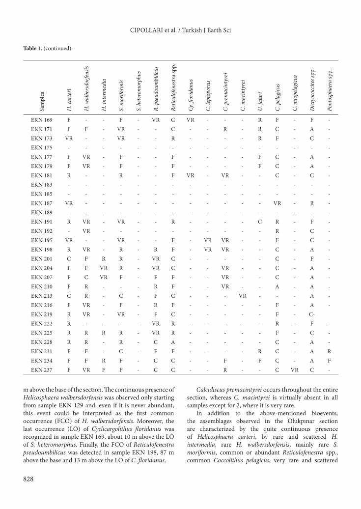
EKN 169 F - - F - VR C VR - - - R F - F -EKN 171 F F - VR - - C - - R - R C - A -EKN 173 VR - - VR - - R - - - - R F - C -EKN 175 - - - - - - - - - - - - - - - -EKN 177 F VR - F - - F - - - - F C - A -EKN 179 F VR - F - - F - - - - F C - A -EKN 181 R - - R - - F VR - VR - - C - C -EKN 183 - - - - - - - - - - - - - - - -EKN 185 - - - - - - - - - - - - - - - -EKN 187 VR - - - - - - - - - - - VR - R -EKN 189 - - - - - - - - - - - - - - - -EKN 191 R VR - VR - - R - - - - C R - F -EKN 192 - VR - - - - - - - - - - R - C -EKN 195 VR - - VR - - F - VR VR - - F - C -EKN 198 R VR - R - R F - VR VR - - C - A -EKN 201 C F R R - VR C - - - - - C - F -EKN 204 F F VR R - VR C - - VR - - C - A -EKN 207 F C VR F - F F - - VR - - C - A -EKN 210 F R - - - R F - - VR - - A - A -EKN 213 C R - C - F C - - - VR - - - A -EKN 216 F VR - F - R F - - - - - F - A -EKN 219 R VR - VR - F C - - - - - F - C-EKN 222 R - - - - VR R - - - - - R - F -EKN 225 R R R R - VR R - - - - - F - C -EKN 228 R R - R - C A - - - - - C - A -EKN 231 F F - C - F F - - - - R C - A REKN 234 F F R F - C C - - F - F C - A FEKN 237 F VR F F - C C - - R - - C VR C -
m above the base of the section. The continuous presence of Helicosphaera walbersdorfensis was observed only starting from sample EKN 129 and, even if it is never abundant, this event could be interpreted as the first common occurrence (FCO) of H. walbersdorfensis. Moreover, the last occurrence (LO) of Cyclicargolithus floridanus was recognized in sample EKN 169, about 10 m above the LO of S. heteromorphus. Finally, the FCO of Reticulofenestra pseudoumbilicus was detected in sample EKN 198, 87 m above the base and 13 m above the LO of C. floridanus.
Calcidiscus premacintyrei occurs throughout the entire section, whereas C. macintyrei is virtually absent in all samples except for 2, where it is very rare.
In addition to the above-mentioned bioevents, the assemblages observed in the Olukpınar section are characterized by the quite continuous presence of Helicosphaera carteri, by rare and scattered H. intermedia, rare H. walbersdorfensis, mainly rare S. moriformis, common or abundant Reticulofenestra spp., common Coccolithus pelagicus, very rare and scattered
829
CIPOLLARI et al. / Turkish J Earth Sci
C. miopelagicus, generally abundant Dictyococcites spp., rare or very rare Pontosphaera, and, finally, very rare Umbilicosphaera jafari.
The presence of S. heteromorphus together with the absence of H. ampliaperta allows us to refer the
lower 64 m of the study section to the MNN5a subzone (Fornaciari et al. 1996) (Figure 5). The interval between the continuous presence of H. walbersdorfensis and the LO of S. heteromorphus (between 55.5 m and 66.5 m of depth) points to the MNN5b subzone. Moving upward,
1 2 3 4
5 6 7 8
9 10
13 14 15 16
2µm
2µm 2µm
2µm2µm2µm2µm
2µm 2µm
2µm2µm2µm
2µm 2µm 2µm
11 12
2µm
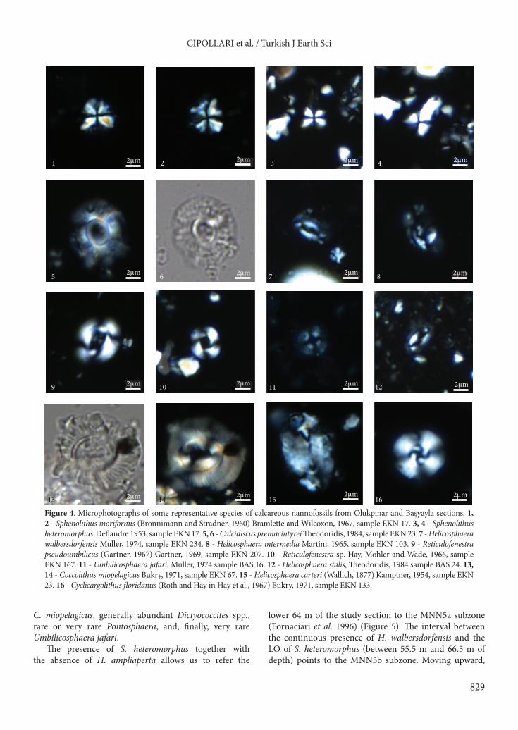
Figure 4. Microphotographs of some representative species of calcareous nannofossils from Olukpınar and Başyayla sections. 1, 2 - Sphenolithus moriformis (Bronnimann and Stradner, 1960) Bramlette and Wilcoxon, 1967, sample EKN 17. 3, 4 - Sphenolithus heteromorphus Deflandre 1953, sample EKN 17. 5, 6 - Calcidiscus premacintyrei Theodoridis, 1984, sample EKN 23. 7 - Helicosphaera walbersdorfensis Muller, 1974, sample EKN 234. 8 - Helicosphaera intermedia Martini, 1965, sample EKN 103. 9 - Reticulofenestra pseudoumbilicus (Gartner, 1967) Gartner, 1969, sample EKN 207. 10 - Reticulofenestra sp. Hay, Mohler and Wade, 1966, sample EKN 167. 11 - Umbilicosphaera jafari, Muller, 1974 sample BAS 16. 12 - Helicosphaera stalis, Theodoridis, 1984 sample BAS 24. 13, 14 - Coccolithus miopelagicus Bukry, 1971, sample EKN 67. 15 - Helicosphaera carteri (Wallich, 1877) Kamptner, 1954, sample EKN 23. 16 - Cyclicargolithus floridanus (Roth and Hay in Hay et al., 1967) Bukry, 1971, sample EKN 133.
830
CIPOLLARI et al. / Turkish J Earth Sci
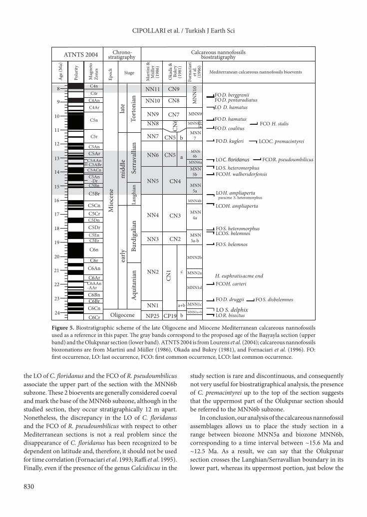
the LO of C. floridanus and the FCO of R. pseudoumbilicus associate the upper part of the section with the MNN6b subzone. These 2 bioevents are generally considered coeval and mark the base of the MNN6b subzone, although in the studied section, they occur stratigraphically 12 m apart. Nonetheless, the discrepancy in the LO of C. floridanus and the FCO of R. pseudoumbilicus with respect to other Mediterranean sections is not a real problem since the disappearance of C. floridanus has been recognized to be dependent on latitude and, therefore, it should not be used for time correlation (Fornaciari et al. 1993; Raffi et al. 1995). Finally, even if the presence of the genus Calcidiscus in the
study section is rare and discontinuous, and consequently not very useful for biostratigraphical analysis, the presence of C. premacintyrei up to the top of the section suggests that the uppermost part of the Olukpınar section should be referred to the MNN6b subzone.
In conclusion, our analysis of the calcareous nannofossil assemblages allows us to place the study section in a range between biozone MNN5a and biozone MNN6b, corresponding to a time interval between ~15.6 Ma and ~12.5 Ma. As a result, we can say that the Olukpınar section crosses the Langhian/Serravallian boundary in its lower part, whereas its uppermost portion, just below the
MNN9
MNN8
CN1
CN2
CN3
CN4
CN5
CN6
CN7
CP19
CN5
C6Cr
C6CnC6BrC6Bn
C6AAn-AAr
C6Ar
C6AnC6r
C6n
C5ErC5EnC5DrC5DnC5CrC5Cn
C5BrC5Bn
C5An-Dr
C5ACn
C5AAn-C5ABr
C5ArC5An
C5r
C5n Tort
onia
nSe
rrav
allia
nLa
nghi
an
mid
dle
Mio
cene
Burd
igal
ian
Aqu
itani
an
early
Oligocene b
a+b
c
24
23
22
21
20
19
18
17
16
15
14
13
12
11
10
Age
(Ma)
LO S. delphix
FO D. druggii
LO R. bisectus
FO S. belemnos
LCO S. belemnosFO S. heteromorphus
LCO H. ampliaperta
LO S. heteromorphusLO
FO D. kugleri
FO D. coalitus
FO D. hamatus
MNN3a-b
MNN4a
LO H. ampliapertaparacme S. heteromorphus
MNN4b
FCO H. walbersdorfensis
MNN5a
MNN5b
MNN6b
MNN6a
MNN7
ab
late
MNN1d
MNN2a
MNN1c
MNN1a+b
a
b
MNN2b
FO S. disbelemnos
H. euphratis acme endFCO H. carteri
FCO R. pseudoumbilicus
LCO C. premacintyrei
CN8
CN9
C4ArC4AnC4rC4n
MN
N10
FCO H. stalis
FO D. pentaradiatusFO D. berggrenii
LO D. hamatus9
8
NP25
NN1
NN2
NN3
NN4
NN5
NN6
NN7
NN8NN9
NN10
NN11
Forn
acia
ri et
al.
(199
6)
Oka
da &
Bukr
y(1
981)
ATNTS 2004
Pola
rity
Mag
neto
Zone
s
Epoc
h Stage
Chrono-stratigraphy
Calcareous nannofossilsbiostratigraphy
Mediterranean calcareous nannofossils bioevents
Mar
tini &
M
ülle
r (1
986)
Figure 5. Biostratigraphic scheme of the late Oligocene and Miocene Mediterranean calcareous nannofossils used as a reference in this paper. The gray bands correspond to the proposed age of the Başyayla section (upper band) and the Olukpınar section (lower band). ATNTS 2004 is from Lourens et al. (2004); calcareous nannofossils biozonations are from Martini and Müller (1986), Okada and Bukry (1981), and Fornaciari et al. (1996). FO: first occurrence, LO: last occurrence, FCO: first common occurrence, LCO: last common occurrence.

831
CIPOLLARI et al. / Turkish J Earth Sci
first occurrence of shallow-water limestones of the Mut Formation in our local section, is included within the late Serravallian.4.2. The Başyayla sectionIn the Başyayla section, the calcareous nannofossils are rare and moderately preserved. All the assemblages are dominated by small specimens ranging from 3 µm to 5 µm and by the presence of U. jafari. Furthermore, in the Başyayla section, the genus Discoaster is essentially absent. These peculiar assemblages were interpreted as the result of environmental filtering (Cosentino et al. 2012). Nevertheless, it is important to note the continuous presence
of H. stalis. Even if its abundance is not very high due to the scarcity of the assemblages (in particular of the genus Helicosphaera), we can presume that the Başyayla section is above the FCO of H. stalis. This position is supported by the virtual absence of H. walbersdorfensis (Fornaciari et al. 1996). Finally, the abundance of U. jafari, which generally prefers near-shore marine environments and high salinity waters, is consistent with paleoenvironmental conditions that prevented the diffusion of discoasterids in a shallow-water marine environment. The results of the semiquantitative analysis are shown in Table 2, whereas some representative species are shown in Figure 4.
Table 2. Results of the semiquantitative analysis of the calcareous nannofossils assemblages from the Başyayla section. A: abundant (>10 specimens per field of view), C: common (1–10 specimens per field of view), F: frequent (1 specimen per field of view), R: rare (<1 specimen per field of view), VR: very rare (<<1 specimen per field of view).
Sam
ples
H. c
arte
ri
H. i
nter
med
ia
H. s
talis
S. a
bies
R. p
seud
oum
bilic
us
Retic
ulof
enes
tra sp
p.
U. ja
fari
C. p
elagi
cus
Dic
tyoc
occit
es sp
p.
Pont
osph
aera
spp.
BAS 1 - - - - - - - - - -BAS 2 R - VR R R A C VR A VRBAS 3 R - R R VR C F R C VRBAS 4 - - R VR R A C VR A VRBAS 5 - - - - - - - - - -BAS 6 F VR R VR VR C C VR C RBAS 7 R - R - R A F - C -BAS 8 F - R F R C F F C -BAS 9 R VR R R R C F VR C VR
BAS 10 R VR - VR VR F F F C RBAS 11 R - VR - VR C C R C -BAS 12 F R C - F C C F C -BAS 13 R - VR R F C F VR C -BAS 14 VR - VR - VR R F - C -BAS 15 VR - R - R F C - C -BAS 16 R VR F R F C F - C VRBAS 17 - - - - - - - - - -BAS 18 - - - - - - - - - -BAS 19 - - - VR VR R F - F -BAS 20 VR - R VR R F F VR C -BAS 21 R VR R R R C F - C -BAS 22 VR - R - VR F F - C VRBAS 23 VR - R R R F C R C -BAS 24 - - R - R F R - C -
832
CIPOLLARI et al. / Turkish J Earth Sci
Following the calcareous nannofossil assemblages found in the Başyayla section, the study section should be placed no earlier than within subzone MNN8b (early Tortonian). The total absence of discoasterids due to unfavorable paleoenvironmental conditions prevents application of calcareous nannofossil zonation for more precisely constraining the age of the study section. Looking at the planktonic foraminifera assemblages, the occurrence of both Catapsidrax parvulus and Globigerinoides extremus allowed Cosentino et al. (2012) to limit the upper part of the Başyayla section to the late Tortonian (MMi 12a biozone, 8.35–7.81 Ma).
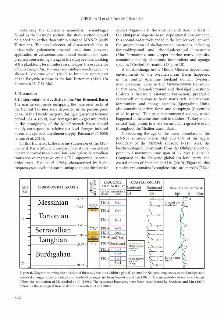
5. Discussion5.1. Interpretation of cyclicity in the Mut-Ermenek BasinThe marine sediments onlapping the basement rocks of the Central Taurides were deposited in the postorogenic phase of the Tauride orogeny, during a quiescent tectonic period. As a result, any transgressive–regressive cycles in the stratigraphy of the Mut-Ermenek Basin should mainly correspond to relative sea-level changes induced by eustatic cycles and sediment supply (Bassant et al. 2005; Janson et al. 2010).
In this framework, the marine succession of the Mut-Ermenek Basin (Mut and Köselerli formations) was at least in part deposited in an overall late Burdigalian-Serravallian transgressive–regressive cycle (TB2 supercycle, second-order cycle, Haq et al. 1988), characterized by high-frequency sea-level and coastal-onlap changes (third-order
cycles) (Figure 6). In the Mut-Ermenek Basin, at least in the Olukpınar slope-to-basin depositional environment, this second-order cycle ended in the late Serravallian with the progradation of shallow-water limestones, including foramol/bryomol and rhodalgal/coralgal limestones (Mut Formation), onto deeper marine marly deposits, containing mainly planktonic foraminifera and sponge spicules (Köselerli Formation) (Figure 2B).
A similar change in the Middle Miocene depositional environments of the Mediterranean Basin happened in the central Apennine foreland domain (western Mediterranean) close to the MNN5/MNN6 transition. In that area, foramol/bryomol and rhodalgal limestones (Calcari a Briozoi e Litotamni Formation) prograded extensively onto slope-to-basin marls rich in planktonic foraminifera and sponge spicules (Spongolitic Unit), also containing debris flows and slumpings (Cosentino et al. in press). This paleoenvironmental change, which happened at the same time both in southern Turkey and in central Italy, points to a late Serravallian regressive event throughout the Mediterranean Basin.
Considering the age of the lower boundary of the MNN5a subzone (~15.6 Ma) and that of the upper boundary of the MNN6b subzone (~11.9 Ma), the biochronological constraints from the Olukpınar section point to a maximum time span of 3.7 Myr (Figure 5). Compared to the Neogene global sea level curve and coastal onlaps of Snedden and Liu (2010) (Figure 6), this time interval contains 2 complete third-order cycles (TB2.4
Lan2/Ser1TB2.4
TB2.5
TB2.3
TB3.2
0.5 0.0 100 0 -100m
Messinian
Tortonian
SerravallianLanghian
Burdigalian
Me1
Tor2
Tor1
Ser3Ser2
Bur5/Lan1
Bur4Bur3Bur2Bur1
10
20Long-termtrend
Present day sea-level
13.82
11.61
7.25
15.97
20.43
5.33TB3.3
TB3.2
TB3.1
TB2.6TB2.5TB2.4
TB2.3
TB2.2
TB2.1
SEA-LEVEL CHANGECOASTAL ONLAPS
BasinwardLandwardSEQUENCE
TERMINOLOGYHaq et al.
(1988)Hardenbol et al.
(1998)
CHRONOSTRATIGRAPHYAGE(Ma)
Olukpınar section
Başyaylasection
STU
DY
SEC
TIO
NS
Major relativesea-level change
Minor relativesea-level change
14.78
13.65
12.76
20.43
19.1918.49
17.25
16.38
11.79
9.32
7.16
5.55
Figure 6. Diagram showing the position of the study sections within a global scheme for Neogene sequences, coastal onlaps, and sea-level changes. Coastal onlaps and sea-level changes are from Snedden and Liu (2010). The magnitudes of sea-level change follow the estimation of Hardenbol et al. (1998). The sequence boundary have been recalibrated by Snedden and Liu (2010) following the geological time scale from Gradstein et al. (2008).

833
CIPOLLARI et al. / Turkish J Earth Sci
and TB2.5) and part of the TB2.3 and TB2.6 cycles, at the base and the top of the Olukpınar section, respectively. However, taking into account the occurrence of the debris flows, which we interpret as related to falling stage system tracts (FSSTs), and the Köselerli/Mut transition within the Olukpınar section, which we relate to a transgressive-to-highstand transition, only 2 boundaries of the third-order sequence are recorded in the study section: TB2.3/TB2.4 and TB2.4/TB2.5 (Figure 6). According to Snedden and Liu (2010), the TB2.3/TB2.4 sequence boundary (14.78 Ma) corresponds to a major relative sea-level drop, whereas the younger TB2.4/TB2.5 sequence boundary (13.65 Ma) corresponds to a minor relative sea-level change.
Interestingly, the debris flows at the base of the TB2.4 and TB2.5 sequences in the Olukpınar section show different thicknesses likely related to the different amounts of sea level drop responsible for the genesis of those sequence boundaries (Figure 7). The MNN5/MNN6 transition at 13.6 Ma, which occurs at ~67 m of depth within the uppermost debris flow of the Olukpınar section (Figure 7), supports the notion of a debris flow triggered by the sea-level drop that occurred globally at 13.65 Ma (TB2.4/TB2.5 sequence boundary, Figure 6). In the Mut-Ermenek Basin, 2 similar debris flow and slumping deposits were reported by Bassant et al. (2005) within the upper Burdigalian marine deposits of the Mut succession (MNN4 calcareous nannofossil biozone). However, although according to the authors those debris flows were triggered by 2 Burdigalian sea level falls, they were related to the late highstands of 2 different sequences, instead of their relative falling stages.
Although mass gravity flows and related deposits could be triggered by different processes (e.g., margin oversteepening during sea-level highstands, seismic activity, or erosion during sea level lowstands), the most common process for triggering mass gravity flow on the slope is a relative sea-level fall with erosion of the basin margins (Handford & Loucks 1993; Scheibner et al. 2000, 2003; Drzewiecki & Simó 2002 and references therein; Warrlich et al. 2002; Bosence & Wilson 2003). Debris flows related to sea-level falls have been identified from different basins, from the Cambrian up to the Miocene (Drzewiecki & Simó 2002 and references therein). Scheibner et al. (2000, 2003), working on slope sediments of a Paleocene ramp-to-basin transition in NE Egypt, reported depositional facies quite similar to the facies recognized at the Olukpınar section, with hemipelagic marls and debris flow deposits that were related to transgressive/highstand and lowstand phases, respectively. According to our age model for the Olukpınar section, derived from an updated biostratigraphical scheme for nannofossils (Fornaciari et al. 1996), and the global/regional cyclicity of sea-level changes, the debris flows recognized at the Olukpınar section may be related to different phases of sea level fall.
The upper Tortonian marine deposits of the Başyayla section, which at ~8 Ma recorded a progradational event of shallow water foramol/bryomol and rhodalgal limestones onto offshore or intraplatform marls, containing mollusks, bryozoans, ostracods, benthonic and planktonic foraminifera, and calcareous nannofossils (Cosentino et al. 2012), are the upper part of a younger third-order cycle (TB3.2, Haq et al. 1988; Figure 6). In particular, the Başyayla section corresponds to the TST/HST transition of the TB3.2 sequence. The TB3 supercycle started in the earliest Tortonian (Figure 6), just after a major sea-level drop at the end of the Serravallian (TB2.6/TB3.1 transition, 11.79 Ma; Snedden & Liu 2010). The glacioeustatic sea-level lowstand at the base of cycle TB3.1, which marks the Serravallian/Tortonian transition, coincides with the Mi-5 isotope event and the deep-sea hiatus NH4 (Hilgen et al. 2005). This hiatus should also be present in the Mut-Ermenek Basin somewhere between the Olukpınar and Başyayla sections.
Unfortunately, in the marine sections sampled in the Mut-Ermenek Basin, we missed the Serravallian/Tortonian transition (11.61 Ma), which, according to Snedden and Liu (2010), happened very close to one of the major global ocean sea-level drops (~70 m) that occurred during the Miocene. This major sea-level drop, which occurred in the latest Serravallian (11.79 Ma), corresponds to the TB2/TB3 transition of the supercycles of Haq et al. (1988) (Figure 6). Although we did not recognize any exposure surface or forced regression facies corresponding to the TB2/TB3 transition in the Mut-Ermenek Basin (possibly due to bad exposure of the corresponding stratigraphical interval or unsuitable facies), in the Adana Basin, a well-developed erosional surface due to a relative sea-level drop characterizes the top of the Serravallian Güvenç Formation. Along the erosional surface, the early Tortonian terrestrial red beds of the Kuzgun Formation rest unconformably on the outer shelf clays and marls of the Güvenç Formation (Ünlügenç 1993). This erosional surface could be linked, at least in part, to the sea-level drop that happened during the latest Serravallian at the TB2/TB3 transition (Snedden & Liu 2010).5.2. The Olukpınar and Başyayla sections in the Middle-Late Miocene platform-basin system of the Mut-Ermenek BasinBoth of the sections that we sampled in the Mut-Ermenek Basin pertain to a complex platform-basin system. In particular, according to the age model provided in this paper for the Olukpınar section, the analyzed deeper marine sediments of the Köselerli Formation, which point to a basin-to-slope environment, are temporally equivalent to the shallow-water limestones of the Ermenek Platform (Janson et al. 2010) (Figure 7). These Langhian-Serravallian

834
CIPOLLARI et al. / Turkish J Earth Sci
ab
Age (Ma)
Polarity
MagnetoZones
Epoch
Stage
Martini &Müller (1986)
Okada &Bukry (1981)
Fornaciari et al. (1996)
ATN
TS 2
004
Chr
ono-
stra
tigra
phy
Cal
care
ous n
anno
foss
ilsbi
ostr
atig
raph
y
8 9 10 11 12 13 14 15 16 17 18 19C
5Er
C5E
n
C5D
r
C5D
nC
5Cr
C5C
n
C5B
r
C5B
n- D
rC
5An
C5A
Cn
C5A
An
C5A
Br
C5A
r
C5A
n
C5r
C5n
C4A
r
C4A
n
C4r
C4n
Mioceneearlymiddlelate
NN
11
NN
10
NN
9
NN
8
NN
7
NN
6
NN
5
NN
4
NN
3C
N2
CN
3
CN
4
CN5
CN5CN6
CN
7
CN
8
CN
9
MN
N3a
-b
MN
N4a
MN
N4b
MN
N5a
MN
N5b
MN
N6b MN
N6a
MN
N 7
MN
N 8ab
MN
N 9
MN
N
10
BurdigalianLanghianSerravallianTortonian
50 40 30 20 10 0
110
100 90 80 70 60 50 40 30 20 10 0
MNN5aMNN5bMNN6aMNN6b
MNN10
<15.
6 M
a
13.6
Ma
13.1
Ma
14.4
Ma
300
250
200
150
100 50 0
NN4NN5NN6 15.6
Ma
13.6
Ma
Başy
ayla
sect
ion
(Cos
entin
o et
al.,
201
2)O
lukp
ınar
sect
ion
(thi
s pap
er)
Erm
enek
Pla
tform
(Jan
son
et a
l., 2
010)
PLT
INT
STB
SBSB
LSTTSTHSTHST TST LSTTB2.4TB2.5
TB3.2 Accommodation space -+
FSSTFSSTFi
gure
7. C
orre
latio
n pa
nel a
mon
g th
e stu
dy se
ctio
ns (B
aşya
yla
and
Olu
kpın
ar se
ctio
ns) a
nd th
e com
posit
e sec
tion
for t
he E
rmen
ek p
latfo
rm (J
anso
n et
al.
2010
). PL
T:
carb
onat
e pla
tform
; IN
T: in
trap
latfo
rm d
eepe
r mar
ine d
epos
its, S
TB: s
lope
-to-
basin
dee
per m
arin
e dep
osits
, SB:
sequ
ence
bou
ndar
y, LS
T: lo
wst
and
syst
ems t
ract
, TST
: tr
ansg
ress
ive
syst
ems t
ract
, HST
: hig
hsta
nd sy
stem
s tra
ct.

835
CIPOLLARI et al. / Turkish J Earth Sci
deeper marine marls of the Köselerli Formation extensively crop out to the south and to the west of Ermenek in the Olukpınar and Başyayla areas, respectively. Thus, the extent of the Miocene carbonate platform in those areas, as suggested by many authors (Gedik et al. 1979; Şenel 2002; Ulu 2002; Bassant et al. 2005; Janson et al. 2010; Pomar et al. 2012), should be greatly revised for this time interval, since those maps mainly depict the area of the deeper marine marls as within the younger Serravallian carbonate platform.
The long-term transgressive–regressive cycle of the Olukpınar section, which corresponds to the middle-upper part of the TB2 supercycle of Haq et al. (1988) (Figure 6), can be subdivided into at least 2 cycles of 106-year scale based on the occurrence of 2 thick debris flow deposits (debris flows 2 and 4), containing shallow water components derived from the edge of a carbonate platform. At that time, a composite platform system was developing to the north of the Olukpınar area (Ermenek platform, Janson et al. 2010). The N-S channel axes of these remobilized carbonate sediments imply that shallow-water carbonate debris flowed from north, which is consistent with the facies distribution of the platform-basin system of the Middle Miocene Mut-Ermenek Basin (Janson et al. 2010).
The debris flow deposits intercalated within the deeper marine marls of the Köselerli Formation are interpreted as strictly linked to the sea-level drops that happened during the middle Langhian (14.78 Ma) and the early Serravallian (13.65 Ma) (Figure 6). As stated before, according to the age model presented in this paper, these 2 cycles of 106-year scale (third-order cycles) correspond to the TB2.4 and TB2.5 cycles of Haq et al. (1988). In each 106-year-scale cycle recognized in the Olukpınar section, the debris flow deposits (FSSTs) together with the less distinguishable sediments of the lowstand systems tract (LST) pass upwards into marls with planktonic foraminifera and sponge spicules, which could be generally related to a long period of sea-level rise, containing both the transgressive systems tract (TST) and the highstand systems tract (HST). A hiatus could be interpreted at the TB2.4/TB2.5 transition, due to the erosional character of the bottom of the debris flow deposits and the removal of some HST deposits of the TB2.4 cycle. The HST of the younger third-order cycle (TB2.5) contains shallow-water limestones, such as coral boundstones and red algae bindstones, very similar to the Serravallian shallow-water limestones at the top of the Ermenek platform (Janson et al. 2010). The occurrence of shallow water limestones on top of the Serravallian deeper water marls of the Köselerli Formation document an infra-Serravallian sea-level highstand, which induced reduction of the accommodation space and consequent progradation, with forestepping geometries, of the shallow-water sediments toward the slope-to-basin depositional environment.
In the carbonate succession of the Ermenek platform, which was the shallow-water counterpart of the Olukpınar deeper water marine succession, based on the depositional geometries and the vertical and lateral facies variation, Janson et al. (2010) distinguished 2 large-scale sequences that may be correlated with the large-scale cycles that we suggest for the Olukpınar section (Figure 7). 5.3. Age constraints from the Mut-Ermenek Basin for the uplift of the CAP southern marginThe calcareous nannofossil biochronology of the Mut-Ermenek Basin presented here confirms the Langhian-Serravallian age (MNN5-MNN6 biozone) for the majority of the marine sediments onlapping the southern margin of the CAP, already provided from previous work on different sections of the same area (Janson et al. 2010). In this paper, adopting an updated biostratigraphical scheme for reference (Fornaciari et al. 1996), we were also able to identify the calcareous nannofossil subzone within the MNN5-MMN6 interval (MNN5a, MNN5b, MNN6a, and MNN6b), allowing us to better constrain the age of the Olukpınar section and to improve the possible correlations among other Middle Miocene deeper marine sections in the Mediterranean Basin.
In the Mut-Ermenek Basin, a younger sedimentary cycle showing a transgressive–regressive trend was recognized at the top of the marine succession cropping out in the vicinity of the town of Başyayla (Cosentino et al. 2012). In the Başyayla section, the presence of Helicosphaera stalis throughout the analyzed succession implies that the youngest marine deposits capping the Tauride basement rocks at the southern margin of the CAP are at least as young as early Tortonian (MNN8b). According to Cosentino et al. (2012), planktonic foraminifera and magnetostratigraphy tightly constrain the upper part of the section to the interval of 8.35–8.108 Ma (late Tortonian), constraining the uplift of the CAP southern margin at a post-8 Ma age.
The youngest portion of the late Tortonian sedimentary cycle recognized in the Başyayla section was recently found in the Beyşehir area (Sarıalan section, Deynoux et al. 2005; Flecker et al. 2005; Schildgen et al. 2012b), where above upper Tortonian deeper marine sediments lower Messinian shallow-water marine deposits constrain the onset of surface uplift in a period younger than 6.7 Ma (early Messinian) (Schildgen et al. 2012b).5.4. Middle-Late Miocene paleogeography of the Eastern Mediterranean Basin in southern TurkeyIn southern Turkey, following the earlier uplift phase linked to the central Tauride orogeny, continental sedimentary basins mainly connected with postorogenic extensional tectonics developed throughout the southern margin of the central Taurides with the deposition of fluvial conglomerates and fine-grained lacustrine deposits

836
CIPOLLARI et al. / Turkish J Earth Sci
(Yenimahalle and Fakırca formations in the Mut-Ermenek Basin, and Karsantı and Gildirli formations in the Adana Basin). Subsequently, during a quiescent tectonic period, 2 long-term transgressive–regressive cycles (second-order cycles) were responsible for changing the paleogeography of the marginal area of the Eastern Mediterranean Basin. The first transgression phase, happening early within the TB2 supercycle, started in the late Burdigalian with the deposition of marine deposits related to the evolution of platform-basin systems in both the Mut-Ermenek Basin (Mut and Köselerli formations; Tanar & Gökçen 1990; Şafak et al. 2005) and in the Adana Basin (Karaisalı and Kaplankaya formations; Gürbüz 1993; Gürbüz & Kelling 1993; Cronin et al. 2000).
The innermost and highest evidence for coastal onlap on the basement rocks of the Taurides, indicating a major transgression event, are related to marine deposits pertaining to the TB3 supercycle (Figure 7). In particular, in the Başyayla area, the onlap surface of the youngest marine deposits of this transgressive cycle (late Tortonian, ~8 Ma; Cosentino et al. 2012) reaches an elevation of 2 km. Additionally, the upper Tortonian-lower Messinian marine succession, recently found in the Beyşehir area (Sarıalan section, Deynoux et al. 2005; Flecker et al. 2005; Schildgen et al. 2012b), showing upper Tortonian shallow-water deposits unconformably overlying highly deformed Triassic limestones, indicates a late Miocene (late Tortonian) transgression of the Eastern Mediterranean Sea onto the interior of the Anatolian Peninsula, reaching at least the Başyayla and Beyşehir areas.
At that time, before the uplift of the CAP southern margin, the paleogeography of southern Turkey was very close to the reconstruction at 7 Ma suggested by Schildgen et al. (2012b) showing the coastal area of the Mediterranean Sea in the interior of the Anatolian Peninsula, more than 100 km inland from its present position.
6. ConclusionsThe stratigraphy and the nannofossil biochronology of the Olukpınar and the Başyayla sections of southern Turkey
help to better understand the evolution of the marine succession of the Mut-Ermenek Basin onlapping the CAP southern margin. The Olukpınar section shows calcareous nannofossil assemblages associated with the biozones between MNN5a and MNN6b, corresponding to a time interval between ~15.6 Ma and ~12.5 Ma (late Langhian-late Serravallian). The section includes deep marine marls and remobilized sediments (debris flow deposits) coming from the shelf edge of the Middle Miocene Ermenek platform.
The Başyayla section (late Tortonian, ~8 Ma) corresponds to the youngest sedimentary cycle within the marine succession onlapping the CAP southern margin. It defines the maximum age in the Mut-Ermenek Basin for starting the uplift of the plateau margin.
The marine succession capping the southern margin of the CAP was deposited during a quiescent tectonic period. In this framework, facies changes, forestepping geometries, and backstepping geometries are mainly related to glacioeustatic sea-level changes. The Olukpınar section correlates with the TB2.4 and TB2.5 cycles, whereas the Başyayla section correlates with the TB3.2 cycle.
The major transgressive event at the southern margin of the CAP, which happened within the TB3.2 cycle (late Tortonian), brought the coastal onlap of the Mediterranean Sea toward the interior of the Anatolian Peninsula, almost 100 km from the present Eastern Mediterranean coast line.
AcknowledgmentsThis work is part of the Vertical Anatolian Movements Project (VAMP), funded by the TOPO-EUROPE initiative of the European Science Foundation, including contribution by the IGAG-CNR (com. TA.P05.009, mod. TA.P05.009.003) and by the APVV (Agentúra na podporu výskumu a vývoja; Slovak Research and Development Agency) (EC–009-07). The manuscript benefited from helpful reviews by Taylor Schildgen. We greatly appreciate the useful comments and suggestions of Xavier Janson and 2 anonymous reviewers, which improved the paper.
References
Akay, E. & Uysal, Ş. 1988. Post-Eocene tectonics of the central Taurus Mountains. Mineral Res. Expl. Bull. 108, 23–34.
Akay, E., Uysal, S., Poisson, A., Cravatte, J. & Müller, C. 1985. Stratigraphy of the Antalya Neogene Basin. Bull. Geol. Soc. Turkey 28, 105–119.
Aksu, A.E., Calon, T.J., Piper, D.J.W., Turgut, S. & Izdar, E. 1992. Architecture of late orogenic Quaternary basins in northeastern Mediterranean Sea. Tectonophysics 210, 191–213.
Bassant, P., Van Buchem, F.S.P., Strasser, A. & Görür, N. 2005. The stratigraphic architecture and evolution of the Burdigalian carbonate-siliciclastic sedimentary systems of the Mut Basin, Turkey. Sedimentary Geology 173, 187–232.
Bosence, D.W.J. & Wilson, R.C.L. 2003. Sequence stratigraphy of carbonate depositional systems. In: Coe, A.L. (ed), The Sedimentary Record of Sea-Level Change. The Open University, Cambridge, 234–256.
Bozkaya, Ö. & Yalçin, H. 2000. Very low grade metamorphism of upper Paleozoic-lower Mesozoic sedimentary rocks related to burial and thrusting in the central Taurus Belt, Konya, Turkey. International Geology Review 42, 353–367.
Cosentino, D., Miccadei, E., Barberi, R., Basilici, G., Cipollari, P., Parotto, M. & Piacentini, T. In press. Explanatory Notes of the Geological Map of Italy, Scale 1:50,000, Sheet 357-Cittaducale (in Italian). Available at http://www.isprambiente.gov.it/Media/carg/note_illustrative/357_Cittaducale.pdf.
837
CIPOLLARI et al. / Turkish J Earth Sci
Cosentino, D., Schildgen, T.F., Cipollari, P., Faranda, C., Gliozzi, E., Hudáčková, N., Lucifora, S. & Strecker, M.R. 2012. Late Miocene surface uplift of the southern margin of the Central Anatolian plateau, Central Taurides, Turkey. Geological Society of America Bulletin 124, 133–145.
Cronin, B.T., Gürbüz, K., Hurst, A. & Satur, N. 2000. Vertical and lateral organization of a carbonate deep-water slope marginal to a submarine fan system, Miocene, southern Turkey. Sedimentology 47, 801–824.
Deynoux, M., Çiner, A., Monod, O., Karabıyıkoğlu, M., Manatschal, G. & Tuzcu, S. 2005. Facies architecture and depositional evolution of alluvial fan to fan-delta complexes in the tectonically active Miocene Köprüçay Basin, Isparta Angle, Turkey. Sedimentary Geology 173, 315–343.
Dixon, J.E. & Robertson, A.H.F. 1984. The geological evolution of the eastern Mediterranean. Geol. Soc., London, Spec. Publ. 17.
Drzewiecki, P.A. & Simó, J.A. 2002. Depositional processes, triggering mechanisms and sediment composition of carbonate gravity flow deposits: examples from the Late Cretaceous of the south-central Pyrenees, Spain. Sedimentary Geology 146, 155–189
Eris, K.K., Bassant, P. & Ülgen, U.B. 2005. Tectono-stratigraphic evolution of an Early Miocene incised valley-fill (Derinçay Formation) in the Mut Basin, Southern Turkey. Sedimentary Geology 173, 151–185.
Faranda, C., Gliozzi, E., Cipollari, P., Grossi, F., Darbaş, G., Gürbüz, K., Nazik, A., Gennari, R. & Cosentino, D. 2013. Messinian paleoenvironmental changes in the easternmost Mediterranean Basin (Adana Basin, Southern Turkey). Turkish Journal of Earth Sciences doi:10.3906/yer-1205-11.
Flecker, R., Poisson, A. & Robertson, A.H.F. 2005. Facies and palaeogeographic evidence for the Miocene evolution of the Isparta Angle in its regional eastern Mediterranean context. Sedimentary Geology 173, 277–314.
Fornaciari, E., Backman, J. & Rio, D. 1993. Quantitative distribution patterns of selected lower to middle Miocene calcareous nannofossils from the Ontong Java Plateau. In: Berger, W.H., Kroenke, L.W., Mayer, L.A. (eds), Proceedings of the Ocean Drilling Program, Scientific Results 130. ODP, College Station, TX, USA, 245–256.
Fornaciari, E., Di Stefano, A., Rio, D. & Negri, A. 1996. Middle Miocene quantitative calcareous nannofossil biostratigraphy in the Mediterranean region. Micropaleontology 42, 37–63.
Gedik, A., Birgili, S., Yilmaz, H. & Yoldas, R. 1979. Geology of the Mut-Ermenek-Silifke (Konya, Mersin) area and petroleum possibilities. B. Geol. Soc. Turkey 22, 7–26.
Görür, N. 1992. A tectonically controlled alluvial fan which developed into a marine fan-delta at a complex triple junction: Miocene Gildirli Formation of the Adana Basin, Turkey. Sedimentary Geology 81, 245–252.
Gradstein, F.M., Ogg, J.G. & Smith, A.G. (eds) A Geologic Time Scale 2004. Cambridge University Press, Cambridge, 469–471.
Gürbüz, K. 1993. Identification and Evolution of Miocene Submarine Fans, in the Adana Basin, Turkey. PhD, University of Keele.
Gürbüz, K. & Kelling, G. 1993. Provenance of Miocene submarine fans in the northern Adana Basin, southern Turkey: a test of discriminant function analysis. Geological Journal 28, 277–293.
Handford, C.R. & Loucks, R.G. 1993. Carbonate depositional sequences and systems tracts—responses of carbonate platforms to relative sea-level change. In: Loucks, R.G. & Sarg, R. (eds), Carbonate Sequence Stratigraphy; Recent Advances and Applications. American Association of Petroleum Geologists Memoir 57, 3–41.
Haq, B.U., Hardenbol, J. & Vail, P.R. 1988. Mesozoic and Cenozoic chronostratigraphy and cycles of sea level change. In: Wilgus, C.K., Hastings, B.S., Kendall, C.G.St.C., Posamentier, H.W., Ross, C.A. & Van Wagoner, J.C. (eds), Sea-Level Changes: An Integrated Approach. SEPM Spec. Publ. 42, 109–124.
Hilgen, H., Aziz, H.A., Bice, D., Iaccarino, S., Krijgsman, W., Kuiper, K., Montanari, A., Raffi, I., Turco, E. & Zachariasse, W.J. 2005. The Global boundary Stratotype Section and Point (GSSP) of the Tortonian Stage (Upper Miocene) at Monte Dei Corvi. Episodes 28, 6–17.
Iaccarino, S.M., Premoli Silva., I., Biolz, M., Foresi, L.M., Lirer, F., Urco, E. & Petrizzo, M.R. 2007. Practical manual of Neogene Planktonic foraminifera. International School on Planktonic Foraminifera. VI course: Neogene. Perugia (Italy), 19–23 February 2007, 1–181.
Janson, X., van Buchem, F.S.P., Dromart, G., Eichenseer, H.T., Dellamonica, X., Boichard, R., Bonnaffe, F. & Eberli, G. 2010. Architecture and facies differentiation within a Middle Miocene carbonate platform, Ermenek, Mut Basin, southern Turkey. Geological Society, London, Special Publications 329, 265–290.
Jarvis, A., Reuter, H.I., Nelson, A. & Guevara, E. 2008. Hole-Filled Seamless SRTM Data V4. International Centre for Tropical Agriculture (CIAT). Available at http://srtm.csi.cgiar.org (last accessed May 2008).
Jolivet, L. & Faccenna, C., 2000. Mediterranean extension and the Africa-Eurasia collision. Tectonics 19, 1095–1106.
Kempler, D. & Ben-Avraham, Z., 1987. The tectonic evolution of the Cyprean arc. Annales Tectonicae 1, 58–71.
Lourens, L., Hilgen, F., Shackleton, N.J., Laskar, J. & Wilson, J. 2004. Appendix 2. Orbital tuning calibrations and conversions for the Neogene Period. In: Gradstein, F.M., Ogg, J.G., & Smith, A.G. (eds), A Geologic Time Scale 2004. Cambridge University Press, Cambridge, 469–471.
Martini, E. & Müller, C. 1986. Current Tertiary and Quaternary calcareous nannoplankton stratigraphy and correlations. Newsl. Stratigr. 16, 99–112.
Okada, H. & Bukry, D. 1981. Supplementary modification and introduction of code numbers to the low-latitude coccolith biostratigraphic zonation (Bukry, 1973; 1975). Marine Micropaleontology 5, 321–325.
Özgül, N. 1997. Stratigraphy of tectonostratigraphic units in the Bozkir-Hadim-Taskent around northern part of Central Taurus. Bull. Mineral Res. Explorat. 119, 113–174.

838
CIPOLLARI et al. / Turkish J Earth Sci
Pomar, L., Bassant, P., Brandano, M., Ruchonnet, C. & Janson, X. 2012. Impact of carbonate producing biota on platform architecture: insights from Miocene examples of the Mediterranean region. Earth-Science Reviews 113, 186–211.
Raffi, I., Rio, D., d’Atri, A. Fornaciari, E. & Rocchetti, S. 1995. Quantitative distribution patterns and biomagnetostratigraphy of Middle and Late Miocene calcareous nannofossils from Equatorial Indian and Pacific Oceans (Legs 115, 130, and 138). In: Pisias, N.G., Mayer, L.A., Janecek, T.R., Palmer-Julson, A. & van Andel, T.H. (eds), Proceedings of the Ocean Drilling Program, Scientific Results 138. ODP, College Station, TX, USA, 479–502.
Robertson, A.H.F. 1998. Tectonic significance of the Eratosthenes Seamount: a continental fragment in the process of collision with a subduction zone in the eastern Mediterranean (Ocean Drilling Program Leg 160). Tectonophysics 298, 63–82.
Robertson, A.H.F. 2000. Tectonic evolution of Cyprus in its easternmost Mediterranean setting. In: Panayides, I., Xenophontos, C. & Malpas, J. (eds), Proceedings of the Third International Conference on the Geology of the Eastern Mediterranean, Geological Survey Department, Republic of Cyprus, 11–44.
Robertson, A.H.F. & Grasso, M. 1995. Overview of the Late Tertiary-recent tectonic and paleoenvironmental development of the Mediterranean region. Terra Nova 7, 114–127.
Şafak, Ü., Kelling, G., Gökçen, N.S. & Gürbüz, K. 2005. The mid-Cenozoic succession and evolution of the Mut basin, southern Turkey, and its regional significance. Sedimentary Geology 173, 121–150.
Scheibner, C., Kuss, J. & Marzouk, A.M. 2000. Slope sediments of a Paleocene ramp-to-basin transition in NE Egypt. International Journal of Earth Sciences 88, 708–724.
Scheibner, C., Reijmer, J.J.G., Marzouk, A.M., Speijer, R.P. & Kuss, J. 2003. From platform to basin: the evolution of a Paleocene carbonate margin (Eastern Desert, Egypt). International Journal of Earth Sciences 92, 624–640.
Schildgen, T.F., Cosentino, D., Bookhagen, B., Niedermann, S., Yildirim, C., Echtler, H.P. & Strecker, M.R. 2012a. Multi-phased uplift of the southern margin of the Central Anatolian plateau, Turkey: a record of tectonic and upper mantle processes. Earth and Planetary Science Letters 317–318, 85–95.
Schildgen, T.F., Cosentino, D., Caruso, A., Buchwaldt, R., Yildirim, C., Bowring, S.A., Rojay, B., Echtler, H. & Strecker, M.R. 2012b. Surface expression of Eastern Mediterranean slab dynamics: Neogene topographic and structural evolution of the SW margin of the Central Anatolian Plateau, Turkey. Tectonics 31, TC2005.
Şenel, M. 2002. Geological Map of Turkey, Konya (No. 14). Scale 1:500,000, 1 sheet. Ankara, Turkey, Maden Tetkik ve Arama Genel Müdürlüğü (MTA).
Şengör, A.M.C. & Yilmaz, Y. 1981. Tethyan evolution of Turkey: a plate tectonic approach. Tectonophysics 75, 181–241.
Snedden, J.W. & Liu, C. 2010. A compilation of Phanerozoic sea-level change, coastal onlaps, and recommended sequence designations. AAPG, Search and Discovery Article #40594. Available at http://www.searchanddiscovery.com/documents/2010/40594snedden/ndx_snedden.pdf.
Tanar, Ü. & Gökçen, N. 1990. Mut-Ermenek Tersiyer istifinin stratigrafisi ve mikropaleontolojisi. MTA Dergisi 110, 175–180 (in Turkish).
Ulu, Ü. 2002. Geological Map of Turkey, Adana (No. 15). Scale 1:500,000, 1 sheet. Ankara, Turkey, Maden Tetkik ve Arama Genel Müdürlüğü (MTA).
Ünlügenç, U.C. 1993. Controls on Cenozoic Sedimentation, Adana Basin, Southern Turkey. PhD, University of Keele.
Warrlich, G.M.D., Waltham, D.A. & Bosence, D.W.J. 2002. Quantifying the sequence stratigraphy and drowning mechanisms of atolls using a new 3-D forward stratigraphic modelling program (CARBONATE 3D). Basin Research 14, 379–400.
Williams, G.D. & Ünlügenç, U.C. 1992. Structural controls on stratigraphic evolution of the Neogene Çukurova basin complex. International Workshop on Work in Progress on Geology of Turkey, Abstracts, Keele University England, 79–80.