Analysis of innovative challenges
226
D 2.2 Analysis of Innovative Challenges 1/226 ECP-2008-GEO-318007 Plan4all Analysis of Innovative Challenges Deliverable number D2.2 Dissemination level Public Delivery date 16 th November 2009 Status Final Authors Clemens Beyer (CEIT Alanova) Wolfgang W. Wasserburger (CEIT Alanova) Runar Bergheim (AviNet), Pēteris Brūns (TDF), Karel Charvat (HSRS), Miroslav Dvorak (Olomouc), Petr Horak (HF), Julia Neuschmid (CEIT Alanova), Dimitrov Stelian (EPF), Norma Zanetti (Hyperborea) eContentplus This project is funded under the eContentplus programme1, a multiannual Community programme to make digital content in Europe more accessible, usable and exploitable. 1 OJ L 79, 24.3.2005, p. 1.
-
Upload
independent -
Category
Documents
-
view
3 -
download
0
Transcript of Analysis of innovative challenges

D 2.2 Analysis of Innovative Challenges
1/226
ECP-2008-GEO-318007
Plan4all
Analysis of Innovative Challenges
Deliverable number D2.2
Dissemination level Public
Delivery date 16th
November 2009
Status Final
Authors Clemens Beyer (CEIT Alanova)
Wolfgang W. Wasserburger (CEIT Alanova)
Runar Bergheim (AviNet), Pēteris Brūns (TDF),
Karel Charvat (HSRS), Miroslav Dvorak
(Olomouc), Petr Horak (HF), Julia Neuschmid
(CEIT Alanova), Dimitrov Stelian (EPF), Norma
Zanetti (Hyperborea)
eContentplus
This project is funded under the eContentplus programme1,
a multiannual Community programme to make digital content in Europe more accessible, usable and exploitable.
1
OJ L 79, 24.3.2005, p. 1.

D 2.2 Analysis of Innovative Challenges
2/226
1 Abstract
Plan4all is a European project dealing with spatial planning data interoperability, har-
monisation and Spatial Data Infrastructure building. The project is organised in nine
work packages (WP), which are further structured into several tasks. This deliverable
presents the results of task 2.2 which is part of WP2 – the state of the art analysis –
and has the objective to analyse latest developments and innovative challenges in
SDI building for spatial planning in Europe. The objective of this deliverable is to
assist to pilot partners deploy their infrastructure in WP6.1, to prepare recommenda-
tion for possible platforms. The deliverable use results of other two deliverables D 2.1
―Identification of leading regional and local administration in building SDI for spatial
planning‖ describing the detailed situation in single European countries (the report
provides a general survey on SDI and spatial planning data in each partner country)
and D 2.3 ―INSPIRE Requirements Analysis‖, which analyses requirements coming
from INSPIRE directive. The results are based on an analysis of information about
relevant software classified according a framework for software classification based
on INSPIRE architecture, spataial planning needs and a collection of best practice
projects.

D 2.2 Analysis of Innovative Challenges
3/226
2 Contents
1 Abstract .............................................................................................................. 2
2 Contents ............................................................................................................. 3
3 Introduction ....................................................................................................... 7
3.1 Objectives ............................................................................................................. 7
3.2 Structure ............................................................................................................... 7
3.3 Methodology......................................................................................................... 7
4 From Geographic Information Systems to Spatial Data Infrastructure
building ...................................................................................................................... 9
4.1 History and state of the art .................................................................................. 9
4.1.1 Computer Aided Design (CAD) .......................................................................................... 9
4.1.2 Geographic Information Systems (GIS) ........................................................................... 10
4.1.3 Web Mapping ................................................................................................................... 10
4.1.4 Service-Oriented Architecture .......................................................................................... 12
4.1.5 Web 2.0 ............................................................................................................................ 13
4.2 Standards ............................................................................................................13
4.2.1 W3C ................................................................................................................................. 13 4.2.1.1 Extensible Markup Language (XML) ....................................................................... 13 4.2.1.2 Simple Object Access Protocol (SOAP) ................................................................. 14 4.2.1.3 Web Service Description Language (WSDL) .......................................................... 14
4.2.2 OASIS .............................................................................................................................. 15 4.2.2.1 ebXML ..................................................................................................................... 15 4.2.2.2 UDDI ........................................................................................................................ 15
4.2.3 OGC ................................................................................................................................. 15 4.2.3.1 Geography Markup Language (GML) ..................................................................... 16 4.2.3.2 KML ......................................................................................................................... 18 4.2.3.3 Web mapping services (WMS) ............................................................................... 18 4.2.3.4 Web Map Tile Server (WMTS) ................................................................................ 18 4.2.3.5 Web feature services (WFS) ................................................................................... 19 4.2.3.6 Web coverage services (WCS) ............................................................................... 19 4.2.3.7 Styled Layer Descriptor (SLD) ................................................................................ 20 4.2.3.8 Web Map Context ................................................................................................... 20 4.2.3.9 Catalogue Service (CSW) ....................................................................................... 20 4.2.3.10 Web Processing Services (WPS) ........................................................................... 21
4.2.4 ISO (International Standardisation Organisation) Metadata standards ........................... 22
4.2.5 De Facto Standards ......................................................................................................... 23
4.3 Policy ...................................................................................................................23
4.3.1 INSPIRE ........................................................................................................................... 23
4.4 Initiatives .............................................................................................................24
4.4.1 UNSDI .............................................................................................................................. 24
4.4.2 GMES .............................................................................................................................. 25
4.4.3 GEOSS ............................................................................................................................ 25

D 2.2 Analysis of Innovative Challenges
4/226
5 Framework for classifying technologies and services ................................ 26
5.1 Classification given by Plan4all extension of INSPIRE Networking
Architecture ....................................................................................................................26
5.2 Classification by standards ................................................................................26
5.3 Classification by technology ..............................................................................26
5.3.1 Client-Side (User Interface) ............................................................................................. 27 5.3.1.1 File transfer technology ........................................................................................... 27 5.3.1.2 Thin Client Web Maps ............................................................................................. 27 5.3.1.3 Thick Client Web Maps ........................................................................................... 27 5.3.1.4 Standalone Web Map Applications ......................................................................... 28 5.3.1.5 GIS with ability to use online data ........................................................................... 28 5.3.1.6 Browser Extensions ................................................................................................ 28 5.3.1.7 Web-based 3D graphics .......................................................................................... 29 5.3.1.8 Web Browser with scripting extensions .................................................................. 30
5.3.2 Serverside ........................................................................................................................ 30 5.3.2.1 Application server .................................................................................................... 30 5.3.2.2 Tile server and ―cookie cutter‖................................................................................. 30 5.3.2.3 File interpreting ....................................................................................................... 30 5.3.2.4 Mapserver with database backend ......................................................................... 31 5.3.2.5 Mapserver with more intelligent functions ............................................................... 31 5.3.2.6 Middleware .............................................................................................................. 31 5.3.2.7 Geodatabases ......................................................................................................... 31
5.4 Classification by Service ....................................................................................31
5.4.1 State of the art ................................................................................................................. 31 5.4.1.1 Proprietary mapping services.................................................................................. 31 5.4.1.2 Direct SQL Requests to Geodatabases .................................................................. 31
5.5 Products ..............................................................................................................32
5.5.1 Template with answering suggestions ............................................................................. 32
5.6 Selected Product overview .................................................................................33
6 Chances, potentials, risks of data infrastructure applications ................... 39
6.1 Data Storage ........................................................................................................39
6.1.1 Any time access and combined access ........................................................................... 39
6.1.2 Redundancy ..................................................................................................................... 39
6.2 Data Display ........................................................................................................41
6.2.1 Generalisation .................................................................................................................. 41
6.2.2 Web mapping vs. cartography ......................................................................................... 42
6.3 Legal obligation ..................................................................................................43
6.4 Incorrect data use ...............................................................................................43
6.5 Derived datasets .................................................................................................43
6.6 Metadata ..............................................................................................................44
6.6.1 Metadata quality............................................................................................................... 44
7 Data evaluation and quality criteria ............................................................... 45

D 2.2 Analysis of Innovative Challenges
5/226
7.1 Why Data Quality? ..............................................................................................45
7.2 Aspects of Data Quality ......................................................................................45
7.2.1 Accuracy .......................................................................................................................... 46
7.2.2 Completeness .................................................................................................................. 46
7.2.3 Consistency ..................................................................................................................... 47
7.2.4 Currency .......................................................................................................................... 47
7.2.5 Timeliness ........................................................................................................................ 48
7.2.6 Volatility ............................................................................................................................ 48
7.2.7 Accessibility ..................................................................................................................... 48
7.2.8 Interpretability .................................................................................................................. 48
7.3 How to Achieve Data Quality ..............................................................................49
7.4 Summary .............................................................................................................49
8 Detailed examination of existing related EU initiatives and projects ......... 51
8.1 Initiatives, Projects and Best Practises in detail ..............................................51
8.1.1 Overview .......................................................................................................................... 51
8.1.2 Collection ......................................................................................................................... 53
8.2 Overview of the European Initiatives, Projects and Best Practise
Documentation ............................................................................................................. 103
8.2.1 Analysis of European Initiatives, Projects and Best Practise Documentation ............... 103 8.2.1.1 Thematic Groups of projects ................................................................................. 103 8.2.1.2 Used technology/software ..................................................................................... 105 8.2.1.3 Accessibility ........................................................................................................... 105 8.2.1.4 Weaknesses and challenges ................................................................................ 105
8.2.2 Comparison of Best Practise projects with Plan4all ...................................................... 108
8.3 Summary ........................................................................................................... 110
9 Conclusion – Innovative Challenges ........................................................... 112
9.1 Complexity of planning process ...................................................................... 112
9.2 Different legal context ...................................................................................... 113
9.3 Cross-border accuracy ..................................................................................... 113
9.4 Differences in the use of terms ........................................................................ 114
9.5 Differences between cultures .......................................................................... 114
9.6 Lack of topology ............................................................................................... 114
9.7 Geodata and time .............................................................................................. 115
9.8 Technology ........................................................................................................ 116
9.8.1 General .......................................................................................................................... 116
9.8.2 Alternative Methods ....................................................................................................... 116 9.8.2.1 Collaborative Mapping .......................................................................................... 116 9.8.2.2 Crowdsourcing ...................................................................................................... 117
9.9 Sustainability..................................................................................................... 117
D 2.2 Analysis of Innovative Challenges
6/226
9.10 Organisational Challenges ............................................................................... 117
10 Sources and short Glossary ..................................................................... 118
10.1 Sources.............................................................................................................. 118
10.2 Glossary ............................................................................................................ 118
11 Annex A: Known Software ........................................................................ 119
11.1 Graphic Standards ............................................................................................ 119
11.2 Commercial Software ....................................................................................... 121
11.3 Commercial Software (partly without costs) ................................................... 150
11.4 Open Source Software ...................................................................................... 153
11.5 Portals ............................................................................................................... 198
11.6 Popular services without costs........................................................................ 199
11.7 Open data projects............................................................................................ 201
12 Annex B: Survey results ........................................................................... 202
12.1 Assessment of national and regional policies ................................................ 202
12.1.1 Legal Situation ........................................................................................................... 202
12.1.2 Data Management ..................................................................................................... 207
12.1.3 Survey answers regarding metadata ......................................................................... 208
12.2 Spatial Data Infrastructures: State of the Art (survey evaluation) ................. 211
12.2.1 SDI Organisation ....................................................................................................... 212
12.2.2 Interoperability and Metadata .................................................................................... 215
12.2.3 SDI Coordination ....................................................................................................... 218
12.2.4 National Geodatabases ............................................................................................. 220
12.2.5 Conclusion from this section of the survey ................................................................ 222
12.3 Used software ................................................................................................... 223
D 2.2 Analysis of Innovative Challenges
7/226
3 Introduction
3.1 Objectives
Plan4all focuses on the interoperability and harmonisation of spatial planning data
based on the existing best practises in European regions and municipalities and the
results of current research projects. The project involves a detailed description and
summary of the current situation and standards, proposal, testing and implementation
of spatial planning metadata profile, common data model and harmonisation
procedures. The important parts of Plan4all are networking standards of spatial plan-
ning data, based on previously collected and analysed experiences. Furthermore,
common procedures and methods for spatial data sharing will be defined as well as
the use of new pan-European standards for spatial planning data within the EU.
Expected results from Plan4all are European forums for SDI (Spatial Data Infra-
structure) in spatial planning, a database and analysis in terms of organisation,
sharing and harmonisation as well as SDI recommendations for spatial planning.
Plan4all also focuses on implementing the INSPIRE Directive into the spatial plan-
ning process, mainly based on building spatial planning data models and metadata
profiles.
The project is structured into nine work packages. The aim of Work Package 2 (WP2)
is to analyse the current state of the art in spatial planning, the used technologies,
INSPIRE requirements and also to identify the requirements that affect the imple-
mentation of spatial planning SDI. Into more detail, the objective of the present Task
2.2 out of WP2 is to analyze latest developments and innovative challenges of SDI
for spatial planning in Europe.
3.2 Structure
This deliverable presents the results of WP2 Task 2.2 and aims to identify innovative
challenges in data harmonisation. The first step is to establish a framework for classi-
fying technologies and services with focus on technology convergence and the emer-
gence of applications. To test that framework a selection of known software packa-
ges was described (page 9). The detailed software descriptions are part of Annex A
(page 119). The two following chapters deal with the chances, potentials, risks of
data infrastructure applications (page 39) as well as data evaluation and quality
criteria (page 45). In addition there is a detailed examination of existing related EU
projects and a comparison of Best Practise Projects with Plan4all, identifying
strengths and weaknesses of spatial planning SDI implementation (page 51). For the
assessment of national and regional policies we refer to Deliverable 2.1. On this
basis we try to find a conclusion that defines the most innovative challenges on SDI
for the future (page 112).
3.3 Methodology
The results of Task 2.2 are based on a survey among both, all project partners and
the European members of the Paln4all partner ISOCARP. The survey is shared with

D 2.2 Analysis of Innovative Challenges
8/226
Task 2.1. Besides, there is a documentation of well known software and of best
practise projects that have been collected providing a template questionnaire.
Into more detail the survey covers a wide range of topics describing the present
situation in spatial planning in each partner country and its subsidiaries. It includes
basic information like the availability of plans and the legal situation, cross-border
initiatives, data availability and data management, metadata collection, web mapping
activities, spatial data infrastructures, national geodatabases and data license
models. The survey was also forwarded to the large number of international mem-
bers of the project partner ISOCARP so that valuable information could be also
retrieved from outside the Plan4all consortium, too. The results of this survey are
used in task 2.1 and 2.2 to find out about correlations between the legal situation, the
availability of plans and the accessibility of data, in terms of harmonising activities
and efforts in building a national SDI.
The classification and description of software was done according to a developed
framework containing information about the product version, manufacturer, develop-
ping period, type, approach, interactivity, technology, metadata management, usage
in planning and challenges. A table with the collected software information provides
an overview of existing spatial planning related software and classifies suitable soft-
ware for Plan4all.
The documentation of the best practise projects contains detailed information about
the project type, dimension, start, end, partners, goals and content, used technology,
strengths and weaknesses, accessibility, user interface and challenges. All together
more than 40 best practise projects in Europe could be identified, described and
analysed.
The complete list of best practise projects and the software classifications can be
found in the Annex A (page 119) and also on the internal project wiki. The wiki serves
as an online platform that gives access to all project partners and contains all papers,
documents, surveys that have been produced so far. In addition to communication
via web seminars and workshops are organised, especially the meeting in Schwechat
on September 14th and 15th, 2009 and the external Expert Workshop hosted by the
University of Rome on October, 5th 2009. The purpose on the one hand was to share
information and results on WP2 among the partners on the other hand to get
feedback by an external consultation of experts to avoid blindness by routine.
Experts especially invited to review this deliverable were Michele Campagna (I),
Pawel Decewicz (PL) and Gabor Remetey-Fülöpp (H).

D 2.2 Analysis of Innovative Challenges
9/226
4 From Geographic Information Systems to Spatial Data Infrastructure building
A spatial data infrastructure (SDI) is a framework of spatial data, metadata, users and
tools that are interactively connected in order to use spatial data. Current Spatial
Data Infrastructure (SDI) development is combination of data, technologies and
standards and legislation and also by implementation initiatives. On the technological
side current SDI is mainly based on Web Mapping and Service Oriented Architecture
(SOA) and currently also by newly coming Web 2.0 approach. Some of the main
principles are that data and metadata should not be managed centrally, but by the
data originator respectively owner, and that tools and services connect via computer
networks to the various sources. A GIS is often the platform for deploying an
individual node within an SDI. To achieve these objectives, good coordination
between all the actors is necessary and the definition of standards is very important.
Spatial data infrastructure (SDI) is a kind of a service oriented architecture (SOA) and
covers a variety of services: discovery services, view services, download services,
transformation services and services allowing spatial data services to be invoked.
Spatial Data Infrastructure is service based combination of Web Mapping, but also
standalone GIS and eventually CAD applications. So there is a short introduction
about the development and history of such systems.
From the point of view of standardisation the most adequate are effort of Open
Geospatial Consortium, ISO, W3C and OASIS. Legislation is defined by INSPIRE
directive and implementation of SDI is supported by different European and World
wide initiatives as GMES, UNSDI and GEOSS.
4.1 History and state of the art
Since web mapping is very much based on ideas used by CAD and GIS there is a
short introduction about the development and history of such systems.
4.1.1 Computer Aided Design (CAD)
First Computer Aided Design systems came up in the 1970s. In its first days it only
served as an equivalent for manual drawing and construction desks. Whereas in the
late 1980s with the change to Personal Computers and the addition of 3d Functions
CAD Systems got more and more the function of integrated construction systems not
only as a graphical representation of already constructed parts.
Beginning with the late 1980s in some places still in use, CAD systems were also
used to store geographical data. As the needs to represent the earth surface (e. g.
different projections) differ a little bit from mechanical parts and geographic users
also wanted to store database entries with their features and use some basic
geographic functions. Consequently new, so called Geographic Information Systems
were developed based upon CAD and database principles.
CAD systems typically follow the motto that every feature is drawn in its final
representation (‗What you see is what you get‘ – ‗Wysiwyg‘) whereas the upcoming
D 2.2 Analysis of Innovative Challenges
10/226
Geographic systems store features without a special graphical representation and
produce that upon database items.
In the time being some complex CAD systems integrated also GIS functions or put
hybrid systems into market. A typical system that follows this approach is Autodesk
Map which combines the fully featured 3d AutoCAD with 2d GIS functions.
4.1.2 Geographic Information Systems (GIS)
It is difficult to be defined when exactly the contemporary GIS technology was estab-
lished, because GIS technology evolved through multiple parallel but separate appli-
cations across numerous disciplines and researchers. One of the most important
facts of the GIS history was the development of the GBF-DIME files by the U.S. Cen-
sus Bureau in the 1960s which is one of the first examples of governmental initiative,
using digital mapping and digital spatial data. Later that initiative led to the develop-
ment of the Census TIGER files, which are in use today. In the 1970s the further
development of the GIS technology continued mainly within the universities, where
the first approaches and prototypes for the later so called Geographic Information
Systems were developed. Such prototype is the program SYMAP, developed at the
Laboratory for Computer Graphics and Spatial Analysis at the Harvard Graduate
School of Design in 1966, which was widely distributed and served as a model for
later systems. One of the most important pioneering projects from that period is the
so called Canada Geographic Information System (CGIS). It was developed in the
1960s and 1970s to assist in regulatory procedures of land-use management and
resource monitoring. This simple automated computer processes designed to store
and process large amounts of spatial data enabled Canada to begin a national land-
use management program and become a foremost promoter of geographic informa-
tion systems (GIS).
With the upcoming graphical user interfaces these systems were first used outside of
universities and programming companies in the late 1980s. Opposite to CAD
systems their advantage was that features could be printed (to screen or paper) in
different variations depending from database entries. Besides, these new geographic
functions allowed the overlay of different datasets and the automatic creation of
combined datasets. Later on also map projections of the earth were fully integrated
and graphical retrieving data became more and more easy.
Whereas these systems followed the CAD approach to store explicitly borders
between features (Vector GIS), alternatives were developed in Raster GIS which
stored all values for every single cell. At first this approach was mainly used because
of memory and CPU restrictions. However, nowadays such systems are mainly used
for remote sensing data or to represent continuous changing data.
Today nearly all systems allow the use of both approaches.
4.1.3 Web Mapping
With the upcoming of the World Wide Web (WWW), first ideas came up how to
represent maps in the Web. As a first approach pictures were placed in HTML pages
originating from scans of paper material or electronic drawings.

D 2.2 Analysis of Innovative Challenges
11/226
Shortly after the web gathered momentum, first applications were developed which
generated HTML pages on the fly based upon database entries. Shortly afterwards
people also began to think about dynamically generated maps for the web.
First approaches used manually tiled maps and combined them e. g. dynamically
with points of interest. While this was based upon manual work it was rarely used for
more than one city.
Because of very complex developments it took some years before the first
commercially programmed web map servers were introduced to the public in the late
1990s. Most of them follow the approach to tile pre produced huge bitmaps on the fly
or produce small tiles out of vector data dynamically (e. g. ArcView IMS). Only few
other products tried to serve vector data to dedicated HTML clients (e. g. Arc-
Explorer) or browser extensions (Java Applets, Netscape PlugIns or Microsoft
Internet Explorer ActiveX; e. g. Autodesk MapGuide). Whereas the first approach
was restricted by serverside CPUs and the size because of small bandwidths, the
second approach had the disadvantage of downloading (or getting on disks) and
installing extensions.
Based on today‘s bandwidths these problems no longer exist in many countries and
developers got the chance to decide which approach to use upon user and
application requirements.
As another indirect change in the information business open source technologies
became more important. Nowadays open source products are market leader in web
mapping.
Web mapping is understood as implementation of automatically generated maps
through internet infrastructure. The term web GIS is often used simultaneously but
the meaning of web GIS is much wider as it also includes analysis and geoproces-
sing functions whereas web mapping just deals with map generation, display and
navigation within the map. As web mapping tools become more and more powerful,
the border between web mapping and web GIS is, however, not always clear. Further
on, only the term ―web mapping‖ (or ―web map‖) will be used.
Web maps are mainly dissemination media, i. e. they serve as visualisation tool for
geodata which are queried from one or more (also distributed) servers. One of the
huge advantages of this technology is the fact that data updates are very simple: As
the source data on a map server is altered, all web mapping clients will instantly also
receive the updated datasets, having no need to update every single client on its
own.
Beside that modern upcoming web services are enabled to use disperse stored data.

D 2.2 Analysis of Innovative Challenges
12/226
A short overview:
Fig. 1: Web Mapping Application Overview
A spatial data infrastructure (SDI) is a framework of spatial data, metadata, users and
tools that are interactively connected in order to use spatial data.
Some of the main principles are that data and metadata should not be managed
centrally, but by the data originator respectively owner, and that tools and services
connect via computer networks to the various sources. A GIS is often the platform for
deploying an individual node within an SDI. To achieve these objectives, good
coordination between all the actors is necessary and the definition of standards is
very important.
Spatial data infrastructure (SDI) is a kind of a service oriented architecture (SOA) and
covers a variety of services: discovery services, view services, download services,
transformation services and services allowing spatial data services to be invoked.
4.1.4 Service-Oriented Architecture
In computing, service-oriented architecture (SOA) provides a set of principles of
governing concepts used during phases of system development and integration.
Such an architecture will package functionality as interoperable services: software
modules provided as a service can be integrated or used by several organisations,
even if their respective client systems are substantially different.
Web services can implement a service-oriented architecture. Web services make
functional building-blocks accessible over standard Internet protocols independent of
Web Mapping Server
Users Database
Geodatabases
Geodata file archive
Mobile Users
Web Mapping Application Overview
Application Server
D 2.2 Analysis of Innovative Challenges
13/226
platforms and programming languages. These services can be new applications or
just wrapped around existing legacy systems to make them network-enabled.
Each SOA building block can play one or both of two roles:
a) server;
b) server and client;
c) client.
The current development of SOA is mainly defined by consortiums W3C, OASIS and
in SDI by Open Geospatial Consortium.
4.1.5 Web 2.0
Web 2.0 is commonly associated with web applications which facilitate interactive
information sharing, interoperability, user-centered design and collaboration on the
World Wide Web. Examples of Web 2.0 include web-based communities, hosted
services, web applications, social-networking sites, video-sharing sites, wikis, blogs,
mashups and folksonomies. A Web 2.0 site allows its users to interact with other
users or to change website content, in contrast to non-interactive websites where
users are limited to the passive viewing of information that is provided to them. As
example of Web 2.0 application could be mentioned GoogleMaps or OpenStreetMap.
Google Maps also offer full interactivity as users can draw their own content directly
into the map. In contrast to WFS-T, Google has a strict distinction between user
generated content and original content provided by the company itself which is also a
form of a digital rights management. However, Google Maps are not fully OGC
compliant: WMS can be shown in Google applications but Google data cannot be
accessed via WMS requests.
OpenStreetMap: Beside the Google Applications OpenStreetMap offers its own
standards as an open alternative; since more than 100,000 contributors work on the
maps it is emerging like Wikipedia and cannot be ignored in some situations where
planning data is rare.
4.2 Standards
4.2.1 W3C
The World Wide Web Consortium (W3C) is an international community based on
member participation, which defines the standard for World Wide Web. Currently, the
most relevant standards for SDI building are XML, SOAP and WSDL.
4.2.1.1 Extensible Markup Language (XML)
XML (Extensible Markup Language) is a set of rules for encoding documents
electronically. It is a textual data format, with strong support via Unicode for the
languages of the world. XML is used as common interface for many applications,
there also exist several schema systems designed to aid in the definition of XML-
based languages.

D 2.2 Analysis of Innovative Challenges
14/226
A XML document is a string of characters. The characters could be markup or
content. They are distinguished by the application of simple syntactic rules. Markup
either begin with the character "<" and end with a ">", or begin with the character "&"
(ampersand) and end with a ";" (semicolon). Strings of characters which are not
markup are content. Tags are a markup beginning with "<" and ending with ">".
Elements are a logical component of a document which either begins with a start-tag
and ends with a matching end-tag, or consists only of an empty-element tag. The
characters between the start- and end-tags are content. Attribute are a markup
construct consisting of a name/value pair that exists within a start-tag or empty-
element tag.
Software which processes an XML document are called processor. It works in the
service of an application. The processor is often referred to colloquially as an XML
parser.
4.2.1.2 Simple Object Access Protocol (SOAP)
SOAP is a basic protocol supporting exchange of structured information for Web
Services. It is based on Extensible Markup Language (XML) as its message format.
SOAP provides a basic messaging framework for Web service.
SOAP is composed from several layers:
message exchange patterns (MEP),
underlying transport protocol bindings,
message processing models,
protocol extensibility.
Both SMTP and HTTP are valid application layer protocols used as transport for
SOAP, but HTTP has gained wider acceptance as it works well with today's Internet
infrastructure; specifically, HTTP works well with network firewalls. SOAP may also
be used over HTTPS.
XML is used as the standard message format because of its widespread use by
major corporations and open source development efforts.
4.2.1.3 Web Service Description Language (WSDL)
WSDL is an XML format for describing network services as a set of endpoints
operating on messages containing either document-oriented or procedure-oriented
information. The operations and messages are described abstractly, and then bound
to a concrete network protocol and message format to define an endpoint. Related
concrete endpoints are combined into abstract endpoints (services). WSDL is
extensible to allow description of endpoints and their messages regardless of what
message formats or network protocols are used to communicate, however, the only
bindings described in this document describe how to use WSDL in conjunction with
SOAP 1.1, HTTP GET/POST, and MIME.
WSDL is an XML format for describing network services as a set of endpoints
operating on messages containing either document-oriented or procedure-oriented

D 2.2 Analysis of Innovative Challenges
15/226
information. The operations and messages are described abstractly, and then bound
to a concrete network protocol and message format to define an endpoint. Related
concrete endpoints are combined into abstract endpoints (services). WSDL is
extensible to allow description of endpoints and their messages regardless of what
message formats or network protocols are used to communicate, however, the only
bindings described in this document describe how to use WSDL in conjunction with
SOAP 1.1, HTTP GET/POST, and MIME.
4.2.2 OASIS
OASIS (Organisation for the Advancement of Structured Information Standards) is a
non-profit consortium that drives the development, convergence and adoption of
open standards for the global information society. The consortium produces more
Web service standards than any other organisation along with standards for security,
eBusiness, and standardisation efforts in the public sector and for application-specific
markets. Two main relevant standards of OASIS are ebXML and UDDI.
4.2.2.1 ebXML
Electronic Business using eXtensible Markup Language, commonly known as e-
business XML a family of XML based standards sponsored by OASIS and
UN/CEFACT. There exist 6 specifications, 5 parts of the work were submitted to ISO
TC 154 for approval. The International Organization for Standardization (ISO) has
approved the following five ebXML specifications as the ISO 15000 standard, under
the general title, Electronic business eXtensible markup language:
ISO 15000-1: ebXML Collaborative Partner Profile Agreement
ISO 15000-2: ebXML Messaging Service Specification
ISO 15000-3: ebXML Registry Information Model
ISO 15000-4: ebXML Registry Services Specification
ISO 15000-5: ebXML Core Components Technical Specification
4.2.2.2 UDDI
Universal Description, Discovery and Integration (UDDI) is a platform-independent,
Extensible Markup Language (XML)-based registry for businesses worldwide to list
themselves on the Internet. The UDDI was integrated into the Web Services Intero-
perability (WS-I) standard as a central pillar of web services infrastructure. The UDDI
specifications supported a publicly accessible Universal Business Registry in which a
naming system was built around the UDDI-driven service broker.
4.2.3 OGC
The Open Geospatial Consortium, Inc (OGC) is an international industry consortium
of companies, government agencies and universities participating in a consensus
process to develop publicly available interface standards. OpenGIS® Standards
support interoperable solutions that "geo-enable" the Web, wireless and location-
based services, and mainstream IT. The standards empower technology developers
D 2.2 Analysis of Innovative Challenges
16/226
to make complex spatial information and services accessible and useful with all kinds
of applications. The OGC adopted sets of standards, which are important for Plan4all
implementation.
4.2.3.1 Geography Markup Language (GML)
The Geography Markup Language (GML) is an XML grammar for expressing
geographical features. It serves as a modelling language for geographic systems as
well as an open interchange format for geographic transactions on the internet. As
with most XML based grammars, there are two parts to the grammar – the schema
that describes the document and the instance document that contains the actual
data, i. e. the spatial and non-spatial properties of geographic features. The encoding
is done in compliance with ISO 19118 for the transport and storage of geographic
information modeled according to the conceptual modeling framework used in the
ISO 19100 series of International Standards and including both the spatial and non-
spatial properties of geographic features. GML serves as a modelling language for
geographic systems as well as an open interchange format for geographic
transactions on the Internet. The concept of features in GML is a very general one
and includes not only conventional ―vector" or discrete objects, but also coverage and
sensor data. The ability to integrate all forms of geographic information is a key
element for the use of GML.
Since 2007 GML is published as ISO standard ISO 19136:2007.
The previous version (2.1.2) of GML was concerned with what the OGC calls simple
features: features whose geometric properties are restricted to ―simple‖ geometries.
For example, a city could be represented as a feature collection where the individual
features represent such things as rivers, roads and colleges. Each of these feature
types would have named and typed properties.
The 3.0 version of GML addresses needs that were not addressed or adequately met
in previous versions, and in particular:
simple 2D linear features come with enhanced features including temporal
properties, coverages, dynamic features, complex, non-linear, 3D geometry
features, 2D topology;
representation of spatial and temporal reference systems, units of measure
and standards information;
use reference system, units and standards information in the representation of
geospatial phenomena, observations and values;
representation of default styles for feature and coverage visualisation;
GML 3.0 specification defines the XML Schema syntax, mechanisms, and
conventions that:
Provide an open, vendor-neutral framework for the definition of geospatial
application schemas and objects;
Allow profiles that support proper subsets of GML framework descriptive
capabilities;

D 2.2 Analysis of Innovative Challenges
17/226
Support the description of geospatial application schemas for specialised
domains and information communities;
Enable the creation and maintenance of linked geographic application
schemas and datasets;
Support the storage and transport of application schemas and data sets;
Increase the ability of organisations to share geographic application schemas
and the information they describe.
Last versions of GML (3.1.1 and 3.2.1) add new geometries, are more compliant with
the ISO/TC 211 family of specifications and contain some items for increased
efficiency and simplicity. The last versions maintain backward compatibility for GML
version 3.0.0 and 2.1.2 instance documents by preserving, but deprecating, some
schema components that have been replaced by different constructs in the current
version.
Last enhancements, include:
The Temporal Reference Systems schema for GML 3.1 provides constructs
for handling various styles of temporal reference system. This schema reflects
a partial implementation of the model described in ISO 19108:2002.
Temporal topology schema for ISO19136 provides constructs for handling
topological complexes and temporal feature relationships. Temporal geometric
characteristics of features are represented as instants and periods. While,
temporal context of features that does not relate to the position of time is
described as connectivity relationships among instants and periods. These
relationships are called temporal topology, as they do not change in time, as
long as the direction of time does not change. It is used effectively in the case
of describing a family tree expressing evolution of species, an ecological cycle,
a lineage of lands or buildings, or a history of separation and merger of
administrative boundaries. This schema reflects a partial yet consistent
implementation of the model described in ISO 19108:2002.
Support for Void (ISO/IEC 11404)
Symbols for units of measurements. In addition to using names of commonly
accepted units (e. g. ISO 31) references to application domain specific unit
definitions are required. To support commonly used unit symbols like ―s‖ for
seconds, unit references now are a union of:
o a reference to an application defined units dictionary (like in GML 3.1.1)
o a string that follows the UCUM rules for naming units using the case
sensitive symbol labels.
By value and by reference encoding and ownership of a property value. By-
value or by-reference in a GML property and ―ownership‖ (deep-copy, deep-
delete) are different concepts. This was clarified.
Element substitutability vs type derivation. In GML 3.1, requirements were
often focused on content model definitions (e. g. ―feature-type types must be

D 2.2 Analysis of Innovative Challenges
18/226
ultimately derived from gml:AbstractFeatureType‖) which are an artefact of the
W3C XML Schema language and are thus normally invisible. The
requirements did not focus on components that can appear in instance
documents, i. e. elements representing features whose name is the feature
type and which are substitutable for gml:AbstractFeature. This has been
changed.
Collection types. All existing collection types in GML including the feature
collection types have been deprecated.
4.2.3.2 KML
KML is an XML language focused on geographic visualisation, including annotation
of maps and images. Geographic visualisation includes not only the presentation of
graphical data on the globe, but also the control of the user's navigation in the sense
of where to go and where to look.
Google submitted KML (formerly Keyhole Markup Language) to the Open Geospatial
Consortium (OGC) to be evolved within the OGC consensus process with the
following goal: KML Version 2.2 has been adopted as an OGC implementation
standard.
4.2.3.3 Web mapping services (WMS)
A Web Map Service (WMS) is a standard protocol for serving map images over the
internet that are generated by a map server using data from a geographic data
resource or raster images. The specification was developed and first published by the
OGC in 1999.
The classic web map service (WMS) today is the most important technology in this
group for planning purposes. It passes the user‘s requests to the map server and
receives an image file which is generated by the map server on the fly upon request.
The map which is displayed to the user consists of one or more images depending on
the clients requests.
An OGC Web Map Service (WMS) produces maps of spatially referenced data
dynamically from geographic information. This international standard defines a "map"
to be a portrayal of geographic information as a digital image file suitable for display
on a computer screen. A map is not the data itself. WMS-produced maps are
generally rendered in a pictorial format such as PNG, GIF or JPEG, or occasionally
as vector-based graphical elements in Scalable Vector Graphics (SVG) or Web
Computer Graphics Metafile (WebCGM) formats. This is in contrast to a Web Feature
Service (WFS) – which returns actual vector data – and a Web Coverage Service
(WCS) – which returns actual raster data.
4.2.3.4 Web Map Tile Server (WMTS)
The candidate WMTS Interface Standard is much like the OGC's popular Web Map
Server (WMS) Interface Standard, but it enables better server performance in
applications that involve many simultaneous requests. To improve performance,
instead of creating a new image for each request, it returns small pre-generated

D 2.2 Analysis of Innovative Challenges
19/226
images (e. g., PNG or JPEG) or reuses identical previous requests that follow a
discrete set of tile matrices. This proposed standard provides support for multiple
architectural patterns - KVP, REST and SOAP.
4.2.3.5 Web feature services (WFS)
The Open Geospatial Consortium Web Feature Service Interface Standard (WFS)
provides an interface allowing requests for geographical features across the web
using platform-independent calls. WFS is oriented for vector data exchange on the
Internet. It uses GML format for data transfer. Both geometric and attribute informa-
tion are transferred with GML. Also OGC Web gazetteer Service profile is derived
from this service. An extended capability of the service enables transactional opera-
tions like insert/update/delete features on remote servers. WFS uses also Filter
Encoding for querying.
The 1.0 version of the Web Feature Service Interface Specification (WFS) was
published by the Open Geospatial Consortium on September 2002. This specification
purpose is to describe data manipulation operation on OpenGIS Simple Features
(feature instances) allowing servers and clients to ―communicate‖ on the feature
level. A WFS-compliant service provides client applications with real spatial data (i. e.
OGC geospatial Features), typically expressed as an XML-encoded file.
The WFS Transaction (WFS-T) operation is used to describe data transformation
operations that are to be applied to web accessible feature instances. A web feature
service may process a Transaction operation directly or possibly translate it into the
language of a target datastore to which it is connected and then have the datastore
execute the transaction. When the transaction has been completed, a web feature
service will generate an XML response document indicating the completion status of
the transaction.
The Transaction operation is optional and a WFS implementation does not need to
support it to conform to this specification. If the Transaction operation is supported
then this fact must be advertised in GetCapabilities results.
4.2.3.6 Web coverage services (WCS)
The WCS may be compared to the OGC Web Map Service (WMS) and the Web
Feature Service (WFS); like them it allows clients to choose portions of a server's
information holdings based on spatial constraints and other criteria, but the WCS
deals with raster data instead of vector data (WFS). WCS supports electronic
retrieval of geospatial data as "coverages" – which is digital geospatial information
representing space-varying phenomena. This service enables data transfer in native
format together with metadata needed for data interpretation. Only raster data are
currently supported, vector data are planed to be incorporated in the future. This
service plays important role for satellite data transfer in the system.
The Web Coverage Service provides three operations: GetCapabilities (typical to all
OGC WxS standards), GetCoverage, and DescribeCoverage.

D 2.2 Analysis of Innovative Challenges
20/226
4.2.3.7 Styled Layer Descriptor (SLD)
A Styled Layer Descriptor (SLD) is an XML schema specified by the Open
Geospatial Consortium (OGC) for describing the appearance of map layers. It is
capable of describing the rendering of vector and raster data. A typical use of SLDs
is to instruct a Web Map Service (WMS) of how to render a specific layer.
Since 2007 the SLD specification has been split up into two new OGC specifications:
Symbology Encoding Implementation Specification (SE)
Styled Layer Descriptor
Styled Layer Descriptor Specification now only contains the protocol for
communicating with a WMS about how to style a layer. The actual description of the
styling is now exclusively described in the Symbology Encoding Implementation
Specification.
4.2.3.8 Web Map Context
WMS 1.1.1 specifies how individual map servers describe and provide their map
content. The Context specification states how a specific grouping of one or more
maps from one or more map servers can be described in a portable, platform-inde-
pendent format for storage in a repository or for transmission between clients. This
description is known as a "Web Map Context Document", or simply a "Context".
Presently, context documents are primarily designed for WMS bindings. However,
extensibility is envisioned for binding to other services.
A Context document includes information about the server(s) providing layer(s) in the
overall map, the bounding box and map projection shared by all the maps, sufficient
operational metadata for Client software to reproduce the map, and ancillary meta-
data used to annotate or describe the maps and their provenance for the benefit of
human viewers.
4.2.3.9 Catalogue Service (CSW)
Catalogue services support the ability to publish and search collections of descriptive
information (metadata) for data, services, and related information objects. Metadata
in catalogues represent resource characteristics that can be queried and presented
for evaluation and further processing by both humans and software. Catalogue
services are required to support the discovery and binding to registered information
resources within an information community. Metadata act as generalised properties
that can be queried and returned through catalogue services for resource evaluation
and, in many cases, invocation or retrieval of the referenced resource. Catalogue
services support the use of one of several identified query languages to find and
return results using well-known content models (metadata schemas) and encodings.
Catalogue services are the key technology for locating, managing and maintaining
distributed geo-resources (i. e. geospatial data, applications and services). With OGC
catalogue services, client applications are capable of searching for geo-resources in
a standardised way (i. e. through standardised interfaces and operations) and,
ideally, they are based on a well-known information model, which includes spatial
D 2.2 Analysis of Innovative Challenges
21/226
references and further descriptive (thematic) information that enables client
applications to search for geo-resources in very efficient ways.
Whereas interfaces and operations of OGC catalogue services are well defined, it is
left up to the developer of the system to define a specific information model which a
catalogue service instance provides. This includes, but is not limited to, the
information which can be inserted in the catalogue, supported query languages,
available search terms, response/result sets, etc. This point is of major importance
with respect to interoperability between different catalogue service instances.
The CSW information model is based on the international standard for metadata
description ISO 19115:2003/Cor.1:20066. In addition, the catalogue uses a metadata
description for service metadata based on the ISO 19119:2005/PDAM 17 standard
[ISO 19119] to facilitate the management of service metadata. The encoding of any
information object in this profile is based on ISO/TS19139. The main purpose of the
information model is to provide a formal structure for the description of information
resources that can be managed by a catalogue service that complies with the
application profile.
The current standard is CSW 2.0.2, which is supported by metadata system ―Micka‖
and also an implementation in ―GeoNetwork opensource‖ is expected.
4.2.3.10 Web Processing Services (WPS)
The OpenGIS Web Processing Service (WPS) Interface Standard from Open Geo-
spatial Consortium defines a standardised interface that facilitates the publishing of
geospatial processes on the web and the discovery of and binding to those proces-
ses by clients. ―Processes‖ include any algorithm, calculation or model that operates
on spatially referenced data. ―Publishing‖ means making available machine-readable
binding information as well as human-readable metadata that allows service disco-
very and use. A WPS can be configured to offer any sort of GIS functionality to
clients across a network, including access to pre-programmed calculations respec-
tivly computation models that operate on spatially referenced data. The data required
by the WPS can be delivered across a network, or is available on a server. This inter-
face specification provides mechanisms to identify the spatially referenced data re-
quired by the calculation, initiate the calculation and manage the output so that the
client can access it. This Web Processing Service is targeted at processing both
vector and raster data. The WPS specification is designed to allow a service provider
to expose a web accessible process, such as polygon intersection, in a way that
allows clients to input data and execute the process with no specialised knowledge of
the underlying physical process interface or API. The WPS interface standardises the
way processes and their inputs/outputs are described, how a client can request the
execution of a process, and how the output from a process is handled. Because WPS
offers a generic interface, it can be used to wrap other existing and planned OGC
services that focus on providing geospatial processing services. For instance Python
Web Processing Service is an implementation of the Web processing Service
standard.
D 2.2 Analysis of Innovative Challenges
22/226
The specified Web Processing Service (WPS) provides client access to pre-pro-
grammed calculations and/or computation models that operate on spatially referen-
ced data. The data required by the service can be delivered across a network, or
available at the server. This data can use image data formats or data exchange stan-
dards such as Geography Markup Language (GML) or Geolinked Data Access Ser-
vice (GDAS). The calculation can be as simple as subtracting one set of spatially
referenced numbers from another (e.g. determining the difference in influenza cases
between two different seasons), or as complicated as a global climate change model.
The WPS interface specifies three operations that can be requested by a client and
performed by a WPS server, all mandatory implementation by all servers. Those
operations are:
4.2.4 ISO (International Standardisation Organisation) Metadata standards
ISO 19115:2003 defines the schema required for describing geographic information
and services. It provides information about the identification, the extent, the quality,
the spatial and temporal schema, spatial reference, and distribution of digital
geographic data.
ISO 19115:2003 is applicable to:
the cataloguing of datasets, clearinghouse activities, and the full description of
datasets;
geographic datasets, dataset series, and individual geographic features and
feature properties.
ISO 19115:2003 defines:
mandatory and conditional metadata sections, metadata entities, and
metadata elements;
the minimum set of metadata required to serve the full range of metadata
applications (data discovery, determining data fitness for use, data access,
data transfer, and use of digital data);
optional metadata elements - to allow for a more extensive standard
description of geographic data, if required;
a method for extending metadata to fit specialised needs.
Though ISO 19115:2003 is applicable to digital data, its principles can be extended
to many other forms of geographic data such as maps, charts, and textual documents
as well as non-geographic data.
ISO 19119:2005 identifies and defines the architecture patterns for service interfaces
used for geographic information, defines its relationship to the Open Systems
Environment model, presents a geographic services taxonomy and a list of example
geographic services placed in the services taxonomy. It also prescribes how to create
a platform-neutral service specification, how to derive conformant platform-specific

D 2.2 Analysis of Innovative Challenges
23/226
service specifications, and provides guidelines for the selection and specification of
geographic services from both platform-neutral and platform-specific perspectives.
ISO/TS 19139:2007 defines Geographic MetaData XML (gmd) encoding, an XML
Schema implementation derived from ISO 19115.
4.2.5 De Facto Standards
GeoRSS
GeoJSON
4.3 Policy
4.3.1 INSPIRE
INSPIRE (Infrastructure for Spatial Information in Europe) is the name of an EU
directive for the development of an European Spatial Data Infrastructure. INSPIRE
Directive 2007/2/EC of the European Parliament and of the Council of 14th March
2007 establishing an Infrastructure for Spatial Information in the European Commu-
nity (INSPIRE) entered into force on the 15th May 2007. Member States have until
15th May 2009 to transpose the Directive into their legislative systems. INSPIRE lays
down general rules to establish an infrastructure for spatial information in Europe for
the purposes of Community environmental policies, and policies or activities which
may have an impact on the environment. The goal of the infrastructure is to support
the European Environmental policy and decision-making. The directive is legally
binding for EU member states and includes explicit deadlines for its implementation.
The detail description of INSPIRE rules is in D 2.3 INSPIRE Requirements Analysis
The implementing rules will be of major relevance for the implementation of the
INSPIRE directive. They are currently developed and specified by five drafting teams.
The drafting teams cover the following topics:
Metadata
Data specifications
Network services
Data and service sharing
Monitoring and reporting
INSPIRE Network Services Architecture is based on the description provided in the
INSPIRE Technical Architecture Overview document. At the core of the architecture
are the INSPIRE Service Types:
Discovery
View
Download
Transform
Invoke2
2
See D2.3 INSPIRE Requirements Analysis

D 2.2 Analysis of Innovative Challenges
24/226
4.4 Initiatives
4.4.1 UNSDI
Formed in 2000, UNGIWG (United Nations Geospatial Information Working Group)
comprises a network of UN professionals and others, working in the fields of carto-
graphy and geospatial information management science to address common geo-
spatial issues - maps, boundaries, data exchange, standards, naming conventions,
and location. It also works directly with nongovernmental organisations, research
institutions and industry to develop and maintain common geographic databases and
geospatial technologies to enhance guidance and operational capabilities. Since its
inception, UNGIWG has been laying the foundations for a UNSDI (United Nations
Spatial Data Infrastructure). The accomplishments of its Task Groups in particular
indicated that refinement and refocusing of current activities and UNGIWG organi-
sation could deliver the components for such a system. During the 7th UNGIWG
Plenary meeting held in Santiago in November 2006, it has been recognised that the
development of a common vision and understanding on UNSDI was a priority. In
order to build on common interests, the UNGIWG Secretariat consulted the UN
agencies on the activities carried out within the agency that could benefit from the
UNSDI. Four primary UN business cases drive the need for a UNSDI:
1. Provision of spatial data and information
2. Development of common data services
3. Capacity building
4. Promotion of partnerships and cooperation
The UNSDI Vision is for a comprehensive, decentralised geospatial information fra-
mework that facilitates decision-making at various levels by enabling access, retrieval
and dissemination of geospatial data and information in a rapid and secure way.
Achieving this vision in the milieu of UN reform, delivering on the MDGs (Millennium
Development Goals) and attending to the remits of evolving global governance requi-
res a mechanism to establish system coherence for the applications and exchange of
geospatial data for UN activities.
The UNSDI is such a mechanism. It enables interoperability between spatial data
infrastructures developed for specific purposes that operate within UN agencies,
among groups of UN agencies sharing common interests, and between the UN,
Member States and their regional and thematic groupings, and partners. To achieve
this the UNSDI provides a base collection of technologies, datasets, human resour-
ces, policies, institutional arrangements, and partnerships that facilitate the availa-
bility, exchange of, access to and use of geographically-related information using
standard practices, protocols, and specifications. Where SDI's do not yet exist -
within or beyond the bounds of the UN - it is in the UN's interest to foster their deve-
lopment as a means of encouraging improved ease of access and re-use of spatial
data to support the MDGs, the UN reform agenda and the tenets of the UN Charter.
At its core, the UNSDI will contribute substantively to the million of the United Nations
by engaging member states, regional organisations and partners in building consen-
D 2.2 Analysis of Innovative Challenges
25/226
sus, policy and governance mechanisms to ensure that geospatial data and informa-
tion sharing practices are used widely in social, economic and environmental deve-
lopment.
Access, retrieval, and dissemination of geospatial data and services will be enabled
in an easy and secure way by the UNSDI, avoiding duplication in data collection and
management within the United Nations, and with and between its member states and
partners.
By facilitating efficient global and local access, exchange and utilisation of geospatial
information to both developed and developing countries, the UNSDI will enhance
decision-making on a global basis and at all levels of societies and thus contribute
substantively to the achievement of the Millennium Development Goals (MDGs).The
UNSDI will also provide opportunities to increase UN efficiencies and effectiveness in
the context of the recent UN reform agenda and by facilitating the demands of increa-
sing global governance.
4.4.2 GMES
The objective of GMES is to provide, on a sustained basis, reliable and timely servi-
ces related to environmental and security issues in support of public policy makers‘
needs. GMES is an EU-led initiative, in which ESA implements the space component
and the Commission manages actions for identifying and developing services relying
both on in-situ and space-borne remote sensing data. GMES will use, to the maxi-
mum extent possible, existing capacities, weather they are national or European.
This entails cooperation between the European Community, ESA and their Member
States.
4.4.3 GEOSS
The Global Earth Observation System of Systems will provide decision-support tools
to a wide variety of users. As with the Internet, GEOSS will be a global and flexible
network of content providers allowing decision makers to access an extraordinary
range of information at their desk.
This ‗system of systems‘ will proactively link together existing and planned observing
systems around the world and support the development of new systems where gaps
currently exist. It will promote common technical standards so that data from the
thousands of different instruments can be combined into coherent data sets. The
‗GEOPortal‘ offers a single Internet access point for users seeking data, imagery and
analytical software packages relevant to all parts of the globe. It connects users to
existing data bases and portals and provides reliable, up-to-date and user friendly
information – vital for the work of decision makers, planners and emergency mana-
gers. For users with limited or no access to the Internet, similar information is
available via the ‗GEONETCast‘ network of telecommunication
D 2.2 Analysis of Innovative Challenges
26/226
5 Framework for classifying technologies and services
An important part of the state of the art analysis is to identify relevant GIS techno-
logies and services. To make them more structured, we described a framework to
classify software products, which was tested by classifying a couple of existing
products. The framework includes minimum requirements for software and services
in SDI and several classifications (classification by technology, by interactivity, by
approach). First of all we need this framework to test it and to see if it is useful in SDI
context (or will be within the project time). Second, we need detailed software
description to decide which software could be used for the development of Plan4all
prototype.
5.1 Classification given by Plan4all extension of INSPIRE Networ-king Architecture
The INSPIRE networking Architecture define next five types of basic services:
• Discovery
• View
• Downloading
• Transformation
• Invoke
The definition of this services is described detail in D 2.3 INSPIRE Requirements
Analysis. This services are defined mainly for sharing data and services across
Europe. INSPIRE services doesn‘t include such functionality like digitalisation, data
collection, data analysis, routing, design and planning. So for classification of soft-
ware we will use next additional type of services:
• Digitalisation
• Data collection
• Digital cartography
• Data analysis
• Routing
• Design and planning activity
5.2 Classification by standards
Classification by standards is given by OGC and ISO standards described in the pre-
vious chapter.
5.3 Classification by technology
There are various types of web mapping applications which have different goals, use
different technologies and are addressing different target groups. Therefore, we set
up a number of groups to classify web mapping and online geo data manipulation by
used technology.

D 2.2 Analysis of Innovative Challenges
27/226
5.3.1 Client-Side (User Interface)
5.3.1.1 File transfer technology
The simpliest form of map acquisition through the web is a download-only map where
you can view and/or download any static map (image file or pdf). There is no
interactivity and no direct connection to a map server or geodatabase. The download
can only be updated by replacing the downloadable file. Because files may be very
large in size someone should mention that this download may use the more robust
FTP protocol too. In such a case all intelligence of the application must be provided
server side. Such systems are outdated in the SDI context.
5.3.1.2 Thin Client Web Maps
In a time when it was quite unsafe that browsers could interpret JavaScript typical
web mapping clients consisted of a serverside calculated map picture surrounded by
many hyperlinks (e. g. for zoom, pan, switch layers, query attribute data), and
probably also reacting on clicks within the image as they were embedded in a HTML
form. On click the whole HTML page as well as the embedded image was reloaded
from the server where it also was regenerated just in the client requested size. Such
systems are working with nearly any graphical browser, even very outdated versions.
First versions of web mapping servers from the commercial GIS companies worked
in that way in the late 1990s just like the mapserver from the University of Minnesota
(In the time being this server component has also grown at a similar pace as its
commercial counterparts and offer all the OGC interfaces to a similar or higher
degree of conformance.), where this behaviour is still in use nowadays. Since first
mobile devices, especially mobile phones, had low technical possibilities this
technology was also reused for the first mobile applications, e. g. with WAP. Such
systems will be used in the SDI context only within special circumstances.
5.3.1.3 Thick Client Web Maps
Since the comfort of thin client web maps is undesirable, developers created new
interfaces which allow more comfortable usability. Typically these clients request
either vector data from the server and interpret it client side or raster tiles (e. g.
images with 256 * 256 pixels, mostly fractions of 1024). On zoom events these data
are recalculated in a first step (even if the pixels get huge) and reloaded in a second
step. In pan events the vectors or rasters are moved and the missing parts requested
in another step. This technology ensures that maps can be displayed quickly as well
as more comfortably than with simple one image applications.
Since the scripting technology of browsers in the mid 1990s was in its infancy, first
attempts of creating better interfaces were setup upon browser add-ons or http using
standalone applications. Later on scripting languages especially JavaScript were
impressively extended and so newer interfaces use this technology. Specific
technologies of that type are:

D 2.2 Analysis of Innovative Challenges
28/226
5.3.1.4 Standalone Web Map Applications
Since browsers bring a lot of functionality which is not needed for geographical
applications, it may be a good concept to provide special web map client
applications. On the other hand restrictions caused by applets and all applications
capable of residing within browsers made it reasonable to create standalone
applications. The standalone applications also allowed re-use of code for the creation
of simple clients based on their mainstream commercial products. In the time being
new standalone applications were developed for mobile devices as these give the
possibility to override restrictions of mobile browsers.
5.3.1.5 GIS with ability to use online data
Beside other standalone applications some GIS (and even CAD) systems are
enabled also to use web maps in the meantime.
5.3.1.6 Browser Extensions
Typically geographic applications used the following way to extend the browser‘s
possibilities. A huge common disadvantage of nearly all these technologies is that
the user has to install something, which is problematic especially in company
networks with restricted rights. Some of these extensions only work as an extended
user interface to load images more comfortable, others bring real vector data to the
user and interpret it there. Nevertheless also public viewable maps were published
with such systems in former days.
Proprietary ActiveX
This technology had a very comfortable download but was limited to Microsoft
Internet Explorer and therefore lost importance by the time. Some applications which
used that way of extension are:
Java Applets
Java applets are very comfortable because the user does not have to download
anything. But on the other hand in times of (respectively on systems with) small
bandwidth it needs a long time to start the application. In some cases, developers
also created installable applets, whereby one disadvantage was solved by getting
another one. Another disadvantage was the poor graphical interface of early Java
applets. Some applicationsthat used this approach are:
Netscape PlugIns/Firefox AddOns
Whereas the fist PlugIns for Netscape were used for overriding built-in technical
restrictions of the early versions, in the time being, modern extensions for Firefox are
offered mainly to improve the usability.
Flash, Silverlight and OpenLazlo Applications
To avoid downloading of proprietary extensions some developers used the widely
installed Flash PlugIn (or its uncommon used counterparts Silverlight and OpenLazlo)
which are nowadays often installed with one‘s browser standard installation. Since

D 2.2 Analysis of Innovative Challenges
29/226
Flash applications with many elements have a poor performance and the server side
development is not quite easy, this technology was used only rarely and for smaller
projects in a geographical context.
SVG Applications
While SVG (Scalable Vector Graphics) is a W3C standard since 2001 some
developers tried to use it for geographic applications too. But SVG never became
really accepted. On one hand it is implemented in Firefox natively, but with poor
functionality for zooming and panning, on the other hand Microsoft invented its own
standard (ovl?) and a SVG-PlugIn was needed. At last Adobe ended the support of
its market leading PlugIn. In the meantime most of the features of SVG are also
possible with HTML and JavaScript directly. A huge advantage of SVG is the full
implementation of the DOM (document object model).
5.3.1.7 Web-based 3D graphics
X3D (Extensible 3D) is an open standard XML-based language successor to the
popular VRML (Virtual Reality Modelling Language) the original ISO standard for
web-based 3D graphics (ISO/IEC 14772). In particular, the XML encoding enables
3D to be incorporated into web services architectures and distributed environments
allowing 3D data moving between applications. X3D has been officially incorporated
within MPEG-4 multimedia standard and it is compatible with SVG.
X3D has a rich set of features to support applications such as engineering and
scientific visualisation, multimedia presentations, entertainment and educational
titles, web pages, and shared virtual worlds.
In particular X3D feature set includes:
3D graphics: Polygonal geometry, parametric geometry, hierarchical
transformations, lighting, materials and multi-pass/multi-stage texture mapping
2D graphics: Text, 2D vector and planar shapes displayed within the 3D
transformation hierarchy
Animation: Timers and interpolators to drive continuous animations
Spatial audio and video: Audiovisual sources mapped onto geometry in the
scene
User interaction: Mouse-based picking and dragging; keyboard input
Navigation: Cameras; user movement within the 3D scene; collision, proximity
and visibility detection
User-defined objects: Ability to extend built-in browser functionality by creating
user-defined data types
Scripting: Ability to dynamically change the scene via programming and
scripting languages

D 2.2 Analysis of Innovative Challenges
30/226
Networking: Ability to compose a single X3D scene out of assets located on a
network; hyperlinking of objects to other scenes or assets located on the
World Wide Web
Physical simulation: Humanoid animation; geospatial datasets; integration with
Distributed Interactive Simulation (DIS) protocols
5.3.1.8 Web Browser with scripting extensions
With the further development of browsers and the extended scripting languages,
application developers were enabled to construct user interfaces directly within the
browser using that scripting technologies and avoiding extensions, which have to be
installed. Some of them – like OpenLayers – are even enabled to interpret vector
layers directly.
Others – like Mapbender which also includes a backend application– have a rich
interface which reminds of desktop mapping applications.
There is no need to install any additional software on the client‘s (i. e. the user‘s) PC.
The scripts are embedded in the HTML pages or separate files and loaded on
demand without user interaction.
5.3.2 Serverside
5.3.2.1 Application server
There is a certain number of powerful web mapping clients available; they are
predominantly open source software and they all work through the user‘s web
browser. Although called client, the web mapping client software is installed on a
server and loaded to the client.
Whereas server modules which deliver maps to clients, derive from a handful
products on market, surrounding applications are often individually programmed.
Most of these applications are written in PHP, sometimes also in Python, Perl or
Java. Beside that, there are some products on the market which even include a
backend for special purposes, e. g. Mapbender.
While most of the application servers allow only the interpretation of zoom and pan
requests or even feature information requests, some applications are able to react to
further GIS functions starting with drawing requests and lasting to real GIS functions
like polygon overlays.
5.3.2.2 Tile server and ―cookie cutter‖
While the first products on market mainly served tiles or created them out of huge
bitmaps on the fly, this rather simple solution is still used for mass user applications.
5.3.2.3 File interpreting
The first more sophisticated attempt used vector files (mainly ESRI shape files) and
created bitmaps on the fly. Really early applications even used desktop applications
running on the server and sent screenshots to the user.

D 2.2 Analysis of Innovative Challenges
31/226
First products in the market like the mapserver of the university of Minnesota or
ArcIMS used their proprietary set of request parameters nowadays most services
work OGC compliant so that client applications have no need to know the server side
product in detail.
5.3.2.4 Mapserver with database backend
With the upcoming geodatabases products were enabled to interpret data from these
databases directly. In the time being these products were also enhanced to produce
maps upon requirements with user driven design.
5.3.2.5 Mapserver with more intelligent functions
Driven by the Open Source Community with the latest products it is also possible to
use some GIS functions like manipulating data or retrieving data to use it with
intelligent clients so that mapservers act like a middle tier to the geodatabase.
5.3.2.6 Middleware
Middleware products with special geographic functions may be for example servers
which request data or images from another map server and reproject these on the fly
to send it to clients.
5.3.2.7 Geodatabases
Geodatabases are commonly SQL extensions which allow the request of
geographical data from SQL databases based on geographical items. Some of them
are also able to achieve GIS functions. In early days of development some of them
used also proprietary protocols.
5.4 Classification by Service
5.4.1 State of the art
State of the art is on the one side defined by technology development, which is cur-
rently mainly predicted by service oriented architecture and currently also Web 2.0
development. On the other side current state of the art is defined by European legis-
lation given by the INSPIRE directive. Parallel to the INSPIRE initiative the initiatives
GMES and GEOSS could be mentioned and word wide also the UNSDI initiative.
5.4.1.1 Proprietary mapping services
First products on market used their own proprietary request protocols which are even
in use nowadays by many map distributors. Most mapping clients are able to request
maps from the most established mapservers in their specific proprietary protocol.
5.4.1.2 Direct SQL Requests to Geodatabases
Geodatabases usually can be requested following the Simple Feature Specification
for SQL defined by the Open GIS Consortium (OGC).

D 2.2 Analysis of Innovative Challenges
32/226
5.5 Products
5.5.1 Template with answering suggestions
Plan4all Product/Service description #...
Productname/Version Full name (short name, actual/last Version)
Manufacturer
Developed from/to
Contact Name (email)
Short Description
Type commercial
OpenSource
Standard (OGC, W3C, …)
Commercial, but free of cost (for …)
Approach Graphic Display
Web Mapping
Web Mapping (Globe)
Web Cartography
Web GIS
Geodatabase
Location-based services
Routing
Interactivity Only Viewing
Semi interactive
Fully interactive
Technology Server side Application Server
Tile Server/…
File Interpreting
Database Access
WebGIS functions
Client side standalone
ActiveX
PlugIn/AddOn
Applet
Scripts
HTML only
Used Services/ Protocols
proprietary
WMS (OGC conform)
WFS (OGC conform)
WFS-T (OGC conform)
WCS (OGC conform)
SLD/… (OGC conform)
Simple Feature Specification for SQL (OGC)
GeoRSS
KML
GML
SVG
Others (specify …)
Operating System Server side
Client side
Webtechnology Webserver
Browsers
Projections Which
Where Server side
Client side

D 2.2 Analysis of Innovative Challenges
33/226
Metadata management
Known usage in planning Challenges
Collected by
Additions by
Remarks
Manufacturers remarks
5.6 Selected Product overview
This table provides classification of selected products, which was recognised as most
relevant for Plan4all pilot implementations. The full list of products and detailed
information about all software is provided in Annex A.
Products Classification Comments
Type Manufacturer Product Plan4all
classification
Standards
Com
merc
ial S
oftew
are
AbacoGroup DbMap2D View
Downloading
Transformation
Digitalisation
Data collection
Digital cartography
Data analysis
Routing
WMS (OGC
conform)
Simple Feature
Specification for
SQL (OGC)
GeoRSS
KML
Autodesk Inc. Autodesk Map Digitalisation
Data collection
Data analysis
Design and
planning activity
WMS?
Autodesk
MapGuide
View WMS?, WFS? Until 2005;
Client-Server-
Application; still
in use;
Bentley Systems Bentley Cadastre Design and
planning activity
KML
Bentley Map Digitalisation
Data collection
Design and
planning activity
KML
WMS
GeoWebPublisher View
Downloading
WMS **
MicroStation Digitalisation
Data collection
Design and
planning activity
KML
WMS
proprietary
projections
Conterra terraCatalog Discovery CSW
ISO19115/19119)
Connectivity to
ArcGIS

D 2.2 Analysis of Innovative Challenges
34/226
Products Classification Comments
Type Manufacturer Product Plan4all
classification
Standards
ERDAS Apollo Image
Manager
Discovery
View
Downloading
Digital cartography
Data analysis
WSDL/SOAP/UDD
I, WRS 0.0.2
WMS-WSDL,
WMS POS,
WMS, WMC,
WCS-WSDL,
WCS, URN,
SOAP, SLD,
OWS common,
Filter,
CAT2 AP, ebRIM,
CAT CS/W
Metadata ISO
19115/ 19119/
19139
Included
Metadata-
Management
Apollo Server Discovery
View
Downloading
Digital cartography
Data analysis
WSDL/SOAP/UDD
I, WRS 0.0.2
WMS-WSDL,
WMS POS,
WMS, WMC,
WCS-WSDL,
WCS, URN,
SOAP, SLD,
OWS common,
Filter,
CAT2 AP, ebRIM,
CAT CS/W
Metadata ISO
19115/ 19119/
19139
ERDAS Catalog Discovery
View
Downloading
Digital cartography
Data analysis
Routing
WSDL/SOAP/UDD
I, WRS 0.0.2
WMS-WSDL,
WMS POS,
WMS, WMC,
WCS-WSDL,
WCS, URN,
SOAP, SLD,
OWS common,
Filter,
CAT2 AP, ebRIM,
CAT CS/W
Metadata ISO
19115/ 19119/
19139
ESRI ArcCatalog Discovery
19115/19119/1913
9, CSW?
Meta Data Editor
ArcGIS Explorer View WMS Free of cost
ArcIMS / ArcGIS
Server
View
Downloading
Digital cartography
Data analysis
WMS, WFS Various
Applications
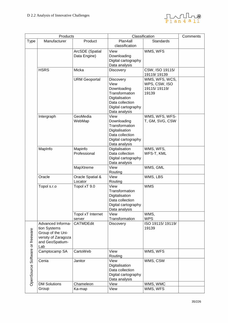
D 2.2 Analysis of Innovative Challenges
35/226
Products Classification Comments
Type Manufacturer Product Plan4all
classification
Standards
ArcSDE (Spatial
Data Engine)
View
Downloading
Digital cartography
Data analysis
WMS, WFS
HSRS Micka Discovery CSW, ISO 19115/
19119/ 19139
URM Geoportal Discovery
View
Downloading
Transformation
Digitalisation
Data collection
Digital cartography
Data analysis
WMS, WFS, WCS,
WPS, CSW, ISO
19115/ 19119/
19139
Intergraph GeoMedia
WebMap
View
Downloading
Transformation
Digitalisation
Data collection
Digital cartography
Data analysis
WMS, WFS, WFS-
T, GM, SVG, CSW
MapInfo Mapinfo
Professional
Digitalisation
Data collection
Digital cartography
Data analysis
WMS, WFS,
WFS-T, KML
MapXtreme View
Routing
WMS, GML
Oracle Oracle Spatial &
Locator
View
Routing
WMS, LBS
Topol s.r.o Topol xT 9.0 View
Transformation
Digitalisation
Data collection
Digital cartography
Data analysis
WMS
Topol xT Internet
server
View
Transformation
WMS,
WPS
OpenS
ourc
e S
oft
ware
or
freew
are
Advanced Informa-
tion Systems
Group of the Uni-
versity of Zaragoza
and GeoSpatium-
Lab
CATMDEdit Discovery ISO 19115/ 19119/
19139
Camptocamp SA CartoWeb View
Routing
WMS, WFS
Cenia Janitor View
Digitalisation
Data collection
Digital cartography
Data analysis
WMS, CSW
DM Solutions
Group
Chameleon View WMS, WMC
Ka-map View WMS, WFS
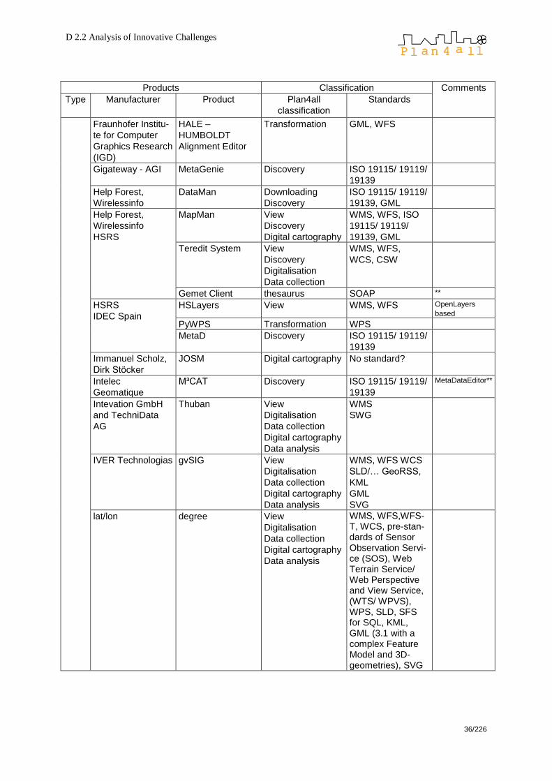
D 2.2 Analysis of Innovative Challenges
36/226
Products Classification Comments
Type Manufacturer Product Plan4all
classification
Standards
Fraunhofer Institu-
te for Computer
Graphics Research
(IGD)
HALE –
HUMBOLDT
Alignment Editor
Transformation GML, WFS
Gigateway - AGI MetaGenie Discovery ISO 19115/ 19119/
19139
Help Forest,
Wirelessinfo
DataMan Downloading
Discovery
ISO 19115/ 19119/
19139, GML
Help Forest,
Wirelessinfo
HSRS
MapMan View
Discovery
Digital cartography
WMS, WFS, ISO
19115/ 19119/
19139, GML
Teredit System View
Discovery
Digitalisation
Data collection
WMS, WFS,
WCS, CSW
Gemet Client thesaurus SOAP **
HSRS
IDEC Spain
HSLayers View WMS, WFS OpenLayers
based
PyWPS Transformation WPS
MetaD Discovery ISO 19115/ 19119/
19139
Immanuel Scholz,
Dirk Stöcker
JOSM Digital cartography No standard?
Intelec
Geomatique
M³CAT Discovery ISO 19115/ 19119/
19139
MetaDataEditor**
Intevation GmbH
and TechniData
AG
Thuban View
Digitalisation
Data collection
Digital cartography
Data analysis
WMS
SWG
IVER Technologias gvSIG View
Digitalisation
Data collection
Digital cartography
Data analysis
WMS, WFS WCS
SLD/… GeoRSS,
KML
GML
SVG
lat/lon degree View
Digitalisation
Data collection
Digital cartography
Data analysis
WMS, WFS,WFS-T, WCS, pre-stan-dards of Sensor Observation Servi-ce (SOS), Web Terrain Service/ Web Perspective and View Service, (WTS/ WPVS), WPS, SLD, SFS for SQL, KML, GML (3.1 with a complex Feature Model and 3D-geometries), SVG
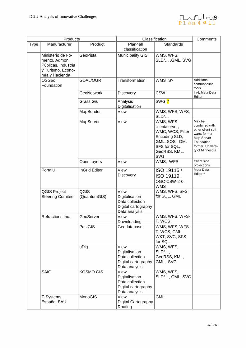
D 2.2 Analysis of Innovative Challenges
37/226
Products Classification Comments
Type Manufacturer Product Plan4all
classification
Standards
Ministerio de Fo-
mento, Admon
Públicas, Industria
y Turismo, Econo-
mía y Hacienda
GeoPista Municipality GIS WMS, WFS,
SLD/… ,GML, SVG
OSGeo
Foundation
GDAL/OGR Transformation WMSTS? Additional
commandline
tools
GeoNetwork Discovery CSW Inkl. Meta Data
Editor
Grass Gis Analysis
Digitalisation
SWG ?
MapBender View WMS, WFS, WFS,
SLD/…
MapServer View WMS, WFS
client/server,
WMC, WCS, Filter
Encoding SLD,
GML, SOS, OM,
SFS for SQL,
GeoRSS, KML,
SVG
May be
combined with
other client soft-
ware; former:
Map-Server
Foundation,
former: Universi-
ty of Minnesota
OpenLayers View WMS, WFS Client side
projections
PortalU InGrid Editor View
Discovery ISO 19115 / ISO 19119, OGC-CSW-2-0,
WMS
Meta Data
Editor**
QGIS Project
Steering Comitee
QGIS
(QuantumGIS)
View
Digitalisation
Data collection
Digital cartography
Data analysis
WMS, WFS, SFS for SQL, GML
Refractions Inc. GeoServer View
Downloading
WMS, WFS, WFS-T, WCS
PostGIS Geodatabase, WMS, WFS, WFS-
T, WCS, GML,
WKT, SVG, SFS
for SQL
uDig View
Digitalisation
Data collection
Digital cartography
Data analysis
WMS, WFS,
SLD/…,
GeoRSS, KML,
GML, SVG
SAIG KOSMO GIS View
Digitalisation
Data collection
Digital cartography
Data analysis
WMS, WFS,
SLD/…, GML, SVG
T-Systems
España, SAU
MonoGIS View
Digital Cartography
Routing
GML

D 2.2 Analysis of Innovative Challenges
38/226
Products Classification Comments
Type Manufacturer Product Plan4all
classification
Standards
Vivid Solutions JUMP View
Digitalisation
Data collection
Digital cartography
Data analysis
WMS, SLD/…,
GML, SVG
D 2.2 Analysis of Innovative Challenges
39/226
6 Chances, potentials, risks of data infrastructure applications
Based on the framework of technologies and services we give a theoretic view on
their chances, potentials and risks concerning data storage, data display, legislation,
insufficient data use, derived datasets and the quality of metadata.
6.1 Data Storage
6.1.1 Any time access and combined access
Any time and any where access is one of the main advantages of online data
infrastructures. The user is not dependent on certain office hours nor does he or she
have to collect datasets on offline devices to have an every time access. The
problem of having offline datasets which are out of date because an update has been
missed does not exist in this case because there is always access to the latest
version of all data.
Any time and any where access does not necessarily mean that the datasets are
shared via internet or similar, potentially insecure channels. A connection can also be
made through a secured or private network and can even be encrypted so that only
privileged users can access the data. Therefore, confidential datasets can be
accessed this way, too.
Combined access means that datasets from different sources can be accessed in the
same way because everything is part of the spatial data infrastructure (SDI).This is a
huge advantage opposite to datasets which are kept without an SDI (see also
―incorrect data use‖ and the figure below). Since this ambition may be overruled by
browser security features, using more than one source with browser extensions may
work only via reverse proxy servers or middleware.
6.1.2 Redundancy
A huge problem of distributed data management is redundancy. This term refers to
double storage of identical datasets as well as multiple storage of similar datasets
due to erroneous or negligent survey or a lack of coordination. There may be several
reasons for redundancy:
quicker access: If all relevant datasets are stored at the same place,
disregarding the fact that they are also available elsewhere, the user does not
have to think of different sources but can always rely on the same data source.
independency: One data store is not dependent on another data store if it
keeps all relevant datasets in its own place.
ignorance: The datasets are kept in multiple places because one data
manager simply does not know that another data manager maintains the same
datasets. This is a common effect in tangled and outdated infrastructure
networks of big administrational clusters. Technical ignorance may also be a

D 2.2 Analysis of Innovative Challenges
40/226
consequence of legal ignorance, which is often followed by redundant
datasets.
Apart from safety issues which see redundancy as a matter of purpose for security
reasons (backup), classic redundancy often leads to problems: More than one
instance of a dataset is available, and each claims to be the latest – but the user
does not really know which one is the one he or she should choose to work with.
Central data storage or an up-to-date data infrastructure network helps to solve
redundancy problems which are not only a matter of work efficiency but also a matter
of wasted disk space.

D 2.2 Analysis of Innovative Challenges
41/226
6.2 Data Display
6.2.1 Generalisation
Cartographic generalisation is the process of selecting and representing information
of a map in a way that adapts to the scale of the display medium of the map. Printed
maps are always provided in fixed scales whereas digital maps are scalable. This
can lead to presentation problems because geodata are always stored in a resolution
which is proper for a certain scale range. Zooming out of this range may result in
inaccurate, wrong, or at least strange data display. An alternative could be to store
geodata only at their best available resolution and apply automatic generalisation
dependent on the requested map scale. However, generalisation is a balancing
process. Automatic generalisation still leads to problems as different researchers
invented conceptual models for automated generalisation, but still there is no clear
classification of operators available, It is doubtful if a comprehensive classification will
evolve in future. This leads directly to the next point:
Fig. 2: Problems of GIS applications in huge (administrational) network structures
Problems of GIS applications in huge (administrational) network structures
VVaarriieettyy ooff iinnffoorrmmaattiioonn aanndd ddaattaa
DDaattaa aanndd iinnffoorrmmaattiioonn aacccceessss
AApppplliiccaattiioonn uusseerr
Big, heterogeneous data amount
official statistics
transportation, distance
biota, protection areas
imagery, base maps
land use data
… Cooperation, joint solution
identical data for identical
problems in all divisions
data interpretation
overall goals
Application needs
simple handling
hardly used daily used
user-oriented access
space for derived datasets

D 2.2 Analysis of Innovative Challenges
42/226
6.2.2 Web mapping vs. cartography
Cartography is understood as the study and practise of designing geographical maps
combining science, aesthetics, and technique, and building on the premise that
reality may be modelled in ways that communicate spatial information effectively,
whereas web mapping is a much simpler technique of visualisation of digital data.
Cartography (printed maps) Web mapping (digital maps)
Scale fixed scale variable scale, but are data suitable
for all scales?
Generalisation manual generalisation a few automatic generalisation
rules, or no generalisation at all
Layer structure fixed layer structure (in most cases) variable layers
Resolution high resolution maximum resolution is screen
resolution what about printouts?
Generation time map generation once respectively
periodically
map generation on the fly through
map server applications
respectively pre generated in short
intervals or simply cached
Update cycles high up-to-dateness is expensive
because of manually intervention
In most cases easily and
automatically updateable
User know how? user needs to know how to read a
map – really?
user needs to know how to read a
map, user also needs to know how
to navigate within a map, for edits
additional know-how or experience
is necessary, or, at least, advisable
Readability map should be designed to be
readable
some layer combinations may result
in illegibility
Flexibility no flexibility, map is as it is sometimes too much flexibility
especially when web mapping is
mixed up with web GIS
User
contributions
nearly no user contributions, no
interactivity
user contributions and interactivity
are possible
Plausibility datasets are checked for plausibility in simple systems there is usually
no guarantee for correct data;
however, geodatabases can handle
digital data signature so that
correctness can also be trusted with
electronic maps
Legally binding may be legally binding (currently) difficulties with legal
commitment
Tab. 1: Web Mapping vs. Cartography

D 2.2 Analysis of Innovative Challenges
43/226
Remark: Although there are no useable web systems which deliver really good
cartography further development could change the perspective to the above points.
6.3 Legal obligation
Dealing with datasets is often not subject to legislation as far as datasets are not
understood as content building items but as core digital mass. Laws often state which
data has to be used for which purpose but in most cases they do not say anything
about the way data should be used. There are no statements regarding data storage,
file formats, data documentation (metadata) and similar issues which are essential for
a working SDI. Therefore, it is also critical to rely on the legal commitment of online
datasets because such commitment cannot be derived from the legal situation in
most countries.
Spatial data infrastructures should therefore be made a part of the legislative
framework. This step also simplifies the situation administrative offices often see
themselves in: They want to build an SDI and have to spend working time on that
issue, but the time cannot be booked correctly because in their legally defined
business a booking slot for such things simply does not exist and even more time is
wasted making loop constructs to by-pass this lack of legal coverage.
6.4 Incorrect data use
Often, data access is physically not ensured or de facto impossible due to technical
hurdles. This may cause the following risks:
Datasets are not used because hardly anyone knows of their existence.
Datasets are not correctly used according to their actual purpose because
data documentation (metadata) is poor.
Identical work and identical results (but with different interpretation and
different graphic expression) are done more than once in different divisions of
the company or administration which makes the results incomprehensible.
6.5 Derived datasets
A spatial data infrastructure also allows to store derived datasets, i. e. the amount of
new data which evolves through calculation and analysis of existing data. An SDI
helps to avoid multiple calculations of the same facts because once an analysis result
is generated, it can be made part of the SDI and, therefore, immediately accessible to
all other network partners and/or institutions. Since derived datasets usually not
reuse the geographic primitives, geometric changes are not automatically mirrored to
derived datasets. In such cases the derived datasets should be recalculated, which is
often forgotten because it is not automated.

D 2.2 Analysis of Innovative Challenges
44/226
6.6 Metadata
6.6.1 Metadata quality
Metadata quality is as important as the actual data quality. If you want to work with
geodata, you need to know where these data come from, for which scale they are
suited, how the data have been processed, and much more. As the overall quality of
a product is always dependent on the weakest link, a dataset is only as good as its
metadata documentation which should not be done according to own standards, but
following existing guidelines like the INSPIRE directive or the rules of ISO 19115
(―Geographic Information – Metadata‖). Once a dataset lacks metadata, all derived
datasets will suffer from the same deficit. The data cannot be traced back to its roots;
uncertainty and insecurity arise and finally prevent the dataset from being used
without doubts about its origin.
Some survey results may be found in Annex B (page 208)

D 2.2 Analysis of Innovative Challenges
45/226
7 Data evaluation and quality criteria
So far the importance of correct data use and high quality of metadata was outlined
in the previous chapter, but we still did not answer the questions about the aspects of
data quality and how high quality data can be achieved? Constitutive this chapter
emphasizes on identifying criteria for data quality, because the best technologies and
services alone are useless without the right data – and the other way around.
7.1 Why Data Quality?
Data quality is an increasingly important issue which must not be neglected. Con-
sequences of poor data quality can be felt often in everyday life without being aware
of the causes. A simple example is the mistaken or duplicate delivery of a letter which
is mainly caused by errors in an address database.
The Office of Management and Budget of the United States of America defines data
quality as "an encompassing term comprising utility, objectivity, and integrity."
o Objectivity means that information is accurate, clear, complete, and was unbiasedly collected.
o Utility means that the information is useful for its anticipated purpose. o Integrity means the security of information, i. e. protection from unintended or
unauthorised changes.
In comparison to this United States definition the Directive 2003/98/EC of the
European Parliament and of the Council of 17 November 2003 on the re-use of
public sector information highlights the aspect of data quality mainly regarding the
accessibility of public data and its availability in a format which is platform
independent. This directive states that it is necessary for public data the re-use
guarantee the data quality in terms of accuracy and up-to-dateness through data
cleaning campaigns, which would make datasets attractive to potential users.
Scientific discussions of data quality began in the late 1960s, and it took three more
decades until computer sciences started considering the problem of data quality
definition, measurement, and improvement.
7.2 Aspects of Data Quality
In terms of the Plan4all project, the data quality discussion should concentrate on
these criteria:
o accuracy (in both geometric and attributive terms) o completeness o consistency o currency – this term has nothing to do with money but means system currency,
the time duration from the time the real world changes to the time when the information system state is updated. (Source: Wang, Richard Y., et al.: Information quality. Armonk, NY, 2005.)
o timeliness
D 2.2 Analysis of Innovative Challenges
46/226
o volatility o accessibility o interpretability
Data quality is a multi-faceted concept, and all factors have to be considered at the
same time:
o In some cases quality dimensions can easily be detected (e. g. apparent misspellings); in other cases, however, measurement of data quality can be somewhat difficult (e. g. when admissible but nevertheless incorrect values are provided).
o As with accuracy, completeness can be hard to evaluate, especially if the expected total number of datasets is unknown. In case of polygons it is easier to state completeness, if the topic is covering the whole area, like for example land use whereas completeness is tricky to measure if polygons may overlap.
o Consistency detection can show that there are errors, but the errors can often not be exactly localised.
7.2.1 Accuracy
Accuracy is defined as the closeness between a real life value and the (database)
value which represents the real life value. It can be divided into
o syntactic accuracy, which applies to the check whether the value can anyway be true, e. g. if a value is within the allowed range of values. In syntactic accuracy it does not matter if the value is representing its correspondent real life value.
o semantic accuracy, which applies to the difference between the database value and its real life correspondent value.
Here is an example for accuracy: In a street network database, the name ―King
Street‖ has been erroneously attached to a street section which is not part of the
street called ―King Street‖ in real life. Thus, semantic accuracy is not given. However,
―King Street‖ is a valid street name anyway, so syntactic accuracy is given.
Semantic accuracy is typically more complex than syntactic accuracy, as the object
has to be uniquely identified to apply a semantic accuracy check.
7.2.2 Completeness
Completeness of data states whether data have sufficient breadth, depth, and scope
for their intended purpose. It can be understood as the extend to which datasets in a
table describe the real world. The more real world values are missing among the
datasets, the worse the completeness of data. Completeness problems often arise in
connection with null values in tables. Is the value really null, is it existing but
unknown, or is it unknown if it is existing? So, to characterise the completeness of
data, it must be investigated why values are missing: The following cases can be
distinguished:
o A dataset is missing because its real world existence is unknown to the date of data collection (e. g. an unknown ground water stream).
o A dataset is missing although it exists in real world, but was forgotten, misplaced or not surveyed for any reason (e. g. a ground water stream close to the border of the survey region).

D 2.2 Analysis of Innovative Challenges
47/226
o A dataset is missing because it did not exist in real life when data collection took place (e. g. a new groundwater stream caused by construction works). This is not a completeness problem, but a currency problem – see below.
Handling polygon vector data, completeness can easily be checked – the data should
be covering the whole area without without any gap. Line and point vector data
cannot be verified that easily because the structure of the whole set is not taked
corrupted when parts are missing. Raster datasets are always complete at first
glance, but, on second glance, there can also be cells showing a ―no data‖ value.
7.2.3 Consistency
Datasets in a table, or relations in a database, must follow certain rules which define
the consistency of these data. In other words, consistency expresses whether data
are logically correct. Data are checked for dependencies which must be met to make
data consistent. The followig types of dependencies can be distinguished:
Key dependencies: Given key dependency allows the installation of primary
keys in a table. A value in a primary key field may occur only once, e. g. a
parcel number in a municipality. Having data from more than one municipality,
the primary key must be extended also to the field of the municipality code.
Having a primary key enclosing more fields, the value in each single columns
is allowed to occur more often, but each combination of all primary key fields
may exist only once.
Inclusion dependencies: These restraints manage the relations between
tables in a database. For instance, if a land table has information about the
parcels and their respective owners, the owner can be defined through his or
her social security number (as each such number exists only once forever).
Functional dependencies: Other dependencies which can put into
constraints or formulas are called functional dependencies. In abstract words,
there can be a constraint that for certain values x and y in a table row the
column z must have a certain value or be in a certain range. For instance, a
road section in a peripheral area of a municipality (x) which was opened after
1950 (y) must not have an overall width less than 4 metres (z). If this
constraint is violated, the dataset is not consistent – there must be an error,
but it cannot be said from the dataset where the error is located as it can have
its origin either in the x, y, or z field.
7.2.4 Currency
The change of data in time is highly important concerning electronic (online) data
structures. There is a significant difference between data on paper-based and
electronic media. Printed data are published once and for all whereas electronic data
are published continuously on the web. Currency is defined through the time spread
between a real world gain, e. g. the designation of new building land parcels, and the
corresponding database update. It describes how promptly data are updated, giving
renewed datasets a high currency.

D 2.2 Analysis of Innovative Challenges
48/226
Currency underlines the importance of metadata management as ―Last Update‖ fields
are usually a mandatory element of a metadataset. Knowing the average update
period (or volatility, see below) for certain themes, it can easily be estimated whether
datasets are likely to be up to date. E. g., land use data with a last update in 1999 are
out of date for almost sure, whereas data of inland waters from 1999 are likely to be
still up to date because the inland waters network will usually not have changed
during the past few years.
Also data synchronisation is a matter of currency. Especially data models which deal
which many different data sources – like Plan4all – will have to deal with datasets of
different sources having different time stamps. However, regarding planning relevant
data, the question is not only how to synchronise datasets (e. g. interpolation of
population values), but also whether it is basically allowed to synchronise data as an
interpolation may neglect spatial impacts having occurred in the meantime, or simply
falsifies analysis results.
7.2.5 Timeliness
Timeliness expresses how current data are for the task at hand. It is possible to have
data of high currency which nevertheless can be useless because they are late for
their actual purpose. For instance, data of a digital zoning plan may be current
referring to the latest changes – but they are rather useless for reclamations if they
are published after the reclamation deadline, giving the data a bad timeliness.
7.2.6 Volatility
Volatility is a factor which describes how frequent data changes occur; it can be
understood as the usual length data remain valid. Parcel data near the centre of a
municipality may have a low volatility as these parcels are covered with buildings or
other city structures which today are usually not subject to changes. Or, these
datasets are changed once, perhaps twice, when new building land at the outskirts is
opened up. On the contrary, road traffic data may have high volatility as the traffic
system is behaving very dynamically and always self-adapting to the current
situation.
7.2.7 Accessibility
To make data accessible, it is not enough simply to put the data onto a web site or
make them somehow downloadable from a server. Accessibility means that the user
can successfully access data. There must be access to the network including
availability of the necessary hardware, software, interface, and tools. The user must
understand the navigation procedure and/or the navigation language. And, just as
important, the user must be able to perceive the information given, which means
accessibility also includes measures for individuals with disabilities.
7.2.8 Interpretability
Interpretability states whether or how good data are documented, and if metadata are
available so that meaning and properties of data sources can be interpreted correctly.
The documentation of European data has to be done according to the INSPIRE
D 2.2 Analysis of Innovative Challenges
49/226
directive; sticking to the guidelines given by INSPIRE data interpretability can be
taken for granted.
7.3 How to Achieve Data Quality
To receive data of high quality, there must be an eye on quality measurement right
from the birth of data, which date lies even before data collection because only if the
proper issues are surveyed, the data receive sufficient informative value. Data quality
activities can be classified as follows:
(1) New data acquisition: Set up a new database or refresh an existing database
with new quality data.
(2) Standardisation: modify data according to standards (e. g. spelling checks,
comply with style sheets).
(3) Object identification: make sure that the connection between the real world
object and its database counterpart is correct.
(4) Data integration: produce a unified view out of data from heterogeneous sources
– this step will be one of the main tasks of Plan4all.
(5) Source trustworthiness: rate data sources on the basis of the quality of data
they provide.
(6) Quality composition: compute the actual data quality dimension values.
(7) Error detection, and, if possible, error localisation: apply rules to find out if there
are errors in the data.
(8) Error correction: try to eliminate as many errors as possible.
(9) Cost optimisation: achieving data quality produces costs. An optimal cost/quality
ratio has to be found so that data have a good quality which is affordable though.
7.4 Summary
Data quality consists of a wide variety of dimensions which characterise the
goodness of data. The framework presented on the previous pages should work as a
reference for those working on the data and metadata model in the forthcoming work
packages of Plan4all so that all user groups coming into contact with data on the one
hand can rely on the quality of the Plan4all data, but on the other hand also can
characterise, or, to some extent, measure data quality.
As a consequence, data quality should be constantly on the rise, and, furthermore,
on a comparable level through all groups and institutions contributing to the Plan4all
data collection. Data concepts are evolving rapidly due to the increased apply of
information and communication technologies, so also the concept of data quality will
continuously be changed and extended. The diversity of real world phenomena that
can put into databases and tables is too large to set up general rules for ―the‖ data
quality. There is no chance for an overall data quality approach, thus Plan4all can

D 2.2 Analysis of Innovative Challenges
50/226
develop a milestone regarding quality of administrational data and/or planning related
data and metadata.
Within the achievement of data quality, it will often be impossible to receive data with
an overall 100 % quality. The higher data quality is, the higher the costs are, and,
perhaps, also the longer the waiting period is. The right cost/quality ratio for high data
quality at an affordable price level is also an important factor that should be taken
into consideration.
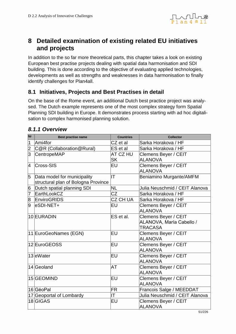
D 2.2 Analysis of Innovative Challenges
51/226
8 Detailed examination of existing related EU initiatives and projects
In addition to the so far more theoretical parts, this chapter takes a look on existing
European best practise projects dealing with spatial data harmonisation and SDI
building. This is done according to the objective of evaluating applied technologies,
developments as well as strengths and weaknesses in data harmonisation to finally
identify challenges for Plan4all.
8.1 Initiatives, Projects and Best Practises in detail
On the base of the Rome event, an additional Dutch best practice project was analy-
sed. The Dutch example represents one of the most complex strategy form Spatial
Planning SDI building in Europe. It demonstrates process starting with ad hoc digitali-
sation to complex harmonised planning solution.
8.1.1 Overview
Nr Best practise name Countries Collector
1 Ami4for CZ et al Sarka Horakova / HF
2 C@R (Collaboration@Rural) ES et al Sarka Horakova / HF
3 CentropeMAP AT CZ HU SK
Clemens Beyer / CEIT ALANOVA
4 Cross-SIS EU Clemens Beyer / CEIT ALANOVA
5 Data model for municipality structural plan of Bologna Province
IT Beniamino Murgante/AMFM
6 Dutch spatial planning SDI NL Julia Neuschmid / CEIT Alanova
7 EarthLookCZ CZ Sarka Horakova / HF
8 EnviroGRIDS CZ CH UA Sarka Horakova / HF
9 eSDI-NET+ EU Clemens Beyer / CEIT ALANOVA
10 EURADIN ES et al. Clemens Beyer / CEIT ALANOVA, María Cabello / TRACASA
11 EuroGeoNames (EGN) EU Clemens Beyer / CEIT ALANOVA
12 EuroGEOSS EU Clemens Beyer / CEIT ALANOVA
13 eWater EU Clemens Beyer / CEIT ALANOVA
14 Geoland AT Clemens Beyer / CEIT ALANOVA
15 GEOMIND EU Clemens Beyer / CEIT ALANOVA
16 GéoPal FR Francois Salge / MEEDDAT
17 Geoportal of Lombardy IT Julia Neuschmid / CEIT Alanova
18 GIGAS EU Clemens Beyer / CEIT ALANOVA
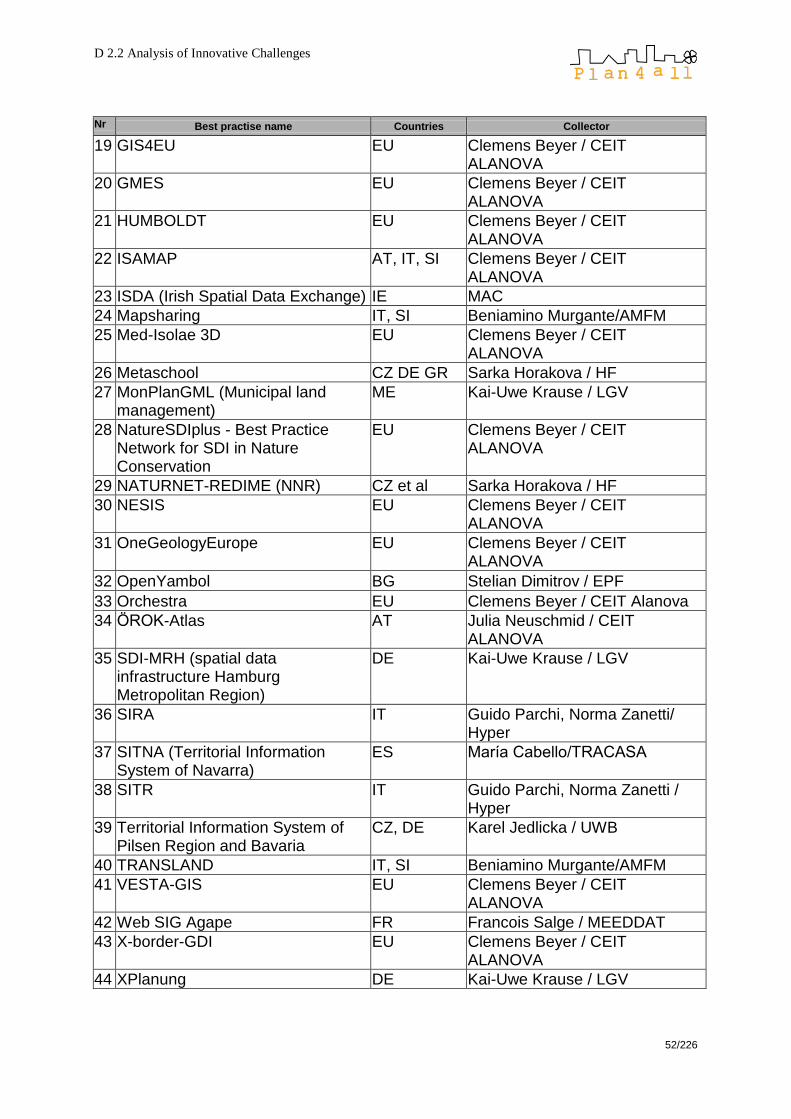
D 2.2 Analysis of Innovative Challenges
52/226
Nr Best practise name Countries Collector
19 GIS4EU EU Clemens Beyer / CEIT ALANOVA
20 GMES EU Clemens Beyer / CEIT ALANOVA
21 HUMBOLDT EU Clemens Beyer / CEIT ALANOVA
22 ISAMAP AT, IT, SI Clemens Beyer / CEIT ALANOVA
23 ISDA (Irish Spatial Data Exchange) IE MAC
24 Mapsharing IT, SI Beniamino Murgante/AMFM
25 Med-Isolae 3D EU Clemens Beyer / CEIT ALANOVA
26 Metaschool CZ DE GR Sarka Horakova / HF
27 MonPlanGML (Municipal land management)
ME Kai-Uwe Krause / LGV
28 NatureSDIplus - Best Practice Network for SDI in Nature Conservation
EU Clemens Beyer / CEIT ALANOVA
29 NATURNET-REDIME (NNR) CZ et al Sarka Horakova / HF
30 NESIS EU Clemens Beyer / CEIT ALANOVA
31 OneGeologyEurope EU Clemens Beyer / CEIT ALANOVA
32 OpenYambol BG Stelian Dimitrov / EPF
33 Orchestra EU Clemens Beyer / CEIT Alanova
34 ÖROK-Atlas AT Julia Neuschmid / CEIT ALANOVA
35 SDI-MRH (spatial data infrastructure Hamburg Metropolitan Region)
DE Kai-Uwe Krause / LGV
36 SIRA IT Guido Parchi, Norma Zanetti/ Hyper
37 SITNA (Territorial Information System of Navarra)
ES María Cabello/TRACASA
38 SITR IT Guido Parchi, Norma Zanetti / Hyper
39 Territorial Information System of Pilsen Region and Bavaria
CZ, DE Karel Jedlicka / UWB
40 TRANSLAND IT, SI Beniamino Murgante/AMFM
41 VESTA-GIS EU Clemens Beyer / CEIT ALANOVA
42 Web SIG Agape FR Francois Salge / MEEDDAT
43 X-border-GDI EU Clemens Beyer / CEIT ALANOVA
44 XPlanung DE Kai-Uwe Krause / LGV

D 2.2 Analysis of Innovative Challenges
53/226
8.1.2 Collection
Best Practise # 1
Project Name Ami4for
Type of project o EU project
Dimension of project o international
Project start 2005
Project end 2007
URL http://www.ami4for.org/
Leader, Project Partners
Lead Partner: Wirelessinfo (WIN), Czech republic Project Partners: European Space Agency/European Space Research INstitute (ESA/ESRIN) Lesprojekt Sluzby s.r.o. (LPS) Help Service Remote Sensing s.r.o. (HSRS ) MJM (MJM) Forest Management Institute (FMI) ARS Logica (ARS LOGICA)
Content (keywords) Open Service Architecture, Ambient mobile intelligence, Open GIS WEB services, Metadata
Content (description)
The main objective was to establish a new concept of Ambient Mobile Intelligence (AMI) for forest, winery and agriculture management integrated mobile communication, new methods of navigation (GPS, EGNOS, GALILEO) and integration of spatial information including satellite imaging (SPOT, IKONOS, EROS, PROBA).
Used technology/software
UMN Mapserver, Geoserver, PostgreSQL, MAP Project MANager (MAPMAN), Teredit System, ArcPad
Strengths or chances of this project
Development of MAPMAN and Teredit System web technology for management and publication of spatial data, applications for data collection in the field and their storage directly on the server
Weaknesses or risks of this project
Tests have been carried out only on the limited number of the testbeds
Accessibility, Information Information about the project available on the project website. Project reports are accessible upon request at the project coordinator.
User Interface, Software
MAPMAN - Map Project Manager is a software tool for users who want to publish or create new map projects and compositions. Teredit Systems - Teredit is a special tool for data collection in the field, data transfer from a mobile device (PDA, notebook) to a server and for generating a project for data collection.
Challenges Possibility to re-implement the developed technologies for spatial data management on the Web, support for geospatial web services
This project deals with planning relevant datasets no
This project is compatible to the standards of the OGC yes
This project is a cross-border initiative yes
Contact WIRELESSINFO, Petr Horak, [email protected]
Collected by Sarka Horakova, WRLS
Additional remarks -

D 2.2 Analysis of Innovative Challenges
54/226
Best Practise # 2
Project Name C@R (Collaboration@Rural: a collaborative platform for working and living in rural areas)
Type of project o EU integrated project
Dimension of project o international
Project start 2006
Project end Still running – the fixed end is 2009
URL http://www.c-rural.eu/
Leader, Project Partners Project Leader: TRAGSA, Spain + 34 Project Partners
Content (keywords) Rural Living Labs, Collaborative Working Environments, Open Collaborative Architecture, Software Collaborative Tools, Collaborative Core Services
Content (description)
C@R project aims to boost the introduction of Collaborative Working Environments (CWE) as key enablers catalyzing rural development. According to this strategic goal, the C@R Integrated Project proposes a complete set of research activities and tasks which will identify, develop and validate technological responses to actual barriers jeopardizing the sustainable development in rural areas.
Used technology/software
Open Service Oriented Architecture (OSOA) including BUS & AXIS 2, Core Collaborative Service (CCS) and SCT; implementation of OGC standards; Metadata & catalogue system Micka, Geohosting components including Map Project MANager – Mapman, Data Manager (DataMan) and web map visualization client HSLAyers;
Strengths or chances of this project
C@R is a project that aims to enable people in remote and rural Europe to fully participate in the knowledge society as citizens and as professionals. User involvement – support for Living lab methodology - users are invited to participate in the whole development process, can test products, bring innovative ideas. OSOA implementation – Open Service Oriented Architec-ture has been implemented and tested in several user applications in 7 European living labs. Some of the applications have been focused on implementation of technology for spatial planning
Weaknesses or risks of this project
Implementation of OSOA requires the specialized IT– knowledge. Principle of the collaboration with users can meet an insufficient interest in involvement from their side.
Accessibility, Information
All project data are freely accessible over the internet: see project website...; Project data of the Czech partner WIRELESSINFO are freely accessible over the internet: see project website http://www.livinglab.cz/ – all datasets are available as web map services
User Interface, Software In Wirelessinfo applications: web map visualization client HSLayers, MapMan, DataMan, metadata catalogue Micka, How is the project‟s user interface built? Which software is used?
Challenges
Style of work typical for living labs (user involvement, developer collaboration) can bring benefits in the application development in spatial planning area. OSOA implementation in SDI
This project deals with planning relevant datasets yes
This project is compatible to the standards of the OGC yes
This project is a cross-border initiative yes
Contact WIRELESSINFO, Petr Horak, [email protected]
Collected by Sarka Horakova, WRLS
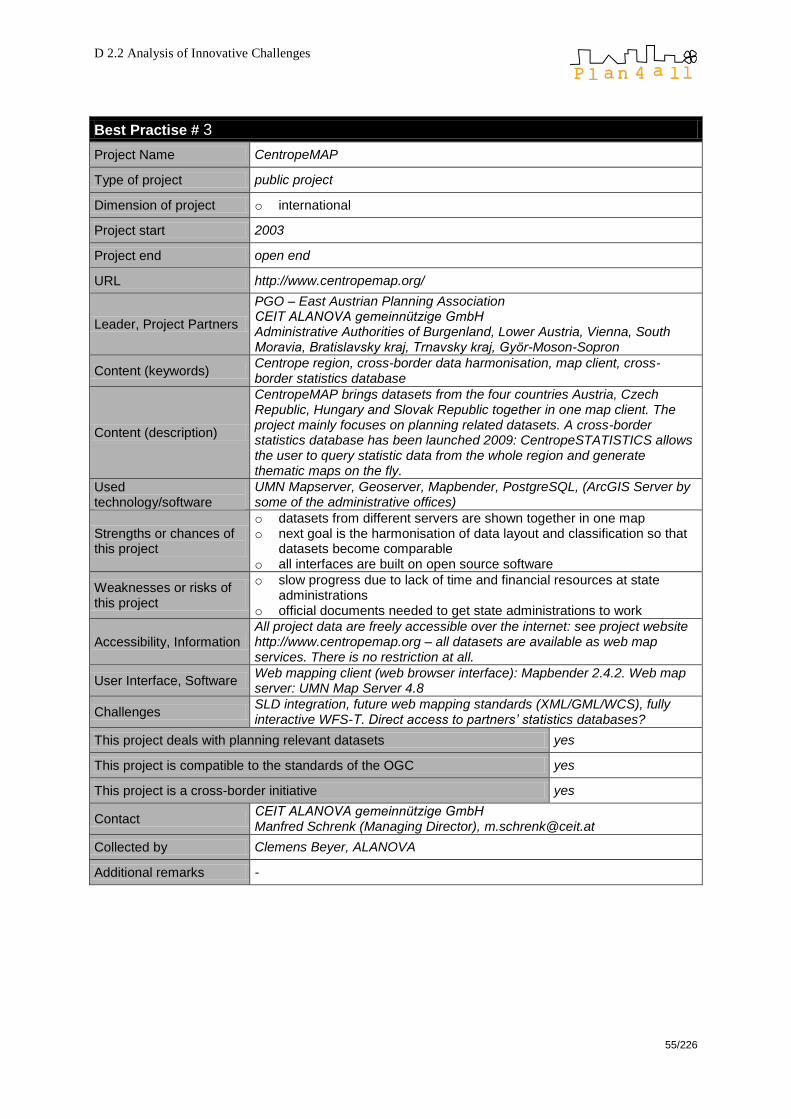
D 2.2 Analysis of Innovative Challenges
55/226
Best Practise # 3
Project Name CentropeMAP
Type of project public project
Dimension of project o international
Project start 2003
Project end open end
URL http://www.centropemap.org/
Leader, Project Partners
PGO – East Austrian Planning Association CEIT ALANOVA gemeinnützige GmbH Administrative Authorities of Burgenland, Lower Austria, Vienna, South Moravia, Bratislavsky kraj, Trnavsky kraj, Györ-Moson-Sopron
Content (keywords) Centrope region, cross-border data harmonisation, map client, cross-border statistics database
Content (description)
CentropeMAP brings datasets from the four countries Austria, Czech Republic, Hungary and Slovak Republic together in one map client. The project mainly focuses on planning related datasets. A cross-border statistics database has been launched 2009: CentropeSTATISTICS allows the user to query statistic data from the whole region and generate thematic maps on the fly.
Used technology/software
UMN Mapserver, Geoserver, Mapbender, PostgreSQL, (ArcGIS Server by some of the administrative offices)
Strengths or chances of this project
o datasets from different servers are shown together in one map o next goal is the harmonisation of data layout and classification so that
datasets become comparable o all interfaces are built on open source software
Weaknesses or risks of this project
o slow progress due to lack of time and financial resources at state administrations
o official documents needed to get state administrations to work
Accessibility, Information All project data are freely accessible over the internet: see project website http://www.centropemap.org – all datasets are available as web map services. There is no restriction at all.
User Interface, Software Web mapping client (web browser interface): Mapbender 2.4.2. Web map server: UMN Map Server 4.8
Challenges SLD integration, future web mapping standards (XML/GML/WCS), fully interactive WFS-T. Direct access to partners‟ statistics databases?
This project deals with planning relevant datasets yes
This project is compatible to the standards of the OGC yes
This project is a cross-border initiative yes
Contact CEIT ALANOVA gemeinnützige GmbH Manfred Schrenk (Managing Director), [email protected]
Collected by Clemens Beyer, ALANOVA
Additional remarks -

D 2.2 Analysis of Innovative Challenges
56/226
Best Practise # 4
Project Name Cross-SIS
Type of project EU project
Dimension of project international
Project start 2005
Project end 2007
URL http://www.cross-sis.com (discontinued)
Leader, Project Partners data and technoloy providers from Lower Austria (Austria), Gelderland and Overijssel (The Netherlands), Navarra (Spain) and North-Rhine Westphalia (Germany)
Content (keywords) web mapping, statistics, cross-border GDI, interactive, thematic maps, INTERREG IIIc
Content (description)
Planning pilot: a web GIS client that presents comparable regional planning data as interactive maps at a European level, not only presenting planning data in a cross-border context, but also following a service-oriented architecture with OGC-compliant technologies. Statistics: With CROSS-SIS it was demonstrated that with distributed interoperable web service technologies it is possible to discover, retrieve, visualize and analyze spatial data regardless of the factual physical location.
Used technology/software
UMN and other map server applications, SOAP, ArcSDE, Oracle, SLD
Strengths or chances of this project
Cross-SIS was one of the very first projects to jointly display both geographic and thematic maps in cross-border style.
Weaknesses or risks of this project
The partner regions were quite far away so that apart from pure feasibility the project did not deliver any useful map with interpretable content.
Accessibility, Information
The project‘s website is not online any more, though information can be found over the internet, e. g. http://www.it.nrw.de/informationstechnik/IT_Veroeffentlichungen/Aus gabenarchiv/ausgabe1_2008/schwerpunkte/z091200851_s9.pdf
User Interface, Software web browser interface, Javascript map viewer
Challenges
One of the main results of Cross-SIS was that many technical questions regarding a European SDI are solveable but not trivial. Bigger efforts are necessary in data content and structure harmonisation of the EU regions' (geo)data stock to enable meaningful cross-border use.
This project deals with planning relevant datasets no
This project is compatible to the standards of the OGC yes
This project is a cross-border initiative yes
Contact Oliver Karusseit, Düsseldorf, Germany +49 211 9449-6302, [email protected]
Collected by Clemens Beyer, CEIT ALANOVA
Additional remarks -
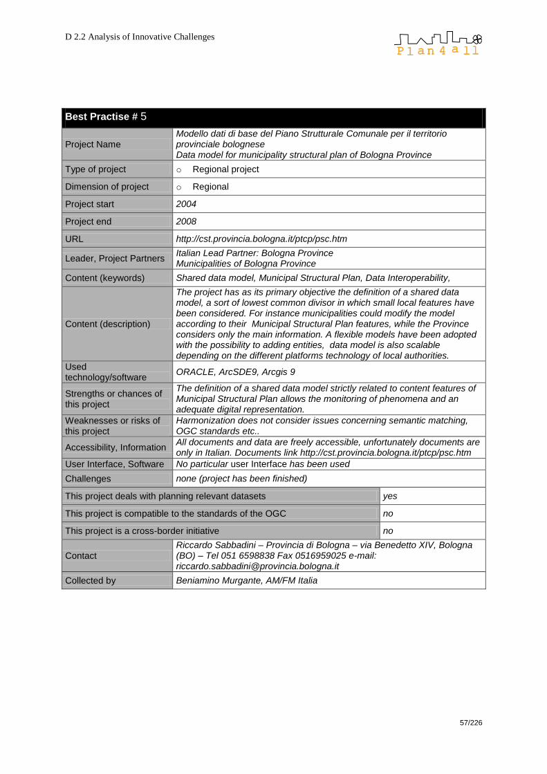
D 2.2 Analysis of Innovative Challenges
57/226
Best Practise # 5
Project Name Modello dati di base del Piano Strutturale Comunale per il territorio provinciale bolognese Data model for municipality structural plan of Bologna Province
Type of project o Regional project
Dimension of project o Regional
Project start 2004
Project end 2008
URL http://cst.provincia.bologna.it/ptcp/psc.htm
Leader, Project Partners Italian Lead Partner: Bologna Province Municipalities of Bologna Province
Content (keywords) Shared data model, Municipal Structural Plan, Data Interoperability,
Content (description)
The project has as its primary objective the definition of a shared data model, a sort of lowest common divisor in which small local features have been considered. For instance municipalities could modify the model according to their Municipal Structural Plan features, while the Province considers only the main information. A flexible models have been adopted with the possibility to adding entities, data model is also scalable depending on the different platforms technology of local authorities.
Used technology/software
ORACLE, ArcSDE9, Arcgis 9
Strengths or chances of this project
The definition of a shared data model strictly related to content features of Municipal Structural Plan allows the monitoring of phenomena and an adequate digital representation.
Weaknesses or risks of this project
Harmonization does not consider issues concerning semantic matching, OGC standards etc..
Accessibility, Information All documents and data are freely accessible, unfortunately documents are only in Italian. Documents link http://cst.provincia.bologna.it/ptcp/psc.htm
User Interface, Software No particular user Interface has been used
Challenges none (project has been finished)
This project deals with planning relevant datasets yes
This project is compatible to the standards of the OGC no
This project is a cross-border initiative no
Contact Riccardo Sabbadini – Provincia di Bologna – via Benedetto XIV, Bologna (BO) – Tel 051 6598838 Fax 0516959025 e-mail: [email protected]
Collected by Beniamino Murgante, AM/FM Italia

D 2.2 Analysis of Innovative Challenges
58/226
Best Practise # 6
Project Name Dutch Spatial Planning SDI
Type of project public
Dimension of project national
Project start
The current Spatial Planning Act (Wet op de ruimtelijke ordening, new Wro) took effect on 1 July 2008; the relevant part for digital spatial planning and SDI is the Spatial Planning Standards Regulation that will take effect on 1 January 2010.
Project end ongoing
URL http://international.vrom.nl/pagina.html?id=37427 http://www.agi.org.uk/SITE/UPLOAD/DOCUMENT/Events/AGI2009/ papers/RonBloksma.pdf
Leader, Project Partners Ministry of Housing, Planning and Environment, Provincial and municipal authorities
Content (keywords) Digitalisation of spatial planning plans, SDI
Content (description)
In the Netherlands a package of spatial planning standards was developed in 2008 saying that spatial plans have to be made available in digital format with the same legal status as the analogue plans. This package is legally established in the Spatial Planning Standards Regulations, which are part of the WRO (Wet op de ruimtelijke ordening – Spatial Planning Act). Because of this SDI building process all plans of public administrations will be exchangable, comparable and accessable for everybody.
Used technology/software
The digital plans are publicly available as „plain‟ datasets. They are a coherent set of widely recognised files (GML, HTML, PDF, XML and several image files). They are structured in a specific way and their web locations are catalogued in an XML file, which has to be acknowledged at a national index service.
Strengths or chances of this project
The act is a further step towards digitalisation of spatial planning data and SDI building, standardised definition of access, storage and distribution of spatial planning data, according to ISO/OGC standards.
Weaknesses or risks of this project
-
Accessibility, Information
The Spatial Planning Act stipulated that all governments must make their spatial plans publicly available so that they can be electronically accessed by everyone. Anyone who wants to use digital plans can discover the web locations through the national index service. The integrity, authenticity and completeness of the datasets are safeguarded by the digital signature of the authority on the separate files or plan and in the XML file catalogue of all the digital plans of that authority.
User Interface, Software
Challenges
This project deals with planning relevant datasets
This project is compatible to the standards of the OGC
This project is a cross-border initiative
Contact Paul Janssen <[email protected] (Geonovum)
Collected by Julia Neuschmid (Ceit Alanova)

D 2.2 Analysis of Innovative Challenges
59/226
Best Practise # 7
Project Name EarthLookCZ
Type of project o public project
Dimension of project o national
Project start 2007
Project end Still running – the fixed end is 2009
URL http://www.earthlook.cz
Leader, Project Partners WIRELESSINFO, Czech republic
Content (keywords) Spatial data infrastructure, GMES (Global Monitoring for Environment and Security), INSPIRE, web services
Content (description)
EarthLookCZ is one of pilot projects developed in the Czech Republic in the ERA-STAR regions framework. The project undertaken by WIRELESSINFO association aims to verify the validity of spatial data infrastructure quality for GMES in the Czech Republic and is supported by the Ministry of Education, Youth and Sports.
Used technology/software
UMN MapServer, Geohosting technology – modification and integration of the technological components for geo-spatial data management – MapMan, DataMan, visualization client HSLayers, metadata and catalogue system Geohosting
Strengths or chances of this project
Implementation of ISO and OGC standards for data sharing and exchange, distribution system that ensures the access to distributed data and metadata of the GMES,
Weaknesses or risks of this project
Slow progress due to financial resources at state administrations
Accessibility, Information Information about the project available only in Czech language on the project website. Project reports are accessible upon request at the project coordinator.
User Interface, Software EarthLookCZ portal with Geohosting applications MapMAn and DataMan, HSlayers client
Challenges Integration of main datasets of GMES Core Services, publication of the local GMES datasets on the web
This project deals with planning relevant datasets yes
This project is compatible to the standards of the OGC yes
This project is a cross-border initiative yes
Contact WIRELESSINFO, Petr Horak, [email protected]
Collected by Sarka Horakova, WRLS
Additional remarks -

D 2.2 Analysis of Innovative Challenges
60/226
Best Practise # 8
Project Name EnviroGRIDS
Type of project o EU project
Dimension of project o international
Project start 2009
Project end 2013
URL http://www.envirogrids.net/
Leader, Project Partners
The EnviroGRIDS Project Team includes 27 partners from 15 countries University of Geneva, Climatic Changes and Climate Impacts & Spatial Analyses and Predictions,CCSS, European Organization for Nuclear research, Switzerland (CERN), Swiss Federal Institute of Aquatic Science and Technology (EAWAG), Geographic GIS&RS Consulting Center (Geographic), UNESCO: Institute for Water Education (UNESCO/IHE), European Topic Centre Land Use and Spatial Information supported by the European Environment Agency (EEA) (UAB), Ukrainian Scientific and Research Institute of Ecological Problems (USRIEP) etc.
Content (keywords) GEOS, monitoring, INSPIRE, GRID, SDI
Content (description)
EnviroGRIDS aims at building the capacity of scientist to assemble such a system in the Black Sea Catchment, the capacity of decision-makers to use it, and the capacity of the general public to understand the important environmental, social and economic issues at stake. EnviroGRIDS will particularly target the needs of the Black Sea Commission (BSC) and the International Commission for the Protection of the Danube River (ICPDR) in order to help bridging the gap between science and policy.
Used technology/software
GRID, metadata. SWE, WPS,
Strengths or chances of this project
Focus on application domain
Weaknesses or risks of this project
Very different technologies integration
Accessibility, Information Not defined yet, but part of data will be publicly available
User Interface, Software OGS services, GRIS services
Challenges To use GRID technology inside of SDI
This project deals with planning relevant datasets partly
This project is compatible to the standards of the OGC yes
This project is a cross-border initiative yes
Contact Czech Centre for Science and Society, Karel Charvat, [email protected]
Collected by Karel Charvat, CCSS
Additional remarks -

D 2.2 Analysis of Innovative Challenges
61/226
Best Practise # 9
Project Name eSDI-NET+
Type of project EU project
Dimension of project international
Project start 2007
Project end 2010
URL http://www.esdinetplus.eu/
Leader, Project Partners German lead partner + partners from 14 EU countries: data providers and GI umbrella organisations
Content (keywords) SDI, networking, INSPIRE, GMES, GALILEO, interoperability, best practises
Content (description)
Objective of eSDI-Net+ is to bring together existing SDI key players and target users in a Thematic Network to be established as a platform for communication and exchange between different stakeholders involved in the creation and use of SDI's.
Used technology/software
best practise collection – no special software needed
Strengths or chances of this project
increase awareness for importance of SDIs, best practise award, establishing a thematic network. All kinds of European GI Agencies will benefit from a uniform normative context which will promote the creation of a shared base cartography. The GI Research community, thanks to a better definition of specifications, will be able to carry out the research and training projects throughout Europe. All users can benefit from the interoperable and accessible base cartography.
Weaknesses or risks of this project
best practise collection – no actual risks
Accessibility, Information Press releases, public deliverables, presentations, workshop information, and dissemination material is available through the project website. International Conference in Turin, Italy, 26-27 November 2009
User Interface, Software best practise collection – no special software or user interface needed
Challenges By mobilising such expertise, eSDI-NET+ offers the means to catalyse new initiatives, actions and services, maximising the potential of both GI and the communities it supports.
This project deals with planning relevant datasets yes
This project is compatible to the standards of the OGC yes
This project is a cross-border initiative yes
Contact Joachim RIX, Darmstadt, Germany Tel: +49 (0) 6151/155-596 E-mail: [email protected]; [email protected]
Collected by Clemens Beyer, CEIT ALANOVA
Additional remarks -

D 2.2 Analysis of Innovative Challenges
62/226
Best Practise # 10
Project Name EURADIN
Type of project EU project
Dimension of project international
Project start June 2008
Project end May 2010
URL https://www.euradin.eu/
Leader, Project Partners
The EURADIN consortium, coordinated by the Government of Navarre (ES), is composed of a variety of experts in the field of Spatial Information, including public authorities, research centres, service providers and dissemination partners. 30 partners from the following European countries participate in the project. Austria: http://www.bev.gv.at/ Czech Republic: http://www.vugtk.cz/e_index.html Denmark: http://www.deaca.dk/, http://www.grontmij-carlbro.com/en/Frontpage.htm Finland: http://www.vaestorekisterikeskus.fi/vrk/home.nsf/pages/index_eng France: http://www.ign.fr/ Germany: http://www.bezreg-koeln.nrw.de/brk_internet/organisation/index.html Hungary: http://www.fomi.hu/honlap/angol/, http://www.geox.hu/ Italy: http://www.regione.piemonte.it/, http://www.regione.lombardia.it/, http://www.csipiemonte.it/en/home.shtml, http://www.regione.toscana.it/ Latvia: http://www.vzd.gov.lv/?lang=ENG Lithuania: http://www.registrucentras.lt/index_en.php The Netherlands: http://www.kadaster.nl/english/, http://www.navteq.com/index.html Norway: http://www.statkart.no/ Portugal: http://www.igeo.pt/, http://www.eurogi.org/, http://www.fct.unl.pt/ Spain: http://www.navarra.es/home_en/Gobierno+de+Navarra/, http://www.tracasa.es/es/, http://www.cnig.es/, http://www.icv.gva.es/, http://www.intergraph.com/, http://www.telefonica.es/acercadetelefonica/telefonica/informe_rc/acerca/portada-2.html, http://www.catastro.meh.es/eng/default_eng.asp Sweden: http://www.lantmateriet.se/epidefault.aspx?id=55&lang=EN United Kingdom: http://www.intelligent-addressing.co.uk/iaweb/welcome.htm
Content (keywords) address data harmonisation, address infrastructure, INSPIRE
Content (description)
EURADIN is creating a best practise network to promote European address harmonisation establishing a common definition, registration and access to European address data. The consortium works on analysing the current situation, building the necessary consensus, delivering a proposal for data harmonisation, implementation of the INSPIRE specifications and creating a toolbox to assist data flow.
Used technology/software
Different partners are working with different technologies for developing gazetteer services across Europe for accessing address data: Open source – Deegree with Postgres ESRI technology Open LS and Intergraph technology
Strengths or chances of this project
The project is working to demonstrate the validity of data model and metadata profile proposed based on INSPIRE data model through the implementation of several gazetteer services providing access to
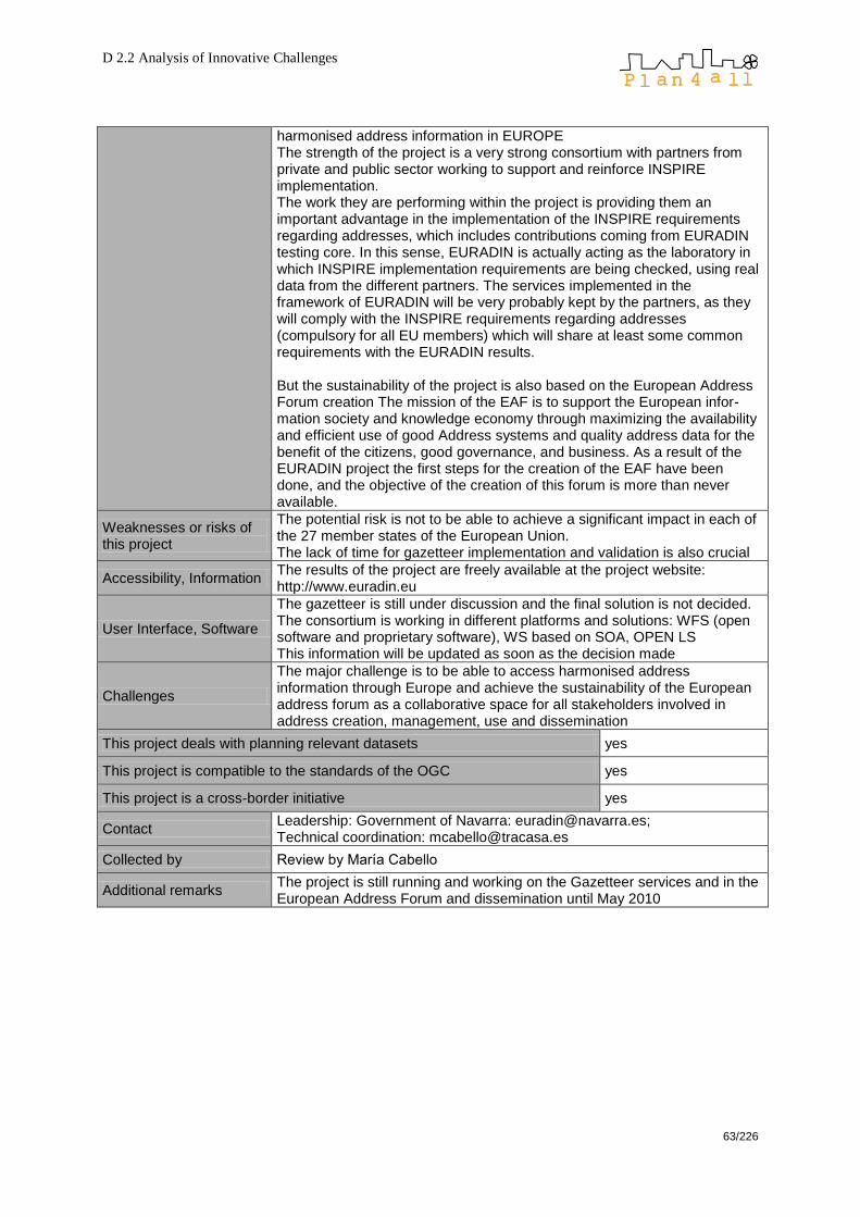
D 2.2 Analysis of Innovative Challenges
63/226
harmonised address information in EUROPE The strength of the project is a very strong consortium with partners from private and public sector working to support and reinforce INSPIRE implementation. The work they are performing within the project is providing them an important advantage in the implementation of the INSPIRE requirements regarding addresses, which includes contributions coming from EURADIN testing core. In this sense, EURADIN is actually acting as the laboratory in which INSPIRE implementation requirements are being checked, using real data from the different partners. The services implemented in the framework of EURADIN will be very probably kept by the partners, as they will comply with the INSPIRE requirements regarding addresses (compulsory for all EU members) which will share at least some common requirements with the EURADIN results. But the sustainability of the project is also based on the European Address Forum creation The mission of the EAF is to support the European infor-mation society and knowledge economy through maximizing the availability and efficient use of good Address systems and quality address data for the benefit of the citizens, good governance, and business. As a result of the EURADIN project the first steps for the creation of the EAF have been done, and the objective of the creation of this forum is more than never available.
Weaknesses or risks of this project
The potential risk is not to be able to achieve a significant impact in each of the 27 member states of the European Union. The lack of time for gazetteer implementation and validation is also crucial
Accessibility, Information The results of the project are freely available at the project website: http://www.euradin.eu
User Interface, Software
The gazetteer is still under discussion and the final solution is not decided. The consortium is working in different platforms and solutions: WFS (open software and proprietary software), WS based on SOA, OPEN LS This information will be updated as soon as the decision made
Challenges
The major challenge is to be able to access harmonised address information through Europe and achieve the sustainability of the European address forum as a collaborative space for all stakeholders involved in address creation, management, use and dissemination
This project deals with planning relevant datasets yes
This project is compatible to the standards of the OGC yes
This project is a cross-border initiative yes
Contact Leadership: Government of Navarra: [email protected]; Technical coordination: [email protected]
Collected by Review by María Cabello
Additional remarks The project is still running and working on the Gazetteer services and in the European Address Forum and dissemination until May 2010

D 2.2 Analysis of Innovative Challenges
64/226
Best Practise # 11
Project Name EuroGeoNames (EGN)
Type of project o EU project
Dimension of project o international
Project start 2006
Project end 2009
URL http://www.eurogeographics.org/eurogeonames
Leader, Project Partners Federal Agency for Cartography and Geodesy (BKG, Germany) + 8 partners from 6 member states
Content (keywords) multilingual, geographical names, Web GIS, INSPIRE
Content (description)
The EuroGeoNames (EGN) project to develop a European geographical names infrastructure and services successfully completed the eContentplus funded phase at the end of February 2009. EGN is a core project under EuroSpec. EGN has implemented an interoperable internet service that links to and provides access to the official, multilingual geographical names data held at the national level across Europe. EGN is a major contribution to opening up public sector information within a wider European spatial (geographic) information infrastructure, and relates more specifically to the INSPIRE implementation rules. The target is to aggregate data for all EU Member States, Candidate countries as well as EFTA countries – by connecting their national databases in the EGN infrastructure. The user – primarily ‗value added service‘ providers - will have access to this information through a Web GIS application which will enable searching using all official European languages, including minority languages.
Used technology/software
open source databases (MySQL, PostgreSQL), non-transactional WFS 1.0, gazetteer services, Deegree, Geoserver
Strengths or chances of this project
Correct display of diacritic signs and transliteration are well-known problems. It is the main strength of this project to overcome these ―digital language barriers‖.
Weaknesses or risks of this project
The services seem not to be available via internet – an ArcGIS installation is necessary to use EGN.
Accessibility, Information The extension is available for free from http://arcscripts.esri.com (requires ArcGIS 9.2 or higher)
User Interface, Software EGN‘s interface has been realised as an extension for ESRI ArcGIS.
Challenges -
This project deals with planning relevant datasets yes
This project is compatible to the standards of the OGC yes
This project is a cross-border initiative yes
Contact Pier-Giorgio Zaccheddu, [email protected]
Collected by Clemens Beyer, CEIT ALANOVA
Additional remarks -
D 2.2 Analysis of Innovative Challenges
65/226
Best Practise # 12
Project Name EuroGEOSS
Type of project EU project (GEOSS is a world-wide project)
Dimension of project international
Project start 2009
Project end no information available
URL http://www.eurogeoss.eu/
Leader, Project Partners 22 partners from 10 countries including USA
Content (keywords) GEOSS, INSPIRE, monitoring
Content (description)
EuroGEOSS demonstrates the added value to the scientific community and society of making existing systems and applications interoperable and used within the GEOSS and INSPIRE frameworks. The project will build an initial operating capacity for a European Environment Earth Observation System in the three strategic areas of Drought, Forestry and Biodiversity. It will then undertake the research necessary to develop this further into an advanced operating capacity that provides access not just to data but also to analytical models made understandable and useable by scientists from different disciplinary domains. EuroGEOSS builds on three strategic application areas that the Joint Research Centre (JRC) has institutional responsibilities: forestry, biodiversity and drought.
Used technology/software
the project has just started, thus no information available
Strengths or chances of this project
facilitate member states in contributing to GEOSS with their existing national monitoring capacities; share European experiences with devleoping countries, e. g. in Africa
Weaknesses or risks of this project
-
Accessibility, Information the project has just started, thus no information available
User Interface, Software the project has just started, thus no information available
Challenges The aspect of multi-disciplinary interoperability remains to date a fundamental challenge that informs the GEOSS initiative and other related efforts such as the development of e-science
This project deals with planning relevant datasets yes
This project is compatible to the standards of the OGC yes
This project is a cross-border initiative yes
Contact http://www.eurogeoss.eu/contact/default.aspx
Collected by Clemens Beyer, CEIT ALANOVA
Additional remarks -
D 2.2 Analysis of Innovative Challenges
66/226
Best Practise # 13
Project Name eWater Multilingual cross-border access to ground water databases
Type of project o EU project
Dimension of project o international
Project start 2006
Project end 2008
URL http://www.ewater.eu/
Leader, Project Partners
NETHERLANDS ORGANISATION FOR APPLIED SCIENTIFIC RESEARCH – TNO + 14 partners from 13 member states
Content (keywords) cross-border, sub-surface water, interoperability, web portal, groundwater monitoring, INSPIRE
Content (description)
eWater is a multilingual Internet system, providing access to hydrogeolo-gical measurement data as well as ground water maps in EU countries. The hydrogeological data are usually acquired from wells or springs. Hydrogeological maps and models are produced based on on interpolation of the point measurement data and interpretation of geological structures. Since eWater architecture complies with INSPIRE policy, new data suppliers are also able to distribute their data via the system. Moreover, the spatial hydrogeological data infrastructure, developed within eWater project, can be used by other international applications.
Used technology/software
WSDL, XSD, WFS, PostgreSQL, MapBuilder (Javascript)
Strengths or chances of this project
As ground water does not care much about administrative borders, such data are excellent examples for the importance of cross-border data infrastructures.
Weaknesses or risks of this project
-
Accessibility, Information
There are a web mapping application, a metadatabase, and a thesaurus (online dictionary).
User Interface, Software
Web browser interface
Challenges -
This project deals with planning relevant datasets yes
This project is compatible to the standards of the OGC yes
This project is a cross-border initiative yes
Contact Dr Alexei TCHISTIAKOV, Netherlands Institute of Applied Geoscience TNO, [email protected]
Collected by Clemens Beyer, CEIT ALANOVA
Additional remarks -

D 2.2 Analysis of Innovative Challenges
67/226
Best Practise # 14
Project Name Geoland
Type of project public project
Dimension of project national
Project start 2003
Project end open-ended
URL http://www.geoland.at/
Leader, Project Partners GIS offices of all 9 Austrian federal states
Content (keywords) national geodatabase, INSPIRE, WMS, SDI
Content (description)
With the realisation of the Geodata Network with all Austrian Federal states through geoland.at, the first concrete step of the conversion of aims, defined by Austrian Geodata politics, is made. This Geodata Network should offer a free and Austrian wide access to Geodata and Services of the federal states of Austria for many purposes. The planned openness of the Geodata network – with decentralised data-management following the subsidiarity principle on the basis of international standards (OGC, ISO, CEN, WMS, WFS, etc.) and national Standards (ISO EN ON) offers moreover the possibility to include and link further Geodata.
Used technology/software
Map servers: different software depending on the 9 federal states operating the map servers; map client: own construction
Strengths or chances of this project
fist project to visualise web map services from different Austrian administrational web map servers in one client via internet
Weaknesses or risks of this project
sometimes poor map server performance, this needs to be strongly improved to guarantee full Austria-wide data display
Accessibility, Information free access
User Interface, Software web browser
Challenges not only national joint view, but also international data (e. g. like CentropeMAP)
This project deals with planning relevant datasets yes
This project is compatible to the standards of the OGC yes
This project is a cross-border initiative no
Contact Amt der Oberösterreichischen Landesregierung [email protected]
Collected by Clemens Beyer, CEIT ALANOVA
Additional remarks -

D 2.2 Analysis of Innovative Challenges
68/226
Best Practise # 15
Project Name GEOMIND Geophysical Multilingual Internet-Driven Information Service
Type of project o EU project
Dimension of project o international
Project start 2006
Project end 2008
URL http://www.geomind.eu/portal/, http://thes.igme.gr/geomind/
Leader, Project Partners Lead Partner: Polish Geological Institute + 11 partners from 8 other EU countries
Content (keywords) SDI, eContentPlus, INSPIRE, multilingual, metadata
Content (description)
GEOMIND is a web-based information portal to search, display and order geophysical data on international level. It provides a multilingual platform as well as metadata on various geophysical topics. The metadata profile os compliant to ISO 19115 and ISO 19139. The system demonstrates research capabilities of the partners and will increase public awareness of the usefulness of geophysical research methods for various needs of the society.
Used technology/software
Java, XML for metadatabase, metadata editor, overview map and thesaurus
Strengths or chances of this project
The system concentrates on metadata only because once there is a comprehensive and complete metadataset, the access procedure to real geodata is almost done.
Weaknesses or risks of this project
Metadata must be uploaded to a central database before being provided through GEOMIND. There is no way to simply link metadata from existing databases.
Accessibility, Information The metadata portal is freely accessible – registration is only needed for metadata providers and translation contributors.
User Interface, Software web browser interface
Challenges In a further step, real geodata could be integrated into such a system through web mapping so that there is at least a preview.
This project deals with planning relevant datasets yes
This project is compatible to the standards of the OGC yes
This project is a cross-border initiative yes
Contact Geomind, RAKOWIECKA 4, 00957 WARSZAWA, POLAND
Collected by Clemens Beyer, CEIT ALANOVA
Additional remarks -

D 2.2 Analysis of Innovative Challenges
69/226
Best Practise # 16
Project Name GéoPal
Type of project Local-government – national-government – private partnership
Dimension of project Sub national for the Région ―Pays de la Loire‖
Project start 2006
Project end
URL http://www.geopal.org
Leader, Project Partners
The Regional council (elected administration for the region) The préfecture de region (state adminstration for the region The general council ((elected administration for the département) of the 5 départements (NUTS III), GéoVendée, the inter-municipality structures of the agglomeration that are capital for the department, GIP Loire estuaire (public interest grouping for the Loire estuary), IGN (French mapping agency), BRGM (French geological survey), IFREMER (research institute for Sea), the regional state administrations, …
Content (keywords) SDI, discovery, search, visualisation, download, metadata
Content (description) Implement a common framework for consistency and interoperability for all initiatives connected to geomatic and GI :
o Increase the efficiency off all entities that produce and or use GI in the Pays de la Loire region,
o Develop mutual use and sharing of existing GI by these entities o Stimulate the GI development in the Pays de la Loire region and
participate to any actions as many initiatives exist but many inconsistencies and heterogeneity exist.
Used technology/software
Based on the PRODIGE platform, which use open source software, developed by the préfecture de la région Rhône-Alpes. Evolutions are on their way taking account of the CARMEN platform developed by MEEDDAT
Strengths or chances of this project
It is an example of a efficient and conistent project within its local context that goes in close cooperation between the state and local government :
o Acquisition of geographical reference data and thematic data elaborated at the departement level
o Host a data catalogue interoperable with the national géocatalogue (www.geocatalogue.fr) part of the French geoportal (www.geoportail.fr)
o Co-production of data such as the land and city planning documents using a common set of specification
Weaknesses or risks of this project
The Elected people at the Region level (regional council members) have difficulties to appropriate the project and have a low level support to the initiative. They therefore allocate insufficient human resources for the user-oriented application.
Accessibility, Information
o Host a data catalogue interoperable with the national geoportal o Harmonize and standardise data o Develop a patrimony of available data o Create a mutual platform of services
User Interface, Software
The software solution includes o A WEB browser for identifying the available datasets based on the
ISO 19115 standard o A WEB viewer based on WMS o An upload download service
The organisationnal sxchema of the regional SDI (see diagram) includes o An Internet bloc open to the general public o An Extranet bloc open to the GEOPAL members. The Extranet
includes a geoWeb service platform and a collaborative platform. Passing from one bloc to the other is transparent to the user.
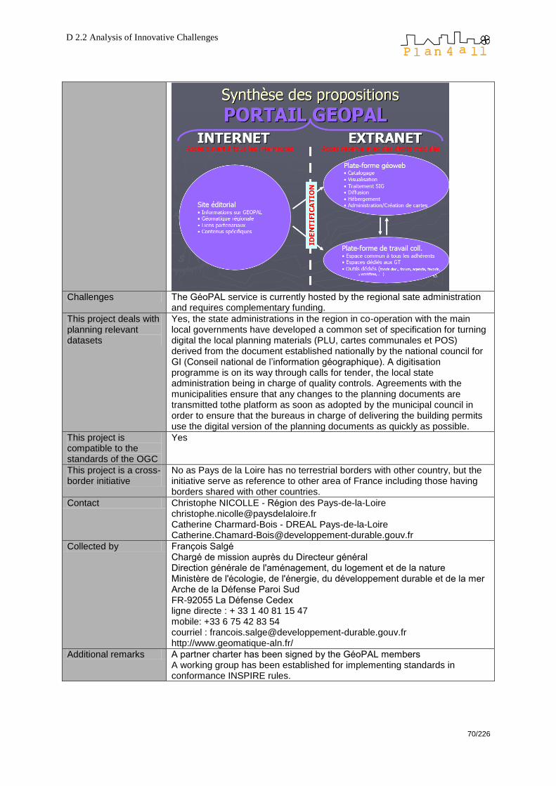
D 2.2 Analysis of Innovative Challenges
70/226
Challenges The GéoPAL service is currently hosted by the regional sate administration
and requires complementary funding.
This project deals with planning relevant datasets
Yes, the state administrations in the region in co-operation with the main local governments have developed a common set of specification for turning digital the local planning materials (PLU, cartes communales et POS) derived from the document established nationally by the national council for GI (Conseil national de l‘information géographique). A digitisation programme is on its way through calls for tender, the local state administration being in charge of quality controls. Agreements with the municipalities ensure that any changes to the planning documents are transmitted tothe platform as soon as adopted by the municipal council in order to ensure that the bureaus in charge of delivering the building permits use the digital version of the planning documents as quickly as possible.
This project is compatible to the standards of the OGC
Yes
This project is a cross-border initiative
No as Pays de la Loire has no terrestrial borders with other country, but the initiative serve as reference to other area of France including those having borders shared with other countries.
Contact Christophe NICOLLE - Région des Pays-de-la-Loire [email protected] Catherine Charmard-Bois - DREAL Pays-de-la-Loire [email protected]
Collected by François Salgé Chargé de mission auprès du Directeur général Direction générale de l'aménagement, du logement et de la nature Ministère de l'écologie, de l'énergie, du développement durable et de la mer Arche de la Défense Paroi Sud FR-92055 La Défense Cedex ligne directe : + 33 1 40 81 15 47 mobile: +33 6 75 42 83 54 courriel : [email protected] http://www.geomatique-aln.fr/
Additional remarks A partner charter has been signed by the GéoPAL members A working group has been established for implementing standards in conformance INSPIRE rules.
D 2.2 Analysis of Innovative Challenges
71/226
Best Practise # 17
Project Name Geoportale della Lombardia (Geoportal of Lombardy)
Type of project Public-private
Dimension of project Regional
Project start 2007
Project end 2009
URL http://www.cartografia.regione.lombardia.it/geoportale
Leader, Project Partners Project between local public authorities and private subjects in the Lombardy region that deal with spatial planning data
Content (keywords) Regional SDI, INSPIRE, regional law on SDI
Content (description)
The geoportal of Lombardy is a collection of GIS data of local authorities, with the aim to build a regional SDI. Regional Law 12/2005 requires all plans at local, provincial, and regional levels to be prepared in digital format and to contribute to the regional SDI, coordinated by the Regional Authority (spatial governance, spatial planning, natural and cultural heritage, risk prevention etc.). Pilot for Inspire
Used technology/software
ESRI GIS Portal Toolkit, international metadata standards ISO19115 and ISO19139, The GeoPortal is built on top of REGIS, the Regional Enterprise platform for Geographic Information Services, which consists of an technological infrastructure (based on ESRI Enterprise components) and basic services used as "LEGO bricks" to build up geographic solutions
Strengths or chances of this project
Data harmonisation, exchange of spatial planning data for local authorities, Inspire standards
Weaknesses or risks of this project
-
Accessibility, Information Accessible for local authorities vie web services
User Interface, Software ESRI products
Challenges -
This project deals with planning relevant datasets yes
This project is compatible to the standards of the OGC yes
This project is a cross-border initiative no
Contact
Marco Panebianco Lombardia Informatica Via Don Minzoni, 24 Milan , Milan 20158, Italy Phone: +39.02.39331.636 E-mail: [email protected]
Collected by Julia Neuschmid, CEIT ALANOVA
Additional remarks -

D 2.2 Analysis of Innovative Challenges
72/226
Best Practise # 18
Project Name GIGAS (GEOSS, INSPIRE and GMES – an Action in Support)
Type of project EU project
Dimension of project international
Project start 2008
Project end 2010, platform persisting thereafter
URL http://www.thegigasforum.eu/
Leader, Project Partners Fraunhofer Institute (Germany) + 18 partners from 7 countries
Content (keywords) INSPIRE, GMES, FP7, Consensus building, Harmonisation of SDI initiatives
Content (description)
The three initiatives GEOSS, INSPIRE and GMES share commonalities, including their thematic focus, their reliance on international standards and the advanced Spatial Data Infrastructures that are needed for their implementation. At the same time however, each initiative follows its own timeline and approach for technical development, thereby risking to evolve into separate, incompatible services. GIGAS is a consensus process that facilitates communication between INSPIRE, GEOSS, GMES and the standardisation bodies.
Used technology/software
The consensus-driven approach of GIGAS does not require any special technology or software.
Strengths or chances of this project
coordinate actions between SDI projects which are primarily independent from each other
Weaknesses or risks of this project
Are there too many separate SDI initiatives? Is it too late to bring them all in line?
Accessibility, Information
The GIGAS discussion board is not available to the public. The website features public deliverables, a conference paper on GIGAS, dissemination material, and the Report of the 1st GIGAS Stakeholder Workshop (Brussels, Jan 2009).
User Interface, Software The consensus-driven approach of GIGAS does not require any special technology or software.
Challenges bringing THE European SDI to life
This project deals with planning relevant datasets yes
This project is compatible to the standards of the OGC yes
This project is a cross-border initiative yes
Contact GIGAS Project Office +49-6151-155-637 E-Mail: [email protected]
Collected by Clemens Beyer, CEIT ALANOVA
Additional remarks This project does not deal with SDI itself, it deals with harmonisation of SDI initiatives.

D 2.2 Analysis of Innovative Challenges
73/226
Best Practise # 19
Project Name GIS4EU
Type of project EU project
Dimension of project international
Project start 2007
Project end 2010
URL http://www.gis4eu.eu/
Leader, Project Partners Lead partner: CORILA (Italy) + 21 partners from 9 countries
Content (keywords) INSPIRE, data model, data sharing, base cartography, web mapping
Content (description)
GIS4EU aims at organising a system to share base cartography layer in order to make accessible and generate a common level of sharing information, without building a central database but sharing data through standard services. The project intends to develop a common data model and support tools for assessment of common standards based on INSPIRE Directive.
Used technology/software
project ongoing, thus no information available
Strengths or chances of this project
common data models for administrative units, hydrography, transportation networks and elevation themes homogenous reference data provided by various cartographic authorities from different countries. During the project an operational validation of INSPIRE standards and implementation rules will be performed.
Weaknesses or risks of this project
assertiveness among various other similar projects
Accessibility, Information There will be a GIS4EU geoportal featuring base layers for administrative units, hydrography, transportation networks and elevation themes.
User Interface, Software project ongoing, thus no information available
Challenges join geographic SDI and planning SDI over INSPIRE
This project deals with planning relevant datasets yes
This project is compatible to the standards of the OGC yes
This project is a cross-border initiative yes
Contact
CONSORZIO PER LA GESTIONE DEL CENTRO DI COORDINAMENTO DELLE ACTIVITA DI RICERCA INERENTI IL SISTEMA LAGUNARE DI VENEZIA, ITALY DE ZORZI Stefania, +39 041 2402523, [email protected]
Collected by Clemens Beyer, CEIT ALANOVA
Additional remarks -
D 2.2 Analysis of Innovative Challenges
74/226
Best Practise # 20
Project Name GMES – Global Monitoring for Environment and Security
Type of project EU project
Dimension of project international
Project start 1998
Project end 2013 at the earliest
URL http://www.gmes.info/
Leader, Project Partners
Content (keywords) ESA, Sentinel, monitoring, INSPIRE
Content (description)
Global Monitoring for Environment and Security (GMES) is a joint initiative of the European Commission and European Space Agency, which aims at achieving an autonomous and operational Earth observation capacity. The objective is to rationalize the use of multiple-sources data to get a timely and quality information, services and knowledge, and to provide autonomous and independent access to information in relation to environment and security. In other words, it will pull together all the information obtained by environmental satellites, air and ground stations to provide a comprehensive picture of the "health" of Earth.
Used technology/software
space satellite missions
Strengths or chances of this project
GMES is one of three related initiatives that are the subject of the GIGAS (GEOSS, INSPIRE and GMES an Action in Support) harmonization project under the auspices of the EU 7th Framework Programme.
Weaknesses or risks of this project
The only risk is a potential failure of the ESA missions.
Accessibility, Information All sub projects and partners are linked on the central GMES website; from these linked website a large number of data catalogues, contact information and online services are accessible.
User Interface, Software GMES consists of numerous single projects and therefore does not run specific own software
Challenges building an own European monitoring satellite network
This project deals with planning relevant datasets yes
This project is compatible to the standards of the OGC yes
This project is a cross-border initiative yes
Contact GMES Bureau, Brussels, +32.2.296 21 62, [email protected]
Collected by Clemens Beyer, CEIT ALANOVA
Additional remarks -

D 2.2 Analysis of Innovative Challenges
75/226
Best Practise # 21
Project Name HUMBOLDT
Type of project EU project
Dimension of project international
Project start 2006
Project end 2010
URL http://www.esdi-humboldt.eu/
Leader, Project Partners Lead Partner: Fraunhofer Institute, Germany. + 27 partners throughout Europe
Content (keywords) European SDI, open source software, harmonisation, metadata
Content (description)
The Humboldt project aims to facilitate the harmonisation of spatial data and metadata by automating the necessary processes as far as possible. Humboldt will undertake a process analysis which will show the steps necessary to harmonise data and metadata. Finally, a software framework and diverse tools will be developed and integrated into the ESDI to support spatial data and service providers in offering standardized spatial information.
Used technology/software
The HUMBOLDT project is developing an own software branch: http://community.esdi-humboldt.eu/
Strengths or chances of this project
All HUMBOLDT developments will be available as Open Source Software, released under the LGPL 3.0 license.
Weaknesses or risks of this project
-
Accessibility, Information
The whole software branch is well-documented: Detailed documentation for all these services and applications, such as full specifications, will be made available under the same license as the software itself. Furthermore, a forum, wiki and bugtracker are prepared for your information and feedback.
User Interface, Software own software
Challenges creating a standalone open source community
This project deals with planning relevant datasets yes
This project is compatible to the standards of the OGC yes
This project is a cross-border initiative yes
Contact Project Office: zeitform Internet Dienste OHG, Darmstadt, Germany E-mail: [email protected]
Collected by Clemens Beyer, CEIT ALANOVA
Additional remarks -

D 2.2 Analysis of Innovative Challenges
76/226
Best Practise # 22
Project Name ISAMAP – Harmonisation of regional data resources for cross-border planning
Type of project o EU project
Dimension of project o international
Project start 2003
Project end 2006
URL http://www.isamap.info/
Leader, Project Partners
Lead Partner: Carinhtia - Office of the Government of Carinthia, Dept. 20, Spatial Planning - KAGIS Project Partners: Friuli Venezia Giulia - Regione Autonoma Friuli-Venezia Giulia, Direzione centrale della pianificazione territoriale, della mobilità e delle infrastrutture di trasporto; Slovenia - Ministry of the Environment, Spatial Planning and Energy, National Office for Spatial Planning
Content (keywords) spatial information, data harmonisation, INTERREG, cross border planning
Content (description)
Nearly 80% of all decisions of the public administration in general and the planning in particular depend on the availability of geographical information. The project sets the task to build up a cross-border infrastructure for geodata which is able to supply the groundwork of questions as regional planning, interests of disaster protection as well as regional political decisions.
Used technology/software
WMS, Geoland Viewer
Strengths or chances of this project
ISAMAP was one of the very first projects to deal with cross-border planning data using web mapping applications, also following the INSPIRE initiative‘s guidelines, thus being a pioneer in the field of cross-border harmonised GIS.
Weaknesses or risks of this project
As many other similar projects followed since ISAMAP, there have not been significant weaknesses within this project in retrospect.
Accessibility, Information
The project results are freely accessible through the project website http://www.isamap.info/ – however, the map viewer is currently (Aug. 2009) not working. A short project report brochure can be found at http://www.isamap.info/Final_Broschure_ISAMAP.pdf
User Interface, Software web browser interface, Geoland Viewer software (in-house development by Carinthian state administration)
Challenges none (project has ended)
This project deals with planning relevant datasets yes
This project is compatible to the standards of the OGC yes
This project is a cross-border initiative yes
Contact
Amt der Kärntner Landesregierung Abteilung 20/Landesplanung KAGIS Wulfengasse 13 A-9020 Klagenfurt [email protected], [email protected]
Collected by Clemens Beyer, CEIT ALANOVA
Additional remarks -
D 2.2 Analysis of Innovative Challenges
77/226
Best Practise # 23
Project Name ISDE – Irish Spatial Data Exchange
Type of project public-private partnership
Dimension of project National – within Ireland.
Project start 2006
Project end Still running: open-ended
URL www.isde.ie
Leader, Project Partners
Leader: Irish Marine Institute Partners: Department of Communications, Marine and Natural Resources Environmental Protection Agency Department of Environment, Heritage and Local Government Teagasc – the Irish agriculture and food development authority Electricity Supply Board The Coastal and Marine Resources Centre, University College Cork The Hydraulics and Maritime Research Centre, University College Cork The Martin Ryan Marine Institute, National University of Ireland, Galway The Centre for Coastal and Marine Research, University of Ulster
Content (keywords) ISD discovery, search, metadata, distributed.
Content (description)
ISDE is a discovery service for spatial data to search metadata catalogues operated by each of the partner organisations. The exchange architecture is distributed with a light central mediation service. The exchange is based around OGC and ISO standards, which allows it to be independent of any catalogue implementation technologies.
Used technology/software
The ISDE is a distributed web architecture consisting of Two browser versions, namely that developed by ESRI-Ireland and an open-source browser developed by CMRC at UCC. The Messaging Hub, known as 'Reach Lite'. This is a temporary compo-nent being used while discussions are carried out with the Irish Reach Agency on possible integration with the Irish Public Services Broker. The Broker/mediator. This maintains a record of participating catalogue services.
Strengths or chances of this project
It is an Irish National web-service based distributed discovery service for spatial data belonging to various organisations, searching the meta-data catalogues operated by each of the partner organisations and accessing the databases at source. It is based on open OGC and ISO standards.
Weaknesses or risks of this project
It is not yet fully INSPIRE compliant and is still work in progress as the Irish Reach & Broker Services have not gained wide usage.
Accessibility, Information
ISDEis very easy to use, and allows users to freely search spatial data metadata catalogues operated by each of the partner organisations, at www.marine.ie/isde/isdesearch.htm or by selecting the global option on the individual catalogue search pages from any of the partners‘ websites.
User Interface, Software
For this ISDE architecture a simplified version of the Reach Public Service
Broker protocols (ReachLite) was implemented3. This ‗lite‘ implementation
of protocols circumvented the more complex requirements for a complete hub-and-spoke Reach implementation. The solution included: Web Browser (Requester) – The user of the service via the host application server Web Server (Application Host) – The Enabler that manages the web
3
www.fujitsu.com/ie/casestudies/midata.html

D 2.2 Analysis of Innovative Challenges
78/226
services and accepts HTTP requests and augments and routes the message appropriately ReachLite (Fulfiller) – The provider of the service functionality based on a partial implementation of the Reach Public Service Broker interface standards. The ReachLite Fulfiller was designed with software components to work both in a Microsoft and Open Source environments. The ISDE solution demonstrates the value of data exchange within the public services sector as a whole. It provides immediate practical assistance to those agencies and organisations and individuals that require an Irish nation wide view of the available data. The key focus of the ISDE project was the development of a metadata dis-covery mechanism that allows metadata catalogues held by the different organisations to become searchable via the Web. In collaboration with ESRI Ireland, Fujitsu developed and deployed an online mechanism whe-reby publicly funded bodies can provide seamless public access to Meta-data relating to GI data sets that they hold. They also identified suitable standards for Metadata exchange in the context of metadata catalogues and indexed data stores, and migration towards INSPIRE compliance. By maximising the reuse of GI data using a federated database integrated using Reach technologies, the key benefits are the improved selection of research locations, topics and questions to be answered about Ireland‘s resources. The ISDE project has also increased Ireland‘s ability to manage and benefit from the various data resource that exists within the public ser-vices and is demonstrating the potential of web-enabled Geographical In-formation Systems (GIS) and related technologies at a national level. It is hoped that the successful sharing of metadata will demonstrate the usefulness of the Irish Spatial Data Exchange and prompt other organisa-tions to make funding available to allow all INSPIRE-related data from va-rious repositories to be exchanged seamlessly, such as a thematic search for temperature variations for pre-selected coastal and offshore locations.
Challenges
The ISDE service is currently hosted by the Irish Marine Institute. ISDE needs funding to allow it to provide fully INSPIRE-compliant access to the partner organisations involved, and enable/encourage further organisations to join in, particularly the Local Authorities, who are directly involved in the Irish Planning system.
This project deals with planning relevant datasets Yes, but not primarily.
This project is compatible to the standards of the OGC Yes
This project is a cross-border initiative No – not yet.
Contact [email protected] no further contact information is provided.
Collected by Dr. John J O‘Flaherty, MAC
Additional remarks
The ISDE partners are currently drafting a Memorandum of Understanding (MOU) to be entered into by participating organizations. Organizations wishing to participate have to adhere to the following ISDE Interoperability Guidelines: ISDE - principal standards are: ISO 19115 for meta data structure OGC CSW 2.0 For catalogue entry exchange UDDI for service identification. And they have issued the following ISDE Interoperability Guidelines (IIGs): Interoperability Guidelines (IIG003) for Data Server (www.marine.ie/isde/IIG-003.pdf) Interoperability Guidelines (IIG002) for ISDE Record (www.marine.ie/isde/IIG-002.pdf) Interoperability Guidelines (IIG001) for ReachLite (www.marine.ie/isde/IIG-001.pdf)

D 2.2 Analysis of Innovative Challenges
79/226
Best Practise # 24
Project Name Mapsharing
Type of project o EU project
Dimension of project o international
Project start 2005
Project end 2007
URL http://www.mapsharing.eu/
Leader, Project Partners
Lead Partner: Trieste Province Project Partners: Pordenone Province, Muggia municipality, Udine municipality; Slovenia Municipality of Koper, Regional Development Agency South Primorska
Content (keywords) Strategic Environmental Assessment, spatial information, INTERREG, cross border planning
Content (description)
The main aim of Mapsharing project consists in identifying tools and methodologies for the construction of shared territorial knowledge in order to increase the effectiveness of Strategic Environmental Assessment in cross-border area located between Friuli Venezia Giulia region and Slovenia Republic. In more detailed way a SDI has been realized for storing data used in the project, in order to ensure their use for planning and programming, as well as their diffusion using internet. The project also defines a shared methodology between project partners, for Strategic Environmental Assessment applicable in Italy and Slovenia and for cross-border plans and programs.
Used technology/software
WMS, WFS, GML
Strengths or chances of this project
This project adopts OGC standards and an huge amount of data have been produced in order to improve the Strategic Environmental Assessment quality. All data are accessible for all citizen.
Weaknesses or risks of this project
This initiative of cross-border harmonization does not consider issues concerning semantic matching. In this project miss an ontological approach.
Accessibility, Information
All documents and data are freely accessible, unfortunately great part of documents are in Italian language. Documents link (http://www.mapsharing.eu/index.php?id=22&L=0), Webgis link (http://sitp.provincia.pordenone.it/pmap/map.phtml?config=mca&language=it)
User Interface, Software
web browser interface, Mapserver
Challenges none (project has been finished)
This project deals with planning relevant datasets yes
This project is compatible to the standards of the OGC yes
This project is a cross-border initiative yes
Contact Sergio Bergnach, Provincia di Pordenone, Largo San Giorgio, 12 - 33170 Pordenone, tel. + 390434 342311 fax + 390434 231244 [email protected]
Collected by Beniamino Murgante, AM/FM Italia
D 2.2 Analysis of Innovative Challenges
80/226
Best Practise # 25
Project Name Med-Isolae 3D
Type of project EU project
Dimension of project international
Project start 2007
Project end 2009
URL http://www.medisolae-3d.eu/, http://www.3d-islands.eu/
Leader, Project Partners Lead partner: Coordinator: EPSILON INTERNASIONAL ANONYMI ETAIREIA MELETON KAI SYMVOULON + 13 partners from 7 countries
Content (keywords) eContentPlus, INSPIRE; SDI, 3D-aerial navigation
Content (description)
Based on readily available geodata owned and to be delivered by the project partners, MedIsolae-3D will deliver for 100+ European Mediterranean islands: (1) A spatial data infrastructure (SDI) in the EU-INSPIRE logic, (2) A 3D-aerial webGIS flying-over application, for island navigation as a virtual-visiting, (3) A dissemination, exploitation and sustainability plan for the commercial use of the Portal, (4) A dynamic Portal for islands information, data sales, and 3D aerial navigation, the latter also being linked to the Google Earth™, Virtual Earth™, and ArcGlobe™ SDI/GIS platforms.
Used technology/software
Google Maps, Flash, Virtual Earth, ArcGlobe
Strengths or chances of this project
Provide an aerial flying-over navigation mastered by the users, who can approach island features and points of interest (POI) as road networks, mountains and hacking trails, beaches, archaeological sites and monuments, city facilities, and visitor information centres, attributed to scale up to 1:5.000 of GIS vector data. a veryinteresting approach also for tourism
Weaknesses or risks of this project
dependency on commercial enterprises and their rules after the project end (which could lead to data developed away from open standards towards proprietary formats)
Accessibility, Information The project results (web maps, aerial navigation) will be freely accessible to anyone over the internet, platform will be marketed after project end
User Interface, Software web browser interface http://www.3d-islands.eu/
Challenges
(1) Make the MedIsolae Portal ―the Portal‖ to be used by many EU islands (beyond project partners). (2) Promote the MedIsolae 3D flying-over service world-wide. (3) Link to Google™, Microsoft™, and ESRI™ platforms for future business.
This project deals with planning relevant datasets yes
This project is compatible to the standards of the OGC yes
This project is a cross-border initiative yes
Contact Marc Bonazountas, +302106898615, [email protected]
Collected by Clemens Beyer, CEIT ALANOVA
Additional remarks -
D 2.2 Analysis of Innovative Challenges
81/226
Best Practise # 26
Project Name Metaschool
Type of project o EU project
Dimension of project o international
Project start 2008
Project end 2010
URL http://www.metaschool.cz/
Leader, Project Partners
Project coordinator is Ellinogermaniki Agogi from the Greece Czech Centre for Science and Society Gymnasium “Nad Kavalirkou” in Prague European Schoolnet University Bayreuth American Colleagues Thessaloniky
Content (keywords) Education, Metadata, Uniform Resource Management (URM)
Content (description)
Project Towards Teacher Competence on Metadata and Online Resources - Metaschool is financing from the Lifelong Learning Programme and Comenius Multilateral projects sub-programme. The project objective is to propose new methods of information technology and metadata utilization in educational system.
Used technology/software
URM technologies as a solution based on WEB 2.0 principles
Strengths or chances of this project
Searching for articles, presentations, tutorials, digital maps and their utilization and sharing.
Weaknesses or risks of this project
Data availability Willingness of teachers to publish their materials
Accessibility, Information Metaschool portal is free of charge for all schools Registration makes possible better using of information (sharing, publishing)
User Interface, Software Web base interface, Internet explorer
Challenges Need to solve IPR issue, probably Common Creative Licence
This project deals with planning relevant datasets yes
This project is compatible to the standards of the OGC yes
This project is a cross-border initiative yes
Contact Czech Centre for Science and Society, Dr Karel Charvat, [email protected]
Collected by Sarka Horakova, CCSS
Additional remarks -

D 2.2 Analysis of Innovative Challenges
82/226
Best Practise # 27
Project Name Municipal land management - MonPlanGML
Type of project public project
Dimension of project o National
Project start 03/2004
Project end 12/2011
URL http://www.gtz.de/en/weltweit/europa-kaukasus-zentralasien/6530.htm
Leader, Project Partners GTZ (Deutsche Gesellschaft für Technische Zusammenarbeit); Client: German Federal Ministry for Economic Cooperation and Development Lead exec. agency: Montenegrin Min. for Spatial Planning & Environment
Content (keywords) Harmonization of spatial planning data
Content (description)
The project ―Municipal Land Management‖, Montenegro, started in March 2004. It is designed for a total period of approximately 8 years (March 2004 – December 2011). Its overall objective is that legal certainty as well as spatial and urban planning using land as a resource is improved. The pro-ject is targeted to take effect within the municipalities: As local self-gover-ning units, they are the most important users of cadastre and real estate registration information. The municipalities receive advice on urban land use planning, municipal real estate management and land tax collection, the most important (municipal) land management tasks. According to the ―Montenegrin Law on Planning and Development‖, all new planning docu-ments have to be elaborated and submitted to the municipal / national planning institutions in digital form. As one of the activity fields of the Muni-cipal Land Management Project, the development of the GML-based data model MonPlanGML will form the necessary precondition for a standard-dized visualization and exchange of digital planning information in Montenegro.
Used technology/software
RationalRose (UML modeling) MonPlanGML Toolbox (converting ESRI shape files to MonPlanGML data format
Strengths or chances of this project
Harmonization of spatial planning data (corresponding to Montenegrin planning law) so that datasets become comparable and interoperable.
Weaknesses or risks of this project
o
Accessibility, Information see project website or CORP paper http://www.gtz.de/en/weltweit/europa-kaukasus-zentralasien/6530.htm/ http://www.corp.at/corp_relaunch/papers_txt_suche/CORP2008_17.pdf
User Interface, Software
Challenges data harmonisation
This project deals with planning relevant datasets yes
This project is compatible to the standards of the OGC yes
This project is a cross-border initiative yes
Contact
Dr. Joachim Benner (Institute for Applied Computer Science Karlsruhe) [email protected] Eichhorn (LGV Hamburg - Agency for Geo-Information and Surveying) [email protected]. Kai-Uwe Krause (LGV Hamburg - Agency for Geo-Information and Surveying) [email protected] Müller (GTZ) [email protected]
Collected by Kai-Uwe Krause, Agency for Geo-Information and Surveying
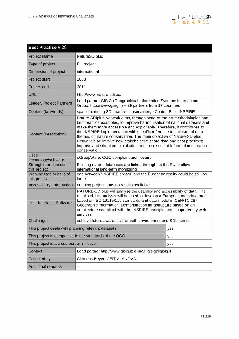
D 2.2 Analysis of Innovative Challenges
83/226
Best Practise # 28
Project Name NatureSDIplus
Type of project EU project
Dimension of project international
Project start 2008
Project end 2011
URL http://www.nature-sdi.eu/
Leader, Project Partners Lead partner GISIG (Geographical Information Systems International Group, http://www.gisig.it) + 29 partners from 17 countries
Content (keywords) spatial planning SDI, nature conservation, eContentPlus, INSPIRE
Content (description)
Nature-SDIplus Network aims, through state-of-the-art methodologies and best practice examples, to improve harmonisation of national datasets and make them more accessible and exploitable. Therefore, it contributes to the INSPIRE implementation with specific reference to a cluster of data themes on nature conservation. The main objective of Nature-SDIplus Network is to: involve new stakeholders; share data and best practices; improve and stimulate exploitation and the re-use of information on nature conservation.
Used technology/software
eGroupWare, OGC compliant architecture
Strengths or chances of this project
Existing nature databases are linked throughout the EU to allow international long-term monitoring.
Weaknesses or risks of this project
gap between ―INSPIRE dream‖ and the European reality could be still too large
Accessibility, Information ongoing project, thus no results available
User Interface, Software
NATURE-SDIplus will analyse the usability and accessibility of data. The results of this analysis will be used to develop a European metadata profile based on ISO 19115/119 standards and data model in CEN/TC 287 Geographic information. Demonstration infrastructure based on an architecture compliant with the INSPIRE principle and supported by web services
Challenges achieve future awareness for both environment and SDI themes
This project deals with planning relevant datasets yes
This project is compatible to the standards of the OGC yes
This project is a cross-border initiative yes
Contact Lead partner http://www.gisig.it; e-mail: [email protected]
Collected by Clemens Beyer, CEIT ALANOVA
Additional remarks -
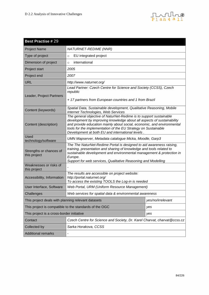
D 2.2 Analysis of Innovative Challenges
84/226
Best Practise # 29
Project Name NATURNET-REDIME (NNR)
Type of project o EU integrated project
Dimension of project o international
Project start 2005
Project end 2007
URL http://www.naturnet.org/
Leader, Project Partners
Lead Partner: Czech Centre for Science and Society (CCSS), Czech republic + 17 partners from European countries and 1 from Brazil
Content (keywords) Spatial Data, Sustainable development, Qualitative Reasoning, Mobile Internet Technologies, Web Services
Content (description)
The general objective of NaturNet-Redime is to support sustainable development by improving knowledge about all aspects of sustainability and provide education mainly about social, economic, and environmental tools for the implementation of the EU Strategy on Sustainable Development at both EU and international levels .
Used technology/software
UMN Mapserver, Metadata catalogue Micka, Moodle, Garp3
Strengths or chances of this project
The The NaturNet-Redime Portal is designed to aid awareness raising, training, presentation and sharing of knowledge and tools related to sustainable development and environmental management & protection in Europe. Support for web services, Qualitative Reasoning and Modelling
Weaknesses or risks of this project
-
Accessibility, Information The results are accessible on project website: http://portal.naturnet.org/ To access the existing TOOLS the Log-in is needed
User Interface, Software Web Portal, URM (Uniform Resource Management)
Challenges Web services for spatial data & environmental awareness
This project deals with planning relevant datasets yes/no/irrelevant
This project is compatible to the standards of the OGC yes
This project is a cross-border initiative yes
Contact Czech Centre for Science and Society, Dr. Karel Charvat, [email protected]
Collected by Sarka Horakova, CCSS
Additional remarks -
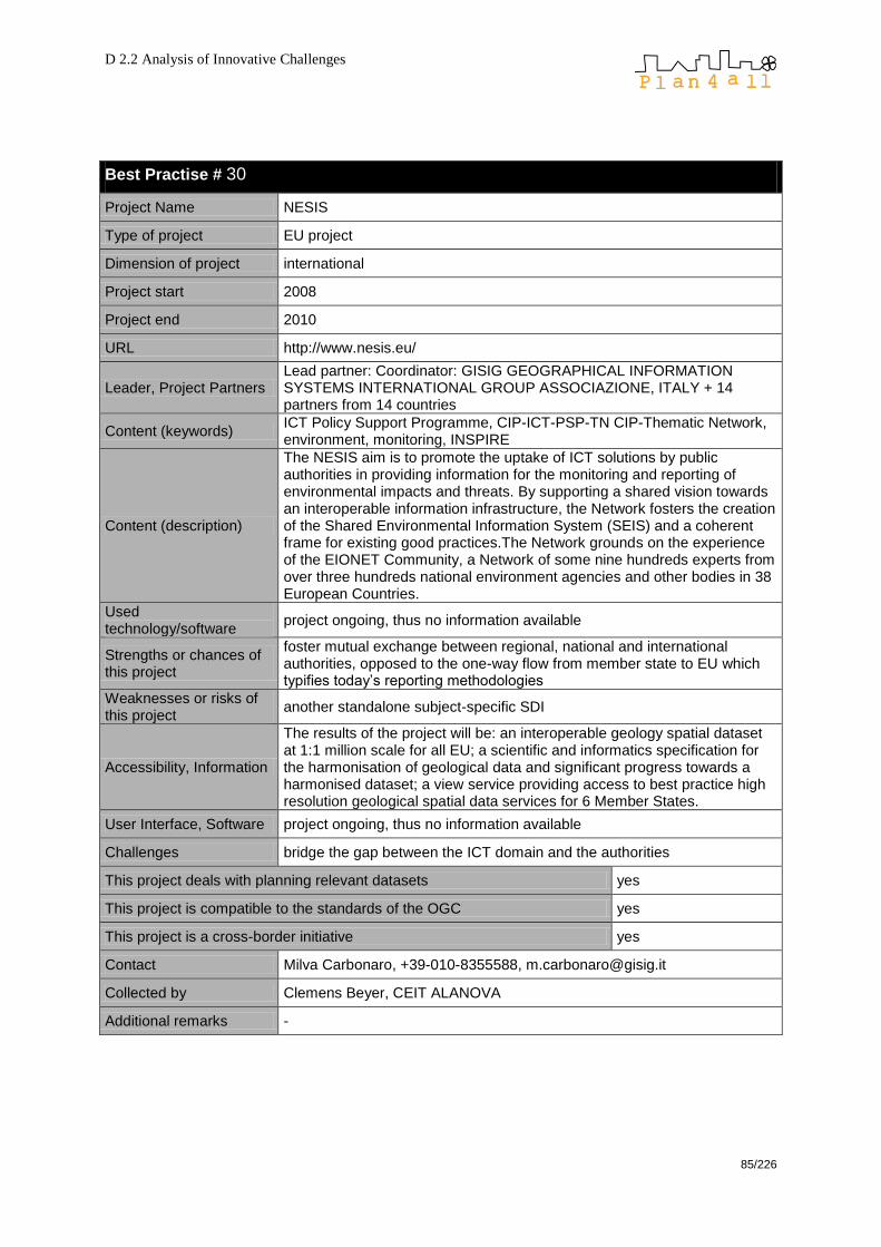
D 2.2 Analysis of Innovative Challenges
85/226
Best Practise # 30
Project Name NESIS
Type of project EU project
Dimension of project international
Project start 2008
Project end 2010
URL http://www.nesis.eu/
Leader, Project Partners Lead partner: Coordinator: GISIG GEOGRAPHICAL INFORMATION SYSTEMS INTERNATIONAL GROUP ASSOCIAZIONE, ITALY + 14 partners from 14 countries
Content (keywords) ICT Policy Support Programme, CIP-ICT-PSP-TN CIP-Thematic Network, environment, monitoring, INSPIRE
Content (description)
The NESIS aim is to promote the uptake of ICT solutions by public authorities in providing information for the monitoring and reporting of environmental impacts and threats. By supporting a shared vision towards an interoperable information infrastructure, the Network fosters the creation of the Shared Environmental Information System (SEIS) and a coherent frame for existing good practices.The Network grounds on the experience of the EIONET Community, a Network of some nine hundreds experts from over three hundreds national environment agencies and other bodies in 38 European Countries.
Used technology/software
project ongoing, thus no information available
Strengths or chances of this project
foster mutual exchange between regional, national and international authorities, opposed to the one-way flow from member state to EU which typifies today‘s reporting methodologies
Weaknesses or risks of this project
another standalone subject-specific SDI
Accessibility, Information
The results of the project will be: an interoperable geology spatial dataset at 1:1 million scale for all EU; a scientific and informatics specification for the harmonisation of geological data and significant progress towards a harmonised dataset; a view service providing access to best practice high resolution geological spatial data services for 6 Member States.
User Interface, Software project ongoing, thus no information available
Challenges bridge the gap between the ICT domain and the authorities
This project deals with planning relevant datasets yes
This project is compatible to the standards of the OGC yes
This project is a cross-border initiative yes
Contact Milva Carbonaro, +39-010-8355588, [email protected]
Collected by Clemens Beyer, CEIT ALANOVA
Additional remarks -

D 2.2 Analysis of Innovative Challenges
86/226
Best Practise # 31
Project Name OneGeologyEurope
Type of project EU project
Dimension of project international
Project start 2008
Project end 2010
URL http://www.onegeology-europe.org/home
Leader, Project Partners Lead partner: Natural Environment Research Council (British Geological Survey - BGS) + partners from 29 countries
Content (keywords) geology, metadata, geological map, web mapping, data search, geoscience SDI, INSPIRE
Content (description)
29 countries and European organizations are committed to create a geological map at 1:1.000.000 scale, which will be available as from September 2011, integrated with metadata initially available in the following languages: English, French, Italian, Spanish, Swedish, Czech and Norwegian. The project strives to facilitate search for geological spatial data which through the web. Web services will enable its usage through different means, such as visualization, downloading and various transformations. The data will be easily discoverable and easy to understand and analyse.
Used technology/software
project ongoing, thus no information available
Strengths or chances of this project
Geological data are essential to the prediction and mitigation of landslides, subsidence, earthquakes, flooding and pollution – but they are difficult to discover and are not interoperable. For those outside the survey or nation they are not easy to obtain, to understand, or use. This project helps to harmonise geological data sources throughout Europe.
Weaknesses or risks of this project
another standalone subject-specific SDI
Accessibility, Information
The results of the project will be: an interoperable geology spatial dataset at 1:1 million scale for all EU; a scientific and informatics specification for the harmonisation of geological data and significant progress towards a harmonised dataset; a view service providing access to best practice high resolution geological spatial data services for 6 Member States.
User Interface, Software project ongoing, thus no information available
Challenges bring this SDI together with various other subject-specific SDIs according to INSPIRE guidelines
This project deals with planning relevant datasets yes
This project is compatible to the standards of the OGC yes
This project is a cross-border initiative yes
Contact Ian JACKSON ([email protected])
Collected by Clemens Beyer, CEIT ALANOVA
Additional remarks -

D 2.2 Analysis of Innovative Challenges
87/226
Best Practise # 32
Project Name Open Yambol- Local initiative for transference in spatial planning of Yambol Municipality, Bulgaria
Type of project Public/EU project
Dimension of project local/regional/national/international
Project start 2008
Project end 2009, but the update will be made on every 2 months
URL http://www.openyambol.org/gis/
Leader, Project Partners IDEA (local NGO-www.ngoidea.com) and Municipality of Yambol
Content (keywords) Map client, spatial planning data, transparency in spatial planning
Content (description)
The project is an initiative of non-governmental organization IDEA, supported by the Ymabol municipality administration and funded by Operational Program Administrative capacity (European Social Fund). The basic idea of the project is to publish spatial planning data, regarding the territory of Yambol Municipality, Bulgaria and all decisions in that field. Using UMN Map server, all spatial planning data and all changes era dynamically published and available for the general public.
Used technology/software
UMN Map server
Strengths or chances of this project
Spatial planning datasets from different sources (Cadastre Agency, Yambol municipality etc) are integrated on one online map; all interfaces are built on open source software
Weaknesses or risks of this project
Problems with sustainability- no clear idea how the service will be funded after the funding is gone
Accessibility, Information The project data is accessible over the internet at http://www.openyambol.org/gis/– all datasets are available as web map services. There is no restriction at all.
User Interface, Software Web map server: UMN Map Server 4.8
Challenges Probably upgrading the map server into fully functional GIS server, with developed GIS services
This project deals with planning relevant datasets yes
This project is compatible to the standards of the OGC yes
This project is a cross-border initiative no
Contact Milena Georgieva, NGO IDEA, [email protected]
Collected by Stelian Dimitrov, EPF
Additional remarks -

D 2.2 Analysis of Innovative Challenges
88/226
Best Practise # 33
Project Name ORCHESTRA (Open architecture and spatial data infrastructure for risk management)
Type of project o EU project
Dimension of project o international
Project start 2004
Project end 2008
URL http://www.eu-orchestra.org/
Leader, Project Partners SCIENCE AND TECHNOLOGY CENTER FOR EUROPE AT MADRID (STREAM) + 13 partners from 7 countries
Content (keywords) risk management, INSPIRE, project network, SDI
Content (description)
ORCHESTRA is designing and implementing the specifications for a service oriented spatial data infrastructure for improved interoperability among risk management authorities in Europe, which will enable the handling of more effective disaster risk reduction strategies and emergency management operations. ORCHESTRA will not only deliver technical results such as the RM-OA plus developed services and applications, but also aims to bring together and consolidate the risk management community. This is being done by integrating the results and recommendations of previous and current European and National projects and initiatives. Some of the results of ORCHESTRA are being used as input to the INSPIRE (through its Drafting Teams) and GMES initiatives.
Used technology/software
OGC-compliant web mapping technology (e. g. QGIS Mapserver, GML); the Reference Model for the ORCHESTRA Architecture has even been granted the status of an OGC best practise document.
Strengths or chances of this project
- To design an open service-oriented architecture for risk management - To develop the software infrastructure for enabling risk management services - To deliver an infrastructure integrating spatial and non-spatial services for risk management - To validate the ORCHESTRA results in a multi-risk scenario - To provide software standards for risk management applications
Weaknesses or risks of this project
limitations of web mapping software and standards regarding scenario operation and simulation
Accessibility, Information The project data are accessible via web mapping clients (meanwhile partly abandoned)
User Interface, Software web interface (mapping client)
Challenges bringing scenario tools and more GIS functionality into web mapping
This project deals with planning relevant datasets yes
This project is compatible to the standards of the OGC yes
This project is a cross-border initiative yes
Contact Name: Esteban Lauzan, Jose Fernando Tel: +34-91-2148613, Fax: +34-91-7543252 [email protected]
Collected by Clemens Beyer, CEIT ALANOVA
Additional remarks -
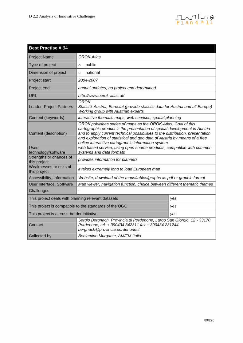
D 2.2 Analysis of Innovative Challenges
89/226
Best Practise # 34
Project Name ÖROK-Atlas
Type of project o public
Dimension of project o national
Project start 2004-2007
Project end annual updates, no project end determined
URL http://www.oerok-atlas.at/
Leader, Project Partners ÖROK Statistik Austria, Eurostat (provide statistic data for Austria and all Europe) Working group with Austrian experts
Content (keywords) interactive thematic maps, web services, spatial planning
Content (description)
ÖROK publishes series of maps as the ÖROK-Atlas. Goal of this cartographic product is the presentation of spatial development in Austria and to apply current technical possibilities to the distribution, presentation and exploration of statistical and geo data of Austria by means of a free online interactive cartographic information system.
Used technology/software
web based service, using open source products, compatible with common systems and data formats
Strengths or chances of this project
provides information for planners
Weaknesses or risks of this project
it takes extremely long to load European map
Accessibility, Information Website, download of the maps/tables/graphs as pdf or graphic format
User Interface, Software Map viewer, navigation function, choice between different thematic themes
Challenges -
This project deals with planning relevant datasets yes
This project is compatible to the standards of the OGC yes
This project is a cross-border initiative yes
Contact Sergio Bergnach, Provincia di Pordenone, Largo San Giorgio, 12 - 33170 Pordenone, tel. + 390434 342311 fax + 390434 231244 [email protected]
Collected by Beniamino Murgante, AM/FM Italia

D 2.2 Analysis of Innovative Challenges
90/226
Best Practise # 35
Project Name spatial data infrastructure Hamburg Metropolitan Region (SDI-MRH)
Type of project public project
Dimension of project National
Project start 2003
Project end open end
URL http://www.geodaten.metropolregion.hamburg.de
Leader, Project Partners
―LGV Hamburg‖ – Agency for Geo-Information and Surveying Hamburg, ―LGN Lower Saxony‖ - Geodetic Survey of Lower Saxony, Interior Ministry of Schleswig Holstein, six counties of Lower Saxony, six counties of Schleswig Holstein bordering the Free and Hanseatic City of Hamburg
Content (keywords) Hamburg Metropolitan Region, cross-border data and layout harmonisation, map client, spatial data infrastructure based on OGC web services
Content (description)
SDI-MRH brings datasets from the three federal states Hamburg, Lower Saxony (partly) and Schleswig Holstein (partly) together in one map client. The project mainly focuses on comprehensive regional planning at federal state and county level, urban land-use planning, protected sites, tourism, education and commercial areas related datasets.
Used technology/software
deegree WMS, WFS, WFS-G, WMPS, Mapbender, PostgreSQL / PostGIS, ESRI ArcIMS ( used by some of the administrative offices).
Strengths or chances of this project
- Datasets from different servers are shown together in one map - Harmonisation of data layout and classification so that datasets become comparable (realised for geometric boundary of binding land-use plans, protected sites and commercial areas; development of more harmonised object models is planed) - Cascading WMS, OGC services and map applications are built on open source software
Weaknesses or risks of this project
slow progress in data and layout harmonisation
Accessibility, Information All project data are freely accessible over the internet: see project website http://www.geodaten.metropolregion.hamburg.de There is no restriction at all.
User Interface, Software Web mapping client (web browser interface): Mapbender 2.5 Web map service (WMS) / web feature service (WFS-G) / web map print service (WMPS) : deegree 2.3
Challenges SLD integration, cascading access to partners WMS
This project deals with planning relevant datasets yes
This project is compatible to the standards of the OGC yes
This project is a cross-border initiative yes
Contact LGV Hamburg – Agency for Geo-Information and SurveyingThomas Eichhorn (head of the Department Geo Data Application and head of the SDI-MRH coordination site) [email protected]
Collected by Kai-Uwe Krause, Agency for Geo-Information and Surveying
Additional remarks -
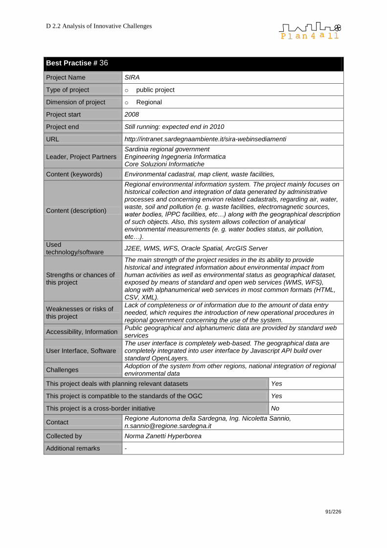
D 2.2 Analysis of Innovative Challenges
91/226
Best Practise # 36
Project Name SIRA
Type of project o public project
Dimension of project o Regional
Project start 2008
Project end Still running: expected end in 2010
URL http://intranet.sardegnaambiente.it/sira-webinsediamenti
Leader, Project Partners Sardinia regional government Engineering Ingegneria Informatica Core Soluzioni Informatiche
Content (keywords) Environmental cadastral, map client, waste facilities,
Content (description)
Regional environmental information system. The project mainly focuses on historical collection and integration of data generated by administrative processes and concerning environ related cadastrals, regarding air, water, waste, soil and pollution (e. g. waste facilities, electromagnetic sources, water bodies, IPPC facilities, etc…) along with the geographical description of such objects. Also, this system allows collection of analytical environmental measurements (e. g. water bodies status, air pollution, etc…).
Used technology/software
J2EE, WMS, WFS, Oracle Spatial, ArcGIS Server
Strengths or chances of this project
The main strength of the project resides in the its ability to provide historical and integrated information about environmental impact from human activities as well as environmental status as geographical dataset, exposed by means of standard and open web services (WMS, WFS), along with alphanumerical web services in most common formats (HTML, CSV, XML).
Weaknesses or risks of this project
Lack of completeness or of information due to the amount of data entry needed, which requires the introduction of new operational procedures in regional government concerning the use of the system.
Accessibility, Information Public geographical and alphanumeric data are provided by standard web services
User Interface, Software The user interface is completely web-based. The geographical data are completely integrated into user interface by Javascript API build over standard OpenLayers.
Challenges Adoption of the system from other regions, national integration of regional environmental data
This project deals with planning relevant datasets Yes
This project is compatible to the standards of the OGC Yes
This project is a cross-border initiative No
Contact Regione Autonoma della Sardegna, Ing. Nicoletta Sannio, [email protected]
Collected by Norma Zanetti Hyperborea
Additional remarks -

D 2.2 Analysis of Innovative Challenges
92/226
Best Practise # 37
Project Name SITNA (Territorial Information System of Navarra)
Type of project Public project collaborative
Dimension of project Regional – Region of Navarra (Spain)
Project start 2000
Project end It is open-ended
URL http://sitna.navarra.es
Leader, Project Partners
The system organization is corporative and horizontal and it get involved all the actors. The main Board: Coordination Commission is chaired by the Vice President of the Government of Navarra. All departments of the Government of Navarra are involved. Moreover the Government of Navarra, Local Administrations, public companies and recently some private company are also participating in SITNA. The SITNA have been implemented wit the technologic support of the company Trabajos Catastrales S.A. (TRACASA). More information can be find at SITNA Geoportal
Content (keywords)
Spatial Data Infrastructure, Territorial Information System, INSPIRE, Navarra, SITNA (Territorial Information System of Navarra), IDENA (Regional SDI of Navarra), IDEPamplona (Local SDI of Pamplona), Modernization of Administration, Public Service, Information Society.
Content (description)
SITNA has been designed to coordinate and update integrated GI resources from multiple units (all the Government Departments are involved in data supply) so that they can be used to support the activities of every unit, allowing every user‟s category to fulfill specific needs for information. The system integrates incoming informative flows of the different suppliers, and supplies back territorial integrated information. The incoming information flows are subject to quality assurance procedures, and a precise homogeneous reference system is used for spatial data integration. The system also allows for time series data management. On top of SITNA, the IDENA has been developed according to ISO and OGC interoperability standards and offers catalogue, map and download services. The Territorial Information System of Navarra (SITNA) has evolved in the last decade into the regional SDI of Navarra (IDENA) improving integration and giving operative support to a wider number of users.
Used technology/software
In-house developments
Strengths or chances of this project
Three aspects have been focused in SITNA from its beginnings: The Management, essential to consolidate the model and the coordination among the stakeholders; the Information, collecting the biggest number of possible layers and, at the same time, involving the Departments in their management; the Dissemination, making useful the System, the best way to state it and guarantee its growth. SITNA aims to contribute to the modernisation of the Public Administrations taking part as infrastructure for regional development
Weaknesses or risks of this project
Lacking of collaborative culture regarding spatial information. Not be able to evolve as required by the users and the technological advances.

D 2.2 Analysis of Innovative Challenges
93/226
Accessibility, Information
SITNA geoportal is the open window for all those users and citizens interested in information related to the territory of Navarra. The information is free with legal copyright and is available for discovering, viewing and downloading directly from the SDI of Navarra (IDENA) From SITNA Geoportal home, several data and services are offered increasing and evolving continuously.
User Interface, Software SITNA web is based in in-house developments from TRACASA based on SOAP
Challenges
Technologically, planned developments include WFS services and openness services such as API-mashups or Iframe, Future developments for SITNA also include the connection to mobile devices; the diffusion of SITNA among schools, private companies, universities, and local administrations;
This project deals with planning relevant datasets yes
This project is compatible to the standards of the OGC yes
This project is a cross-border initiative
No, but participates in the National SDI initiative (IDEE)that it‟s cross-border (all Spanish regions are participating to build IDEE in a collaborative way)
Contact Government of Navarra: [email protected] Tracasa:[email protected]
Collected by María Cabello, Tracasa (on behalf of partner NASURSA)
Additional remarks -

D 2.2 Analysis of Innovative Challenges
94/226
Best Practise # 38
Project Name Sistema Informativo Territoriale Regionale (SITR)
Type of project o public project
Dimension of project o Regional
Project start 2005
Project end Still running: expected end in 2010
URL http://www.sardegnaterritorio.it/sistemainformativo/progettositr.html
Leader, Project Partners Sardinia regional government, Core Soluzioni Informatiche.
Content (keywords) GIS, INSPIRE, OGC, Standards, WMS, WFS, OLS, ISO19115,CNIPA, SMART WEB MAPPING
Content (description)
Regional territorial information system. The project mainly focuses on collection and integration of geographical data generated by local administrations, along with the publication of standard web services for providing such geographical dataset.
Used technology/software
J2EE, WEB SERVICES, ORACLE, ORACLE SPATIAL, ArcIMS, JAVASCRIPT API, PHP, GEOSERVER, MySQL, TOMCAT, JBOSS, APACHE
Strengths or chances of this project
The main strength of the project resides in the its ability to provide geographical dataset by standard OGC web services (WMS, WFS, OLS,… ) and guarantee data interoperability to any client that support OGC Standards and INSPIRE rules.
Weaknesses or risks of this project
Lack of completeness or of information due to the use of different information systems from local administrative offices. Duplication of data with other territorial systems who don‘t interoperate with standards.
Accessibility, Information Public geographical data are provided by standard web services based on the INSPIRE rules.
User Interface, Software
The user interface is completely web-based. The geographical data are completely integrated into user interface by Javascript API build over the OpenLayers tool. Clients can access directly to wms, wfs services and build custom interfaces to data.
Challenges Adoption of the system from other regions, national integration of regional environmental data.
This project deals with planning relevant datasets Yes
This project is compatible to the standards of the OGC Yes
This project is a cross-border initiative No
Contact Regione Autonoma della Sardegna, Ing. Rita Vinelli, [email protected]
Collected by Norma Zanetti Hyperborea
Additional remarks -
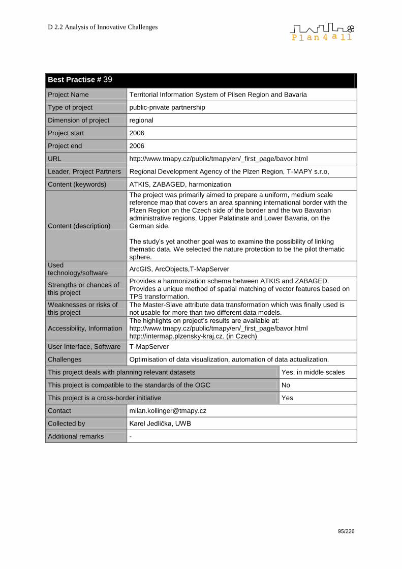
D 2.2 Analysis of Innovative Challenges
95/226
Best Practise # 39
Project Name Territorial Information System of Pilsen Region and Bavaria
Type of project public-private partnership
Dimension of project regional
Project start 2006
Project end 2006
URL http://www.tmapy.cz/public/tmapy/en/_first_page/bavor.html
Leader, Project Partners Regional Development Agency of the Plzen Region, T-MAPY s.r.o,
Content (keywords) ATKIS, ZABAGED, harmonization
Content (description)
The project was primarily aimed to prepare a uniform, medium scale reference map that covers an area spanning international border with the Plzen Region on the Czech side of the border and the two Bavarian administrative regions, Upper Palatinate and Lower Bavaria, on the German side. The study‘s yet another goal was to examine the possibility of linking thematic data. We selected the nature protection to be the pilot thematic sphere.
Used technology/software
ArcGIS, ArcObjects,T-MapServer
Strengths or chances of this project
Provides a harmonization schema between ATKIS and ZABAGED. Provides a unique method of spatial matching of vector features based on TPS transformation.
Weaknesses or risks of this project
The Master-Slave attribute data transformation which was finally used is not usable for more than two different data models.
Accessibility, Information The highlights on project‘s results are available at: http://www.tmapy.cz/public/tmapy/en/_first_page/bavor.html http://intermap.plzensky-kraj.cz. (in Czech)
User Interface, Software T-MapServer
Challenges Optimisation of data visualization, automation of data actualization.
This project deals with planning relevant datasets Yes, in middle scales
This project is compatible to the standards of the OGC No
This project is a cross-border initiative Yes
Contact [email protected]
Collected by Karel Jedlička, UWB
Additional remarks -
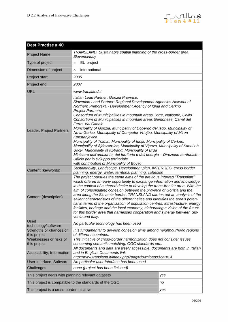
D 2.2 Analysis of Innovative Challenges
96/226
Best Practise # 40
Project Name TRANSLAND, Sustainable spatial planning of the cross-border area Slovenia/Italy
Type of project o EU project
Dimension of project o international
Project start 2005
Project end 2007
URL www.transland.it
Leader, Project Partners
Italian Lead Partner: Gorizia Province, Slovenian Lead Partner: Regional Development Agencies Network of Northern Primorska - Development Agency of Idrija and Cerkno Project Partners: Consortium of Municipalities in mountain areas Torre, Natisone, Collio Consortium of Municipalities in mountain areas Gemonese, Canal del Ferro, Val Canale Muncipality of Gorizia, Muncipality of Doberdò del lago, Muncipality of Nova Gorica, Muncipality of Øempeter-Vrtojba, Muncipality of Miren-Konstanjevica Muncipality of Tolmin, Muncipality of Idrija, Muncipality of Cerkno, Muncipality of Ajdovøœina, Muncipality of Vipava, Muncipality of Kanal ob Soœi, Muncipality of Kobarid, Muncipality of Brda Ministero dell‟ambiente, del territorio e dell‟energia – Direzione territoriale – Ufficio per lo sviluppo territoriale with contribution of Muncipality of Bovec
Content (keywords) Sustainability, Landscape, Development plan, INTERREG, cross border planning, energy, water, territorial planning, cohesion
Content (description)
The project pursues the same aims of the previous Interreg “Transplan” which offered an early opportunity to exchange information and knowledge in the context of a shared desire to develop the trans-frontier area. With the aim of consolidating cohesion between the province of Gorizia and the area along the Slovenia border, TRANSLAND carries out an analysis of the salient characteristics of the different sites and identifies the area‟s poten-tial in terms of the organization of population centres, infrastructure, energy facilities, heritage and the local economy, elaborating a vision of the future for this border area that harnesses cooperation and synergy between Slo-venia and Italy.
Used technology/software
No particular technology has been used
Strengths or chances of this project
It is fundamental to develop cohesion aims among neighbourhood regions of different countries.
Weaknesses or risks of this project
This initiative of cross-border harmonization does not consider issues concerning semantic matching, OGC standards etc..
Accessibility, Information All documents and data are freely accessible, documents are both in Italian and in English. Documents link http://www.transland.it/index.php?pag=downloads&cat=14
User Interface, Software No particular user Interface has been used
Challenges none (project has been finished)
This project deals with planning relevant datasets yes
This project is compatible to the standards of the OGC no
This project is a cross-border initiative yes

D 2.2 Analysis of Innovative Challenges
97/226
Contact Marzia Bonetti, Daniel Jjarc Provincia di Gorizia, Corso Italia, 55 – 34170 Gorizia, tel. + 390481547120 [email protected], [email protected]
Collected by Beniamino Murgante, AM/FM Italia
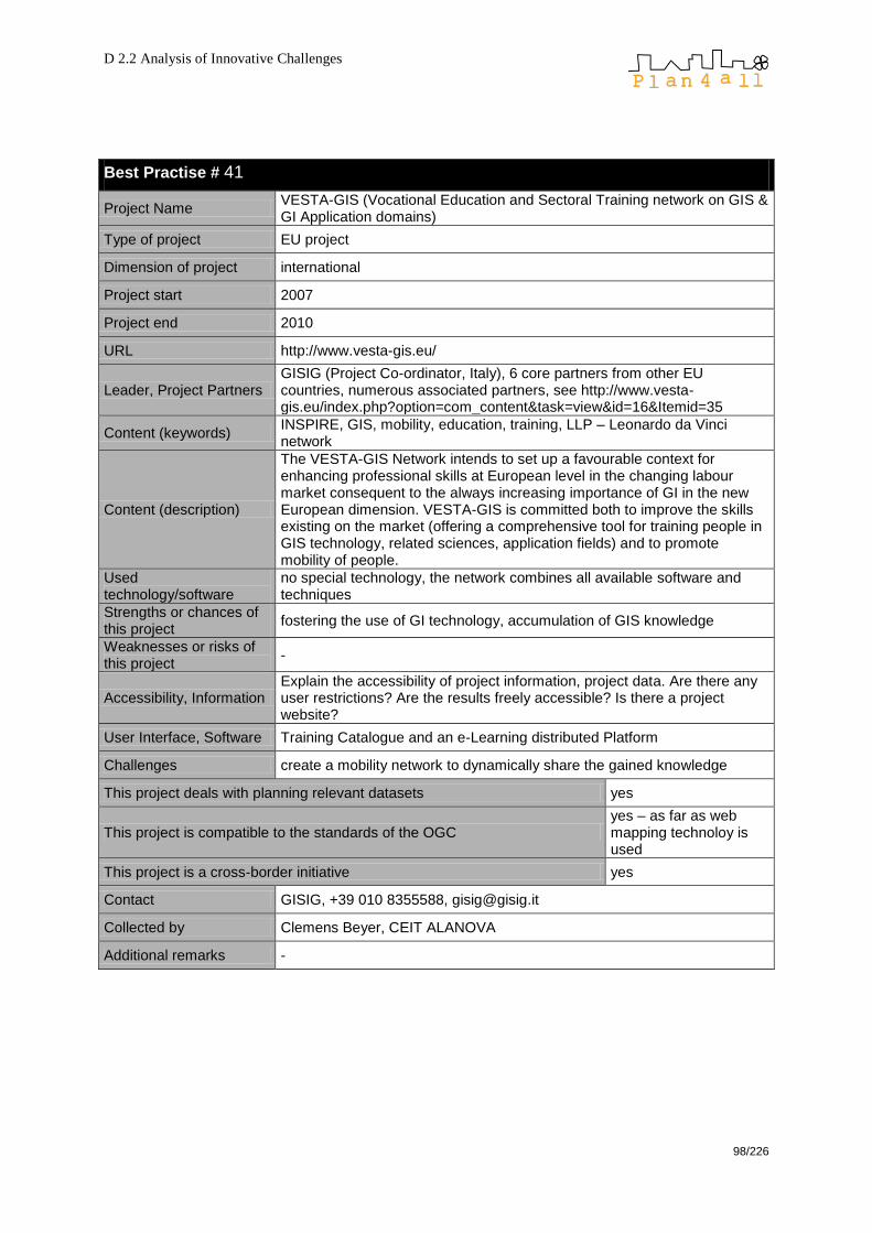
D 2.2 Analysis of Innovative Challenges
98/226
Best Practise # 41
Project Name VESTA-GIS (Vocational Education and Sectoral Training network on GIS & GI Application domains)
Type of project EU project
Dimension of project international
Project start 2007
Project end 2010
URL http://www.vesta-gis.eu/
Leader, Project Partners GISIG (Project Co-ordinator, Italy), 6 core partners from other EU countries, numerous associated partners, see http://www.vesta-gis.eu/index.php?option=com_content&task=view&id=16&Itemid=35
Content (keywords) INSPIRE, GIS, mobility, education, training, LLP – Leonardo da Vinci network
Content (description)
The VESTA-GIS Network intends to set up a favourable context for enhancing professional skills at European level in the changing labour market consequent to the always increasing importance of GI in the new European dimension. VESTA-GIS is committed both to improve the skills existing on the market (offering a comprehensive tool for training people in GIS technology, related sciences, application fields) and to promote mobility of people.
Used technology/software
no special technology, the network combines all available software and techniques
Strengths or chances of this project
fostering the use of GI technology, accumulation of GIS knowledge
Weaknesses or risks of this project
-
Accessibility, Information Explain the accessibility of project information, project data. Are there any user restrictions? Are the results freely accessible? Is there a project website?
User Interface, Software Training Catalogue and an e-Learning distributed Platform
Challenges create a mobility network to dynamically share the gained knowledge
This project deals with planning relevant datasets yes
This project is compatible to the standards of the OGC yes – as far as web mapping technoloy is used
This project is a cross-border initiative yes
Contact GISIG, +39 010 8355588, [email protected]
Collected by Clemens Beyer, CEIT ALANOVA
Additional remarks -

D 2.2 Analysis of Innovative Challenges
99/226
Best Practise # 42
Project Name Web SIG Agape
Type of project public project
Dimension of project local (north of département ―Meurthe-et-Moselle‖, see map)
Project start 2009
Project end
URL https://sig.agape-ped.org
Leader, Project Partners AGAPE Lorraine Nord (Agence d‘urbanisme)All the 7 intercommunalités (group of municipalities) that are among the members of AGAPE (agence d'urbanisme)
Content (keywords) SDI, metadata, visualisation
Content (description)
Implementation of a WEB GIS for all the local governments that are included in the AGAPE area (see map). The platform will meet their requirements: today viewing of cadastral maps, later the system will enable the management of the building permits (autorisation d‘urbanisme). It will enable the consultation of geographic information by the general public in conformance with INSPIRE rules.
Used technology/software
The platform is entirely based on open source software. All data are stored in a PostGIS database. Cartoweb is used for cartographic display. Metadata used GéoSource that is a French clone of GeoNetwork.
Strengths or chances of this project
Using open source software enabled to start the project without huge investments. The existence of many corporate data within AGAPE enabled to rapidly fuel the system with data.
Weaknesses or risks of this project
As the project is in its launching phase, there is always the risk that users, both decision maker (elected people) and technical do not appropriate the tool. The consequence will be that no further funding may be available for new user-oriented developments.As no SDI in Lorraine (the region) is proposed and no coordination around GI is on its way, data exchange, sharing and usage are complex to organise. As an example the user conditions that apply to the same reference data defer between the two département (NUTS3 local government).
Accessibility, Information The system hosts a metadata catalogue that will be interoperable with the national geocatalogue (www.geocatalogue.fr) that is part of the French geoportal (www.geoportail.fr)
User Interface, Software
The system is in fact a thematic geoportal that enable accessing a wide range of maps. The open to public part has limited available functionalities (navigation, print, layer selection and location service).The professional part is only open to identified users. Additional functions are available: data export (both image and vector), portrayal management (sort of cartographic layout), adjunction of annotation and user-oriented data management (adjunction, modification, deletion of geographical data both geometry and semantic).Based on the user ID, cartography enable to access sensitive data over the territory the user is operating on (privacy constraints (CNIL) on personal data)
Challenges The main goal is to implement a system that enables thematic usage and distribution usage for GI in line with INSPIRE.
This project deals with planning relevant datasets yes
This project is compatible to the standards of the OGC yes
This project is a cross-border initiative no
Contact Christophe BREDEL – AGAPE

D 2.2 Analysis of Innovative Challenges
100/226
[email protected] Olivier Durr – AGAPE [email protected]
Collected by François Salgé, MEEDDAT
Additional remarks
Of course, AGAPE is progressively turning digital the planning documents of the participating municipalities. A database modelling has been done as close as possible of the CNIG specification for PLU and SUP. Further more, due to the observation mission of the agency, urban sprawl and land use layers are produced and will be made available on the platform. Using Mapserver enabled to guarantee interoperability with WMS and WFS clients and servers. Few functionalities such as data updating or context safeguard are specific to the Cartoweb framework and do not conform to
WFS-T or WMC. More or less, the initiative to access cadastral data has no trans-border nature. But AGAPE acting in the context of the European pole of development (www.agglo-ped.org) and the cross-border Esch-Belval area, the system will be use in the related projects
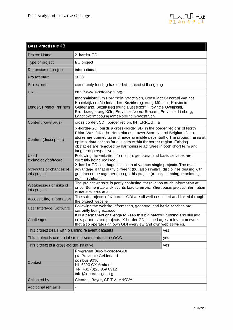
D 2.2 Analysis of Innovative Challenges
101/226
Best Practise # 43
Project Name X-border-GDI
Type of project EU project
Dimension of project international
Project start 2000
Project end community funding has ended, project still ongoing
URL http://www.x-border-gdi.org/
Leader, Project Partners
Innenministerium Nordrhein- Westfalen, Consulaat Generaal van het Koninkrijk der Nederlanden, Bezirksregierung Münster, Provincie Gelderland, Bezirksregierung Düsseldorf, Provincie Overijssel, Bezirksregierung Köln, Provincie Noord-Brabant, Provincie Limburg, Landesvermessungsamt Nordrhein-Westfalen
Content (keywords) cross border, SDI, border region, INTERREG IIIa
Content (description)
X-border-GDI builds a cross-border SDI in the border regions of North Rhine-Westfalia, the Netherlands, Lower Saxony, and Belgium. Data stores are opened up and made available decentrally. The program aims at optimal data access for all users within thr border region. Existing obstacles are removed by harmonising activities in both short term and long term perspectives.
Used technology/software
Following the website information, geoportal and basic services are currently being realised.
Strengths or chances of this project
X-border-GDI is a huge collection of various single projects. The main advantage is that many different (but also similar!) disciplines dealing with geodata come together through this project (mainly planning, monitoring, administration).
Weaknesses or risks of this project
The project website is partly confusing, there is too much information at once. Some map click events lead to errors. Short basic project information is not available at all.
Accessibility, Information The sub-projects of X-border-GDI are all well-described and linked through the project website.
User Interface, Software Following the website information, geoportal and basic services are currently being realised.
Challenges It is a permanent challenge to keep this big network running and still add new partners and projects. X-border GDI is the largest relevant network that also operates an own GDI overview and own web services.
This project deals with planning relevant datasets yes
This project is compatible to the standards of the OGC yes
This project is a cross-border initiative yes
Contact
Programm Büro X-border-GDI p/a Provincie Gelderland postbus 9090 NL-6800 GX Arnhem Tel: +31 (0)26 359 8312 [email protected]
Collected by Clemens Beyer, CEIT ALANOVA
Additional remarks -
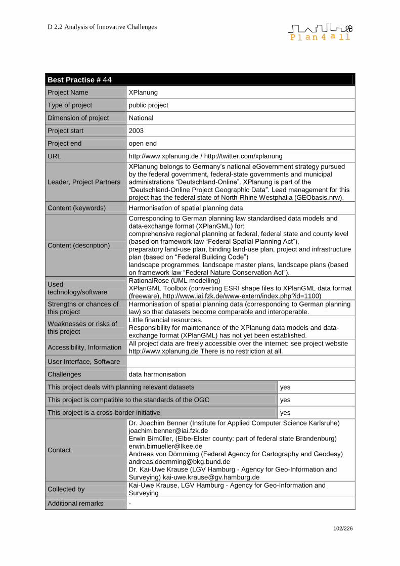
D 2.2 Analysis of Innovative Challenges
102/226
Best Practise # 44
Project Name XPlanung
Type of project public project
Dimension of project National
Project start 2003
Project end open end
URL http://www.xplanung.de / http://twitter.com/xplanung
Leader, Project Partners
XPlanung belongs to Germany‘s national eGovernment strategy pursued by the federal government, federal-state governments and municipal administrations ―Deutschland-Online‖. XPlanung is part of the ―Deutschland-Online Project Geographic Data‖. Lead management for this project has the federal state of North-Rhine Westphalia (GEObasis.nrw).
Content (keywords) Harmonisation of spatial planning data
Content (description)
Corresponding to German planning law standardised data models and data-exchange format (XPlanGML) for: comprehensive regional planning at federal, federal state and county level (based on framework law ―Federal Spatial Planning Act‖), preparatory land-use plan, binding land-use plan, project and infrastructure plan (based on ―Federal Building Code‖) landscape programmes, landscape master plans, landscape plans (based on framework law ―Federal Nature Conservation Act‖).
Used technology/software
RationalRose (UML modelling) XPlanGML Toolbox (converting ESRI shape files to XPlanGML data format (freeware), http://www.iai.fzk.de/www-extern/index.php?id=1100)
Strengths or chances of this project
Harmonisation of spatial planning data (corresponding to German planning law) so that datasets become comparable and interoperable.
Weaknesses or risks of this project
Little financial resources. Responsibility for maintenance of the XPlanung data models and data-exchange format (XPlanGML) has not yet been established.
Accessibility, Information All project data are freely accessible over the internet: see project website http://www.xplanung.de There is no restriction at all.
User Interface, Software
Challenges data harmonisation
This project deals with planning relevant datasets yes
This project is compatible to the standards of the OGC yes
This project is a cross-border initiative yes
Contact
Dr. Joachim Benner (Institute for Applied Computer Science Karlsruhe) [email protected] Erwin Bimüller, (Elbe-Elster county: part of federal state Brandenburg) [email protected] Andreas von Dömmimg (Federal Agency for Cartography and Geodesy) [email protected] Dr. Kai-Uwe Krause (LGV Hamburg - Agency for Geo-Information and Surveying) [email protected]
Collected by Kai-Uwe Krause, LGV Hamburg - Agency for Geo-Information and Surveying
Additional remarks -
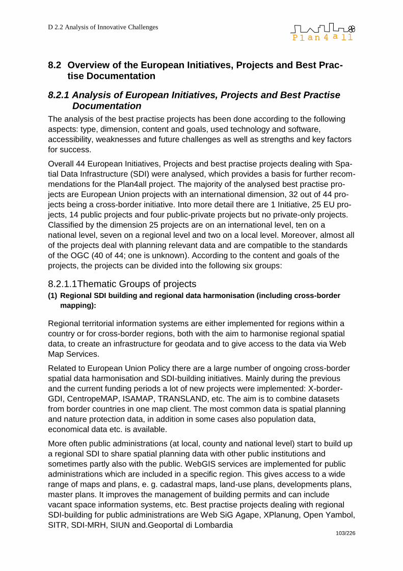
D 2.2 Analysis of Innovative Challenges
103/226
8.2 Overview of the European Initiatives, Projects and Best Prac-tise Documentation
8.2.1 Analysis of European Initiatives, Projects and Best Practise Documentation
The analysis of the best practise projects has been done according to the following
aspects: type, dimension, content and goals, used technology and software,
accessibility, weaknesses and future challenges as well as strengths and key factors
for success.
Overall 44 European Initiatives, Projects and best practise projects dealing with Spa-
tial Data Infrastructure (SDI) were analysed, which provides a basis for further recom-
mendations for the Plan4all project. The majority of the analysed best practise pro-
jects are European Union projects with an international dimension, 32 out of 44 pro-
jects being a cross-border initiative. Into more detail there are 1 Initiative, 25 EU pro-
jects, 14 public projects and four public-private projects but no private-only projects.
Classified by the dimension 25 projects are on an international level, ten on a
national level, seven on a regional level and two on a local level. Moreover, almost all
of the projects deal with planning relevant data and are compatible to the standards
of the OGC (40 of 44; one is unknown). According to the content and goals of the
projects, the projects can be divided into the following six groups:
8.2.1.1 Thematic Groups of projects (1) Regional SDI building and regional data harmonisation (including cross-border
mapping):
Regional territorial information systems are either implemented for regions within a
country or for cross-border regions, both with the aim to harmonise regional spatial
data, to create an infrastructure for geodata and to give access to the data via Web
Map Services.
Related to European Union Policy there are a large number of ongoing cross-border
spatial data harmonisation and SDI-building initiatives. Mainly during the previous
and the current funding periods a lot of new projects were implemented: X-border-
GDI, CentropeMAP, ISAMAP, TRANSLAND, etc. The aim is to combine datasets
from border countries in one map client. The most common data is spatial planning
and nature protection data, in addition in some cases also population data,
economical data etc. is available.
More often public administrations (at local, county and national level) start to build up
a regional SDI to share spatial planning data with other public institutions and
sometimes partly also with the public. WebGIS services are implemented for public
administrations which are included in a specific region. This gives access to a wide
range of maps and plans, e. g. cadastral maps, land-use plans, developments plans,
master plans. It improves the management of building permits and can include
vacant space information systems, etc. Best practise projects dealing with regional
SDI-building for public administrations are Web SiG Agape, XPlanung, Open Yambol,
SITR, SDI-MRH, SIUN and.Geoportal di Lombardia

D 2.2 Analysis of Innovative Challenges
104/226
(2) National SDI building and national data harmonisation
A second group of best practise projects deals with SDI-building on a national level,
trying to harmonise spatial data from key players within the country (national/re-
gional/county/local level, etc.). A national SDI-building project in Austria is ―Geoland‖
which can be described as a geodata network that offers a free and Austrian wide
access to geodata and services of the federal states of Austria. The spatial data
harmonisation is based on international standards (OGC, ISO, CEN, WMS, WFS,
etc.) and national standards (ISO, EN, ON). Another example is MonPlanGML that
aims to form the necessary precondition for a standardised visualisation and exchan-
ge of digital planning information in Montenegro, or the ÖROK-Atlas which is an
online information and mapping tool for spatial planning related topics. The Dutch
Spatial Planning Standards Regulation will take effect on January 1st 2010 and says
that all spatial plans of the public administrations of the municipial and provincial level
have to be made available in digital format. They will then have the same legal status
as the analogue plans. This national SDI building process will make all plans
comparable, exchangable and accessable for everybody.
(3) SDI building for sectoral themes
Thematic networks focus on a specific topic and are situated on different levels, i. e.
regional, national, cross-border, European level. A great number of projects deal with
environmental issues (data collection, analysing, sharing, monitoring) and providing
web-based access to environmental data (hydrogeological measurement data, geolo-
gical data, data regarding air, waste, soil and pollution, biodiversity, forestry, drought
etc.) as well as maps (e. g. ground water maps, geological maps ...). To name some
of those projects: eWater, OneGeologyEurope, SiRA, EnviroGRIDS, EuroGEOSS,
NESIS, GEOMIND.
The GMES demonstrate European initiative focused on support for global monitoring
(Earth Observation and In Situ). GMES is complementary to INSPIRE initative and it
include a lot of Europan projects funded from Framework programs or trough ESA.
Besides, there are other thematic best practise projects, for example EuroGeoNames
(giving access to the official European, multilingual geographic names via WebGis
application) and C@R which is about sustainable development in rural areas.
(4) Best practise networks
A third group of projects is characterised by their approach of creating best practise
networks. EURADIN is about promoting European address harmonisation by estab-
lishing a common definition, registration and access to European address data. Natu-
re-SDIplus Network aims, through state-of-the-art methodologies and best practise
examples, to improve harmonisation of national datasets on nature conversation and
make them more accessible and exploitable.
D 2.2 Analysis of Innovative Challenges
105/226
(5) Metadata collection
The importance of metadata has already been described above (page 44), saying
that ―a dataset is only as good as its metadata collection‖ and also emphasising on
existing and international standards. Once there is a comprehensive and complete
metadataset, the access procedure to real geodata is almost done. Therefore some
initiatives concentrate especially on metadata: GEOMIND, ISDE, Metaschool,
HUMBOLDT.
(6) SDI harmonisation initiatives
The last group of best practise projects does not deal with SDI itself, but with harmo-
nisation of existing SDI initiatives by coordinating actions between SDI projects and
key players which are primarily independent from each other. The objective is to
establish a platform for communication and exchange between different stakeholders
involved in the creation and use of SDI's and also to increase awareness for the
importance of an SDI. Projects are GIGAS and eSDI-NET+, which can be described
as consensus processes that facilitate communication between different standardisa-
tion bodies and directives and initiatives, such as INSPIRE, GEOSS, GMES.
8.2.1.2 Used technology/software
The used technologies and software are rather heterogeneous and therefore hard to
compare. Roughly summarised many projects use open source software because of
financial reasons. Also UMN Map Server and MySQL or PostgreSQL/PostGIS data-
bases are common. The user interface is in most of the cases
a web browser interface
discovery based on ISO 19115 standards
web viewer based on WMS (typically a Javascript map viewer)
In some cases own software and in-house developments are in use (e. g. ISAMAP,
Humboldt, SITNA).
8.2.1.3 Accessibility
Most projects have in common that the data can be accessed easily via a project
website. In general these WebGIS services can be used without restrictions and for
free (which applies sometimes only for parts of the data). In some little cases project
information/data is accessible only upon request.
8.2.1.4 Weaknesses and challenges
This is a summary of the collected weaknesses, threats and risks of the best practise
projects which are also challenges for the future.
D 2.2 Analysis of Innovative Challenges
106/226
Insufficient financial resources
The risk of no further funding which negatively effects the project progress. Funding
and financial guarantee is a key element for keeping a project running.
Insufficient human resources
Often specialised IT-knowledge is required which cannot always be provided. In
some cases there is also a low level support for the members of public
administrations.
Complexity
There is a high complexity of data usage, exchange and the integration of different
technologies. The question rises, if the gap between the ―INSPIRE dream‖ and the
European reality could still be too large?
Distance
Although geographical distance gets more and more irrelevant in today‘s globalised
world, the factor of overcoming space was still mentioned as a barrier for creating
useful maps between distant partner regions.
Insufficient data (quality, quantity, availability, interoperability)
Spatial data (at least in Europe) is expensive and not always available. For future
developments bigger efforts are necessary in data collection (quantity and quality) as
there are still big disparities between different European Union regions. Harmonisa-
tion gets of high importance to enable meaningful cross-border use. Also regional
data should be integrated on a national level.
Insufficient sustainability
Most of the best practise projects are based on a fixed term of some months. As a
result, the question rises what happens after the project ending? Usually it depends
on the funding, if a project survives. The sustainability of a project depends on the
one hand on the financial resources and on the other hand on the project itself and if
it is able to achieve a significant impact.
Insufficient technology
In some cases a poor map server performance and other weak points in the used
software were mentioned. However, the long list of potential software in the GIS
sector shows that there is a wide range of options and different solutions.
A future challenge might be to upgrade some map servers to fully functional Web GIS
servers, to make use of web mapping standards (gml, WCS), to develop new
services and to optimize for example the data visualisation, automation, updating, etc
to provide better support for geospatial Web services as well as to make the services
and the data public (promotion).

D 2.2 Analysis of Innovative Challenges
107/226
Insufficient cooperation
On the one hand the lack of collaboration and cooperation is a further potential
thread for the failure of a SDI building and data harmonisation project. Cooperation
can be done according to the Living-Labs-Methodology, which involves not only the
developers but also the users in the application development. On the other hand the
question is, if there are already too many separate SDI initiatives and if it is too late to
bring them all in line?
Insufficient standards and metadata collection
There are still some initiatives of harmonisation that do not consider issues
concerning semantic matching, OGC standards etc. In addition metadata is still not
always collected at all, or at least not collected to official standards. A challenge for
the further development is to work more towards the implementation of the INSPIRE
principles.
Strengths & factors for success
This summary of collected strengths of the best practise projects can be seen as key
elements for successful spatial planning data harmonisation and SDI building.
Open Source Products
Open Source software and OGC conform Web Services (WMS, WFS) are in
common use as they enable the work with GIS data without huge investments.
Standards
ISO and OGC standards and most common formats (html., csv., xml.) make data
sharing and data exchange easier.
Metadata
Accurate metadata collection clears the way for data networking and SDI building in a
European context. Unfortunately, lots of metadata information is still incomplete and
not collected according to certain standards (see survey results, section 4, metadata
collection).
Efficiency
Data harmonisation and interoperability of different data catalogues improve the
efficiency in spatial planning. Aims are the integration of datasets from different
sources into one (online) map, to create common data models for administrative units
and homogenous reference data.
Cooperation
Interregional, cross-border and transnational cooperation (horizontally) as well as
cooperation between the state and regional or local governments (vertically) are a
key factor for successful data harmonisation. In addition cross-border initiatives
support the development of cohesion aims between different regions/countries. Also
a strong consortium with partners from public and private sectors is necessary to
support the INSPIRE implementation in all sectors dealing with spatial information.

D 2.2 Analysis of Innovative Challenges
108/226
Cooperation is also about knowledge transfer and exchange, meaning that the
experience should be shared with less experiences or less developed countries
within the European Union, but also with players outside of the EU.
Coordination
In addition to cooperation with different partners, coordination of primarily existing
and independent projects is of high importance.
Modernisation
The implementation of Web Services and SDI building is a big step towards the
modernization of e. g. public administrations.
Monitoring
Especially concerning environmental issues, linked nature databases allow
international long-term monitoring.
Living Lab Methodology
Living Lab is a new research paradigm that integrates a user-centric multidisciplinary
research approach and user community driven innovation based on real life
experiments. Users can participate in the development process by coming up with
innovative ideas. The approach intends to increase the understanding of occurring
phenomena, to explore and evaluate new ideas and concepts to enable re-usable
experiments (i. e. dataset, research protocols and methods,...), to result in more
accurate and reliable products and services, to speed-up concepts and to bring
science and innovation closer to the citizen.
Accessibility
Data needs to be accessible, most common on the project website via WebGIS
Services. Especially in a European context, the importance of multilingualism rises,
so that the language is not a barrier for spatial planning data access. For a high use
the services need to be promoted and the necessary GIS skills transferred.
8.2.2 Comparison of Best Practise projects with Plan4all
This chapter deals with similarities, differences and links between the presented best
practise projects and Plan4all. The first paragraph gives a short description of
Plan4all, it‘s type, dimension, goals, strengths and weakness.
Plan4all is an EU project with international dimension, starting in 2009 with project
duration of three years. The project involves 24 partners within the European Union
countries and Norway from public and private institutions. The initial situation is a
fragmented legal structure and disjointed planning laws in the different countries,
which make it difficult to compare planning regulations across Europe, e. g. for
investors and decision makers. Therefore the project will focus on the harmonisation
of spatial planning data and metadata as well as on building a networking infrastruc-
ture for sharing spatial planning data. It is based on existing best practise projects in
the EU and will be done according to the INSPIRE directive. The strengths and

D 2.2 Analysis of Innovative Challenges
109/226
chances of the project are to make planning information more transparent and under-
standable. Plan4all deals with best practise networks, metadata collection, SDI
harmonisation initiatives and European SDI-building for spatial planning data (see
page 103). Because spatial planning is interdisciplinary and integrates themes from
various sectors, Plan4all concentrates only on a limited number of themes, focusing
on land use and land regulation.
Compared to the presented best practise projects above, Plan4all fits in the large
group of European Union projects with an international dimension. With 24 partners
in different European countries the transnational project is rather wide spread and
probably much more linked than most of the other projects (large number of cross-
border projects). Plan4all is still at the beginning of a three years period, whereas
most of the other projects have already started some years ago or have even been
finished by now. Here is a chance for Plan4all as it can learn from previous projects
and can make use of their experience with spatial data harmonisation and SDI-
building. Some of the key persons of the best practise projects are present in the
Plan4all Team and can give experience, knowledge and support concerning the
management, used technologies, the handling of accessibility of the data etc.
However, potential risks are that not all Plan4all goals can be achieved and that this
new approach or attempt of planning data harmonisation and SDI building will be just
another project out of many. So, what is it that makes the Plan4all project special and
unique compared to other SDI-building projects?
Plan4all is not another standalone subject-specific SDI but has one of its main tasks
in harmonising existing SDIs and making them interoperable. It is so far, one of the
biggest networks of partners dealing with spatial data harmonisation (according to the
number of partners and the number of participating countries). It also emphasizes
more than any other project on the INSPIRE directive.
Based on the mentioned strengths and weaknesses of the best practise projects,
factors for success and future challenges for Plan4all are:
(1) Sustainability
For the success of Plan4all it is essential to have a great sustainable impact which
means to keep the process of data harmonisation and SDI building alive, also after
the project ending as this is the point on which many previous projects failed.
Sustainability depends on different factors, mentioned below.
(2) Funding
Financial resources are a key element for a project and decide its future existence
and sustainability. As some previous projects show, as soon as the funding is gone,
the project stops.
(3) Communication, cooperation
Plan4all integrates partners from different European countries, who do not have the
same experience and level of knowledge in spatial data, spatial data harmonisation,
GIS technologies etc. There is a need for knowledge transfer according to GIS tech-
nologies/relevant software/services and applied geographical information systems.
D 2.2 Analysis of Innovative Challenges
110/226
Moreover the partners are characterised by different languages, mentalities and cul-
tural background. Even regional cross-border projects of a smaller dimension are
often slowed down or even hindered by ―borders‖, so a challenge for Plan4all will be
to overcome those possible barriers.
(4) Strengthening of awareness, promotion
Moreover it is of high importance to strengthen the awareness that SDI and data
harmonisation is necessary and to point out the advantages of the Plan4all initiative
to keep the network stable and to gain new partners for the future. Besides promoting
the idea of Plan4all within the circle of experts and SDI builders, a challenge will be to
promote the new services also to the users.
(5) Monitoring
Further monitoring – not only during but also after the project ending – can be a
support to ensure sustainability.
8.3 Summary
There are a lot of best practise projects dealing with spatial data infrastructures, each
of them combing knowledge from a variety of experts from public authorities,
research institutions, service suppliers and technology providers. All of these projects
follow the aims of the INSPIRE directive to establish an infrastructure for spatial
information throughout the Europe. The collected examples can be divided into the
following groups:
(1) Regional SDI building and regional data harmonisation (including cross-border
mapping)
(2) National SDI building and national data harmonisation
(3) SDI building for sectoral themes
(4) Best practise networks
(5) Metadata collection
(6) SDI harmonisation initiatives
The key ideas behind these projects are:
(1) To show that cross-border applications are feasible.
Today‘s web technologies developed rapidly in the past few years concerning
facilities and speed. For example, only little less than half of Germany's internet users
had a broadband connection in 2006, whereas the percentage rose to even 65.4 %
of all internet users during the year 2008, which is 42.6 % of Germany's whole
population. (source: http://www.initiatived21.de/presseinformationen/nonliner-atlas-
2008-breitbandnutzung-ist-standard). Both the technical standards and the
necessary software are available, and most applications are accessible through web
browser interfaces so that the end user does not need to install anything.
(2) To foster knowledge regarding cross-border data exchange within the EU
The more spatial data exchange projects are running – regardless if a project is
situated only within a country or across borders –, the more knowledge around the

D 2.2 Analysis of Innovative Challenges
111/226
necessary tools and applications will exist; and the bigger the knowledge base, the
easier the access. The goal of such SDI projects should not only be data exchange
or INSPIRE implementation (see point 4 below) itself, but also building a knowledge
database for cross-border data interchange.
(3) To underline the importance of metadata collection
Each data exchange project emphasises the importance of proper metadata. Unfortu-
nately, metadata do not exist in every today‘s data collection; but the knowledge of
the importance of metadata is still growing. Perhaps the lack of metadata has histori-
cal reasons in some cases when data networking was no common task and data
managers treated their stock like a treasure which has to be hidden and blocked
against any access from outside. Thinking in European dimensions has made such
attitudes obsolete; and SDI projects will do their best to eliminate these historical
leftovers.
(4) To prepare things for the implementation of the INSPIRE directive.
Metadata are part of all SDI projects; and metadata are a mandatory precondition for
INSPIRE compliance; so every SDI project and every initiative that fosters the
collection of metadata is clearing the way towards INSPIRE. Metadata stocks built
during the running period of the collected best practise projects are likely to remain
after the end of the projects because otherwise all the efforts spent on metadata
collection would be lost. The more metadata exists, the less must be done towards
the completion of a European metadata collection.
(5) To be a pioneer and an advisor for Plan4all
Based on the analysis of the best practise projects and their strengths, weaknesses
and challenges there are some requirements and challenges for Plan4all. Plan4all
integrates multicultural and multilingual partners from different European countries,
with diverse backgrounds on knowledge and experience in GIS technologies and
spatial data harmonisation. Therefore efficient communication, knowledge transfer
and cooperation are additional challenges. Moreover it is of high importance to
strengthen the awareness that SDI and data harmonisation is necessary, to point out
the advantages of the Plan4all initiative and to promote the services to the users. The
aim is to have a great sustainable impact which means to keep the process of data
harmonisation and SDI building alive, also after the project ending – can be a support
to ensure sustainability, which should be the most important goal and probably is also
the biggest challenge for Plan4all.

D 2.2 Analysis of Innovative Challenges
112/226
9 Conclusion – Innovative Challenges
This deliverable is an analysis of the current state of the art in spatial planning. The
focus is on GIS technologies and services in use as well as on the latest
developments in data harmonisation and SDI building in Europe according to the
evaluation of best practise projects. The main objective of this state of the art
description and analysis is to define ―innovative challenges‖ for SDI in spatial
planning in Europe, i. e. to identify new challenges that may occur for Plan4all. This
conclusion presents features that have to be solved for clearing the way for a
successful spatial data harmonisation and SDI building:
1 Complexity of the planning process 2 Different legal context
3 Cross-border accuracy 4 Differences in the use of terms 5 Differences between cultures 6 Lack of topology 7 Geodata and time 8 Technology 9 Sustainability 10 Organisational challenges
9.1 Complexity of planning process
Figure 3 tries to describe the planning process which is extremely complex due to
1. the high number of involved stakeholders with different interest and intentions
and
2. the need for continuous adaption and updates.
The different players have diverse backgrounds, interest and intentions but are all
linked to each other and therefore forced to come to mutual agreement in the plan-
ning process without undermining the interests of some weaker players (planning
result). Involved are the planners themselves (often situated in public institutions)
whose intention is the administrative performance and also to advance their own
position and career. In general planners are strongly influenced by politics on differ-
rent levels (national, regional and local level) that has the power of shaping and
structuring space. Also relevant are the interest groups, who in fact are not directly
involved in the planning process itself, but get active when representing a group‘s
opinion on certain plans or projects, i. e. supporting or criticising them. The interest
groups work together intensively with the concerned citizens/citizen initiatives and
other participants, e. g. land holders (private land holders, farmers, companies, incor-
porated enterprises etc. whose interests are life quality and of course the value of the
estate. In addition, the media plays an important role in representing and conducting
spatial planning processes without being interested in the planning process itself but
in their own success and number of editions. The planning process is – as shown in
figure 3 – ongoing, meaning that it gets continuous input (socio-demographic data,
economic data, changes in infrastructure, agriculture and aquaculture, natural risks

D 2.2 Analysis of Innovative Challenges
113/226
etc.) which constantly influences the stakeholders and in a further step influences the
planning result (plans, explanatory reports etc).
planning resultplanning resultplanning processplanning processinitial situationinitial situation
Plan
Explanatory reports
Aditional documentslike- Proposed land use- Alternative plans- Risk analyses- Environmental effects
Planner
Interest groups
Citzens andother participants
Politics
Publicagencies
Media
Input datalike INSPIRE topics1. Land cover2. Land use3. Utility and government services4. Production and industrial facilities5. Agriculture and aquaculture facilities6. Area management/restrictions/ regulation zones and reporting units7. Natural risk zones
Sociodemographic data
Economic data
Historic data
Infrastructure
Fig. 3: Complexity of planning process
9.2 Different legal context
In addition to the general challenge that the spatial planning process is of high com-
plexity, it is characterising for Plan4all that the project has to deal with challenges
related to cross-border activities. As Plan4all integrates 24 partners in various Euro-
pean countries it also deals with many different legal frameworks. The legal situation
on spatial planning is very diverse and complex. For example do planning laws exist
on different levels, so do the responsible planners which then do not interact on the
same eye level. In addition a plan in one country is not the same as a plan in another
one, meaning that there are a variety of development plans available with different
content, obligation etc. In some cases they are legally binding for the administration
and for the public, in some cases only for the administration and in some cases they
are not legally binding at all. As a result there is no common basis for cross-border
planning, but the development of one cross-border region is regulated by multiple
laws and regulations (see fig. 4).
9.3 Cross-border accuracy
A further challenge is to provide correct data. Cross-border accuracy is an important
issue when datasets from different national geodatabases are brought together.
Border lines between countries are usually not surveyed once per border line, but

D 2.2 Analysis of Innovative Challenges
114/226
twice: one time for the country on the one side of the border and another time for the
neighbouring country. So there are two different datasets representing the same real
life object, but as these datasets were surveyed by different institutions and stored in
different cartographic projections, there may be (and often are) differences.
9.4 Differences in the use of terms
Further constraints are linguistic differences in the use of terms. Technical terms are
difficult to translate into other languages and even within a country they are not
always standardised. Take Austria as an example where spatial planning laws and
their technical terms are embodied on the level of the nine Austrian federal states.
This leads to an inhomogeneous terminology. A standardised terminology is
important for spatial planning data harmonisation but also hard to achieve, as this
would imply legal amendments.
9.5 Differences between cultures
The challenge to overcome differences between cultures, mentalities and languages
is also closely connected to cross-border activities. A challenge for Plan4all is to
overcome those possible barriers as Plan4all has such a big dimension and
integrates many different countries, many different languages and an uncountable
number of different mentalities.
9.6 Lack of topology
The topology, i. e. the relation of objects to each other, nowadays is usually not
included in spatial data, which has negative effects on the data accuracy. Because of
the lack of topology mistakes in data accuracy, e. g. incongruent border lines (see
above) can happen.

D 2.2 Analysis of Innovative Challenges
115/226
9.7 Geodata and time
Country A
Country B
Country C
Country D
Zoning plan1996,updated 2003 Zoning plan
2006
Zoning plan1990.updated 1999
Zoning plan1995,updated 2000
Zoning plan2009
National SpatialStrategy 2000
&Regional Development
Strategy 2007
Regional DevelopmentConcept 2004
Regional Strategy2005
National State/ Local/Municipallevel Region level
Country A Planning Regional No planninglaw 1960 Development at state levelupdated concept 20041993 (NUTS 1/(NUTS 0) NUTS 2)
Country B National Regional No planningSpatial Development at state levelStrategy Strategy2000 2007
Country C Planning Regional Differentlaw 1966, Strategy zoning plansupdated 2005 at local level2005
Country D Plannning Strong role No planninglaw 1973 of national at state levelupdated level1996 (NUTS 1/
NUTS 2)
Fig. 4: Complexity of planning and time
Geodata and time refers on the one hand to the validity of spatial data which is
constricted to a certain number of years. This means that zoning regulations may
D 2.2 Analysis of Innovative Challenges
116/226
change after some years and as a consequence to spatial planning activities. For
cross-border regions it is impossible to do holistic and integrated spatial planning if
spatial planning data, plans and activities are not connected and harmonised.
On the other hand in some countries spatial planning data is outdated as it refers
back to the 1990s and does not correlate with the actual spatial planning situation
anymore. Therefore, a lot of spatial planning data gets updated at the moment (and
urgently needs to get updated as soon as possible) (a large number of bigger
municipalities are currently working on new zoning plans).
9.8 Technology
9.8.1 General
The big challenge is not the technology itself but to bring it to a wide group of users in
the simplest way. A big number of different high quality GIS software, technologies
and possible services already exist, so concerning the technology, data
harmonisation and SDI building is possible. Of course there is always the need and
mainly the wish to develop new services and to optimise for example the data
visualisation, automation and updating. But the bigger challenge in technology is to
bring it to the user. Plan4all integrates partners from different European countries
who do not have the same experience and level of knowledge in spatial data, spatial
data harmonisation, GIS technologies etc. Therefore, there is a need for knowledge
transfer according to GIS technologies, relevant software and services as well as
applied geographical information systems.
A challenge for the further development is also to work more towards the implement-
tation of the INSPIRE principles. There are still some initiatives that do not use
certain standards like ISO, OGC or INSPIRE. Also of high importance is the compa-
rability of data formats.
For future developments bigger efforts are necessary in data collection (quantity and
quality) as there are still big disparities between different European Union regions.
Harmonisation gets of high importance to enable meaningful cross-border use. Also
regional data should be integrated on a national level.
9.8.2 Alternative Methods
9.8.2.1 Collaborative Mapping
Collaborative mapping is defined as aggregation of web maps and user-generated
content from a group of individuals or entities. Collaborative Mapping applications
work in two different ways:
(1) Shared Surface: The map itself is created collaboratively by sharing a common
surface, for example WikiMapia or OpenStreetMap. User-generated content place
names and descriptions to locations. Collaborative mapping faces problems like
revision control, concurrent access issues and versioning.
(2) Overlays: the same as shared surface, but with the use of third-party base maps
below the collaboratively edited layers.

D 2.2 Analysis of Innovative Challenges
117/226
9.8.2.2 Crowdsourcing
The term ―crowdsourcing‖ has been deducted from the outsourcing model (i. e.
subcontracting a service to a third-party company). Tasks are taken to a crowd
(group of people, community) through an open call, so the group of solvers is
intentionally unknown. The crowd then submits solutions, also sorts them and finds
the best ones. These best solutions are then owned by the starter of the open call
(the ―crowdsourcer‖). The people or the group responsible for the best solution is
sometimes rewarded.
9.9 Sustainability
For the success of Plan4all it is essential to have a great sustainable impact which
means to keep the process of data harmonisation and SDI building alive also after
the project ending as this is the point on which many previous projects were not
sustainable. Sustainability depends on different factors. One of them is funding:
financial resources are a key element for a project and decide its future existence of
failure. As some previous projects show, as soon as the funding is gone the project
stops.
Moreover it is important to strengthen the awareness that SDI and data harmonisa-
tion is necessary, to point out the advantages of the Plan4all initiative, to promote it,
to keep the network stable and to gain new partners for the future. Planners and
others who work with spatial planning data need to be aware of the advantages that
they can have out of the project. Otherwise they will stick to their old habits and daily
routine, handling spatial data as they always did.
Further monitoring – not only during but also after the project ending – can be a
support to ensure sustainability.
Another chance to gain sustainability is to bring in the results in normative processes
or laws.
9.10 Organisational Challenges
Even if all technological challenges will be solved, still some organisational challen-
ges will reside. As a last conclusion this may be one of the hardest solveable, on the
other hand organisational changes often give the chance to solve technical problems
on the way.
Plan4all will try to give them a chance.

D 2.2 Analysis of Innovative Challenges
118/226
10 Sources and short Glossary
10.1 Sources
http://en.wikipedia.org/wiki/Cartographic_generalization
http://en.wikipedia.org/wiki/Cartography
http://en.wikipedia.org/wiki/Service-oriented_architecture
Batini, Carlo: Data Quality. Concepts, Methodologies and Techniques (Data-Centric
Systems and Applications). Berlin, 2006.
Kollarits, S., et al.: Das Strategische InformationsSystem Niederösterreich: Ziele und
Methoden. In: Schrenk, M. (Hrsg.): Computer Aided Spatial Planning. Proceedings of
8th symposion on Information Technology in Urban and Spatial Planning. Vienna,
2003, pp. 53-60.
Schut, Peter: Open Gis Web Processing Service. 87 p. 2007.
10.2 Glossary
DOM – Document Object Model
FTP – File Transfer Protocol
HTTP – Hypertext Transfer Protocol
ODBC – Open Database Connectivity
OGC – Open Geospatial Consortium
SDI – Spatial Data Infrastructure, sometimes also GDI (geodata infrastructure)
WAP (W@P) – Wireless Application Protocol

D 2.2 Analysis of Innovative Challenges
119/226
11 Annex A: Known Software
11.1 Graphic Standards
SVG
Plan4all Product/Service description # 1
Productname/Version Scalable Vector Graphics (SVG) 1.2.T (2006)
Manufacturer World Wide Consortium (W3C)
Developed from/to 1999, ongoing
Contact Dean Jackson <[email protected] (staff contact); Chris Lilley <[email protected]> (chair of the working group)
Short Description A free and normed file format for describing two-dimensional vector graphics, both static and dynamic (i. e. interactive or animated); SVG images and their behaviours are defined in XML text files. This means that they can be searched, indexed, scripted and, if required, compressed. Since they are XML files, SVG images can be created and edited with any text editor, but specialized SVG-based drawing programs are also available. Besides that, there are several GIS-Programs outputting SVG, incl. PostGIS; OpenLayers also supports SVG directly.
Type Standard (W3C)
Approach Vector image format
Interactivity Fully interactive
Technology Server side
Client side PlugIn/AddOn support or Browser built in
Used Services/ Protocols
SVG
JavaScript
DOM-Model
Operating System Server side
Client side All
Webtechnology Webserver
Browsers All major modern web browsers except Microsoft Internet Explorer support and render SVG markup directly, but provide only basic functions. To view SVG files in Internet Explorer, either users have to download and install a browser plugin, or the webmaster can include SVG Web, a JavaScript library currently under development at Google Code. Besides that the OpenLayers JavaScript Library also supports SVG directly. For Internet Explorer Adobe ActiveX maybe used which provides extended functions, but is no more supported by Adobe. Microsoft offers its own proprietary format OVL.
Projections Which
Where
Metadata management
Known usage in planning See http://www.carto.net/
Challenges Limited use of svg on the web, by the lack of browser support (esp. Microsoft Internet Explorer and extended functions on Mozilla Family)
Collected by Julia Neuschmid (Ceit Alanova)
Additions by Wolfgang W. Wasserburger (CEIT Alanova)
Remarks Source (Oct. 2009): http://de.wikipedia.org/wiki/Scalable_Vector_Graphics; http://www.carto.net/

D 2.2 Analysis of Innovative Challenges
120/226
http://www.w3.org/Graphics/SVG/

D 2.2 Analysis of Innovative Challenges
121/226
11.2 Commercial Software
Abaco s.r.l.
Plan4all Product/Service description # 2
Productname/Version DbMAP ASJ
Manufacturer ABACO S.r.L.
Developed from/to ABACO S.r.L.
Contact [email protected]
Short Description Easily publish GIS data from existing spatial databases and distributed GIS data sources. Efficient, complete, cost-effective and user-friendly platform to build and release WebGIS applications. DbMAP ASJ has a simple, performing and scalable architecture providing the best interoperability among applications and the Spatial Data Infrastructure. DbMAP ASJ either takes advantage of all the features, reliability and scalability of Oracle Locator and Spatial, or the flexibility of PostGIS, or any relational database via JDBC/ODBC (Access, SQL Server, SyBase, MySQL, etc.). DbMAP ASJ works within any J2EE Containers (ORACLE, TOMCAT, IBM WEBSPHERE, etc.) running on Windows, Linux and MAC OS; it offers Web Map Services supported by any WMS clients and offers several other services, through Servlets, like the usage of Google Earth as a data source. It is supplied with royalty free advanced java applets, OCX and Java components. These components can be used freely in WebGIS applications developed with usual programming tools to build best-of-breed thin-client web applications, classic client/server desktop applications and handheld devices applications. DbMAP ASJ Runtime Server is either licensed per number of users, or per number of web server. In both cases DbMAP ASJ Runtime Server is independent from the number of sessions on the web server and it is equipped with the image services and spatial server components for both DbMAP and WMS clients. DbMAP Viewer & Author is required on any clients connected to the server component that needs to manipulate deeply the spatial data. It works via http and it is licensed per workstation in every environment where a Runtime Server exists. WebGIS Author application projects are dependant from the DbMap ASJ license owned. DbMAP Viewer & Author includes the Data Manager, which can be directly connected to the data server via Tcp/Ip. DbMAP Developer Kit is licensed per developer workstation and based on the runtime server license for the development, test and demonstration in the built applications. DbMAP Developer Kit is provided with a DbMAP Viewer & Author license (DataManager included) for development, test and demonstration. Java applets, OCX/activex and Java components (for pocket PC either) are used to build and deploy, royalty-free, all the WebGIS applications. DbMAP Developer Kit is supplied with source code for the satellite applets components, which can be modified for a complete customisation of the user interface. It comes with a full set of
D 2.2 Analysis of Innovative Challenges
122/226
templates for the rapid development of advanced GIS application. End users of WebGIS client/server or handheld-based applications built with the Developer Kit must own a DbMAP ASJ Runtime Server user license, which can be provided by authorized developers. DbMAP ASJ has a simple, performing and scalable architecture providing the best interoperability among applications and the Spatial Data Infrastructure. DbMAP ASJ either takes advantage of all the features, reliability and scalability of Oracle Locator and Spatial, or the flexibility of PostGIS, or any relational database via JDBC/ODBC (Access, SQL Server, SyBase, MySQL, etc.). DbMAP ASJ works within any J2EE Containers (ORACLE, TOMCAT, IBM WEBSPHERE, etc.) running on Windows, Linux and MAC OS; it offers Web Map Services supported by any WMS clients and offers several other services, through Servlets, like the usage of Google Earth as a data source. It is supplied with royalty free advanced java applets, OCX and Java components. These components can be used freely in WebGIS applications developed with usual programming tools to build best-of-breed thin-client web applications, classic client/server desktop applications and handheld devices applications. DbMAP ASJ Runtime Server is either licensed per number of users, or per number of web server. In both cases DbMAP ASJ Runtime Server is independent from the number of sessions on the web server and it is equipped with the image services and spatial server components for both DbMAP and WMS clients. DbMAP Viewer & Author is required on any clients connected to the server component that needs to manipulate deeply the spatial data. It works via http and it is licensed per workstation in every environment where a Runtime Server exists. WebGIS Author application projects are dependant from the DbMap ASJ license owned. DbMAP Viewer & Author includes the Data Manager, which can be directly connected to the data server via Tcp/Ip. DbMAP Developer Kit is licensed per developer workstation and based on the runtime server license for the development, test and demonstration in the built applications. DbMAP Developer Kit is provided with a DbMAP Viewer & Author license (DataManager included) for development, test and demonstration. Java applets, OCX/activex and Java components (for pocket PC either) are used to build and deploy, royalty-free, all the WebGIS applications. DbMAP Developer Kit is supplied with source code for the satellite applets components, which can be modified for a complete customisation of the user interface. It comes with a full set of templates for the rapid development of advanced GIS application. End users of WebGIS client/server or handheld-based applications built with the Developer Kit must own a DbMAP ASJ Runtime Server user license, which can be provided by authorized developers. The efficient server component offers advanced GIS services via Web, taking advantage of any features offered by the existing spatial database engine, and accessing the whole Spatial Data Infrastructure. DbMAP ASJ Runtime Server offers Map and Image Server services (with multi-source data support) that can be used for remote visualization and editing, even directly on any centralised spatial databases. DbMAP
D 2.2 Analysis of Innovative Challenges
123/226
ASJ Runtime Server allows to control the services and GIS data to be published, through a web interface, in order to completely integrate with the existing security system. DbMAP ASJ Runtime Server is easy to install and to configure; it directly accesses the GIS data sources to publish, whichever DB they are in and whatever the format of raster and vectorial files managed. Author & Data Manager make GIS portal development very easy. With the included Data Manager, DbMAP Viewer & Author ensures to database Administrators and to WebGIS applications developers a fast productivity, keeping complete control on the system and the spatial data. Data Manager, directly connected with the database, makes the population of geospatial tables easy and fast; it also guarantees the best flexibility and control of data migration activities. DbMap ASJ Viewer & Author connects to the DbMAP server component via http (internet or intranet) and it allows, among others: the best control on the data; the selection of the layers (even from different data sources, driver engines and web servers); the visibility of the services and the desired layout for any single application; the direct editing of geometries, depending on the available data management engine installed. The Developer Kit is complete for all standard development platforms. DbMAP Developer Kit is the most complete and powerful solution to develop WebGIS applications that are interacting with a central Spatial DB reachable via Web. DbMAP Developer Kit includes advanced components to build applications on every platform, using the same development tools already used for the management applications. These components are not simple modules to display and surf the GIS data, but complete ―objects‖ (Applets, OCX/ActiveX and Java classes) offering advanced ―methods‖ to build reliable and fully controlled applications requiring the best interaction and integration among the alphanumeric data and their graphic and geometric representation, georefered in the space. The Developer Kit is the complete solution for all the standard development platforms. DbMAP Developer Kit is a powerful solution to develop WebGIS applications that need to interact with a centralised spatial database, relaying even on a distributed Spatial Data Infrastructure, and reachable through the Web. DbMAP Developer Kit includes advanced components to build applications on any platforms, using the common development tools. These components are not only simple modules to display and navigate thrhough GIS data, but they are full extendeable ―objects‖ (Applets, OCX/ActiveX and Java classes) offering advanced ―methods‖ to develop reliable and fully controlled applications requiring the best interaction and integration among the alphanumeric data and their graphic and geometric representation, including the control on their georeference in the space. The main technical features of the system are:
Compliance with OGC® (Open Geospatial Consortium) requisites;
OGC® Web Map Service Implementation Specification, Version 1.1.1;
Compatibility with all the most common operative systems (Windows, MacOS, Linux);
DbMAP ASJ web components can be used with any

D 2.2 Analysis of Innovative Challenges
124/226
internet browsers; no installation or additional plug-in required; Java 1.1 (or later) virtual machine is required;
Server components require Java 1.4 o later and are compatible with the most common web servers and Java/J2EE containers, like Oracle AS, Apache Tomcat, IBM Websphere, etc.
Type Commercial
Approach Web Mapping
Web Mapping (Globe)
Web Cartography
Web GIS
Geodatabase
Location-based services
Routing
Interactivity Fully interactive
Technology Server side Application Server
Tile Server
Database Access
WebGIS functions
Client side standalone
ActiveX
PlugIn/AddOn
Applet
Scripts
HTML only
Used Services/ Protocols
proprietary
WMS (OGC conform)
Simple Feature Specification for SQL (OGC)
GeoRSS
KML
Operating System Server side Windows
Linux
MAC OS
Client side Windows
Linux
MAC OS
Webtechnology Webserver Web Server and J2EE Container (Oracle AS; Tomcat; IBM Websphere; etc.);
Browsers Standard browser internet (MS Internet Explorer 7, 8, FireFox 3, Opera 9, Safari 3 ecc.)
Projections Which Full support
Where Server side
Client side
Metadata management
Known usage in planning Challenges
Collected by Provincia di Roma
Additions by
Remarks
Manufacturers remarks

D 2.2 Analysis of Innovative Challenges
125/226
Plan4all Product/Service description # 3
Productname/Version DbMAP Web 3D
Manufacturer ABACO S.r.L.
Developed from/to ABACO S.r.L.
Contact [email protected]
Short Description 3D web visualization of bidimensional GIS data stored in a centralised standard geodatabase. It is an extension of DbMAP ASJ and easily allows to create 2D and 3D integrated Geographic Information Systems. The innovative DbMAP Web 3D introduces an additional point of view in the use of bidimensional GIS data stored in centrali-sed geodatabases and relying on distributed Spatial Data In-frastructures. It takes advantage of all DbMAP ASJ's features, and consequently of an existing Web-GIS application, in order to establish a connection with any geodatabases. DbMAP Web 3D allows users to manage, publish and consult, on the internet and in 3D, the total amount of territorial data that the database may offer. Users basically ―fly‖ over a tridimensional model of land published on the web and they can query on it interactively or select layers for real-time rendering of informa-tion. The model can also be enriched with tridimensional buil-dings created from the bidimensional plan (3D extruded ob-jects), or with pre-built 3D models. To understand how DbMAP Web 3D works and how its featu-res easily integrate in a Web-GIS application architecture to foster the Spatial Data Infrastructure contained information, a detailed description follows. DbMAP Web 3D Builder, is the tool needed to generate a 3D dataset, starting from DTM (Digital Terrain Model) files of se-veral formats. In this phase the users can achieve a noticeable realistic representation of tridimensional objects and buildings, starting from the bidimensional plan provided as a georeferred Shapefile including the height value (creation of 3D extruded objects). The new City Vision tool tightly integrates with the DbMAP 3D Builder to use images and orthophotos to texturise the sides of the extruded object. Also pre-existent 3D models created with advanced graphic editing softwares (3D Studio MAX, AutoCAD, etc.) can be used, having perfect reproduce-tions of real buildings, like monuments. The Builder can incor-porate the models in the dataset through the Poser tool. DbMAP Web 3D Runtime Server, server component that inter-face with DbMAP ASJ Runtime Server, so with every geodata-base, and with 3D dataset created with Builder of DbMAP 3D, to provide functionality and data displayed in three dimensions using DbMAP Web 3D Flyer; DbMAP Web 3D Flyer, the thin-client component to be added to a web page, works out in real time data from DbMAP Web 3D RuntimeServer, that in turn interface with DbMAP ASJ and dataset (terrain model, extruded objects, monuments and facade image); DbMAP Developer Kit, SDK providing a multi-platform solution for the development of GIS applications interacting with a cen-tralised geographic database accessible via web and taking advantage of the usual development environments already used for building applications. OCX, ActiveX and Java compo-nents and Java applets are available. DbMAP ASJ Runtime Server, an extremely powerful server

D 2.2 Analysis of Innovative Challenges
126/226
component offering Map and Image Server services (multi-source data), which allows the direct access to the GIS data sources to publish, whichever database they are contained in and whatever format the raster and vectorial files (ECW, TIFF and DWG) are. DbMAP Viewer & Author, connect to the DbMAP server com-ponent via http (internet or intranet), allowing the maximum control on data, on the selection of the informative layers, on the services, on the web pages layout and on the editing of the geometries. It takes advantage of the existing spatial en-gine and ensures the interaction with the functionalities offered by the relational database used. DbMAP Data Manager, connects with the existing centralised database to import and export Shape files, and to create and import background images in shape format. The main technical features of the system are:
Conformity with OGC® (Open Geospatial Consortium) requisites
OGC® Web Map Service Implementation Specification, Version 1.1.1
Support the NATIVE Oracle Spatial 11g 3D Data Types
Compatibility with the most common operative systems (Windows, MacOS, Linux)
DbMAP ASJ web components can be used with any internet browsers; no installation or additional plug-in required; Java 1.1 virtual machine (or later) is required
DbMAP Web 3D client component requires Macromedia Shockwave Player
Server components require Java 1.4 (or later) and are compatible with the most common web servers and Java/J2EE containers like Oracle AS, Apache Tomcat, IBM Websphere, BEA Weblogic, etc
It is compatible with the following Input DTM:
Arc/Info ASCII Grid (.grd, .asc)
Arc/Info Binary Grid (.adf)
GeoTiff (.tif)
USGS ASCII DEM (.dem)
Surfer Grid (.grd)
The user may take advantage of:
A graphic interface;
2D navigation (zoom and pan) of the imported DTM;
Merge of several DTM into the same project;
Creation of a 3D dataset for DbMAP Web 3D Flyer;
Advanced correction of the invalid Input DTM points;
Resolution of T-Junction and Crack through algorithms of saturation;
Import of Shapefile data to generate extruded objects;
Topological solution alghorithms of the data used for the generation of extruded objects;
Texture application option for the buildings;
Import of data from City Vision.

D 2.2 Analysis of Innovative Challenges
127/226
The main capabilities are:
Multi-resolution texture compatibility;
Data streaming via http of the 3D dataset built with DbMAP 3D Builder;
Independence from servers, because the 3D dataset is directly downloaded from a virtual web directory;
Multi-language configuration;
Use of Macromedia Shockwave Player for web pages; Compatible as .exe for Windows;
Visualization of the textures composed of more informative layers, vectorial maps and raster images;
No pre-processing required by the textures, because they are obtained in real time through DbMAP Web 3D servlet;
Dynamic 3D project;
Visualization of projects distributed via Web or by CD/DVD.
The user may take advantage of:.
Realistic 3D navigation with collision control;
Real time analysis of the territory to know identify slopes, direction, difference in altitude, areas, 2D and 3D distances;
Queries (in motion either) of the informative layers;
Navigation by place-names associated with specific geometries deriving from SQL queries directly executed on the centralised database;
Customizable data forms compatible with DbMAP ASJ;
Dynamic localization of the initial point of view;
GIS Layer list coming in real time from the centralised database.
DbMAP Web 3D City Vision is a brand new and innovative application within the DbMAP Web 3D suite. It perfectly inte-grates with the other components and allows to re-use all the bidimensional territorial data, either stored into an existing centralised geodatabase or available on a Spatial Data Infra-structure, to generate most of the textures needed to either represent an extremely realistic urban area, or the portion of a territory. DbMAP Web 3D Vision can manage orthophotos and Shapefile images (or even any Bitmaps or not-georeferred JPGs - digital pictures, 360° and perspective photos, etc.), which contain information about the height of the buildings and of the objects located on the portion of the land to show. The tool allows any developers to attach realistic textures to the facades of extruded buildings created by the Builder. DbMAP Web 3D Poser, works strictly together with Vision to insert, pose and scale libraries of 3D models (monuments, bridges, projects, symbols, etc.) previously created with any type of 3D graphic editing tools (for example, 3D Studio MAX®); they are then converted into a file format compatible with Shockwave®, in a 3D dataset. Poser offers both a bidi-mensional and a tridimensional preview of the territory in order to ease the visual positioning of models.
Type Commercial
Approach Web Mapping
Web Mapping (Globe)

D 2.2 Analysis of Innovative Challenges
128/226
Web Cartography
Web GIS
Geodatabase
Location-based services
Routing
Interactivity Fully interactive
Technology Server side Application Server
Tile Server
Database Access
WebGIS functions
Client side standalone
ActiveX
PlugIn/AddOn
Applet
Scripts
HTML only
Used Services/ Protocols
proprietary
WMS (OGC conform)
Simple Feature Specification for SQL (OGC)
GeoRSS
KML
Operating System Server side Windows;
Linux;
MAC OS.
Client side Windows;
Linux;
MAC OS.
Webtechnology Webserver Web Server and J2EE Container (Oracle AS; Tomcat; IBM Websphere; etc.);
Browsers Standard browser internet (MS Internet Explorer 7, 8, FireFox 3, Opera 9, Safari 3 etc.)
Projections Which Full support
Where Server side
Client side
Metadata management
Known usage in planning Challenges
Collected by Provincia di Roma
Additions by
Remarks
Manufacturers remarks
D 2.2 Analysis of Innovative Challenges
129/226
Autodesk Inc.
Plan4all Product/Service description # 4
Productname/Version Autodesk MapGuide Enterprise (MapGuide, V. 2010); Open Source (V. 2.0.2)
Manufacturer Autodesk Inc./OS Geo
Developed from/to 2006 - 2010
Contact Markus Briglmeier ([email protected])
Short Description Autodesk MapGuide Enterprise/ OS is a client server oriented technology. It offers a open and flexible platform for web development and supports a huge variety of dataformats, filebase formats like SHP, SDF,DXF,...; many standard databased formats like Oracle, SQLServer, MySQL, PostGIS, ODBC,...; a huge varity of rasterformats as well as Webservices like WMS, WFS,... The data are accessed through the data access technology FDO. FDO let you work with data natively from a variety of data formats and coordinate systems seamlessly in one application. This is enabled using FDO Data Access Technology. By using third-party and open source FDO data providers, you can extend the data access capabilities of the core application by yourself. For more information about formats see also www.autodesk.com/fdo or http://fdo.osgeo.org/
Type Commercial – Autodesk MapGuide Enterprise
Open Source – Map Guide
Approach Web Mapping
Partly Web GIS
Interactivity interactive – Web 2.0
Technology Server side MapGuide Server/Web Server
Client side Standalone (Author)
ActiveX
Netscape PlugIn
Applet
Servlet serving images
Ajax
Dwf-Viewer
Authoring tool – standalone, Autodesk MapGuide Studio
Used Services/ Protocols
Development
Microsoft.net
Php
Java Enhancements through
Fusion
Open layers
...
Operating System Server side serves all platforms because of Ajax, but also full Linux and Windows support
Client side serves all platforms because of Ajax
Linux, Windows
Autodesk MapGuide Studio – Windows only
Dwf-Viewer – Windows only Interactivity on platforms – Ajax

D 2.2 Analysis of Innovative Challenges
130/226
Webtechnology Webserver Internet Information Server
Apache WebServer
Browsers Internet Explorer well established, others only poorly supported and used; Apple Safari, Mozilla Firefox, Google Chrome
Projections Which Many different; extendable Former mentor library – now MetaCRS, Open Source coordinates system library. Extendable – self defined coordinate systems possible
Where server side
Metadata management limited
Known usage in planning Challenges
Collected by Wolfgang W. Wasserburger (CEIT Alanova)
Additions by
Remarks Displaced 2006 the original client server orientated Autodesk MapGuide
Manufacturers remarks Autodesk Mapguide was donated to the OSGeo Foundation.
At the moment there are two versions available:
Commercial – Autodesk MapGuide Enterprise
OpenSource – MapGuide
Autodesk is working very closely with OSGeo, the intention is
to provide two versions with the same functionalities. The
reason is to address different user requirements. Both
versions are free of charge, for the commercial version only a
subscription fee is required.
Autodesk MapGuide Enterprise is the proprietary version of
MapGuide Open Source. Autodesk subjects the software to
commercial-grade quality assurance testing and includes
formal, dedicated
support. Autodesk MapGuide Enterprise benefits from open-source innovation and adds the security and strength of Autodesk‘s reputation for stable, high quality software. More at www.mapguide.osgeo.org or www.autodesk.com/mapguideenterprise

D 2.2 Analysis of Innovative Challenges
131/226
Bentley
Plan4all Product/Service description # 5
Productname/Version BENTLEY CADASTRE
Manufacturer Bentley Systems
Developed from/to Bentley Systems Inc.
Contact [email protected]
Short Description Bentley Cadastre is an application for creating, maintaining, and analyzing land information. It can address any type of land management requirement, including parcel management and taxation, agricultural land management, easement and right-of-way maintenance. For parcel or cadastre management, it mirrors real world workflows for data capture and manipulation, resulting in a rigorous, accurate cadastral fabric. A truly universal product that can be easily adapted to standards around the world, Bentley Cadastre provides example XML schemas and data in both North American and European formats.
Type Commercial
Approach Graphic Display
Geodatabase
Location-based services
Routing
Planning
Parcel management and taxation
Land management
Interactivity Fully interactive
Technology Server side Application Server
Tile Server/…
File Interpreting
Complete coordinate projection system
Database Access (supported databases are Oracle Spatial; MySQL, SQL Server, etc…)
WebGIS functions
Client side None
Used Services/ Protocols
Proprietary (DGN)
SHP
ECW
MrSid
KML
Operating System Server side Windows
Client side None
Webtechnology Webserver
Browsers
Projections Which
Where Server side
Metadata management No
Known usage in planning Challenges
Collected by Agustín Lanero. Ayuntamiento de Gijón
Additions by
Remarks http://www.bentley.com/es-ES/Products/Bentley+Cadastre/
Manufacturers remarks
D 2.2 Analysis of Innovative Challenges
132/226
Plan4all Product/Service description # 6
Productname/Version BENTLEY MAP version 08.11.05.49
Manufacturer Bentley Systems
Developed from/to Bentley Systems Inc.
Contact [email protected]
Short Description Bentley Map is a desktop geographic information system with tools for visualizing, printing and processing spatial data
Type Commercial
Approach Graphic Display
Geodatabase
Location-based services
Routing
Planning
Interactivity Fully interactive
Technology Server side Application Server
Tile Server/…
File Interpreting
Database Access (supported databases are Oracle Spatial; MySQL, SQl Server, etc…)
WebGIS functions
Client side None
Used Services/ Protocols
Proprietary (DGN)
SHP
ECW
MrSid
KML
Operating System Server side Windows
Client side None
Webtechnology Webserver
Browsers Bentley Map Viewer (Free)
Projections Which Server side
Where Server side
Metadata management No
Known usage in planning Challenges
Collected by Agustín Lanero. Ayuntamiento de Gijón
Additions by
Remarks http://www.bentley.com/es-ES/Products/Bentley+Map/
Manufacturers remarks

D 2.2 Analysis of Innovative Challenges
133/226
Plan4all Product/Service description # 7
Productname/Version Microstation (Microstation, V8i)
Manufacturer Bentley Systems; www.bentley.com
Developed from/to -2009
Contact ? Via web pages or regional offices
Short Description Microstation is desktop CAD system used above all for designs. In its latest version - V8i - enables viewing WMS (OGC). In combination with other software from Bentley it could be part of GIS system with web services etc.
Type commercial
Approach Graphic Display
Interactivity Only Viewing
Technology Server side
Client side Standalone
ActiveX
Used Services/ Protocols
WMS (OGC conform)
KML (only export)
SVG (only export)
Operating System Server side
Client side Windows only
Webtechnology Webserver -
Browsers -
Projections Which From version V8i Microstation supports projections from internal library (EPSG based)
Where Client side
Metadata management none
Known usage in planning Microstation is used for plan drafting.
Challenges
Collected by Miloslav Dvorak (Olomouc)
Additions by
Remarks
Manufacturers remarks
D 2.2 Analysis of Innovative Challenges
134/226
ERDAS
Plan4all Product/Service description # 8
Productname/Version ERDAS APOLLO Image Manager
Manufacturer ERDAS, Inc.
Developed from/to 2007-2009
Contact [email protected]
Short Description ERDAS APOLLO Image Manager allows you to share data using various domain specific applications. You can also centralize your geospatial information metadata, with search, retrieve and disseminate capabilities. ERDAS Image Manager implements comprehensive Web Mapping Service (WMS), Web Coverage Service (WCS), Catalogue Service (CS-W), Web Feature Service (WFS), Web Map Context (WMC) and ISO 19115/19139 standards.
Type commercial
Approach Graphic Display
Web Mapping
Web Mapping (Globe)
Web Cartography
Web GIS
Interactivity Fully interactive
Technology Server side Application Server
Tile Server
File Interpreting
Database Access (PostgreSQL/PostGIS, Oracle)
WebGIS functions
Client side standalone
ActiveX
PlugIn/AddOn
Applet
Scripts
HTML only
Used Services/ Protocols
ECWP/JPIP (proprietary)
WSDL/SOAP/UDDI (OGC conform)
WRS 0.0.2 (OGC conform)
WMS-WSDL (OGC conform)
WMS POST (OGC conform)
WMS (OGC conform)
WMC (OGC conform)
WCS-WSDL (OGC conform)
WCS (OGC conform)
URN (OGC conform)
SOAP (OGC conform)
SLD (OGC conform)
OWS common (OGC conform)
Filter (OGC conform)
CAT2 AP ebRIM (OGC conform)
CAT CS/W (OGC conform)
Metadata ISO 19115/19139 (OGC conform)
Operating System Server side Windows 2000/XP/2003 Server (32 bit)
Client side Windows XP/Vista
Webtechnology Webserver JBOSS 4.2.2

D 2.2 Analysis of Innovative Challenges
135/226
Browsers Firefox 1.5 or later
Microsoft Internet Explorer 6.x or later
Projections Which Many different; extendable
Where Server side
Client side
Metadata management ERDAS APOLLO Image Manager contains a detailed ISO 19115 Profile for describing aggregates and datasets, a stylized viewer for ISO 19115 metadata and detailed editing user interface. Persist and disseminate your metadata interoperability. Extended catalog API based on JAXR API.
Storage, harvest and management of OGC web services
Categorisation of registered resources based on ISO taxonomies and OpenGIS service classifications
Extended query capabilities allowing retrieving resources and services for instance by keyword, by date, by geo-extent and by organization search. Moreover, the extreme flexibility of the ebRIM model allows search based on virtually any possible criterion.
Built fully in Java and benefits from the latest Oracle Spatial, PostGIS and ebXML technologies.
Known usage in planning Challenges
Collected by
Additions by
Remarks
Manufacturers remarks
Plan4all Product/Service description # 9
Productname/Version ERDAS APOLLO Server (EAS, Version 9.3.2)
Manufacturer ERDAS Inc.
Developed from/to 2007-2009
Contact [email protected]
Short Description ERDAS APOLLO Server is the Enterprise platform to catalog and serve vector, raster, terrain and map data based on the open standards of the Open Geospatial Consortium (OGC) and the International Standardization Organization (ISO). ERDAS Apollo Server delivers all the geospatial data allowing cataloguing and serving geospatial data of your enterprise over the web, via a user-friendly interface. ERDAS APOLLO Server implements the basic functionalities of a Spatial Data Infrastructure.
Type commercial
Approach Web Mapping Partly Web GIS Geodatabase Web Cartography
Interactivity Semi interactive

D 2.2 Analysis of Innovative Challenges
136/226
Technology Server side Mapserver
File Interpreting
Database Access
Client side Applet
Scripts
Servlet serving images
HTML only
Used Services/ Protocols
WMS (OGC conform)
WFS (OGC conform)
WFS-T (OGC conform)
WCS (OGC conform)
WMC (OGC conform)
SLD (OGC conform)
GeoRSS
KML
GML
WSDL/SOAP/UDDI (OGC conform)
SOAP (OGC conform)
URN (OGC conform)
OWS common
Gaz (OGC conform)
ECW-P
JPEG 2000
JPIP
Operating System Server side Windows Server 2003 Enterprise Edition (32-bit and 64 bit)
Windows XP Professional SP2 or higher
Solaris Sparc 10
Red Hat Linux Enterprise 5 (32-bit and 64-bit)
CentOS 5.1, 5.2 (32-bit)
Client side Windows
Linux
Webtechnology Webserver Apache Tomcat 5.5. or 6.0
Jboss-4.2.2 or higher
Weblogic 10.1
Browsers IE 6 or higher , Mozilla Firefox 2.0 or higher
Projections Which Many different; extendable
Where Server side
Client side
Metadata management none
Known usage in planning - Challenges -
Collected by Maurizio Cosmai
Additions by -
Remarks
Manufacturers remarks
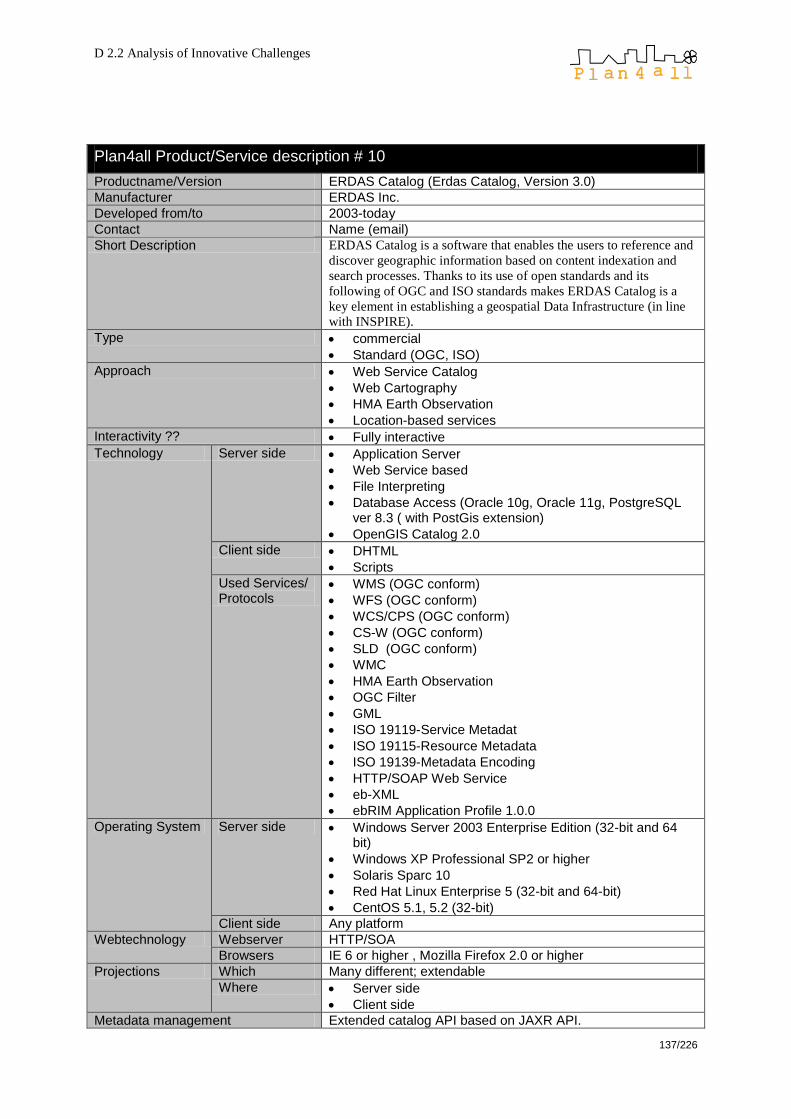
D 2.2 Analysis of Innovative Challenges
137/226
Plan4all Product/Service description # 10
Productname/Version ERDAS Catalog (Erdas Catalog, Version 3.0)
Manufacturer ERDAS Inc.
Developed from/to 2003-today
Contact Name (email)
Short Description ERDAS Catalog is a software that enables the users to reference and
discover geographic information based on content indexation and
search processes. Thanks to its use of open standards and its
following of OGC and ISO standards makes ERDAS Catalog is a
key element in establishing a geospatial Data Infrastructure (in line
with INSPIRE).
Type commercial
Standard (OGC, ISO)
Approach Web Service Catalog
Web Cartography
HMA Earth Observation
Location-based services
Interactivity ?? Fully interactive
Technology Server side Application Server
Web Service based
File Interpreting
Database Access (Oracle 10g, Oracle 11g, PostgreSQL ver 8.3 ( with PostGis extension)
OpenGIS Catalog 2.0
Client side DHTML
Scripts
Used Services/ Protocols
WMS (OGC conform)
WFS (OGC conform)
WCS/CPS (OGC conform)
CS-W (OGC conform)
SLD (OGC conform)
WMC
HMA Earth Observation
OGC Filter
GML
ISO 19119-Service Metadat
ISO 19115-Resource Metadata
ISO 19139-Metadata Encoding
HTTP/SOAP Web Service
eb-XML
ebRIM Application Profile 1.0.0
Operating System Server side Windows Server 2003 Enterprise Edition (32-bit and 64 bit)
Windows XP Professional SP2 or higher
Solaris Sparc 10
Red Hat Linux Enterprise 5 (32-bit and 64-bit)
CentOS 5.1, 5.2 (32-bit)
Client side Any platform
Webtechnology Webserver HTTP/SOA
Browsers IE 6 or higher , Mozilla Firefox 2.0 or higher
Projections Which Many different; extendable
Where Server side
Client side
Metadata management Extended catalog API based on JAXR API.

D 2.2 Analysis of Innovative Challenges
138/226
Storage, harvest and management of OGC web services
Categorisation of registered resources based on ISO taxonomies and OpenGIS service classifications
Extended query capabilities allowing retrieving resources and services for instance by keyword, by date, by geo-extent and by organization search. Moreover, the extreme flexibility of the ebRIM model allows search based on virtually any possible criterion. Provides an out-of-the-box web application that allows OpenGIS service registration and discovery, with a Client built using ERDAS Enterprise Web Toolkit.
Built fully in Java and benefits from the latest Oracle Spatial, PostGIS and ebXML technologies.
Known usage in planning Challenges
Collected by
Additions by
Remarks
Manufacturers remarks

D 2.2 Analysis of Innovative Challenges
139/226
ESRI
Plan4all Product/Service description # 11
Productname/Version ESRI Arc Catalog V. 9.2
Manufacturer ESRI
Developed from/to -
Contact www.esri.com
Short Description Desktop application for managing GIS data such as maps, globes, databases, models, metadata and services. Functions: search, metadata view and maintenance, import and export of geodatabases, administration of geodatabases
Type Metadata editor
Approach Geodatabase management Desktop application
Interactivity Fully interactive
Technology Server side Database Access
Client side standalone
Used Services/ Protocols
WMS (OGC conform)
WFS (OGC conform)
WFS-T (OGC conform)
WCS (OGC conform)
GeoRSS
KML
Operating System Server side
Client side
Webtechnology Webserver
Browsers
Projections Which All
Where Server side
Client side
Metadata management Yes, ISO standards
Known usage in planning Database management
Challenges
Collected by Julia Neuschmid (Ceit Alanova)
Additions by
Remarks Sources (oct. 2009): http://www.esri-germany.de/products/arcgis/about/arccatalog.html
Plan4all Product/Service description # 12
Productname/Version ArcGis Explorer 9.2
Manufacturer ESRI
Developed from/to -
Contact http://www.esri.com/software/arcgis/explorer/index.html
Short Description ArcGIS Explorer is a free, downloadable GIS viewer that gives you an easy way to explore, visualize and share GIS information. Access to ready-to-use ArcGIS Online basemaps and layers; combination of local data with map services for creating custom maps; performance of spatial analysis (e.g. visibility, modeling, proximity search); possibility of adding photos, reports, videos and other information to your maps.
Type free of cost (for everybody)
Approach Web Mapping (Globe)
WebGis

D 2.2 Analysis of Innovative Challenges
140/226
Interactivity Semi interactive
Technology Server side Application Server
WebGIS functions
Geodatabases can be added
Client side ActiveX
PlugIn/AddOn
Applet
Used Services/ Protocols
WMS (OGC conform)
WFS (OGC conform)
GeoRSS feeds can be added
KML can be added
GML is supported
Operating System Server side -
Client side Windows
Webtechnology Webserver -
Browsers Internet Explorer
Projections Which All
Where Server side
Client side
Metadata management Yes
Known usage in planning -
Challenges
Collected by Julia Neuschmid (Ceit Alanova)
Additions by
Remarks Sources (Oct. 2009): http://www.esri.com/software/arcgis/explorer/system-requirements.html http://services.arcgisonline.com/arcgisexplorer500/help/opencontent.htm
Plan4all Product/Service description # 13
Productname/Version ArcIMS / ArcGIS Server 9.2 / 9.3
Manufacturer ESRI
Developed from/to -2009
Contact
Short Description ArcGIS Server is a Geographic Information System (GIS) software package made by ESRI to provide Web-oriented spatial data services. Since version 9.2 the product ArcGIS Server includes also the spatial data management software (formerly known as ArcSDE).
Type Commercial
Approach Web Mapping
Web GIS
Building spatial data infrastructures
Geodatabase
Geo processing
Interactivity Fully interactive
Technology Server side Spatial database access on underlying IBM DB2, Informix, Microsoft SQL Server, Oracle and PostgreSQL databases
Client side HTML, Flex, Silverlight, JavaScript, .NET, JAVA
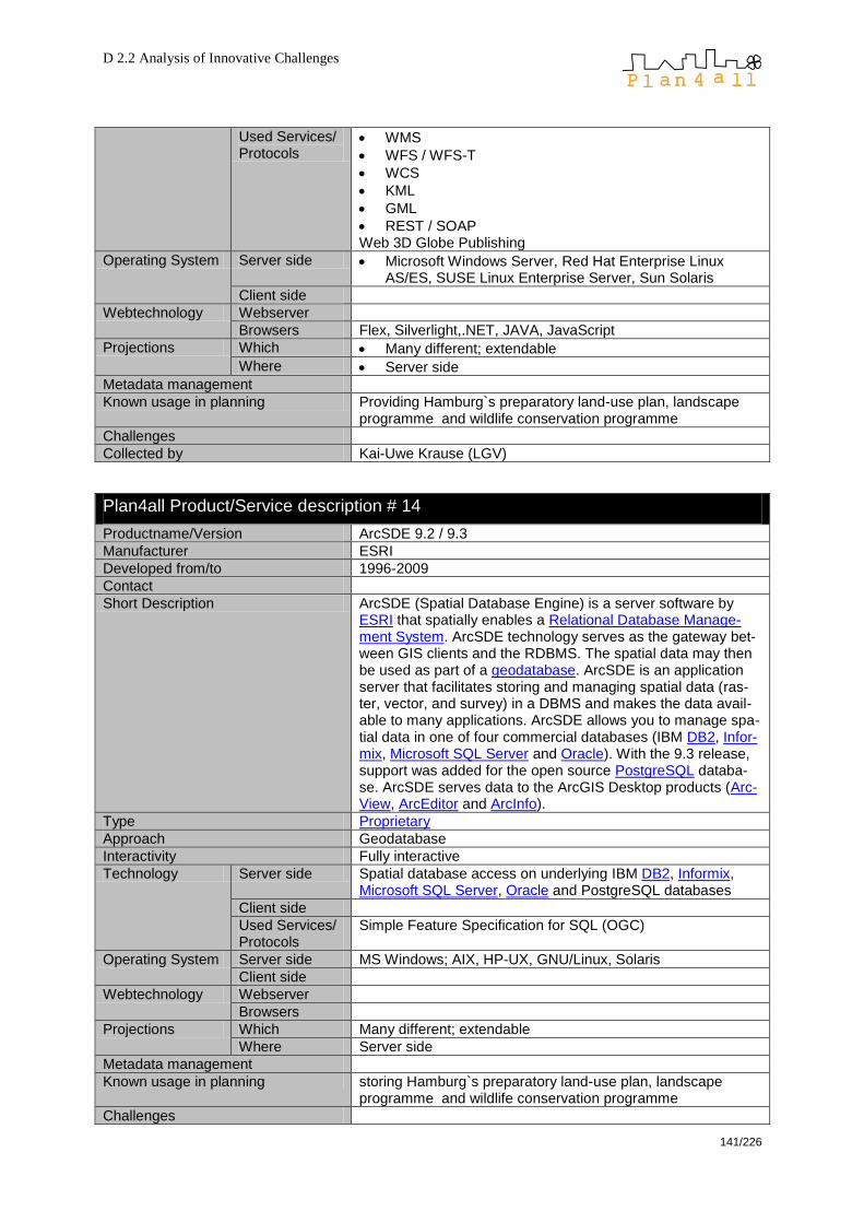
D 2.2 Analysis of Innovative Challenges
141/226
Used Services/ Protocols
WMS
WFS / WFS-T
WCS
KML
GML
REST / SOAP Web 3D Globe Publishing
Operating System Server side Microsoft Windows Server, Red Hat Enterprise Linux AS/ES, SUSE Linux Enterprise Server, Sun Solaris
Client side
Webtechnology Webserver
Browsers Flex, Silverlight,.NET, JAVA, JavaScript
Projections Which Many different; extendable
Where Server side
Metadata management
Known usage in planning Providing Hamburg`s preparatory land-use plan, landscape programme and wildlife conservation programme
Challenges
Collected by Kai-Uwe Krause (LGV)
Plan4all Product/Service description # 14
Productname/Version ArcSDE 9.2 / 9.3
Manufacturer ESRI
Developed from/to 1996-2009
Contact
Short Description ArcSDE (Spatial Database Engine) is a server software by ESRI that spatially enables a Relational Database Manage-ment System. ArcSDE technology serves as the gateway bet-ween GIS clients and the RDBMS. The spatial data may then be used as part of a geodatabase. ArcSDE is an application server that facilitates storing and managing spatial data (ras-ter, vector, and survey) in a DBMS and makes the data avail-able to many applications. ArcSDE allows you to manage spa-tial data in one of four commercial databases (IBM DB2, Infor-mix, Microsoft SQL Server and Oracle). With the 9.3 release, support was added for the open source PostgreSQL databa-se. ArcSDE serves data to the ArcGIS Desktop products (Arc-View, ArcEditor and ArcInfo).
Type Proprietary
Approach Geodatabase
Interactivity Fully interactive
Technology Server side Spatial database access on underlying IBM DB2, Informix, Microsoft SQL Server, Oracle and PostgreSQL databases
Client side
Used Services/ Protocols
Simple Feature Specification for SQL (OGC)
Operating System Server side MS Windows; AIX, HP-UX, GNU/Linux, Solaris
Client side
Webtechnology Webserver
Browsers
Projections Which Many different; extendable
Where Server side
Metadata management
Known usage in planning storing Hamburg`s preparatory land-use plan, landscape programme and wildlife conservation programme
Challenges

D 2.2 Analysis of Innovative Challenges
142/226
Collected by Kai-Uwe Krause (LGV)
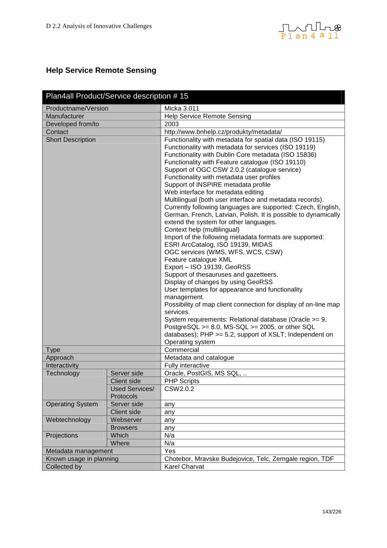
D 2.2 Analysis of Innovative Challenges
143/226
Help Service Remote Sensing
Plan4all Product/Service description # 15
Productname/Version Micka 3.011
Manufacturer Help Service Remote Sensing
Developed from/to 2003
Contact http://www.bnhelp.cz/produkty/metadata/
Short Description Functionality with metadata for spatial data (ISO 19115) Functionality with metadata for services (ISO 19119) Functionality with Dublin Core metadata (ISO 15836) Functionality with Feature catalogue (ISO 19110) Support of OGC CSW 2.0.2 (catalogue service) Functionality with metadata user profiles Support of INSPIRE metadata profile Web interface for metadata editing Multilingual (both user interface and metadata records). Currently following languages are supported: Czech, English, German, French, Latvian, Polish. It is possible to dynamically extend the system for other languages. Context help (multilingual) Import of the following metadata formats are supported: ESRI ArcCatalog, ISO 19139, MIDAS OGC services (WMS, WFS, WCS, CSW) Feature catalogue XML Export – ISO 19139, GeoRSS Support of thesauruses and gazetteers. Display of changes by using GeoRSS User templates for appearance and functionality management. Possibility of map client connection for display of on-line map services. System requirements: Relational database (Oracle >= 9, PostgreSQL >= 8.0, MS-SQL >= 2005, or other SQL databases); PHP >= 5.2, support of XSLT; Independent on Operating system
Type Commercial
Approach Metadata and catalogue
Interactivity Fully interactive
Technology Server side Oracle, PostGIS, MS SQL, ..
Client side PHP Scripts
Used Services/ Protocols
CSW2.0.2
Operating System Server side any
Client side any
Webtechnology Webserver any
Browsers any
Projections Which N/a
Where N/a
Metadata management Yes
Known usage in planning Chotebor, Mravske Budejovice, Telc, Zemgale region, TDF
Collected by Karel Charvat

D 2.2 Analysis of Innovative Challenges
144/226
Plan4all Product/Service description # 16
Productname/Version URM GeoPortal
Manufacturer Help Service Remote Sensing, CCSS, WirelessInfo, Help Forest
Developed from/to 2007
Contact http://portal.plan4all.eu
Short Description The URM GeoPortal4
is a new, integrated solution being designed as combination of previous technologies Uniform Resource Management, Geohosting and new technological development of a visualization client based on Open Layers. The URM GeoPortal is not one integrated solution, but set of modules and services, which are able to communicate trough interoperable services (OGC, W3C). The solution is modular and could be easy modifying for different purposes. URM Geoportal is based on Open Source technologies, but it could be integrated with different technologies like MS SQL or ArcSDE. Uniform Resource Management (URM supports validation, discovery and access to heterogeneous informa-tion and knowledge. It is based on utilization of metadata schemes. The URM models currently also integrate different tools, which support sharing of knowledge. The GeoPortal system is developed on the OpenSource platforms (MapSer-ver, GeoServer) and contains common visualization, data sharing, metadata and catalogue functionalities. Additional parts of solution are also tools for management sensor observation and spatial data transformation and processing.
Type Commercial
Approach Inspire Geoportal Based on Open Source technologies but can be integrated with different technologies (MS SQL, ArcSDE, …)
Interactivity
Technology Server side Any
Client side ExtJS
Used Services/ Protocols
OGC – CSW, WMS, WFS, WCS, WPS
Operating System
Server side any
Client side any
Webtechnology Webserver any
Browsers any
Projections Which N/a
Where N/a
Metadata management MICKA (compatible with INSPIRE); for storing of metadata can also be used: PostgreSQL, mySQL, MS SQL, Oracle
Known usage in planning Challenges
Collected by Karel Charvat
Additions by Julia Neuschmid (Ceit Alanova)
Remarks
Manufacturers remarks
4
Karel CHARVAT & Stepan KAFKA, Jachym CEPICKY, Martin VLK, Petr HORAK, Premysl VOHNOUT
GEOPORTAL - A NEW WEB 2.0 APPROACH FOR SDI, GI2009 – Symposium Dresden, May 2009
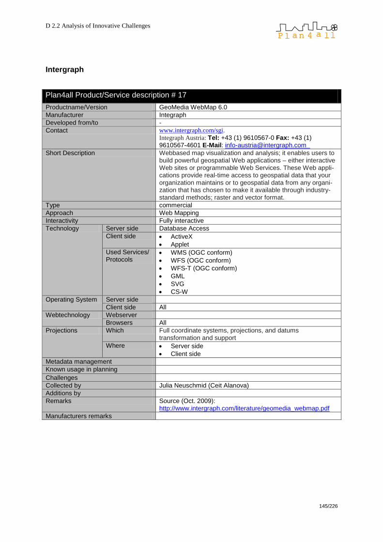
D 2.2 Analysis of Innovative Challenges
145/226
Intergraph
Plan4all Product/Service description # 17
Productname/Version GeoMedia WebMap 6.0
Manufacturer Integraph
Developed from/to -
Contact www.intergraph.com/sgi.
Integraph Austria: Tel: +43 (1) 9610567-0 Fax: +43 (1) 9610567-4601 E-Mail: [email protected]
Short Description Webbased map visualization and analysis; it enables users to build powerful geospatial Web applications – either interactive Web sites or programmable Web Services. These Web appli-cations provide real-time access to geospatial data that your organization maintains or to geospatial data from any organi-zation that has chosen to make it available through industry-standard methods; raster and vector format.
Type commercial
Approach Web Mapping
Interactivity Fully interactive
Technology Server side Database Access
Client side ActiveX
Applet
Used Services/ Protocols
WMS (OGC conform)
WFS (OGC conform)
WFS-T (OGC conform)
GML
SVG
CS-W
Operating System Server side
Client side All
Webtechnology Webserver
Browsers All
Projections Which Full coordinate systems, projections, and datums transformation and support
Where Server side
Client side
Metadata management
Known usage in planning Challenges
Collected by Julia Neuschmid (Ceit Alanova)
Additions by
Remarks Source (Oct. 2009): http://www.intergraph.com/literature/geomedia_webmap.pdf
Manufacturers remarks

D 2.2 Analysis of Innovative Challenges
146/226
Manifold
Plan4all Product/Service description # 1
Productname/Version Manifold System 8.0 (Manifold, Build 8.0.15.0)
Manufacturer Manifold Net Ltd, 1805 North Carson Street Suite 700, Carson City, NV 89701
Developed from/to © 1993-2008 CDA International Ltd.
Contact [email protected]
Short Description Manifold System is a single, integrated product that provides three major classes of GIS functionality in a single package: as a desktop application, as an objects library for programmers and as an Internet Map Server for web applications Different Manifold System editions make it possible to deliver advanced features to organizations.
Type commercial
Approach fully featured Desktop GIS (drawing, image, raster, surface, terrain)
Spatial DBMS
Web Mapping
Web GIS
Interactivity Fully interactive
Technology Server side Application Server
WebGIS functions
OGC WFS server functionality to enable OGC WFS clients (see remarks)
Client side standalone
.Net application (C#)
Scripting (.Net languages)
VBScript, JScript, Python (Forms)
Used Services/ Protocols
proprietary
Manifold Spatial SQL (superset of Microsoft SQL, Jet SQL, ANSI SQL)
KML, KMZ (import/export)
GeoTIFF
XML
Operating System Server side Windows Server 2008
Client side Microsoft (XP, Vista, 7)
Webtechnology Webserver Manifold IMS, Microsoft IIS
Browsers any
Projections Which any
Where Server side
Client side
Metadata management No
Known usage in planning Community Services, City Planning, Hazard Simulation
Challenges web cartography, image/raster analysis
Collected by Wolfgang W. Wasserburger (CEIT Alanova)
Remarks ---
Manufacturers remarks Manifold System is both a client and a server for OGC WMS and the Manifold Image Server interface; however, although Manifold IMS can be a server for OGC WFS, Manifold does not yet provide OGC WFS client capabilities. Manifold provides OGC WFS server capabilities so that those users who are using OGC WFS clients can get data from a Manifold IMS website.
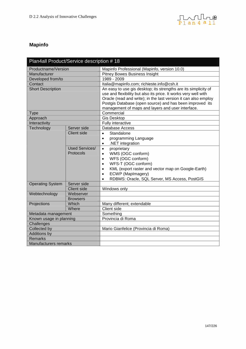
D 2.2 Analysis of Innovative Challenges
147/226
Mapinfo
Plan4all Product/Service description # 18
Productname/Version Mapinfo Professional (Mapinfo, version 10.0)
Manufacturer Pitney Bowes Business Insight
Developed from/to 1989 - 2009
Contact [email protected]; [email protected]
Short Description An easy to use gis desktop; its strengths are its simplicity of use and flexibility but also its price. It works very well with Oracle (read and write); in the last version it can also employ Postgis Database (open source) and has been improved its management of maps and layers and user interface.
Type Commercial
Approach Gis Desktop
Interactivity Fully interactive
Technology Server side Database Access
Client side Standalone
programming Language
.NET integration
Used Services/ Protocols
proprietary
WMS (OGC conform)
WFS (OGC conform)
WFS-T (OGC conform)
KML (export raster and vector map on Google-Earth)
ECWP (MapImagery)
RDBMS: Oracle, SQL Server, MS Access, PostGIS
Operating System Server side
Client side Windows only
Webtechnology Webserver
Browsers
Projections Which Many different; extendable
Where Client side
Metadata management Something
Known usage in planning Provincia di Roma
Challenges
Collected by Mario Gianfelice (Provincia di Roma)
Additions by
Remarks
Manufacturers remarks
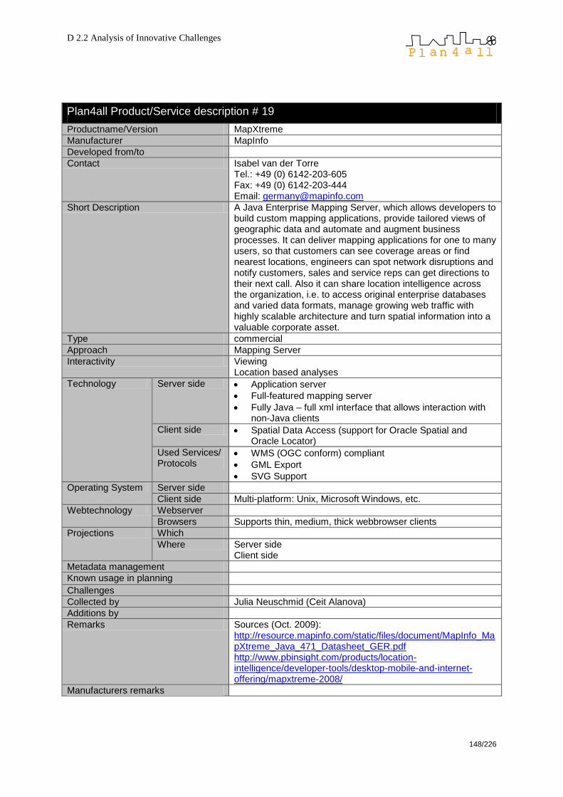
D 2.2 Analysis of Innovative Challenges
148/226
Plan4all Product/Service description # 19
Productname/Version MapXtreme
Manufacturer MapInfo
Developed from/to
Contact Isabel van der Torre Tel.: +49 (0) 6142-203-605 Fax: +49 (0) 6142-203-444 Email: [email protected]
Short Description A Java Enterprise Mapping Server, which allows developers to build custom mapping applications, provide tailored views of geographic data and automate and augment business processes. It can deliver mapping applications for one to many users, so that customers can see coverage areas or find nearest locations, engineers can spot network disruptions and notify customers, sales and service reps can get directions to their next call. Also it can share location intelligence across the organization, i.e. to access original enterprise databases and varied data formats, manage growing web traffic with highly scalable architecture and turn spatial information into a valuable corporate asset.
Type commercial
Approach Mapping Server
Interactivity Viewing Location based analyses
Technology Server side Application server
Full-featured mapping server
Fully Java – full xml interface that allows interaction with non-Java clients
Client side Spatial Data Access (support for Oracle Spatial and Oracle Locator)
Used Services/ Protocols
WMS (OGC conform) compliant
GML Export
SVG Support
Operating System Server side
Client side Multi-platform: Unix, Microsoft Windows, etc.
Webtechnology Webserver
Browsers Supports thin, medium, thick webbrowser clients
Projections Which
Where Server side Client side
Metadata management
Known usage in planning Challenges
Collected by Julia Neuschmid (Ceit Alanova)
Additions by
Remarks Sources (Oct. 2009): http://resource.mapinfo.com/static/files/document/MapInfo_MapXtreme_Java_471_Datasheet_GER.pdf http://www.pbinsight.com/products/location-intelligence/developer-tools/desktop-mobile-and-internet-offering/mapxtreme-2008/
Manufacturers remarks

D 2.2 Analysis of Innovative Challenges
149/226
Oracle
Plan4all Product/Service description # 20
Productname/Version Oracle Spatial & Oracle Locator
Manufacturer Oracle Corp.
Developed from/to
Contact http://www.oracle.com/technology/products/spatial/index.html
Short Description Oracle Locator is a feature of Oracle Database 11g Standard and Enterprise Editions that provides core location functionality needed by most customer applications. Oracle Spatial is an op-tion for Oracle Enterprise Edition that provides advanced spatial features to support high-end GIS and LBS solutions. Also, Oracle provides the Oracle Application Server MapViewer, a Java component for map rendering and viewing geospatial data managed by Oracle Spatial or Locator. Oracle Spatial, Oracle Locator and MapViewer comply with germane OGC Standard Specifications.
Type Commercial
Approach Geodatabase
Interactivity Full, DB level
Technology Server side Spatial data management functions
Java and XML APIs
PL/SQL
SQL/MM
Client side
Used Services/ Protocols
WMS (OGC conform), through Oracle Application Server MapViewer
WFS (OGC conform)
WFS-T (OGC conform)
CSW (OGC conform)
OpenLS
GML (committed to support)
Operating System
Server side any
Client side any
Webtechnology Webserver -
Browsers -
Projections Which All
Where Server side
Metadata management
Known usage in planning Challenges
Collected by Norma Zanetti Hyperborea S.r.l.
Additions by
Remarks
Manufacturers remarks

D 2.2 Analysis of Innovative Challenges
150/226
11.3 Commercial Software (partly without costs)
Adobe
Plan4all Product/Service description # 21
Productname/Version Flash (Version CS 4 Professional (2008); Version CS5 to be released in April 2010)
Manufacturer Adobe (former Macromedia)
Developed from/to 1996, ongoing
Contact http://www.adobe.com/products/flash/
Short Description Multimedia platform, method for adding animation and interactivity to web pages. Flash can manipulate vector and raster graphics.
Type Commercial, partly free
Approach Multimedia platform
Interactivity scriptable
Technology Server side
Client side PlugIn/AddOn
Used Services/ Protocols
WMS (OGC conform)
GeoRSS
KML
Operating System Server side
Client side Microsoft Windows, Mac OS X
Webtechnology Webserver
Browsers
Projections Which
Where Server side Client side
Metadata management yes
Known usage in planning Challenges
Collected by Julia Neuschmid (Ceit Alanova)
Additions by
Remarks Source (Oct. 2009): http://de.wikipedia.org/wiki/Adobe_Flash http://www.adobe.com/se/products/flashplayer/
Manufacturers remarks
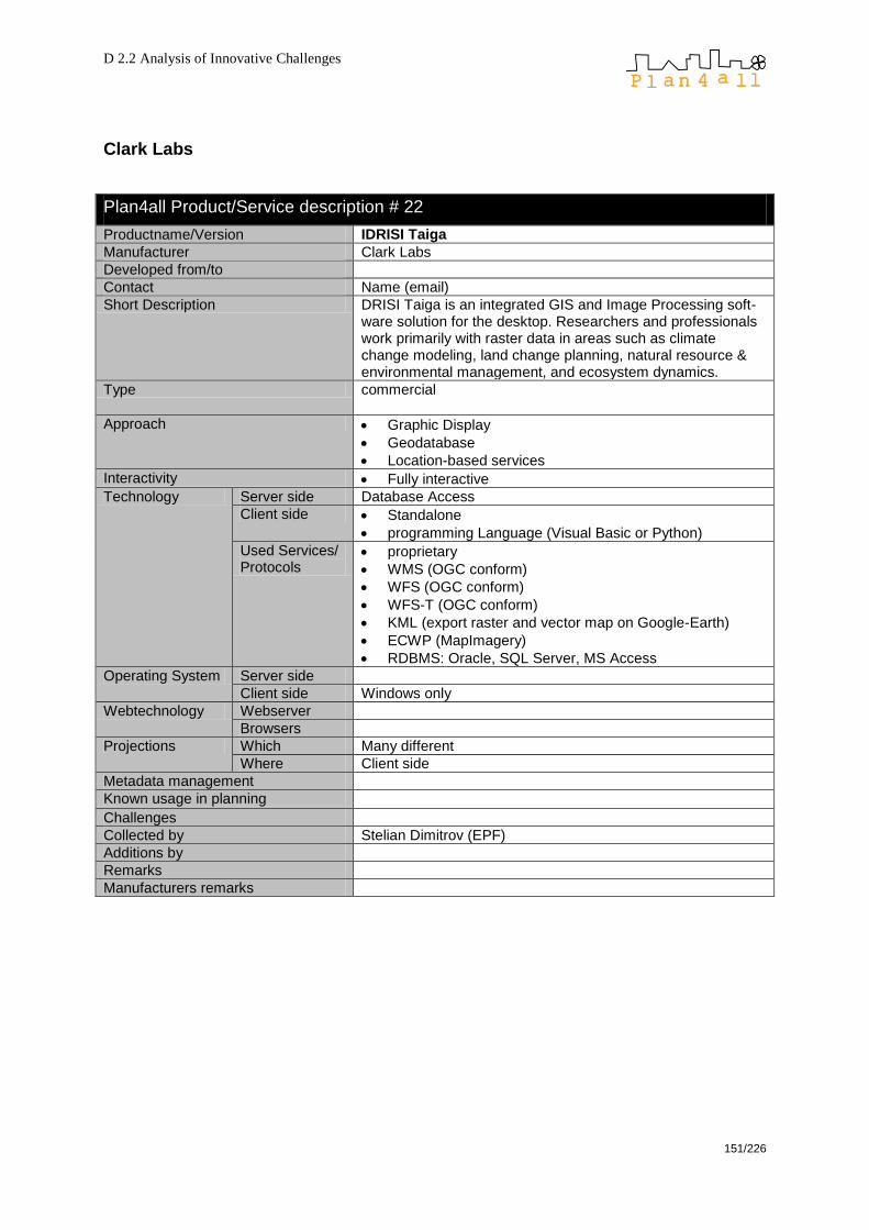
D 2.2 Analysis of Innovative Challenges
151/226
Clark Labs
Plan4all Product/Service description # 22
Productname/Version IDRISI Taiga
Manufacturer Clark Labs
Developed from/to
Contact Name (email)
Short Description DRISI Taiga is an integrated GIS and Image Processing soft-ware solution for the desktop. Researchers and professionals work primarily with raster data in areas such as climate change modeling, land change planning, natural resource & environmental management, and ecosystem dynamics.
Type commercial
Approach Graphic Display
Geodatabase
Location-based services
Interactivity Fully interactive
Technology Server side Database Access
Client side Standalone
programming Language (Visual Basic or Python)
Used Services/ Protocols
proprietary
WMS (OGC conform)
WFS (OGC conform)
WFS-T (OGC conform)
KML (export raster and vector map on Google-Earth)
ECWP (MapImagery)
RDBMS: Oracle, SQL Server, MS Access
Operating System Server side
Client side Windows only
Webtechnology Webserver
Browsers
Projections Which Many different
Where Client side
Metadata management
Known usage in planning Challenges
Collected by Stelian Dimitrov (EPF)
Additions by
Remarks
Manufacturers remarks
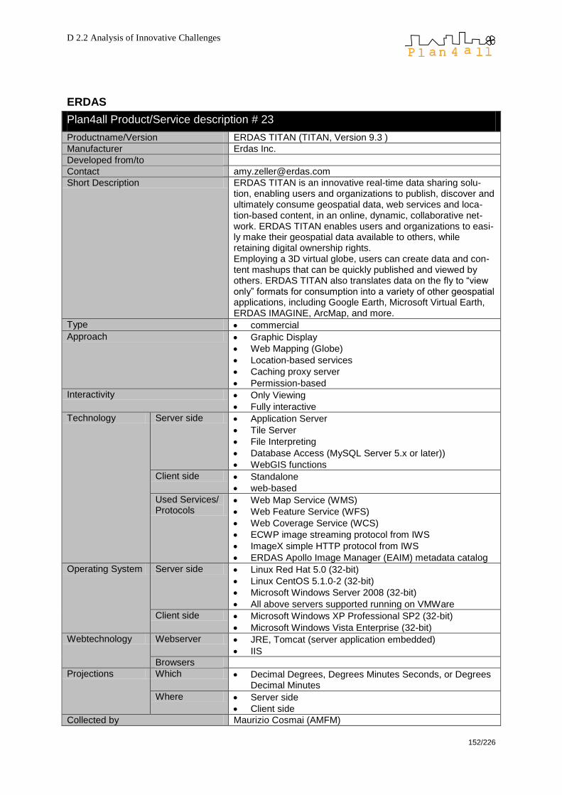
D 2.2 Analysis of Innovative Challenges
152/226
ERDAS
Plan4all Product/Service description # 23
Productname/Version ERDAS TITAN (TITAN, Version 9.3 )
Manufacturer Erdas Inc.
Developed from/to
Contact [email protected]
Short Description ERDAS TITAN is an innovative real-time data sharing solu-tion, enabling users and organizations to publish, discover and ultimately consume geospatial data, web services and loca-tion-based content, in an online, dynamic, collaborative net-work. ERDAS TITAN enables users and organizations to easi-ly make their geospatial data available to others, while retaining digital ownership rights. Employing a 3D virtual globe, users can create data and con-tent mashups that can be quickly published and viewed by others. ERDAS TITAN also translates data on the fly to ―view only‖ formats for consumption into a variety of other geospatial applications, including Google Earth, Microsoft Virtual Earth, ERDAS IMAGINE, ArcMap, and more.
Type commercial
Approach Graphic Display
Web Mapping (Globe)
Location-based services
Caching proxy server
Permission-based
Interactivity Only Viewing
Fully interactive
Technology Server side Application Server
Tile Server
File Interpreting
Database Access (MySQL Server 5.x or later))
WebGIS functions
Client side Standalone
web-based
Used Services/ Protocols
Web Map Service (WMS)
Web Feature Service (WFS)
Web Coverage Service (WCS)
ECWP image streaming protocol from IWS
ImageX simple HTTP protocol from IWS
ERDAS Apollo Image Manager (EAIM) metadata catalog
Operating System Server side Linux Red Hat 5.0 (32-bit)
Linux CentOS 5.1.0-2 (32-bit)
Microsoft Windows Server 2008 (32-bit)
All above servers supported running on VMWare
Client side Microsoft Windows XP Professional SP2 (32-bit)
Microsoft Windows Vista Enterprise (32-bit)
Webtechnology Webserver JRE, Tomcat (server application embedded)
IIS
Browsers
Projections Which Decimal Degrees, Degrees Minutes Seconds, or Degrees Decimal Minutes
Where Server side
Client side
Collected by Maurizio Cosmai (AMFM)
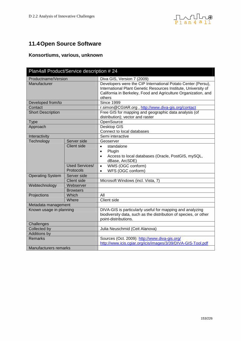
D 2.2 Analysis of Innovative Challenges
153/226
11.4 Open Source Software
Konsortiums, various, unknown
Plan4all Product/Service description # 24
Productname/Version Diva GIS, Version 7 (2009)
Manufacturer Developers were the CIP International Potato Center (Persu), International Plant Genetic Resources Institute, University of California in Berkeley, Food and Agriculture Organization, and others
Developed from/to Since 1999
Contact [email protected] , http://www.diva-gis.org/contact
Short Description Free GIS for mapping and geographic data analysis (of distribution); vector and raster
Type OpenSource
Approach Desktop GIS Connect to local databases
Interactivity Semi interactive
Technology Server side Geoserver
Client side standalone
PlugIn
Access to local databases (Oracle, PostGIS, mySQL, dBase, ArcSDE)
Used Services/ Protocols
WMS (OGC conform)
WFS (OGC conform)
Operating System Server side
Client side Microsoft Windows (incl. Vista, 7)
Webtechnology Webserver
Browsers
Projections Which All
Where Client side
Metadata management
Known usage in planning DIVA-GIS is particularly useful for mapping and analyzing biodiversity data, such as the distribution of species, or other point-distributions.
Challenges
Collected by Julia Neuschmid (Ceit Alanova)
Additions by
Remarks Sources (Oct. 2009): http://www.diva-gis.org/ http://www.icis.cgiar.org/icis/images/3/39/DIVA-GIS-Tool.pdf
Manufacturers remarks
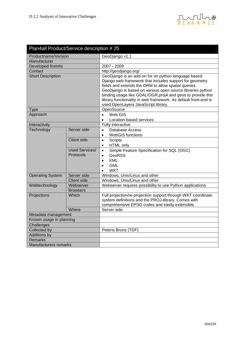
D 2.2 Analysis of Innovative Challenges
154/226
Plan4all Product/Service description # 25
Productname/Version GeoDjango v1.1
Manufacturer
Developed from/to 2007 - 2009
Contact http://geodjango.org/
Short Description GeoDjango is an add-on for on python language based Django web framework that includes support for geometry fields and extends the ORM to allow spatial queries. GeoDjango is based on various open source libraries python binding usage like GDAL/OGR,proj4 and geos to provide this library functionality in web framework. As default front-end is used OpenLayers JavaScript library.
Type OpenSource
Approach Web GIS
Location-based services
Interactivity Fully interactive
Technology Server side Database Access
WebGIS functions
Client side Scripts
HTML only
Used Services/ Protocols
Simple Feature Specification for SQL (OGC)
GeoRSS
KML
GML
WKT
Operating System Server side Windows, Unix/Linux and other
Client side Windows, Unix/Linux and other
Webtechnology Webserver Webserver requires possibility to use Python applications
Browsers
Projections Which Full projection/re-projection support through WKT coordinate system definitions and the PROJ-library. Comes with comprehensive EPSG codes and easily extensible.
Where Server side
Metadata management
Known usage in planning Challenges
Collected by Peteris Bruns (TDF)
Additions by
Remarks
Manufacturers remarks

D 2.2 Analysis of Innovative Challenges
155/226
Plan4all Product/Service description # 26
Productname/Version Geoserver 1.6.2
Manufacturer
Developed from/to
Contact http://geoserver.org/
Short Description GeoServer is a Java-based software server that allows users to view and edit geospatial data. Using open standards set forth by the Open Geospatial Consortium (OGC), GeoServer allows for great flexibility in map creation and data sharing.
Type OpenSource
Approach Web GIS
Interactivity Only Viewing
Technology Server side WebGIS functions
Client side
Used Services/ Protocols
WMS (OGC conform)
WFS (OGC conform)
WFS-T (OGC conform)
WCS (OGC conform)
KML
GML
SVG
SLD (OGC-conform)
Operating System Server side JAVA
Client side any
Webtechnology Webserver any
Browsers any
Projections Which All
Where Server side
Metadata management
Known usage in planning
Challenges
Collected by Norma Zanetti Hyperborea S.r.l.
Additions by Wolfgang W. Wasserburger (CEIT Alanova)
Remarks
Manufacturers remarks
Plan4all Product/Service description # 27
Productname/Version JOSM (Java OpenStreetMap Editor)
Manufacturer Originally developed by Immanuel Scholz and currently maintained by Dirk Stöcker
Developed from/to Continuous development
Contact http://josm.openstreetmap.de/
Short Description JOSM is an editor for OpenStreetMap (OSM) written in Java 1.5. Currently it supports loading stand alone GPX tracks and GPX track data from the OSM database as well as loading and editing existing nodes, ways, metadata tags and relations from the OSM database.
Type OpenSource (GPL)
Approach Web Cartography (it acts as a front-end editor for OpenStreetMap)
Interactivity Fully interactive
Technology Server side
Client side standalone

D 2.2 Analysis of Innovative Challenges
156/226
Used Services/ Protocols
OSM proprietary Protocol
Operating System Server side OS independent under JAVA
Client side
Webtechnology Webserver
Browsers
Projections Which Unprojected
Mercator
Where Client
Metadata management
Known usage in planning Challenges
Collected by Pasquale Di Donato
Additions by Wolfgang W. Wasserburger (CEIT Alanova)
Remarks
Manufacturers remarks
Plan4all Product/Service description # 28
Productname/Version Ka-Map!
Manufacturer
Developed from/to 2005-2007
Contact http://ka-map.maptools.org/, http://ka-map.ominiverdi.org/wiki/index.php/Main_Page
Short Description ka-Map! ("ka" as in ka-boom!) is an open source project that is aimed at providing a javascript API for developing highly interactive web-mapping interfaces using features available in modern web browsers. ka-Map! official web site is ka-Map.MapTools.org ka-Map! was originally developed by, and most of it is Copyright (c) 2005, DM Solutions Group Inc.
Type OpenSource
Approach Graphic Display
Web Mapping
Interactivity Semi interactive
Technology Server side Tile Server/…
WebGIS functions
Client side Scripts HTML only
Used Services/ Protocols
WMS (OGC conform)
WFS (OGC conform) – only points
Operating System Server side http://ka-map.maptools.org/
Client side http://ka-map.maptools.org/
Webtechnology Webserver UMN MapServer PHP MapsScript dependent
Browsers
Projections Which Many different; extendable;
Where Server side
Metadata management
Known usage in planning Challenges
Collected by Peteris Bruns (TDF)
Additions by
Remarks
Manufacturers remarks

D 2.2 Analysis of Innovative Challenges
157/226
Plan4all Product/Service description # 29
Productname/Version pgRouting 1.03
Manufacturer
Developed from/to 2006-2009
Contact http://pgrouting.postlbs.org/
Short Description This project's main objective is to provide routing functionality to PostGIS / PostgreSQL. pgRouting is part of PostLBS, which provides core tools for Location Based Services (LBS) as Open Source Software (OSS). Its tools are similar to those found on proprietary software.
Type OpenSource
Approach Geodatabase
Location-based services
Routing
Interactivity Semi interactive
Technology Server side Database Access
WebGIS functions
Client side
Used Services/ Protocols
Simple Feature Specification for SQL (OGC)
Operating System Server side Linux; Windows; Mac OS X and other (needs PostgreSQL/PostGIS)
Client side Linux; Windows; Mac OS X and other (SQL-Client)
Webtechnology Webserver
Browsers
Projections Which Many different; extendable
Where Server side
Metadata management
Known usage in planning Challenges
Collected by Peteris Bruns (TDF)
Additions by Wolfgang W. Wasserburger (CEIT Alanova)
Remarks Probably not SDI relevant
Manufacturers remarks

D 2.2 Analysis of Innovative Challenges
158/226
Advanced Information Systems Group of the University of Zaragoza and
GeoSpatiumLab
Plan4all Product/Service description # 30
Productname/Version CatMDEdit – 4.5
Manufacturer Advanced Information Systems Group of the University of Zaragoza and GeoSpatiumLab
Developed from/to Continuous development
Contact [email protected]
Short Description CatMDEdit is a metadata editor tool that facilitates the docu-mentation of resources, with special focus on the description of geographic information resources. CatMDEdit is a desktop application that enables to create, edit, delete, view, replicate, import, export, validate, and automatically generate metadata files. The product automa-tically generates XML file identifier and some metadata ele-ments for spatial series and from raster and vector files: additional tools to facilitate metadata edition are a contacts repository, a thesaurus tool, and a tool for the selection of bounding box coordinates.
Type OpenSource (GPL License)
Approach
Interactivity Fully interactive
Technology Server side
Client side standalone
Used Services/ Protocols
Others (ISO 19115, ISO 19139, Dublin Core, INSPIRE Metadata Regulation)
Operating System Server side
Client side OS independent
Webtechnology Webserver
Browsers
Projections Which
Where
Metadata management Yes
Known usage in planning Challenges
Collected by
Additions by Pasquale Di Donato
Remarks
Manufacturers remarks
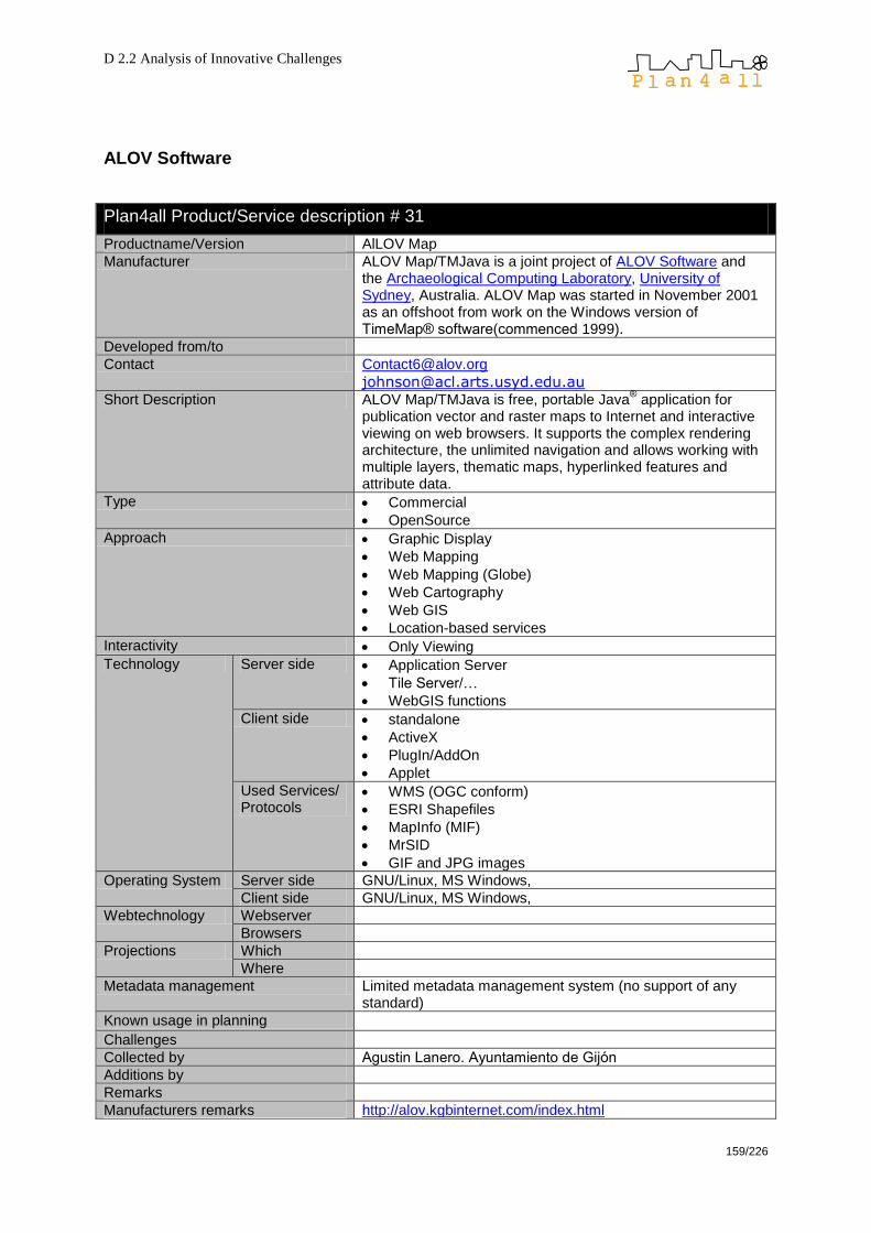
D 2.2 Analysis of Innovative Challenges
159/226
ALOV Software
Plan4all Product/Service description # 31
Productname/Version AlLOV Map
Manufacturer ALOV Map/TMJava is a joint project of ALOV Software and the Archaeological Computing Laboratory, University of Sydney, Australia. ALOV Map was started in November 2001 as an offshoot from work on the Windows version of TimeMap® software(commenced 1999).
Developed from/to
Contact [email protected]
Short Description ALOV Map/TMJava is free, portable Java® application for
publication vector and raster maps to Internet and interactive viewing on web browsers. It supports the complex rendering architecture, the unlimited navigation and allows working with multiple layers, thematic maps, hyperlinked features and attribute data.
Type Commercial
OpenSource
Approach Graphic Display
Web Mapping
Web Mapping (Globe)
Web Cartography
Web GIS
Location-based services
Interactivity Only Viewing
Technology Server side Application Server
Tile Server/…
WebGIS functions
Client side standalone
ActiveX
PlugIn/AddOn
Applet
Used Services/ Protocols
WMS (OGC conform)
ESRI Shapefiles
MapInfo (MIF)
MrSID
GIF and JPG images
Operating System Server side GNU/Linux, MS Windows,
Client side GNU/Linux, MS Windows,
Webtechnology Webserver
Browsers
Projections Which
Where
Metadata management Limited metadata management system (no support of any standard)
Known usage in planning Challenges
Collected by Agustin Lanero. Ayuntamiento de Gijón
Additions by
Remarks
Manufacturers remarks http://alov.kgbinternet.com/index.html

D 2.2 Analysis of Innovative Challenges
160/226
Autodesk Inc.
Plan4all Product/Service description # 32
Productname/Version Autodesk MapGuide OpenSource (?, V.?)
Manufacturer Autodesk Inc.
Developed from/to 2006-
Contact Michaela Schneeberger ([email protected])
Short Description
Type Commercial (?) OpenSource
Approach Web Mapping
Interactivity
Technology Server side
Client side
Used Services/ Protocols
Operating System Server side
Client side
Webtechnology Webserver
Browsers
Projections Which
Where
Metadata management
Known usage in planning Challenges
Collected by Wolfgang W. Wasserburger (CEIT Alanova)
Additions by
Remarks Displaced 2006 the original client server orientated Autodesk MapGuide
Manufacturers remarks
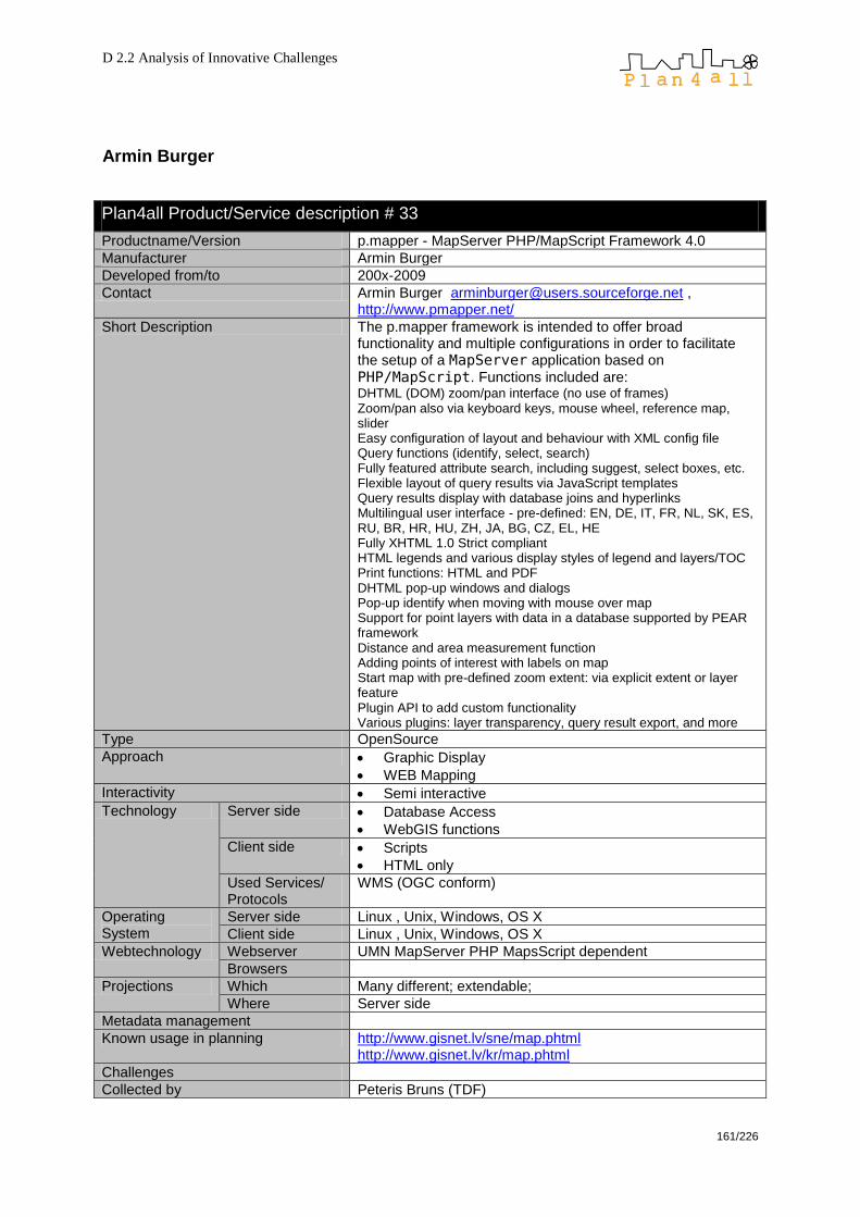
D 2.2 Analysis of Innovative Challenges
161/226
Armin Burger
Plan4all Product/Service description # 33
Productname/Version p.mapper - MapServer PHP/MapScript Framework 4.0
Manufacturer Armin Burger
Developed from/to 200x-2009
Contact Armin Burger [email protected] , http://www.pmapper.net/
Short Description The p.mapper framework is intended to offer broad functionality and multiple configurations in order to facilitate the setup of a MapServer application based on
PHP/MapScript. Functions included are: DHTML (DOM) zoom/pan interface (no use of frames) Zoom/pan also via keyboard keys, mouse wheel, reference map, slider Easy configuration of layout and behaviour with XML config file Query functions (identify, select, search) Fully featured attribute search, including suggest, select boxes, etc. Flexible layout of query results via JavaScript templates Query results display with database joins and hyperlinks Multilingual user interface - pre-defined: EN, DE, IT, FR, NL, SK, ES, RU, BR, HR, HU, ZH, JA, BG, CZ, EL, HE Fully XHTML 1.0 Strict compliant HTML legends and various display styles of legend and layers/TOC Print functions: HTML and PDF DHTML pop-up windows and dialogs Pop-up identify when moving with mouse over map Support for point layers with data in a database supported by PEAR framework Distance and area measurement function Adding points of interest with labels on map Start map with pre-defined zoom extent: via explicit extent or layer feature Plugin API to add custom functionality Various plugins: layer transparency, query result export, and more
Type OpenSource
Approach Graphic Display
WEB Mapping
Interactivity Semi interactive
Technology Server side Database Access
WebGIS functions
Client side Scripts
HTML only
Used Services/ Protocols
WMS (OGC conform)
Operating System
Server side Linux , Unix, Windows, OS X
Client side Linux , Unix, Windows, OS X
Webtechnology Webserver UMN MapServer PHP MapsScript dependent
Browsers
Projections Which Many different; extendable;
Where Server side
Metadata management
Known usage in planning http://www.gisnet.lv/sne/map.phtml http://www.gisnet.lv/kr/map.phtml
Challenges
Collected by Peteris Bruns (TDF)

D 2.2 Analysis of Innovative Challenges
162/226
Camptocamp SA
Plan4all Product/Service description # 34
Productname/Version Cartoweb – 3.5.0
Manufacturer Camptocamp SA
Developed from/to Continuous development
Contact http://cartoweb.org/contact.html
Short Description CartoWeb is a comprehensive and ready-to-use Web-GIS as
well as a convenient framework for building advanced and
customized applications; is written using PHP5.
Functions: searching, browsing, querying, outlining, recentering, layers management, tabs browsing and PDF printing, routing, data editing and layout customisation.
Type OpenSource (GPL License)
Approach Web GIS
Routing
Interactivity
Technology Server side WebGIS functions
Client side Standalone PlugIn
Used Services/ Protocols
WMS and WFS (based on MapServer) KML
Operating System Server side OS Indipendent, Windows 2000 / XP, GNU / Linux Debian
Client side
Webtechnology Webserver Apache is recommended, CartoWeb may be set up as a SOAP Web Service enabling to have front-end server on one maschine and data and map generation on another.
Browsers all
Projections Which Different projections can be defined (e. g. WGS 84)
Where
Metadata management Yes
Known usage in planning Challenges
Collected by
Additions by Pasquale Di Donato, Julia Neuschmid (Ceit Alanova)
Remarks Source (Oct. 2009): http://cartoweb.org
Manufacturers remarks

D 2.2 Analysis of Innovative Challenges
163/226
Cenia
Plan4all Product/Service description # 35
Productname/Version Janitor
Manufacturer Cenia
Developed from/to 2001
Contact http://www.janitor.cz
Short Description several interconnected applications, enabling simple and quick data management - JanMap, JanDat, SQLTools, DataBuilder, FieldGIS; provides tools for primary data collection and additional data processing - storage, organization, surveying, analysis
Type freeware
Approach Desktop GIS
Interactivity Fully interactive
Technology Server side Database access
File interpreting
Client side standalone
Used Services/ Protocols
WMS (OGC conform)
WFS (OGC conform)
Simple Feature Specification for SQL (OGC)
Operating System Server side
Client side Windows
Webtechnology Webserver
Browsers
Projections Which all
Where Client side
Metadata management
Known usage in planning Challenges
Collected by Petr Horak
Additions by
Remarks
Manufacturers remarks
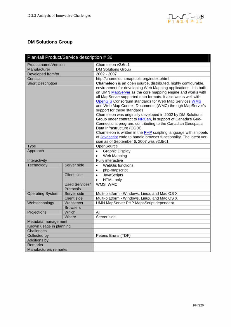
D 2.2 Analysis of Innovative Challenges
164/226
DM Solutions Group
Plan4all Product/Service description # 36
Productname/Version Chameleon v2.6rc1
Manufacturer DM Solutions Group
Developed from/to 2002 - 2007
Contact http://chameleon.maptools.org/index.phtml
Short Description Chameleon is an open source, distributed, highly configurable, environment for developing Web Mapping applications. It is built on UMN MapServer as the core mapping engine and works with all MapServer supported data formats. It also works well with OpenGIS Consortium standards for Web Map Services WMS and Web Map Context Documents (WMC) through MapServer's support for these standards. Chameleon was originally developed in 2002 by DM Solutions Group under contract to NRCan, in support of Canada's Geo-Connections program, contributing to the Canadian Geospatial Data Infrastructure (CGDI). Chameleon is written in the PHP scripting language with snippets of Javascript code to handle browser functionality. The latest ver-sion as of September 6, 2007 was v2.6rc1
Type OpenSource
Approach Graphic Display
Web Mapping
Interactivity Fully interactive
Technology Server side WebGis functions
php-mapscript
Client side JavaScripts
HTML only
Used Services/ Protocols
WMS, WMC
Operating System Server side Multi-platform - Windows, Linux, and Mac OS X
Client side Multi-platform - Windows, Linux, and Mac OS X
Webtechnology Webserver UMN MapServer PHP MapsScript dependent
Browsers
Projections Which All
Where Server side
Metadata management
Known usage in planning
Challenges
Collected by Peteris Bruns (TDF)
Additions by
Remarks
Manufacturers remarks

D 2.2 Analysis of Innovative Challenges
165/226
Fraunhofer Institute for Computer Graphics Research (IGD)
Plan4all Product/Service description # 37
Product name/Version HALE - HUMBOLDT Alignment Editor Version 1.0
Manufacturer Fraunhofer Institute for Computer Graphics Research (IGD), Darmstadt, Germany
Developed from/to Febr. 2009, software will be usable for end-users end of Octo-ber 2009 with Version 1.0. Until then the schema, the instance data import and definition of simple mappings can be tested.
Contact Thorsten Reitz, [email protected]
Short Description RCP application that allows users to interactively design trans-formations on a conceptual schema level. It supports import of schemas from different sources, such as Eclipse ecore, WFS and GML Application Schemas. The defined transformations are stored either locally or in the HUMBOLDT Model Reposito-ry and used by the Conceptual Schema Transformer to per-form Schema Transformation on actual geodata. HALE is a tool for geodomain application experts and GI ex-perts, especially data custodians. It provides a means to crea-te automatically executable horizontal mappings on the con-ceptual schema level and in addition in some aspects on the logical schema level. It provides the means to ensure the vali-dity of a mapping on the base of the source and target sche-ma as well as on the base of the source and a reference data set. It uses schemas created in the HUMBOLDT Editor. It does not execute those mappings. Three are very few Conceptual Schema Alignment tools for the geodomain, and available alignment tools like FME focus strongly on the physical and logical level, whereas tools like Protégé PROMPT and COMA++ do not make use of the spe-cifics of geoinformation.
Type OpenSource
Approach Graphic Display
Mapping
Geodatabase
Interactivity Fully interactive
Technology
Client side standalone
Used Services/ Protocols
WFS (OGC conform)
GML
Operating System Server side
Client side Linux & Windows versions, downloadable from http://builds.esdi-humboldt.eu/hale-linux-m3.zip and http://builds.esdi-humboldt.eu/hale-win32-M3.zip
Projections Which
Where Client side
Metadata management Mapping rules for metadata elements; INSPIRE compliant. Uses using OTL(Ontology Mapping Language).
Known usage in planning Subproject of: HUMBOLDT Harmonisation Toolkit, which consist of (1) The HUMBOLDT Model Editor,(2) The HUMBOLDT Alignment Editor and (3) The WCDS Client.
Collected by Julia Neuschmid, CEIT ALANOVA
Additions by John O‘Flaherty, MAC
Remarks Source (Oct. 2009): http://www.community.esdi-humboldt.eu/projects/show/hale
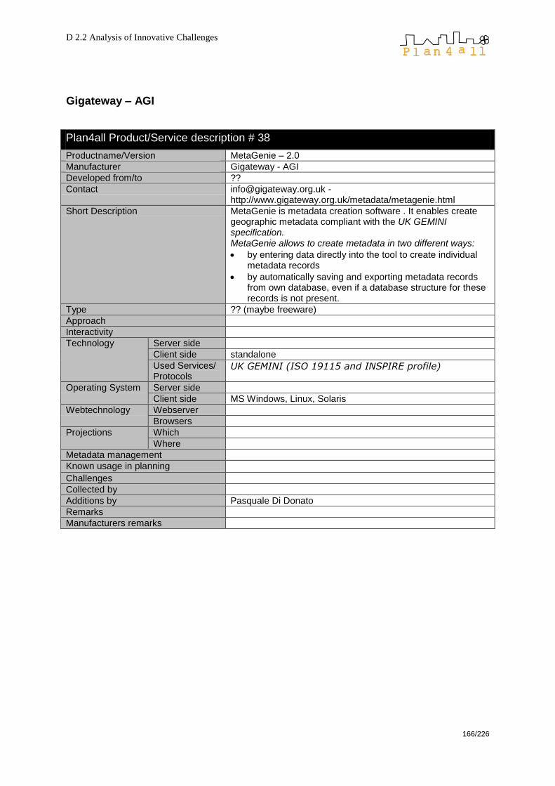
D 2.2 Analysis of Innovative Challenges
166/226
Gigateway – AGI
Plan4all Product/Service description # 38
Productname/Version MetaGenie – 2.0
Manufacturer Gigateway - AGI
Developed from/to ??
Contact [email protected] - http://www.gigateway.org.uk/metadata/metagenie.html
Short Description MetaGenie is metadata creation software . It enables create geographic metadata compliant with the UK GEMINI specification. MetaGenie allows to create metadata in two different ways:
by entering data directly into the tool to create individual metadata records
by automatically saving and exporting metadata records from own database, even if a database structure for these records is not present.
Type ?? (maybe freeware)
Approach
Interactivity
Technology Server side
Client side standalone
Used Services/ Protocols
UK GEMINI (ISO 19115 and INSPIRE profile)
Operating System Server side
Client side MS Windows, Linux, Solaris
Webtechnology Webserver
Browsers
Projections Which
Where
Metadata management
Known usage in planning Challenges
Collected by
Additions by Pasquale Di Donato
Remarks
Manufacturers remarks

D 2.2 Analysis of Innovative Challenges
167/226
Help Forest, Wirelessinfo
Plan4all Product/Service description # 39
Productname/Version DATa MANager (DataMan)
Manufacturer Help forest, WIRELESSINFO
Developed from/to 2008
Contact [email protected]
Short Description DataMan is application for management of spatial data. It sup-ports management of data in databases or files. It supports export and import of this data and also publishing and upda-ting of related metadata. In database, it is possible to store both, vector and raster data, including their attributes. Also for file oriented storage, it supports both, vector and raster data. From raster formats, it currently supports IFF/GeoTIFF, JPEG, GIF, PNG, BMP, ECW, from vector formats ESRI Shapefile, DGN, DWG, GML.
Type OpenSource (available from end of 2009 under GPL licence)
Approach Web Application
Interactivity Only Viewing
Semi interactive
Fully interactive
Technology Server side Application Server
Tile Server/…
File Interpreting
Database Access
WebGIS functions
Client side standalone
ActiveX
PlugIn/AddOn
Applet
Scripts
HTML only
Used Services/ Protocols
proprietary
WMS (OGC conform)
WFS (OGC conform)
WFS-T (OGC conform)
WCS (OGC conform)
SLD/… (OGC conform)
Simple Feature Specification for SQL (OGC)
GeoRSS
KML
GML
SVG
Others (specify …)
Operating System Server side
Client side
Webtechnology Webserver
Browsers
Projections Which
Where Server side Client side
Known usage in planning Challenges
Collected by Petr Horak

D 2.2 Analysis of Innovative Challenges
168/226
Plan4all Product/Service description # 40
Productname/Version MAP project MANager (MapMan)
Manufacturer Help forest, WIRELESSINFO
Developed from/to 2006
Contact [email protected]
Short Description The Map Project Manager (MapMan) is a web tool for users who want to publish or create new map projects and composi-tions. It supports publication of spatial composition from locally stored data (fields or database-stored in DataMan), with exter-nal WMS, WFS data services. MapMan provides visualization in web browser using such clients like OpenLayers, Google-Maps, DHTML client, Desktop viewer GoogleEarth, DIS Jani-tor or publish data as OGC WebMapService (WMS), OGC WebFeatureService (WFS). All published data are also con-nected with metadata stored in Micka.
Type OpenSource (available from end of 2009 uder GPL licence)
Approach Web Mapping
Spatial data publication on the web
Interactivity Fully interactive
Technology Server side Web Application
Client side Scripts
Used Services/ Protocols
WMS (OGC conform)
WFS (OGC conform)
Operating System Server side any
Client side any
Webtechnology Webserver any
Browsers any
Projections Which all
Where Server side
Metadata management Micka
Known usage in planning Challenges
Collected by Petr Horak
Additions by
Remarks
Manufacturers remarks

D 2.2 Analysis of Innovative Challenges
169/226
Plan4all Product/Service description # 41
Productname/Version Teredit System
Manufacturer Help forest, WIRELESSINFO
Developed from/to 2007
Contact [email protected]
Short Description Teredit system is a special solution for data transfer from mo-bile unit to server and back. This solution is realized via form of transactional component system when one part of system is installed on server (Broker). Broker enables preparation of the project, project sharing with other users and data checking be-fore saving into target database. The second part of system is installed on mobile device (PDA) and provides communication between server and PDA. The own collection or editing can be enable by any applications in common use (tested for geogra-phical data ArcPad, Topol CE, SiteMate, FieldCheck or for non-geographical data the own database editor)
Type OpenSource (available from end of 2009 under GPL licence)
Approach Data Collection in the field
Interactivity Fully interactive
Technology Server side Application Server
Database Access
Web application
Client side standalone
Scripts
Used Services/ Protocols
WMS (OGC conform)
WFS (OGC conform)
WFS-T (OGC conform)
Simple Feature Specification for SQL (OGC)
GML
Operating System Server side Any
Client side Windows mobile
Webtechnology Webserver Any
Browsers
Projections Which All
Where Server side
Client side
Metadata management Micka
Known usage in planning Challenges
Collected by Petr Horak
Additions by
Remarks
Manufacturers remarks
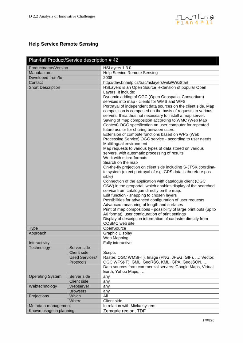
D 2.2 Analysis of Innovative Challenges
170/226
Help Service Remote Sensing
Plan4all Product/Service description # 42
Productname/Version HSLayers 1.3.0
Manufacturer Help Service Remote Sensing
Developed from/to 2008
Contact http://dev.bnhelp.cz/trac/hslayers/wiki/WikiStart
Short Description HSLayers is an Open Source extension of popular Open Layers. It include: Dynamic adding of OGC (Open Geospatial Consortium) services into map - clients for WMS and WFS Portrayal of independent data sources on the client side. Map composition is composed on the basis of requests to various servers. It isa thus not necessary to install a map server. Saving of map composition according to WMC (Web Map Context) OGC specification on user computer for repeated future use or for sharing between users. Extension of compute functions based on WPS (Web Processing Service) OGC service - according to user needs Multilingual environment Map requests to various types of data stored on various servers, with automatic processing of results Work with micro-formats Search on the map On-the-fly projection on client side including S-JTSK coordina-te system (direct portrayal of e.g. GPS data is therefore pos-sible) Connection of the application with catalogue client (OGC CSW) in the geoportal, which enables display of the searched service from catalogue directly on the map. Edit function - snapping to chosen layers Possibilities for advanced configuration of user requests Advanced measuring of length and surfaces Print of map compositions - possibility of large print outs (up to A0 format), user configuration of print settings Display of description information of cadastre directly from COSMC web site
Type OpenSource
Approach Graphic Display Web Mapping
Interactivity Fully interactive
Technology Server side
Client side Scripts
Used Services/ Protocols
Raster: OGC WMS(-T), Image (PNG, JPEG, GIF), …; Vector: OGC WFS(-T), GML, GeoRSS, KML, GPX, GeoJSON, … Data sources from commercial servers: Google Maps, Virtual Earth, Yahoo Maps, …
Operating System Server side any
Client side any
Webtechnology Webserver any
Browsers any
Projections Which All
Where Client side
Metadata management In relation with Micka system
Known usage in planning Zemgale region, TDF

D 2.2 Analysis of Innovative Challenges
171/226
Collected by Karel Charvat
Manufacturers remarks Dual licensing is used. For OS is used GPL

D 2.2 Analysis of Innovative Challenges
172/226
Plan4all Product/Service description # 43
Productname/Version PyWPS
Manufacturer Help Service Remote Sensing
Developed from/to 2003
Contact http://pywps.wald.intevation.org/
Short Description PyWPS is project, which is developed since 2006, and tries to implement OGC WPS standard in it's 0.4.0 version. It is written in Python programming language. The main goal of PyWPS is, that it has been written from the beginning, with direct support for GRASS GIS. So, PyWPS can be understand, as kind of translation library, which translates requests complain to WPS standard, overhands them to GRASS GIS or other command line tool (such as GDAL/OGR, PROJ.4 or R statistical packa-ge), monitors the calculation progress and informs the user and after the calculation is completed, it returns back it's result.
Type Open Source
Approach OGC Web Service WPS
Interactivity Library
Technology Server side Grass, Linux
Client side Phyton
Used Services/ Protocols
WPS 1.0.1
Operating System Server side Linux
Client side any
Webtechnology Webserver any
Browsers any
Projections Which N/a
Where N/a
Metadata management Yes
Known usage in planning Challenges
Collected by Karel Charvat
Additions by
Remarks
Manufacturers remarks
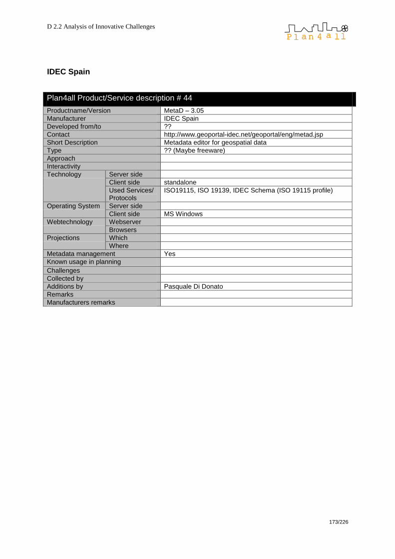
D 2.2 Analysis of Innovative Challenges
173/226
IDEC Spain
Plan4all Product/Service description # 44
Productname/Version MetaD – 3.05
Manufacturer IDEC Spain
Developed from/to ??
Contact http://www.geoportal-idec.net/geoportal/eng/metad.jsp
Short Description Metadata editor for geospatial data
Type ?? (Maybe freeware)
Approach
Interactivity
Technology Server side
Client side standalone
Used Services/ Protocols
ISO19115, ISO 19139, IDEC Schema (ISO 19115 profile)
Operating System Server side
Client side MS Windows
Webtechnology Webserver
Browsers
Projections Which
Where
Metadata management Yes
Known usage in planning Challenges
Collected by
Additions by Pasquale Di Donato
Remarks
Manufacturers remarks

D 2.2 Analysis of Innovative Challenges
174/226
Intelec Geomatic
Plan4all Product/Service description # 45
Productname/Version M3CAT – 1.5
Manufacturer Intelec Geomatique
Developed from/to ??
Contact http://www.intelec.ca/html/en/technologies/m3cat.html
Short Description M3CAT is a tool that assist users in entering and managing metadata about geospatial data sets.
M3CAT allows users to enter metadata using any standard (Multistandard) and any language (Multilingual). It is provided with the FGDC, GILS, NBII and ISO 19115 metadata standards and in English and French. Functions are available to add other standards and/or languages. It works in a Web environment, supports XML and SGML, and can interface to the ANSI/NISO Z39.50 FGDC GEO profile.
Type Freeware
Approach
Interactivity Fully interactive
Technology Server side
Client side standalone
Used Services/ Protocols
FGDC
GILS
NBII
ISO 19115
Operating System Server side MS Windows
Client side
Webtechnology Webserver Requires MS IIS and Oracle or Access
Browsers
Projections Which
Where
Metadata management Yes
Known usage in planning Challenges
Collected by Pasquale Di Donato
Additions by
Remarks
Manufacturers remarks

D 2.2 Analysis of Innovative Challenges
175/226
Intevation GmbH / TechniData AG
Plan4all Product/Service description # 46
Productname/Version Thuban, Version 1.2.2 (2009), Versions have been released about 1-1,5 years periods since dec. 2003
Manufacturer Intevation GmbH and TechniData AG
Developed from/to 2001-2008
Contact Bernhard Reiter ([email protected])
Short Description Thuban is an interactive, multi-platform geographic data viewer, which can visualize and analyze spatial data (only query, join) and convert between projections. Multi-Language Support; vector and raster data support, extensability and flexibility for deriving individual GIS applications.
Type OpenSource
Approach Desktop GIS Viewer
Geodatabase can be added: PostGis
Interactivity Fully interactive (but not too many functions)
Technology Server side -
Client side standalone
PlugIn/AddOn
Used Services/ Protocols
WMS (OGC conform)
Export to SVG
Operating System
Server side
Client side Multi-platform: Windows, Mac, Linux
Webtechnology Webserver
Browsers
Projections Which All
Where Server side
Client side
Metadata management -
Known usage in planning
Challenges
Collected by Julia Neuschmid (Ceit Alanova)
Additions by
Remarks Sources (Oct. 2009): http://www.cascadoss.eu/en/PDFs/SW_Documentation_Thuban.pdf http://thuban.intevation.org/concept.html
Manufacturers remarks

D 2.2 Analysis of Innovative Challenges
176/226
IVER
Plan4all Product/Service description # 47
Productname/Version GvSIG 1.9
Manufacturer IVER Tecnologías (Spain) together with the Generalitat Valenciana and the Jaume I University of Castellón 1.1 (latest stable version; Version 1.9 – latest unstable version)
Developed from/to 2003-200x
Contact http://www.gvsig.gva.es
Short Description Desktop GIS oriented to manage geographic information which is characterised by a user-friendly interface. It can handle both vector and raster data. It features basic ans advanced editing tools for the creation and maintenance of vector or raster spatial data on a variety of file formats, inclu-ding remote data sources. Application interface is in Spanish, Valencian, English, Bas-que, Gallego, Czech, Chinese, French, German, Italian, Ro-manian, Polish and Portuguese. In some cases application is able to use JUMP (Java Unified Mapping Platform) plugins. On gvSIG base is developed also mobile application gvSIG Mobile version for use in mobile devices.
Type OpenSource
Approach Graphic Display
Web Mapping
Geodatabase
Modelling and Analysis (e.g. network analysis)
Simple data processing (union,clip,dissolve etc.)
Interactivity Fully interactive
Technology Server side
Client side Standalone
PlugIn/AddOn
Applet
Used Services/ Protocols
WMS (OGC conform)
WFS (OGC conform)
WCS (OGC conform)
SLD/… (OGC conform)
GeoRSS
KML
GML
SVG
possible to extend with plugins (ArcIMS, ArcSDE and other)
Operating System
Server side Multi-platform - Windows, Linux, and Mac OS X
Client side Multi-platform - Windows, Linux, and Mac OS X
Webtechnology Webserver
Browsers
Projections Which All
Where Server side Client side
Metadata management According to ISO 19115 Standards
Known usage in planning It is aimed at users of geographic information, whether professionals or civil servants (city councils, councils, regional councils or ministries); It is also interesting for university settings due to its R&D&I component.

D 2.2 Analysis of Innovative Challenges
177/226
Challenges
Collected by Norma Zanetti Hyperborea
Additions by Peteris Bruns
Remarks Sources (Oct. 2009): http://www.cascadoss.eu/en/PDFs/SW_Documentation_gvSIG.pdf http://www.gvsig.gva.es/index.php?id=gvsig_desktop&L=2 http://www.gvsig.gva.es/fileadmin/conselleria/images/Documentacion/ponencias/gvSIG_Intergeo08.pdf
Manufacturers remarks

D 2.2 Analysis of Innovative Challenges
178/226
lat/lon
Plan4all Product/Service description # 48
Productname/Version deegree
Manufacturer lat/lon / Department of Geography, GIS Unit
Developed from/to ?-2009
Contact [email protected]
Short Description deegree is a Java Framework offering the main building blocks for Spatial Data Infrastructures. Its entire architecture is developed using standards of the Open Geospatial Consor-tium (OGC) and ISO/TC 211 (ISO Technical Committee 211 -- Geographic Information/Geomatics).
Type OpenSource
Approach Graphic Display
Web Mapping
Web GIS
building spatial data infrastructures
Interactivity Fully interactive
Technology Server side Application Server
Tile Server
File Interpreting (shp / gml)
Database Access, Support of PostGIS 1.0 and Oracle spatial/locator (9i/10g)
WebGIS functions
Client side HTML only
Used Services/ Protocols
WMS (official reference implementations of the Open Geospatial Consortium)
WFS (OGC conform)
WFS-T (OGC conform)
WCS (official reference implementations of the OGC)
pre-standards of Sensor Observation Service (SOS)
Web Terrain Service / Web Perspective and View Service (WTS/WPVS)
Web Processing Service (WPS)
SLD (OGC conform)
Simple Feature Specification for SQL (OGC)
KML
GML, Support of GML 3.1 with a complex Feature Model and 3D-geometries
SVG
Operating System
Server side java
Client side
Webtechnology Webserver java servlet engine e.g. apache tomcat
Browsers
Projections Which Many different; extendable
Where Server side
Metadata management CSW supports ISO19115/ISO19119 Application Profile, fully transactional
Known usage in planning spatial data infrastructure Hamburg Metropolitan Region (SDI-MRH) xplanung (Germany) Informatiemodel Ruimtelijke Ordening (IMRO) (Netherlands)
Collected by Kai-Uwe Krause

D 2.2 Analysis of Innovative Challenges
179/226
Plan4all Product/Service description # 49
Productname/Version GeoPista
Manufacturer
Developed from/to Ministerio de Fomento, Ministerio de Administraciones Públicas, Ministerio de Industria, Turismo y Comercio, Ministerio de Economía y Hacienda
Contact http://www.grupotecopy.es/cotesa/
Short Description GEOPISTA is a Territorial Information System for City Councils that on the basis of a mapping geopositions both municipal information and Management, providing thus online services based on Geographical Information Systems.
Type OpenSource
Approach Graphic Display
Web Mapping
Web Cartography
Web GIS
Geodatabase
Location-based services
Interactivity Full interactive
Technology Server side Application Server
Tile Server/…
File Interpreting
Database Access (supported databases are Oracle Spatial; MySQL; PostgreSQL (PostGIS))
WebGIS functions
Client side ActiveX
PlugIn/AddOn
Applet
Used Services/ Protocols
WMS (OGC conform)
WFS (OGC conform)
SLD/… (OGC conform)
GML
SVG
ECW, Tiff, GeoTiff, MrSid
Operating System Server side Windows
Client side Windows, GNU/Linux and other Unice
Webtechnology Webserver
Browsers
Projections Which All
Where Server side Client side
Metadata management
Known usage in planning • Ayuntamiento de Moya, Las Palmas
• Diputación Provincial de Albacete
• Ayuntamiento de Olot, Gerona
• Ayuntamiento de Villablino, León
• Grupo de Acción Local de la Sierra del Segura, Albacete
• Ayuntamiento de Aspe, Alicante
• Ayuntamiento de Xativa, Valencia • Diputación de Cuenca • Grupo de Acción Local Campos de Hellín, Albacete • Diputación Provincial de Lleida • Ayuntamiento de Tomelloso, Ciudad Real • Diputación Provincial de Barcelona • Ayuntamiento de Abegondo, La Coruña • Ayuntamiento de As Pontes de García Rodríguez, La Coruña • Junta de Comunidades de Castilla La Mancha • Diputación Provincial de A coruña • Ayuntamiento de Las Rozas, Madrid • Ayuntamiento de Cuenca, Cuenca

D 2.2 Analysis of Innovative Challenges
180/226
• Diputación Provincial de Valencia • Diputación Provincial de Badajoz • Diputación Provincial de Huesca • Mancomunidad de Municipios del Bajo Guadalquivir, Sevilla • Diputación Provincial de Almería • Consell de Mallorca • Junta de Castilla y León • Diputación Provincial de Pontevedra • Diputación Provincial de Soria • Ayuntamiento de Miranda de Ebro, Burgos • Diputación Provincial de Palencia • Ayuntamiento de Salamanca • Ayuntamiento de Córdoba • Diputación Provincial de León • Ayuntamiento de Lalín, Pontevedra • Mancomunidad de Sierra Morena Cordobesa, Córdoba • Ayuntamiento de Roses, Girona • Ayuntamiento de Abaran, Murcia • Ayuntamiento de Valverde del Camino, Huelva • Ayuntamiento de Alzira, Valencia • Ayuntamiento de Ciutadella de Menorca, Baleares • Ayuntamiento de Pizarra, Málaga • Mancomunidad de Municipios de la Sierra de Cádiz, Cádiz • Diputación de Guadalajara • Ayuntamiento de Alhaurin el Grande, Málaga • Ayuntamiento de Écija, Sevilla • Ayuntamiento de Guillena, Sevilla • Ayuntamiento de Pineda de Mar, Barcelona • Ayuntamiento de Montilla, Córdoba • Región de Murcia • Consorcio Cuenca Minera de Río Tinto, Huelva • Ayuntamiento de Ceutí, Murcia • Ayuntamiento de Algarrobo, Málaga • Mancomunidad de Desarrollo Condado de Huelva, Huelva • Ayuntamiento de A Estrada, Pontevedra • Mancomunidad de Servicios del Suroeste de Madrid, Madrid • Ayuntamiento de Badalona, Barcelona • Diputación de Tarragona Diputación de Alicante • Ayuntamiento de San Lorenzo de el Escorial, Madrid • Municipio de Caranavi, Bolivia • Ayuntamiento de Santa Lucia, Las Palmas • Ayuntamiento de Fondón, Almería • Ayuntamiento de Puerto del Rosario, Las Palmas • Ayuntamiento de El Ejido, Almería • Ayuntamiento de Laviana, Asturias • Ayuntamiento de Calvia, Illes Baleares • Ayuntamiento de Tineo, Asturias • Ayuntamiento de Manresa, Barcelona • Diputación Provincial de Burgos • Ayuntamiento de Fuentidueña de Tajo, Madrid • Ayuntamiento de Alhaurín de la Torre, Málaga • Ayuntamiento de Bellreguard, Valencia • Ayuntamiento de Almansa, Albacete • Ayuntamiento de Balaguer, Lleida • Ayuntamiento de Barrios de Colina, Burgos • Ayuntamiento de Valdes, Asturias • Ayuntamiento de Cambre, A Coruña • Ayuntamiento de Tuineje, Las Palmas • Ayuntamiento de Mérida, Badajoz • Ayuntamiento de Riofrío de Aliste, Zamora • Ayuntamiento de Jaén, Jaén • Ayuntamiento de Almonte, Huelva • Ayuntamiento de Tordesillas, Valladolid • Ayuntamiento de Finestrat, Alicante • Diputación Provincial de Sevilla • Ayuntamiento de Vigo, Pontevedra • Grupo de Acción Local de Alto Guadiana Mancha, Ciudad Real
Challenges
Collected by Agustín Lanero. Ayuntamiento de Gijón
Additions by
Remarks
Manufacturers remarks http://www.geopista.com/

D 2.2 Analysis of Innovative Challenges
181/226
OSGeo
Plan4all Product/Service description # 50
Productname/Version GDAL 1.6.2 (Geospatial Data Abstraction Library)
Manufacturer Frank Warmerdam (OSGEO)
Developed from/to
Contact http://www.gdal.org/
Short Description GDAL is a translator library for raster geospatial data formats that is released under an X/MIT style Open Source license by the Open Source Geospatial Foundation. As a library, it pre-sents a single abstract data model to the calling application for all supported formats. It also comes with a variety of useful commandline utilities for data translation and processing. The NEWS page describes the August 2009 GDAL/OGR 1.6.2 release. The related OGR library (which lives within the GDAL source tree) provides a similar capability for simple features vector data.
Type OpenSource
Approach Data transformation library
Interactivity Library
Technology Server side
Client side Standalone
Used Services/ Protocols
WMSTS
Operating System
Server side Multi-platform - Windows, Linux, and Mac OS X
Client side Multi-platform - Windows, Linux, and Mac OS X
Webtechnology Webserver
Browsers
Projections Which All
Where
Metadata management
Known usage in planning Uses a lot of desktop and server side applications like UMN Mapserver, Qgis even commercial ArcGIS software.
Challenges
Collected by Peteris Bruns (TDF)
Additions by
Remarks
Manufacturers remarks
Plan4all Product/Service description # 51
Productname/Version GRASS (Geographic Resources Analysis Support System), current version GRASS 6.4.0RC5 (June 2009)
Manufacturer Open Source Geospatial Foundation, community
Developed from/to 1982 - today, continuous updates
Contact http://grass.itc.it/community/team.php, http://lists.osgeo.org/mailman/listinfo/grass-dev irc://freenode.net #grass
Short Description GIS used for data management, image processing, graphics production, spatial modeling, spatial analysis, creating, managing and storing spatial data (raster/vector format) and visualization. GRASS can interface with commercial printers, plotters, digitizers, and databases to develop new data as well

D 2.2 Analysis of Innovative Challenges
182/226
as manage existing data. 3D (raster and vector) capabilities (analyze, display). No 3D vector topology is build.
Type OpenSource & Free Software
Approach Desktop GIS Allows integration with WebGis applications Geodatabase, GRASS can be linked to one or many database management systems (e.g. PostgreSQL, mySQL, SQLite, ODBC, …) PostgreSQL is prefered. Routing – network analysis Visualization, Analysis, Processing Remote sensing data analysis Spread modelling ...
Interactivity Fully interactive
Technology Server side -
Client side standalone
Used Services/ Protocols
SVG – very limited
Support of OGC services
ODBC
Operating System Server side GNU/Linux, MS Windows, MacOSX
Client side GNU/Linux, MS Windows, MacOSX
Webtechnology Webserver
Browsers
Projections Which All
Where Client side
Metadata management Rather poor, limited metadata management system (no support of any standard). It is on the top of GRASS developers TODO list.
Known usage in planning GRASS is currently used in academic and commercial settings around the world, as well as by many governmental agencies and environmental consulting companies.
Challenges Metadata, new raster architecture, GUI, new vectorization, new 3D visualization tool (wxnviz),..Ongoing development in 7.0 branch. Small developer community.
Collected by Julia Neuschmid (Ceit Alanova )
Additions by Jachym Cepicky (HSRS-Help Service Remote Sensing)
Remarks Sources (Oct. 2009): http://grass.osgeo.org/intro/general.php http://www.cascadoss.eu/en/PDFs/SW_Documentation_GRASS.pdf http://grass.itc.it/devel/grasshist.html http://gama.fsv.cvut.cz/~landa/publications/2007/workshop-cvut-07/landa-metadata-grass.pdf http://www.ohloh.net/p/grass_gis
Manufacturers remarks
Plan4all Product/Service description # 52
Productname/Version Mapbender 2.5.2
Manufacturer OSGeo
Developed from/to
Contact see http://www.mapbender.org/Partners
Short Description Mapbender is the software and portal site for geodata management of OGC OWS architectures. The software provides web technology for managing spatial data services implemented in PHP, JavaScript and XML and licensed under the GNU GPL. It provides a data model and interfaces for displaying, navigating and querying OGC compliant map
D 2.2 Analysis of Innovative Challenges
183/226
services. The Mapbender framework furthermore provides authentication and authorization services, OWS proxy functionality, management interfaces for user, group and service administration in WebGIS projects.
Type Open Source
Approach Web Mapping
Interactivity Fully interactive
Technology Server side PHP
Database Access
Client side Scripts
HTML
Used Services/ Protocols
WMS (OGC conform)
WFS (OGC conform)
WFS-T (OGC conform)
SLD/… (OGC conform)
Operating System Server side every
Client side every
Webtechnology Webserver every
Browsers every
Projections Which depends on queried map servers
Where Server side
Metadata management none
Known usage in planning CentropeMAP
Challenges
Collected by Clemens Beyer, CEIT ALANOVA
Additions by
Remarks
Manufacturers remarks
Plan4all Product/Service description # 53
Productname/Version MapServer v5.4.2
Manufacturer OSGeo (formerly University of Minnesota)
Developed from/to 199x-2009
Contact OSGEO
Short Description Multi-purpose web map portal
Type OpenSource
Approach Graphic Display
Web Mapping
Web Cartography
Web GIS
Location-based services
Interactivity Only Viewing
Semi interactive
Fully interactive
Technology Server side Application Server
Tile Server/…
File Interpreting
Database Access
WebGIS functions
Client side Scripts
HTML only

D 2.2 Analysis of Innovative Challenges
184/226
Used Services/ Protocols
Legacy proprietary interface
WMS client/server (OGC)
WFS client/server (OGC)
WMC (OGC)
WCS (OGC)
Filter Encoding SLD (OGC)
GML (OGC)
SOS (OGC)
OM (OGC)
Simple Feature Specification for SQL (OGC)
GeoRSS
KML
SVG
Operating System Server side Windows, Unix/Linux, FreeBSD (written in C)
Client side Multiple tools use Mapserver as back-end, e.g. KaMAP, MapBender
Webtechnology Webserver Integrates with Apache or IIS through PHP add-on module, also .NET and JAVA bindings.
Browsers Browser independent
Projections Which Full projection/re-projection support through WKT coordinate system definitions and the PROJ-library. Comes with comprehensive EPSG codes and easily extensible.
Where Server side: YES Client side: NO
Metadata management Metadata for WMS/WFS services may be maintained within map definition file both on MAP and LAYER level.
Known usage in planning Used as back-end for many client solutions, e.g. widely in Norway.
Challenges
Collected by Runar Bergheim
Additions by
Remarks
Manufacturers remarks
Plan4all Product/Service description # 54
Productname/Version OpenLayers 2.8
Manufacturer OSGeo
Developed from/to
Contact http://openlayers.org/
Short Description OpenLayers is an Open Source map viewing library, written in pure JavaScript. The OpenLayers library provides a JavaScript API which makes it easy to incorporate maps from a variety of sources into your webpage or application. OpenLayers currently has support for OGC WMS layers, navigation, icons, markers, and layer selection
Type OpenSource
Approach Graphic Display
Web Mapping
Interactivity Fully interactive
Technology Server side
Client side Scripts
Used Services/ Protocols
WMS (OGC conform)
WFS (OGC conform)
Operating System
Server side any
Client side any
Webtechnology Webserver any

D 2.2 Analysis of Innovative Challenges
185/226
Browsers any
Projections Which All
Where Client side
Metadata management
Known usage in planning Challenges
Collected by Norma Zanetti Hyperborea
Additions by
Remarks
Manufacturers remarks
Plan4all Product/Service description # 55
Productname/Version Proj4 – 4.4.6 (MS windows), 4.4.8 (Linux)
Manufacturer Originally developed by Gerald Evenden (USGS), now within the OSGEO Community
Developed from/to Continuous development
Contact http://trac.osgeo.org/proj/
Short Description Cartographic projection library
Type OpenSource (MIT License)
Approach Projection library used by several software
Interactivity Command line tools
Technology Server side Not applicable, but used by other server side applications such as MapServer, PostGIS
Client side standalone
Used Services/ Protocols
Operating System
Server side MS Windows, Linux
Client side
Webtechnology Webserver
Browsers
Projections Which several
Where Proj4 is a library and as such can be embedded in server side applications. Command line tools are available for desktop use.
Metadata management
Known usage in planning Challenges
Collected by Pasquale Di Donato
Additions by
Remarks
Manufacturers remarks

D 2.2 Analysis of Innovative Challenges
186/226
PortalU
Plan4all Product/Service description # 56
Productname/Version InGrid
Manufacturer Federal-State-Cooperation PortalU (environmental ministries on federal and state level), Coordination Center PortalU
Developed from/to From 2005
Contact [email protected]
Short Description The technology of the German Environmental Information Por-tal PortalU
® (www.PortalU.de) InGrid
® is a modular software
for the central access to online available environmental infor-mation. The name InGrid is a shortcut for Information Grid. In an InGrid
®-Portal it is possible to integrate web pages, data
and metadata. The software InGrid® is applicable for different
kinds of purposes. Main components of InGrid
®:
User-friendly and flexible configurable portal surface Metadata catalog InGrid
®Catalog (webcatalog)
Map viewer Diverse enquiry interfaces for the search in connected system and for information transfer
Type OpenSource components Webcatalog: INSPIRE (IR Metadata), ISO 19115 / ISO 19119 conform OGC-CSW-2-0 interface (DE profile) based on ISO standards 19115, 19119 and 19139 an INSPIRE OGC conform WMS viewer Software can be used without licence fees on federal, state and municipal level in Germany Rights on Software are reserved by German Federal Ministry for Environment, Nature Conservation and Nuclear Safety
Approach Portal and Search functions with full text search, thesaurus based search, display of ongoing news, measurement data and special topic pages Visualisation of digital maps by an integrated map viewer and WMS (Web Mapping) Spatial search for maps, services and other information objects Determination of spatial reference from non referenced content by semantically analysis of the place names within the document ISO conform description and management of geo data and geo services in the integrated metadata catalog InGrid®Catalog Involvement of external geo data catalogs via OGC-CSW-2.0 compatible interface Transfer from information via CSW-2.0 interface to other systems -> thus an integration in spatial data infrastructure like GDI-DE or INSPIRE is possible
Interactivity Fully interactive
Technology Server side Java 6 SDK
Tomcat
Apache
PHP
Relational Database (MySQL, PostgreSQL, MS SQL Server, Oracle)
D 2.2 Analysis of Innovative Challenges
187/226
Client side Web Browser
Used Services/ Protocols
Java Binary Objects
TCP/IP
HTTP
HTTPS
XML
CSW (OGC conform)
WMS (OGC conform)
OpenSearch / GeoRSS
Operating System Server side Windows or Linux derivates
Client side Any (as far as a web browser is included)
Webtechnology Webserver Apache
Browsers Firefox, Internet Explorer, Opera, Safari, Chrome, …
Projections Which Many different; extendable
Where Server side
Metadata management Metadata are managed by the webcatalog InGridCatalog (INSPIRE IR Metadata, ISO 19115, ISO 19119 conform) where different kind of environmental information can be described: geoinformation, maps, services, applications, informationsystems, data collections, data bases, documents, reports, literature, projects and programmes
Known usage in planning Besides PortalU InGrid is used for running two environmental information portals on state level (Saxony and Rhineland Platinate) and one on municipal level (Lower Saxony); furthermore it is used within the EU-funded eContenplus Project GS Soil (www.gssoil.eu)
Challenges
Collected by
Additions by
Remarks For further information: www.kst.portalu.de
Manufacturers remarks

D 2.2 Analysis of Innovative Challenges
188/226
QGIS Project Steering Committee (PSC)
Plan4all Product/Service description # 57
Productname/Version Quantum GIS (QGIS) (1.2.0)
Manufacturer QGIS Project Steering Committee (PSC)
Developed from/to 2002 to 2009
Contact www.qgis.org, [email protected]
Short Description QGIS is an Open Source GIS, providing common GIS func-tions and features. QGIS supports a number of raster and vec-tor data formats, with new format support easily added using the plugin architecture. QGIS is released under the GNU Ge-neral Public License (GPL). Developing QGIS under this licen-se means that everybody can inspect and modify the source code.
Type OpenSource
Approach Graphic Display
Interactivity Fully interactive
Technology Server side Database Access (PostgreSQL PostGIS)
Client side Standalone
Used Services/ Protocols
WMS (OGC conform)
WFS (OGC conform)
Simple Feature Specification for SQL (OGC)
GML
Operating System Server side
Client side Java (Linux , Unix, Windows, OS X)
Webtechnology Webserver
Browsers
Projections Which Many different; extendable.
Where Client side
Metadata management
Known usage in planning Challenges
Collected by Giuseppina Pellegrino (DIPSU)
Additions by
Remarks
Manufacturers remarks

D 2.2 Analysis of Innovative Challenges
189/226
Refrations Research
Plan4all Product/Service description # 58
Productname/Version PostGIS
Manufacturer Refractions Research
Developed from/to
Contact http://postgis.refractions.net/
Short Description PostGIS provides support for geographic objects to the PostgreSQL DBMS. PostGIS follows the OpenGIS "Simple Features Specification for SQL" and has been certified as compliant with the "Types and Functions" profile. PostGIS has been developed as a project in open source spatial database technology and is released under the GNU General Public License.
Type OpenSource
Approach GIS
Interactivity Full, DB level
Technology Server side Spatial data management functions
Client side
Used Services/ Protocols
WMS (OGC conform)
WFS (OGC conform)
WFS-T (OGC conform)
WCS (OGC conform)
GML
WKT
Operating System
Server side any
Client side any
Webtechnology Webserver any
Browsers any
Projections Which All
Where Server side
Metadata management
Known usage in planning
Challenges
Collected by Norma Zanetti Hyperborea S.r.l.
Additions by
Remarks
Manufacturers remarks
D 2.2 Analysis of Innovative Challenges
190/226
Plan4all Product/Service description # 59
Product name/Version uDig
Manufacturer
Developed from/to
Contact http://udig.refractions.net
Short Description uDig is an open source (LGPL) GIS desktop application framework, built with Eclipse Rich Client (RCP) technology. uDig s a complete Java solution for desktop GIS data access, editing, and viewing. uDig aims to be: User friendly, providing a familiar graphical environment for GIS users; Desktop located, running as a thick client, natively on Windows, Mac OS/X and Linux; Internet oriented, consuming standard (WMS, WFS, WCS) and de facto (GeoRSS, KML, tiles) geospatial web services; and, GIS ready, providing the framework on which complex analytical capabilities can be built, and gradually subsuming those capabilities into the main application.
Type OpenSource
Approach Graphic Display
Web Mapping
Web GIS
Geodatabase
Interactivity Fully interactive
Technology Server side -
Client side standalone
PlugIn/AddOn
Used Services/ Protocols
proprietary
WMS (OGC conform)
WFS (OGC conform)
SLD/… (OGC conform)
GeoRSS
KML
GML
SVG
Operating System
Server side
Client side All platform (Java based)
Webtechnology Webserver
Browsers
Projections Which All
Where Client side
Metadata management
Known usage in planning Challenges
Collected by Norma Zanetti Hyperborea
Additions by
Remarks
Manufacturers remarks
D 2.2 Analysis of Innovative Challenges
191/226
SAIG
Plan4all Product/Service description # 60
Productname/Version Kosmo GIS Desktop 1.2.1
Manufacturer SAIG is a company centered at the development of Geographic Information Systems and solutions over them.
Developed from/to
Contact http://www.opengis.es/
Short Description Desktop GIS oriented to manage geographic information which is characterized by a user-friendly interface. Application is based on JUMP (Java Unified Mapping Platform) annd is able to use JUMP and Open Jump plugins.
Type OpenSource
Approach Graphic Display
Web Mapping
Geodatabase
Modelling and Analysis (e.g. network analysis)
Simple data processing (union,clip,dissolve etc.)
Interactivity Fully interactive
Technology Server side
Client side Standalone
PlugIn/AddOn
Applet
Used Services/ Protocols
WMS (OGC conform)
WFS (OGC conform)
SLD/… (OGC conform)
GML
SVG
possible to extend with plugins (ArcIMS, ArcSDE and other)
Operating System
Server side Multi-platform - Windows, Linux, and Mac OS X
Client side Multi-platform - Windows, Linux, and Mac OS X
Webtechnology Webserver
Browsers
Projections Which All
Where Server side Client side
Metadata management
Known usage in planning
Challenges
Collected by
Additions by Peteris Bruns (TDF)
Remarks
Manufacturers remarks
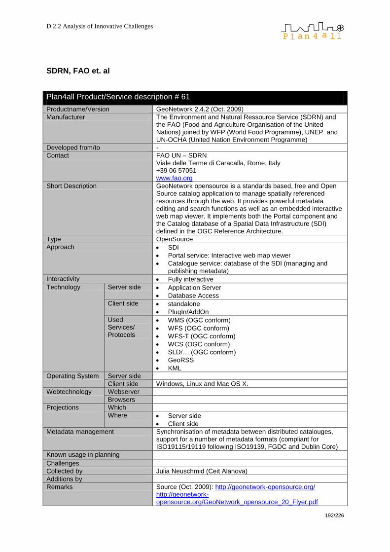
D 2.2 Analysis of Innovative Challenges
192/226
SDRN, FAO et. al
Plan4all Product/Service description # 61
Productname/Version GeoNetwork 2.4.2 (Oct. 2009)
Manufacturer The Environment and Natural Ressource Service (SDRN) and the FAO (Food and Agriculture Organisation of the United Nations) joined by WFP (World Food Programme), UNEP and UN-OCHA (United Nation Environment Programme)
Developed from/to -
Contact FAO UN – SDRN Viale delle Terme di Caracalla, Rome, Italy +39 06 57051 www.fao.org
Short Description GeoNetwork opensource is a standards based, free and Open Source catalog application to manage spatially referenced resources through the web. It provides powerful metadata editing and search functions as well as an embedded interactive web map viewer. It implements both the Portal component and the Catalog database of a Spatial Data Infrastructure (SDI) defined in the OGC Reference Architecture.
Type OpenSource
Approach SDI
Portal service: Interactive web map viewer
Catalogue service: database of the SDI (managing and publishing metadata)
Interactivity Fully interactive
Technology Server side Application Server
Database Access
Client side standalone
PlugIn/AddOn
Used Services/ Protocols
WMS (OGC conform)
WFS (OGC conform)
WFS-T (OGC conform)
WCS (OGC conform)
SLD/… (OGC conform)
GeoRSS
KML
Operating System Server side
Client side Windows, Linux and Mac OS X.
Webtechnology Webserver
Browsers
Projections Which
Where Server side
Client side
Metadata management Synchronisation of metadata between distributed catalouges, support for a number of metadata formats (compliant for ISO19115/19119 following ISO19139, FGDC and Dublin Core)
Known usage in planning Challenges
Collected by Julia Neuschmid (Ceit Alanova)
Additions by
Remarks Source (Oct. 2009): http://geonetwork-opensource.org/ http://geonetwork-opensource.org/GeoNetwork_opensource_20_Flyer.pdf
D 2.2 Analysis of Innovative Challenges
193/226
Manufacturers remarks

D 2.2 Analysis of Innovative Challenges
194/226
T-Systems España, SAU
Plan4all Product/Service description # 62
Productname/Version MonoGIS
Manufacturer T-Systems España, SAU Calle Sancho de Ávila, 110-130. 08018 Barcelona. España
Developed from/to
Contact [email protected]
Short Description MonoGis as an map server open source project. It includes a benchmarking between other open source map server. Mono is multi-platform, multi-language and multi-technology. The term multi-technology means that you may couple a variety of different programming platforms within the same application.
Type OpenSource
Approach Graphic Display
Web Mapping
Web Cartography
Web GIS
Geodatabase
Location-based services
Interactivity Semi interactive
Technology Server side Application Server
Tile Server/…
File Interpreting
Database Access (supported databases are Oracle Spatial; MySQL; PostgreSQL (PostGIS))
WebGIS functions
Client side ActiveX
PlugIn/AddOn
Scripts
Used Services/ Protocols
Geomedia GDO (stored in MDB, SQL Server or Oracle)
some OGR supported formats (DGN v7, MapInfo, Oracle Spatial, GML, S-57)
Oracle Spatial
JPEG, PNG, TIFF and ECW raster data sets.
Operating System
Server side Windows
Client side Windows, GNU/Linux and other Unice
Projections Which All
Where Server side
Client side
Metadata management
Known usage in planning Ayuntamiento de Gijón
Ayuntamiento de Leganés
Ayuntamiento de San Feliu de Llobregat
Ayuntamiento de Terrasa
Diputación de Tarragona Challenges
Collected by Agustín Lanero. Ayuntamiento de Gijón
Manufacturers remarks http://galadriel.grokthis.net:8011/ http://biblioteca.universia.net/html_bura/ficha/params/id/42168158.html
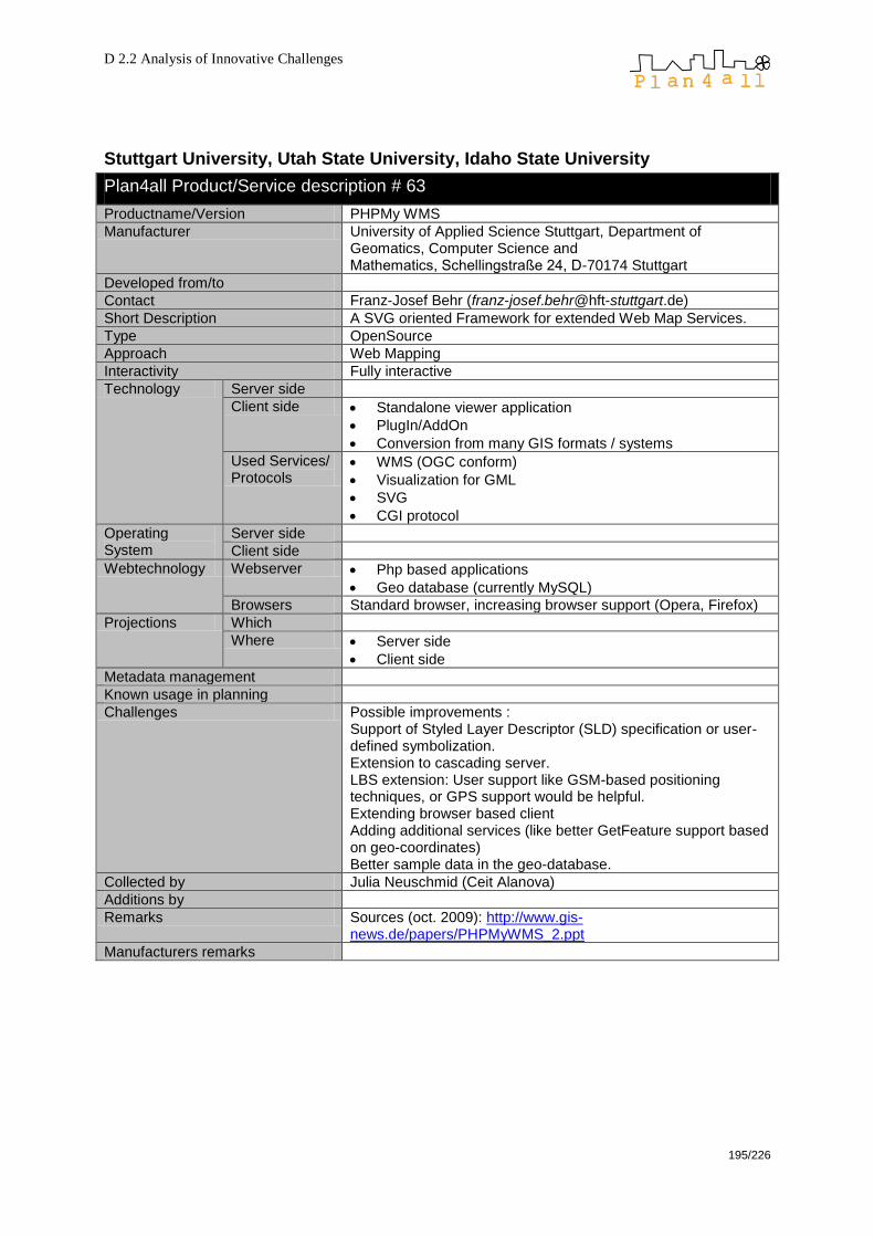
D 2.2 Analysis of Innovative Challenges
195/226
Stuttgart University, Utah State University, Idaho State University
Plan4all Product/Service description # 63
Productname/Version PHPMy WMS
Manufacturer University of Applied Science Stuttgart, Department of Geomatics, Computer Science and Mathematics, Schellingstraße 24, D-70174 Stuttgart
Developed from/to
Contact Franz-Josef Behr ([email protected])
Short Description A SVG oriented Framework for extended Web Map Services.
Type OpenSource
Approach Web Mapping
Interactivity Fully interactive
Technology Server side
Client side Standalone viewer application
PlugIn/AddOn
Conversion from many GIS formats / systems
Used Services/ Protocols
WMS (OGC conform)
Visualization for GML
SVG
CGI protocol
Operating System
Server side
Client side
Webtechnology Webserver Php based applications
Geo database (currently MySQL)
Browsers Standard browser, increasing browser support (Opera, Firefox)
Projections Which
Where Server side
Client side
Metadata management
Known usage in planning
Challenges Possible improvements : Support of Styled Layer Descriptor (SLD) specification or user-defined symbolization. Extension to cascading server. LBS extension: User support like GSM-based positioning techniques, or GPS support would be helpful. Extending browser based client Adding additional services (like better GetFeature support based on geo-coordinates) Better sample data in the geo-database.
Collected by Julia Neuschmid (Ceit Alanova)
Additions by
Remarks Sources (oct. 2009): http://www.gis-news.de/papers/PHPMyWMS_2.ppt
Manufacturers remarks

D 2.2 Analysis of Innovative Challenges
196/226
Plan4all Product/Service description # 64
Productname/Version MapWindowGIS version 4.3
Manufacturer Utah State University. Idaho State University
Developed from/to
Contact http://www.mapwindow.org/contact.php
Short Description MapWindow GIS The MapWindow application is a free, extensible, geographic information system (GIS) that can be used: As an alternative desktop GIS To distribute data to others To develop and distribute custom spatial data analyses MapWinGIS ActiveX Control At the core of the MapWindow application is the MapWinGIS ActiveX control. Using this control, you can program custom mapping functionality directly into your own software
Type Open source component (free distribution)
Approach Graphic Display
Web Mapping
Web Cartography
Web GIS
Geodatabase
Location-based services
Interactivity Semi interactive
Technology Server side Application Server
Tile Server/…
File Interpreting
Database Access (supported databases are Oracle Spatial; MySQL; PostgreSQL (PostGIS))
WebGIS functions
Client side ActiveX
Used Services/ Protocols
ESRI Shapefiles
ASCII Grids
GeoTiff Grids
Operating System
Server side Windows
Client side Windows
Webtechnology Webserver
Browsers
Projections Which All
Where Server side
Client side
Metadata management
Known usage in planning Challenges
Collected by Agustín Lanero. Ayuntamiento de Gijón
Additions by
Remarks
Manufacturers remarks http://www.mapwindow.org/
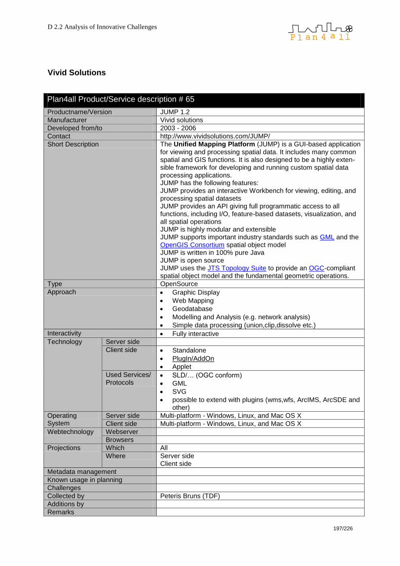
D 2.2 Analysis of Innovative Challenges
197/226
Vivid Solutions
Plan4all Product/Service description # 65
Productname/Version JUMP 1.2
Manufacturer Vivid solutions
Developed from/to 2003 - 2006
Contact http://www.vividsolutions.com/JUMP/
Short Description The Unified Mapping Platform (JUMP) is a GUI-based application for viewing and processing spatial data. It includes many common spatial and GIS functions. It is also designed to be a highly exten-sible framework for developing and running custom spatial data processing applications. JUMP has the following features: JUMP provides an interactive Workbench for viewing, editing, and processing spatial datasets JUMP provides an API giving full programmatic access to all functions, including I/O, feature-based datasets, visualization, and all spatial operations JUMP is highly modular and extensible JUMP supports important industry standards such as GML and the OpenGIS Consortium spatial object model JUMP is written in 100% pure Java JUMP is open source JUMP uses the JTS Topology Suite to provide an OGC-compliant spatial object model and the fundamental geometric operations.
Type OpenSource
Approach Graphic Display
Web Mapping
Geodatabase
Modelling and Analysis (e.g. network analysis)
Simple data processing (union,clip,dissolve etc.)
Interactivity Fully interactive
Technology Server side
Client side Standalone
PlugIn/AddOn
Applet
Used Services/ Protocols
SLD/… (OGC conform)
GML
SVG
possible to extend with plugins (wms,wfs, ArcIMS, ArcSDE and other)
Operating System
Server side Multi-platform - Windows, Linux, and Mac OS X
Client side Multi-platform - Windows, Linux, and Mac OS X
Webtechnology Webserver
Browsers
Projections Which All
Where Server side Client side
Metadata management
Known usage in planning
Challenges
Collected by Peteris Bruns (TDF)
Additions by
Remarks

D 2.2 Analysis of Innovative Challenges
198/226
11.5 Portals
INSPIRE Geoportal
Plan4all Product/Service description # 66
Productname/Version Inspire Geoportal (prototype)
Manufacturer Published by the EU, Joint Research Center
Developed from/to Sept. 2008, ongoing
Contact http://www.inspire-geoportal.eu/
Short Description The geoportal provides the means to search for spatial data sets and spatial data services, and subject to access restrictions, view and download spatial data sets from the EU Member States within the framework of the Infrastructure for Spatial Information in the European Community (INSPIRE) Directive.
Type Popular Network Service without costs
Approach Graphic Display
Metadata editor (create metadata according to INSPIRE)
Interactivity Fully interactive (create metadata)
Technology Server side Do not know
Client side Do not know
Used Services/ Protocols
WMS (OGC conform)
WFS (OGC conform)
WFS-T (OGC conform)
WCS (OGC conform)
CSW
WPS
GML
Operating System
Server side
Client side Windows, Linux, MAC OS X
Webtechnology Webserver
Browsers All
Projections Which ETRS89 (?), compatible to other projections
Where Server side Client side
Metadata management Yes, according to INSPIRE, at the moment not much metadata is available as it is just a prototype so far
Known usage in planning
Challenges
Collected by Julia Neuschmid (Ceit Alanova)
Additions by
Remarks Sources (Oct. 2009): http://www.inspire-geoportal.eu/index.cfm/pageid/241/documentid/502/doctype/341
Manufacturers remarks

D 2.2 Analysis of Innovative Challenges
199/226
11.6 Popular services without costs
Plan4all Product/Service description # 67
Productname/Version Google Earth (Version 5)
Manufacturer Original author Keyhole Corp. (2001) > Google Inc. (2004)
Developed from/to 2001 (under the name ―keyhole; Earth Viewer 3D‖) > from 2004 Google Earth by Google
Contact http://earth.google.com/
Short Description 2D view/3D model of the earth (satellite images, aerial photography) as well as vector data (border lines, localities, transportation network, POIs); functions: search, navigation, measurement, zoom; additional features like googly sky, google moon, street view, google ocean, flight simulator, etc.; 41 languages; image data and resolution vary
Type Free software with limited functionality (Google Earth) Commercial (Google Earth Pro)
Approach Desktop application, Virtual Globe
Interactivity Only Viewing (3D)
Technology Server side Application Server
Tile Server/…
File Interpreting
Client side PlugIn/AddOn
Used Services/ Protocols
proprietary
WMS server
WFS (OGC conform)
SLD/… (OGC conform)
GeoRSS
KML for customising Google Earth
GML
SVG
Operating System
Server side
Client side Windows (2000, XP, Vista), Mac OS X (ab 10.3.9) und Linux, iphone OS
Webtechnology Webserver
Browsers Internet Explorer, Mozilla Firefox, Google Chrome, Safari
Projections Which WGS84
Where Server side Client side
Metadata management Yes
Known usage in planning Challenges
Collected by Julia Neuschmid (Ceit Alanova)
Additions by
Remarks Source (Oct. 2009) http://en.wikipedia.org/wiki/Google_Earth http://computer.howstuffworks.com/google-earth11.htm
Manufacturers remarks
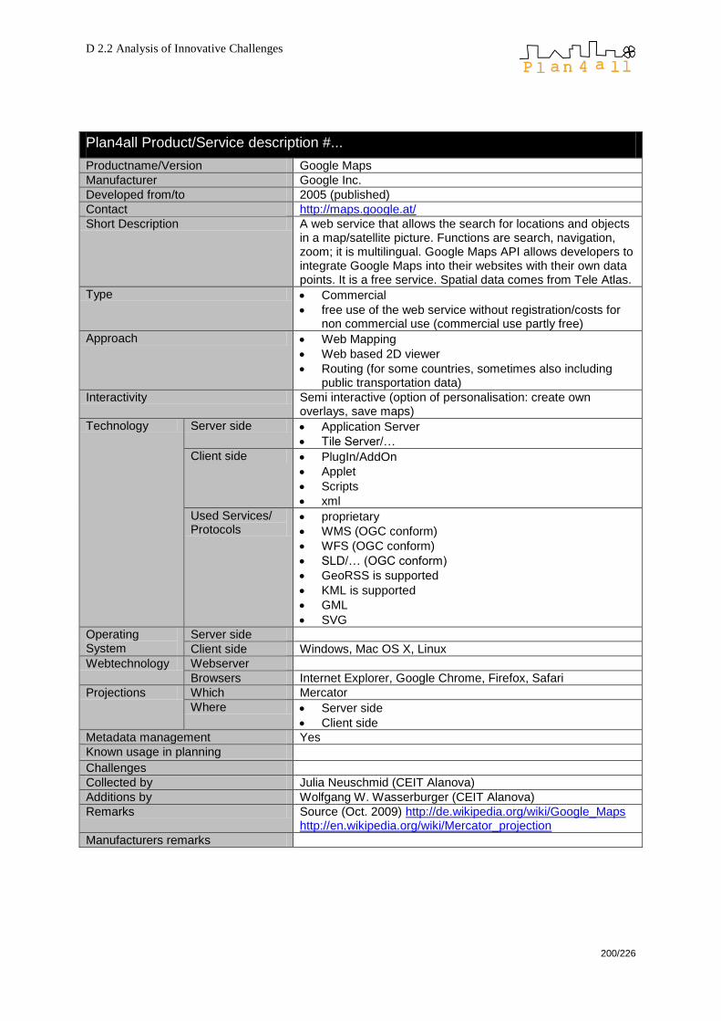
D 2.2 Analysis of Innovative Challenges
200/226
Plan4all Product/Service description #...
Productname/Version Google Maps
Manufacturer Google Inc.
Developed from/to 2005 (published)
Contact http://maps.google.at/
Short Description A web service that allows the search for locations and objects in a map/satellite picture. Functions are search, navigation, zoom; it is multilingual. Google Maps API allows developers to integrate Google Maps into their websites with their own data points. It is a free service. Spatial data comes from Tele Atlas.
Type Commercial
free use of the web service without registration/costs for non commercial use (commercial use partly free)
Approach Web Mapping
Web based 2D viewer
Routing (for some countries, sometimes also including public transportation data)
Interactivity Semi interactive (option of personalisation: create own overlays, save maps)
Technology Server side Application Server
Tile Server/…
Client side PlugIn/AddOn
Applet
Scripts
xml
Used Services/ Protocols
proprietary
WMS (OGC conform)
WFS (OGC conform)
SLD/… (OGC conform)
GeoRSS is supported
KML is supported
GML
SVG
Operating System
Server side
Client side Windows, Mac OS X, Linux
Webtechnology Webserver
Browsers Internet Explorer, Google Chrome, Firefox, Safari
Projections Which Mercator
Where Server side
Client side
Metadata management Yes
Known usage in planning Challenges
Collected by Julia Neuschmid (CEIT Alanova)
Additions by Wolfgang W. Wasserburger (CEIT Alanova)
Remarks Source (Oct. 2009) http://de.wikipedia.org/wiki/Google_Maps http://en.wikipedia.org/wiki/Mercator_projection
Manufacturers remarks

D 2.2 Analysis of Innovative Challenges
201/226
11.7 Open data projects
Open Street Map Foundation
Plan4all Product/Service description #...
Productname/Version Open Street Map
Manufacturer Steve Coast, Open Street Map Foundation
Developed from/to 2004, ongoing
Contact www.openstreetmap.org
Short Description OSM is a collaborative project to create a free editable map of the world. The maps are created using data from portable GPS devices, aerial photography, other free sources or simply from local knowledge. OpenStreetMap was inspired by sites such as Wikipedia — it is a distribution of free geospatial data and provides geospatial data for anybody to use and share. Registered users can upload GPS track logs and edit the vector data using the given editing tools.
Type Free database and map server with geographic data and editable maps
Approach Web Mapping
Geodatabase
OSM maps can be included in other Location-based services
Interactivity Fully interactive (users can edit data but not too many GIS functions, no analysis etc.)
Technology Server side Tile Server/API/Web Mapping Services (Mapnik, Osmarender)
Client side Scripts
Used Services/ Protocols
OSM API Via derived services also other Protocols
Operating System Server side
Client side Windows, Linux, Mac OS X
Webtechnology Webserver
Browsers All
Projections Which Mercator, Lat/Lon
Where Server side
Client side
Metadata management yes
Known usage in planning - Challenges Quality criteria for data; add standards
Collected by Julia Neuschmid (Ceit Alanova)
Additions by Wolfgang W. Wasserburger (CEIT Alanova)
Remarks Source (Okt. 2009): http://www.corp.at/corp_relaunch/papers_txt_suche/CORP2009_156.pdf http://www.geofabrik.de/media/2009-05-18-osm-qualitaetsmanagement-fossgis2009.pdf
Manufacturers remarks

D 2.2 Analysis of Innovative Challenges
202/226
12 Annex B: Survey results
To give an overview of used Software, built up SDI etc. a Survey was done among
Partners and ISOCARP Members. May be that not all results present the absolute
truth since answers were given from a very subjective point of view. Answers being
worth to present publicly will be shown here.
12.1 Assessment of national and regional policies
12.1.1 Legal Situation
Nearly all (86.7 %) of the countries have planning laws or planning regulations on
national level (centralised or federal). (Question 4 of the task 2.1 and 2.2. survey).
About a quarter has planning laws on state level and half of the countries have
planning laws on regional and/or local level. It is interesting that (with only one
exception) in all countries with planning laws on the regional level there are also
planning laws on the local level.
The ―classic‖ distribution of planning laws (stated for 7 of 15 countries) is national,
region/province, and local (municipality).
On which levels do planning laws exist in your country?
66,7%
20,0%
26,7%
53,3% 53,3%
0,0%0,0%
10,0%
20,0%
30,0%
40,0%
50,0%
60,0%
70,0%
National
(centralised)
National
(federal)
State Region or
Province
Local
(municipality)
Other
Fig. 5: Levels of planning laws or planning regulations
Almost all countries have development plans or similar planning instruments in each
of the three categories shown in the graph below. (Survey questions 5-7.)
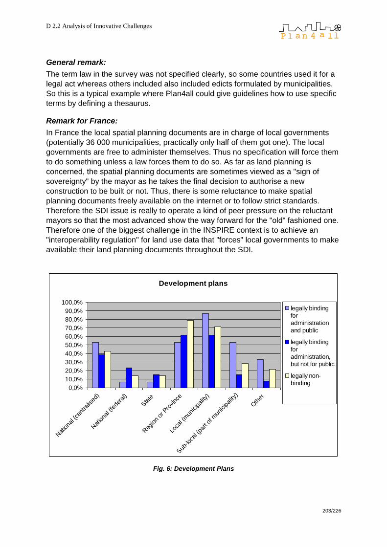
D 2.2 Analysis of Innovative Challenges
203/226
General remark:
The term law in the survey was not specified clearly, so some countries used it for a
legal act whereas others included also included edicts formulated by municipalities.
So this is a typical example where Plan4all could give guidelines how to use specific
terms by defining a thesaurus.
Remark for France:
In France the local spatial planning documents are in charge of local governments
(potentially 36 000 municipalities, practically only half of them got one). The local
governments are free to administer themselves. Thus no specification will force them
to do something unless a law forces them to do so. As far as land planning is
concerned, the spatial planning documents are sometimes viewed as a "sign of
sovereignty" by the mayor as he takes the final decision to authorise a new
construction to be built or not. Thus, there is some reluctance to make spatial
planning documents freely available on the internet or to follow strict standards.
Therefore the SDI issue is really to operate a kind of peer pressure on the reluctant
mayors so that the most advanced show the way forward for the "old" fashioned one.
Therefore one of the biggest challenge in the INSPIRE context is to achieve an
"interoperability regulation" for land use data that "forces" local governments to make
available their land planning documents throughout the SDI.
Development plans
0,0%
10,0%
20,0%
30,0%
40,0%
50,0%
60,0%
70,0%
80,0%
90,0%
100,0%
Nat
iona
l (ce
ntra
lised
)
Nat
iona
l (fe
dera
l)
Sta
te
Reg
ion
or P
rovinc
e
Loca
l (m
unicipality
)
Sub
-loca
l (pa
rt of
mun
icipal
ity)
Oth
er
legally binding
for
administration
and public
legally binding
for
administration,
but not for public
legally non-
binding
Fig. 6: Development Plans

D 2.2 Analysis of Innovative Challenges
204/226
The majority of plans can be found in the regional and local levels. Throughout every
level the relation between legally non-binding plans and plans having at least a partly
legal obligation is approximately 1:2.
General remark:
The term development plan in the survey was not specified clearly, so some
countries used it in different ways. So this is a typical example where Plan4all could
give guidelines how to use specific terms by defining a thesaurus.
3-4 types of plans
5-8 types of plans
9-11 types of plans
Data Source: ESRI Digital Chart of the World, proprietary illustration
Fig. 7: Map: Types of Plans
In all countries various plans are available to the public (survey question 8). Whereas
in higher administrative levels plans tend to be available both printed and digital. On
local (municipal) or sub-local level the majority of plans is available only in printed
version. No plan is available in digital version without print – this is most probably
because planning laws all have their origin in the pre-digital era, so they demand
printed plans which are legally binding them. Moreover, once a digital version exists it
is no big deal to produce a printed version whereas the opposite – turning a printed
map into a digital version – is likely to take higher amounts of time and money.

D 2.2 Analysis of Innovative Challenges
205/226
Are these plans available to the public?
0
2
4
6
8
10
12
14
16
Natio
nal (c
entra
lised
)
Natio
nal (f
edera
l)
Sta
te
Regi
on o
r Pro
vinc
e
Loca
l (m
unicipality
)
Sub
-loca
l (pa
rt of m
unicip
ality
)
No
Yes, digital only
Yes, printed only
Yes, printed and digital
Fig. 8: Public available plans
Remarks (survey question 9)
o Netherlands: Even with the new law (guilty starting at 1/10/2010) which says
that plans have to be made digital, paper maps are still present. Only in doubt
the digital ones are more authentic.
This is a remarkable fact as older laws tend to emphasise the printed versions
because in terms of many older planning laws digital versions of plans simply do not
exist at all.
o Belgium: Digital access of local plans depends on the municipality – some
municipalities have web-based digital access, others only offer hard copies.
o Italy:
o Question 5: Regional plans legally binding the public: only as far as
some part of Regional Landscape plan is concerned.
o Question 8: all existing plans are public and are available in printed
form. The availability in digital form of plans varies from region to
region, in a region from province to province, in a province from
municipality to municipality.
The most recent territorial and urban plans at regional, provincial and
municipal level are available on the Internet, often with WebGIS
services.
o Romania: The availability of plans depends mainly on the size of
municipalities or settlements. Bigger municipalities also have these documents
in digital versions on their website, other settlements do not even have a
webpage.

D 2.2 Analysis of Innovative Challenges
206/226
o Czech Republic: Legally non-binding plans are usually available only in
printed version to the public on demand. Legally binding plans on local level
are always available printed and partly digital.
o Latvia: In digital format most of all plans are available in dgn or jpg formats.
o France: The plans are available to the public printed (always) or digital
(sometimes).
Conclusion
There is a significant correlation between planning laws on a certain level and having
legally binding development plans on the same level, which is not quite surprising.
Also legally non-binding plans are more likely to appear on levels which have their
own planning laws.
Correlation between planning laws and legally binding plans
yes (77,3%)
no (22,7%)
Fig. 9: Correlation between planning laws and legally binding plans
The above correlation was calculated counting levels with planning laws and legally
binding plans and levels without planning laws and also without legally binding plans
as ―yes‖ and all other levels without commonality regarding planning laws and legally
binding plans as ―no‖.
The availability of digital planning information is still a very heterogeneous issue, but
throughout all countries there is a significant trend towards the supply of digital maps.
The main commonality is the lack of legal obligation for digital planning documents. It
can be taken for granted that this situation is going to change during the next few
years as the INSPIRE implementation has to be done and therefore some countries
will have to adapt their laws or administration structure. So it is not surprising at all
that there is no planning information which is available in a digital, but not in a printed
version.
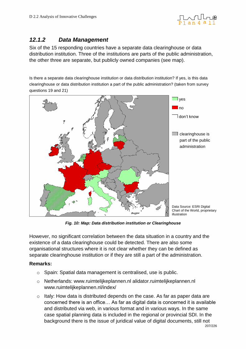
D 2.2 Analysis of Innovative Challenges
207/226
12.1.2 Data Management
Six of the 15 responding countries have a separate data clearinghouse or data
distribution institution. Three of the institutions are parts of the public administration,
the other three are separate, but publicly owned companies (see map).
Is there a separate data clearinghouse institution or data distribution institution? If yes, is this data
clearinghouse or data distribution institution a part of the public administration? (taken from survey
questions 19 and 21)
yes
no
don‘t know
clearinghouse is
part of the public
administration
Data Source: ESRI Digital Chart of the World, proprietary illustration
Fig. 10: Map: Data distribution institution or Clearinghouse
However, no significant correlation between the data situation in a country and the
existence of a data clearinghouse could be detected. There are also some
organisational structures where it is not clear whether they can be defined as
separate clearinghouse institution or if they are still a part of the administration.
Remarks:
o Spain: Spatial data management is centralised, use is public.
o Netherlands: www.ruimtelijkeplannen.nl alidator.ruimtelijkeplannen.nl
www.ruimtelijkeplannen.nl/index/
o Italy: How data is distributed depends on the case. As far as paper data are
concerned there is an office… As far as digital data is concerned it is available
and distributed via web, in various format and in various ways. In the same
case spatial planning data is included in the regional or provincial SDI. In the
background there is the issue of juridical value of digital documents, still not

D 2.2 Analysis of Innovative Challenges
208/226
definitely addressed. Part of the public administration or a separate, but
publicly owned company.
Some examples: the SINA network collects, manages and distributes
environmental data on behalf of the Ministry of Environment, through its
Regional Focal Points which in turn collect data on behalf of Regions and
Autonomous Provinces. ―Sistema Piemonte‖ is a web portal, based on a
consortium among public authorities, for accessing services of the Region of
Piemonte; among these, geographic data.
o Romania: They have different kind of data, mostly orthophoto plans, geocoded
topographic maps, partially vectorised maps, etc...
o Latvia: On state level (for all territories of country - 100% coverage): Cadastre
data (State Land Service - www.vzd.gov.lv ), ortho-photo data - Latvia's
Geospatial Information Agency (www.lgia.gov.lv )
o Ireland: Ordanance Survey Ireland, www.osi.ie; Irish Spatial Data Exchange,
www.marine.ie/isde/
o France: The intention is at the ministerial level to survey which DTA, SCOT
and PLU exist in digital form and to provide later on access to these digital
data.
Conclusion
Spatial data is available at quite similar scale levels in all countries. On the local level
there are scales around 1:1,000 to 1:10,000, on the national level the available
scales vary depending on the absolute area of each country. The data access and
data distribution infrastructure is heterogeneous. It depends on clearinghouse
existence, hierarchic structure of the administration, responsibilities within the
administrational structure, and, of course, the legal situation.
In some cases own data infrastructures are set up on local or regional levels because
the national SDI building process is too slow. This leads to inconsistency,
redundancy and problems with up-to-dateness of the required datasets. Large
harmonisation efforts have to be spent to create a consistent SDI from fragmented,
inhomogeneous structures.
Only if there are clear data and metadata requirements and specifications, there can
be working national SDIs which are also comparable and compatible with each other.
It will be the task of the upcoming Plan4all work packages to define data models
which can help to solve the problems which are shown in this survey chapter.
12.1.3 Survey answers regarding metadata
Question 22 – Does your country collect metadata?

D 2.2 Analysis of Innovative Challenges
209/226
yes, everywhere
partly, not growing
partly and growing
no
other
Data Source: ESRI Digital Chart of the World, proprietary illustration
Tab. 2: Map: Collection on Metadata
All countries are collecting metadata except Lithuania.

D 2.2 Analysis of Innovative Challenges
210/226
Question 23 – According to which standards is your metadata collection done?
own standards
INSPIRE
ISO 19115
don‘t know
Data Source: ESRI Digital Chart of the World, proprietary illustration
Tab. 3: Map: Standards of Metadata
14 countries are collecting metadata, the vast majority follows either the INSPIRE or
the ISO 19115 rules which basically follow a similar approach as INSPIRE originated
on the ISO 19115 standards. (However, there are several differences and it must be
kept in mind that conformance to ISO 19115 does not automatically guarantee con-
formance to INSPIRE and vice versa.) Only Bulgaria claims to have own standards
for metadata collection; Belgium‘s respondent did not know.
Question 24 – Other Remarks (if necessary):
Ireland: Government policy is to adhere to INSPIRE. Some organisations use
ISO 19115 and there was a push towards a Geo-ID, but it is not well
coordinated.
Romania: In the past no standards were used, for most of the geodatasets no
metadata is available but first actions regarding metadata collection are taken
(also according to Inspire and OGC/ISO Standards). Standards used depend
on the needs of the users. Each institution that collects metadata has its own
needs in mind, depending on what they use it for. There are no companies
specialised in collecting and centralizing metadata and there are no laws
regarding the collection of metadata. There are a few autonomous, partly state
owned companies that collect them (National Agency for Cadastre and Land
Registration, Romanian Waters, Electrica).

D 2.2 Analysis of Innovative Challenges
211/226
Czech Republic: CENIA Czech information agency manages own metadata
accordant with ISO 19115.
Italy: Inspire directive should be the standard for metadata collection. Anyway,
different administrations use different standards for metadata collection. The
technical specifications for the "National repertory of territorial data" are under
construction and they refer to the INSPIRE Directive, which refers to the ISO
19115. At national level an ISO 19115-based profile has been developed: this
includes also INSPIRE requirements.
Netherlands: Shifting from 19115 to INSPIRE.
Conclusion from this section of the survey
14 out of 15 responding countries are involved in metadata collection. Apart from
Bulgaria where own standards are used, all other countries refer to either ISO 19115
metadata standards or are already collecting their metadata according to the
INSPIRE requirements which rely on ISO 19115/19119 over wide areas. However,
this consistency throughout nearly all respondent countries shows that there are
initiatives for metadata collection. This does not implicate that the metadata collection
itself is also at a homogeneous progress status in these countries.
For the countries using the ISO 19115 metadata profile it will not be a great change
to adapt their metadata collection to the INSPIRE requirements.
12.2 Spatial Data Infrastructures: State of the Art (survey evaluation)
In addition to the collection of best practise projects the survey asks for information
about the existence of spatial data infrastructure in each partner country to give an
overall picture and a complete state of the art analysis on the SDI situation in Europe.

D 2.2 Analysis of Innovative Challenges
212/226
12.2.1 SDI Organisation
Question 32
Your SDI organisation is
0,0%
10,0%
20,0%
30,0%
40,0%
50,0%
60,0%
70,0%
80,0%
90,0%
100,0%
centralised (national) centralised (state level) decentralised (local level) other (as specif ied)
Fig. 11: SDI organisations
Over 60 % of the responding countries have an SDI organisation on national level
and about a quarter has a state level SDI. Ten out of 15 respondents claim to have
an SDI which is centralised anyway (on national or state level; this fact cannot be
seen in the chart as multiple selection was allowed for this question).

D 2.2 Analysis of Innovative Challenges
213/226
centralised
(national level)
centralised (state
level)
decentralised
(local level)
other (regional)
Data Source: ESRI Digital Chart of the World, proprietary illustration
Fig. 12: Map: SDI Organisational Level
Nearly 40 % of the responding countries have a local level SDI. Regarding the ―other‖
option, Spain and Latvia have a regional SDI.
Question 33 – Which themes are available on which level?
Regarding the availability of themes, the majority of data is available on national
level, mostly around 80 to 100 % of themes are available on national level and 60 to
70 % on local level. Just a few themes are available on local level only, this is mostly
regarding farming, biota, planning, and structure data.
In a few countries some data themes are not available, the large ―not available‖ area
in the category ―oceans‖ is, of course, due to the fact that not all countries are
situated next to an ocean.

D 2.2 Analysis of Innovative Challenges
214/226
Fig. 13: Map: available Themes
To sum up, it can be said that data availability is given throughout Europe. The
differences in data formats are dealt within question 35.
Question 34 – Other remarks (if necessary):
Italy: Most of the data available at national level (e. g. through the National
Cartographic Portal and the SINA network) comes from the Regions and
Provinces.
Romania: Even though most of the data can be found, the themes are
collected by different institutions and are stored separately. Also, because
everyone uses own standards, quality and resolution may vary. Economy
theme only includes income/earnings and unemployment data. Society theme
only includes population distribution, age and gender structure, and data for
urban and rural population.
Spain: Due to the existence of many sub-national SDIs (more than 50
according to eSDINet+ project) it is difficult to give a consistent answer for the
local level.
Bulgaria: The situation is very dynamic – some municipalities just started their
own initiatives for building detailed geodatabases.

D 2.2 Analysis of Innovative Challenges
215/226
12.2.2 Interoperability and Metadata
Question 39
Is data interoperability regulated by law?
15%
85%
0%
Yes
No
Don't know
Data interoperability is
regulated by law only in
15 % of the responding
countries (equals to 2 of
13). In 11 countries there
are no interoperability
regulations, only the
Netherlands and Germany
claim to have according
legal context.
Fig. 14: Data Interoperability Regulation by Law
Is (public) data access regulated by law?
85%
15%0%
Yes
No
Don't know
Regulations concerning
data access exist in nearly
all responding countries.
With Italy and Norway
only 2 out of 13 countries
(or 15 % of the respon-
ding countries) state to
have no (public) data
access regulation by law.
Fig. 15: Public Data Access Regulations
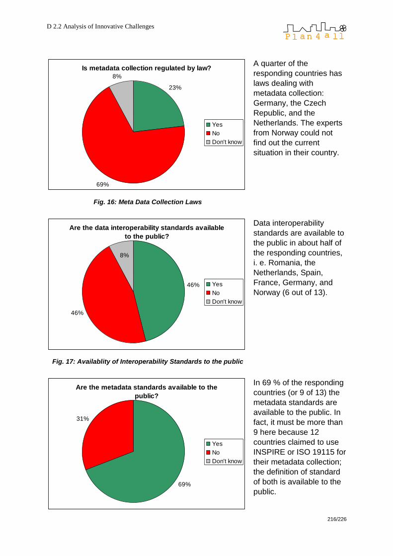
D 2.2 Analysis of Innovative Challenges
216/226
Is metadata collection regulated by law?
23%
69%
8%
Yes
No
Don't know
A quarter of the
responding countries has
laws dealing with
metadata collection:
Germany, the Czech
Republic, and the
Netherlands. The experts
from Norway could not
find out the current
situation in their country.
Fig. 16: Meta Data Collection Laws
Are the data interoperability standards available
to the public?
46%
46%
8%
Yes
No
Don't know
Data interoperability
standards are available to
the public in about half of
the responding countries,
i. e. Romania, the
Netherlands, Spain,
France, Germany, and
Norway (6 out of 13).
Fig. 17: Availablity of Interoperability Standards to the public
Are the metadata standards available to the
public?
69%
31%
Yes
No
Don't know
In 69 % of the responding
countries (or 9 of 13) the
metadata standards are
available to the public. In
fact, it must be more than
9 here because 12
countries claimed to use
INSPIRE or ISO 19115 for
their metadata collection;
the definition of standard
of both is available to the
public.
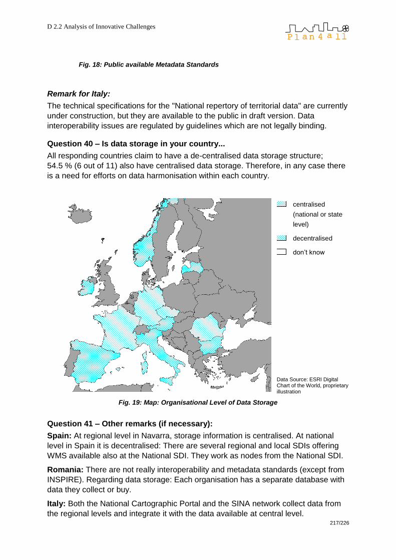
D 2.2 Analysis of Innovative Challenges
217/226
Fig. 18: Public available Metadata Standards
Remark for Italy:
The technical specifications for the "National repertory of territorial data" are currently
under construction, but they are available to the public in draft version. Data
interoperability issues are regulated by guidelines which are not legally binding.
Question 40 – Is data storage in your country...
All responding countries claim to have a de-centralised data storage structure;
54.5 % (6 out of 11) also have centralised data storage. Therefore, in any case there
is a need for efforts on data harmonisation within each country.
centralised
(national or state
level)
decentralised
don‘t know
Data Source: ESRI Digital Chart of the World, proprietary illustration
Fig. 19: Map: Organisational Level of Data Storage
Question 41 – Other remarks (if necessary):
Spain: At regional level in Navarra, storage information is centralised. At national
level in Spain it is decentralised: There are several regional and local SDIs offering
WMS available also at the National SDI. They work as nodes from the National SDI.
Romania: There are not really interoperability and metadata standards (except from
INSPIRE). Regarding data storage: Each organisation has a separate database with
data they collect or buy.
Italy: Both the National Cartographic Portal and the SINA network collect data from
the regional levels and integrate it with the data available at central level.

D 2.2 Analysis of Innovative Challenges
218/226
12.2.3 SDI Coordination
Questions 43-45
66.7 % (8 out of 12) of the responding countries state that there is a national SDI
coordination. A third claims to have no such institution, one respondent says that it is
not known.
In half of the countries the efforts of building an SDI are coordinated. Five countries
explain that they have no such coordination, one respondent says that they do not
know.

D 2.2 Analysis of Innovative Challenges
219/226
SDI coordination and SDI building efforts
national SDI co-
ordination
yes (67 %)
no (33 %)
don‘t know (0 %)
coordination of
SDI building
efforts (municipa-
lities, regions,
states)
yes (50 %)
no (42 %)
don‘t know (8 %)
Data Source: ESRI Digital Chart of the World, proprietary illustration
Fig. 20: Map: SDI Coordination
The very high ―Don‘t know‖ rate (see fig. below) for SDI use outside the public
administration does not allow any interpretation; it implicates only the answer for
question 3 (point of view) where slightly more than half of the responding experts
stated to come from a public administration authority, so it is likely that these experts
do not know much about potential use of their SDI outside the public administration.

D 2.2 Analysis of Innovative Challenges
220/226
Is your SDI also in use outside the public
administration?
16,7%
25,0%58,3%
Yes
No
Don't know
Fig. 21: Public use of SDI
Question 47 – Other remarks (if necessary):
Italy: As for questions 43 and 44: The National Cartographic Portal is a
National SDI project currently under implementation. CNIPA (National Centre
for the IT in the Public Administration) is in charge of defining the technical
specifications for the use of the public authorities' geographic data. The
Interregional Centre for the information, geographic and statistical data
(http://www.centrointerregionale-gis.it) is a voluntary association among
Regions and Autonomous Provinces that led to the definition of an agreement
among State, Regions and local authorities (Intesa GIS) for coordinating the
creation and management of the geographic information systems.
12.2.4 National Geodatabases
Question 48 – Is there a national geodatabase?
Question 49 – Are there also external partners involved in your country’s
efforts of building a (national) geodatabase?
These eight countries state to have a national geodatabase: Norway, Bulgaria,
Germany, France, Italy, Spain, Malta, Romania. From the eight countries stating to
have a national geodatabase, five (62.5 %) say that there are also external partners
involved in their geodatabase building efforts: Germany, France, Italy, Romania,
Spain (see map).

D 2.2 Analysis of Innovative Challenges
221/226
Is there a natio-
nal geodatabase?
yes
no
also external part-
ners are involved
in SDI building ef-
forts
Data Source: ESRI Digital Chart of the World, proprietary illustration
Fig. 22: Map: external involvement in national Geodatabase
Question 50 – For public use of geodata we have…
Two countries do not have web map services for public use (Latvia and Spain). The
others offer WMS or WFS either free of charge or for a fee. Printed maps are
available for a fee throughout all respondent countries, and files are also available
everywhere for a fee.
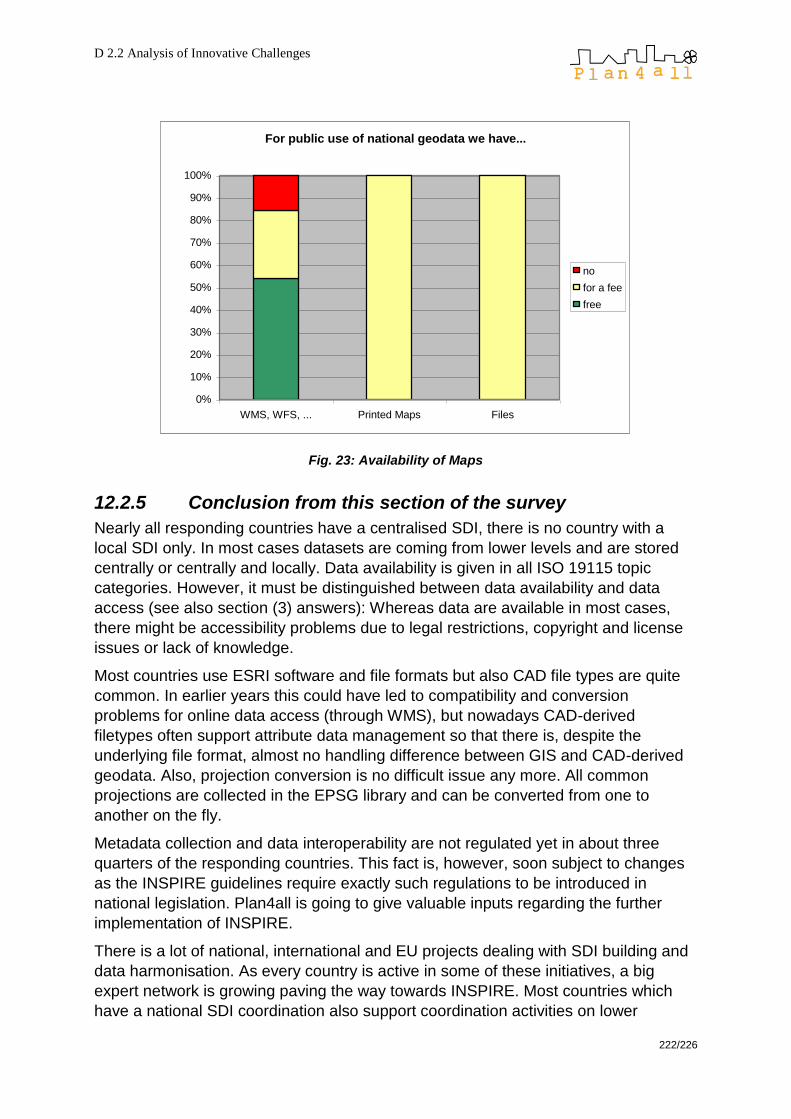
D 2.2 Analysis of Innovative Challenges
222/226
For public use of national geodata we have...
0%
10%
20%
30%
40%
50%
60%
70%
80%
90%
100%
WMS, WFS, ... Printed Maps Files
no
for a fee
free
Fig. 23: Availability of Maps
12.2.5 Conclusion from this section of the survey
Nearly all responding countries have a centralised SDI, there is no country with a
local SDI only. In most cases datasets are coming from lower levels and are stored
centrally or centrally and locally. Data availability is given in all ISO 19115 topic
categories. However, it must be distinguished between data availability and data
access (see also section (3) answers): Whereas data are available in most cases,
there might be accessibility problems due to legal restrictions, copyright and license
issues or lack of knowledge.
Most countries use ESRI software and file formats but also CAD file types are quite
common. In earlier years this could have led to compatibility and conversion
problems for online data access (through WMS), but nowadays CAD-derived
filetypes often support attribute data management so that there is, despite the
underlying file format, almost no handling difference between GIS and CAD-derived
geodata. Also, projection conversion is no difficult issue any more. All common
projections are collected in the EPSG library and can be converted from one to
another on the fly.
Metadata collection and data interoperability are not regulated yet in about three
quarters of the responding countries. This fact is, however, soon subject to changes
as the INSPIRE guidelines require exactly such regulations to be introduced in
national legislation. Plan4all is going to give valuable inputs regarding the further
implementation of INSPIRE.
There is a lot of national, international and EU projects dealing with SDI building and
data harmonisation. As every country is active in some of these initiatives, a big
expert network is growing paving the way towards INSPIRE. Most countries which
have a national SDI coordination also support coordination activities on lower

D 2.2 Analysis of Innovative Challenges
223/226
administrational levels, mostly in western part of Europe. Central European countries
tend to have no SDI coordination according to the survey responses.
There is a high ―don‘t know‖ rate for SDI use outside public administration. This result
might come from a consistent, but slow change from single data providers to national
SDI services so that many users simply have not recognised yet that the data
sources they are dealing with belong to an SDI meanwhile – for reason of daily habit
or because the SDI structure is in its beginnings and therefore still too small to be
recognised as what it is growing to.
12.3 Used software
In this chapter we provide the corresponding results of the survey mentioned before.
All survey responding countries have online access to spatial planning related
geodata except Latvia which explains that online data access is not available
because of a lack of this kind of developments on state level. Cadastre GIS and state
geoportal are planned in the near future (within 2 or 3 years). The following software
packages are used in these countries (question 28: Which software is used to
provide these web map services?):
Arc
GIS
Se
rver
Arc
IMS
Au
toca
d M
ap
de
eg
ree
Ge
ose
rver
Inte
rgra
ph
CS
sro
Ma
pb
en
de
r
Ma
pIn
fo
Ma
pX
site
Op
en G
is
UM
N M
ap
se
rver
We
bM
ap
Se
rver
ow
n s
oftw
are
Austria
Bulgaria
Czech
Republic
France KO-
GIS
Germany Frame
work
Ireland various
Italy
Malta
Netherlands
Norway

D 2.2 Analysis of Innovative Challenges
224/226
Romania City
of
Ora
dea
Spain Cadastre
Tab 4: Software Usage in Survey Countries
Question 29: In which year did your country start with WMS (approximately if
you don’t know exactly)?
Ireland and the Netherlands were the first partner countries to deal with web map
services (WMS); Norway, Malta, and Austria joined them approximately one year
later. Germany boarded in the year 2003. The rest of the responding countries
started working with WMS 2004 or later, which may have been much easier as the
web mapping technology had emerged from its childhood at that time.
Ireland 2000
Netherlands 2000
Norway 2001
Malta 2001
Austria 2001
Germany 2003
Czech Republic 2004
Romania 2004/2005
Spain 2005
Italy around 2005/2006
Bulgaria
o (Ministry of regional development)
o Sofia municipality (the capital)
2009
2006
France 2007
Belgium did not know
Latvia did not know
Lithuania did not know
Tab 5: WMS Start in Survey Countries
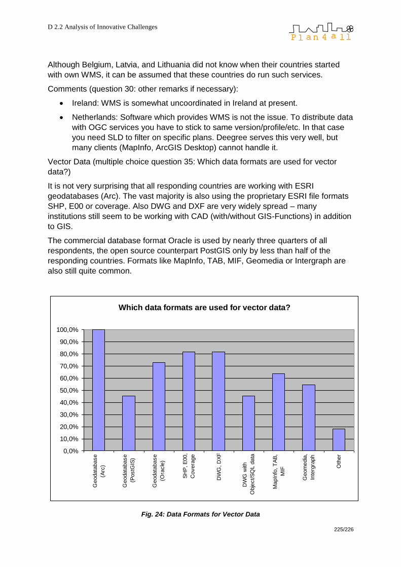
D 2.2 Analysis of Innovative Challenges
225/226
Although Belgium, Latvia, and Lithuania did not know when their countries started
with own WMS, it can be assumed that these countries do run such services.
Comments (question 30: other remarks if necessary):
Ireland: WMS is somewhat uncoordinated in Ireland at present.
Netherlands: Software which provides WMS is not the issue. To distribute data
with OGC services you have to stick to same version/profile/etc. In that case
you need SLD to filter on specific plans. Deegree serves this very well, but
many clients (MapInfo, ArcGIS Desktop) cannot handle it.
Vector Data (multiple choice question 35: Which data formats are used for vector
data?)
It is not very surprising that all responding countries are working with ESRI
geodatabases (Arc). The vast majority is also using the proprietary ESRI file formats
SHP, E00 or coverage. Also DWG and DXF are very widely spread – many
institutions still seem to be working with CAD (with/without GIS-Functions) in addition
to GIS.
The commercial database format Oracle is used by nearly three quarters of all
respondents, the open source counterpart PostGIS only by less than half of the
responding countries. Formats like MapInfo, TAB, MIF, Geomedia or Intergraph are
also still quite common.
Which data formats are used for vector data?
0,0%
10,0%
20,0%
30,0%
40,0%
50,0%
60,0%
70,0%
80,0%
90,0%
100,0%
Geodata
base
(Arc
)
Geodata
base
(PostG
IS)
Geodata
base
(Ora
cle
)
SH
P, E
00,
Covera
ge
DW
G, D
XF
DW
G w
ith
Obje
ct/S
QL d
ata
MapIn
fo, T
AB
,
MIF
Geom
edia
,
Inte
rgra
ph
Oth
er
Fig. 24: Data Formats for Vector Data

D 2.2 Analysis of Innovative Challenges
226/226
Regarding the ―other‖ option: In Germany all data formats are possible. Romania also
uses SQD (SICAD), MegaCAD, Megatel, ESRI ArcSDE, Microstation, ArchiCAD, and
VectorWorks. In Spain DGN is available. In Netherlands data exchange is done via
exchange in GML/WMS/WFS.
As a short conclusion of used Software and technical data format, we can see, that it
really makes sense to find some technical way to harmonise data. All experts will
know how much work it might be to convert data to other formats. Even if there are
technical methods sometimes the contents have to be reorganised afterwords.