An analysis of the AD1762 earthquake and tsunami in SE Bangladesh
31
REVIEW ARTICLE An analysis of the AD1762 earthquake and tsunami in SE Bangladesh Edris Alam • Dale Dominey-Howes Received: 29 August 2012 / Accepted: 26 August 2013 / Published online: 10 September 2013 Ó Springer Science+Business Media Dordrecht 2013 Abstract In AD1762, a large earthquake originating within the Arakan Subduction Zone occurred. However, conflicting opinions exist as to whether this earthquake triggered a major regional tsunami in the northern Bay of Bengal (BoB) that struck southeast Ban- gladesh. This research aims to review and assess the effects of the AD1762 earthquake in Bangladesh and reviews what effects associated tsunamis had along the coast of southeast Bangladesh. Through field visits and investigations, this research confirms the locations of liquefaction, compaction, landslides, co-seismic subsidence, deaths and injuries using the descriptions of historical documents as a guide. The earthquake triggered land-level changes where the soil is young and soft, and these areas are located adjacent to the coast of the BoB and along the banks of the Karnafuli, Halda and Meghna rivers. The earthquake probably generated several submarine sediment slides that triggered local tsunamis that struck different locations (Bansbaria, Bharchhara and Burumchhara) along the Chittagong coast. Following an analysis of the earthquake effects, we consider that a repeat of the AD1762 earthquake would result in significant damage to fragile infrastructure and to vulnerable communities in Bangladesh. Further, we recommend (1) conducting geological and geomorphological studies at key sites to assess the nature and extent of land-level changes; (2) undertaking socially oriented community vulnerability assessments to earth- quakes and tsunamis; and (3) implementing a variety of risk-reduction strategies to reduce vulnerability and enhance resilience to future events. E. Alam (&) Natural Hazard Research Laboratory, School of Biological, Earth and Environmental Sciences, University of New South Wales, Sydney, NSW 2052, Australia e-mail: [email protected]; [email protected] E. Alam Department of Geography and Environmental Studies, University of Chittagong, Chittagong 4331, Bangladesh D. Dominey-Howes School of Geosciences, The University of Sydney, Sydney, NSW 2006, Australia 123 Nat Hazards (2014) 70:903–933 DOI 10.1007/s11069-013-0841-5
-
Upload
independent -
Category
Documents
-
view
0 -
download
0
Transcript of An analysis of the AD1762 earthquake and tsunami in SE Bangladesh

REVIEW ARTICLE
An analysis of the AD1762 earthquake and tsunami in SEBangladesh
Edris Alam • Dale Dominey-Howes
Received: 29 August 2012 / Accepted: 26 August 2013 / Published online: 10 September 2013� Springer Science+Business Media Dordrecht 2013
Abstract In AD1762, a large earthquake originating within the Arakan Subduction Zone
occurred. However, conflicting opinions exist as to whether this earthquake triggered a
major regional tsunami in the northern Bay of Bengal (BoB) that struck southeast Ban-
gladesh. This research aims to review and assess the effects of the AD1762 earthquake in
Bangladesh and reviews what effects associated tsunamis had along the coast of southeast
Bangladesh. Through field visits and investigations, this research confirms the locations of
liquefaction, compaction, landslides, co-seismic subsidence, deaths and injuries using the
descriptions of historical documents as a guide. The earthquake triggered land-level
changes where the soil is young and soft, and these areas are located adjacent to the coast
of the BoB and along the banks of the Karnafuli, Halda and Meghna rivers. The earthquake
probably generated several submarine sediment slides that triggered local tsunamis that
struck different locations (Bansbaria, Bharchhara and Burumchhara) along the Chittagong
coast. Following an analysis of the earthquake effects, we consider that a repeat of the
AD1762 earthquake would result in significant damage to fragile infrastructure and to
vulnerable communities in Bangladesh. Further, we recommend (1) conducting geological
and geomorphological studies at key sites to assess the nature and extent of land-level
changes; (2) undertaking socially oriented community vulnerability assessments to earth-
quakes and tsunamis; and (3) implementing a variety of risk-reduction strategies to reduce
vulnerability and enhance resilience to future events.
E. Alam (&)Natural Hazard Research Laboratory, School of Biological, Earth and Environmental Sciences,University of New South Wales, Sydney, NSW 2052, Australiae-mail: [email protected]; [email protected]
E. AlamDepartment of Geography and Environmental Studies, University of Chittagong, Chittagong 4331,Bangladesh
D. Dominey-HowesSchool of Geosciences, The University of Sydney, Sydney, NSW 2006, Australia
123
Nat Hazards (2014) 70:903–933DOI 10.1007/s11069-013-0841-5

Keywords Earthquake � Tsunami � Hazard � Liquefaction � Compaction �Bangladesh
1 Introduction
The 2004 Indian Ocean Tsunami (2004 IOT) originating from the Sunda Subduction
Zone (SSZ) prompted growing concerns about earthquake and tsunami risk in the Bay of
Bengal (BoB). Alam et al. (2012) confirmed that the AD1762 Arakan Subduction Zone
(ASZ) earthquake, further north than the epicentre of the 2004 IOT, also generated a
tsunami. This is the first known, potentially ‘‘large’’ earthquake-generated tsunami
originating in the northern BoB. However, Alam et al. (2012) acknowledged that more
systematic work is need to be done to better understand this event because no others
have originated in the ASZ since AD1762. As such, the return periods of such earth-
quakes are not known and if such an event is repeated today, it would likely be cata-
strophic due to the very large, low-lying coastal populations. Further, recent work by
Gupta and Gahalaut (2009) and Khan (2012) dismissed the possibility of the generation
of large earthquake tsunamis in this region. Although several authors including Cummins
(2007) and Gupta and Gahalaut (2009) have referred to historical evidence about the
AD1762 earthquake, not enough detailed analysis of historical documentation has been
undertaken to provide a robust understanding of the AD1762 earthquake event and its
effects on Bangladesh. This lack of understanding stands as a barrier to effective disaster
risk reduction in Bangladesh.
Historical records have been used effectively to reconstruct earthquake and tsunami
histories in Greece, Italy and Japan (Ambraseys 1980; Atwater et al. 2005; Bolt 1930;
Cisternas et al. 2005; Dominey-Howes 2002). To expand the ‘‘temporal window’’
(Guidoboni and Stucchi 1993) about the record of earthquake and tsunami risk in Ban-
gladesh, this research collects and reviews historic documents about the effects of the
AD1762 earthquake and verifies the data through field investigations and community
consultation in SE Bangladesh. Used together, these sources and investigations help us to
understand the extent of tsunami effects along the southeast (SE) Bangladesh coast.
Specifically, the aims of this paper are to:
• provide a detailed description of the AD1762 earthquake and its effects using historical
accounts, contemporary sources and field verification of these descriptions;
• provide a detailed description of the tsunami derived from contemporary sources,
historical accounts and field verification of these descriptions; and
• identify further research priorities in the region in relation to earthquake and tsunami
hazards by analysing the effects associated with the AD1762 event.
In the following sections, we introduce the tectonic setting of the northern BoB and
outline the data sources collected and methods used for this research. This is followed by
an interpretation of the historical evidence through the lens of contemporary field inves-
tigations in SE Bangladesh. We then evaluate the findings in the context of local geography
and topography, the nature and extent of descriptions within historical documents com-
bined with current earthquake and tsunami literature for the northern BoB region and
beyond. Finally, we make a series of recommendations for future research.
904 Nat Hazards (2014) 70:903–933
123

2 Tectonic setting of the northern BoB
Bangladesh is located within the seismically active zones, surrounded by the Himalayan Arc, the
Shillong Plateau and the Dauki Fault (DF) in the north, the ASZ in the south and the Naga-
Haflong-Disang thrust zone (NHDTZ) in the northeast (Fig. 1). Several seismic faults, the
Jamuna Fault (JF), the Haluaghat Fault (HF) and the Sylhet Fault (SF) are located within
Bangladesh. In the north of the Andaman Trench (AT) (Fig. 2), the Indian Plate is moving
northward with respect to the Sunda Plate at a rate of 37 mm/yr. This movement is accom-
modated by the Sagaing Fault in the east and by the Indo-Burmese Arc in the west. The rate of
accommodation by the Sagaing Fault and in the Indo-Burmese Arc region is about 18 and
20 mm/yr, respectively (Gupta and Gahalaut 2009). The regional motion of plates is predom-
inantly dextral strike-slip. Thus, the India–Burma plate boundary in the Arakan and Irrawaddy
region is defined by oblique plate motion that generates strike-slip-dominated earthquakes with
poor tsunami-generating capability (Gupta and Gahalaut 2009; Khan 2012; Nielsen et al. 2004;
Socquet et al. 2006). The deformation front of the plate boundary between the India and Sunda
plates in the northern BoB is either landward or in shallow water in the Arakan region (Fig. 2).
Therefore, a giant earthquake could not displace significant volumes of water in the Arakan
region, resulting in major tsunami. In contrast to the regional tectonics, Cummins (2007)
assigned the AD1762 event a magnitude of Mw 8.8 and used this to simulate a tsunami. This
simulation suggests that the Bangladesh coast was inundated by a tsunami with a maximum
height of 2.5 m (Fig. 3). Despite some strong arguments that the AD1762 Arakan earthquake
triggered a large tsunami, a consensus of opinion is lacking and there are no known records of
large tsunamis in the region in the last 2,000 years (Gupta and Gahalaut 2009; Khan 2012).
Paul and Bhuiyan (2010) quoted the Geological Survey of Bangladesh for records of at
least 465 earthquakes of minor-to-moderate magnitudes that occurred between AD1971
and AD2006 in Bangladesh. Earthquakes that occurred in AD1787, AD1822, AD1830,
AD1865, AD1866, AD1885, AD1918, AD1935, AD1997, AD1999, AD2001, AD2003 and
AD2012 significantly affected Bangladesh (Akhter 2010; Khan 2010). Historical records
suggest the most damaging earthquake reported in Bangladesh was the 2 April AD1762
event that occurred at 5 p.m. local time. Earthquake shaking was most severely felt along
the southeast coast of India and along the Bangladesh and Myanmar coasts (Oldham 1883).
The earthquake caused huge damage, deaths and injuries in SE Bangladesh (Oldham 1883;
Verelst 1763). The existing literature reveals that several epicentres have been proposed for
the AD1762 earthquake. Martin and Szeliga (2010) suggested that the epicentre was to the
east of Chittagong at 22.4�N and 92.2�E. However, Satyabala (2003) suggested that the
epicentre was adjacent to Kolkata at 22�N and 88�E. Ganse and Nelson (1982) using an
analysis of the earthquake damage suggested the epicentre was at 22�N and 92�E, in the
middle of Chittagong (Fig. 1).
3 Research processes, methods and approaches
To better understand the AD1762 earthquake and tsunami, a thorough search on historical
documents was conducted in local libraries and government authorities in Bangladesh
between November AD2010 and January AD2011. The search for historical documents
eventually extended to India and Myanmar and the British Library (BL). Thus, a total of 20
historical documents (Alam 1947; Allen 1912; Anon 1763; Burke 1763, 1764; Chhibber
1934; Fergusson 1863; Gulston 1763a, b; Halstead 1843; Hirst 1763; Hunter 1876; Islam
2004; Islamabadi 1987; Mallet 1878; Oldham 1883; Rizvi 1969, 1970; Verelst 1763; and
Nat Hazards (2014) 70:903–933 905
123

Webster 1911) were located. Of these historical documents, two reports by Gulston
(1763a) and Verelst (1763) have been used extensively because the authors were the first
British servicemen from Chittagong to document the AD1762 earthquake. Observing the
devastation caused by the earthquake, they were concerned for the future of their
administration and sent immediate detailed accounts of the effects to the British Admin-
istration in the United Kingdom. Whilst extensive use of limited primary sources such as
these is acceptable in this type of research, we do acknowledge that they only represent the
perspectives of the original authors and other valuable details about the events which may
be over looked due to a variety of contextual reasons at the time of writing. We
acknowledge immediately that future efforts should be made to identify and consult with
other primary sources to improve our knowledge of the effects of the AD1762 earthquake
in Chittagong.
Fig. 1 Location of Bangladesh and adjacent seismic sources. The epicentres of earthquakes (above 4.6 Ms)that occurred within and adjacent to Bangladesh from AD1548–AD2012 are shown (Akhter 2010; Khan2010). Black, green and red stars represent the proposed locations of the epicentre of the AD1762earthquake proposed by Satyabala (2003), Martin and Szeliga (2010) and Ganse and Nelson (1982),respectively. DF Dauki Fault, ASZ Arakan Subduction Zone (ASZ), NHDTZ Naga-Haflong-Disang thrustzone, JF Jamuna Fault, HF Haluaghat Fault and SF Sylhet Fault (Source map prepared adapting tectonicselements from Alam et al. 2003; Ali and Choudhury 2001; Khan 2012; Mukherjee et al. 2009)
906 Nat Hazards (2014) 70:903–933
123

Seven BL documents (Anon 1763; Burke 1763, 1764; Gulston 1763a, b; Hirst 1763;
Verelst 1763) were written in old English. To better understand the contents of these
documents, we translated them into modern English. We also consulted online archives
that contained these sources previously noted by Gupta (2009). Key comments about
earthquake effects by location are provided in Table 1. To understand the effects of the
earthquake, we cross-checked the contents of the historical documents before analysing the
information using ‘‘manifest content analysis’’. Content analysis is a ‘‘set of methods for
analysing the symbolic content of any [written] communication. The basic idea is to reduce
the total content of a communication to a set of categories that represents some charac-
teristics of research interest’’ (Singleton and Straits 1999, p. 383). Through the process of
the content analysis, the types and locations of effects were identified and categorised.
Fig. 2 The tectonic setting of the northern BoB with respect to three tectonic plates: the Eurasian, Indian,and Burmese plates. The red and yellow solid lines, and the white dashed line indicate convergent,divergent, and diffuse plate boundaries, respectively. The black solid line shows major faults. Rates of platemotion with reference to the Indian Plate are given in mm/yr and are adapted from Gahalaut and Gahalaut(2007) and Gupta and Gahalaut (2009). Red stars indicate the source locations of AD1762 ArakanSubduction Zone and AD2004 Sumatra Subduction Zone earthquakes. ASZ Arakan Subduction Zone,ASRTFS Andaman Sea Ridge Transform Fault System, AT Arakan Trench, DF Deformation Front, GSFGreat Sumatra Fault, SEB Southeast Bangladesh, SF Sagaing Fault, SP Sunda Plate, SSZ Sunda SubductionZone (Source adapted from Khan (2012) and Google Earth)
Nat Hazards (2014) 70:903–933 907
123

These were then used to guide field investigations in November and December AD2010 in
SE Bangladesh (Fig. 4).
The fieldwork investigations helped to verify the reliability of the descriptions taken from
the content analysis. Local maps coupled with consultation with local people were used to
confirm the identity of the locations in the historical documents. The context of the
descriptions and locations of the earthquake effects were then compared with each geo-
graphical location in SE Bangladesh. The confirmed effects of the earthquake are summarised
in Table 1. On the basis of the description of earthquake effects at different locations, a
modified Mercalli intensity (MMI) scale value is assigned to each location (Table 1). Whilst
we attempt to assign intensities at specific geographical locations, we caution over reliance on
their accuracy. The coastal sediments of the region are highly water saturated and are weak.
Liquefaction can occur in such sediments, at lower ground-shaking intensities than in similar
or less water-saturated sediments. Further research is needed to explore this issue.
We used the evidence of flooding triggered by the earthquake as an indicator to help
answer the question of whether the tsunami struck the entire coast of SE Bangladesh or was
only more locally experienced. To achieve this, we first undertook a detailed content
analysis of the historical documents in relation to tsunamis. The locations of flooding
effects were identified and mapped. The locations of the flooding were then compared with
local contour maps and known tropical cyclone flooding heights. This helped to infer and
place constraints on the possible height of the AD1762 tsunami.
In several cases, Gulston (1763a) and Verelst (1763) provided details on both the
location of effects and the names of people whose houses were damaged (i.e. Hurry
Singh’s House at Dohazari, Santeeram Cannongoey house at Pathorgatha, Mr. Griffith’s
brick house at Kotwali) and the names of the dead and injured. This enabled us to consult
Fig. 3 Maximum offshore 2.5 m tsunami heights from the west coast of Myanmar to SE Bangladesh coastbased on the AD1762 earthquake. The rectangle block along the eastern coast of the northern Bay of Bengalindicates a fault model for the AD1762 Chittagong earthquake, with length 700 km, width 125 and depth10 m. The star indicates the epicentre of the AD1762 earthquake (Source Modified after Cummins 2007)
908 Nat Hazards (2014) 70:903–933
123

Ta
ble
1T
he
effe
cts
of
the
AD
1762
eart
hquak
ean
dre
port
edts
unam
iin
the
nort
her
nB
oB
regio
nw
ith
apar
ticu
lar
focu
son
the
coas
tof
SE
Ban
gla
des
h
Loca
tion
of
effe
cts
MM
IT
he
effe
cts
of
the
AD
1762
eart
hquak
e
Th
ep
rese
nt
day
spel
lin
go
rlo
cati
on
so
fef
fect
s
Lat
itu
de/
Lo
ngit
ud
eD
escr
ipti
on
of
loca
tio
ns
inh
isto
rica
lre
cord
s
Liq
uef
acti
on
or
com
pac
tion
or
liq
uef
acti
on
and
com
pac
tio
nin
mai
nla
nd
Flo
odin
go
fth
eco
ast
of
the
Bo
B
Com
pac
tio
nan
din
un
dat
ion
of
the
ban
ks
of
riv
ers
Lan
dsl
ides
alo
ng
the
ban
ks
of
cree
ks
or
river
s
Up
lift
Gro
un
dsh
akin
gfe
ltse
ver
ely
SE
Ba
ng
lad
esh
coa
sta
nd
Dh
aka
Ak
ilp
oo
rat
Ban
sbar
ia2
2.5
/9
1.7
2A
ku
lP
oor
atB
ans
Bu
rrea
hX
2,
32
––
––
Bah
arch
har
a22.4
2/
91
.93
Bah
arch
arah
or
Bar
Char
aX
14
2,
10
––
––
Bah
ng
oo
Chan
gee
19
.81
/9
3.9
8B
ahn
go
oC
han
gee
VII
I2
,3
––
––
2,
3
Baj
alia
22
.14
/9
2.1
2B
ajal
eeah
IX3
––
2–
–
Ban
dar
ban
22
.11
/9
2.1
8P
ardav
anor
Bar
dav
anV
III
––
––
–8
,10,
11
,1
2
Beg
amgan
j22.5
6/
91
.06
Beg
um
gan
jV
III
15
––
––
–
Bu
rum
chh
ara
22
.13
/9
1.8
5B
aram
Char
ahX
–2
,3
––
–3
Ch
and
er-n
ago
re2
2.8
5/
88
.35
Ch
and
er-n
ago
reV
II–
––
––
4
Ch
itta
go
ng
22
.59
/9
1.5
7C
hat
tigra
on
or
Isla
mab
adIX
––
––
–1
,2
,3
,4
,7,
10
,1
9
Ch
itta
go
ng
22
.59
/9
1.5
7T
he
bri
ckh
ou
seo
fG
riffi
thIX
––
––
–3
Ch
itta
go
ng
22
.33
/9
1.8
3T
he
ho
use
of
Sh
iam
Ram
VII
I–
––
––
2,
3
Nat Hazards (2014) 70:903–933 909
123

Ta
ble
1co
nti
nued
Loca
tion
of
effe
cts
MM
IT
he
effe
cts
of
the
AD
1762
eart
hquak
e
Th
ep
rese
nt
day
spel
lin
go
rlo
cati
on
so
fef
fect
s
Lat
itu
de/
Lo
ngit
ud
eD
escr
ipti
on
of
loca
tio
ns
inh
isto
rica
lre
cord
s
Liq
uef
acti
on
or
com
pac
tion
or
liq
uef
acti
on
and
com
pac
tio
nin
mai
nla
nd
Flo
odin
go
fth
eco
ast
of
the
Bo
B
Com
pac
tio
nan
din
un
dat
ion
of
the
ban
ks
of
riv
ers
Lan
dsl
ides
alo
ng
the
ban
ks
of
cree
ks
or
river
s
Up
lift
Gro
un
dsh
akin
gfe
ltse
ver
ely
Ch
itta
go
ng
coas
t2
2.5
9/
91
.57
Lan
dsu
bsi
den
cein
sea
X–
––
––
–
Dh
aka
23
.72
/9
0.3
5D
ecca
or
Dac
caV
I–
––
––
1,
4,
7,
9,
16
Do
haz
ari
22
.16
/9
2.0
7C
avit
yat
Do
Haz
ary
IX2
,3
––
–2
,3
Hu
rry
Sin
gh
Haz
ari
22
.16
/9
2.0
7H
urr
yS
ing
Haz
arry
VII
I–
––
––
2,
3
Go
yp
arah
22
.34
/9
1.8
3G
oy
par
ahV
III
3–
––
–3
Hal
da
Riv
er2
2.4
3/
91
.88
Hal
dah
IX2
,3
–3
3–
3
Ho
wla
22
.43
/9
1.8
8H
ow
laX
2,
3–
––
–2
Kodal
aad
jace
nt
toth
eK
arn
afu
liR
iver
88
.45
/9
2.0
6K
ad’d
’ale
ahad
jace
nt
toth
eK
arn
Ph
oo
ly
IX–
––
3–
3
Lak
shm
ipu
r2
3.0
3/
90
.66
Lo
ckep
oer
IX–
––
––
–
Mad
hu
pu
rte
rrac
e2
4.1
0/
90
.20
Mad
hu
pu
rte
rrac
eIX
––
––
17
–
Pat
ho
rgat
ha
22
.33
/9
1.8
3P
atte
rG
ott
ahIX
2–
––
–
Sit
akun
d2
2.6
2/
91
.67
See
taK
un
dIX
––
––
–1
,2
,3
,1
0
910 Nat Hazards (2014) 70:903–933
123

Ta
ble
1co
nti
nued
Loca
tion
of
effe
cts
MM
IT
he
effe
cts
of
the
AD
1762
eart
hquak
e
Th
ep
rese
nt
day
spel
lin
go
rlo
cati
on
so
fef
fect
s
Lat
itu
de/
Lo
ngit
ud
eD
escr
ipti
on
of
loca
tio
ns
inh
isto
rica
lre
cord
s
Liq
uef
acti
on
or
com
pac
tion
or
liq
uef
acti
on
and
com
pac
tio
nin
mai
nla
nd
Flo
odin
go
fth
eco
ast
of
the
Bo
B
Com
pac
tio
nan
din
un
dat
ion
of
the
ban
ks
of
riv
ers
Lan
dsl
ides
alo
ng
the
ban
ks
of
cree
ks
or
river
s
Up
lift
Gro
un
dsh
akin
gfe
ltse
ver
ely
Su
abil
22
.64
/9
1.7
9S
ow
abee
lo
rS
awab
ill
IX2
–2
,3
2,
3–
–
Ko
lka
taa
nd
oth
erw
est
Ben
gal
reg
ion
,In
dia
Bar
rack
po
re2
2.7
6/
88
.37
Gh
iro
tty
V–
––
––
1,
4
Co
ssim
baz
ar2
4.1
1/
88
.28
Co
ssim
baz
arV
––
––
–9
Ko
lkat
a2
2.2
8/
88
.22
Cal
cutt
aV
I–
––
––
1,
4,
7
Mu
rshid
abad
24
.17
/8
8.2
7M
ox
ud
abat
hV
II–
––
––
9
Mya
nm
ar
coa
st
Ara
kan
bu
tn
ow
fam
ilia
ras
My
anm
ar
19
.81
/9
3.9
8A
raca
nV
II–
––
––
4,
18
Ch
edu
ba
Isla
nd
18
.82
/9
3.6
2C
hed
ub
aIs
lan
dIX
––
––
6,
10
1,
6,
12
Fo
ul
Isla
nd
19
.19
/9
4.7
7F
ou
lIs
lan
dIX
––
––
6,
10
1,
6,
12
Peg
u1
7.1
9/
96
.29
Bag
oV
I–
––
––
4
Ram
ree
Isla
nd
19
.10
/9
3.7
8R
amre
eIs
lan
dIX
––
––
61
Nat Hazards (2014) 70:903–933 911
123

Ta
ble
1co
nti
nued
Loca
tion
of
effe
cts
MM
IT
he
effe
cts
of
the
AD
1762
eart
hquak
eN
ote
s
Th
ep
rese
nt
day
spel
lin
go
rlo
cati
on
so
fef
fect
s
Lat
itud
e/L
on
git
ud
eD
escr
ipti
on
of
loca
tion
sin
his
tori
cal
reco
rds
Co-
seis
mic
sub
sid
ence
Wat
erle
vel
rais
edin
riv
ers
Riv
erd
ried
up
Mu
dv
olc
anic
eru
pti
on
s
Co
llap
sed
ho
use
s
SE
Ba
ng
lad
esh
coa
sta
nd
Dh
aka
Ak
ilp
oo
rat
Ban
sbar
ia2
2.5
/9
1.7
2A
ku
lP
oo
rat
Ban
sB
urr
eah
X–
––
–3
Gu
lsto
n(1
76
3a,
p.2
52
)st
ated
:‘‘
And
by
lett
erfr
om
Sat
oo
Mes
ter
Dar
oo
gah
of
the
salt
-wo
rks
[sal
t]at
Ban
sbar
eeah
,it
sofe
llo
ut,
that
,to
the
wes
twar
d,
Akl’
poora
h,
anis
land
of
the
fast
-work
s,w
asle
vel
edw
ith
the
wat
ero
nit
sea
stsi
de,
and
on
the
no
rth
and
sou
thth
eg
rou
nd
op
ened
from
5to
7cu
bit
sin
wid
th,
and
sun
kli
ke
ap
itto
the
dep
tho
f1
0cu
bit
s,th
ew
ater
spo
uti
ng
up
;n
or
isth
ere
the
leas
tap
pea
ran
ceo
fit
ssu
bsi
din
g:
we
kn
ow
no
tw
hat
wil
lco
me
of
it’’
Bah
arch
har
a22.4
2/
91
.93
Bah
arch
arah
or
Bar
Ch
ara
X–
––
––
Ver
elst
(17
63,
p.
26
7)
des
crib
edth
eef
fect
s:‘‘
At
Bar
Ch
ara,
nea
rth
ese
a,fi
ve
or
six
cess
of
gro
und
imm
edia
tely
sun
k,
and
ou
to
ffo
ur
or
fiv
eh
un
dre
dp
eop
le,
abo
ut
two
hu
ndre
dw
ere
lost
,w
ith
all
thei
rca
ttle
;an
dth
eg
reat
est
par
to
fth
ere
mai
nin
gin
hab
itan
ts,
wh
ora
nin
tow
oo
ds,
hav
en
ot
yet
bee
nh
eard
of’
’
Bah
ng
oo
Ch
ang
ee1
9.8
1/
93
.98
Bah
ng
oo
Ch
ang
eeV
III
––
––
3‘‘
An
dB
ahn
go
oC
han
gee
,a
Joo
mH
ill,
rent
intw
ain
,an
dis
sun
k3
0cu
bit
s,an
dth
eh
ou
seo
fm
ost
of
the
inh
abit
ants
inth
ose
par
tsth
row
nd
ow
n’’
(Guls
ton
17
63
a,p
.2
55
)
Baj
alia
22
.14
/9
2.1
2B
ajal
eeah
IX–
––
–2
,3
‘‘A
tB
ajal
eeah
,an
oth
erJo
om
hil
lu
po
nth
eri
ver
,o
pen
ed3
0cu
bit
s,an
dsi
nk
ing
wat
erro
seu
p’’
(Gu
lsto
n1
76
3a,
p.
25
5).
Gu
lsto
n(1
76
3a,
p.
25
4)
also
stat
ed‘‘
And
atB
ajal
eeah
…cr
eeks
wer
ecl
ose
dup
by
ban
ks
of
sands
risi
ng
fro
mth
eir
bo
tto
m’’
912 Nat Hazards (2014) 70:903–933
123

Ta
ble
1co
nti
nued
Loca
tion
of
effe
cts
MM
IT
he
effe
cts
of
the
AD
1762
eart
hquak
eN
ote
s
Th
ep
rese
nt
day
spel
lin
go
rlo
cati
on
so
fef
fect
s
Lat
itud
e/L
on
git
ud
eD
escr
ipti
on
of
loca
tion
sin
his
tori
cal
reco
rds
Co-
seis
mic
sub
sid
ence
Wat
erle
vel
rais
edin
riv
ers
Riv
erd
ried
up
Mu
dv
olc
anic
eru
pti
on
s
Co
llap
sed
ho
use
s
Ban
dar
ban
22
.11
/9
2.1
8P
ardav
anor
Bar
dav
anV
III
––
8,
10
,1
1,
12
,1
4
––
‘‘…
apla
ce,
call
edB
ardav
an,
ala
rge
river
isto
tall
ydri
edu
pb
ya
ban
ko
fsa
nd
that
rose
up
inth
em
idd
leo
fit
.’’(A
nn
ual
Reg
iste
r,1
76
3,
p.
61
).R
izv
i(1
97
0,
p.
54
)st
ated
:‘‘
Acc
ord
ing
toC
apta
inL
ewin
,a
larg
eri
ver
was
dri
edup
atP
ardab
an…
’’
Beg
amgan
j22.5
6/
91
.06
Beg
um
gan
jV
III
––
––
–A
gro
und
com
pac
ted
inB
egum
gan
j(W
ebst
er1
91
1)
Bu
rum
chh
ara
22
.13
/9
1.8
5B
aram
Ch
arah
X–
––
––
‘‘…
wat
erw
asu
pto
am
an’s
wai
st,
and
the
peo
ple
ther
eh
ave
bet
aken
them
selv
esto
flig
ht,
thro
ug
hfe
aro
fp
eris
hin
g;
no
liv
ing
crea
ture
bu
tth
eca
ttle
no
wre
mai
nin
g’’
(Guls
ton
17
63a,
p.
25
3)
Ch
and
er-
nag
ore
22
.85
/8
8.3
5C
han
der
-n
ago
reV
II–
––
––
Th
eea
rth
quak
esh
oo
kC
han
der
nag
ore
(Hir
st1
76
3)
Ch
itta
go
ng
22
.59
/9
1.5
7C
hat
tigra
on
or
Isla
mab
adIX
––
––
–T
he
acco
unts
of
dev
asta
tion
inC
hat
tigra
on
wer
ere
mar
kab
le(H
irst
17
63)
Ch
itta
go
ng
22
.59
/9
1.5
7T
he
bri
ckh
ou
seo
fG
riffi
th
IX–
––
–3
Mr.
Gri
ffith
’sbri
ckhouse
inIs
lam
abad
was
crac
ked
(Gu
lsto
n1
76
3a)
Ch
itta
go
ng
22
.33
/9
1.8
3T
he
ho
use
of
Sh
iam
Ram
VII
I–
––
–3
Th
eh
ou
seo
fS
hia
mR
amta
xg
ath
erer
was
bro
ken
do
wn
(Gu
lsto
n1
76
3a)
Ch
itta
go
ng
coas
t2
2.5
9/
91
.57
Lan
dsu
bsi
den
cein
sea
X1
0,
11
,1
2,
13
,1
4–
––
–T
he
eart
hq
uak
eca
use
da
per
man
ent
sub
mer
gen
ceo
f1
55
.40
km
2ad
jace
nt
toC
hit
tagong
(Riz
vi
19
70)
Nat Hazards (2014) 70:903–933 913
123
Ta
ble
1co
nti
nued
Loca
tion
of
effe
cts
MM
IT
he
effe
cts
of
the
AD
1762
eart
hquak
eN
ote
s
Th
ep
rese
nt
day
spel
lin
go
rlo
cati
on
so
fef
fect
s
Lat
itud
e/L
on
git
ud
eD
escr
ipti
on
of
loca
tion
sin
his
tori
cal
reco
rds
Co
-se
ism
icsu
bsi
den
ce
Wat
erle
vel
rais
edin
riv
ers
Riv
erd
ried
up
Mu
dv
olc
anic
eru
pti
ons
Co
llap
sed
ho
use
s
Dh
aka
23
.72
/9
0.3
5D
ecca
or
Dac
caV
I–
4,
9,
12
,1
6–
––
Hir
st(1
76
3,
p.
25
7)
stat
ed:
‘‘…
the
rise
of
the
wat
ers
inth
eri
ver
was
sov
ery
sud
den
and
vio
len
t,th
atso
me
hu
nd
red
so
fla
rge
cou
ntr
yb
oat
sw
ere
dri
ven
ash
ore
,o
rlo
st,
and
gre
atn
um
ber
so
fli
ves
lost
inth
em’’
Do
haz
ari
22
.16
/9
2.0
7C
avit
yat
Do
Haz
ary
IX–
––
––
Gu
lsto
n(1
76
3a,
b,
p.
25
3)
stat
ed:
‘‘A
nd
atD
oH
azar
y…
ther
eo
pen
eda
cavit
yli
ke
ad
itch
of
20
0cu
bit
sin
len
gth
,w
hic
hfi
lled
wit
hw
ater
.’’
Ver
elst
(17
63,
p.
26
7)
stat
es:
‘‘B
azal
lyC
reek
and
Do
Haz
arry
Cre
ek,
are
sto
pp
edu
p’’
Hu
rry
Sin
gh
Haz
ari
22
.16
/9
2.0
7H
urr
yS
ing
Haz
arry
VII
I–
––
–2
,3
‘‘In
the
Pu
rgu
nn
ahD
oH
azar
ree,
Hu
rry
Sin
gH
azar
ry’s
bri
ckh
ou
sew
asen
tire
lyth
row
nd
ow
n…
’’(V
erel
st1
76
3,
p.
26
6)
Go
yp
arah
22
.34
/9
1.8
3G
oy
par
ahV
III
––
––
3‘‘
And
Mo
kta
ram
Fow
tadhar
,dw
elli
ng
atG
oypar
ah,
has
wri
tten
,th
atto
the
no
rth
and
east
his
ho
use
was
crac
ked
…W
ater
spo
ute
du
pan
dth
eg
rou
nd
also
com
pac
ted
gra
du
ally
(Gu
lsto
n1
76
3a)
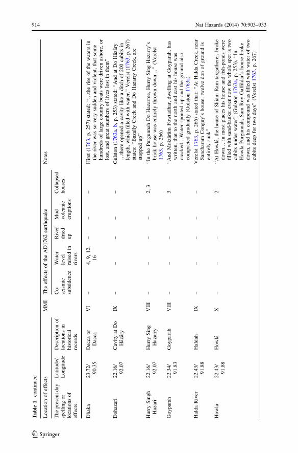
Hal
da
Riv
er2
2.4
3/
91
.88
Hal
dah
IX–
––
––
Ver
elst
17
63,
p.
26
6)
stat
edth
at:
‘‘A
tH
ald
aC
reek
,n
ear
San
char
amC
on
gu
y’s
ho
use
,tw
elv
ed
on
of
gro
un
dis
enti
rely
sun
k’’
Ho
wla
22
.43
/9
1.8
8H
ow
laX
––
––
2‘‘
At
Ho
wla
,th
eh
ou
seo
fS
hia
mR
amta
xgat
her
er,
bro
ke
do
wn…
inm
ost
pla
ces
his
ho
use
and
fish
-po
nds
wer
efi
lled
wit
hsa
nd
-ban
ks:
even
no
wth
ew
ho
lesp
ot
istw
ocu
bit
su
nd
erw
ater
’’(G
uls
ton
17
63a,
p.
25
3).
‘‘In
Ho
wla
Pu
rgu
nn
ah,
Sam
Roy
Gaf
fild
ar’s
ho
use
bro
ke
do
wn
,an
dh
isco
mp
ou
nd
was
fill
edw
ith
wat
ero
ftw
ocu
bit
sd
eep
for
two
day
s’’
(Ver
elst
17
63,
p.
26
7)
914 Nat Hazards (2014) 70:903–933
123

Ta
ble
1co
nti
nued
Loca
tion
of
effe
cts
MM
IT
he
effe
cts
of
the
AD
1762
eart
hquak
eN
ote
s
Th
ep
rese
nt
day
spel
lin
go
rlo
cati
on
so
fef
fect
s
Lat
itud
e/L
on
git
ud
eD
escr
ipti
on
of
loca
tion
sin
his
tori
cal
reco
rds
Co
-se
ism
icsu
bsi
den
ce
Wat
erle
vel
rais
edin
riv
ers
Riv
erd
ried
up
Mu
dv
olc
anic
eru
pti
ons
Co
llap
sed
ho
use
s
Ko
dal
aad
jace
nt
toth
eK
arn
afu
liR
iver
88
.45
/9
2.0
6K
ad’d
’ale
ahad
jace
nt
toth
eK
arn
Ph
oo
ly
IX–
––
––
Gu
lsto
n(1
76
3a,
b,
p.
25
4)
stat
ed:
‘‘…
the
east
war
do
fK
adr
Kat
chee
aha
larg
eh
ill,
call
edK
ad’d
’ale
ah,
ver
yn
ear
Kar
nP
hoo
ly,
was
ren
t,an
dit
stop
ped
up
the
pas
sag
efo
rb
oat
sin
and
ou
tth
atri
ver
’’
Lak
shm
ipu
r2
3.0
3/
90
.66
Lo
ckep
oer
IX9
,1
4–
––
9‘‘
…at
Lo
ckep
oer
,ab
ou
ttw
od
ays
jou
rney
fro
mD
ecca
(Dh
aka)
,a
circ
uit
of
lan
d,
nea
rfi
ftee
nE
ng
lish
mil
esin
circ
um
fere
nce
,w
assw
allo
wed
up,
and
all
the
peo
ple
and
catt
leo
nit
wer
ed
row
ned
’’B
urk
e(1
76
4,
p.
83
).‘‘
An
eart
hq
uak
ein
Ap
ril
17
62
issa
idto
hav
een
gu
lfed
atr
act
cou
ntr
yar
ou
nd
Lak
shm
ipu
rfi
ftee
nm
iles
inex
tent,
wit
hal
lit
sin
hab
itan
ts;
and
the
Coll
ecto
rst
ates
that
oth
erd
epre
ssio
ns
of
the
lan
d,
no
wth
esi
teo
fd
eep
mar
shes
,m
apb
ed
ue
tosi
mil
arca
use
s’’
(Hun
ter
18
76,
p.
25
0)
Mad
hu
pu
rte
rrac
e2
4.1
0/
90
.20
Mad
hu
pu
rte
rrac
eIX
––
––
–T
he
Ap
ril
AD
17
62
eart
hq
uak
eu
pli
fted
par
tso
fM
adhupur
Ter
race
whic
his
loca
ted
appro
xim
atel
y2
9k
mn
ort
ho
fD
hak
aC
ity
Pat
ho
rgat
ha
22
.33
/9
1.8
3P
atte
rG
ott
ahIX
––
––
3‘‘
Fro
mP
atte
rG
ott
ahto
Ho
wla
h,
abo
ut
8ce
fsd
iffe
ren
ce,
the
gro
un
do
pen
ed,
and
ag
reat
qu
anti
tyo
fw
ater
was
imm
edia
tely
thro
wn
ou
t,an
din
sev
eral
pla
ces
the
gro
und
enti
rely
sun
k’’
(Ver
elst
17
63,
p.
26
6)
Sit
akun
d2
2.6
2/
91
.67
See
taK
un
dIX
––
–2
,1
0,1
1,
12
,1
4–
Ver
elst
(17
63)
stat
edth
attw
ov
olc
ano
eser
up
ted
inC
hit
tag
on
g.
Hu
nte
r(1
87
6,
p.
22
8)
stat
ed:
‘‘T
wo
vo
lcan
oes
are
said
toh
ave
op
ened
inth
eS
itak
un
dh
ills
’’
Nat Hazards (2014) 70:903–933 915
123

Ta
ble
1co
nti
nued
Loca
tion
of
effe
cts
MM
IT
he
effe
cts
of
the
AD
1762
eart
hquak
eN
ote
s
Th
ep
rese
nt
day
spel
lin
go
rlo
cati
on
so
fef
fect
s
Lat
itud
e/L
on
git
ud
eD
escr
ipti
on
of
loca
tion
sin
his
tori
cal
reco
rds
Co
-se
ism
icsu
bsi
den
ce
Wat
erle
vel
rais
edin
riv
ers
Riv
erd
ried
up
Mu
dv
olc
anic
eru
pti
ons
Co
llap
sed
ho
use
s
Su
abil
22
.64
/9
1.7
9S
ow
abee
lo
rS
awab
ill
IX–
––
––
Gu
lsto
n(1
76
3a,
p.
25
5)
men
tio
ned
that
:‘‘
…th
en
ort
hsi
de
of
the
Ch
ach
lah
So
wab
eel,
just
by
Hal
dah
riv
er,
bro
ke
do
wn
and
issw
allo
wed
up
by
the
riv
er,
and
also
fou
rp
eop
lew
ere
ov
erw
hel
med
init
sru
ins’
’
Ko
lka
taa
nd
oth
erw
est
Ben
ga
lre
gio
n,
Ind
ia
Bar
rack
po
re2
2.7
6/
88
.37
Ghir
ott
yV
––
––
–T
he
effe
ctof
the
eart
hquak
ew
asal
sover
yal
arm
ing
atG
hir
ott
y(H
irst
17
63).
Su
jit
Das
Gu
pta
(per
s.C
om
.2
01
1)
con
firm
edth
ep
rese
nt
loca
tion
of
Gh
irott
y:
‘‘I
amce
rtai
nth
atth
ep
lace
isB
arra
ckpore
(22.7
6�N
,8
8.3
7E
;h
eig
ht
15
m),
15
-18
mil
esn
ort
ho
fK
olk
ata
by
the
sid
eo
fth
eG
ang
aR
iver
(on
its
east
ban
k).
Bec
ause
this
was
the
pla
cein
wh
ich
the
Dutc
h,
Fre
nch
and
Bri
tish
esta
bli
shed
canto
nm
ents
du
rin
gth
e1
5-1
7ce
ntu
ries
.C
olo
nel
Co
ote
was
also
inth
isca
nto
nm
ent
in1
76
2’’
Co
ssim
baz
ar2
4.1
1/
88
.28
Coss
imbaz
arV
––
––
–T
he
An
nu
alR
egis
trar
des
crib
edth
eef
fect
so
fea
rth
quak
ein
Mo
xu
dab
ath
bas
edo
na
lett
erfr
om
Cas
sam
baz
ar(A
no
n1
76
3).
Ko
lkat
a2
2.2
8/
88
.22
Cal
cutt
aV
I–
4–
––
Hir
st(1
76
3)
rep
ort
edth
atw
ater
rose
inC
alcu
tta
up
tosi
xfe
etan
dd
irec
tio
nw
asin
no
rth
–so
uth
Mu
rshid
abad
24
.17
/8
8.2
7M
oxu
dab
ath
VII
––
––
–‘‘
…a
mo
stv
iole
nt
fire
hap
pen
edat
Mo
xu
dab
ath
,w
hic
hh
adre
du
ced
that
pla
ceto
ash
es’’
(An
on
17
63,
p.
83
)
916 Nat Hazards (2014) 70:903–933
123

Ta
ble
1co
nti
nued
Loca
tion
of
effe
cts
MM
IT
he
effe
cts
of
the
AD
1762
eart
hquak
eN
ote
s
Th
ep
rese
nt
day
spel
lin
go
rlo
cati
on
sof
effe
cts
Lat
itud
e/L
on
git
ud
eD
escr
ipti
on
of
loca
tion
sin
his
tori
cal
reco
rds
Co
-se
ism
icsu
bsi
den
ce
Wat
erle
vel
rais
edin
riv
ers
Riv
erd
ried
up
Mu
dv
olc
anic
eru
pti
ons
Co
llap
sed
ho
use
s
Mya
nm
ar
coa
st
Ara
kan
bu
tn
ow
fam
ilia
ras
My
anm
ar
19
.81
/9
3.9
8A
raca
nV
II–
––
––
Th
eea
rth
quak
eo
ccu
rred
on
the
2A
pri
lw
asd
estr
uct
ive
inA
raca
n(H
irst
17
63)
Ch
edu
ba
Isla
nd
18
.82
/9
3.6
2C
hed
uba
Isla
nd
IX–
––
6–
The
eart
hquak
eel
evat
edap
pro
xim
atel
y3
.97
–6
.70
min
the
Ch
edu
ba
Isla
nd
(Hal
stea
d1
84
3)
Fo
ul
Isla
nd
19
.19
/9
4.7
7F
oul
Isla
nd
IX–
––
6–
The
eart
hquak
eel
evat
edap
pro
xim
atel
y2
.74
-3.6
6m
inth
eF
ou
lIs
lan
d(H
alst
ead
18
43)
Peg
u1
7.1
9/
96
.29
Bag
oV
I–
––
––
Th
eea
rth
quak
eo
ccu
rred
on
the
2A
pri
lA
D1
76
2w
asv
iole
nt
inP
egu
(Hir
st1
76
3)
Ram
ree
Isla
nd
19
.10
/9
3.7
8R
amre
eIs
land
IX–
––
6–
The
effe
cts
of
the
eart
hquak
ew
ere
des
truct
ive
off
the
no
rth
coas
to
fR
amre
eIs
lan
d(O
ldham
18
83)
Th
en
um
ber
sin
colu
mn
3in
dic
ate
the
cod
ing
of
refe
ren
ces
that
are
pro
vid
edb
elow
1.
Old
ham
(18
83),
2.
Ver
elst
(17
63)
3.
Gu
lsto
n(1
76
3a)
4.
Hir
st(1
76
3)
5.
Mal
let
(18
78)
6.
Hal
stea
d(1
84
3)
7.
An
on
.(1
76
3)
8.
Bu
rke
(17
63)
9.
Burk
e(1
76
4)
10
.R
izv
i(1
97
0)
11
.A
lam
(19
47)
12
.Is
lam
(20
04)
13
.Is
lam
abad
i(1
98
7)
14
.H
un
ter
(18
76)
15
.W
ebst
er(1
91
1)
16
.A
llen
(19
12)
17
.F
erg
uss
on
(18
63)
18
.C
hh
ibb
er(1
93
4)
19
.G
uls
ton
( 17
63
b)
Nat Hazards (2014) 70:903–933 917
123

with their descendants when possible and appropriate. A genealogical analysis was
therefore performed to confirm the location of reported effects. Genealogy is defined as the
study of lineal descent from an ancestor (Wright 1995, p. 2). Descendants of Hurry Singh
Hazari and Santeeram Cannongoey were identified in Dohazari and Pathorgatha, respec-
tively. The descendants were asked if they possessed any information about the earthquake
effects that had been passed down from previous generations. The descendants were only
able to confirm the locations of the respective areas and the names of family members alive
in AD1762. They did not have any information regarding the earthquake and its effects on
past generations. These data were used to verify and map the locations of the earthquake
effects. Finally, the updated descriptions of earthquake effects have been rewritten using
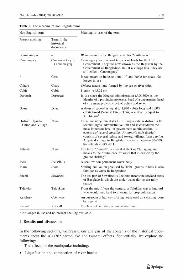
the terms used in the modern earthquake literature. Many non-English terms have been
used in our research and an explanation of these is provided in Table 2. For consistency,
the modern names of the places have been used, but the respective old names reported in
the historical evidence are also provided in Table 1.
Fig. 4 Location of field sites visited and investigations undertaken along the SE coast of Bangladesh
918 Nat Hazards (2014) 70:903–933
123
4 Results and discussion
In the following sections, we present our analysis of the contents of the historical docu-
ments about the AD1762 earthquake and tsunami effects. Sequentially, we explore the
following:
The effects of the earthquake including:
• Liquefaction and compaction of river banks;
Table 2 The meaning of non-English terms
Non-English term Meaning or uses of the term
Present spelling Term in thehistoricaldocuments
Bhumikompo – Bhumikompo is the Bengali word for ‘‘earthquake’’
Cannongoey Cannoon-Goey orCannoon-goij
Cannongoey were record keepers of lands for the BritishGovernment. They are now known as the Registrar by theGovernment of Bangladesh, but at a village level they arestill called ‘‘Cannongoey’’
* Cess It was meant to indicate a unit of land liable for taxes. Nolonger in use
Chhara Chara Chhara means land formed by the sea or river tides
Cubit Cubit 1 cubit &45.72 cm
Darogah Daroogah In use since the Mughal administration (AD1500) as theidentity of a provincial governor, head of a department, headof city management, chief of police and so on
Doan Doan A doan of ground is equal to 1,920 cubits long and 1,600cubits broad (Verelst 1763). Thus, one doan is equal to&0.64 km2
District, Upazila,Union and Village
None There are sixty-four districts in Bangladesh. A district is thesecond largest administrative unit and is considered themost important level of government administration. Itconsists of several upazilas. An upazila (sub-district)consists of several unions and several villages form a union.A typical village in Bangladesh contains between 30–500households (BBS 2011)
Jalhosti None The term ‘‘Jalhosti’’ is a local dialect in Chittagong andmeans to the ‘‘turbulence of water that is caused by theground shaking’’
Jeels Jeels/Jhils A shallow non permanent water body
Jhum Joom Shifting cultivation practised by Tribal groups in hills is alsofamiliar as Jhum in Bangladesh
Suabil Sowabeel The last part of Sowabeel is Beel that means the lowland areasof Bangladesh, which are under water during the rainyseason
Talukdar Taluckdar From the mid-fifteen the century, a Talukdar was a landlordwho would lend land to a tenant for crop cultivation
Kutchery Cutcherry An out-room or hallway of a big house used as a waiting roomby a guest
Kutwal Kutwall The head of an urban administrative unit
* No longer in use and no present spelling available
Nat Hazards (2014) 70:903–933 919
123

• Liquefaction-induced compaction and subsidence along the coast of the BoB;
• Landslides at Kodala on the bank of the Karnafuli River;
• Co-seismic submergence and subsidence;
• Mud volcanic eruptions;
• The collapse of houses, deaths and injuries;
• Evidence of recent earthquake effects and the context of vulnerability.
The effects of the tsunami including:
• Tsunamis on the coast of Chittagong;
• Water-level variation in the river adjacent to Dhaka;
• Location of the AD1762 earthquake and tsunami affected areas in Bangladesh;
• Historical records of tsunamis in Cheduba Island;
• Evidence of uplift along the Myanmar coast and the height of the tsunami; and
• Other examples of the effects of the earthquake on soft sediments and earthquake-
triggered slides and tsunamis.
4.1 The content of historical documents
The content analysis of the historical documents and data collected throughout the field
investigations revealed that the main effects of the earthquake were the following: liq-
uefaction-induced surface cracking, compaction and subsidence, landslides, co-seismic
subsidence, mud volcanic eruptions and inundations along the coast of the BoB (Table 1).
As shown in Fig. 5, the effects of the earthquake were observed as far as west Kolkata in
India and southeast of Bago in Myanmar—an area covering a total distance of over
1,220 km.
4.2 Evaluation of the historical evidence via ground-truthing during visits
A total of 16 areas affected by the earthquake and tsunami were identified from the
historical documents. Field visits and investigations were subsequently conducted in
Baharchhara, Burumchhara, Pathorgatha, Howla, Akilpoor, Bansbaria, Sitakund, Bandar-
ban, Bajalia, Dohazari, Suabil, Kodala and along the Halda, Karnapfuli and Sangu rivers in
Chittagong and the Meghna River in Lakshmipur, Bangladesh (Fig. 6). The identified
effects of the earthquake and tsunami on these areas are discussed in the following
sections.
4.2.1 The effects of the earthquake
4.2.1.1 Liquefaction and compaction of river banks Liquefaction-induced surface
cracking and compaction occurred in Pathorgatha, Howla, Dohazari, Bajalia and Kodala,
all of which are located along river banks in Chittagong.
Pathorgatha is located on the northern bank of the Karnafuli River, which flows in an
east–west direction adjacent to the city of Chittagong. Howla is located near the confluence
of the Halda and Karnafuli rivers (Figs. 6, 7a). From the descriptions of the effects (key
comments for Pathorgatha are detailed in Table 1) sourced from the BL in relation to
Pathorgatha and Howla, it can be determined that liquefaction-induced surface cracking
and compaction occurred on the river banks between these areas.
920 Nat Hazards (2014) 70:903–933
123

Dohazari is a union at Chandanaish upazila, Chittagong (Fig. 6). The main effect
caused by the earthquake at Dohazari (Table 1) was liquefaction related to surface
cracking. Dohazari Creek is now a part of the Sangu River. Earthquake-induced lique-
faction occurred in saturated soil along the banks of the river where soil lost its strength
after being shaken by the earthquake. Discussions with the descendants at the Dohazari’s
house revealed that they do not have any record of this event.
Bajalia is located to the east of Chittagong adjacent to Bandarban (Fig. 6). BL sources
accurately describe its location on the bank of river and provide evidence of a tribal
community living in the area. The descriptions of the effects (Table 1) by Gulston (1763a)
identify liquefaction-induced surface cracking in the hills along the Bajalia Creek. The
Bajalia Creek is now called the Sangu River, and field visits revealed that there are hills
Fig. 5 The locations of the AD1762 earthquake effects extended as far west as Kolkata, India and SE toBago, Myanmar. The cluster of red circles along the Chittagong coast show widespread damage (Datasources Gulston 1763a, b; Hirst 1763; Verelst 1763 and Table 1)
Nat Hazards (2014) 70:903–933 921
123

along the Sangu River at Bajalia. Consultation with local historical works (Rizvi 1970)
suggests that the Jhum cultivation (shifting cultivation in hills practised by the tribal
community in Bangladesh) occurred in that area. The tribal group also once dominantly
lived in that area. Information derived from the field visits indicate that Gulston (1763a)
was correct in his descriptions of the earthquake effects experienced at Bajalia.
Gulston (1763a) reported liquefaction and compaction of approximately
1,211.65 sq km of land along the Halda River (Figs. 6, 7b). Gulston (1763a, p. 253) stated
‘‘And at Haldah about 12 doan of land belong to Sacheeram Cannoongoeij is entirely sunk
into the water’’. Further, Gulston’s (1763a) report (Table 1) also suggests the occurrence of
landslides and inundation at Suabil which is located within the floodplain of the Halda
River. The Halda River continuously deposits sediment to form new floodplain and also
erodes young sediment from the banks of the river (Rizvi 1970). Saturated soft soils when
shaken by large earthquakes loose their cohesive strength causing slipping to occur. Thus,
Fig. 6 Location of the effects of the AD1762 earthquake along the SE Bangladesh coast. AP Akilpoor, BBBansbaria, BM Burumchhara, BH1 Baharchhara 1, BH2 Baharchhara 2, BJ Bajalia, CTG Chittagong City,DH Dohazari, HL Howla, KD Kodala, LP Lakshmipur, PG Pathorgatha, ST Sitakund, SB Suabil, KPRKarnafuli River, MR Meghna River, SR Sangu River
922 Nat Hazards (2014) 70:903–933
123

it is extremely likely that liquefaction and compaction did occur in unconsolidated land
along the Halda River.
4.2.1.2 Liquefaction-induced compaction and subsidence along the coast of the
BoB Gulston (1763a) and Verelst (1763) describe the effects of the AD1762 earthquake at
Akilpoor, a village in the Bansbaria union, located on the Chittagong coast (Fig. 6). Referring
to Akilpoor, Verelst (1763, p. 266) observed that ‘‘at Bans Burrreah, Akul Poor, near the sea,
the earth opened in seven places, like wells, throwing up the water ten cubits high; the great
Cutcherry there, with brick walls, is cracked and shivered into pieces’’. Gulston (1763a) also
provided similar descriptions of these effects (Table 1) at Akilpoor and Bansbaria. From the
field visits and investigations, we believe that the descriptions of the earthquake effects on this
village are likely and would have included liquefaction-induced surface failure, compaction
and subsidence of the lose sediment along the coast of the BoB. However, the spatial dis-
tribution of these effects appears to have been limited.
4.2.1.3 Landslides at Kodala on the bank of the Karnafuli River The descriptions of
surface failures at Kodala located on the bank of the Karnafuli River (Fig. 6) can be
attributed to landslides triggered by the earthquake. Gulston (1763a, p. 254) stated: ‘‘…the
eastward of Kadr Katcheeah a large hill, called Kad’d’aleah, very near Karn Phooly, was
rent, and it stopped up the passage for boats in and out that river.’’ Kodala (Kodala spelt as
Fig. 7 a The region between Pathorgatha and Howla on the bank of Karnafuli River, Chittagong City;b The location of Suabil on the bank of the Halda River. Gulston (1763a) reported liquefaction andcompaction of the low land of the Suabil by the earthquake on the bank of the Halda River; c The location ofKodala on the bank of the Karnafuli River. Gulston (1763a) reported a landslide triggered by the earthquakefrom the Kodala Hills on the bank of the Karnafuli River; d The particular location of Burumchhara, theSangu River and the Bay of Bengal. The north and south Burumchharas were dissected by the Sangu River.The Sangu River empties into the BoB at its western end. This is the only location where the BL sourcesclearly report the damage by tsunami and the deaths of people (Source adapted from Google Earth)
Nat Hazards (2014) 70:903–933 923
123

Kad’d’aleah in Gulston’s (1763a) description)) is located on the bank of the Karnafuli
River, 50 km northeast of Chittagong City. The width of the Karnafuli River is less than
125 m adjacent to Kodala (Fig. 7c). It appears that a portion of the Kodala Hills along the
Karnafuli River was ‘‘broken into pieces’’ by the shaking of the earthquake, and sub-
sequent landslides blocked access to the adjacent river for incoming and outgoing boats.
4.2.1.4 Co-seismic submergence and subsidence Content analysis of the available his-
torical documents suggests that co-seismic submergence occurred due to the earthquake. It
is reported that the earthquake caused submergence of approximately 155.40 sq km along
the west coast of Chittagong (Burke 1764; Rizvi 1970; Fig. 6).
Co-seismic subsidence was reported in Baharchhara and Lakshmipur (Fig. 6). However,
there may have been unreported places where co-seismic subsidence also occurred. This
can be inferred from Verelst (1763, p. 268) who comments, ‘‘By the accounts already come
in, there are 120 Dons of ground lost in different part of the province; but these I am afraid
will not be one-eighth part of the whole damages, as we have further relations coming in
every hour.’’
Hunter (1876) and Anon (1763) reported (Table 1) co-seismic subsidence of 24 sq km
of land in Lakshmipur (Fig. 6). Laskhmipur is located in the lower estuarine region, where
the Meghna River flows into the BoB. Through the formation of sand bars and mouth bars
in the Meghna estuary, the sediments are soft, young and unconsolidated in this region
(Brammer 1966, 2002; Gupta and Khan 1996). It is possible that severe ground shaking by
the earthquake resulted in compaction and subsidence of the land beneath the water of the
Meghna River.
4.2.1.5 Mud volcanic eruptions The earthquake is said to have caused the discharge of
sulphur-mixed water and two volcanic eruptions in the Sitakund Hills (Fig. 6), Chittagong
(Akhter 1979; Alam 1947; Gulston 1763a; Hunter 1876; Islamabadi 1987; Verelst 1763).
Verelst (1763, p. 269) observed: ‘‘As we are informed, that there are two volcanoes
opened…’’ Akhter (1979) investigated the sediments of the Sitakund Hills and found that
two mud volcanoes had erupted as a consequence of the earthquake. Following Akhter’s
(1979) analysis, we accept the reports of eruptions of mud volcanoes triggered by the
earthquake as reliable. Another earthquake that occurred in AD1865 is said to have caused
sand and mud ejections in the Sitakund Hills (Rizvi 1970).
4.2.1.6 The collapse of houses, deaths and injuries Historical documents record both
earthquake effects on housing and the number of deaths and injuries that sustained as a
result of the event. The earthquake caused extensive damage to houses in Chittagong. Even
‘‘well-built’’ houses made of bricks are reported to have experienced cracking or complete
collapse. For example, Verelst (1763, p. 265) stated: ‘‘… as there is not a brick wall or
house but is either greatly damaged or fallen.’’ Evidence from field visits and data from
location and genealogical analysis identify at least ten locations where damage to houses
was reported. Some of these include the house of Sacheeram Cannoongoey at Halda, Hurry
Singh’s house at Dohazari, Santeeram Cannongoey’s house at Pathorgatha, Mr. Griffith’s
brick house at Kotwali, a mud building, Kutchery houses and mud buildings in Akilpoor,
Bansbaria, Burumchhara, Baharchhara and Howla (Fig. 6). Discussion with locals could
only confirm the locations of these places, but no stories of earthquake damage are
available.
924 Nat Hazards (2014) 70:903–933
123

Deaths and injuries sustained as a result of the earthquake were reported in several
places. The BL sources detailed those locations where physical changes in land and
damage to houses resulted in deaths and injuries. The reports of deaths and injuries were
stated in a particular manner. For example, ‘‘the break down of the Santaram Cannoon-
Goey brick house and injury of his relations’’, ‘‘Taluckdar’s ground sunk and four people
killed at Suabil’’ (Verelst 1763), ‘‘loss of two hundred people at Baharchhara’’, ‘‘the break
down of Hurry singh’s house at Do Hazari which hurt one of his family members’’, ‘‘a
bricked room of Santeeram Cannoon-Goey’s house in Chittagong broken down and his
brother, Rajah Ram, was killed by the falling down of brick’’ (Gulston 1763a). Discussions
with descendants in Dohazari and Pathorgatha, where deaths and injuries were reported did
not reveal any such records of the earthquake.
4.2.1.7 Evidence of recent earthquake effects and the context of vulnerability Similar to
the AD1762 earthquake, a Ms 6.1 event in AD1997 whose epicentre was in Bandarban
caused liquefaction-induced subsidence of a five-floor building in Chittagong in which
thirty-two people died (which is over 60 km from the epicentre (Khan 2004)). In addition,
numerous hilly areas developed cracks and experienced slumping in Bandarban (Islam
2001). Another two earthquakes that occurred in AD1999 and AD2003, whose epicentres
were in Chittagong, caused damage to houses, deaths and injuries. A repeat of the AD1762
earthquake would be expected to cause numerous slope failures in heavily deforested
(Alam et al. 2005) and fragmented hilly areas in Chittagong resulting in further deaths and
injuries. Recently, heavy monsoon rainfall has caused widespread slope failure resulting in
landslides associated with deaths and injuries in every rainy season (Alam et al. 2005;
Mahmood and Khan 2008). Due to poor infrastructure and a lack of preparedness in
Chittagong and Dhaka, the consequences of a repeat of the AD1762 earthquake would be
devastating. It should be noted that total population and population density in Dhaka and
Chittagong have increased at least tenfold since the first census in AD1872 to the most
recent in AD2011 (BBS 2010; Rizvi 1969, 1970).
4.2.2 The effects of the tsunami
4.2.2.1 Tsunamis on the coast of Chittagong Local tsunamis were observed in three
places—Bansbaria, Baharchhara and Burumchhara following the earthquake (Fig. 6). The
context of descriptions and the extent of inundations are evaluated in the following
sections.
Gulston (1763a) quotes a letter from Satoo Mester Darogah (a local administrator and
resident at Bansbaria) to describe the effects of the earthquake in Chittagong. Referring to
the tsunami at Bansbaria, Gulston (1763a, p. 252) stated that: ‘‘And from the reports of the
people there we hear, that these places were never before overflowed by the water…a mud
building of your servant’s (the writer of this account) was almost destroyed by the shock,
but it still stands upright’’. There is no river inside or adjacent to Bansbaria. This suggests
that the area along the Bansbaria coast that was affected by liquefaction and subsidence
was also struck by a tsunami generated by the earthquake. The mud building inhabited by
Satoo Mester Darogah is reported to have cracked as a result of the shaking of the
earthquake, but it remained standing following the earthquake. This suggests that the
height of tsunami and maximum run-up was very low, and it did not reach up to the wall of
a mud building, causing it to collapse. Therefore, this research suggests that a medium-to-
large tsunami did not occur in this area.
Nat Hazards (2014) 70:903–933 925
123
Gulston (1763a), Verelst (1763) and Rizvi described the effects (Table 1) of the
earthquake at Baharchhara. Verelst (1763) stated that: ‘‘At Bar Chara, near the sea, five or
six cess of ground immediately sunk, and out of four or five hundred people, about two
hundred were lost, with all their cattle; and the greatest part of the remaining inhabitants,
who ran into woods, have not yet been heard of.’’ The Baharchhara is a union at Banskhali.
This suggests co-seismic subsidence in Baharchhara, resulting in both human and animal
deaths. Verelst’s (1763) descriptions indicate that the inhabitants at Baharchhara experi-
enced a tsunami triggered by the earthquake and fled to higher ground to save their lives.
However, Rizvi (1970) proposed an alternative area (see Baharchhara 2 in Fig. 6),
which is located in the present Boalkhali upazila. Rizvi (1970, p. 54) stated that: ‘‘Bah-
archara means an outer strip of land, exposed and abandoned, and a tidal wave accom-
panying an earthquake would cover any of these places’’. In Bengali, Baharchhara consists
of two words, Bahar (outer) and Chhara, which means land formed by sea or river tides.
Boalkhali is an upazila, and part of it is located along the Karnafuli River, but at present,
there is no location called Baharchhara. Rizvi’s (1970) proposed that the location of
Baharchhara was inside or along the Karnafuli River, having the Chhara as part of its
name. The descriptions by Rizvi (1970) suggest that a tsunami triggered by the earthquake
did inundate Baharchhara. Other locations are reported to have been affected around
Baharchhara and include Pathorgatha and Howla where liquefaction-induced surface
failures and compaction was mentioned (Figs. 6, 7a).
Gulston (1763a) and Verelst (1763) provide a clear description of a tsunami in Bur-
umchhara. Baharchhara, a name of two unions called north and south Burumchharas, is
located in Anawara and Banshkhali upazilas, respectively. Both north and south Bur-
umchharas are dissected by the Sangu River, which flows into the BoB (Fig. 7d). In
reference to the tsunami at Burumchhara, Gulston (1763a, p. 253) stated: ‘‘The Kutwall, of
Islamabad, also informed us with his own mouth, that, in a place called Baramcharah, the
water was up to a man’s waist, and the people there have betaken themselves to flight,
through fear of perishing; no living creature but the cattle now remaining.’’ Verelst (1763)
reported that Burumchhara was inundated by sea water to an approximate depth of 90 cm.
It is possible that the earthquake generated submarine sediment slides that triggered local
tsunamis adjacent to the Burumchhara coast. Another explanation is that the sudden rise of
water triggered by the earthquake could have raised its flow height at the particular geo-
graphical location along an oxbow lake in Anawara and Banskhali adjacent to the BoB.
Given that the depth [height] of water at this location was described as reaching ‘‘up to a
man’s waist’’, the flow depth of any tsunami event can be assumed to have been less than
1.3 m in Bangladesh. An alternative explanation is that a part of the Burumchhara coast at
this location subsided during the earthquake, causing seawater to inundate the low-lying
land.
Our review of historical evidence coupled with field visits does not support the sug-
gestion of inundation occurring over extended areas. There is no concrete evidence of a
tsunami achieving a flood runup height of circa 2.5 m along the Chittagong coast. This
argument is supported by an analysis of the flooding effects of the AD1985 tropical
cyclone on the Bangladesh coast. Dube et al. (2004) indicated that the AD1985 Bhola
tropical cyclone raised water levels by a maximum of 3 m at the northern end of the BoB
and flooding the Chittagong coast with a 2.8-m-high storm surge. The middle and western
coast was also flooded by a storm surge with a height of at least one metre. If water were
raised 2–3 m in the northern BoB due to either a tsunami or a tropical cyclone, the entire
SE Bangladesh coast would have been flooded. Here, it should be noted that the oldest
report on the Ganges and Brahmaputra rivers by Rennell and Banks (1781) describes
926 Nat Hazards (2014) 70:903–933
123

flooding in the Lakshmipur district caused by a severe tropical cyclone in AD1763.
However, they make no mention of flooding in the year before.
4.2.2.2 Water level raised in the river adjacent to Dhaka The earthquake severely shook
the ground in Dhaka (Allen 1912; Burke 1764; Hirst 1763). Hirst (1763, p. 257) stated that:
‘‘At Dacca, in this kingdom of Bengal, the consequences have been terrible: the rise of the
waters in the river was so very sudden and violent, that some hundreds of large country
boats were driven ashore, or lost, and great numbers of lives lost in them.’’ Allen (1912,
p.131) added that: ‘‘At Dhaka the rivers and jhils were agitated, and rose high above their
usual levels, leaving, when they receded, their banks strewed with dead fish.’’ From these
historical descriptions, it is unclear whether a tsunami originating in the BoB inundated as
far as Dhaka. The logical explanation is that the severe shaking of the earthquake caused
oscillations of river water from the Buriganga River that runs alongside Dhaka. During the
2004 IOT, seismic seiches were observed in all water bodies and pond water in Dhaka, for
example, oscillated by up to 0.61 m (Akhter 2010).
Debate arises as to whether tsunami waves in the BoB reached as far inland as Dhaka
(Cummins 2007). Analysis of the districts between Lakshmipur and Dhaka is useful for
understanding whether flooding occurred from the coast inland as far as Dhaka. Although co-
seismic subsidence occurred in Lakshmipur on the eastern bank of the lower Meghna River,
no flooding was reported. In a north–south direction between Lakshmipur and Dhaka are the
districts of Shariatpur, Chandpur, Comilla, Munshiganj and Narayangonj (Fig. 8). The dis-
tance from Lakshmipur to Dhaka is approximately 215 km. Without a tsunami in the coastal
(Lakshmipur and Noakhali) and intermediate areas, the occurrence of tsunami in Dhaka is
unlikely. However, it is possible that the sudden rise of water in the northern BoB could have
been funnelled up the river in Dhaka without flooding low-lying settlements along the way.
4.2.2.3 Location of the AD1762 earthquake and tsunami affected areas in Bangla-
desh Analysis of the areas reported to have been affected by the earthquake and tsunami
are useful for understanding whether the entire SE Bangladesh coast was impacted. Despite
reports of tsunamis at Baharchhara, Burumchhara and Bansbaria (that are located in a
south–north direction (Fig. 6) along the Chittagong coast), no flooding was mentioned
throughout these areas from any direction. Additionally, Gulston (1763a) and Verelst
(1763) thoroughly described the effects of the earthquake in Pathorgatha, but no inundation
was observed in the adjacent city of Chittagong, where the British servicemen were
residing. This suggests that if a local tsunami had occurred as a result of the earthquake, the
height of any tsunami experienced at the Karnafuli River was too small to inundate the city
of Chittagong. Currently, the review of historical documents from Chittagong, Noakhali,
Lakshmipur, and Barisal does not provide any substantial evidence to support tsunami
inundation from any direction. If a large tsunami had occurred in Chittagong (i.e. Bah-
archhara, Burumchhara and Bansbaria), the flooding would have swept over the offshore
islands (i.e. Sandwip and Hatiya islands) at the funnel-shaped coast at the northern end of
the BoB (Fig. 6). The coastal and offshore island areas adjacent to the BoB are low-lying
and very flat. The ground height of the region, up to 200 km from the coast is lower than
3 m (Fig. 8; Umitsu 1985). Again, location analysis of these reported areas does not
support flooding in these adjacent, connected and intersecting areas from any direction.
It is possible, however, that the earthquake could have triggered submarine sediment
slides, which may have generated local tsunamis that inundated Baharchhara,
Nat Hazards (2014) 70:903–933 927
123

Burumchhara and Bansbaria. The thickness of sediment in the northern end of the BoB
along the Chittagong coast is more than 13 km (Cummins 2007; Curray et al. 1982).
4.2.2.4 Historical records of tsunamis in Cheduba Island Captain Edward P. Halsted
(1843), Captain of the British ship Childers conducted a survey along the Arakan coast in
AD1841. Halstead quoted the experiences of a 106-year-old resident who came from the
Cheduba Island (Fig. 5) during the AD1762 earthquake. The resident’s description of the
event is captured in the following text from Halstead’s report:
The earthquake was very violent, the sea washed to and fro several times with great
fury, and then retired from the grounds, leaving an immense quantity of fish; the
Fig. 8 The contour lines show the elevation above mean sea level (MSL). The western and estuarineregions have an average elevation of 0–3 m and the Chittagong coast 0–30 m. Solid dots show the locationsof districts from Lakshmipur to Dhaka (Source base map from USGS (2011)
928 Nat Hazards (2014) 70:903–933
123

feasting on which is a favorite story throughout the Island; no lives were lost, no
rents in the earth occurred, nor fire from the volcanoes of the Island (1843, p. 434).
Halstead also reported that local people fled to higher ground when the AD1762 tsunami
occurred. Halstead’s report of the tsunami may not be relied upon in isolation because he
conducted his survey 77 years after the earthquake occurred. However, Verelst (1763),
who documented accounts of the earthquake effects immediately after the event, observed
that the locals fled to higher ground after seeing the tsunami in Baharchhara. Taken
together, it is reasonable to accept the validity of the matching accounts.
4.2.2.5 Evidence of uplift of the Myanmar coast and the height of tsunami The AD1762
earthquake is reported to have resulted in co-seismic uplift along the west coast of
Myanmar, Ramri, Cheduba and Foul islands (Fig. 5) between 2.74 and 6.70 m (Halstead
1843). The analysis of sediment on Phayonkar Island by Okamura et al. (2008) using radio
carbon dating of coral and shell suggests that an identified uplift of 3–5 m could be
attributed to the AD1762 earthquake. Further, recent geological investigations in 2006 and
2007 undertaken along the western coast of Myanmar suggest the occurrence of terrace
uplift during the AD1762 earthquake, but there is no explicit evidence of tsunami deposits
(Aung et al. 2006, 2008; Thein and Swe 2008). The recent estimation of 3–5 m of uplift off
the coast of Myanmar by the earthquake is consistent with the historical reports by Hal-
stead and Mallet (Halstead 1843; Mallet 1878).
Evidence of uplift of the Arakan coast is explicit, but evidence for tsunamis is less clear.
One possibility is that the uplift along the Arakan coast had elevated coastal tracts above
the reach of the subsequent tsunami. Another explanation is that although oscillations of
ocean water in the BoB were observed following the earthquake, deep ocean tsunami did
not affect the Myanmar coast.
5 Other examples of the effects of the earthquake in soft sediments and earthquake-triggered slides and tsunamis
The AD1762 earthquake ruptured the south of the ASZ including 250 km of the Bengal
shelf (Fig. 2). The event triggered widespread land-level changes and human deaths and
injuries that occurred along the adjacent SE Bangladesh. The soil in the reported areas of
liquefaction, compaction and subsidence derived sand and silty sand deposits adjacent to
the rivers of Karnafuli, Halda, Sangu and Meghna and on the coast of the BoB (Khan 2001;
Umitsu 1997). Similar effects of earthquakes in the recently formed deposits occurred in
Christchurch, New Zealand during the 22 February AD2011 earthquake (Jaiswal et al.
2011), in Alaska, USA following the 27 March AD1964 earthquake (Vellejo and Asce
1988), at the Frasher Delta, Canada during the 24 December AD1872 earthquake (Clague
et al. 1992) and in Wenchuan, China following the 12 May AD2008 earthquake (Huang
and Jiang 2010). It should be borne in mind that the AD1964 Alaska earthquake was
generated in a similar sediment subduction zone (Ruff 1989), causing numerous surface
cracking, liquefaction-induced landslides, local slide-generated tsunamis (McCulloch
1984) and a major Pacific Ocean tsunami (Nicolsky et al. 2010). Since the sedimentation
rate in the northern BoB is very high, Cummins (2007) issued a precaution that the
possibility of submarine or subareal landslide-generated tsunamis should be considered
significant because, as we have already reported, the AD1762 earthquake probably trig-
gered at least three local tsunamis along the Chittagong coast.
Nat Hazards (2014) 70:903–933 929
123

6 Conclusions
Drawing evidence from deep archival research and field visits, we identified historically
reported locations of the AD1762 earthquake effects in SE Bangladesh. Gulston (1763a)
and Verelst (1763) described the nature and extent of the effects in different places in
Chittagong. The descriptions of historical evidence together with field visits do not support
the flooding of large areas from any direction (i.e. north–south or east–west or west–east)
along the coast of SE Bangladesh. However, historical evidence from the Chittagong and
Arakan coasts are inconsistent in describing the occurrence of local tsunamis. It is possible
that the earthquake generated several sediment slides in the northern BoB, generating
tsunamis in Chittagong. Another possibility was that earthquake-induced subsidence,
adjacent to the BoB, caused local tsunamis.
Although large areas were not affected by any tsunami, liquefaction, compaction and
subsidence and damage to houses were extensive. Our analysis of the effects of the
AD1762 earthquake suggested that significant damage occurred in the built environment
and the vulnerable communities that lived along the Bangladesh coast. Thus, the findings
of this research are significant for disaster management policies in relation to earthquakes
and tsunamis in Bangladesh as well as for generating awareness among vulnerable coastal
communities.
Gulston (1763a) and Verelst (1763) reported the effects of the earthquake quoting local
administrative people and familiar local names. It is possible that effects in other locations
have not been documented, limiting our understanding to fully quantify the earthquake. As
such, we suggest conducting further investigations into archival sources to achieve a more
complete understanding of the effects of the AD1762 earthquake and tsunami. Accord-
ingly, there is also a further need for a geological and geomorphological study to be
undertaken at the key sites in order to assess the nature and extent of palaeoenvironmental
changes. However, it should be borne in mind that since the AD1762 earthquake, the SE
Bangladesh coast has been flooded by at least fourteen severe tropical cyclones including
the events in AD1767, AD1822, AD1970 and AD1991, which have already resulted in
significant sediment deposition and reworking induced by storm surges. Additionally, in
order to understand community vulnerability to earthquakes and tsunamis, a comprehen-
sive survey should be conducted in Bangladesh. The resident populations of SE Bangla-
desh are at high risk from future earthquakes and tsunamis if they occur. As such, we
recommend taking proactive measures in relation to earthquake and tsunamis in Bangla-
desh by launching appropriate awareness programmes and implementing risk management
strategies.
Acknowledgments We thank the UNSW for financial support to undertake this research. Thanks to JamesGoff at UNSW for constructive comments on the report version of this manuscript and to two anonymousreferees who provided very constructive comments on an earlier draft of this manuscript. Thanks to theDisaster Action and Development Organisation (DADO), Bangladesh for helping with data collection inBangladesh.
References
Akhter SH (1979) Structure, stratigraphy and sedimentology of the Upper Tertiary sediments of the centralpart of the Sitakund Hill Range, Chittagong, Bangladesh. M.Sc. thesis, Department of Geology,University of Dhaka, Bangladesh
930 Nat Hazards (2014) 70:903–933
123

Akhter SH (2010) Earthquakes of Dhaka. In: Islam MA, Ahmed SU, Rabbani AKM (eds) Environment ofCapital Dhaka—Plants wildlife gardens parks air water and earthquake. Asiatic Society of Bangladesh,pp 401–426
Alam M (1947) Chattragramer Itihas-Company Amol (History of Chittagong-Company Period) (in Ben-gali). Islamia Litho & Printing Press, Chittagong, p 265
Alam M, Alam MM, Curray JR, Chowdhury MLR, Gani MR (2003) An overview of the sedimentarygeology of the Bengal Basin in relation to the regional tectonic framework and basin-fill history. SedGeol 155:179–208
Alam E, Chowdhury MAT, Akbar MT (2005) Aspects of socio-environmental problems resulting from hillcutting in Chittagong City of Bangladesh: local people’s perspectives. Pak J Soc Sci 3(8):1048–1052
Alam E, Dominey-Howes D, Goff J, Chague-Goff C (2012) Tsunamis of the northeast Indian Ocean with aparticular focus on the Bay of Bengal region—a synthesis and review. Earth Sci Rev114(1–2):175–193
Ali MH, Choudhury JR (2001) Assessment of Seismic Hazard in Bangladesh. In: Nizamuddin K (ed)Disaster in Bangladesh: selected readings. Disaster Research Training and Management Centre,University of Dhaka, Bangladesh, pp 197
Allen BC (1912) Eastern Bengal District Gazetteers. The Pioneer Press, Dhaka, p 195Ambraseys N (1980) Studies in historical seismicity and tectonics, Engineering Seismology Section,
Department of Civil Engineering, Imperial College of Science and Technology, London, pp 26–35Anon. (1763) Extract of a letter from Fort William, in Bengal, The Monthly Chronologer, p 279Atwater BF, Satoko M, Satake K, Yoshinobu T, Kazue U, Yamaguchi DK (2005) The orphan tsunami of
1700, Japanese clues to a parent earthquake in North America, USGS Professional paper 1707, p 133Aung TT, Okamura Y, Satake K, Swe W, Swe TL, Saw H, Tun ST (2006) Paleoseismological survery along
the western Coast of Myanmar, Active Fault Research Centre, GSJ/AIST, No. 6, pp 171–188Aung TT, Satake K, Okamura Y, Shishikura M (2008) Geologic evidence for three great earthquakes in the
past 3400 years off Myanmar. J Earthq Tsunami 2(4):259–265BBS (2010) Statistical yearbook of Bangladesh, Bangladesh Bureau of Statistics (BBS), Government of
BangladeshBeveridge H (1876) The District of Ba0karganj: its history and statistics. Trubner & Co, London, p 459Bolt BA (1930) Earthquakes. W.H. Freeman and Company, New York, p 378Brammer H (1966) The geography of soils of Bangladesh. University Press Ltd, Dhaka, p 287Brammer H (2002) Land use and land use planning in Bangladesh. University Press Ltd, Dhaka, p 554Burke E (1763) (ed) Annual Register, vol 6. pp 60–61Burke E (1764) (ed) Annual Register, vol 7. p 83Chhibber HL (1934) The geology of Burma. Macmillan, London, pp 1–530Cisternas M, Atwater BF, Torrerjon F, Sawai Y, Machuca G, Marcello L, Eipert A, Youlton C, Salgado I,
Kamataki T, Shishikura M, Rajendran CP, Javed KM, Rizal Y, Husni M (2005) Predecessors of thegiant 1960 Chile earthquake. Nature 437:404–407
Clague JJ, Naesgaard E, Sy E (1992) Liquefaction features on the Fraser delta: evidence for prehistoricearthquake? Can J Earth Sci 29:1734–1745
Cummins PR (2007) The potential for giant tsunamigenic earthquakes in the northern Bay of Bengal. Nature449:75–78
Curray JR, Emmel FJ, Moore DG, Raitt EW (1982) Structure, tectonics and geological history of the north-eastern Indian Ocean. In: Nairn AEM, Stchli FG (eds) The ocean basin and margin. Plenum Press, NewYork, pp 399–450
Dominey-Howes D (2002) Documentary and geological records of tsunamis in the Aegean Sea region ofGreece and their potential value to risk assessment and disaster management. Nat Hazards 25:195–224
Dube SK, Chittibabu P, Sinha PC, Rao AD, Murty TS (2004) Numerical modelling of storm surge in thehead Bay of Bengal using location specific model. Nat Hazards 31:437–453
Fergusson J (1863) On recent changes in the delta of the Ganges. Q J Geol Soc Lond 19:321–354Gahalaut VK, Gahalaut K (2007) Burma plate motion. J Geophys Res 112(B10402):1–9Ganse RA, Nelson JB (1982) Catalog of significant earthquakes 2000 B.C. to 1979, including quantitative
casualties and damage. Bull Seismol Soc Am 72(3):873–877Guidoboni E, Stucchi M (1993) The contribution of historic records of earthquakes to evaluation of seismic
hazards. Annali Di Geofisca 36(3–4):201–215Gulston E (1763a) An account of an earthquake at Chittagong: translated from the Persian by Mr. Edward
Gulston, in the service of the honourable East India Company, and communicated by him to theReverend Mr. Hirst. Philos Trans (1683–1775) 53:251–265
Gulston E (1763b) Extract of a Letter from Mr. Edward Gulston, at Chittagong, to Major John Carnac, atCalcutta. Philos Trans R Soc 53:263–264
Nat Hazards (2014) 70:903–933 931
123

Gupta S (2009) Bay of Bengal Earthquake of 1762 [Online]. Available: https://sites.google.com/site/indiaquake/bay-of-bengal-earthquake-of-1762 15 Feb 2011
Gupta H, Gahalaut V (2009) Is the northern Bay of Bengal tsunamigenic? Bull Seismol Soc Am99(6):3496–3501
Gupta PKS, Khan SR (1996) Geology of Hatia Island, Noakhali District, Bangladesh, Records of GeologicalSurvey of Bangladesh, Government of Bangladesh, vol 8, No 2, p 39
Halstead EP (1843) Report on the Island of Chedooba. J Asiat Soc. No. 113, New Series No. 26, pp 433–435Hirst W (1763) An account of an earthquake in the East Indies, of two Eclipses of the Sun and Moon,
observed at Calcutta: in a letter to the Reverend Thomas Birch, D. D. Secret. R. S. from the ReverendWilliam Hirst, M. A. F. R. S. Philos Trans (1683–1775) 53:256–262
Huang Y, Jiang X (2010) Field-observed phenomena of seismic liquefaction and subsidence during the 2008Wenchuan earthquake in China. Nat Hazards 54:839–850
Hunter WW (1876) A statistical account of Bengal, Chittagong Hill tracts, and districts of Chittagong,Noakhali, Tripperah, Hill Tripperah, vol VI. Trubner & Co., London, p 444
Islam M (2001) Chittagong hill tracts: state of environment. In: Chowdhury QM (ed) Forum of environ-mental journalists of Bangladesh (FEJB). Dhaka, Bangladesh, pp 135–139
Islam SI (ed) (2004) Banglapedia: National Encyclopedia of Bangladesh, vol 3. Asiatic Society of Ban-gladesh, Dhaka, p 191
Islamabadi A (1987) Chattragram Smwarani (A memorial in Chittagong) (in Bengali). Azadi PrintersLimited, Chittagong, p 159
Jaiswal K, Golden C, Gould N, Berkowitz R (2011) A field reconnaissance mission for Feb 22, 2011Christchurch New Zealand earthquake. Seismol Res Lett 82(3):452
Khan SR (2001) Geomorphic and Geologic characteristics of the coastal plains of Bangladesh, Internationalseminar on Quarternary development and coastal hydrodynamics of the Ganges Delta in Bangladesh,held in Dhaka from 2–3 June 2001
Khan AA (2004) Earthquake vulnerability and hazard assessment in the active collision margin of Ban-gladesh with special reference to Dhaka, Chittagong, and Sylhet triangular region, Research ReportMinistry of Science and Information and Communication Technology, Govt. of Bangladesh, p 96
Khan AA (2010) Earthquake, tsunami and geology of Bangladesh. University Grant Commission of Ban-gladesh, Dhaka, p 331
Khan AA (2012) Seismogenic sources in the Bay of Bengal vis-a‘-vis potential for tsunami generation andits impact in the northern Bay of Bengal coast. Nat Hazards 61:1127–1141
Mahmood AB, Khan MH (2008) Landslide vulnerability of Bangladesh hills and sustainable managementoptions: a case study of 2007 landslide in Chittagong City, A paper prepared for Management andMitigation of Water Induced Disaster to be held on 21–22 April 2008 in Kathmandu, Nepal
Mallet FR (1878) Mud volcanoes of Ramri and Chedooba, Geological Survey of India Records, 11, Part 2,pp 188–191
Martin S, Szeliga W (2010) A Catalog of Felt Intensity Data for 570 Earthquakes in India from 1636 to2009. Bull Seismol Soc Am 100(2):562–569
McCulloch (1984) Geologic effects of the great 1964 Alaskan earthquake. 79th Annual Meeting, UnitedStates Department of Interior Geological Survey, Salt Lake City, USA
Mukherjee M, Fryar AE, Thomas WA (2009) Geologic, geomorphic and hydrologic framework and evo-lution of the Bengal basin, India and Bangladesh. J Asian Earth Sci 34:227–244
Nicolsky DJ, Suleimani EN, Hansen RA (2010) Numerical modeling of the 1964 Alaska tsunami in westernPassage Canal and Whittier, Alaska. Nat Hazards Earth Syst Sci 10(12):2489–2505
Nielsen C, Chamot-Rooke N, Rangin C, The ANDAMAN Cruise Team (2004) From partial to full strainpartitioning along the Indo-Burmese hyper-oblique subduction. Mar Geol 209:303–327
Okamura Y, Shishikura M, Swe W, Saw H, Swe T Tun S (2008) Paleoseismological evidence of the 1762and earlier earthquakes off Myanmar, American Geophysical Union, 88, 52, Suppl., AGU 2007 FallMeeting, 2007
Oldham RD (1883) A catalogue of Indian earthquakes from the earliest time to the end of A.D. 1869. MemGeol Surv India 19(3):163–215
Paul BK, Bhuiyan RH (2010) Urban earthquake hazard: perceived seismic risk and preparedness in DhakaCity, Bangladesh. Disasters 34(2):337–359
Rennell J, Banks J (1781) An account of the Ganges and Brahmaputra Rivers. Philos Trans R Soc Lond71:87–114
Rizvi SNH (ed) (1969) East Pakistan District Gazetteers: Dacca. East Pakistan Government Press, Dhaka,p 353
Rizvi SNH (ed) (1970) East Pakistan District Gazetteers: Chittagong. East Pakistan Government Press,Dhaka, p 344
932 Nat Hazards (2014) 70:903–933
123

Ruff LJ (1989) Do trench sediments affect great earthquake occurrence in subduction zones? Pure ApplGeophys 129(1–2):263–282
Satyabala SP (2003) The historical earthquakes of India. In: William HKL et al (ed) International handbookof earthquake and engineering seismology, Part A, vol 81A. Academic Press, pp 1–5
Singleton RA, Straits BC (1999) Approaches to social research, 3rd edn. Oxford University Press, New YorkSocquet A, Vigny C, Chamot-Rooke N, Simons W, Rangin C, Ambrosius B (2006) India and Sunda plates
motion and deformation along their boundary in Myanmar determined by GPS. J Geophys Res111:B05406
Thein M, Swe TL (2008) Earthquake and tsunami hazard potential along the Myanmar coastal areas. In:Proceedings of the international symposium on the restoration program from giant earthquakes andtsunamis, Phuket, Thailand, pp 29–35
Umitsu M (1985) Regional Characteristics of the landforms in the Bengal Basin. Studies in Socio-CulturalChange in Rural in Bangladesh, No. 1, pp 1–44
Umitsu M (1997) Landforms and floods in the Ganges delta and coastal lowland of Bangladesh. MarGeodesy 20(1):77–87
USGS (2011) Downloadable GIS Data for Bangladesh. United States Geological Survey [Online]. Avail-able: http://pubs.usgs.gov/of/1997/ofr-97-470/OF97-470H/linked_filepaths1.htm
Vellejo LE, Asce AM (1988) The liquefaction of sand lenses during an earthquake. American Society ofCivil Engineers, Geotechnical special publication, pp 493–507
Verelst (1763) An account of the earthquakes that have been felt in the province of Islamabad, with thedamages attending them, from 2nd to the 19th of April, 1762: translated from the Persian, andcommunicated to Henry Vansittart, Esq; President and Governor of Fort William in Bengal, by Mr.Verelst, Chief of the Hon. East India Company’s Affairs at Islamabad. Philos Trans (1683–1775)53:265–269
Webster JE (1911) Eastern Bengal and Assam district gazetteer: Noakhali. The Pioneer Press, Allahabad,p 107
Wright RS (1995) The genealogist’s handbook: modern methods for researching family history. TheAmerican Library Association, Chicago, p 191
Nat Hazards (2014) 70:903–933 933
123