Blind Digital Signatures, Group Digital Signatures and Revocable Anonymity
Upload
independentCategory
view
0download
0
The Holocene 16,8 (2006) pp. 1095� 1107
Tsunami and palaeotsunami depositionalsignatures and their potential value inunderstanding the late-Holocene tsunamirecordDale T.M. Dominey-Howes,* Geoff S. Humphreys andPaul P. Hesse
(Department of Physical Geography, Macquarie University, Sydney NSW 2109,Australia)
Received 20 April 2005; revised manuscript accepted 16 May 2006
Introduction and aim
The Great Sumatra-Andaman
December 2004 (Lay et al., 2005
reasons: (1) it is the most catastr
occurred in terms of the number o
homeless and displaced (Geist et
public awareness of tsunami, a
fully appreciated (Bryant, 2001)
large teletsunami affecting many
# 2006 SAGE Publications
Abstract: In recent years, much research on modern and palaeotsunami deposits has been published. From
these studies, a range of signature types has been identified. Identifying and dating such deposits is an
important element in understanding late-Holocene tsunami hazard and risk. However, important
questions such as, ‘do modern and palaeotsunami leave similar or dissimilar traces?’; ‘do tsunami leave
the same signatures all around the world or are there significant variations?’; and ‘what is the actual record
of tsunami in different parts of the world?’ still remain. Answering these questions is not an easy task but
examining megatsunami flood deposits should shed some light on these questions because such
high-magnitude events should leave very clear and detailed traces within the coastal landscape. The
coast of SE Australia is reported to have been affected by numerous palaeomegatsunami in the late
Holocene. As such, the coast of New South Wales offers an important natural laboratory to examine in
detail deposits associated with such events. Here, we summarize the published characteristics of modern
and palaeotsunami deposits globally and within Australia. We briefly outline the tsunami risk to Australia
before examining a site called Minnamurra Point on the coastline of SE Australia (south of Sydney) that
has previously been described as containing evidence for a palaeomegatsunami of an unknown age. We
describe the results of a detailed coastal survey, field stratigraphic investigation and various standard
laboratory analyses. Surprisingly, we are unable to replicate the previously reported findings of tsunami
deposits. Whilst we prefer the interpretation that the sequence is an in situ soil (the sediment sequence
examined contains none of the usually reported lines of evidence to demonstrate tsunami provenance), we
recognize and discuss the significance and difficulty of identifying tsunami deposits in the field and
consider the implications of our findings to the wider debate about the preservation of tsunami-deposited
sediments.
Key words: Tsunami, palaeotsunami, signatures, evidence, tsunami risk, Australia, Holocene.
s
Indian Ocean tsunami of
) was significant for several
ophic event known to have
f lives lost, and people made
al., 2006); (2) it has raised
hazard type not previously
; (3) it was an extremely
countries around the Indian
Ocean � one of the largest such events in the last 100 years;
and (4) for such a large event, the tsunami has only left a small
‘imprint’ in the coastal landscape (Keating et al., 2005). That is,
its geomorphological and sedimentological record is limited
and is likely to be rapidly lost as normal marine processes
modify and erode these imprints (Keating et al., 2005). The last
point is very significant because tsunami scientists argue that
the preservation, identification and dating of ‘palaeotsunami’
deposits is an important component in assessing long-term
(late Holocene) tsunami risk (Dawson and Shi, 2000;
Dominey-Howes, 2002) especially when the historic record is
short. Obviously, such assessments are only possible where
tsunami leave distinctive and datable deposits. Therefore,
*Author for correspondence (e-mail: [email protected])10.1177/0959683606069400

studies must identify a detailed set of distinguishing tsunami
features (hereafter referred to as ‘signatures’) that researchers
may use as a diagnostic tool. There are two important tasks to
such work. First, post-tsunami surveys following contempor-
ary events should identify and describe all erosional and
depositional signatures. Second, palaeotsunami deposits
should be investigated and their signatures identified and
described. It will then be possible to determine to what degree
modern and palaeotsunami leave similar or dissimilar signa-
tures. Of particular value in the second task is to examine sites
thought to record evidence for megatsunami because such sites
should contain clear and unambiguous signatures that may
become ‘type signatures’ for palaeotsunami studies.
Palaeotsunami investigations from southeast Australia sug-
gest that the New South Wales (NSW) coast has been
repeatedly impacted by megatsunami. Unfortunately, it is not
clear to what sources these palaeomegatsunami events might
be linked � an important component of understanding risk
(Dawson, 1999). As such, the NSW coastline offers a natural
laboratory for examining palaeotsunami records.
In light of the introduction, the aims of this paper are to:
(1) summarize the reported ‘signatures’ of modern and
palaeotsunami globally and in Australia, and to provide
an outline of the previously reported tsunami risk to
Australia;
(2) examine in detail a site from southeast Australia reported
to have been affected by a palaeomegatsunami flood;
and
(3) consider the importance of the findings of this study to the
wider debate about tsunami depositional signatures and
their identification and preservation.
Tsunami signatures
Modern and palaeotsunami signatures worldwideThe geological investigation of tsunami is a new research area
(Dominey-Howes, 2002; Scheffers and Kelletat, 2003) and
there have been no direct observations of tsunami sediment
erosion, transport and deposition (Dawson, 1996; Dawson and
Shi, 2000). There have however, been numerous post-tsunami
field surveys following recent events (eg, 1992 Nicaragua,
Satake et al., 1993; 1992 Flores Island, Shi et al., 1995; 1994
Java, Dawson et al., 1996; 1998 Papua New Guinea, Goldsmith
et al., 1999 and Kawata et al., 1999; and 2004 Maldives,
Keating et al., 2005). From these surveys, a variety of
signatures have been recorded. Similarly, investigations indi-
cate that palaeotsunami may be identified within the geological
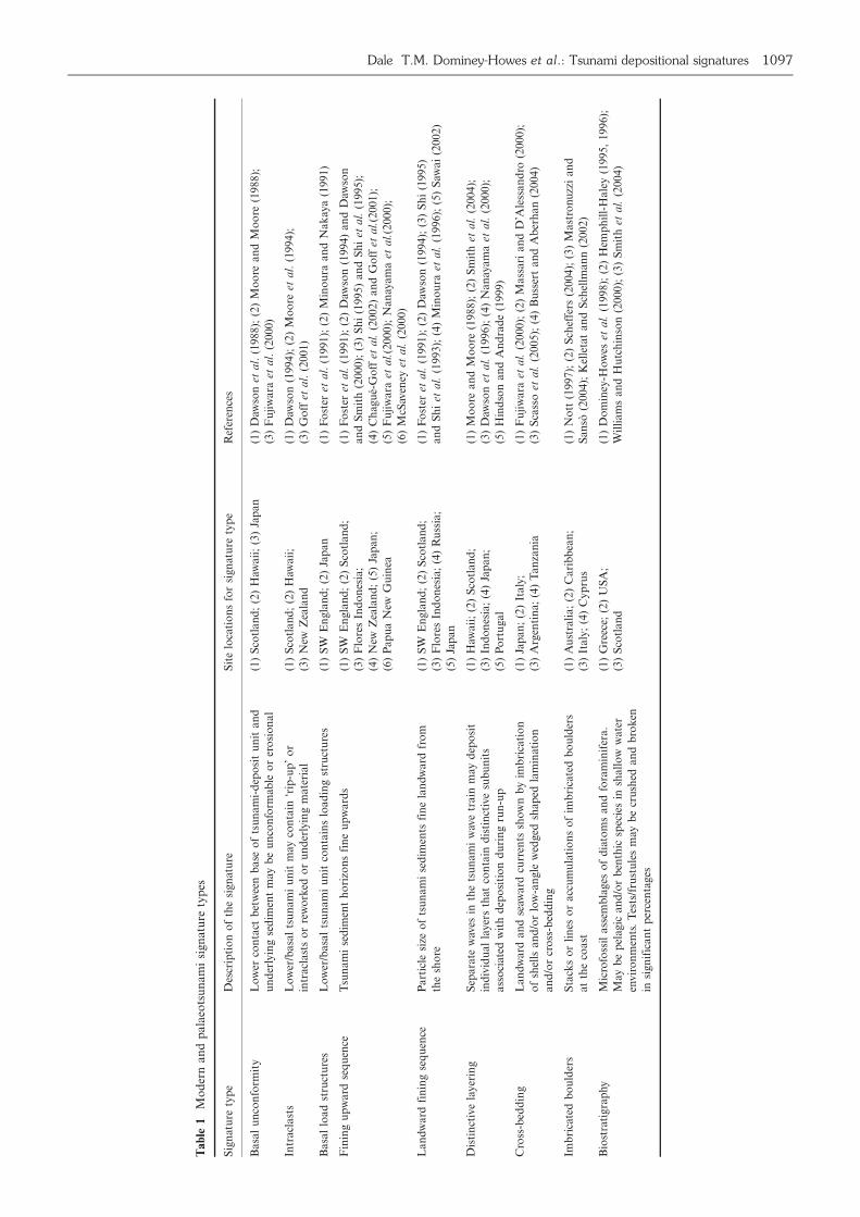
record. Table 1 summarizes the signatures identified for
modern and palaeotsunami sediments.
Tsunami sediments are frequently deposited as continuous
and discontinuous ‘sediment sheets’, which may comprise silts,
clays, sands and boulders; these sheets mantle the underlying
surface, which may have been affected by wave erosion (though
not always); rise in altitude and taper landward; are often
sharply bounded at the top and bottom; are moderately to well
sorted; are fine to massively bedded; have particle size
distributions that fine upward and landward; include rip-up
intraclasts within the body of the tsunami sediment unit and
have microfossil assemblages that suggest landward transport
of species from different water environments (or from the
marine environment into a terrestrial environmental setting)
and the shells of which may be crushed or broken (see
references cited in Table 1). Recently, boulder and megaclast
deposits together with their imbrication and orientation have
been presented as evidence of tsunami (Bryant, 2001; Bryant
and Nott, 2001; Scheffers, 2004; Mastronuzzi and Sanso,
2004). However, some authors contest this claim (Williams
and Hall, 2004) whilst others remain to be convinced (Saintilan
and Rogers, 2005). Deposition and preservation of tsunami
sediments is dependent upon an adequate sediment supply,
processes of reworking during backwash and subsequent
tsunami inundation and post-depositional environmental pro-
cesses (Dawson and Shi, 2000; Dominey-Howes, 2002).
In summary, modern and palaeotsunami studies demon-
strate that a range of sediments are deposited, that these
deposits are distinctive within the stratigraphic record and are
often characterized by unusual micro- and macrofossil assem-
blages (Dominey-Howes et al., 1998; Goff et al., 1998; Dawson
and Shi, 2000). Authors usually present a ‘suite’ of these
signatures in their analyses to argue the tsunami provenance of
specific units. Consequently, the signature types in Table 1 are
becoming used as an ‘unofficial check-list’ in identifying
evidence for tsunami.
Australian tsunamiSince the 1980s, published research suggests that the coasts of
Australia have been repeatedly impacted by (palaeo-)tsunami
(Young and Bryant, 1992; Bryant et al., 1992a,b; Young et al.,
1995, 1996; Bryant and Young, 1996; Nott, 1997, 2003a,b,
2004; Bryant, 2001; Bryant and Nott, 2001; Kelletat and
Scheffers, 2003; Switzer et al., 2005). Given the huge distances
of inundation (up to 30 km from the coast, Bryant and Nott,
2001: 242) and enormous flood run-ups (up to�/130 m a.s.l. at
Steamers Beach, Bryant et al., 1997) described, at least two (if
not more) of the reported palaeotsunami events fall within the
category of being classified as ‘megatsunami’. Consequently,
some of this work has lead to what has been referred to as the
‘Australian mega-tsunami hypothesis’ (Goff et al., 2003). If it
transpires that this hypothesis can be independently validated,
it has profound implications for investigating long-term
tsunami frequency everywhere, for understanding Australian
coastal evolutionary processes and for determining coastal
vulnerability in Australia. However, some authors have begun
to question the evidence reported for Australian palaeotsu-
nami (Felton and Crook, 2003; Goff and McFadgen, 2003;
Goff et al., 2003; Noormets et al., 2004). Given the very short
historic record of Australian tsunami (which only dates back to
AD1858; Sydney Morning Herald, 1858), careful analysis and
validation of the reported palaeotsunami record of Australia is
important for (1) contributing to the global debate about
tsunami and palaeotsunami signatures preserved within the
geological record and (2) for resolving any controversies within
the Australasian geological community.
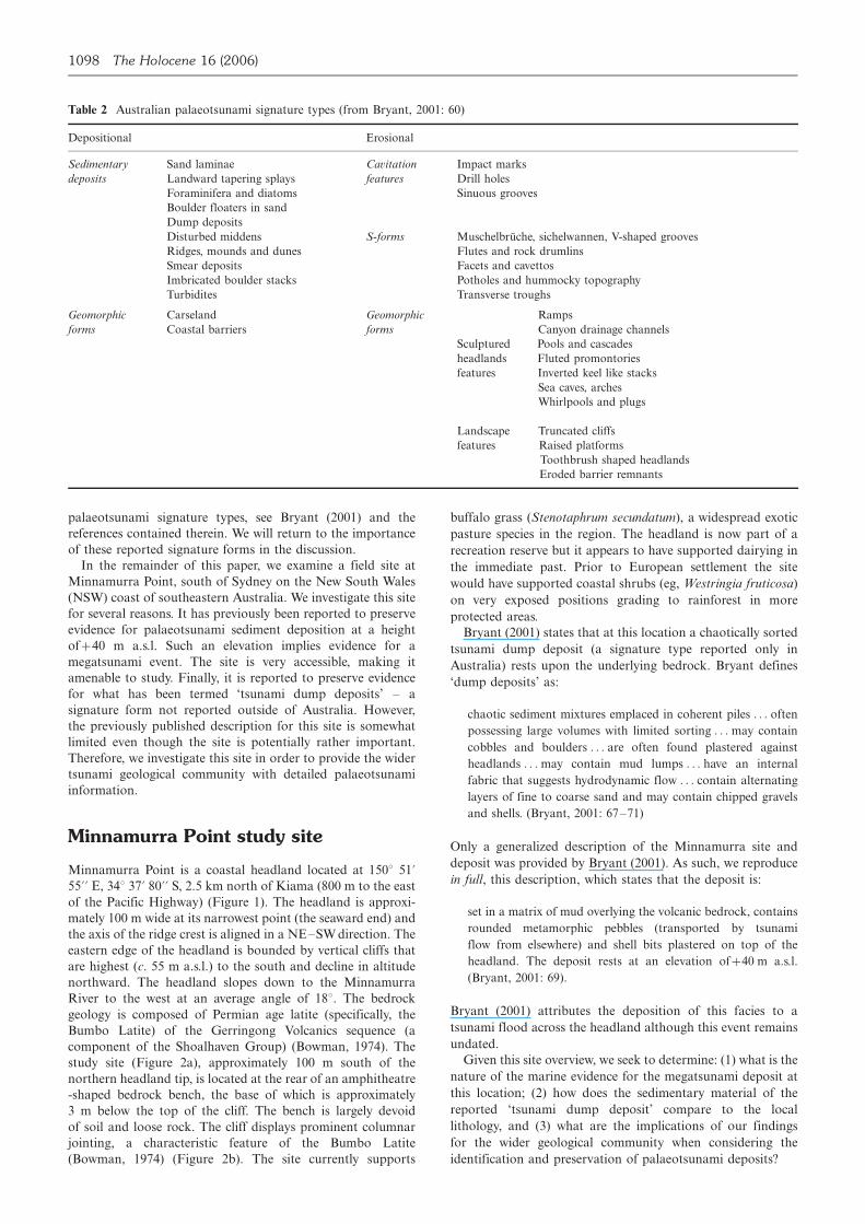
Australian palaeotsunami signaturesPart of the controversy about the Australian megatsunami
debate relates to the type of signatures used to identify
tsunami. Bryant (2001) and his co-workers have identified a
variety of signatures of tsunami impact in Australia (Table 2),
which they divide into two major classes: (1) depositional, and
(2) erosional. For both of these major classes, examples of
either ‘sedimentary deposits’ and ‘geomorphic forms’ or just
‘geomorphic forms’ are provided. Depositional signatures are
divided into small�scale individual sedimentary deposits such
as ‘sand laminae’ or ‘dump deposits’ and large�scale geomor-
phological forms such as ‘carseland’ or ‘coastal barriers’. The
erosional signatures are divided into small scale features such
as ‘drill holes’ or ‘cavettos’ eroded into rock surfaces and large
scale features that are individual geomorphological forms such
as ‘truncated cliffs’ or ‘arches’. For a fuller account of these
1096 The Holocene 16 (2006)
Ta
ble
1M
od
ern
an
dp
ala
eots
un
am
isi
gn
atu
rety
pes
Sig
nat
ure
typ
eD
escr
ipti
on
of
the
sign
atu
reS
ite
loca
tio
ns
for
sign
atu
rety
pe
Ref
eren
ces
Ba
sal
un
con
form
ity
Lo
wer
con
tact
bet
wee
nb
ase
of
tsu
na
mi-
dep
osi
tu
nit
an
d
un
der
lyin
gse
dim
ent
may
be
un
con
form
able
or
ero
sio
nal
(1)
Sco
tla
nd
;(2
)H
awa
ii;
(3)
Jap
an
(1)
Daw
son
eta
l.(1
98
8);
(2)
Mo
ore
an
dM
oo
re(1
98
8);
(3)
Fu
jiw
ara
eta
l.(2
00
0)
Intr
acl
ast
sL
ow
er/b
asa
lts
un
am
iu
nit
may
con
tain
‘rip
-up
’o
r
intr
acl
ast
so
rre
wo
rked
or
un
der
lyin
gm
ate
ria
l
(1)
Sco
tla
nd
;(2
)H
awa
ii;
(3)
New
Zea
lan
d
(1)
Daw
son
(19
94
);(2
)M
oo
reet
al.
(19
94
);
(3)
Go
ffet
al.
(20
01)
Ba
sal
loa
dst
ruct
ure
sL
ow
er/b
asa
lts
un
am
iu
nit
con
tain
slo
ad
ing
stru
ctu
res
(1)
SW
En
gla
nd
;(2
)Ja
pa
n(1
)F
ost
eret
al.
(19
91
);(2
)M
ino
ura
an
dN
ak
aya
(19
91)
Fin
ing
up
ward
seq
uen
ceT
sun
am
ise
dim
ent
ho
rizo
ns
fin
eu
pw
ard
s(1
)S
WE
ngla
nd
;(2
)S
cotl
an
d;
(3)
Flo
res
Ind
on
esia
;
(4)
New
Zea
lan
d;
(5)
Jap
an
;
(6)
Pap
ua
New
Gu
inea
(1)
Fo
ster
eta
l.(1
99
1);
(2)
Daw
son
(19
94)
an
dD
awso
n
an
dS
mit
h(2
00
0);
(3)
Sh
i(1
99
5)
an
dS
hi
eta
l.(1
99
5);
(4)
Ch
agu
e-G
off
eta
l.(2
00
2)
an
dG
off
eta
l.(2
00
1);
(5)
Fu
jiw
ara
eta
l.(2
00
0);
Na
nay
am
aet
al.
(20
00);
(6)
McS
aven
eyet
al.
(20
00)
Lan
dw
ard
fin
ing
seq
uen
ceP
art
icle
size
of
tsu
nam
ise
dim
ents
fin
ela
nd
wa
rdfr
om
the
sho
re
(1)
SW
En
gla
nd
;(2
)S
cotl
an
d;
(3)
Flo
res
Ind
on
esia
;(4
)R
uss
ia;
(5)
Jap
an
(1)
Fo
ster
eta
l.(1
99
1);
(2)
Daw
son
(19
94);
(3)
Sh
i(1
99
5)
an
dS
hi
eta
l.(1
99
3);
(4)
Min
ou
raet
al.
(19
96);
(5)
Saw
ai
(20
02)
Dis
tin
ctiv
ela
yer
ing
Sep
ara
tew
aves
inth
ets
un
am
iw
ave
train
may
dep
osi
t
ind
ivid
ua
lla
yer
sth
atco
nta
ind
isti
nct
ive
sub
un
its
ass
oci
ated
wit
hd
epo
siti
on
du
rin
gru
n-u
p
(1)
Haw
aii
;(2
)S
cotl
an
d;
(3)
Ind
on
esia
;(4
)Ja
pa
n;
(5)
Po
rtu
ga
l
(1)
Mo
ore
an
dM
oo
re(1
98
8);
(2)
Sm
ith
eta
l.(2
00
4);
(3)
Daw
son
eta
l.(1
99
6);
(4)
Na
nay
am
aet
al.
(20
00);
(5)
Hin
dso
na
nd
An
dra
de
(19
99)
Cro
ss-b
edd
ing
Lan
dw
ard
an
dse
awa
rdcu
rren
tssh
ow
nb
yim
bri
cati
on
of
shel
lsa
nd
/or
low
-an
gle
wed
ged
shap
edla
min
ati
on
an
d/o
rcr
oss
-bed
din
g
(1)
Jap
an
;(2
)It
aly
;
(3)
Arg
enti
na;
(4)
Ta
nza
nia
(1)
Fu
jiw
ara
eta
l.(2
000);
(2)
Mass
ari
an
dD
’Ale
ssan
dro
(2000);
(3)
Sca
sso
eta
l.(2
00
5);
(4)
Bu
sser
ta
nd
Ab
erh
an
(20
04)
Imb
rica
ted
bo
uld
ers
Sta
cks
or
lin
eso
ra
ccu
mu
lati
on
so
fim
bri
cate
db
ou
lder
s
atth
eco
ast
(1)
Au
stra
lia
;(2
)C
ari
bb
ean
;
(3)
Ita
ly;
(4)
Cy
pru
s
(1)
No
tt(1
99
7);
(2)
Sch
effe
rs(2
00
4);
(3)
Ma
stro
nu
zzi
an
d
Sa
nso
(2004);
Kel
leta
tan
dS
chel
lman
n(2
002)
Bio
stra
tigra
phy
Mic
rofo
ssil
ass
emb
lages
of
dia
tom
san
dfo
ram
inif
era.
May
be
pel
agic
an
d/o
rb
enth
icsp
ecie
sin
shall
ow
wate
r
envir
on
men
ts.
Tes
ts/f
rust
ule
sm
ayb
ecr
ush
edan
db
rok
en
insi
gn
ific
an
tp
erce
nta
ges
(1)
Gre
ece;
(2)
US
A;
(3)
Sco
tla
nd
(1)
Do
min
ey-H
ow
eset
al.
(1998);
(2)
Hem
ph
ill-
Hale
y(1
995,
1996);
Wil
lia
ms
an
dH
utc
hin
son
(20
00
);(3
)S
mit
het
al.
(20
04)
Dale T.M. Dominey-Howes et al.: Tsunami depositional signatures 1097
palaeotsunami signature types, see Bryant (2001) and the
references contained therein. We will return to the importance
of these reported signature forms in the discussion.
In the remainder of this paper, we examine a field site at
Minnamurra Point, south of Sydney on the New South Wales
(NSW) coast of southeastern Australia. We investigate this site
for several reasons. It has previously been reported to preserve
evidence for palaeotsunami sediment deposition at a height
of�/40 m a.s.l. Such an elevation implies evidence for a
megatsunami event. The site is very accessible, making it
amenable to study. Finally, it is reported to preserve evidence
for what has been termed ‘tsunami dump deposits’ � a
signature form not reported outside of Australia. However,
the previously published description for this site is somewhat
limited even though the site is potentially rather important.
Therefore, we investigate this site in order to provide the wider
tsunami geological community with detailed palaeotsunami
information.
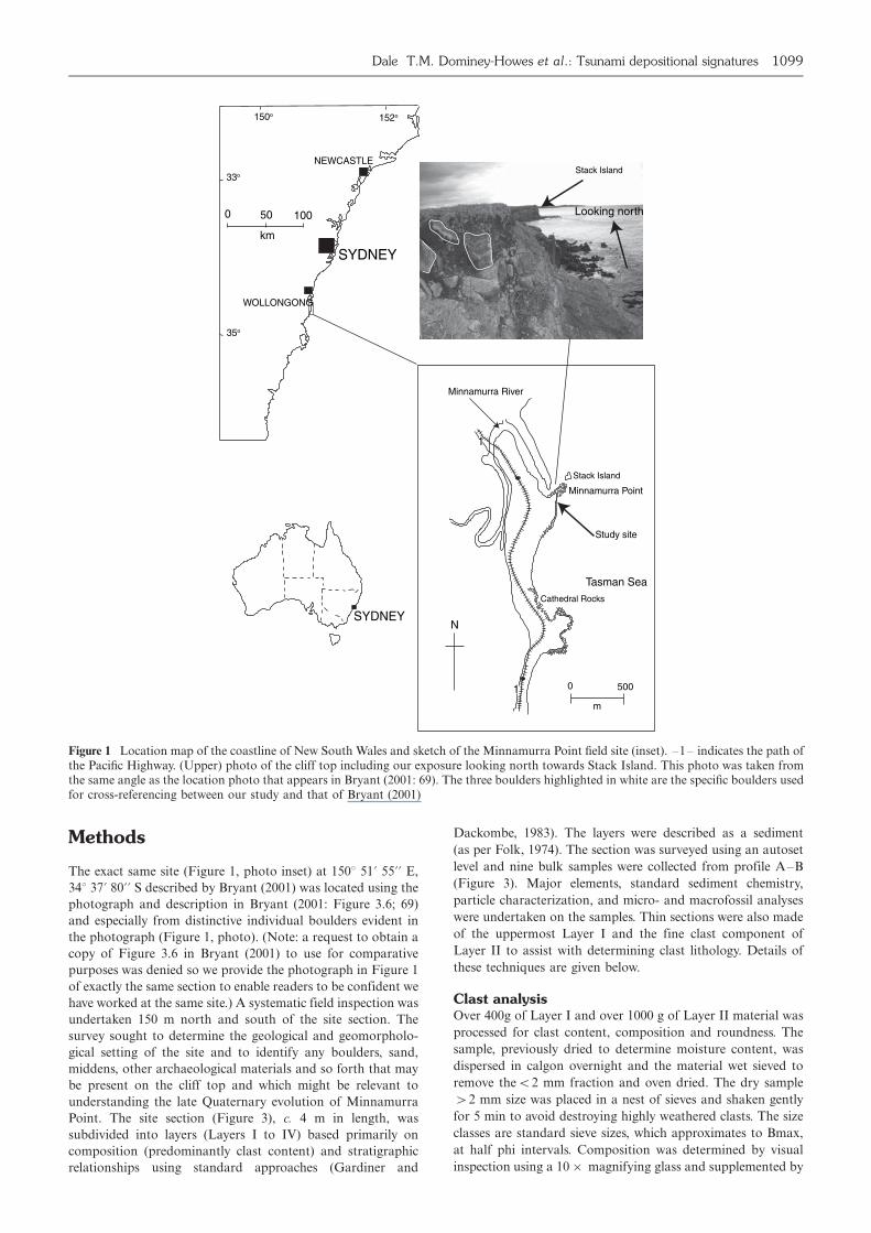
Minnamurra Point study site
Minnamurra Point is a coastal headland located at 1508 51?55?? E, 348 37? 80?? S, 2.5 km north of Kiama (800 m to the east
of the Pacific Highway) (Figure 1). The headland is approxi-
mately 100 m wide at its narrowest point (the seaward end) and
the axis of the ridge crest is aligned in a NE�SW direction. The
eastern edge of the headland is bounded by vertical cliffs that
are highest (c. 55 m a.s.l.) to the south and decline in altitude
northward. The headland slopes down to the Minnamurra
River to the west at an average angle of 188. The bedrock
geology is composed of Permian age latite (specifically, the
Bumbo Latite) of the Gerringong Volcanics sequence (a
component of the Shoalhaven Group) (Bowman, 1974). The
study site (Figure 2a), approximately 100 m south of the
northern headland tip, is located at the rear of an amphitheatre
-shaped bedrock bench, the base of which is approximately
3 m below the top of the cliff. The bench is largely devoid
of soil and loose rock. The cliff displays prominent columnar
jointing, a characteristic feature of the Bumbo Latite
(Bowman, 1974) (Figure 2b). The site currently supports
buffalo grass (Stenotaphrum secundatum), a widespread exotic
pasture species in the region. The headland is now part of a
recreation reserve but it appears to have supported dairying in
the immediate past. Prior to European settlement the site
would have supported coastal shrubs (eg, Westringia fruticosa)
on very exposed positions grading to rainforest in more
protected areas.
Bryant (2001) states that at this location a chaotically sorted
tsunami dump deposit (a signature type reported only in
Australia) rests upon the underlying bedrock. Bryant defines
‘dump deposits’ as:
chaotic sediment mixtures emplaced in coherent piles . . . often
possessing large volumes with limited sorting . . . may contain
cobbles and boulders . . . are often found plastered against
headlands . . . may contain mud lumps . . . have an internal
fabric that suggests hydrodynamic flow . . . contain alternating
layers of fine to coarse sand and may contain chipped gravels
and shells. (Bryant, 2001: 67�71)
Only a generalized description of the Minnamurra site and
deposit was provided by Bryant (2001). As such, we reproduce
in full, this description, which states that the deposit is:
set in a matrix of mud overlying the volcanic bedrock, contains
rounded metamorphic pebbles (transported by tsunami
flow from elsewhere) and shell bits plastered on top of the
headland. The deposit rests at an elevation of�/40 m a.s.l.
(Bryant, 2001: 69).
Bryant (2001) attributes the deposition of this facies to a
tsunami flood across the headland although this event remains
undated.
Given this site overview, we seek to determine: (1) what is the
nature of the marine evidence for the megatsunami deposit at
this location; (2) how does the sedimentary material of the
reported ‘tsunami dump deposit’ compare to the local
lithology, and (3) what are the implications of our findings
for the wider geological community when considering the
identification and preservation of palaeotsunami deposits?
Table 2 Australian palaeotsunami signature types (from Bryant, 2001: 60)
Depositional Erosional
Sedimentary Sand laminae Cavitation Impact marks
deposits Landward tapering splays features Drill holes
Foraminifera and diatoms Sinuous grooves
Boulder floaters in sand
Dump deposits
Disturbed middens S-forms Muschelbruche, sichelwannen, V-shaped grooves
Ridges, mounds and dunes Flutes and rock drumlins
Smear deposits Facets and cavettos
Imbricated boulder stacks Potholes and hummocky topography
Turbidites Transverse troughs
Geomorphic Carseland Geomorphic Ramps
forms Coastal barriers forms Canyon drainage channels
Sculptured Pools and cascades
headlands Fluted promontories
features Inverted keel like stacks
Sea caves, arches
Whirlpools and plugs
Landscape Truncated cliffs
features Raised platforms
Toothbrush shaped headlands
Eroded barrier remnants
1098 The Holocene 16 (2006)
Methods
The exact same site (Figure 1, photo inset) at 1508 51? 55?? E,
348 37? 80?? S described by Bryant (2001) was located using the
photograph and description in Bryant (2001: Figure 3.6; 69)
and especially from distinctive individual boulders evident in
the photograph (Figure 1, photo). (Note: a request to obtain a
copy of Figure 3.6 in Bryant (2001) to use for comparative
purposes was denied so we provide the photograph in Figure 1
of exactly the same section to enable readers to be confident we
have worked at the same site.) A systematic field inspection was
undertaken 150 m north and south of the site section. The
survey sought to determine the geological and geomorpholo-
gical setting of the site and to identify any boulders, sand,
middens, other archaeological materials and so forth that may
be present on the cliff top and which might be relevant to
understanding the late Quaternary evolution of Minnamurra
Point. The site section (Figure 3), c. 4 m in length, was
subdivided into layers (Layers I to IV) based primarily on
composition (predominantly clast content) and stratigraphic
relationships using standard approaches (Gardiner and
Dackombe, 1983). The layers were described as a sediment
(as per Folk, 1974). The section was surveyed using an autoset
level and nine bulk samples were collected from profile A�B
(Figure 3). Major elements, standard sediment chemistry,
particle characterization, and micro- and macrofossil analyses
were undertaken on the samples. Thin sections were also made
of the uppermost Layer I and the fine clast component of
Layer II to assist with determining clast lithology. Details of
these techniques are given below.
Clast analysisOver 400g of Layer I and over 1000 g of Layer II material was
processed for clast content, composition and roundness. The
sample, previously dried to determine moisture content, was
dispersed in calgon overnight and the material wet sieved to
remove theB/2 mm fraction and oven dried. The dry sample
�/2 mm size was placed in a nest of sieves and shaken gently
for 5 min to avoid destroying highly weathered clasts. The size
classes are standard sieve sizes, which approximates to Bmax,
at half phi intervals. Composition was determined by visual
inspection using a 10�/ magnifying glass and supplemented by
Cathedral Rocks
Minnamurra Point
Stack Island
Tasman Sea
1
1
Minnamurra River
SYDNEY
NEWCASTLE
WOLLONGONG
150o 152o
33o
35o
0 50
km
100
SYDNEY
Study site
0 500
m
Stack Island
N
Looking north
Figure 1 Location map of the coastline of New South Wales and sketch of the Minnamurra Point field site (inset). �1� indicates the path ofthe Pacific Highway. (Upper) photo of the cliff top including our exposure looking north towards Stack Island. This photo was taken fromthe same angle as the location photo that appears in Bryant (2001: 69). The three boulders highlighted in white are the specific boulders usedfor cross-referencing between our study and that of Bryant (2001)
Dale T.M. Dominey-Howes et al.: Tsunami depositional signatures 1099
thin section analysis. Powers roundness classes (Folk, 1974)
were used to characterize each half phi sample.
Thin sectionsSamples were placed in a mould and impregnated with araldite
under vacuum from which standard petrological sections were
produced. Two samples were examined: aggregates of Layer I
and the 2�8 mm clast fraction of Layer II.
Particle sizing of the fine earth fractionIn order to determine the particle size of the fine earth
fractions (eg, sand (63�2000 mm) and mud (B/63 mm)) of
Layers I and II, 10�25 g of sediment was air dried and gently
ground through a 2 mm mesh. The residue in each sieve nest
was collected and the volume of that fraction was calculated as
a percentage of the original mass. Samples were treated with
hydrogen peroxide to remove organic matter and dispersed in
calgon before wet sieving through a 63 mm mesh. The
gravimetric moisture content was determined from an addi-
tional 10 g sample after oven drying at 1058C for 24 h and the
result used to determine the oven-dried equivalent mass of the
dispersed sample. The loss on ignition (LOI) was determined
from the same oven-dried samples after heating to 5008C in a
muffle furnace for 24 h.
Major elementsBulk samples of the B/2 mm fraction from Layers I and II as
well as three separate clast size fractions from Layer II, and a
whole rock sample from Layer IV, were analysed by Energy-
Dispersive Polarised X-Ray Fluorescence (EDPXRF) on a
SPECTRO X-Lab 2000 X-Ray Spectrometer. This analysis was
undertaken on crushed (TEMA tungsten carbide mill) samples
(0.3�0.4 g) fused with lithium tetraborate/metaborate flux at
10508C and set in a carbon die to form glass discs. Loss on
ignition involved heating samples in a muffle furnace at 10008Cfor 4 h.
Sediment chemistryBulk samples from Layers I and II were air dried at 35�408Covernight and crushed to pass through a 2 mm sieve. Soil pH
was obtained from a 1:2 (v/v) soil�water mix with a potentio-
metric determination. Exchangeable K, Ca, Mg and Na were
obtained from a 1M neutral ammonium acetate extraction and
measured by ICP-OES. CEC is the summation of extractable
cations (K, Ca, Mg, Na) plus extractable acidity. Total carbon
and total N were obtained by a Dumas combustion. Available
P was obtained using an Olsen extraction followed by
Molybdenum Blue colorimetry. Total P was obtained from a
nitric/hydrochloric digestion and measured by ICP-OES.
Analysis was undertaken At Hill Laboratories, New Zealand,
an internationally accredited facility.
Micro- and macrofossil analysisAll bulk samples were soaked in distilled water for 2 h and wet
sieved through a stack sieve to 63 mm. Sieved samples were
oven dried at 208C for at least 24 h and the residue was
examined under the microscope. Any micro- and macrofossil
specimens were recovered and identified.
Results
The cliff top field surveyDuring the cliff top inspection we observed no boulders, sand
sheets or middens (disturbed or intact) and the cliff top is
devoid of any unusual features or deposits. However, living
gastropods were observed and, in several locations, small
amounts of shell hash and broken mollusc fragments were
present in discrete patches on the ground surface along the
headland (but not landward of the site section). Table 3 lists the
species observed.
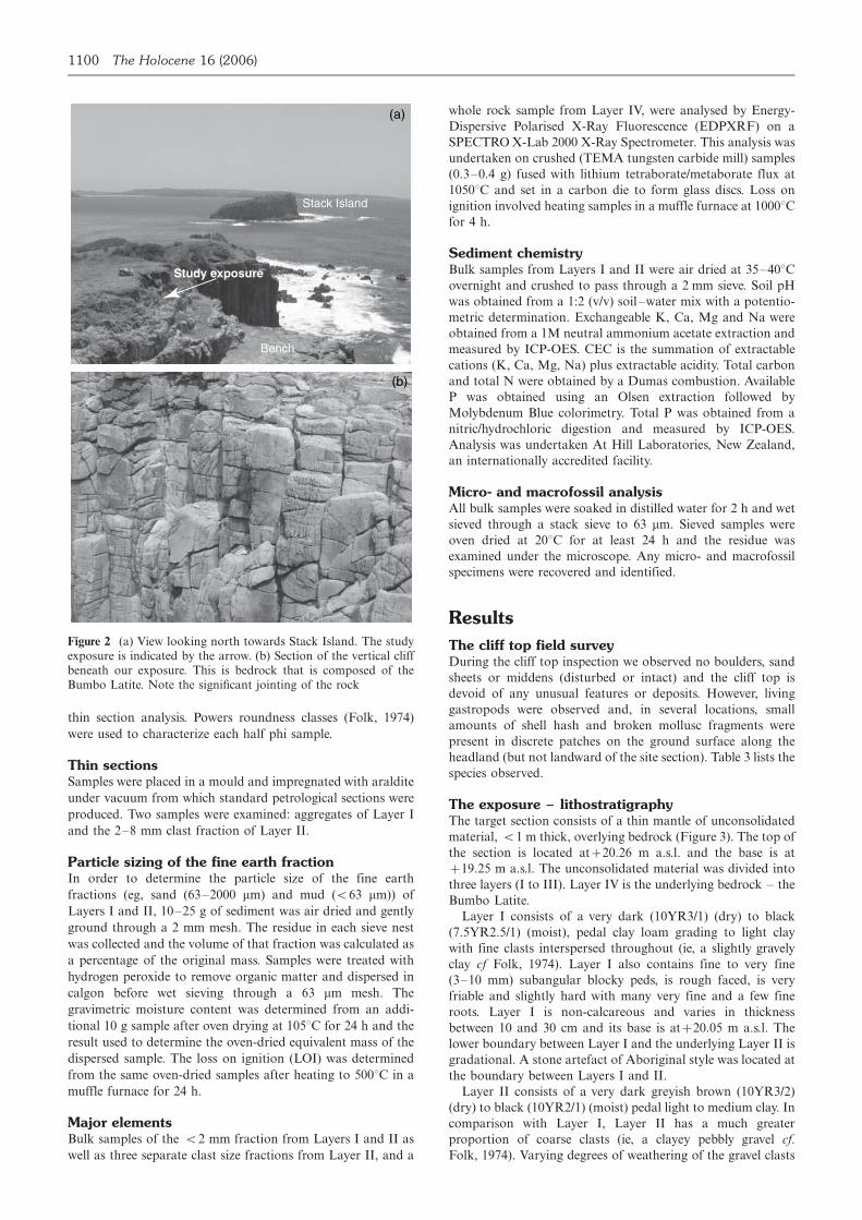
The exposure � lithostratigraphyThe target section consists of a thin mantle of unconsolidated
material, B/1 m thick, overlying bedrock (Figure 3). The top of
the section is located at�/20.26 m a.s.l. and the base is at
�/19.25 m a.s.l. The unconsolidated material was divided into
three layers (I to III). Layer IV is the underlying bedrock � the
Bumbo Latite.
Layer I consists of a very dark (10YR3/1) (dry) to black
(7.5YR2.5/1) (moist), pedal clay loam grading to light clay
with fine clasts interspersed throughout (ie, a slightly gravely
clay cf Folk, 1974). Layer I also contains fine to very fine
(3�10 mm) subangular blocky peds, is rough faced, is very
friable and slightly hard with many very fine and a few fine
roots. Layer I is non-calcareous and varies in thickness
between 10 and 30 cm and its base is at�/20.05 m a.s.l. The
lower boundary between Layer I and the underlying Layer II is
gradational. A stone artefact of Aboriginal style was located at
the boundary between Layers I and II.
Layer II consists of a very dark greyish brown (10YR3/2)
(dry) to black (10YR2/1) (moist) pedal light to medium clay. In
comparison with Layer I, Layer II has a much greater
proportion of coarse clasts (ie, a clayey pebbly gravel cf.
Folk, 1974). Varying degrees of weathering of the gravel clasts
(b)
Bench
Stack Island
Study exposure
(a)
Figure 2 (a) View looking north towards Stack Island. The studyexposure is indicated by the arrow. (b) Section of the vertical cliffbeneath our exposure. This is bedrock that is composed of theBumbo Latite. Note the significant jointing of the rock
1100 The Holocene 16 (2006)
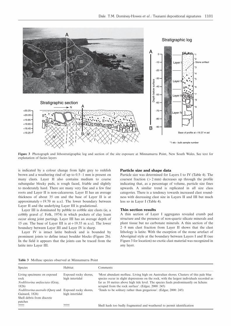
is indicated by a colour change from light grey to reddish
brown and a weathering rind of up to 0.5�1 mm is present on
many clasts. Layer II also contains medium to coarse
subangular blocky peds, is rough faced, friable and slightly
to moderately hard. There are many very fine and a few fine
roots and Layer II is non-calcareous. Layer II has an average
thickness of about 35 cm and the base of Layer II is at
approximately�/19.70 m a.s.l. The lower boundary between
Layer II and the underlying Layer III is gradational.
Layer III is dominated by pebble to cobble size clasts (ie, a
cobbly gravel cf. Folk, 1974) in which pockets of clay loam
occur along joint partings. Layer III has an average depth of
15 cm. The base of Layer III is at�/19.55 m a.s.l. The lower
boundary between Layer III and Layer IV is sharp.
Layer IV is intact latite bedrock and is bounded by
prominent joints to define intact boulder blocks (Figure 2b).
In the field it appears that the joints can be traced from the
latite into Layer III.
Particle size and shape dataParticle size was determined for Layers I to IV (Table 4). The
coarsest fraction (�/2 mm) decreases up through the profile
indicating that, as a percentage of volume, particle size fines
upwards. A similar trend is replicated in all size class
categories. There is a tendency towards increased clast round-
ness with decreasing clast size in Layers II and III but much
less so in Layer I (Table 4).
Thin section resultsA thin section of Layer I aggregates revealed crumb ped
structure and the presence of non-quartz silicate minerals and
plant tissue but no carbonate minerals. A thin section of the
2�8 mm clast fraction from Layer II shows that the clast
lithology is latite. With the exception of the stone artefact of
Aboriginal style at the boundary between Layers I and II (see
Figure 3 for location) no exotic clast material was recognized in
any layer.
... .. .... . . .................... ... .. .
............. .
.......
. ..... .................
. .........
....... .
... .... ...
. ........ .
. ..... .. ....... ..... .
... .
A
B
.
. .. . ...
. ...
. ...
. ...
. ...
. ...
. ...
. ...
.
..
.
. ...
. ...
...
. ..
.
.
..
..
..
..
.
...
..
. .
+20.25
+20.05
+19.85
+19.65
+19.45
+19.25 IVIV IV
IIII
II
III
N
0
-10
-30
-40
-50
-60
-20
-70
-80
-90
Dep
th b
elow
sur
face
.
..
...
.
..
. ... .
... ... .
..
.
. . .
..
.. .
..
.
..
. . ....
.. ..
. ...
..
.....
. . ..
.
.
...
. ...
.
.
..
.
*1
*2
*3
*4
*5
*6
*7
*9
*8
Base of profile at +19.37 m asl
*1 etc - bulk sample number
B
A
*
Stone artifact
A
BB
I
IIII
IIIIIIIIII
IVIV IVIV
Layer I
Layer II
Layer III
Layer IV
Stratigraphic section
Stratigraphic log
Figure 3 Photograph and lithostratigraphic log and section of the site exposure at Minnamurra Point, New South Wales. See text forexplanation of facies layers
Table 3 Mollusc species observed at Minnamurra Point
Species Habitat Comments
Living specimens on exposed
rock
Nodilittorina unifasciata (Gray,
1826)
Exposed rocky shores,
high intertidal
‘Most abundant mollusc. Living high on Australian shores. Clusters of this pale blue
species occur in slight depressions on the rock, with the largest individuals recorded as
far as 10 metres above high tide level. The species feeds predominantly on lichens
scraped from the rock surface’. (Edgar, 2000: 245)
Nodilittorina australis (Quoy and
Gainard, 1826)
Exposed rocky shores,
high intertidal
‘Tends to be solitary rather than gregarious’. (Edgar, 2000: 245)
Shell debris from discrete
patches
????? ????? Shell hash too badly fragmented and weathered to permit identification
Dale T.M. Dominey-Howes et al.: Tsunami depositional signatures 1101

Major elementsTable 5 presents results of major element analysis. Eleven
major elements were analysed in the following samples: (1)
Layer I; (2) Layer II; (3) Layer II gravel in the 2�4 mm
fraction; (4) Layer II gravel in the 4�8 mm fraction; (5) Layer
II gravel in the 8�16 mm fraction and (6) Layer IV latite
bedrock. Analysis of the results contained within Table 6
reveals the following trends: (1) there is an increase in the value
of S up profile; (2) there is a decrease in the value of Si, Al, Mg,
Ca, NA and P up profile; (3) there are no trends in the values
of Ti, Fe and Mn up profile. The common soluble cations
decrease in concentration in a consistent manner in order of
potassium, sodium, calcium and magnesium, with the excep-
tion of the Layer IV (latite) sample where calcium replaces
potassium. Sample 6 from Layer IV (the Bumbo Latite) has a
composition that generally rests between basalt and andesite.
Sediment chemistryTable 6 summarizes results of chemical analyses of the fine
earth fraction (B/2 mm) of the samples taken from Layers I
and II. There is little difference between Layers I and II in
terms of chemistry. In terms of Australian standards
(McDonald et al., 1984; Isbell, 1996) these materials have
high levels of base saturation, and cation exchange capacity
and exchangeable potassium, very high levels of exchangeable
magnesium and sodium but low to moderate levels of
exchangeable calcium and low available phosphorous, which
contrasts with the high total P. Organic matter and LOI are
also high.
PalaeontologySamples were examined for the presence of foraminiferids and
ostracoda. None were present in any of the samples. No
macrofossil material such as marine molluscs (bivalves and
gastropods), brachiopods, echinoderms (sea urchins, brittle
stars and star fish) and fish remains were recovered either.
Discussion
Our discussion is divided in to three parts. First, we revisit the
published global and Australian tsunami signature types and
Table 4 Summary of gravel (clast) and particle size data and gravel characteristics
Particle size class Layer I % volume Layer II % volume Layer III % volume Layer IVa % volume
Gravel (�/2 mm) content 2.6 57 70 na
Sand (63�2000 mm) content 14.0 6.9 24.2 na
Mud (B/63 mm) content 83.4 36.1 5.8 na
Clast size Roundnessb of gravel sized clasts
Layer I Layer II Layer III Layer IVa
32�64 mm no material a � sa sa � sr na
16�32 mm no material a � sa sa � sr na
8�16 mm a � sa a � sr sa � sr na
4�8 mm a � sa a � sr sr na
2�4 mm sa � sr sa � sr sr na
aLayer IV is composed of solid bedrock � there are no clasts or fine sediment available for analysis.ba, angular; sa, subangular; sr, subrounded.
Table 5 Major elements in the unconsolidated sediment, clasts and rock
Unconsolidated sediment at Minnamurra Point Rock samples
Layer I Layer II Layer II
clasts 2�4 mm
Layer II
clasts 4�8 mm
Layer II
clasts 8�16 mm
Layer IV
Bumbo Latite
Andesitea Basalta
Increasing trend
S 0.08 0.07 0.02 0.02 0.02 0.01
Decreasing trend
SiO2 43.97 43.31 49.34 50.72 52.08 54.69 58.17 50.83
Al2O3 14.39 16.50 16.13 17.15 17.62 17.85 17.26 14.07
MgO 0.89 0.92 1.64 1.75 1.86 1.80 3.23 6.34
CaO 1.17 0.85 1.78 2.39 3.26 5.67 6.93 10.42
Na2O 2.42 2.25 2.86 3.38 3.50 4.22 3.21 2.23
P2O5 0.34 0.32 0.36 0.44 0.60 0.78 0.2 0.23
No obvious trend
TiO2 1.07 1.14 1.21 1.26 1.25 1.07 0.8 2.03
Fe2O3 8.14 9.33 14.28 11.57 9.38 6.49 7.24 11.94
MnO 0.16 0.18 0.20 0.19 0.15 0.11 0.18
K2O 3.33 3.24 4.30 4.84 4.87 4.40 1.61 0.82
LOI 23.71 21.63 7.43 6.10 5.18 2.52
TOTAL 99.66 99.72 99.57 99.79 99.78 99.60
aAverage composition from Krauskopf and Bird (1995).
1102 The Holocene 16 (2006)
consider their significance. Second, we discuss the results of
our analysis of Minnamurra Point and consider what light this
work sheds on the record of palaeotsunami flooding at this
location. Third, we consider the importance of our work to the
broader debate about the preservation and identification of
palaeotsunami deposits everywhere.
Global and Australian tsunami signaturesAs more and more geological studies of modern and palaeo-
tsunami are published, we are learning much about the nature
of their deposits. From these studies a suite of distinguishing or
‘diagnostic’ signatures have become apparent. It is also
becoming clear that tsunami and palaeotsunami leave similar
signatures imprinted within the coastal landscape. However, it
is also obvious from a careful analysis of the studies listed in
Table 1 that not all tsunami result in the deposition of all of the
reported signature forms. In fact, at best, only a selection of
these signature forms may be present in any specific tsunami
facies. This is potentially rather problematic. Consequently,
whilst it is inappropriate to refute a tsunami origin for an
individual sediment facies simply because it does not contain
any (or all) of the reported signature types, it is in our opinion
the reporting authors responsibility to unequivocally demon-
strate that a particular sedimentary facies owes its origins to a
tsunami, based upon other lines of evidence such as geomor-
phological data, eye witness accounts and so forth. Further-
more, they should present a sustained argument based on
evidence that cannot be accounted for in less dramatic ways �ie, the application of Occam’s Razor.
Not withstanding the previous comment, one of the most
significant lessons of the 2004 Indian Ocean tsunami to the
Australasian geological community is that Australia is at risk
from tsunami flooding. This event did inundate coastal areas
of Western Australia, although no systematic field surveys have
been reported that quantify the extent, nature and record of
this flooding (Cummings, personal communication, 2005).
Consequently, to dismiss entirely the reported palaeotsunami
evidence in Australia as some authors have, is both unwise and
unfair. However, it is also apparent that the reported Aus-
tralian tsunami signature forms (see Table 2) differ from those
described elsewhere (see Table 1) and that many of the
Australian types are seemingly unique. Several possibilities
exist to explain these observations, including that tsunami
impacting on the Australian coastline are somehow different,
or that researchers in Australia have evolved different explana-
tions for the same evidence. There is no quick or ready solution
to this paradox other than to acknowledge that such a
difference exists and to seek ways of identifying the different
signatures as well as re-examining the published evidence. It is
this latter approach that has been followed in our study of
Minnamurra Point.
Interpretation of the Minnamurra Point siteand stratigraphyIn our cliff top survey we found no unusual geomorphological
forms or sedimentary deposits that might reasonably be
interpreted as the product of catastrophic marine inundation
(of any form). No boulders, sand sheets, coral blocks or other
features of marine origin are present. The small isolated
patches of shell hash (Table 3) are thought to relate to sea
birds eating living molluscs at a specific feeding spot (beha-
viour observed by us). The live molluscs are in living position
attached to cliff top rocks at�/20 m a.s.l. Therefore, dead
specimens probably relate to death at that location and should
not be inferred to represent evidence of marine inundation and
deposition (Williamson, personal communication, 2006).
Bryant (2001) reported that the site section is at an altitude
of�/40 m a.s.l. In fact, we levelled the site at an elevation of
just�/20 m a.s.l. Our study section consists of a thin mantle of
unconsolidated material (B/1 m thick) divided in to three layers
overlying bedrock. The pebble clasts within Layers I to III have
the same lithology (Bumbo Latite) as the underlying bedrock.
The volume of pebble clasts (as a percentage of the entire
sediment) present in each layer is highest in Layer III directly
above the bedrock and decreases up profile towards the ground
surface. Maximum clast size is also greatest in Layer III and
decreases up profile. There is also a tendency for increasing
clast roundness up profile. Taken together, these three pieces of
evidence indicate that the pebble clasts within this unconsoli-
dated sediment owe their origins to in situ weathering of the
underlying bedrock. We recognize that the fining up of the
clasts towards the top of the sequence could be indicative of
tsunami sediment deposition but the fining up can equally be
explained by natural weathering of the clasts. The major
elements (XRF analysis, Table 5) seem to indicate a consistent
weathering pattern from rock to coarse gravel to fine gravel
(Table 6). The slight reversal in trend between Layers II and I
most likely refects the influence of the higher organic matter
and hence LOI (Table 6) in the latter. Such a weathering
pattern is consistent with the presence of weathering rinds and,
presumably, neoformation to common clay minerals. With the
exception of a single stone artefact, all of our observations and
results indicate that the entire gravel fraction is derived from
the local latite.
The Bumbo Latite sample (Layer IV) has a composition
between average basalt and andesite (Krauskopf and Bird,
1995) in terms of its oxides of Si and Ti. Several other elements
are similar to the andesite including Al, Fe, Ca and Na, but Mg
is much lower and K and P are much higher (Table 6).
These observations support the regional geological mapping
(Bowman, 1974).
If a tsunami had dumped marine sediments at this location,
they might be expected to contain shell hash or microfossils as
well as sand. The analytical results do not indicate this. First,
no shell or microfossils were recovered. Second, the results of
the sediment chemical analysis demonstrate that the samples
have chemical compositions similar to the latite (indicating
local provenance) and do not contain any elevated exchange-
able Ca and higher pH values that might be expected from the
shell material that would be deposited by a tsunami and which
has been reported elsewhere (see Table 7). Bryant (2001: 69)
describes the deposit as ‘set in a matrix of mud overlying the
volcanic bedrock, contains rounded metamorphic pebbles . . .
and shell bits. The material (our Layers I and II) certainly
consists of gravel set in a mud matrix and it does overlie
volcanic rock (latite), but we could not confirm the presence of
either shell or rounded metamorphic pebbles.
Table 6 Sediment chemistry
Measure Layer I Layer II
pH (1:2 soil�water) 6.1 6.3
Extractable P (Olsen) (mg/L) 2 2
Extractable K (me/100 g) 1.64 2.01
Extractable Ca (me/100 g) 6.0 4.7
Extractable Mg (me/100 g) 10.8 10.4
Extractable Na (me/100 g) 8.65 7.88
Cation Exchange Capacity (me/100 g) 35 32
Base saturation (%) 78 79
Organic carbon (%) 10.2 6.6
Total N (%) 0.46 0.32
Total P (mg/kg) 971 879
Loss on Ignition �/5008C (%) 15.0 11.2
Dale T.M. Dominey-Howes et al.: Tsunami depositional signatures 1103

Ta
ble
7R
esu
lts
fro
mo
ur
stu
dy
sect
ion
com
pa
red
wit
hp
ub
lish
edts
un
am
i-d
epo
site
dse
dim
ent
seq
uen
ces
Kn
ow
n/r
epo
rted
chara
cter
isti
csR
efer
ence
sR
esu
lts
fro
mo
ur
stu
dy
sect
ion
Geo
chem
istr
y:
incr
ease
sin
con
cen
trat
ion
so
fso
diu
m,
sulp
hu
r,ch
lori
ne,
calc
ium
an
d
mag
nes
ium
(rel
ativ
e)to
un
der
lyin
gan
do
ver
lyin
gse
dim
ents
�in
dic
ate
ssa
lt-w
ater
inu
nd
ati
on
or/
an
dh
igh
ma
rin
esh
ell
con
ten
t.V
ari
atio
ns
ino
ther
elem
ents
may
occ
ur
dep
end
ing
on
nat
ure
of
min
eralo
gy
of
sed
imen
tsan
dan
yb
edro
ck
Go
ffet
al.
(20
01
);
Ch
ag
ue-
Go
ffa
nd
Go
ff(1
99
9);
Ch
ag
ue-
Go
ffet
al.
(20
02)
Th
ere
isa
slig
ht
incr
ease
inth
eo
xid
eso
fC
a,
Na
,K
an
dP
inL
ayer
I
over
Lay
erII
bu
tth
ese
are
all
mu
chlo
wer
tha
nin
the
gra
vel
-siz
efr
act
ion
an
dth
ela
tite
bed
rock
.G
eoch
emic
all
yit
app
ears
as
an
orm
al
wea
ther
ing
seq
uen
cew
ith
the
slig
ht
rela
tive
incr
ease
inL
ayer
Iat
trib
ute
dto
org
an
ic
mat
ter
Ma
rin
em
icro
foss
ils:
(eg
,d
iato
ms
an
dfo
ram
inif
erid
s)�
incr
ease
sin
abu
nd
an
ceo
fm
ari
ne
an
db
rack
ish
wat
erd
iato
msp
ecie
s;in
crea
ses
inp
lan
kto
nic
dia
tom
s;in
crea
ses
inth
e
per
cen
tage
of
bro
ken
dia
tom
fru
stu
les.
Mark
edch
an
ges
inm
ari
ne
fora
min
ifer
al
ass
emb
lag
es;
incr
ease
sin
the
per
cen
tag
eo
fd
eep
erw
ater
spec
ies;
incr
ease
sin
the
per
cen
tag
eo
fb
rok
enfo
ram
inif
era
lte
sts;
incr
ease
sin
abu
nd
an
ceo
fp
lan
kto
nic
fora
min
ifer
a;
intr
od
uct
ion
of
mari
ne
an
db
rack
ish
ass
emb
lages
into
oth
erw
ise
no
n-m
ari
ne
(ter
rest
rial)
sed
imen
tse
qu
ence
s
Go
ffet
al.
(20
00
,2
00
1);
Hem
ph
ill-
Hale
y(1
995);
Min
ou
raet
al.
(19
94);
Sh
enn
an
eta
l.(1
99
6);
Do
min
ey-H
ow
eset
al.
(19
98);
Daw
son
an
dS
hi
(20
00)
We
reco
ver
edn
om
ari
ne
mic
rofo
ssil
so
fa
ny
typ
e
Ma
rin
em
acr
ofo
ssil
s:(e
g,
mo
llu
scs)
�in
div
idu
al
shel
lsan
dsh
ell-
rich
un
its
oft
enp
rese
nt
(sh
ells
freq
uen
tly
art
icu
late
d)
Go
ffet
al.
(19
98
,2
00
0,
20
01);
Fu
jiw
ara
eta
l.(2
00
0);
Na
nay
am
aet
al.
(20
00)
We
reco
ver
edn
om
ari
ne
ma
cro
foss
ils
of
an
yty
pe
Wo
od
an
do
rga
nic
deb
ris:
wo
od
,w
oo
dy
mate
ria
l,va
scu
lar
pla
nt
mat
eria
la
nd
oth
er
org
an
ics
oft
enfo
un
dw
ith
ino
r‘r
aft
ed’
on
top
of
tsu
na
mi
sed
imen
tla
yer
Go
ffet
al.
(20
01
);
Do
min
ey-H
ow
eset
al.
(19
98);
Ima
mm
ura
eta
l.(1
99
7)
We
reco
ver
edn
osu
chm
ate
ria
lfr
om
ou
rsa
mp
les
oth
erth
an
liv
ing
roo
ts
fro
mg
rass
spec
ies
an
dm
ino
ra
mo
un
tso
fch
arc
oa
l.N
B,
cha
rco
al
is
com
mo
nin
Au
stra
lian
sed
imen
ts/s
oil
s
Pa
rtic
lesi
zefi
nes
upw
ard
:ts
un
am
ise
dim
ent
lay
ers
fin
eu
pw
ard
thro
ug
hse
qu
ence
Fo
ster
eta
l.(1
99
1);
Daw
son
(19
94);
Sh
i(1
99
5);
Min
ou
raet
al.
(19
96);
Saw
ai
(20
02)
Th
ere
isa
slig
ht
coa
rsen
ing
inth
efi
ne
eart
hfr
act
ion
(63�
20
00
mm)
toth
e
surf
ace
bu
tth
ere
isa
dec
rea
sein
gra
vel
con
ten
tth
atco
uld
be
inte
rpre
ted
as
fin
ing
up
wa
rdo
ra
lter
nati
vel
y,a
sa
no
rma
lw
eath
erin
gp
atte
rnin
soil
Ero
sio
na
lo
ru
nco
nfo
rmable
low
erb
ou
nd
ary
:L
ow
erco
nta
ctb
etw
een
ba
seo
fts
un
am
i-d
epo
site
d
un
ita
nd
un
der
lyin
gse
dim
ent
may
be
un
con
form
able
or
ero
sio
na
l
Daw
son
eta
l.(1
98
8);
Fu
jiw
ara
eta
l.(2
00
0)
We
ob
serv
en
ou
nco
nfo
rmit
ies
wit
hin
ou
rse
dim
ent
seq
uen
ce
1104 The Holocene 16 (2006)

All of the information presented above is consistent with the
stratigraphy being an in situ soil derived from the underlying
latite bedrock. Our sediment description correlates with other
descriptions of soils obtained during regional mapping in this
area (Parbery, 1947; Hazelton, 1992). The section is very easily
classified as a Eutric Andosol (WRB, 1998). In the Australian
soil classification system this is a Chocolate Soil using the great
soil group system of Stace et al. (1968) or a Black Dermosol
(Isbell, 1996). In order to assist readers in making an
independent judgement of our interpretation, we summarize
our data and compare our findings with published examples of
tsunami deposits (see Table 7). It is clear that our results bear
no resemblance to published tsunami deposit characteristics.
The results of our work at Minnamurra Point and various
standard laboratory analyses conducted on samples returned
to the laboratory indicate that the field site preserves no
features that demonstrate the effect of a tsunami or other
catastrophic marine inundation. We prefer the alternative
explanation that the stratigraphic sequence located at Minna-
murra Point owes its origins to the development of an in situ
soil derived from the underlying latite bedrock.
The absence of any unequivocal evidence for a tsunami is not
proof that a megatsunami has not impacted this part of the
NSW coastline. However, we suggest that there is no compel-
ling evidence for such an event. We are very surprised at being
unable to replicate the previously reported findings at Minna-
murra Point. An obvious implication from this study is that
careful and systematic re-examination of other sites reported to
contain evidence for palaeotsunami flooding in Australia
should take place so a better determination of the evidence
may be made and that controversies surrounding the Austra-
lian palaeotsunami record may be resolved.
The wider debate about the preservation of tsunamidepositsOur work at Minnamurra Point highlights two important
issues relevant to the wider tsunami community beyond
Australasia. First, there exists the possibility that when Bryant
(2001) conducted his analysis, the field evidence really was
present but, between his work and ours, that evidence has been
lost to natural environmental processes. Since we are able to
relocate specific individual clasts (see the outlined clasts in
Figure 1 photo inset) at the study site (and which are displayed
in the field photo of Bryant (2001: Figure 3.6, 69)) we doubt
this is the case but such a possibility would mean that the
preservation potential of tsunami-deposited sediments is fickle
and not guaranteed and is highly variable and site specific.
This would be enormously problematic. Second, the loss or
absence of evidence for past tsunami would mean it is
impossible to examine longer-term records of tsunami in any
given area. The implications for understanding environmental
processes, coastal landscape evolution and late-Holocene
tsunami hazard and risk cannot be understated.
Conclusion
The identification and dating of tsunami and palaeotsunami
deposits is a vital element in understanding late-Holocene
tsunami hazard and risk. To this end, much work has been
published detailing the signatures of modern and ancient
tsunami deposits. Our review of the published literature
indicates that there is some variation in the types of signatures
recognized around the world. There is no easy way to address
this difference except to acknowledge its existence and to
examine in detail sites reported to preserve evidence for
modern and palaeotsunami. In our analysis of such a site at
Minnamurra Point on the New South Wales coast of Australia,
we have been unable to identify the previously reported
evidence for a palaeomegatsunami flood. Several possibilities
exist to explain the discrepancy between the original report of
this site and the results of our investigation. The most
significant issue to arise from our study, and which is relevant
to the wider tsunami geological community, is that the
preservation potential of tsunami-deposited sediments may
be rather limited (except under very favourable conditions).
Consequently, determination of the late-Holocene tsunami
record may be rather problematic and the implications for
understanding long-term tsunami risk can not be understated.
Acknowledgements
This research was supported by Macquarie University Re-
search Grant number 9802 0222. We thank Carol Lawson of
GEMOC at Macquarie University for the XRF analyses,
Hannah Nair for examination of the shell fragments and
Jane Williamson (department of Biological Sciences, Macquar-
ie University) for assisting in the identification of the whole
mollusc specimens. Maurizio Labbate is thanked for providing
assistance in the field. We thank Alastair Dawson, Sue
Dawson, Iain Stewart and an anonymous referee for valuable
comments on an earlier draft of this paper.
Dale T.M. Dominey-Howes et al.: Tsunami depositional signatures 1105
References
Bowman, H.N. 1974: Geology of the Wollongong, Kiama and
Robertson 1: 50,000 sheets. Geological Survey of NSW, 179 pp.Bryant, E. 2001: Tsunami: the underrated hazard. Cambridge
University Press, 320 pp.Bryant, E. and Nott, J. 2001: Geological indicators of large
tsunami in Australia. Natural Hazards 24, 231�49.Bryant, E. and Young, R. 1996: Bedrock-sculpting by tsunami,
south coast New South Wales, Australia. Journal of Geology 104,
565�82.Bryant, E., Young, R. and Price, D. 1992a: Evidence of tsunami
sedimentation on the southeastern coast of Australia. Journal of
Geology 100, 753�65.Bryant, E., Young, R., Price, D. and Short, A. 1992b: Evidence for
Pleistocene and Holocene raised marine deposits, Sandon
Point, New South Wales. Australian Journal of Earth Sciences 39,
481�93.Bryant, E., Young, R., Price, D., Wheeler, D. and Pease, M. 1997:
The impact of tsunami on the coastline of Jervis Bay, southeastern
Australia. Physical Geography 18, 440�59.Bussert, R. and Aberhan, M. 2004: Storms and tsunamis: evidence
of event sedimentation in the Late Jurassic Tendaguru Beds
of southeastern Tanzania. Journal of African Earth Sciences 39,
549�55.Chague-Goff, C. and Goff, J. 1999: Geochemical and sedimen-
tological signature of catastrophic salt water inundations
(tsunami), New Zealand. Quaternary Australia 17, 38�48.Chague-Goff, C., Dawson, S., Goff, J., Zachariasen, J., Berryman,
K., Garnett, D., Waldron, H. and Mildenhall, D. 2002: A tsunami
(c. 6300 years BP) and other environmental changes, northern
Hawke’s Bay, New Zealand. Sedimentary Geology 150, 89�102.Dawson, A. 1994: Geomorphological effects of tsunami runup and
backwash. Geomorphology 10, 83�94.____ 1996: The geological significance of tsunamis. Zeitschrift fur
Geomorphologie Neues Funde Supplementen-Band 102, 199�210.____ 1999: Linking tsunami deposits, submarine slides and off-
shore earthquakes. Quaternary International 60, 119�26.Dawson, A. and Shi, S. 2000: Tsunami deposits. Pure and Applied
Geophysics 157, 875�97.
1106 The Holocene 16 (2006)
Dawson, A. and Smith, D. 2000: The sedimentology of MiddleHolocene tsunami facies in northern Sutherland, Scotland, UK.Marine Geology 170, 69�79.Dawson, A., Long, D. and Smith, D. 1988: The Storegga Slides:evidence from eastern Scotland for a possible tsunami. Marine
Geology 82, 271�76.Dawson, A., Shi, S., Dawson, S., Takahashi, T. and Shuto, N. 1996:Coastal sedimentation associated with the June 2nd and 3rd,1994 tsunami in Rajegwesi, Java. Quaternary Science Reviews 15,901�12.Dominey-Howes, D. 2002: Documentary and geological records oftsunamis in the Aegean Sea region of Greece and their potentialvalue to risk assessment and disaster management. Natural
Hazards 25, 195�24.Dominey-Howes, D., Dawson, A. and Smith, D. 1998: LateHolocene coastal tectonics at Falasarna Harbour, western Crete,Greece: a sedimentary study. In Stewart, I. and Vita-Finzi, C.,editors, Coastal tectonics. Geological Society, London, SpecialPublication 146, 343�52.Edgar, G.J. 2000: Australian marine life: the plants and animals of
temperate waters. New Holland Publishers (Australia) Pty Ltd(Revised Edition), 544 pp.Felton, A. and Crook, K. 2003: Evaluating the impacts of hugewaves on rocky shorelines: an essay review of the book ‘Tsunami �the underrated hazard’. Marine Geology 197, 1�12.Folk, R.L. 1974: Petrology of sedimentary rocks. Third edition.Hemphills.Foster, I., Albon, A., Bardell, K., Fletcher, J., Jardine, T., Mothers,R., Pritchard, M. and Turner, S. 1991: High energy coastalsedimentary deposits: an evaluation of depositional processes insouthwest England. Earth Surface Processes and Landforms 16,341�56.Fujiwara, O., Masuda, F., Sakai, T., Irizuki, T. and Fuse, K. 2000:Tsunami deposits in Holocene bay mud in southern Kanto region,Pacific coast of central Japan. Sedimentary Geology 135, 219�30.Gardiner, V. and Dackombe, R. 1983: Geomorphological field
manual. George Allen & Unwin, 254 pp.Geist, E., Titov, V. and Synolakis, C. 2006: Tsunami: wave ofchange. Scientific American January, 56�63.Goff, J. and McFadgen, B. 2003: Large earthquakes and theabandonment of prehistoric coastal settlements in 15th centuryNew Zealand. Geoarchaeology 18, 609�23.Goff, J., Sutherland, V., Cochran, U. and Shane, P. 1998: Possibletsunami deposits from the 1855 earthquake, North Island, NewZealand. In Stewart, I. and Vita-Finzi, C., editors, Coastal
tectonics. Geological Society, London, Special Publication 146,353�74.Goff, J., Rouse, H., Jones, S., Hayward, B., Cochran, U., McLea,W., Dickinson, W. and Morley, M. 2000: Evidence for anearthquake and tsunami about 3100�3400 yr ago, and othercatastrophic salt water inundations recorded in a coastal lagoon,New Zealand. Marine Geology 170, 231�49.Goff, J., Chague-Goff, C. and Nichol, S. 2001: Palaeotsunamideposits: a New Zealand perspective. Sedimentary Geology 143,1�6.Goff, J., Hulme, K. and McFadgen, B. 2003: ‘Mystic Fires ofTamaatea’: attempts to creatively rewrite New Zealand’s culturaland tectonic past. Journal of the Royal Society of New Zealand 33,795�809.Goldsmith, P., Barnett, A., Goff, J., McSaveney, M., Elliott, S. andNongkas, M. 1999: Report of the New Zealand reconnaissanceteam to the area of the 17 July 1998 tsunami at Sissano Lagoon,Papua New Guinea. Bulletin of the New Zealand Society for
Earthquake Engineering 32, 102�18.Hazelton, P.A. 1992: Soil landscapes of the Kiama 1:100 000 sheet.NSW Department Land and Water Conservation.Hemphill-Haley, E. 1995: Diatom evidence for earthquake-inducedsubsidence and tsunami 300 yr ago in southern coastalWashington. Geological Society of America Bulletin 107, 367�78.____ 1996: Diatoms as an aid in identifying late-Holocene tsunamideposits. The Holocene 6, 439�48.Hindson, R. and Andrade, C. 1999: Sedimentation andhydrodynamic processes associated with the tsunami generated
by the 1755 Lisbon earthquake. Quaternary International 56,
27�38.Imammura, S., Subandono, G., Watson, G., Moore, A., Takahashi,
T., Matsutomi, H. and Hidayat, R. 1997: Irian Jaya earthquake and
tsunami cause serious damage. EOS, Transactions of the American
Geophysical Union 78, 200�201.Isbell, R.F. 1996. The Australian soil classification. CSIRO
Publishing.Kawata, Y., Benson, B., Borrero, J., Davies, H., de Lange, W.,
Imamura, F., Letz, H., Nott, J. and Synolakis, C. 1999: Tsunami in
Papua New Guinea was as intense as first thought. EOS
Transactions, American Geophysical Union 80, 101, 104�105.Keating, B., Helsley, C., Waheed, Z. and Dominey-Howes, D. 2005:
2004 Indian Ocean tsunami in the Maldives: initial observations.
Science of Tsunami Hazards 23, 19�70.Kelletat, D. and Scheffers, A. 2003: Chevron-shaped accumula-
tions along the coastlines of Australia as potential tsunami
evidences? Science of Tsunami Hazards 21, 174�88.Kelletat, D. and Schellmann, G. 2002: Tsunami in Cyprus, field
evidences and 14C dating results. Zeitschrift fur Geomorphologie
Neue Funde 46, 19�34.Krauskopf, K.B. and Bird, D.K. 1995: Introduction to geochemistry.
Third edition, McGraw-Hill, 647 pp.Lay, T., Kanamori, H., Ammon, C., Nettles, M., Ward, S., Astre,
R., Beck, S., Bilek, S., Brudzinski, M., Butler, R., DeShon, H.,
Ekstrom, G., Satake, K. and Sipkin, S. 2005: The Great
Sumatra-Andaman earthquake of 26 December 2004. Science
308, 1127�33.Massari, F. and D’Alessandro, A. 2000: Tsunami-related scour-
and-drape undulations in Middle Pliocene restricted-bay
carbonate deposits (Salento, South Italy). Sedimentary Geology
135, 265�81.Mastronuzzi, G. and Sanso, P. 2004: Large boulder accumulations
by extreme waves along the Adriatic coast of southern Apulia
(Italy). Quaternary International 120, 173�84.McDonald, R.C., Isbell, R.F., Speight, J.G., Walker, J. and
Hopkins, M.S. 1984: Australian soil and land survey field
handbook. Inkata Press.McSaveney, M., Goff, J., Darby, D., Goldsmith, P., Barnett, A.,
Elliott, S. and Nongkas, M. 2000: The 17 July 1998 Papua New
Guinea: evidence and initial interpretation. Marine Geology 170,
81�92.Minoura, K. and Nakaya, S. 1991: Traces of tsunami preserved in
inter-tidal lacustrine and marsh deposits: some examples from
northeast Japan. Journal of Geology 99, 265�87.Minoura, K., Nakaya, S. and Uchida, M. 1994: Tsunami deposits
in a lacustrine sequence of the Sanriku coast, northeast Japan.
Sedimentary Geology 89, 25�31.Minoura, K., Gusiakov, V., Kurbatov, A., Takeuti, S., Svendsen, J.,
Bondevik, S. and Oda, T. 1996: Tsunami sedimentation associated
with the 1923 Kamchatka earthquake. Sedimentary Geology 106,
145�54.Moore, G. and Moore, J. 1988: Large-scale bedforms in boulder
gravel produced by giant waves in Hawaii. In Clifton, H., editor,
Sedimentologic consequences of convulsive geological events.
Geological Society of America Special Paper 229, 101�10.Moore, J., Bryan, W. and Ludwig, K. 1994: Chaotic deposition by a
giant wave, Molakai, Hawaii. Geological Society of America
Bulletin 106, 962�67.Nanayama, F., Shigeno, K., Satake, K., Shimokawa, K., Miyasaka,
S. and Ishii, M. 2000: Sedimentary differences between the 1993
Hokkaido-nansei-oki tsunami and the 1959 Miyakojima typhoon
at Taisei, southwestern Hokkaido, northern Japan. Sedimentary
Geology 135, 255�64.Noormets, R., Crook, K. and Felton, E. 2004: Sedimentology of
rockshorelines 3. Hydrodynamics of megaclast emplacement and
transport on a shore platform, Oahu, Hawaii. Sedimentary
Geology 172, 41�65.Nott, J. 1997: Extremely high energy wave deposits inside the
Great Barrier Reef, Australia: determining the cause � tsunami or
tropical cyclone. Marine Geology 141, 193�207.
Dale T.M. Dominey-Howes et al.: Tsunami depositional signatures 1107
____ 2003a: The importance of prehistoric data and variability of
hazard regimes in natural hazard risk assessment � examples from
Australia. Natural Hazards 30, 43�58.____ 2003b: Waves, coastal boulder deposits and the importance of
the pre-transport setting. Earth and Planetary Science Letters 210,
269�76.____ 2004: The tsunami hypothesis � comparisons of the field
evidence against the effects, on the Western Australian coast, of
some of the most powerful storms on Earth. Marine Geology 208
1�12.Parbery, N.H. 1947: Black headland soils of the south coast.
Unusual process of formation. The Agricultural Gazette (NSW)
58, 123�25.Saintilan, N. and Rogers, K. 2005: Recent storm boulder deposits
on the Beecroft Peninsula, New South Wales, Australia.
Geographical Research 43, 429�32.Satake, K., Bourgeois, J., Abe, K., Tsuji, Y., Imamura, F., Iio, Y.,
Katao, H., Noguera, E. and Estrade, F. 1993: Tsunami field survey
of the 1992 Nicaragua earthquake. EOS Transactions, American
Geophysical Union 74, 145, 156�57.Sawai, Y. 2002: Evidence for 17th century tsunamis generated on
the Kuril-Kamchatka subduction zone, Lake Tokotan, Hokkaido,
Japan. Journal of Asian Earth Sciences 20, 903�11.Scasso, R., Concheyro, A., Kiessling, W., Aberhan, M., Hecht, L.,
Medina, F. and Tagle, R. 2005: A tsunami deposit at the
Cretaceous/Paleogene boundary in the Neuquen Basin of
Argentina. Cretaceous Research 26, 283�97.Scheffers, A. 2004: Tsunami imprints on the Leeward Netherlands
Antilles (Aruba, Curacao, Bonaire) and their relation to other
coastal problems. Quaternary International 120, 163�72.Scheffers, A. and Kelletat, D. 2003: Sedimentological and
geomorphologic tsunami imprints worldwide � a review. Earth
Science Reviews 63, 83�92.Shennan, I., Long, A., Rutherford, M., Green, F., Innes, J., Lloyd,
J., Zong, Y. and Walker, K. 1996: Tidal marsh stratigraphy, sea-
level change and large earthquakes. A 5000 year record in
Washington, USA. Quaternary Science Reviews 15, 1023�59.
Shi, S. 1995: Observational and theoretical aspects of tsunamisedimentation. PhD Thesis. Coventry University, 333 pp.Shi, S., Dawson, A. and Smith, D. 1993: Geomorphological impactof the Flores tsunami of 12th December 1992. In Tsunami ’93,Proceedings of the IUGG/IOC International Tsunami Symposium,Wakayama, Japan, August 23�27, 1993, 689�96.Shi, S., Dawson, A. and Smith, D. 1995: Coastal sedimentationassociated with the December 12th 1992 tsunami in Flores,Indonesia. Pure and Applied Geophysics 144, 525�36.Smith, D., Shi, S., Cullingford, R., Dawson, A., Dawson, S., Firth,C., Foster, I., Fretwell, P., Haggart, B., Holloway, L. and Long, D.2004: The Holocene Storegga Slide tsunami in the UnitedKingdom. Quaternary Science Reviews 23, 2291�21.Stace, H.T.C., Hubble, G.D., Brewer, R., Northcote, K.H., Sleeman,J.R., Mulcahy, M.J. and Hallsworth, E.G. 1968: A handbook ofAustralian soils. Rellim Technical Publications/CSIRO.Switzer, A.D., Pucillo, K., Haredy, R., Jones, B.G. and Bryant, E.2005: Sea level, storm or tsunami: enigmatic sand sheet deposits ina sheltered coastal embayment from southeastern New SouthWales, Australia. Journal of Coastal Research 21, 655�63.Sydney Morning Herald. 12th February 1858, Sydney.Williams, D. and Hall, A. 2004: Cliff-top megaclast deposits ofIreland, a record of extreme waves in the North Atlantic � stormsor tsunamis? Marine Geology 206, 101�17.Williams, H. and Hutchinson, I. 2000: Stratigraphic andmicrofossil evidence for Late Holocene tsunamis at SwantownMarsh, Whidbey Island, Washington. Quaternary Research 54,218�27.Young, R. and Bryant, E. 1992: Catastrophic wave erosion on thesoutheastern coast of Australia: impact of the Lanai tsunami ca.105 ka? Geology 20, 199�202.Young, R., Bryant, E. and Price, D. 1995: The imprint of tsunamiin Quaternary coastal sediments of southeastern Australia.Bulgarian Geophysical Journal 21, 24�32.____ 1996: Catastrophic wave (tsunami?) transport of boulders inthe southern New South Wales, Australia. Zeitschrift fur Geomor-phologie Neues Funde 40, 191�207.WRB 1998: World reference base for soil resources. FAO.
Copyright © 2022 FDOKUMEN