An Analysis of Agricultural Systems Modelling Approaches ...
25
Citation: Vannier, C.; Cochrane, T.A.; Zawar Reza, P.; Bellamy, L. An Analysis of Agricultural Systems Modelling Approaches and Examples to Support Future Policy Development under Disruptive Changes in New Zealand. Appl. Sci. 2022, 12, 2746. https://doi.org/ 10.3390/app12052746 Academic Editor: Simone Morais Received: 17 January 2022 Accepted: 2 March 2022 Published: 7 March 2022 Publisher’s Note: MDPI stays neutral with regard to jurisdictional claims in published maps and institutional affil- iations. Copyright: © 2022 by the authors. Licensee MDPI, Basel, Switzerland. This article is an open access article distributed under the terms and conditions of the Creative Commons Attribution (CC BY) license (https:// creativecommons.org/licenses/by/ 4.0/). applied sciences Article An Analysis of Agricultural Systems Modelling Approaches and Examples to Support Future Policy Development under Disruptive Changes in New Zealand Clémence Vannier 1, *, Thomas A. Cochrane 1 , Peyman Zawar Reza 2 and Larry Bellamy 1 1 Department of Civil and Natural Resources Engineering, University of Canterbury, Private Bag 4800, Christchurch 8140, New Zealand; [email protected] (T.A.C.); [email protected] (L.B.) 2 School of Earth and Environment, University of Canterbury, Private Bag 4800, Christchurch 8140, New Zealand; [email protected] * Correspondence: [email protected] Abstract: Agricultural systems have entered a period of significant disruption due to impacts from change drivers, increasingly stringent environmental regulations and the need to reduce unwanted discharges, and emerging technologies and biotechnologies. Governments and industries are devel- oping strategies to respond to the risks and opportunities associated with these disruptors. Modelling is a useful tool for system conceptualisation, understanding, and scenario testing. Today, New Zealand and other nations need integrated modelling tools at the national scale to help industries and stakeholders plan for future disruptive changes. In this paper, following a scoping review process, we analyse modelling approaches and available agricultural systems’ model examples per thematic applications at the regional to national scale to define the best options for the national policy development. Each modelling approach has specificities, such as stakeholder engagement capacity, complex systems reproduction, predictive or prospective scenario testing, and users should consider coupling approaches for greater added value. The efficiency of spatial decision support tools working with a system dynamics approach can help holistically in stakeholders’ participation and understanding, and for improving land planning and policy. This model combination appears to be the most appropriate for the New Zealand national context. Keywords: decision-making support; integrated modelling; policy development; regional to national scale; data and skills 1. Introduction The future of agriculture depends on the system’s responses to the global challenges of climate change adaptation, carbon emission reduction, water availability, water quality restoration, and ecosystem services’ provision. Policy, technology and science have a key role to play in addressing these challenges [1–3]. Climate change, the most studied of global change challenges, is already causing major disruptions in food supply due to yield losses and subsequent chain reactions on socio-economic systems [4,5]. However, a larger range of disruptions are putting agricultural systems under pressure and could lead to major disruptions to the agro-economical system: diseases or pandemics like the Asian Swine Fever outbreak [6,7], socio economic factors (war, conflict, etc.), trade restrictions/barriers or agreements [8], new food consumption trends [9,10], and disruptive technologies such as cowless milk [11]. Technology can also be a positive factor: precision agriculture to optimise yields and minimise nutrient losses [12,13], biotechnology such as the use of seaweed for reduction of methane emissions [14,15], water/irrigation optimisation, and efficiency improvements [16], and others. The range of potential beneficial and detrimental disruptive elements highlight the urgent need to address long-term sustainability of agricultural systems [17,18]. Appl. Sci. 2022, 12, 2746. https://doi.org/10.3390/app12052746 https://www.mdpi.com/journal/applsci
-
Upload
khangminh22 -
Category
Documents
-
view
1 -
download
0
Transcript of An Analysis of Agricultural Systems Modelling Approaches ...

�����������������
Citation: Vannier, C.; Cochrane, T.A.;
Zawar Reza, P.; Bellamy, L.
An Analysis of Agricultural Systems
Modelling Approaches and Examples
to Support Future Policy
Development under Disruptive
Changes in New Zealand. Appl. Sci.
2022, 12, 2746. https://doi.org/
10.3390/app12052746
Academic Editor: Simone Morais
Received: 17 January 2022
Accepted: 2 March 2022
Published: 7 March 2022
Publisher’s Note: MDPI stays neutral
with regard to jurisdictional claims in
published maps and institutional affil-
iations.
Copyright: © 2022 by the authors.
Licensee MDPI, Basel, Switzerland.
This article is an open access article
distributed under the terms and
conditions of the Creative Commons
Attribution (CC BY) license (https://
creativecommons.org/licenses/by/
4.0/).
applied sciences
Article
An Analysis of Agricultural Systems Modelling Approachesand Examples to Support Future Policy Development underDisruptive Changes in New ZealandClémence Vannier 1,*, Thomas A. Cochrane 1 , Peyman Zawar Reza 2 and Larry Bellamy 1
1 Department of Civil and Natural Resources Engineering, University of Canterbury, Private Bag 4800,Christchurch 8140, New Zealand; [email protected] (T.A.C.);[email protected] (L.B.)
2 School of Earth and Environment, University of Canterbury, Private Bag 4800,Christchurch 8140, New Zealand; [email protected]
* Correspondence: [email protected]
Abstract: Agricultural systems have entered a period of significant disruption due to impacts fromchange drivers, increasingly stringent environmental regulations and the need to reduce unwanteddischarges, and emerging technologies and biotechnologies. Governments and industries are devel-oping strategies to respond to the risks and opportunities associated with these disruptors. Modellingis a useful tool for system conceptualisation, understanding, and scenario testing. Today, NewZealand and other nations need integrated modelling tools at the national scale to help industriesand stakeholders plan for future disruptive changes. In this paper, following a scoping reviewprocess, we analyse modelling approaches and available agricultural systems’ model examples perthematic applications at the regional to national scale to define the best options for the nationalpolicy development. Each modelling approach has specificities, such as stakeholder engagementcapacity, complex systems reproduction, predictive or prospective scenario testing, and users shouldconsider coupling approaches for greater added value. The efficiency of spatial decision supporttools working with a system dynamics approach can help holistically in stakeholders’ participationand understanding, and for improving land planning and policy. This model combination appears tobe the most appropriate for the New Zealand national context.
Keywords: decision-making support; integrated modelling; policy development; regional to nationalscale; data and skills
1. Introduction
The future of agriculture depends on the system’s responses to the global challengesof climate change adaptation, carbon emission reduction, water availability, water qualityrestoration, and ecosystem services’ provision. Policy, technology and science have a keyrole to play in addressing these challenges [1–3]. Climate change, the most studied of globalchange challenges, is already causing major disruptions in food supply due to yield lossesand subsequent chain reactions on socio-economic systems [4,5]. However, a larger rangeof disruptions are putting agricultural systems under pressure and could lead to majordisruptions to the agro-economical system: diseases or pandemics like the Asian SwineFever outbreak [6,7], socio economic factors (war, conflict, etc.), trade restrictions/barriersor agreements [8], new food consumption trends [9,10], and disruptive technologies such ascowless milk [11]. Technology can also be a positive factor: precision agriculture to optimiseyields and minimise nutrient losses [12,13], biotechnology such as the use of seaweedfor reduction of methane emissions [14,15], water/irrigation optimisation, and efficiencyimprovements [16], and others. The range of potential beneficial and detrimental disruptiveelements highlight the urgent need to address long-term sustainability of agriculturalsystems [17,18].
Appl. Sci. 2022, 12, 2746. https://doi.org/10.3390/app12052746 https://www.mdpi.com/journal/applsci

Appl. Sci. 2022, 12, 2746 2 of 25
Since the 2000s, the international community through multilateral agreements andNon-Governmental Organisations (NGOs) have advocated for countries to restore or limittheir impacts on the environment, based on policy informed by science. Agriculturalactivity, that represents almost 40% of global land use worldwide [19], is a significantcontributor to Greenhouse Gas (GHG) emissions [20,21], soil and water quality loss [22–24],biodiversity loss [25–27], and thus environmental sustainability. At the international scale,several institutions have guided recommendations, incentives, and warnings over the pasttwo decades. The Intergovernmental Panel on Climate Change (IPCC) provides assess-ments of climate change, its impacts and future risks, and recommendations; the ParisAgreement was adopted by 196 countries to limit global warming; the United Nations (UN)adopted the 17 Sustainable Development Goals (SDGs) [28,29], and the Millennium Ecosys-tem Assessment [30], by the Aichi Biodiversity Targets were formulated for conservationand restoration of biodiversity and ecosystem services by 2020 [31]. These environmentalgoals need to be synergistic with agricultural productivity and food security goals andthus the Food and Agriculture Organisation (FAO) is leading international efforts to de-feat hunger, and provide adequate nutrition for all people. All these international effortslink policy and science at a global scale and incentivise nations to tackle global changechallenges, and national governments are the key players in setting policy to enhancesustainability, resilience, productivity, and trade opportunities. Policy implementationoften requires global coordination, comprehensive, integrated, and multi-sectoral analysesto support national target-setting [32]. The national scale is thus a key scale to define policy,laws, and regulations, and also to negotiate and organise international market trade espe-cially for food security purposes or national sustainable profitability [33,34]. Agriculturalsystems need to strive for more flexibility and more adaptation options to gain resilienceunder economic, environment, and social disruptions [35].
Modelling is a useful tool for system conceptualisation, understanding, projectionof future scenarios, and hypothesis testing about the impact of disruptions in a system’soverall behaviour in relation to changes in its components. Models are generally definedby two ways: (1) their approach, i.e., how the internal process is working, and (2) theirthematic application, i.e., the thematic question they are being used for. The choice ofapproaches regarding the thematic questions is crucial for successful modelling processes.Many different modelling approaches exist and each of these have a different degree ofcomplexity, requiring different data and application skill levels, and are not equal forsystem conceptualisation, analysis, prediction or prospection [36,37]. However, all theapproaches provide some level of useful knowledge of agricultural systems and can helpdecision-making. Most agricultural models were developed from science knowledge forpolicy development and focus on agricultural sustainability and resilience [38–42]. Some ofthe available models group a wide range of indicators, such as the integrated SustainableDevelopment Goals model (iSDG, [40]), which is customisable for all countries, or theIntegrated Valuation of Ecosystem Services and Tradeoffs (InVest), a multi-ecosystem-services modelling platform [43]. Other models only focus on one part of the system,such as crop models, water models, energy models, GHG emission calculators, or climatemodels. The selection of model thus depends on the application scale, the questionsneeding answers, system complexity, and data availability.
With more than six decades of multidisciplinary contribution to concepts and tools foragricultural systems modelling, the scientific community considers models critical to makeinformed agricultural decisions [39]. However, today, only few countries seem to haveeither appropriate agricultural systems models or decision tools to support policy develop-ment under disruptive changes (i.e., EU with their CAPRI model, [41]). In New Zealand,but also more widely in other Pacific countries, there is an urgent need for assessing thedifferent pathways and interventions for a sustainable future of the agricultural sectorunder disruptive changes. Numerical and participative modelling is an option consideredby the New Zealand government, and has been requested by the industry and sectoralorganisations to gain in global understanding of the future of NZ agriculture and help

Appl. Sci. 2022, 12, 2746 3 of 25
define efficient long-term policies. As several modelling options are available, there isa need of synthesis knowledge to assist modellers and model users in selecting the mostappropriate option for future application.
The aim of this paper is (1) to analyse agricultural system modelling approaches and(2) identify available model examples for thematic applications (3) to help address currentNZ needs and support policy development. Agricultural system modelling knowledgeis synthesised to help stakeholders with model selection and future model development.Agricultural system modelling approaches are analysed and currently available, and freelyaccessible (non-commercial) models are listed per thematic application. Model processes aredescribed, as well as requirements in terms of skills and data needs, strengths, weaknesses,and the questions each is intended to answer. Discussion focuses on model usabilityand limitations.
2. The New Zealand Context
In New Zealand, nearly half of GHG emissions come from agriculture [44]. The mainsource of agricultural emissions is methane from livestock digestive systems and manuremanagement which makes up around three quarters of the agriculture emissions. Thenext largest source is nitrous oxide from nitrogen added to soils. Nitrogen also leaches togroundwater and pollutes waterways through runoff. As a result of climate change and theParis Agreement ratification, and the need to improve degraded water bodies, wetlands,streams, and groundwater, the New Zealand government has set up two major actions inthe law, the Zero Carbon Amendment Act (2019), and the National Policy Statement forFreshwater Management (2020).
The NZ food and fiber export revenue represents a third of the country’s total exportrevenue. However, with a strong market-driven agricultural system, and despite numericenvironmental targets and fixed deadlines, the NZ government (i.e., Ministry of PrimaryIndustries, regional councils, policy-makers, regulators), industries (i.e., agritech organisa-tions, lobby groups), and sectoral stakeholders (i.e., from dairy, beef and lamb, fisheries,horticulture, crops, or forestry sectors) still struggle to have a clear vision of the future ofagriculture (Figure 1).
Appl. Sci. 2022, 12, x FOR PEER REVIEW 4 of 26
Figure 1. Flow chart from disruption of NZ agricultural system, modelling need, to solution de-
sign. Surrounding in red, where an analysis and synthesis of knowledge is proposed.
3. Method
We conducted a literature-based scoping review [45], that consists in identification,
selection, and synthesis of research studies to ‘map’ relevant knowledge and gaps in the
field of interest. Here, the scoping review was conducted to synthesise knowledge about
the main agricultural systems modelling approaches and available models. To this end,
we identified, selected, and synthesised research studies, methods, and associated mod-
elling tools.
For the analysis of approaches to model agricultural systems (Section 4), a search for
bibliographic references was carried out using Google Scholar, ScienceDirect, Open edi-
tion, MDPI, and ResearchGate, searching for the following keywords: agricultural mod-
elling, agricultural system modelling, agricultural national framework, and environmen-
tal modelling approaches. The following six main types of modelling approaches emerged
from the literature review: participatory, deterministic, probabilistic, system dynamics,
agent-based, and artificial intelligence. A search of these approaches combined with agri-
culture modelling in the titles, key words, or abstracts was also carried out. Article refer-
ence lists were also checked for other pertinent articles. We focused on recent publications
in order to analyse the current scientific modelling knowledge.
For the analysis of existing models by thematic applications (Section 5), research was
carried out online with a focus on NGOs’ initiatives like the Food and Agriculture Organ-
isation, the United Nations, the Natural Capital Initiative, or policy support organisations.
Governmental websites of primary industries of developed countries were also explored
(mainly in USA, Canada, Europe, Australia, and New Zealand, as these provide broad
access to data and models). From a methodological point of view, we used a set of key
word searches on Google Scholar (related to decision support tools, agricultural model-
ling, agricultural policy model, agriculture, and ecosystem model, etc.), and a wider liter-
ature review of recent agricultural modelling reviews. We focused on developed coun-
tries’ model examples that contribute to define national policy developments. Model the-
matic applications identified through the review process were grouped as follows: Deci-
sion Support Tools (DST), crop models, water models, Greenhouse Gas emissions (GHG)
calculators, climate models, and multi-ecosystem-services’ modelling platforms.
Figure 1. Flow chart from disruption of NZ agricultural system, modelling need, to solution design.Surrounding in red, where an analysis and synthesis of knowledge is proposed.

Appl. Sci. 2022, 12, 2746 4 of 25
A NZ agricultural system model designed for policy-making purposes under disrup-tive changes should be able to address the key questions from government and industryorganisations (Figure 1). For example, climate change disruptions (i.e., recurrent droughts,flooding events, or other extreme events such as storms or spring frosts) raise questionsabout agricultural production, mechanisms to adapt to changes, or new agricultural op-portunities and actions that need to be developed to reduce anthropogenic impact onclimate change. Environmental impacts of agricultural production (i.e., the reduction ofwater quality, the increase of food demand, the loss of biodiversity, and the increase ofGHG emissions) raise questions about actions that need to be developed regarding sectoralfootprints on the environment and the need for new technology or new infrastructure toaddress these impacts. New disruptive technologies or the generalisation (i.e., connectivity)of precision agriculture and new biotechnology raise questions on the gain in environmentresilience, sustainability, and profitability that can be expected with new developments.Similarly, a model could be used to answer questions on how new policy and incentiveslimit environmental impacts.
3. Method
We conducted a literature-based scoping review [45], that consists in identification,selection, and synthesis of research studies to ‘map’ relevant knowledge and gaps inthe field of interest. Here, the scoping review was conducted to synthesise knowledgeabout the main agricultural systems modelling approaches and available models. To thisend, we identified, selected, and synthesised research studies, methods, and associatedmodelling tools.
For the analysis of approaches to model agricultural systems (Section 4), a search forbibliographic references was carried out using Google Scholar, ScienceDirect, Open edition,MDPI, and ResearchGate, searching for the following keywords: agricultural modelling,agricultural system modelling, agricultural national framework, and environmental mod-elling approaches. The following six main types of modelling approaches emerged fromthe literature review: participatory, deterministic, probabilistic, system dynamics, agent-based, and artificial intelligence. A search of these approaches combined with agriculturemodelling in the titles, key words, or abstracts was also carried out. Article reference listswere also checked for other pertinent articles. We focused on recent publications in orderto analyse the current scientific modelling knowledge.
For the analysis of existing models by thematic applications (Section 5), research wascarried out online with a focus on NGOs’ initiatives like the Food and Agriculture Organi-sation, the United Nations, the Natural Capital Initiative, or policy support organisations.Governmental websites of primary industries of developed countries were also explored(mainly in USA, Canada, Europe, Australia, and New Zealand, as these provide broadaccess to data and models). From a methodological point of view, we used a set of keyword searches on Google Scholar (related to decision support tools, agricultural modelling,agricultural policy model, agriculture, and ecosystem model, etc.), and a wider literaturereview of recent agricultural modelling reviews. We focused on developed countries’ modelexamples that contribute to define national policy developments. Model thematic appli-cations identified through the review process were grouped as follows: Decision SupportTools (DST), crop models, water models, Greenhouse Gas emissions (GHG) calculators,climate models, and multi-ecosystem-services’ modelling platforms.
4. Analysis of Approaches to Modelling Agricultural Systems
Six main modelling approaches with different levels of complexity in terms of skillsand data needs were identified (Figure 2), as well as their characteristics. Each approachis further described below, highlighting requirements for application, and their strengthsand weaknesses.

Appl. Sci. 2022, 12, 2746 5 of 25
Appl. Sci. 2022, 12, x FOR PEER REVIEW 5 of 26
4. Analysis of Approaches to Modelling Agricultural Systems
Six main modelling approaches with different levels of complexity in terms of skills
and data needs were identified (Figure 2), as well as their characteristics. Each approach
is further described below, highlighting requirements for application, and their strengths
and weaknesses.
Figure 2. Modelling approaches and associated complexity.
4.1. Participatory Approach
The participatory approach is based on the active participation of experts or stake-
holders. This approach is particularly useful and powerful when there is a lack of meas-
ured data (Figure 2). A conceptual framework of questions and systems thinking allows
for the development of theoretical models or design concepts based on expert knowledge
or stakeholders’ engagement [46]. This approach is also useful to resolve conflicts of in-
terest [47,48].
Coupling different types of expertise during the process helps strengthen the devel-
opment of a conceptual model [46] or to initiate other types of more complex modelling
and scenario simulations [47,49]. Participatory approaches for system modelling or sce-
nario development are useful to bring together expert and stakeholder knowledge from
academic, political, and civil sectors. Engaging stakeholders along with scientists is in-
creasingly used in environmental research for analysing global change impacts [50] or
sustainable futures [51,52]. Some tools have been developed to structure the participatory
approach and to help follow scientific protocols. For example, the RIO approach (Dutch
acronym for Reflexive Interactive Design) aims to structurally address complex trade-offs
and to contribute by process and design to change perspectives towards sustainable de-
velopment avoiding conflict [46,53,54].
While the participatory approach works very well at a fine scale to help farmers on
economically viable and environmentally strong decisions related to farm management
[55], it is often used as a discussion tool for structuring environmental problems and de-
sign solutions (i.e., climate change adaptation roadmap, water management, sustainabil-
ity of agricultural sector) at a larger scale (regional to national) [46,56–58]. Strengths:
• At a regional to national scale, the participatory approach is well designed for pol-
icy- and decision-making if it is sustained by upstream numerical modelling.
Figure 2. Modelling approaches and associated complexity.
4.1. Participatory Approach
The participatory approach is based on the active participation of experts or stakehold-ers. This approach is particularly useful and powerful when there is a lack of measureddata (Figure 2). A conceptual framework of questions and systems thinking allows forthe development of theoretical models or design concepts based on expert knowledgeor stakeholders’ engagement [46]. This approach is also useful to resolve conflicts ofinterest [47,48].
Coupling different types of expertise during the process helps strengthen the develop-ment of a conceptual model [46] or to initiate other types of more complex modelling andscenario simulations [47,49]. Participatory approaches for system modelling or scenario de-velopment are useful to bring together expert and stakeholder knowledge from academic,political, and civil sectors. Engaging stakeholders along with scientists is increasinglyused in environmental research for analysing global change impacts [50] or sustainablefutures [51,52]. Some tools have been developed to structure the participatory approachand to help follow scientific protocols. For example, the RIO approach (Dutch acronymfor Reflexive Interactive Design) aims to structurally address complex trade-offs and tocontribute by process and design to change perspectives towards sustainable developmentavoiding conflict [46,53,54].
While the participatory approach works very well at a fine scale to help farmers oneconomically viable and environmentally strong decisions related to farm management [55],it is often used as a discussion tool for structuring environmental problems and designsolutions (i.e., climate change adaptation roadmap, water management, sustainability ofagricultural sector) at a larger scale (regional to national) [46,56–58].
Strengths:
• At a regional to national scale, the participatory approach is well designed for policy-and decision-making if it is sustained by upstream numerical modelling.
• Expert consultation can be a quicker process than numerical modelling and it does notnecessarily need data or modelling skills.
Appl. Sci. 2022, 12, 2746 6 of 25
• When coupled with another approach, participatory process has a real benefit tointegrate stakeholders’ participation (no data can fill the “real-world” knowledge gap).
• When decision-making is the main aim, the participatory process is fundamental togaining stakeholder buy-in.
Weaknesses:
• The participatory approach can suffer several biases, including group think, dependingon the point of view of experts/stakeholders.
• It is a qualitative approach and therefore hard to quantify for coupling with other typeof approaches.
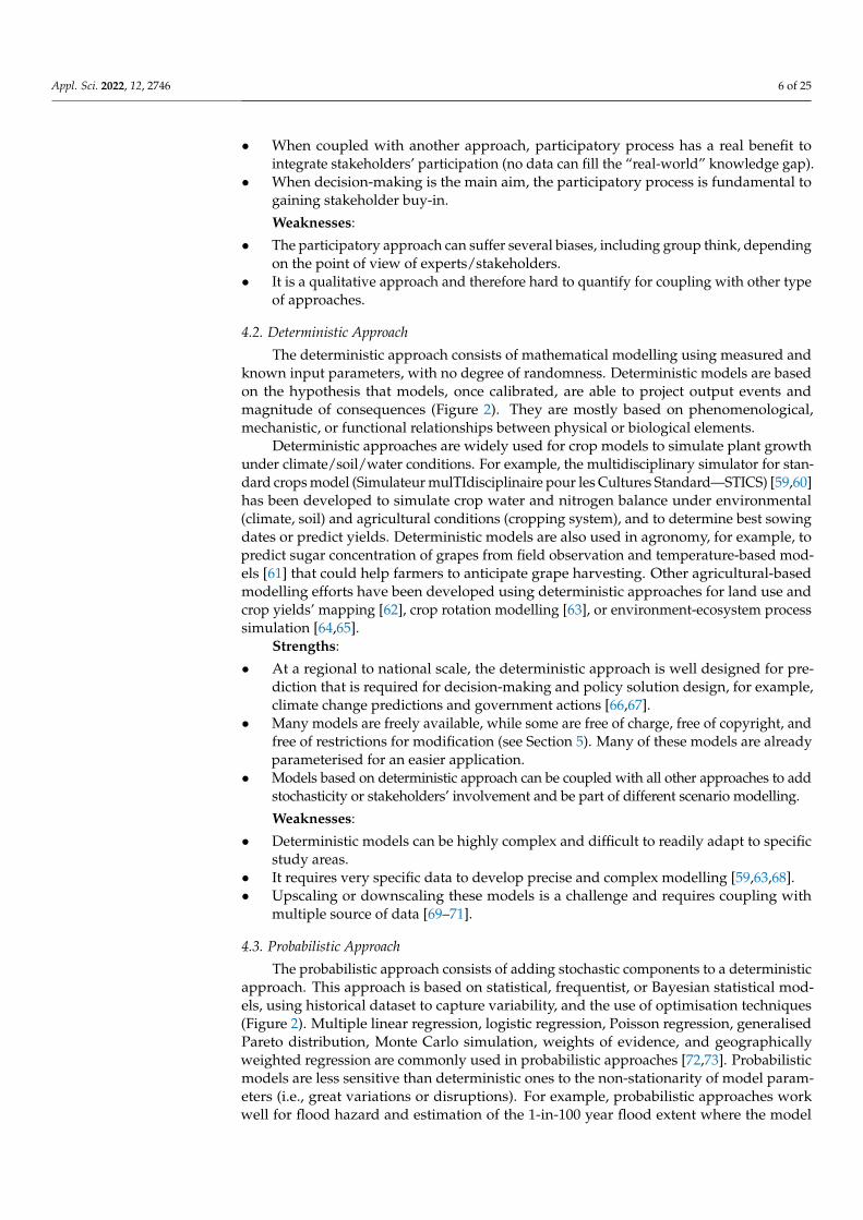
4.2. Deterministic Approach
The deterministic approach consists of mathematical modelling using measured andknown input parameters, with no degree of randomness. Deterministic models are basedon the hypothesis that models, once calibrated, are able to project output events andmagnitude of consequences (Figure 2). They are mostly based on phenomenological,mechanistic, or functional relationships between physical or biological elements.
Deterministic approaches are widely used for crop models to simulate plant growthunder climate/soil/water conditions. For example, the multidisciplinary simulator for stan-dard crops model (Simulateur mulTIdisciplinaire pour les Cultures Standard—STICS) [59,60]has been developed to simulate crop water and nitrogen balance under environmental(climate, soil) and agricultural conditions (cropping system), and to determine best sowingdates or predict yields. Deterministic models are also used in agronomy, for example, topredict sugar concentration of grapes from field observation and temperature-based mod-els [61] that could help farmers to anticipate grape harvesting. Other agricultural-basedmodelling efforts have been developed using deterministic approaches for land use andcrop yields’ mapping [62], crop rotation modelling [63], or environment-ecosystem processsimulation [64,65].
Strengths:
• At a regional to national scale, the deterministic approach is well designed for pre-diction that is required for decision-making and policy solution design, for example,climate change predictions and government actions [66,67].
• Many models are freely available, while some are free of charge, free of copyright, andfree of restrictions for modification (see Section 5). Many of these models are alreadyparameterised for an easier application.
• Models based on deterministic approach can be coupled with all other approaches to addstochasticity or stakeholders’ involvement and be part of different scenario modelling.
Weaknesses:
• Deterministic models can be highly complex and difficult to readily adapt to specificstudy areas.
• It requires very specific data to develop precise and complex modelling [59,63,68].• Upscaling or downscaling these models is a challenge and requires coupling with
multiple source of data [69–71].
4.3. Probabilistic Approach
The probabilistic approach consists of adding stochastic components to a deterministicapproach. This approach is based on statistical, frequentist, or Bayesian statistical mod-els, using historical dataset to capture variability, and the use of optimisation techniques(Figure 2). Multiple linear regression, logistic regression, Poisson regression, generalisedPareto distribution, Monte Carlo simulation, weights of evidence, and geographicallyweighted regression are commonly used in probabilistic approaches [72,73]. Probabilisticmodels are less sensitive than deterministic ones to the non-stationarity of model param-eters (i.e., great variations or disruptions). For example, probabilistic approaches workwell for flood hazard and estimation of the 1-in-100 year flood extent where the model

Appl. Sci. 2022, 12, 2746 7 of 25
question is already a probability that needs mapping representation [74]. Many statisticalmodels are developed using quantitative data table that can be coupled with a deterministicsystem response (i.e., crop yield, milk production, or farmers–consumers’ prices) [39]. Theprobabilistic approach, however, lacks extrapolation power because of the data dependencyfor parameterisation.
The probabilistic approach is also useful for understanding statistical relationshipsbetween drivers of changes. This type of approach works well for Land Use and LandCover Change (LULCC) modelling by coupling statistical methods like Markov chain forquantifying change over years, and to integrate probability in changes in maps [75,76],or for agricultural–economic production relationship analysis [77], historical data, andreconstruction of crop sequences [78], or allocation-optimisation based on statistical multi-criteria analysis [79].
Strengths:
• At a regional to national scale, this approach is well designed for land-use changedynamic analysis and for policy adaptation [75,80,81].
• With a large amount of data available freely, the probabilistic approach can be easilyconsidered both for statistical and spatial trend analysis.
• Coupling deterministic and probabilistic approaches can lead to powerful modellingof the climate change adaptation for agriculture and land-use strategies.
Weaknesses:
• Statistical models are inherently unsuited to predict the impact of major disruptionsbecause of the historical data/parameterisation dependency for this approach.
• Analysis tools are freely available (R, Q-GIS), but advanced skills in data processingare needed.
4.4. System Dynamics Approach
The system dynamics (SD) approach is a scientific framework for addressing complexand non-linear feedback systems [82]. This systems thinking approach contrasts withprobabilistic and deterministic approaches by their ability to describe non-linearity of thechanges in system states responding to external drivers [83] (Figure 2). SD models areusually used for energy policy development, environmental policy analysis, innovationimpact evaluation, strategic planning, and public policy evaluation [84–86]. The SD pro-cess is iterative and interactive, and stakeholders can be involved at every stage of theprocess from question definition, to conceptual/mental model building, formal modeldevelopment strategy, and scenario testing feedback. SD models are designed to addressthe “What if?” question of a complex problem and are useful for prospective scenariotesting. Consequently, they are widely used to develop efficient Decision Support Tools(DST) to help in policy development and decision-making, and are often coupled withother types of models (see Section 4, and Table 1).
SD approach has been widely used in hydrology and water resources management [87–89],agricultural land and soil resources [90,91], or food system resilience [92–95].
Strengths:
• At a regional to national scale, the system dynamics approach is well designed forscenario testing and policy prospection.
• SD approach allows multi-disciplinary and multi-method integration. Other approachescan be coupled/linked with SD (participatory, deterministic, probabilistic approaches) tobetter emphasise the complexity of agricultural and natural resources issues.
• SD approach is suitable to reproduce agricultural systems’ organisation and to designnew strategies or to experiment management/policy scenarios [96].

Appl. Sci. 2022, 12, 2746 8 of 25
Weaknesses:
• The main difficulty in SD approach is validation. Especially when modelling disrup-tive scenarios, and when internal (model behaviour) and external (outputs) validationpossibilities are limited [97]. However, a range of tools can be used to help for valida-tion: the use of local knowledge (participatory-expertise approach) and historical datafor calibration (probabilistic approach); running sensitivity analysis of key variables, oranalysing scenarios and results in comparison with expert opinions (expert modellersand expert stakeholders).
• There is a risk of formulating erroneous policy by trusting simulations of invalidatedmodels [91].
4.5. Agent-Based Approach
The agent-based approach consists in modelling a system with autonomous decision-making entities interacting with their environment [98]. Agent-based models (ABMs) aim toreproduce real-world-like complexity (Figure 2). ABMs are usually based on a parsimoniousparadigm [99] that leads to simple models with great explanatory power. This modellingapproach is the only multi-level approach, allowing emergence of processes and feedbackloops that mean behaviour adaptation of individuals or groups of individuals [99–102].This makes the ABMs very useful to simulate behaviour adaptation to new incentives, ornew policy, especially for scenario testing [103].
ABMs can be used as spatially explicit models. Using real (i.e., GIS layers or pixelgrids) or virtual landscapes accounting for the spatial dimension, distance, and timeconcepts, ABMs allow coupling with LULCC models to analyse the processes causing thechanges [102,104]. For example, farming decisions depend on incentives and interactionsat different levels of organisation, such as interactions with other farmers, institutions,associations, markets, or other networks [100,101,104,105]. ABMs are also useful to testindividual and collective adaptations to new policy, for example, GHG price effect [102], oradaptation capacity of winegrowers to climate change [106].
Strengths:
• At a regional to national scale, the ABM approach is well designed to simulate societyor stakeholders’ behaviour facing new policy.
• ABM approach allows coupling of models (using additional physical deterministicmodels like crop or climate models).
• ABM approach allows for the development of conceptual models to test simple agentbehaviours or the combination of behaviours under different incentives.
• ABM approach can simulate disruptions and agent adaptation capacities to a systemat different organisation levels and scales.
Weaknesses:
• Like SD, it is difficult to validate ABMs, but a range of tools can be used: the validationof the conceptual framework (by external experts or stakeholders), a robust sensitivityanalysis to make sure conclusions fit with the model [104].
• ABMs are not suitable for prediction but powerful for scenario testing.
4.6. Artificial Intelligence
Artificial Intelligence (AI) is an interdisciplinary approach consisting of a set of algo-rithms trying to mimic human intelligence. AI is already widely used for fraud detectionand prediction models, image recognition patterns, spam filters, speech and audio recogni-tion (Google, Siri, Cortana, Alexa, etc.) and others [107]. Machine learning algorithms anddeep learning tools are commonly used to automatically learn from data, such as sensordata or databases, to recognize complex patterns and make intelligent decisions basedon data [108]. AI allows for analysing big data quickly [109], regardless of complexity(Figure 2). In agricultural sciences, AI is widely used for predicting crop yields [110], forprecision agriculture [107], agriculture automation [111], disease detection, and weed, crop,
Appl. Sci. 2022, 12, 2746 9 of 25
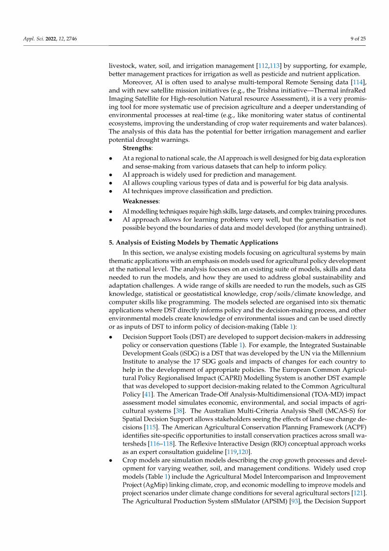
livestock, water, soil, and irrigation management [112,113] by supporting, for example,better management practices for irrigation as well as pesticide and nutrient application.
Moreover, AI is often used to analyse multi-temporal Remote Sensing data [114],and with new satellite mission initiatives (e.g., the Trishna initiative—Thermal infraRedImaging Satellite for High-resolution Natural resource Assessment), it is a very promis-ing tool for more systematic use of precision agriculture and a deeper understanding ofenvironmental processes at real-time (e.g., like monitoring water status of continentalecosystems, improving the understanding of crop water requirements and water balances).The analysis of this data has the potential for better irrigation management and earlierpotential drought warnings.
Strengths:
• At a regional to national scale, the AI approach is well designed for big data explorationand sense-making from various datasets that can help to inform policy.
• AI approach is widely used for prediction and management.• AI allows coupling various types of data and is powerful for big data analysis.• AI techniques improve classification and prediction.
Weaknesses:
• AI modelling techniques require high skills, large datasets, and complex training procedures.• AI approach allows for learning problems very well, but the generalisation is not
possible beyond the boundaries of data and model developed (for anything untrained).
5. Analysis of Existing Models by Thematic Applications
In this section, we analyse existing models focusing on agricultural systems by mainthematic applications with an emphasis on models used for agricultural policy developmentat the national level. The analysis focuses on an existing suite of models, skills and dataneeded to run the models, and how they are used to address global sustainability andadaptation challenges. A wide range of skills are needed to run the models, such as GISknowledge, statistical or geostatistical knowledge, crop/soils/climate knowledge, andcomputer skills like programming. The models selected are organised into six thematicapplications where DST directly informs policy and the decision-making process, and otherenvironmental models create knowledge of environmental issues and can be used directlyor as inputs of DST to inform policy of decision-making (Table 1):
• Decision Support Tools (DST) are developed to support decision-makers in addressingpolicy or conservation questions (Table 1). For example, the Integrated SustainableDevelopment Goals (iSDG) is a DST that was developed by the UN via the MillenniumInstitute to analyse the 17 SDG goals and impacts of changes for each country tohelp in the development of appropriate policies. The European Common Agricul-tural Policy Regionalised Impact (CAPRI) Modelling System is another DST examplethat was developed to support decision-making related to the Common AgriculturalPolicy [41]. The American Trade-Off Analysis-Multidimensional (TOA-MD) impactassessment model simulates economic, environmental, and social impacts of agri-cultural systems [38]. The Australian Multi-Criteria Analysis Shell (MCAS-S) forSpatial Decision Support allows stakeholders seeing the effects of land-use change de-cisions [115]. The American Agricultural Conservation Planning Framework (ACPF)identifies site-specific opportunities to install conservation practices across small wa-tersheds [116–118]. The Reflexive Interactive Design (RIO) conceptual approach worksas an expert consultation guideline [119,120].
• Crop models are simulation models describing the crop growth processes and devel-opment for varying weather, soil, and management conditions. Widely used cropmodels (Table 1) include the Agricultural Model Intercomparison and ImprovementProject (AgMip) linking climate, crop, and economic modelling to improve models andproject scenarios under climate change conditions for several agricultural sectors [121].The Agricultural Production System sIMulator (APSIM) [93], the Decision Support

Appl. Sci. 2022, 12, 2746 10 of 25
System for Agrotechnology Transfer (DSSAT) [122], or Aquacrop model to assess cropgrowth, crop yield or food security issues [123]. Other crop models not presentedin Table 1 included models that are focussed on enhancing scientific understanding,more complex to use, and required a large amount of data and skills.
• General water models (Table 1) are developed to understand or manage water qualityand quantity of hydrological processes under different physical and management con-ditions. Two water models provided by FAO are CropWat, that links crop and watermodelling to calculate crop water and irrigation requirements based on soil, climate,and crop data [124], and Aquastats, which monitors the SDG 6 (ensure availability andsustainable management of water and sanitation for all), and in particular on waterstress and water use efficiency [125]. Other widely used water models include Wa-terWorld [126], developed to understand hydrological processes and water resources,and the Soil and Water Assessment Tool (SWAT), a small watershed to river basin-scalemodel used to simulate the quality and quantity of surface and ground water, andpredict the environmental impact of land use, land management practices, and climatechange [127,128]. Additionally, many multi-service platforms provide general watermodelling tools.
• Greenhouse gas emission (GHG) calculators mostly focus on deterministically es-timating carbon and methane emissions (Table 1). Among GHG calculators [129],easy-to-use models that provide great added value on mitigation possibilities includethe Ex-Ante Carbon-balance Value Chain Tool (Ex-ACT VC) developed by FAO toincrease resilience of populations and ecosystems, and to decarbonize the globaleconomy [130,131], the Agro Chain Greenhouse Gas Emission calculator (ACGE),which estimates total GHG emissions associated with food products [132], and the Cli-mate Change, Agriculture and Food Security-Mitigation Options Tool (CCAFS-MOT),a mitigation options tool estimating GHG emissions from multiple crop and livestockmanagement practices [133].
• Climate models take into account complex atmosphere–ocean–land surface–cryosphereinteractions through physics-based knowledge. A full review of climate models is outof the scope of this paper, but the Climate Analogues model provided by FAO [134]caught our attention for its adaptation-focus approach (Table 1). This model identifiesareas that experience statistically similar climatic conditions, but which may be sepa-rated temporally and/or spatially. The approach allows locating areas whose climatetoday is similar to the projected future climate of a place of interest, or vice versa.The approach allows comparing agricultural systems working in “future” climateconditions to help define adaptation strategies.
• Multi-service platforms are a shell of models related to Ecosystem Services quantifi-cation, mapping, and modelling. They group agricultural production, carbon stock,pollination, water quality, and other models together (Table 1). Multi-service platformsinclude the widely used Integrated Valuation of Ecosystem Services and Tradeoffs(InVest) [43], the Toolkit for Ecosystem Service Site-Based Assessment (TESSA) [135],or the Co$ting Nature platforms developed to explore how changes in ecosystems canlead to changes in the flows of many different benefits to people [136].

Appl. Sci. 2022, 12, 2746 11 of 25
Table 1. Examples and thematic applications of national and regional agro-environmental models.
ModelApplication
ModellingApproach Model Name Spatial Scale Input Data Needs Model Aim Skills Needed Strengths (+)/
Weaknesses (−) Comments References
Dec
isio
nsu
ppor
ttoo
l
Syst
emdy
nam
ics
IntegratedSustainable
DevelopmentGoals (iSDG)
National scale,country-based
model.
Worldwide data onsocial, economic,
and environmentalsectors.
Policy simulation tooldesigned to help
policy-makers andstakeholders make sense of
interconnections between theSDGs. iSDG focuses the
dynamic interactions withinthe SDG system to reveal thebest paths and progression
towards achieving the SDGs.
Model open forcollaboration
with the iSDGteam to developown country’s
example.
+: Already implementedmodel around the
17 SDGs defined by theMillennium Institute.
Developed first forfood security issues;also used for otherquestions like clean
energy use in the USA.Could be interested to
develop fora carbon-neutral
objective.
[40]https://www.millennium-
institute.org/isdg(accessed on
1 December 2021)
−: Not agriculturalsystem model only.
Wider than agriculturalsector.
Non-spatial modelling.Indicator scores only.
Syst
emdy
nam
ics Common
AgriculturalPolicy
RegionalisedImpact
(CAPRI)modelling
system
European Union(27) +Norway,
Western Balkans,Turkey scale,NUTS2 scale(280 regions),and 10 farm
types for eachregion.
Economic data,farm/market
balance, unit valueprices, policy
variables. Dataprovided by
FAOSTAT andEurostat.
Economic model developedby EU to support
decision-making related tothe Common AgriculturalPolicy based on scientific
quantitative analysis.
High skills (GIS,programma-
tion).
+: Already developed,stable, and complete
process for EU. Spatialmodelling.
Multifunctionalityindicators analysis
(food security,landscape,
environment, ruralviability), applied to
the agricultural sector,with an economic
model.
[41]https://www.
capri-model.org/dokuwiki/doku.php (accessed on1 December 2021)
−: Can be adapted toother countries around
the world but withheavy development to
plan.
Syst
emdy
nam
ics
TradeoffAnalysis—
MultiDimensional
impactassessment(TOA-MD)
National,regional to local
scale.
Whole farm system(crops, livestock,
aquaculture,income), simulatingeconomic indicators,threshold indicators
for any otherquantifiableeconomic,
environmental, orsocial outcome.
Model developed to improvethe understanding ofagricultural system
sustainability and informpolicy decisions. TOA-MD
can be used to analysetechnology adoption,
payment of ecosystemservices, environmental
change impact, andadaptation.
Medium to highskills.
+: Already developed,stable, and complete
process.Free and easy access tothe full model. Modellink with AgMIP crop
model.Spatial modelling.
Developed by OregonState University/USACan be requested by
registration formonline.
[38]https://agsci.
oregonstate.edu/tradeoffs/about-toa (accessed on
1 December 2021)
Det
erm
inis
tic/
Prob
abili
stic
Multi-CriteriaAnalysis Shell
for SpatialDecisionSupport
(MCAS-S)
International,national,
regional, andcatchment scale.
GIS data/maplayers.
MCAS-S informs spatialdecision-making and help
with stakeholderengagement. Model showstransparently how mapped
information can be combinedto meet an objective. Modelallows stakeholders to see
the effects that theirdecisions may have.
Medium to highGIS skills.
+: Already developed,stable, and complete
process.Free and easy access tothe full model. Already
used for severalresources management
and adaptation.Spatial and multi-criteria
statistical modelling.
Developed by theAustralian
Department ofAgriculture, Water and
the Environment.Download available
for free.
[115]https://www.
agriculture.gov.au/abares/
aclump/multi-criteria-analysis
(accessed on1 December 2021)

Appl. Sci. 2022, 12, 2746 12 of 25
Table 1. Cont.
ModelApplication
ModellingApproach Model Name Spatial Scale Input Data Needs Model Aim Skills Needed Strengths (+)/
Weaknesses (−) Comments ReferencesD
eter
min
isti
c/Pr
obab
ilist
ic AgriculturalConservation
PlanningFramework
(ACPF)
Watershed toregional scale.
GIS land use andsoils.
ACPF informs and engageslocal producers in
agricultural conservation. Ithelps in engaging with
stakeholders and buildingconservation solutions.
Medium to highGIS skills.
+: ArcGis toolboxmodule.
Users are able to buildtheir own database.
Spatial and multi-criteriastatistical modelling.
Model available forfree as an ArcGis
module. Already usedby conservationplanners, project
coordinators, agencystaff etc.
[116–118]https://acpf4
watersheds.org/(accessed on
1 December 2021)
Part
icip
ator
yap
proa
ch ReflexiveInteractive
Design(RIO)
Aspatial,conceptual
process.
Expert consultationapproach, need for
knowledge, not data.
RIO structurally addressescomplex trade-offs and
contributes by process anddesign to change towardssustainable development.
Low skills, buthigh field or
systemknowledge
needed.
+: First step to designa new system approach.
Interesting forstakeholders’
engagement without anyskills requested.
–
[119,120]ActionCatalogue-
method(accessed on
1 December 2021)−: No quantification norspatial analysis. Onlyconceptual approach.
Cro
pM
odel
Phys
ical
/D
eter
min
isti
c AgriculturalModel Inter-comparison
andImprovement
Project(AgMIP)
World tonational scale.
Worldwide data onclimate, crops, and
economy.
AgMIP was developed toimprove agricultural models
for assessing impacts ofclimate variability and
change and other drivingforces on agriculture, food
security, and poverty.
Medium to lowcomputational
skills.
+: Use worldwidedataset, good for
country comparisons.Online model with data
translator. Developed for foodsecurity issues.
[121]https:
//agmip.org/(accessed on
1 December 2021)−: Only sectoralapplications, no generaloverview of agricultural
systems.
Phys
ical
/D
eter
min
isti
c
AgriculturalProduction
SystemSimulator(APSIM)
Global to localscale.
Field data andobservation needed.
APSIM is a highly advancedmodel for modelling andsimulation of agricultural
systems. It contains a suite ofmodules that enable the
simulation of systems fora diverse range of plant,animal, soil, climate, andmanagement interactions.
High skills oncrop modelling
needed.
+: Very precise farmingmodel.
More than only crops.Online downloadavailable for free.
Based on crop model,with other parameterslarger than only crops
(like livestock, andclimate variability
effects). Developed inAustralia and New
Zealand.
[93]https://www.
apsim.info/(accessed on
1 December 2021)−: Not easy to use.
Require very preciseagronomic knowledge.No spatial component.
Phys
ical
/D
eter
min
isti
c DecisionSupport
System forAgrotechnol-ogy Transfer
(DSSAT)
Aspatial model.
42 cropsimplemented,
databasemanagement for soil,
weather, cropmanagement,
experimental data.
The DSSAT crop modelsimulates growth,
development, and yield asa function of the
soil–plant–atmospheredynamics.
High skills oncrop modelling
needed.
+: already implementedfor 42 crops.
Online downloadavailable for free.
[122]https://dssat.net/
about/(accessed on
1 December 2021)−: Crop model only.

Appl. Sci. 2022, 12, 2746 13 of 25
Table 1. Cont.
ModelApplication
ModellingApproach Model Name Spatial Scale Input Data Needs Model Aim Skills Needed Strengths (+)/
Weaknesses (−) Comments ReferencesPh
ysic
al/
Det
erm
inis
tic
AquaCrop Aspatial model.
Weather data, cropand soil
characteristics,management
practices.
Crop growth modeldeveloped by the Land andWater Division of FAO to
address food security and toassess the effect ofenvironment and
management on cropproduction. Crop yieldprediction model under
vertical conditions.
Medium to highskills in crop
modelling andagronomy.
+: Good to assist formanagement decisionson irrigation or on crop
response toenvironmental changes. Software available
online for free.Provided by FAO.
[123]http://www.fao.org/aquacrop/
overview/whatisaquacrop/en/ (accessed on1 December 2021)
−: No spatialcomponent.
Wat
er/C
rop
mod
el
Phys
ical
/D
eter
min
isti
c
CropWatAspatial, farmer
to landscaperesolution.
Crop, soil, climatedata. Decade and
daily calculation ofcrop water
requirements.
Calculation of crop waterrequirements and irrigationrequirements based on soil,
climate, and crop data.CROPWAT can also be used
to evaluate farmers’irrigation practices and toestimate crop performance
under both rain-fed andirrigated conditions.
Mediumagronomical
skills.
+: Software freelyavailable online.
Allow the developmentof irrigation schedule.
Provided by FAO.
[124] http://www.fao.org/land-
water/databases-and-software/cropwat/en/(accessed on
1 December 2021)
−: Work firstly at farmscale; can be used at
small catchment scale.
Wat
er/C
rop
mod
el
Phys
ical
/Det
erm
inis
tic
Soil and WaterAssessment
Tool(SWAT)
Small watershedto river basin.
GIS topography,land use, soil,climate data.
Simulation of the quality andquantity of surface and
ground water. Prediction ofthe environmental impact ofland use, land management
practices, and climatechange.
High water, GISand, modelling
skills.
+: Spatial modelling.Already widely used in
assessing soil erosionprevention and control,
non-point sourcepollution control, and
regional management inwatersheds.
Software available forfree with a GIS
connection.
Data can be providedonline from available
world data to helpbuild own model.
[127,128]https:
//swat.tamu.edu/(accessed on
1 December 2021)
Wat
er
Phys
ical
/D
eter
min
isti
c
AQUASTATGlobal, regional,
national scale.
Worldwide data onwater resources,water use, and
agricultural watermanagement.
AQUASTAT is monitoring ofthe Sustainable
Development Goal 6 thatsets out to “ensure
availability and sustainablemanagement of water andsanitation for all”, and, inparticular, on water stressand water use efficiency.
Medium dataanalysis skills tocollect and bring
togetherinformation.
+: Model outputsalready available.
Provided by FAO.
[125]http://www.fao.
org/aquastat/en/(accessed on
1 December 2021)
−: Low resolution, butalready processed.

Appl. Sci. 2022, 12, 2746 14 of 25
Table 1. Cont.
ModelApplication
ModellingApproach Model Name Spatial Scale Input Data Needs Model Aim Skills Needed Strengths (+)/
Weaknesses (−) Comments ReferencesPh
ysic
al/D
eter
min
isti
c
WaterWorld Large to finescale.
Data provided fromremote sensing or
other global sources.Own data sources
can be used.
Waterworld aims tounderstand the hydrologicaland water resources baseline
and water risk factorsassociated with specificactivities under currentconditions, and under
scenarios for land use, landmanagement, and climate
change.
Medium to lowas default
parameters anddata are
provided. Morecomplicated touse with own
data and preciseparameterisa-tion at a local
scale.
+: Quick and relativelyeasy to use.
Allow scenarios, spatialmodel, spatial outputs.
Used detailed spatialdatasets at 1 km2 and1 ha resolution for theentire world. Spatial
model for biophysicaland socio-economicprocesses along withscenarios for climate,
land use, andeconomic change.
[126]http://www.
policysupport.org/waterworld
(accessed on1 December 2021)
GH
Gem
issi
onca
lcul
ator
Phys
ical
/D
eter
min
isti
c
Ex-AnteCarbon-
balance Toolvalue chain
(EX-ACT VC)
From local tonational scale.
Worldwide dataprovided by FAO.
EX-ACT VC aims to developsustainable and performantfood value chain in order toeradicate poverty in rural
areas, to increase resilience ofpopulations and ecosystems,
and to decarbonize ourglobal economy.
Medium to lowdata skills.
+: Works as a decisionsupport tool. Indicators
like value added,employment, water use,emissions, food loss andwaste, and resilience aremonitored by the model.
Excelsoftware/indicatorsopen access and free
download.Provided by FAO.
[130,131]http://www.fao.org/tc/exact/ex-
act-vc/en/(accessed on
1 December 2021)
Phys
ical
/D
eter
min
isti
c
Agro chaingreenhouse
gas emission(ACGE)
From world toregional scale,
per agriculturalproduction type.
Regional data,specific data ontransport and
packaging.
ACGE estimates total GHGemissions associated with afood product. It addressesthe most common stages of“linear” agro-food chains
(chains for fresh and simpleprocessed products: canned,frozen, packaged, and otherminimally processed forms).
Low skill, Excelsheet to fill.
+: Default data arealready implemented.General indices. Large
regional indices.
Very easy to use Excelsheet. Quick to obtain
indices on generalGHG emission per
agriculturalproduction type. Clear
guidelines provided.
[132]https://ccafs.
cgiar.org/agro-chain-greenhouse-
gas-emissions-acge-calculator#.Xvq6hCgzYuU
(accessed on1 December 2021)
−: Not easy todownscale at national
scale.
Phys
ical
/D
eter
min
isti
c
ClimateChange,
Agricultureand FoodSecurity—Mitigation
Options Tool(CCAFS-
MOT)
Regional tonational scale.
General data onnational climate, soil,crop, and grassland
management.
Model estimates greenhousegas emissions from multiple
crop and livestockmanagement practices,
providing policy-makerswith access to reliable
information needed to makescience-informed decisionsabout emission reductions
from agriculture.
Low skill, Excelsheet to fill.
+: Easy to use.FAO data can provide all
the needed inputs.
Very efficient toolproviding emissions
and mitigationpotentials for crops,
grasslands, andlivestock.
[133]https://cgspace.
cgiar.org/handle/10568/67027(accessed on
1 December 2021)

Appl. Sci. 2022, 12, 2746 15 of 25
Table 1. Cont.
ModelApplication
ModellingApproach Model Name Spatial Scale Input Data Needs Model Aim Skills Needed Strengths (+)/
Weaknesses (−) Comments References
Cli
mat
eM
odel
s
Prob
abili
stic
ClimateAnalogues Worldwide.
Use current climatedata from WorldClim
aggregated to2 degrees,
(1970–2000). Futureclimate data come
from CCAFS-Climatefor all CMIP5 and
RCPs.
The models identify areasthat experience statisticallysimilar climatic conditions,
but which may be separatedtemporally and/or spatially.The approach allows locatingareas whose climate today is
similar to the projectedfuture climate of a place of
interest, or vice versa.
Medium to lowskill.
+: Easy to use data arealready implemented.
Model is running with R.
Very interesting tocompare the future
climate of a region ofinterest with otherplaces in the world
and what agriculturecan look like. Good for
building mitigationoptions rapidly.
Provided by FAO.
[134]https:
//www.ccafs-analogues.org/
(accessed on1 December 2021)
−: No downscalingallowed.
Mul
ti-s
ervi
cepl
atfo
rm
Phys
ical
/D
eter
min
isti
c IntegratedValuation ofEcosystem
Services andTradeoffs(InVest)
Local to globalscale.
Spatial resolutionand data input are
flexible (wide rangeof environmental
modelling).
Suite of models used to mapand value the goods andservices from nature that
sustain and fulfill human life.It helps explore how changes
in ecosystems can lead tochanges in the flows of manydifferent benefits to people.
Medium to high.Need GIS andmapping skillsto build own
data andanalyse outputs.
+: Spatial modelling ofa wide range of ES.
Allow spatial inputs andoutputs.
Can be used with othermodel outputs in a GIS.
Almost 20 modelsavailable for free suchas: carbon, pollination,
habitat quality,reservoir hydropower,
crop production,habitat risk
assessment, sedimentretention, waterpurification, etc.
[43]https://
naturalcapitalproject.stanford.edu/
software/invest(accessed on
1 December 2021)
Phys
ical
/D
eter
min
isti
c Toolkit forEcosystem
ServiceSite-Based
Assessment(TESSA)
Local to globalscale.
Land-use data,default parameters
provided.
TESSA aims to understandthe impacts on naturalcapital and ecosystemservices of actual and
potential changes in state atindividual sites. TESSA aimsto promote better planningdecisions to support bothbiodiversity conservation
and ecosystem servicedelivery.
Medium to low:guides for
non-specialistusers through
various methodsfor rapidlyquantifyinga range ofecosystemservices.
+: Toolkit,multi-indicators,
ES-based, developed fordecision-making.Can be used by
non-experts.
ES approach, notagricultural approach.
Evaluate a range of10 ES (nutrition, water
supply, materials,energy, regulation of
biophysical, flow,physico-chemical,
biotic environment,2 cultural ES).
[135]http:
//tessa.tools/(accessed on
1 December 2021)
Phys
ical
/Det
erm
inis
tic
Co$tingNature Worldwide.
Spatial datasets at1 km2 and 1 ha
resolution for theentire world.
A web-based tool for naturalcapital accounting and
analysing the ecosystemservices provided by naturalenvironments (i.e., nature’s
benefits), identifying thebeneficiaries of these
services, and assessing theimpacts of human
interventions.
Medium to low.
+: Online platform withalready implemented
data.Spatial models for
biophysical andsocio-economic
processes along withscenarios for climate
and land use.
[136]http://www.
policysupport.org/self-paced-
training/costingnature-
english(accessed on
1 December 2021)
−: Target EcosystemServices, more forconservation and
development, less foronly agricultural
purposes.No downscaling
available.

Appl. Sci. 2022, 12, 2746 16 of 25
6. Discussion6.1. Range of Model Approaches and Thematic Applications
The approaches and model examples presented in Figure 2 and Table 1 show a rangeof freely and easily accessible tools, which require low to high levels of input data and ap-plication skills. That means modelling of agricultural systems does not necessarily requiretime-consuming data collection or model development for certain levels of application, butonly a few models are available for regional or national modelling applications. For exam-ple, the FAO models can be used as-is for basic scenario modelling or for feeding anothermodel. The benefits from combined approaches and the use of spatial models for better landplanning are also obvious. For example, coupling a participatory approach to a quantitativedeterministic or probabilistic approach to include stakeholder engagement for scenariodesign or to test stakeholder behaviours on an ABM enhances the model outputs.
A range of models are available to address specific questions faced by the NZ govern-ment at a national or regional decision-level, related to agricultural systems technology,disruptions, and the environment (Figure 1), but none of the currently available models orapproaches can answer all questions by themselves. A combination of several approachesand existing models can help address individual disparate issues (Table 2).
Table 2. Synthesis of example questions and modelling process options.
Question Examples Modelling Process Options
• How will anthropogenicclimate disruption affectagricultural systems?
- Deterministic approach to understand physicalprocesses (climate, crop, milk yields models, economicmodels);
- Probabilistic approach to define vulnerability(land-use model);
- Participatory approach to draw opportunities andadaptation strategies;
- Agent-based approach with Decision Support Tools todesign incentives, regulations or policies.
- . . .
• How will disruptivetechnologies change futureagriculture pathways?
- Systems Dynamics approach to simulate a newtechnology disruption (non-linear system);
- Agent-based approach with Decision Support Tools tounderstand new technology adoption, and scaling upand out opportunities;
- Multi-Criteria Analysis to spatially understand andpredict consequences on land use, ecosystems, andenvironment.
- . . .
• How can technology be bestused to improve theprofitability, resilience andsustainability of agriculture?
- Systems Dynamics approach to simulate a newtechnology disruption (non-linear system);
- Deterministic and probabilistic approaches to evaluateenvironmental consequences (GHG emissioncalculators, Ecosystem Services models, water models,economic models);
- Multi-Criteria Analysis to spatially understand andevaluate consequences of change.
- . . .

Appl. Sci. 2022, 12, 2746 17 of 25
Table 2. Cont.
Question Examples Modelling Process Options
• How can agriculturalinfrastructure be redesignedand improved to efficientlysupply food products fora country and around theworld?
- Systems Dynamics approach to simulate a systemchange and its disruption;
- Deterministic and probabilistic approaches to evaluatesocio-economic consequences on food supply;
- Artificial Intelligence to simulate demand and supplycapacity in real-time.
- . . .
• How can policy be used toimprove governance ofagritech and sectoraldisruptions?
- Agent-Based approach to understand behavioursagainst decision levels;
- Decision Support Tools to design optimal changes ingovernance system;
- Deterministic and probabilistic approaches to evaluateeconomic consequences on a sector disruption(economic models).
- . . .
Analysis of modelling approaches and model examples allows for identifying modelstrengths, weaknesses, data needs, and skill requirements to select the best combinationfor the NZ needs. A DST, based on an SD approach, can be the most suitable modellingsystem at a regional to national scale for modelling the agricultural systems to supportpolicy development and anticipate main impacts. For example, the iSDG model developedby the Millennium Institute [40] aims to model the interconnections between a largenumber of objectives to help identify policy interventions (Table 1). This model focuseson the dynamic interactions within the objectives to reveal the best pathways towardsachieving them all. The SD approach used appears to be perfectly suited to the modellingof interconnections even for non-linear relationships of the system between parameters andfeedback loops. DST are even more efficient when coupling with a spatial component. Forexample, the CAPRI model, using an SD approach (Table 1), was specifically developedfor the European agricultural system to evaluate the impacts of the Common AgriculturalPolicy and trade on production, income, markets, trade, and the environment from globalto regional scales [41]. The model architecture is organised around a supply model of280 European regions embedded in a global market model, and uses specific spatial andnon-spatial databases. The indicators defined in the model are relevant to addressingagricultural/environmental issues related to Nitrogen and Phosphate balances, GHGemissions, animal stock density, irrigation and water consumption, and the value of nature.In addition, the spatial component from national to regional scales is ideally suited for itsintended application. The model allows spatial and temporal analysis of trends and theimpacts of new policies. It also takes into account the international market supply anddemand chain. One negative point of the CAPRI model is its inability to transpose andcalibrate the model to any other country outside the EU without restructuring the model.In comparison, the American Trade-Off Analysis-Multidimensional (TOA-MD, Table 1)impact assessment model is a smart-model easily re-usable, using an SD approach, takinginto account economy, technology, policy, crop, livestock, and aquaculture subsystemsto simulate adoption, outcome distributions, and impact indicators of new policy [38].This model, which includes a spatial component, can also be used for analysing ecosystemservices, the impacts of climate change, and other environmental changes. The SD approachused for DST in policy development is the most suitable approach to model complex anddynamic systems and allows coupling with other model approaches.
One complementary approach to SD is the spatial Multicriteria Analysis (MCA).Spatial MCA is based on a deterministic or probabilistic modelling approach and is usedwithin a geographic information systems (GIS) spatial platform. Spatial MCA is of added-value for land-use planning optimisation because it allows mapping of model outputs or

Appl. Sci. 2022, 12, 2746 18 of 25
stakeholder choices. Widely used for quantifying multifunctionality of agriculture [137,138]or ecosystem services trade-off and bundles [139,140], MCA are quantitative and goal-oriented models. An example of this complementary approach is the Australian Multi-Criteria Analysis Shell for Spatial Decision Support (MCAS-S, Table 1), which is designedfor decision-makers to combine and meet planning objectives [115]. This model helps withstakeholder engagement by showing the effects of decisions using spatial information. Onlybasic GIS skills are needed to apply this model because of the user-friendly interface andinbuilt GIS database. On the contrary, the Agricultural Conservation Planning Framework(ACPF, Table 1) is a GIS toolset developed for MCA and requires a high level of GIS skills.This model, however, allows engagement with stakeholders to build conservation solutionsin an agricultural context [116–118].
Whatever the skills needed and methodological choices, the spatial MCA allows forthe SD model to provide a spatial representation of scenarios. MCA can thus help toprovide optimal allocation propositions and scenario assessments for any systems models.
6.2. Limits, Margin of Progress, and Recommendations for Future New Zealand Development
With more than six decades of multidisciplinary contribution to concepts and toolsfor agricultural systems modelling, the scientific community considers models critical tomake informed agricultural decisions [39]. However, despite all data and models available,models often fail to inform policy. For example, the European Commission defined a strat-egy to halt biodiversity loss affected by the agricultural sector by 2020. Those efforts weresupported by the Common Agricultural Policy (CAP) subsidies (40% of the EU budget,EUR 362.8 billion) for the 2014–2020 period. However, the agricultural reforms failed onbiodiversity, mainly due to underestimation of intensive farming, increasing of chemicals,and machinery use (according to European Court of Auditors). In addition to limitedmodelling, other reasons for failure include the dilution of ambitions, targeting large farmsonly, multiple possible exemptions, and abandonment of previous working measures (e.g.,reduction of permanent grassland) [27,141]. A large number of other models have beendeveloped since 2014 to understand the failed processes [142,143] and define recommen-dations for the 2030 strategy. They highlighted the need for more flexibility to regionaladaptations and a focus on land-use processes rather than quantity (e.g., connectivity oflandscape element to support overall diversity) [141,142]. In the context of a future devel-opment of the NZ agricultural system model, the example of the European model limits areto be considered. The chosen or developed model must take into account the complexity ofthe whole system, but it must also maintain an expert analysis phase downstream from themodelling outputs.
The next generation of models should be led by the use of AI, and should includeadvances in technology, such as precision agriculture, biotech, and others. During theanalysis process, we did not find any national or regional agricultural systems of DST modelbased on AI, as proper training of AI systems requires large volumes of data, and in a sense,AI is still in its infancy in environmental applications. However, as agricultural systemsmodelling has always capitalised from technology advances, operating with big data andgeneralising cloud computing is a major avenue of future development. The current stateof agricultural system models’ complexity is sufficient for powerful applications [83].
To select the ideal model or combination of models for future agricultural systemmodelling initiatives in NZ, modellers and users should consider the following:
1. Clearly identify the question(s) to be answered or the objectives of the modelling initiative.2. Assess the data available for modelling (qualitative, quantitative, statistical databases,
field observations, GIS maps, etc.). The data available will help refine the modellingapproach to use and model thematic application, and if needed, help identify whatadditional data needs to be collected.
3. Evaluate existing models and their adaptation potential to address the modellingrequirements. Consideration for the type of approach needed, model thematic ap-plication, and model availability will depend on items 1 and 2 above. Furthermore,

Appl. Sci. 2022, 12, 2746 19 of 25
consideration should be given to a combination of modelling approaches to addressall requirements, if necessary.
7. Conclusions
There is currently an urgent need for a national scale agricultural systems modellingin NZ to address key questions of the sector, due to critical global environmental, socio-economic, and technological disruptions. Although there are a number of models availablefor agricultural systems modelling, none are intended to be used for modelling majornational or regional disruptions to agriculture, or their usability outside inbuilt geographicboundaries is low. Furthermore, most models are only intended for targeted applicationsfor understanding the effects of land-use change, climate, or other specific changes. TheFAO suite of models are freely globally accessible, provide generalised country-specificinput data, and are quickly reusable for specific regional to national modelling initiatives;however, the weakness of these models is in their singular modelling approach, whichlimits their applicability to address a range of complex disruptions at once.
Six broad modelling approaches were identified, and each of these approaches pro-vides for specific strengths, weaknesses, and application complexities. The participatoryapproach allows a great stakeholder engagement; deterministic approaches allow fora direct link with field knowledge and physical processes; probabilistic approaches pro-vide statistical modelling to explain uncertainties; system dynamics approaches allow formodelling complex systems and include feedback loops and delay response; agent-basedapproaches permit behaviour reproduction and testing, and artificial intelligence allows fordeep learning of any source of data to provide understanding of previous changes, whichcan be used as a predictive tool.
To better understand the current complex disruptions affecting the NZ agriculturalsector and assess relevant policies to address future disruptions, a suite of physical crop–water–climate models (i.e., FAO models) should be linked to economic, trade, and pro-duction models (i.e., CAPRI model), ecosystem health models (i.e., InVest), and targetsocio-environmental global objectives (i.e., ISDG indices). An SD approach would bean ideal framework to allow for an integration of these models for both temporal andspatial analysis. Furthermore, ABM could be used to understand and test behaviourof stakeholders under various scenarios of disruptions. Free national datasets (i.e., NZStats, sectoral statistics Dairy NZ, Beef&Lamb, Irrigation NZ), international datasets (i.e.,FAOSTAT) and maps (i.e., Global Land Cover, OurEnvironment NZ), together with dataanalysis of national or global datasets through Artificial Intelligence could provide for thenecessary inputs to drive such models and also be used to calibrate and validate resultsthrough comparison to examples of historical disruptions to agriculture.
The complexity of the NZ agricultural system and its economic, social, and environ-mental implications, requires integrative approaches, particularly at the national scalefor policy and decision-making. A single modelling approach has limited usefulness formodelling of complex agricultural disruptions and thus future investment is needed by theNZ government and industry in integrative modelling development. Finally, this analysissuggests the use of a spatial DST, based on an SD approach, as the most suitable modellingsystem at a regional to national scale for modelling the NZ agricultural system to supportpolicy development and anticipate main impacts and future disruptions.
Author Contributions: Conceptualization, C.V., T.A.C., L.B. and P.Z.R.; methodology, C.V. andT.A.C.; formal analysis, C.V.; data curation, C.V.; writing—original draft preparation, C.V. and T.A.C.;writing—review and editing, T.A.C., L.B. and P.Z.R.; supervision, T.A.C., L.B. and P.Z.R.; projectadministration, T.A.C.; funding acquisition, T.A.C., L.B. and P.Z.R. All authors have read and agreedto the published version of the manuscript.
Funding: This research received no external funding.
Conflicts of Interest: The authors certify that they have no affiliations with or involvement in any organi-zation or entity with any financial interest in the subject matter or materials discussed in this manuscript.

Appl. Sci. 2022, 12, 2746 20 of 25
References1. Keith, H.; Vardon, M.; Stein, J.A.; Stein, J.L.; Lindenmayer, D. Ecosystem Accounts Define Explicit and Spatial Trade-Offs for
Managing Natural Resources. Nat. Ecol. Evol. 2017, 1, 1683–1692. [CrossRef] [PubMed]2. Rolnick, D.; Donti, P.L.; Kaack, L.H.; Kochanski, K.; Lacoste, A.; Sankaran, K.; Ross, A.S.; Milojevic-Dupont, N.; Jaques, N.;
Waldman-Brown, A.; et al. Tackling Climate Change with Machine Learning. arXiv 2019, arXiv:1906.05433. [CrossRef]3. Wang, X.; Daigger, G.; Lee, D.-J.; Liu, J.; Ren, N.-Q.; Qu, J.; Liu, G.; Butler, D. Evolving Wastewater Infrastructure Paradigm to
Enhance Harmony with Nature. Sci. Adv. 2018, 4, eaaq0210. [CrossRef] [PubMed]4. Janssens, C.; Havlík, P.; Krisztin, T.; Baker, J.; Frank, S.; Hasegawa, T.; Leclère, D.; Ohrel, S.; Ragnauth, S.; Schmid, E.; et al. Global
Hunger and Climate Change Adaptation through International Trade. Nat. Clim. Chang. 2020, 10, 829–835. [CrossRef] [PubMed]5. Porfirio, L.L.; Newth, D.; Finnigan, J.J.; Cai, Y. Economic Shifts in Agricultural Production and Trade Due to Climate Change.
Palgrave Commun. 2018, 4, 111. [CrossRef]6. Mason-D’Croz, D.; Bogard, J.R.; Herrero, M.; Robinson, S.; Sulser, T.B.; Wiebe, K.; Willenbockel, D.; Godfray, H.C.J. Modelling
the Global Economic Consequences of a Major African Swine Fever Outbreak in China. Nat. Food 2020, 1, 221–228. [CrossRef][PubMed]
7. Tian, X.; von Cramon-Taubadel, S. Economic Consequences of African Swine Fever. Nat. Food 2020, 1, 196–197. [CrossRef]8. Friel, S.; Schram, A.; Townsend, B. The Nexus between International Trade, Food Systems, Malnutrition and Climate Change.
Nat. Food 2020, 1, 51–58. [CrossRef]9. Burton, R.J.F. The Potential Impact of Synthetic Animal Protein on Livestock Production: The New “War against Agriculture”? J.
Rural Stud. 2019, 68, 33–45. [CrossRef]10. Collins, C.M.; Vaskou, P.; Kountouris, Y. Insect Food Products in the Western World: Assessing the Potential of a New ‘Green’
Market. Ann. Entomol Soc. Am. 2019, 112, 518–528. [CrossRef]11. Mouat, M.J.; Prince, R. Cultured Meat and Cowless Milk: On Making Markets for Animal-Free Food. J. Cult. Econ. 2018, 11,
315–329. [CrossRef]12. Wang, X.; Dou, Z.; Shi, X.; Zou, C.; Liu, D.; Wang, Z.; Guan, X.; Sun, Y.; Wu, G.; Zhang, B.; et al. Innovative Management
Programme Reduces Environmental Impacts in Chinese Vegetable Production. Nat. Food 2021, 2, 47–53. [CrossRef]13. Zhang, P.; Guo, Z.; Ullah, S.; Melagraki, G.; Afantitis, A.; Lynch, I. Nanotechnology and Artificial Intelligence to Enable Sustainable
and Precision Agriculture. Nat. Plants 2021, 7, 864–876. [CrossRef] [PubMed]14. Roque, B.M.; Venegas, M.; Kinley, R.D.; de Nys, R.; Duarte, T.L.; Yang, X.; Kebreab, E. Red Seaweed (Asparagopsis Taxiformis)
Supplementation Reduces Enteric Methane by over 80 Percent in Beef Steers. PLoS ONE 2021, 16, e0247820. [CrossRef] [PubMed]15. White, L.N.; White, W.L. Seaweed Utilisation in New Zealand. Bot. Mar. 2020, 63, 303–313. [CrossRef]16. Greenland, S.J.; Dalrymple, J.; Levin, E.; O’Mahony, B. Improving Agricultural Water Sustainability: Strategies for Effective Farm
Water Management and Encouraging the Uptake of Drip Irrigation. In The Goals of Sustainable Development: Responsibility andGovernance; Approaches to Global Sustainability, Markets, and Governance; Crowther, D., Seifi, S., Moyeen, A., Eds.; Springer:Singapore, 2018; pp. 111–123, ISBN 978-981-10-5047-3.
17. Knickel, K.; Redman, M.; Darnhofer, I.; Ashkenazy, A.; Calvão Chebach, T.; Šumane, S.; Tisenkopfs, T.; Zemeckis, R.;Atkociuniene, V.; Rivera, M.; et al. Between Aspirations and Reality: Making Farming, Food Systems and Rural Areas MoreResilient, Sustainable and Equitable. J. Rural Stud. 2018, 59, 197–210. [CrossRef]
18. Stephens, E.C.; Martin, G.; van Wijk, M.; Timsina, J.; Snow, V. Editorial: Impacts of COVID-19 on Agricultural and Food SystemsWorldwide and on Progress to the Sustainable Development Goals. Agric. Syst. 2020, 183, 102873. [CrossRef]
19. FAO Sustainable Food and Agriculture-News. Available online: http://www.fao.org/sustainability/news/detail/en/c/1274219/(accessed on 12 April 2021).
20. Lynch, J.; Cain, M.; Frame, D.; Pierrehumbert, R. Agriculture’s Contribution to Climate Change and Role in Mitigation Is DistinctFrom Predominantly Fossil CO2-Emitting Sectors. Front. Sustain. Food Syst. 2021, 4, 518039. [CrossRef]
21. Morecroft, M.D.; Duffield, S.; Harley, M.; Pearce-Higgins, J.W.; Stevens, N.; Watts, O.; Whitaker, J. Measuring the Success ofClimate Change Adaptation and Mitigation in Terrestrial Ecosystems. Science 2019, 366, eaaw9256. [CrossRef]
22. Fu, B.; Merritt, W.S.; Croke, B.F.W.; Weber, T.R.; Jakeman, A.J. A Review of Catchment-Scale Water Quality and Erosion Modelsand a Synthesis of Future Prospects. Environ. Model. Softw. 2019, 114, 75–97. [CrossRef]
23. Liu, Y.; Engel, B.A.; Flanagan, D.C.; Gitau, M.W.; McMillan, S.K.; Chaubey, I. A Review on Effectiveness of Best ManagementPractices in Improving Hydrology and Water Quality: Needs and Opportunities. Sci. Total Environ. 2017, 601–602, 580–593.[CrossRef] [PubMed]
24. Melland, A.R.; Fenton, O.; Jordan, P. Effects of Agricultural Land Management Changes on Surface Water Quality: A Review ofMeso-Scale Catchment Research. Environ. Sci. Policy 2018, 84, 19–25. [CrossRef]
25. Dudley, N.; Alexander, S. Agriculture and Biodiversity: A Review. Biodiversity 2017, 18, 45–49. [CrossRef]26. Ortiz, A.M.D.; Outhwaite, C.L.; Dalin, C.; Newbold, T. A Review of the Interactions between Biodiversity, Agriculture, Climate
Change, and International Trade: Research and Policy Priorities. One Earth 2021, 4, 88–101. [CrossRef]27. Pe’er, G.; Dicks, L.V.; Visconti, P.; Arlettaz, R.; Báldi, A.; Benton, T.G.; Collins, S.; Dieterich, M.; Gregory, R.D.; Hartig, F.; et al. EU
Agricultural Reform Fails on Biodiversity. Science 2014, 344, 1090–1092. [CrossRef] [PubMed]28. Gil, J.D.B.; Reidsma, P.; Giller, K.; Todman, L.; Whitmore, A.; van Ittersum, M. Sustainable Development Goal 2: Improved Targets
and Indicators for Agriculture and Food Security. Ambio 2019, 48, 685–698. [CrossRef]

Appl. Sci. 2022, 12, 2746 21 of 25
29. Lee, K.-H.; Noh, J.; Khim, J.S. The Blue Economy and the United Nations’ Sustainable Development Goals: Challenges andOpportunities. Environ. Int. 2020, 137, 105528. [CrossRef]
30. MEA. Ecosystems and Human Well-Being: Biodiversity Synthesis; Millennium Ecosystem Assessment: Washington, DC, USA, 2005.31. CBD (Convention on Biological Diversity). Aichi Biodiversity Targets of the Strategic Plan 2011–2020. Available online: https:
//www.cbd.int/sp/targets/ (accessed on 20 August 2020).32. Gao, L.; Bryan, B.A. Finding Pathways to National-Scale Land-Sector Sustainability. Nature 2017, 544, 217–222. [CrossRef]33. Bishop, M.L.; Xiaotong, Z. Why Is China a Reluctant Leader of the World Trade Organization? New Political Econ. 2020, 25,
755–772. [CrossRef]34. Margulis, M.E. The World Trade Organization between Law and Politics: Negotiating a Solution for Public Stockholding for Food
Security Purposes. Transnatl. Leg. Theory 2018, 9, 343–360. [CrossRef]35. Urruty, N.; Tailliez-Lefebvre, D.; Huyghe, C. Stability, Robustness, Vulnerability and Resilience of Agricultural Systems. A Review.
Agron. Sustain. Dev. 2016, 36, 15. [CrossRef]36. Kaddoura, S.; El Khatib, S. Review of Water-Energy-Food Nexus Tools to Improve the Nexus Modelling Approach for Integrated
Policy Making. Environ. Sci. Policy 2017, 77, 114–121. [CrossRef]37. Kelly (Letcher), R.A.; Jakeman, A.J.; Barreteau, O.; Borsuk, M.E.; ElSawah, S.; Hamilton, S.H.; Henriksen, H.J.; Kuikka, S.;
Maier, H.R.; Rizzoli, A.E.; et al. Selecting among Five Common Modelling Approaches for Integrated Environmental Assessmentand Management. Environ. Model. Softw. 2013, 47, 159–181. [CrossRef]
38. Antle, J.M.; Ray, S. Sustainable Agricultural Development: An Economic Perspective; Palgrave Studies in Agricultural Economics andFood Policy; Palgrave Macmillan: London, UK, 2020; ISBN 978-3-030-34598-3.
39. Jones, J.W.; Antle, J.M.; Basso, B.; Boote, K.J.; Conant, R.T.; Foster, I.; Godfray, H.C.J.; Herrero, M.; Howitt, R.E.; Janssen, S.; et al.Brief History of Agricultural Systems Modeling. Agric. Syst. 2017, 155, 240–254. [CrossRef] [PubMed]
40. Millennium Institute ISDG Model Documentation 2017. Available online: https://isdgdoc.millennium-institute.org/en/ (ac-cessed on 16 January 2022).
41. Mittenzwei, K.; Fjellstad, W.; Dramstad, W.; Flaten, O.; Gjertsen, A.K.; Loureiro, M.; Prestegard, S.S. Opportunities and Limitationsin Assessing the Multifunctionality of Agriculture within the CAPRI Model. Ecol. Indic. 2007, 7, 827–838. [CrossRef]
42. Qu, W.; Shi, W.; Zhang, J.; Liu, T. T21 China 2050: A Tool for National Sustainable Development Planning. Geogr. Sustain. 2020, 1,33–46. [CrossRef]
43. Sharp, R.; Chaplin-Kramer, R.; Wood, S.; Guerry, A.; Tallis, H.; Ricketts, T.; Nelson, E.; Ennaanay, D.; Wolny, S.; Olwero, N.; et al.InVEST User’s Guide; The Natural Capital Project, Stanford University, University of Minnesota, The Nature Conservancy, andWorld Wildlife Fund: Arlington, VA, USA, 2018.
44. Ministry for the Environment Agriculture Emissions and Climate Change. Available online: https://environment.govt.nz/guides/agriculture-emissions-climate-change/ (accessed on 14 September 2021).
45. Arksey, H.; O’Malley, L. Scoping Studies: Towards a Methodological Framework. Int. J. Soc. Res. Methodol. 2005, 8, 19–32.[CrossRef]
46. Romera, A.J.; Bos, A.P.; Neal, M.; Eastwood, C.R.; Chapman, D.; McWilliam, W.; Royds, D.; O’Connor, C.; Brookes, R.;Connolly, J.; et al. Designing Future Dairy Systems for New Zealand Using Reflexive Interactive Design. Agric. Syst. 2020, 181,102818. [CrossRef]
47. Lamarque, P.; Artaux, A.; Barnaud, C.; Dobremez, L.; Nettier, B.; Lavorel, S. Taking into Account Farmers’ Decision Making toMap Fine-Scale Land Management Adaptation to Climate and Socio-Economic Scenarios. Landsc. Urban. Plan. 2013, 119, 147–157.[CrossRef]
48. Pirotta, E.; New, L.; Marcoux, M. Modelling Beluga Habitat Use and Baseline Exposure to Shipping Traffic to Design EffectiveProtection against Prospective Industrialization in the Canadian Arctic. Aquat. Conserv. Mar. Freshw. Ecosyst. 2018, 28, 713–722.[CrossRef]
49. Vannier, C.; Bierry, A.; Longaretti, P.-Y.; Nettier, B.; Cordonnier, T.; Chauvin, C.; Bertrand, N.; Quétier, F.; Lasseur, R.; Lavorel, S.Co-Constructing Future Land-Use Scenarios for the Grenoble Region, France. Landsc. Urban. Plan. 2019, 190, 103614. [CrossRef]
50. Harrison, P.A.; Dunford, R.; Savin, C.; Rounsevell, M.D.A.; Holman, I.P.; Kebede, A.S.; Stuch, B. Cross-Sectoral Impacts of ClimateChange and Socio-Economic Change for Multiple, European Land- and Water-Based Sectors. Clim. Change 2015, 128, 279–292.[CrossRef]
51. Bohunovsky, L.; Jäger, J.; Omann, I. Participatory Scenario Development for Integrated Sustainability Assessment. Reg. Environ.Change 2011, 11, 271–284. [CrossRef]
52. Nieto-Romero, M.; Milcu, A.; Leventon, J.; Mikulcak, F.; Fischer, J. The Role of Scenarios in Fostering Collective Action forSustainable Development: Lessons from Central Romania. Land Use Policy 2016, 50, 156–168. [CrossRef]
53. Bos, A.P.; Koerkamp, P.W.G.G.; Gosselink, J.M.J.; Bokma, S. Reflexive Interactive Design and Its Application in a Project onSustainable Dairy Husbandry Systems. Outlook Agric. 2009, 38, 137–145. [CrossRef]
54. Elzen, B.; Bos, B. The RIO Approach: Design and Anchoring of Sustainable Animal Husbandry Systems. Technol. Forecast. Soc.Change 2019, 145, 141–152. [CrossRef]
55. Yelapure, S.J.; Kulkarni, D.R.V. Literature Review on Expert System in Agriculture. Int. J. Comput. Sci. Inf. Technol. 2012, 3,5086–5089.

Appl. Sci. 2022, 12, 2746 22 of 25
56. Kanter, D.R.; Schwoob, M.-H.; Baethgen, W.E.; Bervejillo, J.E.; Carriquiry, M.; Dobermann, A.; Ferraro, B.; Lanfranco, B.;Mondelli, M.; Penengo, C.; et al. Translating the Sustainable Development Goals into Action: A Participatory BackcastingApproach for Developing National Agricultural Transformation Pathways. Glob. Food Secur. 2016, 10, 71–79. [CrossRef]
57. Kebede, A.S.; Nicholls, R.J.; Allan, A.; Arto, I.; Cazcarro, I.; Fernandes, J.A.; Hill, C.T.; Hutton, C.W.; Kay, S.; Lázár, A.N.; et al.Applying the Global RCP–SSP–SPA Scenario Framework at Sub-National Scale: A Multi-Scale and Participatory ScenarioApproach. Sci. Total Environ. 2018, 635, 659–672. [CrossRef]
58. Nyam, Y.S.; Kotir, J.H.; Jordaan, A.J.; Ogundeji, A.A.; Turton, A.R. Drivers of Change in Sustainable Water Management andAgricultural Development in South Africa: A Participatory Approach. Sustain. Water Resour. Manag. 2020, 6, 62. [CrossRef]
59. Bergez, J.E.; Raynal, H.; Launay, M.; Beaudoin, N.; Casellas, E.; Caubel, J.; Chabrier, P.; Coucheney, E.; Dury, J.; Garcia deCortazar-Atauri, I.; et al. Evolution of the STICS Crop Model to Tackle New Environmental Issues: New Formalisms andIntegration in the Modelling and Simulation Platform RECORD. Environ. Model. Softw. 2014, 62, 370–384. [CrossRef]
60. Brisson, N.; Mary, B.; Ripoche, D.; Jeuffroy, M.H.; Ruget, F.; Nicoullaud, B.; Gate, P.; Devienne-Barret, F.; Antonioletti, R.;Durr, C.; et al. STICS: A Generic Model for the Simulation of Crops and Their Water and Nitrogen Balances. I. Theory andParameterization Applied to Wheat and Corn. Agronomie 1998, 18, 311–346. [CrossRef]
61. Parker, A.K.; García de Cortázar-Atauri, I.; Gény, L.; Spring, J.-L.; Destrac, A.; Schultz, H.; Molitor, D.; Lacombe, T.; Graça, A.;Monamy, C.; et al. Temperature-Based Grapevine Sugar Ripeness Modelling for a Wide Range of Vitis Vinifera L. Cultivars. Agric.For. Meteorol. 2020, 285–286, 107902. [CrossRef]
62. Lasseur, R.; Vannier, C.; Lefebvre, J.; Longaretti, P.-Y.; Lavorel, S. Landscape-Scale Modeling of Agricultural Land Use for theQuantification of Ecosystem Services. J. Appl. Remote Sens. 2018, 12, 046024. [CrossRef]
63. Kollas, C.; Kersebaum, K.C.; Nendel, C.; Manevski, K.; Müller, C.; Palosuo, T.; Armas-Herrera, C.M.; Beaudoin, N.; Bindi, M.;Charfeddine, M.; et al. Crop Rotation Modelling—A European Model Intercomparison. Eur. J. Agron. 2015, 70, 98–111. [CrossRef]
64. Crouzat, E.; Mouchet, M.; Turkelboom, F.; Byczek, C.; Meersmans, J.; Berger, F.; Verkerk, P.J.; Lavorel, S. Assessing Bundles ofEcosystem Services from Regional to Landscape Scale: Insights from the French Alps. J. Appl Ecol. 2015, 52, 1145–1155. [CrossRef]
65. Vannier, C.; Lasseur, R.; Crouzat, E.; Byczek, C.; Lafond, V.; Cordonnier, T.; Longaretti, P.-Y.; Lavorel, S. Mapping EcosystemServices Bundles in a Heterogeneous Mountain Region. Ecosyst. People 2019, 15, 74–88. [CrossRef]
66. The Intergovernmental Panel on Climate Change (IPCC). History—IPCC. Available online: https://www.ipcc.ch (accessed on 16January 2022).
67. Overview of New Zealand’s Climate. Available online: https://niwa.co.nz/education-and-training/schools/resources/climate/overview (accessed on 29 November 2021).
68. Fraga, H.; Costa, R.; Moutinho-Pereira, J.; Correia, C.M.; Dinis, L.-T.; Gonçalves, I.; Silvestre, J.; Eiras-Dias, J.; Malheiro, A.C.;Santos, J.A. Modeling Phenology, Water Status, and Yield Components of Three Portuguese Grapevines Using the STICS CropModel. Am. J. Enol Vitic. 2015, 66, 482–491. [CrossRef]
69. Dominique, C.; Hossard, L.; Demarez, V.; Dechatre, H.; Irfan, K.; Baghdadi, N.; Flamain, F.; Ruget, F. STICS Crop Model andSentinel-2 Images for Monitoring Rice Growth and Yield in the Camargue Region. Agron. Sustain. Dev. 2021, 41, 49. [CrossRef]
70. Jacob, D.; Teichmann, C.; Sobolowski, S.; Katragkou, E.; Anders, I.; Belda, M.; Benestad, R.; Boberg, F.; Buonomo, E.;Cardoso, R.M.; et al. Regional Climate Downscaling over Europe: Perspectives from the EURO-CORDEX Community. Reg.Environ. Chang. 2020, 20, 51. [CrossRef]
71. Le Roux, R.; Katurji, M.; Zawar-Reza, P.; Quénol, H.; Sturman, A. Comparison of Statistical and Dynamical Downscaling Resultsfrom the WRF Model. Environ. Model. Softw. 2018, 100, 67–73. [CrossRef]
72. Cornillon, P.-A.; Guyader, A.; Husson, F.; Jegou, N.; Josse, J.; Kloareg, M.; Matzner-Lober, E.; Rouvière, L. R for Statistics; CRCPress: Boca Raton, FL, USA, 2012; ISBN 978-1-4398-8145-3.
73. Sanders, L. Models in Spatial Analysis; ISTE Ltd.: London, UK; Newport Beach, CA, USA, 2007; ISBN 978-1-905209-09-5.74. Baldassarre, G.D.; Schumann, G.; Bates, P.D.; Freer, J.E.; Beven, K.J. Flood-Plain Mapping: A Critical Discussion of Deterministic
and Probabilistic Approaches. Hydrol. Sci. J. 2010, 55, 364–376. [CrossRef]75. Bacani, V.M.; Sakamoto, A.Y.; Quénol, H.; Vannier, C.; Corgne, S. Markov Chains–Cellular Automata Modeling and Multicriteria
Analysis of Land Cover Change in the Lower Nhecolândia Subregion of the Brazilian Pantanal Wetland. J. Appl. Remote Sens.2016, 10, 016004. [CrossRef]
76. Hyandye, C.; Martz, L.W. A Markovian and Cellular Automata Land-Use Change Predictive Model of the Usangu Catchment.Int. J. Remote Sens. 2017, 38, 64–81. [CrossRef]
77. Courtonne, J.-Y.; Longaretti, P.-Y.; Alapetite, J.; Dupré, D. Environmental Pressures Embodied in the French Cereals Supply Chain.J. Ind. Ecol. 2016, 20, 423–434. [CrossRef]
78. Le Ber, F.; Benoît, M.; Schott, C.; Mari, J.-F.; Mignolet, C. Studying Crop Sequences with CarrotAge, a HMM-Based Data MiningSoftware. Ecol. Model. 2006, 191, 170–185. [CrossRef]
79. Kaim, A.; Cord, A.F.; Volk, M. A Review of Multi-Criteria Optimization Techniques for Agricultural Land Use Allocation. Environ.Model. Softw. 2018, 105, 79–93. [CrossRef]
80. Kourgialas, N.N.; Karatzas, G.P. A National Scale Flood Hazard Mapping Methodology: The Case of Greece—Protection andAdaptation Policy Approaches. Sci. Total Environ. 2017, 601–602, 441–452. [CrossRef]
81. Martinuzzi, S.; Radeloff, V.C.; Joppa, L.N.; Hamilton, C.M.; Helmers, D.P.; Plantinga, A.J.; Lewis, D.J. Scenarios of Future LandUse Change around United States’ Protected Areas. Biol. Conserv. 2015, 184, 446–455. [CrossRef]

Appl. Sci. 2022, 12, 2746 23 of 25
82. Sterman, J. Business Dynamics, 1st ed.; McGraw-Hill, Inc.: New York, NY, USA, 2000; ISBN 978-0-07-231135-8.83. Jones, J.W.; Antle, J.M.; Basso, B.; Boote, K.J.; Conant, R.T.; Foster, I.; Godfray, H.C.J.; Herrero, M.; Howitt, R.E.; Janssen, S.; et al.
Toward a New Generation of Agricultural System Data, Models, and Knowledge Products: State of Agricultural Systems Science.Agric. Syst. 2017, 155, 269–288. [CrossRef]
84. Elsawah, S.; Pierce, S.A.; Hamilton, S.H.; van Delden, H.; Haase, D.; Elmahdi, A.; Jakeman, A.J. An Overview of the SystemDynamics Process for Integrated Modelling of Socio-Ecological Systems: Lessons on Good Modelling Practice from Five CaseStudies. Environ. Model. Softw. 2017, 93, 127–145. [CrossRef]
85. Liu, H.; Liu, Y.; Wang, H.; Yang, J.; Zhou, X. Research on the Coordinated Development of Greenization and Urbanization Basedon System Dynamics and Data Envelopment Analysis—A Case Study of Tianjin. J. Clean. Prod. 2019, 214, 195–208. [CrossRef]
86. Sun, Y.; Liu, N.; Shang, J.; Zhang, J. Sustainable Utilization of Water Resources in China: A System Dynamics Model. J. Clean.Prod. 2017, 142, 613–625. [CrossRef]
87. Beall, A.; Fiedler, F.; Boll, J.; Cosens, B. Sustainable Water Resource Management and Participatory System Dynamics. Case Study:Developing the Palouse Basin Participatory Model. Sustainability 2011, 3, 720–742. [CrossRef]
88. Pasqualino, R.; Jones, A.W.; Monasterolo, I.; Phillips, A. Understanding Global Systems Today—A Calibration of the World3-03Model between 1995 and 2012. Sustainability 2015, 7, 9864–9889. [CrossRef]
89. Ryu, J.H.; Contor, B.; Johnson, G.; Allen, R.; Tracy, J. System Dynamics to Sustainable Water Resources Management in the EasternSnake Plain Aquifer Under Water Supply Uncertainty1. JAWRA J. Am. Water Resour. Assoc. 2012, 48, 1204–1220. [CrossRef]
90. Dent, J.B.; Edwards-Jones, G.; McGregor, M.J. Simulation of Ecological, Social and Economic Factors in Agricultural Systems.Agric. Syst. 1995, 49, 337–351. [CrossRef]
91. Turner, B.L.; Wuellner, M.; Nichols, T.; Gates, R.; Tedeschi, L.O.; Dunn, B.H. Development and Evaluation of a System DynamicsModel for Investigating Agriculturally Driven Land Transformation in the North Central United States. Nat. Resour. Model. 2016,29, 179–228. [CrossRef]
92. Ericksen, P.J. Conceptualizing Food Systems for Global Environmental Change Research. Glob. Environ. Chang. 2008, 18, 234–245.[CrossRef]
93. Holzworth, D.; Huth, N.I.; Fainges, J.; Brown, H.; Zurcher, E.; Cichota, R.; Verrall, S.; Herrmann, N.I.; Zheng, B.; Snow, V. APSIMNext Generation: Overcoming Challenges in Modernising a Farming Systems Model. Environ. Model. Softw. 2018, 103, 43–51.[CrossRef]
94. Monasterolo, I.; Pasqualino, R.; Mollona, E. The Role of System Dynamics Modelling to Understand Food Chain Complexity andAddress Challenges for Sustainability Policies. In Proceedings of the SYDIC (System Dynamics Society) and the FAO “MeetingUrban Food Needs” Project, First Mediterranean Conference on Food Supply and Distribution Systems in Urban Environments,Rome, Italy, 6–7 July 2015.
95. Tendall, D.M.; Joerin, J.; Kopainsky, B.; Edwards, P.; Shreck, A.; Le, Q.B.; Kruetli, P.; Grant, M.; Six, J. Food System Resilience:Defining the Concept. Glob. Food Secur. 2015, 6, 17–23. [CrossRef]
96. Turner, B.L.; Menendez, H.M.; Gates, R.; Tedeschi, L.O.; Atzori, A.S. System Dynamics Modeling for Agricultural and NaturalResource Management Issues: Review of Some Past Cases and Forecasting Future Roles. Resources 2016, 5, 40. [CrossRef]
97. Walters, J.P.; Archer, D.W.; Sassenrath, G.F.; Hendrickson, J.R.; Hanson, J.D.; Halloran, J.M.; Vadas, P.; Alarcon, V.J. ExploringAgricultural Production Systems and Their Fundamental Components with System Dynamics Modelling. Ecol. Model. 2016, 333,51–65. [CrossRef]
98. Bonabeau, E. Agent-Based Modeling: Methods and Techniques for Simulating Human Systems. Proc. Natl. Acad. Sci. USA 2002,99, 7280–7287. [CrossRef] [PubMed]
99. Kremmydas, D.; Athanasiadis, I.N.; Rozakis, S. A Review of Agent Based Modeling for Agricultural Policy Evaluation. Agric.Syst. 2018, 164, 95–106. [CrossRef]
100. Caillault, S.; Mialhe, F.; Vannier, C.; Delmotte, S.; Kêdowidé, C.; Amblard, F.; Etienne, M.; Bécu, N.; Gautreau, P.; Houet, T.Influence of Incentive Networks on Landscape Changes: A Simple Agent-Based Simulation Approach. Environ. Model. Softw.2013, 45, 64–73. [CrossRef]
101. Guillem, E.E.; Murray-Rust, D.; Robinson, D.T.; Barnes, A.; Rounsevell, M.D.A. Modelling Farmer Decision-Making to AnticipateTradeoffs between Provisioning Ecosystem Services and Biodiversity. Agric. Syst. 2015, 137, 12–23. [CrossRef]
102. Morgan, F.J.; Daigneault, A.J. Estimating Impacts of Climate Change Policy on Land Use: An Agent-Based Modelling Approach.PLoS ONE 2015, 10, e0127317. [CrossRef]
103. Le, Q.B.; Park, S.J.; Vlek, P.L.G. Land Use Dynamic Simulator (LUDAS): A Multi-Agent System Model for Simulating Spatio-Temporal Dynamics of Coupled Human–Landscape System: 2. Scenario-Based Application for Impact Assessment of Land-UsePolicies. Ecol. Inform. 2010, 5, 203–221. [CrossRef]
104. Parker, D.C.; Manson, S.M.; Janssen, M.A.; Hoffmann, M.J.; Deadman, P. Multi-Agent Systems for the Simulation of Land-Useand Land-Cover Change: A Review. Ann. Assoc. Am. Geogr. 2003, 93, 314–337. [CrossRef]
105. Matthews, R.B.; Gilbert, N.G.; Roach, A.; Polhill, J.G.; Gotts, N.M. Agent-Based Land-Use Models: A Review of Applications.Landsc. Ecol. 2007, 22, 1447–1459. [CrossRef]
106. Tissot, C.; Neethling, E.; Rouan, M.; Barbeau, G.; Quénol, H.; Le Coq, C. Modeling Environmental Impacts on ViticulturalEcosystems: A First Case Study in a Regulated Wine Producing Area. Int. J. Agric. Environ. Inf. Syst. (IJAEIS) 2017, 8, 1–20.[CrossRef]

Appl. Sci. 2022, 12, 2746 24 of 25
107. Patrício, D.I.; Rieder, R. Computer Vision and Artificial Intelligence in Precision Agriculture for Grain Crops: A SystematicReview. Comput. Electron. Agric. 2018, 153, 69–81. [CrossRef]
108. Keijsers, N.L.W. Neural Networks. In Encyclopedia of Movement Disorders; Kompoliti, K., Metman, L.V., Eds.; Academic Press:Oxford, UK, 2010; pp. 257–259, ISBN 978-0-12-374105-9.
109. Misra, N.N.; Dixit, Y.; Al-Mallahi, A.; Bhullar, M.S.; Upadhyay, R.; Martynenko, A. IoT, Big Data and Artificial Intelligence inAgriculture and Food Industry. IEEE Internet Things J. 2020, 1. [CrossRef]
110. Kouadio, L.; Deo, R.C.; Byrareddy, V.; Adamowski, J.F.; Mushtaq, S.; Phuong Nguyen, V. Artificial Intelligence Approach for thePrediction of Robusta Coffee Yield Using Soil Fertility Properties. Comput. Electron. Agric. 2018, 155, 324–338. [CrossRef]
111. Jha, K.; Doshi, A.; Patel, P.; Shah, M. A Comprehensive Review on Automation in Agriculture Using Artificial Intelligence. Artif.Intell. Agric. 2019, 2, 1–12. [CrossRef]
112. Bannerjee, G.; Sarkar, U.; Das, S.; Ghosh, I. Artificial Intelligence in Agriculture: A Literature Survey. Int. J. Sci. Res. Comput. Sci.Appl. Manag. Stud. 2018, 7, 6.
113. Liakos, K.G.; Busato, P.; Moshou, D.; Pearson, S.; Bochtis, D. Machine Learning in Agriculture: A Review. Sensors 2018, 18, 2674.[CrossRef]
114. Chlingaryan, A.; Sukkarieh, S.; Whelan, B. Machine Learning Approaches for Crop Yield Prediction and Nitrogen StatusEstimation in Precision Agriculture: A Review. Comput. Electron. Agric. 2018, 151, 61–69. [CrossRef]
115. Lesslie, R.G.; Hill, M.J.; Hill, P.; Cresswell, H.P.; Dawson, S. The Application of a Simple Spatial Multi-Criteria Analysis Shellto Natural Resource Management Decision Making. In Landscape Analysis and Visualisation: Spatial Models for Natural ResourceManagement and Planning; Lecture Notes in Geoinformation and Cartography; Pettit, C., Cartwright, W., Bishop, I., Lowell, K.,Pullar, D., Duncan, D., Eds.; Springer: Berlin/Heidelberg, Germany, 2008; pp. 73–95, ISBN 978-3-540-69168-6.
116. Tomer, M.D.; James, D.E.; Sandoval-Green, C.M.J. Agricultural Conservation Planning Framework: 3. Land Use and FieldBoundary Database Development and Structure. J. Environ. Qual. 2017, 46, 676–686. [CrossRef]
117. Tomer, M.D.; Boomer, K.M.B.; Porter, S.A.; Gelder, B.K.; James, D.E.; McLellan, E. Agricultural Conservation Planning Framework:2. Classification of Riparian Buffer Design Types with Application to Assess and Map Stream Corridors. J. Environ. Qual. 2015, 44,768–779. [CrossRef] [PubMed]
118. Tomer, M.D.; Porter, S.A.; Boomer, K.M.B.; James, D.E.; Kostel, J.A.; Helmers, M.J.; Isenhart, T.M.; McLellan, E. AgriculturalConservation Planning Framework: 1. Developing Multipractice Watershed Planning Scenarios and Assessing Nutrient ReductionPotential. J. Environ. Qual. 2015, 44, 754–767. [CrossRef] [PubMed]
119. Bos, A.P. Reflexive Interactive Design (RIO) = Reflexive Interactive Design (RIO); Wageningen UR Livestock Research: Wageningen,The Netherlands, 2010.
120. Bos, A.P.; Grin, J. Reflexive Interactive Design as an Instrument for Dual Track Governance. In System Innovations, KnowledgeRegimes, and Design Practices towards Transitions for Sustainable Agriculture; INRA: Paris, France, 2012; pp. 132–153.
121. Rosenzweig, C.; Jones, J.W.; Hatfield, J.L.; Ruane, A.C.; Boote, K.J.; Thorburn, P.; Antle, J.M.; Nelson, G.C.; Porter, C.;Janssen, S.; et al. The Agricultural Model Intercomparison and Improvement Project (AgMIP): Protocols and Pilot Studies.Agric. For. Meteorol. 2013, 170, 166–182. [CrossRef]
122. Jones, J.W.; Hoogenboom, G.; Porter, C.H.; Boote, K.J.; Batchelor, W.D.; Hunt, L.A.; Wilkens, P.W.; Singh, U.; Gijsman, A.J.;Ritchie, J.T. The DSSAT Cropping System Model. Eur. J. Agron. 2003, 18, 235–265. [CrossRef]
123. Steduto, P.; Hsiao, T.C.; Fereres, E.; Raes, D.; Land and Water Division. Crop Yield Response to Water; FAO Irrigation and DrainagePaper; FAO: Rome, Italy, 2012; ISBN 978-92-5-107274-5.
124. Smith, M.; Nations, F.; Food & Agriculture Organization. CROPWAT: A Computer Program for Irrigation Planning and Management;Food & Agriculture Organization: Rome, Italy, 1992; ISBN 978-92-5-103106-3.
125. Siebert, S.; Döll, P.; Hoogeveen, J.; Faures, J.-M.; Frenken, K.; Feick, S. Development and Validation of the Global Map of IrrigationAreas. Hydrol. Earth Syst. Sci. 2005, 9, 535–547. [CrossRef]
126. Mulligan, M. WaterWorld: A Self-Parameterising, Physically Based Model for Application in Data-Poor but Problem-RichEnvironments Globally. Hydrol. Res. 2013, 44, 748–769. [CrossRef]
127. Bieger, K.; Arnold, J.G.; Rathjens, H.; White, M.J.; Bosch, D.D.; Allen, P.M.; Volk, M.; Srinivasan, R. Introduction to SWAT+,A Completely Restructured Version of the Soil and Water Assessment Tool. JAWRA J. Am. Water Resour. Assoc. 2017, 53, 115–130.[CrossRef]
128. Tan, M.L.; Gassman, P.W.; Yang, X.; Haywood, J. A Review of SWAT Applications, Performance and Future Needs for Simulationof Hydro-Climatic Extremes. Adv. Water Resour. 2020, 143, 103662. [CrossRef]
129. Colomb, V.; Bernoux, M.; Bockel, L.; Chotte, J.-L.; Matrin, S.; Martin-Phipps, C.; Mousset, J.; Tinlot, M.; Touchemoulin, O. Reviewof GHG Calculators in Agriculture and Forestry Sectors. A Guideline for Appropriate Choice and Use of Landscape Based Tools; FAO: Rome,Italy, 2012; p. 49.
130. Bernoux, M.; Branca, G.; Carro, A.; Lipper, L.; Smith, G.; Bockel, L. Ex-Ante Greenhouse Gas Balance of Agriculture and ForestryDevelopment Programs. Sci. Agric. (Piracicaba Braz.) 2010, 67, 31–40. [CrossRef]
131. Milne, E.; Neufeldt, H.; Rosenstock, T.; Smalligan, M.; Cerri, C.E.; Malin, D.; Easter, M.; Bernoux, M.; Ogle, S.; Casarim, F.; et al.Methods for the Quantification of GHG Emissions at the Landscape Level for Developing Countries in Smallholder Contexts.Environ. Res. Lett. 2013, 8, 015019. [CrossRef]
Appl. Sci. 2022, 12, 2746 25 of 25
132. Broeze, J. Agro-Chain Greenhouse Gas Emissions (ACGE) Calculator 2019. Available online: https://cgspace.cgiar.org/bitstream/handle/10568/106161/ACGE%20calculator%20guidelines.pdf (accessed on 16 January 2022).
133. Feliciano; Nayak; Vetter, S.H.; Hillier, J. CCAFS Mitigation Options Tool, Beta Version. 2018. Available online: www.ccafs.cgiar.org(accessed on 16 January 2022).
134. Arango, D.; Jones, E.; Ramirez-Villegas, J.; Bonilla, O.; Jarvis, A. Climate Analogues_2.0 R Package Installation and UserGuide. 2014, p. 13. Available online: https://www.academia.edu/23941035/CLIMATE_ANALOGUES_2_0_R_PACKAGE_INSTALLATION_AND_USER_GUIDE?auto=download (accessed on 16 January 2022).
135. Peh, K.S.-H.; Balmford, A.; Bradbury, R.B.; Brown, C.; Butchart, S.H.M.; Hughes, F.M.R.; Stattersfield, A.; Thomas, D.H.L.;Walpole, M.; Bayliss, J.; et al. TESSA: A Toolkit for Rapid Assessment of Ecosystem Services at Sites of Biodiversity ConservationImportance. Ecosyst. Serv. 2013, 5, 51–57. [CrossRef]
136. Silvestri, S.; Kershaw, F. Framing the Flow: Innovative Approaches to Understand, Protect. and Value Ecosystem Services across LinkedHabitats; UNEP: Nairobi, Kenya, 2010; ISBN 978-92-807-3065-4.
137. Rossing, W.A.H.; Zander, P.; Josien, E.; Groot, J.C.J.; Meyer, B.C.; Knierim, A. Integrative Modelling Approaches for Analysis ofImpact of Multifunctional Agriculture: A Review for France, Germany and The Netherlands. Agric. Ecosyst. Environ. 2007, 120,41–57. [CrossRef]
138. Song, B.; Robinson, G.M.; Bardsley, D.K. Measuring Multifunctional Agricultural Landscapes. Land 2020, 9, 260. [CrossRef]139. Mouchet, M.A.; Paracchini, M.L.; Schulp, C.J.E.; Stürck, J.; Verkerk, P.J.; Verburg, P.H.; Lavorel, S. Bundles of Ecosystem
(Dis)Services and Multifunctionality across European Landscapes. Ecol. Indic. 2017, 73, 23–28. [CrossRef]140. Queiroz, C.; Meacham, M.; Richter, K.; Norström, A.V.; Andersson, E.; Norberg, J.; Peterson, G. Mapping Bundles of Ecosystem
Services Reveals Distinct Types of Multifunctionality within a Swedish Landscape. AMBIO 2015, 44, 89–101. [CrossRef] [PubMed]141. Hristov, J.; Clough, Y.; Sahlin, U.; Smith, H.G.; Stjernman, M.; Olsson, O.; Sahrbacher, A.; Brady, M.V. Impacts of the EU’s Common
Agricultural Policy “Greening” Reform on Agricultural Development, Biodiversity, and Ecosystem Services. Appl. Econ. Perspect.Policy 2020, 42, 716–738. [CrossRef]
142. Concepción, E.D.; Aneva, I.; Jay, M.; Lukanov, S.; Marsden, K.; Moreno, G.; Oppermann, R.; Pardo, A.; Piskol, S.; Rolo, V.; et al.Optimizing Biodiversity Gain of European Agriculture through Regional Targeting and Adaptive Management of ConservationTools. Biol. Conserv. 2020, 241, 108384. [CrossRef]
143. Cormont, A.; Siepel, H.; Clement, J.; Melman, T.C.P.; WallisDeVries, M.F.; van Turnhout, C.A.M.; Sparrius, L.B.; Reemer, M.;Biesmeijer, J.C.; Berendse, F.; et al. Landscape Complexity and Farmland Biodiversity: Evaluating the CAP Target on NaturalElements. J. Nat. Conserv. 2016, 30, 19–26. [CrossRef]