(21) Holocene geomorphic evolution of the Beşik plain and changing environment of ancient man
20
Sonderdruck aus STUDIA TROICA Band 1 · 1991 VERLAG PHILIPP YON ZABERN · MAINZ AM RHEIN
Transcript of (21) Holocene geomorphic evolution of the Beşik plain and changing environment of ancient man
Sonderdruck aus
STUDIA TROICA Band 1 · 1991
VERLAG PHILIPP YON ZABERN · MAINZ AM RHEIN
INHALT - CONTENTS
Teil A: Troia und Troas - Aktuelle Ausgrabungen und Umfeld
1. Troia
Manfred Korfmann: Troia - Reinigungs- und Dokumentationsarbeiten 1987, Ausgrabungen 1988 und 1989
Günter Mansfeld: Pinnacle E 4/5 - Bericht über die Ausgrabung 1988 . . . . . . . . . . . . . . . . . . . . 35
Stella G. Miller: Terracotta Figurines. New Finds at Ilion, 1988-1989 ........................ .
Charles Brian Rose: The Theater of Ilion
2. Der Naturraum
İlhan Kayan: Holocene Geomorphic Evolution of the Beşik Plain and Changing Environment of
39
69
Ancient Man . . . . . . . . . . . . . . . . . . . . . . . . 79
Jehuda Neumann: Number of Da~s that Black Sea Bound Sailing Ships were delayed by Winds at the Entrance to the Dardanelles near Troy's Site 93
Teil B: Weitere Forschungen und Rezeptionen
1 . Forschungsgeschichte
J ustus Cobet, Emre Madran and Nimet Özgönül: From Saewulfto Schliemann. A Preliminary Bibliography of Travel Books about Troy and the Troad . . . . . . . . . . . . . . . . . . . . . . . 101
Donald F. Easton: Troy before Schliemann 111
2. Frühere Grabungen
Dieıer Hertel.· Schl iemanns These vom Fortleben Troias in den 'Dark Ages' im Lichte neuer Forschungsergebnisse . . . . . . . . . . . . . . . . . 131
Stefan Hiller: Two Trojan Wars? On the Destructions of Troy Vlh and Yiia . . . . . . . . . . . . . . . . . . . 145
Jerome Sperling: The !ast Phase of Troy VI and Mycenaean Expansion . . . . . . . . . . . . . . . . . . . . . . . . . . 155
3. Troas und Agais
Dimitris Matsas: Samothrace and the Northeastern Aegean: The Minoan Connection . . . . . . . . . . . . . . 159
Danksagung - Acknowledgements . . . . . . 18 1
V, 182 Seiten, 102 Abb. im Text, 8 Farbtafeln
© 1991 by Philipp von Zabern, Mainz anı Rhein ISBN 3-8053-1124-9
Preis: DM 148 ,-
HOLOCENE GEOMORPHIC EVOLUTION OF THE BEŞiK PLAIN AND CHANGING
ENVIRONMENT OF ANCIENT MAN
İlhan Kayan
I. Introduction
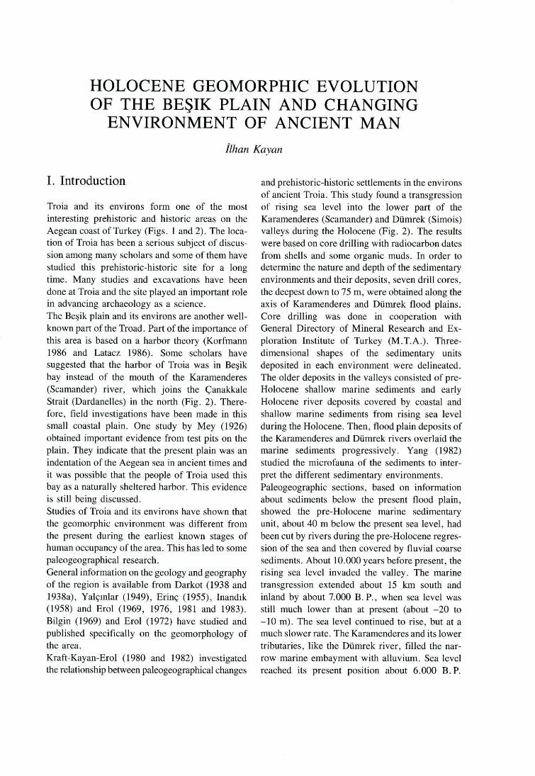
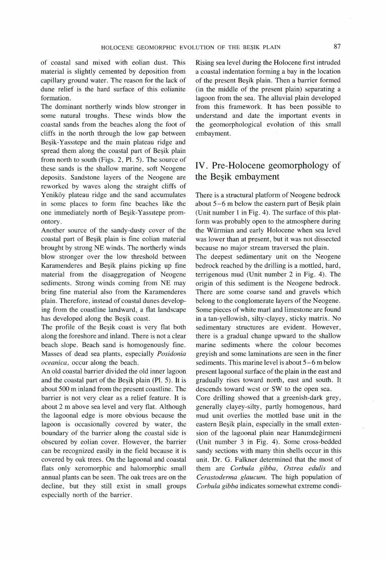
Troia and its environs form one of the most interesting prehistoric and historic areas on the Aegean coast ofTurkey (Figs. 1and2). The location of Troia has been a serious subject of discussion among many scholars and some of them have studied this prehistoric-historic site for a long time. Many studies and excavations have been done at Troia and the site played an important role in advancing archaeology as a science. The Beşik plain and its environs are another wellknown part of the Troad. Part ofthe importance of this area is based on a harbor theory (Korfmann 1986 and Latacz 1986). Some scholars have suggested that the harbor of Troia was in Beşik bay instead of the mouth of the Karamenderes (Scamander) river, which joins the Çanakkale Strait (Dardanelles) in the north (Fig. 2). Therefore , fıeld investigations have been made in this small coastal plain. One study by Mey (1926) obtained important evidence from test pits on the plain. They indicate that the present plain was an indentation of the Aegean sea in ancient times and it was possible that the people of Troia used this bay asa naturally sheltered harbor. This evidence is stili being discussed . Studies of Troia and its environs have shown that the geomorphic environment was different from the present during the earliest known stages of human occupancy of the area. This has led to some paleogeographical research . General information on the geology and geography of the region is available from Darkot (1938 and 1938a), Yalçınlar (1949), Erinç (1955), Inandık (1958) and Erol (1969, 1976, 1981 and 1983). Bilgin (1969) and Erol (1972) have studied and published specifically on the geomorphology of the area. Kraft-Kayan-Erol (1980 and 1982) investigated the relationship between paleogeographical changes
and prehistoric-historic settlements in the environs of ancient Troia. This study found a transgression of rising sea level into the lower part of the Karamenderes (Scamander) and Dümrek (Simois) valleys during the Holocene (Fig. 2). The results were based on core drilling with radiocarbon dates from shells and some organic muds. In order to determine the nature and depth of the sedimentary environments and their deposits , seven drill cores, the deepest down to 75 m, were obtained along the axis of Karamenderes and Dümrek flood plains. Core drilling was done in cooperation with General Directory of Mineral Research and Exploration Institute of Turkey (M.T.A.). Threedimensional shapes of the sedimentary units deposited in each environment were delineated. The older deposits in the valleys consisted of preHolocene shallow marine sediments and early Holocene river deposits covered by coastal and shallow marine sediments from rising sea level during the Holocene. Then, flood plain deposits of the Karamenderes and Dümrek rivers overlaid the marine sediments progressively. Yang (1982) studied the microfauna of the sediments to interpret the different sedimentary environments. Paleogeographic sections , based on information about sediments below the present flood plain, showed the pre-Holocene marine sedimentary unit, about 40 m below the present sea !eve!, had been cut by rivers during the pre-Holocene regression of the sea and then covered by fluvial coarse sediments. About 10.000 years before present, the rising sea Jevel invaded the valley. The marine transgression extended about 15 km south and inland by about 7.000 B. P., when sea level was still much lower than at present (about -20 to -10 m). The sea level continued to rise, but ata much slower rate. The Karamenderes and its lower tributaries, like the Dümrek river, filled the narrow marine embayment with alluvium. Sea !eve! reached its present position about 6.000 B. P.
80 İLHAN KAYAN
o 20 ı.o km
~ MOUNTAINS
E:3 PLATEAU (DEEPLY DISSECTED)
[;] . A LLUVIAL PLAINS, DE LTAS
,,r-' RIV E RS
1774 ELEVATIONS i N METE RS
• MODERN CITY
GÖKÇE ADA
Fig. l Geomorphological outlines of the Biga peninsula and location of the Beşik plain.
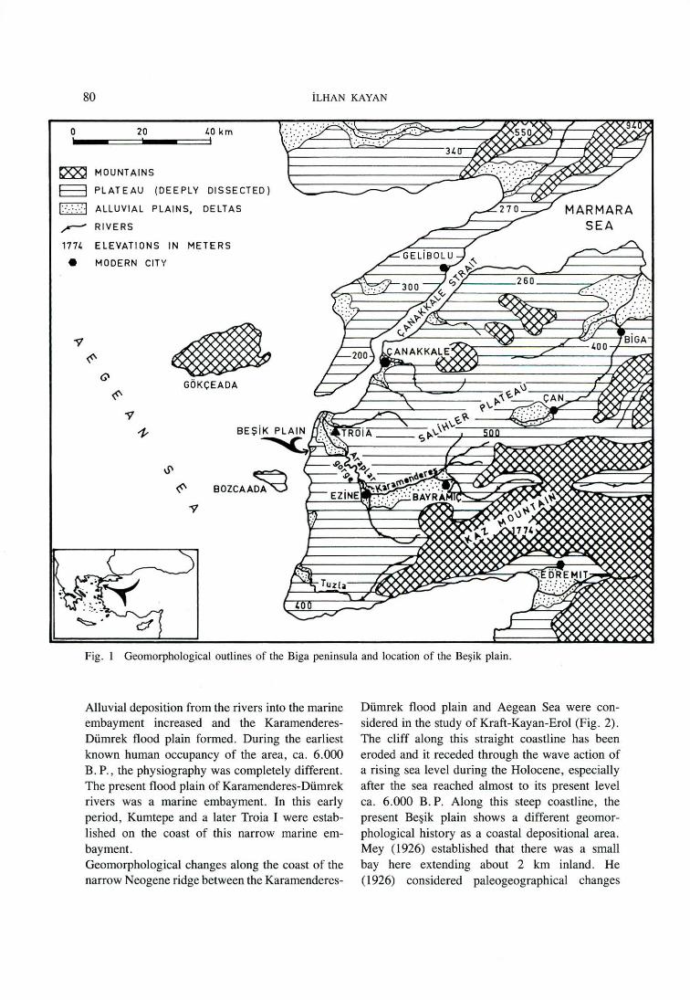
Alluvial deposition from the rivers into the marine embayment increased and the KaramenderesDümrek flood plain formed . During the earliest known human occupancy of the area, ca. 6.000 B. P., the physiography was completely different. The present flood plain of Karamenderes-Dümrek rivers was a marine embayment. in this early period, Kumtepe and a later Troia 1 were established on the coast of this narrow marine embayment. Geomorphological changes along the coast of the narrow Neogene ridge between the Karamenderes-
Dümrek flood plain and Aegean Sea were considered in the study of Kraft-Kayan-Erol (Fig. 2). The cliff along this straight coastline has been eroded and it receded through the wave action of a rising sea level during the Holocene , especially after the sea reached almost to its present level ca. 6.000 B. P. Along this steep coastline, the present Beşik plain shows a different geomorphological history as a coastal depositional area. Mey ( 1926) established that there was a small bay here extending about 2 km inland. He (1926) considered paleogeographical changes
HOLOCENE GEOMORPHIC EVOLUTION OF THE BEŞiK PLAIN 81
HHJ HI GH PLATEAU (200-250 m )
ıs::::sl LOW PLATEAU (60- 80 m )
D KARAHENDERES PLAIN
.ı..lı.. OLD SWAHP S (DRIED UP )
~ SCARPS
Jlı:t- CLIFFS
~ BEACHE S
~ RIVERS
... SPRINGS
~ VILLAGES
50 ELEVATIONS iN MET ERS
e ARCHAEOLOGICAL SITE S
K KU MTEPE
5 BEŞiK - SIVRITEPE
Y BE$1K - VASSITEPE
A ARAPLAR GORGE
N
+ J km
ÇANAl<l<ALE
Fig. 2 Geomorphological outlines of the Troia area and the Beşi k plain.
since prehistorical times and dug some test pits on the plain. He found marine sediments below the present colluvial surface. Based on this, Mey hypothesised that Beşik bay had been a calm and sheltered bay-coast during the Trojan War and the physiography was convenient for Achaean ships as a natura] harbour. Prof. Dr. M. Korfmann has initiated a new era in Troad research. The first project began on the Beş ik plain in 1981 with an intensive survey and excavation program especially aJong the north edge of the plain, at Beşik-Sivritepe and Beşik
Yassıtepe. Since its inception this new Troia project has considered the important effects of the paleogeographic change on cuJtural change. Korfmann invited us to join the project and undertake studies of the environment and paleogeography of the area. Our work started with Prof. Dr. O . Erol in Beş ik plain and its environs in 1983. Present
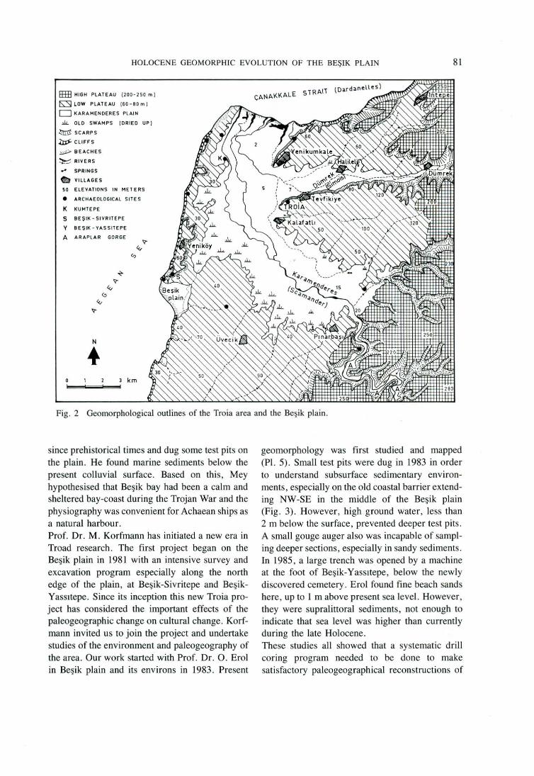
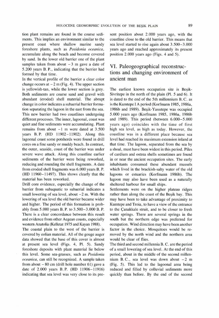
geomorphology was first studied and mapped (Pi. 5). Small test pits were dug in 1983 in order to understand subsurface sedimentary environments, especially on the old coastal barrier extending NW-SE in the middle of the Beşik plain (Fig. 3). However, high ground water, less than 2 m below the surface, prevented deeper test pits. A small gouge auger also was incapable of sampling deeper sections, especially in sandy sediments. in 1985, a large trench was opened by a machine at the foot of Beşik-Yassıtepe, below the newly discovered cemetery . Erol found fine beach sands here, up to 1 m above present sea level. However, they were supralittoral sediments, not enough to indicate that sea level was higher than currently during the late Holocene. These studies ali showed that a systematic drill coring program needed to be done to make satisfactory paleogeographical reconstructions of
82 İLHAN KAYAN
500 m o -- __, ~ .... __ _ CONTOUR LINES
(lnterv•l 2m, duhed 1 m)
s SPRINGS
DRILL S OR TEST PITS:
o 1-6 O. MEY 1926
M. KORFMANN 1982, 1985, 1988
• 1-7 O. EROL 1983
• 01-74 1. KAYAN 1986, 1987, 1988
Fig. 3 Topographical map of the Beşik plain and the drill sites.
the Beşik plain. Of special interest was the vertical and horizontal position of old coastlines and their relation to the newly discovered cemetery. Core drilling started in 1986. Seventy cores were taken in two years on the Beşik plain of about 4-5 krn2
area (Fig. 3). A hand auger was used for most of the holes. it was possible to core most of the
sediments using Edelman and Riverside augers. These penetrated a maximum of 7 m. In addition, a thin gouge auger was used for a quick examination of shallow subsurface features such as locating the top surface of the marine sediments under the terrestrial or eolian deposits covering them. Since the highest parts of the Beşik plain are about 2 m
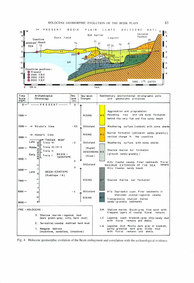
HOLOCENE GEOMORPHIC EVO LUT IO"I OF THE BEŞiK PLAIN 83
ı- L AT E B A y ) E m
p R E S E N T .!!!. w P LA 1 N HO LOCENE BEŞ 1 K
8 6 Dun e
CoHtline AEGEAN: Be•ch
SEA ! 13 2 2
o o
-2 -2
-1. _, -6
CoHtlin• positions : - 6
-8 al Present ~ 2000 Y.8.P. ~ 3500 Y. B.P. cr> 6000 Y.8.P.
o 100 m
Time Archaologic.ıl
Sc•le (YBP)
Chronology
o- --PRE SENT - --
1000 -
2000- ~ Str•bo's t ime
~ Homer's time 3000-
"T ROİAN WAR" L•te UJ T roi• VI
(!) .... . <ı T ro i.ı ııı - ıv -v 4000 - Mıddle uı ...
N T ro i .ı il z ... BEŞİK -E•rly o T ro i .ı 1 Q'. YASSITEPE
5000 - aı ...
u
6000- -L .ıte BEŞİK-SİVRİT EPE
:I: (Kumtepe 1 A)
7000-.....
-_,
8000 - o
UJ
9000- z
Se• Level (m)
o
- 0.5
- 2
o
o
- 4
Su-lttvel Ch•ngu
1 km
- 8
Sediment•ry envi ronment.ıl s t r•tigr•phic units •nd geomorp hic processes
Reced ing s e • and l ow dune form.ıt ion ı RISING 85
Aggr•d•t ion •nd pr ogr•d•tion :
behind the very fl at .ınd t ine Hndy buch
Stillst.ınd Wıo.ıther ing s urface (r edd ish ) w it h some sherds
T RISING O B• r r i ı>r form•t ion ( ye llo wis h s •ndy - gr.ıve ll y ), ı D vertic•l ch.ınge in t he c o.stl ine
l ::;:.~::~ .. , B· :::.«::,":"::: .. ::, ::'.h.::,~: •hoc,.
( greyish sandy - gr .ı ve lly ) (Slow)
H 2b : Co.ı stal s w• mp. Fin e r sedi ments f l o ~ • l Sti llst •nd
-~
R ISI NG
Stillst.ınd l RISI NG
MAX IMUM EXTENS IO N OF T HE SEA rl!mıins
Sh.ıllow m.ı rin e ba r f o r mation
H 1 •: Sap ro pelic l a yer. Fi n er sediments in shallower co as t .ı l-L .ıgoon.ıl sw.ı mp
Tr •nsgressive s hallow mari ne sandy - gr.ıvelly sedi ments
PRE - HOLOCE NE S M Shallo w muine . Blu ish-grey f ine s• nd wi th
3. S h• llow muine - l•goon.ıl mud (d.ırk green-grey, silty , h.ırd mud)
2 . Terrestri.ıl-co•st.ıl mottled h>rd mud
1. Neogene bedrock (mudstone, sandstone, limestone)
f req uent L.ıyers of c oash l flor• l r em• İ n s.
L C L•goon•l co•st . Greenish -grıoy si l ty -s.ı ndy mud with flo r.ıl remains • nd shell s .
LA L.ıgoon;ıl mud. Mos t ly d.ırk gr ey or b l ;ıck is h,
p.ırtly greenis h d .ırk gr e y st icky mud wit h flor•l r em•ins ;ınd she ll s.
Fig. 4 Holocene geomorphic evolution o f the Beşik embayment and correlation wi th the a rchaeolog ical cvidence .
84 İLHAN KAYAN
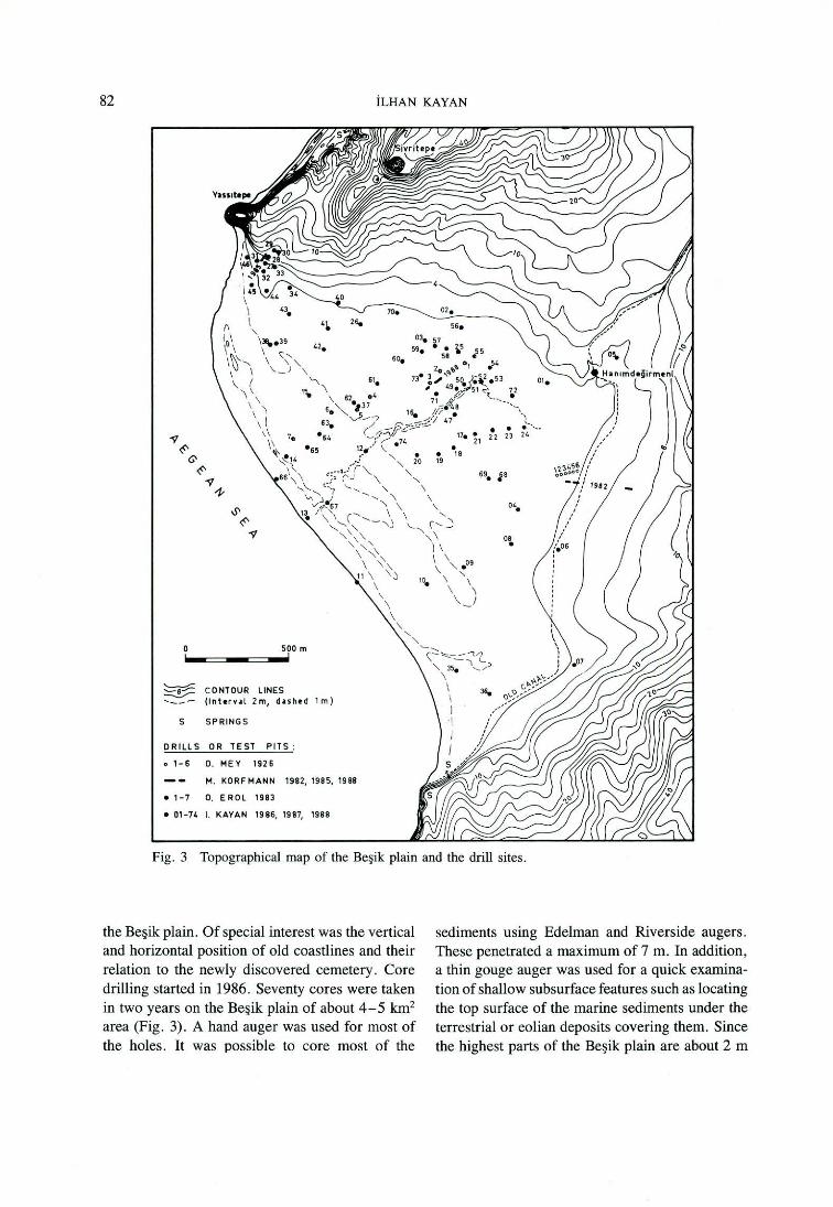
higher than the present sea level , the hand augers penetrated about 5 m below mean sea level. This vertical section contains about 6.000 years of sediment deposited in different environments such as shallow marine, coastal, lagoonal and terrestrial. Until 1987 information about the sediments and their correlation was used to develop paleogeographical maps. In 1987, about 10 samples were taken from subsurface sedimentary units for C 14 dating. These samples were dated by Dr. Kromer at the Institut für Umweltphysik der Universitiit Heidelberg. The C 14 dates correlated well with the paleogeographical reconstructions. In 1988, Prof. Korfmann shifted his project to the main site of Troia near Tevfikiye. Daimler-Benz presented a UNIMOG work-machine for the new Troia excavation to which Korfmann added a hydraulic auger. This powerful machine became known as the " Archaeomog" in Troia. Archaeomog coring was tested on the Beşik plain in 1988. Four holes were augered; each penetrated 11 .5 m to the base of the Holocene sediments (Fig. 3 drill hole numbers 71 to 74). Thus, the new drill made it possible to describe the changing sedimentary environments and paleogeography during the entire Holocene (Fig. 4).
II. Setting of Beşik plain in the geomorphic outlines of Biga peninsula
Beşik plain is a small lowland located on the west coast of the Biga peninsula which is the largest extension of Anatolia toward the west between the Marmara and Aegean seas (Fig. 1). The main structural and geomorphological lineation through the peninsula is SW-NE. Kazdağ ı (Kaz mountain) in the SE and Çanakkale strait and Gelibolu peninsula in the NW are the most distinct elements of this elongation. Between them, the EzineBayrarniç-Çan-Biga depression belt and Salihler plateau ridge are alsa clearly seen as low and high topographic expressions. The ridge of Kazdağı
(1774 m in the NE and 500- 600 m in the SW) consists ofa granitic core with a gneiss surrounding it. A strip of lowland extends along the NW foot of
Kazdağı ridge where several towns are located: Ezine, Bayramiç, Çan, Biga (Fig. 1). This strip is a !ine of small depressions formed by young tectonic movements . The depressions are separated into two sections between Bayramiç and Çan by a volcanic belt about 500 m high. The Çan river flows in the NE part and the Ezine-Bayramiç basin of Karamenderes river is located in the SW part of this depression belt. The Ezine-Bayramiç part is a Neogene basin filled by soft, easily erodable, sandy-clayey-limy sediments. Therefore, the Karamenderes river and its upper tributaries have eroded this area and formed a low river basin with an alluvial plain. The 'Salihler plateau ' (Bilgin 1969) extends to the north of the Ezine-Bayramiç basin about 250- 300 m high (Fig. 1). The surface of this plateau, which cuts different lithological units, is a low undulated erosional surface descending gradually to the NW. The Karamenderes river cuts this plateau with a deeply incised meandering valley in the NW Ezine-Bayramiç basin. This 'Araplar gorge' connects the Ezine-Bayramiç basin to the low flood plain of Karamenderes river and the Çanakkale Strait. The source of the great amount of alluvium in the Karamenderes flood plain is soft Neogene sediments in the EzineBayramiç basin controlled by slower erosion in the hard rocks of Araplar gorge. North and west of Araplar gorge the surface descends by a step-like slope from the Salihler plateau to a lower plateau surface on the Neogene sediments along the SE border of Çanakkale Strait (about 60-80 m high). This plateau extends as low ridges toward the Aegean Sea. The lower valley of Karamenderes river and its lower tributaries are situated on this plateau and filled by alluvium forming the flood plains. Neogene (Upper Miocene-Pliocene) shallow marine, unconsolidated sediments (mostly sandstone, conglomerate, marl) occur between the Salihler plateau and the Çanakkale Strait. They were deposited in a shallow bay extending from the Black Sea (Paratethys) toward the SW during the Sarmatian period of the Upper Miocene. There was a land bridge in this period between the Anatolian and Greek peninsulas separating the Black Sea from the Mediterranean (Erol 1969) . The configuration of the course of Karamenderes
HOLOCENE GEOMORPH1C EVOLUTION OF THE BEŞIK PLAIN 85
river is explained by this Neogene paleogeography . The Çanakkale trough emerged as land in the Pliocene formi ng a river valley collecting water flowing toward the north . In the Quaternary, especially after the Middle Pleistocene, the Mediterranean advanced northward graduaJly and the Çanakkale "valley" became the strait it is today. Lowered sea level during the glacial stages of the Pleistocene caused increased erosion of the easily erodable Neogene sediments. Valleys became deeper and wider. However, during the interglacial stages shallow marine-estuarine sedimentation advanced into the mouths of the deepened river valleys. This process was repeated at least twice. Drill core evidence and C 14 dates show that there were some shallow marine-estuarine sediments in the Karamenderes valley from the previous high sea !eve! stages (probably RissWürm or mid-Würm). They were deeply incised by the rivers during the !ast glacial stage (Würm) when sea level dropped about 100 m (Kraft et al. 1980). The present flood plain of the Karamenderes river and its lower tributaries formed during rising sea level in the Holocene. Plateau ridges about 60- 80 m high lie between the Karamenderes river and its lower tributaries (Fig. 2) . These ridges formed on the Upper Miocene-Pliocene shallow marine sedimentary rocks. They are mostly sandy sediments interbedded with more resistant marl or limestone layers and some terrestrial mudstone especiaJly toward top. The sediments are almost horizontal in some places, but in others are tilted or faulted. Thus some ridges show cuesta features and some structural terraces are related to lithological differences. The flood plain of the Karamenderes river occurs between the exit from Araplar gorge and the Çanakkale strait, a distance of 15 km with an average width of 4 km (Fig. 2) . Two west-east ridges lie in the eastem section of this plain : Yenikumkale ridge in the north and Tevfikiye ridge in the south . The Dümrek river with its wide flood plai n lies between them joining the Karamenderes plain in the west. Both ridges formed on Neogene layers tilted slightly southward. Therefore the northern slopes at the ridges are steeper and straighter. South-facing
slopes are gentle with some small structural platforms or terraces. Troia is located at the west end of the Tevfikiye ridge. Thus it has a commanding position overlooking both the Karamenderes plain in the west and the Dümrek in the north (Fig. 2) . West of Karamenderes flood plain is another ridge of the Neogene sediments, Yeniköy ridge, separating the Karamenderes plain from the Aegean sea . This ridge is about 1 O km long, 1- 1 .5 km wide, and 40-60 m high. The layers of this ridge are almost horizontal or very slightly tilted eastward. Wave erosion has formed a straight cliff !ine along the Aegean coast. East-facing slopes are very gentle, irregular in shape with some flat steps related to the underlying structure. The west coast of Biga peninsula lies fairly straight in a north-south direction . Its profile shows a steep cliff about 40-60 m high in the soft Neogene sediments. Although there are no deep indentations, there are small alluvial flats along the Aegean coast. Some of them are delta plains at the mouths of small rivers located along weak structural lineations or in depressed zones of the Neogene bedrock. However, no important river or large delta plain occurs. The biggest river is the Tuzla river in the south and its coastal-delta plain is more extensive than the others (Fig . 1). The west coast of the Biga peninsula has been an important area for occupation and cultural development since prehistoric times . The locations of archaeological sites imply some relation to the small coastal embayments which were convenient harbours along this straight and steep coastline. Such places are not marine indentations today, but alluvial plains, having straight coastlines in the same d irection as the coastal cliffs. However, it is clear that the small alluvial coastal plains had been marine embayments before they filled with alluvium. The geomorphological and sedimentological evidence obtained from the drill cores in the alluvial fil i of the Beşik plain ha ve been very useful in understanding this process.
III. Geomorphology of the Beşik
plain
Beşik plain is the first embayment along the steep coast extending southward from the Aegean mouth
86 İLHAN KAYAN
of the Çanakkale strait (Fig. 2). This small plain occurs on the coastal part of a NE-SW structural lowland between low plateau ridges of Yeniköy in the north and a wider part of the same plateau in the south. The plain is separated from the Karamenderes plain by a very low (below 10 m) and small threshold in the NE. Loose and fine marine sand cover with shell fragments on the threshold suggests that the sea once passed over this threshold. However, there is no evidence that sea level rose to this elevation during the Quaternary, especially the Holocene. The coastline of the Beşik plain extends NW-SE and about 2 km inland, narrowing to a triangular shape (Pi. 5). No river traverses the Beşik plain. Only an old cana) on the threshold in the east is noticeable (Fig. 3). The cana) was dug so water from the Pınarbaşı karstic springs in the south of the Karamenderes plain would flow directly to the sea (Fig. 2). The ruin of an old water-mill at the mouth of the canal opening to the Beşik plain is known as " Hanım Değirmeni" or "Hamam Değirmeni" in old maps. The cana) turns south and reaches the sea in the southern part of the plain. However, it is currently dry and infilled in most places. Beşik plain is bordered by plateau slopes, 40-60 m high, in the north and south (Pi. 5, Korfmann 1986). Neogene bedrock interbedded with more resistant limestone and marl layers and less resistant mudstone layers form low step features along these slopes. A smooth belt of foothills occurs between the plain and the slopes. This very flat feature is wider in the east. it formed along the foot of the Iow plateau slopes by deposition of sediments from the mudstone layers ofthe plateau. it can be differentiated from the deposits of the plain by its reddish-brown colour. There are two main geomorphic features on the plain. üne is the inner or old lagoonal part, the other is the outer or coastal part. A very low and flat old coastal barrier occurs between them, about 500 m inland from the present coastline (Pl. 5). The old lagoon in the east comer of the Beşik plain has silted in and is only semi-active today. The bottom of the lagoon (about 50-80 cm above sea level) may be covered by water in the rainy seasons especially during severe storms. However, this condition does not persist because a small outlet
drains to the sea through the old coastal barrier in the middle of the plain. Although the lagoon is dry during summer seasons, it cannot be used for agriculture because the soil is too clayey and has halomorphic-hydromorphic characteristics. Agricultural areas have been extended recently from the edges by usi ng better agricul tural technıques .
Rain erodes soil from the adjacent plateau and slopes and carries it to the edge ofthe plain. Thus, the area of the old lagoon is bordered by colluvial foothill deposits especially in the east. But this material does not reach the centre of the lagoonal area because there is no stream to carry it . Therefore, in spite of its small area, the old lagoon has not completely infilled . The colluvial foothill deposits are advancing slowly over the lagoon. Extending the agricultural areas inward is also partly related to this geomorphic process. Lagoonal sediments found by drilling through the colluvial foothill deposits show that the lagoon covered a larger area in earlier times . The coastal part of Beşik plain is a strip of Iand about 500 m wide. it is separated into two sections by a longitudinal , 100-150 m wide, lagoonal channel which is only active in the winter (Pi. 5). This channel accommodates sea water during storms. The area covered by water depends on wind direction. The bottom of the channel is only about 30-40 cm above mean summer sea level. Sediments in the channel are finer than outside it and sand cover does not exist. The surface is damp even during the dry summer season and partly covered by halomorphic small plants. The main coastal flats of the Beşik plain extending on both sides of the lagoonal channel are about 60-80 cm above mean sea level. The steps along the channel edges are low but clear. The surface covered by eolian sand and dust coming mostly during dry summer periods with the dominant northerly winds. However, there is no dune relief on this surface except one small dune ridge along the northern part of the coast. Drill cores on both sides of the channel showed a sandy-dusty eolian section from the top down to the present sea level. This layer covers homogenous shallow marine sandy foreshore sediments. The upper eolian section is well indurated especially toward the surface. it is evident that the sandy material consists
HOLOCENE GEOMORPH IC EVOLUTION OF THE BEŞiK PLAIN 87
of coastal sand mixed with eolian dust. This material is slightly cemented by deposition from capillary ground water. The reason for the lack of dune relief is the hard surface of this eolianite formation. The dominant northerly winds blow stronger in some natural troughs. These winds blow the coastal sands from the beaches along the foot of cliffs in the north through the low gap between Beşik-Yassıtepe and the main plateau ridge and spread them along the coastal part of Beşik plain from north to south (Figs. 2 , Pi. 5). The source of these sands is the shallow marine, soft Neogene deposits. Sandstone layers of the Neogene are reworked by waves along the straight cliffs of Yeniköy plateau ridge and the sand accumulates in some places to form fıne beaches like the one immediately north of Beşik-Yassıtepe promontory. Another source of the sandy-dusty cover of the coastal part of Beşik plain is fıne eolian material brought by strong NE winds. The northerly winds blow stronger over the low threshold between Karamenderes and Beşik plains picking up fıne material from the disaggregation of Neogene sediments. Strong winds coming from NE may bring fıne material also from the Karamenderes plain. Therefore, instead of coastal dunes developing from the coastline landward, a flat landscape has developed along the Beşik coast. The profile of the Beşik coast is very flat both along the foreshore and inland . There is nota clear beach slope. Beach sand is homogenously fıne.
Masses of dead sea plants, especially Posidonia oceanica, occur along the beach. An old coastal barrier divided the old inner lagoon and the coastal part of the Beşik plain (Pi. 5). it is about 500 m inland from the present coastline. The barrier is not very clear as a relief feature. it is about 2 m above sea Ievel and very flat. Although the Iagoonal edge is more obvious because the Iagoon is occasionally covered by water, the boundary of the barrier along the coastal side is obscured by eolian cover. However, the barrier can be recognized easily in the field because it is covered by oak trees. On the lagoonal and coastal flats only xeromorphic and halomorphic small annual plants can be seen. The oak trees are on the decl ine, but they stili exist in small groups especially north of the barrier.
Rising sea level during the Holocene first intruded a coastal indentation forming a bay in the location of the present Beşik plain . Then a barrier formed (in the rniddle of the present plain) separating a lagoon from the sea. The alluvial plain developed from this framework. it has been possible to understand and date the important events in the geomorphological evolution of this small embayment.
IV. Pre-Holocene geomorphology of the Beşik embayment
There is a structural platform of Neogene bedrock about 5-6 m below the eastern part of Beşik plain (Unit number 1 in Fig . 4). The surface of this platform was probably open to the atmosphere during the Würmian and early Holocene when sea level was Jower than at present, but it was not dissected because no major stream traversed the plain. The deepest sedimentary unit on the Neogene bedrock reached by the drilling is a mottled, hard, terrigenous mud (Unit number 2 in Fig. 4) . The origin of this sediment is the Neogene bedrock. There are some coarse sand and gravels which belong to the conglomerate layers of the Neogene. Some pieces ofwhite marl and limestone are found in a tan-yellowish, silty-clayey, sticky matrix . No sedimentary structures are evident. However, there is a · gradual change upward to the shallow marine sediments where the colour becomes greyish and some Jarninations are seen in the fıner sediments. This marine Jevel is about 5-6 m below present Jagoonal surface of the plain in the east and gradually rises toward north, east and south . It descends toward west or SW to the open sea. Core drilling showed that a greenish-dark grey, generally clayey-silty , partly homogenous, hard mud unit overlies the mottled base unit in the eastern Beşik plain, especially in the small extension of the Iagoonal plain near Hanımdeğirmeni (Unit number 3 in Fig. 4) . Some cross-bedded sandy sections with many thin shells occur in this unit. Dr. G. Falkner determined that the most of them are Corbula gibba, Ostrea edulis and Cerastoderma glaucum. The high population of Corbula gibba indicates somewhat extreme condi-
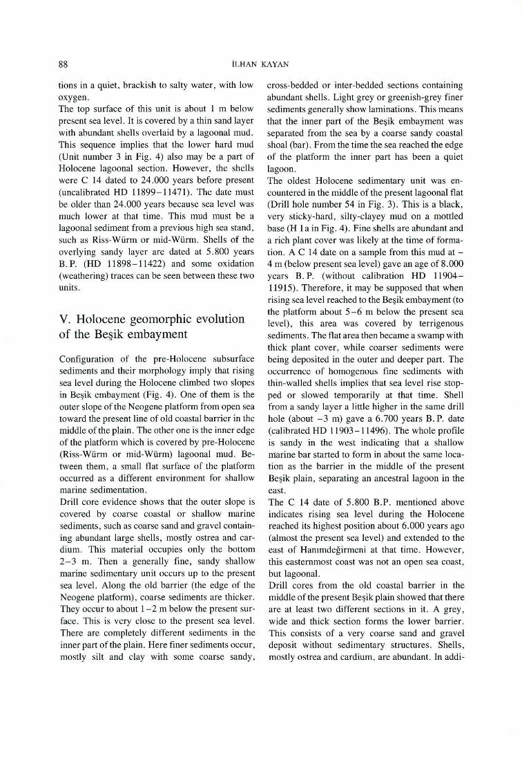
88 İLHAN KAYAN
tions in a quiet, brackish to salty water, with low oxygen. The top surface of this unit is about 1 m below present sea level. It is covered by a thin sand la yer with abundant shells overlaid by a lagoonal mud. This sequence implies that the lower hard mud (Unit number 3 in Fig. 4) alsa may be a part of Holocene lagoonal section. However, the shells were C 14 dated to 24.000 years before present ( uncalibrated HD 11899 - 114 71). The date must be older than 24.000 years because sea level was much lower at that time. This mud must be a lagoonal sediment from a previous high sea stand, such as Riss-Würm or mid-Würm. Shells of the overlying sandy layer are dated at 5. 800 years B. P. (HD 11898- 11422) and some oxidation (weathering) traces can be seen between these two units.
V. Holocene geomorphic evolution of the Beşik embayment
Configuration of the pre-Holocene subsurface sediments and their morphology imply that rising sea level during the Holocene climbed two slopes in Beşik embayment (Fig. 4). üne of them is the outer slope ofthe Neogene platform from open sea toward the present line of old coastal barrier in the rniddle of the plain. The other one is the inner edge of the platform which is covered by pre-Holocene (Riss-Würm or mid-Würm) lagoonal mud. Between them, a small flat surface of the platform occurred as a different environment for shallow marine sedimentation. Drill core evidence shows that the outer slope is covered by coarse coastal or shallow marine sediments, such as coarse sand and gravel containing abundant large shells, mostly ostrea and cardium. This material occupies only the bottom 2-3 m. Then a generally fine, sandy shallow marine sedimentary unit occurs up to the present sea level. Along the old barrier (the edge of the Neogene platform) , coarse sediments are thicker. They occur to about 1- 2 m below the present surface. This is very close to the present sea level. There are completely different sediments in the inner part of the plain. Here finer sediments occur, mostly silt and clay with some coarse sandy ,
cross-bedded or inter-bedded sections containing abundant shells. Light grey or greenish-grey finer sediments generally show laminations. This means that the inner part of the Beşik embayment was separated from the sea by a coarse sandy coastal shoal (bar). From the time the sea reached the edge of the platform the inner part has been a quiet lagoon. The oldest Holocene sedimentary unit was encountered in the middle of the present Jagoonal flat (Drill hole number 54 in Fig. 3). This is a black, very sticky-hard, silty-clayey mud on a mottled base (H 1 a in Fig. 4). Fine shells are abundant and a rich plant cover was likely at the time of formation. A C 14 date ona sample from this mud at -4 m (below present sea level) gave an age of 8.000 years B. P. (without calibration HD 11904-11915). Therefore, it may be supposed that when rising sea level reached to the Beşik embayment (to the platform about 5-6 m below the present sea level), this area was covered by terrigenous sediments. The flat area then became a swamp with thick plant cover, while coarser sediments were being deposited in the outer and deeper part. The occurrence of homogenous fine sediments with thin-walled shells implies that sea level rise stopped or slowed temporarily at that time. Shell from a sandy layer a little higher in the same drill hole (about -3 m) gave a 6.700 years B. P. date (calibrated HD 11903- 11496). The whole profile is sandy in the west indicating that a shallow ınarine bar started to form in about the same location as the barrier in the middle of the present Beşik plain, separating an ancestral lagoon in the east. The C 14 date of 5.800 B.P. mentioned above indicates rising sea level during the Holocene reached its highest position about 6.000 years ago (almost the present sea level) and extended to the east of Hanımdeğirmeni at that time. However, this easternmost coast was not an open sea coast, but lagoonal. Drill cores from the old coastal barrier in the middle of the present Beşik plain showed that there are at least two different sections in it. A grey, wide and thick section forms the lower barrier. This consists of a very coarse sand and gravel deposit without sedimentary structures. Shells, mostly ostrea and cardium, are abundant. In addi-
HOLOCENE GEOMORPHIC EVOLUTION OF THE BEŞIK PLAIN 89
tion plant remains are found in the coarse sediments. This implies an environment similar to the present coast where shallow marine sandy foreshore plants, such as Posidonia oceanica, accumulate along the beach and become covered by sand. In the lower old barrier one of the plant samples taken from about - 3 m gave a date of 5 .200 years B. P., indicating that the barrier had formed by that time. In the vertical profile of the barrier a clear color change occurs at - 2 m (Fig. 4). The upper section is yellowish-tan , while the lower section is grey. Both sediments are coarse sand and gravel with abundant (eroded) shell material. The abrupt change in color indicates a subaerial barrier formation separating the lagoon in the east from the sea. This new barrier had two coastlines undergoing different processes. The inner, lagoonal, coast was quiet and fıne sediments were accumulating. Plant remains from about - 1 m were dated at 3.500 years B. P. (HD 11902- 11902). Along this lagoonal coast some potsherds were found in drill cores on a fine sandy or muddy beach. in contrast, the outer, seaside, coast of the barrier was under severe wave attack. Along this coastline earlier sediments of the barrier were being reworked, reducing and rounding the shell fragments. A date from eroded shell fragments was 6.000 years B. P. (HD 11960-11497). This shows clearly that the material has been reworked. Drill core evidence, especially the change of the barrier from subaquatic to subaerial indicates a small lowering of sea level , about -2 m. With the lowering of sea level the old barrier became wider and higher. The period of this formation is probably from 5.000 years B. P. to 3.500- 3.000 B. P. There is a clear concordance between this result and evidence from other Aegean coasts, especially westem Anatolia (KeUetat 1975 and Kayan 1988). The coastal plain to the west of the barrier is covered by eolian material. Ali of the gouge auger data showed that the base of this cover is almost at present sea level (Figs. 4 , Pl. 5). Sandy foreshore deposits with plant material lie below this level. Some sea-grasses, such as Posidonia oceanica, can stili be recognized. A sample taken from about - 80 cm (drill hole number 61) gave a date of 2.000 years B. P. (HD 11906-11916) indicating that sea !eve! was very close to its pre-
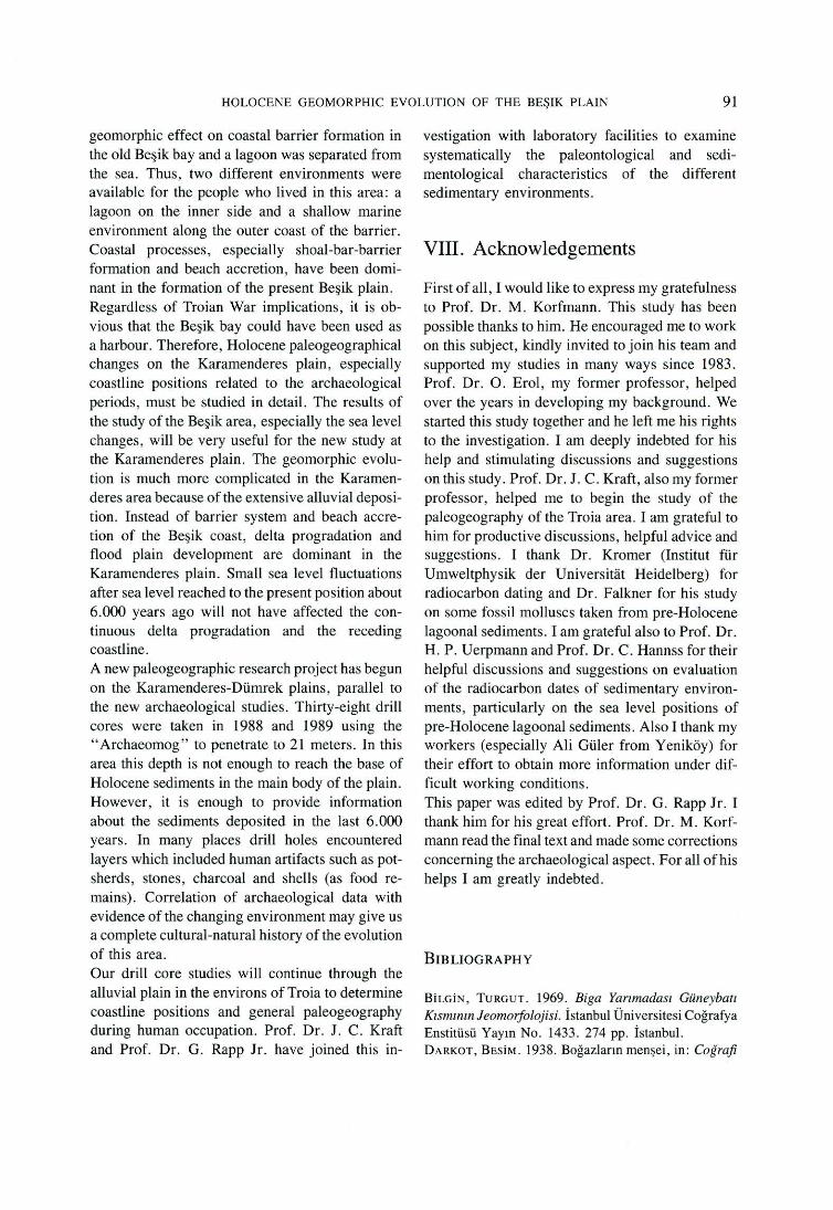
sent position about 2.000 years ago, with the coastline close to the old barrier. This means that sea level started to rise again about 3.500-3.000 years ago and reached approximately its present position 2.000 years ago (Figs. 4 and 5).
VI. Paleogeographical reconstructions and changing environment of ancient man
The earliest known occupation site is BeşikSivritepe in the north of the plain (Pi. 5 and 6). it is dated to the end of the 5th millennium B. C. as is the Kumtepe 1 A peri od (Korfmann 1985, 1986a, 1986b and 1989). Beşik-Yassıtepe was occupied 5 .000 years ago (Korfmann 1985, 1986a, 1986b and 1989). This period (between 6.000-5.000 years ago) coincides w ith the t ime of fir st high sea level, as high as today. However, the coastline was in a different place because sea level had reached its maximum extension inland at that time. The lagoon, separated from the sea by a shoal, must have been widest in this period. Piles of cardium and ostrea shells sometimes are found in or near the ancient occupation sites. The early inhabitants consumed these abundant mussels which lived in the brackish-salty water of the old lagoons or estuaries (Korfmann 1986b). The lagoon may also have been used as a naturally sheltered harbour for small ships. Settlements were on the higher plateau ridges rather than along the coast of the Beşik bay. This may have been to take advantage of proximity to Kumtepe and Troia, to ha ve a view of the entrance to the Çanakkale strait, and to be closer to fresh water springs. There are several springs in the south but the northern edge was preferred for occupation. Wind direction may have been another factor in the choice. Mosquitoes would be removed by the north wind and the northern area would be clear of flies . The third and second millennia B. C. are the period ofa small lowering of sea level . At the end of this period, about in the middle of the second millennium B. C., sea level was down about -2 m (Fig. 5). This led to the lagoonal area being reduced and fılled by colluvial sediments more quickly than before. By the end of the second

90 iLHAN KAYAN
Depth
m
2
-1
-2
-3
w a.. ~ w~ ı-
0::: > QI
·- o. uı QI
1 .....
-~ E ti) :::J w ::.:: m ~
NE OL I T H IC
7 6
1 1 ::.::-
·-UlW V>uıa.. > W<{W 1
CD > t- > -1
<{ <{ <(
o o o o::: o::: o::: 1- 1- 1-
BRONZE
5 4
s.~ ı. "•ı
~(/ ,,.,,.
-... -~ "' "' ~
QI u .... E "1:1 ... c
> ~ ... c !!' t.ı
<{ ... .... ... QI z .c
o o Eo t.ı o::: .... o - ....
1-:ı::=~ 1- •
A G E
3
c ... E
t.ı o ..... o::: "' QI c ı: :ı::
~ :;:~ - -' . -=. .. "' o ~
z .oz O '" O - .... _ ~ Ul :::
2
De pth
m
2
o
-3
? T 1 M E (THOUSAND YEARS BEFORE PRESENT)
Fig. 5 Sea level changes on the Beşik coast during the !ast 6000 years.
millennium the lagoon was smaller and the coastal barrier wider (Pl. 8). Some potsherds were found along the Jagoonal coast of the barrier. They showed no evidence of transportation or erosion by waves. They appeared to be in situ. in the opinion of Korfmann and his colleagues th~ potsherds may belong to the end of the second millennium B. C. The "Trojan War" and its environment have long been topics for discussion. it has been suggested that, if such a war took place, the Achaean camp may have been at the Beşik embayment instead of the embayment at the mouth of Karamenderes river (Korfmann 1986 and 1986a). During the time of Trojan War, about l .200 B. C., sea Jevel was about 2 m below its current level (Fig. 5). The Beşik lagoon was reduced in size and the barrier widened (Pi. 8). It is difficult to believe that ships passed through a widened barrier to the lagoon . However, one can imagine that small ships may ha ve been dragged easily onto the flat sandy beach (personal communication by Kraft). The coastline was about 400 m farther inland at that time, and the Beşik-Sivritepe - Beşik-Yassıtepe ridge might
have protected the Beşik embayment from strong northerly winds (Pi. 8).
VII. Conclusions
ln spite of its small area on a cliff coast, Beşik embayment has had a very slow and quiet geomorphic development during the Holocene. Therefore, it has been possible to understand al i the geomorphic events and paleogeographical changes in this period related to human occupation. During the earliest known occupation of the area, about 6.000 years ago, sea Ievel had reached its present level and extended inland into the embayment. People settled in the north, along the top of a coastal promontory, the Beşik-Sivritepe - Beşik-Yassı
tepe ridge. There is no evidence that sea Jevel rose higher than present in this area during the Holocene. Sedimentological investigations show that sea level descended about 2 m from 5.000 to 3.500 years before present (Fig. 5). This had an important
HOLOCENE GEOMORPHIC EVOLUTlON OF THE BEŞiK PLAIN 91
geomorphic eff ect on coastal barrier formation in the old Beşik bay and a Jagoon was separated from the sea. Thus, two different environments were available for the people who lived in this area: a lagoon on the inner side and a shallow marine environment along the outer coast of the barrier. Coastal processes, especially shoal-bar-barrier formation and beach accretion, have been dominant in the formation of the present Beşik plain. Regardless of Troian War implications, it is obvious that the Beşik bay could have been used as a harbour. Therefore, Holocene paleogeographical changes on the Karamenderes plain , especially coastline positions related to the archaeological periods, must be studied in detail. The results of the study of the Beşik area, especially the sea level changes, will be very useful for the new study at the Karamenderes plain. The geomorphic evolution is much more complicated in the Karamenderes area because of the extensive alluvial deposition. Instead of barrier system and beach accretion of the Beşik coast, delta progradation and flood plain development are dominant in the Karamenderes plain. Small sea !eve! fluctuations after sea !eve! reached to the present position about 6.000 years ago will not have affected the continuous delta progradation and the receding coastline. A new paleogeographic research project has begun on the Karamenderes-Dümrek plains, parallel to the new archaeological studies. Thirty-eight drill cores were taken in 1988 and 1989 using the "Archaeomog" to penetrate to 21 meters. In this area this depth is not enough to reach the base of Holocene sediments in the main body of the plain. However, it is enough to provide information about the sediments deposited in the last 6.000 years. In many places drill holes encountered Jayers which included human artifacts such as potsherds, stones, charcoal and shells (as food remains). Correlation of archaeological data with evidence of the changing environment may give us a complete cultural-natural history of the evolution of this area. Our drill core studies will continue through the alluvial plain in the environs of Troia to determine coastline positions and general paleogeography during human occupation. Prof. Dr. J. C. Kraft and Prof. Dr. G. Rapp Jr. have joined this in-
vestigation with laboratory facilities to examine systematically the paleontological and sedimentological characteristics of the different sedirnentary environments.
VIII. Acknowledgements
First ofall , 1 would like to express my gratefulness to Prof. Dr. M. Korfmann. This study has been possible thanks to him. He encouraged me to work on this subject, kindly invited to join his team and supported my studies in many ways since 1983. Prof. Dr. O. Erol , my former professor, helped over the years in developing my background . We started this study together and he left me his rights to the investigation. 1 anı deeply indebted fo r his help and stimulating discussions and suggestions on this study. Prof. Dr. J. C. Kraft, also my former professor, helped me to begin the study of the paleogeography of the Troia area. 1 anı grateful to him for productive discussions , helpful advice and suggestions. 1 thank Dr. Kromer (Institut für Umweltphysik der Universitat Heidelberg) for radiocarbon dating and Dr. Falkner for his study on some fossil molluscs taken from pre-Holocene lagoonal sediments. 1 anı grateful also to Prof. Dr. H. P. Uerpmann and Prof. Dr . C. Hannss for their helpful discussions and suggestions on evaluation of the radiocarbon dates of sedimentary environments, particularly on the sea level positions of pre-Holöcene lagoonal sedirnents. Also 1 thank my workers (especially Ali Güler from Yeniköy) for their effort to obtain more information under difficult working conditions. This paper was edited by Prof. Dr. G. Rapp Jr. 1 thank him for his great effort. Prof. Dr. M. Korfmann read the final text and made some corrections concerning the archaeological aspect. For ali of his helps 1 anı greatly indebted.
BIB LIOG RAPHY
BİLGİN, TURGUT. 1969. Biga Yarımadası Güneybatı
Kısmınınleomorfolojisi. İstanbul Üniversitesi Coğrafya Enstitüsü Yayın No. 1433. 274 pp. İstanbul. DARKOT, BESİM. 1938. Boğazların menşei, in : Coğrafi
92 İLHAN KAYAN
Araşurmalar 1: 1- 14. İstanbul Ünivers itesi Coğrafya Enstitüsü Yayın No. 4. İstanbul. DARKOT, BESİM. 1938a. Ege haliçlerinin menşe ve tekamülü, in: Coğrafi Araşurmalar 1: 29- 52. İstanbul Üniversitesi Coğrafya Enstitüsü Yayın No. 4. İstanbul. ERİNÇ, SIRRI. 1955. Gediz ve Küçük Menderes deltalarının morfolojisi, in : Dokuzuncu Coğrafya
Meslek Haftası, Tebliğler ve Konferanslar, 33- 66. Türk Coğrafya Kurumu Yayın No. 2. İstanbul. E ROL, Ocuz. 1969. Çanakkale Boğazı çevresinin jeomorfoloj isi hakkında ön not (A preliminary report on the geomorphology of the Çanakkale area - The Dardanelles , Turkey) . Ankara Üniversitesi Coğrafya Araştırmaları Dergisi 2. Ankara. EROL, Ocuz. 1972. Truva çevresinin foto-jeomorfolojik haritası , Jeomorfoloji Dergisi 4. Ankara. E ROL, Od'uz. 1976. Quaternary shoreline changes on the Anatolian coasts of the Aegean Sea and related problems. Bull. Soc. geol. France 18, 2: 459-68. Paris. EROL, Ocuz. 1981. Neotectonic and geomorphological evolution of Turkey, in: FAIRBRIDGE, R . W ., Neoıectonics. Zeitschrift far Geomorphologie. Suppl. 40: 193-211. Berlin . EROL, Ocuz. 1983. Historical Changes on the Coastline ofTurkey , in : BrRo, E. C. F. and P. FABBRI , Coastal Problems in the Mediterraneaıı Sea. Int. Geogr. Union, Comm. on the Coastal Environment, 95- 108. Bologna. İNANDIK , H AMİT. 1958. Türkiye kıy ıl arına genel bakış , İstanbul Üniversitesi Coğrafya Enstitüsü Dergisi 9: 50-72. İstanbul. KAYAN, İ LH AN . 1988 . Late Holocene Sea-Level Changes on the Western Anatolian Coast, in : PıRAZ
zou, P. A. and D. B. Sc oTT, Quaıerııary Coasıal Changes. Special issue of Palaeogeography, Palaeoclimatology, Palaeoecology 68: 205-18. Amsterdam. KELLETAT, DıETER. 1975. Eine eustatische Kurve für das jüngere Holozan , konstruiert nach Zeugnissen früherer Meeresspiegelstande im östlichen Mittelmeergebiet , Neues Jahrbuch far Geologie und Paliionıologie. Monatshefie 6: 360- 74 . KoRFMANN , MANFRED. 1984 . Beşik Yassıtepe ve Beşik
Sivritepe 1983 ön raporu , in : VJ. Kazı Sonuçları Toplantısı, 107-20. Anka ra. KORFMANN, MANFRED. 1985. Beşik Yass ıtepe, Beşik
Sivritepe ve Beşik Mezarlığı 1984 ön raporu, in : V/J. Kazı Sonuçları Toplantısı, 229-38. Ankara. KORFMANN, M ANFRED. 1986. Troy: Topography and
avigation , in : Troy and the Trojan War. A Symposium Held at Bryn Mawr College, October 1984. Ed. M. J. Mellink, 1-16. New York. KoRFMANN , MANFRED. l 986a. Beşik-Tepe: New Evidence for the Period of the Trojan Sixth and Seventh Settlements, in: Troy and the Trojan War. A Symposium
Held at Bryn Mawr College, October 1984. Ed. M. J. Mell ink, 17-28. New York. KoRFMA NN, MANFRED. 1986b. Beşik-Tepe. Vorbericht über d ie Ergebnisse der Grabungen von 1984. Grabungen anı Beşik-Yassıtepe, Beşik-Sivritepe und Beşik
Graberfeld , Archöologischer Anzeiger: 303-63. Beri in. KORFMANN, MANFRED. 1989. Beşik-Tepe . Vorbericht über die Ergebnisse der Arbe iten von 1987 und 1988. Auswertungsarbeiten Beşik-S ivritepe, Beşik-Yassıtepe ,
Beşik-Graberfeld , Grabungen anı Beşik-Sivritepe, Archtiologischer Anzeiger: 473-81. Berlin. KRAFT, JOHN C ., İLHAN KAYA N and Oc uz EROL. 1980. Geomorphic reconstructions in the environs of ancient Troy, Science 209: 776-82. Washington. KRAFT, JOHN C., İ LH AN KAYAN and Ocuz EROL. 1982 . Geology and Paleogeographic Reconstructions of the Vicinity ofTroy, in: RAPP, G. Jr. and J . A. GıFFORD (eds.), Troy: The Archaeological Geology, Supplementary Monograph 4, 11-40. Cincinnati. KRAFT, Jo HN C . , DANIEL F. BELKNAP and İ LHAN KAYAN. 1983. Potentials of Discovery of Human Occupation Sites on the Continental Shelves and Nearshore Coastal Zone, in: MASTERS, P . M. and N. C. F LEMMING (eds.) , Quaternary Coastlines and Marine Archaeology, 87-120. New York. KRAFT , JoHN C ., İLHAN KAYA N and STANLEY E. Asc HENBRENNER. 1985. Geological Studies ofCoastal Change Applied to Archaeological Settings, in: RAPP, G. Jr. and J . A. GıFFORD (eds.) , Archaeological Geology, 57 - 84 . New Haven. L ATACZ, JoACHIM . 1986. News from Troy. Berytus Archaeological Studies 34: 97 - 127. Beirut. MEY, ÜSCA R. 1926. Das Schlachtfeld vor Troja. Berlin. - Leipzig. PıRAZZO LI , PAOLO A. 1987. Sea Level Changes in the Mediterranean , in: TooLEY, M . J . and I. SHENNA N (eds.) , Sea-Level Changes, 152-81. Oxford. YALÇINLAR, İSMAİ L. 1949. Çanakkale Boğazı civarının jeomorfoloj isi üzerine müşahedeler. Türk Coğrafya Dergisi 11-12: 129 - 38. İstanbul. YANG, LıEN-CHu. 1982 . The Distribution and Taxonoıny of Ostracodes and Benthic Foraminifers in Late Pleistocene and Holocene Sediments of the Troad (Biga Peninsula), Turkey. 209 pp . A thesis of maste r of science in geology. University of Delaware , Department of Geology. Newark.
Prof Dr. İlhan Kayan Ege Üniversitesi Edebiyat Fakültesi Coğrafya Bölümü TR-35100 Bornova/İzmir
PRESENT
o 500 m __ c:::_c::=: ....
LOW PLATEAU SLOPES
ON THE NEOGENE BEDROCK
(MAINLY SANDY - LIMY SEDI MENT S)
----+ STEEPER. GE NTLER
GEN TLE SLOPE - FOOT
ON COLLUYIA L DEPOS IT
LAGOON
LOW COASTAL L A ND F ORM S
SCARPS AND CL IFFS
- - - -" SMAL L STREAMS, 20 ELE VA T ION S (m)
Gcornorphological rnap of the Beşi k plain.
TAF EL 5
I I
I
/
,,,.., \ / ' ,,,,.,. ,'
/ / 6 \
I I
I I
I
/ \ I -"" ~ I / / I
4'.-' ( ~/ {!zL O Mil\ / \
\ ) \ ) _,,/'' 6 )
// / "" (
6
30
4 ~ \
1.0
I 1
10\
·---
40
TAFEL 6
6000 B.P. SEA LEVEL : 0 m
o SOOm
ı==:J LOW PLATEAU SLOPES
ON THE NEOGENE BEOROCK (MAINLY SANDY-LIMY SEDIMENTS)
. . . .
8
~ STEEPER, ___.. GENTLER
D GENTLE SLOPE-FOOT
ON COLLUVIAL DEPOSIT
c:::J SHOAL
..ılı. COASTAL SWAMP
:rn:m: SCARPS AND CLIFFS
OC OLO CLI FF
E $ K 8 AY
Palaeogeographic reconstruction of the Beşik plain about 6000 years ago when sea level was almost the same as present.
5000 B.P. SEA LEVEL: 0 m
o 500 m
LOW PLATEAU SLOPES
ON THE NEOGENE BEDROCK
(MAINLY SANDY- LIMY SEDIMENT S )
- STEE PER, ----'- GENTLER
GENTLE SLOPE-FOOT
ON CO LLU VIAL DEPOSIT
C:::J LAGOON
LJ COASTAL BARRIER - BEACH
.1lı.. COASTAL SWAMP
rn:m: SCARP S AND CLI F FS
OC OLD CLIFF
---~" SMALL STREAMS
TAFEL 7
I I
I
Palaeogeographic reconstruction of the Beşik plain about 5000 years ago when sea level was almost the same as present.
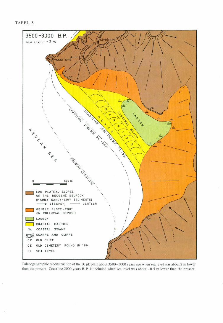
TAFE L 8
3500 - 3000 B.P. SE A LEVEL : -2 m
o
LOW P L ATEAU SLOPES
ON T HE NEOGENE BEDROCK
(MAINLY SANDY- LIMY SEDI MENTS )
--+ STE EPER, GENTL ER
GENTLE SL OP E - F OOT
ON CO LL UVI AL DEPOS IT
C:=J LAGOON
c=J COASTAL BA RR I E R
..ili. COASTA L SW AMP
mrm SCAR P S AND CL IFFS
oc OL D CLI FF
CE OLD CEMETE RY F OU ND iN 198 4
S L SEA L E VEL
I I
I , I
... ___ _
/ /
/ ------:::-/\ <_\~
' ' '\ "' 1 1
' 1 1
'
Palaeogeographic reconstruction of ehe Beşi k plain about 3500-3000 years ago whe n sea level was about 2 rn lower than the prcsent. Coastl ine 2000 years B. P. is inc luded when sea leve l was about -0.5 rn lower than thc present.