(06) Holocene geomorphic evolution of a barrier-salt marsh system, SW Delaware Bay
23
Reprint From SOUTHEASTERN GEOLOGY PUBLISHED A T DUKE UN IVERS ITY DURH AM, NORTH CAROLINA VOL. 20 NO. 2 MARCH, 1979
Transcript of (06) Holocene geomorphic evolution of a barrier-salt marsh system, SW Delaware Bay

Reprint From
SOUTHEASTERN
GEOLOGY
PUBLISHED AT DUKE UN I VERSITY DURH AM, NORTH CAROLINA
VOL. 20 NO. 2 MARCH, 1979
HOLOCENE GEOMORPHIC EVOL UTION OFA BARRIER-
SALT MARSH SYSTEM, SW DELAWARE BAY
By
Ilhan Kayan Department of Geography and Geology
Univer sity of Ankar a Ankara, Turkey
a nd Department of Geology University of Delaware
Newark, Delawa re 19711
and
John C. Kraft Department of Geology Univer sity of Delaware
Newark, Delaware 19711
ABSTRACT
Delaw a re Bay is one of the l a r ge r estuaries alon g the eastern coast of North Amer ica. The paleogeomorphology ofa portion of the southwest coast of Delaw a re Bay a t Cedar C reek-Sl aughter Beach has been delineated from airphoto studies , surface sedimentological and geomorphic studie s of present day coastal environments, and sedimentological a n d pal e ontol ogical studies of s ubsurface sed iments o f the latter half of the Holocene Epoch. Radiocarbon data from sedimentary environmental lithosomes clearly indicate that estuarine conditions existed in the study a rea a round 5000 B. P . Studies of the sediment s and the shapes of the sedimentary bodies encountered in a drilling progr am in a small area show that it is possible to make paleogeog r aph ic recons tructions of coa s t a l zone environments during the Hol ocene in the Cedar C r eek- Slaughter Beach area. Critical elements in such a study include the identificat ion of the pre - Holocene sur face a nd its morpho logical variants, the identification of Holocene environmental lithosomes in terms of their three - dimensional configurations and sediment type, a nd the radiocarbon dating of basal salt marsh o r ganic rich sediments and othe r salt marslı s ediments to provide a time frame for t h e sedi mentary env ironments . It is possible to predict a r ate of coastal ero sion of approximatel y one meter per year in the a rea, based on observation of ongo ing coastal proces ses and the geo logic r eco rd of the l ast half of the Holocene.
79
INTRODU CTI ON
Atla ntic coas t al Delaware lies on the no r thweste rn flank of the Baltimore Canyon Trough geosyncline. Geosynclina l depo s its occur from t he Fall Zone in the northwest to the oute r edge of the Atlantic continental she lf. In the a xis of the geos yncline , sediments are thicke r t han 12, 000 m . In the area of this s tudy ( Fig ure 1), the s outhwestern p o r t ion of a m a jor estuar y, Delaware Bay, geo s ynclinal sediment s a re appr ox imately 2000 m thick. These sediment s have been depos i ted in varied s edim enta r y env ironments s ince Jur assic time. Presently, the geosyncline i s pa r tially emerg ed as the Atl ant i c Coastal Plain and par t ia:ly su bme r g e <l a,; t he Atlan tic continental shelf. The e ntire eme r ge <l and submcrge d Co a:> t a l P l ai.n is covered by Q uatern a r y s ediments u s ua l l y l ess t han 30 m t h ick. The majority of the s ediments on t h e e m e rged coaslal pl a in are prob< 1,ly Sangamon Ag e fluv ia l, e s t ua rine - l agoon a l a n d s h a llow m a rin c sar:ds and m uds . On the c ontinenta l s helf a nd in adja cent l agoons a n rJ e s l uar ie s , Holocene s e diment s occur i n t h i ck nes s e s of up to 30 nı. During the l a test Wiscons in Ice Age , s ea - l evel dropped to m ore t han 100 m below present. Dur ing the peak Wiscon s in regres s ion, a dee pl y incised valley s y stem d evel oped on t he north western fla n k of the B a ltimc re Canyon Trough geosyncline. Deta il s of the ance s tral Delawa r e Rive r and it s tributa ry systems have been trac ed onto the outer Delawar e shelf (Swift, 19 74 and Twitche ll and o ther s , 1977 ). Studies by Emery (1 967), E mery a nd Ga r rison (1967) a nd Whitmore a nd others (1 967 ) have identüied coasta l - marine s ed iment s of Holocene a ge approximately 100 km offsho r e on t h e outer continenta l s helf. T hei r evidence s included mar s h deposit s , the pre sen ce of C r as sos trea v i rginica - the common oyster, an d a bundant rema in s of mas todon s an d m ammoths.
Sea level rose rela tive to l a nd a t a fai rly r a pid r a te in the early a nd middl e por tions of the Hol ocene Epoch and at ever dec reasing r a t es towar d t h e end of the Hol ocene to present time (F igure 2). Studies of relative sea l evel ri se , utiliz ing over 80 r a dioc a rbon d a te s , were used to develop a loca l r e lative sea l evel rise c urve for t he D e lawar e c oasts (Kraft , l 976a, Kraft , 19 7 6b, a n d Belknap and K r aft, 19 77 ). 1n addition, Hicks a nd Crosby (1 9 7 4) , based on tidal gauge rea dings, show t hat t he r a te o f r e l a tive sea l evel rise of the past half centu r y has dramatically inc reased in the s tudy area. T hey noted tha t in an eight year p eriod i n the 1960 ' s sea level rose appr oximatel y 8 . 4 cm. It i s not yet know n what this observation means . It may be a fluctuation on a l onge r te r m average o r it may be a change in cause and effect with a s ignificantly higher r a te of sea level rise to be p rojected into the futu re. Stud ie s by Elliott (1 972 ), K r aft and other s (1 9 7 3 ), Kraft and John (1 9 76 ), an d Str om ( 1972 ) p r ovide supporting evidence for the interpretations made here in. Howeve r , they do not a nswe r the quest ion raised by Hicks and C r osby regarding a pos sible dr a m a tic accele r ation in rate of sea leve l ri se in p r esent t imes.
80
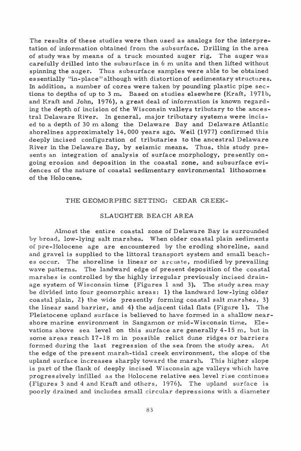
Figure 1.
.c,.·· DELAWARE
N
BAY"\c GEOMORPHOLOGICAL MAP OF
THE CEDAR CREEK -
SLAUGHTER BEACH AREA
,.
NEARı. Y F'UllT IJHOULATING Ul"l.Mm SUlllf ACE
Ofrıl PLEISTO([N[ N ARIN[ Of.PostTS IPOS T wıSCOtHIN ""0St0N.lol. suııtf'ACl'. I
NEAAL Y F'LAT HILLS AND
HIGHEA UPL.ANO SUftF'ACE
CıRCULAA OCP AESSIOHS
t ) UNORAl fıl fO
21JOINE0 TO T HE ORAINAÇf SYST(M
INCISEO DRAINAGE S YSTEtrıı
il uPP[llt ( C)G ( OF' THE VAl.LH SLOPf:
21VALLEY SLOPE ! APPAOJt > l "W. )
3) RUNNING WATCfl
41 oPC H WATCR
VAL LEY BOTTOM OR F'LUVlAL TERRACE
ON THE COLLUVIAL OEP OSITS
TH[ 8 0 \JNOARl' 8ETWEEN H i E
P l[ ISTOCEHE UPLANO ANO MARSH SUftfıtıCC
ti WIT t1 S TCP
21 WITHOU T S TEP
O LO MEANOER SCARPS
( IUCOGNISfO ON TH( .t.Jfl'°"OTOSI
MAASH SUAFACE
il TIOAL CAfCICS
21 SALT PO NOS
31 ISOLATEO UPLAHO ISL AHO tPLEISTOCCNE )
WASHOVEA 8ARRl[R
O S HORELıNE
21 BAARl (R !OUNEI
ll WASHOVC A F'AN S
OFFSHOAE DEPOSITIONAL ST AVCTURE
LI NES (S EEN ON TH( A IAPHOTOSI
EL EVATION ANO DEPTH VALuES 1 ME TE qs 8AS( 0 ON lııl(AN SE A L (Vtll
ROADS W1TH NUMBERS
AAI LWAY
SE TTLEMENTS
\_ ~
~
"' ·o· ·() r;! :~ J .
~ ~ ': ~o::.~•m ,..
~
·,~\< J N
,~ ;~,. ·· · t ... LOCATION MAP
~ f .• • O()() •W
""" " r ,ri' ı ~ • ~~- . · ~· .•. A geomorphological map of the Cedar Creek- Slaughter Beach area, including an index to the area of study.
81
"
• 8ASAI... P[A f
® TDl.t. MARSH PCA T
@ WOOO f.11 OCTPllAL ORGAHICS
~ ::: <>!:: CAR8JON I JO t~ ~ ::~O<:.:::" POSOT~• >--. AGE RANCE
j OEPTH RAta:
Figu r e 2. A lo c<ı.l r e l a tive s ea level rise curve based on r ad iocarbon dates from the Delaware coas ta l zone. Details of location a nd mate rials dated are published in Kraft, 1976a. Radiocarbon analys e s in this studywere c orrected acco r ding to the MASCA correc tion tables (Ralph and others, 1973).
Detai.led studies of the P leisto ce n e sediment s of the Atlanti c Coastal Plain were m a de by Jordan (1964). Jordon concluded that t he Pleistocene Epoc h depo s its were formed in fluvial environments in the north and middle part of the St a te of Delaware and shoreline and nearshore - shallow marine sedimentary environment s in the southern part of Delawa r e. This concept is now being questioned in the sense of specific ages of the depositional units. On the other hand, these sedi menta ry environment s appea r t o be clearly defineci . It is possible that the Quaterna ry sediments of the Atlantic Coastal P lain we r e d epos ited during h igh sea stands in the Sangamon and in mid - Wisconsin time s . Regional aspects of Holocene sediment s a nd t he Del aware coastal area are published elsew here (Kraft, l 97la; Kraft _. 1971 b; Kraft a n d John, 1976 ; and Weil, 1976).
METHODS
Stereographic a irphoto an a lysis was made of the s t ud y a r ea. Pre s ent fluvi a l and coastal environments we r e rel ated to an incised drainage pattern on the o l der c oastal p l ain (Figure 1). Sedimentol ogic a nd flora-faunal studies were made of the present coastal envir onments.
82
The results of these studies were then used as analogs for the interpretation of information obtained from the subsurface. Drilling in the area of study was by means of a truck mounted auger rig. The auger was carefully drilled into the subsurface in 6 m un its and then lifted without spinning the auger. Thus subsurface samples were able to be obtained es sentially "in- place" although with distortion of sedimentary structure s. in addition, a number of cores were t aken by pounding plastic pipe sec tions to depths of up to 3 m . Based on studies elsewhere (Kraft, 197lb, and Kraft and John, 1976), a great deal of information i s known regarding the depth of incision of the Wisconsin valleys tributary to the ancestral Delaware River. In general, major tributary systems were inci s ed to a depth of 30 m a long the Delaware Bay and Delaware Atlantic shorelines approximately 14, 000 years ago. Weil (1977) confirmed this deeply incised configuration of tributaries to the a n cestral Delaware R iver in the Delaware Bay, by seismic means. Thus, this study pres ents an integration of analysis of surface morphology, presently on going erosion and deposition in the coastal zone, and subsurface evidences of the nature of coastal sedimentary environmental lithosomes of the Hol o cene.
THE GEOMORPHIC SETTING: CEDAR CREEK-
SLAUGHTER BEACH AREA
Almost the entire coastal zone of Delaware Bay is surrounded by broad , low- lying salt marshes. When older coastal plain sediments of pre - Holocene age a re encountered by t he eroding shoreline, sand and g r avel i s supplied to the littora l transport system and small beach es occur. The s horeline is linear or ar cuate , modified by prevailing wave patterns. The l andward edge of present deposition of the coastal marshes is controlled by the highly irregul ar p reviously incised drainage system of Wisconsin time (Figures 1 a nd 3). The study area may be divided into four geomorphic areas : 1) the l andward l ow- lying older coastal plain, 2 ) the wide presently fo rming coastal salt marshe s , 3 ) the linear sand barrier, and 4) the adjacent tida l flats (Figure 1). The Pleistocene upland surface is believed to have formed in a shallow near shore marine environment in Sangamon or mid-Wisconsin time. Ele vations above sea l evel on this surface are generally 4- 15 m, but in some areas reach 17- 1 8 m in poss i bl e relict dune ridges or barriers formed during the last regres s ion of the sea from the study area. At the edge of the present marsh-tidal c reek environment, the slop e of the upland surface inc reases sharply towa rd the marslı. This higher slope is part of the flank of deeply incised Wisconsin age valleys which have p rogressively infilled as the Holocene relative ·sea level r is e continues ( F i gures 3 an d 4 and Kraft and othe r s, 1976). The upland sur face i s poorly drained and includes small cir cular depressions with a d iameter
83
N
~~:)(
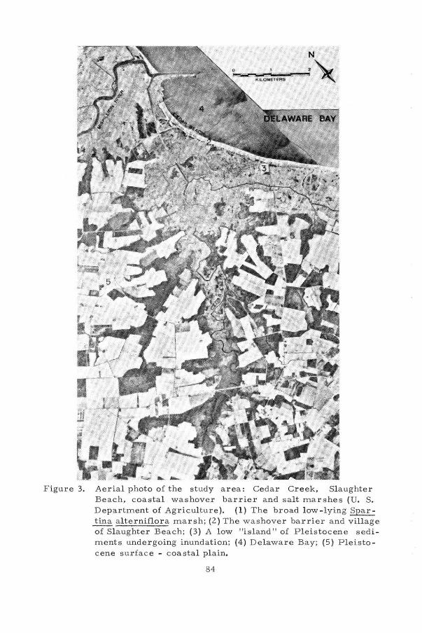
F igure 3. Aerial photo of t h e study a rea : Ced a r Creek, Sl aughte r Beach, coas ta l washover barrier and salt mars hes (U. S. Depar tment of Agriculture ). (1) The broad low -ly ing Spartina alte rniflora mar slı; (2 ) The washover barrier and v illage of Sl a ughter Beach; (3) A low "island " o f P leis tocen e sed i ments undergoin g in undation; (4 ) Delawar e Bay; (5) P leis tocene surface - coa st a l pla in.
84
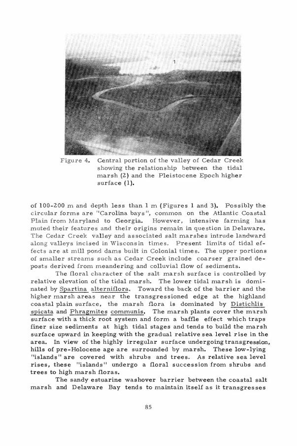
Figure 4. Central portion of the valley of Cedar Creek showing the relationship between the tidal marsh (2) and the Pleis tocene Epoch higher surface (1).
of 100-200 m and depth less t han 1 m (Figures 1 and 3). Possibly the c ircular forms are 11 Carolina b ay s 11
, c ommon on the Atlantic Coastal P l ain from Maryland to Georg ia. However, intensive farming has muted their feature s a nd their origins remain in question in Delaware. The Cedar Creek valley and associated salt marshe s intrude landwar d along valleys incised in Wisconsin times. Present limits of tidal ef fects are at m ill pond dams built in Colonial time s . The u ppe r portions of smaller streams such as Cedar Creek include coarser g r ained de posts derived from meandering and colluvial flow of sediments.
The floral ch a r acter of the salt mars h surface i s controlled by rela tive e l evation of the tidal marsh. T h e lower tida l marsh is domi nated by Spartin a alterniflor a . Toward t he back of the barrier and the higher mar sh areas nea r the transgressioned edge at the highl and coastal plain s urface, the marsh flora is dominated by Distichlis sp icata and Phragmites communis. The marsh p lants cover the marsh surface with a thick root system and form a baffle effect which traps finer s ize sediments at high tidal stages and tends to build the marsh surface upward in keeping with the gradual relative sea level rise in the area. in view of the highly irregular surface undergoing transgression, hills of pre-Holocene age are s urrounded by marsh. These low - lying 11islands 11 are covered with shrubs and trees. As relative sea level rises, these "islands 11 undergo a floral succession from shr ubs and trees to high mar sh flora s.
The sandy estuarine washover barrier between the coastal salt marsh and Delaware Bay t ends to maintain itself as it transgre sses
85

landward by coastal erosion across the low -lying salt mar slı. Rates of e r osion in the a rea of study are approximately 1 m p er yea r but v a ry up to 8 m per year along the adjacent Delaware Bay s horeline to the north a nd south, as averaged from coastal survey maps over the past cen t ury (Kraft and others, 1976). Short-term rates of eros ion are ex tremely difficult to predict. The a rea is sub ject to high intensity events such as h urricane s and northeas t e r s . The l ow-lying c oas t a l a r ea has a tidal range of 1. 5 m and is therefore s ubject to storm overwash. Seaward of t he washover barrier lies a 500 m wide organic muddy tidal fla t. Short- ter m r ates of e r osion a r e difficult to deter mine since the mouth of the Mispillion R iver t o the north is protected by two jetties , a pproximately 1. 5 km l ong and the direction of s torm wave approach i s h ighly varied.
The estuarine washover barrier between the coastal marshes and Delaware Bay i s gene rally about 3 m above mean sea level. It varies in width 150- 200 m from t he ba y to the limits of the sandy wash over l obes. The washov er barrier extend s like a natural levee a long the shoreline; thus, the sP'1all c reeks that c r os s the marsh tend to flow p a rallel to the back of t he barrLer a s tributa ries to larger c r eeks, eventually d r a in ing into t he l a rger Mispillion River. During times of storm e rosion, the ba rrier is overwashed and massively eroded. The be rm-beachface at the town of Slaughte r Beach has varied over the past several decade s from mass ive erosion and undermining of bulkheads to full wide b eaches established by beach nourishment programs. Sand and gravel eroded from the beach is not r eplaced by the natura! littoral transport system at the r ate of storm loss. This may be caused by the jetties o f t he Mispillion River or by l ack of sour ce of additiona l course sediments to the littora l transport system. The inner tidal a r ea in front o f the barrier includes wide tidal flats of bay muds and sands and g r a vel s eroded from the beach.
COASTA L PROCESSES
Climatic conditions in the area of study vary greatly on a yearl y and long-term ba s is. ln gene r a l , winter winds are s tronger, with constant di rection. ln the Cedar Creek-Sl aughter Beach a r ea, the dominant wind direction is from l and to sea a long the coa stline, which lies in a northwest - southeast d i rection. Thus the w ind in opposition to the ave r age direction of wave approach and may tend to decrease the powe r of waves as they impinge upon the shoreline in the area of s tudy. However, winds and waves of hurricanes and northeasters a r e generally f rom the east. These st orm waves are the most effective processes causing geomorphic change of the beaches in t he study area. T he fas test w ind recorded in the past 50 year period a long the Delaware Bay coastline was 130 km pe r hour. The ave r age wave height in Delawar e Bay is relatively low, O. 5 m . The average t ida l r ange in the area is
86

1. 25 m with a spring tide range of 1. 5 m. During extreme stor ms (50 year recurrence in terval) a maximum effective wave height of 7 m with calculated extreme heights of 12 m can occur in Delaware Bay (Maurer a n d Wan g , 1972 ). As a result of storm dominated wave activity t h e estuarine barriers rema ined l ow and are frequently overwash ed.
Although the general littoral tran sport system in the Del aware Bay on the southwestern or Del aw a re shorelin e is to the south, frequent exceptions o ccur. Va r iable w ind dire c tions in storms m ay rever se t h e littor a l drift patte rn. Milford Neck, l y ing to the north of t he a rea of study p rovide s a s ource of cour se s and sediment tha t flows southward into the a r ea of study. However, much of this sediment is t rapped by the j etties of the Mispillion River. These jetties cause a d i s r uption of flow and accordingly a counter flow along Slaughter Beach in this area of s tudy, providin g for short per iods of northerly littoral drift in t he relativel y protected area south of the jetties. Regardless, over the longer t erm, coast a l erosion is much greater than coastal deposition. Acco rdingly the shoreline contin ues to move landwards and the marsh surface continues to build upward with sediment of the turbid waters of the flood tides flowing ac r oss the mar sh surface. Based on an analysis of coastal processes impinging upon t h e study area, it is felt that the jetty of the Mispillion R iver, t he resultant alteration in current flow patterns, extreme storm events, and continuing r e lative s e a level rise are t he prime rea sons for excep tional rates of erosion and resultant l andwar d migration in the Sl a ughter Beach a rea .
SUBSUR FACE SEDIMENT AR Y UNITS IN THE CEDAR CREEK-
S LAUGHTER BEACH AR E A
E l even h ol es were drilled in the study a rea. Radiocarbon a n a l yses of five sample s of salt marslı sediments believed to be in growth position were o btained. A number of interpretive cross-sections were made an d a re indexed on Figure 5. The se c ros s - sections were canstruc ted both p a r a llel and perpendic ular to the washover barrier. By means of t hese c ros s-sections and with a knowledge of rela tive sea level change · in the a rea as provided by the radiocarbon dates in this study and elsewhere (Kraft, 1976a ) paleogeographic reconstructions were made. The subsurface test s were drilled with a truck mounted auger rig. As 6 m of penetration were made, the augers were lifted without rotation. Thus the s edimentary sequence s could be examined a nd sampled with reasonable confidence that the sediments studied were in proper stratigraphic pos ition. However, sedimentary s tructure s tended to be destroyed by this proces s. Test hol es w e re drilled into the underlying P l e istocene s edim ent s in an attempt to define t he shape of the l and s urface during the peak of the Wisconsin glaciation. ln general, the P l eistocene s ediments a r e compact ed sands an d oxidi zed to yellow, o r ange, tan and
87

GEOLOGICAL MAP OF THE CEOAR CREEK
SLAUGHTER BEACH AREA o 2 KM -----=====io----c=:==~
PLEISTOCENE SHALLOW MARINE
CHANNEL - LAG DEPOSITS COLLUVIAL SANOS
MARSH
WASHOVER
KAY~N-IO DRILL HOLES AND NUMBERS
ll.___i CROSS SECTION LINES
DELAWARE BAY
s'
Figure 5. Geologic map of the Cedar Creek- Slaughter Beach area showing lines of interpretive subsurface cross sections .
88

light brown and light gray colors. No orga nic debri s was found in the Pleistocene sediments. Depth to the Pleis tocene s urface is highly var ied. Pleistocene sediments a re expos e d in the adjacent Coastal Plain at e l evations up to 17-1 8 m above sea level. ln the holes drilled for thi s study, the Pleistoc ene sur fac e w a s found at depth s up to 14 m below s ea l evel. F u r t her, in studies o f adj acent areas along the entire coa st of Delawar e Bay and the Delawa re Atlantic Ocean c oast, Pleistocene erosional surfaces have been found a t depths up to 35 m below sea l evel. Thus, the deeply incised eros i on surface a t t h e peak Wis c onsin glac iation a nd re s ulta nt l ower s ea level ha d a tota l relief of appr oximately 50 m in the valleys tributa ry t o the a ncestra l Delaware River (Kraft and J ohn, 19 76 ). The a nc e s tra l Delaware River flowed southeastwa rd t h ro ugh centra l Delaw a re Bay into the a r ea of the present Atla ntic Ocea n and t henc e eastward ac r o ss t he c ontinental shelf. Thi s , much l arger r iver, was inc is ed to ove r 65 m bel ow present sea level. Thus, with knowledge of base l evels of tlıe major rivers tribut a ry to the ancestral river , projec t i on s of d e p ths of valley s can be made in the area of stud y. Stra tig r a phic s e c t ion s int erpreted and presented in t he paper are ba sed on a highly p robab l e co m mon base level of erosion of river valleys t o the north and south d uring tlıe peak Wiscon sin Epoch.
Holocene fluv ial sand s oc cur as channel-la g d eposit s . Tlıese
depo sit s usually cons i s t of dark gray coarse sands with a low per centa ge o f pebbles . Tlıey occ ur along tlıe axes of Ceda r Creek and its tri b ut a rie s and can be e asily d iffe rentiated from the P lei st ocene sand s and gravel s by the fact tha t they a r e non-consolidated and not oxidized. T hes e c hannel deposits occur at the base of the Holocene transgres sive s equen c e.
The salt marslı deposits appear to keep pace with the continuing r ise of s e a rela tive to l and. Tlıus the mar s lı surface itself may be used as a paleo-indicator of sea l evel stand if one can identify a mars h surface in the sub s urfac e and date it by radiocarbon methods. Much of the marsh section i s an organic clay with marslı plant debris scattered tlırouglıout. At tim es t he marslı flor a devel oped in rela tively dense layers of organic sedi ment . Some of t he sediments are clearly trans ported macerated debris. However , otlıer s are recognizable as mar s lı
flora in g rowth position. Tlıis indicates a marsh su rface and, if datable, is extremely u seful in paleogeographic reconstructions. In some of the subsurface sampl es, lagoonal mud s equen ces a re found. These lagoonal sediments consist of clay silts, generally gray or dark gray in color. A fauna of Elplıidium cla vatum and Crassostrea virginica Gmelin was found . These , pl us a few rare ostracodes are a good indication of lagoonal conditions. Drill holes and tr enches were also made through the c oastal waslıover ba rrier depo s its. Sediments of the washove r barrier are viable, gen erally light in color, and moderately to poo"rly sorted with an avera ge medium- coarse g r aine d size. In local a reas, we ll sorted, fine dune sands occur along t he uppe r part of t he bar r ie r. However, in view of the frequent waslıove r s tlıat occur, dune fields are only
89
a m inor element of the bar rier morphology. The beach-berm and w as h over deposits include a low percent of pebbles. The pebbles are qua rt z and silicified limestone. A number o f the s e pebbl es incl ude fos sil coral s of Silurian and Devonian age , similar to t hose found in the Ap palachian Mounta ins of northeastern Pennsylvania. These fossils are a n evidence that the original source of sand and gravel in the Coas tal Plain deposits of the Delaware region wa s eros ion of paleozoic sedi ments in northeastern Pennsylvania. P r esumably the sediment w a s transported to the lower D elaware Coastal Plain by glacial streams and redistributed and depos ited by coastal processes during the Pleistocene Epoch.
Fig ure s 6 to 13 show detailed c ross - s ections of the depositional environment s foun d in t h e subs urfa ce. The sediments are shown sche matic ally. Environm ental interp retations have bee n m a de bas e d on direc t cor relation of litholog ie s found in the d rill holes with s ediment s fo r min g in p r es ent day coa sta l envi ronments in the area of st udy. This has b e e n fu r ther s upported by comparison of Fo r aminifera, O strac oda , and mollus k s fonn d in the d r i ll hole s, with tho se pre sen tly living in t he c oast a l environme nt s. Ca r e w as taken t o determine whether or not mar slı flora was transported redeposited debris or mars lı flor a in growtlı po s ition. With careful s tudy, it is possible to identifythe marslı
flora by megascop ic an d mic roscopic means; and therefore, determine whether or not a h ig h or a low marslı flora was encountered (Allen, 1977). In addi tion, surface and subsurface environmental analyses else· where in t he Delaware coastal region were used as supportive informa tion in int erp r eting the subsurface envi r onments in the Cedar C r eekSl aught e r B e ach a rea (Kra,ft, 197 l a , Kraft, 197lb, K r aft and John, 1976, and K r aft and Other s, 1976).
F igu r es 6 an d 7 indi cate the presence ofa coastal back barrier lagoon s urrounded by fringing salt marslı. These lagoonal conditions existed in some portions of the area of study from approximatel y 6000 ye a r s B . P. to 300 - 400 yea rs B. P. The shapes of tlıe Holocene subsur fa c e s edimentary bodies are h ighly varied and in part determined by the p re -exi s ting e r osional topography of the land surface formed during the time of the peak Wisconsin gla c iation. As sea level rose with the w aning of the Wi s consin glaciation, coastal sedimentary environments migrated in a landward direction, infilling the v a lleys and keeping pace with r i se of sea level through the Holocene Epoch. Thu s the overall thickness of the Hol ocene sediment s deposited has been determined by tlıe rise in sea level over the transgressed land s urface. Radiocarbon da tes presented in the c ross - sections allowed the development ofa time fram e for the deposition of these sediments. However, the actual shape of the sedimentary environmental litlıosomes and resultant thickness of sediments of Hol ocene coastal environments is ext remely varied, and dependent upon pre-existing e r os iona l topography under going transgression. Cross - section Figures 8 -10 are perpendicular to the barrier but do not include lagoonal muds. However, they show tlıe highly
90
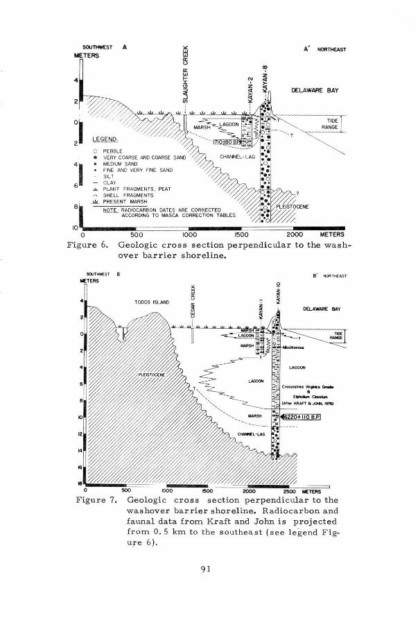
SOUTHWEST A A' NORTHEAST 15 METERS ı..ı
ıs
4
2
8
o: ı..ı ı--:ı: (!)
~
O PEBBLE • VERY COARSE ANO COARSE SANO • MEOIUM SANO • FINE ANO VERY FINE SAND
SILT CLAY
.ı. PLANT FRAGMENTS, PEAT ~ SHELL FRAGMENTS
..>iL PRESENT MARSH
!'iQif_; RADIOC ARBON OATES ARE CORRECTED ACCOROING TO MASCA CORRECTION TABLES
OELAWARE BAY
TiDE RANGE
500 1000 1500 2000 METERS
Figure 6. Geologic cross section perpendicular to t he washover barr.ier shoreline.
SOUTK#EST 8
METERS
4 TODDS ISLAND
B' NORTHEA.ST
DELAWARE BAY
LAGOON
·· Cranotlf9o '1rfİ'İCO (İııll'llft a
E,....._~ ...
~ 1000 eoo 2000 2'°° METtRS
Figure 7. Geologic e ros a s ection perpendicular to the was hover barrier shoreline. Radiocarbon and faunal data from Kraft and John is project ed fr om O. 5 km to the southeast ( see legend Figu:r-e 6 ).
91
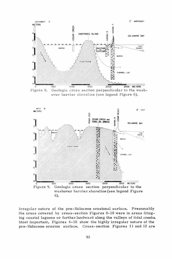
sour.-sT C METERS
4
8.
WEST 0
METERS
C' NOl!Tt€AST
SHEPPAROS ISLA/'D DELAWARE BAY
~O 1000 1500 2000 2500 METERS
Geologic cross section perpendi c ular to the washover bar rier shoreline ( see legend F igur e 6 ).
.., o N
CEDAR CREEK ...ı RQAO t6 -8ROGE
O' ( AS T
OELAWARE BAY
--............. , ..... t~'
---.. Rı.NGE
~
2500 METERS
to the Figure
irregula r nature of the pre- Holocene erosiona l surface. Presumably the a rea s covered by cross-section Figures 8-10 were in areas fringing coastal lagoons or further landward a long the valleys of tidal creeks. Mest important, F igure s 6-10 show the highly i rregular nature of the pre-Holocene erosion surface. Cross-secti on Figures 11 and 12 are
92
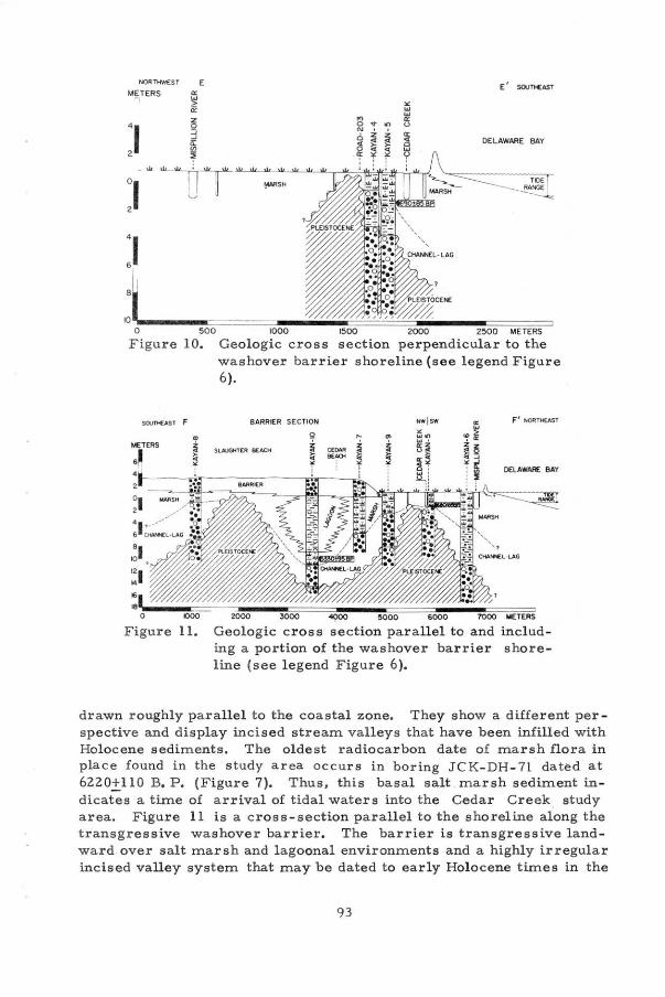
NOR TtfflES T
METERS -,
41 6
E
" w w a: u
E ' SOUTMEAST
DELAWARE BAY
j~~~=====--~ O 500 1000 1500 2000 2500 METERS
Figure 10. Geologic cross section perpendicular to the washover barrier shoreline (see legend Figure 6).
SOVTHEAST F BARRIER SECTION F' NOATl-tEAST
METERS
6~
2 ,._
~ CLOM ~ .. ~ Sl.AIJGKT[R BEACH
"' ~.! 9004 ~ •1-~~-.-...---~~~~~~---......-~~~i
DEl.AWARE BAY
2
ol 2
o ıooo
Figure 11. 2000 3000 ~ ~000 6000 7000 METERS
Geologic eros s section parallel to and including a portion of the washover barrier shoreline (see legend Figure 6 ).
drawn roughly pa rallel to the coastal zone. They show a different per spective and display incised stream valleys that have been infilled with Holocene sediments . The oldest radiocarbon date of marslı flora in place found in the study area occurs in boring JCK-DH- 71 dated at 6220±110 B. P. (Figure 7). Thus, this hasal salt marslı sediment indicates a time of arrival of tidal waters into tlıe Cedar Creek study area. Figure 11 is a cross-section parallel to tlıe shoreline along the transgressive washover barrier. The barrier is transgressive landward .over salt marslı and l agoonal environments and a higlıly irregular incised valley system that may be dated to early Holocene times in tlıe
93

SOU1'4EAST G
METERS
si
F igure 12.
-THEAST H
METERS
e
PARALLEL TO BACK Of BARRIER G' ~TMW[ST
Geologic c r oss section parallel to and l andward of the washover barrier c ross s e ction showing some of the ba rrier washover lobes ( see legend Figur e 6).
H' SLAUGHTER NECK
SOUTH
6 .......... --=========---------=======::::::ıı---------=======::ı o ~o ıooo ı:ıoo 2000 2500 METERS
F igure 13. Geologic cross section of the upper Cedar Creek valley n ear the head of tidal penetra tion (see legend F igure 6 ).
area of study but to the peak Wiscons in gl a ciation from the evidenc e el sewlıere in the Delawar e coastal zone. Cros s - s ection Figure 12 is al s o parallel to the shoreline but l andward of the barrier. Some of tlıe washover lobes whiclı extend l andward on top of tlıe marslı a re shown. Cross - s e ction Figure 13 slıows the uppe r portion oftidal Cedar Creek. Here clıannel lag deposits are overlain by a tidal marslı sequence tlıat infills the n a rrow, r e latively deeply incised upper valley of tlıe ances tral Ceda r Creek.
94
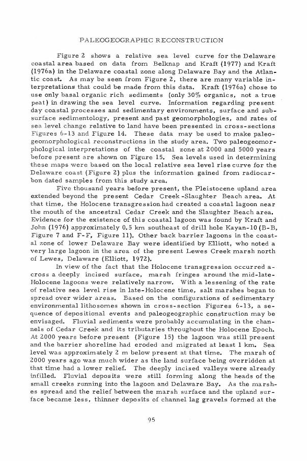
PALEOGEOGRAPHI C RECONSTR UCTION
Figure 2 shows a relative sea level curve for the Delaware coast a l area based on <lata from Belknap and Kraft (1977) a nd Kraft (1 976a) in the Delaware coastal zone along Delaware Bay and the Atlantic coast. As may be seen from Figure 2, there are many variable interpretations that could be made from this data. Kraft (1976a) chose to use only basal organic rich sediments (only 30% organics, not a true p ea t) in drawing the sea level curve. Information regarding pre sent day coastal p roces ses and sedimentary environments, surface and sub surface sedimentology, present and past geomorphologies, and rates of s e a level c hange relative to land have been presented in cross-sections Figures 6 -1 3 and Figure 14. These data may be used to make paleogeomorphological reconstructions in the study area. Two paleogeomor -pholog ical interpretations of the coastal zone at 2000 and 5000 years before pre sent a re shown on Figure 15. Sea levels used in determining these maps were based on the local relative sea level rise c urve for the D e l aware coast (Figure 2) plus the information gained from radiocar bon dated samples from this study a rea.
Five t h ousand years before present, the Pleistocene upland a rea extended beyond the present Cedar Creek - Slaughter Beach area. At that time, the Holocene transgression had created a coastal lagoon near the mouth of the ancestral Cedar Creek and the Slaughter Beach area. Evidence for the existence of this coastal lagoon was found by Kraft and John (1976) approximately O. 5 km southeast of drill hole Kayan-10 (B-B, Figure 7 and F-F, Figure 11 }. Other back barrier lagoons in the coasta l zone of lower Delaw a re Bay were identified by Elliott, who noted a very large lagoon in the a rea of the present Lewes Creek marslı north of Lewes, Delawa re (Elliott, 1972).
In view of the fact that the Holocene transgression occurred a c ross a deeply incised surface, marslı fringes around the mid-lateHolocene lagoon s were relatively n a rrow. With a lessening of the rate of relative sea leve l rise in l ate-Holocene time, salt marshes began to spread over wider areas. Based on t he configurations of sedimentary environmental lithosomes shown in cross-section Figures 6-13, a se quence of depositional events a nd paleogeogr aphic construction may be envisaged. F l uvial sediments were probably accumulating in the c hannel s of Ced a r Creek and it s tributaries throughout the Holocene Epoch. At 2000 years before present (Figure 15) the lagoon was still present and the barrier shoreline had eroded and migrated a t least 1 km. Sea l evel was approximate ly 2 m below present a t that time. The marslı of 2000 years ago was much wider as the land surface being overridden at th a t t ime had a lower relie f. The deeply incised v a lleys were already infilled. Fluvial depos its were still forming along the heads of the small creeks running into the lagoon and Delaware Bay. As the marshes spread and the relief between the marslı surface and the upland s ur face became less, thinner deposits of channel lag gravels formed at the
95
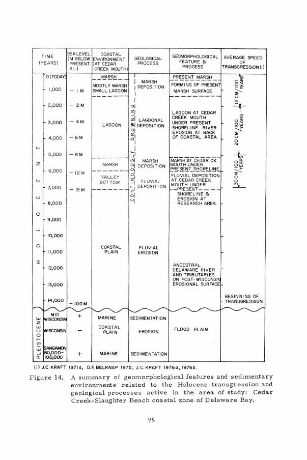
TiME
(YEARS)
O(TOOAY
1,000
2,000
3,000
4,000
w 5,000
z 6,000
w 7,000
u 8,00 0
o 9,000
_J
10,000
o 11,000
:ı:
12,000
13,000
14,000
SEALEVEL COASTAL (M BELOW ENVIRONMENT GEOLOGICAL PflESENT (AT CEDAR PROCESS SL) CREEK MOUTH)
- iM
- 2 M
- 4M
-6M
-8M
- 12M
-15M
- IOOM
+
1 MARSH MOSTL Y MARSH I OEPOSITION
S~=-L _ı:-_:~N I
LAGOON
1 (!)I zı
;;ı LAGOONAL ~j DEPOSITION oı ırı ol
1 >-ı
------ ~f MARSH MARSH =>f DEPOSITION --- -- o, VALL EY ~I
BOTTOM -1 FLUVIAL ----- ~I OEPOSITION
COASTAL PLAIN
COASTAL PLAIN
MARINE
ol uı
FLUVIAL EROSION
SEDI MENTATION
EROSION
SEOI MENTATION
GEOMORPHOLOGICAL AVERAGE SPEED FEATURE S OF
PROCESS TRANSGRESSION (1)
PBS?~N.! !!!~~ -FORM 1 NG OF PRESEN MARSH SURFACE
L AGOON AT CEOAR CREEK MOUTH UNOER PRESENT SHORELINE. RIVER EROSION AT BACK OF COASTAL AREA.
MARSHATCEÔİİRCi<. MOUTH UNDER P~g!::!_T_S!iQB~lliE . FLUVIAL OEPOSITION AT CEOAR CREEK MOUTH UNOER - PRE SENT- - -
SHORELINE 8 EROSION AT RESEARCH AREA.
ANCESTRAL DELAWARE RIVER ANO TRIBUTARI ES ON POST-WISCONSI EROSIONAL SURFACE
FLOOD PLAIN
o ır olj ->-i' u
V> ır
0<( ow ~ ~ u o N
* o~ ->-i' u o
_'.J___
BEGIN NI NG OF TRANSGRESSION
( 1) J.C.KRAFT 19710, D. F.BELKNAP 1975, J.C.KRAFT 19760, 1976b.
Figure 14. A summary of geomorpholog i cal features and sedimentary environments related to t he Holocene transgression a nd geological processes active in the a rea of study: Cedar C r eek- Slaughter Beach coastal zone of Delaware Bay.

Figur e 15. Paleogeogr aphic r econstruction of t he Ce dar C r eek- Slaughter Beach area for 2000 years before present and 500 0 years befor e present.
heads of the valleys. Compari sons of the two reconstructions show that the lagoon
existcd in the a r ea for a relatively l ong time . Rad ioca rbon dates of the marsh that eventua lly enc r oached acros s this l agoon are relatively young, 300 to 400 years B . P . Simila r conclusion s w ere reached re garding other a ncient lagoons along t he Del aware Bay coast (Kraft, 1971 b ). It is possible that the shallow c oastal back ba rrie r lagoon s wer e pre sent when European settlers fi r st reached North America. However, the radiocarbon evidence tends to suggest tha t the lagoons closed about 400 year s B. P . A g r adually narrowing marsh sur face ex tends up the valley of Cedar Creek . As relative sea lev el c ont inues t o r ise, this marsh sur fac e will b uild landward a nd upwa r d and tend to cover the c hannel l ag deposits of the center of the Cr eek bed and further override the low-ly ing valley edges. In gener a l , t he d r a inage pa tte rns of mid - Holocene time were the same as present; however, the barrier la y fu rther seaward a nd the mar sh lagoon s equence was below present sea l evel. Although there is evidence of abandoned mar s h channel s in some of the sal t ma r sh a r eas , they a r e n ot common. Hi stori cal maps of the study area and a d j a cent coasta l marshes to the north and south show no evidence of migr a t ion of m eande r s . Accordingly , it is hypothe sized tha t the meander l oops of the tidal creeks have rema ined in a r e l atively stabl e position fo r a long time.
97

CONCLUSIONS
Marine environments fir s t intruded int o tlıe Ceda r Creek va lley a rea in tlıe v icinity of Slauglıt e r Beaclı abo ut 6200 years B. P. From tlıen until now a s sea level g r a dually r ose, tlıe c oas t eroded and tlıe est uar ine waslıover barrier migrated landward and upward acro ss tlıe coastal salt mar s lı. At tlıe s a me time, tlıe sa lt marslı surface rose at a r a te simila r to tlıe relative sea level ris e. At one time, a l a r g e co :ı.stal l a goon oc c urred in tlıe a rea of Slauglıter Beach. Tlıis lagoo n was fina lly fille d and c overed by a s a lt mars lı approximatel y 300-400 B. P. Today tlıe Slauglıter Beaclı barrier continue s to undergo inten s ive ero sion a n d waslıover and a sl o w mig ration landwa rd. Witlıo ut needed beac h n our ishment by means of dredging s ands and g r a vels from offshor e shoal s, t he ba r r ier w o uld gradually dis a p pea r witlıin tlıe next ccnt ury a nd a more mars lıy s lıoreline woul d tak e its pla ce. Witlı c ont inued r e l ative s e a l evel r i s e a nd re s ul tan t ris e of tlıe mar slı sur fac e, tlıe l ate Hol ocene t r an sgression will expand landwar d a s salt mar s lı cond it ion s continue to enc r oaclı upon tlıe low-ly ing coast al p la in. Tlıe s um mary of geomorplıolog ic al and g e olo gical p rocesses of coas tal envi r on menta l clıang e p resente d in Figu r e 14 will probably con '::inue int o the slıort t e r m ge ologic al fut u r e . Tlıu s man w o uld be w ell advis ed to a dapt to tlı e se ever changing s lıoreline environmenta l config u r a tion s in planning futur e c ons truc t ion o r developm ent of the coastal zone.
REFERENC ES CITED
Allen, E. A. , 1977, P etr ology and stratigr aplıy of Holocene coastalmar slı d e po s it s a long t lıe western slıore of Delaware Ba y: A Delaware Sea Gra nt Technic al Report DEL-SG-20-77, Colleg e of Marine Studie s , Univer s ity of Delaware , Newa rk, Delawa re, 287 p .
Belk nap, D. F . and J . C. Kraft, 1977, Holocene relative sea-level c lıange s a nd coasta l s tratigraplıic unit s on tlıe nortlıwest flank of tlıe Baltimore Canyon Trouglı g e osync line: Jour. Sed. Petrology, v. 47, no. 2, p. 6 10-629.
Elliott, G. K., 1972 , Tlıe Great Marslı a t Lewes, Delawa re, tlıe plıy
siog r a phy, classific ation and geologi c lıi story ofa coastalmarsh: ONR Teclı. Report No. 19, Colleg e of Marine Studies, Univer s ity of D elaware , 139 p.
Emery, K . O . , 19 67, Tlıe Atlantic continental margin of the United States d uring tlıe past 70 million years: Geol. Assoc. Canada Spec. Paper 4, p . 53-70.
Emery, K. O., a nd L. E . Garrison , 1967, Sea levels 7000 and 20, 000 yea rs a go : Science, v . 157, p. 684-687.
Hicks, S. D . and J. E. Crosby, 1974, Trends and variability of yearly mean sea level : NOAA Tech. Memorandum NOS 13, Rockville,
98
Md. , National Oceanic and Atmospheric Admin. / Nat. Ocean Survey, 14 p .
Jordan, R. R., 1964, Columbia (Pleistocene) sediments of Delaware : Delaware Geological Survey Bull. No. 12, 69 p .
K raft, J, C., 197la, Sedimentary facies patterns and geologic history of a Holo cene marine transgression: Geological Soc. America Bull., v . 82 , p . 2131-2158.
------'' 197lb, A guide to the geology of Delaware's coastal environments: Geol. Soc. of America' s Field Trip Guidebook, Tech. Pub, No. l, College of Marine Studies, Unive rs i ty o f Delaware , Newar k, Delawa re, 22 0 p.
Kraft , J . C., R. B. Biggs, S . D. Hal sey, 1973, Morphology and vertica l sequence modelsin Holocene tran sgressive barrier systems: in Coates, D. R . , ed. , Coastal Geomorphology. P ublications in Geomorphology, State University of New Yo rk, Binghamton, N. Y. , p . 32 1-354.
Kraft, J. C. and C. John, 1976, The geological structure of the shorelines of Del aware: A Delaware Sea Grant T echni cal Report DELSG-14-76, College of M a rine Studies , University of Delaware, Newar k , Del aware, 106 p.
K r a ft, J . C. , 19 76a, Radioca rbon dates in t he Delaware coasta l zone (Easter n Atlantic Coast of North America ) : A Del awar e Sea Grant Technical Report DEL-SG-19- 76, College of MarineStudie s, University of Del awar e, Newark, D el aware, 20 p.
------, 19 76b, Late Quaterna r y p a l eogeographic changes in the coastal environment s of Del aware, M iddl e Atlantic Bight , rela-ed to a r chaeol ogic settings: Annals of t he New York Academy of Sciences, vol. 288 , p. 35 - 69.
Kraft, J. C. , E . A . Allen, D. F. Belk nap , C. J, John, and E. M. Maurmeyer, 1976 , Geolog i cal processes and t he geology of Dela ware's coastal z one; published as Delaware' s Changing Shore line, Tec hnical R ept. No. 1, Office of State P l anning, Dover, Delaware, 319 p.
Maurer, D ., and H. Wang, 1972, Environmenta l vulnerability of the Del aware Bay a rea to supertanker accommodation: Vol. III, Chemistry, engineering, geology and physical o ceanog r aphy. Report submitted to Co uncil on Environmenta l Quality, Washington, D . C.
Ralph, E . K., H. N. M ichael, and M. C. Han, 1973, Radiocar bon dates and reality: MASCA Newsl etter, Vol. 9, No. 1, The Univer sity Museum, University of Pennsylvania, Pennsylvania,
Strom, R. N. , 19 72 , Sediment distribution in southwestern Delaware Bay: ONR Tech. Rept. No. 18 , College of Marine Studies, Univ. of Del awar e , Newa r k , 118 p.
Swift, D., 1974, Continenta l Shelf sedimentation, in Burk, C. A. and C. L. Drake, eds. Thegeologyof continentalma r gins, p. 117-135 , Spr inger , Verlag, New Yo r k.
99

Twichell, D. C. , H. J. Knebel, and D. W. Folger, 1977, Delaware River: Evidence for its former extension to Wilmington Canyon: Science, vol. 195, p. 483-484.
Whitmore, F. C. , K. O. Emery, H. B. S. Cooke and D. J. B. Swift, 1967, Elephant teeth from the Atlantic continental shelf: Science Yol. 156, no. 3781, p. 1477-1481.
W eil, C. B, , 1977, Sediments, structural framework, and evolution of Delaware Bay, a transgressive estuarine delta: A Delaware Sea Grant Technical Report: DEL-SG-4-77, College of Marine Studies, University of Delaware, Newark, Delaware, 199 p.
100