GEOMORPHIC CYCLES
28
GEOMORPHIC CYCLES Narendranath Guria
Transcript of GEOMORPHIC CYCLES

GEOMORPHIC CYCLES
Narendranath Guria
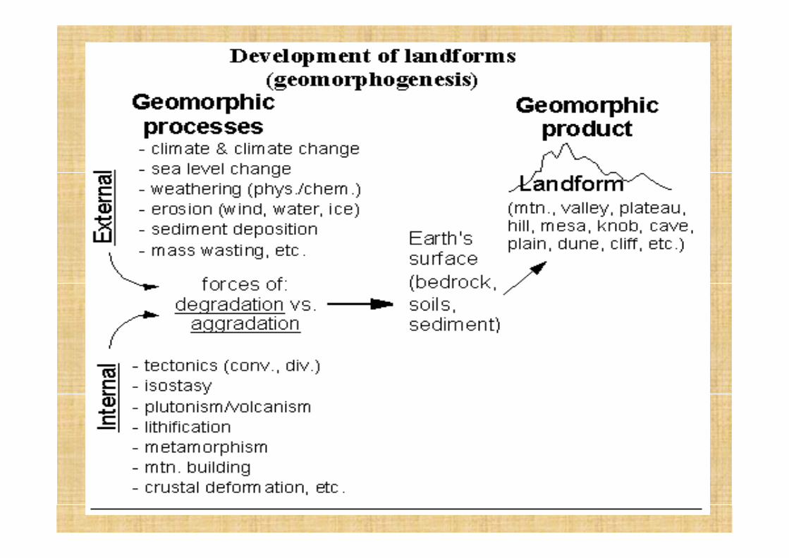

• Geomorphogenesis ("land" + "form" + "origin") iscontrolled in many way by many different factors. Someof the processes operate at the Earth's surface, otherswork in the subsurface. Most surficial processes (exceptsediment deposition) degrade the landscape (i.e. wear itdown) whereas most internal processes contribute insome way to building up (aggrade) the surface. So in asense, external forces battle internal forces for controlof the appearance of the Earth!!!
• The end result is a landform.
The Influence of Rock Types on Landscape
• The appearance and characteristic features of landforms are greatly influenced by the underlying rock types. Softer rocks like clay and shale are worn down much faster than harder rocks like granite.
• Within West Malaysia the resistant granites form the high ground of the Main Range and the Eastern Range, where several peaks rise to over 2,000 feet. Shales, schists and sandstones, being less resistant, form the much lower, rounded hills. Recent river sediments form flat plains.
• The limestones, resistant because of their permeability, form prominent steep-sided hills such as those near Ipoh and in Perlis.

• The larger task of endogenetic forces is tocreate irregularities on the surface of theEarth by volcanism, mountain building, etc. Assoon as these endforms are exposed on thesurface, the various processes of weatheringstart working on them. Soon these areweathered, and in due course of time, theweathered products are transported byvarious agents.
• The whole period, during which erosionprocesses erode the new surface to sea level isone cycle and since erosion plays an importantpart in it, it is called the cycle of erosion.
• The significance of the cycle concept is that itexplains the sequential development oflandforms in a temporal framework.
• There are three views on the cycle of erosion. These are of Davis, Penck and King.

• These views relate to the sequentialdevelopment of landforms in an orderlyfashion during which the slope also evolves ina variety of ways. Thus, these cycles, whiledescribing the development of landforms, alsogive information about the evolution ofslopes.
DAVIS CONCEPT- The Geographic Cycle
• The notion, first introduced by the Americangeographer William Morris Davis, that a high-level land surface would be eroded until thewhole surface was lowered.
• Acc. to him “Each type of regional geologicalstructure could be viewed as evolving under theprotracted operation of a given process toproduce a sequence of stages of landformassemblages. Each stage would posses a suite oflandforms appropriate to and characteristic of it.

• Davis developed a theory of landform creation anderosion, which he called the "geographical cycle." Thistheory is more commonly known as the "cycle oferosion," or more properly, the "geomorphic cycle." Histheory explained that mountains and landforms arecreated, mature, and then become old.
• Davis's cycle of erosion (also known as thegeographical cycle) is a theoretical construct whichproposes that humid temperate landscapes are afunction of what Davis called ‘the trio of geographiccontrols’, namely: the geological structure; thegeomorphological processes of weathering anderosion; and the stage of landform evolution(essentially equivalent to the passage of time).
• He explained that the cycle begins with the uplift ofmountains. Rivers and streams begin to create V-shaped valleys among the mountains (the stage called"youth"). During this first stage, the relief is steepestand most irregular.
• Over time, the streams are able to carve wider valleys("maturity") and then begin to meander, leaving onlygently rolling hills ("old age").
• Finally, all that is left is a flat, level plain at the lowestelevation possible (called the "base level.") This plainwas called by Davis a "peneplain," which means "almosta plain" for a plain is actually a completely flat surface).
• Then, "rejuvenation" occurs and there is another upliftof mountains and the cycle continues.
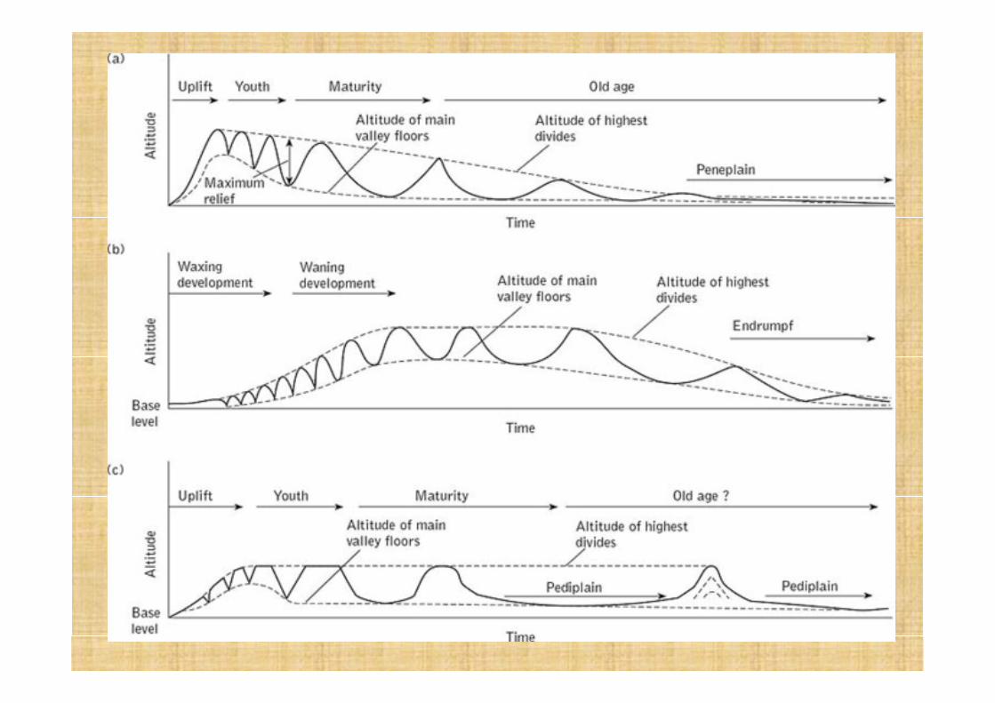
The cycle of erosion theory involves periods of uplift, youth, maturity and old age,followed by more uplift. It applies mainly to humid landscapes in temperate regionswhere streams are the dominant agent of erosion.A peneplain is an almost flat surface near base level, sea level in most cases. Its‘almost- a- plain’ a plain scarcely rising above sea level at the coast, but rising graduallyinland towards the occasional residual hills known as monad nocks.A useful starting point in explaining the cycle of erosion is when a peneplainundergoes a period of rapid uplift. This is followed by youth, where streams becomeestablished and erode down toward base level. Much of the original flat surfaceremains and is not drained by the streams. Over time, the main streams have cut closeto base level and a more extensive tributary network is established.In maturity, the stream valleys have widened so that the original flat surface has beeneroded everywhere and streams drain the entire landscape. The streams becomegraded, meaning that there is a balance between erosion and deposition all alongtheir lengths and valley floors become wider as the streams begin to meander. Inaddition, the hillsides slowly become less steep.Given enough time, the landscape will be denuded to old age, a low relief surface nearbase level with low hills where mountains used to stand. With the entire land surfaceclose to base level, running water has little power to move sediment and deep soilsdevelop. Given enough time, the old age stage merges into a peneplain and upliftoccurs again.
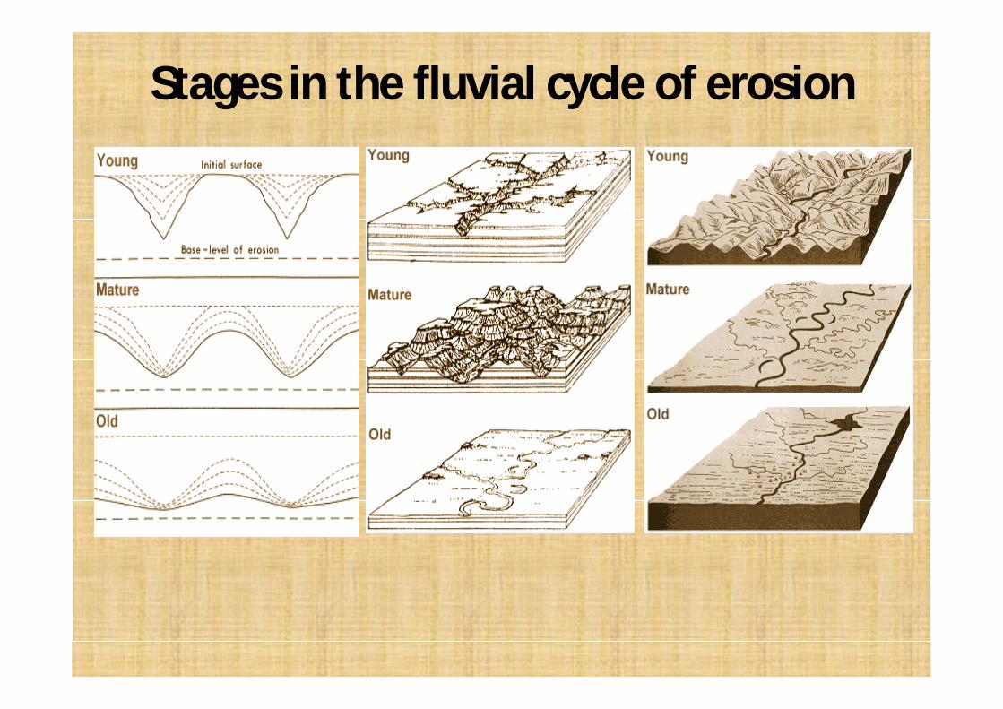
Stages in the fluvial cycle of erosion
Walter Penck’s Concept- Slope Replacement(1924, 1953)
• Penck was influenced by field observations made inGermany, particularly the Rhine graben area, innorthern Argentina, and to a lesser degree, in Africa.
• He believed that landforms should be interpreted bymeans of ratios which might be expected to occurbetween erosional (exogenetic) processes anddiastrophic (endogenetic) processes.
• Landscape was considered an expression of the phaseand rate of upliftment in relation to the rate ofdegradation.
• Erosional processes were held to operate according tosome worldwide laws whose rate were different indifferent climates. These laws were:
1. Local intensity of erosion is directly related to the steepness of the slope segment.2. The inclination of each segment of an erosionalslope is determined by the sizes of the mobile debris.3. The largest debris size which is mobile on a slopesegment varies with the inclination of the slope. Thegreater the inclination, the greater is the largest debrissize, which is mobile.4. If the production of debris by weathering is uniformon a slope segment, erosion will cause the segment toretreat parallel to itself.5. If some eroded material is allowed to collect at thebase of a retreating slope segment, a new segmentwith lower inclination will develop.
• Penck was of the view that most tectonicmovement began and ended slowly. Thecommon pattern of such movements was aslow uplift, an accelerated uplift, adeceleration in uplift and finally quiescence.
• The slope of any region are basically similar ingradient and their characteristics aredetermined by “intensity of erosion”. Threetypes of slopes are-
1. Uniform slopes indicate constant intensity oferosion, i.e., uniform development.2. Concave slopes indicate declining intensity oferosion, i.e., waning development.3. Convex slopes indicate increasing intensity oferosion, i.e., waxing development.
Increasing intensity of Erosion• This is the fiorst stage of erosion. The initial surface
(primarrumpf) is a featureless surface. As there is slow, long,continuous uplift, the primarrumpf retained its featurelesscharacter for a long time.
• As the rate of upliftment increased, stream incision led toobliteration of the featureless character and starteddeveloping narrow valleys. Thus, altitude and relief increased.Later on, the rate of upliftment increased tremendously whichresulted in formation of steep V-shaped valley.
• Since the rate of upliftment was very high, downcutting orvertical incision could not keep pace with the accelerateduplift. Thus, the ridge summits and valley bottoms rose wellabove sea level. The slope became convex because ofextensive downcutting in valley bottoms without anycorresponding denudation on the upper slope.

Constant Intensity of ErosionPhase I
• There is an acceleration of uplift but this oneis not as high as compared to the previousphase. The summit rise but at a slower speed.Valley deepening, valley bottom uplift andsummit uplift are balanced in such a way thatthe relief remains constant.
Phase II• The summit neither increase nor decrease, as the
lowering of the summit height is offset by uplift, which continues even in this stage. The valley deepening still continues at an accelerated rate because the uplift provide the much needed stream velocity for vertical incision but this valley deepening is also matched by divide wasting, so the relief in this case , too, remain constant.
• As the rate of upliftment decreases, rate of valley degradation also decreases, and the valley floor rises.
Phase III• There is a complete cessation of upliftment.
The summit, thus, begins to lose height byerosion and there is a gradual decline ofelevation. Since there is no upheaval to offsetthe effect of down cutting, valley continues tobecome deep and their floors also becomelower. But uniform development is maintainedas there is constant intensity of erosion andsummit lowering is also as low. Hence, therelief remains constant.
Declining Intensity of erosion• The upliftment of landform has completely
stopped and erosion is dominant. Thus,declining landforms appear. The summitscontinue to be eroded and lowered, however,there is a considerable decrease in downcuttingor vertical incision of valley floors. The net resultis that altitude as well as relief both are lowered.At the same time, valley sides are retreating,parallel to themselves.
• The upper slopes maintain their angle of slopeand valley floors increase in width. The surfacefrom ridge crest to the stream (valley side slopes)now consists of two parts-
• The upper part called boschesteilwand or gravityslope, is relatively steep and maintains its angleby parallel retreat, although the height isdeclining.
• The lower part, called haldenhang or wash slope,is gentle and has a declining gradient. The angleat which these slopes meet is distinct and itmainly depends upon the size of the material thatis being moved over them and the amount ofwater available to move this material. The angleis fairly sharp in the form of a knick.
L.C. King’s Concept- Pediplanation(1953, 1967)
• Lester C King’s model of landscape evolution is similar toDavis’ in that uplift is episodic and rapid in comparisonwith rates of denudation, and that the overallmorphology of a landscape at any point in time isdiagnostic of its evolutionary stages of development.
• The difference: mode of slope development.• King initially developed his model to account for the
landscapes of southern Africa. These are characterisedby extensive, gently inclined surfaces dotted withinselbergs and separated by escarpments, and havedeveloped under predominantly arid to tropical wet drymorphoclimatic regimes.
• He envisaged the parallel retreat of a single free-face slope unit, leaving a broad, concave pedimentsloping at an angle of 6-7 degree or less at itsbase. Gradually over time, pediments coalesce toform pediplains and this mode of landscapedevelopment, is therefore called pediplanation.
• He theorized that once pediment surfaces havebeen formed, they persist with little change untilthe next phase of surface uplift promotes a newcycle of river incision and escarpment retreat,which consumes existing pediplains and createsnew ones.
• Like Davis, King envisioned impulsive uplift and longresponse times of landscape adjustment. He neveraccepted the Davisian concave-convex slope; hefavored Penck’s view of concave hillslopes and slopereplacement. On the basis of Panck’s model heconclude that the landscape assumes the form of aseries of nested, retreated escarpments.
• King called the low gradient footslope extensions ofthe steep escarpments pediments and the flatbeveled surface they leave in their retreating wake apediplane.
• King proposed that once pediments form, that theypersist indefinitely until consumed by youngerretreating escarpments following renewed base levelfall.

References• Frank J. Pazzaglia (2003), Landscape evolution
model, Development in Quaternary Science, Vol.1, pp. 247-272.
• Siddhartha, K. (1999), The Earth’s Dynamic Surface, Kisalaya Publication, N. Delhi.
• Doerr, A.H. (1993), Fundamentals of PhysicalGeography, IInd edition, Wm. C. Brown.Publishers, Australia.

Dr. Mukesh Verma ([email protected])