Holocene marine transgression in the Black Sea: New evidence from the northwestern Black Sea shelf

lable at ScienceDirect
Quaternary Science Reviews 30 (2011) 1846e1860
Contents lists avai
Quaternary Science Reviews
journal homepage: www.elsevier .com/locate/quascirev
The early Holocene sea level rise
D.E. Smith a,*, S. Harrison b, C.R. Firth c, J.T. Jordan d
aOxford University Centre for the Environment, South Parks Road, Oxford OX1 3QY, UKbDepartment of Geography, University of Exeter, Cornwall Campus, Penryn, Cornwall TR10 9EZ, UKc School of Environment and Technology, University of Brighton, Lewes Road, Brighton BN2 4GJ, UKdDepartment of Geography, Environment and Disaster Management, Coventry University, Coventry CV1 5FB, UK
a r t i c l e i n f o
Article history:Received 22 November 2010Received in revised form19 April 2011Accepted 28 April 2011Available online 25 May 2011
Keywords:Early Holocene sea level riseIce sheetMeltwater pulseCoastlinesOcean currentsVolcanoesSubmarine slidesHuman migrations and cultural change
* Corresponding author. Tel.: þ44 1926 426307.E-mail address: [email protected] (D.E. S
0277-3791/$ e see front matter � 2011 Elsevier Ltd.doi:10.1016/j.quascirev.2011.04.019
a b s t r a c t
The causes, anatomy and consequences of the early Holocene sea level rise (EHSLR) are reviewed. Therise, of ca 60m, took place over most of the Earth as the volume of the oceans increased during degla-ciation and is dated at 11,650e7000 cal. BP. The EHSLR was largely driven by meltwater release fromdecaying ice masses and the break up of coastal ice streams. The patterns of ice sheet decay and theevidence for meltwater pulses are reviewed, and it is argued that the EHSLR was a factor in the ca8470 BP flood from Lake Agassiz-Ojibway. Patterns of relative sea level changes are examined and it isargued that in addition to regional variations, temporal changes are indicated. The impact of the EHSLRon climate is reviewed and it is maintained that the event was a factor in the 8200 BP cooling event, aswell as in changes in ocean current patterns and their resultant effects. The EHSLR may also haveenhanced volcanic activity, but no clear evidence of a causal link with submarine sliding on continentalslopes and shelves can yet be demonstrated. The rise probably influenced rates and patterns of humanmigrations and cultural changes. It is concluded that the EHSLR was a major event of global significance,knowledge of which is relevant to an understanding of the impacts of global climate change in the future.
� 2011 Elsevier Ltd. All rights reserved.
1. Introduction
The early Holocene, defined here as 11,650 to 7000 calibratedyears before 1950 (BP), was a time of widespread environmentalchange as temperatures rose rapidly at the end of the last glacia-tion. A notable feature of this time was the ca 60m rise in sea levelsover most of the Earth, as several studies imply (e.g. Fairbanks,1989; Bard et al., 1996). This has attracted a great deal of scien-tific attention in recent years and we believe that it is timely toconsider the published evidence for this rise and its impacts on theenvironment. We review the likely causes of the sea level rise,including its effects on the decay of coastal ice streams, beforeoutlining the nature of the rise and its effects on coastlines.We thenexamine its possible consequences, in particular its relationship toclimate, volcanic activity and submarine sliding, before consideringits impacts on Mesolithic and Neolithic cultures. In a concludingstatement, the paper summarises the changes described;comments on the relevance of studies of early Holocene sea levelchange as a key to understanding patterns and rates of changeduring glacial terminations; and concludes with a brief account of
mith).
All rights reserved.
the extent to which an understanding of this phase of Earth historycan prepare us for Earth system responses in the foreseeable future.
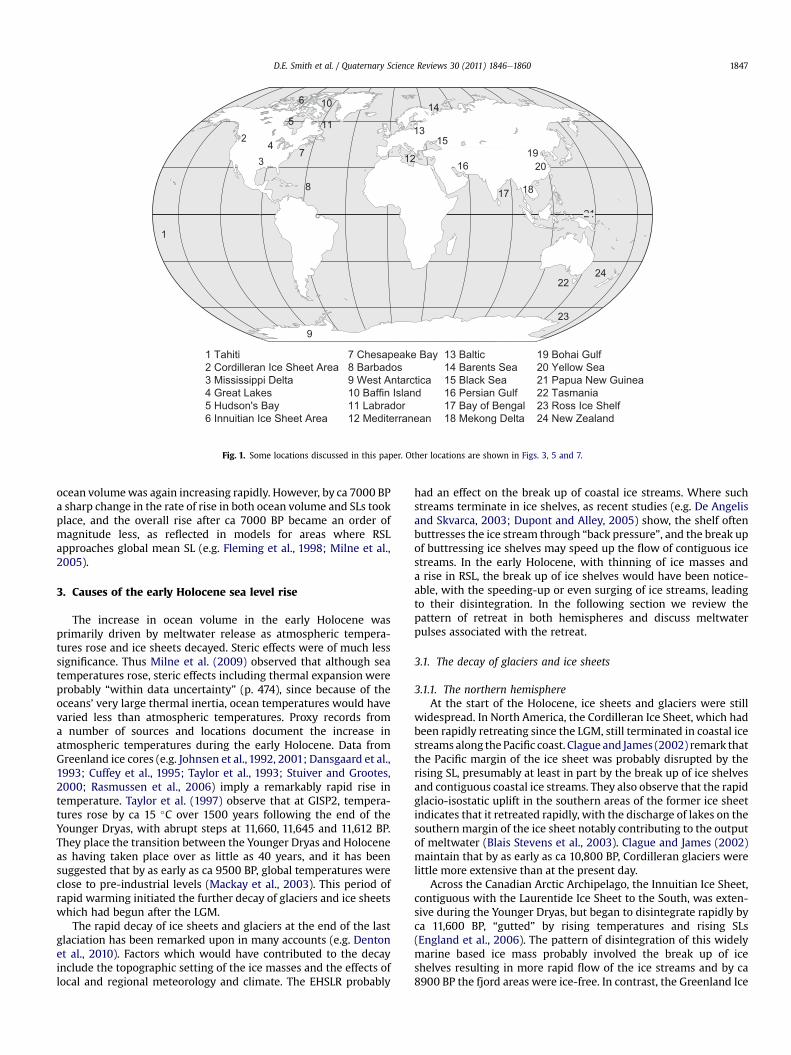
In the account which follows, sea level (SL) refers to the level ofthe sea surface without reference to the land and relative sea level(RSL) refers to the level of the sea as observed at the coastline. Alldates given here are in sidereal (calibrated) years. Where originalcalibrated radiocarbon dates are not given in the publishedaccounts quoted, calibrated dates have been obtained using Calib6.0 (Reimer et al., 2009). All dates are given as before 1950: where2000 AD is the datum (as with some ice core records), dates havebeen adjusted. Locations discussed are shown in Figs. 1, 3,5 and 7.
2. Definition
The early Holocene SL rise (here referred to by the acronymEHSLR) was a period of rapid rise over most of the Earth’s oceanswhich took place between 11,650 BP and 7000 BP. Ocean volumehad been increasing after the Last Glacial Maximum (LGM)according to the oxygen isotope record (e.g. Chappell andShackleton, 1986; Cayre et al., 1999), but studies of low latitudecoral records (e.g. Edwards et al., 1993; Montaggioni et al., 1997;Bard et al., 2010) indicate that the increase slowed during theYounger Dryas (ca 12,900e11,650 years BP based on Rasmussenet al., 2006 and Walker et al., 2009). By the start of the Holocene
23
2224
13
12
8 17
16
15
14
4
5 11
7
10
9
2019
18
1
6
3
2
21
1 Tahiti2 Cordilleran Ice Sheet Area3 Mississippi Delta4 Great Lakes5 Hudson's Bay6 Innuitian Ice Sheet Area
7 Chesapeake Bay8 Barbados9 West Antarctica10 Baffin Island11 Labrador12 Mediterranean
13 Baltic14 Barents Sea15 Black Sea16 Persian Gulf17 Bay of Bengal18 Mekong Delta
19 Bohai Gulf20 Yellow Sea21 Papua New Guinea22 Tasmania23 Ross Ice Shelf24 New Zealand
Fig. 1. Some locations discussed in this paper. Other locations are shown in Figs. 3, 5 and 7.
D.E. Smith et al. / Quaternary Science Reviews 30 (2011) 1846e1860 1847
ocean volumewas again increasing rapidly. However, by ca 7000 BPa sharp change in the rate of rise in both ocean volume and SLs tookplace, and the overall rise after ca 7000 BP became an order ofmagnitude less, as reflected in models for areas where RSLapproaches global mean SL (e.g. Fleming et al., 1998; Milne et al.,2005).
3. Causes of the early Holocene sea level rise
The increase in ocean volume in the early Holocene wasprimarily driven by meltwater release as atmospheric tempera-tures rose and ice sheets decayed. Steric effects were of much lesssignificance. Thus Milne et al. (2009) observed that although seatemperatures rose, steric effects including thermal expansion wereprobably “within data uncertainty” (p. 474), since because of theoceans’ very large thermal inertia, ocean temperatures would havevaried less than atmospheric temperatures. Proxy records froma number of sources and locations document the increase inatmospheric temperatures during the early Holocene. Data fromGreenland ice cores (e.g. Johnsen et al., 1992, 2001; Dansgaard et al.,1993; Cuffey et al., 1995; Taylor et al., 1993; Stuiver and Grootes,2000; Rasmussen et al., 2006) imply a remarkably rapid rise intemperature. Taylor et al. (1997) observe that at GISP2, tempera-tures rose by ca 15 �C over 1500 years following the end of theYounger Dryas, with abrupt steps at 11,660, 11,645 and 11,612 BP.They place the transition between the Younger Dryas and Holoceneas having taken place over as little as 40 years, and it has beensuggested that by as early as ca 9500 BP, global temperatures wereclose to pre-industrial levels (Mackay et al., 2003). This period ofrapid warming initiated the further decay of glaciers and ice sheetswhich had begun after the LGM.
The rapid decay of ice sheets and glaciers at the end of the lastglaciation has been remarked upon in many accounts (e.g. Dentonet al., 2010). Factors which would have contributed to the decayinclude the topographic setting of the ice masses and the effects oflocal and regional meteorology and climate. The EHSLR probably
had an effect on the break up of coastal ice streams. Where suchstreams terminate in ice shelves, as recent studies (e.g. De Angelisand Skvarca, 2003; Dupont and Alley, 2005) show, the shelf oftenbuttresses the ice stream through “back pressure”, and the break upof buttressing ice shelves may speed up the flow of contiguous icestreams. In the early Holocene, with thinning of ice masses anda rise in RSL, the break up of ice shelves would have been notice-able, with the speeding-up or even surging of ice streams, leadingto their disintegration. In the following section we review thepattern of retreat in both hemispheres and discuss meltwaterpulses associated with the retreat.
3.1. The decay of glaciers and ice sheets
3.1.1. The northern hemisphereAt the start of the Holocene, ice sheets and glaciers were still
widespread. In North America, the Cordilleran Ice Sheet, which hadbeen rapidly retreating since the LGM, still terminated in coastal icestreams along thePacific coast. Clague and James (2002) remark thatthe Pacific margin of the ice sheet was probably disrupted by therising SL, presumably at least in part by the break up of ice shelvesand contiguous coastal ice streams. They also observe that the rapidglacio-isostatic uplift in the southern areas of the former ice sheetindicates that it retreated rapidly, with the discharge of lakes on thesouthern margin of the ice sheet notably contributing to the outputof meltwater (Blais Stevens et al., 2003). Clague and James (2002)maintain that by as early as ca 10,800 BP, Cordilleran glaciers werelittle more extensive than at the present day.
Across the Canadian Arctic Archipelago, the Innuitian Ice Sheet,contiguous with the Laurentide Ice Sheet to the South, was exten-sive during the Younger Dryas, but began to disintegrate rapidly byca 11,600 BP, “gutted” by rising temperatures and rising SLs(England et al., 2006). The pattern of disintegration of this widelymarine based ice mass probably involved the break up of iceshelves resulting in more rapid flow of the ice streams and by ca8900 BP the fjord areas were ice-free. In contrast, the Greenland Ice

D.E. Smith et al. / Quaternary Science Reviews 30 (2011) 1846e18601848
Sheet largely terminated on land in the early Holocene anddownwasting and topographic controls became increasinglysignificant in the pattern of retreat (e.g. Long and Roberts, 2003).
The Laurentide Ice Sheet was retreating extensively by theearly Holocene. As the ice sheet decayed, the Hudson Straitopened to the North over a deep channel into Hudson’s Bay(Andrews and Peltier, 1976) along the former saddle betweenLabradorean, Baffin Island and Keewatin ice (Peltier and Andrews,1983). Calving of the ice margin was rapid, with high rates ofretreat (Andrews, 1973), and a calving bay, the Tyrrell Sea, devel-oped in the NE part of Hudson’s Bay by ca 9000 BP (e.g. Andrewset al., 1995) (Fig. 2). On the South-West margin of the ice sheet,Lake Agassiz had begun to form by ca 13,400 BP and before ca8000 BP had linked with Lake Ojibway to the East (Leveringtonet al., 2002; Teller and Leverington, 2004). It is believed that thelake drained catastrophically through the Hudson Strait at ca8470 BP (Barber et al., 1999), with drainage occurring in episodesof 113,100 km3 and 49,900 km3 (Clark et al., 2004), which at163,000 km3 in total amounts to more than seven times thehighest estimate of Van der Leeden et al. (1990) for the volume ofthe present day Great Lakes.
We hypothesise that the EHSLR played a significant rôle in thedecay of ice in Hudson’s Bay and the discharge of Lake Agassiz-Ojibway. As the Hudson Strait opened, land uplift was rapid andexceeded SL rise, with the emergence of shorelines in Labrador-Baffin Island and along the Strait, as many studies (e.g. assummarized in Pirazzoli, 1991) show. However, since the Strait andits continuation into North-East Hudson’s Bay are deep (up to 600mat present), the developing Tyrrell Sea remained extensive in thatarea. As the ice sheet downwasted it began to “lift” from its bed inplaces as Lajeunesse and St-Onge (2008) proposed, probablyaccompanied by the break up of the ice shelf. Break up of the iceshelf would have resulted in more rapid flow of the ice sheet,promoting further thinning and an increased rate of retreat. South-West of the ice sheet, the level of Lake Agassiz-Ojibway lay over200m above RSL North of the ice sheet and aided by the hydrostatichead, subglacial drainage took place, probably increasing as thelake level dropped from 120m above SL with the drainage ofsuccessive lake levels (Clark et al., 2004). Throughout theseepisodes, rebound beneath the ice would have been restrained(following the model of Andrews, 1970), and as Hillaire-Marcel andFairbridge (1978) maintained, RSL at the ice margin would havebeen rising as SL in the North Atlantic rose. This rise probablyexceeded any fall which might have resulted from the reduction ofthe gravitational effect of the retreating and thinning ice sheet onRSL at the ice margin. In our hypothesis therefore, the EHSLR
0 500 Km
HUD
ONS T R A I T
TYRRELL
SEA
DAVIS
60°
50°
90°
W
60°W
Laurentide Ice Sheet
Lake Agassiz–Ojibway
STRAIT
Fig. 2. The extent of the Laurentide Ice Sheet and Lake Agassiz-Ojibway prior to thecatastrophic drainage of ca 8470 BP. Redrawn from Lajeunesse and St-Onge, 2008.
penetrated beneath the lifting and thinning ice, ensuring that theretreating margin of the ice sheet became buoyant, hastening itsdecay. Hence the retreat of the Laurentide Ice Sheet at this timeinvolved downwasting, causing the ice to thin; increasing subgla-cial meltwater flow; decay of the buttressing ice shelf to the Northwith an increase in the flow of the ice sheet; and a rising RSL in theTyrrell Sea, the latter the result of the EHSLR.
Across the Atlantic in North-West Europe and western Asia, icesheet retreat was due largely to changes in insolation and inweather patterns with the EHSLR playing a minor rôle. Svendsenet al. (2004) maintain that the Scandinavian Ice Sheet progres-sively increased in size towards the LGMwhile the Barents-Kara IceSheet to the East became smaller. Although Grosswald and Hughes(2002) envisage a larger Barents-Kara Ice Sheet than do Svendsenet al. (2004) during the LGM, most studies maintain that by thebeginning of the Holocene, the shores of Svalbard and the westernBarents Sea were largely ice-free (e.g. Landvik et al., 1998) andhence along the Scandinavian and Russian Arctic coastline melt-waters were derived from ice masses terminating on land. Theextent of ice in the eastern Arctic is unclear, but it seems unlikelythat any coastal ice streams were present by the start of theHolocene (Svendsen et al., 2004). To the West, the Scandinavian IceSheet still terminated on the Continental Shelf in the early Holo-cene, while around the Baltic the successive developments of theBaltic Ice Lake (before ca 14,000eca 11,500 BP), Yoldia Sea (ca11,500eca 10,800 BP), Ancylus Lake (ca 10,800eca 9200 BP) andfinally Litorina Sea followed the fluctuating relationship betweenproglacial lake levels in the proto-Baltic Sea and the rising EHSLRbeyond thresholds along the adjacent North Sea coast (Bj}orck,1995; Nesje et al., 2004); meltwaters from the proglacial BalticIce Lake and Ancylus Lake contributing to the EHSLR. In southernNorway, the ice-dammed Nedre Glamsjø Lake discharged to theNorth Sea at ca 10,300 BP (Longva and Thoresen, 1991).
3.1.2. The southern hemisphereAnderson et al. (2002) in examining the pattern of retreat of
the Antarctic Ice Sheet from the LGM to the present, remark uponregional differences, notably between East and West Antarctica,which have a bearing on the effects of the EHSLR. The WestAntarctic Ice Sheet, which had expanded to the outer ContinentalShelf at the LGM, remained beyond its present limit for most of theHolocene, while the East Antarctic Ice Sheet only reached the mid-shelf area at the LGM and in many cases had already retreated toits present position by the mid-Holocene. However, both icesheets terminated widely in ice shelves, the break up of whichmay have resulted in the speeding-up of flow from contiguous icestreams, leading to retreat (e.g. De Angelis and Skvarca, 2003).Several authors have emphasised the importance of the effect ofSL rise in the break up of ice shelves in Antarctica, includingIngólfsson et al. (1998) and Ingólfsson and Hjort (1999), whopointed to the possible effects of SL rise in the break up of the icestreams and shelves which make up the Ross Ice Shelf. Theysuggest that rising global SLs controlled the deglaciation ofAntarctic shelf areas during the early Holocene, and argued thatthe inner shelf and land areas continued to be deglaciated until ca7000 BP. However, Mackintosh et al. (2011) have argued thatalthough sea level rise triggered the onset of ice recession, it wassubsequent ocean warming that resulted in most of the ice loss.Hence the EHSLR may have played an important part in the breakup of Antarctic ice shelves and contiguous ice streams, but thereare uncertainties concerning the duration of its effect. In SouthAmerica, the evidence for a Patagonian ice shelf at this time isequivocal, and Anderson and Archer (1999) believe that theretreat of this ice sheet occurred before the rising SL reachedthe area.

Fig. 3. The NGRIP d 18O record from the Greenland Ice Sheet, based on the new GICC05 time scale (referenced to 1950 AD), redrawn from Rasmussen et al. (2006) (A) compared withfour empirically-based graphs of RSL change during the EHSLR (B) and the duration of published meltwater pulses (freshwater fluxes) and discharges frommajor ice-dammed lakes
D.E. Smith et al. / Quaternary Science Reviews 30 (2011) 1846e1860 1849

Table 1Freshwater fluxes from proglacial lakes in the early Holocene.
Lake Date of discharge, cal. BPa Volume of discharge, km3 Sea level equivalent, m Reference
Agassiz-Ojibway 11,700 9300 0.026 Teller et al., 200211,200 5900 0.01610,600 7000 0.01910,400 3700 0.01010,300 2100 0.00610,000 1600 0.0049500 2300 0.0069200 1600 0.0048400 113,100 0.3148400 49,000 0.136
Baltic ice lake 11,600 9300 0.026 Nesje et al., 2004; Bj}orck, 1995Ancylus lake 9800 n/a n/a Nesje et al., 2004; Bj}orck, 1995Nedre Glamsjø lake 10,300 120 <0.001 Longva and Thoresen, 1991; Nesje et al., 2004Fraser River basin 11,000 n/a n/a Blais-Stevens et al., 2003
a Note: the discharge date assumes instantaneous discharge: actual discharge times may have been longer.
D.E. Smith et al. / Quaternary Science Reviews 30 (2011) 1846e18601850
3.2. Meltwater pulses
3.2.1. Published eventsMeltwater pulses (MWPs) were initially identified from changes
in the rate of growth of coral reefs. MWP 1B involved a rapid rise inSL of 28m at Barbados, centred upon 10,800 BP (Fairbanks, 1989),although the event is given an age range of 10,750 BPe11,600 BP inwork elsewhere (e.g. Edwards et al., 1993; Liu et al., 2004). Thecatastrophic rise events (CREs) of Blanchon and Shaw (1995) equateto MWPs. CRE 2, involving a rapid rise of SL of 7.5m at ca 11,500 BPand CRE 3, involving a rapid rise of SL of 6.5m at ca 7600 BP werebased on a range of sites across the Caribbean. More recently,MWPs have also been recognised from sediments. Thus MWPs 1Cand 1D involved rapid rises of SL in the western Pacific of 20m at ca9800 BPe9200 BP and up to 10m at ca 8000 BP (Liu et al., 2004). AnMWP of ca 4.5m at 7600 BP is recognised from isolation basinstudies in the Baltic (Yu et al., 2007).
Considerable uncertainty surrounds many of the early HoloceneMWPs identified thus far. Cazenave at al. (2000) summarizedproblemsconcerning theevidence in theCaribbean forMWP1Bwellas for CRE 2 and CRE 3 and while Bard et al. (1996) originally foundsome slight evidence for MWP 1B in Tahiti, they did not identify itthere in later work (Montaggioni et al., 1997; Bard et al., 2010).Indeed, Gehrels (2010) in assessing the validity of the Barbados sealevel curve has pointed to the problems of deriving accurate RSLinformation from coral reef sites. MWPs derived from sedimentsmay also be uncertain. MWP 1C (Liu et al., 2004), is based uponawide scatter of data both spatially and temporally. However, MWP1D of Liu et al., 2004 occurs at a similar time to the rise at ca 7600 BPin the Baltic and CRE 3, and is probably more secure, being based onevidence from a greater range of environments.
3.2.2. SourcesDated proglacial lake discharges provide the most direct
evidence for MWPs. Table 1 lists current estimates of freshwaterfluxes from proglacial lakes during the early Holocene.
Nesje et al. (2004) correlated freshwater fluxes across the NorthAtlantic from the record in Table 1. For the early Holocene, they
(C). The graph from Schuchert Dal, Scoresby Sund, Greenland, is based on data in Table 1 of Hgrowth position. The graph from the Forth valley, Scotland is based on data from Table 2 of Smverified by microfossil analyses. The graph from Singapore is based on data from supplemeshell and coral samples. The graph from Tahiti is based on data from Table S1 in Bard et al. (2and on PocilloporaandMonastrea annuligera corals (depth ranges 20 m). Dates from Hall et alfrom (Bard et al., 2010) are 230Th/234U dates. All dates are expressed to 2s. Altitudes for tSchuchert Dal were determined barometrically to “sea-level”; altitudes for Tahiti are descrisediment consolidation is suspected (Singapore and the Forth valley), corrections were app
identified three freshwater outburst periods: R2, ca 11,335eca10,750 BP; R1, ca 10,500 BPeca 10,200 BP and the final Lake Agassizflood at ca 8470 BP. No evidence for R1 or R2 has been found outsidethe North Atlantic. Arguably the most widespread evidence fora freshwater flux or MWP is that for the discharge from LakeAgassiz, evidence for which is claimed to have been found in theMississippi delta (Törnqvist et al., 2004), Chesapeake Bay (Croninet al., 2007), South China Sea (Yim et al., 2006), Mekong delta(Tamura et al., 2009) and the Netherlands (Hijma and Cohen, 2010).
The total contribution of proglacial lake discharge to MWPs isonly ca 0.567m of sea level equivalent, hence the sources of manyMWPsmust lie elsewhere, given the large rises claimed for some. Ithas been maintained that the decay of the Laurentide Ice sheetcould have been responsible for MWP 1B (and by implication CRE2) (Peltier and Fairbanks, 2006). However, Antarctic sources havebeen claimed for MWP 1B, McKay et al. (2008) indicating thatrecession of the Ross Ice Sheet (i.e. the coastal ice stream leading tothe Ross Ice Shelf) may have suppliedmeltwater prior to the start ofMWP 1B, and Leventer et al. (2006) arguing that recession of theEast Antarctic Ice Sheet had the potential to contribute to MWP 1B.Blanchon and Shaw (1995) claim that CRE 3 could be explained byAntarctic Ice Sheet instability, but Yu et al. (2007) maintain that theRSL rise at 7600 BP was due to the collapse of the Labrador sector ofthe Laurentide Ice Sheet. However, despite the many uncertaintiesconcerning the origins and magnitude of MWPs, it is likely that atleast some of these events occurred, contributing to the EHSLR andimplying that it was variable in both rate and extent.
4. Anatomy of the early Holocene sea level rise
4.1. Spatial variations
Spatial changes in global sea surface levels due to geophysicaleffects occurred during the early Holocene. Effects such as changesin Earth rotation, originally addressed by Munk and Revelle (1952),have been the source of considerable interest, with Mörner (1993)remarking specifically on the period 13,000e11,000 BP, whichincludes the EHSLR. Clark et al. (1978); Clark and Primus (1987);
all et al. (2010) from “exact sea-level” positions using samples of Mya truncata found inith et al. (2010), consisting of peat samples from transgressive and regressive overlaps,
ntary table DR3 of Bird et al. (2010), which lists mangrove wood and roots with some010) which consists of dates from the shallow reef coral Acropora sp. (depth range 5 m). (2010), Smith et al. (2010) and Bird et al. (2010) are calibrated radiocarbon dates; dateshe Forth valley and Singapore were referenced to local Mean Sea Level; altitudes forbed as “above RSL”. Error margins are as stated in the original publications, and wherelied. The trends shown are as originally published.

Table 2Notable coastline changes during the EHSLR.
Event Timing, cal. BP Details, ages cal. BP Area flooded Reference
Sunda Shelf and Torres Strait flood Completed ca 7000 Many straits and channels open.“Sundaland” flooded.
Over 1.8 M km2 Hanebuth et al., 2000
Bering Strait opens 11,000e12,000 Widespread sedimentation across the shelf,including in theChukchi Sea, largely terminating at ca 7000.“Beringia” widely flooded.
Continental Shelf aroundthe Bering Strait, > 0.4 M km2.
Keigwin et al., 2006.
Strait of Dover opens 8000e8600 or“before 7500”
S. North Sea, including “Doggerland”flooded.
ca 120,000 km2 Jelgersma, 1979; Shennanet al., 2000; Gaffneyet al., 2007
Arrival of saline waters intoBlack Sea
Circa 9300 Most of the surrounding shelfflooded by 7000.
ca 400,000 km2 (expandedand became marine)
Ryan et al., 2003; Majoret al., 2006.
}Oresund Strait opens, Ancylus lakebecomes brackish (Mastogloia Sea)
9200 Litorina Sea established by ca 8500;maximumflooding reached ca 7000.
ca 400,000 km2 Björck, 1995; Eronenet al., 2001.
Arabian Gulf flooded Second episode ofrapid RSL risebegins ca 11,000.
Maximum floodingreached ca 7000.
ca 400,000 km2 Lambeck, 1996; Telleret al., 2000.
Yellow Sea modern coastlinereached
ca 7500 Continental Shelf of YellowSea and Bohai Gulf, >0.7 M km2.
Liu et al., 2004, Liu andMilliman, 2004.
D.E. Smith et al. / Quaternary Science Reviews 30 (2011) 1846e1860 1851
Peltier (2007); Bamber et al. (2009); and Hu et al. (2009) consid-ered the redistribution of mass both after the LGM and during theHolocene in some detail. At the end of the early Holocene andsubsequently, the effects of deglaciation involved greater rises inRSL in low latitudes, resulting in sea level “highstands”, as manyRSL graphs show (e.g. Fleming et al., 1998; Zong, 2004; Bird et al.,2007; Sloss et al., 2007). However, movement of water betweenocean basins and collapsing forebulges around former ice sheets, orocean syphoning (Mitrovica and Peltier, 1991), together withcontinental levering, which also involved movement towards thecontinental margins, but due to water loading, subsequentlyreduced the level of the highstands (Mitrovica and Milne, 2002).Geophysical effects are also indicated in recent modelling resultswhich indicate that the discharge of Lake Agassiz-Ojibway probablycreated a global mean SL rise of 0.4m, with rises of greater than 1mat far field locations but a fall of at least 2m near Hudson’s Bay(Kendall et al., 2008). Such changes indicate that the EHSLR willhave varied regionally perhaps on a metre scale.
4.2. Temporal variations
Detailed empirically-based RSL graphs for the full period of theEHSLR are disappointingly few. Most such graphs are from areaswhere glacio-isostatic or tectonic uplift has carried evidence abovepresent SL or from low latitude coral reef sites. d 18O values fromforaminifera in ocean cores provide more general information.Fig. 3 shows recently (2010) published graphs of RSL change in theearly Holocene using data provided in the original publications. Thesites concerned are away from platemargins and are in areas wheretectonic effects and the effects of subsidence are relatively small.Graph A, from Schuchert Dal, Scoresby Sund, E Greenland (Hallet al., 2010), is from an area where throughout the early HoloceneRSL was falling due to glacio-isostatic land uplift. Here, dates arebased upon shell samples in raised delta or beach deposits. Verticalerrors for the samples are up to 5m, but generally less than 1m, andthe RSL values plotted are for the geomorphic features inwhich theshells were found. Graph B, from the Forth valley, Scotland (Smithet al., 2010), is from close to the centre of glacio-isostatic uplift ofthe British-Irish Ice Sheet, in an area where RSL was at first fallingthen rose as the EHSLR began to exceed uplift, and is based uponconformable peat samples from transitional horizons, supported bymicrofossil analyses. This graph shows distinct fluctuations both asRSL fell and during the subsequent rise. Graph C, from Singapore
(Bird et al., 2007, 2010) is based upon the altitudes of mangrovewood and roots with some shell and coral samples and showsa rapid rise from at least 8800 BP to 8100 BP, correlated with themeltwater pulse associated with the drainage of Lake Agassiz-Ojibway and the 8200 event, followed by a period of much slowerrise between 7800 and 7400 BP, after which RSL rose to a mid-Holocene highstand at ca 6500 BP. Although this graph onlycovers the period since ca 9000 BP, offshore on the Sunda Shelf,Hanebuth et al. (2000) obtained dates of ca 11,000 BP for earlyHolocene wood (possibly Mangrove) at 47 m depth. Graph D, fromTahiti (Bard et al., 1996, 2010) is from a coral reef area in an islandwhich is a volcanic “hot spot” where some tectonic effects arenoted, which Bard et al. (2010) estimate as having raised the area ata rate of 0.25 mm/year after the LGM (the altitudes were adjustedfor this by Bard et al. (2010)). The RSL graphs shown in Fig. 3 arecompared with the Greenland ice core records of Rasmussen et al.(2006) and periods of published freshwater fluxes and MWPs.
The issue of oscillations in SL following the LGM and notably inthe Holocene has remained a matter of debate since Fairbridge’s(1960) seminal account. It would certainly appear logical thatthere should be oscillations, as Jelgersma and Tooley (1995) show,given probable steric effects such as variations in sea surfacetemperature (Bond et al., 1997) as well as episodic contributions ofmeltwater, while the effect of sea level rise across the variabletopography of the continental shelves of the world would have hadan effect. Indeed, very rapid rates of rise over short periods duringthe EHSLR of up to 75mm/year (e.g. Tooley,1989,1993, 2002; Smithet al., 2002), many apparently not related to proposed MWPs,illustrate the variability involved. It seemsmost likely however thatany variations will have been registered primarily regionally orlocally. It is also possible that such variations as occurred wereprimarily stepped rather than oscillatory (e.g. Liu et al., 2004), giventhe rate of the overall SL rise then occurring. Where local RSLstudies identify oscillations, it may be that local factors such asglacio-isostatic or tectonic processes interacting with SL rise mayhave led to the registration of transgressive/regressive sequences.In areas where glacio-isostatic uplift became less pronouncedduring the early Holocene, such as in Scotland (e.g. Shennan et al.,1995; Smith et al., 2010), Scandinavia (e.g. Svendsen andMangerud,1987) or the North-East USA (see graphs in Pirazzoli, 1991), thesometimes sharp change from a falling RSL to a rising one, normallyaround 10,000e8000 BP (see for example the graph for the Forthvalley, Fig. 3), probably reflects a change in the rate of the EHSLR.
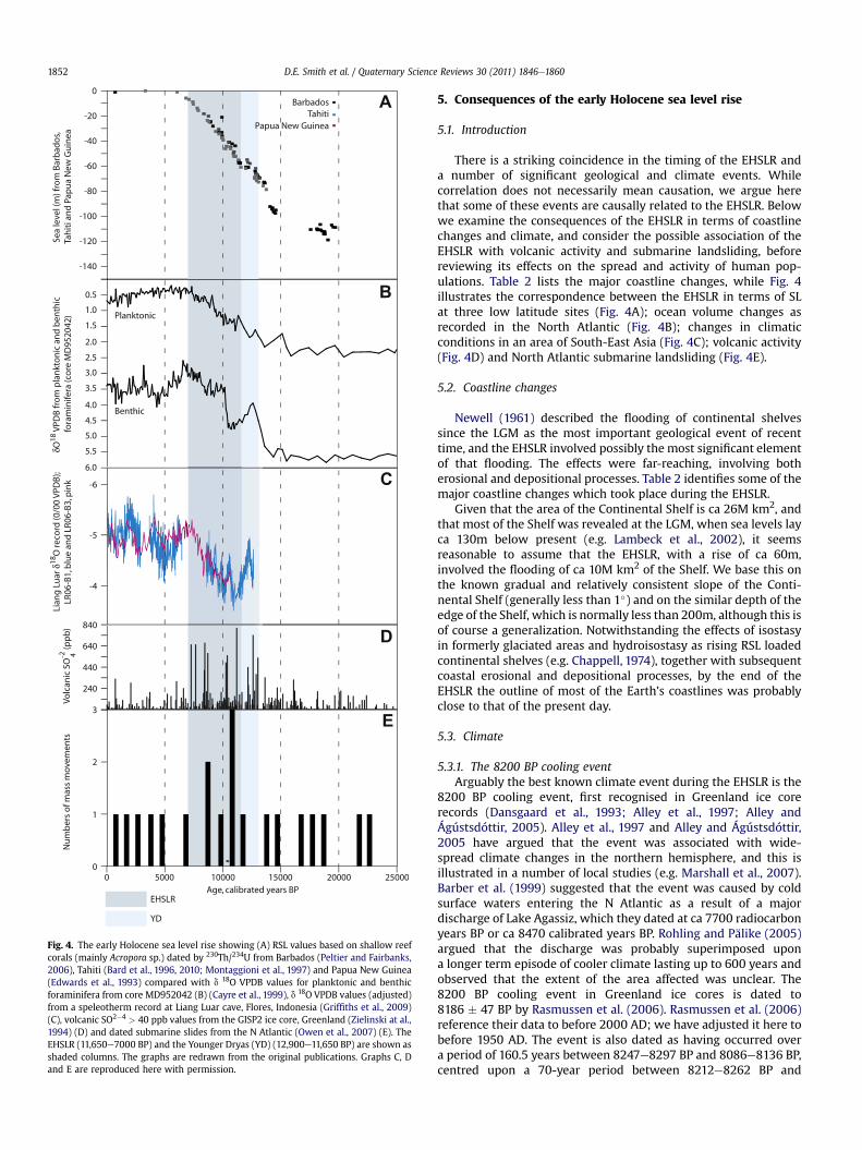
Fig. 4. The early Holocene sea level rise showing (A) RSL values based on shallow reefcorals (mainly Acropora sp.) dated by 230Th/234U from Barbados (Peltier and Fairbanks,2006), Tahiti (Bard et al., 1996, 2010; Montaggioni et al., 1997) and Papua New Guinea(Edwards et al., 1993) compared with d 18O VPDB values for planktonic and benthicforaminifera from core MD952042 (B) (Cayre et al., 1999), d 18O VPDB values (adjusted)from a speleotherm record at Liang Luar cave, Flores, Indonesia (Griffiths et al., 2009)(C), volcanic SO2�4 > 40 ppb values from the GISP2 ice core, Greenland (Zielinski at al.,1994) (D) and dated submarine slides from the N Atlantic (Owen et al., 2007) (E). TheEHSLR (11,650e7000 BP) and the Younger Dryas (YD) (12,900e11,650 BP) are shown asshaded columns. The graphs are redrawn from the original publications. Graphs C, Dand E are reproduced here with permission.
D.E. Smith et al. / Quaternary Science Reviews 30 (2011) 1846e18601852
5. Consequences of the early Holocene sea level rise
5.1. Introduction
There is a striking coincidence in the timing of the EHSLR anda number of significant geological and climate events. Whilecorrelation does not necessarily mean causation, we argue herethat some of these events are causally related to the EHSLR. Belowwe examine the consequences of the EHSLR in terms of coastlinechanges and climate, and consider the possible association of theEHSLR with volcanic activity and submarine landsliding, beforereviewing its effects on the spread and activity of human pop-ulations. Table 2 lists the major coastline changes, while Fig. 4illustrates the correspondence between the EHSLR in terms of SLat three low latitude sites (Fig. 4A); ocean volume changes asrecorded in the North Atlantic (Fig. 4B); changes in climaticconditions in an area of South-East Asia (Fig. 4C); volcanic activity(Fig. 4D) and North Atlantic submarine landsliding (Fig. 4E).
5.2. Coastline changes
Newell (1961) described the flooding of continental shelvessince the LGM as the most important geological event of recenttime, and the EHSLR involved possibly the most significant elementof that flooding. The effects were far-reaching, involving botherosional and depositional processes. Table 2 identifies some of themajor coastline changes which took place during the EHSLR.
Given that the area of the Continental Shelf is ca 26M km2, andthat most of the Shelf was revealed at the LGM, when sea levels layca 130m below present (e.g. Lambeck et al., 2002), it seemsreasonable to assume that the EHSLR, with a rise of ca 60m,involved the flooding of ca 10M km2 of the Shelf. We base this onthe known gradual and relatively consistent slope of the Conti-nental Shelf (generally less than 1�) and on the similar depth of theedge of the Shelf, which is normally less than 200m, although this isof course a generalization. Notwithstanding the effects of isostasyin formerly glaciated areas and hydroisostasy as rising RSL loadedcontinental shelves (e.g. Chappell, 1974), together with subsequentcoastal erosional and depositional processes, by the end of theEHSLR the outline of most of the Earth’s coastlines was probablyclose to that of the present day.
5.3. Climate
5.3.1. The 8200 BP cooling eventArguably the best known climate event during the EHSLR is the
8200 BP cooling event, first recognised in Greenland ice corerecords (Dansgaard et al., 1993; Alley et al., 1997; Alley andÁgústsdóttir, 2005). Alley et al., 1997 and Alley and Ágústsdóttir,2005 have argued that the event was associated with wide-spread climate changes in the northern hemisphere, and this isillustrated in a number of local studies (e.g. Marshall et al., 2007).Barber et al. (1999) suggested that the event was caused by coldsurface waters entering the N Atlantic as a result of a majordischarge of Lake Agassiz, which they dated at ca 7700 radiocarbonyears BP or ca 8470 calibrated years BP. Rohling and Pälike (2005)argued that the discharge was probably superimposed upona longer term episode of cooler climate lasting up to 600 years andobserved that the extent of the area affected was unclear. The8200 BP cooling event in Greenland ice cores is dated to8186 � 47 BP by Rasmussen et al. (2006). Rasmussen et al. (2006)reference their data to before 2000 AD; we have adjusted it here tobefore 1950 AD. The event is also dated as having occurred overa period of 160.5 years between 8247e8297 BP and 8086e8136 BP,centred upon a 70-year period between 8212e8262 BP and

Fig. 5. A: Current pathways and generalized bathymetry in the Arctic Ocean andadjacent areas (image from Google Earth), showing locations of the Bering Strait (BS)Greenland (G), Norway (N), Scotland (S), the Netherlands (NS), the North Sea (NS) andthe Strait of Dover (SD). B: Current pathways and generalized bathymetry in theIndonesian seas (image from Google Earth), showing locations of Singapore (Si), theSunda Sea (Su), the South China Sea (SCS), the Indian Ocean (I), the Pacific Ocean (P),the Makassar Strait (M), the Lombok Strait (L), Flores (F), the Ombai Strait (O), theTimor Strait (T) and the Torres Strait (TS).
D.E. Smith et al. / Quaternary Science Reviews 30 (2011) 1846e1860 1853
8141e8191 BP (Thomas et al., 2007). The difference in age betweenthe dates of Rasmussen et al. (2006) and Thomas et al., 2007 andthe Lake Agassiz-Ojibway meltwater discharge may be less thanthe dates indicate. The radiocarbon date quoted by Barber et al.(1999) of ca 7700 BP (a mid point value, including correctionsfor marine carbonate) for the discharge of Lake Agassiz-Ojibwayprovides a calibrated range of 8321e8768 BP to 2s (shown inFig. 3). This calibrated range is very close to the range ofRasmussen et al. (2006) and overlaps with the greater range ofThomas et al., 2007 for the 8200 BP event. In addition, the LakeAgassiz-Ojibway discharge could have occurred over a longerperiod, given that two episodes may have been involved (Tellerand Leverington, 2004). We therefore accept the hypothesis,following Barber et al. (1999), that proximity in age is an argumentfor a causal link between discharge of Lake Agassiz-Ojibway andthe 8200 BP event. Further, if our hypothesis that the EHSLR playeda rôle in the decay of the Laurentide Ice Sheet and the drainage ofLake Agassiz-Ojibway is accepted, the EHSLR must have also playeda rôle in the 8200 BP cooling event.
5.3.2. Ocean current changesOther climate events related to the EHSLR include the effects of
changes in ocean currents. Thus major changes took place at the
time in the Arctic. Fig. 5A shows present current pathways, some ofwhich were affected by the EHSLR, in the Arctic and adjacent seas.At the start of the Holocene, the Bering Strait, which had previouslybeen closed, opened as SL rose (e.g. Keigwin et al. (2006) and Pacificwaters began to enter the Arctic. Hu et al. (2010) propose a theoryto account for episodes of glaciation and deglaciation in thenorthern hemisphere inwhich the flowof water through the BeringStrait during sea level rise results in muted meridional overturningin the North Atlantic and ultimately glacial conditions. This theoryis an echo of the earlier theory of Ewing and Donn (e.g. 1956) inwhich SL rise in the North-East Atlantic allowed greater volumes ofwater in the North Atlantic Drift to pass across the relativelyshallow sea floor between Greenland, Iceland and Scotland, thusbringing warmer temperatures to the Arctic before the resultingincreased precipitation initiated glacial conditions. These theoriesemphasise the possible impact of the EHSLR on ocean currents inthe Arctic and on local or regional climates in the area.
In South-East Asia, the start of the Holocene saw an almostcontinuous coastline from the Bay of Bengal to Australia with onlynarrow passages through deep water straits in the Indonesianseas East of Flores. Fig. 5B shows present day current pathwaysthrough these straits. A major current here is the IndonesianThroughflow, a significant feature of the global ocean circulation(e.g. Lee et al., 2001), which can bring warm Pacific water into theIndian Ocean (e.g. England and Huang, 2005). As the EHSLRoccurred, flow was probably increased and the temperature ofthermocline water in the adjacent Indian Ocean rose by ca 3.2 �C(Xu et al., 2008). By ca 9500 BP, with the rising SL now ca 30mbelow present, the rise in temperature had stabilised as the SundaShelf became flooded and water freshened in the Makassar Straitwith the development of the South China Sea Throughflow(Tozuka et al., 2007; Linsley et al., 2010). Changes in the Indo-nesian Throughflow, in which the EHSLR played a part, influencedIndian Ocean temperatures as well as tropical ocean-atmosphericcoupling.
5.3.3. Increases in sea areasThe flooding of continental shelves affected both regional and
global climate. Monnin et al. (2001) describe the decrease inatmospheric pCO2 due to the greater sea area during the earlyHolocene as the largest during the entire deglaciation. Rippeth et al.(2008) concluded that the period 11,000 BP to 8000 BP saw thegreatest decrease. Thus the warming trend at the start ofthe Holocene would have been even greater were it not for theincreased sea area during the early Holocene.
In South-East Asia, Griffiths et al. (2009) argue that theflooding of the Sunda Shelf between 11,000 BP and 7000 BPintensified the NE monsoon which had begun to reach the areaduring the Younger Dryas (Hanebuth et al., 2000). They point toa decrease in the adjusted d 18O record in speleotherm calcitefrom Liang Luar cave in western Flores, Indonesia, which, theybelieve, indicates an increase in monsoonal rainfall (Fig. 4C).They maintain that the increase may be due to an abruptsouthward shift in the Intertropical Convergence Zone, togetherwith the increase in sea area during the early Holocene aroundIndonesia.
5.3.4. The EHSLR and climateIn the case of the 8200 BP cooling event as well as changes in
ocean currents and changes in sea areas, the common factors arecoastal topography and offshore bathymetry. We hypothesise thatthe influence of the EHSLR on climate was due to a unique set ofcircumstances which have determined the extent to which theoceans are able to transmit climate change across the globe, actingas a surrogate for changes in insolation.

Fig. 6. Cumulative percentage frequency of tephra layers at central Mediterranean and New Zealand sites (McGuire et al., 1997; Firth et al., 2005).
D.E. Smith et al. / Quaternary Science Reviews 30 (2011) 1846e18601854
5.4. Changes in volcanic activity
Several authors have pointed to the effects of water and iceloading in stimulating volcanic activity. Rampino et al. (1979) andHall (1982) suggested that crustal loading during glaciation andunloading during deglaciation may have imparted stresses to thecrust which resulted in volcanic activity. Nakada and Yokose(1992) also maintained that crustal stresses are important incausing volcanic activity, identifying water loading during degla-ciation as significant. Zielinski et al. (1994, 1996), in their study ofthe record of volcanism from the GISP2 ice core (Fig. 4D) observethat the greatest number of volcanic signals after the LGMoccurred during 17,000e6000 BP and especially 15,000e8000 BPand also relate this to crustal stresses, notably crustal unloading ofice at the end of the last glaciation. McGuire et al. (1997) argued,from the stratigraphy and age of tephra layers and sea floordeposits in the Mediterranean that increased tephra layeremplacement occurred between 15,000 and 8000 BP, corre-sponding to the observations of Zielinski et al. (1994, 1996).However, McGuire et al. (1997) maintained that rapid sea levelrises, such as occurred during the early Holocene, enhancedvolcanic activity, but with lags of between 1500 and 7000 years.Later, Firth et al. (2005) suggested that the number of explosiveeruptions in both the Mediterranean and New Zealand increasedduring the rise in SL after the LGM and became greater during theYounger Dryas and EHSLR (Fig. 6). The rising water levels impactedupon the around 1400 coastal and island volcanic systems (ca 93%of active Holocene volcanoes) by increasing confining pressures onmagma chambers, locking fault systems, raising water tables andenhancing flank instability, which promoted more explosivevolcanic activity. Firth et al. (2005) propose that while the shorterlag times identified by McGuire et al. (1997) relate to the imme-diate response of volcanoes to rising water tables, locking faultsystems and increasing confining pressures, the longer time lagsmay reflect the broader loading of the mantle promoting theascent of fresh batches of magma into volcanic centres.
The analyses of McGuire et al. (1997) and Firth et al. (2005)relate to the frequency of explosive eruptions on a regional scalebut it is clear that different volcanic areas respond in different waysto changes in sea level. Thus in New Zealand (Fig. 6) Mount Taranaki(Mount Egmont), a large coastal volcano, became more explosiveearly in the Holocene probably in response to localised increasedconfining pressures and rising water tables, while in contrast theTaupo Volcanic Zone to the North-East of Mount Taranaki
demonstrates increased explosive volcanic activity in the early tomid-Holocene resulting from a broader loading of the mantle byrising sea levels. In the Mediterranean, Scott and Stewart (2008)maintained that volcanic activity was influential in the buildingof Mount Etna. It is probable that whilst the EHSLR results inincreased explosive volcanic activity, the processes involved ina volcanic area varied according to the loading conditions and theunderlying structure.
The EHSLR thus appears to be strongly associated with volcanicactivity, as is shown by evidence for increased explosive activityduring the EHSLR in several coastal volcanic areas across the globe,together with an increase in volcanic aerosols at a similar time inthe Greenland ice core record. However the mechanisms areunclear. McGuire et al. (1997) identified one cause of volcanicactivity as being flank collapse, and a recent study by Quidelleuret al. (2008) indicated that large volume landslides due to struc-tural failure and flank collapse on submarine volcanic slopesoccurred at glacial terminations during periods of SL rise. However,as Firth et al. (2005) observed, other mechanisms driven by SL riseare possible and further study is awaited.
5.5. Changes in submarine sliding along continental slopes andshelves
5.5.1. MechanismsSubmarine slides are widely distributed along Continental
Slopes and Shelves. Hühnerbach andMasson (2004) identify nearly300 slope failures in the North Atlantic and adjacent seas alone.There are many different types of such slides, as Masson et al.(2006) observe, and they occur in a variety of environments,involving mainly Quaternary sediments. Factors involved in themovement of these materials, or “preconditions” include stratig-raphy, with variations in the texture of adjacent layers; over-pressure, or pressure in excess of local hydrostatic pressure (e.g.Flemings et al., 2008); the presence of gas hydrates (e.g. Bouriaket al., 2000); and the tectonic setting of the area. Gas hydraterelease (e.g. Bouriak et al., 2000), widely favoured as a cause ofmany slides, appears now to be thought less significant in some(Brown et al., 2006; McGuire, 2010; Tappin, 2010). Triggers includeincreases in the sediment load, for example by glacial deposition(Laberg et al., 2006), RSL change (Georgiopoulou et al., 2010), waveaction in shallow areas during storms (Carlson et al., 1991) and inparticular, seismic activity (e.g. Masson et al., 2006). Submarineslides may generate tsunamis (Tappin, 2004) and the early

Fig. 7. A: The flooding of Doggerland: The coastline around the North Sea centred on the Dogger Bank, at 10,000 BP and 7000 BP, after Shennan et al. (2000), with permission. B: Theflooding of Sundaland: The coastline around the Sunda Shelf at 11,560 BP and 7240 BP, from Sathiamurthy and Voris (2006), with permission. C: The flooding of Beringia: Thecoastline around the Bering Strait at 12,000 BP and 7000 BP, from Manley (2002), with permission.
D.E. Smith et al. / Quaternary Science Reviews 30 (2011) 1846e1860 1855
Holocene Holocene Storegga Slide of ca 8100 BP is believed to havegenerated a particularly large tsunami (e.g. Smith et al., 2004).
5.5.2. Ages of submarine slidesOnly a relatively small proportion of slides have been dated thus
far. Ages have been obtained mainly by radiocarbon or amino aciddating of pelagic sediments above and below turbidites related tothe slides (e.g. Rothwell et al., 1998). However for many slides thedates quoted are from overlying sediment only and are thusessentially minimum dates. Owen et al. (2007) and Leynaud et al.
(2008) identify two categories of sliding: high latitude slides,where sliding has resulted from high sediment supply fromretreating ice sheets combined with high seismicity related toisostatic uplift, and increasing ocean temperatures leading to thedissociation of gas hydrates; and low latitude slides, where duringboth deglacial and interstadial conditions sliding has resulted fromchanges in deposition and warmer ocean temperatures leading tothe dissociation of gas hydrates. Fig. 4E depicts the distribution ofsubmarine slides in the North Atlantic and western Mediterraneanaccording to age, after Owen et al. (2007).

D.E. Smith et al. / Quaternary Science Reviews 30 (2011) 1846e18601856
5.5.3. Rôle of SL changeWhilemost studies attribute submarine sliding to seismic activity,
glacio-isostatic uplift, sediment loading and possibly the release ofgas hydrates, the rôle of SL change deserves consideration. It is notedthat from the evidence to date, some clustering of dated slidesoccurred at the time of the EHSLR, a conclusion broadly supported bythe studiesofMaslinet al. (2004),Owenetal. (2007)andLee (2009) inthe North Atlantic, although more data are needed (see Fig. 4E).Maslin et al. (2004) maintained that, based on slide volume, 70% ofcontinental slope failuresduring the last45,000yearsoccurred in twoperiods, between 15,000 and 13,000 BP and between 11,000 and8000 BP, periods of rapid SL rise. The first slide to be reported fromAntarctica, theGebra Slide,fits inwith this pattern, being dated to theGlacial/Holocene transition (Imbo et al., 2003). Several authors pointto possible mechanisms by which SL rise may cause submarinesliding. Bryant (2001) suggested that the SL rise following the LGMincreased thepressureonunconsolidatedContinental Shelf andSlopesediments, promoting instability. There is some merit in this view,given that during the EHSLR seafloorpressureswouldhave increasedby at least 6 atm overall, at varying rates across variable slopes inlargely unconsolidated and saturated sediments, and we note thatincreases in sea floor pressure have been advocated for the flankcollapse of submarine volcanic slopes by Quidelleur et al. (2008),referred to above. Others argue that SL rise contributed to instabilityand failure through increasing pore water pressure, probably onunstable slopes (e.g. Georgiopoulou et al., 2010; McGuire, 2010).Further, the attribution of rapid glacio-isostatic uplift as one of thepossible triggers (e.g. Owen et al., 2007) is less secure in the North-East Atlantic given that the initial failure areas of many slides lieclose toor seawardof thezerouplift isobasesofboth theScandinavianand British-Irish ice sheets in areaswhere peripheral subsidencemayhave magnified RSL change. Recent work by Fretwell et al. (2010)indicates that a similar situation could apply in the case of theGebra Slide in Antarctica. For these reasons, the rôle of the EHSLR asa trigger for sliding should not be dismissed, although given thedifferences in the types of submarine slide and in their geologicalsetting, no single cause can be attributed to them.
5.6. The early Holocene sea level change and the biosphere: effectson human populations
5.6.1. Population movementMany studies have examined the effects of Quaternary SL
change on the distribution and activities of people, plants andanimals. In this paper we concentrate on the human dimension.The EHSLR took place at a time of noticeable changes in humanactivity across the Earth. Population expansion was leading tomigration at a time when in many places land areas were dimin-ishing, presenting challenges to migrating people. Some of themost marked changes have taken place in the Middle East. In thePersian Gulf, human populations may have been present for over100,000 years, periodically expanding from and contracting intorefugia with changes in climate and RSL (Rose, 2010). In the earlyHolocene, most of the Gulf was dry except along rivers, but RSL wasrising and was penetrating the Strait of Hormuz. By ca 7000 BPmarine waters had advanced over 1000 km and had occupied mostof the floor of the Gulf (Lambeck, 1996), displacing populations intoadjacent areas (Teller et al., 2000). To the North, major changes tookplace around the shores of the Black Sea during the EHSLR. It wasoriginally proposed that a major flood had occurred at ca 7500 BP(Ryan et al., 1997), later dated to ca 9300 BP (Ryan et al., 2003),widely inundating land around its shores, notably along thenorthern shore. Turney and Brown (2007) dated the ca 7500 BPflood of Ryan et al., 2003 to between 8350 BP and 8250 BP andargued that the flood may have been caused by the Lake Agassiz-
Ojibway outburst. They maintained that the flood would haveinundated the low-lying land around the Black Sea (especially thenorthern shore) and led to migration of peoples across Europe.However, an alternative view is that following the arrival of salinewater into the Black Sea at ca 9300 BP (Major et al., 2006), the riseof RSL was gradual with no indication of rapid shifts in humanactivity along the northern shore (Yanko-Hombach et al., 2007;Stanko, 2009). Indeed, migration appears to have taken placefrom the Levant and through Greece (e.g. Gkiasta et al., 2003).
In the Southern North Sea, people occupying “Doggerland”(Fig. 7A) were dispersed as RSL rose. It has been argued that thefinal abandonment of Doggerland was due to the Holocene Store-gga Slide tsunami of ca 8100 BP (Weninger et al., 2008) althoughthe likely decay of the tsunami southward along the eastern coastof Britain (Smith et al., 2004) raises some questions about theeffectiveness of the flooding in the Doggerland area. To the East,from the Sunda Shelf area, or “Sundaland” (Fig. 7B), indigenouspeople were also dispersed as RSL rose (Hill et al., 2007), and it ismaintained that climate change and RSL rises were the main forcesshaping human diversity in the area (Soares et al., 2008). At theBering Strait (Fig. 7C), people had already begun to move acrossthe dry land of “Beringia” and possibly along coastal routes into theAmericas during and following the LGM (e.g. Fagundes et al., 2008;Perego et al., 2009). The peopling of the Americas during the periodof the EHSLR occurred from already established indigenous pop-ulations, and although there was probably still some movementfrom Siberia (Zlojutro et al., 2006) at the time, the EHSLR may haveinfluenced the make up of the indigenous populations by restrict-ing movements across Beringia.
5.6.2. Cultural changeThe period of the EHSLR was one of cultural transition. The
change fromMesolithic hunter-gatherer economies tomore settledNeolithic economies took place at different times in different areas.In the Middle East, the transition was occurring by 11,500 BP (e.g.Pinhasi et al., 2005); in China before ca 9000 BP (Stanley and Chen,1996); in Europe between ca 8000 BP and ca 6000 BP (Gkiasta et al.,2003). Interestingly, Gkiasta et al. (2003) remark that in Britain, therise of the Neolithic involved indigenous adoption rather thancolonization, therefore raising the question of whether this reflec-ted the isolation of Britain during the EHSLR following the floodingof Doggerland. There is evidence to suggest that the EHSLR had aneffect on the timing of the Mesolithic/Neolithic transition. Thus inthe Persian Gulf, Kennett and Kennett (2006) maintain that therising SL of the early Holocene bought rich coastal and aquatichabitats to the area, helped in communications and aided irriga-tion, thus promoting the development of urban-based states.Around the Black Sea, although the concept of rapid flooding isdebated, displacement of people would have occurred (e.g.Dolukhanov et al., 2009) and the hypothesis of Turney and Brown(2007) that such displacement could have contributed to therapid expansion of Neolithic culture remains a possibility. Aroundthe margins of areas of marked glacio-isostatic uplift in northernEurope such as Scandinavia, the rapid rise of SL led initially to thewidespread retreat of coastal dwellingMesolithic people, but as therise in SL slowed and populations became more stable, farmingdeveloped and the Neolithic began, notably in southern Scandi-navia (Schmölcke et al., 2006). On present evidence therefore, wehypothesise that the EHSLR was influential not only in populationmovement but also in cultural change.
6. Concluding statement
In this review we have considered the causes, anatomy andconsequences of the EHSLR. The rise occurred as the last glaciation

D.E. Smith et al. / Quaternary Science Reviews 30 (2011) 1846e1860 1857
came to an end, forced by widespread changes in insolation as theEarth moved from a glacial to an interglacial environment. TheEHSLR played a role in the decay of the ice masses, and was botha cause and a consequence of ice sheet decay. Rising SLs destabi-lized thinning coastal ice streams, often breaking up buttressing iceshelves, and hastened the decay of the ice. The EHSLR enabledocean currents to penetrate the Arctic, affecting climate, andincreased the exchange of thermocline water between the Pacificand Indian oceans, increasing the surface temperature of the latter.The flooding of the Continental Shelf increased precipitation inareas of South-East Asia, resulting in movement of the IntertropicalConvergence Zone. The EHSLR probably increased explosivevolcanic activity but the causal mechanism is unclear. No clearrelationship with submarine sliding on continental slopes andshelves has yet been convincingly demonstrated, although theinfluence of the EHSLR cannot be excluded. The EHSLR resulted inthe dispersal of human populations and probably influencedcultural development, at least in some areas. The EHSLR acted as anagent of climate change, transmitting a warming climate across theEarth and in the process influencing the development of humansocieties.
The events of the EHSLR provide a key to understandingprevious glacial terminations. It is clear that the topographic settingof ice masses is important in terms of their vulnerability to rises inSL. Bathymetry is also significant, controlling thresholds whichmaydetermine the influence of ocean currents. Consideration oftopography and bathymetry may assist in estimating both magni-tudes and rates of change. Study of the EHSLR may also inform anunderstanding of future changes. In their consideration of theeffects of ice sheet decay on future sea levels, The Palaeo Sea LevelWorking Group (2010) argued that “The early tomid-Holocenemaywell be the key to understanding future sea level change” (p. 24).Comparisons between present trends and those in the early Holo-cene are instructive. RSL at Tahiti, broadly indicative of trends in thelevel of the sea surface over much of the globe and the only suchsite which records change over the full period of the EHSLR, rose by55e60m overall, a rate of ca 12e13 mm/year (Bard et al., 2010,estimate 11.7 mm/year for the period 8950e11,650 BP at Tahiti). Bycontrast, Fleming et al. (1998) modelled an overall SL rise after7000 BP of about 3e5m, a mean rate of 0.4e0.7 mm/year over 7000years. In recent times the rate of SL rise has increased considerably.The Intergovernmental Panel on Climate Change (IPCC) FourthAssessment (2007) estimated that the rate of rise for 1993e2003was 3.1 � 0.7 mm/year Cazenave et al. (2009) provided an estimateof 2.5 � 0.4 mm/year for 2003e2008: a lower estimate, althoughoverlapping the IPCC range. IPCC project a mean global SL rise of upto 5.9 mm/year by 2099, and there are arguments that this does nottake sufficient account of changes taking place in the mass balanceof the Greenland and Antarctic ice sheets (e.g. Rignot et al., 2008),although uncertainties persist about the magnitude of suchchanges (Bromwich and Nicolas, 2010). In this regard, it is inter-esting that Cazenave et al. (2009) estimate that the contribution ofland ice to the mass of the oceans during 2003e2008 exceeded theIPCC 1993e2003 estimate. The likelihood is that SL will continue torise in the foreseeable future and the question arises as to at whatrate and whether a “tipping point”will be reached following whichconsequences similar to those identified in this paper may betriggered.
Acknowledgements
We thank Sue Rouillard for cartographic work and the refereesfor their perceptive and constructive comments.
References
Alley, R.B., Ágústsdóttir, A.M., 2005. The 8k event: cause and consequences of amajorHolocene abrupt climate change. Quaternary Science Reviews 24, 1123e1149.
Alley, R.B., Mayewski, P.A., Sowers, T., Stuiver, M., Raylor, K.C., Clark, P.U., 1997.Holocene climatic instability: a prominent, widespread event 8200 years ago.Geology 25 (6), 483e486.
Anderson, D.M., Archer, R.B., 1999. Preliminary evidence of early deglaciation insouthern Chile. Palaeogeography, Palaeoclimatology, Palaeoecology 146,295e301.
Anderson, J.B., Shipp, S., Lowe, A.L., Wellner, J.S., Mosola, A.B., 2002. The Antarcticice sheet during the last glacial maximum and its subsequent retreat history:a review. Quaternary Science Reviews 21, 49e70.
Andrews, J.T., 1970. A Geomorphological Study of Postglacial Uplift with ParticularReference to Arctic Canada. Oxford University Press, New York.
Andrews, J.T., 1973. The Wisconsin Laurentide Ice Sheet: dispersal centers, problemsof rates of retreat, and climatic implications. Arctic and Alpine Research 5 (3),185e199.
Andrews, J.T., Peltier, W.R., 1976. Collapse of the Hudson Bay ice center and glacio-isostatic rebound. Geology 1976, 73e75.
Andrews, J.T., Maclean, B., Kerwin, M., Manley, W., Jennings, A.E., Kalls, E., 1995.Final stages in the collapse of the Laurentide ice sheet, Hudson Strait, Canada,NWT: 14 C AMS dates, seismic stratigraphy and magnetic susceptibility logs.Quaternary Science Reviews 14, 983e1004.
Bamber, J.L., Riva, R., Vermeersen, B.L.A., LeBrocq, A.M., 2009. Reassessment of thepotential sea-level rise from a collapse of the West Antarctic ice sheet. Science324, 901e903.
Barber, D.C., Dyke, A., Hillaire-Marcel, C., Jennings, A.E., Andrews, J.T., Kerwin, M.W.,Bilodeau, G., McNeely, R., Southon, J., Morehead, M.D., Gagnon, J.M., 1999.Forcing of the cold event of 8,200 years ago by catastrophic drainage of Lau-rentide lakes. Nature 400, 344e351.
Bard, E., Hamelin, B., Arnold, M., Montaggioni, L., Cabioch, G., Faure, G., Rougerie, F.,1996. Deglacial sea-level record from Tahiti corals and the timing of globalmeltwater discharge. Nature 382, 241e244.
Bard, E., Hamelin, B., Delanghe-Sabatier, D., 2010. Deglacial meltwater pulse 1B andYounger Dryas Sea levels revisited with Boreholes at Tahiti (and supportingonline material). Science 327, 1235e1237.
Bird, M.I., Fifield, L.K., The, T.S., Chang, C.H., Shirlaw, N., Lambeck, K., 2007. Aninflection in the rate of early mid-Holocene eustatic sea-level rise: a new sea-level curve from Singapore. Estuarine. Coastal and Shelf Science 71, 523e536.
Bird, M.L., Austin, W.E.N., Wurster, C.M., Fifield, K., Mojtahid, M., Sargeant, C., 2010.Punctuated eustatic sea-level rise in the early Holocene. Geology 38, 803e906.
Björck, S., 1995. A review of the history of the Baltic Sea, 13.0e8.0 ka BP. QuaternaryInternational 27, 19e40.
Blais-Stevens, A., Clague, J.J., Mathewes, R.W., Hebda, R.J., Bornhold, B.D., 2003.Record of large, late Pleistocene outburst floods preserved in Saanich Inletsediments, Vancouver island, Canada. Quaternary Science Reviews 22,2327e2334.
Blanchon, P., Shaw, J., 1995. Reef drowning during the last deglaciation: evidence forcatastrophic sea-level rise and ice-sheet collapse. Geology 23 (1), 4e8.
Bond, G., Showers, W., Cheeseby, M., Lotti, R., Almasi, P., De Mencol, P., Priore, P.,Cullen, H., Hajdas, I., Bonani, G., 1997. A pervasive millennial-scale cycle in theNorth Atlantic Holocene and glacial climates. Science 294, 2130e2136.
Bouriak, S., Vanneste, M., Saoutkine, A., 2000. Inferred gas hydrates and clay diapirsnear the Storegga Slide on the southern edge of the Vøring Plateau, offshoreNorway. Marine Geology 163, 125e148.
Bromwich, D.H., Nicolas, J.P., 2010. Ice-sheet uncertainty. Nature Geoscience 3,596e597.
Brown, H.E., Holbrook, W.S., Hornbach, J., Nealon, J., 2006. Slide structure and role ofgas hydrate at the northern boundary of the Storegga Slide, offshore Norway.Marine Geology 229, 179e186.
Bryant, E., 2001. Tsunami: The Underrated Hazard. Cambridge University Press,Cambridge.
Carlson, P.R., Karl, H.A., Edwards, B.D., 1991. Mass sediment failure and transportfeatures revealed by acoustic techniques, Beringian Margin, Alaska. MarineGeotechnology 10, 33e51.
Cayre, O., Lancelot, Y., Vincent, E., 1999. Palaeoceanographic reconstructions fromplanktonic foraminifera off the Iberian Margin: temperature, salinity, andHeinrich events. Paleoceanography 14, 384e396.
Cazenave, A., Dawson, A.G., Frezzotti, M., Long, A.J., Raper, S.C.B., Reeh, N.,Tooley, M.J., de Wolde, J., Woodworth, P., 2000. Global changes in the volumeand mass of the ocean. In: Smith, D.E., Raper, S.B., Zerbini, S., Sánchez-Arcilla, A.(Eds.), Sea Level Change and Coastal Processes: Implications for Europe. Officefor Official Publications of the European Communities, Luxembourg, pp. 9e80.
Cazenave, A., Dominh, K., Guinehut, S., Berthier, E., Llovel, W., Ramillen, G.,Ablain, M., Larnicol, G., 2009. Sea level budget over 2003e2008: a reevaluationfrom GRACE space gravimetry, satellite altimetry and Argo. Global and Plane-tary Change 65, 83e88.
Chappell, J., 1974. Late Quaternary glacio- and Hydro-isostasy, on a Layered Earth.Quaternary Research 4, 405e438.
Chappell, J., Shackleton, N.J., 1986. Oxygen isotopes and sea level. Nature 324,137e140.
Clague, J.J., James, T.S., 2002. History and isostatic effects of the last ice sheet insouthern British Columbia. Quaternary Science Reviews 21, 71e87.

D.E. Smith et al. / Quaternary Science Reviews 30 (2011) 1846e18601858
Clark, J.A., Primus, J.A., 1987. Sea level changes resulting from future retreat of icesheets: an effect of CO2 warming of the climate. In: Tooley, M.J., Shennan, I.(Eds.), Sea Level Changes. Blackwell, Oxford, pp. 356e370.
Clark, J.A., Farrell, W.E., Peltier, W.R., 1978. Global changes in post-glacial sea level:a numerical calculation. Quaternary Research 9, 265e287.
Clark, G.K.C., Leverington, D.W., Teller, J.T., Dyke, A.S., 2004. Palaeohydraulics of thelast outburst flood from glacial Lake Agassiz and the 8200 BP cold event.Quaternary Science Reviews 23, 389e407.
Cronin, T.M., Voigt, P.R., Willard, D.A., Thunell, R.C., Halka, J., Berke, M., Pohlman, J.,2007. Rapid sea level rise and ice sheet response to 8200-year climate event.Geophysical Research Letters 34, L20603.
Cuffey, K.M., Clow, G.D., Alley, R.B., Stuiver, M., Waddington, E.D., Saltus, R.W., 1995.Large Arctic temperature change at the Wisconsin-Holocene glacial transition.Science 270, 455e458.
Dansgaard, W., Johnsen, S.J., Clausen, H.B., Dahl-Jensen, D., Gundestrup, N.S.,Hammer, C.U., Hvidberg, C.S., Steffersen, J.P., Sveinbjörnsdottir, A.E., Jouzel, J.,Bond, G., 1993. Evidence for general instability of past climate from a 250-kyrice-core record. Nature 364, 218e220.
De Angelis, H., Skvarca, P., 2003. Glacier Surge after ice shelf collapse. Science 299,1560e1562.
Denton, G.H., Anderson, R.F., Toggweiler, J.R., Edwards, R.L., Schaefer, J.M.,Putnam, A.E., 2010. The last glacial termination. Science 328, 1652e1656.
Dolukhanov, P.M., Kadurin, S.V., Larchenkov, E.P., 2009. Dynamics of the coastalNorth Black Sea area in late Pleistocene and Holocene and early humandispersal. Quaternary International 197, 27e34.
Dupont, T.K., Alley, R.B., 2005. Assessment of the impostance of ice-shelf buttressingto ice-sheet flow. Geophysical Research Letters 32, L04503.
Edwards, R.L., Beck, J.W., Burr, G.S., Donahue, D.J., Chappell, J.M.A., Bloom, A.L.,Druffel, E.R.M., Taylor, F.W., 1993. A large drop in atmospheric 14C/12C andreduced melting in the Younger Dryas, documented with 230Th ages of corals.Science 260, 962e968.
England, M.H., Huang, F., 2005. On the Interannual variability of the Indonesianthroughflow and its Linkage with ENSO. Journal of Climate 18, 1435e1444.
England, J., Atkinson, N., Bednarski, J., Dyke, A.S., O’Cofaigh, C., 2006. The Innuitian IceSheet: configuration, dynamics and chronology. Quaternary Science Reviews 25,689e703.
Eronen, M., Gluckert, G., Hatakka, L., van de Plassche, O., van der Plicht, J., Rantala, P.,2001. Rates of Holocene isostatic uplift and relative sea-level lowering of theBaltic in SW Finland based on studies of isolation contacts. Boreas 30, 17e30.
Ewing, M., Donn, W.L., 1956. A theory of ice ages. Science 123, 1063e1066.Fagundes, N.J.R., Kanitz, R., Eckert, R., Valls, A.C.S., Bogo, M.R., Salzano, F.M.,
Smith, D.G., Silva Jr., W.A., Zago, M.A., Ribeiro-dos-Santos, A.K., Santos, S.E.B.,Petzl-Erler, M.L., Botatto, S.L., 2008. Mitochondrial population GenomicsSupports a single pre-Clovis origin with a coastal route for the peopling of theAmericas. The American Journal of Human Genetics 82, 583e592.
Fairbanks, R.G., 1989. A 17,000-year glacio-eustatic sea level record: influence ofglacial melting rates on the Younger Dryas event and deep-ocean circulation.Nature 342, 637e642.
Fairbridge, R.W., 1960. Eustatic changes in sea level. In: Ahrens, L.H., Press, F.,Rankama, K., Runcorn, S.K. (Eds.), Physics and Chemistry of the Earth, vol. 4.Pergamon Press, London, pp. 99e185.
Firth, C.R., McGuire, B., Stewart, I.S. 2005. Late Quaternary climatic change asa trigger for explosive volcanism, paper presented at the Royal GeographicalSociety/Institute of British Geographers Annual Conference, London.
Fleming, K., Johnson, P., Zwartz, D., Yokoyama, Y., Lambeck, K., Chappell, J., 1998.Refining the eustatic sea-level curve since the Last Glacial Maximum using far-and intermediate-field sites. Earth and Planetary Science Letters 163, 327e342.
Flemings, P.B., Long, H., Dugan, B., Germaine, J., John, C.M., Behrmann, J.H.,Sawyer, D., 2008. Pore pressure penetrometers document high overpressurenear the seafloor where multiple submarine landslides have occurred on thecontinental slope, offshore Louisiana, Gulf of Mexico. Earth and PlanetaryScience Letters 269, 309e325.
Fretwell, P.T., Hodgson, D.A., Watcham, E.P., Bentley, M.J., Roberts, S.J., 2010. Holo-cene uplift of the south Shetland islands, Antarctic Peninsula, modelled fromraised beaches. Quaternary Science Reviews 29, 1880e1893.
Gaffney, V., Thomson, R., Fitch, S., 2007. Mapping Doggerland. Archaeopress, Oxford.Gehrels, R., 2010. Sea-level changes since the last glacial maximum: an appraisal for
the IPCC Fourth Assessment Report. Journal of Quaternary Science 25 (1),26e38.
Georgiopoulou, A., Masson, D.G., Wynn, R.B., Krastel, S., 2010. Sahara Slide: age,initiation and processes of a giant submarine slide. Geochemistry, Geophysics,Geosystems 11 (7), 22. Q07014.
Gkiasta, M., Russell, T., Shennan, S., Steele, J., 2003. Neolithic transition in Europe:the radiocarbon record revisited. Antiquity 77 (295), 45e62.
Griffiths, M.L., Drysdale, R.N., Gagan, M.K., Zhao, J.-x., Aycliffe, L.K., Hellstrom, J.C.,Hantoro, W.S., Frisia, S., Feng, Y.-x., Cartwright, I., St Pierre, E., Fischer, M.J.,Suwargadi, B.W., 2009. Increasing Australian-Indonesian Monsoon RainfallLinked to Early Holocene Sea-level Rise. Nature Geoscience 2, 636e639.
Grosswald, M.G., Hughes, T.J., 2002. The Russian component of an Arctic ice sheetduring the last glacial maximum. Quaternary Science Reviews 21, 121e146.
Hall, K., 1982. Rapid deglaciation as an initiator of volcanic activity: an hypothesis.Earth Surface Processes and Landforms 7, 45e51.
Hall, B.L., Baroni, C., Denton, G.H., 2010. Relative sea-level changes, Schuchert Dal,East Greenland, with implications for ice extent in late-glacial and Holocenetimes. Quaternary Science Reviews 29, 3370e3378.
Hanebuth, T., Stattegger, K., Grootes, P.M., 2000. Rapid flooding of the Sunda shelf:a Late-Glacial Sea level record. Science 288, 1033e1035.
Hijma, M.P., Cohen, K.M., 2010. Timing and magnitude of the sea-level jumppreluding the 8200 yr event. Geology 38, 275e278.
Hill, C., Soares, P., Mormina, M., Macaulay, V., Clarke, D., Blumbach, P.B., Vizuete-Forster, M., Forster, P., Bulbeck, D., Oppenheimer, S., Richards, M., 2007.A mitochondrial stratigraphy for island southeast Asia. The American Journal ofHuman Genetics 80, 29e43.
Hillaire-Marcel, C., Fairbridge, R.W., 1978. Isostasy and eustasy of Hudson bay.Geology 6, 117e122.
Hu, A., Meehl, G., Han, W., Yin, J., 2009. Transient response of the MOC and climateto potential melting of the Greenland Ice Sheet in the 21st century. GeophysicalResearch Letters 36, L10707.
Hu, A., Meehl, G.A., Otto-Bliesner, B.L., Waelbroeck, C., Han, W., Loutre, M.-F.,Lambeck, K., Mitrovica, J.X., Rosenbloom, N., 2010. Influence of Bering Straitflow and North Atlantic circulation on glacial sea-level changes. Nature Geo-science 3, 118e121.
Hühnerback, V., Masson, D.G., 2004. Landslides in the North Atlantic and its adja-cent seas: an analysis of their morphology, setting and behaviour. MarineGeology 213, 343e362.
IPCC., 2007. Summary for Policymakers. In: Solomon, S., Qin, D., Manning, Z.,Chen, M., Marquis, K.B., Avery, M., Tignor, M., Miller, H.L. (Eds.), Climate Change2007: The Physical Science Basis. Contribution of Working Group 1 to theFourth Assessment Report of the Intergovernmental Panel on Climate Change. )Cambridge University Press, Cambridge.
Imbo, Y., De Batist, M., Canals, M., Prieto, M.J., Baraza, J., 2003. The Gebra slide:a submarine slide on the Trinity Peninsula margin, Antarctica. Marine Geology193, 235e252.
Ingólfsson, Ó, Hjort, C., Berkman, P.A., Bj}orck, S., Colhoun, E., Goodwin, I.D., Hall, B.,Hirakawa, K., Melles, M., Möller, R., Prentice, M.L., 1998. Antarctic glacial historysince the Last Glacial Maximum: an overview of the record on land. AntarcticScience 10 (3), 326e344.
Ingólfsson, Ó, Hjort, C., 1999. The Antarctic contribution to global sea level rise.Polar Research 18 (2), 323e330.
Jelgersma, S., 1979. Sea-level changes in the North Sea basin. In: Oele, E.,Schuttenhelm, R.T.E., Wiggers, A.J. (Eds.), The Quaternary History of the NorthSea. Uppsala University, Uppsala, pp. 233e248.
Jelgersma, S., Tooley, M.J., 1995. Sea-level changes during the recent geological past.Journal of Coastal Research Special Issue 17, 123e139.
Johnsen, S.J., Clausen, H.B., Dansgaard, W., Fuhrer, K., Gundestrup, N., Hammer, C.U.,Iversen, P., Jouzel, J., Stauffer, B., Steffersen, J.P., 1992. Irregular glacial intersta-dials recorded in a new Greenland ice core. Nature 359, 311e313.
Johnsen, S.J., Dahl-Jensen, D., Gundestrup, N., Steffensen, J.P., Clausen, H.B.,Miller, H., Masson-Delmotte, V., Sveinbjörnsdottir, A.E., White, J., 2001. Oxygenisotopes and palaeotemperature records from six Greenland ice-core stations:Camp Century, Dye-3, GRIP, GISP-2, Renland and NorthGRIP. Journal ofQuaternary Science 16 (4), 299e307.
Keigwin, L.D., Donnelly, J.P., Cook, M.S., Driscoll, N.W., Brigham-Grette, J., 2006. Rapidsea-level rise and Holocene climate in the Chukchi Sea. Geology 34, 861e864.
Kendall, R.A., Mitrovica, J.X., Milne, G.A., Törnqvist, T.E., Li, Y., 2008. The sea-levelfingerprint of the 8.2 ka climate event. Geology 36 (5), 423e426.
Kennett, D.J., Kennett, J.P., 2006. Early State Formation in southern Mesopotamia:sea levels, shorelines, and climate change. Journal of Island and CoastalArchaeology 1, 67e99.
Laberg, J.S., Vorren, T.O., Kenyon, N.H., Ivanov, M., 2006. Frequency and triggeringmechanisms of submarine landslides of the Norwegian continental margin.Norwegian Journal of Geology 86, 155e161.
Lajeunesse, P., St-Onge, G., 2008. The subglacial origin of the Lake Agassiz-Ojibwayfinal outburst flood. Nature Geoscience 1, 184e188.
Lambeck, K., 1996. Shoreline reconstructions for the Persian Gulf since the lastglacial maximum. Earth and Planetary Science Letters 142, 43e57.
Lambeck, K., Yokoyama, Y., Purcell, T., 2002. Into and out of the Last GlacialTermination: sea level change during oxygen isotope stages 3 and 2. QuaternaryScience Reviews 21, 343e360.
Landvik, J.Y., Bondevik, S., Elverhøi, A., Fjeldskaar, W., Mangerud, J., Salvigsen, O.,Siegert, M., Svendsen, J.-I., Vorren, T.O., 1998. The last glacial maximum ofSvalbard and the Barents Sea area: ice sheet extent and configuration.Quaternary Science Reviews 17, 43e75.
Lee, H.J., 2009. Timing of occurrence of large submarine landslides on the AtlanticOcean margin. Marine Geology 264, 53e64.
Lee, T., Fukumori, I., Menemenlis, D., Xing, Z., Fu, L.-L., 2001. Effects of the Indo-nesian throughflow on the Pacific and indian oceans. Journal of PhysicalOceanography 32, 1404e1429.
Leventer, A., Domack, E., Dunbar, R., Pike, J., Stickley, C., Maddison, E., Brachfield, S.,Manley, P., McClennen, C., 2006. Marine sediment record from the EastAntarctic margin reveals dynamics of ice sheet recession. GSA Today 16, 4e10.
Leverington, D.W., Mann, J., Teller, J.T., 2002. Changes in the bathymetry and volumeof glacial Lake Agassiz between 9200 and 7700 14C yr. B.P. Quaternary Research57, 244e252.
Leynaud, D., Meinert, J., Vanneste, M., 2008. Submarine mass movements onglaciated and non-glaciated European continental margins: a review of trig-gering mechanisms and preconditions to failure. Marine and PetroleumGeology 26, 618e632.
Linsley, B.K., Rosenthal, Y., Oppo, D.W., 2010. Holocene evolution of the Indonesianthroughflow and the western Pacific warm pool. Nature Geoscience 3, 578e583.
D.E. Smith et al. / Quaternary Science Reviews 30 (2011) 1846e1860 1859
Liu, J.P., Milliman, J.D., 2004. Reconsidering Melt-water pulses 1A and 1B: globalimpacts of rapid sea-level rise. Journal of Ocean University of China (Oceanicand Coastal Sea Research) 3 (2), 183e190.
Liu, J.P., Milliman, J.D., Gao, S., Cheng, P., 2004. Holocene development of the YellowRiver’s subaqueous delta, North Yellow sea. Marine Geology 209, 45e67.
Long, A.J., Roberts, D.H., 2003. LateWeichselian deglacial history of Disko Bugt, WestGreenland, and the dynamics of the Jakobshavns Isbrae ice stream. Boreas 32,208e226.
Longva, O., Thoresen, M.K., 1991. Iceberg scours, iceberg gravity craters and currenterosion marks from a gigantic Preboreal flood in southeastern Norway. Boreas20, 47e62.
Mörner, N.-A., 1993. Global change: the high-amplitude changes 13-10 kaagoenovel aspects. Global and Planetary Change 7, 243e250.
Mackay, A.W., Battarbee, R.W., Birks, H.J.B., Oldfield, F. (Eds.), 2003. Global Change inthe Holocene. Arnold, London.
Mackintosh, A., Golledge, N., Dornack, E., Dunbar, R., Leventer, A., White, D.,Pollard, D., DeConto, R., Fink, D., Zwartz, D., Gore, D., Lavoie, C., 2011. Retreat ofthe East Antarctic ice sheet during the last glacial termination. Nature Geo-science 4, 195e202.
Major, C.O., Goldstein, S.L., Ryan, W.B.F., Lericolais, G., Piotrowski, A.M., Hajdas, I.,2006. The co-evolution of Black Sea level and composition through the lastdeglaciation and its palaeoclimatic significance. Quaternary Science Reviews 25,2031e2047.
Manley, W.F., 2002. Postglacial Flooding of the Bering land Bridge: a GeospatialAnimation: INSTAAR, vol. 1. University of Colorado. http://instaar.colorado.edu/QGISL/bering_land_bridge.
Marshall, J.D., Lang, B., Crowley, S.F., Weedon, G.P., van Calsteren, P., Fisher, E.H.,Holme, R., Holmes, J.A., Jones, R.T., Bedford, A., Brooks, S.J., Bloemendal, J.,Kiriakoulakis, K., Ball, J.D., 2007. Terrestrial impact of abrupt changes in theNorth Atlantic thermohaline circulation: early Holocene, UK. Geology 35,639e642.
Maslin, M., Owen, M., Day, S., Long, D., 2004. Linking continental-slope failures andclimate change: Testing the clathrate gun hypothesis. Geology 32 (1), 53e56.
Masson, D.G., Harbitz, C.B., Wynn, R.B., Pedersen, G., Løvholt, F., 2006. Submarinelandslides: processes, triggers and hazard prediction. Philosophical Trans-actions of the Royal Society A 364, 2009e2039.
McGuire, W.J., 2010. Potential for a hazardous geospheric response to projectedfuture climate changes. Philosophical Transactions of the Royal Society A 368,2317e2345.
McGuire, W.J., Howarth, R.J., Firth, C.R., Solow, A.R., Pullen, A.D., Saunders, S.J.,Stewart, I.S., Vita-Finzi, C., 1997. Correlation between rate of sea-level changeand frequency of explosive volcanism in the Mediterranean. Nature 389,473e476.
McKay, R.M., Dunbar, G.B., Naish, T.R., Barrett, P.J., Carter, L., Harper, M., 2008.Retreat history of the Ross ice sheet (Shelf) since the last glacial maximum fromdeep-basin sediment cores around Ross island. Palaeogeography, Palae-oclimatology, Palaeoecology 260, 245e261.
Milne, G.A., Long, A.J., Bassett, S.E., 2005. Modelling Holocene relative sea-levelobservations from the Caribbean and South America. Quaternary ScienceReviews 24, 1183e1202.
Milne, G.A., Gehrels, W.R., Hughes, C.W., Tamisiea, M.E., 2009. Identifying the causesof sea-level change. Nature Geoscience 2, 471e478.
Mitrovica, J.X., Milne, G.A., 2002. On the origin of late Holocene sea-level highstandswithin equatorial basins. Quaternary Science Reviews 21, 2179e2190.
Mitrovica, J.X., Peltier, W.R., 1991. On postglacial geoid subsidence over the equa-torial oceans. Journal of Geophysical Research 96, 20.053e20.071.
Monnin, E., Indermühle, A., Dällenbach, A., Flückiger, J., Stauffer, B., Stocker, T.F.,Raynaud, D., Barnola, J.-M., 2001. Atmospheric CO2 Concentrations over the lastglacial termination. Science 291, 112e114.
Montaggioni, L.F., Cabioch, G., Carmoinau, G.F., Bard, E., Ribaud-Laurenti, A.,Faure, G., Déjardin, P., Récy, J., 1997. Continuous record of reef growth over thepast 14k.y. on the mid-Pacific island of Tahiti. Geology 25, 555e558.
Munk, W., Revelle, R., 1952. Sea level and the rotation of the Earth. American Journalof Science 250, 829e833.
Nakada, M., Yokose, H., 1992. Ice age as a trigger of active Quaternary volcanism andtectonism. Tectonophysics 212, 321e329.
Nesje, A., Dahl, S.O., Bakke, J., 2004. Were abrupt Late-Glacial and early-Holoceneclimatic changes in northwest Europe linked to freshwater outbursts to theNorth Atlantic and Arctic Oceans? The Holocene 14, 299e310.
Newell, N.D., 1961. Recent terraces of tropical limestone shores. Zeitschrift fürGeomorphologie 3, 87e106.
Owen, M., Day, S., Maslin, M., 2007. Late Pleistocene submarine mass movements:occurrences and causes. Quaternary Science Reviews 26, 958e978.
PALSEA (Palaeo Sea Level Working Group), 2010. The sea-level conundrum: casestudies from palaeo-archives. Journal of Quaternary Science 25, 19e25.
Peltier, W.R., 2007. Postglacial coastal evolution: ice-ocean-solid Earth interactions ina period of rapid climate change. Geological Society of America Special Paper 426,5e28.
Peltier, W.R., Andrews, J.T., 1983. Glacial geology and glacial isostasy of the HudsonBay region. In: Smith, D.E., Dawson, A.G. (Eds.), Shorelines and Isostasy, vol. 16.Institute of British Geographers Special Publication, pp. 285e320.
Peltier, W.R., Fairbanks, R.G., 2006. Global glacial ice volume and Last GlacialMaximum duration from an extended Barbados sea level record. QuaternaryScience Reviews 25, 3322e3337.
Perego, U.A., Achilli, A., Angerhofer, N., Accetturo, M., Pala, M., Oliveri, A.,Kashani, B.H., Ritchie, K.H., Scozzari, R., Kong, Q.-P., Myres, N.M., Salas, A.,Semino, O., Bandeit, H.-J., Woodward, S.R., Torroni, A., 2009. Distinctive palaeo-indian migration routes from Beringia marked by two rare mtDNA Hap-logroups. Current Biology 19, 1e6.
Pinhasi, R., Fort, J., Ammerman, A.J., 2005. Tracing the origin and spread of Agri-culture in Europe. Public Library of Science Biology 3 (12), 2220e2228.
Pirazzoli, P.A., 1991. World Atlas of Holocene Sea-Level Changes. Elsevier,Amsterdam.
Quidelleur, X., Hildenbrand, A., Samper, A., 2008. Causal link between Quaternarypaleoclimatic changes and volcanic islands evolution. Geophysical ResearchLetters 35, L02303. doi:10.1029/2007GL031849.
Rampino, M.R., Self, S., Fairbridge, R.W., 1979. Can rapid climate change causevolcanic eruptions? Science 206, 826e829.
Rasmussen, S.O., Andersen, K.K., Svensson, A.M., Steffersen, J.P., Vinther, B.M.,Clausen, H.B., Siggard-Andersen, M.-L., Johnsen, S.J., Larsen, L.B., Dahl-Jensen, D.,Bigler, M., Rothlisberger, R., Fischer, H., Goto-Azuma, K., Hansson, M.E., Ruth, U.,2006. A new Greenland ice core chronology for the last glacial termination.Journal of Geophysical Research 111, D06102.
Reimer, P.J., et al., 2009. Quaternary Isotope Laboratory Radiocarbon CalibrationProgram. University of Washington.
Rignot, E., Bamber, J.L., van den Broeke, M.R., Davis, C., Li, Y., van de Berg, W.J., vanMeijgaard, E., 2008. Recent Antarctic ice mass loss from radar inferometry andregional climate modelling. Nature Geoscience 1, 106e110.
Rippeth, T.P., Scourse, J.D., Uehara, K., McKeown, S., 2008. Impact of sea-level riseover the last deglacial transition on the strength of the continental shelfCO2 p.mp. Gephysical Research Letters 35, L24604.
Rohling, E.J., Pälike, H., 2005. Centennial-scale climate climate cooling witha sudden event around 8,200 years ago. Nature 434, 975e979.
Rose, J.I., 2010. New light on human Prehistory in the Arabo-Persian Gulf Oasis.Current Anthropology 51 (6), 849e883.
Rothwell, R.G., Thomson, J., Kähler, G., 1998. Low-sea-level emplacement of a verylarge Late Pleistocene “megaturbidite” in the western Mediterranean Sea.Nature 392, 377e380.
Ryan, W.B.F., Pitman III, W.C., Major, C.O., Shimkus, K., Mosalenko, V., Jones, J.A.,Dimitrov, P., Gorür, N., Sakinç, M., Yüce, H., 1997. An abrupt drowning of theBlack Sea shelf. Marine Geology 138, 119e126.
Ryan, W.B.F., Major, C.O., Lericolais, G., Goldstein, S.L., 2003. Catastrophic floodingof the Black sea. Annual Reviews of Earth and Planetary Sciences 31,525e554.
Sathiamurthy, E., Voris, H.K., 2006. Maps of Holocene Sea level Transgression andSubmerged lakes on the Sunda shelf. The Natural History Journal of Chula-longkorn University, 1e43. Suppl. 2.
Schmölcke, U., Endtmann, E., Kloos, S., Meyer, M., Michaelis, D., Rickert, B.-H.,Rössler, D., 2006. Changes of sea level, landscape and culture: a review of thesouth-western Baltic area between 8800 and 4000 BC. Palaeogeography,Palaeoclimatology, Palaeoecology 240, 423e438.
Scott, S., Stewart, I. 2008. Did Sea Level Change Build Mount Etna? the Role of OceanLoading on the Ascent, Emplacement and Eruption of Etnean Magmas. Paperpresented at the International Geological Congress, Oslo.
Shennan, I., Innes, J.B., Long, A.J., Zong, Y., 1995. Late Devensian and Holocenerelative sea-level changes in northwestern Scotland: new data to test existingmodels. Quaternary International 26, 97e123.
Shennan, I., Lambeck, K., Flather, R., Horton, B., McArthur, J., Innes, J., Lloyd, J.,Rutherford, M., Wingfield, R., 2000. Modelling western North Sea palae-ogeographies and tidal changes during the Holocene. In: Shennan, I.,Andrews, J.E. (Eds.), Holocene Land-ocean Interaction and EnvironmentalChange Around the Western North Sea, vol. 166. Geological Society SpecialPublication, pp. 299e319.
Sloss, C.R., Murray-Wallace, C.V., Jones, B.G., 2007. Holocene sea-level change on thesoutheast coast of Australia: a review. The Holocene 17, 999e1014.
Smith, D.E., Firth, C.R., Cullingford, R.A., 2002. Relative sea-level trends during theearly-middle Holocene along the eastern coast of mainland Scotland, UK.Boreas 31, 185e202.
Smith, D.E., Shi, S., Cullingford, R.A., Dawson, A.G., Dawson, S., Firth, C.R.,Foster, I.D.L., Fretwell, P.T., Haggart, B.A., Holloway, L.K., Long, D., 2004. TheHolocene Storegga slide tsunami in the United Kingdom. Quaternary ScienceReviews 23, 2291e2321.
Smith, D.E., Davies, M.H., Brooks, C.L., Mighall, T.M., Dawson, S., Rea, B.R., Jordan, J.T.,2010. Holocene relative sea levels and related prehistoric activity in the Forthlowland, Scotland, United Kingdom. Quaternary Science Reviews 29,2382e2410.
Soares, P., Trejaut, J.A., Loo, J.-H., Hill, C., Mormina, M., Lee, C.-L., Chen, Y.-M.,Hudjashov, G., Forster, P., Macaulay, V., Bulbeck, D., Oppenheimer, S., Lin, M.,Richards, M.B., 2008. Climate change and postglacial human dispersals insoutheast Asia. Molecular Biology and Evolution 25 (6), 1209e1218.
Stanko, V.N., 2009. Formation dynamics of the population of the northwesternPry�cornomorja Steppe in the Upper Paleolithic and Mesolithic. QuaternaryInternational 197, 8e11.
Stanley, D.J., Chen, Z., 1996. Neolithic settlement distributions as a function of sealevel-controlled topography in the Yangtze delta, China. Geology 24 (12),1083e1086.
Stuiver, M., Grootes, P.M., 2000. GISP2 Oxygen isotope records. Quaternary Research53, 277e284.

D.E. Smith et al. / Quaternary Science Reviews 30 (2011) 1846e18601860
Svendsen, J.I., Alexanderson, H., Astakhov, V.I., Demidov, I., Dowdeswell, J.A.,Funder, S., et al., 2004. Late Quaternary ice sheet history of northern Eurasia.Quaternary Science Reviews 23, 1229e1271.
Svendsen, J.I., Mangerud, J.,1987. LateWeichselian and Holocene sea-level history fora cross-section of western Norway. Journal of Quaternary Science 2, 113e132.
Tamura, T., Saito, Y., Sieng, S., Ben, B., Kong, M., Sim, I., Choup, S., Akiba, F., 2009.Initiation of the Mekong River delta at 8ka: evidence from the sedimentarysuccession in the Cambodian lowland. Quaternary Science Reviews 28, 327e344.
Tappin, D.R. (Ed.), 2004. Submarine Slunp-generated Tsunamis. Marine Geology,vol. 203, 199e386.
Tappin, D.R., 2010. Submarine mass failures as tsunami sources: their climatecontrol. Philosophical Transactions of the Royal Society A 368, 2417e2434.
Taylor, K.C., Mayewski, P.A., Alley, R.B., Brook, E.J., Gow, A.J., Grootes, P.M., et al., 1997.The Holocene-Younger Dryas transition recorded at Summit, Greenland. Science278, 825e827.
Taylor, K.C., Lamorey, G.W., Doyle, G.A., Alley, R.B., Grootes, P.M., Mayewiski, P.A.,White, J.W.C., Barlow, L.K., 1993. The “flickering switch” of late Pleistoceneclimate change. Nature 361, 432e436.
Teller, J.T., Leverington, D.W., 2004. Glacial Lake Agassiz: a 5000 yr history of changeand its relationship to the d 18O record of Greenland. Geological Society ofAmerica, Bulletin 116 (5/6), 729e742.
Teller, J.T., Glennie, K.W., Lancaster, N., Singhvi, A.K., 2000. Calcareous dunes of theUnited Arab Emirates and Noah’s flood: the postglacial reflooding of the Persian(Arabian) Gulf. Quaternary International 68e71, 297e308.
Teller, J.T., Leverington, D.W., Mann, J.D., 2002. Freshwater outbursts to the oceansfrom glacial Lake Agassiz and their role in climate change during the lastdeglaciation. Quaternary Science Reviews 21, 879e887.
Thomas, E., Wilff, E.W., Mulvaney, R., Steffersen, J.P., Johnsen, S.J., Arrowsmith, C.,White, J.W.C., Vaughn, B., Popp, T., 2007. The 8.2ka event from Greenland icecores. Quaternary Science Reviews 26, 70e81.
Tooley, M.J., 1989. Floodwaters mark sudden rise. Nature 342, 20e21.Tooley, M.J., 1993. Long term changes in eustatic sea level. In: Warrick, R.A.,
Barrow, E.M., Wigley, T.M.L. (Eds.), Climate and Sea Level Change: Observations,Projections and Implications. Cambridge University Press, Cambridge, pp.81e107.
Tooley, M.J., 2002. Sea level. In: Goudie, A.S., Cuff, D.J. (Eds.), Encyclopedia of GlobalChange. Oxford University Press, Oxford, pp. 369e377.
Törnqvist, T.E., Bick, S.J., Gonzalez, J.L., van der Borg, K., de Jong, A.F.M., 2004.Tracking the sea-level signature of the 8.2ka cooling event: New constraintsfrom the Mississippi delta. Geophysical Research Letters 31, L23309.
Tozuka, T., Qu, T., Yamagata, T., 2007. Dramatic impact of the south China Sea on theIndonesian throughflow. Geophysical Research Letters 34, L12612.
Turney, C.S.M., Brown, H., 2007. Catastrophic early Holocene sea level rise, humanmigration and the Neolithic transition in Europe. Quaternary Science Reviews26, 2036e2041.
Van der Leeden, F., Troise, F.L., Todd, D.K., 1990. The Water Encyclopedia. LewisPublishers.
Walker, M., Johnsen, S., Rasmussen, S.O., Popp, T., Steffersen, J-P., Gibbard, P., et al.,2009. Formal definition and dating of the GSSP (Global Stratotype Section andPoint) for the base of the Holocene using the Greenland NGRIP ice core, andselected auxiliary records. Journal of Quaternary Science 24 (1), 3e17.
Weninger, B., Schulting, R., Bradtmoller, M., Clare, L., Collard, M., Edinborough, K.,Hilpert, J., J}oris, O., Nieklus, M., Rohling, E.J., Wagner, B., 2008. The catastrophicfinal flooding of Doggerland by the Storegga Slide tsunami. Documenta Prae-historica 35, 1e18.
Xu, J., Holbourn, A., Khunt, W., Jian, Z., Kawamura, H., 2008. Changes in the ther-mocline structure of the Indonesian outflow during Terminations I and II. Earthand Planetary Science Letters 273, 152e162.
Yanko-Hombach, V., Gilbert, A.S., Dolukhanov, P., 2007. Controversy over the greatflood hypotheses in the Black Sea in light of geological, paleontological, andarchaeological evidence. Quaternary International 167-168, 91e113.
Yim, W.W.-S., Huang, G., Fontugne, M.R., Hale, R.E., Paterne, M., Pirazzoli, P.A., RidleyThomas, W.N., 2006. Postglacial sea-level changes in the northern South ChinaSea continental shelf: evidence for a post-8200 calendar year BP meltwaterpulse. Quaternary International 145-146, 55e67.
Yu, S.-Y., Berglund, B.E., Sandgren, P., Lambeck, K., 2007. Evidence for a rapid sea-level rise 7600 yr. ago. Geology 35, 891e894.
Zielinski, G.A., Mayewiski, P.A., Meeker, L.D., Whitlow, S., Twickler, M.S.,Morrison, M., Meese, D.A., Gow, A.J., Alley, R.B., 1994. Record of volcanism since7000 B.C. From the GISP2 Greenland ice core and implications for the volcano-climate system. Science 264, 948e952.
Zielinski, G.A., Mayewski, P.A., Meeker, L.D., Whitlow, S., Twickler, M.S., 1996.A 110,000-Yr record of explosive volcanism from the GISP2 (Greenland) icecore. Quaternary Research 45, 109e118.
Zlojutro, M., Rubicz, R., Devor, E.J., Spitsyn, V.A., Makarov, S.V., Wilson, K.,Crawford, M.H., 2006. Genetic structure of the Aleuts and Circumpolar pop-ulations based on mitochondrial DNA Sequences: a Synthesis. American Journalof Physical Anthropology 129, 446e464.
Zong, Y., 2004. Mid-Holocene sea-level highstand along the southeast coast ofChina. Quaternary International 117, 55e67.
Copyright © 2022 FDOKUMEN