Holocene sea-level change and the emergence of Neolithic seafaring in the Fuzhou Basin (Fujian,...
11
This article appeared in a journal published by Elsevier. The attached copy is furnished to the author for internal non-commercial research and education use, including for instruction at the authors institution and sharing with colleagues. Other uses, including reproduction and distribution, or selling or licensing copies, or posting to personal, institutional or third party websites are prohibited. In most cases authors are permitted to post their version of the article (e.g. in Word or Tex form) to their personal website or institutional repository. Authors requiring further information regarding Elsevier’s archiving and manuscript policies are encouraged to visit: http://www.elsevier.com/copyright
-
Upload
manoa-hawaii -
Category
Documents
-
view
1 -
download
0
Transcript of Holocene sea-level change and the emergence of Neolithic seafaring in the Fuzhou Basin (Fujian,...
This article appeared in a journal published by Elsevier. The attachedcopy is furnished to the author for internal non-commercial researchand education use, including for instruction at the authors institution
and sharing with colleagues.
Other uses, including reproduction and distribution, or selling orlicensing copies, or posting to personal, institutional or third party
websites are prohibited.
In most cases authors are permitted to post their version of thearticle (e.g. in Word or Tex form) to their personal website orinstitutional repository. Authors requiring further information
regarding Elsevier’s archiving and manuscript policies areencouraged to visit:
http://www.elsevier.com/copyright

Author's personal copy
Holocene sea-level change and the emergence of Neolithic seafaring in theFuzhou Basin (Fujian, China)
Barry V. Rolett a,*, Zhuo Zheng b, Yuanfu Yue b,c
aDepartment of Anthropology, University of Hawaii, 2424 Maile Way, Honolulu, HI, USAbDepartment of Earth Sciences, Sun Yat-Sen University, Guangzhou, Chinac Institut des Sciences de l’Evolution, Université Montpellier 2, Montpellier, France
a r t i c l e i n f o
Article history:Received 12 May 2010Received in revised form17 January 2011Accepted 23 January 2011Available online 26 February 2011
Keywords:Holocene sea-levelChinaNeolithic seafaringCultural response to environmental change
a b s t r a c t
Neolithic seafaring across the Taiwan Strait began approximately 5000 years ago and involved open-seavoyages over distances of at least 130 km. Rapid sea-level rise preceded the emergence of open-seavoyaging, but the possible role of environmental change as a stimulus for the development of seafaring ispoorly understood. We investigate this problem by presenting a record of Holocene sea-level change andcoastal transformation based on sediment cores obtained from the Fuzhou Basin on the coast of Fujian,China. The cores are located in direct proximity to archaeological sites of the Tanshishan Neolithic culture(5000e4300 cal BP), which is significant for its similarity to the earliest Neolithic cultures of Taiwan.Multiple lines of evidence record the earlyHolocene inundation of the FuzhouBasin around9000 cal BP, themid-Holocene sea-level highstand, and the final Holocene marine transgression. This final transition isprecisely documented, with AMS dates showing the change occurred close to 1900 cal BP. Our paleogeo-graphic reconstruction shows that a large estuary filled the Fuzhou Basin during the mid-Holocene. Tan-shishan and Zhuangbianshan, two of the major Fuzhou Basin Neolithic sites, are located today on hillsnearly 80 km from the modern coastline. However, when the sites were settled around 5500e5000 cal BP,themarine transgression had transformed these hills into islands in the upper estuary.We suggest that theNeolithic era estuary setting, together with the lack of land suitable for rice paddy agriculture, inhibitedintensive food production but favored a maritime orientation and the development of seafaring.
� 2011 Elsevier Ltd. All rights reserved.
1. Introduction
Holocene changes in sea level elicited Neolithic culturalresponses including population movement and shifts in settlementpattern (e.g. Stanleyet al.,1999; TurneyandBrown, 2007; Zonget al.,2007; Chen et al., 2008). Sea-level change may also have influencedthe beginning of systematic seafaring. It is hypothesized that someNeolithic cultures adapted to marine transgressions by developingan increasingly maritime orientation, especially in subsistenceactivities and transportation for maintaining and expanding inter-action spheres (Rolett, 2007). Here we investigate the relationshipbetween sea-level change and the beginning of systematic seafaringin southeast China. Use of rudimentary watercraft was establishedby the early Holocene, as shown by the discovery of a nearly eightthousand year old dugout canoe at Kuahuqiao, the earliest knownNeolithic sedentary village site on the coast of China (Jiang and Liu,
2005). However, evidence for systematic seafaring, defined here asregular open-sea voyaging with the ability to navigate beyond therange of land visibility, appears about three thousand years later.Early systematic seafaring is best dated by the Neolithic settlementof Taiwan around 5000 years ago (Tsang et al., 2006). This involvedregular crossing of the Taiwan Strait over distances of at least130e150 km and the transfer of rice agriculture, domesticatedanimals, pottery technology, and other aspects of sedentary villagelife (Rolett, 2007).
FujianProvince, in southeastChinaoppositeTaiwan(Fig.1), playedan important role in the Neolithic settlement of Taiwan. Of particularsignificance is the Tanshishan Neolithic culture, which flourishedbetween 5000 and 4300 calendar years before present (relative toAD 1950; BP) along the lower reaches of theMin River (Lin, G., 2008)(Table 1). The modern coast of southeast China is characterized bynarrow coastal plains, large estuaries and ocean bays, windingshorelines, and thousands of offshore islands. Paleoenvironmentalstudies of regions to the north and south of Fujian showa remarkablehistory of coastal transformation, revealing marked differencesbetween themodern and early- tomid-Holocene settingsofNeolithic
* Corresponding author. Tel.: þ1 808 956 7546; fax: þ1 808 956 4893.E-mail address: [email protected] (B.V. Rolett).
Contents lists available at ScienceDirect
Quaternary Science Reviews
journal homepage: www.elsevier .com/locate/quascirev
0277-3791/$ e see front matter � 2011 Elsevier Ltd. All rights reserved.doi:10.1016/j.quascirev.2011.01.015
Quaternary Science Reviews 30 (2011) 788e797

Author's personal copy
archaeological sites in this region (e.g. Innes et al., 2009; Stanley et al.,1999; Zong et al., 2007, 2009). Yet although the Yangtze (Changjiang)and Pearl (Zhujiang) River mega-deltas are focal points for paleo-geographic research, the Min River and Fuzhou Basin have receivedmuch less attention and high-resolution studies of this area arecompletely lacking. In this context, we initiated an interdisciplinarystudy to investigate environmental change and cultural responseamong coastal Fujian Neolithic cultures important in the emergenceof early seafaring in the Taiwan Strait.
We collected four long cores from thefluvial plain of the lowerMinRiver. The cores are up to 39 m deep and they contain a continuoussediment record from around 9000 cal BP until the present. This timeperiod spans the emergence of systematic seafaring, as well as theentire Neolithic era of the Fujian archaeological sequence. Ourreconstructionof changes insea level and theenvironment is basedonchronostratigraphic analysis coupled with carbon and nitrogenstudies of the cores, augmented by measurements of magneticsusceptibility. Evolutionof thecoastlineestablishedadynamiccontext
Fig. 1. Location map of the Fuzhou Basin study area in Fujian, China, situating the coring sites in relation to the Min River and key Neolithic archaeological sites.
Table 1Early Neolithic Cultures of Southeast China.
Region Culture Age range (cal BP) Characteristics Sources
Zhejiang Hemudu 7000e5000 Large agricultural villages by 6500 BP. Kaogu Xuebao, 1978; Chang, 1986;Bellwood, 2005; Zheng et al., 2009
Kuahuqiao 7700e7550 Earliest Neolithic villages and food productionin coastal China. Cultivation of wild and possiblydomesticated rice. Dugout canoes.
Zhejiang Provincial Institute of CulturalRelics and Archaeology et al., 2004; Zong et al., 2007
Fujian Tanshishan 5000e4300 Maritime culture centered on Fuzhou Basin and themid-Holocene Min River Estuary. Small villages. Pigs, dogs,and possibly low intensity agriculture.
Chen, 2004; Lin, G., 2008.
Keqiutou 6000e5500 Earliest Neolithic culture in coastal Fujian.Most sites on offshore islands. Maritime economy.Pigs but no other evidence of food production.
Fujian Provincial Museum, 1991; Jiao et al., 2009.
Taiwan Dabenkeng 5000e4500 Earliest Neolithic villages in Taiwan and the Penghu Islands.Rice farming, pigs, and dogs. Beginning of systematicopen-sea voyaging in the Taiwan Strait.
Chang, 1969, 1995; Tsang et al., 2006.
B.V. Rolett et al. / Quaternary Science Reviews 30 (2011) 788e797 789

Author's personal copy
for cultural change, favoring a Neolithic maritime orientation whichled to systematic voyaging across the Taiwan Strait by 5000 cal BP.
2. Regional setting
2.1. Environmental setting
The Min River is the largest in Fujian, draining a catchment areaof approximately 61,000 km2 (Lu, 2004: 142). Lower reaches of theriver flow through the Fuzhou Basin, a depositional basin formed bylate Pleistocene faulting. The basin reaches widths of more than20 km wide and contains sediment deposits up to 70 m deep. It issurrounded by low mountains formed during regional volcanicactivity and tectonic uplift. The Tanshishan and Zhuangbianshanarchaeological sites, the principal sites of the Tanshishan Neolithicculture, are located around 75 km from the coast (Fig. 1). Averageriver flow in this area is 1779 m3/sec but discharge can attain25,000e30,000 m3/sec during heavy flooding (Lu, 2004: 142e145).Near Fuzhou, the capital city of Fujian, the river splits into two largebranches that reunite before flowing into the Min Estuary. Theestuary is tightly constrained by mountains as it approaches thesea. This bottleneck, together with an island that blocks the estuarymouth, protects the bay from rough seas and may also influencetidal action. At present, the maximum inland reach of the tides is toaround the split in the river near Fuzhou. Although there isevidence that seawater intruded more than 50 km inland from thepresent coast during the mid-Holocene highstand (Zhu, 1985),previous work leaves questions concerning the chronology andprocess of sea-level changes largely unsettled. The influence of sea-level changes on Neolithic cultures is also an open question.
Rainfall near the Fujian coast is strongly influenced by the EastAsian summer monsoon. Average annual rainfall on the coast isfrom 1000 to 1700 mm, with 80% of the precipitation fallingbetween March and September (Lu, 2004: 106). Of the nine flooddisasters recorded between 1934 and 2005, seven were caused bysummer frontal rain and two were caused by typhoons originatingin the western Pacific (Lu, 2004: 147). The intensity of the summermonsoon has fluctuated during the Holocene as shown by high-resolution stalagmite studies (Wang et al., 2005; Zhang et al., 2008).This hydrological change affected the paleosalinity of the Min RiverEstuary since, for example, increasing monsoon intensity correlateswith increasing freshwater discharge from the river and thusdeclining salinity of the estuary.
Worldwide data identify a general pattern of rapid sea-level riseduring the early Holocene, approaching a highstand around7000 cal BP and retreating to present-day sea level after 4000 cal BP(Peltier, 2002). Sea-level histories for different regions reveal vari-ability in the magnitude and timing of the mid-Holocene highstand.Some of the regional variability is related to factors including coastaltopography, local processes, and differences between coastal andestuarine locations (Lambeck andNakada,1990; Zong, 2004). Data forSingapore shows that sea level rose about 14 m from 9500 to8000 cal BP (Bird et al., 2007). The Singapore data further suggest thatsea-level rise slowed dramatically, perhaps to a standstill, for a fewhundred years after reaching ca.�3 m around 8000 cal BP. Followingthis slowdown or standstill for a few hundred years centered on
7700 cal BP, sea-level rise returned to fairly rapid rates leading to themid-Holocene highstand (Bird et al., 2007). Sea-level data for thesoutheast coast of China analyzed by Zong (2004) show variability inboth timing and amplitude of the mid-Holocene highstand. The datasuggest that the beginning of the sea-level highstand ranged in timefrom around 7500 to 5500 cal BP, while the amplitude varied fromþ2 m to heights near present-day sea level. This variability, which isalso related to the influenceof local neotectonics anddifferences in thequality of sea-level indicators, highlights the importance of estab-lishing a local sea-level history for the Fuzhou Basin area.
2.2. Cultural setting
Two of our Fuzhou Basin sediment cores (FZ2 and FZ5) werecollected in direct proximity to the Tanshishan and Zhuangbianshanarchaeological sites. Both sites represent the Tanshishan Neolithicculture (5000e4300 cal BP) (Lin, G., 2008). The sites lie on small hillsrising20e25mabove thefluvialplainof theMinRiver. Tanshishan, thetype site for the Tanshishan Culture, is the most intensively investi-gatedNeolithic site in Fujian.More than2000m2 of the site have beenexcavated since its discovery in 1954. Initial settlement of the sitewasaround 5500 cal BP and the earliest cultural remains are associatedwith the Keqiutou Culture, the earliest Neolithic culture of coastalFujian. The main occupation is a Tanshishan Culture settlement rep-resenting a small Neolithic village with trenches interpreted asdefensive features, pottery kilns and a well developed ceramic tradi-tion, ground-stone adzes and projectile points, a variety of shell andbone artifacts, and numerous human burials, many of which containpottery vessels as funerary offerings (Lin, G., 2008). Yet despite clearevidence for many of the hallmark traits of Neolithic culture, thearchaeological evidence for agriculture is almost non-existent. Onlya few grains of rice have been recovered, suggesting that agriculturewas at best aminor part of the economy (Chen, 2004). By contrast, thedeposits contain dense accumulations of shellfish remains, indicatinga heavy reliance on marine resources even though today Tanshishanlies in the Min River valley nearly 80 km from the ocean.
Pigs and dogs are also represented in the subsistence remains, asare fish, deer, elephants, and tigers. Zhuangbianshan is a secondmajor Tanshishan Culture site and the range of excavated remains issimilar to that recovered from Tanshishan. Zhuangbianshan is thelargest Neolithic site known for Fujian. It covers an area of about20,000 m2, of which 2804 m2 were excavated, mainly in the early1980s (Fujian Provincial Museum, 2008).
Tanshishan Culture displays a strong affinity to Dabenkeng, theearliest Neolithic culture of Taiwan (Chang, 1969; Tsang et al.,2006). Dabenkeng (5000e4500 cal BP) is clearly derived frommainland cultures and substantial evidence points to Tanshishan asan important influence in its development. This suggests directcontact between Fujian and Taiwan during the Neolithic era(Chang, 1995; Bellwood, 2005; Lin, G., 2008). Such contact is bestexplained by regular open-sea voyaging across the Taiwan Strait.
3. Materials and methods
In June 2007, we recovered three sediment cores from the fluvialplain of theMin River, in the Fuzhou Basin (Fig.1, Table 2). Core FZ5 is
Table 2Sampling locations, surface elevation (relative to modern mean sea level), and lengths of the Fuzhou Basin sediment cores.
Core number Sampling location Latitude N Longitude E Elevation (m) Core length (m)
FZ2 Near Tanshishan Neolithic site 26� 080 35.400 119� 060 34.100 6 37.2FZ4 Fuzhou City, near Gushan 26� 030 28.300 119� 210 25.700 4 39.85FZ5 Near Zhuangbianshan Neolithic site 26� 060 52.800 119� 070 48.200 5 12.75FZ6 Near Fuzhou Normal University 26� 030 59.500 119� 110 49.500 3 26.96
B.V. Rolett et al. / Quaternary Science Reviews 30 (2011) 788e797790
Author's personal copy
from a marsh at the base of the Zhuangbianshan Neolithic site.Zhuangbianshan lies across the river from the Tanshishan site, about4 km from the river channel. The core location is separated from theriver plain by a series of low hills, including Zhuangbianshan. Twoother cores (FZ4, FZ6)were collected fromtheriverfloodplain inareasdownstream.We obtained additional sediments in February 2007 bymonitoring commercial drilling at a construction zone on the riverplainoppositeZhuangbianshan.Thedrillingconditionsandhighsandcontent of the sediments from this core (FZ2) allowed only limitedrecovery. While the context of the FZ2 sediments is less secure thanthat for sediments from the other cores, FZ2 reached a depth of 37m,about three times the depth attained by core FZ5. The FZ2 results areuseful for understanding the stratigraphy of deposits closer to thecenter of the Fuzhou Basin, as well as their chronology and accretionrate at this location which is of particular interest because of itsproximity to the Tanshishan archaeological site.
The core chronologies are based on 17 accelerator mass spec-trometry (AMS) 14C dates of remains of short-lived plantsembedded in the sediments. Samples were dated by four labora-tories: Beijing University, Guangzhou Institute of Geochemistry ofthe Chinese Academy of Sciences, Woods Hole NOSAMS, and BetaAnalytic (Table 3). Dates were calibrated using the program OxCalv4.0.1 (Bronk Ramsey, 1995, 2001). This paper deals chiefly withcore FZ5. The FZ5 sediment sequence is a well-stratified series ofdeposits consisting mainly of clays and silts. The core was obtainedby a commercial tripod-mounted hydraulic piston corer witha >95% success rate in removing sediments while keeping thestratigraphy intact. Sediments were extracted in 1-m increments,contained within 7.5 cm diameter PVC tubes. The PVC tubes filledwith sediment were transported to Sun Yat-Sen University wherethey are kept in refrigerated storage.
Carbon and nitrogen isotope (d13C, d15N) values and the weightratio of total organic carbon to total nitrogen (C/N) of the sedimentsare used to reconstruct the paleoenvironmental setting by
identifying the origin of organic material contained in the deposits.The isotope composition of organic carbon varies significantlyamong terrestrial, freshwater aquatic, and marine sources. Thus,the analysis of carbon isotopes is useful for identifying the origin oforganic material in sediments deposited in coastal and marineenvironments (Lamb et al., 2006; Yu et al., 2010). Estuaries aredistinguished by a salinity gradient from marine water at theestuary mouth to freshwater in the upper estuary. This salinitygradient from the seawater entrance to the source of freshwaterinput is closely correlated with a gradient in d13C values for estuarysediments. The correlation is well established for estuaries inEurope and North America (Middelburg and Nieuwenhuize, 1998;Wilson et al., 2005; Lamb et al., 2006), and also demonstrated inrecent studies of the Pearl River Estuary in southern China (Zonget al., 2006; Yu et al., 2010). d13C values are negatively correlatedwith distance from the seawater entrance, reflecting the isotopi-cally heavier carbon isotope ratios of marine phytoplankton incomparison with those of most terrestrial plants. Because of thispredictable relationship among salinity, d13C values and the originof organic material in sediments, isotope studies of core sedimentsoffer a valuable proxy-based approach for investigating Holocenechanges in relative sea level and paleoriver discharge (Lamb et al.,2006). C/N is also effective in distinguishing among carbon sour-ces, so that most proxy-based paleoenvironmental studies usea combination of d13C and C/N analyses (Lamb et al., 2006).
Stable isotope, as well as organic carbon and nitrogen values forthis study were measured by the University of Hawaii Departmentof Geology and Geochemistry Isotope Biogeochemistry Laboratoryusing a Carla Erba NC2500 analyzer connected to a ConFloII/Fin-nigan MAT Delta S (with source upgrade) mass spectrometer.Initially, 21 samples were selected for isotope and C/N analysis.These were collected at roughly 50 cm intervals between 1.97 and12.42 m below surface (mbs). Upper levels of the core were notanalyzed because the sediment above 1.9 mbs consists of disturbed
Table 3Accelerator mass spectrometry (AMS) dates for the Fuzhou Basin sediment cores.
Core site Depth(cmbs)
Samplenumber
Laboratorynumbera
Samplemateriald
Sedimentmatrix
Samplecontext
Radiocarbonage
13C/12C ratio Calibrated date(95.4% prob.)e
FZ2 680 2.1 Beta-228905 SW Clay Isolated 180 � 40 �25.70 Modern1900 2.4 Beta-228906 SW Sand Isolated 8030 � 60 �29.60 9010e86003720 2.7 Beta-228907 SW Sand with clay Isolated 9520 � 70 �27.40 10890e10570
FZ4 1082 4.103 BA 07690 SW Sand Isolated 190 � 35 e Modern2231 4.106 BA 07691 SW Sand Isolated 3900 � 40 e 4430e41602975 4.114 OS-71398 SW Clay with sand Isolated 7400 � 25 �28.97 8316e81763224 4.113 BA 07692 P Clay with sand Isolated 7345 � 45 e 8308e8024
FZ5 736-742 5.101 BA 07693b LW Peat Abundantplant remains
2010 � 40 �27.00 2105e1876
736-742 5.101 Beta-244873b LW Peat Abundantplant remains
1860 � 40 �27.00 1884e1708
736-742 5.101 GZ 2654b LW Peat Abundantplant remains
1959 � 23 �27.00 1987-e1835
1000 5.104 BA 07694c SW Clay Isolated 6145 � 40 e 7165e69361000 5.104 GZ 2655c SW Clay Isolated 6179 � 28 e 7167e69951126 5.107 OS-71399 SW Clay Isolated 6640 � 25 �31.72 7575e7474
FZ6 1347 6.104 OS-71400 P Clay Isolated 6510 � 20 �27.63 7475e73361358 6.105 GZ 2656 P Clay Isolated 6282 � 29 e 7264e71652533 6.111 GZ 2657 SW Peat Abundant
plant remains8074 � 28 e 9089e8793
2550 6.112 OS-71401 SW Peat Abundantplant remains
8220 � 30 �28.74 9292e9032
a BA, Beijing University; GZ, Guangzhou Institute of Geochemistry, Chinese Academy of Sciences; Beta, Beta Analytic; OS, National Ocean Sciences Accelerator MassSpectrometry Facility(NOSAMS).
b Results for a single sample divided and independently dated by three different laboratories.c Results for a single sample divided and independently dated by two different laboratories.d SW, single small (<1 cm2) piece of dense wood; LW, single large (>10 cm2) piece of dense wood; P, single unidentified plant fragment.e Calibrated dates were determined using the program OxCal v4.0.1 (Bronk Ramsey, 1995, 2001).
B.V. Rolett et al. / Quaternary Science Reviews 30 (2011) 788e797 791
Author's personal copy
fill associated with road construction. Based upon results for thefirst set of analyses, an additional 26 samples were analyzed toobtain better resolution for parts of the core where data revealedevidence of significant shifts in isotope and C/N values. Measure-ments of magnetic susceptibility were used as a supplementarymethod for examining themajor transition in environmental zones.Magnetic susceptibility was measured at Sun Yat-Sen Universityusing an MS2 Magnetic Susceptibility System. Measurements weremade in 1.5 cm steps directly on the surface of the split core halves.
4. Results
4.1. FZ5 core stratigraphy and chronology
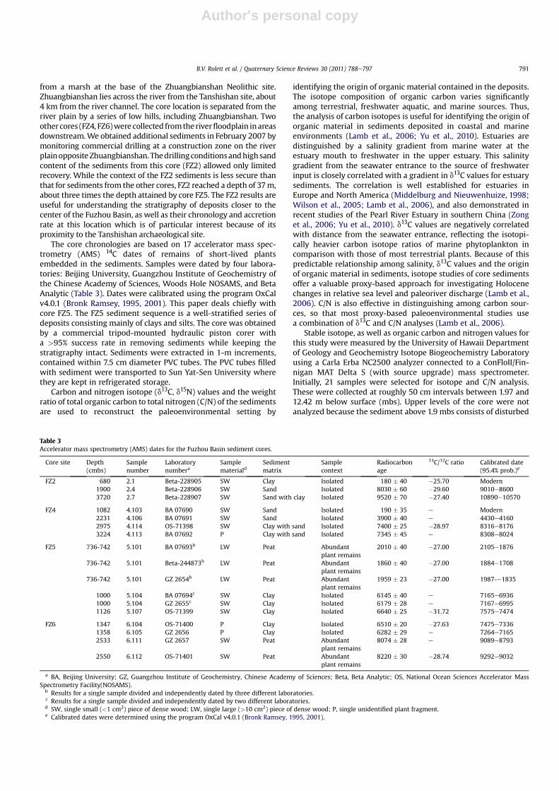
The FZ5 coring site is significant for documenting the environ-mental context of the Tanshishan Neolithic culture, as well as forinvestigating the Holocene sea-level history of the Fuzhou Basin.The base of the FZ5 sediment sequence consists of a thick deposit ofclay mixed with fine sand, resting on bedrock at 12.8 mbs (Fig. 2).This basal layer extends to a transitional zone marked by clays withhigher levels of fine sand found at around 7.8e7.5 mbs. The tran-sitional sediments lead to a fairly abrupt interface at 7.5 mbs witha thin, organic-rich layer of clay and peat. Unlike the basal layer,which contains isolated organic fragments, this clay and peatdeposit is packed with organic material ranging from small frag-ments to tree trunks and branches 10 cm or more in diameter. Theorganic-rich clay and peat layer transitions to a thick upper claydeposit containing very few organic fragments. Above this liesrecent overburden associated with modern landfill.
Three specimens, all consisting of wood, were selected for AMSdating of the FZ5 sediment sequence (Table 3). Two of thesespecimens (5.107 and 5.104) are isolated fragments of dense woodcollected from the basal clay deposit. Sample 5.107, from 11.26 mbs,yielded a date of 7575e7474 cal BP. The second specimen (5.104),from 10 mbs, was divided and submitted for analysis to boththe Beijing and Guangzhou laboratories. The results for thesereplicate analyses are identical, indicating an age of around7170e6940 cal BP. This is aboutfive hundred years later than the datefor sample 5.107, suggesting a sediment accretion rate of 4 cm/yr.The middle layer of organic-rich clay with peat was dated by a largetree trunk or branch fragment (sample 5.101) found at about7.4 mbs. Given the significance of this peat deposit (discussed
below) as a sea-level indicator, sample 5.101 was divided andsubmitted to three different laboratories in order to obtain anunambiguously clear dating result. The age ranges for these threeanalyses are very close and they overlap at around 1900 cal BP.
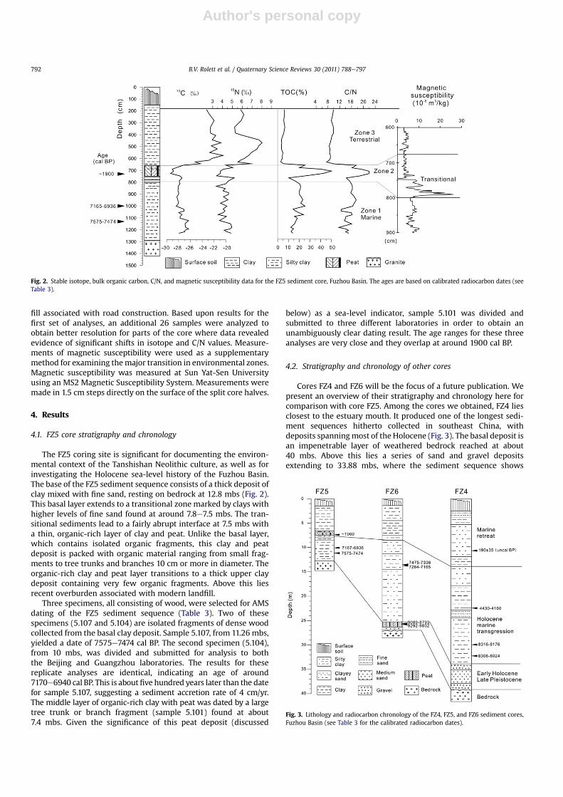
4.2. Stratigraphy and chronology of other cores
Cores FZ4 and FZ6 will be the focus of a future publication. Wepresent an overview of their stratigraphy and chronology here forcomparison with core FZ5. Among the cores we obtained, FZ4 liesclosest to the estuary mouth. It produced one of the longest sedi-ment sequences hitherto collected in southeast China, withdeposits spanningmost of the Holocene (Fig. 3). The basal deposit isan impenetrable layer of weathered bedrock reached at about40 mbs. Above this lies a series of sand and gravel depositsextending to 33.88 mbs, where the sediment sequence shows
Fig. 2. Stable isotope, bulk organic carbon, C/N, and magnetic susceptibility data for the FZ5 sediment core, Fuzhou Basin. The ages are based on calibrated radiocarbon dates (seeTable 3).
Fig. 3. Lithology and radiocarbon chronology of the FZ4, FZ5, and FZ6 sediment cores,Fuzhou Basin (see Table 3 for the calibrated radiocarbon dates).
B.V. Rolett et al. / Quaternary Science Reviews 30 (2011) 788e797792

Author's personal copy
a transition to more than 20 m of clay with some thin lenses of fineand medium sand. The upper deposits, from 12 to 5.6 mbs, consistmainly of fine to coarse sand, with another layer of clay near thetop. The sediment above this consists mainly of modern over-burden. Isolated fragments of wood and other plant remains arefound throughout the core. The lower clay deposits are dated bythree specimens (4.106, 4.113 and 4.114). Two of these (4.113 and4.114), collected at 32.24 and 29.75 mbs, produced similar resultswith age ranges around 8300e8000 cal BP. The date for the thirdsample (4.106), collected at 22.31 mbs, is almost four thousandyears later (4430e4160 cal BP). Results for a specimen (sample4.103) from the upper sand deposits, collected at 10.82mbs, yieldeda modern, uncalibrated radiocarbon age of 190 � 35 BP.
The FZ6 coring site is located just upstream from the city ofFuzhou, near the major split in the Min River. Core FZ6 producedanother long sediment sequence, extending to about 27 mbs, atwhich point the drill encountered an impenetrable layer of gravel(Fig. 3). The base of the sequence consists of sand and graveldeposits. Immediately above this is an approximately 1 m thicklayer of clay mixed with peat, rich in organic remains. The clay andpeat at 25.28e26.31 mbs transitions to a thick series of clay, andclay mixed with fine sand, deposits. These reach from around 25mbs to 1.5 mbs. The top 1.5 m of sediment is modern overburden.The clay and peat deposit is securely dated by two separate woodfragments (samples 6.111 and 6.112) collected at 2533 and2550 mbs. The results for these samples are similar and the ageranges overlap at around 9100e9000 cal BP. The upper claydeposits are also securely dated by two separate specimens(samples 6.104 and 6.105), from 1347 and 1358mbs. The age rangesfor these samples are very close but do not overlap. The combinedage range is from 7165 to 7475 cal BP, with a median of 7320 cal BP.Thus these samples are approximately 1800 years later than datesfor the clay and peat deposit, suggesting a sediment accretion rateof about 1.5 cm/yr.
4.3. Paleoenvironmental indicators
Geochemical results for the FZ5 sediments display well-definedchanges over time in organic content, isotope values, and C/N(Fig. 2). Results for the basal clays (Zone 1) display high variabilityin total organic content (TOC) and C/N, but the d13C and d15N valuesfor these deposits are fairly consistent. TOC ranges widely from10.40 to 25.38% in Zone 1. The period of greatest variability (around10e11 mbs) is followed by a period of comparative stability, from8.24 to 9.88 mbs, during which TOC values hold steady at around20e21%. The C/N ratios fall mainly between 14 and 16.5, althoughvariability is notably high from 10 to 12 mbs. d13C values for theZone 1 clays are mostly between �28.0 per mille (&) and �27.0&,while d15N values are from 3.38& to 5.20&.
Zone 2, the middle layer of organic-rich clay with peat, is clearlydifferent from the above and underlying deposits. The contrast ishighlighted by unusually high TOC values, which peak at 40e50%.C/N ratios for this deposit are comparatively elevated, fallingmainly between 18 and 22, with only onemeasurement below 17.5.The d13C values lie between�29.32& and�27.17&. d15N values aremostly between 3.4& and 4.35&, generally lower than those forZone 1.
The thick upper clay deposit (Zone 3) is also unique incomparison with the other layers, as shown by strikingly differentd13C values and C/N ratios, as well as TOC. TOC values for the Zone 3clays (between 3 and 6.67%) are far lower than those for the rest ofthe FZ5 sediment sequence. C/N ratios also fall outside the range ofvalues recorded for the other zones, and display less variability,ranging from 7.50 to 9.98. The d13C values lie mostly between�23& and �21&, with increasing variability near the interface
with Zone 2. d15N values are mostly between 6& and 8&, signifi-cantly higher than measurements for both Zones 1 and 2.
5. Discussion
5.1. Evolution of the Zhuangbianshan depositional environment
The isotope results identify three distinct environmental zonesin the transformation of the Fuzhou Basin and the Min RiverEstuary. We interpret these findings by comparison with modernenvironmental data and the results of previous paleoenvir-onmental studies (e.g. Middelburg and Nieuwenhuize,1998;Mullerand Mathesius, 1999; Wilson et al., 2005; Lamb et al., 2006; Zonget al., 2006; Yu et al., 2010). The earliest zone represents a contin-uous period of roughly six thousand years documented by the basalclay deposits. These date from about 8000 to 2000 cal BP, spanningthe Neolithic and Bronze Age eras of coastal Fujian and extending tothe Han Dynasty. The Zone 1 deposits consist of fine-grained clayand thus likely formed in a hydrodynamically quiet environment.The Zone 1 depositional environment is best characterized by thed13C values and C/N ratios. The d13C values are typical of thoseindicating a primarily terrestrial source, while the C/N ratiossuggest a mixture of terrestrial and marine sources of organicmaterial. We conclude that the basal clays were deposited in anestuary setting, with the terrestrial organic material derivingmainly from direct inflow of the Min River into the estuary. Anupper estuary setting is the most likely scenario, judging by themodern comparative data, especially those for the Pearl RiverEstuary (Zong et al., 2006; Yu et al., 2010). Results of diatomidentifications for a sediment sample from 10.85 mbs also suggestan estuary setting, however the low frequency of freshwaterspecies (only about 2% of the assemblage) is more consistent witha mid-estuary environment (Rolett et al., in prep).
Some of the variability in Zone 1 d13C values and C/N ratios maybe linked to change over time in the intensity of the monsoon rains.Changes in the rainfall pattern, correlated with river discharge,would have influenced paleosalinity of the Min River Estuary aswell as the input of terrestrial organic material. High-resolutionpaleoclimate studies for southern China show that the monsoonwas generally strong from around 9000 to 7000 cal BP, withweakening during later times and major weakening events at8400e8100 and 4500e4000 cal BP (Wang et al., 2005). One goal ofour future research is to investigate the extent to which changes inthe monsoon cycle are reflected in our cores, through additionalradiocarbon dating and isotope analyses of the FZ5 and FZ6 sedi-ment sequences.
The transition between environmental Zones 1 and 2 is securelydated to around 1900 cal BP. Zone 2 is marked by the thin middlelayer of clay and peat.We interpret this as a brackish swamp settingdeposit that formed within a tidal zone environment close to theriver mouth. Multiple aspects of our study results support thishypothesis. First, the very low d13C values, which peak at around�29&, likely derive primarily from vascular terrestrial vegetationbut could also reflect the contribution of freshwater phytoplankton.By comparison, the tree trunk or branch (AMS dating sample 5.101)found in this deposit yielded a d13C measurement of�27&. Second,the C/N ratios, mostly greater than 18 with a peak at 21.90, aretypically terrestrial and they are higher than ratios recorded formost modern estuary sediments, even samples from upper estuarylocations close to the source of freshwater inflow. For example, theaverage of C/N ratios for modern sediments from upper estuarysettings is 14.8 for the Pearl River Estuary (Zong et al., 2006) and 17for the Schelde Estuary (Middelburg and Nieuwenhuize, 1998).Together with the unusually high organic content, our resultssuggest that the environmental shift from Zone 1 to Zone 2
B.V. Rolett et al. / Quaternary Science Reviews 30 (2011) 788e797 793

Author's personal copy
represents a decline in water salinity, a decrease in water depth,and increased proximity to the river mouth. The presence of peatfurther denotes the significant degree of change from Zone 1 toZone 2, as peat formation in coastal settings generally occurs withinthe upper intertidal environment. Finally, diatom analysis providesadditional support for this interpretation of a brackish swampsetting. A diatom assemblage from sediment collected at 7.17 mbs,some 20 cm below the dated tree trunk or branch, is dominated bybrackish and marine water species but freshwater species make up10% of the sample (Rolett et al., in prep). This is in contrast to theconsiderably lower frequency of 2% freshwater species for thesample collected at 10.85 mbs.
Zone 3, which dates from about 1500 BP until modern times,represents the final stage in the evolution of the FZ5 depositionalenvironment. The transition to Zone 3 is characterized by steepdeclines in C/N ratios and TOC, coupled with a progressive increasein d13C values from �29& to over �21&. The C/N ratios and d13Cvalues appear to signal change to a strongly marine depositionalcontext, but this interpretation is inconsistent with two importantlines of evidence. One of these is the large set of regional andworldwide sea-level data, all of which shows that by 1500 BP sealevel had fallen to near modern levels, with no evidence fora significant marine transgression during the late Holocene (Zong,2004; Bird et al., 2007). Historical accounts for the Fuzhou Basinand lower Min River support this conclusion, recording that theZhuangbianshan area has been a fluvial environmental setting fora period extending at least 1500 years into the past (Lin, T., 2008). Inaddition, we note that the Zone 3 clays are distinguished bypronounced red, yellow, and brown colors produced by iron oxideaccumulation and weathering. This suggests they formed ina terrestrial, floodplain setting. By contrast, the lower and middledeposits are gray in color. In sum, it is difficult to reconcile theisotope results with other contradictory lines of evidence. Onepossible explanation is that the mixture of organic material fromdifferent sources, which can complicate the interpretation ofisotope data (Lamb et al., 2006), has become a factor. Morespecifically, the d13C values for Zone 3 may reflect an abundance ofC4 grasses, which have significantly higher d13C values than C3plants. For the modern Pearl River delta, riverbank soils dominatedby shrubs and grass have higher d13C values (ca.�24&) than soils inforests dominated by C3 plants (ca. �28&) (Yu et al., 2010).Anthropogenic influence related to farming may also be a factor, asagricultural soils in the Pearl River delta produce even higher d13Cvalues (averaging more than �22&) than riverbank soils from thefloodplain (Yu et al., 2010). We argue that the Zone 3 isotope resultsreflect the influence of one or more of these factors and concludethat the depositional environment was terrestrial. Future analyses,including pollen studies of these sediments and further isotopestudies of the modern environment, should allow us to test thishypothesis.
5.2. Holocene sea-level history of the Fuzhou Basin and lower MinRiver area
Despite recent progress in documenting the sea-level history ofcoastal China and southeast Asia, there is still considerable uncer-tainty and debate over the timing, magnitude, and regional vari-ability of the mid-Holocene highstand (e.g. Zong, 2004). Anotherproblem concerns the rate of sea-level change. Was it fairlyconstant over long periods of time? Or was it step-like with longintervals of comparatively slowchange punctuated by short periodsof rapid change (Bird et al., 2007)? Some of the contrasts amongsea-level curves based on different data sets are shown in Fig. 4,which also incorporates new data from the FZ4, FZ5, and FZ6sediment cores. Fig. 4 juxtaposes sea-level curves for the Fujian
coast and Singapore. While the Singapore curve is based on recentradiocarbon dating analyses (Bird et al., 2007), the Fujian curve isbased largely on analyses conducted prior to 1986 (Zong, 2004),prior to the development of AMS dating facilities in China. Signif-icantly, the Singapore curve differs from the Fujian curve in offeringevidence for an inflection in the rate of early mid-Holocene sea-level rise. This is shown by an abrupt decrease in sea-level riseduring the period from around 7800 to 7500 cal BP.
The lower deposits of cores FZ4, FZ5, and FZ6 are associatedwithrapid deglaciation sea-level rise during the approach to the mid-Holocene highstand. Of particular interest is a clay and peat depositnear the base of the FZ6 stratigraphic sequence (25.28e26.31 mbs)(Fig. 3). This organic-rich layer dated to 9100e9000 cal BP likelyaccumulated in a swamp deposit along the shoreline during themarine transgression. It thus marks the intertidal zone during theearly Holocene inundation of the Fuzhou Basin. A simple estimationof relative sea level (RSL) for this index point, using local tidal dataand following the procedure used by Zong (2004), suggests that itwas�21.6 m (Table 4). As shown in Table 4, RSL equals the observedaltitude (OA) minus indicative meaning (IM), where OA is thepresent elevation above sea level and IM is based on Min RiverEstuary tidal data. Although this calculation does not account forpost-depositional compaction of sediments (e.g. Bird et al., 2007) orpossible tectonic movement, it provides a useful approximation forcomparison with sea-level data from other studies. The estimate of�21.6m at 9100e9000 cal BP is roughly consistent with data for theSingapore sea-level curve, which measures RSL at 9500 cal BP at�17 m (Bird et al., 2007). Possible explanations for the discrepancybetween these estimates include local subsidence in the FuzhouBasin and regional differences among sea-level histories.
Twelve meters above the index point in the FZ6 sequence, thereare marine clays dated to ca. 7300 cal BP. These clays were withoutdoubt deposited below mean sea level, and while they do notrepresent a precise sea-level indicator, they nevertheless show thatthat RSL was at least �7.5 at 7300 cal BP (Table 4). This indicatesa minimum sea-level rise of 14.5 m (from �21.6 m to �7.5 m)between 9000 and 7300 cal BP. Again, this rough calculation(without accounting for sediment compaction or tectonic move-ment) is consistent with the Singapore sea-level curve, whichshows a ca. 17 m rise in sea level from 9500 to 7000 cal BP (Birdet al., 2007).
The clay and peat deposit representing Zone 2 in the FZ5 sedi-ment sequence provides another sea-level indicator. RSL for thisindex point, which represents a brackish swamp depositionalsetting, can be estimated as �0.5 m (Table 4). The transition in FZ5from Zone 1 to Zone 2 (around 1900 cal BP) is best explained by anincrease in ground elevation within the tidal frame. This likelyresulted from a fall in RSL associated with the retreating shorelineof the Min River Estuary during the final Holocene marine regres-sion. Our study suggests that the pace of sea-level change duringthe final regression may have been abrupt rather than gradual. Thisis best illustrated by the sharp shift in C/N ratios during the tran-sition from Zone 1 to Zone 2.
5.3. Evolution of the mid-Holocene Min River estuary and Neolithiccultural response
Initial inundation of the Fuzhou Basin associated with earlyHolocene sea-level rise is dated to around 9000 cal BP by peatsediments in core FZ6. As sea level continued to rise during theapproach to the mid-Holocene highstand, the marine transgressionreached Zhuangbianshan and Tanshishan, creating a large estuaryfilling the Fuzhou Basin (Fig. 5). As a result, Zhuangbianshan andTanshishanwere transformed fromlowhills near the river into smalloffshore islands in the upper estuary. Significantly, both of these
B.V. Rolett et al. / Quaternary Science Reviews 30 (2011) 788e797794

Author's personal copy
Neolithic siteswerefirst settledaround5500e5000 cal BP, after theyhad become estuarine islands. This indicates that the islands wereviewed as desirable settlement areas, probably because theyprovided ready access to a wide range of marine, terrestrial, andfluvial resources. Although our results do not date the beginning of
the mid-Holocene sea-level highstand, Zong’s (2004: 61) analysissuggests this occurred around 5500 cal BP in Fujian. Thus theNeolithic occupations of Zhuangbianshan and Tanshishan date towithin the time span of the mid-Holocene highstand.
The transition from Zone 1 to Zone 2 in the FZ5 sedimentsequence likely records a fall in sea level from the mid-Holocenehighstand to near modern levels, dating this event to around1900 cal BP. As the ocean retreated from the estuary, Zhuangbian-shan and Tanshishan were transformed from small islands to hillssurrounded by swamps. Finally, more than 5 m of terrestrial claysaccumulated near Zhuangbianshan between 1900 cal BP and thepresent day. Sediments deposited during the last two thousandyears reflect intensified human impact on the landscape, especiallythrough soil erosion associated with deforestation and agriculturalexpansion. These processes are closely linked with populationgrowth, due in part to an influx of Han Chinese from the northbeginning during the Western Han Dynasty (206 BCe25 AD) (Linand Li, 1991; Lin, 2003). Historic records state that populationinflux led to particularly rapid growth of Fuzhou City during theSong Dynasty (960e1279 AD) (Lin, T., 2008). The same records notethat increases in population led to expansion of agriculturalproduction by terracing and planting hillsides within the FuzhouBasin, causing erosion linked to significant sediment buildup in theriver. This relatively recent period of sedimentation created thepresent-day fluvial plain of the Min River.
Evolution of the Fuzhou Basin and the lower Min River areacoastline can be considered in light of a general global model forHolocene coastal development proposed by Stanley and Warne
Table 4Sea-level index points for Fuzhou Basin Cores FZ5 and FZ6.
FZ5 FZ6
Sea-level dataPresent surface elevation (PSE)at core site (m above sea level)
9 6
Depth of index point (DIP)(m below surface)
7.4 25.5
Observed altitude (OA)a 1.6 �19.5Indicative meaning (IM)b 2.1 2.1Relative sea level (RSL)c �0.5 �21.6
AMS age of index point deposit (cal BP) 1900 cal BPd 9050 cal BPe
Environmental dataDepositional environment Brackish marsh Brackish marshTidal zone during sediment deposition Mean high water Mean high water
a OA equals PSE minus DIP.b IM is based on Min River estuary tidal data compiled and analyzed by Zong
(2004).c RSL equals OA minus IM. Calculation does not account for post-depositional
compaction of sediments or possible tectonic movement.d Date based on the overlapping age ranges for AMS samples 6.111 and 6.112
(Table 3).e Date based on the overlapping age ranges for replicate analyses of AMS sample
5.101 (Table 3).
Fig. 4. Sea-level curves shown in juxtaposition to stages in the cultural history of coastal southeast China and Taiwan. (A) The solid black line is a sea-level curve for Singapore (Birdet al., 2007). The dashed line is a sea-level curve for Fujian (southeast China) and the Taiwan Strait (Zong, 2004); the dotted continuation shows that the reconstruction from around5500 to 6500 BP is based on only two data points. New data from this study are represented as bars. The length of these bars shows AMS age ranges for the sea-level indicators. Thebox indicates the elevation of AMS-dated marine clays in core FZ6. This represents a minimum elevation for RSL at the time of deposition; the dashed continuation illustrates thepossibility that RSL may have been even higher. (B) Time series of archaeologically-documented cultures for coastal southeast China and Taiwan, situating the beginning of open-seavoyaging across the Taiwan Strait within the Neolithic context.
B.V. Rolett et al. / Quaternary Science Reviews 30 (2011) 788e797 795

Author's personal copy
(1994). This model hypothesizes a direct link between decelerationin sea-level rise and the large-scale formation of marine deltasbetween 8500 and 6500 BP (9500 and 7500 cal BP). AMS dates forthe basal stratigraphic zones in cores FZ4, FZ5, and FZ6 areconsistent with this model, showing that Holocene deposition inthe Fuzhou Basin and lower Min River area began around9000 cal BP. The FZ6 sediment sequence records 12 m of sedi-mentation during some 1800 years from around 9000 to7200 cal BP. Although the FZ4 sequence is less securely dated,
this sequence also indicates rapid sediment accretion around8500e8000 cal BP.
During the early- to mid-Holocene marine transgression, sedi-ment transported to the coast and deposited by the Min Riveraccumulated mainly within the Fuzhou Basin itself (Fig. 6).Consequently, there was no large-scale delta formation such as thatassociated with the Yangtze and other major rivers in east Chinaduring the same time period. This distinction is critical for under-standing the Neolithic cultures of coastal Fujian. Early Holoceneshoreline progradation and formation of the Yangtze delta plainattracted Neolithic peoples who settled the coastal lowlands andexploited fertile deltaic soils for rice agriculture (Chen et al., 2008).Neolithic settlement of the coastal lowlands continued eventhrough the time of the mid-Holocene sea-level highstand, as localtopographic conditions protected part of the delta plain frominundation. South of the Yangtze delta plain in the nearby Hang-zhou Bay area (Zhejiang Province), cultures followed a similartrajectory of development, with the early cultivation of rice by7700 cal BP and the establishment of large agricultural villagesaround 6500 cal BP (Fuller et al., 2007; Zong et al., 2007) (Table 1).By contrast, the lack of delta formation in the Fuzhou Basin favoreda distinctly different trajectory of Neolithic development. Beginningwith the earliest Neolithic cultures around 6000 cal BP andcontinuing for the duration of the sea-level highstand, coastalFujian Neolithic settlements were concentrated on nearshoreislands such as Tanshishan and Zhuangbianshan, as well as coastaltablelands (Lin, G., 2008). Despite the shift to a sedentary lifestyleand adoption of classic elements of Neolithic culture including kiln-fired pottery and ground-stone tools, there is very little evidencefor agricultural food production. Instead, it appears the TanshishanCulture subsistence economy was based on marine resources andsupplemented by hunting and gathering (Chen, 2004; Jiao, 2006).
The Tanshishan Culture maritime orientation seems closelylinked to environmental factors, especially the presence of a largemid-Holocene Min River estuary, together with the lack of a deltaicplain and coastal lowlands. The sheltered estuarine setting offeredan abundance of fish and shellfish while the absence of land suit-able for rice paddy agriculture inhibited the development ofintensive food production. The large estuary provided idealconditions for the development of watercraft and early seafaring.Thus, we interpret the beginning of seafaring, perhaps involvingsingle-hull canoes and bamboo rafts, as part of a broad cultural shiftto an increasingly maritime way of life. In this scenario, earlyseafaring facilitated fishing, transportation, and long-distanceexchange. Seafaring most likely began in sheltered estuaries andinshore coastal waters before the advent of regular open-seavoyaging. This later development, involving the ability to navigatebeyond the range of land visibility, allowed crossing of the Taiwan
Fig. 6. Schematic cross-section of the Fuzhou Basin based on data for the FZ2 and FZ5 sediment cores. Note locations of the Zhuangbianshan and Tanshishan Neolithic sites.
Fig. 5. Map of the Fuzhou Basin showing the present-day environmental setting anda paleogeographic reconstruction for the time period around 6000 cal BP.
B.V. Rolett et al. / Quaternary Science Reviews 30 (2011) 788e797796

Author's personal copy
Strait around 5000 cal BP. It has been argued that similaritiesamong the Tanshishan Culture and early Neolithic cultures ofTaiwan suggest that the Taiwanese cultures were derived from orstrongly influenced by the coastal Neolithic peoples of Fujian (e.g.Lin, G., 2008). Our data support this hypothesis and further suggestthat maritime adapted Neolithic peoples of Fujian, and of theFuzhou Basin in particular, played an important role in the begin-ning of systematic voyaging across the Taiwan Strait.
Acknowledgments
We thank Guangqi Zhu, Landon H. Clay, Nathalie Wallsgrove,Yahui Gao, Lin Gongwu, Xiaoqiang Yang, and Jie Yang for assistancein collecting and studying the Fuzhou Basin cores. Ofer Bar-Yosef,Yongqiang Zong, and Angela Lamb provided helpful discussionsand critical comments. This work was supported by the AndoverFoundation for Archaeological Research (through grants from L. T.Clay), the American School of Prehistoric Research (PeabodyMuseum, Harvard University), the National Natural Science Foun-dation of China (Grants 40772113 and 41072128), and the Inter-national Research Center for Japanese Studies.
References
Bellwood, P., 2005. First Farmers: The Origins of Agricultural Societies. Blackwell,Oxford.
Bird, M.I., Fifield, L.K., Teh, T.S., Chang, C.H., Shirlaw, N., Lambeck, K., 2007. Aninflection in the rate of early mid-Holocene eustatic sea-level rise: a new sea-level curve from Singapore. Estuarine, Coastal and Shelf Science 71, 523e536.
Bronk Ramsey, C., 1995. Radiocarbon calibration and analysis of stratigraphy: theOxCal program. Radiocarbon 37, 425e430.
Bronk Ramsey, C., 2001. Development of the radiocarbon program OxCal. Radio-carbon 43, 355e363.
Chang, K.C., 1969. Fengpitou, Tapenkeng, and the Prehistory of Taiwan. In: YaleUniversity Publications in Anthropology No. 73. Yale University Department ofAnthropology and The Peabody Museum, New Haven.
Chang, K.C., 1986. The Archaeology of Ancient China, fourth ed. Yale UniversityPress, New Haven.
Chang, K.C., 1995. Taiwan Strait archaeology and proto-austronesian. In: Li, P.J.,Tsang, C., Huang, Y., Ho, D., Tseng, C. (Eds.), Austronesian Studies Relating toTaiwan. Academia Sinica, Taipei, pp. 161e183.
Chang, K., Goodenough, W., 1996. Archeology of southeastern China and its bearingon the austronesian homeland. In: Goodenough, W. (Ed.), Prehistoric Settle-ment of the Pacific. American Philosophical Society, Philadelphia, pp. 36e56.
Chen, Z.S., 2004. Diet and subsistence strategies of the Tanshishan Culture. FujianWenbo 48, 41e46 (in Chinese with English Abstr.).
Chen, Z., Zong, Y., Wang, Z., Wang, H., Chen, J., 2008. Migration patterns of Neolithicsettlements on the abandoned Yellow and Yangtze River deltas of China.Quaternary Research 70, 301e314.
Fujian Provincial Museum,1991. Brief report of the excavation of the Keqiutou site inPingtan, County, Fujian. Kaogu 199, 587e599 (in Chinese with English Abstr.).
Fujian Provincial Museum, 2008. Excavation report of the Zhuangbianshan site inMinhou County, Fujian. In: Lin, G. (Ed.), Collection of Papers on the TanshishanCulture. Fujian Province Tanshishan Site Museum, Fuzhou, pp. 126e171(in Chinese with English Abstr.).
Fuller, D.Q., Harvey, E., Qin, L., 2007. Presumed domestication? Evidence for wildrice cultivation and domestication in the fifth millennium BC of the LowerYangtze region. Antiquity 81, 316e331.
Innes, J.B., Zong, Y., Chen, Z., Chen, C., Wang, Z., Wang, H., 2009. Environmentalhistory, palaeoecology and human activity at the early Neolithic forager/culti-vator site at Kuahuqiao, Hangzhou, eastern China. Quaternary Science Reviews28, 2277e2294.
Jiang, L., Liu, L., 2005. The discovery of an 8000-year-old dugout canoe at Kuahuqiaoin the Lower Yangtze River, China. Antiquity 79 Project Gallery 305. http://antiquity.ac.uk/projgall/liu/index.html.
Jiang, L., Liu, L., 2006. New evidence for the origins of sedentism and rice domes-tication in the Lower Yangtze River, China. Antiquity 80, 355e361.
Jiao, T., 2006. Ancient environment and cultural changes in Southeast China duringthe Neolithic period. Antiquity 80, 615e621.
Jiao, T., 2007. The Neolithic of Southeast China: Cultural Transformation andRegional Interaction on the Coast. Cambria Press, Youngstown, NY.
Jiao, T., Fan, X., Rolett, B., 2009. The Keqiutou site and early Neolithic cultures of theTaiwan Strait. Fujian Wenbo 53, 8e12 (in Chinese with English Abstr.).
Kaogu, Xuebao, 1978. First report of the excavations of the Hemudu site, Zhejiang.Kaogu Xuebao 1, 39e93 (in Chinese with English Abstr.).
Lamb, A.L., Wilson, G.P., Leng, M.J., 2006. A review of coastal palaeoclimate andrelative sea-level reconstructions using 13C and C/N ratios in organic material.Earth-Science Reviews 75, 29e57.
Lambeck, K., Nakada, M., 1990. Late Pleistocene and Holocene sea-level changealong the Australian coast. Palaeogeography, Palaeoclimatology, Palaeoecology89, 143e176.
Lin, D., 2003. Study of human migrations in the history of Fujian. Research on theSocioeconomic History of China 27, 7e20 (in Chinese).
Lin, G., 2008. Introduction: a brief review of studies on the Tanshishan site andTanshishan Culture. In: Lin, G. (Ed.), Collection of Papers on the TanshishanCulture. Fujian Province Tanshishan Site Museum, Fuzhou, pp. 2e11 (in Chinesewith English Abstr.).
Lin, T., 2008. Transformation of the Fuzhou Bay during the historic period. HistoricalGeography 23, 220e226 (in Chinese with English Abstr.).
Lin, F., Li, C., 1991. The ancestry of human populations in Fujian and Taiwan: thehistory of migrations from Henan Province. Regional Research and Exploration10, 50e53 (in Chinese).
Lu, M. (Ed.), 2004. Fujian Geographical Atlas. Fujian Atlas Publishing Company,Fuzhou (in Chinese).
Middelburg, J.J., Nieuwenhuize, J., 1998. Carbon and nitrogen stable isotopes insuspended matter and sediments from the Schelde Estuary. Marine Chemistry60, 217e225.
Muller, A., Mathesius, U., 1999. The palaeoenvironments of coastal lagoons in thesouthern Baltic Sea, I. The application of sedimentary Corg/N ratios as sourceindicators of organic matter. Palaeogeography, Palaeoclimatology, Palae-oecology 145, 1e16.
Peltier, W.R., 2002. On eustatic sea level history: Last Glacial Maximum to Holocene.Quaternary Science Reviews 21, 377e396.
Rolett, B.V., 2007. Southeast China and the emergence of Austronesian Seafaring. In:Jiao, T. (Ed.), Lost Maritime Cultures: China and the Pacific. Bishop MuseumPress, Honolulu, pp. 54e61.
Rolett, B.V., Gao, Y., Chen, X., Zheng, Z. Diatom evidence for a Holocene sea-levelhistory of the Fuzhou Basin, In Prep.
Stanley, D.J., Warne, A.G., 1994. Worldwide initiation of Holocene marine deltas bydeceleration of sea-level rise. Science 265, 228e231.
Stanley, D.J., Chen, Z., Song, J., 1999. Inundation, sea-level rise and transition fromNeolithic to Bronze age cultures, Yangtze Delta, China. Geoarchaeology 14 (1),15e26.
Tsang, C., Li, K., Zhu, Z., 2006. Traces of Ancient Settlers: A Collection of Archaeo-logical Discoveries from Nanke. Tainan County Government, Xinying(in Chinese).
Turney, C.S.M., Brown, H., 2007. Catastrophic early Holocene sea level rise, humanmigration and the Neolithic transition in Europe. Quaternary Science Reviews26, 2036e2041.
Wang, Y., Cheng, H., Edwards, R.L., He, Y., Kong, X., An, Z., Wu, J., Kelly, M.J.,Dykoski, C.A., Li, X., 2005. The Holocene Asian monsoon: Links to solar changesand North Atlantic climate. Science 308, 854e857.
Wilson, G.P., Lamb, A.L., Leng, M.J., Gonzalez, S., Huddart, D., 2005. Variability oforganic 13C and C/N in the Mersey Estuary, U.K. and its implications for sea-level reconstruction studies. Estuarine, Coastal and Shelf Science 64, 685e698.
Yu, F., Zong, Y., Lloyd, J.M., Huang, G., Leng, M.J., Kendrick, C., Lamb, A.L., Yim, W.W.-S., 2010. Bulk organic d13C and C/N as indicators for sediment sources in thePearl River delta and estuary, southern China. Estuarine, Coastal and ShelfScience 87, 618e630.
Zhang, C., Hung, H., 2008. The Neolithic of Southern China e origin, development,and dispersal. Asian Perspectives 47, 299e329.
Zhang, P., Cheng, H., Edwards, R.L., Chen, F., Wang, Y., Yang, X., Liu, J., Tan, M.,Wang, X., Liu, J., An, C., Dai, Z., Zhou, J., Zhang, D., Jia, J., Jin, L., Johnson, K.R.,2008. A test of climate, sun, and culture relationships from an 1810-yearChinese cave record. Science 322, 940e942.
Zhejiang Provincial Institute of Cultural Relics and Archaeology, Xiaoshan Museum,2004. Kua Hu Qiao: Archaeological Report of Puyang River Valley 1. CulturalRelics Publishing House, Beijing (in Chinese with English Abstr.).
Zheng, Y., Sun, G., Qin, L., Li, C., Wu, X., Chen, X., 2009. Rice fields and modes of ricecultivation between 5000 and 2500 BC in east China. Journal of ArchaeologicalScience 36, 2609e2616.
Zhu, Y., 1985. Fluvial processes during the development of the Minjiang estuary.Taiwan Strait 4 (2), 161e170 (in Chinese with English Abstr.).
Zong, Y., 2004. Mid-Holocene sea-level highstand along the southeast coast ofChina. Quaternary International 117, 55e67.
Zong, Y., Lloyd, J.M., Leng, M.J., Yim, W.W.-S., Huang, G., 2006. Reconstruction ofHolocene monsoon history from the Pearl River Estuary, southern China, usingdiatoms and carbon isotope ratios. The Holocene 16 (2), 251e263.
Zong, Y., Chen, Z., Innes, J.B., Chen, C., Wang, Z., Wang, H., 2007. Fire and floodmanagement of coastal swamp enabled first rice paddy cultivation in eastChina. Nature 449, 459e462.
Zong, Y., Huang, G., Switzer, A.D., Yu, F., Yim, W.W.S., 2009. An evolutionary modelfor the Holocene formation of the Pearl River delta, China. The Holocene 19,129e142.
B.V. Rolett et al. / Quaternary Science Reviews 30 (2011) 788e797 797