Philpotstown Neolithic House, Co. Meath, Ireland
95
Transcript of Philpotstown Neolithic House, Co. Meath, Ireland
PROJECT DETAILS
Project M3 Clonee–Kells Motorway
Site Name Philpotstown 1
Ministerial Direction Number A023/007
Registration Number E3099
Senior Archaeological Consultant Donald Murphy
Site director Kevin Martin
Excavated 29 March – 05 May 2006
Client Meath County Council, National Roads Design
Office, Navan Enterprise Centre, Navan, County
Meath
Townland Philpotstown
Parish Ardsallagh
County Meath
National Grid Reference 286602 264220
Chainage 975–1050 R161 Trim Road
Height 55.28m
Report Type Final
Report Status Submitted
Date of Report May 2009
Report by Kevin Martin
Philpotstown 1, A023/007 M3 Clonee–North of Kells Motorway Scheme
ii
ACKNOWLEDGEMENTS
This report has been prepared by Archaeological Consultancy Services Ltd on behalf of
Meath County Council National Roads Design Office (NRDO) and the National Roads
Authority (NRA). The excavation was carried out under Ministerial Direction Number issued
by the Department of the Environment, Heritage and Local Government (DoEHLG) in
consultation with the National Museum of Ireland (NMI).
Consulting Engineers - N3 Meath Consult
Engineer – Peter Thorne and Thomas Meagher
Resident Engineer – Mary O’Rourke
Meath County Council, National Roads Design Office
Senior Engineer – John McGrath
Project Archaeologist – Mary Deevy
Project Liaison Officer – Ambrose Clarke
National Monuments, Department of the Environment, Heritage and Local Government
Archaeologist – Martin Reid
Irish Antiquities Division, National Museum of Ireland
Keeper – Nessa O’Connor
Philpotstown 1, A023/007 M3 Clonee–North of Kells Motorway Scheme
iii
NON-TECHNICAL SUMMARY
The site at Philpotstown 1 was excavated by Archaeological Consultancy Service Ltd (ACS)
as part of the M3 Clonee–North of Kells Motorway Scheme on behalf of Meath County
Council NRDO and the NRA. The excavation was carried out between 29 March and 5 May
2006 under Ministerial Direction Number A023/007 issued by DOEHLG in consultation with
the NMI. The site at Philpotstown 1 contained evidence for Middle to Late Bronze Age
activity in the form of a rectangular slot-trench structure, two charcoal and heat affected stone
rich troughs, a curvilinear ditch and a single cremated bone deposition uncovered at the
northern extent of the site. The features are interpreted as being roughly contemporary
although the cremation deposit was likely to be the latest activity on the site. Four artefacts
were recovered from the site and included three worked flints and a loom weight. Activity on
the site may relate to contemporary dated activity on the nearby site of Williamstown or
Bawn 2 located 300m south of the site. During the post medieval – modern period a number
of stone field drains were constructed across the site and truncated both the slot trench
structure and curvilinear ditch feature.
Philpotstown 1, A023/007 M3 Clonee–North of Kells Motorway Scheme
iv
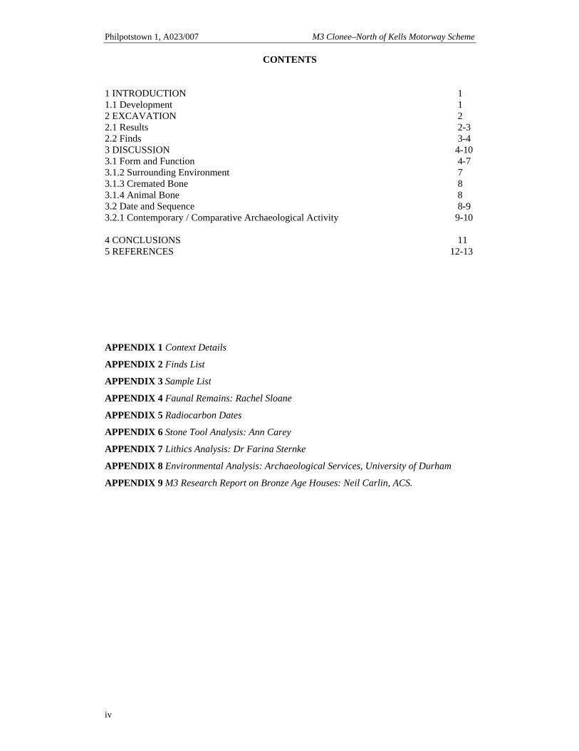
CONTENTS
1 INTRODUCTION 1 1.1 Development 1 2 EXCAVATION 2 2.1 Results 2-3 2.2 Finds 3-4 3 DISCUSSION 4-10 3.1 Form and Function 4-7 3.1.2 Surrounding Environment 7 3.1.3 Cremated Bone 8 3.1.4 Animal Bone 8 3.2 Date and Sequence 8-9 3.2.1 Contemporary / Comparative Archaeological Activity 9-10 4 CONCLUSIONS 11 5 REFERENCES 12-13
APPENDIX 1 Context Details
APPENDIX 2 Finds List
APPENDIX 3 Sample List
APPENDIX 4 Faunal Remains: Rachel Sloane
APPENDIX 5 Radiocarbon Dates
APPENDIX 6 Stone Tool Analysis: Ann Carey
APPENDIX 7 Lithics Analysis: Dr Farina Sternke
APPENDIX 8 Environmental Analysis: Archaeological Services, University of Durham
APPENDIX 9 M3 Research Report on Bronze Age Houses: Neil Carlin, ACS.
Philpotstown 1, A023/007 M3 Clonee–North of Kells Motorway Scheme
v
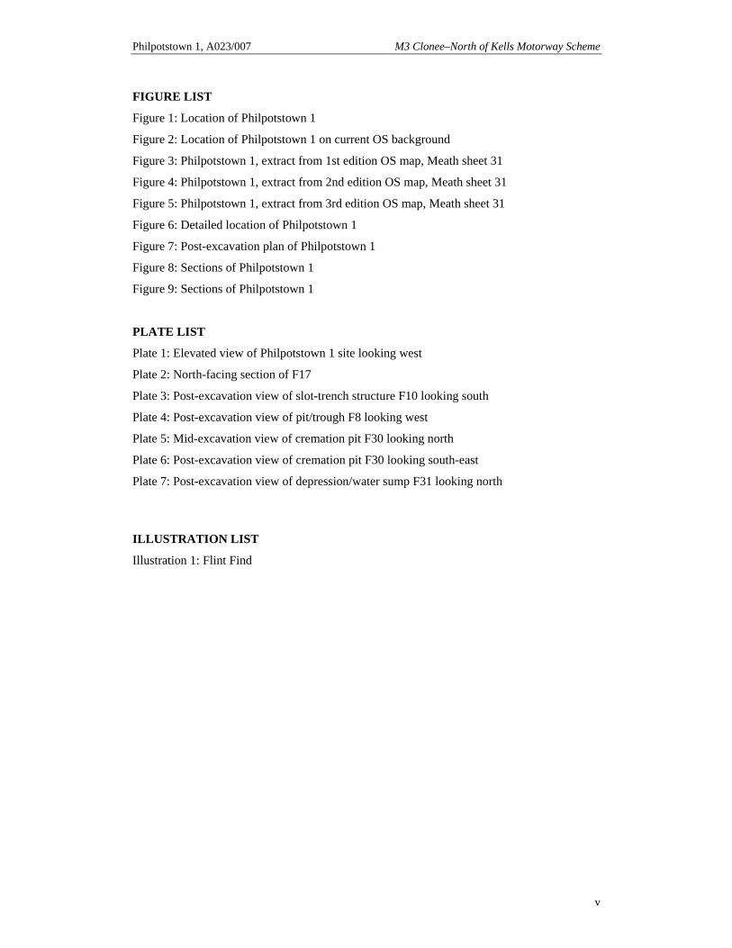
FIGURE LIST
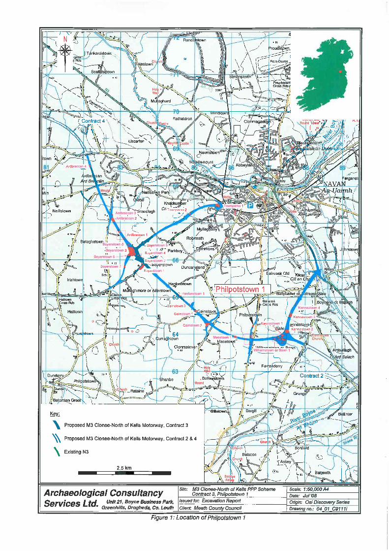
Figure 1: Location of Philpotstown 1
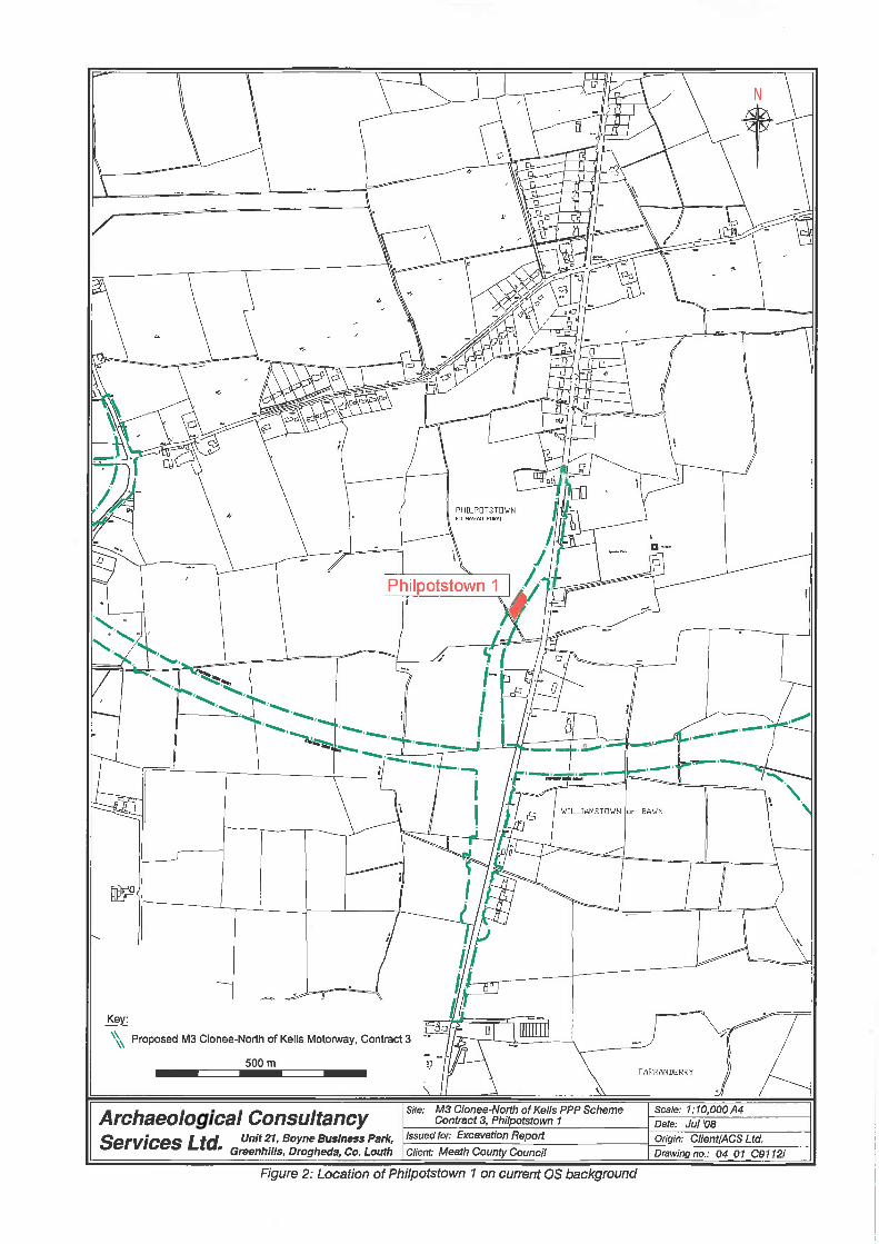
Figure 2: Location of Philpotstown 1 on current OS background
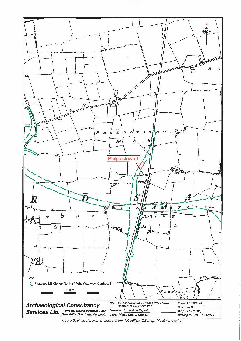
Figure 3: Philpotstown 1, extract from 1st edition OS map, Meath sheet 31
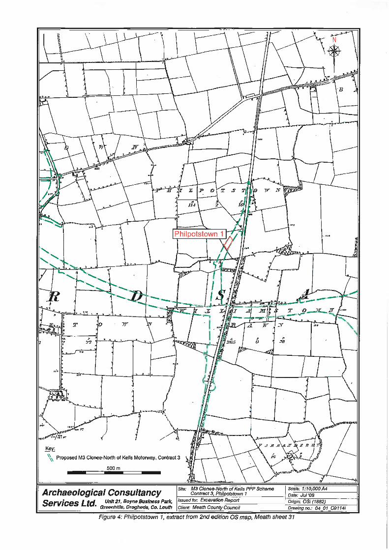
Figure 4: Philpotstown 1, extract from 2nd edition OS map, Meath sheet 31
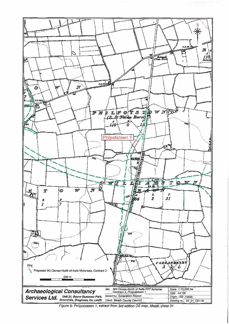
Figure 5: Philpotstown 1, extract from 3rd edition OS map, Meath sheet 31
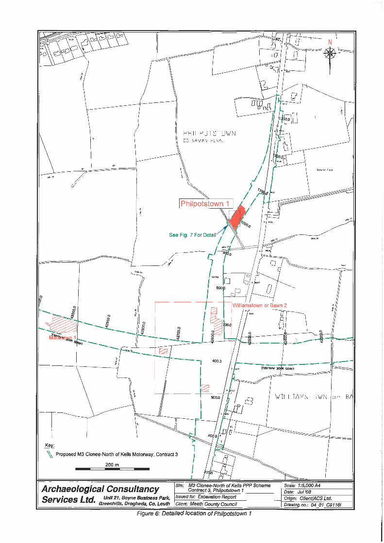
Figure 6: Detailed location of Philpotstown 1
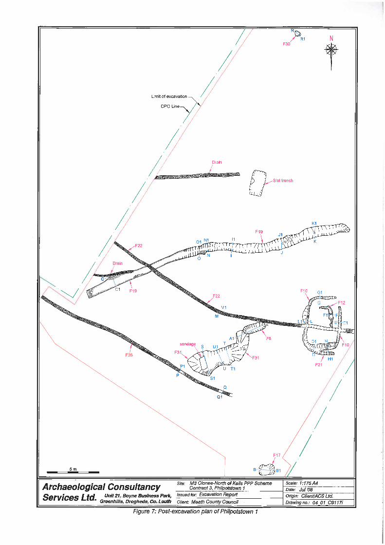
Figure 7: Post-excavation plan of Philpotstown 1
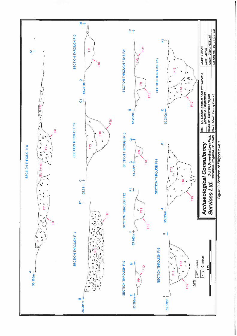
Figure 8: Sections of Philpotstown 1
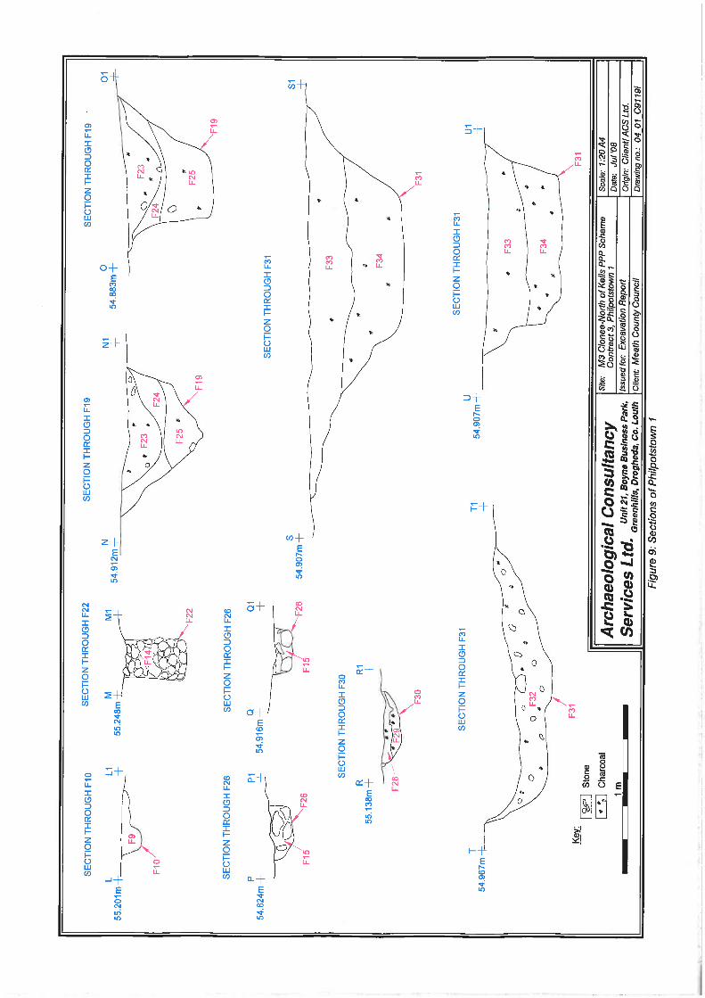
Figure 9: Sections of Philpotstown 1
PLATE LIST
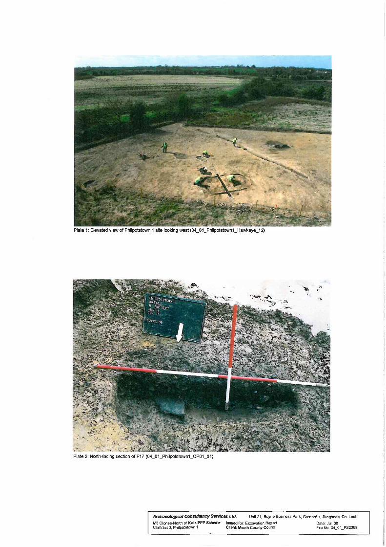
Plate 1: Elevated view of Philpotstown 1 site looking west
Plate 2: North-facing section of F17
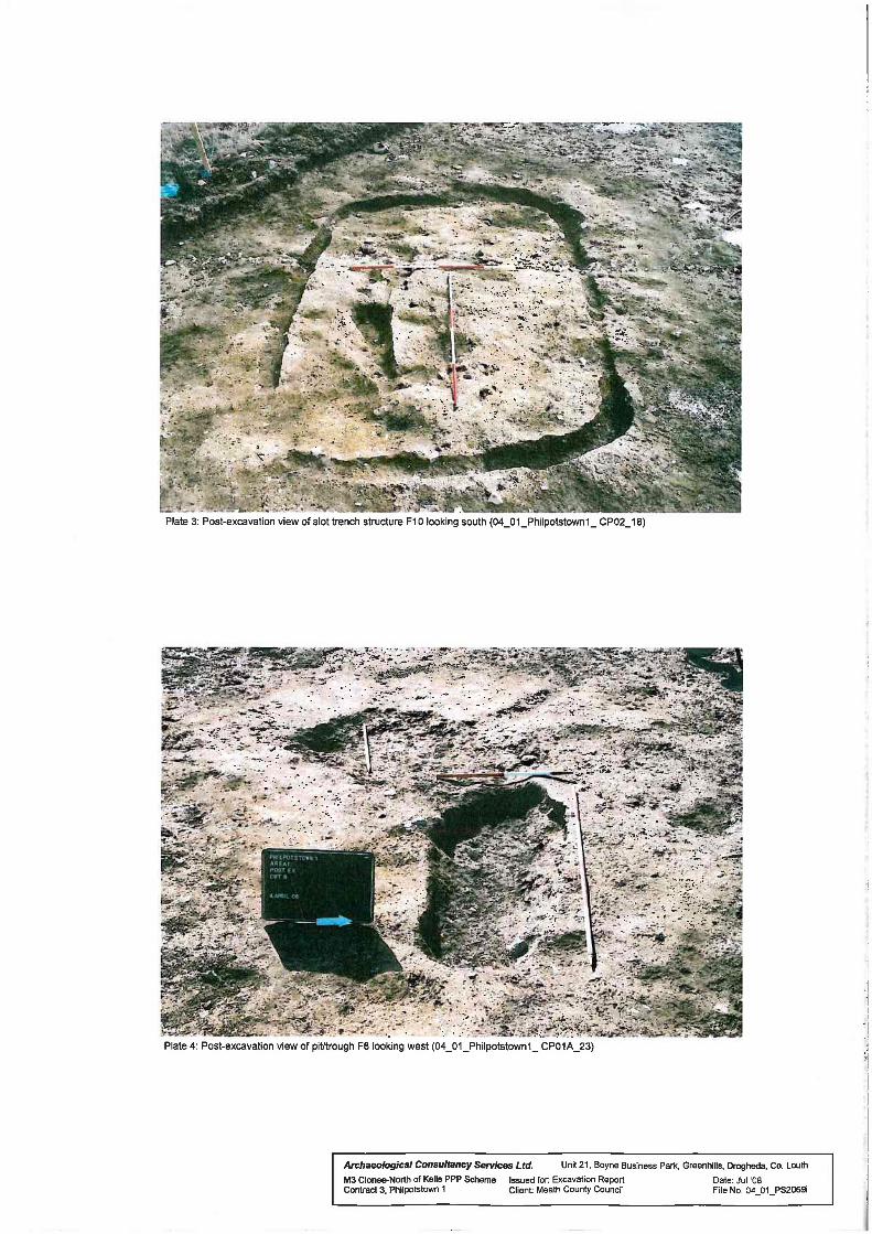
Plate 3: Post-excavation view of slot-trench structure F10 looking south
Plate 4: Post-excavation view of pit/trough F8 looking west
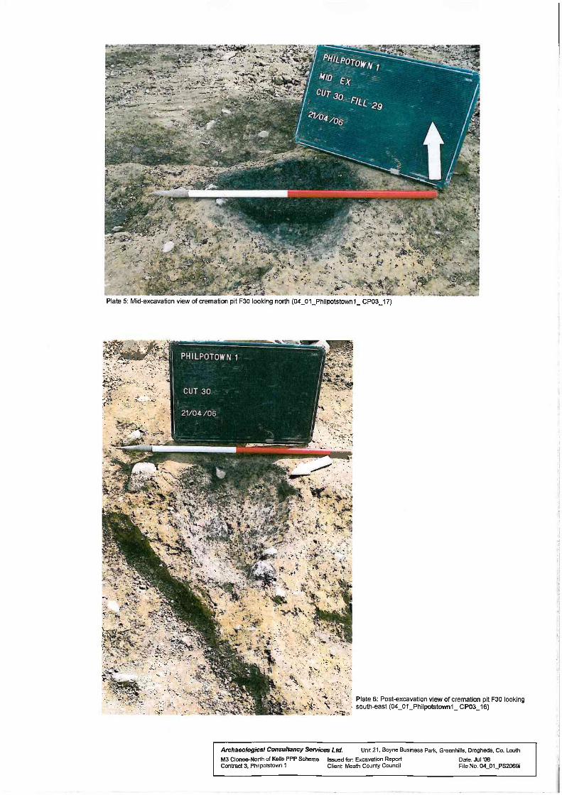
Plate 5: Mid-excavation view of cremation pit F30 looking north
Plate 6: Post-excavation view of cremation pit F30 looking south-east
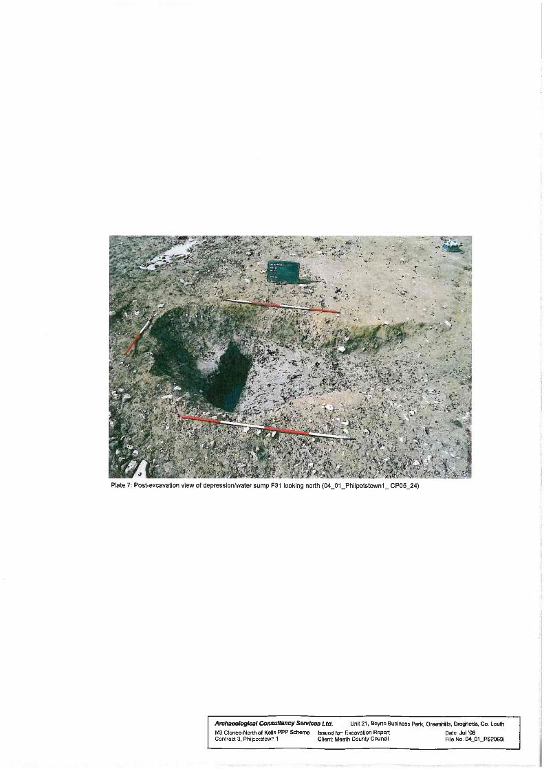
Plate 7: Post-excavation view of depression/water sump F31 looking north
ILLUSTRATION LIST
Illustration 1: Flint Find
Philpotstown 1, A023/007 M3 Clonee–North of Kells Motorway Scheme
1
1 INTRODUCTION
The site at Philpotstown 1 (Figures 1–6) was identified during advanced testing carried out by
Aidan O’Connell during April 2004 under licence number 04E0576. Geophysical anomalies
in the form of three pit features were recorded during the geophysical survey carried out by
Bartlett-Clark Consultancy but were not assessed by test trenching (O’Connell 2004). Two
possible troughs of similar size were partially exposed (2.30m length x 0.25m depth and
2.30m x 0.25m x 0.22m). Both contained one fill of charcoal-enriched, silty clay with heat-
shattered stones. Full resolution of the site occurred in 2006 and re-located these pits, as well
as identifying an isolated cremation pit, a structure represented by three slot-trenches, a
curvilinear ditch, and two modern drains.
1.1 Development
Meath County Council is constructing 49km of two-lane, dual-carriageway motorway
between Clonee and Kells and 10km of single carriageway from Kells to just north of Kells
alongside additional road upgrades, realignments and associated ancillary works. The scheme
has been subdivided into five separate sections as follows: Clonee to Dunshaughlin (Contract
1), Dunshaughlin to Navan (Contract 2), the Navan Bypass (Contract 3), Navan to Kells and
the N52 Kells Bypass (Contract 4), and Kells to North of Kells (Contract 5). Navan to Kells
and the N52 Kells Bypass (Contract 4), and Kells to North of Kells (Contract 5). This section
of the scheme (Contract 3) represents the Navan By-pass.
The desk-based study and the field survey for the whole scheme, carried out in 2000–2001,
were divided into sections which were investigated by Valerie J Keeley Ltd and Margaret
Gowan and Company Ltd. The Record of Monuments and Places, the Sites and Monuments
Record, Topographical files, and literary sources were all consulted. This information was
augmented by geophysical testing conducted by Bartlett-Clark Consultancy who undertook a
magnetometer survey across sample transects which was then supplemented by magnetic
susceptibility, and also by GSB Prospection who undertook gradiometer scanning and a
detailed gradiometer survey. The Environmental Impact Survey (EIS) compiled this data set
to identify approximately 100 sites of interest either along the route or in its proximity (500m
of the landtake). Advance archaeological testing was completed in 2004 by ACS and Irish
Archaeological Consultancy Services Ltd (IAC). Excavation of the sites identified during
testing was conducted by ACS and IAC on behalf of Meath County Council, and the NRA
under directions issued by the Minister for the Environment, Heritage and Local Government
following consultation with the Director of the National Museum of Ireland.
Philpotstown 1, A023/007 M3 Clonee–North of Kells Motorway Scheme
2
2 EXCAVATION
Excavation occurred between 29 March and 5 May 2006 under Ministerial Direction Number
A023/007 issued Meath County Council NRDO. The work was carried out by Kevin Martin
on behalf of ACS. The topsoil (F5) consisted of a moderately compact, mid-brown, clayey
silt with occasional stones and was removed by a machine equipped with a grading bucket. A
compact, brownish-yellow, silty clay with moderate stones comprised the subsoil (F6).
All archaeological features exposed were recorded and excavated by hand using the single
context method. Each feature was assigned a context number. Where appropriate, samples
were retrieved in an attempt to obtain evidence for the date and function of these features
(Appendix 3). Unless otherwise stated, the features have been measured length-width-depth.
All measurements are in metres. All finds were numbered according to the requirements of
the National Museum of Ireland from 1 onwards consistent with licence and feature number.
The artefacts recovered from the site underwent an initial archaeological assessment and
where deemed appropriate, further specialist analysis was carried out on each artefact type.
All radiocarbon dates are quoted in calibrated, two sigma form; their calibrated dates derived
from Oxcal are also given.
2.1 Results
Thirty four contexts were identified, all of which were of archaeological interest. Only the
principal archaeological features of Philpotstown 1 will be discussed within this report; full
details of all these, and further, contexts are located in Appendix 1.
Structure 1
A rectangular-shaped slot-trench feature with rounded corners (c. 4m length x c. 3m width,
internally) formed by a slot-trench (F10: 5.65m x 3.70m x 0.05–0.20m) was exposed in the
eastern area of the site (Figure 7, Plate 1). An internal, curvilinear slot-trench (F12: 2.20m x
1.10m x 0.35m) and an associated, external, east-west, linear slot-trench which extended from
F10, (F21: 1.35m x 0.32m x 0.08m) were also noted. Each of the three trenches contained one
fill (F9, F11 and F20) which consisted of silty clays with small stones and charcoal. Brown,
iron oxidised material was observed in F9 and F11. Soil samples derived from fills F9 and
F11 returned a small amount of charcoal flecks (alder, ash, maloideae, ring porous) and some
possible slag residue, which is considered intrusive (Appendix 3). The slot-trench F10 was
truncated by F22 a modern stone field drain.
Philpotstown 1, A023/007 M3 Clonee–North of Kells Motorway Scheme
3
Pits
An isolated, sub-circular, cremation pit (F30: 0.54m x 0.45m x 0.12m; Figure 7, Plates 5–6)
contained two silty clay fills F28 and F29 which contained charcoal inclusions (ash, oak,
hazel, elm and ring porous) and cremated bone fragments identified as human (16g in F28
and 75g in F29 along with 13g charcoal from F29, Appendix 3,8). Pit F30 was located
approximately 28m north-west of the central area of the slot-trench feature F10.
A likely trough was revealed in the form of a sub-rectangular cut (F17: 1.00m x 1.48m x
0.28m; Figure 7, Plate 2) which contained a single fill, F16, comprising a dark grey silty clay
with charcoal flecks (alder, ash, maloideae and ring porous) and burnt stones.
The third pit and likely trough, F8 (2.19m x 0.83m x 0.25m; Figure 7, Plate 4) was associated
with a large, northeast–southwest, sub-oval pit / watering hole, F31 (7.00m x 2.70m x 0.39m;
Figure 7, Plate 7). F8 contained a single charcoal rich (hazel, ash, maloideae, cherries, elm
and ring porous) and burnt stone fill F7. It is likely that F31 represents a natural depression or
water sump, which over time gradually filled with material relating from the use of F8.
Charcoal flecks and burnt stones were also present in its three fills (F32–F34). A flint
fragment was identified in F32 (A023/007:32:1).
Linear features
A curvilinear, northeast–southwest ditch (F19: 26m x 0.48m x 0.58m) contained five fills
(F13, F18 and F23–F25) all containing various amounts of charcoal and some of which
contained stones. Charcoal from F18 was identified and included alder, hazel, ash, maloideae,
cherries, ring porous (Appendix 8). Animal bones and teeth were also recovered from F18
and F25; only four specimens were classified as countable and these all represented the partial
remains of mandibular pig (Sus sp.) incisors (Sloane, Appendix 4). Two fragments of
retouched / worked flint were discovered in F18 (A023/007:18:1–2) and a loom weight was
revealed in F25 (A023/007:25:1). Cut F19 was truncated by a modern stone drain F22.
Two stony post-medieval - modern field drains (F22: 40m x 0.25m x 0.40m, fill F14, and
F26: 12.00m x 0.30m x 0.13m, fill F15) were also recorded. F22 truncated the slot trench F10
and linear ditch F19.
2.2 Finds
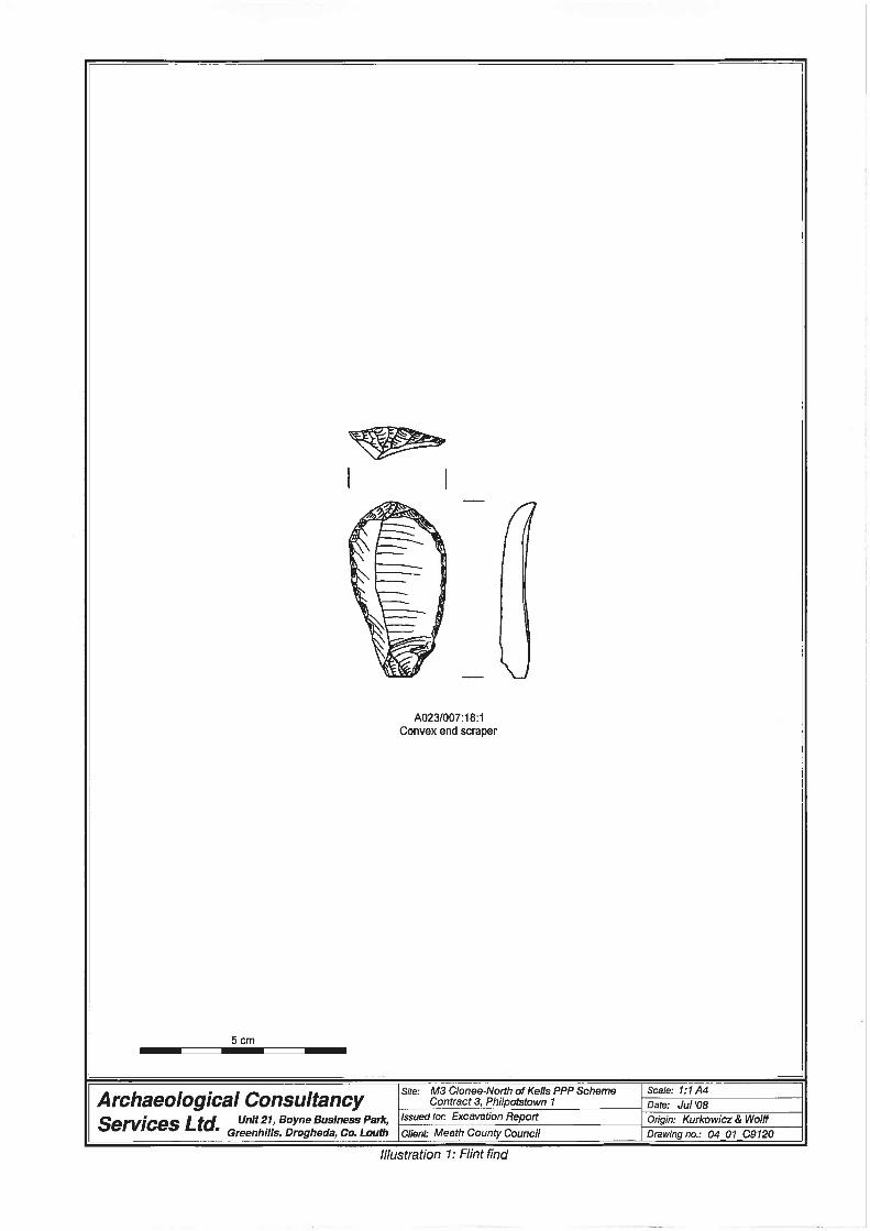
Four artefacts were recovered from the site and included three worked flints (A023/007:18:1-
2), (A023/007:31:1) and a loom weight (A023/007:25:1). Following specialist examination of
the lithics (Appendix 7) they have been identified as representing worked artefacts. Flint
(A023/007:18:1) is described as a large classic convex end scraper. Flint (A023/007:18:2) is
Philpotstown 1, A023/007 M3 Clonee–North of Kells Motorway Scheme
4
described as a burnt flake produced on a single platform core. Flint (A023/007:32:1) is
described as miscellaneous retouched flaked artefact which was produced on a rolled split
pebble half and may have been used as a convex end scraper (ibid). The flint assemblage is
considered typologically diagnostic and represents flint working of the Neolithic period.
Although no Neolithic dated features were identified on the site, the lithics assemblage
recovered demonstrates likely Neolithic activity within the area of the site outside the
landtake area. Their presence within the fills of features which have been dated to the Middle
Bronze Age period is considered residual. They likely represent artefacts which were
recovered during the Bronze Age period likely reused and were subsequently deposited into
the base of the curvilinear ditch and pit on Philpotstown 1. Evidence of Neolithic dated flint
artefacts which were reworked and reused in the Bronze Age period has been previously
identified in the archaeological record. At the nearby site of Williamstown or Bawn 2
(A023/006:18:2) a Neolithic bipolar blade was extensively retouched and reworked during the
Bronze Age period (Martin 2009).
The loom weight (A023/007: 25:1) comprised of a stone disc which was deliberately shaped
(rounded and smoothed) and exhibited little wear (Appendix 6). They have been in use since
the Neolithic period and are not considered good chronological indicators. Both the loom
weight and two of the lithics were recovered from the primary silting phase of the curvilinear
ditch F19. As the flints have been identified as Neolithic in date the likelihood is that the
loom weight is also Neolithic.
3 DISCUSSION
3.1 Form and function
The structure was orientated north-north-east – south-south-west and an entranceway was
identified in the north-eastern corner of its slot-trench, F10, where a break of 0.80m was
evident. The slot-trench construction method is particularly characteristic of structures from
Neolithic/Bronze Age dated sites, such as at excavated at Newtown, Co. Meath, where
Neolithic house foundations consisted of slot-trenches and evidence for post and plank
construction (Gowan & Halpin 1992, 25–27). No postholes were evident in the slot-trench at
Philpotstown 1 nor was there any evidence of burnt planking. Internally an L-shaped cut, F12,
was recorded facing the entranceway and this may have held a windbreak/screen in place. No
stakeholes, roof supports or hearth area was identified internally. The structure was also
stratigraphically isolated from the other archaeological features on Philpotstown 1, making it
difficult to associate them with each other. The structure is likely to have existed for only a
short duration, given its small size, the absence of associated artefacts and the lack of hearth
Philpotstown 1, A023/007 M3 Clonee–North of Kells Motorway Scheme
5
remains in its interior. A radiocarbon date from maloideae charcoal recovered from the slot
trench of the structure has been dated to the Middle Bronze Age period 1386-1123 BC (Beta
247092) (Appendix 5). This date establishes that the structure was contemporary with the
surrounding archaeological features identified on Philpotstown 1 even though it was
stratigraphically isolated from them.
Doody’s survey of 78 Bronze Age structures identified five different categories of structures
built from wood or stone or a combination of both (Doody 2000). The Philpotstown 1
structure would fall into Doody’s category of structures built with a single wall slot.
O’Neill’s more recent survey suggested a different form of classification and the
Philpotstown 1 structure would fall into the category (iv) rectangular houses with no internal
roof supports (O’Neill 2005). Neil Carlin carried out a study of these structures in 2006 and
has classified the type of structure excavated at Philpotstown 1 as a Type C structure
(Appendix 9). His study has identified that there is a wide range of dates of this structure type
falling between 1700 – 830 BC and that these structures were usually circular or oval shaped
in plan and range in diameter from 3-12m. Carlin has identified that one of the main issues
with this type of structure design is in understanding the nature and make up of the roof
design and roof supports (ibid). The lack of internal post supports in these structures can
possibly be attributed to a number of things including later truncation and the use of stone
post pads. Carlin also suggests that various materials possibly skins, turfs and other organic
materials may have been used to cover these structures and so may not have required load
bearing support posts for their roofs as is the case with a number of the other types of Bronze
Age structures identified (ibid).
The two pit/trough features F17 and F8 containing burnt stones and charcoal in their fills are
likely to be evidence of burnt mound/fulacht fiadh type activity on Philpotstown 1 where
rocks heated in a fire are subsequently immersed in a water filled pit or trough to boil the
water. Given their similarity in size and fill inclusions and proximity both features F17 and F8
are considered to be contemporary. These sites are generally prehistoric in date and most are
dated to the Bronze Age period (Buckley 1990). A radiocarbon date from maloideae charcoal
from fill F7 of pit F8 has returned a Middle Bronze Age date of 1608-1417 BC (Beta 247091)
Appendix 5. The function of these troughs was ultimately to boil water using hot stones
previously heated in an open fire. The reasons for boiling water and the creation of troughs
specifically for this purpose is the subject of much debate within the archaeological
community. Experiments by O’Kelly in 1954 proved that a 4.5kg leg of lamb could be cooked
in a controlled manner using the hot stone and water filled trough technique (O’Kelly 1954).
Since then a number of additional theories regarding the use of these features have developed
Philpotstown 1, A023/007 M3 Clonee–North of Kells Motorway Scheme
6
and been put forward ranging from cloth dying, sweat houses, steam bending timber, bathing
and even brewing beer (Buckley 1990), (O’ Neill 2000), (Quinn & Moore 2007). A useful
analogy may be to think of the troughs on these sites as representing the kitchen sinks of the
Bronze Age period which were employed and used boiled water for a myriad of uses. No
artefacts or animal bone fragments were found within the fills of the pits or in association
with them; this is quite typical of these site types. There was no evidence on the site for a
burnt mound spread which normally takes the form of a horseshoe-shaped mound of burnt
stone and charcoal located around a central trough/pit. It may be possible that the burnt
mound spread was located outside of the roadtake. Pit/trough F8 was located next to a large
well/watering hole, F31. It is likely that both features were contemporary and used in the
process of boiling water. Burnt stones and charcoal inclusions were noted in the upper fills of
F31. The lower fill of F31 (F34) consisted of a compact grey clay marl of up to 0.60m in
depth indicating that the feature had contained still water for long periods of time, which
eventually silted up.
The small cremation pit F30 was located approximately 28m north of pit/trough F8 and was
noticeably isolated from the main concentration of archaeology on Philpotstown 1. The
inclusion of cremated bone remains in its fills, F28 and F29, indicate that its likely function
was that of a ritual deposition. Specialist analysis has identified the cremated bone from the
lower fill F29 of the pit as being the remains of an adult or adolescent human. Sex
identification was not possible (Appendix 8). Based on this it is likely that the cremated bone
material recovered from the upper fill F28 is also human. The total weight of the cremated
bone from pit F30 was 160.6g. This amount falls well short of the c. 1000-2500g recorded
from modern cremations (ibid). Given the small overall amount and weight of the cremated
bone it is likely that it represents a token cremation deposition. A radiocarbon date of 1193-
922 BC (Beta 247094) (Appendix 5) from hazel charcoal recovered from the lower fill F29
evidences that this deposition of cremated human bone occurred during the Later Bronze Age
period. Interestingly the environmental charcoal analysis has identified a few charred false
oat-grass tubers, a charred ribwort plaintain seed and a charred barley grain in the lower fill
F29 of pit F30. The false oat-grass tubers potentially relate to the use of this grass species
previously as kindling for the original funeral pyre as it has been frequently identified in
association with cremation deposits such as at Derryvorrigan, Co. Laois, Lismullin 1
(A008/021), Co. Meath, Raynestown 1 (A017/016), Co. Meath, and Tyrrellstown, Co. Dublin
(Appendix 8). The charred ribwort may also have been used as pyre kindling. The charred
barley grain potentially indicates a food offering as part of the ritual deposition at
Philpotstown 1. Studies have shown that barley was the dominant crop used in Ireland during
the mid-late Bronze Age and Iron Age period (O’Donnell 2007). Barley may also have held a
Philpotstown 1, A023/007 M3 Clonee–North of Kells Motorway Scheme
7
ritual significance during this period as a substantial amount of barley grains were noted
included in Bronze Age cremation burials excavated along the route of a recent gas pipeline
Scheme (ibid).
The curvilinear ditch F19 ran nearly the full width of the site and bisects the area between the
structure and the cremation pit. Hazel charcoal from its basal fill has returned a radiocarbon
date of 1413-1133 BC (Beta 247093) (Appendix 5). The flint artefacts recovered from this
feature have been identified as Neolithic in date and were likely reused during the Bronze
Age period. The ditch is potentially contemporary with the structure and the token cremation
deposit. Given its small size it is not interpreted as defensive but may have served as a
boundary demarcating the living area from the area containing the token cremation.
3.1.2 Surrounding Environment The analysis of the charcoal samples recovered from the various features revealed that a
number of species of trees were available locally during the Bronze Age period and were
specifically exploited for use as structural timbers and for fuel in domestic and funerary ritual
activities on Philpotstown 1. The results of the charcoal analysis suggest that mixed
deciduous woodland was growing near the site during the Middle – Late Bronze Age period.
Oak (Quercus) appears to have been the main fuel used in relation to the cremation deposit
and was likely used as a fuel in the funerary pyre along with the false oat grass tubers. Ash
(Fraxinus excelsior) was the most frequent species identified in the charcoal sample
recovered from the slot trench of the structure and so was likely favoured as the structural
timber. Ash, Hazel (Corylus avellana) and Alder (Alnus glutinosa) were the most frequent
species represented in the charcoal samples recovered from the pit/trough features. Elm
(Ulmus), Ring porous, Cherry (Prunus spp) and Maloideae (apple, pear, whitebeams and
hawthorns) were also all identified in varying amounts from the charcoal samples retrieved
from fills F7, F9, F16, F18, F28 and F29. (Appendix 8).
The results of the charcoal analysis suggests that alder, hazel and ash were the main fuels
used and were likely to be the dominant locally available species. The occurrence of alder,
hazel and ash as a fuel used in prehistoric burnt mound type activity is well established in the
archaeological record (O’Donnell et al 2007). It has been suggested that the use of these
species as fuels in burnt mounds reflects the sites general location in marginal settings i.e.
between dry and wetland areas (ibid).
Philpotstown 1, A023/007 M3 Clonee–North of Kells Motorway Scheme
8
3.1.3 Cremated Bone
The total weight of cremated bone recovered from pit F30 was 160.6g with the majority of the
material (144.6g) contained in the lower fill F29 (Appendix 8). The cremated bone was
moderately to severely fragmented, however a couple of large fragments were recovered. The
bone colour was white to pale grey in colour indicating that it had been previously exposed to
temperatures in excess of c. 600ºC. A number of fragments of bone from context F29 the
lower fill of pit F30 were identified as human. Based on this fact it is likely that all the
cremated bone from F30 was human. The identified fragments recovered consisted of bone
pieces from the skull, rib shaft and phalanx (toe bone). Fragments of long bone were also
present but it could not be determined which long bones were represented (ibid). The MNI
count for the material was determined as representing the remains of one human. The sex of
the remains was not determinable though it was likely that they were the remains of an adult
or adolescent (ibid).
3.1.4 Animal Bone
A small quantity of animal bone was recovered from fill F18 and F25 of ditch F19. The
material from fill F18 was regarded as low grade by the specialist and so was not examined
further (Appendix 4). Four fragments of bone from F25 were examined and were identified as
the partial remains of mandibular pig (Sus sp.) incisors (ibid). The remains although small
indicate that during the Middle Bronze Age period pigs formed part of the diet of the people
who occupied the site at Philpotstown 1.
3.2 Date and sequence
Neolithic activity in the vicinity of the site maybe represented by the recovery of three
Neolithic flint artefacts from the base of a curvilinear ditch F19 and pit F31. The features
which the flints were recovered from have been dated to the Middle Bronze Age period and
therefore the flints are likely to have been Neolithic artefacts reused and deposited during the
Middle Bronze Age period.
The charcoal and burnt stone rich pit F8 was the oldest dated feature identified during the
excavation. A radiocarbon date from maloideae charcoal from fill F7 of pit F8 has returned a
Middle Bronze Age date of 1608-1417 BC (Beta 247091) Appendix 5. Trough F17 which
contained similar charcoal and burnt stone inclusions as F8 is considered contemporary with
it.
The slot-trench structure F10 represents the remains of a Middle Bronze Age structure. A
radiocarbon date from maloideae charcoal recovered from the slot trench of the structure has
Philpotstown 1, A023/007 M3 Clonee–North of Kells Motorway Scheme
9
been dated to the Middle Bronze Age period 1386-1123 BC (Beta 247092) (Appendix 5).
This date establishes that the structure was contemporary with a number of the surrounding
archaeological features identified on Philpotstown 1 such as the curvilinear ditch and the
token cremation deposit.. It is not thought that the structure was occupied over a long term
period.
The curvilinear ditch F19 was also radiocarbon dated to the Middle Bronze Age period by
hazel charcoal recovered from its basal fill F18 to 1413-1133 BC (Beta 247093) (Appendix
5).
The token cremation deposit in the northern part of the site, following radiocarbon dating of
hazel charcoal from its lower fill F29 was dated to 1193-922 BC (Beta 247094) (Appendix 5).
This feature was the latest of the Bronze Age features identified on the site and relates to
activity at the end of the Middle Bronze Age period and the beginning of the Late Bronze Age
period.
Based on the four radiocarbon dates returned from features excavated on Philpotstown 1 there
is an overlap in the radiocarbon dates from three of the features. Dates from the slot trench
structure, the curvilinear ditch and the cremation deposit all overlap from 1193 – 1123 BC.
This may indicate that all three of these features were contemporary with each other and date
to this period. Based on this interpretation the charcoal and burnt stone rich pits F8 and F17
predate this activity by approximately 220 years and likely represents an earlier phase of
activity on the site.
During the post medieval – modern period a number of stone filled field drains were
constructed on the Philpotstown 1 site and one of these drains F22 truncated two of the
prehistoric features identified - the slot trench structure and the curvilinear ditch.
3.2.1 Contemporary / Comparative Archaeological Activity
Sixty-one sites along the M3 Scheme have produced evidence for burnt mound type activity.
The closest of these sites to Philpotstown 1 was located 300m south at Williamstown or Bawn
2 (A023/006). A charcoal and heat affected stone rich trough was identified here similar to F8
and F17 on Philpotstown 1. A radiocarbon date from this trough on Williamstown or Bawn 2
produced a date of 1431-1216 BC (Beta 247088) (Martin 2009). Although not precisely
contemporary with the date returned from the trough on Philpotstown 1, the higher end of the
date range from the Williamstown or Bawn 2 trough does overlap slightly with the date from
trough F8.
Philpotstown 1, A023/007 M3 Clonee–North of Kells Motorway Scheme
10
Comparing the dates recovered from the other three features on Philpotstown 1 with the
features dated on Williamstown or Bawn 2 (the trough mentioned above and a large well pit
dated to 1379-1117 BC (QUB 7058) provides a better overlap of the radiocarbon date results
and indicates that activity towards the end of the Middle Bronze Age period and the
beginning of the Late Bronze Age period was occurring on both sites and was likely to be
contemporary. Based on the radiocarbon results and each sites close proximity to each other it
is tempting to suggest that the same group of people were active on both sites during the latter
stages of the Middle Bronze Age period and were likely settled at the Philpotstown 1 site.
Charcoal analysis from Philpotstown 1 indicates that hazel and maloideae species among
others were exploited as fuels (Appendix 8). This compares quite well with the charcoal
results from Williamstown or Bawn 2 (Martin 2009).
With regard to the cremated bone deposition at Philpotstown 1 a number of other nearby sites
along the M3 Scheme have also uncovered evidence of similar burial practices from the
Bronze Age period. At Ardsallagh 2 (A008/034) located 2.8km southwest, ten cremation
burials which formed a Bronze Age flat cemetery were identified (Clarke 2008). Notably
three of the 10 depositions at Ardsallagh 2 were associated with the remnants of four funerary
vessels. The remainder were deposited in shallow earth cut pits as at Philpotstown 1. The
dates of the cremation depositions at Ardsallagh 2 predate the Philpotstown 1 burial by at
least 400 years so are from an earlier phase of the Middle Bronze Age period. Although not
contemporary both sites indicate that the practise of cremation depositions was occurring
across this area during the Middle-Late Bronze Age period. It is not interpreted that the
cremation burial at Philpotstown 1 represented part of a larger flat cemetery burial area. It is
likely that the remains at Philpotstown 1 were of an individual likely associated with the
people who occupied the site during this period.
Cremation depositions were also identified along the M3 Scheme at Macetown 1 (A023/008),
Kennestown 2 (A023/002) and Ardsallagh 1 (A008/034) all within 2.5km of the Philpotstown
1 site. However the burials on these sites were dated to the Iron Age period and are at least
400 years more recent than the Philpotstown 1 deposit. Their presence indicates though that
this practise of depositing cremated human bone as part of a burial ritual continued in the
local area beyond the Later Bronze Age period.
Philpotstown 1, A023/007 M3 Clonee–North of Kells Motorway Scheme
11
4 CONCLUSIONS
Philpotstown 1 (A023/007), excavated 29 March – 5 May 2006 by Kevin Martin (ACS) as
part of the M3 Clonee–North of Kells Motorway Scheme on behalf of Meath County Council
NRDO and the NRA represents the site of a prehistoric settlement, ritual burial and burnt
mound type activity. The site at Philpotstown 1 contained evidence for Middle to Late Bronze
Age activity in the form of a rectangular slot-trench structure, two charcoal and heat affected
stone rich troughs, a curvilinear ditch and a single cremated bone deposition uncovered at the
northern extent of the site. The features are interpreted as being roughly contemporary
although the cremation deposit was likely to be the latest activity on the site. Four artefacts
were recovered from the site and included three worked flints and a loom weight. Activity on
the site may relate to contemporary dated activity on the nearby site of Williamstown or
Bawn 2 located 300m south of the site. During the post medieval – modern period a number
of stone field drains were constructed across the site and truncated both the slot trench
structure and curvilinear ditch feature.
Philpotstown 1, A023/007 M3 Clonee–North of Kells Motorway Scheme
12
5 REFERENCES Buckley, V 1990 Burnt offerings: International Contributions to Burnt Mound Archaeology,
Dublin, Wordwell.
Doody, M 2000. ‘Bronze Age Houses in Ireland’, in A. Desmond et al (eds), New agendas in
Irish Prehistory. Bray, 135-60.
Clarke, L & Carlin, N 2006a Life and Death in County Meath, Archaeology Ireland, Winter
2006 Edition.
Clarke, L & Carlin, N 2006b Life and Death in Ardsallgh, Co. Meath, Seanda, Issue 1.
Clarke, L 2008 Final Report on the Archaeological Excavations of Ardsallagh 1, Co. Meath
(A008/034) E3088. Unpublished report prepared for Archaeological Consultancy Services Ltd
on behalf of Meath County Council.
Gowen, M and Halpin, E 1992 ‘A Neolithic House at Newtown’, Archaeology Ireland Vol. 6,
No.2, 25–7.
Martin, K 2009 Final Report on the Archaeological Excavations of Williamstown or Bawn 2,
Co. Meath (A023/006) E3098. Unpublished report prepared for Archaeological Consultancy
Services Ltd on behalf of Meath County Council.
O’Connell, A 2004 Report on Archaeological Assessment at Testing Area 3, Williamstown or
Bawn and Philpotstown, Co. Meath, Licence Number: 04E0576. Unpublished report prepared
for Archaeological Consultancy Services Ltd.
O’Donnell, L, Grogan, E & Johnston, P, 2007 The Bronze Age landscapes of the Pipeline to
the West, an integrated archaeological and environmental assessment, Wicklow
O’Neill, J 2005 Killoran 8, in Gowen, M., O’Neill, J & Phillips, M. (eds), The Lisheen Mine
Archaeological Project 1996-8, 288-290. Dublin: Wordwell
O’ Neill, J 2000 ‘Just another fulachta fiadha story’, Archaeology Ireland 52 19.
O’ Kelly MJ 1954 ‘Excavations and experiments in ancient Irish cooking-places’, Journal of
the Royal Society of Antiquaries of Ireland 84, 105-55.

Philpotstown 1, A023/007 M3 Clonee–North of Kells Motorway Scheme
13
Quinn, B & Moore, D 2007 ‘Ale, brewing and fulacht fiadh’, Archaeology Ireland Vol.21,
No.3, 8-11.
Signed:
_________________________
Kevin Martin
May 2009
Philpotstown 1, A023/007 M3 Clonee–North of Kells Motorway Scheme
1
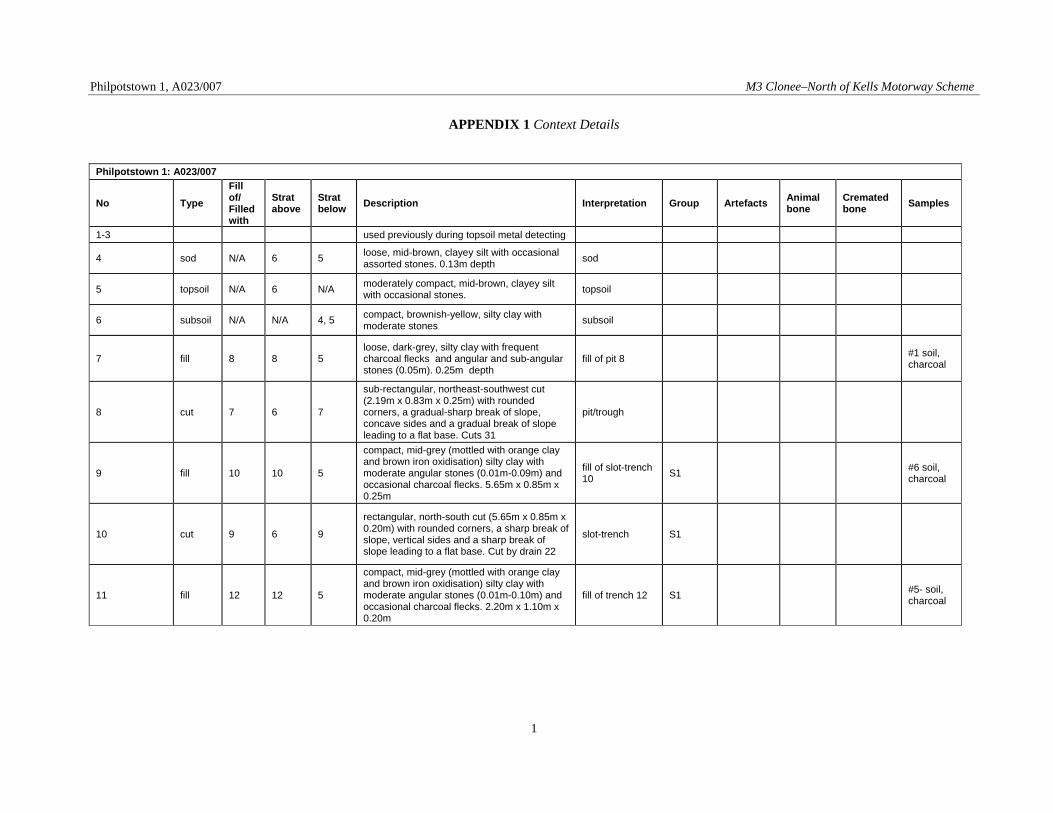
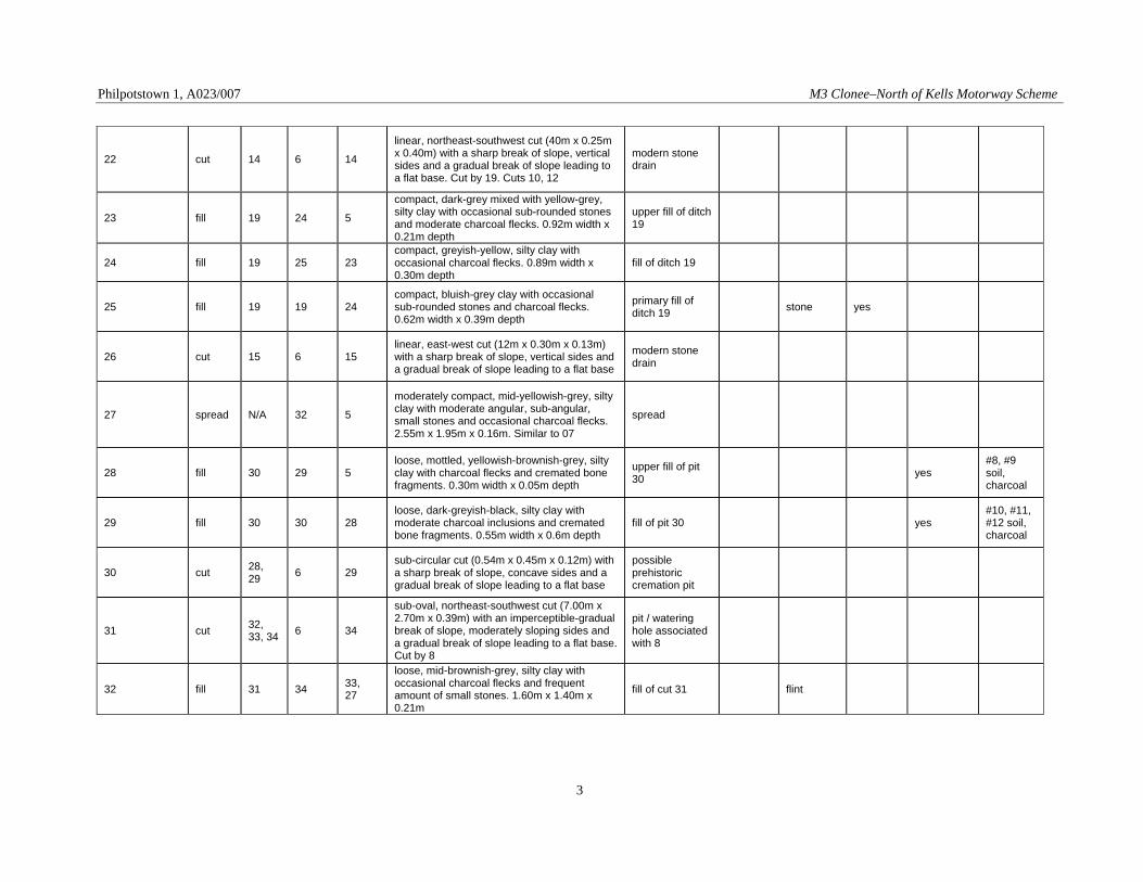
APPENDIX 1 Context Details
Philpotstown 1: A023/007
No Type Fill of/ Filled with
Strat above
Strat below Description Interpretation Group Artefacts Animal
bone Cremated bone Samples
1-3 used previously during topsoil metal detecting
4 sod N/A 6 5 loose, mid-brown, clayey silt with occasional assorted stones. 0.13m depth sod
5 topsoil N/A 6 N/A moderately compact, mid-brown, clayey silt with occasional stones. topsoil
6 subsoil N/A N/A 4, 5 compact, brownish-yellow, silty clay with moderate stones subsoil
7 fill 8 8 5 loose, dark-grey, silty clay with frequent charcoal flecks and angular and sub-angular stones (0.05m). 0.25m depth
fill of pit 8 #1 soil, charcoal
8 cut 7 6 7
sub-rectangular, northeast-southwest cut (2.19m x 0.83m x 0.25m) with rounded corners, a gradual-sharp break of slope, concave sides and a gradual break of slope leading to a flat base. Cuts 31
pit/trough
9 fill 10 10 5
compact, mid-grey (mottled with orange clay and brown iron oxidisation) silty clay with moderate angular stones (0.01m-0.09m) and occasional charcoal flecks. 5.65m x 0.85m x 0.25m
fill of slot-trench 10 S1 #6 soil,
charcoal
10 cut 9 6 9
rectangular, north-south cut (5.65m x 0.85m x 0.20m) with rounded corners, a sharp break of slope, vertical sides and a sharp break of slope leading to a flat base. Cut by drain 22
slot-trench S1
11 fill 12 12 5
compact, mid-grey (mottled with orange clay and brown iron oxidisation) silty clay with moderate angular stones (0.01m-0.10m) and occasional charcoal flecks. 2.20m x 1.10m x 0.20m
fill of trench 12 S1 #5- soil, charcoal
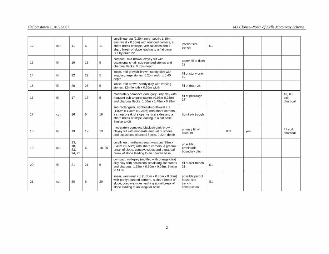
Philpotstown 1, A023/007 M3 Clonee–North of Kells Motorway Scheme
2
12 cut 11 6 11
curvilinear cut (2.20m north-south, 1.10m east-west x 0.35m) with rounded corners, a sharp break of slope, vertical sides and a sharp break of slope leading to a flat base. Cut by drain 22
interior slot-trench S1
13 fill 19 18 5 compact, mid-brown, clayey silt with occasional small, sub-rounded stones and charcoal flecks. 0.31m depth
upper fill of ditch 19
14 fill 22 22 5 loose, mid-greyish-brown, sandy clay with angular, large stones. 0.25m width x 0.40m depth
fill of stony drain 22
15 fill 26 26 5 loose, mid-brown, sandy clay with varying stones. 12m length x 0.30m width fill of drain 26
16 fill 17 17 5 moderately compact, dark-grey, silty clay with frequent sub-angular stones (0.03m-0.28m) and charcoal flecks. 1.00m x 1.48m x 0.28m
fill of pit/trough 17
#2, #3 soil, charcoal
17 cut 16 6 16
sub-rectangular, northeast-southwest cut (1.00m x 1.48m x 0.28m) with sharp corners, a sharp break of slope, vertical sides and a sharp break of slope leading to a flat base. Similar to 08
burnt pit/ trough
18 fill 19 19 13 moderately compact, blackish-dark-brown, clayey silt with moderate amount of stones and occasional charcoal flecks. 0.22m depth
primary fill of ditch 19 flint yes #7 soil,
charcoal
19 cut
13, 18, 23, 24, 25
6 18, 25
curvilinear, northeast-southwest cut (26m x 0.48m x 0.58m) with sharp corners, a gradual break of slope, concave sides and a gradual break of slope leading to an uneven base
possible prehistoric boundary ditch
20 fill 21 21 5
compact, mid-grey (mottled with orange clay) silty clay with occasional small angular stones and charcoal. 1.35m x 0.30m x 0.08m. Similar to fill 09
fill of slot-trench 21 S1
21 cut 20 6 20
linear, west-east cut (1.35m x 0.30m x 0.08m) with partly rounded corners, a sharp break of slope, concave sides and a gradual break of slope leading to an irregular base
possible part of house slot-trench construction
S1
Philpotstown 1, A023/007 M3 Clonee–North of Kells Motorway Scheme
3
22 cut 14 6 14
linear, northeast-southwest cut (40m x 0.25m x 0.40m) with a sharp break of slope, vertical sides and a gradual break of slope leading to a flat base. Cut by 19. Cuts 10, 12
modern stone drain
23 fill 19 24 5
compact, dark-grey mixed with yellow-grey, silty clay with occasional sub-rounded stones and moderate charcoal flecks. 0.92m width x 0.21m depth
upper fill of ditch 19
24 fill 19 25 23 compact, greyish-yellow, silty clay with occasional charcoal flecks. 0.89m width x 0.30m depth
fill of ditch 19
25 fill 19 19 24 compact, bluish-grey clay with occasional sub-rounded stones and charcoal flecks. 0.62m width x 0.39m depth
primary fill of ditch 19 stone yes
26 cut 15 6 15 linear, east-west cut (12m x 0.30m x 0.13m) with a sharp break of slope, vertical sides and a gradual break of slope leading to a flat base
modern stone drain
27 spread N/A 32 5
moderately compact, mid-yellowish-grey, silty clay with moderate angular, sub-angular, small stones and occasional charcoal flecks. 2.55m x 1.95m x 0.16m. Similar to 07
spread
28 fill 30 29 5 loose, mottled, yellowish-brownish-grey, silty clay with charcoal flecks and cremated bone fragments. 0.30m width x 0.05m depth
upper fill of pit 30 yes
#8, #9 soil, charcoal
29 fill 30 30 28 loose, dark-greyish-black, silty clay with moderate charcoal inclusions and cremated bone fragments. 0.55m width x 0.6m depth
fill of pit 30 yes #10, #11, #12 soil, charcoal
30 cut 28, 29 6 29
sub-circular cut (0.54m x 0.45m x 0.12m) with a sharp break of slope, concave sides and a gradual break of slope leading to a flat base
possible prehistoric cremation pit
31 cut 32, 33, 34 6 34
sub-oval, northeast-southwest cut (7.00m x 2.70m x 0.39m) with an imperceptible-gradual break of slope, moderately sloping sides and a gradual break of slope leading to a flat base. Cut by 8
pit / watering hole associated with 8
32 fill 31 34 33, 27
loose, mid-brownish-grey, silty clay with occasional charcoal flecks and frequent amount of small stones. 1.60m x 1.40m x 0.21m
fill of cut 31 flint

Philpotstown 1, A023/007 M3 Clonee–North of Kells Motorway Scheme
4
33 fill 31 32, 34 5
compact, mid-greyish-brown, silty clay with frequent decayed stones and occasional charcoal flecks. 3.95m x 2.50m x 0.25m. Similar to 32
fill of cut 31
34 fill 31 31 32, 33
compact, dark-grey clay marl with occasional charcoal flecks and decayed stones fill of cut 31

Philpotstown 1, A023/007 M3 Clonee–North of Kells Motorway Scheme
1
APPENDIX 2 Finds List
Finds No Description A023/007:18:1 Convex end scraper (Appendix 7) A023/007:18:2 Burnt flake (Appendix 7) A023/007:25:1 Loom weight (Appendix 6) A023/007:32:1 Retouched flint fragment (Appendix
7)

Philpotstown 1, A023/007 M3 Clonee–North of Kells Motorway Scheme
1
APPENDIX 3 Sample List
Sample No Context No Results 1 7 5g charcoal 6 9 3g charcoal 5 11 Nothing 2 16 Nothing 7 18 4g charcoal 6 9 small charcoal flecks, slag in residue 8&9 28 16g cremated bone 12 29 29g cremated bone, 13g charcoal 10&11 29 46g cremated bone
Philpotstown 1, A023/007 M3 Clonee–North of Kells Motorway Scheme
1
APPENDIX 4 Faunal Remains: Rachel Sloane
04_01, M3 Clonee to North of Kells Road Scheme
Analysis of mammalian bone remains from Contract 3 Philpotstown 1, Co. Meath
(A023/007)
16th January 2008
Rachel Sloane
04_01, Contract 3 Philpotstown 1 (A023/007), results of mammal bone analysis: 1. Introduction
Resolution phase archaeological works took place at the site of Philpotstown 1, Co. Meath,
located within Contract 3 of the proposed M3 Clonee to North of Kells Road Scheme.
Excavation commenced on 29th March 2006 and was completed on 5th May 2006 (Ginn pers.
comm.). The archaeological features identified include two pits or troughs rich in charcoal, a
spread, a curvilinear feature interpreted as representing a boundary or some similar feature
and a rectangular shaped structure formed by a slot-trench (Ibid).
2. Findings
A very small quantity of faunal bone remains from F18 and F25 were presented for analysis.
This material was thoroughly inspected and four fragments of faunal teeth were classified as
‘recordable’. The other material was determined as ‘low-grade1 i.e. of insignificant
information value and therefore not recorded. The four ‘recordable’ specimens were retrieved
from F25, the largest fill of the curvilinear feature. This was a very well compacted bluish
grey clay containing occasional sub-rounded stones and some charcoal.
All four fragments were identified as the partial remains of mandibular pig (Sus sp.) incisors.
Although fragmented, they were observed as being in a good state of preservation. No further
zooarchaeological evidence was ascertained.
1 A detailed description of the applied methodology including definition of ‘low-grade’ specimens has been outlined by the current author in the analysis report for Roestown 2 mammalian bone remains, recovered from archaeological excavation carried out as part of the M3 Clonee-North of Kells Road Scheme.

Philpotstown 1, A023/007 M3 Clonee–North of Kells Motorway Scheme
2
3. Recommendations
This material is of extremely limited value in terms of zooarchaeological research. Analysis
beyond identification of species and element was not possible. As it forms part of a much
greater body of mammalian bone assemblages, it might be desirable to store it with the
significant collections retrieved from other archaeological excavations along the route of the
M3. In this context it could be included for permanent storage at National Museum of
Ireland. On its own however, the Philpotstown 1 material is not of any great significance.
Philpotstown 1, A023/007 M3 Clonee–North of Kells Motorway Scheme
1
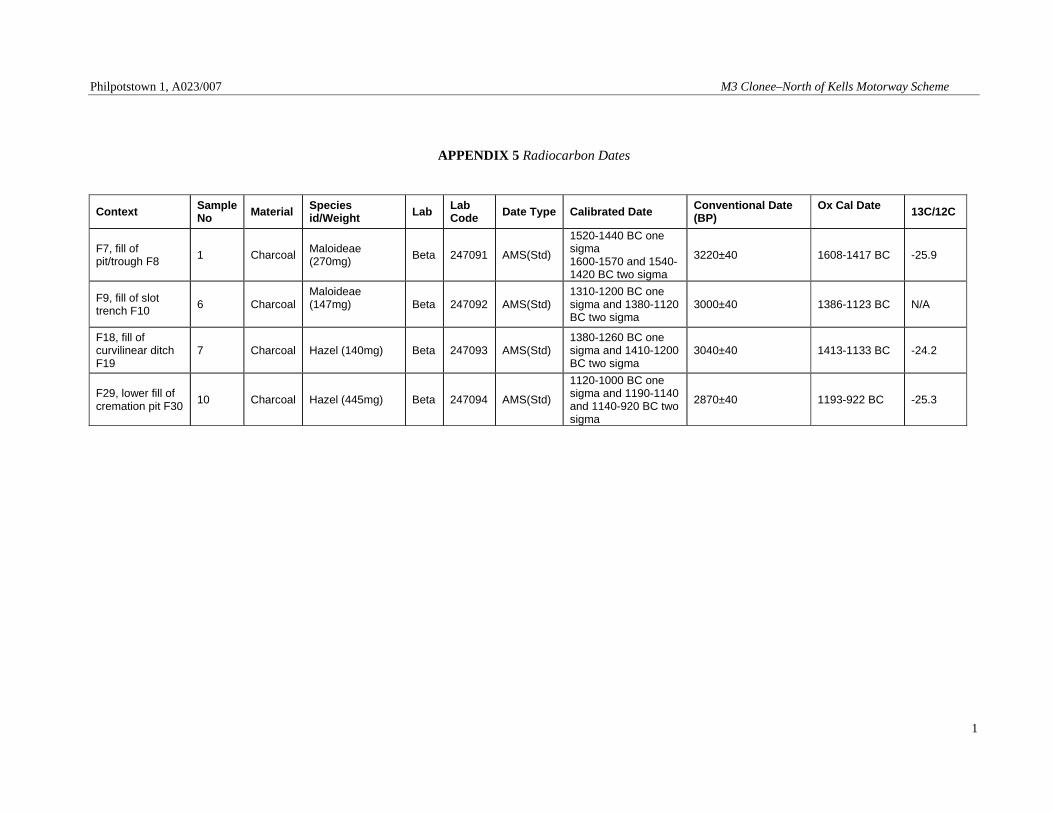
APPENDIX 5 Radiocarbon Dates
Context Sample No Material Species
id/Weight Lab Lab Code Date Type Calibrated Date Conventional Date
(BP) Ox Cal Date 13C/12C
F7, fill of pit/trough F8 1 Charcoal Maloideae
(270mg) Beta 247091 AMS(Std)
1520-1440 BC one sigma 1600-1570 and 1540-1420 BC two sigma
3220±40 1608-1417 BC -25.9
F9, fill of slot trench F10 6 Charcoal
Maloideae (147mg)
Beta 247092 AMS(Std) 1310-1200 BC one sigma and 1380-1120 BC two sigma
3000±40 1386-1123 BC N/A
F18, fill of curvilinear ditch F19
7 Charcoal Hazel (140mg) Beta 247093 AMS(Std) 1380-1260 BC one sigma and 1410-1200 BC two sigma
3040±40 1413-1133 BC -24.2
F29, lower fill of cremation pit F30 10 Charcoal Hazel (445mg) Beta 247094 AMS(Std)
1120-1000 BC one sigma and 1190-1140 and 1140-920 BC two sigma
2870±40 1193-922 BC -25.3
Philpotstown 1, A023/007 M3 Clonee–North of Kells Motorway Scheme
1
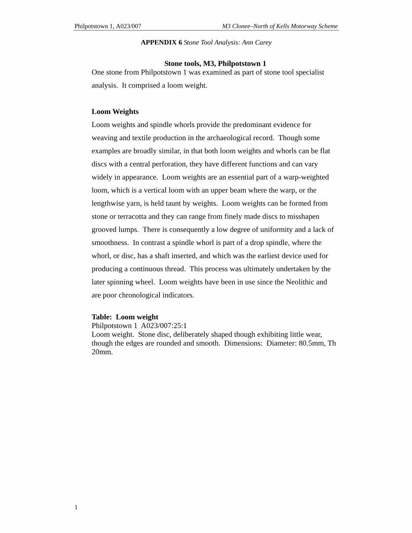
APPENDIX 6 Stone Tool Analysis: Ann Carey
Stone tools, M3, Philpotstown 1
One stone from Philpotstown 1 was examined as part of stone tool specialist
analysis. It comprised a loom weight.
Loom Weights
Loom weights and spindle whorls provide the predominant evidence for
weaving and textile production in the archaeological record. Though some
examples are broadly similar, in that both loom weights and whorls can be flat
discs with a central perforation, they have different functions and can vary
widely in appearance. Loom weights are an essential part of a warp-weighted
loom, which is a vertical loom with an upper beam where the warp, or the
lengthwise yarn, is held taunt by weights. Loom weights can be formed from
stone or terracotta and they can range from finely made discs to misshapen
grooved lumps. There is consequently a low degree of uniformity and a lack of
smoothness. In contrast a spindle whorl is part of a drop spindle, where the
whorl, or disc, has a shaft inserted, and which was the earliest device used for
producing a continuous thread. This process was ultimately undertaken by the
later spinning wheel. Loom weights have been in use since the Neolithic and
are poor chronological indicators.
Table: Loom weight Philpotstown 1 A023/007:25:1 Loom weight. Stone disc, deliberately shaped though exhibiting little wear, though the edges are rounded and smooth. Dimensions: Diameter: 80.5mm, Th 20mm.
APPENDIX 7 Lithics Analysis: Dr Farina Sternke
Lithics Finds Report for E3099 Philpotstown 1, Co. Meath
M3 Road Scheme
Farina Sternke
MA, PhD
E3099 Philpotstown 1 Lithics Finds Report
2
Contents List of Tables 3 Introduction 4 Methodology 4 Quantification 4 Provenance 4 Condition 4 Technology/Morphology 4 Dating 5 Conservation 6 Conclusion 6
Recommendations for Illustration 6
Bibliography 6

E3099 Philpotstown 1 Lithics Finds Report
3
List of Tables Table 1 Composition of the lithic assemblage from Philpotstown 1 (E3099) 6
E3099 Philpotstown 1 Lithics Finds Report
4
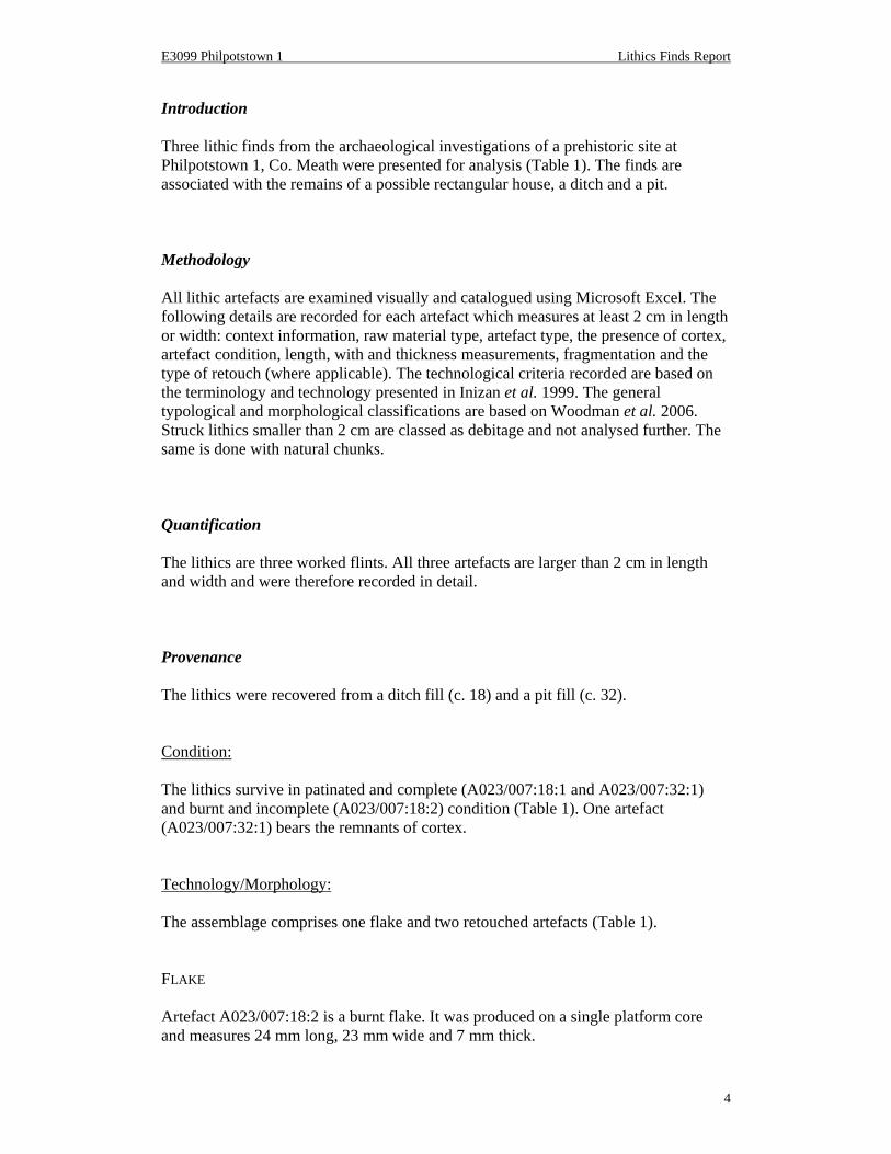
Introduction Three lithic finds from the archaeological investigations of a prehistoric site at Philpotstown 1, Co. Meath were presented for analysis (Table 1). The finds are associated with the remains of a possible rectangular house, a ditch and a pit.
Methodology All lithic artefacts are examined visually and catalogued using Microsoft Excel. The following details are recorded for each artefact which measures at least 2 cm in length or width: context information, raw material type, artefact type, the presence of cortex, artefact condition, length, with and thickness measurements, fragmentation and the type of retouch (where applicable). The technological criteria recorded are based on the terminology and technology presented in Inizan et al. 1999. The general typological and morphological classifications are based on Woodman et al. 2006. Struck lithics smaller than 2 cm are classed as debitage and not analysed further. The same is done with natural chunks.
Quantification The lithics are three worked flints. All three artefacts are larger than 2 cm in length and width and were therefore recorded in detail. Provenance The lithics were recovered from a ditch fill (c. 18) and a pit fill (c. 32).
Condition: The lithics survive in patinated and complete (A023/007:18:1 and A023/007:32:1) and burnt and incomplete (A023/007:18:2) condition (Table 1). One artefact (A023/007:32:1) bears the remnants of cortex. Technology/Morphology: The assemblage comprises one flake and two retouched artefacts (Table 1).
FLAKE Artefact A023/007:18:2 is a burnt flake. It was produced on a single platform core and measures 24 mm long, 23 mm wide and 7 mm thick.
6
Find
No.
Cont
ext
Mat
eria
l
Type
Corte
x
Cond
ition
Leng
th (m
m)
Wid
th (m
m)
Thic
kn. (
mm
)
Com
plet
e
Reto
uch
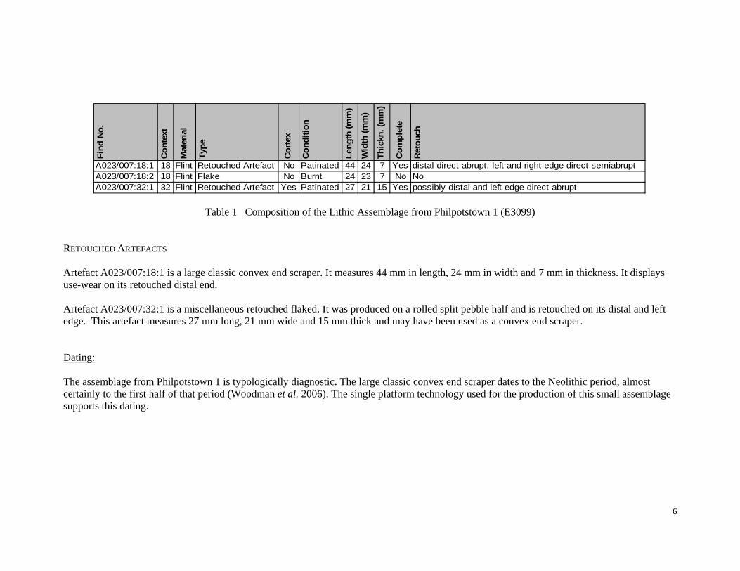
A023/007:18:1 18 Flint Retouched Artefact No Patinated 44 24 7 Yes distal direct abrupt, left and right edge direct semiabruptA023/007:18:2 18 Flint Flake No Burnt 24 23 7 No NoA023/007:32:1 32 Flint Retouched Artefact Yes Patinated 27 21 15 Yes possibly distal and left edge direct abrupt
Table 1 Composition of the Lithic Assemblage from Philpotstown 1 (E3099)
RETOUCHED ARTEFACTS Artefact A023/007:18:1 is a large classic convex end scraper. It measures 44 mm in length, 24 mm in width and 7 mm in thickness. It displays use-wear on its retouched distal end.
Artefact A023/007:32:1 is a miscellaneous retouched flaked. It was produced on a rolled split pebble half and is retouched on its distal and left edge. This artefact measures 27 mm long, 21 mm wide and 15 mm thick and may have been used as a convex end scraper.
Dating: The assemblage from Philpotstown 1 is typologically diagnostic. The large classic convex end scraper dates to the Neolithic period, almost certainly to the first half of that period (Woodman et al. 2006). The single platform technology used for the production of this small assemblage supports this dating.
6
Conservation Lithics do not require specific conservation, but should be stored in a dry, stable environment. Preferably, each lithic should be bagged separately and contact with other lithics should be avoided, so as to prevent damage and breakage, in particular edge damage which could later be misinterpreted as retouch. Larger and heavier items are best kept in individual boxes to avoid crushing of smaller assemblage pieces. Conclusion The lithic finds from the archaeological investigations at Philpotstown 1, Co. Meath are a flint flake and two convex end scrapers. The assemblage is typologically and technologically diagnostic and dates to the first half of the Neolithic period. The finds represent waste from domestic activities carried out at the site. Since debitage is not represented in the assemblage, flintknapping may have taken place elsewhere at the site or the lithics were brought to the site from the coast, perhaps. This site makes a minor contribution to the evidence for Neolithic settlement in Co. Meath.
Recommendations for Illustration
• Convex End Scraper (A023/007:18:1)
Bibliography
Inizan, M.-L., M. Reduron-Ballinger, H. Roche and J. Tixier, 1999. Technology and Terminology of Knapped Stone 5. CREP, Nanterre.
Woodman, P. C., Finlay, N. and E. Anderson, 2006. The Archaeology of a Collection: The Keiller-Knowles Collection of the National Museum of Ireland. National Museum of Ireland Monograph Series 2. Wordwell, Bray.
Philpotstown 1, A023/007 M3 Clonee–North of Kells Motorway Scheme
1
APPENDIX 8 Environmental Analysis: Archaeological Services, University of Durham
Philpotstown 1, M3 Motorway Project, Co Meath, Ireland plant macrofossil, charcoal and cremated bone analysis on behalf of Archaeological Consultancy Services Ltd
Report 2065 December 2008
Archaeological Services
Durham University South Road
Durham DH1 3LE Tel: 0191 334 1121 Fax: 0191 334 1126
[email protected] www.durham.ac.uk/archaeological.services
Philpotstown 1, A023/007 M3 Clonee–North of Kells Motorway Scheme
2
Philpotstown 1, M3 Motorway Project, Co Meath, Ireland
plant macrofossil, charcoal and cremated bone analysis
Report 2065 December 2008
Archaeological Services Durham University
on behalf of
Archaeological Consultancy Services Ltd Unit 21 Boyne Business Park, Greenhills, Drogheda, Co. Louth, Ireland
Contents
1. Summary . . . . . 1
2. Project background . . . 2
3. Plant macrofossil analysis . . . 2
4. Charcoal analysis . . . . 4
5. Cremated bone analysis . . . 7
6. Sources . . . . . 8
Appendix 1 – cremated bone data . . 10
© Archaeological Services 2008
1
1. Summary The project
1.1 An excavation of a Bronze Age site was undertaken by Archaeological Consultancy Services Ltd at Philpotstown 1, Co Meath, Ireland. This report presents the results of plant macrofossil, charcoal and cremated bone analysis of pit fills (contexts 7 and 16), the fill of a possible slot trench (context 9), the fill of a linear feature (context 18), and the fills of a cremation pit (contexts 28 and 29).
Results
1.2 Charred plant macrofossils were low in number, and were only present in the lower fill of the cremation pit. These included false oat-grass tubers and a ribwort plantain seed, which may reflect materials used for kindling on the funeral pyre. A charred barley grain was also recorded, which could represent the remains of a ritual food offering.
1.3 The results of the charcoal analysis suggest that mixed deciduous woodland
was growing near the site. Oak appears to have been the main fuel used on the cremation pyre, while ash may have been used as a structural timber. If the pits relate to burnt mound activities, the main fuels were ash, alder and hazel.
1.4 Around 160g of fully oxidised cremated bone was recovered from the
cremation pit. Despite the extent of fragmentation, a few fragments of human bone were identified amongst the bone from the lower fill. These remains were probably those of an adult or adolescent, but it was not possible to determine age or sex. This probably represents the remains of a token cremation burial.
2
2. Project background Location and background
2.1 An excavation of a possible burnt mound was undertaken by Archaeological Consultancy Services Ltd at Philpotstown 1, Co Meath, Ireland (NGR 286602 264220). Features on the site included charcoal-rich pits or troughs, a spread, a curvilinear feature, a possible cremation pit and a rectangular-shaped structure which may represent a house-type dwelling. Radiocarbon analysis indicated a Bronze Age date for the site. This report presents the results of plant macrofossil, charcoal and cremated bone analysis of pit fills (contexts 7 and 16), the fill of a possible slot trench (context 9), the fill of a linear feature (context 18), and the fills of the possible cremation pit (contexts 28 and 29).
Objective
2.2 The objective was to analyse the plant macrofossils, charcoal, and cremated bone from the site, in order to provide information about the diet, land use and local environment.
Dates
2.3 Samples were received by Archaeological Services Durham University in April 2008. Analysis and report preparation was conducted between April – December 2008.
Personnel
2.4 Sample processing was undertaken by Archaeological Consultancy Services Ltd. The residues were sorted by Mr Lorne Elliott. Plant macrofossil analysis, charcoal analysis and report preparation were carried out by Dr Charlotte O’Brien. Cremated bone analysis was by Dr Anwen Caffell.
Archive
2.5 The licence number is A023/007. The charcoal, flots and bone samples are currently held at the Environmental Laboratory at Archaeological Services Durham University awaiting collection or return.
3. Plant macrofossil analysis
Methods 3.1 The residues were examined for plant remains, shells, bones, pottery sherds
and metalworking debris. The dry flots were scanned at up to x60 magnification using a Leica MZ7.5 stereomicroscope for charred and waterlogged plant remains. Identification of these was undertaken by comparison with modern reference material held in the Environmental Laboratory at Archaeological Services Durham University. Plant taxonomic nomenclature follows Stace (1997).
Results 3.2 Varying quantities of charcoal were present in all of the contexts, and calcined
bone was recovered from the residues of the cremation pit fills (contexts 28 and 29). Burnt stones were recorded in contexts (7), (9), (16) and (18) and a
3
few small pieces of flint were present in context (18). Insect fragments and roots were occasionally recorded, but these are likely to be later intrusive material. Charred plant macrofossils were low in number and only occurred in the lower fill of the cremation pit (context 29). These included a barley grain, a ribwort plantain seed, 2 false oat-grass tubers, and 3 indeterminate tubers. The results of the plant macrofossil analysis are presented in Table 3.1.
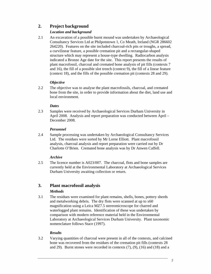
Table 3.1: Plant macrofossils and charcoal from Philpotstown 1
Context 7 9 16 18 28 29
Sample 1 6 2 7 8, 9 10, 11, 12
Feature Pit Slot trench Pit/trough Linear Cremation pit Cremation pit
Material available for radiocarbon dating
Volume of flot (ml) 20 200 10 5 10 100
Residue matrix (relative abundance)
Bone (calcined) - - - - 2 3
Burnt stones 2 2 4 1 - -
Charcoal 2 1 3 1 2 4
Flint (total number) - - - 2 - -
Flot matrix (relative abundance)
Charcoal 1 2 2 2 2 4
Insect fragment - 1 - - - -
Roots (modern) 1 4 2 2 2 1
Charcoal (g/number of fragments)
Total charcoal (g) 2.846 5.409 12.701 6.885 10.152 62.593
Percentage of sample analysed 100 100 100 100 100 32
Total charcoal analysed >4mm (g) 2.846 4.198 12.701 6.885 10.152 20.043
Number of analysed charcoal fragments >4mm 32 22 130 45 56 136
Alnus glutinosa (Alder) - - 5.893 (59F) 1.304 (9F) - -
Corylus avellana (Hazel) 0.763 (11F) - - 0.140 (1F) - 0.445 (1F)
Corylus/Alnus (Hazel/Alder) - 0.094 (1F) - - - -
Fraxinus excelsior (Ash) 0.102 (2F) 3.346 (15F) 1.838 (20F) 2.186 (12F) 0.200 (1F) -
Maloideae (Hawthorn, whitebeams, apple, pear) 0.348 (2F) 0.147 (1F) 0.469 (2F) 0.838 (5F) - -
Prunus spp (Cherries) 0.370 (4F) - - 0.134 (1F) - -
Quercus sp (Oak) - - - - 6.659 (39F) 19.598 (135F)
Ulmus sp (Elm) 0.209 (2F) - - - 0.096 (1F) -
Ring porous 0.063 (1F) 0.474 (4F) 0.598 (8F) 0.098 (1F) 2.586 (14F) -
Unidentified >4mm fraction 0.991 (10F) 0.137 (1F) 3.903 (41F) 2.185 (16F) 0.611 (1F) -
Unidentified <4mm fraction - 1.211 - - - -
Charred remains (total number)
(c) Hordeum spp (Barley species) grain - - - - - 1 (g) Arrhenatherum elatius ssp bulbosum (False Oat-grass) tuber - - - - - 2
(g) Plantago lanceolata (Ribwort Plantain) seed - - - - - 1
(x) Tuber (indeterminate) tuber - - - - - 3
[c-cultivated plant; g-grassland; x-wide niche]. F = number of charcoal fragments. Relative abundance is based on a scale from 1 (lowest) to 5 (highest)
Discussion
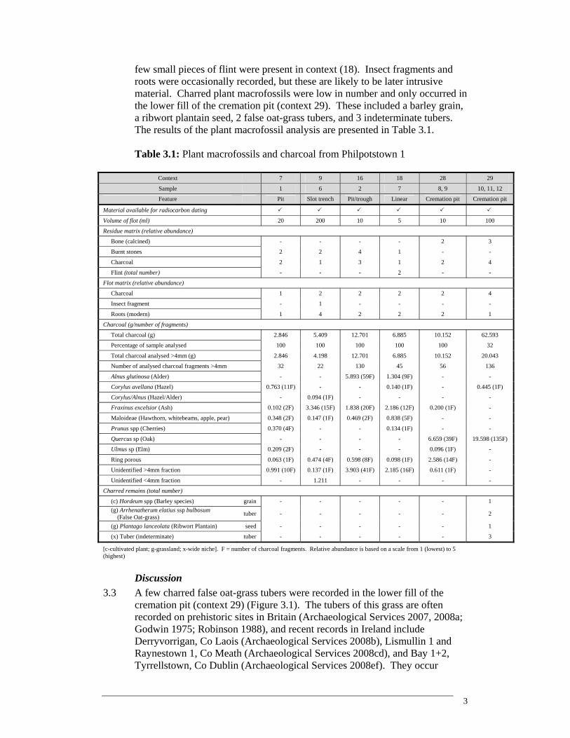
3.3 A few charred false oat-grass tubers were recorded in the lower fill of the cremation pit (context 29) (Figure 3.1). The tubers of this grass are often recorded on prehistoric sites in Britain (Archaeological Services 2007, 2008a; Godwin 1975; Robinson 1988), and recent records in Ireland include Derryvorrigan, Co Laois (Archaeological Services 2008b), Lismullin 1 and Raynestown 1, Co Meath (Archaeological Services 2008cd), and Bay 1+2, Tyrrellstown, Co Dublin (Archaeological Services 2008ef). They occur
4
frequently in cremations, particularly those dating to the Bronze Age (Robinson 1988), where it has been suggested that this grass was used for kindling for the funeral pyre, as the dry, dead stems remain upstanding for much of the year (ibid.). It is believed that false oat-grass tubers also provided a source of food (Godwin 1975; Huntley 1994), and therefore, in the context of a cremation, the charred tubers may represent ritual food offerings placed on the pyre. A charred ribwort plantain seed was also recorded in this context. This weed grows in a variety of habitats, including meadows, pastures and upland grassland (Preston et al. 2002) and may have been collected with the false oat-grass, either incidentally or for use as kindling.
Figure 3.1: A charred false oat-grass tuber 3.4 A charred barley grain was also recorded in the lower fill of the cremation pit
(context 29), which may have been an additional component of a food offering. Studies indicate that barley became the dominant crop used in Ireland during the mid-late Bronze Age and Iron Age (Johnston 2007; Monk 1986). It has been suggested that barley may have held a ritual significance in prehistory, as a preponderance of barley grains was noted in recent studies of Bronze Age cremation burials along the route of the gas pipeline to the west of Ireland (ibid.).
4. Charcoal analysis Methods
4.1 Charcoal was collected from the residues and flots and added to pre-sorted material. Following Boardman (1995), identifications were made on fragments >4mm. At least 100 fragments were identified from each context, where available. The transverse, radial and tangential sections were examined at up to x600 magnification using a Leica DMLM microscope. Identifications
5
were assisted by the descriptions of Hather (2000) and Schweingruber (1978), and modern reference material held in the Environmental Laboratory at Archaeological Services Durham University. A single entity of charcoal from a short-lived tree species, was provided for radiocarbon dating from each of contexts (7), (9), (16), (18) and (29).
Results 4.2 A small amount of charcoal was present in pit fill (7), which comprised hazel,
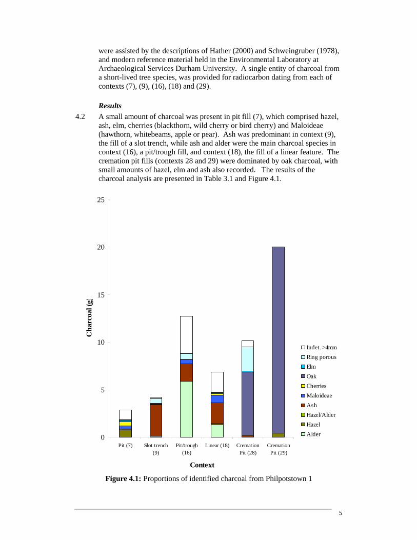
ash, elm, cherries (blackthorn, wild cherry or bird cherry) and Maloideae (hawthorn, whitebeams, apple or pear). Ash was predominant in context (9), the fill of a slot trench, while ash and alder were the main charcoal species in context (16), a pit/trough fill, and context (18), the fill of a linear feature. The cremation pit fills (contexts 28 and 29) were dominated by oak charcoal, with small amounts of hazel, elm and ash also recorded. The results of the charcoal analysis are presented in Table 3.1 and Figure 4.1.
0
5
10
15
20
25
Pit (7) Slot trench(9)
Pit/trough(16)
Linear (18) CremationPit (28)
CremationPit (29)
Context
Cha
rcoa
l (g)
Indet. >4mmRing porousElmOakCherriesMaloideaeAshHazel/AlderHazelAlder
Figure 4.1: Proportions of identified charcoal from Philpotstown 1
6
Discussion 4.3 If the wood was collected locally, the results of the charcoal analysis suggest
that the landscape included mixed deciduous woodland. This comprised a high canopy of ash, oak and elm, with hazel, cherries and Maloideae either growing in the understorey or by the woodland margins. Alder would have favoured wetland areas, for example along riverbanks or in carr vegetation.
4.4 It has been suggested that the pits on the site may relate to burnt mound
activity, in which case the charcoal in the fills (context 7 and 16) may reflect the fuels used for this purpose. The abundance of alder, ash and hazel is broadly in line with a recent study of charcoal from Bronze Age sites in central and western Ireland, which has provided evidence that alder, ash, hazel and oak were the main trees selected for fuel on burnt mound sites (O’Donnell 2007). It has been suggested that this choice of fuel reflects the marginal situation of most burnt mounds, between wet and dryland areas (ibid.). This pattern of fuel selection has been noted at other burnt mound sites along the route of the M3 motorway, for example at Drumbaragh 3 and Gainstown 1 (Archaeological Services 2008gh). Maloideae was present in both pit fills, which may indicate that it was also used for fuel at Philpotstown 1. Alder, ash and Maloideae dominated the charcoal assemblage in context (18), which may indicate that the fill of the linear feature also contained fuel relating to burnt mound activity on the site.
4.5 The charcoal was generally in a poor condition, with many fragments being
orange-stained and partially mineralised. This prevented some of the >4mm fragments from being identified. This is a common phenomenon of features associated with burnt mounds, as the waterlogged conditions can result in the charcoal incorporating minerals such as calcium and iron, which hinders identification (Stuijts 2007).
4.6 The charcoal in the pit and linear fills was too small to be differentiated
between timber (stemwood) and branchwood (roundwood), however in the fill of the slot trench (context 9), the charcoal was dominated by ash timber fragments. This may represent the remains of a burnt structure, as ash provided an important source of structural timbers in prehistory (Stuijts 2007).
4.7 The cremation pit fills (contexts 28 and 29) were dominated by oak timber
fragments, and the presence of tyloses points to the use of oak heartwood. This indicates that mature oak trees were felled, and are likely to have formed the main component of the funeral pyre. This is unsurprising, as studies suggest that oak was the main wood used in prehistoric cremations, and was probably chosen for its ability to achieve the high temperatures required for the cremation process (O’Donnell 2007). A single fragment of hazel was present in context (29) and may have been used for kindling. Small quantities of elm and ash were recorded in context (28), which may also have been used for kindling or additional fuel on the pyre.
7
5. Cremated bone analysis Methods
5.1 Cremated bone was recovered from the upper and lower fills of a presumed cremation pit. The bone from each sample was passed through a nest of sieves, with mesh sizes of 10mm, 5mm, and 2mm (McKinley 2004). Each fraction was weighed and the largest fragment of bone was measured.
Results and interpretation
5.2 Summary data is presented in Table 5.1, and the fraction weights and fragment size data are given in Table 5.2.
5.3 The total weight of cremated bone from pit (30) was 160.6g, but the bulk of
this material (144.6g) was derived from the lower fill (context 29; Table 5.1). The amount of bone falls well short of the c. 1000-2500g recorded for modern cremations (McKinley 1993), but a token selection of remains from the pyre may have been collected for burial in archaeological contexts (McKinley 2000). It is possible that this deposit represents such a token cremation burial.
5.4 The bone from both the fills tended to be moderately to severely fragmented,
with the bulk of the material in the middle and smallest sieved fractions (Table 5.2). Less than 20% of the bone in both contexts was in the largest sieved fraction. However, a couple of large fragments were present, particularly in the lower fill where the largest fragment measured 70.8mm (Table 5.2).
Table 5.1: Summary of cremated remains
Context Context Detail Bone Colour Species Weight (g)
28 Upper fill of cremation pit (30) White Unknown 16.0 29 Lower fill of cremation pit (30) White/ pale grey Human 144.6
5.5 The bone was white to pale grey in colour suggesting exposure to
temperatures in excess of c. 600ºC with a plentiful supply of oxygen (McKinley 2004).
5.6 The fragments were examined with a view to identification, and a small
number of definite fragments of human bone were present in the lower fill. Unfortunately, none of the bone from the upper fill could be identified to species, but it seems likely that this bone was also human.
Table 5.2: Fraction weights and fragment size
Fraction Weights Total Weight >10mm 5-10mm 2-5mm
Max. Frag Size Context
g g % g % g % mm 28 16.0 2.5 15.6 8.6 53.8 4.9 30.6 33.4 29 144.6 25.0 17.3 48.4 33.5 71.2 49.2 70.8
8
The Human Bone 5.7 The weight of identified bone for context (29) is given in Table 5.3, with a full
catalogue provided in Appendix 1. Only a small proportion of bone (3.9%) from context (29) was identifiable, which reflects the generally small size of the fragments. The majority of the identifiable fragments were from the skull, and included part of the left zygoma (the area of the cheekbone bordering the orbit), and fragments of cranial vault. Since the cranial vault is very distinctive and easily recognisable even when severely fragmented it often forms a large proportion of identified bone fragments in cremated remains (McKinley 1994). A couple of small fragments of probable rib shaft were present, as well as the distal end of a proximal or intermediate phalanx, probably from the foot (toe bone). Fragments of long bone were also present, and weighed 19.2g; unfortunately it was not possible to determine from which bone(s) these came.
Table 5.3: Weight of identifiable bone fragments
Skull Axial Upper Limb Lower Limb Total Context g % g % g % g % g %
29 5.2 91.2 0.3 5.3 0.0 0.0 0.2 3.5 5.7 3.9 5.8 There was no duplication of bone elements or parts of bone elements, meaning
that the minimum number of individuals that could be identified was one. Given the size of the fragments, it seems likely that these remains were those of an adult or adolescent. Unfortunately, it was not possible to provide a more precise age estimation, or to determine the sex of the individual.
6. Sources
Archaeological Services 2007 Streethouse Farm, Loftus, Cleveland; plant macrofossil analyis, unpublished report 1613, for Mr Steve Sherlock, Archaeological Services Durham University Archaeological Services 2008a Wheatley Hill to Bowburn; full analysis, unpublished report 1861, Archaeological Services Durham University Archaeological Services 2008b Derryvorrigan 1, Co Laois, Ireland; environmental analysis, unpublished report 1888, for Archaeological Consultancy Services Ltd, Archaeological Services Durham University Archaeological Services 2008c Lismullin 1, Co Meath, Ireland; plant macrofossil, charcoal and cremated bone analysis, unpublished report 1967, for Archaeological Consultancy Services Ltd, Archaeological Services Durham University Archaeological Services 2008d Raynestown 1, Co Meath, Ireland; plant macrofossil, charcoal and bone analysis, unpublished report 1941, for Archaeological Consultancy Services Ltd, Archaeological Services Durham University
9
Archaeological Services 2008e Bay 1, Tyrrellstown, Co Dublin, Ireland; plant macrofossil, charcoal and cremated bone analysis, unpublished report 2103, for Archaeological Consultancy Services Ltd, Archaeological Services Durham University Archaeological Services 2008f Bay 2, Tyrrellstown, Co Dublin, Ireland; plant macrofossil, charcoal and cremated bone analysis, unpublished report 2104, for Archaeological Consultancy Services Ltd, Archaeological Services Durham University Archaeological Services 2008g Drumbaragh 3, Co Meath, Ireland; plant macrofossil, charcoal and faunal remains analysis, unpublished report 2093, for Archaeological Consultancy Services Ltd, Archaeological Services Durham University Archaeological Services 2008h Gainstown 1, Co Meath, Ireland; charcoal analysis, unpublished report 2060, for Archaeological Consultancy Services Ltd, Archaeological Services Durham University Boardman, S J, 1995 Charcoal and charred macrofossils, in K, Branigan & P, Foster (eds) Barra: archaeological research on Ben Tangaval, Sheffield: SEARCH Volume 1, 149-157 Godwin, H, 1975 The history of the British flora, 2nd Edition Hather, J G, 2000 The identification of the Northern European Woods: a guide for archaeologists and conservators, London Huntley, J P, 1994 A1 Walshford-Dishforth (WD93), The plant remains, Part II: Fields 88-105, Archive report to Northern Archaeological Associates, Barnard Castle, Durham Johnston, P, 2007 Analysis of carbonised plant remains, in Grogan, E, O’Donnell, L, & Johnston, P, The Bronze Age landscapes of the Pipeline to the West, an integrated archaeological and environmental assessment, Wicklow McKinley, J I, 1993 Bone Fragment Size and Weights of Bone from Modern British Cremations and the Implications for the Interpretation of Archaeological Cremations, Int J Osteoarchaeol 3, 283-287 McKinley, J I, 1994 The Anglo-Saxon Cemetery at Spong Hill, North Elmham. Part VIII: The Cremations, East Anglian Archaeology Report No 69, Dereham
McKinley, J I, 2000 Phoenix Rising: Aspects of Cremation in Roman Britain, in J Pearce, M Millett & M Struck (eds) Burial, Society and Context in the Roman World, 38-44, Oxford
10
McKinley, J I, 2004 Compiling a Skeletal Inventory: Cremated Human Bone, in M Brickley & J I McKinley (eds) Guidelines to the Standards for Recording Human Remains, 9-13, Southampton and Reading Monk, MA, 1986 Evidence from macroscopic plant remains for crop husbandry in prehistoric and early historic Ireland, Journal of Irish Archaeology, 3, 31-36 O’Donnell, L, 2007 Charcoal and wood, in Grogan, E, O’Donnell, L, & Johnston, P, The Bronze Age landscapes of the Pipeline to the West, an integrated archaeological and environmental assessment, Wicklow Preston, C D, Pearman, D A, & Dines, T D, 2002 New Atlas of the British and Irish Flora, Oxford Robinson, M, 1988 The significance of the tubers of Arrhenatherum elatius (L.) Beauv. from Site 4, cremation 15/11, in: G Lambrick, (ed) The Rollright Stones: Megaliths, monuments and settlement in the prehistoric landscape, English Heritage Archaeological Report 6 Schweingruber, FH, 1978 Microscopic wood anatomy, Birmensdorf Stace, C, 1997 New Flora of the British Isles, 2nd Edition, Cambridge Stuijts, I, 2007 Wood and Charcoal Research in Ireland, in Murphy, EM & Whitehouse, NJ (eds), Environmental Archaeology in Ireland, Oxford
Appendix 1
Context 29 Skull Left zygoma (frontal process); vault fragments (x4)
Axial Rib shaft fragments? (x3)
Upper Limb -
Lower Limb Distal end of a proximal/ intermediate foot phalanx? (probably proximal)
Unidentified long bone shaft fragments (x16), 19.2g
APPENDIX 9 Bronze Age Houses: Neil Carlin
M3 Research Report on Bronze Age Houses in
Ireland
By Neil Carlin
Archaeological Consultancy Services
04/04/06
SUMMARY In this Research Report, I attempt to examine and detail the characteristics of Irish Bronze Age roundhouses. Much of this work is based upon the results of unpublished excavations and the findings have been limited by the restricted nature of information from these sites. The location and landscape setting of houses & settlements is discussed. The various forms of settlements on which these houses are found are outlined. An exposition of attempts to create a hierarchical model of these settlement types is given. Previous studies of Bronze Age structures are reviewed in order to outline what was known prior to commencing this study. The Main characteristics of Bronze Age roundhouse as revealed by my own brief survey are discussed. Aspects such as shape and size, entrances, internal features, associated artefacts, internal divisions, evidence of structural repairs and the construction of buildings in the same area are all examined. The issue of the occurrence of structured deposits in the form of foundation and closing deposits is discussed. Commonly occurring external features and sites that are often found in close proximity to structures are detailed. A review is undertaken of the evidence from recent excavations for the materials that formed the superstructure of these houses. Recurrent structural forms are identified and categorised into groups in order to create a typology of common house-types. The essential aspects of each of these types are outlined and where possible their date range is given and chronologically diagnostic features are highlighted.
Philpotstown 1, A023/007 M3 Clonee–North of Kells Motorway Scheme
2
Bronze Age houses are being found with an ever-increasing frequency, but this data
has not been converted into Knowledge. Until recently, Bronze Age houses and
settlements had been relatively scarce, in contrast to the numbers of metal objects that
have been found and thus, Irish Bronze Age studies have traditionally concentrated on
artefact typologies and metalwork. The upsurge in development led excavations of
Bronze Age habitations has provided the opportunity to achieve a much greater
understanding of settlement at this time. Attempts to synthesise this vast reserve of
new data have not been forthcoming and thus, our textbooks have become extremely
outdated and our knowledge of Bronze Age settlement has not advanced to the level
that it should have. (With the exception of the North Munster Project (Grogan 2006)),
Our understanding of the wider landscape setting and interrelationship of sites such as
hoards, barrows, burnt mounds and settlements has not been advanced.
In light of this, it has been necessary to undertake a small-scale study of primary
sources that synthesizes the results of recent excavations. The success of any such
project is hampered greatly by the paucity of published accounts of the findings from
relevant sites.
This paper undertakes a survey of the new data that has arisen from these recent
excavations in an attempt to decipher what is now known about Bronze Age round
houses in Ireland. The identification of the major characteristics of these structures
should facilitate the recognition of these in the course of excavating possible
roundhouses on the M3 project. It is hoped that the findings from these excavations
can be tailored to address questions raised by this study and serve to support or reject
suggested hypotheses.
In this research report, it is considered that the Early Bronze Age dates from 2500-
1700 BC, the Middle Bronze Age lasted from 1700-1200 BC and the Late Bronze
Age dates to 1200-650.
Philpotstown 1, A023/007 M3 Clonee–North of Kells Motorway Scheme
3
LOCATION, LANDSCAPE SETTING OF HOUSES & SETTLEMENTS
The locations of Bronze Age settlements are thought to be very diverse i.e. hillforts,
wetland sites, lowland sites, upland sites, temporary habitations (Waddell 1998, 205).
Both low-lying and upland areas seem to have been exploited to a greater degree than
had previously occurred during the Neolithic (Cooney & Grogan 1994, 105).
O’Sullivan (1998, 71) suggests that a combination of “high population pressure,
social instability, increasing growth of blanket bog and perhaps even climactic
deterioration caused new low-lying lands, particularly wetlands, to be taken in for
farming”. Despite this expansion expansion, a high degree of uniformity is detectable
in the location of settlements. Land quality, proximity to fresh water and timber for
building and for a heat source, appropriate stone resources and the suitability of the
local topography in terms of farmability and accessibility would all have been
important factors that influenced prehistoric peoples choices regarding location of
settlement Grogan (1996, 48).
Middle Bronze Age and Late Bronze Age settlements are usually located on well-
drained thin soils that were suitable for arable agriculture (O’Sullivan 1998, 70).
Routeways (rivers, fording points, etc) are thought to have been popular areas for
settlement, as they would have facilitated trade and communication (Grogan 2006b,
27). The ridges along river valley sides were extensively exploited as prime locations
for settlement while the river valleys were often utilised for burial sites (Cooney &
Grogan 1999, 103; Grogan 2006). Areas of dryland in close proximity to lakes were
heavily exploited, this is demonstrated by sites such as Townparks, Co. Antrim
(Ballin Smith 2003, 16), which was located just east of Lough Neagh on a former
flood plain and Caltragh, Co. Sligo which was situated on the southern slopes of a
valley beside a lakeshore. A study of Early Bronze Age settlement in Leinster
revealed that the site setting for habitations in this period shares many similarities
with that of the Neolithic. There was a clear preference for coastal, riverine and
lacustrine locations and south-facing slopes with well-drained soils in proximity
(Carlin 2005). Sites appear to have been situated in order to exploit the maximum
number of biospheres possible. Grogan (1996, 48) stresses the importance of social
factors such as proximity to relatives and allies as well as access to sites of ceremonial
Philpotstown 1, A023/007 M3 Clonee–North of Kells Motorway Scheme
4
and religious importance. This latter point may be of particular relevance in
considering the location of settlements within the Tara landscape.
ENCLOSED SETTLEMENTS & SETTLEMENT TYPES
Bronze Age habitation sites may take various forms; they range from enclosed to
open settlements, and from isolated houses to aggregated and nucleated settlements. It
is important to note that isolated and unenclosed settlements on sites where the area of
excavation is restricted, may in fact be part of a greater settlement complex that exists
belong the limits of excavation.
Unenclosed settlement sites from the Early Bronze Age include the structures at Ross
Island, Co. Kerry, Meadowlands, Co. Down and Ahanagloch, Co. Waterford (O'Brien
2005; Pollock & Waterman 1964; Tierney forthcoming). Middle Bronze Age
unenclosed settlements include Kerlogue, Co. Wexford, Kilmurray, Co. Wicklow and
Lisheen, Co. Tipperary (McLoughlin 2002a; O Neill 2001, O Neill 2005). Unenclosed
Late Bronze Age settlement occurs at sites such as Curraghatoor, Co. Tipperary,
Donegore Hill, Co. Antrim and Laughanstown, Co. Dublin (Doody 1987; Doody
1990; Mallory & McNeill 1991; Seaver & Keeley forthcoming).
No clear-cut evidence was detected in this survey for enclosed Early Bronze Age
settlements. Both Middle Bronze Age and Late Bronze Age enclosures consist of a
surrounding palisade, ditch, bank or wall or a combination of these. Examples of
Middle Bronze Age ditched enclosures include Chancellorsland, Co. Tipperary, where
five rectangular buildings, four oval buildings, and one U-shaped structure were
revealed by excavations (Doody 1999). Enclosure 1 at Ballybrowney, Co. Cork
represents an excellent example of a dryland-palisaded enclosure (Cotter 2005). It is
highly comparable to the lakeland-palisaded enclosures such as that at Cullyhanna
Lough, Co. Armagh (Hodges 1958). A Late Bronze Age settlement within a palisaded
enclosure was excavated at Clonfinlough, Co. Offaly (Moloney et al 1993). Late
Bronze Age settlements within ditched enclosures have been excavated at site 17,
Kilsharvan, Co Meath, Lagavoren, Co. Meath, Rathgall, Co. Wicklow, Ballyhenry
Philpotstown 1, A023/007 M3 Clonee–North of Kells Motorway Scheme
5
site 5, Co. Down, and Troopersland, Co. Antrim (Russell & Corcoran 2002, 33;
Murphy & Clarke 2001; Raftery 1976; MacManus 1997; McConway 2000).
Some Middle to Late Bronze Age sites are defined by drystone walls usually between
15 m and 36 m in diameter and the average is c 22 m (Grogan 2006b, 37). Examples
have been excavated at Lough Gur (O’Riordain 1954, Grogan & Eogan 1987; Cleary
1995) and Aughinish, Co. Limerick (Kelly 1974, Raftery 1994, 21 and Carrigillihy,
Co. Cork (O’Kelly 1951). These are usually located on rockland terraces (Grogan
2006b, 134). Cleary’s (2003) excavation of the enclosed Late Bronze Age settlement
at Lough Gur also fits into this category and bares much similarity to the enclosures at
Circles J, K and L and Sites 10-12 (O’Riordain 1954, Grogan & Eogan 1987).
Bruck (1997) found that 65% of 85 Middle Bronze Age sites in Britain were enclosed,
the shape of which varied greatly. Due to the unpublished and unsynthesised nature of
most recent excavations, it is difficult at present to ascertain if the same level of
enclosure was occurring in Ireland at this time. As demonstrated above, it is certain
that some settlements were being enclosed and that as in Britain, this does not appear
to have occurred widely until the end of the Early Bronze Age. In British Middle and
Late Bronze Age enclosed settlements, the houses are usually located to the rear and a
large area to the front is left open, it has been suggested by Parker Pearson (1994, 50-
52) that this may represent a symbolic division of space. The front of the enclosure is
open and accessible to the public, while the back of the enclosure where the house is
located is private. It is usually the case with such site types that most of the domestic
refuse from the excavation will be recovered from the ditch, which appears to have
been the preferred location for rubbish disposal (Bruck forthcoming). This may have
been carried out in order to assert a division between the inside and outside of the
settlement. This finding appears to apply to Irish Bronze Age enclosed settlements
such as Chancellorsland, Lagavoren, Kilsharvan and Ballyveelish 3.
Lakeshore settlements have been excavated at Moynagh Lough, Co. Meath (Bradley
1999, 2005), Ballinderry, 2, Co. Offaly (Hencken 1942; Newman 1997),
Clonfinlough, Co. Offaly (Moloney et al 1993), Cullyhanna, Co. Armagh (Hodges
1958). It has always been assumed that these represent a distinctive settlement form,
but it seems increasingly likely that settlements such as these are not restricted to a
Philpotstown 1, A023/007 M3 Clonee–North of Kells Motorway Scheme
6
lacustrine setting, but rather that the increased levels of preservation afforded to the
archaeology by such a setting has resulted in the existence of these sites being more
detectable in that context. This point is supported by the evidence of enclosure
obtained from recent excavations of sites such as Ballybrowney, Co. Cork (Cotter
2005). It may be suggested that the material culture of the lakeland sites is much
greater, but it must be considered that this may be related solely to the vagaries of
preservation and to the manner in which the site was abandoned.
Isolated houses continue to be constructed throughout the Bronze Age, as do
aggregations of a small number of structures such as Cloghers, Co. Kerry, Caltragh,
Co. Sligo and Ballybrowney, Co. Cork (Kiely Forthcoming; McCabe 2005; Cotter
2005).. More nucleated settlement is represented by the Middle Bronze Age village at
Corrstown, Co. Londonderry which may be paralleled albeit to a lesser extent by
Lough Gur, Co. Limerick and Whitepark Bay, Co. Antrim.
Hillforts were constructed in the Late Bronze Age from 1200 to 1000 BC and it can
be concluded that a much wider variety of settlement forms were in use in the Late
Bronze Age than in the Middle Bronze Age. This ties in well with studies of the
British evidence which have found that a noticeable diversification in the range of
identifiable types of settlement occurs in the Late Bronze Age such as hillforts and
hilltop enclosures (Bruck forthcoming (a)) Midden sites & wetland sites while present
in the Middle Bronze Age, become much more prevalent. This can be interpreted as
an attempt to differentiate between different types of activity and to express a social
distinction between different categories of people (Bruck forthcoming (a)). In the Late
Bronze Age, there is also a diversification in terms of material culture, and the range
of items found on sites increases greatly. Metalwork is much more likely to be found
on Late Bronze Age settlements than on Middle Bronze Age settlements (Bruck,pers
comm.). Certain sites have a very wide range of rare objects and thus the idea of
‘Rich’ sites emerges (see below, Bruck forthcoming (a)).
Philpotstown 1, A023/007 M3 Clonee–North of Kells Motorway Scheme
7
IS THERE A HIERARCHY OF SETTLEMENT FORMS?
In Britain, Middle Bronze Age settlements produce a small and uniform set of finds,
there is little evidence to distinguish one settlement from another and there is no
evidence for any “rich” sites (Bruck 1999b, 146-50). Based on the results of this
study, the same can be said of Irish Middle Bronze Age settlements.
A stratified hierarchical society that was based around tribal identity and warfare is
thought to have emerged in the Late Bronze Age (O’Sullivan 1998, 70). This theory is
thought to be supported by evidence of ranking detected in contemporary burial
practice, which indicates social ranking based on kin group, age, and gender. A
hierarchical scheme for Late Bronze Age settlements has been proposed by both
Eogan (1998) and Grogan (Grogan et al 1995, Grogan 2006) based on the idea that
differences in settlement form and their associated assemblages are reflective of social
ranking. According to this categorisation, solitary unenclosed sites such as Donegore
may represent a simple farmstead that accommodated a single family of low rank, a
cluster of houses may have been occupied by a nucleated family with their leader
living in the most prominent house, small enclosed domestic sites may represent a
higher rank, hilltop enclosures, hillforts and high status lakeshore settlements such as
Moynagh Lough, Ballinderry, and Knocknalappa, Co. Clare are considered to be the
homesteads of those of greatest rank.
These hierarchical schemes are largely based on the material assemblage recovered
from each site (see Grogan 2006, 87) and while it may be the case that such
hierarchical ranking did indeed exist, it should be noted that it is possible that the
presence of items such as swords, ornaments and metalworking moulds on a site may
relate closely to the cultural practices of deposition and to post-depositional factors.
BRONZE AGE ROUNDHOUSES
There has been a huge increase in the number of settlement sites excavated as a result
of major infrastructural developments, since Doody’s (2000) study of 78 Bronze Age
structures revealed the general range of house shapes from this period and their major
morphological aspects. A survey of a number of published and unpublished sources
Philpotstown 1, A023/007 M3 Clonee–North of Kells Motorway Scheme
8
reveals that the number of Bronze Age houses excavated since then has at least
doubled. Furthermore, the excavation of 77 contemporaneous Middle Bronze Age
structures at Corrstown, Co. Antrim adds to this number. The growth in the number of
excavated buildings has enabled the identification of a number of their recurrent
aspects through a brief survey. The majority of those structures included within
Doody’s study, dated to the Late Bronze Age and thus it was difficult to detect
chronological or regional changes in house styles. There has been a subsequent
increase in the numbers of house from every period of the Bronze Age.
Doody (2000, 137) detected the existence of three basic ground-plans; circular, oval
and rectilinear in the construction of Bronze Age houses. 87% of these were round
houses and the most common form of these was circular in plan (ibid, 139). The
details of eleven rectilinear shaped houses is summarised by Doody and most of these
utilise a footing trench (2000, 139). It should be noted that seven of these structures
were located at Chancellorsland, Tipperary and thus, this figure may be somewhat
over representative of the degree to which rectilinear structures are present within the
archaeological record of the Irish Bronze Age.
He classified these structures according to the number of rings present in the
perimeter wall, the presence of a footing trench and the use of internal roof supports.
Based on these classifications, Doody (2000, 137) suggested that all 78 structures
within his survey belonged to one of five different categories that may be built from
wood or stone or a combination of both. These are:
Structures with a single ring of posts,
Structures with a double ring of posts,
Structures with a single wall slot,
Structures with double wall slots
Structures with an external wall and internal posts for roof supports.
O’Neill (2005) has suggested a different form of classification for Bronze Age
houses, these are:
(i) circular houses with no internal roof supports;
(ii) circular houses with a central roof support;
(iii) circular houses with an inner ring of roof supports;
Philpotstown 1, A023/007 M3 Clonee–North of Kells Motorway Scheme
9
(iv) rectangular houses with no internal roof supports; and
(v) rectangular houses with internal roof supports.
O’Neill (2005) points out that variations in the treatment of the outer walling of all
structural types are identifiable in the form of bedding trenches and free-standing
uprights with both single or double walls. The use of stone footed walls as well as a
small number of stone-built houses is also detailed.
The majority of the roundhouses (10 in total) within Doody’s survey belonged to
Group 1, these consisted of an external wall formed by a single ring of posts.
Examples of these include Donegore, Co. Antrim; hut 1 at Curraghatoor, Co.
Tipperary and hut 3 at Clonfinlough, Co Offaly. A footing trench/wall slot was
incorporated into 17 of the roundhouses and over half of these structures were found
to possess an internal ring of roof supports (Doody 2000, 139). Examples include
Castleupton, Co. Antrim; Lisheen, Co. Tipperary; Cloghlucas South, Co. Cork. Those
without an internal ring of posts include hut 2 at Curraghatoor; Raffin, Co. Meath; and
Rathgall, Co. Wicklow.
Doody (2000, 139) found that roundhouses vary in diameter from 3m to 15m, but
68% (n=28) of those studied were between 5 and 9m in diameter. Doody (2000, 143)
claimed that LBA houses are generally bigger and more circular than their Early or
Middle Bronze Age counterparts.
I undertook my own brief survey of Bronze Age houses with the aim of updating that
of Doody’s (2000) study. The site of Corrstown where over 70 Bronze Age
roundhouses were excavated, will only be referred to briefly in this study, it has been
decided to omit many of the findings from this site due to the possibility that recurrent
aspects of the Corrstown structures may not represent island-wide trends and in light
of the high number of these, there is a strong likelihood that their inclusion would bias
the results of the survey.
Within my study, which included many, but not all of those structures from Doody’s
synthesis, there were at least 20 Early Bronze Age structures, 30 Middle Bronze Age
structures, and 33 Late Bronze Age structures. The Middle Bronze Age and Late
Bronze Age architecture was much more substantial than that dating from the Early
Philpotstown 1, A023/007 M3 Clonee–North of Kells Motorway Scheme
10
Bronze Age. A number of clear and recurrent architectural types emerged from this
study. These will be described and categorised below. This set of types is not
exhaustive as there are many structures, which do not conform to any highly definable
type, but such an attempt at categorisation does serve to demonstrate that there are
stereotypical aspects to these houses, the identification of which should serve to
increase our understanding of Bronze Age houses.
SHAPE & SIZE
In this survey, I found that 77 of 114 houses are circular, 20 are oval, and 12 are
rectangular (see appendix). The vast majority (52%, n=98) of roundhouses range from
5 to 7m in diameter and roundhouses with a diameter of 6 m occur at least twice as
frequently (27 examples) as those with any other diameter (see appendix).
ENTRANCES
The entrance was identifiable in a total of 59 structures, 32 % of these were
southeastern, 27 % were eastern, 15 % were northeastern, 11 % were northern, and 9
% were southern. Northwestern, western, and southwestern entrances all occurred
once, thereby representing 2 % each (see appendix). Entrances present themselves
either as posts on either side of a gap in the foundation trench, or as noticeably wider
spacing amongst a set of equally spaced postholes, or as parallel postholes and slot
trenches that represent the remains of an internally or externally porched entrance.
The remains of sill-beams represented by a shallow slot lying across the entrance of
some structures have been excavated at sites such as Knocksaggart, Co. Clare and
Laughanstown, Co. Dublin. The substantial nature of the postholes present at some
entrances suggests that they may in fact represent the remains of a doorframe. Mettled
surfaces are also commonly found at entrances, examples of this have been excavated
at Caltragh, Co. Sligo, Cappagh Beg, Co. Derry, and Rathmullan 15, Co. Meath. It is
likely that these stone layers were deposited to prevent the ground surface from being
worn away in wet conditions, as the entrance would have been an area of heavy foot
traffic (Reynolds 1982, 196). At the Bronze Age village at Corrstown, Co. Derry,
small mettled pathways led out onto a cobbled avenue that traversed the site (Conway
pers comm).
Philpotstown 1, A023/007 M3 Clonee–North of Kells Motorway Scheme
11
INTERNAL FEATURES
Out of a total number of 104 structures for which the requisite level of information
was available, 23 % had an internal hearth, while 87 % displayed no evidence for this.
This figure is supported by the findings from Corrstown where only three out of the
70 round houses excavated had definite hearths (Conway pers comm.) Where a hearth
was present, it was found to be located either centrally or slightly off-centre. This
paucity of hearths has previously been highlighted (Doody 2000, 145). Pits, postholes
and stakeholes are commonly found inside roundhouses and are commonly
interpreted as the remains of furniture, storage pits, refuse pits and internal divisions
(see appendix).
Stone paving was discovered within the house at Cloghlucas, Cork (Gowen 1988) and
within some structures at Corrstown and Ballyprior Beg (Conway pers comm.,
Suddaby 2003). These sites are exceptional in this regard as the vast majority of
structures excavated in Ireland have had no surviving floor or floor-deposits due to
truncation by later agricultural activity. This greatly hampers the identification of the
function of these structures and the recognition of activity areas.
Non-structural features containing burials have been found within a number of
houses. At Ballyveelish 3, Co. Cork, a Polygonal cist burial was located at the centre
of a roundhouse structure (Doody 1987, 18). Cleary (forthcoming has suggested that
this may have been a storage pit during the lifetime of the house that was latterly re-
used for burial. A centrally located pit within the Late Bronze Age structure at
Rathgall contained a cremation and a gold hair ring, which were deposited under a
large boulder. Raftery (1976, 342) suggested that this represented the remains of a
Foundation deposit that may have marked the beginning of the building’s life. At
Kerlogue, Co. Wexford, a sub rectangular pit containing much charcoal and burnt
bone was present near the centre of the house. A pit containing a cremation at was
excavated at the centre of one of the Knocksaggart structures (Hanley 2002).
The excavations at Ardsallagh, Co. Meath by Linda Clarke have revealed two
roundhouses both of which had a single internal feature containing cremated bone.
Philpotstown 1, A023/007 M3 Clonee–North of Kells Motorway Scheme
12
FINDS
At present there appears to be a great variety in the level and types of finds within
structures, and many houses exhibit evidence for little or no finds. The most common
finds include pottery, flint, quernstones and rubbing stones. Amongst those houses
where artefacts are associated with the house, these are usually present within
structural contexts, which raises questions about the extent to which they can be
considered to be associated with the use of the house, it may be useful to consider the
possibility that those finds are foundation or closing deposits.
It is not possible within the limited scope of this study to detect chronological
variation within the finds assemblage. It would seem likely that a greater degree of
exotic finds are found within structures in the Late Bronze Age, this hypothesis is
supported by the discovery of the amber bead at Moynagh and the hair ring at
Rathgall. Two broken halves of a Late Bronze Age socketed spearhead were
recovered from the slot trench of the structure at Kilsharvan 5, Co. Meath (Russell
2001). A palstave axe and a hair ring were found within the structure at Ballyprior
Beg (Suddaby 2003).
It may be possible to create a hierarchical model of settlement types based on the
level of artefactual remains; this is not possible here because the necessary level of
information regarding finds is not readily available within a short-term study such as
this. Furthermore, there is much difficulty in determining how truly representative an
assemblage may be, given the high levels of truncation that many of the structures
have suffered from. It is hoped that future work will resolve this issue.
INTERNAL DIVISIONS
Evidence for internal divisions have been noted during the excavation of some
structures. These often take the form of a line of stakeholes or a shallow slot. The
interpretation of these features as internal divisions can be problematic as it is often
difficult to demonstrate definitive comtemporaneity in the absence of stratigraphic
relationships, artefactual evidence and radiocarbon dates. The structure at
Troopersland, Co. Antrim had a central division formed by two linear slots, 2m and
Philpotstown 1, A023/007 M3 Clonee–North of Kells Motorway Scheme
13
1.4m long, with a central break in between them of 2.6m. Three equidistant stake-
holes spanned this gap. It may be possible that the stakeholes represent the remains of
a movable screen, which allowed entrance into the rear of the structure. Structure 1 at
Caltragh, Co. Sligo may have had a north-south internal division formed by
stakeholes. A north-south line of stakeholes represented an internal division of space
5 m long within the structure at Kerlogue, Co. Wexford. This was similar to that at
Caltragh and may represent the division of the front and back of the house. A possible
North- south line creating a division between east and west is visible within structure
B at Ballybrowney (Cotter 2005). The house at Cloghlucas, Co. Cork may have
possessed a similar east west division represented by a trench, though it is possible
that this feature is unassociated with the structure (Gowen 1988, 117).
EVIDENCE OF REPAIR & RE-USE.
Doody (2000, 147) found that the re-use of a site for successive construction of
buildings is common and he has interpreted this as the sequential replacement of a
single homestead. For example, the high number of structures within the enclosure at
Chancellorsland, Co. Tipperary is more likely to be the result of successive
construction by a single household group rather than that of a large population (Bruck
forthcoming). This view is supported by the fact that these structures intercut each
other. This is not to say that the occurrence of a number of structures on a site should
always be interpreted as the result of settlement drift. Clear comtemporaneity has
been demonstrated for a minimum of 70 Middle Bronze Age structures at Corrstown.
Irish archaeological remains do tend to exhibit the Irish characteristic of having a
strong attachment to place. This is demonstrated by the fact that excavation of
industrial, burial and settlement sites predominantly provide evidence for multiperiod
activity. Excavations at Caltragh, Co. Sligo revealed that one structure had been built
over the location of a previous one (McCabe 2005, 47). At Lisheen, Co. Tipperary,
houses A and B were built over a previous structure. This evidence for continuity can
cause problems in so far as the artefacts found in the structural contexts of
roundhouses often date to a previous phase of occupation. The excavation at
Corrstown may provide examples of this, where numerous Late Neolithic flint tools,
an Early Bronze Age macehead and Early Bronze Age metalworking moulds were
found in Middle Bronze Age contexts. A similar scenario may be detected at
Philpotstown 1, A023/007 M3 Clonee–North of Kells Motorway Scheme
14
Cloghers, Co. Kerry where a rich assemblage of Beaker pottery and associated
artefacts were recovered from the structural contexts of what may be Late Bronze Age
structures. Excavations at Townparks, Co. Antrim and Ballypriorbeg, Co. Antrim
have revealed similar findings (see Ballin Smith 2003, Suddaby 2003). In light of
these occurrences and the strong evidence for continuous settlement activity, it may
be prudent to treat both radiocarbon dates and the artefacts recovered with some
caution and to differentiate between structural and non-structural contexts.
STRUCTURED DEPOSITS
The archaeological record is patterned and structured as a result of the functional and
spatial organization of activity; the changes caused by post-depositional processes and
more importantly, the practices surrounding artefact deposition (Pollard 2002, 22, also
see Richards & Thomas 1984). Synthetic analysis of excavations in Britain has
revealed a recurrent pattern of strange deposits being used to mark out significant
points in space (See Bruck 1999 & Bruck 2001). These odd or structured deposits are
most frequently found in the corners or terminals of ditches or in the postholes at the
entrance to roundhouses (Bruck 1999, 152). These include the deliberate deposition of
spindle whorls, loom weights, animal bone, cereal grain, bronze objects and notably
saddle querns and hammerstones in unusual contexts (Brück 1999, 145-166).
Examples of this have been found to be associated with Irish Bronze Age
roundhouses. At Ballybrowney, Co. Cork, a fragment of a saddle quern was found in
an entrance-posthole to Structure E and a complete saddle quern and the fragment of
another were discovered in the northern entrance posthole to Structure B. No other
saddle querns were found on site. The opposing entrance-posthole of Structure B
yielded a possible anvil stone, which showed clear signs of being worked. The single
fragment of pottery recovered from Structure C came from an entrance posthole and
of the six sherds, five fragments and three crumbs of pottery recovered from Structure
D, all except one sherd, a fragment and a crumb came from two diagonally opposed
entrance-postholes (Cotter Forthcoming). At Knocksaggart, Co. Clare, three possible
token cremations were identified within three separate postholes at the entrance to the
structure (Hanley 2002). A loom weight was found within a posthole of the structure
at Grange Rath, Colp West, Co. Meath (O’Hara 2004). At Laughanstown, a number
Philpotstown 1, A023/007 M3 Clonee–North of Kells Motorway Scheme
15
of saddle querns and rubbing stones were deposited into a pit just north of a Late
Bronze Age structure (Seavers & Keeley forthcoming). At Charlesland, Co. Wicklow,
pottery and cremated bone was found within a number of the postholes, and it was
considered by the excavator that these might have been placed as foundation deposits
(Molloy 2003). A Rib fragment, and two long bones were found in a structural
posthole of a roundhouse at Cloghers, Co. Kerry (Kiely forthcoming).
It can be seen that a clear emphasis was placed on entranceways; Brück (1999, 153)
has suggested that material culture may have been deliberately manipulated by
depositing it in such strategic places in order to distinguish spatial boundaries such as
inside the structure and outside of it. This may also have served to add significance to
the act of moving from one sphere into another.
A very clear and close link between life and death can be observed in the findings
from the excavations of settlement sites (see Cleary forthcoming). There is recurrent
evidence for the deposition of human bone in pits and postholes of houses and in
cremation pits and ringditches in close proximity to structures. There appears to be a
clear symbolic significance attached to saddle querns and rubbing stones as these are
often found deposited in cremation pits or in significant locations. For example, a
saddle quern was used as the lid of cist in Ballyveelish and cremation pits at Caltragh
and Knocksaggart contained parts of saddle querns. It is possible to detect a
significant link between social, physical and material reproduction within the
settlement. Bruck (2001) suggests that the lifecycle of a settlement is connected to the
lifecycle of its occupants and their possessions. It may be the case that the activities
surrounding the death of a householder are intimately connected with their homestead.
This may serve to explain the deposition of cremated bone in the porches of some
structures (Bruck 1999). Bruck has suggested that the death of the house may be
brought about upon the death of a householder by dismantling or destroying the
structure. It is possible that pits containing sherds of pottery from a high number of
vessels may represent the deliberate destruction of a household’s assemblage at the
end of the use-life of that structure (Bruck forthcoming a). Bruck (1999b, 155)
suggests that closing deposits of tools and pots were deliberately damaged and placed
within a structure upon its abandonment.
Philpotstown 1, A023/007 M3 Clonee–North of Kells Motorway Scheme
16
EXTERNAL FEATURES & PROXIMAL SITES
Fencelines in the form of posthole alignments and boundary ditches were found to be
associated with many of the structures within the survey. At Caltragh, Co. Sligo, two
separate linear ditches marked off plots alongside structure one and structure two
(McCabe 2005). Similar boundaries were excavated at Mullagharlin, Co. Louth,
Cappagh Beg, Co. Derry, Charlesland, Co. Wicklow; Townparks, Co. Antrim;
Newtownbalregan, Co. Louth, Tullyallen, Co. Louth, Colp West, Co. Meath,
Curraghatoor, Tipperary, Laughanstown, Co. Dublin. All of these are Middle Bronze
Age or Late Bronze Age in date. In the Middle Bronze Age, an emphasis on defining
and bounding space develops. This is clearly illustrated by the Late Bronze Age linear
ditch excavated at Colp West which contained pottery and a piece of gold thread. All
the Bronze Age features on this site remained to the west of this boundary with the
exception of an enclosure, which was located at its terminus (Murphy & Clarke
2001).
Cooking pits and external hearths have been found outside structures at Castleupton,
Co. Antrim, Ballyvergan west, Co. Cork; Townparks, Co. Antrim; Tullyallen, Co.
Louth, and Cloghers, Co. Meath. Burnt mounds have been found to be spatially and
temporally associated with a number of recently excavated structures. These include
Caltragh, Co. Sligo; Ahanagloch, Co. Waterford, Cloghers, Co. Kerry;
Newtownbalregan, Co. Louth, Kildorragh, Co. Leitrim; Kilmurray, Co. Wicklow,
Cloghlucas South, Co. Cork; and Ballyhenry, Co. Down
Ringditches/ringbarrows are also found in close proximity to houses (see Cleary
forthcoming). These monuments are not always contemporary with the structures. It
has been suggested that the presence of these monuments can be taken to represent
territorial boundaries on edges of a settlement territory. A clear spatial association
between houses and barrows has been detected at Castleupton, Co. Antrim, Inch, Co.
Down, Ballyveelish 3, Co. Cork and Chancellorsland, Co. Tipperary. Cremation pits
have been found in close proximity to a substantial number of structures on sites such
as Cappagh Beg, Co. Derry, Ballynamuddagh, Co. Wicklow; Laughanstown, Co.
Dublin, Ballyhenry, Co. Down, and Caltragh, Co. Sligo, Kilmurray, Co. Wicklow.
Many British Bronze Age settlement sites have an associated small cemetery nearby
Philpotstown 1, A023/007 M3 Clonee–North of Kells Motorway Scheme
17
(Bradley 1981) and it is likely that these burials and monuments represent this in an
Irish context.
.
Grogan (2006b 185) concluded from his study of the North Munster Landscape that
this kind of distribution of archaeological sites and monuments is representative of a
clearly definable pattern of settlement clusters composed of groups of domestic
funerary and ceremonial sites. Grogan (2006b, 133) suggests that this close spatial
patterning (clustering) of settlement, ritual and funerary sites suggests a close social
structure, which reflects the importance of kin-groups at a social and economic level.
CHRONOLOGICAL CHANGES IN ARCHITECHTURE.
Doody (2000, 143) concedes that the sample sizes within his structure are too small to
enable any definitive conclusions to be reached regarding the occurrence of
diachronic morphological changes. Since then a much greater number of structures
have been excavated, yet it remains difficult to definitively identify many
chronologically diagnostic aspects. These are detailed in the structural types section of
this paper, and many are very tentatively proposed. One major guiding point in this
regard that can be stated is that towards the end of the Early Neolithic, architectural
technology appears to have changed with the decline of the rectilinear structures and
to have become much less substantial. The structural remains from this point onwards
(c 3600 BC) become very ephemeral until the Middle Bronze Age, at which stage;
domestic architecture regains a strongly recognisable character with a durable
footprint. Thus, it can be stated that Early Bronze Age structures are much more
flimsy looking and less recognisable than their Middle & Late Bronze Age
counterparts. After the Early Bronze Age, houses appear to be much more carefully
laid out, and many of them present evidence of axial symmetry and possibly shared
design (see Guilbert 1982, 67). Bruck (pers comm.) has pointed out that in Britain,
most structures have a south eastern entrance during the Middle Bronze Age, but this
changes to eastern in the Late Bronze Age, The exact same patterning can be
observed in Ireland (see appendix).
Philpotstown 1, A023/007 M3 Clonee–North of Kells Motorway Scheme
18
EVIDENCE FOR SUPERSTRUCTURE
The materials utilised in house construction vary in accordance with local availability,
and the size and type of structure (Doody 2000, 144). Lighter and less substantial
structures tend to be built of flexible timbers such as young ash, hazel, willow and
poplar. More substantial structures that may have supported heavy roofs made of
thatch tend to have used more robust timbers such as ash, oak or elm. Wattle screens
may have been formed using flexible rods of willow and hazel. Mud daub, animal
skins, reeds, thatch and sods have all been proposed as weatherproof coverings for the
superstructure. Evidence for wattling has been uncovered at Ballyveelish 3,
Clonfinlough, the Knockadoon caveside structures, Cappagh Beg. Daub was
recovered during excavations of structures at Townparks, Co. Antrim, and Lisheen,
Co. Tipperary (Ballin Smith 2003, 41; O’Neill 2005, 291). At Townparks, charcoal
analysis revealed that structure B was composed of large oak posts and walls made
from smaller posts of birch with interwoven wattle of willow & hazel, which was
covered with daub (Ballin Smith 2003, 42). The Carbonised wattle at Cappagh Beg
was a combination of willow and hazel and these were found within foundation trench
of structure (Linnanne 2003).
CATEGORIES OF STRUCTURES
Type A structures.
One of the most recognisable of these archetypes consists of an external penannular
wallslot and an internal ring of posts that is concentric with the external slot trench.
(Henceforth, this will be called type A). These have been found through out the
entirety of the country, there are 18 examples from fourteen different sites. These
structures are usually circular or oval shaped in plan and range in diameter from 6.5 m
to 14.5 m. These large structures display a very strong axial symmetry. The internal
posts tend to be equally spaced with a distance of 1.50 m to 2. 0 m between them and
tend to be 1.5 to 2.0 m from the wallslot. The number of post holes in the internal
post-ring ranges from 6-11. These posts would have functioned as load-bearing
Philpotstown 1, A023/007 M3 Clonee–North of Kells Motorway Scheme
19
internal roof supports and were likely to have been joined together by the placement
of a ringbeam on top of them. It is highly unusual to find a central posthole in
association with this type of structure. Ballybrowney in Co. Cork (Cotter 2005) is the
only site where this has occurred.
The exact function of the external wallslot remains a matter of debate. It has been
suggested that this would have provided a foundation for an external wicker wall
formed of wattle and daub (Ballin Smith 2003, 42), Cotter (2005) has suggested that a
palisade of upright wooden planks would have been positioned within the slot and
some have proposed that this penannular slot served only as an eaves drip gully
(Ladle & Woodward 2003, 275). Based on analogy with the wallslot present in Early
Neolithic rectilinear structures, which certainly contained planks and posts, it would
seem most likely that the two former suggestions are correct.
In rare situations such as Townparks, Co. Antrim (Ballin Smith 2003), postholes or
stakeholes are found to be present within the penannular slot trench, but in the
majority of cases these are absent. It is possible that such postholes represent a later
phase of repair works to the original structure. Burnt stone has been found within the
uppermost fill of the slot trench of these structures on a number of sites including
Cloghlucas, Co Cork and Kerlogue, Co. Wexford.
Where identifiable, the entrance to type A structures is usually to the east or south east
The structure at Kilmurray, Co. Wicklow (O’Neill 2001) is the only exception to this
rule. In most cases, this entrance is defined by a porch. A definite hearth has never
been found inside a type A structure.
Type A houses have been found both on open unenclosed settlements, and have been
found as isolated houses, and on aggregated and, nucleated settlement s. At
Ballybrowney, Co. Cork, a type A house was represented by three of a total four
structures and at Corrstown, there were seven of these structures out of a total of 77.
Radiocarbon dates returned for these houses range from 1775 BC to 1260 BC, most
dates clustering around 1600-1350 BC. Thus, it can be stated that Type A houses
represent a distinctive Middle Bronze Age architectural form. Identical structures to
Philpotstown 1, A023/007 M3 Clonee–North of Kells Motorway Scheme
20
these are known in Britain which also date to the Middle Bronze Age such as that
which was excavated at Bestwall, Dorset (Ladle & Woodward 2003).
Examples of these houses have been excavated at Corrstown, Co. Antrim, Caltragh,
Co. Sligo, Ballybrowney, Co. Cork, Kilmurray, Co. Wicklow, Lisheen, Co.
Tipperary, Inch, Co. Down, Castle Upton, Co. Antrim, Ballynabarney, Co. Wicklow,
Ballyrenan, Co. Down, Cloghlucas South, Co. Cork, Ballyhenry, Co. Down,
Rathmullan 15/16, Co. Meath, Kerlogue, Co. Wexford, and Cappagh Beg, Co. Derry
(Conway, McCabe 2005, Cotter 2005, O Neill 2001, O'Neill 2005, MacManus 1998,
Gahan 1996, Gahan 1997, Gahan 2004, McQuillan 1999, Gowen 1988, MacManus
1997, Stafford 1997, McLoughlin 2002, Linnane 2003).
Type B structures
Type B consists of an external circular arrangement of interrupted slot trenches & an
internal ring of posts that is concentric with the external slot trench postholes. These
structures are usually circular or oval and range in diameter from 9 to 11 m. They tend
to have southeastern porched entrances. Radiocarbon dates returned for these houses
range from 1678 BC to 1105 BC, most dates clustering around 1500-1350 BC. Thus,
it can be stated that these are a Middle Bronze Age house type.
Type B structures are very similar to Type A in terms of size, date and design, the
only major difference is that the external wall slot of type B is interrupted rather than
continuous. This type of structure is found on sites that also have type A structures
and this may serve to explain the similarity between the two. The reason for using an
interrupted slot trench as opposed to a continuous one is unknown. It may be
postulated that the creation of a continuous slot was deemed to be unnecessary.
This distinctive type of structure only appears to be found in North-eastern Ireland
and as such may be seen as an indicator of regionalism in the Irish Bronze Age. There
are four examples of this type on three different sites. Forty seven possible examples
of this type were excavated at Corrstown, Co. Antrim. These were also discovered at
Cappagh Beg, Co. Derry and Ballyhenry, Co. Down (Linane 2003, MacManus 1997).
The Ballyhenry example is lacking any internal postholes and thus may be considered
Philpotstown 1, A023/007 M3 Clonee–North of Kells Motorway Scheme
21
as being of a separate type, although the fact that it is an isolated example may mean
that it can be subsumed within this category.
Type C structures
Type C structures are composed of an external penannular wallslot without any
internal postholes or a single central posthole. It should be stated that on some sites
such as Curraghatoor, Type C structures had infrequent and unequally spaced posts
present within the slot itself (Doody 1987, Doody 2000). These buildings are usually
circular or oval shaped in plan and range in diameter from 3 m to 12 m. There are 11
examples of these from nine sites. A greater degree of variability is detected in the
positioning of entrances for Type C buildings, these range almost equally in
frequency from eastern to southeastern to southern, but there are two northeastern
examples. It may be significant that in direct contrast to Type A & B, no C-type
structures display any evidence for a porch (see appendix).
These structures have a wide date range which stretches from 1700 BC to 830 BC.
At Curraghatoor, three such buildings returned Late Bronze Age radiocarbon dates
that clustered around 1100 BC, radiocarbon dates from the Type C structure at
Townparks, Co. Antrim are in agreement with this timeframe, however; the date from
Structure E at Ballybrowney places this form in the Middle Bronze Age with a date of
1720-1530 BC (Cotter 2005). The corpus of examples of this type of architecture, for
which dates are easily available is limited and thus, one must wait for this situation to
change before stating with certainty that they are Late Bronze Age in date.
It is less than obvious how these structures would have supported the weight of a roof;
this is especially the case for those structures with a large diameter. The fundamental
principle that underlies the building and roofing of a circular structure is that the
weight of the roof must be transferred into circular form around and around the
building (Reynolds 1982, 178). Based on his experimental reconstructions, Reynolds
(1982, 181) has pointed out that in any roofed structure, the greatest weight thrust of
the rafter is exerted at that point which is one third of the way down the slant height of
the rafter from the apex of the structure. Attaching a ring beam around all the rafters
that braces them together and positioning the rafters within holes in the ground that
Philpotstown 1, A023/007 M3 Clonee–North of Kells Motorway Scheme
22
support some of their weight may relieve this problem (Reynolds 1982, 181). It has
been suggested that internal postholes would originally have been present within such
structures but that these have been truncated by later activity. Such a proposition
seems most unlikely given that the postholes for roof support would be expected to be
more substantial than the slot trench in order to support the roof’s weight. Thus, the
absence of any internal roof supports in association with a penannular slot trench
cannot be explained as resulting from truncation. It may similarly be suggested that
the roof supporting posts may have been placed upon stone post pads. In light of the
stress that such posts would have been under, it is difficult to envisage that this option
would be chosen before that of securing these posts within a posthole. It could be
suggested that the posts or planks contained within the slot trench would have been
capable of upholding the roof and while this may have been the case, a strong
argument against such a theory is provided by the fact that the Type A & Type B
structures also utilised a slot trench but that these required an inner ring of postholes
for the purpose of supporting the roof. It may be the case that different materials or
were utilised in order to cover these structures with a light roof compared to that of
structures A & B.
Type D structures
Type D structures are composed of a circular or oval ring of evenly spaced
freestanding postholes. There are 26 examples of this form of architecture on 19
different sites. The number of postholes present within each structure tends to vary. In
some cases such as at Colp West, a central posthole has been identified. The diameter
of D-type buildings ranges from 4 m to 10 m, but the majority of these are between 5
m and 7 m (see appendix). Some of these structures such as those at Cloghers, Co.
Kerry display clear axial symmetry, while others do not. The entrance to these
buildings is usually to the east, south and southeast, though some exceptions exist
which have western and southwestern entrances (see appendix). A minimum of three
of these houses has porches. Eight examples have hearths and these show a preference
for a central location within the structures. Charlesland & Clonfinlough are the only
sites with enclosed examples of type D structures.
Philpotstown 1, A023/007 M3 Clonee–North of Kells Motorway Scheme
23
The date range for these houses is unclear. Nine date to the Late Bronze Age, six to
the Middle Bronze Age and 6 to the Early Bronze Age (see appendix). It should be
stated that four of the Early Bronze Age structures are from a site in Cloghers in
Kerry. Nearly all the features from this site contained Beaker pottery, but no
definitively structural aspects of the four houses were radiocarbon dated. There is
some debate as to whether these houses should be regarded as Beaker houses because
the architectural remains are more typical of the Late Bronze Age. It may be possible
that the Beaker finds are residual or deliberately deposited. The only other Early
Bronze Age date is from Meadowlands, Co. Down. If one discounts the dates from
Cloghers, the evidence in favour of a Middle Bronze Age to Late Bronze Age date
becomes much stronger. Most of the dates cluster between 1400 and 1000 BC.
The construction of these houses is another issue of uncertainty. It is usually assumed
that the ring of posts that form the remains of type D structures would have formed
the only wall of the house (e.g Doody 2000); however, Drewett (1982, 327) suggested
that the postholes present at Black patch, Sussex were merely the remains of the
internal roof supports which would have had an external wall encircling them. Cleary
(2003, 137) also suggests that the ring of posts found at most house sites may be the
remains of the internal roof supports and the house may have extended beyond this to
a non load bearing perimeter wall which was made of materials such as wattle and
daub, wicker, mud, turfs that have not survived to leave any trace in the
archaeological record. The remains of Type A structures, which have an internal ring
of posts and an external slot trench, may support such a hypothesis. It is certainly the
case that some D-type structures bear great similarity to the post-rings of these
structures. Thus, it may be postulated that as the efficiency of architectural technology
developed, it was no longer necessary to dig a foundation trench to support the outer
wall. If this is the case then Type A structures can be seen as ancestral to those of
Type D and the actual size of these structures would have been greater than that
suggested by the ring of postholes and closer to the range exhibited by the type A
structures.
It should be stated that some of the structures within the category of type D are
slightly different to those described above, these have numerous very close set
postholes that do not appear to represent internal roof supports. It is most likely that
Philpotstown 1, A023/007 M3 Clonee–North of Kells Motorway Scheme
24
these postholes represent the outer walls of these structures. Examples of these have
been excavated at site G, Charlesland, Co. Wicklow, Ballynamuddagh, Co. Wicklow
and structure 2 at Moynagh Lough (Molloy 2003, Deevy 2002, Bradley 2005). This
form of structure appears to be Middle Bronze Age in date, but further examples are
necessary to confirm this hypothesis.
Type E Structures
This type of structure is composed of a mixture of freestanding posts and slot trenches
that combine to form an external wall. There are only five examples of these from
four sites within the study (see appendix). These are circular or oval in shape and
range in diameter from 3 m to 8 m. The slot trench is only present along one part of
the side of these buildings and the remainder of the perimeter wall is formed of
postholes. Postholes have been found within the trench and also in the very centre of
these types of structures. Examples of this group of structure have been excavated at
Caltragh, Co. Sligo, Laughanstown, Co. Dublin, at Chancellorsland, Co. Tipperary
(McCabe 2005, Seaver & Keeley forthcoming, Doody 2000).
Three of these structures have a northern entrance, one has a northeastern entrance
and another has a southern entrance. The fact that the majority of these houses do not
have a southern, southeastern or eastern entrance represents a clear departure from the
entrance location of all the previous houses. It is possible that a northern entrance is a
recurrent and central characteristic of these structures, but it can also be understood as
resulting from the smallness of the sample size being studied. Hearths were found to
be present within two of these structures.
The sample size of these structures is too small to allow for a clear date range for their
currency. Meadowlands, Co. Down provides an Early Bronze Age date, while
Caltragh and Chancellorsland returned Middle Bronze Age dates and Laughanstown
was dated to the Late Bronze Age (see appendix).
Philpotstown 1, A023/007 M3 Clonee–North of Kells Motorway Scheme
25
Type F Structures
Type F structures are composed of an external ring of postholes or stakeholes and an
internal ring of postholes that function as roof supports. They are all circular and
range in diameter from 6-9 m. Only three examples were identified by this study,
these were excavated at Cullyhanna, Co. Armagh, Carrigdirty, Co. Limerick and
Mullagharlin, Co. Louth (Hodges 1858, O’Sullivan 2001, McLoughlin 2000).
QUESTIONS THAT THE EXCAVATION OF A BRONZE AGE STRUCTURE
MAY TRY TO ANSWER
• What types of structure(s) are present?
• What is the date range for the use of the structure?
• What is the date range for the currency of various structural types? What
qualitative changes occur in structures from Early Bronze Age to Late Bronze
Age?
• Was the structure roofed, if so, how?
• Is there evidence for internal divisions that suggest differential organisation of
space?
• Is there any evidence to suggest the sort of activities that took place in and
around the houses?
• Is it likely that the house(s) exists in isolation, is it possible that it forms part
of a nucleated settlement? Are there any ancillary structures present?
• Is the site enclosed or unenclosed?
• Examine the structure in its wider landscape setting. Are there contemporary
burnt mounds nearby, have any metal objects been found in the locality?
• Are there any associated field systems/ associated boundaries present?
• Is there any burials or funerary monuments nearby? How does the structure
relate to these?
• Is there any evidence of in-situ rotting of posts in the form of post-pipes or
was the structure dismantled. Is there evidence for repairs?
Philpotstown 1, A023/007 M3 Clonee–North of Kells Motorway Scheme
26
• Was this the first structure built here or was there renewed use of same
location for consecutive structures
• Charcoal i.d to examine what timber was used for structures. If timber and
wattle was used, can we detect, what species were used for each.
• Is there evidence for foundation or closing deposits, structured deposits? It is
necessary to pay due attention to the complexity of depositional and post-
depositional processes when considering these matters.
• Record all findspots in terms of co-ordinates and levels to deal with this
problem, and enable spatial analysis to be carried out.
• Put particular emphasis upon achieving good highly contexted samples for
dating, i.e charred grain from a posthole or wall slot.
• HAND STRIP the area above and around one definite roundhouse in order to
investigate whether artefacts have been displaced into the ploughsoil from the
structure. Plot all the finds, see how they relate to the house.
Philpotstown 1, A023/007 M3 Clonee–North of Kells Motorway Scheme
27
BIBILIOGRAPHY
Ballin Smith, B 2003 The excavation of two Late Bronze Age roundhouses at
Ballypriorbeg, Island Magee, Co. Antrim. Ulster Journal Of Archaeology 62,
16-45.
Bayley, D. 2005. Stratigraphic report of Excavations at site 113, Newtownbalregan.
Unpublished report, Irish Archaeological Consultancy
Bolger, T. 2002b. Three sites on the M1 Motorway at Rathmullan, Co. Meath. Ríocht
na Midhe 13, 8-17.
Bolger, T. 2003a. Site 10 Rathmullan. In I. Bennet (ed.) Excavations 2001, 324-26.
Wordwell, Dublin.
Bolger, T. 2003b. Site 12 Rathmullan. In I. Bennet (ed.) Excavations 2001, 326-7.
Wordwell, Dublin.
Bradley, J 1991. Excavations at Moynagh Lough, Co. Meath. Journal of the Royal
society of Antiquaries of Ireland 121, 5-26.
Bradley, J 1997 Archaeological Excavations at Moynagh Lough, Co. Meath 1995-
1996. Riocht na Midhe 9 (3), 50-61..
Bradley, J 2005 Moynagh Lough, Co Meath, in the Late Bronze Age, in H. Roche et
al (eds.), From Megaliths to Metals, Essays in honour of George Eogan. 91-
98. Oxford, Oxbow
Bradley, R 1981 ‘Various styles of urn’: cemeteries and settlement in southern
England, c. 1400-1000 BC. In R Chapman, I Kinnes & K Randsborg (eds) The
archaeology of Death, 93-104. Cambridge:Cambridge University Press.
Brück J 1997. The Early-Middle Bronze Age transition in Wessex, Sussex, and the
Thames Valley. Unpublished PhDdissertaion, University of Cambridge.
Brück J 1999 “Houses, Lifestyles and Deposition on Middle Bronze Age Settlements
in Southern England”. Prehistoric of the Prehistoric Society 65, 145-166.
Brück J 2001 “Body metaphors and technologies in the English Middle and Late
Bronze Age” in Brück J. (ed.), Bronze Age Landscapes, Tradition and
Transformation, Oxford, 149-160.
Bruck J Forthcoming (a) The character of Late Bronze Age settlement in southern
Britain.
Philpotstown 1, A023/007 M3 Clonee–North of Kells Motorway Scheme
28
Bruck J Forthcoming (b) A comparison of Chancellorsland Site A with contemporary
settlements in Southern England.
Carlin, N. 2005. A Study of Beaker Associated Settlement in Ireland. Unpublished
Masters Thesis. Queens University of Belfast.
Caulfield, S. 1976 ‘Beldergbeg’, In T. G. Delaney (ed.), Excavations 1975-76. 15. Association of Young Irish Archaeologists, Ulster Archaeological Society and Group for the Study of Irish Historic Settlement.
Caulfield, S. 1977 ‘Beldergbeg’, In T. G. Delaney (ed.), Excavations 1977. 34. Association of Young Irish Archaeologists, Ulster Archaeological Society and Group for the Study of Irish Historic Settlement.
Clarke, L & Murphy, D 2001a Excavation of a Multi-period Settlement site at Colp-
West, Co. Meath. Unpublished Final Report.
Clarke, L & Murphy, D 2001b Excavation of Site 17, Lagavoreen, Co. Meath.
Unpublished report for ACS Ltd.
Cleary, K Forthcoming ‘Skeletons in the Closet: The dead among the living on Irish
Bronze Age Settlements’, Journal of Irish Archaeology 10.
Cleary, R. 2003. Enclosed Late Bronze Age Habitation Site and Boundary Wall at
Lough Gur, Co. Limerick. Proceedings of the Royal Irish Academy 103C, 97-
189.
Cleary, R.M. 1995. Later Bronze Age Settlement and Prehistoric Burials, Lough Gur,
Co. Limerick, Proceedings of the Royal Irish Academy 95C, 1-92.
Cleary, R.M. 1993. The Later Bronze Age at Lough Gur: Filling in the Blanks. In E.S.
Twohig and M. Ronayne (eds.) Past Perceptions. The Prehistoric
Archaeology Of South West Ireland, 114-120. Cork
Conway, M,, Gahan, A, and Rathbone, S, 2004/2005. ‘Corrstown: A large Middle
Bronze Age village’. Current Archaeology 195, 120–123.
Cooney, G. and Grogan, E. 1999. Irish Prehistory: A Social Perspective. Wordwell,
Dublin
Cotter, C. 1996. Western Stone Fort Project. In Discovery Programme Reports 4 -
Project Results and Reports 1994. Dublin, 1-14.
Cotter, E. 2005a. Interim report on the Archaeological excavation at Ballybrowney
Lower 1. Unpublished report for ACS Ltd.
Philpotstown 1, A023/007 M3 Clonee–North of Kells Motorway Scheme
29
Cotter, E. 2005b. Bronze Age Ballybrowney, County Cork, in J O’Sullivan & M
Stanley (eds), Recent Archaeological Discoveries on National Road Schemes
2004, 37-45. NRA, Dublin
Coyne, F 2003 Newtown, Co. Limerick
http://www.excavations.ie/Pages/Details.php?Year=&County=Limerick&id=6
746
Cross May, S., Murray, C., O’ Neill, J. & Stevens, P. 2005. Wetland Structures:
Typologies and Parallels. In Gowen, M., O’Neill, J & Phillips, M. (eds), The
Lisheen Mine Archaeological Project 1996-8, 209-23. Dublin: Wordwell.
Deevy, M. B. 2002. Ballynamuddagh. In I. Bennett (ed.) Excavations 2000. Wicklow,
362-364.
Doody M G 1987 Ballyveelish, Co. Tipperary in R M Cleary, M F Hurley & E.A
Twohig (eds) Archaeological Excavations on the Cork-Dublin Gas Pipeline
(1981-82). Cork Archaeological Studies No. 1, 9-22.
Doody M G 1987 Late Bronze Age Huts at Curraghatoor, Co. Tipperary, in R M
Cleary, M F Hurley & E.A Twohig (eds) Archaeological Excavations on the
Cork-Dublin Gas Pipeline (1981-82). Cork Archaeological Studies No. 1, 36-
42.
Doody, M G 1993 Bronze Age Settlement, in E Shee Twohig & M Ronayne (eds),
Past Perceptions. The Prehistoric archaeology of South-West Ireland.
Doody, M. 1995 ‘Ballyhoura Hills Project. Chancellorsland, Co. Tipperary: Interim
report’, Discovery Programme Reports 2: Project results 1993. Royal Irish
Academy, Dublin. 13-18.
Doody, M. 1996 ‘Ballyhoura Hills Project; Interim report’, Discovery Programme
Reports 4: Project results and reports 1994. Royal Irish Academy, Dublin, 15-
22.
Doody, M. 1999 The Ballyhoura Hills Project. Discovery Programme Reports 5, 97-
110.
Doody, M. 2000. ‘Bronze Age houses in Ireland’, in in A. Desmond et al (eds), New
agendas in Irish Prehistory . Bray, 135-60.
Philpotstown 1, A023/007 M3 Clonee–North of Kells Motorway Scheme
30
Drewett, P 1982 Late Bronze Age Downland economy and excavations at black
patch, East Sussex. Proceedings of the prehistoric society 48, 321-400.
Ellison, A 1981 Towards a socio-economic model for the Middle Bronze Age in
Southern England, in I Hodder, G Issac & N Hammond (eds), Patterns of the
Past:studies in honour of David Clarke, 413-438. Cambridge, Cambridge
University Press.
Eogan G. 1998. Homes and Homesteads in Bronze Age Ireland. In H. Bernhard (ed.),
Mensch und Umwelt in der Bronzezeit Europas, 307-26. Kiel. Oetker-Voges
Verlag.
Eogan, J. 2004. The construction of funerary monuments in the Irish Early Bronze
Age: a review of the evidence. In H. Roche et al (eds.), From Megaliths to
Metals, Essays in honour of George Eogan. 56-60. Oxford, Oxbow.
Gahan, A 1997 “A course on Irish prehistory: excavations at Castle Upton,
Templepatrick, Co Antrim”, Archaeology Ireland 11 (2), 29-30.
Gibson, A. 1992. Approaches To The Later Neolithic and Bronze Age Settlement of
Britain. In Mordant, C. & Richard, A (eds), L’Habitat et L’Occupation Du Sol
L’Age Du Bronze En Europe, Actes du Colloque International de Lons–le-
Saunier, Mai 1990. Paris: Editions du Comite des Travaux Historiques et
Scientifiques.
Gowen, M. 1988. Three Irish gas pipelines: new archaeological evidence In Munster.
Dublin: Wordwell
Grogan, E and Eogan, G 1987 ‘Lough Gur Excavations by S. P. Ó Ríordáin: Further
Neolithic and Beaker Habitations on Knockadoon’, Proceedings of the Royal
Irish Academy 87C, 299–506.
Grogan, E. 1996. "Changing Places: settlement patterns in prehistory." The Other
Clare, Vol. 20, 48-52.
Grogan, E. Condit, T., O’Carroll, F., O’Sullivan, A. and Daly, A. 1996 Tracing the
later prehistoric landscape in north Munster. Discovery Programme Reports 4,
26-46.
Guilbert, G 1982 Sussex style of post ring layout in Bronze Age Roundhouses.
Sussex archaeological collections. 120, 209-213.
Guilbert, G 1982 Post-Ring Symmetry in Roundhouses at Moel Y Gaer and Some
Other Sites, in Prehistoric Britain in P J Drury (ed), Structural Reconstruction.
Philpotstown 1, A023/007 M3 Clonee–North of Kells Motorway Scheme
31
Approaches to the interpretation of the excavated remains of buildings. B.A.R
110, 67-87.
Hagen, I. Forthcoming. Excavations at Kilgobbin, Co. Dublin.
Hanley, K. 2002. AR85/86, Knocksaggart. In I. Bennett (ed.) Excavations 2000.
Wicklow, 32-33.
Hodges, H W M 1958 ‘A Hunting Camp at Cullyhanna Lough, near Newtown
Hamilton, County Armagh’, Ulster Journal of Archaeology 21, 7–13.
Kiely, J. forthcoming. Cloghers II, Final Report. Eachtra Archaeological Projects.
Ladle, L & Woodward, A 2003 Middle Bronze Age House and Burnt mound at
Bestwall, Wareham, Dorset: An Interim Report. Proceedings ofd the
Prtehistroic Society 69, 265-277.
Linnane, S 2003 Excavations at Agherton Road, Cappagh Beg, Portstewart. Co.
Derry. Unpublished Report for ACS Ltd.
Linnane, S 2002 Excavations at Tullyallen, Co. Louth. Unpublished Report for ACS
Ltd.
Lynch, R. 1998. Excavations at Taylorsgrange, Dublin. Unpublished Report, Magaret
Gowen & Co. Ltd.
MacSparron, C 2002 Crossreagh East
http://www.excavations.ie/Pages/Details.php?Year=&County=Antrim&id=42
84
McCabe, S 2005 Report on the Archaeological Excavtion of A Bronze Age
Settlement Site at Caltragh, Co. Sligo. Unpublished Report for ACS.
McConway, C 2002 Troopersland, IDB Site. West Division, Co. Antrim
http://www.excavations.ie/Pages/Details.php?Year=&County=Antrim&id=42
97
McManus, C. 1998. IDB Development Site, Belfast Road, Downpatrick.
www.excavations.ie/Pages/Details.php?Year=&County=Down&id=1042.
McManus, C. 2002. IDB (NI) Industrial Development Site, Ballyhenry. In I. Bennett
(ed.) Excavations 2000. Wicklow, 2-3.
McLoughlin, C. 2002a. Excavations at Kerlogue, Wexford. Unpublished Report,
StaffordMc Loughlin Archaeology Ltd.
Philpotstown 1, A023/007 M3 Clonee–North of Kells Motorway Scheme
32
McLoughlin, C. 2002b. Prehistoric Remains at Kerlogue, Co. Wexford. Archaeology
Ireland, 61, 16-19.
McQuade, M. 2005. Excavations at Mell, Co. Louth. Unpublished Report, Magaret
Gowen & Co. Ltd.
McQuillan, L 2001 Inch and Ballyrenan
http://www.excavations.ie/Pages/Details.php?Year=&County=Down&id=149
Molloy, B. 2003a. Excavations at Charlesland Residential Development, Co. Wickow.
Site D. Unpublished Report, Margaret Gowen & Co. Ltd.
Molloy, B. 2003b. Excavations at Charlesland Residential Development, Co. Wickow.
Site G. Unpublished Report, Margaret Gowen & Co. Ltd.
Moloney, A., Jennings, D. Keane, M. and MacDermott, C. 1993. Excavations at
Clonfinlough, Co. Offaly. Irish Archaeological Wetland Unit Transactions 2.
Dublin.
Moore, M. 1995. A Bronze Age settlement and ritual centre in the Monavullagh
Mountains, Co. Waterford. Proceedings of the Prehistoric Society.
Musson, C 1970 House Plans and Prehistory. Current Archaeology 21, 267-75
Newman, C 1993 Sleeping at Elysium. Archaeology Ireland 7, 3, 20-23.
Newman, C 1997 Tara: An Archaeological Survey.
Newman, C 1997b Ballinderry Crannog No.2, Co. Offally: The Late Bronze Age.
Journal of Irish Archaeology, 8, 91-100.
O’Brien, R 2000 Lissatunny Co. Tipperary
http://www.excavations.ie/Pages/Details.php?Year=&County=Tipperary&id=
1544
O’Brien, W. 2005. Ross Island. Mining, Metal and Society in Early Ireland. Bronze
Age Studies 6. Dept of Archaeology, NUIG.
O’Connell, P & Rutter, A.E. 1992 Fota Island.
http://www.excavations.ie/Pages/Details.php?Year=&County=Cork&id=3776
O’Hara, R 2004 Archaeological Excavations at Grange Rath, Colp West, Co. Meath.
Unpublished Final report.
O'Hara, R & Kehoe, H 2003. Excavations at Ballyvergan west, Co. Cork.
Unpublished Report. ACS Ltd.
O’Kelly, M.J 1951 ‘An Early Bronze Age Ring–fort at Carrigillihy, Co. Cork’,
Journal of the Cork Historical and Archaeological Society 56, 69–86.
Philpotstown 1, A023/007 M3 Clonee–North of Kells Motorway Scheme
33
O’Neill, J 2001. A Glimpse oF Wicklows Past. Archaeology Ireland, 58, 30-31.
O’Neill, J 2005. Killoran 8. In Gowen, M., O’Neill, J & Phillips, M. (eds), The
Lisheen Mine Archaeological Project 1996-8, 288-290. Dublin: Wordwell.
O’Riordain, S.P. 1954. ‘ Lough Gur Excavations: Neolithic and Bronze Age houses
on Knockadoon’, Proc Roy Irish Academy, 56c, 297-459.
O’Sullivan, A. 1998 The Archaeology Of Lake Settlement In Ireland. Dublin : Royal
Irish Academy. Discovery programme monograph, No. 4.
O’Sullivan, A. 2001 Foragers, Farmers and Fishermen in a Coastal Landscape. An
intertidal archaeological survey of the Shannon Estuary. Discovery
Programme Monographs 5. Dublin. Royal Irish Academy.
Pollard, J. 2002. The Nature of Archaeological Deposits and Finds Assemblages. In
A. Woodward & J.D. Hill (eds), Prehistoric Britain: the Ceramic Basis. 22-
34. Oxbow, Oxford,
Pollock, A J and Waterman, D M 1964 A Bronze Age Habitation site at Downpatrick.
Ulster Journal of Archaeology 27, 31-58.
Raftery, B 1976 Rathgall and Irish Hillfort Problems, in D.W Harding (ed), Hillforts.
Later Prehistoric Earthworks of Britain and Ireland, 339-57. London,
Academic.
Reid, M L 1993 Prehistoric Houses in Britain. Shire.
Reynolds, P 1982 Substructure to Superstructure. in Prehistoric Britain in P J Drury
(ed), Structural Reconstruction. Approaches To The Interpretation Of The
Excavated Remains Of Buildings. B.A.R 110, 173-199.
Richards, C & Thomas, J.1984. ‘Ritual activity and structured deposition in later
Neolithic Wessex.’ In R. Bradley & Gardiner, J (eds), Neolithic studies. A
review of some current research BAR 133, 189-218.
Russell, I 2001 Archaeological Excavation at Kilsharvan 16, Co. Meath. Unpublished
Report
Seaver, M. & Keeley, V.J. Forthcoming. Final Report on the Archaeological
Excavation of an Archaeological Complex, Laughanstown Townland, Co.
Dublin. South Eastern Motorway.
Suddaby, I. 2003 The Excavation of Two Late Bronze Age Roundhouses at Ballyprior
Beg, Co. Antrim. Ulster Journal of Archaeology 62, 45-92.

Philpotstown 1, A023/007 M3 Clonee–North of Kells Motorway Scheme
34
Tierney, J. Forthcoming. Final Report on Excavations–N25 Road Realignment
Scheme, Kilmacthomas, Co Waterford Licence No. 98E575. Eachtra
Archaeological Projects.
Waddell, J. 1998. The Prehistoric Archaeology of Ireland. Dublin, Wordwell