WATERWOEs - CURVE | Carleton University Research Virtual ...
143
WATERWOEs By Álvaro Jonathan O. Medina A thesis submitted to the Faculty of Graduate and Postdoctoral Affairs in partial fulfillment of the requirements for the degree of Master of Architecture M.ARCH (Professional) Carleton University Ottawa, Ontario © 2017 Álvaro Jonathan O. Medina
-
Upload
khangminh22 -
Category
Documents
-
view
4 -
download
0
Transcript of WATERWOEs - CURVE | Carleton University Research Virtual ...

WATERWOEs
By
Álvaro Jonathan O. Medina
A thesis submitted to the Faculty of Graduate and Postdoctoral Affairs in partial fulfillment of the requirements for the degree of
Master of Architecture
M.ARCH (Professional)
Carleton University Ottawa, Ontario
© 2017 Álvaro Jonathan O. Medina

WATERWOEs
Azrieli School of Architecture and Urbanism Carleton University, Ottawa, Canada
© 2017 Álvaro Jonathan O. Medina

iii.
Abstract
In recent years, the City of Toronto has experienced an
exponential development on its waterfront. From the
extensive debates on the future of the Gardiner Expressway to
the troubling condominiumization of the downtown core,
these schemes all demonstrate a growing interest in restoring
the city’s historical relationship to Lake Ontario.
However, as city planner Wayne C. Reeves explains in his book,
Visions for the Metropolitan Toronto, the solutions of one day
often become problems of the next, prompting a new round
of vision-making and corrective action.
This thesis proposes a new kind of development that could
address the present environmental issues plaguing the
harbour by considering the city’s history and its current state
as a commercial, financial, and industrial global centre. The
proposal attempts to restore Toronto’s connection with its
most scenic and significant geographic feature.

iv.
Acknowledgments
I would like to thank Caz for all of his advice and support this
past year, and for all of the conversations we had that made
the development of this document a fun experience.
To everyone at 208, thank you all for the inspiration and all of
the moments we have shared in and outside of our studio.
Lastly, and most importantly, to my mother and all of my
family and friends who have always been there for me and
have helped me throughout the years.
Also, thank you DA BD.

“That’s the way it is: life includes a lot of empty space. We are one-tenths living tissue, nine-tenths water; life is one tenths Here and Now, nine-tenths a history lesson. For most of the time, that here and now is neither now nor here.” Graham Swift, Waterland (1983)

Table of Contents Abstract iii Acknowledgments iv List of Illustrations & Figures vii
1. WATERWOEs: Scenes 1-9 1 History Lesson 1 6 Here & Now: About the Lake 14
2. WATERWOEs: Scenes 10-16 26 History Lesson 2 30 Here & Now: About the City 37
3. WATERWOEs: Scenes 17-24 53 History Lesson 3 58 Here & Now: About Infrastructure 65
4. WATERWOEs: Scenes 25-35 75 History Lesson 4 81 Here & Now: About CSOs 87
5. WATERWOEs: Scenes 36-37 95 History Lesson 5 99 Here & Now: About the Project 105
6. WATERWOEs: Scenes 38-41 115
Epilogue 120
Credits 124 Endnotes 125 Bibliography 129

vii
List of Illustrations & Figures
Fig. Description
Page
01 The Endless Blue Wine – Model and Video Projection Image by author
6
02 Sugar Beach, 2016 Claude Cormier Architects
7
03 Mayor Rob Ford, 2013 The Toronto Star
8
04 Ontario Place, 2014 Rayson Ho
9
05 Bird’s eye-view of Toronto, 1876 G. Gasgard and Alexander Craig
10
06 The Condominiumization of Toronto, 2016 Partisans Architects
11
07 York Harbour (Toronto), 1797 J. Bouchette
12
08 Toronto Harbour Nautical Chart 2085, ed. 2013 Fisheries and Oceans Canada
13
09 Toronto Chart Image by author
22
10 Toronto Chart Details: Ashbridges Bay Image by author
23
11 Toronto Chart Details: Ontario Place Image by author
24
12 Toronto Chart Details: Sugar Beach Image by author
25
13 Buckminster Fuller, 1968 Clara Thomas Archives
31
14 Project Toronto, 1968 Clara Thomas Archives
32
15 Cover of Drake’s Album, Views, 2016 Cash Money Records
33
16 Harbour Reclamation, 1890-1920 City of Toronto Planning Board
34
17 Harbour City Model, 1970 Toronto Public Library
35

viii
Fig. Description
Page
18 Toronto’s changing Harbour, 1834-1985 Toronto Island Public School
36
19 Map: Toronto Borough Image by author
47
20 Map: York Borough Image by author
48
21 Map: East York Borough Image by author
49
22 Map: Etobicoke Borough Image by author
50
23 Map: North York Borough Image by author
51
24 Map: Scarborough Borough Image by author
52
25 Frederick Gardiner, 1964 The Toronto Star
59
26 Ashbridges Bay Wastewater Treatment Plant, 1965 Toronto Archives
60
27 Metropolitan Toronto’s Water & Sewerage Systems, 1954 Toronto Archives
61
28 Metropolitan Toronto’s Water & Sewerage Systems, 1967 Toronto Archives
62
29 Gardiner Expressway Underpass, 2013 The Toronto Star
63
30 Gardiner Expressway Reconfiguration Proposal, 2015 Entuitive Corporation
64
31 Toronto Sections Image by author
71
32 Detail: Ontario Place & Billy Bishop Airport Tunnel Image by author
72
33 Detail: CN Tower & Sugar Beach Image by author
73
34 Detail: Hearn Generating Station & Ashbridges Bay Image by author
74
35 Don River & Central Waterfront Project MMM Group Limited
82

ix
Fig. Description
Page
36 Don River & Central Waterfront Project, Underground Shafts MMM Group Limited
83
37 R.C. Harris Water Treatment Plant, 2016 Image by author
84
38 Toronto Harbour after a series of heavy storms, 2015 Jim Panou
85
39 Digesters at Ashbridges Bay & Humber Treatment Plants Satellite Imagery
86
40 Site Model: Inner Harbour & Toronto Islands Image by author
91
41 Detail: Lake intake pipes and Island Treatment Plant Tunnel Image by author
92
42 Detail: Existing CSOs Image by author
93
43 Detail: Interceptors located in the lake Image by author
94
44 The Portlands, Ashbridges Bay Gordon Jones
100
45 Aqualina at Bayside Tridel Corporation
101
46 Lower Don Lands, 2016 Image by author
102
47 Views from The Six Image by author
103
48 Views of The Six Image by author
104
49 Interceptor Platform, Axonometric View Image by author
109
50 Plan: Level 0 Image by author
110
51 Plan: Level 1 Image by author
111
52 Plan: Level 2 Image by author
112
53 Interceptor Platform, Elevations Image by author
113

x
Fig. Description
Page
54 Interceptor Platform, Cross-Section Image by author
114
55 Vignette: Platform 6 Image by author
115
56 Vignette: Level 0, Primary Treatment Image by author
116
57 Vignette: Level 2, Secondary Treatment – Greenhouse Image by author
117
58 Vignette: Level 1, Arrival Platform Image by author
118
59 Vignette: Level 1, Sunken Courtyard Image by author
119

Fig. 01: The Endless Blue Wine - Model and Video Projection (image by author)

BUFF REVISED, MARCH 30, 2017 2. 1 OPEN ON: EXT. TORONTO WATERFRONT – SUGAR BEACH – DAY 1
Sunny day. We see groups of people wandering and some are seated in the white Muskoka lounge chairs. Our narrator is sleeping in one of the chairs, his sunglasses on. He awakens, startled by the loud cries of the seagulls fighting over some leftover pieces of bread. He immediately looks around for his kids and finds them. We see his TWIN SONS (7) playing in the sand.
NARRATOR (V.O.) Look at them… They love coming here. Although I must admit it feels like a lie, every time I tell them we are coming to the beach. What beach? There is no beach at Sugar Beach. To me, beach means waterfront where a person can at least dip a toe. But the signage around here clearly warns: NO SWIMMING. As someone who’s actually fallen into Toronto harbour while taking sailing lessons, I can vouch that taking a slimy dip in these waters is not something you really want to do. Yet we still come here, every weekend for a couple of hours. Anything to get out of diaper duty…
JUMP CUT: Back at the NARRATOR’s apartment, we see his WIFE (37), leaning over the change table and struggling to change the diaper of their third child, a BABY GIRL (6 months).
NARRATOR (V.O. – CONT’D) Yup. Not today. Today, I take the boys to Sugar Un-Beach.
Back to scene.
The NARRATOR takes off his sunglasses and gazes out towards the lake.
NARRATOR (V.O.)
See, I was with the penny-pinching Fords on this. Too much to pay for whimsy and durability. These umbrella poles are sturdier than the washing line poles that my late father cement-
BUFF REVISED, MARCH 30, 2017 3.
poured into the backyard decades ago, designed to withstand a nuclear bomb…
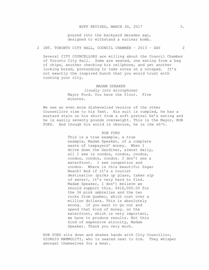
2 INT. TORONTO CITY HALL, COUNCIL CHAMBER – 2013 – DAY 2
Several CITY COUNCELLORS are milling about the Council Chamber of Toronto City Hall. Some are seated, one eating from a bag of chips, another checking his cellphone, and yet another looking bored, pretending to take notes on a notepad. It’s not exactly the inspired bunch that you would trust with running your city.
MADAM SPEAKER
(loudly into microphone) Mayor Ford. You have the floor. Five minutes.
We see an even more dishevelled version of the other Counsellors rise to his feet. His suit is rumpled, he has a mustard stain on his shirt from a soft pretzel he’s eating and he is easily seventy pounds overweight. This is the Mayor, ROB FORD. And though his world is obscure, he is the sh*t.
ROB FORD
This is a true example… a true example, Madam Speaker, of a complete waste of taxpayers’ money. When I drive down the Gardiner, almost daily, all I see is condos, condos, condos, condos, condos, condos. I don’t see a waterfront. I see congestion and condos. Where is this beautiful Sugar Beach? And if it’s a tourist destination (picks up glass, takes sip of water), it’s very hard to find. Madam Speaker, I don’t believe we should support this… $416,000.00 for the 36 pink umbrellas and the two rocks from Quebec, which cost over a million dollars… This is absolutely wrong. If you want to go out and spend that kind of money… on the waterfront, which is very important, we have to produce results. Not this kind of expensive atrocity, Madam Speaker. Thank you very much.
ROB FORD sits down and shakes hands with City Councillor, GIORGIO MAMMOLITI, who is seated next to him. They whisper amongst themselves for a beat.

BUFF REVISED, MARCH 30, 2017 4.
NARRATOR (V.O.) Now, I was never part of Ford Nation to be honest (ok yes, I did vote for him back in 2010). But I have to say… perhaps with the Fords, there could have been some hope for this city to pursue more meaningful waterfront initiatives instead of a large, over-priced sandbox with three dozen “Jackie Kennedy” pink patio umbrellas.
SMASH CUT TO BLACK
CITY TV NEWS REPORTER (V.O.) It is perhaps the finest piece of real estate in the City of Toronto and yet it has been vacant since 2012 when the government decided to close it for a revitalization that, to this day, has not yet happened…
3 1) CU OF EXT. ONTARIO PLACE SIGN 3 4 2) WIDE SHOT OF DESOLETE ONTARIO PLACE GROUNDS, WITH LOCKED 4 GATES AND NO TRESPASSING SIGNS 5 EXT. ONTARIO PLACE - 2014 – DAY 5 CU of Mayor ROB FORD speaking to CITY TV NEWS REPORTER.
ROB FORD This is a gem that we can turn into a bigger gem… and a highlight for this city…
6 CLIP OF ROB FORD AND CITY TV NEWS REPORTER WALKING AROUND 6
THE ENTRANCE TO ONTARIO PLACE.
CITY TV NEWS REPORTER (V.O.) There are so many ideas for what to do with Ontario Place and Rob Ford has one that he thinks will help the city out, financially at least…
7 EXT. ONTARIO PLACE – CONTINUOUS 7 Back to the scene.
ROB FORD I think we need to figure out exactly what dollars can be made here and

BUFF REVISED, MARCH 30, 2017 5.
think outside the box for once. And honestly… there’s nothing wrong with a CASINO coming forward--
The scene freezes.
NARRATOR (V.O.) A CASINO? REALLY? Ok. So maybe there was no hope with Rob Ford after all (God rest his soul).
8 EXT. ONTARIO PLACE – CONTINUOUS 8 Back to the scene.
ROB FORD is posing for photographers and grinning while displaying poker chips in one hand and playing cards fanned out in the other hand.
ROB FORD
Royal FLUSH!! We see camera flashes from the photographers.
NARRATOR (V.O.) Yeah. My thoughts exactly Rob… But to be honest, Ford was not the first and probably not the last politician to have some pretty wild ideas for the waterfront…
9 QUICK CUTS: STOCK PHOTOS OF F.L. OLMSTEAD, JOHN ANDREWS, 9 METRO CENTRE, TORONTO UNION TERMINAL, EB ZEIDLER, WILLIAM
DENNISON, HARBOUR CITY, AND JANE JACOBS
NARRATOR (V.O. – CONT’D) And even those officials who believed that dull Toronto could benefit from the imagination and insight of renowned architects and city planners, they too ended up with some rather interesting proposals. These projects, though never built, have since taken on a kind of legendary status in their spectral incarnation…
SCENE FADES TO BLACK.

History Lesson 1

Fig. 02: Sugar Beach, 2016 (source: Claude Cormier Architects)

Fig. 03: Mayor Rob Ford, 2013 (source: The Toronto Star)

Fig. 04: Ontario Place, 2014 (source: Rayson Ho)

Fig. 05: Birds-eye view of Toronto, 1876 (source: G. Gasgard and Alexander Craig)

Fig. 06: The Condominiumization of Toronto, 2016 (source: Partisans Architects)

Fig. 07: York Harbour (Toronto), 1797 (source: J. Bouchette)

Fig. 08: Toronto Harbour Nautical Chart 2085, ed. 2013 (source: Fisheries and Oceans Canada)

Here & Now: About the Lake

15.
“I still distinctively recollect the untamed aspect which the country exhibited when I first entered the beautiful basin, which then became the scene of my early hydrographical operations. Dense and trackless forests lined the margin of the lake and reflected their inverted images in its glassy surface… The bay and neighboring marshes were the hitherto un-invaded haunts of immense coveys of wild fowl.”1
Joseph Bouchette (1832)
The City of Toronto’s relationship to Lake Ontario is similar to
that of other cities also situated near a large body of water: its
location means that the city enjoys access to both a major
navigational route for trade and commerce, and an unlimited
supply of fresh water. Moreover, the size of Lake Ontario and
its connection to the Atlantic Ocean make it a unique
“ecological wonder” through which all the Great Lakes water
runs.2 Toronto is thus a strategic outpost that, within the span
of a couple of centuries, has grown into a global city that is
the largest in Canada.3 Unfortunately, however, unlike other
waterfront cities, Toronto has failed to uphold its harbour to
the high standards expected of a world-class metropolis.
Although the health and maintenance of the Toronto Harbour
has been on the agenda of municipal authorities since the
city’s inception in 1834, all of their initiatives have failed to
restore this natural basin to its original, pristine condition. In
fact, by as early as 1876, the source of potable water obtained
directly from the harbour was already compromised, which

16.
resulted in widespread outbreaks of cholera and other
diseases among the population. In response, Toronto Water
Works sought to relocate its water treatment intake pipe from
the inner harbour to the lakeside of Toronto Island, so as to
keep the water inlets as far away as possible from the
contaminated inner harbour.4 While this may seem to be a
relatively quick and easy fix, in actuality, this was a band-aid
solution that ultimately did not address the problem of the
pollution itself.
The issue of the harbour’s contamination was not directly
dealt with until 1908, after a city engineer reported three to
four feet of sludge lining the bottom of Toronto Bay.5 This
build up of sewage, in turn, had started to affect the
movement of shipping vessels around the now industrial port.
The discovery of the extent of the pollution problem
subsequently led to the construction of the Main Treatment
Plant (now known as the Ashbridges Bay Wastewater
Treatment Plant) in 1910. Located at the southern end of
Leslie Street, the Main Treatment Plant treated up to 150,000
cubic meters of wastewater per day and served a population
of about half a million people at the time. The plant continued
to expand in the following decades and, together with the
treatment of water by three other facilities built after the city’s
amalgamation in 1954, the condition of the harbour slowly
improved.6 For a short period of time, therefore, the decrease

17.
in contamination led to an increase in proposals for water-
based recreational resources along Toronto’s waterfront.
Although most of these proposals were never realized, they
were indicative of an effort to reconsolidate the historical
relationship between the city and its harbour.
Fast forward some sixty years, however, and those
advancements made during the 1950s and 1960s have now
become insignificant in an ever-expanding city with a current
population of over two and a half million. This sharp
population growth, together with the aging and deteriorating
sewers and watermains, has caused failures in the
infrastructure that have become ever more frequent and
systematic. All of this, in turn, has caused pollution levels in
the harbour to rise once again and, as an added consequence,
has disrupted the once harmonious relationship between the
people of Toronto and the lake. Nowadays the harbour is
regarded as merely a visual spectacle, one that must be
enjoyed from a distance due to the high levels of pollution in
the water. Nevertheless, this visual fetishism has also led to
an unprecedented sprawl of luxury condominiums along the
waterfront, which has created both a physical separation
between the lake and the city, and a social division between
those who can afford lakefront views and those who cannot.

18.
“When modern high-rises and the elevated Gardiner Expressway were planned, they were seen as a pretty decent way of dealing with certain acute problems of the city. Today there is a tendency to consider them grave errors. But one does not have to be a clairvoyant to foresee that the swift and unyielding condominiumization of Toronto has all the right ingredients to become a recipe for the future’s past mistake on a scale that will likely dwarf the Gardiner.”7
Hans Ibelings (2016)
The division that the recent condo boom has brought about
in the City of Toronto is comparable to some other historical
moments in the city’s development that also saw the public’s
connection to the lake dissected by the economical interests
of some private sectors.
During the 1850s for example, several railway companies took
over Toronto’s waterfront to develop their then emerging
industry. This sparked a great deal of controversy and debate
over the impact of industry on access to the lake, as well as
the use and character of the waterfront itself.8 Transportation
again became an issue in the mid-1950s, when debate over
the construction of the Gardiner Expressway, ensued.9 Many
critics of this proposal raised concerns regarding the effect
that such infrastructure would have on the recent efforts to
return the waterfront to the citizens of Toronto for public
recreation and enjoyment. Regardless, the proposal was
pushed forward and the Gardiner was eventually completed

19.
in the mid-1960s, becoming Canada’s first urban freeway.
However, its visual and physical impact still affects the city
today, as its structure has and continues to deteriorate over
time. The Gardiner has subsequently become a blemish on
Toronto’s skyline, rather than a symbol of infrastructural
excellence.
There is a key difference between the above-noted projects
and the recent urban sprawl along Toronto’s waterfront. As
civic projects, these initiatives sought to modernize the city
and thus, bring about economic wealth that would reach the
entire population. By contrast, today’s endeavours seem to
respond only to the individual economic interests of the few
who can afford to benefit from this new, “developer-driven”
urbanization.10 Given this current state of
condominiumization along the waterfront, there is some
question as to whether this trend can be halted or if in fact,
these developments have already come too far. Perhaps then
the solution lies in embracing the status quo and looking
instead for new and innovative ways to address the schism
between Toronto and its harbour.
This thesis proposes that the relationship between Toronto
and the lake is not a superficial one but rather, goes beneath
the surface and deep underground to the infrastructural
network that drives water from the lake to serve this ever-

20.
expanding city. While in the past the many projects realized
and proposed for the waterfront have sought to rationalize
what the lake can do for the city, either visually or
recreationally, this project reverses this methodology and
instead pursues an approach that examines what the built
environment has historically done to/for the harbour. In
doing so, this thesis seeks to address the environmental issues
that currently plague the waterfront, while it also attempts to
reinstate the intimate connection the City of Toronto once had
with its harbour.
Drawing from the lessons learned from Toronto’s past
successes and failures in trying to solve some of its urban
problems, and considering its current status as a commercial,
financial, and industrial global center, this thesis reconciles the
seemingly disparate elements from the city’s history, in order
to arrive at a sustainable future for both the city and its lake.
----------------------------------------------------------------
The following are a series of maps wherein the City of Toronto
is re-interpreted in water terms by using symbols, systems of
measurement, and abbreviations that are typically found on
hydrographic and nautical charts. Unlike a traditional figure-
ground diagram that analyses urban spaces with respect to its
built and un-built fabric, these maps attempt to reorganize the

21.
territory by considering both lake and city as part of a hybrid
terrain.
The resulting charts offer a new understanding of the
relationship between the city and the lake: the difference
between highways and valleys throughout the city disappear,
the built environment becomes shallow, and concepts like
lakeshore and harbour become irrelevant. The city becomes
an island and water becomes the very element that keeps the
city in place.
The red areas of the map correspond to historical sites around
the central Toronto area, while the soundings (water depth
measurements) refer to both the depth of the lake and the
height of some of the residential towers built in the last two
decades. The underlying text visible in the map details is taken
from two contrasting sources that refer to the past and
present of the City of Toronto: the book Visions for the
Metropolitan Toronto Waterfront by Wayne C. Reeves, and the
lyrics to Drake’s album Views from the Six.
----------------------------------------------------------------

Fig. 09: Toronto Chart (image by author)
Fig. 10: Ashbridges Bay Wastewater Treatment Plant (image by author)

Fig. 11: Ontario Place (image by author)

Fig. 12: Sugar Beach (image by author)

BUFF REVISED, MARCH 30, 2017 26. 10 EXT. SKYLINE OF TORONTO – 1960s 10
NARRATOR (V.O) Change was in the air in 1968. Hair opened on Broadway, Rochdale College opened on Bloor Street, Trudeau was going to create a just society, and Buckminster Fuller had a plan to turn Toronto the Good into Toronto the Groovy, the “livingest” city on earth.
11 EXT. TORONTO-DOMINION CENTRE – 1968 – DAY 11
SPEAKER (V.O) This city needs to develop a unique identity. It must maintain a unique role, some pre-eminent capability, which will generate a meaningful influence beyond the boundaries of English-speaking Canada, relating in a distinct and individual way to the world at large.
12 INT. TORONTO-DOMINION CENTRE – PENTHOUSE – DAY 12
A large group of men, each sharply dressed in crisp suits and ties, are seated in a conference room at the penthouse level of the Toronto-Dominion Centre. Many of the men are sceptically flipping through the pages of a shiny white folder. We glimpse the cover of the folder, which reads: PROJECT TORONTO. Despite their dubious expressions, all are listening attentively to the SPEAKER in front of them.
The SPEAKER is BUCKMINSTER FULLER. He is wearing his signature dark coloured suit and thick-lensed spectacles. He stands confidently in front of his project’s display panels. Compared to the politicians and bureaucrats in the room, Bucky looks clever and exuberant. Your classic ENTP.
BUCKMINSTER FULLER
When moving around downtown, one is totally unaware that Toronto is a waterfront and not a prairie city…
On the table is a huge ARCHITECTURAL MODEL of the central waterfront. Among the detailed buildings and highways, there is a giant pyramid next to a tower four times the size of any of the other high-rises modeled.

BUFF REVISED, MARCH 30, 2017 27.
BUCKMINSTER FULLER … That is why I propose a “Gateway Tower”, which would mark the transition from downtown to the waterfront. To the west, this four-hundred-foot Crystal Pyramid would enclose two twenty-storey commercial buildings.
There is silence as the attendees all look at each other in confusion. The silence is broken by the nervous laughter of a few.
One of the men is leaning over, examining the architectural model. He straightens, turns and addresses Bucky directly. IT IS OUR NARRATOR.
NARRATOR I don’t know Bucky… I think we’re losing them.
MUSIC: Hip Hop track, WU-TANG FOREVER by DRAKE, starts to play in the background. BUCKMINSTER FULLER looks over at our NARRATOR and grins.
BUCKMINSTER FULLER Don’t sweat it, man. I’ve got this.
Our NARRATOR grimaces, still not convinced, and turns back to the model. Bucky addresses the crowd again.
BUCKMINSTER FULLER
Together, like the Expo’s geodesic dome did for Montreal, these structures would help to create a global identity that could finally put Toronto on the map!!
The attendees remain silent. Some clap cautiously while Bucky eagerly awaits comments.
NARRATOR (V.O)
Put Toronto on the map? No architecture needed, Bucky. We have Drake for that…
13 INT. AIR CANADA CENTRE – 2016 – NIGHT 13

BUFF REVISED, MARCH 30, 2017 28.
THE HIP HOP SONG KICKS IN AS SOURCE. THE VENUE IS PACKED WITH YOUNG PEOPLE dancing and drinking. We focus on the people screaming in the first few rows, their hands in the air. They are taking pictures of DRAKE as he is performing on the stage.
DRAKE (RAPPING) Machine gun raps for all my n****s in the back. Stadium packed, just glad to see the city on the map. I just gave the city life. It ain’t about who did it first, it’s about who did it right.
N****s looking like “PREACH”…
CU of girls and boys singing along to the music and taking selfies with their backs to the stage. MUSIC CONTINUES.
NARRATOR (V.O)
He might have started from the bottom, aka Weston Road, but as his music fortunes rose he took Toronto with him. How much is Drake’s endorsement worth to the city, you ask? That would be a cool $3 BILLION.
As the song comes to an end, DRAKE raises his hand and points towards the crowd.
DRAKE
TORONTO! Thank you all. I’d love to do this with you again sometime if you are interested…
We hear the roar of the crowd, as the fans cheer loudly in response.
DRAKE (CONT’D)
So… with that being said, I only ask for one more favour: Just get home safe and THANK. ME. LATER!!
14 EXT. AIR CANADA CENTRE – NIGHT 14
We see DRAKE exiting the stage. He is followed by his security crew, who usher him towards a black LIMOUSINE that is parked just outside the venue. Our NARRATOR gets out of the limousine as DRAKE steps in. CU of our NARRATOR walking away from the limousine.

BUFF REVISED, MARCH 30, 2017 29.
NARRATOR (speaking to camera)
Now of course, Drake didn’t single-handedly put Toronto on the map since the city had actually been doing quite well on its own. However, he did coin a new nickname that fast became a worldwide trend: #the6ix.
15 FAST CUTS: GRAPHICS OF VARIOUS MERCHANDISE PROMOTING THE 15 6IX, CELEBRITY INSTAGRAM ACCOUNTS REFERENCING #THE6IX, ETC.
NARRATOR (V.O.) But the 6ix is not just a catchy phrase. It actually has deep connections to the city’s history. Here is Drake himself to explain…
16 INT. BLACK LIMOUSINE – DOWNTOWN TORONTO - NIGHT 16
Drake wearing a black leather jacket with an oversized fur collar, is seated in the back of the limo while he explains the origins of the 6ix. His arms are draped over the girls seated on either side of him, one of whom is popping bottles and pouring champagne into glasses. He leans forward, towards the CAMERA.
DRAKE
Basically, all I did was find a way to make people proud of our city. The 6ix is like a Toronto thing, you know? It derives from one point in time, when the city was broken up into six areas. Like… you had the old City of Toronto, York, East York, Etobicoke, North York, and Scarborough (REPRESENT!). Those areas then all came together to become the great City of Toronto as we all know it today.
Drake takes a sip from the glass offered to him by one of the girls. He turns back to the camera, confused.
DRAKE
But yo, what does this have to do with the waterfront… or the lake for that
matter?
SMASH CUT TO BLACK.

History Lesson 2

Fig. 13: Buckminster Fuller, 1968 (source: Clara Thomas Archives)

Fig. 14: Project Toronto, 1968 (source: Clara Thomas Archives)

Fig. 15: Cover of Drakes Album Views, 2016 (source: Cash Money Records)

Fig. 16: Harbour Reclamation, 1890-1920 (source: City of Toronto Planning Board)

Fig. 17: Harbour City Model, 1970 (source: Toronto Public Library)

Fig. 18: Torontos changing Harbour, 1834-1985 (source: Toronto Island Public School)

Here & Now: About the City

38.
“The purification of Toronto’s Bay will restore that beautiful sheet of water to its original attractiveness, healthfulness and utility. Old residents of Toronto can remember the playground of Toronto: the training ground for the muscle and blood of young Toronto was not the island or some distant lake; it was the waters of Toronto Bay”.11
Mayor Oliver Aikin Howland (1902)
During the first part of the twentieth century, the City of
Toronto had set its sights on expanding and transforming
itself into a major North American hub, on two different fronts.
Firstly, city officials sought to revitalize the waterfront and
Toronto islands through various schemes that, even where
only partially implemented, would eventually dictate the
overall design parameters that still shape the city’s harbour.
Furthermore, the city was also continuing to expand
northward; a rapid growth that subsequently made
infrastructure a priority for city officials, to allow for the
suburbanization of these areas north of Toronto.
With regards to the first objective, one of the most important
waterfront revitalization proposals was the Toronto Harbour
Commissioners Plan of 1912. This plan sought to reorganize
the waterfront to make room for both recreational and
industrial uses and included, among others, recommendations
by American architect and city planner, Frederick Law Olmsted
Jr. Olmsted’s influence can be observed in the overall
character of the scheme, which borrowed heavily from the

39.
North American Beautiful Movement of the late 1800s; a
reform philosophy that emphasized the beautification or
aesthetic transformation of cities.
A particularly important feature of the 1912 proposal included
the construction of a series of bridges to link the mainland to
the Toronto Islands, as had been suggested in many other
prior reports. This would have allowed for the creation of a
“Lake Shore Drive,” namely a boulevard to connect the east,
west, and central portions of the plan and thus, permit the
passage of streetcars and vehicles onto the island. However,
this cross-island boulevard ultimately met an early demise
when the First World War required government officials to
divert their priorities elsewhere.12 Although the idea has been
revisited over the years, the establishment of a physical built
connection between the city and its islands has consistently
failed to become a reality.
In contrast to the above, the only section of the 1912 plan that
did indeed come to fruition shortly after the scheme was
proposed was the reclamation of an area of land known as
Ashbridges Bay. By the beginning of the twentieth century,
this had become a priority for several reasons. Firstly, the
polluted state of the harbour and Ashbridges Bay had led to
increased public pressure for a solution. Moreover, there was
a serious shortage of industrial and port land, and particularly

40.
berths for large ships.13 As such, the new Toronto Harbour
Industrial District (as it was first called) that was created,
constituted the plan’s focal point and in fact, its justification.
The twenty-seven million cubic yards of material that was
subsequently dredged from the lake bed and used to expand
this area, became the largest project of its kind to ever be
undertaken in Canada.14
The completion of the Ashbridges Bay land reclamation
project contributed to the rapid growth of the city’s economy.
It allowed for further development of Toronto’s industrial
capacity and in doing so, helped to establish it as an important
port in the region. However, perhaps more significantly, this
project set an important precedent in Toronto for future land
reclamation initiatives, which sought to provide space for both
infrastructure and recreational ventures around the harbour
area. This included, for example, the creation of an airport in
the 1930s.
Land reclamation was also a central concept behind the rather
bold proposals of the 1960s, most of which were never
realized, although some like Ontario Place did come to
fruition.15

41.
“Toronto, like many ports, has a history of extension into its lake and harbour. 150 years ago, the present Union Station and all lands south of it were harbour waters. In the past, these new lands have been created and used for industry, port facilities and transportation routes that have separated the city and its people from the water. But today we are given another opportunity to reclaim the potentially beautiful shoreline we once had.”16
Minister Stanley J. Randall (1969)
Towards the end of the 1960s, the future of the Toronto
waterfront was embodied by the Harbour City project of
architect, Eberhard Zeidler (Craig, Zeidler & Strong).
Following the successful completion of his Ontario Place
complex, the provincial government again enlisted Zeidler
and a team of consultants to complete a proposal for a town
of about sixty thousand residents, built over a series of
artificial islands between Ontario Place and Toronto Island.
Zeidler’s vision was of a true “water city” reminiscent of Venice
or Amsterdam, and he sought to use this site to give Toronto
a unique new waterfront for the enjoyment and interest of
all.17
Another key player in the development of the Harbour City
proposal was renowned American-Canadian journalist,
author, and urban theorist, Jane Jacobs. Jacobs often
promoted a community-based approach to city building and
Harbour City was no different. Consistent with her theories on

42.
successful urban neighbourhoods, this project allowed for
enough flexibility in zoning for residential and commercial
uses to expand and contract within the development,
depending on the circumstances. This flexibility was also
supported through Zeidler’s design of the buildings
themselves.18
“This is a very high-density project. Yet there is nothing impersonal, or overwhelming or routine about it. This is one of the reasons why I personally think that this may well be the most important advance in city planning that has been made this century.”19
Jane Jacobs (1970)
Perhaps the most important aspect of this Harbour City
proposal was that it acted as a counter-response to the
growth of the downtown core of the time. Much in the same
way that the present-day waterfront is pierced with
condominiums being erected at an unprecedented speed,
development back in the 1960s also attempted to achieve
density by building vertically, through a series of high rises.
By contrast, Harbour City sought to use low buildings,
structured around intimate spaces, where the boundaries
between land and water would be much more fluid.20
Further, like the 1912 plan, Harbour City also promoted the
wholesale re-working of the waterfront in form and function,
offering both an enlargement of the public realm and

43.
development opportunities for the private sector. Yet the
scale and character of these two projects differed greatly.21
Ultimately, Harbour City did not move past the proposal stage,
due to the failure of Toronto’s politicians to align the general
public’s perception of the project with the necessities of
planning the future of the city. Although the architecture itself
was liked well enough, the issue appeared to be with the
advisability of the concept itself.22 Thus, in the end, Zeidler’s
vision for the Toronto waterfront was doomed to join the
other legendary projects like Buckminster Fuller’s Project
Toronto, which today form part of the city’s “un-built” past.
“The ‘Metro Years’, as they are called, have come to be viewed as something of a golden age of municipal jurisdictions, and the years that followed, with their fragmented municipal jurisdictions and near absence of overall regional planning, as something quite base. The fact is that building and managing the region’s infrastructure to serve the broad public interest was much easier before, say, 1973 than in the twenty-five years since. It is no wonder the region is still operating with infrastructure built in that golden age.”23
Richard White (2003)
Around the same time that these waterfront proposals were
being put forward to extend the city into the lake, Public
Works was embarking on an unparalleled infrastructural
expansion to accommodate the expanding borders of the city
itself. This had become necessary in the post-war period,
where the undersized and outdated municipal services were
44.
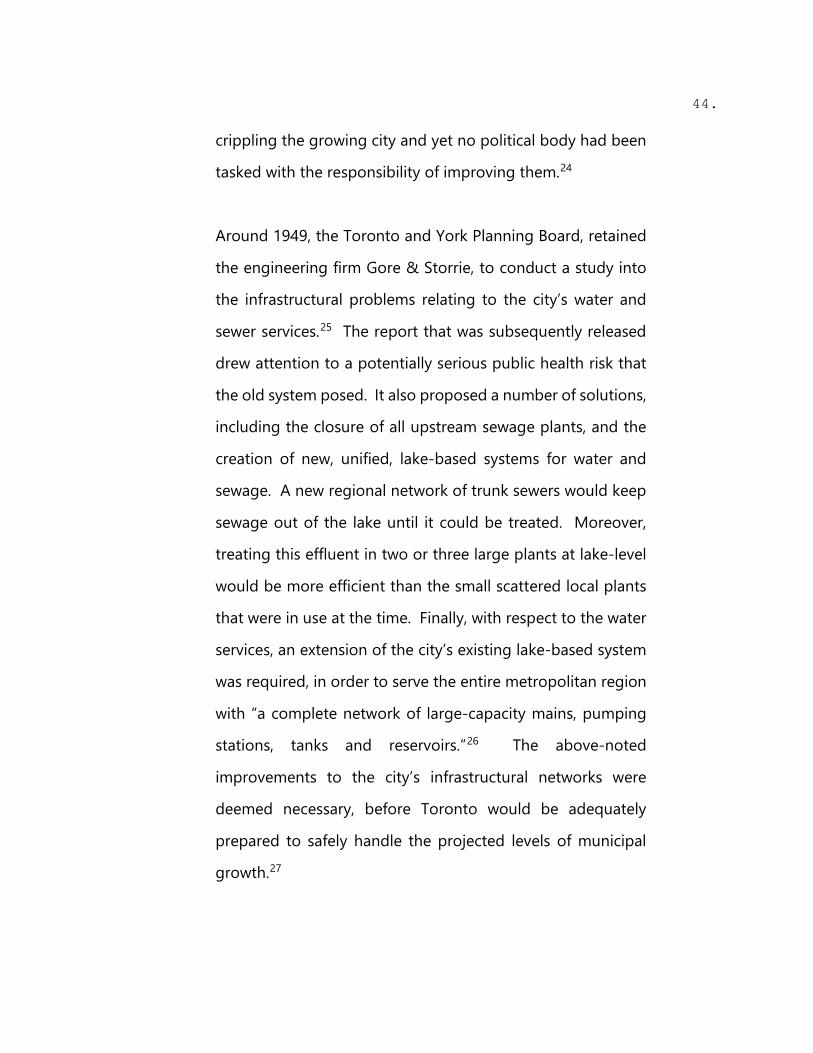
crippling the growing city and yet no political body had been
tasked with the responsibility of improving them.24
Around 1949, the Toronto and York Planning Board, retained
the engineering firm Gore & Storrie, to conduct a study into
the infrastructural problems relating to the city’s water and
sewer services.25 The report that was subsequently released
drew attention to a potentially serious public health risk that
the old system posed. It also proposed a number of solutions,
including the closure of all upstream sewage plants, and the
creation of new, unified, lake-based systems for water and
sewage. A new regional network of trunk sewers would keep
sewage out of the lake until it could be treated. Moreover,
treating this effluent in two or three large plants at lake-level
would be more efficient than the small scattered local plants
that were in use at the time. Finally, with respect to the water
services, an extension of the city’s existing lake-based system
was required, in order to serve the entire metropolitan region
with “a complete network of large-capacity mains, pumping
stations, tanks and reservoirs.”26 The above-noted
improvements to the city’s infrastructural networks were
deemed necessary, before Toronto would be adequately
prepared to safely handle the projected levels of municipal
growth.27

45.
The recommendations included in the study by Gore & Storrie
were ultimately pursued and implemented several years later,
following the creation of Metropolitan Toronto in 1954.
Although there were a number of factors that led to the city’s
amalgamation, this report played an important role in its
conception.28 City officials quickly understood what the
consulting engineers had discovered; that the provision of
water and sewer services was essential to allow for future
growth and to improve overall conditions for its citizens. With
this knowledge came the realization that a unified political
structure would be necessary to provide the appropriate
infrastructure and thus, the idea for an amalgamated Metro
Toronto was born.29
----------------------------------------------------------------
The next series of drawings depict each of the six boroughs
that make up the City of Toronto after the amalgamation of
1954.
These maps show each borough as an island with only the
borders of those regions outside of the City of Toronto
denoted (Vaughan, Mississauga, Markham and Pickering).
Also included are the various rivers and creeks that run
throughout each borough, together with the location and
description of all the water and waste water treatment plants
and pumping stations within each municipality.

46.
By juxtaposing these two layers onto the same map, one
begins to understand the scale of the City of Toronto’s sewage
and water supply systems, as well as the way in which this
intricate network connects all of the six municipalities directly
to the lake. Lake Ontario and the rivers and creeks that run
throughout the city, also form a natural network that defines
the limits of the different boroughs but more importantly, has
brought together a built density that has slowly moved north
and away from the shore.
----------------------------------------------------------------

Fig. 19: Toronto (image by author)

Fig. 20: York (image by author)

Fig. 21: East York (image by author)

Fig. 22: Etobicoke (image by author)
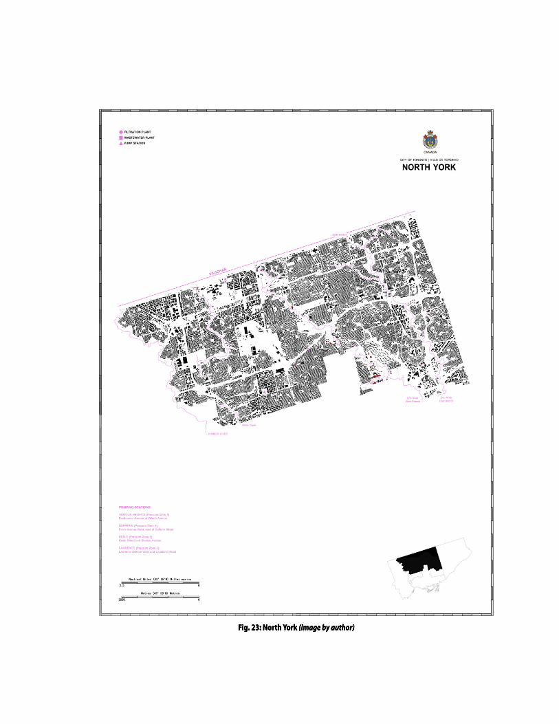
Fig. 23: North York (image by author)

Fig. 24: Scarborough (image by author)

BUFF REVISED, MARCH 30, 2017 53. 17 INT. ONTARIO MUNICIPAL BOARD (OMB) – TORONTO – 1951 – DAY 17
A heated debate is taking place among the city councillors regarding the Toronto and York Planning Board’s (TYPB) proposal for a unitary form of local government – the amalgamation of the suburbs and municipalities into the city and the creation of the Municipality of Metropolitan Toronto.
NARRATOR (V.O.) You see, Drake, to manage the city’s growth that was pushing outward from its pre-war boundaries, the provincial government embarked on an innovative experiment in urban governance. In 1953, it created the Municipality of Metropolitan Toronto, a two-tier federation that ultimately consisted of six local municipalities – THE 6IX! At the heart of its conception? A CENTRALIZED WATER INFRASTRUCTURE SYSTEM that could better serve the periphery.
FREDERICK G. GARDINER, who is the Chair of the TYPB, addresses the OMB panel – a three-man panel chaired by Lorne R. Cumming.
FREDERICK G. GARDINER Chairman Cumming, the lack of a comprehensive, coordinated plan for the city has become a serious problem… a problem to which we simply cannot turn a blind eye any longer. Take our sewage disposal system, for example. You have upstream treatment plants in the suburban municipalities dumping effluent into the overloaded Don and Humber rivers at an alarming rate. The consequence? We down here in Toronto have to deal with their sh*t. Literally!
A few of the counsellors emit sounds of muffled laughter.
FREDERICK G. GARDINER (CONT’D) This can no longer be tolerated. Unified control over water supply, sewage disposal, and storm water is absolutely essential in order to protect the health of our citizens. Which is why we support the proposal

BUFF REVISED, MARCH 30, 2017 54.
before you today, Chairman Cumming. An amalgamated city – one big government – would allow us to govern more effectively and efficiently.
There is cheering from the counsellors and several rise to their feet as Frederick Gardiner takes his seat.
NARRATOR (V.O.) But of course, support for unification was by no means unanimous among the local municipalities. The enduring stinginess and lack of vision plaguing Toronto politics almost sabotaged this initiative as well.
One man, OLIVER E. CROCKFORD, who is the reeve of the Scarborough Township, stands up and tries to regain control of the room.
OLIVER E. CROCKFORD
Chairman Cumming, if I may… these regional problems are being exaggerated. Our existing institutions are perfectly capable of ensuring orderly and controlled development. What Mr. Gardiner is proposing here is so undemocratic, so Socialistic, that it is unworthy of consideration by the freedom-loving Canadians that we represent. The proposed Metro Toronto is a task that only a superman or a dictator like Hitler, Mussolini, Stalin, or Tito would entertain.
Gardiner shakes his head incredulously and leans over to share his frustration with the councillors seated around him.
NARRATOR (V.O.) Regardless of the opposition, centralized control did come about in 1953 with Lorne Cumming’s OMB recommendation and the passing of the MUNICIPALITY OF METROPOLITAN TORONTO ACT. And with this, not only did Toronto become a Megacity but it also gave rise to its first supermayor… none other than “Big Daddy” himself, Frederick Gardiner.

BUFF REVISED, MARCH 30, 2017 55. 18 FOOTAGE FROM 1953 INAUGURATION OF FREDERICK GARDINER AS 18
THE FIRST CHAIRMAN OF METRO TORONTO.
NARRATOR (V.O. – CONT’D) Though he was appointed and held no formal voting power, the thick-browed and silver-tongued giant grabbed the council’s reins and steered the city through a period of furious postwar growth that saw Toronto “shrink at the core and burst at the seams.”
19 EXT. SKYLINE OF NEW YORK CITY – 1950s 19
NARRATOR (V.O.) Shortly after he took the job, Fred Gardiner went to the Big Apple – New York City – to discuss capital projects and spending with that city’s famous but controversial chief of construction, ROBERT MOSES; a man whom Gardiner admired and to whom Gardiner has frequently been compared.
20 INT. MANHATTAN OFFICE – 1953 – DAY 20
ROBERT MOSES Now, Fred. What the hell are you going to do with that mess up there, now that you’re in charge of it?
FREDERICK GARDINER I am going to be like Stalin.
Robert Moses laughs.
FREDERICK GARDINER
No seriously, Bob. I’m going to make a five-year plan that will lay out exactly what I have, how I am going to spend it, and I will know exactly where the money is going.
ROBERT MOSES
Well then, my only piece of advice: Never mind those high-minded advisers. Keep your staff small. Don’t let them boss you around. Hire them when you want and fire them when you want.

BUFF REVISED, MARCH 30, 2017 56.
Make them work for you and not the other way around.
FREDERICK GARDINER
I know, Bob. That’s exactly how I intend to proceed. I’m going to run my own show. That is why they call me The Bulldozer, after all.
The men both laugh and continue their discussion.
21 1) TRACKING SHOT OF CONSTRUCTION SITES DURING THE 1950s. 21
A BULLDOZER AND OTHER MACHINERY ARE SEEN EXCAVATING AND DEMOLISHING OLD STRUCTURES (STOCK FOOTAGE).
NARRATOR (V.O.)
A Bulldozer, indeed. Gardiner’s five-year capital works program was quickly approved in 1954, and it emphasized Metro’s water supply and sewerage as a priority.
22 2) FREDERICK GARDINER VISITING POTENTIAL SITES WITH CITY 22
OFFICIALS AND SUPERVISING ONGOING PROJECTS (STOCK FOOTAGE).
NARRATOR (V.O. – CONT’D) The top water supply projects were the rehabilitation and expansion of the Scarborough and R.C. HARRIS FILTRATION PLANTS, and the John Street pumping station, while the sewerage priorities were the expansion of the ASHBRIDGES BAY TREATMENT PLANT and the construction of new facilities at the mouths of the Humber River and Highland Creek.
23 3) R.C. HARRIS WATER TREATMENT PLANT AND ASHBRIDGES BAY 23
TREATMENT FACILITY EXPANSIONS, UNDER CONSTRUCTION (STOCK FOOTAGE).
NARRATOR (V.O. – CONT’D)
As you can see, these initiatives were all lakefront oriented and to this day, they remain an example of a truly successful waterfront development, which literally reconnected the city to its harbour: a waterfront project on an URBAN SCALE. Take the R.C. Harris Treatment Plant for example;

BUFF REVISED, MARCH 30, 2017 57.
one of the city’s great architectural gems. Yet, not many people are even aware of its existence, never mind the important role it plays in providing a necessary resource that we rely on every day: clean, drinking water.
24 4) FREDERICK GARDINER BEING INTERVIEWED BY A NEWS REPORTER 24
FROM THE TORONTO TELEGRAM OUTSIDE OF CITY HALL – 1954 – DAY
CU of Frederick Gardiner speaking to NEWS REPORTER.
NEWS REPORTER
So what do you say to those who oppose the series of multi-million dollar development projects that you are proposing for this city?
FREDERICK GARDINER (laughs as he answers)
You won’t leave your footprints on the sands of time by sitting your ass on the beach, will you?
We see Gardiner walking away from the crowd of news reporters. They follow him, shouting more questions at his retreating back. SCENE FADES TO BLACK.

History Lesson 3

Fig. 25: Frederick Gardiner, 1964 (source: The Toronto Star)

Fig. 26: Ashbridges Bay Wastewater Treatment Plant, 1965 (source: Toronto Archives)
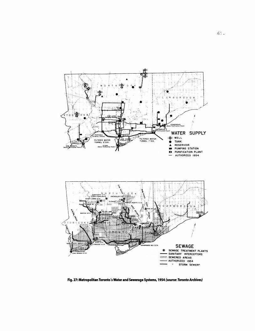
Fig. 27: Metropolitan Torontos Water and Sewerage Systems, 1954 (source: Toronto Archives)

Fig. 28: Metropolitan Torontos Water and Sewerage Systems, 1967 (source: Toronto Archives)
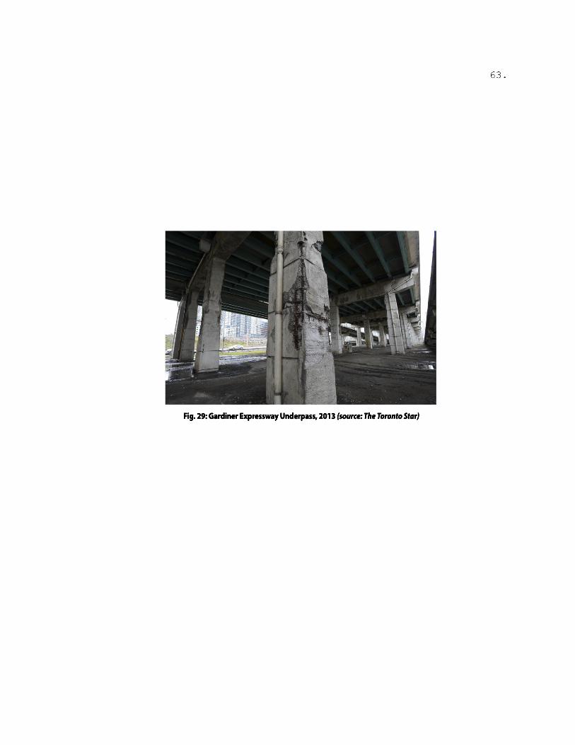
Fig. 29: Gardiner Expressway Underpass, 2013 (source: The Toronto Star)

Fig. 30: Gardiner Expressway Reconguration Proposal, 2015 (source: Entuitive)

Here & Now: About Infrastructure

66.
“If architecture is received in a state of distraction as Walter Benjamin wrote, we might locate sewers, power networks, and rail lines even further beyond awareness. Maybe that explains how the world’s infrastructure, including that of the United States, has been ignored for so long that it now threatens those it was meant to serve.”30
Dana Cuff (2010)
This thesis proposes the design of offshore sewer interceptors
in the inner harbour that could serve as an extension of the
City of Toronto’s aging sewage infrastructure. In recent years,
the capacity of the system has been overwhelmed by the
increased density of the downtown core and the deluge from
extreme thunderstorms. For example, within a span of eight
years, from 2003 to 2011 alone, Toronto was hit with
thunderstorms, three of which were only supposed to occur
“once in a century,” and five that were to happen “once in fifty
years.”31 The increased frequency of extreme weather
conditions, mostly due to climate change, has placed
significant strain on the city’s current infrastructure system.32
In addition to this, the lack of investment in upgrades and
maintenance from City Hall has caused the existing
infrastructure to deteriorate rapidly.33 This abandonment of
the maintenance and upgrade of urban infrastructural
networks is not a problem unique to Toronto, but rather is a
widespread issue that cities around the world are having to
face in recent years. In the United States, for example, there

67.
was a boom in public works initiatives completed, first during
the Great Depression, and then again during the 1950s. These
aging systems are now nearing the end of their useful life and
are increasingly becoming in dire need of repair or
replacement.34 Unfortunately, however, since infrastructure is
largely hidden from public view, these issues often do not
come to light until too late, namely, when the structures
ultimately fail.
Toronto has indeed seen the repercussions of its aging
infrastructural networks, both visible and hidden. A great
example of the former is the present rundown state of one of
the city’s most important engineering projects of the 1950s,
the Frederick G. Gardiner Expressway. This iconic
thoroughfare has been widely discussed in recent years with
a series of innovative replacement/revitalization proposals,
including an exciting project that would have seen most of the
elevated central section of the Gardiner taken down and
replaced by an underground tunnel.35 Such an initiative
would have allowed for the development of new communities
all along this existing derelict area, which could have been a
significant step towards the long sought-after reconnection of
the city’s core to its waterfront. These proposals, however,
have not been realized due to a lack of municipal funds and
the short-sightedness of politicians at the municipal and
provincial levels.36

68.
In contrast to the more visible structures described above,
Toronto’s hidden infrastructure was left out of the political
agendas of its elected officials over the past several decades.
The water and sewage networks in particular had been
neglected; that is, until around July 2013, when large-area
flooding and widespread power outages finally forced the city
to pay closer attention.37 During this time, an extreme
thunderstorm created high levels of rainfall, which
overwhelmed the city infrastructure and caused its waterways
to fail. This storm and the resultant flash floods led to over
$850 million in property damage, setting a record for the
province’s most expensive natural disaster and sending a
wakeup call to city officials.38
The impact of increased heavy rain and power outages has
proven to be particularly problematic for Toronto’s
wastewater treatment plants. During the storm of July 2013,
the city was forced to release more than one billion litres of
raw sewage into Lake Ontario in a single day.39 This is hardly
exceptional, however, as sewage bypasses from the city’s main
wastewater treatment plants have become a more frequent
event in recent years, happening as often as four or five times
a month.40 According to a report released in 2011 by the
international Commission for Environmental Cooperation
(CEC), Toronto’s Ashbridges Bay wastewater treatment plant
was named the top surface water polluter in all of North

69.
America, with an annual on-site surface water discharge of
over 13.5 million kilograms.41 This in turn, has once again
transformed Lake Ontario into a health hazard for its citizens.
Toronto’s inner harbour in particular, receives an extra load of
sewage through combined sewer outfalls (CSOs) that release
excess sewage from pipes designed to overflow into the lake
to relieve pressure on the system.42
The difficulty in addressing this issue now is that Toronto is
already facing a backlog of $1.7 billion in repairs and upgrades
to its water and sewage systems, with an expected $8.7 billion
in additional spending projected until 2020.43 This is the
largest infrastructural renewal backlog of all urban centres in
Canada. However, unlike the proposed renewal of bridges
and highways, the planned upgrades to these “hidden”
infrastructural networks are anything but innovative. One
example is the Don River and Central Waterfront Project, also
known as the Don and Waterfront Trunk Sewers and CSO
Control Strategy. This project aims to eventually delist the
Don River and Toronto inner harbour as “a polluted Great
Lakes Area of Concern,” while also sustaining the rapid growth
of the city “efficiently and securely.”44 The proposal involves
not only a series of upgrades to the existing underground
networks, but also introduces fifteen vertical storage shafts
and three satellite tanks for offline storage of combined sewer
overflows.45 All eighteen of these new storage units are to be

70.
built underground and hidden from plain view. In this way,
although the project attempts to remediate the impact of
aging water and sewage infrastructure to both the city and the
environment, it does so in a manner that merely duplicates the
now defunct water and sewer systems that were built over a
century ago. Even more importantly, it further perpetuates
the age-old “out of sight, out of mind” dictum, which is
ultimately responsible for the city’s current state of
infrastructural crisis and backlog today.
----------------------------------------------------------------
The following sections along the city’s waterfront evaluate and
compare the relationship between the city skyline and the
depth profile of the harbour and the lake beyond the island.
As the drawings reveal, the disconnection between the city
and the harbour is also a vertical one, particularly around the
central waterfront, where buildings rise up to over 553 meters
(the CN Tower) while the inner harbour remains at an average
depth of 8 meters.
Also included as part of the drawings, is the location of some
iconic “visible” infrastructural works in Toronto located along
the waterfront. These include, among others, the Gardiner
Expressway, the Hearn Power Generating Station and of
course, the CN Tower, one of the most defining features of the
city skyline.
----------------------------------------------------------------

Fig. 31: Toronto Sections (image by author)

Fig. 32: Detail - Ontario Place and Billy Bishop Pedestrian Airport Tunnel (image by author)

Fig. 33: Detail - CN Tower and Sugar Beach (image by author)

Fig. 34: Detail - Hearn Generating Station and Ashbridges Bay (image by author)

BUFF REVISED, MARCH 30, 2017 75. 25 EXT. R.C. HARRIS TREATMENT PLANT – DAY 25
We see the grounds of the treatment plant. Quiet. Peaceful. A girl walks her dog on one of the grassy lawns, sloped downwards towards the water. One car is seen parked on the winding road leading to the lake.
NARRATOR (V.O.)
I hate to break it to you, but if you live in Toronto, you drink Lake Ontario. You probably showered with Lake Ontario this morning. Later tonight, if you’re the type of person who takes oral hygiene very seriously, you’ll brush your teeth with toothpaste and Lake Ontario for the second time today, and then rinse the foam out of your mouth with Lake Ontario. Hell, that fancy Triple-Venti-Soy-No Foam Latte you’re drinking? Yep, you guessed it: mostly Lake Ontario.
QUICK CUT: CU of the girl walking her dog. She is holding a Starbucks cup. She looks at it in disgust.
NARRATOR (V.O. – CONT’D)
But not to worry. Before any of that lake water makes it to your sink or shower (or your latte), it needs to be made safe for your consumption. And that’s where the R.C. Harris Water Treatment Plant comes in.
26 TRACKING SHOT OF THE ADMINISTRATION BUILDING OF THE R.C. 26 HARRIS TREATMENT PLANT.
NARRATOR (V.O.) The original structure was completed in 1941 by the engineering firm, Gore, Nasmith, and Storrie, whose architect, Thomas Canfield Pomphrey, designed the plant in the art deco style that was fashionable in its day. The resulting edifice is a huge compound of buff brick that looks like a factory straight out of the land of Oz. And if you’re as big a fan of the Italian Futurists as I am, you can be certain that Sant’Elia would approve.

BUFF REVISED, MARCH 30, 2017 76. 27 FAST CUTS: OLD CITY NEWSPAPER CLIPPINGS WITH FRONT PAGE 27
HEADLINES CRITICIZING THE TREATMENT PLANT: “LAVISH WASTE OF MONEY”, “OUTRAGE”, “EGO & EXTRAVAGENCE: COMISSIONER HARRIS STRIKES AGAIN”, “COSTLY WATER WARS”, ETC.
NARRATOR (V.O.)
Unsurprisingly, not all Torontonians shared in the futuristic vision of Roland (Roly) Caldwell Harris, the city’s Commissioner of Works who was in charge of the project.
28 INT. GORE, NASMITH & STORRIE HEADQUARTERS – TORONTO – 28 1930s – DAY
A meeting is taking place between R.C. Harris and architect, THOMAS CANFIELD POMPHREY, regarding the design of the water treatment plant. Harris has just seen Pomphrey’s first design proposal.
R.C. HARRIS
Listen, Pomphrey, I know this is not the kind of commission that you’ve worked on before, but it is important that this plant be more than just your everyday utilitarian structure of water purification…
THOMAS CANFIELD POMPHREY But that’s just what it is: a water treatment plant! Why do you need to make it more complicated than that? It works and that’s what is important.
R.C. HARRIS (firmly)
NO. I need the citizens to realize… to see the deeper significance of the plant and what it means for this city. It must be a celebration of Toronto’s connection with the lake, the source of our water, and the very reason behind this city’s existence!
THOMAS CANFIELD POMPHREY Umm…OK…
R.C. HARRIS By the time we are finished here Pomphrey, the construction of this

BUFF REVISED, MARCH 30, 2017 77.
glorious building will be viewed by all as an accomplishment of courageous vision and abiding faith. Just you wait and see.
29 EXT. R.C. HARRIS TREATMENT PLANT – DAY – CONTINUOUS 29
Back to the scene.
NARRATOR (V.O.) And he was right… although it actually took a little while longer after its completion for Torontonians to fully realize the important role that this plant would have in the subsequent growth and expansion of the city.
CAMERA ZOOMS IN to the top of the plant’s Alum Tower. We see the silhouette of a man standing by the window overlooking Lake Ontario. IT IS OUR NARRATOR.
NARRATOR
To this day, this treatment plant remains one of the most important waterworks in the region, providing more than 45% of the city’s water supply.
The camera moves beyond the narrator and focuses on the ASHBRIDGES BAY WASTE WATER TREATMENT PLANT, which can be seen at a distance from the Alum Tower.
NARRATOR (CONT’D)
Although to be fair, this awesome PALACE OF PURIFICATION is only able to do what it does thanks to that building over there: the Waste Water Treatment Plant at Ashbridges Bay. Now, I know what comes to mind when you hear the words “waste water.” Yes, our lake is dirty. Yes, our lake is contaminated and all of our sewerage goes in there –
A sturdy old man suddenly enters the room and interrupts our narrator. It is RON BRILLIANT, the Plant Manager at R.C. Harris. He carries himself with the calm authority that one would probably want from someone responsible for providing such a critical utility to over a million people.

BUFF REVISED, MARCH 30, 2017 78.
RON BRILLIANT Excuse me. That is NOT TRUE. This lake is very, very clean. People tend to think it is not clean, but that’s totally wrong. The water – when it arrives at our facility after being drawn from the lake – is already so spotless that it is actually difficult to purify it any further…
Brilliant is holding two cups filled with water. There isn’t any visible difference between the contents of the two. He hands them both to our narrator.
RON BRILLIANT
Here. Can you tell the difference? One is raw water from the lake. The other has been processed already. Can you tell? No, you cannot.
NARRATOR Umm well… can I taste from both?
RON BRILLIANT (angrily)
NO YOU CANNOT.
Brilliant takes back the two cups. He glares at our narrator with an expression between disdain and fury and walks out of the room.
NARRATOR See, now we’re getting to the root of the problem. The fact is that most of our citizens are unaware of their own exposure to water stress and contamination. And we cannot properly manage what we fail to either measure or defend, right?
30 INT. ASHBRIDGES BAY WASTE WATER TREATMENT PLANT – DAY 30
We see some students taking a tour around the facilities. A man, COLIN MARSHALL, is at the front, leading the group. He is the manager of engineering services at Ashbridges Bay.
NARRATOR (V.O.)
Ashbridges Bay is the largest of the four treatment plants servicing Toronto and the largest secondary wastewater treatment plant in Canada.

BUFF REVISED, MARCH 30, 2017 79.
However, it seems that people in this city are only ever made aware of its existence when things go wrong. Like right after that heavy storm that hit the city in 2013… well, that’s when sh*t hits the fan, so to speak.
SMASH CUT TO BLACK.
CBC NEWS REPORTER (V.O.)
It is being said that the Ashbridges Bay Treatment Plant has now bypassed an estimated 367,364 m3 of raw sewage into the lake over the last 28 hours…
31 1) WE SEE CARS HALF-SUBMERGED IN WATER STUCK ON THE ROADS 31 (STOCK FOOTAGE).
32 2) WE SEE RESIDENTS TRYING TO GET THE WATER OUT OF THEIR 32
BASEMENTS USING BUCKETS AND SHOVELS (STOCK FOOTAGE). 33 3) CU OF THE LAKE SURFACE. USED CONDOMS, WET NAPS, 33
TAMPONS AND PLASTIC APPLICATORS ARE SEEN FLOATING IN BROWN WATER (STOCK FOOTAGE).
CBC NEWS REPORTER (V.O. – CONT’D)
… That is how you know it is coming from the sewers, because you are seeing things people flush down the toilet, as opposed to tennis balls, chip bags and cigarettes, which come from storm water…
34 INT. ASHBRIDGES BAY TREATMENT PLANT - DAY - CONTINUOUS 34
Back to the scene. We see Colin showing the students a toblerone-looking waterfall. It is THE PLANT’S FIRST EFFLUENT, which has a high pathogen level. He is answering one of the student’s questions regarding the contamination of the lake during the storm in July 2013.
COLIN MARSHALL (defensively)
Well yeah… under certain storm conditions, we are forced to treat the sewage only with chlorine and dump it directly into the lake. No choice really. It is either that or the

BUFF REVISED, MARCH 30, 2017 80.
whole place floods and ruins everything!
The students look surprised and cover their mouths because of the strong smell. Agitated by the question, Colin walks away and moves rapidly towards the next stop in the tour: the plant’s DIGESTERS.
NARRATOR (V.O.)
I really don’t blame Colin. He is a good guy. Like Ron at the R.C. Harris Plant, they are both just doing their jobs and trying their best to serve the city. The fault really lies with the rest of us. Our city’s poor track record of protecting our lake is not due to natural factors such as climate and geography. It is actually due to poor policies and politicians that simply refuse to recognize the scale of the problem that we are facing today. Clearly, we need more futurists like R.C. Harris.
35 INT. ALUM TOWER – R.C. HARRIS TREATMENT PLANT – DAY – 35 CONTINUOUS
Back to the scene. Our narrator is gone but we see a different silhouette now, also standing by the window overlooking Lake Ontario. IT IS R.C. HARRIS HIMSELF.
NARRATOR (V.O.)
While Harris’ plans did not envision the current state of our city’s waterfront, it is not hard to imagine him still there today, on a sultry summer day, continuing to build a vision for a city that is inextricably linked to the great lake resting silently at his feet.
SCENE FADES TO BLACK.

History Lesson 4

Fig. 35: Don River & Central Waterfront Project (source: MMM Group Limited)

Fig. 36: Don River & Central Waterfront Project, Underground Shafts (source: MMM Group Limited)

Fig. 37: R.C. Harris Water Treatment Plant, 2016 (image by author)

Fig. 38: Toronto Harbour after a series of heavy storms, 2015 (source: Jim Panou)

Fig. 39: Digesters at Ashbridges Bay and Humber Treatment Plants, 2014 (source: Satellite Imagery)

Here & Now: About CSOs

88.
“Infrastructural urbanism understands architecture as a material practice – as an activity that works in and among the world of things, and not exclusively with meaning and image. It is architecture dedicated to concrete proposals and realistic strategies of implementation and not distanced commentary or critique. It marks a return to instrumentality and a move away from the representational imperative in architecture.”46
Stan Allen (2012)
Infrastructural networks represented the most critical
components of city making during the early 20th century. The
growth of metropolitan areas around the world was
dependent upon these public works, in order to ensure the
healthy physical and economical development of cities.
Despite their importance, however, water and sewer systems
have mostly remained underground and hidden from public
view, which in turn has created a disconnection between the
public above and this vital infrastructure below.47 It has also
allowed for the broader social and ecological worlds of
manufactured nature to be ignored and denied, such that for
most people, water is seen to magically appear from our taps,
energy flows from our outlets, and garbage can be made to
disappear forever by simply throwing it into a hole in a wall.48
In fact, the very success of a city’s water and sewer systems, is
often measured by its efficient removal from public sight and
discourse.49
The question becomes then: how can we highlight the
importance of these systems, now that the renewal of
infrastructure has become imperative for most cities around

89.
the world? Must we continue to deny the crucial role of our
water and sewer networks by maintaining the status quo and
burying these structures underground? This project attempts
to address these issues by proposing a new way in which our
infrastructural networks can become a visible beacon of
Toronto’s new urban maturity and thus, reinstate their
significance in the ongoing development of the city.
To achieve this, a different approach to the design of
infrastructure is arguably required; one that might see its
design not as simply “performing to minimum engineering
standards, but as capable of triggering complex and
predictable urban efforts in excess of its designed capacity.”50
In this way, this project seeks to offer a practical solution to
the environmental threat that the rundown sewer
infrastructure poses to the inner harbour, while also providing
a public space that could restore the long lost connection
between the City of Toronto and its harbour.
In order to remediate the problem of sewage bypasses into
Lake Ontario, the proposed interceptor shafts would be
located offshore in the inner harbour, thus avoiding the need
to find a site on the already congested waterfront area while
also reducing the impact of the new infrastructure on the
existing land uses. Moreover, these interceptors would not
only serve as sewer storage tanks but will also introduce

90.
innovative green solutions for the actual treatment of the
sewage overflow. In this way, these CSOs could be treated on
site and directly released into the lake once the water is safe
to be discharged, subsequently reducing the need of
chemicals and high energy-consumption methods that
existing treatment plants currently employ.
----------------------------------------------------------------
According to a 2016 report by Canadian charity, Lake Ontario
Waterkeeper, there are as many as six outfalls that discharge
directly into the inner harbour, all of which failed to meet the
minimum water quality standards.51 The following images are
of a model that identifies and analyzes the locations of these
CSOs in relation to the inner harbour as a whole. The model
also examines possible locations for the proposed sewer
interceptors in relation to the harbour’s varying depths and
the existing navigational and anchorage areas.
----------------------------------------------------------------

Fig. 40: Site Model, Inner Harbour and Toronto Islands (image by author)

Fig. 41: Detail - lake intake pipes and Island Treatment Plant Tunnel (image by author)

Fig. 42: Detail - existing CSOs along the waterfront (red) connected to theexisting sewer trunks. Also shown is the location of one of the three
proposed interceptors in the Lake(image by author)

Fig. 43: Detail - Interceptors located in the lake around the existing anchorage area(image by author)

BUFF REVISED, MARCH 30, 2017 95. 36 EXT. TORONTO WATERFRONT – SUGAR BEACH – DAY 36
We are back at Sugar Beach. The twins continue playing in the sand. Our narrator is still seated in the same lounge chair, staring out into the distance.
NARRATOR (V.O.)
From here you can still see some remnants of the old industrial character of our waterfront: the rust-hulled lakers off-loading cargo; working ships, offensive to the aesthetes. In one of my many alternate lives, I am a stevedore.
We see the PORTLANDS. There is an old bulk carrier docked next to a wall of shipping containers along the eastern shore of the inner harbour.
NARRATOR (V.O.)
Back in the early 1900s, city officials were strongly criticized for submitting to the railways and big industries that literally took over the waterfront and cut-off public access to the lake. Yet today, our politicians are doing the exact same thing by allowing all of these private developments to pop up along the shore.
TIME LAPSE: New CONDOMINUMS SPRING UP and dot the Toronto harbourfront. Aqualina at Bayside, Pier 27, etc.
NARRATOR (V.O. – CONT’D)
At least back then the entire city could benefit from the economic growth that all of the industry along the waterfront, generated. Today, however, it is only the developers that profit from these ugly-as-spit condo buildings, which also cut off the city from its lakefront. (pause) Well… the developers AND the well-heeled “haves” that get posh location access simply because they can afford it.

BUFF REVISED, MARCH 30, 2017 96. 37 INT. MODEL SUITE - AQUALINA BAYSIDE CONDOS – 2015 – DAY 37
The NARRATOR and his wife listen attentively as the TRIDEL sales representative walks them throughout the apartment. They step out onto the terrace, which overlooks the lake.
NARRATOR (V.O.)
But ok, I have to be honest with you guys. At some point, I almost bought into all of this nonsense myself…
SALES REPRESENTATIVE (excitedly)
So as you can see, the star of the show here is obviously the view. There are no condominiums in Toronto that will get you as close to the lake as Aqualina…
The narrator and his wife look at each other, unconvinced.
WIFE (politely)
Oh yes, it’s lovely for sure… and it would be awesome for the kids… Don’t you think, honey?
NARRATOR (forced smile)
Hmm… Sure…
WIFE (CONT’D) But if you don’t mind me asking, how much are we talking about here?
Half beat.
SALES REPRESENTATIVE
Well… including the standard amenities and the finishes you see here, you would be looking at approximately…
The scene freezes.
NARRATOR (V.O.) TWO AND A HALF MILLION DOLLARS! NO WAY. That is A LOT of money for some nice VIEWS of this polluted, inaccessible lake. Needless to say we didn’t take it. Instead we found an

BUFF REVISED, MARCH 30, 2017 97.
apartment just a block north from here for a much more reasonable price.
JUMP CUT: We get a wide interior view of the living room of their CURRENT apartment. We see his wife still struggling to change their baby girl’s diaper.
NARRATOR (V.O.-CONT’D)
But that is exactly what these crooks are trying to sell you: a nice view. And I can tell that some of the people around here did buy into it.
BACK TO SUGAR BEACH.
We see SLO MO people walking around the beach. Some laughing. Some texting on their phones. Some eating hot dogs.
NARRATOR (V.O.)
They’re all getting screwed… completely blind to the fact that this lake is becoming dirtier and dirtier every year. Can’t they see all the garbage floating around? What about the smell? Am I the only one that can smell that sewer outfall nearby? But no. All they care about is their views, the ball game, or which actress went into rehab last week --
We hear a loud drilling noise that drowns out the voiceover of our narrator. CLOSE ON our narrator. He is startled by the sound.
NARRATOR – P.O.V. – As he looks across the water to find the source of the noise, he sees a couple of BARGES driving piles into the lake.
NARRATOR (V.O.) Oh ya. And now there is all of this construction happening in the lake that is supposedly going to be the answer to all of our city’s waterwoes…
Beat. CUT BACK to narrator.

BUFF REVISED, MARCH 30, 2017 98.
NARRATOR: …well that remains to be seen. But one thing is clear: something needs to be done--
TWINS (O.S.)
DAD!! DAD!!! Come here. Dad!! QUICK!! Come over here!!
Our narrator quickly stands up and looks for his twins. He finds them both close to the edge of the water and runs towards them.
NARRATOR
Hey!! I’m here. What’s going on? Are you guys ok? What the --
We see one of the twins pulling something out of the lake with a wooden stick. He shows it to our narrator. IT IS A USED CONDOM.
TWIN #1
Ew. What is this, Dad?
TWIN #2 I already told you, it’s a balloon!
Awkward pause.
NARRATOR Errr… well. That would be…
The narrator LOOKS AT CAMERA.
NARRATOR
See what I mean?!
SCENE FADES TO BLACK.

History Lesson 5

Fig. 44: The Portlands, Ashbridges Bay (source: Gordon Jones)

Fig. 45: Aqualina at Bayside (source: Tridel)

Fig. 46: Lower Don Lands, 2016 (image by author)

Fig. 47: Views from The Six (image by author)

Fig. 48: Views of The Six (image by author)

Here & Now: About the Project

106.
The overall design strategy of this project is to locate these
platforms where they would not impact the navigational
routes in the inner harbour, while also considering the
differences in the depth of the lake so as to maximize the
amount of water that the interceptor tanks can hold.
The platforms respond to each of the six existing CSOs along
the shore. These sewage overflows would be directed into the
bottom section of the proposed platforms, namely the
interceptor phase, located underwater and anchored to the
lakebed. From there, the process is opposite to the way that
sewage is currently dealt with, which utilizes a top to bottom
approach (from the toilets, to the sewers, to the treatment
plants. By contrast, this design essentially inverts that
approach by collecting water from the bottom (from the
CSOs) and bringing it vertically, upwards to the surface for
treatment.
The amount of the sewage that comes from these CSOs
dictates not only the size of the tanks but also the primary
treatment that is to take place in the section just above it. This
second level above the interceptor is still located underwater;
however, the space is organized in such a way that allows for
public access to learn about this primary treatment process,
while also experiencing the underground nature of the
existing hidden infrastructure of the city. From this level, there

107.
is also a space dedicated to a seasonal program that is
interchangeable and can be used for a variety of activities.
Such a space is important when it comes to this new kind of
infrastructure, where the program is flexible and dictated
mainly by the function of the building.
The next level of the structure is located at the water level,
which becomes the main arrival platform where people can
enjoy a 360-view of the city and the islands. This also allows
the public to experience Toronto from an entirely new
perspective; that is, from the middle of the harbour. More
importantly, however, once this proposed infrastructure is in
place, the water would eventually become cleaner and allow
for direct public access to the lake from this platform.
Finally, the elevated top level is where the secondary
treatment of the water occurs using green solutions to
complete the treatment process. This space also provides a
viewing platform from above and could potentially become
an exhibition area for the public to learn about the importance
of the lake, its history and its relationship to the city. The
reason behind having the top level elevated in this way, is to
provide enough sunlight to grow and sustain the plants that
are necessary for the treatment of the water. In a cold climate
like Canada, it becomes important that these spaces are
treated as greenhouses, to permit enough direct sunlight to

108.
reach the plants in a temperature-controlled environment.
This design would allow these systems to remain operational
throughout the year, regardless of the season.
With the design of these platforms, architecture is used to
organize the spaces and the various programs; however, the
overall shape and form is dictated mainly by efficiency and not
by a visual aesthetic. This does not necessarily carry a negative
connotation. Rather, this project proposes a building
typology that is not so much about the architecture itself, but
of the vantage point that a platform such as this can provide
for the public. Architecture thus becomes a backdrop from
which we experience nature as opposed to simply framing it,
and allows for a completely new experience of the city from a
different vantage point.
Infrastructure like that which is proposed by this project, could
potentially generate an exciting opportunity to create new
realms of public spaces where citizens can not only engage
with the process of water cleansing but also interact with the
lake itself and become aware of their own impact on the
sustainable preservation of the harbour. In this way, these
platforms offer a viable solution to Toronto’s waterwoes,
where actual access to the lake by the public becomes a real
possibility and where the connection between the city and its
harbour can be restored.
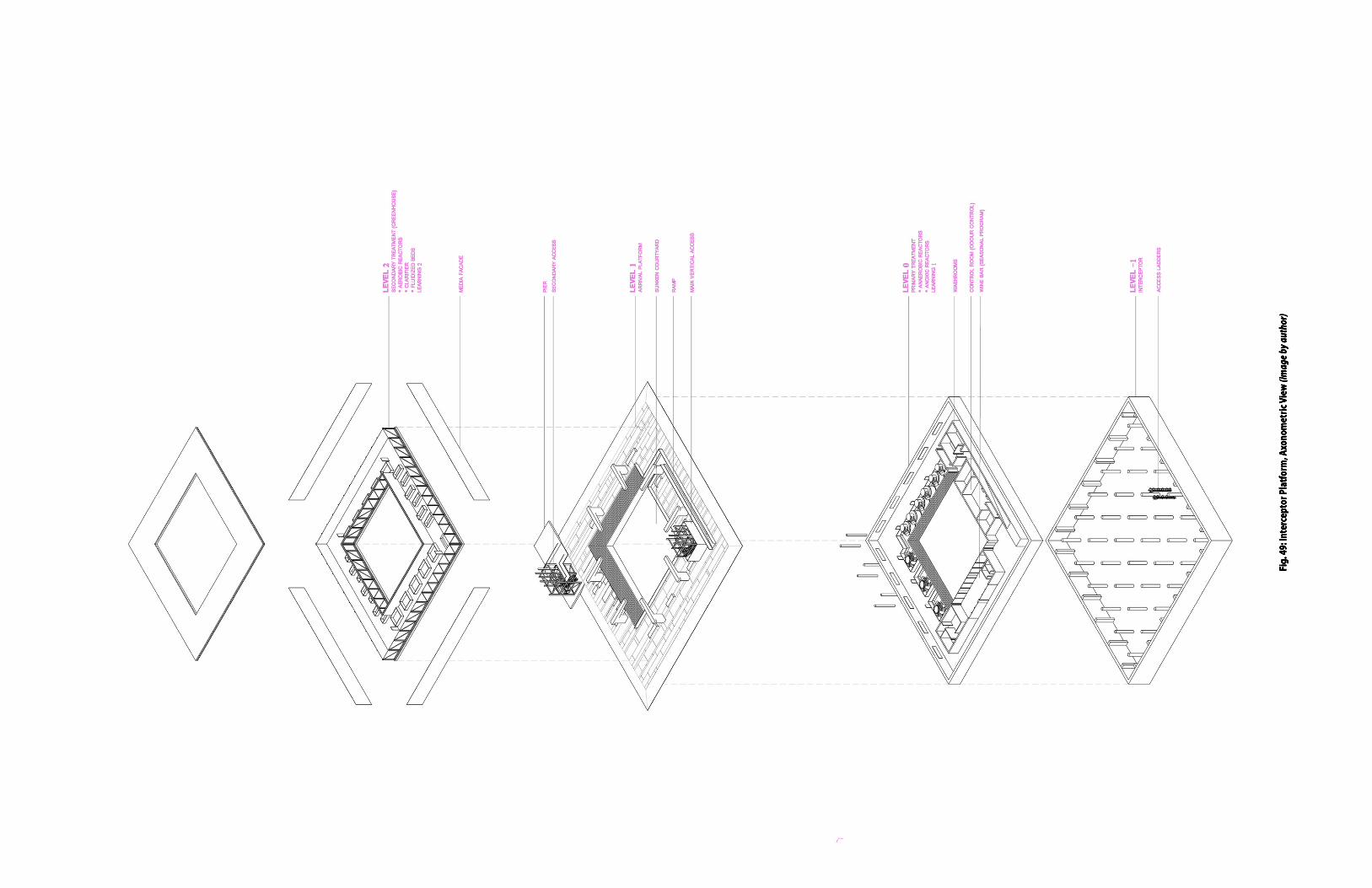
Fig. 49: Interceptor Platform, Axonometric View (image by author)
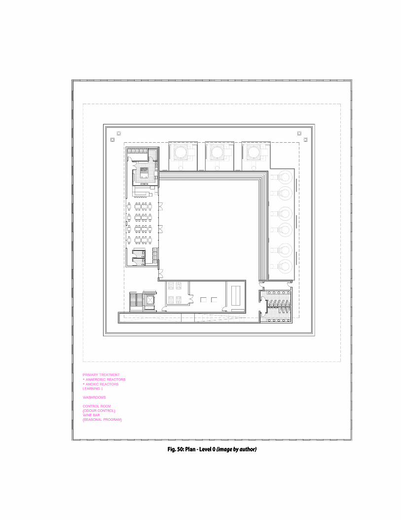
Fig. 50: Plan - Level 0 (image by author)

Fig. 51: Plan - Level 1 (image by author)

Fig. 52: Plan - Level 2 (image by author)

Fig. 53: Interceptor Platform, Elevations (image by author)

Fig. 54: Interceptor Platform, Cross-Section (image by author)

Fig. 55: Platform 6 (image by author)

Fig. 56: Level 0, Primary Treatment (image by author)

Fig. 57: Level 2, Secondary Treatment - Greenhouse (image by author)

Fig. 58: Level 1, Arrival Platform (image by author)

Fig. 59: Level 1, Sunken Courtyard (image by author)

Epilogue

121.
“It is scarcity and plenty that makes the vulgar take things to be precious or worthless; they call a diamond very beautiful because it is like pure water, and then would not exchange one for ten barrels of water.”52
(Galileo Galilei, 1932)
Although this project is centered on the relationship between
the City of Toronto and Lake Ontario, it is not difficult to
imagine how the issues raised here may be viewed in a
broader context, where the repercussions of unsustainable
water use are currently being experienced at both the national
and global level. Toronto is home to almost three million
people and as the major centre of commerce, innovation,
education and culture, the city’s success is intrinsically linked
to the success of our nation overall.53 Thus, such an influential
city could perhaps be used to bring about changes in the way
we think about water, which may also then be considered in
the context of other cities in Canada and around the world.
Since the early 1980s, the balance between human
consumption of the Earth’s resources and the planet’s
biophysical productive capacity has been skewed, such that
there has been a definite shift from a condition of surplus
towards one of global resource scarcity.54 This is particularly
so when it comes to our water resources. Unfortunately,
however, nothing in our experience, habits, or physical and
social infrastructure have been adapted to deal with these

122.
changes.55 With the world’s consumption of water doubling
every twenty years (more than twice the rate of the
population’s growth by 2008!), the planet’s finite supply of
clean water continues to be used at an unsustainable rate.56
In particular, Canadian development has been closely tied to
the many bodies of water within and around its borders. As
such, access to this fundamental resource has been crucial to
our growth as a nation. Considering the country’s impact on
the extraction of natural resources around the world, however,
there may come a time when Canadian leaders must look back
towards our own territory and reconsider our relationship to
the most important natural resource we have: water.
This project, although speculative in nature, seeks to bring
about the reconsideration of our passive approach to our
water resources and replace it instead with an active attitude
in which the next generation of infrastructural works places
the public right amidst the processes of clean water intake and
wastewater disposal. In this way, there is the potential to bring
about a new general consciousness of our own effect on these
processes and thus, highlight the importance of this precious
resource in our lives.
More water. More life.57

“What we wish upon the future is very often the image of some lost, imagined past.” Graham Swift, Waterland (1983)

124.
Credits
The WATERWOEs narrative has been loosely based on the opinions and views
expressed by various individuals, some of whom will forever live in infamy and
others who simply capture the spirit of the everyday citizen of Toronto. This
screenplay, together with the accompanying images and drawings, are meant to
convey a new understanding of the city and its lake that is both fact and fiction,
real and imaginary. Inspired by actual events, the scenes created herein describe
important moments of the city’s past, while also illustrating the pressing need for
innovative and creative solutions in the present to ensure the sustainable future of
the waterfront.
In particular, the character of the Narrator was inspired by the perspectives of the
following persons (in order of appearance):
• Rosie DiManno in her article, “There’s nothing sweet about beach-less Sugar Beach,” published in the Toronto Star (July 7, 2014).
• Mark Osbaldeston in his book, Unbuilt Toronto: A History of the City that Might Have Been, published October 2008.
• Tony Wong in his article, “How much is Drake’s endorsement worth to Toronto?” published in the Toronto Star (June 19, 2016).
• John Lorinc in his article, “How Toronto Lost its Groove,” published in The Walrus (November 12, 2011).
• Niamh Scallan in his article, “Gardiner Expressway: Big Daddy’s big project,” published in the Toronto Star (December 14, 2012).
• Alan Redway in his book, Governing Toronto: Bringing back the city that worked, published November 2014.
• Wayne C. Reeves in his book, Visions for the Metropolitan Toronto Waterfront, Vol. II, published April 1993.
• Steve Kupferman in his article, “Unseen City: The R.C. Harris Water Treatment Plant,” published to the Torontoist (January 3, 2011).
• Ralph Pentland and Chris Wood in their book, Down the Drain: How We Are Failing To Protect Our Water Resources, published May 2013.
• M. Jane Fairburn in her book, Along the Shore: Rediscovering Toronto’s Waterfront Heritage, published July 2013.

125.
Endnotes
1. About the Lake 1 Eric Arthur and Stephen Otto. Toronto, No Mean City (Toronto: University of Toronto Press, 2003), 8. 2 Lake Ontario Waterkeeper, “Lake Ontario,” accessed April 1, 2017, <http://www.waterkeeper.ca>. 3 Derek Hayes, Historical Atlas of Toronto (British Columbia: Douglas and McIntyre, 2013), 6. 4 Wayne C. Reeves, Visions for Metropolitan Toronto Waterfront I: Toward Comprehensive Planning, 1852-1935 (Toronto: University of Toronto, 1992), 8. 5 Reeves, Visions I: Toward Comprehensive Planning, 1852-1935, 9. 6 Wayne C. Reeves, Visions for Metropolitan Toronto Waterfront II: Forging a Regional Identity, 1913-68 (Toronto: University of Toronto, 1993), 24. 7 Hans Ibelings and PARTISANS, Rise and Sprawl: The Condominiumization of Toronto (Montreal/Amsterdam: The Architecture Observer, 2016), 39. 8 Reeves, Visions I: Toward Comprehensive Planning, 1852-1935, 4. 9 Reeves, Visions II: Forging a Regional Identity, 1913-68, 34. 10 Ibelings and PARTISANS, Rise and Sprawl, 39. 2. About the City 11 Reeves, Visions I: Toward Comprehensive Planning, 1852-1935, 9. 12 Hayes, Historical Atlas of Toronto, 126. 13 Ibid, 120. 14 Reeves, Visions I: Toward Comprehensive Planning, 1852-1935, 6. 15 Hayes, Historical Atlas of Toronto, 126. 16 Stanley J. Randall, and S. W. Clarkson, “Harbour City Report: A new illustrated concept for the Harbour City Development,” Government of Ontario, Department of Trade & Development, 6. 17 Randall and Clarkson, “Harbour City Report,” 7.

126. 18 Mark Osbaldeston et al., Unbuilt Toronto: A History of the City that Might Have Been (Toronto: Dundurn, 2008), 56. 19 Government of Ontario, Department of Trade and Development, “Toronto – Harbour City (1970).” YouTube Channel - Retrontario, posted July 19, 2015, accessed April 1, 2017, <https://www.youtube.com/watch?v=zyWzLmyOYoQ>. 20 Randall and Clarkson, “Harbour City Report,” 38. 21 Reeves, Visions II: Forging a Regional Identity, 1913-68, 35. 22 Osbaldeston et al., Unbuilt Toronto, 60. 23 Richard White, Urban Infrastructure and Urban Growth in the Toronto Region, 1950’s to the 1990’s (Toronto: Neptis Foundation, 2003), 70. 24 White, Urban Infrastructure, 12. 25 See Gore & Storrie Limited, “Report on Water Supply and Sewage Disposal for the City of Toronto and Related Areas,” Toronto and York Planning Board (September 1949). 26 Gore & Storrie Limited, “Report on Water Supply and Sewage Disposal.” 27 Ibid. 28 White, Urban Infrastructure, 14. 29 Ibid, 14. 3. About Infrastructure 30 Dana Cuff, “Architecture as Public Work.” In Infrastructure as Architecture: Designing Composite Networks, eds. Scott Lloyd and Katrina Stoll (Berlin: Jovis, 2010), 18. 31 Ralph Pentland and Chris Wood, Down the Drain: How We Are Failing to Protect Our Water Resources (Vancouver: Greystone Books, 2013), 31. 32 Laura Kane, “Toronto must overhaul aging infrastructure to meet dramatic climate change projections, study shows” The Toronto Star, January 28, 2013, <www.thestarcom>. See also Toronto Environment Office, “Toronto’s Future Weather & Climate Driver Study: Outcomes Report.” SENES Consultants Ltd. Study (October 2012). 33 Laura Kane, “Toronto flooding: Storm renews debate on aging infrastructure” The Toronto Star, July 9, 2013, <www.thestar.com>.

127. 34 Steve Kroft, “Falling Apart: America’s Neglected Infrastructure” CBS News: 60 Minutes, November 23, 2014, <http://www.cbsnews.com>. 35 See e.g. Entuitive Corporation, “Gardiner Expressway Reconfiguration, Replace Option – Tunnel” (powerpoint presentation, 2015). 36 Mike Crawley and Laura Fraser, “Premier Kathleen Wynne to reject Toronto’s request for tolls on DVP, Gardiner” CBC News, January 26, 2017, <www.cbc.ca>. 37 Kane, “Toronto flooding: Storm renews debate on aging infrastructure,” <www.thestar.com>. 38 Carys Mills, “Toronto’s July flood listed as Ontario’s most costly natural disaster,” The Toronto Star, August 14, 2013, <www.thestar.com>. 39 Lake Ontario Waterkeeper, “Cases – T.O. Sewage,” accessed March 27, 2017, <http://www.waterkeeper.ca/toronto-sewage>. 40 Lake Ontario Waterkeeper, “Toronto Harbour Report: Key Findings.” (2016) <http://www.waterkeeper.ca>. 41 Commission of Environmental Cooperation, “North American Pollutant Releases and Transfers, Feature Analysis: Pollutant Releases to Surface Waters.” Taking Stock 13, (March 28, 2011): 11. See also Lake Ontario Waterkeeper, “Toronto leads list of North American polluters,” entry posted April 20, 2011, accessed March 27, 2017, <http://www.waterkeeper.ca/blog/21420>. 42 Lake Ontario Waterkeeper, “Toronto Harbour Report: Key Findings.” (2016) <http://www.waterkeeper.ca>. 43 Elizabeth Brubaker, “Troubled waters,” Financial Post, May 11, 2011, <www.financialpost.com>. 44 MMM Group Limited, “Don River and Central Waterfront Project.” Municipal Class EA Environmental Study Report (August 2012): ES-1. 45 MMM Group Limited, “Don River and Central Waterfront Project,” 13. 4. About CSOs 46 Stan Allen, Points and Lines: Diagrams and Projects for the City, 2nd ed. (New York: Princeton Architectural Press, 2012), 52. 47 Stephen Graham, Vertical: The City from Satellites to Bunkers (New York: Verso, 2016): 331. 48 Graham, Vertical, 331. 49 Rose George, “The Blue Girl: Dirt in the City.” In Dirt: The Filthy Reality of Everyday Life, eds. Rosie Cox et al. (London: Profile Books, 2011), 159.

128. 50 Stan Allen “Landscape Infrastructures.” In Infrastructure as Architecture: Designing Composite Networks, eds. Scott Lloyd and Katrina Stoll (Berlin: Jovis, 2010), 38. 51 Lake Ontario Waterkeeper, “Toronto Harbour Report: Key Findings.” (2016) <http://www.waterkeeper.ca>. Epilogue 52 Alex Prud’Homme, The Ripple Effect: The Fate of Freshwater in the Twenty-First Century (New York: Simon & Schuster Inc., 2011), 9. 53 John Tory, “Mayor Tory on the Federal Ministry of Infrastructure and Communities’ speech.” (speech, Toronto, ON, January 21, 2016) <www1.toronto.ca>. 54 Pentland and Wood, Down the Drain, 10. 55 Ibid. 56 Prud’Homme, The Ripple Effect, 11. 57 Drake. More Life. Young Money Entertainment/Cash Money Records Inc., 2017, mp3, <www.itunes.apple.com>.

129.
Bibliography
Allen, Stan. “Landscape Infrastructures.” In Infrastructure as Architecture: Designing Composite Networks, edited by Scott Lloyd and Katrina Stoll, Berlin: Jovis, 2010.
Allen, Stan. Points and Lines: Diagrams and Projects for the City, 2nd ed. (New York: Princeton Architectural Press, 2012) Arthur, Eric and Stephen Otto. Toronto, No Mean City. Toronto: University of Toronto Press, 2003. Brubaker, Elizabeth. “Troubled waters,” Financial Post, May 11, 2011, <www.financialpost.com>. Colton, Timothy J. Big Daddy: Frederick Gardiner and the Building of Metro Toronto. Toronto: University of Toronto Press, 1980. Commission of Environmental Cooperation, “North American Pollutant Releases and Transfers, Feature Analysis: Pollutant Releases to Surface Waters, Taking Stock 13, (March 28, 2011). “Councillor pushing Ontario Place casino.” Toronto Sun (VIDEO). March 22, 2011. Accessed December 20, 2016. <www.torontosun.com> Crawley, Mike and Laura Fraser, “Premier Kathleen Wynne to reject Toronto’s request for tolls on DVP, Gardiner” CBC News, January 26, 2017, <www.cbc.ca>. Cuff, Dana. “Architecture as Public Work.” In Infrastructure as Architecture: Designing Composite Networks, edited by Scott Lloyd and Katrina Stoll, Berlin: Jovis, 2010. DiManno, Rosie. “There’s nothing sweet about beach-less Sugar Beach: DiManno.” The Toronto Star. July 7, 2014. Accessed December 30, 2016. <https://www.thestar.com>. Drake. More Life. Young Money Entertainment/Cash Money Records Inc., 2017, mp3, <www.itunes.apple.com>.

130. Drake. Views. Young Money Entertainment/Cash Money Records Inc., B002510202, 2016, CD. Entuitive Corporation, “Gardiner Expressway Reconfiguration, Replace Option – Tunnel” (powerpoint presentation, 2015). Fairburn, M. Jane. Along the Shore: Rediscovering Toronto’s Waterfront Heritage. Toronto: ECW Press, 2013. George, Rose. “The Blue Girl: Dirt in the City.” In Dirt: The Filthy Reality of Everyday Life, eds. Rosie Cox et al. (London: Profile Books, 2011), 159. Gore & Storrie Limited, “Report on Water Supply and Sewage Disposal for the City of Toronto and Related Areas,” Toronto and York Planning Board (September 1949). Government of Ontario, Department of Trade and Development. “Toronto – Harbour City (1970).” YouTube Channel - Retrontario. July 19 2015. <https://www.youtube.com/watch?v=zyWzLmyOYoQ>. Graham, Stephen. Vertical: The City from Satellites to Bunkers (New York: Verso, 2016). Hayes, Derek. Historical Atlas of Toronto. Madeira Park, British Columbia: Douglas and McIntyre, 2013. Ibelings, Hans and PARTISANS. Rise and Sprawl: The Condominiumization of Toronto. Montreal/Amsterdam: The Architecture Observer, 2016. Kane, Laura, “Toronto flooding: Storm renews debate on aging infrastructure” The Toronto Star, July 9, 2013, <www.thestar.com>. Kane, Laura, “Toronto must overhaul aging infrastructure to meet dramatic climate change projections, study shows” The Toronto Star, January 28, 2013, <www.thestarcom>.

131. Kroft, Steve, “Falling Apart: America’s Neglected Infrastructure” CBS News: 60 Minutes, November 23, 2014, <http://www.cbsnews.com>. Kupferman, Steve. “Unseen City: The R.C. Harris Water Treatment Plant.” Torontoist. January 3, 2011. Accessed December 31, 2016. <http://torontoist.com>. Lake Ontario Waterkeeper, “Cases – T.O. Sewage,” accessed March 27, 2017, <http://www.waterkeeper.ca/toronto-sewage>. Lake Ontario Waterkeeper, “Lake Ontario.” accessed April 1, 2017, <http://www.waterkeeper.ca>. Lake Ontario Waterkeeper, “Toronto Harbour Report: Key Findings.” (2016) <http://www.waterkeeper.ca>. Lake Ontario Waterkeeper, “Toronto leads list of North American polluters,” entry posted April 20, 2011, accessed March 27, 2017, <http://www.waterkeeper.ca/blog/21420>. Lamar, Kendrick. To Pimp a Butterfly. Universal Music Canada, B00UDDM7K0, 2015, CD. Lauwereyns, Jan, “Fear of Water.” Poetry International Rotterdam. <http://www.poetryinternationalweb.net/pi/site/poem/item/6201/auto/FE AR-OF-WATER>. Lorinc, John, “How Toronto Lost its Groove.” The Walrus. November 12, 2011. Accessed December 27, 2016. <thewalrus.ca>. Mills, Carys, “Toronto’s July flood listed as Ontario’s most costly natural disaster,” The Toronto Star, August 14, 2013, <www.thestar.com>. MMM Group Limited, “Don River and Central Waterfront Project.” Municipal Class EA Environmental Study Report (August 2012). Osbaldeston, Mark et al., Unbuilt Toronto: A History of the City that Might Have Been. Toronto: Dundurn, 2008.

132. Pentland, Ralph, and Chris Wood, Down the Drain: How We Are Failing To Protect Our Water Resources. Vancouver: Greystone Books, 2013. Prud’Homme, Alex, The Ripple Effect: The Fate of Freshwater in the Twenty-First Century (New York: Simon & Schuster Inc., 2011). Randall, Stanley J., and S.W. Clarkson. “Harbour City Report: A new illustrated concept for the Harbour City Development.” Government of Ontario, Department of Trade & Development <http://www.citylab.com>. Redway, Alan, Governing Toronto: Bringing back the city that worked. Victoria: FriesenPress, 2014. Reeves, Wayne C., Visions for the Metropolitan Toronto Waterfront, I: Toward Comprehensive Planning, 1852-1935. Toronto: University of Toronto, 1992. Reeves, Wayne C., Visions for the Metropolitan Toronto Waterfront, II: Forging a Regional Identity, 1913-68. Toronto: University of Toronto, 1993. Scallan, Niamh, “Gardiner Expressway: Big Daddy’s big project.” The Toronto Star. December 14, 2012. Accessed December 27, 2016. <https://www.thestar.com>. Swift, Graham, Waterland. London: Heinemann, 1983. Toronto Environment Office, “Toronto’s Future Weather & Climate Driver Study: Outcomes Report.” SENES Consultants Ltd. Study (October 2012). Tory, John, “Billy Bishop Pedestrian Tunnel.” (speech, Toronto, ON, July 30, 2015), City of Toronto, <www1.toronto.ca>. Tory, John, “Mayor Tory on the Federal Ministry of Infrastructure and Communities’ speech.” (speech, Toronto, ON, January 21, 2016), City of Toronto, <www1.toronto.ca>. Tory, John, “Queens Quay Official Opening.” (speech, Toronto, ON, June 19, 2015), City of Toronto, <www1.toronto.ca>.

133. “Waterfront revitalization a ‘waste of taxpayers’ money,’ Ford says.” CityNews (VIDEO). July 8, 2014. Accessed December 18, 2016. <citynews.ca>. White, Richard. Urban Infrastructure and Urban Growth in the Toronto Region, 1950’s to the 1990’s. Toronto: Neptis Foundation, 2003. Wong, Tony, “How much is Drake’s endorsement worth to Toronto?” The Toronto Star. June 19, 2016. Accessed December 20, 2016. <https://www.thestar.com>. Wong, Tony, “Toronto’s Real Housewives are rich, but are they mean enough?: review” The Toronto Star. March 6, 2017. Accessed April 27, 2017. <https://www.thestar.com>.