βαρρ - Target Exploration
19
Page 1 of 19 Target Exploration Consultants is a United Kingdom Limited Company No. 9880383 Target Target Exploration Target Exploration Report (Tar-149)
-
Upload
khangminh22 -
Category
Documents
-
view
0 -
download
0
Transcript of βαρρ - Target Exploration

Page 1 of 19 Target Exploration Consultants is a United Kingdom Limited Company No. 9880383
Target
Target Exploration
Target Exploration Report (Tar-149)

Page 2 of 19 Target Exploration Consultants is a United Kingdom Limited Company No. 9880383
A flurry of activities followed the lifting of the nuclear-related sanctions on Iran in January 2016. More than 36 IOCs have
been qualified to with NIOC and expressed interest in participating in Iran’s exploration and production sector activities and
upstream projects, and a large number of MoUs and field study agreements are reported to have been concluded. Currently
there are 17 exploration blocks and 52 field development and IOR projects are on offer, representing a rare opportunity
to invest in a variety of world class oil and gas fields.
The petroleum geology of onshore and offshore Iran is a major element in understanding the geology and evaluation the
petroleum exploration and development potential of the adjacent on-shores and off-shores of the Kingdom of Bahrain,
Republic of Iraq, State of Kuwait, State of Qatar, Sultanate of Oman, Kingdom of Saudi Arabia and United Arab Emirates.
This is a comprehensive review and documentation of the petroleum geology of the several basins in onshore and offshore
Iran, with plays-representative onshore and offshore oil and gas field examples.
Authored by an authority in the petroleum geology of Iran, the report is regularly updated, it is currently in 60 pages
of text, 33 tables and 135 maps, sections, figures, Illustrations and up-to-date comprehensive references list.

Page 3 of 19 Target Exploration Consultants is a United Kingdom Limited Company No. 9880383
No. CHAPTER PAGE
1 HIGHLIGHTS OF IRAN’S OIL INDUSTRY HISTORY 3
2 IRAN HYDROCARBON RESERVES, PRODUCTION AND INTERNAL CONSUMPTION 4
3 REGIONAL PLATE TECTONIC SETTING OF IRAN AND THE MIDDLE EAST BASIN 6
4 MAJOR STRUCTURAL ELEMENTS OF THE MIDDLE EAST BASIN 7
5 TOTAL SEDIMENTARY FILL IN THE MIDDLE EAST BASIN 8
6 AN OVERVIEW OF THE SEDIMENTARY BASINS OF IRAN AND THEIR HYDROCARBON
POTENTIAL 9
7 HYDROCARBON DISCOVERIES AND PLAYS IN IRAN OUTSIDE THE ZAGROS BASIN 16
8 OUTLINE OF THE STRUCTURAL FRAMEWORK OF THE ZAGROS BASIN 17
9 OUTLINE OF THE OF THE GEOLOGICAL HISTORY OF THE ZAGROS BASIN 20
10 DISTRIBUTION OF MAJOR OIL AND GAS FIELDS IN ZAGROS BASIN AND ITS OFFSHORE
EXTENSION 22
11 ZAGROS PETROLEUM SYSTEMS OVERVIEW 23
12 STRATIGRAPHIC FRAMEWORK 24
13 PETROLEUM SYSTEM ANALYSIS 30
13.1 Zagros reservoirs 41
13.2 Zagros traps 47
13.3 Zagros seals 48
13.4 Zagros plays – a summary 48
14 DESCRIPTIONS OF SELECTED OIL FIELDS 50
15 REFERENCES 57-60

Page 4 of 19 Target Exploration Consultants is a United Kingdom Limited Company No. 9880383
TABLES
Table 10.1 List of the oil and gas fields in the Zagros basin and its offshore extension
Table 13.1 Thermal evolution of Silurian source rocks in Varavi-1, Dalan-2 and Kuh-e Salamati-1
Table 14.1 Masjed-e Soleyman general field data
Table 14.2 Jufeyr general field data
Table 14.3 Azadegan general field data
Table 14.4 Sarvestan general field data and well test results
Table 14.5 Saadat Abad general field data and well test results
Table 14.6 Khesht general field data
Table 14.7 Dehluran general field data
Table 14.8 Paydar general field data
Table 14.9 West Paydar general field data
Table 14.10 Cheshmeh Khosh general field data
Table 14.11 Mansuri general field data
Table 14.12 Rudak general field data
Table 14.13 Milatun general field data
Table 14.14 Kabud general field data

Page 5 of 19 Target Exploration Consultants is a United Kingdom Limited Company No. 9880383
Table 14.15 Danan general field data
Table 14.16 Changuleh general field data
Table 14.17 Dalpari general field data
Table 14.18 Asmari reservoir zonation’s, their thicknesses and petrophysical characteristics in the Agha Jari field
Table 14.19 Agha Jari general field data and fluid properties relating to the Asmari reservoir
Table 14.20 Ahwaz general field data and fluid properties relating to the Sarvak reservoir
FIGURES
1. Milestones in Iran’s oil industry
Figure 1.1 Drilling of the first well in Iran, 1884
Figure 1.2 Area of the Darcy Concession
Figure 1.3 Darcy’s first well at Chiah Surkh, 1902
Figure 1.4 Day of destiny - oil gushes out of the Masjed-e Soleyman discovery well, 26 May 1908
Figure 1.4a Masjed-e Soleyman discovery well rig today

Page 6 of 19 Target Exploration Consultants is a United Kingdom Limited Company No. 9880383
Figure 1.5 Area of the 1933 Concession
2. Hydrocarbon reserves, production and internal consumption
3. Regional plate tectonic setting of Iran and the middle east basin
Figure 3.1 Regional plate tectonic setting of Iran and the Middle East basin
Figure 3.2 Middle East basin plate boundaries
4. Major structural elements of the Middle East basin
Figure 4.1 Major structural elements of the Middle East basin
5. Total sedimentary fill in the Middle East basin
Figure 5.1 Isopach map showing the total sedimentary fill in the Middle East basin
6. An overview of the sedimentary basins of Iran and their hydrocarbon potential
Figure 6.1 Sedimentary basins of Iran
Figure 6.2 Moghan basin stratigraphic column

Page 7 of 19 Target Exploration Consultants is a United Kingdom Limited Company No. 9880383
Figure 6.3 Locations of the discoveries in the Moghan basin
Figure 6.4 Outline of the South Caspian Basin, its associated deltas and the locations of the oil and gas fields in the Greater Caspian region
Figure 6.5 Locations of the wells drilled by NIOC in the Iranian sector of the Caspian Sea
Figure 6.6 Gorgan Plain stratigraphic column
Figure 6.7 Locations of the discoveries in the Gorgan Plain
Figure 6.8 Stratigraphic column of the Sarakhs/Kopet Dagh basin
Figure 6.9 Locations of the discoveries in the Sarakhs basin
Figure 6.10 Stratigraphic column of the Main Central basin
Figure 6.11 Locations of the discoveries in the Main Central basin
Figure 6.12 Alborz field discovery well blow out,1956
Figure 6.13 Oil from the Alborz discovery well formed a lake next to the drill site
Figure 6.14 Alborz discovery well capping operations

Page 8 of 19 Target Exploration Consultants is a United Kingdom Limited Company No. 9880383
Figure 6.15 Stratigraphic column of the Tabas-Kerman basin
Figure 6.16 Stratigraphic column of the Makran basin
7. Hydrocarbon discoveries and plays in Iran outside the Zagros basin
Figure 7.1 Hydrocarbon discoveries and plays in Iran outside the Zagros basin
8. Outline of the structural framework of the Zagros basin
Figure 8.1 Tectonic/structural map of the Zagros basin in the Iranian sector
Figure 8.2 Satellite image of the southeastern part of the Zagros fold belt.
Figure 8.3 Sequence of events that resulted in the formation of the Zagros orogenic zone
Figure 8.4 Cross-sections showing structures associated with compressional movements in the Zagros Basin
Figure 8.5 NE - SW oriented cross sections through the Zagros basin
Figure 8.6 Folded Lower Cretaceous-Oligo-Miocene limestone-marl sequence, central Zagros basin
Figure 8.7 Axial view of a symmetrical folded belt anticline

Page 9 of 19 Target Exploration Consultants is a United Kingdom Limited Company No. 9880383
Figure 8.8 Vertical SW limbs of two asymmetrical folded belt anticlines
Figure 8.9 An asymmetrical syncline
Figure 8.10 Distribution of piercement salt domes in the Zagros basin and Persian Gulf
Figure 8.11 Zagros salt tectonics features
Figure 8.12 Salt dome modes of occurrence and associated glaciers
9. Outline of the of the geological history of the Zagros basin
Figure 9.1 Stratigraphic column of the Zagros basin
Figure 9.2 Distribution of the continents and oceans in the Early Triassic (237 Ma)
Figure 9.3 Distribution of the continents and oceans in the Early Jurassic (195 Ma)
Figure 9.4 Distribution of the continents and oceans in the Late Jurassic (152 Ma)
Figure 9.5 Distribution of the continents and oceans in the Late Cretaceous (94 Ma)
Figure 9.6 Distribution of the continents and oceans in the Cretaceous/Tertiary boundary (66 Ma)

Page 10 of 19 Target Exploration Consultants is a United Kingdom Limited Company No. 9880383
Figure 9.7 Distribution of the continents and oceans in the Middle Eocne (52 Ma)
Figure 9.8 Distribution of the continents and oceans in the Middle Miocene (14 Ma)
Figure 9.9 Present day distribution of the continents and oceans
10. Distribution of the major oil and gas fields in the zagros basin and its offshore extension
Figure 10.1 Locations of oil and gas fields and key structural elements in Zagros basin and its offshore extension
Figure 10.2 Distribution of the major oil and gas fields in the Zagros basin and its offshore extension
Figure 10.3 Outline of the North Dome-South Pars field
11. Zagros petroleum systems overview
12. Stratigraphic framework
Figure 12.1 Infra-Cambrian - Palaeozoic stratigraphic column
Figure 12.2 Map showing the distribution of the Infracambrian-Cambrian salt basins in the Middle East basin
Figure 12.3 Exotic block of a bedded sedimentary sequence brought to the surface by a salt plug

Page 11 of 19 Target Exploration Consultants is a United Kingdom Limited Company No. 9880383
Figure 12.4 Correlation of Palaeozoic rock units in the Imbricated Belt
Figure 12.5 Middle Basin Cambrian facies distribution map
Figure 12.6 Middle East basin Late Cambrian facies distribution map
Figure 12.7 Middle East Basin Middle Ordovician facies distribution map
Figure 12.8 Middle East Basin Early Silurian (Llandoverian) facies distribution map
Figure 12.9 Distribution of the Early Silurian (Llandoverian) source rocks in the Middle East basin
Figure 12.10 Middle East basin Pre-Permian subcrop map
Figure 12.11 Isopach and facies distribution map of the Permian Dalan Formation in the Zagros basin
Figure 12.12 Zagros basin Mesozoic stratigraphic columns
Figure 12.13 Isopach map of the Middle-Late Triassic Dashtak Formation in the Zagros basin
Figure 12.14 Lithology, formation names and thicknesses of Jurassic successions in the Zagros basin
Figure 12.15 End Jurassic palaeogeographic map of the Zagros basin

Page 12 of 19 Target Exploration Consultants is a United Kingdom Limited Company No. 9880383
Figure 12.16 Lithology, formation names and thicknesses of Cretaceous successions in the Zagros basin
Figure 12.17 Early Cretaceous (Neocomian) palaeogeographic map of the Zagros basin
Figure 12.18 Early Cretaceous (Barremian - Early Aptian) palaeogeographic map of the Zagros basin
Figure 12.19 Early Cretaceous (Albian) palaeogeographic map of the Zagros basin
Figure 12.20 Upper Cretaceous (Coniacian) palaeogeographic map of the Zagros basin
Figure 12.21 Upper Cretaceous (Santonian) palaeogeographic map of the Zagros basin
Figure 12.22 Upper Cretaceous (Campanian) palaeogeographic map of the Zagros basin
Figure 12.23 Upper Cretaceous (Maestrichtian) palaeogeographic map of the Zagros basin
Figure 12.24 Zagros basin Cenozoic/Tertiary stratigraphic columns
Figure 12.25 Lithology, formation names and thicknesses of Cenozoic successions in the Zagros basin
Figure 12.26 Field photograph of the Palaeogene section in Fars province
Figure 12.27 Palaeocene - Eocene isopach and facies distribution map of the Zagros basin
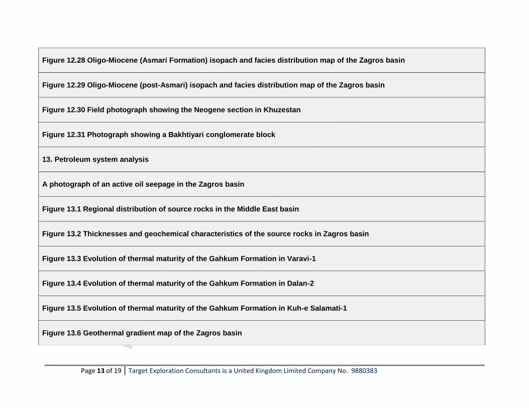
Page 13 of 19 Target Exploration Consultants is a United Kingdom Limited Company No. 9880383
Figure 12.28 Oligo-Miocene (Asmari Formation) isopach and facies distribution map of the Zagros basin
Figure 12.29 Oligo-Miocene (post-Asmari) isopach and facies distribution map of the Zagros basin
Figure 12.30 Field photograph showing the Neogene section in Khuzestan
Figure 12.31 Photograph showing a Bakhtiyari conglomerate block
13. Petroleum system analysis
A photograph of an active oil seepage in the Zagros basin
Figure 13.1 Regional distribution of source rocks in the Middle East basin
Figure 13.2 Thicknesses and geochemical characteristics of the source rocks in Zagros basin
Figure 13.3 Evolution of thermal maturity of the Gahkum Formation in Varavi-1
Figure 13.4 Evolution of thermal maturity of the Gahkum Formation in Dalan-2
Figure 13.5 Evolution of thermal maturity of the Gahkum Formation in Kuh-e Salamati-1
Figure 13.6 Geothermal gradient map of the Zagros basin

Page 14 of 19 Target Exploration Consultants is a United Kingdom Limited Company No. 9880383
Figure 13.7 Stratigraphic distribution of source rocks in the Jurassic - Miocene petroleum system in the Middle East basin
Figure 13.8 Source rock-reservoir-seal relationships for the Dezful Embayment
Figure 13.9 Isopach and distribution map of the organic rich Sargelu Formation in the Zagros basin
Figure 13.10 Isopach and distribution map of the organic rich Garau Formation in the Zagros basin
Figure 13.11 Photomicrogaph showing highly mature kerogen in the Garau Formation
Figure 13.12 An outcrop of the Kazhdumi shale in central Zagros basin
Figure 13.13 Isopach map of the Kazhdumi Formation in the Zagros basin
Figure 13.14 Cumulative isopach map of the organic rich layers of the Kazhdumi Formation
Figure 13.15 Photomicrograph showing mature kerogen in the Kazhdumi Formation
Figure 13.16 Comparison between saturated n-alkane fractions of Karanj field oil and solvent extracts of Kazhdumi and Pabdeh Formations
Figure 13.17 Burial history profiles for the Kazhdumi source rock in the Dezful Embayment
Figure 13.18 Burial history profiles indicating the beginning of oil generation and expulsion windows for the Kazhdumi and

Page 15 of 19 Target Exploration Consultants is a United Kingdom Limited Company No. 9880383
Pabdeh source rocks in a well located close to the top of the giant Marun anticline
Figure 13.19 Isopach map of organic rich layers in Middle Eocene to Oligocene part of the Pabdeh Formation in Zagros basin
Figure 13.20 Burial history profiles for the Pabdeh source rock in the Dezful Embayment
Figure 13.21 Origin of hydrocarbons in Zagros basin fields and its offshore extension into Iranian sector of the Persian Gulf
Figure 13.22 Enhancement of strike parallel permeability resulting from the widening of early diagenetic fractures by folding
Figure 13.23 Examples of the microfauna characterizing the subdivisions of the Asmari limestone
Figure 13.24 An outcrop of fractured Asmari limestone
Figure 13.25 Relationship between bed thickness and fracture density, Pahn anticline, NE of the Dezful Embayment
Figure 13.26 Relationship between bed thickness and fracture density, Asmari anticline, Dezful Embayment
Figure 13.27 Photomicrograph of extensively dolomitisd Lower Asmari, central Zagros basin area
Figure 13.28 NE - SW oriented cross sections through the Gach Saran oil field
14. Descriptions of selected oil fields

Page 16 of 19 Target Exploration Consultants is a United Kingdom Limited Company No. 9880383
Figure 14.1 Locations of the Masjed-e Soleyman, Jufeyr and Azadegan fields
Figure 14.2 Cross section and top Asmari structure contour map, Masjed-e Soleyman field
Figure 14.3 Cross section and top Sarvak structure contour map, Jufeyr field
Figure 14.4 Cross section and top Sarvak structure contour map, Azadegan field
Figure 14.5 Locations of the Sarvestan, Saadatabad and Khesht fields
Figure 14.6 Top Sarvak structure contour map, Sarvestan field
Figure 14.7 Top Sarvak structure contour map, Sarvestan field
Figure 14.8 Cross section and top Asmari structure contour map, Khesht field
Figure 14.9 locations of the Dehluran, Paydar, West Paydar and Cheshmeh Khosh fields
Figure 14.10 Top Sarvak structure contour map, Dehluran field
Figure 14.11 Top Asmari structure contour map, Paydar field
Figure 14.12 Top Sarvak structure contour map, Paydar field

Page 17 of 19 Target Exploration Consultants is a United Kingdom Limited Company No. 9880383
Figure 14.13 Cross section and top Asmari structure contour map, West Paydar/Fauqi field
Figure 14.14 Cross section and top Asmari structure contour map, Cheshmeh Khosh field
Figure 14.15 Locations of the Mansuri, Rudak and Milatun fields
Figure 14.16 Cross section and top Asmari structure contour map, Mansuri field
Figure 14.17 Cross section and top Jurassic structure contour map, Rudak-Milatun fields
Figure 14.18 locations of the Kabud, Danan, Changuleh and Dalpari fields
Figure 14.19 Cross section and top Asmari structure contour map, Kabud field
Figure 14.20 Cross section and top Sarvak structure contour map, Kabud field
Figure 14.21 Cross section and top Asmari structure contour map, Danan field
Figure 14.22 Cross section and top Sarvak structure contour map, Danan field
Figure 14.23 Cross section and near top Sarvak structure contour map, Danan field
Figure 14.24 Top Sarvak structure contour map, Dalpari field

Page 18 of 19 Target Exploration Consultants is a United Kingdom Limited Company No. 9880383
Figure 14.25 Locations of the Gachsaran, Agha Jari Ahwaz and Pazanan fields
Figure 14.26 Top Asmari structure contour map, Gachsaran field
Figure 14.27 Cross section through the Gachsaran field
Figure 14.28 Top Asmari structure contour map, Agha Jari field
Figure 14.29 Diagrammatic cross section through the Agha Jari field
Figure 14.30 locations of the Naft-e Shahr, Haft Kel, Naft-e Sefid and Lali fields
Figure 14.31 Schematic stratigraphic-structural section through the Naft-e Shahr field
Figure 14.32 Top Asmari structure contour map, Haft Kel field
Figure 14.33 Schematic stratigraphic-structural section through the Haft Kel field
Figure 14.34 Schematic stratigraphic-structural section through the Naft-e Sefid field
Figure 14.35 Schematic stratigraphic-structural section through the Pazanan field
Figure 14.36 Schematic stratigraphic-structural section through the Lali field
Page 19 of 19 Target Exploration Consultants is a United Kingdom Limited Company No. 9880383
_________________________________________________________________________________________________
This report is available for immediate dispatch from
Target Exploration Consultants
Click here to purchase your copy
For further information, contact:
M. Casey
Target Exploration Consultants 65 Kenton Court, London W14 8NW, UK. Tel: (+44) (0) 207 371 2240
www.targetexploration.com
Home About Us Experience Services Training Conferences Publications Order Form
News Careers Contracts Downloads Uploads Links Rep/Software Contact Us
07-07-2021