voluntary cleanup report - Washington State Department of ...
159
VOLUNTARY CLEANUP REPORT GALVIN FLYING SERVICES QUAD 7 PROJECT 7777 PERIMETER ROAD S. SEATTLE, WASHINGTON Prepared for: King County International Airport URS Project No.: 33761772 TCP No. NW2167 November 18, 2010
-
Upload
khangminh22 -
Category
Documents
-
view
1 -
download
0
Transcript of voluntary cleanup report - Washington State Department of ...
VOLUNTARY CLEANUP REPORT GALVIN FLYING SERVICES QUAD 7 PROJECT 7777 PERIMETER ROAD S. SEATTLE, WASHINGTON
Prepared for:
King County International Airport
URS Project No.: 33761772 TCP No. NW2167 November 18, 2010
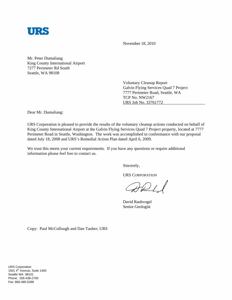
November 18, 2010 Mr. Peter Dumaliang King County International Airport 7277 Perimeter Rd South Seattle, WA 98108
Voluntary Cleanup Report Galvin Flying Services Quad 7 Project 7777 Perimeter Road, Seattle, WA TCP No. NW2167 URS Job No. 33761772
Dear Mr. Dumaliang:
URS Corporation is pleased to provide the results of the voluntary cleanup actions conducted on behalf of King County International Airport at the Galvin Flying Services Quad 7 Project property, located at 7777 Perimeter Road in Seattle, Washington. The work was accomplished in conformance with our proposal dated July 18, 2008 and URS’s Remedial Action Plan dated April 6, 2009.
We trust this meets your current requirements. If you have any questions or require additional information please feel free to contact us.
Sincerely,
URS CORPORATION
David Raubvogel Senior Geologist
Copy: Paul McCullough and Dan Tauber; URS
URS Corporation 1501 4th Avenue, Suite 1400 Seattle WA 98101 Phone: 206-438-2700 Fax: 866-485-5288

W:\WM&RD\KCIA\WO#17 - Galvin Flying Services\VCP\Cleanup Report\VCP Report_KCIA 7777.doc i
TABLE OF CONTENTS
Page
1.0 INTRODUCTION ...............................................................................................................1
2.0 BACKGROUND .................................................................................................................1 2.1 SITE DESCRIPTION ..............................................................................................1 2.2 PREVIOUS INVESTIGATIONS AND CLEANUP ACTIONS .............................1 2.3 SUBSURFACE CONDITIONS ..............................................................................2
3.0 VOLUNTARY CLEANUP SCOPE AND FINDINGS .......................................................4 3.1 SELECTION OF CLEANUP LEVELS ..................................................................4 3.2 SCOPE .....................................................................................................................4 3.3 BARRIER/GRAVITY WALL INSTALLATION ...................................................6 3.4 EXCAVATION MONITORING, FIELD OBSERVATIONS, WASTE
CHARACTERIZATION AND POST EXCAVATION SAMPLING PROCEDURES ........................................................................................................6
3.5 DEWATERING ACTIVITIES ................................................................................8 3.6 MONITORING WELL DECOMMISSIONING AND RE-
INSTALLATION ....................................................................................................8
4.0 ANALYTICAL RESULTS .................................................................................................9 4.1 SOIL STOCKPILE ..................................................................................................9 4.2 POST EXCAVATION .............................................................................................9
5.0 CONCLUSIONS AND RECOMMENDATIONS ..............................................................9
6.0 REFERENCES ..................................................................................................................10
TABLES
Table 1 – Summary of Stockpile Soil Analytical Results Table 2 – Summary of Post-Excavation Soil Analytical Results Table 3 – Summary of Sanitary Sewer Discharge Monitoring Analytical Results
FIGURES
Figure 1 – Site Location Map Figure 2 – Site Plan Figure 3 – Area of Prior Remedial Action Figure 4 – Current Remedial Action Area and Post-Excavation Soil Sample Locations Figure 5 – Monitoring Well Location Map

W:\WM&RD\KCIA\WO#17 - Galvin Flying Services\VCP\Cleanup Report\VCP Report_KCIA 7777.doc ii
APPENDICES
Appendix A – Site Investigation/Remediation Summary Appendix B – Gravity Wall and Excavation Plans Appendix C - Barrier/Gravity Wall As-Built Drawing Appendix D – Site Photographs Appendix E – Soil Disposal Documentation Appendix F – Surface Sampling Record Forms Appendix G – Laboratory Analytical Reports Appendix H – Boring Logs/As-Built Diagrams
W:\WM&RD\KCIA\WO#17 - Galvin Flying Services\VCP\Cleanup Report\VCP Report_KCIA 7777.doc 1
1.0 INTRODUCTION
This report presents the results of the URS Corporation (URS) voluntary cleanup actions performed on behalf of King County International Airport (KCIA) ,also known as Boeing Field, at the Galvin Flying Services (Galvin) Quad 7 Project located at KCIA, 7777 Perimeter Road in Seattle, Washington (subject property or site). Voluntary cleanup actions implemented at the site included the excavation and off-site disposal of Jet A petroleum-contaminated soil (PCS) in the northeast portion of the parcel and installation of a barrier/gravity wall shoring system along the northeastern leasehold boundary to mitigate potential recontamination of the remediated area. The cleanup was performed in accordance with applicable provisions of the State of Washington Model Toxics Control Act (MTCA), Washington Administrative Code 173-340, and the Washington State Department of Ecology (Ecology) Guidance for Remediation of Petroleum Contaminated Soils (Ecology 1995). This report documents the cleanup action, associated field observations, laboratory analytical results, and off-site soil disposal.
2.0 BACKGROUND
2.1 SITE DESCRIPTION
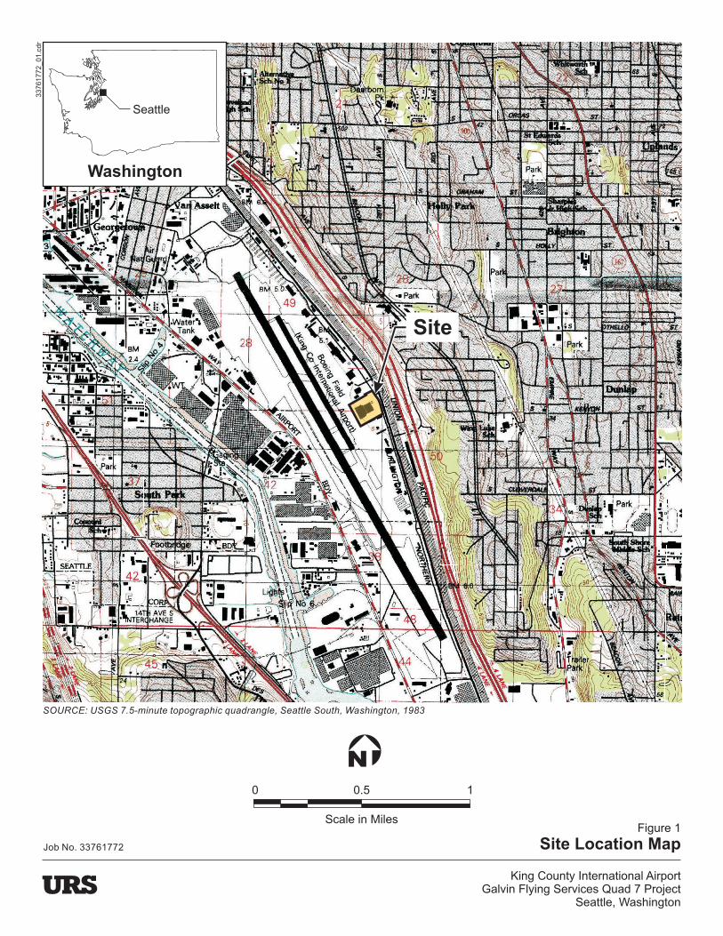
The project site is located along the east side of Boeing Field at 7777 (Parcel B) and 7827 (Parcel A) Perimeter Road South in Seattle, Washington (Figure 1). Galvin leases the property. The project site is bounded to the north by the Hanger Holdings Inc. (HHI) property (7675 Perimeter Road South), to the east by Perimeter Road South, to the south by the 7827 building parking area, and to west by the airport taxiway (Figure 2).
The project area is located in the northeastern corner of the site, which is approximately 9.23 acres and contains two approximately 41,200-square-foot hanger buildings (Hangers 3/A and 4/B), a modular office building (Building C), a boiler shed (Building D), and associated parking and landscaped areas (Figure 2). A storage compound was formerly located along the southern property line. The property is referred to as the Galvin Quad 7 property and is owned by KCIA. The adjacent HHI property also is owned by KCIA.
The site slopes gently to the west-northwest and ranges in elevation from approximately 14 to15 feet above mean sea level. The nearest surface water body is the Duwamish River, which lies approximately 3,300 feet to the southwest.
2.2 PREVIOUS INVESTIGATIONS AND CLEANUP ACTIONS
Phase I environmental site assessments (ESAs) and subsurface investigations conducted at the site identified contamination associated with historical land use prior to Galvin’s lease of the property in 2002 (PES 2002). Remedial actions were implemented at the project site to address release(s) of Jet A fuel that had migrated from the adjacent HHI property onto the northeastern portion of the site from historic aviation fueling operations (PES 2003, 2005, and 2006). Voluntary cleanup actions subsequently implemented for HHI included drilling soil borings, installing monitoring wells, and excavating Jet A fuel-affected soils on the subject property. The cleanup work was conducted under Ecology’s Voluntary Cleanup Program (VCP No. NW1167). URS presented an in-depth summary of the prior investigations and cleanup measures conducted at the subject property and the adjacent HHI property in their remedial
W:\WM&RD\KCIA\WO#17 - Galvin Flying Services\VCP\Cleanup Report\VCP Report_KCIA 7777.doc 2
action plan (URS 2009). An overview of the prior remedial activities is provided below and a summary is provided in Appendix A. Excavation of soil contaminated with Jet A fuel in the northeastern corner of the Galvin Quad 7 property was performed August through December 2004 (PES 2005). The resulting excavation area is depicted on Figure 3. Approximately 580 tons of PCS was excavated and transported off site for treatment and disposal. An additional 700 cubic yards was temporarily stockpiled on site and tested, and soil with petroleum hydrocarbon concentrations of less than 10,000 mg/kg was used to backfill the excavation. Confirmation soil samples were collected from the excavation and sample results exceeding applicable MTCA cleanup levels are provided on Figure 3. In January 2005, monitoring well MW-10 was installed within the excavation (Figure 3) and subsequent groundwater monitoring detected free product and elevated levels of Jet A fuel constituents.
Redevelopment of the subject property proposed by Galvin in 2009 would have consisted of demolishing the existing structures, removing pavement, revising the existing subgrade utilities and constructing seven new hanger buildings for storage and light maintenance of private and corporate aircraft. The cleanup of Jet A fuel affected soils was to occur during the proposed redevelopment. Subsequently, Galvin postponed redevelopment and construction of their new facilities. However, KCIA moved forward with the voluntary cleanup of the Jet A contaminated soil and groundwater to facilitate future site redevelopment plans. KCIA and URS met with Ecology and, based on our discussions, the prior VCP number was rescinded and the HHI and Galvin leaseholds were re-enrolled into the VCP as two separate properties: NW2166 and NW2167, respectively. Ecology also requested that measures be taken to mitigate the potential recontamination of the remediated area by installing a barrier. Therefore, URS designed a gravity wall shoring system that would provide both a hydraulic barrier and shoring to accommodate removal of affected soils adjacent to the northern boundary of the leasehold.
2.3 SUBSURFACE CONDITIONS
2.3.1 Hydrogeology
The site is underlain by fill material consisting of silty fine to coarse sand with varying amounts of gravel, which overlies reworked and native alluvial deposits. The fill generally ranges in thickness from 2 to 6 feet. The initial Jet A remedial excavation located in the northeastern corner or the subject property was excavated to approximately 10 feet below ground surface (bgs). This area of the site contains up to 10 feet of fill and quarry spalls were used to backfill the excavation to a depth of approximately 6.5 feet bgs (PES 2005). URS’s geotechnical investigation identified gravelly fill material to a depth of approximately 12 feet bgs within the former excavation area (URS 2009). The underlying native alluvial deposits consisted of interbedded light brown to grayish brown silty sand with dark brown to black fine to medium sands. Gravel and organic matter also was noted within the alluvial material, as well as thin clay layers. The alluvial material ranges in thickness from 20 to 60 feet and is underlain by glaciolacustrine deposits (PanGeo, Inc. 2009).
Groundwater was encountered at depths ranging from approximately 5.5 feet to 9 feet bgs during drilling of the borings and monitoring wells (Figure 3) installed at the subject property (PES 2002). Five monitoring wells (MW-5, MW-6, MW-8, MW-9, and MW-10) were located on the subject property. With the exception of MW-10, all of the wells appear to have been screened within native soils. MW-10 appears to have been screened mostly within gravel backfill in the central portion of the initial remedial excavation. Static groundwater levels measured within the site monitoring well network located in the northeastern portion of the property ranged from approximately 6 feet to 11 feet bgs. The saturated zone beneath the subject property consists of silty sands grading to fine to medium sands. Based on static

W:\WM&RD\KCIA\WO#17 - Galvin Flying Services\VCP\Cleanup Report\VCP Report_KCIA 7777.doc 3
groundwater level measurements, the groundwater gradient has been documented to be westerly to southwesterly toward the Duwamish River.
Light non-aqueous phase liquid (LNAPL), also known as “free product,” was detected in one monitoring well, MW-10. LNAPL measurements in MW-10 collected on a monthly basis in 2008 ranged from 0.17 to 0.4 feet, and during the winter of 2009 ranged from 0.04 to 0.32 feet. Monitoring wells MW-6 and MW-10 were decommissioned in July 2010 prior to implementing the remedial excavation work.
2.3.2 Jet A Petroleum Hydrocarbon Distribution
Soil
Jet A petroleum hydrocarbon contamination was identified both in the northeastern portion of the subject property and to the north, on the HHI property. The extent of petroleum hydrocarbon contamination was generally defined during multiple phases of investigations conducted at both properties. Soil remediation was initially undertaken at the adjacent HHI property and the subject property. This consisted of removing Jet A petroleum hydrocarbon-impacted soils exceeding 10,000 mg/kg (PES 2005). Soil with Jet A petroleum hydrocarbon levels less than 10,000 mg/kg were generally placed back into the remedial excavations. The limits of the prior soil excavation area are depicted on Figures 3 and 4. Jet A petroleum hydrocarbon concentrations left in place in this area ranged from 2,010 to 16,400 mg/kg, which exceeds the MTCA Method A soil cleanup level of 2000 mg/kg. Selected soil analytical data is presented on Figure 3. The affected soils covered an estimated area of approximately 5,600 square feet and appeared to extend to depths of between approximately 10 to 15 feet.
Groundwater
Following the remedial actions, LNAPL was discovered in monitoring wells at the subject property (MW-10) and at HHI (MW-4 and MW-7). Subsequently, three product recovery wells (RW-1, RW-2, and RW-3) were installed on the HHI property (Figure 3). These wells depress the groundwater table and skim accumulated product. Groundwater monitoring wells MW-5, MW-6, MW-8, MW-9, and MW-10 are located on the subject property (Figure 3). As mentioned above, LNAPL was detected in MW-10 in 2006. Subsequently, KCIA implemented product removal in 2006 using a multi-phase extraction vacuum pump and a limited quantity of product (<2 gallons) was recovered after nine multi-phase extraction events (PES 2006). Recent LNAPL measurements in MW-10 during 2009 indicated product thicknesses ranging from a film to 0.3 feet. Jet A range petroleum hydrocarbons have been detected in groundwater samples from MW-5, MW-9, and MW-10. The highest levels of Jet A-range petroleum were detected in MW-10, and have consistently exceeded the MTCA Method A groundwater cleanup level of 0.5 mg/L. Jet A-range petroleum hydrocarbons also were detected at the closest downgradient well adjacent to the former remedial excavation (MW-5) at levels exceeding applicable cleanup levels. Jet A-range petroleum hydrocarbons at downgradient monitoring wells located less than 100 feet from the edge of the remedial excavation either were not detected (MW-8) or were detected at levels ranging from 0.49 mg/L to 0.796 mg/L (MW-9). Lube oil range petroleum has been detected in MW-8 at concentrations ranging from 0.52 mg/L to 1.06 mg/L. No elevated levels of benzene, toluene, ethylbenzene, or xylenes have been detected in the groundwater samples collected from MW-5, MW-6, MW-8, MW-9, and MW-10. As mentioned in Section 2.3.1, monitoring wells MW-6 and MW-10 were decommissioned in July 2010.

W:\WM&RD\KCIA\WO#17 - Galvin Flying Services\VCP\Cleanup Report\VCP Report_KCIA 7777.doc 4
3.0 VOLUNTARY CLEANUP SCOPE AND FINDINGS
3.1 SELECTION OF CLEANUP LEVELS
The cleanup actions implemented at the site were conducted in accordance with Ecology’s Voluntary Cleanup Program. Based on the nature of the contamination present and the site’s current and anticipated future commercial land use, MTCA Method A soil cleanup levels were used as the applicable cleanup standard. The cleanup levels were as follows:
Compound of Concern Cleanup Level (mg/kg) Basis Jet A Range Petroleum Hydrocarbons 2,000 MTCA Method A Diesel Range Petroleum Hydrocarbons 2,000 MTCA Method A
Oil Range Petroleum Hydrocarbons 4,000 MTCA Method A
The Method A soil cleanup levels for the petroleum hydrocarbons compounds are based on protection of groundwater (either as a residential drinking water source or for prevention of the formation of free product on groundwater) and are the most stringent soil cleanup levels for petroleum hydrocarbons. Soils exhibiting field evidence of petroleum impacts (e.g., hydrocarbon odor, staining, elevated photoionization detector [PID] readings, etc.) were removed during the excavation activities and were handled as petroleum-contaminated.
3.2 SCOPE
The purpose of the voluntary cleanup actions was to document and confirm the removal of Jet A petroleum hydrocarbon-contaminated soil and disposing of these soils at a permitted facility. To accomplish this objective, URS retained Cascade Drilling Company of Woodinville, Washington to decommission wells (e.g., MW-6 and MW-10) and install two new monitoring wells (MW-11 and MW-12); Fremont Analytical of Seattle, Washington to provide analytical testing services; and APS of Issaquah, Washington to provide utility locating services. Clearcreek Contractors of Everett, Washington, under direct contract to KCIA, installed of the barrier/gravity wall system, relocated and reconnected utilities within the project area, performed soil excavation and dewatering activities, and transported PCS to the off-site disposal facility. The specific scope of work performed by URS and the above referenced contractors was as follows:
URS Corporation
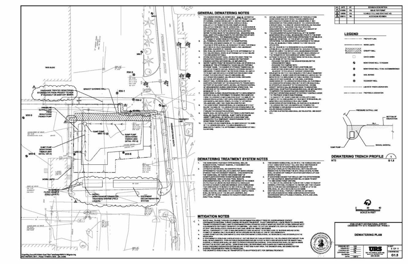
Designed the gravity wall system and prepared bid plans and specifications for King County entitled “7777 Site Remediation – Phase 3, Contract C00490C09 (King County 2010). The bid document included: the demolition plan, utility relocation plan; temporary erosion control and a dewatering plan. The plan drawings are provided in Appendix B.
Assisted King County with evaluation and selection of the gravity wall/excavation contractor.
Monitored contractor’s relocation and reconnection of water, stormwater, and sanitary sewer utilities in project area.

W:\WM&RD\KCIA\WO#17 - Galvin Flying Services\VCP\Cleanup Report\VCP Report_KCIA 7777.doc 5
Monitored installation of the barrier/gravity wall for compliance with the barrier wall installation specifications and reviewed quality assurance testing data.
Monitored removal of the Jet A affected soils and implemented field screening in accordance with URS’s Remedial Action Plan (URS 2009).
Documented the soil conditions at the base and sidewalls of the remedial excavation and collected post-excavation soil samples to confirm cleanup levels had been achieved or if additional excavation was warranted.
Collected stockpiled soil samples for waste characterization.
Submitted soil samples to Fremont Analytical laboratory for analysis.
Monitored the drilling and installation of monitoring wells MW-11 and MW-12.
Prepared this report summarizing the field activities, analytical results, and conclusions associated with the soil remedial actions.
APS
Assisted with locating on-site utilities and tracing water lines.
Cascade Drilling
Filed required Ecology well decommissioning and installation permits.
Decommissioned monitoring wells MW-6 and MW-10 in accordance with Ecology regulations.
Provided drilling and well installation services for new monitoring wells MW-11 and MW-12.
Clearcreek Contractors
Conducted all site preparation activities, including implementation of the temporary erosion/sediment control plan, utility relocation plan; dewatering plan and obtaining all necessary permits.
Installed the barrier/gravity wall along the northern leasehold boundary.
Excavated and segregated soils exhibiting evidence of petroleum hydrocarbons based on field screening results obtained by URS in accordance with the Remedial Action Plan (URS 2009).
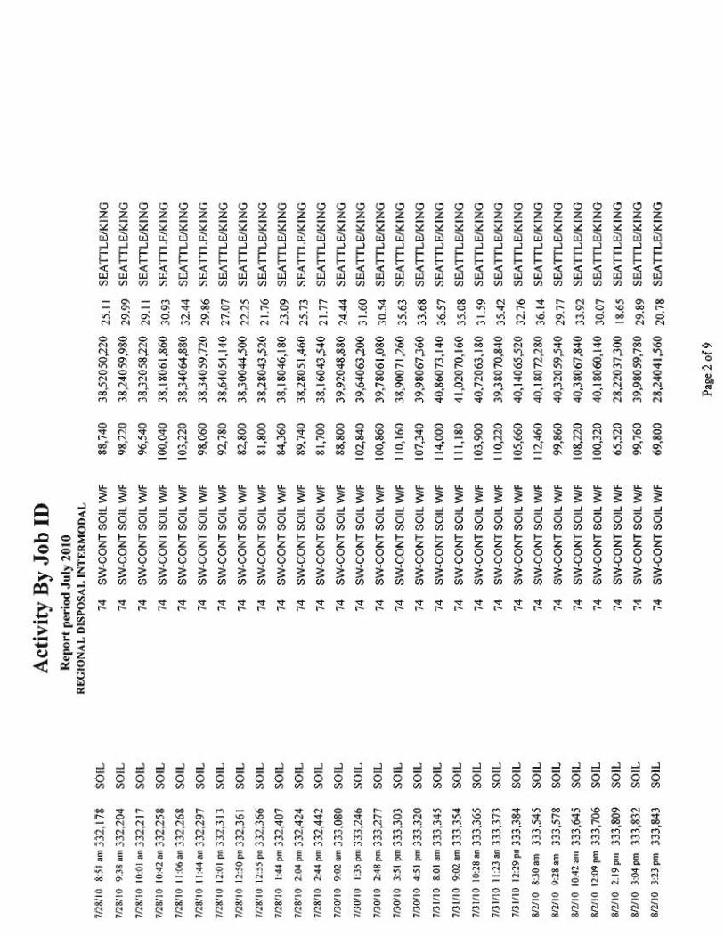
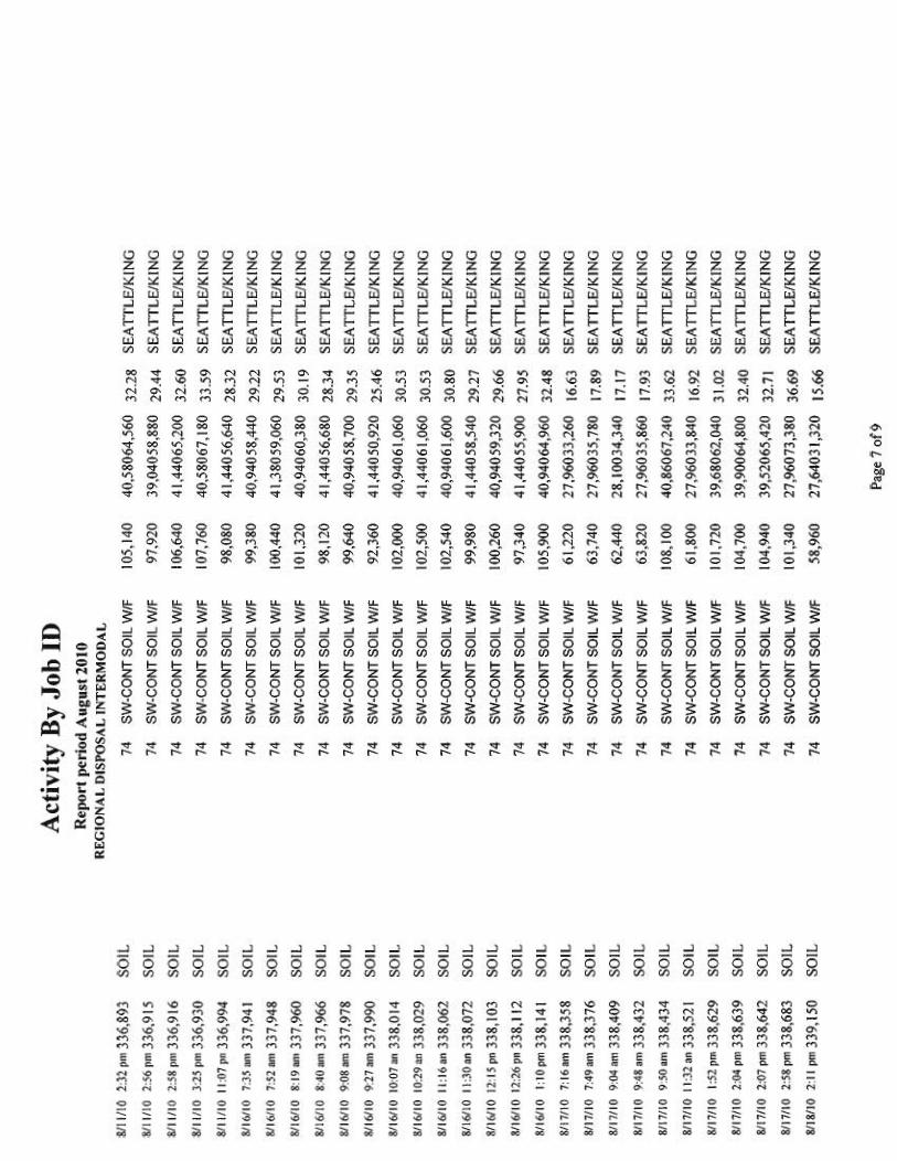
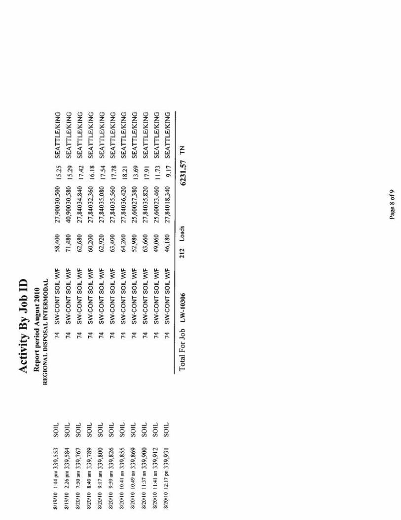
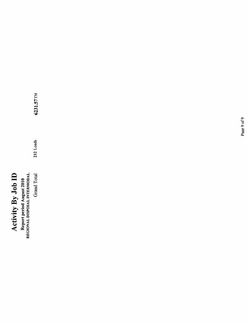
Transported approximately 6,261 tons of soil containing petroleum hydrocarbons to the Rabanco/Allied Waste transfer station in South Seattle, Washington.
Reconnected all utilities and backfilled and compacted the excavation.
Regraded the excavation area and hydroseeded the surface.
Freemont Analytical
Performed analytical testing of stockpile and post-excavation soil samples for Jet A-, diesel-, mineral oil-, and lube oil-range petroleum hydrocarbons by Ecology Method NWTPH-Diesel Extended (Dx).
Specific details of the cleanup action and methodology used for soil sampling, field screening, and laboratory analyses performed are presented in Sections 3.3 through 3.6.

W:\WM&RD\KCIA\WO#17 - Galvin Flying Services\VCP\Cleanup Report\VCP Report_KCIA 7777.doc 6
3.3 BARRIER/GRAVITY WALL INSTALLATION
Prior to implementing the removal of Jet A affected soils, Clearcreek installed the soil-cement-bentonite barrier/gravity wall between July 26 and August 3, 2010. The purpose of the barrier/gravity wall was to:
Provide a shoring wall to allow contaminated soils to be safely excavated up to the approximate northern boundary of the leasehold
Provide a barrier to contaminated groundwater and free product migration from the adjacent HHI property to the subject property
Clearcreek pre-trenched the length of the wall to clear any obstacles, reroute utilities crossing the alignment of the wall, and to identify any unknown utilities. PCS removed during the pre-trenching activities was sent off site for disposal. The barrier/gravity wall was installed per the specifications described in Section 02260 of the technical specifications (King County 2010). The location of the gravity wall is depicted on Figure 4. The permeability and strength of the barrier/gravity wall material was formulated to meet the technical specifications of < (5 x 10⁻⁷) cm/sec and > 20 psi and < 300 psi at 28 days, respectively. An as-built drawing of the barrier/gravity wall construction is included in Appendix C. The wall was 120 feet in length and 10 feet in wide (Figure 4), and was installed to a depth of 15 feet bgs.
During the gravity wall installation, records of bentonite slurry mix quantities, proportions of additives utilized, and adjustment to the slurry mix were maintained. Soil-cement-bentonite slurry trench quality control testing was performed (e.g., viscosity, density, filtrate loss, and pH of initial and in-trench bentonite slurry) during the installation of the trench in conformance with the technical specifications (King County 2010). The quality assurance (QA) test data confirmed that the gravity wall specifications had been met. Following installation, the gravity wall was allowed to cure for a minimum of one week prior to allowing excavation of soil adjacent to the wall. Photographs of the barrier/gravity wall equipment and installation are presented in Appendix D.
3.4 EXCAVATION MONITORING, FIELD OBSERVATIONS, WASTE CHARACTERIZATION AND POST EXCAVATION SAMPLING PROCEDURES
3.4.1 Excavation Monitoring
The voluntary cleanup activities were implemented between August 4 and August 20, 2010 in conformance with the Remedial Action Plan (URS 2009) and included excavating and removing Jet A affected soils previously identified in the northeastern portion of the site and installing a barrier wall. Clearcreek conducted the excavation activities using a trackhoe. Photographs taken during the voluntary cleanup activities are provided in Appendix D. URS personnel were on site monitoring earthwork activities, field-screening soils, and performing stockpile and post-excavation soil sampling. URS personnel described the subsurface materials encountered in the excavation and field-screened soil samples for organic vapors using a PID. Particular attention was given to noting visible evidence of staining, discoloration, odors, or other relevant factors indicative of petroleum hydrocarbon contamination in the exposed soils.
Excavated soils consisted of fill material that was placed in the prior remedial excavation completed in 2004. The fill was characterized by gray fine to medium sand with silt and gravel. The fill material had moderate to strong hydrocarbon odors. Native soils were encountered at approximately 12 feet bgs and

W:\WM&RD\KCIA\WO#17 - Galvin Flying Services\VCP\Cleanup Report\VCP Report_KCIA 7777.doc 7
consisted of black fine to medium sand with gray silt and clay. Native soils were noted at shallower depths in the excavation sidewalls outside the footprint of the initial remedial excavation.
Field screening PID readings from excavated soils ranged from non-detect to approximately 600 ppm. Concrete debris (e.g., historic building footings) also was encountered during the excavation activities (Appendix D). Clearcreek crushed some of the concrete debris and used it as backfill. Based on field screening, the excavation was extended further south than planned to remove affected soils. Figure 4 depicts the resulting excavation. A total of approximately 6,261 tons of Jet A petroleum-affected soils were removed and transported to the Rabanco transfer station in Seattle, Washington. The soil was then transported via rail for disposal at Allied Waste’s Roosevelt Regional (Subtitle D) Landfill in Roosevelt, Washington. Disposal documentation is provided in Appendix E.
Groundwater was noted in the excavation at approximately 9 to 11 feet bgs. Therefore, the bottom of the excavation was completed below the groundwater table, which required dewatering the excavation to facilitate soil removal. The dewatering activities performed by Clearcreek are discussed in Section 3.5. Free product was not evident on the groundwater table during excavation dewatering.
The excavation was backfilled with quarry spalls and crushed concrete material salvaged from the site to approximately 7 feet bgs. The quarry spalls were covered with a geotextile liner and the remainder of the excavation was backfilled with Type 17 fill that was compacted using a roller compactor. An independent testing service (Cascade Testing) performed compaction testing at the site as part of the QA program. The results of the independent testing indicated that the materials generally meet specification requirements for compaction. The area was subsequently covered with topsoil and hydroseeded.
3.4.2 Soil Stockpile and Post Excavation Sampling
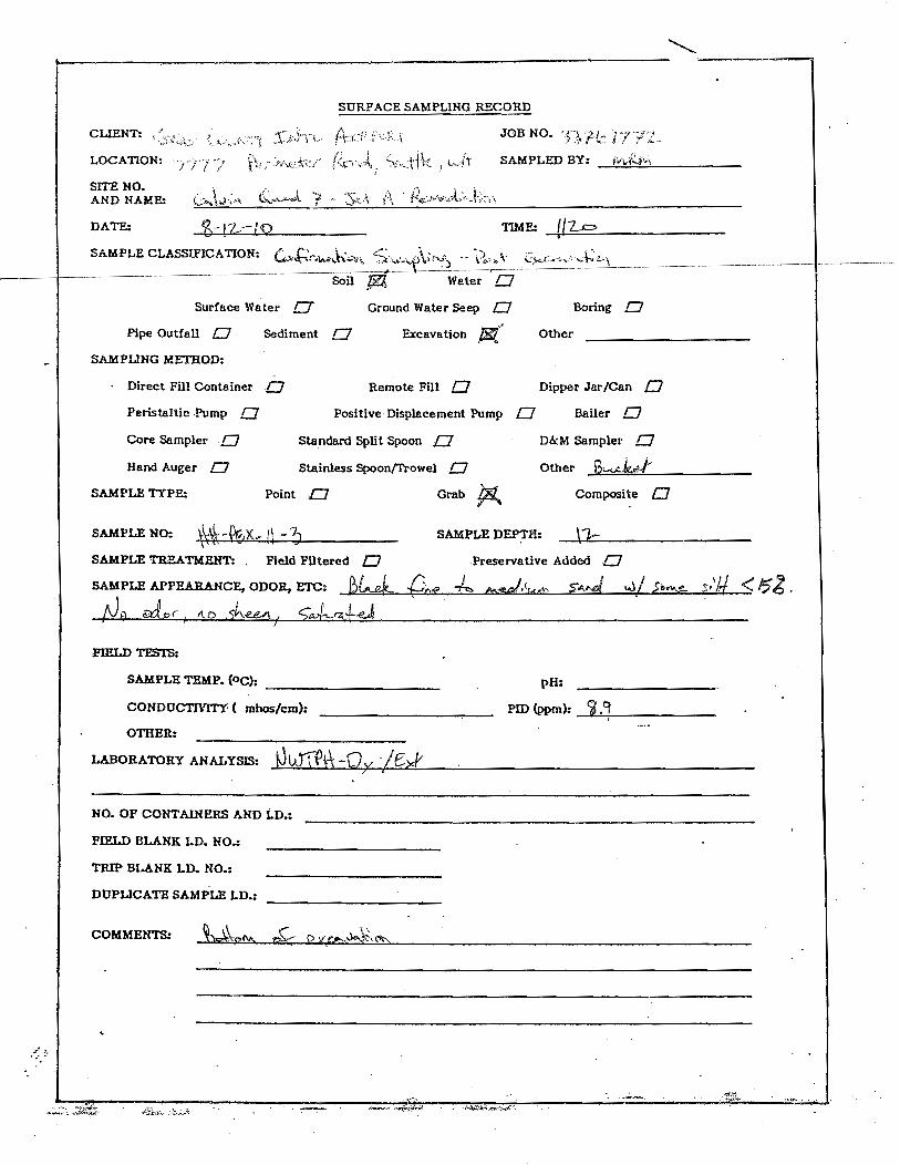
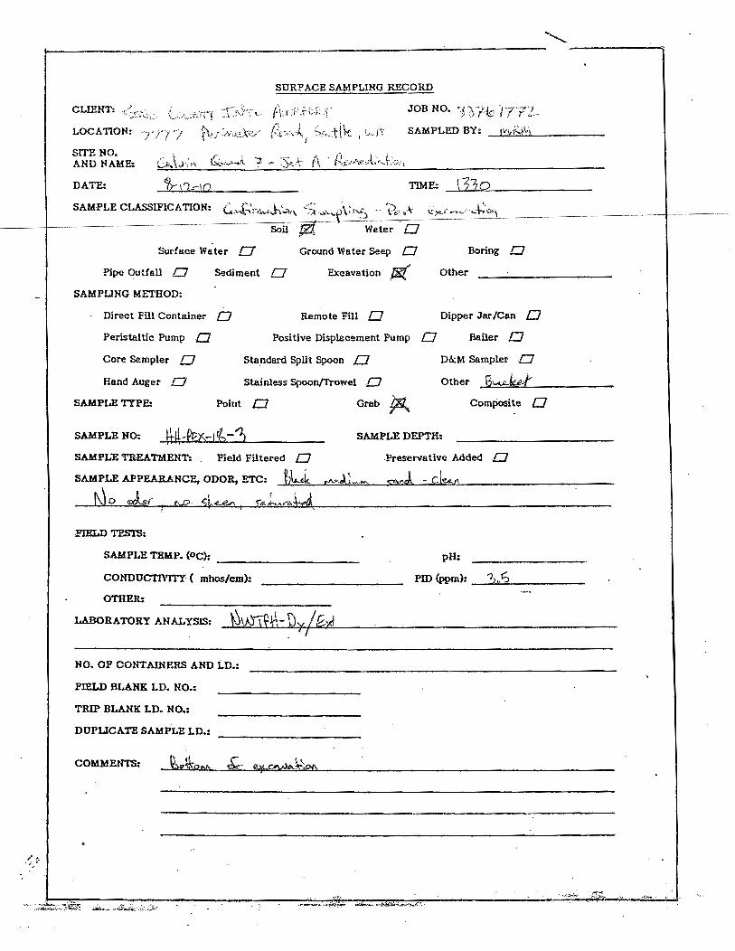
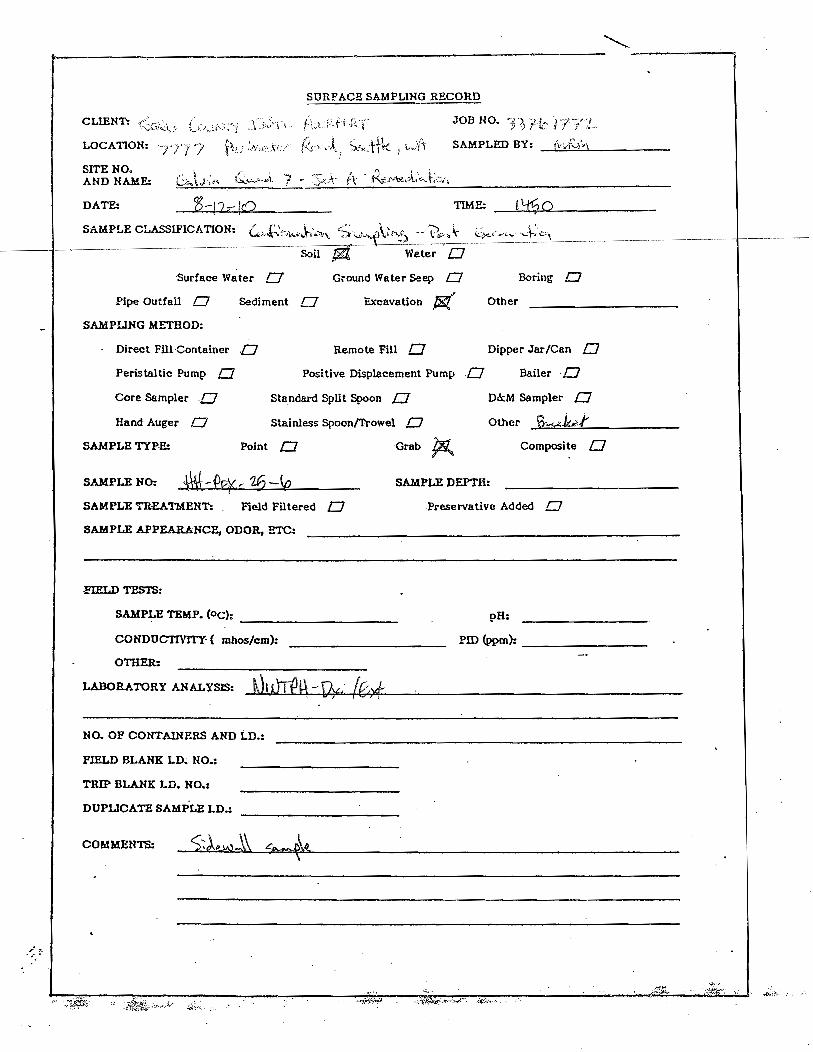
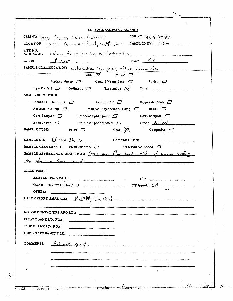
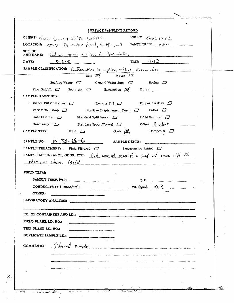
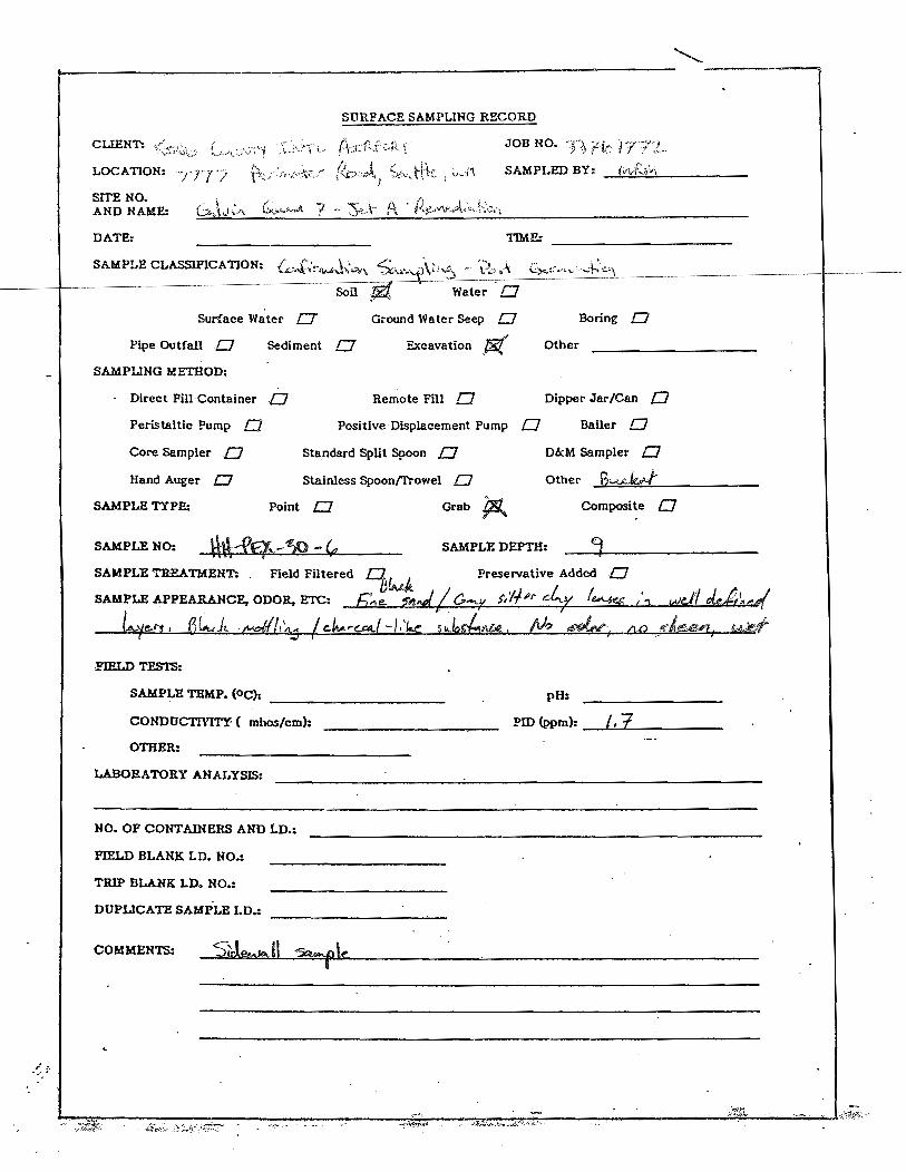
Excavated petroleum-affected soils were temporarily stockpiled or directly loaded into trucks for disposal. Samples of this material (designated Stockpile [SP]) were collected periodically to document the petroleum hydrocarbon concentrations in the soils. A total of 14 stockpile soil samples were collected during the excavation activities. When field screening indicated that excavation bases and sidewalls had evidence of only minor petroleum contamination, post-excavation soil sampling (designated PEX) was performed to confirm that the petroleum-affected soils had been removed adequately. The soil sample locations are shown on Figure 4. A total of 32 post-excavation soil samples (13 sidewall and 19 bottom of excavation) were collected from the excavation using a trackhoe and samples were collected from undisturbed soils within the trackhoe bucket. Soil sampling log forms are provided in Appendix F. The sidewall samples were collected from between 8 and 9 feet bgs. The base of excavation soil samples were collected from depths ranging from 11 to 13.5 feet bgs. The soil samples were placed in laboratory-supplied glassware, labeled and then stored in an ice chest at 4 deg. C until delivered to the laboratory under chain-of-custody protocol.
The stockpile and post-excavation soil samples were submitted for analysis to Fremont Analytical, of Seattle, Washington, an Ecology-accredited laboratory. The samples were analyzed for diesel-range- petroleum hydrocarbons (including of Jet A fuel) by US Environmental Protection Agency (EPA) Method NWTPH-Dx. Selected post-excavation soil samples also were analyzed for volatile organic compounds (VOCs) by EPA Method 8260B. The initial petroleum-affected soils excavated during pre-trenching of the gravity wall were sampled and analyzed for total metals (EPA Method 6020) for waste characterization purposes. Laboratory data was reviewed and validated by a URS chemist and no data usability issues were identified. The laboratory analytical results are summarized in Tables 1 and 2 and the laboratory analytical reports are provided in Appendix G.

W:\WM&RD\KCIA\WO#17 - Galvin Flying Services\VCP\Cleanup Report\VCP Report_KCIA 7777.doc 8
3.5 DEWATERING ACTIVITIES
Groundwater encountered at the bottom of the remedial excavation (9 to 11 feet bgs) required removal to facilitate the excavation of petroleum-affected soils at and below the groundwater table. Dewatering activities were performed by Clearcreek and included pumping groundwater from the excavation into aboveground settling tanks, filtering and treating the groundwater through granular activated carbon vessels prior to discharge to the King County sanitary sewer. Excavation dewatering discharges to the sanitary sewer were approved by the King County Wastewater Treatment Division in their May 25, 2010 “Letter of Authorization 11188-01 to Discharge to the Sanitary Sewer” (King County Wastewater Treatment Division 2010). Excavation and dewatering was conducted on an as-needed basis from August 11 through August 24, 2010. A total of approximately 183,500 gallons of treated water was discharged to the sanitary sewer (Table 3). The largest quantity of water treated and discharged to the sewer occurred on August 18th and totaled 42,700 gpd, which was well below the 92,000 gpd discharge limit.
Water samples were collected periodically following granular activated carbon treatment and prior to discharge to the sanitary sewer to ensure that discharge limitations were being met as required by discharge authorization. Table 3 summarizes analytical results for water samples collected as part of the dewatering and sanitary sewer discharge requirements. No constituents of concern were identified in the water samples.
3.6 MONITORING WELL DECOMMISSIONING AND RE-INSTALLATION
Prior to implementing the soil excavation activities, existing monitoring wells MW-6 and MW-10 located within the remediation area were decommissioned in July 2010 to facilitate excavation of Jet A-affected soils. These wells were decommissioned by Cascade Drilling, a licensed well drilling contractor, in accordance with Ecology regulations. The wells were filled with bentonite chips and were subsequently excavated during the soil remedial excavation work.
Following the completion of the soil excavation and backfilling, Cascade Drilling installed monitoring wells MW-11 (replacement for MW-10) and MW-12 on September 9, 2010. The monitoring well boring logs/as-built diagrams are provided in Appendix H and the locations are shown on Figure 5. The monitoring wells were installed using a hollow-stem auger drill rig. MW-11 was located within the central portion of the remedial excavation and native soils beneath the fill material consisted of dark gray to black fine to medium sands. Groundwater was noted at a depth of approximately 10.5 feet bgs during drilling. MW-12 was completed adjacent to the southwestern corner of the gravity wall. Native soils were noted at approximately 6 feet bgs and consisted of gray silty clays to silty sands to approximately 14 feet bgs. From 15 to 21 feet, dark gray to black fine to medium sands were noted. This sand was underlain by a silt to silty clay layer. Groundwater was noted in MW-12 at approximately 12 feet bgs. Both of the wells were screened from 8 to 20 feet bgs. The wells were developed using pump and surge techniques and approximately 55 gallons of water was purged from each well. By the end of purging, the groundwater was clear/low turbidity. Investigation-derived wastes (e.g., drill cuttings, purge water and decon water) were contained in labeled 55-gallon steel drums and will be disposed of properly.
Quarterly groundwater compliance monitoring is scheduled to begin in October 2010. The monitoring wells that will be sampled during the quarterly groundwater compliance monitoring program include MW-1, MW-5, MW-8, MW-9, MW-11, and MW-12 (Figure 5).

W:\WM&RD\KCIA\WO#17 - Galvin Flying Services\VCP\Cleanup Report\VCP Report_KCIA 7777.doc 9
4.0 ANALYTICAL RESULTS
4.1 SOIL STOCKPILE
The stockpile sampling results are summarized in Table 1. Fourteen stockpile samples (SP-1 through SP-14) were collected from the remedial excavation and analyzed for Jet A petroleum hydrocarbons by EPA Method NWTPH-Dx. The initial soils removed from the gravity wall pre-trenching were sampled (P-1) and analyzed for total metals. Jet A-range petroleum hydrocarbons were detected in 13 of the 14 stockpile soil samples at concentrations ranging from 36 mg/kg to 8,580 mg/kg. Diesel-, mineral oil-, and lube oil-range hydrocarbons were not detected above laboratory reporting limits in any of the stockpile samples. Five metals (e.g., arsenic; barium; cadmium; chromium and lead) were detected in sample P-1 at concentrations below MTCA Method A cleanup levels.
4.2 POST EXCAVATION
The post-excavation soil analytical results are summarized in Table 2 and the sampling locations are shown on Figure 4. A total of 32 post-excavation samples (PEX-1 through PEX-32) were collected and analyzed for Jet A petroleum hydrocarbons. In addition, samples PEX-1 through PEX-10 were analyzed for VOCs. Jet A-range petroleum hydrocarbons were detected in only four of the 32 post-excavation soil samples. Concentrations of Jet A ranged from 57 mg/kg (PEX-22) to 150 mg/kg (PEX-21), well below the MTCA Method cleanup level of 2,000 mg/kg. Diesel-, mineral oil, and lube oil-range hydrocarbons were not detected above laboratory reporting limits in any of the post-excavation soil samples. Low concentrations of isopropylbenzene, butylbenzene and propylbenzene also were detected in 5 of the ten samples analyzed for VOCs. No other VOCs were detected in these samples.
5.0 CONCLUSIONS AND RECOMMENDATIONS
Based on the findings of the voluntary cleanup actions undertaken at the subject property, URS has drawn the following conclusions:
The soil bentonite-cement gravity wall installed along the northern leasehold boundary allowed Jet A petroleum hydrocarbon affected soils to be effectively removed up to the leasehold boundary between Galvin and HHI by providing structural support. The wall was also designed to provide a hydraulic barrier to contaminated groundwater and free product migration from the upgradient HHI property to the subject property. Permeability and strength QA testing performed on soil-bentonite-cement mixture confirmed that project specifications have been met and that the wall will be an effective barrier to mitigate recontamination of the area remediated.
The area of Jet A petroleum affected soil was excavated by Clearcreek over a three week period in August 2010 and the resulting excavation measured approximately 120 by 80 feet and varied in depth between 11 to 13.5 feet bgs. A total of 6,261 tons of petroleum affected soils were removed for off site disposal at the Allied Waste Roosevelt Regional Landfill. Groundwater was encountered in the remedial excavation between 9 and 11 feet bgs. Thus, impacted soils below the groundwater table were removed during the excavation program. Dewatering of the excavation was conducted to facilitate the removal of saturated zone soils. Approximately 183,500 gallons of water was removed and treated onsite (e.g., settling tank

W:\WM&RD\KCIA\WO#17 - Galvin Flying Services\VCP\Cleanup Report\VCP Report_KCIA 7777.doc 10
and GAC filtration) prior to discharge to the sanitary sewer in conformance with the King County Wastewater discharge authorization.
A total of 32 post excavation (sidewall and bottom of the excavation) soil samples were collected (Figure 4) and analyzed. Based on the results, no exceedances in MTCA Method A cleanup levels were identified within the excavation. These results indicate that the remedial actions have effectively removed Jet A petroleum hydrocarbon impacted soils from the subject property. Accordingly, no further action related to Jet A petroleum hydrocarbon impacted soil are warranted. The remedial excavation was backfilled with quarry spalls and Type 17 fill which was compacted. The area was finished with topsoil and hydroseeded to prevent erosion.
Monitoring wells decommissioned prior to the remedial actions were reinstalled at the subject property. MW-11 was installed within the central portion of the remedial excavation and MW-12 was installed near the southwest corner of the gravity wall. Quarterly groundwater compliance monitoring will be conducted (e.g., MW-1, MW-5, MW-8, MW-9, MW-11 and MW-12) to assess the effectiveness of the cleanup action and the performance of the barrier/gravity wall in mitigating the migration of contaminated groundwater from the adjacent HHI property. The first round of post remediation groundwater monitoring is scheduled for Fall 2010 (October). The groundwater monitoring results will be submitted to Ecology following the completion of one year of quarterly monitoring. Based on the results of the quarterly monitoring program, URS will provide recommendations regarding regulatory closure (e.g., property specific NFA) of the subject property.
6.0 REFERENCES
King County. 2010. 7777 Site Remediation – Phase 3, Contract C00490C09, Volume 1 of 1, Bidding Requirements and Forms, General Terms and Conditions, Technical Specifications, Contract Drawings. March.
King County Wastewater Treatment Division. 2010. Letter of Authorization 11188-01 to Discharge to the Sanitary Sewer. May 25.
PanGeo, Inc. 2009. Geotechnical Report, Galvin Quad 7 Redevelopment, 7777/7827 Perimeter Road South, Seattle, Washington. July 25.
PES Environmental, Inc. (PES). 2002. Baseline Environmental Conditions Report, Galvin Fying Services, Inc. Leasehold 7777/7827 Perimeter Road South, Seattle, Washington. January 25.
———. 2003. Remedial Investigation and Focused Feasibility Study Report, Hangar Holdings, Inc, Seattle, Washington. September 10.
———. 2005. Phase 1 Independent Cleanup Action Report, Hangar Holdings Inc. 7675 Perimeter Road South, Seattle, Washington. May 15.
———. 2006. Independent Cleanup Action Update, Hangar Holdings, Inc. – VCP NW 1167; 7675 Perimeter Road South, Seattle, Washington. September 6.
URS Corporation (URS). 2009. Remedial Action Plan, Galvin Flying Services Quad 7 Project, 7777 Perimeter Road South, Seattle, WA. April 6.

W:\WM&RD\KCIA\WO#17 - Galvin Flying Services\VCP\Cleanup Report\VCP Report_KCIA 7777.doc 11
Washington State Department of Ecology (Ecology). 1995. Guidance for Remediation of Petroleum Contaminated Soils. November.

TABLES

Table 1Summary of Stockpile Soil Analytical Results
King Co International Airport - Galvin Quad 7 Remediation ProjectSeattle, WA
Jet A Range Hydrocarbons
Diesel Range Hydrocarbons
Mineral Oil Range
Hydrocarbons
Lube Oil Range Hydrocarbons
SP-01 8/4/2010 8,580 ND ND ND
SP-02 8/4/2010 403 ND ND ND
SP-03 8/5/2010 333 ND ND ND
SP-04 8/5/2010 1,210 ND ND ND
SP-05 8/6/2010 2,660 ND ND ND
SP-06 8/6/2010 5,790 ND ND ND
SP-07 8/6/2010 1,340 ND ND ND
SP-08 8/9/2010 2,500 ND ND ND
SP-09 8/9/2010 480 ND ND ND
SP-10 8/11/2010 4,900 ND ND ND
SP-11 8/11/2010 36 ND ND ND
SP-12 8/16/2010 ND ND ND ND
SP-13 8/20/2010 380 ND ND ND
SP-14 8/20/2010 1,030 ND ND ND
2,000 2,000 4,000 2,000
Notes:Numbers in bold font indicate that the reported result meets or exceeds the MTCA Method A soil cleanup level.
Model Toxics Control Act (MTCA) Cleanup Regulation, WAC 173-340. MTCA Method A values are from Ecology website
CLARC tables downloaded August 2010 (https://fortress.wa.gov/ecy/clarc/reporting/CLARCReporting.aspx).
ND = Not detected
SP = Stockpile
* P-1 (sampled 7/9/2010) was analyzed for metals. The following metals were detected: arsenic 3.77 mg/kg,
barium 152 mg/kg, cadmium 0.415 mg/kg, chromium 16.5 mg/kg, lead 58.3 mg/kg. Mercury, selenium, and silver were not detected.
MTCA Method A Soil Cleanup Level (mg/kg)
Concentration (mg/kg)
SampleDate
SampleID
W:\WM&RD\KCIA\WO#17 - Galvin Flying Services\VCP\Cleanup Report\Tables\Tables 1 through 3Table 1

Table 2Summary of Post-Excavation Soil Analytical Results
King Co International Airport - Galvin Quad 7 Remediation ProjectSeattle, WA
Sample Depth Elevation (ft AMSL)
Jet A Range Hydrocarbons
Diesel Range Hydrocarbons
Mineral Oil Range
Hydrocarbons
Lube Oil Range Hydrocarbons
VOCs
PEX-1-3 12 3 8/10/2010 ND ND ND ND ND
PEX-2-3 12 3 8/10/2010 ND ND ND ND ND
PEX-3-7 8 7 8/11/2010 ND ND ND ND ND
PEX-4-3a 12 3 8/11/2010 ND ND ND ND ND
PEX-5-3b 12 3 8/11/2010 ND ND ND ND ND
PEX-6-3 12 3 8/11/2010 ND ND ND ND ND
PEX-7-6.5 8.5 6.5 8/11/2010 ND ND ND ND ND
PEX-8-4c 11 4 8/11/2010 ND ND ND ND ND
PEX-9-3d 12 3 8/11/2010 ND ND ND ND ND
PEX-10-3e 12 3 8/11/2010 ND ND ND ND ND
PEX-11-3 12 3 8/12/2010 ND ND ND ND NA
PEX-12-3 12 3 8/12/2010 ND ND ND ND NA
PEX-13-2 13 2 8/12/2010 ND ND ND ND NA
PEX-14-2 13 2 8/12/2010 ND ND ND ND NA
PEX-15-2 13 2 8/12/2010 ND ND ND ND NA
PEX-16-3 12 3 8/12/2010 ND ND ND ND NA
PEX-17-1.5 13.5 1.5 8/12/2010 ND ND ND ND NA
PEX-18-3 12 3 8/12/2010 ND ND ND ND NA
PEX-19-3 12 3 8/12/2010 ND ND ND ND NA
PEX-20-3 12 3 8/12/2010 ND ND ND ND NA
PEX-21-6.5 8.5 6.5 8/12/2010 150 ND ND ND NA
PEX-22-6.5 8.5 6.5 8/12/2010 57 ND ND ND NA
PEX-23-6.5 8.5 6.5 8/12/2010 ND ND ND ND NA
PEX-24-6 9 6 8/12/2010 100 ND ND ND NA
PEX-25-6 9 6 8/12/2010 130 ND ND ND NA
PEX-26-6 9 6 8/12/2010 ND ND ND ND NA
PEX-27-6 9 6 8/16/2010 ND ND ND ND NA
PEX-28-6 9 6 8/16/2010 ND ND ND ND NA
PEX-29-6 9 6 8/16/2010 ND ND ND ND NA
PEX-30-6 9 6 8/20/2010 ND ND ND ND NA
PEX-31-6 9 6 8/20/2010 ND ND ND ND NA
PEX-32-6 9 6 8/20/2010 ND ND ND ND NA
2,000 2,000 4,000 2,000 Varies
Notes:Numbers in bold font indicate that the reported result meets or exceeds the MTCA Method A soil cleanup level.
Model Toxics Control Act (MTCA) Cleanup Regulation, WAC 173-340. MTCA Method A values are from Ecology website
CLARC tables downloaded August 2010 (https://fortress.wa.gov/ecy/clarc/reporting/CLARCReporting.aspx).
ft bgs = feet below ground surface
Grade Elevation = approximately 15 feet above mean sea level (AMSL)
J = Estimated value
NA = Not analyzed
ND = Not detected
PEX = Post Excavation
VOCs = Volatile organic compoundsa PEX-4-3 had sec-butylbenzene at 0.02 mg/kgb PEX-5-3 had n-propylbenzene at 0.02 mg/kg and n-butylbenzene at 0.01 mg/kg. n-Butylbenzene was reported at a concentration less than the reporting limit, but above the method detection limit--this result is an estimated valuc PEX-8-4 had sec-butylbenzene at 0.04 mg/kg, isopropylbenzene at 0.03 mg/kg, and n-propylbenzene at 0.01 mg/kg. Isopropylbenzene and n-propylbenzene were reported at concentrations less than the reporting limits, but abo the method detection limits--these results are estimated values.d PEX-9-3 had n-propylbenzene at 0.02 mg/kg and isopropylbenzene at 0.02 mg/kg. Isopropylbenzene was reported at a concentration less than the reporting limit, but above the method detection limit--this result is an estimated value PEX-10-3 had n-propylbenzene at 0.02 mg/kg.
MTCA Method A Soil Cleanup Level (mg/kg)
Concentration (mg/kg)
Site LocationSample
DateSample Depth (Grade=ft bgs)
SampleID
Jet A Release
W:\WM&RD\KCIA\WO#17 - Galvin Flying Services\VCP\Cleanup Report\Tables\Tables 1 through 3Table 2

Table 3Summary of Wastewater Discharge Monitoring Analytical ResultsKing Co International Airport - Galvin Quad 7 Remediation Project
Seattle, WA
SampleDate
Discharge Volume (gpd)
Discharge through GAC
(yes/no)NP FOG (mg/L) Benzene (mg/L) Toluene (mg/L)
Ethylbenzene (mg/L)
Total Xylenes (mg/L)
PCE (mg/L)
8/11/2010 18,700 yes ND ND ND ND ND ND
8/12/2010 17,000 yes -- -- -- -- -- --
8/16/2010 22,400 yes -- -- -- -- -- --
8/17/2010 41,800 yes -- -- -- -- -- --
8/18/2010 42,700 yes -- -- -- -- -- --
8/19/2010 12,000 yes -- -- -- -- -- --
8/20/2010 10,400 yes ND ND ND ND ND ND
8/23/2010 12,100 yes -- -- -- -- -- --
8/24/2010 6,400 yes -- -- -- -- -- --
Discharge
Limitations1 92,000 NA 100 0.07 1.4 1.7 2.2 0.24
Notes-- = no sample collectedgpd = gallons per day (approximate)GAC = granular activated carbonND = None detectedNP FOG = Nonpolar fats, oils, and greasemg/L = milligrams per literPCE = tetrachloroethene1Per King County Wastewater Treatment Division Letter of Authorization 11188-01 to Discharge to the Sanitary Sewer, dated May 25, 2010.
W:\WM&RD\KCIA\WO#17 - Galvin Flying Services\VCP\Cleanup Report\Tables\Tables 1 through 3Table 3

FIGURES
Job No. 33761772
Figure 1
Site Location Map
King County International AirportGalvin Flying Services Quad 7 Project
Seattle, Washington
33
76
17
72
_0
1.c
dr
Scale in Miles
0.5 10
Washington
Seattle
Site
SOURCE: USGS 7.5-minute topographic quadrangle, Seattle South, Washington, 1983

LEGEND
Galvin leasehold boundary
Limits of prior Jet A fuel excavation
Project area
HangarHoldings
Inc.(7675)
HangarHoldings
Inc.(7675)
Hangar 3/A(7827 Perimeter Rd. S.)
Hangar 3/A(7827 Perimeter Rd. S.)
Hangar 4/B(7777 Perimeter Rd. S.)
Hangar 4/B(7777 Perimeter Rd. S.)
Boiler Shed(Building D)
Office(Building C)
Perim
eter Rd. S
.
Airp
ort W
ay
Storage Compound Area
Storage Compound Area
Boiler Shed(Building D)
Office(Building C)
Perim
eter Rd. S
.
Airp
ort W
ay
Job No. 33761772
Figure 2
Site Plan
King County International AirportGalvin Flying Services Quad 7 Project
Seattle, Washington
33
76
17
72
_0
3.c
dr
Approximate Scale in Feet
150 3000
SOURCE: Google Earth Pro, TerraMetrics 2009
Boiler Shed(Building D)
Office(Building C)
Airp
ort W
ay
Perim
eter Rd. S
.
Storage Compound Area
Taxiway
Taxiway
LEGEND
Galvin leasehold boundary
Limits of prior Jet A fuel excavation
Project area

Jet A Range Hydrocarbons
Diesel Range Hydrocarbons
Lube Oil Range
HydrocarbonsBenzene Toluene Ethylbenzene
Total Xylenes
CS-2 10 9/28/2004 8,270 NA 94.7 NA NA NA NACS-3 10 9/28/2004 8,060 NA 55.7 NA NA NA NACS-5 10 9/28/2004 6,780 NA 31.7 NA NA NA NACS-7 9 9/28/2004 4,280 NA 27.6 NA NA NA NACS-9 9 9/28/2004 7,830 NA 31.3 NA NA NA NACS-12 5 9/28/2004 4,040 NA 53.3 NA NA NA NA
CS-16(B) 9 10/18/2004 8,730 NA <500 NA NA NA NACS-18 5 10/13/2004 2,570 NA 61.7 NA NA NA NACS-21 9 10/13/2009 16,400 NA 78.9 NA NA NA NA
3-5 9/20/2000 2,010 1,350 NR <0.050 <0.060 <0.41 <5.28-10 9/20/2000 9,620 5,760 NR <1.0 <1.0 <8.3 <15
SB-8 8-10 9/20/2000 13,700 8,700 NR <0.50 <0.96 <14.6 <37.73-6 11/6/2000 5,440 3,530 NR NA NA NA NA6-9 11/6/2000 3,110 1,970 NR NA NA NA NA3-6 11/6/2000 6,250 4,030 NR NA NA NA NA6-9 11/6/2000 13,400 8,090 NR NA NA NA NA9-12 11/6/2000 2,120 1,390 NR NA NA NA NA4-6 4/21/2004 6870 NA 1,090 < 0.4 < 0.4 26.6 18.58-10 4/21/2004 11.3 NA < 25 0.128 0.284 1.27 6.54
U-1-09 14.0-15.5 2/5/2009 8,100 <20 NA NA NA NA NAU-2b-09 9.0-10.5 2/5/2009 5,800 J <20 NA NA NA NA NA
2,000 2,000 2,000 0.03 7.0 6.0 9.0
Notes:
Bold values indicate that the detected value is above the corresponding screening level (MTCA Method A cleanup level).J = Result is estimatedNA = Not analyzedNR = Fraction not identified in associated hydrocarbon identification analysisCS = Post excavation confirmation sampleSB = Soil Boring* 2000-2004 data from PES Environmental Inc. (2000, 2002, 2005).
SampleID
MTCA Method A Soil Cleanup Level (mg/kg)
Concentration (mg/kg)
Jet A Release AreaSB-6
SB-17
SBG-19
SB-18
Site LocationSample
Date*
Sample Depth (feet)


APPENDIX A
SITE INVESTIGATION/REMEDIATION SUMMARY

A-1
APPENDIX A – ENVIRONMENTAL OVERVIEW
Galvin Flying Services Leasehold
The environmental assessment of the Quad 7 parcel conducted in January 2002 for King County identified soil and groundwater contamination from on-site and off-site sources (PES Environmental 2002). The Quad 7 parcel currently has two hangars: Hangar A and B. The hangars are used for aircraft storage and light maintenance and office space. One hangar was built in 1950 and the other in 1963. Galvin subleased the hangars in 1995 from Burlington Resource Aviation and entered into a lease agreement directly with King County in 1999. Prior to Galvin leasing the Quad 7 parcel, King County conducted a Baseline Environmental Assessment of the parcel to document the existing environmental conditions at the site. The assessment identified the following:
Between 1999 and 2001, King County conducted soil and groundwater investigations on the Quad 7 parcel including the hangar buildings, the former chemical storage shed, the former USTs that were connected to the oil burners in the hangar buildings, and the northeast corner of the property to assess the impacts of the plume from the former Shell and Union Oil UST site located on the Hanger Holdings property.
The investigations included 35 test pits and installation of four groundwater monitoring wells
Sixty six soil samples and 30 groundwater samples were collected for analysis of petroleum hydrocarbons, VOCs, and metals
The investigations identified contamination beneath the hangars, at the former Chemical Storage Compound/Shed, and at the northeast corner of the parcel associated with the former Shell and Union Oil underground aviation fuel facility plume
No evidence of petroleum contamination was detected around the former USTs that were located north of the boiler shed and were removed in 1990
Three oil/water separators were identified, one on the north and south sides of Hangar 4 and one in the southeast corner of the property near the storage compound.
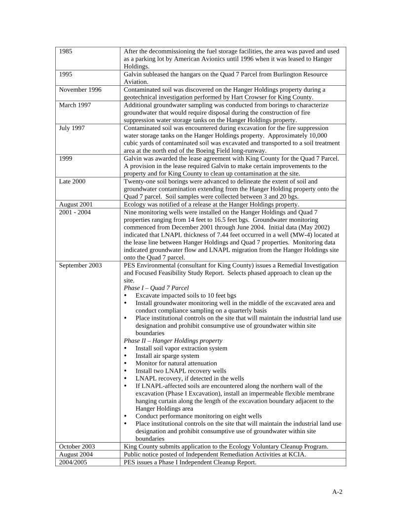
Hangar Holdings Leasehold
The Hangar Holdings property located adjacent to the north side of Quad 7 parcel had several phases of investigation and remedial actions. A summary of the site history and related information is provided in the chart below.
1940 to 1950 The Hanger Holdings and Quad 7 site were developed for aviation related activities.
1954 to 1984 Shell Oil leased the southeastern portion of Hanger Holdings property and installed 8 steel USTs for storage of Jet fuel and aviation gasoline, and a loading rack.
1950 to 1984 Union Oil leased a portion of Hanger Holdings property and installed 3 steel 8,000-gallon USTs containing aviation gasoline, and a loading rack.
1984 to 1985 USTs and associated piping were decommissioned by October 1984 and removed in 1985. There is no documentation of conditions observed during excavation and tank closure work.
A-2
1985 After the decommissioning the fuel storage facilities, the area was paved and used as a parking lot by American Avionics until 1996 when it was leased to Hanger Holdings.
1995 Galvin subleased the hangars on the Quad 7 Parcel from Burlington Resource Aviation.
November 1996 Contaminated soil was discovered on the Hanger Holdings property during a geotechnical investigation performed by Hart Crowser for King County.
March 1997 Additional groundwater sampling was conducted from borings to characterize groundwater that would require disposal during the construction of fire suppression water storage tanks on the Hanger Holdings property.
July 1997 Contaminated soil was encountered during excavation for the fire suppression water storage tanks on the Hanger Holdings property. Approximately 10,000 cubic yards of contaminated soil was excavated and transported to a soil treatment area at the north end of the Boeing Field long-runway.
1999 Galvin was awarded the lease agreement with King County for the Quad 7 Parcel. A provision in the lease required Galvin to make certain improvements to the property and for King County to clean up contamination at the site.
Late 2000 Twenty-one soil borings were advanced to delineate the extent of soil and groundwater contamination extending from the Hanger Holding property onto the Quad 7 parcel. Soil samples were collected between 3 and 20 bgs.
August 2001 Ecology was notified of a release at the Hanger Holdings property. 2001 - 2004 Nine monitoring wells were installed on the Hanger Holdings and Quad 7
properties ranging from 14 feet to 16.5 feet bgs. Groundwater monitoring commenced from December 2001 through June 2004. Initial data (May 2002) indicated that LNAPL thickness of 7.44 feet occurred in a well (MW-4) located at the lease line between Hanger Holdings and Quad 7 properties. Monitoring data indicated groundwater flow and LNAPL migration from the Hanger Holdings site onto the Quad 7 parcel.
September 2003 PES Environmental (consultant for King County) issues a Remedial Investigation and Focused Feasibility Study Report. Selects phased approach to clean up the site. Phase I – Quad 7 Parcel Excavate impacted soils to 10 feet bgs Install groundwater monitoring well in the middle of the excavated area and
conduct compliance sampling on a quarterly basis Place institutional controls on the site that will maintain the industrial land use
designation and prohibit consumptive use of groundwater within site boundaries
Phase II – Hanger Holdings property Install soil vapor extraction system Install air sparge system Monitor for natural attenuation Install two LNAPL recovery wells LNAPL recovery, if detected in the wells If LNAPL-affected soils are encountered along the northern wall of the
excavation (Phase I Excavation), install an impermeable flexible membrane hanging curtain along the length of the excavation boundary adjacent to the Hanger Holdings area
Conduct performance monitoring on eight wells Place institutional controls on the site that will maintain the industrial land use
designation and prohibit consumptive use of groundwater within site boundaries
October 2003 King County submits application to the Ecology Voluntary Cleanup Program. August 2004 Public notice posted of Independent Remediation Activities at KCIA. 2004/2005 PES issues a Phase I Independent Cleanup Report.

A-3
Phase I excavation on Galvin Quad 7 property conducted August through December 2004.
Confirmation soil samples were collected from the excavation. 580 tons of petroleum contaminated soil was transported off-site for treatment
and disposal and an additional 700 cubic yards was stockpiled on site. Soil with concentrations of <10,000 mg/kg was returned to the excavation.
In January 2005, well MW-10 was installed to a depth of 15 feet in the center of the excavated area.
Groundwater samples were collected that revealed jet fuel constituents above the cleanup level.
September 2006 PES Independent Cleanup Action Update. September and October 2005 - LNAPL observed in MW-4 located on Hangar
Holdings property with thicknesses of ranging from 0.02 to 0.03 foot. March 6, 2006 - LNAPL thickness detected in MW-4 up to 3.00 feet. Measured LNAPL thickness in MW-10 on May 16, 2006 was 0.35 foot. King County installed LNAPL recovery and hydraulic control wells on the
Hanger Holdings leasehold to recover free product and control migration of the product onto the Quad 7 Parcel. Three wells were installed (Figure 3) near the boundary of the Galvin and Hanger Holding leaseholds.

APPENDIX B
GRAVITY WELL AND EXCAVATION PLANS


APPENDIX C
BARRIER/GRAVITY WALL AS-BUILT DRAWING


APPENDIX D
SITE PHOTOGRAPHS

PHOTOGRAPHIC LOG
KCIA King County International Airport
Galvin Flying Services Quad 7 Project Seattle, Washington
URS Project No. 33761772
Dates: 7/9/10 – 8/20/10
W:\WM&RD\KCIA\WO#17 - Galvin Flying Services\VCP\Cleanup Report\Appendices\Appendix D_Site Photos.doc
Photo No.
2
Direction Photo Taken: Northeast
Description: Excavation work associated with the barrier/gravity wall installation in the northwest corner of the remedial action area.
Photo No.
1
Direction Photo Taken: Northwest
Description: Remedial action area prior to excavation activities. Hangar Holdings Inc. facility is in the background.
PHOTOGRAPHIC LOG
KCIA King County International Airport
Galvin Flying Services Quad 7 Project Seattle, Washington
URS Project No. 33761772
Dates: 7/9/10 – 8/20/10
W:\WM&RD\KCIA\WO#17 - Galvin Flying Services\VCP\Cleanup Report\Appendices\Appendix D_Site Photos.doc
Photo No.
4
Direction Photo Taken: East
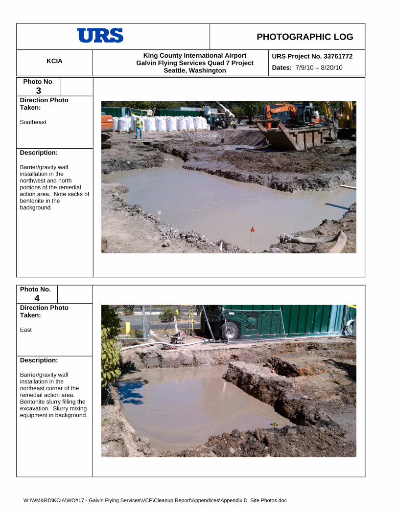
Description: Barrier/gravity wall installation in the northeast corner of the remedial action area. Bentonite slurry filling the excavation. Slurry mixing equipment in background.
Photo No.
3
Direction Photo Taken: Southeast
Description: Barrier/gravity wall installation in the northwest and north portions of the remedial action area. Note sacks of bentonite in the background.

PHOTOGRAPHIC LOG
KCIA King County International Airport
Galvin Flying Services Quad 7 Project Seattle, Washington
URS Project No. 33761772
Dates: 7/9/10 – 8/20/10
W:\WM&RD\KCIA\WO#17 - Galvin Flying Services\VCP\Cleanup Report\Appendices\Appendix D_Site Photos.doc
Photo No.
5
Direction Photo Taken: West
Description: Barrier/gravity wall installation progressing to the west.
Photo No.
6
Direction Photo Taken: West
Description: Barrier/gravity wall installation along the north leasehold boundary (fence line).

PHOTOGRAPHIC LOG
KCIA King County International Airport
Galvin Flying Services Quad 7 Project Seattle, Washington
URS Project No. 33761772
Dates: 7/9/10 – 8/20/10
W:\WM&RD\KCIA\WO#17 - Galvin Flying Services\VCP\Cleanup Report\Appendices\Appendix D_Site Photos.doc
Photo No.
8
Direction Photo Taken: West/southwest
Description: Remedial excavation on August 6, 2010. Concrete debris associated with historic building footings is evident in the northwest corner of the excavation. Bentonite slurry in bottom of the excavation.
Photo No.
7
Direction Photo Taken: West
Description: Remedial excavation on August 5, 2010. Hardened gravity/barrier wall is visible at right. Bentonite slurry evident in the foreground.

PHOTOGRAPHIC LOG
KCIA King County International Airport
Galvin Flying Services Quad 7 Project Seattle, Washington
URS Project No. 33761772
Dates: 7/9/10 – 8/20/10
W:\WM&RD\KCIA\WO#17 - Galvin Flying Services\VCP\Cleanup Report\Appendices\Appendix D_Site Photos.doc
Photo No.
10
Direction Photo Taken: East/northeast
Description: Remedial excavation on August 17, 2010. Quarry spalls were placed in the base of the excavation and covered with a geotextile liner prior to backfilling with clean soils.
Photo No.
9
Direction Photo Taken: Northeast
Description: Remedial excavation on August 11, 2010. Dewatering well visible in foreground. Barrier/gravity wall visible at north edge of excavation.

PHOTOGRAPHIC LOG
KCIA King County International Airport
Galvin Flying Services Quad 7 Project Seattle, Washington
URS Project No. 33761772
Dates: 7/9/10 – 8/20/10
W:\WM&RD\KCIA\WO#17 - Galvin Flying Services\VCP\Cleanup Report\Appendices\Appendix D_Site Photos.doc
Photo No.
12
Direction Photo Taken: Northwest
Description: The remedial excavation area following completion of backfilling on August 20, 2010.
Photo No.
11
Direction Photo Taken: North/northwest
Description: Backfilling and compacting on August 18, 2010. Note clean fill on top of quarry spalls and geotextile. Compaction testing equipment is visible adjacent to the worker in the center of the photo. Temporary dewatering well evident with discharge piping leading to water treatment system.
APPENDIX E
SOIL DISPOSAL DOCUMENTATION


APPENDIX F
SURFACE SAMPLING RECORD FORMS


APPENDIX G
LABORATORY ANALYTICAL REPORTS

www.fremontanalytical.com
2930 Westlake Ave N Suite 100 Seattle, WA 98109 T: (206) 352-3790 F: (206) 352-7178
[email protected] URS Corporation Attn: Dave Raubvogel
1501 4th
Avenue, Suite 1400 Seattle, WA 98101
RE: Galvin Phase III, Boeing Field Project ID: CHM100709-8
July 12th, 2010
Dave:
Enclosed are the analytical results for the Galvin Phase III, Boeing Field soil sample (Sample ID: P-1) delivered to Fremont Analytical on July 9
th, 2010.
Sample Receipt:
The sample was received in good condition - in the proper containers (2 – 2oz sample jars), properly sealed, labeled and within holding time. The sample was stored in a refrigeration unit at the USEPA-recommended temperature of 4°C ± 2°C. There were no sample receipt issues to report. Sample Analysis:
Examination of this sample was conducted for the presence of the following:
Total Metals (RCRA-8) in Soil by EPA Method 6020
This application was performed under Washington State Department of Ecology accreditation parameters. All appropriate Quality Assurance / Quality Control method parameters have been applied. There were no sample analysis issues to report.
Please contact the laboratory if you should have any questions about the report.
Thank you for using Fremont Analytical.
Sincerely,
Michelle Clements Lab Manager / Sr. Chemist

Analysis of Total Metals in Soil by EPA Method 6020
2930 Westlake Ave . N., Suite 100
Seattle, WA 98109
T: 206.352.3790
F: 206-352-7178
email: [email protected]
Project: Galvin Phase III, Boeing Field
Client: URS Corporation
Client Project #: N/A
Lab Project #: CHM100709-8 MS MSD
EPA 6020 MRL Method LCS P-1 Batch Batch RPD
(mg/kg) Blank 100709-2-1 100709-2-1 %
Date Extracted 7/9/10 7/9/10 7/9/10 7/9/10 7/9/10
Date Analyzed 7/11/10 7/11/10 7/11/10 7/11/10 7/11/10
Matrix Soil Soil Soil
Arsenic (As) 0.10 nd 71% 3.77 88% 88% 1%
Barium (Ba) 0.50 nd 96% 152 94% 109% 15%
Cadmium (Cd) 0.20 nd 83% 0.415 95% 95% 1%
Chromium (Cr) 0.10 nd 89% 16.5 96% 97% 1%
Lead (Pb) 0.20 nd 81% 58.3 96% 97% 1%
Mercury (Hg) 0.20 nd 107% nd 107% 106% 1%
Selenium (Se) 0.50 nd 97% nd 110% 97% 13%
Silver (Ag) 0.10 nd 81% nd 93% 95% 1%
"nd" Indicates no detection at the listed reporting limits
"int" Indicates that interference prevents determination
"J" Indicates estimated value
"MRL" Indicates Method Reporting Limit
"LCS" Indicates Laboratory Control Sample
"MS" Indicates Matrix Spike
"MSD" Indicates Matrix Spike Duplicate
"RPD" Indicates Relative Percent Difference
Acceptable RPD is determined to be less than 30%
Acceptable Recovery Limits:
LCS, LCSD, MS, MSD: 65% to 135%
Spike Concentrations:
As, Cr, Ba = 50 mg/kg
Pb = 25 mg/kg
Ag, Se = 12.5 mg/kg
Cd, Ag = 2.5 mg/kg
Hg = 1.0 mg/kg
CONFIDENTIAL www.fremontanalytical.com 1


www.fremontanalytical.com
2930 Westlake Ave N Suite 100 Seattle, WA 98109 T: (206) 352-3790 F: (206) 352-7178
[email protected] URS Corporation Attn: Dave Raubvogel
1501 4th
Avenue, Suite 1400 Seattle, WA 98101
RE: KCIA – Quad 7 Project ID: CHM100804-5 URS Project No: 33761772.00001
August 11th, 2010
Dave:
Enclosed are the analytical results for the KCIA – Quad 7 soil samples delivered to Fremont Analytical on August 4th,
2010. Sample Receipt:
The samples were received in good condition - in the proper containers, properly sealed, labeled and within holding time. The samples were contained in 2 – 4oz sample jars. The samples were received in a cooler with wet ice, with a cooler temperature of 3.6°C, which is within the laboratory recommended cooler temperature range (<4°C - 10°C). The samples were stored in a refrigeration unit at the USEPA-recommended temperature of 4°C ± 2°C. There were no sample receipt issues to report. Sample Analysis:
Examination of these samples was conducted for the presence of the following:
Diesel and Heavy Oil in Soil by NWTPH-Dx/DX Ext. with Silica Gel Clean-up
This application was performed under Washington State Department of Ecology accreditation parameters. All appropriate Quality Assurance / Quality Control method parameters have been applied. There were no sample analysis issues to report.
Please contact the laboratory if you should have any questions about the report.
Thank you for using Fremont Analytical.
Sincerely,
Michael Dee Sr. Chemist / Principal

Diesel and Heavy Oil in Soil by NWTPH-Dx / Dx Ext. with Silica Gel Clean-up
2930 Westlake Ave. N., Suite 100
Seattle, WA 98109
T: 206.352.3790
F: 206.352.7178
email: [email protected]
Project: KCIA - Quad 7
Client: URS Corporation
Client Project #: 33761772
Lab Project #: CHM100804-5Duplicate
NWTPH-Dx/Dx Ext. MRL Method LCS HH-SP-01-080410 HH-SP-01-080410 RPD HH-SP-02-080410
(mg/kg) Blank %
Date Extracted 8/4/10 8/4/10 8/4/10 8/4/10 8/4/10
Date Analyzed 8/4/10 8/4/10 8/4/10 8/4/10 8/4/10
Matrix Soil Soil Soil
Jet A 20 nd 8580 8980 5% 403
Diesel (Fuel Oil) 20 nd 102% nd nd nd
Mineral Oil 40 nd nd nd nd
Heavy Oil 50 nd nd nd nd
Surrogate Recovery
(Surr 1 ) 2-Fluorobiphenyl 92% 133% C C C
(Surr 2) o-Terphenyl 95% 101% 100% 120% 102%
"nd" Indicates not detected at listed reporting limits
"int" Indicates that interference prevents determination
"J" Indicates estimated value
"C" Indicates coelution prevents determination
"RPD" Indicates Relative Percent Difference
"MRL" Indicates Method Reporting Limit
Acceptable RPD is determined to be less than 30%
Acceptable Recovery Limits:
Surrogate = 65% to 135%
Surrogate Concentration = 20 mg/kg
Spike Concentration = 500 mg/kg
Diesel (Fuel Oil) = C12-C24
Mineral Oil = C15-C40
Heavy Oil = C24-C40
CONFIDENTIAL www.fremontanalytical.com 1


www.fremontanalytical.com
2930 Westlake Ave N Suite 100 Seattle, WA 98109 T: (206) 352-3790 F: (206) 352-7178
[email protected] URS Corporation Attn: Dave Raubvogel
1501 4th
Avenue, Suite 1400 Seattle, WA 98101
RE: Galvin Quad 7 – 7777 Site Remediation Project ID: CHM100805-5 URS Project No: 33761772.00001
August 11th, 2010
Dave:
Enclosed are the analytical results for the Galvin Quad 7 – 7777 Site Remediation soil samples delivered to
Fremont Analytical on August 5th
, 2010. Sample Receipt:
The samples were received in good condition - in the proper containers, properly sealed, labeled and within holding time. The samples were contained in 2 – 4oz sample jars. The samples were stored in a refrigeration unit at the USEPA-recommended temperature of 4°C ± 2°C. There were no sample receipt issues to report. Sample Analysis:
Examination of these samples was conducted for the presence of the following:
Diesel and Heavy Oil in Soil by NWTPH-Dx/Dx Ext.
This application was performed under Washington State Department of Ecology accreditation parameters. All appropriate Quality Assurance / Quality Control method parameters have been applied. There were no sample analysis issues to report.
Please contact the laboratory if you should have any questions about the report.
Thank you for using Fremont Analytical.
Sincerely,
Michael Dee Sr. Chemist / Principal

Analysis of Diesel and Heavy Oil in Soil by NWTPH-Dx / Dx Ext.
2930 Westlake Ave. N., Suite 100
Seattle, WA 98109
T: 206.352.3790
F: 206.352.7178
email: [email protected]
Client: URS Corporation
Client Project #: 33761772
Lab Project #: CHM100805-5Duplicate
NWTPH-Dx/Dx Ext. MRL Method LCS HH-SP-03-080510 HH-SP-03-080510 RPD HH-SP-04-080510
(mg/kg) Blank %
Date Extracted 8/6/10 8/6/10 8/6/10 8/6/10 8/6/10
Date Analyzed 8/6/10 8/6/10 8/6/10 8/6/10 8/6/10
Matrix Soil Soil Soil
Jet A 20 nd 333 398 18% 1210
Diesel (Fuel Oil) 20 nd 100% nd nd nd
Mineral Oil 40 nd nd nd nd
Heavy Oil 50 nd nd nd nd
Surrogate Recovery
(Surr 1 ) 2-Fluorobiphenyl 104% 126% 109% C C
(Surr 2) o-Terphenyl 101% 112% 101% 101% 98%
"nd" Indicates not detected at listed reporting limits
"int" Indicates that interference prevents determination
"J" Indicates estimated value
"C" Indicates coelution prevents determination
"RPD" Indicates Relative Percent Difference
"MRL" Indicates Method Reporting Limit
Acceptable RPD is determined to be less than 30%
Acceptable Recovery Limits:
Surrogate = 65% to 135%
Surrogate Concentration = 20 mg/kg
Spike Concentration = 500 mg/kg
Diesel (Fuel Oil) = C12-C24
Mineral Oil = C15-C40
Heavy Oil = C24-C40
Project: Galvin Quad 7-7777 Site Remediation
CONFIDENTIAL www.fremontanalytical.com 1


www.fremontanalytical.com
2930 Westlake Ave N Suite 100 Seattle, WA 98109 T: (206) 352-3790 F: (206) 352-7178
[email protected] URS Corporation Attn: Dave Raubvogel
1501 4th
Avenue, Suite 1400 Seattle, WA 98101
RE: King County International Airport Project ID: CHM100806-4 URS Project No: 33761772.00001
August 11th, 2010
Dave:
Enclosed are the analytical results for the King County International Airport soil samples delivered to Fremont
Analytical on August 6th
, 2010. Sample Receipt:
The samples were received in good condition - in the proper containers, properly sealed, labeled and within holding time. The samples were contained in 3 – 4oz sample jars. The samples were stored in a refrigeration unit at the USEPA-recommended temperature of 4°C ± 2°C. There were no sample receipt issues to report. Sample Analysis:
Examination of these samples was conducted for the presence of the following:
Diesel and Heavy Oil in Soil by NWTPH-Dx/Dx Ext.
This application was performed under Washington State Department of Ecology accreditation parameters. All appropriate Quality Assurance / Quality Control method parameters have been applied. There were no sample analysis issues to report.
Please contact the laboratory if you should have any questions about the report.
Thank you for using Fremont Analytical.
Sincerely,
Michael Dee Sr. Chemist / Principal

Analysis of Diesel and Heavy Oil in Soil by NWTPH-Dx / Dx Ext.
2930 Westlake Ave. N., Suite 100
Seattle, WA 98109
T: 206.352.3790
F: 206.352.7178
email: [email protected]
Client: URS Corporation
Client Project #: 33761772
Lab Project #: CHM100806-4Duplicate
NWTPH-Dx/Dx Ext. MRL Method LCS HH-SP-05-080610 HH-SP-05-080610 RPD
(mg/kg) Blank %
Date Extracted 8/9/10 8/9/10 8/9/10 8/9/10
Date Analyzed 8/9/10 8/9/10 8/9/10 8/9/10
Matrix Soil Soil
Jet A 20 nd 2660 3130 16%
Diesel (Fuel Oil) 20 nd 92% nd nd
Mineral Oil 40 nd nd nd
Heavy Oil 50 nd nd nd
Surrogate Recovery
(Surr 1 ) 2-Fluorobiphenyl 100% 113% C C
(Surr 2) o-Terphenyl 95% 124% 98% 101%
"nd" Indicates not detected at listed reporting limits
"int" Indicates that interference prevents determination
"J" Indicates estimated value
"C" Indicates coelution prevents determination
"RPD" Indicates Relative Percent Difference
"MRL" Indicates Method Reporting Limit
Acceptable RPD is determined to be less than 30%
Acceptable Recovery Limits:
Surrogate = 65% to 135%
Surrogate Concentration = 20 mg/kg
Spike Concentration = 500 mg/kg
Diesel (Fuel Oil) = C12-C24
Mineral Oil = C15-C40
Heavy Oil = C24-C40
Project: King County International Airport
CONFIDENTIAL www.fremontanalytical.com 1

Analysis of Diesel and Heavy Oil in Soil by NWTPH-Dx / Dx Ext.
2930 Westlake Ave. N., Suite 100
Seattle, WA 98109
T: 206.352.3790
F: 206.352.7178
email: [email protected]
Client: URS Corporation
Client Project #: 33761772
Lab Project #: CHM100806-4
NWTPH-Dx/Dx Ext. MRL
(mg/kg)
Date Extracted
Date Analyzed
Matrix
Jet A 20
Diesel (Fuel Oil) 20
Mineral Oil 40
Heavy Oil 50
Surrogate Recovery
(Surr 1 ) 2-Fluorobiphenyl
(Surr 2) o-Terphenyl
"nd" Indicates not detected at listed reporting limits
"int" Indicates that interference prevents determination
"J" Indicates estimated value
"C" Indicates coelution prevents determination
"RPD" Indicates Relative Percent Difference
"MRL" Indicates Method Reporting Limit
Acceptable RPD is determined to be less than 30%
Acceptable Recovery Limits:
Surrogate = 65% to 135%
Surrogate Concentration = 20 mg/kg
Spike Concentration = 500 mg/kg
Diesel (Fuel Oil) = C12-C24
Mineral Oil = C15-C40
Heavy Oil = C24-C40
Project: King County International Airport
HH-SP-06-080610 HH-SP-07-080610
8/9/10 8/9/10
8/9/10 8/9/10
Soil Soil
5790 1340
nd nd
nd nd
nd nd
C C
96% 99%
Project: King County International Airport
CONFIDENTIAL www.fremontanalytical.com 2


www.fremontanalytical.com
2930 Westlake Ave N Suite 100 Seattle, WA 98109 T: (206) 352-3790 F: (206) 352-7178
[email protected] URS Corporation Attn: Dave Raubvogel
1501 4th
Avenue, Suite 1400 Seattle, WA 98101
RE: Galvin Quad 7 Remediation Project ID: CHM100810-6 URS Project No: 33761772.00001
August 13th, 2010
Dave:
Enclosed are the analytical results for the Galvin Quad 7 Remediation soil samples delivered to Fremont Analytical
on August 10th
, 2010. Sample Receipt:
The samples were received in good condition - in the proper containers, properly sealed, labeled and within holding time. The samples were contained in 2 – 4oz sample jars. The samples were received in a cooler with gel ice, with a cooler temperature of 7.4°C, which is within the laboratory recommended cooler temperature range (<4°C - 10°C). The samples were stored in a refrigeration unit at the USEPA-recommended temperature of 4°C ± 2°C. There were no sample receipt issues to report. Sample Analysis:
Examination of these samples was conducted for the presence of the following:
Diesel and Heavy Oil in Soil by NWTPH-Dx/DX Ext. with Silica Gel Clean-up
These applications were performed under Washington State Department of Ecology accreditation parameters. All appropriate Quality Assurance / Quality Control method parameters have been applied. There were no sample analysis issues to report.
Please contact the laboratory if you should have any questions about the report.
Thank you for using Fremont Analytical.
Sincerely,
Michael Dee Sr. Chemist / Principal

Diesel and Heavy Oil in Soil by NWTPH-Dx / Dx Ext. with Silica Gel Clean-up
2930 Westlake Ave. N., Suite 100
Seattle, WA 98109
T: 206.352.3790
F: 206.352.7178
email: [email protected]
Project: Galvin Quad 7 Remediation
Client: URS Corporation
Client Project #: 33761772.00001
Lab Project #: CHM100810-6Duplicate
NWTPH-Dx/Dx Ext. MRL Method LCS HH-SP-08-080910 HH-SP-08-080910 RPD
(mg/kg) Blank %
Date Extracted 8/10/10 8/10/10 8/10/10 8/10/10
Date Analyzed 8/10/10 8/10/10 8/10/10 8/10/10
Matrix Soil Soil
Jet A 20 nd 2500 2000 22%
Diesel (Fuel Oil) 20 nd 92% nd nd
Mineral Oil 40 nd nd nd
Heavy Oil 50 nd nd nd
Surrogate Recovery
(Surr 1 ) 2-Fluorobiphenyl 117% 100% C C
(Surr 2) o-Terphenyl 108% 117% 99% 104%
"nd" Indicates not detected at listed reporting limits
"int" Indicates that interference prevents determination
"J" Indicates estimated value
"C" Indicates coelution prevents determination
"RPD" Indicates Relative Percent Difference
"MRL" Indicates Method Reporting Limit
Acceptable RPD is determined to be less than 30%
Acceptable Recovery Limits:
Surrogate = 65% to 135%
Surrogate Concentration = 20 mg/kg
Spike Concentration = 500 mg/kg
Diesel (Fuel Oil) = C12-C24
Mineral Oil = C15-C40
Heavy Oil = C24-C40
CONFIDENTIAL www.fremontanalytical.com 1

Diesel and Heavy Oil in Soil by NWTPH-Dx / Dx Ext. with Silica Gel Clean-up
2930 Westlake Ave. N., Suite 100
Seattle, WA 98109
T: 206.352.3790
F: 206.352.7178
email: [email protected]
Project: Galvin Quad 7 Remediation
Client: URS Corporation
Client Project #: 33761772.00001
Lab Project #: CHM100810-6
NWTPH-Dx/Dx Ext. MRL
(mg/kg)
Date Extracted
Date Analyzed
Matrix
Jet A 20
Diesel (Fuel Oil) 20
Mineral Oil 40
Heavy Oil 50
Surrogate Recovery
(Surr 1 ) 2-Fluorobiphenyl
(Surr 2) o-Terphenyl
"nd" Indicates not detected at listed reporting limits
"int" Indicates that interference prevents determination
"J" Indicates estimated value
"C" Indicates coelution prevents determination
"RPD" Indicates Relative Percent Difference
"MRL" Indicates Method Reporting Limit
Acceptable RPD is determined to be less than 30%
Acceptable Recovery Limits:
Surrogate = 65% to 135%
Surrogate Concentration = 20 mg/kg
Spike Concentration = 500 mg/kg
Diesel (Fuel Oil) = C12-C24
Mineral Oil = C15-C40
Heavy Oil = C24-C40
HH-SP-09-080910
8/10/10
8/10/10
Soil
480
nd
nd
nd
C
99%
CONFIDENTIAL www.fremontanalytical.com 2


www.fremontanalytical.com
2930 Westlake Ave N Suite 100 Seattle, WA 98109 T: (206) 352-3790 F: (206) 352-7178
[email protected] URS Corporation Attn: Dave Raubvogel
1501 4th
Avenue, Suite 1400 Seattle, WA 98101
RE: Galvin Quad 7 Remediation Project ID: CHM100811-6 URS Project No: 33761772.00001
August 13th, 2010
Dave:
Enclosed are the analytical results for the Galvin Quad 7 Remediation soil samples delivered to Fremont Analytical
on August 11th
, 2010. Sample Receipt:
The samples were received in good condition - in the proper containers, properly sealed, labeled and within holding time. The samples were contained in 2 – 4oz sample jars. The samples were received in a cooler with wet ice, with a cooler temperature of 6.3°C, which is within the laboratory recommended cooler temperature range (<4°C - 10°C). The samples were stored in a refrigeration unit at the USEPA-recommended temperature of 4°C ± 2°C. There were no sample receipt issues to report. Sample Analysis:
Examination of these samples was conducted for the presence of the following:
Diesel and Heavy Oil in Soil by NWTPH-Dx/DX Ext. with Silica Gel Clean-up
These applications were performed under Washington State Department of Ecology accreditation parameters. All appropriate Quality Assurance / Quality Control method parameters have been applied. There were no sample analysis issues to report.
Please contact the laboratory if you should have any questions about the report.
Thank you for using Fremont Analytical.
Sincerely,
Michael Dee Sr. Chemist / Principal

Diesel and Heavy Oil in Soil by NWTPH-Dx / Dx Ext. with Silica Gel Clean-up
2930 Westlake Ave. N., Suite 100
Seattle, WA 98109
T: 206.352.3790
F: 206.352.7178
email: [email protected]
Client: URS Corporation
Client Project #: 33761772
Lab Project #: CHM100811-6Duplicate
NWTPH-Dx/Dx Ext. MRL Method LCS HH-SP-10-081110 HH-SP-10-081110 RPD HH-SP-11-081110
(mg/kg) Blank %
Date Extracted 8/11/10 8/11/10 8/11/10 8/11/10 8/11/10
Date Analyzed 8/11/10 8/11/10 8/11/10 8/11/10 8/11/10
Matrix Soil Soil Soil
Jet A 20 nd 4900 5100 2% 36
Diesel (Fuel Oil) 20 nd 97% nd nd nd
Mineral Oil 40 nd nd nd nd
Heavy Oil 50 nd nd nd nd
Surrogate Recovery
(Surr 1 ) 2-Fluorobiphenyl 99% 95% C C 97%
(Surr 2) o-Terphenyl 97% 120% 101% 93% 104%
"nd" Indicates not detected at listed reporting limits
"int" Indicates that interference prevents determination
"J" Indicates estimated value
"C" Indicates coelution prevents determination
"RPD" Indicates Relative Percent Difference
"MRL" Indicates Method Reporting Limit
Acceptable RPD is determined to be less than 30%
Acceptable Recovery Limits:
Surrogate = 65% to 135%
Surrogate Concentration = 20 mg/kg
Spike Concentration = 500 mg/kg
Diesel (Fuel Oil) = C12-C24
Mineral Oil = C15-C40
Heavy Oil = C24-C40
Project: Galvin Quad 7 Remediation
CONFIDENTIAL www.fremontanalytical.com 1


www.fremontanalytical.com
2930 Westlake Ave N Suite 100 Seattle, WA 98109 T: (206) 352-3790 F: (206) 352-7178
[email protected] URS Corporation Attn: Dave Raubvogel
1501 4th
Avenue, Suite 1400 Seattle, WA 98101
RE: Galvin Quad 7 Remediation Project ID: CHM100812-2 URS Project No: 33761772.00001
August 13th, 2010
Dave:
Enclosed are the analytical results for the Galvin Quad 7 Remediation soil samples delivered to Fremont Analytical
on August 12th
, 2010. Sample Receipt:
The samples were received in good condition - in the proper containers, properly sealed, labeled and within holding time. The samples were contained in 16 – 4oz sample jars. The samples were received in a cooler with wet ice, with a cooler temperature of 4.6°C, which is within the laboratory recommended cooler temperature range (<4°C - 10°C). The samples were stored in a refrigeration unit at the USEPA-recommended temperature of 4°C ± 2°C. There were no sample receipt issues to report. Sample Analysis:
Examination of these samples was conducted for the presence of the following:
Diesel and Heavy Oil in Soil by NWTPH-Dx/DX Ext. with Silica Gel Clean-up
This application was performed under Washington State Department of Ecology accreditation parameters. All appropriate Quality Assurance / Quality Control method parameters have been applied. There were no sample analysis issues to report.
Please contact the laboratory if you should have any questions about the report.
Thank you for using Fremont Analytical.
Sincerely,
Michael Dee Sr. Chemist / Principal
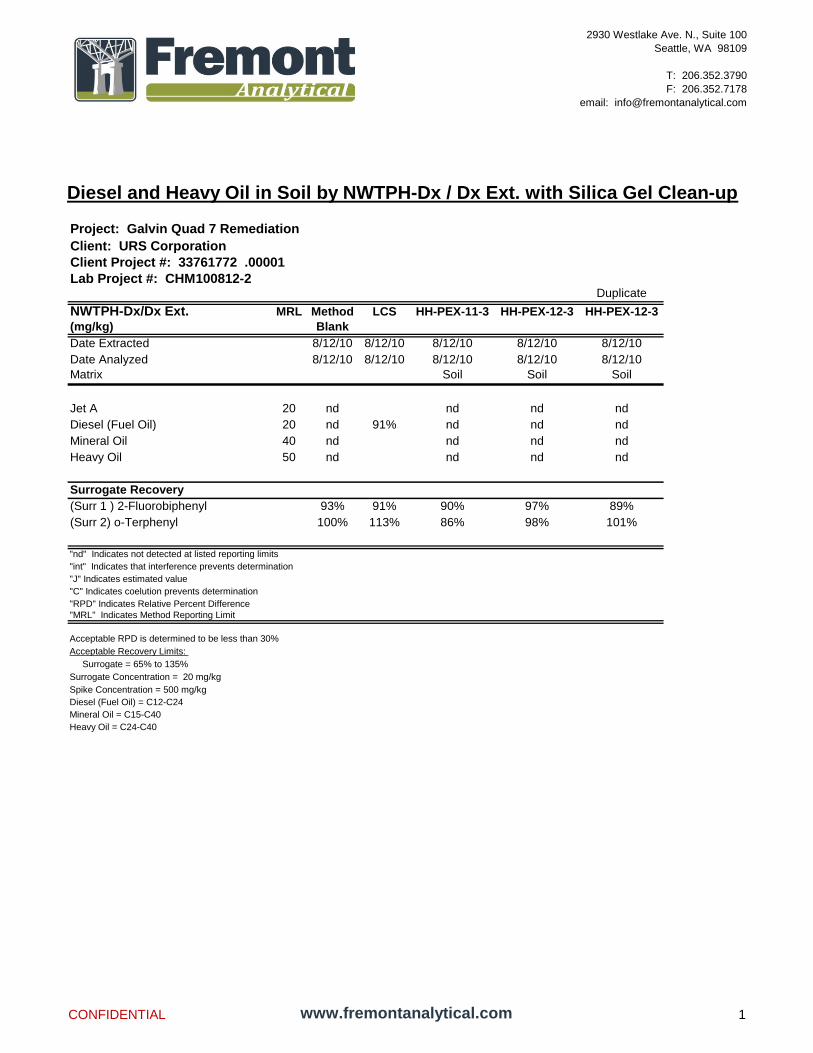
Diesel and Heavy Oil in Soil by NWTPH-Dx / Dx Ext. with Silica Gel Clean-up
2930 Westlake Ave. N., Suite 100
Seattle, WA 98109
T: 206.352.3790
F: 206.352.7178
email: [email protected]
Client: URS Corporation
Client Project #: 33761772 .00001
Lab Project #: CHM100812-2Duplicate
NWTPH-Dx/Dx Ext. MRL Method LCS HH-PEX-11-3 HH-PEX-12-3 HH-PEX-12-3
(mg/kg) Blank
Date Extracted 8/12/10 8/12/10 8/12/10 8/12/10 8/12/10
Date Analyzed 8/12/10 8/12/10 8/12/10 8/12/10 8/12/10
Matrix Soil Soil Soil
Jet A 20 nd nd nd nd
Diesel (Fuel Oil) 20 nd 91% nd nd nd
Mineral Oil 40 nd nd nd nd
Heavy Oil 50 nd nd nd nd
Surrogate Recovery
(Surr 1 ) 2-Fluorobiphenyl 93% 91% 90% 97% 89%
(Surr 2) o-Terphenyl 100% 113% 86% 98% 101%
"nd" Indicates not detected at listed reporting limits
"int" Indicates that interference prevents determination
"J" Indicates estimated value
"C" Indicates coelution prevents determination
"RPD" Indicates Relative Percent Difference
"MRL" Indicates Method Reporting Limit
Acceptable RPD is determined to be less than 30%
Acceptable Recovery Limits:
Surrogate = 65% to 135%
Surrogate Concentration = 20 mg/kg
Spike Concentration = 500 mg/kg
Diesel (Fuel Oil) = C12-C24
Mineral Oil = C15-C40
Heavy Oil = C24-C40
Project: Galvin Quad 7 Remediation
CONFIDENTIAL www.fremontanalytical.com 1

Diesel and Heavy Oil in Soil by NWTPH-Dx / Dx Ext. with Silica Gel Clean-up
2930 Westlake Ave. N., Suite 100
Seattle, WA 98109
T: 206.352.3790
F: 206.352.7178
email: [email protected]
Client: URS Corporation
Client Project #: 33761772 .00001
Lab Project #: CHM100812-2
NWTPH-Dx/Dx Ext. MRL
(mg/kg)
Date Extracted
Date Analyzed
Matrix
Jet A 20
Diesel (Fuel Oil) 20
Mineral Oil 40
Heavy Oil 50
Surrogate Recovery
(Surr 1 ) 2-Fluorobiphenyl
(Surr 2) o-Terphenyl
"nd" Indicates not detected at listed reporting limits
"int" Indicates that interference prevents determination
"J" Indicates estimated value
"C" Indicates coelution prevents determination
"RPD" Indicates Relative Percent Difference
"MRL" Indicates Method Reporting Limit
Acceptable RPD is determined to be less than 30%
Acceptable Recovery Limits:
Surrogate = 65% to 135%
Surrogate Concentration = 20 mg/kg
Spike Concentration = 500 mg/kg
Diesel (Fuel Oil) = C12-C24
Mineral Oil = C15-C40
Heavy Oil = C24-C40
Project: Galvin Quad 7 Remediation
HH-PEX-13-2 HH-PEX-14-2 HH-PEX-15-2 HH-PEX-16-3
8/12/10 8/12/10 8/12/10 8/12/10
8/12/10 8/12/10 8/12/10 8/12/10
Soil Soil Soil Soil
nd nd nd nd
nd nd nd nd
nd nd nd nd
nd nd nd nd
104% 92% 96% 97%
117% 102% 103% 98%
CONFIDENTIAL www.fremontanalytical.com 2

Diesel and Heavy Oil in Soil by NWTPH-Dx / Dx Ext. with Silica Gel Clean-up
2930 Westlake Ave. N., Suite 100
Seattle, WA 98109
T: 206.352.3790
F: 206.352.7178
email: [email protected]
Client: URS Corporation
Client Project #: 33761772 .00001
Lab Project #: CHM100812-2
NWTPH-Dx/Dx Ext. MRL
(mg/kg)
Date Extracted
Date Analyzed
Matrix
Jet A 20
Diesel (Fuel Oil) 20
Mineral Oil 40
Heavy Oil 50
Surrogate Recovery
(Surr 1 ) 2-Fluorobiphenyl
(Surr 2) o-Terphenyl
"nd" Indicates not detected at listed reporting limits
"int" Indicates that interference prevents determination
"J" Indicates estimated value
"C" Indicates coelution prevents determination
"RPD" Indicates Relative Percent Difference
"MRL" Indicates Method Reporting Limit
Acceptable RPD is determined to be less than 30%
Acceptable Recovery Limits:
Surrogate = 65% to 135%
Surrogate Concentration = 20 mg/kg
Spike Concentration = 500 mg/kg
Diesel (Fuel Oil) = C12-C24
Mineral Oil = C15-C40
Heavy Oil = C24-C40
Project: Galvin Quad 7 Remediation
HH-PEX-17-1.5 HH-PEX-18-3 HH-PEX-19-3 HH-PEX-20-3
8/12/10 8/12/10 8/12/10 8/12/10
8/12/10 8/12/10 8/12/10 8/12/10
Soil Soil Soil Soil
nd nd nd nd
nd nd nd nd
nd nd nd nd
nd nd nd nd
96% 100% 86% 107%
103% 102% 95% 106%
CONFIDENTIAL www.fremontanalytical.com 3

Diesel and Heavy Oil in Soil by NWTPH-Dx / Dx Ext. with Silica Gel Clean-up
2930 Westlake Ave. N., Suite 100
Seattle, WA 98109
T: 206.352.3790
F: 206.352.7178
email: [email protected]
Client: URS Corporation
Client Project #: 33761772 .00001
Lab Project #: CHM100812-2
NWTPH-Dx/Dx Ext. MRL
(mg/kg)
Date Extracted
Date Analyzed
Matrix
Jet A 20
Diesel (Fuel Oil) 20
Mineral Oil 40
Heavy Oil 50
Surrogate Recovery
(Surr 1 ) 2-Fluorobiphenyl
(Surr 2) o-Terphenyl
"nd" Indicates not detected at listed reporting limits
"int" Indicates that interference prevents determination
"J" Indicates estimated value
"C" Indicates coelution prevents determination
"RPD" Indicates Relative Percent Difference
"MRL" Indicates Method Reporting Limit
Acceptable RPD is determined to be less than 30%
Acceptable Recovery Limits:
Surrogate = 65% to 135%
Surrogate Concentration = 20 mg/kg
Spike Concentration = 500 mg/kg
Diesel (Fuel Oil) = C12-C24
Mineral Oil = C15-C40
Heavy Oil = C24-C40
Project: Galvin Quad 7 Remediation
HH-PEX-21-6.5 HH-PEX-22-6.5 HH-PEX-23-6.5
8/12/10 8/12/10 8/12/10
8/12/10 8/12/10 8/12/10
Soil Soil Soil
150 57 nd
nd nd nd
nd nd nd
nd nd nd
85% 103% 91%
99% 95% 97%
CONFIDENTIAL www.fremontanalytical.com 4
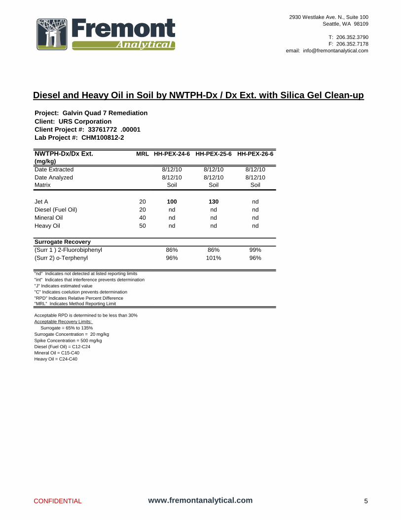
Diesel and Heavy Oil in Soil by NWTPH-Dx / Dx Ext. with Silica Gel Clean-up
2930 Westlake Ave. N., Suite 100
Seattle, WA 98109
T: 206.352.3790
F: 206.352.7178
email: [email protected]
Client: URS Corporation
Client Project #: 33761772 .00001
Lab Project #: CHM100812-2
NWTPH-Dx/Dx Ext. MRL
(mg/kg)
Date Extracted
Date Analyzed
Matrix
Jet A 20
Diesel (Fuel Oil) 20
Mineral Oil 40
Heavy Oil 50
Surrogate Recovery
(Surr 1 ) 2-Fluorobiphenyl
(Surr 2) o-Terphenyl
"nd" Indicates not detected at listed reporting limits
"int" Indicates that interference prevents determination
"J" Indicates estimated value
"C" Indicates coelution prevents determination
"RPD" Indicates Relative Percent Difference
"MRL" Indicates Method Reporting Limit
Acceptable RPD is determined to be less than 30%
Acceptable Recovery Limits:
Surrogate = 65% to 135%
Surrogate Concentration = 20 mg/kg
Spike Concentration = 500 mg/kg
Diesel (Fuel Oil) = C12-C24
Mineral Oil = C15-C40
Heavy Oil = C24-C40
Project: Galvin Quad 7 Remediation
HH-PEX-24-6 HH-PEX-25-6 HH-PEX-26-6
8/12/10 8/12/10 8/12/10
8/12/10 8/12/10 8/12/10
Soil Soil Soil
100 130 nd
nd nd nd
nd nd nd
nd nd nd
86% 86% 99%
96% 101% 96%
CONFIDENTIAL www.fremontanalytical.com 5
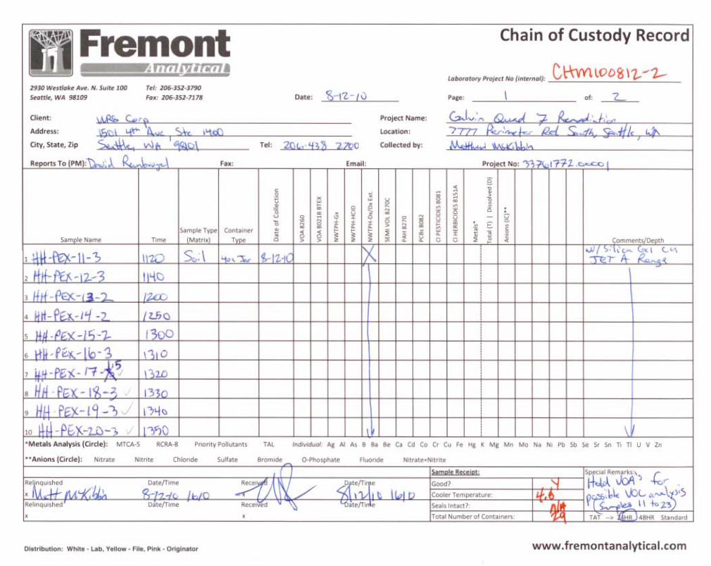


www.fremontanalytical.com
2930 Westlake Ave N Suite 100 Seattle, WA 98109 T: (206) 352-3790 F: (206) 352-7178
[email protected] URS Corporation Attn: Dave Raubvogel
1501 4th
Avenue, Suite 1400 Seattle, WA 98101
RE: Galvin Quad 7 Remediation Project ID: CHM100816-6 URS Project No: 33761772.00001
August 17th, 2010
Dave:
Enclosed are the analytical results for the Galvin Quad 7 Remediation soil samples delivered to Fremont Analytical
on August 16th
, 2010. Sample Receipt:
The samples were received in good condition - in the proper containers, properly sealed, labeled and within holding time. The samples were contained in 3 – 4oz sample jars. The samples were received in a cooler with wet ice, with a cooler temperature of 3.0°C, which is within the laboratory recommended cooler temperature range (<4°C - 10°C). The samples were stored in a refrigeration unit at the USEPA-recommended temperature of 4°C ± 2°C. There were no sample receipt issues to report. Sample Analysis:
Examination of these samples was conducted for the presence of the following:
Diesel and Heavy Oil in Soil by NWTPH-Dx/DX Ext. with Silica Gel Clean-up
This application was performed under Washington State Department of Ecology accreditation parameters. All appropriate Quality Assurance / Quality Control method parameters have been applied. There were no sample analysis issues to report.
Please contact the laboratory if you should have any questions about the report.
Thank you for using Fremont Analytical.
Sincerely,
Michael Dee Sr. Chemist / Principal

Diesel and Heavy Oil in Soil by NWTPH-Dx / Dx Ext. with Silica Gel Clean-up
2930 Westlake Ave. N., Suite 100
Seattle, WA 98109
T: 206.352.3790
F: 206.352.7178
email: [email protected]
Client: URS Corporation
Client Project #: 33761772.00001
Lab Project #: CHM100816-6Duplicate
NWTPH-Dx/Dx Ext. MRL Method LCS HH-PEX-27-6 HH-PEX-28-6 HH-PEX-29-6 HH-PEX-29-6
(mg/kg) Blank
Date Extracted 8/16/10 8/16/10 8/16/10 8/16/10 8/16/10 8/16/10
Date Analyzed 8/16/10 8/16/10 8/16/10 8/16/10 8/16/10 8/16/10
Matrix Soil Soil Soil Soil
Jet A 20 nd nd nd nd nd
Diesel (Fuel Oil) 20 nd 121% nd nd nd nd
Mineral Oil 40 nd nd nd nd nd
Heavy Oil 50 nd nd nd nd nd
Surrogate Recovery
(Surr 1 ) 2-Fluorobiphenyl 86% 83% 91% 73% 104% 96%
(Surr 2) o-Terphenyl 91% 93% 96% 120% 116% 113%
"nd" Indicates not detected at listed reporting limits
"int" Indicates that interference prevents determination
"J" Indicates estimated value
"C" Indicates coelution prevents determination
"RPD" Indicates Relative Percent Difference
"MRL" Indicates Method Reporting Limit
Acceptable RPD is determined to be less than 30%
Acceptable Recovery Limits:
Surrogate = 65% to 135%
Surrogate Concentration = 20 mg/kg
Spike Concentration = 500 mg/kg
Diesel (Fuel Oil) = C12-C24
Mineral Oil = C15-C40
Heavy Oil = C24-C40
Project: Galvin Quad 7 Remediation
CONFIDENTIAL www.fremontanalytical.com 1


www.fremontanalytical.com
2930 Westlake Ave N Suite 100 Seattle, WA 98109 T: (206) 352-3790 F: (206) 352-7178
[email protected] URS Corporation Attn: Dave Raubvogel
1501 4th
Avenue, Suite 1400 Seattle, WA 98101
RE: Galvin Quad 7 Remediation Project ID: CHM100816-7 URS Project No: 33761772.00001
August 20th, 2010
Dave:
Enclosed are the analytical results for the Galvin Quad 7 Remediation soil sample (Sample ID: HH-SP-12-081610)
delivered to Fremont Analytical on August 16th
, 2010. Sample Receipt:
The sample was received in good condition - in the proper containers, properly sealed, labeled and within holding time. The samples were contained in 1 – 4oz sample jars. The samples were received in a cooler with wet ice, with a cooler temperature of 3.0°C, which is within the laboratory recommended cooler temperature range (<4°C - 10°C). The samples were stored in a refrigeration unit at the USEPA-recommended temperature of 4°C ± 2°C. There were no sample receipt issues to report. Sample Analysis:
Examination of this sample was conducted for the presence of the following:
Diesel and Heavy Oil in Soil by NWTPH-Dx/DX Ext. with Silica Gel Clean-up
This application was performed under Washington State Department of Ecology accreditation parameters. All appropriate Quality Assurance / Quality Control method parameters have been applied. There were no sample analysis issues to report.
Please contact the laboratory if you should have any questions about the report.
Thank you for using Fremont Analytical.
Sincerely,
Michael Dee Sr. Chemist / Principal

Diesel and Heavy Oil in Soil by NWTPH-Dx / Dx Ext. with Silica Gel Clean-up
2930 Westlake Ave. N., Suite 100
Seattle, WA 98109
T: 206.352.3790
F: 206.352.7178
email: [email protected]
Client: URS Corporation
Client Project #: 33761772.00001
Lab Project #: CHM100816-7QA Sample QA Duplicate
NWTPH-Dx/Dx Ext. MRL Method LCS HH-SP-12-081610 Batch Batch
(mg/kg) Blank 100816-6-3 100816-6-3
Date Extracted 8/16/10 8/16/10 8/16/10 8/16/10 8/16/10
Date Analyzed 8/16/10 8/16/10 8/16/10 8/16/10 8/16/10
Matrix Soil Soil Soil
Jet A 20 nd nd nd nd
Diesel (Fuel Oil) 20 nd 121% nd nd nd
Mineral Oil 40 nd nd nd nd
Heavy Oil 50 nd nd nd nd
Surrogate Recovery
(Surr 1 ) 2-Fluorobiphenyl 86% 83% 70% 104% 96%
(Surr 2) o-Terphenyl 91% 93% 117% 116% 113%
"nd" Indicates not detected at listed reporting limits
"int" Indicates that interference prevents determination
"J" Indicates estimated value
"C" Indicates coelution prevents determination
"RPD" Indicates Relative Percent Difference
"MRL" Indicates Method Reporting Limit
Acceptable RPD is determined to be less than 30%
Acceptable Recovery Limits:
Surrogate = 65% to 135%
Surrogate Concentration = 20 mg/kg
Spike Concentration = 500 mg/kg
Diesel (Fuel Oil) = C12-C24
Mineral Oil = C15-C40
Heavy Oil = C24-C40
Project: Galvin Quad 7 Remediation
CONFIDENTIAL www.fremontanalytical.com 1
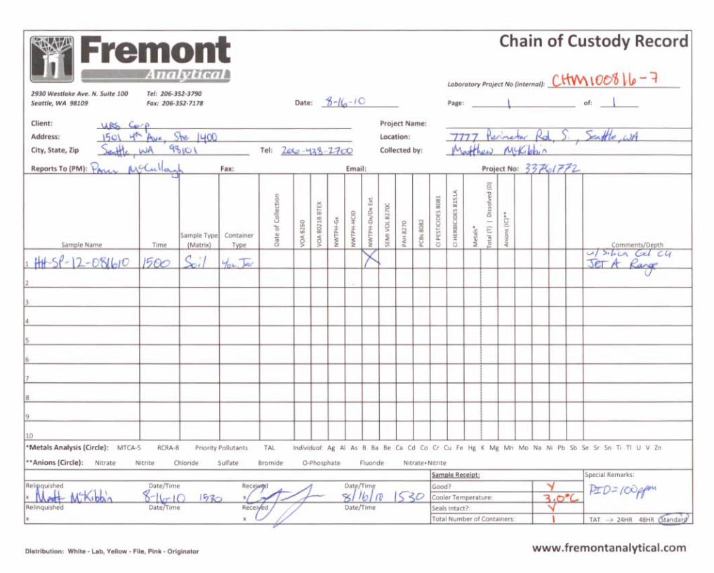

www.fremontanalytical.com
2930 Westlake Ave N Suite 100 Seattle, WA 98109 T: (206) 352-3790 F: (206) 352-7178
[email protected] URS Corporation Attn: Dave Raubvogel
1501 4th
Avenue, Suite 1400 Seattle, WA 98101
RE: Galvin Quad 7 Remediation Project ID: CHM100820-6 URS Project No: 33761772.00001
August 26th, 2010
Dave:
Enclosed are the analytical results for the Galvin Quad 7 Remediation soil samples delivered to Fremont Analytical
on August 20th
, 2010. Sample Receipt:
The samples were received in good condition - in the proper containers, properly sealed, labeled and within holding time. The samples were contained in 2 – 4oz sample jars. The samples were received in a cooler with wet ice, with a cooler temperature of 2.1°C, which is within the laboratory recommended cooler temperature range (<4°C - 10°C). The samples were stored in a refrigeration unit at the USEPA-recommended temperature of 4°C ± 2°C. There were no sample receipt issues to report. Sample Analysis:
Examination of these samples was conducted for the presence of the following:
Diesel and Heavy Oil in Soil by NWTPH-Dx/DX Ext. with Silica Gel Clean-up
This application was performed under Washington State Department of Ecology accreditation parameters. All appropriate Quality Assurance / Quality Control method parameters have been applied. There were no sample analysis issues to report.
Please contact the laboratory if you should have any questions about the report.
Thank you for using Fremont Analytical.
Sincerely,
Michael Dee Sr. Chemist / Principal
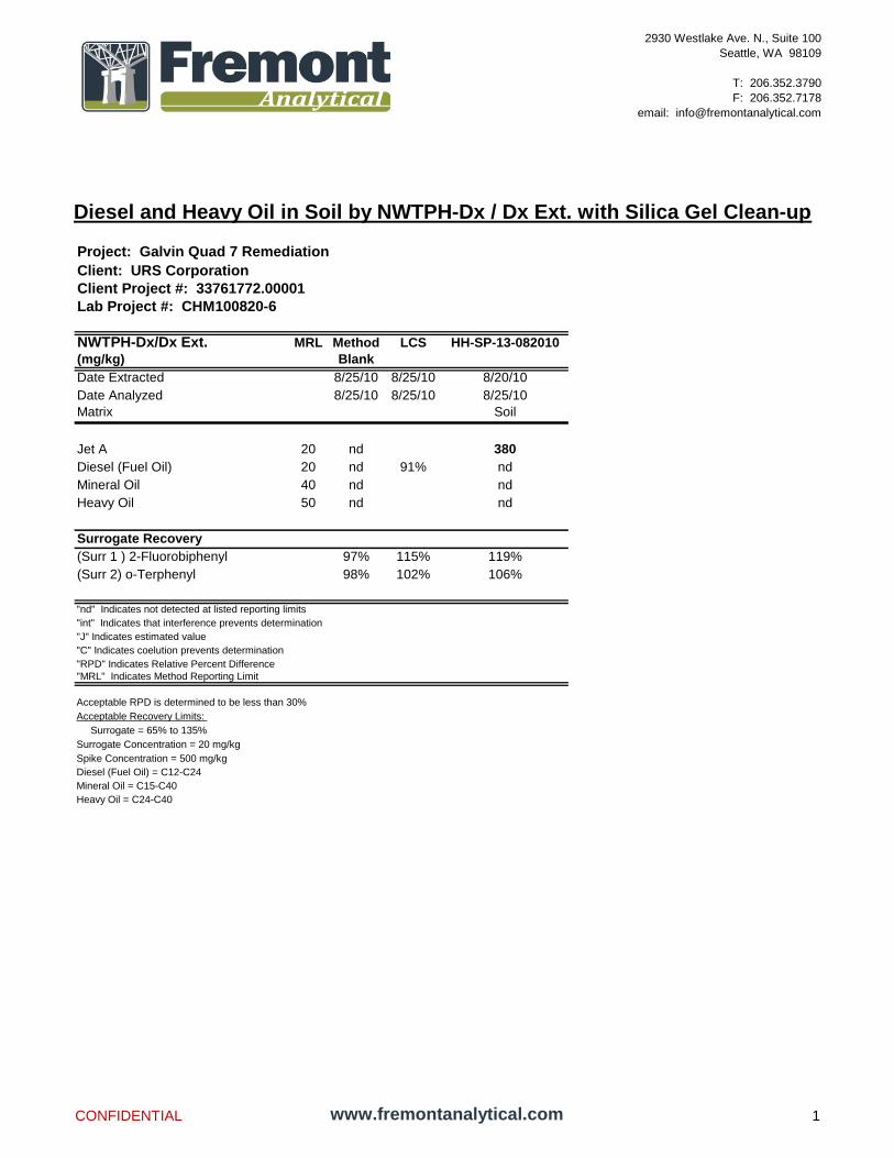
Diesel and Heavy Oil in Soil by NWTPH-Dx / Dx Ext. with Silica Gel Clean-up
2930 Westlake Ave. N., Suite 100
Seattle, WA 98109
T: 206.352.3790
F: 206.352.7178
email: [email protected]
Client: URS Corporation
Client Project #: 33761772.00001
Lab Project #: CHM100820-6
NWTPH-Dx/Dx Ext. MRL Method LCS HH-SP-13-082010
(mg/kg) Blank
Date Extracted 8/25/10 8/25/10 8/20/10
Date Analyzed 8/25/10 8/25/10 8/25/10
Matrix Soil
Jet A 20 nd 380
Diesel (Fuel Oil) 20 nd 91% nd
Mineral Oil 40 nd nd
Heavy Oil 50 nd nd
Surrogate Recovery
(Surr 1 ) 2-Fluorobiphenyl 97% 115% 119%
(Surr 2) o-Terphenyl 98% 102% 106%
"nd" Indicates not detected at listed reporting limits
"int" Indicates that interference prevents determination
"J" Indicates estimated value
"C" Indicates coelution prevents determination
"RPD" Indicates Relative Percent Difference
"MRL" Indicates Method Reporting Limit
Acceptable RPD is determined to be less than 30%
Acceptable Recovery Limits:
Surrogate = 65% to 135%
Surrogate Concentration = 20 mg/kg
Spike Concentration = 500 mg/kg
Diesel (Fuel Oil) = C12-C24
Mineral Oil = C15-C40
Heavy Oil = C24-C40
Project: Galvin Quad 7 Remediation
CONFIDENTIAL www.fremontanalytical.com 1

Diesel and Heavy Oil in Soil by NWTPH-Dx / Dx Ext. with Silica Gel Clean-up
2930 Westlake Ave. N., Suite 100
Seattle, WA 98109
T: 206.352.3790
F: 206.352.7178
email: [email protected]
Client: URS Corporation
Client Project #: 33761772.00001
Lab Project #: CHM100820-6
NWTPH-Dx/Dx Ext. MRL
(mg/kg)
Date Extracted
Date Analyzed
Matrix
Jet A 20
Diesel (Fuel Oil) 20
Mineral Oil 40
Heavy Oil 50
Surrogate Recovery
(Surr 1 ) 2-Fluorobiphenyl
(Surr 2) o-Terphenyl
"nd" Indicates not detected at listed reporting limits
"int" Indicates that interference prevents determination
"J" Indicates estimated value
"C" Indicates coelution prevents determination
"RPD" Indicates Relative Percent Difference
"MRL" Indicates Method Reporting Limit
Acceptable RPD is determined to be less than 30%
Acceptable Recovery Limits:
Surrogate = 65% to 135%
Surrogate Concentration = 20 mg/kg
Spike Concentration = 500 mg/kg
Diesel (Fuel Oil) = C12-C24
Mineral Oil = C15-C40
Heavy Oil = C24-C40
Project: Galvin Quad 7 Remediation
Duplicate
HH-SP-14-082010 HH-SP-14-082010 RPD
%
8/20/10 8/20/10
8/25/10 8/25/10
Soil Soil
1030 1280 22%
nd nd
nd nd
nd nd
109% 111%
94% 102%
CONFIDENTIAL www.fremontanalytical.com 2


www.fremontanalytical.com
2930 Westlake Ave N Suite 100 Seattle, WA 98109 T: (206) 352-3790 F: (206) 352-7178
[email protected] URS Corporation Attn: Dave Raubvogel
1501 4th
Avenue, Suite 1400 Seattle, WA 98101
RE: Galvin Phase III, Boeing Field Project ID: CHM100709-8
July 12th, 2010
Dave:
Enclosed are the analytical results for the Galvin Phase III, Boeing Field soil sample (Sample ID: P-1) delivered to Fremont Analytical on July 9
th, 2010.
Sample Receipt:
The sample was received in good condition - in the proper containers (2 – 2oz sample jars), properly sealed, labeled and within holding time. The sample was stored in a refrigeration unit at the USEPA-recommended temperature of 4°C ± 2°C. There were no sample receipt issues to report. Sample Analysis:
Examination of this sample was conducted for the presence of the following:
Total Metals (RCRA-8) in Soil by EPA Method 6020
This application was performed under Washington State Department of Ecology accreditation parameters. All appropriate Quality Assurance / Quality Control method parameters have been applied. There were no sample analysis issues to report.
Please contact the laboratory if you should have any questions about the report.
Thank you for using Fremont Analytical.
Sincerely,
Michelle Clements Lab Manager / Sr. Chemist

Analysis of Total Metals in Soil by EPA Method 6020
2930 Westlake Ave . N., Suite 100
Seattle, WA 98109
T: 206.352.3790
F: 206-352-7178
email: [email protected]
Project: Galvin Phase III, Boeing Field
Client: URS Corporation
Client Project #: N/A
Lab Project #: CHM100709-8 MS MSD
EPA 6020 MRL Method LCS P-1 Batch Batch RPD
(mg/kg) Blank 100709-2-1 100709-2-1 %
Date Extracted 7/9/10 7/9/10 7/9/10 7/9/10 7/9/10
Date Analyzed 7/11/10 7/11/10 7/11/10 7/11/10 7/11/10
Matrix Soil Soil Soil
Arsenic (As) 0.10 nd 71% 3.77 88% 88% 1%
Barium (Ba) 0.50 nd 96% 152 94% 109% 15%
Cadmium (Cd) 0.20 nd 83% 0.415 95% 95% 1%
Chromium (Cr) 0.10 nd 89% 16.5 96% 97% 1%
Lead (Pb) 0.20 nd 81% 58.3 96% 97% 1%
Mercury (Hg) 0.20 nd 107% nd 107% 106% 1%
Selenium (Se) 0.50 nd 97% nd 110% 97% 13%
Silver (Ag) 0.10 nd 81% nd 93% 95% 1%
"nd" Indicates no detection at the listed reporting limits
"int" Indicates that interference prevents determination
"J" Indicates estimated value
"MRL" Indicates Method Reporting Limit
"LCS" Indicates Laboratory Control Sample
"MS" Indicates Matrix Spike
"MSD" Indicates Matrix Spike Duplicate
"RPD" Indicates Relative Percent Difference
Acceptable RPD is determined to be less than 30%
Acceptable Recovery Limits:
LCS, LCSD, MS, MSD: 65% to 135%
Spike Concentrations:
As, Cr, Ba = 50 mg/kg
Pb = 25 mg/kg
Ag, Se = 12.5 mg/kg
Cd, Ag = 2.5 mg/kg
Hg = 1.0 mg/kg
CONFIDENTIAL www.fremontanalytical.com 1


August 12, 2010
LIMS USE: FR - PETER DUMALIANG
LIMS OBJECT ID: 254503
254503
Project:
Pace Project No.:
RE:
Peter DumaliangKing County International Airport7277 Perimeter Rd. SSeattle, WA 98108
Galvin Quad 7 Remediation
Dear Peter Dumaliang:
Enclosed are the analytical results for sample(s) received by the laboratory on August 11, 2010. Theresults relate only to the samples included in this report. Results reported herein conform to themost current NELAC standards, where applicable, unless otherwise narrated in the body of thereport.
If you have any questions concerning this report, please feel free to contact me.
Sincerely,
Heidi Geri
[email protected] Manager
Enclosures
REPORT OF LABORATORY ANALYSIS
This report shall not be reproduced, except in full,
without the written consent of Pace Analytical Services, Inc..
Page 1 of 10
Pace Analytical Services, Inc.
940 South Harney
Seattle, WA 98108
(206)767-5060

CERTIFICATIONS
Pace Project No.:
Project:
254503
Galvin Quad 7 Remediation
Washington Certification IDs940 South Harney Street, Seattle, WA 98108Alaska CS Certification #: UST-025Alaska Drinking Water VOC Certification #: WA01230Alaska Drinking Water Micro Certification #: WA01230
California Certification #: 01153CAFlorida/NELAP Certification #: E87617Oregon Certification #: WA200007Washington Certification #: C1229
REPORT OF LABORATORY ANALYSIS
This report shall not be reproduced, except in full,
without the written consent of Pace Analytical Services, Inc..
Page 2 of 10
Pace Analytical Services, Inc.
940 South Harney
Seattle, WA 98108
(206)767-5060

SAMPLE ANALYTE COUNT
Pace Project No.:
Project:
254503
Galvin Quad 7 Remediation
Lab ID Sample ID Method
Analytes
Reported LaboratoryAnalysts
254503001 GWD-01 EPA 5030B/8260 11 PASI-SLPM
254503002 GWD-01-A EPA 1664A 1 PASI-SBPR
254503003 GWD-01-B EPA 1664A 1 PASI-SBPR
254503004 GWD-01-C EPA 1664A 1 PASI-SBPR
REPORT OF LABORATORY ANALYSIS
This report shall not be reproduced, except in full,
without the written consent of Pace Analytical Services, Inc..
Page 3 of 10
Pace Analytical Services, Inc.
940 South Harney
Seattle, WA 98108
(206)767-5060
PROJECT NARRATIVE
Pace Project No.:
Project:
254503
Galvin Quad 7 Remediation
Method:
Client: King County International Airport
EPA 5030B/8260
Date: August 12, 2010
Description: 8260 MSV
General Information:
1 sample was analyzed for EPA 5030B/8260. All samples were received in acceptable condition with any exceptions noted below.
Hold Time:
The samples were analyzed within the method required hold times with any exceptions noted below.
Initial Calibrations (including MS Tune as applicable):
All criteria were within method requirements with any exceptions noted below.
Continuing Calibration:
All criteria were within method requirements with any exceptions noted below.
Internal Standards:
All internal standards were within QC limits with any exceptions noted below.
Surrogates:
All surrogates were within QC limits with any exceptions noted below.
Method Blank:
All analytes were below the report limit in the method blank with any exceptions noted below.
Laboratory Control Spike:
All laboratory control spike compounds were within QC limits with any exceptions noted below.
Matrix Spikes:
All percent recoveries and relative percent differences (RPDs) were within acceptance criteria with any exceptions noted below.
Duplicate Sample:
All duplicate sample results were within method acceptance criteria with any exceptions noted below.
Additional Comments:
REPORT OF LABORATORY ANALYSIS
This report shall not be reproduced, except in full,
without the written consent of Pace Analytical Services, Inc..
Page 4 of 10
Pace Analytical Services, Inc.
940 South Harney
Seattle, WA 98108
(206)767-5060

PROJECT NARRATIVE
Pace Project No.:
Project:
254503
Galvin Quad 7 Remediation
Method:
Client: King County International Airport
EPA 1664A
Date: August 12, 2010
Description: HEM, Oil and Grease
General Information:
3 samples were analyzed for EPA 1664A. All samples were received in acceptable condition with any exceptions noted below.
Hold Time:
The samples were analyzed within the method required hold times with any exceptions noted below.
Method Blank:
All analytes were below the report limit in the method blank with any exceptions noted below.
Laboratory Control Spike:
All laboratory control spike compounds were within QC limits with any exceptions noted below.
Matrix Spikes:
All percent recoveries and relative percent differences (RPDs) were within acceptance criteria with any exceptions noted below.
Duplicate Sample:
All duplicate sample results were within method acceptance criteria with any exceptions noted below.
Additional Comments:
This data package has been reviewed for quality and completeness and is approved for release.
REPORT OF LABORATORY ANALYSIS
This report shall not be reproduced, except in full,
without the written consent of Pace Analytical Services, Inc..
Page 5 of 10
Pace Analytical Services, Inc.
940 South Harney
Seattle, WA 98108
(206)767-5060

ANALYTICAL RESULTS
Pace Project No.:
Project:
254503
Galvin Quad 7 Remediation
Sample: GWD-01 Lab ID: 254503001 Collected: 08/11/10 09:40 Received: 08/11/10 10:35 Matrix: Water
Parameters Results Units DF Prepared Analyzed CAS No. QualReport Limit
8260 MSV Analytical Method: EPA 5030B/8260
Benzene ND ug/L 1 08/12/10 09:50 71-43-21.0
Ethylbenzene ND ug/L 1 08/12/10 09:50 100-41-41.0
Tetrachloroethene ND ug/L 1 08/12/10 09:50 127-18-41.0
Toluene ND ug/L 1 08/12/10 09:50 108-88-31.0
Xylene (Total) ND ug/L 1 08/12/10 09:50 1330-20-73.0
m&p-Xylene ND ug/L 1 08/12/10 09:50 179601-23-12.0
o-Xylene ND ug/L 1 08/12/10 09:50 95-47-61.0
4-Bromofluorobenzene (S) 88 % 1 08/12/10 09:50 460-00-480-120
Dibromofluoromethane (S) 99 % 1 08/12/10 09:50 1868-53-780-122
1,2-Dichloroethane-d4 (S) 85 % 1 08/12/10 09:50 17060-07-080-124
Toluene-d8 (S) 88 % 1 08/12/10 09:50 2037-26-580-123
Sample: GWD-01-A Lab ID: 254503002 Collected: 08/11/10 09:40 Received: 08/11/10 10:35 Matrix: Water
Parameters Results Units DF Prepared Analyzed CAS No. QualReport Limit
HEM, Oil and Grease Analytical Method: EPA 1664A
Total Petroleum Hydrocarbons ND mg/L 1 08/12/10 14:165.1
Sample: GWD-01-B Lab ID: 254503003 Collected: 08/11/10 09:50 Received: 08/11/10 10:35 Matrix: Water
Parameters Results Units DF Prepared Analyzed CAS No. QualReport Limit
HEM, Oil and Grease Analytical Method: EPA 1664A
Total Petroleum Hydrocarbons ND mg/L 1 08/12/10 14:175.1
Sample: GWD-01-C Lab ID: 254503004 Collected: 08/11/10 10:05 Received: 08/11/10 10:35 Matrix: Water
Parameters Results Units DF Prepared Analyzed CAS No. QualReport Limit
HEM, Oil and Grease Analytical Method: EPA 1664A
Total Petroleum Hydrocarbons ND mg/L 1 08/12/10 14:195.1
REPORT OF LABORATORY ANALYSIS
This report shall not be reproduced, except in full,
without the written consent of Pace Analytical Services, Inc..
Date: 08/12/2010 03:52 PM Page 6 of 10
Pace Analytical Services, Inc.
940 South Harney
Seattle, WA 98108
(206)767-5060

QUALITY CONTROL DATA
Pace Project No.:
Project:
254503
Galvin Quad 7 Remediation
QC Batch:
QC Batch Method:
Analysis Method:
Analysis Description:
MSV/2844
EPA 5030B/8260
EPA 5030B/8260
8260 MSV Water 10 mL Purge
Associated Lab Samples: 254503001
Parameter Units
Blank
Result
Reporting
Limit Qualifiers
METHOD BLANK: 36074
Associated Lab Samples: 254503001
Matrix: Water
Analyzed
Benzene ug/L ND 1.0 08/12/10 08:41
Ethylbenzene ug/L ND 1.0 08/12/10 08:41
m&p-Xylene ug/L ND 2.0 08/12/10 08:41
o-Xylene ug/L ND 1.0 08/12/10 08:41
Tetrachloroethene ug/L ND 1.0 08/12/10 08:41
Toluene ug/L ND 1.0 08/12/10 08:41
Xylene (Total) ug/L ND 3.0 08/12/10 08:41
1,2-Dichloroethane-d4 (S) % 86 80-124 08/12/10 08:41
4-Bromofluorobenzene (S) % 87 80-120 08/12/10 08:41
Dibromofluoromethane (S) % 101 80-122 08/12/10 08:41
Toluene-d8 (S) % 89 80-123 08/12/10 08:41
Parameter Units
LCS
Result
% Rec
Limits Qualifiers% RecConc.
36075LABORATORY CONTROL SAMPLE & LCSD:
LCSSpike LCSD
% Rec RPD
Max
RPD
LCSD
Result
36106
Benzene ug/L 22.520 112 75-12411022.0 2 30
Ethylbenzene ug/L 20.520 102 76-12410020.0 2 30
m&p-Xylene ug/L 42.640 106 75-12410441.4 3 30
o-Xylene ug/L 22.820 114 76-12111122.2 3 30
Tetrachloroethene ug/L 16.120 80 70-1278517.0 5 30
Toluene ug/L 19.920 99 75-1249919.9 .03 30
Xylene (Total) ug/L 65.460 109 76-12310663.6 3 30
1,2-Dichloroethane-d4 (S) % 83 80-12484
4-Bromofluorobenzene (S) % 92 80-12091
Dibromofluoromethane (S) % 98 80-12299
Toluene-d8 (S) % 90 80-12391
REPORT OF LABORATORY ANALYSIS
This report shall not be reproduced, except in full,
without the written consent of Pace Analytical Services, Inc..
Date: 08/12/2010 03:52 PM Page 7 of 10
Pace Analytical Services, Inc.
940 South Harney
Seattle, WA 98108
(206)767-5060

QUALITY CONTROL DATA
Pace Project No.:
Project:
254503
Galvin Quad 7 Remediation
QC Batch:
QC Batch Method:
Analysis Method:
Analysis Description:
WET/2186
EPA 1664A
EPA 1664A
1664 HEM, Oil and Grease
Associated Lab Samples: 254503002, 254503003, 254503004
REPORT OF LABORATORY ANALYSIS
This report shall not be reproduced, except in full,
without the written consent of Pace Analytical Services, Inc..
Date: 08/12/2010 03:52 PM Page 8 of 10
Pace Analytical Services, Inc.
940 South Harney
Seattle, WA 98108
(206)767-5060

QUALIFIERS
Pace Project No.:
Project:
254503
Galvin Quad 7 Remediation
DEFINITIONS
DF - Dilution Factor, if reported, represents the factor applied to the reported data due to changes in sample preparation, dilution ofthe sample aliquot, or moisture content.
ND - Not Detected at or above adjusted reporting limit.
J - Estimated concentration above the adjusted method detection limit and below the adjusted reporting limit.
MDL - Adjusted Method Detection Limit.
S - Surrogate
1,2-Diphenylhydrazine (8270 listed analyte) decomposes to Azobenzene.
Consistent with EPA guidelines, unrounded data are displayed and have been used to calculate % recovery and RPD values.
LCS(D) - Laboratory Control Sample (Duplicate)
MS(D) - Matrix Spike (Duplicate)
DUP - Sample Duplicate
RPD - Relative Percent Difference
N-Nitrosodiphenylamine decomposes and cannot be separated from Diphenylamine using Method 8270. The result reported foreach analyte is a combined concentration.
Pace Analytical is NELAP accredited. Contact your Pace PM for the current list of accredited analytes.
LABORATORIES
Pace Analytical Services - SeattlePASI-S
REPORT OF LABORATORY ANALYSIS
This report shall not be reproduced, except in full,
without the written consent of Pace Analytical Services, Inc..
Date: 08/12/2010 03:52 PM Page 9 of 10
Pace Analytical Services, Inc.
940 South Harney
Seattle, WA 98108
(206)767-5060

QUALITY CONTROL DATA CROSS REFERENCE TABLE
Pace Project No.:
Project:
254503
Galvin Quad 7 Remediation
Lab ID Sample ID QC Batch Method QC Batch Analytical Method
Analytical
Batch
254503001 MSV/2844GWD-01 EPA 5030B/8260
254503002 WET/2186GWD-01-A EPA 1664A
254503003 WET/2186GWD-01-B EPA 1664A
254503004 WET/2186GWD-01-C EPA 1664A
REPORT OF LABORATORY ANALYSIS
This report shall not be reproduced, except in full,
without the written consent of Pace Analytical Services, Inc..
Date: 08/12/2010 03:52 PM Page 10 of 10
Pace Analytical Services, Inc.
940 South Harney
Seattle, WA 98108
(206)767-5060
September 01, 2010
LIMS USE: FR - PETER DUMALIANG
LIMS OBJECT ID: 254585
254585
Project:
Pace Project No.:
RE:
Peter DumaliangKing County International Airport7277 Perimeter Rd. SSeattle, WA 98108
Galvin Quad 7 Remediation
Dear Peter Dumaliang:
Enclosed are the analytical results for sample(s) received by the laboratory on August 18, 2010. Theresults relate only to the samples included in this report. Results reported herein conform to themost current NELAC standards, where applicable, unless otherwise narrated in the body of thereport.
If you have any questions concerning this report, please feel free to contact me.
Sincerely,
Heidi Geri
[email protected] Manager
Enclosures
REPORT OF LABORATORY ANALYSIS
This report shall not be reproduced, except in full,
without the written consent of Pace Analytical Services, Inc..
Page 1 of 11
Pace Analytical Services, Inc.
940 South Harney
Seattle, WA 98108
(206)767-5060

CERTIFICATIONS
Pace Project No.:
Project:
254585
Galvin Quad 7 Remediation
Washington Certification IDs940 South Harney Street, Seattle, WA 98108Alaska CS Certification #: UST-025Alaska Drinking Water VOC Certification #: WA01230Alaska Drinking Water Micro Certification #: WA01230
California Certification #: 01153CAFlorida/NELAP Certification #: E87617Oregon Certification #: WA200007Washington Certification #: C1229
REPORT OF LABORATORY ANALYSIS
This report shall not be reproduced, except in full,
without the written consent of Pace Analytical Services, Inc..
Page 2 of 11
Pace Analytical Services, Inc.
940 South Harney
Seattle, WA 98108
(206)767-5060

SAMPLE ANALYTE COUNT
Pace Project No.:
Project:
254585
Galvin Quad 7 Remediation
Lab ID Sample ID Method
Analytes
Reported LaboratoryAnalysts
254585001 GWD - Influent EPA 5030B/8260 11 PASI-SATH
EPA 1664A 1 PASI-SBPR
254585002 GWD - 02 EPA 5030B/8260 11 PASI-SATH
254585003 GWD - 02 - A EPA 1664A 1 PASI-SBPR
254585004 GWD - 02 - B EPA 1664A 1 PASI-SBPR
254585005 GWD - 02 - C EPA 1664A 1 PASI-SBPR
254585006 Trip Blank EPA 5030B/8260 11 PASI-SATH
REPORT OF LABORATORY ANALYSIS
This report shall not be reproduced, except in full,
without the written consent of Pace Analytical Services, Inc..
Page 3 of 11
Pace Analytical Services, Inc.
940 South Harney
Seattle, WA 98108
(206)767-5060

PROJECT NARRATIVE
Pace Project No.:
Project:
254585
Galvin Quad 7 Remediation
Method:
Client: King County International Airport
EPA 5030B/8260
Date: September 01, 2010
Description: 8260 MSV
General Information:
3 samples were analyzed for EPA 5030B/8260. All samples were received in acceptable condition with any exceptions noted below.
Hold Time:
The samples were analyzed within the method required hold times with any exceptions noted below.
Initial Calibrations (including MS Tune as applicable):
All criteria were within method requirements with any exceptions noted below.
Continuing Calibration:
All criteria were within method requirements with any exceptions noted below.
Internal Standards:
All internal standards were within QC limits with any exceptions noted below.
Surrogates:
All surrogates were within QC limits with any exceptions noted below.
Method Blank:
All analytes were below the report limit in the method blank with any exceptions noted below.
Laboratory Control Spike:
All laboratory control spike compounds were within QC limits with any exceptions noted below.
Matrix Spikes:
All percent recoveries and relative percent differences (RPDs) were within acceptance criteria with any exceptions noted below.
Duplicate Sample:
All duplicate sample results were within method acceptance criteria with any exceptions noted below.
Additional Comments:
REPORT OF LABORATORY ANALYSIS
This report shall not be reproduced, except in full,
without the written consent of Pace Analytical Services, Inc..
Page 4 of 11
Pace Analytical Services, Inc.
940 South Harney
Seattle, WA 98108
(206)767-5060

PROJECT NARRATIVE
Pace Project No.:
Project:
254585
Galvin Quad 7 Remediation
Method:
Client: King County International Airport
EPA 1664A
Date: September 01, 2010
Description: HEM, Oil and Grease
General Information:
4 samples were analyzed for EPA 1664A. All samples were received in acceptable condition with any exceptions noted below.
Hold Time:
The samples were analyzed within the method required hold times with any exceptions noted below.
Method Blank:
All analytes were below the report limit in the method blank with any exceptions noted below.
Laboratory Control Spike:
All laboratory control spike compounds were within QC limits with any exceptions noted below.
Matrix Spikes:
All percent recoveries and relative percent differences (RPDs) were within acceptance criteria with any exceptions noted below.
Duplicate Sample:
All duplicate sample results were within method acceptance criteria with any exceptions noted below.
Additional Comments:
This data package has been reviewed for quality and completeness and is approved for release.
REPORT OF LABORATORY ANALYSIS
This report shall not be reproduced, except in full,
without the written consent of Pace Analytical Services, Inc..
Page 5 of 11
Pace Analytical Services, Inc.
940 South Harney
Seattle, WA 98108
(206)767-5060

ANALYTICAL RESULTS
Pace Project No.:
Project:
254585
Galvin Quad 7 Remediation
Sample: GWD - Influent Lab ID: 254585001 Collected: 08/18/10 07:50 Received: 08/18/10 16:00 Matrix: Water
Parameters Results Units DF Prepared Analyzed CAS No. QualReport Limit
8260 MSV Analytical Method: EPA 5030B/8260
Benzene ND ug/L 1 08/20/10 05:40 71-43-21.0
Ethylbenzene ND ug/L 1 08/20/10 05:40 100-41-41.0
Tetrachloroethene ND ug/L 1 08/20/10 05:40 127-18-41.0
Toluene ND ug/L 1 08/20/10 05:40 108-88-31.0
Xylene (Total) ND ug/L 1 08/20/10 05:40 1330-20-73.0
m&p-Xylene ND ug/L 1 08/20/10 05:40 179601-23-12.0
o-Xylene ND ug/L 1 08/20/10 05:40 95-47-61.0
4-Bromofluorobenzene (S) 93 % 1 08/20/10 05:40 460-00-480-120
Dibromofluoromethane (S) 95 % 1 08/20/10 05:40 1868-53-780-122
1,2-Dichloroethane-d4 (S) 98 % 1 08/20/10 05:40 17060-07-080-124
Toluene-d8 (S) 89 % 1 08/20/10 05:40 2037-26-580-123
HEM, Oil and Grease Analytical Method: EPA 1664A
Total Petroleum Hydrocarbons ND mg/L 1 08/27/10 12:052.4
Sample: GWD - 02 Lab ID: 254585002 Collected: 08/18/10 08:10 Received: 08/18/10 16:00 Matrix: Water
Parameters Results Units DF Prepared Analyzed CAS No. QualReport Limit
8260 MSV Analytical Method: EPA 5030B/8260
Benzene ND ug/L 1 08/20/10 06:07 71-43-21.0
Ethylbenzene ND ug/L 1 08/20/10 06:07 100-41-41.0
Tetrachloroethene ND ug/L 1 08/20/10 06:07 127-18-41.0
Toluene ND ug/L 1 08/20/10 06:07 108-88-31.0
Xylene (Total) ND ug/L 1 08/20/10 06:07 1330-20-73.0
m&p-Xylene ND ug/L 1 08/20/10 06:07 179601-23-12.0
o-Xylene ND ug/L 1 08/20/10 06:07 95-47-61.0
4-Bromofluorobenzene (S) 92 % 1 08/20/10 06:07 460-00-480-120
Dibromofluoromethane (S) 94 % 1 08/20/10 06:07 1868-53-780-122
1,2-Dichloroethane-d4 (S) 96 % 1 08/20/10 06:07 17060-07-080-124
Toluene-d8 (S) 89 % 1 08/20/10 06:07 2037-26-580-123
Sample: GWD - 02 - A Lab ID: 254585003 Collected: 08/18/10 08:10 Received: 08/18/10 16:00 Matrix: Water
Parameters Results Units DF Prepared Analyzed CAS No. QualReport Limit
HEM, Oil and Grease Analytical Method: EPA 1664A
Total Petroleum Hydrocarbons ND mg/L 1 08/27/10 12:062.4
REPORT OF LABORATORY ANALYSIS
This report shall not be reproduced, except in full,
without the written consent of Pace Analytical Services, Inc..
Date: 09/01/2010 05:09 PM Page 6 of 11
Pace Analytical Services, Inc.
940 South Harney
Seattle, WA 98108
(206)767-5060

ANALYTICAL RESULTS
Pace Project No.:
Project:
254585
Galvin Quad 7 Remediation
Sample: GWD - 02 - B Lab ID: 254585004 Collected: 08/18/10 14:50 Received: 08/18/10 16:00 Matrix: Water
Parameters Results Units DF Prepared Analyzed CAS No. QualReport Limit
HEM, Oil and Grease Analytical Method: EPA 1664A
Total Petroleum Hydrocarbons ND mg/L 1 08/27/10 12:065.7
Sample: GWD - 02 - C Lab ID: 254585005 Collected: 08/18/10 15:15 Received: 08/18/10 16:00 Matrix: Water
Parameters Results Units DF Prepared Analyzed CAS No. QualReport Limit
HEM, Oil and Grease Analytical Method: EPA 1664A
Total Petroleum Hydrocarbons ND mg/L 1 08/27/10 12:062.4
Sample: Trip Blank Lab ID: 254585006 Collected: 08/18/10 00:00 Received: 08/18/10 16:00 Matrix: Water
Parameters Results Units DF Prepared Analyzed CAS No. QualReport Limit
8260 MSV Analytical Method: EPA 5030B/8260
Benzene ND ug/L 1 08/20/10 05:15 71-43-21.0
Ethylbenzene ND ug/L 1 08/20/10 05:15 100-41-41.0
Tetrachloroethene ND ug/L 1 08/20/10 05:15 127-18-41.0
Toluene ND ug/L 1 08/20/10 05:15 108-88-31.0
Xylene (Total) ND ug/L 1 08/20/10 05:15 1330-20-73.0
m&p-Xylene ND ug/L 1 08/20/10 05:15 179601-23-12.0
o-Xylene ND ug/L 1 08/20/10 05:15 95-47-61.0
4-Bromofluorobenzene (S) 92 % 1 08/20/10 05:15 460-00-480-120
Dibromofluoromethane (S) 94 % 1 08/20/10 05:15 1868-53-780-122
1,2-Dichloroethane-d4 (S) 95 % 1 08/20/10 05:15 17060-07-080-124
Toluene-d8 (S) 89 % 1 08/20/10 05:15 2037-26-580-123
REPORT OF LABORATORY ANALYSIS
This report shall not be reproduced, except in full,
without the written consent of Pace Analytical Services, Inc..
Date: 09/01/2010 05:09 PM Page 7 of 11
Pace Analytical Services, Inc.
940 South Harney
Seattle, WA 98108
(206)767-5060

QUALITY CONTROL DATA
Pace Project No.:
Project:
254585
Galvin Quad 7 Remediation
QC Batch:
QC Batch Method:
Analysis Method:
Analysis Description:
MSV/2882
EPA 5030B/8260
EPA 5030B/8260
8260 MSV Water 10 mL Purge
Associated Lab Samples: 254585001, 254585002, 254585006
Parameter Units
Blank
Result
Reporting
Limit Qualifiers
METHOD BLANK: 36934
Associated Lab Samples: 254585001, 254585002, 254585006
Matrix: Water
Analyzed
Benzene ug/L ND 1.0 08/20/10 04:23
Ethylbenzene ug/L ND 1.0 08/20/10 04:23
m&p-Xylene ug/L ND 2.0 08/20/10 04:23
o-Xylene ug/L ND 1.0 08/20/10 04:23
Tetrachloroethene ug/L ND 1.0 08/20/10 04:23
Toluene ug/L ND 1.0 08/20/10 04:23
Xylene (Total) ug/L ND 3.0 08/20/10 04:23
1,2-Dichloroethane-d4 (S) % 96 80-124 08/20/10 04:23
4-Bromofluorobenzene (S) % 93 80-120 08/20/10 04:23
Dibromofluoromethane (S) % 94 80-122 08/20/10 04:23
Toluene-d8 (S) % 91 80-123 08/20/10 04:23
Parameter Units
LCS
Result
% Rec
Limits Qualifiers% RecConc.
36935LABORATORY CONTROL SAMPLE & LCSD:
LCSSpike LCSD
% Rec RPD
Max
RPD
LCSD
Result
36936
Benzene ug/L 17.920 89 76-1278817.7 1 30
Ethylbenzene ug/L 17.220 86 72-1258516.9 2 30
m&p-Xylene ug/L 34.740 87 73-1268534.1 2 30
o-Xylene ug/L 17.320 87 73-1238617.3 .5 30
Tetrachloroethene ug/L 12.820 64 40-1646412.7 .2 30
Toluene ug/L 16.420 82 69-1258016.0 2 30
Xylene (Total) ug/L 52.160 87 74-1248651.3 1 30
1,2-Dichloroethane-d4 (S) % 93 80-12495
4-Bromofluorobenzene (S) % 94 80-12094
Dibromofluoromethane (S) % 95 80-12297
Toluene-d8 (S) % 90 80-12389
REPORT OF LABORATORY ANALYSIS
This report shall not be reproduced, except in full,
without the written consent of Pace Analytical Services, Inc..
Date: 09/01/2010 05:09 PM Page 8 of 11
Pace Analytical Services, Inc.
940 South Harney
Seattle, WA 98108
(206)767-5060

QUALITY CONTROL DATA
Pace Project No.:
Project:
254585
Galvin Quad 7 Remediation
QC Batch:
QC Batch Method:
Analysis Method:
Analysis Description:
WET/2211
EPA 1664A
EPA 1664A
1664 HEM, Oil and Grease
Associated Lab Samples: 254585001, 254585003, 254585004, 254585005
Parameter Units
Blank
Result
Reporting
Limit Qualifiers
METHOD BLANK: 37680
Associated Lab Samples: 254585001, 254585003, 254585004, 254585005
Matrix: Water
Analyzed
Total Petroleum Hydrocarbons mg/L ND 5.0 08/27/10 12:01
REPORT OF LABORATORY ANALYSIS
This report shall not be reproduced, except in full,
without the written consent of Pace Analytical Services, Inc..
Date: 09/01/2010 05:09 PM Page 9 of 11
Pace Analytical Services, Inc.
940 South Harney
Seattle, WA 98108
(206)767-5060
QUALIFIERS
Pace Project No.:
Project:
254585
Galvin Quad 7 Remediation
DEFINITIONS
DF - Dilution Factor, if reported, represents the factor applied to the reported data due to changes in sample preparation, dilution ofthe sample aliquot, or moisture content.
ND - Not Detected at or above adjusted reporting limit.
J - Estimated concentration above the adjusted method detection limit and below the adjusted reporting limit.
MDL - Adjusted Method Detection Limit.
S - Surrogate
1,2-Diphenylhydrazine (8270 listed analyte) decomposes to Azobenzene.
Consistent with EPA guidelines, unrounded data are displayed and have been used to calculate % recovery and RPD values.
LCS(D) - Laboratory Control Sample (Duplicate)
MS(D) - Matrix Spike (Duplicate)
DUP - Sample Duplicate
RPD - Relative Percent Difference
N-Nitrosodiphenylamine decomposes and cannot be separated from Diphenylamine using Method 8270. The result reported foreach analyte is a combined concentration.
Pace Analytical is NELAP accredited. Contact your Pace PM for the current list of accredited analytes.
LABORATORIES
Pace Analytical Services - SeattlePASI-S
REPORT OF LABORATORY ANALYSIS
This report shall not be reproduced, except in full,
without the written consent of Pace Analytical Services, Inc..
Date: 09/01/2010 05:09 PM Page 10 of 11
Pace Analytical Services, Inc.
940 South Harney
Seattle, WA 98108
(206)767-5060

QUALITY CONTROL DATA CROSS REFERENCE TABLE
Pace Project No.:
Project:
254585
Galvin Quad 7 Remediation
Lab ID Sample ID QC Batch Method QC Batch Analytical Method
Analytical
Batch
254585001 MSV/2882GWD - Influent EPA 5030B/8260
254585002 MSV/2882GWD - 02 EPA 5030B/8260
254585006 MSV/2882Trip Blank EPA 5030B/8260
254585001 WET/2211GWD - Influent EPA 1664A
254585003 WET/2211GWD - 02 - A EPA 1664A
254585004 WET/2211GWD - 02 - B EPA 1664A
254585005 WET/2211GWD - 02 - C EPA 1664A
REPORT OF LABORATORY ANALYSIS
This report shall not be reproduced, except in full,
without the written consent of Pace Analytical Services, Inc..
Date: 09/01/2010 05:09 PM Page 11 of 11
Pace Analytical Services, Inc.
940 South Harney
Seattle, WA 98108
(206)767-5060
APPENDIX H
BORING LOGS/AS-BUILT DIAGRAMS

SPT
CME HSA
BoreholeBackfill
Logged By DRR9/9/10
Drill RigType
HammerData
Cascade Drilling, Inc.
8 1/4"
Hollow Stem Auger DrillingContractor
Ground SurfaceElevation
10.5 ft
Total Depthof Borehole
Groundwater Level
DrillingMethod
SamplingMethod
Wel
lC
ompl
etio
nS
chem
atic
50/6"
300 lb.
50/6"
PID = 0.0 ppm in well
9:55 end10:30 well set
9:45
9:20 begin
50/6"
Wel
lC
ompl
etio
nS
chem
atic
0.0
0.0
0.0 10.5 ft
3
2
Boring was completed to 20.5 ft bgs.Groundwater was encountered at 10.5 ft bgs.Monitoring well was installed on 9/9/10:
2-inch Sch. 40 PVC 10-slot well screen: 20'-8'2-inch Sch 40 PVC riser: 8'-0'#2/12 Monterey sand pack: 20'-6'Cetco PureGold bentonite chips: 6'-3'Cement: 3'-0'Flush monument
Well developed by Cascade Drilling, Inc. on 9/9/10.
Grading native dark gray to black fine to medium SAND, little coarsesand, trace fine gravel (wet) (no odor)
Grading (wet) (excavation fill)
Brown medium to coarse SAND, trace fine gravel (dry) (excavationfill)
TopsoilSP
1
Project Location: Seattle, WashingtonLog of Boring MW-11
MATERIAL DESCRIPTION
20.5 feet bgs
REMARKS ANDWELL DETAILS
Blo
ws/
6in
.
EN
V2
WIT
H W
ELL
T:\O
NE
WO
RLD
\337
6177
2 K
CIA
CLE
AN
UP
\337
6177
2.G
PJ
UR
SS
EA
3B.G
LB U
RS
SE
A3.
GD
T 1
0/5/
10
0
5
10
15
20
25
30
Project Number: 33761772
Project: King County International Airport – Quad 7
Sheet 1 of 1
OV
M (p
pm)
Location
Date(s)Drilled
Num
ber
Drill BitSize/Type
Dow
nhol
eD
epth
, fee
t
Within remedial excavationCompleted as Monitoring Well
Checked By
Rec
over
y (%
)
Ele
vatio
n,fe
et
US
CS
Type
Gra
phic
Log
SAMPLES

2
Boring was completed to 21.5 ft bgs.Groundwater was encountered at 9.5 ft bgs.Monitoring well was installed on 9/9/10:
2-inch Sch. 40 PVC 10-slot well screen: 20'-8'2-inch Sch 40 PVC riser: 8'-0'#2/12 Monterey sand pack: 20'-6'Cetco PureGold bentonite chips: 6'-3'Cement: 3'-0'Flush monument
Well developed by Cascade Drilling, Inc. on 9/9/10.
Wel
lC
ompl
etio
nS
chem
atic
Wel
lC
ompl
etio
nS
chem
atic
0.0
0.0
0.0
0.0
9.5 ft
8 1/4"
3
Cascade Drilling, Inc.
1
4
DRR
DrillingMethod
SamplingMethod
HammerData
Total Depthof Borehole
300 lb.
Logged By
Dark gray to brown SILT with silty clay layers, wood fragments,plastic silt (wet) (no odor)
9/9/10
Drill RigType
SPT
91010
1550/6"
5919
556
PID = 0.0 ppm in well8:25 end
8:00 begin
CL
Grading dark gray to black fine to medium SAND, trace coarse sand(wet) (no odor)
Dark gray to black fine to medium SAND (wet) (no odor)
Gray to brown-gray silty fine SAND, mottled, laminated (moist)(slight petrolem odor)
Gray-brown fine SAND, trace silt (dry)Gray silty CLAY, iron oxide zones
Brown fine to medium SAND (dry) (fill)Topsoil
ML
SP
SP
CME HSA
SP
SM
BoreholeBackfill
Project Location: Seattle, Washington
MATERIAL DESCRIPTION REMARKS ANDWELL DETAILS
Num
ber
Ele
vatio
n,fe
et
US
CS
OV
M (p
pm)
EN
V2
WIT
H W
ELL
T:\O
NE
WO
RLD
\337
6177
2 K
CIA
CLE
AN
UP
\337
6177
2.G
PJ
UR
SS
EA
3B.G
LB U
RS
SE
A3.
GD
T 1
0/5/
10
Blo
ws/
6in
.
Project: King County International Airport – Quad 7
Sheet 1 of 1
Log of Boring MW-12Project Number: 33761772
0
5
10
15
20
25
30
Completed as Monitoring Well Location
Checked By
Drill BitSize/Type
Date(s)Drilled
21.5 feet bgsDrillingContractor
Ground SurfaceElevation
9.5 ftGroundwater Level
Hollow Stem Auger
West of remedial excavation
Dow
nhol
eD
epth
, fee
t
SAMPLESG
raph
ic L
og
Type
Rec
over
y (%
)