Final Cleanup Action Plan - Washington State Department of ...
32
August 2020 South State Street MGP Site Bellingham, Washington Final Cleanup Action Plan Issued by Washington State Department of Ecology Toxics Cleanup Program Northwest Regional Office 3190 160th Avenue SE Bellevue, Washington 98008-5452
-
Upload
khangminh22 -
Category
Documents
-
view
0 -
download
0
Transcript of Final Cleanup Action Plan - Washington State Department of ...
August 2020 South State Street MGP Site Bellingham, Washington
Final Cleanup Action Plan
Issued by Washington State Department of Ecology Toxics Cleanup Program Northwest Regional Office 3190 160th Avenue SE Bellevue, Washington 98008-5452

Final Cleanup Action Plan South State Street MGP Site i August 2020
Table of Contents
1.0 INTRODUCTION ............................................................................................................................................... 1
1.1. General Facility Information ....................................................................................................................... 1 1.2. Purpose and Contents of the Cleanup Action Plan ................................................................................... 1 1.3. Site Location and Definition ....................................................................................................................... 2 1.4. History of the Site and Surrounding Property ............................................................................................ 2
1.4.1. Railroad (1890 to Present) ............................................................................................................. 2 1.4.2. Lumber Mill (1884 to 1925) ........................................................................................................... 2 1.4.3. Manufactured Gas Plant (1890 to 1956) ...................................................................................... 2 1.4.4. Boulevard Park (1980 to Present) ................................................................................................. 3
1.5. Nearby MTCA Cleanup Sites ....................................................................................................................... 3
2.0 NATURE AND EXTENT OF CONTAMINATION ................................................................................................. 4
3.0 CLEANUP STANDARDS ................................................................................................................................... 4
3.1. Soil Cleanup Standards .............................................................................................................................. 5 3.2. Groundwater Cleanup Standards .............................................................................................................. 6 3.3. Sediment Cleanup Standards .................................................................................................................... 6 3.4. Air Cleanup Standards ................................................................................................................................ 7
4.0 AREAS REQUIRING CLEANUP ........................................................................................................................ 8
5.0 DESCRIPTION OF CLEANUP ACTION ............................................................................................................. 8
5.1. Cleanup Action Objectives .......................................................................................................................... 8 5.2. Remedial Alternatives Considered ............................................................................................................. 9 5.3. Evaluation of Remedial Alternatives ....................................................................................................... 10
5.3.1. Threshold Requirements .............................................................................................................. 10 5.3.2. Other Requirements ..................................................................................................................... 11 5.3.3. Cleanup Action Expectations ....................................................................................................... 11
5.4. Description of the Selected Cleanup Action ........................................................................................... 12 5.4.1. Upland Permeable Vegetated Soil Cap ....................................................................................... 12 5.4.2. Enhanced Bioremediation of Groundwater ................................................................................ 12 5.4.3. Groundwater Monitored Natural Attenuation ............................................................................. 13 5.4.4. Remove Remnant Gas Holder ..................................................................................................... 13 5.4.5. Sediment Capping ........................................................................................................................ 13 5.4.6. Sediment Natural Recovery ......................................................................................................... 14
5.5. Institutional Controls ............................................................................................................................... 15 5.6. Types, Levels and Amounts of Hazardous Substances to Remain in Place ......................................... 15 5.7. Restoration Timeframe ............................................................................................................................ 16 5.8. Compatibility with Adjacent Cleanup Site ............................................................................................... 16
6.0 IMPLEMENTATION OF THE CLEANUP ACTION ........................................................................................... 16
6.1. Remedial Design ...................................................................................................................................... 16 6.2. Applicable, Relevant and Appropriate Requirements (ARARs) ............................................................. 17 6.3. Permits ..................................................................................................................................................... 18 6.4. Other Pre-Construction Submittals ......................................................................................................... 18

Final Cleanup Action Plan South State Street MGP Site ii August 2020
6.5. Compliance Monitoring and Operations and Maintenance .................................................................. 19 6.6. Schedule ................................................................................................................................................... 20
7.0 REFERENCES ............................................................................................................................................... 20
LIST OF TABLES
Table 1. Summary of Cleanup Levels
LIST OF FIGURES
Figure 1. Vicinity Map Figure 2. South State Street Site and Whatcom Waterway Site Units Figure 3. South State Street Site and Property Ownership Figure 4. MTCA Cleanup Sites in Bellingham Bay Figure 5. Cleanup Action Upland Unit Figure 6. Cleanup Action Marine Unit

Final Cleanup Action Plan South State Street MGP Site iii August 2020
LIST OF ABBREVIATIONS AND ACRONYMS
ARARs Applicable or Relevant and Appropriate Requirements
BB&E Bellingham Bay & Eastern
bgs below ground surface
BNSF BNSF Railway Company
CAP, Plan Cleanup Action Plan
CAOs cleanup action objectives
CFR Code of Federal Regulations
City City of Bellingham
cm centimeters
cPAH carcinogenic PAHs
CP/STPM plan Construction Protection and Short-Term Performance Monitoring Plan
CSL Cleanup Screening Level
CWA Clean Water Act
DCA disproportionate cost analysis
DNR Washington State Department of Natural Resources
Ecology Washington State Department of Ecology
EDR Engineering Design Report
ENR enhanced natural recovery
ESA Endangered Species Act
HPAH high molecular weight PAHs
ICs institutional controls
IHS Indicator Hazardous Substances
ISS in-situ solidification
JARPA Joint Aquatic Resource Permit Application
LPAH low molecular weight PAHs
LTP/CM plan Long-Term Performance and Confirmation Monitoring Plan
mg/kg milligrams per kilogram
MGP Manufactured Gas Plant
MLLW mean lower low water
MNA monitored natural attenuation
MNR monitored natural recovery

Final Cleanup Action Plan South State Street MGP Site iv August 2020
MTCA Model Toxics Control Act
NAPL non-aqueous phase liquid
NEPA National Environmental Policy Act
NPDES National Pollutant Discharge Elimination System
OMMP Operations, Maintenance, and Monitoring Plan
PAHs polycyclic aromatic hydrocarbons
Pilot Project Bellingham Bay Demonstration Pilot Project
PQL practical quantitation limit
PSE Puget Sound Energy
RCRA Resource Conservation and Recovery Act
RCW Revised Code of Washington
RI/FS Remedial Investigation/Feasibility Study
SCO Sediment Cleanup Objective
Site, South State Street Site South State Street MGP
SMS Sediment Management Standards
SEPA State Environmental Policy Act
SVE soil vapor extraction
SWAC surface-area weighted average concentration
TEQ toxic equivalent concentration
µg/kg micrograms per kilogram
USACE U.S. Army Corps of Engineers
VOC volatile organic compounds
WAC Washington Administrative Code
Final Cleanup Action Plan South State Street MGP Site 1 August 2020
1.0 INTRODUCTION
This document is the Washington State Department of Ecology’s (Ecology) Cleanup Action Plan (CAP or Plan) for the South State Street Manufactured Gas Plant Site (Site or South State Street Site) in Bellingham Washington. The general location of the Site at Boulevard Park south1 of the downtown business district is shown on Figure 1.
This CAP has been prepared pursuant to the requirements of the Model Toxics Control Act (MTCA) administered by Ecology under Chapter 173-340 of the Washington Administrative Code (WAC), and the requirements of the Sediment Management Standards (SMS) administered by Ecology under Chapter 173-204 WAC. The CAP is based on the January 2019 Final Remedial Investigation/Feasibility Study (RI/FS) (Landau and GeoEngineers 2019).
1.1. General Facility Information
The following is a summary of general facility information for the South State Street Site:
Site Name South State Street Manufactured Gas Plant
Property Address South State Street, Bellingham, Washington, 98225
Cleanup Site ID 4606
Facility Site ID 2865
Agreed Order No. DE 7655
Agreed Order and Amendment Dates April 30, 2010 (Original), October 10, 2017 (Amendment 1), May 21, 2019 (Amendment 2)
Parties to the Orders Ecology, City of Bellingham, Puget Sound Energy
Current Property Owners City of Bellingham, Washington State (managed by the Department of Natural Resources), BNSF Railway Company
1.2. Purpose and Contents of the Cleanup Action Plan
The purpose of the CAP is to present Ecology’s selected cleanup action for the Site. The Plan includes the following elements required under WAC 173-340-380, plus a summary of Site history and contamination:
■ Cleanup levels and points of compliance for Indicator Hazardous Substances (IHS);
■ Applicable state and federal laws that are known at this point in the process;
■ A summary of the process used in the FS to select the preferred cleanup alternative, including a description of other cleanup alternatives evaluated in the FS;
■ A general description of the selected cleanup action for the Site;
■ A summary of the contamination that will remain at the Site after completing the cleanup action;
1 All directions are referenced relative to “project north.” The relationship between project north and true north is shown in the figures.

Final Cleanup Action Plan South State Street MGP Site 2 August 2020
■ Institutional controls required as part of the proposed cleanup action; and
■ The anticipated cleanup action schedule.
Ecology has made a preliminary determination that a cleanup in conformance with the CAP will comply with the requirements for selection of a remedy under WAC 173-340-360. This Plan forms the basis for future cleanup action design that will be conducted under Agreed Order DE 7655 between Ecology, the City of Bellingham (City) and Puget Sound Energy (PSE). Cleanup action implementation will occur in the future under a Consent Decree.
1.3. Site Location and Definition
The South State Street Manufactured Gas Plant (MGP) was formerly located on a portion of what is now Boulevard Park on the eastern shore of Bellingham Bay (Figure 1). The Site is divided into an upland unit and marine unit, separated by the ordinary high-water mark (Figure 2). The upland unit encompasses the northern portion of Boulevard Park and is further divided into three areas: the upper park, the slope, and the lower park. The MGP was located in the upper park. The marine unit includes aquatic lands of Bellingham Bay. The upland unit includes property owned by the City, BNSF Railway Company (BNSF) and Washington State (managed by the Department of Natural Resources [DNR]) (Figure 3). The Marine unit includes State-owned aquatic land and platted street right of way.
1.4. History of the Site and Surrounding Property
A summary of historical information from the RI is presented below.
1.4.1. Railroad (1890 to Present)
The mainline of the coastal railroad passes through the Site, as shown on Figure 2. The active rail line is operated by BNSF and began operation in 1890. Additional railways historically crossed the Site adjacent to the current rail line. These rail operations included the Bellingham Bay & Eastern (BB&E)/Northern Pacific track, the Northern Pacific/Chicago Milwaukee log dump spur, and the State Street railway.
1.4.2. Lumber Mill (1884 to 1925)
A former lumber mill, constructed in 1884, operated on piers over aquatic lands adjacent to the Site shoreline. The lumber mill operated over most of its time as either the Bellingham Mill Company or the E.K. Wood Lumber Mill. The facility was located almost exclusively on a wood pile-supported wharf that extended approximately 1,200 feet along the shoreline and 400 feet into Bellingham Bay, encompassing tidelands occupied by the present-day lower park (including a portion of the Site) and waters offshore of the present-day park. The mill was closed after a fire burned it to the ground on September 30, 1925 (Griffin 2007). Over the next 50 years, the wharf was removed and most of the remaining pilings were cut at the mudline or removed entirely, and the area was filled and developed into the present-day lower park (Griffin 2007).
1.4.3. Manufactured Gas Plant (1890 to 1956)
The Bellingham Bay Gas Company began operating an MGP in December 1890 within the footprint of the present-day upper park (Griffin 2007). Facility operations continued until about 1956. The facility produced gas that was used to heat and light residences and businesses. The facility initially included a coal house bunker, retorts, purifier, barrel sheds, and two gas holders. The facility expanded over the following decades

Final Cleanup Action Plan South State Street MGP Site 3 August 2020
to include an additional gas holder and equipment associated with a propane-air gas manufacturing process. Ownership of the facility changed a number of times between the early 1900s and mid-1950s with Whatcom County Railway and Light Company having ownership in about 1904, followed by Whatcom Fairhaven Gas Company, Puget Sound Traction & Light & Power Company, Puget Sound Power & Light, Bellingham Gas Company, and finally Cascade Natural Gas Corporation (Griffin 2007 and Herrenkohl 2009).
1.4.4. Boulevard Park (1980 to Present)
The Site has been used solely as a public park since 1980. The park was constructed by placing fill in tidelands formerly occupied by the historic sawmill (lower park) and upland formerly occupied by the MGP facility. Fill in the lower park includes wood waste associated with former lumber mill and log-rafting operations, and materials from local demolition and construction projects. Pilings associated with the former lumber mill wharf likely remain beneath the lower park. The base of one of the former gas holders remains above-ground in the upper park.
The shoreline of Boulevard Park is subject to erosive marine forces. Two projects have been completed to mitigate shoreline erosion. In 2013, the City of Bellingham completed the Boulevard Park Shoreline Improvement project along the west shoreline of Boulevard Park, south of the cleanup Site boundary in the lower park. Large debris was removed from the beach, three drift sills were constructed perpendicular to the shoreline, and gravel and sand were placed on the beach. A revetment was constructed at the north end of the project.
Another project was completed in 2017, this time to protect the shoreline from erosion within the cleanup Site boundary (lower park shoreline). This work was conducted by the City and PSE in 2017 as a MTCA interim action, under Amendment 1 to the Agreed Order. The interim action generally consisted of placing a riprap revetment along the west shoreline of the Site, stabilizing a concrete bulkhead, and removing a public pier, wood piles and decking. As required by MTCA, the interim action will not preclude the selection of alternatives for the final cleanup action.
1.5. Nearby MTCA Cleanup Sites
Twelve cleanup sites located in and near Bellingham Bay are part of the Bellingham Bay Demonstration Pilot Project (Pilot Project). The cleanup sites located closest to the South State Street Site are shown on Figure 4. The Pilot Project is a coordinated effort by federal, tribal, state, and local governments to clean up sediment contamination on a bay-wide scale.
Portions of the Whatcom Waterway site overlap with the marine unit of the South State Street Site (Figure 2). Mercury is the key IHS in sediment associated with the Whatcom Waterway Site. In the area of overlap, the Whatcom Waterway cleanup consists of monitored natural recovery (Whatcom Waterway Units 7 and 9 in Figure 2; Anchor QEA 2015). Unit 7 (Starr Rock) encompasses an area where sediment dredged from Whatcom Waterway and adjacent berthing areas was disposed during the late 1960s. Unit 9 is an area where low-level mercury contamination exists in subsurface sediment.
The South State Street and Whatcom Waterway cleanups will be coordinated to assure compatibility. Compatibility and coordination of the cleanups are discussed further in Sections 5.8.

Final Cleanup Action Plan South State Street MGP Site 4 August 2020
2.0 NATURE AND EXTENT OF CONTAMINATION
Historic MGP operations resulted in petroleum hydrocarbons, volatile organic compounds (VOCs), polycyclic aromatic hydrocarbons (PAHs), cyanide and some metals (selenium and lead) exceeding screening levels in Site media (soil, groundwater and sediment). The nature and extent of these contaminants at the Site are described in the RI (Landau 2019).
In the upland unit, the most prevalent contaminants are carcinogenic PAHs (cPAHs), naphthalene, and benzene in soil, and cPAHs, naphthalene, benzene, and cyanide in groundwater. These contaminants are commonly associated with former MGP operations, although some Site contaminants in the upland unit may have originated from historic sources other than the MGP (e.g. fill, treated wood, and historic activities discussed in Section 1.4). The highest concentrations of soil and groundwater contamination occur in the upper park, and in the lower park near the base of the steep slope. Groundwater is only present seasonally in the upper park. The distribution of contaminant concentrations in groundwater between the upper park and the shoreline indicate that significant natural attenuation occurs between the upper park and the shoreline.
The primary contaminant in the marine unit is cPAHs, which drives cleanup needs due to bioaccumulation-based effects on human health and ecological receptors. The boundary of the marine unit coincides with the location where cPAH concentrations in sediment decline to the established regional background concentration of 86 micrograms per kilogram (µg/kg; Figure 2). The cPAH-exceedance area encompasses a few isolated locations closer to the shoreline where chemicals also exceed SMS-promulgated chemical criteria based on protection of the benthic invertebrate community. Site-related chemicals that most frequently exceed the benthic criteria include total low molecular weight PAHs (LPAHs), high molecular weight PAHs (HPAHs), and some individual PAHs. Ecology’s selected cleanup action for the marine unit addresses exceedances of both human health risk-based (bioaccumulation) and benthic toxicity criteria.
Co-located potentially bioaccumulative chemicals unrelated to the Site also are present in surface sediment within the marine unit, including metals (arsenic, cadmium, chromium, and mercury) and pentachlorophenol.2 The South State Street cleanup action will also address these non-Site-related chemicals within (but not beyond) the Site boundary. However, the parties performing the South State Street cleanup will not be responsible for additional cleanup actions if these non-Site-related chemicals reappear within the Site boundary after the remedy is proved successful.
3.0 CLEANUP STANDARDS
Contaminants detected in soil, groundwater, and sediment were evaluated relative to a broad range of screening levels in the RI. The list of chemicals exceeding screening levels was further condensed to a group of IHSs which were then used to identify cleanup needs. IHSs varied somewhat by medium, but collectively included cPAHs (toxic equivalent concentration [TEQ]), naphthalene, benzene, cyanide, selenium and lead.
2 These are identified as potentially bioaccumulative chemicals in WAC 173-333-310 (Persistent Bioaccumulative Toxins) or List 1 (primary bioaccumulative chemicals of concern) or List 2 (candidate bioaccumulative chemicals) in the Dredged Material Evaluation and Disposal Procedures User Manual (ACOE et al. 2016)

Final Cleanup Action Plan South State Street MGP Site 5 August 2020
Cleanup standards for the IHSs were proposed in the FS. Cleanup standards consist of: (1) chemical concentrations in environmental media that are protective of human health and the environment, and (2) the locations where the cleanup levels must be met (point of compliance). Media-specific cleanup levels and points of compliance for soil, groundwater and sediment are presented in the following sections. Cleanup levels are summarized in Table 1, along with the basis for each value. Table 1 also includes cleanup levels for indoor air that would apply to future buildings, if constructed at the Site.
In addition to cleanup standards, applicable or relevant and appropriate requirements (ARARs), which are discussed in Section 6.2, are other regulatory requirements that apply to the cleanup action at the Site.
3.1. Soil Cleanup Standards
Soil cleanup levels are based on the protection of human health (direct contact) and the protection of groundwater (Table 1). These soil cleanup levels address the following potential exposure pathways and receptors:
■ Direct contact (human health and terrestrial ecological species); and
■ Leaching to groundwater, which is discharging to sediment/surface water (human health and benthic/aquatic species).
No cleanup level was developed based on protecting aquatic resources from upland soil erosion because the selected cleanup action will prevent soil erosion.
The soil cleanup levels based on the protection of groundwater (Table 1) are lower than background concentrations associated with non-specific (diffuse) sources in some urban environments. For example, Ecology (2011) found that shallow soil in six Seattle neighborhoods had a background cPAH concentration of 390 µg/kg,3 which exceeds the practical quantitation limit (PQL)-based soil cleanup level (6.6 µg/kg) selected for the South State Street Site (Table 1). For this reason, the potential presence of urban background contamination will be considered when applying the PQL-based soil cleanup levels to the South State Street Site. Empirical groundwater data also will be considered when applying these cleanup levels to the Site as described in MTCA (WAC 173-340-747(9)).
The standard point of compliance for soil based on the protection of groundwater is throughout the Site. For the protection of human health via direct contact, the standard point of compliance for soil is from ground surface to 15 feet below ground surface (bgs). See WAC 173-340-740(6)(d). Soil cleanup levels, however, will not be achieved at the standard point of compliance throughout the Site because the selected alternative for the South State Street Site includes containment. MTCA recognizes that soil cleanup levels typically are not met at the standard point of compliance for cleanups involving containment, and that these cleanups still comply with cleanup standards under certain conditions (WAC 173-340-740(6)(f)). The cleanup action selected for the South State Street Site meets these conditions.
In summary, the point of compliance for soil will be considered to have been met once the cleanup actions established in this CAP have been implemented.
3 90th percentile value for all urban soil samples collected during Ecology’s study; cPAH concentrations in all samples ranged from 1.9 to 8,900 µg/kg.

Final Cleanup Action Plan South State Street MGP Site 6 August 2020
3.2. Groundwater Cleanup Standards
Groundwater cleanup levels are based on the protection of marine surface water and sediment (Table 1). As discussed in Section 3.6 of the RI, Ecology has determined that groundwater beneath the South State Street Site and other waterfront cleanup sites in Bellingham Bay is non-potable; therefore, use of groundwater as drinking water was not considered in the development of cleanup levels.
The groundwater cleanup levels established in this CAP address the following exposure pathways and receptors:
■ Discharge to sediment (human health and benthic/aquatic species); and
■ Discharge to marine surface water (human health and aquatic species).
The standard point of compliance for groundwater under MTCA is throughout the Site. MTCA allows use of a conditional point of compliance at sites where it can be demonstrated that it is not practicable to meet cleanup levels throughout the site within a reasonable restoration time frame, and that all practicable methods of treatment have been used in the cleanup (WAC 173-340-720(8)(c)). Ecology has determined that the cleanup action selected for the South State Street Site meets the regulatory requirements for use of a conditional point of compliance for groundwater. At such sites, the conditional point of compliance must be located as close as technically possible to the source of contamination. The results of additional investigations and analyses conducted during design will be used to further evaluate where the conditional point of compliance will be located. The final location will be established in the monitoring plan described in Section 6.5.
In summary, the point of compliance for groundwater will be conditional and located as close as practicable to the source of contamination.
3.3. Sediment Cleanup Standards
Cleanup levels for sediment are selected from a range of numerical values. The SMS sediment cleanup objective (SCO) is the low end of the range, below which no adverse effects on the benthic community or unacceptable risks to human health and higher trophic species are anticipated; the cleanup screening level (CSL) is the higher end of the range, above which distinct adverse effects on the benthic community or unacceptable risks to human health and higher trophic species may occur.
The final cleanup levels for sediment are in Table 1. Additional details on cleanup level derivation are provided in the following paragraphs.
Sediment cleanup levels are initially established at the SCO and may be adjusted up to, but not higher than, the CSL. The only sediment IHS, cPAHs, are bioaccumulative compounds; risk-based cleanup levels are typically far below levels that occur in nature or our ability to quantify them in environmental media. Under the SMS, background values or analytical PQLs can be considered for use as cleanup levels for ubiquitous bioaccumulative compounds. In the SMS, natural background represents the SCO, whereas regional background (indicative of urban sources to a watershed) is equivalent to the Site-specific CSL.
The sediment cleanup level for cPAHs is set at the regional background concentration established by Ecology in Bellingham Bay (86 µg/kg; Table 1). This regional background value was selected as the cleanup level because it represents the prevailing sediment quality in the inner portion of Bellingham Bay not

Final Cleanup Action Plan South State Street MGP Site 7 August 2020
influenced by specific contaminant sources or sites. As such, the regional background concentration represents the level to which surface sediment will equilibrate (i.e., recontaminate to) over time following sediment cleanup. Although it is possible to attain lower contaminant concentrations in sediment following cleanup, lower levels cannot be maintained due to the influence of ongoing, widespread contribution from aerial deposition, upland runoff or other processes transporting contaminants on a regional basis. The selection of regional background concentration as the sediment cleanup level (or CSL) is feasible and can be achieved within a reasonable timeframe.
In summary, the sediment cleanup level established in this CAP was developed based on protection of bioaccumulation through seafood consumption (human health and higher trophic species). The sediment cleanup level is also protective of direct contact with sediment; which includes benthic organisms living in sediment and people engaged in beach play, clamming, or net-fishing.
For marine sediment cleanup, the point of compliance for the protection of human health and higher trophic species with respect to consumption of seafood gathered is the biologically active zone, which is considered the upper 12 centimeters (cm) of sediment in Bellingham Bay. This same point of compliance addresses protection of benthic organisms. The point of compliance for protection of human health with respect to direct contact is the upper 45 cm of sediment in the intertidal area.
Compliance with the seafood-consumption/direct contact cPAH cleanup level is assessed horizontally on a surface-area weighted average concentration (SWAC) basis.
Post-construction compliance monitoring will include the South State Street Site-related chemicals for which cleanup levels have been established, and other non-Site-related chemicals that have been detected in sediment at concentrations greater than SMS criteria, including chemicals related to the adjacent (and overlapping) Whatcom Waterway site. Compliance monitoring will also be conducted at this adjacent site. Data collected in the overlap areas will be shared to allow all parties to evaluate whether cleanup levels pertaining to their sites are attained in the areas of overlap. In these areas, the opportunity exists to coordinate compliance monitoring programs to reduce duplication of effort.
Although the South State Street cleanup will initially address non-Site-related chemicals within the Site boundaries, the parties performing the cleanup will not be responsible for addressing non-Site-related chemicals if they reappear within the Site boundary in the future. This applies to bioaccumulative chemicals as discussed in Section 2, and non-Site-related chemicals that exceed SMS benthic criteria.
3.4. Air Cleanup Standards
Air cleanup levels established in this CAP are based on the protection of human health (inhalation; Table 1). The standard point of compliance is ambient air throughout the Site. However, inhalation of outdoor air was not identified as a significant exposure pathway in the RI. The air cleanup levels, therefore, would be considered relevant to indoor air if buildings were ever constructed at the Site in the future.
Air cleanup levels were established for benzene and naphthalene. Other VOCs were detected in soil vapor at the Site at concentrations greater than screening levels; however, cleanup levels for these VOCs were not established because of the greater toxicity of benzene relative to the other VOCs and because benzene was detected at the highest concentrations in soil vapor samples.

Final Cleanup Action Plan South State Street MGP Site 8 August 2020
4.0 AREAS REQUIRING CLEANUP
Areas requiring cleanup are defined by locations where chemical concentrations exceed cleanup levels as shown in Figure 2. The upland unit encompasses cleanup level exceedances in soil and groundwater. The marine unit encompasses the footprint of sediment that exceeds the bioaccumulation-based cleanup level for cPAHs. Isolated exceedances of benthic toxicity criteria (closer to the shoreline) are fully encompassed by the cPAH exceedance area.
5.0 DESCRIPTION OF CLEANUP ACTION
This section summarizes the remedy selection process, as presented in the FS, and describes the selected cleanup action.
5.1. Cleanup Action Objectives
The cleanup action objectives (CAOs) include eliminating, reducing, or otherwise controlling to the extent practicable, unacceptable risks to human health and the environment posed by hazardous substances in impacted media in accordance with the MTCA cleanup regulation (Chapter 173-340 WAC), SMS (Chapter 173-204 WAC), and other applicable regulatory requirements. The individual CAOs for the cleanup action at the Site are specific to certain media, contaminants, exposure routes and receptors.
The objective of the upland unit cleanup is to reduce or control to the extent feasible, risks from hazardous substances in soil, soil vapor and groundwater associated with the following potential exposure routes:
■ People contacting contaminants in soil (dermal contact and incidental ingestion);
■ Ecological receptors contacting a potential PAH hot spot in the upper park (dermal contact and incidental ingestion);
■ People being exposed to volatile contaminants resulting from soil vapor migrating to indoor air of potential future buildings (inhalation of indoor air);
■ Transport of upland contaminants to marine sediment or surface water via groundwater migration; and
■ Erosion of upland contaminated soil and transport to the marine unit.
As described in the RI report, groundwater beneath the Site is classified as non-potable. Therefore, the CAOs need not include preventing use of groundwater as potable water; however, institutional controls (ICs) are included in the selected cleanup action that prevent withdrawal of groundwater from the Site for potable and non-potable uses.
The objective of the marine unit cleanup is to reduce or control to the extent practicable, risks from hazardous substances in sediment associated with the following potential exposure routes:
■ People contacting contaminants in sediment (dermal contact and incidental ingestion);
■ Exposure of aquatic organisms to contaminants in sediment within the biologically active zone (the upper 12 cm of sediment); and
■ Exposure of people and higher trophic level receptors (fish, aquatic-dependent birds and mammals) to contaminants in sediment via the bioaccumulation/seafood ingestion pathway.
In addition to the CAOs described above, the Site cleanup must be compatible with the cleanup action planned for the area of overlap with the Whatcom Waterway site.

Final Cleanup Action Plan South State Street MGP Site 9 August 2020
5.2. Remedial Alternatives Considered
Five remedial alternatives were developed and evaluated to address contaminated media in the FS. Each alternative includes cleanup actions for the Site as a whole (both upland and marine units) because of the significant influence that protection of sediment has on the technologies applied in the upland portion of the Site. In particular, the relationship between the lower park soil and groundwater and adjacent intertidal sediment warranted developing alternatives that holistically address the most critical CAOs; those ultimately associated with preventing unacceptable exposures to contaminants in marine sediment.
Remediation levels were developed to support the development of cleanup alternatives. Soil remediation levels were developed to determine where the permeable vegetated soil cap in Alternative 1 is required to prevent unacceptable exposures by park users and park workers in the upland unit. Soil remediation levels were developed for each soil IHS; however, the extent of the soil cap in Alternative 1 was driven solely by the cPAH remediation level of 0.39 milligrams per kilogram (mg/kg).
Sediment remediation levels were developed to delineate where active (e.g., capping) versus passive (e.g. monitored natural recovery [MNR]) technologies would be applied in the different alternatives. Alternatives that utilize active remediation (capping) in areas exceeding an upper remediation level of 965 µg/kg are anticipated to achieve SWAC-based compliance with the cPAH cleanup level (86 µg/kg) in a 10-year restoration timeframe based on anticipated natural recovery rates (ITRC 2014). Alternatives using capping in areas exceeding a lower remediation level of 345 µg/kg are estimated to achieve SWAC-based compliance with the cPAH cleanup level at the time construction is completed. All the alternatives incorporate one or both sediment remediation levels.
A general description of each alternative evaluated in the FS is presented below.
Alternative 1: Soil and Sediment Capping, Monitored Natural Attenuation, Natural Recovery
This alternative includes a permeable vegetated soil cap in the upland unit to address direct-contact risks to park users. Groundwater in the upland unit is addressed using monitored natural attenuation (MNA). The sediment remedy includes a conventional sand cap in the intertidal and shallow subtidal zones and enhanced natural recovery (ENR) and MNR in progressively deeper waters.
Alternative 2: Soil and Sediment Capping, In-situ Groundwater Treatment, Monitored Natural Attenuation, Natural Recovery
This alternative includes a larger permeable vegetated soil cap in the upland unit to address direct-contact risks based on an unrestricted land use scenario. Enhanced bioremediation is used to address groundwater contamination between a portion of the shoreline and the steep slope, while MNA is used elsewhere. The sediment remedy is the same as Alternative 1, except a portion of the ENR area is replaced with a thin sand cap.
Alternative 3: Low Permeability Upland Capping and Sediment Capping, Monitored Natural Attenuation, Natural Recovery
This alternative includes a low permeability cap covered by a vegetated soil horizon in the upland. Groundwater would be addressed by reduced stormwater infiltration (due to the cap) and MNA. The remedy in the marine unit includes expanded footprints of conventional and thin caps, eliminating the use of ENR. MNR is used in remaining portions of the marine unit.

Final Cleanup Action Plan South State Street MGP Site 10 August 2020
Alternative 4: Soil and Sediment Capping, Soil Vapor Extraction, and Bioremediation, Sediment Removal, Natural Recovery
Alternative 4 is similar to Alternative 1, except for the addition of upland in-situ treatment technologies and nearshore sediment removal. It includes the same permeable vegetated soil cap as Alternative 2, with the addition of soil vapor extraction (SVE) and bioventing in portions of the upper park. Also similar to Alternative 2, groundwater contamination is addressed using enhanced bioremediation but over a much larger area (in both the upper and lower park). The sediment remedy includes nearshore sediment removal followed by capping the excavated area. Other parts of the sediment remedy are the same as Alternative 1.
Alternative 5: ISS and Bioremediation, Sediment Removal, with Soil and Sediment Capping
Alternative 5 includes in-situ solidification (ISS) in the upper park, and a permeable vegetated soil cap in both the upper and lower park. Groundwater in the lower park is addressed using enhanced bioremediation in the same area as Alternative 4, with remaining areas addressed using MNA. The sediment remedy includes nearshore sediment removal and the largest conventional sediment cap of any alternative. Areas outside the conventional cap are addressed using MNR.
Common Elements
In addition to the remedial action components described above, certain actions are common to each remedial alternative. For each alternative, the above-ground components of the remnant gas holder in the upper park, and its contents, would be removed from the Site. Contamination that exists on the steep slope between the upper and lower park (Figure 5) would be addressed using monitoring and institutional controls. The purpose of these actions would be to limit access to the slope, maintain long-term stability of the slope and reduce the risk of soil erosion. Contamination is likely present beneath the railroad right-of-way near the base of the slope (Figure 3), even though exposures are unlikely to occur. The risk of potential exposures in this area would be addressed using institutional controls or other administrative mechanisms. In the marine unit, pilings would be removed from sediment capping or excavation areas.
5.3. Evaluation of Remedial Alternatives
Each of the alternatives described above was evaluated with respect to the criteria outlined in MTCA. This regulation sets forth the minimum requirements and procedures for selecting a cleanup action. A cleanup action must meet each of the minimum requirements specified in WAC 173-340-360(2), and other requirements, as outlined in this section.
5.3.1. Threshold Requirements
The cleanup action must:
■ Protect human health and the environment;
■ Comply with cleanup standards (see Section 3.0);
■ Comply with applicable state and federal laws (see Sections 6.2 and 6.3); and
■ Provide for compliance monitoring (see Section 6.5)

Final Cleanup Action Plan South State Street MGP Site 11 August 2020
5.3.2. Other Requirements
In addition, the cleanup action must:
■ Use permanent solutions to the maximum extent practicable;
■ Provide for a reasonable restoration time frame; and
■ Consider public concerns.
WAC 173-340-360(3) describes the specific requirements and procedures for determining whether a cleanup action uses permanent solutions to the maximum extent practicable. A permanent solution is defined as one where cleanup levels can be met without further action being required at the Site other than the disposal of residue from the treatment of hazardous substances. When a completely permanent solution is considered infeasible, MTCA provides a mechanism to select the alternative that uses permanent solutions to the maximum extent practicable. To determine whether a cleanup action uses permanent solutions to the maximum extent practicable, a disproportionate cost analysis (DCA) is conducted that compares the relative costs and benefits of a group of cleanup action alternatives. The DCA process involves the consideration of several factors, including:
■ Protectiveness;
■ Permanent reduction of toxicity, mobility and volume;
■ Cost;
■ Long-term effectiveness;
■ Short-term risk;
■ Implementability; and
■ Consideration of public concerns.
The comparison of benefits and costs may be quantitative, but will often be qualitative and require the use of best professional judgment.
WAC 173-340-360(4) describes the specific requirements and procedures for determining whether a cleanup action provides for a reasonable restoration time frame.
5.3.3. Cleanup Action Expectations
WAC 173-340-370 sets forth expectations for the development of cleanup action alternatives and the selection of cleanup actions. Ecology expects that cleanup actions considered in the remedy selection process meet these expectations; however, Ecology recognizes that there may be some sites where cleanup actions conforming to these expectations are not appropriate.
Cleanup actions for the South State Street Site were developed in accordance with the MTCA requirements described above, as described in the final FS report (GeoEngineers 2019). The alternative evaluation process included several steps:
■ Identified and evaluated remedial technologies: Remedial technologies and process options potentially applicable to the cleanup of Site contaminants and media were identified and screened as the

Final Cleanup Action Plan South State Street MGP Site 12 August 2020
basis for choosing those most appropriate for the Site. Screening criteria included relative cost, implementability, and effectiveness. Technologies not selected in this process were eliminated from further consideration.
■ Assembled alternatives: Retained technologies were assembled to develop five remedial alternatives for the Site, as discussed in Section 5.2. Each alternative addressed the entire Site, including technologies to address contaminants in the Upland and Marine Units.
■ Evaluated alternatives: The alternatives were evaluated in accordance with procedures set forth in MTCA and SMS to determine the preferred alternatives for the Site. All alternatives were determined to meet the threshold requirements (WAC 173-340-360(2)(a) and WAC 173-204-570(3)) and were carried forward to the DCA to identify the most permanent remedy in accordance with WAC 173-340-360.
The DCA used the evaluation of overall benefit of each alternative, as well as the expected cleanup costs associated with the alternatives to evaluate the alternative that is permanent to the maximum extent practicable, as outlined in MTCA. The results of the DCA identified Alternative 2 as having the highest degree of benefit per unit cost in comparison to the other remedial alternatives.
5.4. Description of the Selected Cleanup Action
The components of the selected cleanup action, Alternative 2 in the FS, are described below and presented in Figures 5 (Upland) and 6 (Marine).
5.4.1. Upland Permeable Vegetated Soil Cap
A permeable vegetated soil cap will be constructed throughout most of the upper and lower park. The raised grade of the cap in the lower park will reduce the risk of coastal inundation resulting from future sea level rise. The cap will consist of a clean soil horizon, the surface of which will be vegetated and/or paved to support park use. It will be underlain by a separation layer (geotextile) to demarcate underlying contaminated soil. The cap surface will consist of turf grass and other types of vegetation to the extent feasible, as well as paved or other surfaces for park use.
The cap will reduce human health (direct contact) risks and provide a clean soil horizon in which park workers could conduct routine maintenance activities without encountering deeper contaminated soil. Once the cleanup is implemented, routine park maintenance activities (e.g. irrigation system repairs) could occur in the clean soil horizon without additional requirements to ensure worker safety. Future maintenance needs will be facilitated, to the extent practicable, by the cap design and provisions in an environmental covenant.
The shoreline margin of the soil cap will join the upper part of the nearshore sediment cap (described below). Shore protection of some kind (hard shore or soft shore protection) will be required on the waterward edge of the upland. Both the upland and marine sediment caps in this shoreline area will be designed to resist coastal erosion. At locations where there is no sediment cap adjacent to the upland cap, a permanent shoreline stabilization revetment will be used to resist shoreline erosion.
5.4.2. Enhanced Bioremediation of Groundwater
The portion of the upland where groundwater impacts are greatest, upgradient of the pocket beach, will be addressed using enhanced bioremediation (Figure 5). This in-situ treatment technology will address lighter

Final Cleanup Action Plan South State Street MGP Site 13 August 2020
organic contaminants (primarily benzene and naphthalene). Bioremediation will be implemented by injecting or otherwise emplacing nutrients or other amendments into the saturated zone to generate conditions that stimulate microbes capable of degrading organic contaminants. The contaminants being addressed by bioremediation already appear to be degrading naturally at the Site. Enhanced bioremediation is planned to address areas of higher contaminant concentrations, with the goal of reducing those concentrations to levels that can be further degraded by natural attenuation after a discrete period of active treatment.
Additional characterization of groundwater geochemical conditions, and possibly treatability testing, will be conducted to evaluate the most effective bioremediation approach and amendments for treatment. Additional data collection and possible pilot testing will be conducted during a pre-remedial design investigation.
5.4.3. Groundwater Monitored Natural Attenuation
Groundwater in other portions of the upland unit will be addressed using MNA. Contaminant trends across the Site have indicated that MNA is occurring, resulting in significant degradation between higher concentration upgradient areas and downgradient areas in the lower park. Carcinogenic PAHs are expected to attenuate prior to reaching the conditional point of compliance as a result of adsorption to the soil matrix, while lighter organic contaminants are expected to degrade biologically, as well as adsorb to soil. Cyanide in groundwater is also capable of attenuating by adsorption to the upland soil matrix as well as biodegradation. Infiltrating stormwater likely contributes to aerobic conditions in shallow groundwater that enhances hydrocarbon degradation. The aerobic conditions are likely short-lived due to contaminant degradation. However, the high sulfate conditions associated with the influence of marine water can result in anaerobic degradation through sulfate-reducing mechanisms. Additional data collection will be necessary to evaluate these processes. These data will be collected during a pre-remedial design investigation.
5.4.4. Remove Remnant Gas Holder
The above-ground concrete cylindrical wall of the only remaining gas holder in the upper park and MGP residuals inside this structure, including any potential NAPL, will be removed and appropriately disposed of off-Site. Underground portions of the base of the gas holder will be removed, to the extent practicable, to observe whether a non-aqueous phase liquid (NAPL) source is present and warrants removal. Remnant subgrade components of the former gas holder, to the extent they exist, will be covered by the soil cap, similar to the present-day landscape cover above the former northern gas holder.
5.4.5. Sediment Capping
A conventional sand cap will be constructed in the intertidal and shallow subtidal zones (above -10 feet mean lower low water [MLLW]) at (and slightly beyond) all locations where surface sediment concentrations exceed the upper remediation level for cPAHs4 (Figure 6). The cap will include a sand chemical isolation
4 The selected remedy incorporates capping in all areas where cPAH concentrations exceed the upper remediation level. This approach is anticipated to achieve compliance with the human health (bioaccumulation) cleanup level on a SWAC basis within an estimated 10-year time frame as natural recovery processes reduce cPAH concentrations in deeper subtidal portions of the marine unit. Sediment caps in the selected remedy also will achieve compliance with SMS benthic criteria on a point-by-point basis and human health (direct contact) criteria on a SWAC basis at the time construction is completed.

Final Cleanup Action Plan South State Street MGP Site 14 August 2020
layer with a nominal thickness of 2 feet; cap thickness could be increased, or amendments added, in the pocket beach area to enhance attenuation of contaminants in underlying sediment and pore water, if needed. An additional armor horizon will be placed on top of the chemical containment horizon to prevent erosion of cap material. The nature of the armoring materials will be further evaluated during remedial design.
A thin sand cap (1-foot-thick) will be constructed in some portions of deeper subtidal (below -10 feet MLLW) areas where surface sediment exceeds the upper remediation level for cPAHs.
A significant portion of the conventional sand cap will overlap eelgrass beds in lower intertidal portions of the Site (Figure 6). Surf smelt spawning habitat also is present in the pocket beach area. Potential methods to minimize impacts to eelgrass beds, surf smelt spawning habitat and other habitat considerations will be addressed during design and permitting phases of the cleanup action.
Shoreline erosion will be addressed with the sediment cap at the transition to the upland and/or by the shoreline stabilization revetment integrated with the upland soil cap, as discussed in Section 5.4.1.
5.4.6. Sediment Natural Recovery
Natural recovery technologies (ENR and MNR) will be used in portions of the marine unit where surface sediment concentrations of cPAHs are relatively low, but still exceed cleanup levels, and natural deposition of clean sediment is anticipated to achieve cleanup levels within a reasonable timeframe on a SWAC basis. The selected cleanup action relies on natural recovery to be effective in deeper offshore areas where lower energy conditions allow net deposition of clean sediment, and where periodic high-energy events (e.g. storms) will not affect recovery on a large scale. The effectiveness of natural recovery can be evaluated based on an assessment of deposition rates and hydrodynamic conditions that may disturb deposited sediment. Further evaluation of these conditions will be completed during a pre-remedial design investigation.
■ ENR will be used in subtidal areas surrounding the thin cap where surface sediment concentrations of cPAHs are between the lower5 and upper remediation levels for cPAHs. ENR will involve the placement of approximately 6 inches of clean sand on the sediment surface. This clean sand will mix with contaminated surface sediment through natural processes. The placement of additional clean sand accelerates, or “enhances,” the natural recovery process in ENR areas.
■ MNR will be utilized in remaining portions of the marine unit where surface sediment concentrations are less than the lower remediation level for cPAHs and greater than the bioaccumulation cleanup level.
The effect of natural recovery in the ENR and MNR areas is expected to achieve compliance with the bioaccumulation cleanup level for cPAHs on a Site wide SWAC basis within 10 years.
5 The lower remediation level for cPAHs was used to develop more robust sediment capping alternatives in the FS. The human health (bioaccumulation) cleanup level for cPAHs is achieved on a SWAC basis at the time construction is completed if areas exceeding this remediation level are capped. The selected cleanup action uses this remediation level to define the boundary between ENR and MNR.

Final Cleanup Action Plan South State Street MGP Site 15 August 2020
5.5. Institutional Controls
Institutional Controls (ICs) will be employed to ensure the long-term protectiveness of the remedy in the upland and marine units. The ICs will be documented in an operations, maintenance, and monitoring plan, and described in a restrictive covenant that is recorded with Whatcom County. ICs on state-owned aquatic lands or BNSF property will require coordination with DNR or BNSF and implementation via separate legal mechanisms.
■ In the upland, ICs will prohibit activities that may compromise the integrity of the soil cap or result in the extraction of groundwater. This will include restrictions such as digging by park users or park maintenance activities that might damage the cap. ICs will also prohibit the addition of any structures with indoor airspace without prior evaluation of potential vapor intrusion risks, or mitigation of those risks based on the structure design. The stability of the steep slope will be preserved by monitoring vegetation and covering bare soil if practicable.
■ ICs will also be utilized to protect the sediment remedy. The specific nature of these ICs will depend on details developed during the remedial design and permitting process. Due to the shallow water depths in the Site vicinity, navigation restrictions on large vessels may not be necessary. Although the details of ICs in the marine unit cannot be specified at this time, the goal of the ICs will be to protect the integrity of the sediment cap, and ENR and MNR areas.
Long-term monitoring and maintenance of the upland and sediment caps and natural recovery areas will be required. Groundwater monitoring also will be required. Periodic review of remedy performance and effectiveness will be conducted in conjunction with the monitoring program.
5.6. Types, Levels and Amounts of Hazardous Substances to Remain in Place
Contaminated media will remain at the Site at concentrations exceeding cleanup levels after construction of the selected remedy. While the selected cleanup action primarily utilizes containment technologies, groundwater treatment will be used in the upland unit. Enhanced bioremediation, a destructive and irreversible treatment technology, will be used to treat groundwater where contaminant concentrations are greatest in the lower park. Collectively, components of the selected remedy will destroy contaminants, reduce contaminant mobility, and cut off exposure pathways to reduce risks to people and ecological receptors.
Off-Site treatment and/or disposal of contaminated media will be limited and will be primarily associated with removal of the remnant gas holder in the upland unit and incidental waste generated during construction activities. Bioremediation and natural attenuation processes are expected to result in the destruction of some organic contaminants, as well as cyanide, but the degree of destruction is uncertain at this point and will be a focus of pre-design investigation activities. Other groundwater contaminants that are not amenable to biodegradation, such as cPAHs, will remain in groundwater although it will attenuate through non-destructive processes such as adsorption onto organic material in the soil matrix.
Contaminated upland soil will be contained beneath approximately 2.8 acres of vegetated cap. Approximately 35,000 cubic yards of soil with Site contaminants exceeding cleanup levels will remain beneath the upper park cap and on the steep slope between the upper and lower park. An estimated 90,000 cubic yards of contaminated soil will remain beneath the lower park cap after the remedy is constructed.
Final Cleanup Action Plan South State Street MGP Site 16 August 2020
Contaminated sediment will be contained by approximately 6.5 acres of capping in the Marine Unit. An estimated volume of 150,000 cubic yards of sediment with Site contaminants exceeding cleanup levels will be contained by the caps. In addition to the cap areas, approximately 16 acres of sediment with lower contaminant concentrations will be addressed by natural recovery. An estimated 160,000 cubic yards of contaminated sediment will remain in the natural recovery area.
In addition to Site-related contaminants, co-located contaminants associated with off-Site sources will also remain at levels exceeding screening levels after the remedy is completed. This includes the bioaccumulative chemicals listed in Section 2.0 and non-bioaccumulative chemicals (benzyl alcohol, benzoic acid, and 2,4-dimethylphenol).
5.7. Restoration Timeframe
Cleanup standards will be achieved for the South State Street Site as follows:
■ Upland Unit – When construction is completed.
■ Marine Unit, capping areas – When construction is completed. Biological communities, specifically benthic invertebrates, will likely become re-established in sediment capping areas within 3 years of completing construction. Restoration of eelgrass beds, where capped, may require a longer time frame.
■ Marine Unit, ENR and MNR areas – cPAH concentrations in the ENR area will be reduced when construction is completed. Subsequent natural recovery processes in the ENR and MNR areas are anticipated to reduce cPAH concentrations on a Site-wide SWAC basis, ultimately achieving compliance with the cleanup level within a 10-year time frame.
5.8. Compatibility with Adjacent Cleanup Site
The South State Street marine unit overlaps with portions of Whatcom Waterway Units 7 and 9 (Anchor QEA 2015, Figure 6). These Whatcom Waterway units are being addressed by MNR. The capping and natural recovery components of the South State Street Site are compatible with MNR at the Whatcom Waterway Site. Compliance monitoring for both sites will be required.
6.0 IMPLEMENTATION OF THE CLEANUP ACTION
The cleanup action will be implemented based on this CAP. Implementation includes remedial design, permitting, preparation of plans and specifications, construction, and post-construction monitoring and maintenance.
6.1. Remedial Design
Pre-design investigations and evaluations will be performed to support the design process. This may include additional sediment sampling to refine the footprint of sediment capping and ENR, and further evaluate natural recovery processes; coastal engineering analysis to support sediment cap design, and; groundwater sampling to support design details for enhanced bioremediation.
Design details will be established in an Engineering Design Report (EDR), that will be subject to Ecology review and approval. Once approved, the EDR will serve as the basis for developing permit applications, construction plans and specifications, and final compliance monitoring plans. The plans and specifications will be developed to guide construction of the cleanup action and to serve as the basis for bidding the work to contractors.

Final Cleanup Action Plan South State Street MGP Site 17 August 2020
6.2. Applicable, Relevant and Appropriate Requirements
Cleanup actions must comply with applicable local, state and federal laws. The primary law governing cleanup of the South State Street Site is MTCA (Chapter 70.105D Revised Code of Washington [RCW]). According to MTCA’s implementing regulations, cleanup actions must comply with all state and federal laws (WAC 173-340-710(1)) that have jurisdiction over the cleanup (i.e., are applicable) or that Ecology determines may apply to the cleanup (i.e., are relevant and appropriate). Collectively these laws, implementing regulations, standards, limitations or other requirements are referred to as ARARs. ARARs regulate specific components of the cleanup, including standards for cleanup of sediment, disposal of hazardous waste, and management of stormwater during construction. Other applicable laws and their implementing regulations include, but are not limited to:
■ Washington Chemical Contaminants and Water Quality Act implemented by the Sediment Management Standards (Chapter 173-204 WAC).
■ Washington Water Pollution Control Act implemented by Washington State Water Quality for Surface Waters (Chapter 173-201A WAC).
■ Clean Water Act (33 USC Chapter 26 §1251 et seq.; 40 Code of Federal Regulations [CFR] Chapter 1, Subchapter D), with respect to water quality criteria for surface water (Bellingham Bay) and in-water work associated with dredging or sediment capping.
■ Dredge and fill requirements under CFR 320-330 implementing Section 404 of the Clean Water Act and Washington State Hydraulic Code Rules under Chapter 220-110 WAC.
■ Solid and Hazardous Waste Management Act (RCW 70.95; Chapters 173-305 WAC and others).
■ Washington Hazardous Waste Management Act (RCW 70.105) and Dangerous Waste Regulations, only if dangerous wastes are discovered during implementation of the cleanup action (none have been identified to date).
■ Resource Conservation and Recovery Act (RCRA) and Subtitle C regulations, to the extent that any hazardous wastes are discovered during the cleanup action (none have been identified to date).
■ Washington State Clean Air Act (RCW 70.94) and air quality regulations (Chapter 173-400 WAC) for point source emissions.
■ Shoreline Management Act (RCW 90.48; Chapter 173-16 WAC; City of Bellingham Shoreline Master Program), with respect to construction activities during the cleanup action.
■ Hydraulic Code Rules (Chapter 77.55.100; Chapter 220-110 WAC).
■ Endangered Species Act (ESA), due to listing of Puget Sound Chinook and the potential listing of Coastal/Puget Sound bull trout.
Additional ARARs may be identified during the cleanup design and permitting process.
Cleanup projects are subject to environmental review under the State Environmental Policy Act (SEPA), National Environmental Policy Act (NEPA) or both. For most projects in Washington, this review consists of a SEPA checklist, although an environmental impact statement is sometimes required. Ecology will complete the SEPA review for the South State Street Site cleanup. The NEPA review will be completed by the U.S. Army Corps of Engineers (USACE) through the Section 404 permit process.

Final Cleanup Action Plan South State Street MGP Site 18 August 2020
Bellingham Shoreline Master Plan requirements will apply because the project includes elements located within 200 feet of the shoreline. In addition to any local compliance review, Ecology conducts site-specific review of cleanup actions conducted under MTCA, provided that those actions are consistent with the substantive requirements of the Shoreline Master Program.
6.3. Permits
Most of the requirements associated with ARARs are specified as regulatory permit conditions; however, cleanup actions conducted under a MTCA Order or Consent Decree are exempt from the procedural requirements of most state and local permits including the Washington State Clean Air Act, Solid and Hazardous Waste Management Act, Hydraulic Code Rules, Water Pollution Control Act, State Environmental Policy Act and local regulations. Regardless of the permit exemptions, all cleanup actions must meet the substantive requirements of the subject regulations/permits. Ecology will consult with lead agencies for the exempted permits and identify the substantive requirements during the design phase of the cleanup.
Permits administered by the State of Washington but granted authority under federal regulations—the Clean Water Act (CWA), National Pollutant Discharge Elimination System (NPDES), and treatment, storage or disposal of hazardous waste under the RCRA— must still be obtained, as must all federally required permits. Requirements governing cleanup of sediment under federal regulation will be addressed through the Joint Aquatic Resource Permit Application (JARPA). The JARPA coordinates information applicable to the USACE-issued CWA Section 10 and Section 404 permits (Nationwide 38 or Individual 404 permit) and Ecology-issued CWA Section 401 Water Quality Certifications6. A state issued NPDES permit will be required for any on-Site water treatment or discharge of stormwater from the cleanup Site during implementation of the remedy as well as a DNR Use Authorizations for State-Owned Aquatic Lands.
The federal permitting process includes review of issues relating to wetlands, Tribal treaty rights, threatened and endangered species, habitat impacts and other factors. The USACE will consult as required regarding potential project impacts on species and habitats protected under the ESA and related requirements. In addition, Washington State’s Department of Archaeological and Historic Preservation (State Historic Preservation Office) will be consulted to determine the effects of the cleanup under Section 106 of the National Historic Preservation Act.
Ecology will be responsible for final approval for the cleanup action, following consultation with other federal, state and local regulators. The USACE will separately be responsible for approval of the project under Nationwide Permit 38 or Section 404 permit, following ESA consultation with the federal natural resource trustees, and also incorporating Ecology’s 401 Water Quality Certification.
6.4. Other Pre-Construction Submittals
Other documents will need to be prepared prior to construction including bid documents, contractor submittals required by the specifications, those required by permitting agencies, and others yet to be specified. All of these need to be provided to Ecology for review and for project records; some may also need to be approved by Ecology.
6 The 404 Permit coverage includes but is not limited to protection of essential fish habitat, marine mammals, and migratory birds.
Final Cleanup Action Plan South State Street MGP Site 19 August 2020
6.5. Compliance Monitoring and Operations and Maintenance
Three types of compliance monitoring are required under MTCA for site cleanup: protection, performance and confirmation. A long-term care and maintenance plan will also be required because contaminated materials will remain on-Site in perpetuity in accordance with the selected remedy.
Protection monitoring (also referred to as construction monitoring) will be conducted during construction to assure that permit requirements are met, and human health and the environment are protected.
Performance monitoring (also referred to as post-construction monitoring) will be conducted at the end of the construction period to confirm that design specifications and cleanup standards have been achieved. This type of monitoring can be further divided into short-term and long-term phases. The short-term phase covers actions that can be completed immediately at the end of construction, whereas the long-term phase includes requirements that will not be met immediately.
Confirmation monitoring (also referred to as long-term monitoring) will be conducted to confirm that the remedy is continuing to be effective over time in areas/media that have attained cleanup standards.
The following specific MTCA monitoring plans will therefore be prepared for the South State Street Site:
■ Construction Protection and Short-Term Performance Monitoring Plan (CP/STPM plan). This combined plan will be part of construction documents, as the requirements in these plans will need to be implemented during and checked immediately after construction.
■ Long-Term Performance and Confirmation Monitoring Plan (LTP/CM plan). This combined plan will be prepared for the post-construction period to track areas that do not meet cleanup standards immediately after construction, and to confirm that the cleanup continues to be effective in areas that do meet cleanup standards immediately after construction. This plan will be included in the document described in the following paragraph.
Long-term care and maintenance of the completed cleanup will be important to maintain its effectiveness in protecting human health and the environment. Consequently, an umbrella plan termed the Operations, Maintenance, and Monitoring Plan (OMMP) will be prepared to guide care and monitoring of the cleanup after the construction is complete. The OMMP will be revised if there are any changes in the Upland or Marine Units that warrant changes (e.g. construction of park infrastructure consistent with ICs).This document will include the LTC/CM plan referenced above, and will also include a consideration of contingency response measures.
Contingency response actions will be described in detail in the CP/STPM plan for short-term construction contingency actions and LTP/CM plan for post-construction contingency actions. These plans will be developed as a part of remedial design. Along with the information on monitoring, as described above, these plans will discuss the types of contingency actions that could potentially be required in response to monitoring observations, and conditions that would trigger those actions. The plans will be part of an EDR prepared for Ecology review.

Final Cleanup Action Plan South State Street MGP Site 20 August 2020
6.6. Schedule
It is hoped that pre-design investigation, design and permitting of the South State Street cleanup can be completed over a period of approximately three years. However, the permitting timeframe can be unpredictable.
Implementation of the cleanup action will occur under a future Consent Decree. Construction will require phasing the upland and sediment activities. The schedule for in-water work will also be determined based on permit-specified fish windows to minimize effects to migrating juvenile salmonids and other aquatic species. Significant planning and coordination will be required to determine how to implement the cleanup in a manner that reduces the period(s) of park closure. Because of the phasing and coordination needs, and in-water work window limitations, construction is expected to take approximately two full calendar years. Post-construction monitoring will be performed for a duration and frequency to be identified during remedial design.
A final binding construction schedule and set of deliverables will be established in the future Consent Decree between Ecology and one or more of the potentially liable parties.
7.0 REFERENCES
ACOE et al., 2016. Dredged Material Evaluation and Disposal Procedures Manual. U.S. Army Corps of Engineers, Seattle District; U.S. EPA, Region 10; Washington State Department of Ecology. August 2016.
Anchor QEA 2015, “Final Engineering Design Report, Whatcom Waterway Cleanup in Phase 1 Site Areas,” Prepared for Port of Bellingham, February 2015.
Ecology 2011. Urban Seattle Area Soil Dioxin and PAH Concentrations Initial Summary Report. September 2011.
GeoEngineers 2019. “Final Feasibility Study Report, South State Street Manufactured Gas Plant.” Prepared for the City of Bellingham. January 22, 2019.
Griffin 2007. Boulevard Park & Taylor Avenue Dock, on the Old Bellingham Waterfront. Knox Cellars Publishing Company, Bellingham, Washington.
Herrenkohl 2009. Personal communications (conversations with Tim Wahl, City of Bellingham Parks and Recreation Department) re: History of Boulevard Park.
ITRC 2014. “Contaminated Sediments Remediation, CS-2.” Interstate Technology and Regulatory Council Contaminated Sediments Team. August 2014.
Landau Associates 2019. “Final Remedial Investigation Report, South State Street Manufactured Gas Plant.” Prepared for the City of Bellingham. January 22, 2019.
Landau and GeoEngineers 2019. “Final Remedial Investigation and Feasibility Study Report, South State Street Manufactured Gas Plant.” Prepared for the City of Bellingham and Puget Sound Energy. January 22, 2019.

Vadose Saturated
7.4 mg/kg 0.5 mg/kg 71 µg/L na naSoil: Protection of groundwater as surface water (based on toxicity to aquatic organisms), adjusted up to the PQL only for saturated soil.GW: Protection of surface water (based on toxicity to aquatic organisms).
250 mg/kg 250 mg/kg na na na Soil: Human health - based on direct contact.
0.009 mg/kg 0.005 mg/kg 1.6 µg/L na 0.32 µg/m3
Soil: Protection of groundwater as surface water (based on fish consumption by people), adjusted up to the PQL only for saturated soil.GW: Protection of surface water (based on fish consumption by people).Air: Human health - based on inhalation of indoor air.
2.3 mg/kg 0.12 mg/kg 83 µg/L na 0.074 µg/m3Soil: Protection of benthic organisms in sediment via the groundwater pathway.GW: Protection of benthic organisms in sediment.Air: Human health - based on inhalation of indoor air.
6.6 µg/kg 6.6 µg/kg 0.02 µg/L 86 µg/kg dw na
Soil: Protection of groundwater as surface water (based on fish consumption by people), adjusted up to the derived PQL.GW: Protection of surface water (based on fish consumption by people); adjusted up to the derived PQL.Sed: Regional background (SMS CSL based on bioaccumulative risks to people and ecological receptors).
0.57 mg/kg 0.1 mg/kg 0.005 mg/L na na
Soil: Protection of groundwater as surface water (based on toxicity to aquatic organisms), adjusted up to the PQL only for saturated soil.GW: Protection of surface water (based on toxicity to aquatic organisms), adjusted up to the PQL.
Notes:cPAH = carcinogenic polycyclic aromatic hydrocarbon PQL = practical quantitation limitCSL = cleanup screening level SMS = Sediment Management Standardsdw = dry weight TEQ = toxic equivalent concentrationGW = groundwater µg/kg = microgram per kilogrammg/kg = milligram per kilogram µg/L = microgram per literna = compound is not an indicator hazardous substance for this medium, therefore, no cleanup level is needed. µg/m3 = microgram per cubic meter
PAH = polycyclic aromatic hydrocarbons VOC = volatile organic compound
Table 1Summary of Cleanup Levels
South State Street MGP SiteBellingham, Washington
Indicator Hazardous Substance Groundwater Basis for Cleanup Level
Soil
Cyanide
Indoor Air
cPAH TEQ
Other
Metals
Selenium
PAHs
VOCs
Benzene
Lead
Naphthalene
Sediment
1 of 1

µ
SITE
Vicinity Map
Figure 1
South State Street MGP SiteBellingham, Washington
2,000 2,0000
Feet
Data Source: Mapbox Open Street Map, 2017
Notes:1. The locations of all features shown are approximate.2. This drawing is for information purposes. It is intended to
assist in showing features discussed in an attached document.GeoEngineers, Inc. cannot guarantee the accuracy and contentof electronic files. The master file is stored by GeoEngineers,Inc. and will serve as the official record of this communication.
Projection: NAD 1983 StatePlane Washington North FIPS 4601 Feet
P:\0
\018
6890
\GIS
\MXD
s\01
8689
001_
F01_
Vici
nity
Map
_MG
P.m
xd D
ate
Expo
rted
: 10/
14/1
9 b
y m
augu
st
South State Street MGP Site
Legend µ
Project North True North

UT
UT
UT
UTUT
-20
-15
-10
-5
0
5
5
10
0
15
15
2015
60
5550
4540
3530
6570
75
65
70
75
80
55
6065
70
75
-5
-15-20
-25
-25
-20
-15
-10
-5
0
0510
-10
-30
-35
-30 -25-20
-15-30
-20-25
2520
-20
-15
-10
-5
05
WhatcomWaterway Unit 9
WhatcomWaterway Unit 7
Marine Unit
UplandUnit
Pocket Beach
WhatcomWaterway Unit 9
Figure 2
P:\0
\018
6890
\CAD
\02\
CAP\
0186
8900
2_F0
2_Si
te U
nits
.dw
g TA
B:11
x17
Land
scap
e D
ate
Expo
rted:
02/
28/2
0 - 1
3:16
by
tmic
haud
Notes:1. The locations of all features shown are approximate.2. This drawing is for information purposes. It is intended to
assist in showing features discussed in an attached document.GeoEngineers, Inc. cannot guarantee the accuracy and contentof electronic files. The master file is stored by GeoEngineers,Inc. and will serve as the official record of this communication.
Data Source: Base data from AECOM. Survey data from Larry Steeleand Assoc., 2012.
Projection: NAD83 WA State Planes, N Zone, US FootVertical Datum: Mean Lower Low Water (MLLW)
SSS MGP SiteBellingham, Washington
South State Street and Whatcom WaterwaySite Units
South State Street
LegendMarine Unit Boundary
Upland Unit Boundary
Inner Harbor Line
Mean Lower Low Water
15
-15
Feet
0150 150
W
EN
S
True NorthProject North
W
E
NS
Rail Road Right-of-Way
Ordinary High Water
Bathymetry Contours (5ft)
Topographic Contours (5ft)

80 0 80
Feet
Notes: 1. The locations of all features shown are approximate.2. This drawing is for information purposes. It is intendedto assist in showing features discussed in an attached document. GeoEngineers, Inc. cannot guarantee the accuracy and contentof electronic files. The master file is stored by GeoEngineers, Inc.and will serve as the official record of this communication.
Projection: NAD83 WA State Plane, N Zone, US Foot
LegendInner Harbor LineUpland Unit BoundaryMarine Unit Boundary
Parcel OwnershipRight-of-Way (ROW)Private ResidenceCity of BellinghamBNSF Railway (BNSF)State Owned Aquatic Land (SOAL)
P:\0\
0186
890\
GIS\
MXDs
\018
6890
01_F
03_P
ropert
yBou
ndari
es.m
xd D
ate Ex
porte
d: 08
/13/
20 b
y mau
gust
City ofBellingham
City ofBellingham
City ofBellingham
BNSF Railway
SOAL
BNSF RailwayBNSF Railway
Private Residence
RAILROAD AVE ROW
DARWIN AVE ROW
DICKENS AVE ROW
SOUTH STATE STREET ROW
BAYVIEW DRIVE ROW
SOALSOAL
SOAL SOAL
SOAL
Data Source: Ownership information provided by Landau.Aerial imagery provided by ERSI.
µ
South State Street Site and Property Ownership
SSS MGP SiteBellingham, Washington
Figure 3
Upland Unit Boundary
µ
Project North True North

1,000 0 1,000
Feet
Notes: 1. The locations of all features shown are approximate.2. This drawing is for information purposes. It is intendedto assist in showing features discussed in an attached document. GeoEngineers, Inc. cannot guarantee the accuracy and contentof electronic files. The master file is stored by GeoEngineers, Inc.and will serve as the official record of this communication.
Projection: NAD 1983 StatePlane Washington North FIPS 4601 Feet
LegendSouth State Street MGP Site
Whatcom Waterway MTCA Cleanup Site Unit
Other MTCA Cleanup Site
P:\0
\018
6890
\GIS
\MXD
s\01
8689
001_
Fig_
04_M
TCA_
Site
s.m
xd D
ate
Expo
rted
: 03/
11/2
0 b
y m
augu
st
Bellingham BayWhatcom Waterway
Site
9
South StateStreet
MGP Site
Cornwall Ave*Landfill Site
I&JWaterway
Site
CentralWaterfront
Site
GP West SiteRG Haley Site
HarrisAvenue
Shipyard
1B
3A3B2A
2A2C1C
1A
6A
6B 6C
2B5C
8
5B
5A
9
7
Data Source: Aerial imagery provided by ESRI.
MTCA Cleanup Sites in Bellingham Bay
SSS MGP SiteBellingham, Washington
Figure 4
True NorthProject North
* The in-water portion of the Cornwall Avenue Landfill Site may be expanded in the future.

-20
-15
-10
-5
0
5
5
10
0
15
15
2015
60
5550
4540
3530
6570
75
65
7075
80
55
6065
70
75
2520
Permeable Vegetated Soil Cap
Enhanced TargetedBioremediation ofGroundwater
Shoreline Protection byAdjacent Sediment Cap
Shoreline Protection Revetment(No Adjacent Sediment Cap)
Above-Ground Gas HolderComponents to be Removed
(Concrete Cylindrical Wall Remaining)
Slope Area
Upper Park Area
Lower Park Area
Figure 5
LegendP:
\0\0
1868
90\C
AD\0
2\CA
P\01
8689
002_
F05_
Clea
nup
Actio
n Up
land
Uni
t.dw
g TA
B:11
x17
Land
scap
e D
ate
Expo
rted:
11/
14/1
9 - 2
1:14
by
tmic
haud
Feet
060 60
Notes:1. The locations of all features shown are approximate.2. This drawing is for information purposes. It is intended to assist in
showing features discussed in an attached document. GeoEngineers, Inc.cannot guarantee the accuracy and content of electronic files. The masterfile is stored by GeoEngineers, Inc. and will serve as the official record ofthis communication.
Data Source: Base data from AECOM. Survey data from Larry Steele andAssoc., 2012.
Projection: NAD83 WA State Planes, N Zone, US FootVertical Datum: Mean Lower Low Water (MLLW)
SSS MGP SiteBellingham, Washington
Cleanup Action Upland Unit
Permeable Vegetated Soil Cap
Enhanced Bioremediation (Groundwater)
Shoreline Protection Revetment
Shoreline Protection Component of AdjacentSediment Remedy
Slope Area - Monitor Vegetation andSlope Stability
Railroad Right-of-Way Institutional Controls
Site Structures
Former Gas Holder
Gravel Path
Bathymetry Contours (5ft)
Topographic Contours (5ft)
Mean Lower Low Water
Mean High Tide
Ordinary High Water
Inner Harbor Line
Upland Unit Boundary
Marine Unit Boundary
W
EN
S
True NorthProject North
W
E
NS
15
-15
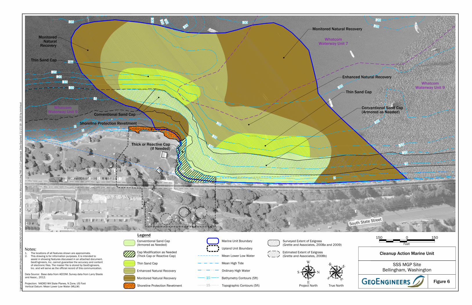
UT
UT
UT
UTUT
-20
-15
-10
-5
0
5
5
10
0
15
15
2015
60
5550
4540
3530
6570
75
65
7075
80
5560
6570
75
-5
-15-20
-25
-25
-20
-15
-10
-5
0
0510
-10
-30
-35
-30 -25-20
-15-30
-20-25
2520
Conventional Sand Cap(Armored as Needed)
Monitored Natural Recovery
Enhanced Natural Recovery
Conventional Sand Cap
MonitoredNatural
Recovery
Thin Sand Cap
Thin Sand Cap
Thick or Reactive Cap(If Needed)
Shoreline Protection Revetment -20
-15
-10
-5
05
WhatcomWaterway Unit 9
WhatcomWaterway Unit 9
WhatcomWaterway Unit 7
Figure 6
\\ge
oeng
inee
rs.c
om\W
AN\P
roje
cts\
0\01
8689
0\CA
D\0
2\CA
P\01
8689
002_
F06_
Clea
nup
Actio
n M
arin
e Un
it.dw
g TA
B:11
x17
Land
scap
e D
ate
Expo
rted:
11/
17/1
9 - 1
6:00
by
tmic
haud
Feet
0150 150
Notes:1. The locations of all features shown are approximate.2. This drawing is for information purposes. It is intended to
assist in showing features discussed in an attached document.GeoEngineers, Inc. cannot guarantee the accuracy and contentof electronic files. The master file is stored by GeoEngineers,Inc. and will serve as the official record of this communication.
Data Source: Base data from AECOM. Survey data from Larry Steeleand Assoc., 2012.
Projection: NAD83 WA State Planes, N Zone, US FootVertical Datum: Mean Lower Low Water (MLLW)
SSS MGP SiteBellingham, Washington
Cleanup Action Marine Unit
South State Street
LegendConventional Sand Cap(Armored as Needed)
Cap Modification as Needed(Thick Cap or Reactive Cap)
Thin Sand Cap
Enhanced Natural Recovery
Monitored Natural Recovery
Shoreline Protection Revetment
Marine Unit Boundary
Upland Unit Boundary
Mean Lower Low Water
Mean High Tide
Ordinary High Water
Bathymetry Contours (5ft)
Topographic Contours (5ft)15
-15
W
EN
S
True NorthProject North
W
E
NS
Surveyed Extent of Eelgrass(Grette and Associates, 2008a and 2009)
Estimated Extent of Eelgrass(Grette and Associates, 2008b)