CLAYS AND SHALES WASHINGTON
224
State of Washington ARTHUR B. LANGLIE, Go vernor Department of Conservation and Development JOHN BROOKE FINX, Director DIVISI ON OF GEOLOGY HAROLD E. CULVER. Supervisor Bulletin No. 24 CLAYS AND SHALES OF WASHINGTON BY S HELDON L. GLOVER With tests by Hewitt Wilson Testing done under cooperative agreement between the U. S. Bureau of Mines and the Unlversily 0£ Washington OLYMPIA •TATE. PRINTING PLANT 1941 For sale by Department of Conservation and Developmell.(. Olympia, Washington Price, one dolla.z:.
-
Upload
khangminh22 -
Category
Documents
-
view
0 -
download
0
Transcript of CLAYS AND SHALES WASHINGTON
State of Washington ARTHUR B. LANGLIE, Governor
Department of Conservation and Development JOHN BROOKE FINX, Director
DIVISION OF GEOLOGY HAROLD E. CULVER. Supervisor
Bulletin No. 24
CLAYS AND SHALES OF
WASHINGTON BY
SHELDON L. GLOVER
With tests by Hewitt Wilson Testing done under cooperative agreement
between the U. S. Bureau of Mines and the Unlversily 0£ Washington
OLYMPIA •TATE. PRINTING PLANT
1941
For sale by
Department of Conservation and Developmell.(.
Olympia, Washington
Price, one dolla.z:.

CONTENTS
Lette1· of transmittal Page
Introduction . . . . . . . . . . . . . . . . . . . . . . . . . . . . . . . . . . . . . . . . . . . . . . . . . . . . . . . . l Scope of paper. . . . . . . . . . . . . . . . . . . . . . . . . . . . . . . . . . . . . . . . . . . . . . . . . . 1 Acknowledgments . . . . . . . . . . . . . . . . . . . . . . . . . . . . . . . . . . . . . . • . . . . . . . . 2 Bibliography of Washington clays................................. 2
Origin ot clay. . . . . . . . . . . . . . . . . . . . . . . . . . . . . . . . . . . . . . . . . . . . . . . . . . . . . . . 6 Definition of clay. . . . . . . . . . . . . . . . . . . . . . . . . . • . . . . . . . . . . . . . . . . . . . . . 6 Rock sotu·ces of clay. . . . . . . . . . . . . . . . . . . . . . . . . . . . . . . . . . . . . . . . . . . . . 6 Mineral sources of clay. . . . . . . . . . . . . . . . . . . . . . . . . . . . . . . . . . . . . . . . . . . 7 Weathering . . . . . . . . . . . . . . . . . . . . . . . . . . . . . . . . . . . . . . . . . . . . . . . . . . . . . 7 Erosion and sedimentation. . . . . . . . . . . . . . . . . . . . . . . . . . . . . . . . . . . . . . . . 8 Changes in clays after deposition.... . ...... ... ................... 9
Color change . . . . . . . . . . . . . . . . . . . . . . . . . . . . . . . . . . . . . . . . . . . . . . . 9 Leaching . . . . . . . . . . . . . . . . . . . . . . . . . . . . . . . . . . . . . . . . . . . . . . . . . . . 9 Concretions . . . . . . . . . . . . . . . . . . . . . . . . . . . . . . . . . . . . . . . . . . . . . . . . . l 0 Induration . . . . . . . . . . . . . . . . . . . . . . . . . . . . . . . . . . . . . . . . . . . . . . . . . . 10 Softening . . . . . . . . . . . . . . . . . . . . . . . . . . . . . . . . . . . . . . . . . . . . . . . . . . . 11
Classification of clays......................... . ...................... 12 Classification by origin. . . . . . . . . . . . . . . . . . . . . . . . . . . . . . . . . . . . . . . . . . . 12
Residual . . . . . . . . . . . . • . . . . . . . . . . . . . . . . . . . . . . . . . . . . . . . . . . . . . . . 13 Collu\Tial . . . . . . . . . . . . . . . . . . . . . . . . . . . . . . . . . . . . . . . . . . . . . . . . . . . 13 Alluvial . . . . . . . . . . . . . . . . . . . . . . . . . . . . . . . . . . . . . . . . . . . . . . . . . . . . 13 Lacustrine . . . . . . . . . . . . . . . . . . . . . . . . . . . . . . . . . . . . .. . . . . . . . . . . . . 14 Marine and estuarine.............................. .. ........ 14 Glacial . . . . . . . . . . . . . . . . . . . . . . . . . . . . . . . . . . . . . . . . . . . . . . . . . . . . . 14 Eolian . . . . . . . . . . . . . . . . . . . . . . . . . . . . . . . . . . . . . . . . .. . . . . . . . . . . . . 15
Classification by physical properties.................... .. ......... 16 Classification by. use..................... ... ..................... 16
Constitution of clays...................................... . ...... .... 19 Mineralogy . . . . . . . . . . . . . . . . . . . . . . . . . . . . . . . . . . . . . . . . . . . . . . . . . . . . . l 9 Chemical compounds . . . . . . . . . . . . . . . . . . . . . . . . . . . . . . . . . . . . . . . . . . . . 20
Silica . . . . . . . . . . . . . . . . . . . . . . . . . . . . . . . . . . . . . . . . . . . . . . . . . . . . . . 20 Alumina . . . . . . . . . . . . . . . . . . . . . . . . . . . ... . . . . • . . . . . . . . . . . . • . . . . 20 Water . . . . . . . . . . . . . . . . . . . . . . . . . . . . . . . . . . . . • . . . . . . . . . . . . . . . . . 20 Hygroscopic water; pore water. . . . . . . . . . . . . . . . . . . . . . . . . . . . . . . 21 Iron compounds . . . . . . . . . . . . . . . . . . . . . . . . . . . . . . . . . . . . . . . . . . . . . 2J Lime ....................................................... 22 Magnesia . . . . . . • . . . . . . . . . . . . . . . . . . . . . . . . . . . . . . . . . . . . . . . . . . . . 22 Alkalies . . . . . . . . . . . . . . . . . . . . . . . . . . . . . . . . . . . . . . . . . . . . . . . . . . . . 23 Titanium compounds . . . . . . . . . . . . . . . . . . . . . . . . . . . . . . . . . . . . . . . . :23 Manganese compounds .... ............................ ... ... :23 Organic matter . . . . . . . . . . . . . . . . . . . . . . . . . . . . . . . . . . . . . . . . . . . . . 23
Working properties of clay........................................... 24 Original properties . . . . . . . . . . . . . . . . . . . . . . . . . . . . . . . . . . . . . . . . . . . . . . 24
Color . . . . . . . . . . . . . . . . . . . . . . . . . . . . . . . . . . . ... . . . . . . . . . . . . . . . . . 24 Hardness . . . . . . . . . . . . . . . . . . . . . . . . . . . . . . . . . . . . . . . . . . . . . . . . . . . 24 Texture . . . . . . . . . . . . . . . . . . . . . . . . . . . . . . . . . . . . . . . . . . . . . . . . . . . . 24 Slaking........ ................................. ............ 25 Porosity and specific gravity. . . . . . . . . . . . . . . . . . . . . . . . . . . . . . . . . . 25
Prefiring character . . . . . . . . . . . . . . . . . . . . . . . . . . . . . . . . . . . . . . . . . . . . . . 25 Plasticity . . . . . . . . . . . . . . . . . . . . . . . . . . . . . . . . . . . . . . . . . . . . . . . . . . . 25 Water of plasticity. . . . . . . . . . . . . . . . . . . . . . . . . . . . . . . . . . . . . . . . . . . 26 Bonding power . . . . . . . . . . . . . . . . . . . . . . . . . . . . . . . . . . . . . . . . . . . . . 26 Drying shrinkage . . . . . . . . . . . . . . . . . . . . . . . . . . . . . . . . . . . . . . . . . . . 26 Tensile strength . . . . . . . . . . . . . . . . . . . . . . . . . . . . . . . . . . . . . . . . . . . . . 27

lV Contents
Working properties of clay Page Fi.ri.I1g effects . . . . . . . . . . . . . . . . . . . . . . . . . . . . . . . . . . . . . . . . . . . . . . . . . . . 27
Loss of volatile matter. . . . . . . . . . . . . . . . . . . . . . . . . . . . . . . . . . . . . . . 27 Incipient fusion . . . . . . . . . . . . . . . . . . . . . . . . . . . . . . . . . . . . . . . . . . . . . 27 Vitrification . . . . . . . . . . . . . . . . . . . . . . . . . . . . . . . . . . . . . . . . . . . . . . . . . 28 Fusion . . . . . . . . . . . . . . . . . . . . . . . . . . . . . . . . . . . . . . . . . . . . . . . . . . . . . 28 Vitrification range . . . . . . . . . . . . . . . . . . . . . . . . . . . .. . . . . . . . . . . . . . . 28 Shrinkage . . . . . . . . . . . . . . . . . . . . . . . . . . . . . . . . . . . . . . . . . . . . . . . . . . 28 Color .. . . . . . . . . . . . . . . . . . . . . . . . . . . . . . . . . . . . . . . . . . . . . . . . . . . . . . 29 Porosity . . . . . . . . . . . . . . . . . . . . . . . . . . . . . . . . . . . . . . . . . . . . . . . . . . . . 29 Strength and hardness. . . . . . . . . . . . . . . . . . . . . . . . . . . . . . . . . . . . . . . 30 Temperatw·e measurements . . . . . . . . . . . . . . . . . . . . . . . . . . . . . . . . . . 30
Operating methods . . . . . . . . . . . . . . . . . . . . . . . . . . . . . . . . . . . . . . . . . . . . . . . . . . 32 Prospecting for clay. . . . . . . . . . . . . . . . . . . . . . . . . . . . . . . . . . . . . . . . . . . . . 32 Plant location . . . . . . . . . . . . . . . . . . . . . . . . . . . . . . . . . . . . . . . . . . . . . . . . . . . 33 Mining clay . . . . . . . . . . . . . . . . . . . . . . . . . . . . . . . . . . . . . . . . . . . . . . . . . . . . 33 Manufacturing . . . . . . . . . . . . . . . . . . . . . . . . . . . . . . . . . . . . . . . . . . . . . . . . . . 34
Preparation of the clay. . . . . . . . . . . . . . . . . . . . . . . . . . . . . . . . . . . . . . . 34 Sorting and mixing. . . . . . . . . . . . . . . . . . . . . . . . . . . . . . . . . . . . . . 34 Grinding . . . . . . . . . . . . . . . . . . . . . . . . . . . . . . . . . . . . . . . . . . . . . . . 35 Washing .. . . . . . . . . . . . . . . . . . . . . . . . . . . . . . . . . . . . . . . . . . . . . . . 35 Screening . . . . . . . . . . . . . . . . . . . . . . . . . . . . . . . . . . . . . . . . . . . . . . . 36 Tempering .. . . . . . . . . . . . . . . . . . . . . . . . . . . . . . . . . . . . . . . . . . . . . 36
Molding . . . . . . . . . . . . . . . . . . . . . . . . . . . . . . . . . . . . . . . . . . . . . . . . . . . . 36 So!t- mud process . . . . . . . . . . . . . . . . . . . . . . . . . . . . . . . . . . . . . . . 36 Stiff-mud process . . . . . . . . . . . . . . . . . . . . . . . . . . . . . . . . . . . . . . . 37 Dry pressing . . . . . . . . . . . . . . . . . . . . . . . . . . . . . . . . . . . . . . . . . . . . 38 Sewer pipe . . . . . . . . . . . . . . . . . . . . . . . . . . . . . . . . . . . . . . . . . . . . . 38 Pottery . . . . . . . . . . . . . . . . . . . . . . . . . . . . . . . . . . . . . . . . . . . . . . . . . 38
Turning . . . . . . . . . . . . . . . . . . . . . . . . . . . . . . . . . . . . . . . . . . . . 38 Jollying or jiggering................................. 38 Pressing . . . . . . . . . . . . . . . . . . . . . . . . . . . . . . . . . . . . . . . . . . . . 39 Casting . . . . . . . . . . . . . . . . . . . . . . . . . . . . . . . . . ... . . . . . . . . . 39 Drying, glazing, and firing. . . . . . . . . . . . . . . . . . . . . . . . . . . . 39
Terra cotta . . . . . . . . . . . . . . . . . . . . . . . . . . . . . . . . . . . . . . . . . . . . . 39
~~~~g. :: : : : : : : : : : : : : : : : : : : : : : : : : : : : : : : : : : : : : : : : : : : : : : : : : : : : :g Kilns .. . . . . . . . . . . . . . . . . . . . . . . . . . . . . . . . . . . . . . . . . . . . . . . . . . 41 Fuels . . . . . . . . . . . . . . . . . . . . . . . . . . . . . . . . . . . . . . . . . . . . . . . . . . . 43
Statistics of production of clay and clay products in Washington ........ . Tests made on Wasbington clays ..................................... .
Method o:C testing, by Hewitt Wilson ...... . ............ . ..... . ... .
~w~i~~ ::: : : : : : : : : : : : : : : : : : : : : : : : : : : : : : : : : : : : : : : : : : : : : : : : : : Tabulation of results ........................................ .
Groups of Washington clays ..................... : ................... . Recent alluvial clays ........................................ . .. . Cascade residual clays .......................................... . Palouse day .................................................. . Silts ............................... . ................... , ..... . Puget Sound glacial clays ................. . ..................... . Willa pa Pleistocene clays ................................ .. ..... . Hammer Bluff clays ........................ . ... . ............... . Spokane-Clayton clays ............................. . ..... . ..... .
Residual phase ............................................ . Lacustrine phase ........................................... .
Shales ................................................... , .... . High-alumina clays ................................................ . .Description of clays and shales. by counties ........................... .
Adams County ................................................ . Asotin County . . ........................ . ................. . .... . Benton County .. . ........................... . ................. . Chelan County ................................................. .
44 45 45 45 46 47 48 48 49 49 50 51 52 53 53 54 54 54 56 59 59 59 60 61
Contents V
Description of clays and shales, by counties Page
Clallam County . . . . . . . . . . . . . . . . . . . . . . . . . . . . . . . . . . . . . . . . . . . . . . . . 65 Shales . . . . . . . . . . . . . . . . . . . . . . . . . . . . . . . . . . . . . . . . . . . . . . . . . . . . . 65 Puget Sound glacial clay. . . . . . . . . . . . . . . . . . . . . . • . . . . . . . . . . . . . 68
Clark County . . . . . . . . . . . . . . . . . . . . . . . . . . . . . . . . . . . . . . . . . . . . . . . . . . 69 Columbia County . . . . . . . . . . . . . . . . . . . . . . . . . . . . . . . . . . . . . . . . . . . . . . . 73 Co\vlitz County . . . . . . . . . . . . . . . . . . . . . . . . . . . . . . . . . . . . . . . . . . . . . . . . . 74 Douglas County . . . . . . . . . . . . . . . . . . . . . . . . . . . . . . . . . . . . . . . . . . . . . . . . 85 Ferry County . . . . . . . . . . . . . . . . . . . . . . . . . . . . . . . . . . . . • . . . . . . . . . . . . . 87 Franklin County . . . . . . . . . . . . . . . . . . . . . . . . . . . . . . . . . . . . . . . . . . . . . . . . 89 Garfield County . . . . . . . . . . . . . . . . . . . . . . . . . . . . . . . . . . . . . . . . . . . . . . . . 94 Grant County . . . . . . . . . . . . . . . . . . . . . . . . . . . . . . . . . . . . . . . . . . . . . . . . . . 94 Grays Harbor County. . . . . . . . . . . . . . . . . . . . . . . . . . . . . . . . . . . . . . . . . . . 97
Shales . . . . . . . . . . . . . . . . . . . . . . . . . . . . . . . . . . . . . . . . . . . . . . . . . . . . . 98 W illapa Pleistocene clays. . . . . . . . . . . . . . . . . . . . . . . . . . . . . . . . . . . . 10 l
Island County . . . . . . . . . . . . . . . . . . . . . . . . . . . . . . . . . . . . . . . . . . . . . . . . . . 106 Jefferson County ............................................... 106 King County ..................................... . ............. 108
Cascade residual clays. . . . . . . . . . . . . . . . . . . . . . . . . . . . . . . . . . . . . . . 1 08 Shales ..................................................... 112 Hammer Bluff clays. . . . . . . . . . . . . . . . . . . . . . . . . . . . . . . . . . . . . . . . . 137 Puget Sound glacial clays .................... .............. .. 151
Kitsap County . . . . . . . . . . . . . . . . . . . . . . . . . . . . . . . . . . . . . . . . . . . . . . . . . 160 Shales ....... . ............................... ... ... . ...... . 160 Puget Sound glacial clays. . . . . . . . . . . . . . . . . . . . . . . . . . . . . . . . . . . . 162
Kittitas County . . . . . . . . . . . . . . . . . . . . . . . . . . . . . . . . . . . . . . . . . . . . . . . . . 163 Klickitat County . . . . . . . . . . . . . . . . . . . . . . . . . . . . . . . . . . . . . . . . . . . . . . . 166 Lewis County .............................. . ................... 167
Shales .......... ......... ..................... .....•..... .. 168 Willapa Pleistocene clays ............... . .................... 180 Recent alluvial clays ......... ............ .. .. . ... ... .. ...... 188
Lincoln County . . . . . . . . . . . . . . • . . . . . . . . . . . . . . . . . . . . . . . . . . . . . . . . . 189 Mason County . . . . . . . . . . . . . . . . . . . . . . . . . . . . . . . . . . . . . . . . . • . . . . . . . 190 Okanogan County . . . . . . . . . . . . . . . . . . . . . . . . . . . . . . . . . . . . . . • . . . . . . . 192 Pacific County . . . . . . . . . . . . . . . . . . . . . . . . . . . . . . . . . . . . . . . . . . . . . . . . . . 195
Shales ... . ............ ......... . ........................... 195 Willapa Pleistocene clays. . . . . . . . . . . . . . . . . . . . . . . . . . . . . . . . . . . . 199
Pend Oreille County. . . . . . . . . . . . . . . . . . . . . . . . . . . . . . . . . . . . . • . . . . . . . 200 Pierce County .... . ........................ . ...... . ........... . . 205
Cascade residual clays. . . . . . . . . . . . . . . . . . . . . . . . . . . . . . . . . . . . . . . 205 Shales . ............... .... ................. ................ 214 Puget Sound glacial clays. . . . . . . . . . . . . . . . . . . . . . . . . . . . . . . . . . . . 216
San Juan County.. . . . . . . . . . . . . . . . . . . . . . . . . . . . . . . . . . . . . . . . . . . . . . . 217 Skagit County .. . . . . . . . . . . . . . . . . . . . . . . . . . . . . . . . . . . . . . . . . . . . . . . . . 217 Skama11ia County . . . . . . . . . . . . . . . . . . . . . . . . . . . . . . . . . . . . . . . . . . . . . . . 225 Snohomish County . . . . . . . . . . . . . . . . . . . . . . . . . . . . . . . . . . . . . . . . . . . . . 225 Spokane County . . . . . . . . . . . . . . . . . . . . . . . . . . . . . . . . . . . . . . . . . . . . . . . . 229
Late geologic history. . . . . . . . . . . . . . . . . . . . . . . . . . . . . . . . . . . . . . . . . 229 OccuiTence of clay groups .................... . .... .......... 231 Light- fl.ring clays ......... . .. .... ............ . ..... .. ....... 234
Districts ...... . . .. . ........ ...... .. .. . ........ . ........ 234 Tekoa-Fail:field district . . . . . . . . . . . . . . . . . . . . . . . . . . . . . . 234 Manito district ............................. . ....... 237 Freeman district . . . . . . . . . . . . . . . . . . . . . . . . . . . . . . . . . . . 241 Mica district . . . . . . . . . . . . . . . . . . . . . . . . . . . . . . . . . . . . . . . 244 Moran district . . . . . . . . . . . . . . . . . . . . . . . . . . . . . . . . . . . . . . 252 Cheney-Medical Lake district ............... . ... ..... 253 Chester district . . . . . . . . . . . . . . . . . . . . . . . . . . . . . . . . . . . . . 253 Pleasant Prairie district ........•.......... . .......... 256 Deadman Creek district. . . . . . . . . . . . . . . . . . . . . . . . . . . . . . 258 Five Mile Prairie district . . ......... . .............. . .. 262 Milan district . . . . . . . . . . . . . . . . . . . . . . . . . . . . . . . . . . . . . . 262 Deer Parl< district. . . . . . . . . . . . . . . . . . . . . . . . . . . . . . . . . . . 264
Vl Contents
Description of clays and shales, by counties Spokane County Page
Dark-firing Latah clays. . . . . . . . . . . . . . . . . . . . . . . . . . . . . . . . . . . . . . 266 Districts . . . . . . . . . . . . . . . . . . . . . . . . . . . . . . . . . . . . . . . . . . . . . . . 267
West Spokane district .... .................... . ...... 267 Shelley Lake district. . . . . . . . . . . . . . . . . . . . . . . . . . . . . . . . 271 Five Mile Prairie district . ............................ 272 Buckeye district . . . . . . . . . . . . . . . . . . . . . . . . . . . . . . . . . . . . 273 Chattaroy-Milan district. .. ....... .... .............. . 274
Dark-firing Palouse clay ..................................... 276 Dark-firing glacial clay. . . . . . . . . . . . . . . . . . . . . . . . . . . . . . . . . . . . . 278
Stevens County ..... . .................. , . . . . . . . . . . . . . . . . . . . . . . . 280 Light-firing clays .............................................. 280
Districts . . . . . . . . . . . . . . . . . . . . . . . . . . . . . . . . . . . . . . . . . . . . . . . 282 Clayton district . . . . . . . . . . . . . . . . . . . . . . . . . . . . . . . . . . . . . 282 Valley district . . . . . . . . . . . . . . . . . . . . . . . . . . . . . . . . . . . . . . 292
Dark-firing clays ........................................... 294 Districts . . . . . . . . . . . . . . . . . . . . . . . . . . . . . . . . . . . . . . . . . . . . . . . 294
Chewelah district . . . . . . . . . . . . . . . . . . . . . . . . . . . . . . . . . . . 294 Bissell-Northport district . . . . . . . . . . . . . . . . . . . . . . . . . . . . 295 Kettle Valley district ... ... . ......................... 298
Thurston County . . . . . . . . . . . . . . . . . . . . . . . . . . . . . . . . . . . . . . . . . . . . . . . 299 Wahkiakum County . . . . . . . . . . . . . . . . . . . . . . . . . . . . . . . . . . . . . . . . . . . . 302 Walla Walla County .. .. ............... ... . .... ..... ...... .. . .... 305 Whatcom County . . . . . . . . . . . . . . . . . . . . . . . . . . . . . . . . . . . . . . . . . . . . . . . 306
Common shales . . . . . . . . . . . . . . . . . . . . . . . . . . . . . . . . . . . . . . . . . . . . 306 Sumas shales . . . . . . . . . . . . . . . . . . . . . . . . . . . . . . . . . . . . . . . . . . . . . . 308 Puget Sound glacial clays ................. . .................. 319
Whitman County .................................. ..... . ..... . . 319 Light-fu'ing clays ........................................... 320
Districts . . . . . . . . . . . . . . . . . . . . . . . . . . . . . . . . . . . . . . . . . . . . . . . 321 Palouse district . . . . . . . . . . . . . . . . . . . . . . . . . . . . . . . . . . . . . 321 Bald Butte-Fallon district .... ... . .... ..... .... .... . . 326 Garfield-Tekoa district ............. . . .............. . 327
Dark- firing clays . . . . . . . . . . . . . . . . . . . . . . . . . . . . . . . . . . . . . . . . . . . 327 Yakima County . . . . . . . . . . . . . . . . . . . . . . . . . . . . . . . . . . . . . . . . . . . . . . . . . 332
Appendix 1-Locations and properties of Washington clays and shales ... 336 Appendix :2-Chemical analyses . . . . . . . . . . . . . . . . . . . . . . . . . . . . . . . . . . . . . 342 Appendix 3
Table !- Production of clay products in Washington, 1894-1939 .... 354 Table 2-Clay plants in Washington .. ...... . .. . . .. . .. ..... . Facing 358 Table 3-Production of raw clay in Washington, 1907-1939 .......... 359
Index ........ . ................. . ..... .. .. ......................... . 361
Plate 1.
2. 3. 4. 5. 6. 7. 8.
9. 10.
11.
12. 13.
14.
Figme 1.
2.
3.
4. 5.
6.
ILLUSTRATIONS
Page Characteristic road cut in Pleistocene sandy clay and decom-
posed gravel, Grays Harbor County. . . . . . . . . . . . . . . . . . . . . . 102 "Glory hole" used in mining shale at Taylor. . . . . . . . . . . . . . . . . . 123 Great wall of shale developed in the Taylor "glory hole" ...... 126 Pit of the old Norlhern Clay Co. east of Auburn. . . . . . . . . . . . . . 139 Hammer Bluff on Green River, east of Auburn. . . . . . . . . . . . . . . 145 Glacial clay in the Builders Brick Co. pit, Seattle. . . . . . . . . . . . . . 152 Section of part of the Chehalis Brick & Tile Co. pit ... ......... 186 Cascade residual clay in the pit of the Far West Brick & Tile Co.,
Clay City . . . . . . . . . . . . . . . . . . . . . . . . . . . . . . . . . . . . . . . . . . . . . . 208 Residual clay pit at Freeman ................................ 241 A, Fire-clay pit of Gladding, McBean & Co. at Mica; B, Pit of
Washington Brick, Lime & Sewer Pipe Co. at Mica. . . . . . . . 245 A, Nearly pure kaolin interbedded with the usual refractory
clays at Mica; B, Rain-gullied residual clay in a 1·aihoad cut 1 ¥.! miles north of Mica . . . . . . . . . . . . . . . . . . . . . . . . . . . . . . . . . 248
Basalt intrusion in Latah shales just west of Spokane. . . . . . . . . . 269 Palouse-clay pit of former Freeman brick plant of Washington
Brick, Lime & Sewer Pipe Co.. . . . . . . . . . . . . . . . . . . . . . . . . . . . 277 A, Banded Latah clay of the Clayton pit; B, Varved glacial clays
and sills at Colville ..................................... 283
Section illustrating the sedimentary sequence at Hammer Bluff on Green River, King County .......................... Jl37
Section to illustrate the occurrence of clays in the Spokane region ................................................ 231
The Tekoa-Spokane-Clayton region and location of clays sampled . . . . . . . . . . . . . . . . . . . . . . . . . . . . . . . . . . . . . . . . . . . . . . 233
Section of beds at the Clayton pit, Stevens County ......... ... 282 Map showing location of clays sampled near Sumas, Whatcom
County ............................................... 312 Section of beds at the Cox pit, near Palouse, Whitman County .. 322
LETTER OF TRANSMITTAL The Honorable John Brooke Fink, Director Department of Conservation and Development Olympia, Washington
Dear Sir:
I have the honor to present a report on the "Clays and Shales o{ Washington," with the recommendation that it be published as Bulletin 24 of the Geological series.
This report presents the geologic information resulting from a state-wide investigation of the resources and technology of Washington clays undertaken as a triple cooperation between the United States Bureau of Mines, the Engineering Experiment Station of the University of Washington, and the State Geological Survey. The technological study was supervised by Hewitt Wilson, Ceramist, U. S. Bureau of Mines, who prepared the section on "Methods of Testing Washington Clays" for this report.
With .few exceptions, the description of individual deposits and plants is based on personal observation by the author, thus insuring both authoritative character and comparative value rarely attained in such comprehensive reports.
In view of the widening interest in the use of clays not only in ceramics but as a souroo of metallic aluminum and for other industrial applications, it is believed this report will be of particular value.
February 10, 1941 Pullman, Washington
Respectfully yours, HAROLD E. CULVER, Supervisor of Geology.
INTRODUCTION
The study upon which this bulletin is based was begun in the summer of 1919, when the writer canvassed the State for samples from the many clay and shale deposits and for data on their geology. Nearly every county was visited the first season, and in those where high-grade clays were known or whe.re there was a possibility of their occurrence, great care was exercised to obtain as complete information as possible on clay resources.
A preliminary investigation was made of these 20-pound samples, after which the most promising localities were again visited and 100-pound samples were taken. During the summer of 1920 the counties and other areas that had been omitted in the previous work were investigated; so the samples and information then at hand not only were pertinent to particular deposits but could be used as indicative oi the clay resources and possibilities of the whole State.
The samples were tested by Hewitt Wilson, Professor of Ceramic Engineering, College of Mines, University of Washington, and Nonmetallics Engineer, U. S. Bureau of Mines, assisted by Ernest T. Goodner, Fellow in Ceramics, under a cooperative agreement between the Washington Geological Survey, the College of Mines at the University of Washington, and the U. S. Bureau of Mines. Tabulated results of these tests are included after the description of the various clay occurrences in the following report. Later, more exhaustive tests were made by Wilson of the larger and more promising samples and those data were incorporated by him in what was intended originally to be a companion bulletin to this, published (as Bulletin No. 18) by the Engineering Experiment Station, University of Washington, in 1923.
As the expected funds for publication of the present report were not forthcoming when the work was completed, the data have been available only in the files of the Division of Geology. In 1936-37, additional field work was done and the report was completely revised to include the recent as well as the earlier data.
SCOPE OF PAPER
In view of the labor and expense of making physical analyses of so many samples and the doubtful benefit to be derived from chemical analyses, it was decided to eliminate the chemical investigation. Previous investigators and private individuals have made many such analyses, and all these results that are available have been included in appendix 2. Unless analyses are made continually of the clay being worked, they amount to no more than a general indication of the composition of the clay type. A similar indication is obtainable by referring the samples men-
2 Clays and Shales of Washington
tioned in this report to the listed analyses that have been made from previous samples taken on the same or related deposits.
In preparing the report, stress has been laid on the geology of the various clays rather than on the technology of the clay industry. The broader phases of clay work are outlined and briefly discussed for the ready reference of the general public; but those whose interests lie particularly in this specialized field are referred to the many excellent books and articles on this subject alone. The objects strived for in the report are to list the different types of clay occurring in the State and to show the geographic range of each type; to make data on the physical characteristics of these clays easily available; and, finally, to show the relations between clay, rock, and geologic processes, whereby areas may be classified as to their possible clay types or lack of such materials.
ACKNOWLEDGMENTS The investigation of Washington clays from the viewpoint of
the ceramist in addition to that of the geologist has largely been made possible through the active interest of Mr. Hewitt Wilson. This association with Mr. Wilson has been particularly enjoyable and his contributions to the study are greatly appreciated.
Thanks are due the many operating companies and individuals who have cooperated in the collection of data. A uniformly hearty response has been received throughout the State to inquiries on the operation of plants and on occurrences of clays. This helpful attitude is greatly appreciated and has contributed markedly to the completeness of the report.
Statistics of production are largely from published reports of the U. S. Geological Survey and the U. S. Bureau of Mines; hitherto unpublished statistics are contributed through the courtesy of the U. S. Bureau of the Census.
BIBLIOGRAPHY OF WASHINGTON CLAYS 1891. Bethune, George A., Mines and minerals of Wasbjngton: First Ann.
Rept. of State Geologis t, pp. 104-107, Olympia. Includes a brief generalization on Washington clays and gives three analyses.
1892. Bethune, Geo1·ge A., Mines and minerals of Washington: Second Ann. Rept. of State Geologist, pp. 63-67, Olympia. Includes a brief generalization on Wasbfagton clays, repeats the analyses of the First Ann. Rept. and gives three additional ones.
1902. Landes, Henry ( and Roberts, Milnor), The non metalliferous resources of Washington except coal: Washington Geo!. Survey Ann. Rept. for 1901, vol. 1, pt. 3, pp. 13-23. Includes a brief generalization on Washington clays and on the Washington B1·ick, Lime and Manufacturing Co., together with detailed data on the Denny Clay Co., and the Little Falis Fire Clay Co.
Introduction 3
1905. Landes, Henry, The clay deposits of Washington: U. S. Geol. Sw·vey Bull. 260, pp. 550-558. Gives some statistics on clay products and production and describes deposits in the vicinity of Seattle, Spokane, Sopenah (Vader), and Yakima.
1906. Landes, Henry, Cement resources of Washington: U. S. Geol. Sw·vey Bull. 285, pp. 377-383. Gives analyses and brief descriptions of clays in Ferry, King, Okanogan, San Juan, Skagit, Snohomish, Stevens, and Whatcom counties and discusses their utilization in the manufacture of Portland cement.
1909. Darton, N. H., Structural materials in parts of Oregon and Washington: U. S. Geol. Survey Bull. 387. Mentions the occurrence of clays in Washington and quotes Landes (BuU. 285) on analyses and descriptions of deposits.
1910. Shedd, Solon, The clays of tbe State of Washington, their geology, mineralogy, and technology: State College oi Washington. This is an extensive discussion of the properties of clays and the technology of the clay industry. Operating plants and many clay deposits in some 20 counties are described and the results of the tests and analyses o! the clays are given.
1911. Geijsbeek, Samuel, Clay deposits of Washington: Am. Ceramic Soc. Trans., vol. 13, pp. 751-764.
1912. Evans, George Watkins, The coal fields of King County: Washington Geo!. Sw·vey Bull. 3. Gives many sections and descriptions of shales occurring with coal.
1913. Bretz, J Harlen, Glaciation of the Puget Sound region: Washington Geo!. Survey Bull. 8. Gives the origin and mentions many occwTences of glacial clay in the Puget Sound region.
1914. Landes, Henry, The mineral resources of Washington: Washington Geo!. Survey Bull. 11, pp. 29-34. Lists the clay plants operating in the State and gives statistics on production from 1905 to 1912. Includes map showing location of plants.
1914. Shedd, Solon, Cement materials and industry in the State of Washington: Washlngton Geol. Survey Bull. 4. Includes general in.formation on clays and brie11y describes occurrences, giving analyses, at 22 localities.
1914. Saunders, E. J. , The coal fields of Kittitas County: Washington Geo!. Survey Bull. 9. Gives many sections and descriptions of shales occurring with coal.
1915. Daniels, Joseph, The coal fields of Pierce County: Washington Geol. Survey Bull. 10. Gives many sections and descriptions of shales related to coal beds.
1916. Weaver, Charles E., The Tertiary formations of western Washington: Washington Geol. Survey Bull. 13. An extensive report on the age, characteristics, and extent or shales and other Tertiary rocks in western Washington.
1919. Culver, Harold E., The coal fields of southwestern Washington: Washington Geo!. Survey Bull. 19. Gives many sections and desc1·iptions of shales occurring with coal.
4 Clays and Shales of W ashfrigton
1920. Weaver, Charles E., The mineral resources of Stevens County: Washington Geol. Survey Bull. 20, pp. 338-344. Includes general information on the clays of Stevens County and discusses briefly those of the Clayton (includ4lg the Abbott, Neafus, and Conner pits), Kettle Falls, Chewelah, Colville, Northport, and Valley areas.
1921. Patty, E. N., and Glover, S. L., The mineral Tesources of Washington: Washington Geol. Survey Bull. 21, pp. 121-127. Lists the clay plants operating in the State and gives statistics on production from 1913 to 1918. Includes map showing location of plants.
1823. Wilson, Hewitt, The clays and shales of Washington, their technology and uses: Univ. of Washington Eng. Exp. Sta. Bull. 18. A very comprehensive r.eport on properties of clays and clay testing. Compares typical Washington clays with several standard clays and gives the .results of complete tests made on clay samples obtained by the Wash
ington Geo!. Survey. Intended as a companion report to Bulletin 24 of the Division of Geology.
1923. Jenkins, 0 . P., Geological investigation of the coal fields of western Whatcom County : Washington Div. of Geol. Bull. 28. Gives many sections of shales occurring with coal.
1924. Jenkins, 0. P., Geological investigation of the coal fields of western Skagit C6unty: Washington Div. of Geol. Bull. 29. Gives a few sections of shales occurring with coal.
1924. Shedd, Solon, The mineral resources of Washington: Washington Div. oi Geol. Bull. 30, pp. 152-159. Lists the clay plants operating in the State and gives statistics on production from 1913 to 1922.
1926. Pardee. J. T., and Bryan, Kirk, Geology o:C the Latah formation in relation to the lavas of the Columbia Plateau near Spokane, Washington: U. S. GeoL Survey Prof. Paper 140-A. Presents the geology of the formation that contains some of the best clays or the Spokane-Clayton area and describes many occurrences of clays and shale .
1928. Goodspeed, G. E., and Weymouth, A. A., Mineral constituents and origin of a certain kaolin deposit near Spokane, Washington: Am. Ce1·amic Soc. Jour., vol. 11, no. 9, pp. 687- 695. Discusses the petrographic and mineralogic features of the Freeman residual clay and suggests an origin other than weathering.
1929. Burkhalter, Edward, The variety of clays of Washington and their adaptability to ceramic industry: Am. Ceramic Soc. Bull. 11, pp. 236-239.
1932. Tullis, E. L., The clays of Tertiary age in northern Idaho and eastern Washington (abst.): Pan-Am. Geologist, vol. 58, pp. 152-153; NW Science, vol. 6, p. 30.
1934. Goodspeed, G. E., Recrystallization replacement of small dikes and sills (abst.): Geo!. Soc. America Proc. 1934-, p. 329.
1934. Landes, Henry, The mineral resources of the Columbia River in eastern Washington and parts of northern Idaho: Appendix 1 of report entitled, "Columbia River and minor tributaries'': 73rd Congress, 1st Session, House Document No. 103, vol. 2, pp. 1068-1076. Includes a general account of Washington clays and the clay industry.
Introduction 5
1934. Wilson, Hewitt (with geological contributions by G. E. Goodspeed), Kaolin and china clay in the Pacific Northwest: Univ. of Washington Eng. Exp. Sta. Bull. 76. A very comprehensive report on the highgrade white clays of Washington and Idaho, including their geology and physical properties and the results of exhaustive tests on representative samples.
1935. Chelikowski, .r. R., Geologic distribution of fire clays in the United States: Am. Ceramic Soc. Jou1·., vol. 18, pp. 387-388.
1935. Glover, Sheldon L., Oil and gas possibilities of western Whatcom County: Washington Div. of Geol. Rept. of Investigations No. 2. Gives sections and descriptions of clays and shales in connection with discussion of lhe possibilities of oil and gas occwTence.
1937. Glover, Sheldon L., Nonmetallic mineral resources or Washington: Washington Div. o:f Geol. Bull. 33, pp. 18-28. Discusses briefly the clays of the State and gives the location and suitability of deposits for refractory, buff-firing, and red-firing ware. Also lists the plants operating in the State and gives statistics on production from 1923 to 1933.
1937. Weaver, C. E., Tertiary stratigraphy of western Washington and northwestern Oregon: Univ. of Wash. Publications in Geology, vol. 4. A very comprehensive report on the geology of the formations that contain the usable shales of western Washington.
1938. Hodge, E. T., Market for Columbia River hydro-electric power using Northwest minerals. Section 4, Northwest clays: War Dept. Corps of Eng., U. S. Army. O!fice of Div. Eng., North Pacific Div., Portland, Oregon, vols. 1-4. A comprehensive report which includes general ceramic, metallurgic, and economic data applicable to Northwest clays and detailed geologic information on certain selected Washington deposits.
To the above list of specific reports there may be added the following:
A111. Ceramic Soc. Jow·. and Trans. Articles dealing chiefly with the technology of Washington clays.
U. S. Ge.al. Survey Min. Res. Statistics on clay and clay products and production.
U. S. Bur. of Mines Min. Res. and Min. Yearbooks. Statistics on clay and clay products and production.
U. S. Bur. of the Census reports. Statistics on clay products manufacture.
6 Clays and Shales of Washington
ORIGIN OF CLAY
DEFINITION OF CLAY
Clay is a soft, earthy aggregate, consisting essentially of a hydrous aluminum silicate, that is plastic when wet but hard and brittle when dry. Shale is a more or less laminated rock, one which tends to split along the original laminae of bedding, that is formed from the induration of clays, muds, or silts. Different shales may vary greatly in hardness, but all lack plasticity without treatment. The term also is erroneously used to include mudstones, which are rocks similar to shale but lack a marked fissile structure.
ROCK SOURCES OF CLAY
Necessarily, the rocks containing the largest amount of aluminum silicate minerals will, upon disintegration and decomposition, produce the most clay. To be of the greatest value, the clay must contain a minimum of iron compounds; so a rock formed of feldspar, or feldspar and quartz, with but little of the accessory minerals, will produce the "purest" clay. Examples of these are the granites and pegmatites such as occur in the northeastern part of Washington. Other crystalline igneous rocks such as monzonite and syenite, high in feldspar and normally containing only minor amounts of the femic minerals, also are prominent sources of the better grade of light-colored clays. However, clays of some type, although possibly very impure, are derived from practically all igneous rocks even including the basalts.
Some metamorphic rocks give rise to excellent clays. This is particularly true of gneiss, which, with granite, has been the source of the best clays of the Spokane area. Other metamorphic rocks may decompose to clay, though they do not as a rule produce deposits of high quality. In fact, the low-fusion darkfiring characteristics of many Washington clays appear to be due to admixtures of materials derived from schists, slates, and argillites that have a relatively high content of iron and fluxes.
Sedimentary rocks such as sandstone and shale give rise to clay upon disintegration to the extent that clay or feldspar was originally present in the rock. When exposed to weathering influences, the clay substance may be washed from the accompanying sands and impurities, or it may be so abundant that, when the rock breaks up and softens, the included sand grains and other foreign matter will not prevent the whole mass being
Origin of Clay 7
classed as clay. Instances are common throughout Washington, especially in the coal areas of the western region. In many parts of the United States clay is derived by weathering of limestone, but this is a rare rock in Washington, and such clays are not known to occur.
MINERAL SOURCES OF CLAY
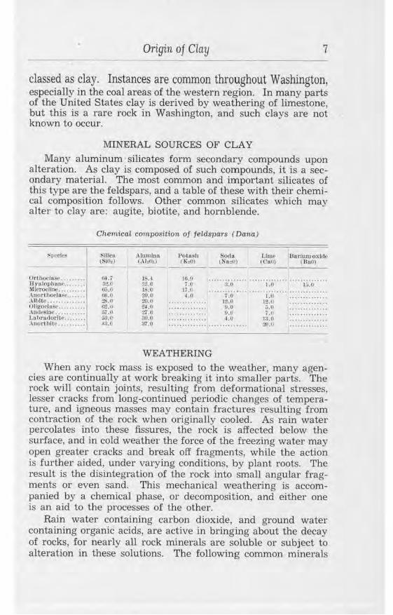
Many aluminum silicates form secondary compounds upon alteration. As clay is composed of such compounds, it is a secondary material. The most common and important silicates of this type are the feldspars, and a table of these with their chemical composition follows. Other common silicates which may alter to clay are: augite, biotite, and hornbl,ende.
Or thotl11i;• ...••.••• U,u lor,bo.,w ....... . .lllr·roclln~ ....... . . . Anor1ho('(u~o ...... . .\lblti• ............. . Ollgo<·l 11~e .••••••••• . lnde~tnc . .... . .... . Lu t,ruilorlte . ..... .. .\nnrt hit,, ........ .
Chemical composition of feldspars ( Dana)
Sllic11 (Sil):)
,~ ... '; ifl.O ll,;.u ,;,;.o :!$.() ti'l.H .;1.0 o.'l.(' ,a.,1
Alumlno (.\b(>.,)
:U,.4 22.0 18.() 20.0 :!0.0 :!4.11 2'i.O :!O.() :rr.o
Pota~h CK,~,)
Soda ( Nll:,/t)
Ut,w U1trlumoxlrl,• <Cao) ( IlaO)
ti ...... ici"' ........ ;:,i .......... ;;:,, ... .. 11:~ ...... 1:0 .. ··· ··· ·· ·;:t,···· ::::::::::::::
... ....... .... 12.0 12.U .. ........... .
.. .. .......... !l.O r..O ............ ..
... . ..... .. ... tl.O 7.1, .... ........ ..
.............. ui rn.o .... ......... .
.............. .............. ~~).O . ........... ..
WEATHERING
When any rock mass is exposed to the weather, many agencies are continually at work breaking it into smaller parts. The rock will contain joints, resulting from deformational stresses, lesser cracks from long-continued periodic changes of temperature, and igneous masses may contain fractures resulting from contraction of the rock when originally cooled. As rain water percolates in to these fissures, the rock is affected below the surface, and in cold weathe1· the force of the freezing water may open greater cracks and break off fragments, while the action is further aided, under varying conditions, by plant roots. The result is the disintegration of the rock into small angular fragments or even sand. This mechanical weathering is accompanied by a chemical phase, or decomposition, and either one is an aid to the processes of the other.
Rain water containing carbon dioxide, and ground water containing organic acids, are active in bringing about the decay of rocks, for nearly all rock minerals are soluble or subject to alteration in these solutions. The following common minerals
8 ciays and ShaLes of Washington
are listed in the order of their relative solubility or ease of altera tion.<D
l. Nepheline 6. Hornblende 11. Orthoclase 2. Leucite 7. Talc 12. Biotite 3. OUvine 8. Serpentine 13. Muscovite 4. Apatite 9. Epidote 14. Quartz 5. Augite 10. Plagioclase
The process is slow and complex, involving the solution and removal of some minerals and the chemical change of others to hydrous silicates. These new minerals are soft and easily affected by the mechanical processes and so aid in disintegration and mak,e erosion more effective. Where protected from erosion, percolating waters may later remove the soluble products of decomposition, while the clay substance, aluminum silicate, remains and is concentrated. Quartz, freed by the disintegration of the original rock, becomes the sand grains found disseminated through most residual clays, and muscovite, slow to decompose, is likewise commonly present. When the parent rock contains but little of the femic minerals and is high in feldspar, and if the soluble salts, the impurities of clay, have been well leached out, this decomposition produces a white clay, kaolin, in which the mineral kaolinite predominates.
The formation of the kaolin minerals nacrite and, particularly, dickite, by the action of thermal waters and gaseous emanations connected with igneous activity is not considered here, although it is a recognized process and may have been responsible for the origin of certain clays in both eastern and western Washington.
EROSION AND SEDIMENTATION
If erosion is as active as decomposition, the clay, as soon as formed, will be swept away by wind or water and deposited in some other place. Under such conditions, the formation of residual clay on the site of the original rock is reduced to a minimum, but beds of transported clays are produced in other localities. The products of rock weathering are worked over by rain water, are gradually moved to the foot of slopes, and finally carried away in the streams. Clay particles and silt are usually carried in suspension, while larger sand grains and pebbles are
· rolled along the stream bed. In this manner, material may be transported a great distance from its original source. Whenever the velocity of a stream is retarded, some of the load of sediment is deposited. A small check to the current will cause gravel and sand to fall, while silt and clay will still be carried. If the velocity undergoes a sudden complete check, the whole
© After Buckman, H. 0 .. Cbemlcal and physical processes involved in iormation of resicfual clay: Am. Ceramic Soc. Trans .. vol. 13. p. 336. 1911.
Origin of Clay 9
load of the stream will be dropped, and the bed of sediment thus formed will be poorly assorted. The most complete grading of material is brought about by a stream flowing into a lake or sea; here the gravel and sand is deposited near the shore, while the clay is laid down in deeper water. In this manner great thicknesses of sediments are formed and separate strata may be quite distinct.
When erosion proceeds at a faster rate than rock decay, the transported material will contain very little clay but will be chiefly silt, sand, and gravel. Great beds of silt occur throughout northern Washington, produced by glaciers grinding to powder the rocks over which they passed. This "rock flour" is formed also by the grinding effects of boulders rolled by swift streams along rocky channels. The silts are almost invariably high in fluxes and iron, for they have the composition of the original hetrogeneous rocks from which they were formed, without benefit of the leaching and purification that clays normally receive to some degree before and during transportation.
CHANGE IN CLAYS AFTER DEPOSITION Geologic processes may greatly alter clay deposits subse
quent to their formation. The action may be either mechanical or chemical and may add to or detract from the commercial value of the clay. ·
COLOR CHANGE
The effect that is most noticeable is the change in color as a result of weathering. Nearly all clay deposits show some shade of brown or yellow at the surface and for an irregular distance beneath, while the unweathered clay may be blue or gray. This is mostly due to the oxidation of iron compounds contained in the clay, but may be the result of iron oxide-bearing solutions working through a hitherto iron-free clay. Instances of the first process are particularly common in the glacial clays of the Coast, while those of the second are common among the white clays near Spokane. Iron oxide may be deposited on joints ari -parallel to them and give to some deposits a deceptive effect of bedding.
LEACHING
Ground water percolating through a clay bed may leach out soluble compounds and lower the content of fluxes. Carbon dioxide or weak organic acids in the solutions facilitate the removal of soluble salts and may, by changing the iron to soluble compounds, produce a whitened clay. Thus high-grade fire clays occur in the coal measures, for the abundant vegetation and plant decay favorable to the formation of coal probably
10 CLays and Shales of Washington
increases the leaching activity of the swamp waters by adding various acids. which act on the undersoils, removing iron and fluxes and, consequently, increasing the percentage of alumina.
Sediments such as sand and silt may, through decomposition, become impure plastic clays. Feldspars in an arkosic sand decompose so the deposit becomes a clayey sand, as in the Hammer Bluff formation of King County; or glacial silts may alter to soft clays, as, no doubt, has occurred rather generally under the influence of abundant moisture in the deposits of western Washington.
CONCRETIONS
Many deposits of clay contain lenticular or odd-shaped stony masses called concretions. These vary both in shape and composition. Examples are numerous in the clay deposits along the Columbia River near Wenatchee, where they range from the size of a bean up to 2 inches or so in diameter. At Chewelah in Stevens County, calcareous concretions about the shape of a lima bean are abundant. Such concretionary bodies at times attain great size; in the coal-measure shales of western Washington they commonly measure many feet in length. Concretions may have various compositions such as silica, iron carbonate or oxide, or calcium carbonate, but always differ from the main mass in which they are found. Presumably, they form through the redeposition of some dissolved minor constituent of the sediment about a center, or, as is often the case, about a nucleus such as a shell or leaf fragment.
INDURATION
Clays, sands, and gravels, in beds total ing thousands of feet in thickness, have been laid down in past geologic times. The pressure of such great accumulations of sediments, together with partial dehydration, chemical cementation, and crustal movement, may result in consolidating the materials to shale, sandstone, and conglomerate. Shales differ from clays primarily in being harder and more compact. They have a lower water content and lack plasticity when fresh, and they are associated with sandstone rather than with sand. The feature of hardness varies greatly in different shales; some, although compact, may be cut as easily as wax; others are flintlike and break into conchoidal chips when struck with a hammer. They are usually characterized by a lamination or cleavage parallel to the bedding, but this is not apparent in some beds. A fissile structure may be a depositional feature, or it may be developed by movements of the bed, such as folding, causing slippage and orientation of the particles composing the shale; but however caused, this characteristic is accentuated by weathering. Unweathered
Origin of Clay 11
shale, shale that has undergone but little movement, and even some highly folded shale, may be massive and show no more "shaly" structure than clay. Such rocks are better termed claystone or mudstone, though this distinction is seldom made in industry.
With further dehydration and consolidation, shales are metamorphosed to argillites. These are rocks that show no noticeable secondary cleavage. Still further metamorphism, commonly by folding under great pressure, produces slates which show welldeveloped secondary cleavage without regard to the original bedding. Both argillites and slates have had most, if not all, properties destroyed that give ceramic value to the ordinary argillaceous materials.
SOFTENING
Clays, and particularly shales, where exposed to the weather, as at their outcrops, are somewhat softened and disintegrated. This is due to frost action and other mechanical agencies and to the addition of vegetal matter; or it may be caused by the removal of soluble material which has cemented the particles together, or by the addition of water to partially dehydrated material. Since clays and other argillaceous sedimentary rocks are already residues or end products of both mechanical and mechanical weathering, they are only slitghtly susceptible to these influences, and such action is relatively shallow, common1y being represented by little more than the soil mantle. Nevertheless, weathering or any other process, either natural or artificial, which results in the disintegration of shale in the presence of water will commonly return it to its original condition of soft, plastic clay. In this, shales differ from argillites and slates in which plasticity can be recovered with great difficulty, if at all.
12 Clays and Shales of Washington
CLASSIFICATION OF CLAYS
Clays are classified in different ways, and it depends upon the purpose of the classification as to which system is used. Geologically, it is most important to use origin as a basis; in commercial work the use to which a clay can be put determines its type; in technology a clay's physical properties are distinguishing features. In a description of a clay, use is made of all these classifications whenever possible.
CLASSIFICATION BY ORIGIN
The following outline shows the geologic origin of various clays:
I. ResiduaJ clays.
A. Clays derived in place from igneous rocks. a. Kaolin, derived from granite and other feldspathic rocks. b. Ferruginous, impw·e and beidelHte-type clays, derived ordi
narily from igneous rocks rich in augite, hornblende, or other femic minerals.
B. Clays derived in place from metamorphic rocks. a . Kaolin, derived from gneiss and other feldspathic metamor
phic rocks. b . Kaolin or clay, derived from schist, argillaceous quartzite, or
argillaceous marbles. C. Clays derived in p lace from sedimentary rocks.
a. Sw-face clay, derived from shale. b. Sw·face clay, derived Irom argillaceous sandstone. c. Surface clay, derived from argi11aceous limestone.
n. Colluvial clays. KaoHns and clays p1·actically residual but. shifted by gravity.
Il1. Transported clays. A. Alluvial (fluviatile) clays, those transported by streams and de
posited on flood plains and · deltas. B. Lacustrine clays, those deposited in lakes. C. Estuarine clays, those deposited in bays or submerged mouths of
rivers. D. Marine clays, those deposited ·in marine waters.
a. Littoral clays, those deposited near shore. b. Pelagic clays, those deposited offshore in deep water.
E. Glacial clays, those transported by ice. a. Till, boulder clay, unassorted material resulting from the
erosional action of ice. b. Aqueoglacial clays, those formed by glacial action and
assorted by water action. F. EoHan clays, those transported and deposited by wind.
Loess, dust, and silt.
Classification of Clays 13
RESIDUAL
Clay formed in place from the weathering and decomposition of rock is termed residual. Such clays are not particularly abundant in Washington because in most parts of the State the relief is such that the material is removed by erosion as soon as formed. Clays of this type form a sheetlike mantle sometimes of great lateral extent. Their vertical depth is known to exceed 100 feet in some parts of the United States, and some deposits in Washington have thicknesses nearly as great.
The greatest beds of residual clay would be expected among rocks of greatest geologic age, but no rock is too young to have some alteration, although it may be very slight. Also, the character of the original rock bas a direct bearing on the rate of decay. Those of the basic igneous types, such as basalt, are affected by weathering much more rapidly than the acidic ones, such as granite. In fact, it has been shown that the rate of decay, texture remaining constant, is dependent upon the basicity.
When decomposition is incomplete "rotten rock" is formed. Some such materials, especially among the granites, may still appear like the unaltered rock, but when touched they disintegrate to sand and kaolin. These are not true clays, as they lack plasticity, but they may sometimes be rendered plastic by treatment. In residual deposits from limestone, the transition from clay to hard rock may be abrupt; in deposits from most other rocks, clay grades into coarse sandy material or "rotten rock" and finally into fresh resistant rock.
COLLUVIAL
So long as clay remains in place, where it was formed, it belongs to the foregoing group of residuals. When such clay is formed on a slope, it will gradually creep to the bottom under the influence of gravity, aided usually by surface water, and it is then classed as colluvial clay. Although the distance traveled may be small, it is in places sufficient to allow a certain selective bedding to appear in the deposit. Many seemingly residual clays are no doubt properly colluvial in nature.
ALLUVIAL
Streams that carry large amounts of sediment have periods of flood and slack water, and at any time the rapidity of the current will vary in different parts of the channel. Under these variable conditions, alluvial sediments may accumulate in one place while previous deposits may be removed from other points. This results in poorly classified deposits, commonly lenticular in form and, from the commercial viewpoint, of low value.
14 Clays and Shales of Washington
LACUSTRINE In lakes the coarser gravels and sands will be deposited near
shore while the finest clays remain for a time in suspension and so eventually will accumulate in the deeper water away from shore. Such clays are mostly well assorted and consequently low in sand content; they may be formed in beds of considerable thickness. Well-preserved leaf fossils are commonly found on the bedding planes of these sediments and indicate the lacustrine origin of the series. The drainage area of a lake is relatively small, so there is less chance for the admixture of impurities common to marine formations; and if the lake happens to be in a granite area, especially pure clays will accumulate.
The beneficial effect of leaching is commonly apparent in sediments originating in ponds and swamps where plant life has been abundant. Water, carrying carbonic and other feeble acids, extracts iron as soluble ferrous carbonate from soils and clays. Such iron-bearing solutions in stagnant lakes and swamps are oxidized and the resulting ferric hydroxide, being insoluble, floats for a time as an oily-appearing film; it finally sinks to the bottom where it forms a cement around sand grains or, when abundant, forms a layer of limonite, or bog iron. The presence of this heavy rust-colored segregation of iron oxide is sometimes taken as an indication that the clays in connection have been leached of their iron and are consequently light firing. This inference may be misleading, as in the instance of certain Latah beds in the Spokane area.
MARINE AND ESTUARINE
These clays are formed when sediments are laid down in the sea and in broad river mouths. It is not unusual for materials of this kind to have great areal extent, and they may accumulate in formations thousands of feet in thickness. A large series will show much variation in texture, grading from the finest clays to silts and coarse sands. Individual strata, however, may be very uniform and sharply separated from each other. Most such sediments in Washington, in fact, all older than Pleistocene. are indurated to shales, mudstones, and related rocks. They show the lack of purity that would be expected of materials from such divers rock sources. brought by innumerable streams, and mixed by ocean currents.
GLACIAL
The material carried by ice is a hetrogeneous mixture of rock fragments ranging from the finest powder to huge boulders. As left by the receding ice, this debris is unassorted and is called
Classification of Clays 15
boulder clay or glaoial till. As water works through the drift, the finer sedwents may be removed to be later assorted and deposited in lakes and ponds. Thus, aqueoglacial clays are formed, only differing in origin from ordinary alluvial and lacustrine clays by the part played by ice in their formation. Their physical characteristics, however, are very different, as the component grains, the rock flour, are the result of the abrasive action of the ice instead of decomposition, and there has been scant opportunity for the removal of the iron and fluxes contained in the original rocks.
EOLIAN
Eolian clays are usually found in an arid or semiarid country. They are deposits, sometimes rudely stratified, that have resulted from the accumulation of wind-borne particles of dust and silt. Examples are abundant in Washington and are described in more detail under the heading of Whitman County.
16 Clays and Shales of Washington
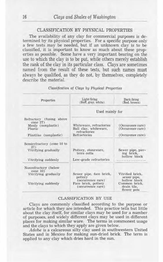
CLASSIFICATION BY PHYSICAL PROPERTIES The availability of any clay for commercial purposes is de
termined by its physical properties. For a specific purpose only a few tests may be needed, but if an unknown c1ay is to be classified, it is important to know as much about these properties as possible. Some have a very important bearing on the use to which the clay is to be put, while others merely establish the rank of the clay in its particular class. Clays are sometimes named from the result of these tests, but such names must always be qualified, as they do not, by themselves, completely describe the material.
Classification of Clays by PliysicaL Properties
Properties
Refractory (fusing above cone 27)
Mealy (nonplastic) Plastic
FlinUike (nonplastic)
Semirefractory (cone 10 to 27)
Vitrii:)ling gradually
Vitrifying suddenly
Nonrefractory (below cone 10)
Vitrifying gradually
Vitrifying suddenly
I
Light firing (Buff, gray, white)
Dark firing (Red. brown)
Used mainly for
Whiteware, refractories Ball clay, whiteware,
refractories Refractories
Pottery, stoneware, terra cotta
Low-grade refractories
Sewer pipe, face brick, pottery ( occuxrence rare)
Face brick, pottery (occurrence rare)
(Occurence rare) (Occurence rare)
(OccUJ·ence rare)
Sewer pipe, paving brick, hollow block
Vitrified brick, sewer pipe, hollow block
Common brick. drain tile,
__Q_ower pots
CLASSIFICATION BY USE
Clays are commonly classified according to the purpose or article for which they are intended. This practice tells but little about the clay itself, for similar clays may be used for a number of purposes, and widely different clays may be used in different places for making similar ware. The terms in commonest usage and the clays to which they apply are given below.
Adobe is a calcareous silty clay used in southwestern United States and in Mexico for making sun-dried brick. The term is applied to any clay which dries hard in the sun.
CLassification of Cla·ys 17
Ball clay is a ·very strong, plastic white-firing clay, rather refractory, that is used as a part of the clay body in whiteware manufacture to give plasticity and strength to the mixture.
Brick clay is a common sandy plastic clay that fires hard at moderate temperatures. The requirements for a clay suitable for common brick are not exacting, and suitable material occurs almost universally. For the better grade of brick (face, vitrified, fancy, pressed), clays are used that have a moderately long firing range and sufficient impurities to give a certain desired color.
China clay is a white-firing, usually highly refractory clay that contains a minimum of fluxing or coloring impurities. A low-plastic residual clay composed almost entirely of kaolinite and free silica is what is usually referred to by this term, but some plastic sedimentary clays of similar compositions are also included. Such clays are seldom naturally suitable for use but must first be purified by washing, after which they are mixed with ground feldspar, flint, and ball clay to form the body in the manufacture of whiteware, porcelain, decorative tiles, and other high-grade products.
Fire clay must possess high refractoriness (not fusible below cone 27 or 28) and sufficient plasticity to retain the desired form before firing. It is sometimes possible, by mixing a highly refractory nonplastic material with a suitable bonding clay, to produce a very satisfactory product. Care must be used, however, to not introduce fluxing impurities with the plastic clay. Fire clay is used for fire brick and shapes, furnace linings, refractory cement, crucibles, and other such heat-resisting ware. It is sometimes used, as well, for floor tiles, terra cotta, pressed brick, and paving brick.
Fuller's earth is a clay that may only be described as having the power to absorb certain basic colors and thus eliminate them from liquids containing them. Any attempt to define such clays by color, composition, or general appearance is impossible, as the only test is whether or not the given clay will do the required work. Different kinds of fuller's earth behave differently under ordinary clay-testing conditions, while many clays act the same as fuller's earth, except in the final absorption test. The earth is used for bleaching, clarifying, deodorizing, and filtering waxes, fats, greases, and animal, vegetable, and mineral oils. It was formerly used for "fulling'' cloth, removing the natural oils from the fabric, but now other processes have virtually supplanted it.
Paint clay is used in an unfired condition. It is finely ground, mixed with oil, and forms the body for some kinds of mineral paints. Highly ferruginous, or ocherous, clays and shales that
18 Clays and Shales of Washington
are free from grit are mostly used, but those low in iron are suitable for fillers.
Paper clay must be pure white and free from sand. Usually washed kaolin is required. It is used unfired as a filler to give body and weight to various kinds of paper, and the best grades are used for surfacing calendered paper.
Paving-brick material is fairly plastic when tempered, contains sufficient fluxing impurities to vitrify at a medium temperature, and should possess a rather long temperature range. It fires to a red color and produces a dense, resistant body of high tensile strength and toughness. It is used for making paving brick or block, and sewer pipe.
Pottery clay is a buff- or white-firing clay that is sufficiently smooth, tough, and plastic to be workable on a potters' wheel and yet hold its shape during drying and firing. A low flux content is desirable. It is used for making art pottery, yellow ware, and earthenware; also in modeling.
Sewer-pipe day possesses about the same physical characteristics as paving-brick clay but must stand up well and not warp during firing. This property is sometimes obtained by adding a little fire clay to the mixture. It is used for making sewer pipe, conduits, flue lining, and structural hollow block.
Slip day is a very fine, even-grained clay that is red firing and easily fusible. It is mixed with water to a creamy consistency and sprayed over some kinds of pottery and stoneware to form a glaze, or the ware may be dipped into tanks of the socalled "slip".
Stone-ware clay is a refractory or semirefractory clay or plastic, tough, low-shrinkage clay mixture that will fire to a dense vitreous body of buff or gray color. The physical characteristics are somewhat similar to those of pottery clay. It is used in making stoneware, yellow ware, earthenware, and terra cotta.
Terra cotta clay is usually a buff-firing and semirefractory clay that is similar in physical properties to stoneware clay. Good behavior during drying and firing is essential, and freedom from soluble salts is desirable. The increase in the use of terra cotta for ornamental and general structural purposes has led to greater care being used in selecting clays for the purpose than was formerly thought necessary.
Constitution of Clays
CONSTITUTION OF CLAYS
MINERALOGY
19
From the method in which clays are formed, from different rocks and under variable conditions, it might be expected that nearly as many minerals would be present in clay as were constituents of the original rock mass. This is true, not for a particular clay, but for clays in general. A great variety of mineral fragments , mostly microscopic in size, are noted when different clay samples are examined. They represent stable aggregates, difficult to decompose; others in which alteration has progressed to various degrees but is not complete; and still other minerals that have been added or that are secondary and have formed from the recombination of elements freed in the decomposition of the rock. A hydrous aluminum silicate, sometimes spoken of as the basic "clay substance", belongs to the last-mentioned class. In the highest-grade white clay, known as kaolin, this essential silicate is predominantly the mineral kaolinite,© Al:!0,;.2± Si0:!.2Ht0, but may be the rare mineral nacrite or the relatively uncommon one dickite, both having the formula, Al:!0a.2Si0:! .2H:!O. Other hydrous silicates may be present or predominate in a clay and these, together with various impurities and nonessential minerals, give great variety in chemical composition and physical properties. They include halloysite, Al:!Oa.2+ Si01.nH20; allophane, Al~O~,Si02,nH20; montmorillonite, MgO.Al20 ,1.5Si0~.nH20; beidellite, Al:!0:1.3SiO~.nH:!O; nontronite, (Fe,A1L 0 ,i.2Si02.2H20; and a potash-bearing clay substance of uncertain formula.
Clays are sometimes simple in composition and so the constituent minerals are readily determined with a microscope; other kinds are more complex mixtures, and, owing to their generally fine state of subdivision, it may be very difficult to recognize any but a few of the minerals present. A list of such minerals includes kaolinite and all related hydrous aluminum silicates, quartz, sericite, muscovite, limonite, chlorite, siderite, monazite, talc, epidote, calcite, feldspars , hematite, pyrite, marcasite, zircon, topaz, tourmaline, zeo1ites, ruti1e, manganese oxides, biotite, gypsum, hornblende, ilmenite, magnetite, dolomite, glauconite, cassiterite, staurolite, and lepidolite. The first five or six are common constituents of most clays; the others occur probably in about the order in which they are listed, those toward the end being comparatively rare. All these except the kaolinic minerals are impurities and nonessential
(i) Ross, c. s .. and Kerr, P. F .. The kaolin minerals: U. S. Geo!. Survey Prof. Paper 165-E. 1931.
20 Clays and Shales of Washington
from the mineralogical standpoint, but they introduce chemicals which have a decided influence on the commercial use of the clay.
CHEMICAL COMPOUNDS
For ceramic purposes the chemical analysis of a clay is only of general classification value, and in only few instances are the data used in commercial work. The reason for this is that the analysis throws no light on the actual mineralogic state in which the various chemical compounds occur, listing them all as simple oxides, while their action is influenced largely by their state of aggregation. Physical tests are much more informative and from them may be obtained the applicability of a clay for any specific purpose. However, analyses are necessary if the clay is desired for metallurgical purposes or in the manufacture of cement. There is the probability that analyses may aid in the proper compounding of glazes for various clay bodies. Also, within limits, they allow inferences to be drawn as to the behavior of the clay in working and firing.
The chemical analysis of a clay gives the compounds which form the minerals present in the sample. Seldom are more than ten determinations made, and usually several less.
SILICA
Silica is present in clay as an essential constituent, forming 46.3 percent of kaolinite and also being combined with other silicates, such as feldspar and mica. It is present, free, as quartz in sand, and as such lessens the plasticity and shrinkage of clay and increases the porosity of the ware. It is not an active flux, although when finely ground and mixed with kaolin it lowers the fusion point. A high proportion of silica indicates a relatively low water content, low shrinkage, and low plasticity.
ALUMINA
This is an essential constituent of kaolinite and allied minerals and is also present in many other silicates. Its proportion in clay is extremely variable and ranges from less than 10 percent in lean, sandy clays to 39.5 percent in pure kaolinite and even higher if some minerals such as bauxite or diaspore are present. The refractoriness of clay and many other properties depend largely on the alumina content. High-grade clays should have nearly the chemical composition of kaolinite (alumina, 39.5 percent; silica, 46.5 percent; and combined water, 14 percent), and so an analysis gives the degree of purity.
WATER
Combined water is chemically a part of clay and is theoretically present to the amount of 14 percent in the mineral
Constitution of Clays 21
kaolinite. It is driven off at a temperature between 500° and 600° C. when the ware is fired. A high content 0£ combined water may indicate a high drying and firing shrinkage, and a tendency of the clay to crack. Very plastic clays are commonly of this character.
HYGROSCOPIC WATER-PORE WATER
The film of water that adheres to each clay grain is termed hygroscopic water. It is driven off at 100° to 110 C. but is recovered from the air as soon as the clay is exposed to the ordinary atmosphere. To this small moisture content, even present in seemingly dry clays, is added the extremely variable and, in plastic clays, large amount of pore water. This is the water mechanically held in the pore space, between grains, in all clays that have been in actual contact with water. It may amount to as much as 40 percent in freshly mined clays, but is eliminated by air-drying.
IRON COMPOUNDS
Iron may be present in clays in several forms, and it is owing to its compounds that clay and clay products, in general, show characteristic colors. Clays containing over 3 percent iron oxide, and without excess lime, are mostly dark firing. An influencing factor is the distribution and fineness of grain of the iron compound.
The carbonate, siderite, FeCO:" when present may be evenly disseminated throughout or occur as concretions. During the firing the liberation of carbon dioxide and the formation of ferrous oxide, an active flux, renders clay containing much siderite unsuitable for most purposes.
When iron occurs as a sulphide, pyrite or marcasite, FeS:!, acid vapors are given off on firing and ferrous sulphide is set free. This is an extremely active flux, and so clays or shales containing pyrite require great care in handling and are usually unsatisfactory, especially for high-grade ware. It is seldom economically advantageous to attempt to better clay by removing this mineral from the raw material, although it can be done by concentration methods. Some of the soft clays of western Washington contain pyrite in abundance, and material which might otherwise be classed as fire clay is greatly lowered in value.
The ferric hydroxide, limonite, 2Fe:!0:1.3H:!O, is the most common iron compound in clays, though the nonhydrous oxide. hematite, Fe~O:i, may occur, particularly in shales. Because of it, clays are stained and become uniformly reddish brown and yellow in color in degree depending on the amount present. It gives a red color to fired ware, but otherwise its effect is gen-
22 Clays and Shales of Washington
erally good, causing a moderate fluxing action which usually is easily controlled.
The various iron compounds are calculated together in most analyses as iron oxide, Fe20 :11 and as sucb may range from a mere trace in some clays to over 30 percent in others.
LIME
Calcium carbonate, CaCO:l, is the form in which calcium is usually present in clay, although all its compounds are given as the oxide, CaO, in analyses. It may also occur in silicate combinations, as in feldspars, in the form of sulphate, gypsum, CaS04.2H:!O, or as the phosphate, Ca3 (P04L. Calcium carbonate may be a residual constituent of the clay, or it may be derived from limestone and mechanically deposited with the clay, or may owe its origin to chemical or organic processes active during the clay-forming period.
Lime in this State is not present in the clays in sufficient quantity to cause serious difficulty. Aside from the content of a few deposits closely associated with limestone, the usual amount ranges from a trace to 2 or 3 percent. The glacial clays and silts are higher in this constituent than most other clay types. In a few places, calcium carbonate concretions are scattered throughout the clay and must be removed or thoroughly ground to prevent injury to the ware.
Calcium carbonate changes to calcium oxide during the firing process. This oxide is not harmful if evenly distributed through the ware, but if it is concentrated, as in pebbles, it will slake when the ware is exposed to the weather, and the consequent swelling usually disrupts the piece. At high temperature, lime unites with the silica and certain other constituents of clay to form an active flux, so, other things being equal, the greater the amount of lime and other fluxing agents, the more fusible the clay. This inference is useful though not accurate. The rate of vitrification may be undesirably rapid if as much as 5 or 10 percent of lime is present, particularly if accompanied by other fluxes. Lime, under certain conditions, has a reducing effect, and if present in sufficient quantity may prevent the formation of red iron compounds and so give the ware a buff color. Calcium sulphate, gypsum, has about the same effect on fusion as the carbonate, but it is slightly soluble in water, and so forms an efflorescence on the surface of ware when exposed to the weather. This white discoloration detracts from the value of the product.
MAGNESIA
The magnesia con tent of clays is from the decomposing original magnesium silicates forming the clay mass and from mag-
Constitution of Clays. 23
nesium carbonates associated with calcium. Its effect is similar to that of calcium, but it is less active in its action during firing.
ALKALIES
The so-called alkalies include soda (N a'.!0 ), potash (K'.!O), and lithia (Li:!O) and are included in clay in remnants of the original silicates, particularly feldspars, from which the clay was formed and in their decomposition products. When a fluxing action is desfred, the alkalies are very beneficial, as they promote a gradual vitrification. To obtain this, feldspar is added to china clays in the manufacture of high-grade products.
TITANIUM COMPOUNDS
Rutile (TiO~ ) and ilmenite (FeTiO:t) are present in many clays, but usually in small quantity. They give a titanium content (reported as TiOJ to the clay, though its effect is lost in the greater activity of other fluxing impurities.
MANGANESE COMPOUNDS
Manganese is seldom present in sufficient quantity to be noticeable. It is occasionally added to a clay body or slip to give some special color effect to the fired ware.
ORGANIC MATTER
Organic matter is a common impurity in transported clay. It is mostly very finely divided and may be present in amounts sufficient to mask the color of the iron oxides. Such clays range from light brown-gray through brown to black in color, the depth of tone depending on the amount of the finely com.minuted organic material. In its capacity of introducing colloids and bacteria into clay, organic matter may have a beneficial effect on the plasticity, an effect that is not clearly understood. It burns out during the firing of ware and then is apt to cause a porous product, while the carbon dioxide evolved may cause a swelling of the fired pieces. It is otherwise undesirable because of its effect on the oxidation of the iron contained in the clay.
24 Clays and Shales of Washington
WORKING PROPERTIES OF CLAY
Certain peculiar physical properties of clay make the ceramic industry a possibility. Some of the properties are essential, such as plasticity, while many others are very important and have a direct bearing on the use of the particular clay. Still others are recognized but have less commercial application. A list includes the following:
Original properties
Color Hardness Texture Slaking Porosity Specific gravity
Physicai Properties of Clays
Prefiring characters
Plasticity Water of plasticity Bonding power Shrinkage and deforma-
tion during drying Tensile strength
Firing effects
Loss of volatile parts Incipient fusion tempera-
ture Vitrification temperature Fusion temperature Vitrification range Porosity Color Tensile strength Hardness
ORIGINAL PROPERTIES
COLOR The color of raw clay is usually due to the presence of iron
oxides, but organic matter is a common coloring agent and so, to a lesser degree, are the manganese compounds. Color, when considered with other properties, is useful to the experienced clay worker in identifying clays. It is little indication of the _fired color, however, and therefore must be used with caution.
HARDNESS
Some shales or mudstones are very hard and "flintlike" ; others are only slightly consolidated and may be cut easily with a knife. Dry clays are sometimes soft and "mealy", and others are .firm and compact. The latter are commonly brittle but may be tough and resistant to pressure. This property of hardness depends upon many factors, such as cohesion between grains, texture, and compression undergone. The method of handling the clay and the type of grinding machinery used must be based to some extent on the degree of hardness.
TEXTURE
A good idea may be had as to the fineness of grain, uniformity, and sand content of a clay by its "feel" when taken between the fingers, when tested between the teeth, and when cut by a knife. Plastic clays that are fine-grained and low in sand will feel unctuous, "greasy", or "soapy"; a cut surface of such clays, es-
Working Properties of Clay 25
pecially when damp, will have a waxlike sheen. An exact method of determining fineness of grain is by passing a sample through sieves of various mesh. The fineness of grain appears to be closely related to other physical properties such as plasticity, porosity, and temperature of fusion, but exact inferences are difficult lo draw. In general, high shTinkage, tendency to warp and crack, slow drying, and low fusion are associated with extreme fineness of grain. Such conclusions are by no means infallible.
SLAKING
Slaking is the property of crumbling into an incoherent mass that is exhibited by clays and by many shales when they are placed in water. Some soften without marked disintegration; others separate into minute flakes. The time consumed by slaking varies with different samples from almost instantaneous to many days. It is taken as an indication of the amount of grinding and working needed to put a clay or shale into a usable plastic condition, a material that will not slake being probably low or lacking in plasticity.
POROSITY AND SPECIFIC GRAVITY
Porosity and specific gravity of dry clays are sometimes determined, but so far no useful inferences are made from them.
PREFIRING CHARACTER
PLASTICITY
Plasticity involves the ability of clay to be molded while wet, to retain the given shape when dry, and to then have sufficient strength to withstand a certain amount of handling. As with most of the physical properties, plasticity has no definite, accepted measure, but is judged mostly by the feel of the wet clay between the fingers. By this method, with a little practice, the degree and character of plasticity is determined, and is spoken of as: very plastic; fat, rich, rubbery, or waxy; sticky-plastic; medium plastic; and nonplastic, lean, and poor.
As the degree of plasticity varies with several factors, it is subject to some control. Thus, it may be reduced by the addition of a nonplastic material to the clay, such as sand, ground feldspar, or "grog" ( fired clay). Preheating bas a similar effect on plastic clay. On the other hand, a lean clay can be rendered more plastic by blunging with water and removing the sand that settles out; or a highly plastic clay may be added, though care must be taken to introduce no harmful impurities. Also, an increase in plasticity of a given clay or shale may be brought about by fine grinding (particularly in the presence of water), prolonged pugging or kneading, extended weathering and aging,
26 Clays and Shales of Washington
or by the addition of colloidal substances such as dextrin, gelatin, gum, and colloidal silica. Some clays, better termed mudstones, practically nonplastic, can be rendered sufficiently plastic to be used without bond by very fine grinding in a ball mill. In this connection see the results of tests on the Kummer flint clay, page 129.
WATER OF PLASTICITY
Water of plasticity is the water required to "temper the clay", that is, make it the proper consistency for molding. It varies with different clays and shales. A large amount of water indicates a tendency to crack on drying.
BONDING POWER
The ability of the clay to hold less plastic material together in a strong, plastic mass is its bonding power. Clays exhibiting this property in high degree are valuable in many industries. An actual trial is the only test of this property, although high plasticity is a general indication.
DRYING SHRINKAGE
Water in plastic clay fills the pores and forms a film around each clay grain. While drying, there is a constant evaporation, from the outer surface of the piece, of water that is forced to the surface by capillary attraction from the interior. With the loss of this water, the grains move closer together, and there is a shrinkage and readjustment of the mass until the grains are actually in contact. The amount of linear shrinkage is determined by measuring between two marks before and after drying the test piece, the result being in terms of percent of wet length. A range from 1 or 2 to 36 percent was obtained on various clays during the testing of Washington samples. Volume shrinkage may be calculated from linear shrinkage with sufficient accuracy for ordinary purposes, but the results do not hold true for flat pieces, as in these the greatest amount of shrinkage is at right angles to tbe flat surface. When greater accuracy is desired, some type of volumeter may be used where results are based on the displacement of liquid by the test piece.
To know the amount of shrinkage and the action during drying is of great importance. Dies and molds must be made so that the ware will be a certain size after shrinkage is complete, and the clay must remain uniform so that continual changing of dies will be unnecessary. If shrinkage is great, there is a tendency to warp and crack during drying unless great care be exercised, and because of this many clays would be useless without added treatment. To overcome this trouble, ware made from such clays is dried very slowly, sometimes in closed rooms
Working Properties of Clay 27
and at times covered with wet cloths. A more common way is to add to the clay body less plastic material or nonplastics such as sand and grog. A more elaborate method, but one which is being increasingly used with very good effect, is the humidity drier system whereby the ware is placed in a very humid hot atmosphere, the content of water vapor being gradually decreased until the ware is dry.
TENSrLE STRENGTH
Tensile strength is important, as it indicates the relative resistance to abrasion and pressure shown by dry ware. If the tensile strength is too low, ware stacked in the kilns will not stand the weight of the upper layers. The ordinary tensilestrength test, as applied to concrete, is generally used in testing for this property. Samples may range from 30 to 350 pounds to the square inch, but 100 pounds is usually considered ample for most ware.
FIRING EFFECTS Certain effects take place when clay is heated that greatly
alter the physical properties of the clay.
LOSS OF VOLATILE MATTER
Hygroscopic water is still present in small amount and is driven from the ware during the "water-smoking" period at a temperature of from 100 to 150 C. The chemically combined water of the hydrous minerals in the clay is driven off between 400° and 700 C. without particular effect on the firing of the ware. Organic matter is a common impurity in clays and shales and its combustion may raise the temperature of the kiln too rapidly; also, the gases liberated may combine with minerals in the clay, influencing the character of the ware, or they may be drawn off too rapidly, causing a porous or bloated product. Sulphur is liberated from the distillation of pyrite, and, at about the same temperature, 400 to 650 C., carbon dioxide is evolved from the carbonate minerals present. These gases must all be allowed to escape before oxidation can be properly completed, for if fusion should set in first, the result would be a vesicular, bloated product.
INCIPIENT FUSION
Materials which in themselves are difficultly fusible, when heated together may fuse at a much lower temperature. A common example is calcium and silica. These fuse and form calcium silicate, which may interact with other minerals in the formation of complex silicates. All the compounds listed as fluxes operate in a similar manner and vary the nature of the resulting product. The temperature of inci.pient fusion is very
28 Clays and Shales of Washington
low in some clays and high in others, ranging from about 900° to 1,200" C. When that temperature is reached, the compounds having the lowest melting point in the clay fuse, and, if they are present in sufficient quantity, the ware, on cooling, will be steel hard. Common brick is usually finished at this heat.
VITRIFICATION
As the temperature is raised, more of the clay material is fused until, without loss of shape, nearly all the pore space between unfused grains is filled with the viscous, semimolten matter. On cooling, the ware then has a vitreous luster and is very dense and homogeneous. Porcelain and chinaware bodies, stoneware, paving and foundation brick, and sewer pipe are commonly fired to this point.
FUSION
With a still greater increase in temperature, the entire body becomes viscous from an excess of fused material, and the ware tends to lose shape and flow. In testing clays the "cone fusion" is the temperature, expressed in cones (p. 30), at which the clay deforms and fuses. Clinker brick are those which have been raised to the fusion temperature.
VITRIFICATION RANGE
Vitrification range is a very important factor in the working of any clay. It is the difference in temperature between incipient and viscous fusion. Many clays containing a large proportion of fluxing compounds become viscous and lose shape almost as soon as vitrification commences; other clays may vary 200° or more between these two points. The range should be greater than the difference in temperature between the cooler and hotter portions of the kiln used, else some of the ware will be melted when the rest is underfired. Some short-range clays, and they include the common glacial clay of western Washington, can be handled if care is used in loading the kiln and in firing, but there is always the danger of spoiling a large part of the burn.
SHRINKAGE
Fire shrinkage takes place during firing and increases the total shrinkage of the ware. It is caused by the loss of chenucally combined water in the raw clay, by the formation of silicates of greater density, and by the filling of pore space during vitrification. A high-shrinkage clay must be carefully fired to prevent cracking the ware; also, since the lower courses in a kiln are under great pressure, which restricts adjustment during shrinkage, a lower tonnage output per kiln usually results fr9m the use of such clay.
Working Properties of Clay 29
The firing of clay samples does not ordinarily take into consideration the weight which commercial ware must carry in a kiln and which may hinder shrinkage until the piece is ruptured; therefore, it is very important, if high shrinkage is indicated in tests, to find how the clay reacts to pressure during firing. The same remedies for shrinkage are used that apply to drying the clay, insomuch as additions to the clay body and slow handling are concerned.
COLOR
The color of ware depends on the compounds present in the clay and on their state of oxidation after firing. When iron oxide is present, a reducing condition in the kiln, forming ferrous oxide, gives a dark color to the ware, while a good oxidizing condition forms ferric oxide and gives the bright reds. The change from ferrous to ferric iron depends also on the temperature and amount of vitrification. If iron oxide or other coloring impurities are low in amount or absent, the fired ware may be some shade of buff, gray, or even white. For the brightest, truest colors, the ware is muffled, that is, enclosed and protected from all reducing influences in firing. Most high-grade products are treated in this manner.
POROSITY
The porosity of clay products depends on the amount of unfilled space between grains, so a clay that is difficult to vitrify will be porous compared with one vitrifying at a moderate temperature. By proper mixtures and temperature adjustments, light-weight, porous partition tile and impervious. heavy sewer pipe are made. This relation between vitrification and porosity is used to determine the applicability of a clay. In such work, samples of known clays are used and their apparent porosity determined at various firing temperatures. A graph is then drawn which shows distinctive characteristics for each commercial type of clay. Similar clays should have a like porosity curve; so the examination of a curve plotted from tests made on an unknown clay will aid greatly in determining the availability of the clay for various purposes.
To obtain the percentage of apparent porosity the test brick is thoroughly dried at about 110 C. until of constant weight. It is then immersed in distilled water for several days until completely saturated. Boiling under low pressure may be used to facilitate this operation. The brick is then weighed while suspended in water and again while suspended in air. The following formula is used in the calculations:
Wet weight - dry weight Percentage of porosity = 100
Wet weight - suspended weight
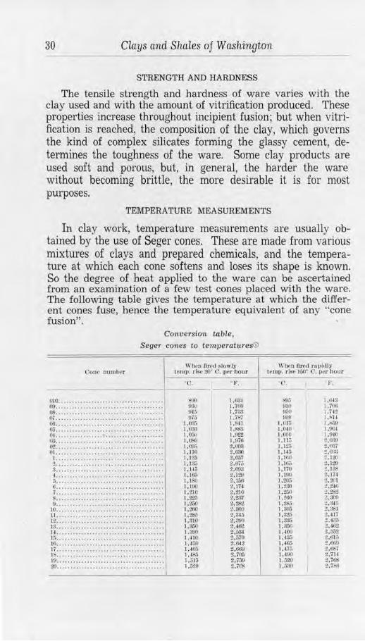
30 ciays and Shales of Washington
STRENGTH AND HARDNESS
The tensile strength and hardness of ware varies with the clay used and with the amount of vitrification produced. These properties increase throughout incipient fusion; but when vitrification is reached, the composition of the clay, which governs the kind of complex silicates forming the glassy cement, determines the toughness of the ware. Some clay products are used soft and porous, but, in general, the harder the ware without becoming brittle, the more desirable it is for most purposes.
TEMPERATURE MEASUREMENTS
In clay work, temperature measurements are usually obtained by the use of Seger cones. These are made from various mixtures of clays and prepared chemicals, and the temperature at which each cone softens and loses its shape is known. So the degree 0£ heat applied to the ware can be ascertained from an examination of a few test cones placed with the ware. The following table gives the temperature at which the different cones fuse, hence the temperature equivalent of any "cone fusion".
Conversion table , Seger cones to temperatures©
l'Ollt· nutul,rr
010 ..................................... . 00 ...................................... . 08 ...... . ...... ...... . ... ················ 07 . .. ... ..... ........ .... ·· ····•····· ...• 00 .......... . ............ . .............. . (~'j ............... ·••··· •• .. •.. . ••• • ·•·• · • 0-1. ................ 1 .................... . !~ ...................................... . 02 .. . ............... ·•· ... . ... . ... . ..... . 01 •..••.••.•..•.••••••••••.•••.•.••..••.•
I. . . ................................•... 2 .. .................................... .. 3 .•.•••••••...•••••••.•••.••.• ·•••·· •.•• •. ..... ..... . ....... ..... .... .......... • a .. ......... . ............ . ........ . ... • · () ...................................... . 7 •••••••••••••••.•••••••••••••••••.•••.• ....................................... 0 .............. . ...................... .
IO ••.••••••••.••••••••.•••••••. . ••••••••• ll .................... .. ................ . 12 .•..•••••••..••..•...•.•..••..••••.••.. Hi ............................ .. ........ . 1-1 ...................................... . 1:-. .......... ............. ... ............ . 10 . • ... .. . .. ··•·· ·· ..................... . 17 ••••••••••••••••••••••••••••••••••••••• l !, •....•• . ••• ..• •..•.••.•••••.••••• .. •••. 10 ••...••••.••.••• . ••• . ••. .. .•••.••. . .•.. 20 ...................................... .
\Vh~n II re, I s lowlr tl'llll'· rl~,· ~>o· e,_1. 1ll'r t1our
( '.
>!10 ();-111 !MG fl75
u•i:, t .ll:!O I .0,j(I l,(ll(I 1,0'J;, I. IHI 1,1:?.j 1, i:I,) 1.1-15 1.rn:, 1.1!,11 1. 11)0 1,210 ,t~ l ,:?.;o 1,200 1,2$.; 1,:J10 1.$00 I .~!JO 1,410 1,4:,0 1,.fOil l,4S:, 1.515 1,520
~·. ll'lu•n 11r.,.1 runhtly
I P1n11. r ls,• I ~,O' C. 11er honr
c . F.
:O,!f\7 1.0-i:J lt:~1 1. i'OII I•~' 1.ilt lllJO I, •ll
l,010 J,:,.?J l.(t.10 1.0Ci 1.,~;11 1.04< 1.11: :?,0:\\1 1,12:. t,f\;7 1. l4ti :?, /l;l:l I ,]f.0 • .12(. 1. l()i; 2 ,1:?!) 1.liO 2,1~ 1.lllU 2-. li, 1,211.'i l,:lllO
:!.,2111 t,2m
1,2.)0 i ,~:l 1. ,2,;o i .,~x, 1.2:';; :?,34."i I ,!llJo :?. Sel l,32.) ~,-'17 1.:i:1., '!,4:lo 1,:i,;o :tt.aoi 1.400 ~.002. 1.4:l.'> '!,Gl it 1.4!\5 2.600 1,,H;; :!,~7 1.400 2,711 1.520 t .'i~ 1.;,:J() 2.7-.ll
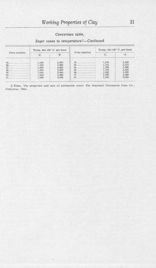
CJoue num her
23 ... ...... .. .. .... . :!6 ...... ...... ... .. '!/r •• •••.••••••• . .••• $ . . ............... . :!!I •••... •••... . ..••. :JO .... ......... .... . :it ...... ........ ... .
W otking Ptope·1·ties of Clay 31
Conversion table,
Seger cones to temperature©-Continued
'l'cmp. rl~o 100' 0 . l)('r hour
•o.
1,i,,.'-0 1,:illo J,600 1.01;, ,,mu 1,f..0 1,f,SO
' },'. C'Onc number
:~~- ... . a:l ............... . :~ .............. .. :Jo ............... . H(:j • •••••••• •• ••• •• 37 ... . . .. ... ... .. . :» .. ..... ... ..... .
'J'cmJ). rl~P 100• ('. r,cr hour
l'. F.
S.Wli 3,tTJ 3,200 3,2-l!i 3,29(1 8.~ 3,335
© From , 'l'ltc 11rOJ\•' rli••• 1uh.l u~~ o f 11>'TOllletrlc cone><: 1'he Stouclurd Pyromctrlc Clone Co .• Oohm,1,u~, Ohio.
32 Clays and Shales of Washington
OPERATING METHODS
PROSPECTING FOR CLAY
Clay is seldom located as the result of deliberate prospecting. It usually attracts the attention of farmers as they excavate £or wells, post holes, or cellars; or it may be reported by prospectors or hunters. From these the clay worker receives the information and is commonly su pplied with samples. The adaptability of the clay is then determined by tests, after which the important features of extent and minability are investigated.
When it is desirable to actually prospect for clay throughout a large territory, the geology of the region should first be ascertained. Very accurate deductions may then be drawn as to the presence of clay and its probable type from a knowledge of the rock formations, geologic history, and topographic and climatic factors. For example, buff-firing residual clays would be expected in a granitic area of low relief; and if, at some previous time, lakes occupied the valleys, high-grade, well-assorted kaolins would be looked for. On the other hand, buff-firing clays would be the exception in an area of glacial sediments or marine shales, but various types of red-firing clays would be available.
When searching a particular area for clay, much time may be saved by obtaining information as to its occurrence from the inhabitants. Road cuts, ravines, and plowed fields often expose clay, and sometimes the earth removed by a burrowing animal or thrown up by the roots of a fallen tree may give useful information. When other means fail, recourse may be had to earth augers or boring rigs, and these should always be used to determine the extent and uniformity of a deposit before a plant is built.
In searching for shales, the situation is somewhat different. These bedded deposits in Washington are mostly folded, so they dip into the earth at various angles, and sampling is confined to outcrops on the hillsides or where the strata have been cut by streams. In a region where coal occurs, the investigation is simplified by visiting mines and prospects. Shale is soft and does not resist erosion like sandstone, so ravines in the uplands and coves along the seashore commonly mark shale members. Low rounded hills and parallel ridges also are indicative of a shale-bearing series and ar·e usually in marked contrast with the topography oi an igneous area.
Brick clays in this State are abundant, and deposits may generally be found near any of the markets. This is a fortunate condition, for neither common brick nor clay can be shipped
Operating Methods 33
very far with profit. Clays and shales suitable for highergrade products may be transported farther, and plants with rail or boat facilities may operate at a distance from market centers. Only the highest grades of buff-firing semirefractory and refractory clays repay transporting more than a few miles to factory or railroad.
PLANT LOCATION
The success of a brick yard, which makes a product sold on a small margin of profit, depends on a large output with minimum expense. The following are ideal conditions for operating:
1. An ample body of suitable clay that may be used "run-of-pit". 2. No overburden present. 3. No objectionable material or features in clay. 4. Quarry or other cheap quantity-mining methods applicable. 5. Natural drainage. 6. Plant in proximity to pit. 7. Plant designed and managed for maximum efficiency. 8. Gravity delivery of clay to crushing machinery and throughout the
plant. 9. Kilns adjacent to railroad or other transportation.
10. Fuel available and cheap. 11. An immediate and nearby market.
To ihe writer's knowledge there is no plant enjoying all these advantages in Washington, but some have nearly all. In some places, the state of competition or market is such that profits can be made under very adverse conditions. Whether a plant can be operated under unfavorable conditions should be carefully considered before building.
MINING CLAY
Clay mmmg is commonly carried on in open pits or cuts. A quarry face is made in the side of a hill or pit, and the clay caved down by undercutting, or it is worked in benches. When the output warrants the initial expense, and it is not necessary to separate different types of clay, power-shovel excavation is most economical. An overburden of sand may be beneficial to mix with the clay to give a freer-working body. When necessary to strip off the surface material, it is handled by plows and scrapers or other means similar to those used for mining the clay. Hydraulicking has proved very effective in some cases. Drainage always must be allowed for but is not so vitally important in drier eastern Washington. Shales, when flat lying or very thickly bedded, may be mined in the same manner as clays, blasting being used to cave the material. However, underground work is commonly necessary and ordi-
- 2
34 Clays and Shales of Washington
nary coal-mining practice is followed. An interesting and very efficient method is the "glory-hole'' system that formerly was employed at Taylor.
Clay is usually loaded by shovel into dump-cars and so conveyed to the plant. Labor is saved if loading-traps are used. In these, the car passes under a platform onto which the clay is caved or dumped by scraper; there, by the removal of boards, the clay falls into the car or onto a conveyor belt. Narrow gauge railways are sometimes installed, and standardgauge equipment, three-quarters of a mile or so in length, was formerly used at Clay City. The distance from pit to plant varies greatly depending primarily upon the value of the clay. In Washington, clay is regularly hauled by truck 6 miles to the Clayton plant in Stevens County and 11 or 12 miles to both Renton and Auburn in King County. High-grade clay has been shipped from the Spokane district to Seattle and Portland, distances of 330 and 377 miles, and for a long time shale has been shipped regularly from Sumas to Seattle, a distance 0£ 115 miles. These long hauls would not be practical where different conditions prevail.
MANUFACTURING
Most clay products, in fact, all the common ones, pass through four distinct steps in the process of manufacturing. These are:
1. Preparation of the clay. 2. Molding to the desired shape. 3. Drying, to remove excess moisture. 4. Firing, to give hardness and permanent Corm to the ware.
The methods of carrying on these steps and the machinery used vary with the different products made, but the fundamentals are much the same.
PREPARATION OF THE CLAY
SORTING AND MlXING
It is seldom that a single clay is used alone, as mined. Usually clays of different characteristics are mixed together or other materials are added, such as feldspar and flint for whiteware or sand and crushed fired clay ("grog") .for common red-firing ware. For the better grades of ware the various clays encountered in a deposit are commonly mined and stored separately, then afterward these are mixed in the most advantageous proportions, as determined by experiment, for the particular ware desired.
Very little sorting is done in taking clay for common brick, and mixing is usually accomplished in the pit when the clay
Operating Methods 35
is mined. Excess sand is avoided, but some is essential to give a free-working body and eliminate cracking and high shrinkage. When all the clays, or mixture of clays and sand, can be used as encountered in the pit, the conditions are ideal and the materials are said to be used (<run-of-pit".
GRINDING
The treatment preceding tempering depends on the type of clay and the ware to be produced; it almost invariably includes grinding in some form. One or more sets of plain rolls are considered sufficient in many of the brick plants using the moist clays of western Washington, and form the commonest equipment. Some plants have special machines such as disintegrator rolls that whip the lumps, and conical rolls designed to eliminate pebbles from the clay.
The better grades of ware require finer grinding, and then a dry-pan is used. This is a heavy revolving pan, from 5 to 9 feet in diameter, supported and driven by a vertical shaft. Two large mullers or wheels turn on a horizontal shaft and run on the floor of the pan. The clay must be fairly dry when fed into the pan. As the latter revolves, the clay passes under the mullers and eventually is ground fine enough to pass through the screen plates in the bottom of the pan. Bali or pebble mills are used when exceptionally fine wet-grinding is required for high-grade ware or for pottery glazes; plasticity may be developed in almost nonplastic shales by their use.
WASHING
The highest-grade clays, such as china and paper clay and sometimes stoneware clay, are disintegrated and washed in excess water to remove sand and other impurities. The thin sludge or "slip" is flowed into a series of settling tanks. The sand is collected in the first one or two, where a sand wheel may be used to scoop it out and so render the process continuous. The clay remains longer in suspension to finally settle in the other tanks; after this, the water is drained off and the thick slip is formed into cakes by means of a filter press, or it is air-dried.
The only clays washed in this State are those used by the various potteries, though a kaolin-washing plant formerly operated at Freeman, Spokane County. Washing is a process that is applicable to the better light-firing clays of eastern Washington, and, as reported by Wilson,© makes them usable for whiteware and possibly paper clay. Also, excellent stone-
(i) Wilson. Hewitt. Kaolin and china clay in the Pacific Northwest: Unlv. or Washington Eng. Exp. Sta. Bull. 76. 1934.
36 Clays and Shales of Washington
ware and pottery clay could be produced by this means as well as refractories with exceptionally high fusion points.
SCREENING
Except when rolls are used, as in the manufacture of common brick and fireproofing, the clay is screened after grinding or washing. This eliminates oversize material.
TEMPERING
Tempering, or producing the proper degree of plasticity, simply involves working the clay with water. A most primitive method, and one still employed in small brick yards, is to place clay, without grinding, in a "soak-pit". This is either a box or pit in the ground into which water is poured and the clay stirred by hand or horse power. A soaking of 24 hours is usually sufficient for clay that is to be used in the soft-mud process. The usual method of tempering, however, is in a pug mill. This is a continuous process whereby lumps are broken and the clay is quickly kneaded into a plastic mass. The clay feeds into one end of a metal trough as a proper amount of water is added; a revolving shaft armed with spirally set knives cuts and mixes the clay and forces it through the pug mill and out the discharge end. The amount of water and clay is under control, but the mixing action depends on the length of the machine. In this State, the pug mill and stiff-mud process (see below) is used almost exclusively.
A wet-pan is used when fine grinding and mixing is desired in one operation. It may be used when clay is too damp for a dry-pan, and is especially advantageous in that the maximum plasticity is developed by its use. H is similar to a drypan but has a solid bottom, and the plastic clay is removed by a scoop after a given period of operating. Wet-pans, generally in conjunction with dry-pans, are used in all the sewer-pipe plants of the State.
MOLDING
Three methods are used in shaping common ware: the soft-mud, stiff-mud, and dry-press processes. A supplemental process, repressing, may be used when brick are desired with smooth faces and sharp edges. In this, 1brick made by either the stiff-mud or soft-mud process are placed in molds and subjected to pressure. The appearance is improved and trade names may be added, but it is a question whether other advantages are gained.
SOFT-MUD PROCESS
The soft-mud process is only used for common brick and, of the several methods, requires the least outlay of capital. Hand-
Operating Met hods 37
molded brick have been made since before the dawn of history, yet the process is still followed in some small yards. No such yards are operating now in Washington, though formerly numerous here and still common elsewhere. By this method, a wooden mold having compartments for six brick is used. It is first wet and then sanded to prevent sticking. Clay, from a soak-pit, is thrown sharply into each compartment so as to fill it completely; the excess is struck off the top by means of a taut wire; and then the brick are turned out of the mold onto a level sanded surface in the yard. When partially dry, they are turned on edge to hasten drying. A good molder can make from 5,000 to 8,000 brick a day by this method.
Machine-molded soft-mud brick are made in only four yards in this State, but that method is very common throughout the East. The machines have a capacity of about 10,000 brick a day when horse power is employed and up to 35,000 a day when mechanically powered. Clay of low plasticity may be used, and the resulting brick are free from lamination, resistant to frost action, and generally of good appearance. In the machine, the clay is placed in a pug mill which forces it into a hopper; from there, by means of a plunger, it is forced into automatically sanded molds below.
STIFF-MUD PROCESS
Stiff-mud molding is only done by hand when making pottery, terra cotta, and specially modeled shapes, such as sewerpipe elbows. The clay is used in a plastic condition but is mixed with considerably less water than for the soft-mud process. In hand work, a plaster mold is generally used to give speed and accuracy in duplicating designs.
The auger machine stiff-mud process is the one used for making drain tile and hollow block and, at least in this State, is the most favored method of brick manufacture. A horizontally revolving auger receives clay directly from a pug mill and forces it through a die. The clay is given shape by the die and emerges as a long column, which passes onto a cutting table. This clay column is then cut into sections by taut wires, and the individual bricks, blocks, or tiles, pass onto an off-bearing belt. The cutting mechanism may be operated by hand or automatically by power and, in making brick, may cut from one to eighteen or more at a time. Stones, if present in the clay, cause much trouble at this stage by breaking wires in the cutter. All kinds of hollow building blocks, fireproofing, drain tile, and brick are made on one auger machine by changing the die through which the clay is forced. Rough-textured face brick are made by allowing a slack wire or points to drag over the moving clay column. When the clay does not flow smoothly through the die, rough, ragged cor-
38 Clays and Shales of Washington
ners result, a condition that may be prevented by properly proportioning the percentage of clay and sand in the mixture and by careful tempering. It is also usual to beat the die by steam, or to oil-lubricate it, so as to aid in overcoming such trouble. The capacity of these machines, depending on size, ranges from 40,000 to 100,000 brick in 10 hours.
DRY PRESSING
By the dry-press process, tempering and drying are eliminated and brick with sharp edges and smooth faces are produced in one operation. Also, it is possible to use any kind of clay or shale, even including some almost lacking in plasticity. The clay is generally stored before using. It is ground to pass a 16-mesh screen and feeds automatically into steel molds. The ground material is then greatly compressed by plungers and formed into compact bricks, after which they are ejected and the process repeated. Dry-press machines, according to their size1
make two, four, or six brick at a time, and the largest is capable of an output of 30,000 to 40,000 brick per day. They are semiautomatic in operation.
SEWER PIPE
Sewer pipe are made by the stiff-mud process, using a machine of the plunger type which makes only one pipe at a time. Clay is fed into one of two cylinders which are connected by a piston. Steam is admitted to the upper one, and the piston, descending, forces the clay out through a die in the base of the lower cylinder. At the end of the stroke, the completed pipe is cut off by a wire and removed to the drying floor; the piston is then raised and the process repeated for another pipe. By changing the dies, it is possible to make pipe from 3 to 30 inches in diameter. Hollow block and drain tile also may be made b y this method but are commonly turned out on an auger machine.
POTTERY
Clay for use in pottery is more thoroughly worked and kneaded after tempering than when other products are made. Its working properties may be further improved by storing the plastic clay in damp cellars.
Turning.- The method by which a lump of clay is placed on a horizontally revolving wheel and worked up to the desired shape by hand has been practiced throughout the ages. It is still followed in small plants and especially for heavy earthenware. When the object is formed, it is cut loose from the wheel by running a wire beneath it and is then set away to dry.
Jollying or jiggering.- This accomplishes the same results as turning but is quicker and more accurate. Clay is placed in
Operating Methods 39
a horizontally revolving plaster mold and is shaped to the inner contour of the mold by means of a "pull-down" or template. The article shrinks as it dries and is then readily separated from the mold. Jugs and similarly shaped ware are made in two sections. These are then fastened together with a thin clay cement or, in some instances, by merely bringing the two edges of plastic clay into contact.
Pressing.-This process is used in making ware of odd shape. The clay is pressed into plaster forms which are then put together and the seams smoothed out with a wet sponge. The mold is later removed as in jollying.
Casting.-Tbis takes advantage of the absorptive power of plaster of paris. A mold is made of this material in the shape of the desired article and is filled with a thin slip of clay and water. Part of the water is absorbed, leaving a layer of clay around the inside of the mold. When this layer is thick enough, the rest of the slip is poured out and the mold is set aside to dry, after which the cast article is readily removed for firing.
Drying, glazing, and firing.-Drying of pottery is slowly and carefully done on racks in open or heated closed rooms.
Flower pots are fired to hardness without glazing. Stoneware is dipped in, or sprayed with, a thin mixture of clay and water called "slip". This slip is made from a clay that fuses at a low temperature to a smooth glass-a temperature at which the body being glazed only becomes vitreous. Slip-clays are commonly obtained from Albany, New York, but with proper handling many of the silts of eastern Washington and the glacial clays of western Washing ton could be used for common brown glaze. The better class of ware of all kinds is glazed with artificial mixtures of clays, fluxes, quartz, and metallic oxides. These are added after the ware has received a preliminary or "biscuit" firing. For the final firing the ware is placed in saggers, hollow fire-clay receptacles, so as to protect it from any reducing conditions in the kiln.
TERRA COTTA
The manufacture of terracotta is very similar, in general, to that of pressed pottery. As the pieces for each order handled by the terra cotta plant are special, the designing and drafting departments are very important. Here allowance is made for the shrinkage of the clay, so that the pieces when completed may properly fit into the structure for which they are intended. Plaster molds are then made, and the carefully prepared clay is pressed into place by hand. When shapes are particularly intricate, hand modeling takes the place of molded work. Drying and glazing are not unlike that of pottery, and firing is accom-
40 Clays and Shales of Washing ton
plished in muffle kilns, usually of the round down-draft type. Before packing for shipment, the pieces are assembled and, if necessary, trimmed, to assure alignment in the structure for which they were designed.
DRYING
Drying is essential to remove the water of plasticity, or tempering water, from the ware before firing. The time-honored system, one in vogue in many small yards, is to place the brick in the open air and rely on the sun and wind. In eastern Washington, this does very well except during the cold months. Commonly pallets are used-narrow boards which, after being filled with brick, are placed on racks in covered but otherwise open sheds.
Better equipment includes heated tunnels, so the plant may be independent of the weather and also decrease the drying time. Many systems are used, but the principal one is to load the ware on cars which are introduced into the cooler end of long artificially heated tunnels. The heat may be from steam, direct radiation, or waste from the kilns. The cars move through the tunnels very slowly and are drawn from the hotter end. Sewer pipe, terra cotta, and, at times, hollow block are dried on hotfloors, the ware being placed separately on floors heated by steam pipes and left until ready for the kilns. Great care is sometimes required in drying to prevent the ware cracking. Different clays respond differently to treatment, and often much experimenting is necessary.
FIRING
Experience and, particularly, knowledge of the behavior of the clay used count for a great deal in firing. Money, labor, and time have been expended on material that is in the kiln; this is all wasted if poorly fired or defective ware is produced. The best results are obtained when the temperatures of the kilns are always known and are under careful control. In smaller plants, the temperature is estimated by time, appearance, or the measured settle of the hot ware. Such methods are inexact and lead to erratic results and possible Joss. Accurate control is effected by using Seger cones or pyrometers, and in some plants use is made of both for the value of checked results.
In practice, the aim is to make a turnover of the kiln in as short a time as is compatible with a maximum amount of perfect ware. Time must not be lost between the completion of "watersmoking" and raising the temperature for oxidation. There must not be even incipient fusion before oxidation is complete, and it may be necessary to hold the temperature steady for some time at this stage to let the heat "soak" into the heart of the ware.
Operating Methods 41
Too great haste may cause a bloated product from evolution of gas in an already viscous ware, or an off-colored "blue-stoning" from imperfect oxidation. The heat generally may be quickly raised after oxidation until vitrification is complete, but there must be a minimum of over.firing. Cooling also must be controlled so that it is not too rapid, yet no time should be lost in starting a fresh kiln.
The color of fired ware is chiefly dependent on impurities ( or lack of them) in the clay being used; thus, pleasing reds are due to proper oxidation of iron compoun.ds during firing. Variations may be caused by different actions of combustion gases on chemical compounds in the ware, giving "flashing" and efflorescence. One induced variation obtained during firing is the salt-glazing of sewer pipe and cheap grades of stoneware. It is accomplished by throwing salt on the fires when the kiln is at its maximum temperature. The salt is volatilized and acts as a flux on the surface of the ware, thus causing a film of clay to melt. Other surface colors for high-grade ware are obtained by the application of glazes prior to final firing.
KILNS
There is great variety in the kinds of kilns used for firing clay products, and there is also a large difference in the efficiency of the various kinds.
The up-draft, or scove, kiln is the simplest form and has been extensively used throughout Washington. The dry unfired brick are built into a rectangular open-work pile with a series of parallel arched fire boxes at I.he bottom. Two courses of brick are .finally set as a close wall and top to the pile, and these are spread with wet clay to retain as much heat as possible. When fired, the brick near the arches are apt to be as much overfired as the outer tiers are underfired. The temporary character of a scove kiln is a disadvantage, it being necessary to rebuild a whole kiln after each firing, but they answer very well for small yards. B.v making permanent walls for these kilns, there is smaller heat loss. a greater percentage of good brick obtained, and time is saved in preparing the kiln for firing. Up-draft kilns are cheaply built and may be sucessfully used for some of the better grades of ware, providing the contents of the kiln are protected from the direct flames. One sernimuffle type is used in this State for firing flower pots. In it, the fire box is under the chamber of the kiln; the gases pass to the rear and then enter the chamber, sweep through the ware, and escape in a flue in the front of the kiln.
Down-draft kilns are either round or rectangular permanent kilns with fire boxes built at regular intervals in the walls. The hot gases are directed against the top of the kiln and are drawn
42 Clays and Shales of Washington
down through the ware to escape under the floor through flues which connect with a separate stack. Such kilns are used almost exclusiv.ely for sewer pipe, drain tile, and fire brick. They are used also for firing hollow block and face brick and, when muffled, for terracotta and pottery. A down-draft kiln, although more costly to build, has the advantage of being hottest at the top where the least weight is borne by the ware. This causes less deformation and, with the excellent temperature control possible, gives the greatest output of perfect ware.
Continuous kilns are designed to use heat from a cooling kiln instead of wasting it in the air. They consist of a series of connecting chambers built on the plan of an oval or a rectangle. By means of dampers, the heated gases from one chamber are passed through the ware in the next one or two chambers before going to the stack, thus preheating the ware and saving time and fuel on the final firing. In this way, while one chamber is at a maximum temperature, others are heating, others are cooling, and still others are being set or emptied. There are many patented variations in the designs of these kilns, and all types represent a large initial outlay of capital. They have many advantages, such as: saving of fuel, saving on labor in firing, long life with low cost of maintenance and repairs, and a high percentage output of perfect ware.
A good many continuous kilns, of one kind or another, are operating in Washington, but it is interesting to note that they are only used for firing common brick and some hollow block. In other States, they are used for ware of a higher grade, but here manufacturers of such ware have been slow to adopt them, in preference using the periodic down-draft kilns.
All of the foregoing kilns have been used in some form for many years, and the improvements have been of a minor nature. In late years, however, the tunnel kiln bas been developed, embodying a new principal in clay firing, with a great increase in efficiency and economy of ooeration. The kiln consists of a long arched tunnel with a track for the kiln cars. The whole tunnel is well insulated to prevent loss of heat, and a center section is equipped with fire boxes or other burners and reenforced with materials of greater heat-resisting qualities. The stack is at one end of the tunnel, so that cold air enters at the opposite end and becomes heated upon passing the center.
In operation, the ware is loaded on wel1-insulated, fire-resisting cars and enters the stream of heated air at the stack end of the tunnel. As other cars are entered, the preceding ones pass through constantly increasing temperature until the maximum is reached in the central zone. Thereafter the car is in a decreasing temperature until it emerges from the cool end of the tunnel ready for unloading and the next trip through. Any desired
Operating Methods 43
time may be taken for the passage through the kiln, and the central temperature may be kept constant and under exact control. Full advantage is taken of the beat from cooling ware, and on the whole, there is little waste of fuel, heat, or time. The system has been employed in firing the higher-grade wares, and one such kiln is in operation here (Gladding, McBean & Co., Renton plant) for firing refractories. It has been adapted elsewhere, with apparently good success, to ordinary red-firing products, but its great initial cost has worked against that use.
FUELS
Wood or coal has always been the principal fuel used for firing clay ware in Washington. It has been moderately cheap and satisfactory, but the time is not far distant when wood will be out of the question and coal may be much higher priced. Fuel oil is being used with excellent results at two or three plants, though it is relatively expensive and subject to price fluctuations. Natural gas is still a doubtful possibility here, so the final solution of the problem appears to lie in the more efficient use of coal. Powdered coal has been used with great success in sintering magnesite and in cement manufacture. It could be used in the large clay plants, but a better plan would be to use by-product producer gas. Gas is the ideal fuel in ceramic work, and by this means maximum values could be obtained from each ton of coal used.
44 Clays and Shales of Washington
STATISTICS OF PRODUCTION OF CLAY AND CLAY PRODUCTS IN WASHINGTON
Most clay in this State is mined by clay-products manufacturers from their own properties and used by them for wares. Some, however, is sold by these companies as raw clay, and a few individuals, not manufacturers: also own pits and sell raw clay. In the 33 years for which figures are available-1907 to 1939 inclusive-the sale of clay has amounted to $807,704. The maximum tonnage sold in any one year was 49,858, valued at $91,279, in 1937. The greatest total value of sales was $104,490 for 43,968 tons in 1936. The average price received per ton in various years has ranged from $0.81 in 1934 to the phenomenal price of $11.74 in 1921. This price fluctuates not only with economic conditions but as special demands arise for particular clays. The average price for the whole period is approximately $3.00, a figure which allows but a small margin of profit for a nonmanufacturing pit owner after the costs of mining, usually on a small scale, and haulage to some delivery point have been deducted. Details of raw clay production are given in appendix 3, table 3.
The production of clay wares has been an important industry since the early days of the State, but it was not until 1894 that the U. S. Geological Survey began to assemble annual records of the output. The production in that year was over a half million dollars-an indication of the magnitude of this industry during preceding years. In the 45 years from 1894 to 1938, inclusive, the total value of clay products bas been $70,251,186. The maximum value for any one year is given by the U.S. Geological Survey as $3,060,486 in 1909. During 1932-35 the yearly value dropped below 1 million dollars for the first times since 1904. but commonly the production is valued at 1 to 2 million dollars and during 2 years it was more than 3 million dollars. The principal products manufactured in Washington are: common brick, sewer pipe, fire brick, face brick, fireproofing and hollow block, terra cotta, drain tile, and pottery. The last two are consistently at the bottom of the list in order of value; the other products change position from year to year, depending on economic conditions and on building and municipal improvement trends. Statistics of the production of clay products is given in appendix 3, table 1.
The clay plants that were operating in the State in 1937 are listed in appendix 3, table 2. Four of these plants were inoperative in 1937 but could soon go into production if that should be warranted. The tendency for many years has been toward a progressive decrease in the number of operating plants and a far more efficient operation of those remaining, whereby the market is amply cared for and excellent products assured.
Tests Mctde on Washington Clays 45
TESTS MADE ON WASHINGTON CLAYS In preparing the groundwork for this report, every county in
the State was visited, and a representative sample, of approximately 20 pounds weight, was taken of every clay that appeared to have promise of ceramic value. In trus way, material for laboratory investigation was obtained from present workings, abandoned pits, and undeveloped outcrops, from formations known to contain usable clays or shales, and from others whose merits were entirely unknown.
After preliminary tests, the more promising clay occurrences were revisited and larger samples, 100 pounds in weight, were secured. Similar large samples were taken of the general mixtures used in the operating plants. Thus an abundance of material was assured for the tests described below.
Upon completion of final tests, the fired bars and test pieces, together with bottles containing a small amount of raw clay from each sample, were filed for future reference with the Ceramic Department, U. S. Bureau of Mines, Seattle, Washington.
METHOD OF TESTING By Hi:wrrr WtLSON, Ceramisi, U. S. Bureau of Mines
PREFIRING
The samples of clay were dried to approximately 706 C. and crushed lo pass a 20-mesh screen. They wern then tempered and worked thoroughly with water by hand or in a small auger machine to lhe best plastic consistency. After aging the plastic clay in damp cloth for about 24 hours, the test pieces were pressed in brass molds by hand 01· run out on an auger machfoe having a 1 ¥a by 1 ¥a-inch die. The size of the plastic lest pieces was then l ¥a by 1 !Ai by 2 inches.
The plastic weight and volume were dete1·mined immediately. For the volume, a Schw-echt overflow volumeter, using kerosene, or a Goodner mercury volumeter was used. The test pieces wei·e then air-dried at room tempei·ature (for about 5 hours at approximately 706 C.) and then to constant weight at 110° C. They were cooled to room temperature in a desiccator, reweighed, and the dry volumes determined. From these figures the percentage of dry-volume shrinkage and dry-linear shrinkage are determined by the following formulae:
v,.-v .. D.V.S.=---- 100 where D.V.S. = dry-volume shrinkage, in percent
V ,, = plastic volume v., V,, = dry volume
3 ____ _
( _ f D.V.S. )
D.L.S. = 1- "\J 1- JOO where D.L.S. = dry-Unear shrinkage 100
46 Clays and Shales of Washington
Water of plasticity is calculated as a percentage of the weight of the dry bar by the following formula:
Wp- W,, 1' = ---- 100 where T =-water of plasticity, in percent
W1, = weight of plastic test piece w .. = weight oi the dry test piece
"Shrinkage water" is that portion of the water of plasticity which is driven off up to the point where shrinkage ceases. ''Pore water" is that portion of the water of plasticity which is driven off from the point where shrinkage ceases until the clay piece has reached approximately constant weight at 110• C. Thus shrinkage water plus pore water equals water of plasticity. The following formulae are used in these calculations:
V1, ---:-V11 t, = ~~~~ 100 where t, = shrinkage water, in percent
VP= plastic volume V,, = dry volume W.i = dry weight
t, = T - t, where t: = pore water, in percent T = the percent water of plasticity
FIRING
In order to determine the behavior of a clay in firing, the following data must be obtained:
1. Progressive change in porosity and absorption. 2. Progressive change in volume and linear shrinkage. 3. Progressive change in color, hardness, and condition.
The test pieces were placed in a muffle kiln of the fire-tube type, whose muffle chamber is approximately 8 cubic feet capacity. The temperature of each firing was determined by numerous sets of pyrometric cones placed in all parts of the kiln. Both artificial gas and kerosene were used as fuel. The rate of heating was approximately that specified by the Standards Committee of the American Ceramic Society, the time of firing varying from 20 to 24 hours. The clay trials were not drawn from the kiln while hot but we.re le.ft to cool with the kiln, so that the best colors possible were obtained. In order to obtain results under actual commercial conditions. check firings were made in the following commercial kilns:
1. Lake Union Brick & Tile Co., Seattle. Common brick and tile kiln to approximately cone 04.
2. Denny Renton Clay & Coal Co., Seattle. Terra cotta kilns to cones 3-4 and 6-7. Fire brick kiln to cone 12.
3. Northern Clay Company, Auburn, Washington. Terra cotta kiln to cones 6-7.
The fired dry weight (W,) was first taken. The weighed test pieces were then boiled for 2 hours in water, cooled to room temperatw·e in water, and reweighed after removing the surface water with a damp cloth. This saturated weight is designated as S,; the volume of the fired bar, as V,; and the following formulae used:
Tests Made on Washington Clays
Sr-W, Apparent porosity, in percent.-P = ----
Absorption, in percent.-A = S,-W,
w,
V,
100
100
V.,-V, Fired volume shrinkage. in percent.-F.V.S. = ---- 100
V,,
Fired linear shrinkage. in percent.-F.L.S. = F.V~) 1-----
100
Total linear shrinkage, in percent.-T.L.S. = F.L.S. - D.L.S.
47
100
Changes in the hardness were determined by cutting the test bars with a knife and noting the relative hardness as compared with steel.
The [ollowing method was used to determlne the cone fusion point: 1·aw or fired samples were ground to pass a 60-mesh screen and molded into the usual pyrometric cone shape. For nonplaslic fired samples, gum was added to give plastic and dry strength. In the case or low-temperature clays, the cones were deformed in the kiln used fo1· firing the test pieces. The semirefractory clays and fire clays were placed with the standard Orton cones in a special kiln fired with oxygen and acetylene and heated until the clay cone deformed.
TABULATION OF RESULTS
The various physical properties found by means ol the above tests have been listed in tabular form to be included with the geologic description of the particular sample. Certain abbreviations have been used, as .follows:
L.S. % d.1.-Linear sh1·inkage in percent of dry length. T.L.S. % d.1.-Total linear slu-inkage (drying and firing) in percent of dry
length. V.S.% d.v.-Volume shrinkage in percent of dry volume. Abs.-Absorption. A. Por.-Apparent porosity. $-Indicates that the sample was fired to the given temperature in a com
mercial kiln. S.H., Lt., Dk.,-Steel hard, light, dark.
48 Clays and Shales of Washington ------
GROUPS OF WASHINGTON CLAYS For convenience, the clay materials of the State have been
divided into the following ten groups on the composite bases of geographic location, origin, and physical properties: (1) Recent alluvial, (2) Cascade residual, (3) Palouse, ( 4) Silts, (5) Puget Sound glacial, (6) Willapa Pleistocene, (7) Hammer Bluff, (8) Spokane-Clayton residual, (9) Spokane-Clayton lacustrine, (10) Shales. Such a grouping does not provide accurate classification, but it is of considerable practical use, as it includes virtually all known occurrences and allows valuable deductions to be made when only a little information is available on a given clay. For instance, certain more-or-less definite properties may be expected for clays found in the geographic range of a given group; or if the physical properties are known, inferences may be drawn as to location or origin of the particular clay.
The geologic map © of the State gives the distribution of the major formations and rock assemblages comprising the areal geology of Washington. As the various clay groups are a part of the areal geology, the map serves in most instances to delineate the geographic range of the various clays. Geologic conditions have been such in this State that almost all bedded clays and shales available for ceramic purposes are of Tertiary age or younger. The residual clays of the Spokane-Clayton district are derived from rocks that are Mesozoic or older, but the clays themselves are probably not older than Tertiary. Cretaceous and older clays, so useful in many other States, are in Washington generally so metamorphosed that their useful properties have been destroyed. An exception is the slightly metamorphosed Cretaceous shale of the San Juan Islands.
RECENT ALLUVIAL CLAYS Recent alluvial clays occur in lake beds and along streams,
and have resulted from erosion of the local country rock. Beds may range from only a few feet to 40 feet and more in thickness. They are commonly free from overburden and may be excavated without difficulty. Some deposits are plastic and have excellent working properties; others are sandy or silty and may be weakly plastic and difficult to use. Almost invariably they are soft buff or ~ay clays, containing abundant impur:ii ties, that have only a moderate firing range, fuse at low temperatures, and fire to red and brown colors. They are commonly suitable for ordinary structural ware, and many deposits have been so utilized at various olaces in the State. The State geologic map shows by the symbol Qa some of the alluvium which includes such clays, however, the scale of the map prohibits showing the many floodplain deposits.
(D Division of Geology , PreUmlnary geologic map ot Wash lnl(ton. to accompany Part I. Bull. 32. 1936.
Groups of Washington Clays 49
CASCADE RESIDUAL CLAYS Residual clays occur in the foothills of the Cascades, particu
larly in Pierce and King counties, and are formed by the decomposition and, generally, subsequent leaching of andesite and other igneous rocks. Known deposits are of relatively small extent and depth, and the location of other bodies cannot be predicted. Buff-firing refractory phases of these clays may be closely associated with those that are red firing and nonrefractory. but they are satisfactory materials, particularly when unusual colors are desired, for structural ware. They have been prospected in several places, mined in a small way at a few, and developed extensively at one place. They are a part of the Miocene volcanics (Tmv) shown on the geologic map of Washington.
PALOUSE CLAY "Palouse clay," sometimes known as "basaltic clay," is a
term used to designate two varieties of clay materials and when so considered includes the deposits of a far greater area than is covered by any other clay type in the State. Both residual clay, formed from the decomposition of basalt, and loess are listed here under this very general term. The two types are considered together because of their general similarity in appearance and because decomposed grains of basalt have doubtless added materially to the clay content of the loess. Then, too, neither their physical properties nor their place of principal occurrence justify a separation. Typical residual clay is found in basalt areas of western Washington and, again, in the more elevated basalt regions of eastern Washington. It is commonly dark red to dark brown in color, very plastic, and, when properly handled, forms an excellent red-firing material. The typical loess deposits occur throughout most of the Columbia basalt plateau of eastern Washington but have their greatest development in Whitman and Spokane counties, in what is known as the "Palouse country". These clays are shown on the geologic map as a part of the Pleistocene continental sediments ( Qc) that form the surficial cover of much of southeastern Washington. That part which is most typically Palouse clay lies east of a line extending from Spokane to Walla Walla.
The beds mostly overlie basalt, may be 60 feet or more in thickness, and are composed of buff to yellowish-brown soft, friable, silty clays.
These clays may be very easily mined in great quarry-faced open cuts. There is no overburden to contend with, and objectionable impurities and pebbles are almost unknown. When used alone, the loess is easily worked and gives a body of good structure and pleasing red color, but this may lack the deep, rich
50 Clays and Shales of Washington
hue obtainable from basaltic residual clay. As in all clays, some deposits are too plastic, and others (loess only) may be too sandy, so mixing must usually be resorted to. Then a good freeworking material results which has moderate shrinkage, a good vitrification range, and, when steel hard, fow porosity and excellent structure. Vitrification commonly commences at cone 0~ and is complete at cone 3; fusion may not be reached until cone 10.
Palouse clays are suitable for common brick, red face brick, drain tile, and hollow block, and with proper handling many deposits probably could supply material suitable for sewer pipe, segment block, and, in fact, practically all the red-firing vitreous wares.
SILTS A considerable variety of materials with a great geographic
range is included under the term (lsilts" . These are primarily the weakly plastic, silty clays of predominantly gray and buff color that occur as horizontally bedded terrace deposits in the valleys of northeastern Washington. They are of glacial origin, correspond in working properties to the glacial clays of western Washington, and are particularly abundant in Okanogan, Stevens, and Pend Oreille counties. Also included under the term are the alluvial and lacustrine clays of tbe Ringold formation (best exposed in the White Bluffs of Franklin County), materials mostly of silty nature and so belonging in this group. The clays of the Ellensburg formation are distinct in being of greater geologic age, generally more compact, and associated with loose sandstones and conglomerates in moderately to steeply dipping beds. They have their greatest recognized extent in Kittitas and Yakima counties. They are grouped with the silts because of weak plasticity, short firing range, low fusion, and dark fired color. The most characteristic silts are those in the northeastern part of the State, shown on the State geologic map with the Pleistocene alluvium ( Qa) and glacial drift ( Qg) . The Ringold and Ellensburg formations are shown with other Miocene (Tmc) and Pleistocene (Qc) continental sediments.
Ordinarily the silts, like the Puget Sound glacial clays, occur in well-assorted beds with little objectionable material. An overburden may or may not be present, and separation from gravel or sand strata is not difficult. Also, the beds are commonly massive, thus giving an excellent working face. Volcanic dust is a common constituent of many of the silts, and this, together with the scant decomposition that has occurred since the materials were originally deposited as rock flour , gives them their characteristic weak plasticity. The more plastic varieties are apt to be sticky and are worked with difficulty. Also, the total shrinkage is high , excessively so in some samples tested.
Groups of Washington Clays 51
Vitrification starts at a moderate temperature-cone 04 or 03-and the range is very short, fusion usually being complete at cone 4 or 5. Dark reds and browns are common fired colors, and good vitreous bodies are difficult to obtain.
Good common brick may be m~de from some of the better grades of silts, especially if the deposit is well weathered. Some beds of the Ellensburg formation are successfully used for brick, drain tile, and hollow block, and the Ringold formation also may be available in part for similar products. On the whole, however, with the exceptions noted, the silts are difficult and unsatisfactory materials to handle and have small economic value.
PUGET SOUND GLACIAL CLAYS Under the heading of "Puget Sound glacial clays" are in
cluded only the aqueoglacial deposits of western Washington. The glacial clays of eastern Washington have rather different characteristics and are grouped under the heading of "Silts". The State geologic map shows the area of accumulations of this class, due directly or indirectly to ice action, as Pleistocene glacial drift ( Qg) . Throughout this area unassorted drift is chiefly in evidence, but beds of sand and clay are very abundant and will fill the need for common-brick material in each locality for an indefinite period.
Glacial clays are dark to light blue in color when damp, dry to a light gray, and show the customary buffs and browns where weathering has penetrated. Some are sandy or silty; but smooth, unctuous phases are common. Lateral variation is marked and makes the deposit being worked a constantly unknown quantity. Limestone pebbles, so common in glacial clays of the East, are absent. Pebbles of quartzite and igneous rock, however, are occasionally scattered through lhe clays and may be present in lenses and layers, while an overburden of similar objectionable material is commonly present. The clays form massive beds, in some places 40 feet or more in thickness, so that a great quantity may be easily mined by quarry methods.
The working properties of the glacial clays are generally good, but sand may be needed to open the body and prevent dragging as the clay passes through the die. The elimination or crushing of the occasional pebbles that occur in the clay is desirable. Shrinkage is moderate, but difficulties are usually encountered in firing. The vitrification range is very short, incipient fusion appearing at approximately cone 02 with complete fusion between cones 2 and 6. Consequently, the brick are usually not fired to steel hardness and may have a nonuniform color varying from a buff brown to dark red. At higher temperatures, the color is red brown and may become purple and black.
52 Clays and Shales of Washington
Puget Sound glacial clays are used for making common brick, drain tile, and partition tile; and, when color and structure are not important, they may be used for hollow block. When made with a rough texture they find a ready market as face brick. They may be used for flower pots, especially when washed, and a slip prepared from certain kinds can be used to replace the standard Albany slip for a cheap brown glaze.
Nearly every town in the Sound country at some time has had a brick yard using these clays, perhaps because a good product could be made by simple methods. Within recent years, the situation has changed markedly; in 1920 the number of plants making common structural ware from glacial clay had decreased to 12; at the present time (1937) only 7 plants remain, and some of these are inoperative.
WILLAPA PLEISTOCENE CLAYS
The term "Willapa Pleistocene clays" has been adopted here to designate the surficia1 materials that occur throughout much of southwestern Washington and which are particularly abundant in the Willapa Hills region. There are many other clays of the same age in the State, but a distinctive name appears desirable for these particular beds because of their peculiar appearance, which leads to ready recognition, and their general concordance in properties. As used, the term includes t.he vast amount of clay, clayey sand, and decomposed gravel of Pleistocene age that masks the bedrock throughout a large part of nonglaciated western Washington. Some of these materials are shown on the State geologic map as Pleistocene continental sediments (Qc); others, near the ocean, are shown as Pleistocene alluvium (Qa) ; and still other deposits, that in some places overlie older formations, are not specifically indicated by either color or symbol. Commonly, they are alluvial, but some deposits are apparently lacustrine, and marine beds occur near the coast. In most exposures, they are rusty or reddish brown for many feet below the surface, and associated gravels are nearly always iron stained.
Near tidewater on the west, the beds are fresher and .show the blues and greens of unoxidized clays below a scant depth of weathered material. The deposits here are of estuarine origin and have a characteristically mealy structure and weak plasticity. On the whole they correspond in physical properties to the other clays of this group, though their temperature of fusion is lower.
The Willapa Pleistocene clays in general are the surface materials and so are easily mined as soon as the land is cleared. The gravels that may occur closely associated with the clays are mostly so softened as to give little trouble in the grinding
Groups of Washington Clays 53
process and even have a beneficial effect in opening the bodyj quartzite pebbles, however, are unaltered, so when they are present, extra precautions must be taken in grinding. These clays have good plasticity and molding properties, but commonly have rather high shrinkage unless mixed with less plastic material. They become hard at approximately cone 04, and show a firing range from cones 04 to 7. The fusion temperature is in the vicinity of cone 11. The fired colors are buff red to chocolate brown and are usually of a pleasing, clear tone.
In marked contrast to the general run of these clays are certain beds, occurring at several places, which have distinctive physical properties. They commonly are soft, plastic gray clays that are buff firing and in some instances semirefractory. A few are somewhat consolidated so as to approach the induration of shales.
The Willapa Pleistocene clays have been utilized for many years for a good quality of common brick, rough-textured face brick, drain tile, and hollow block, while material available in some localities can be utilized for sewer pipe and products of higher grade. For data on individual deposits and particular tests, reference should be made to the sections on Cowlitz, Lewis, and other southwestern counties.
HAMMER BLUFF CLAYS The clays of the Hammer Bluff formation occur in such a
small area that their delineation on the geologic map of the State is not feasible. Nevertheless, in view of the scarcity of terra cotta materials in western Washington, the deposits are of marked economic value. They occur in the Green River Valley in King County, chiefly from 9 to 11 miles east of Auburn, and at one place have been worked for many years. They are mostly sandy but show much variation in texture. In general, they are all free-working clays of good plasticity and moderate shrinkage. The firing range is good, and varies between cones 3 and 15; complete fusion may not occur until cone 23-26 is reached, and some samples were able to withstand cone 28. They fire to grays and buffs and are suitable, when properly treated, for terra cotta, some kinds of stoneware, and yellow earthenware.
SPOKANE-CLAYTON CLAYS The Spokane-Clayton clays are the unconsolidated buff
firing, mostly refractory clays that occur near the eastern border of the State from Palouse, Whitman County, through the Spokane vicinity, to Valley, Stevens County. Both residual and sedimentary clays are included. Some are shown on the
54 Clays and Shales of Washington
State geologic map as Miocene continental deposits (Tmc); others occur near the border of Mesozoic ( ?) acid intrusives (Mi) and Miocene volcanics (Tmv) or other formations. A few occurrences are near the border of Paleozoic metamorphic rock (Poe) and younger formations.
RESIDUAL PHASE
The residual phase of Spokane-Clayton clays includes those deposits formed in place and also those of colluvial nature that border Mica Peak, Spokane County, together with others, less important, that occur to the north. They are unconsolidated, easily mined materials of widespread occurrence. The overburden on different deposits varies from a few inches to 40 feet and more, but there are few objectionable impurities in the clay itself. In general, the clays are easily prepared, work smoothly, and have a moderate to rather high shrinkage. They are eminently adapted to washing, if the included quartz grains and muscovite are undesirable and an especially high-grade clay is sought. They remain porous until subjected to high temperatures and fuse at approximately cone 30, some picked samples even reaching cone 35. The fired colors are light buff, gray, and nearly white.
LACUSTRINE PHASE
Lacustrine clays occur throughout the same territory as the preceding residual type but have their best exposure in the vicinity of Clayton, Stevens County. They are mainly refractory and are otherwise closely related to the residual clays because of their origin. An overburden of sand, gravel, or red-firing clay is commonly present in variable amounts, but the clays are in flat-lying, easily mined, unconsolidated beds. They are usually of good plasticity, and some are very unctuous. Shrinkage is rather high but excellent bodies can be developed on firing. Their vitrification range is ample for all purposes, and minimum porosity is reached at comparatively low temperatures. The fired colors are various shades of buff and may be very light. Fusion is approximately cone 26 but may reach cone 32.
These clays are extensively used for face brick, terra cotta, stoneware, and earthenware, and it is to be expected that, with experimenting, they may be found available for other high-grade products, including refractories.
SHALES Compacted argillaceous beds occur abundantly with the
sandstone and conglomerate of the Tertiary formations. They are generally and rather loosely called s hales, although that
Groups of Washington Clays 55
term implies a fissile structure that commonly is lacking. The most useful shales in the State are in the sedimentary strata known as Puget, Chuckanut, and Swauk formations; probably shales of value occur in the Roslyn formation, and samples from still other formations show promise. The soft SpokaneClayton clays of the Latah formation are of great value, but the shale phases of that series are mostly usable for only common grades of ware. The many formations in which shales occur are shown on the State geologic map as: (1) Miocene and Oligocene marine strata (Tm, Tma, Tmm, and Tmo); (2) Miocene continental beds (Tmc); (3) Eocene marine strata (Te) ; and ( 4) Eocene continental strata (Tee). The last includes the Puget, Chuckanut, Swauk, and Roslyn formations.
There is sufficient similarity in physical properties to permit considering all Tertiary shales as members of a single group. In many instances properties of samples from different beds in one formation show fully as wide a range as is shown by samples from several formations.
In general, the shales dip at such an angle that underground methods must be employed for their mining. In some places the properties of many adjacent steeply dipping beds are sufficiently similar, or have a composite character, that permits quarry mining. Where shales are fla 1. lying or particularly massive they may be quarried without difficulty.
Shales are commonly low in lime content but moderately high in iron oxide. Some are soft and friable and respond readily to treatment; others are hard and tough, slake very slowly, and so are used with some difficulty. A combination of jaw-crusher and dry-pan is all that is required for most varieties. Good plasticity may be developed in a wet-pan, and even the least plastic, unless highly indurated, will respond if the treatment is prolonged. 'The water of plasticity may range between wide limits, and the drying shrinkage, although generally moderate, may show similar variance.
Certain beds of the Puget, Chuckanut, and Swauk formations are very refractory, having cone fusions as high as 34: others fuse at moderate temperatures, the average being cone 6-8. Fire shrinkage is mostly low. The fired color of all except the refractory, buff-firing types is commonly brown or r ed brown, and when steel hard the bodies are dense, tough, and of low porosity. Carbonaceous matter is common in shales and may cause bloating and black-coring in the firing.
Shales are used for a great variety of ware, such as: face brick, hollow block, partition tile, sewer pipe, and paving brick. A few exceptional varieties are used for fire brick, terra cotta, and other high-grade products.
56 Clays and Shales of Washington
IDGH-ALUMINA CLAYS Clays have many commercial uses aside from their princi
pal utilization in the manufacture of clay wares. Some uses depend on the peculiar physical properties of certain clays, such as the employment of bentonite (a clay of the montmorillonite group) as "mud" in the rotary drilling of oil wells. Other uses depend on chemical composition, as in the manufacture of Portland cement. Although at present of minor importance in the metallurgical field, clays seem destined to play a role of increasing importance because of their unique chemical composition.
Clays contain aluminum as an essential part of their composition. This element is chemically combined with oxygen, silicon, and water and is present as a hydrous aluminum silicate. When clays are analyzed the aluminum is reported as a simple oxide, and the term for this oxide, alumina ( Al20 :l), is used in speaking of the aluminum in a clay. Some clays approach the mineral kaolinite in composition with an alumina content nearly up to the theoretkal 39.5 percent of kaolinite. A few clays are known which have still higher percentages of alumina because of the presence of small amounts of oxides of aluminum such as gibbsite and diaspore.
At present, in the United States, metallic aluminum is made from the mineral bauxite, a hydrated aluminum oxide ( Al'.!0:1.2H.10 ) . Theoretically pure bauxite contains 73.9 percent alumina, but the percentage in commercial ore usually ranges from 50 to 60 percent. These amounts are in strong contrast with the 30 to 40 percent in high-grade clays and 15 to 30 percent in most clays.
The process by which aluminum is reduced from bauxite is not applicable to clays. However, any process that will permit their use has unlimited supplies of raw material at hand. Several processes have been worked out whereby aluminum can be reduced from clays but not on the economic basis necessary for present competition with bauxite. A process was developed by a commercial organization which successfully produced aluminum from Washington clays as long ago as 1920. The results of a survey of the aluminum industry with reference to the utilization of northwest clays is given by Miller.ID A process in which Washington clays were used and which proved successful under laboratory conditions was developed by Parkman.© It appears certain that eventually the
(i) Miller. R. M., A sm·vey of the aluminum industry and Its mellurglcal processes: State College of Washington and State Metallurgical Research Lab. Bull. D. 1935.
© Parkman, H. C., Sulphuric acid leaching of Washington clays for the production ol alumina and a luminum metal: State College or Washington and State Metallurgical Research Lab. Bull. E, 1935.
High-alumina Clays 57
high-alumina clays of the State will become aluminum ores, particularly with the advent of abundant, cheap electric power.
The clays that appear best adapted to such use are those highest in alumina and lowest in iron content. Possibly a lower content of alumina would be satisfactory if other characteristics of the clay, such as ready slaking, were favorable and the iron content was particularly low. High-alumina clays occur in various parts of the State and are listed with their analyses in appendix 2. Those occurring in the largest easily mined quantity are the Spokane-Clayton clays. They are known to extend over several thousand acres in the Mica-FTeeman-Manito area, and the alumina content of these clays has ranged in various analyses from 30.5 to 41.2 peTcent. The inclusion of lim.onite in samples from Manito gave an il'on oxide content of 13.9 to 15.5 percent, but in general these clays have a low iron content.
Many other localities in Washington have high-alumina clays. A content greater than 30 percent is known for some of the lightfiring clays of Whitman County and is reported for a Clallam County clay; it is characteristic of the Clayton clays of Stevens County, the refractory shales of Douglas, Chelan, King, and Whatcom counties, and is reported for a Skagit County shale. An unusually high content of alumina, 45.23 percent, has been reported among analyses of the Kummer flint clay. Another very high alumina clay is being mined in Cowlitz County; an analysis of water-free, calcined clay from thls property has shown 53.68 percent alumina and only 0.26 percent iron oxide.
Clays with an alumina content between 25 and 30 percent are still more abundant. They are known to occur in most of the counties mentioned above and, in addition, in Lewis, Pierce, and Snohomish counties. Doubtless, all those counties and many others would be shown to contain clays with at least 25 percent alumina if more complete analytical data were available.
In the following table is given the location by county and district of all high-alumina clays for which analyses are available. This includes all such materials that are now known except the refractory Douglas County clay-shales. For convenience of comparison an arbitrary separation into three groups has been made: clays having an alumina content of 25-30 percent, those ranging from 30-35 percent, and those having over 35 percent alumina. Because of the importance of the content of iron for certain uses there is added the iron oxide percentage, calculated as Fe20 ::· Reference to appendix 2 for complete analyses, precise location ( when known) 1 and other details is facilitated by the designation of the analysis number in each instance.
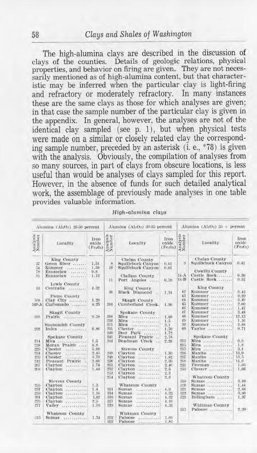
58 Clays and Shales of Washington
The high-alumina clays are described in the discussion of clays of the counties. Details of geologic relations, physical properties, and behavior on firing are given. They are not necessarily mentioned as of high-alumina content, but that characteristic may be inferred when the particular clay is light-firing and refractory or moderately refractory. In many instances these are the same clays as those for which analyses are given; in that case the sample number of the particular clay is given in the appendix. In general, however, the analyses are not of the identical clay sampled ( see p. 1), but when physical tests were made on a similar or closely related clay the corresponding sample number, preceded by an asterisk (i. e. , ,:,78) is given with the analysis. Obviously, the compilation of analyses from so many sources, in part of clays from obscure locations, is less useful than would be analyses of clays sampled for this report. However, in the absence of funds for such detailed analytical work, the assemblage of previously made analyses in one table provides valuable information.
High-atumina clays
.llu1nlnu (AhO,) 2.;.30 percenL .\l11 111lnn (.ll•Oo) :JO.~ l)c.rccoL Alu1nln11 (.\ l: 0 •) :i.·, + 1K•rccut
Lo1·ulily [rou i~
ox ide ~~ (F<•,Oo) ~?
I "';,,;
l.ocullty Iron f] I
oxide .; E (fo,03) ~~
J.ocullty Jro11
oxld,• (.Pe:!Oa)
--K-h,-g -0-0-110._t_y_ --,--C-,h-t>l-llt-1 Counly -- -, <Jltelun Ootmly m Green River ..... . • 1.5.l Squlllchuck Canyon 0.01 II S1111lllchuc.k Cunyon 0.41 ;,i Knmmer . . . . . . . . . • 1.38 10 l:!qulltuhuek C:unyon ().61 iS Enumciaw . . .. . . .. O.S Cowlitz (.,'ounty M Enumclow ........ 1.18 Cl11ll a111 Oonnty IJ-A 011stle Rork. ....... o.:w
11 Port ,l ngPlr$ . .. .. o. ;o U-8 Castle Rork...... .. 0.52 Lewis County
ua C1•nlrull11 .. ... . . . 4.!t?
Pierce County IUS Olay OiLy .. • .. . . • • L:l!J
JOO-A Ourbonado . .. . . . . . 4 .26
Skagit Count)' rn:t Proirle . . . . . . • . . . • . !1.;i,,
Snohomish county ~1 lmlcx . . . . . . . . . . .. . . S.S6
i51>okn ne County 2H Mlcu . . . . . . . . .. . . . . . 1.:, ~:I.:> Moran Prairie . . .. 4 .!' :!:.'11 ChcSl<>r • . .. . .. .. . . ii.OS 2:i1 Olleft<•r . . . . . . . . . . . 2A3 23.; Chester . . .. . .. . . . . 3. 79 Zit Ph•11s 11nL Prnirll• . . 2.~0 211/ 01i1)'tOO .••.•••. •.• 1.74 2,,, {ll11ylOO ........... 1.44
Stevens Oountr 2~; Olulrton 1.3 2,,;7 Olay1on .... . ... .. . 1. 4 :i.;o Oltlyton .. .. . . . .. .. 1.10 Zill Cluyton . . .. . . . . .. 1. 2 270 Clnyton . . . . . . . . . . . z.;, 'l.1i VaJJey ............. ·1, 7(;
Whatcom County :m, Smnos ... • . .... . •• 1.74
King (·ounty as JJJurk Oiu m(lllfl .•
Skogll Count)• 2to Oum lwrlnud t' re,•k .
Spoknnr Counly '.!Ill- AUr u .. ... . ....... . 210 .\lieu .. .. . . ... ... . . 211 J\lfou ............. . 2:11 Chester ...... . ... . 240 Dl-rr Park ..... .. . 241 P leasant P ruirl!• .. 2-H Oeu,1111011 Orer k ..
Ste1·1•ns Cottnty 248 Clay ton 24.Y Ciartou z;,o Clayton 2ii1 01ayton 251 l~loytou ?;;:1 ('laylo11 2j4 Clnyton
I \\'hutcom County
31J fiumos ..... .. .... . ~I~ Sumus ... . . .. .. . .. 316 Sumft~ ... . .. ..... . 317 Suma~ .. ... .. .... . ~10 Sumns ••••.•. . . •••
\\"hit11111t1 County
1.91)
1.0$ I.ii 2.l l.iO 1.72. 2.7S 2.28
1.50 1.<,2 2.39 2 •• 1() 2.ri 2. 3 2.S
4.0 4.82 ~. 32 4 .10 ·1.32
!t'l2 PlllOuS~ .. ...... .. · I 1.110 33:l Pa louse . . . . . . . . . . . 1.S3
King Cou11ty I 42 Kummer .... . .. •••. 48 Kununer ..... . ... .. ,u Kummer .. ..... .. . . (6 Rnnmwr .... . . .... . 4tl Knrnnwr .. ....... . . 17 Rumuwr .. . 06 .... ..
48 Kmnmer .......... . 4 !} Kuntmer .. ....... . . i,O R11 n1111r r ... ...... . . f.,() 'l'uylor .. . .... .. ... .
S11okt1ne County ZlZ Mica .... .. ....... .. 2Ul ! 1iCit ..... . . .... .. . . 21;; Mlcu ....... ...... . . 210 Manito •..••. . .••.. 21i Muoito ........... . 21S )tan Ito .. .. ...... . . 22!l Fre<'ntllo ......... . . :Z:l-~ Olu•~1t·r ...... . ... . .
\\'h111e0m County :!Jf SurtHt~ ............ . :~o Su,1111>' ........... . . :1"21 S11muF •• .•• •••.•. .. :)22 :Sumas ... . ....... .. !l:!11 B<>IHnghum •...•...
V1' hltmnn County
ll.43 3.2~ 3.4~ :!,.60 l.H us
l:t. 12 1 . lf. :?,, (),'Tl
o.o 1.8 :!. I
13.0 1.5. J 14.0 U,11 1.00
3.11 Pnlousr ........... . 1 2.20
Asotin County
DESCRIPTION OF CLAYS AND SHALES BY COUNTIES
ADAMS COUNTY
59
Adams County is in east central Washington and has an area of 1,912 square miles. The region is a treeless expanse of broad, rolling hills separated by valleys that in places become steep-sided coulees. Columbia River basalt underlies the whole county and is exposed in a great many cuts and coulees. Overlying the basalt in parts of the region, particularly in the southwest, are well-stratified sediments in which soft silty sandstones and buff-colored clay-silts predominate. The surface material throughout is a soil, largely eolian in origin, that is mostly silty and rather low in clay substance.
The bedded silts as a rule are fine-grained and even-textured, low in bonding materials, and of low specific gravity. They may be used for common brick and drain tile if carefully mixed and handled so as to control low plastic strength and high shrinkage, but they are not very satisfactory. Reference to the results obtained on similar material from Grant County (p. 94) will give a good indication of what may be expected. A more easily handled clay suitable for common structural ware could be obtained quite generally by utilizing the surface soil, which is a sandy phase of the Palouse clay found in Whitman County.
ASOTIN COUNTY
Asotin County, in the southeastern corner of the State, has an area of 606 square miles. The relief is extreme, as the county includes high uplands of the Blue Mountains and deep canyons of the Snake and Grande Ronde rivers. Pre-Tertiary metamorphic rocks have been exposed by the deep erosion of the Snake River at two places, about 14 and 20 miles southeast of Asotin. They include greenstone, schist, limestone, and very calcareous argillites and are not a source of materials usable for ceramic purposes. However, a deposit of nearly pure-white clay is said to crop out opposite Lime Hill on the Idaho side of the river. at the contact of the metamorphic rocks and the overlying basalt. Shedd© mentions this clay as having a thickness of about 10 feet in places and extending at least one-half mile across the country. An analysis (appendix 2) shows a high silica content but does not give the percentage of iron oxide. Extensions of this deposit on the Washington side are not known, but they might be found by tracing the basalt contact.
(l) Shedd, Solon. Cement materials and industry in the State of Washington: Washington Geol. Survey Bull. 4, p. 117, 1913.
60 Clays and Shales of Washington
Aside from these relatively small exposures of older rock, the Columbia River basalt forms the bedrock of the whole county. It is covered in most places by a mantle of Palouse clay, a yellowish-brown silty clay that is in small part residual but it is mostly a loessal material. The usual physical properties of these surface beds are given for such deposits in Whitman County (p. 327).
The only other clay type known to occur in Asotin County is a laminated fine-grained very light gray clay that in a few places forms thick beds intercalated with the basalt flows. Excellent exposures are in road cuts a mile or two southwest of Asotin. They are derived from lacustrine deposits of silt and volcanic ash and are red-firing materials similar in physical properties to the Latah shales of Spokane County. A peculiar variant of this clay is a black, highly carbonaceous material, so "fat" and free from sand as to resemble wax, that is exposed in road cuts a few miles west of Clarkston.
BENTON COUNTY
Benton County, in the great bend of the Columbia River in the southern part of the State, has an area of 1,671 square miles. The bedrock is the Columbia River basalt. Sediments are interbedded with the basalt and crop out in some cuts and ravines. They are not usable except for the commonest red-firing ware and, in general, their structure and inter calation with basalt would make mining expensive and difficult.
Silty alluvial clays occur in the Yakima Valley and have been utilized at Prosser and Kennewick for common brick. They exhibit weak plasticity, low strength, and high shrinkage with a tendency to crack in drying and firing.
The plain lying west of the Columbia River, in the vicinity of White Bluffs and Hanford, is floored with poorly assorted clays, sands, and irregular deposits of gravel. This Recent alluvial material has been left by the river when at former times it £lowed to the west of its present position. It is owing to this eastward movement that the Ringold formation, as exposed in the White Bluffs of the Columbia, is found only on the eastern side of the river. Good clays no doubt occur in the river alluvium, but their location can only be ascertained by boring, and the overburden would prove a serious deterrent to their use. In the NE1,4 sec. 1, (13-26 E ) several wells have been sunk that average about 45 feet in depth. Clay was encountered at the bottom of these, but its thickness and areal extent are unknown. It is reported that similar material has been penetrated for 60 feet near White Bluffs.
Chelan County 61
Sample No. 9, probably representative of these clays, was taken from a dump by one of the wells. It is a light-gray clay, mostly smooth and free from grit but containing a few small sand aggregates scattered throughout. The sand grains are coarse and are composed of quartz and fragments of basalt.
Plastic an d dry propert ies Sample No. 9 Plastic ity . .. ........ . ...... Strong, sticky Volume shrinkage .. . ..... 50.2% dry volume Shrinkage wa ter ...... . .......... . ... 27.4% Linear s hrinkage ......... 20.7% dry length Pore water ... .. .................... 15.2% Linear shrinkage ......... 9.5% wet length Wa ter of plasticity .............. . .... 42.6% Dry condition ... . ........ Cracked
('oil•· I (.'otor
-:-11
BLttI- brown t>, Jju IT- red ti:.? Rt-'<l~t,rown
Fi red properties Sample No. 9
Condition
000,1 . h nrtl i;l<'<•I hunl ~ t•ur \0 1ir,1ou:t.
s. ll.
L.!:i.'r.tJ.I. l,l'. L.S,c~,1.1. \',!, ',<I. \'. .\ Ii~.
o.~ I 21.0 2.0 ---16. 1 1.~ 2'>.2 l~.\I 11.t
!041 :11.11 2!1.1 0.6
A.Por.
:?S.ll :12.() 1.:l
Remarks: Best firing r ange: 08- 01. Cone fusion: 6-7. High shrinkage: cracking. Needs a nonabsorbent, nonplastic admixture.
A small brick yard was formerly operated in Hanford on very sandy al1uvial clay taken from the bank of the Columbia just north of the town. The product showed the effect of the high sand content of the clay used.
CHELAN COUNTY
Chelan County, in north central Washington, has an area of 2,900 square miles. It is largely a rough and mountainous region lying on the eastern slope of the northern Cascades, but terraces and broad valleys border the Columbia River and its tributary valleys. Argillites, quartzites, and schists occur in the western part of the county, but they are not rocks in which clay materials would be expected to occur. However, of equal extent in that region and forming the predominant rock in the northern part of the county are granite, granodiorite, and gneiss. Such rocks, upon decomposition, produce excellent clays. Similar rocks have been the source of the high-grade clays of the Spokane region. In Chelan County erosion is so active that it is doubtful if any residual deposits exist. There is the possibility, though, of occurrences in protected places, just as residual clays occur on the western slopes of the mountains in King and Pierce counties.
Lowlands bordering the mountains, where the products of decay of the granitic rock would normally occur, are deeply buried w1der the Columbia River basalt. Low-iron highalumina clays may have accumulated at the edge of the basalt or may be interbedded with the flows, as happened in the Spokane area, but so far, no such deposits are known.
62 Clays and Shales of Washington
The most valuable source of ceramic materials is the Swauk formation of Eocene age. These beds cover a large area in the vicinity of Wenatchee and the southern border of the county and extend for 50 miles to the northwest. They consist of some conglomerate, arkosic and relatively high-quartz sandstones, and a great variety of shales. The stratigraphic thickness is difficult to determine, but measurements made during investigations by the Division of Geology indicate at least 12~000 feet of beds. The sediments in many respects resemble the Chuckanut formation of Whatcom County and it may be that they are stratigraphic correlatives.
The Swauk sediments are of fluviatile and lacustrine origin and were deposited at about the same time that the Puget group was laid down. However, no marine phase has been observed in the Swauk. The shales are mostly nondescript mudstones similar to the usual Chuckanut types; but in some places, again similar to certain of the Whatcom County beds, they show the valuable physical properties of sediments derived from acid rocks and accumulated in isolated waters. Sedimentation may have been partly in lagoons or lakes, but in some way protection was afforded certain strata from contamination with the detritus from heterogeneous rocks.
The resultant high-alumina clay-shales are well exposed, and for several years have been worked for ceramic materials, about 31!2 miles northeast of Wenatchee on the Douglas County side of the Columbia River. These beds are basal members of the Swauk and lie immediately above the pre-Swauk surface of gneiss. They are described in more detail under the heading of Douglas County.
Other good examples of the high-grade Swauk shales are on the west side of Squillchuck Canyon, 3 or 4 miles south of Wenatchee. Thick beds interstratified with sandstone have been exposed here by prospect tunnels in the NW% sec. 27, (22-20E) . This is near the axis of a northwestward-trending anticline, where the beds show considerable variation in strike and dip, though low dips of 15° to 20° are usual. The shales are dark gray-brown, low in sand, and very hard. They are nonplastic, but a plasticity can be developed by wet grinding. Mr. N. W. L. Brown, who is interested in their development, has supplied analyses (appendix 2) and told the writer that cone fusions of cones 34 to 35 were obtained on test samples.
The known beds of refractory, light-firing shales are confined to the two localities just mentioned, but extensions of these strata probably exist. If so, they could be found by following recognized structures. Other shales in the Swauk may be of good quality, so the formation warrants thorough prospecting. A region worthy of particular attention is the 280 square miles
Chelan County 63
of Swauk rocks extending from Wenatchee to a little beyond Wenatchee Lake.
The benches and high terraces bordering the Columbia and tributary streams are, for the most part, gravel and sand, but in some places there are thick beds of fine gray Pleistocene silt and some Recent soft buff-colored clays. A brick yard at Wenatchee was operated for a number of years on a bed of soft, alluvial clay that lies along the Columbia at 9th and Walla Walla Avenue. The site is on the first bench about 25 feet above the water. The pit covers an area 275 feet long and 125 feet wide; it has been excavated to a depth of about 20 feet. A great quantity of reserve clay exists. The material is bedded, but the assorting is poor, one stratum merging into another. It all contains some sand, and in some places it is more sand than clay. A few small scattered pebbles are in the clay, and one noted, of granitic material, was about 2 inches in diameter. Calcareous concretions, flat and irregular in shape, are found in the better clay strata, and the clay itself is calcareous.
Sample No. 156 of this clay is a sandy buff-colored material that is soft and easily powdered when dry. The friableness is probably increased by the abundant irregular minute tubes caused by root hairs which traverse the more clayey phases.
Plastic and dry properti es Sample No. 156 Plasticity .... . .. . . .. ....... . . . ...... . Good Volume shrinkage . . ... .. . 20.2% dry volume Shrinkage water . .. ...... . . .. ... . .... . 10.5% Linear shrinkage ......... 7.3% dry length Pore wa ter . ..... .. . .. . .. .. .. ......... 12.6% Linear shrinkage ...... . .. 6.6'f., wet length Water of plasticity .. . ..... . ..... • ... 23.1% Dry condition ....... . .... Good
Fired properties Sample No. 156
Cnnc j Color l 'ootlltlon L.S.%11 .1. 'r. f,.S.%d .J. \'.S.'; ,cl.\'. ----- - --
.-\11~. J\ .Por .
c.,. l ,ig ltL r t'11-hro11n
(1oc>d, hNrrl 0.6 i.11 l .~ 17.7 31.S
07 Ll1illL rcil- nootl , hor,I o.~ "·' 2. , lH. 7 29.S I l,rowu
(W llrl~hl 11rowu-J'(lfl
nootl, S.ll. - 1.3 !'-,G 3.S 12.2 2ll.9
(l:! l\ro"n- r~1l 1; C101I. SB. 3.U 11.2 11.3 S.i 17.0 1.0 1.2
1.1 ZA 3 Tlnrk hrown l
1{ 7. I ll . I 19.7
r,l,J Vllrt>t>111-. ~lhrhl H-7• 1 tlo J s ticking. S.ll. i .O 14 3 19.;i
Remarks: Best firing range: 07-02. Cone fusion: 8. Good color and texture.
Class of ware: Used for brick and tile.
Wenatchee Brick & Tile Co.-The company mines the clay "run-of-pit" by means of a steam shovel loading into cablehauled cars. When delivered to the plant the material is put through conical and plain rolls to eliminate as many of the pebbles and concretions as possible; after this it is elevated
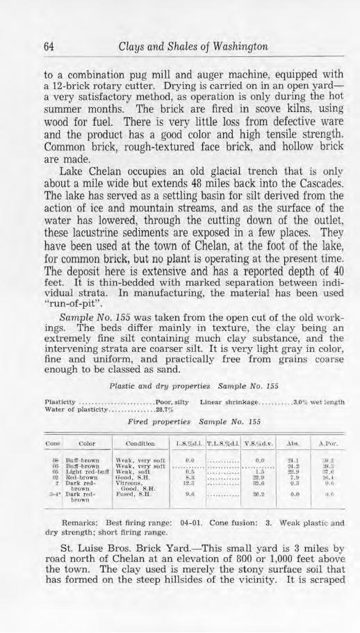
64 Clays and Shales of Washington
to a combination pug mill and auger machine, equipped with a 12-brick rotary cutter. Drying is carried on in an open yarda very satisfactory method, as operation is only during the hot summer months. The brick are fired in scove kilns, using wood for fuel. There is very little loss from defective ware and the product has a good color and high tensile strength. Common brick, rough-textured face brick, and hollow brick are made.
Lake Chelan occupies an old glacial trench that is only about a mile wide but extends 48 miles back into the Cascades. The lake has served as a settling basin for silt de1ived from the action of ice and mountain streams, and as the surface of the water has lowered, through the cutting down of the outlet, these lacustrine sediments are exposed in a few places. They have been used at the town of Chelan, at the foot of the lake, for common brick, but no plant is operating at the present time. The deposit here is extensive and has a reported depth of 40 feet. It is thin-bedded with marked separation between individual strata. In manufacturing, the material has been used ''run-of-pit" .
Sample No. 155 was taken from the open cut of the old workings. The beds differ mainly in texture, the clay being an extremely fine silt containing much clay substance, and the intervening strata are coarser silt. It is very light gray in color, fine and uniform, and practically free from grains coarse enough to be classed as sand.
Plastic and dry properties Sample No. 155
Plaslic.lty . .. .... . ... . . . ..... . .. . . Poor. suty Linear shrinkage .. .. ... .. .. 3.0"! we t length Water of plasticity ...... . ... ... . . 28.7%
Cono Color
()l Du tr- brown 06 8utf- l,rowu 03 Light red- bu ff ll2 Ren- llrown 2 Durk red
brown 3-4* Durl< rcd
hrown
Fired properties Sample No. 155
Condition
\\·1111-.k. ,.,.(1ry !tott W~n k, v~ry soft Wenk. 80ft Ooocl, S.B. Vitreous.
Clgod, S.H . Fu~ed. S.ll .
l,.S.% <1.1. '1'. L .S.%<l.l . Y .S.o/cd .v.
o.o O.o
. 3 12.2
0.G
0.0
1.6 ~ .o ~ -0
26 .2
Ah~. • .\.Pttr.
2 1. 1 ~Ai'.:! 2-1.2 v .:; 22.0 .r; .o 7 .!I Ill.~ 0.3 0.,1
0.0 ,l.f.
Remarks: Best firing r ange: 04-01. Cone (usion : 3. Weak plastic and dry strength; short firing range.
St. Luise Bros. Brick Yard.- This small yard is 3 miles by road north of Chelan at an elevation of 800 or 1,000 feet above the town. The clay used is merely the stony surface soil that has formed on the steep hillsides of the vicinity. I t is scraped
Clallam County 65
up, screened, and put into a soak-pit until ready for the press. A horse-powered soft-mud machine is used, and the brick are air-dried on the ground. They are fired in a scove kiln. using wood for fuel.
Rhyolite intrusives and flows and rhyolitic tuffs are rather common rocks in Chelan and Okanogan counties. They are mostly rather low in iron and so, when weathered, or decomposed by hydrothermal action, may produce light-firing semirefractory clays. A few such deposits, irregular and of slight extent, are known in the vicinity of Wenatchee. They cause much interest and give rise to reports of valuable clay occurrences, but, so far, none of commercial importance is known. Future prospecting may prove the existence of workable bodies, for a great thickness of plastic altered rhyolite was encountered in the deep drilling of an oil prospect in this vicinity. An attempt was made at one time to use a nonplastic, somewhat weathered rhyolite for dry-pressed brick. The plant is located about a mile southeast of Wenatchee in the SE'{i. SEI4 sec. 16, (22-20 E).
CLALLAM COUNTY
Clallam County is in the extreme northwestern part of the State and has an area of 1,726 square miles. Clay or shale of economic importance is unknown in the Olympic Mountains, which comprise much of the county, and, from the character of the rocks composing this rugged region, it is not likely that any such materials will ever be found. However, the bench land lying north of the mountains and extending to the Strait of Juan de Fuca is made up of sediments of Miocene and Oligocene age containing excellent shales. This belt is several miles in width and extends the full length of the county, yet a heavy mantle of glacial drift renders outcrops comparatively scarce and confines them mainly to the sea cliffs and river channels.
SHALES
For a long distance, the Seattle, Port Angeles & Western Railroad has its grade on a bench that is well covered with glacial drift; but from a point in the western part of R. 9 W. to the town of Twin, and beyond, the hills rise abruptly from tidewater, and excellent exposures of the Tertiary formations are common along the right-of-way. Bluish-gray shale, weathering to a buff color, is exposed along the track on both sides of Murdock Creek in the SY2 sec. 29, (31-9 W) . In the Nl/:! sec. 30, (31-9 W), exposures of shale are continuous; 30 feet is not an uncommon height for the cuts through this material and
-3
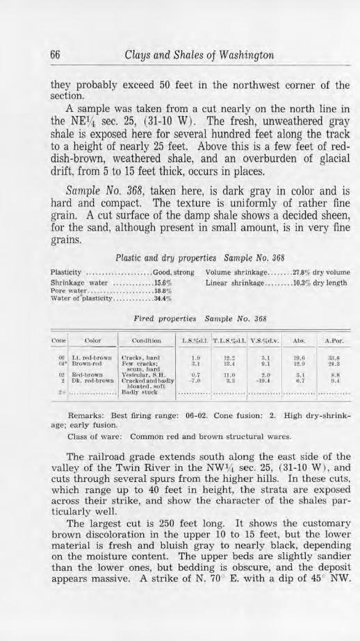
66 Clays and Shales of Washington
they probably exceed 50 feet in the northwest corner of the section.
A sample was taken from a cut nearly on the north line in the NE¥.i, sec. 25, (31-10 W). The fresh, unweathered gray shale is exposed here for several hundred feet along the track to a height of nearly 25 feet. Above this is a few feet of reddish-brown, weathered shale, and an overburden of glacial drift, from 5 to 15 feet thick, occurs in places.
Sample No. 368, taken here, is dark gray in color and is hard and compact. The texture is uniformly of rather fine grain. A cut surface of the damp shale shows a decided sheen, for the sand, although present in small amount, is in very fine grains.
Plastic and dry properties Sample No. 368
Plasticity ......... . ........... Good, strong Volume shrinkage . . . .... . 27.8% dry volume Shrinkage waler ....... ...... 15.6% Linear shrinkage ......... 10.3% dry length Pore water ....... . ............ . 18.8% Water or"plastlcity ............ . 34.4%
Fired properties Sample No. 368
Cone Color Condition
00 Lt. red-brown rruck~. hard o.,• Brown-rP<I J,ew crueks: S<'Ulll, hurd
O'l R1•d·l1l'Own v esil'ulAt, 8 .R .
I
L.$.%cl.l. 1'1'.I ... %d.l. V.S.%d.v.
J.f) 3.1
O.i - i.O
12.: 13.4
11.0 !l.8
1i.l 9.1
2.0 - 10.4
Abs. A.Por.
10.(1 :)3.8 12.1) 114 .3
5.1 .s 0.7 0.4 2 Dk. red-brown Crn<'kNI on(! budly
IJlonted . soft 2- ... . .. .. • .. .. .. .. • Oanlr Hu~k ........................ , ........................ , ........ ... .
------Remarks: Best firing range: 06-02. Cone fusion: 2. High dry-shrink
age; early fusion.
Class of ware: Common red and brown struc-tw·al wares.
The railroad grade extends south along the east side of the valley of the Twin River in the NWlJi. sec. 25, (31-10 W ), and cuts through several spurs from the higher hills. In these cuts, which range up to 40 feet in height, the strata are exposed across their strike, and show the character of the shales particularly well.
The largest cut is 250 feet long. It shows the customary brown discoloration in the upper 10 to 15 feet, but the lower material is fresh and bluish gray to nearly black, depending on the moisture content. The upper beds are slightly sandier than the lower ones, but bedding is obscure, and the deposit appears massive. A strike of N. 70 ~ E. with a dip of 45° NW.
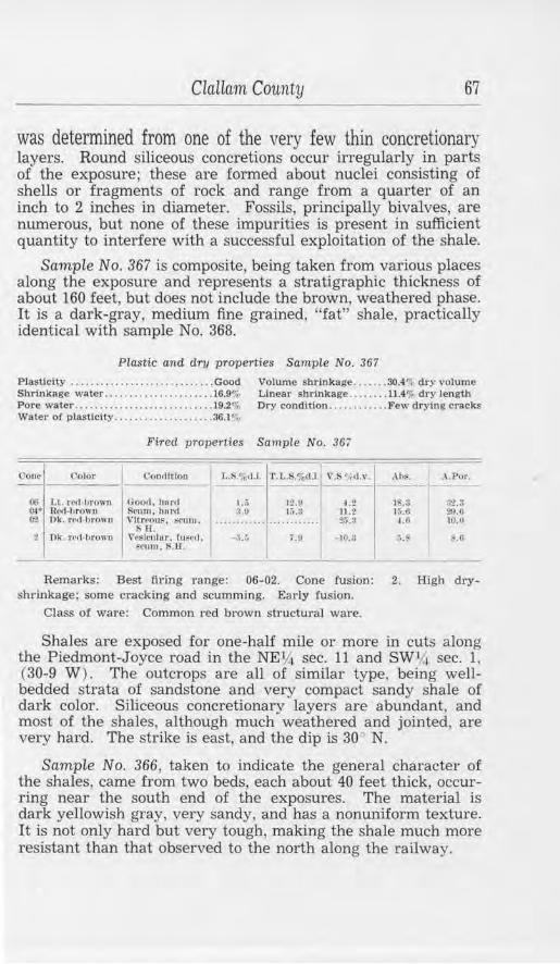
Clallam County 67
was determined from one of the very few thin concretionary layers. Round siliceous concretions occur irregularly in parts of the exposure; these are formed about nuclei consisting of shells or fragments of rock and range from a quarter of an inch to 2 inches in diameter. Fossils, principally bivalves, are numerous, but none of these impurities is present in sufficient quantity to interfere with a successful exploitation of the shale.
SampLe No. 367 is composite, being taken from various places along the exposure and represents a stratigraphic thickness of about 160 feet, but does not include the brown, weathered phase. It is a dark-gray, medium fine grained, "fat" shale, practically identical with sample No. 368.
Plastic and dry properties Sample No. 367
Plasticity ... . ......... . ............... Good Volume shrinkage .•..... 30.4% dry volume Shrinkage water .... .. ................ 16.9% Linear shrinkage ...... .. 11.4% dry length Pore water .. . ................. .. ...... J9.2% Dry condition . ..•........ Few drying cracks Water o( plasticity .. ... ........ .... ... 36.1 %
Fired properties Sample No. 367
C'one l'olor Con,llitou l,.R.•1<>•1.1. ·r . t,.R,%d.l I v.i. , ,,1~ Ahl'i, .\ .Por.
06 1.l. rr,t-brnwn Goi>,1, hartl ).;j 12.n 4.Z I' • :1-2.3 ... (H• Rr(l-l1rowu S<·um, hnro :J.!l 11;.a 11 ,2 lii.6 :!9.0 02. Dk. rrrl ,hrowu Vhrrous,
s TJ. ~<"llllt • .. .......... ············ 2.).3 4.0 10.(1
:! l'lk. rrrl ·hr0\111 Vesi1•11lur. f11~,,,1. -:i.:, j .!I - 10.!I 5.~ ~.tl srurn, ~.ll.
Remru:ks: Best firing range: 06-02. Cone !usion: 2. High dryshrinkage; some cracking and scumming. Early fusion.
Class of ware: Common t·ed brown structural ware.
Shales are exposed for one-half mile or more in cuts along the Piedmont-Joyce road in the NEY-i sec. 11 and SWV.i. sec. l , (30-9 W) . The outcrops are all of similar type, being wellbedded strata of sandstone and very compact sandy shale of dark color. Siliceous concretionary layers are abundant, and most of the shales, although much weathered and jointed, are very hard. The strike is east, and the dip is 30- N.
Sample No. 366, taken to indicate the general character of the shales, came from two beds, each about 40 feet thick, occurring near the south end of the exposures. The material is dark yellowish gray, very sandy, and has a nonuniform texture. It is not only hard but very tough, making the shale much more resistant than that observed to the north along the railway.
68 Clays and Shales of Washington
Plastic and. dry properties Sample No. 366
Plasticity . . .. .. ...... .. ... . . Weak, crumbly Volume shrinkage . .. ..... . 9.6"0 dry volume Shrinkage water ....... . .... 4.9% Linear shrinkage . ... .. . .. . 3.3o/, dry .length Pore water . . ....... . ........ 14.1 % Water of plasticity .. ....... . 19M'o
Fired properties Sample No. 366
Cone Color
OS Lt. n'!l-hrown O! Ok. ml·hrown
Condition
\\'Mk, ~oft Vitreoui surfufe,
$.1:i.
L. '.C~d.l. 'l'.L.S.'%d.l., V.S.%d.,•. .\bs.
1.11 l.O
5.2 .2
o.3 lU
175 ...,. 7
.\.Por.
31.0 1 ,6
:1 Dk. ml-hrown
fi• Dk. Ml-hrown
Fn~rll 111111 ,•esiculur. S.ll.
B1011 te<l, hunt Fu~~d.
.... · • ... .... ~ : ..... ... :::'..... : : I · '.: Remarks: Best firing range: 04-01. Cone fusion: 2. Poor plastic
strength. Short vitrification range, early fusion.
Shales are exposed about 4 miles south of Port Angeles in the bed of Tumwater (Fraziers) Creek but were not sampled; they also outcrop under considerable glacial overburden on the sides of Morse Creek Valley near Highway No. 101. Brown, much-weathered shale is cut by the Freshwater road just north of its junction with the Port Angeles-Joyce road, and a very hard dark-gray shale is exposed in cuts along Highway No. 101 east of Lake Sutherland for considerable distance on both sides of the Elwha River. On the Clallam road, in sec. 26, (31-12 W ), shales are exposed at several places, and they are common along the shore, as at the mouth of Whiskey Creek and from there to Freshwater Bay.
PUGET SOUND GLACIAL CLAY
Glacial clay is plentiful in the county, especially in the vicinity of Port Angeles, and differs only in minor detail from occurrences of the Puyallup series elsewhere. It was sampled at but one place-in the business district of Port Angeles where a 40-foot bank was formerly exposed on the south side of the street-grade. The clay bed, here, may be 30 feet thick, but the lower part is masked by material fallen from above. Laterally, sand and gravel phases replace the clay; there are immense quantities of each of these sediments.
Many years ago a brick yard operated on this clay, making a fair quality of common, soft-mud brick. It was found that weathered material was most usable and that exposure to the air and the addition of some sand to the clay was beneficial.
Scimple No. 365 includes the unweathered bluish-gray clay from the lower part of the exposure and also some of the upper
Clark County 69
slightly weathered yellowish-gray material. It is very plastic and exhibits a characteristic blocky joint structure on drying in the bank. It is uniform in texture, contains the fine siltlike sand common to most glacial clays, but is apparently free from coarse grit or pebbles.
Plastic and dry properties Sample No. 365
Plastichy ..................... .. ..... . Good Volume shrinkage .. .. .... 26.2% dry volume Shrinkage water .... , ......... . ....... 13.S"'o Linear shrinkage . .. . ..... 9.6% dry length Pore water . ...•..... . ...•.... .. ....... 16.8% Linear shrinkage .. .. ...... 7 .0% wet length Water of plasticity ... . ... ............. 30.6%
Fired properties Sample No. 365
r'olor Contlfllon l~S "I'd .I. 'l.'. l,.S.o/od.l. V.S.'ii lf.,,. ,\tis. ..\.Por.
Olll l3utf.l,rown \\",•uk. sofl n.u 10.t 1. ~ 17 .7> !-11. 1;;.~ ~-~ G.7 12. 3
1~; Lt. r,•tl-hrown S1•11111, grw d. html lW Dk. r~t1,1,rown S<•1111rn1NI. i::oorl.
S.11.
I. I l0. 7 3.:1 0.G 10.2 15.9
2 f>lc. rt•tJ-1,rowu GJuzeU, llli'rd~ S.H.
7 2 10.S 20.1 0.0 0.0
:I-~ . .. ............ Fu<Nt
Remarks: Best firing range: 07-02. Cone fusion: 5. Low temperature-of-fusion.
Class of ware: Common red-brown structural wares.
CLARK COUNTY
Clark County is an area of 634 square miles bordering the Columbia River in the southern part of western Washington. The eastern part of the county lies in the foothills of the Cascades, where the bedrock is largely basalt and rock of similar type. Reaching from there to the river is an extensive gently rolling plain composed of basaltic flows and agglomerate, but overlain in many places, sometimes to great depth, with alluvial deposits of Pleistocene age. These latter are unconsolidated sands and gravels with abundant sandy red-firing clays. Buff.firing phases occur but are local and apparently few in number.
The clays and sands are well exposed at Image, a station on the Seattle. Portland & Spokane Railway, about 5 miles east of Vancouver. The Denny-Renton Clay & Coal Co. formerly had a sewer-pipe plant here and developed and used a large amount of clay. Open-cut quarry-face mining was employed on the clay, which lay about 100 feet above the river level on a bench just north of the plant. Although the different beds are horizontal, they are subject to great lateral variation due to crossbedding a11d the thinning out of strata.
Sample No. 300 is general in character, being taken from several places in the 12-foot working face of the pit. It represents dark- and light-gray sandy clay, buff and gray clayey
70 Clays and Shales of Washington
sand, and also an indefinite stratum of dark-gray plastic clay underlying the rest.
Plastic and dry properties Sampte No. 300
PlasUc!ly ...... .. ............... . Very good Volume shrinkage ........ 37.8% dry volume Shrinkage water ... . ............ . 18.5% Linear shrinkage ......... 14.6% dry length Pore water ............ .... ....... 10.9% Ory condition ........... . . Hard and strong Water of plasticity . . ........... .. 29.4%
Fi red properties Sample No. 300
Cone Oolor Con<lltlon L.R.o/ocl.1. T.L.S.%d.l. V.S.%d.v. I Ahs. A.Por.
Ol> ButT·brown Weak , soft -0. 1:i. -u 15.~ ?.S. 0'2 Bright huff-ml Goocl, IHlnt J.i Hi.3 5,0 12.l 24.0 t ll rlghL Ooo,1, S.11 3.8 I .4 11.0 G.:l 12.7
hrOll'll·TPII 3--J" DrlghL Good,,· H. 4.4 10.0 12.7 3.S ,;;
hrown,url I I Remarks: Best firing range: 02-6. Cone fusion: 10-11. High dry
shrinkage. Class of ware: Thls matel'ial, with a nonplastic addition, was used for
sewer pipe and red-brown structural ware.
Sample No. 301 is from the 6-foot stratum of dark-gray, somewhat bluish, clay that is partly exposed at different places in the pit. It is best seen in the southeas t end where the irregular bed attains its maximum height above the pit floor. This clay is plastic when dug but dries to very compact lumps. It is high in clay substance but still contains some sand and muscovite mica.
PLastic and dry properti es Sample No. 301 Plasticity ......... .. ......... .. ....... Good Volum e shrinkage ..... . .. 47.1% dry volume Shrinkage water . .. .. ................. 28.7% Linear shrinkage ........ . 19.1% dry length Pore water . ................ ..... ...... 29.5~ Lin~ar shrinkage ..... . . . . 11.0% wet length Water of plasticity .................... 58.2% Dry condition ........ . ... Strong dry bars
Fired properties Sample No. 301
Com• Color Conrlfllou J, .S.o;;_d.l. 'l!. l ,.S.%(J.I. 'l'.S.%d.v. Abs. I .\.Por. -~ J,lghL l°/llff Good. har,I 1.:l 20.•I 3.9 ,~. 7 :lb.~ ·~ r.tght h11fT-ret1 t1oo,t. S.li. 5.1 :?-1~2 11 .i 7.~ 15.~
01-l Llghl tm tr-r<',I Gootl. s.11. 7.0 :!1).1 19.0 0.5 13.i, ,H• Brigh t ltuff•r (•,I Uoo,1. S.H. ~.,, 27 . 7 28.6 5.l 11'>.b-,~;· nrown-r('(I O<>Ocl, fi.li. I0.2 :!9.3 27.0 4.S (l.!1
12· l)o rk tirowu Vc~tco lnr~ 10.1 W.2 27.3 6.3 fl. fllFNI. $.1:1 .
Remarks: Best firing range: 08-8. Cone fusion: 16. Class of ware: Needs more nonplastic material for red and brown strnc
tural ware. See No. 300.
Sample No. 302 was taken from the NE14 sec. 10, (1-4 E ) . This is in the hilly region northeast of Washougal where the
Clark County 71
alluvial deposits of clay attain considerable thickness. Several prospect pits were dug in a hillside on the property of R. H. Bedell, exposing similar clay of uniform texture in each. The clay is dark yellow in color and dries to a much lighter shade. It contains abundant white mica and fine, siltlike sand, which gives a soft, friable character to the material.
Plastic and dry properties Sample No. 302
Plasticity ..... ... ... . ... . . . ........ . .. Good Volume shrinkage .. .. ... . 19.2o/, dry volume Shrinkage water ... .. ... .. .. . ... . . . . . . 11.3% Linear shrinkage ....... . . 6.9% dry length Pore water ....... .... .. . ... .... ... . .. 20.1 % Linear shrinkage ....... .. 5.8% wet length Water of plasticity ................... 31.4% Dry condition .... ... .. .. . . Strong bars
Coo;•
010 06 Ol
01
a-1• 0
12!'
F ired properties Sample No. 302
('olor <'onclltlon l .. S.%d.l. i'l'.L.S.'il,d.t.l V.S.<µd.v. Abs. A.Por. ·--llutr- llrown Weu k. &Oft 1.tl s.~ 4.8 Sn. 40.2 Brown- rt'tl \\'1•11k, ~ofl :l.l 10.0 0.0 25.9 , ().8 13rlght l)rOWII 1100<1. hord ii.3 12.ll ]5.0 18,0 33.2
ml BrigbL brown-
rt'{I Gootl. S.H. 10.G 17.1 28.2 G.2 1s. r
Bright t;rown-rl'd
Goo,I, S.B. L1.B 20.2 3L9 0.2 0.4
Dl"'P lirown- X,•ur ,·ltr~ou•. uu. 21.1.1 St.O 0.2 o.~ red )t00d. s. I!. ................. Port!)• fu~eil .................. .. .. .. ............ ............ .......... ..
Remarks: Best firing range: 04-7. Cone fusion: 11-12. Class of ware: Red-brown structural ware.
A structureless mantle of yellow clay-loam, an alluvial silt deposit, covers the region about Vancouver and forms a very productive soil. This material is satisfactory for making common brick and has been used for that purpose by several yards in the vicinity. One of these, the plant of the Hidden Brick Co., is in the north part of Vancouver at 2611 Kauffman St. Formerly, clay was obtained from a few blocks south of this location, where the clay is similar in origin and physical properties to that used now. The present pit, covering an area 50 by 400 feet, exposes a yellowish sandy clay that is 10 feet thick at the east end and 4 feet at the west. There is no overburden, and objectionable pebbles are absent where the clay is thickest though rather abundant in the thinner part of the stratum. Underlying the clay is a stained, somewhat decomposed bed of gravel.
Sample No. 769 is of the prepared clay as used by the Hidden Brick Co. from the old pit.
72 Clays and Shales of Washington
Plastic and dry properties Sam:ple No. 769 Plasticity .... ....... . .......... . Fair. sandy Volume shrinkage ...... . . 12.0% dry volume Shrinkage waler . . .............. 6.4% Linear shrinkage ......... 4.2% dry length Pore water .............. .. ...... 16.5% Water of plasticity ... . .......... 22.9%
Con,•
0 0-2
Fired properties Sample No. 769
Color Condition ·u; %•1.1. 1'1'.L.S.o/od.l. V.S ')?u.v.
Rrd-brown \reak, soft .. .................... ... :>.O Deep red-browa C:ood, S.H. ······ ··· ·· · ......... .. .. !U
Remarks: Best firing range: 06-2. Cone fusion: 6-7. Class of ware: Was used for common brick.
Abs. I
A.Por.
28.3 46., 12. :J>.ii
Hidden Brick Co.-The clay is plowed to expose it to the weather and later carried by scraper to a trap, where it is taken by conveyor belt to the plant. There .it passes through disintegrator rolls to a pug mill, and then to a stiff-mud auger machine with a hand cutter, or, as is the usual practice, to a horizontal sand-mold soft-mud machine. Drying is completed in from 8 to 14 days, depending on the weather, and is on covered open-air pallet racks. The brick are fired in a scove kiln, taking 3 days for water smoking and 10 days more to complete the firing. The output varies from 500,000 common and roughtextured brick, under recent conditions of the market, to a million or so in good years.
Throughout a large area in the vicinity of Ridgefield is an alluvial clay that greatly resembles the Palouse clay of eastern Washington (p. 49) . These . sediments are well exposed in numerous road cuts and particularly in the pit of the R. B. Muffett Brick & Tile Co., 3 miles northeast of Ridgefield, near the center of the north line SE-Y.t sec. 17, (4-1 E) . Thjs pit is 100 feet long, 85 feet wide, and has a 22-foot face. It exposes a gray to reddish-buff sandy clay in which only an indistinct stratification is a-pparent. There is no overburden, and the only objectionable feature is the presence of occasiona1 quartzite pebbles. Stream-rounded boulders up to 6 inches in diameter have been found in the clay.
The material, proved by a well in the pit to extend to a depth of at least 52 feet, was deposited by streams heavily charged with sediment. It shows lateral va1iation in texture, the west side of the pit being free from very sandy phases, while the east side grades downward into 8 feet of clayey sand at the bottom. Coarse phases occur irregularly in the deposit, and some parts are clayey grits in which virtually all the small pebbles are decomposed. The more clayey part develops a rude columnar structure on drying; it contains irregular minute holes left by
Columbia County 73
root hairs, and both joints and holes are lined with a brown, almost gelatinous film of the clay mineral beidellite. The sandy phase has numerous layers of gray to black, carbonaceous plastic clay that range from one-eighth to one inch in thickness. These in some places appear as discontinuous horizontal lenslike layers and in others as irregular branching dikelike masses that cut through the sand at any angle to the horizontal.
R. B. Muffett Brick & Tile Co.-The clay is dug by means of a very efficient gasoline-powered channeling machine built by Mr. Muffett. This device has a cutting head armed with revolving knives and operates on a boom like that of a power shovel. It cuts a 2-foot channel from bottom to top of the pit face ; when this cut is 10 feet deep the machine is moved on its track into position for a new cut until the entire face is traversed. The disintegrated clay from the cutting head drops on a conveyor belt, which leads to a hopper in the machine. A car passes under this, is filled, and is then pulled by cable to the plant.
The plant is equipped with rolls, horizontal plunger-type stiff-mud machine, and hand cutter. The brick are dried in a covered shed and fired in a scove kiln. In firing, two days are allowed for water smoking, and three more to complete the firing. The product has a good structure and a very pleasing bright-red color. A year's run consists of 130,000 to 150,000 rough-textured brick (used for b'oth face and common), about 27,000 hollow block, and about 50,000 various-sized drain tile.
COLUMBIA COUNTY
Columbia County is in southeastern Washington. south of the Snake River. The area is 858 square miles, made up of broad, rolling bills which merge into a mountainous region to the south. The bedrock throughout the county is basalt. In places residual clays from the decomposition of that rock may occur; in general, the surficial deposits are loess and modified residuum very similar in appearance and physical properties to the Palouse clay of Whitman County (p. 327). Some alluvial clays occur in the valley of the Touchet River, but these are only further modifications of the Palouse clay of the uplands. All such materials are red firing, though entirely satisfactory for brick and drain tile and could be utilized if the local market warranted. A brick yard was in operation at one time on these clays in Dayton.
74 Clays and Shales of Washington
COWLITZ COUNTY
Cowlitz County borders the Columbia River in the southwestern part of the State and bas an area of 1,153 square miles. A rough topography characterizes th~ county, and the eastern and extreme western portions are mountainous. This, together with the prevailing heavy growth of timber, renders much of the region difficult of access. Eocene basalt forms a considerable proportion of the bedrock, and in places not subject to rapid erosion a decomposition residue has accumulated to considerable depth. The residual product is a dark reddish-brown clay that varies greatly in texture in different regions, depending on the composition of the original rock, on the completeness of decomposition, and on the amount of weathering to which the clay has been subjected. Miocene basalt occurs also, but is relatively unaltered.
Tertiary sediments occur in the western part of the county and are exposed in the Cowlitz Valley and in the hills to the west. They include shales and sandstones of Eocene, Oligocene, and Miocene age. Excellent shale exposures occur in the railway cuts and along the various river and creek channels in this field. The structure of the beds is relatively simple, and low angles of dip are the rule; some local buckling, however, has increased the angle in places. Some strata are thin-bedded and have close intercalation of sandstone, sandy shale, and clayshales; but thick beds of shale are numerous and could be mined without great difficulty.
The shales are commonly associated with coal of subbituminous rank. In the search for workable coal beds, prospect pits and tunnnels have been dug in many places. In some of these the strata can be observed, but many are in a caved or flooded condition. As development progresses in road work or mines a careful study of the newly exposed shales would be advantageous; for the series contains a few beds that are buff-firing, and some have been found to be of great economic value.
A buff-firing bedded material of unusual type is exposed about 2 miles south of Kelso on the Temple property, where Highway No. 99 is graded through a prominent ridge. This material is a tu:ff-a water-laid deposit of volcanic dust, pumice, and some rock fragments-that has, to a large degree, been altered to clay. Slight_induration has made it shalelike in hardness and appearance. The cut is about 200 feet long and up to 18 feet in height; so shows the strata to good advantage. They are medium-thick beds and dip from 5° to 10° SE. Some are fine-textured, and these are lightest in color, being a slightly
Cowlitz County 75
yellowish gray or nearly white; others are coarse, have a decidedly granular appearance, and are darker gray and stained with iron oxide on the joint planes. Spheroidal weathering and jointing are very prominent throughout the exposure.
Two samples were taken here, one being carefully picked, to avoid stain, from the fine-textw-ed beds, and the other a general one. In mining it would no doubt be feasible to sort the tuff so as to avoid the stained material, but it probably would be unnecessary to differentiate between the beds.
Sample No. 309, of the finer matelial, has a uniform texture and is very compact when dry. It has a harsh feel due to the large amount of unaltered volcanic glass and to fragments of quartz and feldspar.
Plastic and dry properties Sample No. 309
Plasticity ......... . .. ....... .. ... .. .. Good Volume shrinkage . ....... 20.7% dry volume Shrinkage water . .... ... . . . . ... ....... 15.2% Linear shrinkage . . . .. .... 7.4"t dry length Pore water . ...... .. ................... 33.4% Water of plastlcily .................. .. 48.6%
Fired properties Sample No. 309
('on,' Color Conrllllou L .!,.~·o<I.I. f' . l,.S.%d.l. I
V.S.~tl.V. Ah,_ ..\.Por.
fl6 Drll(hl hulf W('!tk, ~Ofl "·" Ja.9 23.~ 10.;; :l'l.:1 l)j Bright buff Wrak, soft t/.0 16.1 :!.I.S 10.0 ll'Ul 1 J.lrlghl l111fT Jlunl U.7 17. 1 26.:, I .0 29.
0-7"" Ilrljl'ht bu fT Uard IU.11 lS.3 29.3 H.0 24.ll
Rema1·ks: Best firing range: 02-6. Cone fusion: 9. Short vitrification range. Small cracks, cones 04, 1, and 6-7•.
Class or ware: The buff color is so unusually bright that it may be useful with other clays for buff-colored structw·al wares.
Sample No. 308 came from various scattered places in the exposure. It is mostly less compact and slightly darker gray 1han the preceding sample. A granular, mealy appearance, from larger component grains, is noticeable. Spherical concretionary bodies up to one-half inch in diameter are abundant in both samples; they are slightly harder than the surrounding material but crush easily and are practically the same as the matrix in composition.
Plastic and dry properties Sample No. 308
Plasticity ..... .. . ... .. ......... .. .... Fair Volume sht·lnkage . ....... 12.8% dry volume Shrinkage water ...................... 9.1% Linear shrinkage . . ....... 4.5% dry length Pore water ......... . ......... . ...... .. 34.2% Dry condHlon ............ Fair Water o! plasticity ................... . 43.3%
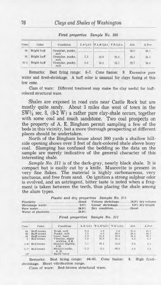
76 Clays and Shales of Washington
Fired properties Sample No. 308
Uone l Color Co111lflion l,.S.%,11.1. 'I'. T,.S.o/.,(1.1. V.S.o/etl.\' . .\hs. I A.P1,r.
00 Bright buff Grunulnr, 1iunky . soft ·· ········ · ............ ········ ···· i6.0 3:-1.i
l~l Bright bnff Granulnr, 1111111:y. 7 .• ; lZ.O 20. 2;,.$ Sb.5 eoft
01-1 Bright hutr (l ranulnr, punk-y, .o 13. 1 tJ. i ?2.7 ~.6 soft
Remarks: Best firing range: 6-7. Cone fusion: 9. Excessive pore water and fired-shrinkage. A buff color is unusual for clays fusing at this low cone.
Class of ware: Different treatment may make the clay useful for buffcolored structural ware.
Shales are exposed in road cuts near Castle Rock but are mostly quite sandy. About 3 miles due west of town in the SWIJt sec. 8, (9-2 W) a rather pure clay-shale occurs, together with some coal and much sandstone. Two coal prospects on the property of A. E. Bingham permit sampling a few of the beds in this vicinity, but a more thorough prospecting at different places should be undertaken.
North of the Bingham house about 300 yards a shallow hillside opening shows over 3 feet of dark-colored shale above bony coal. Slumping has confused the bedding so the data on the sample are merely indicative of the general character of this interesting shale.
Sample No. 311 is of the dark-gray, nearly black shale. It is compact but is easily cut by a knife. Muscovite is present in very fine flakes. The material is highly carbonaceous, very unctuous, and free from sand. On ignition a strong sulphur odor is evolved, and an astringent, bitter taste is noted when a fragment is taken between the teeth, thus placing the shale among the alum types.
Plastic and dry properties Sample No. 311 Plastlcl1y .... . ..............•.•....... Good Volwne shr inkage ........ 14.3 .. , dry vo lume Shrinkage water ..... .. .......... .. ... 9.0% Linear shrinkage ......... 5.0<;i dry length Pore water .. . ........ . . .. ........ . ...• 24.9% Dry condition •........... Good Water of plasticity .. . . ... .. . ... ... . . . . 33.9%
Color
OS JlulT-hrown 00 1Ju ff -br own tu flu lf-h ro1111 2 H~d-hro wn
:i..1• R~,1-h rowu
Fired properties Sample No. 311
C-on,lltlon
WN,k . sort C'u oky . soft Good. hurtl Vltrnou~. ~light
stk klng , Sf.I . 131011 t ,~ l s llgblly.
!>.n . Dlont.1d l1111lly .
s. f.l .
L.s .%,1.1. •r.1..s.%t1.1. v.s.s,d.,•. ---O.:!. 5.2 0 .ll !/.:, R.o 10.0 fl.II 11.0 16.H i .I> ) •) 21 .. i
:i.1 10.1 H.11
- 1.:i -2 .n -29.11
.\ hs.
31.S 2S.I I . I :U
2.5
t.O
.\.Por.
.f5. I 41.,: :"t?.1
~ . I
t I
t. '
12• . •• • . . • • . • • • • . . • • . 011d ly ru~rit ........................................................... Remarks: Best firing range: 04-01. Cone f usion: 8. High fired
shrinkage. Short vitrification range. Class of ware: Red-brown structural ware.
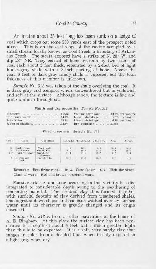
Cowlitz County 77
An incline about 25 feet long has been sunk on a ledge of coal which crops out some 200 yards east of the prospect noted above. This is on the east slope of the ravine occupied by a small stream locally known as Coal Creek, a tributary of Arkansas Creek. The strata exposed have a strike of N. 20° W. and dip 28° NE. They consist of bon!=? overlain by two seams of coal each about 2 feet thick, separated by a 2-foot bed of light bluish-gray shale with a 3-inch parting of bone. Above the coal, 6 feet of dark-gray sandy shale is exposed, but the total thickness of this member is unknown.
Sample No. 312 was taken of the shale overlying the coal. It is dark gray and compact where unweathered but is yellowish and soft at the surface. Although sandy, the texture is fine and quite uniform throughout.
Plastic and dry properties Sample No. 312
Plasliclty .... . . . ............... ...... Good Volume shrinkage ........ 24.8';; dry volume Shrinkage water ............... .. ..... 14.3% Linear shrinkage .. .. ..... 9.0% dry length Pore water .................•.......... 19.3% Linear shrinkage .... . .... 6.8% wet length Water or plasticity .... ... ....... .. .... 33.6% Dry condition ............ Good
Fired properties Sample No. 312
C,ont• l'olor Coll(lllton I..S.%11.1. 'l'.Ui,%<1.1. v.~.t, t<1.,1• ,,,,~. .\.Por.
Ob 0•2
;:-.i ·
h
---Bu If.I tr<)\\ II W,•uk. ~oft 1.1 ID. I :1.:1 ~UI ;;!).~ Red-hroun noo,1, s .u . 0 .0 I ,H 21.~ ~ . ll 1:l.11 Onrk t1•d· lor<Jm1 nornl. s.H .. 12.~ 21. 1 ~.; fU fl. I
\ l llrf•OUK 13ro"n unrl fn1'r<I, SU. tt ... 21.~ ;~l.b 2.1 1.(1
hlill'k
Remarks: Best firing range: 04-3. Cone fusion: 6-7. High shrinkage. Class of ware: Red and brown structural ware.
Massive arkosic sandstone occurring in this vicinity has disintegrated to considerable depth owing to the weathering of cementing material. The residual clay thus formed, together with surficial deposits of clay derived from weathered shales, has migrated down slopes and has been worked over by sw1ace water until its character is greatly changed and its origin obscured.
Sample No. 342 is from a cellar excavation at the house of A. E. Bingham. At this place the surface clay has been penetrated to a depth of about 4 feet, but a much greater depth than this is to be expected. It is a soft, very sandy clay that ranges in color from a decided blue when freshly exposed to a light gray when dry.
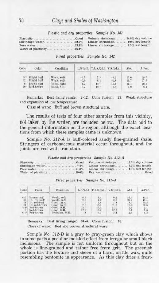
78 Clays and Shales of Washington
Plastic and dry properties Sample No. 342 Plasticity .................... . ........ Good Volume shrinkage ........ 24.8% dry volume Shrinkage water ..................... . 12.6% Linear shrinkage ......... 9.0% dry leng{b Pore water ................... ........ . 13.8% Linear shrinkage .... . .... 7.5% wet length Water of plasticity .......... .. .. . ..... 26.4%
Fired properties Sample No. 342
Cone Color Conilfllon L.li.%~1'l'.L.S.%tl.l. ,·. <,?11.\'. Ab~. .A.Por. '
o~· Brighi huff Wc" k. soft -1.i j .~ -;;.2 15.0 Z,..7 (2 Bright buff \l'v11k1 soft -o.u 8.l -1. H.i t7 .2
fl Brown-huff Good. h11rd I. j 111.i +J\.1
I IU 2'l.1
12" Buff-hrown n()ofl. S.H. u 12.7 10.6 3.0 ,A
Remarks: Best firing range: 2-12. Cone fusion: 23. Weak structure and expansion at low temperature.
Class of ware: Buff and brown structural ware.
The results of tests of four other samples from this vicinity, not taken by the writer, are included below. The data add to the general information on the region, although the exact locations from which these samples came is unknown.
Sample No. 312-A is buff-colored sandy fine-grained shale. Stringers of carbonaceous material occur throughout, and the joints are red with iron stain.
Plasti c and dry p1"operties Sample No. 312-A Plasticity ... . ......................... Good Volume shrinkage .. ... .. . 12.3o/, dry volume Sllr1nkage water ..... ... ......... . .... 7 .4 '11 Linear shrinkage. . . . . . . . . 4.3% dry length Pore water ........... . ................ 21.6% Linear shrinkage ......... 4.5"1, wel length Water o{ plasticity .................... 29.0% Dry condition ....... . .......... . .... Good
Fired properties Sample No. 312-A
Couc i Oolor Conllltfon J.,.S.o/o<l.1. J'l'. 1,.S.o/od,1. V.$.o/,d.v.
CIO r.u IH Ill
:~· fl
H-·1*
nrowu•huff W1•ok. soft II. I 4.4 0 ,) Ll. nd-buff W1•ok. soft 0.2 4.5 0.i\ Lt. r~'d-bu ff Hootl, 111ml 1.;; 5.b 1.4 LL red-brown Ooorl, bar,I 7.S 12. 1 :n.:; Red-brown Oood. $.II. 1:!.!I IT.2 :1-1.0 Red·brown Good , .B. It.~ 16.6 .,., " .,_,., U~d·lwown Ve~lrulor. S.EL J.i, tLl 1),,1
Remarks : Best firing range: 04-4. Cone fusion: 18. Class of ware: Red and brown structural ware.
Ahs. .\ .Por.
25.:; 40.3 25.4 40.1 1 ' .3 ll().:; 10.3 ~.5 t.l 2.4 O.'i 1.G 2.0 4.8
Sample No. 312-B is a gray to gray-green clay which shows in some parts a peculiar mottled effect from irregular small black inclusions. The sample is not uniform throughout but on the whole is fine-grained and rather free from grit. The greenish portion has the texture and sheen of a hard, brittle wax, quite resembling bentonite in appearance. As this clay dries a frost-
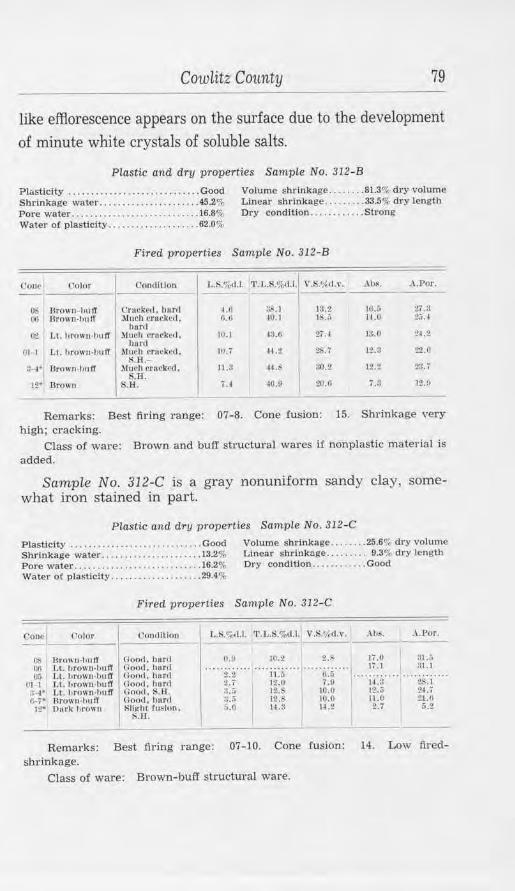
Cowlitz County 79
like efflorescence appears on the surface due to the development 0£ minute white crystals of soluble salts.
Plastic and dry properties Sample No. 312-B
Pl&sticity ............... . ... . ..... .... Good Volume shr inkage .. ...... 81.3% d1·y volume Shrinkage water ...................... 45.2o/, Linear shrinkage .. .. ..... 33.5% dry length Pore water ................ ... ........ . 16.8% Dry condltion •.• ... •..... Strong Water of plasticity ................... . 62.0%
Fired properties Sample No. 312-B
('ol1l· l 'olor Coudlllon L.S.o/,,, 1.1. 'l'.J,.$.%cl.l.l V.S.o/,.d.v. ,\IJS. A.Por.
()$ Tlrown-hu tT Crnrk1•d , 11,ml I .II :)S. I J:l.2 IG.;, 21.a Ii) llrown-hulf ?tlnch rre1·kell. 6.6 I0.1 1:..;; 11.0 1;;.J
huril (}t Li. hrnwu-h11 fT Much crucl:c1I . HI.I 43.G 27. J ]:$.0 ~4.~
h,11·(1 01-1 Lt. hrown-hull' Mtll'h c·n,rltcri, lfl. i U .2 ZS..7 l:!..!l 22.P
S.H.-a,...-1 • Ilrown-hufT .Muell cruckrd, 11.3 41. !l0.2 1:, ., 2:!. T
$.IL 12" llrown S.1:L u {0.0 20.(1 i.3 12.U
Remarks: Best firing range: 07-8. Cone fusion: 15. Shrinkage very high; cracking.
Class of ware: Brown and buff structural wares if nonplastic material is added.
Sample No. 312-C is a gray nonuniform sandy clay, somewhat iron stained in part.
Plastic and dry properties Sample No. 312-C
Plasticity ....................... .. .... Good Shrinkage water ..... .. ............... 13.2% Pore water ... . .................. ...... 16.2%
Volume shrinkage ..... . .. 25.6% dry volume Linear shrlnkage . ..... ... 9.3% dry length Dry condition ......•..... Good
Water of plasticity ... . .......... . .... 29.4%
Fired properties Sample No. 312-C
C'onc I ('olor Condltiou 1,.S.%d.l. •r.l,.S.%,1.1. V .S.</,d. \", ..--\.1,~. .\ .Por.
~ 13rown-hutT Hoo,!. hur,1 1).\1 l(J.2 !?.' Ji.ll a1.;, (~I l.l. hrnw11-h11 IT Cool!. hor,I ·· · · ·· · ··· ·· .. ...... ... Jj .1 Ul.l
()5 LL I ,rowu•bu fl Uoo,I. hnr(I 2.~ 11.6 li.5 ........................ 111-1 1. t. hro,rn-hu 11' 1100,I. hurrl 2.7 12.0 ,.!) ll.3 :!.'>.I :!-4' LL l,rown-hu ff C:ou.i. S.U. :J.U 1• 10.0 12.(; :!4.7 (~7" Broll'n•b11fl' (100<1. hur,I ;J •• ; 12.~ 10.0 II .Cl 21.11
JZ- Durk Hr0\111 Sll1<ht fusion. 5.0 H .3 11.2 2.7 &.Z l'i.H .
Remarks: Best firing range: 07-10. Cone fusion: 14. Low firedshrinkage.
Class of ware: Brown-buff structural ware.
80 Clays and Shales of Washington
Sample No. 312-D is a dark-gray very sandy material, probably a poorly consolidated clayey sandstone or sandy shale.
Plastic and dry properties Sample No. 312-D
Plasticity ........ ..................... Good Volume shrinkage ... . .... 14.5% dry volume Shrinkage water ........... .. ....... ,. 8.3% Linear shrinkage ...... ... 5.1% dry length Pore water ........................... 18.9% Linear shrinkage ..... . ... 4.9% wet length Water or plasticity ........ .... .... .... 27.2% Dry condition ............ Good
Fired properties Sample No. 312-D
Cone I -Color I Condition L.$.%(1.1. 'l'.L.H.%ll.l.1 V.l'i.1/i il.1'.
Oi Gruy-11ro11 11 ,rruJ; , ~ofl 0.1 ij, (i o.z OI llrOllll• rNI Goo<I , bard 5.0 10.1 H.:l HI Dark hrown-rcd Good, 8.Il. .:; 13.C 2~.4
:!,-4~ D11rk retl-1,rown Good, .H. 10.U 16.0 ~.3 r,..;• Brown out! Gootl , •. H. 10.9 10.0 29.3
lilaek I ------
Remarks: Best firing range: 05-5. Cone fusion: 10.
Class of ware: Brown and red sfructural wares.
Ah~.
21.:; U.11
.9 ;l,2 0.7
A.Por.
3.'U 20.0 J •) 7.3 u;
l
Sample No. 313 was taken one-half mile or so west of the Bingham property, at the old Red Ash coal mine. The material, a soft fine-grained clay, bluish gray and yellow in color, is exposed in the hillside above the mine portal. The apparent abundance should be verified by further prospecting, as the clay is probably a weathered surface phase of the underlying shale.
Plastic and dry properties Sample No. 313 Plasticity ...•....... .. .......... . ..... Good Volume shrinkage .•.•.... 46.0% dry volume Shrinkage water .. . ........... . . ...... 25.0% Linear s hrinkage . ........ . 18.6% dry length Pore water ........ ... ...... . ..... .... 15.0% Water of plasticity ............. . . . ... 40.0%
Fired properties Sample No. 313
()om• -
o; O't
-
('olor Condit ion 1,.S.%ll.1. 'l'. I, ... %l1.1.
Bulf -1,rown \\'l•uk, $Oft O.iJ I .o LL hrown-hnfl Cloo,t. hurtl 2.1 :!O.;
Remarks: High shrinkage. Cone fusion: 20. Class of ware: Brown-butl' structural wares.
Y .S.l,td .,•.
0.0 , .. ~ .\IJ~. A .. Por.
----20.6 35.4 10.(1 30.4
Sandy concretionary shales are well exposed in road cuts in sec. 17 ( 9-2 W ) and were sampled at one place in order to ascertain the general physical characteristics of such material. Here the beds have undergone advanced weathering and are greatly jointed and iron stained. Some strata are rather "fat" , but these are intercalated with the sandy members and others of very hard blue sandstone. The strike is S. 20° E., and dip 10 NE.
Cowlitz County 81
Sample No. 310 includes a general mixture, only eliminating the concretionary or sandstone layers. The fragments range in color from buff to reddish brown and their texture is nonuniform but mostly coarse and very sandy.
Piastic and dry properties Sample No. 310
Plasticity .. . .. ...... . . .... . . ... .. . . . . Weak Dry condition .. ........ .. ...... ... .. .. Weak
Cone - -(t7
0-~
Fired properties Sample No. 310
Color ('ornlllion l,.f-.%d,I. 'r.L.S.%,l,1. V.S.'t',rl.v.
Bright W,•al<. ,,ery ~oft :u ... .. .. .. ... 10.;; h r OW.11• rl'H
llrlgh t ll'cuk , ~oft ~.:i ...... . . . . . .. IL~ hrown n1d
Remarks: Short vitrification range. Cone fusion: 6-.
Class of ware: Possible red and brown structural wares.
. \ hs. A.For .
3 1.T 40A
:?i .6 36.5
Cowlitz clay mine.-The Cowlitz clay mine of Gladding, McBean & Co. is in a newly discovered series of exceptionally high quality clay-shales that occurs 7 miles northeast of Castle Rock at approximately the center of the N1hN1h sec. 20, (10-1 W) . The beds, when in their normal condition, are so deeply weathered and stained at the outcrop that there is little to indicate their presence, but they were found when an exposure of white calcined material, resistant to weathering, was investigated. The mined clays are shipped to the Renton plant of the company, where they are used for refractories.
Section at Cowlitz clay mine CD Ft. in.
13. Soil and weathered clay. . . . . . . . . . . . . . . . . . . . . . . . . . . . . 8 12. Clay and carbonaceous clay. . . . . . . . • . . . . . . . . . . . . . . . . . 8 11. Blue plastic clay. . . . . . . . . . . . . . . . . . . . . . . . . . . . . . . . . . . . 2 10 10. Carbonaceous 'clay and sand . ... . .. .... . . . ... . ........ 1 l
9. Yellowish clay (fuses at cone 31) ... . ........... ..... 2 l 8. Gray clay (fuses at cones 33-34) ................. .. . . 3 6 7. Gray clay, frregulady iron stained and containing
segregations of iron oxide. . . . . . . . . . . . . . . . . . . . . . . . . . . . 2 6. Gray clay (fuses at cone 34+) . . . . . . . . . . . . . . . . . . . . . . . . 1 7 5. Woody lignite . . . . . . . . . . . . . . . . . . . . . . . . . . . . . . . . . . . . . . . 3 4. Gray clay (!uses at cone 34+ ) .. ... ..... . ............ 3 3 3. Woody lignite ........ . ............... . .. . . . .. ... .. . 5 4 2. Light bluish gray clay containing pellets of volcanic ash
and some siderite. . . . . . . . . . . . . . . . . . . . . . . . . . . . . . . . . . . 9 6 1. Slightly consolidated stratum of boulders and gravel. ... 40+
(1) From the results of prospecting by Gladding. McBean & Co .. through the courtesy of Mr. W. E. Lemley.
82 Clays cind Shales of Washington
This almost fl.at-lying clay series occurs near the top of a prominent hill or ridge that rises several hundred feet and forms the north side of the Toutle Valley at this place. The ridge is capped with a thick flow of basalt, and slumped blocks of this rock have partly disintegrated and lie as huge boulders on the hillside. The thickness of the basalt is not known, though it is probably well over 50 feet, and the contact with the underlying sediments is concealed. Separating the basalt and the top bed (No. 13) of the measured section is an undetermined thickness, possibly 20 feet or more, of unprospected shales or clays, some beds of which are much more consolidated than the lower strata, if fragments in the soil cover are any indication.
The clays so far exposed do not have any shaly structure and are only slightly more consolidated than, for instance, the soft, plastic glacial clays of the Puget Sound region. They are very "fat", mostly low in sand (if not free from it), and show a high, waxy sheen on cut surfaces. The associated carbonaceous material is black but soft and quickly disintegrates to laminated, woody-appearing fragments upon exposure. Aside from minute lenses and flakes of coaly matter irregularly disseminated through the clays (particularly bed No. 4) the main impurities are streaks and segregations of limonite and some discontinuous layers of bog iron in bed No. 7, rounded pellets of white very fine-grained volcanic ash in bed No. 2, and small segregations of siderite sand also in bed No. 2.
A ravine is in the series at the clay mine. East of this the beds are being opened by two tunnels from which the clays will be stoped by coal-mining methods. An upper drift trends eastward in beds No. 4, 5, 6, and part of 7; a lower one trends northeast in beds No. 2, 3, and 4. Bed No. 2 will probably not be mined, as the siderite grains and segregations, together with the ash pellets (fusing at a moderate temperature to a white enamel), lower the fusion point of a material which, where pure, has a cone fusion as high as 35.
On the west side of the ravine the clays have been naturally calcined by the burning out of the associated lignite. Beds No. 4 to 8 are well exposed in a quarry face that has been cut here and from which the material will be mined. They are also exposed by tunnels; a main drift trends northwestward for 90 feet; 40 feet from the portal a branch extends at right angles for 60 feet to the northeast and another for 40 feet to the southwest. Some 300 tons of calcined clay bas been mined from the southwest branch, and a 10-foot face developed.
The calcined clay is remarkably uniform in appearance. Though iron stained, particularly along joints, for some distance below the surface, the underground material is mostly
Cowlitz County 83
very light gray to pure white. It has undergone incipient fusion, so a brittle, almost steel-hard body has resulted. This is still very porous, and the original shrinkage is reduced only about 50 percent. The material is easily mined, as the greatly jointed and fractured rock tends to "run" as soon as openings are made in it.
Interesting variations in the calcined clay are caused by small amounts of impurities in parts of the beds. Thus a pinkishcolored rock has been produced in places, and, as its vitrification is more advanced, the body is harder and less porous. A still more dense body with a markedly conchoidal fracture and dark blue-gray color shows the effect of decidedly reducing conditions on a somewhat impure clay. The original position of the lignite beds is shown by layers of light-gray loose flinty ash throughout the workings, though incomplete combustion and possibly a termination of combustion to the northeast is indicated by unburned gray clay in the face of that branch drift.
This series is possibly a part of the widespread Eocene sediments and intercalated basalt flows of the region. The beds, however, greatly resemble Pleistocene sediments, owing to (1) the slight consolidation of the underlying gravel stratum, (2) the very slight induration of the clays and their ready slaking in water, (3) the presence of bog iron usually associated with lacustrine clays, (4) the woody character of the lignite, and (5) the nearly horizontal structure. Definite correlation must await further study, but it does not appear reasonable to consider the overlying basalt of Pleistocene age, the peculiarities of the sediments being explained, probably, by the very slight diastrophism the strata have undergone as compared to coal measures elsewhere.
Prospecting for continuations of the series should be relatively easy, as the various beds are concordant. The overlying basalt forms conspicuous outcrops; the underlying bouldery gravels show through the surface soils in some places; and between them are the refractory clays. It would not be expected that materials of such purity would have any great lateral extent, as their very nature presupposes a rather local basin of sedimentation and freedom from contamination with the more usual coal-measure sediments. It is known, however, that the presence of the same or similar clays is indicated below the basalt at various places around this ridge and for several miles to the north near the Salmon River of Lewis County.
A large basaltic area lies between Castle Rock and Vader and is traversed for several miles by the county roads and railways. Unaltered rock crops out on hillsides and in many road cuts, but a residual material from the rock decay occurs to great thick-
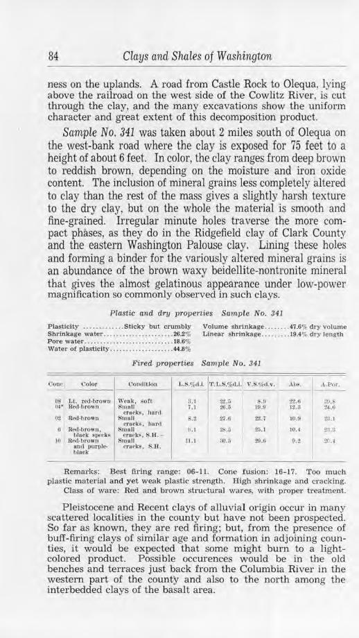
84 Clays cind Shales of Washington
ness on the uplands. A road from Castle Rock to Olequa, lying above the railroad on the west side of the Cowlitz River, is cut through the clay, and the many excavations show the uniform character and great extent of this decomposition product.
Sample No. 341 was taken about 2 miles south of Olequa on the west-bank road where the clay is exposed for 75 feet to a height of about 6 feet. In color, the clay ranges from deep brown to reddish brown, depending on the moisture and iron oxide content. The inclusion of mineral grains less completely altered to clay than the rest of the mass gives a slightly harsh texture to the dry clay, but on the whole the material is smooth and fine-grained. Irregular minute holes traverse the more compact phases, as they do in the Ridgefield clay of Clark County and the eastern Washington Palouse clay. Lining these holes and forming a binder for the variously altered mineral grains is an abundance of the brown waxy beidellite-nontronite mineral that gives the almost gelatinous appearance under low-power magnification so commonly observed in such clays.
Plastic and dry properties Sample No. 341
Plasticity ..... . ....... Sticky bul crumbly Volume shrinkage . .... . .. 47.6% dry volwne Shrinkage water ...................... 26.2% Linear shrinkage . ...... . . 19.4% dry length Pore water ......... . ......... .... . ... . 18.6% Water of plasticity ................. .. . 44.8%
Fired P'T'Operties Sample No. 341
()one t'o.lor Oon,lftlou L. ,o/o< I.J· l:·L.S.%d.l. V.$.%, l.1•. . Ah~. .\ .J>,,r .
OS Lt. rcd•brown Wettk, soft 3. l 2:! .;; .o 22.0 !.:!).~ 4~· Red·bl'OWU $moll ; .1 26.5 19.9 12.!l 2-1. t,
crufk~. hu r,I O'l Rctl-hrown Smull S.2 27.0 22.7 10.ll l?~:. l
en1e1<.s. hur,I 0 Rctl..-hrowu . Smull !U :?b.O 20.l 10. 1 2:1.:1
10 hluck ~peck~
R,•,1-hrown c•roek~. S.li. -
Smull 11. 1 :;o.r, 29.U 0.2 :?r .~ and purple-hlttek
cnrks. !U:l.
Remades: Best firing range: 06-11. Cone fusion : 16-17. Too much plastic material and yet weak plastic strength. High slirinkage and cracking.
Class of ware: Red and brown structural wares, with proper treatment.
Pleistocene and Recent clays of alluvial origin occur in many scattered localities in the county but have not been prospected. So far as known, they are red firing; but, from the presence of buff-firing clays of similar age and formation in adjoining counties, it would be expected that some might burn to a lightcolored product. Possible occurences would be in the old benches and terraces just back from the Columbia River in the western part of the county and also to the north among the interbedded clays of the basalt area.
Douglas County 85
Dromore Pottery.-The Dromore Pottery is on Highway No. 99 just north of Kalama. The clay used is from the A. B. pit, Stevens County, and is obtained by truck from clay shipments sent to Portland, Oregon, by railroad. The clay is hand washed, screened through 60 mesh, allowed to dry to proper plasticity, and aged. The ware, ornamental pottery, is formed by kickwheel and by casting, dried in the open air, and fired in two kerosene-fired up-draft square kilns of 36-inch inside dimensions. Glazes are mixed in a pebble mill and applied after the usual preliminary "biscuit" firing.
DOUGLAS COUNTY
Douglas County is in the central part of the State and has an area of 1,787 square miles. It is a rolling plain and plateau region flanked on the west by the lower Cascades and on the north by the Okanogan Hjghlands. The bedrock of the county is basalt except in a few places where the Columbia River and a few short tributaries have eroded through to underlying older rock. The northern part of the county is mantled with glacial drift and surficial deposits that are mostly gravelly and of little value for clay materials. South of that area the surface is sandy loess, probably with some residual basaltic clay, and, rather generally, can supply a material suitable for common red-fired structural ware. A brick yard operated at one time at Waterville on this sandy clay.
Near the Columbia River, across from Wenatchee, erosion has cut through the basalt to the Swauk formation, exposing a small area of sandstones and very high-grade refractory shales. These beds are a part of the extensive series occurring in Chelan County which is more fully described under that county heading. The Douglas County beds are best exposed about 400 feet above the river near the foot of the steep bluffs in the SEl4NW~ sec. 23, (23-20 E ) . Occasional outcrops extend for about 11h miles to the south and, concealed beneath the glacial sediments, the Swauk formation may underlie much of the broken bench land west of the basalt cliffs almost as far south as Rock Island.
The contact of the series with the underlying biotite gneiss is well exposed in the NE%NW% sec. 23, (23-20 N) . From there the Swauk rocks thin out to the north and the outcrops are only remnants left high on the bluffs of metamorphic rock. Some 600 feet south of the first large gneiss outcrops is an abandoned quarry-pit, 40 feet in diameter, whose 25-foot face exposes both the Swauk sandstone and the underlying gneiss. The sandstone is broken and disintegrated; the gneiss, decomposed and kaolinized. Intruding the gneiss, irregularly expanding at the contact, and cutting a short distance into the sandstone is an
86 Clays and Shales of Washington
intrusive material probably on the order of rhyolite. Some of this is merely disintegrated and is composed of quartz, partially altered feldspar, and a small amount of muscovite; much of it, however, is decomposed, probably hydrothermally altered, to a bluish-green sericite and the white, kaolin mineral, halloysite. The latter when damp is waxlike, though but slightly plastic; when dry it is hard, brittle, and has the color and texture of unglazed porcelain. It appears to be a further alteration of the mica and occurs between the quartz grains in the body of the rock and as rather pure segregations and veins as much as 2 inches thick.
Another old pit was opened 100 feet to the south. This shows rock relations similar to the first and, as well, a 1- to 3-foot quartz vein, with subordinate £eldspar entirely altered to kaolinite, that cuts through the gneiss and for 6 feet into the sandstone before it lenses out.
South of these pits for 800 feet are excellent exposures of the near-basal sedimentary beds. The structure varies somewhat, and it is probable that there has been some dislocation through slumping or, possibly, faulting; in general, however, the strike is parallel to the bluff (N. to N. 10° E. ) and the dip is about 10° easterly or into the hill. A stratigraphic thickness of about 100 feet is exposed here and in cuts along a county road running east through the center of section 13; higher beds are concealed by Pleistocene silts, sands, and gravels. The members are moderately well indurated shales and sandstones, mostly buff and gray but in places showing unusual variations of color from blood-red to delicate lavender.
Several of the argillaceous strata are light firing and more or less refractory; while one of the lowest beds exposed, a member 22 feet thick, is of exceptional quality and has been extensively mined. Though somewhat laminated at the outcrop, this lower bed has but little shaly structure underground; it is a hard smooth bluish-gray claystone, very "fat" and waxy. Parts of the bed, particularly in the upper half, are carbonaceous, dark gray and brown in color and contain numerous leaf imprints. Also in the~e portions is considerable coaly matter, ranging in quantity from minute layers and lenses to occasional segregations of black blocky coal as much as 2 feet thick. The bed, near the tunnel portal, is all a No. 1 fire clay, but farther in the hill the upper 12 feet is less pure, contains scattered coarse angular sand grains, and ranks as a No. 2 refractory. The lower 10 feet remains of very high quality, however; it has an average cone fusion of 34, and some parts, not commercial in quantity, reach cone 35.
Wenatchee clay mine.-Rather extensive mining has been
Ferry County 87
carried on here by Gladding, McBean & Co. for a number of years. Part of the time the lower refractory shale was quarried along a 550-foot face. This work became increasingly difficult as the face, now 40 feet high in places, exposed more and more of the upper, unwanted beds. To overcome this, a drift was driven in a S. 86° E. direction for 150 feet into the hill. This forms a main haulageway, and the bed has been mined by rooms and pillars extending both to the north and south. The underground work is not free from trouble. however; to mine the whole bed requires a 22-foot roof, and this, naturally, is hard to hold and requires close timbering. Much of the clay to the south has been lost through caving, and it is probable that drifts to the north shortly will be terminated by a small fault that may necessitate driving a new entry.
The company operates the property about 30 weeks per year, shipping one car (25 tons) per day of the No. 1 or No. 2 fire clay and occasionally a car of soft clflyey arkose, called "Wenatchee sandy", that overlies the shale stratum. All are used at Renton for refractories, the "sandy" being useful to counteract the high shrinkage of some clays and to give a more porous, open body.
FERRY COUNTY
Ferry County is in the northeastern part of the State and has an area of 2,220 square miles. The region is a part of the mountainous Okanogan Highlands, and many different formations are present. Some of the rocks are metamorphic varieties such as slate, quartzite, and schist and would not be expected to produce useful clay materials either in their original form or upon decomposition. But other very extensive formations are composed of granite and related rocks that could be a source of excellent clays. That no high-grade clays have been found in the county may be due to their rapid removal by erosion in this area of considerable relief, or it may be because the interest of prospectors is in metallic rather than nonmetallic minerals.
In the vicinity of Republic is an area several square miles in extent of Tertiary lacustrine sediments. These are spoken of by Umpleby<D as being buff to grayish-brown finely laminated sandstones, shales, and tuffs, of predominantly fine grain. The shale is largely tuffaceous, and this lowers its value for ceramic use by making the flux content excessive and also making the material red firing.
A brick yard operated at one time near Republic on a scant deposit of yellowish-gray clay which occurs about 3 miles west of town. A very good grade of common brick was made.
(!) U mpleby . Joseph B .. Geology and ore deposits of Republic mining district : Washington Geol. Survey Bull. I. p . 24, 1910.
88 CLays and Shales of Washington
The rock around Republic has been considerably faulted, and "fault gouge" is commonly encountered in the mines of the district. This is a gritty clay, sometimes called "talc" by miners, that is formed by the decomposition and, in some places, the hydrothermal alteration of the crushed rock of brecciated zones. The material was investigated, not because of possible economic value, but rather to ascertain the physical properties of an unusual clay type. A sample was taken in the Quilp mine, one of the many gold properties of the Republic mining district, at a place on the 100-foot level 90 feet north of the old Quilp shaft. Here, a kaolinized shear zone in andesite is from 4 to 5 feet wide and dips 55 ° NE. to an unknown depth below the surface.
Sample No. 151, of the gouge, is light blue when damp and fresh but dries to a very light greenish gray. The groundmass is a very fine unctuous material composed of sericite and kaolin, but lumps of the clay are harsh from included angular frag-ments of rock which have only been partly altered. Crystals of secondary pyrite are disseminated throughout.
Plastic and dry properties Sample No. 151
Plasticity ..... . . . ...... . . .. .. . . . .. . . .. Good Volume shrin kage .. . ... . . 55.0% dry volume Shrink.age water ...... ... ........ ... .. 33.5% Linear shrinkage .. ... .... 22.5% dry length Pore water .. . ........... .. ....... . . . .. 14.5% Water of plasticity ... .. . . ...... . . .... . 48.0%
Co11c Color
fill Duff-brown 03 Red·l)rown
:H• Oark buff· hrowu
u Grny-lJrown
Fired properties Sample N o. 151
Oond!tlon
Uud acu 111. s:a .Good. S. li. B11(1Jy swelled.
s El . 13udly swrlled,
8 Ii.
J,.!l.%11.l. 1'1'.L.S.%d.l. V.8.%d,v.
;;.u 2 . I 1,.s
-:t-1.it - 2.V I 00.0
Abs. .\ .Por.
11.4 l l>.6 1.5 9.ll
JO .;; Z.U i
4C .U 40.0
Remarks: Best firing range: 08-02. Cone .fusion: 8. (Sample was washed be.l'ore testing.) 58 % residue on a 200-mesh sieve.
Class of ware: Possible red and brown structural wares if not washed.
During Pleistocene time a considerable thickness of glacial sediment was deposited in Ferry County. The silts that occur in terraces along the larger rivers are chiefly composed of rock .flour formed by the grinding action ot the ice, but some contain a high percentage of volcanic dust.
Sample No. 150 was taken from a railroad cut on the Great Northern Railway just south of Rockcut and is representative of silts occurring at many places along the Kettle River as far as Laurier. This deposit extends along the track to a height indicative of an immense amount of material. It is gray in color and not as fine as the silts occurring farther south. The deposit is
Franklin County 89
stratified, and many small concretions are present. Under a microscope the sample shows angular fragments of quartz and feldspar, a small amount of femic minerals, and a low percentage of volcanic dust. Very little actual clay substance is present.
Plastic and dry properties Sample No. 150 Plasticity ...... .. ............... Very weak Volume shrinkage ........ 9.9% dry volume Shrinkage water ...... . ............... 6.1% Linear shrinkage ...... . .. 3.4% dry length Pore water ... ... ....... .. ...... . ...... 20.1% Dry condition . ...... .. ... Weak, sandlike Water 0£ plasticity .................... 26.2%
Fired properties Sample No. 150
Cone Color Conclltton 1..8 o/.,tl.l. '1'.L.S.%d.J. V.S.<;,i d.v. Abs. A.Por. -- ---!---·-------- -
OS J'alfstopowcler ........................................................ 1 ........... . . .. .. ... .. . . 0'2 Orown N,•ar ru~lon, 11.l !t.;; 17 .1 I 12..2 · 2Lll
G-7' Brown-l>lutk F~::.r. ....... ..... .... ... .. .. . ............ O.!I 2.0 veslrular, $.H.
Remarks: Best firing range: 04-03. Cone fusion: 2. Weak plastic and dry strength; slow to develop fired strength; very short vitrification range.
Class of ware: Slip clay.
FRANKLIN COUNTY
Franklin County lies between the Snake and Columbia rivers at their junction, in the southeastern part of the State. It has an area of 1,206 square miles, including plains, broad rolling hills, and steep-walled coulees. Columbia River basalt is the bedrock of the county, but overlying it in many places and covering a considerable area are sediments of the Ringold formation. Overlying these and forming the surficial deposits of the county are eolian sands, silts, and silty clays. The clay content of the surface materials is decidedly variable from place to place but, in general, is higher in the northern part of the county. The widespread, and in places, thick deposits of yellowish-brown silty surface clays are less plastic than the clays of regions farther east, but they may be used for common brick and tile. They have properties similar to the Palouse clays and are the usual sandy western phase of those clays.
The Ringold beds, because of their striking light color, have received some mention as possible ceramic materials, and reports are current of high-grade clays occurring in the formation. For this reason they were examined in considerable detail, but the results obtafoed failed to bear out the various stories. They are excellently exposed on the east side of the Columbia River from Wahluke to within 12 miles or so of Pasco, a distance of nearly 30 miles. In this area of the type section the strata are known as the White Bluffs, from their general light color. The
90 Clays and Shales of Washington
exposure has resulted from the river cutting into the horizontal lacustrine sediments to a depth of more than 500 feet. The beds continue several miles eastward from the Columbia, but thin out as the underlying basalt attains greater elevation. They extend west of the river, but most of that part in Benton County has been removed by the Columbia during a time when it was cutting to the west of its present channel.
Early writers correlated this spectacular series with the Ellensburg formation, but Merriam and Buwalda0 , on paleontologic evidence, give the age as late Pliocene or Pleistocene, show it to be distinct from the older Ellensburg, and suggest the name Ringold for the formation. The series is made up mostly of fine-grained sands, silts, and clays, though it does contain some coarse gravel. Mechanically formed material is far in excess of decomposition products, and the silts and clays include large amounts of volcanic dust; so little, li any, high-grade clay is present. Individual beds stand out prominently when viewed from a distance and may be traced a long way on the face of the bluffs; but when a near examination is made the line of demarcation between strata is indistinct, and sections measured at points 2 or more miles apart may not check except in a most general manner.
A traverse made from the SE1;4SE~ sec. 33, (13-28 E ) to the top of the bluffs in the NW~ of the same section provided the following stratigraphic section:
Section near Hanford Feet
Loose gray clayey sand. . . . . . . . . . . . . . . . . . . . . . . . . . . . . . . . . . . . . . . . . . . . . . 25 Gray caliche: very compact.... ................ ... . . . . . . . . . . . . . . . . . . . . 3 Light-buff clay. Contains some ash and fine sandy clay. (Sample No.
11-A) . . . . . . . . . . . . . . . . . . . . . . . . . . . . . . . . . . . . . . . . . . . . . . . . . . . . . . . . . . 75 Reddish-brown sand . . . . . . . . . . . . . . . . . . . . . . . . . . . . . . . . . . . . . . . . . . . . . . . . 6 Yellow clayey sandstone: loose............ . . .... . . .. . .......... . ..... 75 Nearly white thin-bedded volcanic ash...... . ............. ....... . .... 15 Sand. Contains resistant iron-stained layers....... . . . . . . . . . . . . . . . . . . . . 50 Thin-bedded light-gray to yellow sand. . . . . . . . . . . . . . . . . . . . . . . . . . . . . . . . 30 Gray clayey silt. (Sample No. 11-D) . . . . . . . . . . . . . . . . . . . . . . . . . • . . . . . . . . 50 Sand and silt, including some gravel. ......... . . . . . ................... 100 Covered by reworked material of old river bench . . . . . . . . . . . . . . . . . . . . . . 75
504 Water level
© Merriam. J . C .. and Buwalda. J.P. , Age of strata referred to the Ellensbul'g formation in the Wnite Bluffs of the Columbia River : Univ. of California Publications, Bull. o/ the Dept. of Geol. vol. 10, no. 15, 1917.
Franklin County 91
Certain of the above beds are better consolidated than the rest and stand out in vertical faces, but most of the material is not very compact and so slumps easily. If it were not for the aridity of the region the cliffs could not stand long.
Sample No. 11-D was taken from a 50-foot bed of gray clayey silt. It is very fine-grained and free from sand and has consolidated into a rather compact bed.
Plastic and dry properties Sample No. 11-D Plasticity ........ . ....... .... ... ... . .. Fair Volume shrinkage . . .... .. 19.6% dry volume Shrinkage water .. . .. . .. . ... . . .... . ... 13.2% Linear shrlnkage . .... . . ... . 7.1% dry length Pore water .... . ...... . .. . ....... . ... . . 28.6% Linear shrinkage ...... . ... . 7.7% wet length Water of plastlclly . •. ... . .. • .... . ..... 41.8%
Fired propert.ies Sample No. 11-D
ConP C'olor Conclltlon __::fl.%d.J. 'L'. l,.S.o/c><l.l.1 \',S.%d.v.1 __ A_bs_. ___ A_.P_<1~
118 8uff-rc,l Folr , ~011 n1 Lt. bull-hrown ('loo,I. hard m U. r~rl-hrown (10 0,1, hard 01 Dark ri'll•hr()wr Neur
,·u rcow•. s. a.
t.:1 9.4 21\.2 22.0 H.{I 0.0
11.0
0.0
Remarks: Best firing range: 04-01. Cone fusion: 6. High shrinkage, poor plastic and dry properties; short firing range.
Sample No. 11-A, from a 75-foot bed of light-buff clay, is also very fine-grained but contains considerable volcanic dust.
Plastic and dry properties Sample No. 11-A Plasticity . . ......... ... ...... . ..... . .. Good Volume shrinkage . . . . .... 26.2% dry volume Shrinkage water .. ...... . . . ........ . . . 16.1% Linear shrinkage .. .... . .. 9.6% dry length Pore water ...... . ..... . . . ....... .... . . 22.7% Linear shrinkage . ...... . . 6.5% wet length Water of plasticity . ..... . .... . .... .. .. 38.8% Ory condition ....... . . . . . Porous. weak
Fired 'f)'Toperties Sample No. 11-A
Oone Color Condition L .S.%11.l. 'l'.L .S.o/od .l. V.S.%<1.,,. Abs. A.P or.
010 BulT•hrOWll W~ttk , \ T('f)' 11.t:, IOA 2.5 2"l.a :u .; f Ofl
07 Rcd-hutT Good. IJghL :l.4 13.0 9 .~ :!0.1 33.i. scum, her,1
........ . ... 1 ............ . . . . .. ...... 03 Dark rcd,hrown Good. S.11.. 2.1 fl.2 ~2 Dark rrd,hrowu $rum: near 14.i> :/,I . I 37.S o.o o.o
vltr,,oui , RU.
Remarks: Best firing range: 07-02. Cone fusion: 6. Class of ware: Common red-brown structural wares by the addition of
non-plastic material to reduce high shrinkage.
A traverse was made from a point just north of the old Ringold School, at about the center of sec. 14, (14-28 E) up a coulee to the top of the bluffs, following a general N. 65 ~ E. direction. The material here, although similar, is more affected by weathering than that of tbe preceding location; hence outcrops
92 Clays and Shales of Washing ton
do not show as prominently, and dependable measurements and determinations are more difficult to obtain.
SecHon near Ringold Feet
Loose light-buff clayey sand. . . . . . . . . . . . . . . . . . . . . . . . . . . . . . . . . . . . . . . . . . 75 Alternate strata of loose and very resistant coarse calcareous sandstone.. 25 Light-buff clayey silt; very fine, even textured, in part sandy and con-
taining volcanic ash. (Sample No. 12-D)...... . . . . . . . . . . .. .. .. .. .. 75 Ligbt yellowish-gray clay; thin-bedded. (Sample No. 12-B)....... ... ... 15 Light-gray unconsoUdated micaceous sand. Contains resistant iron-
stained layers . . . . . . . . . . . . . . . . . . . . . . . . . . . . . . . . . . . . . . . . . . . . . . . . . . 50 Light-buff fine thin-bedded sandy clay and ash. . . . . . . . . . . . . . . . . . . . . . . . . 50 Alternate strata of greenish clay, sand, sandstone, and gravel with pebbles
up to 3 inches. . . . . . . . . . . . . . . . . . . . . . . . . . . . . . . . . . . . . . . . . . . . . . . . . . . 50 Dark greenish-gray smooth clay. Some sandstone partings included. . . . . 15 Dark greenish-gray clay; smooth and fine. (Sample No. 12-A) .......... 12 Fine-grained ash, in part calcareous and resistant; bedding distinct. . . . . . 15 Concealed by slide material. . . . . . . . . . . . . . . . . . . . . . . . . . . . . . . . . . . . . . . . . . 80 Covered by reworked material of old river bench.. . . . . . . . . . . . . . . . . . . . . 55
517
Water level
Sample No. 12-A was taken from the 12-foot bed mentioned in the above stratigraphic section and was the best-appearing clay seen in the writer's examination of the White Bluffs, yet it proved unsatisfactory for ceramic use. Allowing for the few sandstone partings in the overlying bed, there is a thickness of about 25 feet of this clay that is very uniform in color and texture. It is gray with a slightly greenish tone and is quite dark when fresh. It is soft and has a smooth, waxlike feel but contains a small amount of grit.
Remai·ks: Only a fair plasticity was developed with 66.3 percent tempering water. Cracking and high shrinkage render the clay unfit for commercial use alone. The cone fusion is cone 6-7, and the fired color is a red-brown.
Sample No. 12-B, from a stratum 10 to 20 feet in thickness, is a very light yellowish-gray clay that is nearly white when dry. It is free from grit and fairly smooth but probably contains volcanic dust in a very finely divided state. The material is excellently bedded and is compact enough to break in great blocks showing smooth fractures.
Remarks: The plastic strength is poor. High shrinkage combined with cracking renders the sample, alone, unfit for commercial ware. The cone fusion is 7, and the fired color is red-brown.
Sample No. 12-D from a 75-foot stratum is a very fine eventextured clayey silt that is light buff in color and weathers to
Franklin County 93
gray. The material is thin-bedded and contains sandy portions and some ash.
Plastic and dry properties Sample No. 12-D l;'lasticity . ... .. .... ... ....•.. . Fair, crumbly Volume shrinkage ..... ... 17.0% dry volume Shrinkage water ............... ... ... . 10.6% Linear shrinkage ......... 6.0% dry length Pore water ............................ 23.4% Linear sbrlnkage ..... . ... 7.1% wet length Water of plasticity ............... .. ... 34.0% Dry condition ... ... ...... Porous, weak
Fired properties Sample No. 12-D
Color Condition L.S,%tl.1, l'l'.1,.S.%tl.l. \' ,S,<J?d.v. ~ ,_A_.P_o_r. _
1110 Bu ff brown \,\"fluk , ~<·L1111. t>.O G.O 0.0 :!j.i ,rer)' :ioft
o, Rcd· hulT \\'eak.~1·11in,solt 1.0 i .O 3. l Ill R<•d-bnlT Good. F<·mn, h11rrl .............. . ... . ... .. , .. ...... .. . . fl'.? Dark r~d -hrown Goon, scum, $.li. ia.o 19.0 34.2
s-1• Dnrk n•d,hrow11 Vitr,,011~. $.B. .. .................... .. .......... ..
2Ul J7.:; 4 .2 0.0
:lS.5
:JS.ii
0.6
Remarks: Best firing range: 03-2. Cone fusion: 5-6. High shrinkage, rapid change after cone 07, poor plastic and dry properties.
About 31h miles south of the Ringold School on the line between T. 11 and 12 N. , R. 28 E., the river has cut into the east bank, exposing the lower beds of the series which are in most other places concealed by old river benches and colluvial materials. This lower part is made up of alternate beds of coarse well-rounded and .flattened gravels and poorly assorted sands. The member exposed at water level is over 40 feet in thickness and is composed of gravel averaging about 3 inches in diameter (maximum 12 inches), in a matrix of clayey sand. For the first 100 feet the materials are greatly iron stained, and this, with the concretionary sandstone layers and the general coarse character of the sediments, offers a striking contrast to the strata of higher elevation making up the bulk of the White Bluff series.
Sample No. 14-B was taken from a 10-foot stratum exposed in a coulee in the S1h sec. 1, (11-28 E ) at an elevation of about 130 feet above the Columbia. It is a soft greenish-gray clay practically identical with sample No. 12-A, perviously noted. At this point the clay is immediately overlain by a 10-foot bed of very compact light-gray ash, above which are 300 feet of silts and sands. Below the clay sampled lies a sandy gray clay that grades in 30 feet through clayey sand to pure sand. Gravels and red sands form the outcrops from that point down the coulee to the river.
Plastic and dry properties Sample No. 14- B Plasticity . . ........ .. ...... ........ . . Sticky Volume shrinkage ........ 86.2% dry volume Shrinkage water .. . ......... . . ........ 42.5% Linear shrinkage .... ..... 35.2",, dry length Pore water . ... . .. .. ..... . .... . ....... . 12.9% Linear shrinkage ......... 12.5% wet length Water of plasticity . .. ....... . . . ...... . 54.8% Ory condition ............ Cracked badly
94 Clays and Shales of Washington
Fired properties Sample No. 14-B
Cone Color Condition L.S%1l.l. '.l.'.L.S.o/o!l.l.1 V.S.~tl.,,. Abs. A.Por .
[11 Buff-hrown 13allly cn1ck~d, $.H.-
5.3 4.0.5 Ji,.l 0.7 19.0
,~ Red-brown Badly mickert, .o -13.2. 22.l 1.2 2.i vltreouF. no fl1sion. S.H.
Remarks: Best firing range: 08-02. Cone fusion : 9. High shrinkage, cracking.
Class of ware: Alone, il is unfit for commercial wares.
In utilizing individual beds of the White Bluff clays, recourse would eventually be necessary to underground mining methods, although for a time a large tonnage could be secured from some of the members by quarrying the outcrops. As the beds are very thick a great amount of material could be easily handled by a series of drifts and stopes. With a high-grade clay the expense of operating and of bringing needed timber for this work into the region would not be prohibitive, but the common clays that do exist here would not warrant such treatment.
GARFIELD COUNTY
Garfield County is in the southeastern part of the State, south of the Snake River, and has an area of 694 square miles. High rolling plateau country borders the Snake River on the north and merges into tbe Blue Mountains on the south. The river, in one place, has eroded through 2,000 feet of Columbia River lava and has exposed underlying granite, but nearly everywhere else basalt forms the bedrock of the county. Eolian deposits of red-firing clay together with some residual materials, all classified under the general term Palouse clay, overlie the basalt and form deposits which in most places are very thick. Quite generally, such material is suitable for ordinary brick and tile. So far, however, the only use made of local clays was in a small yard, operated at one time at Pomeroy. This was a grayer, more silty clay than is usual and probably the bed was of Recent alluvial origin.
GRANT COUNTY
Grant County, with an area of 2,720 square miles, is a semiarid region of plains and rolling hills in the central part of the State. The conditions here, bearing on clay resources, are very similar to those of Franklin County. The bedrock basalt is exposed in many coulees and scabland areas, but is mostly covered by a variable mantle of silty eolian material. Gravels
Grant County 95
occur over a small area in the north-central part, and there the finer surface deposits are predominantly sandy.
Large deposits of diatomite occur south of Quincy and have associated with them some smooth light-gray to greenish-gray clays. Such clays no doubt will be found in greater abundance as the diatomite beds are more fully developed, but they have no particular value for ceramic ware, as they are red-firing and have high shrinkage. Similar clays, occurring above the diatomite of Squaw Creek, Kittitas County, were tested and the results are given on page 166.
As in Franklin County, great thicknesses of well-stratified sediments overlie the basalt in some places. These beds are excellently exposed along the Chicago, Milwaukee, St. Paul & Pacific Railway at the foot of the Saddle Mountains, in the southern part of the county. The basalt, here, forms a great escarpment that rises precipitously to a height of 2,000 feet above the coulee floor of Crab Creek. For several miles in the vicinity of Corfu and of Taunton, Adams County, erosional remnants of a one-time very extensive sedimentary series show on the mountain side. That the beds are correlatives of the Ringold formation of White Bluffs is indicated by the lithology and general relations. The following section was measured one-half mile west of Corfu where the strata were particularly well exposed. The strike here is S. 70° E., with a dip of 5°-10° NE.; however, the variation from the horizontal may be due to possible landslip.
Section near Corfu Feet
Sandy, eolian surface material ....................................... 5-10 Conglomerate; subangular basalt cobbles with calcareous cement. . . . . . . 15 Unconformity Even-grained buff-colored silt. (Sample No. 1).. . . . . . . . . . . . . . . . . . . . . 30 Loose red sand. . . . . . . . . . . . . . . . . . . . . . . . . . . .. . . . . . . . . . . . . . . . . . . . . . . . . . 2 Fine loose conglomerate and loose sandstone .......................... 6-12 Brownish-yellow sandy clay; uneven texture..... .................... 5 Buff-colored silt, as above. . . . . . . . . . . . . . . . . . . . . . . . . . . . . . . . . . . . . . . . . . . 6 Concealed . . . . . . . . . . . . . . . . . . . . . . . . . . . . . . . . . . . . . . . . . . . . . . . . . . . . . . . . . 10 Dark-green fine-grained clay (Sample No. 2), containing calcareous
concretions and a 1-foot parting of ash. . . . . . . . . . . . . . . . . . . . . . . . . . 4 Buff-colored fine thin-bedded clayey sandstone....................... 25 Very coarse gray, green, and red sandstone, grading into conglome1·ate
at base . . . . . . . . . . . . . . . . . . . . . . . . . . . . . . . . . . . . . . . . . . . . . . . . . . . . . . . . 10 Alternate strata of light-bufl' and gray clayey sand and sandy clay. . . . . . 20 Basalt to railroad track, about.. . . . . . . . . . . . . . . . . . . . . . . . . . . . . . . . . . . . . . 280 Basalt to valley floor, about......................................... 80
(Approximate) 500
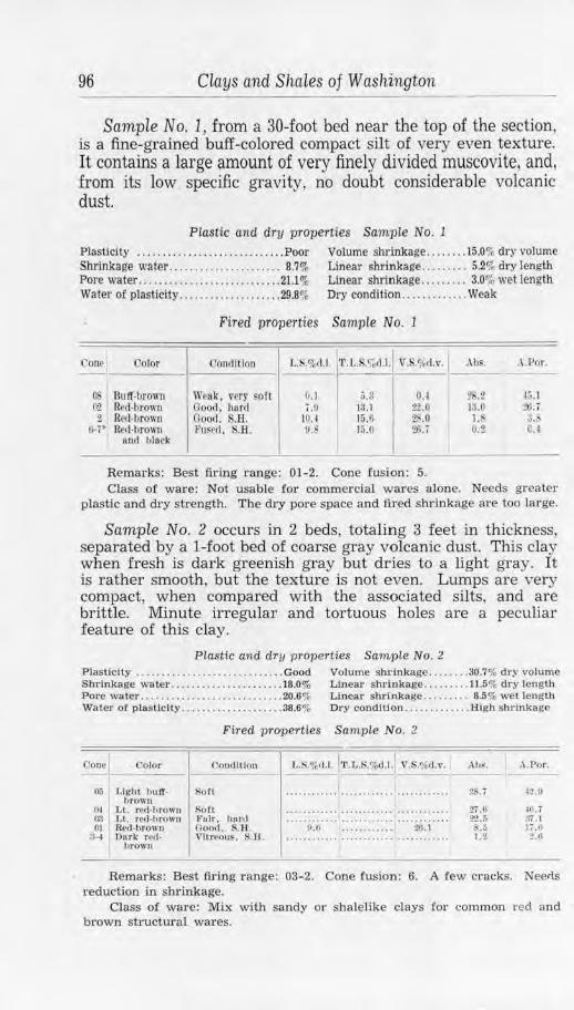
96 Clays and Shales of Washington
Sample No. 1) from a 30-foot bed near the top of the section, is a fine-grained buff-colored compact silt of very even texture. It contains a large amount of very finely divided muscovite, and, from its low specific gravity, no doubt considerable volcanic dust.
PLa.stic and dry properties Sample No. 1
Plasticity ..... ..... . .................. Poor Volume shrinkage ........ 15.0% dry volume Shrinkage water ........ .. ............ 8.'7% Linear shrinkage .. . . .... . 5.2% dry length Pore water ...... ......... ............. 21.l % Linear shrinkage ...... . .. 3.0% wet length Water of plasticity .................... 29.8% Ory condition ............. Weak
Fired properties Sample No. 1
Cone Color <.:onrlitton L.S.o/0d.l. 1'1'.L.S.%11.L V .S.<,{,tl.\•. Abs. 1 . Por. I --
~ Buff-brown \\'rak, 11ery soft (I.I 5.!l o.~ %.2 15.1 {',2 Ht•d-brown Good, bunl i.O 13.1 22.0 13.0 itl.7 2 Red-brown Good. S.B. JO. I 15.6 2 .0 1. :J.1'
tH• Red-brown FUFPII, KH. !I. l:i.O W.i 0.2 0. 1 ltnd black
I
Remarks: Best firing range: 01-2. Cone fusi-0n: 5. Class of ware: Not usable for commercial wares alone. Needs greater
plastic and dry strength. The dry pore space and fl.red shrinkage are too large.
Sample No. 2 occurs in 2 beds, totaling 3 feet in thickness, separated by a 1-foot bed of coarse gray volcanic dust. This clay when fresh is dark greenish gray but dries to a light gray. It is rather smooth, but the texture is not even. Lumps are very compact, when compared with the associated silts, and are brittle. Minute irregular and tortuous holes are a peculiar feature of this clay.
Plastic and dry properties Sample No. 2 Plastic! ty ........... . ........ . ........ Good Volume sbrlnkage ........ 30.7% dry volume Shrln kage waler ...................... 18.0% Linear shrinkage ......... 11.5% dry length Pore water . ...... . ...... .... .. ........ 20.6% Linear shrlnkage . . ....... 8.5% wet length Water of plasticity .......... . . . ....... 38.6% Dry condition .......... .. . HJgb shtlnkage
Fired p roperties Sample No. 2
Co1w 0olor (.'ontllllon ~%1i.1.1::,1,.S.%tl.l. l V.S.<;ktl.v. :--A _h~_. ___ ., _.P_o_r. _
Oo Light llU IT· hrowu
0-1 Lt. red-brown fl(! l,t. re<l -hrom1 01 Rt1,l-brown
;H Durk rod · litO\Vll
!>O(l
Rott J?afr, h11nl noo•I. S.ll. Vltn•ou~. S.H.
~.I) 21;.1
u..r 27. 0 22.(i ..
l "'
42.ll
111. 7 ::1.1 1,.11 :!.ti
Remarks: Best firing range: 03-2. Cone .fusion: 6. A few cracks. Neerls 1·eduction in shrinkage.
Class of ware: Mix with sandy or shalelike clays for common red and brown structu1·al wares.
Grays Harbor County 97
The Ringold beds are situated so that mining would be relatively cheap; and certainly great tonnages are available. but none is of a quality suitable for other than the commonest redfiring ware, and great care would be required in their use even for such products.
Other clays interbedded with basalt occur between Corfu and Taunton. Some of these are smooth, plastic, and appear to be of good quality, but they are all red-firing and of high shrinkage. Although it is not known that these belong to the Ellensburg formation, they are interbasalt, similar in most respects to typical Ellensburg clays of Yakima and Kittitas counties, and may be tentatively correlated with them.
Two other clay types occur in Grant County in the vicinity of the Grand Coulee dam. One forms erosional remnants on the granite at the head of Grand Coulee. It has been correlated by BerryCD with the Latah formation and doubtless has ceramic properties rather similar to those of the red-firing shales of the Spokane region. The other occurs in the river gorge and possibly also at higher elevations. It is a well-bedded, in places finely laminated or varved, soft bluish-gray clay with interbedded silty phases. Such material accumulated to considerable thickness during a ponding of the Pleistocene Columbia River. Most of the deposit has been removed by erosion, but large remnants remain that are suitable for ordinary red-fired ware. The physical properties are similar to the related silts and clays described more fully from Pend Oreille and othe1· northeastern counties.
GRAYS HARBOR COUNTY
Grays Harbor County borders the Pacific Ocean in the westcentral part of the State and has an area of 1,927 square miles. The topography varies from lowlands and rolling hills in the southern part along the ocean to the high mountains of the Olympics to the north. This latter more inaccessible area is made up of extrusive rocks and sediments which have been more or less metamorphosed to greenstone, argillite, and quartzite These rocks do not contain usable shales and are not associated with clays that are valuable for ceramic purposes. Elsewhere, however, the bedrock is sandstone, sandy shale, and shale, with some interbedded basalt and pyroclastic material, and useful clay materials are abundant.
Throughout some 800 square miles, which includes the whole area of greatest development and population, various Tertiary sediments crop out or underlie a mantle of residual soil or Pleis-
(j) Berry, E. W .. A Miocene flora from Grand Coulee, Washington : U. S . Geol. Survey Prof. Paper 170, pp. 31-42, 1932.
-4
98 Clays and Shales of Washington
tocene sediments. The lowest, of Eocene age, are rather tuffaceous and contain interbeds of agglomerate and basalt. The dominant formations, however, are of Oligocene and Miocene age and total several thousand feet in stratigraphic thickness. They mostly accumulated in marine embayments under varying depths of water, so the resultant rocks, though ranging from fine conglomerates to the most unctuous clay-shales, are commonly thick-bedded, and consequently a given type could be easily mined.
During Pleistocene time flood-plain deposits 0£ silty clays, sands, and gravels were spread over the older surface of Tertiary strata. The resultant aggraded plain, later uplifted, has been dissected by the many rivers until now tilted beds of shale and sandstone are exposed in many places under unconsolidated horizontally bedded alluvial sediments. These more recent clays and sands are designated by the general term of "Willapa Pleistocene deposits"; and, although probably contemporaneous with the glacial sediments which mask the bedrock in the eastern part of the county and occur throughout the Puget Sound region, they are rather different in occurrence and character.
Probably color and hardness serve best to distinguish the Willapa Pleistocene and glacial sediments. The Willapa materials are commonly stained to various shades of yellow and reddish brown, and it is only where the strata are laid open to considerable depth that unoxidized bluish-gray material occurs. Aside from the staining, there is marked decomposition of sand grains and softening and disintegration of pebbles in the gravels, only the silica grains and the quartzite pebbles having escaped some alteration. On the other hand, heavy ferric oxide stain on glacial pebbles of the Puget Sound vicinity is not common; so deep reds and browns are not characteristic, and pebbles are seldom altered except in the oldest till and there to a comparatively slight degree.
SHALES
The lower course of Humptulips River is through Willapa sands and clays, but at a place 11/2 miles east of the Humptulips post office a thick series of fine-grained dark-blue shales is exposed. These occur in the south side of the river channel for more than a quarter of a mile above the old bridge site but are covered at high water. The strata are thick-bedded. Siliceous phases are rare, but some small limonite nodules occur. Part of the exposed beds are slightly sandy, though in general the shale is "fat" and free from any but fine grit. These beds strike N. 50°-65° W. and dip from 70° NE. to nearly vertical. Back from the water, a river bench of sand and coarse gravel covers the upturned strata to a depth of 12 feet, while beyond this the
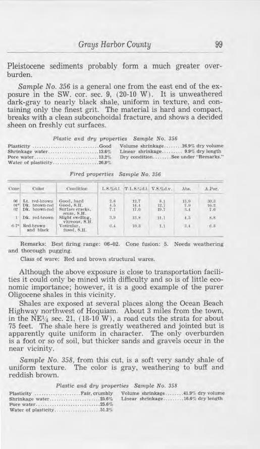
Grays Harbor County 99
Pleistocene sediments probably form a much greater overburden.
Sample No. 356 is a general one from the east end of the exposure in the SW. cor. sec. 9, (20-10 W) . It is unweathered dark-gray to nearly black shale, uniform in texture, and containing only the finest grit. The material is hard and compact, breaks with a clean subconchoidal fracture, and shows a decided sheen on freshly cut surfaces.
Plastic and dry properties Sample No. 356 Plasttcity .......... .. ............ . .•.. Good Volume shrinkage . .. . . . . . 26.9% dry volume Shrinkage water ..... . .... . .. .. ... .. . . 13.6% Linear shrinkage . .. .... .. 9.9o/, dry length Pore water ................ . .. . ........ 13.2% Dry condition ........ See under "Remarks." Water of plasticity ........... .. ....... 26.8%
Fired properties Sample No. 356
<'on~ Color ('on,lltfon L.S.% U . 1'r l.1.S.'ft<I.I . Y., .o/,,d.v. At,s. A.Por.
00 Lt. red ,brown Goorl. hnrd Z.b 12. i '\, ] 15.9 :;().:l 04· Dk. hrOll'O•rNI Good. S.H. 4 .~. 14.4 12. 7 7.9 11.1.l! lr2 Dk. hrown,rcd Surfu<.-e c·rnt\ks. i.J 17.0 10.7 :u 7.0
reum.R.n. I Dk. rcd ·llrown Slight 8W!•l)lng. !l.O 13.8 J l.1 u; s.s
vltr,~ou~, R.Ef. !>-7• R(lff-brown \'l'@lculnr, 1). 4 10.3 I . I ~. 4 ll.ll
and hlurk fused . !<.lf.
Remarks: Best firing range: 06-02. Cone fusion: 5. Needs weathering and thorough pugging.
Class o! ware: Red and brown structural wares.
Although the above exposure is close to transportation facilities it could only be mined with difficulty and so is of little economic importance; however, it is a good example of the purer Oligocene shales in this vicinity.
Shales are exposed at several places along the Ocean Beach Highway northwest of Hoquiam. About 3 miles from the town, in the NElA sec. 21, (18-10 W), a road cuts the strata for about 75 feet. The shale here is greatly weathered and jointed but is apparently quite uniform in character. The only overburden is a foot or so of soil, but thicker sands and gravels occur in the near vicinity.
Sample No. 358, from this cut, is a soft very sandy shale of uniform texture. The color is gray, weathering to buff and reddish brown.
Plastic and dry properties Sample No. 358 Plasticity . ... ...... . . . . . .. . . . Fair. crumbly Volume shrinkage .. . ..... 41.9% dry volume Shrinkage water . ... .... . ......... ... . 25.6% Linear shrinkage .. ...... . 16.6% dry length Pore water ....... . ... . ... ... ..... . . .. . 25.6% Water of plasticity ............ . ..•. . . . 51.2%
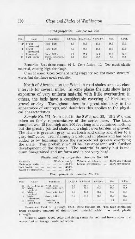
100 Clays and Shales of Washington
Fired properties Sample No. 358
rou~ Color Conc'lition L.S.%u.L '.r.L.S.'hl,l. V.S.%<1.v. Ab~. A.Por.
oi• Bright brown,recl
Good. hard u 21.2 13.2 1 .5 33.5
m Bright brown-red
Goocl. horrf 5.7 :1'2.3 16.0 15. l 27.9
6 'Brown-red Good, S.ll.- 2.u 24.0 12.2 Zl.2 10 Durk brown F8~cd. dcfonucd. . ~ 23.S 20.0 . I 14.S '·~ .. Il.
Remarks: Best firing range: 04-7. Cone fusion: 10. Too much plastic material, causing high shrinkage.
Class of ware: Good color and firing range for red and brown structural wares, but shrinkage needs reduction.
North of Aberdeen on the Wish.kah road shales occur at close intervals for several miles. In some places the cuts show large exposures of very uniform material with little overburden; in others, the beds have a considerable covering of Pleistocene gravel or clay. Throughout, there is a great similarity in the appearance of outcrops, and doubtless this applies to the physical characteristics.
Sample No. 361, from a cut in the sw1,4 sec. 28, ( 18-9 W) , was taken as fairly representative of the series here. The bank sampled was 15 feet high and 200 feet long and contained nothing but the greatly jointed shale and a slight overburden of gravels. The shale is greenish gray when fresh and damp and dries to a gray-buff color. Iron staining is profound in places and has been added to by leachings from the rust-colored gravels overlying the shale. This probably would be less apparent with further development of the deposit. The material is sandy but is medium fine-grained and uniform and is not very hard.
Plastic and dry properties Sample No. 361 Plas ticity . ..... . ..... . .. . ... Weak. crumbly Volume shrinkage ..... .. . 49.3% dry volume Shrinkage water .. • .. . . . . . .. .. ... ... .. 30.8% Linear shrinkage .. . ...... 20.3% dry length Pore water . ....... . ... . . .. ..... , .. ... . 24.8% Water of plasticity ... . . ... .. .. . . .. .. . . 55.6%
Fired properties Sample No. 361
Con(' i)olor Coudllluu L.S.%11.J. 'l'.L.!-t',c<I.I. V.S.o/c,(t.,,. AhS. A.Por.
00 l ,f. huff,l.)rown 1r1•uk , soft t.~ :?-:U i.O 20. i 34.~ (W Brigh t f't•II' fl'M k~. ~O fl :l. , 2-1.0 10.fl lS.3 31.1
hllff· r~CI ()'J ll rlghl Vew t1nwk~1 hnr•l :;. 1 z.u H.7 , .~. i 27 .s
bUff·t f d
..... ~:l'. .... 1 .. .. ~:~ .... 0 l)rlglll 00011 , S .. l:l.- 21. 11.2 :?2.2 hrown-rc,I
10 Urown Vrsicuh1r . ............ 9.7 19.2 Hncl b lMk ruscd, S.H.
Remarks: Best fu·ing range: 02-8. Cone fusion: 10. Too high shrinkage from excessive amount of fine-grained material which has weak plastic strength.
Class of ware: Good color and firing range !or red and brown structural wares, but shrinkage needs reduction.
Grays Harbo1· County 101
Similar exposures occur in the northwest corner of the same section and at other places up the river. Bluish-gray compact shales in beds as much as 500 feet thick are reported to occur in mostly low-dipping strata on the middle fork of the Wishkah River to the north of sec. 14, ( 19-9 W) . Other thick shales are reported from the higher reaches of the Satsop River, but all are too remote to be of economic importance at this time.
Five miles northwest of Montesano, on the Wynooche road, are cuts in which beds of shale are exposed, and a few others of simila1· nature occur between that point and the town. In the NEY.i, sec. 33 and the NW~ sec. 34, (18-8 W) the road, in skirting the foot of the hills, has been graded through several spurs. One such cut, 400 feet long by 18 feet high, exposes a thick shale member that strikes N. 15 E. and dips 55° NW. It is unconformably overlain by about 12 feet of horizontal lenticular Pleistocene beds which include gravel, sand, and clay.
Sample No. 362, of the shale, is a dark bluish-gray to nearly black material. It is hard and compact, uniform in texture, and slightly sandy. Clay substance is present in sufficient quantity to give a bright sheen to freshly cut damp surfaces.
Plastic and dTy pTopeTties Sample No. 362 Plastici ty . ... .. . . ........•.. . .. ..... .. Good Volume shrinkage . . .. .. .. 46.8% dry volume Shrinkage water ... .. ......... . ...... . 25.9% Linear shrinkage .......... 19.0% dry length Pore water .. . ....... ........ . ...... . .. 20.9% Water of plasticity ............. ... .... 46.8%
Fired praperties Sample No. 362
Ooo~I Color Oondflfon l,.S.o/o<Ll. 'l'.L.S.?\d.l. \'.S.o/otl.v. 1 Abf . ..l. P or.
06 LL n'<l-brow11 J~~w or11fkS. h11rd 1.3 :ia.~ 12.J H .3 w.s o~· )lotUcd hull Ft'W ,·rnclu<. l:i.H. ii.() 24 .0 14 .3 11.3 22.. ; end red
~ Ok. ret l·lirown .Few <·ruck~. ntl:-ir 5.0 2,1.6 JS.:;
I 1.0
I 1.9
fu~lon , S.ll. H•1 Dk. red-brown Ve$f!'ulnr, S.H. - :1.'l.tl - 14.G -07.3 11.0 12.3
Remarks: Best firing range: 06-01. Cone fusion: 6. Class o.f ware: Red and brown structural wares ii content of plastic
material is reduced.
WILLAPA PLEISTOCENE CLAYS
Several samples were taken from the abundant exposures of Pleistocene clay, although it is not a material suited to anything but ordinary red-firing ware. For common brick, it is usual to develop the deposit which is most advantageously situated rather than to go far afield for one of slightly better grade; so the samples are important more for general information and for comparison with the glacial clays and others of similar type than for the commercial application of the data to the particular deposit where found.
102 Clays and Shales of Washington
Two general varieties of this clay are recognized. One is a typical silty flood-plain deposit that corresponds to the mud that is accumulating at the present time in the large estuaries such as Grays Harbor. The other is more local in occurrence, is often closely associated with sand and gravel, and is a more plastic, better grade of clay. The latter corresponds to river- and lakedeposited material which may be seen accumulating in quiet water where a slight change of conditions will cause it to be covered with sand or gravel.
PLATE l
CHARACTERISTIC ROAD CUT IN PLEISTOCENE SANDY CLAY AND DECOMPOSED GRAVEL. GRAYS HARBOR COUNTY.
The upper g1;avelly member is essentially contemporaneous with I.he clays. bu~ the two are separated by an uneven erosionaJ surface. The working properties of the clay. sampled as No. 354. would be improved by the incJusion of the gravel.
A sample was taken from a road cut 9 miles southwest of Aberdeen, in the center of the N 1h sec. 32, (17-10 W) . This is on the highway and near a branch of the Northern Pacific Railway. The cut exposes a 12-foot bank of massive clay for about 200 feet along the road. The upper 6 feet is weathered and brown in color, rather sandy, and contains a few pebbles, mostly small. The lower 6 feet with base concealed is more argillaceous and has proved impervious to weathering. No pebbles were seen in this lower portion of the exposure.
Grays Harbor County 103
Scimple No. 354, from this cut, is a bluish-gray soft, silty clay that is very dark colored when damp. The texture is uniform and fine.
Piastic and dry vroperties Sample No. 354 Plasticity ...........•..... Fair, ral.her silty Volume shrinkage .. ...... 26.9% dry volume Shrinkage water .. ... ... . ... .... .... .. 17.4% Linear shrinkage ........ 9.9",. dry length Pore water ........................... . 28.001r Water or plaslicity .. . ... . ......... .... 45.4%
Fired properties Sample No. 354
Oooe Color Co111IIUon L.S.%11.l, 'l'. l,.S.<,i,1.1. Y.S.%,1.v. .\h~.
rno UulT-brown 00 Red-brown 1).1" }3rlght,
1Jrown-rc'1 OZ H,•d ,brown
2 Purple-brO\\'II
G-7• R~(I l)TOWII• hltwk
Weak, FOfl Weuk, $Oft <100,J. h11r1J
SIIA"ht •tnm, l\'OOd, SB.
(loo,I, slight slkk!u11, S.B .
. Puscd, \•esicular, S.11.
O.i
16.0
o.o
IU.tl
19.S
'.lei.~
~fl.3
?l.O
Ill. I
fl.I
0.7
.\ .Por.
:!(1,:1
0.1>
1.3
Remarks: Best firing range: 03-01. Cone fusion: 5. High shrinkage: near vitrification.
Class of ware: Red and brown structural wares.
Except in a few places, the Willapa Pleistocene sediments completely conceal the older formations for several miles back from the ocean, and even the river banks and sea cliffs are formed of the poorly consolidated sands and clays. A typical section is exposed in the 25-foot cliff at Pacific Beach. Here, under 2 feet of gravelly soil, is a 12-foot bed of gravel containing a few thin layers of clay. Below the gravel a massive clay member is exposed for 10 feet to where its base is concealed beneath the beach sands. At other places in the vicinity the gravelly bluffs extend upward to a much greater height.
Sample No. 357, taken of the clay member mentioned above, is soft bluish-gray silty material very similar to sample No. 354.
Plastic and dry properties Sample No. 351 Plasticity ............... .. ...... . Weak, silty Volume shrinkage ....... 28.6'1, dry volume Shrinkage waler .... ...... ..... .. .... 18.9% LJnear shrinkage ......... . 10.6~ dry length Pore waier ... .. ...... ... ....... .. ..... 28.8% Water of plasticity .. ...... .•.•........ 47.7%
104 Clays and. Shales of Washington
Fired properties Sample No. 357
COnol Color Oontlltlon L.S.%d.l. 11'.l,., .%d.l. V.S.%d.v. Abs. A.Por.
flO l Lt. ml-brOWII " eak. son 3.j H.l 10.2 26.2 10.3 O!' Bright Good. hurd 14.5 25.1 3i.5 19.3 . 1.~
hrown-red 03 Bright Scum, good, 16.i> :?7 .1 41.G 2.3 ~.4
hrown-red S.11. 01 Rrcl-hro,m lightly stuck, 1;;.4 26.0 ~9.o 0.3 0.
S.ll. 2 Dk. ml-hrown fituck, not cle· ·· ······· ··· ········ ···· .................. .. ...... ....... .. .
forme(l, S.H. ~,· Uk r~d-orown Vltrrous, t 11SNI, S.H.
7. I -~ 21.!i 0.1 (,,2
Remarks: Best firing range: 04-02. Cone fusion: 5.
Class of ware: High shrinkage and short firing range for red and brown structural wares.
Road cuts in Willapa sediments are frequent on the McKay road north of Hoquiam. In some of these, common clays of fair quality are exposed which show the beneficial effect of advanced weathering and leaching.
Sample No. 355 was taken in a roadside excavation about 5 feet deep where a representative example of these clays could be obtained. The clay is reddish yellow except where light-gray phases show the effect of leaching. It is smooth and unctuous, for although originally sandy most of the grains are decomposed to clay.
Plastic and dry properties Sample No. 355 Plasticity ............................ Good Volume shr.inkage ....... 47.3% dry volume Shrlnkage water .......... .. ........ 27.7% Linear s hrinkage ... . .... 19.~% dry length Pore water ................. .. ........ 23.7% Water of plasticity ....... ......... . 51.4%
Fired properties Sample No. 355
('cmol Color Con, ll!lon l ,.S.%(1.1. 'l'.L.~/1fd.t ' \".S.%d.v. I Ahs. ..\.Por.
01• ButI·re<I Jtew t:rnt'ks . horll 0,8 :!.';. (I 17.7 IS.II 3-2.,1 l 'rl BulT,re1l f'rw crur ks, $.B .- 11.0 2/l.2 J().4 13.6 :».:?
(; ll11 if-rNI Ooo<I , S.Ji.- !J.t 28.1 2,;. J
I 12.;; 2.·,.1
10 Brown Sligh t cracking , 15.3 :J.l.(J 39.2 2.,1 II.Cl oncl hlurk SB.
Remarks: Best fir ing range: 04-9. Cone fusion: 11-12. High content of plastic material causing high shrinkage.
Class of ware: Good color and firing range fot· red and brown structural wares.
A clay very similar to the above is exposed in a cut on Highway No. 101, 1 v~ miles north.west of Hoquiam. This is in the NW1,4 sec. 27, (8-10 W) . In grading through a low ridge, a cut
Grays Harbor County 105
50 feet long by 12 feet high has been made in a rather lightcolored clay. Weathering has progressed to a depth of about 8 feet, and farther along joints, leaving the clay buff and dark yellow in color. A few harder layers of limonite occur, and the foot of the exposure is on reddish-stained gravels.
Sample No. 359 is of the least-weathered portion. It is considerably stained but has portions that are gray in color. Although soft, the clay is tough and shows a sheen on cut surfaces that is absent in more silty phases.
Plastic and dry properties Sample No. 359 Plasticity ...................•.. . ...... Good Volume shrinkage ...... . 62.5% dry volume Shrinkage water .................... 36.9% Linear shrinkage .... ... . 25.7% dry length Pore water ........ ... ........ . ...... 18.3'* Water or plasticity ................. 55.2%
Fired properties Sample No. 359
l'onr Color Condition L.S.%d.l. 'I'. L.S.7,d.l. V.S.o/o1l.v. 1 Al)~. A.Por. ---00 I Lt. red-brown Good, hard 5.9 31.0 UJ.O 10.i 3;; .t oi• Bright Few crack~. . i $.U 23.11 JJ.O 22.l!
brown-r,'tl good, S.Il. :; JJrlght l'ew crncks, JI.;; 37.2 30.5 l.i 10.3
brown-red good, S.II. tH• Drown-red, Good, S.Il. 10.6 36.:J 28. 1 3.i 7.11
S"J)('rk lcs 10 llrown 1u1<J F,dgc blisters, 11.i :.17.4 3J.0 O.i 1.7
block rleformed, S.R.
Remarks: Best firing range: 06-5. Cone fusion: 10. Too much plastic material causing high shrinkage.
Class of ware: Good color and firing range for red and brown structural wares.
High bluffs parallel the shore in the vicinity of Grays Harbor station on the Northern Pacific Railway, just west of Hoquiam. The upper beds are composed of reddish gravels, but in the lower 15 feet are clayey sands and sandy clays with one 5-foot stratum of purer clay that has been so compressed as to be almost shalelike.
Sample No. 360, of the clay member, is an even brownishbuff color. It has a fine uniform texture and is free from any but very fine grit. The amount of clay substance is very high, so that in drying, the material has become greatly cracked and jointed. It is compact and breaks with a subconchoidal fracture.
Plastic and dry properties Sample No. 360
Plastic.lty . ....... . ... . .... Fair, crumbly Volume shrinkage ....... 29.5% dry volume Shrinkage water .. ....... . .......... . 19.8% Linear shrinkage . .. . . ... 11.0q,1 dry length Pore water ...... ....... ... .. ......... 31.3% Water of plasticity ................. 51.1%
106 Clays and Shales of Washington
Fired properties Sample No. 360
Cone Color ('011,lltion l..!i.%r11. 'l'.L.S.11,d.l. V.S.%<1 v. Ahs. A.Por. - ------0G Brown.red W'ea'k, soft l>.ll 19.3 22.9 22.:J ~. I ().l• Browu-rell Good, hard .... ........ .... .. ....... .......... . 2U :l(i.2 0-2 Red·hrowu trucks. hard II.~ 22.3 30.J 13.7 26.
r. Rt'<l·hrown Vitreous, I .a :!9.5 ~5. O.!J 2.1 and hl11rk r,u d, S.H.
Remarks: Best firing range: 03-3. Cone fusion: 7t . High percentage dry pore space and firing shrinkage.
Class of ware: Red and brown structural wares, if properly handled.
ISLAND COUNTY
This .county, with an area of 208 square miles, lies in northern Puget Sound and is composed entirely of islands, the largest being Whidbey and Camano. The land surlace is rolling and uneven, as is characteristic of all the glaciated Sound area, and there are no distinctive elevations. A mantle of glacial drift effectually conceals the bedrock except in the extreme northern part of Whidbey Island, where metamorphic rocks of probable Mesozoic age outcrop.
The clay resources are confined to glacial deposits in which unassorted till predominates. Beds of stratified sands and gravels occur at different places, and associated with them, as at Useless Bay on Whidbey Island and at Algiers Bay on Camano Island, are the bluish-gray glacial clays, characteristic of the Puget Sound region.
JEFFERSON COUNTY
Jefferson County is in the Olympic Peninsula and has an area of 1,747 square miles. The most rugged portion of the Olympic Mountains is in the central part of the county, and the foothills reach to tidewater on the east, while a broad lowland area extends from the Olympics westward to the ocean. The Olympic Mountains form a great area barren of clay reserves. At the base of the mountains to the southeast, the bedrock is basalt that is altered, in part, to greenstone. Also present is a relatively small amount of sandstone that is almost quartzite, and shale which is so indurated that plasticity is destroyed. These rocks are readily seen in outcrops along Hood Canal. The situation for ceramic materials is better in the northeastern portion of the county. There marine shales and sandstones of Oligocene age and Eocene basalts, tuffs, and intercalated sediments form the bedrock and crop out in many places. Concealing the bedrock over much of the eastern region are extensive deposits of glacial
Jefferson County 107
sediments with properties similar to the glacial clays that are worked extensively elsewhere in the Puget Sound region.
West of the mountains, under a cover of Pleistocene sediments, are chiefly conglomerates, sandstones, and shales of the Hoh formation. The shales of the Hoh series appear unsuitable for ceramic use, partly because of the scarcity of thick beds (they are mostly thin to moderately thick and interbedded with hard sandstone), and partly because of their hard, nonplastic condition. However, the Pleistocene clays are abundant and suitable for common red-fired ware. Tests on similar clays from Grays Harbor County are given on pages 101/ 106.
Three miles north of Quilcene a cut has exposed much-weathered shale to a depth of 12 feet. The exposure lies 50 yards from the railroad under a very slight overburden of glacial gravel. The material is stained and jointed, rendering structural data obscure; no doubt the beds have considerable thickness.
Sample No. 369, from this place, is a very sandy brown and yellowish-brown shale. It is rather hard and of nonuniform texture.
Plastic and dry properties Sample No. 369 Plasticity ................ .. ........ .. Weak Volume shrinkage ....... 24.3% dry volume Shrinkage water . . ....... .. ......... 12.9% Linear shrinkage .... . . .. 8.9% dry length Pore water ................ . ... , .... . . 15.2 % Water of plasticity ........ . .. . ..... . 28.1 ''l
Fired properties Sample No. 369
Cono C'olor <.Joo,lltlou L.S.%d .J. '·t·.r..s.r,;.u.l v.s.%,<1.,• . . • \l1f . .\.Por . -1110 Red-brown 11 ,,uk. soft 1.11 10.:; 4.5 18.9 3!.0 ...., I "'"''' hm,·,. Goorl, s.n . 5.0 IJ.4 15.7 6.i 11.0 red
1 tlrown-rl'/1 n oorl , S.B . l.7 H .6 JU.I ~-S 10.2 ~ Dor k llrowu- Goo,1 . S.B. 4.5 13.4 12.S 2.S 3.7
rcrl
Remarks: Best tiring l"ange: 07-5. Cone fusion: 7-8. Mix. sandy and plastic portions to control shrinkage.
Class of wa1·e: Red and brown structurnl wares.
Bolton Peninsula, which forms the eastern shore of Quilcene Bay, has a great thickness of shale exposed at its southern end for a quarter of a mile along the beach. The beds appear at the foot of a cliff of glacial drift, so the overburden is excessive.
Sample No. 364 includes material from several places at the west part of this exposure. It is a much-jointed gray shale that is weathered to a buff and brown color. The sample contains a very small amount of fine grit, but the texture is smooth and quite uniform. Most of the shale is compact and brittle and shows spheroidal weathering.
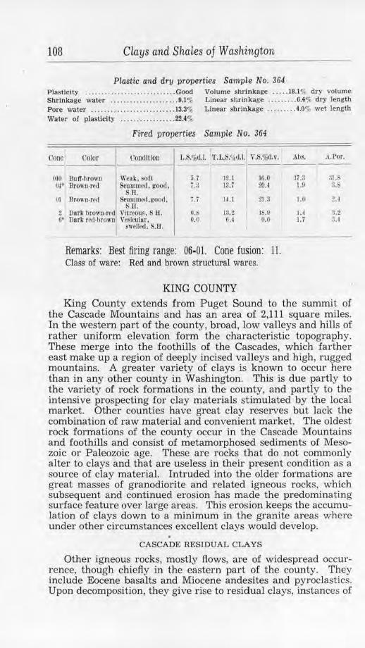
108 Clays and Shales of Washington
Plastic and dry properties Sampl.e No. 364 Plasticity ....... . .......... . ....... .. Good Volume shrinkage ..... 18.1% dry volume Shrinkage water ...... ... ......... . .. 9.1 % Linear shrinkage .. ...... . 6.4% dry length Pore water .. .. ...................... 13.3% Linear shrinkage ........ .4.0% wet length Water of plasticity ...... · ........... 22.4%
Fired properties Sample No. 364
Cono t'olor l'Oll(lftion J,.S.%LI.I. 'l'.1. ',%(I.I. V.S.%cl.1•.
010 Butt-1,rown Weak, ~oCl 5.7 12.l 16.0 OI* Brown,rrd Scummed, good, i .:l 13.7 20.4
ni
2 O'
,.H. llrown-rr,I c11111111ccl,goo,1,
:.B. i .i 14.l 21.3
Dark hrown-n•1J Vitreous, s H. li.S 13.2 18.0 Dark ml-hrown Yesicular, 0.0 6.4 0.0
i.welled. S.B .
Remarks: Best firing range: 06-01. Cone fusion: 11. Class of ware: Red and brown structural wares.
KING COUNTY
Al.ls. :1..Por.
li.3 31. 1.9 3.
J.0 2.4
1.4 3.2 1.7 3. -l
King County extends from Puget Sound to the summit of the Cascade Mountains and has an area of 2,111 square miles. In the western part of the county, broad, low valleys and hills of rather uniform elevation form the characteristic topography. These merge into the foothills of the Cascades, which farther east make up a region of deeply incised valleys and high, rugged mountains. A greater variety of clays is known to occur here than in any other county in Washington. This is due partly to the variety of rock formations in the county, and partly to the intensive prospecting for clay materials stimulated by the local market. Other counties have great clay reserves but lack the combination of raw material and convenient market. The oldest rock formations of the county occur in the Cascade Mountains and foothills and consist of metamorphosed sediments of Mesozoic or Paleozoic age. These are rocks that do not commonly alter to clays and that are useless in their present condition as a source of clay material. Intruded into the older formations are great masses of granodiorite and related igneous rocks, which subsequent and continued erosion has made the predominating surface feature over large areas. This erosion keeps the accumulation of clays down to a minimum in the granite areas where under other circumstances excellent clays would develop.
CASCADE RESIDUAL CLAYS
Other igneous rocks, mostly flows, are of widespread occurrence, though chiefly in the eastern part of the county. They include Eocene basalts and Miocene andesites and pyroclastics. Upon decomposition, they give rise to residual clays, instances of
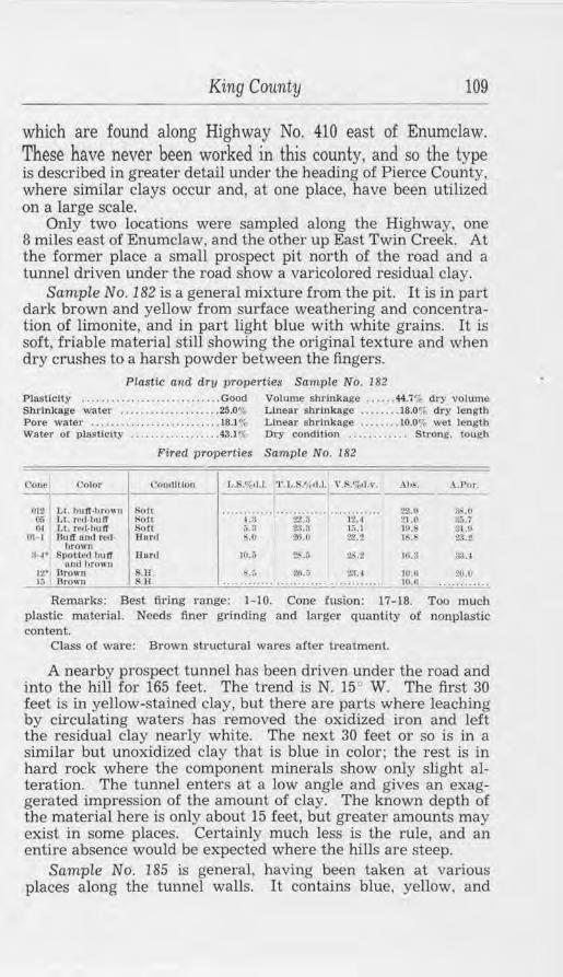
King County 109
which are found along Highway No. 410 east of Enumclaw. These have never been worked in this county, and so the type is described in greater detail under the heading of Pierce County, where similar clays occur and, at one place, have been utilized on a large scale.
Only two locations were sampled along the Highway, one 8 miles east of Enumclaw, and the other up East TwiD Creek. At the former place a small prospect pit north of the road and a tunnel driven under the road show a varicolored residual clay.
Sample No. 182 is a general mixture from the pit. It is in part dark brown and yellow from surface weathering and concentration of limonite, and in part light blue with white grains. It is soft, friable material still showing the original texture and when dry crushes to a harsh powder between the fingers.
Plastic and dry properties Sample No. 182 Plasticity .. ........... . ....... . ...... Good Volume shrinkage .. . .. . 44.7% dry volume Shrinkage water ............ .. ...... 25.0<r, Linear shrinkage .. . ..... 18.0"i. dry length Pore water ......... .. ............... 18.1% Linear shrinkage ... . .... 10.0% wet lenglh Water of plastici ty .................. 43.1% Dry condition . . . . . . . . . . . . Strong. tough
Fired properties Sample No. 182
l lOJJC.\ Color <'ondlllon J,.S.%,1.1. 'J'. L.S.t1~tl.1. \ ',S,%11.v . Ah,<. .\.Por. -----
01:! L L h u lf· lm>11 11 sou ............ ············ ... .. ... ... . 2:U> :l,,,(l (15 Lt. rcd -t,u If ~oft 4.a 22.3 l2.4 21.0 :J;,.i OJ Ll. re,1-lmlT S<>ft :i.3 28.3 15.1 IP. :u.o
01 1 Jlnlf ond red· Har<I ::,,(I ti.i.O :!2.2 18-.• :!:l.2 brown
:~· SpoU•'d bu ff Dor.I 10 . . ; 2'-.5 :!S.2 Ul.3 :i:u ond brown
12' Drown .H. i-.l 20.:, ~ .. lO.U 20.0 13 Brown l';.H . ............ ...... .... ............ 10.fi . ...........
Remarks: Best firing range: 1-10. Cone fusion: 17-18. Too much plastic material. Needs finer grinding and larger quantity of nonplastic content.
Class of ware: Brown structw·aJ wares after treatment.
A nearby prospect tunnel has been driven under the road and into the hill for 165 feet. The trend is N. 15° W. The first 30 feet is in yellow-stained clay, but there are parts where leaching by circulating waters has removed the oxidized iron and left the residual clay nearly white. The next 30 feet or so is in a similar but unoxidized clay that is blue in color; the rest is in hard rock where the component minerals show only slight alteration. The tunnel enters at a low angle and gives an exaggerated impression of the amount of clay. The known depth of the material here is only about 15 feet, but greater amounts may exist in some places. Certainly much less is the rule, and an entire absence would be expected where the hills are steep.
Sample No. 185 is general, having been taken at various places along the tunnel walls. It contains blue, yellow, and
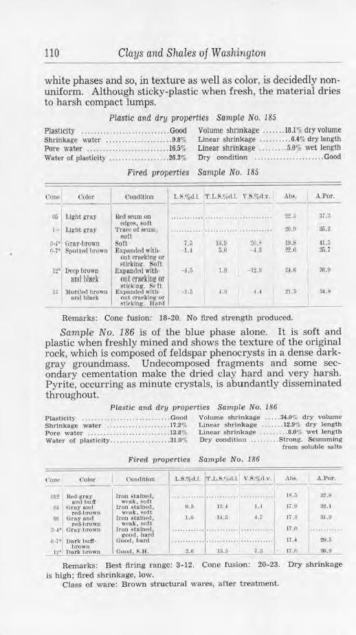
llO Clays and Shales of Washington
white phases and so, in texture as well as color, is decidedly nonuniform. Although sticky-plastic when fresh, the material dries to harsh compact lumps.
Plastic and dry properties Sample No. 185
Plasticity ... . ....... .. ............... Good Volume shrinkage ....... 18.l % dry volume Shrinkage water ..................... 9.8% Linear shrinkage ... ..... . . 6.4% dry length Pore water ....... .... ............... 16.5% Linear shrinkage ........ . 5.0% wet length Water of plasticity ... ......... . ...... 26.3% Dry condition ... ... ......... . ...... Good
Fired properties Sample No. 185
Con" Color Couclltlon T,.S.o/od.l. 'l'. L.S.<,kd.1. V. ',%11.v. Ah8. A.Por.
1~; J,ight gray Red scum on ··· ·· ·· ··· ·· ........................ 22.~ 37.:l ~dges, soft
1+ 1,igllt!,'Tay Trace o f SCUIII, ........... ············ . .... ..... ... 20.ll 3,i.2 solt
!f-i• Grny·l/rown Soft 7.;"> i:J.9 ~o.~ 19. 41.5 ,~;· Spo(l!'d hrown Expnndcd with· - I.I 5.0 - 1.3 22.H 3.S.7 out cracking or sticking. Soft
12· Deci, brown Expunded with- --U 1.0 -11.ll :!,J.6 36.1! arnl lJlack out cracking or
~ticking. Sdt 1;; l\lolUcd brown Expanded wi th· -1.5 4.9 - 1, 1 21.5 :1-1 . b
an,J hlnck out crocking or HlrJ;ing-. Hartl
Remarks: Cone fusion: 18- 20. No fired strength produced.
Sample No. 186 is of the blue phase alone. It is soft and plastic when freshly mined and shows the texture of the original rock, which is composed of feldspar phenocrysts in a dense darkgray groundmass. Undecomposed fragments and some secondary cementation make the dried clay hard and very harsh. Pyrite, occurring as minute crystals, is abundantly disseminated throughout.
Plastic and dry properties Sample No. 186 P lasticity .. . .......... . .... . ...... . .. Good Volume shrinkage ... .. 34.01; dry volume Shrinkage water ... .. ....... . .. . .... 17.2% Linear shrinkage .. . .... 12.9% dry length Pore water ...... ... ... . .... ......... 13.8% Linear shrinkage ......... 8.0% wet length Water of plasticity .......... . ....... . 31.0% Dry condition ......... Strong. Scumming
Crom soluble salts
Fired properties Sample No. 186
('OIi~ ("olor C'onclltlon 1,.S.%tl.l. l'l'.L.S!/,tl.1. V.S.%tl.v. .-\bs. A.Por. ---,~12
R~~~!r1~i ff Iron stained . ............ .......... .... .. ... ..... J~.iJ 32.8
wrul<. ~o!l (» Gray 1md Iron sta lned, 0.5 l ~A l.4 17 .U 3'U
rc{l,t,rown wellk, sof t 01 Gray itnd rron sta'lnecl, 1.6 14 .. 'i " . 7 l i.3 :n.o
r tld-hrowu weak, soft :~· Grey-hrown Iro n s tulne11. .. ..... ... .. ............ .. .. ........ li .O . .... .. .....
J'.;OOd, ho.rd f .. -7• Durk 1)11 ff. Oood. hur<I ············ ...... .. ........... ..... 11.4 29-.5
hrowo 12• Dork brown Good, $.B . :?.6 15.,7 7 ,;; 17.0 30.9
Remarks: Best fil'ing range: 3-12. Cone fusion: 20-23. Dry shrinkage is high; fued shrinkage, low.
Class of ware: Brown structural wares, after treatment.
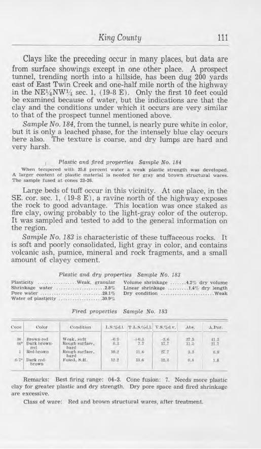
King County 111
Clays like the preceding occur in many places, but data are from surface showings except in one other place. A prospect tunnel, trending north into a hillside, has been dug 200 yards east of East Twin Creek and one-half mile north of the highway in the NEV,iNW~ sec. 1, (19-8 E). Only the first 10 feet could be examined because of water, but the indications are that the clay and the conditions under which it occurs are very similar to that of the prospect tunnel mentioned above.
Sample No.184, from the tunnel, is nearly pure white in color, but it is only a leached phase, for the intensely blue clay occurs here also. The texture is coarse, and dry lumps are hard and very harsh.
Plastie and fired properties Sample No. 184 When tempered with 25.8 percenl water a weak plastic strength was developed.
A larger content of plastic mate1;aJ Is needed for gray and brown structural wares. The sample fused at cones 23-26.
Large beds of tuff occur in this vicinity. At one place, in the SE. cor. sec. 1, ( 19-8 E ) , a ravine north of the highway exposes the rock to good advantage. This location was once staked as fire clay, owing probably to the light-gray color of the outcrop. It was sampled and tested to add to the general information on the region.
Sample No. 183 is characteristic of these tuffaceous rocks. It is soft and poorly consolidated, light gray in color, and contains volcanic ash, pumice, mineral and rock fragments, and a small amount of clayey cement.
Plastic and dry properties Sample No. 183 Plasticity . . ......... . ..... Weak, granular Volume shrinkage .... . .. 4.2% dry volume Shrinkage water . . . . . . . . . •.. ........ 2.8% Pore water . . . . ....... . ......... • ..... 28.1%
Linear shrinkage ......... 1.4% dry length Dry condltlon ....................... Weak
Water of plast!_clty .............. .. ... 30.9%
Fired properties Sample No. 183
Con,"' Uolor t•on<lltlon L.R%tl.J. 1'. l,.S.%11.l.1 , ·.S.%d.,•. , lb~. A.For. -OS llrO\\ n-re(I Weuk , soft -0.0 +o.5 -2.6 27.;; 41.0 oi• Dark ltrown· Rou!fh surfuce, G.3 7.7 17.; u.;; 21.7
rt.1tl lmr;l
I 1 Rcd·l>rowu Roui:h snrfuce . 10.2 ILG Zl.7 a.:~ ll.8
h,mr c:;...;• Durk reel· Vu~ccl. S.H. 12.2 13.G 3'l.8 O.s l.8
brown
Remarks: Best firing range: 04-3. Cone fusion: 7. Needs more plastic clay for greater plastic and dry strength. Dry pore space and fired shrinkage are excessive.
Class of ware: Red and brown structural wares, after treatment.
112 Clays and Shales of Washington
Sample No. 181 is from a quarry opened for road metal about 5 miles southeast of Greenwater, in sec. 19, (19-10 E). The rock is well exposed for 200 feet along the road and, owing to a slide, for 75 feet above that level. It is a buff-colored well-indurated tuff that has a pronounced shaly structure. The material attracted some attention at one time but has no particular value, as it is almost nonplastic, fires to a brown color, and fuses below cone 10.
If after carefully testing samples and investigating the transportation problem, it should be found desirable to use any of the Cascade residual clays, they should be intensively prospected before a location is decided upon. It might be possible to mine a large tonnage by stripping the clay from a broad area; but it is doubtful if the material extends to any great depth, and the deposits are local in character.
SHALES The Puget group of Eocene shales, sandstones, and carbonace
ous strata underlie about 340 square miles in the southwestern quarter of King County. Outcrops are abundant, though chiefly confined to river canyons, creek beds, and steeper hillsides. In other places, a mantle of glacial drift of variable thickness together with surface loam and dense undergrowth commonly cover the bedrock. This formation has been extensively studied because of the importance of its coal beds. ·
Other sedimentary beds, of Oligocene age, occur in the area north of that underlain by the Puget formation. They are thought to form the bedrock over some 275 square miles, although outcrops are rare, owing to the great thickness of drift. The series is not commonly coal bearing but might be valuable as a source of shale suitable for ceramic purposes.
The Tertiary strata have been tilted from their original position, and in some places the folding has been extreme. This makes underground mining necessary for beds of usual thickness-an expensive system which the usual character of the shales seldom warrants. In a few occurrences, it is feasible to mine shale and coal together. ·This might prove advantageous with some of the thinner coal beds which otherwise could not be handled at a profit. Very thick shales or several beds that can be used in aggregate may be mined by open cut or quarry methods, as is done at the Newcastle shale quarry, if the overburden is not too great. What can be accomplished in the way of stripping overburden was demonstrated at the Renton plant of Gladding, McBean & Co.
Shales occur at many places in the south part of Seattle and the near vicinity, but for the most part bedrock is effectively
King County 113
buried beneath an immense ~hickness of glacial drift. In only one place have the shales been utilized. This is at Renton, 12 miles southeast of Seattle, where one of the largest clay plants in the State is located. The following section was made from measurements obtained in the old Renton coal mines, at the shale quarry of Gladding, McBean & Co., and along the track of the Columbia & Puget Sound Railway as far as the bridge over the Cedar River.
Section of Renton coaL series Feet
Pleistocene Glacial drift ........ . . ................... . ................... --
Unconformity Oligocene
Iron-stained conglomerate. . . . . . . . . . . . . . . . . . . . . . . . . . . . . . . . . . . . . 165 Concealed . . . . . . . . . . . . . . . . . . . . . . . . . . . . . . . . . . . . . . . . . . . . . . . . . . . 335 Gray sandstone, with granite pebbles and tuffs. . . . . . . . . . . . . . . . . . 230 Concealed . . . . . . . . . . . . . . . . . . . . . . . . . . . . . . . . . . . . . . . . . . . . . . . . . . . 285
::~:Stone }worked by Gladding, McBean & Co.) ... .f 1~~ Shale, sandy at base L 110
Unconformity Eocene
Sandstone . . . . . . . . . . . . . . . . . . . . . . . . . . . . . . . . . . . . . . . . . . . . . . . . . . . 40 Coal (Bed No. 1)............................................. 17 Sandstone and shale. . . . . . . . . . . . . . . . . . . . . . . . . . . . . . . . . . . . . . . . . . 110 Coal (Bed No. 2)............................................. 13 Gray shale, shaly sandstone, and sandy shale. . . . . . . . . . . . . . . . . . . . 25 Medium-grained massive light-gray sandstone. . . . . . . . . . . . . . . . . . . 37 Slightly laminated sandstone. . . . . . . . . . . . . . . . . . . . . . . . . . . . . . . . . . . 10 Coal (Bed No. 3) ......... . ................................... 11 Massive coarse-grained iron-stained sandstone. . . . . . . . . . . . . . . . . . 42+
Base concealed ................................................... 1,560
The plant is one-half mile east of Renton on the south side of the Cedar River Valley. The shale that crops out there is of good quality and where first opened had only a scant overburden. As the quarry was pushed back into the hill, a greater face of shale was developed; but the overburden of drift also increased until it now stands 150 feet thick, equal to the vertical thickness of the shale mined. Thi~ enormous overburden was formerly removed by hydraulic "giants" and carried by flume out into the valley, where it was impounded. By this means, stripping was continued until a sufficient bench of shale was exposed to run
(j) In part after Evans, G . W .. The coal fields or King County: Washington Geol. Survey Bull. 3. 1912.
114 Clays and Shales of Washington
the plant for several years. Very little is mined now, as use is made of other materials.
In the quarry is a 30-foot bed of massive sandstone which is overlain by shales similar to the lower beds but not so well exposed. Lenticular masses of sandstone, some of great size, also occur in the upper strata. Under the sandstone stratum are 100 feet of laminated dark-gray and brown shales. This is the main portion worked. Parting the lower shales are two thin sandstone members, and massive sandstone underlies the series worked. Some of the shales are unctuous and "fat"; others, especially the lower members, are very sandy; and lateral variation in all the beds is marked.
Landslide has altered the original structure in the east side of the quarry but the general strike is N. 10°-20° E. and the dip, 10°-16° SE. This dip carries the beds down into the hill of glacial drift, so that the thickness of the overburden is increasing. It is said, however, that a little farther to the southeast the overburden decreases decidedly where a more elevated preGlacial surface, composed of shales stratigraphically above those in the quarry, has allowed less drift to accumulate.
Sample No. 392 is a general one of the shale from the quarry. It is dark brownish gray in color and moderntely soft. Although sandy in texture, it is uniform and rather fine.
Plastic and dry properties Sample No. 392 Plasticity ............................ Good Volume shrinkage ...... 16.0% dry volume Sh1'1nkage water ................. . ... 8.4o/, Linear shrinkage .......... 5.7% dry len gth Pore water ............. . ........... 13.4%-Water of plasticity . . ... . ............ 21.8%
Fired properties Sample No. 392
Corw Color Con1lltion L.S.%d.1. 'J'.t,.S.'if<l.l. v. .%11.,·. Abs. A.Por.
010 Purpk·IJrown W(•uk. ~oft - 0..:'i 5.2 -1.4 l~. 28.::i Qi; Brown-red Light s1•1m1, 3.0 1).3 10.3 11,4 2'UI
0'2 Rcd-browu gr,od, h,,r,I
J,igtlt scum. good . Ku.
0.7 12.4 1S.7 I.fl 10. 1
Remarks: Best. fu·ing range: 06-02. Cone fusion: 6-7. Class of ware: Used ior red-brown structural wares. face and paving
brick, and hollow tile.
Gladding, McBean & Co., Renton plant (formerly DennyRenton Clay & Coal Co.) .-The shale is mined by driving tunnels 10 feet horizontally in the foot of the quarry face, then timbering over the track for 15 feet out from the face. The shale is blasted and caved down onto muck-boards which roof the covered tracks, and by lifting these boards, the shale drops into the cars. Formerly there were 22 of these tunnels and tracks in the 750
King County 115
feet of workings, but for future work it is anticipated that a power shovel will be used. The cars run by gravity 200 yards to the tipple, where a gravity car-dump empties the shale onto a grizzly, a jaw-crusher breaks the oversize, and a conveyor belt carries the crushed material to a storage bunker.
Other bunkers contain clays and shales (up to 6,000-8,000 tons in all) from the various mines and pits operated by the company. From any of these storage supplies the materials feed by underground conveyor belts to one of the six 9-foot dry-pans. From these it is elevated, passed over screens, and then sent to the ground-clay storage bunkers. A proportioning-and-distributing belt system feeds the clay from these bins to three complete lines of pug mills and auger machines. In two of these lines the clay is vacuum deaired for making paving brick and all structural materials; the other and largest line is used for all refractories. The equipment also includes one 4-brick dry-press and facilities for hand molding of special fire-brick shapes.
The drying system includes one 8-track carrier drier, of 120-car capacity that uses waste heat and steam, and a 28-tunnel double-track drier, 30 cars to the tunnel, using heat from an auxiliary furnace.
A Harrop tunnel kiln, the only one of its kh1d in the State, is used for firing the refractory ware and also for buff face brick and glazed wall block. This kiln is 3191h feet long and has a capacity of 52 cars, each car holding 1,200 fire brick or their equivalent. The cars take 104 hours in their passage through the kiln. The bot zone, fired by 6 oil-burners on each side, now reaches a temperature of cone 13, and is later to be increased to cone 16. All red-firing ware and some of the buff face brick are fired in 5 rectangular periodic down-draft kilns, 16 feet wide and ranging from 70 to 150 feet in length, and four 30- to 34-foot diameter round down-draft kilns. Temperatures are measured by thermocouple pyrometers and checked by optical pyrometers and cones, so a careful control is maintained at all times.
Some 150 tons of raw clay are used per day. Refractories are the major product manufactured and form 75 percent of the output. The other products, in order of yearly tonnage output, rank approximately as follows: paving brick, acid brick, blowpit brick, face brick, roofing tile, glazed wall block, quarry tile, miscellaneous.
For many years a plant was operated at Van Asselt, in south Seattle, by the old Denny-Renton Clay & Coal Co. Fire brick, silica brick, and other specialties were made there at one time. Later, production was confined to terra cotta. Although no longer in operation (the plant was destroyed by fire ) , the following tests, made on three of their terra cotta bodies, are
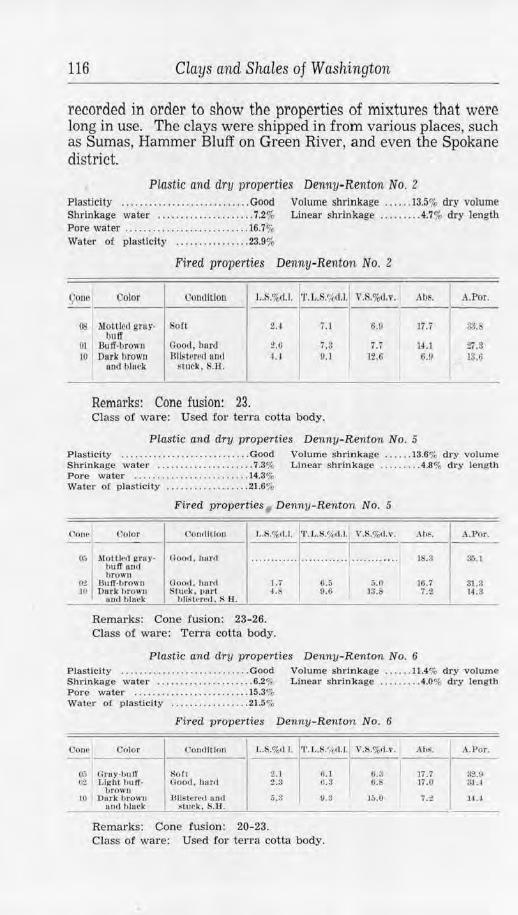
116 Clays and Shales of Washington
recorded in order to show the properties of mixtures that were long in use. The clays were shipped in from various places, such as Sumas, Hammer Bluff on Green River, and even the Spokane district.
Plastic and dry properties Denny-Renton No. 2 Plasticity ... . ..... . ...... . ........... Good Volume shrinkage ..... . 13.5% dry volume Shrinkage water ......... . ..... . ..... 7.2% L.inear shrln'kage . . .... . . . 4.7% dry lengil1 Pore water ..... . ........... . ........ . 16.7% Water of plasticity ..... . .......... 23.9%
Fired properties Denny-Renton No. 2
9 0110 Color Oomlltlon L.S,%d.l. T.L.S.'/i,d.l. V.S.%<1,v. Al)S. A.Por. --
OS I ""'"' ""'" Soft 2.4 i .1 6.9 17.7 33. IJulf
I OJ Bulf·hrown Good, hnrd 2.0 7.3 7.i 14.1 27.3 JO Dllrk brown 8llst~rcc1 un,1 I.J 9.1 12,6
I 6.V 13.6
uod bluck s tuck, S.H.
Remarks: Cone fusion: 23. Class of ware: Used for terra cotta body.
Piastic and dry properties Denny-Renton No. 5 Plasticity ...... . .... . ...... . ... .. .... Good Volume shrinkage .... .. 13.6% dry volume Shrinkage water ............... . ..... 7.3% Linear shrinkage .... . . . . .4.8% dry length Pore water . . ...... . ... • ... .• ....... 14.3% Water or plasticity . •.. .... .. .... . . .. 21.6%
Fired properties Denny- Renton No. 5
Contl
o:;
C~.? IO
('nlor t'o.nolltlOn L.S.%tl.l.
l\lotth'<I gn1y-tmlT 111111
Uoo,I . hunl ..... .... ... l,rown
nuJf.lJrown Goo,L horil I.; Dark hrowu 1Sl11ck, 1>ar1 4.
nod tilark hllstncct. SH.
Remarks: Cone fusion: 23-26. Class of ware: Terra cotta body.
'l'.L.S.%<1.1, V.S.%<1.v.
.. .. .. . ..... -·· ·· · · · ····
G.5 &.o 9.6 ) 3 .1>
,\hf.
lS.3
rn.1 7.2
Plastic and dry properties Denny-Renton No. 6
A.Por.
Si'i.l
31.3 14.3
Plastlclly .. .. ............ . ... . ....... Good Volume shrinkage .... .. 11.4% dry volume Shrinkage water . .... . ...... .. . . .... . 6.2% Linear shrin!kage .. . . .. .. . 4.0% dry length Pore water . ... . . . .. •...... • .. ... . . . 15.3% Water of plasticity . ........ . . •.. .. . 21.5%
Fired properties Denny-Renton No. 6
Oono C'olor (.'ondftion L.S.%<1 I. 'l'.L.S.'Ad. l. V ,l,l,%d , \ ' , Ah•. A.Por. --
00 Gruy-b1111' tiofr 2.1 0.1 (i.3 l'i .7 32.U C>L Light buff• Good , hurd 2 .3 0.3 ILS li.O 3JA
hrowu JO Dnrk hrown llllStt\red unll 5.3 0 . 3 15.0 7. 2 14.l
uod hhltk s111rk, S.H.
Remarks: Cone fusion: 20-23. Class of ware: Used for terra Cotta body.
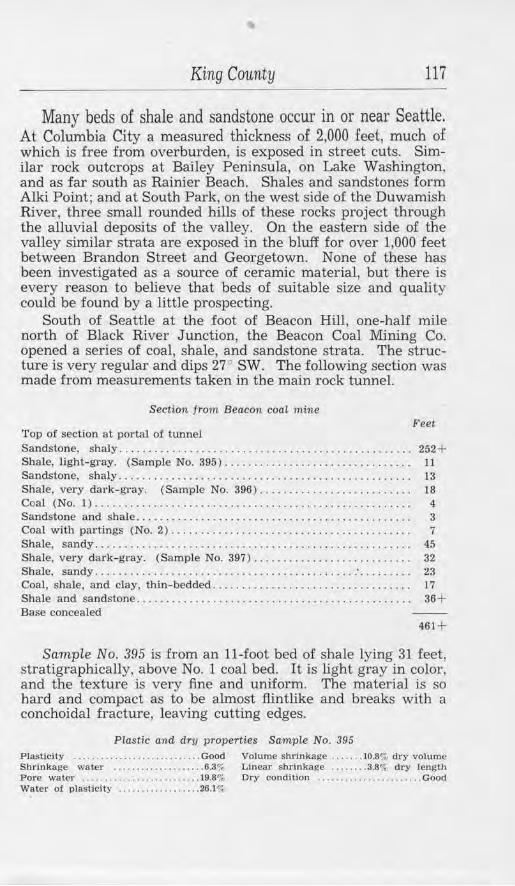
King County 117
Many beds of shale and sandstone occur in or near Seattle. At Columbia City a measured thickness of 2,000 feet, much of which is free from overburden, is exposed in street cuts. Similar rock outcrops at Bailey Peninsula, on Lake Washington, and as far south as Rainier Beach. Shales and sandstones form Alki Point; and at South Park, on the west side of the Duwamish River, three small rounded hills of these rocks project through the alluvial deposits of the valley. On the eastern side of the valley similar strata are exposed in the bluff for over 1,000 feet between Brandon Street and Georgetown. None of these has been investigated as a source of ceramic material, but there is every reason to believe that beds of suitable size and quality could be found by a little prospecting.
South of Seattle at the foot of Beacon Hill, one-half mile north of Black River Junction, the Beacon Coal Mining Co. opened a series of coal, shale, and sandstone strata. The structure is very regular and dips 27° SW. The following section was made from measurements taken in the main rock tunnel.
Section from Beacon coal mine Feet
Top of section at portal of tunnel Sandstone, shaly ..... ... ......................... . ................ 252+ Shale, light-gray. (Sample No. 395)................................ 11 Sandstone, shaly.................................................. 13 Shale, very dark-gray. (Sample No. 396) .......................... 18 Coal (No. 1) ..... . . . . . . . . . . . . . . . . . . . . . . . . . . . . . . . . . . . . . . . . . . . . . . . . . 4 Sandstone and shale. . . . . . . . . . . . . . . . . . . . . . . . . . . . . . . . . . . . . . . . . . . . . . . 3 Coal with partings (No. 2) . . . . . . . . . . . . . . . . . . . . . . . . . . . . . . . . . . . . . . . . . 7 Shale, sandy. . . . . . . . . . . . . . . . . . . . . . . . . . . . . . . . . . . . . . . . . . . . . . . . . . . . . . 45 Shale, very dark-gray. (Sample No. 397).. ......................... 32 Shale, sandy ............................................ : . . . . . . . . . 23 Coal, shale, and clay, thin-bedded. . . . . . . . . . . . . . . . . . . . . . . . . . . . . . . . . . 17 Shale and sandstone. . . . . . . . . . . . . . . . . . . . . . . . . . . . . . . . . . . . . . . . . . . . . . . 36+ Base concealed
461+
Sctmple No. 395 is from an 11-foot bed of shale lying 31 feet , stratigraphically, above No. 1 coal bed. It is light gray in color, and the texture is very fine and uniform. The material is so hard and compact as to be almost flintlike and breaks with a conchoidal fracture, leaving cutting edges.
Plastic and dry properties Sample No. 395 P lasticity ............................ Good Volume shrinkage ....... 10.8% dry volume Shrinkage water ................. ... 6.3')1 Linear shrinkage ........ 3.8% dry length Pore water ...... . .......... . ........ 19.8% Dry condition ............. . ......... Good Water of plasticity ................. . 26.l '7r
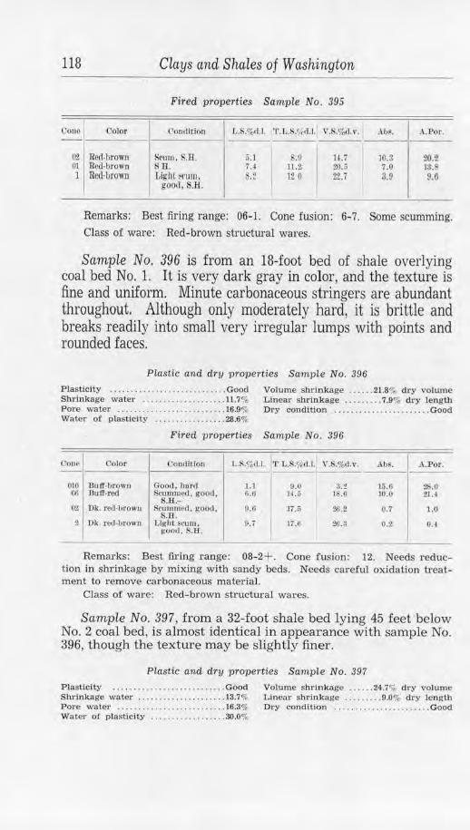
118 Clays and Shales of Washington
Fired properties Sample No . 395
Cone I Color Condition J •• S.%rl.l. ' l'.r •. S.',,d.l. V., .o/,,.1.v. .\ IJ~. A.Por.
(12 Red-hrown Scum. S.Il. 5.1 .0 lU 10.3 20.2 01 Red-bro"'n s B.. u 11 .2 20.;, 7.0 13 .8 l Red-brown Light l,('1.1111, .2 12 0 22.7 3.9 9.0
good. S.H. I
Remarks : Best firing range: 06-J. Cone fusion: 6-7. Some scumming. Class of ware: Red-brown structural wares.
Samp!e No. 396 is from an 18-foot bed of shale overlying coal bed No. 1. It is very dark gray in color, and the texture is fine and uniform. Minute carbonaceous stringers are abundant throughout. Although only moderately hard, it is brittle and breaks readily into small very irregular lumps with points and rounded faces.
Plastic and dry properties Sample No. 396
Plasticity ....... . ....... . .. .. .... .... Good Volume shrinkage . .... . 21.8% dry volwne Shrinkage water ...... .. ... . ..... ... 11.7% Linear shrln!kage . ....... . 7.9% d1·y length Pore water ... . .. . .... . .. . ........ . . . 16.9% Dry condition . .... . ........... . . ... . Good Water of p lasticity . . . ... . ........ . . 28 .6%
Fired properties Sample No. 396
Cone Color Conrtltlon L .S ,%11.l 'I'. L.S.',i}() .1. V.S.%c.l.v. AIJS. A.Por.
0 10 Bu ff-brown Good, h,ml 1.1 o.o 3.t li'j .6 28.0 06 Bu IT-red Scn1m11t'd, g ooJ , fl.G H.6 1 .ll 10.0 21.4
S.R.-02 Dk. r ed-b.row11 Scummed, go od ,
S.B . 9.ll ]7 .5 26.2 0.7 1.0
2 Dk. r <.'(],browll l, lghl scum. !'<><>d , S.R.
9.7 17.0 ~-3 0.2 0.4
Remarks: Best firing range: 08-2+. Cone fusion: 12. Needs reduction in shrinkage by mixing with sandy beds. Need s careful oxidation treatment to remove carbonaceous material.
Class of ware: Red-brown structurnl wares.
Sample No. 397, from a 32-foot shale bed lying 45 feet below No. 2 coal bed, is almost identical in appearance with sample No. 396, though the texture may be slightly finer.
Plastic and dry properties Sample No. 397
Plasticity ... . ....... . .. . ....... ... . . Good Volume shririkage . .. . . . 24.7",, dry volume Shrinkage water .. ..... . .. . ..... . .. .. 13.7% Linear shrinkage . . . . ... . . 9.0% dry length Pore water . . . . .......... . ..... . .. .. . 16.3o/, Dry condHion . ... . . ... . .... . ...... . . Good Water of plasticity ................ .. 30.0%
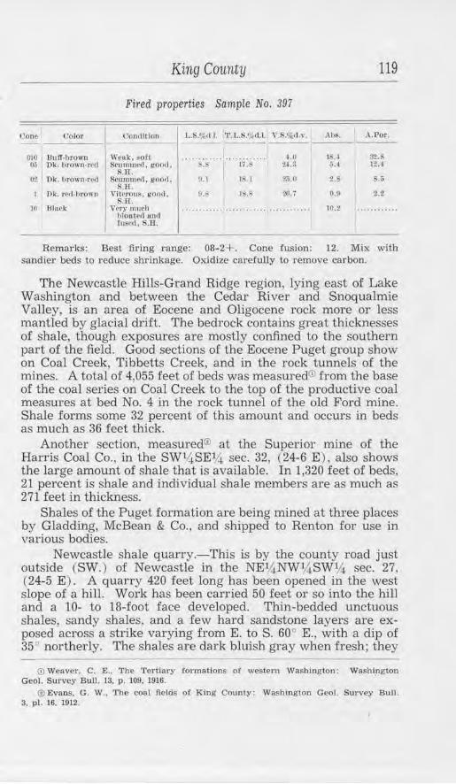
('one I Color
010 nuff-llrown o.; Dk. brown-rp,1
02 Dk. 1trow11-rvd
I Dk. red-brown
Ht lllnck
King County
Fired properties Sample No. 397
l'oodilion
ll'Ntk. ~oft :-immme<l , goo,I,
S.H. Scunnrn'd, good ,
S.H. Vilerous, 1<0011.
~.Jl. Very much
hloutcrl UIHI fn~c1I, S.B'.
L.S.%d I. 'l'.L.l:://,d.l. Y.$.%,l.,•.
.................... .... ~." n.s U. 1
v.~ lb. I
1:..b
1.0 21.:l
25.0
2(1. 7
119
Ah~. A.Por.
1 . I $2. 5. 1 12..t
~.s &.&
o.u 2.2
10.2 ... ..........
Remarks: Best firing range: 08-2+. Cone fusion: 12. Mix with sandier beds to reduce shrinkage. Oxidize carefully to remove carbon.
The Newcastle Hills-Grand Ridge region, lying east of Lake Washington and between the Cedai- River and Snoqualmie Valley, is an area of Eocene and Oligocene rock more or less mantled by glacial drift. The bedrock contains great thicknesses of shale, though exposures are mostly confined to the southern part of the field. Good sections of the Eocene Puget group show on Coal Creek, Tibbetts Creek, and in the rock tunnels of the mines. A total of 4,055 feet of beds was measured® from the base of the coal series on Coal Creek to the top of the productive coal measures at bed No. 4 in the rock tunnel of the old Ford mine. Shale forms some 32 percent of this amount and occurs in beds as much as 36 feet thick.
Another section, measured® at the Superior mine of the Harris Coal Co., in the SW14 SE14 sec. 32, (24-6 E), also shows the large amount of shale that is available. In 1,320 feet of beds, 21 percent is shale and individual shale members are as much as 271 feet in thickness.
Shales of the Puget formation are being mined at three places by Gladding, McBean & Co., and shipped to Renton for use in various bodies.
Newcastle shale quarry.-This is by the county road just outside (SW.) of Newcastle in the NE~NWY.jSWV.~ sec. 27, (24-5 E). A quarry 420 feet long has been opened in the west slope of a hill. Work has been carried 50 feet or so into the hill and a 10- to 18-foot face developed. Thin-bedded unctuous shales, sandy shales, and a few hard sandstone layers are exposed across a strike varying from E. to S. 60° E., with a dip of 35° northerly. The shales are dark bluish gray when fresh; they
<D Weaver, C. E .. The Tertiary .formations or western Washington: Washington Geo!. Survey Bull. 13. p. 109. 1916.
@ Evans. G. W., The coal flelcis of King County: Washington Geol. Survey Bull. 3. pl. 16. 1912.
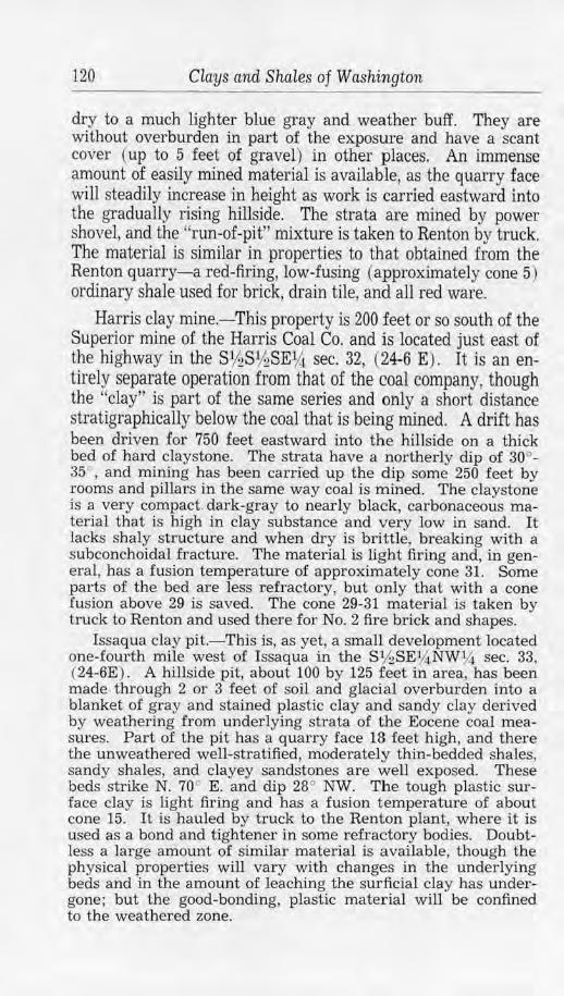
120 Clays and Shales of Washington
dry to a much lighter blue gray and weather buff. They are without overburden in part of the exposU1·e and have a scant cover ( up to 5 feet of gravel) in other places. An immense amount of easily mined material is available, as the quarry face will steadily increase in height as work is carried eastward into the gradually rising hillside. The strata are mined by power shovel, and the "run-of-pit" mixture is taken to Renton by truck. The material is similar in properties to that obtained from the Renton quarry-a red-firing, low-fusing (approximately cone 5) ordinary shale used for brick, drain tile, and all red ware.
Harris clay mine.-This property is 200 feet or so south of the Superior mine of the Harris Coal Co. and is located just east of the highway in the S1hS1hSE1,4 sec. 32, (24-6 E). It is an entirely separate operation from that of the coal company, though the ''clay" is part of the same series and only a short distance stratigraphically below the coal that is being mined. A drift has been driven £or 750 feet eastward into the hillside on a thick bed of hard claystone. The strata have a northerly dip of 30°-35 ", and mining has been carried up the dip some 250 feet by rooms and pillars in the same way coal is mined. The claystone is a very compact. dark-gray to nearly black, carbonaceous material that is high in clay substance and very low in sand. It lacks shaly structure and when dry is brittle, breaking with a subconchoidal fracture. The material is light firing and, in general, has a fusion temperature of approximately cone 31. Some parts of the bed are less refractory, but only that with a cone fusion above 29 is saved. The cone 29-31 material is taken by truck to Renton and used there for No. 2 fire brick and shapes.
Issaqua clay pit.-This is, as yet, a small development located one-fourth mile west of Issaqua in the S% SE% NW1,4 sec. 33, (24-6E) . A hillside pit, about 100 by 125 feet in area, has been made through 2 or 3 feet of soil and glacial overburden into a blanket of gray and stained plastic clay and sandy clay derived by weathering from underlying strata of the Eocene coal measures. Part of the pit has a quarry face 18 feet high, and there the unweathered well-stratified, moderately thin-bedded shales, sandy shales, and clayey sandstones are well exposed. These beds strike N. 70c E. and dip 28° NW. Th e tough plastic surface clay is light firing and has a fusion temperature of about cone 15. It is hauled by truck to the Renton plant, where it is used as a bond and tightener in some refractory bodies. Doubtless a large amount of similar material is available, though the physical properties will vary with changes in the underlying beds and in the amount of leaching the sur:ficial clay has undergone; but the good-bonding, plastic material will be confined to the weathered zone.
King County 121
Cedar Mountain is an outcropping mass of Eocene strata in secs. 29 and 30, (23-6 E) . Deep glacial drift surrounds the area, but the shales and sandstones are well exposed along the river in sec. 29 and along the county road in sec. 30. The dip is mostly southeasterly at angles ranging from 15° to 45°. Extensive prospecting for coal has been carried on, and one mine, that of the Pacific Coast Coal Co. at New Black Diamond, was operating in 1939. Shales in this vicinity form a large proportion of the total exposed series. Their great thickness together with convenient location may sometime make them economically valuable. A section©, which bas been measured along the county road and in mine workings, shows shale to form 67 percent of the 1,958 feet of exposed beds and to occur in individual members as much as 570 feet thick.
Sample No. 381 is from a sandy shale interbedded with sandstone exposed at one place along the road in sec. 30, (23-6 E), and is merely indicative of general characteristics. The material is very dark gray in color, of uniform texture, and, although sandy, is fine-grained. It is compact and moderately hard.
Plastic and dry properties Sample No. 381
Plasticity .. . ......... . ............... Good Volume shr-inkage ...... 20.7% dry volume Shrink.age water ............. . ..... .. u.Gr, Linear shrinkage ......... 7.4% dry length .Pore water ................. . ....... 18.1% Water o! plasticity .................. 29.7%
Fired properties Sample No. 381
(lorn.• Oolor l'onilltloo l,.S.%11.1. 'l'.l,.S.~d.1.I V.S.%d,v. Ahs. A . .Por. -- ----1 llli 13uft'.retl r.00;1. FOIi a.s 11.2 11.0 !ti.fl 29.1 01 Dk. rrfl·hrown NN1r vUr•1ou~. D. I rn.s 2;;.tl 0.0 2.0
Drown IIJltl good. S.ll.
0 Vesiruler. 11.fo 21.9 3i. I I s.o 21.6 black sticking. S.ff.
--Remarks: Best firing range: 06-01. Cone fusion: 7-8. Mix with
neighboring sandy beds for better control. Class of ware: Red and brown structural wares.
Sample No. 382 was taken from a 30-foot face exposed in a road cut above Cedar Mountain Station. A large quantity of shale is available and could be quarried and handled without great difficulty. The material is mostly sandy and is moderately hard. The color is gray with considerable variation in shade, and the texture is uniform and medium fine.
(i) Evans, C. W .. The coal fields of King County: Washington Geo!. Survey Bull. 3. pl 13, 1912.
122 Clays and Shales of Washington
Ptastic and dry properties Sample No. 382 Plasticity ..... . ...................... Good Volume shrinkage ..... . 9.5% dry volume Shrinkage water ...... . ........ . ..... 4.6% Linear shrinkage ........ 3.3% dry length Pore water .......... ..... ....... . ... 2.3% Water of plasticity .................. 6.9%
Fired properties Sample No. 382
Cone Color Condition l, .!l.%d.J. 'l'.L.S.%d.iJ V . . %d.v. Ab. A.Por.
00 Drown-gray Goo/I. son 2.3 5.G 0.7 17.9 35.3 01 Gray.brown Good. S.H.- 5.8 9.1 16.4 S.o 17.6 6 Dk. gray-brown Near vilreous. .ti 11.!l 23.i 1.2 1.9
S.H.
Remarks: Best firing range: 04-01. Cone fusion: 8. Class of ware: See No. 381 for mixing to make red-brown structural
wares.
The beds of the Puget group occurring at Taylor are of particular interest because they have been mined not only for coal but for the accompanying shales as well. It is one of the few places in the State where this has been done on an extensive scale, although some other coal mines have marketed shale from time to time. One of the plants of Gladding, McBean & Co. is located here and various products have been manufactured, although only sewer pipe and allied wares have been made recently.
The region is rough and hilly and the larger valleys are filled to great depth with glacial drift. Outcrops are restricted to hillside erosion channels. At the mine, located just uphill from the town of Taylor, the beds have been folded into a well-defined syncline which trends N. 45 .::i W. Igneous intrusions of andesite and rhyolite are common and complicate the working of the beds. A 22-foot rhyolite sill, completely altered, was formerly mined on the west side of the syncline. This clay was called "Taylor White," and was mined from two drifts for 2,600 feet on one level and for 6,800 feet on a lower level. A large amount of this clay probably still lies along the strike of the sill, so that a demand for material to be used with ball clay for common whiteware could be met.
Sample No. 179 is of the greatly altered rhyolite mentioned above. Part of the sample is snowy white and part is light buff in color. Kaolinization has not progressed to the colloidal, unctuous state found in some of the eastern Washington residual clays, and so the material is mealy, crumbles easily, and is very harsh feeling. It is composed of partly altered feldspar, quartz, some white mica, and a small amount of calcite. Extensive leaching has removed the femic minerals and their alteration products.
King County 123
Some samples are so homogeneous that component minerals are recognized with difficulty.
Plastic and dry properties Sample No. 179 Plasticity .. ........ .. ......... . . Very weak Volume shrinkage ....... 5.3% dry volume Shrinkage water .•.•................. 3.2% Linear shrinkage .... .. .. 1.8% dry length Pore water .................... .... .. 20.3% Linear sh.linkage ........ 1.5% wet length Water of plasticity .. . ...... . ....... . 23.5% Dry condition ........ Weak and crumbly
Fired properties Sample No. 179
Cone I Color coo,Jttion f,.S.%,-d.J. '1'.L.S.'k ll.1. V.S.o/.,d.v. .~hs. A.Por. I ---
01- 1 Lt. cream, Grentllor, very 2.2 4.0 ll.ii :/d.O 37.3 near wblre SO(L llUll.kl'
u-,;• Lt. cream, Granulnr, 3.3 5.1 9.~ 23.n 36. 1 ncnr white ~oft, pnnky
10 Lt. cre8lll , Grunulnr , 7.S 9.6 21. 7 lfJ.:J 22.9 near white good, !S.H.
12• Light sr,oltcd Grunulnr, 10., 12.5 ~&.S a., 7.0 gray, nenr gooll, S.H. white
Remarks: Best firing range: 8-15. Cone fusion: 28. Very little plastic material. Needs a bonding clay.
Class of ware: Has been used for light-gray dry-pressed face brick fired to high temperatures. Could be used as a siliceous grog.
PLAT& 2
"GLORY HOLE" USED IN MININC SHALE AT TAYLOR.
The b roken shale ls drawn off through an adit below the bottom of the !unnel-like opening. Sampled as No. 384.
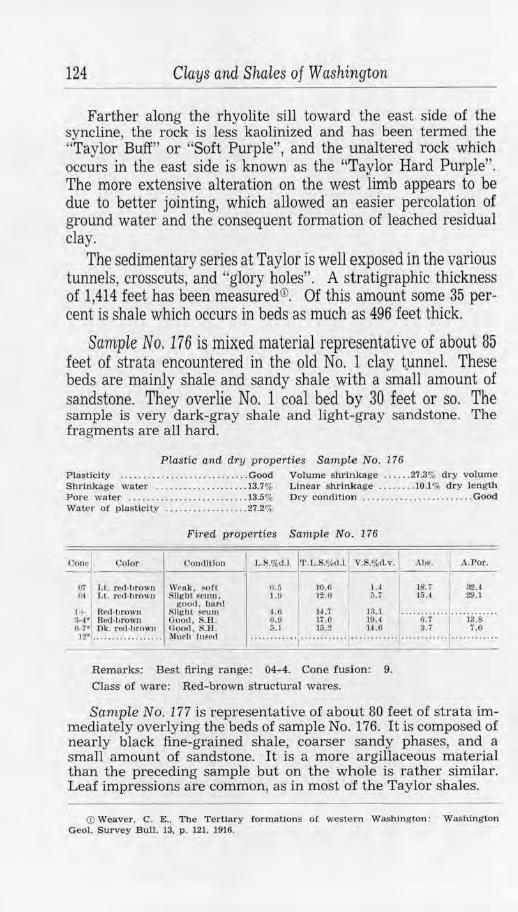
124 Clays and Shales of Washington
Farther along the rhyolite sill toward the east side of the syncline, the rock is less kaolinized and has been termed the "Taylor Buff" or "Soft Purple", and the unaltered rock which occurs in the east side is known as the "Taylor Hard Purple". The more extensive alteration on the west limb appears to be due to better jointing, which allowed an easier percolation of ground water and the consequent formation of leached residual clay.
The sedimentary series at Taylor is well exposed in the various tunnels, crosscuts, and "glory holes". A stratigraphic thickness of 1,414 feet has been measured©. Of this amount some 35 percent is shale which occurs in beds as much as 496 feet thick.
Sample No. 176 is mixed material representative of about 85 feet of strata encountered in the old No. 1 clay t.unnel. These beds are mainly shale and sandy shale with a small amount of sandstone. They overlie No. 1 coal bed by 30 feet or so. The sample is very dark-gray shale and light-gray sandstone. The fragments are all hard.
Plastic and dry properties Sample No. 176 Plasticity ... ... ..... . ........ . ..... . . Good Volume shrinkage ...... 27.3% dry volume Shrinkage water .... . ........... . . .. 13.7% Linear shrinkage . . .. . .•. IO.l % dry length Pore water ..... ....... . ........ . .... 13.5% Dry condition ........ ... ......... . ... Good Water of plasticity ... .. .......•.. .. . 27.2%
Fired properties Sam.ple No. 176
Cone __ 0_0_1or __ 1 __ c_.01_1rt_ltl_o,_1 -1 L.S.%d.J. J•r. t,.S.%d.l. Y.$.%tl,v.
07 l ,t. rcd·brown Weak, sof t l>t 1.t, red·l>rown Sllght ~cum.
o.a l.!>
10.6 12.0
JA ~-7
..i't.Js. I A.Por.
18.7 32.4 15.4 29. I
good. hurd t+ Red-1,rown Slight ~cum ~·1 Red•hrown Good. S.H. tJ 1U l] ..... 0:1· ....... ia:s .. ·· cl-7• Ok . red-hrown Good. S.H. 5.1 l (i.2 H.6 3. i 7.6 12• ....... , • • .. . . • • . • Mu(•h fu8ed ···· ··"····1············ ....... ................ , ........... .
Remarks: Best fu"ing range: 04-4. Cone iusion: 9. Class of ware: Red-brown structural wares.
Sample No. 177 is representative of about 80 feet of strata immediately overlying the beds of sample No. 176. It is composed of nearly black fine-grained shale, coarser sandy phases, and a small amount of sandstone. It is a more argillaceous material than the preceding sample but on the whole is rather similar. Leaf impressions are common, as in most of the Taylor shales.
© Weaver, C. E., The Tertiary -J:ormatlons o! western Washington : Washington Geol. Survey Bull. 13, p . 121. 1916.
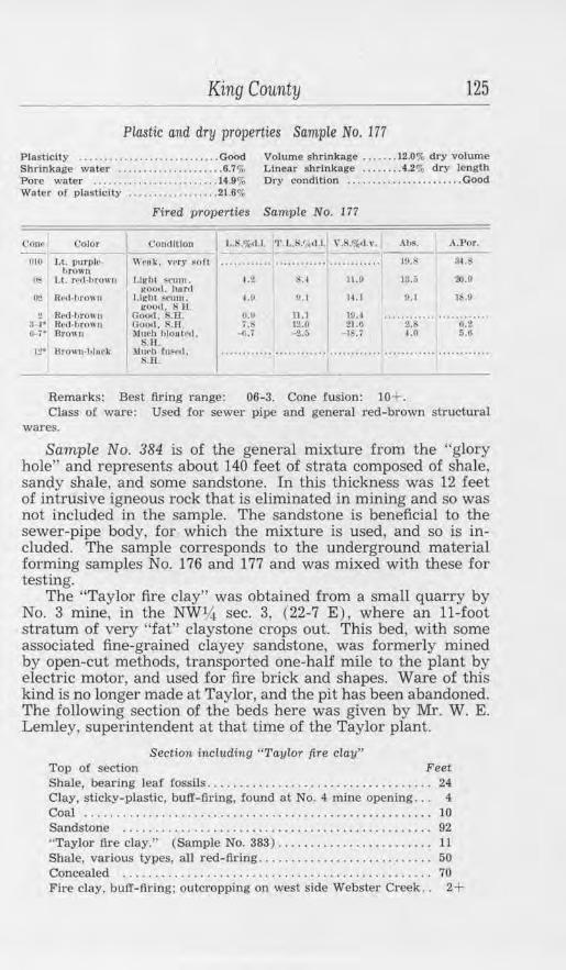
King County 125
Plastic and dry properties Sample No. 177
Plasticity .................. . ....... .. Good Volume shrinkage ....... 12.0% dry volume Shrinkage water ..................... 6.7% L.lnear shrtnkage .. ...... 4.2% dry length Pore water . . .... .. .... . ............ 14.9% Dry condition ....... .... ............ Good Water of plastlcity ..... . .......... . . 21.6%
Fired properties Sample No. 177
(.'Ollf\ Color <:ont1lt1011 L.IS.%~ 'l'.L.S.'1ttl .l.1 \" .S .o/o(l.v . .lbs. .\.Por.
1!10 Lt. l)ltrllh'· W•ok. vrry soft ···· ·· ······ ·· ·· ········ .. .. ........ 10.i: s~.s brown
'"' 1.1. rcd-hrowu Light >C\1111. 4.t $. l 11.9 13.ii :?0.(1 i;oo<I. hnr,1
16.!/ O·! R(l(l .. bro\, n Light ~cum. J.1, l!.1 U.I IJ.l i:00,1. s u.
2 Red-hro11u C:ootl. S.ll. ti.ti 11.1 10. l ..... 2:s·--· ..... i;:2 .. ·· :H• Rl'd•hrow11 Goo,t. S.B 7.S 1:1.0 21.11 0-7· Brem o :\1t1eh hlouta,1. ..Ji.. i -t.:, -IS.i 1.0 5.0
S.1:l. ·~· nmwn-hhwk )111('11 ruFt•rl, ............ ············ .. .................................. S.B.
Remarks: Best firing range: 06- 3. Cone fusion: 10+. Class of ware: Used for sewer pipe and general red-brown structw·al
wares.
Sample No. 384 is of the general mixture from the "glory hole" and represents about 140 feet of strata composed of shale, sandy shale, and some sandstone. In this thickness was 12 feet of intrusive igneous rock that is eliminated in mining and so was not included in the sample. The sandstone is beneficial to the sewer-pipe body, for which the mixture is used, and so is included. The sample corresponds to the underground material forming samples No. 176 and 177 and was mixed with these for testing.
The "Taylor fire clay" was obtained from a small quarry by No. 3 mine, in the NW14 sec. 3, (22-7 E), where an 11-foot stratum of very "fat" claystone crops out. This bed, with some associated fine-grained clayey sandstone, was formerly mined by open-cut methods, transported one-half mile to the plant by electric motor, and used for fire brick and shapes. Ware of this kind is no longer made at Taylor, and the pit has been abandoned. The following section of the beds here was given by Mr. W. E. Lemley, superintendent at that time of the Taylor plant.
Section including " Taylor fire clay" Top of section Feet Shale, bearing leaf fossils . . . . . . . . . . . . . . . . . . . . . . . . . . . . . . . . . . . 24 Clay, sticky-plastic, buff-firing, found at No. 4 mine opening. . . 4 Coal ...................................................... 10 Sandstone . . . . . . . . . . . . . . . . . . . . . . . . . . . . . . . . . . . . . . . . . . . . . . . . 92 "Taylor fire clay." (Sample No. 383) ..... .. ................. 11 Shale, various types, all red- firing ........................... 50 Concealed . . . . . . . . . . . . . . . . . . . . . . . . . . . . . . . . . . . . . . . . . . . . . . . . 70 Fire clay, buff-fiJ·ing; outcropping on west side Webster Creek. . 2+
126 Clays and Shales of Washington
PLATE 3
GREAT WALL OF SHALE DEVELOPED IN THE TAYLOR "GLORY HOLE" .
Some 140 feet of nearly vertical beds were mined In this particular open.ing.
Sample No. 383, of the fire clay, is a very dark-gray material more resembling clay than shale. It is free from grit and cuts with the sheen of wax. When dry the lumps are compact and brittle, breaking with almost a cubic fracture.
Plc!stic and dry properties Sampre No. 383
Plastic ity ... . .. .. .. .......... . ....... Good Volume shrinkage .. ... . 72.9% dry volume Shrinkage water . . .. ... .. . .. . .. . . .. . . 14.8% Linear shrinkage .. . . . ... 30.l o/o dry length Pore water ..... . .. .. .. . ... . . ... . ..... 39.3% Dry condition . ... . Cracke d. strong. tough Water o! plasticity ... . . . .... .. .. . ... 54.l o/o
Color
Ui> Lt. tJrown,hulT
l + Lt. bTOWO·bUJJ
1,-7• S1>otled bu ff. brown
12• Brown
King County 127
Fired properties Sample No. 383
('ondltlou J..S.%,d.l. T . L,.S.<id.l. ,~.$.%J.,•. Ab~. A.Por.
Cru<·ked, otherwise goo,1, hur,1
Crucke<I, ()lhi>rWIRe good, S.J:1. -
Cr11cJ<ed. otlwn,·lso good, S.H.
Cr11cked, otherwise ll:OO<l. $.II.
~. I
4.3
3ii.ll
11.0 28.0
11.0 10.IJ 21.~
1.:.ta
Ill. I s.r, 16.0
I
Remarks: Best firing t·ange: 06-15. Cone fusion: 23+. Too much plastic materiaL
Class o.f ware: Add grog or less plastic clay .for structural wares.
Gladding, McBean & Co., Taylor plant.-The Taylor shales and clays have been mined by several methods during different periods. Some have been mined with coal, using the same system of tunnels and slopes or stoping from separate entries. In this method, ordinary coal-mining procedure for steeply clipping beds was followed. Some beds have been mined from open-cut quarries at the outcrops of the thicker strata. The principal system, however, and the one used at present, is known as the "gloryhole" method. By this means, a raise is extended up the shale bed to the surface of the ground from a loading tunnel. The shale is blasted down from around the upper part of the raise and is carried by gravity down to the loading trap in the tunnel. ready for the short haul of a few hundred yards to the plant. Eventually, a great funnel-shaped opening is evolved, making possible quantity production at minimum expense. It is probable, however, that future mining will be once more by open cuts and quarries along the face of the hill.
As much as 16,000 tons has been mined and stored during the summer months of some years, a quantity sufficient to run the plant at capacity for the rest of the year. Lately, less is used, as the present body is a mixture of Taylor shale, grog from the old slack dump, and shale shipped in from the Newcastle quarry. Tunnels under the storage piles allow easy loading of the cars, which carry the shale to a jaw-crusher, and from there conveyor belts carry it to any one of four dry-pans. The ground shale is elevated, screened, and then dropped to two wet-pans which prepare it for the sewer-pipe press. The press is equipped with a deairing unit, and a combination pug mill and auger machine as well as a dry-press are available for certain work. The ware is dried on hot-floors. The 14 kilns, all of round down-draft type, include nine 34-foot, two 30-foot. two 28-foot, and one of 18-foot
128 CLays and Shales of Washington
diameter. Drying is completed in from 5 to 15 days and firing in from 120 to 240 hours, depending on the size of the ware.
Sewer pipe is made in sizes varying from 3 inches to 30 inches, and all types of standard fittings as well as plain pipe are made. Flue lining is practically the only other product made at present. The capacity of the plant is about 40 tons per day, though the present output is only a little over one-half that amount.
Shales are exposed in a few places east and west of Taylor in the same township and also in the township to the north. Coal is interbedded with the shales and sandstones, but the abundant intrusions and surface flows of igneous rock together with complicated structure render most of the region of doubtful value for ceramic materials. Promising areas for prospecting are secs. 9, 16, 21, 26, 32, and 33, (22-7 E).
The Green River, in much of its course, has cut a deep gorge through the Eocene sediments of the Puget group. Some 9,000 £eet 0£ strata are exposed here, forming one of the most complete stratigraphic sections in the State. Some very pure shales occur, notably in the Kummer vicinity, but most of the rock is sandy shale and sandstone, representing a shallow-water deposition in extensive estuaries. Detailed measurements of these beds by Weaver@ show that shales comprise about 36 percent of the total and are present in members as much as 246 feet thick.
Kummer is in the NE14 sec. 26, (21-6 E ) where a coal and shale mine has been worked intermittently, at times extensively, for many years. The property is owned by Gladding, McBean & Co.; formerly, by the Denny-Renton Clay & Coal Co. The gorge of the Green River is over 300 feet deep here; the upper part is in glacial drift, but the lower is in the coal series comprising massive argillaceous sandstone, coal, flint .fire clay, and various kinds of shale. The mine is on the western limb of a northward trending syncline near the basal sandstone member, where the dip is about 52° SE. The opposite limb of the syncline is crossed by the river along the east line of R. 6 E., but so far no attempt has been made to work this side for clay. Flint clay is reported from the east limb and probably could be readily prospected by using the underlying Kummer sandstone as a marker, but the physical properties of the clay might not be the same as on the west limb.
The flint clay is of particular interest because of the scarcity of such material in the Pacific Northwest. Deposits have been known and mined for many years in eastern States, but few occurrences have been reported elsewhere. This is the only known deposit in Washington, although there could well be others in
© Weaver, C. E .. op. cit., pp. 112-116.
King County 129
the great thickness of Tertiary strata. The bed is 5 feet thick near the river, but increases in thickness along the strike to the north to 10 feet, though only the lower 7 feet, of best quality, is mined. It is as persistent as an ordinary shale stratum, not showing the lenticular character which is a feature of so many of the eastern deposits, nor is it associated with limestone. It overlies 6 feet of bony, impure coal and is overlain in turn by 7 feet of lighter-colored claystone, much like the flint bed though less pure. Shaly partings are lacking, but the material is somewhat jointed.
The average of eight analyses of the flint clay shows a silica content of 39.66 percent and an alumina content of 40.85 percent. The amount of combined water is not known but is thought to be small, since the ignition loss of 15.46 percent would be mostly accounted for by the large carbon content of the clay. Analyses and physical properties suggest that the clay was deposited as a colloidal aluminum silicate closely resembling kaolinite in composition, and that the alumina content was increased above that of theoretical kaolinite by the removal of impurities and some silica through the action of organic material in swamp waters. The .flinty nature might be due to a partial setting of the colloids after deposition, but the fact that this entirely nonplastic clay may be rendered plastic by prolonged grinding in water makes it appear that the induration is due to loss of combined water through pressure.
Sample No. 168 was taken at the outcrop of the flint clay a few feet above the water on the north side of the river. It is very dark gray, nearly black, and shows mottling due to thin layers, lenses, and specks of less carbonaceous material. The sample shows no sand and has an extremely fine and uniform texture. Brittle, hard, and dense, the clay breaks with a smooth conchoidal fracture, the chips commonly having sharp, cutting edges. It does not slake in water. The specific gravity varies with the content of carbonaceous matter and other impurities, ranging from 2.3 to 2.6. Coarser fragments are brown and translucent in polarized light, have very low refractive index, and are isotropic, suggesting colloidal character. The fired sample at first became light gray in color and showed a large ignition loss, through the burning out of carbonaceous matter. The buff color that developed at higher temperatures may be due in part to contamination at the outcrop by iron oxide derived from overlying strata, though no staining was apparent.
Plastic and dry properti es Sample No. 168 Plas ticity ............... None (see below) Volume shrinkage ...•. 27.0'", dry volume Shrinkage water .................... 16.0o/, Linear shrinkage ... . .... 5.7% dry length Pore water •........... . ........•.. . . 15.6<;;, Dry condition • . . . . . . Good dry s trength Water of plasticity .....• . . . .... . .. . 31.6%
-5
130 Clays and Sha1.es of Washington
Fired properties Samp1e No. 168
Cone Color ('ondlLion Ut%rl .l. 'l'.J, .$.%rl.l. ,.$.%.J.,· .1 ,\hs. A.Por.
6 Bulf Wcn'k,~!t 5.2 10.9 14.9 21.3 35.G 10 Bull Goorl. hard 7.1 12.8 19.7 17.2 27.2 12 Deep bulf Goocl, hard 7.7 13.~ 21.8 10.0 25A 15 nee11 buff Good. hnrd .4 lU 28.2 15.4 2H
Remarks: Best firing range: 10-18. Cone fusion: 32+. This sample was ground for 17 minutes in a wet-pan, after which it showed good plasticity.
Class of ware: No. 1 refractory, needing a plastic and refractory bond clay or grinding in water.
Considerable change occurs in the character of the flint clay along its strike to the nmth. The bed becomes thicker, more carbonaceous, and a little less refractory. At a new slope, 1,100 feet or so from the outcrop, the clay can hardly be called "flint". It is uniformly very dark gray, almost black, contains minute lenses and seams 0£ coal, and is no more hard than many other compact Eocene claystones. Under a microscope the clay appears no different from samples taken in the old tunnel except that quartz grains are sparsely but rather uniformly scattered throughout. It is a good, usable material, calcines rather white, bas a cone fusion of about 31, and is used as a grog in more plastic mixes for refractories .
.Sample No. 171 is flint clay from the continuation of the bed sampled as No. 168. This is from an exposure at No. 1 tunnel on the south side of the river. It was the intention of the owners to operate mainly from here, mining both clay and an underlying coal bed, but the location was abandoned after a short time. The sample was taken from the working face 168 feet due south from the portal of the tunnel and ls, in appearance, exactly like sample No. 168.
Plastic and dry properties SampLe No. 171 Plasticity .. . ......... ... .... See No. 168 Volume shl"inkage ....... 17.9% dry volume Shrinkage water ..... .. .•...... ...... 10.3% Linear shrinkage ........ 6.6% dry length Pore water .................... ..... . 20.0% Linear shrinkage ........ 6.3% wet length Water of plasticity .. . . ....... .... .. 30.3% Dry condition . . ...... ..... . . Falr strength
Fired properties Sampte No. 171
L'On(' Color Con(lltlon l,.!'i.%11.J. h•.J,.S.~}d.l. \'.S.%,1,v. .\hs. A.Por. -----
Ct, t :j 6
10 it 15
c;rot)"·l,ulT 11-euk, ~otl 6. 1 18.0 17.9 !lull w ~a k. soft 11.a 1.7.0 30.J Bull ll"cuk. sort 11.2 1S.6 :r.l.2 Buff ll"r nk, SOIL 12.b JO.I 3*.0 Duff Ooort . hard J:l.5 20.] 36.S BufT•hrO\\ II noo,I. hor•I 13.8 20A llO.O Muff.hrown (loO(I. hard 14.0 20.6 S(U
Remarks: Best firing range: 10-18. Cone fusion: 32+ . Class of ware: See No. 168.
16.4 33.0 J~.2 26.2 ll.:!. 22.8 10.7 22.0 0.2 10.3 s.s 16.6 8.cl 18.0
King County 131
Overlying the flint clay where it crops out along the river is a 6-foot bed of lighter-colored hard claystone similar to the lower material but relatively impure, containing, especially, disseminated crystals of magnetite with crusts and masses of hematite and limonite.
Sample No. 169, of this shale, is gray in color with the same peculiar mottling of the lower member but in lighter shade. The texture, fracture, and other physical characteristics are practically identical with the lower member (see sample No. 168, p. 129) .
Piastic and dry properties Sample No. 169 Plasticity . . . . . . . . • . . . . . . . ..... very weak Shrinkage water ..•..... . ......... .. 1.8%
Volume shrinkage .•...• 3.2'~ dry volume Linear shrinkage . ........ l.11/,, dry length
Pore waler .... . .................... . 15.9% Dry condition •... . ...........•...•• . Weak Water or plasticity •.••......... . .. 17.7%
Fired properties Sample No. 169
l lon,J Color l'c,11,H1ion 1,.S.%\1.1. •r.1,.s.~~1.1 .J v.S.eto(].v. --- '
01 I llrny Punky~ \f(•ry ~oft , .0 I 9.0 21.S lll Brown nn,1 Punky , ~oft S.ij 9.G 23.:l
black 1Z ] Dark brown Pnnky. soft 0.1 lll.Z 2:i.1
Remarks: Cone fusion: 28. Variable refractoriness. Class of ware: No. 2 refractory.
,\hit .\ .Por.
21.0 38.S 21.3 :ri.
18.1 Sl . 7
A thin bed of carbonaceous shale overlies the last-mentioned flinty shale and this, in turn, is overlain by 20 feet of gray shale. The latter is a material that was extensively used for sewer pipe at one time but was supplanted by other shales.
Sample No. 172, of this shale, is dark gray in color with occasional .fl.eeks of black carbonaceous matter. It is sandy and hard, but the texture is uniform and moderately fine.
Plastic and dry properties Sample No. 172 Plast1c1t"Y .. ...... ...............•..•. Good Volume shrinkage ........ 9.15, dry volume Shrinkage water .................... 4.8% Linear shrinkage ...... . . 3.2% dry length Pore water .... . ...••.•.. .. .....•..•. 14.8% Dry condition . . ... ... ....... ... ... .. Good Water of plasticity .................. 19.6%
Fired properties Sample No. 172
c•one Color I •. S.%<1.l. T .1,.!-i.';,d .l V.~.%d:r . -\1,s. .\ . l'or.
(>.I Uu ff.l1rowt1 01-l I Dtuk IJrowu
;1--t • Brown-t,lock
1:!"1········ ·· ·· ·· ···
00(111, i-.u. Ooo<I. S.ll. \ ' itr1•011s. goo,I
S. IJ . llullli• fus,•d
:Ul 7.6 l/.0
s.s 7.5 I0.7 20.S 12.2 2-1.l,
Remarks: Best firing range: 06-2. Cone fusion: 11.
1.Z.O :?:+.:; 0.7 11 . 7 o.o o.o
Class of wa1·e: Brown structural wares. Formerly used for sewer pipe.
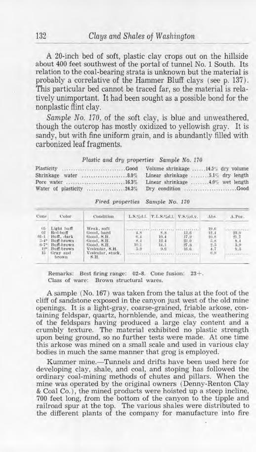
132 Clays and Shales of Washington
A 20-inch bed of soft, plastic clay crops out on the hillside about 400 feet southwest of the portal of tunnel No. 1 South. Its relation to the coal-bearing strata is unknown but the material is probably a correlative of the Hammer Bluff clays (see p. 137). This particular bed cannot be traced far, so the material is relatively unimportant. It had been sought as a possible bond for the nonplastic flint clay.
Sample No. 170. of the soft clay, is blue and unweathered, though the outcrop has mostly oxidized to yellowish gray. It is sandy, but with fine uniform grain, and is abundantly filled with carbonized leaf fragments.
Plastic and dry properties Sample No. 170 Plasticity ........................... . Good Volume shrinkage ...... 14.5r, dry volume Shrinkage water . . . . . .. . .. . . . .. . .. .. 8.0% Linear shrinkage ........ 5.l<;; dry length Pore water . . . . ....... ... ... . .. ..... . 16.3% Linear shrinkage ........ 4.0' 1 wet length Water o! plasticity . . .. . ........ . ... 24.3% Dry conditton ................. .. . . .. Good
Fi red properti es Sample No. 170
(.'Onl' l'nlor (lonfll tloo l,.S,%<1.1. ' l' . 1 .. $.'l'c,d.l. V.S,'i<d,v. --- -- - ---
l,ij 02
DI-I ::-i• 0- 7·
I:?" JO
Ligh t hu lT Wet1k , ,;(li t ............ ············ ·· ··· ······· lletl-h u lT f ;ootl , llu l'fi l.8 s.s 13.0 Bn lT , flnrk Ooorl . S.1:1 . fl. I IOA 17.0 Uulf,hro"n oootl , s. a. :<.~ 12 ~ 23.0 J3u ff,hrown noo,t. s.n. IIJ. 1 H.l 27.:l 811 IT-l,rown \ 7 l1S'fr11h-1r. H. A. ~.o 11.{l 16.d Gray 1111,1 \ \1~Jcl1 lur. suwk~ ...... ..... ............. ..... .... ...
tir own s.u.
Remarks: Best firing range: 02- 8. Cone fus ion: 23+. Class of wa re: Brown s tructural wares.
• \I>~. A. Por .
w.u ............ 12A 2,q ,!) 10.:- :!] . 7 :1.:- ,·I 2.V 5.9 "·; !1.3 o., ····· ······ ·
A sample (No. 167) was taken from the talus at the foot of the cliff of sandstone exposed in the canyon just west of the old mine openings. It is a light-gray, coarse-grained, friable arkose, containing feldspar, quartz, hornblende, and micas, the weathering of the feldspars having produced a large clay content and a crumbly texture. The material exhibited no plastic strength upon being ground. so no further tests were made. At one time this arkose was mined on a small scale and used in various clay bodies in much the same manner that grog is employed.
Kummer mine.- Tunnels and drifts have been used here for developing clay, shale, and coal, and stoping has followed the ordinary coal-mining methods of chutes and pillars. When the mine was operated by the original owners (Denny-Renton Clay & Coal Co. ), the mined products were hoisted up a steep incline, 700 feet long, from the bottom of the canyon to the tipple and railroad spur at the top. The various shales were distributed to the different plants of the company for manufacture into fire
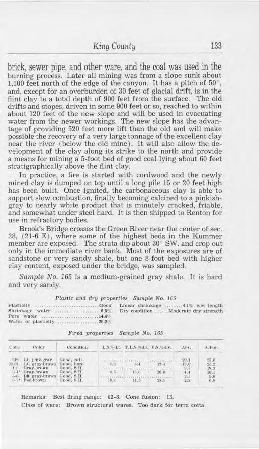
King County 133
brick, sewer pipe, and other ware, and the coal was used in the burning process. Later all mining was from a slope sunk about 1,100 feet north of the edge of the canyon. It has a pitch of 50°, and, except for an overburden of 30 feet of glacial drift, is in the flint clay to a total depth of 900 feet from the surface. The old drifts and stopes, driven in some 900 feet or so, reached to within about 120 feet of the new slope and will be used in evacuating water from the newer workings. The new slope has the advantage of providing 520 feet more lift than the old and will make possible the recovery of a very large tonnage of the excellent clay near the river ( below the old mine) . It will also allow the development of the clay along its strike to the north and provide a means for mining a 5-foot bed of good coal lying about 60 feet stratigraphically above the flint clay.
In practice, a fire is started with cordwood and the newly mined clay is dumped on top until a long pile 15 or 20 feet hlgh has been built. Once ignited, the carbonaceous clay is able to support slow combustion, finally becoming calcined to a pinkishgray to nearly white product that is minutely cracked, friable, and somewhat under steel hard. It is then shipped to Renton for use in refractory bodies.
Brook's Bridge crosses the Green River near the center of sec. 28, (21-6 E ) , where some of the highest beds in the Kummer member are exposed. The strata dip about 30 SW. and crop out only in the immediate river bank. Most of the exposures are of sandstone or very sandy shale, but one 8-foot bed with higher clay content, exposed under the bridge, was sampled.
Scimple No. 165 is a medium-grained gray shale. It is hard and very sandy.
Plastic and dry pro1)erties Sample No. 165 Plastici ty ............ .. ........ .. .... Good Linear shrinkage ...... . 4.1% wet length Shrlnkage water ..... . ... . . . ... .... . 5.81',, Ory condition ... . .. Moderate dry strength Pore water .... . . .. ... .. . . . . . .. ..... 14.4"i, Wa ter or plasticity ........ .. . . ...... 20.2%
Coiw1
l'olor
012 Lt. 1,lnk-1,'Tuy 0-2-111 1,L i:ruy-hrtlwn
1-t Gr uy-1Jrow11 :1-1• GrU)"·hrowu ~ Dk. f!rllY·l1ro w11 Ii- ; • R,~1-hrown
Fired properties SampLe No. 165
( '011.tlt!ou
Ooofl , ~oft Ho1>ll. hurt! Gootl. Sll . 00011. S 11. (Jood. S.ll . Good, s H.
11.;; 1:l. 11 :!tl. O
.. .. ii,:.i ··· f " i~X ... ··· ·~:i .. ..
Remarks: Best firing range: 02-8. Cone fusion: 13.
. \IJS, ..\.Por.
3J.O Z,.2, 19.3 10.1 5.G 0.0
Class of ware: Brown structural wares. Too dark for tena cotta.
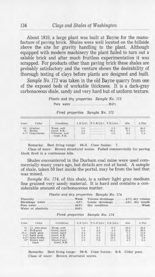
134 Clays and Shales of Washington
About 1910, a large plant was built at Bayne for the manufacture of paving brick. Shales were well located on the hillside above the site for gravity handling to the plant. Although equipped with modern machinery the plant failed to turn out a salable brick and after much fruitless experimentation it was scrapped. For products other than paving brick these shales are probably satisfactory and the venture shows the desirability of thorough testing of clays before plants are designed and built.
Sample No.173 was taken in the old Bayne quarry from one of the exposed beds of workable thickness. It is a dark-gray carbonaceous shale, sandy and very hard but of uniform texture.
Corw C'olor
010 OrlitittR I 1,2 Drown
1;..i• Croy,!Jro ,111
Plastic and dry properties Sampie No. 173
Pore water ...... ... ...... ........ ... 19.3111r
Fired properties Sample No. 173
con,Utlou
\\' 1•11 k, sort Oood. S.11.\'itreous, w~f.
culur. S.A.
L,s:;1.1. 1~:·.'~--~:~''.:1: _v_.s_·:-~~1_.1_•. ,--'~-1:1_. -!·-A ~-·t>_.:_r._
S.l'l . . . . .. .. .... 10.3 0.1 18.0 :i.o . ...... ... .. ».11 3,s, 1 •. ,
Remarks: Best firing ra nge: 04-2. Cone fusion: 7. Class of wa1·e: Brown structural wares. Failed commercially for paving
block fired in a continuous kiln.
Shales encountered in the Durham coal mine were used commercially many years ago, but details are not at hand. A sample of shale, taken 50 feet inside the portal, may be from the bed that was mined.
Sample No. 174, of this shale, is a rather light gray medium fine grained very sandy material. It is har d and contains a considerable amount of carbonaceous matter.
Plastic and dry proper ties Sampl e No. 174 Plasticity ...............•............ Weak Volume shrinkage ........ 8.7% dry volume Shrinkage water ................. ... . 4.5% Linear shrinkage ...... .. 3.0% dry length Pore waler ........................... 14.3% Dry cond1tlon ...... ................ . Weak Water o! plasticity ............ ... ... 18.8%
Fired properties Sample No. 174
C'orw Color ('omlltlou L.s .o~,r.1. J·r.L. .o/o().I. Y. .<;~d. v. Ah~. I A.Por.
IK, Lt. hlue-gruy W1•uk, son -<1.8 2.7 --0, 1(1.2 29.f. OJ Bu If.gray Good, hartl 1.8 4.S &. 1 J!l.4 28.0
01-1 I Dn rl< grny Oood, hurd 4.0 7.0 Ll.i> 7.7 16.G ~· Dork grey Goo,!. s.u. 6.-1 0.4 18.0 &.7 12..l &-7· Grny-brown Oood . S.li . 6.0 9.6 1S.i> 2.0 6.0 12• Urown 1111<1 lilou tt•<I owl 4.0 7.0 u .;;
I 4.~ 8.1
hhwk tnsr,I. $.H.
Remarks: Best fir ing range: 04-6. Cone fusion: 8-9. Color poor. Class of ware: Brown structural wares.
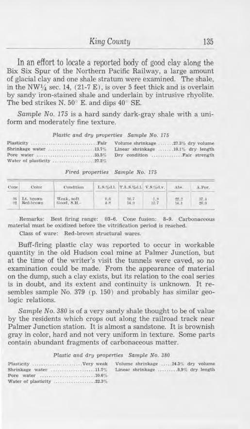
King County 135
In an effort to locate a reported body of good clay along the Bix Six Spur of the Northern Pacific Railway, a large amount of glacial clay and one shale stratum were examined. The shale, in the NWlf.i. sec. 14, (21-7 E ) , is over 5 feet thick and is overlain by sandy iron-stained shale and underlain by intrusive rhyolite. The bed strikes N. 50° E. and dips 40 SE.
Sample No. 175 is a hard sandy dark-gray shale with a uniform and moderately fine texture.
Plastic and dry properties Sample No. 175
Plasticity ........... .. ......... . ....... Fair Volume shrinkage ...... . 27.3% dry volume ShrLnkage water .........•........... 13.7% Linear s hrinkage .... . .. 10.1 % dry length Pore waler .......................... 33.5% Dry condition .............. Fair strenglli Waler of plasticity . .................. 27.20,:.
Fired properties Sample No. 175
Coue Col11r Cm)(JHlon l .. ~.%,1.1. '1'.l, .i'\,%1.1. V .S/'ttl.,•. Ahs. .\ .P or. -- --00 U. brown Wenk , 80ft CI.G 10.7 1.5' 22 .2 37. 1 Ir! &)d-hrown tioo,I, . .ll .- ~- H .ll 13.i 14. l :!t;.!l
'
Remarks: Best firing range: 03-6. Cone fusion: 8-9. Carbonaceous material must be oxidized before the vitrification period is reached.
Class of ware: Red-brown structural wares.
Buff-firing plastic clay was reported to occur in workable quantity in the old Hudson coal mine at Palmer Junction, but at the time of the writer's visit the tunnels were caved, so no examination could be made. From the appearance of material on the dump, such a clay exists, but its relation to the coal series is in doubt, and its extent and continuity is unknown. It resembles sample No. 379 (p. 150) and probably has similar geologic relations.
Sample No. 380 is of a very sandy shale thought to be of value by the residents which crops out along the railroad track near Palmer Junction station. It is almost a sandstone. It is brownish gray in color, hard and not very uniform in texture. Some parts contain abundant fragments of carbonaceous matter.
Plastic and dry properties Sample No. 380
Plastici ty ...... . .............. Very weak Volume s hrinkage ..... 24.3% dry volume Shrinkage water .... , ...... . ...... 11.7"', Linear shrinkage ......... 8.9% dry length Pore water . .. .. . • .. .. .• .... .. .. ..10.6% Water of plas ticity ................. . . 22.3%
136 Clays and Shales of Washington
Fired properties Sample No. 380
Corw Color Ooncllllon L.!4.%dJ. ·r.l,.S.o/o(I.I. V.8.',k<i.v. • \ bs. .a.Por . -
010 Pink-brown Wcuk, soft -0.6 .3 -1.i 20.S :l!'i.i (JI Gruy-browll Weak , sofl -o.s S.l -2.4 10.7 3U 00 Dk. red-hrown 60011 hurd l. 13.7 13.7 9.0 :n.r, 6 Dnrl< brown Near vitreous,
goo<f, s.n. .0 tG.O 2-2.~ 2.S 6.2
Remarks: Best firing range: 04-6. Cone fusion: 9. Poor plastic strength.
Class of ware: By proper h'eatment could be used for red-brown structural wares.
It would be out of the question to mention all the known occurrences of shale in King County, but an effort has been made to give some data on the more accessible deposits. To round out the foregoing it would be well to mention certain shales which have been measured by different investigators in connection with other reports. These have not been sampled by the writer, but some of the beds might well be investigated as sources of shale.
A 456-foot section measured in the old May Creek coal mine<D, in sec. 2, (23-5 E ), shows shale, in beds as much as 50 feet thick, to form about 30 percent of the exposures. A 295-foot section at the Grand Ridge mine©, in sec. 26, (24-6 E), shows 35 percent shale in beds up to 24 feet thick. At the Danville mine®, in sec. 24, (22-6 E ), 48 percent of a measured 229-foot section is shale, and one bed has a thickness of 74 feet. At Black Diamond@ shale forms 18 percent of a 370-foot measured section, and one bed is 58 feet thick. At the Daly mine@, Bayne, a measured section of 478 feet is 49 percent shale and individual beds are as much as 48 feet thick. At the Fleet mine® a 378-foot section shows 62 percent shale and single beds up to 56 feet thick. At the Pocahontas mine©, in sec. 23, (21-7 E ), a 1,130-foot measured section shows 19 percent shale, and thicknesses up to 62 feet for individual beds.
An extension of the Swauk formation of Chelan and Kittitas counties occurs in the vicinity of Skykomish and covers a considerable area to the southeast. As this formation includes highquality refractory shales near Wenatchee, the report of such materials in King County beds warrants careful prospecting.
(O "'Evans, G. w .. The coal fields of King County: Washington Geo!. Survey Bull. 3. p. 64. 1912.
(!) Idem. p. 130. @ Idem. p. 143. © Idem. p. 156.
@ Idem. p. 190. © Idem, p. 194. © Idem, pp. 199, 200.
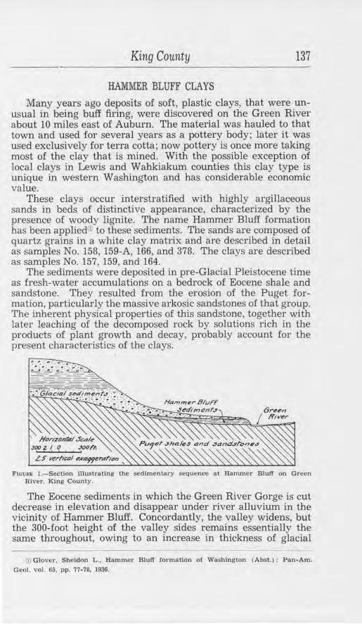
King County 137
HAMMER BLUFF CLAYS
Many years ago deposits of soft, plastic clays, that were unusual in being buff firing, were discovered on the Green River about 10 miles east of Auburn. The material was hauled to that town and used for several years as a pottery body; later it was used exclusively for terracotta; now pottery is once more taking most of the clay that is mined. With the possible exception of local clays in Lewis and Wahkiakum counties this clay type is unique in western Washington and has considerable economic value.
These clays occur interstratified with highly argillaceous sands in beds of distinctive appearance, characterized by the presence of woody lignite. The name Hammer Bluff formation has been applied© to these sediments. The sands are composed of quartz grains in a white clay matrix and are described in detail as samples No. 158, 159-A, 166, and 378. 'The clays are described as samples No. 157, 159, and 164.
The sediments were deposited in pre-Glacial Pleistocene time as fresh-water accumulations on a bedrock of Eocene shale and sandstone. They resulted from the erosion of the Puget formation, particularly the massive arkosic sandstones of that group. The inherent physical properties of this sandstone, together with later leaching of the decomposed rock by solutions rich in the products of plant growth and decay, probably account for the present characteristics of the clays.
F1cuRt !.-Section lllustratlng the sedimentary sequence at Hammer Bluff on Green River. King County.
The Eocene sediments in which the Green River Gorge is cut decrease in elevation and disappear under river alluvium in the vicinity of Hammer Bluff. Concordantly, the valley widens, but the 300-foot height of the valley sides remains essentially the same throughout, owing to an increase in thickness of glacial
~ Glover. Sheldon L .. Rammer Bluff formation o( Washington (Abst. ): Pan-Am.
Geol. vol. 65. pp. 77-78, 1936.
138 Clays and Shales of Washington
drift bordering the valley. The Hammer Bluff sediments underlie the glacial deposits and make up an area of low knolls and dissected terraces near the valley bottom. Formerly the series was much more extensive, but only erosional remnants remain and these commonly have an overburden of glacial gravel, slumped from the valley sides, and Recent alluvium.
The pits of the old Auburn Pottery, later used by the Northern Clay Co. and now owned by Gladding, McBean & Co., are in the SE14 sec. 28, (21-6 E) on a low bench between the county road and the Green River. The excavation, 200 feet by 75 feet, and 25 feet deep at the place of greatest development, exposes 6 feet of gravel and loam underlain by some 30 feet of gray clay of which about half is below the water level. A section of the different members follows, but there is some lateral variation.
Section from pit of Northern Clay Co.
Top of section Feet
Gravels and loam. . ...... . . .. . .. . ..... . ..... . .. 6 Unconformity
Dark-gray clay, iron-stained.. ... . . .... . . . . . . . . . 2 Carbonaceous clay. . . . . . . . . . . . . . . . . . . . . . . . . . . . . 1 Greenish-colored clay with layers of very compact
light-gray volcanic ash. . . . . . . . . . . . . . . . . . . . . 3 Very dark gray sandy clay containing abundant
slightly carbonized woody fragments . . ..... . . . 4 1 Gray clay, sandy in part ... .. .. . . . ..... ..... . ... . .
Watel' level Grayish-blue clay . . .... . . .. . . . ......... .. . . . . . .
5 ~Minced
7-L I 28+
The beds strike N. 30 " W. and dip 7° NE. They thin out northward and finally disappear as the elevation of the underlying Tertiary strata increases. In other directions, at no great distance from the present workings, the bench containing the clays has been removed by erosion.
Sample No. 164 was taken above water level of the main body of sandy gray clay showing fine to rather coarse texture. When dry, the lumps are soft and friable, but the plasticity is good when the material is moist.
Plastic and dry properties Sample No. 164
Plasticity ... .. ..... ... ..... . .. . ...... Good Volume shrinkage ... .. 15.6/f, dry volume Shrinkage water ... . .. . ..... . ......... 9.1 % Linear shrinkage . . . ..... 5.5% dry leng th P ore water ......................... 19.1 % Dry condition . . . . .. . .. . ... . . . . • .. .Good Waler of plasticity .... .... ... . .. .... . 28.2",
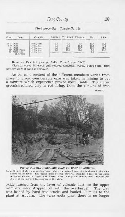
King County 139
Fired properties Sample No. 164
Ooncl Color Condit ion u;.o/o(J.I. 1·1'.L.S.%d.l.l V.S.~cd.v. Abs.
I A.Por.
01- 1 I Buff Goocl, soft 2.a 7.6 (;. j 10.i 3U ,,..r,· Oood. $.1:l.- :?.9 9.l 11.2 17.~ 30.~ U Buff Good, S.Jl . 0.3 11.8 li .7 11.1 27 .u
12· Buff-brown (;oocl, S.11. 7.6 ]3.1 21.1 ;).9 12.0 15 Grny 011(1 Good. H.11. .. .......... ············ ······· ····· 5.S .... ........
I t. t,rown
Remarks: Best firing range: 3-15. Cone fusion: 23-26. Class of ware: Siliceous buff-colored structui·al wares. Terra cotta. Buff
pottery ware if sand is removed.
As the sand content of the different members varies from place to place, considerable care was taken in mining to get a mixture which experience proved most usable. The upper greenish-colored clay is red firing, from the content of iron
PLAT£ 4
PIT OF THE OLD NORTHERN CLAY CO. EAST OF AUBURN.
Some 16 feet or clay was worked here. Only the upper 9 f eet of tbJs shows in the view above water level. The upper dark colored material includes 6 feet of the same series which was stripped with 6 feet of soil and gravel overburden. Sample No. 164 is of the lower 5 f eet shown in the view.
oxide leached from the layer of volcanic dust; so the upper members were stripped off with the overburden. The clay was loaded by hand into trucks and hauled 10 miles to the plant at Auburn. The terra cotta plant there is no longer
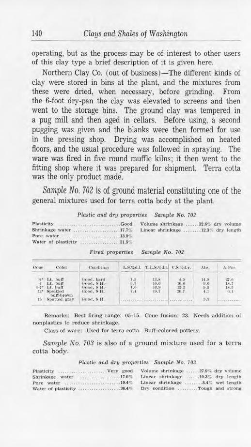
140 Clays and Shales of Washington
operating, but as the process may be of interest to other users of this clay type a brief description of it is given here.
Northern Clay Co. (out of business)-The different kinds of clay were stored in bins at the plant, and the mixtures from these were dried, when necessary, before grinding. From the 6-foot dry-pan the clay was elevated to screens and then went to the storage bins. The ground clay was tempered in a pug mill and then aged in cellars. Before using, a second pugging was given and the blanks were then formed for use in the pressing shop. Drying was accomplished on heated floors, and the usual procedure was followed in spraying. The ware was fired in five round muffle kilns; it then went to the fitting shop where it was prepared for shipment. Terra cotta was the only product made.
Sample No. 702 is of ground material constituting one of the general mixtures used for terra cotta body at the plant.
Plastic and dry properties Sample No. 702
Plasticity ..... . ..•..... . ..... . .•. . ... Good Volume shrinkage ...... 32.6% d ry volum e Shrinkage water ...... .. ........ . .. .. 17.7% Linear s hrinkage ........ 12.3% dry length Pore water .. . ....... ... .... . ... . .... 13.8% Water of p lasticity ... .. .......... . .. 31.5%
Fired properties Sample No. 702
0orw Color Conllltlon I.X%d.t. 'l'.J .. S.%d.l. , ·.s .'1, ,r.v. Ahs. .\ .Por. -------•--- -------4!-1 ' l, l. buff ~ 1.L. huff
t.--i • Lt. bu ff 1.2• Speckle<l
hu.ff-brown 1;; I Spotted ,::ruy
Good. hurtl Good . S H.li oocl. SH .-000,1 . SH.
Good. s H.
1.5 13 . 4.:; x. i 16 .0 10.tl U, JO.O 13".2
, .... . ~: ~ ........ '.~:~ ........ ~~: ~ .. ..
H .1/ !1.6 0.5 ~.1
3.3
Zi.6 JI\. ( IS.o 11.1
-------Remarks: Best firing range: 05-15. Cone fusion: 23. Needs addition of
nonplastics to reduce shrinkage. Class of ware: Used for terra cotta. Buff- colored pottery.
Sample No. 703 is also of a ground mixture used for a terra cotta body .
Plastic and dry properties Sample No. 703
Plasticity .... .. .......... . ..... Very good Volume s hrinkage . ..... 27.9% dry volume Shrinkage water ...... . ... . .... .. . . 17.0% Linear sh r inkage . . . ... I0.3o/, dry length Pore water .. . ........ . . . ....... . . . . 19.4% Li.near shrinkage ..... . .. 8.4% wet len gth Water of plasticity ..... . . ......... . .. 36.4% Dry condition ....... . . Tough and strong
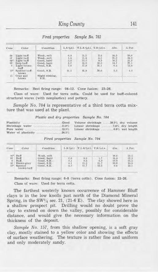
King County 141
Fired properties Sample No. 703
('one I Color ( iorulltloa L.S.1"011.1. ' l'.L.S.o/crl.l. V,S,<fc,1.v. ~ :.J~or._ ----0$ J.11:bt huff rn Llgbl IJull oi• Llghl huff O'.! Det•11 I 111 If ti Light hrO\\ U•
huff 12* S1,otlL'fl hu lf
hrown If, Grey nnd
brown
Weuk , f OH Weak. ~oft Noo,1, lrnnl Good, hur,I Uoml, ~.H .
Good. S.H.
~lll(hl f licking . S.ll.
(l.Q 11 .l 2A l.G ll .S 4.tt :Lo J3.:l 3.5 6. i 16.0 18.0 7.6 Ii .fl tl.1
11.:l 21.6 :wi.o
Remarks: Best firing range: 04-12. Cone fusion: 23-26.
2,4, :; 3~ ... 21.0 :)4 .!I IO,i St.2 H.7 27. l 6.~ 1.2.~
2.2 1.0
Class of ware: Used for ten-a cotta. Could be used for buff-colored structural wares (with nonplastics) and pottery.
Sample No. 704 is representative of a third terra cotta mixture that was used at the plant.
Plastic and dry properties Sample No. 704
Plasticity . . . . .. • . .. ... ..... .. ...... Good Volume shrinkage .. .. . 20.sc; dry volume Shrinkage water ............ .. ...... 11.0"'r Linear shrinkage ....... . 7.4c,I- dry length Pore water . ... . .... .. ... . .. .. .. . .. .. 13.l"'o Linear shrinkage . . ...... . 6.6",, wet length Water of plasticity .. ........ . . . ..... 24.1%
Fired properties Sample No. 704
Cone j __ <.'Ol(lr
(W' llutl
__ <_·o_m_llL_lo_n __ , I •. S.%d.l. 'l'. I..S.%tl.l. V.S.'1, ,1.,·. ~>~. A Por .
02 ButT ii Buff
. 10 llrow11-~r11 y 12' is1,o tt,•cl
brown-huff
\\'t•uk, ~Oft noo,1. bunt Goo,1, S.H.Goo,t. S.li . 1100,1 . S. 8 .
.. . .. o:i; .. .. j .. ···~:;, ... · .. ... i:1 .... 2.1 U.5 U.2 4. l II.~ 11. 7 4.!l I 1 , 7 l2.5
JS.II IS.!J 12.U IO.O 9.(1
Remarks: Best firing range: 6-8 (terracotta). Cone fusion: 23-26. Class of ware: Used for terra cotta.
H:!..!l :t2. :!. :?ll.5 19.:i JJl.l
The farthest westerly known occurrence of Hammer Bluff clays is in the low knolls just north of the Diamond Mineral Spring, in the SWl,.{~ sec. 21, (21-6 E). The clay showed here in a shallow prospect pit. Drilling would no doubt prove the clay to extend on down the valley, possibly for considerable distance, and would give the necessary information on the thickness of the deposit.
Sample No. 157, from this shallow opening, is a soft gray clay, mostly stained to a yellow color and showing the effects of surface weathering. The texture is rather fine and uniform and only moderately sandy.
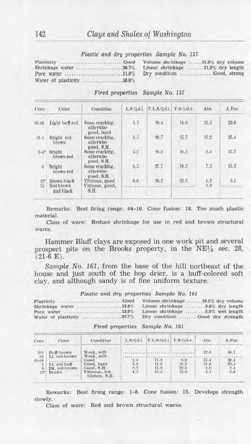
142 Clays CLnd Shales of Washington
Plastic and dry properties SampLe No. 157 Plasticity ..... . .......... .... ...... . . Good Volume shrinkage .... .. 51.9% dry volume Shrinkage water ..................... 26.7% Lineal' shrinkage ........ 21.2% dry length Pore water ............ . ............. 11.9% Dry condition ............... Good, strong Water of plasticity .............. .. .. 36.6%
Fired properties Sample No. 157
Cone Color Condltfou U,.%d,I. •r.L.S.o/o1I.I. v.s.~,d.v. Alis. A.Por. --0~ Light liuff-ml Some t•rueking. p
otlll'rwlse 2fU 14. 11.3 ~-6
good, hard 01-1 Bright red- Some t·rHcking, 5.5 26.7 15.7 11.2 23.4
brown otlwrwise good. S.H.
3-1' Bright Some tratklng. ;,. i ~.!I 16.2 ii. I Ii .i brown-red ot11~rwlse
good . . B. 0 DrlghL Some cracking, 6 • 27.i 1 .2 7.3 15.Z ,,)
I l>rown-red otbf'!'wlse
good, S.H.
1 ..... ~:~ .... 12' Urown-hlurk Vftreou~. goo1I .0 20.2 2'i?..2 J.2 )j lied-brown Vitreous, good, ···· ········ ............ ............ 3.0
and black S.H. I
Remarks: Best firing range: 04-10. Cone fusion: 18. Too much plastic material.
Class o! ware: Reduce shrinkage for use in red and brown structural wares.
Hammer Bluff clays are exposed in one work pit and several prospect pits on the Brooks property, in the NEl,4 sec. 28, (21-6 E) .
Sample No. 161 , from the base of the hill northeast of the house and just south of the hop drier, is a buff-colored soft clay, and although sandy is of fine uniform texture.
Plastic and dry properties Sample No. 161 Plasticity ................ . ....... . ... Good Volume shl'inkage .... . .. 24.2% dry volume Shrinkage water ..... . . . ...... . ..... 13.S"'r Linear shrllllkage ........ . 8.8% dry length Pore water ........ ... ...... .. . . ..... 13.9% Linear sltrinkage ....... . . 5.5% wet length Water of plasllclty .................. 27.7% Dry condition ........ Good dry strength
('on,· Color
Pit llulf-t,ro",1 Cl, l.t. r,d-hro1111
l),",--01 ........... . .... . I 1,t. re,1-llll If 6 Ok. rcd-lirown
12•1 J\rown
Fired properties Sample No. 161
C'ourlltlou
W enk. $OfL Wruk, so ft C)oo.i Goo,1, hard (';ootl. S.B. VitrfOU~. !cw
t,listers. S.R.
L.S.%'1.1. 'l'.L.S.o/,-d.i.l \'.S.'}11.v.1 • \h~.
22.0
A..Por .
.•. , -""'· ' ..... 2: i .. · · .... i i :2 ........ ·o:u ........ ii:.i ........ :io:.i ....
5.~ H ,Ii 16.5 11. 23.3 ~-2 li .0 22.3 -LO .4 ~.r, !$.:! JUI 3. I 5.8
Remarks: Best tll'ing range: 1-8. Cone fusion: 15. Develops sh·ength sJowly.
Class of ware: Red and brown structural wares.
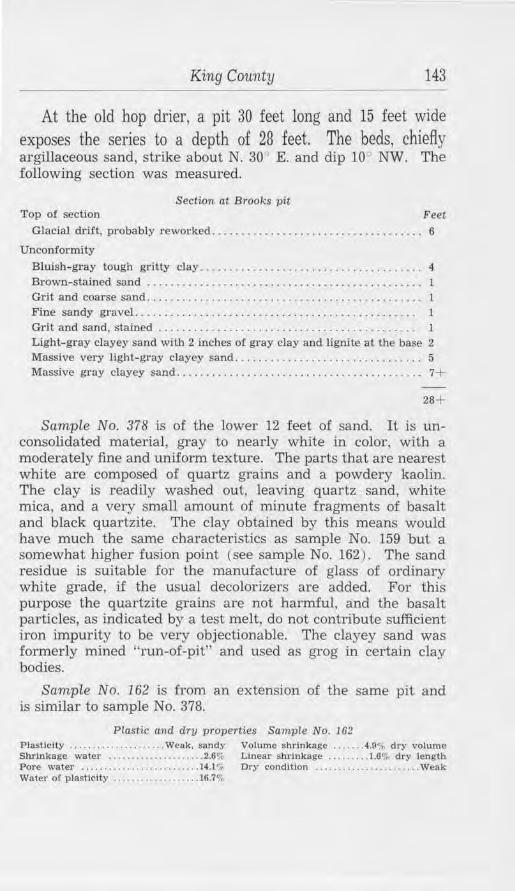
King County 143
At the old hop drier, a pit 30 feet long and 15 feet wide exposes the series to a depth of 28 feet. The beds, chiefly argillaceous sand, strike about N. 30" E. and dip 10 NW. The following section was measured.
Section at Brooks pit Top of section Feet
Glacial drift, probably rewol'ked ..... .. . .. ..... .. . ... ......... ...... 6
Uncorr!onniiy
Bluish-gray tough gritty clay. . . . . . . . . . . . . . . . . . . . . . . . . . . . . . . . . . . . . . 4 Brown-stained sand . . . . . . . . . . . . . . . . . . . . . . . . . . . . . . . . . . . . . . . . . . . . . . . 1 Grit and coarse sand. . . . . . . . . . . . . . . . . . . . . . . . . . . . . . . . . . . . . . . . . . . . . . . 1 Fine sandy gravel. . . . . . . . . . . . . . . . . . . . . . . . . . . . . . . . . . . . . . . . . . . . . . . . l Grit and sand, stained . . . . . . . . . . . . . . . . . . . . . . . . . . . . . . . . . . . . . . . . . . . . 1
Light-gray clayey sand with 2 inches of gray clay and lignite at the base 2 Massive very light-gray clayey sand ....... .. ... ......... .. . . ...... . 5 Massive gray clayey sand .......................................... 7+
28+
Sample No. 378 is of the lower 12 feet of sand. It is unconsolidated material, gray to nearly white in color, with a moderately fine and uniform texture. The parts that are nearest white are composed of quartz grains and a powdery kaolin. The clay is readily washed out, leaving quartz sand, white mica, and a very small amount of minute fragments of basalt and black quartzite. The clay obtained by this means would have much the same characteristics as sample No. 159 but a somewhat higher fusion point (see sample No. 162) . The sand residue is suitable for the manufacture of glass of ordinary white grade, if the usual decolorizers are added. For this purpose the quartzite grains are not harmful, and the basalt particles, as indicated by a test melt, do not contribute sufficient iron impurity to be very objectionable. The clayey sand was formerly mined "run-of-pit" and used as grog in certain clay bodies.
Sample No. 162 is from an extension of the same pit and is similar to sample No. 378.
Plastic and dry properties Sample No. 162 Plasticity ............ . ........ Weak, sandy Volume shrinkage ....... 4.9% dry volume Shrinkage water ..................... 2.6'", Linear shrinkage ........ 1.6% dry length Pore water ..... .. ......... . ....... .. 14.1,;; Dry condition ............. . ........ Weak Water of plasticity .. .... .. . . ... ...... 16.7%
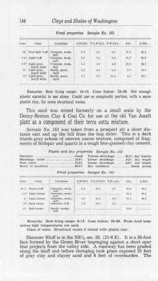
144 ciays and Shales of Washington
Fired properties Sample No. 162
Cone• l'olor Condition 1,.S.%d.l. 'l'.L.S,%d.l. V.S!Arl.v. Abs. A.Por.
r,2 1 \'pry Ugllt huff C: rauu lor. 11·1>11k. O.ll 1.9 (\,9 1i.!J ss.z sort ~i. ,, LigJit bu ff Ornnulur. weak, 0.11 :?. ii 2.~ HI.:? 29.3 ~oft
IH" Light gruy. Grnnuhcr. wcnk. 1.:J t.!l 4.0 11.~ ~.i n~urly" hile sort
lO Light gruy, Sundy, good. 3.2 u O.:l 9.!l I .3 ncurly 11 hilt hunt
It' Ug1t1 gnu•. Sunrfy , good. l.i Ii .~ 1~. t ~.a 10.7 Marty II hil t• hur1I
Remarks: Best firing range: 10-15. Cone fusion: 23-26. Not enough plastic material to use alone. Could use as nonplastic portion, with a more
plastic clay, for some structw·al wares.
This sand was mined formerly on a small scale by the Denny-Renton Clay & Coal Co. for use at the old Van Asselt plant as a component of their terra cotta mixture.
Sample No. 163 was taken from a prospect pit a short distance east and up the hill from the hop drier. This is a dark bluish-gray arkose of uneven coarse textur e, composed of fragments of feldspar and quartz in a tough fine-grained clay cement.
Piastic and dry properties Sample No. 163 Plastic it)' . . ....... . . . ........ .. . . ... Good Volume SbJ_·inkage . . , .... 25.2 <;; dry volwne Shrinkage water . ... . .. . ... ... ... .. . 13.0% Linear s hrinkage ....... 9.2<;- dry length Pore wa ter ...... . .......... . ..... . .. I3.3q4 Linear shrinkage ....... 6.3•. wet length Wa ter ot plaS1iclty ...•..... . . . ..... . 26.3% Dry condition ......... , .... Good, strong
Fired properties Sample No. 163
C'Olor
OJ-1 Hrown-1111 ff
0 J,lght l,r()WU
t,, Buff-hrown
Coudltlon
llrunulur, weuk. ~of t
n ronuhir. weok. !!Oil
Grunulur . W(•uk . sort
Orttoulor. R.H.
~ uri.ly. punk-)', sofl
I..S.%cl.1. T . L,S,%tU . V .S!µd .v . .\ b~. .\. £>or .
o.&
0.1!
1.;
JO.I
10.1
JO.O
16.~ :l0.3
2.P. ,~.o 2S.O
:,.o 12.
Remarks: Best firing range: 8-15. Cone fusion: 23-26. Weak fired body unless high temperatures are used.
Class of ware: Structural wares if mixed with plastic clay.
Hammer Bluff is in the NEY-i. sec. 28, (21-6 E ) . It is a 38-foot face formed by the Green River impinging against a short spur that projects from the valley side. A road way has been graded along the bluff and before slumping took place exposed 22 feet of gra:v clay and clayey sand and 6 feet of overburden. The
King County 145
clay series strikes approximately east and dips 25° -30° N., though possibly involved in landslide. Below are Puget beds, sandstone and thin shales that are exposed to a height of 10 feet above the river. The road is on the contact of the two series.
PLA'l"t 5
HAMMER BLU:FF ON cnEEN HlVER. EAST OF AUBURN.
The 4 _feet or clay above lhe 18-lnch dark. lignite layer was sampled as No. 159: the 12 feet of clay below was sampled as No. 158. Overlying these and only partly shown in the view is 5 feet o( stained clay, then 6 Ceet of reworked glacial drlft.
Sample No. 158 is of a 12-foot bed of clayey sand, exposed at the foot of the cut just above the road grade. It is similar to sample No. 378 (p. 143) but is more compact, owing to the somewhat higher clay content. The material is nearly white in color and has a uniformly coarse texture. It is composed of quartz sand, kaolin, muscovite, and some few grains of basalt. When dry the lumps are so friable as to pulverize easily between the .fingers.
Plastic and dry properties Sample No. 158
Plasticity ..•........••......•.. . .. . .. Weak Volume shrinkage ....... 6.7"~ dry volume Shrinkage water ......... • . ......... . 3.6% Linear shrinkage . . ....... 2.3"; dry length Pore water .... .. .. . . .. ............... 13.9~ Dry condition ................. . .... Weak Water of plasticity .................. J7.5"l-
146 Clays and Shales of Washington
Fired properties Sa1nple No. 158
C'ono Color Condition L.S.%cl.l. T.L.S,%d.J. V.S.$~d.\'. ,\t1~. A.Por.
O,J Lit:ht gn,y' Granular, weak, o.; s.o 2.2 ............ ............ oeur while soft
01 Light gray, Gr11n11lur, weak, ............ ............ ............ 19.0 83.7 near whito soft
:H Lll(lll l!Tl.ll' , r.rnnuh1r, eofl o.s 3. 1 _., I 1S.6 32.5 uear whit~
6-7* potted light Granular, oft ·· ·········· ············ 10.6 28.l gray
12.9 22.G 12" Spot led Ilg hl Gram1lur, hard l.i 1.0 5.0 gruy
Remarks: Best firing range: 8-15. Cone fusion: 28-29. Weak plastic and dry strength. Does not develop strength until late. Needs mixing with more plastic clay.
Class of ware: No. 2 siliceous refractory.
Sample No. 159) also from Hammer Bluff, is from 4 feet of tough gray clay that overlies the clayey sand and is separated from it by 1% feet of woody lignite. It is nearly white in color and is rather fine-grained, especially so when compared with the foregoing sample. In fact, the chief difference between the two is in fineness of grain and in the greater amount of clay substance of No. 159 which makes it more compact.
Plastic and dry properties Sample No. 159 Plasticity ............................ . Fair Volume shrinkage ....... 10.9% dry volume Shrinkage water ....... .... ....... , .. 5.8% Llnear shrinkage ... . ..... 3.8% dry length Pore water . .. ... ....... ... ........ .. 15.1 "'o Dry condition ..... Moderate dry strength Water of plasticity ....... ........ .. 20.9%
Fired. properties Sample No. 159
Color Condition f,.S."l,,1.1. 'l'.t.S.%d. l. V .S.' ,,I.,•. .\hs. A.J?or.
OI I Light creum U3 Light cream 1 Llgt1t crcum
8--1• Ltglll huff <;-7•1 Light Sl)Otte(l
huff 12" Gr11y-b11 tr
W,•11k. ?oft \l'Pl\k, ~Oft Wenk , soft Good, hnrct Ooo<I. S.B.
000<1, s.n.
0.9 4. 7 2.i 1· ·· .... .. .............. . ............ ........ .... ........... , JS.8 83. J ...... , • , • . . . ....•.••..•.••.• , • : .. .. lG.4 S2.G
2.2 1).0 o... 14.7 28.0 z. 1\.6 .2 12. 7 23.4
:,.-1 0.2 15.2 8.2 l7.4
Remarks: Best iiring range: 3-15. Cone fusion: 27. Class of ware: Buff-ii.ring structural wares; terra cotta. Buff-colored
pottery, siliceous type.
Sample No. 160 is similar to No. 159 but is of more weathered material from a little farther east in the same exposure. It is somewhat stained in part with iron oxide.
Plastic and dry properties Sample No. 160 Plast.Jclty ..................... . ...... Good Volume shrln'kage ...... . 20.9% dry volume Shrinkage water .. ......... ... ..... . 11.6% Linear shrinkage ......... 7.5% dry length Pore water ......................... 16.2% Linear shrinkage . . ....... 6.0% wet length Water of plasticity ......... • . . , ..... 27.8<>i Dry condition ........... ...... .. ... . Good
012 Llghl gruy.
I near "hll•' r,1 Light bu IT
3-4 • Light hu IT 0 Light bu ll'
15 Spolte,I !,'TUY
King County
Fired properti.es Sample No. 160
('on,litlon
\\ ,,nk, .•ott
<1oorl, hnrrl Ooocl. S.B..Go<>rl, S.H. Good. S.13.
..................................... ~.a 1:?.l' 1J.O 11.1 1:1.v n.a
Remarks: Best fu-ing range: 01-8. Cone fusion: 27.
20. 1 H.2 10.n
1.~
Class of ware: Buff-colored structural wares; terra cotta.
147
I ;U
.. .:::~ ....
Between Hammer Bluff and the pits of the Northern Clay Co. are old workings of that company. They are known as the "upper pits" as they lie north of, and about 50 feet above, the road. A continuation of the clay of Hammer Bluff was mined here, but work stopped when a slide of overburden occurred. A small exposure of sandy clay is still accessible, and the two samples below were taken there.
Sample No. 159-A is similar to No. 158, but is an iron-stained surface sample with coarse grains of quartz and quartzite.
Plastic and dry properties Sample No. 159-A Plasticity ....................... . ...... Falr Linear shrinkage ...•..... 2.7<;, wet length Water of plas Ucltl' .................. 17.4% Dry condition ............... FaJr strength
Fired properties Sample No. 159- A
f'one Color <'0111111100 L.S.%d.l. 'J'.L.S.o/otl.t.l V.S.~M.v. Ah~. A.Por.
012 Plnk-ercutu Urunuh1r, w11 t1k . ......... , .. ............ ..... ~:~ .... , li.l 31.2 ,·ery PCJfl
01-1 Light ereum Cir1111ulitr . wcnk. 1.3 ............ 16.3 80. 2 ~Ott :µ, T,lgllt ~rcum Grunulur, weuk. t.u ············ 4.5 1:?.i :?..&,:? horll
II Light hu IT. Grunulor. goml, 1.5 ............ 4.1 10.:) 10.S RDOlte<i h11rd
1:.>• Lll!hl bull'. ~J>Otte•I
nrunulur. good . l1orll
1.7 ... ......... 5.0 7.3 13.2
Remarks: Best firing range: 3-15. Cone fusion: 28-29. Class of ware: No. 2 siliceous refractory; buff-colored structural wai·es:
terra cotta.
Sample No. 160-A is from the same pit. It is of a carbonaceous clay underlying a stratum of woody material. Though fine-grained, it is very sandy.
Plastic and dry 'J)Toperties Sample No. 160-A PlasticHy . . . . . . ...... . . .. ..... ...... Good Volume shrinkage ........ 9.3% dry volume Shrinkage water ........... .......... 4.80:, Linear shrinkage ..... .... 3.2% dry length Pore water ..... ..............•...... 11.6% Dry condition ....••.•............ Sandllke Water or plasticity ................... 16.44*
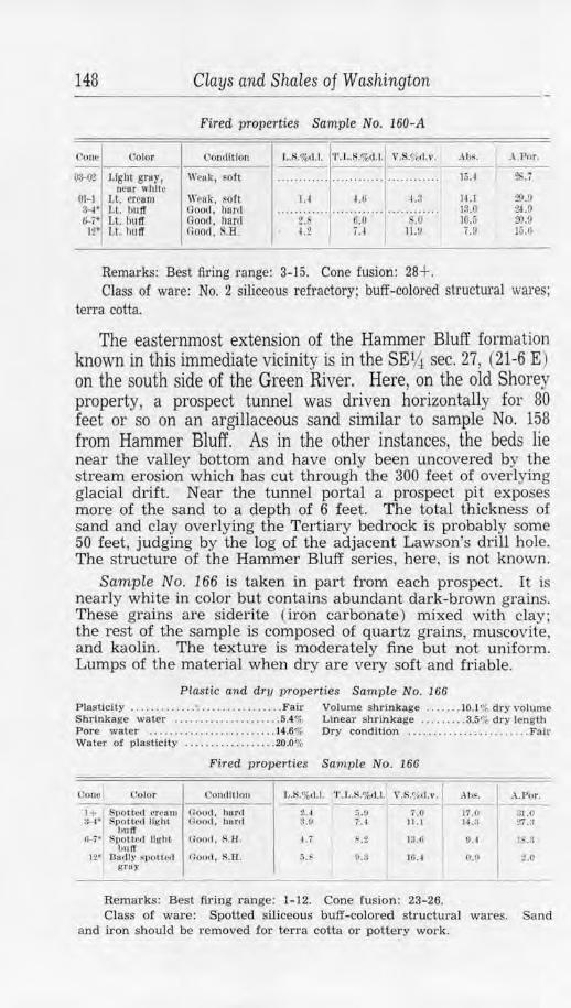
148 Clays and Shales of Washington
Fired properties Sample No. 160-A
(lonr ()olor Co11di t iou l, .S.%d .l. T .L.S.%cl.l. V.S.'l(<l.v. Alls. .\ .Por. I
O:~O':? Light gruy, Wruk, sou ·· ·· ··· ····· .. .... ...... ~ .. ' ........ lo.I ZS.7 DCIU' while
01-1 Lt. cream \\'P8 k , ~oft 1.4 4.fl ~.:l IU 29.!) :H• Lt. l)U ff Good, hftr(I ...... .. ... ······ ·· ···· .... . ........ 13.0 u.o (,-7• Lt. hu ff Good. harrl 2. 6.0 ' .O JQ,j ~.o
12* Lt. bu ff Good. S.B. u u 11.!) i.9 J.i .O
Remarks: Best fil'ing range: 3-J5. Cone fusion: 28+. Class of ware: No. 2 siliceous refractory; buff-coloi·ed structural wares;
terra cotta.
The easternmost extension of the Hammer Bluff formation known in this immediate vicinity is in the SE14 sec. 27, (21-6 E) on the south side of the Green River. Here, on the old Shorey property, a prospect tunnel was driven horizontally for 80 feet or so on an argillaceous sand similar to sample No. 158 from Hammer Bluff. As in the other instances, the beds lie near the valley bottom and have only been uncovered by the stream erosion which has cut through the 300 feet of overlying glacial drift. Near the tunnel portal a prospect pit exposes more of the sand to a depth of 6 feet. The total thickness of sand and clay overlying the Tertiary bedrock is probably some 50 feet, judging by the log of the adjacent Lawson's drill hole. The structure of the Hammer Bluff series, here, is not known.
Sample No. 166 is taken in part from each prospect. It is nearly white in color but contains abundant dark-brown grains. These grains are siderite ( iron carbonate) mixed with clay; the rest of the sample is composed of quartz grains, muscovite, and kaolin. The texture is moderately fine but not uniform. Lumps of the material when dry are very soft and friable.
Plastic and dry properties Sample No. 166 Plasticity .. . ........ .. • .. .... . . .. . . ..... Fair Volume shrinkage .... ... 10.1 '::- dry ,·olume Shrinkage water ......... . ... ........ 5.4% Linear shrinkage .. ... .. . . 3.5% dry length Pore water ..... . ........ . ...... .. .. 14.6% Dry condition ................... .... . Fair Water o( plasticity ...... .. . .. ...... . 20.0%
Fired properties Sample No. 166
Cono Color Co11t1 1t lo11 hS.o/otl .J. 'r. L.S.%rt. i. V.R.'fi'rt.,,. Ah~. .\ .Por. - -----1 + S110HNI cr~om Ooo<.l . hurd 2-. 1 .',. !! 7.0 17.0 ;;i,O :~· Spott.crl llghL Ooo<I , ho rel :1.11 ; -~ 11.1 14 .:l Tt.:J
bu ff (5,,.-; • SllOttc<I light
hulT Goorl, s.n . ~. 7 ~ • .2 IJ.11 0.4 1~.3
12• Oartly ~POll<'<l Ooorl, S.'El. r,. !/.!I JO. ~ O.!I z.o gray
Remarks: Best firing range: 1-12. Cone fusion: 23-26. Class of ware: Spotted siliceous buff-colored structural wares. Sand
and iron should be removed for terra cotta or pottery work.
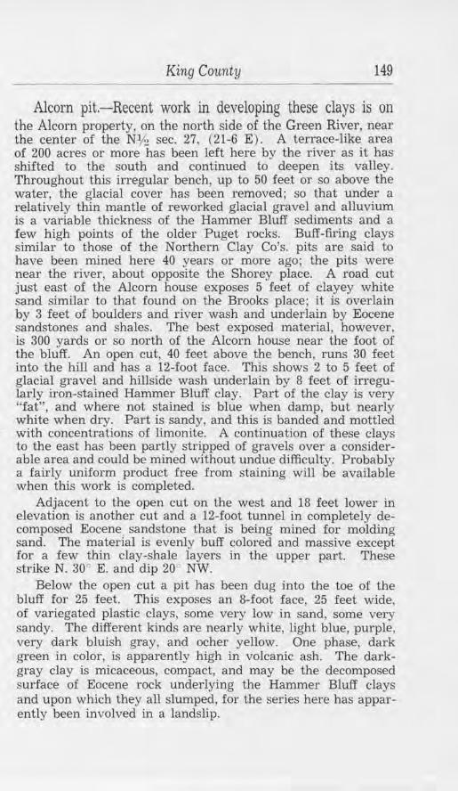
King County 149
Alcorn pit.-Recent work in developing these clays is on the Alcorn property, on the north side of the Green River, near the center of the Nlh sec. 27, (21-6 E). A terrace-like area of 200 acres or more has been left here by the river as it has shifted to the south and continued to deepen its valley. Throughout this irregular bench, up to 50 feet or so above the water, the glacial cover has been removed; so that under a relatively thin mantle of reworked glacial gravel and alluvium is a variable thickness of the Hammer Bluff sediments and a few high points of the older Puget rocks. Buff-firing clays similar to those of the Northern Clay Co's. pits are said to have been mined here 40 years or more ago; the pits were near the river, about opposite the Shorey place. A road cut just east of the Alcorn house exposes 5 feet of clayey white sand similar to that found on the Brooks place; it is overlain by 3 feet of boulders and river wash and underlain by Eocene sandstones and shales. The best exposed material, however, is 300 yards or so north of the Alcorn house near the foot of the bluff. An open cut, 40 feet above the bench, runs 30 feet into the hill and has a 12-foot face. This shows 2 to 5 feet of glacial gravel and hillside wash underlain by 8 feet of irregularly iron-stained Hammer Bluff clay. Part of the clay is very "fat", and where not stained is blue when damp, but nearly white when dry. Part is sandy, and this is banded and mottled with concentrations of limonite. A continuation of these clays to the east has been partly stripped of gravels over a considerable area and could be mined without undue difficulty. Probably a fairly uniform product free from staining will be available when this work is completed.
Adjacent to the open cut on the west and 18 feet lower in elevation is another cut and a 12-foot tunnel in completely decomposed Eocene sandstone that is being mined for molding sand. The material is evenly buff colored and massive except for a few thin clay-shale layers in the upper part. These strike N. 30" E. and dip 20 NW.
Below the open cut a pit has been dug into the toe of the bluff for 25 feet. This exposes an 8-foot face, 25 feet wide, of variegated plastic clays, some very low in sand, some very sandy. The different kinds are nearly white, light blue, purple, very dark bluish gray, and ocher yellow. One phase, dark green in color, is apparently high in volcanic ash. The darkgray clay is mkaceous, compact, and may be the decomposed surface of Eocene rock underlying the Hammer Bluff clays and upon which they all slumped, for the series here has apparently been involved in a landslip.
150 CLays and Shales of Washington
The Alcorn brothers mine these clays intermittently and obtain also some Eocene shale from an old coal entry near the east line of the NE?4 sec. 27, (21-6 E) . A wood-fired clay drier has been improvised to lower the high content of moisture before the clay is trucked to the users. A much larger market could be obtained if shipments of uniform physical properties could be maintained. This would involve prospecting the bench and adjacent lower hill slopes by drilling, in order to find the extent and thickness of the series. Pits could then be dug where the possibilities £or uniform, uncontaminated material were best.
Only two deposits of clay whkh can be correlated with the Hammer Bluff formation have been found outside of the area lying between the Diamond Mineral Springs and the Shorey place. One is a poorly exposed erosional remnant that occurs near the old No. 1 South tunnel at Kummer (see sample No. 170, p. 132). The other is in the NW14 sec. 14, (21-7 E), where lying unconformably on the Puget formation and overlain by glacial gravels, is a rather extensive erosional remnant of Hammer Bluff beds. Some 30 feet of strata, covering an irregular area about 600 feet by 300 feet or more, are exposed by railroad cuts, old clay quarries, and prospect pits. The beds strike N. 40°-60° W. and dip approximately 6° SW. The predominant sediment when the pits were first opened was a very plastic gray clay; some of this still remains, but the best accessible material has been mined out. Occurring with it are clayey sands and some decomposed gravels, and scattered throughout are fragments of woody lignite. A few andesite boulders are present in the series; they have apparently withstood complete decomposition because of their size.
The old Denny-Renton Clay & Coal Co. and later Gladding, McBean & Co. found this deposit usable and mined intermittently until 1936. As the beds became increasingly gritty through lateral variation, the site has been virtually abandoned. Further prospecting for these clays is warranted, and the old Hudson coal mine and Kanasket vicinities might well be examined for other remnants of this formation.
Sample No. 379 is more or less representative of the Hammer Bluff clays occurring near Palmer Junction, although it was taken from a single small exposure made by a railroad cut. It is a gray carbonaceous clay that is soft, medium fine grained, and sandy. The component sand grains are quartz, quartzite, mica, and some coal.
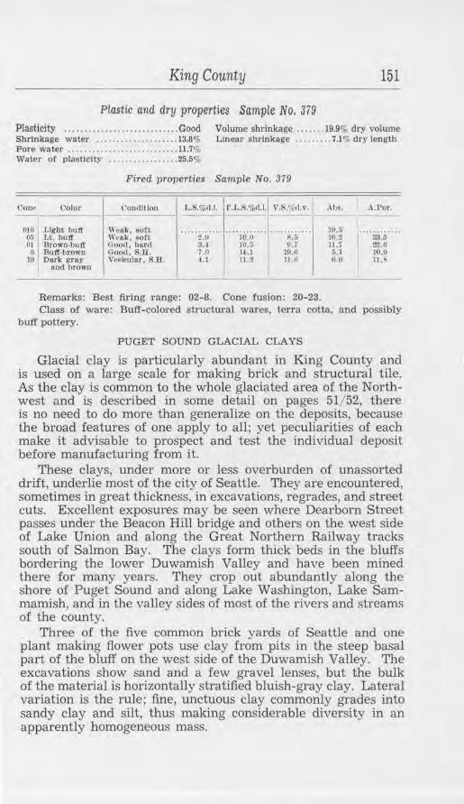
King County 151
Plastic and dry properties Sampie No. 379 Plasticity . . .. ..... . . .. .. . . . . . ........ Good Volume shrinkage ...... . 19.9% dry volume Shrinkage water . ... . . . ......... . ... 13.8% Linear shrinkage ......... 7.1 % dry length Pore water .... . . . ...... . ... . ... . . . .. 11.7% Water o.f plasticity ... .. ....... .... . 25.5%
Fired properties Sample No. 379
Coo~ <' olor C'OtHlltlon l,,S,%<1.1, l' • .L.S.%.-1.1. ,·.itr,d.v. .\hs. A.Por. - - -mo J, lgbt hutT \\'pak, son ............ .. .. ... ..... ············ 19.8 .... .... . .. ..
O.'i LL bulf We~l<, FOfl 2.9 10.0 S.5 lG.2 33.5 01 DrOWO•butr Good. hllJ'rl 3.~ 111. r, U.7 11.7 22.6
(I Ruff-brown Good, s.n. 7.0 14. 1 w.a 5.1 10,!I 10 Dnrl<' ftl'IIY VeFleular. S.H. I.I 11.2 11.6 1 .. 0 11 .h
und brown I
Remarks: Best firing range: 02-8. Cone fusion: 20-23. Class of ware: Buff-colored structural wares, terra cotta, and possibly
buff pottery.
PUGET SOUND GLACIAL CLAYS
Glacial clay is particularly abundant in King County and is used on a large scale for making brick and structural tile. As the clay is common to tbe whole glaciated area of the Northwest and is described in some detail on pages 51/ 52, there is no need to do more than generalize on the deposits, because the broad features of one apply to all; yet peculiarities of each make it advisable to prospect and test 1.he individual deposit before manufacturing from it.
These clays, under more or less overburden of unassorted drift, underlie most of the city of Seattle. They are encountered, sometimes in great thickness, in excavations, regrades, and street cuts. Excellent exposures may be seen where Dearborn Street passes under the Beacon Hill bridge and others on the west side of Lake Union and along the Great Northern Railway tracks south of Salmon Bay. Tbe clays form thick beds in tbe bluffs bordering the lower Duwamish Valley and have been mined there for many years. They crop out abundantly along the shore of Puget Sound and along Lake Washington, Lake Sammamish, and in the valley sides of most of the rivers and streams of the county.
Three of the five common brick yards of Seattle and one plant making flower pots use clay from pi ts in the steep basal part of the bluff on the west side of tbe Duwamish Valley. The excavations show sand and a few gravel lenses, but the bulk of the material is horizontally stratified bluish-gray clay. Lateral variation is the rule; fine, unctuous clay commonly grades into sandy clay and silt, thus making considerable diversity in an apparently homogeneous mass.
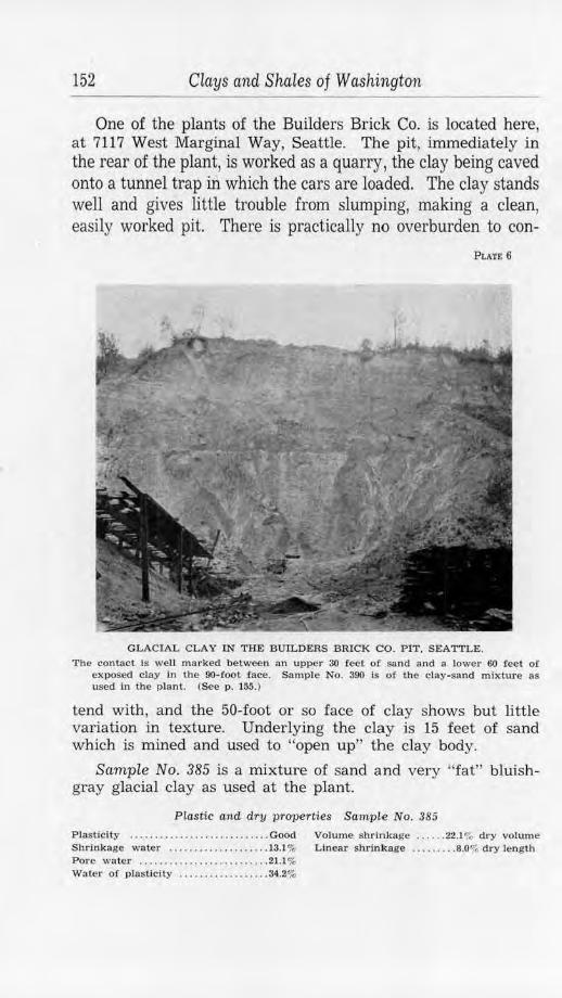
152 Clays and Shales of Washington
One of the plants of the Builders Brick Co. is located here, at 7117 West Marginal Way, Seattle. Tbe pit, immediately in the rear of the plant, is worked as a quarry, the clay being caved onto a tunnel trap in which the cars are loaded. The clay stands well and gives little trouble from slumping, making a clean, easily worked pit. There is practically no overburden to con-
PLATE 6
GLACIAL CLAY IN THE BUILDERS BRICK CO. PIT, SEATTLE.
The contact Is well marked between an upper 30 feel of sand and a lower 60 feet of exposed clay Ln the 90-foot face. Sample No. 390 is of the clay-sand mixture as used in the plant. (See p. 155.)
tend with, and the 50-foot or so face of clay shows but little variation in texture. Underlying the clay is 15 feet of sand which is mined and used to "open up" the clay body.
Scimple No. 385 is a mixture of sand and very "fat" bluishgray glacial clay as used at the plant.
Plastic and dry properties Sample No. 385
Plasticity ... ... ......... . ........ ... . Good Volume shrinkage ... ... 22.1% dry volume Shrlnkage water .... . .......... .. ... 13.1 % Linear shrinkage .... ..... 8.0% dry length Pore water .. ........................ 21.1% Water of plasticity .. . .. ............. 34.2%
King County 153
Fired properties Sample No. 385
Cone Color Oouditlon L.S.%<1.1. 'l'.L.S.%d.l. V-.RMd.v. Abs. I
A.:Por.
Oi LL, rNl-hrown Good , hur,r 1.2 ~.2 3.4 16.3 2S.S CX> BulJ-red Good . hard, .).:; 13.r. 15.i 14.4 27.U
DI<. rNl·hrown light scum
I ltl Vftr<'OU$' surfnre. 11.1 l ll.1 :!O.ll 0.3 II.fl
f!'.OOd, S. H .
Remarks: Best firing range: 07-02. Cone fusion: 2. Could stand more sandy clay for reduction in shrinkage.
Class of ware: Now in use for common red-brown brick and tile.
Builders Brick Co. (formerly, Puget Sound Brick and Tile Co. )-In practice, the clay is mined by trenching into the hill and dragging the clay by a harrow-like device to a car which transports it to the plant at a level allowing for gravity handling. It is passed through two sets of rolls to a combination pug mill, auger machine, and rotary cutter. The output is about 30,000 per day. The brick are trucked to the open-air drying yard, where drying is complete in two weeks in favorable weather. An auxiliary hot-room, with a capacity of 15,000 brick per day, is also used. Firing is in a continuous rectangular kiln with a capacity of 320,000 brick. The plant is temporarily closed, but when operating makes common and rough-textured face brick.
The Abrahamsen Brick Co. is at the foot of the same bluff but farther north, at 5000 West Marginal Way, Seattle. Here the bank has been worked to a height of about 100 feet and has been undermined by old workings until the vast amount of sliding clay mixed with trees and overburden makes difficult and disagreeable operating conditions. The clay is similar to that of the yard mentioned previously but, under the circumstances, reaches the plant with varying sand content and often with troublesome pebbles.
Sample No. 386 was taken of their general mixture.
Plastic and dry properties Sample No. 386 Plasticity ............................. Good Volume shrinkage . .. .... 18.7% dry volume Shrinkage water ............. .. ....... 9.5% Linear shrinkage .... . .... 6.7% dry length Pore water . ........... , ...... ........ 14.5V: Water o! plasticity . ... ............... 24.0",
Coiw --
OIO Ocl
l'2
Fired properties Sample No. 386
Color condition l,.S.%,d.l ·r.1,.IS.%<1.1. \1,S,% (1. , ,. -- ---Buft',hrown \\' ,.~k. ~oil (I.I) ,;.1 0.(1 Dutl-ro, I 000<1. hnnl. t .:'i !l.2 7.~
ligh t srmu R1•d,hrown Goo,1, $ 1L ,; , 7 12.1 1(;.:!
Remarks: Best fixing range: 07-02. Cone fusion: 2. Class of ware: Now used for common structural wares.
AIJS. A.Por.
16.2 80.1 H.U 30.3
6 .11 13.0
154 Clays and Shales of Washington
Abrahamsen Brick Co.-In practice, the clay is mined by power shovel and carried by trucks the 100 yards or so to a hopper-bin. A conveyor belt under the hopper carries the clay the rest of the short way to the plant. There it passes through three pairs of disintegrator rolls to two combination pug mills, auger machines, and automatic rotary cutters. From off-bearing belts the brick are taken on single-deck drier cars to a 12-tunnel direct-heat drier. In 32 hours they are ready for firing. A continuous ring kiln is used, with 400,000 capacity and a turn-over of 3 weeks. "Burlap" and common brick are the only products made.
Still farther north, at 4201 West Marginal Way, Seattle, is another plant of the Builders Brick Co. This operates under much the same conditions as the others and the pit is almost a duplicate of that of the Abrahamsen yard.
Sample No. 391 was taken of their working mixture. Plastic and dry properties Sample No. 391
Plas ticity .. . . . ..... . .. .. ... . .. .. .. . . . Good Volume shrinkage . . .. .. . 17.3% dry volume Shrinkage water . .. . .. ... .. . .. ...... . 9.8% Linear s hrinkage . . . . .... . 6.1% dry length Pore water . .... . ....... .. . . .. . . . . .. • 18.9% Wate r of plasticity .... . .... .. . . . . •. . 28.7%
Fired properties Sample No. 391
Oonc Oolor Condtllon L .S.% cl.l. 1'.T, .S.%().J. V.S.1;1d .v. Abs.
010 Bu ff-brown \\'en.k, sort ········· ··· ... .. 1:6"" ).$ :!O. i, 00 l3u1l'-red l, lg h t scum . 0.9 :!.i Jl/.4
good , soft O'l Uk. rcd,brown Vt t rt'OUY: 1 9.5 Ji,.6 :?6.0 I.G
i,;ood . R H. 2 Ok. red-brown G l81,e(I , badly 4.5 IO.tl )2.~ o.o
~tuck, S.R .
Remarks: Best firing range: 05-02. Cone fusion; 3-4. Class of ware: Now used .for red-brown structural wares.
A.For.
35.5 34.5
4. 1
0.0
Builders Brick Co. (formerly, Lohse Brick Co. ) .- In practice, the clay is mined by power shovel and conveyed in end-dump cars 100 yards to the plant. There it goes by conveyor belt to a rotary drier and then to a 9-foot dry-pan. After screening, the clay passes through a combination pug mill, auger machine, and rotary cutter. The brick are dried on cars in a 13-tunnel steamheated drier. After 48 hours they are ready for the continuous ring kiln which is used here. The plant is temporarily closed, but when operating has a capacity of 10,000,000 common and rough-textured face brick per year.
The Seattle Pottery & Tile Co. is located at 4501 West Mar-
King County 155
ginal Way, Seattle, just north of the old Lohse yard, and obtains its flower-pot clay from the same bluff. Springs and slide material are much in evidence here, but care has been taken, with some success, to keep the original strata intact and usable. No sample of the clay was taken, as it is similar to any of the more plastic glacial clays. For tile, the company buys Hammer Bluff clay from the Alcorn pits.
Seattle Pottery & Tile Co.-The glacial clay is washed to remove rare pebbles and any coarse sand. The process is simple: after mining by pick and shovel, the clay is wheeled to a logwasher where it is blunged with water. The resulting slip is screened and then flowed in troughs to open-air settling vats. These have a 300-ton capacity, but their output is contingent on the weather. It is the intention of the company to wash, dry, and store sufficient clay in the summer months to last through the winter.
At the plant the clay is tempered in a soak-pit, from which it is put through a pug mill with a die for making rolls. These rolls of clay are wire-cut, thus making thick disks or blanks which are formed under pressure into flower pots on the power machines. Various sizes of mantel and some quarry tile are also made on the pug mill auger machine (but from other clays) by changing the dies. There are two flower-pot presses for 2-to 6-inch pots, one for 6- to 12-inch pots, and two jigger wheels for special work. The ware is dried on racks in a hot-room and fired in two horizontal-draft semimu:ffie rectangular kilns (10 feet by 8 feet by 5 feet ) and one circular 12-foot kiln. Coal is used for fuel, and a burn reaching cone 07 is completed in about 60 hours. The capacity of the plant is about 1,000,000 flower pots per year ( on a 4-inch basis) and 250,000 tile.
Bluffs, the counterpart of those on the west of the Duwamish River, border the east side and are formed of similar glacial clays and sands. Two plants here use the glacial clay for brick and structural tile, and two others manufacture flower pots.
The Builders Brick Co., at 9th St. S. and Charleston Ave., have a quarry type of pit, where the clay is exposed to a height of about 60 feet. It is overlain by 30 feet of sand and a small amount of scattered gravel, but much of this was removed by hydraulicking for filling the Duwamish tide flats. No stripping is employed, the clay being allowed to cave by undercutting. Naturally, some overburden caves also, but much of it is used in the brick mixture, and the excess is thrown to one side so as to expose the clay once more. (See pl. 6. )
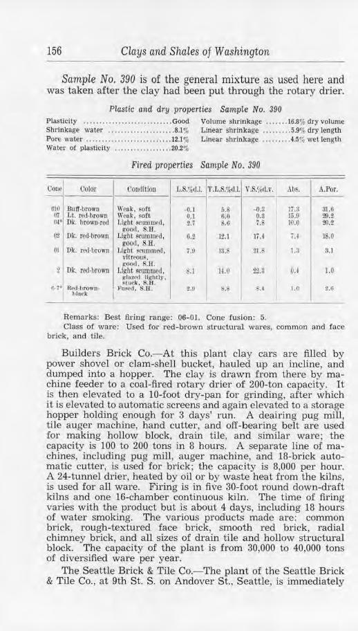
156 Clays and Shales of Washing ton
Sample No. 390 is of the general mixture as used here and was taken after the clay had been put through the rotary drier.
Plastic and dry properties SampLe No. 390 Plasticity ................. . ........ .. Good Volume shrinkage .. . .... 16.8% dry volume Shrinkage water ............... ...... 8.1% Linear shrinkage ......... 5.9% dry length Pore water .............. . ....... .- . ... 12.l % Linear shrinkage . . ....... 4.5% wet length Water of plasticity .............. . ... 20.2%
Fired properties Samp1e No. 390
Cone Color Condition I L. ',%d.1. l•r.L.S.%d.J. V.S.%d.\'. Abs. A.Por.
1 I 010 Buff.brown \\'oak, ~or~ -0.] 5.8 -0.3 JT .3 31.6 Ill Lt. red·brown \Veak, soft 0.1 0.0 0.3 15.9 29.2 (l,t• Dk. brown-red Light scummed, 2.7 8.6 7. 1').0 20.2
good. S.11. O,,! Dk. rcd·brown Light scummed, o.i 12.l 17.4 u 18.0
good . . H. OJ Dk. red-brown Lll!'ht scummed . 751 lS. 21.S l.3 3.1
vitreous. goorl. S.H.
2: Dk. red-brown Light seummctl. . l H.O 2'2.3 OJ 1.0 g laU'<l 111:ttlly , ~tuck, $.H .
IJ-7 • Rc,1-hrown- I rused, S.ff. 2.U ' !!, I l.O 2.6 hlaek
Remarks: Best firing range: 06- 01. Cone fusion: 5. Class of ware: Used for red-brown structural wares, common and face
brick, and tile.
Builders Brick Co.-At this plant clay cars are filled by power shovel or clam-shell bucket, hauled up an incline, and dumped into a hopper. The clay is drawn from there by machine feeder to a coal-fired rotary drier of 200-ton capacity. It is then elevated to a 10-foot dry-pan for grinding, after which it is elevated to automatic screens and again elevated to a storage hopper holding enough for 3 days' run. A deairing pug mill, tile auger machine, hand cutter, and off-bearing belt are used for making hollow block, drain tile, and similar ware; the capacity is 100 to 200 tons in 8 hours. A separate line of machines, including pug mill, auger machine, and 18-brick automatic cutter, is used for brick; the capacity is 8,000 per hour. A 24-tunnel drier, heated by oil or by waste heat from the kilns, is used for all ware. Firing is in five 30-foot round down-draft kilns and one 16-chamber continuous kiln. The time of firing varies with the product but is about 4 days, including 18 hours of water smoking. The various products made are: common brick, rough-textured face brick, smooth red brick, radial chimney brick, and all sizes of drain tile and hollow structural block. The capacity of the plant is from 30,000 to 40,000 tons of diversified ware per year.
The Seattle Brick & Tile Co.- The plant of the Seattle Brick & Tile Co. , at 9th St. S. on Andover St., Seattle, is immediately
King County 157
south of the Builders Brick Co., and their pit, except for minor differences due to lateral variation, is the same as that of the other yard. The clay is mined by clam-shell bucket, dropped into a tunnel, and carried by conveyor belt to disintegrator rolls at the plant. From there it goes to a rotary drier, a 9-foot drypan, and, after screening, to a storage bin. Two complete lines of machines are used, one for tile and hollow block and one for brick. Each includes a combination pug mill, auger machine, and rotary cutter. The ware is dried in a 24-tunnel waste-heat drier and is fired in two 30-foot down-draft kilns and two 2- chamber Hoffman kilns. Wood is used for fuel in the periodic kilns and both coal and wood in the continuous kiln. Water smoking requires 12 hours and the actual firing from 2% to 31h days. The capacity of the plant is about 45,000 brick or their equivalent per day, the various products being common brick, rough-textured and other red face brick, and all sizes of drain tile and hollow building block.
Northwest Pottery Co.-This plant, at 3320 Airport Way, Seattle, is at the foot of the bluff just north of the brick yards, but at present is using glacial clay that has been washed by old hydraulicking operations out into the valley. The clay is scraped up, hauled by truck to the plant, and stored. From the stock pile the clay goes to a pug mill and auger machine where blanks are formed ready for the power press. Flower pots, the only product, are made in sizes from 1 to 14 inches, using the press and a supplemental jolly wheel. The ware is dried in a hotroom (utilizing some waste heat from the kiln) and fired in an 8-foot by 10-foot rectangular coal-fired kiln. Twelve hours is allowed for water smoking, and the burn is completed in 3 days at approximately cone 010. The output is about 60,000 flower pots per month.
Washington Pottery Co.-This pottery is located a few blocks south of the brick yards at 809 Snoqualmie St., Seattle. The glacial clay used is partly from a favorable quarry site on the west side of the valley, near West Michigan St. just above West Marginal Way, and partly from clay that has been washed onto the valley floor by old hydraulicking operations. It is brought by truck to the plant and put through a log-washer and screen and then allowed to dry to the proper plasticity in vats. Flower pots are the only product; the 1- to 8-inch sizes are made on a power press, and the 8- to 14-inch sizes are turned out on a jigger wheel. The ware is dried for 2 days in a hot-room and then fired in an 8-foot by 10-foot rectangular up-draft kiln, a burn to cone 010 being completed in 80 hours. The capacity of the kiln is 25,000 flower pots of 4-inch size, and approximately one kiln per month is fired at present.
158 Clays and Shales of Washington
Potlatch Pottery, Inc.- The Potlatch Pottery, at 1401 Dexter Ave., Seattle, is not at the present time using clays from the State but imports Georgia and Oregon material. Casting, pressing, and hand turning are used in making the rather diversified line of glazed art ware and tableware. Firing is in an 8-foot muffle-type down-draft kiln that is coal fired.
Glacial clay is used for common red-fired ware by the Bothel Brick and Tile Co., at Woodinville, a station on the Northern Pacific Railway near the north end of Lake Washington. The pit is in the low, sloping hill forming the south side of Sammamish Valley and has been worked for many years. The working face is from 15 to 25 feet high and is mostly in broken, mixed material, because of the tendency of the clay to creep forward on the slight slope. Part of the material is sandy and part is very "fat". No overburden is present, but occasionally large boulders must be removed. Weathering has produced a general buff color and a shalelike separation along bedding planes in all except the bottom clay, where the original blue-gray color is preserved.
Bothel Brick & Tile Co.-This plant was inoperative in 1940. When the plant is in operation, the clay is dug by hand and taken 200 feet to the plant by car. There it is elevated, passed through rolls, pug mill, and auger machine. A 6-tunnel steamheated drier is used which limits the capacity of the plant to 12,000 brick per day. The ware is fired in two 30-foot round down-draft kilns and two scove kilns. The product is 3-, 4-, and 6-inch drain tile, and common brick. The average yearly run, of 8 or 9 months, is about 850,000 brick and 100,000 tile.
Two potteries are located at Auburn. One makes only flower pots, from a gray silty glacial clay that is mined from the bluffs bordering Puget Sound northeast of Tacoma. This quarry-pit, near Lakota, is 120 feet long, has a 22-foot face, and an overburden of soil and gravels about 4 feet thick. The clay is mined by hand and trucked to the plant. The other pottery uses clay of the Spokane-Clayton lacustrine type from the Sommer pit, east of Chester, Spokane County.
Auburn Pottery Co., Inc.-This pottery is on the highway, one-half mile north of Auburn. Glacial clay from their Lakota pit, with a little Hammer Bluff clay (from the Alcorn pit) added to improve plasticity, is allowed to slake and is then washed in a blunging machine and flowed as a thick slip to open-air drying vats. The drying clay is scored, so that it :finally cracks into regular-sized blocks used for blanks on the power press. Flower pots of 1- to 8-inch size are made on the press, and those 8- to 12-inches in diameter are turned on a jigger wheel. The ware
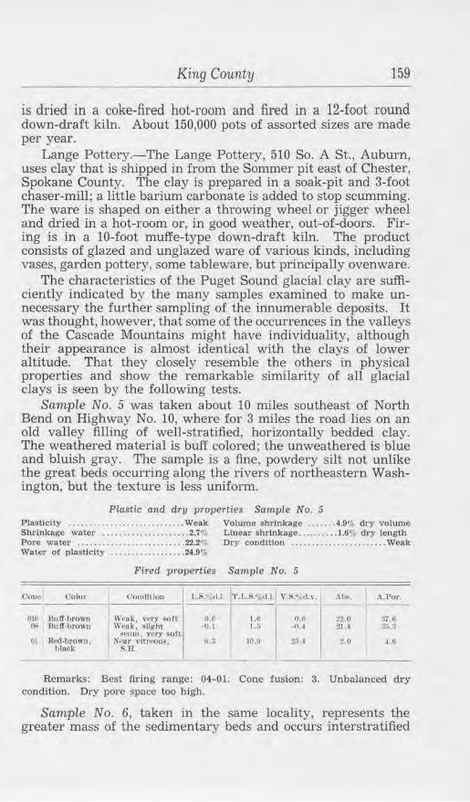
King County 159
is dried in a coke-fired hot-room and fired in a 12-foot round down-draft kiln. About 150,000 pots of assorted sizes are made per year.
Lange Pottery.-The Lange Pottery, 510 So. A St., Auburn, uses clay that is shipped in from the Sommer pit east of Chester, Spokane County. The clay is prepared in a soak-pit and 3-foot chaser-mill; a little barium carbonate is added to stop scumming. The ware is shaped on either a throwing wheel or jigger wheel and dried in a hot-room or, in good weather, out-of-doors. Firing is in a 10-foot muffe-type down-draft kiln. The product consists of glazed and unglazed ware of various kinds, including vases, garden pottery, some tableware, but principally ovenware.
The characteristics of the Puget Sound glacial clay are sufficiently indicated by the many samples examined to make unnecessary the further sampling of the innumerable deposits. It was thought, however, that some of the occurrences in the valleys of the Cascade Mountains might have individuality, although their appearance is almost identical with the clays of lower altitude. That they closely resemble the others in physical properties and show the remarkable similarity of all glacial clays is seen by the following tests.
Sample No. 5 was taken about 10 miles southeast of North Bend on Highway No. 10, where for 3 miles the road lies on an old valley filling of well-stratified, horizontally bedded clay. The weathered material is buff colored; the unweathered is blue and bluish gray. The sample is a fine, powdery silt not unlike the great beds occurring along the rivers of northeastern Washington, but the texture is less uniform.
Plastic and dry properties Sample No. 5 Plasticity .... . .. ... .. ........... . .... Weak Volume shrinkage ...... . 4.9"1 dry volume Shrinkage water ....... . ... .... . ... .. 2.7% Linear shrinkage .......... 1.6% dry length Pore water .......................... 22.2~ Dry condition ... •. . ...• . ..•... . .. . .. Weak Water of plasticity ......... ......... 24.9%
Fired properties Sample No. 5
Cooo Oolor Con<lltlon J.,.K'~~<I.I. r >.S%al \'.S/~trl,v. .\ he. I .\.Por.
DIO 8utr-bro1,'1l 11·,·11k . ,·~rr s<lf1 n.o J.O 0.0 22.0 :~;.tt ~ lluff-hrowu W1>uk. ~light -0. 1 1.i, --0. I 2U :~;.~
$Cum. 1·ery soft 01 Rcd..!Jrowo. ~tor 1·lrrt'()11~, fJ.S 10.9 2,;.4 2.0 ~. G
black S.H.
---Remarks: Best firing range: 04-01. Cone fusion: 3. Unbalanced dry
condition. Dry pore space too high.
Sample No. 6, taken in the same locality, represents the greater mass of the sedimentary beds and occurs interstratified
160 Clays and Shales of Washington
with the more sandy layers. The material itself is thin-bedded and is made up of dark bluish-gray clay that is very "fat" and free from grit, and a smaller amount of a lighter-colored sandy phase. A "run-of-pit" mixture of the sandy (sample No. 5) and plastic phases would doubtless be suitable for ordinary redfired structural ware.
Plastic and dry properties Sample No. 6 Plasticity .... . .... . ... ............... Good Volume shrinkage ...... . 38.9% dry volume Shrinkage water ... . ... ........ ..... 21.0% Linear shrinkage ........ 15.2% dry length Pore water ........... . ........ . ..... 17.3% Linear shrinkage .. ...... . 8.4% wet length Water of plasticity .... ...... .... .... 38.3% Dry condition .. .. .. . .. . . .. .. .. ... . . Good
Fired properties Sample No. 6
Corw Color ('ondition J,.8.%<1.1. 'l'.L.S.%1.1.1 V.S.%cl.v. Alis. .\.Por. --~ BuJl'.lJrown C:00,1. hpr,I l.tl lU 1.7 10.3 3LO 06 LL hrown-re,I Good, S.H.- 5.6 20.7 15.ii lliA 2l,,!) 02 Dlc. red-brown Vitr~ous, J l.l 26.$ 20.0 0. 2.0
goo<!. !;.B. 2 l)k, red-brown !;llghUy JI), 26 .0 211.0 IA 2.U
VfSi(·11lar, S.FL 3--1• RNl·hrown, Vc\RleuJur. 10.2 2.;.~ 27 .; O.ll 1.0
b luck (Ufrtl, $.H. H- 7• Red·brown, Ve$1Cnlnr. l.l 1fj.(t Lt 11,(1 1.0
hlnck f11~(•1l, S.Ji.
Remarks: Best firing range: 06-02. Cone fusion: 3-4. Needs mixing with a sandy clay to counteract high water of plasticity and dry shrinkage. See Nos. 365, 376, 385, 386, 388, 389, 390, etc.
KITSAP COUNTY
Kitsap County, in the central part of the Puget Sound basin, is a rolling to moderately hilly region of 371 square miles. Glacial deposits form a thick covering over the bedrock at all but a few places in the county. Judging from the outcrops that are available, the southern region is largely underlain by basaltic rock and the northern part by a continuation of the Oligocene sediments of Jefferson and King counties. The basalt has contributed nothing to the clay resources, but the Tertiary beds contain many thick shale members which may prove to be of use.
SHALES
Marine fossiliferous shales, with predominant sandstone and conglomerate, are well exposed at the south end of Bainbridge Island. The south shore of Blakeley Harbor shows some 2,400 feet<D of brownish-gray shales in one-half mile. The formation is exposed along the shores of Washington Narrows, but the
(1) Weaver. C. E.. The Tertlal'y formations of weste.1·n Washington : Washington Geol. Survey Bull. 13, p. 182, 1916.
Kitsap County 161
most complete section is on the south shore of Rich's Passage between Orchard Point and Point Glover. Here, a stratigraphic section of 7,715 feet of beds, measured by Weaver0, shows that shale forms 45 percent of the series and that individual members composed predominantly of that rock are as thick as 900 feet.
All exposures occur in sea cliffs and generally at the seaward edge of low wave-cut terraces. In the present beach and low cliffs bordering these terraces, the strata dip to the north at variable angles ranging from 23" to 60 · along Rich's Passage. The overburden of glacial drift may increase in the hills a short distance back from the beach, but the areas destitute of gravel, or covered by only a moderate thickness, are extensive enough to warrant the careful investigation of some of the thicker shale strata.
An apparently commercial deposit of shales a mile southwest of Point Glover, probably a continuation of upper beds at Rich's Passage, was tested but showed disappointing fired properties.
Sample No. 375 is a dark-gray sandy shale that is rather hard. The texture is moderately fine and uniform. When weathered, this material becomes a much lighter gray and then changes to a yellow and dark-brown color.
Plastic and dry properties Sample No. 375 Plasticity ..................... .... ... Good Volume shrinkage . . .. .. 21.0% dry volume Shrinkage water .................. . . 14.4"0 Linear shrinkage ........ 7 .5% dry leng1h Pore water ......................... 30.0% Water of plasticity ..... ... ........ . . 44.4%
Fired properties Sample No. 375
Color ('ondltlnn Al,~. L.S."'.~!:J r.1 •. s.<;;,,1.1. v.s., ,.I.\ . __ _
t~ ltl"d·ltrowu Otl l.t. red-hrowr, 01 Ok. r,,,J.t;rowu
I Dk. r,'d,hrown
\\'ntk. ~oft, ~cum W,•11k, ~011 Yt•:<l<·lllur.
11100 ll•fl. ~Ofl ~\\t1!lt.•(l.
V('!l ttulur. lrnr,I. ~Lurk vrry 1111,111·
- IU
1•> ·) ~l. i
l !l.J -22..11
·!Ji.:!
s2.:, :la.II 12.~
17.ti
A.Por. ---i,11.0 :Ii.a 11.~.
)I'>,()
Remarks: Best firing range: 04-03. Cone fusion: 2-3. Very short tiring range due to bad bloating.
Class of ware: Not suitable for commercial wares.
© Op. cit .. p. 189.
-6
162 Clays and Shales of Washing ton
PUGET SOUND GLACIAL CLAYS
The glacial deposits of the county include clays and sands that commonly have great areal extent and thickness. Wellstratified blue glacial clay containing some sandy phases occurs near Port Orchard and was formerly worked for common brick. This yard was 1 V1 miles west of town on tidewater. Other deposits, conveniently situated, are available whenever their development is warranted.
A great body of clay occurs at Harper, where the HarperHill Brick & Tile Co. operated for many years. The pit was one-fourth mile southwest of the plant in a hillside location. In the working face, for 10 feet or so under the top soil, is a weathered buff-colored sand containing some gravel; from this to the bottom of the pit, about 40 feet, is horizontally bedded blue-gray clay. There are variations in texture, but most of the clay is very plastic-so much so, in fact, that the upper sand is a necessary addition to improve the working and firing properties.
Sample No. 376 was picked from the smooth, very plastic material near the pit floor. This clay is dark blue when damp but dries to a rather light bluish gray. It has the silty appearance common to glacial clays, though it differs from any such clay yet observed in being free from grit even when tested between the teeth. The dried material is compact and very brittle.
Plastic and d-ry properties Sample No. 376 Plas ticity ....... . ........ . . . ... . .... . Good Vo lume s hrinkage ....... 12.6% dry volume Shrinkage water ................... l2.6% L inear shrinkage ..... . .. .4.4% dry length P ore wa te r ...................... . .. 26.3% Linear shrinkage ......... 7.7% wet length Water of plas ticity .... . . . ........ . . . 38.9%
Fired properties Sample No. 376
Oono Color <.:0111lltlon 1,J;,%,LJ, ·r .L. '.%rt.I. , ..... ~(ti.\'. Ah~. A.Por. - - - - -010 JlrOWlt•hU fT sort 0.1; 4.9 1.5 17.6 :».:. 08 llro wn,b11Jt 0 00(1. hu r<I l.lS ;;.11 +.5 16.3 Si;.8 OI Ok. red -brown noort, S.H . 7.5 11.9 20.li 7.0 16.6 02 Rcd•brown Vltreouf , nertr 12.3 10.7 32.6 0.5 1.1
,init t>laek fusion , S.B .
Remarks: Best firing range: 08-02. Cone fus ion: 2. Needs more nonplastic material to cut down the firing shrinkage.
Class of ware: Red-brown structural wares, after treatment.
Sample No. 377 was taken of the general mixture as used at the plant.
Kittitas County 163
Plastic and dry properties Sample No. 377
Plasticity . . . . . . . . ... .. ..... . ........ Good Volume shrinkage ..... . 16.7% dry volume Shrinkage water . . .. . . . ... .. ..... . ... 9.2% Lineru· shrinkage ......... 5.9% dry length Pore water ... . . . . . ..... . . . ....... . . . 18.8o/, Waler of plasticity ..... . . . ....... .. . 28.0%
Fired properties Sample No. 377
t olll· I (.'olor Con<ll rlon c., .•• , ., .. , .. ~ ... ,. \"".S.fhl.v. .\11~. A.Por.
-:;:-1 Buff-brown \\'e1lk, ~O rt O.!l 6. 2 o.s 16.i 31.& ~ I Lt. brown-red L ight ~rum. 4.0 9.9 11.4 15.3 29.S
t,tOl>(l. h1ml 0,2 Rcd,brown Lll(ht ~NIU'I, 7.8 ]3.7 21. r, 3.2 7 .ij
110011, •• H . 2 Ok. red-lJrowu .J-"''l)SPtl. s.o 13.9 2-2.J U l 3.0
H11Ck. KH.
Remarks: Best firing range: 06-02. Cone fusion: 3-4. Class of ware: Red-brown structural wares. Formerly used !or com
mon brick, Dennison tile. and some face brick.
KITTITAS COUNTY
Kittitas County has an area of 2,329 square miles in the central part of the State between the summit of the Cascades and the Columbia River. The western part of this county lies in the mountains, where many different rock types are represented. The older rocks of this area are metamorphic and igneous varieties which, so far as known, are valueless in themselves for ceramic use. They have, however, furnished material for very extensive and thick Eocene sedimentary deposits that occur here and in adjacent areas to the north. Throughout the eastern part of the county, the Columbia River basalt predominates, though interbedded with it in some places and overlying it in others are Miocene and more recent sediments. Detailed descriptions of the various formations are given in several publications.<D
From the character of the original rocks and the fresh-water natl,ire of the derived sediments, it would be expected that some of the Tertiary shales would prove to be of economic value. Unfortunately, many of the strata are thin-bedded, rendering mining difficult; but massive beds exist, and outcrops could be located by careful prospecting. The folding and tilting to which all these strata have been subjected (except, possibly, parts of the Ellensburg beds) also add to the cost of development, but
(l) Smlth. George Otis, U . S. Geol. Survey Geol. Alias. Mount Stuart folio ( no. 106). p. 3, 1904.
Smith, G. 0 .. and Calkins. F. C .. U . S. Geo!. Survey Geol. Atlas, Snoqualmie folio (no. 139) . p. 2. 1906.
Saunders. Edwin J .. The coal fields of Kittitas County: Washington Geol. Survey Bull. 9, pp. 24-31, 1914.
164 Clays and Shales of Washington
high-grade shales could be profitably handled as in King and other counties.
The Swauk formation, of Eocene age, consists mainly of sandstone, although interbedded with this and conglomerate are beds of shale, usually dark colored and carbonaceous. These beds in Kittitas County are too far from a railroad to be of importance now, occurring as they do in the mountainous northwestern part of the county, but extensions of this formation in Chelan and Douglas counties have proved valuable for high-grade refractory shales. (See pp. 61, 85.)
The Naches formation, practically contemporaneous in age with the Swauk series, is an interbedding of sandstone, basalt flows, and a subordinate amount of shale. A small outlier of this formation crops out near Easton, but the main body, with a stratigraphic thickness of some 4,000 feet, is exposed in the high country of the southwestern border of the county.
Probably the most usable shales occur in the Roslyn formation of upper Eocene age. Beds of sandstone and subordinate shale cover an estimated area of 140 square miles in the district to the north of Roslyn and Cle Elum. There are approximately 3,500 feet of these sediments, and they contain several commercially valuable beds of bituminous coal. The shales are finegrained, grading into coarser, sandy phases, and vary in color from gray to almost black. The accessibility of the region and the possibility of mining shales with the coal make the district an attractive one in which to prospect.
Apparently good shales are reported from the Manastash formation of late Eocene age. These beds are exposed in an inaccessible region west of the headwaters of Manastash Creek, but outliers may occur nearer transportation. Many of the shales are fine-grained, and some are very light in color. The beds are associated with coal and may be part of the Roslyn series.
The Guye formation, of Miocene age, differs in many respects from other Tertiary sediments. It occurs high in the Cascades northwest of Lake Keechelus, extends over into King County, and covers an area of about 25 square miles. Sedimentary material, interbedded with andesite and rhyolite, makes up the formation, and shales are fairly abundant. Some of the latter are soft and fissile, but others are so indurated as to be classed as argillite. In color, these shales range from gray green to nearly black. Part of the formation is contiguous to the Chicago, Milwaukee, St. Paul & Pacific Railway and so is accessible if it should prove to be of value.
The Ellensburg formation, laid down on the Columbia River basalt, and in part interbedded with it, occurs at a number of
Kittitas County 165
places in the eastern part of the county and in scattered areas to the south. It is mainly alluvial material-loose conglomerate, soft impure sandstone, volcanic ash, and silty clay-that was deposited along streams and in lakes of late Miocene time, and was covered in some places by later basalt. On the whole, the formation is rather barren of high-grade clays, but some usable beds exist, such as have been developed in Yakima County, and doubtless others will be discovered as markets in the region improve.
One of the valuable mineral resources of central Washington is nearly snow-white diatomite (diatomaceous earth), which forms thick beds in Adams, Benton, Grant, Kittitas, and Yakima counties. For many years companies have been engaged intermittently in mining this material. The workings are principally in Kittitas and Grant counties, and in both places difficulty is caused by an overburden of basalt and clay. Since all of this must be handled in stripping, any utilization of the clay would be very advantageous. Tests for ceramic use were not encouraging, but there is a possibility that the clay may have properties of fuller's earth.
A sample was taken from the overburden of the pit of the old Majestic Diatomaceous Earth Co. on Squaw Creek, 11 miles southeast of Wymer. It is characteristic of most clays found in connection with diatornite, though at some deposits the clay is more compact and brittle. Several beds occur here, as indicated in the following section.
Section of Squaw Creek diatomite deposit
Soil . Basalt ....................... . ..... . ................. . . . ........ .
Feet
1+ 2
Impure dia tomiie . . . . . . . . . . . . . . . . . . . . . . . . . . . . . . . . . . . . . . . . . . . . . . . . 2 Sandy clay . . . . . . . . . . . . . . . . . . . . . . . . . . . . . . . . . . . . . . . . . . . . . . . . . . . . . . 2 Light-buff clay. (Sample No. 6-A) .. .. ... ..... . .... . ....... . .... . .. 5 White diaiomite . ..... . . ....... . . . ....... .. ........... ..... ... ... . 10- 12 Light-buff clay, as above (thickness unknown) . .. ... .... . ...... .. .. 2+
24+
Sample No. 6-A is very light buff in color, being darker when damp, and the texture is uniform and fine. It is loose and poorly consolidated, so the apparent specific gravity is low for clay, and the material powders easily between the fingers. This character apparently results from the inclusion of a less altered stratum of volcanic ash. Some silt and sand were deposited with the
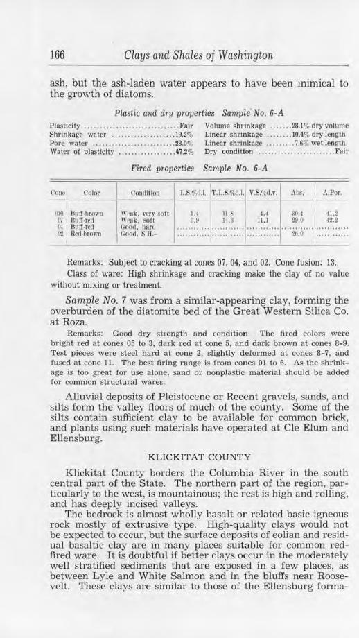
166 Clays and Shales of Washington
ash, but the ash-laden water appears to have been inimical to the growth of diatoms.
Plastic and dry properties Sample No. 6-A
Plasticity .................. .. ....... ... Fair Volwne shrinkage ....... 28.1% dry volume Shrinkage water ............... .... . 19.2% Linear shrinkage .. . . .... 10.4% dry length Pore water .......•.................. 28.0% Linear sbrillkage .. ....... 7 .6% wet length Water of plasticity .................. 47 .2% Dry condition ....................... . Fair
l'onu Color
rno I Du tr-brown 07 I311ff-red tli l:lnff-red O'l Red-brown
Fired properties Sample No. 6- A
CmHliliou L.R.%1U. 'l'.L.S.o/od.l. V.S.%d.v. I Abs. A.Por. ---
1.4 II. ' u S().4 41.2 3.0 11.3 11.l 20.0 J2.2
W1•nli. l'ery fOft \Yrft k. SOfl 110011, l1ard Goort. .11.- ::::::::: : :: :::::::: :: :: :::::::::::r ··20:o···· ::::::::::::
Remarks: Subject to cracking at cones 07, 04, and 02. Cone fusion: 13. Class of ware: High shrinkage and cracking make the clay of no value
without mixing or treatment.
Sample No. 7 was from a similar-appearing clay, forming the overburden of the dia tomite bed of the Great Western Silica Co. at Roza.
Remarks: Good dry strength and condition. The fired colors were bright red at cones 05 to 3, dark red at cone 5, and dark brown at cones 8-9. Test pieces were steel hard at cone 2, slightly deformed at cones 8-7, and iused at cone 11. The best t11·ing range is from cones 01 to 6. As the shrinkage is too great for use alone, sand or nonplastic material should be added for common structm·al wares.
Alluvial deposits of Pleistocene or Recent gravels, sands, and silts form the valley floors of much of the county. Some of the silts contain sufficient clay to be available for common brick, and plants using such materials have operated at Cle Elum and Ellensburg.
KLICKITAT COUNTY
Klickitat County borders the Columbia River in the south central part of the State. The northern part of the region, particularly to the west, is mountainous; the rest is high and rolling, and bas deeply incised valleys.
The bedrock is almost wholly basalt or related basic igneous rock mostly of extrusive type. High-quality clays would not be expected to occur, but the surface deposits of eolian and residual basaltic clay are in many places suitable for common redfired ware. It is doubtful if better clays occur in the moderately well stratified sediments that are exposed in a few places, as between Lyle and White Salmon and in the bluffs near Roosevelt. These clays are similar to those of the Ellensburg forma-
Lewis County 167
tion, described under the headings of Kittitas and Yakima counties (see pp. 164/ 332). Those that have been examined are silty red-firing high-shrinkage varieties.
At one time a brickyard operated at Goldendale on Recent soft alluvial clay that occurs in the valley of the Little Klickitat River. As the material originated principally from the decomposition of basalt, it was easily worked and produced a good grade of common red-fired ware. The soft-mud process was used to produce about 250,000 brick per year ..
LEWIS COUNTY
Lewis County is in central southwestern Washington and has an area of 2,369 square miles. The eastern part of the county is mountainous, but the western part, although hilly, contains broad fertile valleys. The bedrock is much the same as that of Cowlitz County, but the Tertiary sediments and surficial Pleistocene deposits have a greater areal extent. Shales are abundant in the coal-bearing Eocene strata, which crop out over large areas in the vicinity of Chehalis, east of Centralia. and north of Morton, and also in the Oligocene and Miocene formations of adjoining areas. Basalt and related rocks occur, but they are chiefly in the more mountainous areas. Owing to more intense erosion, residual clays from the extrusive rocks are not so plentiful as in Cowlitz County.
An overburden of Willapa Pleistocene clay, sand, and gravel, generally of reddish or yellowish color and more or less advanced decomposition, covers the older rock in parts of the field. It is contemporaneous with and rather similar to the deposits occurring in Grays Harbor County and described under that heading, but an alluvial origin is chiefly indicated for the Lewis County beds. In places, the covering is only a few feet thick or is entirely lacking; but, on the other hand, there are large areas, as in the vicinity of Napavine, where these sediments occur to great depth and effectually conceal the Tertiary strata even in deep cuts and ravines.
Western Lewis County is admirably situated for the manufacturing of clay products. The principal occurrence of the shales and clays coincides with the regions of greater population and development, largely because the broad fertile valleys owe their existence to the presence of the soft materials. This produces a convenient local market for clay products. A greater future development is probable because of the excellent transportation facilities afforded the region and because plants may be located on railroads and clay deposits equidistant from the markets of Puget Sound, Grays Harbor, and the lower Columbia.
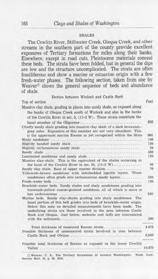
168 CLays and ShaLes of Washington
SHALES
The Cowlitz River, Stillwater Creek, Olequa Creek, and other streams in the southern part of the county provide excellent exposures of Tertiary formations for miles along their banks. Elsewhere, except in road cuts, Pleistocene materials conceal these beds. The strata have been folded, but in general the dips are low and the structure uncomplicated. The strata are often fossiliferous and show a marine or estuarine origjn with a few fresh-water phases. The following section, taken from one by Weavef!J shows the general sequence of beds and abundance of shale.
Section between Winlock and Castle Rock Top of section Feet Massive clay shale, grading in places into sandy shale, as exposed along
the banks of Olequa Creek south of Winlock and also in the banks of the Cowlitz River in sec. 5, ( 11-2 W) . These strata constitute the basal member of the Oligocene. . . . . . . . . . . . . . . . . . . . . . . . . . . . . . . . . . 600
Chiefly sandy shale grading into massive clay shale of a dark brownish-gray color. Exposw·es of this member are not very abundant. This is the uppermost marine Eocene as yet recognized within the State 960
Sbaly sandstone . . . . . . . . . . . . . . . . . . . . . . . . . . . . . . . . . . . . . . . . . . . . . . . . . . 100 Slightly banded sandy shale................. .... ... . .... . .. . ...... 130 Slightly carbonaceous sandy shale . . . . . . . . . . . . . . . . . . . . . . . . . . . . . . . . . 50 Sandy shale . . . . . . . . . . . . . . . . . . . . . . . . . . . . . . . . . . . . . . . . . . . . . . . • . . . . . 4.30 Laminated sandstone and sandy shale .. ..... .... . . . . . . . . . . . . . . . . . . . 150 Massive clay-shale. This is the equivalent oi the shales occurring in
the bank of the Cowlitz River in sec. 25, (11-2 W )................ 50 Sandy clay shale. Base of upper marine division. . . . . . . . . . . . . . . . . . . . 70 Yellowish- brown sandstone with interbedded lignitic layers. These
sandstones often grade into carbonaceous sandy layers . . . . . . . . . . . . 520 Fresh- water beds . . . . . . . . . . . . . . . . . . . . . . . . . . . . . . . . . . . . . . . . . . . . . . . . . 130 Brackish-water beds. Sandy shales and shaly sandstones grading into
brownish-yellow coarse-grained sandstone, all of which is more or less cru:bonaceous . . . . . . . . . . . . . . . . . . . . . . . . . . . . . . . . . . . . . . . . . . . . . . 550
Marine beds. Sandy clay-shales grading into shaly sandstones. The basal portion of this belt grades into beds of brackish-water origin. Below this zone no detailed measurements have been made. The underlying strata are those involved in the area between Castle Rock and Olequa. Just below, andesite and tuffs are intercalated with the sediments. . . . . . . . . . . . . . . . . . . . . . . . . . . . . . . . . . . . . . . . . . . . . 390
Total thickness of measured Eocene sirata. . . . . . . . . . . . . . . . . . . . . 4,4.70 Possible thickness of unmeasured strata involved in area between
Castle Rock and Olequa....... ........... . .. . . . . . . . . . . . . . . . . . . . 6,000
Possible total thickness of Eocene as exposed in the lower Cowlltz Valley ........................ .... .. ...... .. .. ... .. ........... 10,470
(D Weaver. C. E .. The Tertiary formations of western Washington : Wash. GeoJ. Survey Bull. 13. p. 92, 1916.
Lewis County 169
On the west bank of the Cowlitz River, in the NWlJiSW* sec. 24, (11-2 W), two samples were taken from an exposure of Tertiary beds. A 15-foot bank shows a softened and decomposed brown clayey sandstone containing pebbles up to 2 inches in diameter. These latter are sufficiently abundant in places to warrant the term conglomerate being applied, but in all cases they are completely decomposed to plastic clay.
Sample No. 314 is of general nature and includes softened sandstone, coarse grit, and decomposed basaltic and granitic pebbles. The material is soft and sandy, of a brown color, and necessarily of very nonuniform texture.
Plastic and dry properties Sample No. 314
Plasticity ...... ... ....... ... ......... Weak Volume shrinkage ... • ... 22.4o/, dry volume Shrinkage water ........ . ......... ... 14.0% Linear shrinkage ......... 8.1% dry length Pore waler .......................... 27.6% Dry condltlon .... ..... Weak dry strength Water of plasticity ................. .4!.6%
Fired properties Sample No. 314
Cor~1 __ 1_·t,_1o_r __ , __ o_o_m_J1_uo_u __
1 1J.s.o,,.d.J.1'l'.T, .S.%d. l.1 V.S.<;;d.v. ~,:_I A.Por.
Ol l,t. re,,1-hrown Soft, quartz checks
i.O lo. I 111.6 29.2 ~4.0
01 Roo,hrown Sott, Qunrtz 6 .~ 16.i, 23 ., :?(S,:; -42.~ cll!'l·k~
µ• firo",1 Crumhly, sort 0.0 J7 .1 21. 7 20.3 12.3 Ill SJ>Ot\,•d dnrk Onunhly. ~o fl 9,ij 11 .a 211.0 ZS.~ -tl .t
brown 1~· T)uJ< hrown Crumt,ly. ~H. ············ ..... .... .. ............ ~l.!l lO.o
110 !11~1011
Remarks: Cone fusion: 27. Siliceous and weak body. Remove quartz or mix with more plastic clays.
Underlying the above materials is a bed of soft clayey sandstone which extends 4 feet above the river level and whose base is concealed beneath the water. This material is a bright bluish green when fresh but changes on weathering to a gray-green tone and finally, along joints, to brown and red.
Sample No. 315, from this bed, is greenish buff when dry and is slightly compact and very sandy.
Plastic and dry properties Sam.ple No. 315
Plasticit) ' . ................ . ... Weak. sandy Volume shrinkage .. . .. 11.9°; dry volume Shrinkage water ... .................. 6.8% Linear shrinkage . ...... 4.2% dry length Pore water ................ . .... .... .. 22.5~ ... Ory condlUon ................... . ..... Soft
Water of plasticity ................. 29.3"1-
170 Clays and Shales of Washington
Fired properties Sample No. 315
C"Ollt' Color (.1ondilio11 .L.S.%u.1. 'l'.L.fS.o/o(l.l. V.S.!;,d.v. Ah~. A.Por. --
00 Lt. rctl-l,rown (~uurtz, 8.0 S.l 11.S 30.1 I u.o vrry sort
0-2 Lt. rPtl·hrown (~1111rt1.. very soft.
4.1 .3 11.S 26.7 42.4
3-J• Ret1-hro1111 Crumhll', u .s 13.1 25.i 42.2 ,•t•ry ~<'rt
1;...;•1 · potted Crumhly, J.6 8. 13.3 23.4 '!1.i brown-hi ark \•Pry ~tft
12• Brown end \' e~irnla r. 6.5 10.7 18.J 17.5 31.2 black (urrd, har11
Remarks: Cone fusion: 10. No fired strength due to quartz content.
It is reported that about 200 yards up the river from this place a gray soft, plastic clay was mined many years ago by the old Little Falls Fire Clay Co. of Vader. The river has obliterated all signs of the old workings, and no sample could be obta~ed from what was probably a very local occurrence of clay. A clay that may be of similar type occurs on the east side of the river one-fourth mile downstream in the NWt,4 sec. 25, (11-2 W) . At this place, in a small area which is part of the Buswell farm, a number of clays are found which differ markedly from· any others so far observed in western Washington.
The Cowlitz River, here, flows at the foot of a 12- to 15-foot bank forming the face of a bench which meets the east valley slope about 100 yards from the river. At this particular place, bluish-gray clay is exposed on the river bottom, and sample No. 316-A was taken where low water made this material available. The foot of the bank shows 1 foot of nearly black shale, which was sampled as No. 316. The base of the bed was concealed. Above this bed is 2 or 3 feet of reddish-yellow sandy shale, which is overlain by a 3-foot bed of light-gray shale. This uppermost bed was sampled as No. 317. The top of the gray shale is an erosional surface above which is 5 feet or so of Recent stream gravels and boulders.
A small brook crosses the bench a few yards upstream and has cut through these gravels into a soft, plastic gray clay that may be the weathered surface of the shale. The creek shows that the gravels forming the surface of the bench thin out to the east and are absent on the slope of the valley side. At the foot of this hill, sample No. 318 was taken of the gray clay exposed in the brook bed. About 100 yards above this place, sample No. 319 was taken from a small excavation around a spring by the roadside, while sample No. 320 came from a place 100 feet or so southwest of No. 319 near the Buswell barn.
Sample No. 316-A is a light-blue clay, soft and plastic when
Lewis County 171
damp, yet very tough and tenacious. Some portions are rather sandy and the material is nonuniform in texture.
Plastic and dnJ properties Sample No. 316-A
Plasticity ............... . .......... . .. Good Volume shrinkage .... . .40.3% dry volume Shrinkage water .............. ...... 21.9% Linear shrinkage ........ 15.8% dry length Pore water ........................... 17.6% D ry condition .. . . . . . . . . . .. ... , ...... Good Water of plasticity .. . .......... . .... 39.So;
Fired properties Sample No. 316-A
Con~J Color Oon,JJtiou J..S.%11.J 'l'.L.S.%<1.l. V .S.'/,d. ,. -I .lbs. A. Por . ----- -
(1T "Light gray .Fair, llor;I 4.() 1~.s ll.5 18.9 au; O'i Lt. guy Good, S.8 . 7.3 23.1 20.4 13.0 27.1 01 Lt.. lmff-grny Goo(I. ·.a . 9.() 24.8 24-.8 7.7 16.5 :~· Lt. buff Oooli, S.B. 11.7 27.5 31.0 6.0 ll.4 0 Onrk butt 000,1 , S.li. 12.2 :/.8.0 32.4 4.5 10.4
10 MoUJrd brown £'inc IJIIHrr~. 12.l 27.9 32.0 4.& 10.0 11nd black S.ll.
12- IJuff-hrown S.I:! . 9.3 :w.1 26.6 3.6 7.5
Remarks: Best firing range: 07-8. Cone fusion: 23. High shrinkage. Class of ware: Buff-colored structw·al wares, possibly terra cotta and
buff-colored pottery.
Sample No. 316 is a nearly black shaly material that is very brittle and compact. It is free from grit and has a texture similar to a soft wax.
Plastic and dry properties Sample No. 316
Plasticity .. .. ........................ Good Volume shrinkage .. .. ... 62.6% dry volume Shrinkage water .... . ................ 36.lo/, Linear shrinkage .. . ..... 25.8% dry length Pore water .. ......................... 23.0<r, Dry condillon ......... Badly cracked Water of plasticity . .... ...... ...... . . 59.Vio
Fired properties Sample No. 316
Con1..• Color CoucllUon J,.S.o/o(I.I. 'I'. L,.S.o/"dJ. Y.$.';<rb •. Ah~. .\.Por. -- -()j Gray-buff Oracke,I, hurtl ..... ~:~ .... j .. .. ~:~ .... 22.7 15.5 29.S OJ Gray,buJT Crncl<ed , S.B . ........ .... 3.7 9,0
!H• 8uff Cracked. S.ll. 1$.J :lS.O 3-1.3 2.9 G.7 &--7 • Mottll'<i huff Cracked. S.H. H.~ 10.2 37.2 2.0 l.6
-- ---Remarks: Best firing range: 05-10. Cone fusion: 26. High shrinkage
and cxacking.
Class of ware: Use more nonplastic material for buff structural wares, possibly terra cotta.
Sample No. 317 is a light-gray to nearly white shale. In general, it is free from grit and is compact and brittle. A few leaf impressions on the bedding planes of this sample indicate a fresh-water origin for the material.
172 ciays and Shales of Washington
Plastic and dry properties Sample No. 317 Plasticity ................. . ......... Strong Volume shrinkage ....... 31.4% dry volume Shrinkage water ............. . ....... 19.9% Linear shrinkage ........ Jl .8% dry length Pore water ....... . ................... 26.4% Linear shrinkage . . . . . . . . 9.9ft wet length
Water of plasticity ................... 46.3%
Fired properties Sample No. 317
Cono Color Condition L.,.%d.l. 'L'.L.S.%d.l. V.S.~d.v. Abs. A.Por.
~i Cream Craclml. soft .9 20.7 ~.4 ~.s 37.!I 01- 1 Light groy Cracked, '.H. 12.1 23.9 3M 14.H ~.4 lr i* Light buff . Cracked, .u. 15.3
I
27.1 39.3 7.5 l!'i.~ spotted
12"1 LL huff CrucJml, S.li. 1 .0 2.0.S H. 1.5 3.t
Remarks: Best firing range: 03-15. Cone fusion: 31-32. High shrinkage; cracking.
Class of ware: Use nonplastics for No. 1 refractory and possibly terra cotta.
Sample No. 318 is a gray clay that includes portions that are "fat" , waxlike, and free from grit and others that carry considerable sand.
Plastic and dry praperties Sample No. 318 Plasticity .... .... ...... ............... Good Volume shrinkage ....... 32.6% dry volume Shrinkage water .... . .......... . ..... 18.9% Linear shrinkage ........ 12.3% dry length Pore water ...... . ................... 20.3% Dry condition ............ Strong Wate1· of plasticity ................... 39.2%
Fired properties Sample No. 318
Cone Color Condition l,.ll.%d. l. 'l' .L.$.%(1.1. V.lVit tl.1·. All~. A.Por. ---- - - ----
Oi> l ,ll(ht buff llard 1.4 18.7 4 .2 17.0 83.2 J.I LL. lmff !Ul. 14,0 26.;l 30.4 IJ.O li?.li
01-J Bright buff S.ll. U. •J 26.7 $7.2 5.9 ]3.2 ~· Bright huff S.R. 14.4 :'!11.7 :li.3 5.4 L2.0 6-7' Hrlgl,~ huff S.Il. ,~.o 28.Z 40.4 5.3 10.J
12• Lt. hrown S.H .. vc~h-ulur .,., 1 .o 1G. I 7.:? 12. :J
Rerna1·ks: Best firing range: 05-8. Cone fusion: 27. Greatly cracked. High shrinkage.
Class of ware: Buff-colored structural wares.
Sample No. 319 is a bluish-gray very sandy, micaceous clay that, when fresh and wet, has an intense blue color. The texture is even. This material may be the softened, weathered phase of a clayey sandstone.
Plastic and dry properties Samp le No. 319
Plasticity . . ........... . .... ... ....... Weak Volume shrinkage ....... 11.5% dry volume Shrinkage water ..................... 5.7% Linear shrinkage ........ 4.0% dry length Pore water . ..... ..... . . . ............ 10.5% Dry condition ........... Weak Water of plasticity .... . .. .. .......... 17.0%
Lewis County 173
Fired properties Sample No. 319
Cone Color Coni1lllon l,.$,%d .l. 1' .L.S.%<1.l. V .S.<fid. 1•. .~Ii,. .\.Por.
01 l,lghl groy Crumhly. very ~oft
~.l 9. 1 H.~ 14.U 2S,S
~ J· Grenni Cnnnhly, 1.1 11 .7 21.4 12.a 26.3 ,,,,ri• soft 0-7* Creum Orumbly. soft !1. 4 1a. 4 25.7 ll.2 2:u 12" 13rlglll t,u tr \\'~ak. soft ········· ··· .... .... .... .. .. ....... . 0 .9 1 .6
Remarks: Best firing range: 12-18. Cone fusion: 33. Needs finer grinding or a bonding clay for better strength. See No. 320.
Class or ware: No. 1 refractory.
Sample No. 320 is variously colored to grayish green, pink, and purplish brown. It is soft, unctuous, and rather free from grit, and has a uniform texture.
Plastic and dry pToperties Sample No. 320
Plasticity . •. .... .. ...•. . .... •.•• ...• Strong Volume shrinkage ...•... 53.5% dry volume Shrinkage water . ......... . ....... ... 30.2% Linear shrinkage . . ...... 22.2% dry length Pore water ..... . .................. .. 17.6% Dry condition ... ... ...... Strong Water of plasticity ........ . ....... . .. 47.8%
FiTed properties Sample No. 320
t"one ('olor l'ontliLIOII 1,.S.%..t.l. ·11.1,.S.%d.t. l v.s.•.~d.v. .\h@. .-LPor. ----- ----(16 LL. hrown,hu ff Cr11tk1•,I, S.11 .- i>.O 2i .2 14.2 20.2 S&.9 0.} 'LL. hrnwu-I,11 tT Cracked, S.11.- 7 .s ll().() 21.5 ll\.1 8-Z.5 l)l Orcum Crucked, s .H. tl.9 :12.1 20.S 12.:1 21.S
01-J Bu tT Crowk t~l. !<.fl . 12. j 3-1.7 3'2.9 3.0 II. ~· Bright buJf Crn,·k,•d, s.u . .... ii:o· .. · .......... ············ 1.2 3.0 &-7• Motl led hrown Cn..-kc, I, S.li. :lli.2 :l0.5 o.o 1. 1
and bull 12° Brown-huff Cruoked, S.1!. 14 .;! :!(1.4 :ltl.9 1.0 2.1
Remarks: Best firing range: 08-15. Cone fusion: 31 +. See No. 319. Too much plastic material. Cracking; high shrinkuge.
Class of ware: Add more nonplastic for No. 1 refractory.
An extensive flat reaches eastward from the valley rim and is formed by the deposition of Pleistocene sediments. Some of the clays just described resemble, in certain respects, Pleistocene materials; if they do belong to that series, as could be ascertained by test pits, they probably extend eastward for some distance under the flat. In this case, a great tonnage would be available. On the other hand, ordinary brown sandstone and decomposed conglomerate of known Tertiary age occur as low-dipping strata exposed in the river bank just up and down stream from the area in question, and the beds sampled may be a local occurrence of fresh-water shales in the Tertiary marine beds. The
174 Clays and Shales of Washington
plastic clays, then, would be still more limited weathering phases of these rather thin strata of shale, and so the minable quantity would be relatively small. Careful prospecting by means of pits or boreholes should be undertaken before any attempt is made to exploit these interesting materials.
South of Winlock in sec. 5, (11-2 W), several hundred feet of shales occur in the bed of Olequa Creek. The bedding is distinct and shows decided variations in structure; at the midpoint of the exposure the strike is N. 15° W., ana the dip, 20° NE. Some of the individual beds are very sandy, but most of them contain enough clay substance to be quite "fat".
Sample No. 322 was taken to represent the whole shale member. It is dark gray to brown in color, micaceous, and rather sandy. The texture is moderately uniform and fine.
Plasti c and dry properties Sampie No. 322
Plasticity .............. . . .......... . .. Good Volume shrinkage ....... 27.3% dry volume Shrinkage water ............... ..... 17.3% Linear shrinkage . ....... 10.1 % dry length Pore water .......................... 27.5% Linear shrinkage ........ 8.9% wet length Water of plasticity .. . ........... . .... 44.8% Ory condition ............ S trong
Fired properties Sample No. 322
Cont• Color Oonfllllou L.S.%.J.I. •r.L.K%d.l. Y.S.'iftl .v. Abs. A.Por.
00 Ll. red-brown Goof.I, bur<l 1.0 lo.O u.o ().j Lt. l'\J(l·browo Good, hard ; .I Ii.:! ]I.I. 02 Red-brown Ooorl. S.R. l l.l> 2'!.ll :11.~
01-1 Recl·brown Good. S.B. 13.11 z:t; ~.4
27.7 ~2.0 20.7 35.0 9.ii lG.5 7.0 lG.4
8-1* Dk. red-brown Vit.r~ons, fused, 10.l 20.2 :!7.3 6.0 12.8 S.H.
l}-7· Dk. red·brown Vesfc:ulat, fosl'd . !Ul.
u U.ii 12.7 12.0 18.7
I
Remarks: Best firing range: 04- 01. Cone fusion: 7. A small amount of nonplastic material will reduce the high shrinkage.
Class of ware: Red and brown structural wares.
The grade of a logging railroad about 300 yards southeast of the above location exposes a section .of the shales that form the hill to the east. The strike here is north, and the dip, 10° E.
Sample No. 323 of this material is gray in color, weathering to light yellow. It is sandier than the shale exposed in the creek and is quite compact and uniform in texture.
Plasti c an d dry properties Sample No. 323 Plasticity ...... . .......... . ........ ... Good Volume shrinkage . . ..... 34.1% dry volume Shrinkage water ...... . ............. 21.6% Linear shrinkage ... . ... . 13.0% dry length Po1·e water ... ................... . . .. 23.6% Dry condition ... ......... Strong Water of plasticity .... • ............ .. 45.2%
Lewis County 175
Fired properties Sample No. 323
Oolor Conolillon L.S.%d.l. 'l'.J,.S.%li.l.1 \' ... ';,d.v. Abs. A.Por. --
:!6. 7 51.0 18.5 31.2
I~ ~d-brown Good, h11l'd 0.0 13.0 o.o (l:, Brown.red Good. h,irrl 2.6 u;.G 7.6 04 Drown-red Good, bur,I o.o 22.9 '11).i lG.7 29.!l
8.,1 16.8 $.7 7.0
01 Dk. brOWtl•rt>d Goof!, $.11. 10.7 23.7 26.7 1+ Dk. hrown,re,i Oooli, S.H. 12.0 2$.0 31.8 :µ• Dk. brown-rtd .Puscd, SJ!. JZ.a 25.0 33.2 tr7· Ok. rt~l·hrown t'u8ed, J.7 I 18.7 16.2
l1IOPlt'1l, S.H. ..... s:;·· ·· "'"iS:o-""
I
Remarks: Best firing range: 06-2. Cone Cusion: 6-7. Class of ware: Reduce the shrinkage with nonplastic materials for
brown and red structui·al wares.
Just north of Winlock, at the south end of the county bridge over Olequa Creek, massive shale is exposed in the side of the ravine. The base of the nearly horizontal stratum is concealed, but the bed is at least 15 feet thick and probably more. The surface is unconformably overlain by 3 feet of Recent gravels and valley fill. An immense tonnage could be easily mined 'Without reaching the main valley walls where an excessive overburden would be encountered.
Sample No. 340, of this member, is a bluish-gray fine, evengrained shale. It is free from any but very fine grit, and on freshly cut surfaces shows the sheen of very "fat" material. Blocks of the shale are compact and brittle, breaking with a subconchoidal fracture.
Plastic and dry properties Sample No. 340 Plasticity ............................. Poor Volume shrinkage ..... .. 25.2% dry volume Shrinkage water ................ . ... 13.4% Linear sht'.inkage .....•... 9.2% dry length Pore water .......................... 49.7% Linear shrinkage . .... . .. 6.0% wet length Water oJ' plasticity .. . ............... 63.1%
Fired properties Sample No. 340
Cone Color l'<,ntlltlon l,.S.%,1.l. l·r.L.S.%d.l. Y.fi.•,,,t.,·. .\ I)~. A.l?or
()4• Brown-red Gooll. ltunl 12.3 I 21.ij a-;u 20.3 S3.3 0'2 :Brown-rerl Goocl . S.ll.· . 17.0 w.s 44.(1 11.8 23.l
U littl4• SCU III OH R•~d ·l)rOl\ 11 Good. S.H. 19.l 28.3 rr.o 4.0 7.S
Remarks: Best 6rrng range: 03-6. Cone fusion: 7-8. Shrinkage too high. Needs some less-plastic material.
Class of ware: Dark structural wares.
Sample No. 321 was taken from less sandy portions of a large roadside exposure just east of La Camas Creek in the NW"tA sec. 27, (11-2 W). The cut here shows an immense amount of Tertiary thin-bedded dark-gray carbonaceous shales and sandy shales that dip about 4° easterly. The inclusion of more of the
176 Clays and Shales of Washington
sandy shale in the sample would have improved the working properties.
PLaslic and dry properties Sample No. 321
Plasticity .. .. .... . . .. . .. . ... ......... . Good Volume shrinkage ... .. .. 36.0% dry volume Shrinkage water ........... . ........ . 21.1 % Linear shrinkage .... . . . . 13.8% dry length Pore water .......... . ..... . ......... 18.3% Water of plasticity ....... ...... ...... 39.4%
Fired properties Sample No. 321
I V.S.';ill.,•. I 00111• Color Condltiou L.S.%cl.l. •'L'.L.S.%d.l. .\bs. A.Por.
--;; I U. red-brown Weak, soft J.5 lii.3 u I
21.9 36.1 0-2 f3r0\\1H(•d Crucki•<I , KH. 11.« 20.~ LS.4 15.0 'ZI.
I
Remarks: Best firing range: 04-2. Cone fusion: 6-7. Shrinkage high. Class of ware: Add nonplastic material for common brown and red
structural wares.
Shales, available for structural materials, are found near most of the towns in the upper Chehalis Valley. They correspond with other Tertiary shales which have been tested, and but one sample was taken.
Sample Ng. 347 was taken about 4 miles southeast of Pe Ell from one of many cuts on the Boisford road. It is a slightly sandy yellowish-gray shale that weathers to dark buff and brown. The material is thin-bedded, much jointed, and similar to a great many other exposures in the vicinity.
Plastic and dry properties Sample No. 347 Plasticity .............. ... ....... ... .. Good Volume shrinkag-e ....... 47.9% dry volume Sb1·inkage water ........ .• . . . . . . . .. .. 36.6% Liltear shrinkage .. .. . . .. 19.5% dry length Pore water ......... . . ........ ....... 20.2% Water of plasticity . . . ........ .. ..... 56.8%,
Fired properties Sarnple No. 347
( '0110 Color (;ondlllou 1..X.%<1.1. T.l •. S.o/o< I.I. ,,.s.1; c1.v. I ..\hs. A.Por . -- ---cs Lt . red-llrown Wenl<. ,;oft 2.G 22.J i.4 24.0 89. 7 0 1· llrlghl brown-
red Good , burrl ~-9 z.u H.O l ii.7 $8.0
01 Bright brown. Crucks. X.M. 7.0 26.5 JIJ.:; 11.S 22.1 re,t
I 0 Dk. hrowu-rM Ne&r \'llrlflca- 1;$.l 32.0 :J.U u.o 13.4
t lon. s.a .
Remarks: Best firing range: 06-5. Cone fusion: 7-8. Too much plastic material, causing high shrinkage.
Class of ware: Good color for red and brown structural wares.
Fire clays are commonly associated with the many coal beds of the region and adjoining counties, but, so far, no beds of workable thickness have been reported here. Red-firing shales could be mined economically with the coal, though this would
Lewis County 177
hardly be feasible unless the material proved to be of exceptional quality and a market could be assured. Mine operators would do well, however, to investigate the shales and clays that occur in their workings.
A high-quality shale was said to occur on the property of the Mendota Coal & Coke Co. at Mendota. The material was sampled, but tests show it to be of questionable value.
Sample No. 345 was taken just beyond the fault on the 4th level, new slope, where a bed at least 6 feet thick is exposed. The shale is carbonaceous, very sandy, and carries much finely divided muscovite. It is dark gray in color and rathei· compact.
Plastic and dry properties Sample No. 345 Plasticity ...•....... . ........ .. •..... . Good Shrinkage water ......... ........... 13.6%
Volume shrinkage ..•... 25.2% dry volume Linear shrinkage . •... ... 9.2% dry length
Pore water .. .... . ......•.. . ..... . ... 16.8% Llnea-r shrinkage ........ 7.0"'r wet length Water of plasticlly ....... ... ......... 30.4%
Fired properties Sample No. 345
~ ~onu (loJor Comlltlon L.$.%d.l. 'l'.I •. S.%tl.J. \"'.S.~{c1,,. Al>~. .\ .Por. -- -flt, Bo lf•llrown Weak, ~oft 1.0 10.2 2.0 10.1 :l:l.O 01• Ole. rrd•brown llcummed, 7.2 IIU 211.0 ~.ti 16.0
gOO(l, S.11. (I".? Uk. rttl-ht'OWll scumniert, , ... 11.l.O 20.6 LO S.5
goo<l, s.11. 2 Dk. n-<l-llro11 n Vlt:ro0us, sligh tly :,.5 H .7 15.5 2.;l 4.6
swelled . S.B. ti" Ok. ml-brown Vitreous, 2.2 11 . ~ 6.6 1.3 2.1
tusetl. s.n. 11> ~~rU.)'-hrr.,wn BIOHte<I. .. . ~- ...... ............ ············ ············ ........ ....
vlt r~OII$ tusa, I. S.H.
Remarks: Best firing range: 06-02. Cone fusion: 6-7. Scumming, high fired shrinkage.
Class of ware: Red and brown structural wares.
A buff-colored shale similar to the foregoing is exposed by a landslide at the head of the ravine above the powder house near the top of the ridge. It is considerably weathered-a feature to which the better fired properties are no doubt due.
Sample No. 344 is representative of this sandy shale.
Plastic and dry properties Sample No. 344
Plasticity . ....... . .... .. .... Weak. sandy Volume shrinkage ..... . . 30.5% dry volume Shrinkage water ........•............ 17.9% Llnea-r shrinkage ..... .. . Jl.5% dry length Pore water ... ....... ... ........ . .... 18.7% Waler of plasticity ................... 36.6%
178 Clays and Shales of Washington
Fired properties Sample No. 344
Cone Color Condition L.S.%d.l. T.L.S.%d.J. V.S.%d.v. I Abs. -
CS I Light bro,m- \Yeak, 1•ery EO!t 0.8 12.3 1.9 Zl;.5 buff
Ot Bu ff-brown Wenk, soCt V l 16.J 13.2 15.3 03 Buff-brown Wenk, soft o.3 16. i i,. I 14.S 6 Bull-brown Good, .li. 7.6 19. l 21.2 7.1
10 Groy-1.Jrown \'ltreous, good, 0.5 21.0 26.0 J.5 S.H.
12 .................. Fusrd ... .... ......... .................... ............
Remarks: Best firing range: 02-10. Cone iusion: 12.
Class of ware: Buff-brown structural wares.
.~.Por.
4-0.Z
28.4 Zi.3 U.6 9.0
··· ·········
Light-colored clays have been reported occasionally from the Alpha-Mayfield region, but so far those investigated have been mealy-textured red-firing varieties without particular value. An outcrop of striking appearance occurs a mile south of Highway No. 5 on Mill Creek, at approximately the center of the SE% sec. 13, (12-1 E ) . The creek has cut its valley through a thick deposit of reddish-colored Pleistocene gravel to a lightgray horizontally stratified silty shale. Later erosion has produced a shallow gorge in the lower more resistant material and in one place bas exposed the bed in a 12-foot vertical wall for 250 feet. The physiography indicates that the shale underlies the terrace-like flats along both sides of the creek. These extend upstream for half a mile, have a width of 100 to 150 feet between the gorge and the gravel bluffs, and are surfaced with as much as 6 feet of reworked Pleistocene gravel. The shale is remarkably uniform in texture. The upper part is rather thin-bedded and stained, the lower part is massive, but all is cut by a vertical and horizontal system of joints. Aside from yellow staining on joints the material weathers nearly white. The fresh shale is light bluish gray and dries to a light gray. It is very compact and brittle, breaks with a conchoidal fracture, and is so finegrained that grit can hardly be detected between the teeth. The peculiar nature of this shale is apparently due to its being composed of extremely fine volcanic dust that has undergone some decomposition in place. The small amount of actual clay substance accounts for the weak plasticity and the small (14 percent) dry and fired linear shrinkage. At cone 06 a sample of this material became steel-hard, moderately porous, and buff red in color.
Shale outcrops are abundant in the Eocene formations north of Morton, but in only comparatively few places are these accessible by railroad. One-half mile south of Lindberg, cuts on Highway No. 5, just above the railroad, expose the strata for
Lewis County 179
considerable distance toward Morton. A sample was taken near the center of sec. 25, (13-4 E), where from 10 to 15 feet of shale is overlain by 20 feet of well-cemented light-gray sandstone. The beds dip 40° NW., but the structure varies greatly in short distances.
Sample No. 336 is mostly a sandy dark-gray carbonaceous shale, but some parts are very "fat". A fresh-water origin is indicated by leaf imprints. The shale is very resistant and tough.
Plastic and dry properties Sample No. 336 Plasticity .....•.. . ....... ..... ..... ... Poor Shrinkage water ..................... 10.4% Pore water .......................... 12.8% Water of plasticity .......... . ........ 23.2%
Volume shrinkage ....... 20.4% dry volume Linear shrinkage •....... 7.3% dry length Linear shrinkage ......•. 5.0% wet length
Fired properties Sample No. 336
Color
1)) Bu II·browu 1»• Dk. rerl-hrown 02 Dlc. red-browJt 01 Dk. red·bro,m 4 Brown aud
h lack G-7* Durk tilock
brown 10 Druck t,rown
and h l flC.k 12• .............. , .. .
Co1111lt1011
Weak, ~oft Good, S.B. Good, S.H. Goo<I, S.li. Good, s.11. S11rruc•e erurkP.
\'CS1CU1Ar, $.B . Vfry budly
bloated, S.B. }'used
0.4 5.fl a.o tl.3 i .~i
~.3
1 .I 1.3 lZ. 11 ·~-t, 18.S Ji.O rn.6 17.R H.fl 20.4
11.6 J2.4-
19.2 7.9 6.1 S.4 -J.2
2.1
A.Par.
31.4 16.0 1:1.~ 7 .7 7.S
4.0
Remarks: Best flriog range: 06-3. Cone fusion : 12. Class of ware: Red and brown structural wares.
A hru·d, siliceous shale underlies coal bed No. 2 at the old Ladd mine, west of Mineral. A more argillaceous shale forms a 4-foot bed under coal No. 1, and above coal No. 4 is reported a 40-foot bed of shale.
Sample No. 336-B, taken of the 4-foot bed, was sent to the Division office for analysis. It is very dark gray in color. The texture is extremely fine and uniform, yet the material contains some grit. The sample is hard and very brittle, the latter feature being due in part to the minute fracturing and jointing that characterize this shale. Iron oxide has been deposited on the joints.
Plastic and dry properties Sampte No. 336-B
Plasticity ........................... Sticky Volume shrinkage ..... .. 59.7% dry volume Shrlokage water .................... 30.3% Linear shrinkage ........ 24.6% dry length Pore water ....... ..... .. ........ . ... 13.2% Water of plasticity ............... . ... 43.5';,
Dry condition ........... Drying cracks
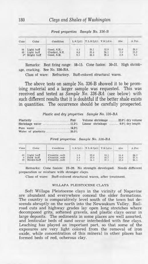
180 Clays and Shales of Washington
Fired properties Sample No. 336-B
_0_01_1e1 __ 0_0_1o_r __
1 __ o_on_d_ltt_oo __
1 J, .S.%<l .l. t L.S.%<J .1.I V.S.7,d.v. ·-"- 1.l_s._ ~
OS Light buff 02 Light bulf Ii* Bright bu ff
Good, S.H.Oracked, S.l:l . Good. S.H.
L 'i .&
9.7
29.1 ~ .4 ~ .3
12.0 24.l 20.5
15.0 5.9 s.
~.o 13.0
.s
Remarks: Best firing range: 08-15. Cone fusion: 30-31. High shrinkage, cracking. See No. 336-BA.
Class of ware: Refractory. Buff-colored structural wares.
The above tests on sample No. 336-B showed it to be promising material and a larger sample was requested. This was received and tested as Sample No. 336-BA (see below) with such different results that it is doubtful if the better shale exists in quantities. The occurrence should be carefully prospected.
Plastic and dry properties Sample No. 336-BA
Plasticity . ...... . . . .... .. .. . . . . . .. .. . Fair Volume shrinkage . .. . ... 22.0% dry volume Shrinkage water ..... . . . ........... . . 11.3% Linear shrinkage . .. . . .. 8.0~ dry length Pore water . . .. ..... .. .... .. ....... .. 14.2% Water of plasticity .... . .. . ........... 25.5%
Fired properties Sample No. 336-BA
Cone Color <.'ondlllou l ,.S.o/c,11.I. '1'.L .S.%d.l. V. .'/od.v. Al,s . A. Por.
00 LlghL t)uff C'rumbti•. sofl 4 () 12.6 13.1 14.• 2S.2 (; Dork buff Orumhly, sofl 5.11 13.9 10. i J3.ti 27.8
10 Drown,bulT Crnml,ly. sot! ft. I U . 1 Ii . l 12.E> 26.ii
Remarks: Cone fusion: 23-26. No sh·ength developed. Needs different preparation or mixtw·e with stronger clays.
Class of ware: Buff-colored structural wares, .after treatment.
WILLAP A PLEISTOCENE CLAYS
Soft Willapa Pleistocene clays in the vicinity of Napavine are abundant and everywhere conceal the older formations. The country is comparatively level south of the town but descends abruptly on the north into the Newaukum Valley. Railroad cuts and highway grades lay open long stretches where decomposed grits, softened gravels, and plastic clays occur jn large deposits. The sediments in some places are well assorted, and lenticular beds of sand occur interbedded with fine clays. Leaching has played an important part, so that some of t he exposures are very light colored from the removal of iron oxide, while concentration of this mineral in other places has formed beds of red, ocherous clay.
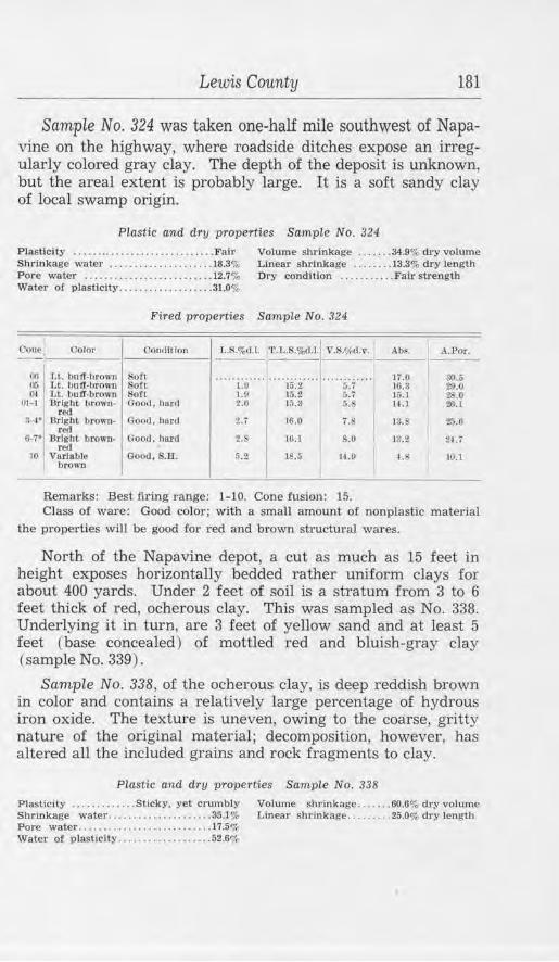
Lewis County 181
Sample No. 324 was taken one-half mile southwest of Napavine on the highway, where roadside ditches expose an irregularly colored gray clay. The depth of the deposit is unknown, but the areal extent is probably large. It is a soft sandy clay of local swamp origin.
Plastic and dry properties Sample No. 324
Plasticity .............. .. ........ ... .. Fair Volume shrinkage ... . . . . 34.9% dry volume Shrinkage water ............. .. ...... 18.3% Linear shrinkage ........ 13.3% dry length Pore water .......................... 12.7% Dry condition ........... Fair strength Water of plasticity ... . ....... ... ...•. 31.0%
Fired properties Sample No. 324
Cone Color Goodltlon L .i'i.%d .J. 'r.T,.S.o/o<f .l. V.S.<fid.v. Abs. A.Por.
Oti I Lt. bu ff-brown Soft ············ ........... .I. ........... 17.0 30.S 05 Lt. bu ff-brown SofL 1.9 1tl.2 5.7 JG.3 29.0 ().I Lt. buff-brown l:iotl 1.9 1r;.2 ij.7 15.J 28.0
OH Bright brown- Good, hur,l z.o l5.3 5. 14 .1 ~-1 red
3-I• Bright brown· (lood, burd 2. i 16.0 7. 13 .S 25.0
1
red 6-7• 13rfghL brown- Good, bard 2.b 16.J s.o lll.2 2(_;
red 10 Varlablo Good , S.H . 6 ') 18.6 J,f.P ,f. L0.1 ·" brown
Rema1·ks: Best firing range: 1-10. Cone fus.io11: 15. Class of ware: Good color; with a small amount of nonplastic material
the properties will be good for red and brown structural wares.
North of the Napavine depot, a cut as much as 15 feet in height exposes horizontally bedded rather uniform clays for about 400 yards. Under 2 feet of soil is a stratum from 3 to 6 feet thick of red, ocherous clay. This was sampled as No. 338. Underlying it in turn, are 3 feet of yellow sand and at least 5 feet (base concealed) of mottled red and bluish-gray clay (sample No. 339).
Sample No. 338, of the ocherous clay, is deep reddish brown in color and contains a relatively large percentage of hydrous iron oxide. The texture is uneven, owing to the coarse, gritty nature of the original material; decomposition, however, has altered all the included grains and rock fragments to clay.
Plastic and dry properties Sample No. 338
Plasticity . . ..... . ..... Sticky. yet crumbly Volume shrinkage ....... 60.6% dry volume Shrinkage water .. .. .. . .•.•.....•... . 35.l % Linear shrinkage ... .. ... . 25.0% dry length Pore water .......... .. ........ - . ... .. 17.5% Water of plasticity ... . ..... ... ...... . 52.6%
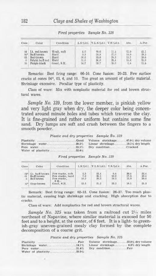
182 Clays and Shales of Washington
Fired properties Sample No. 338
V.S.~{d.v. j I
Ooue Oolor Coudltlon LJ:;.%d.l. •r.L .S.%d .l. .\IJ~. A.Por. ---
OS Lt. red-hrown We8k, ort u 29.0 JU 2.'i.9 43.l OI* .Bu ff -brown li urcl u.o 3.U) 2i .II H.9 I 29.;5 00 Red-brown H11 rd LO.O 3:i.6 26.5 13.7 28.0 0 Brivh t bu ff-red Hard 11.0 36.0 ~A 11.0 24.0
}() PurpJ~-bl11ek Good, .R. lU !!JU : .0 6.!> 15.&
Remarks: Best firing range: 06-10. Cone fusion: 20-23. Few surface cracks at cones 04\ 03, 6, and IO. Too great an amount of plastic material. Shrinkage excessive. Peculiar type of plasticity.
Class of ware: Mix with nonplastic material fo r red and brown structural wares.
Sample No. 339, from the lower member, is pinkish yellow and very light gray when dry, the deeper color being concentrated around minute holes and tubes which traverse the clay. It is fine-grained and rather uniform but contains some fine sand. Dry lumps are soft and crush between the fingers to a smooth powder.
Plastic an d dry properties Sample No . 339 Plasticity ... . ........ ... ....... .. .... Good Volume shrinkage .. ..... 4'7.0% dry volume Shrinkage water . ... . ........ . . .. .... 29.3% Linear shrinkage ...... ... 19.1% dry len gth Pore water .......... .. ...... .. ....... 23.1% Water o! plasticity ... . ........ . ~ . . ... 52.4%
Dry cond ition . . ....... ... Cracked
fired properties Sample No . 339
Oonc Color Condltfon l ,.S.%d.l. T.L.S.%d.l. V.S.%d.v. . \ h~. A.l?or .
04• l ,t. bu ff-brown t'ew n uek~. ~of t 8.3 22.4
I 9.4 I 20.4 33.4
01 Buff-b ro wn Few emc·k$, hard 7.0 26.1 10.6 17.5 30.4 G R-Od ·brown F\~w CJ'UCk $ . 10.2 29.3 !!S.2
I 15.0 29.4
SB.-12• Orny-brown Good . S.II. 12.2 31.3 3"2.3 10.1 21.3
Remark: Best firing range: 02- 12. Cone fusion: 26-27. Too much plastic material, causing high shrinkage and cracking. High absorption due to cracks.
Class of ware: Add nonplastics for red and brown structm·al wares.
Sample No. 325 was taken from a railroad cut 21h miles northeast of Napavine, where similar material is exoosed for 50 feet and to a height, at the center, of 6 feet. It is a light- to greenish-gray uneven-grained mealy clay formed by the complete decomposition of a coarse grit.
Plastic and dry properties Sample No. 325 Plasticity . .... . . . ....... . . .. ......... . Fair Volume sh,inkage ... ... . 22.9% dry volume Shrinkage water ...... . ....... .. .. . .. 14.1 % Linear shrinkage . ........ 8.3% dry length Pore wa ter ... . .......... . . . . .. . . . . . . . 21.4% Dry condition ........ . ... Fair Wa ter of plas ticity ................... 35.5%
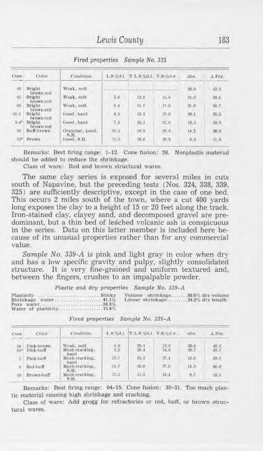
Lewis County 183
Fired properties SampLe No. 325
C'one Color ('on,1111011 L.S.%11.l. 1'.L.S.%,d.l. V.S.<J,l.\l. J\bs. A.Por. - - ---(l(j Bright \\'ea.k. sofl ............................ ........ :!S.b ~3.2
brown,rctl o..-; Urlghl
brown-red Weok, soft 5.U 18.0 1:..6 2l.3 38.ll
0-2 JlrlghL Weak, FOft o..r 14 .7 li.O 21.G 116. i brown-red
111-1 Bright Oootl. hard f,. 15.1 19.0 20.1 3S.3 brown. r~d
3-1• Bright htOWfl•fed
({oo<i, hnrd 7.$ 16.1 :1.1.11 19.3 au 10 Uoff,brown n ranular. good. 10.5
$.H. lE!.8 28.2 14 .1 ro.o
12' 13ro,m Good , S.H. 11.3 19.6 ll0.2 6.F ll.8
Remarks: Best firing range: 1-12. Cone fusion: 26. Nonplastic material should be added to reduce the shrinkage.
Class of ware: Red and brown structural wares.
The same clay series is exposed for several miles in cuts south of Napavine, but the preceding tests (Nos. 324, 338, 339, 325) are sufficiently descriptive, except in the case of one bed. This occurs 2 miles south of the town, where a cut 400 yards long exposes the clay to a height of 15 or 20 feet along the track. Iron-stained clay, clayey sand, and decomposed gravel are predominant, but a thin bed of leached volcanic ash is conspicuous in the series. Data on this latter member is included here because of its unusual properties rather than for any commercial value.
Sample No. 339-A is pink and light gray in color when dry and has a low specific gravity and pulpy, slightly consolidated structure. It is very fine-grained and uniform textured and, between the fingers, crushes to an impalpable powder.
Plastic and dry properties Sample No. 339-A Plasticity .......................... Sticky Volume shrinkage ... .... 58.6% dry volume Shrinkage water .... . ................ 41.1% Linear shrinkage ...... . .. 24.2% dry length Pore water ........ .. .... ....... . ..... 34.3<;'r Water of plasticity ............ ....... 75.4%
Fired properties Sample No. 339-A
Cont• Oolor ( '01111111011 l..:'i."1,11.l. 'T'. L.R.%11,I. \ '.$.<; ,<!.,·. ,\bs. I A.Por. - --Ob Pink-brown \~ruk, soft LP 29.l 1:l.9 !l().6 46.2 0 1• Plok•l1111T .Muc·h c-rocklng, :i.2 29.-1 14.S 20.7 32.i
html 2 Plnk-bulT Mul'h <·r1-1~kinJ.{, 10.1
h,rnl 34.3 27.:f 18.G 3'2.2
II Rcd·IJUIT Much rr,wkinl(. ~.ll.
11. 7 SS.11 37.!l 15.2 20.0
Ill Urown-bujf ~ltll'h l·rncklng, S.II.
li.3 41.5 13.4 8.7 1S.S
Remarks: Best firing range: 04-15. Cone fusion: 30-31. Too much plastic material causing high shrinkage and cracking.
Class of ware: Add grogg for refractories or red. buff, or brown structural wares.
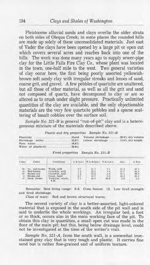
184 Clays and Shales of Washington
Pleistocene alluvial sands and clays overlie the older strata on both sides of Olequa Creek; in some places the rounded hills are made up solely of these unconsolidated materials. Just east of Vader the clays have been opened by a large pit or open cut which covers several acres and reaches back into one of the hills. The work was done many years ago to supply sewer-pipe clay for the Little Falls Fire Clay Co. , whose plant was located in the town, one-half mile to the west. Two general varieties of clay occur here, the first being poorly assorted yellowishbrown soft sandy clay with irregular streaks and lenses of sand, coarse grit, and gravel. A few pebbles of quartzite are unaltered, but all those of other material, as well as all the grit and sand not composed of quartz, have decomposed to clay or are so altered as to crush under slight pressure. Practically unlimited quantities of the clay are available, and the only objectionable materials are the very few quartzite pebbles and a sparse scattering of basalt cobbles over the surface soil.
Sample No. 321-B is general "run-of-pit" clay and is a heterogeneous mixture of the materials described above.
Plastic and dry prope,·ties Sample No. 321- B Pla~tlcity ............................ Good Volume shrinkage ....... 29.5% dry volume S hrinkage wate1· . .... . ........ . . . ... . 15.8% Linear shr ink age . ....... 11.0% d ry length Pore wa ter .......... . ..... . . .. . ...... 16.6% Water of plasticity ... . ........ . ...... 32.4%
Fired pr operties Sample No. 321-B
Con~J Color <1011d i1iou T,.S.%,1.1. 'l '.L.S.%<].l.1 V .S.',',<l.v . • \ bS. A.l"or . I
(:6 Lt. red-brown Wcuk, sort O.i 11.7 2.1 21.2 37.3 IH Red·browo C ri 1111t,ty, sot~ 1.i 12.2 a.o 17.7 34.5 C,2 l3rown-red Cmmhl)•, soft 1 .4 l iU 4.2 18.1 32.9 a Orown-red Good, horrl 2:7 13.7 7.0 16.2 :30.3
lO nnrlc brown Vc~h-ulur, ~tuck . 7.2 18.2 20.0 2.8 5.2 S.H.
Remarks: Best fi1·ing r ange: 2-8. Cone fusion: 13. Low fi red strength and 1:il"ed shrinkage.
Class of ware: Red and brown str uctural wares.
The second variety of clay is a better-assorted, light-colored material that is exposed in the south side of the pit wall and is said to underlie the whole workings. An irregular bed, a foot or so thick, occurs also in the main working face of the pit. To obtain this clay in quantities, a small open cut was made in the floor of the main pit; but this, being below drainage level, could not be investigated at the time of the writer's visit.
Sample No. 321 -A, from the south wall, is a somewhat ironstained gray clay that is very tough and plastic. It carries fine sand but is rather fine-grained and of uniform texture.
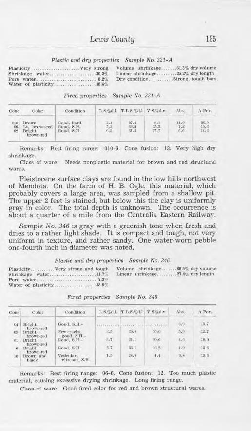
Lewis County 185
Plastic and dry properties Sample No. 321-A Plasticity ..... . .. . ...... . ..... Very strong Volume shrinkage ....... 61.3% dry volume Shrinkage watc.r . ... . .. ........ ...... 30.2% Linear shrinkage ........ . 25.2% dry length Pore water. . . . . . . . . . . . . . . . . . . . . . . . . . . 8.2% Dry condltlon ......... . . Stro.ng, tough bars Water of plasticity ... . ......... ...... 38.4%
Fired properties Sample No. 321- A
Cone Color Cond1llon L.S.%dJ. '1'.L.S.%d.l. Y.S.r,,,l.v. Ab~. A.Por.
010 :Brown Good, ha.rd 2.1 27.3 fi.1 i~.o 26.0 00 Lt. hrown-red Ooo,1, S.B. 5.ll ao.r; 15.2 7.2 15.!l 0'2 Bright Go0<1, s.n . fl.3
I 31.5 li.7 6.G H.3
brown-red I Remarks: Best firing range: 010-6. Cone fusion: 13. Very high dry
shrinkage. Class of ware: Needs nonplastic materfal for brown and red structural
wares.
Pleistocene surface clays are found in the low hills northwest of Mendota. On the farm of H. B. Ogle, this material, which probably covers a large area, was sampled from a shallow pit. The upper 2 feet is stained, but below this the clay is uniformly gray in color. The total depth is unknown. The occurrence is about a quarter of a mile from the Centralia Eastern Railway.
Sample No. 346 is gray with a greenish tone when fresh and dries to a rather light shade. It is compact and tough, not very uniform in texture, and rather sandy. One water-worn pebble one-fourth inch in diameter was noted.
Plastic and dry properties Sample No. 346
Plasticity ... .. ... ... Very strong and tough Volume sh_rinkage ....... 66.4% dry volume Shrinkage water .............. . ,, .... 31.7% Linear shrinkage ..... .. .. 27.4% dry length Pore water .. .... ....... . ............. 7.2% Water of plasticity ... .. . ............. 38.9%
Fired properties Sample No. 346
Cone I Oolor Contlllloo L.S.%d.l. l'l'.L.S.o/od.l. V.S.c;./ d.v. Abs. A.Por.
oi• Bright Good. S.D.- ...................... ......... ..... ft.II 13.i hrow11-re1l
03 Bright Few crueks. :u 30.!/ lO. fJ 5.P 12.7 brown-rod good. S.R.
01 Bright Good. IS.ll.- 3.1 21.1 10.U 1.6 10.0 brown-red
6 Drigbt Good, S.JI. a i :l3.] rn.2 4.0 1:tu brown-red
10 Brown antl Ve~i~uJnr, 1.5 28.9 4.4 tl.b 13.3 hlPek ,•ltreous. R.U
Remarks: Best fixing range: 06-6. Cone .fusion: 12. Too much plastic material, causing excessive drying shrinkage. Long firing range.
Class of ware: Good fired color £or red and brown sh·uctural wares.
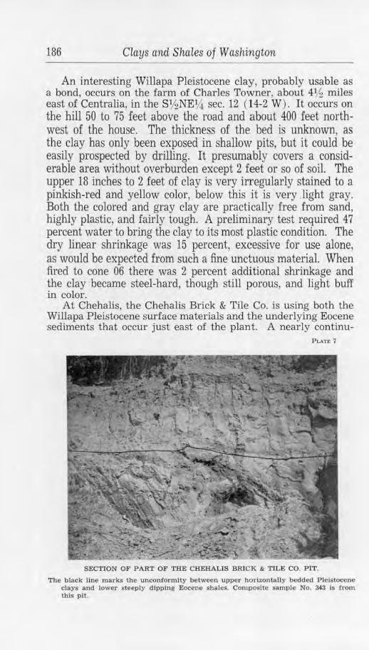
186 Clays and Shales of Washington
An interesting Willapa Pleistocene clay, probably usable as a bond, occurs on the farm of Charles Towner, about 41h miles east of Centralia, in the S1/2NEY.t sec. 12 (14-2 W) . It occurs on the hill 50 to 75 feet above the road and about 400 feet northwest of the house. The thickness of the bed is unknown, as the clay has only been exposed in shallow pits, but it could be easily prospected by drilling. It presumably covers a considerable area without overburden except 2 feet or so of soil. The upper 18 inches to 2 feet of clay is very irregularly stained to a pinkish-red and yellow color, below this it is very .light gray. Both the colored and gray clay are practically free from sand, highly plastic, and fairly tough. A preliminary test required 47 percent water to bring the clay to its most plastic condition. The dry linear shrinkage was 15 percent, excessive for use alone, as would be expected from such a fine unctuous material. When fired to cone 06 there was 2 percent additional shrinkage and the clay became steel-hard, though still porous, and light buff in color.
At Chehalis, the Chehalis Brick & Tile Co. is using both the Willapa Pleistocene surface materials and the underlying Eocene sediments that occur just east of the plant. A nearly continu-
PLATE 7
SECTION OF PART OF THE CHEHALIS BRICK & TILE CO. PIT.
The black line marks the unconformity between upper horizontally bedded Pleistocene clays and lower s teeply dipping Eocene shales. Composite sample No. 343 is from this pit.
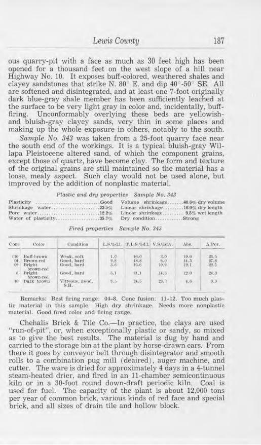
Lewis County 187
ous quarry-pit with a face as much as 30 feet high has been opened for a thousand feet on the west slope of a hill near Highway No. 10. It exposes buff-colored, weathered shales and clayey sandstones that strike N. 80° E. and dip 40 ' -50° SE. All are softened and disintegrated, and at least one 7-foot originally dark blue-gray shale member has been sufficiently leached at the surface to be very light gray in color and, incidentally, buff.firing. Unconformably overlying these beds are yellowishand bluish-gray clayey sands, very thin in some places and making up the whole exposure in others, notably to the south.
Sample No. 343 was taken from a 25-.foot quarry face near the south end of the workings. It is a typical bluish-gray Willapa Pleistocene altered sand, of which the component grains, except those of quartz, have become clay. The form and texture of the original grains are still maintained so the material has a loose, mealy aspect. Such clay would not be used alone, but improved by the addition of nonplastic material.
Plastic and drtJ properties Sample No. 343 Plasticity ........... .. ..... • .. .. , , ... Good Volume shrinkage ..... .. 40.6% dry volume Shrinkage water .... ..... ....... .. ... 23.5% Linear shrinkage ......... 16.0% dry length Pore water ........................... 12.2% Linear shrlnkage ..... ... . 9.5% wet length Water of plasticity ................... 35.7% Dry condition ........ . ... Strong
Fired properties Sample No. 343
Conr Color l'onrl lllo11 1..1>.%,I.I. 'l'.L.$.'7.d.l.
'""''··· 1· Al)R. A.Por. -- -
OIO Uuff-brown Wenk, soft 1.0 JO.O $.0 10.0 33.;; 1\1 Uro\ln•rcd Good, hord :?.;, l .$ s.o H .~ 27.6 (r.? Hrlgltl Goo,l, bnrd S.tl 10.6 lll.2 12.1 22.ii
ltrown-rrrl ll Brigit~
bro"'n,rrrl Ooo,J. ltnr,t r,,) 21.1 H ,3 12.0 24.0
HI Ou.rk hrown vltreou~. !!O<ul, ~.s S.R.
24.5 2!1.:l l. 6 9.!l
I Remarks: Best firing range: 04-8. Cone fusion: 11-12. Too much plas
tic material in this sample. High dry shrinkage. Needs more nonplastic matedal. Good fired color and firing range.
Chehalis Brick & Tile Co.-In practice, the clays are used "run-of-pit" 1 or, when exceptionally plastic or sandy, so mixed as to give the best results. The material is dug by hand and carried to the storage bin at the plant by horse-drawn cars. From there it goes by conveyor belt through disintegrator and smooth rolls to a combination pug mill (deaired ), auger machine, and cutter. The ware is dried for approximately 4 days in a 4-tunnel steam-heated drier, and fired in an 11-chamber semicontinuous kiln or in a 30-foot round down-draft periodic kiln. Coal is used for fuel. The capacity of the plant is about 12,000 tons per year of common brick, various kinds of red face and special brick, and all sizes of drain tile and hollow block.
188 Clays and Shales of Washington
RECENT ALLUVIAL CLAYS
The Chehalis and other valleys are floored with Recent alluvial clays. These are flood-plain accumulations that were deposited at a time when the land had a somewhat lower elevation than at present. Drainage is a serious problem in mining such surface materials; but the excellent quality, as shown by the tests, warrants thorough prospecting.
Sample No. 327, characteristic of these clays, is from a place about 3 miles southwest of Centralia just off the valley road near the center of sec. 24, (14-3 W) . It is a soft bluish-gray clay, irregularly stained with iron oxide. The texture is fine but sandy.
Plastic and dry properties Sarnp1e No. 327
Plasticity ............... . ............ Good Volume shrinkage ....... 13.0% dry volume Shrinkage water ........ .... ......... 7.2% Linea.r shrinkage ... . ..... 4.5% dry length Pore water ....... ................ .... 18.l'il, Dry condition . . . . . . .•.. . Fair Water of plasticity ................... 25.3%
Fired properties Sample No. 327
Con~ Color t'ouclltloo L.$.o/o< I.I. 'J'.L.$.%.J.1. V.S.<!l,d.v. AhS. . .\.l'or. --OIO 13uJT-browo \\'cflk. soft 0.11 L 1i 0.0 22.IJ 37.4 00 Red·brown nood, harc1 3.1 7.U 1/.0 10.7 3:H 02 Red-brown 11ood, lrnrd n.; 10.2 16.2 13.4 25.5
1+ Red-brown Oooct, s.n. 7.7 12.2 21.~ JJ.2 22.2 ~· Dk. hrown-rod Good. S.ll. 1).7 14.2 :/ll.~ ~.II I I.I t>-7" 01c. rNl·browa Good. .a. 10.0 1;;.1 :!fl.I l. ·I.I) JO Dk. gray. Vitreous, fused, 0. 1 10.0 17.S 4.2 8. l
hrown s.a . Remarks: Best firing range: 06-6. Cone. fusion: 7-8. Class of ware: Well proportioned for red and brown structural wares.
Sample No. 326 was taken 1 mile north of Napavine at the foot of Napavine Hill. The highway crosses the flat Newaukum Valley here, and Recent alluvial clays are exposed in drainage ditches. The depth of such material is unknown. The clay is bluish gray to yellowish gray, and, although sandy, is tough and compact.
Plastic and dry properties Sample No. 326 Plasticity ........ ..... ..... ....... . .. Good Volume shrin.kage ....... 19.7% dry volume Shrinkage water ..... . . . . ... . ........ 10.9% Linear s hrinkage ...... . . 7 .1 % dry length Pore water .....•... .•.. . . .. ... .....•• 16.0% Linear shrinkage .. . ..... 6.3% wet length Water of plaslicity ...... . ... .. ....... 26.9% Dry condJticm .......... . Good
Fired properties Sample No .. 126
OoueJ Color Condition L.S.%(l.l. T .T,.S.%,<1.1. V.S.%<),Y. Abs. A.l?or.
00 Red.JJrown Weuk, ~OU ············ .... ioj···· ..... ... .. .. 19.2 33.6 (/1 Red-brown noo<I, hard a.~ 9.S lG.O 29.2 ~· Brown-.rc<I Gc,011. bu.ril LO 11.1 U.4 14.8 26.S G Drown.red Uood. S.H. G.1 13.2 17.2 9 .8 18.9
Remarks: Best fu•ing range: 01-7. Cone fusion: 9-10. Rather slow to develop good strength.
Class of ware: Red and brown structural wares.
Lincoln County 189
Sample No. 337 was taken near Morton in the S.Yi sec. 25, (13-4 E) . It is from the thick mantle of surface material which occurs in the Tilton Valley and which is derived by weathering from the sedimentary and igneous rock of the vicinity. It is a light-brown earthy clay, soft and very sandy.
Plastic and dry properties Sample No. 337 Plasticity ............ . ......... Fair. sandy Volume sllrlnkage ....... 26.1% dry volume Shrinkage water . ....•.... . ...... .. . . 13.6% Linear shrinkage . . ... . ... 9.6% dry length Pore water •... ................... . ... 21.1% Wa ter of plasticlly ....... . ........... 34.7%
Fired properties Sam ple No. 337
Conti1 l'olor Contlit lon L.S.%rU . 'I'. L.S.o/,<ll. \'.S.%<1.v.
01 R,•d·lirowu \\'PH k , $Oft S,3 12,(1 10.9 1 Bright retl· 000,1 • h n rtl a., 12.S 11.2 I browr1 0-1· fu>rl,brown Good, S.H .- 6.2 14.S u.o
10 Unrk hrowo VeE11.·nh1r . f11~1~,1, I I. I 20,7 2(1.7 R. li.
Remarks: Best firing range: 01-8. Cone fusion: 11. Class of ware: Dark-red and brown structural wares.
LINCOLN COUNTY
.\1,,,. I A.Por.
22.0 3tU 17.11 20.5
12.0 21.8 ).0 2.2
Lincoln County, in central eastern Washington, is an area of rolling plains, incised by valleys and coulees. Basalt underlies most of this region, and older formations are exposed at only a few places in the northeast and extreme north. A thick mantle of clayey material in general covers the surface and is classed with the Palouse clay, described from Whitman County (p. 327) . It varies considerably in different parts of the county, in some places being ty pically eolian, in others modified by stream action connected with glaciation, but there is more or less concordance in the physical properties of the surficial beds. Better clays, so far unreported, may occur in a few favorable locations, probably under an overburden of the brownish-yellow Palouse clay. Expected occurrence would be between Reardon and Edwall, where pre-basalt granite and metamorphic rocks form prominent hills.
In most places the common surface clays may be used for ordinary red-fired structural ware. In general, they slake quickly and completely, have good plasticity, and when not too "fat" show only moderate shrinkage. They tend to develop pleasing red to dark-red colors and fuse under cone 6.
Alluvial clays and silts of glacial origin are found in terraces bordering the Spokane and Columbia rivers. Such materials are mostly light to dark gray in color and closely resemble the
190 CLays and Shales of Washington
silty clays occurring in Stevens, Ferry, and Okanogan counties. So far as known, these clays are red firing, but one deposit in sec. 30, (27-39 E) is apparently of somewhat better grade. A partial analysis shows it to contain 62.7 percent silica, 23.5 percent alumina, and 2.61 percent iron oxide, thus possibly placing the clay in the buff-firing class. No samples were available for testing.
MASON COUNTY
Mason County includes an area of 730 square miles just west of Puget Sound. The northwestern part reaches into the Olympic Mountains, and the rest of the county is moderately rolling and hilly. The county is well supplied with clays suitable for common brick and 'other ordinary products but contains no known deposits of the better clays or shales. Metamorphic rocks in the more mountainous part, and basic igneous rocks in other regions form the bedrock, and even these are generally concealed by a thick mantle of glacial deposits except in the most elevated portions. It is only under the drift in the southwestern part of the county that usable shales occur, and there outcrops are of rare occurrence.
Sedimentary strata that have been partially metamorphosed, and so indurated as to have lost most or all of their plasticity, occur for about a mile along the west shore of Hood Canal between Hoodsport and Lilliwaup. The formation is excellently exposed in cuts on Highway No. 101 as beds of greenish-gray very hard, flintlike, siliceous shale, and nearly black hard finegrained shale. The strike is S. 40° W. , and the dip, 60° SE.
Samples No. 363-A and 363-B, of these members, developed no plasticity or strength upon testing, and fired to dark-red vitreous bodies at cone 02. They are not suited to commercial use.
Just south of these exposures, on both sides of Sund's Creek, are softer sandy shales, which show remarkable examples of the rosettes formed by spheroidal weathering. This feature is also characteristic of the exposures to the north.
Sample No. 363, of the Sund's Creek shale, is greatly weathered and jointed, and has been stained yellow and brown by limonite, but it is still a rather hard, brittle material.
Plastic and dry properties Sample No. 363
Plasticity ................ ...... Very weak Volume shrinkage ... .... 12.4% dry volume Shrinkage water. .................. . . 7.5"'• Linear shrinkage ......... 4.3% dry length Pore water . ... .......... . ............ 27.2% Water of plasticity ... ... •. ..... . ..... 34.7%
Mason County 191
Fired properties Sample No. 363
t•mw Color Condition L.S.%<1 .1 . '1'.L.s.,~tl.l. V.$,%d,v. Ah• I A.Por. --,__ ___ --~ Dk. rPd-hrown ( 'rnmhly, bar<i :;A !1.7 15.3 1:1.s 2Ll
t,..'j Ht'fl-hrown nowt, s.n. A.~ 10.7 lS.O JO.I 1~.1 unrl hlark
Remarks: Best firing range: 02-5. Cone fusion: 7-8. High percentage of dry pore space; weak plastic strength.
Class of ware: Brown and red struclul'al wares.
Great thicknesses of soft stratified glacial clays are exposed in some of the road cuts along Hood Canal, notably near Eagle Creek, and in cuts at the south end of Totten Inlet. A little over 9 miles, by road, northwest of Olympia, in the SE:4 sec. 32, (19-3 W), is a cut 150 yards long and 12 feet or so high, in horizontally stratified clays. These probably have an origin connected with the Admiralty glaciation, but resemble in appearance and properties the Pleistocene deposits of southwestern Washington. The cut exposes 3 feet of soil grading downward into a silty clay. This is underlain by 1 foot of brown somewhat decomposed gravel; 6 feet of compact iron-stained silty clay that is rather shaly (sample No. 372); and, finally, 3 feet, with base concealed, of gray and very dark gray fine, plastic clay (sample No. 371). Some bedded gravel is present, of which all but the quartzite pebbles have decomposed to clay. Typical unaltered glacial gravels and a few boulders form a scattered overburden and also occur in an old erosion channel near the center of the cut, but this represents a later depositional feature.
Sample No. 371. of the lowest exposed stratum, is very dark brownish gray in color with some lighter and bluish phases. It is uniformly of fine texture, rather free from sand, and is a tough unctuous clay.
Plastic and dry properties Sample No. 371 Plasticity ...•..... .. .•....... Good. Strong Volume shrinkage .•..... 76.7C} dry volume Shrinkage wale!' . ........ •. .... •.• ... 38.7''t Linear shrinkage ......... 31.6'f dry length Pore water .......................... 17.2% Water of plasticity .............. .. ... 55.9%
Fired properties Sample No. 371
,our f'olor Condition L.S.%<1.1. 't.L.S.~iti,l. V.S.%(1.\'. Ahs. A.Por.
01..ft~ Durk loulT Muell crurkeu. 7.1 :JS. j 20.S 4.6 11.2 IS.JI .
01 Dnrk liu lT llucll cror.lml, :U 5.5 !;.Ji.
&-,• Uro,111-\u11T )lucl1..rnrk1•,J, 7 .i :!.5 5..t S.ll.
JO ~lotlletl brmrn ,·,•ry llllll'h rrncked. S.11.
....................................... ......... 1 .......... . . 12" J. ii:hl brown f Pll hllste'",
l'UJ . ;, 39.4 21.6 2.0 5.5
Remarks: Best firing range: 06-10. Cone fusion: 19. High content of plastic material, causing high shrinkage and cracking.
Class of ware: Add nonplastics for brown-buff structural wares.
192 Clays and Shales of Washington
Sample No. 372, of the 6-foot bed, is a reddish brown and yellow shaly clay. The bed is greatly jointed, the planes being marked by a thick coating of limonite. Decomposition has changed most of the included grit to clay, forming a rather I fat" material.
Plastic and dry prOJJerties Sample No. 372 Plasticity ..... .... ................. .. Good Volume shrinkage . .. .... 39.1% dry volume Shrinkage water ........ . ............ 22.5% Linear shrinkage ......... 15.2% dry length Pore water ........................... 24.7% Water of plasticity .... ...... ........ .4U%
Fired properties Sample No. 372
Coor t'olor Conrlllion L.S.%tl.1. 'l'.l,., .",{cl.I. V.S.%cl.v. Ahs. A.Por. ----00 Red-brown Weak, soft i.6 22. 2U I .ti ::.u w• 'JJeCkled red- uoocl, bard 7. 23.0 21.6 15.-1 :i;.o
brown 2 S1iecJ.:leu red,
tJrown Good, .H .- .o 28.2 2-2. J H.3 ZH
6-7• S1i«:klrrl re<l· Goorl. .B.- 9.1) 2L 26, 1 15.! 2l!.9 brown
Remarks: Best fking range: 04-7. Cone fusion: 10. High shrinkage, but good firing range.
Class o.f ware: Add nonplastic material for red-brown structural wares.
OKANOGAN COUNTY
Okanogan County, the largest in the State, is in the north central part of Washington. It is part of tbe rolling, mountainous region known as the Okanogan Highlands, and has an area of 5,221 square miles. The old metamorphic rocks, common in the county, would not be expected to contain usable clay materials. Some of the well-indurated argillites might have plasticity developed by fine grinding, particularly in water, but, so far as known, they originated from very ordinary, impure clays and so have no properties to warrant special treatment. However, the most abundant rock is granitic, so deposits of highquality residual clay or valuable sedimentary beds would be expected to occur in favorable places. It would appear that in the 80 years of mining, the occurrence of good clays would be known if they exist at all. On the other hand, the region was glaciated in Pleistocene time, and such soft surficial deposits as were not removed by the ice may have been covered by glacial sediments. Also, areas of lower elevation and slow erosion, where clays might well exist, have a deep soil and grass cover, so, as a general thing, little is known of the subsoil.
The abundant silts and silty clays that occur throughout the valleys are Pleistocene deposits formed by the erosion of a great variety of rocks, hence they are impure (from a ceramic stand-
Okanogan County 193
point) and of very restricted use. During the retreat of the ice, the glacial "rock flour", with more or less sand and gravel, was laid down in lakes marginal to the ice. The depth to which these sediments accumulated and the great extent of the backedup water is shown by terraces and benches in all the northern valleys well into Canada. Later the lakes were drained and the loose sediments were eroded from stream valleys, leaving terrace remnants up to several hundred feet above the present channels. The deposits have somewhat the uniformity of properties shown by the Puget Sound glacial clays, so a few samples taken here and there in the northeastern counties are adequate to indicate the characteristics of this material.
The only sample taken of pre-Pleistocene rock was from 4 miles northeast of Oroville, where the highway along Tonasket Creek is graded through a highly fractured black graphitic argillite. This material is interbedded with basic igneous rocks and strikes eastward, dipping 45" to the north. A great amount is indicated, for a thickness of over 100 feet is exposed, but tests show little worth in spite of the local belief that the rock has particular value.
Sample No. 152 of this argillite has a glossy bluish-black color. Beside graphite, which is present in sufficient quantities to soil the fingers, the rock contains abundant calcite and some quartz. The rock is soft and easily broken but is not so easily pulverized.
Remarks: With 18.4% water a fair plastic strength results. When fired between cones 1 and 3, a buff-brown body is produced. When fired below cone 05 and cooled, the test bars disintegrate, probably owing to the lime content.
Sample No. 153 was taken from a low bench near the Okanogan River about one-half mile southeast of Oroville. Here a cut 30 feet long and about 15 feet high has been made in a stratified bed of medium-fine gray silt. The strata dip 20 ., N., a local feature in otherwise horizontal beds. Like most of the silts it is low in cohesiveness and, when dry, disintegrates to powder when pressure is applied. Occasionally this material is hauled to Oroville, where it is mixed with a light buff-colored soft clay that occurs as a 4-foot alluvial deposit under surface sand and loam, and used for common brick.
Plastic and dry properties Samp!e No. 153 Plasticity .......... . .... ...... . .. .. .. Weak Volume shrJnkage •.... . . 10.0~ dry volume Shrinkage water ...... ... ...... . . . ... 6.1% Linear shrinkage .. . . ... . . 3.5'/c dry length Pore water . . ..... •.... .. ...••.. . . . ... 23.5% Linear shrinkage... . . . . . . 2.5% wet le11gth Water of plasticity ..... . . . .... . .. . ... 29.6% Dry condition .. . . ....... . Weak
-7
194 Clays and Shales of Washington
Fired properties Sample No. 153
t'onr Color ('on<lition L.8.%d.l. 'l '.LJt%d.l. Y.S.%cl.l·. Alis. I A.Por.
06 B11fT-brown Weak, 1·cry ·ott 0.2 3.i 0.6 2S.2 I
13.2 01 'D1tr'k hro1\11 Fu~ion ~tarting, 10.i H.Z 28.6 a.~ 7.2
S.1:1. 1 Drown-li lnck Hnrlly lu~c, 1,
SH. 12.7 10.2 33A 0.1) 0.0
Remarks: Best firing range: 04-02. Cone fusion: 3-4. Fired shrinkage a little high; weak plastic and dry strength; short firing range.
Class of ware: Used as part of mixture for common brick.
Oroville (J. H. Finnie) Brick Yard.- This plant is located in Oroville and operates on the deposit of buff clay just mentioned. The clay is scraped from a shallow pit, not over 6 feet deep, and carried to a soak-pit. After 24 hours it is ready for the horsepowered soft-mud brick machine. Drying is in the open air and requires about 3 days. Firing is in a scove kiln, 2 days being allowed for water smoking and 6 or 7 additional days for the actual burn. Except for 3 years, the yard has operated steadily since 1912 and makes about 150,000 common brick per year.
On the west shore of Lake Osoyoos, a large silt deposit occurs which is similar in appearance and in physical characteristics to other beds of this material. Near Omak large beds of sandy gray silt are exposed up the coulee northwest of town. Little of value occurs here, as all the clays are low in bonding power. Similar materials occur at Okanogan and at Riverside. Shedd© reports the occurrence of clays between Riverside and Conconully in the Scotch Creek basin and also at several other places in the county. Analyses of these soft high-iron alluvial silts and clays are given in appendix 2.
Sample No. 154 was taken about 1 mile east of Brewster on Highway No. 97 where a compact light-gray clayey silt is exposed in the steep banks of a coulee. The beds are from 10 to 20 feet thick and show some tilting but are, in the main, horizontal. The material is fine and even grained, and large amounts are available. The overburden of gravel would prove objectionable if the deposit were to be utilized.
Plastic and dry properties Sam,ple No. 154 Plasticity . .. ........ ... ........ .. .. . . Weak Volume shrinkage ....... 6.9% dry volume Shrinkage water ...... . . .......... . . . 4,0% Linear shrinkage .. . .. . ... 2.4% dry length Pore water . ... . ... .... . ........... . . . 19.3% D1·y condition ........................ Weak Water of plasticity ................... 23.3%
----------- --(l) Shedd. Solon. Cement materials and industry in the St.ate of Washington : Wash
ington Geol. Survey Bull. 4, p. 168. 1913.
Pacific County 195
Fired properties Sample No. 154
Coor Color 1'011,lltlon 1,,:5,%<1.I. '1'. l,.S.'f<<I.I. V.S.%d.~. AIJR. .\.Por. - - --·~l lluff-lJrown \r,1uk. ,·11r )' sc,ft -0.4
I 2.1) - 1.l 23.4 37.!>
O! Red-Luff \\'euk. ~Mt 1. tl J. 0 l.i 20.4 :l&.O ()'2--01 Durk huff· noM. s.u. 5. l 7.J 14.ii 16.1 24.9
brown I Durk r<'<I· \'lrr,•ous. KOOd. l l.4 13.S 30.G LS 1.2
hrown s u. I 3-4• Red-brown to rus,•u, S.li. 11.ii 16.0 8i,5 0.(l 0.0 hluck
--Remarks: Best firing range: 03-01. Cone fusion: 4. Weak plastic and
dry strength; slow to develop fired strength; short vitrification period.
PACIFIC COUNTY
Pacific County is an area of 895 square miles in the extreme southwestern part of the State. Although not mountainous, it is a region of considerable relief, with a hilly, rolling topography. The bedrock consists of Eocene and Miocene basalts and a great stratigraphic thickness of Eocene, Oligocene and Miocene sandstones and shales. Overlying these, especially in the western part of the region, are Willapa Pleistocene clays, sands, and gravels. These are similar to the beds of Grays Harbor County and their occurrence and characteristics are much the same. In basaltic areas protected from erosion, a reddish-brown residual clay occurs similar to that which was sampled in Cowlitz County (see sample No. 341) .
SHALES
Thick beds of shale, principally of marine origin, occur in the various sedimentary series and have been exposed in many of the cuts on the Chehalis-South Bend road. This highway parallels the Northern Pacific Railway down the Willapa Valley so that strata, where exposed and sampled, are all adjacent to rail transportation.
East of Francis, 1112 miles, the road is graded through a low ridge in the SE~ sw14 sec. 6, (12-6 W) . Thin-bedded uniformtextured shales occur here for 250 feet. The strike is approximately north, and the beds dip 20° E. There is no overburden except 3 feet of soil from weathered shale. The shale outcrops as a ridge and so makes open-cut mining feasible.
Sample No. 348, from the 15-foot lowest shale stratum with base concealed, is a light yellowish-gray color which with further weathering becomes buff and darker yellow. It is somewhat
196 Clays and Shales of Washington
sandy but is fine-grained and "fat". The material is laminated and moderately compact.
Plastic and dry properties Sample No. 348
Plasticity .. .. ...... . . ... . Fair, but crumbly Volume shrinkage . ...... 46.4% dry volume Shrinkage water ......... . .... . ...... 26.5% Linear shrinkage ....... . . 18.8% dry length Pore water . .................. . ....... 20.3% Water of plasticity .. , . . . . . .. .. . ... . . . 46.8%
Fired properties Sample No. 348
Con,• Color Oooditio11 l..S.%rl.l. 'l'.L.S.~ d.l. V.S.%d.v. ,n,~. 1\.Por.
r.s u111t flu If. hrown
l\'fuk. sort l.7 20.5 i>.O I .5 32.7
().I Bright lmlT·ml Good, Ii.II. ',;') zu 2/U u 10.G 01 Bright hutf -rNl 6ooc1, S.H. DA 2.8.2 2~. 3.0 G. G Dk. red-brown Good, s.rr. 10.6 20.4 2S.4 1.0 4.6
Remarks: Best firing range: 06-8. Cone fusion: 11-12. Class of ware: Good color a nd firing range for red and brown structural
wares, but shrinkage should be reduced.
A longer cut one-half mile west of Lebam exposes weathered shale very similar to the above, but entirely unweathered material also occurs. An immense quantity is available under only a foot or so of surface soil. Some of the strata carry siliceous concretions as much as 6 inches in diameter. The strike of the beds is N. 30" E. , and the dip, 20° NW.
Sample No. 349, of the unweathered shale, is very dark gray and has a bluish tone when fresh. It is sandy but has a moderately fine texture and is tough and hard.
Plastic an d dry properties Sample No. 349
Plasticity ...... . .... . ............... . Good Volume shrinkage . . .. . .. 32.0<ftl dry volume Shrinkage water ... . ... . .. . ... .... ... 17.6<fi Linear shrinkage .... .. ... 12.1% dry len gth Pore water .............. . ............ 19.6% Water ot plasticity . . . .... . . ....... ... 37.2%
Fired properties Sample No. 349
Con,• l 'Olnr t'o11<lltlon L.S.%d.!. '1'.L .$ .'µd .l. V.S.o/(lll.v. Ahs. A.Por. --
OS Buff-brown \l't•ak , so(t o.s 12.!> 2.8 l S.O ~ -2 () l Uk. reo-hrown Scummrd, g-oo, I , :,.:{ Ii .4- 15.0 4. 7 IC/.0
S.li. 0'2 Dk. rod,t,rowo Sc11mmP1I, 7.:! JV.4 20 •• 1 j,(l 7.1:,
1·rurked. S..H. t Dk. red-brown Ooo<I. S.H. 8.7 :!0.8 2-1.0 3.1 7 .0 II Dk. ud-l>rown Vitreous . -t .2 11. 9 --0.3 11 .4 23.5
,•l'Slrulnr, S.H.
Remarks: Best firing range: 06- 2. Cone fusion: 8. Class of ware: Red-brown structural wares, if shrinkage is r educed.
Pacific County 197
Two miles southeast of Raymond a large exposure of thinbedded shales is made by a cut on Highway No. 12. The strike is approximately east, with a dip of 30° S. Some of the beds are ''fat", others are very sandy; so a mixture could be obtained in mining that would not have too great shrinkage.
Sample No. 350 is a general sample and includes both sandy and unctuous shale. The colors are rather light yellowish grays and darker yellows and are unevenly placed due to differential leaching between sandy and impervious strata. Necessarily the texture is nonuniform.
Plastic and dry properties Sample No. 350 Plasticity ... ....... Good. slightly crumbly Volume shrinkage ....... 45.7':c dry volume Shrinkage water ..................•.• 27.0% Linear shrinkage .. ....... 18.4<;1 dry length Pore water ........................... 20.7% Water of plasticity .. ........ .. ... ... . 47.7%
Fired properties Sample No. 350
t'one Color Condition I..S,%d.l. 'L'.1 •. l>.',td.l. \'.S.%d.v. .\tis. .\.Por. -- -- -
(IS tight hull'· brown
Wenk, soft 1.i 20.1 5.1 17.1 30. '-
()j TJr1ght hrown Goocl, !!.H . :,.2 2'J.C: H.9 7.2 1:i.1 r,'ll
I tr,? llrlght 1,rown. nood, s.H. ll.2 2,.0 17.j 6.8 1;;,1 retl
1 Bright L1rown. Few crurks. G. I 2-4.S 1S.O 5.Ii 11.0 red l?OO<I, S.ll.
6-i" Bright brown- Bhtck ~llt'l'k$, ~.o ~.ll 13.9 2.$ 5.i red l?Ood. 1:Ul.
Remarks: Best firing range: 06-01. Cone fusion: 8. Shrinkage should be reduced.
Class oi ware: Good color for red and brown structural wares.
Other thick beds of shale similar to the above are exposed in grading operations on the Chehalis road about 1 mile southeast of Raymond. The location is near the top of a hill and this, together with the thick to massive bedding, would make the material very easily handled. More sandy phases, to overcome the excessive shrinkage shown by the sample, could no doubt be obtained.
Sample No. 351 of this shale is more uniformly fine grained than sample No. 350, but also it contains fewer of the highly argillaceous phases. It is a compact material but is not very hard.
Plastic and dry properties Sample No. 351 Plasticity .... .... •.. . Fair. though crumbly Volume shrinkage . . ..... 68.S<k, dry volume Shrinkage water ... ......•....•...• .• 39.1% Linear shrinkage •. .... ... 28.2% dry length Pore water .............. . ............ 17.0% Water oC plasticity .............. ..... 56.1%
198 CLays and Shales of Washington
Fired properties Sample No. 351
C'onr Color C'ondftlon L.S.%,1.1. '1'. L . . 'hd I. \1.S.%d.v. .ibs. ..\.Por. -- --- -- -
Lil(hL brown-I ' llaff
floo1I, 111ml ]. i 29.9 4.9 lO.i I
33.!
().j• DrlghL bu ff· red
s.n.- 5.2 33A 14.T 6.1 12.l
113 Bright buff-red
S.B.- 6.0 3l.2 li.O 6.0 12.l
0-2 'Brigbl bu1I- S.H . 6.11 35.1 rn.2 ············ ............ red
I V Bright browo- ,.B. s.s 37.0 ~-2 3.5
I 7.G
mi [
Remarks: Best firing range: 07-7. Cone fusion: 11-12. Too much plastic material causing hlgh shrinkage.
Class of ware: Good color and firing range for red and brown structural wares.
West of the business center of Raymond Ph miles, the railroad and highway round the foot of a bill where a 30-foot cut has been made in shales. The strata are exposed for over 200 feet along the road and have a stratigraphic thickness of over 70 feet. The structure is varied by several minor faults, but in the main the strike is S. 10,., W., and the dip, 30 SE. No pronounced sandy beds are included in the section, but there are some few thin concretionary lenses. The upper 10 feet of the cut is weathered shale of brown and yellow color; below this zone, however, the shale is nearly black. AU the material is finely jointed.
Sample No. 352 is from several places in the exposure. It is very dark gray, nearly black in color, is free from sand. and is very compact and brittle. Cut surfaces show a waxlike sheen, indicating the even, fine texture and high content of clay substance.
Plastic and dry properties Sample No. 352
Plasticity ...... . ...•............... . .. Fair Volume shrinkage .. . .... 26.1% dry volume Shrinkage water ...... . .......... .. . 14.0% Linear s hrinkage . . . . . . . . 9.6% dry length Pore water ... ........ ... ......... . .. 19.4% Linear shrinkage ... ... .. 7.8% wet length Water o! plasticity .......... . ... ... . 33.4% Ory condition .............. See '"Remarks'"
Fired properties Sample No. 352
Cone Color Condition l..!;.%rl.l . j'l'. l,.S.',{(1.1.1 V.S.%d.v. Al~•. .\ . Por.
I fl(l LI. rrd·brown \\'Ntk , FO!t 2.!l 12.5 8.4 16.7 :le.2 ()l• Red-lJrown t1ooct, hnr,J ............ ········ ···· ············ 12.5 ~1.0 oa lled-hrown (;oc,rt H.Q IS.I 10.1 S.2 lii.:l 1 RN.1-hrown Vt--sl~ulur. - 1.2 .4 -3.0 O.& 1:;.s
swelled, :,;.H. n• Ok rl'(t-brown Vps[(·uh,r. -1.0 s.o -6.0 ........................
swollen. S.H.
Remai·ks: Best fixing range: 05-02. Cone Iusion: 7. Needs finer grinding for best dry strength. Short firing range.
Class of ware: Red-brown structural wares.
Pacific County 199
WILLAP A PLEISTOCENE CLAYS
The Willapa Pleistocene clays and sands of Pacific County are similar to those occurring in Grays Harbor County. They extend south across the county and for a number of miles back from the ocean and from Willapa Bay as horizontally bedded deposits commonly of great thickness.
Streets at South Bend have been graded through Pleistocene sediments that have the appearance of moderately compact gray shales, owing to the drying and separation on bedding planes of the laminated clays. Many years ago a small plant operated here on these clays, and in spite of scant equipment and the lack of modern methods a fair quality of brick and hollow block was made.
In cuts on the South Bend-Bay Center road the sediments are exposed in the rolling hills at considerable height above sea level The strata vary from massive to thin-bedded and laminated, and are almost invariably flat-lying. The sands are gray and bluish gray, mostly very argillaceous, and weather to buffs and dark yellows. The unweathered clays are dark bluish gray, soft, and plastic; they are fairly pure in some places, sandy in others. Weathering and accompanying leaching in some parts of exposures may lower the iron content and produce light-gray clays that have a deceptive appearance of high quality; this, however, is a purely local feature of no economic significance.
Sea cliffs on Willapa Bay everywhere expose sections of the Pleistocene sediments. On the west side of the peninsula upon which Bay Center is built is a typical exposure in which shell beds and drift wood indicate comparatively recent emergence. The conditions of deposition were similar to those prevailing in the Bay at the present time.
Section near Bay Center Feet
Soil . . . . . . . . . . . . . . . . . . . . . . . . . . . . . . . . . . . . . . . . . . . . . . . . . . . . . 3 Clay and sand, buff-colored. thin-bedded; contains unaltered
drift wood ... .. ............... ..... ........... . ..... 16 Shell bed . . . . . . . . . . . . . . . . . . . . . . . . . . . . . . . . . . . . . . . . . . . . . . . 3 Clay, gray, soft and, in part, sandy. (Sample No. 353) .... . .. 8
Level of low tide Clay, continuation of the above member, shown in wells .... 12 Sand ... ...... . ........... . ................... ............ .
Sample No. 353 was taken from the lower bed of clay. When drilling for water, this particular stratum was shown to be 20 feet thick and underlain by sand. It is a dark muddy-gray very soft clay. The texture is uneven and, on the whole, rather sandy.
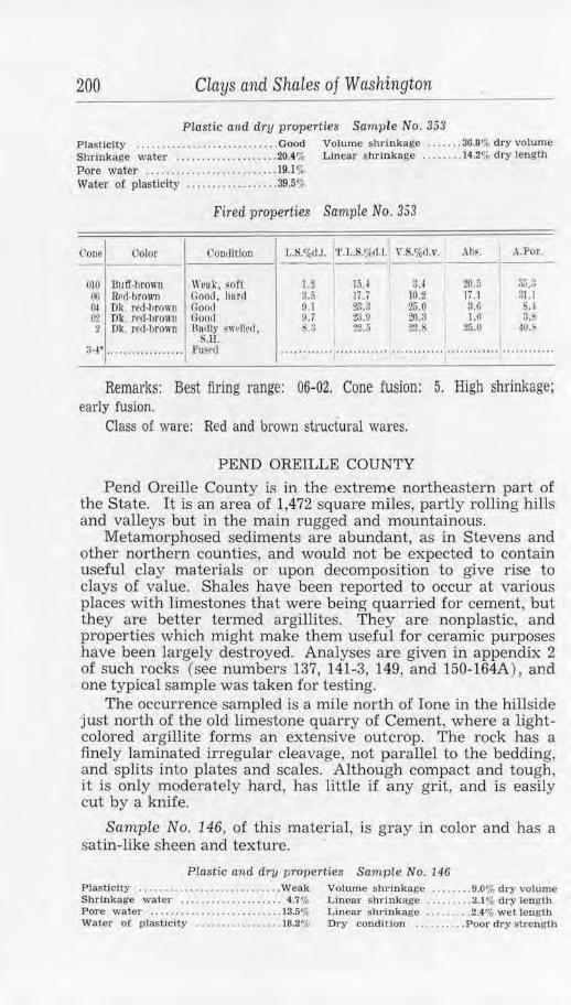
200 Clays and Shales of Washington
Plastic and dry properties Sample No. 353 Plasticity .............. . ....... . ..•.. Good Volume s hrinkage ....... 36.8% dry volume Shrinkage water ... . ................ 20.4% Lin ear shrinkage ........ 14.2% d ry length Pore water ......... . .... . ........... 19.1 % Water of plasticity .. . ........ . ...... 39.5%
Fired properties Sample No. 353
Cone Color Coodltion LS.%d, 1. r'.L.S.%d.l. v . . %d.v. Abs. I ..\.Por.
010 Buff-brown \\'cak . oft 1.2 $.4 20.5 !1.'i.~ 15.4 00 R~d-hrown flood, hnrrl 3.5 JU 10.2 Ii .1 31.J OI Dk. red-lirown Good 9.1 2!).8 25.0 3.f> SA ~l Dk. recl-hro,111 riood 9.7 2$.9 20.:l 1.6 3. 2 Dk. red-brown Bo,nr £wrllecl, s.:i 2'2.;j 22. 2.i.O ~o.s.
S.li. a-.i • ... , .............. l·u~~d ············ ... ..................... ············ ············
Remarks: Best firing range: 06-02. Cone fusion : 5. High shrinkage; early fusion.
Class of ware: Red and brown structural wares.
PEND OREILLE COUNTY
Pend Oreille County is in the extreme northeastern part of the State. It is an area of 1,472 square miles, partly rolling hills and valleys but in the main rugged and mountainous.
Metamorphosed sediments are abundant, as in Stevens and other northern counties, and would not be expected to contain useful clay materials or upon decomposition to give rise to clays of value. Shales have been reported to occur at various places with limestones that were being quarried for cement, but they are better termed argillites. They are nonplastic, and properties which might make them useful for ceramic purposes have been largely destroyed. Analyses ar e given in appendix 2 of such rocks (see numbers 137, 141-3, 149, and 150-164A), and one typical sample was taken for testing.
The occurrence sampled is a mile north of Ione in the hillside just north of the old limestone quarry of Cement, where a lightcolored argillite forms an extensive outcrop. The rock has a finely laminated irregular cleavage, not parallel to the bedding, and splits into plates and scales. Although compact and tough , it is only moderately hard, has little if any grit, and is easily cut by a knife.
Samp!e No. 146, of this material, i s gray in color and has a satin-like sheen and texture. ·
PLastic an d dry properties Sarnp le No. 146 P lasticity ..............•............. Weak Volume shrinkage ..... . .. 9.0% dry volume Shrinkage water . . .................. 4.7% L inear shrinkage ......... 3.1 % dry length Pore water .................. . ....... 13.5% Linear shrinkage . ..•..... 2.4% wet length Water of plastic ity ....... ...•...... 18.2% Dry condit ion .......... P oor d ry strength
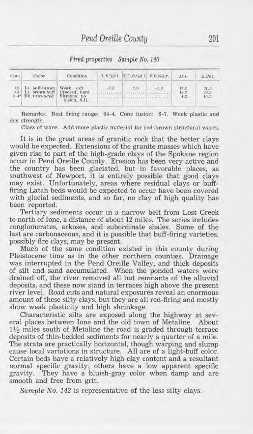
Pend Oreille County
Fired properties Sample No. 146
Cone Oolor CoodJtfon
1i:- Lt. buff-hrown Weak, soft I~ T,t. hrown-buff OrnckNI, ha.rd
3-1• nk. hrown•red Vltrc'Ou~. un ru~ lon . S.B.
L.:S.%(1.1. 'l'.J,.R',k l.1. V.S.%<L •·.
-0.5 2.0 -1.;;
201
Abs. A . .Por.
11.3 31.5 )Q.2 2».0 1.2 10.~
Remarks: Best firing range: 04- 4. Cone fusion: 6-7. Weak plastic and dry strength.
Class of ware: Add more plastic material for red-brown structural wa1·es.
It i.s in the great areas of granitic rock that the better clays would be expected. Extensions of the granite masses which have given rise to part of the high-grade clays of the Spokane region occur in Pend Oreille County. Erosion has been very active and the country has been glaciated, but in favorable places, as southwest of Newport, it is entirely possible that good clays may exist. Unfortunately, areas where residual clays or bufffiring Latah beds would be expected to occur have been covered with glacial sediments, and so far , no clay of high quality has been reported.
Tertiary sediments occur in a narrow belt from Lost Creek to north of Ione, a distance of about 12 miles. The series includes conglomerates, arkoses, and subordinate shales. Some of the last are carbonaceous, and it is possible that buff-firing varieties, possibly fire clays, may be present.
Much of the same condition existed in this county during Pleistocene time as in the other northern counties. Drainage was interrupted in the Pend Oreille Valley, and thick deposits of silt and sand accumulated. When the ponded waters were drained off, the river removed all but remnants of the alluvial deposits, and these now stand in terraces high above the present river level. Road cuts and natural exposures reveal an enormous amount of these silty clays, but they are all red-firing and mostly show weak plasticity and high shrinkage.
Characteristic silts are exposed along the highway at several places between Ione and the old town of Metaline. About 11h miles south of Metaline the road is graded through terrace deposits of thin-bedded sediments for nearly a quarter of a mile. The strata are practically horizontal, though warping and slump cause local variations in structure. AU are of a light-buff color. Certain beds have a relatively high clay content and a resultant normal specific gravity; others have a low apparent specific gravity. They have a bluish-gray color when damp and are smooth and free from grit.
Sample No. 142 is representative of the less silty clays.
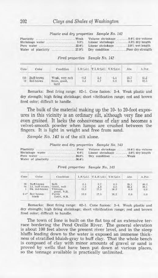
202 Clays and Shales of Washington
Plastic and driJ properties Sample No. 142 Plasticity ....... .. .. . ..... . .......... Weak Volume shrinkage .. . ..... 9.4% dry volume Shrinkage water .......... •. ... . ... . . 5.5% Linear shrinkage .. ....... 3.3% dry length Pore water ... . ........ • ........... . . 22.4% Linear shrinkage ......... 2.8% wet length Water of plasticit}' .. . ... ..... ..... . 27.9% Dry condition ........... Poor dry strength
),'ired properties Sample No. 142
Con~I Color Con,lltion l,.S.~}11.I. 'l'.L.S.%11.1. V.S.%<1.,•. .\h~. .\ .Por.
010 I .Buff·brown Wrnk, very ~on -o.o 2.b -1.1 2J,7 il,Z 0-2 l?cd·brown !:irmn, good, 3 ,.[ 6.7 o.s 18.2 32.5
llard
Remarks: Best firing range: 02-1. Cone fusion: 3-4. Weak plastic and dry strength; high firing shrinkage; short vitrification range; red and brown fired color; difficult to handle.
The bulk of the material making up the 10- to 20-foot exposures in this vicinity is an ordinary silt, although very fine and even grained. It lacks the cohesiveness of clay and becomes a velvet-smooth powder when lumps are crushed between the fingeTs. It is light in weight and free from sand.
Sample No. 143 is of the silt alone.
Plastic and dry properties Sample No. 143 Plasticity ..... .. ..... .. ............... Poor Volume shrinkage ....... 10.4% dry volume Shrinkage water ...... .. . ...• .•. . . .. 6.4% Linear shrinkage . . . . . . . . 3.6% dry length Pore waler .. . ..... ..... . .. .......... 24.0% Dry condition .... . ...... Weak Water of plasticity . ... .. . ... . ...... . 30.4%
F'ired properties Sample No. I43
Con,· I Color <.'on,Urlon t..S.%tl.l. ' l'.L.S!,4d.J. V.S.o/od. ,·. ahs. .\.Por.
0(1 RufT-llrown Soft O.l S.7 0.3 26.1 40.2 Ol Lt. hu If ·hrown Ono<l, soft 1 .2 4.S 3.0 24.4 00.J
I Dk. rc(l.1Jrow11 Vltn•ous, 13.9 17.5 30.2 o.o 0.0 goo,1 . s..a.
3-1' Re,I brown- Purtl)' 13.9 17.i; SQ.2 0.0 0.0 hlurk fu~rl,I, S.B.
Remarks: Best firing range: 02-1. Cone fusion: 3-4. Weak plastic and dry strength; high firing shrinkage; short vitrification range; red and brown tired color; difficult to handle.
The town of Ione is built on the flat top of an extensive terrace bordering the Pend Oreille River. The general elevation is about 100 feet above the present river level, and in the steep bluffs leading down to the water is exposed an immense thickness of stratified bluish-gray to buff clay. That the whole bench is composed of clay with minor amounts of gravel or sand is proved by wells that have been put down at various places, so the tonnage available is practically unlimited.
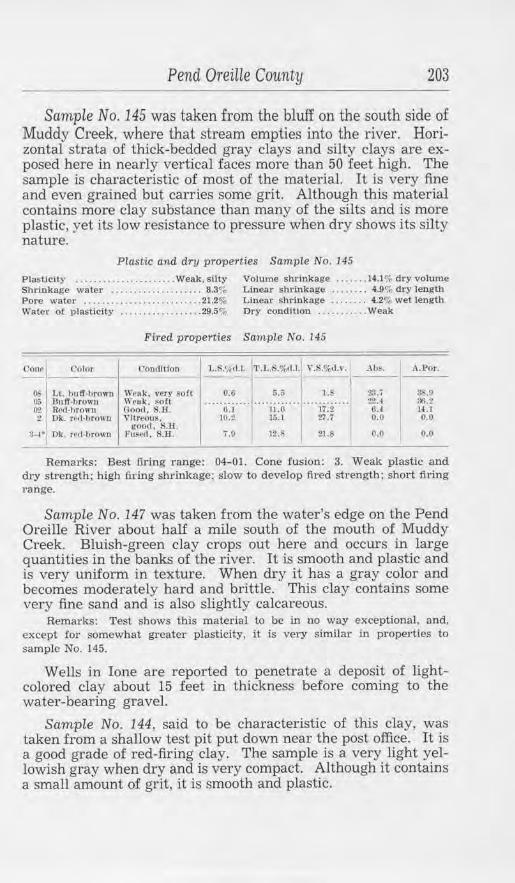
Pend Oreme County 203
Sample No. 145 was taken from the bluff on the south side of Muddy Creek, where that stream empties into the river. Horizontal strata of thick-bedded gray clays and silty clays are exposed here in nearly vertical faces more than 50 feet high. The sample is characteristic of most of the material. It is very fine and even grained but carries some grit. Although this material contains more clay substance than many of the silts and is more plastic, yet its low resistance to pressure when dry shows its silty nature.
Plastic and dry properties Sample No. 145
Plasticity ..... . ......... .. ..... Weak, silty Volume shrinkage ... . . .. 14.1% dry volume Shrinkage water . ............ . ...... 8.3% Linear shrinkage .. ... ... 4.9% dry length Pore water .......................... 21.2% Linear shrinkage .... .. . . 4.2% wet length Water of plasticity . .... ...... ....... 29.5% Dry condition . .......... Weak
Fired properties Sample No. 145
('one Color Condition L.S.<;,,rl.1. '1'. l,.S.%d.l. Y.S.%d.v. . lb~. J\.l:'or •
OS 1, t. huff-brown Weul<, 1•cry sort 0.6 6.5 1. r ~'t.7 ~ .9 05 Duff,hrowu Weak. $O!t
;ir· ur T ~r I
2:U 86.2 02 RM,hrown Oood, S.H. 6.J l4.t 2 Dk. red,hrown Vltr,011~. 0.0 0.0
good. s.n. :i--1·1 Ok. rf<l•hrown l'u~ed, $.H. 'i.O 12.S 21.S o.o 0.0
Remarks: Best firing range: 04-01. Cone fusion: 3. Weak plastic and dry strength; high firing shTinkage; slow to develop fired strength; short firing range.
Sample No. 147 was taken from the water's edge on the Pend Oreille River about half a mile south of the mouth of Muddy Creek. Bluish-green clay crops out here and occurs in large quantities in the banks of the river. It is smooth and plastic and is very uniform in texture. When dry it has a gray color and becomes moderately hard and brittle. This clay contains some very fine sand and is also slightly calcareous.
Remarks: Test shows this material to be in no way exceptional, and, except :for somewhat greater plasticity, it is very similar in properties to sample No. 145.
Wells in Ione are reported to penetrate a deposit of lightcolored clay about 15 feet in thickness before coming to the water-bearing gravel.
Sample No. 144, said to be characteristic of this clay, was taken from a shallow test pit put down near the post office. It is a good grade of red-firing clay. The sample is a very light yellowish gray when dry and is very compact. Although it contains a small amount of grit, it is smooth and plastic.
204 Clays and Shales of Washington
Plastic and dry properties SampLe No. 144 Plasticity ........................... Good Volume shrinkage . .. .... 25.4% dry volume Shrinkage water .................... 13.1 % Linear shrinkage .... . ... 9.3% dry length Pore water .............. . ........ ... 16.0% Linear shrinkage ...... .. 6.7% wet length
Water of plasticity ................ .. 29.1%
Fired properties Sample No. 144
Cone Color Comlit!on L. -~~d.J. 'VJ,.S.%<1.1.! V.f!.%d.1•. Abs. A.Por.
00 Lt. red -brown Light s~um, :;.s Jo.1 10.0 10.0 21.5 i;ood, S.H.-
05-0l Red-brown Light m nn, ············ ......................... i.O 14.4 good, S.B.
00 Red-bro1m Vitreous, light ·· ·········· ···· ········ ............ 0.0 0.0 • nun. . H .
2 Glav.ed dark Fused, 2.1 HA G.2 5.2 9.0 rcd·browu rletormea . . H.
Remarks: Best firing range: 07-02. Cone fusion: 3-4. Shrinkage a little high.
Class of ware: Add more nonplastic material for red and brown common structural wares.
A well put down in the NE. cor. sec. 1, (37-42 E), just west of Ione, went through some 70 feet of sediments. Some strata are fine-grained smooth clays very low in grit, while others are more sandy but mostly of very fine texture. Similar clays, horizontally bedded, are exposed in nearby road cuts so that great amounts, well situated for handling, are available.
Sample No. 141, from material removed in sinking the well, shows variations in color from gray to buff and considerable variation in texture.
Plastic and dry prope1·ties Sample No. 141
Plasticity .... .. ....... ..... . ......... Weak Shrinkage water ....... .. ........... 10.1 % Pore water ............ , ............. 18.5% Water of plasticity ..... ....... ... .. . 28.6%
Volume shrinkage ... . ... 19.4% dry volume Linear shrinkage ...... .. 6.9% dry length Linear shrinkage . ... .... 6.7% wet length Dry condition .... . ...... Weak
Fired properties Sample No. 141
Conf Color Condition 1 •. s .,;, ,1.1. l'l' .J .. S.o/.,cU.1 V.fi.%d.,·. Ah!-. I . .\.Por.
06 'Buff,browu \\'Puk. f<'um, ~oft lJ.7 7.0 1.0 1S . ' 32.11 01 Ok. rcd-1,rown Cloorl. S.ll. !).S JC,.7 26.(: 4.0 o .:J
I Uk. rt•rl-brown Llghlll' s.1 l!;.0 22.3 0.1 0.2 stuck , S.H.
I
Remarks: Best firing range: 05-02. Cone fusion: 4. Short firing range; weak plastic and dry strength.
Class of ware: Would be difficult to m ake into ware.
Clays of the same general nature as those occurring near Ione are found at many places up the river. Thick irregular deposits occur at Blue Slide; these are dark-gray bedded materials that cover upward of 20 acres. Laminated clays have been deposited
Pierce County 205
near Usk, and buff-colored beds interstratified with light-gray silts crop out in the vicinity of Newport. All these have the similarity of physical properties that are associated with the glacial clays of western Washington. Greater variation, however, is shown in the chemical composition of these terrace clays. The following tabulation is made from the results of 19 analyses taken from various sources. It gives the maximum, minimum, and average percentage of the main clay constituents and is indicative of most of the soft clays or silts found along the Pend Oreille River.
Anatyses of clays from Pen d OreiUe Valley, Pend OreiUe County
CONST l'l'UF,N'f'S Muxfrnum U lnhnnm Awra gc (pc>rcenl) (Jl(lrG'<ln l) (J)('rC~11t )
~ Uica (S10 s) ... . ..... . .... .. .. . ....... , . . . .. . . . . . .. . . . .. . . . . .. .. .. .. 77 .05 .\lumln11 11ml lr<>n {Ab<h. ~·e,Oa/............ ........ ............. :i:uis L ime (OuO) ........ ............ ...... . ......... ............ .... .... 9.7, llu1:ncsit1 (M1<0) . . . • • . . . . . .. • . . . . . . . • . . .• . . . . . . . . . . . . . • •• • . . . . • .. . • . ~.00
54.10 lo.5:J 1.30 o.so
00.11 13.li 1.00 1.311
In the above analyses the alumina and iron (Al'.!0 :1, Fe~OJ were not determined separately. From various samples that have been individually determined, 6.0 percent might be taken as the average iron (Fe~0,1) content; in this event, the average amount of alumina (Al:!0,1 ) would be approximately 17 percent.
PIERCE COUNTY
Pierce County, whlch has an area of 1,701 square miles, extends eastward from Puget Sound to the summit of the Cascade Mountains and so includes a most varied topography and extreme differences in elevation. The clay materials occur as three main types: Cascade residual, from the decomposition of igneous rock; shale, in the coal-bearing Puget group of Eocene age; and bedded clay, in the Puget Sound glacial deposits. Each of these is peculiar to a formation which is dominant throughout certain large areas, so the clay obtainable in a particular locality may be readily ascertained. The Tertiary beds form an irregular belt about 5 or 6 miles wide, extending south across the county from near Buckley to Ashford. East of this area of consolidated sediments and west of it to about the vicinity of Eatonville are igneous rocks of Miocene age and younger. They are chiefly made up of andesite flows, pyroclastic rocks, and smaller amounts of granodiorite and related intrusives. Still farther west the bedrock is deeply covered with glacial sediments.
CASCADE RESIDUAL CLAYS
The Cascade residual clays have resulted from the decomposition of Miocene volcanic rocks. Some deposits are certainly
206 Clays and Shales of Washington
due to hydrothermal alteration of the andesites; others may be erosional remnants of ancient products of deep weathering. It is entirely possible that clays may still exist that were formed by weathering prior to the elevation of the present Cascade Mountains. Intense erosion brought about by the uplift would have stripped off almost all the alteration products, but in protected places-possibly covered by later flows-some of the old clays might remain. This appears to be the explanation for isolated thick deposits of residual clays, commonly associated with unaltered dikes and flows, that occur in several places in the county.
One of the occurrences is in cuts along the Chicago, Milwaukee, St. Paul & Pacific Railway one-half mile north of La Grande. This is at an elevati.on of 942 feet in the lower foothills of the Cascades and near the eastern border of the main drift area. Some buff-firing clay was mined here many years ago by the Denny-Renton Clay & Coal Co. and shipped to their terra cotta plant at Van Asselt. The cut and old pit expose the clay to a depth of about 12 feet at one place over an area measuring 150 feet by 100 feet. The clay is mottled and variegated in color and texture, some places being nearly white and others gray, red, blue, and purple. This is due, in part, to differential leaching and iron staining but also to the fact that the original rock was a volcanic agglomerate, a felsHic rock containing, as inclusions, blocks of porphyritic andesite as much as 3 feet in diameter. Such an aggregate, upon decomposition, naturally would show marked differences in the physical characteristics of different portions.
The clay is well situated for mining, and the overburden of glacial gravels is not extreme, although it increases to the west. The nearness of unaltered rock, however. shows the deposit to be an erosional remnant, the extent of which can only be determined by careful prospecting. Also, the andesitic inclusions are red firing, thus necessitating hand sorting of the clay to avoid a product which will be decidedly irregular in properties.
Sample No. 184-A was taken on the west side of the railroad tracks. When dry, it is principally light gray and nearly white, but a few colored phases in very light shades are present. The clay is nearly structureless, and the texture is uneven but mostly fine. Lumps are soft and are easily crushed between the fingers to a harsh powder. The amount of free quartz is very low.
Plast ic and dry properties Sample No. 184-A Plasticity . . . . ........ .. ...... Sticky, weak Volume shrinkage . . . .. . . 16.0% dry volume Shrinkage wate r . ... . .. . .......... .. 10.2"', Linear s hrinkage . ... ... . 5.7% dry length Pore water ... . .. ...... . • . . ....... . .. 26.8% Linear s hrinkage .. . . . . .. 5.5% wet length Water of plas ticity .... . .... .. ... . . .. 37.0% Dry condition .. ......... Weak
Conel Color
012 Lt. plnk,grny 00 U. cre1rn1 0-I Lt. erram 1 Oream
3-,l• l..t. groy,tm IT 0-7* Lt. gruy,l)ufT 12* U . t,uff
Pierce Coiinty 207
Fired properties Sample No. 184-A
L'011<1iLiOJl
Sort ~oil /i\011 Roll !;oft Solt Soft
I
L.S.'t, .t.l. 'l'.1,.S,%,1.1. \'.S.%d.v. Abs. ,\.Por.
:::::'.1:~::::l:::::o:!::::l:::::~?::::1--!--:-!_, __ :_!_j_ ..... ~ :6
...... .. . '.:~ ......... ~:'. ...... "29:0" ...... ~7 ::i" .. :?.& .5 '-.2 27.9 41.fl s.o o.s 10.a 23.fl :~.s
Remarks: Best £ring range: 12-18. Steel hard. cones 16-17. Cone fusion: 30.
Class of ware: No. 2 refractory.
Sample No. 184-B, also from the west side of the railroad, is of uniform light-buff color and comprises both soft and relatively hard material.
Plastic and dry properties Sample No. 184-B Plasticity ............ ... ............. Good Volume shrinkage . .... .. 25.5% dry volume Water of plasticity ...•.... .. ....... 47.7% Linear shrinkage ... ... .. 7.9% dry length
Fired properties Sample No. 184-B
<'one Color L'OtHllt[OJ1 V.S.<µ ,t.v.
Light rr~om.. .......... .. ............ Roft... ................ .. .. ... . .. ..... 0.11 Llghtcrcnm .......................... Soft... ............................... u.7 1, igh( rri•um...................... .... S0f1. .... . ..... ........ ... .. .... ...... li.2 Ligl,t hutf ...... ......... ... .... .. .... Jlar<I. .. .......... ... ..... .... . ..... . ;;,7 Light h11tf........ ...... .. ... .... ..... El~rd .............. . ................................. .
Remarks: Best firing range: cone 15+ . Cone fusion: 31. Class o:f' ware: Refractories. Has been used .for terra cotta and fire brick.
Sample No. 185-A was taken on the east side of the tracks. Here the inclusions are more in evidence, so the sample comprises a great variety of textures and colors. Some of the inclusions, although completely decomposed, still show the coarse, porphyritic texture of the original rock, the feldspars being changed to kaolin and the femic minerals to chlorite.
Plastic andi dry properties Sample No. 185-A Plasticity ..................... . ...... Good Volume shrinkage .. . ... , 14.1% dry volume Shrinkage water ........... . ........ 9.0% Linear shrinkage ..... . .. 4.9% dry length Pore water . ........ . ....... ...... . .. 24.0% Linear shrinkage .. . ..... 4.5% wet length Water of plastici ty .... ....... ... . ... 33.0"t Dry condJtion .. . ......... Strong
Fired properties Sample No. 185-A
Cone Color
ll3-02 L I. Cl'Nlffl 01-1 l ,t . C"rcam
t'oudllfoo
Rofl Soft
''· .. ~ 1·orny.ij~;,; ...... ·i;;,i-ii ........... .. 0-1• GrllY·bttff Hurd
10 Gruy ,hulf l :I:* n ray.J,u ff X.Il.
L.S.'/,(1.1. T .L.S.%d,J. V.S.%<1,1•.
........................ ····· ···· ··· 3.S .7 J0.!1
11.b H ,0 ·· ···· ······ ············ .... .. ..... .
ii.i JO.ti l G.2
············ ········· ··· :l2.1 4F;.~ 21. l :L;.o :lO.!i :l:l.i, 14 .11 .......... . 11.IJ 10.8
Remarks: Best firing range: 5-15. Cone fusion: 28-. The structure shows grog checking but otherwise is good.
Class of ware: No. 2 refractory or gray-buff structural wares.
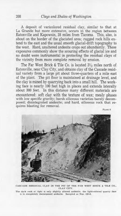
208 Clays and S1uiles of Washington
A deposit of varicolored residual clay, similar to that at La Grande but more extensive, occurs in the region between Eatonville and Kapowsin, 28 miles from Tacoma. This, also, is about on the border of the glaciated area; rugged rock hills extend to the east and the usual smooth glacial-drift topography to the west. Hard, unaltered andesite crops out abundantly. These exposures commonly show the scouring effects of glacial ice and no doubt were instrumental in protecting the residual clays of the vicinity from more complete removal by erosion.
The Far West Brick & Tile Co. is located 31h miles north of Eatonville, near Clay City, and obtains clay of the Cascade residual variety from a large pit about three-quarters of a mile east of the plant. The pit floor is maintained at drainage level, and the clay is mined by quarrying back into a small hill. The working face is nearly 100 feet high in places and extends laterally about 300 feet. In this distance many different materials are encountered: soft clay with the texture of wax; mealy phases with low specific gravity; harsh siliceous varieties barely decomposed; disintegrated andesite; and hard, siliceous rock that requires blasting for removal.
Pl.AT& 8
CASCADE RESIDUAL CLAY IN THE PIT OF THE FAR WEST BRICK & TILE CO .. CLAY CITY.
The dark rock al right ls only slightly altered andesite; the JJght-colo1·ed quarry face is in completely decomposed andesite. Sampled as Nos. 186-8.
Pierce County 209
Because of the different kinds of original rock and the differ· ence in leaching and extent of decomposition, the residual clay appears in all colors-nearly white, green, blue, yellow, and dark red. The variously colored clays have different physical characteristics, not only working differently, but firing to buff, red, and unusual intermediate shades. This makes it essential to segregate varieties when mining the clay, if certain colors of ware are to be maintained. As one clay grades into another or abruptly changes, the deposit is very irregular and difficult to handle, and there is no assurance that a color in fired ware can be duplicated at some distant date.
Sample No. 187 was taken in an effort to procure a "run-ofpit" mixture. It includes all of the colors mentioned above with the exception of the dark red. Necessarily it is a heterogeneous mixture with uneven texture and peculiar appearance.
Plastic and dry properties Sample No. 187
Plasticity ........ . ... . ..•.. . ...... .. . . Fair Volwne shrinkage ....... 27.0% dry volume Shrinkage water ... .. ......... . ...... 16.4% Linear shrinkage ....... . 9.9% dry length Pore w11ter ..... .. . . ....... . . . •.. . .. 19.6% Linear shrinkage .... . ... 7.l '"o wet length Water of plasticity ................. 30.6% Dry condition .........• sort
Pired properties Sam,pLe No. 1 Bi
<.•on~l. __ co_io_r _ 1 __ c_·o_n_<11_11o_n __
1 L.R.<;. il.l. l'J'.t,,S.%,1.l . _' '_.!-_.%_d_.,._. , __ .,h_;,. _ _ A_.P_or_. _
0'2 J.t. browu,hutr 01 Lt. brown-tmlT
1 t Lt. groy-lJrown ~ 4· Brown-gruy &-7· Spotted irray
12• Dec!) l>rown 1.; SpotlNI urowo
Weuk, sotl Weal<, soft Wrnk, soft Oood. hfml Oood, h11r11 l~oo,J. fi B. lllacl< hll~tcr~.
S.H .
............ .. . . .. ...... ..... . ...... 21.7 ;Jtl, 3
... .. 4 :f ... .. .. j3:i1" .. .... ii :~· ... .... ~:~ .... .. .. ~-S
..... .. ..... .... ... ..... .... . ....... 19.11 ia::i·"· u. i !fl.6 l .£ 1(1.0 29.2 !l.li l!/.J :!ti. I 5.!l 1.2.0 ............... ......... '""""""I""""'"" ........... .
-------"--- ------Rema1·ks: Best fil-ing range: 3-12. Cone fusion: 20+ .
Class o! ware: Gray and brown structw·al wares. Used for race brick and tile. Nos. 187-B and 187-C, pp. 212/213.
Sample No. 187-A represents a clay that occurs here in possibly greater quantity than any other. I t is a light-colored greenish material when dry, with the appearance of sandstone. Lumps break easily to a haTsh powder between the fingers. 1 t is a decom posed andesite, still showing the original texture. The mass is granular and is composed of white kaolin together with green chlorite and serpentine. It contains also some limonite and a very little free quartz.
210 Clays and Shales of Washington
Plastic and dry properties Sample No. 187-A
P las ticity . ......... .. ........ .... .... Weak Shrinkage water .... . ....... ... . ..... 4.7% Pore water ........... . .............. 27.8%
Volume shrinkage ........ 6.9% dry volume Linear snrinkage .. ....... 2.4% dry length Dry condition ..... ...... Weak
Water of plasticity ...... . .......... 32.5%
Fired properties Sample No. l87-A
Cour Oolor Oondllion 1..S.~d.l. 'l.'.l •. S.%d.l. V.S.%d.v. I .\hs. A.Par. --
0-2 1 Lt. brown-lJuff Granular, oft 5.6 8.0 15. 'ti.7 43.6 lt Brown-buff Granular, sott 7.0 9A 19.5 23 .i 3&.3 3-1* Brown GranulRI, soft 9.6 12.0 20.l 22.S ro.4 G-7• Spot terl brown Grnnulnr, soft 8.5 10.9 23.5 13. ~ .7
12" Black Vesicular, hodly ············ ............ ......... ... ············ .. .......... fused
Remarks: Best firing range: 5-6. Cone fusion: 10. Short firing range at high temperatures. Weak strength. Could be used only in a more plastic mixture.
In some places, where the residual material is nearly white in color, alteration is less advanced and has been accompanied by leaching. The feldspars are only partially altered to kaolin; the femic minerals are conspicuously absent; and minute crystals of secondary pyrite form crusts on joints and are scattered abundantly throughout the mass. Such clay carries a relatively large percentage of quartz, thus showing a different phase of the parent rock or, possibly, silicification as a feature of the alteration.
This more-siliceous white clay is rather refractory and has been used as a fire clay. It is not suitable for exacting requirements, owing to the irregular occurrence of pyrite and to the normal content of ordinary fluxing agents. It may, however, be classed as a low-grade or No. 2 fire clay and as such would be satisfactory for uses where a high-testing and correspondingly high-priced refractory was not necessary.
Sample No. 1.86-A, taken from the east or "fire clay" side of the pit, is representative of a large amount of the clay, so far as general appearance goes. It is derived from a porphyritic rock, and the abundant altered feldspars show white against a finegrained light-blue groundmass. Lumps when dry are compact and not easily crushed in the hands. The texture is gritty and harsh, and much fine pyrite is disseminated throughout the sample.
Plastic and dry properties Sample No. 186-A
Plasticity . . ... .. . .. . .... .. . ... . . ...... Fair Shrinkage water .. .. ....... .... ..... l2.3% Pore water ....... . ........ ... . . ..... 17.9%
Volume shrinkage ...... . 21.2% dry volume Linear shrinkage .... ... . 7 .6% dry length Linear shrinkage ........ 6.0% wet length
Water of plasticity . . ........ . .. ... .. 30.2% Dry condition .......... . Brown scum: fair
Pierce County
Fired properties Sample No. 186-A
Con~ Color Condllion L.S.~cl.l. ' l'.L.S.o/,;d.l.l V.S.o/.,d.v.
012 Light grar . SnrCacc crocks, ············ .................... .... oenr whit<• €OH Ol Oreaun f;urhlC<' cracks, 0.6 S.2 1.8
fOft
I+ I Llghl b'l"lll" Surfut~ rrueks, ............ ············ ............ sort
3-1• Llghl gTay Surface M"ocks, o.s S.l 2.5 ~oft
11-r·
JO
12*
L ight gruy Surface crocks, ~oft
1.6 9.2 4.S
Gray-hu ff Surfa('(• cracks, ·········-·· ·· ···· ···· ·· ............ sou
n ray·hufT Snrfo•'<' crneks, 2.5 10.l 7.4 ~ou
Remarks: Best fu·ing range: 12-15. Cone f usion: 29. Class of ware: No. 2 refractory. See No. 187-D, p. 212.
211
~us. .\.Por.
24.5 31U
24.l ss.o 2'1.0 3().11
20.8 32.5
11l.1 29.2
l:\.6 . .... .. ..... 13. l 26.8
A notable concentration of iron oxide leached from the surrounding clays has resulted in a great body of red, ocherous clay in the upper west side of the pit. It is practically an earthy, impure limonite.
Sample No. 188, of this material, is reddish brown in color, nonuniform in texture, and somewhat gritty. When dry, the lumps are compact but brittle.
Plastic and dry properties Sample No. 188 Plasticity ..... . ................. . .... Good Volume shrinkage ....... 39.6% dry volume Shrinkage water . . ..•...........•.•. 22.5% Linear shrinkage ....... . 15.4% dry length Pore water .......... . ............... 12.7% Linear shrinkage ........ 7 .6% wet length Water of plasticity .. . ....•.... .. .... 35.2% Dry condition .......... Fair dry strength
Fired properties Sample No. 188
Uou~ Color C'on,lltlon L.$.<;,11.l. re.1,.S.%tl.l. V.S.%<1.,•. ,\ b~. A.Por.
012 Ll. buff-reel ll'euk, ~oit ··········· · ............ ··· ·· ······· 23.2 S9.4 ()I Lt. hrown-recl Gootl, hurd 4 .1 l!l.fi U.6 10.2 3-l.7 111 Aright. Good, huril ... ......... .. .......... ····· ······ · 17.0 83.3
IJuff-rt<l 3-1• Gray uncl Goocl. S.11.- 5.7 :?1.1 10.2 ]7 .1 SS.3
brown-red ;;..(i Gray oncl Good, S.El. .......... .. .. .......... ............ lG.l Sl.O
hrowu-rt"l ~,.
1
Gm "" Goo(I, !;.11. 0.2 2J .ll 17.t 10.0 29.8 brown-re<I
12• Dar'k brown Ooo,I. S.li. 1L I :!'2.S 20.;; s.o 10.9 JG Dark hrO\\ n Slight. hlo»tlng, i.O 22.4 1.0.a 10.S 20.S
S.H.
Remar ks: Best firing range: 02-12. Cone fusion: 19. High drying shrinkage.
Class of ware : For use in a gray, red, or brown structural-ware mixture.
Sample No. 187-D is of the ground No. 2 fire clay that was formerly supplied to the trade. The marked variations in
212 Clays and Shales of Washington
physical properties of such clay are well shown by comparing the results of tests on this sample with those on No. 186-A (p. 210), presumably of the same type of clay.
Plastic and dry properties Sample No. 187-D
Plasticity ............................. Fair Volume shrinkage ....... 12.8% dry volume Shrinkage water .. . ................. 7 .2% Linear shrinkage ........ 4.5% dry length Pore water .......................... 17 .8% Water of plasticity .................. 25.0%
Fired properties Sample No. 187-D
('ono Color Condition L. ,%d.l. T .L.S. %cl.I. V.S.%ti.v. .Abs. .\ .Por.
00 Ligbl brown Red cdgl.', $C1 1m, soft ··········· · ············ ............ 16.0 81.3
00 Pink·brown Oood, hard 1.6 G.l 4.6 15.5 ?SA 10 Gray-brown Good. S.lf. 3.5 s.o ]0.0 u .o· 22".2
Remarks: Best firing range: 1-10. Cone fusion: 14. Class of ware: Could use in a mixture for structw·al wares but needs
more plastic strength.
Sample No. 187-B is ground clay as used in the regular mixture at the plant, for hollow block and face brick.
Plastic and dry properties Sample No. 187-B PlasticHy ......... .. ................. Good Volurne shrinkage ....... 18.9% dry volume Shrinkage water .................... 9.7% Linear shrinkage ........ 6.8% dry length Pore water ............. .. ........... 15.3% Water of plasticity .................. 25.0%
Fired properties Sampte No. 187-B
(.'our I Color Condition L.S.~hl.l. 1.1'.L.S.%d.l.' V'.S.%tl.v. Abs. .\.Por.
N; I Brown-hull
I
Grunu ler, soft 2.0 8.8 ii.O 17.0 31..6 !12 Brown. bu tr r.r1u111lll.l', hard 2A o.z ().9 17.3 3] ,(i 10 Oroy-brown Slight stJcklnK, 1.5 11.3 12.s )0.5 :)0.1
S.B.
Remarks: Best firing range: 1-9. Cone fusion: 15. Class o:r ware: Now used for face brick and structural tile.
Sample No. 187-C is ground clay as employed at the plant for making the special face brick used in the construction of Home Economics, Commerce, and Philosophy halls at the University of Washington, Seattle.
Plastic and dry properties Sampte No. 187- C Plasticity ............................ Good Volume shrinkage ... .. .. 20.5% dry volume Shrinkage water ..................... 10.9% Linear shrinkage ........ 7.4% dry length Pore water .... .. ....... . ............ U.8% Water of plasticity .................. 22.7%
{'one
OS
02
10
Pierce County
Fired properties Sample No. 187-C
Color Condlllon L.$.<.,ll.l. T.L.S.%<J.1.I V.S.o/.,d .\'.
Light hrown Slight rect edgo, 2.0 9.4 I r;.s ::rum, 1'0lt
Pillk-b.rown Grennlur , good . 2,7 10.1 i.7 h,wl
Gray and Hood, S.ll. LS 12.Z 13.7 l1rown
Remarks: Best firing range: 02-9. Cone fusion: 15. Class of ware: Now used for fancy face brick.
213
Abs. .\,l>or. - -
20. l 35,;1
to.7 :!9.u
o.o 10.0
Far West Brick & Tile Co.-The Far West Clay Co., the original operators, mined the deposit by steam shovel, loaded into side-dumping cars on a standard-guage track, and used a 40-ton geared locomotive to take the clay to the plant. Some effort was made in digging and storing the clay to keep the markedly different types separate, but a power shovel is hardly conducive to nice separation. The present company has the clay mined by contract (a power shovel is still used), and transportation to the plant is by auto truck.
The clay is dried on a hot-floor, is then ground in one of two 6-foot dry-pans and is elevated to bins. After screening, the clay passes through a pug mill and then goes by chute to a brick and tile auger machine. A hand cutter is used for tile and an automatic rotary 13-brick cutter for brick. The tile are dried on an open-floor waste-heat drier; the brick, in a waste-heat 16-tunnel drier. The kiln system includes six 28-foot kilns, and two 30-foot kilns; all are of round down-draft periodic type. The time of :fiTing varies, but in general. 3 days is allowed for water-smoking and 5 more for the actual burn. The principal products are hollow building block, partition tile, and variegated rough-textured face brick.
About half a mile north of the pit of the Far West Brick & Tile Co. the narrow valley opens into a meadow which on the south side is flanked by a hill of glacial drift and on other sides by rocky hills of andesite. Here, at the base of these hills, residual clay occurs similar to that described above. A road on the south side has cut through the glacial drift and exposes an ocherous, red clay resembling sample No. 188. The extent of this clay is unknown, and the overburden is probably excessive. Just across the meadow, on the north side, some prospecting bas been done in what appears to be a large body of clay resembling the lighter-colored material mined at the Far West pit.
These clays are encountered also in cuts on the EatonvilleKapowsin road west of Lake Kapowsin, in the NW1,4 sec. 7. (17-5 E ) . The clay shows continuously for 200 feet or so along
214 Clays and Shales of Washington
the road to a maximum depth of 8 feet. The material is near to and above the railway grade and so could be easily handled except for some overburden of glacial gravel, which, however, may not be present in sufficient quantity to be troublesome.
Sample No. 335 is general, being taken at various places in the exposure. The color is pink, white , yellow, and brown, though shades of pink predominate. The texture is finer than most of the residual clays noted above, and part of the sample is unctuous and free from grit.
Plastic and dry properties Sample No. 335
Plasticity . .......... .. .... ... ..... ... Good Volume shrinkage .... . .. 30.9% dry volume Shrinkage water ..................... 19.0% Linear shrinkage ....... . 11.6% dry length Pore water ......... .... ..... ... .... . 24.4% Linear shrinkage ..... ... 7 .9% wet length Water of plasticity ................. 43.4%
Fired properties Sample No. 335
Conf Color ConditlOJl L.S.<fid.l. '.l'J •. S.%d.l.l V.S.o/o4t.v. Ah~. I
A.Por. -
Oil I Lt. grny,hrown Wenk. sofl 1.1 12.7 3.8 :Iii. 7 40.S 04 Ruff-red Weok. SOit :1.1 14.7 9.0 2~.4 39.S 02 nrown-bu IT Good. hur1I 4.!l 15.9 12.3 21.ii 37.0 3 Lt. buff,l)rown Good, llarct 6.~ 1$ .0 1S.O I . l 3't.7
JO O rt1 y-r;rown 000,1, !l.l.l. 0.1 20 .7 2,; .1 12.7 i s.
Remarks: Best firing range: 1-10. Cone fusion: 27. Too much plastic material. Good firing range at higher temperatures.
Class of ware: Buff and brown structural wares.
Other Cascade residual clays occur along White River in King County, so there is a considerable amount of this type of material known, and more will be found by further prospecting. That it is a difficult clay to work will be judged from the preceding pages; but it will continue to be in demand, as colors and textures may be obtained by its use that, so far, have not been duplicated by the use of other clays.
SHALES
The coal-bearing Puget group of Eocene age occupies a large area in Pierce County and has a thickness of 10,000 to 15,000 feet<D. Shales and sandstones, with their intermediate phases, form the bulk of the rock, and, although they have never been worked on a large scale, should be an important source of red-firing material for ceramic purposes. In King County similar shales have been mined for many years; they, also, belong to the Puget group and much of the general data
· (D Daniels, .Joseph, The coal-fields of Pierce County: Washington Geo!. Survey BuU. 10. 1915.
Pierce County 215
is applicable to Pierce County. Results of their tests may be found under that county beading.
In Pierce County the Burnett series contains the upper members of the group and is over 8,000 feet thick. The beds at·e exposed along South Prairie Creek and include the coal beds worked ai Spiketon and South Willis. The next lower, Wilkeson, series is mainly sandstone but contains some shales. It is only 1,000 feet in thickness and is practically barren of coal. The underlying Carbonado series, 2,200 feet thick, is the most important in the county as a coal producer and is likewise the most highly developed. It is mined at Burnett, Wilkeson, and Carbonado.
Although samples were taken only at Carbonado, some excellent beds of shale are exposed where creeks cut into the Puget rocks, or where tunnels in coal operations have crosscut the strata. One of several shale members exposed in the rock tunnel of the Pittsburg Number Eight mine is 48 feet thick. Four beds of shale from 19 to 28 feet thick are cut by the tunnel east from the Winsor bed at South Willis. Some of these could be advantageously mined with the coal. At one place at Burnett, about 100 feet stratigraphically below No. 2 coal bed, is 39 feet of dark-gray shale. This is exposed on the second level east of the fault. Some shale in workable width occurs between No. 2 bed and the Queen bed at Gale Creek, and an immense amount of sandy shale is exposed in a crosscut, off the main haulage way, between the East 6 and East 8 beds at Wilkeson.
The sedimentary beds at Carbonado are predominantly sandy, but some could be used as a source of clay material. Two shale members, 13 and 18 feet thick, respectively, are exposed above North 5 coal bed in North 1 mine, No. 33 tunnel. Other shales lie between No. 11 and No. 12 coal beds. These are in two beds, 5 and 6 feet thick, separated by 30 inches of sandstone, and crop out in the canyon 100 feet west of the old No. 6 tunnel The dip here is 65° westerly.
Sample No. 180, of these outcropping beds, is a dark-gray very hard, tough material. The shale is sandy, but the texture is moderately fine and uniform.
Plastic and dry properties Sample No. 180
Plasticity .... .... .. . . ...... . . ... .. . .. . Fair Volume shrinkage ... . ... 13.2~ dry volume Shrinkage waler ... ... ........ . ..... 6.5% Linear shrinkage . . . ..... 4.6% dry length Pore water . ........ . ........... . .... 12.1% Dry condition .... Fair; needs fine grinding Water of plasticit"y .. . . ..... . . . . .. . 18.6%
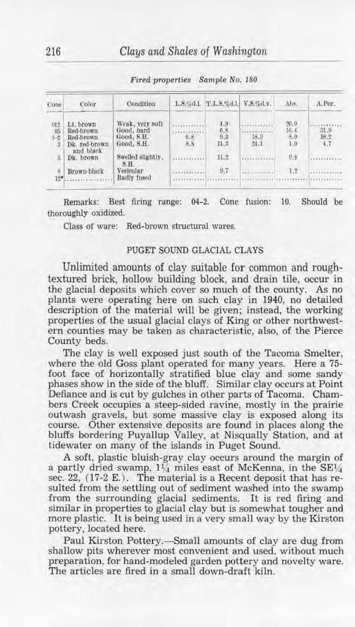
216
Cone Color
012 Lt. brown Icy Red-brown
1-2 Rcd-l)rown 3 Ok. red-brown
and blork
Clays and Shales of Washington
Fired properties Sample No. 180
Condition L.$.o/rd.l. T.L.S.%d.l. V. .%rl.1".
Weak, very soft ········ ···· 4.9 ............ Good, hard ············ 6. ............ Good, S.1:f. o.s 0.3 18.0 Good, S.H. .8 11.3 21.1
.\bf. A.Por .
20.0 ········ ···· 16.1 31.9 ~.() JS.2 1.9 4. 7
r, Dk. brown Swelled slightly, ..... ..... . . ll.2 ... . . . .... .. o. . .......... . S.H.
s Brown-block Vesicular w . . . . . . . . . . . . . . . . . . Dartly fused :::::: ::::::1 ..... ~:'. .... :::::::::::: ..... '.:~ .... ,::::::::::::
Remarks: Best firing range: 04-2. Cone fusion : 10. Should be thoroughly oxidized.
Class of ware: Red-brown structural wares.
PUGET SOUND GLACIAL CLAYS
Unlimited amounts of clay suitable for common and roughtextured brick, hollow building block, and drain tile, occur in the glacial deposits which cover so much of the county. As no plants were operating here on such clay in 1940, no detailed description of the material will be given;, instead, the working properties of the usual glacial clays of King or other northwestern counties may be taken as characteristic, also, of the Pierce County beds.
The clay is well exposed just south of the Tacoma Smelter, where the old Goss plant operated for many years. Here a 75-foot face of horizontally stratified blue day and some sandy phases show in the side of the bluff. Similar clay occurs at Point Defiance and is cut by gulches in other parts of Tacoma. Chambers Creek occupies a steep-sided ravine, mostly in the prairie outwash gravels, but some massive clay is exposed along its course. Other extensive deposits are found in places along the bluffs bordering Puyallup Valley, at Nisqually Station, and at tidewater on many of the islands in Puget Sound.
A soft, plastic bluish-gray clay occurs around the margin of a partly dried swamp, 1 Y.i miles east of McKenna, in the SEY,. sec. 22, (17-2 E. ) . The material is a Recent deposit that has resulted from the settling out of sediment washed into the swamp from the surrounding glacial sediments. It is red firing and similar in properties to glacial clay but is somewhat tougher and more plastic. It is being used in a very small way by the Kirston pottery, located here.
Paul Kirston Pottery.-Small amounts of clay are dug from shallow pits wherever most convenient and used, without much preparation, for hand-modeled garden pottery and novelty ware. The articles are fired in a small down-draft kiln.