Vol. 7 PUNJAB ROADS & BRIDGES DEVELOPMENT BOARD
351
--.- -. . . - El 370 Vol. 7 PUNJAB ROADS & BRIDGES DEVELOPMENT BOARD I GOVERNMENT OF PUNJAB -A PUNJAB STATE ROAD SECTOR PROJECT 4 Ia ConmbNcy Servkis -rPPrfcfqly SbA frPclwI P 1) -- " q] ___h0 -to su swam ad ~~~~~~~~~~~.yr. ' P. 0~~~~~~~~~~~~~~~~~~~~~~~~~~~~~~~~~~ t X SiS...wz... .Sj, Pr- _ ...* VemW 2006 IL 4 l- 4 CONSULTING ENGINEERING SERV ;L tJ 57, NEHRU PLACE (5TH FLOOR), NEW Of : , '. '1 FILE C,OpZ Public Disclosure Authorized Public Disclosure Authorized Public Disclosure Authorized Public Disclosure Authorized Public Disclosure Authorized Public Disclosure Authorized Public Disclosure Authorized Public Disclosure Authorized
-
Upload
khangminh22 -
Category
Documents
-
view
2 -
download
0
Transcript of Vol. 7 PUNJAB ROADS & BRIDGES DEVELOPMENT BOARD
- - .- -. . . -
El 370Vol. 7
PUNJAB ROADS & BRIDGES DEVELOPMENT BOARDI GOVERNMENT OF PUNJAB
-APUNJAB STATE ROAD SECTOR PROJECT 4 Ia
ConmbNcy Servkis -rPPrfcfqlySbA frPclwI P 1) -- " q]
___h0 -to su swam ad
~~~~~~~~~~~.yr. '
P.
0~~~~~~~~~~~~~~~~~~~~~~~~~~~~~~~~~~
t X SiS...wz....Sj,
Pr- _ ...*
VemW 2006IL 4
l- 4 CONSULTING ENGINEERING SERV;L tJ 57, NEHRU PLACE (5TH FLOOR), NEW Of
: , '. '1 FILE C,OpZ
Pub
lic D
iscl
osur
e A
utho
rized
Pub
lic D
iscl
osur
e A
utho
rized
Pub
lic D
iscl
osur
e A
utho
rized
Pub
lic D
iscl
osur
e A
utho
rized
Pub
lic D
iscl
osur
e A
utho
rized
Pub
lic D
iscl
osur
e A
utho
rized
Pub
lic D
iscl
osur
e A
utho
rized
Pub
lic D
iscl
osur
e A
utho
rized
0
** 6:9* PUNJAB ROADS & BRIDGES DEVELOPMENT BOARD* GOVERNMENT OF PUNJAB
PUNJAB STATE ROAD SECTOR PROJECT -
Consultancy Services for Project Preparatory* ~~Studies for Package I (Phase I) Feasibility
* 12 Environmental & Social Studies andPreliminary Engineering
* tt11
4,
S~~~ h
; I.S r ~ - i0 it
_ 1 % ' '-t-
* _- L -
I * \ FINAL REPOR ;@; ;
|* Part C: Environmental
* Volume 2: Appendices to MS -
; ~~May 2006
* 72CONSULTING ENGINEERING SERVICES (INDIA) PVT. LTD.* LLEII ~~~~~~~~~57, NEHRU PLACE (5TH FLOOR), NEW DELHI - 110 019, INDIA
00
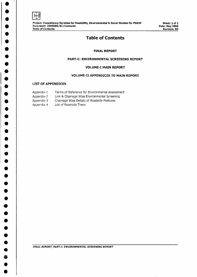
Project: Consultancy Services for Feasibility, Environmental & Social Studies for PSRSP Sheet: 1 of 1Document: 2005086/EC/Contents Date: May 2006Table of Contents Revision: RO
Table of Contents
FINAL REPORT
* PART-C: ENVIRONMENTAL SCREENING REPORT
VOLUME-I MAIN REPORT
VOLUME-II APPENDICES TO MAIN REPORT
LIST OF APPENDICES
Appendix-1 Terms of Reference for Environmental AssessmentAppendix-2 Link & Chainage Wise Environmental Screening
* Appendix-3 Chainage Wise Details of Roadside FeaturesAppendix-4 List of Roadside Trees
0
0
*
* ~~~~FINAL REPORT, PART C: ENVIRONMENTAL SCREENING REPORT
0
Project : Consultancy Services for Feasibility, Environmental & Social Studies for PSRSP Sheet: 1 of 7Document: 2005086/EC/Appendix-1 Date: May 2006
* Terms of Reference Revision: RO
ADpendix-1: Terms of Reference
* Environment Assessment
* BACKGROUND
* 1. Environment Assessment (EA) process is a decision making tool to ensure that the project designand implementation are environmentally sound and sustainable. During the preparation phase the
| * objective of the EA is to provide inputs to the feasibility study; preliminary and detailed design of* the project. During the implementation phase, the environmental management plans (developed as
a part of the EA during the preparation phase) serve as a framework for executing the mitigation,enhancement and monitoring measures.
* 2. In the preparation phase, the EA shall achieve the following objectives:
* . To establish the environmental baseline in the study area, and to identify any significantenvironmental issue;
. To assess these impacts and provide for measures to address the adverse impacts by the* provision of the requisite avoidance, mitigation and compensation measures;
0 To integrate the environmental issues in the project planning and design;
* . To develop appropriate management plans for implementing, monitoring and reporting ofthe environmental mitigation and enhancement measures suggested.
3. The environmental assessment studies and reporting requirements to be undertaken under these* TOR must conform the GOI and the Ban guidelines and regulations, which comprise of, inter alia:
The Environmental Impact Assessment Notification, MOEF 1994 with subsequent amendments;Environmental Guidelines for Rail/Roads/Highways Project, MOEF, 1989; the operational policies,
* guidelines and the reference materials of the World Bank listed in Annex I.
* 4. The EA comprises the following stages-environmental screening, project EA and the EMPs.However, as the present consultancy package is limited to undertaking feasibility analysis andpreparation of Preliminary Design Report, the scope of EA is limited to undertaking Environmental
* Screening followed by the project EA of the project(The EMP for the project will be developedduring the detailed design stage of the project). The scope of work for the consultant, under this
* package, is detailed out in the following sections
* DESCRIPTION OF THE PROJECT
* 5. The project roads are dispersed throughout the State of Punjab, covering a length of 1698 kmschosen on the basis of the SOS study. The list of such roads is at attachment 1. The improvements
* will consist mainly or raising the formation level, widening to two lanes from existing intermediatem lane width, providing paved shoulders and pavement strengthening of existing two lane roads.
Certain Urban reaches of roads may be upgraded to four lanes and/or provision for drains sidewall,* parking etc. In some cases, new alignment and/or realignment may also be required. Rehabilitation* works will generally involve strengthening of existing pavement and reconstruction of severely
damaged section. Such works do not envisage any form of widening of existing embankrnent..
* FINAL REPORT, PART C: ENVIRONMENTAL SCRfEE.IING REPORT
F y* Project Consultancy Services for Feasibility, Environmental & Social Studies for PSRSP Sheet: 2 of 7
Document 2005086/EC/Appendix-1 Date: May 2006* Terms of Reference Revision: RO
* SCOPE OF WOR'K
* Inception
* 6. The Consultants shall use the inception period to familiarize with the project details. The
Corsultants shall recognize that the remaining aspects of the project, such as engineering and
* social, are being studied in parallel, and it is important for these aspects to be incorporated. The
Consultants should also recognize that due care and diligence planned during the inception stage
helps in improving the timing and quality of the EA reports.
* 7. during the inception period the Consultants shall (a) study the project information to appreciate the
* context within which the EA should be carried out, (b) identify the sources of secondary information
on the project, on similar projects and on project area, (c) select sample corridor based on simple
* criteria and carry out a reconnaissance survey, and (d) undertake preliminary consultations with
* selected stakeholders, the proceedings of the consultation with stakeholders shall be video
recorded.
8. Following the site visits and stakeholder consultations, as well as a review of the conditions of
* contract between the consultant and the client, the consultant shall analyze the adequacy of the
allocated manpower, time and budget and shall clearly bring out/major/minor deviations, if any. The
Consultants shall study the various available surveys, techniques, models and software in order to
* determine what would be most appropriate in the context of this project.
V 9. The Consultant shall interact with the engineering and social consultant to determine how the EA
work fits into the overall project preparation/project cycle; how overlapping areas are to be jointly
* addressed; and to apSropriately plan the timing of the deliverables of the EA process. The
consultant shall develop criteria/methodology for Environmental Screening of selected links and for
selecting appropriate EA instrument (s) for subsequent stage of project preparation. In addition, a
* mechanism for continuous interaction between the engineering, environmental and social teams
shall be formalized and included in the Inception Report.
Environment Screening
10. General: Environment screening is done in the early stages of the project preparation to make
* preliminary assessment/review of the environment issues that the relevant to the proposed project,
and to make the project environmentally sound and sustainable. It determines the appropriate
extent and type of project EA to undertake, provides information/input that are required for
* assessing technical, economic and financial feasibility of the project, and recommends possible
modifications in the preliminary project design.
11. The Consultants shall carry out environmental screening as pare the work plan and methods
* described in the Inception Report, and in consideration of the comments of the Client on the same.
* The Consultants shall keep in mind the particular requirements of the project, especially the needs
of the overall feasibility studies in carrying out the screening. The environmental surveys be* coordinated with the social and engineering surveys, as far as practical.
* 12. Surveys: The Consultants shall collect information on the existing environment scenario from
secondary sources, and identify gaps to be filled, relevant to the environmental screening needs
from primary surveys. Primary surveys shall include baseline (air, water and noise) pollution
* monitoring at representative and sensitive locations, and identification of all macro-level
environmental issues within the project's influence area. The Consultants shall extensively use the* video records of the project road (carried out as part of the engineering surveys).
.
* FINAL REPORT, PART C: ENVIRONMENTAL SCREENING REPORT
.LEg* Project Consultancy Services for Feasibility, Environmental & Social Studies for PSRSP Sheet: 3 of 7
Document 2005086/EC/Appendix-1 Date: May 2006Terms of Reference Revision: RO
13. The Consultants shall survey the environmentally sensitive locations o and along the project road,
as well as within the project's influence area. All regionally or nationally recognized environmental
* resources and features within the project. Typically, these will include stretches of roadside trees;
environmental and common property resources such as forests, large water bodies; heritage
complexes and major physical cultural properties. All these may be depicted using a line diagram or
* a strip map.
* 14. Stakeholder Assessment & Consultants: The Consultants shall carry out consultations with all
communities that are likely to be affected, NGOs, selected Government Agencies and other
* stakeholders to (a) collect baseline information, (b) obtain a better understanding of the potential
impacts and (c) appreciate the perspectives/concerns of the stakeholders. Consultations shall be
preceded by a systematic stakeholder analysis, which would (a) identify the individual or
* stakeholder groups relevant to the project and to environmental issues, (b) include expert opinion
and inputs, and (c) determine the nature and scope of consultation with each type of stakeholders,
(d) determine the tools to be used in contacting and consulting each type of the relevant
* stakeholders, Consultant with the stakeholders shall not be treated as a project information
dissemination session, but be used to improve the plan and design of the project.
15. Identification of the Valued Environment Components (VECs): The Consultants shall
* determine the VECs considering the baseline information (from both secondary and primary
* sources), the preliminary understanding of the activities proposed in the project and, most
importantly, the stakeholder consultations. [VECs defined as social or biophysical component of an
* environment which is of value (for any reason) in a project influence area - for further details see
the World Bank, Roads and Environment, A Handbook (World Bank Technical Paper No. 376),
Washington DC, 19,97 (pp 25)].
* 16. Preliminary analysis of Impacts and Management Measures: The consultants shall conduct
* a preliminary analysis of the nature, scale and magnitude of the impacts that the project is likely to
cause on the environment, especially on the identified VECs (Valued Environmental Co9rnponents),
* and classify the same using established methods. For the negative impacts identified, alternative
* mitigation/management options shall be examined, and the most appropriate ones suggested. For
the positive measures identified, alternative and preferred enhancement measures shall be
* proposed.
* 17. Scoping for Project Environmental Assessment (EA): This shall be a direct outcome from the
environmental screening. The consultants shall define boundaries of the project EA after a careful
* consideration of the baseline scenario, likely impacts on the identified VECs, and the proposed
* mitigation and enhancement measures. The scooping shall include that which will be covered in the
project EA along with the "how, when and where" of each activity recommended. It shall include
* listing of other environment issues that do not deserve a detailed examination in the project EA
* (covering induced impacts that may be outside the purview of the client) along with a justification.
The scooping needs to identify and describe the specific deviations or inclusions vis-a-vis the
* original TOR, if any, aldng with a justification; modify the TOR for the project EA; if required; and
recommend studies that need to be conducted in parallel but are outside the purview of the EA
process.
18. Environmental inputs to feasibility study & preliminary project design: The EA consultants
* shall make location-specific design recommendations, wherever possible or required, related to
alignment (major/minor shifts or bypass or altogether different route alternative), road cross-
* sections, construction material use, and mitigation & enhancement measures. For all the different
* FINAL REPORT, PART C: ENVIRONMENTAL SCREENING REPORT
: Project Consultancy Services for Feasibility, Environmental & Social Studies for PSRSP Sheet: 4 of 7Document 2005086/EC/Appendix-1 Date: May 2006
* Terms of Reference Revision: RO
0 alternative improvement proposals under consideration, using acceptable/established valuation
* techniques, the consultants shall prepare {a) an estimate of economic costs of the environmentdamage (primarily the impact on the VECs, and economic benefits from the direct positive impacts
* that the project is likely to cause, and {b} and estimate of financial cost on the mitigation and
enhancement measures that the project is likely to require, and financial benefits, if any.
19. The EA consultants shall consult with the engineering consultants and familiarize themselves with
* the project's overall feasibility analyses models, so that the EA inputs are in conformity to the needs
* of the overall feasibility study. For example, the environmental cost and b3enfit stream estimation
should cover he lifetime of the project, by each unit road-section analogous to the unit road-
* sections used in the engineering analysis. In addition, wherever economic and financial costs of the
* environmental impacts cannot be satisfactorily estimated or in the cases of significant irreversible
environmental impacts, the consultants shall make recommendations to avoid generating such
* impacts.
* 20. The consultants shall prepare an Environmental Screening Report. The report will be revised inconsideration of the comments of the Client.
Project Environmental Assessment
21. Baseline Surveys: The consultants will {a} collect information from secondary sources that are
* relevant to understanding the baseline, as well as the design of mitigation and enhancement
* measures, as pertaining to physical, biological and socio-cultural environments; {b} carry out site
visits and investigations of all the environmentally sensitive locations (based on the inventory of* valued eco-system components) and document them on the base maps to identify conflict points
with preliminary design (including verification of these from authentic sources of information, suchas from the revenue and forest records); and {c} prepare detailed specific maps showing details of
* candidate sites for environmental enhancements.
* 22. All surveys shall be carried out in compliance with the Gol standards/guidelines/norms. Wherever
such guidelines/norms are not available, the techniques, tools and sample employed for the surveys
* shall conform to the international prices. Whenever directly relevant secondary data is available,* these should be used, while indirectly relevant data should be verified through primary survey.
Environmental quality (air, water and noise) monitoring shall include an adequate number of* samples, as established on a sampling network to provide a representative picture of pollution levels
along all the links (in addition to the sample collected during environmental screening). Additional
data for sensitive environmental/ecological receptors, if any, shall be collected such as to analyze* and predict the possible impacts to a degree and precision of acceptable professional standards.
Further, additional specialized surveys, such as biodiversity assessment surveys, and hydrologicalsurveys shall be conducted, if and when recommended by environmental scooping described earlier.
* 23. The consultants shall also collect information on the various prevailing environmental and forest
* laws/regulations so as to carry out the project EA in conformity to these.
24. Stakeholder Consultation: The consultants shall undertake community consultation sessions atthe state, district, village and roadside community levels as per the consultation plan prepared
* during the environmental screening stage. Consultations should be carried out with all relevantstakeholders identified through stakeholder analysis. The objective of the consultation sessions shallbe to improve the project's interventions with regard to environmental management. Two rounds of
* consultations shall be carried out- the first to seek views from the stakeholders on theenvironmental issues and the ways these could be resolved, and the second to provide feed back to
FINAL REPORT, PART C: ENVIRONMENTAL SCREENING REPORT
*
F:
Project Consultancy Services for Feasibility, Environmental & Social Studies for PSRSP Sheet: 5 of 7* Document 2005086/EC/Appendix-1 Date: May 2006
Terms of Reference Revision: RO
* the stakeholders that their views have been taken care in the project. Further, the residual
* feedbacks received shall be analyzed, and the consultants shall determine how these can be
addressed in the final EMP and in the project designs. The consultation programme shall be
coordinated with the social and the engineering teams.
* 25. Environmental Analysis of Alternatives: As the overall alignments are final at this stage, the
* environmental analysis of alternatives shall focus on bypasses (including alignment), cross-sections,
materials and sources of materials from an environment management perspective. This analysis
* shall also cover comparisons in relation to sitting, design, technology selection, construction
techniques and phasing, and operating and maintenance procedures.
26. impact Prediction & Management: The coOnsultants shall determine the potential impacts due to the
projects through identification, analysis and evaluation on sensitive areas (natural habitats; sites of
* historic, cultural and conservation importance), urban settlements and villages/agricultural areas or
any other identified VEC. These will be identified as significant positive and negative impacts, direct
* and indirect impacts, immediate and long-term impacts, and unavoidable or irreversible impacts.
27. For each impact predicted as above, feasible and cost effective mitigation measures shall be
identified to reduce potentially significant adverse environmental impacts to acceptable levels.
28. In line with the recommendations of the Environmental Screening, for common road construction
operations, the Consultant shall develop standardized management measures and / or codes of
* practice and explore the possibility of integrating the same into the PWD operations manual. The
consultants shall explore and recommend different environmental site-specific mitigation measures
* like compensatory afforestation and noise barriers, as well as enhancements including roadside
* landscaping, separation of non-motorized lanes in an aesthetically appealing manner, provision of
pilgrimage pathways, development of cultural properties or improving access along the corridor. The
* capital and recurrent costs of the measures, and institutional, training, and monitoring requirements
* to effectively implement these measures shall be determined. At this stage, it would be important to
identify the need for further environmental studies for issues that cannot be dealt with during the
* project preparation stage, but should be undertaken during project implementation.
* 29. Institutional Arrangement to Manage Environment Impacts Effectively: the consultants shall identify
institutional/organizational needs to implement the recommendations of the project EA and to
propose steps to strengthen or expand, if required. This may extend to new agency functions, inter-
* sectoral arrangements, management procedures and training, staffing, operation and maintenance,
training and budgeting.
30. Other Assistance to the Client: The consultants shall support the client to furnish any relevant
* information required for obtaining clearance from various state and central government agencies.
This may include {a} assisting the client in the submission of application for the Clearance of
Reserved or Protected Forests to the Punjab Forest Department; {b} completion of forms and
* submission of the same for obtaining Non-objection Certificates (NoC) under the Water in Air Acts
from the Punjab State Pollution Control Board, {c} completion and submission of the MoEF
questionnaire for the Environmental Appraisal for the project; {d} assistance in presentation to the
* Wildlife Board of the MoEF in obtaining clearance for any section or links passing through the
Wildlife Reserves or Sanctuaries or other protected areas, if any; {e} assistance in submission for
any other clearance requirements with respect to the environmental components relevant to the
* project.
0* ~~FINAI. REPORT, PART C: ENVIRONMENTAL SCREENING REPORT
Project Consultancy Services for Feasibility, Environmental & Social Studies for PSRSP Sheet: 6 of 7Document 2005086/EC/Appendix-1 Date: May 2006Terms of Reference Revision: R0
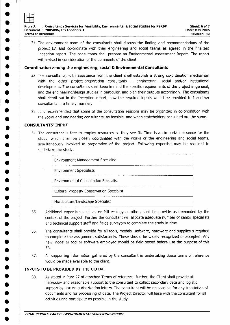
31. The environment team of the consultants shall discuss the finding and recommendations of the
* project EA and co-ordinate with their engineering and social teams as agreed in the finalized
Inception report. The consultants shall prepare an Environmental Assessment Report. The report
* will revised in consideration of the comments of the client.
* Co-ordination among the engineering, social & Environmental Consultants
* 32. The consultants, with assistance from the client shall establish a strong co-ordination mechanism
with the other project-preparation consultants - engineering, social and/or institutional
development. The consultants shall keep in mind the specific requirements of the project in general,
* and the engineering/design studies in particular, and plan their outputs accordingly. The consultants
shall detail out in the Inception report, how the required inputs would be provided to the other
consultants in a timely manner.
* 33. It is recommended that some of the consultation sessions may be organized in co-ordination with
the social and engineering consultants, as feasible, and when stakeholders consulted are the same.
CONSULTANTS' INPUT
34. The consultant is free to employ resources as they see fit. Time is an important essence for the
* study, which shall be closely coordinated with the works of the engineering and social teams,
* simultaneously involved in preparation of the project. Following expertise may be required to
undertake the study:
Environment Management Specialist
* . Environment Specialists
* Environmental Consultation Specialist
* Cultural Propenty Conservation Specialist
Horticulture/Landscape Specialist
35. Additional expertise, such as on hill ecology or other, shall be provide as demanded by the
context of the project. Further the consultant will allocate adequate number of senior specialists
* and technical support staff and fields surveyors to complete the study in time.
* 36. The consultants shall provide for all tools, models, software, hardware and supplies s required
lo complete the assignment satisfactorily. These should be widely recognized or accepted. Any* new model or tool or software employed should be field-tested before use the purpose of this
EA.
37. All supporting information gathered by the consultant in undertaking these terms of reference
would be made available to the client.
* INPUTS TO BE PROVIDED BY THE CLIENT
* 38. As stated in Para 27 of attached Terms of reference, further, the Client shall provide all* necessary and reasonable support to the consultant to collect secondary data and logistic
support by issuing authorization letters. The consultant will be responsible for any translation of* documents and for processing of data. The Project Director will liase with the consultant for all
*activities and participate as possible in the study.
FINAL REPORT, PART C: ENVIRONMENTAL SCREENING REPORT
: "Project : Consultancy Services for Feasibility, Environmental & Social Studies for PSRSP Sheet: 7 of 7Document 2005086/EC/Appendix-1 Date: May 2006Terms of Reference Revision: RO
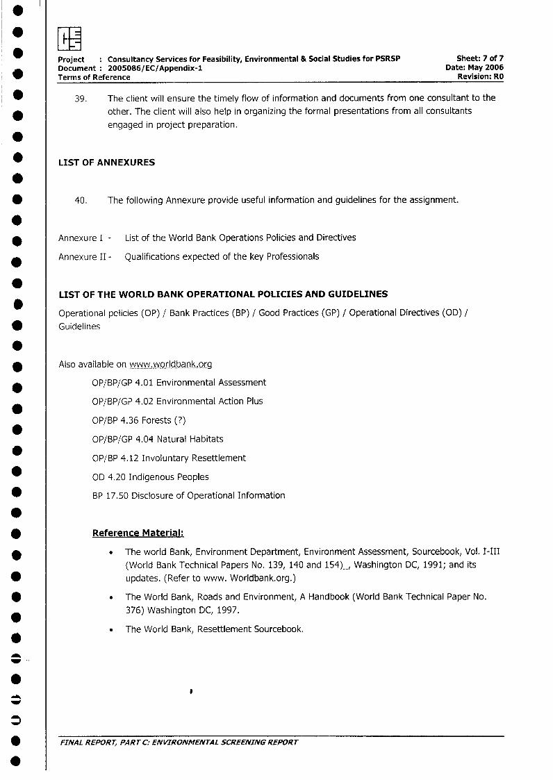
* 39. The client will ensure the timely flow of information and documents from one consultant to the
* other. The client will also help in organizing the formal presentations from all consultants
engaged in project preparation.
* LIST OF ANNEXURES
* 40. The following Annexure provide useful information and guidelines for the assignment.
.* Annexure I - List of the World Bank Operations Policies and Directives
Annexure II - Qualifications expected of the key Professionals
LIST OF THE WORLD BANK OPERATIONAL POLICIES AND GUIDELINES
Operational policies (OP) / Bank Practices (BP) / Good Practices (GP) / Operational Directives (OD) /* Guidelines
* Also available on www.worldbank.org
* OP/BP/GP 4.01 Environmental Assessment
OP/BP/GP 4.02 Environmental Action Plus
OP/BP 4.36 Forests (?)
OP/BP/GP 4.04 Natural Habitats
* OP/BP 4.12 Involuntary Resettlement
* OD 4.20 Indigenous Peoples
* BP 17.50 Disclosure of Operational Information
* Reference Material:
* . The world Bank, Environment Department, Environment Assessment, Sourcebook, Vol. I-III
(World Bank Technical Papers No. 139, 140 and 154)_, Washington DC, 1991; and its
* updates. (Refer to www. Worldbank.org.)
* . The World Bank, Roads and Environment, A Handbook (World Bank Technical Paper No.
376) Washington DC, 1997.
. The World Bank, Resettlement Sourcebook.
_
j FINAL REPORT, PART C: ENVIRONMENTAL SCREENING REPORT
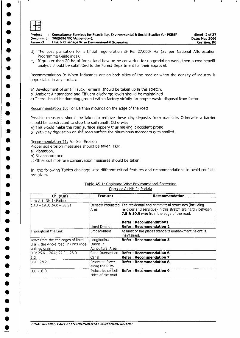
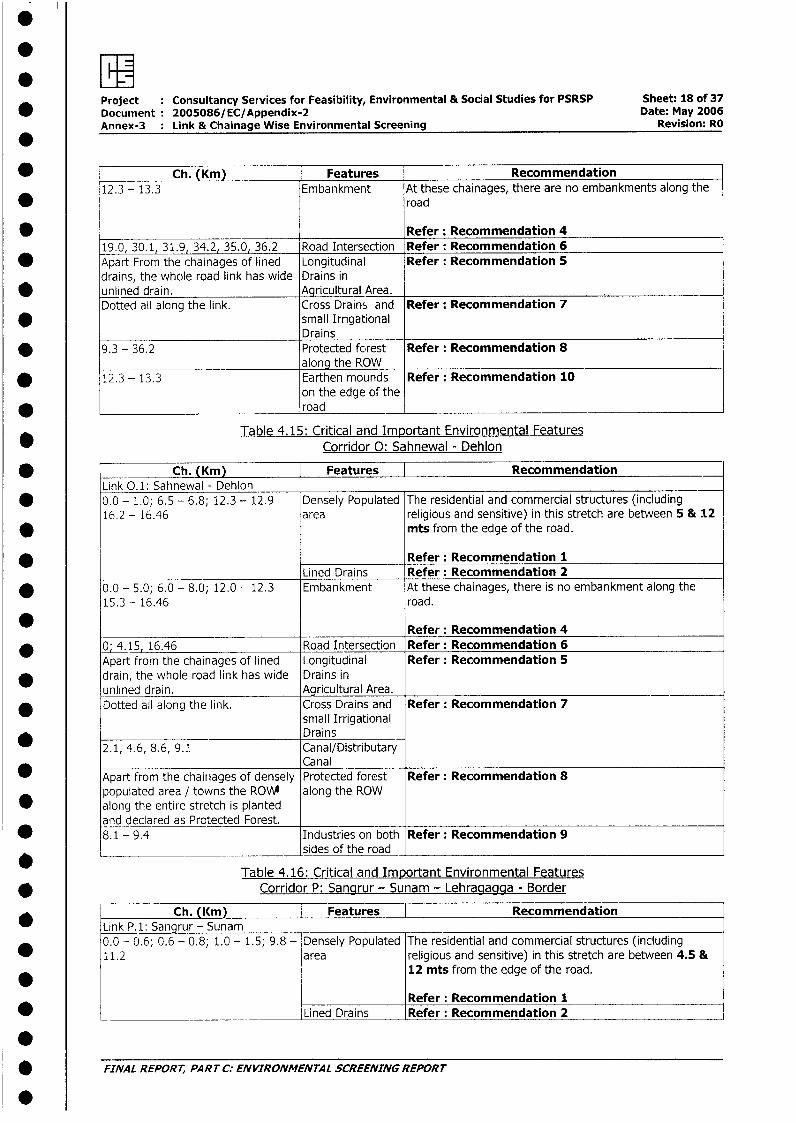
FnProject Consultancy Services for Feasibility, Environmental & Social Studies for PSRSP Sheet: 1 of 37Document: 2005086/EC/Appendix-2 Date: May 2006Annex-3 : Link & Chainage Wise Environmental Screening Revision: RO
Appendix-2: Link & Chainage Wise Environmental Screening
All VECs, critical/important environmental features and conflicts that may influence the decision making* in planning and design have been identified and discussed corridorwise and linkwise.
The Recommendations for different features are given hereunder:
Recommendation 1: For Densely Populated Area Feature* a) The Extent of up-gradation needed would be suggested in road design section.
b) Type of rehabilitation to be implemented would be dealt in R&R Action Plan.c) Speed barriers are to be provided near educational institutions and religious places.d) No Horn and sensitive structure signage has to be put at sensitive structures.
* e) Where ever possible plantation should be done for noise and dust barriers
* Recommendation 2: For Lined Draina) The existing drains are choked. Metal screens should be used to cover these drains for separating
* solid wastes disposed by the local populace in the drain.b) Culverts should be constructed where the pathway to the structures has obstructed the flow of the
* drain.
Recommendation 3: For_Water Bodies* a) During up-gradation of the road, measures should be taken to avoid or minimize impacts on the
surface water.* b) Construction of Retention wall on the roadside bank is suggested.
c) In case of acquiring a portion of water body for the up-gradation of road, the depth of the pond* should be increased in proportion to area acquired.
Recommendation 4: For No EmbankmentNo embankment along the road increases the possibility of road flooding. Flooding damages bituminous
* macadam and disrupts tralfic flow. At most of the places standard embankment height is notmaintained. Reasonable embankment should be maintained. The specifics of the embankment would be
* dealt in Road design section
* Recornmendation 5: For Longitudinal Drains in Agricultural Area.The encroached longitudinal drains in the stretches should be restored. The existing drains should bemaintained by cutting the overgrown weeds and grasses, which does not act as riff- raff for controlling
* the flow water but obstruct their flow. Culverts should be made at the road intersection for flow of waterin the drain
Recommendation 6: For Road Intersection & Railway crossing* Following amenities / facilities should be provided.
1. Proper Illumination,* 2. Visible Signage,
3. Bus stand at safe distance from the road* 4. Place for congregation of people
* tRecommendation 7: Canals/ Distributary canalsDuring road improvement, measures should be taken to avoid or minimize impacts on the surface water.
Recommendation 8: For Protected forest along the ROW* For the up-gradation of road in the link trees would be uprooted. ( First row of trees are at 3.5 mts to 4
mts frorm the edge of the road)a) Protected Forest trees felled with the roots are the property of Forest Department.
_ b) The compensatory plantation area has to be double the area of the land diverted.c) The number of sapling planted should be © 1100 plants/ Ha.(as per National Afforestation
* Programme Guidelines)j FINAL REPORT, PART C: ENVIRONMENTAL SCREENING REPORT
Project : Consultancy Services for Feasibility, Environmental & Social Studies for PSRSP Sheet: 2 of 37Document 200SO86/EC/Appendix-2 Date: May 2006
* Annex-3 Link & Chainage Wise Environmental Screening Revision: RO
* d) The cost plantation for artificial regeneration © Rs. 27,000/ Ha (as per National AfforestationProgramme Guidelines).
* e) If greater than 20 ha of forest land have to be converted for up-gradation work, then a cost-benefitanalysis should be submitted to the Forest Department for their approval.
Recommendation 9: When Industries are on both sides of the road or when the density of industry isappreciable in any stretch.
a) Development of small Truck Terminal should be taken up in this stretch.* b) Ambient Air standard and Effluent discharge levels should be maintained
c) There should be dumping ground within factory vicinity for proper waste disposal from factor
0Recommendation 10: For Earthen mounds on the edge of the road
Possible measures should be taken to remove these clay deposits from roadside. Otherwise a barrier* should be constructed to stop the soil runoff. Otherwise
a) This would make the road kurface slippery thus making it accident-prone.* b) With clay deposition on the road surface the bituminous macadam gets spoiled.
Recommendation 11: For Soil ErosionProper soil erosion measures should be taken like:a) Plantation,
_ b) Silvipasture andc) Other soil moisture conservation measures should be taken.
In the following Tables chainage wise different critical features and recommendations to avoid conflictsare given.
* Table-A5.1: Chainage Wise Environmental ScreeninqCorridor A: NH 1- Patiala
a -- Ch. (Km) Features RecommendationLink A.1: NH 1- Patiala
* 18.0 - 19.0; 24.0 - 28.21 Densely Populated The residential and commercial structures (includingArea religious and sensitive) in this stretch are hardly between
7.5 & 10.5 mts from the edge of the road.
* Refer: RecommendationlLined Drains Refer: Recommendation 2
* Throughout the Link Embankment At most of the places standard embankment height ismaintained.
* Apart from the chainages of lined Longitudinal Refer: Recommendation 5drain, the whole road link has wide Drains in
* unlined drain Agricultural Area.0.0; 25.0 - 26.0; 27.0 - 28.0 Road Intersection Refer: Recommendation 6
0 1.0 Canal Refer: Recommendation 70.0 - 28.21 Protected forest Refer: Recommendation 8
* ________________________________ along the ROW0.0 -18.0 Industries on both Refer: Recommendation 9
* sides of the road
FINAL REPORT, PART C: ENVIRONMENTAL SCREENING REPORT
S
Project Consultancy Services for Feasibility, Environmental & Social Studies for PSRSP Sheet: 3 of 37* Document: 2005086/EC/Appendix-2 Date: May 2006
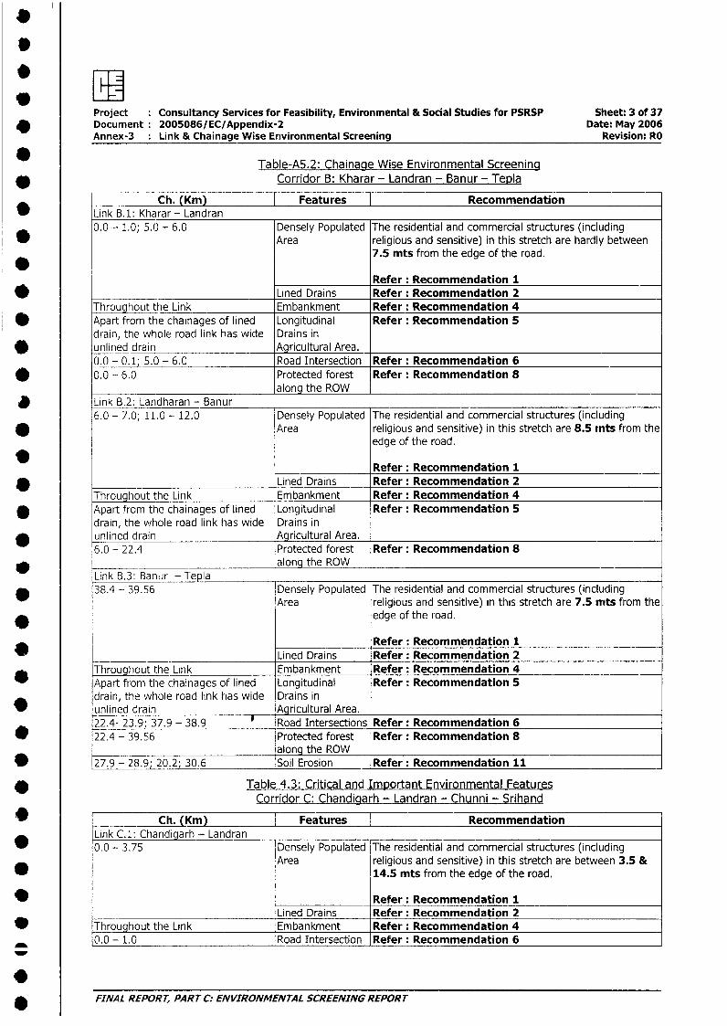
Annex-3 : Link & Chainage Wise Environmental Screening Revision: RO
Table-A5.2: Chainaqe Wise Environmental Screening* Corridor B: Kharar - Landran - Banur - Tepla
^ _ ~~~~~Ch. (Km) | Features |Recommendation* Link B.1: Kharar - Landran
0.0 - 1.0; 5.0 - 6.0 Densely Populated The residential and commercial structures (includingArea religious and sensitive) in this stretch are hardly between
7.5 mts from the edge of the road.
Refer: Recommendation 1* Lined Drains Refer: Recommendation 2
Throughout the Link Embankment Refer: Recommendation 4* Apart from the chainages of lined Longitudinal Refer: Recommendation 5
drain, the whole road link has wide Drains inv unlined drain Agricultural Area.
0.0 -_0.1 5.0 - 6.0 Road Intersection Refer: Recommendation 6* 0.0 - 6.0 Protected forest Refer: Recommendation 8
along the ROWLink B.2: Landharan - Banur6.0 - 7.0; 11.0 - 12.0 Densely Populated The residential and commercial structures (including
* Area religious and sensitive) in this stretch are 8.5 mts from theedge of the road.
Refer: Recommendation 1* Lined Drains Refer: Recommendation 2
Throughout the Link Embankment Refer: Recommendation 4* Apart from the chainages of lined Longitudinal Refer: Recommendation 5
drain, the whole road link has wide Drains in* unlined drain Agricultural Area.
6.0 - 22.4 Protected forest Refer: Recommendation 8* along the ROW _ _ _ _
Link B.3: Banur - T epla* 38.4 - 39.56 Densely Populated The residential and commercial structures (including
Area religious and sensitive) in this stretch are 7.5 nits from the* edge of the road.
Refer: Recommendation 1__ __________________Lined Drains Refer: Recommendation 2Throughout the Link Embankment Refer: Recommendation 4Apart from the chainages of lined Longitudinal Refer: Recommendation 5drain, the whole road link has wide Drains in
v unlined drain Agricultural Area.22.4- 23.9; 37.9 - 38.9 T Road Intersections Refer: Recommendation 6
* 22.4 - 39.56 Protected forest Refer: Recommendation 8along the ROW
* 27.9 - 28.9; 20.2; 30.6 Soil Erosion Refer: Recommendation 11
0 Table 4.3: Critical and Important Environmental FeaturesCorridor C: Chandigarh - Landran - Chunni - Srihand
0 __ Ch. (Kmr Features | RecommendationLink C.1: Chandigarh - Landran
* 0.0 - 3.75 Densely Populated The residential and commercial structures (includingArea religious and sensitive) in this stretch are between 3.5 &
* 14.5 mts from the edge of the road.
0 . _ Refer: Recommendation 1Lined Drains Refer: Recommendation 2
* Throughout the Link Embankment Refer: Recommendation 40.0- 1.0 Road Intersection Refer: Recommendation 6F
5 FINAL REPORT, PART C: ENVIRONMENTAL SCREENING REPORT
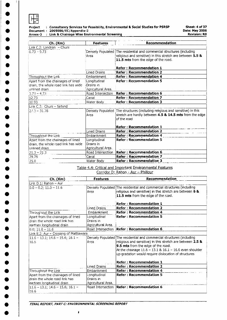
: wProject Consultancy Services for Feasibility, Environmental & Social Studies for PSRSP Sheet: 4 of 37
* Document 2005086/EC/Appendix-2 Date: May 2006Annex-3 Link & Chainage Wise Environmental Screening Revision: RO
Ch. (Km) Features Recommendation* Link C.2: Landran - Chuni
6.73 - 9.73 Densely Populated The residential and commercial structures (including* Area religious and sensitive) in this stretch are between 5.5 &
11.5 mts from the edge of the road.
Refer: Recommendation 1Lined Drains Refer: Recommendation 2
Throughout the Link Embankment Refer: Recommendation 4* Apart from the chainages of lined Longitudinal Refer: Recommendation 5
drain, the whole road link has wide Drains in* unlined drain _ Agricultural Area.
3.73 - 4.73 _ Road Intersection Refer: Recommendation 6* 12.73 Canal Refer: Recommendation 7
10.93 Water Body Refer: Recommendation 3* Link C.3: Chuni - Sirhind
27.3 - 31.78 Densely Populated The structures (including religious and sensitive) in thisArea stretch are hardly between 4.5 & 14.5 mts from the edge
of the road
Refer: Recommendation 1Lined Drains Refer: Recommendation 2
* Throughout the Link Embankment Refer: Recommendation 4Apart from the chainages of lined Longitudinal Refer: Recommendation 5
* drain, the whole road link has wide Drains inunlined drain Agricultural Area.
* 21.3 - 22.3 Road Intersection Refer: Recommendation 629.78 Canal Refer: Recommendation 7
* 25.0 Water Body Refer: Recommendation 3
* Table 4.4: Critical and Important Environmental FeaturesCorridor D: Rahon - Aur - Phillour
_ ___ Ch. (Km) | Features RecommendationLink D.1: Rahon - Aur0.0 - 0.2; 11.0 - 11.6 Densely Populated The residential and commercial structures (including
Area religious and sensitive) in this stretch are between 6 &11.5 mts from the edge of the road.
* _____________ Refer: Recommendation 1Lined Drains Refer: Recommendation 2
* Throughout the Link Embankment Refer: Recommendation 4Apart from the chainages of lined Longitudinal Refer: Recommendation 5drain the whole road link has Drains inearthen longitudinal drain Agricultural Area.
* 0.0; 11.0- 11.6 Road Intersection Refer: Recommendation 6Link E.2: Aur - Crossing of Mattiawara
* 11.6 - 13.1; 14.6 - 15.6; 16.1 - Densely Populated The residential and commercial structures (including16.6 Area religious and sensitive) in this stretch are between 2.5 &
* 9.5 mts from the edge of the road.At the chainage 11.6 - 13.1 & 16.1 - 16.6 even shoulder
* up-gradation would require dislocation of structures
Refer: Recommendation 1______ Lined Drains Refer: Recommendation 2
* Throughout the Link Embankment Refer: Recommendation 4Apart from the chainages of lined Longitudinal Refer: Recommendation 5
* drain the vvhole road link has Drains inearthen longitudinal drain Agricultural Area.
* 11.6 - 13.1; 14.6 - 15.6; 16.1 - Road Intersection Refer: Recommendation 616.6 __________________________
* FINAL REPORT, PART C: ENVIRONMENTAL SCREENING REPORT
0
Project : Consultancy Services for Feasibility, Environmental & Social Studies for PSRSP Sheet: 5 of 37* Document 2005086/EC/Appendix-2 Date: May 2006
Annex-3 : Link & Chainage Wise Environmental Screening Revision: RO
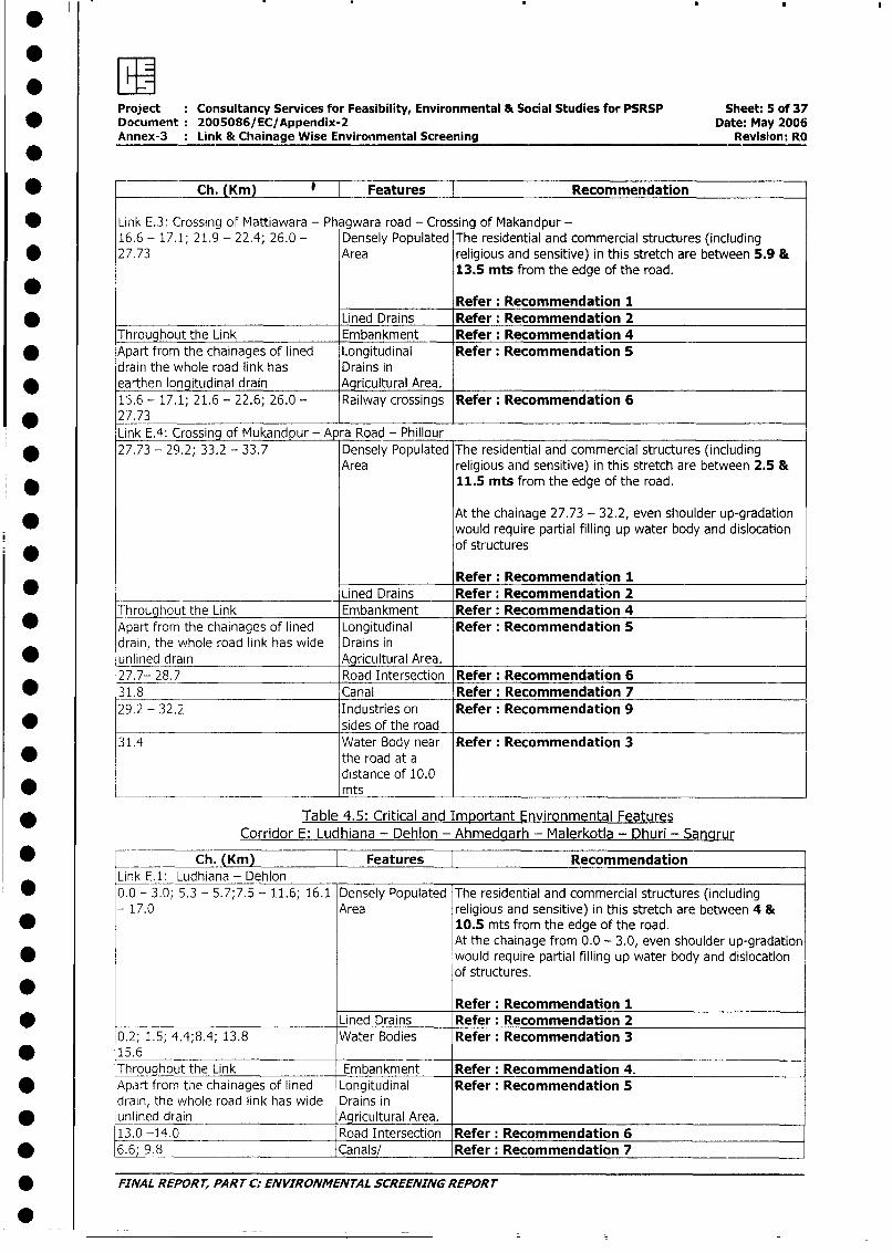
* - Ch. lm Y l Features l Recommendation
Link E.3: Crossing of Mattiawara - Phagwara road - Crossing of Makandpur -16.6 - 17.1; 21.9 - 22.4; 26.0 - Densely Populated The residential and commercial structures (including
* 27.73 Area religious and sensitive) in this stretch are between 5.9 &13.5 mts from the edge of the road.
Refer: Recommendation 1Lined Drains Refer: Recommendation 2
Throughout the Link Embankment Refer: Recommendation 4* Apart from the chainages of lined Longitudinal Refer: Recommendation 5
drain the whole road link has Drains in* earthen longitudinal drain Agricultural Area.
13.6 - 17.1; 21.6 - 22.6; 26.0 - Railway crossings Refer: Recommendation 6* 27.73
Link E.4: Crossing of Mukandpur - A ra Road - Phillour* 27.73 - 29.2; 33.2 - 33.7 Densely Populated The residential and commercial structures (including
Area religious and sensitive) in this stretch are between 2.5 &* 11.5 mts from the edge of the road.
At the chainage 27.73 - 32.2, even shoulder up-gradationwould require partial filling up water body and dislocation
* ~~~~~~~~~~~~~~~~~~~of structures
Refer: Recommendation 1* Lined Drains Refer: Recommendation 2
Throughout the Link Embankment Refer: Recommendation 4* Apart from the chainages of lined Longitudinal Refer: Recommendation 5
drain, the whole road link has wide Drains in* unlined drain - Agricultural Area.
27.7- 28.7 Road Intersection Refer: Recommendation 6* 31.8 Canal Refer: Recommendation 7
29.2 - 32.2 Industries on Refer: Recommendation 9* sides of the road
31.4 Water Body near Refer: Recommendation 3the road at adistance of 10.0
* ______________________ mts
* Table 4.5: Critical and Important Environmental FeaturesCorridor E: Ludhiana - Dehlon - Ahmedaarh - Malerkotla - Dhuri - Sanarur
* Ch. (Km) Features | RecommendationLink E.1: Ludhiana - Dehlon
* 0.0 - 3.0; 5.3 - 5.7;7.5 - 11.6; 16.1 Densely Populated The residential and commercial structures (including- 17.0 Area religious and sensitive) in this stretch are between 4 &
* 10.5 mts from the edge of the road.At the chainage from 0.0 - 3.0, even shoulder up-gradation
* would require partial filling up water body and dislocationof structures.
Refer: Recommendation 1Lined Drains Refer: Recommendation 2
0.2; 1.5; 4.4;8.4; 13.8 Water Bodies Refer: Recommendation 3* 15.6 _ _
Throughout the Link Embankment Refer: Recommendation 4.* Apart from tne chainages of lined Longitudinal Refer: Recommendation 5
drain, the whole road link has wide Drains in* unlined drain Agricultural Area.
13.0 -14.0 Road Intersection Refer: Recommendation 6* 6.6; 9.8 Canals/ Refer: Recommendation 7
* FINAL REPOR T, PART C: ENVIRONMENTAL SCREENING REPORT
*
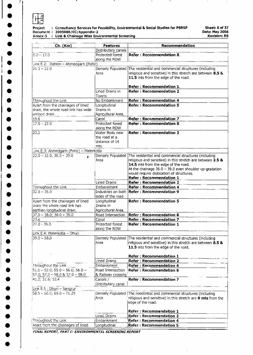
FwProject Consultancy Services for Feasibility, Environmental & Social Studies for PSRSP Sheet: 6 of 37Document: 2005086/EC/Appendix-2 Date: May 2006
_ Annex-3 Link & Chainage Wise Environmental Screening Revision: RO
* _ Ch. (Km) | Features Recommendation__________________________ Distributary canals
* 0.0 - 17.0 Protected forest Refer: Recommendation 8.along the ROW
* Link E.2: Dehion - Ahmedcarh (Pohi )21.3 - 22.0 Densely Populated The residential and commercial structures (including
* Area religious and sensitive) in this stretch are between 8.5 Et11.5 mts from the edge of the road.
-- Refer: Recommendation 1.* Lined Drains in Refer: Recommendation 2
Towns* Throughout the Link No Embankment Refer: Recommendation 4
Apart from the chairiages of lined Longitudinal Refer: Recommendation 5* drain, the whole road link has wide Drains in
unlined drain Agricultural Area.19.6 Canal Refer: Recommendation 717.0 - 22.0 Protected forest Refer: Recommendation 8
* . along the ROW20.2 Water Body near Refer: Recommendation 3
* the road at adistance of 14* mts.
Link E.3: Ahmedgarh (Pohir) - Maler otla_* 22.0 - 32.0, 36.0 - 39.0 L Densely Populated The residential and commercial structures (including
Area religious and sensitive) in this stretch are between 2.5 &14.5 mts from the edge of the road.At the chainage 36.0 - 39.0 even shoulder up-gradationwould require dislocation of structures.
0 Refer: Recommendation 1Lined Drains Refer: Recommendation 2
* Throughout the Link Embankment Refer: Recommendation 432.0 - 35.0 Industries on both Refer: Recommendation 9
* sides of the roadApart from the chainages of lined Longitudinal Refer: Recommendation 5drain the whole road link has Drains inearthen longitudinal drain. Agricultural Area.
* 37.0 - 38.0; 38.0 - 39.0 Road Intersection Refer: Recommendation 623.6 Canal Refer: Recommendation 7
* 22.0 - 39.0 Protected forest Refer: Recommendation 1along the ROW __________________________
* Link E.4: Malerkotla - Dhuri39.0 - 58.0 Densely Populated The residential and commercial structures (including
Area religious and sensitive) in this stretch are between 8.5 &11.5 mts from the edge of the road.
Refer: Recommendation 1* _Lined Drains Refer: Recommendation 2Throughout the Link Embankment Refer: Recommendation 4
* 51.0 - 52.0; 55.0 - 56.0; 56.0 - Road Intersection Refer: Recommendation 657.0; 57.0 - 58.0 & 57.0 - 58.0 & Railway crossing
* 41.2; 51.6; 53.4 Canals / Refer: Recommendation 7_ Distributary canal
* 'Link E.5 . Dhuri - Sangrur ___ _-58.5 - 60.0; 69.0 - 71.29 Densely Populated The residential and commercial structures (including
* Area religious and sensitive) in this stretch are 8 mts from theedge of the road.
.Refer: Recommendation 1
* Lined Drains Refer: Recommendation 2Throuqhout the Link Embankment Refer: Recommendation 4
* Apart from the chainages of lined Longitudinal Refer: Recommendation 5
FINAL REPORT, PART C: ENVIRONMENTAL SCREENING REPORT
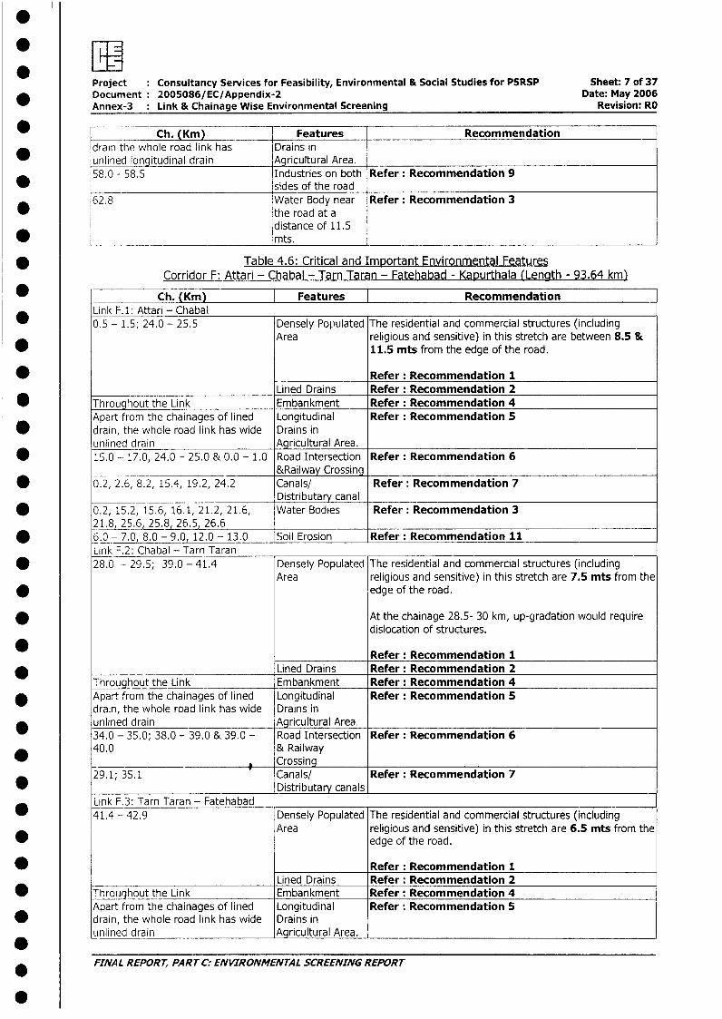
Project Consultancy Services for Feasibility, Environmental & Social Studies for PSRSP Sheet: 7 of 37* Document 2005086/EC/Appendix-2 Date: May 2006
Annex-3 Link & Chainage Wise Environmental Screening Revision: RD
Ch. (Km) Features Recommendationdrain the whole road link has Drains in
_ unlined longitudinal drain Agricultural Area. _58.0 - 58.5 Industries on both Refer: Recommendation 9
* sides of the road62.8 Water Body near Refer: Recommendation 3
the road at adistance of 11.5
* ___________ _______________________________mts.
* Table 4.6: Critical and Important Environmental FeaturesCorridor F: Attari - Chabal - Tarn Taran - Fatehabad - Kapurthala (Length - 93.64 km)
* Ch. (Km) | Features ] RecommendationLink F.1: Attari - Chabal0.5 - 1.5; 24.0 - 25.5 Densely Populated The residential and commercial structures (including
Area religious and sensitive) in this stretch are between 8.5 &11.5 mts from the edge of the road.
* Refer: Recommendation 1Lined Drains Refer: Recommendation 2
* Throughout the Link Embankment Refer: Recommendation 4Apart from the chainages of lined Longitudinal Refer: Recommendation 5
* drain, the whole road link has wide Drains inunlined drain Agricultural Area.
* 15.0 - 17.0, 24.0 - 25.0 & 0.0 - 1.0 Road Intersection Refer: Recommendation 6&Railway Crossing
* 0.2, 2.6, 8.2, 15.4, 19.2, 24.2 Canals/ Refer: Recommendation 7Distributary canal
* 0.2, 15.2, 15.6, 16.1, 21.2, 21.6, Water Bodies Refer: Recommendation 321.8, 25.6, 25.8, 26.5 26.6 _
* 6.0 - 7.0 8.0 - 9.0- 12.0 - 13.0 Soil Erosion Refer: Recommendation 11Link F.2: Chabal - Tarn Taran
* 28.0 - 29.5; 39.0 - 41.4 Densely Populated The residential and commercial structures (includingArea religious and sensitive) in this stretch are 7.5 mts from the
* edge of the road.
* At the chainage 28.5- 30 km, up-gradation woLild requiredislocation of structures.
Refer: Recommendation 1LIined Drains Refer: Recommendation 2
Throughout the Link Embankment Refer: Recommendation 4* Apart from the chainages of lined Longitudinal Refer: Recommendation 5
drain, the whole road link has wide Drains inunlined drain _Agicultural Area.34.0 - 35.0; 38.0 - 39.0 & 39.0 - Road Intersection Refer: Recommendation 640.0 & Railway
Crossing29.1; 35.1 Canals/ Refer: Recommendation 7*________________________________ Distributary canals
Link F.3: Tarn Taran - Fatehabad41.4 - 42.9 Densely Populated The residential and commercial structures (including
Area religious and sensitive) in this stretch are 6.5 mts from theedge of the road.
* Refer: Recommendation 1Lined Drains Refer: Recommendation 2
* Throughout the Link Embankment Refer: Recommendation 4Apart from the chainages of lined Longitudinal Refer: Recommendation 5
* drain, the whole road link has wide Drains inunlined drain Agricultural Area.
FINAL REPORT, PART C: ENVIRONMENTAL SCREENING REPORT
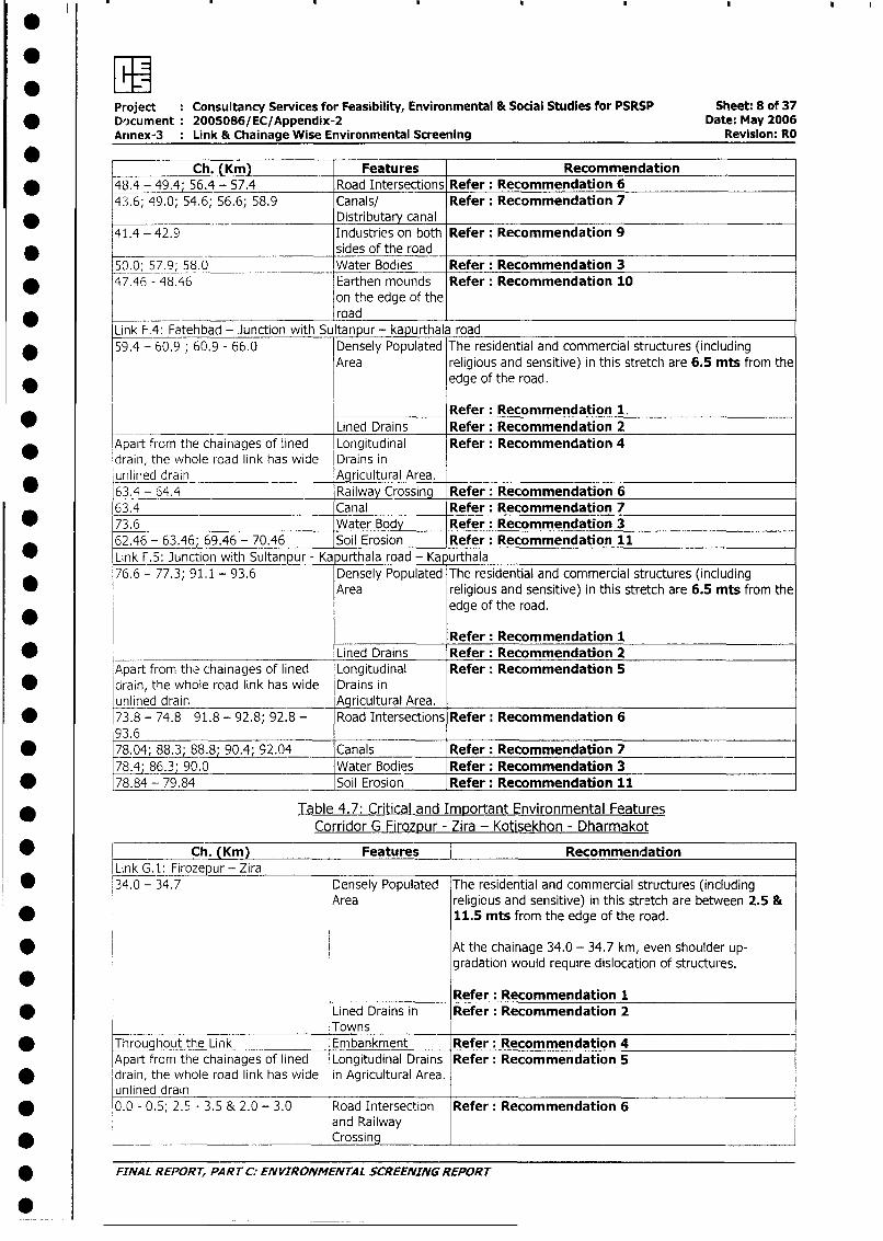
Project : Consultancy Services for Feasibility, Environmental & Social Studies for PSRSP Sheet: 8 of 37* Document 2005086/EC/Appendix-2 Date: May 2006
Arinex-3 : Link & Chainage Wise Environmental Screening Revision: RO
Ch. (Km) Features Recommendation* 48.4 - 49.4; 56.4 - 57.4 Road Intersections Refer: Recommendation 6
43.6; 49.0; 54.6; 56.6; 58.9 Canals/ Refer: Recommendation 7* Distributary canal
41.4 - 42.9 Industries on both Refer: Recommendation 9-~ sides of the road50.0, 57.9; 58.0 Water Bodies Refer: Recommendation 3
* 47.46 - 48.46 Earthen mounds Refer: Recommendation 10on the edge of theroad
Link F.4: Fatehbad - Junction with Sultanpur - kapurthala road* 59.4 - 60.9; 60.9 - 66.0 Densely Populated The residential and commercial structures (including
Area religious and sensitive) in this stretch are 6.5 mts from the* edge of the road.
Refer: Recommendation 1._ _ _ Lined Drains Refer: Recommendation 2
Apart from the chainages of lined Longitudinal Refer: Recommendation 4drain, the whole road link has wide Drains inunlined drain Agricultural Area.63.4 - 64.4 Railway Crossing Refer: Recommendation 663.4 Canal Refer: Recommendation 7
* 73.6 Water Body Refer: Recommendation 362.46 - 63.46; 69.46 - 70.46 Soil Erosion Refer: Recommendation 11
* Link F.5: Junction with Sultanpur - Ka urthala road - Ka urthala76.6 - 77.3; 91.1 - 93.6 Densely Populated The residential and commercial structures (including
Area religious and sensitive) in this stretch are 6.5 mts from theedge of the road.
Refer: Recommendation 1* Lined Drains Refer: Recommendation 2
Apart from the, chainages of lined Longitudinal Refer: Recommendation 5* drain, the whole road link has wide Drains in
unlined drain _-Agricultural Area.* 73.8 - 74.8 91.8 - 92.8; 92.8 - Road Intersections Refer: Recommendation 6
93.6* 78.04; 88.3; 88.8; 90.4; 92.04 Canals Refer: Recommendation 7 _ _
78.4; 86.3; 90.0 Water Bodies Refer: Recommendation 3* 78.84 - 79.84 Soil Erosion Refer: Recommendation 11
* Table 4.7: Critical and Important Environmental FeaturesCorridor G Firozpur - Zira - Kotisekhon - Dharmakot
Ch. (Km) Features RecommendationLink G.1: Firozepur - Zira
* 34.0 - 34.7 Densely Populated The residential and commercial structures (includingArea religious and sensitive) in this stretch are between 2.5 &
* 11.5 mts from the edge of the road.
* At the chainage 34.0 - 34.7 km, even shoulder up-gradation would require dislocation of structures.
l______________ Refer: Recommendation 1Lined Drains in Refer: Recommendation 2
__________________________ Towns* Throughout the Link Embankment Refer: Recommendation 4
Apart from the chainages of lined Longitudinal Drains Refer: Recommendation 5* drain, the whole road link has wide in Agricultural Area.
unlined drain* 0.0 - 0.5; 2.5 - 3.5 & 2.0 - 3.0 Road Intersection Refer: Recommendation 6
and Railway* -~____________________________ Crossing _
* FINAL REPORT, PART C: ENVIRONMENTAL SCREENING REPORT
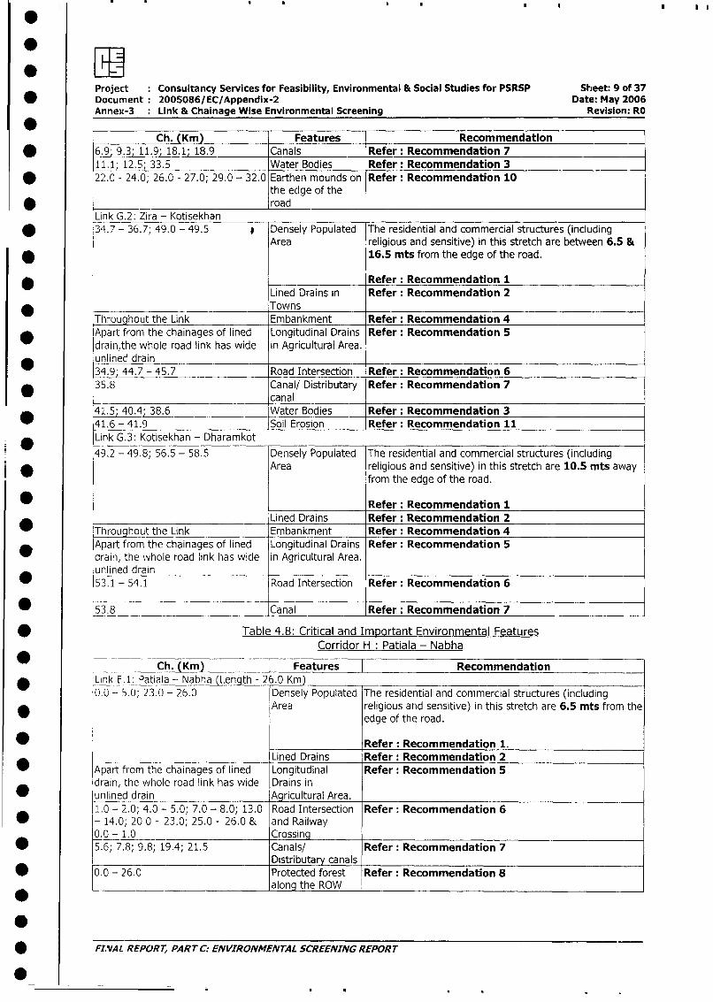
:~~~ 9Project Consultancy Services for Feasibility, Environmental & Social Studies for PSRSP Sheet: 9 of 37
* Document 2005086/EC/Appendix-2 Date: May 2006Annex-3 : Link & Chainage Wise Environmental Screening Revision: RO
Ch. (Krn) Features Recommendation* 6.9; 9.3; 11.9; 18.1; 18.9 Canals Refer: Recommendation 7
11.1; 12.5; 33.5 Water Bodies Refer: Recommendation 3* 22.0 - 24.0; 26.0 - 27.0; 29.0 - 32.0 Earthen mounds on Refer: Recommendation 10
the edge of the* ___ _ __________ road
Link G.2: Zira - Kotisekhan* 34.7 - 36.7; 49.0 - 49.5 * Densely Populated The residential and commercial structures (including
Area religious and sensitive) in this stretch are between 6.5 &* 16.5 mts from the edge of the road.
* _ _ _ _ Refer: Recommendation 1Lined Drains in Refer: Recommendation 2Towns
Throughout the Link Embankment Refer: Recommendation 4* Apart from the chainages of lined Longitudinal Drains Refer: Recommendation 5
drain,the whole road link has wide in Agricultural Area.* unlined drain
34.9; 44.7 - 45.7 Road Intersection Refer: Recommendation 6* 35.8 Canal/ Distributary Refer: Recommendation 7
______________________________ canal41.5; 40.4; 38.6 Water Bodies Refer: Recommendation 341.6 - 41.9 Soil Erosion Refer: Recommendation 11Link G.3: Kotisekhan - Dharamkot
49.2 - 49.8; 56.5 - 58.5 Densely Populated The residential and commercial structures (includingArea religious and sensitive) in this stretch are 10.5 mts away
from the edge of the road.
*______________ Refer: Recommendation 1Lined Drains Refer: Recommendation 2
Throughout the Link Embankment Refer: Recommendation 4Apart from the chainages of lined Longitudinal Drains Refer: Recommendation 5drain, the whole road link has wide in Agricultural Area.unlined drain53.1 - 54.1 Road Intersection Refer: Recommendation 6
0 53.8 __Canal Refer: Recommendation 7
* Table 4.8: Critical and Important Environmental FeaturesCorridor H: Patiala - Nabha
___Ch. (Km) Features Recommendation* Link E.1: Patiala - Nabha (Length - 2 .0 Km) _
0.0 - 5.0; 23.0 - 26.0 Densely Populated The residential and commercial structures (including* Area religious and sensitive) in this stretch are 6.5 mts from the
edge of the road.
Refer: Recommendation 1.Lined Drains Refer: Recommendation 2
_ Apart from the chainages of lined Longitudinal Refer: Recommendation 5drain, the whole road link has wide Drains in
* unlined drain Agricultural Area.1.0 - 2.0; 4.0 - 5.0; 7.0 - 8.0; 13.0 Road Intersection Refer: Recommendation 6
* - 14.0; 20 0 - 23.0; 25.0 - 26.0 & and Railway0.0 - 1.0 Crossing
* 5.6; 7.8; 9.8; 19.4; 21.5 Canals/ Refer: Recommendation 7Distributary canals
* 0.0 - 26.0 Protected forest Refer: Recommendation 8* along the ROW
* FINAL REPORT, PART C: ENVIRONMENTAL SCREENING REPORT
.
: w* Project : Consultancy Services for Feasibility, Environmental & Social Studies for PSRSP Sheet: 10 of 37
Document 2005086/EC/Appendix-2 Date: May 2006Annex-3 : Link & Chainage Wise Environmental Screening Revision: RO
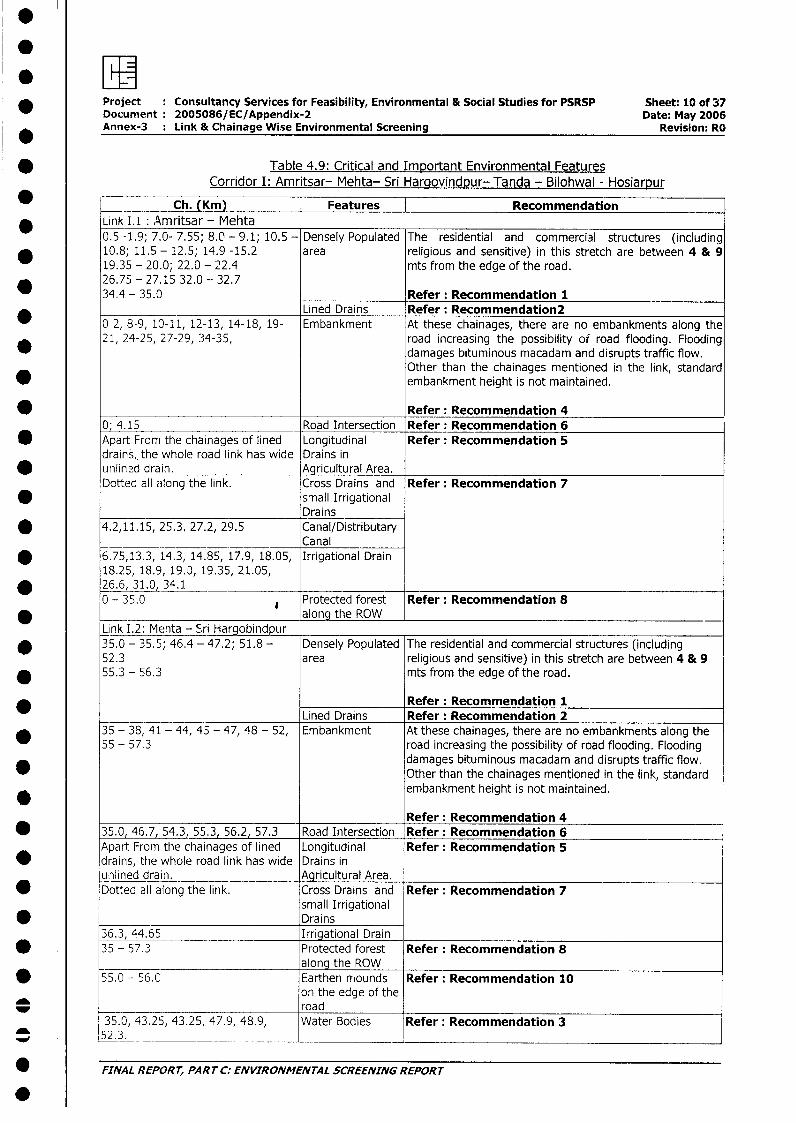
* Table 4.9: Critical and Important Environmental FeaturesCorridor I: Amritsar- Mehta- Sri Hargovindpur- Tanda - Bilohwal - Hosiarpur
Ch. (Km) | Features | RecommendationLink 1.1: Amritsar - Mehta0.5 -1.9; 7.0- 7.55; 8.0 - 9.1; 10.5 - Densely Populated The residential and commercial structures (including
* 10.8; 11.5 - 12.5; 14.9 -15.2 area religious and sensitive) in this stretch are between 4 & 919.35 - 20.0; 22.0 - 22.4 mts from the edge of the road.
* 26.75 - 27.15 32.0 - 32.734.4 - 35.0 Refer: Recommendation 1
Lined Drains Refer: Recommendation20-2, 8-9, 10-11, 12-13, 14-18, 19- Embankment At these chainages, there are no embankments along the21, 24-25, 27-29, 34-35, road increasing the possibility of road flooding. Flooding
damages bituminous macadam and disrupts traffic flow.Other than the chainages mentioned in the link, standard
* embankment height is not maintained.
* _ Refer: Recommendation 40; 4.15 Road Intersection Refer: Recommendation 6
* Apart From the chainages of lined Longitudinal Refer: Recommendation 5drains,, the whole road link has wide Drains in
* unlin2d drain. Agricultural Area.Dotted all ailong the link. Cross Drains and Refer: Recommendation 7
* small IrrigationalDrains
* 4.2,11.15, 25.3, 27.2, 29.5 Canal/DistributaryCanal
* 6.75,13.3, 14.3, 14.85, 17.9, 18.05, Irrigational Drain18.25, 18.9, 19.0, 19.35, 21.05,
* 26.6, 31.0, 34.1 _-0 - 35.0 Protected forest Refer: Recommendation 8
* along the ROWLink I.2: Mehta - Sri Hargobindpur
* 35.0 - 35.5; 46.4 - 47.2; 51.8 - Densely Populated The residential and commercial structures (including52.3 area religious and sensitive) in this stretch are between 4 & 9
* 55.3 - 56.3 mts from the edge of the road.
Refer: Recommendation 1Lined Drains Refer: Recommendation 2
* 35 - 38, 41 - 44, 45 - 47, 48 - 52, Embankment At these chainages, there are no embankments along the55 - 57.3 road increasing the possibility of road flooding. Flooding
damages bituminous macadam and disrupts traffic flow.Other than the chainages mentioned in the link, standardembankment height is not maintained.
Refer: Recommendation 4* 35.0, 46.7, 54.3, 55.3, 56.2, 57.3 Road Intersection Refer: Recommendation 6
Apart From the chainages of lined Longitudinal Refer: Recommendation 5* drains, the whole road link has wide Drains in
uilined drain. Agricultural Area.0 Dotted all along the link. Cross Drains and Refer: Recommendation 7
small Irrigational* Drains
36.3, 44.65 Irrigational Drain* 35 - 57.3 Protected forest Refer: Recommendation 8
_______ ________________ along the ROW* 55.0 - 56.C Earthen mounds Refer: Recommendation 10
on the edge of the* ~~~~~~~~~~~~road
35.0, 43.25, 43.25, 47.9, 48.9, Water Bodies Refer: Recommendation 352.3. __ _
* FINAL REPORT, PART C: ENVIRONMENTAL SCREENING REPORT
0
*Project Consultancy Services for Feasibility, Environmental & Social Studies for PSRSP Sheet: 11 of 37Document 2005086/EC/Appendix-2 Date: May 2006Annex-3 Link & Chainage Wise Environmental Screening Revision: RO
* [ Ch. (Krn) Features | Recommendation
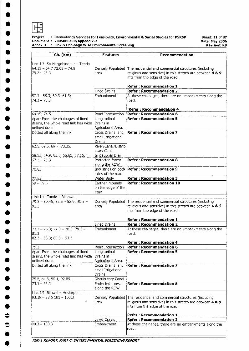
* Link I.3: Sri Hargobindpur - Tanda64.15 - 64.7 72.05 - 74.8 Densely Populated The residential and commercial structures (including
* 75.2 - 75.3 area religious and sensitive) in this stretch are between 4 & 9* mts from the edge of the road.
Refer: Recommendation 1* _________________ Lined Drains Refer: Recommendation 2.
57.3 - 58.3; 60.3- 61.3; Embankment At these chainages, there are no embankments along the* 74.3 - 75.3 road.
* Refer: Recommendation 469.15; 74.5 Road Intersection Refer: Recommendation 6
* Apart From the chainages of lined Longitudinal Refer: Recommendation 5drains, the whole road link has wide Drains in
* unlined drain. Agricultural Area.Dotted all along the link. Cross Drains and Refer: Recommendation 7
* small Irrigational___ Drains
* 62.5, 69.5, 69.7, 70.35. River/Canal/Distributary Canal
* 58.55 64.9 65.8, 66.65, 67.15. Irrigational Drain57.2 - 75.3 Protected forest Refer: Recommendation 8
* along the ROW70.85 Industries on both Refer: Recommendation 9
* sides of the road77.65 Water Body Refer: Recommendation 3
* 59 -- 59.3 Earthen mounds Refer: Recommendation 10on the edge of theroad
Link I.4: Tanda - Bilohwal* 79.3 - 80.45; 82.5 - 82.9; 90.3 - Densely Populated The residential and commercial structures (including
91.3 area religious and sensitive) in this stretch are between 4 & 9* mts from the edge of the road.
Refer: Recommendation 1* Lined Drains Refer: Recommendation 2
73.3 - 75.3; 77.3 - 78.3; 79.3 - Embankment At these chainages, there are no embankments along the81.3 road.82.3 - 83.3; 89.3 - 93.3 Refer: Recommendation 4
75.3 Road Intersection Refer: Recommendation 60 Apart From the chainages of lined Longitudinal Refer: Recommendation 5
drains, the whole road link has wide Drains in* unlined drain. Agricultural Area.
Dotted all along the link. Cross Drains and Refer: Recommendation 7* small Irrigational
Drains* 75.8, 84.6, 90.1, 92.85. Distributory Canal
73.3 - 93.3 Protected forest Refer: Recommendation 8* _- aiong the ROW
Link I.5: Bilowal - Hosiiarpu* 93.18 - 93.6 101 - 103.3 Densely Populated The residential and commercial structures (including
area religious and sensitive) in this stretch are between 4 & 9* mts from the edge of the road.
Refer: Recommendation 1Lined Drains Refer: Recommendation 2
99.3 - 100.3 Embankment At these chainages, there are no embankments along theroad.
FINAL REPORT, PART C: ENVIRONMENTAL SCREENING REPORT
* w
Project Consultancy Services for Feasibility, Environmental & Social Studies for PSRSP Sheet: 12 of 37Document 2005086/EC/Appendix-2 Date: May 2006Annex-3 Link & Chainage Wise Environmental Screening Revision: RO
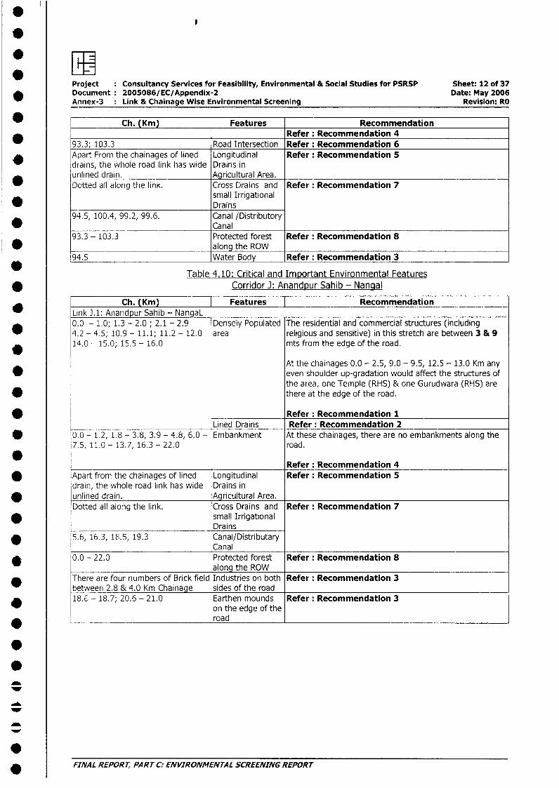
Ch. (Km) Features RecommendationRefer: Recommendation 4
93.3; 103.3 Road Intersection Refer: Recommendation 6* Apart From the chainages of lined Longitudinal Refer: Recommendation 5
drains, the whole road link has wide Drains inunlined drain. Agricultural Area.Dotted all along the link. Cross Drains and Refer: Recommendation 7
small IrrigationalDrains
94.5, 100.4, 99.2, 99.6. Canal /DistributoryCanal
93.3 - 103.3 Protected forest Refer: Recommendation 8* ___ along the ROW
94.5 Water Body Refer: Recommendation 3
Table 4.10: Critical and Important Environmental Features* Corridor J: Anandpur Sahib - Nangal
Ch. (Km) Features Recommendation_ Link J,1: Anandpur Sahib - NangaL
0.0 - 1.0; 1.3 - 2.0 ; 2.1 - 2.9 Densely Populated The residential and commercial structures (including* 4.2 - 4.5; 10.9 - 11.1; 11.2 - 12.0 area religious and sensitive) in this stretch are between 3 & 9
14.0 - 15.0; 15.5 - 16.0 mts from the edge of the road.
At the chainages 0.0 - 2.5, 9.0 - 9.5, 12.5 - 13.0 Km any* even shoulder up-gradation would affect the structures of
the area, one Temple (RHS) & one Gurudwara (RHS) are* there at the edge of the road.
Refer: Recommendation 1Lined Drains Refer: Recommendation 2
* 0.0 - 1.2, 1.8 - 3.8, 3.9 - 4.8, 6.0 - Embankment At these chainages, there are no embankments along the7.5, 11.0 - 13.7, 16.3 - 22.0 road.
Refer: Recommendation 4* Apart from the chainages of lined Longitudinal Refer: Recommendation 5
drain, the whole road link has wide Drains in* unlined drain. Agricultural Area.
Dotted all along the link. Cross Drains and Refer: Recommendation 7* small Irrigational
Drains* 5.6, 16.3, 18.5, 19.3 Canal/Distributary
Canal* 0.0 - 22.0 Protected forest Refer: Recommendation 8
along the ROWThere are four numbers of Brick field Industries on both Refer: Recommendation 3between 2.8 & 4.0 Km Chainage sides of the road
* 18.6 - 18.7; 20.6 - 21.0 Earthen mounds Refer: Recommendation 3on the edge of the
* __ _____-_____________ road
* FINAL REPORT, PART C: ENVIRONMENTAL SCREENING REPORT
: 1Project : Consultancy Services for Feasibility, Environmental & Social Studies for PSRSP Sheet: 13 of 37
E Document 2005086/EC/Appendix-2 Date: May 2006Annex-3 : Link & Chainage Wise Environmental Screening Revision: RO
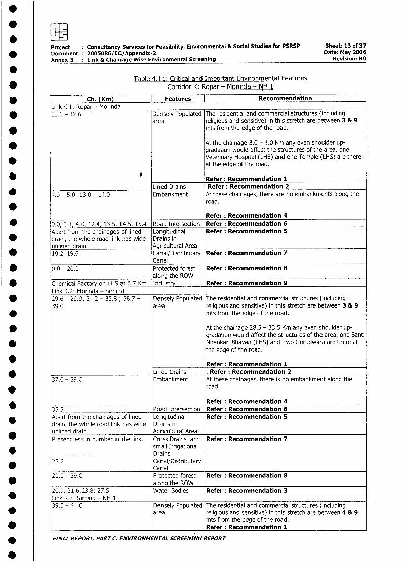
0Table 4.11: Critical and Important Environmental Features
Corridor K: Ropar - Morinda - NH 1
Link - Ch. (Km) Features | RecommendationLink KA: Ropar - Morinda
D 11.6 - 12.6 Densely Populated The residential and commercial structures (includingarea religious and sensitive) in this stretch are between 3 & 9
* mts from the edge of the road.
* At the chainage 3.0 - 4.0 Km any even shoulder up-gradation would affect the structures of the area, one
* Veterinary Hospital (LHS) and one Temple (LHS) are thereat the edge of the road.
Refer: Recommendation 1Lined Drains Refer: Recommendation 2
_ 4.0 - 5.0; 13.0 - 14.0 Embankment At these chainages, there are no embankments along theroad.
Refer: Recommendation 4* 0.0, 3.1, 4.0, 12.4, 13.5, 14.5, 15.4 Road Intersection Refer: Recommendation 6
Aoart from the chainages of lined Longitudinal Refer: Recommendation 5* drain, the whole road link has wide Drains in
unlined drain. Agricultural Area.* 19.2, 19.6 Canal/Distributary Refer: Recommendation 7
Canal* 0.0 - 20.0 Protected forest Refer: Recommendation 8
_______________________________ along the ROW* Chemical Factory on LHS at 6.7 Km Industry Refer: Recommendation 9
Link K.2: Morinda - Sirhind* 29.6 - 29.9; 34.2 - 35.8; 38.7 - Densely Populated The residential and commercial structures (including
39.0 area religious and sensitive) in this stretch are between 3 & 9* mts from the edge of the road.
* At the chainage 28.5 - 33.5 Km any even shoulder up-gradation would affect the structures of the area, one Sant
* Nirankari Bhavan (LHS) and Two Gurudwara are there atthe edge of the road.
Refer: Recommendation 1Lined Drains . Refer: Recommendation 2
37.0 - 39.0 Embankment At these chainages, there is no embankment along the* road.
Refer: Recommendation 435.5 Road Intersection Refer: Recommendation 6
* Apart from the chainages of lined Longitudinal Refer: Recommendation 5drain, the whole road link has wide Drains inunlined drain. - Agricultural Area.Present less in number in the link. Cross Drains and Refer: Recommendation 7
small IrrigationalDrains
25.2 Canal/DistributaryCanal
20.0 - 39.0 Protected forest Refer: Recommendation 8* along the ROW
20.9 21.6;23.8; 27.5 Water Bodies Refer: Recommendation 3* Link K.3: Sirhind - NH 1
39.0 - 44.0 Densely Populated The residential and commercial structures (includingarea religious and sensitive) in this stretch are between 4 & 9
mts from the edge of the road.* ___________________________ ______________ Refer: Recommendation 1
* FINAL REPORT, PART C: ENVIRONMENTAL SCREENING REPORT
40
* Project Consultancy Services for Feasibility, Environmental & Social Studies for PSRSP Sheet: 14 of 37Document 2005086/EC/Appendix-2 Date: May 2006Annex-3 Link & Chainage Wise Environmental Screening Revision: RO
Ch. (Km) Features RecommendationLined Drains Refer: Recommendation 2
There is no embankment all along Embankment Refer: Recommendation 4* the road in this stretch.
41.8; 43.8; 44.0 Road Intersection Refer: Recommendation 6
* Apart from the chainages of lined Longitudinal Refer: Recommendation 5drain, the whole road link has wide Drains in
* unlined drain. Agricultural Area.0.0 - 5.0 Protected forest Refer: Recommendation 8
* along the ROW
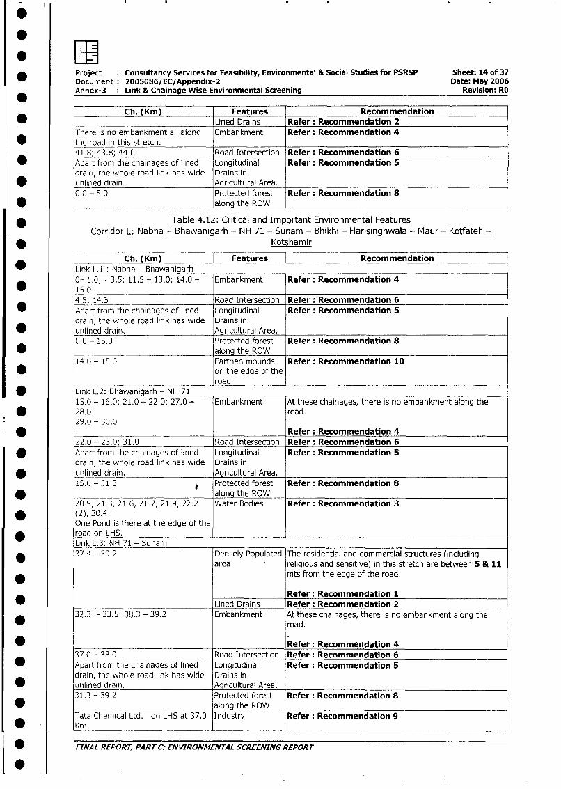
* Table 4.12: Critical and Important Environmental FeaturesCorridor L: Nabha - Bhawaniciarh - NH 71 - Sunam - Bhikhi - Harisinghwala -- Maur - Kotfateh -
* Kotshamir
* Link L.1: Nabha - Bhawanigarh0- 1.0, - 3.5; 11.5 - 13.0; 14.0 - Embankment Refer: Recommendation 4
* 15.04.5; 14.5 Road Intersection Refer: Recommendation 6
* Apart from the chainages of lined Longitudinal Refer: Recommendation 5drain, the whole road link has wide Drains in
* unlined drain. Agricultural Area.0.0 - 15.0 Protected forest Refer: Recommendation 8
* .__ along the ROW14.0 - 15.0 Earthen mounds Refer: Recommendation 10
* on the edge of the_________________________ road
* Link L.2: Bhawanigarh - NH 7115.0 - 16.0; 21.0 - 22.0; 27.0 - Embankment At these chainages, there is no embankment along the
* 28.0 road.29.0 - 30.0*_________ _____________ Refer: Recommendation 422.0 - 23.0; 31.0 Road Intersection Refer: Recommendation 6
* Apart from the chainages of lined Longitudinal Refer: Recommendation 5drain, the whole road link has wide Drains inLunlined drain. Agricultural Area.15.0 - 31.3 Protected forest Refer: Recommendation 8
* . _ _ along the ROW20.9, 21.3, 21.6, 21.7, 21.9, 22.2 Water Bodies Refer: Recommendation 3
* (2), 30.4One Pond is there at the edge of the
* road on LHS.Link L.3: NH 71 - Sunam
* 37.4 - 39.2 Densely Populated The residential and commercial structures (includingarea religious and sensitive) in this stretch are between 5 & 11
mts from the edge of the road.
Refer: Recommendation 1Lined Drains Refer: Recommendation 2
32.3 - 33.5; 38.3 - 39.2 Embankment At these chainages, there is no embankment along theroad.
* _ Refer: Recommendation 437.0 - 38.0 Road Intersection Refer: Recommendation 6
* Apart from the chainages of lined Longitudinal Refer: Recommendation 5drain, the whole road link has wide Drains in
* unlined drain. Agricultural Area.31.3 - 39.2 Protected forest Refer: Recommendation 8
* . along the ROWTata Chemical Ltd. on LHS at 37.0 Industry Refer: Recommendation 9
* Km __ _____________Km
i w FINAL REF'ORT, PART C: ENVIRONMENTAL SCREENING REPORT
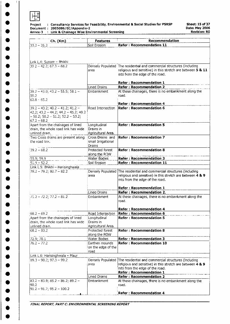
* Project Consultancy Services for Feasibility, Environmental & Social Studies for PSRSP Sheet: 15 of 37Document: 2005086/EC/Appendix-2 Date: May 2006
* Annex-3 : Link & Chainage Wise Environmental Screening Revision: RO
w ~~~~~~Ch. (Km) | Features |Recommendation* ~~~~33 - 35.3 _ Soil Erosion lRfr eomnaio 11
Link L.4: Sunam - Bhikhi* 39.2 -- 42.2; 67.3 - 68.2 Densely Populated The residential and commercial structures (including
area religious and sensitive) in this stretch are between 5 & 11* mts from the edge of the road.
Refer: Recommendation 1Lined Drains Refer: Recommendation 2
* 39.2 - 43.0; 43.2 - 55.5; 58.1 - Embankment At these chainages, there is no embankment along the59.2 road.
* 60.8 - 65.2Refer: Recommendation 4
* 39.2 - 40.2; 40.2 - 41.2; 41.2 - Road Intersection Refer: Recommendation 642.2; 43.2 - 44.2; 44.2 - 45.2; 49.2
* - 50.2; 50.2 - 51.2; 52.2 - 53.2;67.2 - 68.2
* Apart from the chainages of lined Longitudinal Refer: Recommendation 5drain, the whole road link has wide Drains inunlined drain. Agricultural Area.Two Cross drains are present along Cross Drains and Refer: Recommendation 7the road link. small Irrigational
Drains39.2 - 68.2 Protected forest Refer: Recommendation 8
* _________________________ along the ROW5_.9 59.9 Water Bodies Refer: Recommendation 3
* 51.9 - 52.2 Soil Erosion Refer: Recommendation 11Link L.5: Bhikhi - Harisinghwala
* 78.2 - 79.2; 80.7 - 82.2 Densely Populated The residential and commercial structures (includingarea religious and sensitive) in this stretch are between 4 & 9
* mts from the edge of the road.
*_____________ Refer: Recommendation 1Lined Drains Refer: Recommendation 2.
* 71.2 - 72.2; 77.2 - 81.2 Embankment At these chainages, there is no embankment along theroad.*Refer: Recommendation 4
* 68.2 - 69.2 Road Intersection Refer: Recommendation 6Apart from the chainages of lined Longitudinal Refer: Recommendation 5
* drain, the whole road link has wide Drains inunlined drain. - -Agricultural Area.
* 68.2 - 83.2 Protected forest Refer: Recommendation 8along the ROW
* 72.9;_78.1 Water Bodies Refer: Recommendation 376.2 - 77.2 Earthen mounds Refer: Recommendation 10
* on the edge of theroad
* Link L.6: Harisinghwala - Maur89.3 - 90.2; 97.3 - 99.2 Densely Populated The residential and commercial structures (including
* area religious and sensitive) in this stretch are between 4 & 9mts from the edge of the road.Refer: Recommendation 1
____________ Lined Drains Refer: Recommendation 2* 83.2 - 83.9; 85.2 - 86.2; 89.2 - Embankment At these chainages, there is no embankment along the
90.2 road.* 91.2 - 91.7; 95.2 - 100.2
_NAL REPORT_ PART C:ENVIRONMGRefer: Recommendation 4
* ~~FINAL REPORT, PAPRTC: ENVIRONMENTAL SCREENINGREPORT
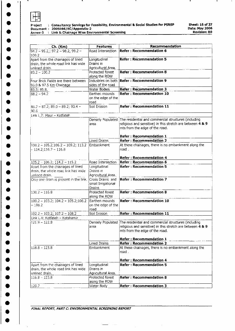
Project Consultancy ServicVs for Feasibility, Environmental & Social Studies for PSRSP Sheet: 16 of 37Document 2005086/EC/Appendix-2 Date: May 2006Annex-3 : Link & Chainage Wise Environmental Screening Revision: RO
0Ch. (Km) Features Recommendation
* 194.2 - 95.2,; 97.2 - 98.2, 99.2 - Road Intersection Refer: Recommendation 6100.2
_ Apart from the chainages of lined Longitudinal Refer: Recommendation 5drain, the whole road link has wide Drains in
* unlined drain. Agricultural Area.83.2 - 100.2 Protected forest Refer: Recommendation 8
* along the ROWFour Brick Fields are there between Industries on both Refer: Recommendation 9
* 96.0 & 97.5 Km Chainage sides of the road83.5; 85.8, Water Bodies Refer: Recommendation 3
S 88.2 - 94.2 Earthen mounds Refer: Recommendation 10on the edge of the
_ road86.2 - 87.2; 89.0 - 89.2; 90.4 - Soil Erosion Refer: Recommendation 11
* 90.6 _-
Link L.7: Maur - Kotfateh* _ Densely Populated The residential and commercial structures (including
area religious and sensitive) in this stretch are between 4 & 9* mts from the edge of the road.
Refer: Recommendation 1Lined Drains Refer: Recommendation 2
* 100.2 - 105.2;106.2 - 109.2; 113.2 Embankment At these chainages, there is no embankment along the
114.2;116.2 - 116.8 road .
Refer: Recommendation 4
* 105.2 - 106.2; 114.2 - 115.2 Road Intersection Refer: Recommendation 6Apart from the chainages of lined Longitudinal Refer: Recommendation 5
* drain, the whole road link has wide Drains inunlined drain. Agricultural Area.Only one drain is present in the link. Cross Drains and Refer: Recommendation 7
small Irrigational* Drains
100.2 - 116.8 Protected forest Refer: Recommendation 8along the ROW
100.2 - 103.2; 104.2 - 105.2;106.2 Earthen mounds Refer: Recommendation 10* - 108.2 on the edge of the
road102.2 - 103.2; 107.2 - 108.2 Soil Erosion Refer: Recommendation 11
Link L.8: Kotfateh - Kotshamir121.9 - 122.8 Densely Populated The residential and commercial structures (including
area religious and sensitive) in this stretch are between 4 & 9mts from the edge of the road.
Refer: Recommendation 1* Lined Drains Refer: Recommendation 2
118.8 - 123.8 Embankment At these chainages, there is no embankment along the
* road .
_ _ ____________________ Refer: Recommendation 4Apart from the chainages of lined Longitudinal Refer: Recommendation 5
* drain, the whole road link has wide Drains inunlined drain. Agricultural Area.
* 116.8 - 123.8 Protected forest Refer: Recommendation 8along the ROW
* 120.7 Water Body Refer: Recommendation 3
** ~~FINAL REPORT, PART C: ENVIRONMENTAL SCREENING REPORT
S
Project Consultancy Services for Feasibility, Environmental & Social Studies for PSRSP Sheet: 17 of 37* Document: 2005086/EC/Appendix-2 Date: May 2006
Annex-3 : Link & Chainage Wise Environmental Screening Revision: RO
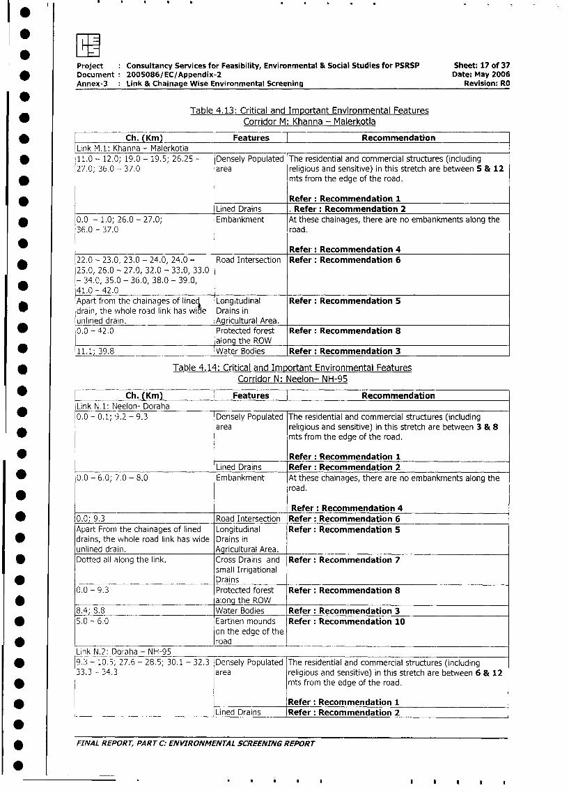
*Table 4.13: Critical and Important Environmental Features
* Corridor M: Khanna - Malerkotla
Ch. (Km) Features RecommendationLink MA: Khanna - Malerkotla
* 11.0 - 12.0; 19.0 - 19.5; 26.25 - Densely Populated The residential and commercial structures (including27.0; 36.0 - 37.0 area religious and sensitive) in this stretch are between 5 & 12
* mts from the edge of the road.
Refer: Recommendation 1Lined Drains . Refer: Recommendation 2
* 0.0 - 1.0; 26.0 - 27.0; Embankment At these chainages, there are no embankments along the
36.0 - 37.0 road.
_ Refer: Recommendation 4
* 22.0 - 23.0, 23.0 - 24.0, 24.0 - Road Intersection Refer: Recommendation 625.0, 26.0 - 27.0, 32.0 - 33.0, 33.0- 34.0, 35.0 - 36.0, 38.0 - 39.0,41.0 - 42.0Apart from the chainages of lineq Longitudinal Refer: Recommendation 5
* drain, the whole road link has wiae Drains in_unlined drain. Agricultural Area.
* 0.0 - 42.0 Protected forest Refer: Recommendation 8alonq the ROW_
* 11.1; 39.8 -_______________ Water Bodies Refer: Recommendation 3
* Table 4.14: Critical and Important Environmental FeaturesCorridor N: Neelon- NH-95
_ - Ch. (Km) | Features RecommendationLink N.1: Neelon- Doraha0.0 - 0.1; 9.2 - 9.3 Densely Populated The residential and commercial structures (including
area religious and sensitive) in this stretch are between 3 & 8mts from the edge of the road.
* Refer: Recommendation 1Lined Drains Refer: Recommendation 2
* 0.0 - 6.0; 7.0 - 8.0 Embankment At these chainages, there are no embankments along theroad.
Refer: Recommendation 4
* 0.0; 9.3 Road Intersection Refer: Recommendation 6
Apart From the chainages of lined Longitudinal Refer: Recommendation 5* drains, the whole road link has wide Drains in
unlined drain. Agricultural Area.Dotted all along the link. Cross Drains and Refer: Recommendation 7
small Irrigational* Drains
0.0 - 9.3 Protected forest Refer: Recommendation 8along the ROW
8.4; 8.8___ Water Bodies Refer: Recommendation 3
* 5.0 - 6.0 Earthen mounds Refer: Recommendation 10on the edge of the
* __ __ l ~~~~~~~~roadLink N.2: Doraha - NH-95
* 9.3 - 10.5; 27.6 - 28.5; 30.1 - 32.3 Densely Populated The residential and commercial structures (including
33.3 - 34.3 area religious and sensitive) in this stretch are between 6 & 12
* mts from the edge of the road.
*_____________ Refer: Recommendation 1_____________ ___Lined Drains Refer: Recommendation 2
-* fINAL REPORT, PART C: ENVIRONMENTAL SCREENING REPORT
0~.. . . |
* w
Project Consultancy Services for Feasibility, Environmental & Social Studies for PSRSP Sheet: 18 of 37Document 2005086/EC/Appendix-2 Date: May 2006Annex-3 : Link & Chainage Wise Environmental Screening Revision: RO
*
* Ch. (Km) Features Recommendation12.3 - 13.3 Embankment At these chainages, there are no embankments along the
* road
* _ _ _ _ _ _ _ Refer: Recommendation 419.0, 30.1, 31.9, 34.2, 35.0, 36.2 Road Intersection Refer: Recommendation 6
* Apart From the chainages of lined Longitudinal Refer: Recommendation 5drains, the whole road link has wide Drains in
* unlined drain. Agricultural Area.Dotted all along the link. Cross Drains and Refer: Recommendation 7
* small IrrigationalDrains
* 9.3 - 36.2 Protected forest Refer: Recommendation 8along the ROW
* 12.3- 13.3 Earthen mounds Refer: Recommendation 10on the edge of the
* road _
Table 4.15: Critical and Important Environmental Features* Corridor 0: Sahnewal - Dehlon
Ch. (Km) Features RecommendationLink O.1: Sahnewal - Dehlon
* 0.0 - 1.0; 6.5 - 6.8; 12.3 - 12.9 Densely Populated The residential and commercial structures (including16.2 - 16.46 area religious and sensitive) in this stretch are between 5 & 12
* mts from the edge of the road.
*_____________ Refer: Recommendation 1Lined Drains Refer: Recommendation 2
* 0.0 - 5.0; 6.0 - 8.0; 12.0 - 12.3 Embankment At these chainages, there is no embankment along the15.3 - 16.46 road.
Refer: Recommendation 4* 0; 4.15, 16.46 Road Intersection Refer: Recommendation 6
Apart from the chainages of lined Longitudinal Refer: Recommendation 5* drain, the whole road link has wide Drains in
unlined drain. Agricultural Area. _
Dotted all along the link. Cross Drains and Refer: Recommendation 7small Irrigational
* ~~~~~~~~~~~~Drains2.1, 4.6, 8.6, 9.1 Canal/Distributary
CanalApart from the chainages of densely Protected forest Refer: Recommendation 8populated area / towns the ROW\ along the ROW
* along the entire stretch is plantedand declared as Protected Forest.
* 8.1 - 9.4 Industries on both Refer: Recommendation 9sides of the road
Table 4.16: Critical and Important Environmental Features* Corridor P: Sangrur - Sunam - Lehragagga - Border
Ch. (l(m) | Features ] RecommendationLink P.1: Sangrur - Sunam 0.0 - 0.6; 0.6 - 0.8; 1.0 - 1.5; 9.8 - Densely Populated The residential and commercial structures (including11.2 area religious and sensitive) in this stretch are between 4.5 &
12 mts from the edge of the road.
Refer: Recommendation 1Lined Drains Refer: Recommendation 2
* FINAL REPORT, PART C: ENVIRONMENTAL SCREENING REPORT
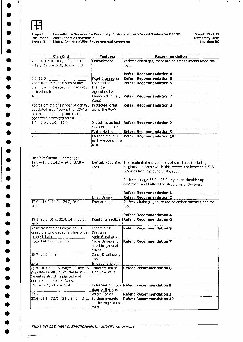
* [* Project : Consultancy Services for Feasibility, Environmental & Social Studies for PSRSP Sheet: 19 of 37
Document 2005086/EC/Appendix-2 Date: May 2006* AAnnex-3 Link & Chainage Wise Environmental Screening Revision: RO
Ch. (Km) Features Recommendation* 2.0 - 4.0, 5.0 - 8.0, 9.0 - 10.0, 12.0 Embankment At these chainages, there are no embankments along the
- 18.0, 19.0 - 24.0, 26.0 - 28.0 road .
Refer: Recommendation 4* 0.0, 11.5 Road Intersection Refer: Recommendation 6
Apart from the chainages of line Longitudinal Refer: Recommendation 5* drain, the whole road link has wide Drains in
unlined drain Agricultural Area.* 10.3 Canal/Distributary Refer: Recommendation 7
CanalApart from the chainages of densely Protected forest Refer: Recommendation 8populated area / town, the ROW of along the ROWhe entire stretch is planted anddeclared s protected forest
* 1.0 - 1.9 ; 11.0 - 12.0 Industries on both Refer: Recommendation 9sides of the road
9.9 Water Bodies Refer: Recommendation 32.8 Earthen mounds Refer: Recommendation 10
* on the edge of theroad
* Link P.2: Sunam - Lehragagga12.0 - 15.5 ; 24.2 - 24.6; 37.8 - Densely Populated The residential and commercial structures (including39.0 area religious and sensitive) in this stretch are between 1.5 &
8.5 mts from the edge of the road.
* At the chainage 23.2 - 23.9 any, even shoulder up-gradation would affect the structures of the area.
Refer: Recommendation 1* _ Lined Drain; Refer: Recommendation 2
12.0 - 18.0, 19.0 - 24.0, 26.0 - Embankment At these chainages, there are no embankments along the* 28.0 road.
*________________________ Refer: Recommendation 419.1, 25.8, 31.2, 32.8, 34.6, 35.9, Road Intersection Refer: Recommendation 6
* 36.8Apart from the chainages of line Longitudinal Refer: Recommendation 5
* drain, the whole road link has wide Drains inunlined drain Agricultural Area.Dotted all along the link Cross Drains and Refer: Recommendation 7
small irrigational* drains
18.7, 30.5, 38.9 Canal/Distributary_ Canal
37.3 Irrigational DrainApart fromn the chainages of densely Protected forest Refer: Recommendation 8populated area / town, the ROW of along the ROWhe entire stretch is planted and_decared s protected forest __
* 15.1 - 1.6.9, 21.9 - 22.9 Industries on both Refer: Recommendation 9sides of the road
* 23.9 Water Bodies Refer: Recommendation 320.4; 21.1 ; 32.0 - 33.1 34.0 - 34.1 Earthen mounds Refer: Recommendation 10
* on the edge of theroad
rFINAL REPORT, PART C. ENVIRONMENTAL SCREENING REPORT
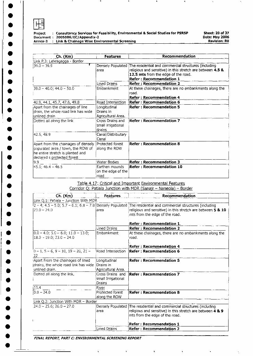
: w * Project Consultancy Services for Feasibility, Environmental & Social Studies for PSRSP Sheet: 20 of 37
Document 2005086/EC/Appendix-2 Date: May 2006Annex-3 Lirik & Chainage Wise Environmental Screening Revision: RO
* ~~~~~~~Ch. (Km) | Features |Recommendation* Link P.3: Lehragagga - Border _
39.0 - 39.9 # Densely Populated The residential and commercial structures (including* area religious and sensitive) in this stretch are between 4.5 &
12.5 mts from the edge of the road.*_____________ Refer: Recommendation 1Lined Drains Refer: Recommendation 2
39.0 - 40.0; 44.0 - 50.0 Embankment At these chainages, there are no embankments along theroad.Refer: Recommendation 4
* 40.9, 44.1, 45.7, 47.6, 49.8 Road Intersection Refer: Recommendation 6Apart from the chainages of line Longitudinal Refer: Recommendation 5
* drain, the whole road link has wide Drains inunlined drain Agricultural Area.Dotted all along the link Cross Drains and Refer: Recommendation 7
small irrigational* drains
42.5, 48.9 Canal/Distributary* _ Canal
Apart from the chainages of densely Protected forest Refer: Recommendation 8* populated area / town, the ROW of along the ROW
he entire stretch is planted anddeclared s protected forest9.9 Water Bodies Refer: Recommendation 3
* 45.1; 46.4 - 46.5 Earthen mounds Refer: Recommendation 10on the edge of the
* ~~~~~~~~~~~~road
Table 4.17: Critical and Important Environmental Features
* Corridor Q: Patiala Junction with MDR (Sanajr - Naneola) - Border
* Ch. (Krn) Features Recommendation
Link Q.1: Patiala - Junction With MDR* 2 - 4; 4.5 - 5.0; 5.7 - 6.1; 6.8 - 7.8 Densely Populated The residential and commercial structures (including
23.0 - 24.0 area religious and sensitive) in this stretch are between 5 & 10
* mts from the edge of the road.
* Refer: Recommendation 1.Lined Drains Refer: Recommendation 2
* g 0.0 - 4.0; 5.0 - 6.0; 11.0 - 13,0; Embankment At these chainages, there are no embankments along the18.0 - 19.0; 23.0 - 24.0 road.
Refer: Recommendation 4* 0 - 1, 5 - 6, 9 - 10, 19 - 20, 21 - Road Intersection Refer: Recommendation 6
22* Apart From the chainages of lined Longitudinal Refer: Recommendation 5
drains, the whole road link has wide Drains in* unlined drain. Agricultural Area.
Dotted all along the link. Cross Drains and Refer: Recommendation 7* small Irrigational
Drains* 23.4 River
0.0 - 24.0 Protected forest Refer: Recommendation 8along the ROW
Link Q.2: Junction With MDR - Border* 24.0 - 25.6; 26.0 - 27.0 Densely Populated The residential and commercial structures (including
area religious and sensitive) in this stretch are between 4 & 9* l mts from the edge of the road.
Refer: Recommendation 1
*_______ ________________ Lined Drains Refer: Recommendation 2
* FINAL REPORT, PART C. ENVIRONMENTAL SCREENING REPORT
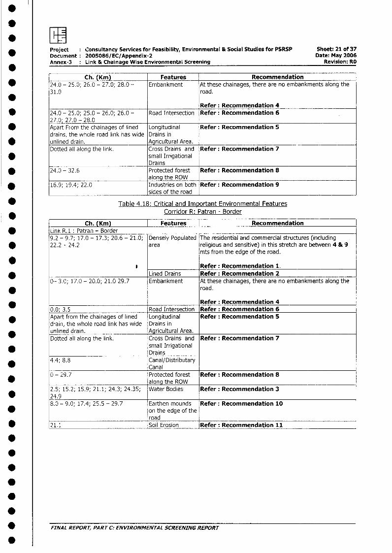
* Project Consultancy Services for Feasibility, Environmental & Social Studies for PSRSP Sheet: 21 of 37Document: 2005086/EC/Appendix-2 Date: May 2006Annex-3 : Link & Chainage Wise Environmental Screening Revision: RO
Ch. (Km) Features Recommendation* 24.0 - 25.0; 26.0 - 27.0; 28.0 - Embankment At these chainages, there are no embankments along the
31.0 road.
Refer: Recommendation 4* 24.0 - 25.0; 25.0 - 26.0; 26.0 - Road Intersection Refer: Recommendation 6
27.0; 27.0 - 28.0* Apart From the chainages of lined Longitudinal Refer: Recommendation 5
drains, the whole road link has wide Drains in* unlined drain. Agricultural Area.
Dotted all along the link. Cross Drains and Refer: Recommendation 7* small Irrigational
Drains* 24.0 - 32.6 Protected forest Refer: Recommendation 8
along the ROW I* 16.9; 19.4; 22.0 Industries on both Refer: Recommendation 9
sides of the road
* Table 4.18: Critical and Important Environmental FeaturesCorridor R: Patran - Border
Ch. (Km) Features [ Recommendation* Link R.1: Patran - Border
9.2 - 9.7; 17.0 - 17.3; 20.6 - 21.0; Densely Populated The residential and commercial structures (including* 22.2 - 24.2 area religious and sensitive) in this stretch are between 4 & 9
mts from the edge of the road.
* Refer: Recommendation 1.Lined Drains Refer: Recommendation 2
0-- 3.0; 17.0 - 20.0; 21.0 29.7 Embankment At these chainages, there are no embankments along the* road.
Refer: Recommendation 40.0; 3.5 Road Intersection Refer: Recommendation 6
* Apart from the chainages of lined Longitudinal Refer: Recommendation 5drain, the whole road link has wide Drains inunlined drain. Agricultural Area.Dotted all along the link. Cross Drains and Refer: Recommendation 7
small IrrigationalDrains
_ 4.4; 8.8 Canal/DistributaryCanal
0 - 29.7 Protected forest Refer: Recommendation 8_ along the ROW
2.5; 15.2; 15.9; 21.1; 24.3; 24.35; Water Bodies Refer: Recommendation 3* 24.9
8.0 - 9.0; 17.4; 25.5 - 29.7 Earthen mounds Refer: Recommendation 10on the edge of theroad ___________________________
* 21.1 Soil Erosion Refer: Recommendation 11
.
.
_
* FINAL REPORT, PART C: ENVIRONMENTAL SCREENING REPORT
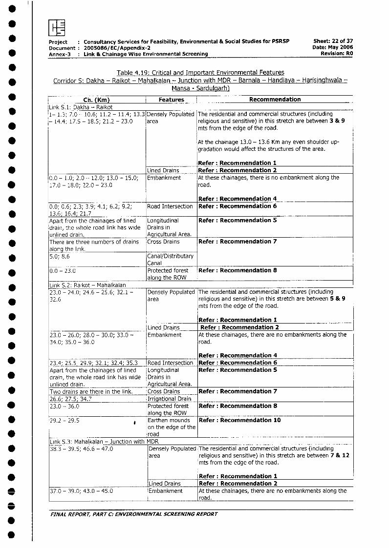
* Project Consultancy Services for Feasibility, Environmental & Social Studies for PSRSP Sheet: 22 of 37Document 2005086/EC/Appendix-2 Date: May 2006Annex-3 Link & Chainage Wise Environmental Screening Revision: RO
Table 4.19: Critical and Important Environmental Features* Corridor S: Dakha - Raikot - Mahalkalan - Junction with MDR - Barnala - Handiaya - Harisinghwala -
Mansa - Sardulgarh)
Ch. (Km) Features RecommendationLink S.1: Dakha - Raikot1- 1.3; 7.0 - 10.6; 11.2 - 11.4; 13.3 Densely Populated The residential and commercial structures (including- 14.4; 17.5 - 18.5; 21.2 - 23.0 area religious and sensitive) in this stretch are between 3 & 9
mts from the edge of the road.
* At the chainage 13.0 - 13.6 Km any even shoulder up-gradation would affect the structures of the area.
Refer: Recommendation 1* _____________________________ Lined Drains Refer: Recommendation 2
0.0 - 1.0; 2.0 -- 12.0; 13.0 - 15.0; Embankment At these chainages, there is no embankment along the* 17.0 - 18.0; 22.0 - 23.0 road.
* Refer: Recommendation 40.0; 0.6; 2.3; 3.9; 4.1; 6.2; 9.2; Road Intersection Refer: Recommendation 6
* 13.6; 16.4; 21.7Apart from the chainages of lined Longitudinal Refer: Recommendation 5
* drain, the whole road link has wide Drains inunlined drain. Agricultural Area.There are three numbers of drains Cross Drains Refer: Recommendation 7along the link.
* 5.0; 8.6 Canal/DistributaryCanal
* 0.0 - 23.0 Protected forest Refer: Recommendation 8_ __________________________ along the ROW
* Link 5.2: Raikot - Mahalkalan23.0 - 24.0; 24.6 - 25.6; 32.1 - Densely Populated The residential and commercial structures (including
* 32.6 area religious and sensitive) in this stretch are between 5 & 9mts from the edge of the road.
* Refer: Recommendation 1Lined Drains Refer: Recommendation 2
23.0 - 26.0; 28.0 - 30.0; 33.0 - Embankment At these chainages, there are no embankments along the* 34.0; 35.0 - 36.0 road.
Refer: Recommendation 4* 23.4; 25.5; 29.9; 32.1; 32.4; 35.3 Road Intersection Refer: Recommendation 6
Apart from the chainages of lined Longitudinal Refer: Recommendation 5* drain, the whole road link has wide Drains in
unlined drain. Agricultural Area.Two drains are there in the link. Cross Drains Refer: Recommendation 726.6; 27.5; 34.7 Irrigational Drain
* 23.0 - 36.0 Protected forest Refer: Recommendation 8along the ROW
* 29.2 - 29.5 e Earthen mounds Refer: Recommendation 10on the edge of the
* _ roadLink S.3: Mahalkalan - Junction with MDR
* 38.3 - 39.5; 46.6 - 47.0 Densely Populated T he residential and commercial structures (includingarea religious and sensitive) in this stretch are between 7 & 12
* mts from the edge of the road.
Refer: Recommendation 1Lined Drains Refer: Recommendation 2
O 37.0 - 39.0; 43.0 - 45.0 Embankment At these chainages, there are no embankments along the__________________________________ ________________ road.
FINAL REPORT, PART C: ENVIRONMENTAL SCREENING REPORT
.
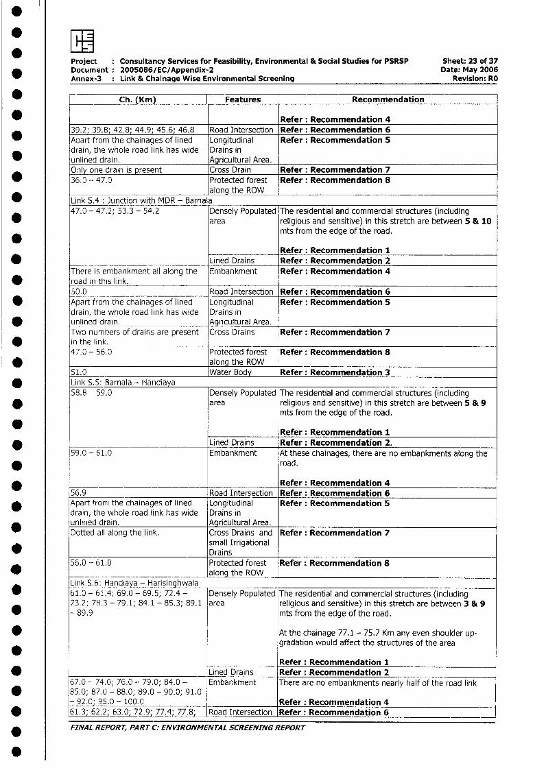
*I
Project Consultancy Services for Feasibility, Environmental & Social Studies for PSRSP Sheet: 23 of 37Document: 2005086/EC/Appendix-2 Date: May 2006Annex-3 : Link & Chainage Wise Environmental Screening Revision: RO
* Ch. (Km) Features Recommendation
* Refer: Recommendation 439.2; 39.8; 42.8; 44.9; 45.6; 46.8 Road Intersection Refer: Recommendation 6
* Apart from the chainages of lined Longitudinal Refer: Recommendation 5drain, the whole road link has wide Drains in
* unlined drain. Agricultural Area.Only one drain is present Cross Drain Refer: Recommendation 7
* 36.0 - 47.0 Protected forest Refer: Recommendation 8along the ROW
* Link S.4: Junction with MDR - Barnala47.0 - 47.2; 53.3 - 54.2 Densely Populated The residential and commercial structures (including
area religious and sensitive) in this stretch are between 5 & 10mts from the edge of the road.
Refer: Recommendation 1* Lined Drains Refer: Recommendation 2
There is embankment all along the Embankment Refer: Recommendation 4* road in this link.
50.0 Road Intersection Refer: Recommendation 6* Apart from the chainages of lined Longitudinal Refer: Recommendation 5
drain, the whole road link has wide Drains inunlined drain. Agricultural Area.Two numbers of drains are present Cross Drains Refer: Recommendation 7
* in the link.47.0 - 56.0 Protected forest Refer: Recommendation 8_1.0 along the ROW51.0 _ Water Body Refer: Recommendation 3
* Link S.5: Barnala - Handiaya58.8 - 59.0 Densely Populated The residential and commercial structures (including
* area religious and sensitive) in this stretch are between 5 & 9mts from the edge of the road.
*___________ Refer: Recommendation 1* _ Lined Drains Refer: Recommendation 2.
59.0 - 61.0 Embankment At these chainages, there are no embankments along the* road.
Refer: Recommendation 456.9 Road Intersection Refer: Recommendation 6
* Apart from the chainages of lined Longitudinal Refer: Recommendation 5drain, the whole road link has wide Drains inunlined drain. Agricultural Area.Dotted all along the link. Cross Drains and Refer: Recommendation 7
small IrrigationalDrains
56.0 - 61.0 Protected forest Refer: Recommendation 8* _ _____________________________ along the ROW
Link S.6: Handiaya - Harisinghwala* 61.0 - 61.4; 69.0 - 69.5; 72.4 - Densely Populated The residential and commercial structures (including
73.2; 78.3 - 79.1; 84.1 - 85.3; 89.1 area religious and sensitive) in this stretch are between 3 & 9* - 89.9 mts from the edge of the road.
* At the chainage 77.1 - 75.7 Km any even shoulder up-gradation would affect the structures of the area
Refer: Recommendation 1* ________________________________ Lined Drains Refer: Recommendation 2
67.0 - 74.0; 76.0 - 79.0; 84.0 - Embankment There are no embankments nearly half of the road link* 85.0; 87.0 - 88.0; 89.0 - 90.0; 91.0
- 92.0; 95.0 - 100.0 Refer: Recommendation 4* 61.3; 62.2; 63.0; 72974j7.8; Road Intersection Refer: Recommendation 6
FINAL REPORT, PART C: ENVIRONMENTAL SCREENING REPORT
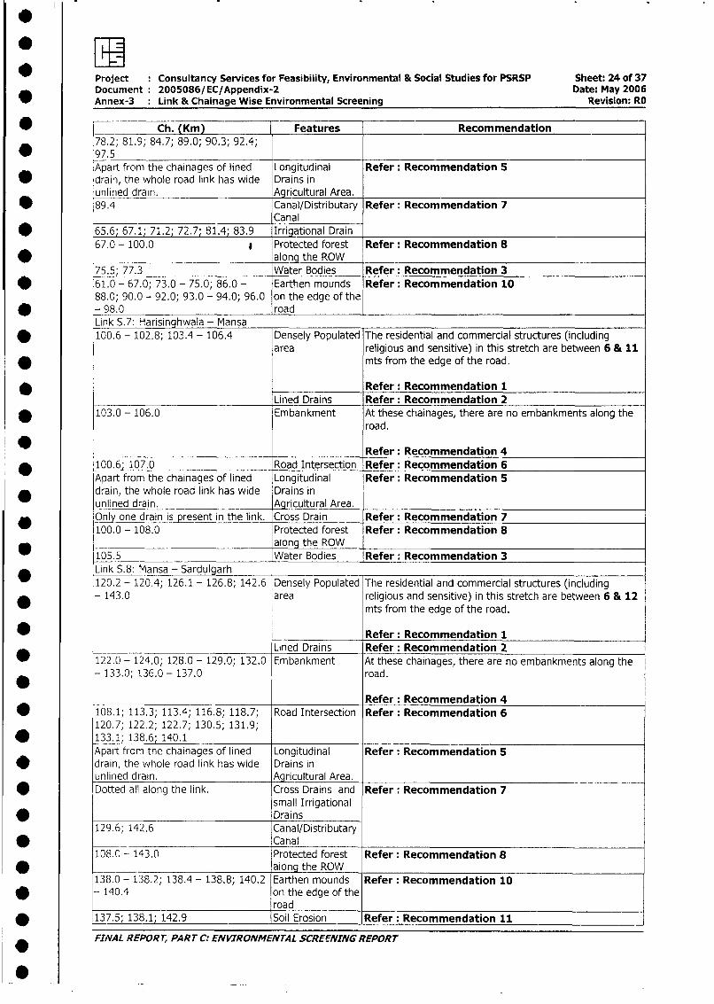
: wM
Project Consultancy Services for Feasibility, Environmental & Social Studies for PSRSP Sheet: 24 of 37Document 2005086/EC/Appendix-2 Date: May 2006Annex-3 Link & Chainage Wise Environmental Screening Revision: RO
_ = Ch. (Km) Features Recommendation78.2; 81.9; 84.7; 89.0; 90.3; 92.4;97.5Apart from the chainages of lined Longitudinal Refer: Recommendation 5
* drain, the whole road link has wide Drains inunlined drain. Agricultural Area.
* 89.4 Canal/Distributary Refer: Recommendation 7Canal
* 65.6; 67.1; 71.2; 72.7; 81.4; 83.9 Iriational Drain67.0 - 100.0 * Protected forest Refer: Recommendation 8
* _ along the ROW75.5; 77.3 Water Bodies Refer: Recommendation 3
* 61.0 - 67.0; 73.0 - 75.0; 86.0 - Earthen mounds Refer: Recommendation 1088.0; 90.0 - 92.0; 93.0 - 94.0; 96.0 on the edge of the
* - 98.0 roadLink 5.7: Harisinghwaia - Mansa
* 100.6 - 102.8; 103.4 - 106.4 Densely Populated The residential and commercial structures (includingarea religious and sensitive) in this stretch are between 6 & 11
* mts from the edge of the road.
Refer: Recommendation 1Lined Drains Refer: Recommendation 2
* 103.0 - 106.0 Embankment At these chainages, there are no embankments along theroad.
Refer: Recommendation 4_ ., . _. 100.6; 107.0 Road Intersection Refer: Recommendation 6
Apart from the chainages of lined Longitudinal Refer: Recommendation 5* drain, the whole road link has wide Drains in
unlined drain. Agricultural Area.Only one drain is present in the link. Cross Drain Refer: Recommendation 7100.0 - 108.0 Protected forest Refer: Recommendation 8
along the ROW105.5 Water Bodies Refer: Recommendation 3Link 5.8: Mansa - Sardulgarh120.2 - 120.4; 126.1 - 126.8; 142.6 Densely Populated The residential and commercial structures (including- 143.0 area religious and sensitive) in this stretch are between 6 & 12
mts from the edge of the road.
Refer: Recommendation 1Lined Drains Refer: Recommendation 2
122.0 - 124.0; 128.0 - 129.0; 132.0 Embankment At these chainages, there are no embankments along the- 133.0; 136.0 - 137.0 road.
Refer: Recommendation 4* 108.1; 113.3; 113.4; 116.8; 118.7; Road Intersection Refer: Recommendation 6
120.7; 122.2; 122.7; 130.5; 131.9;* 133.1; 138.6; 140.1
Apart from the chainages of lined Longitudinal Refer: Recommendation 5* drain, the whole road link has wide Drains in
unlined drain. Agricultural Area.9 Dotted all along the link. Cross Drains and Refer: Recommendation 7
small Irrigational* _ _ _ _ _ _ _ _ _ _ _ _ _ Drains
129.6; 142.6 Canal/Distributary* _ _ _ _ _ _ _ _ _ _ _ _ _ Canal
108.0 - 143.0 Protected forest Refer: Recommendation 8* ._ _ _ _ _ _ _ along the ROW
138.0 - 138.2; 138.4 - 138.8; 140.2 Earthen mounds Refer: Recommendation 10* - 140.4 on the edge of the
_____________ _________road* 137.5; 138.1; 142.9 Soil Erosion Refer: Recommendation 11
FI,VAL REPORT, PART C: ENVIRONMENTAL SCREENING REPORT
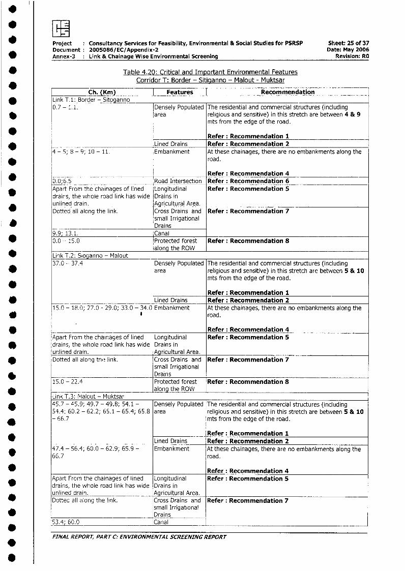
* wProject Consultancy Services for Feasibility, Environmental & Social Studies for PSRSP Sheet: 25 of 37Document: 2005086/EC/Appendix-2 Date: May 2006
* Annex-3 Link & Chainage Wise Environmental Screening Revision: RO
* Table 4.20: Critical and Important Environmental FeaturesCorridor T: Border - Sitiqanno - Malout - Muktsar
Ch. (Km) Features | Recommendation* Link T.1: Border - Sitoganno
0.7 - 1.1. Densely Populated The residential and commercial structures (including* area religious and sensitive) in this stretch are between 4 & 9
mts from the edge of the road.
Refer: Recommendation 1Lined Drains Refer: Recommendation 2
4 - 5; 8 - 9; 10 - 11. Embankment At these chainages, there are no embankments along the* road.
Refer: Recommendation 4_ 0.0;6.5 Road Intersection Refer: Recommendation 6* Apart From the chainages of lined Longitudinal Refer: Recommendation 5
drains, the whole road link has wide Drains inunlined drain. Agricultural Area.Dotted all along the link. Cross Drains and Refer: Recommendation 7
small IrrigationalDrains
9.9; 13.1. Canal* 0.0 - 15.0 Protected forest Refer: Recommendation 8
along the ROW* Link T.2: Sioganno - Malout _
37.0 - 37.4 Densely Populated The residential and commercial structures (includingarea religious and sensitive) in this stretch are between 5 & 10
mts from the edge of the road.
Refer: Recommendation 1* Lined Drains Refer: Recommendation 2
15.0 - 18.0; 27.0 - 29.0; 33.0 - 34.0 Embankment At these chainages, there are no embankments along the* , road.
* _ _ _ Refer: Recommendation 4Apart From the chainages of lined Longitudinal Refer: Recommendation 5
* drains, the whole road link has wide Drains inunlined drain. Agricultural Area.Dotted all along the link. Cross Drains and Refer: Recommendation 7
small Irrigational* Drpins
15.0 - 22.4 Protected forest Refer: Recommendation 8________________________________ along the ROWLink T.3: Malout - Muktsar
* 45.7 - 45.9; 49.7 - 49.8; 54.1 - Densely Populated The residential and commercial structures (including54.4; 60.2 - 62.2; 65.1 - 65.4; 65.8 area religious and sensitive) in this stretch are between 5 & 10
* - 66.7 mts from the edge of the road.
*_____________ Refer: Recommendation 1Lined Drains Refer: Recommendation 2
47.4 - 56.4; 60.0 - 62.9; 65.9 - Embankment At these chainages, there are no embankments along the*r 66.7 road.
0 Refer: Recommendation 4Apart From the chainages of lined Longitudinal Refer: Recommendation 5
v drains, the whole road link has wide Drains inunlined drain. Agricultural Area.
* Dotted all along the link. Cross Drains and Refer: Recommendation 7small Irrigational
* _______________ _ ____________ Drains53.4; 60.0 Canal
FINAL REPORT, PART C: ENVIRONMENTAL SCREENING REPORT.
Project Consultancy Services for Feasibility, Environmental & Social Studies for PSRSP Sheet: 26 of 37* Document: 2005086/EC/Appendix-2 Date: May 2006
Annex-3 : Link & Chainage Wise Environmental Screening Revision: RO
Ch. (Km) _ Features Recommendation* 22.4 - 29.3 Protected forest Refer: Recommendation 8
along the ROW* 39.2; 61.7; 66.1 Industries on both Refer: Recommendation 9
sides of the road* 46.2 Water Body Refer: Recommendation 3
Table 4.21: Critical and Important Environmental FeaturesCorridor U: Abohar -Junction with Fazilka -Malout Road - Muktsar - Kotkapura )
* Ch. (Km) I Features [ RecommendationLink U.1: Abohar - Junction with Fazilka - Malout Road
* 2.0 - 2.5; 11.0 - 12.0 Densely Populated The residential and commercial structures (includingarea religious and sensitive) in this stretch are between 3 & 9
* mts from the edge of the road.
* At the chainages 2.0 - 7.5 and 11.5 - 18.5 Km any evenshoulder up-gradation would affect the structures of thearea; five Schools, two Temples, two Gurudwara and oneDispensary are there at the edge of the road.
Refer: Recommendation 1_- __Lined Drains Refer: Recommendation 20.1- 1.0; 4.0 - 7.0; 7.2 - 8.0; 10.3 Embankmer-t At these chainages, there is no embankment along the
* - 12.0; 12.3 - 13.0 road.
Refer: Recommendation 45. 68; 17.4 Road Intersection Refer: Recommendation 6
* Apart from the chainages of lined Longitudinal Refer: Recommendation 5drain, the whole road link has wide Drains inunlined drain. Agricultural Area.
* Present 3 in numbers in the link. Cross Drains and Refer: Recommendation 7*__________________________________ N allas0.0 - 19.7 Protected forest Refer: Recommendation 8
along the ROW* 6.9 ; 16.9 (RHS) - present near the Water Bodies Refer: Recommendation 3
edge of the road.
Link U.2: Junction with Fazilka - Malout Road - Muktsar* 19.7 - 20.2; 22.2 - 22.6; 22.7 - Densely Populated The residential and commercial structures (including
23.1; 26.9 - 27.7; 31.7 - 32.6; 34.4 area religious and sensitive) in this stretch are between 3 & 9* - 35.2; 39.7 - 39.9; 46.7 - 49.0 mts from the edge of the road.
* At the chainages 20.7 (LHS), 27.4 (LHS), 29.3 (RHS), 35.3(LHS), 47.0 (LHS) Km any even shoulder up-gradation
* would affect the educational and religious structures,present at the edge of the road in the area.
.Refer: Recommendation 1
29.7 __ _ _Lined Drains Refer: Recommendation 219.7 - 20.2; 29.7 - 30.7; 31.7 - Embankment At these chainages, there is no embankment along the
* 32.5; 34.4 - 35.7; 37.7 - 38.7; 39.7 road .- 40.4; 41.7 - 43.9; 45.1 - 47.4;
* 48.6 - 49.0 Refer: Recommendation 420.2 Road Intersection Refer: Recommendation 6
* Apart from the chainages of lined Longitudinal Refer: Recommendation 5drain, the whole road link has wide Drains inunlined drain. Agricultural Area.Present 4 in numbers Cross Drains and Refer: Recommendation 7
Nallas23.4; 34.0; 38.3 Canal/Distributary
* Canal
* FINAL REPORT, PART C: ENVIRONMENTAL SCREENING REPORT
.
* Project : Consultancy Services for Feasibility, Environmental & Social Studies for PSRSP Sheet: 27 of 37
Document: 2005086/EC/Appendix-2 Date: May 2006
_ Annex-3 : Link & Chainage Wise Environmental Screening Revision: RO
* Ch. (Km) Features Recommendation
* 19.7 - 49.0 Protected forest Refer: Recommendation 8along the ROW
* 27.1 Water Body Refer: Recommendation 3Ptesent near the edge of the road
* on RHS.Link U.3: Muktsar - Kotkapura
* 49.0 - 51.0; 61.9 - 62.0; 64.0 - Densely Populated The residential and commercial structures (including
65.0; 68.3 - 70.0; 73.0 - 74.3; 80.0 area religious and sensitive) in this stretch are between 4 & 9
* - 81.4 mts from the edge of the road.
Refer: Recommendation 1
Lined Drains Refer: Recommendation 2* 49.0 - 53.0; 55.0 - 57.0; 58.0 - Embankment At these chainages, there is no embankment along the
59.0; 60.0 - 62.0; 63.0 - 65.0; 67.0 road.* - 70.0; 79.0 - 81.0
Refer: Recommendation 4
* 50.0 - 51.0; 57.0 - 58.0; 80.0 - Road Intersection Refer: Recommendation 681.0
* Apart from the chainages of lined Longitudinal Refer: Recommendation 5drain, the whole road link has wide Drains in
* unlined drain. _- Agricultural Area.
Present 3 in numbers Cross Drains and Refer: Recommendation 7* _______ Nallas
58.8 Canal/Distributary* __Canal
49.0 - 81.4 Protected forest Refer: Recommendation 8* _____________ along the ROW
61.7 _ Water Body Refer: Recommendation 3
* Table 4.22: Critical and Important Environmental Features
* Corridor V: Kotkapura - Jaitu - Goniana
Ch. (Kin) I Features | Recommendation
* Link \/.1: Kotkapura - Jaitu - Goniana 0.0 - 0.6; 14.3 - 17.6 Densely Populated The residential and commercial structures (including
area religious and sensitive) in this stretch are between 0.5 &12.0 mts from the edge of the road.
At the chainage ..... even shoulder up-gradation would
* result in filling of water body / dislocation of structure
* Refer: Recommendation 1Lined Drains Refer: Recommendation 2
* 0.0 - 6.0; 7.0 - 10.0; 12.0 - 21.5; Embankment At these chainages, (maximum portion of the road section)
22.2 - 24.0; 28.0 - 29.9 there are no embankments along the road.
SRefer: Recommendation 4
* 0.0; 29.9 Road Intersection Refer: Recommendation 6Apart from the chainages of lined Longitudinal Refer: Recommendation 5drain, tne whole road link has wide Drains inunlined drain. Agricultural Area.
* Dotted all along the link. Cross Drains and Refer: Recommendation 7small Irrigational
* __ Drains*6.0; 21.7 Canal/Distributary
* l Canal7.8; 12.9, Irrigational DrainApart from the chainages of densely Protected forest Refer: Recommendation 8populated area / towns the ROW along the ROW
FINAL REPORT, PART C: ENVIRONMENTAL SCREENING REPORT
Project Consultancy Services for Feasibility, Environmental & Social Studies for PSRSP Sheet: 28 of 37Document 2005086/EC/Appendix-2 Date: May 2006
* Annex-3 : Link & Chainage Wise Environmental Screening Revision: RO
Ch. (Km) Features Recommendationalong the entire stretch is plantedand decl3red as Protected Forest.1.2 - 2.9 Industries on both Refer: Recommendation 9
* ________ _____ sides of the road
11.7; 19.6; 23.1 Water Bodies Refer: Recommendation 3
* 12.0 - 14.0 Earthen mounds Refer: Recommendation 10on the edge of the
* _______ roadTable 4.23: Critical and Important Environmental Features
Corridor W: iaitu - Baiakhana - Bhagta - Salabatpura - Bhadur - Pakhoke
Ch. (Km) Features RecommendationLink W.1:Jaito - Bajakhana - Bhagta
* 0.0 - 0.4 Densely Populated The residential and commercial structures (includingI area religious and sensitive) in this stretch are between 7 &12
* mts from the edge of the road.
* Refer: Recommendation 1Lined Drains Refer: Recommendation 2
* 2.0 - 3.0; 5.0 - 9.6 Embankment At these chainages, there are no embankments along theroad .
SRefer: Recommendation 4
* 0.0; 6.0; 9.6 Road Intersection Refer: Recommendation 6Apart From the chainages of lined Longitudinal Refer: Recommendation 5
* drains, the whole road link has wide Drains inunlined drain. Agricultural Area.Dotted all along the link. Cross Drains and Refer: Recommendation 7
small Irrigational* Drains
0.0 - 9.6 Protected forest Refer: Recommendation 8along the ROW
0.7 Water Body Refer: Recommendation 3
* Link W.2: Bhagta - Salabatpura - Di st. Boundary
9.6 - 10.6; 20.6 - 22.6; 27.6 - 28.6; Densely Populated The residential and commercial structures (including
* 28.6 - 29.2 area religious and sensitive) in this stretch are between 6 & 12mts from the edge of the road.
* Refer: Recommendation 1Lined Drains Refer: Recommendation 2
13.6 - 17.6; 22.6 - 24.6; 26.6 - Embankment At these chainages, there are no embankments along the
* 27.6; 29.6 - 30.6 road.
Refer: Recommendation 4
* 12.3 - 13.6 Road Intersection Refer: Recommendation 6Apart From the chainages of lined Longitudinal Refer: Recommendation 5drains, the whole road link has wide Drains inunlined drain. Agricultural Area.
0 Dotted all along the link. Cross Drains and Refer: Recommendation 7small Irrigational
* Drains9.6 - 29.0 Protected forest Refer: Recommendation 8
* _ ____ along the ROW35.6; 35.8 Water Body Refer: Recommendation 3
* 18.3 - 18.5; 23.6 - 24.6; 33.6 - Earthen mounds Refer: Recommendation 10* 34.6; 36.6 - 38.6 on the edge of the
FINAL REPORT, PART C: ENVIRONMENTAL SCREENING REPORT
*~~~~~ L -
Project Consultancy Services for Feasibility, Environmental & Social Studies for PSRSP Sheet: 29 of 37
* Document: 2005086/EC/Appendix-2 Date: May 2006
Annex-3 Link & Chainage Wise Environmental Screening Revision: RO
*L*nk Wl3: Ch. (Km) | Features | RecommendationLink W.3: Dis. Boundary - Bhadaur - Pakhoke
* 42.6 - 43.6; 50.6 - 56.4 Densely Populated The residential and commercial structures (includingarea religious and sensitive) in this stretch are between 5 & 10
* mts from the edge of the road.
Refer: Recommendation 1Lined Drains Refer: Recommendation 2.
* 39.6 - 40.5; 40.6 - 41.5; 43.1 - Embankment At these chainages, there are no embankments along the44.2; 45.6 - 47.4; 51.0 - 52.0; 53.0 road.- 56.4
____________ __ Refer: Recommendation 4
* 41.62; 42.6; 46.62; 47.6; 48.62; Road Intersection Refer: Recommendation 649.6; 55.62; 56.4
* Apart Frorn the chainages of lined Longitudinal Refer: Recommendation 5drains, the whole road link has wide Drains inunlined drain. Agricultural Area.Dotted all along the link. Cross Drains and Refer: Recommendation 7
small IrrigationalDrains
50.2 ___ Canal __ 29.0 - 56.4 Protected forest Refer: Recommendation 8
along the ROW
Table 4.24: Critical and Important Environmental Features
* Corridor X: Firozpur - Mallanwala - Makhu - Kotisekhan - Moga
Ch. (Km) | Features | RecommendationLink X.1: Firozpur - Mallanwala
* 0.0 - 1.0;15.0 - 16.0; 21.0 - 24.0 Densely Populated The residential and commercial structures (includingarea religious and sensitive) in this stretch are between 3.5 &
10 mts from the edge of the road.
Refer: Recommendation 1* __________ _Lined Drains Refer: Recommendation 2
20 - 2.5; 4.9 - 5.2; 6.2 - 7.0; 11.0 Embankment At these chainages, there are no embankments along the
* - 19.0; 22.0 - 24.0 road.
0 _ _________________________ Refer: Recommendation 4
3 _L3.8; 4.3; 6.0 Road Intersection Refer: Recommendation 6* AApart from the chainages of lined Longitudinal Refer: Recommendation 5
drain, the whole road link has wide Drains in* unlined drain. Agricultural Area.
Dotted all along the link. Cross Drains and Refer: Recommendation 7* small Irrigational
Drains* 6.1; 13.8 Canal/Distributary
Canal* 5.0 - 6.2 Industries on both Refer: Recommendation 9
_______ sides of the road* L_14.6 Water Bodies Refer: Recommendation 3
Apart from the chainages of densely Protected forest Refer: Recommendation 8* populated area / towns the ROW along the ROW
along the entire stretch is plantedand declared as Protected Forest.
* FINAL REPORT, PAR T C: ENVIRONMENTAL SCREENING REPORT
0~~~~~~~~~~~~~~~~~~~~~~~~~~~~~~~~~~~~~~~~~~~~~~~~~~~~~~~
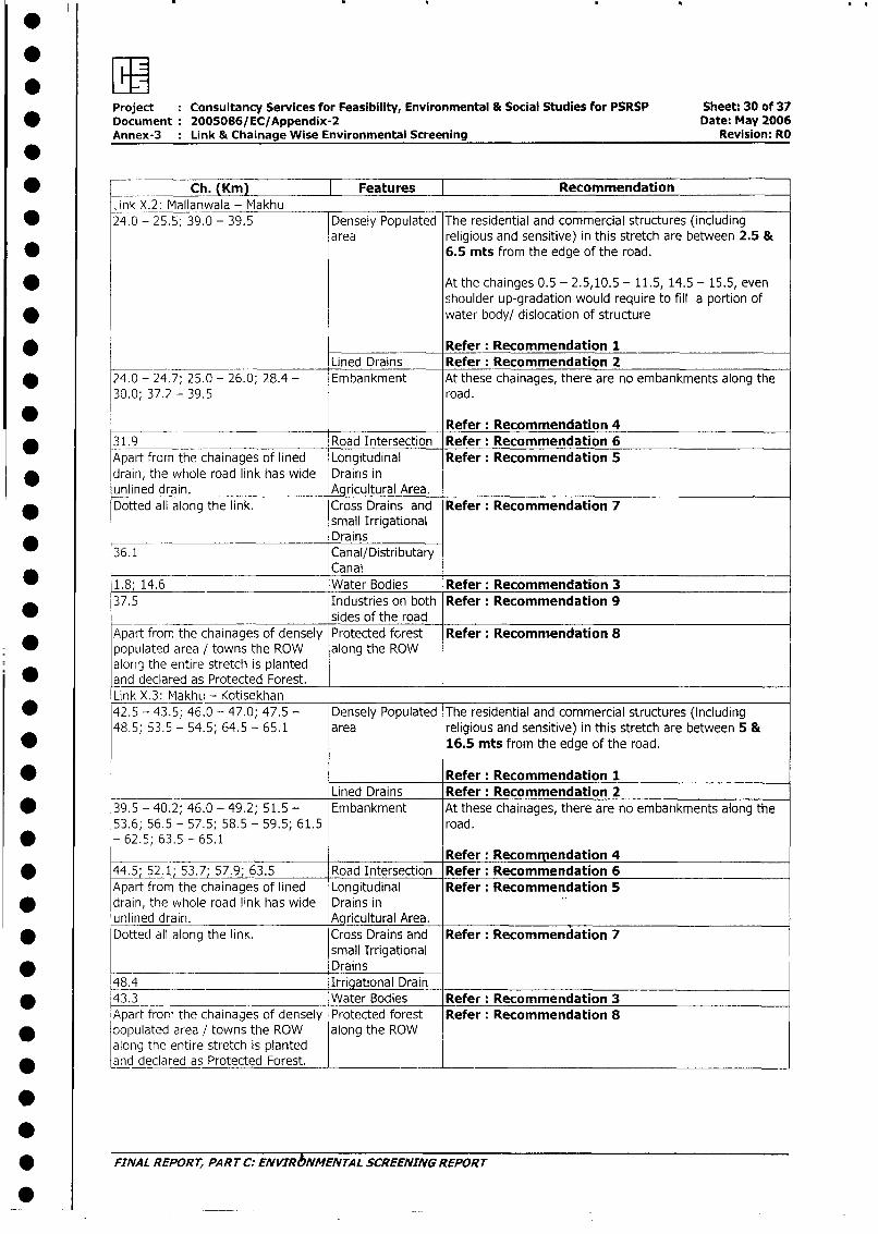
Project Consultancy Services for Feasibility, Environmental & Social Studies for PSRSP Sheet: 30 of 37* Document: 2005086/EC/Appendix-2 Date: May 2006
Annex-3 Link & Chainage Wise Environmental Screening Revision: RO
* Ch. (Km) Features T RecommendationLink X.2: Mallanwala - Makhu
* 24.0 - 25.5; 39.0 - 39.5 Densely Populated The residential and commercial structures (includingarea religious and sensitive) in this stretch are between 2.5 &
* 6.5 mts from the edge of the road.
* At the chainges 0.5 - 2.5,10.5 - 11.5, 14.5 - 15.5, evenshoulder up-gradation would require to fill a portion ofwater body/ dislocation of structure
* Refer: Recommendation 1___ Lined Drains Refer: Recommendation 2
* 24.0 - 24.7; 25.0 - 26.0; 28.4 - Embankment At these chainages, there are no embankments along the30.0; 37.2 - 39.5 road.
Refer: Recommendation 431.9 Road Intersection Refer: Recommendation 6Apart from the chainages of lined Longitudinal Refer: Recommendation 5
* drain, the whole road link has wide Drains inunlined drain. Agricultural Area.Dotted all along the link. Cross Drains and Refer: Recommendation 7
small IrrigationalDrains
36.1 Canal/Distributary*___________ Canal1.8; 14.6 Water Bodies Refer: Recommendation 337.5 Industries on both Refer: Recommendation 9_ sides of the roadApart from the chainages of densely Protected forest Refer: Recommendation 8
* populated area / towns the ROW along the ROWalong the entire stretch is planted
0 and declared as Protected Forest.Link X.3: MakhLi - Kotisekhan
* 42.5 - 43.5; 46.0 - 47.0; 47.5 - Densely Populated The residential and commercial structures (including48.5; 53.5 - 54.5; 64.5 - 65.1 area religious and sensitive) in this stretch are between 5 &
* 16.5 mts from the edge of the road.
0 Refer: Recommendation 1Lined Drains Refer: Recommendation 2
* 39.5 - 40.2; 46.0 - 49.2; 51.5 - Embankment At these chainages, there are no embankments along the53.6; 56.5 - 57.5; 58.5 - 59.5; 61.5 road.
* - 62.5; 63.5 - 65.1Refer: Recomm, endation 4
* 44.5; 52.1X7; 57.9; 63.5 Road Intersection Refer: Recommendation 6Apart from the chainages of lined Longitudinal Refer: Recommendation 5
* drain, the whole road link has wide Drains inunlined drain. Agricultural Area.
0 Dotted all along the link. Cross Drains and Refer: Recommendation 7small Irrigational
* Drains48.4 Irrigational Drain
* 43.3 Water Bodies Refer: Recommendation 3Apart from the chainages of densely Protected forest Refer: Recommendation 8
* populated area / towns the ROW along the ROWalong the entiire str_etch is plantedand declared as Protected Forest.
* FINAL REPORT, PART C: ENVIRbNMENTAL SCREENING REPORT
0
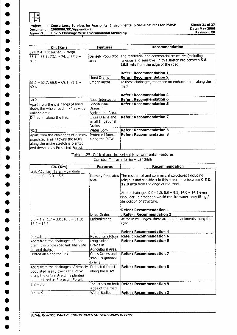
* Project : Consultancy Services for Feasibility, Environmental & Social Studies for PSRSP Slieet: 31 of 37Document: 2005086/EC/Appendix-2 Date: May 2006Annex-3 : Link & Chainage Wise Environimental Screening Revision: RO
0 _ _ _ _ _ _ _ _ _ _ _ _ _ _ _ _ _ _ _ _ _ _ _ _ _ _ _ _ _ _ _ _ _ _ _ _
Ch. (Km) | Features | RecommendationLink X.4: Kotisekhan - Moga65.1 - 66.1; 73.1 - 74.1; 77.3 - Densely Populated The residential and commercial structures (including
* 8(i.6 area religious and sensitive) in this stretch are between 5 &16.5 mts from the edge of the road.
Refer: Recommendation 1* Lined Drains Refer: Recommendation 2
65.1 - 66.7; 68.0 - 69.1; 71.1 - Embankment At these chainages, there are no embankments along the* 80.6, road.
*________________________ Refer: Recommendation 468.7 Road Intersection Refer: Recommendation 6
* Apart from the chainages of lined Longitudinal Refer: Recommendation 5drain, the whole road link has wide Drains in
* unlined drain. Agricultural Area.Dotted all along the link. Cross Drains and Refer: Recommendation 7
* small IrrigationalDrains
* 70.3 Water Body Refer: Recommendation 3Apart from the chainages of densely Protected forest Refer: Recommendation 8
* populated area / towns the ROW along the ROWalong the entire stretch is plantedand declared as Protected Forest.
Table 4.25: Critical and Important Environmental FeaturesCorridor Y: Tarn Taran - Jandiala
* [ Ch. (Km) Features | RecommendationLink Y.1: Tarn Taran - Jandiala
* 0.0 - 1.0; 13.0 -15.5 Densely Populated The residential and commercial structures (includingarea religious and sensitive) in this stretch are between 0.5 &
* 12.0 mts from the edge of the road.
* At the chainages 0.0 - 1.0, 8.0 - 9.5, 14.0 - 14.1 evenshoulder up gradation would require water body filling /
* dislocation of structure.
Refer: Recommendation 1Lined Drains . Refer: Recommendation 2
* 0.0 - 1.2; 1.7 - 3.0 ;10.0 - 11.0; Embankment At these chainages, there are no embankments along the13.0 - 15.5 road.
* Refer: Recommendation 4* 0; 4.15 Road Intersection Refer: Recommendation 6
Apart from the chainages of lined Longitudinal Refer: Recommendation 5drain, the whole road link has wide Drains inunlined drain. Agricultural Area.Dotted all along the link. Cross Drains and Refer: Recommendation 7
small IrrigationalDrains
* Apart from the chainages of densely Protected forest Refer: Recommendation 8populated area / towns the ROW along the ROW
* along the entire stretch is plantedanc declared as Protected Forest.
* 1.2 - 3.3 Industries on both Refer: Recommendation 9______________________________ sides of the road
; 0.4; 0.5 Water Bodies Refer: Recommendation 3
** ~~FINAL REPORT, PART C: ENVIRONMENTAL SCREENING REPORT
0
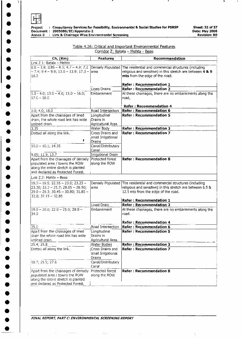
Project Consultancy Services for Feasibility, Environmental & Social Studies for PSRSP Sheet: 32 of 37* Document 2005086/EC/Appendix-2 Date: May 2006
Annex-3 : Link & Chainage Wise Environmental Screening Revision: RO
STable 4.26: Critical and Important Environmental Features
* Corridor Z: Batala - Mehta - Beas
Ch. (Km) Features RecommendationLink Z.1: Batala - Mehta
* 0.0 - 3.8; 3.85 - 4.3; 4.7 - 4.9; 7.2 Densely Populated The residential and commercial structures (including- 7.4; 9.4 - 9.9; 13.0 - 13.9; 17.3 - area religious and sensitive) in this stretch are between 4 & 9
* 18.0 mts from the edge of the road.
Refer: Recommendation 1Lined Drains Refer: Recommendation 2
* 1.0 - 4.0; 13.0 - 4.0; 15.0 - 16.0; Embankment At these chainages, there are no embankments along the17.0 - 18.0 road,
* ___________ _________ __________ Refer: Recommendation 4
0.0 4.0; 18.0 Road Intersection Refer: Recommendation 6__ Apart from the chainages of lined Longitudinal Refer: Recommendation 5
drain, the whole road link has wide Drains in0 unlined drain. Agricultural Area.
3.35 Water Body Refer: Recommendation 3Dotted all along the link. Cross Drains and Refer: Recommendation 7
small Irrigational* e Drains
10.0 - 10.1; 14.35 Canal/Distributary* Canal
9.05; 11.9; 13.7 Irrigational DrainApart from the chainages of densely Protected forest Refer: Recommendation 8populated area / towns the ROW along the ROW
* along the entire stretch is plantedand declared as Protected Forest.
* Link Z.2: Mehta - Beas18.0 - 19.5; 22.55 - 23.0; 23.25 - Densely Populated The residential and commercial structures (including
* 23.30; 25.2 - 25.7; 28.05 - 28.50; area religious and sensitive) in this stretch are between 6.5 &29.0 - 29.3; 30.45 - 30.80; 31.85 - 12.5 mts from the edge of the road.
* 32.0; 32.15 - 32.85Refer: Recommendation 1
* Lined Drain Refer: Recommendation 219.0 - 20.0; 22.0 - 25.0; 28.0 - Embankment At these chainages, there are no embankments along the
* 34.0 road.
Refer: Recommendation 435.0 Road Intersection Refer: Recommendation 6
* Apart from the chainages of lined Longitudinal Refer: Recommendation 5drain the whole road link has wide Drains in
* unlined drain. Agricultural Area.25.4; 25.8 Water Bodies Refer: Recommendation 3Dotted all along the link. Cross Drains and Refer: Recommendation 7
small Irrigational* ________________________________ D rains
18.7; 25.5; 27.6 Canal/Distributary* ___-- Canal
Apart from the chainages of densely Protected forest Refer: Recommendation 8* fpopulated area / towns the ROW along the ROW
along the entire stretch is planted* |and declared as Protected Forest. l
* FINAL REPORT, PART C: ENVIRONMENTAL SCREENING REPORT
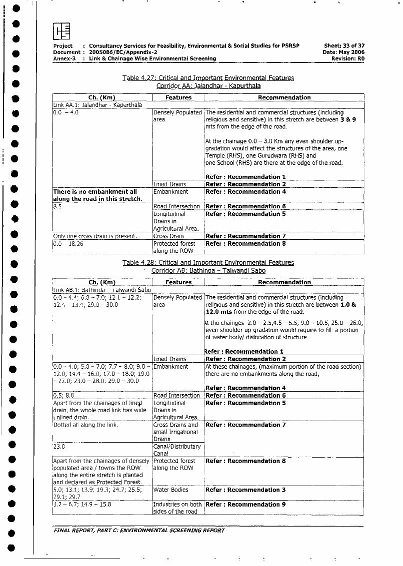
Project : Consultancy Services for Feasibility, Environmental & Social Studies for PSRSP Sheet: 33 of 37* Document: 2005086/EC/Appendix-2 Date: May 2006
Annex-3 Link & Chainage Wise Environmental Screening Revision: RO
*Table 4.27: Critical and Important Environmental Features
* Corridor AA: Jalandhar - Kapurthala
* Ch. (Km) Features RecommendationLink A.1: Jalandhar - Kapurthala
* 0.0 - 4.0 Densely Populated The residential and commercial structures (includingarea religious and sensitive) in this stretch are between 3 & 9
* mts from the edge of the road.
At the chainage 0.0 - 3.0 Km any even shoulder up-gradation would affect the structures of the area, one
ii g Temple (RHS), one Gurudwara (RHS) andone School (RHS) are there at the edge of the road.
Refer: Recommendation 1Lined Drains Refer: Recommendation 2
* There is no embankment all Embankment Refer: Recommendation 4alon the road in this stretch.
0 8.5 Road Intersection Refer: Recommendation 6Longitudinal Refer: Recommendation 5
* Drains in_______ ___ Agri___________- Agricultural Area.
Only one cross drain is present. Cross Drain Refer: Recommendation 70.0 - 18.26 Protected forest Refer: Recommendation 8
alonq the ROW
Table 4.28: Critical and Important Environmental FeaturesCorridor AB: Bathinda - Talwandi Sabo
* = Ch. (Km) Features [ RecommendationLink AB.1: Bathinda - Talwandi Sabo
* 0.0 - 4.4; 6.0 - 7.0; 12.1 - 12.2; Densely Populated The residential and commercial structures (including12.4 - 1.3.4; 29.0 - 30.0 area religious and sensitive) in this stretch are between 1.0 &
12.0 mts from the edge of the road.
* Xt the chainges 2.0 - 2.5,4.5 - 5.5, 9.0 - 10.5, 25.0 - 26.0,even shoulder up-gradation would require to fill a portion
* of water body/ dislocation of structure
efer: Recommendation 1Lined Drains Refer: Recommendation 2
* 0.0 - 4.0; 5.0 -- 7.0; 7.7 - 8.0; 9.0 - Embankment At these chainages, (maximum portion of the road section)
1.2.0; 14.4 - 16.0; 17.0 - 18.0; 19.0 there are no embankments along the road,* - 22.0; 23.0 - 28.0; 29.0 - 30.0 Refer: Recommendation 4
0.5 8.8 Road Intersection Refer: Recommendation 6Apart from the chainages of lineli Longitudinal Refer: Recommendation 5drain, the whole road link has wide Drains inuLinlined drain. Agricultural Area.Dotted all along the link. Cross Drains and Refer: Recommendation 7
small IrrigationalDrains
* 23.0 Canal/DistributaryCanal
Apart from the chainages of densely Protected forest Refer: Recommendation 8populated area / towns the ROW along the ROW
* along the entire stretch is plantedand declared as Protected Forest.
* 5.0; 13.1; 13.9; 19.3; 24.7; 25.5; Water Bodies Refer: Recommendation 329 1; 29.7
* 3.2 - 6.7; 14.9 - 15.8 Industries on both Refer: Recommendation 9*________________________________ sides of the road
* FINAL REPORT, PART C: ENVIRONMENTAL SCREENING REPORT
.
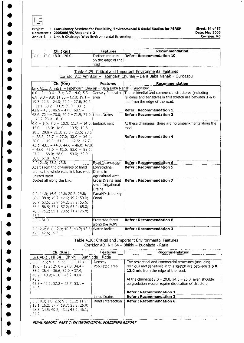
Project Consultancy Services for Feasibility, Environmental & Social Studies for PSRSP Sheet: 34 of 37* Document: 2005086/EC/Appendix-2 Date: May 2006
Annex-3 Link & Chainage Wise Environmental Screening Revision: RO
0* ____ Ch. Km Features Recommendation
16.0 - 17.0; 18.0 - 20.0 Earthen mounds Refer: Recommendation 10* on the edge of the
road
* Table 4.29: Critical and Important Environmental FeaturesCorridor AC: Amritsar - Fatehgarh Churian - Dera Baba Nanak - Gurdaspu
Ch. (Km) Features V Recommendation* Link AC.1: Amritsar - Fatehgarh Chur ian - Dera Baba Na ak - Gurdaspur
0.0 - 2.4; 3.0 - 3.1; 3.7 - 4.0; 5.3 - Densely Populated The residential and commercial structures (including
* 6.9; 9.0 - 9.9; 11.85 - 12.0; 19.1 - area religious and sensitive) in this stretch are between 3 & 819.3; 22.3 - 24.0; 27.0 - 27.8; 30.2 mts from the edge of the road.
* - 31.1; 33.2 - 33.7; 39.0 - 39.1;43.9 -45.0; 46.5 -47.6; 68.1 - Refer: Recommendation 1.
v 68.6; 70.4 - 70.6; 70.7 - 71.9; 73.0 Lined Drains Refer: Recommendation 273.7; 79.0 - 81.0
* 0.0 - 6.0; 7.0 - 10.0; 11.7 - 14.0; Embankment At these chainages, there are no embankments along the15.0 - 16.0; 18.0 - 19.5; 19.6 - road.
* 20.5; 20.8 - 21.0; 23.3 7 23.5; 23.6- 25.5; 25.7 - 27.0; 33.0 - 34.0; Refer: Recommendation 4
* 38.0 - 40.0; 41.0 - 42.6; 42.7-43.1; 43.1 - 44.0; 44.0 - 46.0; 47.0
* - 48.0; 49.0 - 52.0; 53.0 - 55.0;57.2 - 58.0; 58.0 - 59.0; 59.0 -60.0; 60.0 - 67.0
* 0.0; 21.0; 23.2; 23.8 Road Intersection Refer: Recommendation 6Apart From the chainages of lined Longitudinal Refer: Recommendation 5drains, the whole road link has wide Drains inunlined drain. Agricultural Area.
S Dotted all along the link. Cross Drains and Refer: Recommendation 7small Irrigational
* Drains9.0; 14.0; 14.4; 19.6; 20.5; 29.8; Canal/Distributary
* 36.8; 38.8; 45.7; 47.6; 49.2; 50.0; Canal50.7; 53.5; 53.9; 54.2; 55.2; 55.5;
* 56.4; 56.5; 57.1; 57.2; 63.0; 65.0;70. 5; 75.2; 59.1; 70.5; 71.4; 76.8;
* 77.70.0 - 81.0 Protected forest Refer: Recommendation 8
* along the ROW2.0; 2.0; 6.1; 12.9; 40.3; 40.7; 42.5; Water Bodies Refer: Recommendation 3
v 42.5; 42.6; 59.3
Table 4.30: Critical and Important Environmental FeaturesCorridor AD: NH 64 - Bhikhi - Budhlada - Ratia
* Ch. (Krn) Features RecommendationLink AD.1: NH64 - Bhikhi - Budhlada - Ratia
* 0.0 - 0.3; 9.3 - 9.8; 11.1 - 12.1; Densely The residential and commercial structures (including19.6 - 19.9; 25.0 - 27.8; 34.4 - Populated area religious and sensitive) in this stretch are between 3.5 &
* 35.2; 36.4 - 36.6; 37.0 - 37.4; 12.0 mts from the edge of the road.40.2 - 40.9; 41.0 -- 43.2; 43.4 -
* 43.5 At the chainagel9.0 - 20.0, 24.0 - 25.0 even shoulder45.8 - 46.3; 52.2 - 52.7; 53.1 - up gradation would require dislocation of structure.
* 54.3Refer: Recommendation 1
* _ Lined Drains Refer: Recommendation 2 _ _
0.0; 0.9; 1.8; 2.5; 9.5; 11.2; 11.9; Road Intersection Refer: Recommendation 6v 15.1; 16.2; 17.7; 19.7; 25.5; 26.8;
28.8; 34.5; 40.2; 43.1; 45.9; 46.1;* 52.7 _ _
* FINAL REPOR T,. PART C: ENVIRONMENTAL SCREENING REPORT
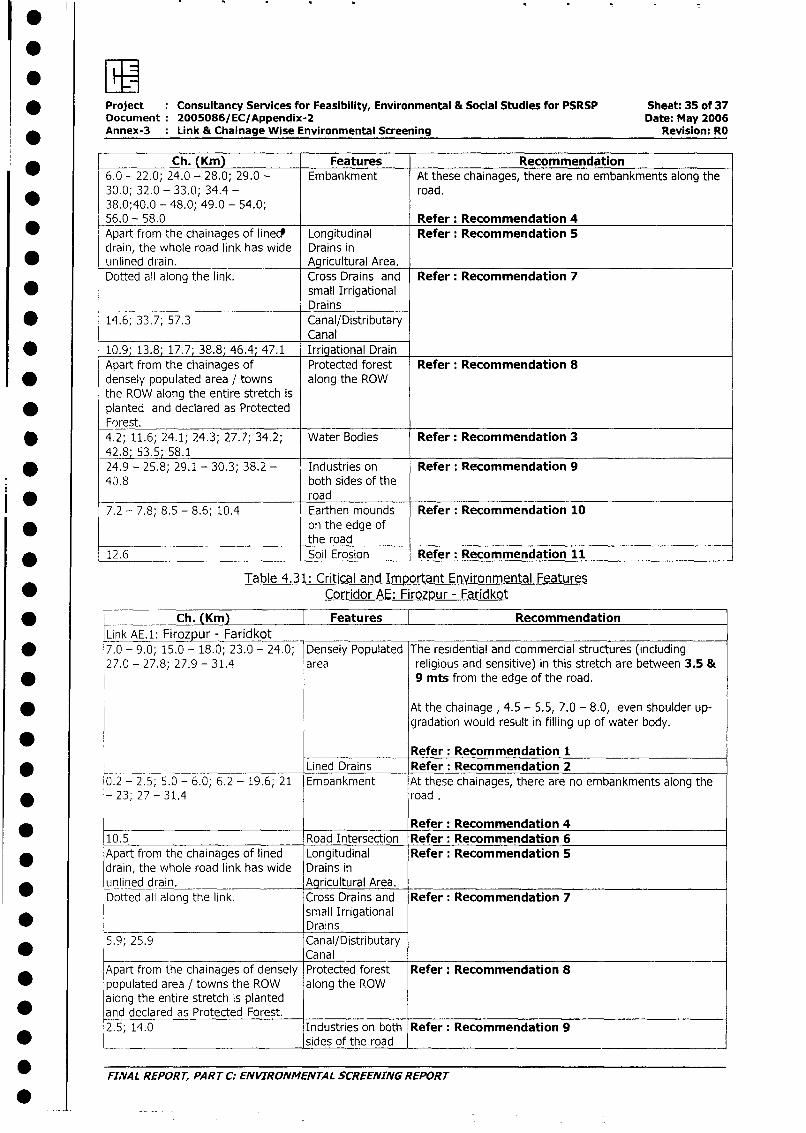
* Project Consultancy Services for Feasibility, Environmental & Social Studies for PSRSP Sheet: 35 of 37Document 2005086/EC/Appendix-2 Date: May 2006Annex-3 Link & Chainage Wise Environmental Screening Revision: RO
Ch. (Kin) Features Recommendation6.0 - 22.0; 24.0 - 28.0; 29.0 - Embankment At these chainages, there are no embankments along the30.0; 32.0 - 33.0; 34.4 - road.38.0;40.0 - 48.0; 49.0 - 54.0;56.0 - 58.0 Refer: Recommendation 4
* Apart from the chainages of linecd Longitudinal Refer: Recommendation 5drain, the whole road link has wide Drains in
* unlined drain. Agricultural Area.Dotted all along the link. Cross Drains and Refer: Recommendation 7
* small IrrigationalDrains
* 14.6; 33.7; 57.3 Canal/DistributaryCanal
* 10.9 13.8; 17.7 38.8 46.4 47.1 Irrigational DrainApart from the chainages of Protected forest Refer: Recommendation 8
* densely populated area / towns along the ROWthe ROW along the entire stretch is
* planted and declared as ProtectedForest.
* 4.2; 11.6; 24.1; 24.3; 27.7; 34.2; Water Bodies Refer: Recommendation 342.8; 53.5; 58.1
* 24.9 - 25.8; 29.1 - 30.3; 38.2 - Industries on Refer: Recommendation 9
40.8 both sides of the. -_ road
7.2 - 7.8; 8.5 - 8.6; 10.4 Earthen mounds Refer: Recommendation 10* on the edge of
the road* 12.6 Soil Erosion Refer: Recommendation 11
Table 4.31: Critical and Important Environmental Features
* Corridor AE: Firozpur - Faridkot
Ch. (Km) l Features RecommendationLink AE.1: Firozpur - Faridkot
* 7.0 - 9.0; 15.0 - 18.0; 23.0 - 24.0; Densely Populated The residential and commercial structures (including27.0 - 27.8; 27.9 - 31.4 area religious and sensitive) in this stretch are between 3.5 &
* 9 mts from the edge of the road.
* At the chainage , 4.5 - 5.5, 7.0 - 8.0, even shoulder up-gradation would result in filling up of water body.
Refer: Recommendation 1____ Lined Drains Refer: Recommendation 2
0.2 - 2.5; 5.0 - 6.0; 6.2 - 19.6; 21 Embankment At these chainages, there are no embankments along the* - 23; 27 - 31.4 road .
Refer: Recommendation 410.5 Road Intersection Refer: Recommendation 6
* Apart from the chainages of lined Longitudinal Refer: Recommendation 5drain, the whole road link has wide Drains inunlined drain. Agricultural Area.Dotted all along the link. Cross Drains and Refer: Recommendation 7
small IrrigationalDrains
5.9; 25.9 Canal/DistributaryCanal
Apart from the chainages of densely Protected forest Refer: Recommendation 8* populated area / towns the ROW along the ROW
along the entire stretch is planted* and declared as Protected Forest.
2.5; 14.0 Industries on both Refer: Recommendation 9* _ sides of the road
* FINAL REPORT, PART C: ENVIRONMENTAL SCREENING REPORT
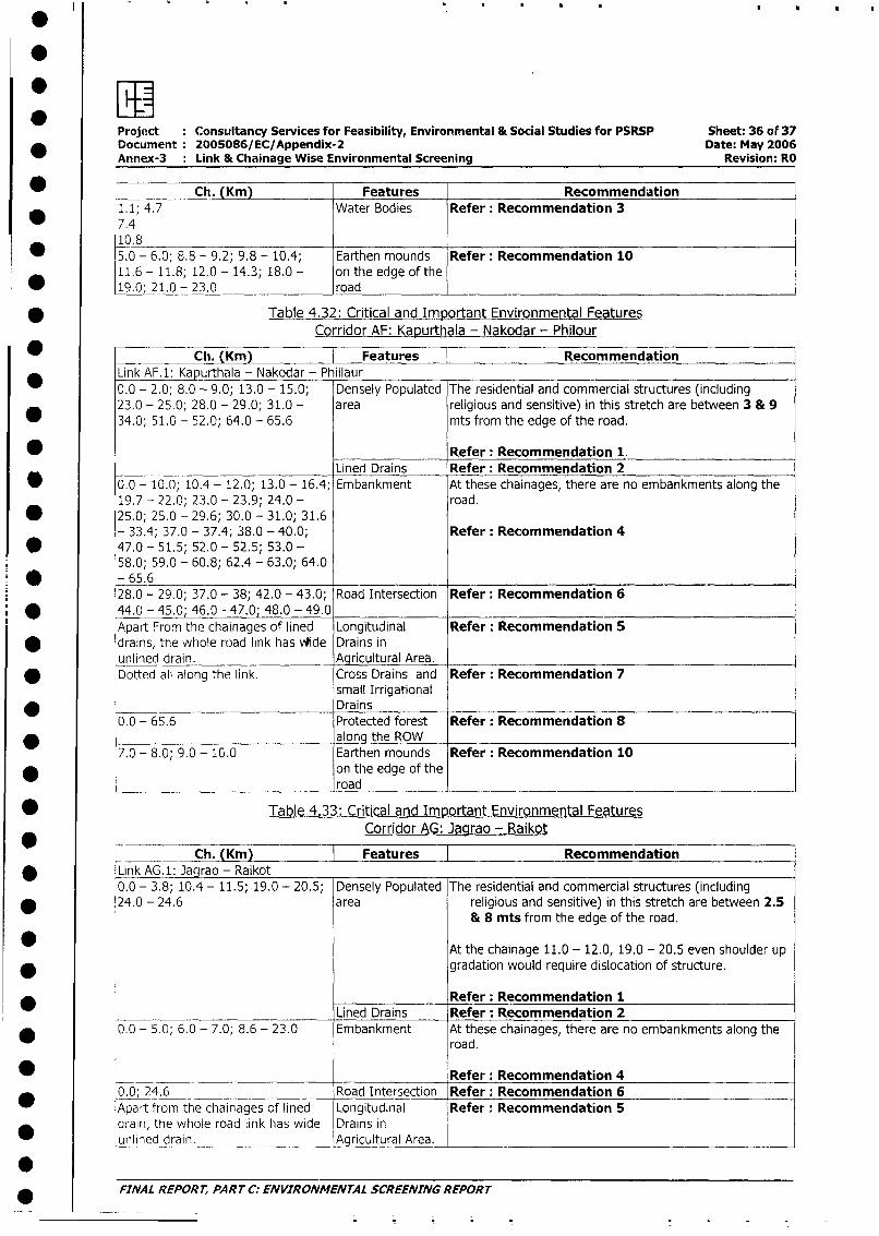
Project Consultancy Services for Feasibility, Environmental & Social Studies for PSRSP Sheet: 36 of 37Document: 2005086/EC/Appendix-2 Date: May 2006Annex-3 : Link & Chainage Wise Environmental Screening Revision: RO
Ch. (Km) Features Recommendation* 1. 1; 4.7 Water Bodies Refer: Recommendation 3
7.410.8 _ ___5.0 - 6.0; 8.8 - 9.2; 9.8 - 10.4; Earthen mounds Refer: Recommendation 1011.6 - 11.8; 12.0 - 14.3; 18.0 - on the edge of the
* 19.0; 21.0 - 23.0 road I
* Table 4.32: Critical and Important Environmental FeaturesCorridor AF: Kapurthala - Nakodar - Philour
_ Ch. (Km) Features RecommendationLink AF.1: Kapurthala - Nakodar - Phillaur0.0 - 2.0; 8.0 - 9.0; 13.0 - 15.0; Densely Populated The residential and commercial structures (including23,0 - 25.0; 28.0 - 29.0; 31.0 - area religious and sensitive) in this stretch are between 3 & 9
34.0; 51.0 - 52.0; 64.0 - 65.6 mts from the edge of the road.
* Refer: Recommendation 1.Lined Drains Refer: Recommendation 2
* 0.0 - 10.0; 10.4 - 12.0; 13.0 - 16.4; Embankment At these chainages, there are no embankments along the
19.7 - 22.0; 23.0 - 23.9; 24.0 - road.
* 25.0; 25.0 - 29.6; 30.0 - 31.0; 31.6- 33.4; 37.0 - 37.4; 38.0 - 40.0; Refer: Recommendation 4
* 47.0- 51.5; 52.0- 52.5; 53.0-58.0; 59.0 - 60.8; 62.4 - 63.0; 64.0
* - 65.628.0 - 29.0; 37.0 - 38; 42.0 - 43.0; Road Intersection Refer: Recommendation 6
* 44.0 - 45.0; 46.0 - 47.0 48.0 - 49.0Apart From the chainages of lined Longitudinal Refer: Recommendation 5
* drains, the whole road link has vWide Drains inunlined drain. _ Agricultural Area.Dotted all along the link. Cross Drains and Refer: Recommendation 7
small Irrigational* Drains
0.0 - 65.6 Protected forest Refer: Recommendation 8* along the ROW
7.0 - 8.0; 9.0 - 10.0 Earthen mounds Refer: Recommendation 10* on the edge of the
road
* Table 4.33: Critical and Important Environmental FeaturesCorridor AG: Jagrao - Raikot
Ch. (Km) Features Recommendation* Link AG. 1: Jagrao - Raikot
0.0 - 3.8; 10.4 - 11.5; 19.0 - 20.5; Densely Populated The residential and commercial structures (including
* 24.0 - 24.6 area religious and sensitive) in this stretch are between 2.5& 8 mts from the edge of the road.
At the chainage 11.0 - 12.0, 19.0 - 20.5 even shoulder up
* gradation would require dislocation of structure.
*_____________ Refer: Recommendation 1Lined Drains Refer: Recommendation 2
* 0.0 - 5.0; 6.0 - 7.0; 8.6 - 23.0 Embankment At these chainages, there are no embankments along theroad.
_ Refer: Recommendation 4
_ 0.0; 24.6 Road Intersection Refer: Recommendation 6Apart from the chainages of lined Longitudinal Refer: Recommendation 5drain, the whole road link has wide Drains inunlined drain. A_gricultural Area.___
* FINAL REPORT, PART C: ENVIRONMENTAL SCREENING REPORT
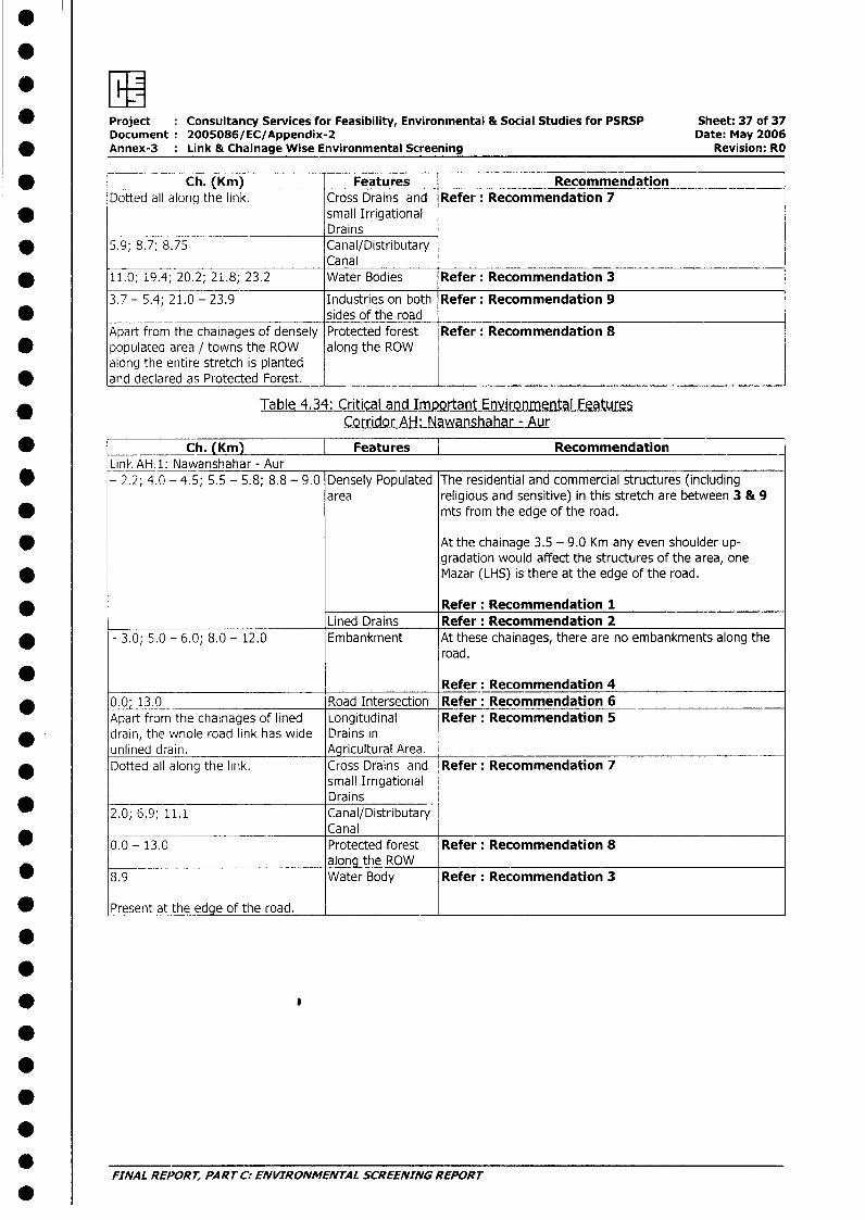
*I
* Project : Consultancy Services for Feasibility, Environmental & Social Studies for PSRSP Sheet: 37 of 37Document: 2005086/EC/Appendix-2 Date: May 2006
* Annex-3 : Link & Chainage Wise Environmental Screening Revision: RO
Ch. (Km) Features RecommendationDotted all along the link. Cross Drains and Refer: Recommendation 7
* small Irrigational_________ Drains
* 5.9; 8.7; 8.75 Canal/DistributaryCanal
* 11.0; 19.4; 20.2; 21.8; 23.2 Water Bodies Refer: Recommendation 3
3.7 - 5.4; 21.0 - 23.9 Industries on both Refer: Recommendation 9* sides of the road
Apart from the chainages of densely Protected forest Refer: Recommendation 8* populated area / towns the ROW along the ROW
along the entire stretch is plantedand declared as Protected Forest.
* Table 4.34: Critical and Important Environmental Features
Corridor AH: Nawanshahar - Aur
* _ Ch. (Km) | Features | RecommendationLink AH.: Nawanshahar - Aur
* - 2.2; 4.0 - 4.5; 5.5 - 5.8; 8.8 - 9.0 Densely Populated The residential and commercial structures (includingarea religious and sensitive) in this stretch are between 3 & 9
* mts from the edge of the road.
* At the chainage 3.5 - 9.0 Km any even shoulder up-gradation would affect the structures of the area, one
* Mazar (LHS) is there at the edge of the road.
* Refer: Recommendation 1Lined Drains Refer: Recommendation 2
* - 3.0; 5.0 - 6.0; 8.0 - 12.0 Embankment At these chainages, there are no embankments along theroad.
Refer: Recommendation 4* 0.0; 13.0 Road Intersection Refer: Recommendation 6
Apart from the chainages of lined Longitudinal Refer: Recommendation 5* drain, the whole road link has wide Drains in
unlined drain. Agricultural Area.Dotted all along the link. Cross Drains and Refer: Recommendation 7
small IrrigationalDrains
2.0; 6.9; 11.1 Canal/DistributaryCanal
0.0 - 13.0 Protected forest Refer: Recommendation 8along the ROW
* 8.9 Water Body Refer: Recommendation 3
* Present at the edge of the road. _
0
.
FINAL REPORT, PART C: ENVIRONMENTAL SCREENING REPORT
.
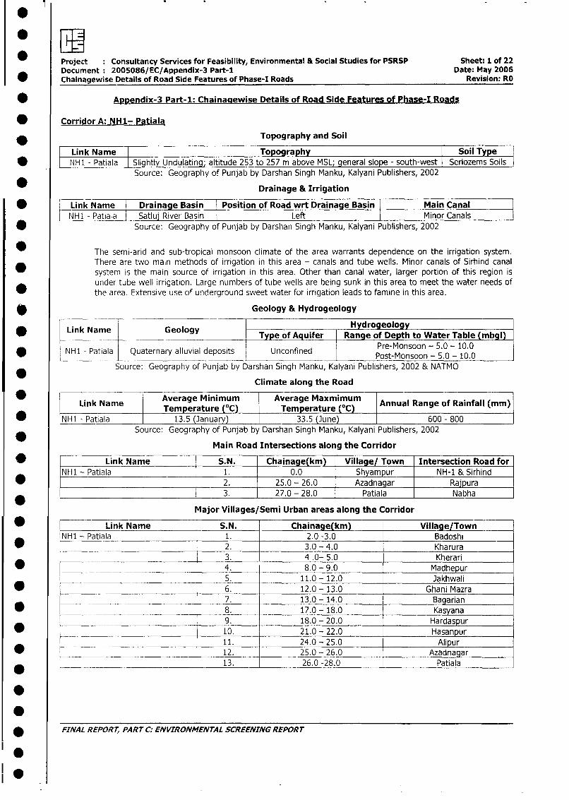
*1l Project : Consultancy Services for Feasibility, Environmental & Social Studies for PSRSP Sheet: 1 of 22Document: 2005086/EC/Appendix-3 Part-1 Date: May 2006Chainagewise Details of Road Side Features of Phase-I Roads Revision: RO
* Appendix-3 Part-1: Chainagewise Details of Road Side Features of Phase-I Roads
* Corridor A: NH1- Patiala
* Topography and Soil
Linik Name Topography Soil Type* NH1 - Patiala l Slightly Undulating; altitude 253 to 257 m above MSL; general slope - south-west Seriozems Soils
Source: Geography of Punjab by Darshan Singh Manku, Kalyani Publishers, 2002
* Drainage & Irrigation
* LLink Name Draiage Basin Position of Road wrt Drainage Basin Main CanalNH1 - Patiala Satlu River Basin Left I Minor Canals l
* Source: Geography of Punjab by Darshan Singh Manku, Kalyani Publishers, 2002
The semi-arid and sub-tropical monsoon climate of the area warrants dependence on the irrigation system.There are two main methods of irrigation in this area - canals and tube wells. Minor canals of Sirhind canalsystem is the main source of irrigation in this area. Other than canal water, larger portion of this region isunder tube well irrigation. Large numbers of tube wells are being sunk in this area to meet the water needs of
* the area. Extensive use of underground sweet water for irrigation leads to famine in this area.
* Geology & Hydrogeology
Hydrogeology* Link Name Geology I Type of Aquifer Range of Depth to Water Table (mbgl)
_ _____ P_- so YP 5. 9 10.0NH1 - Patiala Quaternary alluvial deposits Unconfined Pre-Monsoon - 5.0 - 10.0
Source: Geography of Punjab by Darshan Singh Manku, Kalyani Publishers, 2002 & NATMO
Climate along the Road
Link Name Average Minimum Average Maxmimum Annual Range of Rainfall (mm)* hNHl _____ ~~~Temperature (0C) Temperature (0C)
* NH1 -Patiala 13.5 (January) 33.5 (June) 600 - 800Source: Geography of Punjab by Darshan Singh Manku, Kalyani Publishers, 2002
Main Road Intersections along the Corridor
[NH1 - Link Name S.N. Chainage(km) Village/ Town Intersection Road forNH1 - Patiala 1. 0.0 Shyampur NH-1 & Sirhind* __________________________ _ 2. 25.0 - 26.0 Azadnagar Ra'pura
3. 27.0 - 28.0 Patiala Nabha
Major Villages/Semi Urban areas along the Corridor
* _ Link Name S.N. Chainage(km) Village/Town
NH1 - Patiala 1. 2.0 -3.0 Badoshi* _____ 2. 3.0 - 4.0 Kharura
_ _ 3. 4 .0- 5.0 Kherari* _____________________________ 4. 8.0 - 9.0 Madhepur
5. 11.0 - 12.0 Jakhwali* 6. 12.0 - 13.0 Ghani Mazra
7. 13.0 - 14.0 Bagarian
* _______ 8. 17.0 - 18.0 Kasyana
9. 18.0 - 20.0 Hardaspur
* ___ 10. 21.0 - 22.0 Hasanpur11. 24.0- 25.0 Alipur
* ________ 12. 25.0 - 26.0 Azadnagar
13. 26.0 -28.0 Patiala
* FINAL REPORT, PART C: ENVIRONMENTAL SCREENING REPORT
.0
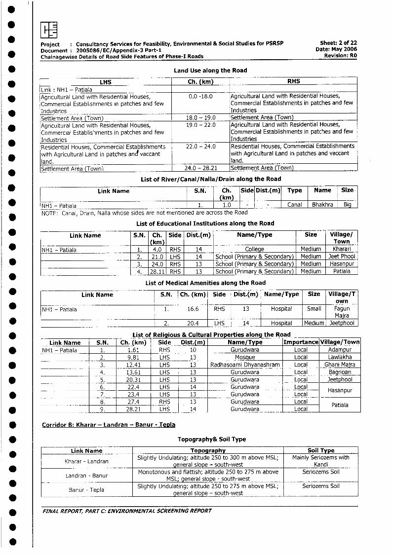
ewHProject Consultancy Services for Feasibility, Environmental & Social Studies for PSRSP Sheet: 2 of 22Document: 2005086/EC/Appendix-3 Part-I Date: May 2006Chainagewise Details of Road Side Features of Phase-I Roads Revision: RO
* Land Use along the Road
* LHS Ch. (km) RHSLink : NH1 - Patiala
* Agricultural Land with Residential Houses, 0.0 -18.0 Agricultural Land with Residential Houses,Commercial Establishments in patches and few Commercial Establishments in patches and few
* Industries IndustriesSettlement Area (Town) 18.0 - 19.0 Settlement Area (Town)
* Agricultural Land with Residential Houses, 19.0 - 22.0 Agricultural Land with Residential Houses,Commercial Establishments in patches and few Commercial Establishments in patches and few
* Industries IndustriesResidential Houses, Commercial Establishments 22.0 - 24.0 Residential Houses, Commercial Establishmentswith Agricultural Land in patches and vaccant with Agricultural Land in patches and vaccantland. land.Settlement Area (Town) 24.0 - 28.21 Settlement Area (Town)
List of River/Canal/Nalla/Drain along the Road
_ F Link Name S.N. | Ch. Side Dist.(m) Type Name Size(km)
NH1 - Patiala 1. 1.0 Canal Bhakhra BigNOTE: Canal, Drain, Nalla whose sides are not mentioned are across the Road
List of Educational Institutions along the Road
* - Link Name S.N. Ch. Side Dist.(m) Name/Type Size Village/_ _ __ __ (km) Town
NH1 - Patiala 1. 4.0 RHS 14 College Medium Kharari2. 21.0 LHS 14 School (Primary & Secondary) Medium Jeet Phool
*_________________________ 3. 24.0 RHS 13 School (Primary & Secondary) Medium Hasanpur*_________________________ 4. 28.11 RHS 13 School (Primary & Secondary) Medium Patiala
List of Medical Amenities along the Road
* Link Name S.N. Ch. (km) Side Dist.(m) Name/Type Size Village/T* _ _ _ _ _ _ _ _ _ _ _ _ _ _ _ _ _ _ _ _ _ _ _ _ _ _ _ _ _ _ _ _ _ o w n
NH1 - Patiala 1. 16.6 RHS 13 Hospital Small FagunMajra
* 2. 20.4 LHS 14 Hospital Medium Jeetphool
* List of Religious & Cultural Properties along the RoadLink Name S.N. Ch. (km) Side Dist.(m) Name/Type Importance Village/Town
* NH1 - Patiala 1. 1.61 RHS 10 Gurudwara Local Adampurl l __ 2. 9.81 LHS 13 Mosque Local Lawlakha
* L - | 3. 12.41 LHS 13 Radhasoami Dhyanashram Local Ghani Mairal ____ l______ 4. 13.61 LHS 13 Gurudwara Local Bagrioan
* | ____ l 5. 20.31 LHS 13 Gurudwara Local Jeetphool
l_____ l 6. 22.4 LHS 14 Gurudwara Local l sl* ____ ____ 7. 23.4 LHS 13 Gurudwara Local Hasanpur
8. 27.4 l RHS 13 Gurudwara Local* ____ ___ ___ 9. 28.21 l LHS 114 Gurudwara Local Patiala
Corridor B: Kharar - Landran - Banur - Tepla
* Topography& Soil Type
Link Name Topography Soil TypeKharar - Landran | Slightly Undulating; altitude 250 to 300 m above MSL; Mainly Seriozems withKharar l Landran general slope - south-west KandiLandran - Banur Monotonous and flattish; altitude 250 to 275 m above Seriozems SoilL Landran - Banur | MSL; general slope - south-west l _l
* l Banur - Tepla Slightly Undulating; altitude 250 to 275 m above MSL; Seriozems Soil*anur -. Tep_a general slope - south-west l_l
* FINAL REPORT, PART C: ENVIRONMENTAL SCREENING REPORT
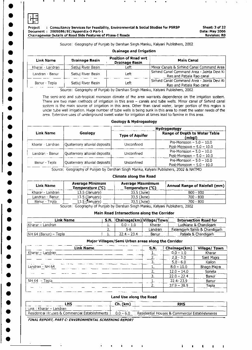
Project Consultancy Services for Feasibility, Environmental & Social Studies for PSRSP Sheet: 3 of 22
Document: 2005086/EC/Appendix-3 Part-i Date: May 2006
Chainagewise Details of Road Side Features of Phase-I Roads Revision: RO
* Source: Geography of Punjab by Darshan Singh Manku, Kalyani Publishers, 2002
* ____ Drainage and Irrigation
Link Name Drainage Basin Position of Road wit Main Canal______________ _______________ Drainage Basin __________________
Kharar - Landran Satluj River Basin Left Minor Canals & Sirhind Canal Command Area
Landran - Banur Satluj River Basin Left Sirhind Canal Command Area - Jainta Devi KiLandran - Banur Satluj River Basin Left Rao and Patiala Rao canal
* . . . Sirhind Canal Command Area - Jainta Devi KiBanur - Tepla Satluj River Basin Left Rao and Patiala Rao canal
* Source: Geography of Punjab by Darshan Singh Manku, Kalyani Publishers, 2002
The semi-arid and sub-tropical monsoon climate of the area warrants dependence on the irrigation system.
! There are two main rnethods of irrigation in this area - canals and tube wells. Minor canal of Sirhind canal
system is the main source of irrigation in this area. Other than canal water, larger portion of this region is
under tube well irrigation. Huge number of tube wells is being sunk in this area to meet the water needs of the
area. Extensive uses of underground sweet water for irrigation at times lead to famine in this area.
Geology & Hydrogeology
_ HydrogeologyLink Name Geology Type of Aquifer Range of Depth to Water Table
_____________ _____________________ ~(m bg l)
* Kharar - Landran Quaternary alluvial deposits Unconfined Post-Monsoon - 5.0 - 10.0Prs-Monsoon - 5.0 - 10.0
* Landran - Banur Quaternary alluvial deposits Unconfined Pre-Monsoon - 5.0 - 10.0Pret-Monsoon - 5.0 - 1.0.0
* Banur - Tepla Quaternary alluvial deposits Unconfined Post-Monsoon - 5.0 - 10.0
Source: Geography of Punjab by Darshan Singh Manku, Kalyani Publishers, 2002 & NATMO
Climate along the Road
Link Name Average Minimum Average Maxmimum AnulR geoRafllm)*Link Name l ATemperature (OC) Temperature (0C) Annual Range of Rainfall (mm)
* Kharar - Landran 13.5 (January) 33.5 (June) 800 - 900
Landran - Banur 13.5 (January) 33.5 (June) 700 - 800
* Banur - TepIa 13.5 (anuary) 33.5 (June) 700 - 800
Source: Geography of Punjab by Darshan Singh Manku, Kalyani Publishers, 2002
Main Road Intersections along the Corridor
* Link Name S.N. Chainage(km) Village/Town Intersection Road for
Kharar - Landran 1. 0.0 - 1.0 Kharar _ Ludhiana & Chandigarh
* _______________ 2. 5-6 Landran Fatemgarh Sahib & Chandigarh
_{H64 (Banur) - TepIa 1. 22.4 - 23.4 Banur Patiala & Chandigarh
Major Villages/Semi Urban areas along the Corridor
* _ Link Name S.N. Chainage(km) Village/ Town
Kharar - Landran 1. 0.0 - 1.0 Kharar
* 2. 2.0 - 3.0 Sant Majra3. 5.0 - 6.0 Kailon
* Landran - NH 64 1. 8.0- 10.0 Bhago Majra
_________ 2. 12.0 - 14.0 Soneta
* __________________________________________________________ 3. 22.0 - 22.4 Banur
NH 64 - Tepla 1. 22.4- 23.9 Banur
* ______ _________________________________ ___ 2. 37.9 - 38.9 Tepla
Land Use along the Road
| * l ~~~~~~~~LHS |Ch. (km) |RHSl
Link : Kharar - LandranResidential Hcuses & Commercial Establishments 0.0 - 6.0 Residential Houses & Commercial Establishments
| * FINAL REPORT, PART C: ENVIRONMENTAL SCREENING REPORT
0~.. . . |
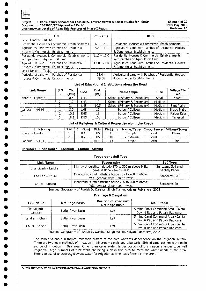
Project : Consultancy Services for Feasibility, Environmental & Social Studies for PSRSP Sheet: 4 of 22Document: 2005086/EC/Appendix-3 Part-1 Date: May 2006
* Chainagewise Details of Road Side Features of Phase-I Roads Revision: RO
* l LH__IS __Ch. (kmL RHSIink: Landran - NH 64 LHS Ch. (k RHS
* Residential Houses & Commercial Establishments 6.0 - 7.0 Residential Houses & Commercial EstablishmentsAgricultural Land with Patches of Residential 7.0 - 11.0 Agricultural Land with Patches of Residential HousesHouses & Commercial Establishments & Commercial EstablishmentsResidential Houses & Commercial Establishments 11.0 - 12.0 Residential Houses & Commercial Establishments
* with patches of Agricultural Land with patches of Agricultural LandAgricultural Land with Patches of Residential 12.0 - 22.0 Agricultural Land with Patches of Residential HousesHouses & Commercial Establishments __ ___ & Commercial EstablishmentsLink: NH 64 - Tepla
* Agricultural Land with Patches of Residential 38.4 - Agricultural Land with Patches of Residential HousesHouses & Commercial Establishments 39.56 & Commercial Establishments
* List of Educational Institutions along the Road
* Link Name S.N Ch. Side Dist. Name/Type Size Village/To(kmn) Name/Tpe Siz
* Kharar - Landran 1. 0.5 LHS 10 School (Primary & Secondary) Small Kharar___ _ ____ 2. 1.7 LHS 10 School (Primary & Secondary) Medium
* 3. 3.4 LHS 10.5 School (Primary & Secondary)_ Medium Sant MairaLandran - NH 64 1. 8.9 LHS 12 School / College Medium Bhago Maira
* 2. 10.1 RHS 13 School / College Medium Raipur Kala3. 18.1 RHS 100 School / College Medium Tangauri
* List of Religious & Cultural Properties along the Road)
* L Lirik Name S.N. Ch. (km) Side Dist.(m) Name/Type Importance Village/TownKharar - Landran 1. l 0.1 LHS 11 Temple Local Kharar
* _ = 2. 0.2 LHS 10 Gurudwara LocalLandran - NH 64 1. 16.8 RHS 13 Temple Local Dairi
Corridor C: Chandiaarh - Landran - Chunni - Sirhind
*Topography Soil Type
_ _ Link Name Topography Soil TypeChandigarh - Landran Slightly Undulating; altitude 270 to 300 m above MSL; Seriozems Soil amd* Chandigarh - Landran . general slope - south-west Slightly Kandi
Landran - Chuni Monotonous and flattish; altitude 255 to 260 m above Seriozems Soil*_________ Landran ____-________ MSL; general slope - south-west Seriozems_Soil
Chuni - Srihind Monotonous and flattish; altitude 250 to 260 m above Seriozems SoilMSL; general slope - south-west
Source: Geography of Punjab by Darshan Singh Manku, Kalyani Publishers, 2002
Drainage & Irrigation
Link Name Drainage Basin Position of Road wrt Main Canal
* | Chandigarh - Drainsgef | Sirhind Canal Command Area - JaintaLandran Satluj River Basin Left Devi Ki Rao and Patiala Rao canal
* - . l . . Left|Sirhind Canal Command Area - Jaintalandran l Chuni latluj River Basin LeftIDevi Ki Rao and Patiala Rao canalChun* - Srihind Satluj River Basin Let .Sirhind Canal Command Area - JaintaL Chuni - Srihind l Satluj River Basin l Left | Devi Ki Rao and Patiala Rao canal
* Source: Geography of Punjab by Darshan Singh Manku, Kalyani Publishers, 2002
The semi-arid and sub-tropical monsoon climate of the area warrants dependence on the irrigation system.There are two main methods of irrigation in this area - canals and tube wells. Sirhind canal system is the mainsource of irrigation in this area. Other than canal water, larger portion of this region is under tube wellirrigation. Large numbers of tube wells are being sunk in this area to meet the water needs of the area.Extensive use of undergrouid sweet water for irrigation at time leads famine in this area.
.* FINAL REPORT, PART C: ENVIRONMENTAL SCREENING REPORT
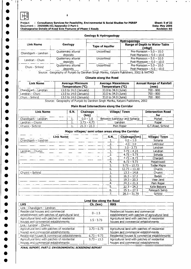
Project Consultancy Services for Feasibility, Environmental & Social Studies for PSRSP Sheet: 5 of 22* Document: 2005086/EC/Appendix-3 Part-I Date: May 2006
Chainagewise Details of Road Side Features of Phase-I Roads Revision: RO
* Geology & Hydrogeology
_ Hydrogeology |* Link Name Geology Type of Aquifer Range of Depth to Water Table
(mbgl)Chandigarh -Landran Quaternary alluvial Unconfined Pre-Monsoon - 5.0 - 10.0
* Chandigarh - Landran deposits Post-Monsoon - 5.0 - 10.0
Landran - Chuni Quaternary alluvial Unconfined Pre-Monsoon - 5.0 - 10.0deposits Post-Monsoon - 5.0 - 10.0
Chuni - Srihind Quaternary alluvial Unconfined Pre-Monsoon - 5.0 - 10.0* Chuni - Srihind deposits Post-Monsoon - 5.0- 10.0
Source: Geography of Punjab by Darshan Singh Manku, Kalyani Publishers, 2002 & NATMO
Climate along the Road
* Link Name Average Minimum Average Maxmimum Annual Range of RainfallTemperature (°C) Temrerature (°C) (mm)
_ Chandigarh - La 13.0 to 14.0 Janua 33.0 to 34.0 June 700 - 800
Landran - Chuni 13.0 to 14.0 (January) 33.0 to 34.0 (June) 700 - 800
Chunda -Sihind 13.0 to 14.0 (January) 33.0 to 34.0 (June) 700 - 800Source: Geography of Punjab by Darshan Singh Manku, Kalyani Publishers, 2002
Main Road Intersections along the Corridor
* - Link Name S.N. Chainage Village/ Town Intersection Road(km) for
* Chandigarh - Landran 1. 0.0 - 1.0 Between Lakhnaur and Sohana MohaliLandran - Chunn 1. 3.73 - 4.73 Landran Ropar
* Chunni - Sirhind 1. 21.3 - 22.3 Pain Ropar G.T.Road, Sirhind
Major villages/ semi urban areas along the Corridor
Link Name S.N. Chainage(km) Village/ Town
* Chandigarh - Landran 1. 0.0 - 1.0 Sohana2. 2.0 - 3.0 Lakhnaur
* _._ _3. 3.0 - 3.73 Landran
Landran - Chunni 1. 3.73 - 4.23 Landran
* __ _____?2. 4.73 - 5.73 Sohada3. 7.73 - 8.73 Chanjedi
* 4. 8.73 - 9.73 Majatriwadi5. 9.73 - 10.73 Todar Majra
* -- 6. 12.73 - 13.30 Chunni
Chunni - Sirhind 1. 13.3 - 14.8 Chunni
* 2. 16.3 - 17.3 Badali3. 19.3 - 20.3 VeerJand
* 4. 20.3 - 21.3 Pain Ropar5. 22.3 - 24.3 Kalla Bajoara
* ______________________________________________________ 6. 25.3 - 27.3 Fategarh Sahib*______________________________________ 7. 28.3 - 31.78 Sirhind
___________ Land Use along t he Road
* LHS Ch. (km) RHSLink : Chandiqarh - LandranResidencial houses and commercial 0 1.5 Residencial houses and commercial-establishment with patches of agricultural land establishment with patches of agricultural land
* | Agricultural land with patches of residential 1.5 - 3.73 Agricultural land with patches of residential-houses and commercial establishments houses and commercial establishmentsLink : Landran - ChunniiAgricultural land with patches of residential 3.73 - 6.73 Agricultural land with patches of residentialhouses and commercial establishments houses and commercial establishmentsResidential houses & commercial establishments 6.73 - 9.73 Residential houses & commercial establishments|
* l Agricultural land with patches of residential 9.73 - 13.3 Agricultural land with patches of residentiallhousesand commercial establishments houses and commercial establishments
_ FINAL REPORT, PART C: ENVIRONMENTAL SCREENING REPORT
0
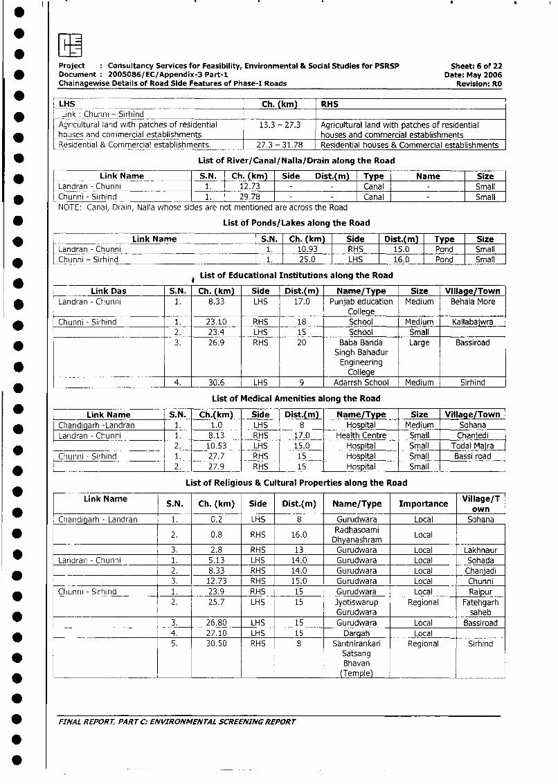
Project Consultancy Services for Feasibility, Environmental & Social Studies for PSRSP Sheet: 6 of 22* Document: 2005086/EC/Appendix-3 Part-1 Date: May 2006
Chainagewise Details of Road Side Features of Phase-I Roads Revision: RO
*
LLHS Ch. (km) RHS* Link: Chunni - Sirhind
Agricultural land with patches of residential 13.3 - 27.3 Agricultural land with patches of residentialhouses and commercial establishments houses and commercial establishments-Residential & Commercial establishments. 27.3 - 31.78 Residential houses & Commercial establishments
* List of River/Canal/Nalla/Drain along the Road
Landran - Link Name S.N. Ch. (km) Side Dist.(m) Type Name SizeLandran - Chunni 1. 12.73 - Canal _ Small* Chunni - Sirhind 1. 29.78 - Canal SmallNOTE: Canal, Drain, Nalla whose sides are not mentioned are across the Road
* List of Ponds/Lakes along the Road
* Link Name S.N. Ch. (km) Side Dist.(m) Type SizeLandran - Chunni 1. 10.93 RHS 15.0 Pond Small
* Chunni - Sirhind 1. 25.0 LHS 16.0 Pond Small
* # List of Educational Institutions along the Road
Link Das S.N. Ch. (km) Side Dist.(m) Name/Type Size Village/Town* | Landran - Chunni 1. 8.33 LHS 17.0 Punjab education Medium Behala More
College* LChunni - Sirhind 1. 23.10 RHS 18 School Medium Kallabajwra
2. 23.4 LHS 15 School Small* l l 3. 26.9 RHS 20 Baba Banda Large Bassiroad
Singh BahadurEngineering
__ _ _ _ ______College
-*____________________ 4. 1 30.6 LHS 9 Adarrsh School I Medium Sirhind
List of Medical Amenities along the Road
| * ~ l Link Name S.N. Ch.(km) Side Dist.(m) Name/Type Size Village/Town* | Chandigarh -Landran 1. 1.0 LHS | 8 - Hospital Medium | Sohana
Landran - Chunni 1. 8.13 RHS 17.0 - Health Centre Small Chanjedi*_______________________ -l2. 10.53 LHS | 15.0 - Hospital Small Todal Majra
Chunni - Sirhind 1. 27.7 RHS | 15 Hospital Small Bassi road
* _________________ 2. 27.9_ RHS | 15 - Hospital Small |
List of Religious & Cultural Properties along the Road
Link Name S.N. Ch. (km) Side Dist.(m) Name/Type Importance Village/T
Chandiqarh - Landran 1. 0.2 LHS 8 Gurudwara Local Sohana
* [ 2. 0.8 RHS 16.0 Radhasoami Local_________ Dhyanashram
*__| __ ;3. 2.8 RHS 13 Gurudwara Local LakhnaurLandran - Chunni 1. 5.13 LHS 14.0 Gurudwara Local Sohada
l __ l______________ 2. 8.33 RHS l 14.0 Gurudwara Local Chanjadi
- L l 3. 12.73 RHS 15.0 Gurudwara Local Chunni* Chunni - Sirhind 1. 23.9 RHS 15 Gurudwara Local Raipur
2. 25.7 LHS 15 Jyotiswarup Regional Fatehgarh______ l l |Gurudwara saheb|
_ r | 3. 26.80 LHS 15 Gurudwara Local Bassiroad_ l l__________ 4. 27.10 LHS 15 Dargah Local
5. 30.50 RHS 8 Santnirankari Regional SirhindSatsangBhavan
* L ___________________ -_ _ _ _ L ~~~~~(Tem ple) _ _ _ _ _
* FINAL REPORT, PART C; ENVIRONMENTAL SCREENING REPORT
.
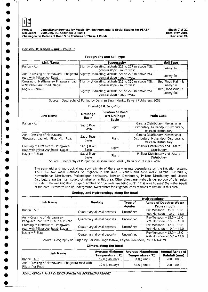
* Project Consultancy Services for Feasibility, Environmental & Social Studies for PSRSP Sheet: 7 of 22Document: 2005086/EC/Appendix-3 Part-1 Date: May 2006
* Chainagewise Details of Road Side Features of Phase-I Roads Revision: RO
Corridor D: Rahon - Aur - Phillaur
Topography and Soil Type
Link Name Topography Soil Type* Rahon - Aur Slightly Undulating; altitude 223 to 227 m above MSL; Loamy Soil
_ general slope - south-west
* Aur - Crossing of Mattiawara- Phagwara Slightly Undulating; altitude 221 to 225 m above MSL; Loamy Soilroad wil:h Pillaur-Aur Road general slope - south-west
* Crossing of Mattiawara- Phagwara road Slightly Undulating; altitude 223 to 220 m above MSL; Bet (Flood Plain) &with Pillaur-Aur Road- Nagar general slope - south-west Loamy Soil
* Nagar - Phillaur Slightly Undulating; altitude 223 to 220 m above MSL; Bet (Flood Plain) &
general slope - south-west Loamy Soil
Source: Geography of Punjab by Darshan Singh Manku, Kalyani Publishers, 2002
* Drainage & Irrigation
Drainage Position of RoadLink Name Dain wrt Drainage Main Canal
Basin BasinRahon - Aur Satluj River Garcha Distributary, Nawashahar
* Bauin Right Distributary, Mukandpur Distributary,Bairsian Distributary
Aur - Crossing of Mattiawara- Satluj River Garcha Distributary, Nawashahar_ Phagwara road with Pillaur-Aur Road Basin Right Distributary, Mukandpur Distributary,
Bairsian Distributary
_ Crossing of Mattiawara- Phagwara Satluj River Right Phillaur Distributary and Liasararoad with Pillaur-Aur Road- Nagar Basin Distributary
* Nagar - Phillaur Satluj River Right Phillaur Distributary and Liasara* < _ ___________________________ _ Basin Distributary
Source: Geography of Punjab by Darshan Singh Manku, Kalyani Publishers, 2002
0 The semi-arid and sub-tropical monsoon climate of the area warrants dependence on the irrigation system.There are two main methods of irrigation in this area - canals and tube wells. Garcha Distributary,
* Nawanshahar Distributary, Mukandapur disributary, Bairsian Distributary, Phillaur Distributary and LiasaraDistributary are the main source of irrigation in this area. Other than canal water, larger portion of this region
* is under tube well irrigation. Huge quantities of tube wells are being sunk in this area to meet the water needsof the area. Extensive use of underground sweet water for irrigation leads at times to famine in this area.
Geology and Hydrogeology along the Road
* # HydrogeologyLink Name Geology Type of Range of Depth to Water
_ Aquifer Table (mbgl)Rahon - Aur Quaternary alluvial deposits Unconfined Pre-Monsoon - 15.0 - 18.0
* ~~~~~~~~~~~~~~~~~~~~~~~Post-Monsoon - 10.0 - 15.0
Aur -- Crossing of Mattiawara- Quaternary alluvial deposits Unconfined Pre-Monsoon - 15.0 - 18.0
* Phagwara road with Pillaur-Aur Road Post-Monsoon - 10.0 - 15.0Crossing of Mattiawara- Phagwara Quaternary alluvial deposits Unconfined Pre-Monsoon - 12.0 - 18.0
* ~~road with Pillaur-Aur Road- Nagar Qaenraluildpst Ucofed Post-Monsoon - 10.0 - 15.0
Nagar - Phillaur Quaternary alluvial deposits Unconfined Pre-Monsoon - 12.0 - 18.0
* ____________LPost-Monsoon - 10.0 - 15.0Source: Geography of Punjab by Darshan Singh Manku, Kalyani Publishers, 2002 & NATMO
* Climate along the Road
Link Name Average Minimum Average Maxmimum Annual Range of_ Link Name Temperature (C) Temperature (°C) Rainfall (mm)
* Rahon - Aur 12.0 (January) 34.0 (June) 700 - 800
Aur - Crossing of Mattiawara- Phagwara road with 12.0 (January) 34.0 (June) 700 - 800PilNar-Aur Road
* ~~FINAL REPORT, PART C:- ENVIRONMENTAL SCREENING REPORT
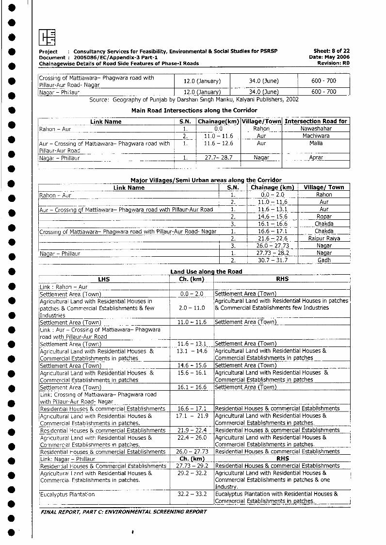
* Project : Consultancy Services for Feasibility, Environmental & Social Studies for PSRSP Sheet: 8 of 22Document: 2005086/EC/Appendix-3 Part-1 Date: May 2006
_ Chainagewise Details of Road Side Features of Phase-I Roads Revision: RO
* Crossing of Mattiawara- Phagwara road with 12.0 (January) 34.0 (June) 600 - 700Pillaur-Aur Road- Nagar
* Nagar - Phillaur 12.0 (January) 34.0 (June) 600 - 700Source: Geography of Punjab by Darshan Singh Manku, Kalyani Publishers, 2002
Main Road Intersections along the Corridor
Link Name S.N. Chainage(km) Village/Town Intersection Road forRahon - Aur 1. 0.0 Rahon Nawashahar_____________________________________ 2. 11.0- 11.6 Aur MachiwaraAur - Crossing of Mattiawara- Phagwara road with 1. 11.6 - 12.6 Aur MallaPillaur-Aur RoadNagar - Phillaur 1. 27.7- 28.7 Nagar Aprar
Major Villages/Semi Urban areas along the Corridor_ Link Name S.N. Chainage (km) Village/ Town
Rahon- Aur 1. 0.0 - 2.0 Rahon2. 11.0 - 11.6 Aur
* Aur - Crossing of Mattiawara- Phagwara road with Pillaur-Aur Road 1. 11.6 - 13.1 Aur.________________________________________________________ 2. 14.6 - 15.6 Ropar
3. 16.1 - 16.6 ChakdaCrossing of Mattiawara- Phagwara road with Pillaur-Aur Road- Nagar 1. 16.6 - 17.1 Chakda*________________________________________________________ 2. 21.6 - 22.6 Raipur Raiya
_____________ _________________________________________ 3. 26.0 - 27.73 Nagar* N~aga- Phillaur 1. 27.73 - 28.2 Nagar
2. 30.7 - 31.7 Gadh
* Land Use alon the RoadLHS Ch. (km) RHS
* 'Link : Rahon - AurSettlement Area (Town) 0.0 - 2.0 Settlement Area (Town)
* Agricultural Land with Residential Houses in Agricultural Land with Residential Houses in patchespatches & Commercial Establishments & few 2.0 - 11.0 & Commercial Establishments few Industries
* Industries _
Settlement Area (Town) 11.0 - 11.6 Settlement Area (Town)Link : Aur - Crossirng of Mattiawara- Phagwararoad with Pillaur-Aur Road
* Settlement Area (Town) 11.6 - 13.1 Settlement Area (Town)Agricultural Land with Residential Houses & 13.1 - 14.6 Agricultural Land with Residential Houses &
* Commercial Establishments in patches Commercial Establishments in patchesSettlement Area (Town) 14.6 - 15.6 Settlement Area (Town)
* Agricultural Land with Residential Houses & 15.6 - 16.1 Agricultural Land with Residential Houses &Commercial Establishments in patches Commercial Establishments in patches
* Settlement Area (Town) 16.1 - 16.6 Settlement Area (Town)Link: Crossing of Mattiawara- Phagwara road
* with Pillaur-Aur Road- Nagar.Residential Houses & commercial Establishments 16.6 - 17.1 Residential Houses & commercial Establishments
* Agricultural Land with Residentiai Houses & 17.1 - 21.9 Agricultural Land with Residential Houses &Commercial Establishments in patches. Commercial Establishments in patches.
* Residential Houses & commercial Establishments 21.9 - 22.4 Residential Houses & commercial EstablishmentsAgricultural Land with Residential Houses & 22.4 - 26.0 Agricultural Land with Residential Houses &
* Commercial Establishments in patcies. Commercial Establishments in patches.Residential Houses & commercial Establishments 26.0 - 27.73 Residential Houses & commercial Establishments
* Link: Nagar_- Phillaur Ch. (km) RHSResiden:ial Houses & Commercial Establishments 27.73 - 29.2 Residential Houses & commercial Establishments
* Agricultural Lend with Residential Houses & 29.2 - 32.2 Agricultural Land with Residential Houses &Commercial Establishments in patches. Commercial Establishments in patches & one*____________________________________________ Industry.Eucalyptus Plantation 32.2 - 33.2 Eucalyptus Plantation with Residential Houses &
* _________________________ Commercial Establishments in patches.
FINAL REPORT, PART C: ENVIRONMENTAL SCREENING REPORT
*'0
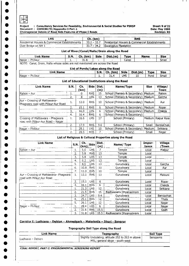
* Project : Consultancy Services for Feasibility, Environmental & Social Studies for PSRSP Sheet, 9 of 22Document 2005086/EC/Appendix-3 Part-1 Date: May 2006Chainagewise Details of Road Side Features of Phase-I Roads Revision: RO
* _________LHS 1 Ch. (km) RHSResidential Houses & Commercial Establishments 33.2 - 33.7 Residential Houses & Commercial Establishments
* Over Bridge on NH 1 33.7 - 34.2 Eucalyptus Plantation
List of River/Canal/Nalla/Drain along the Road
Link Name |S.N. Ch. (km) Side | Dist.(m) Type Name Size* gNaar - Phillaur l 1. l 31.8 l - - Canal - Small
NOTE: Canal, Drain, Nalla whose sides are not mentioned are across the Road
* List of Ponds/ Lakes along the RoadLink Name S.N. Ch. (km) Side Dist.( i Tpe Size
* L9Nar - Phillafr l 1. 31.4 |LHS 10 | Pond | Small
* List of Educational Institutions along the Road
Link Name S. N. Ch. Side Dist. Name/Type Size Village/Rahon -Aur(km) _ (m) Town
_ _ . . .,Rahon - Aur 1. 0 RHS 15 School (Primary & Secondary) Medium Rahon_ 2. 8 LHS 13 School (Primary & Secondary) Medium Garcha
Aur - Crossing of Mattiawara- 1. 12.0 RHS 10 Schcol (Primary & Secondary) Medium AurPhagwara road with Pillaur-Aur Road
2. 15.1 RHS 6 School (Primary & Secondary) Medium Ropar* 3. 16.0 LHS 6 School (Primary & Secondary) Medium Chakda
4. 16.4 RHS 6 School (Primary & Secondary)_ Crossing of Mattiawara - Phagwara 1. 16.6 LHS 17 School (Primary) Medium Raipur Raia
road with Pillaur-Aur Road - Nagar 2. 17.9 RHS 9.6 School (Primary) Small BansiaChak
Nagar - Phillaur 1. 28.1 LHS 10 School (Primary & Secondary) Medium Selkiana* ___ _ _ 2. 28.5 RHS 7 School (Primary) Small Nagar
* List of Religious & Cultural Properties along the Road
* Link Name S.N. Ch. Side Dist. Name/ Type Impor- Village________________Mk)tance /Town
Rahon - Aur 1. 5.0 LHS 7 Temple Local Malpur* -. 2. 5.8 RHS 13 Temple Local
*__ .___ 3. 5.8 LHS 13 Temple Local_ 4. 6.2 LHS 13 Temple Local
5. 8.0 LHS 13 Gurudwara Local Garcha
* __ ___ ___________________ 6. 10.8 RHS 10 Gurudwara Local Aur._ ____________________________ 7. 11.0 RHS 10 Temple Local
* Aur - Crossing of Mattiawara- Phagwara 1. 13.1 RHS 13 Gurudwara Local Malauni_ ~~road with Pillaur-Aur Road
road with Pillaur-Aur Road 2. 15.1 LHS 6 Gurudwara Local Ropar3. 16.1 RHS 6 Gurudwara Local Chakda
* 1. 21.3 LHS 12 Gurudwara Local Selkiana._________________________________ 2. 21.5 RHS 15 Radhasoami Dhyanashram Local
* 3. 24.7 LHS 9.4 Gurudwara Local Bansiachak4. 25.1 RHS 12 Gurudwara Local Thala
* _ __________________________________ 5. 26.1 LHS 12 Gurudwara Local Nagar
Nagar - Phillaur 1. 28.4 LHS 6 Gurudwara Local Nagar___________________________________ 2. 31.6 RHS 15.5 Gurudwara Local Gadh*________________________________ 3. 31.8 LHS 15.5 Radhasoami Dhyanashram Local _
* Corridor E: Ludhiana - Dehlon - Ahmedgarh - Malerkotla - Dhuri - Sancirur
* Topography Soil Type along the Road
Link Name Topography Soil Type
Ludhia*a - Dehlon Slightly Undulating; altitude 252 to 263 m above Seriozems* tedhialia - Dehlon | ~~~~~~MSL; general slope_- south-westll
FINAL REPORT, PARTC: ENVIRONMENTAL SCREENINGREPORT
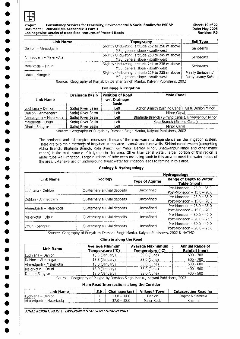
.
*E[MProject Consultancy Services for Feasibility, Environmental & Social Studies for PSRSP Sheet: 10 of 22Document 2005086/EC/Appendix-3 Pait-1 Date: May 2006
* Chainagewise Details of Road Side Features of Phase-I Roads Revision: RO
* _ Link Name Topography Soil Type
* Dehlon - Ahmedgarh Slightly Undulating; altitude 252 to 250 m above SeriozemsMSL; general slope - south-west
Ahmedgarh - Malerkotla Slightly Undulating; altitude 250 to 245 m above Seriozems* _________________________________MSL; general slope - south-west
* Malerkotla - Dhuri Slightly Undulating; altitude 241 to 238 m above Seriozems_______ ~~~~~~~~~~~~~MSL; general slope - south-west I_________
Dhuri - Sangrur ~~~~Slightly Undulating; altitude 229 to 235 mn above Mainly Seriozems'* Dhuri - Sangrur _______________________ MSL; general slope - south-west Partly Loamy Soils
Source: Geography of Punjab by Darshan Singh Manku, Kalyani Publishers, 2002
* Drainage & irrigation
* Drainage Basin Position of Road Main CanalLink Name wrt Drainage
_ BasinLudhiana - Dehlon Satluj River Basin Left Abhor Branch (Sirhind Canal), Gil & Dehlon Minor
* Dehion - Ahmedgarh Satlui River Basin Left Minor CanalAhmedgarh - Malerkotla Satluj River Basin Left Bhatinda Branch (Sirhind Canal), Bhagwanpur Minor
* Malerkotla - Dhuri Satluj River Basin Left Kota Branch (Sirhind Canal)Dhuri - Sangrur Satluj River Basin Left Minor Canal
* Source: Geography of Punjab by Darshan Singh Manku, Kalyani Publishers, 2002
The semi-arid and sub-tropical monsoon climate of the area warrants dependence on the irrigation system.There are two main methoqs of irrigation in this area - canals and tube wells. Sirhind canal system (comprisingAbhor Branch, Bhatinda Branch, Kota Branch, Gir Minor, Dehlon Minor, Bhagwanpur Minor and other minorcanals) is the main source of irrigation in this area. Other than canal water, larger portion of this region isunder tube well irrigation. Large numbers of tube wells are being sunk in this area to meet the water needs ofthe area. Extensive use of underground sweet water for irrigation leads to famine in this area.
* Geology & Hydrogeology
____________ HydrogeologyLink Name Geology Type ofRange of Depth to Water
Type ofAquiferTable (mbgl)
Ludhiana - Dehlon Quaternary alluvial deposits Unconfined Pre-Monsoon - 25.0 - 35.0* - Pos-Monsoon - 25.0 - 35.0
Dehion - Ahmedgarh Quaternary alluvial deposits Unconfined Post-Monsoon - 15.0 - 20.0* ~~~~~~~~~~~~~~~~~~~~~~~Post-Monsoon - 25.0 - 35.0
Ahmedgarh - Malerkotla Quaternary alluvial deposits Unconfined Pre-Monsoon - 25.0 - 35.0* Poe-Monsoon - 30.0 - 40.0
Malerkotla - Dhuri Quaternary alluvial deposits Unconfined Pre-Monsoon - 30.0 - 40.0* ~~~~~~~~~~~~~~~~~~~~~~~Pret-Monsoon - 30.0 -405.0
Dhurj - Sangrur Quaternary alluvial deposits Unconfined Post-Monsoon - 20.0 - 25.0
* Source: Geography of Punjab by Darshan Singh Manku, Kalyani Publishers, 2002 & NATMO
* ____________ Climate along the Road
Ln NAverage Minimum Average Maxmimum Annual Range of* Link Name Temperature (°C) Temperature (°C) Rainfall (mm)
Ludhiana - Dehlon 13.5 (January) 35.0 (June) 600 - 700* Dehlon - Ahmedgarh 13.5 (January) 35.0 (June) 600 - 700
Ahmedgarh - Malerkotla 13.0 (January) 35.0 (June) 500 - 600* Malerkotla - Dhuri 13.0 anuary) 35.0 (June) 400 - 500
Dhuri - Sangrur _ 13.0 (January) 35.0 (June) 400 - 500* Source: Geography of Punjab by Darshan Singh Manku, Kalyani Publishers, 2002
Main Road Intersections along the Corridor
Link Name S.N._ Chainage(km) Village/ Town Intersection Road for* Ludhiana - Dehion 1. 13.0 - 14.0 Dehlon Rajkot & Samrala
Ahmedgarh - Malerkotla 1. 37.0 - 38.0 Maler Kotla Khanna
* FINAL REPORT, PART C: ENVIRONMENTAL SCREENING REPORT
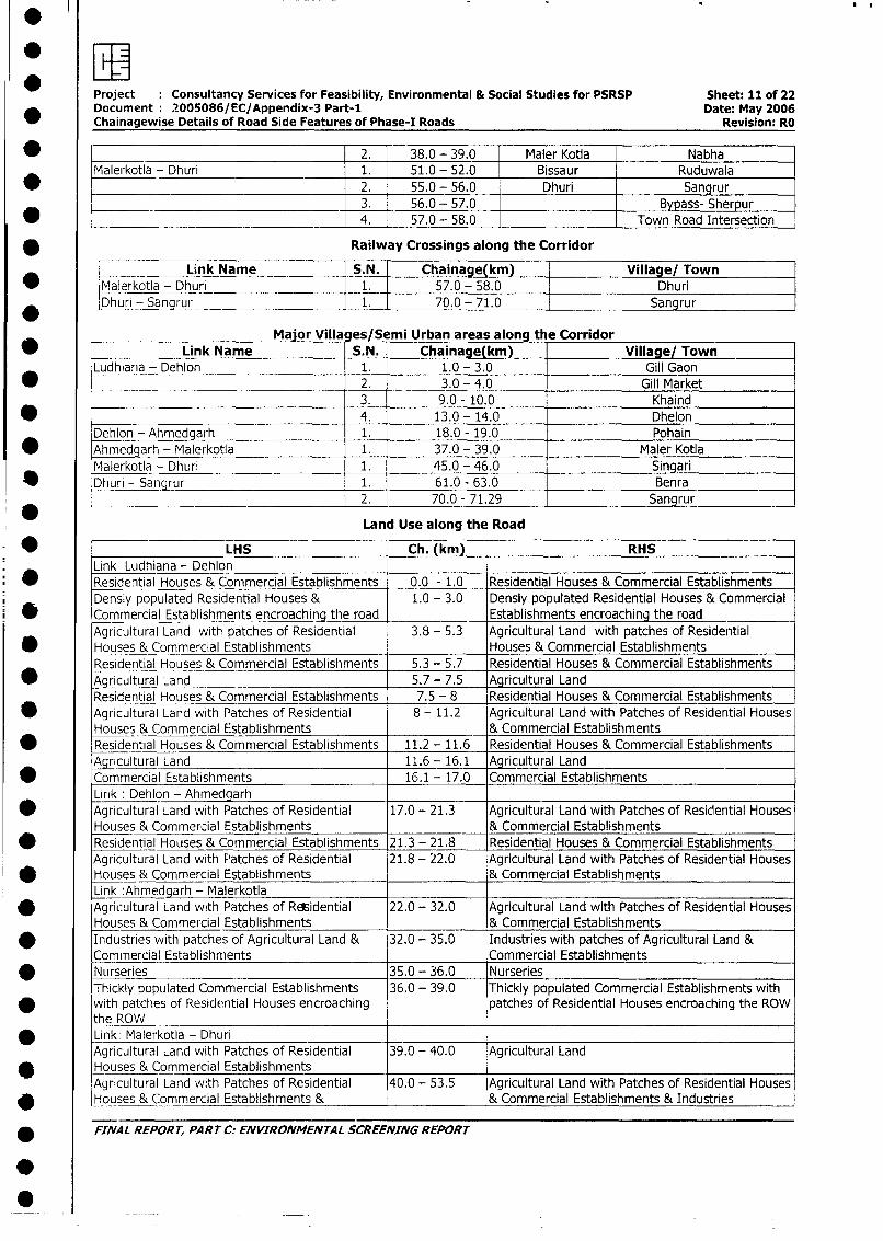
Project Consultancy Services for Feasibility, Environmental & Social Studies for PSRSP Sheet: 11 of 22Document 2005086/EC/Appendix-3 Part-1 Date: May 2006Chainagewise Details of Road Side Features of Phase-I Roads Revision: RO
_ ____________________________________ 2. 38.0 - 39.0 Maler Kotla NabhaMalerkotla - Dhuri 1. 51.0 - 52.0 Bissaur Ruduwala
2. 55.0 - 56.0 Dhuri Sangrur3. 56.0 - 57.0 Bypass- Sherpur
* ____________________________________ 4. 57.0 - 58.0 Town Road Intersection
* Railway Crossings along the Corridor
Link Name S.N. Chainage(km) Village/ Town
* Malerkotla - Dhuri 1. 57.0- 58.0 DhuriDhuri - Sangrur 1. 70.0 - 71.0 Sangrur
Major Villa es/Semi Urban areas along th e Corridorm _____ Link Name S.N. Chainage(km) Village/ Town
Ludhiana - Dehlon 1. 1.0 - 3.0 Gill Gaon
* 2. 3.0 - 4.0 Gill Market__________________________ 3. 9.0 - 10.0 Khaind
* -- 4. 13.0 - 14.0 DhelonDehlon - Ahmedgarh 1. 18.0 - 19.0 Pohain
* Ahmedgarh - Malerkotla 1. 37.0 - 39.0 Maler Kotla
Malerkotla - Dhuri 1. 45.0 - 46.0 Singari
* Dhuri - Sangrur 1. 61.0 - 63.0 Benra2. 70.0 - 71.29 Sangrur
Land Use along the Road
* LHS Ch. (km) RHSLink Ludhiana - Dehlon
O Residential Houses & Commercial Establishments 0.0 - 1.0 Residential Houses & Commercial EstablishmentsDensly populated Residential Houses & 1.0 - 3.0 Densly populated Residential Houses & CommercialCommercial Establishments encroaching the road Establishments encroaching the roadAgricultural Land with patches of Residential 3.8 - 5.3 Agricultural Land with patches of Residential
0 Houses & Commercial Establishments . Houses & Commercial Establishments
Residential Houses & Commercial Establishments 5.3 - 5.7 Residential Houses & Commercial Establishments* Agricultural Land 5.7 - 7.5 Agricultural Land
Residential Houses & Commercial Establishments 7.5 - 8 Residential Houses & Commercial Establishments* Agricultural Land with Patches of Residential 8 - 11.2 Agricultural Land with Patches of Residential Houses
Houses & Commercial Establishments _ & Commercial Establishments* Residential Houses & Commercial Establishments 11.2 - 11.6 Residential Houses & Commercial Establishments
Agricultural Land 11.6 - 16.1 Agricultural Land* Commercial Establishments 16.1 - 17.0 Commercial Establishments
Link: Dehlon - Ahmed arh* Agricultural Land with Patches of Residential 17.0 - 21.3 Agricultural Land with Patches of Residential Houses
Houses & Commercial Establishments & Commercial Establishments* Residential Houses & Commercial Establishments 21.3 - 21.8 Residential Houses & Commercial Establishments
Agricultural Land with Patches of Residential 21.8 - 22.0 Agricultural Land with Patches of Residertial HousesHouses & Commercial Establishments & Commercial EstablishmentsLink :Ahmedgarh - Malerkotla
* Agricultural Land with Patches of REsidential 22.0 - 32.0 Agricultural Land with Patches of Residential HousesHouses & Commercial Establishments & Commercial Establishments
* Industries with patches of Agricultural Land & 32.0 - 35.0 Industries with patches of Agricultural Land &Commercial Establishments Commercial Establishments
* Nurseries 35.0 - 36.0 NurseriesThickly populated Commercial Establishments 36.0 - 39.0 Thickly populated Commercial Establishments withwith patches of Residential Houses encroaching patches of Residential Houses encroaching the ROWthe ROW
* Link: Malerkotla - DhuriAgricultural Land with Patches of Residential 39.0 - 40.0 Agricultural LandHouses & Commercial EstablishmentsAgricultural Land with Patches of Residential 40.0 - 53.5 Agricultural Land with Patches of Residential Houses
* Houses & Commercial Establishments & & Commercial Establishments & Industries
* FINAL REPORT, PART C. ENVIRONMENTAL SCREENING REPORT
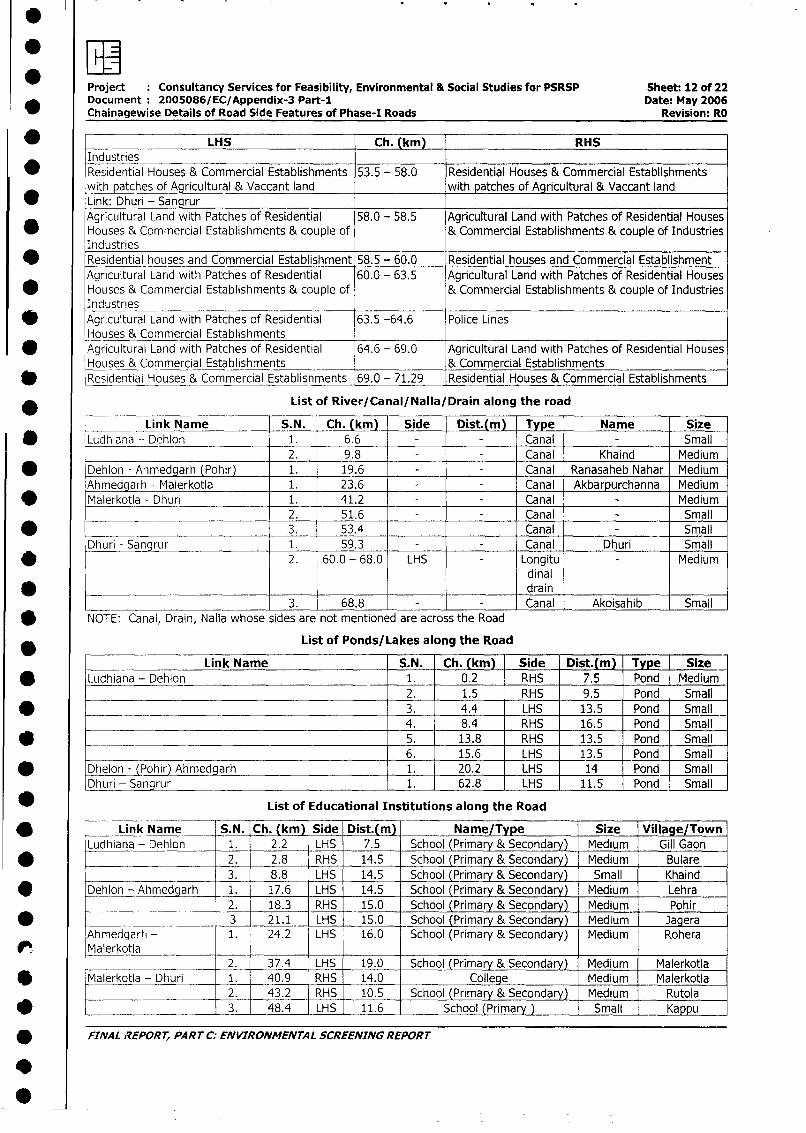
Project : Consultancy Services for Feasibility, Environmental & Social Studies for PSRSP Sheet: 12 of 22Document: 2005086/EC/Appendix-3 Part-I Date: May 2006Chainagewise Details of Road Side Features of Phase-I Roads Revision: RO
_ LHS Ch. (km) RHSIndustries
* Residential Houses & Commercial Establishments 53.5 - 58.0 Residential Houses & Commercial Establishmentswith patches of Agricultural & Vaccant land with patches of Agricultural & Vaccant land
* Link: Dhuri - SanqrurAgricultural Land with Patches of Residential 58.0 - 58.5 Agricultural Land with Patches of Residential Houses
* Houses & Commercial Establishments & couple of & Commercial Establishments & couple of IndustriesIndustries
* Residential houses and Commercial Establishment 58.5 - 60.0 Residential houses and Commercial Establishment
Agricultural Land with Patches of Residential 60.0 - 63.5 Agricultural Land with Patches of Residential Houses
* Houses & Commercial Establishments & couple of & Commercial Establishments & couple of IndustriesIndustries
* Agricultural Land with Patches of Residential 63.5 -64.6 Police LinesHouses & Commercial Establishments
* Agricultural Land with Patches of Residential 64.6 - 69.0 Agricultural Land with Patches of Residential Houses
Houses & Commercial Establishments & Commercial Establishments
* Residential Houses & Commercial Establishments 69.0 - 71.29 Residential Houses & Commercial Establishments
* List of River/Canal/Nalla/Drain along the roadF~~~~~~~~~~~~~~~~~~~~~~~~~~~~~~~~~~~~~~~~~~~~~~~~~~~~~~~~~~~~Link Name S.N. Ch. (km) Side Dist.(m) Type Name Size
* Ludhiana - Dehlon 1. 6.6 - - Canal Small2. 9.8 - - Canal Khaind Medium
* Dehion - Ahmedgarh (Pohir) 1. 19.6 - - Canal Ranasaheb Nahar Medium
Ahmedgarh - Malerkotla 1. 23.6 - - Canal Akbarpurchanna Medium
* Malerkotla - Dhuri 1. 41.2 - - Canal Medium2. 51.6 - - Canal Small
* 3. 53.4 Canal Small
Dhuri - Sangrur 1. 59.3 - - Canal Dhuri Small
* 2. 60.0 - 68.0 LHS - Longitu Mediumdinal
* _______ drain3. 68.8 Canal Akoisahib Small
NOTE: Canal, Drain, Nalla whose sides are not mentioned are across the Road
List of Ponds/Lakes along the Road
____ Link Name S.N. Ch. (km) Side Dist.(m) Type | Size
* Ludhiana - Dehlon _ 1. 0.2 RHS 7.5 Pond Medium2. 1.5 RHS 9.5 Pond Small
* __ 3. 4.4 LHS 13.5 Pond Small4. 8.4 RHS 16.5 Pond Small
* 5. 13.8 RHS 13.5 Pond Small6. 15.6 LHS 13.5 Pond Small
* Dhelon - (Pohir) Ahmedgarh 1. 20.2 LHS 14 Pond Small
_huri - Sangrur 1. 62.8 LHS 11.5 Pond Small
* List of Educational Institutions along the Road
* _ Link Name S.N. Ch. (km) Side _Dist.(m) NameType | Size Village/TownLudhiana - Dehlon 1. 2.2 LHS 7.5 School (Primary & Secondary) Medium Gill Gaon
* _ l 2. 2.8 RHS 14.5 | School (Primary & Secondary) Medium Bulare
3. 8.8 LHS 14.5 School (Primary & Secondary) Small Khaind
* Dehion - Ahmedgarh 1. 17.6 LHS 14.5 School (Primary & Secondary) Medium Lehra
__ | 2. 18.3 RHS 15.0 School (Primary & Secondary) Medium Pohir
* l 3 - 21.1 LHS 15.0 l School (Primary & Secondary) Medium JageraAhmedgarhi - 1. 24.2 LHS 16.0 School (Primary & Secondary) Medium RoheraM alerkotla l l _ l_l___l_l_l_
2. 37.4 LHS 19.0 School (Primary & Secondary) Medium Malerkotla
* Malerkotla - Dhuri 1. 40.9 RHS 14.0 College Medium Malerkotla2. 43.2 RHS 10.5 School (Primary & Secondary) Medium Rutola
* __________ l3. 48.4 LHS 11.6 School (Primary) Small Kappu
* FINAL REPORT, PART C; ENVIRONMENTAL SCREENING REPORT
0
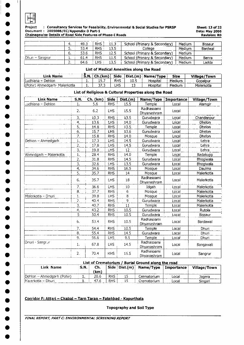
.
SWHProject : Consultancy Services for Feasibility, Environmental & Social Studies for PSRSP Sheet: 13 of 22Documetit: 2005086/EC/Appendix-3 Part-i Date: May 2006Chainagewise Details of Road Side Features of Phase-I Roads Revision: RO
* ______ 4. 49.3 RHS 11.3 School (Primary & Secondary) Medium Bissaur_____________ 5. 53.4 RHS 13.5 College Medium Bardwal
* ____ __________ 6. 53.6 RHS 12.5 School (Primary & Secondary) MediumDhuri - Sangrur 1. 61.4 RHS 11.5 School (Primary & Secondary) Medium Benra
* ____________ 2. 64.6 LHS 13.5 School (Primary & Secondary) Medium Ladda
* List of Medical Amenities along the Road
Link Name N._ Ch.(km) Side Dist.(m) Name/Type Size Village/Town* [Ludhiana - Dehlon 1. 15.7 RHS 10.5 Hospital Medium Gopalpur
[(Pohir) Ahmedgarh- Malerk<otla 1. 37.3 LHS 13 Hospital Medium Malerkotla
List of Religious & Cultural Properties along the Road
* _ Link Name S.N. Ch. (km) Side Dist.(m) Name/Type Importance Village/TownLudhiana - Dehlon 1. 5.6 RHS 15.5 Temple Local Alamgir
_*_ .2. 6.2 LHS 15.5 Dhyanashram Local
* 3. 10.3 RHS 13.5 Gurudwara Local Chandanpur4. 13.6 LHS 14.0 Gurudwara Local Dhelon
* _____________________ 5. 14.8 RHS 13.5 Temple Local Dhelon6. 15.7 LHS 13.6 Gurudwara Local Dhelon
* ______________________ 7. 15.8 RHS 14.0 Mosque Local DhelonDehlon - Ahmedgarh 1. 17.3 LHS 14.5 Gurudwara Local Lehra
* 2. 17.8 LHS 14.5 Gurudwara Local Lehra3. 19.8 LHS 12 Gurudwara Local Lehra
* Ahmedgarh - Malerkotla 1. 28.4 RHS 14.0 Temple Local Badakupp2. 31.8 RHS 14.5 Gurudwara Local Bhogiwala
* 3. 32.6 LHS 13.5 Gurudwara Local Bhogiwala4. 34.6 RHS 16.5 Mosque Local Daulma
* 5. 35.7 RHS 14 Mosque Local Malerkotla6. 35.7 LHS 18 ~Radhasoami6. 35.7 LHS 18 Dhyanashram Local Malerkotla
7. 36.6 LHS 10 Idgah Local Malerkotla* _______________________ 8. 37.7 RHS 6 Mosque Local Malerkotla
Malerkotla - Dhuri 1. 39.8 LHS 8 Mosque Local Malerkotla* 2. 40.4 RHS 9 Gurudwara Local Malerkotla
3. 40.7 RHS 11 Temple Local Malerkotla* _- __4. 43.2 RHS 10.5 Gurudwara Local Rutola
5 50.4 RHS 10.5 Gurudwara Local Bissaur
6. 53.4 RHS 10.5 Radhasoami Local Bardawal
*____ 7. 54.4 RHS 10.5 Temple Local Dhurir _ _ ____ 8. 55.4 RHS 14.5 Gurudwara Local Dhuri
* ___ __ 9. 56.6 LHS 9.5 Temple Local Dhuri* Dhuri - Sangrur 1. 67.8 LHS 14.5 Radhasoami Local Bangawali
2. 70.4 RHS 15.5 Dhyanashram Local Sangrur
List of Crematorium / Burial Ground along the roadLink Name S.N. Ch. Side Dist.(m) Name/Type Importance Village/Town
(km) IDehlon - Ahmedgarh (Pohir) 1. 20.6 RHS 15 Crematorium Local Jagera
* Malerkotla - Dhuri 1. 47.6 RHS 15 Crematorium I Local Singari
* Corridor F: Attari - Chabal - Tarn Taran - Fatehbad - KaRurthala
* Topography and Soil Type
* FINAL REPORT, PARTC; ENVIRONMENTAL SCREENINGREPORT
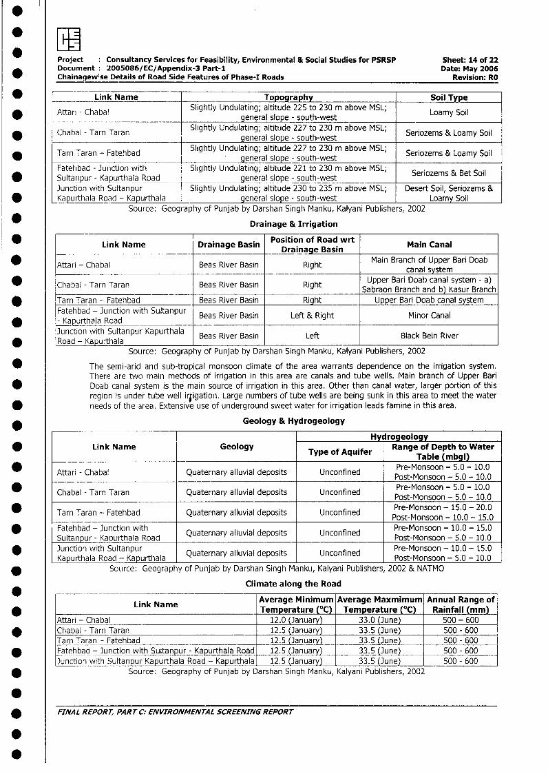
Project Consultancy Services for Feasibility, Environmental & Social Studies for PSRSP Sheet: 14 of 22Document: 2005086/ EC/Appendix-3 Part-1 Date: May 2006Chainagewise Details of Road Side Features of Phase-I Roads Revision: RO
* Link Name Topography Soil Type
* Attari - Chabal Slightly Undulating; altitude 225 to 230 m above MSL;Soilgeneral slope - south-west
Chabal - Tarn Taran Slightly Undulating; altitude 227 to 230 m above MSL; Seriozems & Loamy Soilgeneral slope - south-west ____________
* Tarn Taran - Fatehbad Slightly Undulating; altitude 227 to 230 m above MSL; Seriozems & Loamy Soil.____ __________________ general slope - south-west
Fatehbad - Junction with Slightly Undulating; altitude 221 to 230 m above MSL; Seriozems & Bet Soil* Sultanpur - Kapurthala Road general slope - south-west
Junction with Sultanpur Slightly Undulating; altitude 230 to 235 m above MSL; Desert Soil, Seriozems &* Kapurthala Road - Kapurthala general slope - south-west Loamy Soil
Source: Geography of Punjab by Darshan Singh Manku, Kalyani Publishers, 2002
Drainage & IrrigationLink Name ~~~~~Position of Road wrt Mi aa
* Link Name Drainage Basin Drainage Basin Main Canal
* Attari - Chabal Beas River Basin Right Main Branch of Upper Bari Doabcanal system
* Chabal - Tarn Taran Beas River Basin Right Upper Bari Doab canal system - a)Sabraon Branch and b) Kasur Branch
* Tarn Taran - Fatehbad Beas River Basin Right Upper Bari Doab canal systemFathba -Juntin wthSultanpur Mio Caa
Fatehbad - Junction with Beas River Basin Left & Right Minor Canal* - Kapurthala Road __ ____
Junction with Sultanpur Kapurthala Beas River Basin Left Black Bein River* Road - Kapurthala I I
Source: Geography of Punjab by Darshan Singh Manku, Kalyani Publishers, 2002
* The semi-arid and sub-tropical monsoon climate of the area warrants dependence on the irrigation system.There are two main methods of irrigation in this area are canals and tube wells. Main branch of Upper BariDoab canal system is the main source of irrigation in this area. Other than canal water, larger portion of thisregion is under tube well irfigation. Large numbers of tube wells are being sunk in this area to meet the water
* needs of the area. Extensive use of underground sweet water for irrigation leads famine in this area.
* Geology & Hydrogeology
Hy rogeologyLink Name Geology Type of Aquifer Range of Depth to Water0 Type of Aquifer ~~~~~~~~~~~~~~Table (mbgl)
Attari - Chabal Quaternary alluvial deposits Unconfined Pre-Monsoon - 5.0 - 10.0
Post-Monsoon - 5.0 - 10.0* Chabal - Tarn Taran Quaternary alluvial deposits Unconfined Post-Monsoon - 5.0 - 10.0
* ~~Tarn Taran -Fatehbad Quaternary alluvial deposits Unconfined Pre-Monsoon - 15.0 - 20.0Post-Monsoon - 10.0 - 15.0
* Fatehbad - Junction with Quaternary alluvial deposits Unconfined Pre-Monsoon - 10.0 - 15.0Sultanpur - Kapurthala Road Post-Monsoon - 5.0 - 10.0
Junction with Sultanpur Quaternary alluvial deposits Unconfined Pre-Monsoon - 10.0 - 15.0-Kapur-thala Road - Kapurtlhala Post-Monsoon - 5.0 - 10.0
* Source: Geography of Punjab by Darshan Singh Manku, Kalyani Publishers, 2002 & NATMO
Climate along the Road
Link Name Average Minimum Average Maxmimum Annual Range of* Link Name Temperature (°C) Temperature (°C) Rainfall (mm)
Attari - Chabal 12.0 (January) 33.0 (June) 500 - 600* Chabal - Tarn Taran 12.5 (January) 33.5 (June) 500 - 600
Tarn Taran - Fatehbad 12.5 (January) 33.5 (June) 500 - 600* Fatehbad - Junction with Sultanpur - Kapurthala Road 1 12.5 (January) 33.5 (June) 500 - 600
Junction with Sultanpur Kapurthala Road - Kapurthala 12.5 (January) 33.5 (June) T 500 - 600* Source: Geography of Punjab by Darshan Singh Manku, Kalyani Publishers, 2002
* FINAL REPORT, PART C: ENVIRONMENTAL SCREENING REPORT
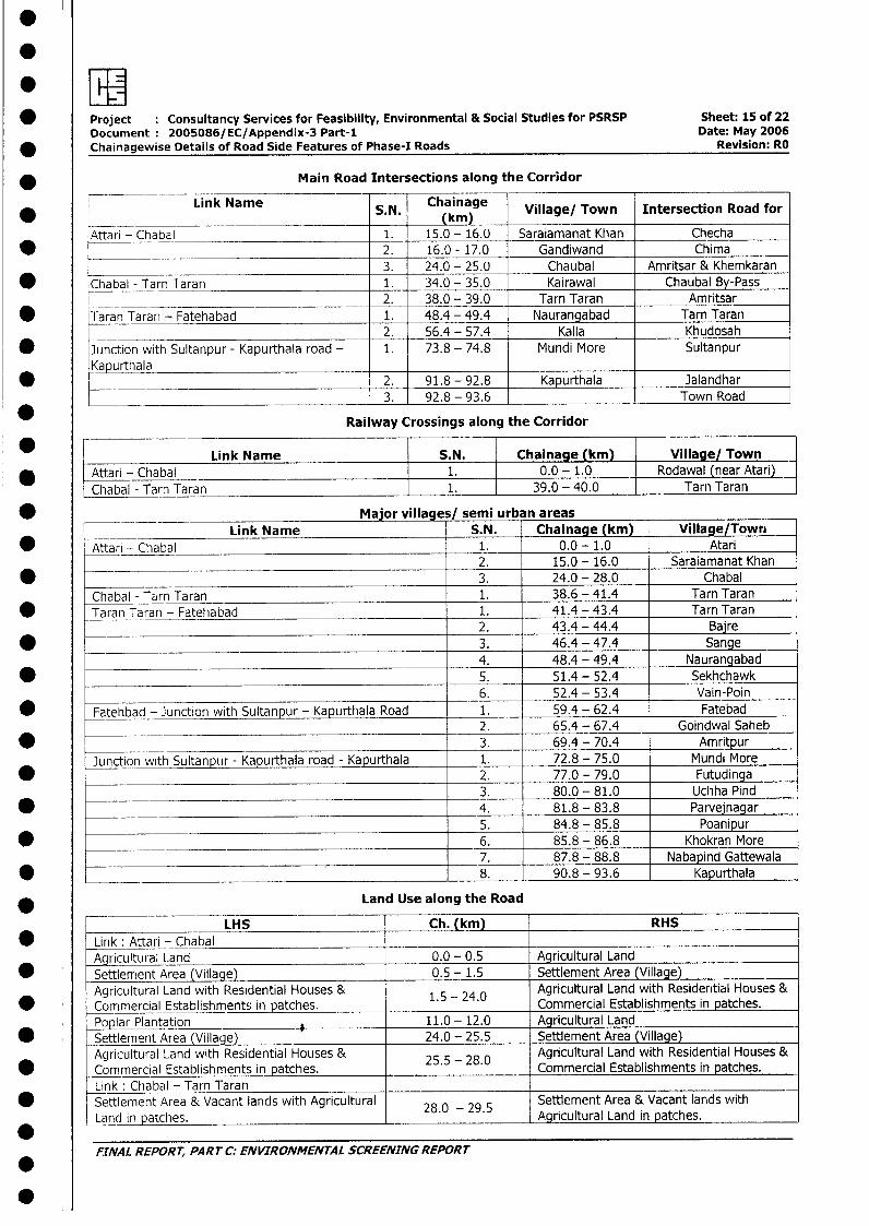
* IJI -
* Project Consultancy Services for Feasibility, Environmental & Social Studies for PSRSP Sheet: 15 of 22Document 2005086/EC/Appendix-3 Part-1 Date: May 2006
_ Chainagewise Details of Road Side Features of Phase-I Roads Revision: RO
Main Road Intersections along the Corridor
* = Link Name S.N. Chainage Village/ Town Intersection Road for
Attari - Chabal 1. 15.0 - 16.0 Saraiamanat Khan Checha* 2. 16.0 - 17.0 Gandiwand Chima
3. 24.0 - 25.0 Chaubal Amritsar & Khemkaran
* Chabal - Tarn Taran 1. 34.0 - 35.0 Kairawal Chaubal By-Pass2. 38.0 - 39.0 Tarn Taran Amritsar
* Taran Taran - Fatehabad 1. 48.4 - 49.4 Naurangabad Tarn Taran2. 56.4 - 57.4 Kalla Khudosah
* Junction with Sultanpur - Kapurthala road - 1. 73.8 - 74.8 Mundi More SultanpurKapurthala ___
K h a I _a _2. 91.8 - 92.8 Kapurthala Jalandhar3. 92.8 - 93.6 Town Road
Railway Crossings along the Corridor
* r Link Name S.N. Chainage (km) Village/ Town* Attari - Chabal 1. 0.0 - 1.0 Rodawal (near Atari)
Chabal - Tarn Taran 1. 39.0 - 40.0 Tarn Taran
___ Major villages/ semi urban areasLink Name S.N. Chainage (km) Village/Town
* Attari - Chabal 1. 0.0- 1.0 Atari2. 15.0 - 16.0 Saraiamanat Khan
* 3. 24.0 - 28.0 ChabalChabal - Tarn Taran 1. 38.6 - 41.4 Tarn Taran
* Taran Taran - Fatehabad 1. 41.4 - 43.4 Tarn Taran________________________________________ 2. 43.4 - 44.4 Baire
* _- 3. 46.4 - 47.4 Sange4. 48.4 - 49.4 Naurangabad
* 5. 51.4 - 52.4 Sekhchawk6. 52.4 - 53.4 Vain-Poin
* Fatehbad - Junction with Sultanpur - Kapurthala Road 1. 59.4 - 62.4 Fatebad2. 65.4 - 67.4 Goindwal Saheb
* _ 3. 69.4 - 70.4 AmritpurJunction with Sultanpur - Kapurthala road - Kapurthala 1. 72.8 - 75.0 Mundi More
* ___________________________________________________ 2. 77.0 - 79.0 Futudinga3. 80.0 - 81.0 Uchha Pind
* __________ _______________________________________ 4. 81.8 - 83.8 Parvejnagar
5. 84.8 - 85.8 Poanipur* 6. 85.8 - 86.8 Khokran More
7. 87.8 - 88.8 Nabapind Gattewala* .____________________ ____________________________ 8. 90.8 - 93.6 Kapurthala
* Land Use along the Road
LHS Ch. (km) RHS
* Link: Attari - Chabal _-____________________Agricultural Land 0.0 - 0.5 Agricultural Land
* Settlement Area (Village) 0.5 - 1.5 Settlement Area (Village)Agricultural Land with Residential Houses & 1.5 -- 24.0 Agricultural Land with Residential Houses &
* Commercial Establishments in patches. Commercial Establishments in patches.Poplar Plantation 11.0 - 12.0 Agricultural Land
* . Settlement Area (Village) 24.0 - 25.5 Settlement Area (Village)Agricultural Land with Residential Houses & 25.5 - 28.0 Agricultural Land with Residential Houses &
* Commercial Establishments in patches. Commercial Establishments in patches.Link: Chabal - Tarn TaranSettlement Area & Vacant lands with Agricultural 28.0 - 29.5 Settlement Area & Vacant lands withLand in patches. . . Agricultural Land in patches.
FrNAL REPORT, PARTC: ENVIRONMENTAL SCREENING REPORT
.
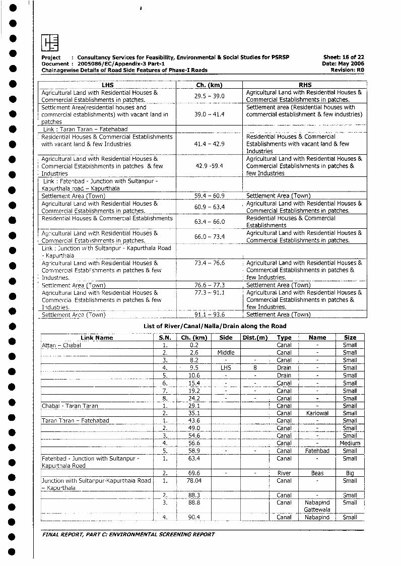
*
Project Consultancy Services for Feasibility, Environmental & Social Studies for PSRSP Sheet: 16 of 22Document 2005086/EC/Appendix-3 Part-i Date: May 2006
* Chainagewise Details of Road Side Features of Phase-I Roads Revision: RO
* LHS Ch. (km) RHSAgricultural Land with Residential Houses & 29.5 - 39.0 Agricultural Land with Residential Houses &
-Commercial Establishments in patches. Commercial Establishments in patches.Settlement Area(residential houses and Settlement area (Residential houses with
* commercial establishments) with vacant land in 39.0 - 41.4 commercial establishment & few industries)patchesLink: Taran Taran - FatehabadResidential Houses & Commercial Establishments Residential Houses & Commercial
* with vacant land & few Industries 41.4 - 42.9 Establishments with vacant land & fewIndustries
* Agricultural Land with Residential Houses & Agricultural Land with Residential Houses &Commercial Establishments in patches & few 42.9 -59.4 Commercial Establishments in patches &
* Industries few IndustriesLink: Fatehbad - Junction with Sultanpur -
* Kapurthala road - KapurthalaSettlement Area (Town) 59.4 - 60.9 Settlement Area (Town)
* Agricultural Land with Residential Houses & 60.9 - 63.4 Agricultural Land with Residential Houses &Commercial Establishments in patches. Commercial Establishments in patches.Residential Houses & Commercial Establishments 63.4 - 66.0 Residential Houses & Commercial
* 63.4 - 66.0 Establishments* Agricultural Land with Residential Houses & 66.0 - 73.4 Agricultural Land with Residential Houses &
Commercial Establishments in patches. Commercial Establishments in patches.* Link: Junction with Sultanpur - Kapurthala Road
- Kapurthala* Agricultural Land with Residential Houses & 73.4 - 76.6 Agricultural Land with Residential Houses &
Commercial Establishments in patches & few Commercial Establishments in patches &* Industries. few Industries.
Settlement Area (Town) 76.6 - 77.3 Settlement Area (Town)_ Agricultural Land with Residential Houses & 77.3 - 91.1 Agricultural Land with Residential Houses &
Commercial Establishments in patches & few Commercial Establishments in patches &Industries. few Industries.
_ Settlement Area (Town) 91.1 - 93.6 Settlement Area (Town)
* List of River/Canal/Nalla/Drain along the Road
Link Name S.N. Ch. (krn) Side Dist.(m) Type Name SizeAttari - Chabal 1. 0.2 Canal - Small*____________ 2. 2.6 Middle Canal - Small
3. 8.2 - Canal - Small4. 9.5 LHS 8 Drain - Small5. 10.6 - Drain - Small6. 15.4 - Canal - Small
_ 7. 19.2 - Canal - Small8. 24.2 - Canal - Small
* Chabal - Taran Taran 1. 29.1 _ Canal - Small____ _____________________________ 2. 35.1 Canal Kariowal Small
* Taran Taran - Fatehabad 1. 43.6 Canal - Small2. 49.0 Canal - Small
_ 3. 54.6 ___ Canal - Small4. 56.6 Canal - Medium
* 5. 58.9 Canal Fatehbad SmallFatehbad - Junction with Sultanpur - 1. 63.4 Canal Small
* Kapurthala Road _2. 69.6 River Beas Big
Junction with Sultanpur-Kapurthala Road 1. 78.04 Canal Small-Kapurthala ___
*-_Kap_rth_la2. 88.3 Canal Small3. 88.8 Canal Nabapind Small
* _ Gattewala*___________________ _ ___________ 4. 90.4 Canal Nabapind Small
* FINAL REPORT, PART C: ENVIRONMENTAL SCREENING REPORT
* Project Consultancy Services for Feasibility, Environmental & Social Studies for PSRSP Sheet: 17 of 22Document 2005086/EC/Appendix-3 Part-I Date: May 2006
* Chainagewise Details of Road Side Features of Phase-I Roads Revision: RO
* E I I I I I Patti5. 1 92.04 1 - I - I Canall - jSmall
NOTE: Canal, Drain, Nalla whose sides are not mentioned are across the Road
List of Ponds/Lakes along the Road
_ Link Name S.N. Ch. (km) Side Dist.(m) Type Size
* Attari - Chabal 1. 0.2 LHS 10 Pond Small2. 15.2 RHS 12 Pond Small
* - -- 3. 15.6 RHS 13 Pond Small4. 16.1 LHS 11 Pond Small
* _ 5. 21.2 RHS 19 Pond Small6. 21.6 LHS 15 Pond Small
_ 7. 21.8 RHS 16 Pond Small8. 25.6 RHS 14 Pond Small
* 9. 25.8 RHS 15 Pond Small10. _ 26.5 RHS 13 Pond Small
* 11. 26.6 RHS 14 Pond Small
Tarn Taran - Fatehabad 1. 50.0 LHS 12 Pond Small
_ 2. 57.9 LHS 13 Pond Small3. 58.0 RHS 10 Pond Small
* Fatehbad - Junction with Sultanpur - Kapurthala Road 1. 73.6 LHS 12 Pond Medium
Junction with Sultanpur-Kapurthala Road Kapurthala- 1. 78.4 RHS 15 Pond Small
* 2. 86.3 RHS 14 Pond Small3. 90.0 RHS 12 Pond Small
* List of Educational Institutions along the Road
* Link Name S.N. Ch. Side Dist. Name/Type Size Village/Town
* Attari - Chabal 1. 0.5 LHS 15 School (Primary) Small Pacca Pind
2. 27.6 RHS 12 School (Primary) Small Chaubal Khurd
* __ Chabal - Tarn Taran 1. 30.7 RHS 11 School (Secondary) Small Nikkakot
2. 31.1 LHS 12 School (Primary) Small
3. 34.1 LHS 12 School (Primary) Small Kairowal
Taran Taran - Fatehabad 1. 47.6 RHS 14 School (Primary & Secondary) Medium Naurangabad
* 2. 50.2 RHS 12 School (Primary & Secondary) Small Rasiana
_ _3. 52.9 RHS 14 School (Primary & Secondary) Medium Vain Poin
4. 56.9 LHS 15 College Medium Parawal
Fatehbad - Juriction with 1. 66.3 RHS 14 School (Primary & Secondary) Big Goindwal Sahib
* Sultanpur - Kapurthala Road ___
_____ 2. 69.4 RHS 12 School (Primary & Secondary) Small Amritpur
* Kapurthala - Junction with 1. 83.24 LHS 12 School (Primary & Secondary) Medium Khirawaliul aprrh la road_
* __ 2. 88.2 RHS 13 College Medium Nanakpur
3. 89.0 RHS 12 School (Primary & Secondary) Medium Naba Pind
_ _ 4. 89.4 LHS 12 College Medium
5. 92.8 LHS 8 _College Medium Kapurthala
_ __ _ __ _ 6. 92.9 LHS 8 School (Primary & Secondary) Medium
* List of Religious & Cultural Properties along the Road
A*tan | ChLink Name | S.N Ch. (kim) Side Dist. (m) Name/Type Importance Village/Town
|Attari - Chabal | 1. | 3.2 LHS 14 Gurudwara Local Mawa
________________________ _ 2. 4.6 LHS 15 Gurudwara Local Mawa
_____________________ l3. 7.5 LHS 14 Gurudwara Local Rajatal
* |________________________ l4. 8.8 LHS 15 Gurudwara Local Budl
5. 15.6 LHS 12 Radhasoami Local SaraiAmant-Khan
_ l l l l l l DhyanashramL______ ___ ____________ 6. 17.6 RHS 1 12 Dargah I Local Gandiwand
* L____ ______ 7. l26.8 l LHS 1 14 Radhasoami Local Chabalkhurd
FINAL REPORT, PART C: ENVIRONMENTAL SCREENING REPORT
Project : Consultancy Services for Feasibility, Environmental & Social Studies for PSRSP Sheet: 18 of 22Document 2005086/ EC/Appendix-3 Part-I Date: May 2006Chainagewise Details of Road Side Features of Phase-I Roads Revision: RO
* | Link Name S.N Ch. (km) Side Dist. (m) Name/Type Importance Village/TownDhyanashram
* Chabal - Tarn Taran 1. 34.2 RHS 11 Gurudwara Local KairwalTarn Taran - Fatehabad 1. 41.96 LHS 14 Gurudwara Local Tarn-Taran
* Fatehbad - )unction with 1. 5.6 LHS 10 Gurudwara Local GoidwalsahebSultanpur - Kapui-thala Road
2. 10.0 RHS 12 Gurudwara Local AmritpurKapurthala - ]unction with 1. 74.4 RHS 12 Gurudwara Local Mondimore
* ~~Sultanpur -_Kpurthala road2. 81.4 LHS 11 Gurudwara Local Khirawali
3. 88.8 LHS 13 Temple Local NabapindGatewalla
* __ _4. 93.04 LHS 7 Temple Local Kapurthala
Corridor G: Ferozpur - Zira - Kotisekhan- Dharamkot
* Topography and Soil Type
* Link Name Topography Soil TypeFerozepur to Zira Slightly Undulating; altitude 192 to 228 m above MSL; Bet (Flood Plain) Soil &
* Ferozepur to Zira general slope - south-west partly Desert Soil
Zira to Kotisekhan Slightly Undulating; altitude 222 to 228 m above MSL; Bet (Flood Plain) Soil*ra general slope - south-west
Kotisekhan to Dharamkot Slightly Undulating; altitude 228 to 234 m above MSL; Bet (Flood Plain) Soil*otisekhan to Dharamkot general slope - south-west
Source: Geography of Punjab by Darshan Singh Manku, Kalyani Publishers, 2002
* Drainage & Irrigation
Link Name Drainage Basin Position of Road wrt Main Canal0 ~~~~~~~~~~~~~~Drainage Basin _ _ _ _ _ _ _ _ _ _ _ _ _ _ _
* Ferozepur to Zira Satluj River Basin Left Canal (Indira Canal)
* Zira to Kotisekhan Satluj River Basin _CLeft Laiwad canalKotisekhan to Dharamkot Satluj River Basin Left Laiwad canal
* Source: Geography of Punjab by Darshan Singh Manku, Kalyani Publishers, 2002
The semi-arica and sub-tropical monsoon climate of the area warrants dependence on the irrigation system.There are two main methods of irrigation in this area - canals and tube wells. Sirhind Feeder canal, Indiracanal and Laiwad canal are the the main source of irrigation in this area. Other than canal water, larger portionof this region is under tube well irrigation. Huge quantities of tube wells are being sunk in this area to meet thewater needs of the area. Extensive use of underground sweet water for irrigation leads to famine in this area.
Geology & Hydrogeology
* HydrogeologyLink Name Geology Type of Aquifer Range of Depth to Water Table
* Type of Aquifer ~~~~~~~~~~~~~(mbgl)
* Ferozepur to Zira Quaternary alluvial deposits Unconfined Post-Monsoon - 5.0 - 10.0
Pre-Monsoon - 5.0 - 10.0
* Zira to Kotisekhan Quaternary alluvial deposits Unconfined Post-Monsoon - 5.0 - 10.0Kotisekhan to ~~~~~~~~~~~~Pret-Monsoon - 5.0 - 10.0
* D~~Koieharamkot Quaternary alluvial deposits Unconfined Post-Monsoon - 5.0 - 10.0
Source: Geography of Punjab by Darshan Singh Manku, Kalyani Publishers, 2002 & NATMO
Climate along the road
* Link Name Average Minimum Average Maxmimum Annual Range ofTemperature (°C) Temperature (0C) Rainfall (mm)
* Ferozepur to Zira 12.5 (January) 33.5 (June) 400 - 500
Ziia to Kotisekhan 12.5 (January) 33.5 (June) 400 - 500
FINAL REPORT, PART C: ENVIRONMENTAL SCREENING REPORT
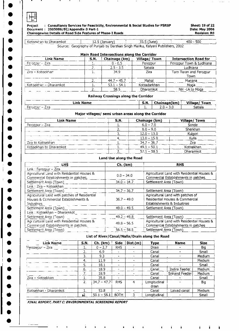
owProject Consultancy Services for Feasibility, Environmental & Social Studies for PSRSP Sheet: 19 of 22Document 2005086/EC/Appendix-3 Part-I Date: May 2006
* Chainagewise Details of Road Side Features of Phase-I Roads Revision: RO
* _otisekhan to Dharamkot 12.5 (January) 33.5 (June) 400 - 500
Source: Geography of Punjab by Darshan Singh Manku, Kalyani Publishers, 2002
Main Road Intersections along the Corridor
* Link Name S.N. Chainage (km) Village/ Town Intersection Road for
Ferozpur - Zira _ 1. 0 - 0.5 Ferozpur Ferozpur Town & Ludhiana
* __ ____ 2. 2.5 - 3.5 Satiala Ludhiana
Zira - Kotisekhan 1. 34.9 Zira Tarn Taran and Ferozpur
* _ __ . __ _ _ _ . _ ______ . __Town
2. 44.7 - 45.7 Mahal Munana
* Kotisekhan - Dharamkot 1. 53.1 - 54.1 Kotsadarkhan Moga
____________________________ 2. 58.5 Dharamkot NH -1A to Moga
Railway Crossings along the Corridor
* Link Name S.N. Chainage(km) Village/ Town
Ferozpur - Zira 1. 2.0 - 3.0 Satiala
Major villages/ semi urban areas along the Corridor
* Link Name S.N. Chainage (km) Village/ Town
Ferozpur - Zira 1. 6.0 - 7.0 Sonde
* F 2. 8.0 - 9.0 Sherkhan3. 12.0 - 13.0 Kulgori
* 4. 13.0 - 15.0 KulIla
Zira to Kotisekhan 1. 34.7- 36.7 Zira
* Kotisekhan to Dharamkot 1. 49.1 - 50.1 Kotisekhan
*_____________________________________________ 2. 57.1 - 58.5 Dharamkot
Land Use along the Road
* LHS Ch. (km) RHS
Link : Ferozpur - Zira* Agricultural Land with Residential Houses & 0.0 - 34.0 Agricultural Land with Residential Houses &
Commercial Establishments in patches. Commercial Establishments in patches.
* Settlement Area (Town) 34.0 - 34.7 Settlement Area (Town)
Link : Zira - Kotisekhan* Settlement Area (Town) 34.7 - 36.7 Settlement Area (Town)
Agricultural Land with patches of Residential Agricultural Land with patches of
* Houses & Commercial Establishments & 36.7 - 49.0 Residential Houses & Commercial
Industries Establishments & Industries
* Settlement Area (Town) 49.0 - 49.5 Settlement Area (Town)
Link : Kotisekhan - Dharamkot* Settlement Area (Town) 49.2 -- 49.8 Settlement Area (Town)
Agricultural Land with Residential Houses & 49.8 - 56.5 Agricultural Land with Residential Houses &
Commercial Establishrnents in patches. Commercial Establishments in patches
Settlement Area (Town) 56.5 - 58.5 Settlement Area (Town)
List of River/Canal/Nalla/Drain along the Road
* Link Name S.N. Ch. (km) Side Dist.(m) Type Name Size
Ferozepur- Zira 1. 0- 2.7 RHS - Drain - Big
* 2. 6.9 - - Canal - Small
_ 3. 9.3 - - Canal - Medium
* L _ 4. 11.9 - - Canal - Medium
L_____ 5. 18.1 - - Canal - Small
* l ~ 6. 18.9 - - Canal Indira Feeder Medium
7. 18.9 - - Canal Srihand Feeder Medium
* |Zira - Kotisekhan 1. 35.8 - Canal - Small
2. 34.7 - 47.7 RHS 4 Longitudinal - Big
* r _ l l l | drain
Kotisekhan - Dharamkot 1. 53.8 - - Canal Laivad canal Medium
* l*2. 50.1 - 58.1 BOTH 3 Longitudinal - Small
* FINNAL REPORT, PAR7 C: ENVIRONMENTAL SCREENING REPORT
* 0~~
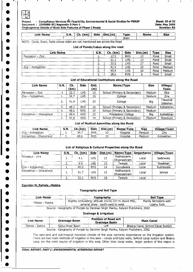
Project Consultancy Services fAr Feasibility, Environmental & Social Studies for PSRSP Sheet: 20 of 22Document 20050861EC/Appendix-3 Part-1 Date: May 2006
_ Chainagewise Details of Road Side Features of Phase-I Roads Revision: RO
* X Link Name S.N. Ch. (km) Side Dist.(m) Type Name Sizel l l l | | ~~~~~~~ ~ ~ ~ ~~~~~drain lll
* NOTE: Canal, Drain, Nalla whose sides are not mentioned are across the Road
* List of Ponds/Lakes along the road
Link Name S.N. Ch. (km) Side Dist.(m) Type Size* Ferozepur - Zira 1. 12.5 RHS 10 Pond Small
2. 11.1 LHS 13 Pond Small
* 3. 33.5 LHS 17 Pond Small
Zira - Kotisekhan 1. 41.5 LHS 10 Pond Medium* 2. 40.4 LHS 10 Pond Medium
_ 3. 38.6 RHS 6 Pond Small
List of Educational Institutions along the Road
* Link Name S. N. Ch. Side Dist. Name/Type Size Village/(km) (m) Town
* Ferozepur - Zira 1 32.3 LHS 13 School (Primary & Secondary) Medium KhaiZira - Kotisekhan 1. 34.7 LHS 10 College Medium Zira
2. 41.4 LHS 20 College Big Jallekhan
e _______ 3. 48.2 RHS 10 School (Primary & Secondary) Medium Kotisekhan
4. 48.6 RHS 14 School (Primary & Secondary) Medium __
_Kotisekhan - Dharamkot 1. 49.8 RHS 15 Polytechnic College Big Kotisekhan* _ - 2. 54.8 RHS 14 School (Primary & Secondary) Medium Noorpura
List of Medical Amenities along the Road
* L Link Name S.N. Ch.(km) Side Dist.(m) Name/Type Size Village/TownZira - Kotisekhan 1 34.7 RHS 10 Hospital Medium Zira
* Kotisekhan- Dharamkot 1 49.6 RHS Hospital Medium Kotisekhan
List of Religious & Cultural Properties along the Road
_ Link Name S.N. Ch. (km) Side Dist.(m) Name/Type Importance Village/Town
Firozepur - Zira 1. 4.1 LHS 13 Radhasoami Local SadinwalaDhyanashram
* 2. 9.9 LHS 15 Temple Local SherkhanZira - Kotisekhan 1. 40.0 RHS 14 Gurudwara Local SukhewalaKotisekhan - Dharamkot 1. 51.7 LHS 15 Radhasoami Local Jamiya
Dhyanashram* ________________________ 2. 52.2 RHS 18 Temple Local | _l
* Corridor H: Patiala -Nabha
Topography and Soil Type
| [ ~~~~~~Link Name |Topograhy Soil Typel
z~ ~ ~~~~~ail - Nabh Slightly Undulating; altitude 253 to 257 m above MSL; lMainly Seriozems with ll < Patiala - Nabha | general slope - south-west to west Loamy Soils
| < Source: Geography of Punjab by Darshan Singh Manku, Kalyani Publishers, 2002
| * __Drainage & Irrigation
Link Name Drainage Basin Position of Road wrt Main Canal0 ______________ I ~~~~~~Drainage Basin
Patiala - Nabha Satluj River Basin Left Bhakra Canal, Sirhind Canal System| * Source: Geography of Punjab by Darshan Singh Manku, Kalyani Publishers, 2002
The semi-arid and sub-tropical monsoon climate of the area warrants dependence on the irrigation system.There are two main methods of irrigation in this area - canals and tube wells. Sirhind canal system and Bhakracanal are the main source of irrigation in this area. Other than canal water, larger portion of this region is
* FINAL REPORT, PART C: ENVIRONMENTAL SCREENING REPORT
0
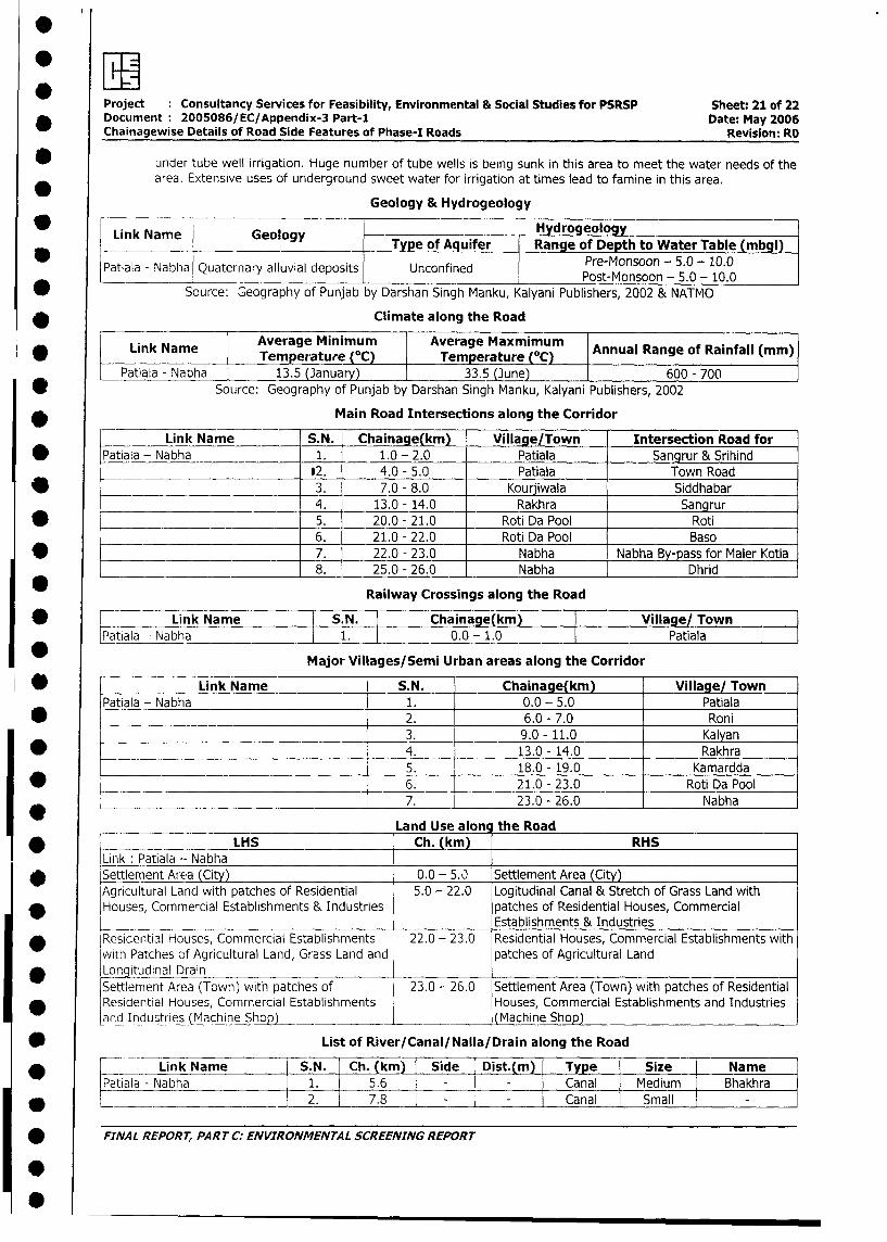
Project Consultancy Services for Feasibility, Environmental & Social Studies for PSRSP Sheet: 21 of 22
Document 2005086/EC/Appendix-3 Part-I Date: May 2006
Chainagewise Details of Road Side Features of Phase-I Roads Revision: RO
under tube well irrigation. Huge number of tube wells is being sunk in this area to meet the water needs of the
area. Extensive uses of underground sweet water for irrigation at times lead to famine in this area.
Geology & Hydrogeology
w Link Name Geology HydrogeologyLink Name Geology Type of Aquifer Range of Depth to Water Table (mbgl3
Patiala - Nabha Quaternary alluvial deposits Unconfined Pre-Monsoon - 5.0 - 10.0
* S ource: Geography of Punjab by Darshan Singh Manku, Kalyani Publishers, 2002 & NATMO
* Climate along the Road
Link Name Average Minimum Average (°C)m | Annual Range of Rainfall (mm)]~~Pa;name ~Temperature (0C) Temperature (OC) Ana ag fRifl
Patiala - Nabha 13.5 (3anuary) 33.5 (June) 600 - 700
l*e Source: Geography of Punjab by Darshan Singh Manku, Kalyani Publishers, 2002
Main Road Intersections along the Corridor
Link Name S.N. Chainage(km) Village/Town Intersection Road for
* Patiala - Nabha 1. 1.0 - 2.0 Patiala Sangrur & Srihind
_________._______ *2. 4.0 - 5.0 Patiala Town Road
* _ 3. 7.0 - 8.0 Kourjiwala Siddhabar
__________________________ 4. 13.0 - 14.0 Rakhra Sangrur
* - 5. 20.0 - 21.0 Roti Da Pool Roti
6. 21.0 - 22.0 Roti Da Pool Baso
* 7. 22.0 - 23.0 Nabha Nabha By-pass for Maler Kotla
____________________________ 8. 25.0 - 26.0 Nabha Dhrid
Railway Crossings along the Road
* : Link Name S.N. Chainage(km) Village/ Town
*Patiala - Nabha l1. 0.0 - 1.0 I Patiala
Major Villages/Semi Urban areas along the Corridor
* = Link Name S.N. Chainage(km) Village/ Town
Patiala - Nabha 1. 0.0 - 5.0 Patiala
* 2. 6.0 - 7.0 Roni
3. 9.0 - 11.0 Kalyan
* 4. 13.0 - 14.0 Rakhra
5. 18.0 - 19.0 Kamardda
* ________________________________ 6. 21.0 - 23.0 Roti Da Pool
e___________________________________ .7. 23.0 - 26.0 Nabha
Land Use along the Road
l ̂ l LHS Ch. (km)l RHS
Link : Patiala - NabhaI |Settlement Area (City) 0.0 - 5.0 Settlement Area (City)
Agricultural Land with patches of Residential 5.0 - 22.0 Logitudinal Canal & Stretch of Grass Land with
Houses, Commercial Establishments & Industries patches of Residential Houses, CommercialEstablishments & Industries
I \ (Residential Houses, Commercial Establishments 22.0 - 23.0 Residential Houses, Commercial Establishments with
with Patches of Agricultural Land, Grass Land and patches of Agricultural Land
* Loitudinal DrainSettlement Area (Town) with patches of 23.0 - 26.0 Settlement Area (Town) with patches of Residential
Residential Houses, Commercial Establishments Houses, Commercial Establishments and Industries
aid Industries (Machine Shop) ___ (Machine Shop)
| ; List of River/Canal/Nalla/Drain along the Road
| * L_ ~~~~Link Name lS.N. lCh. (km) lSide Dist.(m) lType l Size | Name l
L tPatiala -Nabha 1. 5.6 Canal Medium Bhakhra
| } _ l ~~~~~~~~~~~2. l 7.8 l - l - lCanal l Small | - l
| * FINAL REPORT, PART C: ENVIRONMENTAL SCREENING REPORT
I
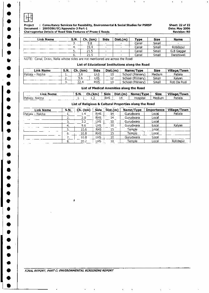
Project Consultancy Services for Feasibility, Environmental & Social Studies for PSRSP Sheet: 22 of 22* Document: 2005086/EC/Appendix-3 Part-1 Date: May 2006
Chainagewise Details of Road Side Features of Phase-I Roads Revision: RO
Link Name S.N. Ch. (km) Side Dist.(m) Type Size Name
* 3. 9.8 - Canal Small
4. 19.4 X- Canal Small Rotidapul
* 5. 21.5 - Canal Small G.B Gaggar
____ 6. 21.5 - Canal Small Darahiwali
NOTE: Canal, Drain, Nalla whose sides are not mentioned are across the Road
List of Educational Institutions along the Road
* Link Name S.N. Ch. (km) Side Dist.(m) Name/Type Size Village/Town
* Patiala - Nabha 1. 3.6 LHS 10 School (Primary) Medium Patiala2. 9.6 LHS 12 School (Primary) Small Kalyan
* 3. 22.4 RHS 10 School (Primary) Small Roti Da Pool
List of Medical Amenities along the Road
Link Name S.N. Ch.(km Side Dist.(m) | Name/Type I Size | Village/Town |
* |Patiala- Nabha 1. 1.2 l RHS | 14 Hospital Medium Patiala
List of Religious & Cultural Properties along the Road
Link Name S.N. Ch. (km) Side Dist.(m) Name/Type Importance Village/Town
* Patiala - Nabha 1. 1.4 RHS 14 Gurudwara Local Patiala2. 2.0 RHS 14 Gurudwara Local
* _ 3. 3.2 LHS 10 Gurudwara Local4. 9.6 LHS 10 Gurudwara Local Kalyan
* 5. 10.6 RHS 15 Temple Local___________ __________ 6. 10.8 RHS~ 15 Temple Local _ _ _ _ _ _ _
l ______________________ 7. 10.8 LHSI 10 Gurudwara Local | _l
l______________________ 8. 20.2 LHS 10 Temple Local Rotidapul
| * ~FINA L REPORT, PART C. ENWRONMENTAL SCREENING REPORT
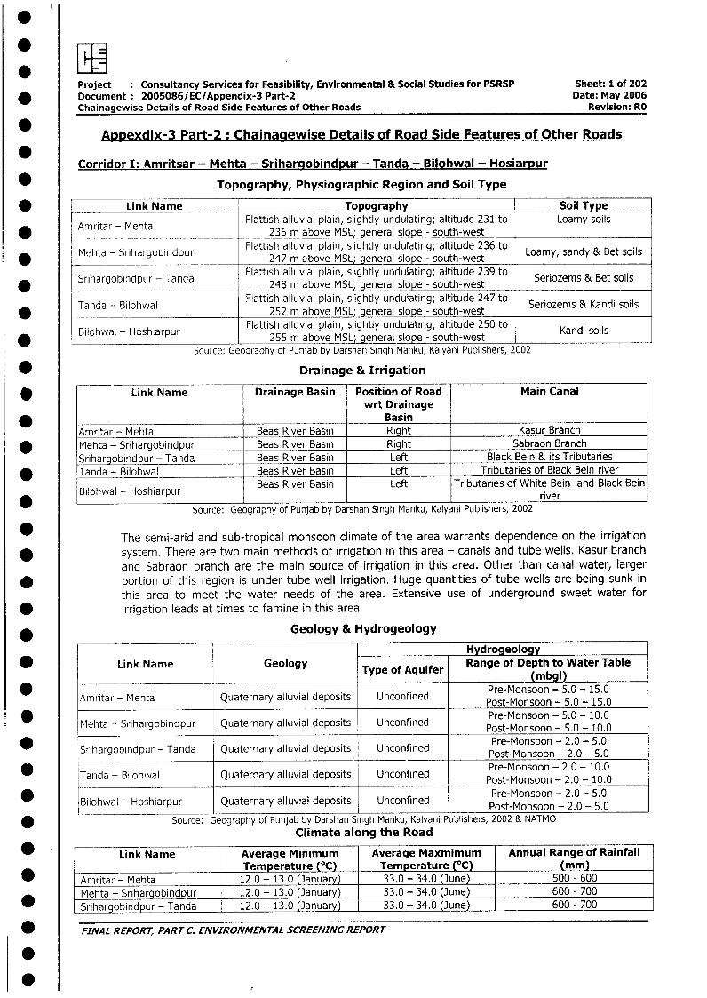
Project Consultancy Services for Feasibility, Environmental & Social Studies for PSRSP Sheet: 1 of 202* DocLument 2005086/EC/Appendix-3 Part-2 Date: May 2006
Chainagewise Details of Road Side Features of Other Roads Revision: RO
* Appexdix-3 Part-2: Chainagewise Details of Road Side Features of Other Roads
Corridor I: .Amritsar - Mehta - Srihargobindpur - Tanda - Bilohwal - HosiarDur
* Topography, Physiographic Region and Soil Type
* Link Name Topography Soil TypeAmritar - Mehta Flattish alluvial plain, slightly undulating; altitude 231 to Loamy soils*mritar _ Mehta 236 m above MSL; general slope - south-west
Mehta - SriargobindpurFlattish alluvial plain, slightly undulating; altitude 236 to Lay ad e olM(hta - Srihargobindpur 27maoeMLgerislp-sutwst Loamy, sandy & Bet soils*____ _ Srihargobindpur - ana247 m above MSL; general slope - south-west
S _ _ __ ,9_ _ P__ _ _ _ _Srihargobindpur - Tanda Flattish alluvial plain, slightly undulating; altitude 239 to Seriozems & Bet soils_____ ~~~~~~~248 m above MSL; general slope - south-west
Tanda - Bilohwal Flattish alluvial plain, slightly undulating; altitude 247 to Seriozems & Kandi soils* Tanda ______- B________252 m above MSL; general slope - south-west
Bilohwal - Hoshiarpur Flattish alluvial plain, slightly undulating; altitude 250 to Kandi soils* Bllohwal - Hoshiarpur 255 m above MSL; general slope - south-west I I
Source: Geography of Punjab by Darshan Singh Manku, Kalyani Publishers, 2002
* Drainage & Irrigation
* Link Name Drainage Basin Position of Road Main Canalwrt Drainage
* . BasinAmritar - Mehta Beas River Basin Right Kasur Branch
* Mehta - Srihargobindpur Beas River Basin Right Sabraon BranchSrihargobindpur - Tanda Beas River Basin Left Black Bein & its Tributaries
* Tanda - Bilohwal Beas River Basin Left Tributaries of Black Bein river
Bilohiwal - Hoshiarpur Beas River Basin Left Tributaries of White Bein and Black Bein_ _ _ _ _ _ _ _ _ _ _ _ _ _ _ _ _ _ _ _ _ _ _ _ _ _ _ _ _ _ _ _ _ _ _ _ _ _riv e r
* Source: Geography of Punjab by Darshan Singh Manku, Kalyani Publishers, 2002
* The semri-arid and sub-tropical monsoon climate of the area warrants dependence on the irrigation* system. There are two main methods of irrigation in this area - canals and tube wells. Kasur branch
and Sabraon branch are the main source of irrigation in this area. Other than canal water, larger* portion of this region is under tube well irrigation. Huge quantities of tube wells are being sunk in
this area to meet the water needs of the area. Extensive use of underground sweet water for* irrigation leads at times to famine in this area.
* ______ __________ Geology & Hydrogeology
Hydrogeology* Link Name Geology Type of Aquifer Range of Depth to Water Table
Type of Aquifer(mbgl)
Amritar - Mehta Quaternary alluvial deposits Unconfined Post-Monsoon - 5.0 - 15.0
Pre-Monsoon - 5.0 - 10.0Mehta - Srihargobindpur Quaternary alluvial deposits Unconfined Post-Monsoon - 5.0 - 10.0
Sriargbidpu-Tada Quterayalluvial deposits Unofind Pre-Monsoon - 2.0 - 5.0Srihargobindpur - ana ~~uaernary nconine Post-Monsoon - 2.0 - 5.0
* Tanda - Bilohwal Quaternary alluvial deposits Unconfined Pre-Monsoon - 2.0 - 10.0___________________ _____________________Post-Monsoon -2.0 - 10.0
* Bilohwal - Hoshiarpur Quaternary alluvial deposits Unconfined Pre-Monsoon - 2.0 - 5.0iowa_Post-Monsoon - 2.0 - 5.0
* Source: Geography of Punjab by Darshan Singh Manku, Kalyani Publishers, 2002 & NATMOClimate along the Road
Link Name Average Minimum Average Maxmimum Annual Range of RainfallTemperature (OC) Temperature (°C) (mm)
* Amritar - Mehta 12.0 - 13.0 (January) 33.0 - 34.0 (June) 500 - 600Mehta - Srihargobindpur 12.0 - 13.0 (January) 33.0 - 34.0 (June) 600 - 700Srihargobindpur - Tanda 12.0 - 13.0 (January) 33.0 - 34.0 (June) 600 - 700
* FINAL REPORT, PART C: ENVIRONMENTAL SCREENING REPORT
S
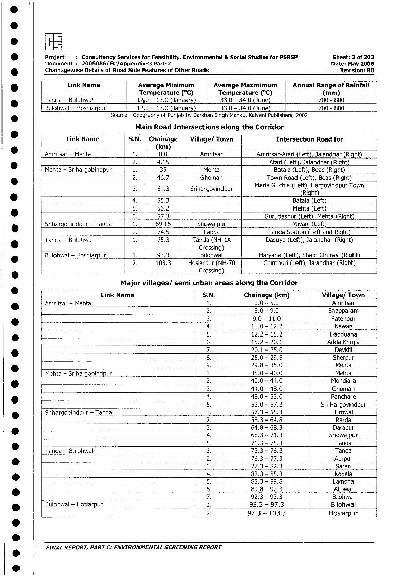
* Project Consultancy Services for Feasibility, Environmental & Social Studies for PSRSP Sheet: 2 of 202Document 2005086/EC/Appendix-3 Part-2 Date: May 2006
_ Chainagewise Details of Road Side Features of Other Roads Revision: RO
Link Name Average Minimum Average Maxmimum Annual Range of RainfallTemperature (OC) Temperature (°C) (mm)
* Tanda - Bulohwal 12 0 - 13.0 (January) 33.0 - 34.0 (June) 700 - 800Bulohwal - Hoshiarpur 12.0 - 13.0 (January) 33.0 - 34.0 (June) 700 - 800
Source: Geography of Punjab by Darshan Singh Manku, Kalyani Publishers, 2002
Main Road Intersections along the Corridor
Link Name S.N. Chainage Village/ Town Intersection Road for(km)
Amritsar - Mehta 1. 0.0 Amritsar Amritsar-Atari (Left), Jalandhar (Right)* __ 2. 4.15 Atari (Left), Jalandhar (Right)
Mehta - Srihargobindpur 1. 35 Mehta Batala (Left), Beas (Right)2. 46.7 Ghoman Town Road (Left), Beas (Right)
Maria Guchia (Left), Hargovindpur Town3. 54.3 Srihargovindpur (Right)
____ ____ ___ ____ ___ ____ ____ ___ ____ ___4. 55.3 Batala (Left)5. 56.2 Mehta (Left)
* . 6. 57.3 Gurudaspur (Left), Mehta (Right)* Srihargobindpur - Tanda 1. 69.15 Showajpur Miyani (Left)
2. 74.5 Tanda Tanda Station (Left and Right)Tanda - Bulohwal 1. 75.3 Tanda (NH-1A Dasuya (Left), Jalandhar (Right)
Crossing)Bulohwal - Hoshiarpur 1. 93.3 Bilohwal Haryana (Left), Sham Churasi (Right)
2. 103.3 Hosiarpur (NH-70 Chintpuri (Left), Jalandhar (Right)______________ Crossing)
Major villages/ semi urban areas along the Corridor
Link Name S.N. Chainage (km) Village/ Town_ i Amritsar - Mehta 1. 0.0 - 5.0 Amritsar
2. 5.0 - 9.0 Shapparam* 3. 9.0 - 11.0 Fatehpur
_ 4. 11.0 - 12.2 Nawan_ F_ 5. 12.2 - 15.2 Dadduana
6. 15.2 - 20.1 Adda Khujla* . 7. 20.1 - 25.0 Devkiji
_____ 8. 25.0 - 29.8 Sherpur* 9. 29.8 - 35.0 Mehta
Mehta - Srihargobindpur _ 1. 35.0 - 40.0 Mehta* -________ 2. 40.0 - 44.0 Mondiara
3. 44.0 - 48.0 Ghoman_ l 4. 48.0 - 53.0 Panchare
_ _ _ _ _ _ _ _ _ _ _ _ _ _ _ _ _ _ _ _ _ 5. 53.0 - 57.3 Sri Hargovindpur* | Srihargobindpur - Tanda 1. 57.3 - 58.3 Tirowal
2. 58.3 - 64.8 Rarda_____________________________________________ 3. _ 64.8 - 68.3 D arapur
4. 68.3 - 71.3 Showajpur* _ 5. 71.3 - 75.3 Tanda
Tanda - Bulohwal 1. 75.3 - 76.3 Tanda* 2. 76.3 - 77.3 Aurpur
3. 77.3 - 82.3 Saran_ .4. 82.3 - 85.3 Kodala
___________ __________________________________ 5. 85.3 - 89.8 Lam bha* 6. 89.8 - 92.3 Allowal
7. 92.3 - 93.3 Bilohwal* Bulohwal - Hosiarpur 1. 93.3 - 97.3 Bilohwal
2. 97.3 - 103.3 Hosiarpur
FINAL REPORT, PART C: ENVIRONMENTAL SCREENING REPORT
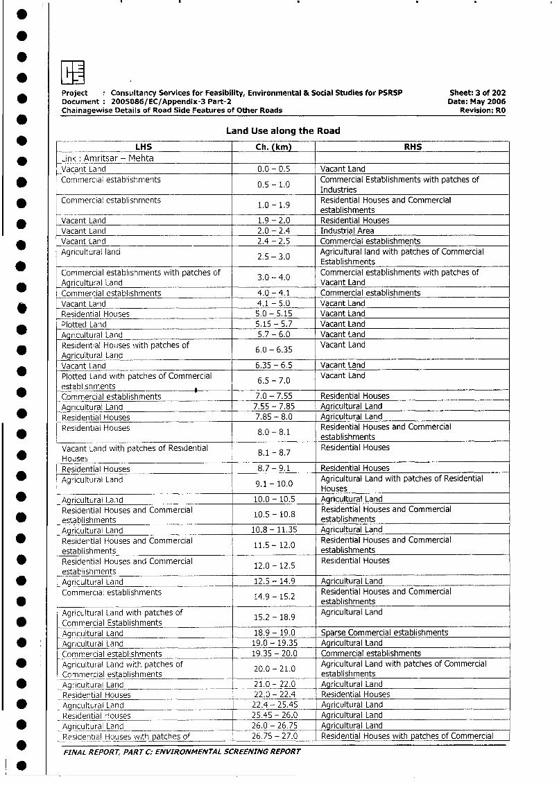
Project ConsLiltancy Services for Feasibility, Environmental & Social Studies for PSRSP Sheet: 3 of 202
* Document 2005086/EC/Appendix-3 Part-2 Date: May 2006
Chainagewise Details of Road Side Features of Other Roads Revision: RO
Land Use along the Road
LHS Ch. (km) RHS
* Link: Amritsar - MehtaVacant Land 0.0 - 0.5 Vacant Land
* Commercial establishments 0.5 - 1.0 Commercial Establishments with patches ofIndustries
Commercial establishments Residential Houses and Commercial* 1.0 - 1.9 establishments
* Vacant Land 1.9 - 2.0 Residential HousesVacant Land 2.0 - 2.4 Industrial Area
_ Vacant Land 2.4 - 2.5 Commercial establishmentsAgricultural land 5 3.0 Agricultural land with patches of Commercial
2.5 - 3.0 EstablishmentsCommercial establishments with patches of 3.0 - 4.0 Commercial establishments with patches ofAgricultural Land Vacant LandCommercial establishments 4.0 - 4.1 Commercial establishments
* _Vacant Land 4.1 - 5.0 Vacant LandResidential Houses_ 5.0 - 5.15 Vacant Land
Plotted Land 5.15 - 5.7 Vacant LandAgricultural Land 5.7 - 6.0 Vacant Land
* Residential Houses with patches of 6.0 - 6.35 Vacant LandAgricultural LandVacant Land 6.35 - 6.5 Vacant Land
Plotted Land with patches of Commercial 6.5 - 7.0 Vacant Landestablishments 7
* Commercial establishments 7.0 - 7.55 Residential Houses___
Aqricultural Land 7.55 - 7.85 Agricultural Land
* Residential Houses 7.85 - 8.0 Agricultural LandResidential Houses 1 Residential Houses and Commercial
* 8.0 - 8.1 establishments
Vacant Land with patches of Residential 8.1 - 8.7 Residential Houses* - Houses
Residential Houses 8.7 - 9.1 Residential Houses* - Agricultural Land 9.1 - 10.0 Agricultural Land with patches of Residential
______________________________________ Houses
* Agricultural Land 10.0 - 10.5 Agricultural LandResidential Houses and Commercial 10.5 - 10.8 Residential Houses and Commercial
* establishments establishmentsAgricultural Land 10.8 - 11.35 Agricultural Land
Residential Houses and Commercial 11.5 12.0 Residential Houses and Commercialestablishments . - . establishments
* Residential Houses and Commercial 12.0 - 12.5 Residential Housesestablishments
* Agricultural Land 12.5 - 14.9 Agricultural Land
Commercial establishments 14.9 - 15.2 Residential Houses and Commercial* 14.9 - 15.2 establishments
Agricultural Land with patches of 15.2 - 18.9 Agricultural Land* Commercial Establishments
Agricultural Land 18.9 - 19.0 Sparse Commercial establishments
* Agricultural Land 19.0 - 19.35 Agricultural LandCommercial establishments 19.35 - 20.0 Commercial establishments
* Agricultural Land with patches of 20.0 - 21.0 Agricultural Land with patches of CommercialCommercial establishments establishments
* _Agricutural Land 21.0 - 22.0 Agricultural LandResidential Houses 22.0 - 22.4 Residential Houses
* ~AaIcultural Land 22.4 - 25.45 Agricultural LandResidential Houses 25.45 - 26.0 Agricultural Land
_ Agricultural Land 26.0 - 26.75 _ Agricultural LandResidential Houses with patches of 26.75 - 27.0 Residential Houses with patches of Commercial
FINAL REPORT, PART C. ENVIRONMENTAL SCREENING REPORT
* S
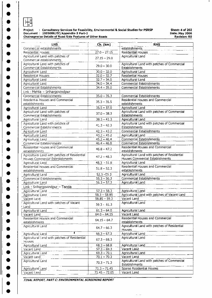
| * Project : Consultancy Services for Feasibility, Environmental & Social Studies for PSRSP Sheet: 4 of 202Document 2005086/EC/Appendix-3 Part-2 Date: May 2006
| * Chainagewise Details of Road Side Features of Other Roads Revision: RO
LHS Ch. (km) RHSCommercial establishments _ establishments
| * Residential Houses 27.0 - 27.15 Residential HousesAgricultural Land with patches of 27.15 - 29.0 Agricultural Land
* Commercial establishmentsAgricultural Land with patches of 29.0 - 30.0 Agricultural Land with patches of Commercial
_ Commercial Establishments . EstablishmentsAgricultural Land 30.0 - 32.0 Agricultural Land
* Residential Houses 32.0 - 32.7 Residential HousesAgricultural Land 32.7 - 34.0 Agricultural Land
* Agricultural Land 34.0 - 34.4 Commercial Establishments
Commercial Establishments 34.4 - 35.0 Commercial Establishments
* Link: Mehta - SrihargovindpurCommercial Establishments 35.0 - 35.3 Commercial Establishments
Residential Houses and Commercial Residential Houses and Commercial_establishments 35.3 - 35.5 establishments
* Agricultural Land 35.5 - 37.0 Agricultural Land
Agricultural Land with patches of 37.0 - 38.3 Agricultural Land with patches of CommercialCommercial Establishments . . EstablishmentsAgricultural Land 38.3 - 41.3 Agricultural LandAgricultural Land with patches of Agricultural Land with patches of Commercial
Commercial Establishments 41.3 - 42.3 Establishments* Agricultural Land 42.3 - 43.2 Commercial Establishments
Agricultural Land 43.2 - 45.2 Agricultural Land
* Agricultural Land 45.2 - 46.4 Commercial Establishments
Commercial Establishments 46.4 - 46.8 Commercial Establishments
Residential Houses and Commercial 46.8 - 47.2 Residential Houses and Commercialestablishments . . establishmentsAgricultural Land with patches of Residential 47.2 - 48.3 Agricultural Land with patches of Residential
-Houses Commercial Establishments Houses Commercial Establishments
Agricultural Land 48.3 - 51.8 Agricultural Land
* Residential Houses and Commercial 5 2.3 Residential Houses and Commercialestablishments 1.8 - 52. establishments
_ Agricultural Land 52.3 -55.3 Agricultural LandCommercial Establishments 55.3 - 56.3 Commercial Establishments
_ Aaricultural Land 56.3 - 57.3 Agricultural Land
Link : Srihargovindpur - Tanda ___ _
Agricultural Land 57.3 - 58.3 Agricultural LandAgricultural Land 58.3 - 58.85 Agricultural Land with patches of Vacant LandVacant Land 58.85 - 59.3 Vacant Land
* Agricultural Land with patches of Vacant 59.3 - 613 Agricultural LandLand . .Agricultural Land 61.3 - 64.0 Agricultural LandVacant Land 64.0 - 64.15 Vacant LandResidential Houses and Commercial 64.15 64.7 Residential Houses and Commercial
* establishments 6 _ establishmentsAgricultural Land 64.7 - 66.3 Agricultural Land with patches of Residential
* ________ ____,______ Houses
Agricultural Land 66.3 - 67.3 Agricultural Land* Agricultural Land with patches of Residential 67.3 - 68.3 Agricultural Land
Houses* Agricultural Land 68.3 - 68.8 Agricultural Land
Vacant Land 57.3 - 69.3 Vacant Land* Agricultural Land 69.3 - 70.1 Agricultural Land
Vacant Land 70.1 - 70.3 Vacant Land* Agricultural Land 70.3 - 71.3 Agricultural Land with patches of Commercial
___________________________________________ __________7.3_-_71_3 Establishments* Agricultural Land 71.3 - 71.45 Sparse Residential Houses
Vacant Land 71.45 - 72.05 Vacant Land
FINAL REPORT, PART C: ENVIRONMENTAL SCREENING REPORT
* _ _ _ _ _ _ _ _ _
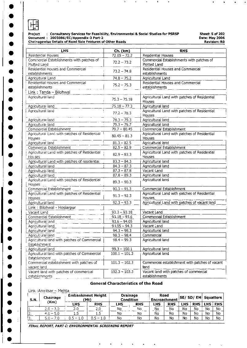
* Project : Consultancy Services for Feasibility, Environmental & Social Studies for PSRSP Sheet: 5 of 202Document 2005086/EC/Appendix-3 Part-2 Date: May 2006
* Chainagewise Details of Road Side Features of Other Roads Revision: RO
LHS Ch. (km) RHS
_ Residential Houses 72.05 - 72.2 Residential Houses
Commercial Establishments with patches of 72.2 - 73.2 Commercial Establishments with patches of
Plotted Land . . Plotted LandResidential Houses and Commercial 73.2 - 74.8 Residential Houses and Commercial
_ establishments . . establishmentsAgricultural Land 74.8 - 75.2 Agricultural Land
Residential Houses and Commercial 75.2 - 75.3 Residential Houses and Commercialestablishments establishments
Link: Tanda - BilohwalAgricultural land Agricultural Land with patches of Residential
* ~~~~~~~~~~~~~~~~75.3 - 75.18 Houses
Agricultural land 75.18 - 77.3 Agricultural land
Agricultural land Agricultural Land with patches of Residential77.2 - 78.3 Hose
_ Agricultural land 78.3 - 79.3 Agricultural land
Agricultural land 79.3 - 79.7 Agricultural landCommercial Establishment 79.7 - 80.45 Commercial Establishment
Agricultural Land with patches of Residential 80.45 - 81.3 Agricultural Land with patches of Residential
* Houses . . HousesAgricultural land 81.3 - 82.5 Agricultural land
* Commercial Establishment 82.5 - 82.9 Commercial Establishment
Agricultural Land with patches of Residential 82.9 - 83.3 Agricultural Land with patches of Residential
_ Houses Houses
Agricultural Land with patches of residential 83.3 - 84.3 Agricultural land
_ Agricultural land 84.3 - 87.3 Agricultural landAgricultural land 87.3 - 87.8 Vacant Land
* _Agricultural land 87.8 - 89.3 Agricultural land
Agricultur-al Land with patches of Residential 89.3 - 90.3 Agricultural land0 ~~Houses
Commercial Establishment 90.3 - 91.3 Commercial Establishment
* Agricultural Land with patches of Residential 91.3 - 92.3 Agricultural Land with patches of Residential
Houses Houses* Agricultural land 92.3 - 93.3 Agricultural Land with patches of vacant land
Link: Bilohwal - Hosiarpur* Vacant Land 93.3 - 93.18 Vacant Land
Commercial Establishment 93.18 - 93.6 Commercial Establishment
* Agricultural land 93.6 - 94.05 Agricultural landAgricultural land 99.05 - 94.3 Vacant Land
* Agric_u_ra' land 94.3 - 98.3 Agricultural land
Agricultural land 98.3 - 98.4 Commercial* Agricultural land with patches of Commercial 98.4 - 99.3 Agricultural land
Establishment* Agricultural land 99.3 - 100.1 Agricultural land
Agricultural land with patches of Commercial 100.1 - 101.3 Agricultural land
* EstablishmentCommercial establishment with patches of 101.3 - 102.3 Commercial establishment with patches of vacant
* vacant land landVacant land with patches of commercial 102.3 - 103.3 Vacant land with patches of commercial
* establishments _ establishments
* General Characteristics of the Road
Link :Amritsar - Mehta
*Chainae Embankment Height Drainage Road SE/ SD/ EM Squatters(Km)C i(ag Mt Condition Encroachment S/S/E qatr
* (Kin) LHS RHS _LHS RHS LHS RHS LHS RHS LHS PHS
1. 2.0-3.0 2.0 2.0 No No No No No No No No
* 2. 4.0 - 5.0 1.5 1.5 No No No No No No No No
3. 5.0 - 7.0 0.5 - 1.0 0.5 - 1.0 No No No No No No No No
FINAL REPORT, PART C: ENVIRONMENTAL SCREENING REPORT
0
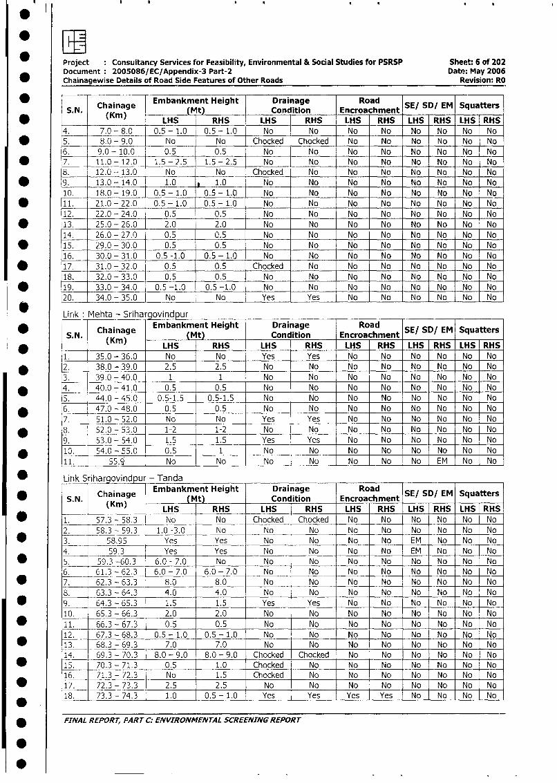
Project Consultancy Services for Feasibility, Environmental & Social Studies for PSRSP Sheet: 6 of 202Document :2005086/ EC/Appendix-3 Part-2 Date: May 2006
*Chainagewise Details of Road Side Features of Other Roads Revision: RO
0 ~~~~~Chainage Embankment Height [ Drainage Road S/S/E qatS. N. (Km) ~ Mt) Condition Encroachment S!S/E qatr
~~~~ ~~~LHS RHS LHS -RHS LHS RHS LHS RHS LHS RHS-
4. 7.0 -8.0 0.-1.0 0.5 -1.0 No No No No No No No No* ~~5. 8.0 - 9.0 No No Chocked Chocked No No No No No No
6. 9.0 - 10.0 0.5 0.5 No No No No No No No No
*7. 11.0 -12.0- 1.5 -2.5 1.5 -2.5 No No No No No No No No
8. 12.0 - 13.0 No No Chocked No No No No No No No
* ~~9. 13.0 -14.0 1.0 LQ.0 No No No No No No No No
10. -18.0 - 19.0 0.5 - 1.0 0.5 - 1.0 No No No No No No No No
* ~~~11. 21.0 - 22.0 0.5 - 1.0 0.5 - 1.0 No No No No No No No No
12. 22.0 - 24.0 0.5 0.5 No No No No No No No No
* ~~~13. 25.0 - 26.0 2.0 2.0 No No No No No No No No
14. 26.0 - 27.0 0.5 0.5 No No No No No No No No
* ~~~15. 29.0 - 30.0 0.5 0.5 No No No No No No No No
16. 30.0 - 31.0 0.5 -1.0 0.5 - 1.0 No No No No No No No No
* ~~~17. -31.0 - 32.0 0.5 0.5 Chocked No No No No No No No
18. 32.0 - 33.0 0.5 0.5 No No No No No No No No
* ~~~19.- 33.0 - 34.0 0.5 -1.0 0.5 -1.0 No No No No No No No No
20. 34.0 - 35.0 No No Yes Yes No No No No No No-
Lirik Mehta - SrihargovindpurChaiage Embankment Height Drainage Road S/S/E qatr
S.N. (hKnmg Mt Condition Encroachment S/S/E qatr(Kin) ~LHS RHS LHS RHS LHS RHS LHS RHS LHS RHS
1. 35.0 -36.0 No No Yes Yes No No No No No No
* ~ ~2. 38.0 - 39.0 2.5 2.5 No No No No No No No No
3. 39.0 -40.0 1 1 No No No No No No No No
4. 40.0 -41.0 0.5 0.5 No No No No No No No No
5. 44.0 -45.0 0.5-1.5 0.5-1.5 No No No No No No No INo
* 6 47.0- 48.0 0.5 0.5 No No No No No No No No
7. 51.0 -52.0 No No Yes Yes No No No No No No
* ~ ~8. 52.0 -53.0 1-2 1-2 No No No No No No No No
9. 53.0 -. 54.0 1.5 1.5 Yes Yes No No No No No No
* ~~~10. -54.0 -55.0 0.5 1 No No No No No No No No
11. 55.9 No No No No No No No EM No INo
* ~~Link S ihargovindpur TandaChaiiage Embankment Height Drainage Road S/S/E qatr
S.N. C(ainage Mt Condition Encroachment S!S!E qatr0 (Kin) ~~~~ ~~~LHS RHS LHS RHS LHS RHS LHS RHS LHS RHS
* ~~~1. 57.3 -_58.3 No No Chocked Chocked No No No No No No
2. 58.3 - 59.3 1.0 -3.0 No No No No No No No No No
* __~~3 58.95 Yes Yes No No No No EM No No No4. 59.3 Yes Yes No No No No EM No No No
* ~ ~~5 - 59.3 -60.3~ 6.0 -7.0 No No No No No No No No No
6._ 61.3-62.3 6.0 -7.0 6.0 -7.0 No No No No No No No No
* ~~~7._ 62.3 -63.3 8.0 8.0 No No No No No No No No
8. 63.3 -64.3 4.0 4.0 No No No No No No No No
* ~ ~9. 64.3 -65.3 1.5 1.5 Yes Yes No No No No No No
10. 65.3 - 66.3 2.0 2.0 No No No No No No No No
* ~~~11. _ -66.3 -67.3 0.5 0.5 No No No No No No No No-
12. 67.3 - 68.3 0.5 - 1.0 0.5 - 1.0 No No No No No No No No
* ~~~13. 68.3 - 69.3 7.0 7.0 No No No No No No No No
14. 69.3 - 70.3 8.0 - 9.0 8.0 - 9.0 Chocked Chocked No No No No No No
* ~~~15. 70.3 - 71.3 0.5 1.0 Chocked No No No No No No No
16. 71.3 - 72.3 No 1.5 Chocked No No No No No No No
* ~~~17. 72.3 - 73.3 2.5 2.5 No No No No No No No No
18. 73.3 - 74.3 1.0 0. 5- 1. 0 Yes Yes Yes Yes No No No No
* ~~FINAL REPORT, PART C. ENVIRONMENTAL SCREENING REPORT
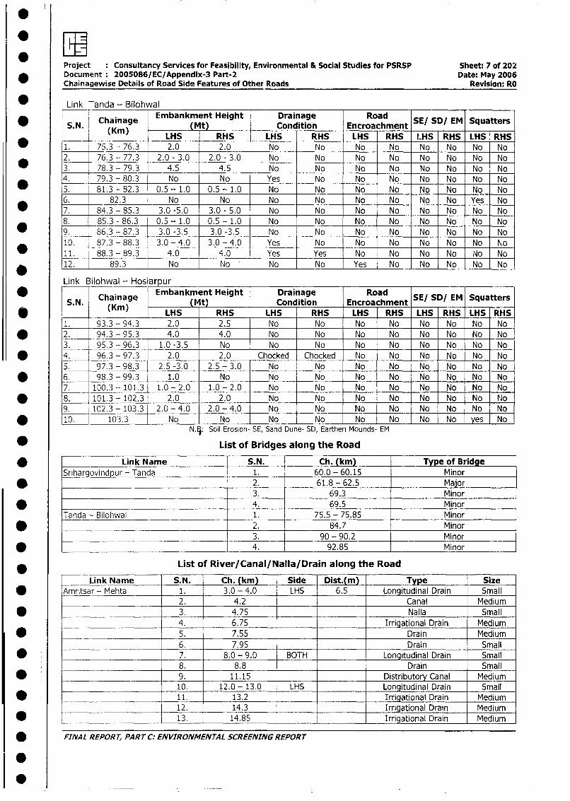
Project Consultancy Services for Feasibility, Environmental & Social Studies for PSRSP Sheet: 7 of 202* ~~~Document 2005086/ EC/Appendix-3 Part-2 Date: May 2006
Chainagewise Details of Road Side Features of Other Roads Revision: RO
* ~~Link --anda - BilohwalChaiage Embankment Height Drainage Road S/S/E qatr
* ~~S. N. C(ainage jtj __ Condition Encroachment S/S/E qatr___ ~~~~ ~~LHS RHS LHS RHS LHS RHS L.HS RHS LHS RHS
* ___~1 (Kin)63 202. oN N o N N o N
2. 75.3 - 76.3 2.0 -30 2.0-30 No No No No No No No No
* ~ ~3. 78.3 -79.3 4.5 4.5 No No No No No No No No4. 79.3 - 80.3 No No Yes No INo No No No No No
* ~ ~5. 81.3 -82.3 0.5 -1.0 0.5 -1.0 No No No No No- No No No6. 82.3 No No No No No INo No No Yes No
* ~ ~7. 84.3 - 85.3 3.0 -5.0 3.0 - 5.0 No No No No No No No No8. 85.3 -86.3 0.5 -1.0 0.5 -1.0 No No No No No No No No
* ~ ~9. 86.3 -- 87.3 3.0 -3.5 3.0 -3.5 No No No No No No No No10. 87.3 - 88.3 3.0 - 4.0 3.0 - 4.0 Yes No No No No No No No
* ~~~11. 188.3 -89.3 4.0 4.0 Yes Yes No No No No No No
12. 89.3 No No No No Yes No No No No No
Link Bilohwal - Hosiarpur___ ___ _ _ _ __ _ _ _ _
* ~~~~~Caiae Embankment Height Drainage Road S/S/E qatrS. N. ChKinag Mt Condition Encroachment S/S/E qatr
* ~~~~ ~~~~ ~~~LHS RHS LHS RHS LHS RHS LHS RHS LHS RHS1 93.3 -94.3 2.0 2.5 N o N o N o N o N o No N o No
* ~ ~~2 . 94.3 -95.3 4.0 4.0 N o N o N o N o N o No N o No3 9 -5.3 -- 96.3 1.0 -3.5 No No No No No No No No No
* ~ ~4. 96.3 - 97.3 2.0 2.0 Chocked Chocked No No No No No NoI5. 97.3_-_98.3 2.5 -3.0 2.5 - 3.0 No No No No INo No No No
* ~ ~6. 98.3 -99.3 1.0 No No No No No No No No No7. 100.3 -- 101.3 1.0 - 2.0 1.0 - 2.0 No No No No No No No No
* ~ ~8. 101.3 - 102.3 - 2.0 2.0 No No No No No No No NJo9. 102.3 - 103.3 2.0 - 4.0 2.0 -4.0 No No No No No No No No
* ~~~10. 103.3 No No No No No INo No No yes. NoNTSoil Erosion- SE, Sand Dune- SD, Earthen Mounds- EM
* ~~~~~~~~~~List of Bridges along the Road
* ~~~~~~~Link Name S.N. Ch. (km) Type of Bridge
Srihargovindpur - Tanda 1. 60.0 - 60.15 Minor* ~~~~~~~~~~~~~~~~~~2. 61.8 -62.5 Major
________________________________ 3. 69.3 Minor
* _________________________________ ~4. 69.5 MinorTanda - Bilohwal 1. 75.5 - 75.85 Minor
* _________________________________ ~2. 84.7 Minor_______________________________ 3. 90 - 90.2 Minor
* ___________________________________ 4. 92.85 Minor
List of River/Canal/NalIa/ Drain along the Road
Link Name S.N. Ch. (kin) Side Dist.(m) Type Size* ~~~Amritsar - Mehta 1. 3.0 - 4.0 LHS 6.5 Longitudinal Drain Small
2. 4.2 Canal Medium* ~~~~~~~~~~~~3. 4.75 Nalla Small
4. 6.75 Irrigational Drain Medium* -~~~~~~~~~ ~~5. 7.55 Drain Medium
______________ ~~6. 7.95 Drain Small
* ~~~ ~~~~~~~ ~~7. 8.0 -9.0 BOTH Longitudinal Drain Small__________ __________ 8. 8.8 Drain Small
* ~~~~~~~~~~~~9. 11.15 Distributory Canal Medium___________ ~~~10. 12.0 - 13.0 -LHS Longitudinal Drain Small
* ~~~ ~ ~~~~~~~~11. 13.2 Irrigational Drain Medium12. 14.3 Irrigational Drain Medium
* _____ ______________ ~13. 14.85 Irrigational Drain Medium
* ~~FINA L REPOR T, PA RT C.- EN VIRONMEN TA L scREENING REpoRTr
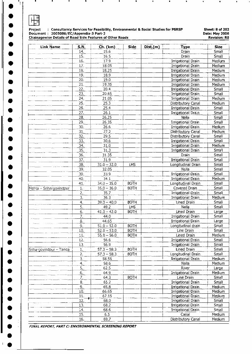
:E .Project Consultancy Services for Feasibility, Environmental & Social Studies for PSRSP Sheet: 8 of 202
* Document: 2005086/EC/Appendix-3 Part-2 Date: May 2006Chainagewise Details of Road Side Features of Other Roads Revision: RO
* Link Name S.N. Ch. (km) Side Dist.(m) Type Size
* _ 14. 15.6 Drain Small
15. 16.5 Drain Small
16. 17.9 Irrigational Drain Medium
17. 18.05 Irrigational Drain Medium
* - _ 18. 18.25 Irrigational Drain Medium
19. 18.9 Irrigational Drain Medium
* 20. 19.0 Irrigational Drain Medium
21. 19.35 Irrigational Drain Medium
22. 20.4 Irrigational Drain Small
23. 20.65 Irrigational Drain Small
24. 21.05 Irrigational Drain Medium
25. 25.3 Distributory Canal Medium
26. 25.4 Irrigational Drain Small
27. 26.1 Irrigational Drain Small
28. 26.25 Nalla Small
29. 26.35 Irrigational Drain Small
30. 26.6 Irrigational Drain Medium
* 31. 27.2 Distributo Canal Medium
32. 29.5 Distributory Canal Small
33. 30.6 Irrigational Drain Small
34. 31.0 Irrigational Drain Medium
* __ 35. 31.3 Irrigational Drain Sma'l
36. 31.35 Drain Small
37. 31.9 Irrigational Drain Small
* ____________ 38. 31.0 - 32.0 LHS Longitudinal Drain Small
_____ 39. 32.05 Nalla Small
*__________________ 39. 33.9 Irrigational Drain Small
____ ________________ 40. 34.1 Irrigational Drain Medium
41. 34.0 - 35.0 BOTH Longitudinal Drain Small
Mehta - Srihargovindpur 1. 35.0 - 36.0 BOTH Covered Drain Small
-_____ __ 2. 35.7 Irrigational Drain Small
3. 36.3 Irrigational Drain Medium
4. 39.0 - 40.0 BOTH Lined Drain Small
_ 5. 49.2 LHS Nalla Small
v___________________ 6. 41.0 - 42.0 BOTH Lined Drain Large
__________ ________ 7. 44.0 Irrigational Drain Small
^ _ _. _ ____ 8. 44.65 Irrigational Drain Large
__________ _________ 9. 51.0 - 52.0 BOTH Longitudinal drain Small
_____ ___________ 10. 52.0 - 53.0 BOTH Line Drain Small
11. 55.0 - 56.0 BOT-H Lined Drain Medium
________ 12. 56.6 Irrigational Drain Small
_ _______________ _ 13. 56.9 Irrigational Drain Small
Srihargovindpur - Tanda 1. 57.3 - 58.3 BOTH Lined Drain Small
2. 57.3 - 58.3 BOTH Longitudinal Drain Small
3. 58.55 Irrigational Drain Medium* ____________ 4. 58.6 Nalla Medium
5. 62.5 River Large
_ 6. 64.9 _ Irrigational Drain Medium
7. 64.3 BOTH Line Drain Small
* ___________________ 8. 65.2 Irrigational Drain Small
9. 65.8 _ Irrigational Drain Medium
_ __ 10. 66.65 Irrigational Drain Medium
11. 67.15 Irrigational Drain Medium
* __________________1_ 2. 68.0 Irrigational Drain Small
_____ _ _ 13. 68.2 Irrigational Drain Small
* ___ . 14. 68.6 Irrigational Drain Small
_ _______._________ 15. 6.5 Canal Medium
_ - 16. 69.7 Distributory Canal Medium
* ' FINAL REPORT, PART C: ENVIRONMENTAL SCREENING REPORT
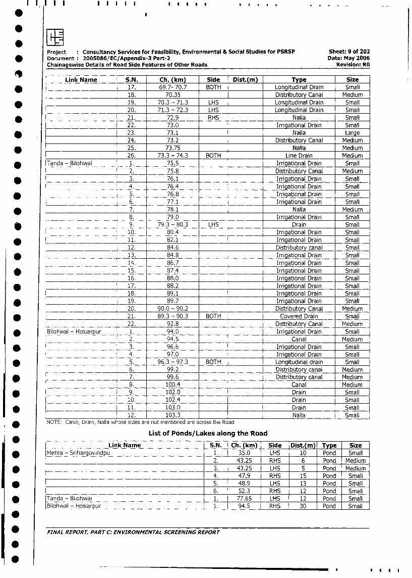
Project : Consultancy Services for Feasibility, Environmental & Social Studies for PSRSP Sheet: 9 of 202
* Document : 2005086/EC/Appendix-3 Part-2 Date: May 2006
Chainagewise Details of Road Side Features of Other Roads Revision: RO
Link Name S.N. Ch. (km) Side Dist.(m) Type Size
* _____________________ 17. 69.7- 70.7 BOTH Longitudinal Drain Small
18. 70.35 _ Distributory Canal Medium
-___________________ 19. 70.3 - 71.3 LHS Longitudinal Drain Small
_ 20. 71.3 - 72.3 LHS Longitudinal Drain Small
* ____________________ 21. 72.9 RHS _ Nalla Small
22. 73.0 Irrigational Drain Small
_ 23. 73.1 Nalla Large
24. 73.2 Distributory Canal Medium
* __ 25. 73.75 Nalla Medium
26. 73.3 - 74.3 BOTH Line Drain Medium
* Tanda - Bilohwal 1. 75.5 Irrigational Drain Small
2. 75.8 Distributory Canal Medium
* -____________________ 3. 76.1 Irrigational Drain Small
4. 76.4 Irrigational Drain Small
* 5. 76.8 Irrigational Drain Small
6. 77.1 _ Irrigational Drain Small
* 7. 78.1 _ Nalla Medium
.______ 8. 79.0 Irrigational Drain Small
* _____________ - 9. 79.3 - 80.3 LHS Drain Small
__ . __ _ __ 10. 80.4 Irrigational Drain Small
* 11. 82.1 Irrigational Drain Small
______________ 12. 84.6 Distributory canal Small
* L_ __ 13. 84.8 Irrigational Drain Small
L _ ___ 14. 86.7 Irrigational Drain Small
* b _ _ _ 15. 87.4 _ Irrigational Drain Small
____ __ 16. 88.0 Irrigational Drain Small
* = ______ 17. 88.2 Irrigational Drain Small
___________________ 18. 89.1 Irrigational Drain Small
* _________ 19. 89.7 _ Irrigational Drain Small
_____________________ 20. 90.0 - 90.2 _ Distributory Canal Medium
* |_________________ 21. 89.3 - 90.3 BOTH Covered Drain Small
_____________________ 22. 92.8 Distributory Canal Medium
* lBilohwal - Hosiarpur 1. 94.0 Irrigational Drain Small
2. 94.5 Canal Medium
* l 3. 96.6 _ Irrigational Drain Small
4. 97.0 _ Irrigational Drain Small
* 5. 96.3 - 97.3 BOTH Longitudinal drain Small
6. 99.2 _ Distributory canal Medium
* l 7. 99.6 Distributory canal Medium
|___________ 8. 100.4 Canal Medium
* l 9. 102.0 _ Drain Small
10. 102.4 _ Drain Small
* ____________________ 11. 103.0 _ _ Drain Small
12. 103.3 _ Nalla Small
NOTE: Canal, Drain, Nalla whose sides are not mentioned are across the Road
List of Ponds/Lakes along the Road
i | _ Link Name S.N. Ch. (km) Side Dist.(m) Type | Size
I * lMehta - Srihargov,ndpu 1. 35.0 LHS 10 Pond Small
__________________________L____________ 12. j 43.25 RHS 6 Pond Medium
I * L_ _________________________________ 13. 43.25 LHS 5 Pond Medium
____________________________________ l4. 47.9 RHS 15 Pond Small
| * | 5. 48.9 LHS 13 Pond Small
1______________________________________________ |6. 52.3 RHS 12 Pond Small
*Tanda - Bilohwal 1. 77.65 LHS 12 Pond Small
Blohwal - Hosiarpur 1. | 94.5 RHS 30 Pond Small
| * FINAL REPORT, PART C: ENVIRONMENTAL SCREENING REPORT
10
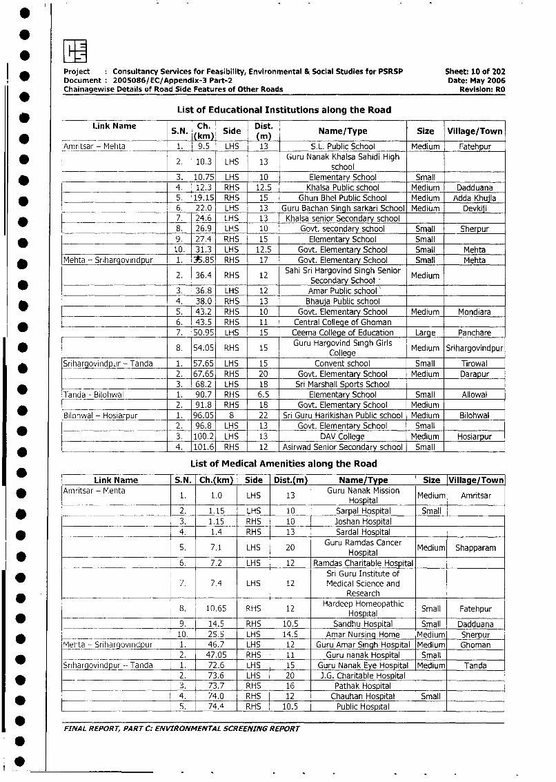
*
i * Project Consultancy Services for Feasibility, Environmental & Social Studies for PSRSP Sheet: 10 of 202Document 2005086/EC/Appendix-3 Part-2 Date: May 2006Chainagewise Details of Road Side Features of Other Roads Revision: RO
List of Educational Institutions along the Road
Link Name S. N. Ch. Side Dist. Name/Type Size Village/Town
Amritsar - Mehta 1. 9.5 LHS 13 S.L. Public School Medium Fatehpur
* 2. 10.3 LHS 13 Guru Nanak Khalsa Sahidi High0 2. 10.3 LHS 13 ~~~~~~~~~~~~~school* - 3. 10.75 LHS 10 Elementary School Small
4. 12.3 RHS 12.5 Khalsa Public school Medium Dadduana* 5. 19.15 RHS 15 Ghuri Bhel Public School Medium Adda Khujla
___________ 6. 22.0 LHS 13 Guru Bachan Singh sarkari School Medium Devkiji
_ ____ 7. 24.6 LHS 13 Khalsa senior Secondary school8. 26.9 LHS 10 Govt. secondary school Small Sherpur
_ 9. 27.4 RHS 15 Elementary School Small
_______________________ 10. 31.3 LHS 12.5 Govt. Elementary School Small Mehta
* Mehta - Srihargovindpur 1. 35.85 RHS 17 Govt. Elementary School Small Mehta
2. 36.4 RHS 12 Sahi Sri Hargovind Singh Senior Medium___ ___ ____ Secondary School-
3. 36.8 LHS 12 Amar Public school'4. 38.0 RHS 13 Bhauja Public school
_________________ 5. 43.2 RHS 10 Govt. Elementary School Medium Mondiara
6. 43.5 RHS 11 Central College of Ghoman______________________ 7. 50.95 LHS 15 Ceema College of Education Large Panchare
* 8. 54.05 RHS 15 Guru Hargovind Singh Girls Medium Srihargovindpur~~~~~~~~~~~~~~~~~~College
* Srihargovindpuir - Tanda 1. 57.65 LHS 15 Convent school Small Tirowal2. 67.65 RHS 20 Govt. Elementary School Medium Darapur3. 68.2 LHS 18 Sri Marshall Sports School
Tanda - Bilohwal 1. 90.7 RHS 6.5 Elementary School Small Allowal2. 91.8 RHS 18 Govt. Elementary School Medium
Bilohwal - Hosiarpur 1. 96.05 8 22 Sri Guru Harikishan Public school Medium Bilohwal2. 96.8 LHS 13 Govt. Elementary School Small3. 100.2 LHS 13 DAV College Medium Hosiarpur
*______________________ 4. 101.6 RHS 12 Asirwad Senior Secondary school Small
List of Medical Amenities along the Road
Link Name S.N. Ch.(km) Side Dist.(m) Name/Type Size Village/Town* Amnritsar - Mehta 1. 1.0 LHS 13 Guru Nanak Mission Medium Amritsar
Hospital2. 1.15 LHS 10 Sarpal Hospital Small
. 3. 1.15 RHS 10 Joshan Hospital
* 4. 1.4 RHS 13 Sardal Hospital
5. 7.1 LHS 20 Guru Ramdas Cancer Medium Shapparam* ~~~~~~~~~~~~~~~~~~~~~~~Hospital
6. 7.2 LHS 12 Ramdas Charitable HospitalSri Guru Institute of
_ 7. 7.4 LHS 12 Medical Science andResearch
8. 10.65 RHS 12 Hardeep Homeopathic Small Fatehpur__._.Hospital* 9. 14.5 RHS 10.5 Sandhu Hospital Small Dadduana
* _~ ____ _._ . _ 10. 25.5 LHS 14.5 Amar Nursing Home Medium Sherpur
Mehta - Sriharovindpur 1. 46.7 LHS 12 Guru Amar Singh Hospital Medium Ghoman* __ _ =-- - -~ 2. 47.05 RHS 11 Guru nanak Hospital Small
Srihargovindpur - Tanda 1. 72.6 LHS 15 Guru Nanak Eye Hospital Medium Tanda_________ 2. 73.6 LHS 20 J.G. Charitable Hospital
3. 73.7 RHS 16 Pathak Hospital
*__________________ 4. 74.0 RHS 12 Chauhan Hospital Small
5. 74.4 RHS 10.5 Public Hospital
*FINAL REPORT, PART C: ENVIRONMENTAL SCREENING REPORT
0
0
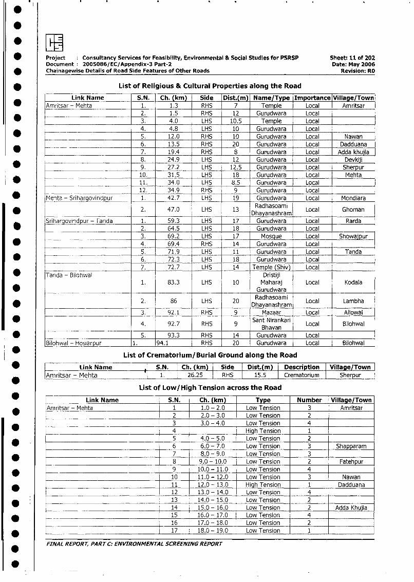
* Project Consultancy Services for Feasibility, Environmental & Social Studies for PSRSP Sheet: 11 of 202Document 2005086/EC/Appendix-3 Part-2 Date: May 2006
* Chainagewise Details of Road Side Features of Other Roads Revision: RO
* List of Religious & Cultural Properties along the Road
Link Name S.N. Ch. (km) Side Dist.(m) Name/Type Importance Village/Town
* Amritsar - Mehta 1. 1.3 RHS 7 Temple Local Amritsar
* _ 2. 1.5 RHS 12 Gurudwara Local
_ - 3. 4.0 LHS 10.5 Temple Local
____- 4. 4.8 LHS 10 Gurudwara Local5. 12.0 RHS 10 Gurudwara Local Nawan
________________-- 6. 13.5 RHS 20 Gurudwara Local Dadduana
* 7. 19.4 RHS 8 Gurudwara Local Adda khuila
_________ 8. 24.9 LHS 12 Gurudwara Local Devkiji
* 9. 27.2 LHS 12.5 Gurudwara Local Sherpur
_ 10. 31.5 LHS 18 Gurudwara Local Mehta
* 11. 34.0 LHS 8.5 Gurudwara Local _ -
12. 34.9 RHS 9 Gurudwara Local
_ Mehta - Srihargovindpur 1. 42.7 LHS 19 Gurudwara Local Mondiara
* 2. 47.0 LHS 13 Radhasoami Local Ghoman
Srihargovnodpur - Tanda 1. 59.3 LHS 17 Gurudwara Local Rarda
___ ____ ________________ 2. 64.5 LHS 18 Gurudwara Local
_ __ ___ _______________ 3. 69.2 LHS 17 Mosque Local Showajpur* -___ ___-- 4. 69.4 RHS 14 Gurudwara Local
___________________ 5. 71.9 LHS 11 Gurudwara Local Tanda
_ 6. 72.3 LHS 18 Gurudwara Local
7. 72.7 LHS 14 Temple (Shiv) Local
* Tanda - Bilohwal Dristiji1. 83.3 LHS 10 Maharaj Local Kodala
* _ _ __ Gurudwara
* _ 2. 86 LHS 20 Radhasoami Local Lambha
___ ________ 3. 92.1 RHS 9 Mazaar Local Allowal
* - 4. 92.7 RHS 9 Sant Nirankari Local Bilohwal___ Bhavan
* S. 93.3 RHS 14 Gurudwara Local
Bilohwal - Hosiarpur 1. 94.1 RHS 20 Gurudwara Local Bilohwal
List of Crematorium/Burial Ground along the Road
* l Link Name S.N. Ch. (km) Side Dist.(m) Description Village/Town|
*Amritsar - Mehta 1. 26.25 RHS 15.5 Crematorium Sherpur
List of Low/High Tension across the Road
_ _ Link Name S.N. Ch. (km) Type Number Village/Town
Amritsar - Mehta 1 1.0 - 2.0 Low Tension 3 Amritsar
_ l 2 2.0 - 3.0 Low Tension 2_ 3 3.0 - 4.0 Low Tension 4
* r 4 High Tension 15 4.0 - 5.0 Low Tension 2
_ 6 6.0 - 7.0 Low Tension 3 Shapparam
7 8.0 - 9.0 Low Tension 3
_ l 8 9.0 - 10.0 Low Tension 2 Fatehpur
* l l 9 10.0 - 11.0 Low Tension 4 l l
10 11.0 - 12.0 Low Tension 3 Nawan
*_________________________________ l11 12.0 - 13.0 High Tension 1 Dadduana12 13.0 - 14.0 LowTension 4
_ l l 13 14.0 - 15.0 Low Tension 214 15.0 - 16.0 Low Tension 2 Adda Khujla
* l l 15 16.0 - 17.0 Low Tension 416 17.0- 18.0 Low Tension 2
* -__________________________ _ 1 17 l 18.0- 19.0 LowTension I 1
FINAL REPORT, PART C: ENVIRONMENrAL SCREENING REPORT
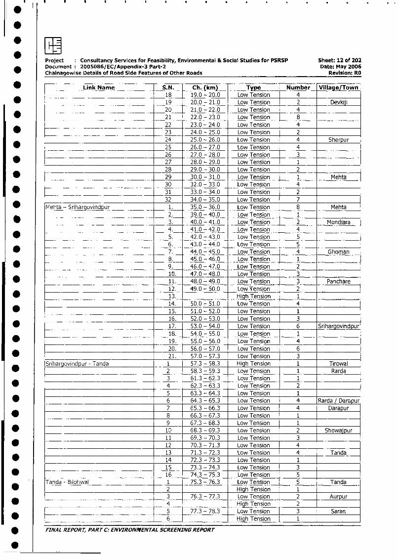
Project Consultancy Services for Feasibility, Environmental & Social Studies for PSRSP Sheet: 12 of 202Document 2005086/EC/Appendix-3 Part-2 Date: May 2006Chainagewise Details of Road Side Features of Other Roads Revision: RO
* _ Link Name S.N. Ch. (km) Type Number Village/Town18 19.0 - 20.0 Low Tension 4
* _____________ ___________________ 19 20.0 - 21.0 Low Tension 2 Devkiji
20 21.0 - 22.0 Low Tension 4
_ _ _ ___ 21 22.0 - 23.0 Low Tension 8
__ _. _ __ _____ _22 23.0 - 24.0 Low Tension 4
* __. _ ___ __________ 23 24.0 - 25.0 Low Tension 2
24 25.0 - 26.0 Low Tension 4 Sherpur
* _ __ . 25 26.0 - 27.0 Low Tension 4
= _ ._ 26 27.0 - 28.0 Low Tension 327 28.0 - 29.0 Low Tension 128 29.0 - 30.0 Low Tension 2
* __ 29 30.0 - 31.0 Low Tension 1 Mehta
30 32.0 - 33.0 Low Tension 4
* 31 33.0 - 34.0 Low Tension 232 34.0 - 35.0 Low Tension 7
_ Mehta - Srihargovindpur 1. 35.0 - 36.0 Low Tension 8 Mehta
2. 39.0 - 40.0 Low Tension 1
_ 3. 40.0 - 41.0 Low Tension 2 Mondiara4. 41.0 - 42.0 Low Tension 4
* _ 5. 42.0 - 43.0 Low Tension 56.- 43.0 - 44.0 Low Tension 5
* _- 7. 44.0 - 45.0 Low Tension 4 Ghoman8. 45.0 - 46.0 Low Tension 1
* ________________________________ 9. 46.0 - 47.0 Low Tension 2
10. 47.0 - 48.0 Low Tension 3
* ________________________ 11. 48.0 - 49.0 Low Tension 3 Panchare
_________ _ __________________ 12. 49.0 - 50.0 Low Tension 2
* ___ ________ 13. High Tension 1
14. 50.0 - 51.0 Low Tension 4
* - 15. 51.0 - 52.0 Low Tension 1
16. 52.0 - 53.0 Low Tension 3
* 17. 53.0 - 54.0 Low Tension 6 Srihargovindpur
18. 54.0 - 55.0 Low Tension 1
* ___ 19. 55.0 - 56.0 Low Tension 420. 56.0 - 57.0 Low Tension 6
* _____ 21. 57.0 - 57.3 Low Tension 3
Srihargovindpur - Tanda 1 57.3 - 58.3 High Tension 1 Tirowal
* 2 58.3 - 59.3 Low Tension 1 Rarda
3 61.3 - 62.3 Low Tension 1
* 0 < 4 62.3 - 63.3 Low Tension 2
________ _____________________ 5 63.3 - 64.3 Low Tension 1
* _ 6 64.3 - 65.3 Low Tension 4 Rarda / Darapur
7 65.3 - 66.3 Low Tension 4 Darapur
* - 8 66.3 - 67.3 Low Tension 1-9 67.3 - 68.3 Low Tension 1
__________________________ 10 68.3 - 69.3 Low Tension 2 Showajpur
__________ _________________ 11 69.3 - 70.3 Low Tension 3
12 70.3 - 71.3 Low Tension 4
13 71.3 - 72.3 Low Tension 4 Tanda
* ___ _______________________ 14 72.3 - 73.3 Low Tension 1
_ ________._______________ .15 73.3 - 74.3 Low Tension 3
* -~ 16 74.3 - 75.3 Low Tension 5
Tanda - Bilohwal 1 75.3 - 76.3 Low Tension 5 Tanda
2 Hig Tension 13 76.3 - 77.3 Low Tension 2 Aurpur
* _ _ _ _ _ __ 4 _ High Tension 2
________________________________ 5 77.3 - 78.3 Low Tension 3 Saran
_ . _ 6 High Tension 1
* FINAL REPORT, PART C: ENVIRONMENTAL SCREENING REPORT
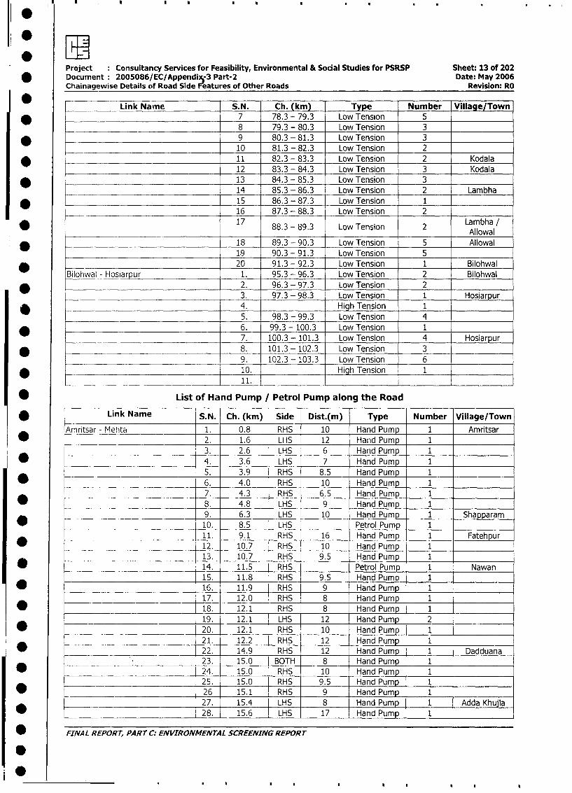
Project Consultancy Services for Feasibility, Environmental & Social Studies for PSRSP Sheet: 13 of 202
* Document: 2005086/EC/Appendix-3 Part-2 Date: May 2006
Chainagewise Details of Road Side Features of Other Roads Revision: RO
0 = Link Name S.N. Ch. (km) Type Number Village/Town
* _ 7 78.3 - 79.3 Low Tension 5
_______________ 8 79.3 - 80.3 Low Tension 3
* _ 9 80.3 - 81.3 Low Tension 310 81.3 - 82.3 Low Tension 2
* 11 82.3 - 83.3 Low Tension 2 Kodala
12 83.3 - 84.3 Low Tension 3 Kodala
* 13 84.3 - 85.3 Low Tension 3
14 85.3 - 86.3 Low Tension 2 Lambha
* 15 86.3 - 87.3 Low Tension 1
16 87.3 - 88.3 Low Tension 2
* 17 88.3 - 89.3 Low Tension 2 Lambha IAllowal
* 18 89.3 - 90.3 Low Tension 5 Allowal
1.9 90.3 - 91.3 Low Tension 5
_ 20 91.3 - 92.3 Low Tension 1 Bilohwal
_Bilohwal - Hosiarpur 1. 95.3 - 96.3 Low Tension 2 Bilohwal
* 2. 96.3 - 97.3 Low Tension 23. 97.3 - 98.3 Low Tension 1 Hosiarpur
* 4. High Tension 1
_________ 5. 98.3 - 99.3 Low Tension 4
_ 6. 99.3 - 100.3 Low Tension 17. 100.3 - 101.3 Low Tension 4 Hosiarpur
* _ 8. 101.3 - 102.3 Low Tension 3
_ _ _ __ _ 9. 102.3 - 103.3 Low Tension 6
* _ 10. High Tension 1
~~~~~_ _ ._ _ _ _ _ _ _ _ _ _ _ _ 11.0 ___ __ _ _ _ _ _ _ _ _ _ _ _ _ _ _ _ _ _ _ _ _ _ _ _
* List of Hand Pump /Petrol Pump along the Road
* Link Name S.N. Ch. (km) Side Dist.(m) Type Number Village/Town
Amritsar - Mehta 1. 0.8 RHS 10 Hand Pump 1 Amritsar
* 2. 1.6 LHS 12 Hand Pump 1
3. 2.6 LHS 6 Hand Pump 1
* 4. 3.6 LHS 7 Hand Pump 1
5. 3.9 RHS 8.5 Hand Pump 1
6. 4.0 RHS 10 Hand Pump 1
7. 4.3 RHS 6.5 Hand Pump 1
* ____ _______S__ 8. 4.8 LHS 9 Hand Pump 1
9. 6.3 LHS 10 Hand Pump 1 Shapparam
10. 8.5 LHS Petrol Pump 1
______ _____________________ 11. 9.1 RHS 16 Hand Pump 1 Fatehpur
* 12. 10.7 RHS 10 Hand Pump 1
13. 10.7 RHS 9.5 Hand Pump 1
* 14. 11.5 RHS Petrol Pump 1 Nawan15. 11.8 RHS 9.5 Hand Pump 1
* _ 16. 11.9 RHS 9 Hand Pump 1
17. 12.0 RHS 8 Hand Pump 1 _-
| * 18. 12.1 RHS 8 Hand Pump 1
19. 12.1 LHS 12 Hand Pump 2
* ___ _ _ 20. 12.1 RHS 10 Hand Pump 1
I L _ _ 21. 12.2 RHS 12 Hand Pump 1
__*_| 22. 14.9 RHS 12 Hand Pump _ 1 Dadduana
l L_ _ 23. 15.0 BOTH 8 Hand Pump 1
| * l 24. 15.0 RHS 10 Hand Pump 1
25. 15.0 RHS 9.5 Hand Pump 1 1* l 26 15.1 RHS 9 Hand Pump 1
*____ _____________________ 27. 15.4 LHS 8 Hand Pump 1 Adda Khujla
l l 28. 15.6 LHS 17 Hand Pump 1
I w FINAL REPORT, PART C: ENVIRONMENTAL SCREENING REPORT
10~~~~. .. .
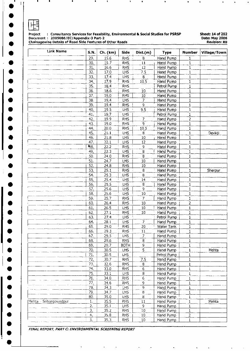
* Project Consultancy Services for Feasibility, Environmental & Social Studies for PSRSP Sheet: 14 of 202Document 2005086/EC/Appendix-3 Part-2 Date: May 2006
* Chainagewise Details of Road Side Features of Other Roads Revision: RO
* Link Name S.N. Ch. (km) Side Dist.(m) Type Number Village/Town
29. 15.6 RHS 8 Hand Pump 1
* __ ____ 30. 15.7 RHS 11 Hand Pump 1 _
__________________________ 31. 16.6 RHS 12 Hand Pump 1
* __ _ 32. 17.0 LHS 7.5 Hand Pump 1
33. _ 17.4 LHS 8 Hand Pump 1
* 34. 17.9 RHS 10.5 Hand Pump 1
____ _ _ _ 35. 18.4 RHS Petrol Pump 1
* 36. 18.6 RHS 10 Hand Pump 1
37. 19.0 RHS 10 Hand Pump 1
* _ 38. 19.4 LHS 7 Hand Pump 1
39. 19.4 RHS 9 Hand Pump 1
* 40. _ 19.5 LHS 9.5 Hand Pump_ 1 __ _
41. 19.7 LHS Petrol Pump 1
* __ _ 42. 19.9 RHS 7 Hand Pump 243. 19.0 RHS 9 Hand Pump 1
* _ 44. 20.0 RHS 10.5 Hand Pump 1
_ ____ 45. 21.1 LHS 8 Hand Pump 1 Devkiji
* -~ 46. 21.8 LHS 10 Hand Pump 1
47. 22.1 LHS 12 Hand Pump 1
* 48. 22.2 RHS 9 Hand Pump 1
49. 22.3 LHS 8 Hand Pump 1
* 50. 24.0 RHS 8 Hand Pump 1
51. 24.7 LHS 10 Hand Pump 1
* 52. 24.8 RHS 10 Hand Pump 1
53. 25.1 RHS 8 Hand Pump 1 Sherpur
* 54. 25.3 LHS 8 Hand Pump 1
__________________________ 55. 25.4 LHS 14 Hand Pump 1
* _ 56. 25.5 LHS 8 Hand Pump 1 _
57. 25.6 LHS 9 Hand Pump_ 1
* 58. 25.6 LHS 10 Hand Pump 1
59. 25.7 RHS 7 Hand Pump 1
* ___ 60. 26.4 RHS 10 Hand Pump 2
61. 26.5 LHS 10 Hand Pump 1
* 62. 27.1 RHS 10 Hand Pump 1
63. 27.4 LHS Petrol Pump 1
* 64. 28.1 LHS 7 Hand Pump 165. 29.0 RHS 20 Water Tank 1
* 66. 29.3 RHS 11 Hand Pump 1
67. 29.5 LHS 7 Hand Pump 1
* _68. 29.6 RHS 8 Hand Pump 1
69. 29.7 BOTH 9 Hand Pump 1
* ___________________________ 70. 30.5 LHS 5 Hand Pump 1 Mehta
71. 30.5 LHS Petrol Pump 1
D ._________ ________________ 72. 30.7 _RHS 7.5 Hand Pump 173. 32.6 RHS 8 Hand Pump 1
D __________ ______________ 74. 33.0 RHS 6 Hand Pump 1
75. 33.1 LHS 8 Hand Pump 1* ___ __ _ 76. 34.0 RHS 6 Hand Pump 1
77. 34.6 RHS 9 Hand Pump 1
* _ _ =78. 34.3 LHS 9 Hand Pump 1
_________________________ 79. 34.7 LHS 8 Hand Pump 1
* _____ 80. 35.0 LHS 8 Hand Pump 1
Mehta - Srihargovindpur 1. 35.5 RHS 11 Hand Pump 1 Mehta
* ____ 2. 35.1 LHS 9 Hand Pump 13. 35.2 RHS 10 Hand Pump 1
* _= ~ 4. 35.8 RHS 10 Hand Pump 2
_ 5. 35.3 RHS 10 Hand Pump 1
FINAL REPORT, PART C: ENVIRONMENTAL SCREENING REPORT
0~~
Project Consultancy Services for Feasibility, Environmental & Social Studies for PSRSP Sheet: 15 of 202
* Document 2005086/EC/Appendix-3 Part-2 Date: May 2006
Chainagewise Details of Road Side Features of Other Roads Revision: RO
* Link Name S.N. Ch. (km) Side Dist.(m) Type Number Village/Town
* ____________________________ 6. 35.35 LHS 11 Hand Pump 1____
7. 35.4 RHS 5 Hand Pum 1
* 8. 35.45 LHS 10 Hand Pump 1
I _______ ___________________ 9. 35.6 RHS 8 Hand Pump 1
* F 10. 35.7 RHS Petrol Pump 1
11. 36.0 LHS 10 Hand Pump 1
* _______ 12. 37.0 RHS 7 Hand Pump 1
13. 37.05 RHS 20 Hand Pump 1
* 14. 38.0 RHS 7.5 Hand Pump 1
_________ 15. 38.4 RHS 8 Hand Pump 1
* _ _ 16. 38.5 LHS 10 Hand Pump 1
_____ 17. 38.65 LHS 10 Hand Pump 1
* ____________________________ 18. 38.7 LHS 10 Hand Pump 2
19. 38.9 RHS 10 Hand Pump 2
* 20. 39.0 RHS 10 Hand Pump 1
21. 39.3 RHS 13 Hand Pump 1
* ___________ 22. 40.3 LHS 9 Hand Pump 1 Mondiara
23. 40.55 RHS 11 Hand Pum 1
* 24. 40.6 LHS Petrol Pump 1
___ _ __25. 41.1 RHS 10 Hand Pump 1
* _____-~ 26. 41.7 LHS 20 Hand Pump 1 127. 42.2 LHS 6.5 Hand Pump 1
* ____ ._ 28. 42.5 RHS 10.5 Hand Pump 1
29. 45.2 RHS 8 Hand Pump 1 Ghoman
* _____ _ - 30. 45.8 LHS Petrol Pump 1
31. 45.8 LHS 6.5 Hand Pump 1
* ._________________________ 32. 46.3 RHS 12 Hand Pump 1
33. 46.4 RHS 8 Hand Pump 1
* _________________ 34. 46.45 LHS 6 Hand Pump 1
35. 46.5 RHS 12 Hand Pump 1 l
* _____________________ 36. 46.6 LHS 9 Hand Pump 1
37. 46.7 RHS 10 Hand Pump 1
* 38. 46.75 RHS 10 Hand Pump 1
39. 47.1 LHS 9 Hand Pump 1
* _ _ _ 40. 47.55 RHS 10 Hand Pump 1
41. 47.6 LHS Petrol Pump 1
* 42. 48.4 RHS 13 Hand Pump 1 Panchare
______________________ 43. 49.1 LHS 9 Hand Pump 1 _
* 44. 50.05 LHS 12 Hand Pump 145. 50.3 RHS 10.5 Hand Pump 1
* _ _ 46. 50.7 RHS 11.5 Hand Pump 1
47. 51.55 LHS 10 Hand Pump 1
* ' 48. 53.1 RHS Petrol Pump 1 Srihargovindpur
49. 55.4 LHS 15 Hand Pump 1
* 50. 56.2 RHS 9 Hand Pump 1
51. 57.1 LHS 10 Hand Pump 1
* Srihargovindpur - Tanda 1. 57.4 LHS Petrol Pump 1 Tirowal
2. 57.85 LHS 14 Hand Pump 1
* _ ________________________ 3. 58.0 LHS 12.5 Hand Pump 14. 58.85 LHS 10 Hand Pump 1 Rarda
* ____________________________ 5. 62.6 LHS 6 Hand Pump 1
6. 64.1 RHS 12.5 Hand Pump 1
* __________________________ .7. 64.2 RHS 14.5 Hand Pump 1
_ 8. 64.2 LHS 12 Hand Pump 1
* ___________________________ 9. 64.3 RHS 10 Hand Pump 1
10. 64.5 RHS 10 Hand Pump 1
* _ 11. 64.6 LHS 10 Hand Pump 1
* FINAL REPORT, PART C: ENVIRONMENTAL SCREENING REPORT
Project Consultancy Services for Feasibility, Environmental & Social Studies for PSRSP Sheet: 16 of 202Document: 2005086/EC/Appendix-3 Part-2 Date: May 2006
_ Chainagewise Details of Road Side Features of Other Roads Revision: RO
. [ Link Name S.N. Ch. (km) Side Dist.(m) Type Number Village/Town
* ___________________ 12. 65.6 LHS 10.5 Hand Pump 1 Darapur
13. 66.0 RHS Petrol Pump 1* -~___________________ 14. 66.8 LHS Petrol Pump 1
15. 69.1 LHS 7 Hand Pump 1 Showaipur
* .___________________________ 16. 70.55 LHS Petrol Pump 1
______ _________________ 17. 71.1 RHS Petrol Pump 1* _ -____ _ 18. 71.5 RHS 18 Hand Pump 1 Tanda
______ _________________ 19. 71.95 RHS 10 Hand Pump 1
* - ____________ .20. 72.1 LHS 9 Hand Pump 121. 72.95 RHS 10 Hand Pump 1 l
X *_ ___________ 22. 73.85 RHS 9,5 Hand Pump_ 1_ __.__. 23. 73.9 LHS 11 Hand Pump 1
* - 24. 73.9 LHS 10.5 Hand Pump 1
_ ___ 25. 74.0 RHS 12 Hand Pump 1
* 26. 74.6 RHS 5.5 Hand Pump 127. 74.75 LHS 6 Hand Pump 1
_ 28. 74.8 LHS 6 Hand Pump 1 1
29. 75.0 RHS 6.5 Hand Pump 1
* _ 30. 75.2 RHS 10 Hand Pump 1
Tanda - Bilohwal 1. 75.9 RHS 12 Hand Pump 1 Tanda
* 2. 76.5 RHS 6.3 Hand Pump 1 Aurpur
3. 76.75 LHS 10 Hand Pump 1* _________________________ 4. 79.1 RHS 10 Hand Pump 1 Saran
5. 79.1 LHS 11 Hand Pump 1
* 6. 79.3 RHS 10 Hand Pump 1
____ 7. 80.3 RHS 20 Hand Pump 1
* 8. 80.4 RHS 14.5 Hand Pump 19. 80.55 RHS 9.5 Hand Pump 1
* 10. 81.0 LHS 16 Hand Pump 111. 81.55 RHS 8.5 Hand Pump 112. 81.6 RHS 7 Hand Pump 113. 82.2 RHS 20 Hand Pump 114. 82.5 LHS 10 Hand Pump 1 Kodala15. 82.55 LHS 12.5 Hand Pump 1
____ 16. 82.75 RHS 14 Hand Pump 117. 82.9 BOTH 10 Hand Pump 1
* _ 18. 83.0 LHS 13 Hand Pump 119. 83.2 LHS 12.5 Hand Pump 1
* _ 20. 83.45 RHS 11 Hand Pump 1
21. 83.5 LHS 8 Hand Pump 1
* 22. 84.2 RHS Petrol Pump 123. 84.35 LHS 17 Hand Pump 1
* 24. 84.7 RHS 15 Hand Pump 125. 86.9 LHS 12.5 Hand Pump 1 Lambha
* _ _26. 87.3 LHS 10 Water Tank 127. 89.35 LHS 5 Hand Pump 128. 89.4 RHS 7 _Hand Pump 1
__ _ 29. 89.45 RHS 10 Hand Pump 1 1
* .__________________________ 30. 89.5 LHS 11 Hand Pump 1 Lambha_
31. 89.6 RHS 12 Hand Pump 1
* _ 32. 89.6 LHS Petrol Pump 1
_______ _______________ _33. 90.4 RHS 9 Hand Pump 1 Allowal* _ 34. 90.5 LHS 10 Hand Pump 2
_____ __________________ 35. 90.6 BOTH 7 Hand Pump 1 __I
* _ ___________________ 36. 90.7 RHS 7.5 Hand Pump 1 I
37. 90.8 RHS 8.5 Hand Pump 1
* _~ 38. 90.8 LHS 9 Hand Pump 1
* FINAL REPORT, PART C. ENVIRONMENTAL SCREENING REPORT
: T1Project : Consultancy Services for Feasibility, Environmental & Social Studies for PSRSP Sheet: 17 of 202
* Document 2005086/EC/Appendix-3 Part-2 Date: May 2006
Chainagewise Details of Road Side Features of Other Roads Revision: RO
Link Name S.N. Ch. (km) Side Dist.(m) Type Number Village/Town
_______________ 39. 91.0 RHS 10 Hand Pump 1
40. 91.1 RHS 12 Hand Pump 1
* 4 1 91.3 RHS 8 Hand Pump 2
42. 91.5 RHS 9 Hand Pump 1
* ________ 43. 91.6 LHS Petrol Pump 1
44. 91.8 LHS 5 Hand Pump 1
* _ __ _ _ 45. 91.9 RHS 8 Hand Pump 1
46. 92.7 LHS 8 Hand Pump 1 Bilohwal
* 47. 93.3 RHS 14 Hand Pump 1
Bilohwal - Hosiarpur 1. 93.5 RHS 9 Hand Pump 1 Bilohwal
* __ _ 2. 94.3 RHS 15.5 Hand Pump 1
3. 94.7 RHS 15 Hand Pump 1
* 4. 95.8 RHS 30 Water Tank 1
5. 96.7 RHS 9 Hand Pump 1
* _ 6. 97.2 RHS 6 Hand Pump 1
7. 98.3 LHS 11 Hand Pump 1 Hosiarpur
* - 8. 98.4 RHS 10.5 Hand Pump 1
9. 98.5 RHS 11,4 Hand Pump 1
* 10. 98.6 LHS Petrol Pump 1
11. 98.75 RHS 12 Hand Pump 1
* 12. 99.5 LHS 15 Hand Pump 1
13. 100.1 LHS 11 Hand Pump 1 Hosiarpur
X * 14. 100.5 LHS Petrol Pump 1
15. 101.5 RHS Petrol Pump 1
* _________________________ 16. 101.7 RHS 6.5 Hand Pump 1
* ___ 17. 101.8 RHS 6 Hand Pump 1
List of Godown/ Cold Storage/Industrial Units along the Road
* _ _Link Name S.N. Ch. (km) Side Dist.(m) Type Village/Town
Amritsar- Mehta 1. 0.95 RHS _ 11 Factory Amritsar
* - _ __ _ 2. 2.1 RHS __ 9 Saha Cold Storage
* __ _ __ _ 3. 2.5 LHS 20 Godown
* ____________________ 4. 1.55 - 2.9 LHS _ 12 Grain Storage
*__________ ____________ 5. 13.8 RHS 16 Brick Field Dadduana
6. 17.95 LHS 13 Brick Field Adda Khujla
*____ __ ___ ___ 7. 23.9 LHS 11 Milk Chilling Centre Devkiji
_ __ _ 8. 29.5 LHS 16 Brick Field Sherpur
____________. 9. _ 34.6 LHS 10 Grain Storage Mehta
10. 34.8 LHS 9 Milk Chilling Centre
_ Mehta - Srihargovindpur 1. 40.2 LHS 8 Brick Field Mondiara
2. 49.2 RHS 12 Brick Field Panchare
3. 50.15 RHS 15 Brick Field
* _ 4. 53 RHS 9 Brick Field
5. 55.5 LHS 9 Factory SriHargovindpur
6. 56.1 LHS 13 Brick Field
Srihargovindpur - Tanda 1. 70.85 RHS 30 Fertilizer Factory Showajpur
* Tanda - Bilohwal 1. 80.85 LHS 20 Ice Factory Saran
2. 80.9 LHS 18 Cold Storage
_. ____________________ 3. 83.2 RHS 30 Cold Storage
*______________________ 4. 85.75 RHS 45 Potato Godown Lambha
Bilowhwal - Hosiarpur 1. 102.4 LHS 30 Godown (FCI) Hosiarpur
2. 102.8 LHS 11.5 Sri Shyam Cold Storage
3. 102.9 LHS 9 Ice Factory
* List of Market Places/Grain Mandi along the Road
r _ Link Name S.N. I Ch. (km) Side Dist. (m) Description Villa e/Town
_Amrit5ar - Mehta 1. 2.55 LHS 12 Grain Mandi Amritsarj
* FINAL REPORT, PART C: ENVIRONMENTAL SCREENING REPORT
S
*
* Project Consultancy Services for Feasibility, Environmental & Social Studies for PSRSP Sheet: Ma of 202Document 2005086/EC/Appendix-3 Part-2 Date: May 2006Chainagewise Details of Road Side Features of Other Roads Revision: RO
Link Name S.N. Ch. (km) Side Dist. (m) Description Village/Town_ 2. 16.0 LHS 20 Grain Mandi Adda 1(hujla
* List of Government Offices along the Road
Link Name S.N. Ch. (km) Side Dist.(m) Type Village/Town
* Amritsar - Mehta 1. 4.3 RHS 12.5 Octroi Naka Amritsar2. 11.6 RHS 12 Sub-Station Nawari
* j___ ___ ___ 3. 11.65 RHS 12 Police Station
- _ 4. 15.05 RHS 17 Punjab National Bank Dadduana
* -_ _ _ 5. 22.9 LHS 12 Police Station Devkiji
Srihargovindpur - Tanda 1. 74.4 LHS 12 Panchayat Office Tanda2. 74.5 LHS 6.5 Punjab National Bank
* Corridor I: Anandpur Sahib - Nanaal
* Topography and Soil Type
* Link Name Topography Physiographic Region Soil TypeSlightly undulating; altitude 300 to 400
* Anandapur Sahib - Nangal m above MSL; general slope - south- Terrace (Malwa) & Bet Kandi & Bet soilswest
* Source: Geography of Punjab by Darshan Singh Manku, Kalyani Publishers, 2002
Drainage along the Road
* _ _Link Name Drainage Basin Position of Road wrt Main Canall
Anandapur Sahib - Narigal Satluj River Basinr Left Minor Canal* Source: Geography of Punjab by Darshan Singh Manku, Kalyani Publishers, 2002
* The semi-arid and sub-tropical monsoon climate of the area warrants dependence on the irrigation
system. The main methods of irrigation in this area are through canals. Few minor canal exist in this
* area which are the sources of irrigation in this area.
* ___ Geology & Hydrogeology
Hydrogeology* Link Name Geology Type of Range of Depth to Water Table
Aquifer (mbgl)
Anandapur Sahib - Nangal Quaternary alluvial deposits Unconfined Post-Monsoon - 1.0 - 3.0
* Source: Geography of Punjab by Darshan Singh Manku, Kalyani Publishers, 2002 & NATMO
* Climate along the Road
Link Name Average Minimum Average Maxmimum Annual Range of[*a LinkNameTemperature (°C) Temperature (°C) Rainfall (mm)
l < ~~~Anandapur Sahib - Nangal 13.0 (January) 32.5 (June) 900 - 1000* Source: Geography of Punjab by Darshan Singh Manku, Kalyani Publishers, 2002
* Major Villages/Semi Urban areas along the Corridor
Link Name S.N. Chainage (km) Village/ Town* Anandpursahib - Nangal 1. 0.0 - 4.0 Anandpur Sahib Town
2. 4.0 - 7.0 Ganguwal
* __ 3. 7.0 - 8.0 Dher
_______ 4. 8.0 - 10.0 Kala Khapur
* _ -- 5. 10.0 - 13.0 Samser6. 13.0 - 14.0 Tabkera Village
* L. _________________________________ 7. 14.0 -19.0 Pathpur*. _ ___-_______________________ 6. 19.0-22.0 Nangal Town
Land Use along the Road
0 FINAL REPORT, PART C: ENVIRONMENTAL SCREENING REPORT
0
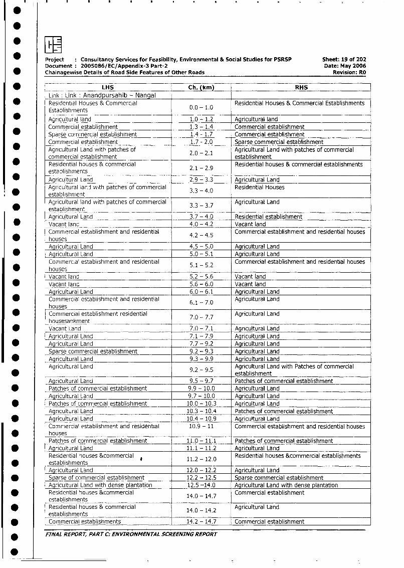
Project Consultancy Services for Feasibility, Environmental & Social Studies for PSRSP Sheet: 19 of 202Document: 2005086/EC/Appendix-3 Part-2 Date: May 2006
* Chainagewise Details of Road Side Features of Other Roads Revision: RO
* T _ = _ LHS Ch. (km RHS
Link: Link Anandpursahib - Nangal
0 Residential Houses & Commercial Establishments
Establishments
Agricultural land 1.0 - 1.2 Agricultural land
Commercial establishment 1.3 - 1.4 Commercial establishment
_S arse commercial establishment 1.4 - 1.7 Commercial establishment
Commet-cial establishment 1.7 - 2.0 Sparse commercial establishment
Agricultural Land with patches of 2.0 2.1 Agricultural Land with patches of commercial
commercial establishment . - . establishment
Residential houses & commercial 2 - 2.9 Residential houses & commercial establishments
establishments . .9
* Agricultural Land 2.9 - 3.3 Agricultural Land
Agricultural land with patches of commercial 3.3 - 4.0 Residential Houses
* establishmentAgricultural land with patches of commercial 3- 337 Agricultural Land
* establishmentAgricultural Land 3.7 - 4.0 Residential establishment
* Vacant land 4.0 - 4.2 Vacant land
Commercial establishment and residential 4.2 - 4.5 Commercial establishment and residential houses
* housesAgricultural Land 4.5 - 5.0 Agricultural Land
* Agricul tural Land 5.0 - 5.1 Agricultural Land
Commerc,al establishment and residential 5.1 - 5.2 Commercial establishment and residential houses
housesVacant land 5.2 - 5.6 Vacant land
* Vacant land 5.6 - 6.0 Vacant land
Agricultural Land 6.0 - 6.1 Agricultural Land
* Commercial establishment and residential 6.1 - 7.0 Agricultural Land
houses* Commercial establishment residential 7.0 - 7.7 Agricultural Land
housesankment* Vacant Land 7.0 - 7.1 Agricultural Land
Agricultural Land 7.1 - 7.9 Agricultural Land
* Agricultural Land 7.7 - 9.2 Agricultural Land
Sparse commercial establishment 9.2 - 9.3 Agricultural Land
* Agricultural Land 9.3 - 9.9 Agricultural Land
Agricultural Land 9.2 - 9.5 Agricultural Land with Patches of commercial
* 9.2-95 _establishmentAgricultural Land 9.5 - 9.7 Patches of commercial establishment
* Patches of commercial establishment 9.9 - 10.0 Agricultural Land
Agricultural Land 9.7 - 10.0 Agricultural Land
* Patches of commercial establishment 10.0 - 10.3 Agricultural Land
Agricultural Land 10.3 - 10.4 Patches of commercial establishment
* Agricultural Land 10.4 - 10.9 Agricultural Land
Commercial establishment and residential 10.9 - 11 Commercial establishment and residential houses
housesPatches of commercial establishment 11.0 - 11.1 Patches of commercial establishment
* Aqricultural Land 11.1 - 11.2 Agricultural Land
Residential houses &commercial 11.2 - 12.0 Residential houses &commercial establishments
* establishmentsAgricultural Land 12.0 - 12.2 Agricultural Land
* Sparse of commercial establishment 12.2 - 12.5 Sparse commercial establishment
Agricultural Land with dense plantation 12.5 -14.0 Agricultural Land with dense plantation
* Residential houses &commercial 14.0 - 14.7 Commercial establishmentestablishments
* Residential houses & commercial 14.0 - 14.2 Agricultural Land
establishments* . Commercial establishments 14.2 - 14.7 Commercial establishment
* FINAL REPORT, PART C: ENVIRONMENTAL SCREENING REPORT
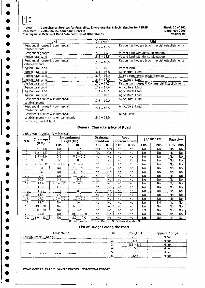
* Project : Consultancy Services for Feasibility, Environmental & Social Studies for PSRSP Sheet: 20 of 202Document 2005086/EC/Appendix-3 Part-2 Date: May 2006
* Chainagewise Details of Road Side Features of Other Roads Revision: RO
LHS Ch. (km) RHS
Residential houses & commercial 14.7 - 15.0 Residential houses & commercial establishmentsestablishments
* Residential houses 15.0 - 15.3 Vacant land with dense plantationAgricultural Land 15.3 - 15.5 Vacant land with dense plantation
* Residential houses & commercial 15.5 - 16.0 Residential houses & commercial establishmentsestablishments
_ Agricultural Land 16.0 - 16.1 Vacant land
Agricultural Land 16.1 - 16.8 Agricultural Land* Agricultural Land 16.8 - 16.9 Sparse commercial establishment
Agriculturai Land 16.8 - 17.0 Agricultural Land* Agricultural Land 17.0 - 17.2 Residential Houses & Commercial Establishments
Agricultural Land 17.2 - 17.4 Agricultural Land* Agricultural Land 17.4 - 17.5 Agricultural Land
Agricultural Land 17.0 - 18.4 Agricultural Land* Residential houses & commercial 17.5 - 19.0 Agricultural Land
establishments* .Residential houses & commercial 18.4 - 19.0 Agricultural Land
establishments* Residential houses & commercial Nangal canal
establishments with no embankment, 19.0 - 22.0* patches of vacant land _____
* General Characteristics of Road
Link Anandpursahib - Nangal
Chainage embankMt Drainage road SE/ SD/ EM Squatters* ~~~.. (Kim) - Height(Mt) Condition Encroachment
* (Km) LHS RHS LHS RHS LHS RHS LHS RHS LHS RHS
1. 0.0 - 1.0 No No Yes Yes No No No No No No* _2. 1.2-1.5 6.0 6.0 Yes Yes No No No No No No
4. 3.9 - 4.9 0.5 0.5 - 3.0 No No No No No No No No
6. 6.0 8.0 8.0 No No No No No No No No7. 7.7 - 8.0 3.0 - 4.0 3.0 - 4.0 No No No No No No No No
* 8. 9.0 No 4.0 - 5.0 No No No No No No No No9. 9.6 No 3.0-4.0 No No No No No No No No
_ 10. 9.7 No 1.0-2.0 No No No No No No No No
11. 10.5 0.5 0.5 No No No No No No No No
* 12. 13.9 2.0-3.0 2.0-3.0 No No No No No No No No
13. 15.7 1.5 1.5 No No No No No No No No
* 14. 15.3 0.5 0.5 No No No No No No No No
15 15.4 1.0 1.0 No No No No No No No No
* 16. 17.3 1.0 - 2.0 1.0-2.0 No No No No No No No No
17. 18.7 No No No No No No No EM No No
* 18. 19-20 No 6.0- 7.0 No No No No No No No No
19. 20.0-20.6 No No No No No No EM No No No
* 20. 21.0 No 10.0- 12.0 No No No No No No No No
21. 21.9- 22,0 No 8.0 - 10.0 No No No No No No No No
* - N.B: Soil Erosion - SE, Sand Dune - SD, Earthen Mounds - EM
* List of Bridges along the road
Link Name S.N. Ch. (km) Type of Bridge
Anandpursahib - Nangal 1. 1.2 - 1.3 Minor2. 5.6 Minor
* ____________________________________ 3. 8.8 - 8.9 M inor
.______ ____ _________________________________ 4. 16.3 Minor
* _________ .__ 5. 19.3 Minor*_____ _ ____________ . _________________________ 6. 20.3 M inor
FINAL REPORT, PART C: ENVIRONMENTAL SCREENING REPORT
0
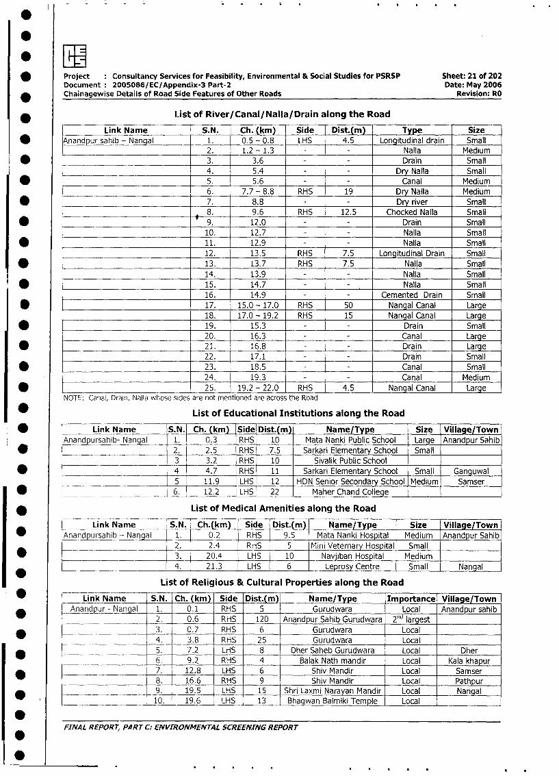
* Project Consultancy Services for Feasibility, Environmental & Social Studies for PSRSP Sheet: 21 of 202
Document: 2005086/EC/Appendix-3 Part-2 Date: May 2006
* Chainagewise Details of Road Side Features of Other Roads Revision: RO
* l ist of River/Canal/Nalla/Drain along the Road
Link Name S.N. Ch. (km) Side Dist.(m) Type Size
* Anandpur sahib - Nangal 1. 0.5 - 0.8 LHS 4.5 Longitudinal drain Small
2. 1.2 - 1.3 - - Nalla Medium
* ______________ 3. 3.6 - - Drain Small
4. 5.4 - - Dry Nalla Small
* -- 5. 5.6 - - Canal Medium
____ _ 6. 7.7 - 8.8 RHS 19 Dry Nalla Medium
* _______________ ____ 7. 8.8 - Dry river Small
_ 8. 9.6 RHS 12.5 Chocked Nalla Small
* _ 9. 12.0 _ - Drain Small
10. 12.7 Nalla Small
* ____________________________ 11. 12.9 Nalla Sm all
___________________________ 12. 13.5 RHS 7.5 Longitudinal Drain Small
* ________________ 13. 13.7 RHS 7.5 Nalla Small
14. 13.9 - Nalla Small
.* _ 15. 14.7 Nalla Small
16. 14.9 Cemented Drain Small
* __ 17. 15.0 - 17.0 RHS 50 Nangal Canal Large
18. 17.0 - 19.2 RHS 15 Nangal Canal Large
* 19. 15.3 - - Drain Small
20. 16.3 - - Canal Large
* 21. 16.8 - - Drain Large
22. 17.1 - - Drain Small
* 23. 18.5 - - Canal Small
24. 19.3 - - Canal Medium
* l 25. 19.2 - 22.0 RHS 4.5 Nangal Canal Large
NOTE: Canal, Drain, Nalla whose sides are not mentioned are across the Road
* List of Educational Institutions along the Road
* Link Name S.N. Ch. (km) Side Dist.(m) Name/Type Size Village/Town
Anandpursahib- Nangal 1. 0.3 RHS 10 Mata Nanki Public School Large Anandpur Sahib
2. 2.5 RHS 7.5 Sarkari Elementary School Small
3 3.2 RHS 10 Sivalik Public School
* 4 4.7 RHS 11 Sarkari Elementary School Small Ganguwal
5 11.9 LHS 12 HDN Senior Secondary School Medium Samser
* _ 6. 12.2 LHS 22 Maher Chand College
* List of Medical Amenities along the Road
Link Name S.N. | Ch.(km) Side Dist.(m) Name/Type Size Village/Town
* Anand ursahib - Nanaal 1. 0.2 RHS 9.5 Mata Nanki Hospital Medium Anandpur Sahib
2. 2.4 RHS 5 Mini Veternary Hospital Small
3. 20.4 LHS 10 Navjiban Hospital Medium
*4. 21.3 LHS 6 Leprosy Centre Small Nangal
List of Religious & Cultural Properties along the Road
I _ L Link Name S.N. Ch. (km) Side Dist.(m) Name/Type Importance Village/Town
_Anandpur - Nangal - 1. 0.1 RHS 5 Gurudwara Local _ Anandpursahib
2. 0.6 RHS 120 Anandpur Sahib Gurudwara 2nd largest
*_ t ____________ 3. 0.7 RHS 6 Gurudwara Local
0 s ___ l 4. 3.8 RHS 25 Gurudwara Local
* -_ l 5. 7.2 LHS 8 Dher Saheb Gurudwara Local Dher
| 6. 9.2 RHS 4 Balak Nath mandir Local Kala khapur
* | __-__________ - 7. 12.8 LHS 6 Shiv Mandir Local Samser
0 l l 8. 16.6 RHS 9 Shiv Mandir Local Pathpur
I________;___________ 9. 19.5 LHS 15 Shri Laxmi Narayan Mandir Local Nangal
l _ <___ l10. 19.6 LHS 13 Bhagwan Balmiki Temple Local
FINAL REPORT, PART C: ENVIRONMEI'TAL SCREENING REPORT
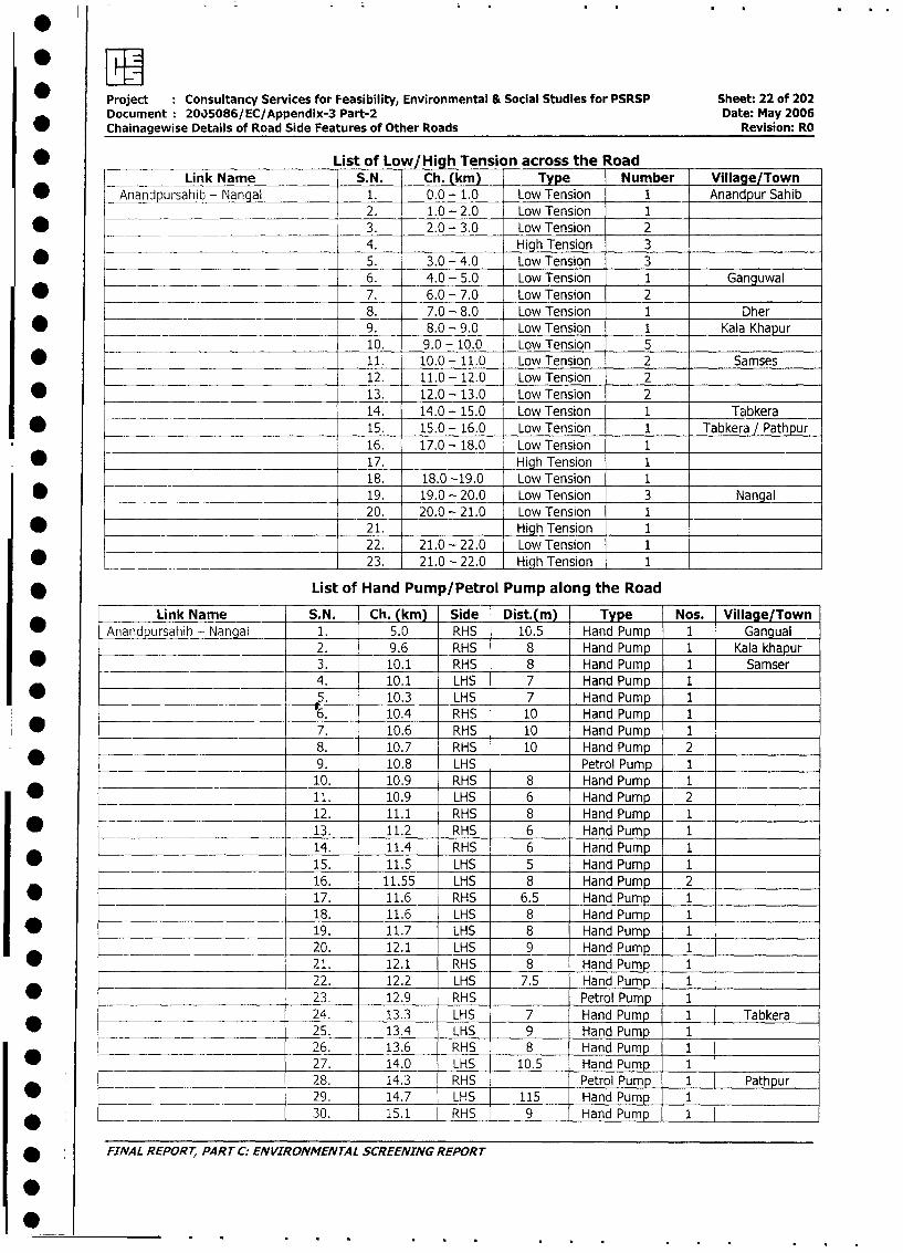
Project Consultancy Services for Feasibility, Environmental & Social Studies for PSRSP Sheet: 22 of 202
Document: 20)5086/EC/Appendix-3 Part-2 Date: May 2006
Chainagewise Details of Road Side Features of Other Roads Revision: RO
* List of Low/High Tension across the Road
Link Name S.N. Ch. (km) Type Number Village/Town
* Anandpursahib - Nangal 1. 0.0 - 1.0 Low Tension 1 Anandpur Sahib
2. 1.0 - 2.0 Low Tension 1
* =____ 3. 2.0 - 3.0 Low Tension 24. High Tension 3
* ______ 5. 3.0 - 4.0 Low Tension 36. 4.0 - 5.0 Low Tension 1 Ganguwal
* 7. 6.0 - 7.0 Low Tension 2 _
8. 7.0 - 8.0 Low Tension 1 Dher
* 9. 8.0 - 9.0 Low Tension 1 Kala Khapur
10. 9.0 - 10.0 Low Tension _
* 11. 10.0 - 11.0 Low Tension 2 Samses
12. 11.0 -12.0 Low Tension 2
* __________________________________ 13. 12.0 - 13.0 Low Tension 2
14. 14.0 - 15.0 Low Tension 1 Tabkera
* =_______ 15. 15.0 - 16.0 Low Tension 1 Tabkera / Pathpur
16. 17.0 - 18.0 Low Tension 1
* 17. High Tension 1
18. 18.0 -19.0 Low Tension 1
* 19. 19.0 - 20.0 Low Tension 3 Nangal
20. 20.0 - 21.0 Low Tension 1
* 21. High Tension 122. 21.0 - 22.0 Low Tension I
* 23. 21.0 - 22.0 High Tension 1
* List of Hand Pump/Petrol Pump along the Road
Link Naie S.N. Ch. (km) Side Dist.(m) Type Nos. Village/Town
* AnandDursahib- Nangal 1. 5.0 RHS 10.5 Hand Pump 1 Gangual
________ 2. 9.6 _ RHS 8 Hand Pump 1 Kala khapur
* > 3. 10.1 RHS 8 Hand Pump 1 Samser
_______ _ _ 4. 10.1 LHS 7 Hand Pump 1
* ______ 5. 10.3 LHS 7 Hand Pump 1
___________________ _6__ 6. 10.4 RHS 10 Hand Pump 1
* ___________________ ______ 7. 10.6 RHS 10 Hand Pump 1
8. 10.7 RHS 10 Hand Pump 2
* _ _____________________ 9. 10.8 LHS Petrol Pump 1
________________ _________ 10. 10.9 RHS 8 Hand Pump 1
_ _ _____________________ 11. 10.9 LHS 6 Hand Pump 2
*_______________________ 12. 11.1 RHS 8 Hand Pump 1
* _ ___________________ 13. 11.2 RHS 6 Hand Pump 1
14. 11.4 RHS 6 Hand Pump 1
* 15. 11.5 LHS 5 Hand Pump 116. 11.55 LHS 8 Hand Pump 2
* 17. 11.6 RHS 6.5 Hand Pump 1
18. 11.6 LHS 8 Hand Pump 1
19. 11.7 LHS 8 Hand Pump 1
20. 12.1 LHS 9 Hand Pump 1
21. 12.1 RHS 8 Hand Pump 1
22. 12.2 LHS 7.5 Hand Pump 1
* - 23. 12.9 RHS Petrol Pump 1
* ____ 24. 13.3 LHS 7 Hand Pump 1 Tabkera
* _____ _ __________ 25. 13.4 LHS 9 Hand Pump 1
26. 13.6 RHS 8 Hand Pump 1
* _____________________ 27. 14.0 LHS 10.5 Hand Pump 1
* _______________________ 28. 14.3 RHS Petrol Pump 1 Pathpur
29. 14.7 LHS 115 Hand Pump 1, ~ ______________ 30. 15.1 RHS 9 Hand Pump 1
* ' FINAL REPORT, PART C: ENVIRONMENTAL SCREENING REPORT
S
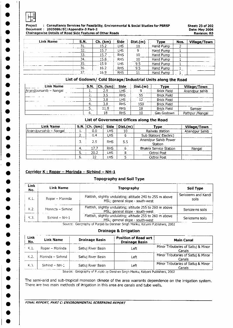
ewFL Project Consultancy Services for Feasibility, Environmental & Social Studies for PSRSP Sheet: 23 of 202
Document: 2005086/EC/Appendix-3 Part-2 Date: May 2006* Chainagewise Details of Road Side Features of Other Roads Revision: RO
* __ Link Name S.N. Ch. (km) Side Dist.(m) Type Nos. Village/Town31. 15.2 LHS 11 Hand Pump 2
* ___ _ ________ 32. 15.7 _ LHS 9 Hand Pump 1
___ ______ __ 33. 15.7 RHS 10 Hand Pump 1* _ _ __ ___ 34. 15.8 RHS 10 Hand Pump 1
___ __ 35. 15.9 LHS 9.5 Hand Pump 1* __ ______ 36. 16.2 RHS 9.5 Hand Pump 1_
*__ _ _________ 37. 16.9 _ RHS 11 Hand Pump 1
List of Godown/ Cold Storage/Industrial Units along the Road
* Link Name S.N. Ch. (km) Side Dist.(m) Type Village/TownAnandpursahib - Nangal 1. 2.9 LHS 9 Brick Field Anandpur sahib
2. 3.5 RHS 55 Brick Field3. 3.8 LHS 12 Brick Field
* _ 4. 3.8 RHS 150 Brick Field5. 11.8 RHS 18 Brick Field Samser
* _ 6. 18 RHS 10 Gas Godown Pathpur /Nangal
* List of Government Offices along the Road
Link Name S.N. Ch. (km) Side Dist.(m) Type Village/TownAnandpursahib - Nangal 1. 0.0 LHS 10 Railway station Anandpur Sahib
2. 0.4 LHS 6 Sub Station( Electric)
* ~ ~ ~ ~~~ ~~~~~~~~3. 25 RS 55 Anandpur Sahib Power3. 2.5 RHS 5.5 Station
_ _ 4. 17.7 RHS 6 Bhakra Service Station Nangal5. 20.2 LHS 8 Octroi Post6. 22 LHS 5 Octroi Post
* Corridor K: Ropar - Morinda - Sirhind - NH-1
Link Topography and Soil Type
* No. Link Name Topography Soil Type
*K1. Ropar - Morinda Flattish, slightly undulating; altitude 240 to 255 m above Seriozems and Kandi-MSL; general slope - south-west
K.2. Morinda - Sirhind Flattish, slightly undulating; altitude 255 to 260 m above Seriozems soils0 ~~~~~~~~~~~~~~MSL; general slope - south-west
K.3. Sirhind - N1-1 Flattish, slightly undulating; altitude 255 to 260 m above Seriozems soils,_ ______ ~ general slope-south-west ____n
* Source: Geography of Punjab by Darshan Singh Manku, Kalyani Publishers, 2002
Drainage & Irrigation
Link Link Name Drainage Basin Position of Road wrt Main Canal* ~~~~No. Drainage Basin| K. 1. | Ropar - Morinda | Satluj River Basin | Left | Minor Tributaries of Satluj & MinorK*. Ropar - Morilda latluj River Basin Left Canals
| K.2. I Morinda - Sirhind | Satluj River Basin | Left | Minor Tributaries of Satluj & Minor*.2. Morinda _ Sirhind latluj River Basin Left Canals
* K.3. Sirhind - NH-i Satluj River Basin Left CMinor Tributaries of Satluj & Mins
Source: Geography of Pinjab by Darshan Singh Manku, Kalyani Publishers, 2002
The semi-arid and sub-tropical monsoon climate of the area warrants dependence on the irrigation system.There are two main methods of itrigation in this area are canals and tube wells.
.* FINAL REPORT, PART C: ENVIRONMENTAL SCREENING REPORT
.
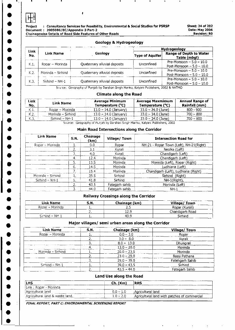
Project Consultancy Services for Feasibility, Environmental & Social Studies for PSRSP Sheet: 24 of 202Document 2005086/EC/Appendix-3 Part-2 Date: May 2006Chainagewise Details of Road Side Features of Other Roads Revision: RO
* Geology & Hydrogeology
LinkHydrogeology* Link LnNaeGogyType of Aquifer Table (mbgl)No. Link Name Geology TpofAuerRange of Depth to Water
K.1. Ropar - Morinda Quaternary alluvial deposits Unconfined Post-Monsoon - 5.0 - 10.0Pre-Monsoon - 5.0 - 10.0
K.2. Morinda - Sirhind Quaternary alluvial deposits Unconfined Post-Monsoon - 5.0 - 10.0
K.3. Sirhind - NH-1 Quaternary alluvial deposits Unconfined Pre-Monsoon - 5.0 - 10.0_____________ I _________________ I_______ Post-Monsoon - 5.0 - 10.0
Source: Geography of Punjab by Darshan Singh Manku, Kalyani Publishers, 2002 & NATMO
* Climate along the Road
Link Link Name Average Minimum Average Maxmimum Annual Range of
No. Temperature (°C) Temperature (tC) Rainfall (mm)
* _K.1. Ropar - Morinda 13.0 - 14.0 (January) 33.0 - 34.0 (June) 800 - 900
K.2. Morinda - Sirhind 13.0 - 14.0 (January) 33.0 - 34.0 (June) 700 - 800
* K.3. _ Sirhind - NH-1 13.0 - 14.0 (January) 33.0 - 34:0 (June) 700 - 800Source: Geography of Punjab by Darshan Singh Manku, Kalyani Publishers, 2002
* Main Road Intersections along the Corridor
* Link Name S.N. Chainage Village/ Town Intersection Road for
Ropar - Morinda 1. 0.0 Ropar NH-21 - Ropar Town (Left), NH-21(Right)2. 3.1 Kurali Neolka (Left)
* _ . _ _3. 4.0 Kurali Chandigarh (Left)_______ 4. 12.4 Morinda Chandigarh (Left)
* 5. 13.5 Morinda Morinda (Left), Ropar (Right)6. 14.5 Morinda Ludhiana (Left)
* S_rh_nd 7. 15.4 Morinda Chandigarh (Left), Ludhiana (Right)Morinda - Sirhind 1. 35.5 Sirhind Sirhind (Right)
* Sirhind - NH-1 1. 41.8 Sirhind NH-1(Right),2. 43.5 Fategarh sahib Morinda (Left)
_ -____________ 1 3. 44.0 Fategarh sahib _ NH-1
Railway Crossings along the Corridor
Link Name S.N. Chainage (km) Village/ Town
* Ropar - Morinda 1. 2.5 Ropar (Kurali)2. 12.9 Chandigarh Road
* _______ Sirhind - NH 1 1. 40.9 Sirhind
* Major villages/ semi urban areas along the Corridor
Link Name S.N. Chainage (km) Village/ Tovin* | Ropar - Morinda 1. 0.0 - 3.0 Ropar
2. 3.0 - 8.0 Kurali| g > 3. 8.0 - 13.0 Dhungrali
t____ l _ ____ 4. 13.0 - 20.0 Morinda
I * |____ Morinda - Sirhind 1. 20.0 - 23.0 Morinda
I___ L _______________________ 2. 23.0 - 29.0 Bassi PathanaSirhind - NH 3. 29.0 - 39.0 Fatehgarh Sahib
__________Sirhind - NH 1 _ 1. 39.0 - 43.5 Sirhind* _________________________ 2. 43.5 - 44.0 Fategarh Sahib
| * Land Use along the Road
LHS _ Ch. (Km) RHS| * lLink: Ropar - Morinda
Agricultural land 0.0 - 1.0 Agricultural land* A ricultural land & waste land. 1.0 - 2.0 Agricultural land with patches of commercial
| * FINAL REPORT, PART C. ENVIRONMENTAL SCREENING REPORT
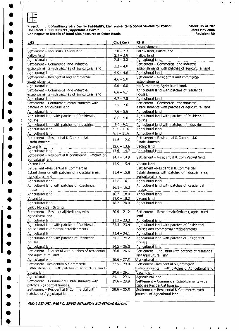
Project Consultancy Services for Feasibility, Environmental & Social Studies for PSRSP Sheet: 25 of 202
Document 2005086/EC/Appendix-3 Part-2 Date: May 2006
Chainagewise Details of Road Side Features of Other Roads Revision- RO
*LHS Ch. (Km) RHSestablishments.
* Settlement - Industria llow land 2.0 - 2.3 Fallow land, Waste land
Fallow land 2.3 - 2.8 Fallow land
* Agricultural land 2.8- 3.2 Agricultural land
Settlement - Commercial and industrial Settlement - Commercial and industrial
* establishments with patches of agricultural land. 3.2 - 4. establishments with patches of agricultural land
Agricultural land 4.0 - 4.6 Agricultural land
Settlement - Residential and commercial 4.6 - S 0 Settlement - Residential and commercial
establishments establishments
* Agricultural land. 5.0 - 6.0 No Settlement, Agricultural land.
Settlement - Commercial and industrial Agricultural land with patches of residential
* establishments with patches of agricultural land 6.0 - 6.7 houses.
Agricultural land 6.7 - 7.5 Agricultural land
46 Settlement - Commercial establishments with Settlement - Commercial and industrial
patches of agricultural land 7.5 - 7.6 establishments with patches of agricultural land
* Aqicultural land 7.6 - 8.6 Agricultural land
Agricultural land with patches of Residential 8.6 - 9.0 Agricultural land with patches of Residential
* houses 86 - 90 _ houses
Agricultural land with patches of industries. 9.0 - 9.3 Agricultural land with patches of industries.
I * Agricultural land 9.3- 11.6 Agricultural land
Agricultural land 9.3 - 11.6 Agricultural land
Settlement - Residential & Commercial Settlement - Residential & Commercial
Establishments 11.6 - 12.6 Establishments
* Vacant land 12.6 - 13.6 Vacant land
Agricultural land 13.6 - 14.7 Agricultural land
_ Settlement - Residential & commercial, Patches of 14.7 - 14.9 Settlement - Residential & Com Vacant land.
agricultural laid.* Vacant land 14.9 - 15.4 Vacant land
Settlement -Residential & Commercial Settlement -Residential & Commercial
* Estaplishments with patches of industrial area, 15.4 - 15.8 Establishments with patches of industrial area,
agricultural land agricultural land
* Agricultural land 15.8 - 16.1 Agricultural land
Agricultural land with patches of Residential 16.1 - 16.2 Agricultural land with patches of Residential
houses houses
Agricultural land 16.2 - 18.0 Agricultural land
* Vacant land 18.0 - 18.2 Vacant land
Agricultural land 18.2 - 20.0 Agricultural land
_ Link: Morinda - SirhindSettlement - Residential(Medium), with 20.0 - 21.2 Settlement - Residential(Medium), agricultural
* agricultural land land
Agricultural land 21.2 - 23.3 Agricultural land
* Agricultural land with patches of Residential 23.3 - 23.4 Agricultural land with patches of Residential
houses and commercial establishments houses and commercial establishments
* Agricultural land 23.4 - 24.1 Agricultural land
Agricultural land with patches of Residential 24.1 - 24.2 Agricultural land with patches of Residential
huuses houses
Agricultural land 24.2 - 26.0 Agricultural land
v Settlement - Industrial with patches of residential 26.0 - 26.6 Settlement - Industrial with patches of residential
and agricultural land and agricultural land
* Agriculuralland 26.6 - 27.5 Agricultural land
Settlement -Residential & Commercial 27.5 - 29.0 Settlement -Residential & Commercial
Establishment, with patches of Agricultural land Establishments, with patches of Agricultural land
Vacant land 29.0 - 29.1 Vacant land
* Agricultural land 29.1 - 29.6 Agricultural land
Settlement - Commercial Establishments with 29.6 - 29.9 Settlement - Commercial Establishments with
patches Residential houses. patches Residential houses.
Settlement - Residential & Commercial with 29.9 - 30.5 Settlement - Residential & Commercial with
* patches of Agricultural land patches of Agricultural land
* FINAL REPORT, PART C: ENVIRONMENTAL SCREENING REPORT
9~.....
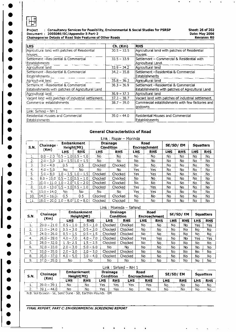
:~~~~~~~~~~~~~~~~~~~~~~~~~~~~Set 26o 0Project Consultancy Services for Feasibility, Environmental & Social Studies for PSRSP Sheet: 26 of 202Document 2005086/EC/Appendix-3 Part-2 Date: May 2006Chainagewise Details of Road Side Features of Other Roads Revision: RO
LHS Ch. (Km) RHS* Agricultural land with patches of Residential 30.5 - 33.5 Agricultural land with patches of Residential
houses. houses.* Settlement -Residential & Commercial 33.5 - 33.9 Settlement - Commercial & Residential with
Establishments Agricultural Land.* Agricultural land 33.9 - 34.2 Agricultural land
Settlement -Residential & Commercial 34.2 - 35.8 Settlement -Residential & Commercial
* Establishments . EstablishmentsAgricultural land 35.8 - 36.3 Agricultural land
* Settlement -Residential & Commercial 36.3 - 36.9 Settlement -Residential & CommercialEstablishments with patches of Agricultural Land Establishments with patches of Agricultural Land
* Agricultural land 36.9 - 37.3 Agricultural landVacant land with patches of industrial settlement. 37.3 - 38.7 Vacant land with patches of industrial settlement.
* Commercial establishments 38.7 - 39.0 Commercial establishments with few factories andgodowns
* Link: Sirhind - NH 1Residential Houses and Commercial 39.0 - 44.0 Residential Houses and Commercial
* Establishments Establishments
* General Characteristics of Road
* _____ _______ _Link: Ropar - Morinda
Chainage Embankment Drainage Road* SN. Chaie(K) Hea kt(Mt) Condition Encroachment SE/SD/ EM Squatters
_ LHS RHS LHS RHS LHS RHS LHS RHS LHS RHS
* 1. C0 -2.0 0.5 - 1.0 0.5 - 1.0 No No No No No No No No
2. 2.0 -3.0 1.0- 1.5 1.0 - 1.5 No No No No No No No No
* 3. 3.0 - 4.0 0.5 0.5 Chocked Chocked No No No No No No
4. 4.0 - 5.0 No No No No Yes Yes No No No No
* 5. 5.0 - 8.0 1.0 - 1.5 1.0 - 1.5 Chocked Chocked Yes Yes No No No No
6. 8.0 - 10.0 0.5 - 1.0 0.5 - 1.0 Chocked Chocked No No No No No No
* 7. 10.0 - 11.0 1.0 - 2.0 1.0 - 2.0 Chocked Chocked No No No No No No
8. 11.0 - 13.0 0.5 - 1.0 0.5 - 1.0 Chocked Chocked Yes Yes No No No No
* 9. 13.0- 14.0 No No No No Yes Yes No No No No
10. 14.0 - 18.0 0.5 0.5 Chocked Chocked No No No No No No
* 11. 18.0 - 20.0 1.0 - 8.0 1.0 - 8.0 Chocked Chocked No No No No No No
* _ ________ Link Morinda - Sirhind
Chainage Embankment Drainage RoadSED/M SqatrS.N. Chainage Height(Mt) Condition Encroachment SE/SD/ EM Squatters
_*_ (9m) LHS RHS LHS RHS LHS RHS LHS RHS LHS RHS
* 1. 20.0 - 21.0 0.5 - 1.0 0.5 - 1.0 Chocked Chocked No No No No Yes Yes
2. 21.0 - 24.0 0.5 - 3.0 0.5 - 3.0 Chocked Chocked No No No No No No
| * _3. 24.0 - 26.0 0.5 - 1.5 0.5 - 1.5 Chocked Chocked No No No No No No
4. 26.0 - 28.0 4.0 - 7.0 4.0 - 7.0 Chocked Chocked Yes Yes No No Yes Yes
5. 28.0 - 32.0 1 .5- 2.5 1.5 - 2.5 Chocked Chocked No No No No No No
6. 32.0- 33.0 2.0 - 3.0 5.0 - 6.0 No No No No No No No No
* _7._ 33.0 - 35.0 2.0 - 3.0 2.0 - 3.0 Chocked Chocked No No No No No No
8. 35.0 - 37.0 4.0 - 5.0 3.0 - 4.0 Chocked Chocked No No No No No No
_9. 37.0 - 39.0 No No No No No No No No No No
1__ __________ _________________ Link . Sirhind - NH 1
* ~~~~~Chainage Embankment Drainage RoadSED/M SqatrS.N. (Kin) Heig ht(Mt) Condition Encroachment SE/SD/ EM Squatters
| * |__ _( ) |LHS RHS | LHS RHS LHS RHS LHS i RHS LHS RHS1. 39.0 -39.1 No No I Yes Yes Yes Yes No No No No
| * | 2. 39.1 - 44.0 No No I Yes Yes No No No No |No NoN.B: Soil Erosion - SE, Sand Dune - SD, Earthen Mounds - EM
FINAL REPORT, PART C: ENVIRONMENTAL SCREENING REPORT
S
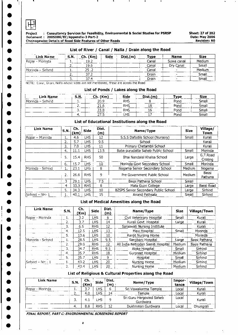
* Project : Consultancy Services for Feasibility, Environmental & Social Studies for PSRSP Sheet: 27 of 202Document 2005086/EC/Appendix-3 Part-2 Date: May 2006
* Chainagewise Details of Road Side Features of Other Roads Revision: RO
* List of River / Canal / Nalla / Drain along the Road
Link Name I S.N. Ch. (Km) Side Dist.(m) Type Name SizeRopar - Morinda 1 19.2 Canal Suwa canal Medium
~~~~~~~~2. 19.6 _Canal Dry Canal Small
* Morinda - Sirhind 1. 25 .2 _ Canal Medium2. 37.2 __ Drain Small
*___ _____ 3. 37.4 _ Drain SmallNOTE. Canal, Drain, Nalla whose sides are not mentioned, these are across the Road
List of Ponds / Lakes along the Road
* ____Link Name S.N. Ch. (Km) Side Dist.(mj Type SizeMorinda - Sirhind 1. 20.9 RHS 8 Pond Small
* ____ 2. 21.6 RHS 18 Pond Small
3. 23.8 RHS 16 Pond Small
* 4. 27.5 LHS 17 Pond Small
* List of Educational Institutions along the Road
Link Name S.N. Ch. Side Dist. Name/Type Size Village/_______________ (km ___ (m Town
Ropar - Morinda 1. 4.6 LHS 12 S.S.S Dafodils School (Nursery) Small Kurali_ 2. 5.7 LHS 9.5 School Kurali
______ 3. 7.0 LHS 11 Primary Chetambli School Kurali
4. 11.1 LHS 13.5 Baba gurudatta Saheb Public School Small Morinda
* 5. 15.4 RHS 50 Bhai Nandalal Khalsa School Large GCosinad
*__________________ 6. 15.7 LHS 10 Morinda Govt Secondary School Small Morinda
*Morinda - Sirhind 1. 23.1 LHS 8 Nogama Senior Secondary School Medium Nogama
* _ 2. 26.6 RHS 9 Pre Government Public School Medium Pathsana
3 29.1 LHS 7.5 Bassi Pathana School Small33.3 RHS 8 Mata Guzri College Large Bassi Road
5. 34.3 LHS 10 BZSPS Senior Secondary Public School Large Sirhind
* Sirhind - NH- 1 1 40.1 LHS 15 Anand Pathsala Small Sirhind
* List of Medical Amenities along the Road
Link Name S N Ch. Side Dist. Name/Type |sSize tVillage/T________________ (Kmn) NaeTyeSie VilgeTw
| Ropar - Morinda 1. 3.2 LHS 6 Civil Veterinary Hospital Small Kurali|_______ |____ 2. 3.7 LHS 14 Kurali Govt. Hospital Large Kurali
* l l 3. 6.5 RHS 12 Saraswati Nursing Institute Kurali|____*_________|___ 4. 12.5 LHS 13 Mavi Hospital Small Morinda
I_________________ 5. 13.6 LHS 10 Ranjit Nursing Home Morinda
I _ |Morinda - Sirhind 1. 28.5 LHS 9.5 Sanjibani Hospital Large Bassi Pathana2. 29.0 RHS 12 All India Netrodan Samiti Hospital Medium Bassi Pathana
| -____ 3. 34.7 RHS 9.5 Aloke Hospital Small Sirhind
*_| __ _ l 4. 35.7 RHS 18 Gurpreet Hospital Medium Sirhind
____ l 5. 35.7 LHS 9 Hospital Small Sirhind
Sirhind - NH - 1 1. 43.2 LHS 20 Nursing Home Medium Sirhind
I____ _ ____ ___ 2. 43.4 LHS 20 Nursing Home Medium Sirhind
| * List of Religious & Cultural Properties along the Road
| *. r Link Name SN. (KC)h Side | Name/Type | otance Villae/T
* lRopar - Morinda 1. - 3.7 LHS 6 - Sri Viswakarma Temple Local Kurali
|____________________ l2. 4.0 LHS 14 Temple Local Kurali
0 * ! i 3. 4.1 LHS 9 Sri Guru Hargovind Saheb Local Kurali_ _ _ _ _ _ _ _ _ _ _ _ _ _ _ _____ _ _ _ _ _ _ _ _ _ _G u rdw ara_ _ _ _ _ _ _ _ _ _ _
| * l _ = l 4. - 8.8 RHS | 12 - Dukhnman Gurdwara Local . Dhungrali
FINAL REPORT, PAR T C: ENVIRONMENTAL SCREENING REPORT
0
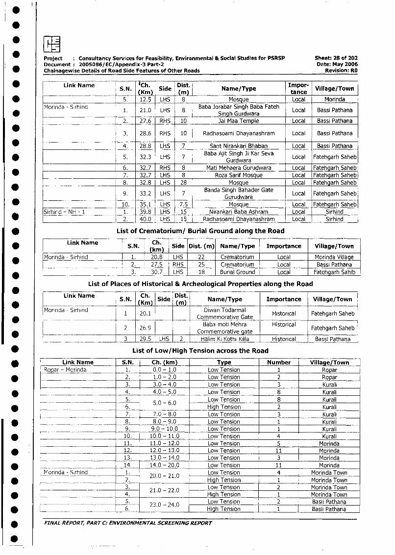
Project : Consultancy Services for Feasibility, Environmental & Social Studies for PSRSP Sheet: 28 of 202
Document: 2005086/EC/Appendix-3 Part-2 Date: May 2006
* Chainagewise Details of Road Side Features of Other Roads Revision: RO
* ~~~~~Link Name I Ch. SieDist. Impor-S. N. (Km) Side Name/Type tance Village/Town
* _ 5. 12.5 LHS 8 Mosque Local Morinda
Morinda - Sirhind 1. 21.0 LHS 8 Baba Jorabar Singh Baba Fateh Local Bassi Pathana
0 ~~~~~~~~~~~~~~~~~Singh Gurdwara2. 27.6 RHS 10 Jai Maa Temple Local Bassi Pathana
3. 28.6 RHS 10 Radhasoami Dhayanashram Local Bassi Pathana
4. 28.8 LHS 7 Sant Nirankari Bhaban Local Bassi Pathana
5 Baba Ajit Singh Ji Kar Seva Local Fatehgarh Saheb32.3 LHS ~~~ Gurdwara
6. 32.7 RHS 8 Mati Mehaera Gurudwara Local Fatehgarh Saheb
_ 7. 32.7 LHS 8 Roza Sarif Mosque Local Fatehgarh Saheb
*______________________ 8. 32.8 LHS 28 Mosque Local Fatehgarh Saheb
9. 33.2 LHS 7 Banda Singh Bahader Gate Local Fatehgarh SahebGurudwara
* 10. 35.1 LHS 7.5 Mosque Local Fatehgarh Saheb
Sirhird - NH - 1 1. 39.8 LHS 15 Nirankari Baba Ashram Local Sirhind
* _~ 2. 40.0 LHS 15 Radhasoami Dhayanashram Local Sirhind
* List of Crematorium/ Burial Ground along the Road
* Link Name S.N. Ch. Side Dist. (m) Name/Type Importance Village/Town___________ ~ ~km )
Morinda - Sirhind 1. 20.8 LHS 22 Crematorium Local Morinda Village
2. 27.5 RHS 25 Crematorium Local Bassi Pathana
* _____-_________ 3. 30.7 LHS 18 Burial Ground Local Fatehgarh Sahib
List of Places of Historical & Archeological Properties along the Road
Link Name S.N. Km Side Dist. Name/Type Importance Village/Town.. _ _ _ _ __ (Ki) _ _ ) _ _ _ _ _ _ _ _ _ _ _ _
Morinda - Sirhind 1 20.1 Diwan Todarmal Historical Fatehgarh Saheb
2 26.9 Baba moti Mehra Historical Fatehgarh Saheb_____________ ______ Commemorative gate
_ __ _ _ .__ _ _3 29.5 LHS 2 Halim Ki Kothi Killa Historical Bassi Pathana
* List of Low/High Tension across the Road
* r Link Name S.N. Ch. (km) Type Number Village/Town
Ropar - Morinda 1. 0.0 - 1.0 Low Tension 1 Ropar
* __________________ l2. 1.0 - 2.0 Low Tension 2 Ropar
3. 3.0 - 4.0 Low Tension 3 Kurali
* L 1 4. 4.0 - 5.0 Low Tension 8 Kurali
l. 5.0 - 6.0 Low Tension 8 Kurali* ________________________ 6. _________ _ 5.0 -6.06 High Tension 2 Kurali
7. 7.0 - 8.0 _ Low Tension 3 Kurali
I * l __________________ _ l 8. 8.0 - 9.0 | Low Tension 1 Kurali
____ _______________ l9. 9.0 - 10.0 Low Tension 1 Kurali
*____________________ _ (10. 10.0 - 11.0 Low Tension 4 Kurali
11. 11.0 - 12.0 Low Tension 5 Morinda
I * l | _ l 12. 12.0 - 13.0 Low Tension 11 | Morinda13. 13.0 - 14.0 Low Tension 3 Morinda
* _ __ l 14. 14.0 - 20.0 Low Tension 11 Morinda
|Morinda - Sirhind 1. 20.0 - 21.0 Low Tension 4 Morinda TownI* _ ______ l2. HighTension 1 Morinda Town
0l .- 21.0 - 22.0 Low Tension 2 Morinda Town
I * ______________ l4. High Tension 1 Morinda Town
S.l5 l 23.0 - 24.0 Low Tension 2 Basii Pathana
| * L_ l 6. l High Tension 1 Basii Pathana
| * FINAL REPORT, PARTrC: ENVIRONMENTAL SCREENING REPORT
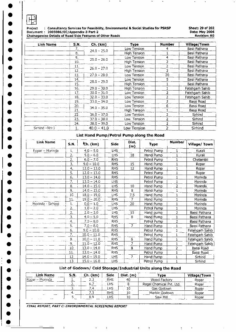
Project Consultancy Services for Feasibility, Environmental & Social Studies for PSRSP Sheet: 29 of 202
* Document 2005086/EC/Appendix-3 Part-2 Date: May 2006Chainagewise Details of Road Side Features of Other Roads Revision: RO
Link Name S.N. Ch. (km) Type Number Village/Town____________ 7. Low Tension 4 Basii Pathana
_*_ 24.0 - 25. HihTnso08. 1 Basii Pathana
* _- __- ._9. 25.0 - 26 0 Low Tension 4 Basii Pathana10. High Tension 2 Basii Pathana
11. Low Tension 2 Basii Pathana_ 12. 26.0 - 27.0 High Tension 2 Basii Pathana
* 13. 27.0 - 28.0 Low Tension 20 Basii Pathana
14. 28.0 - 29.0 Low Tension 5 Basii Pathana
* _____-____ 15. High Tension 1 Basii Pathana
____ ___ ______ 16. 29.0 - 30.0 High Tension 1 Fatehgarh Sahib
-~ 17. 30.0 - 31.0 Low Tension 2 Fatehgarh Sahib
_ 18. 32.0 - 33.0 Low Tension 2 Fatehgarh Sahib
* _ 19. 33.0 - 34.0 Low Tension 2 Bassi Road
______.__ 20. 34.0 - 35.0 Low Tension 6 Bassi Road
* ________________ 21. High Tension 1 Bassi Road
22. 36.0 - 37.0 Low Tension 2 Sirhind
* 23. 37.0 - 38.0 Low Tension 2 Sirhind
_______________________ 24. 38.0 - 39.0 Low Tension 2 Sirhind
* Sirhind -NH-1 1. 40.0 - 41.0 Low Tension 2 Sirhind
List Hand Pump/Petrol Pump along the Road
Link Name S.N. th. (km) Side Dist. Type Number Village/ Town
_ opar - Morinda 1. 4.0 - 5.0 LHS Petrol Pump 1 Kurali
* ________________ 2. 5.0 - 6.0 LHS 18 Hand Pump 1 Kurali
__________________ 2. 6.0 - 7.0 RHS Petrol Pump 1 Chetambli
* _______________ 3. 9.0 - 10.0 RHS 15 Hand Pump 1 Ropar
__ 4. 12.0 - 13.0 RHS 12 Hand Pump 1 Ropar
* 5. 12.0 - 13.0 RHS Petrol Pump 1 Ropar
6. 13.0 - 14.0 RHS Petrol Pump 1 Morinda
* .___________________ 7. 13.0 - 14.0 LHS Petrol Pump 1 Morinda
8. 14.0 - 15.0 LHS 10 Hand Pump 2 Morinda
* . 9. 14.0 - 15.0 RHS 8 Hand Pump 1 Morinda
10 18.0 - 19.0 LHS 7.5 Hand Pump 1 Morinda
*- - Sirhind 11. 19.0 - 20.0 RHS 7 Hand Pump 1 Morinda
Morinda - Sirhind 1. 0.0 - 1.0 LHS 20 Hand Pump 1 Morinda
* ____________________ 2. 1.0 - 2.0 LHS Petrol Pump 1 Morinda
2. 2.0 - 3.0 LHS 15 Hand pump 2 Bassi Pathana
* ____________________ 3. 4.0 - 5.0 RHS 8 Hand Pump 1 Bassi Pathana
4. 7.0 - 8.0 RHS Petrol Pump 2 Bassi Pathana
* ____________________ 5. 7.0 - 8.0 RHS 7 Hand Pump 1 Bassi Pathana
6. 9.0 - 10.0 RHS Petrol Pump 1 Fatehgarh Sahib
* ______-_______ 7. 10.0 - 11.0 RHS Petrol Pump 1 Fatehgarh Sahib
________ _________ 8. 10.0 - 11.0 RHS 6 Hand Pump 1 Fatehgarh Sahib
* 9. 11.0 - 12.0 RHS 7 Hand Pump 1 Fatehgarh Sahib
__________ 10 13.0 - 14.0 RHS 8 Hand Pump 2 Bassi Road
* -~_______________ 11. 13.0 - 14.0 RHS Petrol Pump 1 Bassi Road12 14.0 - 15.0 LHS 7 Hand Pump 1 Sirhind
* ___ . 13 15.0 - 16.0 LHS Petrol Pump 1 Sirhind
List of Godown/ Cold Storage/Industrial Units along the Road
Link Name S.N. Ch. (km) Side IDist. (m) | Type Village/Town
* Ropar - Morinda 1. 2.3 RHS . 40 - Wood Factory Ropar
_ _____________ 2. 6.7 LFIS 8 Regal Chemical Pvt. Ltd. | Ropar
* ___ _ ____ 3. 7.4 LHS 10 Gas Godown Ropar
_ 4. 7.3 RHS 10 - Marble Godown Ropar
w __ ___ ___ __ 5_ _ 1 8.9 LHS 10 Saw Mill Ropar
; FINAL REPORr, PART C: ENVIRONMENTAL SCREENING REPORT
*0
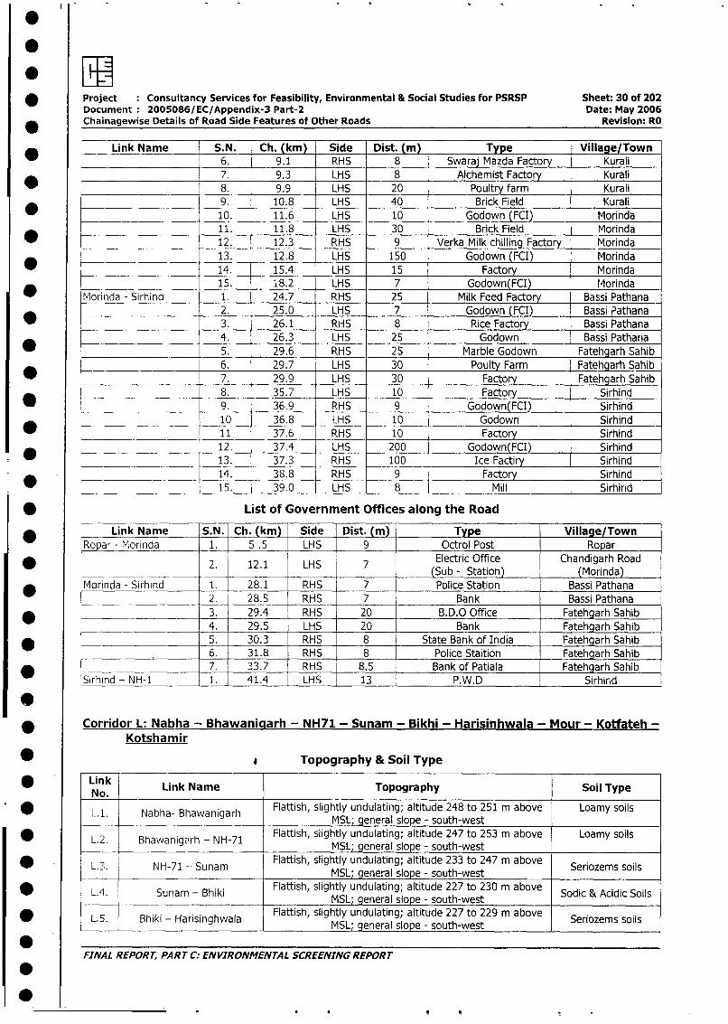
0
* Project Consultancy Services for Feasibility, Environmental & Social Studies for PSRSP Sheet: 30 of 202Document 2005086/EC/Appendix-3 Part-2 Date: May 2006
_ Chainagewise Details of Road Side Features of Other Roads Revision: RO
Link Name S.N. Ch. (km) Side Dist. (m) Type Village/Town
6. 9.1 RHS 8 Swaraj Mazda Factory Kurali
____________________ 7. 9.3 LHS 8 Alchemist Factory Kurali
8. 9.9 LHS 20 Poultry farm Kurali
9. 10.8 LHS 40 Brick Field Kurali
_ 10. 11.6 LHS 10 Godown (FCI) Morinda
11. 11.8 LHS 30 Brick Field Morinda
_ 12. 12.3 RHS 9 Verka Milk chilling Factory Morinda
___________________ 13. 12.8 LHS 150 Godown (FCI) Morinda
_ 14. 15.4 LHS 15 Factory Morinda
15. 18.2 LHS 7 Godown(FCI) Morinda
* Morinda - Sirhind 1. 24.7 RHS 25 Milk Feed Factory Bassi Pathana
2. 25.0 LHS 7 Godown (FCI) Bassi Pathana
3. 26.1 RHS 8 Rice Factory Bassi Pathana
4. 26.3 LHS 25 Godown Bassi Pathana
5. 29.6 RHS 25 Marble Godown Fatehgarh Sahib
* __6. 29.7_ LHS 30 Poulty Farm Fatehgarh Sahib
7. 299 LHS 30 Factory Fatehgarh Sahib
_8. 35.7 LHS 10 Factorv Sirhind
* ___________________ 9. 36.9 RHS 9 Godown(FCI) Sirhind
_ ___ _____10 36.8 LHS 10 Godown Sirhind
_ _ 11 37.6 RHS 10 Factory Sirhind
*__________________ 12. 37.4 LHS 200 Godown(FCI) Sirhind
13. 37.3 RHS 100 Ice Factiry Sirhind
14. 38.8 RHS 9 Factory Sirhind
15. 39.0 LHS 8 Mill Sirhirid
* List of Government Offices along the Road
* Link Name S.N. Ch. (km) Side Dist. (m) Type Village/Town
Ro_ar - Morinda 1. 5 .5 LHS 9 Octroi Post Ropar
2_ 12.1 LHS 7 Electric Office Chandigarh Road
w _ 2. 12.1 LHS (Sub - Station) (Morinda)
* Morinda - Sirhind 1. 28.1 RHS 7 Police Station Bassi Pathana
___________________ 2. 28.5 RHS 7 Bank Bassi Pathana
* _3. 29.4 RHS 20 B.D.O Office Fatehgarh Sahib4. 29.5 LHS 20 Bank Fatehgarh Sahib
* 5. 30.3 RHS 8 State Bank of India Fatehgarh Sahib
6. 31.8 RHS 8 Police Staition Fatehgarh Sahib
7. 33.7 RHS 8.5 Bank of Patiala Fatehgarh Sahib
Sirhind - NH-1 1. 41.4 LHS 13 P.W.D Sirhird
* Corridor L: Nabha - Bhawanigarh - NH71 - Sunam - Bikhi - Harisinhwala - Mour - Kotfateh -
Kotshanmir
* Topography & Soil Type
* Link Link Name Topography Soil Type
No.L. 1.. Nabha- Bhawanigarh Flattish, slightly undulating; altitude 248 to 251 m above Loamy soils
MSL; general slope - south-west
* L.2. Bhawanigarh - NH-71 Flattish, slightly undulating; altitude 247 to 253 m above Loamy soils_ L_2. Bhawanigarh - NH-71 MSL; general slope - south-west
L.3. NH-71 -- Sunam Flattish, slightly undulating; altitude 233 to 247 m above Seriozems soilsMSL; general slope - south-west
L.4. Sunam - Bhiki Flattish, slightly undulating; altitude 227 to 230 m above Sodic & Acidic Soils_________________________MSL; general slope - south-west
L. 5. Bhiki - Harisinghwala Flattish, slightly undulating; altitude 227 to 229 m above Seriozems soils
*__ MSL; general slope - south-west
FINAL REPORT, PART C: ENVIRONMENTAL SCREENING REPORT
0
S~~
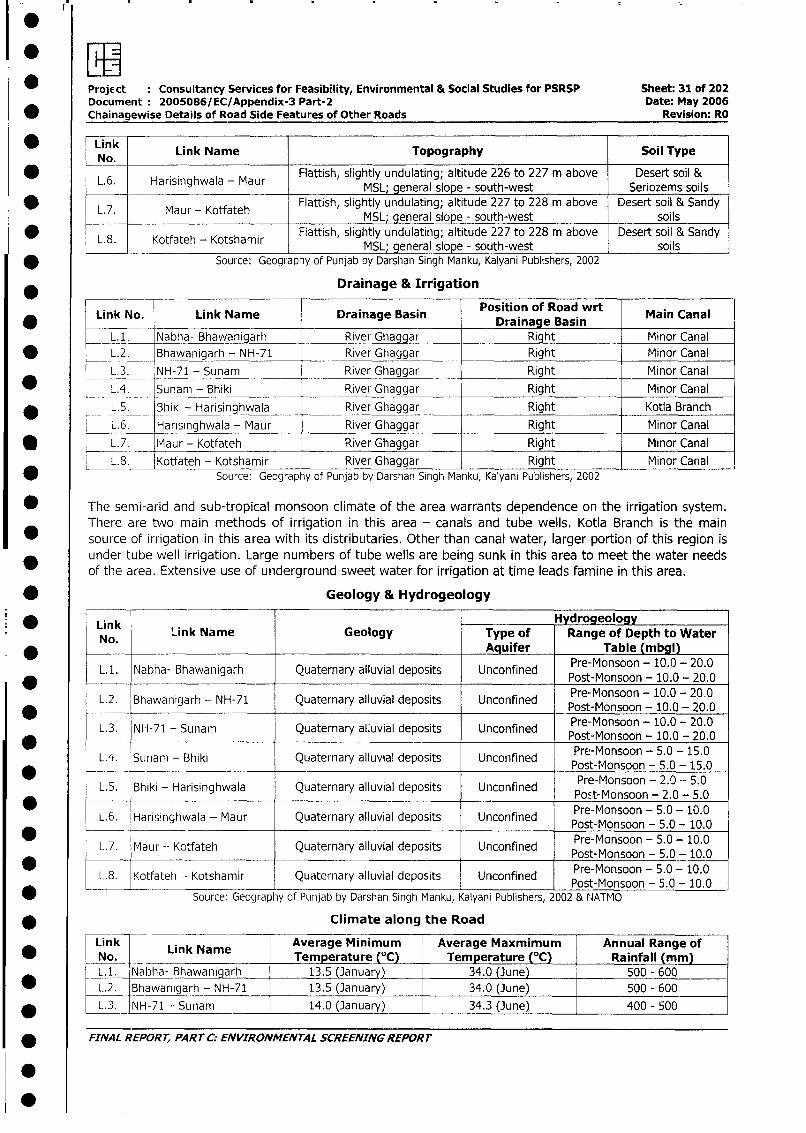
Project Consultancy Services for Feasibility, Environmental & Social Studies for PSRSP Sheet: 31 of 202Document 2005086/EC/Appendix-3 Part-2 Date: May 2006
* Chainagewise Details of Road Side Features of Other Roads Revision: RO
Link Link Name Topography Soil TypeNo,
L.6. Harisinghwala - Maur Flattish, slightly undulating; altitude 226 to 227 m above Desert soil &MSL; general slope - south-west Seriozems soils
L.7. Maur - Kotfateh Flattish, slightly undulating; altitude 227 to 228 m above Desert soil & SandyMSL; general slope - south-west soils
L.8. Kotfateh - Kotshamir Flattish, slightly undulating; altitude 227 to 228 m above Desert soil & Sandy_____ ______________________ MSL; general slope - south-west soils
* Source: Geography of Punjab by Darshan Singh Manku, Kalyani Publishers, 2002
Drainage & Irrigation
Link No. Link Name Drainage Basin Position of Road wrt Main Canal
_L1.. Nabha- Bhawanigarh River Ghaggar Right Minor Canal
* L.2. Bhawanigarh - NH-71 River Ghaggar Right Minor Canal
L.3. NH-71 - Sunam River Ghaggar Right Minor Canal
LA. Sunam - Bhiki River Ghaggar Right Minor Canal
* L 5. Bhiki - Harisinghwala River Ghaggar Right Kotla Branch
L. 6. Harisinghwala - Maur River Ghaggar Right Minor Canal_L.7. Maur - Kotfateh River Ghaggar Right Minor Canal
L. 8. Kotfateh - Kotshamir River Ghaggar Right Minor CanalSource: Geography of Punjab by Darshan Singh Manku, Kalyani Publishers, 2002
* The semi-arid and sub-tropical monsoon climate of the area warrants dependence on the irrigation system.There are two main methods of irrigation in this area - canals and tube wells. Kotla Branch is the main
* source of irrigation in this area with its distributaries. Other than canal water, larger portion of this region isunder tube well irrigation. Large numbers of tube wells are being sunk in this area to meet the water needsof the area. Extensive use of underground sweet water for irrigation at time leads famine in this area.
* Geology & Hydrogeology
Link HydrogeologyNo. Link Name Geology Type of Range of Depth to Water
* Aquifer Table (mbgl)
L.1. Nabha- Bhawanigarh Quaternary alluvial deposits Unconfined Pre-Monsoon - 10.0 - 20.0Pret-Monsoon - 10.0 - 20.0
* L.2. Bhawanigarh - NH-71 Quaternary alluvial deposits Unconfined Post-Monsoon - 10.0 - 20.0
L.3. NH-71 - Sunam Quaternary alluvial deposits Unconfined Pre-Monsoon - 10.0 - 20.0-Post-Monsoon - 10.0 - 20.0
L.4. Sunam - Bhiki Quaternary alluvial deposits Unconfined Post-Monsoon - 5.0 - 15.0
* L.5. Bhiki - HriinhwlaQutenay llvil epsis ncnfne Pre-Monsoon - 2.0 -- 5.0L.5. Bhiki - Harisinghwala Quaternary alluvial deposits Unconfined Pre-Monsoon - 2.0 - 5.0
* -_____ - ~~~~~~~~~~~~~~~~~~~Pret-Monsoon - 5.0 - 10.0L.6. Harisinghwala - Maur Quaternary alluvial deposits Unconfined Post-Monsoon - 5.0 - 10.0
* -_____ -. ~~~~~~~~~~~~~~~~~~Pret-Monsoon - 5.0 - 10.0L. 7. Maur - Kotfateh Quaternary alluvial deposits Unconfined Post-Monsoon - 5.0 - 10.0
* -- ~~~~~~~~~~~~~~~~~~~~~~Pret-Monsoon - 5.0 - 10.0
L.8. Kotfateh - Kotshamir Quaternary alluvial deposits Unconfined Post-Monsoon - 5.0 - 10.0
* -- - Source: Geography of Putnjab by Darshan Singh Manku, Kalyani Publishers, 2002 & NATMO
* __ Climate along the Road
Link Lik N Average Minimum Average Maxmimum Annual Range of* K No. LInk Name Temperature (°C) Temperature (°C) Rainfall (mm) l
L.1. Nabha- Bhawanigarh 13.5 (January) 34.0 (June) 500 - 600
L.2. Bhawanigarh - NH-71 13.5 (January) 34.0 (June) 500 - 600
* L.3. NH-71 - Sunam 14.0 (January) 34.3 (June) 400 - 500
* FINAL REPORr, PART C: ENVIRONMENTAL SCREENING REPORT
.
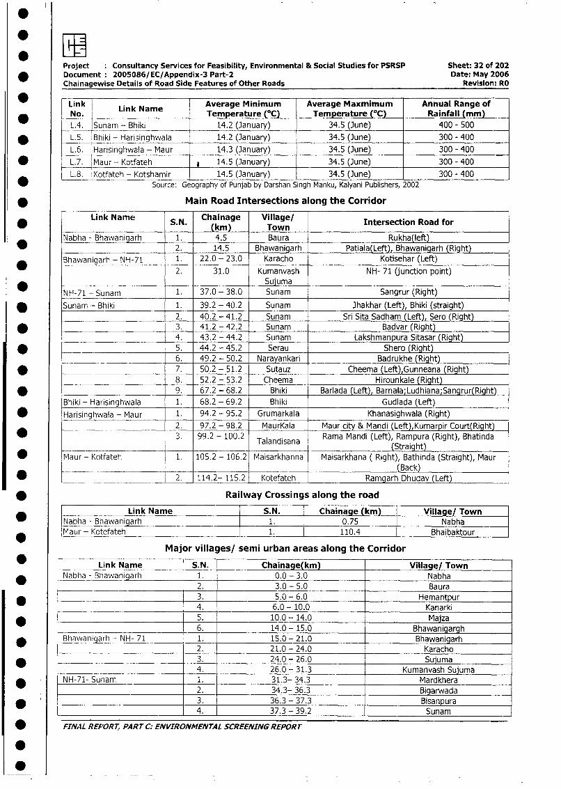
Project Consultancy Services for Feasibility, Environmental & Social Studies for PSRSP Sheet: 32 of 202* Document 2005086/EC/Appendix-3 Part-2 Date: May 2006
Chainagewise Details of Road Side Features of Other Roads Revision: RO
* nkLin k Name Average Minimum Average Maxmimum Annual Range ofNo. L Temperature (°C) Temperature (°C) Rainfall (mm)L.4. Sunam - Bhiki 14.2 (3anuary) 34.5 (June) 400 - 500
* L.5. Bhiki - Harisinghwala 14.2 (January) 34.5 (June) 300 - 400
L.6. Harisinghwala - Maur 14.3 (January) 34.5 (June) 300 - 400
* L.7. Maur - Kotfateh * 14.5 (January) 34.5 (June) 300 - 400
L.8. Kotfateh - Kotshamir 14.5 (January) 34.5 (June) 300 - 400Source: Geography of Punjab by Darshan Singh Manku, Kalyani Publishers, 2002
* Main Road Intersections along the Corridor
Link Name S N Chainage Village/ Intersection Road for(km) Town
Nabha - Bhawanigarh 1. 4.5 Baura Rukha(left)* 2. 14.5 Bhawanigarh Patiala(Left), Bhawanigarh (Right)
Bhawanigarh - NH-71 1. 22.0 - 23.0 Karacho Kotisehar (Left)2. 31.0 Kumanvash NH- 71 (junction point)
SujumaNH-71 - Sunam 1. 37.0 - 38.0 Sunam Sangrur (Right)
* Sunam - Bhiki 1. 39.2 - 40.2 Sunam Jhakhar (Left), Bhiki (straight)2. 40.2 - 41.2 Sunam Sri Sita Sadham (Left), Sero (Right)
I * 3. 41.2 - 42.2 Sunam Badvar (Right)4. 43.2 - 44.2 Sunam Lakshmanpura Sitasar (Right)
* __ 5. 44.2 - 45.2 Serau Shero (Right)6. 49.2 - 50.2 Narayankari Badrukhe (Right)
* -_____ 7. 50.2 - 51.2 Sutauz Cheema (Left),Gunneana (Right)_______________________ 8. 52.2 - 53.2 Cheema Hirounkale (Right)
- _ arisinghwala 9. 67.2 - 68.2 Bhiki Barlada (Left), Barnala;Ludhiana;Sangrur(Right)
Bhiki - Harisinghwala 1. 68.2 - 69.2 Bhiki Gudlada (Left)
* Harisinghwala - Maur 1. 94.2 - 95.2 Grumarkala Khanasighwala (Right)2. 97.2 - 98.2 MaurKala Maur city & Mandi (Left),Kumarpir Court(Right)
* - 3. 99.2 - 100.2 Talandisana Rama Mandi (Left), Rampura (Right), BhatindaTalandisana (Straight)
* Maur- Kotfateh 1. 105.2 - 106.2 Maisarkhanna Maisarkhana ( Right), Bathinda (Straight), Maur
_ __. ________ _(Back)* __ _. 2. 114.2- 115.2 Kotefateh Ramgarh Dhudav (Left)
* Railway Crossings along the road
L _ Link Name S.N. Chainage (km) Village/ TownNabha - Bhawanigarh 1. 0.75 NabhaMaur - Kotefateh 1. 110.4 Bhaibaktour
Major villages/ semi urban areas along the Corridor
* Link Name S.N. Chainage(km) Village/ Town* Nabha - Bhawanigarh 1. 0.0 - 3.0 Nabha
________ _ .___ 2. 3.0 - 5.0 Baura_______ 3. 5.0 - 6.0 Hemantpur
_ 4. 6.0 - 10.0 Kanarki5. 10.0 - 14.0 Maiza
- 6. 14.0 - 15.0 Bhawanigargh* Bhawanigarh - NH- 71 1. 15.0 - 21.0 Bhawanigarh
L- _ 2. 21.0 - 24.0 Karacho* l 3. 24.0 - 26.0 Sujuma
4. 26.0 - 31.3 Kumanvash Sujuma
* | NH-71- Sunam 1. 31.3- 34.3 Mardkhera2. 34.3- 36.3 Bigarwada
* l 3. 36.3 - 37.3 Bisanpura___________________ _____ 4. 37.3 - 39.2 Sunam
* FINAL REP'ORT, PART C: ENVIRONMENTAL SCREENING REPORT
0 -
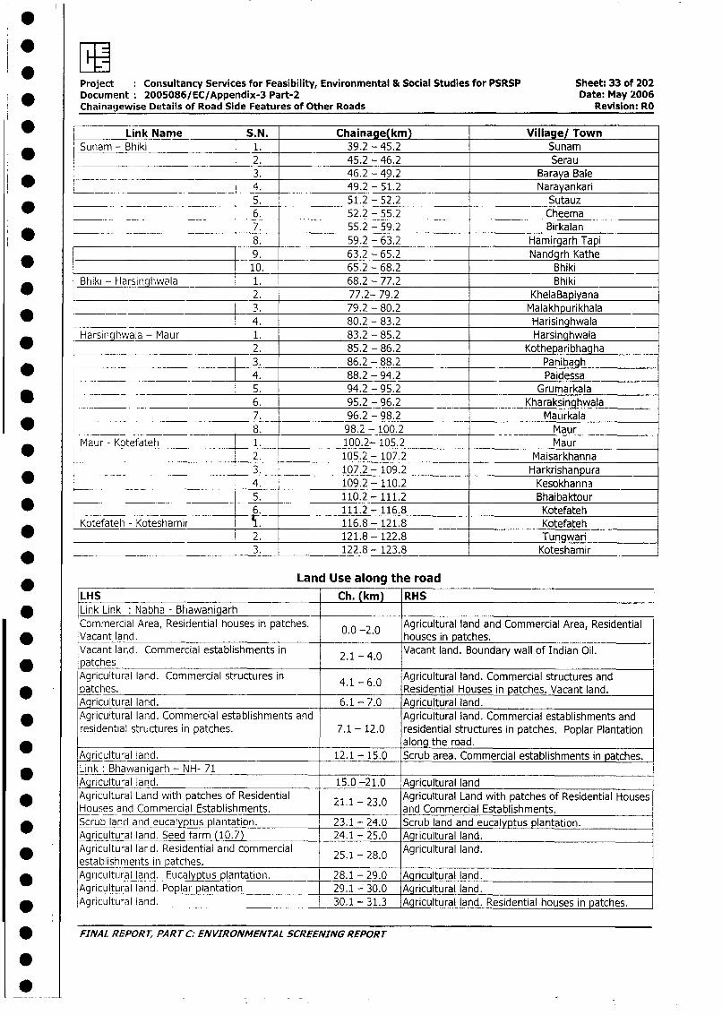
Project Consultancy Services for Feasibility, Environmental & Social Studies for PSRSP Sheet: 33 of 202Document 2005086/EC/Appendix-3 Part-2 Date: May 2006Chainagewise Details of Road Side Features of Other Roads Revisioni: RO
* Link Name [S.N. Chainage(km) Village/ TownSunam - Bhiki 1. 39.2 - 45.2 Sunam
2. 45.2 - 46.2 Serau3. 46.2 - 49.2 Baraya Bale
*__ = ___________________ 4. 49.2 - 51.2 Narayankari_ 5. 51.2 - 52.2 Sutauz
* _ _ 6. 52.2 - 55.2 Cheema* _______________ _ 7. 55.2 - 59.2 Birkalan
8. 59.2 - 63.2 Hamirgarh Tapi9. 63.2 - 65.2 Nandgrh Kathe10. 65.2 - 68.2 Bhiki
Bhiki - Harsinghwala 1. 68.2 - 77.2 Bhiki2. 77.2- 79.2 KhelaBapiyana3. 79.2 - 80.2 Malakhpurikhala
* 4. 80.2 - 83.2 HarisinghwalaHarsinghwala - Maur 1. 83.2 - 85.2 Harsinghwala
2. 85.2 - 86.2 Kotheparibhagha* _ _____________________ _ 3. 86.2 - 88.2 Panibagh
__ -4. 88.2 - 94.2 Paidessa5. 94.2 - 95.2 Grumarkala
_ 6. 95.2 - 96.2 Kharaksinghwala7. 96.2 - 98.2 Maurkala
* _ _ 8. 98.2 - 100.2 MaurMaur - Kotefateh 1. 100.2- 105.2 Maur
* __________ 2. 105.2 - 107.2 Maisarkhanna3. 107.2 - 109.2 Harkrishanpura
* ___ 4. 109.2- 110.2 Kesokhanna5. 110.2 - 111.2 Bhaibaktour
_ 6. 111.2 - 116.8 KotefatehKotefateh - Koteshamir 116.8 - 121.8 Kotefateh
* ____________________________ 2. 121.8 - 122.8 Tungwari3. 122.8 - 123.8 Koteshamir
Land Use along the road
LHS Ch. (km) RHS* Link Link: Nabha - Bhiawanigarh
Commercial Area, Residential houses in patches. 0 0 -2.0 Agricultural land and Commercial Area, Residential* Vacant land. . . houses in patches.
Vacant land. Commercial establishments in 2.1 - 4.0 Vacant land. Boundary wall of Indian Oil.* patches
Agricultural land. Commercial structures in 4.1 - 6.0 Agricultural land. Commercial structures andpatches. . . Residential Houses in patches. Vacant land.Agricultural land. 6.1 - 7.0 Agricultural land.
* Agricultural land. Commercial establishments and Agricultural land. Commercial establishments andresidential structures in patches. 7.1 - 12.0 residential structures in patches. Poplar Plantation
_ along the road._ricultural land. 12.1 - 15.0 Scrub area. Commercial establishments in patches.
* Link: Bhawanigarh - NH- 71Agricultural land. 15.0 -21.0 Agricultural land
* Agricultural Land with patches of Residential 21.1- 23.0 Agricultural Land with patches of Residential HousesHouses and Commercial Establishments. and Commercial Establishments.
* Scrub land and eucalyptus plantation. 23.1 - 24.0 Scrub land and eucalyptus plantation.Agricultural land. Seed farm (10.7) 24.1 - 25.0 -.Agricultural land.
* Agricultural lard. Residential and commercial 25.1 - 28.0 Agricultural land.establishments in patches.
* Agricultural land. Eucalyptus plantation. 28.1 - 29.0 Agricultural land.Aqricultural land. Poplar plantation 29.1 - 30.0 Agricultural land.Agricultural land. 30.1 - 31.3 Agricultural land. Residential houses in patches.
* FINAL REPORT, PART C: ENVIRONMENTAL SCREENING REPORT
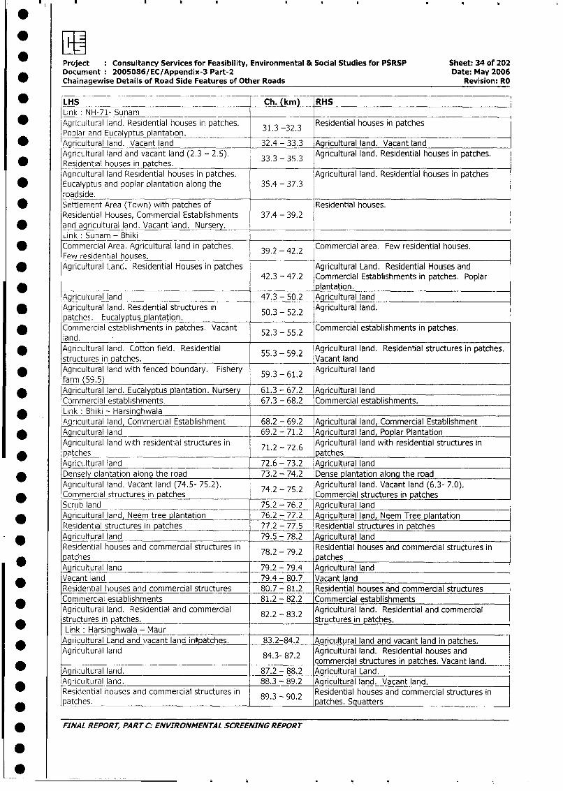
Project : Consultancy Services for Feasibility, Environmental & Social Studies for PSRSP Sheet: 34 of 202Document 2005086/EC/Appendix-3 Part-2 Date: May 2006Chainagewise Details of Road Side Features of Other Roads Revision: RO
* |LHS Ch. (km) RHSLink: NH-71- Sunam
* Agricultural land. Residential houses in patches. 31.3 -32.3 Residential houses in patchesPoplar and Eucalyptus plantation.
* Agricultural land. Vacant land 32.4 - 33.3 Agricultural land. Vacant land
Agricultural land and vacant land (2.3 - 2.5). 33.3 - 35.3 Agricultural land. Residential houses in patches.
* Residential houses in patches.Agricultural land Residential houses in patches. Agricultural land. Residential houses in patches
* Eucalyptus and poplar plantation along the 35.4 - 37.3roadside.
* Settlement Area (Town) with patches of Residential houses.Residential Houses, Commercial Establishments 37.4 - 39.2and agricultural land. Vacant land. Nursery.Link: Sunam - Bhiki
* Commercial Area. Agricultural land in patches. 39.2 - 42.2 Commercial area. Few residential houses.Few residential houses.
* Agricultural Lanc. Residential Houses in patches Agricultural Land. Residential Houses and42.3 - 47.2 Commercial Establishments in patches. Poplar
* _ plantation.Agricultural land 47.3 - 50.2 Agricultural land
* Agricultural land. Residential structures in 50.3 - 52.2 Agricultural land.oatche . Eucalyptus plantation.
* Commercial establishments in patches. Vacant 52.3 - 55.2 Commercial establishments in patches.land.Agricultural land. Cotton field. Residential 55.3 - 59.2 Agricultural land. Residential structures in patches.
structures in patches. . . Vacant land
* Agricultural land with fenced boundary. Fishery 59.3 - 61.2 Agricultural landfarm (59.5)
* Agricultural land. Eucalyptus plantation. Nursery 61.3 - 67.2 Agricultural land
Commercial establishments. 67.3 - 68.2 Commercial establishments.
* Link: Bhiki - HarsinghwalaAgricultural land, Commercial Establishment 68.2 - 69.2 Agricultural land, Commercial Establishment
* A~gricultural land 69.2 - 71.2 Agricultural land, Poplar Plantation
Agricultural land with residential structures in 71.2 - 72.6 Agricultural land with residential structures in
patches patchesAgricultural land 72.6 - 73.2 Agricultural land
* Densely plantation along the road 73.2 - 74.2 Dense plantation along the road
Agricultural land. Vacant land (74.5- 75.2). 74.2 75.2 Agricultural land. Vacant land (6.3- 7.0).
* Commercial structures in patches . - . Commercial structures in patches
Scrub land _ 75.2 - 76.2 Agricultural landAgricultural land Neem tree plantation 76.2 - 77.2 Agricultural land, Neem Tree plantation
Residential structures irn patches 77.2 - 77.5 Residential structures in patches
* Agricultural land 79.5 - 78.2 Agricultural land
Residential houses and commercial structures in 78.2 79.2 Residential houses and commercial structures in
* patches . - . patchesAgricultural land 79.2 - 79.4 Agricultural land
Vacant land 79.4 - 80.7 Vacant land
Residential houses and commercial structures 80.7 - 81.2 Residential houses and commercial structures
Commercial establishments 81.2 - 82.2 Commercial establishments
Agricultural land. Resioential and commercial 82.2 83.2 Agricultural land. Residential and commercialstructures in patches. . - . structures in patches.
Link: Harsinghwala - MaurAgricultural Land and vacant land intpatches. 83.2-84.2 Agricultural land and vacant land in patches.
Agricultural land 84.3- 87.2 Agricultural land. Residential houses and
* _ _ _~~~~~~~~~~~~~~~- commercial structures in patches. Vacant land.Agricultural land. 87.2 - 88.2 Agricultural Land.* Agricultural land. _ 88.3 - 89.2 Agricultural land. Vacant land.
Residential houses and commercial structures in 89.3 90.2 Residential houses and commercial structures inpatches. . - . patches. Squatters
* FINAL REPORT, PARTCC: ENVIRONMENTAL SCREENING REPORT
0~~~~~~~
Project Consultancy Services for Feasibility, Environmental & Social Studies for PSRSP Sheet: 35 of 202* Document: 20050861fEC/Appendix-3 Part-2 Date: May 2006
Chainagewise Details of Road Side Features of Other Roads Revision: RO
LHS Ch. (km) RHS* Agricultural land. 90.3 - 92.2 Agricultural land. Residential structures in patches
_ . - . and poplar plantation along the road.* Agricultural land. 92.3 - 94.2 Agricultural land.
Agricultural land and Apiculture. Residential 94.3 - 96.2 Agricultural land and Residential houses in patches.* houses in patches. Vacant land
Agricultural land. 96.3 - 97.7 Agricultural land.Narma (cotton) cultivation. Commercial and 97.3 - 99.2 Narma (cotton) cultivation. Commercial andresidential structures. residential structures.
* Agricultural land, Vacant land (16.4 - 17.0) 99.2 - 100.2 Agricultural land, Poplar plantationLink: Maur - Kotfateh
* Agricultural land Farm (0.6) 100.2 -101.2 Agricultural land,Agricultural Land Vacant land, Poplar plantation. 101.2 - 104.2 Agricultural LandAgricultural land, Residential and commercial 104.2 105.2 Agricultural land, Residential and commercialstructures. 104.2 structures.
* Agricultural land. Residential houses in patches 105.2 - 107.2 Agricultural land. Residential houses in patchesVacant land 107.2 -108.2 Agricultural land
* Agricultural land. Residential houses in patches. 108.2 - 109.2 Agricultural land. Residential houses in patchesPoplar plantation
* Aoricultural land with fenced line. 109.2 - 112.2 Agricultural land with fenced line, Dense PlantationAqricultural land 112.2 - 114.2 Agricultural landAgricultural land with fence Boundary. 114.2 - 115.2 Agricultural land with fence boundary. Vacant land_ _ _ 114.2. .. 115.2 _(14.5)
* Agricultural land. Fenced boundary, Vacant land, Agricultural land. Fenced boundary, Vacant Land,Commercial structures 115.2 - 116.8 Residential houses in patches, Commercial
* ~ ____ ___ _ structures.
Link: Kotefateh - Koteshamir _Agricultural Land and dense plantation along the 116.8 -117.8 Agricultural Land and dense plantation along theroad. road.Agricultural land. 117.9 - 119.8 Agricultural land.Agricultural land. Fenced line along the road. 119.9 - 121.8 Agricultural land. Fenced line along the road.Residential houses few in number.Residential houses. 121.9 - 122.8 Residential houses. Vacant landAgricultural land with fencing along the road. 122.9 - 123.8 Agricultural land with fencing along the roadResidential houses in patches. Farm-house (6.7).
* General Characteristics of the Road
* Link: Nabha - Bhawanigarh
Embankment CoDitionag RoadS.N. Chainage Height (Mt) Din Encroachment SE / SD/EM Squatters
(Kin)* LHS RHS LHS RHS LHS RHS LHS RHS LHS RHS
1. 1.0 - 2.0 No 1.0 - 2.0 Yes Yes No No No No No No
* 2. 3.6 - 4.7 0.5 0.5 Encroa Encroa No No No No No No____- ~~~- ched - ched
* 3. 4.7 - 6.0 1.0 1.0 Yes Yes No No No No No No4. 6.0 - 7.9 0.5 0.5 Chocked Chocked No No No No No No
* _7 .9 - 8.0 3.0 3.0 Yes Yes No No No No No No
6. S 8.0 - 8.5 2.0 - 1.0 - 2.0 Yes Yes No No No No No No
7. 8.5 - 8.6 0.5 0.5 Yes Yes No No No No No No* 8. 8.6 - 9.0 3.0 3.0 Yes Yes No No No No No No
9. 9.0 - 10.5 2.0 2.0 Yes Yes No No No No No No* 10. 10.5 - 11.0 3.0 3.0 Yes Yes No No No No No No
*1 11.0 - 11.5 1o.0- 1.0- 2.0 Yes Yes No No No No No NoA_ _2.0
12. 12.0- 13.0 No No Yes Yes No No No No Yes Yes13. 13.0 - 14.0 1.0 1.0 Yes Yes No No No No No No
[14.1 14.0- 15.0 I No No No No No No EM EM No No
FINAL REPORT, PART C: ENVIRONMENTAL SCREENING REPORT
..
owP* ~~~Project Consultancy Services for Feasibility, Environmental & Social Studies for PSRSP Sheet: 36 of 202
Document 2005086/ EC/Appendix-3 Part-2 Date: May 2006
* ~~~Chainagewise Details of Road Side Features of Other Roads Revision,. RO
Link :Bhawanigarh -NH- 71 Dang
Embankment CoDitionag Road* ~~~S. N. Chainage Height (Mt) Cnion Encroachment SE ISD/EM Squatters
(Kin) _ _
LHS RHS LHS RHS LHS RHS LHS RHS LHS RHS* ~~~~1. 15.0 - 16.0 No No Chocked Chocked No No No No No No
2. 16.0 - 17.0 1.0 1,0 I Yes Yes No No No No No No
* ~~~~3. 17.0 - 21.0 1.0 1.0 Chocked Chocked No No No No No No
4. 22.0 - 24.0 0.5 0.5 Chocked Chocked No No No No No No
* ~~~~5. 24.0 - 25.0 1.0 1.0 Chocked Chocked No- No No No No No
6. 25.0 - 27.0 1.0 - 1.0 Yes Yes No No No No No No
* ~~~~7. 27.0 - 28.0 No No No No No No No No No No
8. 28.0 - 28.9 0.5 -0.05 Chocked Chocked No No No No No No
* ~~~~9. 28.9 - 29.0 1.0 1.0 Yes Yes No No No No No No
10. 29.0 -30.0 No No No No No No No No No No
* ~~~11. 30.2 -31,3 No 1.0 No Yes No No No No No No
* ~~Link LNH-71- Sunam__ _ _ _ _ _ _ __ _ _ _ _ _
Chainage Embankment Drainage Road S DE qatrS.N. (hain)g Height (Mt) Condition Encroachment S DE qatr
* ~~~~~~~~~LHS RHS LHS RHS LHS RHS LHS RHS LHS RHS1. 31.3 -32.3 0.5 .No Yes No No No No No No No
* ~~~~2. 32.3 -33.3 No -No No - No No No No No No No
3. 33.3 -33.5 No No No - No No No SE SE No No
* ~~~~4. 33.5 - 35.3 0.5 0.5 __Yes Yes No No SE SE No No
5. 35.3 - 36.3 0.5 0.5 Yes - Yes No No No No No No
* ~~~~6. 36.3 - 37.3 Low lying area7. 36.8 - 37.3 2.0 2.0 Yes Yes No No No No ]No No
* ~~~~8. 37.8 - 38.3 0.5 0.5 Chocked Chocked No No No No JNo No
* ~~Link Sunam - Bhiki___________________________ ______
Chaiage Embankment Drainage Road SE/ SD/EM SquattersS. N. (Km) Height (Mt) Condition Encroachment
____ ________ LHS RS LHS RHS LHS RHS LHS RHS -LHS RHS1. 39. - 2.2 No o N No No No -No No2.__ 41.2 - 42.2 Water_Loqqingq
* ~~~~3. 42.2 -43.0 No No No No No No No No No No
4. 43.0 - 43.2 0.5 No Yes Yes No No No No No No
* ~~~~5. 43.2- 46.8 No No No No No No No No No No
6. 46.2 - 46.8 No No No No No No No No No No
* ~~~~7. 46.8 -46.9 No No Yes Yes No No No No No No
8._47.2- -48.2 No No No No No No No No No No
* ~~~~9. 48.2 - 51.2 No No -Chocked Chocked No No No No No No
10. 51.9 -52.2 No No No No No No SE No No No
* ~~~~11. 53.2 - 54.2 No No No No No No No No Yes Yes
12. i54.2 - 55.0 No No Chocked Chocked No No No No No No
* ~~~~13. 55.0 -55.2 No No No No No No No No No No
14. 55.2 - 55.5 No No Yes Yes No No No No No No
* ~~~~15. __5_ 5 S56 0.5 0.5 Yes Yes No No No No No No
16. 57.2 - 58.1 0.5 0.5 Chocked Chocked No No No No No No17 58.1 -58.2 No No No No No No No No No No
18. 58.2 -59.2 No * No No No No No No No No No
* ~~~19. 58.7 - 58.9 Dense Plantation (LHS). - __
20. 59.2 - 60.2 0.5 -0.5 Yes - Yes No o No o No o
2. 61.1 -61.2 No No No No No No No No No
2. 61.2 -65.2 No No No No No No No No No No65. -662 .5 0.5 -Chocked -Chocked INo INo No No No No
FINA L REPOR T, PA RT C:- EN VIRONMENTA L SCREENING REPOR T
Project :Consultancy Services for Feasibility, Environmental & Social Studies for PSRSP Sheet: 37 of 202
* ~~~Document :2005086/EC/Appendix-3 Part-2 Date: May 2006
Chainagewise Details of Road Side Features of Other Roads Revision: RO
F ~~~~~~Embankment Drainage RoadS.N Chainage Height (Mt)- Condition Encroachment SE/ SD/EM Squatters
Ki) LHSI RHS LHS RHS LHS RHS LHS RHS LHS RHS
* F ~~25. 6.2 -_67,2 3.0 - 5.013.0 - 5.0 Yes Yes No No No No No No
L26. 67.4 - 68.2 3.0 3.0 Yes Yes No No No No Yes Yes-
* ~~Link :Bhiki - Harsin hwala_____
Chaiage Embankment Drainage RoadSEjSDM Sqatr
* ~~~S. N. Chainag Hei h Mt) Condition Encroachment S DE qatr
(Kin) LHS RHS LHS RHS LHS RHS LHS RHS LHS RHS
* ~~~~1. 68.2 - 69.2 0.5 0.5 Choked Chocked No No No No No No
2. 70.1 - 70.2 1.0 1.0 Chocked Chocked No No No No No No
* ~~~~3. 70.2 - 71.2 2.0 2.0 No No No No No No No No
4. 72.2 - 73.2 1.0 1.0 I No No No No No No No No
* ~~~~5. 73.2 - 74.2 3.0 3.0 Chocked Chocked No No No No No No
6. 74.2 - 75.2 1.0 1.0 No No No No No No No No
* ~~~~7. 75.2 -76.2 1.0 1.0 No No No No SD No No No
8. 76.2 - 77.2 1.0 1.0 Chocked Chocked No No EM EM No No
* ~~~~9. 79.2 -80.2 No No No No No No No No No No
_10.- 80.2 -81.2 -No No No No No No No No No No
* ~~~~11. 81.2 - 82.2 0.5 0.5 No No No No No No -Yes Yes
1.L8.2 - 83.2 1.0 1.0 Yes Yes No No No No No No
Link :Harsinghwala - Maur
Chainage Emaket Dang odSE /SD/EM SquattersS.. (Krn) Height (Mt) Condition Encroachment
LHS RHS LHS RHS LHS RHS LHS RHS LHS RHS
1. 83.6 -83.9 No No No No No No No No No No
* ~~~~2. 83.9 -84.2 No 0.5 Yes Yes No No No No No No
3. 84.2 - 85.2 3.0 3.0 No No No No No No No No
* ~~~~4. 85.4 -86.2 No No No No No No No No No No
5. 86.2 - 87.2 3.0 3.0 Yes Yes No No SE SE No No
* ~~~~6. 87.2 - 88.2 1.0 1.0 __Yes Yes No No No No No No
7. C88.2 ~-89.2 1.0 1.0 No No No No EM EM No No
* ~~~~8. 89,0 -89.2 1.0 1.0 No No No No SE SE No No
9. -89.2 - 90.2 No 0o No No No No EM EM Yes Yes
* ~~~~10. 90.2 - 91.2 3.0 No Yes Yes No No EM EM No No
1:1. 90.4 - 90.6 3.0 N o Yes Yes N o No SE/EM SE/EM N o No0
* ~~~~12. 91.2 -91.7 N o N o N o N o No N o E M E M N o N o
13. 91.7 -91.9 1.0 1.0 Yes Yes N o No EM EM N o No
* ~~~~14. 91.9 - 93.2 1.0 N o Yes Yes No N o EM EM N o No
15. 93.0 - 94.2 0.5 0.5 Yes Yes N o N o EM EM No N o
* ~~~~16. 94.2 - 95.2 _0.5 0.5 Yes Yes N o N o N o No0 N o No
17. 95.2 -97.8 No No No No No No No No No No
* ~~~~18. 97.8 - 98.2 No No No No No No No No Yes Yes
19. 98._5 - 98.8 Water Logging (RHS)
* ~~~~20. 99.1 -99.2 No: No~~ Noo No No No No No No
21. 99.2 - 100.2 No No Yes Yes No No No No No No
22 92-992Low lying area
Link: Maur - Kotfateh Ebnmn riaeRa
Chainage Emaket DangRodS SDE SqterS.N. (Km) Hei ht (Mt) Condition Encroachment S DE qatr
* (Kin) ~~~~~~~~LHS RHS LHIS ~RHS LHS RHS LHS RHS LHS RH
1 . 100.2 -101.2 N o N o N o N o No N o E M N o N o N o
2 . 101.2 -102.2 N o N o N o No N o N o EM E EM N o N o
* ~~~~3 . 102.2- 103.2 N o N o N o N o N o N o E M S SE N o N o
4. 103.2 - 104.2 N o N o N o N o N o No0 N o E M N o N o
* ~~~~5 . 104.2 -105.2 No No No No No No EM -No No No
6. 105.2 -106.2 1 1 No No N No No No No No
* ~~FINAL REPORT, PART C.- ENVIRONMENTAL SCREENING REPORT
* ,
Project Consultancy Services for Feasibility, Environmental & Social Studies for PSRSP Sheet: 38 of 202
Document 2005086/EC/Appendix-3 Part-2 Date: May 2006
Chainagewise Details of Road Side Features of Other Roads Revision: RO
*S. N. Chainage Embi Met Condition E Roahment SE / SD/EM Squatters
* L___in)L_ LHS RHS LHS _RHS LHS RHS LHS RHS LHS RHS
7-f 1 06.2-107.2 No No No No No No EM No No No
- L 8. 107.2 - 108.2 No No No No No No SE SE/EM No No
* L_ 9. 109.2-110.2 1 1 No No No No No No No No
L lo _110.2- 112.2 1 1 No No No No No No No No
L LK 11. 112.2 - 113.2 0.5 _ 0.5 No No No No No No No No
12. 113.2- 114.2 No No Yes No No No No No No No
L13. 114.2-115.2 1 1 No No No No No No No No
* 14. 115.2-116.2 2 2 Chocked Yes No No No No No No
L 15. 116.2-116.8 No No No No No No No No No No
Link: Kotefateh - Koteshamir
Embankment Drainage Road
S.N. Chainage Height (Mt) Condition Encroachment SE / SD/EM Squatters
LHS RHS LHS RHS LHS RHS LHS RHS LHS RHS
* - 1. 116.8-118.8 0.5 0.5 No No No No No No No I No
2. 118.8-123.8 No No No No No No No No No No
N.B: Soil Erosion - SE, Sand Dune - SD, Earthen Mounds - EM
List of Bridges along the road
Link Name S.N. Ch. (km) Type
| * ISunarn - Bhiki 1. 39.8 - 40.0 Railway over bridge
|________________________________ |2. 40.3 - 40.4 Minor Bridge
I * L |_____________________ _ 3. 66.7 Minor Bridge
l_\ ______________ _ _________|____ 4. 67.4 Minor Bridge
| * Hsinghwala - Maur 1. 87.2 Minor Bridge
Maur - Kotfateh 1. 115.2 | Major Bridge(Kasana Drain)
List of River/Canal/Nalla/Drain along the road
* w F Link Name ] S.N. Ch. (km) Side i stM Type Name Size
* 5 |Sunam - Bhiki 1. 48.2 Drain - Medium
2. 52.9 - 53.9 BOTH_ 7 Longitudinal Drain - Medium
* j I 1 3. 67.4 Drain - Medium
Bhiki - Harsinghwala 1. 82.2 - 83.2 RHS 7 Longitudinal drain - Small
* LHarsinghwala - Maur 1. 87.9 - 88.2 BOTH 7 Longitudinal Drain - Small
2. 89.7 - 89.9 BOTH 7 Lined Drain - Small
* |Maur- Kotfateh 1. 103.2 - 114.1 LHS 7 Longitudinal Drain - Small
2. 114.1 Drain - Small
| * | | 3. 110.4- 110.6 LHS 7 Lined drain - Small
Kotfateh - Koteshamir 1. 118.8 - 119.8 BOTH 7 Lined Drain - Small
| * NOTE: Canal, Drain, Nalla whose sides are not mentioned are across the Road.
* List of Pond/Lakes along the road
I__I _ Link Name S.N. Ch. (km) Side Dist. (m) Type Size
* Bhawiniqarh- NH- 71 _ 1. 20.9 LHS 5 Pond Small
2. 21.3 LHS 10 Pond Small
| * _____ ___ l__ 3. 21.6 LHS 10 Pond Small
4. 21.7 LHS 8 Pond Small
| t | _ | 5. 21.9 LHS 8 Pond Small
6. 22.2 LHS 8 Pond Small X
| * | t 7. 22.2 LHS 8 Pond Medium
8. 30.4 LHS 8 Pond Medium
* lSunam - Bhiki 1. 55.9 LHS 8 Pond Small
2. 1 59.9 RHS 9 Pond Small
* Bhiki - Harsinghwala _ 1. 72.9 RHS 8 Pond Small
| * FINAL REPORT, PART C: ENVIRONMENTAL SCREENING REPORT
0 ~ ~ ~ ~ ~ ~ ~ ~ ..
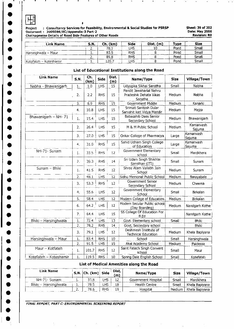
Project Consultancy Services for Feasibility, Environmental & Social Studies for PSRSP Sheet: 39 of 202
* Document 2005086/EC/Appendix-3 Part-2 Date: May 2006
Chainagewise Details of Road Side Features of Other Roads Revision: RO
Link Name | S.N. _ Ch. (km)_ Side Dist. (m) Type Size
* ____________ 2. 78.1 LHS 10 Pond Small
Harsinghwala - Maur 1. 83.5 RHS _ 8 Pond Small
* _ ____________ 2. 85.8 RHS 8 Pond Small
Kotefateh - Koteshamir 1. 120.7 LHS 8 Pond Small
List of Educational Institutions along the Road
* Link Name S.N. Ch. Side Dist. Name/Type Size Village/Town(kmn) AiMn
Nabha - Bhawanigarh 1. 1.0 LHS 15 Udyogika Sikhai Sanstha Small NabhaPandit Jawaharlal Nehru
_ _ 2. 2.2 RHS 15 Pradeshik Dehata Vikas Medium NabhaSanstha
* - __- 3. 6.9 RHS 15 Government Middle Medium Kanarki
* 4. 10.8 LHS 15 Srimati Santosh Dular Medium Majza
Bhawanigarh - NH- 71 1. 15.4 LHS 15 Babasahib Dass Senior Medium Bhawanigarh
* ______________ ~~~~~~~~~~Secondary School
* 2. 26.4 LHS 15 M & M Public School Medium Kamanvash
3. 27.0 LHS 15 Onkar College of Pharmacya Large SKamanvashK_ -_ _ _ _ _1__
4. 31.0 RHS 15 Sahid Udham Singh College Lre Kamanvashv _ _ . _ ___ 4. 31.0 RHS 15 _ of Education Large Kama
NH-71- Sunam 1. 33.5 RHS 12 Government Elementary Small Mardkhera
____.__ _________ ___school
2. 39.3 RHS 14 Sri Udam Singh Shikhlai Small Sunam________ ________________ ~~~Sansthan_(ITI)_ _ _ _ __ _ _ _ _ _ _ _
Sunam - Bhiki 1. 41.5 RHS 12 Shree Atam Vallabh Jai Medium Sunam* ___________ ~~~~~~~~~~~~~School
. __ ____- -. 2. 48.1 LHS 12 Sidhu Memorial Public School Medium Barayabale
3. 53.3 RHS 12 Government Senior Medium CheemaSecondary School
4. 55.6 LHS 12 Government Elementary Small BirkalanSchool
* 5. 58.4 LHS 12 Modern College of Education Medium Birkalan
* 6. 64.2 LHS 12 Modern Secular Public school Medium Nandgarh Kothe(Day Boarding)
* 7. 64.4 LHS 15 SS College Of Education For Nandgarh Kothe_____ ~~~~~B. Ed
Bhiki - Harsinghwala 1. 72.4 LHS 13 Govt. Elementary school Small Bhiki
2. 78.2 RHS 14 Govt. Secondary school _ Bhiki
3. 79.1 LHS 12 Technical Education Medium Khela Bapiyana
Harsinghwala - Maur 1. 83.4 RHS 10 School Small Harsinghwala
2. 91.5 LHS 15 Akal Academy School Medium Paidessa
MaUr - Kotfateh 1. 101.7 RHS 12 Saint Fatech Singh Convent Small Maur4 ~~~~school
Kotefateh - Koteshamir 1. 119.5 RHS 10 spring Dale English School Small Kotefateeh
List of Medical Amenities along the Road
Link Nanie S.N. Ch. (km) Side Dist. Name/Type | Size Village/Town
NH-71- Sunam 1. 33.8 LHS 12 Government Hospital Small Mardkhera
Bhiki - Harsinahwala 1. 78.5 LHS 18 Health Centre Small Khela Bapiyana
*________ .____________ 2. 78.6 RHS | 18 Hospital Medium Khela Bapiyana
FINAL REPORT, PART C: ENVIRONMENTAL SCREENING REPORT
-
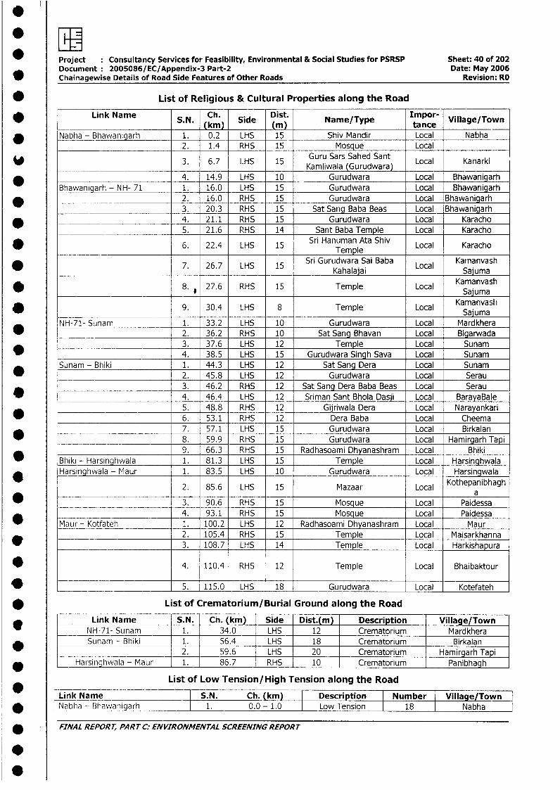
EElProject Consultancy Services for Feasibility, Environmental & Social Studies for PSRSP Sheet: 40 of 202Document 2005086/EC/Appendix-3 Part-2 Date: May 2006
* Chainagewise Details of Road Side Features of Other Roads Revision: RO
* List of Religious & Cultural Properties along the Road
* Link Name S. Ch. Side Dist. Name/Type tancr Village/TownS.mN. (kim) tance
* Nabha - Bhawanigarh 1. 0.2 LHS 15 Shiv Mandir Local Nabha2. 1.4 RHS 15 Mosque Local
3. 6.7 LHS 15 Kamliwala SGurudwara Local Kanarki
* - -- 4. 14.9 LHS 10 Gurudwara Local BhawanigarhBhawanigarh - NH- 71 1. 16.0 LHS 15 Gurudwara Local Bhawanigarh
* _________________________ 2. 16.0 RHS 15 Gurudwara Local Bhawanigarh3. 20.3 RHS 15 Sat Sang Baba Beas Local Bhawanigarh
* _ 4. 21.1 RHS 15 Gurudwara Local Karacho5. 21.6 RHS 14 Sant Baba Temple Local Karacho
* _ _ _ 6. 22.4 LHS 15 Sri Hanuman Ata Shiv Local Karacho____________ ~~~~~~Temple
Sri Gurudwara Sai Baba Kainanvash7. 26.7 LHS 15 Kahalajai Local Sajuma
* 8. 27.6 RHS 15 Temple Local KamanvashKSajuma
* 9. 30.4 LHS 8 Temple Local Kamanvash_ _ ~~~~~~~~~~~~~~~~~~~~~Sajuma
NH-71- Sunam 1. 33.2 LHS 10 Gurudwara Local Mardkhera* ___ 2. 36.2 RHS 10 Sat Sang Bhavan Local Bigarwada
3. 37.6 LHS 12 Temple Local Sunam_ 4. 38.5 LHS 15 Gurudwara Singh Sava Local Sunam
Sunam - Bhiki 1. 44.3 LHS 12 Sat Sang Dera Local Sunam2. 45.8 LHS 12 Gurudwara Local Serau3. 46.2 RHS 12 Sat Sang Dera Baba Beas Local Serau
_ ____ __ 4. 46.4 LHS 12 Sriman Sant Bhola Dasji Local BarayaBale5. 48.8 RHS 12 Gijriwala Dera Local Narayankari
_ __ 6. 53.1 RHS 12 Dera Baba Local Cheema7. 57.1 LHS 15 Gurudwara Local Birkalan
_ _.__ _ __ 8. 59.9 RHS 15 Gurudwara Local Hamirgarh Tapi*________________________ 9. 66.3 RHS 15 Radhasoami Dhyanashram Local BhikiBhiki - Harsinghwala 1. 81.3 LHS 15 Temple Local Harsinghwala
* Harsinghwala - Maur 1. 83.5 LHS 10 Gurudwara Local Harsingwala
2. 85.6 LHS 15 Mazaar Local Kothepanibhagha
_ ______________________ 3. 90.6 RHS 15 Mosque Local Paidessa* ___ _ _4. 93.1 RHS 15 Mosque Local Paidessa
Maur - Kotfateh 1. 100.2 LHS 12 Radhasoami Dhyanashram Local Maur2. 105.4 RHS 15 Temple Local Maisarkhanna
_ _________ _____________ 3. 108.7 LHS 14 _ Temple Local Harkishapura
* 4. 110.4 RHS 12 Temple Local Bhaibaktour
_ _______ _ 5. 115.0 LHS 18 Gurudwara Local Kotefateh
* List of Crematorium/Burial Ground along the Road
Link Name S.N. Ch. (km) Side Dist.(m) Description Village/TownNH-71- Sunam 1. 34.0 LHS _ 12 Crematorium MardkheraSunam - Bhiki 1. 56.4 LHS 18 Crematorium Birkalan
_ _ _ 2. 59.6 LHS 20 Crematorium Hamirgarh Tapi* _ Harsinghwala - Maur 1. 86.7 RHS 10 Crematorium Panibhagh
List of Low Tension/High Tension along the Road
Link Name S.N. Ch. km Description Number Village/Town* | Nabha - Bhawanigarh I 1. I 0.0 - 1.0 Low Tension I 18 I Nabha
* FINAL REPORT, PART C: ENVIRONMENTAL SCREENING REPORT
.
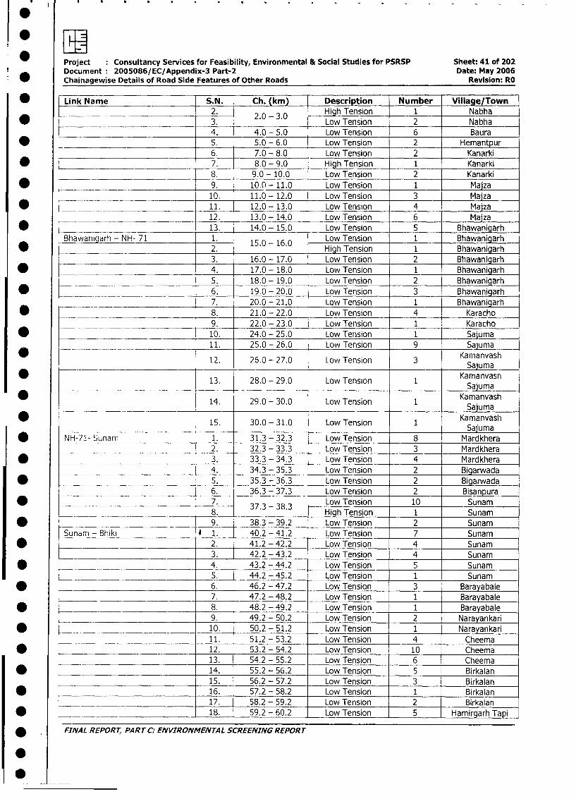
Project Consultancy Services for Feasibility, Environmental & Social Studies for PSRSP Sheet: 41 of 202
Document 2005086/EC/Appendix-3 Part-2 Date: May 2006
Chainagewise Details of Road Side Features of Other Roads Revision: RO
* Link Name S.N. Ch. (km) Description Number Village/Town
2. j High Tension 1 Nabha
* _______ ________________ 3. 2.-3.0 Low Tension 2 Nabha
4. 4.0 - 5.0 Low Tension 6 Baura
* _ 5. 5.0 - 6.0 Low Tension 2 Hemantpur_6. 7.0 - 8.0 Low Tension 2 Kanarki
* 7. 8.0 - 9.0 High Tension 1 Kanarki
_ _ 8. 9.0 - 10.0 Low Tension 2 Kanarki
* 9. 10.0 - 11.0 Low Tension 1 Maiza
_.__ 10. 11.0 - 12.0 Low Tension 3 Maiza
* __ 11. 12.0 - 13.0 Low Tension 4 Majza
12. 13.0 - 14.0 Low Tension 6 Majza
* _ ___ 13. 14.0 - 15.0 Low Tension 5 Bhawanigarh
Bhawanigarh - NH- 71 1. Low Tension I Bhawanigarh
____ 2. . High Tension 1 Bhawanigarh3. 16.0 - 17.0 Low Tension 2 Bhawanigarh
* 4. 17.0 - 18.0 Low Tension 1 Bhawanigarh5. 18.0 - 19.0 Low Tension 2 Bhawanigarh
* __ 6. 19.0 - 20.0 Low Tension 3 Bhawanigarh
7. 20.0 - 21.0 Low Tension 1 Bhawanigarh
* ______ _________________ 8. 21.0 - 22.0 Low Tension 4 Karacho
____ ._ _ 9. 22.0 - 23.0 Low Tension 1 Karacho
* ________ ____________________ 10. 24.0 - 25.0 Low Tension 1 Sajuma
_ ____ 11. 25.0 - 26.0 Low Tension 9 Sajuma
12. 26.0 - 27.0 Low Tension 3 Kamanvash_. _ _K_ Sajuman _
13. 28.0 - 29.0 Low Tension 1 KamanvashKSaauma
* - - 14. 29.0 - 30.0 Low Tension 1 SajumaKaumaa
15. 30.0 - 31.0 Low Tension Kamanvash
| * NH-71- Sunam 1. 31.3 - 32.3 Low Tension 8 Mardkhera2. 32.3 - 33.3 Low Tension 3 Mardkhera
* 3. 33.3 - 34.3 Low Tension 4 Mardkhera4. 34.3 - 35.3 Low Tension 2 Bigarwada
* 5. 35.3 - 36.3 Low Tension 2 Bigarwada
_ 6. 36.3 - 37.3 Low Tension 2 Bisanpura
* _ _ 7. 37L3 - 3 Low Tension 10 Sunam
___ 8. . - . High Tension 1 Sunam
* _ 9. 38.3 - 39.2 Low Tension 2 Sunam
Sunam - Bhiki * 1. 40.2 - 41.2 Low Tension 7 Sunam
* 2. 41.2 - 42.2 Low Tension 4 Sunam3. 42.2 - 43.2 Low Tension 4 Sunam
1 4. 43.2 - 44.2 Low Tension 5 Sunam5. 44.2 - 45.2 Low Tension 1 Sunam
* _ 6. 46.2 - 47.2 Low Tension 3 Barayabale7. 47.2 - 48.2 Low Tension 1 Barayabale
| * 8. 48.2 - 49.2 Low Tension 1 Barayabale
9. 49.2 - 50.2 Low Tension 2 Narayankari
* _ _ 10. 50.2 - 51.2 Low Tension 1 Narayankari
11. 51.2 - 53.2 Low Tension 4 Cheema
* 12. 53.2 - 54.2 Low Tension 10 Cheema13. 54.2 - 55.2 Low Tension 6 Cheema
* 14. 55.2 - 56.2 Low Tension 5 Birkalan
15. 56.2 - 57.2 Low Tension 3 Birkalan
* 16. 57.2 - 58.2 Low Tension 1 Birkalan17. 58.2 - 59.2 Low Tension 2 Birkalan
* ____ 18. 59.2 - 60.2 Low Tension 5 Hamirgarh Tapi
* FINAL REPORT, PART C: ENVIRONMENTAL SCREENING REPORT
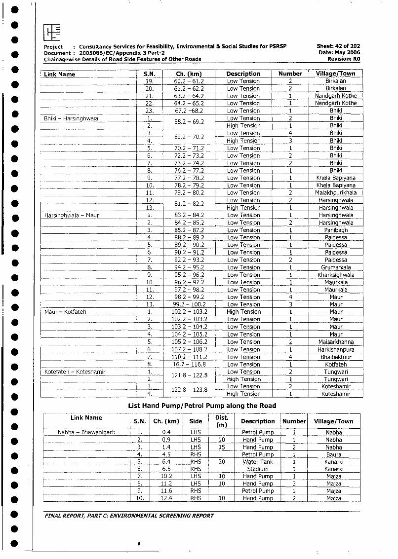
Project Consultancy Services for Feasibility, Environmental & Social Studies for PSRSP Sheet: 42 of 202
* Document: 2005086/EC/Appendix-3 Part-2 Date: May 2006
Chainagewise Details of Road Side Features of Other Roads Revision: RO
0 Link Name S.N. Ch. (km) Description Number Village/Town
* . 19. 60.2 - 61.2 Low Tension 2 Birkalan
20. 61.2 - 62.2 Low Tension 2 Birkalan
* _ 21. 63.2 - 64.2 Low Tension 1 Nandgarh Kothe
22. 64.2 - 65.2 Low Tension 1 Nandgarh Kothe
_ _ 23. 67.2 -68.2 Low Tension 1 Bhiki
Bhiki - Harsinghwala 1. Low Tension 2 Bhiki
* - 2. 58.2 v, 62. High Tension 1 Bhiki
_ 3. Low Tension 4 Bhiki
* 69.2 -70.2 _____4. . . High Tension 3 Bhiki
__ _ __ 5. 70.2 - 71.2 Low Tension 1 Bhiki
* _ 6. 72.2 - 73.2 Low Tension 2 Bhiki
__ __ = 7. 73.2 - 74.2 Low Tension 2 Bhiki
* _ ___ __ __ _ 8. 76.2 - 77.2 Low Tension 1 Bhiki
____ _ _ _ 9. 77.2 - 78.2 Low Tension 1 Khela Bapiyana
10. 78.2 - 79.2 Low Tension 1 Khela Bapiyana
11. 79.2 - 80.2 Low Tension 2 Malakhpurikhala
12. 81.2-82.2 Low Tension 2 Harsinghwala
_ 13. Hiqh Tension 1 Harsinghwala
* _arsinghwala - Maur 1. 83.2 - 84.2 Low Tension 1 Harsinghwala
2. 84.2 - 85.2 Low Tension 2 Harsinghwala
3. 85.2 - 87.2 Low Tension 1 Panibagh
_04. 88.2 - 89.2 Low Tension 1 Paidessa
5. 89.2 - 90.2 Low Tension 1 Paidessa
* _56. 90.2 - 91.2 Low Tension 1 Paidessa
* 6_ 7. 92.2 - 93.2 Low Tension 2 Paidessa
8. 94.2 - 95.2 Low Tension 1 Grumarkala
9. 95.2 - 96.2 Low Tension 1 Kharksighwala
10. 96.2 - 97.2 Low Tension 1 Maurkala11. 97.2 - 98.2 Low Tension 1 Maurkala
_ 12. 97.2 - 98.2 Low Tension 1 Maur12. 98.2 - 99.2 Low Tension 4 Maur
*13. 99.2 - 100.2 Low Tension 3MaurMaur - Kotfateh 1. 102.2 - 103.2 High Tension 1 Maur
* -- 2. 102.2 - 103.2 Low Tension 1 Maur
3. 103.2 - 104.2 Low Tension 1 Maur
* 4. 104.2 - 105.2 Low Tension 1 Maur
5. 105.2 - 106.2 Low Tension L Maisarkhanna
* _ _ 6. 107.2 - 108.2 Low Tension 1 Harkishanpura
_____ 7. 110.2 - 111.2 Low Tension 4 Bhaibaktour
8. 16.2 - 116.8 Low Tension 1 Kotfateh
Kotefateh - Koteshamir 1. 121.8 - 122.8 Low ension 2 Tungwari
2. 1 LowTension 1 Tungwari
__ __ 3. 122.8 123.8 Low Tension 2 Koteshamir
* ________________________________________ 122.8 - 123.8 High Tension 1 Koteshamir
List Hand Pump/Petrol Pump along the Road
* Link Name S.N. Ch. (km) Side Dist. Description Number Village/Town
* -_ ___ . _)
Nabha - Bhawanigarh 1. 0.4 LHS Petrol Pump 1 Nabha
* . 2. 0.9 LHS 10 Hand Pump 1 Nabha
3. 1.4 LHS 15 Hand Pump 2 Nabha
* _ 4. 4.5 RHS Petrol Pump 1 Baura
__ _. _ _ 5. 6.4 RHS 20 Water Tank 1 Kanarki
* _ 6. 6.5 RHS Stadium 1 Kanarki
7. 10.2 LHS 10 Hand Pump 1 Maiza
* 8. 11.2 LHS 10 Hand Pump 3 Majza
_______ ____ 9. 11.6 RHS Petrol Pump 1 Majza* __________ 10. 12.4 RHS 10 Hand Pump 2 Majza
* FINAL REPORT, PARTC: ENVIRONMENTAL SCREENING REPORT
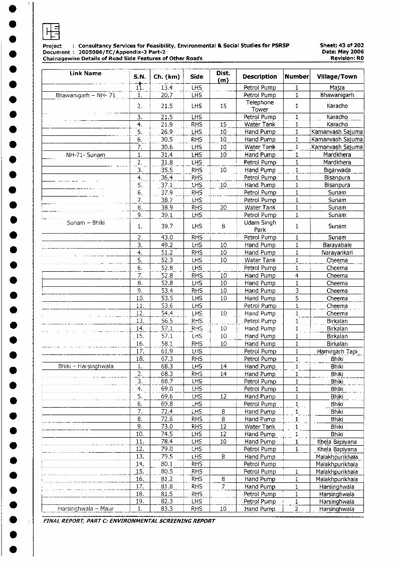
Project Consultancy Services for Feasibility, Environmental & Social Studies for PSRSP Sheet: 43 of 202* Document 2005086/EC/Appendix-3 Part-2 Date: May 2006
Chainagewise Details of Road Side Features of Other Roads Revision: RO
* Link Name S.N. Ch. (krn) Side Dist. Description Number Village/Town
___________________________ 11 13.4 LHS Petrol Pump 1 Majza_Bhawanigarh - NH- 71 1. 20.7 LHS Petrol Pump 1 Bhawanigarh
2. 21.5 LHS 15 Telephone 1 Karacho_____ ~~~~~~~~~~~~Tower
_ -______ - 3. 21.5 LHS Petrol Pump 1 Karacho4. 21.9 RHS 15 Water Tank 1 Karacho
* _ 5. 26.9 LHS 10 Hand Pump 1 Kamanvash Saiuma__ 6. 30.5 RHS 10 Hand Pump 1 Kamanvash Sajuma
* 7. 30.6 LHS 10 Water Tank 1 Kamanvash SajumaNH-71- Sunam 1. 31.4 LHS 10 Hand Pump 1 Mardkhera
2. 31.8 LHS Petrol Pump 1 Mardkhera3. 35.5 RHS 10 Hand Pump 1 Bigarwada
. __ 4. 36.4 RHS Petrol Pump 1 Bisanpura___________________________ 5. 37.1 LHS 10 Hand Pump 1 Bisanpura
_ ________________________ _ 6. 37.9 RHS Petrol Pump 1 Sunam_ ________________________ 7. 38.7 LHS Petrol Pump 1 Sunam
* _ 8. 38.9 RHS 20 Water Tank 1 Sunam_____________________ 9. 39.1 LHS Petrol Pump 1 Sunam
* Sunam - Bhiki 1. 39.7 LHS 8 Udam Singh 1 Sunam______________________ ~~~ ~~~Park
* 2. 43.0 RHS Petrol Pump 1 Sunam_____ 3. 49.2 LHS 10 Hand Pump 1 Barayabale
* _ __ 4. 51.2 RHS 10 Hand Pump 1 Narayankari5. 52.3 LHS 10 Water Tank 1 Cheema
* ____ _____ _____________ 6. 52.8 LHS Petrol Pump 1 Cheema=__ 7. 52.8 RHS 10 Hand Pump 4 Cheema
8. 52.8 LHS 10 Hand Pump 1 Cheema_.__ _ _9. 53.4 . RHS 10 Hand Pump 3 Cheema
* _ ___ 10. 53.5 LHS 10 Hand Pump 5 Cheema* _ __ _ ___ _ ___ 11. 53.6 LHS Petrol Pump 1 Cheema
-*----12. 54.4 LHS 10 Hand Pump 1 Cheema* _ ._ __ ___.__ __13. 56.5 RHS Petrol Pump 1 Birkalan
* ____ ___. .__ _14. 57.1 RHS 10 Hand Pump 1 Birkalan15. 57.1 _ _LHS 10 Hand Pump 1 Birkalan
_______ __ _ 16. 58.1 RHS 10 Hand Pump 1 Birkalan____ ___________ 17. 61.9 LHS Petrol Pump 1 Hamirgarh Tapi_ 1 =___ __ =18. 67.3 RHS Petrol Pump 1 Bhiki
Bhiki - Harsinghwala 1. 68.3 LHS 14 Hand Pump 1 Bhiki2. 68.3 RHS 14 Hand Pump 1 Bhiki
*_____ _________________ 3. 68.7 LHS Petrol Pump 1 Bhiki4. 69.0 LHS Petrol Pump 1 Bhiki
*_______________________ _ 5. 69.6 LHS 12 Hand Pump 1 Bhiki6. 69.8 LHS Petrol Pump 1 Bhiki7. 72.4 LHS 8 Hand Pump 1 Bhiki
* _______ 8. 72.6 RHS 8 Hand Pump 1 Bhiki____ ___ ___________ 9. 73.0 RHS 12 Water Tank 1 Bhiki
* __________________________ 10. 74.5 LHS 12 Hand Pump 1 Bhiki__________________________ 11. 78.4 LHS 10 Hand Pump 1 Khela Bapiyana* __________ 12. 79.0 LHS Petrol Pump 1 Khela Bapiyana* ____ 13. 79.5 LHS 8 Hand Pump Malakhpurikhala
14. 80.1 RHS Petrol Pump Malakhpurikhala* __________________________ - 15. 80.5 RHS Petrol Pump 1 Malakhpurikhala
16. 81.2 _ RHS 8 Hand Pump 1 Malakhpurikhala17. 81.8 RHS 7 Hand Pump 1 Harsinghwala
_ 18. 81.5 RHS Petrol Pump 1 Harsinghwala*________________________ 19. 82.3 LHS Petrol Pump 1 Harsinghwala
Harsinghwala - Maur 1_ 83.3 RHS 10 Hand Pump 2 Harsinghwala
* FINAL REPORT, PART C: ENVIRONMENTAL SCREENING REPORT
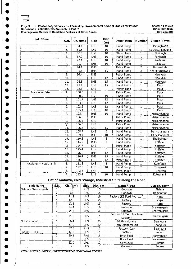
*EEI* Project Consultancy Services for Feasibility, Environmental & Social Studies for PSRSP Sheet: 44 of 202
Document: 2005086/EC/Appendix-3 Part-2 Date: May 2006_ Chainagewise Details of Road Side Features of Other Roads Revision: RO
* Link Name S.N. Ch. (km) Side Dmt. Description Number Village/Town
* ___ 2. 84.4 LHS 10 Hand Pump 1 Harsinghwala3. 85.5 LHS 10 Hand Pump 1 Kothepanibhagha
* _________________________ 4. 86.8 LHS 10 Water Tank 1 Panibagh
_____- 5. 87.7 LHS _ 10 Hand Pump 1 Panibagh
* t _ 6. 90.1 LHS 10 Hand Pump 2 Paidessa=__ ____ _______ _____ 7. 91.4 RHS 10 Hand Pump 1 Paidessa
_ 8. 94.1 RHS Petrol Pump 2 Grumarkala______-_______________ 9. 95.6 RHS 15 Hand Pump 2 Kharaksinghwala
* _ _ _9. 96.4 RHS Petrol Pump 1 Maurkala__________ ______________ 10. 96.8 LHS 12 Hand Pump 1 Maurkala
* ____________________________ 11. 96.8 RHS 15 Hand Pump 1 Maurkala
12. 98.4 LHS 15 Hand Pump 1 Maur* _____________________ 13. 98.8 _LHS Water Tank 1 Maur
Maur - Kotfateh 1. 100.5 LHS Petrol Pump 1 Maur_ 2. 100.9 LHS 10 Hand Pump 1 Maur
3. 101.4 LHS 12 Hand Pump 1 Maur* 4. 103.5 LHS 12 Hand Pump 1 Maur
5. 103.5 LHS 12 Hand Pump 1 Maur_____________ 6. 105.1 LHS 10 Hand Pump 1 Maur
7. 105.4 RHS 10 Hand Pump 1 Maisarkhanna
* ____ __________ 8. 106.5 RHS Petrol Pump 1 Maisarkhanna9. 106.5 LHS Petrol Pump 1 Maisarkhanna
* Qi 106.6 LHS Petrol Pump 1 Maisarkhanna11. 106.5 LHS 15 Hand Pump 1 Maisarkhanna
* ______ ___ 12. 108.7 LHS 9 Hand Pump 1 Harkishanpura________ ________ 13. 109.1 RHS 10 Hand Pump 1 Harkishanpura
14. 110:8 LHS 8 Hand Pump 1 Bhaibaktour. -~ 15. 114.9 RHS 7 Hand Pump 1 Kotfateh
* 16 114.7 LHS Petrol Pump 1 Kotfateh17. 115.4 LHS 8 Hand Pump 1 Kotfateh
* 18. 116.0 RHS 12 Hand Pump 1 Kotfateh19. 116.4 RHS 15 Hand Pump 1 Kotfateh
* _ 20. 116.8 LHS 12 Water Tank 1 Kotfateh
Kotefateh - Koteshamir 1. 121.3 LHS 8 Hand Pump 1 Kotefateh*________________________ 2. 122.0 LHS 10 Hand Pump 2 Tungwari
3. 122.5 LHS Petrol Pump 1 Tungwari* = 4. 123.4 LHS 10 Hand Pump 1 Koteshamir
List of Godown/Cold Storage/Industrial Units along the Road
Link Name S.N. Ch. (km) Side Dist. (m) Name/Type Village/Town* Nabha - Bhawanigarh 1. 1.8 RHS 15 Godown Nabha
2. 5.8 RHS 15 Godown Hemantpur* 3. 11.9 LHS 10 Factory (KE Ford Pvt. Ltd.) Majza
__ 4. 12.6 LHS 15 Factory Maiza* _ 5. 12.8 LHS 15 Factory Majza
_ ____._ 6. 14.4 RHS 16 Godown Bhawanigarh* +_ . _ _ _ 7. 14.4 LHS 16 Godown Bhawanigarh
8. 14.5 LHS 15 Factory (Hi Tech Machine Bhawanigarh* ____ ___ __ ____-- ~~~~~~~ ~ ~~~System) _____
NH-71- Sunam _ ___ 1. 36.4 LHS 20 LG Gas storage Bisanpura
* _ __ ____ _ _ 2. 37.0 _ LHS 20 Tata Chemical Ltd Bisanpura
L __ 1 3. 37.3 _ RHS 15 Factory (Ice) Bisanpura* Sunarn - Bhiki 1. 42.2 RHS 15 Factory Sunam
l l 2. _ 50.2 RHS 15 Brick Field Narayankari* ___ -- ------- _3. 51.0 RHS 10 Brick Field Narayankari
4. 52.0 LHS 12 Cow Shed Sutauz* L _ _ _ __ _5. 53.6 LHS 10 Godown Sutauz
FINAL REPORT, PART C: ENVIRONMENTAL SCREENING REPORT
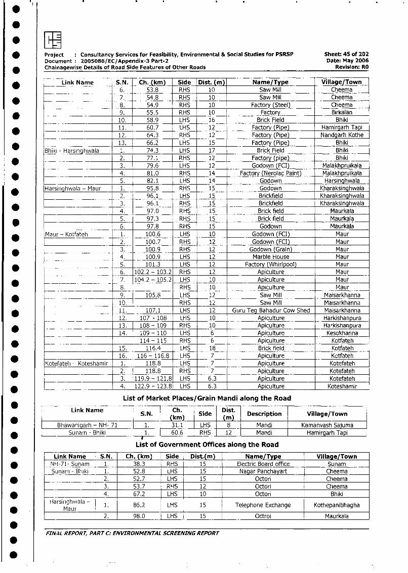
* Project Consultancy Services for Feasibility, Environmental & Social Studies for PSRSP Sheet: 45 of 202
Document 2005086/EC/Appendix-3 Part-2 Date: May 2006
_ Chainagewise Details of Road Side Features of Other Roads Revision: RO
* Link Name S.N. Ch. (km) Side Dist. (m) Name/Type Village/Town
_ _____ _6. 53.8 RHS 10 Saw Mill Cheema
* _ 7. 54.8 RHS 10 Saw Mill Cheema
8. 54.9 RHS 10 Factory (Steel) Cheema* 9. 55.5 RHS 10 Factory Birkalan
10. 58.9 LHS 16 Brick Field Bhiki
* 11. 60.7 LHS 12 Factory (Pipe) Hamirgarh Tapi
___________________ 12. 64.3 RHS 12 Factory (Pipe) Nandgarh Kothe
* _ _ 13. 66.2 LHS 15 Factory (Pipe) Bhiki
Bhiki - Harsinghwala 1. 74.3 LHS 17 Brick Field Bhiki
* 2. 77.1 RHS 12 Factor (pipe) Bhiki
3. 79.6 LHS 12 Godown (FCI) Malakhpruikala
* _ 4. 81.0 RHS 14 Factory (Nerolac Paint) Malakhpruikala
______ 5. 82.1 LHS 14 Godown Harsinghwala
_ Harsinghwala - Maur 1. 95.8 RHS 15 Godown Kharaksinghwala2. 96.1 LHS 15 Brickfield Kharaksinghwala
* .___ _____ - 3. 96.1 RHS 15 Brickfield Kharaksinghwala
0 4. 97.0 RHS 15 Brick field Maurkala
5. 97.3 RHS 15 Brick field Maurkala
6. 97.8 RHS 15 Godown Maurkala
* Maur- Kotfateh 1. 100.6 LHS 10 Godown (FCI) Maur
2. 100.7 RHS 12 Godown (FCI) Maur
3. 100.9 RHS 12 Godown (Grain) Maur
_________ 4. 100.9 LHS 12 Marble House Maur
* -______ __________ 5. 101.3 LHS 12 Factory (Whirlpool) Maur
_____ _______ 6. 102.2 - 103.2 RHS 12 Apiculture Maur
* _._ ___ _ __ 7. 104.2 - 105.2 LHS 10 Apiculture Maur
_______ _ _8. RHS 10 _ Apiculture Maur
* _ ___ 9. 105.8 LHS 12 Saw Mill Maisarkhanna
___________ 10. RHS 12 Saw Mill Maisarkhanna
11. 107.1 LHS 12 _ Guru Teg Bahadur Cow Shed Maisarkhanna
12. 107 - 108 LHS 10 Apiculture Harkishanpura
13. 108 - 109 RHS 10 Apiculture Harkishanpura
________ 14. 109 - 110 LHS 6 Apiculture Kesokhanna
* _~ ___114 - 115 RHS 6 Apiculture Kotfateh
15. 116.4 LHS 18 Brick field Kotfateh
* 16. 116 - 116.8 LHS 7 Apiculture Kotfateh
IKotefateh - Koteshamir 1. 118.8 LHS 7 Apiculture Kotefateh
* 2. 118.8 RHS 7 Apiculture Kotefateh
______ 3. 119.9 - 121.8 LHS 6.3 Apiculture Kotefateh
_ L 4. 122.9 - 123.8 LHS 6.3 Apiculture Koteshamir
List of Market Places/Grain Mandi along the Road
* < Link Name S.N. Ckh Side Dist. Description Village/Town* _____ m(m) - m)
Bhawanigarh - NH- 71 1. 31.1 LHS 8 Mandi Kamanvash Sajuma
_ Sunam - Bhiki 1. 60.6 RHS 12 Mandi Hamirgarh Tapi
* List of Government Offices along the Road
Link Name S.N. Ch. (km) Side Dist.(m) Name/Type Village/Town
* _NFI-71- Sunam 1. 38.3 RHS 15 Electric Board office Sunam
Sunam - Bhiki 1. 52.8 LHS 15 Nagar Panchayart Cheema
* -- ___ 1 2. 52.7 LHS 15 Octori Cheema
_ l 3. _ 53.7 RHS 12 Octori Cheema
* __ ___ 4 67.2 LHS 10 Octori Bhiki
Harsinghwala - 1. 86.2 LHS 15 Telephone Exchange Kothepanibhagha* Maur I l___l__
-_ l 2. 98.0 LHS 15 Octroi Maurkala
FIN4L REPORT, PAR T C: ENVIRONMENTAL SCREENING REPORT
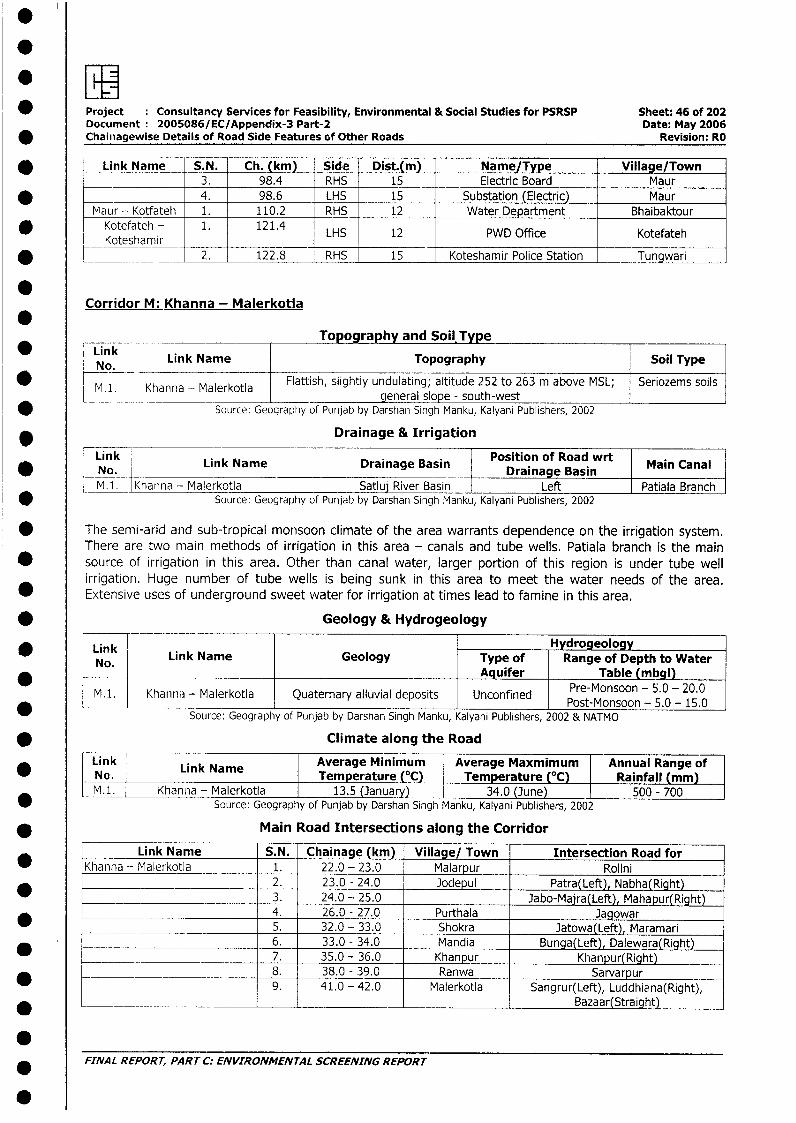
.
* Project Consultancy Services for Feasibility, Environmental & Social Studies for PSRSP Sheet: 46 of 202Document 2005086/EC/Appendix-3 Part-2 Date: May 2006
* Chainiagewise Details of Road Side Features of Other Roads Revision: RO
* Link Name S.N. Ch. (km) Side Dist.(m) Name/Type Village/Town3. 98.4 RHS 15 Electric Board Maur
* _______________ 4. 98.6 LHS 15 Substation (Electric) MaurMaur - Kotfateh 1. 110.2 RHS 12 Water Department Bhaibaktour
i Kotefateh - 1. 121.4 LHS 12 PWD Office KotefatehKoteshamir _ I_
* L __ ___ 2._ _122.8 RHS 15 Koteshamir Police Station Tungwari
Corridor M: Khanna - Malerkotla
* Link Topography and Soil.TypeNg,k Link Name Topography Soil Type
* M.1. Khanna - Malerkotla Flattish, slightly undulating; altitude 252 to 263 m above MSL; Seriozems soils_l. Khanna - Malerkotla - general slope - south-west
* Source: Geography of Punjab by Darshan Singh Manku, Kalyani Publishers, 2002
* _________________ Drainage & Irrigation
Link -- Position of Road wrtNo. Link Name Drainage Basin Drainage Basin Main Canal
M.1. Khanna - Malerkotla Satluj River Basin Left Patiala BranchSource: Geography of Punjab by Darshan Singh Manku, Kalyani Publishers, 2002
* The semi-arid and sub-tropical monsoon climate of the area warrants dependence on the irrigation system.There are two main methods of irrigation in this area - canals and tube wells. Patiala branch is the main
* source of irrigation in this area. Other than canal water, larger portion of this region is under tube wellirrigation. Huge number of tube wells is being sunk in this area to meet the water needs of the area.
* Extensive uses of underground sweet water for irrigation at times lead to famine in this area.
* Geology & Hydrogeology
* Link l HydrogeologyNo. Link Name Geology Type of Range of Depth to Water
*____ Aquifer Table (mbgl)
M.1. Khanna - Malerkotla Quaternary alluvial deposits Unconfined Post-Monsoon - 5.0 - 15.0
Source: Geography of Punjab by Darshan Singh Manku, Kalyani Publishers, 2002 & NATMO
* Climate along the Road
ink L k Average Minimum Average Maxmimum Annual Range of* No. L iNnk Name Temperature (°C) Temperature (°C) Rainfall (mm)
M.1. Khanna - Malerkotla 13.5 (January) 34.0 (June) 500 - 700* ~~~~~~~~~Source: Geography of Punjab by Darshan Singh Manku, Kalyani Publishers, 2002
* Main Road Intersections along the Corridor
Link Name S.N. Chainage (km) Village/ Town Intersection Road for* Khanna - Malerkotla 1. 22.0 - 23.0 Malarpur Rolini
2. 23.0 - 24.0 Jodepul Patra(Left), Nabha(Right)_ ____ 3. 24.0 - 25.0 3- Jabo-Majra(Left), Mahapur(Right)
4. 26.0 - 27.0 Purthala Jagowar_ 5. 32.0 - 33.0 Shokra l Jatowa(Left), Maramari
6. _ 33.0 - 34.0 Mandia Bunga(Left), Dalewara(Right)7. 35.0 - 36.0 Khanpur Khanpur(Right)
_____ _ _ __ 8. 38.0 - 39.0 Ranwa | Sarvarpur_ -~ 9. 41.0 - 42.0 Malerkotla Sangrur(Left), Luddhiana(Right),
* _ _ l l Bazaar(Straight)
FINAL REPORT, PART C: ENVIRONMENTAL SCREENING REPORT
.
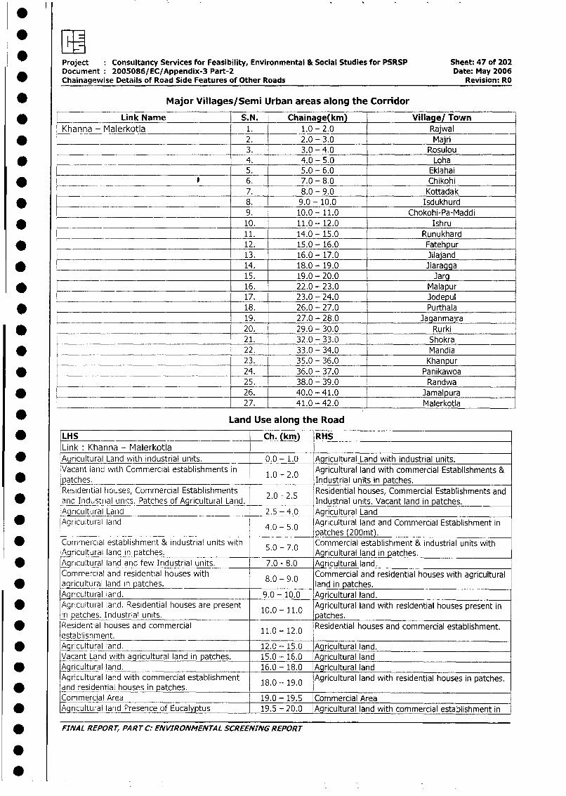
Project : Consultancy Services for Feasibility, Environmental & Social Studies for PSRSP Sheet: 47 of 202
Document: 2005086/EC/Appendix-3 Part-2 Date: May 2006
_ Chainagewise Details of Road Side Features of Other Roads Revision: RO
* Major Villages/Semi Urban areas along the Corridor
* Link Name S.N. Chainage(km) Village/ ToArn
Khanna - Malerkotla 1. 1.0 - 2.0 Rajwal
* 2. 2.0 - 3.0 Majri3. 3.0 - 4.0 Rosulou
* _ _ _ 4. 4.0 - 5.0 Loha5. 5.0 - 6.0 Eklahai
* _ _ . ____ @ 6. 7.0 - 8.0 Chikohi7. 8.0 - 9.0 Kottadak
* ________ 8. 9.0 - 10.0 Isdukhurd
______ ________________ 9. 10.0 - 11.0 Chokohi-Pa-Maddi
* _ - _ 10. 11.0 - 12.0 Ishru11. 14.0 - 15.0 Runukhard
* 12. 15.0_- 16.0 Fatehpur13. 16.0_- 17.0 Jilajand
_ 14. 18.0 - 19.0 Jiaragga
_______ 15. 19.0 - 20.0 Jarg* _ 16. 22.0 - 23.0 Malapur
17. 23.0 - 24.0 Jodepul* ______________________________________ 18. 26.0 - 27.0 Purthala
19. 27.0 - 28.0 Jaganmaira
_ 20. 29.0 - 30.0 Rurki21. 32.0 - 33.0 Shokra
* 22. 33.0 - 34.0 Mandia
___ _________________________________ 23. 35.0 - 36.0 Khanpur
_ .__________ _______________________ 24. 36.0 - 37.0 Panikawoa25. 38.0 - 39.0 Randwa
* 26. 40.0 - 41.0 Jamalpura27. 41.0 - 42.0 Malerkotla
* Land Use along the Road
* LHS Ch. (km) RHS
Link Khanna - Malerkotla* Agricultural Land with industrial units. 0.0 - 1.0 Agricultural Land with industrial units.
Vacant land with Commercial establishments in 1.0 - 2.0 Agricultural land with commercial Establishments &
* patches. __ 1 . Industrial units in patches.
Re,sidential houses, Commercial Establishments 2.0 - 2.5 Residential houses, Commercial Establishments and
* and Industrial units. Patches of Agricultural Land. . . Industrial units. Vacant land in patches.
Agricultural Land _ 2.5 - 4.0 Agricultural Land
* Agricultural land 4.0- 5.0 Agricultural land and Commercial Establishment in
.- _________ __. ___ patches (200mt).* Commercial establishment & industrial units with S.0 - 7.0 Commercial establishment & industrial units with
Agricultural land in patches. Agricultural land in patches.
* Agr cultural land and few Industrial units. 7.0 - 8.0 Agricultural land.
Commercial and residential houses with 8 - 9 Commercial and residential houses with agricultural
* agricultural land in patches. 8. - .0 land in patches.
Agricultural land. 9.0 - 10.0 Agricultural land.
* Agricultural land. Residential houses are present 10.0 - 1.1.0 Agricultural land with residential houses present in
in patches. Industrial units. patches.Residential houses and commercial 11.0 -12.0 Residential houses and commercial establishment.
establishment.* Aqricultural land. 12.0- 15.0 Agricultural land.
Vacant Land with agricultural land in patches. 15.0- 16.0 Agricultural land
* Agricultural land. 16.0- 18.0 Agricultural land
Agricultural land with commercial establishment 18.0 -- 19.0 Agricultural land with residential houses in patches.and residential houses in patches.Commercial Area 19.0 - 19.5 Commercial Area
* Agricultural land Presence of Eucalyptus 19.5 - 20.0 Agricultural land with commercial establishment in
* FINAL REPORT, PART C: ENVIRONMENTAL SCREENING REPORT
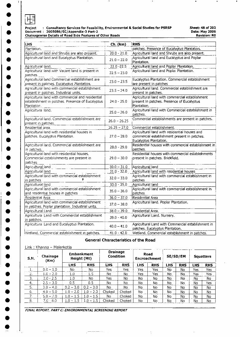
Project Consultancy Services for Feasibility, Environmental & Social Studies for PSRSP Sheet: 48 of 202* Document: 2005086/EC/Appendix-3 Part-2 Date: May 2006
Chainagewise Details of Road Side Features of Other Roads Revision: RO
LHS Ch. (km) RHS* Plantation. patches. Presence of Eucalyptus Plantation.
Agricultural land and Shrubs are also present. 20.0 - 21.0 Agricultural land and Shrubs are also present.Agricultural land and Eucalyptus Plantation. 210 - 22.0 Agricultural land and Eucalyptus and Poplar
* 2.0 - 22.0 Plantation.c Agricultural land. 22.0 -22.5 Agricultural land and Poplar Plantation.
Agricultural land with Vacant land is present in 22.5 - 23.0 Agricultural land and Poplat Plantation.patches.Agricultural land Commercial establishment are 23.0 - 23.5 Eucalyptus Plantation. Commercial establishmentpresent in patches. Eucalyptus Plantation. are present in patchesAgricultural land with commercial establishment 23.5 - 24.0 Agricultural land. Commercial establishment are*present in patches. Industrial units. . . present in patches.Agricultural land with commercial and residential Agricultural land with commercial establishmentestablishment in patches. Presence of Eucalyptus 24.0 - 25.0 present in patches. Presence of EucalyptusPlantation. Plantation.Agricultural land. 25.0 - 26.0 Agricultural land with Commercial establishment in* __ __ 25.0 - 26.0 patches.Agricultural land. Commercial establishment are 26.0 - 26.25 Commercial establishments are present in patches.
* present in patches.Residential area. 26.25 - 27.0 Commercial establishment.
* Agricultural land with residential houses in Agricultural land with residential houses andpatches. Eucalyptus Plantation. 27.0 - 28.0 commercial establishment present in patches.
* __ _Eucalyptus Plantation.Agricultural land. Commercial establishment are 28.0 29.0 Residential houses with commercial establishment in
* in patches. ._ -. _ patches.Agricultural land with residential houses. Residential houses with commercial establishmentsCommercial establishments are present in 29.0 - 30.0 present in patches. Brickfield.patches
* Agricultural land 30.0 - 31.0 Agricultural landAgricultural land 31.0 - 32.0 Agricultural land with residential houses
* Agricultural land with commercial establishment Agricultural land with commercial establishment inin patches 32.0 - 33.0 patches
* Agricultural land 33.0 - 35.0 Agricultural landAgricultural land with commercial establishment 35.0 - 36.0 Agricultural land with commercial establishment in
* ~ and residential houses in patches patchesResidential Area 36.0 - 37.0 Residential Area
* Agricultural land with commercial establishment 37.0 - 38.0 Agricultural land. Poplar Plantation.in patches. Poplar plantation. Industrial units.
* Agricultural Land. 38.0 - 39.0 Residential Area.Agricultural Land with Commercial establishment 39.0 - 40.0 Agricultural Land. Nursery.in patche .Agricultural Land and Eucalyptus Plantation. 40.0 - 41.0 Agricultural Land with Commercial establishment in_______________________________________ _ . . patches. Eucalyptus Plantation.Wetland. Commercial establishment in patches. 41.0 - 42.0 Wetland. Commercial establishment in patches.
* General Characteristics of the Road
* Link: Khanna - Malerkotla
ChainageKm) Embankment Drainage Road* ~~~S. N. (Kainag Height (Mt) Cnion Encroachment SE/SD/EM Squatters
* LHS RHS LHS RHS LHS RHS LHS RHS LHS RHS1. 0.0- 1.0 No No Yes Yes Yes Yes No No Yes Yes
* 2. 1.0 - 2.0 1.0 1.5 No No Yes Yes No No Yes Yes3. 2.0 - 2.5 1.0 No Yes No No No No No No No
* 4. 2.5 - 3.0 0.5 0.5 No No No No No No No Yes5. 3.0 -4.0 0.2 - 3.0 0.2 - 3.0 No No No No No No No No
* 6. 4.0 - 5.0 1.0 - 2.0 1.0 - 2.0 Choked Choked No No No No No No
7__ 5.0 - 7.0 1.0 - 1.5 1.0 - 1.5 No Choked No No No No No No
* t 8. L_7.0 - 8.0 1.0 - 1.5 1.0 - 1.5 Choked Choked No No No No No No
_ FiNAL REPORT, PART C: ENVIRONMENTAL SCREENING REPORT
.
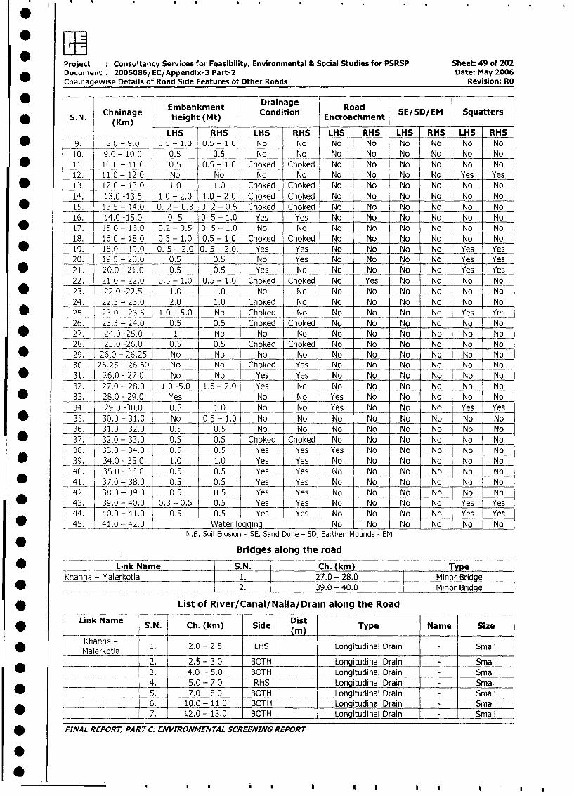
Project :Consultancy Services for Feasibility, Environmental & Social Studies for PSRSP Sheet: 49 of 202
Document 2005086/EC/Appendix-3 Part-2 Date: May 2006
Chainagewise Details of Road Side Features of Other Roads Revision: RO
* -- ~~~~~~~~~~~DrainageChaiage Embankment Condition Road S/DE qatr
* ~~~S. N. Chainag Height (Mt) Encroachment S/DE qatr
~~~~ ~~~~LHS RHS- LHS RHS LHS RHS LHS RHS LHS RHS
* ~~~9. 8.0 -9.0 0.5 -1.0 0.5 -1.0 No No No No No No No No
10 . 9.0 - 10.0 0.5 0.5 No No No No No No No No
* ~~~11. 10.0 -11.0 0.5 0.5 -1.0 Choked *Choked No No No No No No
12. 11.0 - 12.0 No No No No No No No No Yes Yes
* 1~~~3. 12.0 - 13.0 1.0 1.0 Choked Choked No No No No No No
14. 13.0 -13.5 1.0 - 2.0 1.0 - 2.0 Choked Choked No No No No No No
* ~~~s*1 13.5 - 14.0 0. 2 - 0.3 0. 2 - 0.5 Choked Choked No No No No No No
16. 14.0 -15.0 0. 5 0. 5 - 1.0 Yes Yes No No No No No No
* ~~~17. 15.0 -16.0 0.2 -0.5 0. 5- 1.0 No No No No No No No No
18. 16.0 - 18.0 0.5 - 1.0 0.5 - 1.0 Choked Choked No No No No No No
* ~~~19. 18.0 - 19.0 0. 5- 2.0 0. 5- 2.0. Yes Yes No No No No Yes Yes
20. 19.5 - 20.0 0.5 0.5 No Yes No No No No Yes Yes
* ~~~21. 20.0 - 21.0 0.5 0.5 Yes No No No No No Yes Yes
22. 21.0 - 22.0 0.5 - 1.0 0.5 - 1.0 Choked Choked No Yes No No No No
* ~~~23. 22.0 -22.5 1.0 1.0 No No No No No No No No24 ___ 22.5 - 23.0 2.0 1.0 Choked No No No No No No No
* ~~~~25 23.- 23.5 1.0 - 5.0 No Choked No No No N o Ys Yes
26. 23.5 - 24.0 0.5 -0.5 ChoKed Choked No No No No No No
* ~~~27. 24.0 -25.0 1 No No No No No No No No No
28. 25.0 -26.0 0.5 0.5 Choked Choked No No No No No No
* ~~~29. 26.0 - 26.25 No No No No No No No No No No
30. 26.25 - 26.60 No No Choked Yes No No No -No No No
* ~~~31. 26.0 - 27.0 No No Yes Yes No No No No No No
32. 27.0 - 28.0 1.0 -5.0 1.5 - 2.0 Yes No No No No No No No
* ~~~33. 28.0 - 29.0 Yes No No Yes No No No No No
34. 29.0 -30.0 0.5 1.0 No No Yes No No No Yes Yes
* ~~~35. 30.0 -31.0 No 0.5 -1.0 No No No No No No No No
36. 31.0 - 32.0 0.5 0.5 No No No No No No No No
* ~~~37. _32.0 - 33.0 0.5 0.5 Choked Choked No No No No No No
38. 33.0 - 34.0 0.5 0.5 Yes Yes Yes No No No No No
* ~~~39. 34.0 - 35.0 1.0 1.0 Yes Yes No No No No No No
40. 35.0 - 36.0 0.5 0.5 Yes Yes No No No No No No
* ~~~~41. 37.0 - 38.0 0.5 0.5 Yes Yes No No No No No No
42. 38.0 - 39.0 0.5 0.5 Yes Yes No No No No No No
* ~~~~43. 39.0 - 40.0 0.3 - 0.5 0.5 Yes Yes No No No No Yes Yes
44. 40.0 - 41.0 0.5 0.5 Yes Yes No No No No Yes Yes
* L ~~45. 41.0 - 42.0 Water logging No INo No No No No-
NB1: Soil Erosion - SE, Sand Dune - SD, Eartlhen Mounds - EM
Bridges along the road
Kh ~~~Link Name S.N. Ch. (kin) Type7Khna - Malerkotla 1. 27.0 - 28.0 Minor Bridge
[ann ~~~~~~~~~~~~2. 39.0 -40.0 Minor Bridge
* ~~~~~~~~List of River/Canal/Nallaf Drain along the Road
Link Name S. N. Ch. (kin) Side Dist Type Name SizeA~~~~ L - _ _ _~~(m
Khanna - 1. 2.0 - 2.5 LHS Longitudinal Drain -Small*~~~~Mlrol_____ ~~~~2. 2.A - 3.0 BOTH ____ Longitudinal Drain - Small
* ~~~ ~~~~~~~3. 4.0 - 5.0 BOTH ____ Longitudinal Drain - Small
_______ _____ 4. 5.0 - 7.0 RHS ____ Longitudinal Drain - Small
* ________________ 5~~. 7.0 - 8.0 BOT ____ Longitudinal Drain - Small__________ 6. 10.0 - 11.0 BT ____ Longitudinal Drain -Sml
* _______________ ~~7. 12.0 - 13.0 BOH ____ Longiitudinal DrainirSal
* ~~FINAL REPORT, PART C. ENVIRONMENTAL SCREENING REPORT

Project : Consultancy Services for Feasibility, Environmental & Social Studies for PSRSP Sheet: 50 of 202* Document: 2005086/EC/Appendix-3 Part-2 Date: May 2006
Chainagewise Details of Road Side Features of Other Roads Revision: RO
_ Link Name S.N. Ch. (km) Side Dist Type Name Size
*8. 13.0- 14.0 BOTH Longitudinal Drain Nm Small
9. 14.0 - 15.0 BOTH Longitudinal Drain - Small10. 16.0 - 19.0 BOTH Longitudinal Drain - Small
11. 19.5 - 20.0 RHS Longitudinal Drain - Small
* 12. 20.0 - 21.0 LHS Longitudinal Drain - Small13. 21.0 - 22.0 BOTH Longitudinal Drain - Small
* 14. 22.5 - 23.5 LHS Longitudinal Drain - Small
=______________ 15. 23.5 - 26.0 BOTH I Longitudinal Drain - Small
* 16. 26.25 - 26.60 LHS Cemented line - Small
_ 17. 26.60 - 27.0 LHS Uncovered Cemented Line Small
* 18. 39.0 - 40.0 BOTH Line SmallNOTE: Canal, Drain, Nalla whose sides are not mentioned is across the Road
List of Ponds/Lakes along the road
* _ Link Name S.N. Ch. (km) Side Dist.(m) Type Size
Khanna - Malerkotla 1. 11.1 LHS 6 Pond I Small
* _______ __________ _ 2. 39.8 LHS 6 Pond Small
* List of Educational Institutions along the road
* r _ Link Name -S.N. Ch. (km) Side Dist.(m) Name/Type Size Village/Town
-- Khanna - Malerkotla 1. 8.0 RHS 15 School Medium Kottadak
* __ 2 . 10.5 LHS 15 School Small Chokohi-Pa-Maddi_ r- _ = _ _ 3. 20.6 RHS 15 School Small Jarg
* - ~~~ ~~~~~~~~4 . 27.7 RHS 1 5 School Small JaganMajra__ __ _ ___ _5. _ 29.8 LHS 15 School Small Rurki
* ___ _ _6. 30.7 RHS 15 School Small Rurki
__ _ 7. 35.0 LHS 15 School Small Khanpur
* _-____ _ 8. 36.9 LHS 15 Primary Small Panikawoa
List of Medical Amenities along the Road
Link Name S.N. Ch.(km) Side Dist.(m) Name/Type Size Village/Town
* Khanna - Malerkotla 1 5.6 I LHS 13 I Hospital I Medium Eklahai
2. 20.2 RHS 13 Health Centre Small | Jarg
* List of Religious & Cultural Properties along the Road
* <___ Link Name S.N. Ch. (km) Side Dist.(m) Name/Type Importance Village/Town
Khanna - Malerkotla 1. 5.6 RHS 15 Gurudwara Local Eklahai
2. 10.1 RHS 15 Gurudwara Local Chokohi-Pa-Maddi
* l l _ 3. 11.2 LHS 15 Gurudwara Local Ishru
4. 16.7 LHS 15 Gurudwara Local lilaland
* l l 5. 18.10 RHS 15 Temple Local Jiaragga_____ l6. 20.2 RHS 15 Temple Local Jarg
* |____________________ l7. 24.5 RHS 18 Temple Local Jodepul________ l8. 26.7 LHS 15 Gurudwara Local Purthala
* t | 9. 29.3 LHS 15 Gurudwara | Local Rurki
| __________________ l10. 33.4 RHS 15 Gurudwara Local Rurki
* L___ _ I11. 36.7 RHS 15 Mosque Local Panikawoa
-l____ l___________ 12. 38.9 RHS 15 Gurudwara Local Ranwa
* l____ l___ ___________ 13. l 40.1 LHS 15 Mosque Local Jamalpura___ ___ __________ l14. 41.2 - LHS - 9 Mosque Local Malerkotla
* L __ _____________ 14. 41.4 RHS 8 Mosque Local Rurki
* List of Crematorium/Burial Ground along the Road
Link Name S-N- Ch- km Side istm) Description Importance Village/Town
M Khanna - Malerkotla 1. 16.0- 17.0 I LHS 15 Crematorium | Local | ilajand
* FINAL REPORr, PART C: ENVIRONMENTAL SCREENING REPORT
I
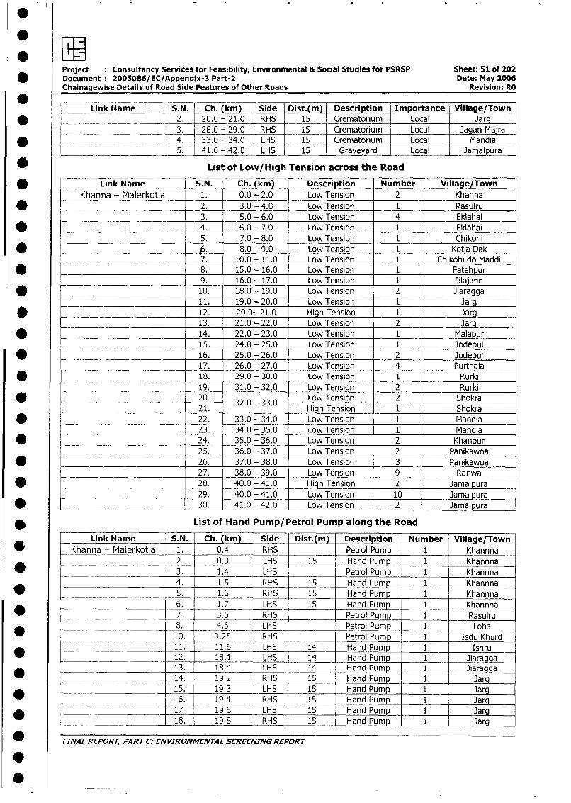
.EEProject Consultancy Services for Feasibility, Environmental & Social Studies for PSRSP Sheet: 51 of 202
* Document 2005086/EC/Appendix-3 Part-2 Date: May 2006Chainagewise Details of Road Side Features of Other Roads Revision: RO
Link liame S. N. Ch. (km) Side Dist.( m) Description Importance Village/Town
* l 2. 20.0 - 21.0 RHS 15 Crematorium Local Jarg
______________ 3. 28.0 - 29.0 RHS 15 Crematorium Local Jagan Majra
* ____ _ _ _ 4. 33.0 - 34.0 LHS 15 Crematorium Local Miandia
____ 5. 41.0 - 42.0 LHS 15 Graveyard Local Jamalpura
* List of Low/High Tension across the Road
* nLink Name S.N. Ch. (km) Description Number Village Town
Khanna - Malerkotla 1. 0.0 - 2.0 Low Tension 2 Khanna
* _- 2. 3.0 - 4.0 Low Tension 1 Rasulru3. _ 5.0 - 6.0 Low Tension 4 Eklahai
* 4. 6.0 - 7.0 Low Tension 1 Eklahai
5. 7.0 - 8.0 Low Tension 1 Chikohi
* g6. 8.0 - 9.0 Low Tension 1 Kotla Dak7. 10.0 - 11.0 Low Tension 1 Chikohi do Maddi
* [ _______________________ 8. 15.0 - 16.0 Low Tension 1 Fatehpur
________________ 9. 16.0 - 17.0 Low Tension 1 Jilajand
* -________________________ 10. 18.0 - 19.0 Low Tension 2 Jiaragga11. 19.0 - 20.0 Low Tension 1 Jarg
* = . -______________ 12. 20.0- 21.0 High Tension 1 Jarg13. 21.0 - 22.0 Low Tension 2 Jarg
* . ~ 14. 22.0 - 23.0 Low Tension 1 Malapur15. 24.0 - 25.0 Low Tension 1 Jodepul
* 16. 25.0 - 26.0 Low Tension 2 Jodepul17. 26.0 - 27.0 Low Tension 4 Purthala
* 18. 29.0 - 30.0 Low Tension 1 Rurki19. 31.0 - 32.0 Low Tension 2 Rurki20. 32_0 - 33_0 Low Tension 2 Shokra21. .0 . High Tension 1 Shokra
* 22. 33.0 - 34.0 Low Tension 1 Mandia
23. 34.0 - 35.0 Low Tension 1 Mandia
* ___ 24. 35.0 - 36.0 Low Tension 2 Khanpur._________ 25. 36.0 - 37.0 Low Tension 2 Panikawoa
* -- 26. 37.0 - 38.0 Low Tension 3 Panikawoa
27 7. 38.0 - 39.0 Low Tension 9 Ranwa
* __ _. 28. 40.0 - 41.0 High Tension 2 Jamalpura_____ _ _29. 40.0 - 41.0 Low Tension 10 Jamalpura
* 30. 41.0 - 42.0 Low Tension 2 Jamalpura
* List of Hand Pump/Petrol Pump along the Road
Link Name S.N. Ch. (kkm) Side Dist.(m) Description Number Village/Town* Khanna - Malerkotla 1. 0.4 RHS Petrol Pump 1 Khannna
^ ___ 2. 0.9 LHS 15 Hand Pump 1 Khannna
___ X -- 3. 1.4 LHS Petrol Pump 1 Khannna
4. 1.5 RHS 15 Hand Pump 1 Khannna|-- ~~ - --~- -- ~- ~ ~ ------- 5. 1.6 RHS 15 Hand Pump 1 Khannna
*___.__ 6. _ 1.7 LHS 15 Hand Pump _ 1 Khannna
_____ __________ _7. 3.5 RHS Petrol Pump 1 Rasulru
_-|__ ---- _- _ 8. 4.6 LHS Petrol Pump 1 Loha
I _ L _ _ _o10. 9.25 RHS _ Petrol Pump 1 Isdu Khurd11. 11.6 LHS 14 Hand Pump 1 Ishru
I ____L__ _ ___________ 12. 18.1 LHS 14 Hand Pump 1 Jiaragga_ _ * l . 13. 18.4 LHS 14 Hand Pump 1 JiaraggaI__ L _______________ 14. 19.2 RHS 15 Hand Pump 1 Jarg
_15. 19.3 LHS 15 Hand Pump 1 Jarg
| * X 16. 19.4 RHS 15 Hand Pump 1 Jarg
l __l 17. 19.6 LHS 15 Hand Pump 1 Jarg,~_ _ _ __ _ _ _ _ _ __ _+_ _ .
18____________ i. 19.8 RHS 15 Hand Pump 1 _ Jarg
| * FINAL REPOR7, PART C: ENVIRONMENTAL SCREENING REPORT
I0
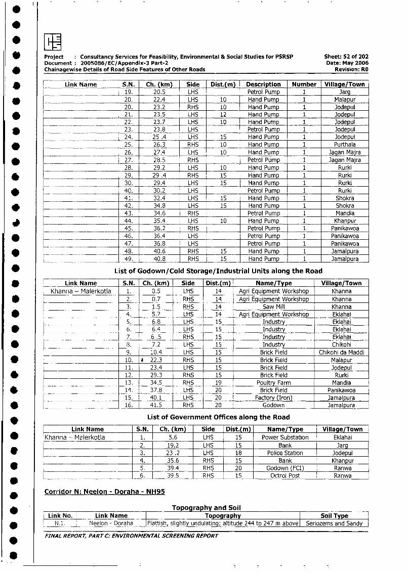
* Project Consultancy Services for Feasibility, Environmental & Social Studies for PSRSP Sheet: 52 of 202Document: 200S086/EC/Appendix-3 Part-2 Date: May 2006
* Chainagewise Details of Road Side Features of Other Roads Revision: RO
* | Link Name S.N. Ch. (km) Side Dist.(m) Description Number Village/Town
___________ 19. 20.5 LHS Petrol Pump 1 Jarg
* 20. 22.4 LHS 10 Hand Pump 1 Malapur20. 23.2 RHS 10 Hand Pump 1 Jodepul
* 21. 23.5 LHS 12 Hand Pump 1 Jodepul
____ ________________ 22. 23.7 LHS 10 Hand Pump 1 Jodepul
________ 23. 23.8 LHS Petrol Pump 1 Jodepul24. 25 .4 LHS 15 Hand Pump 1 Jodepul
* 25. 26.3 RHS 10 Hand Pump 1 Purthala
26. 27.4 LHS 10 Hand Pump 1 Jagan Maira
* 27. 28.5 RHS Petrol Pump 1 Jagan Maira
28. 29.2 LHS 10 Hand Pump 1 Rurki
* . 29. 29 .4 RHS 15 Hand Pump 1 Rurki
_.___ 30. 29.4 LHS 15 Hand Pump 1 Rurki
* -~ 40. 30.2 LHS Petrol Pump 1 Rurki
____________________ 41. 32.4 LHS 15 Hand Pump 1 Shokra
* 42. 34.8 LHS 15 Hand Pump 1 Shokra43. 34.6 RHS Petrol Pump 1 Mandia
44. 35.4 LHS 10 Hand Pump 1 Khanpur
_____ 45. 36.2 RHS Petrol Pump 1 Panikawoa46. 36.4 LHS Petrol Pump 1 Panikawoa
______ 47. 36.8 LHS Petrol Pump 1 Panikawo3
O __ _ _ 48. 40.6 RHS 15 Hand Pump 1 Jamalpura__- _49. 40.8 RHS 15 Hand Pump 1 Jamalpura
* List of Godown/Cold Storage/Industrial Units along the Road
* Link Name S.N. Ch. (km) Side Dist.(m) Name/Type Village/Town
Khanna - Malerkotla 1. 0.5 LHS 14 Agri Equipment Workshop Khanna
1 2. 0.7 RHS 14 Agri Equipment Workshop Khanna
3. 1.5 RHS 14 Saw Mill Khanna
* _ 4. 5.7 LHS 14_ Agri Equipment Workshop Eklahai5. 6.8 LHS 15 Industry Eklahai
* ______________________ 6. 6.4 LHS 15 Industry Eklahai
7. 6.5 RHS 15 Industry Eklahai
* _________ 8. 7.2 LHS 15 Industry Chikohi
9. 10.4 LHS 15 Brick Field Chikohi da Maddi
* ____________________ 10. * 22.3 RHS 15 Brick Field Malapur11. 23.4 LHS 15 Brick Field Jodepul
* = _ 12. 29.3 RHS 15 Brick Field Rurki
______ 13. 34.5 RHS 19 Poultry Farm Mandia
* 14. 37.8 LHS 20 Brick Field Panikawoa
15. 40.1 LHS 20 Factory (Iron) Jamalpura
* ______________________ 16. 41.5 RHS 20 Godown Jamalpura
* List of Government Offices along the Road
Link Name S.N. Ch. (km) Side Dist.(m) Name/Type Village/Town
* Khanna - Malerkotla 1. 5.6 LHS 15 Power Substation Eklahai
2. 19.2 LHS 15 Bank Jarg
* ___ 3. 23 .2 LHS 18 Police Station Jodepul
4. 35.6 RHS 15 Bank Khanpur
* _ 5. 39.4 RHS 20 Godown (FCI) Ranwa
______ . _________________ 6. 39.5 RHS 15 Octroi Post Ranwa
Corridor N: Neelon - Doraha - NH95
___ Topography and SoilLink No. Link Name Topography Soil Type
* L N.1. l Neelon - Doraha IFlattish slightly undulating; altitude 244 to 247 m above| Seriozems and Sandy |
FINAL REPORT, PART C: ENVIRONMENTAL SCREENING REPORT
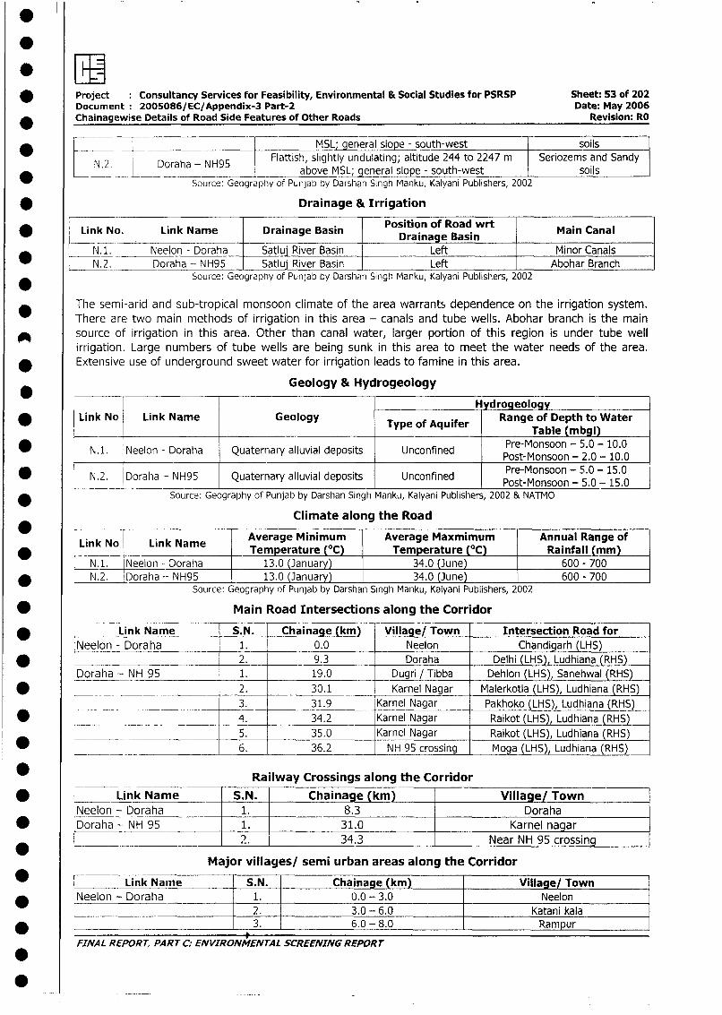
* Project Consultancy Services for Feasibility, Environmental & Social Studies for PSRSP Sheet: 53 of 202Document 2005086/EC/Appendix-3 Part-2 Date: May 2006
_ Chainagewise Details of Road Side Features of Other Roads Revision: RO
_ < ~~~~~~~~~~~~~~~~~~~~MSL; general slope - south-west soils
N.2_ Doraha - NH95 Flattish, slightly undulating; altitude 244 to 2247 m Seriozems and Sandy* N.2_ _ 4 Doraha - NH95above M en!realsope - south-west soils
SoUrce: Geography of Punjab by Darshan Singh Manku, Kalyani Publishers, 2002
* Drainage & Irrigation
Link No. Link Name Drainage Basin Position of Road wrt Main Canal* _ _ _ ~~~~~~~~~~~~~Drainage Basin
N. _ Neelon - Doraha Satluj River Basin Left Minor CanalsN. 2. Doraha - NH95 Satluj River Basin Left Abohar Branch
Source: Geography of Punjab by Darshan Singh Manku, Kalyani Publishers, 2002
The semi-arid and sub-tropical monsoon climate of the area warrants dependence on the irrigation system.There are two main methods of irrigation in this area - canals and tube wells. Abohar branch is the main
A source of irrigation in this area. Other than canal water, larger portion of this region is under tube wellirrigation. Large numbers of tube wells are being sunk in this area to meet the water needs of the area.Extensive use of underground sweet water for irrigation leads to famine in this area.
Geology & Hydrogeology
l _____________H ydrogeologyLink No Link Name Geology Tyeo qir Range of Depth to Water
* | Link No Link Name Geology Type of Aquifer Table (mbgl)
* N.1. Neelon - Doraha Quaternary alluvial deposits Unconfined Pre-Monsoon - 5.0 - 10.0Pret-Monsoon - 5.0 - 15.0-
* 4 N.2. Doraha - NH95 Quaternary alluvial deposits Unconfined Pre-Monsoon - 5.0 - 15.0I~~~~~~~~~~~~~~~~~~~~~~ PotMoso - . -1
* Source: Geography of Punjab by Darshan Singh Manku, Kalyani Publishers, 2002 & NATMO
Climate along the Road
Link No Link Name Average Minimum Average Maxmimum Annual Range ofLink_No Lnk Name _Temperature (°C) Temperature (°C) Rainfall (mm)
N.1. Neelon - Doraha 13.0 (January) 34.0 (June) 600 - 700* N.2. Doraha - NH95 13.0 (January) 34.0 (June) 600 - 700
Source: Geography of Punjab by Darshan Singh Manku, Kalyani Publishers, 2002
* Main Road Intersections along the Corridor
* Link Name S.N. Chainage (km) Village/ Town Intersection Road forNeelon - Doraha 1. 0.0 Neelon Chandigarh (LHS)
* 2. 9.3 Doraha Delhi (LHS), Ludhiana (RHS)Doraha - NH 95 1. 19.0 Dugri / Tibba Dehlon (LHS), Sanehwal (RHS)
* ___ ___ ___ 2. 30.1 Karnel Nagar Malerkotla (LHS), Ludhiana (RHS)__ _ ___.__ 3. 31.9 Karnel Nagar Pakhoko (LHS), Ludhiana (RHS)
* .___ _ __ ___ 4. 34.2 Karnel Nagar Raikot (LHS), Ludhiana (RHS)5. 35.0 Karnel Nagar Raikot (LHS), Ludhiana (RHS)
* ____ 6. 36.2 NH 95 crossing Moga (LHS), Ludhiana (RHS)
* Railway Crossings along the Corridor
* I ~~~~~Link Name S.N. Chaina e _(km) Village/ TownlI _,__I_9____
Neelon - Doraha 1. 8.3 Doraha* Doraha - NH 95 1. 31.0 Karnel nagar
*0__ ?. 34.3 Near NH 95 crossing
Major villages/ semi urban areas along the Corridor0 Link Nam-e |S.N. |Chainage (km) |Village/ Townl
INeelon - Doraha 1. 0.0 - 3.0 Neelon
_ I I ~~~~ ~ ~~~~~~~~~2. I3.0 -- 6.0 IKatani kalaI* | I ~~~ ~ ~~~~~~~~~3 I 6.0 - 8.0 IRampur
FINAL REPORT, PARTC: ENVIRONMENTAL SCREENINGREPORT
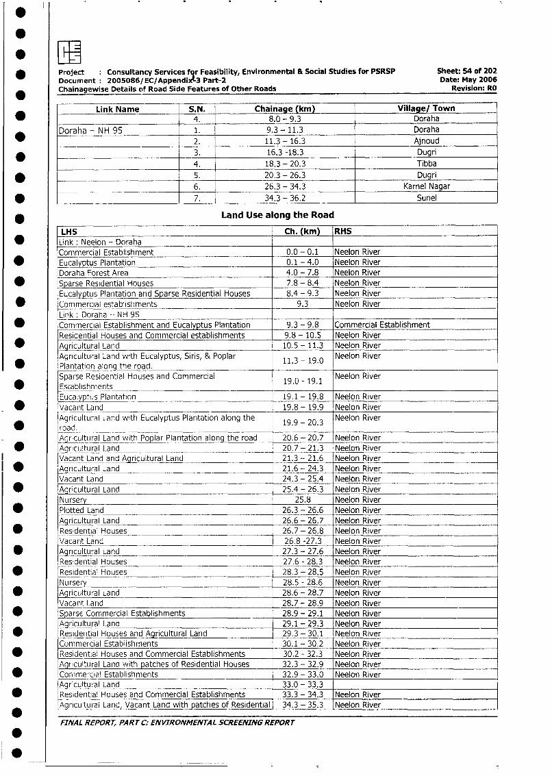
* Project Consultancy Services fqr Feasibility, Environmental & Social Studies for PSRSP Sheet: 54 of 202Document 2005086/EC/Appendix!.3 Part-2 Date: May 2006Chainagewise Details of Road Side Features of Other Roads Revision: RO
Link Name S.N. Chainage (km) Village/ Town4. 8.0 - 9.3 Doraha
Doraha - NH 95 1. 9.3 - 11.3 Doraha
_ 2. 11.3 - 16.3 Ajnoud
* _ 3. 16.3 -18.3 Dugri
4. 18.3 - 20.3 Tibba
* S___________________________ 5. 20.3 - 26.3 Dugri
6. 26.3 - 34.3 Karnel Nagar
* _ ________________________ 7. 34.3 - 36.2 Sunel
* Land Use along the Road
LHS Ch. (km) RHS
0 Link: Neelon - DorahaCommercial Establishment 0.0 - 0.1 Neelon River
* Eucalyptus Plantation 0.1 - 4.0 Neelon RiverDoraha Forest Area 4.0 - 7.8 Neelon River
* 1Sparse Residential Houses 7.8 - 8.4 Neelon River
Eucalyptus Plantation and Sparse Residential Houses 8.4 - 9.3 Neelon River
* Commercial establishments 9.3 Neelon RiverLink : Doraha -- NH 95
* Commercial Establishment and Eucalyptus Plantation 9.3 - 9.8 Commercial EstablishmentResidential Houses and Commercial establishments 9.8 - 10.5 Neelon River
* Agricultural Land 10.5 - 11.3 Neelon River
Agricultural Land with Eucalyptus, Siris, & Poplar 11.3 - 19.0 Neelon River* Plantation along the road.
Sparse Residential Houses and Commercial 19.0 - 19.1 Neelon River* Escablshments
Eucalyptus Plantation 19.1 - 19.8 Neelon River
* Vacant Land 19.8 - 19.9 Neelon River
Agricultural Land with Eucalyptus Plantation along the 19.9 - 20.3 Neelon River* _~~oad. _
AgriculturalLnd with Poplar Plantation along the road 20.6 - 20.7 Neelon River
* Agricultural Land 20.7 - 21.3 Neelon River
Vacant Land and Agricultural Land 21.3 - 21.6 Neelon River
* Agricultural Land 21.6 - 24.3 Neelon River
Vacant Land 24.3 - 25.4 Neelon River
* Agricultural Land 25.4 - 26.3 Neelon River
Nursery 25.8 Neelon River
* Plotted Land 26.3 - 26.6 Neelon River
Agricultural Land 26.6 - 26.7 Neelon River
* Residential Houses 26.7 - 26.8 Neelon River
Vacant Land 26.8 -27.3 Neelon River
* Agricultural Land 27.3 - 27.6 Neelon River
Residential Houses 27.6 - 28.3 Neelon River
* Residential Houses 28.3 - 28.5 Neelon River
Nurser 28.5 - 28.6 Neelon River
* Agricultural Land 28.6 - 28.7 Neelon River
Vacant Land 28.7 - 28.9 Neelon River
* Sparse Commercial Establishments 28.9 - 29.1 Neelon River
Agricultural Land 29.1 - 29.3 Neelon River
* Residential Houses and Agricultural Land 29.3 - 30.1 Neelon River
Commercial Establishments 30.1 - 30.2 Neelon River
* Residential Houses and Commercial Establishments 30.2 - 32.3 Neelon River
Agricultural Land with patches of Residential Houses 32.3 - 32.9 Neelon River
* *Comercial Establishments 32.9 - 33.0 Neelon River
Agricultural Land 33.0 - 33.3* Residential Houses and Commercial Establishments 33.3 - 34.3 Neelon River
Agricultural Land, Vacant Land with patches of Residential 34.3 - 35.3 Neelon River
FINAL REPORT, PART C: ENVIRONMENTAL SCREENING REPORT
.0~L ;
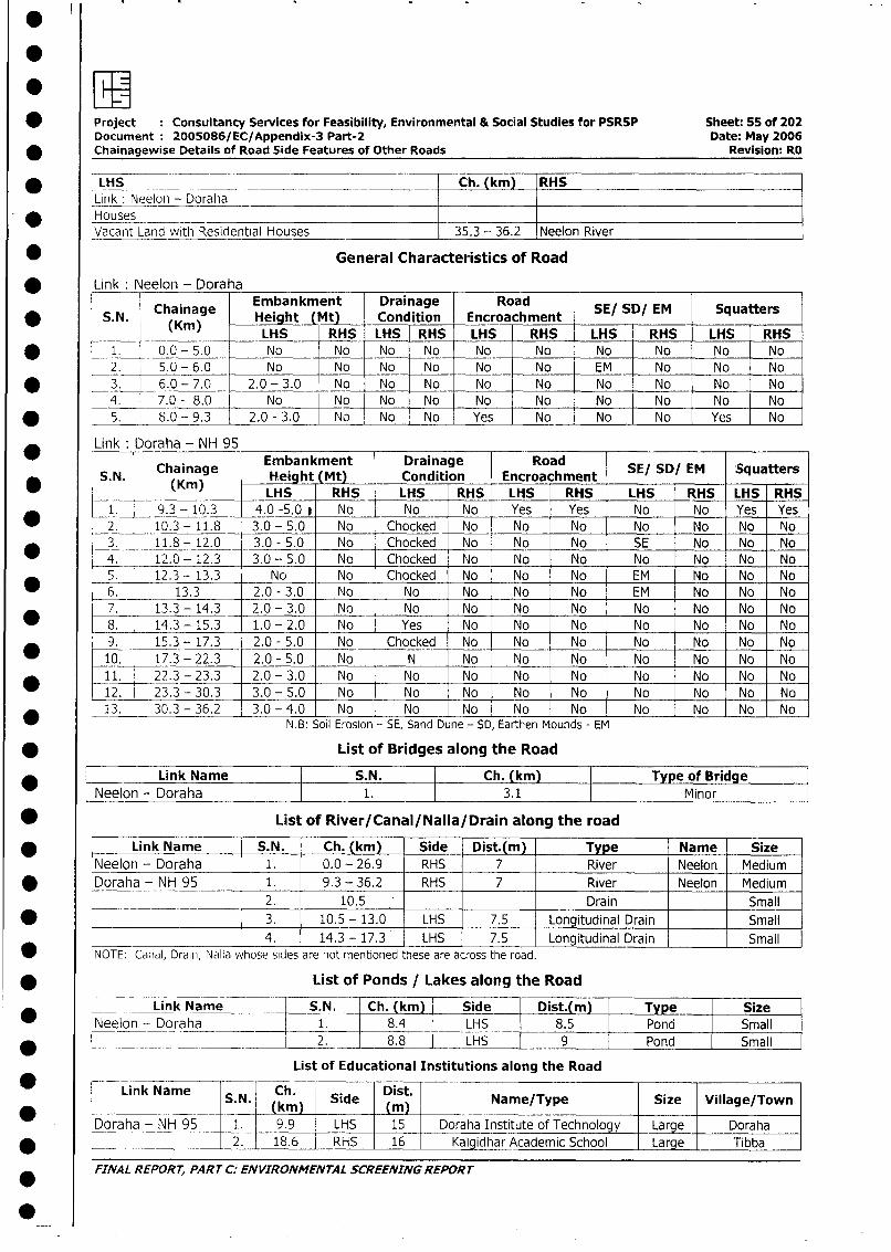
*Project Consultancy Services for Feasibility, Environmental & Social Studies for PSRSP Sheet: 55 of 202Document 2005086/ EC/Appendix-3 Part-2 Date: May 2006
* Chainagewise Details of Road Side Features of Other Roads Revision: RO
*~~~LSC.(m HLink :Neelon - DorahaHouses ____
Vacanit Lanid with Residential Houses 35.3 - 36.2 Neelon River
* ~~~~~~~~~General Characteristics of Road
Link :Neeloin - Doraha
S 1 Chainage Embankment Drainage Road SE/ SD/ EM SquattersSN. (Kin) Height (Mjt) Condition Encroachment___
LHS RHS LHS RHS LHS RHS LHS RHS LHS RHS* ~~~~1. 0.0 -5.0 No No No No No No No -No No -No
2. 5.0 -6.0 L No No No No No No EM No No No* ~~~3. -6.0 -7.0 2.0 -3.0 No No No No No No No No -No
4. 7.0 - 8.0 No No No No No No No No No No* ~~~~5, 8.0 -9.3 2.0 -3.0 No No No Yes No No No Yes -No
LikDrha-Ninage Embankment Drainage RoadS. N. (Kain)g Heigt (Mt) Condition Encroachment SE/ SD/ EM Squatters
~~~~K)LHS RHS LHS RHS LHS RHS LHS RHS LHS RHS
1. 9.3 -- 10.3 4.0 -5.0 i No No No Yes Yes No No Yes Yes* ~~~2. 10.3 - 11.8 3.0 - 5.0 No Chocked No No No No No No No
3. 11.8 - 12.0 3.0 - 5.0 No Chocked No No No I SE No No No* ~~~4. 1-2.0 - 12.3 3.0 - 5.0 No Chocked No No No No No No No
S. 12.3 - 13.3 No No Chocked No - No No EM No No No* ~~~6. 13.3 2.0 -3.0 No No No No No EM No No No
7. 13.3 -14.3 2.0 -3.0 No No No No No No No No No* ~~~8. 14.3 -15.3 1.0 -2.0 No Yes No No No No No No No
9. 15.3 - 17.3 2.0 - 5.0 No Chocked No No No No No No No* ~~~10. 17.3 -22.3 2.0 -5.0 No N No No No No No No No
* 11. ~~~~22.3 -23.3 2.0 -3.0 No No No No No No No No No12. 23.3 - 30.3 3.0 - 5.0 No No No No No No No No No13. 30.3 -36.2 3.0 -4.0 No No No No No No No No No
* -- ~~~~~~~~~~N.B1: Soil Erosion - SE, Sand Dune - SD, Earthen Mounds - EM
* ~~~~~~~~~~List of Bridges along the Road
Link Name S.N. I Ch. (kin) IType of BridgeNeelon - Draha 1.3.1 Minor
* ~~~~~~~~List of River/Canal/Nalla/Drain along the road
* ~~~~~Link Name S.N. Ch. (kin) Side Dist.(m) . Type Name SizeNeelon - Doraha 1. 0.0 - 26.9 RHS 7 River Neelon Medium
* ~~~Doraha - NH 95 1. 9.3 - 36.2 RHS 7 River Neelon Medium
________ _ _________ 2. j 10.5 _ _ __ _ _ _ __Drain _ _ __ Sm all
* ____________________ ~3. 10.5 - 13.0 LHS 7.5 Longitudinal Drain ____ Small
__________________ 4. 14.3 - 17.3 LHS 7.5 Longitudinal Drain Small
NOTE: Canial, Draini, Nalla whose sides are not mentioned these are across the road.
* ~~~~~~~~~List of Ponds / Lakes along the Road
Link Name S.N. Ch. (km) Side Dist. im Type Size* ~~~Neelon - Doraha ___1. 8.4 LHS 8.5 Pond Small
__ _____ ~~~ ~~2. 8.8 LHS 9 Pond Small
List of Educational Institutions along the Road
LinkName S.N. h Side DitNaeTpSze Vlg/ow
Doah--NH95 1 99 HS 15 Draa nsitt_o_Tcholg Large Doraha
2. 18.61 RHS 6 Kalgdhar AademicSchool Large Tibba
FINAL REPORT, PART C:- ENVIRONMENTAL SCREENING REPORT
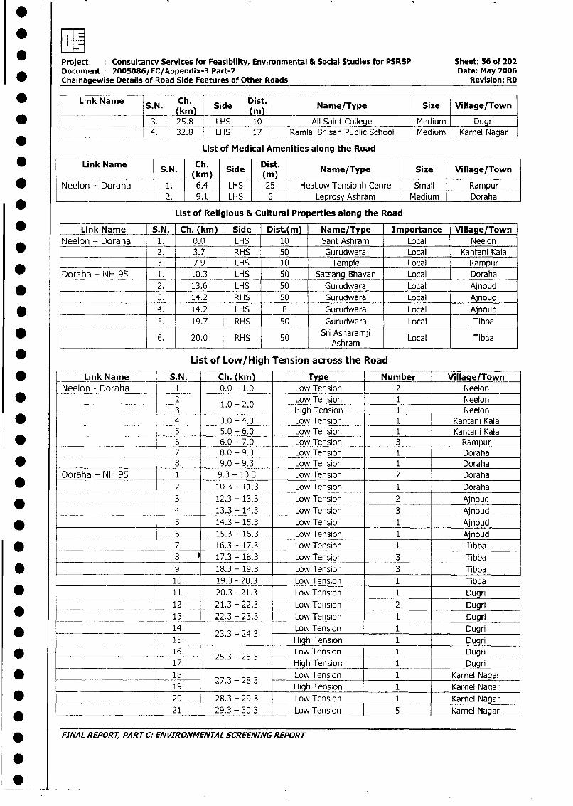
Project Consultancy Services for Feasibility, Environmental & Social Studies for PSRSP Sheet: 56 of 202Document 2005086/EC/Appendix-3 Part-2 Date: May 2006Chainagewise Details of Road Side Features of Other Roads Revision: RO
* 0 Link Name S N. Ch. Side t Name/Type Size Village/Town__________ ~~~(kin) (mn)
* ___ 3. 25.8 LHS 10 All Saint College Medium Dugri
4. 32.8 LHS 17 Ramial Bhisan Public School Medium Karnel Nagar
List of Medical Amenities along the Road
* ~~~~Link Name Ch. Dist.NaeTpS.N. (km). Side (ms Name/Type Size Village/Town
_ ~~~~ ~ ~~~(ki)_ (in)* Neelon - Doraha 1. 6.4 LHS 25 HeaLow Tensionh Cenre Small Rampur
2. 9.1 LHS 6 Leprosy Ashram Medium Doraha
List of Religious & Cultural Properties along the Road
* Linik Name S.N. Ch. (km) Side Dist.(m) Name/Type Importance Village/Town
Neelon - Doraha 1. 0.0 LHS 10 Sant Ashram Local Neelon
_ ______ 2. 3.7 RHS 50 Gurudwara Local Kantani Kala
3. 7.9 LHS 10 Temple Local Rampur
* Doraha - INH 95 1. 10.3 LHS 50 Satsang Bhavan Local Doraha
* .______________ 2. 13.6 LHS 50 Gurudwara Local Ajnoud
3. 14.2 RHS 50 Gurudwara Local Ajnoud
* 4. 14.2 LHS 8 Gurudwara Local Ajnoud
5. 19.7 RHS 50 Gurudwara Local Tibba
6. 20.0 RHS 50 Sri Asharamji Local Tibba_____ _____________ ____ Ashram
List of Low/High Tension across the Road
* r Link Name S.N. Ch. (km) Type Number Village/TownNeelon - Doraha 1. 0.0 - 1.0 Low Tension 2 Neelon
* l__ ___ 2. l 1.0-2.0 Low Tension 1 Neelon3. High Tension | 1 Neelon
* < l 4. 3.0 - 4.0 Low Tension 1 Kantani Kala5. 5.0 - 6.0 Low Tension 1 Kantani Kala
* l l 6. 6.0 - 7.0 Low Tension 3 Rampur7. 8.0 - 9.0 Low Tension 1 Doraha
* L l 8. 9.0 - 9.3 Low Tension 1 DorahaDoraha - NH 95 - 1. 9.3 - 10.3 Low Tension 7 Doraha
* | l 2. 10.3 - 11.3 Low Tension 1 Doraha
3. 12.3 - 13.3 Low Tension 2 Ajnoud
- r l 4. 13.3 - 14.3 Low Tension 3 Ajnoud
* | | _5. 14.3 - 15.3 Low Tension 1 Anoud
6. 15.3 - 16.3 Low Tension 1 Ajnoud
I * ___________|___ 7. 16.3 - 17.3 LowTension 1 Tibba
_______ 8. * 17.3 - 18.3 Low Tension 3 Tibba
| * _ l 9. 18.3 - 19.3 Low Tension 3 Tibba
10. 19.3 - 20.3 Low Tension 1 Tibba
I * L_______________ _ I 11. 20.3 - 21.3 Low Tension 1 Dugri
_____ 12. 21.3 - 22.3 Low Tension 2 Dugri
o _ l | 13. 22.3 - 23.3 Low Tension 1 Dugri
l _________________ _ l l 14. 23.3 - 24.3 Low Tension 1 Dugri
_________________|__ 15. High Tension 1 Dugri
l * | ______ ___________ 16. 25.3 - 26.3 Low Tension 1 Dugri17. High Tension 1 Dugri
| * _________ 18. 27 - 28.3 Low Tension 1 Karnel Nagar2 - 19. 28.3High Tension 1 Karnel Nagar
| ______ _____________ l 20. 28.3 - 29.3 Low Tension 1 Karnel Nagar
__________________ _ l | 21. 29.3 - 30,3 Low Tension 5 Karnel Nagar
* FINAL REPORT, PART C. ENVIRONMENTAL SCREENING REPORT
.
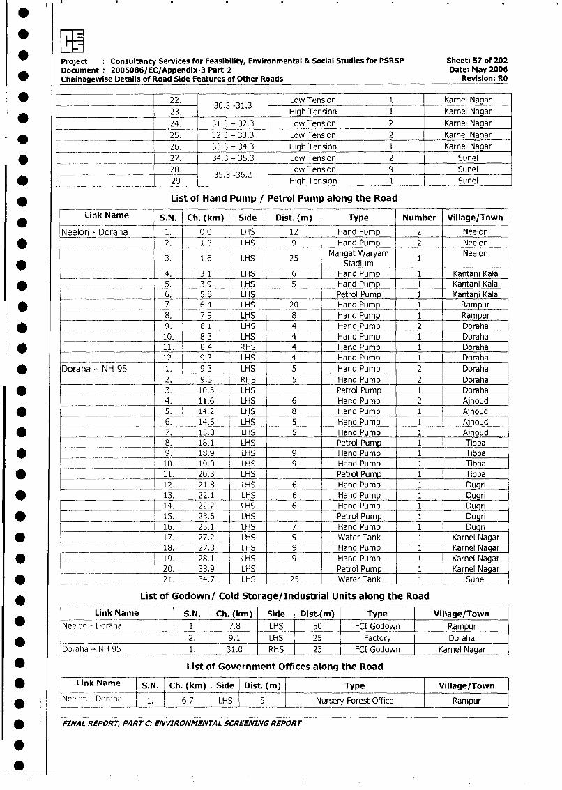
Project Consultancy Services for Feasibility, Environmental & Social Studies for PSRSP Sheet: 57 of 202Document 2005086/EC/Appendix-3 Part-2 Date: May 2006Chainagewise Details of Road Side Features of Other Roads Revision: RO
* _______________________ 22. 30.3 -31.3 Low Tension 1 Karnel Nagar
23. High Tension 1 Karnel Nagar
24. 31.3 - 32.3 Low Tension 2 Karnel Nagar
* ______________________ 25. 32.3 - 33.3 Low Tension 2 Karnel Nagar
_______ 26. 33.3 - 34.3 High Tension 1 Karnel Nagar
* -________ ______ 27. 34.3 - 35.3 Low Tension 2 Sunel
28. 35.3 -36.2 Low Tension 9 Sunel
* _._29 High Tension 1 Sunel
* List of Hand Pump / Petrol Pump along the Road
Link Name S.N. Ch. (km) Side Dist. (m) Type Number Village/Town
Neelon - Doraha _ 1. 0.0 LHS 12 Hand Pump 2 Neelon
* ___ _ __ _ __ _ 2. 1.6 LHS __ 9 _ Hand Pump 2 Neelon
3. 1.6 LHS 25 Mangat Waryam 1 Neelon* __ __ Stadium
_ _ _ _____ _4. 3.1 LHS 6 Hand Pump 1 Kantani Kala
* -_ ____5. 3.9 LHS 5 Hand Pump 1 Kantani Kala
6. 5.8 LHS Petrol Pump 1 Kantani Kala
* __.___________ 7. 6.4 LHS 20 Hand Pump 1 Rampur
__________________ 8. 7.9 LHS 8 Hand Pump 1 Rampur
_ _ _. 9. 8.1 LHS 4 Hand Pump 2 Doraha
10. 8.3 LHS 4 Hand Pump 1 Doraha
* __________________ 11. 8.4 RHS 4 Hand Pump 1 Doraha
1_ 2. 9.3 LHS 4 Hand Pump 1 Doraha
* Doraha - NH 95 1. 9.3 LHS 5 Hand Pump 2 Doraha
_______ ___________ 2. 9.3 RHS 5 Hand Pump 2 Doraha
* ___________________ 3. 10.3 LHS Petrol Pump 1 Doraha
__________ - 4. 11.6 LHS 6 Hand Pump 2 Ajnoud
5. 14.2 LHS 8 Hand Pump 1 AInoud6. 14.5 LHS 5 Hand Pump 1 Ajnoud
* _____-~__________ 7. 15.8 LHS 5 Hand Pump 1 Ainoud
__________________ - 8. 18.1 LHS Petrol Pump 1 Tibba
* ___-~ _____ 9. 18.9 LHS 9 Hand Pump 1 Tibba
____ 10. 19.0 LHS 9 Hand Pump 1 Tibba
* ____-_____________ 11. 20.3 LHS Petrol Pump 1 Tibba
12. 21.8 LHS 6 Hand Pump 1 Dugri
* I____________________ 13. 22.1 LHS 6 Hand Pump 1 Dugri
14. 22.2 LHS 6 Hand Pump 1 Dugri
* ___ 15. 23.6 LHS Petrol Pump 1 Dugri
16. 25.1 LHS 7 Hand Pump 1 Dugri
* __________-~ 17. 27.2 LHS 9 Water Tank 1 Karnel Nagar
0___ _ 18. 27.3 LHS 9 Hand Pump 1 Karnel Nagar
* ___ _______ 19. 28.1 LHS 9 Hand Pump 1 Karnel Nagar
<__ ._ 20. 33.9 LHS Petrol Pump 1 Karnel Nagar
* l _ 21. 34.7 LHS 25 Water Tank 1 Sunel
* List of Godown/ Cold Storage/Industrial Units along the Road
Link Name S.N. Ch. (km) Side Dist.(m) Type Village/Town
* |Neelon - Doraha 1. 7.8 LHS 50 FCI Godown Rampur
*______________ _ I | 2. 9.1 LHS 25 Factory Doraha
Doraha - NH 95 l___ 1. 31.0 RHS 23 FCI Godown Karnel Nagar
* List of Government Offices along the Road
* Link Name S.N. Ch. (km) |Side Dist. (m) Type Village/Town
* Neelon - Doraha 1. 6.7 1 LHS 5 Nursery Forest Office Rampur
FINAL REPORT, PART C: ENVIRONMENTAL SCREENING REPORT
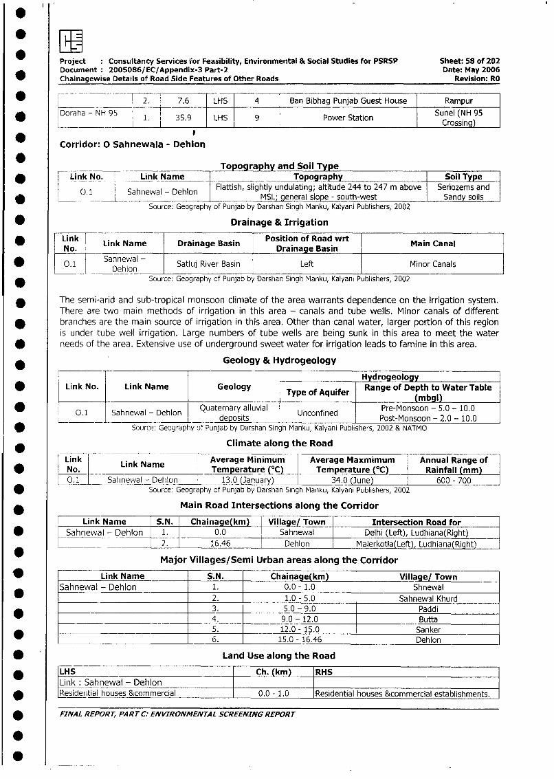
Project Consultancy Services for Feasibility, Environmental & Social Studies for PSRSP Sheet: 58 of 202Document 2005086/EC/Appendix-3 Part-2 Date: May 2006Chainagewise Details of Road Side Features of Other Roads Revision: RO
* _ _ 42. 7.6 LHS 4 Ban Bibhag Punjab Guest House Rampur
/ Doraha - NH 95 1. 35.9 LHS 9 Power Station Sunel (NH 95Crossing)
_ Corridor: 0 Sahnewala - Dehion
* Topograph and Soil Type* Link No.- __-_Link Name Topography Soil Type
0.1 Sahniewal - Dehlon Flattish, slightly undulating; altitude 244 to 247 m above Seriozems and* L O.1 Sahnewal - Dehlon MSL; general slope - south-west Sandy soils
Source: Geography of Punjab by Darshan Singh Manku, Kalyani Publishers, 2002
* Drainage & Irrigation
* Link Link Name Drainage Basin Position of Road wrt Main CanalNo. Drainage Basin
* 0.1 Sahnewal - Satluj River Basin Left Minor Canals
* Source: Geography of Punjab by Darshan Singh Manku, Kalyani Publishers, 2002
* The semi-arid and sub-tropical monsoon climate of the area warrants dependence on the irrigation system.
There are two main methods of irrigation in this area - canals and tube wells. Minor canals of different
branches are the main source of irrigation in this area. Other than canal water, larger portion of this region
is under tube well irrigation. Large numbers of tube wells are being sunk in this area to meet the water
* needs of the area. Extensive use of underground sweet water for irrigation leads to famine in this area.
* Geology & Hydrogeology
Hydrogeology* Link No. Link Name Geology Type of Aquifer Range of Depth to Water Table
____________________________ ~~~ ~~(m bgl)
*.1 Sahnewal - Dehlon Quaternary alluvial Unconfined Pre-Monsoon - 5.0 - 10.0______ ________________deposits UnofndPost-Monsoon - 2.0 - 10.0
* Source: Geography of Punjab by Darshan Singh Manku, Kalyani Publishers, 2002 & NATMO
Climate along the Road
k I L ink Nam Average Minimum Average Maxmimum Annual Range of* L No. _Temperature (°C) Temperature (C) Rainfall (mm)
0.1 _ Sahnewal - Dehlon 13.0 (January) 34.0 (June) 600- 700* Source: Geography of Punjab by Darshan Singh Manku, Kalyani Publishers, 2002
Main Road Intersections along the Corridor
F-uLink Name S.N. Chainage (km) Village/ Town Intersection Road for
* ~Sahnewal - Dehlon 1. 0.0 Sahnewal Delhi (Left), Ludhiana(Right)
* _ __ _ 2. 16.46 Dehlon Malerkotla(Left), Ludhiana(Right)
Major Villages/Semi Urban areas along the Corridor
* Link Name S.N. Chainage(km) Village/ Town
Sahnewal - Dehlon 1. 0.0 - 1.0 Shnewal2. 1.0 - 5.0 Sahnewal Khurd3. 5.0 - 9.0 Paddi
* _____________________ 4. 9.0 - 12.0 Butta5. 12.0 - 15.0 Sanker
_ _~ 6. 15.0 - 16.46 Dehlon
* Land Use along the Road
* LHS Ch. (km) RHS l
Link: Sahnewal - Dehlon* Residenitial houses &commercial 0.0 - 1.0 Residential houses &commercial establishments.
* FINAL REPORT, PART C: ENVIRONMENTAL SCREENING REPORT
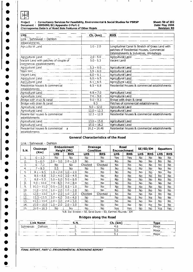
Project Consultancy Services for Feasibility, Environmental & Social Studies for PSRSP Sheet: 59 of 202* Document 2005086/EC/Appendix-3 Part-2 Date: May 2006
Chainagewise Details of Road Side Features of Other Roads Revision: RO
* LHS Ch. (km) RHS
Link: Sahnewal - Dehlonestablishments.
* AgricultLural Land 1.0 - 2.0 Longitudinal Canal & Stretch of Grass Land withpatches of Residential Houses, Commercial
__________________Establishments & Industries, Workshops.
Agricultural Land 2.0 - 5.0 Agricultural LandVacant Land with patches of couple of 5.0 - 5.3 Vacant Landcommercial establishmentsAgricultural Land 5.3 - 6.0 Agricultural Land
* Slam tent 5.9 - 6.0 Agricultural Land
Vacant Land 6.0 - 6.1 Agricultural Land*0Agr c tural Land 6.0 - 6.5 Agricultural Land
Agricultural Land 6.1 - 6.5 Agricultural LandResidential houses & commercial 6.5 - 6.8 Residential houses & commercial establishmentsestablishments
* lAgricultural Land 6.8 - 7.0 Agricultural Land
Agricultural Land 7.0 - 9.0 Agricultural Land_ Bridge with drain & canal 9.0 - 9.3 Bridge with drain & canal
_Brie with drain & canal 9.3 Patches of commercial establishments* Aqricultural Land 9.0 - 12.0 Agricultural Land
Agricultural Land 12.0 - 12.3 Aqricultural Land* Residetntial houses & commercial 12.3 - 12.9 Residential houses & commercial establishments
establishments _
Agricultural Land 13.0 - 15.0 Agricultural LandAgricultural Land _ 15.0 - 16.2 Agricultural Land
Residential houses & commercial * 16.2 - 16.46 Residential houses & commercial establishmentsestablishments
General Characteristics of the Road
* Link: Sahnewal - Dehlon
* S.N. Chainage Embankment Condition Roaed SE/SD/EM Squatters*(Kin) LHS RHS LHS RHS LHS RHS LHS RHS LHS RHS
1. 0-1.0 No No No No Yes Yes No No No No2. 5 - 6.0 2.0 - 3.0 1.0 - 2.0 No No No No No No No No3. 6 - 7.0 No No Chocked Chocked No No No No No No4. 7- 8.0 0.5 No No No No No No No No No_5._ 8.1 - 8.5 1.0 - 2.0 1.0 - 2.0 No No No No No No No No6. 8.5 - 8.8 3.0 - 4.0 3.0 - 4.0 No No No No No No No No7. 8.8 - 9.0 5.0 - 6.0 5.0 - 6.0 No No No No No No No No8. 9.0 - 10.0 7.0 - 8.0 7.0 - 8.0 No No No No No No No No9. 10.0- 11.0 0.5- 1.0 0.5 - 1.0 No No No No No No No No
10 11.0 - 12.0 1.0- 2.0 1.0 - 2.0 No No No No No No No No
_ _11. 12.0 - 13.0 1.0 - 2.0 1.0- 2.0 Chocked Chocked No No No No No No12. 13.0 -13.5 3.0 - 4.0 3.0 - 4.0 No No No No No No No No
* 13. 13.5 - 15.0 2.0- 3.0 2.0- 3.0 No No No No No No No No14. 15.0 - 16.0 1.0 - 2.0 2.0- 3.0 No _ No No No No No No No
_j5. 16.0- 16.5 No No No _ No Yes Yes No No Yes YesN.B: Soil Erosion - SE, Sand Dune - SD, Earthen Mounds - EM
Bridges along the Road
Link Name S.N. Ch. (km) Type
* Sahnewal - Dehion 1. 4.6 Minor
*_ _________ ____ 2 9.0 Minor
* FINAL REPOR-T, 3.RT C:ENVIRONMENTAL 9.1 Major
* ~~FINAL REPORT, PART C. ENVIRONMfENTAL SCREENING REPORT
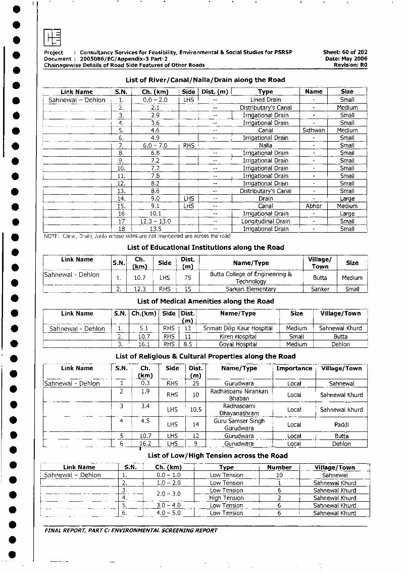
Project : Consultancy Services for Feasibility, Environmental & Social Studies for PSRSP Sheet: 60 of 202
Document 2005086/EC/Appendix-3 Part-2 Date: May 2006
Chainagewise Details of Road Side Features of Other Roads Revision: RO
List of River/Canal/Nalla/Drain along the Road
Link Name S.N. Ch. (km) Side Dist. (m) Type Name Size
* Sahnewal - Dehlon 1. 0.0 - 2.0 LHS Lined Drain - Small
2. 2.1 Distributary's Canal - Medium
* _____________________ 3. 2.9 Irrigational Drain - Small
4. 3.6 Irrigational Drain - Small
* 5. 4.6 Canal Sidhwan Medium
__ ___ _6. 4.9 _ _ Irrigational Drain - Small
* 7. 6.0 - 7.0 RHS Nalla - Small
8. 6.8 _ Irrigational Drain - Small
* 9. 7.2 Irrigational Drain - Small
10. 7.7 Irrigational Drain - Small
* 11. 7.8 _ Irrigational Drain - Small
12. 8.2 Irrigational Drain - Small
* ____________________ 13. 8.6 Distributary's Canal - Small
______ ____ 14. 9.0 LHS Drain - Large
* _ 15. 9.1 LHS Canal Abhor Medium
16 10.1 Irrigational Drain Large
* ______________ 17 12.3 -13.0 _ Longitudinal Drain Small
18 13.5 Irrigational Drain Small
NOTE: Canal, Drain, Nalla whose sides are not mentioned are across the road
List of Educational Institutions along the Road
Link Name S.N. Ch. Side Dist. Name/Type Village/ Size____ ___ ______ _(kin) - -(in) Tow n S z
Sahnewal - Dehlon 1. 10.7 LHS 75 Butta College of Engineering & Butta Medium0 2. 12.3 RHS 15 ~~~~~~~~~~Technology
_____2. 12.3 RHS 15 Sarkari Elementary Sanker Small
* List of Medical Amenities along the Road
* Link Name S.N. Ch.(km) Side Dist. Name/Type Size Village/Town_______ _ ___ (m)| _
* Sahnewal - Dehlon 1. 5.1 RHS 13 Srimati Dilip Kaur Hospital | Medium Sahnewal Khurd2. 10.7 RHS 11 Kiren Hospital Small Butta
* __________________ 3. 16.1 RHS 8.5 Goyal Hospital Medium Dehlon
* _ _ _ _ _ List of Religious & Cultural Properties along the Road
Link Name S.N. Ch. Side Dist. Name/Type Importance Village/Town
|____ *_ lL -(km)(m)Sahnewal - Dehlon 1 0.3 RHS 25 Gurudwara Local Sahnewal
* _ 1 2 1.9 RHS 10 Radhasoami Nirankari Local Sahnewal Khurd______ ____________ _____ _____B haban
| * i 3 3.4 LHS 10.5 Radhasoami Local Sahnewal Khurd____ ________________ _____ lDhayanashram
* - 4 4.5 LHS 14 Guru Samser Singh Local Paddi________________ ~~~~~~Gurudwara
* -j - 5 10.7 LHS 12 Gurudwara Local Butta
6 16.2 LHS 9 Gurudwara Local Dehlon
List of Low/High Tension across the Road
_ < Link Name S.N. Ch. (km) Type Number Village/Town*Sahnewal - Dehlon 1. 0.0 - 1.0 Low Tension 10 Sahnewal
2. 1.0 - 2.0 Low Tension 1 Sahnewal Khurd
L _______ I 230 - 3 30 Low Tension 6 Sahnewal Khurd* 2.0 - 3.0 4. High Tension 2 Sahnewal Khurd
l _________________ l5. 3.0 - 4.0 Low Tension 6 Sahnewal Khurd
_ |~ l6. 4.0 - 5.0 Low Tension 6 Sahnewal Khurd
FINAL REPORT, PART C: ENVIRONMENTAL SCREENING REPORT
*0
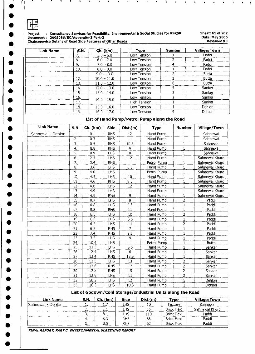
* Project Consultancy Services for Feasibility, Environmental & Social Studies for PSRSP Sheet: 61 of 202
Document 2005086/EC/Appendix-3 Part-2 Date: May 2006
Chainagewise Details of Road Side Features of Other Roads Revision: RO
Link Name S.N. Ch. (kml_ Type Number Village/Town
7. 5.0 - 6.0 Low Tension 1 Paddi
8. 6.0 - 7.0 Low Tension 2 Paddi
* _ 9. 7.0 - 8.0 Low Tension 4 Paddi
___ ______ __________ 10. 8.0 - 9.0 Low Tension 1 Paddi
_ 11. 9.0 - 10.0 Low Tension 2 Butta
12. 10.0 - 11.0 Low Tension 3 Butta
* ___________________ 13. 11.0 -12.0 Low Tension 6 Butta
14. 12.0 - 13.0 Low Tension 5 Sanker
* __________-- 15. 13.0 - 14.0 Low Tension 3 Sanker
16. 14.0 - 15.0 Low Tension 2 Sanker
17. High Tension 1 Sanker
18. 15.0 - 16.0 Low Tension 1 Dehlon
____ __________ 19. 16.0 - 17.0 Low Tension 9 Dehlon
* List of Hand Pump/Petrol Pump along the Road
* Lv Link Name S.N. Ch. (km) Side Dist.(m) Type Number Village/Town
Sahnewal - Dehlon 1. 0.1 RHS 12 Hand Pump 1 Sahnewal
2. 0.3 RHS 11 Hand Pump 1 Sahnewal
_ ________ 3. 0.5 RHS 10.5 Hand Pump 1 Sahnewa
* ___ 4. 0.8 RHS 9 Hand Pump 1 Sahnewa
5. 0.9 LHS 8 Hand Pump 1 Sahnewa
* ____ __________ 6. 2.5 LHS 12 Hand Pump 1 Sahnewal Khurd
___ _ _________ 7. 3.4 RHS Petrol Pump 1 Sahnewal Khurd
* _____ _ 8. 3.6 LHS 6.5 Hand Pump 1 Sahnewal Khurd
9. 4.0 LHS Petrol Pump 1 Sahnewal Khurd
* .____ 10. 4.5 LHS 10 Hand Pump 1 Sahnewal Khurd
_ ___ 11. 4.6 RHS 8.5 Hand Pump 1 Sahnewal Khurd
* _ 12. 4.6 LHS 12 Hand Pump 1 Sahnewal Khurd
13. 4.9 LHS 11 Hand Pump 1 Sahnewal Khurd
* 14. 4.9 RHS 9 Hand Pump 1 Sahnewal Khurd
15. 0.7 LHS 8 Hand Pump 2 Paddi
_ -~ 16. 0.8 LHS 5.5 Hand Pump 1 Paddi
17. 0.8 RHS 11 Hand Pump 1 Paddi
| * 18. 6.5 LHS 10 Hand Pump 2 Paddi
19. 6.6 LHS 8.5 Hand Pump 1 Paddi
| * 20. 6.7 LHS 11 Hand Pump 2 Paddi
21. 6.8 RHS 7 Hand Pump 1 Paddi
* __________________ .22. 7.4 RHS 9.5 Hand Pump 1 Paddi
___ ____ 23. 7.5 LHS 9 Hand Pump 1 Paddi
* _~ - 24. 10.4 LHS Petrol Pump 1 Butta
25. 12.3 LHS 8.5 Hand Pump 1 Sanker
| * _ 26. 12.4 LHS 6 Hand Pump 1I1 Sanker
27. 12.4 RHS 13.5 Hand Pump 1 Sanker
| * _ 28. 12.5 LHS 13 Hand Pump 2 Sanker
__ ___ __. 29. 12.6 RHS 13 Hand Pump 2 Sanker
| * _ ___ 30. 12.8 RHS 15 Hand Pump , 2 Sanker
_ _ __ _ 31. 12.9 LHS 11 Hand Pump 2 Sanker
* ___ _ 32. 16.2 LHS 12 Hand Pump 1 Dehlon
* ___ _ 33. 16.3 LHS 10.5 Hand Pump 1 Dehlon
List of Godown/Cold Storage/Industrial Units along the Road
| * L Link Name S.N. Ch. (km) Side Dist.(m) | Type Village/Town
* Sahnewal - Dehlon 1. 1.7 LHS 10 Factory Sahnewal -
_____ ___ _________ t 2. 2.1 - LHS - 35 - Brick Field Sahnewal Khurd
* L _ __ __ 1 3. 8.1 | LHS 110 Brick Field Paddi
L __ __ _ _ __ 1 4. 8.3 | RHS 56 Brick Field Paddi
* L___- _ 1 5 | 8.5 | RHS | 62 BrickField Paddi
FINAL REPORT, PART C: ENVIRONMENTAL SCREENING REPORr
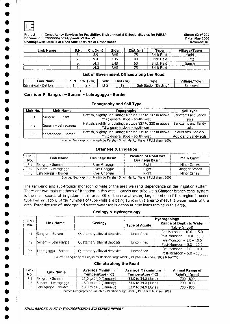
: r'Project Consultancy Services for Feasibility, Environmental & Social Studies for PSRSP Sheet: 62 of 202Document 2005086/EC/Appendix-3 Part-2 Date: May 2006Chainagewise Details of Road Side Features of Other Roads Revision: RO
_ Link Name S.N. Ch. (km) Side Dist.(m) Type Village/Town6. 8.9 RHS 75 Brick Field Paddi
* _ 7. 9.4 LHS 40 Brick Field Butta_ _ __ 8. 14.3 LHS 50 Brick Field Sanker
9. 14.3 RHS 75 Brick Field
* List of Government Offices along the Road
Link Name IS.N. Ch. (km) Side Dist.(m) Type Village/Town I| Sahnewal - Dehlon l 1l 2.7 LHS 12 Sub Station(Electric Sahnewal
_ Corrridor P: Sangrur - Sunam - Lehragagga - Border
* Topography and Soil Type
* Link No. Link Name Topography Soil TypeP. 1 Sangrur - Sunam Flattish, slightly undulating; altitude 237 to 242 m above Seriozems and Sandy
*_________ P.1 __Sangrur ___-_Sunam _ MSL; general slope - south-west soils
Flattish, slightly undulating; altitude 227 to 230 m above Seriozems and Sandy* P.2 Sunam - Lehragagga MSL; general slope - south-west soils
* P.3 Lehragagga - Border Flattish, slightly undulating; altitude 215 to 227 m above Seriozems, Sodic &* P.3 Lehragagga - Border~~ ~~~~ MSL; general slope - south-west Acidic and Sandy soils]Source: Geography of Punjab by Darshan Singh Manku, Kalyani Publishers, 2002
Drainage & Irrigation
Link Link Narne Drainage Basin Position of Road wrt Main Canal_ No. ________________No.Drainage Basin
P. 1 Sangrur - Sunam River Ghaggar Right Minor Canals* _P. Sunam - Lehragagga River Ghaggar Right Ghaggar Branch
P.3 Lehragagga - Border River Ghaggar Right Minor Canals* Source: Geography of Punjab by Darshan Singh Manku, Kalyani Publishers, 2002
* The semi-arid and sub-tropical monsoon climate of the area warrants dependence on the irrigation system.There are two main methods of irrigation in this area - canals and tube wells.Ghaggar branch canal system
* is the main source of irrigation in this area. Other than canal water, larger portion of this region is undertube well irrigation. Large numbers of tube wells are being sunk in this area to meet the water needs of the
* area. Extensive use of underground sweet water for irrigation at time leads famine in this area.
* ____ _____ Geology & Hydrogeology
Lik -Hydrogeology
ink Link Name Geology Type Range of Depth to WaterNo. of Aquifer ~~~~~~~~~~~~Table (mbgl)
P.1 Sangrur - Sunam Quaternary alluvial deposits Unconfined Pre-Monsoon - 10.0 - 15.0g unam ~~~~~~uaernary ~~~~~Post-Monsoon - 10.0 - 15.0
* P.2 Sunam - Lehragagga Quaternary alluvial deposits Unconfined Pre-Monsoon - 5.0 - 10.0* ~~~~~~~~~~~~~~~~~~~~~~~Post-Monsoon - 5.0 - 10.0
P.3 Lehragagga - Border Quaternary alluvial deposits Unconfined Pre-Monsoon - 5.0 - 10.0
* Source: Geography of Punjab by Darshan Singh Manku, Kalyani Publishers, 2002 & NATMO
*____ - Climate along the Road
ink LAverage Minimum Average Maxmimum Annual Range of* No. Link Name Temperature (0C) Temperature (0C) Rainfall (mm)
P.1__ Sangrur - Sunam 13.0 to 14.0 (January) 33.0 to 34.0 (June) 700 - 800* P.2 Sunam - Lehragagga 13.0 to 14.0 (January) 33.0 to 34.0 (June) 700 - 800
P.3 Lehragagga - Border 13.0 to 14.0 (January) 33.0 to 34.0 (June) 700 - 800* Source: Geography of Punjab by Darshan Singh Manku, Kalyani Publishers, 2002
* FINAL REPORT, P4RT C: ENVIRONMENTAL SCREENING REPORT
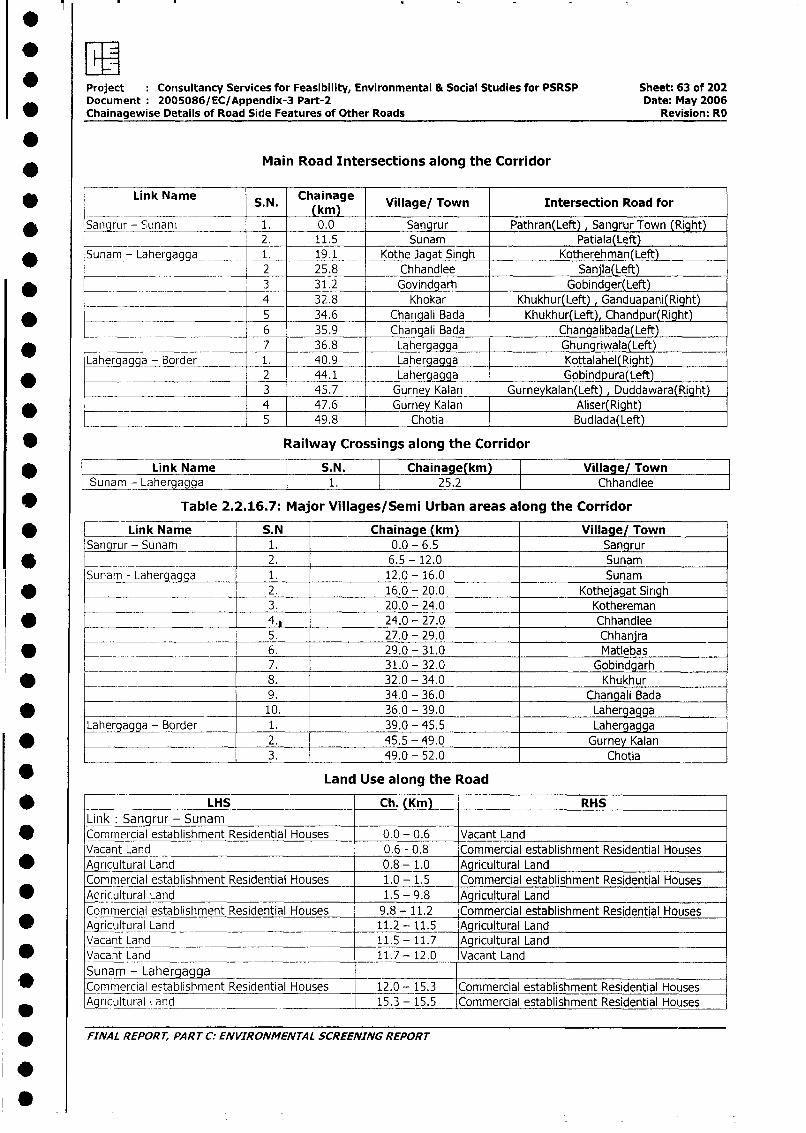
Project Conisultancy Services for Feasibility, Environmental & Social Studies for PSRSP Sheet: 63 of 202Document 2005086/ EC/Appendix-3 Part-2 Date: May 2006
0 Chainagewise Details of Road Side Features of Other Roads Revision: RO
.Main Road Intersections along the Corridor
* r Link Name S.N. Chainage Village/ Town Intersection Road for(km)
* Sangrur - Sunam 1. 0.0 Sangrur Pathran(Left) , Sangrur Town (Right)____ 2. 11.5 Sunam Patiala(Left)
* Sunam - Laher a _ 1. 19.1 Kothe JagatSingh Kotherehman(Left)|_________- __________ 2 25.8 Chhandlee Sanjla(Left)
* _ __ ._ __ 3 31.2 Govindgarh Gobindger(Left)_____ _ __ . 4 32.8 Khokar Khukhur(Left) , Ganduapani(Right)
* ____________ 5 34.6 Changali Bada Khukhur(Left), Chandpur(Right)
_______________________ 6 35.9 Changali Bada Changalibada(Left)
*_________________________ 7 36.8 Lahergagg Ghungriwala(Left)Laheruaaaa - Border 1. 40.9 Lahergagga Kottalahel(Right)
* . 2 44.1 Lahergagga Gobindpura(Left)________ __________ 3 45.7 Gurney Kalan Gurneykalan(Left), Duddawara(Right)
* _ 4 47.6 Gurney Kalan Aliser(Right)L __ _______________ 5 49.8 Chotia Budlada(Left)
* Railway Crossings along the Corridor
Link Name S.N. Chainage(km) Village/ Townl Sunam--Lahergagga 1. 25.2 Chhandlee
* Table 2.2.16.7: Major Villages/Semi Urban areas along the Corridor
* Link Name S.N Chainage (km) Village/ TownSangrur - Sunam 1. 0.0 - 6.5 Sangrur
* ____ 2. 6.5 - 12.0 Sunam
Sunam - Lahergagga 1. 12.0 - 16.0 Sunam
* _______________ __2. 16.0 - 20.0 Kothejagat Sirigh3. 20.0 - 24.0 Kothereman4._ _24.0 - 27.0 Chhandlee5. 27.0 - 29.0 Chhanjra
* __ __ 6. 29.0 - 31.0 Matlebas______ . 7. 31.0 - 32.0 Gobindgarh
* -~ 8. 32.0 - 34.0 Khukhur
9. 34.0 - 36.0 Changali Bada
* 10. 36.0 - 39.0 Lahergagga
Lahergagga - Border 1. 39.0 - 45.5 Lahergagga* -~_______________ 2. 45.5 - 49.0 Gurney Kalan
3. 49.0- 52.0 Chotia
* Land Use along the Road
* - LHS Ch. (Km) RHS
Link: Sangrur - Sunam* Commercial establishment Residential Houses 0.0 - 0.6 Vacant Land
Vacant Land 0.6 - 0.8 Commercial establishment Residential Houses* Agncultural Land 0.8 -1.0 Agricultural Land
Commercial establishment Residential Houses 1.0 - 1.5 Commercial establishment Residential Houses* Aoricultural Land 1.5 - 9.8 Agricultural Land
Commercial establishment Residential Houses 9.8 - 11.2 Commercial establishment Residential Houses* Agricultural Land 11.2 - 11.5 Agricultural Land
Vacant Land 11.5- 11.7 Agricultural Land* Vacant Land 11.7 - 12.0 Vacant Land
Sunam - Lahergagga I
* Commercial establishment Residential Houses 12.0 - 15.3 Commercial establishment Residential HousesAgrcultural Land 15.3 - 15.5 _Commercial establishment Residential Houses
* FINAL REPORT, PART C: ENVIRONMENTAL SCREENING REPORT
.
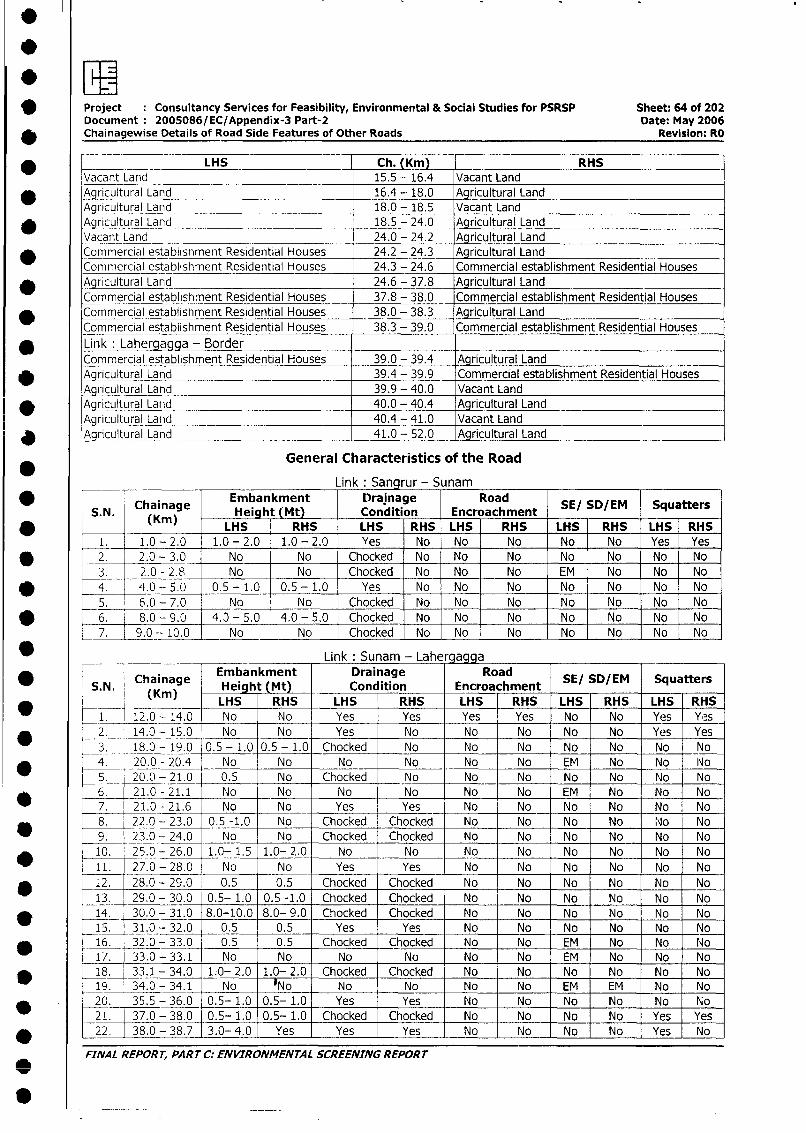
*Project Consultancy Services for Feasibility, Environmental & Social Studies for PSRSP Sheet: 64 of 202Document 2005086/ EC/Appendix-3 Part-2 Date: May 2006Chainagewise Details of Road Side Features of Other Roads Revision: RO
* -___ ~~~~~~LHS Ch. (Kmn) IRHSVacant Land 15.5 - 16.4 Vacant Land
*A_ricultural Land 16.4 -18.0 _Agricultural LandAgriultural Land 18.0 - 18.5 Vacant Land
*Agricultural Land 18.5 - 24.0 Agricultural LandVacant Land 24.0 - 24.2 _Aqricultural LandCommi-ercial establishment Residential Houses 24.2 - 24.3 Ag riculItural ILand
0 ~~Commercial establishment Residential Houses 24.3 - 24.6 Commercial establishment Residential Houses*Agricultural La nd_ 24.6 - 37.8 Agricultural Land
Commercial establishment Residential Houses 37.8 - 38.0 Commercial establishment Residential Houses* ~~~Commercial establishment Residential Houses 38.0 - 38.3 Agricultural Land
Commercial establishment Residential Houses 38.3 - 39.0 Commercial establishment Residential Houses
* ~~Link :Lahergagga - Border-Commercial establishment Residential Houses 39.0 - 39.4 Agricultural Land
* ~~Agricultural Land 39.4 - 39.9 Commercial establishment Residential HousesAgricultural Land 39.9 - 40.0 Vacant Land
* ~~~Agricultural Land 40.0 - 40.4 Agricultural LandAgricultural Land 40.4 -41.0 Vacant Land
*Agrcutural Land 41.0 - 52.0 _Agricultural Land
General Characteristics of the Road
Link :Sang rur - Sunam
* ~~~~~Chainage Embankment Drainage RoadSESD M SqatrS.N. (Kin) Heiaht (Mt) Condlition Encroachment SESDM Sqatr
* ~~~~ ~~~~ ~~LHS RHS LHS RHS LHS RHS LHS RHS LHS RHS_1. 1.0 -2.0 1.0 -2.0 1.0 -2.0 Yes No No No No - No Yes -Yes
* ~~~2. 2.0 -3.0 No No Chocked No No No No No No No3. 2.0 -2.8 No No Chocked No No No EM - No No No
* ~~~4. '1.0 -5.0 0.5 -1.0 0.5- 1.0 Yes No No No No No No No5. 6.0 -7.0 No No Chocked No No I No No - No No No
* ~~~6. -~8.0 - 9.0 4. - 5.0 4.0 - 5.0 Chocked No No No No No No No7. j90- 10.0 No No Chocked No INo No No No No jNo
* ___ ~~~~~~~~~~~~~~Link :Sunam - Lahergagga
* !SNI ~~~Chainage Embankment Drainage RoadSESD M SqatrS.. (Krn) Height (Mt) Condition Encroachment SESDM Sqatr
__ ~~~LHS RHS LHS RHS LHS RHS LHS RHS LHS RHS0 i~~~.~ 12.0 - 14.0 No No Yes Yes Yes Yes No No Yes Yes* ~~~~. 14.0 -15.0 No No Yes No No No No No Yes Yes
3 . 18.0 - 19.0 0.5 - 1.0 0.5 - 1.0 Chocked No No No No No No No4 . 20.0 -20.4 No No No No No No EM No No No5 . 20.0 - 21.0 0.5 No Chocked No No No No No No No6 . 21.0 -21.1 No No No No No No EM No No No
* ~~~7 . 21.0 -21.6 No No Yes Yes No No No No No No8 . 22.0 - 23.0 0.5 -1.0 No Chocked Chocked No No No No Nlo No9 . 23.0 - 24.0 No No Chocked Chocked No No No No No No
* ~~~10. 25.0 - 26.0 1.0- 1.5 1.0- 2.0 No No No No INo No No No11. 27.0 -28.0 No No Yes Yes No No No No No No
* 1~~~2. 28.0 - 29.0 0.5 0.5 Chocked Chocked No No No No No No13. 29.0 - 30.0 0.5-- 1.0 0.5 -1.0 Chocked Chocked No No No No No No
* ~~~14. 30.0 - 31.0O 8.0-10.0 8.0- 9.0 Chocked Chocked No No No No No No15. 31.0 - 32.0 -0.5 0.5 Yes Yes No No No No No INo
* ~~~16. 32.0 - 33.0 0.5 0.5 Chocked Chocked No No EM No No No17. 33.0 -33.1 No No No No No No EM No No No
* ~~~18. 33.1 - 34.0 1.0- 2.0 1.0- 2.0 Chocked Chocked No No No No No No19. 34.0 -34.1 No No No No No No EM EM No No
* ~~~20. 35.5 - 36.0 0.5- 1.0 0.5- 1.0 Yes Yes No No No No No No21. 37.0 - 38.0 0.5- 1.0 0.5- 1.0 Chocked IChocked No No No No Yes Yes
* ~~~22. 38.0 - 38.7 3.0- 4.0 Yes Yes I Yes No Noc N No Yes No
FINA L REPOR T, PA RT C.: EN VIRONMEN TA L SCREENING REPOR T
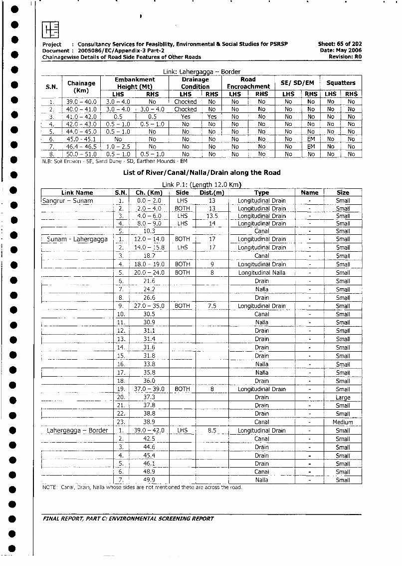
*owMEProject Consultancy Services for Feasibility, Environmental & Social Studies for PSRSP Sheet: 65 of 202Document 2005086/EC/Appendix-3 Part-2 Date: May 2006Chainagewise Details of Road Side Features of Other Roads Revision: RO
* __ _ Li k: Lahergagga - Border
Chainage Embankment Drainage RoadSESD M Sqatr* S.N. (Kin) Height (Mt) Condition Encroachment SE/ SD/EM Squatters
LHS RHS LHS RHS LHS RHS LHS RHS LHS RHS* 1. 39.0 - 40.0 3.0 - 4.0 No Chocked No No No No No No No
2. 40.0 - 41.0 3.0 - 4.0 3.0 - 4.0 Chocked No No No No No No No* 3. 41.0 - 42.0 0.5 0.5 Yes Yes No No No No No No
4. 42.0 - 43.0 0.5 - 1.0 0.5 - 1.0 No No No No No No No No* 5. 44.0 - 45.0 0.5 - 1.0 No No No No No No No No No
6. 45.0 - 45.1 No No No No No No No EM No No* 7. 46.4 - 46.5 1.0 - 2.5 No No No No No No EM No No
8. 50.0 - 51.0 0.5 - 1.0 0.5- 1.0 No No No No No No No No* N.B: Soi Erosion - SE, Sand Dune - SD, Earthen Mounds- EM
* List of River/Canal/Nalla/Drain along the Road
Li k P.1: (Length 12.0 Km)* Link Name S.N. Ch. (Kin) Side Dist.(m) Type Name Size
Sangrur - Sunam 1. 0.0 - 2.0 LHS 13 Longitudinal Drain - Small* __ ___________ 2. 2.0 - 4.0 BOTH 13 Longitudinal Drain - Small
*_L__ ________ 3. 4.0 - 6.0 LHS 13.5 Longitudinal Drain - Small4. 8.0 - 9.0 LHS 14 Longitudinal Drain - Small5. 10.3 Canal - Small
a',unam - Lahergagga 1. 12.0 - 14.0 BOTH 17 Longitudinal Drain - Small
__ __-. _ 2. 14.0 - 15.8 LHS 17 Longitudinal Drain - Small
3 . 18.7 Canal - Small
* _ . _ .__.____ _ 4 18.0- 19.0 BOTH 9 Longitudinal Drain - Small
5. 20.0 - 24.0 BOTH 8 Longitudinal Nalla - Small
| * .. _ _ ... _ _ _6. 21.6 Drain - Small
l__C___ 7. 24.2 Nalla - Small
I w I___________ | 8. 26.6 Drain Small
____*______ |9. 27.0 - 35.0 BOTH 7.5 Longitudinal Drain - Small
l ____________________ _ 110. 30.5 Canal - Small
I _________________ _ l |11. 30.9 Nalla - Small
12. 31.1 Drain - Small
* 1 l | 13. 31.4 Drain - Small14. 31.6 Drain - Small
| * iS| 15. 31.8 Drain - Small16. 33.8 Nalla - Small
| * l | 17. 35.8 Nalla - Small
l___________ r_____ |18. 36.0 Drain - Small
_________________ _ * |19. 37.0 - 39.0 BOTH 8 Longitudinal Drain - Small* | 20. 37.3 Drain - Large
21. 37.8 Drain - Small
* < | 22. 38.8 Drain - Small
*_____ I____________ 23. 38.9 Canal - Medium
* Lahergagqa - Border 1. 39.0 - 42.0 LHS 8.5 Longitudinal Drain - Small
I ____ I______ ______ 2. 42.5 Canal - Small
* __ - 3. 44.6 Drain - Small
r ___ 4. 45.4 Drain _ Small
_ LI _5. 46.1 Drain Small
i 6. 48.9 Canal Small
______ ________|_____ 7. 49.9 Nalla - SmallNOTE: Canal, Drain, Nalla whose sides are not mentioned these are across the road.
0* FINAL REPORt, PART C: ENVIRONMENTAL SCREENING REPORT
S~~~~~~~~~~~~~~~~~~~~~~~~~~~~~~~~~
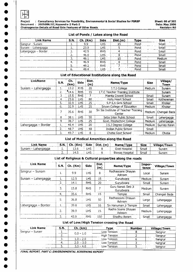
*wProject Consultancy Services for Feasibility, Environmental & Social Studies for PSRSP Sheet: 66 of 202Document 2005086/EC/Appendix-3 Part-2 Date: May 2006Chainagewise Details of Road Side Features of Other Roads Revision: RO
* List of Ponds / Lakes along the Road
* __ ~Link Name S.N. Ch. (Km) Side Dist.(m) Type SizeSangrur - Sunam 1. 9.9 LHS 15 Pond Small
* Sunam - Lahergagga 1.. 23.9 LHS 5 Pond SmallLahergagga -- Border 1. 42.5 RHS 4 Pond Small
* _~ ._ .2. 46.0 LHS 8 Pond Small3. 46.1 LHS 10 Pond Medium
* 4. 46.9 RHS 8 Pond Small_ __ ... _ ____________ ___ ;5. 49.2 RHS 7 Pond Small
* _ 6. 49.4 LHS 7 Pond Small
List of Educational Institutions along the Road
LinkName S.N. Ch. Side Dist. Name/Type Size Village/S..(km)n ) Sie- Nm/yeSz TownSunam - Lahergagga 1. 13.2 RHS 20 I.T.I College Medium Sunam
* 2. 14.6 RHS 15 I.T.C Teacher Training Institute Sunam3 15.5 RHS 7 Mamta Covent School Small Sunam
* __._ 4 23.8 LHS 80 Holly Heart School Small Kothereman5. 32.9 LHS 25 S.P.S.K Girls School Small Khokar
* _______________________ 6. 32.9 LHS 25 Srivan College of Education Medium Khokar
7 35.6Sri Sai Institute of Teacher Training Medium Chengali Bada35.6 RHS 30 ~~~Center8 38.1 LHS 50 Seba Inter Public School Small Lahergagga
* 9 38.7 LHS 25 Govt. Polytechnic College Medium LahergaggaLahergagga - Border 1. 46.4 LHS 20 J.S.J Degree College Medium Gurney Kalan
* 2. 48.7 LHS 18 Indian Public School Small*___________________ 3. 49.7 LHS 8 Chotia Govt School Medium Chotia
List of Medical Amenities along the Road
* Link Name S.N. Ch. (Km) Side Dist. (m) i Name/Type Size Village/Town_ Sunam - Lahergagga 1. 13.6 LHS 8 Goel Hospital Small Sunam I
2. 14.5 LHS 8 Biswas Hos ital Small Sunam
* List of Religious & Cultural properties along the roads
* Link Name S.N. Ch. (Km) Side Dist. Name/Type Impor- Village/Town(m), l ltance
Sangrur - Sunam 1. 9.9 LHS 8 Radhasoami Dhayan Local Sunam0 l l l l l lAshram* ISunam - Lahergagga 1. 12.5 LHS 15 Gurudwara Medium Sunam
__l _l 2. 14.1 RHS 20 Gurudwara Small Sunam* 3. 15.8 RHS 7 Guru Nanak Deb Ji Medium Sunam
Gurudwara* - | 4. 35.6 RHS 15 Temple Small Changali Bada
5. 36.8 LHS 50 Radhasoami Dhayan Large Lahergagga* ~~~~~~ ~ ~~~~~~~~~~Ashram_ _
Laherga_ga -_Border 1. 39.8 LHS 16 Sri Hanuman Ji Temple Small Lahergagga2* 39.9 LHS 15 Radha Soami Dhayan Medium Lahergagga
___ _________ |____ l________ l__l__l Ashram l l_l*_________ ________ ______ ____3. _43.9 RHS 150 Shadhu Asram Small Lahergagga
* List of Low/High Tension crossing the Road
1- Link Name | S. N. Ch. (km) Type Number Village/TownSangrur- Sunam 11 0.0 - 1.0 Low Tension 8 Sangrur
*____ ______________ l2. _ High Tension 2 SangrurL -- 3. 1.0 - 2.0 Low Tension 6 Sangrur
* L __ _________ _ 4. 2.0 - 3.0 Low Tension 3 SangrurL_ 1 5. 3.0 - 4.0 Low Tension 5 Sangrur
* FINAL REPORT, PART C: ENVIRONMENTAL SCREENING REPORT
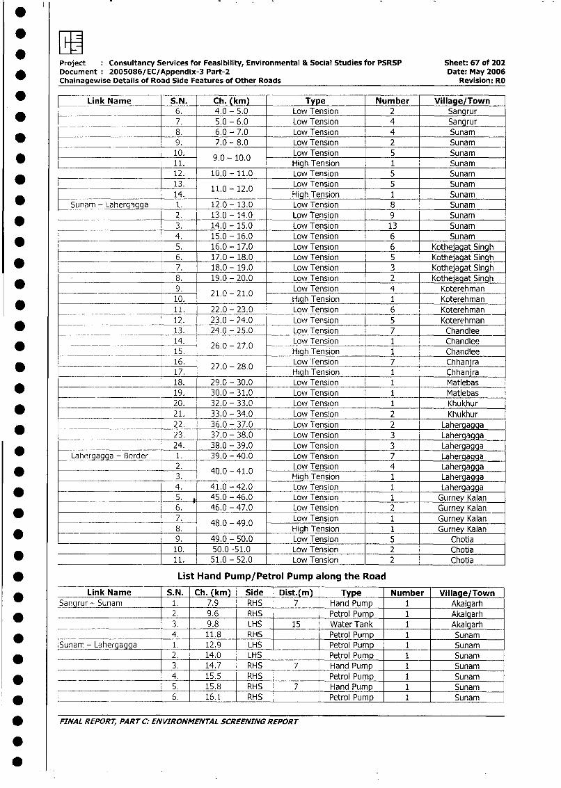
Project Consultancy Services for Feasibility, Environmental & Social Studies for PSRSP Sheet: 67 of 202* Document: 2005086/EC/Appendix-3 Part-2 Date: May 2006
Chainagewise Details of Road Side Features of Other Roads Revision: RO
L Link Name S.N. Ch. (km) Type Number Village/Town6. 4.0 - 5.0 Low Tension 2 Sangrur
l _ 7. 5.0 - 6.0 Low Tension 4 Sangrur8. 6.0 - 7.0 Low Tension 4 Sunam
l 9. 7.0 - 8.0 Low Tension 2 Sunam10. 9.0 - 10.0 Low Tension 5 Sunam11. High Tension 1 Sunam
__ __ 12. 10.0 - 11.0 Low Tension 5 Sunam
_ 13. 11.0 -120 Low Tension 5 Sunam14. . . High Tension 1 Sunam
* Sunam - Lahergegga 1. 12.0 - 13.0 Low Tension 8 Sunam* __--___ 2. 13.0 - 14.0 Low Tension 9 Sunam
3. 14.0 - 15.0 Low Tension 13 Sunam
4. 15.0 - 16.0 Low Tension 6 Sunam
_ ! _ 5. 16.0 - 17.0 Low Tension 6 Kothejagat Singh6. 17.0 - 18.0 Low Tension 5 Kothejagat Singh
* l 7. 18.0 - 19.0 Low Tension 3 Kothejagat Singh8. 19.0 - 20.0 Low Tension 2 Kothejagat Singh
* ________ ____ 9. Low Tension 4 Koterehman
*_________ 10. . - . High Tension 1 Koterehman
* __________ 11. 22.0 - 23.0 Low Tension 6 Koterehman
12. 23.0 - 24.0 Low Tension 5 Koterehman* ___ ____________ 13. 24.0 - 25.0 Low Tension 7 Chandlee
* __ .____________ 14. 26.0 - 27.0 Low Tension 1 Chandlee
_______ _15. High Tension 1 Chandlee
___ 16. 27.0 - 28.0 Low Tension 7 Chhanjra_ _ ._______________ _ _17. High Tension 1 Chhanjra
18. 29.0 - 30.0 Low Tension 1 Matlebas
_ -_____ _ 19. 30.0 - 31.0 Low Tension 1 Matlebas* 20. 32.0 - 33.0 Low Tension 1 Khukhur_ 21. 33.0 - 34.0 Low Tension 2 Khukhur
h _ _ . __ 22. 36.0 - 37.0 Low Tension 2 Lahergagga23. 37.0 - 38.0 Low Tension 3 Lahergagga
* __ _ _ 24. 38.0 - 39.0 Low Tension 3 LahergaggaLahergagga - Border 1. 39.0 - 40.0 Low Tension 7 Lahergagga
* _ 2. 40.0 - 41.0 Low Tension 4 Lahergagga_3. .0 . High Tension 1 Lahergagga
4. 41.0 - 42.0 Low Tension 1 Lahergagga5. 45.0 - 46.0 Low Tension 1 Gurney Kalan6. 46.0 - 47.0 Low Tension 2 Gurney Kalan
7. 48.0 - 49.0 Low Tension 1 Gurney Kalan8. . 4.0 High Tension 1 Gurney Kalan
_ _ 9. 49.0 - 50.0 Low Tension 5 Chotia_____________________ 10. 50.0 -51.0 Low Tension 2 Chotia
* ._________________- 11. 51.0 -52.0 Low Tension 2 Chotia
* List Hand Pump/Petrol Pump along the Road
Link Name S.N. Ch. (km) Side Dist.(m) | Type Number Village/TownSangrur- Sunam 1. 7.9 RHS 7 Hand Pump 1 Akalgarh
* 2. 9.6 RHS Petrol Pump 1 Akalgarh3. 9.8 LHS 15 Water Tank 1 Akalgarh
* 4. 11.8 RHS Petrol Pump 1 SunamSunam - Lahergagga _ 1. 12.9 LHS Petrol Pump 1 Sunam
* 2. 14.0 LHS Petrol Pump 1 Sunam3. 14.7 RHS 7 Hand Pump 1 Sunam
_ ___-~ 4. 15.5 RHS Petrol Pump 1 Sunam5. 15.8 RHS 7 Hand Pump 1 Sunam
* __ 6. 16.1 RHS Petrol Pump 1 Sunam
* FINAL REPORT, PART C: ENVIRONMENTAL SCREENING REPORT
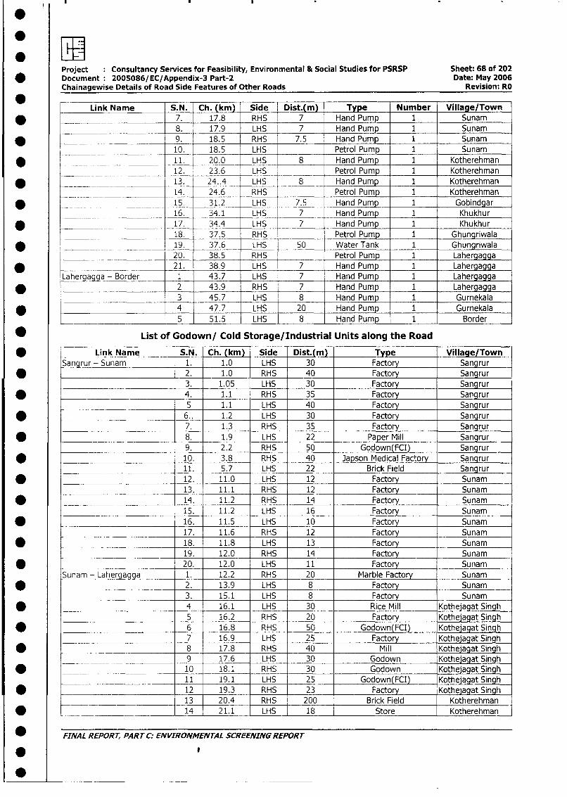
Project Consultancy Services for Feasibility, Environmental & Social Studies for PSRSP Sheet: 68 of 202* Document: 2005086/EC/Appendix-3 Part-2 Date: May 2006
Chainagewise Details of Road Side Features of Other Roads Revision: RO
0 _ _Link Name S.N. Ch. (km) Side Dist.(m) Type Number Village/Town
7. 17.8 RHS 7 Hand Pump 1 Sunam8. 17.9 LHS 7 Hand Pump 1 Sunam
* __ _9. 18.5 RHS 7.5 Hand Pump 1 Sunam_____ 10. 18.5 LHS Petrol Pump 1 Sunam
* l _ _ _ 11. 20.0 LHS 8 Hand Pump 1 Kotherehman12. 23.6 LHS Petrol Pump 1 Kotherehman
* ___ 13. 24.4 LHS 8 Hand Pump 1 Kotherehman14. 24.6 RHS Petrol Pump 1 Kotherehman
* . __ __ 15_ 31.2 LHS 7.5 Hand Pump 1 Gobindgar_ ________ 16. 34.1 LHS 7 Hand Pump 1 Khukhur
* ______ _17. 34.4 LHS 7 Hand Pump 1 Khukhur_____ 18. 37.5 RHS Petrol Pump 1 Ghungriwala
19. 37.6 LHS _ 50 Water Tank 1 Ghungriwala* 20. 38.5 RHS Petrol Pump 1 Lahergagga
* ______________ 21. 38.9 LHS 7 Hand Pump 1 LahergagaLaherqa_a- Border _ 1 43.7 LHS 7 Hand Pump 1 Lahergagga
* ________________ 2 43.9 RHS 7 Hand Pump 1 Lahergagga_____ ____________ -3 45.7 LHS 8 Hand Pump 1 Gurnekala
* ______________________ 4 47.7 LHS 20 Hand Pump 1 Gurnekala
_________ 5 51.5 LHS 8 Hand Pump 1 Border
* List of Godown/ Cold Storage/Industrial Units along the Road
* Link Name S.N. Ch. (kmJ) Side Dist.(m) Type Village/TownSangrur - Sunam 1. 1.0 LHS 30 Factory Sangrur
2. 1.0 RHS 40 Factory Sangrur3. 1.05 LHS 30 Factory Sangrur
* _ 4. 1.1 RHS 35 Factory Sangrur5 1.1 LHS 40 Factory Sangrur
* 6.. 1.2 LHS 30 Factory Sangrur7. 1.3 RHS 35 Factory Sangrur
* ____=_ _ 8. 1.9 LHS 22 Paper Mill Sangrur
___ 9. 2.2 RHS 50 Godown(FCI) Sangrur* 10. 3.8 RHS 40 Japson Medical Factory Sangrur
11. 5.7 LHS 22 Brick Field Sangrur
* 12. 11.0 LHS 12 Factory Sunam13. 11.1 RHS 12 Factory Sunam
* _____. _14. 11.2 RHS 14 Factory Sunam15. 11.2 LHS 16 Factory Sunam
* _ 16. 11.5 LHS 10 Factory Sunam17. 11.6 RHS 12 Factory Sunam
* _===__ _ 18. 11.8 LHS 13 Factory Sunam19. 12.0 RHS 14 Factory Sunam
* 20. 12.0 LHS 11 Factory SunamSunam - Lahergagga 1. 12.2 RHS 20 Marble Factory Sunam
* ____ 2. 13.9 LHS 8 Factory Sunam_____ 3. 15.1 LHS 8 Factory Sunam
* 4 16.1 LHS 30 Rice Mill Kothejagat Singhl5 16.2 RHS 20 Factory Kothejagat Singh
* 6 16.8 RHS 50 Godown(FCI) Kothejagat Singh__ ___ 7 16.9 LHS 25 Factory Kothejagat Singh
* 8 17.8 RHS 40 Mill Kothejagat Singh9 17.6 LHS 30 Godown Kothejagat Singh
* ___ _ _ _ 10 18.1 RHS 30 Godown Kothejagat Singh________. 11 19.1 LHS 25 Godown(FCI) Kothejagat Singh
* 12 19.3 RHS 23 Factory Kothelagat Singhl ____ 13 20.4 RHS 200 Brick Field Kotherehman
* ___ __ _ ____- _14 21.1 LHS _ 18 Store Kotherehman
* FINAL REPORT, PARTCC: ENVIRONMENTAL SCREENINGREPORT
0
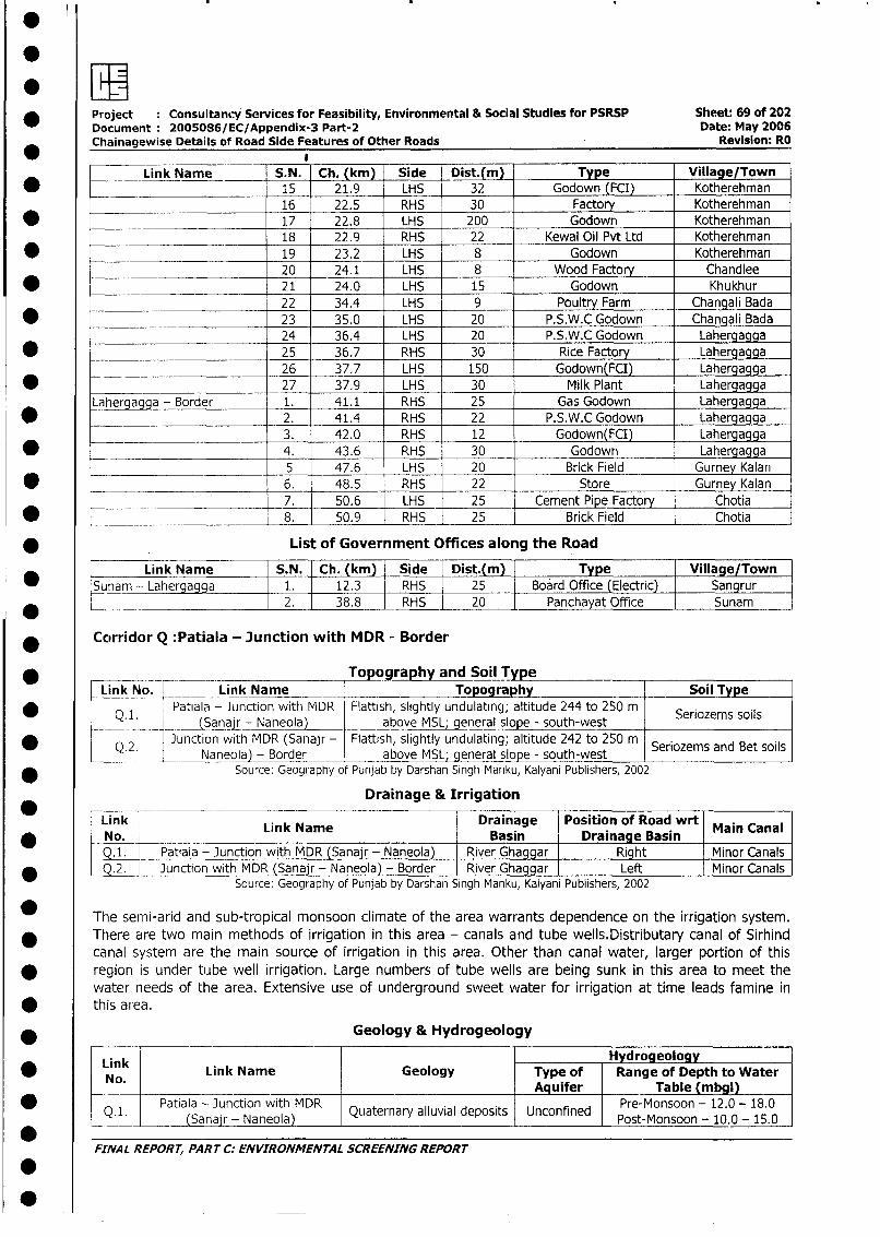
* Project : Consultancy Services for Feasibility, Environmental & Social Studies for PSRSP Sheet: 69 of 202Document: 2005086/EC/Appendix-3 Part-2 Date: May 2006Chainagewise Details of Road Side Features of Other Roads Revision: RO
L___ Link Name S.N. Ch. (km) Side Dist.(m Type Village/Town* _ 15 21.9 LHS 32 Godown (FCI) Kotherehman
________ 16 22.5 RHS 30 Factory Kotherehman* _~ 17 22.8 LHS 200 Godown Kotherehman
18 22.9 RHS 22 Kewal Oil Pvt Ltd Kotherehman
* 19 23.2 LHS 8 Godown Kotherehman20 24.1 LHS 8 Wood Factory Chandlee
* 21 24.0 LHS 15 Godown Khukhur22 34.4 LHS 9 Poultry Farm Changali Bada
* _______ 23 35.0 LHS 20 P.S.W.C Godown Changali Bada24 36.4 LHS 20 P.S.W.C Godown Lahergagga
* _ 25 36.7 RHS 30 Rice Factory Lahergagga26 37.7 LHS 150 Godown(FCI) Lahergagga
* 27 37.9 LHS 30 Milk Plant LahergaggaLahergagga - Border 1. 41.1 RHS 25 Gas Godown Lahergagga
* 2. 41.4 RHS 22 P.S.W.C Godown Lahergagga3. 42.0 RHS 12 Godown(FCI) Lahergagga
* 4. 43.6 RHS 30 Godown Lahergagga5 47.6 LHS 20 Brick Field Gurney Kalan
* _ 6. 48.5 RHS 22 Store Gurney Kalan7. 50.6 LHS _ 25 Cement Pipe Factory Chotia
* L____________________ 8. 50.9 RHS 25 Brick Field Chotia
* List of Government Offices along the Road
Link Name S.N. Ch. (km) Side Dist.(m) Type Village/Town*Sunam - Lahergagga 1. 12.3 RHS 25 Board Office (Electric) Sangrur
2. 38.8 _ RHS 20 Panchayat Office Sunam
* Ccorridor Q :Patiala - Junction with MDR - Border
* -___ ___ _________o Topography and Soil TypeCLink No. Link Name Topography Soil Type
* Q. 1 Patiala - Junction with MDR Flattish, slightly undulating; altitude 244 to 250 m Seriozems soils(__ ~Sana- Naneola) above MSL;-general slope - south-west
Q.2. Junction with MDR (Sanajr - Flattish, slightly undulating; altitude 242 to 250 m Seriozems and Bet soils___ _| Naneoa- Border above MSL; general slope - south-west I
Source: Geography of Punjab by Darshan Singh Manku, Kalyani Publishers, 2002
Drainage & Irrigation
Link Link Name Drainage Position of Road wrt Main CanalNo. Basin Drainage Basin| Q.1. | Patiala - Junction with MDR (Sanajr - Naneola) River Ghaggar Right Minor Canals
* | Q.2. g Junction with MDR (Sanajr - Naneola) - Border River Ghaggar Left Minor CanalsSource: Geography of Punjab by Darshan Singh Manku, Kalyani Publishers, 2002
The semi-arid and sub-tropical monsoon climate of the area warrants dependence on the irrigation system.
* There are two main methods of irrigation in this area - canals and tube wells.Distributary canal of Sirhind
canal system are the main source of irrigation in this area. Other than canal water, larger portion of this
* region is under tujbe well irrigation. Large numbers of tube wells are being sunk in this area to meet the
water needs of the area. Extensive use of underground sweet water for irrigation at time leads famine in
* this area.
* Geology & Hydrogeology
Link HydrogeologyNo. Link Name Geology Type of Range of Depth to Water
Aquifer Table (mbgl)
Q1. Patiala - Junction withea Quaternary alluvial deposits Unconfined Pre-Monsoon - 12.0 - 18.0(Sanajr - Naneola) Post-Monsoon - 10.0 - 15.0
FINAL REPOR T, PART C: ENVIRONMENTAL SCREENING REPOR T
0
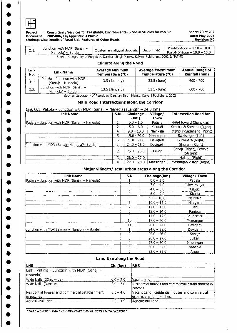
* Project Consultancy Services for Feasibility, Environmental & Social Studies for PSRSP Sheet: 70 of 202Document 2005086/EC/Appendix-3 Part-2 Date: May 2006
* Chainagewise Details of Road Side Features of Other Roads Revision: RO
* Q.2. Junction with MDR (Sanajr - Quaternary alluvial deposits Unconfined Pre-Monsoon - 12.0 - 18.0_ Naneola) - Border Post-Monsoon - 10.0 - 15.0
Source: Geography of Punjab by Darshan Singh Manku, Kalyani Publishers, 2002 & NATMO
Climate along the Road
Link r Average Minimum Average Maxmimum Annual Range of* No. Link Name Temperature (°C) Temperature (0C) Rainfall (mm
*Q.L SPatiala - Junction with MDR 13.5 (January) 33.5 (June) 600 - 700* -~~__ __ CSanak _- an o D_ _ _ _ _ __ _ _ _ _ _ _ _ _
Q. 2. Junction with MDR (Sanajr- 13.5 (January) 33.5 (June) 600 - 700
Source: Geography of Punjab by Darshan Singh Manku, Kalyani Publishers, 2002
* Main Road Intersections along the Corridor
Link .1: Patiala - Junction with MDR (Sanair - Naneola (Length - 24.0 Km)_ Link Name S.N. Chainage Village/ Intersection Road for
(km) Town* Patiala - Junction vvith MDR (Sanajr - Naneola) 1. 0.0 - 1.0 Patiala NH64 toward Chandigarh
2. 5.0 - 6.0 Kaloudi Kenthal & Samana (Right)* _______________ 4. 9.0 - 10.0 Nainkala Fatehpur-Gadeharia (Right)
5. 19.0 - 20.0 Meeranpur Swaisingra (Left)_ 6. 21.0 - 22.0 Devigarh Guthmara (Right)
Junction with MDR (Sanair-Naneolal- Border 1. 24.0 - 25.0 Devigarh Ghuram (Right)
* 2. 25.0 - 26.0 Julkan Sanajr (Right), Peheva2_ 25.0 - 26.0 3ulkan (Straight)
* _ 3. 26.0 - 27.0 Hajipur (Right)4. 27.0 - 28.0 Massingan Massingan village (Right)
Major villages/ semi urban areas along the Corridor
* Link Name S.N. Chainage(km) Village/ Town* Patiala - Junction with MDR (Sanajr - Naneola) 1. 0.0 - 3.0 Patiala
2. 3.0 - 4.0 Ishwarnagar3. 4.0 - 6.0 Kaloudi4. 6.0 - 9.0 Khasia5. 9.0 - 10.0 Nainkala6. 10.0 - 12.0 Hiragarh
_ 7. 11.0 - 13.0 Behl8. 13.0 - 14.0 Panjeta
_ _._ 9. 14.0 - 17.0 Bhunerheri_ ___.__. 10. 17.0 - 20.0 Meeranpur
_ 11. 20.0 - 24.0 DevigarhJunction with MDR (Sanajr - Naneola) - Border 1. 24.0 - 25.0 Devigarh
* _ 2. 25.0 - 26.0 Sanajr3. 26.0 - 27.0 Julkan
* 4. 27.0 - 30.0 Massingan5. 30.0 - 32.0 Naneola
* _ 6. 32.0 - 32.6 Alipur
Land Use along the Road* LHS Ch. (km) RHS* Link: Patiala - Junction with MDR (Sanajr -
N aneolaj _ __ _ _ _ _ _ -_ _ _ _ __ - _ _ _ _ _ _ _ _ _ _ _ _ _ _ _ _ _ _
* Wide Nalla (30mt wide) 0.0 - 2.0 Vacant landWide Nalla (3Omt wide) 2.0 - 3.0 Residential houses and commercial establishment in*__ ________- patchesResidential houses and commercial establishment 3.0 - 4.0 Vacant Land, Residential houses and commercialin atches establishment in patches.A gyjultural Land. 4.0 - 4.5 Agricultural Land.
FINAL REPORT, PART C: ENVIRONMENTAL SCREENING REPORT
-0~~~
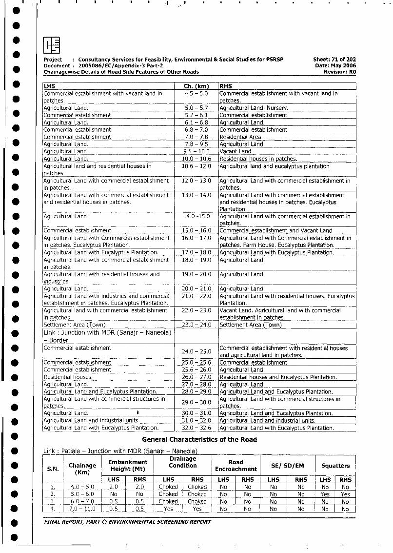
Project Consultancy Services for Feasibility, Environmental & Social Studies for PSRSP Sheet: 71 of 202
Document: 2005086/EC/Appendix-3 Part-2 Date: May 2006
Chainagewise Details of Road Side Features of Other Roads Revision: RO
* LHS Ch. (km) RHSCommercial establishment with vacant land in 4.5 - 5.0 Commercial establishment with vacant land in
* patches. patches.
Agricultural Land. 5.0 - 5.7 Agricultural Land. Nursery.
* Commercial establishment 5.7 - 6.1 Commercial establishment
Agricultural Land. 6.1 - 6.8 Agricultural Land.
* Commercial establishment 6.8 - 7.0 Commercial establishment
Commercial establishment 7.0 - 7.8 Residential Area
* Agricultural Land. 7.8 - 9.5 Agricultural Land
Agricultural Lanc. 9.5 - 10.0 Vacant Land
* Agricultural Land. 10.0 - 10.6 Residential houses in patches.
Agricultural land and residential houses in 10.6 - 12.0 Agricultural land and eucalyptus plantation
patchesAgricultural Land with commercial establishment 12.0 - 13.0 Agricultural Land with commercial establishment in
in patches. patches.
Agricultural Land with commercial establishment 13.0 - 14.0 Agricultural Land with commercial establishment
* and residential houses in patches. and residential houses in patches. EucalyptusPlantation.
* Agricultural Land 14.0 -15.0 Agricultural Land with commercial establishment inpatches.
Commercial establishment. 15.0 - 16.0 Commercial establishment and Vacant Land
Agricultural Land with Commercial establishment 16.0 - 17.0 Agricultural Land with Commercial establishment in
-in patches. Eucalyptus Plantation. patches. Farm House. Eucalyptus Plantation.
Agricultural Land with Eucalyptus Plantation. 17.0 - 18.0 Agricultural Land with Eucalyptus Plantation.
* Agricultural Land with commercial establishment 18.0 - 19.0 Agricultural Land.
in patches.* Agricultural Land with residential houses and 19.0 - 20.0 Agricultural Land.
industries.* Agricultural Land. 20.0 - 21.0 Agricultural Land.
Agricultural Land with industries and commercial 21.0 - 22.0 Agricultural Land with residential houses. Eucalyptus
* establishment in patches. Eucalyptus Plantation. Plantation.
Agricultural land with commercial establishment 22.0 - 23.0 Vacant Land. Agricultural land with commercial
i _n patches establishment in patches
Settlement Area (Town) 23.0 - 24.0 Settlement Area (Town)
* Link: Junction with MDR (Sanajr - Naneola)- BorderCommercial establishment 24C0 - 25.0 ommercial establishment with residential houses
24.0- 25.0 and agricultural land in patches.
* Commercial establishment 25.0 - 25.6 Commercial establishment
Commercial establishment 25.6 - 26.0 Agricultural Land.
* Residential houses. 26.0 - 27.0 Residential houses and Eucalyptus Plantation.
Agricultural Land. 27.0 - 28.0 Agricultural Land.
* Agricultural Land and Eucalyptus Plantation. 28.0 - 29.0 Agricultural Land and Eucalyptus Plantation.
Agricultural Land with commercial structures in 29A0 30.0 gricultural Land with commercial structures in
* patches. . - . patches.
Agricultural Land. I 30.0 - 31.0 Agricultural Land and Eucalyptus Plantation.
* Aqgncultural Land and industrial units. 31.0 - 32.0 Agricultural Land and industrial units.
Agricultural Land with Eucalyptus Plantation. 32.0 - 32.6 Agricultural Land with Eucalyptus Plantation.
* General Characteristics of the Road
* Link: Patiala - Junction with MDR (Sa ajr - Naneola)
Embankment Drainage Ra
S.N. Chainage Height (Mt) Condition Encroachment SE/ SD/EM Squatters
* (K__) _LHS RHS LHS RHS _LHS RHS LHS RHS LHS RHS
0 1. 4.0 - 5.0 2.0 2.0 Choked Choked No No No No No No
* 52. .0 - 6.0 No No Choked Choked I No No No No Yes Yes
3. 6.0 - 7.0 0.5 0.5 Choked Choked No No No No No No
* _ 4. 7.0 -11.0 0.5 0.5 Yes Yes No I No No No No No
* FINAL REPORT, PART C: ENVIRONMENTAL SCREENING REPORT
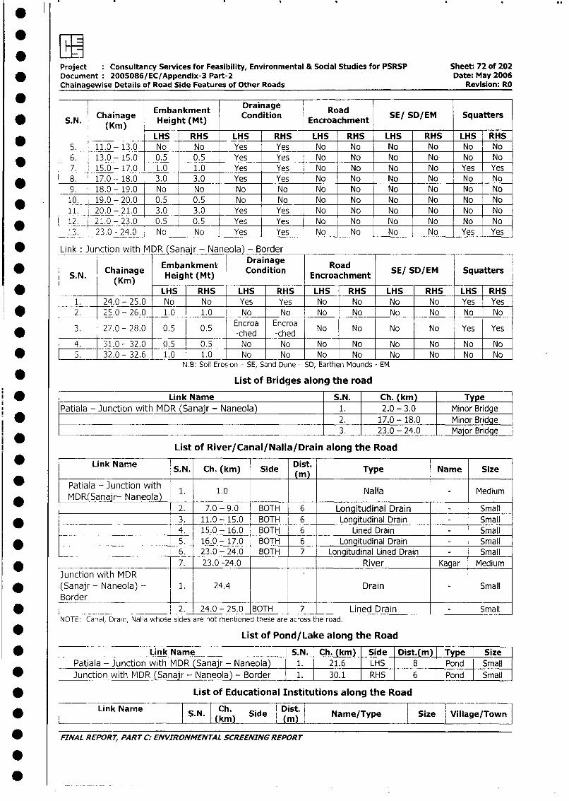
Project Consultancy Services for Feasibility, Environmental & Social Studies for PSRSP Sheet: 72 of 202* Document 2005086/EC/Appendix-3 Part-2 Date: May 2006
Chainagewise Details of Road Side Features of Other Roads Revision: RO
S.Chainage Embankment Drainage Road SE/ SD/EM SquattersS.N. (hKrnag Height (Mt) Cnion Encroachment
LHS RHS LHS RHS LHS RHS LHS RHS LHS RHS5. 11.0- 13.0 No No Yes Yes No No No No No No
* _6. 13.0- 15.0 0.5 0.5 Yes Yes No No No No No No
7. 15.0 - 17.0 1.0 1.0 Yes Yes No No No No Yes Yes8. 17.0 -- 18.0 3.0 3.0 Yes Yes No No No No No No
9. 18.0 - 19.0 No No No No No No No No No No
* 10. 19.0-20.0 0.5 0.5 No No No No No No No No
11. 20.0 - 21.0 3.0 3.0 Yes Yes No No No No No No
* _12. 21.0- 23.0 0.5 0.5 Yes Yes No No No No No No
_.3. 23.0 - 24.0 No _ No Yes Yes No No No No Yes YesLink Junction with MDR (Sana r - Naneola) - Border
DrainageRodS,SDE Sqatr
* S. N. Chainage Embankment Condition road SE/ SD/EM SquattersSN. (Kin) Height (Mt) Ecocmn
*_____ _________ LHS RHS LHS RHS LHS RHS LHS RHS LHS RHS1 2_4.0-25.0 No No Yes Yes No No No No Yes Yes
* L 2. 25.0-26.0 1.0 1.0 No No No No No No No No
* < 3. 27.0 - 28.0 0.5 0.5 Encroa Encroda No No No No Yes Yes
L 4._ 31.0- 32.0 0.5 0.5 No No -No No No No No No
* L 5 32 0-32.6 1.0 1.0 No No No No No No No NoN.B: Soil Erosion - SE, Sand Dune - SD, Earthen Mounds - EM
List of Bridges along the road
* [ Link Name S.N. Ch. km) T ePatiala - Junction with MDR (Sanajr - Naneola) l 1. 2.0 - 3.0 I Minor Bridge
* < | 2. 17.0 - 18.0 Minor Bridge3. 23.0 - 24.0 Major Bridge
List of River/Canal/NalIa/Drain along the Road
L Lirk Name S.N. Ch. (km) Side Dist. Type Name Size
l * | Patiala - Junction with 1. 10 Nalla - Mediuml * | MDR(Sanajr- Naneola) l ll Med
2. 7.0 - 9.0 BOTH 6 Longitudinal Drain - Small| * l 1 3. 11.0 - 15.0 BOTH 6 Longitudinal Drain - Small
4. 15.0 - 16.0 BOTH 6 Lined Drain - Small* _ l 1 5. 16.0 - 17.0 BOTH 6 Longitudinal Drain - Small
6. 23.0 - 24.0 BOTH 7 Longitudinal Lined Drain - Small7. 23.0 -24.0 River Kagar Medium
Junction with MDRI * |(Sanajr - Naneola) -- 1. 24.4 Drain - Small
Border| * < __ _ ___ __ |2. 24.0 - 25.0 BOTH 7 Lined Drain - Small
NOTE: Canal, Drain, Nalla whose sides are not mentioned these are across the road.
List of Pond/Lake along the Road
* [ ___ ~~~~~~~~Link Name |S.N. |Ch. (km)|Sie|Ds.m|Tye| iz
Patiala - Junction with MDR (Sanajr - Naneola) 1. 21.6 LHS 8 Pond Small
* Junction with MDR (Sanajr - Naneola) - Border 1. 30.1 RHS 6 Pond Small
* List of Educational Institutions along the Road
* 5.Link Name | S N.| Ckh i Side | Dist. Name/Type Size Village/wn
_ FINAL REPORT, PARrT C ENVIRONMENTAL SCREENING REPORT
.
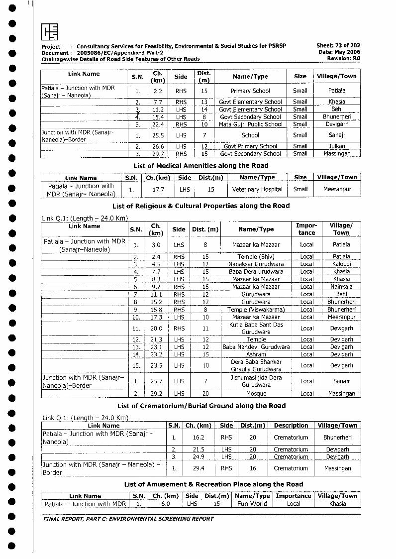
.
Project Consultancy Services for Feasibility, Environmental & Social Studies for PSRSP Sheet: 73 of 202* Document 2005086/EC/Appendix-3 Part-2 Date: May 2006
Chainagewise Details of Road Side Features of Other Roads Revision: RO
Link Name S.N. Ch. Side Dist. Nanie/Type Size Village/Town
Patiala - Junction with MDR 1. 2.2 RHS 15 Primary School Small PatialaJ ~~(Sanajr - Naneola)_ _
2. 7.7 RHS 13 Govt Elementary School Small Khasia_ + 11.2 LHS 14 Govt Elementary School Small Behl
* 4. 15.4 LHS 8 Govt Secondary School Small Bhunerheri5. 22.4 RHS 10 Mata Guiri Public School Small Devigarh
*unction with MDR (Sanajr- 1. 25.5 LHS 7 School Small Sanajr
_ 2. 26.6 LHS 12 Govt Primary School Small Julkan* 3. 29.7 RHS 15 Govt Secondary School Small Massingan
List of Medical Amenities along the Road
Link Name S.N. Ch.(km) Side Dist.(m) Name/Type Size Village/Town
* Patiala - Junction with 1 17.7 LHS 15 Veterinary Hospital Small MeeranpurIMDR (Sanajr- Naneola) 1
* List of Religious & Cultural Properties along the Road
* Link Q.1: (Length - 24.0 Knn)Link Name S.N. Ch. Side Dist. (m) Name/Type Impor- Village/
SN.(kmn) tance TownPatiala - Junction with MDR 1. 3.0 LHS 8 Mazaar ka Mazaar Local Patiala
* (Sanajr-Naneola)2. 2.4 RHS 15 Temple (Shiv) Local Patiala
* __________________________ 3. 4.5 LHS 12 Nanaksar Gurudwara Local Kaloudi4. 7.7 LHS 15 Baba Dera urudwara Local Khasia
* 5. 8.3 LHS 15 Mazaar ka Mazaar Local Khasia6. 9.2 RHS 15 Mazaar ka Mazaar Local Nainkala
* -~ - 7. 11.1 RHS 12 Gurudwara Local Behl_ _____ 8. 15.2 RHS 12 Gurudwara Local Bhunerheri
* - 9. 15.8 RHS 8 Temple (Viswakarma) Local Bhunerheri10. 17.3 LHS 10 Mazaar ka Mazaar Local Meeranpur
11. 20.0 RHS 11 Kutia Baba Sant Das Local Devigarh
* - _ 12. 21.3 LHS 12 Temple Local Devigarh__________ _____~ 13. 23.1 LHS 12 _ Baba Nandev Gurudwara Local Devigarh
*_______________ 14. 23.2 LHS 15 Ashram Local Devigarh
15. 23.5 LHS 10 Dera Baba Shankar Local Devigarh_______ Giraulia Gurudwara
Junction with MDR (Sanajr- 1. 25.7 LHS 7Jishumasi jida Dera Local SanajrNaneola)-Border ___ ____Gurudwara ____ _____
*_______ __________________ 2. 29.2 LHS 20 Mosque Local Massingan
List of Crematorium/Burial Ground along the Road
Link Q. 1: (Length - 24.0 Knn)* | Link Name S.N. Ch. (km) Side Dist.(m) Description Village/Town
Patiala - Junction with MDR (Sanajr - 1. 16.2 RHS 20 Crematorium Bhunerheri* Naneola)
I__ 2. 21.5 LHS 20 Crematorium Devigarh* -_ 3. 24.9 LHS 20 Crematorium Devigarh
Junction with MDR (Sanajr - Naneola) - 1. 29.4 RHS 16 Crematorium Massingan* LBorder _ I I I I _I
* List of Amusement & Recreation Place along the Road
Link Name I S.N. Ch. (km) Side Dist.(m) Name/Type| Importance | Village/Towri* LPatiala - Junction with MDR I 1. 6.0 LHS 15 Fun World Local Khasia
* FINAL REPORT, PART C: ENVIRONMENTAL SCREENING REPORT
.
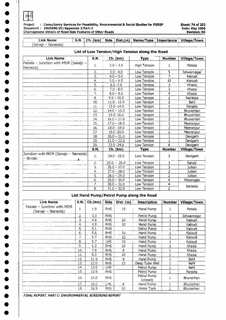
Project Consultancy Services for Feasibility, Environmental & Social Studies for PSRSP Sheet: 74 of 202Document 2005086/EC/Appendix-3 Part-2 Date: May 2006Chainagewise Details of Road Side Features of Other Roads Revision: RO
_ Link Name S.N. Ch. (km) Side Dist.(m) Name/Type Importance Village/Town* (Sanaj Naneola)
List of Low Tension/High Tension along the Road
* ! Link Name S.N. Ch. (km) Type Number Village/Town* Patiala - Junction with MDR (Sanajr - 1. 2.0 - 3.0 High Tension 1 Patiala
Naneola) _* | __ _____________ 2. 3.0 - 4.0 Low Tension 5 Ishwarnagar
3. 4.0 - 5.0 Low Tension 7 Kaloudi* - _ _ 4. 5.0 - 6.0 Low Tension 10 Kaloudi
_______ 5. 6.0 -7.0 Low Tension 3 Khasia* 6. 7.0 - 8.0 Low Tension 3 Khasia
7. 8.0 - 9.0 Low Tension 4 Khasia_ -- -- 8. 9.0 - 10.0 Low Tension 2 Nainkala
_ _____ __ 10. 11.0 - 12.0 Low Tension 2 Behl* 11. 13.0 -14.0 Low Tension 5 Panjeta
12. 14.0 - 15.0 Low Tension 5 Bhunerheri* < _ _= 13. 15.0 -16.0 Low Tension 7 Bhunerheri
14. 16.0 - 17.0 Low Tension 3 Bhunerheri* 15. 17.0 - 18.0 Low Tension 1 Meeranpur
________________ 16. 18.0 - 19.0 Low Tension 3 Meeranpur* 17. 19.0 -20.0 Low Tension 2 Meeranpur
18. 20.0 - 21.0 Low Tension 1 Devigarh_ 19. 21.0 - 22.0 Low Tension 2 Devigarh
20. 23.0 -24.0 Low Tension 6 DevigarhS.N. Ch. (km) Type Number Village/Town
Junction with MDR (Sanajr - Naneola) 1. 24.0 - 25.0 Low Tension 5 DevigarhBorder
2. 25.0 - 26.0 Low Tension 3 Sanajr.__ _ _ 3. 26.0 - 27.0 Low Tension 3 Julkan
_________________________________ 4. 27.0 - 28.0 Low Tension 2 Julkan45. 28.0 - 29.0 Low Tension 2 Julkan6. 29.0 - 30.0 Low Tension 4 Massingan
* _________________________________ 7. 30.0 - 31.0 Low Tension 4 Naneola8. 31.0 - 32.0 Low Tension 2
* List Hand Pump/Petrol Pump along the Road
* [ Link Name S.N. Ch.(km) Side -Dist. (m) Description Number Village/TownPatiala - Junction with MDR 1. 1.9 RHS 15 Hand Pump 1 Patiala
(Sanair - Naneola)| ________________________ 2. 3.3 RHS Petrol Pump 1 Ishwarnagar
0 l 3. 4.8 RHS 10 Hand Pump 1 Kaloudi4. 4.9 RHS 10 Hand Pump 1 Kaloudi
* < 5. 5.1 RHS Petrol Pump 1 Kaloudi6. 5.6 RHS 10 Hand Pump 1 Kaloudi
* -- 7. 5.7 RHS 10 Hand Pump 1 Kaloudi8. 5.7 LHS 10 Hand Pump 1 Kaloudi
* l _9. 6.3 RHS 10 Hand Pump 1 Khasia10. 7.9 RHS 8 Hand Pump 1 Khasia
* t 11. 8.3 RHS 10 Hand Pump 1 Khasia12. 11.9 RHS 8 Hand Pump 1 Behl13. 12.0 RHS 15 Deep Tube Well 1 Behl
l ____________________ 14. 13.0 LHS Petrol Pump 1 Behl* r ____ 15. 13.9 RHS Petrol Pump 1 Panjeta
16. 15.0 RHS Petrol Pump 1 Bhunerheri(closed)
l ____ _____ 17. 15.0 LHS 8 Hand Pump 1 Bhunerheri* L__=____ 18. 16.9 RHS 20 Water Tank 1 Bhunerheri
* FINAL REPORT, PART C: ENVIRONMENTAL SCREENING REPORT
.
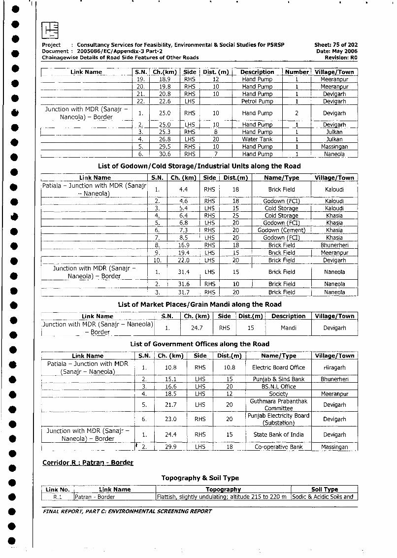
*EI!Project Consultancy Services for Feasibility, Environmental & Social Studies for PSRSP Sheet: 75 of 202Document 2005086/EC/Appendix-3 Part-2 Date: May 2006Chainagewise Details of Road Side Features of Other Roads Revision: RO
* _ _ Link Name S.N. Ch.(km) Side Dist. (m) Description Number Village/Town19. 18.9 RHS 12 Hand Pump 1 Meeranpur
_ __ 20. 19.8 RHS 10 Hand Pump 1 Meeranpur_ __ 21. 20.8 RHS 10 Hand Pump 1 Devigarh
_ _______ 22. 22.6 LHS Petrol Pump 1 Devigarh
* Junction with MDR (Sanajr - 1. 25.0 RHS 10 Hand Pump 2 DevigarhNaneola) - Border I
_ 2. 25.0 LHS 10 Hand Pump 1 Devigarh3. 25.3 RHS 8 Hand Pump 1 Julkan
* 4. 26.8 LHS 20 Water Tank 1 Julkan5. 29.5 RHS 10 Hand Pump 1 Massingan
* _- 6. 30.6 RHS 7 Hand Pump 1 Naneola
List of Godown/Cold Storage/Industrial Units along the Road
* Link Name S.N. Ch. (km) Side Dist.(m) Name/Type Village/Town
* Patiala - Junction with MDR (Sanajr 1. 4.4 RHS 18 Brick Field Kaloudi- Naneola)
* 2. 4.6 RHS 18 Godown (FCI) Kaloudi_ 3. 5.4 LHS 15 Cold Storage _ Kaloudi
* 4. 6.4 RHS 25 Cold Storage Khasia5. 6.8 LHS 20 Godown (FCI) Khasia
* 6. 7.3 RHS 20 Godown (Cement) Khasia7. 8.5 LHS 20 Godown (FCI) Khasia
* ______ 8. 16.9 RHS 18 Brick Field Bhunerheri
9. 19.4 LHS 15 Brick Field Meeranpur* - 10. 22.0 LHS 20 Brick Field Devigarh
Junction with MDR (Sanajr - 1. 31.4 LHS 15 Brick Field NaneolaNaneola) - Border _ _
_________________________________ 2. 31.6 RHS 10 Brick Field Naneola
* _______________________________ 3. 31.7 RHS 20 Brick Field Naneola
* List of Market Places/Grain Mandi along the Road
* l _ __ Link Name S.N. Ch. (km) Side Dist.(m) Description Village/Town
Junction with MDR (Sanajr - Naneola) 1. 24.7 RHS 15 Mandi Devigarh* _____ - Border _ I_ _
List of Government Offices along the Road
Link Name S.N. Ch. (km) Side Dist.(m) Name/Type Village/Town
* | Patiala - Junction with MDR 1. 10.8 RHS 10.8 Electric Board Office riragarh(Sanajr - Naneola) l _ l_l_l_l
* j _ l 2. 15.1 LHS 15 Punjab & Sind Bank Bhunerheri| 3. 16.6 LHS 20 BS.N.L Office
* l 1 4. 18.5 LHS 12 Society Meeranpur
5. 21.7 LHS 20 Guthmara Prabanthak Devigarh* ~~~~~~~~~~~~~~~~~~~~Committee
6. 23.0 RHS 20 Punjab Electricity Board Devigarh__-_______ (Subst tion)
Junction with MDR (Sanajr - 1. 24.4 RHS 15 State Bank of India Devigarh*-- Naneola - Border
* 2. 29.9 LHS 18 Co-operative Bank Massingan
Corridor R: Patran - Border
Topography & Soil Type
* | Link No. | Link Name | Topography Soil Type* L R.1 lPatran - Border IFlattish slightly undulating; altitude 215 to 220 m ISodic & Acidic Soils and
* FINAL REPORT, PART C; ENVIRONMENTAL SCREENING REPORT
0~
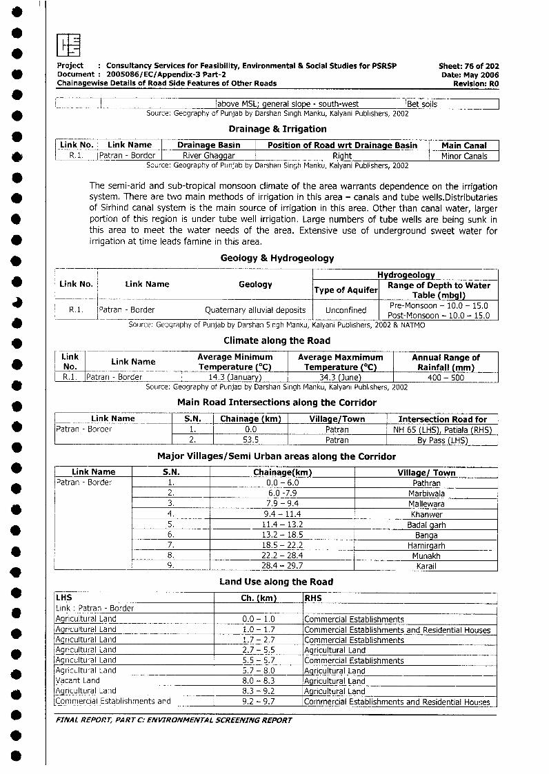
Project Consultancy Services for Feasibility, Environmental & Social Studies for PSRSP Sheet: 76 of 202Document 2005086/EC/Appendix-3 Part-2 Date: May 2006Chainagewise Details of Road Side Features of Other Roads Revision: RO
above MSL; general slope - south-west |Bet soilsSource: Geography of Punjab by Darshan Singh Manku, Kalyani Publishers, 2002
Drainage & Irrigation
Link No. | Link Name Drainage Basin Position of Road wrt Drainage Basin Main Canal* | R.. |Patran - Border I River Ghaggar I Right Minor Canals
Source: Geography of Punjab by Darshan Singh Manku, Kalyani Publishers, 2002
The semi-arid and sub-tropical monsoon climate of the area warrants dependence on the irrigationsystem. There are two main methods of irrigation in this area - canals and tube wells.Distributariesof Sirhind canal system is the main source of irrigation in this area. Other than canal water, larger
* portion of this region is under tube well irrigation. Large numbers of tube wells are being sunk inthis area to meet the water needs of the area. Extensive use of underground sweet water for
* irrigation at time leads famine in this area.
* Geology & Hydrogeology
Hydrogeology* Link No. Link Name Geology Type ofange of Depth to Water
_________________________Type_of_Aquifer Table (mbgl)
R.i. IPatran - Border Quaternary alluvial deposits Unconfined PeMnon-1.-1.________ __________________________________________Post-Monsoon - 10.0 - 15.0
Source: Geography of Punjab by Darshan Singh Manku, Kalyani Publishers, 2002 & NATMO
* __ Climate along the Road
ink L ink Name Average Minimum Average Maxmimum Annual Range of* No. Link Name.Temperature (0C) Temperature (°C) Rainfall (mm)
R.1. Patran - Border 14.3 (January) _ 34.3 (June) 400- 500et Source: Geography of Punjab by Darshan Singh Manku, Kalyani Publishers, 2002
Main Road Intersections along the Corridor
Link Name S.N. Chainage (km) Village/Town Intersection Road forv Patran - Border 1. 0.0 Patran NH 65 (LHS), Patiala (RHS)
2. 53.5 Patran By Pass (LHS)
Major Villages/Semi Urban areas along the Corridor
* _ Link Name S.N. Chainage(km) Village/ Town|Patran - Border 1. 0.0 - 6.0 Pathran
* 2. 6.0 -7.9 Marbiwala3. 7.9 - 9.4 Mallewara
_ 4. 9.4- 11.4 Khanwer5. 11.4 - 13.2 Badal garh
_ 6. 13.2 - 18.5 Banga7. 18.5 - 22.2 Hamirgarh
* 8. 22.2 - 28.4 Munakh*___ _ _________ 9. 28.4 - 29.7 Karail
Land Use along the Road
_ LHS Ch. (km) RHSLink: Patran - BorderAgricultural Land 0.0 - 1.0 Commercial Establishments
~ Agricultural Land _ 1.0 - 1.7 Commercial Establishments and Residential HousesAgqricultural Land 1.7 - 2.7 Commercial EstablishmentsAgricultural Land 2.7 - 5.5 Agricultural LandAgricultural Land 5.5 - 5.7 Commercial Establishments
v Agrcu_ural Land 5.7 - 8.0 Agricultural LandVacant Land 8.0 - 8.3 Agricultural Land
* Agricultural Land 8.3 - 9.2 Agricultural LandCommercial Establishments and 9.2 - 9.7 Commercial Establishments and Residential Houses
_ FINAL REPORT, PART C: ENVIRONMENTAL SCREENING REPORT
.
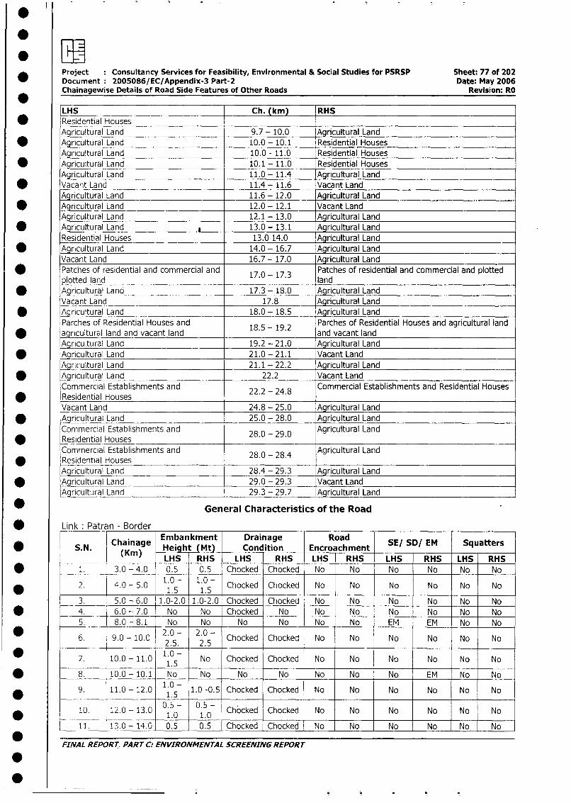
Project : Consultancy Services for Feasibility, Environmental & Social Studies for PSRSP Sheet: 77 of 202Document: 2005086/EC/Appendix-3 Part-2 Date: May 2006Chainagewise Details of Road Side Features of Other Roads Revision: RO
LHS Ch. (km) RHS* Residential Houses
Agricultural Land 9.7 - 10.0 Agricultural Land* Agricultural Land 10.0 - 10.1 Residential Houses
Agricultural Land 10.0 - 11.0 Residential Houses* Agricultural Land 10.1 - 11.0 Residential Houses
Agricultural Land 11.0 - 11.4 Agricultural Land* Vacant Land 11.4- 11.6 Vacant Land
Agricultural Land 11.6 - 12.0 Agricultural Land
* Agricultural Land 12.0 - 12.1 Vacant LandAgricultural Land 12.1 - 13.0 Agricultural Land
* Agricultural Land 13.0- 13.1 Agricultural LandResidential Houses 13.0 14.0 Agricultural Land
* Agricultural Land 14.0 - 16.7 Agricultural LandVacant Land 16.7 - 17.0 Agricultural Land
* Patches of residential and commercial and 17.0 - 17.3 Patches of residential and commercial and plottedplotted land land
* Agricultural Land 17.3 - 18.0 Agricultural LandVacant Land 17.8 Agricultural Land
* Agricultural Land 18.0 - 18.5 Agricultural LandParches of Residential Houses and 18 - 19.2 Parches of Residential Houses and agricultural land
* agricultural land and vacant land . . and vacant landAgricultural Land 19.2 - 21.0 Agricultural Land
* Agricultural Land 21.0 - 21.1 Vacant LandAgricultural Land 21.1 - 22.2 Agricultural Land
* Agricultural Land 22.2 Vacant LandCommercial Establishments and 22.2 24.8 Commercial Establishments and Residential Houses
* Residential Houses . - .Vacant Land 24.8- 25.0 Agricultural Land
* Agnicultural Land 25.0 - 28.0 Agricultural LandCommercial Establishments and 28.0 - 29.0 Agricultural Land
* Residential HousesCommercial Establishments and 28.0 - 28.4 Agricultural LandResidential Houses ___Agricultural Land 28.4 - 29.3 Agricultural Land
* Aqricultural Land 29.0 - 29.3 Vacant LandAgricultural Land 29.3 - 29.7 Agricultural Land
_ General Characteristics of the Road
Link: Patran - Border
* S.N. Chain ainage road SE/ SD/ EM SquattersS. N. (Km) Height (Mt) Condition Encroachment
(Kin) LHS RHS LHS RHS LHS RHS LHS RHS LHS RHS* = 1. 3.0 - 4.0 0.5 0.5 Chocked Chocked No No No No No No
2. 4.0 - 5.0 1.0 - 1.0 - Chocked Chocked No No No No No No* _________ ~~~~~1.5 1.5 _ _ _ _ _ _
3. 5.0 - 6.0 1.0-2.0 1.0-2.0 Chocked Chocked No No No No No No* _ _4. 6.0 - 7.0 No No Chocked No No No No No No No
5. 8.0 - 8.1 No No _ No No No No EM EM No No
6. 9.0 - 10.0 2 0 - 2.0 - Chocked Chocked No No No No No No2.5. 2.5
7. 10.0 - 11.0 1.0- No Chocked Chocked No No No No No No_ _ _ _ _ _ _ _ _ _ 1 .5 _ _ _
* 8. _ 10.0- 10.1 No No No No No No No EM No No
* 9. 11.0 - 12.0 1.0- 1.0 -0.5 Chocked Chocked No No No No No No__________1.5
10. 12.0- 13.0 0.50 0 Chocked Chocked No No No No No No* _ _ _ _ _ _ _ _ _ _ _ _ _ _ _ _ _ 1 .0 1 . _ _ _ _ _ _ _ _ _ _ _
_ 11. | 13.0 - 14.0 0.5 0.5 Chocked Chocked No No No No No No
FINAL REPORT PART C: ENVIRONMENTAL SCREENING REPORT
.
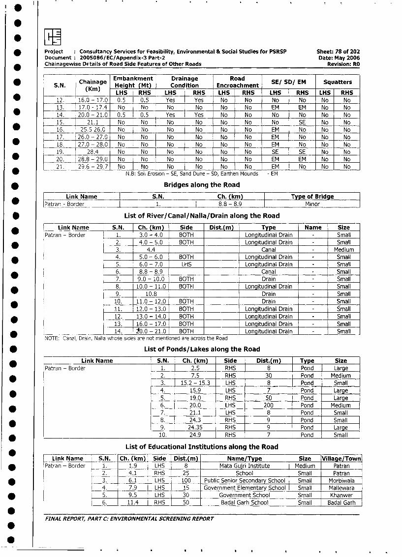
*
* Project Consultancy Services for Feasibility, Environmental & Social Studies for PSRSP Sheet: 78 of 202
Document 2005086/EC/Appendix-3 Part-2 Date: May 2006
_ Chainagewise Details of Road Side Features of Other Roads Revision: RO
* S N )Chah ag Embankment Drainage Road SE/ SD/ EM Squatters0 ~~~~S. N. Cainiage Height (Mt) Condition Encroachment S/S/E qatr
(Km) LHS RHS LHS RHS LHS RHS LHS RHS LHS RHS
_ ~~~~12._ 16.0 - 17.0 0.5 0.5 Yes Yes No No No No No No
13. 17.0 - 17.4 No No No No No No EM EM No No
* 14. 20.0 - 21.0 0.5 0.5 Yes Yes No No No No No No
15. 21.1 No No No No No No No SE No No
* _ 16. 25.5 26.0 No No No No No No EM No No No
* 17. 26.0 - 27.0 No No No No No No EM No No No
18. 27.0 - 28.0 No No No No No No EM No No No
19. 28.4 No No No No No No SE SE No No
_ 20. 28.8 - 29.0 No No No No No No EM EM No No
2____1. 29.6 - 29.7 No_ No No No No No EM No No NoN.B: Soil Erosion - SE, Sand Dune - SD, Earthen Mounds - EM
* Bridges along the Road
* |atran -Link Name S.N. Ch. (km) Type of Bridge
Patran - Border 1. l 8.8 - 8.9 Minor
* List of River/Canal/Nalla/Drain along the Road
* Link Name S.N. Ch. (km) Side Dist.(m) Type Name Size
Patran - Border 1. 3.0 - 4.0 BOTH Longitudinal Drain - Small
* 2. 4.0 - 5.0 BOTH Longitudinal Drain - Small
3. 4.4 Canal - Medium
* 4. 5.0 - 6.0 BOTH Longitudinal Drain - Small
5. 6.0 - 7.0 LHS Longitudinal Drain - Small
6. 8.8 - 8.9 Canal - Small
7. 9.0 - 10.0 BOTH Drain - Small
8. 10.0 - 11.0 BOTH Longitudinal Drain - Small
9. 10.8 . Drain - Small
, 10. 11.0- 12.0 BOTH Drain - Small
11. 12.0 - 13.0 BOTH Longitudinal Drain - Small
* 12. 13.0 - 14.0 BOTH Longitudinal Drain - Small
13. 16.0 - 17.0 BOTH Longitudinal Drain - Small
14. 20.0 - 21.0 BOTH _ Longitudinal Drain - Small
NOTE: Canal, Drain, Nalla whose sides are not mentioned are across the Road
* List of Ponds/Lakes along the Road
Patr*n - Link Name S.N. Ch. (km) Side Dist.(m) Type Size
Patran - Border 1. 2.5 RHS 8 Pond Large
2. 7.5 RHS 30 Pond Medium
3. 15.2 - 15.3 LHS 8 Pond Small
4. 15.9 LHS 7 Pond Large
5. 19.0 RHS 50 Pond Large
6. 20.0 LHS 200 Pond Medium
* | | 7. 21.1 LHS 8 Pond Small
8. 24.3 RHS 9 Pond Small
* |9. 24.35 RHS 9 Pond Large
* t _ | 10. 24.9 RHS 7 Pond Small
List of Educational Institutions along the Road
* Link Name S.N. Ch. (km) Side Dist.(m) Name/Type Size Village/Town
* IPatran - Border 1. 1.9 LHS 8 Mata Gujri Institute Medium Patran
2. 4.1 RHS - 25 School - Small Patran
* I | 3. 6.1 LHS 100 Public Senior Secondary School l Small Morbiwala
_ | L 4. | 7.9 LHS | 15 lGovernment Elementary School | Small Mallewara
* . | | 5. 9.5 LHS 30 Government School | Small Khanwer
6. 11.4 RHS 50 | Badal Garh School | Small Badal Garhr
0FINAL REPORT, PART C: ENVIRONMENTAL SCREENING REPORT
*
0 ~ ~ ~ . ... .
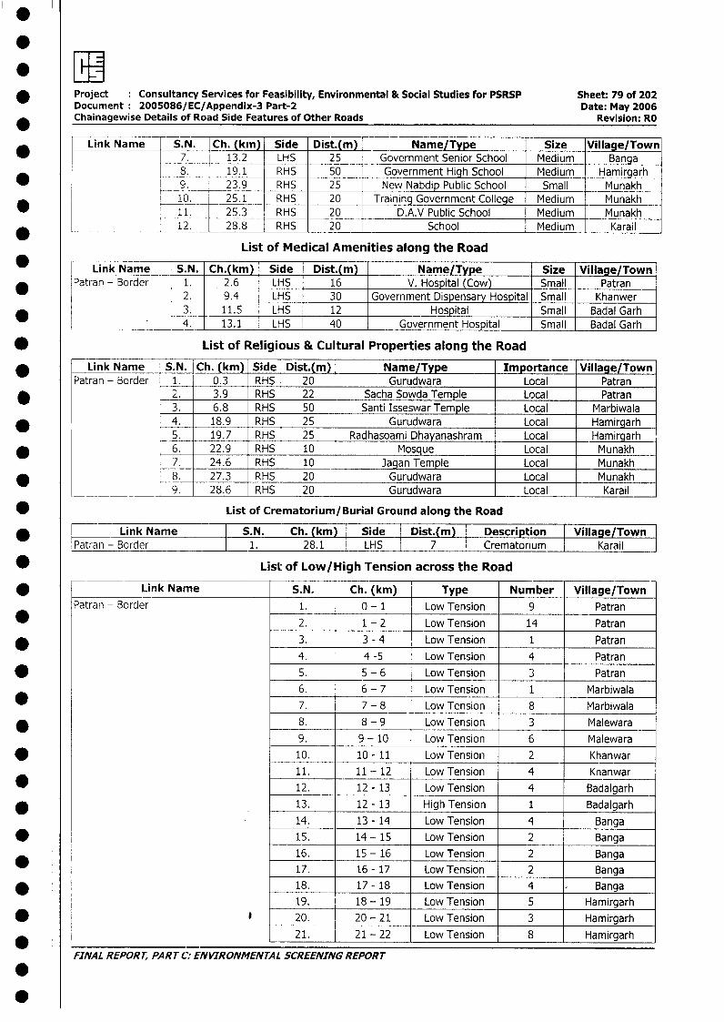
.
* Project Consultancy Services for Feasibility, Environmental & Social Studies for PSRSP Sheet: 79 of 202Document 2005086/EC/Appendix-3 Part-2 Date: May 2006
* Chainagewise Details of Road Side Features of Other Roads Revision: RO
* | Link Name S.N. Ch. (km) Side Dist.(m) Name/Type Size Village/Town7. 13.2 LHS 25 Government Senior School Medium Banga
*8. 19.1 RHS 50 Government High School Medium Hamirgarh90. 23.9 RHS 25 New Nabdip Public School Small Munakh10. 25.1 RHS 20 Training Government College Medium Munakh
* r 11. 25.3 RHS 20 D.A.V Public School Medium Munakh12. 28.8 RHS 20 School Medium Karail
List of Medical Amenities along the Road
Link Name S.N. Ch.(km) Side Dist.(m) Name/Type Size Village/Town* Patran - Border 1. 2.6 LHS 16 V. Hospital (Cow) Small Patran
2. 9.4 LHS 30 Government Dispensary Hospital Small Khanwer3. 11.5 LHS 12 Hospital Small Badal Garh* 4. 13.1 LHS 40 Government Hospital Small Badal Garh
* List of Religious & Cultural Properties along the Road
* Link Name S.N. Ch. (km) Side Dist.(m) Name/Type Importance Village/TownPatran - Border 1. 0.3 RHS 20 Gurudwara Local Patran
* 2. 3.9 RHS 22 Sacha Sowda Temple Local Patran3. 6.8 RHS 50 Santi Isseswar Temple Local Marbiwala
* 4. 18.9 RHS 25 Gurudwara Local Hamirgarh5. 19.7 RHS 25 Radhasoami Dhayanashram Local Hamirgarh
* 6. 22.9 RHS 10 Mosque Local Munakh7. 24.6 RHS 10 Jagan Temple Local Munakh8. 27.3 RHS 20 Gurudwara Local Munakh
____ 9. 28.6 RHS 20 Gurudwara Local Karail
* List of Crematorium/Burial Ground along the Road
Link Name S.N. I Ch. (km) I Side I Dist.(m) I Description Village/TownIPatran - Border I 1. 1 28.1 1 LHS 1 7 1 Crematorium I Karail J
* List of Low/High Tension across the Road
* __________Link Name S.N. Ch. (km) Type Number Village/TownPatran - Border 1. 0 - 1 Low Tension 9 Patran
* 2. 1 - 2 Low Tension 14 Patran* 3. 3 - 4 Low Tension 1 Patran
4. 4 -5 Low Tension 4 Patran* 5. 5 - 6 Low Tension | Patran
6. 6 - 7 Low Tension 1 Marbiwala7. 7 - 8 Low Tension 8 Marbiwala
* 8. 8 - 9 Low Tension 3 Malewara9. 9 - 10 Low Tension 6 Malewara
* 10. 10 - 11 Low Tension 2 Khanwar11. 11 - 12 Low Tension 4 Knanwar
* 12. 12 - 13 Low Tension 4 Badalgarh* . 13. 12 - 13 High Tension 1 Badalgarh
14. 13 - 14 Low Tension 4 Banga* 15. 14 - 15 LowTension 2 Banga
16. 15 - 16 Low Tension 2 Banga17. 16 - 17 Low Tension 2 Banga
* l 18. 17 - 18 Low Tension 4 - Banga19. 18 - 19 Low Tension 5 Hamirgarh
* j 20. 20 - 21 Low Tension] 3 Hamirgarh21. 21 - 22 Low Tension 8 Hamirgarh
FINAL REPORT, PART C: ENVIRONMENTAL SCREENING REPORT
0
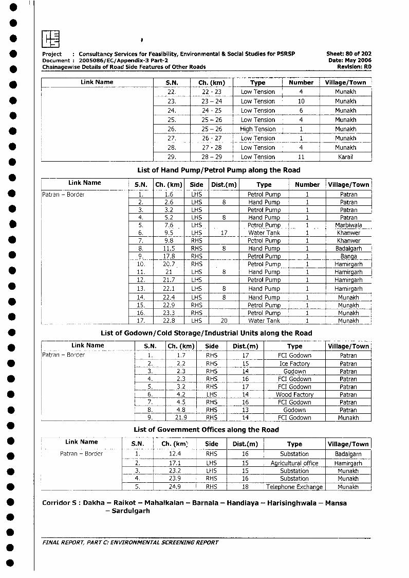
* Project Consultancy Services for Feasibility, Environmental & Social Studies for PSRSP Sheet: 80 of 202Document 2005086/EC/Appendix-3 Part-2 Date: May 2006
* Chainagewise Details of Road Side Features of Other Roads Revision: RO
* K Link Name S.N. Ch. (km) Type Number Village/Town22. 22 - 23 Low Tension 4 Munakh
* 23. 23 - 24 Low Tension 10 Munakh24. 24 - 25 Low Tension 6 Munakh25. 25 - 26 Low Tension 4 Munakh
* l 26. 25 - 26 High Tension 1 Munakh27. 26 - 27 Low Tension 1 Munakh
* = 28. 27 - 28 Low Tension 4 Munakh* ____________________________ 29. 28 - 29 Low Tension 11 Karail
List of Hand Pump/Petrol Pump along the Road
Link Name S.N. Ch. (km) Side Dist.(m) Type Number Village/Town* Patran - Border 1. 1.6 LHS Petrol Pump 1 Patran
2. 2.6 LHS 8 Hand Pump 1 Patran* 3. 3.2 LHS Petrol Pump 1 Patran
4. 5.2 LHS 8 Hand Pump 1 Patran* 5. 7.6 LHS Petrol Pump 1 Marbiwala
6. 9.5 LHS 17 Water Tank 1 Khanwer* 7. 9.8 RHS Petrol Pump 1 Khanwer
8. 11.5 RHS 8 Hand Pump 1 Badalgarh* [ 9. 17.8 RHS Petrol Pump 1 Banga
10. 20.7 RHS Petrol Pump 1 Hamirgarh* 11. 21 LHS 8 Hand Pump 1 Hamirgarh
12. 21.7 LHS Petrol Pump 1 Hamirgarh* 13. 22.1 LHS 8 Hand Pump 1 Hamirgarh
14. 22.4 LHS 8 Hand Pump 1 Munakh15. 22.9 RHS Petrol Pump 1 Munakh16. 23.3 RHS Petrol Pump 1 Munakh
___________________ ____ 17. 22.8 LHS 20 Water Tank 1 Munakh
* List of Godown/Cold Storage/Industrial Units along the Road
* , Link Name S.N. Ch. (km) Side Dist.(m) Type Village/TownPatran - Border 1. 1.7 RHS 17 FCI Godown Patran
* 2. 2.2 RHS 15 Ice Factory Patran3. 2.3 RHS 14 Godown Patran
* 4. 2.3 RHS 16 FCI Godown Patran5. 3.2 RHS 17 FCI Godown Patran
* 6. 4.2 LHS 14 Wood Factory Patran7. 4.5 RHS 16 FCI Godown Patran
* 8. 4.8 RHS 13 Godown Patran9. 21.9 RHS 14 FCI Godown Munakh
_ List of Government Offices along the Road
* Link Name S.N. Ch. (km' Side Dist.(m) Type Village/Town|
* Patran - Border 1. 12.4 RHS 16 Substation Badalgarn2. 17.1 LHS | 15 - Agricultural office Hamirgarh
* l 3. 23.2 LHS | 15 - Substation Munakh4. 23.9 RHS 16 Substation Munakh
* _ _ __ ___ 5. j 24.9 j RHS | 18 Telephone Exchange Munakh
* Corridor S: Dakha - Raikot - Mahalkalan - Barnala - Handiaya - Harisinghwala - Mansa-Sardulgarh
FINAL REPORT, PART C: ENVIRONMENTAL SCREENING REPORT
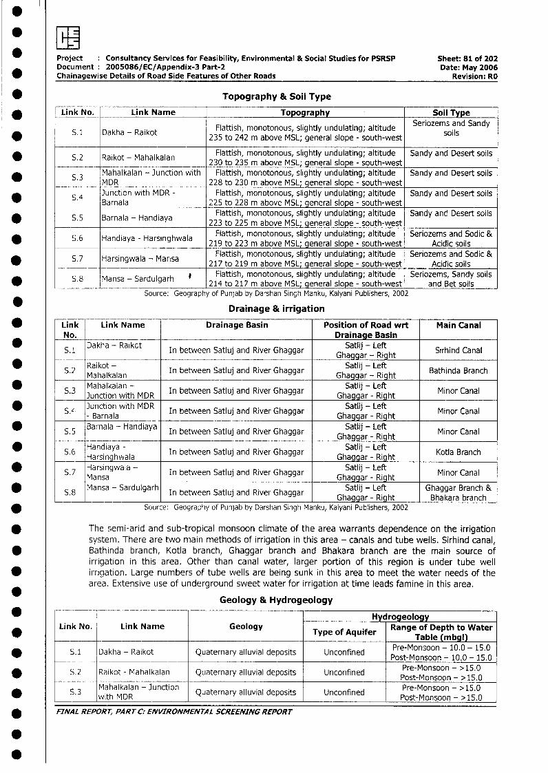
Project Consultancy Services for Feasibility, Environmental & Social Studies for PSRSP Sheet: 81 of 202Document 2005086/EC/Appendix-3 Part-2 Date: May 2006
* Chainagewise Details of Road Side Features of Other Roads Revision: RO
* Topography & Soil Type
* Link No. Link Name Topography Soil Type
5.1 Dakha - Raikot Flattish, monotonous, slightly undulating; altitude Seriozems and Sandyal ot 235 to 242 m above MSL; general slope - south-west soils
* S.2 Raikot - Mahalkalan Flattish, monotonous, slightly undulating; altitude Sandy and Desert soils_ ___________ 230 to 235 m above MSL; general slope - south-west
* S.3 Mahalkalan - Junction with Flattish, monotonous, slightly undulating; altitude Sandy and Desert soilsMDR 228 to 230 m above MSL; general slope - south-westJunction with MDR - Flattish, monotonous, slightly undulating; altitude Sandy and Desert soils
_ __ _S Barnala 225 to 228 m above MSL; general slope - south-west. Barnla-HandayFlattish, monotonous, slightly undulating; altitude Sandy and Desert soils* S.5 Barnala - Handiaya 223 to 225 m above MSL; general slope - south-west
Flattish, monotonous, slightly undulating; altitude Seriozems and Sodic &* S.6 Handiaya - Harsinghwala 219 to 223 m above MSL; general slope - south-west Acidic soils
Flattish, monotonous, slightly undulating; altitude Seriozems and Sodic &* S.7 Harsingwala - Marisa 217 to 219 m above MSL; general slope - south-west Acidic soils
S.8 Mansa - Sardulgarh Fiattish, monotonous, slightly undulating; altitude Seriozems, Sandy soilsansa - ar u gar 214 to 217 m above MSL; general slope - south-west and Bet soils
Source: Geography of Punjab by Darshan Singh Manku, Kalyani Publishers, 2002
Drainage & irrigation
* Link Link Name Drainage Basin Position of Road wrt Main CanalNo. Drainage Basin
S.1 Dakha - Raikct In between Satluj and River Ghaggar Ghaggar - Right Sirhind Canal* Raikot - S~~~~~~~~~~~~~~Gatgar - Lefht
S.2 Raikot - In between Satluj and River Ghaggar Ghaggar - Right Bathinda Branch* S.3 ~~~Mahalkalan -Ibewe aujadRvrGgar Ghaggar - RightMioCalMahalkalan - Satlij - Left
*S.3 Junction with MDR In between Satluj and River Ghaggar Ghaggar - Right Minor Canal
* S unctiona with MDRala In between Satluj and River Ghaggar Ghaggar - Right Minor Canal
* S.6 Barnala - Handiaya In between Satluj and River Ghaggar Satlij - Left Kor CanalGhaggar - RightMioCal
S.6 Harngala In between Satluj and River Ghaggar Ghaggar - Right Kotla Branch
* ~~~S.7 Harsingwala - In between SaljadRie hga Satlij - Left Minor CanalMa nsa adRvr Ghaggar - RightMansa - Sardulgarh In between Satluj and River Ghaggar Satlij - Left Ghaggar Branch &
S.8 In between Satluj and RiverGhaggar_ Ghaggar - Right Bhakara branch* Source: Geography of Punjab by Darshan Singh Manku, Kalyani Publishers, 2002
* The semi-arid and sub-tropical monsoon climate of the area warrants dependence on the irrigationsystem. There are two main methods of irrigation in this area - canals and tube wells. Sirhind canal,
* Bathinda branch, Kotla branch, Ghaggar branch and Bhakara branch are the main source ofirrigation in this area. Other than canal water, larger portion of this region is under tube well
* irrigation. Large numbers of tube wells are being sunk in this area to meet the water needs of thearea. Extensive use of underground sweet water for irrigation at time leads famine in this area.
Geology & Hydrogeology
_ Hy rogeologyLink No. Link Name Geology Type of Aquifer Range of Depth to Water
_______ _ _______________ Table (m bgl)
*S. 1 Dakha - Raikot Quaternary alluvial deposits Unconfined Pre-Monsoon - 10.0 - 15.05.1 ~~~~~~~~~~~~~~~~~~~Post-Monsoon - 10.0 - 15.0
* S.2 Raikot - Mahalkalan Quaternary alluvial deposits Unconfined Pre-Monsoon - >15.0
* _ __ wMahaMkalan - Junction Quaternary alluvial deposits Unconfined Pre-Monsoon - >15.0
* FINAL RFPORT, PARTC: ENVIRONMENTAL SCREENING REPORT
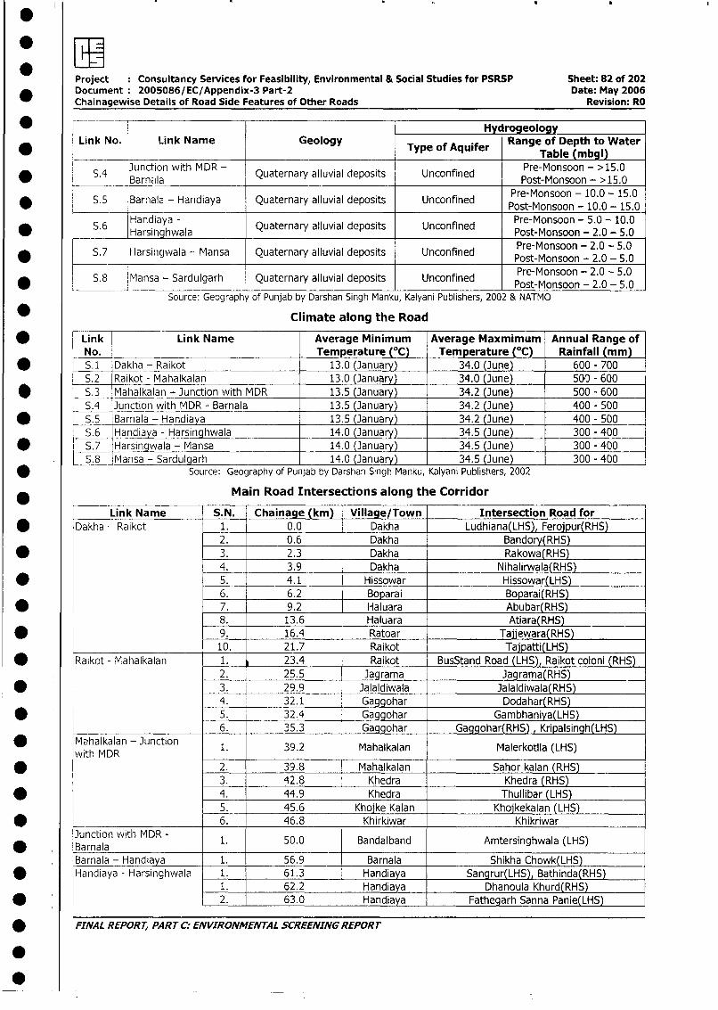
Project : Consultancy Services for Feasibility, Environmental & Social Studies for PSRSP Sheet: 82 of 202Document 2005086/EC/Appendix-3 Part-2 Date: May 2006Chainagewise Details of Road Side Features of Other Roads Revision: RO
* -__ I ____Hy rogeologyLink No. Link Name j Geology Range of Depth to Water
* ________ _________________ ~~~~~~Type of Aquifer Table (mbgl)
S* Juc Barn wMla Quaternary alluvial deposits Unconfined Pre-Monsoon - >15.0__JarnMa ~~~~~~~~~~~~~~~Pose-Monsoon -100>15.0
* S.5 Barnala - Handiaya Quaternary alluvial deposits Unconfined Post-Monsoon - 10.0 - 15.0
* 5.6 ~~~~~~~~~~~~~~~~~~~~~~Post-Monsoon - 20.0 - 15.0*_S.6 Handiaya - Quaternary alluvial deposits Unconfined PeMsoo - .0 - 0
Harsiii hwala ~~~~~~~~~~~~Pret-Monsoon - 2.0 - 5.0S.7 Harsi ngwala - Mansa Quaternary alluvial deposits Unconfined Pre-Monsoon - 2.0 - 5.0
Pret-Monsoon - 2.0 - 5.0* S.8 Mansa - Sardulgarh Quaternary alluvial deposits Unconfined Pre-Monsoon - 2.0 - 5.0
Source: Geography of Punjab by Darshan Singh Manku, Kalyani Publishers, 2002 & NATMO
* Climate along the Road
* Link Link Name Average Minimum Average Maxmimum Annual Range ofNo. Temperature (°C) Temperature (°C) Rainfall (mm)
* S.1 Dakha - Raikot 13.0 (January) 34.0 (June) 600 - 700S.2 Raikot - Mahalkalan 13.0 (January) 34.0 (June) 500 - 600
* S.3 Mahalkalan - Junction with MDR 13.5 (January) 34.2 (June) 500 - 600S.4 Junction with MDR- Barnala 13.5 (January) 34.2 (June) 400 - 500
* - S.5 Barnala - Handiaya 13.5 (January) 34.2 (June) 400 - 500S.6 Handiaya - Harsinghwala 14.0 (January) 34.5 (June) 300 - 400
* _-S.7 Harsingwala - Mansa 14.0 (January) 34.5 (June) 300 - 4005.8 Mansa - Sardulgarh 14.0 (January) 34.5 (June) 300 - 400
* Source: Geography of Punjab by Darshan Singh Manku, Kalyani Publishers, 2002
Main Road Intersections along the Corridor
Link Name S.N. Chainage (km) Village/Town Intersection Road for* Dakha - Raikot 1. 0.0 Dakha Ludhiana(LHS), Ferojpur(RHS)
2. _ 0.6 Dakha Bandory(RHS)* 3. 2.3 Dakha Rakowa(RHS)
4. 3.9 Dakha Nihalirwala(RHS)* 5. 4.1 Hissowar Hissowar(LHS)
6. 6.2 Boparai Boparai(RHS)* 7. 9.2 Haluara Abubar(RHS)
8. 13.6 Haluara Atiara(RHS)* _9. 16.4 Ratoar Taijewara(RHS)
10. 21.7 Raikot Tajpatti(LHS)* Raikot - Mahalkalan 1. 23.4 Raikot BusStand Road (LHS), Raikot coloni (RHS)
2. 25.5 Jagrama Jagrama(RHS)* 3. 29.9 Jalaldiwala Jalaldiwala(RHS)
4. 32.1 Gaggohar Dodahar(RHS)* 5. 32.4 Gaggohar Gambhaniya(LHS)
6. 35.3 Gaggohar Gaggohar(RHS) , Kripalsingh(LHS)* Mafhalkalan - Junction 1. 39.2 Mahalkalan Malerkotila (LHS)
with MDR* 2. 39.8 Mahalkalan Sahor kalan (RHS)
3. 42.8 Khedra Khedra (RHS)* 4. 44.9 Khedra Thullibar (LHS)
5. 45.6 Khoike Kalan Kholkekalan (LHS)* K 6. 46.8 Khirkiwar Khikriwar
* BJunction wit MDR - 1. 50.0 Bandalband Amtersinghwala (LHS)
Barnala - Handiaya 1. 56.9 Barnala Shikha Chowk(LHS)* Handiaya - Harsinghwala | 1. 61.3 Handiaya Sangrur(LHS), Bathinda(RHS)
1. 62.2 Handiaya Dhanoula Khurd(RHS)* - 2. 63.0 Handiaya Fathegarh Sanna Panie(LHS)
* FINAL REPORT, PART C: ENVIRONMENTAL SCREENING REPORT
S~
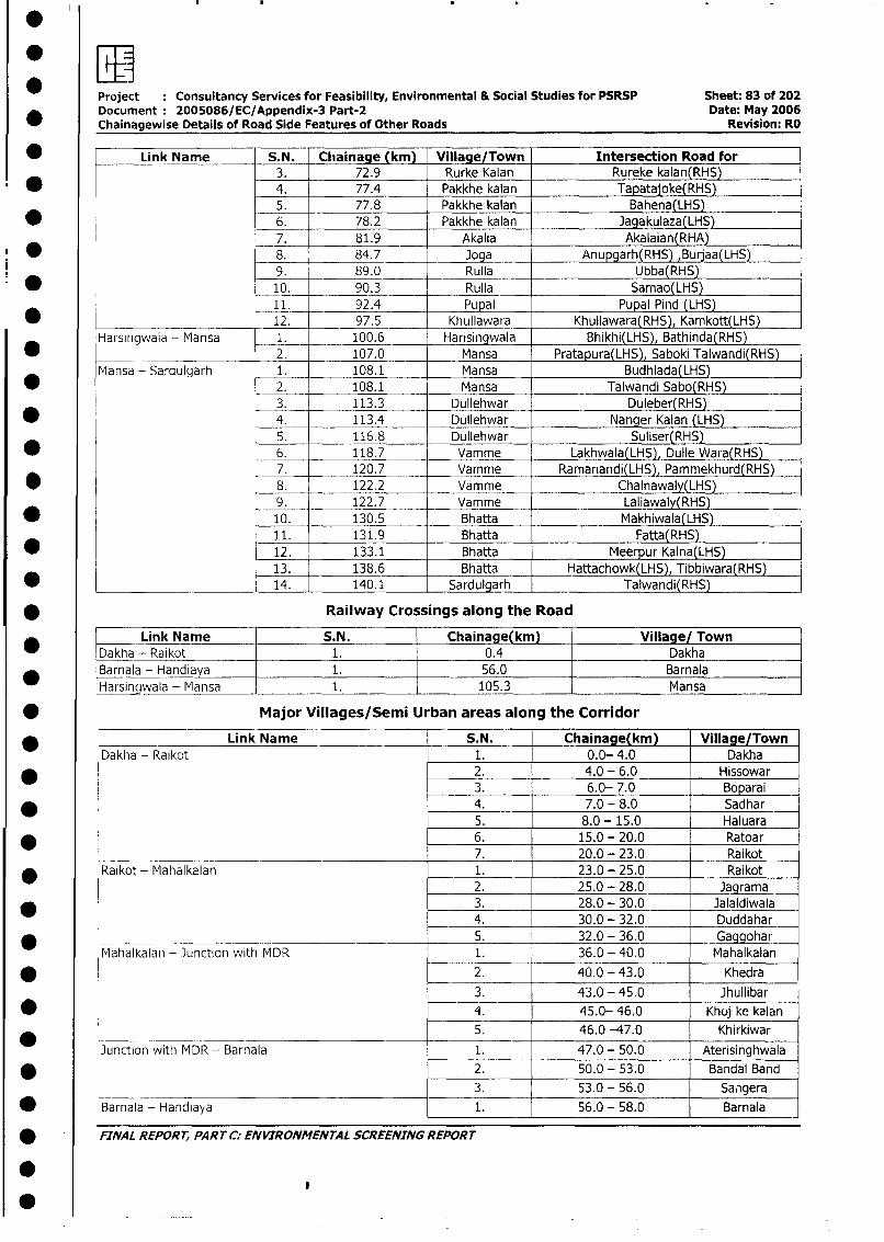
Project Consultancy Services for Feasibility, Environmental & Social Studies for PSRSP Sheet: 83 of 202Document 2005086/EC/Appendix-3 Part-2 Date: May 2006Chainagewise Details of Road Side Features of Other Roads Revision: RO
* Link Name S.N. Chainage (km) Village/Town Intersection Road for3. 72.9 Rurke Kalan Rureke kalan(RHS)
* 4. 77.4 Pakkhe kalan Tapatajoke(RHS)5. 77.8 Pakkhe kalan Bahena(LHS)
* 6. 78.2 Pakkhe kalan Jagakulaza(LHS)7. 81.9 Akalia Akalaian(RHA)
* 8. 84.7 _ Joga Anupgarh(RHS) Buraa(LHS)9. 89.0 Ruila Ubba(RHS)
* l 10. _ 90.3 Rulla Samao(LHS)11. 92.4 Pupal Pupal Pind (LHS)
*______________________ 12. 97.5 Khullawara Khullawara(RHS), Kamkott(LHS)
Harsingwala - Mansa 1. 100.6 Harisingwala Bhikhi(LHS), Bathinda(RHS)* 2. 107.0 Mansa Pratapura(LHS), Saboki Talwandi(RHS)
Mansa - Sardulgarh 1. 108.1 Mansa Budhlada(LHS)* 2. 108.1 Mansa Talwandi Sabo(RHS)
3. 113.3 Dullehwar Duleber(RHS)* 4. 113.4 Dullehwar Nanger Kalan (LHS)
5. 116.8 Dullehwar Suliser(RHS)* 6. 118.7 Vamme Lakhwala(LHS), Dulle Wara(RHS)
7. 120.7 Vamme Ramanandi(LHS), Pammekhurd(RHS)* 8. 122.2 Vamme Chalnawaly(LHS)
9. 122.7 Vamme Laliawaly(RHS)* 10. 130.5 Bhatta Makhiwala(LHS)
11. 131.9 Bhatta Fatta(RHS)* 12. 133.1 Bhatta Meerpur Kalna(LHS)
13. 138.6 Bhatta Hattachowk(LHS), Tibbiwara(RHS)* 14. 140.1 Sardulgarh Talwandi(RHS)
* __________ Railway Crossings along the Road
____ Link Name S.N. Chainage(km) Village/ TownDakha - Raikot 1. 0.4 DakhaBarnala - Handiaya 1. 56.0 BarnalaHarsin wala - Mansa 1. 105.3 Mansa
* Major Villages/Semi Urban areas along the Corridor
* Link Name S.N. Chainage(km) Village/TownDakha - Raikot 1. 0.0- 4.0 Dakha
* 2. 4.0 - 6.0 Hissowar3. 6.0- 7.0 Boparai
* 4. 7.0 - 8.0 Sadhar5. 8.0 - 15.0 Haluara
_ 6. 15.0 - 20.0 Ratoar_____________________________________________ 7. 20.0 - 23.0 Raikot
* Raikot - Mahalkalan 1. 23.0 - 25.0 Raikot2. 25.0 - 28.0 Jagrama
_ 3. 28.0 - 30.0 Jalaldiwala4. 30.0 - 32.0 Duddahar
* 5. 32.0 - 36.0 Gaggohar
Mahalkalan - Junction with MDR 1. 36.0 - 40.0 Mahalkalan
* 2. 40.0 - 43.0 Khedra
3. 43.0 - 45.0 Jhullibar
* _ 4. 45.0- 46.0 Khoj ke kalan5. 46.0 -47.0 Khirkiwar
Junction with MDR - Barnala 1. 47.0 - 50.0 Aterisinghwala
* 2. 50.0 - 53.0 Bandal Band
3. 53.0 - 56.0 Sangera
* Barnala - Handiaya 1. 56.0 - 58.0 Barnala
FINAL REPORT, PART i: ENVIRONMENTAL SCREENING REPORT
0
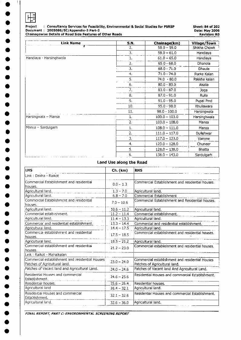
Project Consultancy Services for Feasibility, Environmental & Social Studies for PSRSP Sheet: 84 of 202* Document 2005086/EC/Appendix-3 Part-2 Date: May 2006
Chainagewise Details of Road Side Features of Other Roads Revision: RO
_ I= Link Name S.N. Chainage(km) Village/Town2. 58.0 - 59.0 Shikha Chowk
*__ 3. 59.0 - 61.0 Handiaya* Handiaya - Harsinghwala 1. 61.0 - 65.0 Handiaya
2. 65.0 - 68.0 Dhanola* 3. 68.0 - 71.0 Dhaula
4. 71.0 - 74.0 Rurke Kalan5. 74.0 - 80.0 Pakkhe kalan
_ 6. 80.0 - 83.0 Akalia7. 83.0 - 87.0 Joga
* 8. 87.0 - 91.0 Rulla
9. 91.0 - 95.0 Pupal Pind* 10. 95.0 - 98.0 Khullawara
11. 98.0 - 100.0 Harsingwala_ Harsingwala - Mansa 1. 100.0- 103.0 Harsinghwala* 2. 103.0 - 108.0 Mansa
Mansa - Sardulgarh 1. 108.0-111.0 Mansa
* 2. 111.0 - 117.0 Dullehwar3. 117.0 - 123.0 Vamme
4. 123.0- 128.0 Chuneer* 5. 128.0 - 138.0 Bhatta
__________ 6. 138.0- 143.0 Sardulgarh
Land Use along the Road
* LHS Ch. (km) RHS
* Link: Dakha - Ra;kot
Commercial Establishment and residential 0.0 - 1.3 Commercial Establishment and residential houses.houses.Agricultural land. 1.3 - 7.0 Agricultural land.
* ~9lAgritural land. 6.8 - 7.0 Commercial EstablishmentCommercial Establishment and residential 7.0 - 10.6 Commercial Establishment and Residential houses.houses.Agricultural land. 10.6 - 11.2 Agricultural land.
* Commercial establishment. 11.2 - 11.4 Commercial establishment.Agricultural land. 11.4- 13.3 Agricultural land.
0 Commercial and residential establishment. 13.3 - 14.4 Commercial and residential establishment.Agricultural land. 14.4- 17.5 Agricultural land.Commercial establishment and residential Commercial establishment and residential houses.houses. 17.5 -18.5
* Agricultural land. 18.5 - 21.2 Agricultural land.Commercial establishment and residential 21.2 - 23.0 Commercial establishment and residential houses.houses.Link: Raikot - Mahalkalan
* Commercial establishment and residential Houses 23.0 - 24.0 Commercial establishment and residential HousesPatches of Agricultural land. Patches of Agricultural land.
* Patches of Vacant land and Agricultural Land. 24.0 - 24.6 Patches of Vacant land And Agricultural Land.
Residential Houses and commercial Residential Houses and commercial Establishment.* Establishment. 24.6 - 25.6
Residential houses. 25.6 - 26.4 Residential houses.* Agricultural land 26.4 - 32.1 Agricultural land.
Residential Houses and commercial 32.1 32.6 Residential Houses and commercial Establishment.Establishment. 32.1 - 32.6
* Agricultural land. 32.6 - 36.0 Agricultural land.
FINAL REPORT, PART C: ENVIRONMENTAL SCREENING REPORT
0
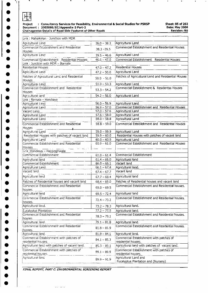
Project : Consultancy Services for Feasibility, Environmental & Social Studies for PSRSP Sheet: 85 of 202* Document: 2005086/EC/Appendix-3 Part-2 Date: May 2006
Chainagewise Details of Road Side Features of Other Roads Revision: RO
Link: Mahalkalan - Junction with MDR
* |Agricultural Land 36.0 - 38.3 Agricultural Land
Commercial Establishment and Residential 38.3 -39.5 Commercial Establishment and Residential Houses.Houses. _ -Agricultural Land 39.5 - 46.6 Agricultural Land
* Commercial Establishment Residential Houses 46.6 - 47.0 Commercial Establishment Residential Houses
Link: Junction with MDR - Barnala ___ _
* Residential Houses 47.0 - 47.2 Residential Houses
Agricultural Land 47.2 - 50.0 Agricultural Land
Patches of Agricultural Land and Residential 50.0 - 51.0 Patches of Agricultural Land and Residential Houses
Houses _-Agricultural Land 51.0 - 53.3 Agricultural Land
* Commercial Establishment and Residential 53.3 - 54.2 Commercial Establishment & Residential HousesHousesAgricultural land 54.2 - 56.0 Agricultural Land
Link: Barnala - Handiaya_ Aqricultural Land 56.0 - 56.9 Agricultural Land
Agricultural Land 56.9 - 57.0 Commercial Establishment and Residential Houses
* Vacant Land 57.0 - 57.6 Agricultural Land
Agricultural Land 57.6 - 58.0 Agricultural Land
* Agricultural Land 58.0 - 58.8 Agricultural Land
Commercial Establishment and Residential 58.8 - 59.0 Commercial Establishment and Residential Houses
Houses IAultural Land 59.0 - 59.9 Agricultural Land
* Residential Houses with patches of vacant land 59.9 - 60.0 Residential Houses with patches of vacant land
Agricultural Land 60.0 - 60.9 Agricultural Land* Commercial Establishment and Residential 60.9 -- 61.0 Commercial Establishment and Residential Houses
Houses* Lirk :Handiaya - Harisinghwala
Commercial Establishment 61.0 - 61.4 Commercial Establishment
* Agricultural land 61.4 - 66.0 Agricultural land
Commercial Establishment 66.0 - 66.1 Vacant land
* Agricultural Land. 66.1 - 67.4 Agricultural land.
Vacant land. 67.4 - 67.7 Vacant land
* Agricultural land 67.7 - 68.4 Agricultural land
Patches of Residential houses and vacant land 68.4 - 69.0 Patches of Residential houses and vacant land
Commercial Establishment and Residential 69.0 - 69.5 Commercial Establishment and Residential houses.
* houses.Agricultural land 69.5 - 72.4 Agricultural land
* Commercial Establishment and Residential 72.4 - 73.2 Commercial Establishment and Residential houses.
houses.* Agricultural land. 73.2 - 78.3 Agricultural land.
Eucalyptus Plantation 77.2 - 77.5 Agricultural land.
Commercial Establishment and Residential 78.3 - 79.1 Commercial Establishment and Residential houses.
houses.* Agricultural land. 79.1 - 81.8 Agricultural land.
Commercial Establishment and Residential 81.8 - 81.9 Commercial Establishment and Residential houses.
houses.Agricultural land. 81.9 - 84.1 Agricultural land.
* Commercial Establishment with patches of 84.1 - 85.3 Commercial Establishment with patches of
residential houses. residential houses.
* Agricultural land with patches of vacant land. 85.3 - 89.1 Agricultural land with patches of vacant land.
Commercial Establishment with patches of _ Commercial Establishment with patches of
* residential houses. 89.1-89.9 residential houses.Agricultural land 89.9 - 91.9 Agricultural Land and
*_.__ ______________________________ ._________.__ Eucalyptus Plantation and (Nursery)
_ FINAL REPORT, PART C: ENVIRONMENTAL SCREENING REPORT
L
0~~~~~~~~~~~~~~~
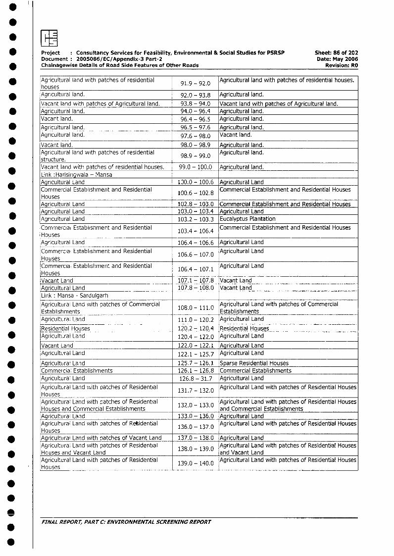
*ZEI* Project Consultancy Services for Feasibility, Environmental & Social Studies for PSRSP Sheet: 86 of 202
Document 2005086/EC/Appendix-3 Part-2 Date: May 2006_ Chainagewise Details of Road Side Features of Other Roads Revision: RO
* Agricultural land with patches of residential 91.9 - 92.0 Agricultural land with patches of residential houses.houses
* Agricultural land. 92.0 - 93.8 Agricultural land.
Vacant land with patches of Agricultural land. 93.8 - 94.0 Vacant land with patches of Agricultural land.* Agricultural land. 94.0 - 96.4 Agricultural land.
Vacant land. 96.4 - 96.5 Agricultural land.
* Agricultural land. 96.5 - 97.6 Agricultural land.Agricultural land. 97.6 - 98.0 Vacant land.
Vacant land. 98.0 - 98.9 Agricultural land.* Agricultural land with patches of residential 98.9 - 99.0 Agricultural land.
structure. _________________________Vacant land with patches of residential houses. 99.0 - 100.0 Agricultural land.Link :Harisingwala - Mansa
* Ayricultural Land 130.0 - 100.6 Agricultural LandCommercial Establishment and Residential 100.6 - 102.8 Commercial Establishment and Residential HousesHouses
* Agricultural Land 102.8 - 103.0 Commercial Establishment and Residential HousesAgricultural Land 103.0 - 103.4 Agricultural Land
* Agricultural Land 103.2 - 103.3 Eucalyptus Plantation
* Commercial Establishment and Residential 103.4 - 106.4 Commercial Establishment and Residential HousesHouses_______________________
* Agricultural Land 106.4 - 106.6 Agricultural Land
Commercial Establishment and Residential 106.6 - 107.0 Agricultural LandHousesCommercial Establishment and Residential 106.4 - 107.1 Agricultural LandHousesVacant Land 107.1 - 107.8 Vacant Land
* Agricultural Land 107.8 - 108.0 Vacant LandLink: Mansa - Sardulgarh
Agricultural Land with patches of Commercial 108.0- 111.0 Agricultural Land with patches of CommercialEstablishments Establishments
* Agricultural Larnd 111.0 - 120.2 Agricultural Land
Residential Houses 120.2 - 120.4 Residential Houses* Agricultural Land 120.4 - 122.0 Agricultural Land
Vacant Land 122.0 - 122.1 Agricultural LandAgricultural Land 122.1 - 125.7 Agricultural Land
* Agricultural Land 125.7 - 126.1 Sparse Residential HousesCommercial Establishments 126.1 - 126.8 Commercial Establishments
* Agricultural Land 126.8 - 31.7 Agricultural Land
Agricultural Land vith patches of Residential 131.7 - 132.0 Agricultural Land with patches of Residential HousesHousesAgricultural Land with patches of Residential 132.0 133.0 Agricultural Land with patches of Residential Houses
* Houses and Commercial Establishments . - . and Commercial EstablishmentsAgricultural Land 133.0 - 136.0 Agricultural Land
* Agricultural Land with patches of Retidential 136.0 - 137.0 Agricultural Land with patches of Residential HousesHouses
* Agricultural Land with patches of Vacant Land 137.0 - 138.0 Agricultural LandAgricultural Land with patches of Residential 138.0 - 139.0 Agricultural Land with patches of Residential Houses
* Houses and Vacant Land and Vacant LandAgricultural Land vwith patches of Residential 139.0 - 140.0 Agricultural Land with patches of Residential HousesHouses
FINAL REPORT, PART C. ENVIRONMENTAL SCREENING REPORT
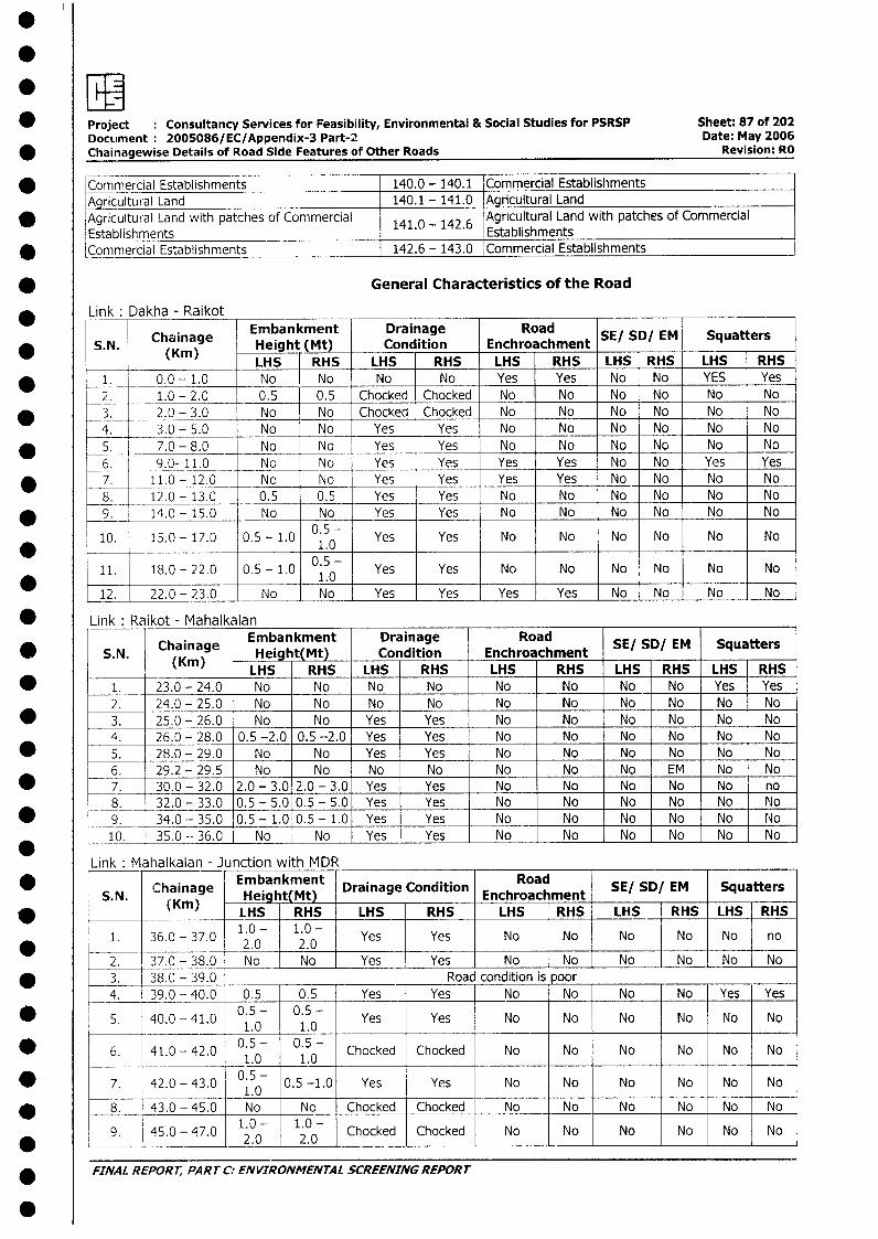
*Project Consultancy Services for Feasibility, Environmental & Social Studies for PSRSP Sheet: 87 of 202DOCLiment 200S086/ EC/Appendix-3 Part-2 Date: May 2006
*Chainagewise Details of Road Side Features of Other Roads Revision: RO
*Commercial Establishments 140.0 - 140.1 'Cornmercial EstablishmentsAgriultural Land 140.1 - 141.0 Agricultural Land
*Agricultural Land with patches of Comimercial 141.0 - 142.6 Agricultural Land with patches of CommercialEstablishments Establishments
*Commercial Establishments 142.6 - 143.0 Commercial Establishments
* ~~~~~~~~~~~General Characteristics of the Road
*Link Dakha - Raikot
Chainage Embankment Drainage Road S/S/E qatr* ~~~S. N. (Kin) Height (Mt) Condition Enchroachment S?S/E qatr
IN~~~~~~LS RHS LHS RHS LHS RHS LHS RHS LHS RHS* ~~~1. 0.0 -1.0 No J.No No No Yes Yes No No YES Yes
2. 1.0 - 2.0 0.5 0.5 Chocked Chocked No No No No No No* ~~~3. 2.0 - 3.0 No No Chocked Chocked No No No No No No
4. 3.0 - 5.0 No No Yes Yes No No No No I No No* ~~~5. j 7.0 -8.0 No No Yes Yes No No No No No No
6. 9.0- 11.0 No No Yes Yes Yes Yes No No Yes Yes* ~~~7. 11.0 - 12.0 No No Yes Yes Yes Yes No -No No No
8. 12.0 - 13.0 0.5 0.5 Yes Yes No No No No No No* ~~~9. 14.0 -15.0 No No Yes Yes No No No No No No
10. 15.0 -17.0 0.5 -1.0 05 Yes Yes No No No No No No* r ---- ~ _ _ _ _ _ _ _ _ _ _ _ _ _ _ _ _ _ 1 .0
11 18.0 -22.0 0.5 -1.0 0.5- Yes Yes No No No No No No_ _ _ _ _ _ _ _ _ _ _ _ _ _ _ _ _ ~1 .0 _ _ _ _ _ _ _ __ _
2220 - 23.0 No No Yes Yes Yes Yes No INo No No
* ~~Link :Raikot -_Mahalkalan
Chainage Embankment Drainage Road S/S/E qatr* ~~~S. N. (Kin) Height(Mtl_ Condition Enchroachment S/S!E qatr
LHS RHS LHS RHS LHS RHS LHS RHS LHS RHS* ~~~~1. 23.0 -24.0 No No No No No No No No Yes Yes
2. 24.0 - 25.0 No No No No No No No No No No* ~~~3. 25.0 -26.0 No No Yes Yes No No No No No No
4. 26.0 - 28.0 0.5 -2.0 0.5 -2.0 Yes Yes No No No No No No* ~~~~5. 28.0 -29.0 No No Yes Yes No No No No No No
6. 29.2 - 29.5 No No No No No No No EM No No* ~~~~7. 30.0 - 32.0 2.0 - 3.0 2.0 - 3.0 Yes Yes No No No No No no
8. 32.0 - 33.0 0.5 - 5.0 0.5 - 5.0 Yes LYes No No No No No NIo* ~~~~9. 34.0- 35.0 0.5 - 1.0 0.5 - 1.0 Yes Yes No 1 No No No No No0
10. 35.0--36.0 No No Yes -Yes No No No No No No
Link :Mahalkalan - Junction with MDR ________ _______
* Chainage ~~~~~Embankment DriaeCniin Road S/S!E qatrS. N. ihiae Heig t(Mlt) Drainage_ Condition Enchroachment SE/__SD/ EM_ Squater
* L ~~~~~~(Kmn) LHS RHS -LHS RHS LHS RHS -LHS RHS LHS -RHS
1. 36.0 -37.0 1.0 1.0 Yes Yes No No No No No no* ~~~~ ~~~~~2.0 2.0 - _ _ _ _ _ _ _ _ _ _ _ _ _ _ _
'2. 37.0 -38.0 No No Yes L Yes No No No No No No* ~~~3. 38.0 - 39.0 Road condition i's poor
4. 39.0 - 40.0 0.5 0.5 Yes Yes No No No No Yes Yes
* ~~~5. 40.0 -41.0 0.5 - 0.5 - Yes Yes No No No No No No1.0 1.0
* 6. 41.0 -42.0 0.5 - 0.5 - Chocked Chocked No No No No No No1.0 1.0I
* ~~~7. 42.0 -43.0 05-0.5 -1.0 Yes Yes No No No No No No_ _ _ _ _ _ _ _ _ _ _ _ _ _ _ 1 .0
* ~~~8. 43.0 - 45.0 No No Chocked Chocked No No No No No No
9. 45.0 - 47.0 1.0 - 1.0 - Chocked Chocked No No No No No No* _ _ _ ~~~~ ~~~~2.0 2.0 No__ _ _ _ _ _ _ _ _ _ _
* ~~FINA L R EPOR T, PA RT C: EN VIR ONMEN TA L SCREENING REPOR T
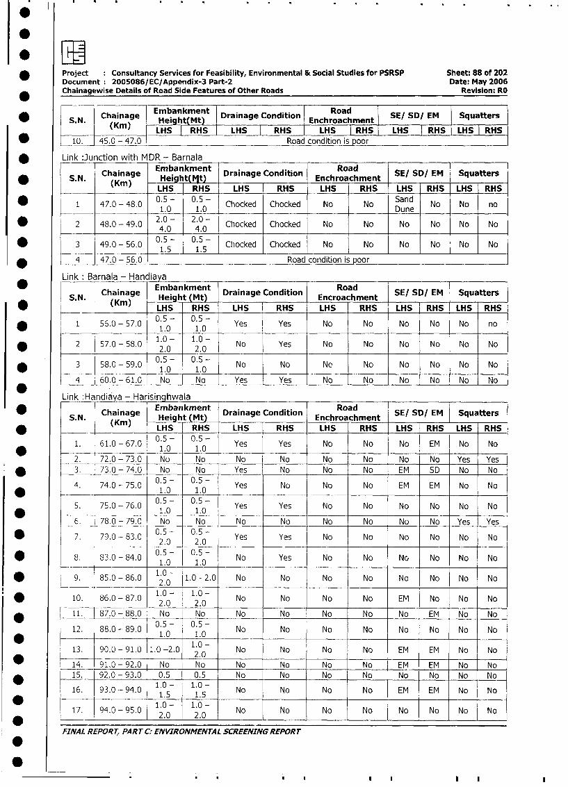
*Project Consultancy Services for Feasibility, Environmental & Social Studies for PSRSP Sheet: 88 of 202Document :2005086/EC/Appendix-3 Part-2 Date: May 2006Chainagewise Details of Road Side Features of Other Roads Revision: RO
Chaiage Embankment Drainage Condition Road S/S/E qatr* ~~~S.N. ChKnag Height(Mt) Enchroachment SISIE qatr
____ ~~~~LHS I RHS LS RS LHS I RHS LHS I RHS LHS I RHS
* ~~~10. 45.0 - 47.0 Road condition is poor
*Link :Junction withi MDR - Barnala
Chainage Embankment .. RoadS. N. (hain)g Heig t(1jt) Drainage Condition Enchroachment SE/ SD/ EM Squatters
___ -(rn LHS riHS LHS RHS LHS RHS LHS RHS LHS RHS
* ~~~1 47.0 -48.0 0.5 - 0.5 - Chocked Chocked No No Sand No No no1.0 -1.0 Dune
* ~~~2 48.0 -49.0 2 .0 - 2 .0 -C hocked Chocked No No No No No No4.0 4.0
* ~~~3 49.0 -56.0 0 .5 - 0 .5 -C hocked Chocked No No No No No N_ _ _ _ _ _ _ _ _ _ _ _ _ _ _ _ 1 .5 1 1 .5 _ _ _ _ _ _ _ _ _ _ _ _ _ _ _ _ _ _ _ _
* ~~~4 47.0 -56.0 Road condition is poor
Link: Barnala - Hand iaya Ra
Chaineihtget) Drainage Condition SE/ SD/ EM SquattersSN ChKinag iembankMet) Encroachment
* (Kin) ~~~~~~LHS RHS LHS RHS LHS RHS LHS RHS LHS RHS
F 1 56.0 -57.0 0.5 - 0.5 - Yes Yes No No No No No no1.0 1.0 ____
2 57.0 -58.0 1.0 - 1.0 - No Yes No No No No No No____ ~~~~2.0 2.0
3 58.0 -59.0 0.5 - 0.5 - No No No No No No No No_ _ _ _ _ _ _ _ _ _ _ _ _ _ _ _ 1 .0 1 .0 1__ _ _ _ _ _ _ _ _
4 60.0 -61.0 No No Yes Yes No No No No No No
Link Hancliaya - Ha isinqhwala
S.. Chainage Embantkment Drainage Condition Road mnt SE/ SD/ EM Squatters
(1(m) LHS RHS LHS RHS LHS RHS LHS RHS LHS RHS
1. 61.0 -67.0 0.5 - 0.5 - Yes Yes No No No EM No No* -------- ~~~~~1.0 1.0 _ _ _ _
2. 72.0 - 73.0 No No I No No No No No No Yes Yes
* ~~~3. 73.0 -74.0 No No Yes No No No EM SD No No
4. 74.0 -75.0 0.5 - 0.5 - Yes No No No EM EM No No1.0 1.0 _ _ _ _ _ _ _ _
5. 75.0 -76.0 0.5 - 0.5 - Yes Yes No No No No No No* -- ~~~~~~~~1.0 1.0
6-. F78.0 - 79.0 No No No No No No No No Yes Yes
7 . 79.0 -83.0 0.5 - 0.5 - Yes Yes No No No No No No__ _ _ 2.0 2.0 _ _ _
* ~~~8 . 83.0 -84.0 0.5 - 0.5 - No Yes No No No No No No__ _______ ~1.0 1.0 i__ _
* ~~~9. 85.0 -86.0 1.0 - 1.0 -2.0 No No No No No No No No2.0
10. 86.0 -87.0 1.0 - 1.0 - No No No No EM No No No~~~~~~2.0 .2.0
* ~~~11. 87.0 -88.0 No No No No No No No EM No No
12. 88.0 -89.0 0.5 - 0.5 - No No No No No No No No* ~~~~ ~~~~~1.0 1.0
13. 90.0 - 91.0 1,0 -2.0 1.0 - No No No No EM EM No No____ _______~' 2.0 _ _
* ~~~Th1. 91,0 -92.0 No No No No No No EM EM No No* ~~~15. 92.0 -93.0 0.5 0.5 No No No No No No No No
16. 93.0. -94.0 1.0 - 1.0 - No No No No EM EM No No_ _ _ _ _ _ _ _ _ _ _ _ _1 .5 1 .S _ _ _ _ _ _ _ _ _
17. 94.0 -95.0 1.0 - 1.0 - No No No No No No No No_ _ _ _ -- ~~~2.0 - 2.0 _ _ _ _ _ _ _ _ _ _ _ _ _ _ _ _ _ _ _ _ _ _ _ _
FINAL REPORT, PART C:- ENVIRONMENTAL SCREENING REPORT
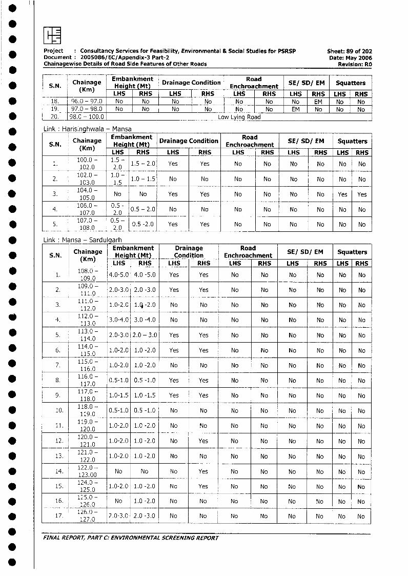
Project Consultancy Services for Feasibility, Environmental & Social Studies for PSRSP Sheet: 89 of 202* Document 2005086/EC/Appendix-3 Part-2 Date: May 2006
Chainagewise Details of Road Side Features of Other Roads Revisioni: RO* _ __ __ _________________
Chainage Embankment | 9 nton Road SE/ SD/ EM SquattersS. N. (Km) Height (Mt)Enhocm t
_ _.N. (Kin) LHS RHS LHS RHS LHS RHS LHS RHS LHS | RHS*_18. 96.0 - 97.0 No No No No No No No EM No _ No
19. 97.0 - 98.0 No No No No No No EM EM No No* 20. _ 98.0 - 100.0 Low Lying Road
Link: Harisinghwala - Mansa
; S.N. Chainage Emba kment Drainage Condition Enchroachment SE/ SD/ EM Squatters* ~~~.. (Kmn) Hei ht (Mt)Enhocm tLHS RHS LHS RHS LHS RHS LHS RHS LHS RHS
* 1. 100.0 - 1.5 - 1.5 - 2.0 Yes Yes No No No No No No102.0 2.0 ____
2. 102.0 - 1.0 _ 1.0 - 1.5 No No No No No No No No0 ~~~~~~~103.0 1.5
* 3. 104.0 - No No Yes Yes No No No No Yes Yes___ 105.0
* 4. 106.0 - 0.5- 0.5 - 2.0 No No No No No No No No* ~~~~~~~107.0 2.0 ___
* 5. 107.0 - 0.5 - 0.5 -2.0 Yes Yes No No No No No No* ~~~~~~~108.0 2.0 _ _ _ _ _ _ _ _ _ _ _ _ _ _ _ _ _ _
* Link lvlansa - Sardulgarh
Chainage Embankment Drainage Road S/DE qatr* S.N. (Kin) Height (Mt) Condition Enchroachment SE/ / E que
( LHS RHS LHS RHS LHS RHS LHS RHS LHS RHS
* 1. 108.0 - 4.0-5.0 4.0 -5.0 Yes Yes No No No No No No109.0 _ _ _ _ _ _ _
* 2. 109.0 -- 2.0-3.0 2.0 -3.0 Yes Yes No No No No No No111.0 _ _ _ _
* 3. 111.0 - 1.0-2.0 1.- -2.0 No No No No No No No No112.0 1
i4. 1112.0 - 3.0-4.0 3.0 -4.0 No No No No No No No No113.0
* 5. 113.0 - 2.0-3.0 2.0 - 3.0 Yes Yes No No No No No No
* 6. 114.0- 1.0-2.0 1.0 -2.0 Yes Yes No No No No No No115.0
*7. 115.0 - 1.0-2.0 1.0 -2.0 No No No No No No No No0 ~~~~~~116.08. 116.0 - 0.5-1.0 0.5 -1.0 Yes Yes No No No No No No
117.0
*9. 117.0 - 1.0-1.5 1.0 -1.5 Yes Yes No No No No No No5 ~~~~~118.0
* 10. 118.0 0.5-1.0 0.5 -1.0 No No No No No No No No119.0
* 11. 119.0 - 1.0-2.0 1.0 -2.0 No No No No No No No No* ~~~~~120.0
12. 120.0 - 1.0-2.0 1.0 -2.0 No Yes No No No No No Noo ~~~~~~~~121.0 * 13. 121.0 - 1.0-2.0 1.0 -2.0 No No No No No No No No
122.0
14. 122.0 - No No No Yes No No No No No No* ~~~~~123.00
* 15. 124.0- 1.0-2.0 1.0 -2.0 No Yes No No No No No No
16. 16.0 - No 1.0 -2.0 No No No No No No No No* _______ ~~126.0
17. 126.0 - 2.0-3.0 2.0 -3.0 No No No No No No No No0~~~~~~2.
FINAL REPORT, PAR T C: ENVIRONMENTAL SCREENING REPORT
.0
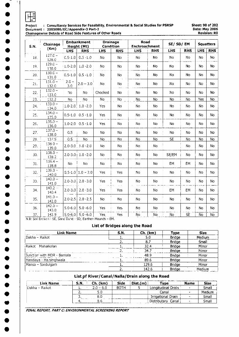
Project : Consultancy Services for Feasibility, Environmental & Social Studies for PSRSP Sheet: 90 of 202Document 2005086/EC/Appendix-3 Part-2 Date: May 2006
* Chainagewise Details of Road Side Features of Other Roads Revision: RO
* S.N. Chainage Embankment Drainage Road SE/ SD/ EM SquattersS. N. (Kin) -Height (Mt) Condition Enchroachment S/S!E qatr
* _____ (Km) LHS RHS LHS RHS LHS RHS LHS RHS LHS RHS
* 18. 127.0 - 0.5-1.0 0.5 -1.0 No No No No No No No No128.0 _
* 19. 129.0 1.0-2.0 1.0 -2.0 No No No No No No No No130.0
* 20. 1130.0 - 0.5-1.0 0.5 -1.0 No No No No No No No No
21. 131.0 - 2.0 - 2.0 - 3.0 No No No No No No No No* ~~~~~~~132.0 3.0
22. 132.0 - No No Chocked No No No No No No No________ 133.0
23. 132.2 No No No No No No No No Yes No
24. 133.0 - 1.0-2.0 1.0 -2.0 Yes No No No No No No No134.0
25. 134.0 - 0.5-1.0 0.5 -1.0 Yes No No No No No No No125.0
26. 135.0- 1.0-2.0 0.5 -1.0 Yes No No No No No No No
27. 137.0 - 0.5 No No No No No No No No No0 ~~~~~138.0* 28. 137.5 0.5 No No No No No SE No No No
29. 138 0 - 2.0-3.0 1.0 -2.0 No No No No No No No139.0
30. 138.02- 2.0-3.0 1.0 -2.0 No No No No SE/EM No No No,.__138.4
31. 138. 8 No No No No No No EM EM No No139.08
- 32. 140.0 0.5-1.0 1.0 - 2.0 Yes Yes No No No No No No140.0-
33. 140.0 - 2.0-3.0 2.0 -3.0 Yes Yes No No No No No No
34. 140.2 - 2.0-3.0 2.0 -3.0 Yes Yes No No EM EM No No141.0-
35. 142.0 2.0-2.5 2.0 -2.5 No No No No No No No No
* ____ 142.0-36. 143.0 5.0-6.0 5.0 -6.0 Yes Yes No No No No No No
* 37. 142.9 5.0-6.0 5.0 -6.0 Yes Yes No No No SE No NoN B: Soil Erosion - SE, Sand Dune - SD, Earthen Mounds - EM.
List of Bridges along the Road
_ Link Name S.N. Ch. (km) Type SizeDakha - Raikot 1. 5.0 Bridge Medium
* 2. 8.7 Bridge SmallRaikot - Mahalkalan 1. 32.4 Bridge Minor
_ _ 2. 34.7 Bridge MinorJunction with MDR - Barnala 1. 48.9 Bridge Minor
* Handiaya - Harsinghwala 1. 89.6 Bridge MinorMansa - Sardulgarh 1. 129.6 Bridge Minor* __________ 2. 142.6 Bridge Medium
* Listpf River/Canal/NalIa/Drain along the Road
Link Name S.N. Ch. (km) Side Dist.(m) Type Name SizeDakha - Raikot 1. 2.0 - 6.0 BOTH 5 Longitudinal Drain - Small
2. 5.0 Canal - Medium3. 8.0 Irrigational Drain - Small
* 4. 8.6 Distributary Canal - Small
* FINAL REPORT, PART C: ENVIRONMENTAL SCREENING REPORT
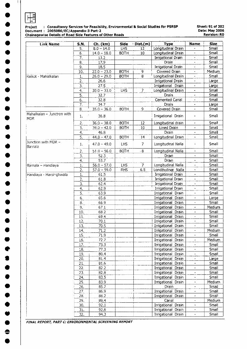
Project Consultancy Services for Feasibility, Environmental & Social Studies for PSRSP Sheet: 91 of 202Document 2005086/EC/Appendix-3 Part-2 Date: May 2006Chainagewise Details of Road Side Features of Other Roads Revision: RO
* _ Link Name S.N. Ch. (km) Side Dist.(m) Type Name Size5. 8.0 - 14.0 LHS 12 Longitudinal Drain - Small6. 14.0 - 18.0 BOTH 10 Longitudinal Drain - Small7. 13.2 Irrigational Drain - Small
* 8. 17.9 Drain - Small9. 18.5 Irrigational Drain - Small
* 10. 22.0 - 23.0 BOTH 9 Covered Drain - MediumRaikot - Mahalkalan 1. 26.0 - 29.0 BOTH 8 Longitudinal Drain - Small
* 2. 26.6 Irrigational Drain - Large3. 27.5 Irrigational Drain - Large
* 4. 30.0 - 33.0 LHS 7 Longitudinal Drain - Small5. 32.7 Drain - Small
* 6. 32.8 Cemented Canal - Small7. 34.7 Drain - Large
_ _______________________ 8. 35.0 - 36.0 BOTH 9 Covered Drain - SmallMahalkalan - Junction with
a MDR 1. 36.8 Irrigational Drain Small2. 36.0 - 38.0 BOTH 12 Longitudinal drain - Small
* 3. 39.0 -42.0 BOTH 10 Lined Drain - Small4. 46.8 Drain - Small
* ______ ____________ 5. 44.0 - 47.0 BOTH 14 Longitudinal Drain - SmallJunction with MDR - 1. 47.0 - 49.0 LHS 7 Longitudinal Nalla - SmallBarnala
2. 51.0 - 56.0 BOTH 8 Longitudinal Nalla - Small* 3. 52.3 Drain - Small
_____ ___ 4. 53.7 Drain - Small* Barnala - Handiaya 1. 56.0 - 57.0 LHS 7 Longitudinal Nalla - Small
2. 57.0 - 59.0 RHS 6.5 Londitudinal Nalla - Small* Handiaya - Harsinghwala 1. 61.5 Irrigational Drain - Small
2. 61.8 Irrigational Drain - Smallv 3. 62.4 Irrigational Drain - Small
4. 62.9 Irrigational Drain - Small* 5. 63.9 Irrigational Drain - Small
6. 65.6 Irrigational Drain - Large* , 8. 66.9 Irrigational Drain - Small
9. 67.1 Irrigational Drain - Medium* 10. 68.2 Irrigational Drain - Small
11. 69.4 Irrigational Drain - Small* 12. 70.1 Irrigational Drain - Small
13. 70.5 Irrigational Drain - Small* 14. 71.2 Irrigational Drain - Medium
15. 71.9 Irrigational Drain - Small* 16. 72.7 Irrigational Drain - Medium
17. 73.3 Irrigational Drain - Smalle 18. 77.3 Irrigational Drain - Small
19. 80.4 Irrigational Drain - SmallS 20. 81.4 Irrigational Drain - Large
21. 81.6 Irrigational Drain - Small* _22. 82.2 Irrigational Drain - Small
23. 82.8 Irrigational Drain - Small* 24. 83.5 Irrigational Drain - Small
25. 83.9 Irrigational Drain - Medium* 26. 85.2 Drain - Small
27. 86.9 Irriqational Drain Small* 28. 88.2 Irrigational Drain Small
29. 89.4 Canal Medium* 30. 92.1 Irrigational Drain Small
31. 92.6 Irrigational Drain Small* 32. 94.3 Irrigational Drain Small
* FINAL REPORT, PART C: ENVIRONMENTAL SCREENING REPORT
0
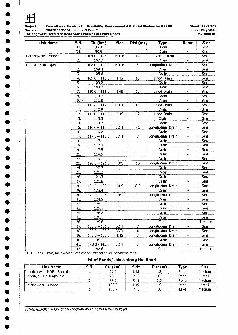
Project Consultancy Services for Feasibility, Environmental & Social Studies for PSRSP Sheet: 92 of 202Document: 2005086/EC/Appendix-3 Part-2 Date: May 2006Chainagewise Details of Road Side Features of Other Roads Revision: RO
Link Name _S.N. Ch. (km) Side Dist.(m) Type Name Size33. 96.0 Drain - Small
34. 98.5 _ Drain - SmallHarsingwala - Mansa 1. 104.0 - 105.0 BOTH 12 Covered Drain - Small
* 2. 107.7 Drain - SmallMansa - Sardulgarh 1. 108.0 - 109.0 BOTH 8 Longitudinal Drain - Small
* 2. 108.4 Drain - Small3. 108.6 Drain - Small
* 4. 109.0- 110.0 LHS 10 Lined Drain - Small5. 109.2 Drain - Small
* 6. 109.7 Drain - Small7. 110.0 - 111.0 LHS 12 Lined Drain - Small
* 8. 110.7 Drain - Small9. * 111.8 Drain - Small
* 10. 112.8 - 112.9 BOTH 10.5 Lined Drain - Small11. 112.9 Drain - Small
* 12. 113.0 - 114.0 RHS 12 Lined Drain - Small13. 113.5 Drain - Small
* 14. 113.7 Drain - Small15. 116.0 - 117.0 BOTH 7.5 Longitudinal Drain - Small
* 16. 116.2 Drain - Small17. 117.0- 118.0 BOTH 8 Longitudinal Drain - Small
* 18. 117.1 Drain - Small19. 117.3 Drain - Small
* 20. 117.5 Drain - Small21. 118.5 Drain - Small
* 22. 119.1 Drain - Small23. 120.0 - 121.0 RHS 10 Longitudinal Drain - Small
* 24. 120.7 Drain - Small25. 121.2 Drain - Small
* 26. 121.3 Drain - Small27. 121.8 Drain - Small
* 28. 122.0 - 123.0 RHS 6.5 Longitudinal Drain - Small29. _ 123.4 Drain - Small
* _30. 124.0 - 125.0 RHS 7 Longitudinal Drain - Small31. 124.5 Drain - Small
* 32. 125.1 Drain - Small33. 125.3 Drain - Small
* 34. 126.8 Drain - Small35. 128.5 Drain - Small
* 36. 129.6 Canal - Medium37. 130.0 - 131.0 BOTH 7 Longitudinal Drain - Small
* 38. 132.0 - 135.0 BOTH 8 Longitudinal Drain - Small39. 135.0 - 136.0 LHS 7 Longitudinal Drain - Small
* 40. 135.1 Drain - Small41. 140.0 - 143.0 BOTH 8 Longitudinal Drain - Small
* ______ ____________ 42. 142.6 Canal - MediumNOTE: Canal, Drain, Nalla whose sides are not mentioned are across the Road.
List of Ponds/Lakes along the Road
* Link Name { S.N. Ch. (km) Side Dist.(m) Tye SizeJunction with MDR - Barnala 1. 51.0 _ LHS 12 Pond MediumHandiaya - Harsinghwala 1. 75.5 _ RHS 8 Pond Small
__________ ___2. 77.3 RHS 6.5 Pond MediumHarsingwala - Mansa 1. 105.5 LHS 10 Pond Small
___________________ 2. 106.7 RHS 50 Lake Medium
* FINAL REPORT, PART C: ENVIRONMENTAL SCREENING REPORT
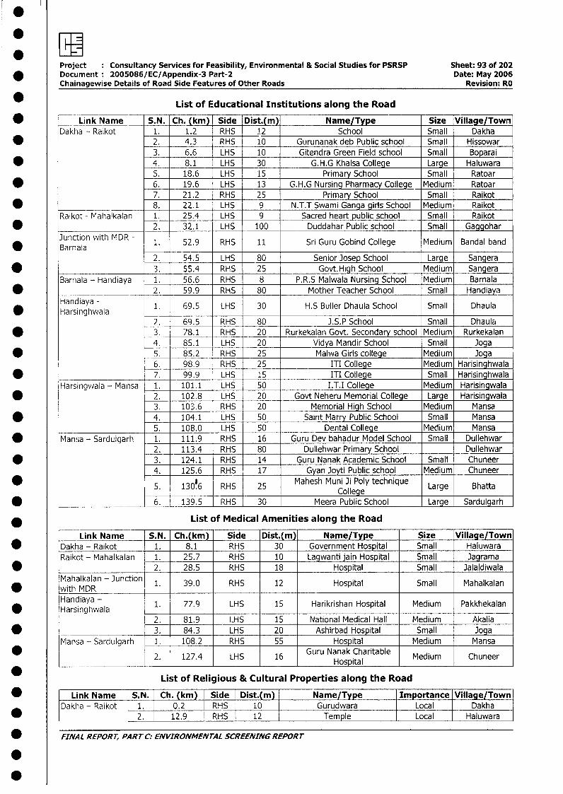
0
Project Consultancy Services for Feasibility, Environmental & Social Studies for PSRSP Sheet: 93 of 202* Documerit 2005086/EC/Appendix-3 Part-2 Date: May 2006
Chainagewise Details of Road Side Features of Other Roads Revision: RO
* List of Educational Institutions along the Road
* Link Name S.N. Ch. (km) Side Dist.(m) Name/Type Size Village/TownDakha - Raikot 1. 1.2 RHS 12 School Small Dakha
* _2. 4.3 RHS 10 Gurunanak deb Public school Small Hissowar3. 6.6 LHS 10 Gitendra Green Field school Small Boparai
* 4. 8.1 LHS 30 G.H.G Khalsa College Large Haluwara5. 18.6 LHS 15 Primary School Small Ratoar
* 6. 19.6 LHS 13 G.H.G Nursing Pharmacy College Medium Ratoar7. 21.2 RHS 25 Primary School Small _ Raikot
* 8. 22.1 LHS 9 N.T.T Swami Ganga girls School Medium RaikotRaikot - Mahalkalan 1. 25.4 LHS 9 Sacred heart public school Small Raikot
* 2. 32.1 LHS 100 Duddahar Public school Small GaggoharJunction with MDR - 1. 52.9 RHS 11 Sri Guru Gobind College Medium Bandal band
2. 54.5 LHS 80 Senior Josep School Large Sangera* 3. 55.4 RHS 25 Govt.High School Medium Sangera
Barnala - Handiaya 1. 56.6 RHS 8 P.R.S Malwala Nursing School Medium Barnala* ________ _____ 2. 59.9 RHS 80 Mother Teacher School Small Handiaya
Handiaya - 1. 69.5 LHS 30 H.S Buller Dhaula School Small Dhaula* ~~Harsinghwala__
2. 69.5 RHS 80 _ .S.P School Small Dhaula* 3_. 78.1 RHS 20 Rurkekalan Govt. Secondary school Medium Rurkekalan
4. 85.1 LHS 20 Vidya Mandir School Small Joga* 5. 85.2 RHS 25 Malwa Giris college Medium Joga
6. 98.9 RHS 25 ITI College Medium Harisinghwala* __________________ 7. 99.9 LHS 15 ITI College Small Harisinghwala
Harsingwala - Mansa 1. 101.1 LHS 50 I.T.I College Medium Harisingwala* 2. 102.8 LHS 20 Govt Neheru Memorial College Large Harisingwala
3. 103.6 RHS 20 Memorial High School Medium Mansa* 4. 104.1 LHS 50 Saint Marry Public School Small Mansa
5. 108.0 LHS 50 Dental College Medium Mansa* Mansa - Sardulgarh 1. 111.9 RHS 16 Guru Dev bahadur Model School Small Dullehwar
2. 113.4 RHS 80 Dullehwar Primary School Dullehwar* 3. 124.1 RHS 14 Guru Nanak Academic School Small Chuneer
4. 125.6 RHS 17 Gyan Joyti Public school Medium ChuneerRHS 25 Mahesh Muni Ji Poly technique Lre Bat
* 5. 130.6 RHS 25 College Large Bhatta
* ________L | [6. 139.5 RHS 30 Meera Public School Large Sardulgarh
* List of Medical Amenities along the Road
Link Name S.N_. Ch.(km) Side Dist.(m) Name/Type Size Village/Town* Dakha - Raikot 1. 8.1 RHS 30 Government Hospital Small Haluwara
Raikot - Mahalkalan 1. 25.7 RHS 10 Lagwanti jai Hospital Small Jagrama* 2. 28.5 RHS 18 Hospital Small Jalaldiwala
Mahalkalan - Junction 1. 39.0 RHS 12 Hospital Small Mahalkalan* ~~with MDR____
Handiayan - 1. 77.9 LHS 15 Harikrishan Hospital Medium Pakkhekalan* ~~Harsinghwala
2. 81.9 lIHS 15 National Medical Hall Medium Akalia* 3. 84.3 LHS 20 Ashirbad Hospital Small Joga
Mansa - Sardulgarh I. 108.2 RHS 55 Hospital Medium Mansa
2. 127.4 LHS 16 Guru Nanak Charitable Medium ChuneerHospital
List of Religious & Cultural Properties along the Road
* Link Name S.N. Ch. (km) Side Dist.(m) Name/Type Importance Village/TownDakha - Raikot 1. 0.2 RHS 10 Gurudwara Local Dakha
* ~~~~~~~~2. 12.9 RHS 12 Temple Local |Haluwara |
* FINAL REPORT, PART C: ENVIRONMENTAL SCREENING REPORT
.
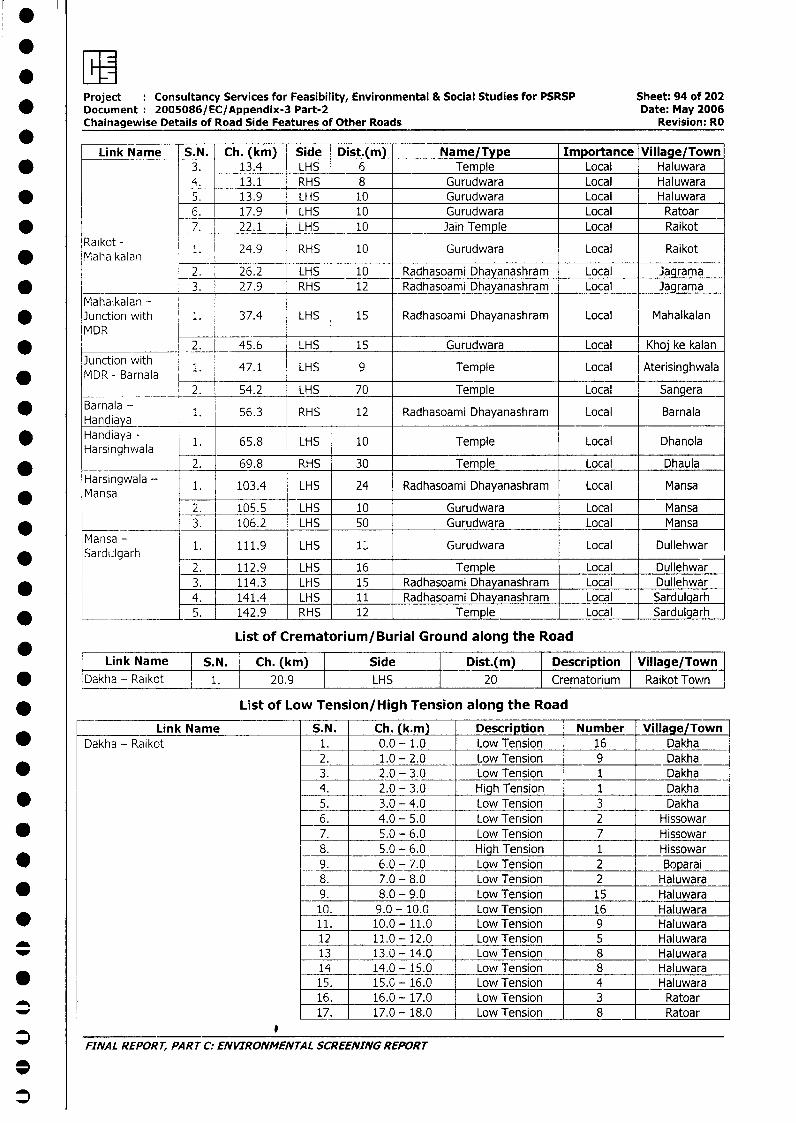
Project Consultancy Services for Feasibility, Environmental & Social Studies for PSRSP Sheet: 94 of 202* Document 2005086/EC/Appendix-3 Part-2 Date: May 2006
Chainagewise Details of Road Side Features of Other Roads Revision: RO
Link Name | S.N. Ch. (km) Side Dist.(m) Name/Type Importance Village/Town* 3. 13.4 LHS 6 Temple Local Haluwara
4. 13.1 RHS 8 Gurudwara Local Haluwara5. 13.9 LHS 10 Gurudwara Local Haluwara6. 17.9 LHS 10 Gurudwara Local Ratoar
_ _ .____ 7 . 22.1 LHS 10 Jain Temple Local RaikotRaikot - 1. 24.9 RHS 10 Gurudwara Local Raikot
* Mahalkalan2. 26.2 LHS 10 Radhasoami Dhayanashram Local Jagrama
* _____-_____ 3. 27.9 RHS 12 Radhasoami Dhayanashram Local JagramaMahalkalan -
* Junction with 1. 37.4 LHS 15 Radhasoami Dhayanashram Local MahalkalanMDR
* _______________ 2. 45.6 LHS 15 Gurudwara Local Khoj ke kalan
* MDR - BaJrna ia 1. 47.1 LHS 9 Temple Local Aterisinghwala2. 54.2 LHS 70 Temple Local Sangera
* Barnala - 1. 56.3 RHS 12 Radhasoami Dhayanashram Local BarnalaHandiayaHandiaya - 1. 65.8 LHS 10 Temple Local DhanolaHarsinghwala
2. 69.8 RHS 30 Temple Local Dhaula
rMainsa 1. 103.4 LHS 24 Radhasoami Dhayanashram Local Mansa2. 105.5 LHS 10 Gurudwara Local Mansa
*____ M _______ 3. 106.2 LHS 50 Gurudwara Local Mansa
* Sansugarh -1. 111.9 LHS 1; Gurudwara Local Dullehwar
2. 112.9 LHS 16 Temple Local Dullehwar* 3. 114.3 LHS 15 Radhasoami Dhayanashram Local Dullehwar
4. 141.4 LHS 11 Radhasoami Dhayanashram Local Sardulgarh* _____________L5. 142.9 RHS 12 Temple Local Sardulgarh
List of Crematorium/Burial Ground along the Road
Link Name S.N. Ch. (km) Side Dist.(m) Descriiption Village/Town* Dakha - Raikct 1. 20.9 LHS 20 Crematorium Raikot Town
* List of Low Tension/High Tension along the Road
Link Name S.N. Ch. (k.m) Description Number Village/Town* Dakha - Raikot 1. 0.0 - 1.0 Low Tension 16 Dakha
2. 1.0 - 2.0 Low Tension 9 Dakha* 3. 2.0 - 3.0 Low Tension 1 Dakha
4. 2.0 - 3.0 High Tension 1 Dakha* 5. 3.0 - 4.0 Low Tension 3 Dakha
6. 4.0 - 5.0 Low Tension 2 Hissowar* 7. 5.0 - 6.0 Low Tension 7 Hissowar
8. 5.0 - 6.0 High Tension 1 Hissowar* 9. 6.0 - 7.0 Low Tension 2 Boparai
8. 7.0 - 8.0 Low Tension 2 Haluwara* 9. 8.0 - 9.0 Low Tension 15 Haluwara
10. 9.0 - 10.0 Low Tension 16 Haluwara* 11. 10.0 - 11.0 Low Tension 9 Haluwara
12 11.0 - 12.0 Low Tension 5 Haluwara13 13.0 - 14.0 Low Tension 8 Haluwara14 _ 14.0 - 15.0 Low Tension 8 Haluwara
* 15. 15.0 - 16.0 Low Tension 4 Haluwara16. 16.0 - 17.0 Low Tension 3 Ratoar
_ l 17. 17.0 - 18.0 Low Tension 8 Ratoar
FINAL REPORT, PART C: ENVIRONMENTAL SCREENING REPORT
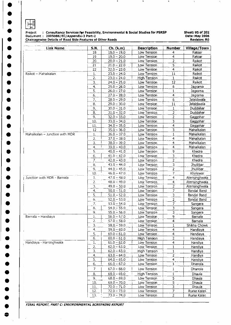
* Project Consultancy Services fyr Feasibility, Environmental & Social Studies for PSRSP Sheet: 95 of 202Document 2005086/EC/Appendix-3 Part-2 Date: May 2006
* Chainagewise Details of Road Side Features of Other Roads Revision: RO
* _ Link Name S.N. Ch. (k.m) Description Number Village/Town18 18.0 - 19.0 Low Tension 4 Ratoar
* 19 19.0 - 20.0 Low Tension 4 Ratoar20 20.0 - 21.0 Low Tension 2 Raikot
* 21. 21.0 - 22.0 Low Tension 5 Raikot
22 22.0 - 23.0 Low Tension 4 Raikot
* Raikot - Mahalkalan 1. 23.0 - 24.0 Low Tension 11 Raikot
2. 23.0 - 24.0 High Tension 1 Raikot
* 3. 24.0 - 25.0 Low Tension 12 Raikot
4. 25.0 - 26.0 Low Tension 6 Jagrama
* 5. 26.0 - 27.0 Low Tension 1 Jagrama
6. 27.0 - 28.0 Low Tension 4 Jagrama
* 7. 28.0 - 29.0 Low Tension 6 Jalaldiwala8. 29.0 - 30.0 Low Tension 11 Jalaldiwala
* 9. 30.0 - 31.0 Low Tension 1 Duddahar8. 31.0 - 32.0 Low Tension 2 Duddahar
* 9. 32.0 - 33.0 Low Tension 2 Gaggohar
10. 33.0 - 34.0 Low Tension 3 Gaggohar
* 11. 34.0 - 35.0 Low Tension 4 Gaggohar12 35.0 - 36.0 Low Tension 3 Mahalkalan
* Mahalkalan - Junction with MDR 1. 36.0 - 37.0 Low Tension 1 Mahalkalan
2. 37.0 - 38.0 Low Tension 4 Mahalkalan
* 3. 38.0 - 39.0 Low Tension 4 Mahalkalan4. 39.0 - 40.0 Low Tension 4 Mahalkalan
* 5. 40.0 - 41.0 Low Tension 9 Khedra6. 41.0 - 42.0 Low Tension 3 Khedra
* 7._ 42.0 - 43.0 Low Tension 2 Khedra
8. 43.0 - 44.0 Low Tension 3 Jhullibar
* 9. 44.0 - 45.0 Low Tension 2 Jhullibar10. 46.0 - 47.0 Low Tension 7 Khirkiwar
* i Junction with MDR - Barnala 1. 47.0 - 48.0 Low Tension 4 Aterisinghwala
2. 48.0 - 49.0 Low Tension 4 Aterisinghwala
* 3. 49.0 - 50.0 Low Tension 2 Aterisinghwala
4. 50.0 - 51.0 Low Tension 7 Bandal Band
* 5. 51.0 - 52.0 Low Tension 3 Bandal Band
6. 52.0 - 53.0 Low Tension 2 Bandal Band
* 7. 53.0 - 54.0 Low Tension 7 Sangera8. 54.0 - 55.0 Low Tension 3 Sangera
* 9. 55.0 - 56.0 Low Tension 3 Sangera
Barnala - Handiaya 1. 56.0 - 57.0 Low Tension 9 Barnala
* 2. 57.0 - 58.0 Low Tension 4 Barnala3. 58.0 - 59.0 Low Tension 1 Shikha Chowk
* 4. 59.0 - 60.0 Low Tension 4 Handiaya5. 60.0 - 61.0 Low Tension 4 Handiaya
* 6. 60.0 - 61.0 High Tension 2 Handiaya
Handiaya - Harsinghwala 1. 61.0 - 62.0 Low Tension 4 Handiya
* 2. 62.0 - 63.0 Low Tension 1 Handiya3. 62.0 - 63.0 High Tension 1 Handiya
* l 4. 63.0 - 64.0 Low Tension 2 Handiya5. 64.0 - 65.0 Low Tension 4 Handiya
* 6. 66.0 - 67.0 Low Tension 1 Dhanola
7 67.0 - 68.0 Low Tension 1 Dhanola
* 8. 68.0 - 69.0 High Tension 1 Dhaula
9. 68.0 - 69.0 Low Tension 5 Dhaula10. 69.0 - 70 0 Low Tension 5 Dhaula
11. 70.0 - 71.0 Low Tension 3 Dhaula* 12. 72.0 - 73.0 Low Tension 7 Rurke Kalan
* 13. 73.0 - 74.0 Low Tension 2 Rurke Kalar
* FINAL REPORT, PART C: ENVIRONMENTAL SCREENING REPORT
S
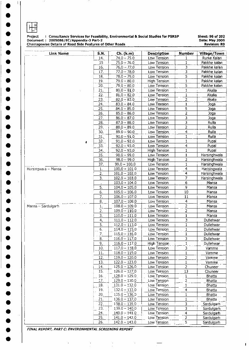
Project : Consultancy Services for Feasibility, Environmental & Social Studies for PSRSP Sheet: 96 of 202Document 200SO86/EC/Appendix-3 Part-2 Date: May 2006
* Chainagewise Details of Road Side Features of Other Roads Revision: RO
* __ _ Link Name S.N. Ch. (k.m) Description Number Village/Town14. 74.0 - 75.0 Low Tension 1 Rurke Kalan
* 15 75.0 - 76.0 Low Tension 1 Pakkhe kalan16. 76.0 - 77.0 Low Tension 3 Pakkhe kalan
* 17. 77.0 - 78.0 Low Tension 3 Pakkhe kalan18. 78.0 - 79.0 Low Tension 5 Pakkhe kalan
* 19. 79.0 - 80.0 High Tension 1 Pakkhe kalan20. 79.0 - 80.0 Low Tension 5 Pakkhe kalan
* . 21. 80.0 - 81.0 Low Tension 1 Akalia22. 81.0 - 82.0 Low Tension 1 Akalia
* 23. 82.0 - 83.0 Low Tension 2 Akalia24. 83.0 - 84.0 Low Tension 1 Joga
* 25. 84.0 - 85.0 Low Tension 5 Joga26. 85.0 - 86.0 Low Tension 2 Joga
* 27. 86.0 - 87.0 Low Tension 3 Joga28. 87.0 - 88.0 Low Tension 3 Rulla
* 29. 88.0 - 89.0 Low Tension 2 Rulla30. 89.0 - 90.0 Low Tension 4 Rulla
* _ 31. 90.0 - 91.0 Low Tension 1 Rulla_ @ 32. 91.0 - 92.0 Low Tension 1 Pupal
* 33. 92.0 - 93.0 Low Tension 4 Pupal34. 92.0 - 93.0 High Tension 1 Pupal
* 35. 98.0 - 99.0 Low Tension 1 Harsinghwala36. 98.0 - 99.0 High Tension 2 Harsinghwala
* 37. 99.0 - 100.0 Low Tension 1 HarsinghwalaHairsingwala - Mansa 1. 100.0 -_101.0 Low Tension 4 Harisingwala
* 2. 101.0 - 102.0 Low Tension 4 Harsinghwala3. 102.0 - 103,0 Low Tension 7 Harsinghwala
* . 103.0 - 104,0 Low Tension 6 Mansa5. 104.0 - 105.0 Low Tension 9 Mansa
* 6. 105.0 - 106.0 Low Tension 10 Mansa7. 106.0 - 107.0 Low Tension 11 Mansa
* 8. 107.0 - 108.0 Low Tension 4 MansaMansa - Sardulgarh 1. 108.0 - 109.0 Low Tension 2 Mansa
* 2. 109.0 - 110.0 Low Tension 2 Mansa3. 110.0 -111.0 Low Tension 1 Mansa
* 4. 111.0 - 112.0 Low Tension 3 Dullehwar5. 112.0 - 113.0 Low Tension 1 Dullehwar
* 6. 114.0 - 115.0 Low Tension 1 Dullehwar7. 115.0 - 116.0 Low Tension 1 Dullehwar
* 8. 116.0 - 117.0 Low Tension 3 Dullehwar9. 116.0 - 117.0 High Tension 1 Dullehwar
* 10. 117.0 - 118.0 Low Tension 3 Vamme11. 118.0 - 119.0 Low Tension 1 Vamme
* 12. 119.0 - 120.0 Low Tension 2 Vamme13. 122.0 - 123.0 Low Tension 1 Vamme
* 14. 125.0 - 126.0 Low Tension 2 Chuneer15. 126.0 - 127.0 Low Tension 13 Chuneer
* 16. 128.0 - 129.0 Low Tension 1 Bhatta17. 129.0 - 130.0 Low Tension 2 Bhatta
* 18. 131.0 - 132.0 Low Tension 1 Bhatta19. 132.0 - 133.0 Low Tension 4 Bhatta
* __20. 135.0 - 136.0 Low Tension 1 Bhatta21. 136.0 - 137.0 Low Tension 1 Bhatta
_ 22. 138.0 - 139.0 Low Tension 3 Sardulgarh23. 139.0 - 140.0 Low Tension 3 Sardulgarh24. 140.0 - 141.0 Low Tension 4 Sardulgarh25. 141.0 - 142.0 Low Tension 2 Sardulgarh
* _____ _______________________ 26. 142.0 - 143.0 Low Tension 5 Sardulgarh
* FINAL REPORT, PART C: ENVIRONMENTAL SCREENING REPORT
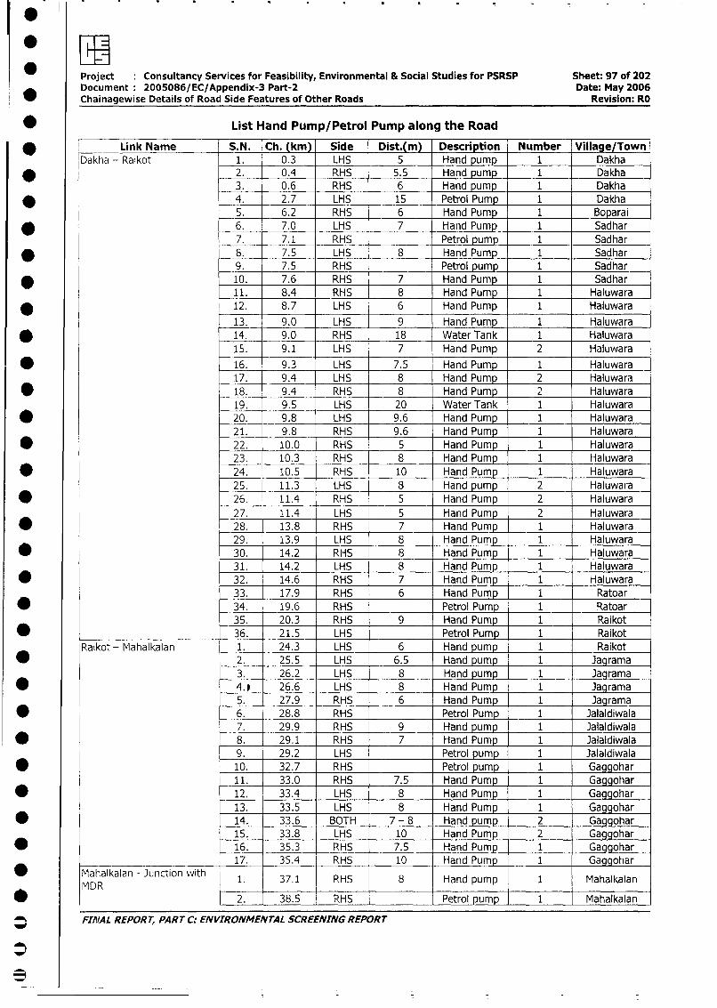
Project Consultancy Services for Feasibility, Environmental & Social Studies for PSRSP Sheet: 97 of 202
Document 2005086/EC/Appendix-3 Part-2 Date: May 2006
Chainagewise Details of Road Side Features of Other Roads Revision: RO
* List Hand Pump/Petrol Pump along the Road
* [ Link Name S.N. Ch. (km) Side Dist.(m) Description Number Village/Town
Dakha - Raikot 1. 0.3 LHS 5 Hand pump 1 Dakha
* f 2. 0.4 RHS 5.5 Hand pump 1 Dakha
3. 0.6 RHS 6 Hand pump 1 Dakha
* 4. 2.7 LHS 15 Petrol Pump 1 Dakha
5. 6.2 RHS 6 Hand Pump 1 Boparai
* 6. 7.0 LHS 7 Hand Pump 1 Sadhar
7. 7.1 RHS Petrol pump 1 Sadhar
* 8. 7.5 LHS 8 Hand Pump 1 Sadhar
9. 7.5 RHS Petrol pump 1 Sadhar
* 10. 7.6 RHS 7 Hand Pump 1 Sadhar
11. 8.4 RHS 8 Hand Pump 1 Haluwara
* 12. 8.7 LHS 6 Hand Pump 1 Haluwara
13. 9.0 LHS 9 Hand Pump 1 Haluwara
* 0 14. 9.0 RHS 18 Water Tank 1 Haluwara
15. 9.1 LHS 7 Hand Pump 2 Haluwara
* 16. 9.3 LHS 7.5 Hand Pump 1 Haluwara
17. 9.4 LHS 8 Hand Pump 2 Haluwara
* _ 18. 9.4 RHS 8 Hand Pump 2 Haluwara
19. 9.5 LHS 20 Water Tank 1 Haluwara
* 20. 9.8 LHS 9.6 Hand Pump 1 Haluwara
21. 9.8 RHS 9.6 Hand Pump 1 Haluwara
* 22. 10.0 RHS 5 Hand Pump 1 Haluwara
23. 10.3 RHS 8 Hand Pump 1 Haluwara
* 24. 10.5 RHS 10 Hand Pump 1 Haluwara
25. 11.3 LHS 8 Hand pump 2 Haluwara
* 26. 11.4 RHS 5 Hand Pump 2 Haluwara
27. 11.4 LHS 5 Hand Pump 2 Haluwara
* 28. 13.8 RHS 7 Hand Pump 1 Haluwara
29. 13.9 LHS 8 Hand Pump 1 Haluwara
* 30. 14.2 RHS 8 Hand Pump 1 Haluwara
31. 14.2 LHS 8 Hand Pump 1 Haluwara
* 32. 14.6 RHS 7 Hand Pump 1 Haluwara
33. 17.9 RHS 6 Hand Pump 1 Ratoar
* 34. 19.6 RHS Petrol Pump 1 Ratoar
35. 20.3 RHS 9 Hand Pump 1 Raikot
* _ 36. 21.5 LHS Petrol Pump 1 Raikot
Raikot - Mahalkalan 1. 24.3 LHS 6 Hand pump 1 Raikot
* 2. 25.5 LHS 6.5 Hand pump 1 Jagrama
3. 26.2 LHS 8 Hand pump 1 Jagrama
* 4.e 26.6 LHS 8 Hand Pump 1 Jagrama
5. 27.9 RHS 6 Hand Pump 1 Jagrama
* 6. 28.8 RHS Petrol Pump 1 Jalaldiwala
7. 29.9 RHS 9 Hand pump 1 Jalaldiwala
* 8. 29.1 RHS 7 Hand Pump 1 Jalaldiwala
9. 29.2 LHS Petrol pump 1 Jalaldiwala
* 10. 32.7 RHS Petrol pump 1 Gaggohar
11. 33.0 RHS 7.5 Hand Pump 1 Gaggohar
* 12. 33.4 LHS 8 Hand Pump 1 Gaggohar
13. 33.5 LHS 8 Hand Pump 1 Gaggohar
* _14. 33.6 BOTH 7 - 8 Hand pump 2 Gaggohar
15. 33.8 LHS 10 Hand Pump 2 Gaggohar_
* 16. 35.3 RHS 7.5 Hand Pump 1 Gaggohar
17. 35.4 RHS 10 Hand Pump 1 Gaggohar
* Mahalkalan - Junction with 1. 37.1 RHS 8 Hand pump 1 Mahalkalan
MDR 2. 38.5 RHS Petrol pump 1 Mahalkalan
_ FIrIAL REPORT, PART C: ENVIRONMENTAL SCREENING REPORT
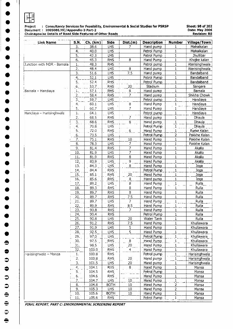
Project Consultancy Services for Feasibility, Environmental & Social Studies for PSRSP Sheet: 98 of 202* Document 2005086/EC/Appendix-3 Part-2 Date: May 2006
Chainagewise Details of Road Side Features of Other Roads Revision: RO
* F Link Name S.N. Ch. (km) Side Dist.(m) Description Number Village/Town* 3. 38.6 LHS 7 Hand pump 1 Mahalkalan
4. 40.0 LHS Petrol Pump 1 Mahalkalan* 5. 42.3 LHS Petrol Pump 1 Jhullibar
6. 45.3 RHS 8 Hand Pump 1 Khojke kalan* Junction with MDR - Barnala 1. 48.3 RHS Petrol pump 1 Aterisinghwala
_ ___ 2. 48.4 LHS 8 Hand pump 1 Aterisinghwala* 3. 51.6 LHS 7.5 Hand pump 1 Bandalband
4. 52.1 LHS Petrol Pump 1 Bandalband* 5. 52.4 RHS Petrol Pump 1 Bandalband
________ 6. 53.7 RHS 20 Stadium 1 Sangera* Barnala - Handiaya 1. 57.1 RHS 8 Hand pump 1 Barnala
2. 58.4 RHS 7 Hand pump 1 Shikha Chowk* 3. 59.7 LHS Petrol pump 1 Handiaya
4. 60.1 LHS 8 Hand Pump 1 Handiaya* 5. 60.7 LHS 7 Hand Pump 1 Handiaya
Handiaya - Harisinghwala 1. 64.1 LHS Petrol pump 1 Handiaya* _ 2. | 68.5 RHS 7 Hand pump 1 Dhaula
3. 68.6 RHS 8 Hand pump 1 Dhaula4. 70.8 LHS Petrol Pump 1 Dhaula5. 72.0 RHS 6 Hand Pump 1 Rurke Kalan
* 6. 73.5 LHS Petrol Pump 2 Pakkhe Kalan7. 75.1 RHS 10 Hand Pump 1 Pakkhe Kalan
* 8. 78.3 LHS 7 Hand Pump 1 Pakkhe Kalan9. 81.4 RHS 7 Hand Pump 1 Akalia10. 81.9 LHS 7 Hand Pump 1 Akalia11. 81.9 RHS 8 Hand Pump 1 Akalia
* 12. 83.9 LHS 9 Hand Pump 1 Akalia13. 84.3 LHS 8 Hand Pump 1 Joga
* 14. 84.4 RHS Petrol Pump 1 Joga15. 85.1 RHS 20 Hand Pump 1 Joga
* 16. 85.6 RHS 8 Hand pump 1 Joga17. 89.2 LHS 8 Hand Pump 1 Rulla
* 18. 89.3 RHS 8 Hand Pump 1 Rulla19. 89.7 RHS 8 Hand Pump 1 Rulla
* 20. 89.7 RHS 7.5 Hand Pump 1 RulIla21. 89.7 LHS 7 Hand Pump 1 Rulla
* 22. 89.9 RHS 8.5 Hand Pump 1 Rulla23. 90.8 RHS 7 Hand Pump 1 Rulla
* 24. 90.4 RHS Petrol Pump 1 RulIla25. 90.8 LHS 20 Water Tank 1 Rulla
* 26. 91.2 RHS 7.5 Hand Pump 1 Khullawara27. 91.9 LHS 5 Hand Pump 1 Khullawara
* _ 28. 92.5 LHS 5 Hand Pump 1 Khullawara29. _ 97.0 LHS Petrol Pump 1 Khullawara
* 30. 97.5 RHS 8 Hand Pump 1 Khullawara31. 98.5 LHS 20 Hand Pump 1 Khullawara32. 100.0 RHS 4 Hand Pump 1 Khullawara
Harisinghwala - Mansa 1. 100.8 RHS Petrol pump 1 Harisinghwala* 2. 100.8 RHS 20 Hand pump 1 Harisinghwala
3. 101.5 LHS 20 Hand pump 1 Harisinghwala* . _104.1 RHS 8 Hand Pump 1 Mansa
5. 104.5 RHS Petrol Pump 1 Mansa* 6. 104.6 RHS Hand Pump 1 Mansa
7. 104.7 LHS 10 -Hand Pump 1 Mansa* 8. 104.8 BOTH 10 Hand Pump 2 Mansa
9. 105.3 LHS 10 Hand Pump 2 Mansa3 o10. 105.6 BOTH 10 Hand Pump 1 Mansa
11. 105.6 RHS Petrol Pump 1 Mansa
_ FINAL REPORT, PART C: ENVIRONMENTAL SCREENING REPORT
S0
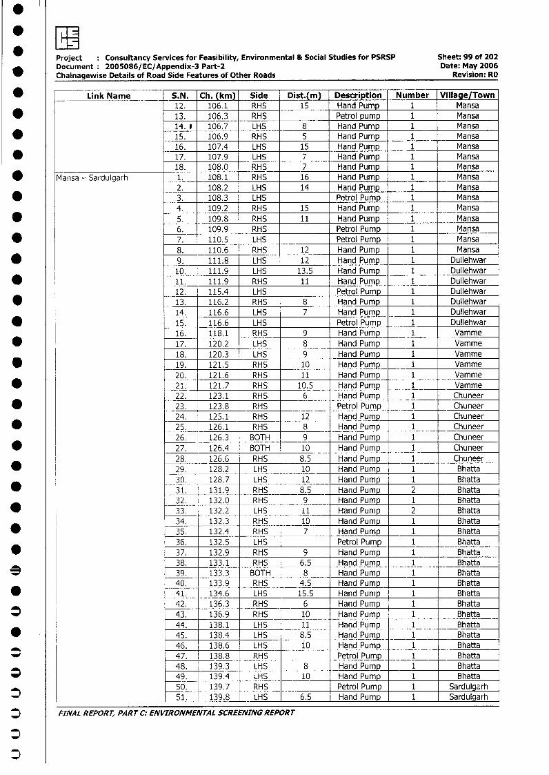
Project : Consultancy Services for Feasibility, Environmental & Social Studies for PSRSP Sheet: 99 of 202Document 2005086/EC/Appendix-3 Part-2 Date: May 2006Chainagewise Details of Road Side Features of Other Roads Revision: RO
* _ Link Name S.N. Ch. (km) Side Dist.(m) Description Number Village/Town12. 106.1 RHS 15 Hand Pump 1 Mansa
* 13. 106.3 RHS Petrol pump 1 Mansa14. e 106.7 LHS 8 Hand Pump 1 Mansa
* 15. 106.9 RHS 5 Hand Pump 1 Mansa16. 107.4 LHS 15 Hand Pump 1 Mansa
* 17. 107.9 LHS 7 Hand Pump 1 Mansa18. 108.0 RHS 7 Hand Pump 1 Mansa
* Mansa - Sardulgarh 1. 108.1 RHS 16 Hand Pump 1 Mansa2. 108.2 LHS 14 Hand Pump 1 Mansa
* 3. 108.3 LHS Petrol Pump 1 Mansa4. 109.2 RHS 15 Hand Pump 1 Mansa
* 5. 109.8 RHS 11 Hand Pump 1 Mansa6. 109.9 RHS Petrol Pump 1 Mansa
* 7. 110.5 LHS Petrol Pump 1 Mansa8. 110.6 RHS 12 Hand Pump 1 Mansa
* 9. 111.8 LHS 12 Hand Pump 1 Dullehwar10. 111.9 LHS 13.5 Hand Pump 1 Dullehwar
* 11. 111.9 RHS 11 Hand Pump 1 Dullehwar12. 115.4 LHS Petrol Pump 1 Dullehwar
* 13. 116.2 RHS 8 Hand Pump 1 Dullehwar14. 116.6 LHS 7 Hand Pump 1 Dullehwar
* 15. 116.6 LHS Petrol Pump 1 Dullehwar16. 118.1 RHS 9 Hand Pump 1 Vamme
* 17. 120.2 LHS 8 Hand Pump 1 Vamme18. 120.3 LHS 9 Hand Pump 1 Vamme
* l 19. 121.5 RHS 10 Hand Pump 1 Vamme20. 121.6 RHS 11 Hand Pump 1 Vamme
* l 21. 121.7 RHS 10.5 Hand Pump 1I1 Vamme22. 123.1 RHS- 6 Hand Pump 1 Chuneer
* 23. 123.8 RHS Petrol Pump 1 Chuneer24. 125.1 RHS 12 Hand Pump 1 Chuneer
* 25. 126.1 RHS 8 Hand Pump 1 Chuneer26. 126.3 BOTH 9 Hand Pump 1 Chuneer27. 126.4 BOTH 10 Hand Pump 1 Chuneer28. 126.6 RHS 8.5 Hand Pump 1 Chuneer29. 128.2 LHS 10 Hand Pump 1 Bhatta30. 128.7 LHS 12 Hand Pump 1 Bhatta
0 _ _31. 131.9 RHS 8.5 Hand Pump 2 Bhatta32. 132.0 RHS 9 Hand Pump 1 Bhatta
* 33. 132.2 LHS 11 Hand Pump 2 Bhatta34. 132.3 RHS 10 Hand Pump 1 Bhatta
* 35. 132.4 RHS 7 Hand Pump 1 Bhatta36. 132.5 LHS Petrol Pump 1 Bhatta
* 37. 132.9 RHS 9 Hand Pump 1 Bhatta38. 133.1 RHS 6.5 Hand Pump 1 Bhatta
3 39. 133.3 BOTH 8 Hand Pump 1 Bhatta40. 133.9 RHS 4.5 Hand Pump 1 Bhatta
* 41. 134.6 LHS 15.5 Hand Pump 1 Bhatta42. 136.3 RHS 6 Hand Pump 1 Bhatta
* l 43. 136.9 RHS 10 Hand Pump 1 Bhatta44. 138.1 LHS 11 Hand Pump 1 Bhatta45. 138.4 LHS 8.5 Hand Pump 1 Bhatta46. 138.6 LHS 10 Hand Pump 1 Bhatta
_ 47. 138.8 RHS Petrol Pump 1 Bhatta48. 139.3 LHS 8 Hand Pump 1 Bhatta49. 139.4 LHS 10 Hand Pump 1 Bhatta50. 139.7 RHS Petrol Pump _ 1 _ Sardulgarh51. 139.8 LHS 6.5 Hand Pump 1 Sardulgarh
* FINAL REPORT, PART C; ENVIRONMENTAL SCREENING REPORT
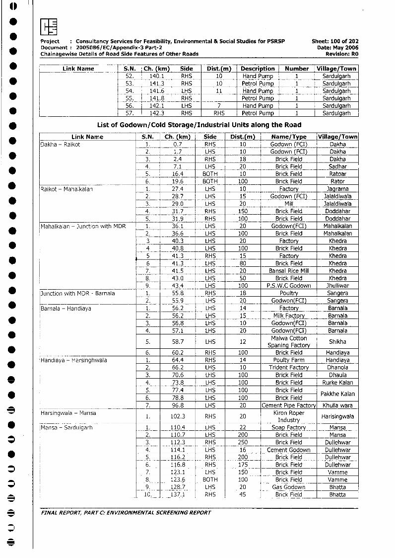
Project Consultancy Services for Feasibility, Environmental & Social Studies for PSRSP Sheet: 100 of 202Document 2005086/EC/Appendix-3 Part-2 Date: May 2006Chainagewise Details of Road Side Features of Other Roads Revision: RO
* __ _ Link Name S.N. Ch. (km) Side Dist.(m) Description Number Village/Town52. 140.1 RHS 10 Hand Pump 1 Sardulgarh53. 141.3 RHS 10 Petrol Pump 1 Sardulgarh54. 141.6 LHS 11 Hand Pump 1 Sardulgarh
* 55. 141.8 RHS Petrol Pump 1 Sardulgarh56. 142.1 LHS 7 Hand Pump 1 Sardulgarh
*____ _______________ 57. 142.3 RHS RHS Petrol Pump 1 Sardulgarh
* List of Godown/Cold Storage/Industrial Units along the Road
Link Namie S.N. Ch. (ki) Side Dist.(m) Name/Type Village/Town_ Dakha - Raikot 1. 0.7 RHS 10 Godown (FCI) Dakha
2. 1.7 LHS 10 Godown (FCI) Dakha3. 2.4 RHS 18 Brick Field Dakha4. 7.1 LHS 20 Brick Field Sadhar
* 5. 16.4 BOTH 10 Brick Field Ratoar6. 19.6 BOTH 100 Brick Field Rator
Raikot - Mahalkalan 1. 27.4 LHS 10 Factory Jagrama2. 28.7 LHS 15 Godown (FCI) Jalaldiwala3. 29.0 LHS 20 Mill Jalaldiwala4. 31.7 RHS 150 Brick Field _ Doddahar5. 31.9 RHS 100 Brick Field Doddahar
Mahalkalan - Junction with MDR 1. 36.1 LHS 20 Godown(FCI) Mahalkalan2. 36.6 LHS 100 Brick Field Mahalkalan3 40.3 LHS 20 Factory Khedra4 40.8 LHS 100 Brick Field Khedra5 41.3 RHS 15 Factory Khedra
* 6 41.3 LHS 80 Brick Field Khedra7. 41.5 LHS 20 Bansal Rice Mill Khedra
* 8. 43.0 LHS 50 Brick Field Khedra9. 43.4 LHS 100 P.S.W.C Godown Jhulliwar
Junction with MDR - Barnala 1. 55.8 RHS 18 Poultry Sangera_____________________________ 2. 55.9 LHS 20 Godwon(FCI) Sangera
Barnala - Handiaya 1. 56.2 LHS 14 Factory Barnala2. 56.2 LHS 15 Milk Factory Barnala
* l 3. 56.8 LHS 10 Godown(FCI) Barnala4. 57.1 LHS 20 Godown(FCI) Barnala
5. 58.7 LHS 12 Malwa Cotton Shikha
* _______________________ 6. 60.2 RHS 100 Brick Field HandiayaHandiaya - Harsinghwala 1. 64.4 RHS 14 Poulty Farm Handiaya
2. 66.2 LHS 10 Trident Factory Dhanola3. 70.6 LHS 100 Brick Field Dhaula
* 4. 73.8 LHS 100 Brick Field Rurke Kalan5. 77.4 LHS 100 Brick Field Pakkhe Kalan6. 78.8 LHS 100 Brick Field
____ ________________________ 7. 96.8 LHS 20 Cement Pipe Factory Khulla wara* Harsingwala - Mansa 1. 102.3 RHS 20 Kiron Roper Harisingwala
Industry Hrsnwl* Mansa - SardLIlgarh 1. 110.4 LHS 22 Soap Factory Mansa
2. 110.7 LHS 200 Brick Field Mansa*l 3. 112.3 RHS 250 Brick Field Dullehwar
4. 114.1 LHS 16 Cement Godown Dullehwar* i _ 5. 116.2 RHS 200 Brick Field Dullehwar
6. 116.8 RHS 175 Brick Field Dullehwar* l 7. 123.1 LHS 150 Brick Field Vamme
: 8. 123.6 BOTH 100 Brick Field Vamme* 9. 128.7 LHS 20 Gas Godown Bhatta
3 _ _ _ 10. 137.1 RHS 45 Brick Field Bhatta
3 FINAL REPORT, PART C: ENVIRONMENTAL SCREENING REPORT
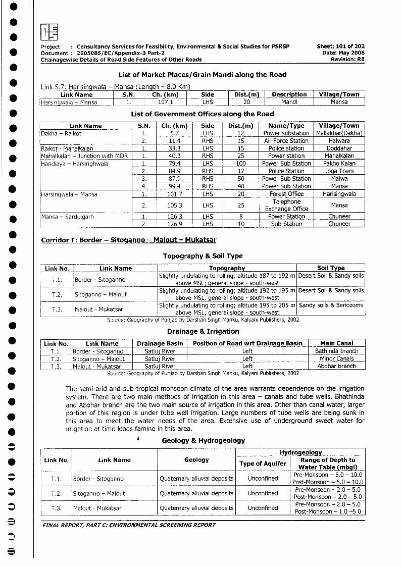
Project : Consultancy Services for Feasibility, Environmental & Social Studies for PSRSP Sheet: 101 of 202* Document: 2005086/EC/Appendix-3 Part-2 Date: May 2006
Chainagewise Details of Road Side Features of Other Roads Revision: RO
*List of Market Places/Grain Mandi along the Road
Link S.7: Harisingwala - Mansa Len th - 8.0 Km* ___ Link Name S.N. Ch. (km) Side Dist.(m) Description Village/Town
Harsingwala-_ansa 1. 107.1 | LHS 20 Mandi Mansa
* List of Government Offices along the Road
_ Link Name S.N. Ch. (km) Side Dist.(m) Name/Type Village/TownDakha - Raikot 1. 5.7 LHS 12 Power substation Mallakbar(Dakha)
* 2. 11.4 RHS 15 Air Force Station HalwaraRaikot - Mahalkalan 1. 33.3 LHS 15 Police station Doddahar
* Mahalkalan - Junction with MDR 1. 40.3 RHS 25 Power station MahalkalanHandiaya - Harsinghwala 1. 79.4 LHS 100 Power Sub Station Pakho Kalan
* 2. 84.9 RHS 12 Police Station Joga Town3. 87.9 RHS 50 Power Sub Station Malwa
* 4. 99.4 RHS 40 Power Sub Station MansaHarsingwala - Mansa 1. 101.7 LHS 20 Forest Office Harisingwala
2. 105.3 LHS 25 Exchange Office Mansa
* Mansa - Sardulgarh 1. 126.3 LHS 8 Power Station Chuneer2. 126.9 LHS 10 Sub-Station Chuneer
* Corridor T: Border - Sitoganno - Malout - Mukatsar
Topography & Soil Type
* | Link No. Link Name Topography Soil TypeSlightly undulating to rolling; altitude 187 to 192 m Desert Soil & Sandy soils
* E T.1. Border - Sitoganno above MSL; general slope - south-west
* T.2. Sitoganno - Malout Slightly undulating to rolling; altitude 192 to 195 m Desert Soil & Sandy soils*_ T.2._Sitoganno-Malout above MSL; general slope - south-west __ _
T. 3. Malout - Mukatsar Slightly undulating to rolling; altitude 195 to 205 m -Sandy soils & Seriozems* t T.3. Flalout - Mukatsar above MSL; general slope - south-west
Source: Geography of Punjab by Darshan Singh Manku, Kalyani Publishers, 2002
Drainage & Irrigation
* Link No. Link Name Drainage Basin Position of Road wrt Drainage Basin Main CanalT.1. Border - Sitoganno Satluj River Left Bathinda branch
_ T.2. Sitoganno - Malout Satluj River Left Minor CanalsT.3. Malout - Mukatsar_ _ Satluj River Left Abohar branch
* Source: Geography of Punjab by Darshan Singh Manku, Kalyani Publishers, 2002
* The semi-arid and sub-tropical monsoon climate of the area warrants dependence on the irrigationsystem. There are two main methods of irrigation in this area - canals and tube wells. Bhathinda
* and Abohar branch are the two main source of irrigation in this area. Other than canal water, larger* portion of this region is under tube well irrigation. Large numbers of tube wells are being sunk in
this area to meet the water needs of the area. Extensive use of underground sweet water for* irrigation at time leads famine in this area.
Geology & Hydrogeology
Hydrogeology* Link No. Link Name Geology TypRange of Depth to
____ Type of Aquifer ~~~~~~~~~Water Table (mbgl)
* T.1. [Border - Sitoganno Quaternary alluvial deposits Unconfined Pre-Monsoon - 5.0 - 10.0Post-Monsoon - 2.0 - 50.0
* T.2. Sitoganno - Malout Quaternary alluvial deposits Unconfined Pre-Monsoon - 2.0 - 5.0Post-Monsoon - 2.0 - 5.0-
IT.3. Malout - Mukatsar Quaternary alluvial deposits Unconfined Pre-Monsoon - 2.0 - 5.0
* FINAL REPORT, PART C: ENVIRONMENTAL SCREENING REPORT
0
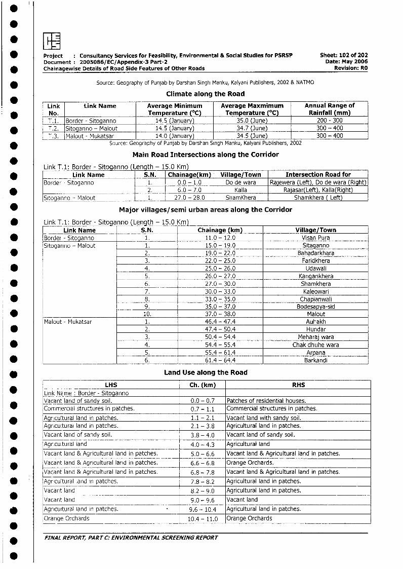
* Project Consultancy Services for Feasibility, Environmental & Social Studies for PSRSP Sheet: 102 of 202Document: 2005086/EC/Appendix-3 Part-2 Date: May 2006
* Chainagewise Details of Road Side Features of Other Roads Revision: RO
* Source: Geography of Punjab by Darshan Singh Manku, Kalyani Publishers, 2002 & NATMO
Climate along the Road
Link Link Name Average Minimum Average Maxmimum Annual Range of* No. Temperature (°C) Temperature (°C) Rainfall (mm)
T.1. Border - Sitoganno 14.5 (January) 35.0 (June) 200 - 300* T.2. Sitoganno - Malout 14.5 (January) 34.7 (June) 300 - 400
| T.3. Malout - Mukatsar 14.0 (January) 34.5 (June) 300 - 400* Source: Geography of Punjab by Darshan Singh Manku, Kalyani Publishers, 2002
Main Road Intersections along the Corridor
Link T.1: BordJer - Sitoganno (Lenqth - 1 5.0 Km)* __ Link Name S.N. Chainage(km) Village/Town Intersection Road for
Border - Sitoganno 1. 0.0 - 1.0 Do de wara Rajewera (Left), Do de wara (Right)* -~__ ________ 2. 6.0 - 7.0 Kalla Rajasar(Left) Kalla(Right)
Sitoganno - Malout 1. 27.0 - 28.0 ShamKhera Shamkhera ( Left)
* Major villages/semi urban areas along the Corridor
* Link T.1: Border - Sitoga nno (Length - 15.0 (m)Link Name S. P. Chainage (km) Village/Town
* Border- Sitoganno 1. 11.0 - 12.0 Visan PuraSitoganno - Malout 1. 15.0 - 19.0 Sitaganno
* 2. 19.0 - 22.0 Bahadarkhara3. 22.0 - 25.0 Faridkhera
* _ 4. 25.0 - 26.0 Udawali5. 26.0 - 27.0 Kangankhera
* 6. 27.0 - 30.0 Shamkhera7. 30.0 - 33.0 Kaleowari
* 8. 33.0 - 35.0 Chapianwali9. 35.0 - 37.0 Bodesapya-sid
* 10. 37.0 - 38.0 MaloutMalout - Mukatsar 1. 46.4 - 47.4 Auhakh
* 2. 47.4 - 50.4 Hundar3. 50.4 - 54.4 Meharaj wara
* 4. 54.4 - 55.4 Chak dhuhe wara5. 55.4 - 61.4 Arpana6. 61.4 - 64.4 Barkandi
* Land Use along the Road
*___ LHS Ch. (km) RHSLink NEme : Border - SitogannoVacant land of sandy soil. 0.0 - 0.7 Patches of residential houses.Commercial structures in patches. 0.7- 1.1 Commercial structures in patches.
* Agricultural land in patches. 1.1 - 2.1 Vacant land with sandy soil.Agricultural land in patches. 2.1 - 3.8 Agricultural land in patches.
* Vacant land of sandy soil. 3.8 - 4.0 Vacant land of sandy soil.Agricultural land 4.0 - 4.3 Agricultural land
* Vacant land & Agricultural land in patches. 5.0 - 6.6 Vacant land & Agricultural land in patches.* Vacant land & Agricultural land in patches. 6.6 - 6.8 Orange Orchards.
Vacant land & Agricultural land in patches. 6.8 - 7.8 Vacant land & Agricultural land in patches.* Agricultural land in patches. 7.8 - 8.2 Agricultural land in patches.
Vacant land 8.2 - 9.0 Agricultural land in patches.* Vacant land 9.0 - 9.6 Vacant land* Agricultural land in patches. 9.6 - 10.4 Agricultural land in patches.
Orange Orchards 10.4 - 11.0 Orange Orchards
* FINAL REPORT, PART C: ENVIRONMENTAL SCREENING REPORT
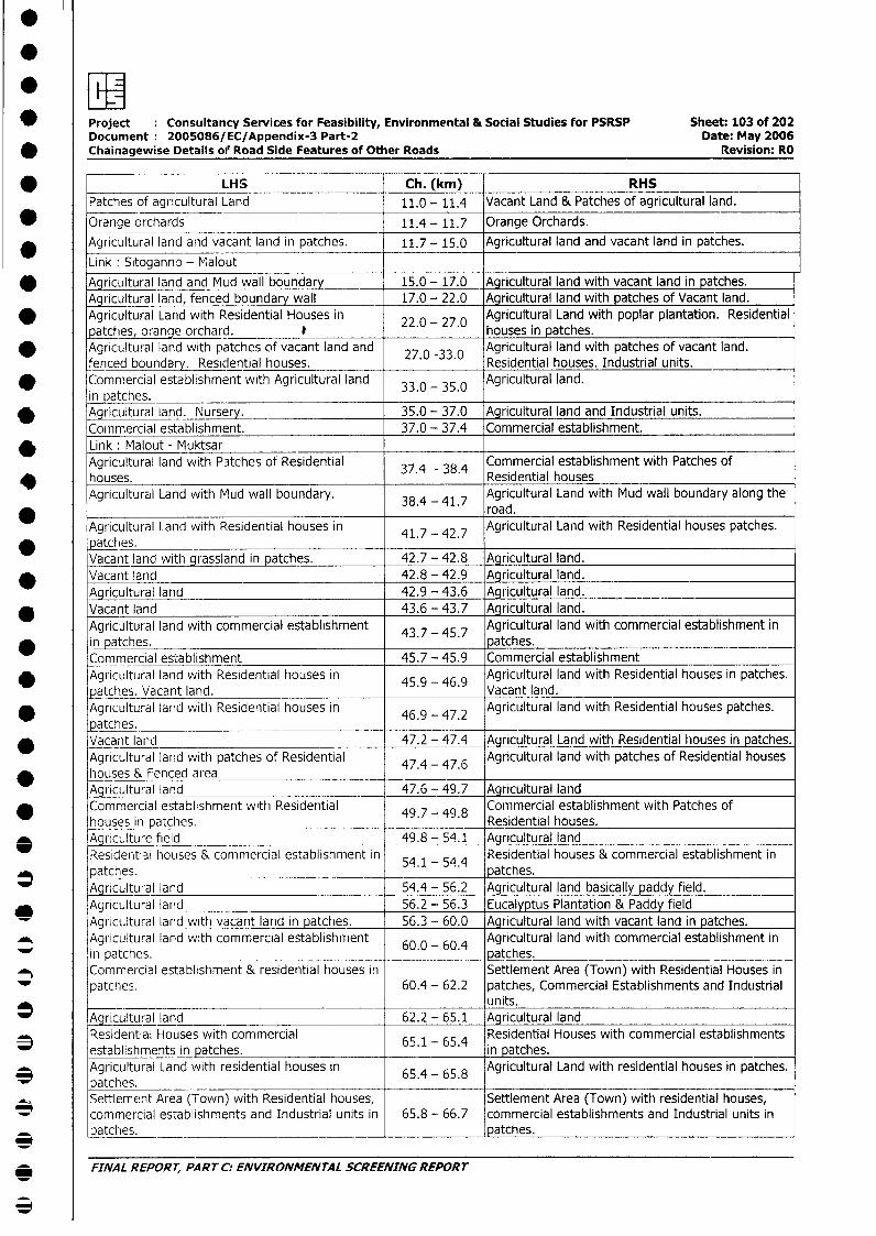
Project Consultancy Services for Feasibility, Environmental & Social Studies for PSRSP Sheet: 103 of 202Document: 2005086/EC/Appendix-3 Part-2 Date: May 2006
* Chainagewise Details oil Road Side Features of Other Roads Revision: RO
* LHS Ch. (km) RHS
Patches of agricultural Land 11.0 - 11.4 Vacant Land & Patches of agricultural land.
* Orange orchards 11.4 - 11.7 Orange Orchards.
* Agricultural land and vacant land in patches. 11.7- 15.0 Agricultural land and vacant land in patches.
Link: Sitoganno - Malout
* AAgricultural land and Mud wall boundary 15.0 - 17.0 Agricultural land with vacant land in patches.Agricultural land, fenced boundary wall 17.0 - 22.0 Agricultural land with patches of Vacant land.
* Agricultural Land with Residential Houses in 22.0 - 27 0 Agricultural Land with poplar plantation. Residentialpatches, orange orchard. I houses in patches.
* Agricultural land with patches of vacant land and 27.0 -33.0 Agricultural land with patches of vacant land.fenced boundary. Residential houses. Residential houses. Industrial units.
* Commercial establishment with Agricultural land 33.0 - 35.0 Agricultural land.in patches. _
* Agricultural land. Nursery. 35.0 - 37.0 Agricultural land and Industrial units.Commercial establishment. 37.0 - 37.4 Commercial establishment.
* Link Malout - MuktsarAgricultural land with P3tches of Residential 37 - 38.4 Commercial establishment with Patches ofhouses. Residential housesAgricultural Land with Mud wall boundary. 38.4 - 41.7 Agricultural Land with Mud wall boundary along the
38.4 - road.Agricultural Land with Residential houses in 41.7 - 42.7 Agricultural Land with Residential houses patches.
* patches.Vacant land with grassland in patches. 42.7 - 42.8 Agricultural land.Vacant land 42.8 - 42.9 Agricultural land.Agricultural land 42.9 - 43.6 Agricultural land.
* Vacant land 43.6 - 43.7 Agricultural land.Agricultural land with commercial establishment 43.7 - 45.7 Agricultural land with commercial establishment in
* in patches. patches.Commercial establishment 45.7 - 45.9 Commercial establishment
* Agricultural land with Residential houses in 45.9 - 46.9 Agricultural land with Residential houses in patches.atches. Vacant land. Vacant land.
* Agricultural land with Residential houses in 46.9 - 47.2 Agricultural land with Residential houses patches.patches. _ __
* Vacant land 47.2 - 47.4 Agricultural Land with Residential houses in patches.Agricultural land with patches of Residential 47.4 - 47.6 Agricultural land with patches of Residential houseshouses & Fenced area ._-_.6Agricultural land 47.6 - 49.7 Agricultural land
* Commercial establishment with Residential 49.7 - 49 8 Commercial establishment with Patches ofhouses in patches. Residential houses.
O ,Agriculture field 49.8 - 54.1 Agricultural landResidential houses & commercial establishment in 54.1 - 54.4 Residential houses & commercial establishment inpatches. -_ 5 54 patches.Agricultural land 54.4 - 56.2 Agricultural land basically paddy field.
ricultural land 56.2 - 56.3 Eucalyptus Plantation & Paddy fieldAgrncultural land with vacant land in patches. 56.3 - 60.0 Agricultural land with vacant land in patches.
_ Agricultural land with commercial establishment 60.0 - 60.4 Agricultural land with commercial establishment inin atches. patches.Commercial establishment & residential houses in Settlement Area (Town) with Residential Houses inpatches. 60.4 - 62.2 patches, Commercial Establishments and Industrial_ units.
0 X jcultural land 62.2 - 65.1 Agricultural landResidential Houses with commercial 65.1 - 654 Residential Houses with commercial establishmentsestablishments in patches. in patches.
* Agricultural Land with residential houses in 65.4 - 65.8 Agricultural Land with residential houses in patches.patches. 65___ _4_ _-__ _65__ _8
Settlement Area (Town) with Residential houses, Settlement Area (Town) with residential houses,commercial establishments and Industrial units in 65.8 -- 66.7 commercial establishments and Industrial units inpatches. __ patches.
FINAL REPORT, PART C: ENVIRONMENTAL SCREENING REPORT
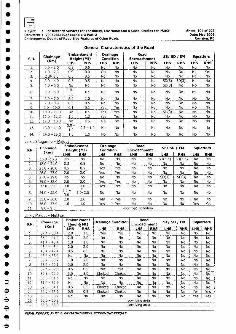
* Project Consultancy Services for Feasibility, Environmental & Social Studies for PSRSP Sheet: 104 of 202Document: 2005086/EC/Appendix-3 Part-2 Date: May 2006Chainagewise Details of Road Side Features of Other Roads Revision: RO
General Characteristics of the Road
* 5.N. Chainage Heim ht (Mt) Drainage Road SE/ SD / EM Squatters
_ (Kin) LHS RHS LHS RHS LHS RHS LHS RHS LHS RHS* 1. 0.0- 1.0 0.5 0.5 No No No No No No No No
2. 1.0 - 2.0 0.0 0.0 Yes No No No No No No Yes* 3. 2 .0- 3.0 0.5 0.5 No No No No No No No No
-_4. 3.0 - 4.0 0.5 0.5 No No No No SD(3) SD(3) No No* _ 5. 4.0 - 5.0 No No No No No No SD(3) No No No
6. 5.0 - 6.0 1.0 - No No No No No No No No No
7. _ 6.0 - 7.0 2.0 2.0 No No No No No No No No* 8. 7.0 - 8.0 0.5 0.5 No No No No No No No No
9. 9.0- 10.0 0.1 0.1 Yes Yes No No No No No No* _10. 10.0 - 11.0 No No Yes Yes No No SD(3) No No No
11. 11.0- 12.0 1.0 1.0 Yes Yes No No No No No No* 12. 12.0- 13.0 No No No No No No No No No No
F 13. 13.0- 14.0 0.5- 0.5- 1.0 No No No No No No No No1.0 _
14. 14.0 - 15.0 1.0 1.0 No No No No No No No No
* Link: Sitoqanno- MaloutChainage Embankment Drainage Ra E DE qatr
* S.N. (hin) Hei ht (Mt) Condition Encroachment SE/ SD / EM SquattersLHS RHS LHS RHS LHS RHS LHS RHS LHS RHS
_ 1. 15.0 -18.0 No No No No No No SD(3.5) SD(3.5) No No2. 18.0 - 21.0 0.5 0.5 No No No No No No No No
_ 3. 21.0 - 26.0 0.5 0.5 Yes Yes No No No No No No4. 26.0 - 27.0 2.0 2.0 Yes Yes No No No No No No
* 5. 27.0 - 29.0 No No No No No No SD(3) SD(3) No No* 6. 29.0 -- 32.0 2.0 2.0 Yes Yes No No No No No No
7. 32.0- 33.0 _3.0 3.0 Yes Yes No No No No No No
S. 34.0 - 35.0 0 2.0- 3.0 No No No No No No No No
9. 35.0 - 36.0 2.0 2.0 Yes Yes No No No No No No_ _10. 36.0 - 37.4 1.0 1.0 Yes Yes No No No No Yes Yes
* 11. 8.0 - 9.0 Poor road condition
Lirnk: Malout - Muktsar* ~ ~~~~Caiae Embankment Drainage Condition RoadSESD M Sqatr
SN Chainage Height(Mt) Encroachment SE/ SD / EM Squatters* (Kin( ) | LHS RHS LHS RHS LHS RHS LHS RHS LHS RHS
1. 37.4 - 38.4 2.0 2.0 Yes Yes No No No No No Noe r 2. 38.4 - 41.4 2.0 2.0 No No No NoI No No No No
3. 41.4 - 43.4 1.0 1.0 No No No No No No No No* L |4. 43.4 - 46.4 2.0 2.0 No No No No No No No No
5. 46.4 - 47.4 0.5 0.5 No No No No No No No No* 1 6. 47.4 - 56.4 No No No No No No No No No No
7. 56.4 - 58.2 1.0 1.0 No No No No No No No No* r8 58.2 - 59.1 2.0 2.0 No No No No No No No No
9. 59.1 - 59.8 0.5 0.5 Yes Yes No No No No No No* 10. 59.8 - 60.0 3.0 3.0 Choked Choked No No No No No No
11. 60.0 - 61.4 No No No No No No No No No No* | 12. 61.4 - 62.9 No No No No No No No No No No
13. 62.9 - 64.1 0.5 | 0.5 Choked Choked No No No No No No3 | 14. 64.1 - 65.9 0.5 1 0.5 Choked Choked No No No No Yes Yes
15. 65.9 - 66.7 No No No No No No No No Yes Yes* 1 16. 60.0 - 60.2 Low lying area
17. 65.8 - 66.0 Low lying area
FINAL REPORT, PART C: ENVIRONMENTAL SCREENING REPORT
3
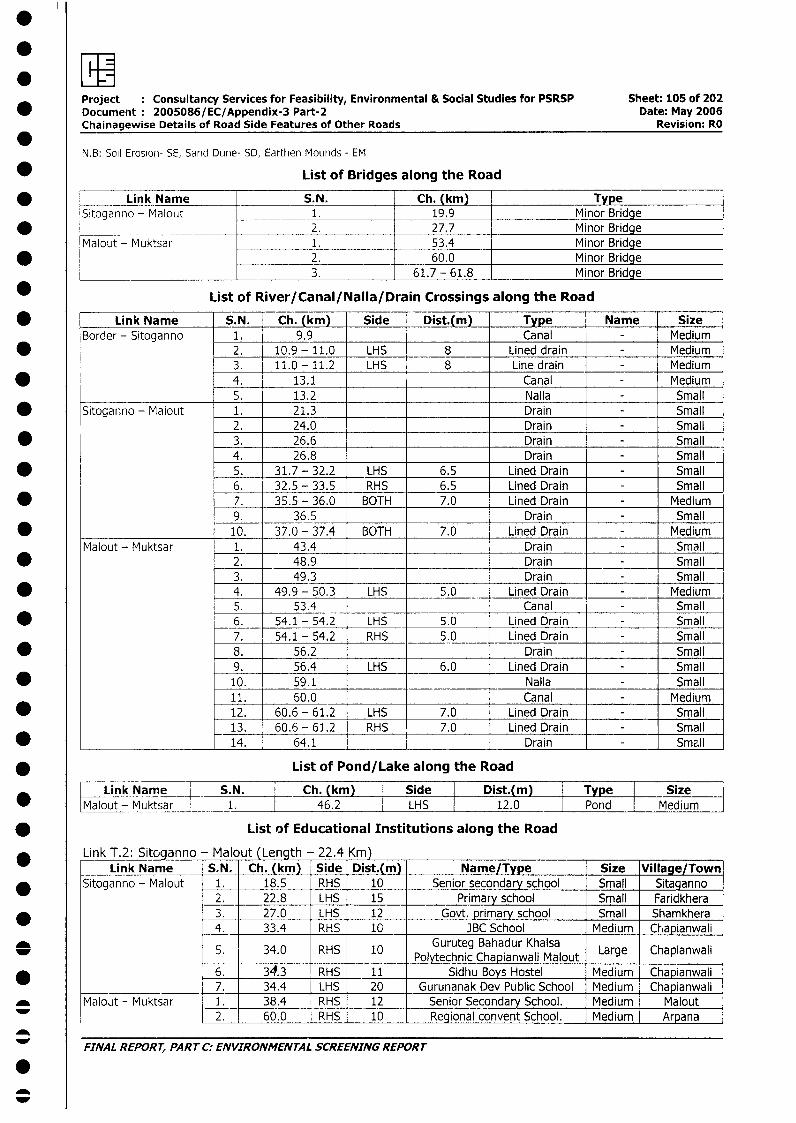
Project Consultancy Services for Feasibility, Environmental & Social Studies for PSRSP Sheet: 105 of 202* Document: 2005086/EC/Appendix-3 Part-2 Date: May 2006
Chainagewise Details of Road Side Features of Other Roads Revision: RO*
N.B: Soil Erosion- SE, Sand DLine- SD, Earthien Mounds - EM
* List of Bridges along the Road
* Link Name S.N. Ch. (kmi) TypeSitoganno - Malout 1. 19.9 Minor Bridge
* _ 2. 27.7 Minor BridgeMalout - Muktsar 1. 53.4 Minor Bridge
* 2. 60.0 Minor Bridge_ ____--____________ 3. 61.7 - 61.8 Minor Bridge
List of River/Canal/Nalla/Drain Crossings along the Road
* Link Name S.N. Ch. (km) Side Dist.(m) Type Name SizeBorder - Sitoganno 1. 9.9 Canal - Medium
* 2. 10.9-11.0 LHS 8 Lined drain - Medium3. 11.0 - 11.2 LHS 8 Line drain - Medium
* l 4. 13.1 Canal - Medium____ 5. 13.2 Nalla - Small
* Sitopanno - Malout 1. 21.3 Drain - Small2. 24.0 Drain - Small
* l 3. 26.6 Drain - Small4. 26.8 Drain - Small5. 31.7 - 32.2 LHS 6.5 Lined Drain - Small6. 32.5 - 33.5 RHS 6.5 Lined Drain - Small
* 7. 35.5 - 36.0 BOTH 7.0 Lined Drain - Medium9. 36.5 Drain - Small
* ____________________ 10. 37.0 - 37.4 BOTH 7.0 Lined Drain - MediumMalout - Muktsar 1. 43.4 Drain - Small
* 2. 48.9 _ _ Drain - Small3. 49.3 Drain - Small
* 4. 49.9 - 50.3 LHS 5.0 Lined Drain - Medium5. 53.4 Canal - Small
* 6. 54.1 - 54.2 LHS 5.0 Lined Drain - Small7. 54.1 - 54.2 RHS 5.0 Lined Drain - Small
* 8. 56.2 Drain - Small9. 56.4 LHS 6.0 Lined Drain - Small
* 10. 59.1 Nalla - Small11. 60.0 Canal Medium
* 12. 60.6 - 61.2 LHS 7.0 Lined Drain - Small13. 60.6 - 61.2 RHS 7.0 Lined Drain - Small
* ____________________ 14. 64.1 _ Drain - Small
* List of Pond/Lake along the Road
Link Name S.N. | Ch. (ki) I Side |n Dist.m) Type Size I* |Malout- Muktsar | __1. | 46.2 | LHS 12.0 Pond Medium
* List of Educational Institutions along the Road
Link T.2: Sitoganno - Malout (Length - 22.4 Km)Link Name S.N. Ch. (km) Side Dist.(m) Name/Type Size Village/Town
* Sitoganno - Ma lout 1. 18.5 RHS 10 Senior secondary school Small Sitaganno2. 22.8 LHS 15 Primary school Small Faridkhera3. 27.0 LHS 12 Govt. primary school Small Shamkhera4. 33.4 RHS 10 JBC School Medium _Chapianwali
* ~~~ ~~~~~~~5. 34.0 RHS 10 Guruteg Bahadur Khalsa Lag ChpnwiPolytechnic Chapianwali Malout Large Chapianwali
6. 34.3 RHS 11 Sidhu Boys Hostel Medium Chapianwali7._ 34.4 LHS 20 Gurunanak Dev Public School Medium Chapianwali
* Malout - Muktsar 1. 38.4 RHS 12 Senior Secondary School. Medium Malout2. 60.0 RHS 10 Regional convent School. Medium Arpana
FINAL REPORT, PART C: ENVIRONMENTAL SCREENING REPORT
00
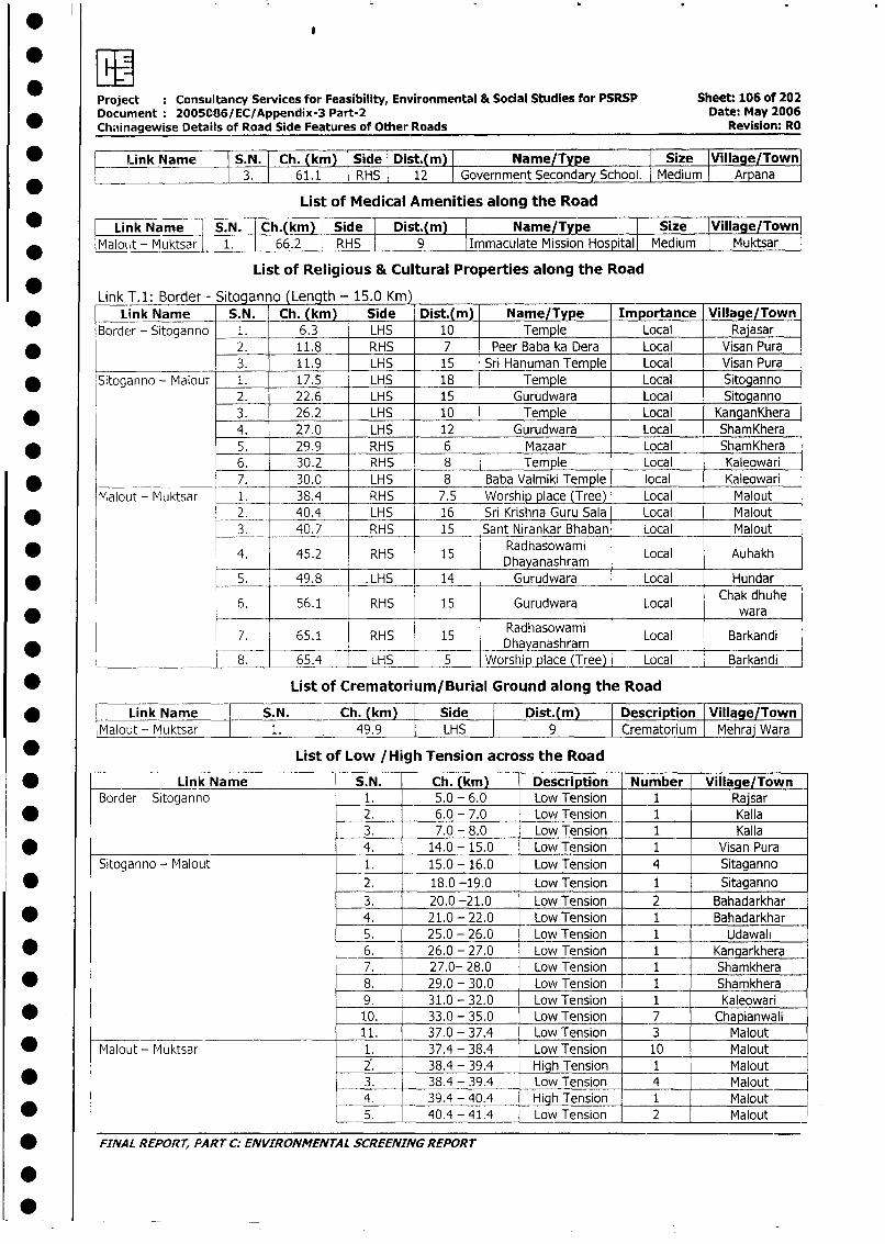
Project : Consultancy Services for Feasibility, Environmental & Social Studies for PSRSP Sheet: 106 of 202Document 2005086/EC/Appendix-3 Part-2 Date: May 2006Chainagewise Details of Road Side Features of Other Roads Revision: RO
* H Link Name S.N. Ch. (km) Side Dist.(m) Name/Type I Size Village/Town* l l 3. l 61.1 RHS 12 Government Secondary School. I Medium Arpana
List of Medical Amenities along the Road
_ LLink Name | S.N. Ch.(km) Side Dist.(m) Name/Type Size lVillage/Town
* |Malout - Muktsar l 1. 66.2 RHS 9 Immaculate Mission Hospital Medium I Muktsar
List of Religious & Cultural Properties along the Road
Link T.1: Border - Sitoganno (Length - 15.0 Km)* Link Name S. N. Ch. (km) Side Dist.(m) Name/Type Importance Village/Town
Border - Sitoganno 1. 6.3 LHS 10 Temple Local Rajasar
2. 11.8 RHS 7 Peer Baba ka Dera Local Visan Pura
_ 3. 11.9 LHS 15 Sri Hanuman Temple Local Visan Pura
* Sitoganno - Malout 1. - 17.5 LHS 18 Temple Local Sitoganno
2. 22.6 LHS 15 Gurudwara Local Sitoganno
* 3. 26.2 LHS 10 Temple Local KanganKhera
4. 27.0 LHS 12 Gurudwara Local ShamKhera
* - 5. 29.9 RHS 6 Mazaar Local ShamKhera
6. 30.2 RHS 8 Temple Local Kaleowari
u_a ______.7. 30.0 LHS 8 Baba Valmiki Temple local Kaleowari
Malout - Muktsar 1. 38.4 RHS 7.5 Worship place (Tree) Local Malout
2. 40.4 LHS 16 Sri Krishna Guru Sala Local Malout
_ 3. 40.7 RHS 15 Sant Nirankar Bhaban Local Malout
4 . 52 RS 15 Radhasowami Local Auhakh* 4. 45.2 RHS 15 Dhayanashram
* l 5. 49.8 . LHS 14 Gurudwara Local Hundar
6. 56.1 RHS 15 Gurudwara Local Chak dhuhewaraRadhasowami
7. 65.1 RHS 15 dhasowam Local Barkandi* l ~~~~~~~~~~~~ ~ ~~Dhayanashram.
_- 8. 65.4 LHS 5 Worship place (Tree) Local Barkandi
* List of Crematorium/Burial Ground along the Road
* Link Name S.N. Ch. km Side Dist.(m) Description Village/Town
Malout - Muktsar 1. 49.9 LHS 9 Crematorium Mehraj Wara
* List of Low /High Tension across the Road
* | Link Name S.N. Ch. (km) Description Number Village/Town
Border -- Sitoganno 1. 5.0 - 6.0 Low Tension 1 Rajsar
* l l 2. 6.0 - 7.0 Low Tension 1 Kalla3. 7.0 - 8.0 Low Tension 1 Kalla
* l l 4. 14.0 - 15.0 Low Tension 1 Visan Pura
Sitoganno - Malout 1. 15.0 - 16.0 Low_Tension 4 Sitaganno
j * | l 2. 18.0 -19.0 Low Tension 1 Sitaganno
3. 20.0 -21.0 Low Tension 2 Bahadarkhar
| * l l 4. 21.0 - 22.0 Low Tension 1 Bahadarkhar
5. 25.0 - 26.0 Low Tension 1 Udawali
| * I L_ 6. 26.0 - 27.0 Low Tension 1 Kangarkhera7. 27.0- 28.0 Low Tension 1 Shamkhera
| * l l 8 l. 29.0 - 30.0 Low Tension 1 Shamkhera9. 31.0 - 32.0 Low Tension 1 Kaleowari
10. 33.0 - 35.0 Low Tension 7 Chapianwali
11. 37.0 - 37.4 Low Tension 3 Malout
| * | Malout - Muktsar 1. 37.4 - 38.4 Low Tension 10 Malout2 . 38.4 - 39.4 High Tension 1 Malout
_ l l 3. 38.4 - 39.4 Low Tension 4 Malout
4. 39.4 - 40.4 High Tension 1 Malout
l * l l 5. 40.4 - 41.4 Low Tension 2 Malout
| * FINAL REPORT, PART C: ENVIRONMENTAL SCREENING REPORT
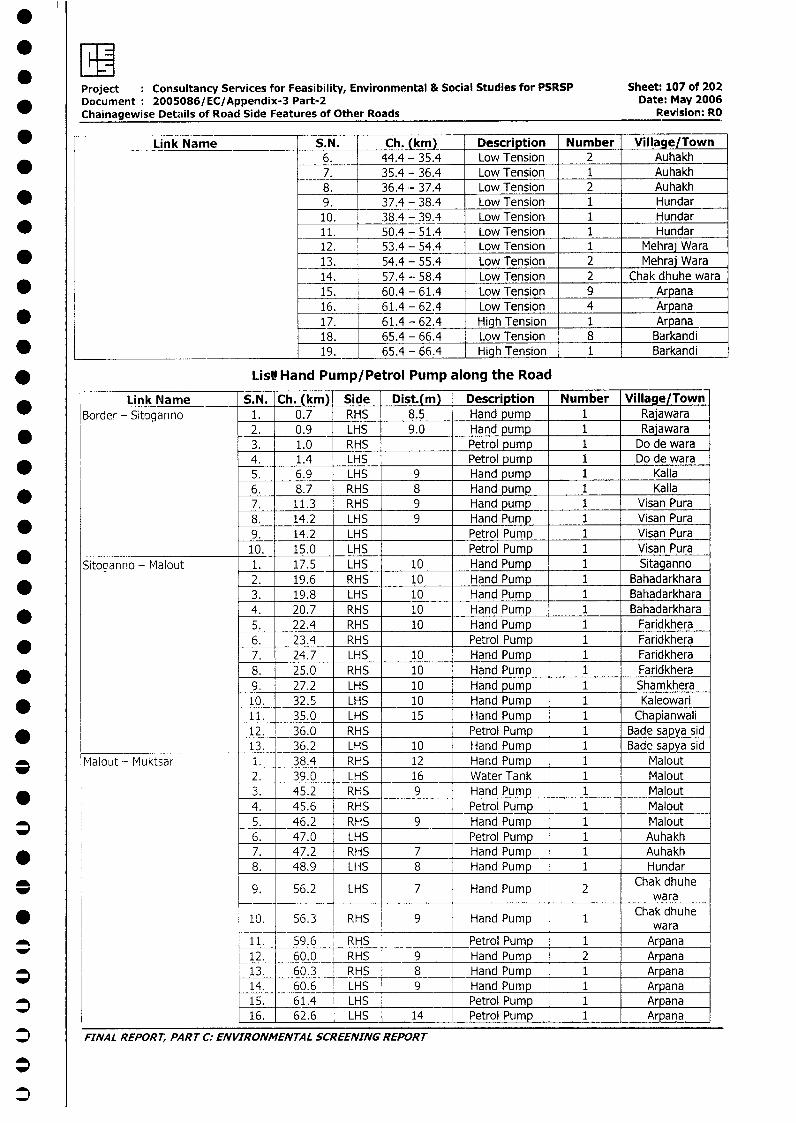
Project Consultancy Services for Feasibility, Environmental & Social Studies for PSRSP Sheet: 107 of 202Document: 2005086/EC/Appendix-3 Part-2 Date: May 2006Chainagewise Details of Road Side Features of Other Roads Revision: RO
*=Link Name S.N. Ch. (km) Description Number Village/Town* _ k 6. 44.4 - 35.4 Low Tension 2 Auhakh
*7. 35.4 - 36.4 Low Tension 1 Auhakh8. 36.4 - 37.4 Low Tension 2 Auhakh
* , 9. 37.4 - 38.4 Low Tension 1 Hundar10. 38.4 - 39.4 Low Tension 1 Hundar
_ 11. 50.4 - 51.4 Low Tension 1 Hundar12. 53.4 - 54.4 Low Tension 1 Melhraj Wara
_ _ 13. 54.4 - 55.4 Low Tension 2 Mehraj Wara14. 57.4 - 58.4 Low Tension 2 Chak dhuhe wara15. 60.4 - 61.4 Low Tension 9 Arpana16. 61.4 - 62.4 Low Tension 4 Arpana17. 61.4 - 62.4 High Tension 1 Arpana18. 65.4 - 66.4 Low Tension 8 Barkandi
* ____________________ __________ 19. 65.4 - 66.4 High Tension 1 Barkandi
* ListHand Pump/Petrol Pump along the Road
* __ Link Name S.N. Ch. (km) Side Dist.(m) Description Number Village/TownBorder - Sitoganno 1. 0.7 RHS 8.5 Hand pump 1 Rajawara* 2. 0.9 LHS 9.0 Hand pump 1 RajawaralS3. 1.0 RHS Petrol pump I Do de wara
4. 1.4 LHS Petrol pump 1 Do de wara5. 6.9 LHS 9 Hand pump 1 Kalla6. 8.7 RHS 8 Hand pump 1 Kalla7. 11.3 RHS 9 Hand pump 1 Visan Pura8. 14.2 LHS 9 Hand Pump 1 Visan Pura9. 14.2 LHS Petrol Pump 1 Visan Pura
* ____________________ 10. 15.0 LHS Petrol Pump 1 Visan PuraSitocanno - Malout 1. 17.5 LHS 10 Hand Pump 1 Sitaganno
2. 19.6 RHS 10 Hand Pump 1 Bahadarkhara3. 19.8 LHS 10 Hand Pump 1 Bahadarkhara4. 20.7 RHS 10 Hand Pump 1 Bahadarkhara5. 22.4 RHS 10 Hand Pump 1 Faridkhera
* 6. 23.4 RHS Petrol Pump 1 Faridkhera7. 24.7 LHS 10 Hand Pump 1 Faridkhera
* 8. 25.0 RHS 10 Hand Pump 1 Faridkhera9. 27.2 LHS 10 Hand pump 1 Shamkhera
* 10. 32.5 LHS 10 Hand Pump 1 Kaleowari11. 35.0 LHS 15 Hand Pump 1 Chapianwali
* 12. 36.0 RHS Petrol Pump 1 Bade sapya sid13. 36.2 LHS 10 Hand Pump 1 Bade sapya sid
3 Malout - Muktsar 1. 38.4 RHS 12 Hand Pump 1 Malout2. 39.0 LHS 16 Water Tank 1 Malout
* 3. 45.2 RHS 9 Hand Pump 1 Malout4. 45.6 RHS Petrol Pump 1 Malout
* 5. 46.2 RHS 9 Hand Pump 1 Malout6. 47.0 LHS Petrol Pump 1 Auhakh
* 7. 47.2 RHS 7 Hand Pump 1 Auhakh8. 48.9 LHS 8 Hand Pump 1 Hundar
_9. 56.2 LHS 7 Hand Pump 2 Chak dhuhewara
* 10. 56.3 RHS 9 Hand Pump 1 Chak dhuhe__ _ wara
_ 11. 59.6 RHS Petrol Pump 1 Arpana12. 60.0 RHS 9 Hand Pump 2 Arpana
* 13. 60.3 RHS 8 Hand Pump 1 Arpana14. 60.6 LHS 9 Hand Pump 1 Arpana
* 15. 61.4 LHS Petrol Pump 1 Arpana16. 62.6 LHS 14 Petrol Pump 1 Arpana
J FINAL REPORT, PART C: ENVIRONMENTAL SCREENING REPORT
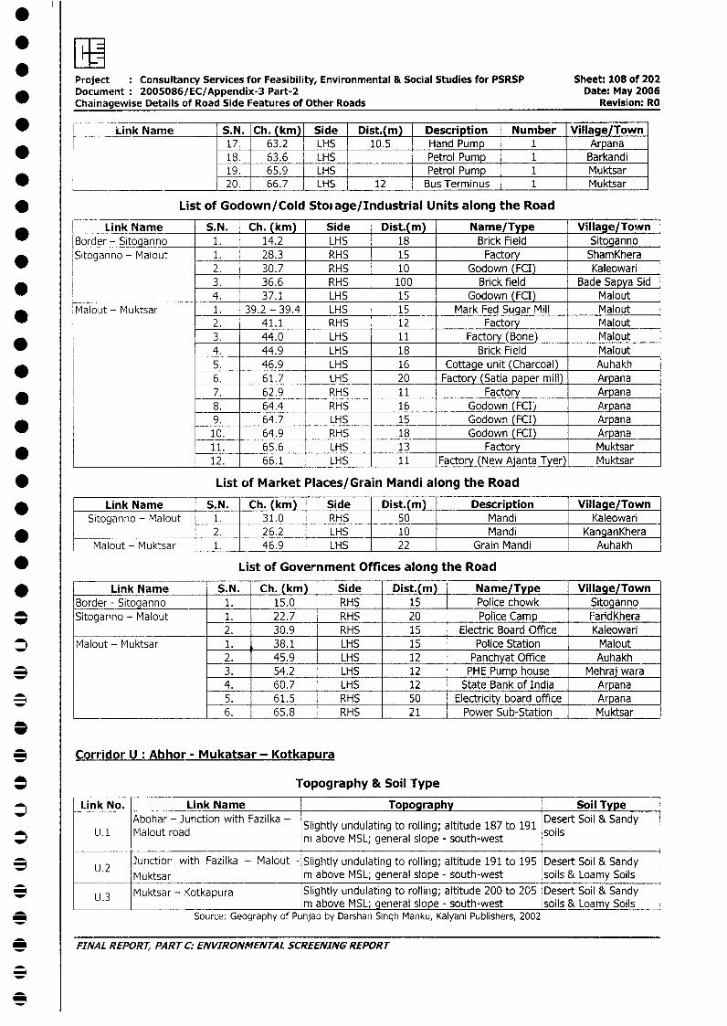
Project Consultancy Services for Feasibility, Environmental & Social Studies for PSRSP Sheet: 108 of 202Document 2005086/EC/Appendix-3 Part-2 Date: May 2006Chainagewise Details of Road Side Features of Other Roads Revision: RO
* < Link Name S.N. Ch. (km) Side Dist.(m) Description Number Village/Town17. 63.2 LHS 10.5 Hand Pump 1 Arpana
* 18. 63.6 LHS Petrol Pump 1 Barkandi19. 65.9 LHS Petrol Pump 1 Muktsar
* ] 20. 66.7 LHS 12 Bus Terminus 1 Muktsar
* List of Godown/Cold Stoiage/Industrial Units along the Road
Link Name S.N. Ch. (km) Side Dist.(m) Name/Type _ Village/TownBorder - Sitoganno 1. 14.2 LHS 18 Brick Field SitogannoSitoganno - Malout 1. 28.3 RHS 15 Factory ShamKhera
2. 30.7 RHS 10 Godown (FCI) Kaleowari3. 36.6 RHS 100 Brick field Bade Sapya Sid4. 37.1 LHS 15 Godown (FCI) Malout
* Malout - Muktsar 1. 39.2 - 39.4 LHS 15 Mark Fed Sugar Mill Malout2. 41.1 RHS 12 Factory Malout3. 44.0 LHS 11 Factory (Bone) Malout
* l 4. 44.9 LHS 18 Brick Field Malout5. 46.9 LHS 16 Cottage unit (Charcoal) Auhakh6. 61.7 LHS 20 Factory (Satia paper mill) Arpana
* l _ 7. 62.9 RHS 11 Factory Arpana8. 64.4 RHS 16 Godown (FCI) Arpana9. 64.7 LHS 15 Godown (FCI) Arpana10. 64.9 RHS 18 Godown (FCI) Arpana11. 65.6 LHS 13 Factory Muktsar12. 66.1 LHS 11 Factory (New Ajanta Tyer) Muktsar
* List of Market Places/Grain Mandi along the Road
* Link Name S.N. Ch. (km) Side Dist.(m) Description Village/TownSitoganno - Malout 1. 31.0 RHS 50 Mandi Kaleowari
* ____________________ 2. 26.2 LHS 10 Mandi KanganKheraMalout - Muktsar 1. 46.9 LHS 22 Grain Mandi Auhakh
* List of Government Offices along the Road
* Link Name S.N. Ch. (km) Side Dist.(m) Name/Type Village/TownBorder - Sitoganno 1. 15.0 RHS 15 Police chowk | Sitoganno
_ Sitoganno - Malout 1. 22.7 RHS 20 Police Camp FaridKhera_____ __ 2. 30.9 RHS 15 Electric Board Office Kaleowari
* Malout - Muktsar 1. 38.1 LHS 15 Police Station Malout2. 45.9 LHS 12 Panchyat Office Auhakh
3 3. 54.2 LHS 12 PHE Pump house Mehraj wara4. 60.7 LHS 12 State Bank of India Arpana
*5. 61.5 RHS 50 Electricity board office Arpana6. 65.8 RHS 21 Power Sub-Station Muktsar
_Corridor U: Abhor - Mukatsar - Kotkapura
* Topography & Soil Type
* | Link No. Link Name Topography Soil TypeAbohar - Junction with Fazilka - Slightly undulating to rolling; altitude 187 to 191 Desert Soil & Sandy
L. U1 Malout road rIm above MSL; general slope - south-west soils
3 | U.2 Junction with Fazilka - Malout - Slightly undulating to rolling; altitude 191 to 195 Desert Soil & Sandy_____.____ Muktsar m above MSL; general slope - south-west soils & Loamy Soils
3 L.3 Muktsar - Kotkapura Slightly undulating to rolling; altitude 200 to 205 Desert Soil & Sandy________ _______________________ _ .3 |m above MSL; general slope - south-west Isoils & Loamy Soils
-* Source: Geography of Punjab by Darshan Singh Manku, Kalyani Publishers, 2002
3 FINAL REPORT, PART C: ENVIRONMENTAL SCREENING REPORT
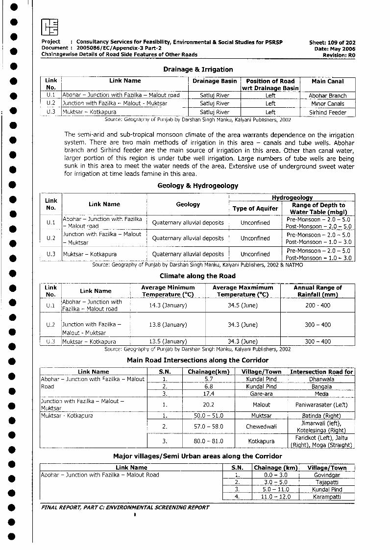
* I
Project : Consultancy Services for Feasibility, Environmental & Social Studies for PSRSP Sheet: 109 of 202Document 2005086/EC/Appendix-3 Part-2 Date: May 2006
_ Chainagewise Details of Road Side Features of Other Roads Revision: RO
* Drainage & Irrigation
* Link f Link Name Drainage Basin Position of Road Main CanalNo. wrt Drainage Basin
* U.1 Abohar - Junction with Fazilka - Malout road Satluj River Left Abohar BranchU.2 Junction with Fazilka - Malout - Muktsar Satluj River Left Minor Canals
* U.3 Muktsar - Kotkapura Satluj River Left Sirhind FeederSource: Geography of Punjab by Darshan Singh Manku, Kalyani Publishers, 2002
The semi-arid and sub-tropical monsoon climate of the area warrants dependence on the irrigation* system. There are two main methods of irrigation in this area - canals and tube wells. Abohar
branch and Sirhind feeder are the main source of irrigation in this area. Other than canal water,larger portion of this region is under tube well irrigation. Large numbers of tube wells are beingsunk in this area to meet the water needs of the area. Extensive use of underground sweet waterfor irrigation at time leads famine in this area.
* Geology & Hydrogeology
* Link Hy rogeology* iNo. Link Name Geology Type of Aquifer Range of Depth to
No. Type of Aquifer ~~~~~~~~~Water Table (mbgl)*U. 1Abohar - 3unction with Fazilka Quaternary alluvial deposits Unconfined Pre-Monsoon - 2.0 - 5.0
* U 2 - Mauktsrad Quaternary alluvial deposits Unconfined Post-Monsoon -2.0 - 5.0* ~ ~ ~~~Mlu odPret-Monsoon - 2.0 - 5.0U.2 J)unction with Fazilka - Malout Quaternary alluvial deposits Unconfined Pr-osn-20- .
Muktsar ~~~~~~~~~~~~~~~~Pret-Monsoon - 2.0 - 5.0* L U.3 Muktsar - Kotkapura Quaternary alluvial deposits Unconfined Pre-Monsoon - 2.0 - 5.0
Source: Geography of Punjab by Darshan Singh Manku, Kalyani Publishers, 2002 & NATMO
* Climate along the Road
Link Link Name Average Minimum Average Maxmimum Annual Range ofNo. Temperature (°C) Temperature (°C) Rainfall (mm)
*U.1 Abohar - Junction with 14.3 (January) 34.5 (June) 200 - 400Fzla- Malout road
U.2 Junction with Fazilka - 13.8 (January) 34.3 (June) 300 - 400* ______ Malout- Muktsar-
U.3 Muktsar - Kotkapura 13.5 (January) 34.3 (June) 300 - 400* Source: Geography of Punjab by Darshan Singh Manku, Kalyani Publishers, 2002
* Main Road Intersections along the Corridor
Link Name S.N. Chainage(km) Village/Town Intersection Road for* Abohar - Junction with Fazilka - Malout 1. 5.7 Kundal Pind Dhanwala
Road 2. 6.8 Kundal Pind Bangala* 3. 17.4 Gare-ara Meda
Junction with Fazilka - Malout - 1. 20.2 Malout Paniwarasater (Left)* Muktsar
Muktsar - Kotkapura 1. 50.0 - 51.0 Muktsar Batinda (Right)Jimarwali (left),
2. 57.0 - 58.0 Chewedwali Kotelesing (Right)
* 3. 80.0 - 81.0 Kotkapura Faridkot (Left), Jaitu3. 80.0 - 81.0 Kotkapura (Right), Moga (Straight)
Major villages/Semi Urban areas along the Corridor
* Link Name S.N. Chainage (km) Village/TownAbohar - Junction with Fazilka - Malout Road 1. 0.0 - 3.0 Govindgar
2. 3.0 - 5.0 Tajapatti3. 5.0 - 11.0 Kundal Pind
* 4. 11.0-12.0 Kcrampatti
* FINAL REPORT, PART C: ENVIRONMENTAL SCREENING REPORT
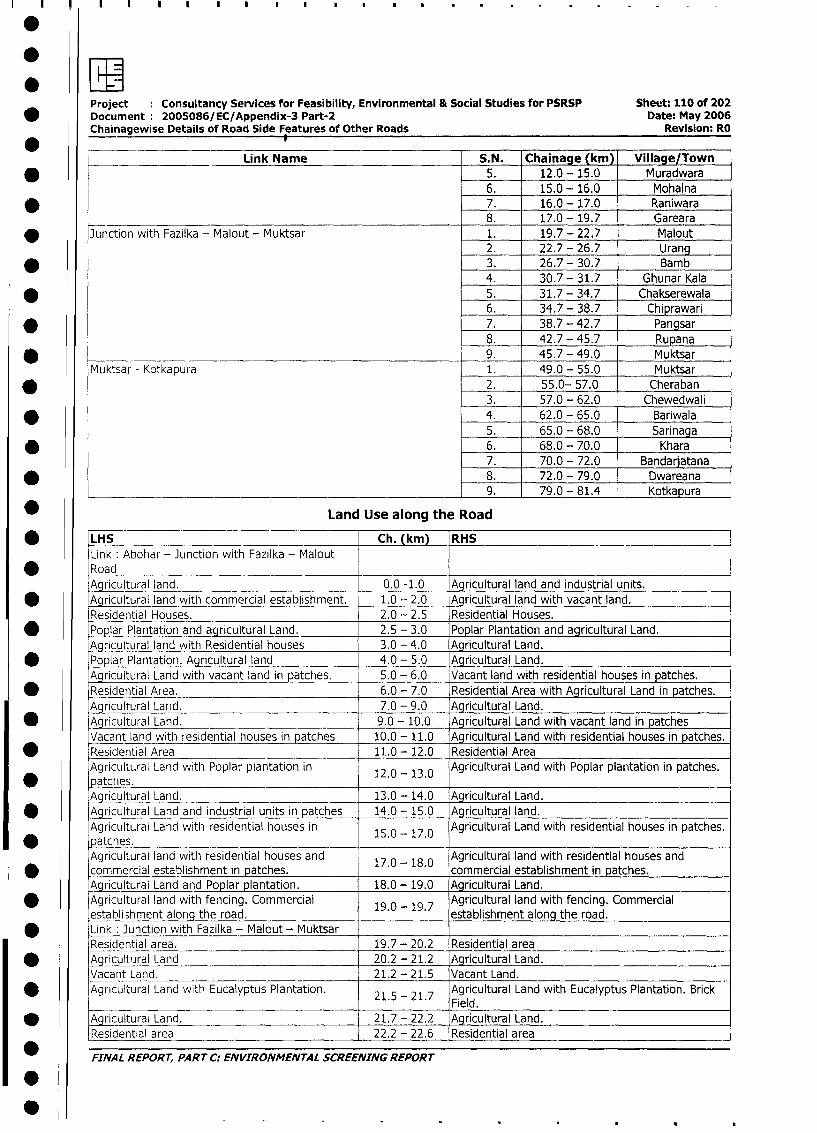
.EProject Consultancy Services for Feasibility, Environmental & Social Studies for PSRSP Sheet: 110 of 202
* Document 2005086/EC/Appendix-3 Part-2 Date: May 2006
Chainagewise Details of Road Side Features of Other Roads Revision: RO
Link Name S.N. Chainage (km) Village/Town
* 5. 12.0 - 15.0 Muradwara6. 15.0 - 16.0 Mohalna
* 7. 16.0 - 17.0 Raniwara8. 17.0 - 19.7 Gareara
* Junction with Fazilka - Malout - Muktsar 1. 19.7 - 22.7 Malout2. 22.7 - 26.7 Urang
* I _ 3. 26.7 - 30.7 Bamb4. 30.7 - 31.7 Ghunar Kala
* 5. 31.7 - 34.7 Chakserewala6. 34.7 - 38.7 Chiprawari
* 7. 38.7 - 42.7 Pangsar
8. 42.7 - 45.7 Rupana
* 9. 45.7 - 49.0 Muktsar
Muktsar - Kotkapura 1. 49.0 - 55.0 Muktsar
* 2. 55.0- 57.0 Cheraban3. 57.0 - 62.0 Chewedwali
* 4. 62.0 - 65.0 Bariwala5. 65.0 - 68.0 Sarinaga
* 6. 68.0 - 70.0 Khara7. 70.0 - 72.0 Bandarjatana
* 8. 72.0 - 79.0 Dwareana9. 79.0 - 81.4 Kotkapura
* Land Use along the Road
LHS Ch. (km) RHSLink Abohar - Junction with Fazilka - Malout
* Road _Agricultural land. 0.0 -1.0 Agricultural land and industrial units.
* Agricultural land with commercial establishment. 1.0 - 2.0 Agricultural land with vacant land.
Residential Houses. 2.0 - 2.5 Residential Houses.
* Poplar Plantation and agricultural Land. 2.5 - 3.0 Poplar Plantation and agricultural Land.
Agricultural land with Residential houses 3.0 - 4.0 Agricultural Land.
* Poplar Plantation. Agricultural land 4.0 - 5.0 Agricultural Land.
Agricultural Land with vacant land in patches. 5.0 - 6.0 Vacant land with residential houses in patches.
* Residential Area. 6.0 - 7.0 Residential Area with Agricultural Land in patches.
Agricultural Land. 7.0 - 9.0 Agricultural Land.
* Agricultural Land. 9.0 - 10.0 Agricultural Land with vacant land in patches
Vacant land with residential houses in patches 10.0 -11.0 Agricultural Land with residential houses in patches.
* Residential Area 11.0- 12.0 Residential Area
Agricultural Land with Poplar plantation in 12.0- 13.0 Agricultural Land with Poplar plantation in patches.
* patches.Agricultural Land. 13.0- 14.0 Agricultural Land.
* Agricultural Land and industrial units in patches 14.0- 15.0 Agricultural land.
Agricultural Land with residential houses in 15.0 - 17.0 Agricultural Land with residential houses in patches.
* patches.Agricultural land with residential houses and Agricultural land with residential houses and
commercial establishment in patches. 17.0 - 18.0 commercial establishment in patches.
Agricultural Land and Poplar plantation. 18.0- 19.0 Agricultural Land.
* Agricultural land with fencing. Commercial 19.0 - 19.7 Agricultural land with fencing. Commercialestabli3hment alori the road. establishment along the road.
* Link: Junction with Fazilka - Malout - MuktsarResidential area. 19.7- 20.2 Residential area
* Agricultural Land 20.2 - 21.2 Agricultural Land.
Vacant Land. 21.2 - 21.5 Vacant Land.
Agricultural Land with Eucalyptus Plantation. 21.5 - 21.7 Agricultural Land with Eucalyptus Plantation. BrickField.
* j\Agricultural Land. 21.7 - 22.2 Agricultural Land.
Residential area 22.2 - 22.6 Residential area
FINAL REPORT, PART C: ENVIRONMENTAL SCREENING REPORT
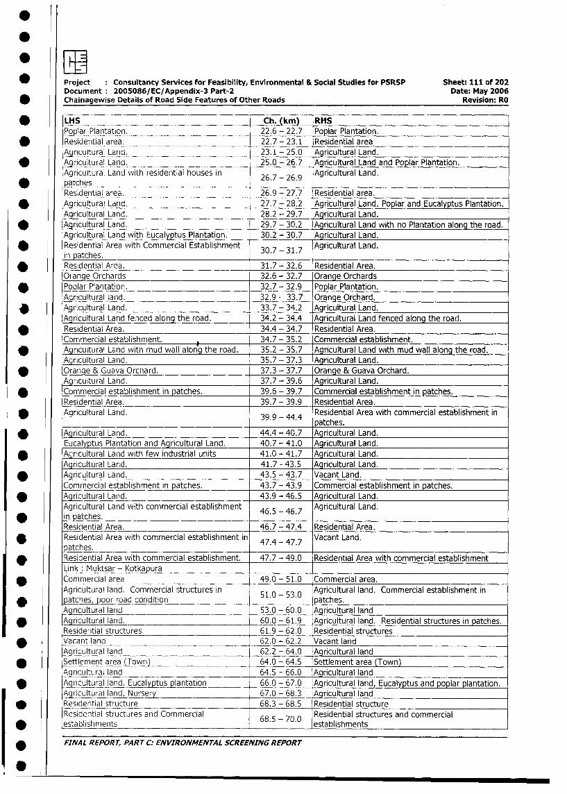
* Project Consultancy Services for Feasibility, Environmental & Social Studies for PSRSP Sheet: 111 of 202
Document 2005086/EC/Appendix-3 Part-2 Date: May 2006
* Chainagewise Details of Road Side Features of Other Roads Revision: RO
* LHS Ch. (km) RHS
Poplar Plantation, 22.6 - 22.7 Poplar Plantation.
* Residential area. 22.7 - 23.1 Residential area
A ricultural Land. 23.1 - 25.0 Agricultural Land.
* Ar_icultural Land, 25.0 - 26.7 _Agricultural Land and Poplar Plantation.
Agricultural Land with residential houses in 26.7 - 26.9 Agricultural Land.
* patchesResidential area. 26.9 - 27.7 Residential area.
* Agricultural Land. 27.7 - 28.2 Aaricultural Land. Poplar and Eucalyptus Plantation.
Agricultural Land. 28.2 - 29.7 AIgultural Land.
* Agricultural Land. 29.7 - 30.2 Agricultural Land with no Plantation alon_qthe road.
Agricultural Land with Eucalyptus Plantation. 30.2 - 30.7 Agricultural Land.
* Residential Area with Commercial Establishment 30.7 - 31.7 Agricultural Land.
in patches.* Residential Area. 31.7 - 32.6 Residential Area.
Orange Orchards 32.6 - 32.7 Orange Orchards
* Poplar Plantation. 32.7 - 32.9 Poplar Plantation.
Agricultural land. 32.9 - 33.7 Orange Orchard.
v Agricultural Land. 33.7 - 34.2 Agricultural Land.
Agricultural Land fenced along the road. 34.2 - 34.4 Agricultural Land fenced along the road.
* Residential Area. 34.4 - 34.7 Residential Area.
Commercial establishment. 34.7 - 35.2 Commercial establishment.
* _Aricultural Land with mud wall along the road. 35.2 - 35.7 Agricultural Land with mud wall along the road.
Agricultural Land. 35.7 - 37.3 Agricultural Land.
* Oranqe & Guava Orchard. 37.3 - 37.7 Orange & Guava Orchard.
Agricultural Land. 37.7 - 39.6 Agricultural Land.
_ Commercial establishment in patches. 39.6 - 39.7 Commercial establishment in patches.
Residential Area. 39.7 - 39.9 Residential Area.
Agricultural Land. 39.9 - 44.4 Residential Area with commercial establishment in
39.9 - ~ atches.
* Agricultural Land. 44.4 - 40.7 Agricultural Land.
Eucalyptus Plantation and Agricultural Land. 40.7 - 41.0 Agricultural Land.
* Agricultural Land with few industrial units 41.0 - 41.7 Agricultural Land.
Agricultural Land. 41.7 - 43.5 Agricultural Land.
_ Aaricultural Land. 43.5 - 43.7 Vacant Land.
Commnercial establishment in patches. 43.7 - 43.9 Commercial establishment in patches.
* Agricultural Land. 43.9 - 46.5 Agricultural Land.
Agricultural Land with commercial establishment 46.5 - 46.7 Agricultural Land.
in patches.Residential Area. 46.7 - 47.4 Residential Area.
* Residential Area with commercial establishment in 47.4 - 47.7 Vacant Land.
Patches.* Residential Area with commercial establishment. 47.7 - 49.0 Residential Area with commercial establishment
Link: Muktsar - Kotkapura* Commercial area 49.0 - 51.0 Commercial area.
Agricultural land. Commercial structures in 510 53.0 Agricultural land. Commercial establishment in
* patches,poor road condition .- . patches.
Agricultural land 53.0 - 60.0 Agricultural land
* Agricultural land. 60.0 - 61.9 Agricultural land. Residential structures in patches.
Residential structures 61.9 - 62.0 Residential structures
* Vacant land 62.0 - 62.2 Vacant land
Aqricultural land 62.2 - 64.0 Agricultural land
* Settlement area (Town) 64.0 - 64.5 Settlement area (Town)
Agricultural land 64.5 - 66.0 Agricultural land
* LA ricultural land. Eucalyptusptation 66.0 - 67.0_ Aqricultural land, Eucalyptus and poplar plantation.
Agrncultural land, Nursery 67.0 - 68.3 Agricultural land
_ Residential structure 68.3 - 68.5 Residential structure
Residential structures and Commercial 68.5 - 70.0 Residential structures and commercial
* establishments establishments
* FINAL REPORT, PART C: ENVIRONMENTAL SCREENING REPORT
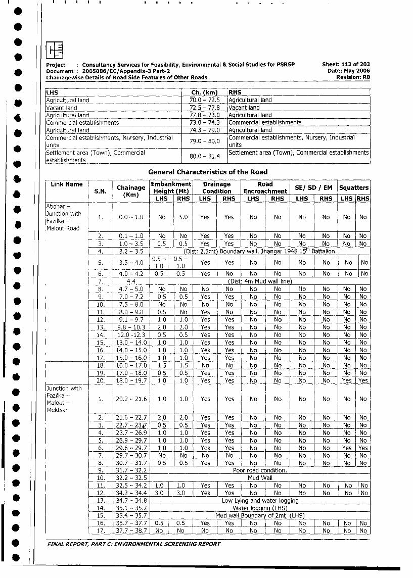
Project Consultancy Services for Feasibility, Environmental & Social Studies for PSRSP Sheet: 112 of 202
* ~~Document :2005086/EC/Appendix-3 Part-2 Date: May 2006
Chainagewise Details of Road Side Features of Other Roads Revision: RO
LHS Ch. (kin) RHS
*Agricultural land 70.0 - 72.5 Agricultural land
Vacant land 72.5 - 77.8 Vacant land
* ~~Agricultural land 77.8 -73.0 Agricultural land
Commercial establishments 73.0 - 74.3 Commercial establishments
* ~~Agricultural land 74.3 - 79.0 Agricultural land
Comm-ercial establishments, Nursery, Industrial 70- . Commercial establishments, Nursery, Industrial
* ~~units 7.-00 units
Settlement area (Town), Commercial 80.0 - 81.4 Settlement area (Town), Commercial establishments
lestablishments _______________________________________________
General Characteristics of the Road
Link Name Ca Embankment Drainage Road S/SDIE Sqatr
* ~~~~~~S. N. Chinage Height (Mt) Condition Encroachment SE_S__ EM Sqater
(Kin) LHS RHS LHS RHS LHS RHS LHS RHS LHS RHS
*~~bhrJunction with 1. 0.0 - 1.0 No 5.0 Yes Yes No No Nlo No No No
Fazilka -*Ma lout Road ______
2. 0.1 -1.0 No No Yes Yes No Nof No No No No_
* ~~~ ~~~~~3. 1.0 -3.5 0.5 0.5 Yes Yes No No INo INo No No
4. 3.2 - 3.5 (Dist 2.5mt) Boundary wall. Jhangar 1948 15 th Battalion.
5. 3.5 -4.0 05- . - Yes Yes 1No No No No jNo No
9 ~~~ ~~~~~6. 4.0 -4.2 0.5 0.5 IYes jNo No No INo No No No
7. 4.4 (Dist: 4m Mud wall line)
* ~~~ ~~~~~8. 4.7 -5.0 No No No No No No No No No No
9. 7.0 - 7.2 0.5 0.5 Yes Yes No No No No No No-
* ~~~~~~~~10. 7.5 -8.0 No No No No No No No No No No
11. 8.0 -9.0 0.5 No Yes No No No No No No No
* ~~~~~~~~12. 9.1 - 9.7 1.0 1.0 Yes Yes No No No No No No
13. 9.8 - 10,3 2.0 2.0 Yes Yes No No No No No No
* ~~~~~~~~14. 12.0 -12.3 0.5 0.5 Yes Yes No No No No No No
15. 13.0-_14.0 1.0 1.0 Yes Yes No No No No No No
* ~~~~~~~~16. 14.0 - 15.0 1.0 1.0 Yes Yes No No No No No No-
-17. 15.0 - 16.0 1.0 1.0 Yes Yes No No No No No No
* - ~~~~~~~18. 16.0 -17.0 1.5 1.5 No No No No No No No No
19. 17.0 -18.0 0.5 0.5 Yes Yes No No No No No No
* ~~~~~~~~20. 18.0 - 19.7 1.0 1.0 Yes Yes No No No No Yes Yes
Junction with
Mazlout - 1. 20.2 - 21.6 1.0 1.0 Yes Yes No No No No No No
* ~~Muktsar2. 21.6 - 22.7 2.0 2.0 Yes Yes No No No No No NoI
* ~~~ ~~~~~3. 22.7- 23si 0.5 0.5 Yes Yes No No No No No No
4. 23.7 - 26.9 1.0 1.0 Yes Yes No No No No No No
* ~~~ ~~~~~5. 26.9 - 29.7 1.0 1.0 Yes Yes No No No No No No
6. 29.6 - 29.7 1.0 1.0 Yes Yes No No No No Yes Yes
* ~~~ ~~~~~7. 29.7 -30.7 No No No0 No No No No No No No
8. 130.7 - 31.7 0.5 0.5 Yes Yes No INo No No No o
* ~~~ ~~~~~9. 31.7 - 32.2 _ Poor road condition.
10. 32.2 - 32.5 Muid Wall
* ~~~~~~~~11. 32.5 - 34.2 1.0 1.0 Ye:s: Yes No No No INo INo INo
12. 34.2 - 34.4j . 3.0 Yes IYes No No INo INo INo ~No
* ~~~~~~~13. 34.7 - 34.8 ILow Lying and water loggi'ng
14. 35.1 -35.2 Waterlogging LHS)
* ~~~~~~~15. 35.4 - 35.7 Mud wall Boundar of 2mt (LHS)
16. 35.7 -37.71 0.5~ 0.5 YesI Yes I No No I No No I No INo
* ~~~~~~~~17. 37.7 -38.7 No INo No I No INo No INo No No INo
* ~~FINA L REPOR T, PA RT C:- EN VIRONMEN TA L SCREENING REPOR T
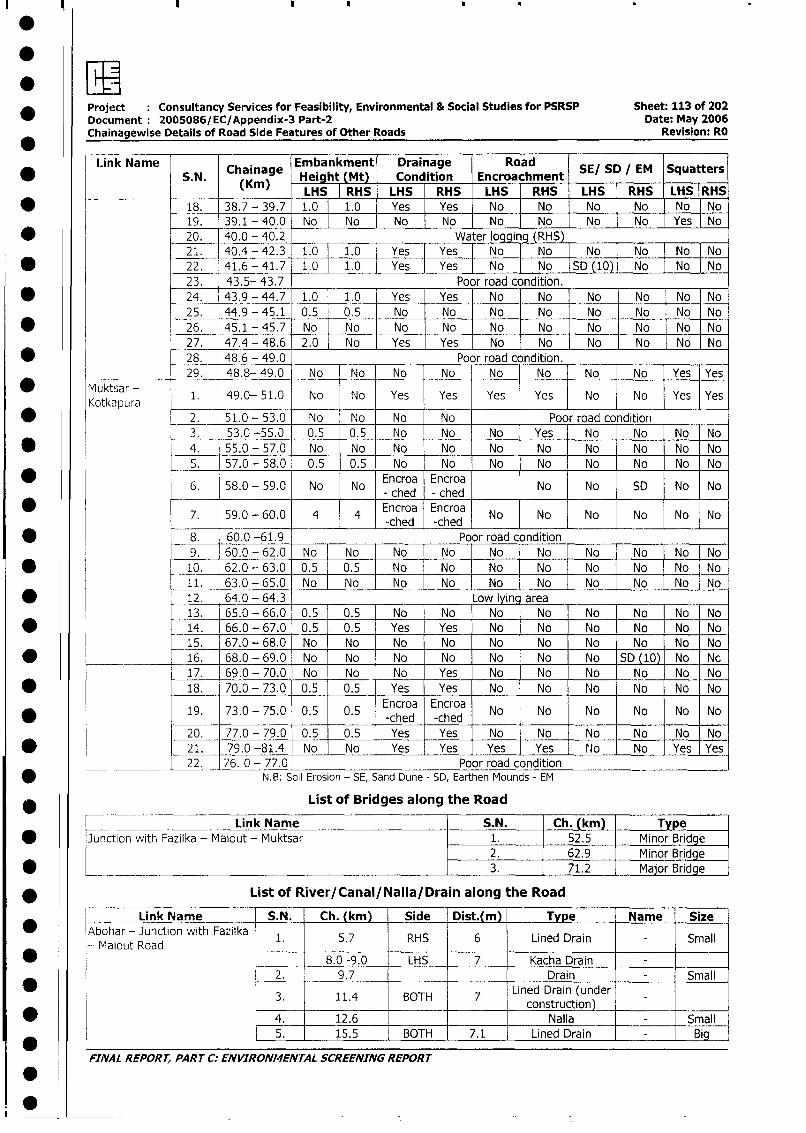
* ~~Project Consultancy Services for Feasibility, Environmental & Social Studies for PSRSP Sheet: 113 of 202Document 2005086/ EC/Appendix-3 Part-2 Date: May 2006Chainagewise Details of Road Side Features of Other Roads Revision: RO
1Link Name Chainage Embankment Drainage Road SESD/M SqatrS. N. (K) Height (Mt) Condition EncroachmentSESDIM Sqter
(Kin) LHS RHS LHS RHS LHS RHS LHS RHS LHS RHS
* ~~~~~~~~18. 38.7 - 39.7 1.0 1.0 Yes Yes No jNo No No No No19. 39.1 - 40.0 No No No No No JNo No No Yes No
* ~~~~~~~20. 40.0 - 40.2 Water logging (RHS)21. 40.4 - 42.3 1.0 10 Ys Yes No ]No ]No No No No
* ~~~~~~~~22. 41.6 -41.7 1,0 1.0 Yes Yes No JNo JSD (10) No No No23. 43.5- 43.7 ____ Poor road condition.
* ~~~~~~~24. 43.9 - 44.7 1.0 1.0 _ Yes Yes No No No No No No25. 44.9 -45.1 0.5 0.5 No No No No -No No No No
* ~~~~~~~~26. 45.1- 45.7 No No No No No No No No No No27. 47.4 -48.6 F2.0 No Yes Yes [No -No -No No No No-
* ~~~~~~~~28. 48.6 - 49.0 Poor road condition._______
Mutsr_ 29. 48.8- 49.0 No No No No No No No No Yes Yes
* Mu~KokapLra- 1. 49.0- 51.0 No No Yes Yes Yes Yes No No Yes Yes
2 . 51.0 - 53.0 N o N o N o N o Poor road condition _____
3. 53.0 -55.0 0.5 0.5 No No No Yes INo No No~ NoI* ~~~ ~~~~~4. 55.0 -57.0 No No No No No No~ No No No No
5. 57.0 - 58.0 0.5 0.5 No No No No No No No No
0 ~~~ ~~~~~6. 58.0 - 59.0 No No Encroa Ecroa No No SD No No
0 ~~~ ~~~~~7. 59.0 - 60.0 14 4 Encroa Encroa No No No No No No-ched -ched__ _ _ __ _ _ _ _ __ _ _
* ~~~ ~~~~~8. 60.0 -61.9 ______ ___ Poor road condition ___ _____
9. 60.0 -62.0 No -No No No No No No No No No* ~~~~~~~~10. 62.0 - 63.0 0.5 .0.5 No No No No No No No No
11. 63.0 - 65.0 No No No No No No No No No o* ~~~~~~~~12. 64.0 -64.3 Low lyinc area
13. 65.0 - 66.0 0.5 0.5 No No INo No No No No No* ~~~~~~~~14. 66.0 - 67.0 0.5 0.5 Yes Yes No No No No No No
15. 67.0 -68.0 No No No No No No No No No No* _____ ~~~~~16. 68.0 - 69.0 NJo No No No No No No SD (10) No N c
17. 69.0 - 70.0 No -No No Yes No No No No No No* ~~~~~~~~18. 70.0 - 73.0 0.5 0.5 Yes Yes No No No No No No
19. 73.0 - 75.0 0.5 0.5 Encroa Encroa No No No No No No* ______ ~~~~~~ ~~~~ ~~~~~-ched -ched __ _ _ _ _ _ _ _ __ _ _ _
20. 77.0 - 79.0 0.5 0.5 Yes Yes No No No No INo INo* ~~~~~~~2 1. 79.0 -81.4 No No Yes Yes Yes Yes fJo No IYes lYes
___________ 22. 76. 0 - 77.0 Poor road condition* ~~~~~~~~~~~N.B: Soil Eirosion - SE, Sand Dune - SD, Earthen Mounds - EM
List of Bridges along the Road
______ ~~~~Link Name S.N. Ch. (km)- Type* ~~Junction with Fazilka - Malout -- Muktsar 1. 52.5 - Minor Bridge
2. 62.9 Minor Bridge* ________________________________________________ 3. 71.2 Major Bridge
* ~~~~~~~List of River/Canal/NaIIa/ Drain along the Road
Link Name S.N. Ch. (kin) Sie [it(n) Type Name Size* ~~Abohar - Junction with Fazilka 1.57RS 6LneIri ml
-Ma lout Road ____ 7RH_6Lied_ran__S al
_______ 8.0 -9.0 LHS 7 Kacha Drain -
2. 9.7 Drain - _ - Small
3. 11.4 BOTH 7 Lined Drain (under ______ ___________ ~~~construction)
* ~~~ ~~~~~~~~~4. 12.6 ____ ___ Nalla - Small
5. 15.5 BOTH 7.1 Lined Drain Bi
FINAL REPORT, PART C.- ENVIRONMENTAL SCREENING REPORT
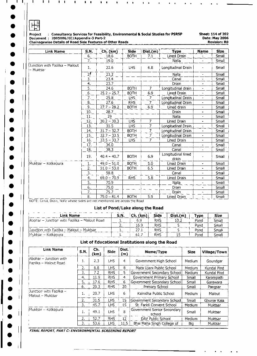
eLSE* Project Consultancy Services for Feasibility, Environmental & Social Studies for PSRSP Sheet: 114 of 202
Document 2005086/EC/Appendix-3 Part-2 Date: May 2006
Chainagewise Details of Road Side Features of Other Roads Revision: RO
Link Name S.N. Ch. (km) Side Dist.(m) Type Name Size
6. 18.6 BOTH 7.1 Lined Drain - Small
7. 19.0 _ _ Nalla - Small
* Junction with Fazilka - Malout 1. 22.6 LHS 6.8 Longitudinal Drain - Small
* Muktsar 23.2 Nalla - Small
3. 23.4 Canal - Small
* 4. 23.7 Drain - Small
5. 24.6 BOTH 7 Lonaitudinal drain - Small
* 6. 25.2 - 25.7 BOTH 6.9 Lined Drain - Small
7. 25.8 LHS 7 Longitudinal Drain - Small
* 8. 27.6 RHS 7 Longitudinal Drain - Small
9. 27.7 - 28.2 BOTH 6.9 Lined drain - Small
* 10. 28.7 Drain - Small
11. 29 Nalla - Small
* 12. 30.2 - 30.3 LHS 7 Lined Drain - Small
13. 31.5 LHS 7 Longitudinal Drain - Small
* 14. 31.7 - 32.7 BOTH 7 Longitudinal Drain - Small
15. 32.7 - 33.5 BOTH 7 Longitudinal Drain - Small
* 16. 33.5 - 33.7 LHS 7 Lined Drain - Small
17. 31.0 Canal - Small
* 18. 38.3 Canal - Small
19. 40.4 - 40.7 BOTH 6.9 Longitudinal lined - Smalldrain
Muktsar - Kotkapura 1. 49.0 - 51.0 BOTH 5.0 Lined Drain - Small
* 2. 51.0 - 53.0 BOTH 6.5 Lined Drain - Small
3. 58.8 Canal - Small
* 4. 69.0 - 70.9 RHS 5.8 Lined Drain - Small
5. 70.9 Nalla - Small
* 6. 75.0 Drain - Small
7. 75.7 Drain - Small
* 8. 79.0 - 81.4 BOTH 5.9 Lined Drain Small
NOTE: Canal, Drain, Nalla whose sides are not mentioned are across the Road
List of Pond/Lake along the Road
* _- Link Name S.N. Ch. (km) Side Dist.(m) Type Size
Abohar - Junction with Fazilka - Malout Road 1. 6.9 RHS 10.2 Pond Small
*_____ _2. 16.9 RHS 5 Pond Small
Junction with Fazilka - Malout - Muktsar 1. 27.1 RHS 5 Pond Small
* Muktsar- Kotkapura 1. 61.7 RHS 15 Pond Small
* List of Educational Institutions along the Road
Link Name S.N. Ch. Side Dist. Name/Type Size Village/Town
(kmn) MAbohar - Junction with 1. 2.3 LHS 4 Government High School Medium Goundgar
* ~~Fazilka - Malout Road _______
2. 6.8 LHS 8 Mata Ujani Public School Medium Kundal Pind
* 1 3. 7.2 RHS 5 Government Secondary School Medium Kundal Pind
4. 11.9 RHS 4 i Government Primary School Small I Karampatti
I _ l | 5. 17.6 RHS 6 Government Secondary School Small Garewara
I ________ 6. 20.3 RHS 20 Primary School Small Pangsar
* JunctiMalout wiuktFsazilka 1. 20.7 LHS 6 Kalnidha Public School Medium Malout
lalout - Muktsar 2. 31.5 LHS 15 Government Secondary School Small Ghunar Kala
3. 45.7 LHS 15 St. Faridi Convent School Medium I Muktsar
o jMuktsar - Kotkapura 1 491 LHS 8 Government Senior Secondary Small Muktsar
____ 49___1 LHS__ ___ school Small__ Muktsar____
l 1 2. 52.7 RHS 12 DAV Public School Medium Muktsar
3. 53.6 1LHS 11.5 Bhai Maha Singh College of Big Muktsar
FINAL REPORT, PART C: ENVIRONMENTAL SCREENING REPORT
I I0
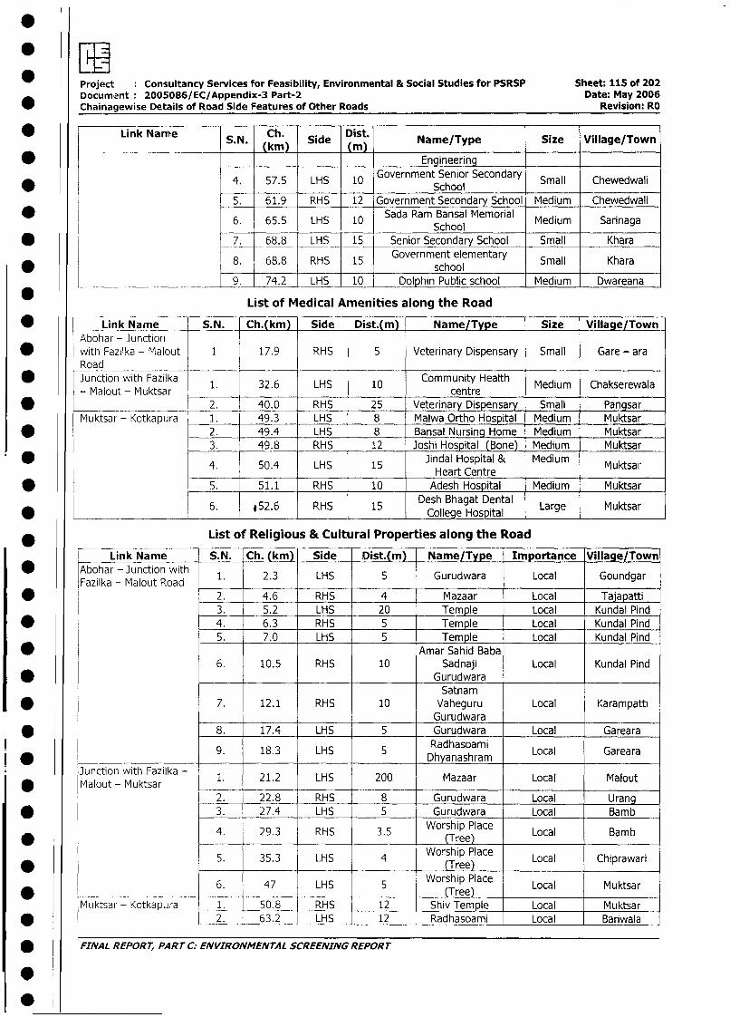
Project : Consultancy Services for Feasibility, Environmental & Social Studies for PSRSP Sheet: 115 of 202Document 2005086/EC/Appendix-3 Part-2 Date: May 2006
Chainagewise Details of Road Side Features of Other Roads Revision: RO
Link Name S.N. Ch. Side Dist. Name/Type Size Village/Town
* __ Engineering
4. 57.5 LHS 10 Government Senior Secondary Small Chewedwali57.5 LH _ 10 School
5. 61.9 RHS 12 Government Secondary School Medium Chewedwali
* 6. 65.5 LHS 10 Sada Ram Bansal Memorial Medium SarinagaSchool
* _ 7. 68.8 LHS 15 Senior Secondary School Small Khara
8. 68.8 RHS 15 Government elementary Small Khara*____________ ______ ____ school _
9. 74.2 LHS 10 Dolphin Public school Medium Dwareana
* LList of Medical Amenities along the Road
* ___ Link Name S.N. Ch.(km) Side Dist.(m) Name/Type Size Village/Town
Abohar - Junction* with Fazilka - Malout 1 17.9 RHS 5 Veterinary Dispensary Small Gare - ara
Road ____
* Junction with Fazilka 1. 32.6 LHS 10 Community Health Medium Chakserewala
-.Malout - Muktsar ______centreMeim Caseaa
* _______ ________ 2. 40.0 RHS 25 Veterinary Dispensary Small Pangsar
Muktsar - Kotkapura 1. 49.3 LHS 8 Malwa Ortho Hospital Medium Muktsar
* 2. 49.4 LHS 8 Bansal Nursing Home Medium Muktsar
3. 49.8 RHS 12 Joshi Hospital (Bone) Medium Muktsar
4. 50.4 LHS 15 Jindal Hospital & Medium Muktsai,50.4 LHS 15 Heart Centre
* 5. 51.1 RHS 10 Adesh Hospital Medium Muktsar
6. .52.6 RHS 15 Desh Bhagat Dental Large Muktsar* _ _ _ _ _ _ _ _ _ _ _ _ _ _ _ _ _ _ ~~~~~~~~~College Hospital _ _ _ _ _ _
* List of Religious & Cultural Properties along the Road
Link Name S.N. Ch. (km) Side Dist.(m) Name/Type Importance Village/Town
I w lAbohar - Junction with 1. 2.3 LHS 5 Gurudwara Local Goundgar
Fazilka - Malout Road| * l 2. 4.6 RHS 4 Mazaar Local Tajapatti
3. 5.2 LHS 20 Temple Local Kundal Pind
| * l 4. 6.3 RHS 5 Temple Local Kundal Pind
5. 7.0 LHS 5 Temple Local Kundal Pind
| * l Amar Sahid Baba6. 10.5 RHS 10 Sadnaji Local Kundal Pind
GurudwaraSatnam
| * l l 7. 12.1 RHS 10 Vaheguru Local KarampattiGurudwara
* l 8. 17.4 LHS 5 Gurudwara Local Gareara
9. 18.3 LHS DRadhasoami Local Gareara
Junction with Fazilka - 1. 21.2 LHS 200 Mazaar Local Malout
I * lMalout- Muktsar lI 2. 22.8 RHS 8 Gurudwara Local Urang
E * l r 3. 27.4 LHS 5 Gurudwara Local Bamb
4. 29.3 RHS 3.5 Worship Place Local Bamb* ~~~~~~~~~~~~~~~~~~~~~~Tree)
5. 35.3 LHS 4 Worship Place Local Chiprawari* __ ____ ~~~~~~~~~~~~~~~~~~Tree)
6. 47 LHS 5 Worship Place Local Muktsar
* - - 1 -- 1I (Tree)
Muktsar - Kotkapura 1. 50.8 RHS 12 Shiv Temple Local Muktsar
| * l 1 2. 1 63.2 LHS | 12 Radhasoami Local Bariwala
| * fINAL REPORT, PARr C: ENVIRONMENTAL SCREENING REPORT
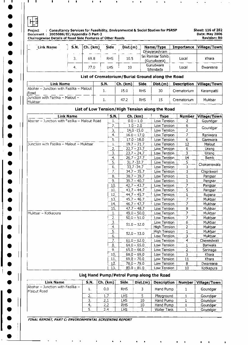
- I
Project Consultancy Services for Feasibility, Environmental & Social Studies for PSRSP Sheet: 116 of 202
* Document 2005086/EC/Appendix-3 Part-2 Date: May 2006
Chainagewise Details of Road Side Features of Other Roads Revision: RO
Link Name _ _ S.N. Ch. (km) Side Dist.(m) Name/Type Importance Village/Town*____ ________ ________ __________ - Dhayanashram
3 ~~~~~~~~~Sri Ramsar Sahib LoaKhr( 3. 69.8 RHS 10.5 (Gurudwara) Local Khara
4. 77.0 LHS 10 Sihindada Local Dwareana
List of Crematorium/Burial Ground along the Road
Link Name S.N. Ch. (km) Side Dist.(m) Description Village/Town
* lAbohar - Junction with Fazilka - Malout 1. 15.0 RHS 30 Crematorium Karampatti
Road _ l
* Junction with Fazilka - Malout - 1. 47.2 RHS 15 Crematorium Muktsar
Muktsar
* List of Low Tension/High Tension along the Road
* .Link Name S.N. Ch. (km) Type Number |Village/Town
IAbohar - Junction with Fazilka - Malout Road 1. 0.0 - 1.0 Low Tension 2 Goundgar -
* 2. 1.0 - 2.0 Low Tension 6 Goundgar3. 14.0 -15.0 Low Tension 2
* 4. 16.0 - 17.0 Low Tension 7 Raniwara
__________ __________________________ 5. 17.0 - 18.0 Low Tension 6 Garewara
* Junction with Fazilka - Malout - Muktsar _. 19.7 - 21.7 Low Tension 12 Malout
2. 22.7 - 23.7 Low Tension 6 Urang
* 3. 23.7 - 24.7 Low Tension 3 _ Urang4. 26.7 - 27.7 Low Tension 14 _ Bamb
* 5. 31.7 -32.7 Low Tension 56. 33.7 -34.7 Low Tension 3 Chakserewala
* 7. 34.7 - 35.7 Low Tension 3 Chiprawari8. 38.7 - 39.7 Low Tension 1 Pangsar
* _ 9. 39.7 - 40.7 Low Tension 1 Pangsar10. 42.7 - 43.7 Low Tension 7 Pangsar
* 11. 43.7 - 44.7 Low Tension 5 Pangsar12. 44.7- 45.7 Low Tension 1 Rupana
* 13. 45.7 - 46.7 Low Tension 7 Muktsar
14. 46.7 - 47.7 Low Tension 7 Muktsar
* ________________________________________ i_ 15. 47.7 - 48.7 Low Tension 8 Muktsar
Muktsar - Kotkapura 1. 49.0 - 50.0 Low Tension 7 Muktsar
I * 2. 50.0 - 51.0 Low Tension 7 Muktsarl 3. 51.0-52.0 Low Tension 6 Muktsar
| * 4. High Tension 2 Muktsar
5. 52.0 - 53.0 High Tension 1 Muktsar
* 6. Low Tension 3 Muktsar7. 61.0 - 62.0 Low Tension 4 Chewedwali
I * 8. 64.0 - 65.0 Low Tension 1 Bariwala9. 65.0 - 66.0 Low Tension 2 Sarinaga
I * l 10. 68.0 - 69.0 Low Tension 3 Khara11. 69.0 - 70.0 Low Tension 11 Khara
I * l 12. 78.0 - 79.0 Low Tension 8 Dwareana_ 13. 80.0 - 81.0 Low Tension 10 Kotkapura
___ UList Hand Pump/Petrol Pump along the Road
| * > Link Name S.N. Ch. (km) Side | Dist.(m) Description | Number Village/Town |
Abohar - Jinction with Fazilka - 1. 0.0 RHS 3 Hand Pump 1 Goundgar* ~~M alout Road__ _ _ _ _ _ _ __ _ __ _ _ _ _ _ _ _ _ _
2. - 1.7 LHS - 5 - Playground 1 Goundgar
| * -t 3. - 2.1 . LHS | 10 - Hand Pump - 1 - Goundgar
4. 2.2 RHS | 10 - Hand Pump 1 Goundgar
| * .l 5. 2.4 LHS - 5 - Water Tank - 1 l Goundgar
* _ FINAL REPORT, PART C: ENVIRONMENTAL SCREENING REPORT
I0
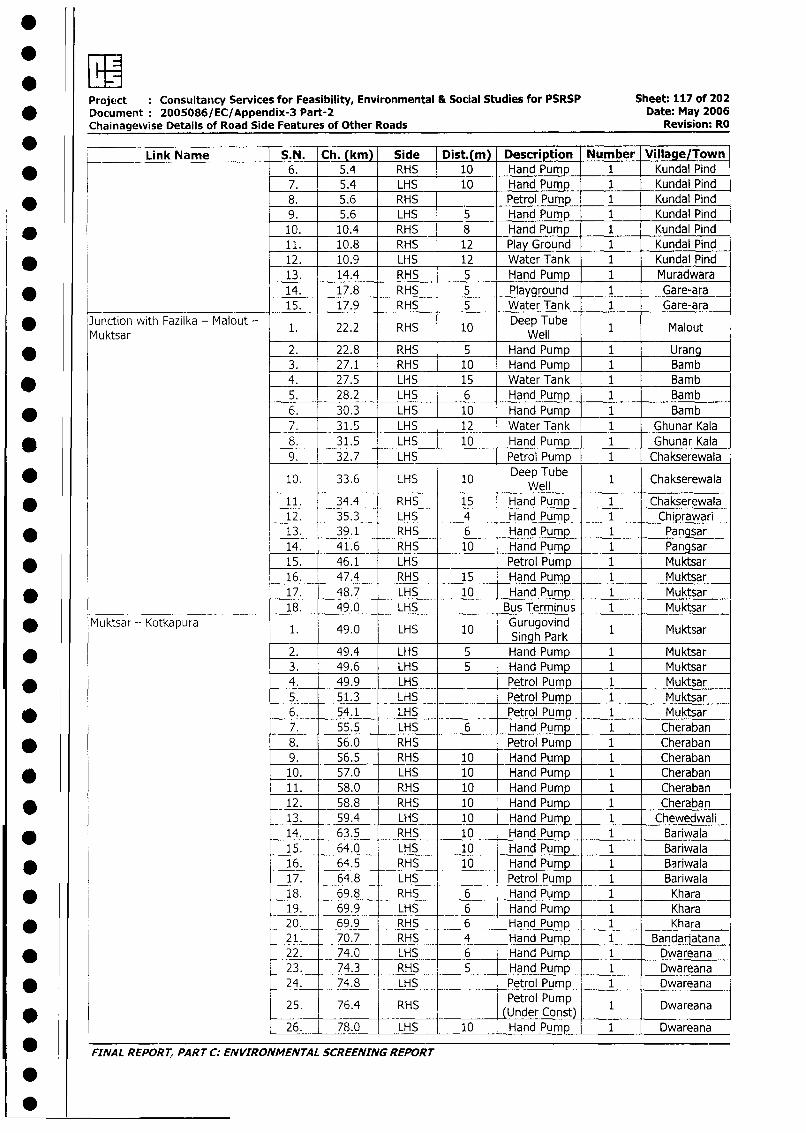
Project : Consultancy Services for Feasibility, Environmental & Social Studies for PSRSP Sheet: 117 of 202* Document 2005086/EC/Appendix-3 Part-2 Date: May 2006
Chainagewise Details of Road Side Features of Other Roads Revision: RO
Link Name S.N. Ch. (km) Side Dist.(m) Description Number Village/Town
* _ 6. 5.4 RHS 10 Hand Pump 1 Kundal Pind
7. 5.4 LHS 10 Hand Pump 1 Kundal Pind
* 8. 5.6 RHS Petrol Pump 1 Kundal Pind
9. 5.6 LHS 5 Hand Pump 1 Kundal Pind
* 10. 10.4 RHS 8 Hand Pump 1 Kundal Pind
11. 10.8 RHS 12 Play Ground 1 Kundal Pind
* 12. 10.9 LHS 12 Water Tank 1 Kundal Pind
13. 14.4 RHS 5 Hand Pump 1 Muradwara
* 14. 17.8 RHS 5 Playground 1 Gare-ara15. 17.9 RHS 5 Water Tank 1 Gare-ara
Junction with Fazilka - Malout - 1. 22.2 RHS 10 Deep Tube 1 Malout
Mu ktsar Well* 2. 22.8 RHS 5 Hand Pump 1 Urang
3. 27.1 RHS 10 Hand Pump 1 Bamb
* 4. 27.5 LHS 15 Water Tank 1 Bamb
5. 28.2 LHS 6 Hand Pump 1 Bamb
* 6. 30.3 LHS 10 Hand Pump 1 Bamb
7. 31.5 LHS 12 Water Tank 1 Ghunar Kala
* 8. 31.5 LHS 10 Hand Pump 1 Ghunar Kala
9. 32.7 LHS Petrol Pump 1 Chakserewala
* . 10. 33.6 LHS 10 Deep Tube 1 Chakserewala_______ ________ ~~~Well
* 11. 34.4 RHS 15 Hand Pump 1 Chakserewala
12. 35.3 LHS 4 Hand Pump 1 Chiprawari
* 13. 39.1 RHS 6 Hand Pump 1 Pangsar
14. 41.6 RHS 10 Hand Pump 1 Pangsar
* 15. 46.1 LHS Petrol Pump 1 Muktsar
16. 47.4 RHS 15 Hand Pump 1 Muktsar
* 17. 48.7 LHS 10 Hand Pump 1 Muktsar
____ .18. 49.0 LHS Bus Terminus 1 Muktsar
Muktsar-- Kotkapura 1. 49.0 LHS 10 Gurugovind 1 Muktsar
* 2. 49.4 LHS _ 5 Singh Park2. 49.4 LHS 5 Hand Pump 1 Muktsar3. 49.6 LHS 5 HnPup 1 Muktsar
* _ 4. 49.9 LHS Petrol Pump. 1 Muktsar
5. 51.3 LHS Petrol Pump 1 Muktsar
* 6. 54.1 LHS Petrol Pump 1 Muktsar
7. 55.5 LHS 6 Hand Pump 1 Cheraban
* 8. 56.0 RHS Petrol Pump 1 Cheraban
9. 56.5 RHS 10 I Hand Pump 1 Cheraban
* _10. 57.0 LHS 10 Hand Pump 1 Cheraban
11. 58.0 RHS 10 Hand Pump 1 Cheraban
* 12. 58.8 RHS 10 Hand Pump 1 Cheraban
13. 59.4 LHS 10 Hand Pump 1 Chewedwali
* 14. 63.5 RHS 10 Hand Pump 1 Bariwala
15. 64.0 LHS 10 Hand Pump 1 Bariwala
* 16. 64.5 RHS 10 Hand Pump 1 Bariwala
17. 64.8 LHS Petrol Pump 1 Bariwala
* 18. 69.8 RHS 6 Hand Pump 1 Khara
19. 69.9 LHS 6 Hand Pump 1 Khara
* 20. 69.9 RHS 6 Hand Pump 1 Khara
21. 70.7 RHS 4 Hand Pump 1 Bandarjatana
* 22. 74.0 LHS 6 Hand Pump 1 Dwareana
23. 74.3 RHS 5 Hand Pump 1 Dwareana
* _ 24. 74.8 LHS Petrol Pump 1 Dwareana
25. 76.4 RHS Petrol Pump 1 Dwareana
26. 78.0 LHS 10 Hand Pump 1 Dwareana
FINAL REPORT, PART C: ENVIRONMENTAL SCREENING REPORT
00
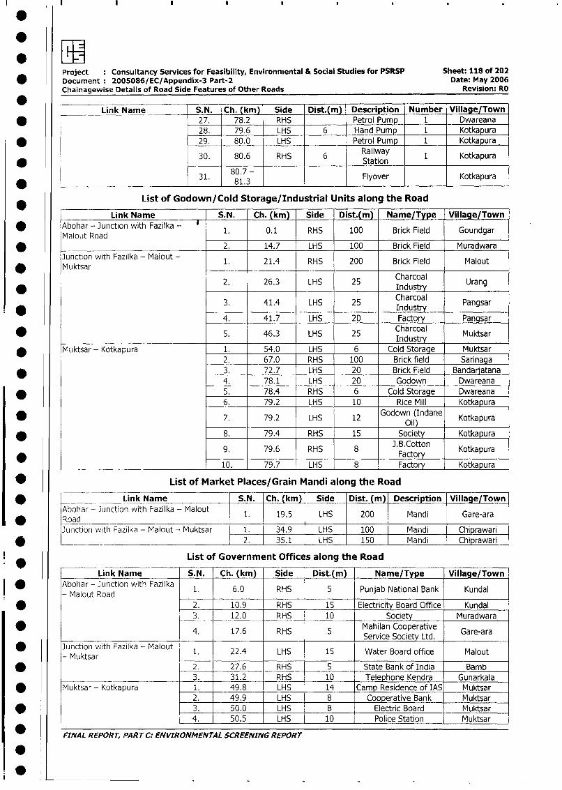
Project : Consultancy Services for Feasibility, Environmental & Social Studies for PSRSP Sheet: 118 of 202
* Document 2005086/EC/Appendix-3 Part-2 Date: May 2006Chainagewise Details of Road Side Features of Other Roads Revision: RO
Link Name S. N. Ch. (km) Side Dist.(m) Description Number Village/Town
* _ _27. 78.2 RHS Petrol Pump 1 Dwareana
28. 79.6 LHS 6 Hand Pump 1 Kotkapura
* 29. 80.0 LHS Petrol Pump 1 Kotkapura
30. 80.6 RHS 6 Railway 1 Kotkapura* ___ ~~~~~~~~~~~~~~~~~~~~~Station
31. 80.7 - Flyover Kotkapura
List of Godown/Cold Storage/Industrial Units along the Road
Link Name S. N. Ch. (km) Side Dist.(m) Name/Type Village/Town
* Abohar - Junction with Fazilka - 1. 0.1 RHS 100 Brick Field Goundgar
Malout Road* 2. 14.7 LHS 100 Brick Field Muradwara
Junction with Fazilka - Malout - 1. 21.4 RHS 200 Brick Field Malout
Muktsar
2. 26.3 LHS 25 Charcoal Urang* ~~~~~~~~ ~ ~~~~~~~~~~~~~~~industryUrn
3. 41.4 LHS 25 Charcoal Pangsar* ~~~~~~~~~~~~~~~~~~~~~~~~~~~Industr-y
4. 41.7 LHS 20 Factory Pangsar
* 5. 46.3 LHS 25 ICndustr Muktsar
* Muktsar- Kotkapura 1. 54.0 LHS 6 Cold Storage Muktsar
2. 67.0 RHS 100 Brick field Sarinaga
* 3. 72.7 LHS 20 Brick Field Bandaratana
4. 78.1 LHS 20 Godown Dwareana
* 5. 78.4 RHS 6 Cold Storage Dwareana
6. 79.2 LHS 10 Rice Mill Kotkapura
* 7. 79.2 LHS 12 Godown (Indane Kotkapura________ ~~~~~~~~ ~~ ~~Oil)_ _ _ __ _ _
* 8. 79.4 RHS 15 Society Kotkapura
9. 79.6 RHS 8 J.B.Cotton Kotkapura*
~~~~~~~~ ~~~~~~~~~~ ~~ ~~~~~Factory__ _ _ _ _ _
10. 79.7 LHS 8 Factory Kotkapura
* List of Market Places/Grain Mandi along the Road
* K Link Name S.N. Ch. (km) Side Dist. (m) Description Village/TownAbohar - Junction with Fazilka - Malout 1. 19.5 LHS 200 Mandi Gare-ara
* Road __ _ __l
Junction with Fazilka - Malout - Muktsar 1. 34.9 LHS 100 Mandi Chiprawari
* _ __ 2. 35.1 LHS 150 Mandi _ Chiprawari
List of Government Offices along the Road
Link Name S.N. Ch. (km)_ Side Dist.(m) Name/Type Village/Town
| * Abohar - Junction with Fazilka 1. 6.0 RHS I 5 Punjab National Bank Kundal
- Malout Road _ _ ____l_l
* 2. 10.9 RHS 15 Electricity Board Office Kundal
3. 12.0 RHS 10 Society Muradwara
4. 17.6 RHS 5 Mahilan Cooperative Gare-araService Society Ltd.
| * Junction with Fazilka - Malout 1. 22.4 LHS 15 Water Board office Malout
- MuktsarI * 2. 27.6 RHS 5 State Bank of India Bamb
3. 31.2 RHS 10 Telephone Kendra Gunarkala
I * Muktsar - Kotkapura 1. 49.8 ! LHS 14 Camp Residence of IAS Muktsar
2. 49.9 | LHS 8 Cooperative Bank Muktsar
* 3. 50.0 - LHS 8 Electric Board Muktsar
4. 50.5 - LHS 10 Police Station Muktsar
0 _ FINAL REPORT, PART C: ENVIRONMENTAL SCREENING REPORT
I0
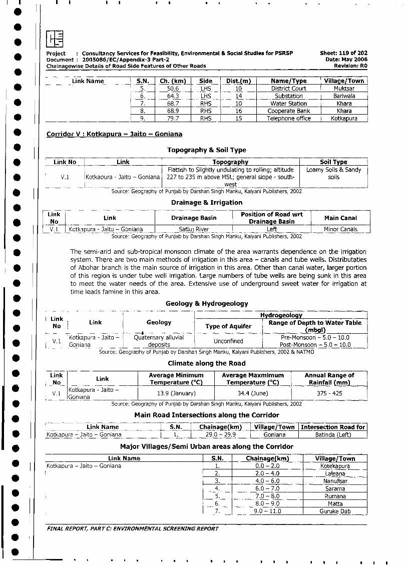
.EProject : Consultancy Services for Feasibility, Environmental & Social Studies for PSRSP Sheet: 119 of 202
Document: 2005086/EC/Appendix-3 Part-2 Date: May 2006
Chainagewise Details of Road Side Features of Other Roads Revision: RO
Link Name S.N. Ch. (km) Side Dist.(m) Name/Type Village/Town
* 5. 50.6 LHS 10 District Court Muktsar
6 . .64.3 LHS 14 Substation Bariwala
* - 7. 68.7 RHS 10 Water Station Khara
8. 68.9 RHS 16 Cooperate Bank Khara
*_____. _________ 9. 79.7 RHS 15 Telephone office Kotkapura
Corridor V: Kotkapura - Jaito - Goniana
* Topography & Soil Type
* Link No Link Topography Soil Type
Flattish to Slightly undulating to rolling; altitude Loamy Soils & Sandy
* V.1 Kotkapura - Jaito - Goniana 227 to 235 m above MSL; general slope - south- soilswest
* Source: Geography of Punjab by Darshan Singh Manku, Kalyani Publishers, 2002
______ -____ Drainage & Irrigation
LLink in riaeBsnPosition of Road wrt Mi aaNo LnDriaeBsnDrainage Basin Mi aa
V* Kotk pura - Jaito - Goniana Satluj River Left Minor Canals
* Source: Geography of Punjab by Darshan Singh Manku, Kalyani Publishers, 2002
* The semi-arid and sub-tropical monsoon climate of the area warrants dependence on the irrigation
system. There are two main methods of irrigation in this area - canals and tube wells. Distributaties
* of Abohar branch is the main source of irrigation in this area. Other than canal water, larger portion
of this region is under tube well irrigation. Large numbers of tube wells are being sunk in this area
* to meet the water needs of the area. Extensive use of underground sweet water for irrigation at
time leads famine in this area.
Geology & Hydrogeology
* l L' k ___________________________|_ _i__1__ydrogeology
Link Link Geology Type of Aquifer Range of Depth to Water Table_ No _ (m9)
Kotkapura - aito - Quaternary alluvial Unconfned Pre-Monsoon - 5.0 - 10.0* V.1 UncGonaonadenedtsPost-Monsoon - 5.0 - 10.0
Source: Geography of Punjab by Darshan Singh Manku, Kalyani Publishers, 2002 & NATMO
Climate along the Road
* Link Link Average Minimum Average Maxmimum Annual Range of
No Temperature (°C) Temperature (°C) Rainfall (mm)
V. 1 Kotkapura - Jaito 13.9 (January) 34.4 (June) 375 - 425
* Source: Geography of Punjab by Darshan Singh Manku, Kalyani Publishers, 2002
Main Road Intersections along the Corridor
Link Name S.N. Chainage(km) Village/Town Intersection Road for
* Kotkapura -jaito - Goniana 1. T 29.0 - 29.9 Goniana Batinda (Left)
* Major Villages/Semi Urban areas along the Corridor
Link Name S.N. Chainage(km) Village/Town
* Kotkapura - Jaito - Goniana 1. 0.0 - 2.0 Kotekapura
2. 2.0 - 4.0 Laleana
* l 3. 4.0 - 6.0 Nanullsar
4. 6.0 - 7.0 Sarama
l * l l 5. 7.0 - 8.0 Rumana6. 8.0 - 9.0 Matta
l l l 7. 9.0- 11.0 Guruke Dab
FINAL REPORT, PART C: ENVIRONMENTAL SCREENING REPORT
1010.. . ... ll l l
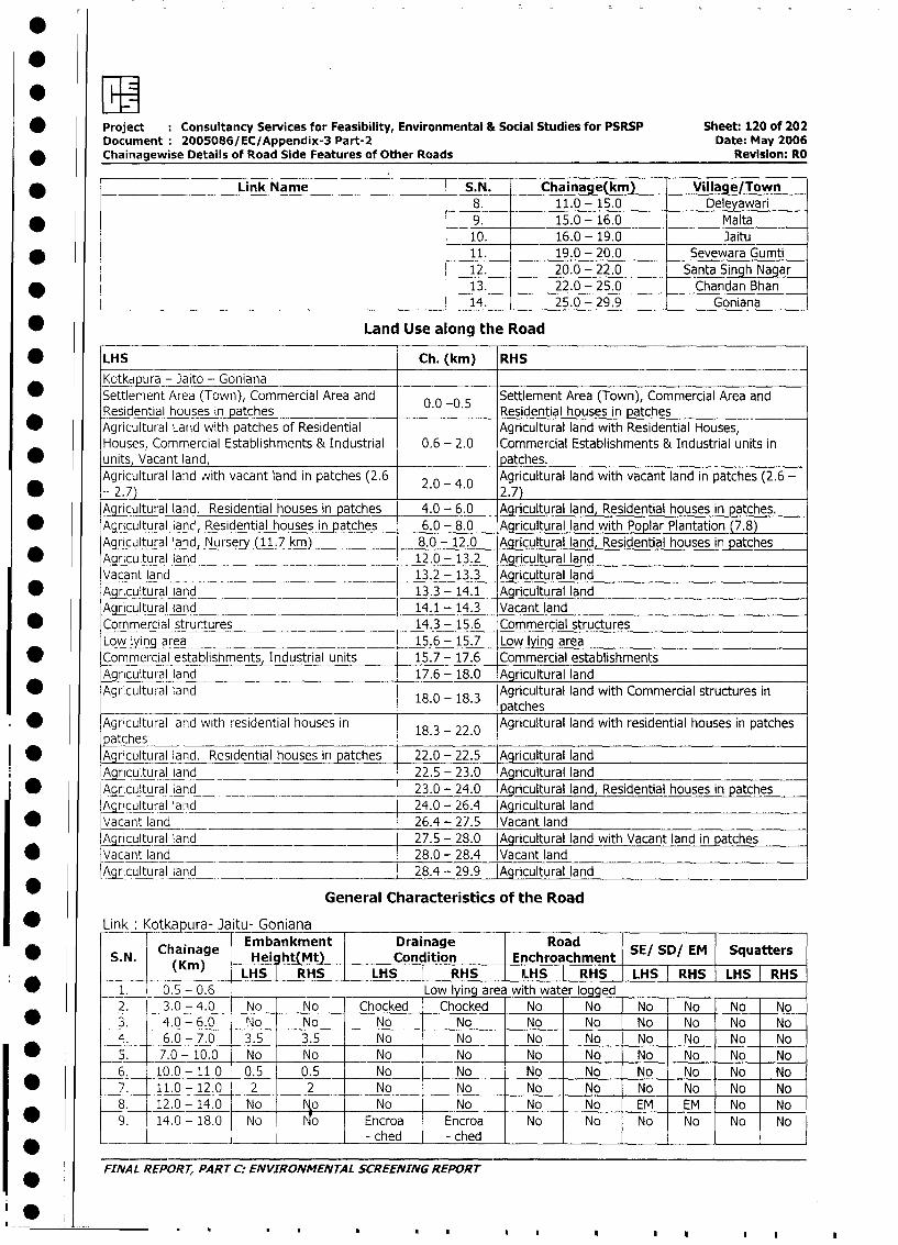
* Project Consultancy Services for Feasibility, Environmental & Social Studies for PSRSP Sheet: 120 of 202
Document: 2005086/EC/Appendix-3 Part-2 Date: May 2006
* Chainagewise Details of Road Side Features of Other Roads Revision: RO
Link Name |S.N. Chainage(km) Village/Town
_8. 11.0 - 15.0 Deleyawari
* _ 9. 15.0- 16.0 Malta
10. 16.0 - 19.0 Jaitu
* l 11. 19.0 - 20.0 Sevewara Gumti
12. 20.0 - 22.0 Santa Singh Nagar
* l 13. 22.0 - 25.0 Chandan Bhan
L __ ____ __ _ _ _14. 25.0 - 29.9 Goniana
* Land Use along the Road
* LHS Ch. (km) RHS
Kotka_ura - Jaito - Goniana
Settlement Area (Town), Commercial Area and 0.0 0.5 Settlement Area (Town), Commercial Area and
Residential houses in patches 0. -0. Residential houses in patches
* Agricultural Land with patches of Residential Agricultural land with Residential Houses,
Houses, Commercial Establishments & Industrial 0.6 - 2.0 Commercial Establishments & Industrial units in
* units, Vacant land, patches.
Agricultural land ,vith vacant land in patches (2.6 2.0 - 4.0 Agricultural land with vacant land in patches (2.6 -
-2.7) 2.7)
Agricultural land. Residential houses in patches 4.0 - 6.0 Agricultural land, Residential houses in patches.
* Agricultural land, Residential houses in patches 6.0 - 8.0 Agricultural land with Poplar Plantation (7.8)
Agricultural land, Nursery (11.7 km) 8.0 - 12.0 Agricultural land, Residential houses in patches
* Aaricultural land 12.0 - 13.2 Agricultural land
Vacant land 13.2 - 13.3 Agricultural land
* Agricultural land 13.3 - 14.1 Agricultural land
Agricultural land 14.1 - 14.3 Vacant land
Commercial structures 14.3 - 15.6 Commercial structures
Low lying area 15.6 - 15.7 Low lying area
* Commercial estabiishments, Industrial units 15.7 - 17.6 Commercial establishment.s
Agricultural land 17.6 - 18.0 Agricultural land
* Agricultural land Agricultural land with Commercial structures in18.0 - 18.3 patches
* Agricultural land with residential houses in 18.3 - 22.0 Agricultural land with residential houses in patches
patches* Agricultural land. Residential houses in patches 22.0 - 22.5 Agricultural land
Agricultural land 22.5 - 23.0 Agricultural land
* Agricultural land 23.0 - 24.0 Agricultural land, Residential houses in patches
Agricultural land 24.0 - 26.4 Agricultural land
* w Vacant land 26.4 - 27.5 Vacant land
lAgnicultral land 27.5 - 28.0 Agricultural land with Vacant land in patches
| X Vacant land 28.0 - 28.4 Vacant land
Agricultural land 28.4 - 29.9 Agricultural land
l General Characteristics of the Road
| * Link Kotkapura- Jaitu- GonianaEmbankment 1 Drainage Road1
l *| S.N. Chainage HeiibhtMnk t | Condition _ I Enchroachment SE/ SD/ EM Squatters
0 | i _ > (Kin) |LHS | RHSLHS HS HLHS R i LHS RHS I LHS RHS1 LHS RHS
i*t 1. 0.5 - 0.6 Low lying area with water logged
2. 3.0 - 4.0 No No Chocked Chocked No No No No No No
* L3. 4.0 - 6.0 No No No No No No No No No No
4. 6.0 - 7.0 3.5 3.5 No No No No No No No No
I * 1 5. 7.0- 10.0 No No No No No No No No No No
6. 10.0-11 0 0.5 0.5 No No No No No No No No
| * [ 7. 11.0 -12.0 2 2 No No No No No No No No
8. 12.0- 14.0 No o No No No No EM EM I No No
I * l 9. 14.0 - 18.0 No o Encroa Encroa No No No No No No
I * L l4|- ched - ched | l ll l
FINAL REPORT, PART C: ENVIRONMENTAL SCREENING REPORT
S~
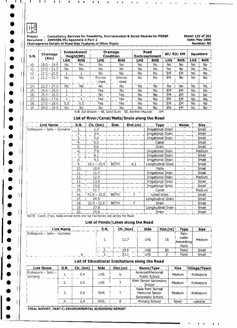
Project Consultancy Services for Feasibility, Environmental & Social Studies for PSRSP Sheet: 121 of 202
_ Document 2005086/EC/Appendix-3 Part-2 Date: May 2006
Chainagewise Details of Road Side Features of Other Roads Revision: Ro
* F1 ~~~~~~~~Embankment Drainage RoadSESDEM qaes
* S N Chainage Hei ht(Mt) Condition Enchroachment SE SD/ EM Squatters
* __ (Km) LHS RHS LHS RHS LHS RHS LHS RHS LHS RHS
10. 18.0-19.0 No No No No No No No No No No
11. 19.0-21.5 No No No No No No No No No No
12. 21.5-22.0 1 1 No No No No EM EM No No
13. 22.2 - 22.3 No No Encroa Encroa No No EM No No No
- ched - ched
14. 22.3-24.0 No No No No No No No No No No
15. 24.0-25.0 1 1 Yes No No No EM EM No No
* 16. 25.4-26.0 1 1 No Yes No No EM EM No No
17. 26.0-27.0 1 1 Yes Yes No No EM EM No No
* 18. 27.0 - 28.0 0.5 0.5 Yes Yes No No EM EM o No|
Ab 19. 28.0-29.9 No No No No No No EM EM No No
N.B: Soil Erosion - SE, Sand Dune - SD, Earthen Mounds - EM
* List of River/Canal/Nalla/Drain along the Road
Link Name S.N. Ch. (km) Side Dist.(m) Type Name Size
Kotkapura - 3aito - Goniana 1. 1.3 Irriqational Drain - Small
2. 3.6 Irrigational Drain - Small
* _ 3. 5.4 Xrrigational Drain - Small
4. 6.0 Canal - Small
* 0_ 5. 6.6 Drain - Small
6. 7.8 Irrigational Drain - Medium
* 7. 8.1 _ Irriqational Drain - Small
8. 9.1 . Irrigational Drain - Small
9. 10.1-10.5 BOTH 6.1 Longitudinal Drain - Small
10. 10.9 Nalla - Small
11. 11.4 Irrigational Drain - Small
* l 12. 12.9 Irrigationai Drain - Medium
13. 13.9 Irrigational Drain - Small
14. 19.0 Irrigational Drain - Small
l 15. 21.7 Canal - Medium
16. 21.8- 22.0 BOTH 7 Lined drain - Small
17. 24.9 Longitudinal Drain - Small
18. 22.5 - 22.6 BOTH 7 Drain - Small
19. 27.8 Lonqitudinal Drain - Small
*_______________________ l20. 29.8 Drain - Small
NOTE: Canal, Drain, Nalla whose sides are not mentioned are across the Road
* List of Ponds/Lakes along the Road
Link Name S.N. - Ch. (km) Side Dist.(m) Type Size
Kotkapura - Jaito -- Goniana Rain
* j j 1. | 11.7 j LHS is 15 |hawater Medium1. 11.7 LHS 15 ~~~~~harvesting
_ _ _ _ l l l l llPondl
2. I 19.6 LHS l 20 Pond l Small
______ * ____ - | 3. | 23.1 | LHS | 3 Pond Small
List of Educational Institutions along the Road
Link Name S.N. Ch. (km) Side Dist.(m) Name/Type Size Village/Town
Kotkapura - Jaito - 1. 0.4 LHS 6 AmarpatiMemorial Medium Kotkapura
Goniana ____Public School
2. 0.5 LHS Rishi Senior Secondary Medium KotkapuraSchool
Sada Ram Bansal
* 1 3. 0.6 RHS 7 Memorial Senior Medium Kotkapura
a_____ l________ l_______ l__l__l__ l Secondary School l l _ _
| * | | 4. 2.4 RHS 8 Primary School Small Laleana
| * FINAL REPORT, PART C0 ENVIRONMENTAL SCREENING REPORT
I0f|*
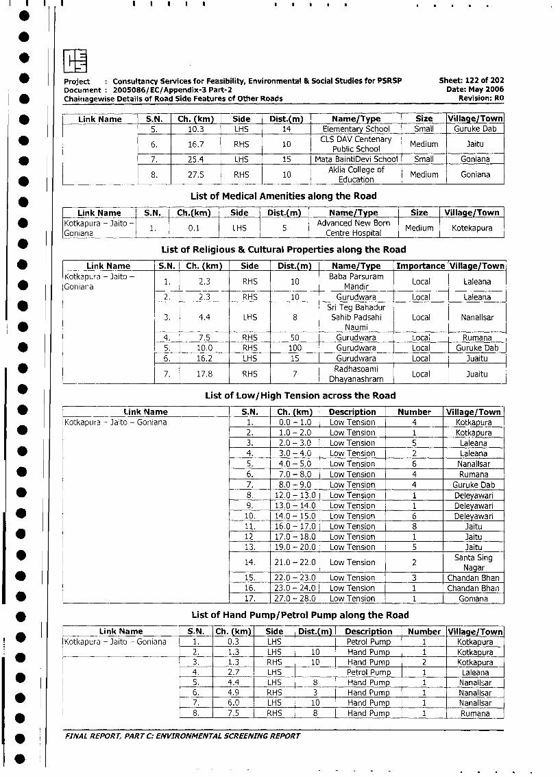
* Project Consultancy Services for Feasibility, Environmental & Social Studies for PSRSP Sheet: 122 of 202
Document 2005086/EC/Appendix-3 Part-2 Date: May 2006
Chaitiagewise Details of Road Side Features of Other Roads Revision: RO
* Link Name S.N. Ch. (km) Side Dist.(m)I Name/Type Size _Village/Town
5. 10.3 LHS 14 Elementary School Small Guruke Dab
6. 16.7 RHS 10 CLS DAV Centenary Medium Jaitu_ _ _ _ _ _ _______ _ ____ ___ ___ ______ Public _School _ _ _ _ _ _ _ _ _ _ _
* 7. 25.4 LHS 15 Mata BaintiDevi School Small Goniana
8. 27.5 RHS 10 Aklia College of Medium Goniana* _ _ _ _ _ _ _ _ _ _ ~~~~~~~~~~ ~ ~~Education _ _
List of Medical Amenities along the Road
Link Name S. N. Ch.(km) Side Dist.(m) Name/Type Size Village/Town
* Kotkapura - Jaito - 1. 0.1 LHS 5 Advanced New Born Medium Kotekapura
Goniana Centre Hos ital
List of Religious & Cultural Properties along the Road
* _ Link Name S.N. Ch. (km) Side Dist.(m) Name/Type Importance Village/Town
Kotkapura - Jaito - 1. 2.3 RHS 10 Baba Parsuram Local Laleana
Goniana __ _ _ _ _Mandir_ _ _ _ _ _ _
2. 2.3 RHS 10 Gurudwara Local Laieana
* Sri Teg Bahadur
3. 4.4 LHS 8 Sahib Padsahi Local Nanallsar
* _____ Naumi
4. 7.5 RHS 50 Gurudwara Local Rumana
* 5. 10.0 RHS 100 Gurudwara Local Guruke Dab
6. 16.2 LHS 15 Gurudwara Local Juaitu
*7. 17.8 RHS D7 Dhayanashram Local Juaitu
List of Low/High Tension across the Road
| * | Link Name S.N. Ch. (km) Description Number Village/Town
Kotkapura - Jaito - Goniana 1. 0.0 - 1.0 Low Tension 4 Kotkapura
I * l l 2. 1.0 - 2.0 Low Tension 1 Kotkapura
3. 2.0 - 3.0 Low Tension 5 Laleana
l * l l 4., 3.0 - 4.0 Low Tension 2 Laleana
5. 4.0 - 5.0 Low Tension 6 Nanallsar
| * | l 6. 7.0 - 8.0 Low Tension 4 Rumana
7. 8.0 - 9.0 Low Tension 4 Guruke Dab
| * 2 | 8. 12.0 - 13.0 Low Tension 1 Deleyawari
9. 13.0 - 14.0 Low Tension 1 Deleyawari
| * | l 10. 14.0 - 15.0 Low Tension 6 Deleyawari
11. 16.0 - 17.0 Low Tension 8 Jaitu
| * l l 12. 17.0 - 18.0 Low Tension 1 Jaitu
13. 19.0 - 20.0 Low Tension 5 Jaitu
14. 21.0 - 22.0 Low Tension 2 Santa Sing
| * l | 15. | 22.0 - 23.0 Low Tension 3 Chandan Bhan
16. 23.0 - 24.0 Low Tension 1 Chandan Bhan
| * l l 17. 27.0 - 28.0 Low Tension 1 Goniana
* ___________ List of Hand Pump/Petrol Pump along the Road
Link Name S.N. Ch. (km) Side Dist.(m) Description Number Village/Town
* |Kotl<apura -]aito - Goniana 1. 0.3 LHS Petrol Pump 1 Kotkapura
2. 1.3 LHS 10 Hand Pump - 1 Kotkapura
I _l l3. l 1.3 RHS 10 Hand Pump 2 Kotkapura
4. 2.7 LHS Petrol Pump 1 Laleana
5. 4.4 LHS 8 Hand Pump 1 Nanallsar
6. 4.9 RHS 3 Hand Pump 1 Nanallsar
* l 7. 6.0 LHS 10 Hand Pump 1 Nanallsar
8. 7.5 RHS 8 Hand Pump 1 Rumana
| * FINAL REPORT, PART C: ENVIRONMENTAL SCREENING REPORT
IS
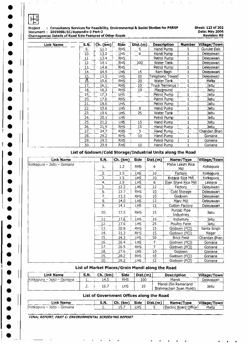
Project Consultancy Services for Feasibility, Environmental & Social Studies for PSRSP Sheet: 123 of 202
Document 2005086/EC/Appendix-3 Part-2 Date: May 2006
* Chainagewise Details of Road Side Features of Other Roads Revision: RO
* Link Name _ S. N. Ch. (km) Side Dist.(m) Description Number Village/Town
9. 11.1 RHS 5 Hand Pump 1 Guruke Dab
* 10. 13.2 LHS 8 Hand Pump 1 Deleyawari
11. 13.4 RHS Petrol Pump 1 Deleyawari
* 12. 14.1 RHS 200 Water Tank 1 Deleyawari
13. 14.8 RHS Petrol Pump 1 Deleyawari
* 14. 14.9 LHS 15 Ram Bagh 1 Deleyawari
15. 15.5 LHS 20 Telephone Tower 1 Deleyawari
* ____I. 15.6 RHS 20 Water Tank 1 Malta
17. 16.1 RHS 10 Truck Terminus 1 Jaitu
* 18. 16.2 RHS 10 Playground 1 Jaitu
19. 17.3 LHS Petrol Pump 1 Jaitu
* 20. 17.6 RHS Petrol Pump 1 Jaitu
21. 18.6 LHS_ Petrol Pump 1 Jaitu
* 22. 19.6 LHS 8 Hand Pump 1 Jaitu
23. 19.6 LHS 25 Water Tank 1 Jaitu
* 24. 20.1 LHS Petrol Pump 1 Jaitu
25. 21.2 LHS 15 Hand Pump 1 Jaitu
* 26. 21.9 RHS 15 Hand Pump 1 Jaitu
27. 24.7 RHS 5 Hand Pump 1 Chandan Bhan
* 28. 29.2 RHS 10 Hand Pump 1 Goniana
29. 29.5 RHS Petrol Pump 1 Goniana
-* ________________________ 30. 29.9 RHS 10 Hand Pump 1 Goniana
* List of Godown/Cold Storage/Industrial Units along the Road
Link Name S.N. Ch. (km) Side Dist.(m) Name/Type Village/Town
Kotkapura - Jaito - Goniana 1. 1.2 RHS 6 Maha Lakshi Rice Kotkapura
* 2. 1.5 LHS 10 Factory Kotkapura
3. 1.5 LHS 10 Kotaria Rice Mill Kotkapura
* 4. 2.9 LHS 8 Ever Shine Rice Mill Laleana
5. 12.2 LHS 12 Factory Deleyawari
* 6. 12.7 RHS 10 Cold Storage Deleyawari
7. 13.3 RHS 10 Godown Deleyawari
* 8. 14.0 LHS 12 Marc Mill Deleyawari
9. 14.1 LHS 12 Cotton Factory Deleyawari
10. 17.5 RHS 15 Punjab Pipe JaituIndustries __ _ _ _ _ _
* 11. 17.6 LHS 15 Industury Jaitu
12. 17.6 LHS 25 Poultry Farm Jaitu
* 13. 20.8 RHS 15 Godown (ECI) Santa Singh
14. 21.3 RHS 15 Godown (FCI) Nagar
15. 24.3 LHS 50 Brick Field Chandan Bhan
16. 26.4 LHS 7 l Godown (FCI) Goniana
* l 17. 26.5 RHS 7 j Godown (FCI) Goniana
18. 27.6 LHS 10 j Godown Goniana
* l 19. 28.2 RHS 10 j Godown (FCI) Goniana
-*______________________________ l 20. 28.2 LHS 12 j Godown (FCI) Goniana
List of Market Places/Grain Mandi along the Road
* r Link Name S.N. Ch. (km) Side Dist.(m) Description Village/Town
* |Kotkapura - Jaito - Goniana 1. 14.5 RHS 100 Mandi Deleyawari
* _ L 2. | 16.7 ! LHS < 10 | graMandi (Sri Ramanand Jaitu2. 16.7 LHS 10 ~~~Brahmachari. Jivan Mukti Jit
List of Government Offices along the Road
Link Name | S.N. |Ch. (km) I Side I Dist.(m) Name/Type IVillage/Townl
* IKotkapura - Jaito - Goniana 1. 15.7 LHS 5 Electric Board Office Malta
* FINAL REPORT, PARTC: ENVIRONMENTAL SCREEN TNGREPORT
I 1-S
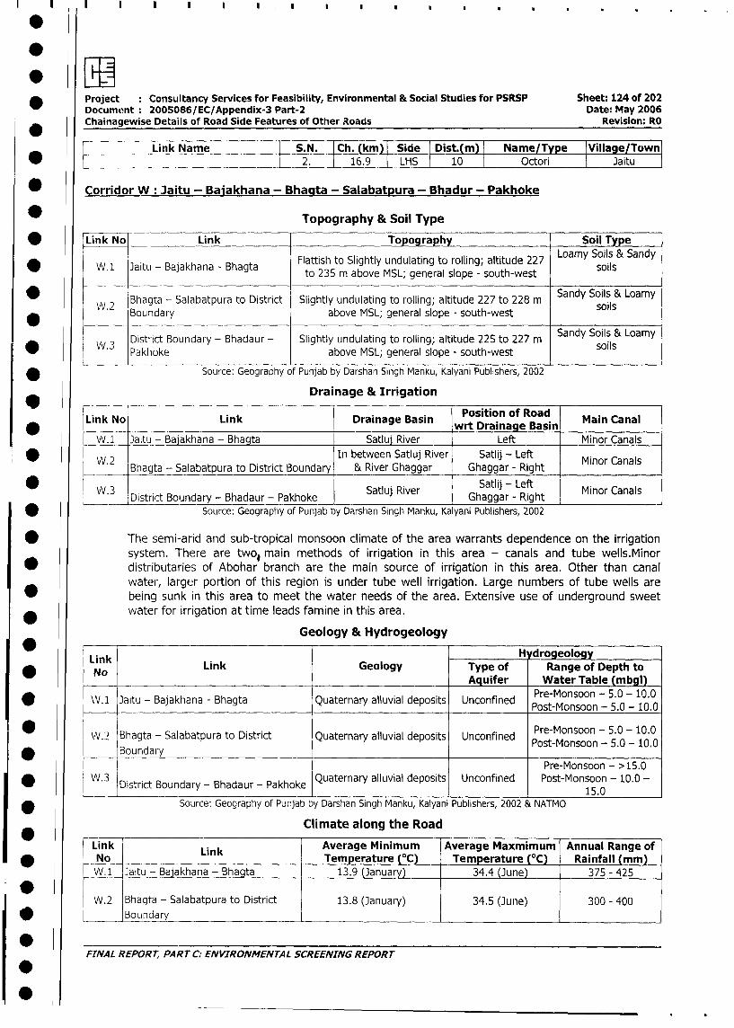
Project Consultancy Services for Feasibility, Environmental & Social Studies for PSRSP Sheet: 124 of 202
Document 2005086/EC/Appendix-3 Part-2 Date: May 2006
Chainagewise Details of Road Side Features of Other Roads Revision: RO
-< Link Name | S.N. Ch. (km) Side Dist.(m) I Name/Type IVillage/Town
* 2. 16.9 lLHS 10 I Octori I Jaitu l
* Corridor W: Jaitu - Bajakhana - Bhacita - Salabatpura - Bhadur - Pakhoke
Topography & Soil Type
* Link No Link Topography Soil Type
Flattish to Slightly undulating to rolling; altitude 227 Loamy Soils & Sandy
* W.1 Jaitu - Bajakhana - Bhagta to 235 m above MSL; general slope - south-west Soils
* W 2 Bhagta - Salabatpura to District Slightly undulating to rolling; altitude 227 to 228 m Sandy Soils & Loamy
W.2 Boundary above MSL; general slope - south-west soils
District Boundary - Bhadaur - Slightly undulating to rolling; altitude 225 to 227 m Sandy Soils & Loamy
W.3 Pakhoke above MSL; general slope - south-west soils
Source: Geography of Punjab by Darshan Singh Manku, Kalyani Publishers, 2002
Drainage & Irrigation
Link No Link Drainage Basin Position of Road Main Canal
W.1 Jaitu - Bajakhana - Bhagta Satluj River _ Left Minor Canals
W.2 In between Satluj River Satlij - Left Minor Canals
Bhagta - Salabatpura to District Boundary & River Ghaggar Ghaggar - Right
W.3 SatluRieSalij - Left Minor Canals*_W.3 District Boundary - Bhadaur - Pakhoke SatIu River Ghaggar - Right Minor_Canals
* Source: Geography of Punjab by Darshan Singh Manku, Kalyani Publishers, 2002
* The semi-arid and sub-tropical monsoon climate of the area warrants dependence on the irrigation
system. There are two, main methods of irrigation in this area - canals and tube wells.Minor
* distributaries of Abohar branch are the main source of irrigation in this area. Other than canal
water, larger portion of this region is under tube well irrigation. Large numbers of tube wells are
* being sunk in this area to meet the water needs of the area. Extensive use of underground sweet
water for irrigation at time leads famine in this area.
Geology & Hydrogeology
Link H drogeology
Link Link Geology Type of Range of Depth to
_ No Aquifer Water Table (mbgl)
* WV.1 Jaitu - Bajakhana - Bhagta Quaternary alluvial deposits Unconfined Pre-Monsoon - 5.0 - 10.0
* ~~~~~IPost-Monsoon - 5.0 - 10.0
W.:? Bhagta - Salabatpura to District Quaternary alluvial deposits Unconfined Post-Monsoon - 5.0 - 10.0
* Boundary PostMonson_-_________
Pre-Monsoon - >15.0
* W.3 District Boundary - Bhadaur - Pakhoke Quaternary alluvial deposits Unconfined Post-Monsoon - 10.0 -
_______________________________________________ ___________15.0
* Source: Geography of Punjab by Darshan Singh Manku, Kalyani Publishers, 2002 & NATMO
Climate along the Road
Link Link Average Minimum Average Maxmimum Annual Range of
No Temperature (°C) Temperature (°C) Rainfall (mm)
W.1 Jaitu - Bajakhana - Bhagta 13.9 (January) 34.4 (June) 375 - 425
W.2 Bhagta - Salabatpura to District 13.8 (January) 34.5 (June) 300 - 400
* Boundary
FINAL REPORT, PART C: ENVIRONMENTAL SCREENING REPORT
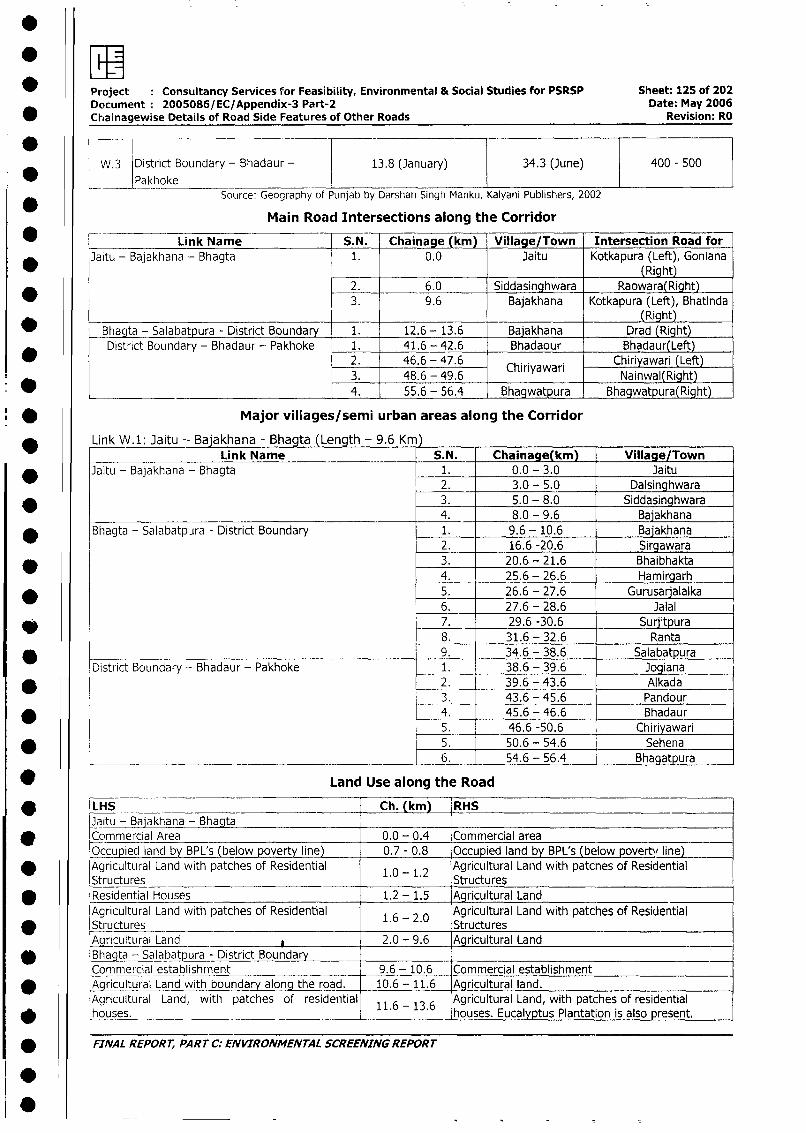
Project Consultancy Services for Feasibility, Environmental & Social Studies for PSRSP Sheet: 125 of 202
Document 2005086/EC/Appendix-3 Part-2 Date: May 2006
* Chainagewise Details of Road Side Features of Other Roads Revision: RU
W.3 District Boundary - Bhadaur - 13.8 (January) 34.3 (June) 400 - 500
__JPakhoke lIl_l
Source: Geography of Punjab by Darshan Singh Manku, Kalyani Publishers, 2002
Main Road Intersections along the Corridor
* Link Name S.N. Chainage (km) Village/Town Intersection Road for
Jaitu - Bajakhana - Bhagta 1. 0.0 Jaitu Kotkapura (Left), Goniana(Right)
2. 6.0 Siddasinghwara Raowara(Right)
* 3. 9.6 Bajakhana Kotkapura (Left), Bhatinda_(Right)
* Bhagta - Salabatpura - District Boundary 1. 12.6 - 13.6 Bajakhana Drad (Right)
District Boundary - Bhadaur - Pakhoke 1. 41.6 - 42.6 Bhadaour Bhadaur(Left)
2. 46.6 - 47.6 Chrawar Chiriyawari (Left)3. 1 48.6 - 49.6 iyINainwal(Right)
* ~ ~ ~ ~ ~~~~~~~~~~~~14. 1 55.6 - 56.4 Bhagwatpura Bgwtura(Right)
Major villages/semi urban areas along the Corridor
* Link W.1: Jaitu -- Bajakhana - Bhagta (Length - 9.6 Km )
Link Name S.N. Chainage(km) Village/Town
* Jaitu - Bajakhana - Bhagta 1. 0.0 - 3.0 Jaitu2. 3.0 - 5.0 Dalsinghwara
* 3. 5.0 - 8.0 Siddasinghwara4. 8.0 - 9.6 Bajakhana
* Bhagta - Salabatpura - District Boundary 1. 9.6 - 10.6 Bajakhana2. 16.6 -20.6 Sirgawara
* 3. 20.6 - 21.6 Bhaibhakta4. 25.6 - 26.6 Hamirgarh
* 5. 26.6 - 27.6 Gurusarjalalka6. 27.6 - 28.6 Jalal
* 7. 29.6 -30.6 Surjitpura8. 31.6 - 32.6 Ranta
* 9. 34.6 - 38.6 Salabatpura
District Boundary - Bhadaur - Pakhoke 1. 38.6 - 39.6 Jogiana
* 2. 39.6 - 43.6 Alkada3. 43.6 - 45.6 Pandour
* 4. 45.6 - 46.6 Bhadaur5. 46.6 -50.6 Chiriyawari
* 5. 50.6 - 54.6 Sehena
____ __________________________________________ 6. _ 54.6 - 56.4 _ Bhaatpura
* Land Use along the Road
* LHS Ch. (km) RHS
Jaitu - Bajakhana - Bhagta* Commercial Area 0.0 - 0.4 Commercial area
Occupied land by BPL's (below poverty line) 0.7 - 0.8 Occupied land by BPL's (below poverty line)
Agricultural Land with patches of Residential 1.0 2 Agricultural Land with patches of Residential
Structures 1. - 1. Structures
* Residential Houses 1.2 - 1.5 Agricultural Land
Agricultural Land with patcies of Residential 1.6 - 2.0 Agricultural Land with patches of Residential
* Structures . Structures
Aqricultural Land 2.0 - 9.6 Agricultural Land
* Bhagta - Salabatpura - District Boundary
Commercial establishnent 9.6 - 10.6 Commercial establishment
* [Aqricultural Land with boundary along the road. 10.6 - 11.6 Agricultural land.
Agricultural Land, with patches of residential 116 - 13.6 Agricultural Land, with patches of residential
* {houses. . . houses. Eucalyptus Plantation is also present.
* FINAL REPORT, PART C: ENVIRONMENTAL SCREENING REPORT
0_
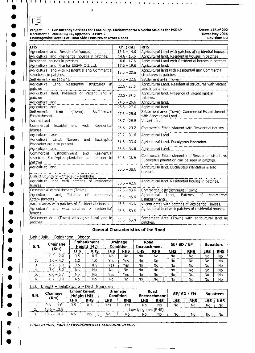
Project Consultancy Services for Feasibility, Environmental & Social Studies for PSRSP Sheet: 126 of 202
v Document 2005086/EC/Appendix-3 Part-2 Date: May 2006
Chainagewise Details of Road Side Features of Other Roads Revision: RO
LHS Ch. (km) RHS
_ Agricultural land. Residential houses 13.6 - 14.6 Agricultural Land with patches of residential houses.
Ag_ncultural land. Residential houses in patches. 14.6 - 16.6 Agricultural land. Residential houses in patches.
Residential houses in patches. 16.6 - 17.6 Agricultural Land with Residential houses in patches.
Agricultural land. Site for ESSAR OIL Ltd. 17.6 - 19.6 Agricultural land.
* AgricLItural land with Residential and Commercial 19.6 - 20.6 Agricultural land with Residential and Commercial
structures in patches. structures in patches.
Settlement area (Town). 20.6 - 22.6 Settlement area (Town).
Agricultural Land. Residential structures in Agricultural Land. Residential structures with vacant
patches. 22.6 - 23.6 land in patches.
Agricultural land. Presence of Vacant land in 23.6 - 24.6 Agricultural land. Presence of vacant land in
patches. . . patches.
_ Agricultural land. 24.6 - 26.6 Agricultural land.
Agricultural land. 26.6 - 27.6 Agricultural land.
* Settlement area (Town), Commercial 27.6 - 28.6 Settlement area (Town), Commercial Establishment
Establishment. . . with Agricultural Land.
* Vacant Land 28.7 - 28.8 Vacant Land
Commercial Establishment with Residential 28.8 - 29.2 Commercial Establishment with Residential houses.
houses.Agricultural Land. 29.2 - 31.6 Agricultural Land.
Agricultural Land. Nursery and Eucalyptus 31.6 - 33.6 Agricultural Land. Eucalyptus Plantation.
Plantation are also reseit._
_ Agcrultural Land. 33.6 - 34.6 Agricultural Land.
Commercial Establishment and Residential Commercial Establishment and Residential structure.
structure. Eucalyptus plantation can be seen in 34.6 - 36.6 Eucalyptus plantation can be seen in patches.
patches. _ _ _ _ _ _ _ _ _ _
* Agricultural land. 36.6- 38.6 Agricultural land. Eucalyptus Plantation is also
36_6 - 38.6 present.
* ~ District Boundary - Bhadaur - Pakhoke
Agricultural land with patches of residential 38.6 -42.6 Agricultural land. Residential houses in patches.
'houses.Commercial establishment (Town). 42.6 - 43.6 Commercial establishment (Town)
Agricultural Land, Patches of commercial 43.6 - 45.6 Agricultural Land, Patches of commercial
Establishments. Establishments.
* Vacant areas with patches of Residential Houses. 45.6 - 46.6 Vacant areas with patches of Residential Houses.
Agricultural land with patches of residential 46.6 - 50.6 Agricultural land with patches of residential houses.
* houses.Settlement Area (Town) with agricultural land in 50.6 - 56.4 Settlement Area (Town) with agricultural land in
*_patches. I I patches.
-* * General Characteristics of the Road
Link Jaitu - Bajakhana - Bhagta
Chainag Embankment Drainage Road SE/ SD / EM Squatters
S.N. (Km) Heig t (Mt) Condition Encroachment S S Eq_
* LHS RHS LHS RHS LHS RHS LHS RHS LHS RHS
1. 0.0 - 2.0 0.5 0.5 No No No No No No No No
* 2. 3.0 - 4.2 1.0 1.0 Yes Yes No No No No No No
3. 4.2 - 5.0 0.5 0.5 Yes Yes No No No No No No
/* 4. 5.0 - 6.0 No No No No No No No No No No
5. 6.0 - 6.7 No No Yes Yes No No No _ No No No
* 6. 6.7 - 9.0 No No No No No No No No No No
* Link : hagta - Salabatpura -- Distt. Boundary
KN Chainage ~Embankment Drainage RoadS/SD/E Sqatr
* S N. Chainage Height (Mt) Condition L Encroachment SE/ SD EM Squatters
l (Km) _LHS|RHS HS |RHr|H S S LS LHS RHS LHS| RHS
* l 1. 9.6-13.6 0.5 0.5 Yes Yes [No I No- No No No I No
l 1 2. 13.6-13.8 Low lying area (RHS).
* 3 . 13.6 -14.2 No No No No I No N No No No No
| | FINAL REPORT, PART C: ENVIRONMENTAL SCREENING REPORT
I9 l
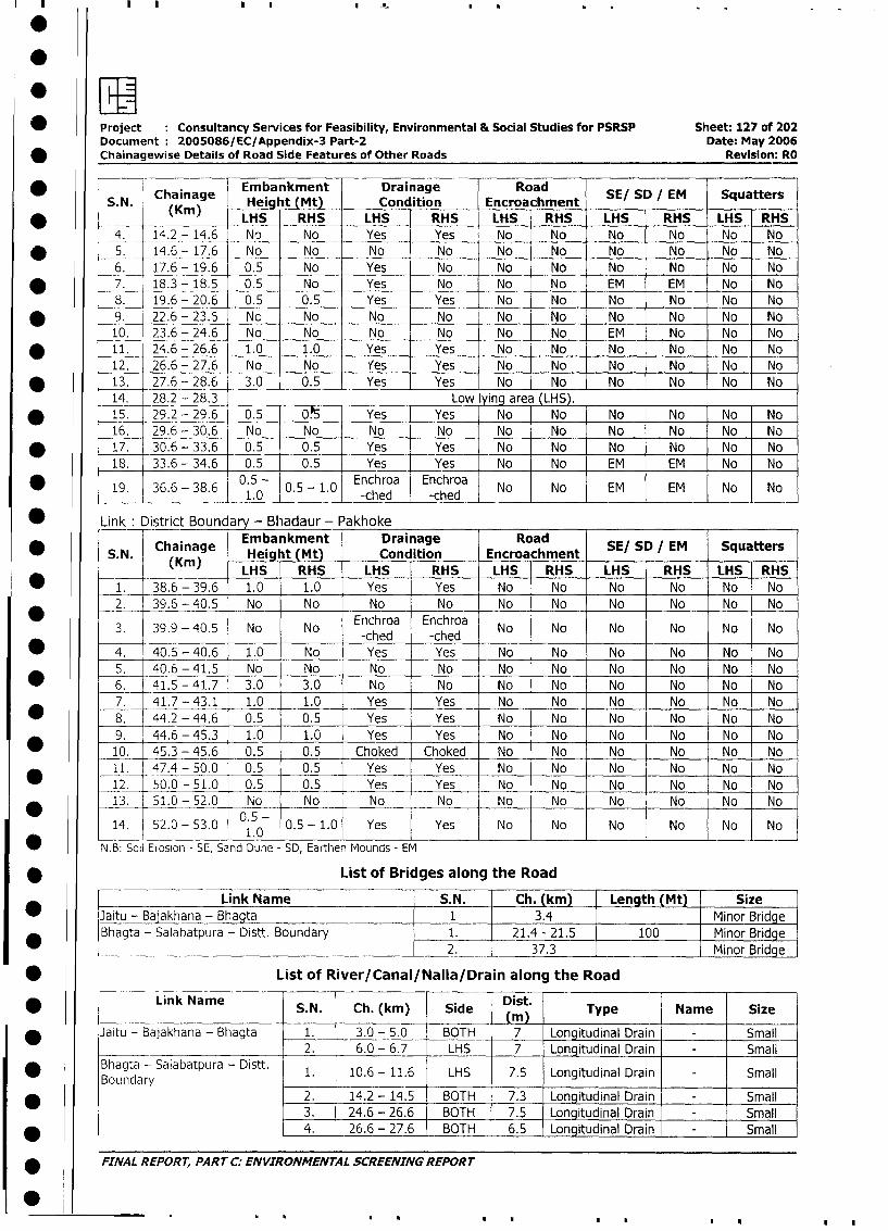
0P
* ~~~Project :Consultancy Services for Feasibility, Environmental & Social Studies for PSRSP Sheet: 127 of 202Document: 2005086/EC/Appendix-3 Part-2 Date: May 2006
*Chainagewise Details of Road Side Features of Other Roads Revision: RO
S.. Chainage Embankment Drainage RoadSESD M SqatrSN. (Kin) Height Mt) Condition Encroachment SESD/M Sqatr
LHS RHS LHS RHS LHS rRHS LHS RHS LHS RHS
4, 14.-2 - 14.6 No No Yes Yes No No No No No No
* ~~~~5. 14.6 -17.6 No No No No No No No No No No
6 . 17.6 -19.6 0.5 N o Yes N o N o N o N o N o N o No
* ~~~7 . 18.3 -18.5 0.5 No0 Yes N o No N o E M E M N o N o
8 . 19.6 - 20.6 0.5 0.5 Yes Yes N o N o N o N o No N o
* ~~~9 . 22.6 -23.6 N o N o N o N o No N o N o N o N o No
10. 23.6 -24.6 N o N o N o N o N o No E M N o N o N o
* ~~~~11. 24.6 - 26.6 1.0 1.0 Yes Yes N o N o N o N o No No
12. 26.6 - 27.6 N o N o Yes Yes N o N o N o No No No
* ~~~~13. 27.6 - 28.6 3.0 0.5 Yes Yes N o N o N o N o N o N o
14. 28.2 - 28,3 Low lying are (LHS _______
* ~~~~15. 29.2 -29.6 0.5 0.5 Yes - Yes N o N o N o N o N o No
16. 29.6 -30.6 N o N o N o N o N o N o N o N o N oN o
* ~~~~17. 30.6 -33.6 0.5 0.5 Yes Yes N o N No N o No NoN o
18. 33.6 -34.6 0.5 0.5 Yes - Yes N o N o E M EM -No N No
19. 36.6 - 38.6 0.5 - 0.5 -1.0 Enchroa Enchroa No No EM EM No No___________ 1.0 __ _ _ _ -ched -ched _ _ _ _ _ _ _ _ _ _ _ _ _ _ _ _ _ _ _
* ~~Link :District Boundary - Bhadaur -_Pakhoke _____
Chainage Embankment Drainage Road* ~~~S.N. (Kain)g Height (Mt) Condition Encroachment SE/ SD IEM Squatters
(Krn) LHS RHS LHS RHS -LHS RHS LHS RHS LHS RHS
* ~~~~1. 38.6 - 39.6 1.0 1.0 Yes Yes No No No No No No
2. 39.6 -40.5 No No No No No No No No No No
3. 39.9 -40.5 No No Enchroa Enchroa No No No No No NoI I ~~~~~~-ched -chedI
* ~~~~4. 40.5 - 40.6 1.0 No Yes Yes No No No No No No
5. 40.6 -41.5 No No No No No No No No No No
* ~~~~6. 41.5 -41.7 3.0 3.0 No No No No No No No No
7. 41.7 - 43.1 1.0 1.0 Yes Yes No No No No No No
* 8~~~~. 44.2 - 44.6 0.5 0.5 Yes Yes No No No No No No
9. 44.6 - 45.3 1.0 1.0 Yes Yes No No No No No No
* ~~~~10. 45.3 - 45.6 0.5 0.5 Choked Choked No No No -No No No
11. 47.4 - 50.0 0.5 0.5 Yes Yes No No No No No No
* ~~~1-2. -50.0 O- 5 1. 0 0.5 0.5 Yes Yes No No No No No No
13. 51.0 -52.0 No No No No No No No No No No
14. 52.0 -53.0 0.5- 0.5 -1.0 Yes Yes No No No No No No_ _ _ _ _ _ _ _ 1~~~~.0 _ _ __ _ _ _ _ _
N.B: Soil Erosion - SE, Sand Dune - SD, Earthen Mounds - EM
* ~~~~~~~~~~List of Bridges along the Road
Link Name ~~SM. Ch. (km) Length (Mt) Size
* ~~~Jaitu - Bajakhana - Bhagta 1 .4Minor Bridge
* ~~~Bhagta - Salabatpura - Distt. Boundary 1. 21.4 - 21.5 100 Minor Bridge
______ ___ __________ _______ __ ____ ___2 _ 37 3M inor Bridge
* ~~~~~~~~List of River/Canal/Nalla/Drain along the Road
* ~~~~~~Link Name S.N. Ch. (kin) Side Dist. Type Name Size
* ~~~Jaitu - Bajakhana - Bhagta 1. 3.0 - 5.0 BOTH 7 Longitudinal Drain - Small
____ __________________ 2. 6.0 - 6.7 LHS 7 Longitudinal Drain - Small
* ~~~Bhagta - Salabatpura - Distt. 1. 10.6 - 11.6 LHS 7.5 Longitudinal Drain - SmallBouindary__ _ _ _ ___
_ _ _ _
* ~~~ ~~~~~~~~~~~2. 14.2 -14.5 BOTH 7.3 Longitudinal Drain - Small
3. 24.6 - 26.6 BOTH 7.5- Longitudinal Drain - Small
* ~~~ ~~~~~~~~~~~4. 26.6 -27.6 BOTH 6.5 Longitudinal Drain - Small
* ~~FINAL REPORT, PART C. ENVIRONMENTAL SCREENING REPORT
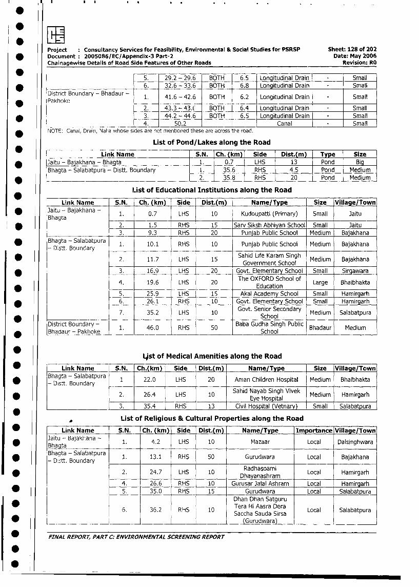
Project Consultancy Services for Feasibility, Environmental & Social Studies for PSRSP Sheet: 128 of 202
* Document 2005086/EC/Appendix-3 Part-2 Date: May 2006
Chainagewise Details of Road Side Features of Other Roads Revision: RO
5. 29.2 - 29.6 BOTH 6.5 Longitudinal Drain - Small
*______ 6. 32.6 - 33.6 BOTH 6.8 Longitudinal Drain - Small
District Boundary - Bhadaur - 1. 41.6 - 42.6 BOTH 6.2 Longitudinal Drain - Small
* Pakhoke2. 43.3 - 43. BOTH 6.4 Longitudinal Drain Small
* 3. 44.2 - 44.6 BOTH 6.5 Longitudinal Drain - Small
4. 50.2 Canal _ Small
NOTE: Canal, Drain, Nalla whose sides are not mentioned these are across the road.
List of Pond/Lakes along the Road
Link Name _ S.N. Ch. (km) Side Dist.(m) Type Size
_ Jaitu - Bajakhana - Bhagta 1. 0.7 LHS 13 Pond Big
Bhagta - Salabatpura - Distt. Boundary 1. 35.6 RHS 4.5 Pond Medium
* ____________________________ 2. 35.8 RHS 20 Pond Medium
List of Educational Institutions along the Road
Link Name S.N. Ch. (km) Side Dist.(m) Name/Type Size Village/Town
* Jaitu - Bajakhana - 1. 0.7 LHS 10 Kudoupatti (Primary) Small Jaitu
Bhagta .
* - 2. 1.5 RHS 15 Sarv Siksh Abhiyan School Small Jaitu
3. 9.3 RHS 20 Punjab Public School Medium Bajakhana
* Bhagta - Salabatpura 1. 10.1 RHS 10 Punjab Public School Medium Bajakhana
- Distt. Boundary
* 2. 11.7 LHS 15 Sahid Life Karam Singh Medium BajakhanaGovernment School M
* L3. 16.9 LHS 20 Govt. Elementary School Small _Sirgawara
4. 19.6 LHS 20 The OXFORD School of Large BhaibhaktaEducation
5. 25.9 LHS 15 Akal Academy School Small Hamirgarh
* } l_ 6. 26.1 RHS 10 Govt. Elementary School Small Hamirgarh
* > > 7. 35.2 LHS 10 Govt. Senior Secondary Medium Salabatpura______________
_______ ~~~~ ~~~School
District Boundary - 1. 46.0 RHS 50 Baba Gudha Singh Public Bhadaur Medium
*__________ ____ Ljst of Medical Amenities along the Road
* > Link Name S.N. Ch.(km) Side Dist.(m) Name/Type Size Village/Town
Bhagta - Salabatpura 1 22.0 LHS 20 Aman Children Hospital Medium Bhaibhakta
- Distt. Boundary _ _ * _ l l l_l_ l
2. 26.4 LHS 10 Sahid Nayab Singh Vivek Medium Hamirgarh1 .~. 35.4 RHS I_______ - CivilEye Hospital _____
*________________ |__ _ |_3. _35.4 _ RHS_ | 13 | Civil Hospital (Vetnary) I Small | Salabatpura
List of Religious & Cultural Properties along the Road
* | Link Name S.N. Ch. (km) Side Dist.(m) Name/Type Importance Village/Town
*aitu - Bajakhana - 1. 4.2 LHS 10 Mazaar Local Dalsinghwara
Bhaota - Salabatpura 1. 13.1 RHS 50 Gurudwara Local Bajakhana
D- Distt. Boundary _*ll_
* t > 2. 24.7 LHS 10 Daydahnashram Local Hamirgarh
4. 26.6 RHS 10 Gurusar Jalal Ashram Local Hamirgarh
* l l 5. 35.0 RHS | 15 Gurudwara Local SalabatpuraDhan Dhan Satguru
0 ~ ~ ~ ~~ ~ ~~~~6 3. H 0 Tera Hi Aasra Dera Loa Slbtpr* 5 i 6. 1 36.2 l RHS 4 10 4 TSaccha Sauda irsa Local SSalabatpura
*___________ _.____________________|__ (Gurudwara)
FINAL REPORT, PART C: ENVIRONMENTAL SCREENING REPORT
1*
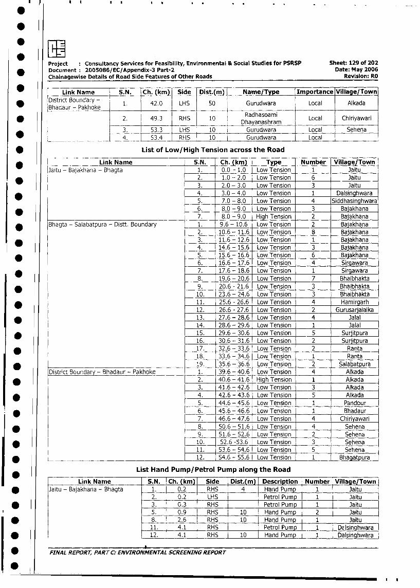
7.
Project : Consultancy Services for Feasibility, Environmental & Social Studies for PSRSP Sheet: 129 of 202
* Document 2005086/EC/Appendix-3 Part-2 Date: May 2006
Chainagewise Details of Road Side Features of Other Roads Revision: RO
* | Link Name S.N. Ch. (km) Side Dist.(m) Name/Type Importance Village/Town
* BaDistrict Boundary - 1. 42.0 LHS 50 Gurudwara Local AlkadaBhadaur_ Padhoom
* 2. 49.3 RHS 10 Dha anashramn Local Chiriyawari
3. 53.3 LHS 10 Gurudwara Local Sehena
. 4. 53.4 RHS 10 Gurudwara Local
* List of Low/High Tension across the Road
* Link Name S.N. Ch. (km) Type Number Village/Town
Jaitu - Bajakhana - Bhagta 1. 0.0 - 1.0 Low Tension 1 Jaitu
* 2. 1.0 - 2.0 Low Tension 6 Jaitu
3. 2.0 - 3.0 Low Tension 3 Jaitu
* 4. 3.0 - 4.0 Low Tension 1 Dalsinghwara
5. 7.0 - 8.0 Low Tension 4 Siddhasinghwara
_ 6. 8.0 - 9.0 Low Tension 3 Baiakhana
7. 8.0 - 9.0 High Tension 2 Bajakhana
* Bhagta - Salabatpura - Distt. Boundary 1. 9.6 - 10.6 Low Tension 2 Bajakhana
2. 10.6 - 11.6 Low Tension 8 Balakhana
* 3. 11.6 - 12.6 Low Tension 1 Baiakhana
4. 14.6 - 15.6 Low Tension 3 Bajakhana
* 5. 15.6 - 16.6 Low Tension 6 Bajakhana
6. 16.6 - 17.6 Low Tension 4 Sirgawara
* l 7. 17.6 - 18.6 Low Tension 1 Sirgawara
8. 19.6 - 20.6 Low Tension 7 Bhaibhakta
* 9. 20.6 - 21.6 Low Tension 3 Bhaibhakta
10. 23.6 - 24.6 Low Tension 3 Bhaibhakta
* 11. 25.6 - 26.6 Low Tension 4 Hamirgarh
12. 26.6 - 27.6 Low Tension 2 Gurusarjalalka
* 13. 27.6 - 28.6 Low Tension 4 Jalal
14. 28.6 - 29.6 Low Tension 1 Jalal
* 15. 29.6 - 30.6 Low Tension 5 Surjitpura
16. 30.6 -- 31.6 Low Tension 2 Surjitpura
* 17. 32.6 - 33.6 Low Tension 2 Ranta
18. 33.6 - 34.6 Low Tension 1 Ranta
* 19. 35.6 - 36.6 Low Tension 2 Salabatpura
District Boundary - Bhadaur - Pakhoke 1. 39.6 - 40.6 Low Tension 4 Alkada
* 2. 40.6 - 41.6 High Tension 1 Alkada
3. 41.6 - 42.6 Low Tension 3 Alkada
_ 4. 42.6 - 43.6 Low Tension 5 Alkada
5. 44.6 - 45.6 Low Tension 1 Pandour
* 6. 45.6 - 46.6 Low Tension 1 Bhadaur
7. 46.6 - 47.6 Low Tension 4 Chiiriyawari
* 8. 50.6 - 51.6 Low Tension 4 Sehena
9. 51.6 - 52.6 Low Tension 2 Sehena
_ 10. 52.6 -53.6 Low Tension 3 Sehena
11. 53.6 - 54.6 Low Tension 5 Sehena
* 12. 54.6 - 55.6 Low Tension 1 Bhagatpura
List Hand Pump/Petrol Pump along the Road
Link Name S.N. Ch. (km) Side Dist.(m) Descri tion Number Village/Town
* Jaitu - Bajakhana - Bhagta 1. 0.2 RHS 4 Hand Pump 1 Jaitu
2. 0.2 LHS Petrol Pump 1 Jaitu
* 3. 0.3 RHS Petrol Pump 1 Jaitu
5. 0.9 RHS 10 Hand Pump 2 Jaitu
I * 8. 2.6 RHS 10 Hand Pump 1 Jaitu
11. 4.1 RHS Petrol Pump 1 1D1singhwara
| * 12. 4.1 RHS 10 Hand Pump 1 Dalsinghwara
| w FINAL REPORT, PART C: ENVIRONMENTAL SCREENING REPORT
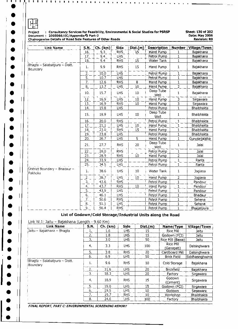
* Project : Consultancy Services for Feasibility, Environmental & Social Studies for PSRSP Sheet: 130 of 202
Document: 2005086/IEC/AppendixA3 Part-2 Date: May 2006
Chainagewise Details of Road Side Features of Other Roads Revision: RO
* Link Name S.N. Ch. (km) Side Dist.(m) Description Number Village/Town
16. 9.3 RHS 15 Hand Pump 1 Bajakhana
* l 17. 9.4 LHS Petrol Pump 1 Bajakhana
18. 9.4 RHS 15 Water Tank 1 Bajakhana
* Bhagta - Salabatpura - Distt. 1. 9.9 RHS 15 Hand Pump 1 Bajakhana
Bounclary2. 10.0 LHS Petrol Pump 1 Bajakhana
5. 10.7 LHS Petrol Pump 1 Bajakhana
7. 12.6 RHS 8 Hand Pump 1 Bajakhana
8. 13.7 LHS 10 Hand Pump 2 Bajakhana
10. 15.7 LHS 10 Deep Tube 1 Bajakhana* 12. 16.9 LHS 10 HandPunnp 3 SirgawaraWell
12. 16.9 LHS 10 Hand Pump 3 Sirgawara
* ~~~ ~~~~~~~~~~~13. 16.9 RHS 10 Hand Pump 3 ISirgawara
14. 19.8 LHS Petrol Pump 1 Bhaibhakta
_ 15. 19.9 LHS 10 Deep Tube 1 BhaibhaktaWell
* 16. 20.0 RHS Petrol Pump 1 Bhaibhakta
17. 21.1 LHS 10 Hand Pump 1 Bhaibhakta
18. 23.0 RHS 15 Hand Pump 1 Bhaibhakta
19. 23.8 LHS Petrol Pump 1 Bhaibhakta
20. 26.7 LHS 5 Hand Pump _ 1 Gurusaralalka
* 21. 27.7 RHS 20 Deep Tube 1 JalalWell
22. 28.0 RHS Petrol Pump 1 Jalal
23. 28.9 RHS 10 Hand Pump 2 Jalal
24. 33.9 LHS Petrol Pump 1 Ranta
25. j 34.5 LHS Petrol Pump 1 Ranta
District Boundary - Bhadaur - 1. 38.6 LHS 10 Water Tank 1 Jogiana
Pakhoke2 38.7 LHS 10 Hand Pump _ 2 Jogiana
* 3. 43.6 RHS Petrol Pump 1 Pandour
4. 43.7 RHS 10 Hand Pump 1 Pandour
_ 5. 43.9 LHS Petrol Pump 1 Pandour
6. 46.1 LHS Petrol Pump 1 Bhadaur
7. 50.6 RHS Petrol Pump 1 Sehena
8. 51.1 LHS Petrol Pump 1 Sehena
____ ____________________ 9. 56.4 RHS Petrol Pump 1 Bhagatpura
* List of Godown/Cold Storage/Industrial Units along the Road
* Link W.l: Jaitu - Bajakhana Le gth - 9.60 Km)
Link Name S.N. Ch. (km) Side Dist.(m) Name/Type Village/Town
* Jaitu - Bajakhana - Bhagta 1. 1.6 LHS 15 Rice Mill Jaitu
2. 1.8 LHS 15 Godown (FCI) Jaitu
* 3. 3.0 LHS 50 Rice Mill (Bawa) Jaitu
4. 3.3 LHS 100 G aice Mill Dalsinghwara
5. 3.8 RHS 20 Cardboard Mill Dalsinghwara
_____ 6. 6.9 LHS 50 Brick Field Siddhasinghwera
Bhagta - Salabatpura - Distt. 1. 9.6 RHS 10 Cold Storage Bajakhana
* Boundary 12. 11.6 LHS 20 Brickfield Baiakhana
* . 3. 18.3 LHS 20 Factory Sirgawara
4. 18.9 RHS 15 odown Sirgawara
* j~~~~~~~~~~~~~~~~~~~~~~~Cment) Srawr
5. 19.0 LHS 15 Godown (FCI) Sirgawara
_ 6. 19.5 LHS 10 Godown Sira_wara
7. 19.7 RHS 10 Workshop I Bhaibhakta
* 8. 24.6 LHS 100 Factory Bhaibhakta
FINAL REPORT, PART C: ENVIRONMENTAL SCREENING REPORT
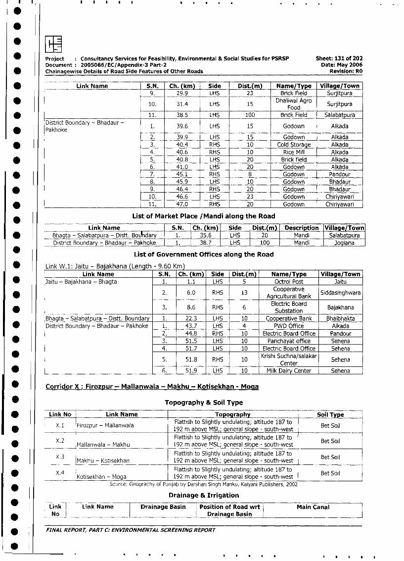
Project Consultancy Services for Feasibility, Environmental & Social Studies for PSRSP Sheet: 131 of 202
Document 2005086/EC/Appendix-3 Part-2 Date: May 2006
* Chainagewise Details of Road Side Features of Other Roads Revision: RO
* Link Name S.N. Ch. (km) Side Dist.(m) Name/Type Village/Town
9. 29.9 LHS 23 Brick Field Surjitpura
* ~~~ ~~~~~~~~~ ~~10. 31.4 LHS 1 Dhlia Agrod Surjitpura
* _____________________________ 11. 38.5 LHS 100 Brick Field Salabatpura
District Boundary - Bhadaur - 1. 39.6 LHS 15 Godown Alkada
* Pakhoke _2. 39.9 LHS 15 Godown Alkada
* 3. 40.4 RHS 10 Cold Storage Alkada
4. 40.6 RHS 10 Rice Mill Alkada
* 5. 40.8 LHS 20 Brick field Alkada
6. 41.0 LHS _ 20 Godown Alkada
* ~~~ ~~~~~~~~ ~ ~~7. 45.1 RHS 8 Godown _ Pandour
8. 45.9 LHS 10 Godown Bhadaur
* 9. 46.4 RHS 20 Godown Bhadaur
10. 46.6 LHS 23 Godown Chiriyawari
_____________ _____________ 11. 47.0 RHS 20 Godown Chiriyawari
List of Market Place /Mandi along the Road
Link Name S.N. Ch. (km) Side Dist.(m) Description Village/Town
* Bhagta - Salabatpura - Distt. BoAhdary 1. 35.6 LHS 20 Mandi Salabatpura
District Boundary - Bhadaur - Pakhoke 1. 38.7 LHS 100 Mandi Jogiana
List of Government Offices along the Road
* Link W.1: Jaitu - Bajakhana (Length - 9.60 Km)
Link Name S.N. Ch. (km) Side Dist.(m) Name/Type Village/Town
* Jaitu - Bajakhana - Bhagta 1. 1.1 LHS 5 Octroi Post Jaitu
* 2. 6.0 RHS 13 AgrcultueraltivBeank Siddasinghwara
3. 8.6 RHS 6 Electric Board Bajakhana__________ ~~~~~~~~~Substation_ _ _ _ _ _
Bhagta - Salabatpura - Distt. Boundary 1. 22.3 LHS 10 Cooperative Bank Bhaibhakta
* District Boundary - Bhadaur - Pakhoke 1. 43.7 LHS 4 PWD Office Alkada
2. 44.8 RHS I 10 Electric Board Office Pandour
* 3. 51.5 LHS 10 Panchayat office Sehena
4. 51.7 LHS 10 Electric Board Office Sehena
5. 51.8 RHS 10 Krishi Suchna/salakar SehenaCenter
* 6. 51.9 LHS 10 Milk Dairy Center Sehena
* Corridor X: Firozpur - Mallanwala - Makhu - Kotisekhan - Moga
* Topography & Soil Type
* | Link No Link Name Topography Soil Type
X.I Firozpur - Mallanwala Flattish to Slightly undulating; altitude 187 to B .o|
* !________ x 1 __________________ _ -Malnaa|192 m above MSL; general slope - south-west Bet Sol
X.2 Flattish to Slightly undulating; altitude 187 to Bet Soil
* l lMallanwala - Makhu 192 m above MSL; general slope - south-west B S
X.3 Flattish to Slightly undulating; altitude 187 to Bet Soil
| * ________ |Makhu - Kotisekhan 192 m above MSL; general slope - south-west | _ e_Ol
X.4 Flattish to Slightly undulating; altitude 187 to Bet Soil
I _ LI(ot Kotisekhan - Moga 192 m above MSL; general slope - south-west
Source: Geography of Punjab by Darshan Singh Manku, Kalyani Publishers, 2002
Drainage & Irrigation
Link Link Name Drainage Basin Position of Road wrt Main Canal
| * ~~~L No || Drainage Basin |
| * FINAL REPORT, PART C: ENVIRONMENTAL SCREENING REPORT
0~....
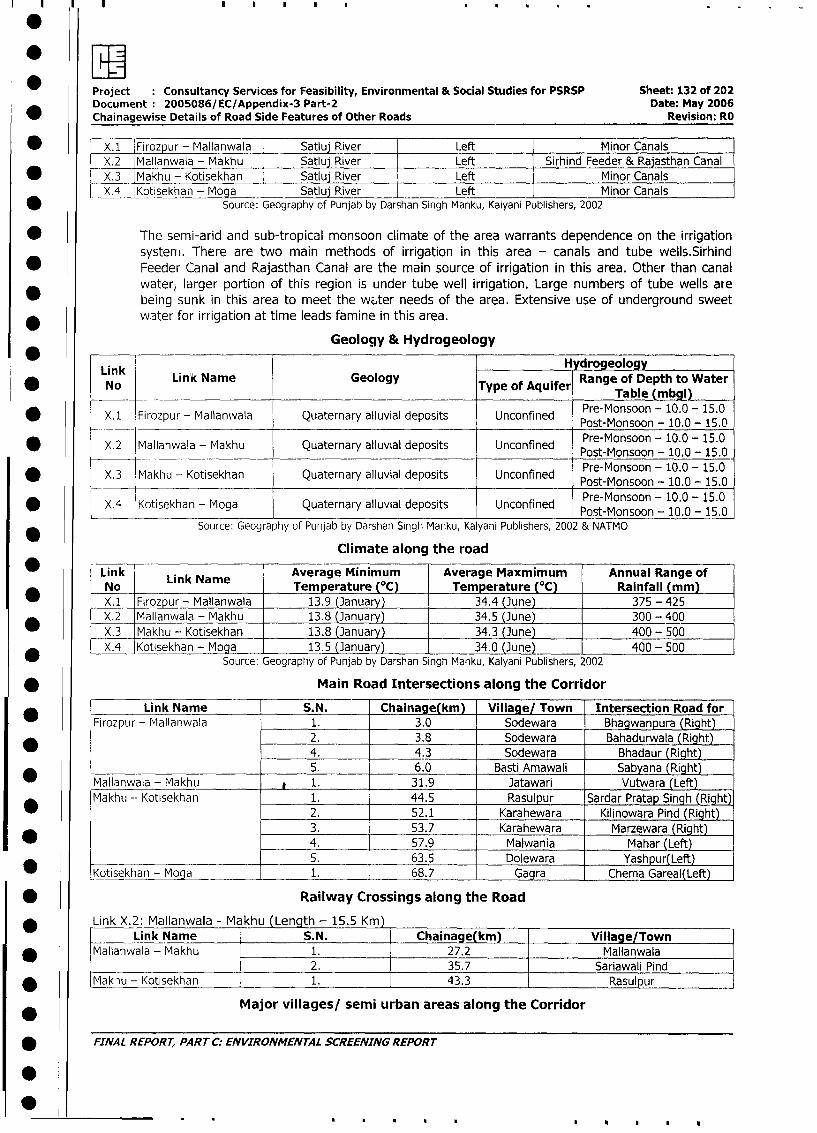
.I~Project Consultancy Services for Feasibility, Environmental & Social Studies for PSRSP Sheet: 132 of 202
Document 2005086/EC/Appendix-3 Part-2 Date: May 2006
_ Chainagewise Details of Road Side Features of Other Roads Revision: RO
* x.1 Firozpur - Mallanwala Satluj River Left Minor Canals
X.2 Mallanwala - Makhu Satluj River Left Sirhind Feeder & Rajasthan Canal
* X.3 Makhu - Kotisekhan Satluj River Left Minor Canals
X.4 Kotisekhan - Moga l Satluj River Left Minor Canals
* Source: Geography of Punjab by Darshan Singh Manku, Kalyani Publishers, 2002
* The semi-arid and sub-tropical monsoon climate of the area warrants dependence on the irrigation
systerm. There are two main methods of irrigation in this area - canals and tube wells.Sirhind
* Feeder Canal and Rajasthan Canal are the main source of irrigation in this area. Other than canal
water, larger portion of this region is under tube well irrigation. Large numbers of tube wells are
being sunk in this area to meet the witer needs of the area. Extensive use of underground sweet
* water for irrigation at time leads famine in this area.
Geology & Hydrogeology
Lik .H drogeology
* LinOk Link Name Geology Type of Aquifer Range of Depth to Water
p ~ ~ r-Monsbln -m 100l)1.
* X.1 Firozpur - Mallanwala Quaternary alluvial deposits Unconfined Pre-Monsoon - 10.0- 15.0Prst-Monsoon - 10.0 - 15.0
* X.2 Mallanwala - Makhu Quaternary alluvial deposits Unconfined Pre-Monsoon - 10.0 - 15.0
Pre-Monsoon - 10.0 - 15.0* X.3 Makhu - Kotisekhan Quaternary alluvial deposits Unconfined Pst-Monsoon - 10.0 - 15.0
Pret-Monsoon - 10.0 - 15.0* ~~~X.4 Kotisekhan - Moga Quaternary alluvial deposits Unconfined Post-Monsoon - 10.0 - 15.0
Source: Geography of Punjab by Darshan Singh Manku, Kalyani Publishers, 2002 & NATMO
Climate along the road
Link LAverage Minimum Average Maxmimum Annual Range of
No Link Name Temperature (°C) Temperature (°C) Rainfall (mm)
_X. 1 Firozpur - Mallanwala 13.9 (January) 34.4 (June) 375 - 425
X.2 Mallanwala - Makhu 13.8 (January) 34.5 (June) 300 - 400
X.3 Makhu - Kotisekhan 13.8 (January) 34.3 (June) 400- 500
*_X.4 Kotisekhan - Moga 13.5 (January) 34.0 (June) 400- 500Source: Geography of Punjab by Darshan Singh Manku, Kalyani Publishers, 2002
* Main Road Intersections along the Corridor
Link Name S.N. Chainage(km) Village/ Town Intersection Road for
Firozpur - Mallanwala 1. 3.0 Sodewara Bhagwanpura (Right)
2. 3.8 Sodewara Bahadurwala (Right)
4. 4.3 Sodewara Bhadaur (Right)
5. 6.0 Basti Amawali Sabyana (Right)
Mallanwala - Makhu p 1. 31.9 Jatawari Vutwara (Left)
Makhu -- Kotisekhan 1. 44.5 Rasulpur Sardar Pratap Singh (Right)
2. 52.1 Karahewara Kilinowara Pind (Right)
3. 53.7 Karahewara Marzewara (Right)
* 4. 57.9 Malwania Mahar (Left)
5. 63.5 Dolewara Yashpur(Left)
Kotisekhan - Moga 1. 68.7 Gagra Chema Gareal(Left)
* Railway Crossings along the Road
Link X.2: Mallanwala - Makhu (Length - 15.5 Km)Link Name S.N. Chainage(km) Village/Town
* Mallanwala - Makhu 1. 27.2 Mallanwala
2. 35.7 Sariawali Pind
_ Makiu - Kotisekhan 1. 43.3 Rasulpur
Major villages/ semi urban areas along the Corridor
* FINAL REPORT, PART C: ENVIRONMENTAL SCREENING REPORT
0
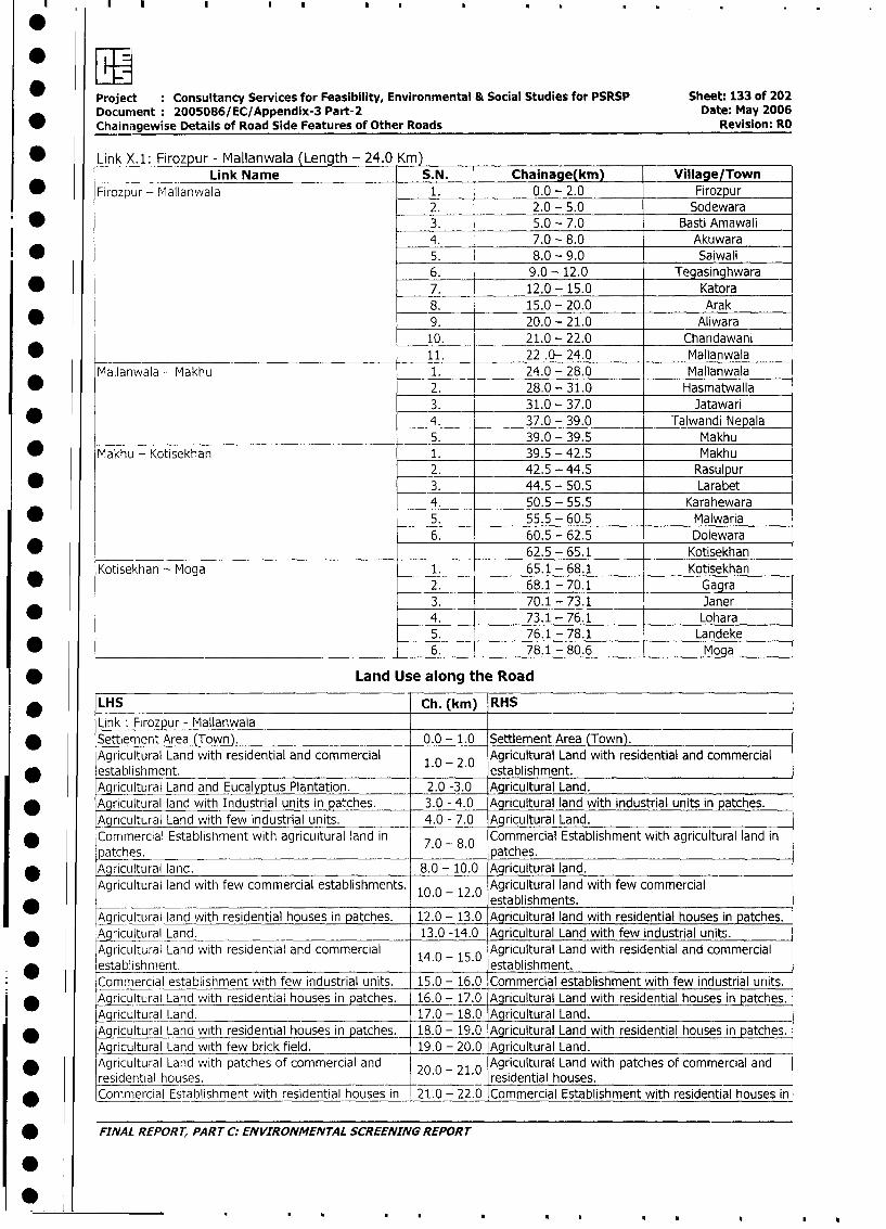
Project Consultancy Services for Feasibility, Environmental & Social Studies for PSRSP Sheet: 133 of 202Document: 2005086/EC/Appendix-3 Part-2 Date: May 2006
Chainagewise Details of Road Side Features of Other Roads Revision: RO
* Link X.1: Firozpur - Mallanwala (Length - 24.0 Km)Link Name S.N. Chainage(km) Village/Town
* Firozpur - Mallanwala 1. 0.0 - 2.0 Firozpur2. 2.0 - 5.0 Sodewara
* 3. 5.0 - 7.0 Basti Amawali
4. 7.0 - 8.0 Akuwara
* 5. 8.0 - 9.0 Saiwali
6. 9.0 - 12.0 Tegasinghwara
* 7. 12.0 - 15.0 Katora
8. 15.0 - 20.0 Arak
* 9._ 20.0 - 21.0 Aliwara
10. 21.0 - 22.0 Chandawani
* 11. 22 .0- 24.0 Mallanwala
Mallanwala - Makhu 1. 24.0 - 28.0 Mallanwala
* 2. 28.0 - 31.0 Hasmatwalla
3. 31.0 - 37.0 Jatawari
* 4. 37.0 - 39.0 Talwandi Nepala5. 39.0 - 39.5 Makhu
_ Makhu - Kotisekhan 1. 39.5 - 42.5 Makhu
2. 42.5 - 44.5 Rasulpur
* 3. 44.5 - 50.5 Larabet4. 50.5 - 55.5 Karahewara
* 5. 55.5 - 60.5 Malwaria
6. 60.5 - 62.5 Dolewara
* 62.5 - 65.1 Kotisekhan
Kotisekhan - Moga 1. 65.1 - 68.1 Kotisekhan
* 2. 68.1 - 70.1 Gagra3. 70.1 - 73.1 Janer
* 4. 73.1 - 76.1 Lohara5. 76.1 - 78.1 Landeke
* l__________________________________ 6. 78.1 - 80.6 Moga
* Land Use along the Road
* LHS Ch. (km) RHS
Link: FLrozpur - Mlallanwala* Settlement Area (Town). 0.0 - 1.0 Settlement Area (Town).
Agricultural Land with residential and commercial 1.0 - 2.0 Agricultural Land with residential and commercial
K establishment. . . establishment.Agricultural Land and Eucalyptus Plantation. 2.0 -3.0 Agricultural Land.
* Agricultural land with Industrial units in pa'ches. 3.0 - 4.0 Agricultural land with industrial units in patches.
Agricultural Land with few industrial units. 4.0 - 7.0 Agricultural Land.
Commercial Establishment with agricultural land in 7.0 8.0 Commercial Establishment with agricultural land in
patches. . - . patches.* Agricultural land. 8.0 - 10.0 Agricultural land.
Agricultural land with few commercial establishments. 10.0 - 12.0 Agricultural land with few commercialestablishments.
Agricultural land with residential houses in patches. 12.0 - 13.0 Agricultural land with residential houses in patches.
_ Aaricultural Land. 13.0 -14.0 Agricultural Land with few industrial units.
Agricultural Land with residential and commercial 14.0 15.0 Agricultural Land with residential and commercial
D establishment. . - . establishment.
Commercial establishment with few industrial units. 15.0 - 16.0 Commercial establishment with few industrial units.
l * Agricultural Land with residential houses in patches. 16.0 - 17.0 Agricultural Land with residential houses in patches.
Agricultural Land. 17.0 - 18.0 Aqricultural Land.
* Agricultural Land with residential houses in patches. 18.0- 19.0 Agricultural Land with residential houses in patches.
Agricultural Land with few brick field. 19.0 - 20.0 Agricultural Land.
AgricuitLiral Land with patches of commercial and 20.0 - 210 Agricultural Land with patches of commercial and
residential houses. . . residential houses.
* Commercial Establishment with residential houses in 21.0 - 22.0 Commercial Establishment with residential houses in
* FINAL REPORT, PART C: ENVIRONMENTAL SCREENING REPORT
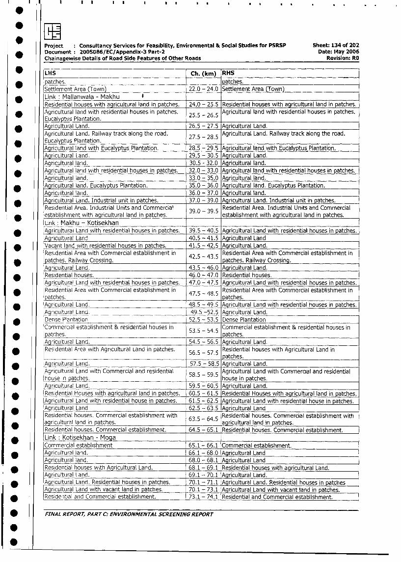
* 7iProject Consultancy Services for Feasibility, Environmental & Social Studies for PSRSP Sheet: 134 of 202
Document: 2005086/EC/Appendix-3 Part-2 Date: M4ay 2006
Chainagewise Details of Road Side Features of Other Roads Revision: RO
* LHS Ch. (km) RHS
;patches. patches.
Settlement Area (Town) 22.0 - 24.0 Settlement Area (Town)
* Link: Mallanwala - Makhu I
Residential houses with agricultural land in patches. 24.0 - 25.5 Residential houses with agricultural land in patches.
* Agricultural land with residential houses in patches. 25.5 - 26.5 Agricultural land with residential houses in patches.
Eucalyptus Plantation.* Agricultural Land. 26.5 - 27.5 Agricultural Land.
Agricultural Land. Railway track along the road. 27.5 - 28.5 Agricultural Land. Railway track along the road.
* Eucalyptus Plantation.Aqricultural land with Eucalyptus Plantation. 28.5 - 29.5 Agricultural land with Eucalyptus Plantation.
* Agricultural Land. 29.5 - 30.5 Agricultural Land.
Agricultural land. 30.5 - 32.0 Agricultural land.
* A_ricultural land with residential houses in patches. 32.0 - 33.0 Agricultural land with residential houses in patches.
Agricultural land. 33.0 - 35.0 Agricultural land.
Agricultural land. Eucalyptus Plantation. 35.0 - 36.0 Agricultural land. Eucalyptus Plantation.
A aricultural land. 36.0 - 37.0 Agricultural land.
* Aqricultural Land. Industrial unit in patches. 37.0 - 39.0 Agricultural Land. Industrial unit in patches.
Residential Area. Industrial Units and Commercial 39R0 39.5 esidential Area. Industrial Units and Commercial
* establishment with agricultural land in patches. .0-3. establishment with agricultural land in patches.
Link: Makhu - Kotisekhan* AgricLIltural Land with residential houses in patches. 39.5 - 40.5 Agricultural Land with residential houses in patches.
Agricultural Land 40.5 - 41.5 Agricultural Land
* Vacant land with residential houses in patches. 41.5 - 42.5 Agricultural Land.
Residential Area with Commercial establishment in 42R5 435 esidential Area with Commercial establishment in
D patches. Railway Crossing. . -4. patches. Railway Crossing.
Agricultural Land. 43.5 - 46.0 Agricultural Land.
* Residential houses. 46.0 - 47.0 Residential houses.
Agricultural Land with residential houses in patches. 47.0 - 47.5 Agricultural Land with residential houses in patches.
* Residential Area with Commercial establishment in 47.5 - 48.5 Residential Area with Commercial establishment in
patches. __ p_ .atches.
* Aqricultural Land. ___ 48.5 - 49.5 Agricultural Land with residential houses in patches.
A gicultural Land. 49.5 -52.5 Agricultural Land.
* Dense Plantation 52.5 - 53.5 Dense Plantation
Commercial establishment & residential houses in Commercial establishment & residential houses in
* patches. .- atches.
Agricultural Land. 54.5 - 56.5 Agricultural Land.
Residential Area with Agricultural Land in patches. 56R5 - 57.5 esidential houses with Agricultural Land in
p atches.
* Agricultural Land. 57.5 - 58.5 Agricultural Land.
Agricultural Land with Commercial and residential 58A5 - 59.5 gricultural Land with Commercial and residential
_ house in patches. . . house in patches.
Agricultural Land. 59.5 - 60.5 Agricultural Land.
Residential Houses with agricultural land in patches. 60.5 - 61.5 Residential Houses with agricultural land in patches.
Agricultural Land with residential house in patches. 61.5 - 62.5 Agricultural Land with residential house in patches.
Agricultural Land 62.5 - 63.5 Agricultural Land
Residential houses. Commercial establishment with Residential houses. Commercial establishment with
agricultural land in patches. 63.5- 64.5 agricultural land in patches.
esidential houses. Commercial establishment. 64.5 - 65.1 Residential houses. Commercial establishment.
_ Link : Kotisekhan - MogaCommercial establishment 65.1 - 66.1 Commercial establishment.
_ Agricultural land. 66.1 - 68.0 Agricultural Land
Agricultural land. 68.0 - 68.1 Agricultural Land
Residential houses with Agricultural Land. 68.1 - 69.1 Residential houses with agricultural Land.
Agricultural Land. 69.1 - 70.1 Agricultural Land.
* Agricultural Land. Residential houses in patches. 70.1 - 71.1 Agricultural Land. Residential houses in patches
Agricultural Land with vacant land in patches. 70.1 - 73.1 Agricultural Land with vacant land in patches.
* Reside tial and Commercial establishment. 73.1 - 74.1 Residential and Commercial establishment.
* FINAL REPORT, PART C: ENVIRONMENTAL SCREENING REPORT

Project :Consultancy Services for Feasibility, Environmental & Social Studies for PSRSP Sheet: 135 of 202Document :2005086/EC/Appendix-3 Part-2 Date: May 2006
* ~~Chainagewise Details of Road Side Features of Other Roads Revision: RO
* ~~LHS Ch. (kin) IRHS
Agricultural Land. 74.1 - 77.3 Agricultural Land. ___________
Commercial establishment and Residential houses in Commercial establishment and Residential houses inipatches. 77.3 - 80.6 patches _________
General Characteristics of the Road
Link :Firozpur - Mallanwala__________
Chainage Embankment Drainage RoadS.N. Chiae Height (Mt) Condition Encroachment SE/ SD IEM Squatter-s
* (Kin) - ~~~~~LHS RHS LHS RS-LS HS.LHS: RHS LHS RHS
* ~~~1. 0.0-0 N No _ oNo Yes Yes No No Yes Yes
2. Poor road condition (0.0 1.0
* ~~~3. 1.2 -2.0 No No No No No No No No No No
4. 1.8 -1.9 Low lying area No No No
* ~~~5. 2.5 - 3.0 0.5 0.5 Yes Yes No No No No NO No
6. 3.0 - 3.9 1.0 1.0 Yes Yes No No No No No No
* ~~~7. 3.9 -4.2 0.5 0.5 Yes Yes No No .No No No No
8. 4.2 - 4.9 1.5 1.5 Yes Yes No No No No No No
* ~~~9. 4.9 -5.0 No No No No No No No No No No
10. 5.2 - 6.0 1 1 Yes Yes No No No No No No
* ~~~11. 6.0 -6.2 5 5 Yes Yes No No No No No No
12. 6.2 -7.0 No No No No Yes Yes No No No No
* ~~~13. 7.9 - 10.0 0.5 0.5 No No No No No No No No
14. 10.0 - 11.0 0.5 0.5 Choked Choked Yes Yes No No No No
* ~~~15. 11.4 -12.0 No No No No No No No No No No
16. 12.0 -13.0 No MO No No No No No No No No
* ~~17. 14.0 -15.0 No No No No No No No No No No
18. 16.0 - 18.0 No No Chocked Chocked No No No No No No
* ~~~19. 18.0 - 18.2 No No Yes Yes No No No No No No
20. 18.2 -19.0 No No No No No No No No No No
* ~~~21. 19.7 - 20.0 1.0 1.0 No No No No No No No No
22. 20.0 - 21.0 1.0 1.0 No No No No No No No No
* ~~~23. 22.0 -23.0 - - Yes Yes No No No No No No
2. 23.1 -24.0 Water logged No No No No No No
* ~~Link :Mallanwala - Makhu
Embankment CoDitionag RoadS.N. Chainage Height (Mt) Cnion Encroachment SE/ SD /EM Squatters
* ~~~~ ~~~~~LHS RHS LHS RHS LHS RHS LHS -RHS LHS RH
1. 24.0 -24.7 No No No No No No No No No No
* ~~~~2. 24.7 - 25.0 0.5 0.5 Yes Yes No No No No No No
3. 26.0 - 26.5 1.0 1.0 Yes Yes Yes Yes No No No No
* ~~~Z. 26.5 -27.4 1.0 1.0 No No No No No No No No
6. 27.4 - 27.6 1.0 1.0 Low lying & water No No No No No No* j~~~~~~~~~~~~~ga~~~~l q e d I _ _ _ _ _ _ _ _ _ _ _ _
7. 27.6 - 28.0 1.0 1.0 Yes Yes No No No No No No
* ~~~~8. 28.0 -28.4 0.5 0.5 No -No No No No No No No
9. 28.4 - 29.0 No No No No Yes Yes No No No No
* ~~~10. 29.0 -29.5 No No No -No No No No No No No
11. 29.5 - 30.4 No INo Yes Yes No No No No No No
* ~~~12. 29.5 - 30.5 _____________Low lying ____ ____ __
13. 30.0 Water ln ged(RHS)-_ No No No No No No
* ~~~14. 30.4 - 31.0 1.0 1.0 Yes Yes No No No No No No
15. 31.0 -32.0 1.0 1.0 No No No No No No -No -No
16. 33.0 -34.0 0.5 - 0.5 -1.0 No No No No No No No No
* ~~~17.j 34.0 -35.7 1.0 - 1.0 -1.5 Yes Yes -N No o No No N
* ~~FINA L REPOR T, PA RT C.- ENVIRONMENTrAL SCREENING REPOR T
L
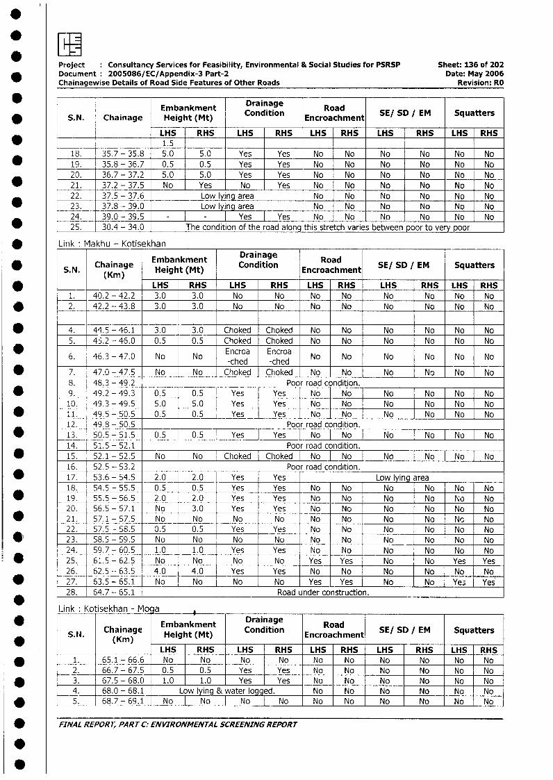
orF"Project Consultancy Services for Feasibility, Environmental & Social Studies for PSRSP Sheet: 136 of 202
* ~~~Document 2005086/EC/Appendix-3 Part-2 Date: May 2006Chainagewise Details of Road Side Features of Other Roads Revision: RO
Embankment Drainage RoadSESD/M Sqatr* ~~~S. N. Chainage Height (Mt) Condition Encroachment SESD M Sqatr
______ ________ LHS RHS LHS -RHS LHS RHS LHS RHS LHS RHS_ _ _ _ _ _ _ _ _ _ _ _ _ _ _ _ 1 .5
18. 35.7 - 35.8 5.0 5.0 Yes Yes No No No No iNo -NoI
* ~~~~19. 35.8 - 36.7 0.5 0.5 Yes _Yes No No No No No No20. 36.7 - 37.2 5.0 5.0 Yes -Yes No No No No No -No
* ~~~~21. 37.2 -37.5 No Yes No Yes No No No No No No22. 37.5 - 37.6 Low lying area No No No No No No
* ~~~~23. 37.8 -39.0 Low lying area No No No No No No24. 39.0 -39.5 __- IYes IYes No No No No No -N
* - ~~25. 30. 4 -3 34.0~ The condition of the road along this stretch varies between poor to very poor-~
* ~~Link M fakhu - Kotisekhan
Embankment Drainage Road* ~~~S.N. Chainage Height (Mt) Condition Encroachment SE/ SD IEM Squatters
(Kin)___ _______ ~LHS RHS LHS RHS LHS RHS LHS RHS LHS RHS1. 40.2 - 42.2 3.0 3.0 No No No No No No No No
* ~~~2. _ 42.2 -43.8 3.0 3.0 No No No No No No No No
* ~~~4. 44.5 - 46.1 3.0 3.0 Choked Choked No No No No No No5. 45.2 - 46.0 0.5 0.5 Choked Choked No No No No No No6. 46.3 - 47.0 No No Encroa Encroa No No No No No No
_____ ____________ ~~-ched -ched
* ~~~7. 47.0 - 47.5 No No Choked Choke N NoNo No No No8. 48.3 - 49.2 _____ Poor road condition. _____
* ~~~9. 49.2 - 49.3 0.5 10.5 [Yes] Yes [o [o I N No No [No10. 49.3 - 49.5 5. .0 Yes Yes No No{ No j o No[ o
* ~~~11. 49.5 - 50.5 0. .5 Yes I Yes [N-o No N o[N12. 49.8 - 50.5 _____ Poor road condition.
* ~~~13. 50.5 -51.5 0.5 10.5 [Yes I Yes [N=o No No No No o14. 51.5 -52.1 ___ ___ Poor road condition.
* ~~~15. 52.1 -52.5 No No [Choked C h ok-e-d [No I No No No NoTI No16. 52.5 -. 53.2 Poor road condition.
* ~~~17. 53.6 -54.5 2.0 2.0 Yes Yes Low lyi'ngarea18. 54.5 - 55.5 0.5 0.5 Yes Yes No No No No No No
* ~~~19. 55.5 - 56.5 2.0 2.0 -Yes Yes No No No No No No20 56.5 - 57.1 No 3.0 -Yes Yes No No No No No No
* ~~~211 57.1 -57.5 No No No No No No No No No No22. 57.5 - 58.5 0.5 0.5 -Yes Yes No No No No No No
* ~~~23. 58.5 -59.5 No No No No No No No No No No24. 59.7 - 60.5 1.0 1.0 -Yes Yes No No No No No No
* ~~~25. 61.5 - 62.5 No No - No No Yes Yes No No Yes Yes26. 62.5 -- 63.5 4.0 4.0 Yes Yes No No No No No No
* ~~~27. 63.5 - 65.1 No No No No Yes_ Yes No No Ys e28. 64.7 -- 65. 1 Road under construction.
L-ink Kotisekhan - Mocja ______
* ~~~~~~~~~~Embankment Drainage RoadSESDIM SqaerS.N. Chainage Height (Mt) Condition Encroachment SESD M Sqatr
* _____(K m
_________ LHS IRHS -. LHS RHS LHS -RHS LHS -RHS LHS .RHS
* ~~~~1. 65.1 -66.6 No No No -T No No No No No No No2. 66.7 - 67.5 _0.5 0.5 Yes Yes No No No - No No No
* ~~~~3. 67.5 -68.0 1.0 1.0 -Yes Yes No No No - No No No4. 68.0 - 68.1 Low lying & water logged. No No No No No No
* ~~~~5. 68.7 -69.1 No I No I No INo No iNo No~ No No No
* ~~FINVAL REPOR7; PARr C:. ENVIRONMENTAL SCREENING REPoRT
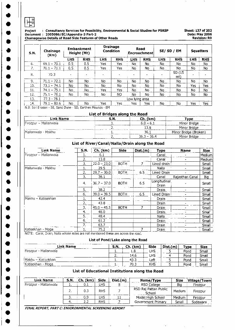
* ~~~Project Consultancy Services for Feasibility, Environmental & Social Studies for PSRSP Sheet: 137 of 202Document 2D0S086/EC/Appendix-3 Part-2 Date: May 2006Chainagewise Details of Road Side Features of Other Roads Revision: RO
Embankment Drainage RoadSESDIM SqatrS. N. Chainage Height (Mt) Condition Encroachment SESD/M Sqatr
* ~~~~~~~K) LHS RHS LHS RHS LHS RHS LHS RHS LHS RHS6. 69.1 - 70.1 0.5 0.5 Yes Yes No No No No No No
* ~~~~7. 70.1 -71.1 0.5 0.5 Yes Yes No No No No No No
8. 70.3 - - - - - - - SD (15____ ~~~~~~~~~~~~~~~~~~~Mt)
9. 71.1 - 72.1 No No No No No No No No No No* ~~~~10. 73.1 - 74.1 No No No No No No No No Yes Yes
11. 74.1 - 75.1 No No Yes Yes No No No No No No* ~~~~12. 75.1 -76.1 No No No NO No No No No No No
13. 77.3 - 78.1 Low lying area* ~~~~14. 79.1 - 80.6 No No Yes IYes IYes IYes No No Yes Yes
N.B: Soil Erosion - SE, Sand Dune - SD, Earthen Mounds - EM
* ~~~~~~~~~List of Bridges along the Road* ~~~~~~~Link Name S.N. Ch. (km) Type
Firozpur - Mlallanwala 1. 6.0 - 6.1 Minor Bridge______ __________ _________________2. 13.8 M inor Bridge
Mallanwala - Makhu 1. 36.1 Minor Bridge (Broken)* ~~~~~~~~~~~~~~ ~ ~~~2. 36.3 - 36.4 Minor Bridge
List of River/Canal/Nalla/Drain along the Road
Link Name S.N. Ch. (kmn) Side Dist.(m) Type Name Size* ~~~Firozpur - Mallanwala 1. 6.1 Canal -Medium
2. 13.8 Canai - Medium* ______________________ ~3. 22.0 -23.0 BOTH 7 Lined drain - Small
Mallanwala - Makhu 1. 29.5 Nalla - Small* ~~~ ~~~~~~~~~~2. 29.7 -30.0 BOTH 6.5 Lined Drain - Small
3. 36.1 Canal Rajasthan Canal
* ~~~ ~~~~~~~~~~4. 36.7 -37.0 BOTH 6.5 Longitudinal - SmallDrain
* ~~~ ~~~~~~~~~~5. 38.2 Drain - Small_______________________ 6. 39.0 - 39.5 BOTH 6.5 Lined Drain - Small
* ~~~Makhu - Kotisekhan 1. 42.4 Drain - Small2. 43.8 Drain - Small
* ~~~ ~~~~~~~~~~3. 45.0 -45.5 BOTH 7 Drain - Small4. 48.0 Drain - Small
* ~~~ ~~~~~~~~~~5. 48.4 Nalla - Small6. 61.2 Drain - Small
* ___________________________ 7. 63.7 Drain - SmallKotisekhan - Moga 1. 75.2 7 Drain - SmallNOTE: Canal, Draini, Nalla whose sides are not mentioned tnese are across the road.
List of Pond/ Lake along the Road
_____ ___ ~Link Name S.N. Ch. (km) _Side Dist.(m) Type Size* ~~~Firozpur - Maillanwala 1. 1.8 LHS 5 Pond Small
________ ___________________________ 2. 14.6 LHS 4 Pond Small* ~~~Makhu - Kotisekhan 1. 43.3 Left 5 __ Pond Small
Kotisekhan - Moga 1. 70.3 RHS I 5 Pond Small
* ~~~~~~~~List of Educational Institutions along the Road
* ~~~~Link Nam S.N. Ch. (km)- Side Dist.(m) - Name/Type Size Village/Town* ~~~Firozpur - Mallainwa a 1.- 0.1 LHS 8 RSD College Big Firozpur
2. 0.3 RHS 7 RSD Raj Pattan Public Medium Firozpur________ ______ ~~~School_ _ _ _ _ _ _ _ _ _
* ~~~ ~~~~ ~~~~3. 0.9 LHS - 11 Model High School Medium Firozpurl4. - 2.2 RHS - 7 -Government Primar -Small -Sodewara
FINAL REPORT, PART C. ENVIRONMENTAL SCREENING REPORT
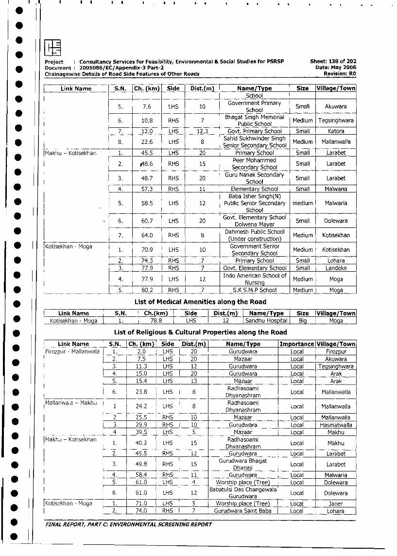
Project : Consultancy Services for Feasibility, Environmental & Social Studies for PSRSP Sheet: 138 of 202
* Document : 2005086/EC/Appendix-3 Part-2 Date: May 2006
Chainagewise Details of Road Side Features of Other Roads Revision: RO
Link Name S.N. Ch. (km) Side Dist.(m) 1 Name/Type Size Village/TownSchool
5. 7.6 LHS 10 Government Primary Small Akuwara7.6 LHS 10 ~~~~School______
6. 10.8 RHS 7 Bhagat Singh Memorial Medium Tegsinghwara} Public School______* 7. 12.0 LHS 12.3 Govt. Primary School Small Katora
* _ __ _ 8. 22.6 LHS: 8 Sahid Sukhwinder Singh Medium Mallanwalla______ _______ __ _ ________ ______Senior Secondary School _ _ _ _ _ _ _ _ _
Makhu - Kotisekhan 1. 45.5 LHS 20 _ Primary School Small Larabet
2. .48.6 RHS 15 Peer Mohammed Small Larabet
3. 48.7 RHS Guru Nanak Secondary Small Larabet48.7 RHS 20 ~~~~School
* 4. 57.3 RHS 11 Elementary School Small Malwaria
Baba Isher Singh(N)
* l . 5. 58.5 LHS 12 Public Senior Secondary medium MalwariaSchool
6. 60.7 LHS 20 Govt. Elementary School Small DolewaraDolwena Mayer______
7. 64.0 RHS 8 Dahmesh Public School Medium Kotisekhan_______ ~~~~~~~(Under_construction)_______
* Kotisekhan - Moga 1. 70.9 LHS 10 Government Senior Medium Kotisekhan
_______ ~~~~~~~Secondary School
* 2. 74.3 RHS 7 Primary School Small Lohara
3. 77.9 RHS 7 Govt. Elementary School Small Landeke
4. 77.9 LHS 12 Indo American School of Medium MogaNursing _ _ _ _ _ _
* 5. 80.2 RHS 7 S.K S.M.P School Medium Moga
* List of Medical Amenities along the Road
Link Name S.N. Ch.(km) Side Dist.(m) I Name/Type Size |Village/Town
* | Kotisekhan - Moga l 1. 78.8 LHS 12 1 Sandhu Hospital Big Moga
* List of Religious & Cultural Properties along the Road
Link Name S.N. Ch. (kmi Side Dist.(m) Name/Type Importance Village/Town
Firozpur - Mallanwala 1. 2.0 LHS 20 Gurudwara Local Firozpur
2. 7.5 LHS 20 Mazaar Local Akuwara
3. 11.3 LHS 12 Gurudwara Local Tegsinghwara
_4. 15.0 LHS 20 Gurudwara Local Arak
* 5. 15.4 LHS 13 Mazaar Local Arak
* _ _ . 6. 23.8 LHS 8 Dhyanashram iLocal Mallanwalla
Mallanwala - Makhu 1 24.2 LHS 8 Radhasoami Local Mallanwalla
* ~~~~~~~~~~~~~~~~Dhyanashram
2 25.5 RHS 10 Mazaar Local Mallanwalla
* 3 29.9 RHS 10 Gurudwara Local Hasmatwalla
4 39.5 LHS 5 Mazaar Local Makhu
_ Makhu - Kotisekhan 1. 40.2 LHS 15 Radhasoami Local Makhu~~~~~~~~~Dhyanashram
* =2. 45.5 RHS 12 Gurudwara Local Larabet
3. 49.8 RHS 15 Gurudwara Bhagat Local Lara bet
49.8 RHS 1 Dha'~4. 58.4 RHS 11 Gurudwara Local Malwaria
| * 5. 61.0 LHS 4 Worship place (Tree) Local Dolewara
6. 61.0 LHS 12 Babatu|si Das Changewala Local Dolewara_____________
~~~~~~~~Gurudwara_ _ _ __ _ _ _ _ _ _
Kotisekhan - Moga 1. 71.0 LHS 5 Worship place (Tree) Local Janer
| * l L 2. l 74.0 RHS 7 Gurudwara Saint Baba Local Lohara
| * : FINAL REPORT, PART C: ENVIRONMENTAL SCREENING REPORT
I
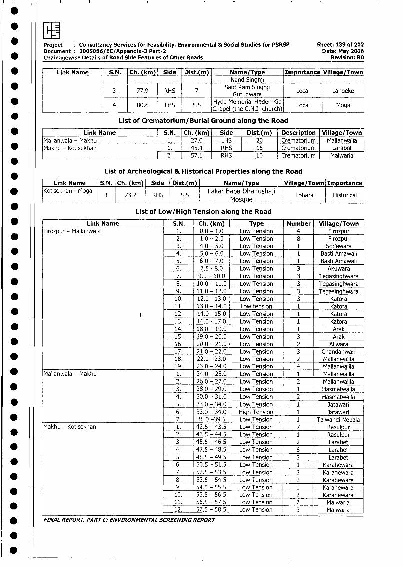
Project Consultancy Services for Feasibility, Environmental & Social Studies for PSRSP Sheet: 139 of 202Document: 2005086/EC/Appendix-3 Part-2 Date: May 2006
* Chainagewise Details of Road Side Features of Other Roads Revision: RO
* ! Link Name S.N. Ch. (km) Side Nist.(m) Name/Type Importance Village/Town_______ ________ _______ ________ Nand Singhji _ _
* 3. 77.9 RHS 7 Sant Ram Singhji Local Landeke________ ________ _______G urudw araLo aL nd e
4* 80.6 LHS 5.5 Hyde Memorial Heden Kid Local Moga_______ ______ ______ -~_________ _______ Chapel (the C.N.1 church), LclMg
_ List of Crematorium/Burial Ground along the Road
* Link Name S.N. Ch. (km) Side Dist.(m) Description Village/Town
Mallanwala - Makhu 1. 27.0 LHS 20 Crematorium Mallanwalla
* Makhu - lKotisekhan 1. 45.4 RHS 15 Crematorium Larabet
___________________________________ 2. 57.1 RHS 10 Crematorium Malwaria
List of Archeological & Historical Properties along the Road
Link Name S.N. Ch. (km) Side Dist.(m) Name/Type _Village/Town Importance
Kotisekhan - Moga 1 73.7 RHS 5.5 Fakar Baba Dhanushae i Lohara Historical
_ List of Low/High Tension along the Road
* Link Name S.N. Ch. (km) Type Number Village/TownFirozpur - Mallanwala 1. 0.0 - 1.0 Low Tension 4 Firozpur
* 2. 1.0 - 2.0 Low Tension 8 Firozpur3. 4.0 - 5.0 Low Tension 1 Sodewara
* 4. 5.0 - 6.0 Low Tension 1. Basti Amawali5. 6.0 - 7.0 Low Tension 1 Basti Amawali
* _ 6. 7.5 - 8.0 Low Tension 3 Akuwara7. 9.0 - 10.0 Low Tension 3 Tegasinghwara
* 8. 10.0 - 11.0 Low Tension 3 Tegasinghwara9. 11.0 - 12.0 Low Tension 3 LTeqinghwara
* 10. 12.0 - 13.0 Low Tension 3 Katora11. 13.0 - 14.0 Low tension 1 Katora
* a 12. 14.0 - 15.0 Low Tension 1 Katora13. 16.0 - 17.0 Low Tension 1 Katora
* 14. 18.0 - 19.0 Low Tension 1 Arak15. 19.0 - 20.0 Low Tension 3 Arak
* 16. 20.0 - 21.0 Low Tension 2 Aliwara17. 21.0 - 22.0 Low Tension 3 Chandanwari
* 18. 22.0 - 23.0 Low Tension 2 Mallanwailla19. 23.0 - 24.0 Low Tension 4 Mallanwallla
* Mallanwala - Makhu 1. 24.0 - 25.0 Low Tension 1 MallanwalIla2. 26.0 - 27.0 Low Tension 2 Mallanwalila
* 3. 28.0 - 29.0 Low Tension 1 Hasmatwalla4. 30.0 - 31.0 Low Tension 2 Hasmatwalla
* l 5. 33.0 - 34.0 Low Tension 1 Jatawari6. 33.0 - 34.0 jHigh Tension 1 Jatawari
* l 7. 38.0 -39.5 Low Tension 1 Talwandi Nepala
Makhu - Kotisekhan 1. 42.5 - 43.5 Low Tension 7 Rasulpur
* l 2. 43.5 -44.5 Low Tension 1 Rasulpur3. 45.5 - 46.5 Low Tension 2 Larabet4. 47.5 -48.5 Low Tension 6 Larabet5. 48.5 - 49.5 Low Tension 3 Larabet
* l 6. 50.5 - 51.5 Low Tension 1 Karahewara7. 52.5 - 53.5 Low Tension 3 Karahewara
* 8. 53.5 - 54.5 Low Tension 2 Karahewara9. 54.5 - 55.5 Low Tension 1 Karahewara
* 10. 55.5 - 56.5 Low Tension 2 Karahewara11. 56.5 - 57.5 Low Tension 7 1 Malwaria
l 12. 57.5 - 58.5 Low Tension 3 Malwaria
* FINAL REPORT, PART C: ENVIRONMENTAL SCREENING REPORr
!
0
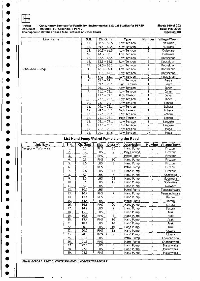
Project Consultancy Services for Feasibility, Environmental & Social Studies for PSRSP Sheet: 140 of 202
Document: 2005086/EC/Appendix-3 Part-2 Date: May 2006Chainagewise Details of Road Side Features of Other Roads Revision: RO
r___ __ Link Name S.N. Ch.(ki) Type Number Village/Town
* l 13. 58.5 - 59.5 Low Tension 2 Malwaria
14. 59.5 - 60.5 Low Tension 1 Malwaria
* l 15. 60.5 - 61.5 Low Tension 3 Dolewara
16. 61.5 -62.5 Low Tension 3 Dolewara
* l 17. 62.5 - 63.5 Low Tension 3 Kotisekhan18. 63.5 - 64.5 Low Tension 9 Kotisekhan
* ____________________ .19. 64.5 - 65.1 Low Tension 7 Kotisekhan
Kotisekhan - Moga 1. 65.1- 66.1 Low Tension 1 Kotisekhan
* 2. 66.1 - 67.1 Low Tension 3 Kotisekhan
3. 67.1 - 68.1 Low Tension 2 Kotisekhan
* 4. 68.1 - 69.1 Low Tension 4 Gagra
5. 69.1 - 70.1 High Tension 1 Gagra
* 6. 70.1 - 71.1 Low Tension 5 Janer
7. 71.1 - 72.1 Low Tension 1 Janer
* 8. 71.1 - 72.1 High Tension 1 Janer
9. 72.1 - 73.1 Low Tension 1 Janer
* 10. 73.1 - 74.1 Low Tension 1 Lohara
11. 74.1 - 75.1 Low Tension 4 Lohara
* 12. 74.1 - 75.1 High Tension 1 Lohara
13. 75.1 - 76.1 Low Tension 3 Lohara
* 14. 75.1 - 76.1 High Tension 1 Lohara
15. 76.1 - 77.1 Low Tension 1 Landeke
* 16. 77.1 - 78.1 Low Tension 2 Landeke
17. 78.1 - 79.1 Low Tension 5 Moga
* 18. 79.1 - 80.6 Low Tension 16 Moga
* List Hand Pump/Petrol Pump along the Road
Link Name S.N. Ch. (km) Side Dist.(m) Description Number Village/Town
* Firozpur - Mallanwala 1. 0.2 RHS 10 Hand Pump 1 Firozpur
2. 0.2 LHS 7 Play Ground 1 Firozpur
* 3. 0.3 RHS Petrol Pump 1 Firozpur
4. 0.6 RHS 10 Hand Pump 1 Firozpur
* 5. 1.5 LHS 8 Hand Pump 1 Firozpur
6. 1.7 RHS Petrol Pump 1 Firozpu
* 7. 1.8 LHS 12 Hand Pump 1 Firozpur
8. 2.2 LHS 7 Hand Pump 1 Sodewara
9. 2.3 LHS 25 Hand Pump 1 Sodewara
10. 3.5 LHS 15 Hand Pump 1 Sodewara
* 11. 7.7 LHS 8 Hand Pump 1 Akuwara
12. 10.3 LHS Petrol Pump 1 Tegasinghwara
* 13. 10.4 RHS 7 Hand Pump 1 Tegasinghwara
14. 13.4 RHS 8 Hand Pump 1 Katora
15. 14.5 LHS Petrol Pump 1 Katora
16. 14.6 RHS _ 20 Hand Pump 1 Katora
* 17. 14.9 LHS 9 Hand Pump 1 Katora
18. 15.0 LHS 5 Hand Pump 1 Arak
* 19. 16.8 RHS 6 Hand Pump 1 Arak
20. 18.4 RHS 10 Hand Pump 1 Arak
* 21. 18.4 LHS 10 Hand Pump 1 Arak
22. 20.0 LHS 10 Hand Pump 1 Arak
* 23. 20.0 RHS 12 Hand Pump 1 Aliwara
24. 20.8 RHS 7 Hand Pump 1 Aliwara
25. 21.1 LHS Petrol Pump 1 Chandanwari
26. 21.8 RHS Petrol Pump 1 Chandanwari
* 21. 22.5 LHS 8 Hand Pump 1 Mallanwalla
28. 22.6 LHS 6 Hand Pump 1 Mallanwalla
* 29. 22.8 RHS 8 Hand Pump 1 Mallanwalla
FINAL REPORT, PART C: ENVIRONMENTAL SCREENING REPORT
0
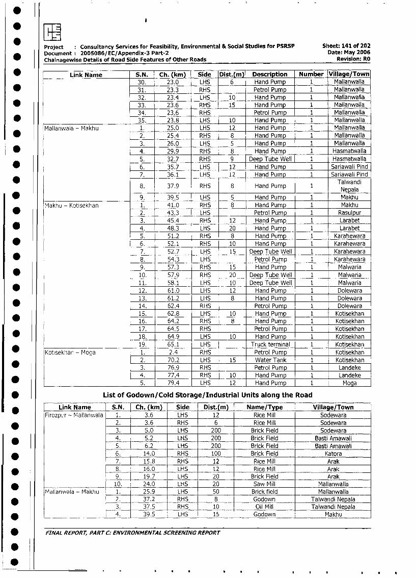
Project Consultancy Services for Feasibility, Environmental & Social Studies for PSRSP Sheet: 141 of 202
Document: 2005086/EC/Appendix-3 Part-2 Date: May 2006
Chainagewise Details of Road Side Features of Other Roads Revision: RO
* Link Name S.N. Ch. (km) Side Dist.(m) Description Number Village/Town
30. 23.0 LHS 6 Hand Pump 1 Mallanwalla
* 31. 23.3 RHS Petrol Pump 1 Mallanwalla
32. 23.4 LHS 10 Hand Pump 1 Mallanwalla
* 33. 23.6 RHS 15 Hand Pump 1 Mallanwalla
34. 23.6 RHS _ Petrol Pump 1 Mallanwalla
* 35. 23.8 LHS 10 Hand Pump 1 Mallanwalla
Mallanwala - Makhu 1. 25.0 LHS 12 Hand Pump 1 Mallanwalla
* 2. 25.4 RHS 8 Hand Pump 1 Mallanwalla
3. 26.0 LHS 5 Hand Pump 1 Mallanwalla
* 4. 29.9 RHS 8 Hand Pump 1 Hasmatwalla
5. 32.7 RHS 9 Deep Tube Well 1 Hasmatwalla
* 6. 35.7 LHS 12 Hand Pump 1 Sariawali Pind
7. 36.1 LHS 12 Hand Pump 1 Sariawali Pind
8. 37.9 RHS 8 Hand Pump 1 TNepalandi
* 9. 39.5 LHS 5 Hand Pump 1 Makhu
Makhu - Kotisekhan 1. 41.0 RHS 8 Hand Pump 1 Makhu
2. 43.3 LHS Petrol Pump 1 Rasulpur
3. 45.4 RHS 12 Hand Pump 1 Larabet
* 4. 48.3 LHS 20 Hand Pump 1 Larabet
5. 51.2 RHS 8 Hand Pump 1 Karahewara
* 6. 52.1 RHS 10 Hand Pump 1 Karahewara
7. 52.7 LHS 15 Deep Tube Well 1 Karahewara
* 8. 54.3 LHS ___ Petrol Pump 1 Karahewara
9. 57.3 RHS 15 Hand Pump 1 Malwaria
* 10. 57.9 RHS 20 Deep Tube Well 1 Malwaria
11. 58.1 LHS 10 Deep Tube Well 1 Malwaria
* 12. 61.0 LHS 12 Hand Pump 1 Dolewara
13. 61.2 LHS 8 Hand Pump 1 Dolewara
_ 14. 62.4 RHS Petrol Pump 1 Dolewara
15. 62.8 LHS 10 Hand Pump 1 Kotisekhan
16. 64.2 RHS 8 Hand Pump 1 Kotisekhan
17. 64.5 RHS Petrol Pump 1 Kotisekhan
* 18. 64.9 LHS 10 Hand Pump 1 Kotisekhan
19. 65.1 LHS Truck terminal 1 Kotisekhan
* Kotisekhan - Moga 1. 2.4 RHS Petrol Pump 1 Kotisekhan
2. 70.2 LHS 15 Water Tank 1 Kotisekhan
3. 76.9 RHS Petrol Pump 1 Landeke
4. 77.4 RHS 10 Hand Pump 1 Landeke
5. 79.4 LHS 12 Hand Pump 1 Moga
* List of Godown/Cold Storage/Industrial Units along the Road
* Link Name S.N. Ch. (km) Side Dist.(m) Name/Type Village/Town
FirozpLr - Mallanwala 1. 3.6 LHS 12 Rice Mill Sodewara
2. 3.6 RHS 6 Rice Mill Sodewara
3. 5.0 LHS 200 Brick Field Sodewara
4. 5.2 LHS 200 Brick Field Basti Amawali
5. 6.2 LHS 200 Brick Field Basti Amawali
* 6. 14.0 RHS 100 Brick Field Katora
7. 15.8 RHS 12 Rice Mill Arak8. 16.0 LHS 12 Rice Mill Arak
9. 19.7 LHS 20 Brick Field Arak
10. 24.0 LHS 20 Saw Mill Mallanwalla
Mallanwala - Makhu 1. _ 25.9 LHS 50 Brick field Mallanwalla
* 2. 37.2 RHS 8 Godown Talwandi Nepala
3. 37.5 RHS 10 Oil Mill Talwandi Nepala
* _________________ 4. 39.5 LHS 15 Godown Makhu
* FINAL REPORT, PART C: ENVIRONMENTAL SCREENING REPORT
0
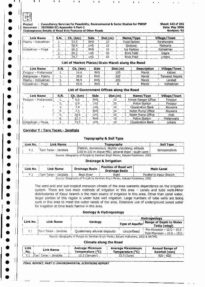
Project : Constiltancy Services for Feasibility, Environmental & Social Studies for PSRSP Sheet: 142 of 202
* Document: 2005086/EC/Appendix-3 Part-2 Date: May 2006
Chainagewise Details of Road Side Features of Other Roads Revision: RO
* Link Name S.N. Ch. (km) Side Dist.(m) = Name/Type Village/Town
Makhu - Kotisekhan 1. 53.5 RHS 15 Food factory Karahewara
* 2. 58.9 LHS 12 Godown Malwaria
* Kotisekhan - Moga 1. 66.3 RHS 10 Ice Factory Kotisekhan
2. 69.1 LHS 50 Brick Field Gagra
* L _ 3. 74.7 LHS 10 Brick Field Lohara
List of Market Places/Grain Mandi along the Road
Link Name S.N. _Ch. (km) Side Dist.(m) Description _ Village/Town
* Firozpur - Mallanwala 1. 14.6 RHS 100 Mandi Katora
Mallanwala - Makhu 1. 38.8 RHS 200 Mandi Talwandi Nepala
Makhu - Kotisekhan 1. 48.9 RHS _ 200 Mandi Larabet
Kotisekhan - Moga 1. 65.8 RHS 8 Mandi Kotisekhan
*0List of Government Offices along the Road
* | Link Name S.N. Ch. (km) Side Dist.(m) Name/Type Village/Town
Firozpur - Mallanwala 1. 0.0 RHS 10 Forest Ranger Office Firozpur
* . 2. 0.9 LHS 20 Police Station Firozpur
3. 7.4 LHS 10 Cooperative Bank Akuwara
* _ 4. 7.5 RHS 10 Water Pump Office Akuwara
5. 18.6 LHS 10 Water Pump Office Arak
________________ 6. 22.7 RHS 10 Police Station Mallanwalla
Kotisekhan - Moga _ 1. 73.5 LHS 10 Cooperative Bank Lohara
Corridor Y: Tarn Taran - Jandiala
0Topography & Soil Type
Link No. Link Name 1 Topography Soil Type
* 5 Y.1 Tarn Taran - Jandiala Flattish, monotonous, Slightly undulating; altitude Sel___________________________230 to 232 m above MSL; general slope - south-west Sroesol
* Source: Geography of Punjab by Darshan Singh Manku, Kalyani Publishers, 2002
Drainage & Irrigation
Link No. Link Name Drainage Basin Draina se Binasinnas
Y. 1 Tarn Taran - Jandiala Beas River Right_Prallelto_Kasu_Branc
* Source: Geography of Punjab by Darshan Singh Manku, Kalyani Publishers, 2002
The semi-arid and sub-tropical monsoon climate of the area warrants dependence on the irrigation
system. There are two main methods of irrigation in this area - canals and tube wells.Minor
* distributaries of Kasur branch is the main source of irrigation in this area. Other than canal water,
larger portion of this region is under tube well irrigation. Large numbers of tube wells are being
* sunk in this area to meet the water needs of the area. Extensive use of underground sweet water
for irrigation at time leads famine in this area.
Geology & Hydrogeology
I * r | l Hy~~~~~~~~~~~~ ~ ~~~drogeology l
Link No. Link Name Geology Typ q e | De to ia l
* Y. 1 Tarn Taran - Jandiala Quaternary alluvial deposits Unconfined Post-Monsoon - 10.0 - 15.0
Source: Geography of Pun)ab by Darshan Singh Manku, Kalyani Publishers, 2002 & NATMO
Climate along the Road
| * F Link Link Name Average Minimum Average Maxmimum Annual Range of
No. Temperature (°C) Temperature (°C) Rainfall (mm)
l * [ Y.1 Tarn Taran - Jandiala 12.3 (January) l 33.3 (June) 500 - 600
| *; FINAL REPORT, PART C: ENVIRONMENTAL SCREENING REPORT
I010
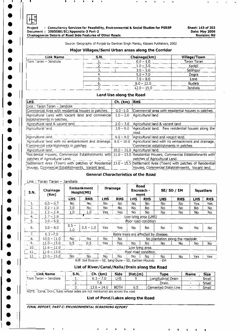
Project Consultancy Services for Feasibility, Environmental & Social Studies for PSRSP Sheet: 143 of 202
* Document: 2005086/EC/Appendix-3 Part-2 Date: May 2006
Chainagewise Details of Road Side Features of Other Roads Revision: RO
* Source: Geography of Punjab by Darshan Singh Manku, Kalyani Publishers, 2002
* Major Villages/Semi Urban areas along the Corridor
Link Name S.N. Chainage(km) Village/Town
Tarn Taran - Jandiala 1. 0.0 - 1.0 Taran Taran
2. 1.0 - 3.0 Kadgil
* I 3. 3.0 - 5.0 Sabhipur4. 5.0 - 7.0 Dogra
5. 7.0 - 8.0 Lone6. 8.0 - 12.0 Budala
* ______ ___________________ 7. 12.0 - 15.0 Jandiala
* Land Use along the Road
* LHS Ch. (km) RHS
Link : Taran Taran - JandialaCommercial Area with residential houses in patches. 0.0 -1.0 Commercial area with residential houses in patches.
Agricultural Land with Vacant land and commercial 1.0 - 2.0 Agricultural land
* establishments in patches.Agricultural land & vacant land 2.0 - 3.0 Agricultural land & vacant land
Agricultural land. 3.0 - 6.0 Agricultural land. Few residential houses along the
~~~~~~~~~~~~~~~~~~road.* Agjcultural land. 6.0 - 8.0 Agricultural land and vacant land.
Agricultural land with no embankment and drainage. 8.0 - 10.0 Agricultural land with no embankment and drainage.
Commercial establishments in patches Commercial establishments in patches
Agricultural land. 10.0 - 11.0 Agricultural land.
* Residential HJouses, Commercial Establishments with 11.0- 13.0 Residential Houses, Commercial Establishments with
patches of Agricultural Land. patches of Agricultural Land.
Settlement Area (Town) with patches of Residential 13.0 - 15.5 Settlement Area (Town) with patches of Residential
Houses, Commercial Establishments. Vacant land. Houses, Commercial Establishments. Vacant land.
* General Characteristics of the Road
Link Taran Taran - Jandiala
Embankment Drainage Road* S.N. Chainage Height(Mt) Encroach - SE/ SD / EM Squatters
(Kin) mentLHS RHS LHS RHS LHS RHS LHS RHS LHS RHS
1. 0.0-0.2 No No No No No No No No Yes Yes
* 2. 0.2- 1.0 3.0 No No No No No No No No No
3. 1.2- 1.4 1.0 1.0 Yes Yes No No No No No No
* 4. 1.7-1.9 Low lying area (LHS)5. 3.0 - 6.0 _ Poor road condition
* 6. 3.0 - 8.0 0.5 - 1.0 Yes Yes No No No No No No_ _ _ _ _ _ ~~~~~1.0I
7. 6.3 -7.0 Babla trees are affected by disease.
*8. 10.0 - 11.0 No No No No I No plantation along the roadside.
9. 11.0 - 13.0 0.5 0.5 Yes Yes No y No N|No No No
10. 11.6 - 12.0 Low lying area.
11. 11.6 -13.0 Poor road condition.* | 12. 13.0 - 15.0 No No No No No I No I No No Yes Yes
N.B: Soil Erosion - SE, San,d Dune - SD, Earthen Mounds - EM
List of River/Canal/Nalla/Drain along the Road
Link Name S.N. Ch. (km) Side T Dist.(m) Type Name Size
| * ITarn Taran - Jandiala 1. 6.3 - 7.0 LHS 9 Longitudinal Drain - Small
2. 7.8 Drain - Small
3. 13.6 - 14.0 BOTH 6.5 Cemented Drain Line - Small
NOTE: Canal, Drain, Nalla whose sides are not mentioned are across the road
| * List of Pond/Lakes along the Road
| * FINAL REPORT, PART C: ENVIRONMENTAL SCREENING REPORT
I 10
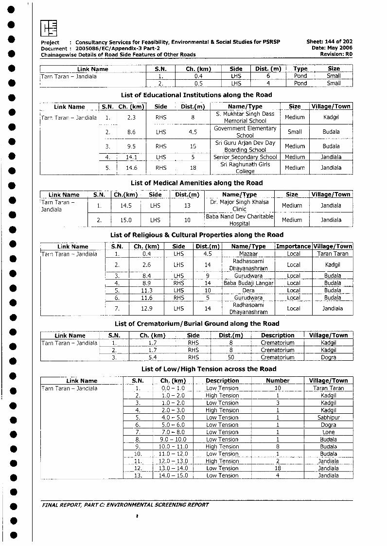
* Project Consultancy Services for Feasibility, Environmental & Social Studies for PSRSP Sheet: 144 of 202Document: 2005086/EC/Appendix-3 Part-2 Date: May 2006
* Chainagewise Details of Road Side Features of Other Roads Revision: RO
* ____ Link Name S.N. Ch. (km) Side Dist. (m) Type SizeTarn Taran - Jandiala 1. 0.4 LHS 6 Pond Small
* _ ~~ ~ ~~~ ~ ~~~ ~ ~ ~ ~~2. 0.5 LHS 4 Pond Smaill |
* List of Educational Institutions along the Road
Link Name S.N. Ch. (km) Side Dist.(m) Name/Type Size Village/Town
Tarn Taran - Jandiala 1. 2.3 RHS 8 S. Mukhtar Singh Dass Medium Kadgil_____ Memorial School
2. 8.6 LHS 4.5 Government Elementary Small BudalaSchool
3. 9.5 Sri Guru Arjan Dev Day Medium Budala0 9.5 RHS 15 ~~~~~~~~~~~~~~Boarding School_______* 4. 14.1 LHS 5 Senior Secondary School Medium Jandiala
5. 14.6 RHS 18 Sri Raghunath Girls Medium Jandiala
* List of Medical Amenities along the Road
Link Name S.N. Ch.(km) Side Dist.(m) Name/Type Size Village/Town* Tarn Taran - 1. 14.5 LHS 13 Dr. Major Singh Khalsa Medium Jandiala
Jandiala Clinic _ _ _ _ _ _ _ _ _ _ _ _ _
2. 15.0 LHS 10 Baba Nand Dev Charitable Medium JandialaHospital_ _ _ _
List of Religious & Cultural Properties along the Road
* Link Name S.N. Ch. (km) Side Dist.(m) Name/Type Importance Village/TownTarn Taran - Jandiala 1. 0.4 LHS 4.5 Mazaar Local Taran Taran
2. 2.6 LHS 14 RaDhayanashram Local Kadgil
* l 3. 8.4 LHS 9 Gurudwara Local Budala4. | 8.9 RHS 14 Baba Budaji Langar Local Budala
* l 5. | 11.3 LHS 10 Dera Local Budala6. 11.6 RHS 5 Gurudwara Local Budala
I ~~~~~~~~Radhasoami7. 12.9 LHS 14 Dhayanashram Local Jandiala
List of Crematorium/Burial Ground along the Road
* | Link Name S.N. | Ch. (km) Side Dist.(m) Description Village/Town* |Tarn Taran - Jandiala 1. | 1.7 RHS | 8 Crematorium Kadgil
2. | 1.7 RHS 8 Crematorium Kadgil| 3. | 5.4 RHS 50 Crematorium | Dogra
List of Low/High Tension across the Road
Link Name S.N. Ch. (km) Description Number Villaae/TownTarn Taran - Jandiala 1. 0.0 - 1.0 Low Tension 10 Taran Taran
2. 1.0 - 2.0 High Tension 1 Kadgil* l | 3. 1.0 - 2.0 Low Tension 3 Kadgil
4. 2.0 - 3.0 High Tension 1 Kadgil* l | 5. 4.0 - 5.0 Low Tension 1 Sabhipur
6. 5.0 - 6.0 Low Tension 1 Dogra* l | 7. 7.0 - 8.0 Low Tension 1 Lone
8. 9.0 - 10.0 Low Tension 1 Budala* IL_9. 10.0 - 11.0 High Tension 8 Budala
10. 11.0 -12.0 Low Tension 1 Budala* 1 <11. 12.0 - 13.0 High Tension 2 Jandiala
12. 13.0 - 14.0 Low Tension 18 Jandiala* l | 13. 14.0 - 15.0 Low Tension 4 Jandiala
.* FINAL REPORT, PART C: ENVIRONMENTAL SCREENING REPORT
0
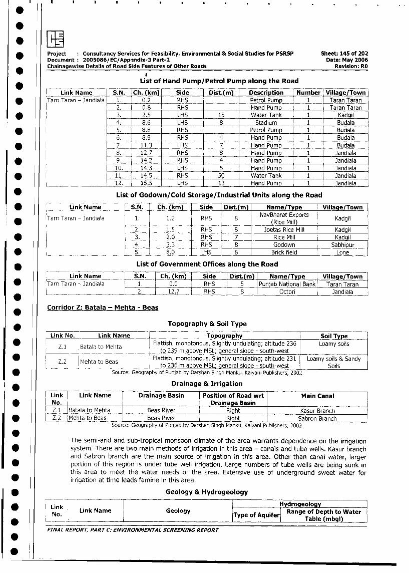
* Project Consultancy Services for Feasibility, Environmental & Social Studies for PSRSP Sheet: 145 of 202
Document 2005086/EC/Appendix-3 Part-2 Date: May 2006
Chainagewise Details of Road Side Features of Other Roads Revision: RO
IList of Hand Pump/Petrol Pump along the Road
Link Name S.N. Ch. (km) Side Dist.(m) Description Number Village/Town
* Tarn Taran - Jandiala 1. 0.2 RHS Petrol Pump 1 Taran Taran
2. 0.8 RHS Hand Pump 1 Taran Taran
* 3. 2.5 LHS 15 Water Tank 1 Kadgil
4. 8.6 LHS 8 Stadium 1 Budala
* 5. 8.8 RHS _ Petrol Pump 1 Budala
6. 8.9 RHS 4 Hand Pump 1 Budala
* 77. 11.3 LHS 7 Hand Pump 1 Budala
8. 12.7 RHS 8 Hand Pump 1 Jandiala
* 9. 14.2 RHS 4 Hand Pump 1 Jandiala
10. 14.3 LHS 5 Hand Pump 1 Jandiala
11. 14.5 RHS 50 Water Tank 1 Jandiala
12. 15.5 LHS 13 Hand Pump 1 Jandiala
* List of Godown/Cold Storage/Industrial Units along the Road
* L_ Link Name S.N. Ch. (km) Side Dist.(m) Name/Type Village/Town
Tarn Taran - Jandiala 1. 1.2 RHS 8 NavBharat Exports KadgilTainT _______
~~~~~~~~~~~~~~~~~(Rice Mill)
2. 1.5 RHS 8 Joetas Rice Mill Kadgil
* 3. 2.0 RHS 7 Rice Mill Kadgil
4. 3.3 RHS 8 Godown Sabhipur
* _______________________ 5. 8.0 LHS 8 Brick field Lone
* List of Government Offices along the Road
Link Name S.N. Ch. (km) Side Dist.(m) Name/Type Village/Town
* lTarn Taran - Jandiala 1. 0.0 RHS 5 Punjab National Bank Taran Taran
L ___ _____________ 2. 12.7 RHS 8 Octori Jandiala
Corridor Z: Batala - Mehta - Beas
* _____ Topography & Soil Type
| Link No. - Link Name Topography Soil Type
* Z I B Flattish, monotonous, Slightly undulating; altitude 236 Loamy soilsp Z.1 lBatala to Mehta | to 239 m above MSL; general slope - south-west
* t Z.2 lMehta to Beas 1 Flattish, monotonous, Slightly undulating; altitude 231 Loamy soils & Sandy
Z.2 Mehta to Beas to 236 m above MSL; general slope - south-west I Soils
* Source: Geography of Punjab by Darshan Singh Manku, Kalyani Publishers, 2002
Link -- Drainage & Irrigation
l|Link | Link Name Drainage Basin Position of Road wrt Main Canal
No. Drainage Basin |_l
Z.1 Batala to Mehta Beas River Right Kasur Branch
| * l Z.2 Mehta to Beas Beas River Right l Sabrofi Branch
Source: Geography of Punjab by Darshan Singh Manku, Kalyani Publishers, 200:2
0The semi-arid and sub-tropical monsoon climate of the area warrants dependence on the irrigation
| g system. There are two main methods of irrigation in this area - canals and tube wells. Kasur branch
and Sabron branch are the main source of irrigation in this area. Other than canal water, larger
l * portion of this region is under tube well irrigation. Large numbers of tube wells are being sunk in
this area to meet the water needs ol the area. Extensive use of underground sweet water for
* irrigation at time leads famine in this area.
| * Geology & Hydrogeology
* _ l Link HydrogeologyNo. Link Name Geology Type of Aquifer| Range of Depth to Water
I Table (mbgl)
FINAL REPORT, PART C: ENVIRONMENTAL SCREENING REPORT
l
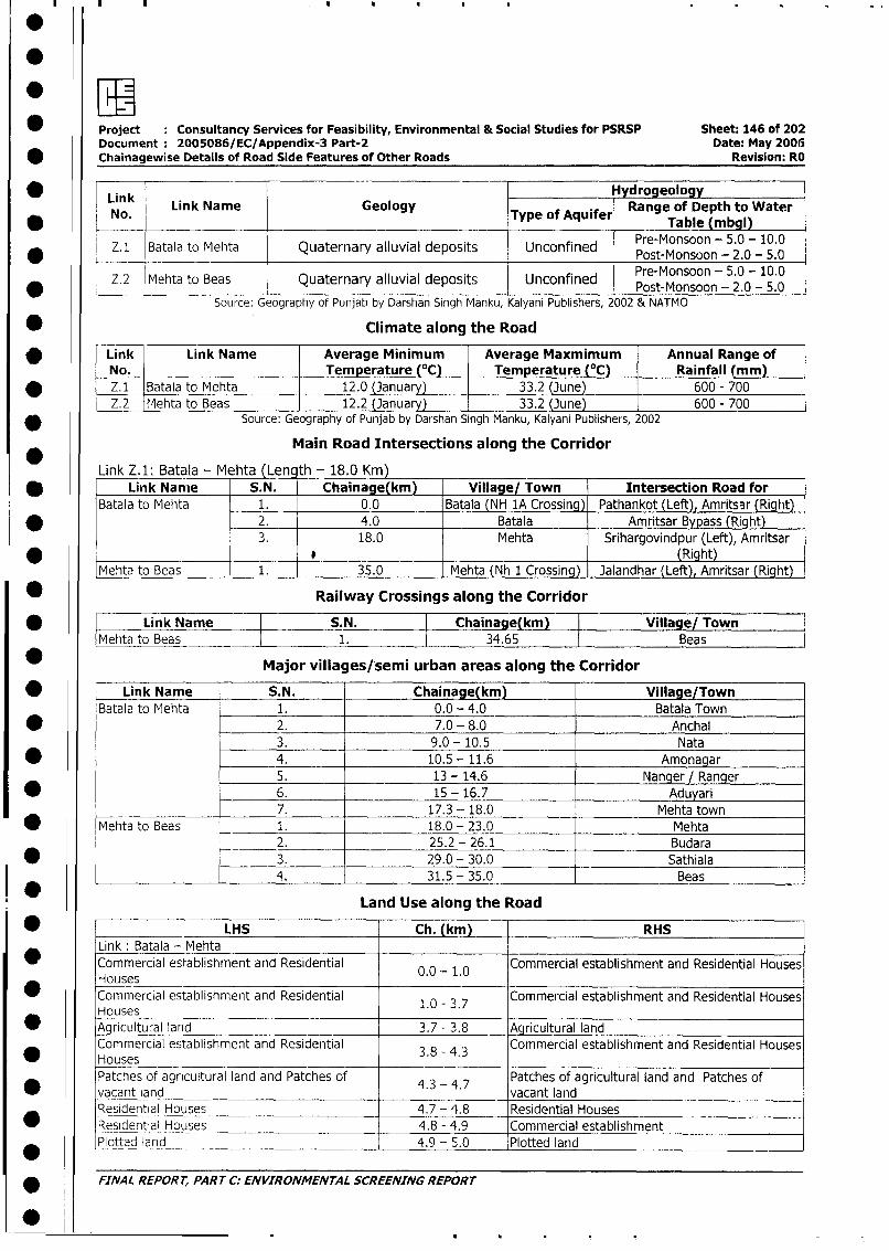
*EI* Project : Consultancy Services for Feasibility, Environmental & Social Studies for PSRSP Sheet: 146 of 202
Document: 2005086/EC/Appendix-3 Part-2 Date: May 2006Chainagewise Details of Road Side Features of Other Roads Revision: RO
* F Link vydrogeologyLink Name Geology Range of Depth to Water
No. Type of Aquifer Table (mbgl)
Z.1 Batala to Mehta Quaternary alluvial deposits Unconfined Pre-Monsoon - 5.0- 10_ _ _ _ _ _____ ____ ___ _ _____ ____ _____ _____ ____ __ __ _____ ____ Post-M onsoon - 2.0 - 5.0___ _ _ _ _ _ _ _ _ _ _ _ _ __ _ _ _ _
Z.2 Mehta to Beas Quaternary alluvial deposits Unconfined Pre-Monsoon - 5.0 - 10.0* __I Post-Monsoon- 2.0 -5.0
Source: Geography of Punjab by Darshan Singh Manku, Kalyani Publishers, 2002 & NATMO
* Climate along the Road
Link Link Name Average Minimum Average Maxmimum Annual Range ofNo. __Temperature (°C) _Temperature (°C) Rainfall (mm)
* Z.1 Batala to Mehta 12.0 (January) 33.2 (June) 600 - 700Z.2 Mehta to Beas 12.2 (Januar) 33.2 (3une) _ 600 - 700
* Source: Geography of Punjab by Darshan Singh Manku, Kalyani Publishers, 2002
Main Road Intersections along the Corridor
Link Z.1: Batala - Mehta (Lencth - 18.0 Krn)* Link Nanie S.N. Chainage(km) Village/ Town Intersection Road for
Batala to Mehta 1. 0.0 Batala (NH 1A Crossing) Pathankot (Left), Amritsar (Righit)
* 2_. 4.0 Batala Amritsar Bypass (Right)3. 18.0 Mehta Srihargovindpur (Left), Amritsar
* . __ _ . (Right)
Mehta to Beas 1. 35.0 I Mehta (Nh 1 Crossing) Jalandhar (Left), Amritsar (Right)-
* Railway Crossings along the Corridor
* Link Name S.N. Chainage(km) Village/ TownMehta to Beas 1. 34.65 Beas
* Major villages/semi urban areas along the Corridor
* Link Name S.N. Chainage(km) Village/TownBatala to Mehta 1. 0.0 - 4.0 Batala Town
* 2. 7.0 - 8.0 Anchal3. 9.0 - 10.5 Nata
* 4. 10.5 - 11.6 Amonagar
5. 13 - 14.6 Nanger / Ranger
* 6. 15 - 16.7 Aduyari
____ _________ 7. 17.3 - 18.0 Mehta town
* Mehta to Beas 1. 18.0 - 23.0 Mehta2. 25.2 - 26.1 Budara
* l 3. 29.0 - 30.0 Sathiala
____ 4. 31.5 - 35.0 Beas
Land Use along the Road
* | LHS Ch. (km) RHSLink: Batala - Mehta
0 Commercial esl-ablishment and Residential 0.0 -1.0 Commercial establishment and Residential HousesHouses 0 1.0
Commercial establishment and Residential 1.0 - 3.7 Commercial establishment and Residential HousesHouses
|_* aricultural land 3.7 - 3.8 -- Agricultural landCommercial establishment and Residential 3.8 - 4.3 Commercial establishment and Residential Houses
I 0* Houses ____I_*_I_I
Patches of agricultural land and Patches of 4.3 4.7 Patches of agricultural land and Patches of
* |vacant land _ vacant land
Residential Houses 4.7 -4.8 Residential Housesl * lResidential Houses 4.8 - 4.9 Commercial establishment
-Plotted land ____ 4.9 - 5.0 Plotted land __
9 FINAL REPORT, PART C: ENVIRONMENTAL SCREENING REPORT
0
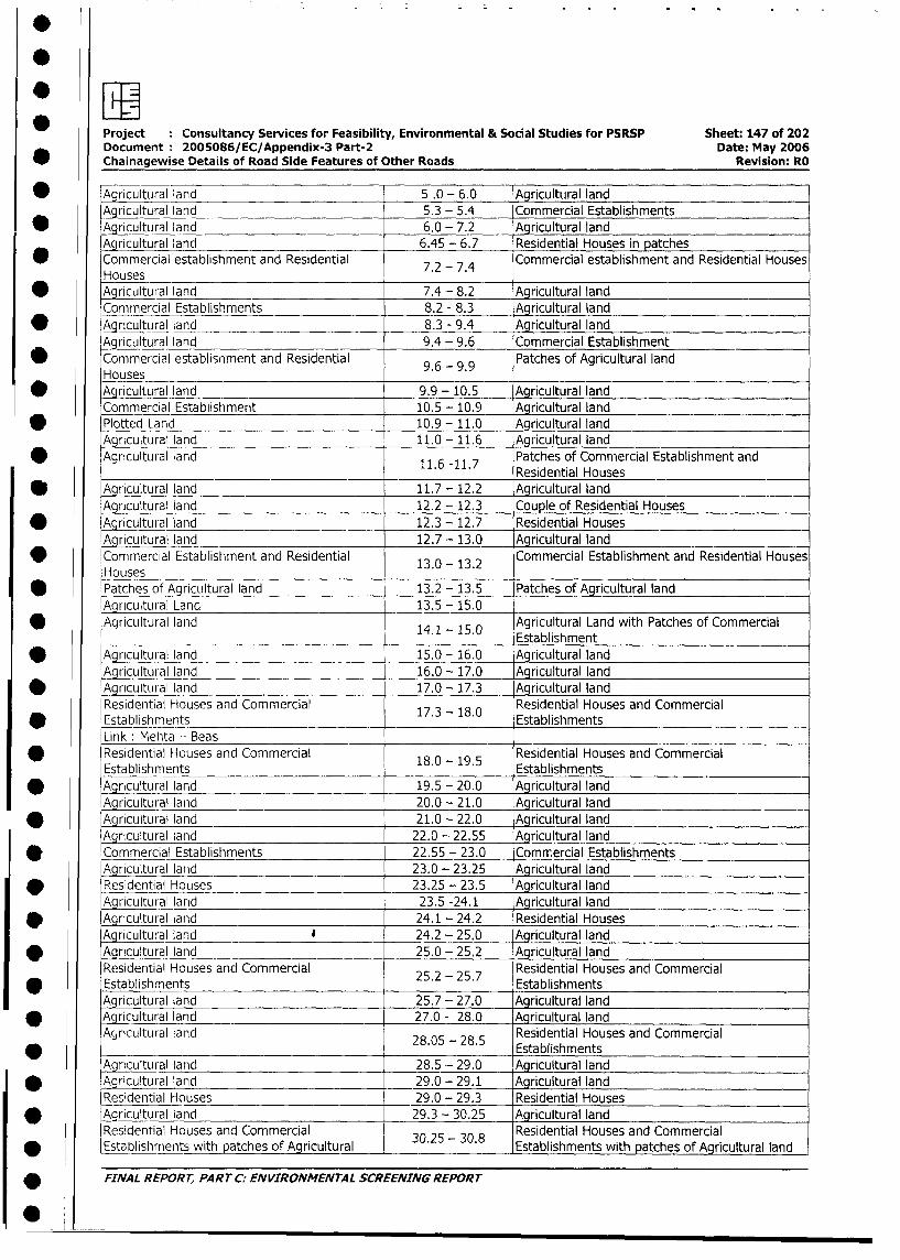
Project Consultancy Services for Feasibility, Environmental & Social Studies for PSRSP Sheet: 147 of 202
Document 2005086/EC/Appendix-3 Part-2 Date: May 2006
Chainagewise Details of Road Side Features of Other Roads Revision: RO
* Agricultural land 5 .0 - 6.0 Agricultural land5.3 - 5.4 Commercial Establishments
* Agricultural land 6.0 - 7.2 Agricultural land
Agricultural land 6.45 - 6.7 Residential Houses in patches
Commercial establishment and Residential 7.2 - 7.4 Commercial establishment and Residential Houses
Houses* Agricultural land 7.4 - 8.2 Agricultural land
Commercial Establishments 8.2 - 8.3 Agricultural land
tAgricultural land 8.3 - 9.4 Agricultural land
Agricultural land 9.4 - 9.6 Commercial Establishment
* Commercial establisnment and Residential 9.6 - 9.9 Patches of Agricultural land
Houses* Agricultural land 9.9 - 10.5 Agricultural land
Commercial Establishment 10.5 - 10.9 Agricultural land
* Plotted Land 10.9 - 11.0 Agricultural land
Agricultural land 11.0- 11.6 Agricultural land
* Agricultural land 11.6 -11.7 Patches of Commercial Establishment and11.6 -11.7 Residential Houses
* Agricultural land 11.7 - 12.2 Agricultural land
Agricultural land 12.2 - 12.3 Couple of Residential Houses
* Agricultural land 12.3 - 12.7 Residential Houses
Agricultural land 12.7 - 13.0 Agricultural land
Commercial Establishment and Residential 13.0 - 13.2 Commercial Establishment and Residential Houses
Houses* Patches of Agricultural land 13.2 - 13.5 Patches of Agricultural land
Agricultural Land 13.5 - 15.0
Agricultural land 14.1 - 15.0 Agricultural Land with Patches of Commercial
* Agricultural land _ 14.1- 15.0 Establishment
Aqricultural land 15.0 - 16.0 Agricultural land
Aq ricultural land 16.0 - 17.0 Agricultural land
* ~~~Agricultural land 17.0 - 17.3 Agricultural land
Residential Houses and Commercial 17.3 -18.0 Residential Houses and Commercial
* Establishments Establishments
Link: Mehta - Beas* Residential Houses and Commercial 18.0 - 19.5 Residential Houses and Commercial
Establishments Establishments
* Agricultural land 19.5 - 20.0 Agricultural land
Agricultural land 20.0 - 21.0 Aqricultural land
* Agricultural land 21.0 - 22.0 Agricultural land
Agricultural land 22.0 - 22.55 Agricultural land
* Commercial Establishments 22.55 - 23.0 Commercial Establishments
Agricultural land 23.0 - 23.25 Agricultural land
* Residential Houses 23.25 - 23.5 Agricultural land
Agricultural land 23.5 -24.1 Agricultural land
* Agricultural land 24.1 - 24.2 Residential Houses
Agricultural land 24.2 - 25.0 Agricultural land
v Agricultural land 25.0 - 25.2 Agricultural land
Residential Houses and Commercial 25.2 25.7 Residential Houses and Commercial
* Establishments . - . Establishments
Aqricultural land 25.7 - 27.0 Agricultural land
* Aqricultural land 27.0 - 28.0 Agricultural land
Agricultural land 28.05 - 28.5 Residential Houses and Commercial28.05 - 28.5 Establishments
Agricultural land 28.5 - 29.0 Agricultural land
* Agricultural land 29.0 - 29.1 Agricultural land
Residential Houses 29.0 - 29.3 Residential Houses
* Agricultural land 29.3 - 30.25 Agricultural land
Residential Houses and Commercial 30.25 30.8 Residential Houses and Commercial
* Establishments with patches of Agricultural . - . Establishments with patches of Agricultural land
* FINAL REPORT, PART C: ENVIRONMENTAL SCREENING REPORT
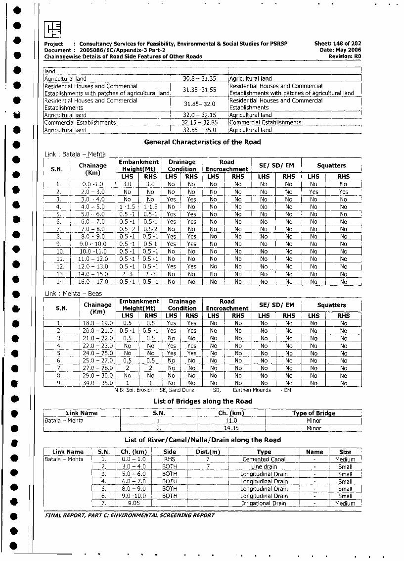
ewProject Consultancy Services for Feasibility, Environmental & Social Studies for PSRSP Sheet: 148 of 202
Document: 2005086/EC/Appendix-3 Part-2 Date: May 2006
Chainagewise Details of Road Side Features of Other Roads Revision: RO
* landA ricultural land 30.8 - 31.35 Agricultural land
Residential Houses and Commercial 31.35 -31.55 Residential Houses and CommercialEstablishments with patches of agricultural land 3 .35 - 1.55 Establishments with patches of agricultural land
* Residential Houses and Commercial 31.85- 32.0 Residential Houses and Commercial
Establishments EstablishmentsAgricultural land 32.0 - 32.15 I Arcultural land
Commercial Establishments 32.15 - 32.85 Commercial Establishments
* Agricultural land 32.85 - 35.0 Agricultural land
* General Characteristics of the Road
Link Batala - Mehtaw S N j Chaina e mbankhtMet _ Drainage Road SE/ SD/ EM Squatters
S. N. Chainage Height(Mt) Condition Encroachment S/S/E qatr
(Kim) LHS RHS LHS RHS LHS RHS LHS RHS LHS RHS
1. 0.0-1.0 3.0 3.0 No No No No No No No No
,* 2. 2.0 - 3.0 No No No No No No No No Yes Yes
3. 3.0 - 4.0 No No Yes Yes No No No No No No
* _ 4. 4.0 - 5.0 1-1.5 1-1.5 No No -- No No No No No No
5 _ 5.0 - 6.0 0.5 -1 0.5-1 Yes Yes No No No No No No
* 6 _ 6.0 - 7.0 0.5 -1 0.5-1 Yes Yes No No No No _ No No
7. 7.0 - 8.0 0.5 -2 0.5-2 No No No No No No No No
* 8. 8.0 - 9.0 0.5 -1 0.5 -1 Yes Yes No No No No No No
9. 9.0 - 10.0 0.5 -1 0.5 1 Yes Yes No No No No No No
* 10. 10.0 -11.0 0.5 -1 0.5 -1 No No No No No No No No
11. 11.0- 12.0 0.5 -1 0.5 -1 No No No No No No No No
* 12. 12.0 - 13.0 0.5 -1 0.5 -1 Yes Yes No No No No No No
13. 14.0- 15.0 2 -3 2-3 No No No No No No No No
* 14. 16.0 - 17.0 0.5 -1 0.5 -1 No No No No No No No No
* Link: Mehta - Beas
Chainage Embankment Drainage Road SE/ SD/ EM Squatters* ~~~SN.N Chainag Height(Mt) Condition Encroachment S/S/E qatrL< (m) LHS I RHS LHS RHS LHS RHS LHS RHS LHS RHS
* l 1. 18.0- 19.0 0.5 0.5 Yes Yes No No No No No No
2. 20.0 - 21.0 0.5 -1 0.5 -1 Yes Yes No No No No No No
* | 3. 21.0 - 22.0 0.5 0.5 No No No No No No No No
4. 22.0- 23.0 No No Yes Yes No No No No No No
e 5. 24.0 - 25.0 No No Yes Yes No No No No No No
l 6. 25.0 - 27.0 0.5 0.5 No No No No No I No No No
* 0 7. 27.0 - 28.0 2 2 No No No No No Nc No No
l 8. 29.0 - 30.0 No No No No No No No No No No
* 9. 34.0 - 35.0 1 1 No No No No No No No No
N.B: Soil Erosion - SE, Sand Dune - SD, Earthen Mounds - EM
* List of Bridges along the Road
* [ ~~~~Link Name |S.N. | Ch. (km) |Type of Bridgel
Batala - Mehta l_1. l_____._ _l Minor_l
h L _ | ~~ ~ ~ ~ ~~~~~ ~~~2. |14.35 |Minorl
* List of River/Canal/Nalla/Drain along the Road
Link Name S.N. Ch. (km) Side | Dist4(m) | Type Name Size
* |Batala - Mehta 1. 0.0 - 1.0 RHS _ 7 Cemented Canal l Medium
2. 3.0 - 4.0 BOTH 7 Line drain - - Small
* l l 3. 5.0 - 6.0 BOTH _ Longitudinal Drain - Small
4. 6.0 - 7.0 BOTH | Longitudinal Drain - Small
v l5<|. 8.0 - 9.0 BOTH | Longitudinal Drain - Smal
6. 9.0 -10.0 BOTH | Longitudinal Drain - Small|
v 7. l 9.05 1 | | Irrigational Drain - Medium
* FINAL REPORT, PART C: ENVIRONMENrAL SCREENING REPORT
0*
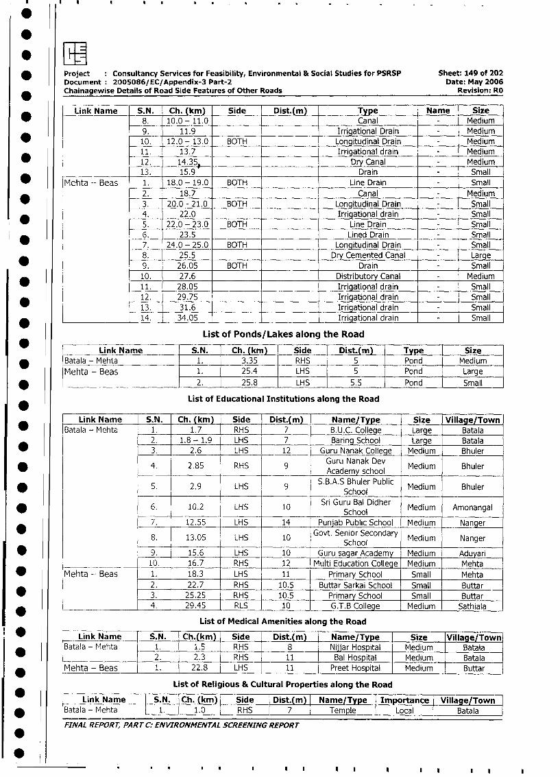
* Project Consultancy Services for Feasibility, Environmental & Social Studies for PSRSP Sheet: 149 of 202
Document 2005086/EC/Appendix-3 Part-2 Date: May 2006
Chainagewise Details of Road Side Features of Other Roads Revision: RO
Link Name S.N. Ch.km) Side Dist.(m) _ Type Name Size
8. 10.0- 11.0 Canal - Medium
9. 11.9 Irrigational Drain - Medium
_ 10. 12.0 - 13.0 BOTH Longitudinal Drain - Medium
11. 13.7 Irrigational drain - Medium
* 12. 14.35. Dry Canal- Medium
1. 15.9 Drain Small
* Mehta - Beas 1. 18.0 - 19.0 BOTH Line Drain - Small
2. 18.7 Canal - Medium
3. 20.0 - 21.0 BOTH Longitudinal Drain - Small
4. 22.0 Irrigational drain - Small
5. 22.0 - 23.0 BOTH Line Drain - Small
6. 23.5 Lined Drain - Small
7. 24.0 - 25.0 BOTH Longitudinal Drain - Small
8. 25.5 Dry Cemented Canal - Large
_ 9. 26.05 BOTH Drain - Small
10. 27.6 Distributory Canal - Medium
* 11. 28.05 Irrigational drain - Small
12. 29.75 Irrigational drain - Small
13. 31.6 Irrigational drain - Small
*_______________ 14. 34.05 Irrigational drain - Small
List of Ponds/Lakes along the Road
__ Link Name S.N. Ch. (km) Side Dist.(m) Type Size
_ Batala - Mehta 1. 3.35 RHS 5 Pond Medium
Mehta - Beas 1. 25.4 LHS 5 Pond Large
* ___________ 2. 25.8 LHS 5.5 Pond Small
List of Educational Institutions along the Road
Link Name S.N. Ch. (km) Side Dist.(m) Name/Type Size Village/Town
* Batala - Mehta 1. 1.7 RHS 7 B.U.C. College -Large Batala
2. 1.8 - 1.9 LHS 7 Baring School Large Batala
* 3. 2.6 LHS 12 Guru Nanak College Medium Bhuler
*4. 2.85 RHS 9 Guru Nanak Dev Medium Bhuler* ~~~~~~~~~~~~~~ ~ ~~~Academy school_______
S. 2.9 LHS 9 S.B.A.S Bhuler Public Medium Bhuler* ~~~~~~~~~~~~~~~~~~~~School
6. 10.2 LHS 10 Sri Guru Bal Didher Medium Amonangal* lSchool
7. 12.55 LHS 14 Punjab Public School Medium Nanger
8. 13.05 LHS 10 Govt. Senior Secondary Medium NangerSchool
* 9. 15.6 LHS 10 Guru sagar Academy Medium Aduyari
| 10. 16.7 RHS 12 Multi Education College Medium Mehta
* Mehta -Beas 1. 18.3 LHS 11 Primary School Small Mehta
2. 22.7 RHS 10.5 Buttar Sarkai School Small Buttar
* 3. 25.25 RHS 10.5 Primary School Small I Buttar
* - . 1 4. 29.45 RLS 10 G.T.B College Medium Sathiala
List of Medical Amenities along the Road
* L-Link Name S. N. Ch.|km) Side Dist.(m) |_Name/Type Size Village/Town
Batala - Mehta 1. 1.5 RHS 8 Nijjar Hospital Medium Batala
I I_______________ 1 2. 2.3 RHS 11 I Bal Hospital Medium Batala I
Mehta - Beas 1. 22.8 LHS 11 Preet Hospital Medium Buttar
List of Religious & Cultural Properties along the Road
Link Name S.N. Ch. (km) Side Dist.(mn | Name/Type Importance Village/Town7
* |Batala - Mehta L 1. I 1.0 RHS 7 Temple Local L Batala
FINAL REPORT, PART C: ENVIRONMENTAL SCREENING REPORT
I0 0~~..||II
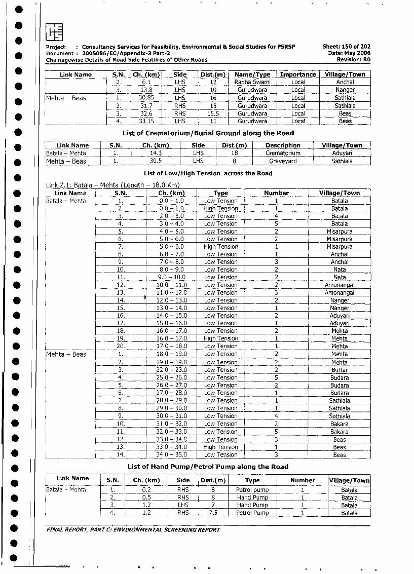
Project Consultancy Services for Feasibility, Environmental & Social Studies for PSRSP Sheet: 150 of 202
* Document: 2005086/EC/Appendix-3 Part-2 Date: May 2006
Chainagewise Details of Road Side Features of Other Roads Revision: RO
L link Name S.N. Ch. (km) Side Dist.(m) Name/Type Importance Village/Town2. 6.1 LHS 12 Radha Swami Local Anchal
_ ________ 3. 13.8 LHS 10 Gurudwara Local Nanger
Mehta - Beas 1. 30.85 LHS 16 Gurudwara Local Sathiala
2. 31.7 RHS 15 Gurudwara Local Sathiala
_ 3. 32.6 RHS 15.5 Gurudwara Local Beas
_____ _4. 33.15 LHS 11 | Gurudwara Local Beas
* List of Crematorium/Burial Ground along the Road
* Link Name S.N. Ch. (km) Side Dist.(m) Description Village/Town
Batala - Mehta 1. 14.3 LHS 18 Crematorium Aduyari
* Mehta - Beas 1. 30.5 LHS 8 Graveyard Sathiala
List of Low/High Tension across the Road
Link Z.1: Batala - Mehta (Length - 18.0 Km)
* l Link Name S.N. Ch. (km) Type Number Village/Town
Batala - Mehta 1. 0.0 - 1.0 Low Tension 1 Batala
* _ 2. 0.0 - 1.0 High Tension 1 Batala
3. 2.0 - 3.0 Low Tension 4 Bacala
* 4. 3.0 - 4.0 Low Tension 5 Batala
5. 4.0 - 5.0 Low Tension 2 Misarpura
* _ 6. 5.0 - 6.0 Low Tension 2 Misarpura
7. 5.0 - 6.0 High Tension 1 Misarpura
* - 8. 6.0 - 7.0 Low Tension 1 Anchal
9. 70 - 8.0 Low Tension 3 Anchal
* _ 10. 8.0 - 9.0 Low Tension 2 Nata
11. 9.0 - 10.0 Low Tension 2 Nata
* 12. 10.0 - 11.0 Low Tension 2 Amonangal
13. 11.0 - 12.0 Low Tension 3 Amonangal
* 14. 12.0 - 13.0 Low Tension 2 Nanger
15. 13.0 - 14.0 Low Tension 1 Nanger
* 16. 14.0 - 15.0 Low Tension 2 Aduyari
17. 15.0 - 16.0 Low Tension 1 Aduyari
* 18. 16.0 - 17.0 Low Tension 2 Mehta
19. 16.0 - 17.0 High Tension 1 Mehta
* 20. 17.0 - 18.0 Low Tension 1 Mehta
Mehta - Beas 1. 18.0 - 19.0 Low Tension 2 Mehta
* 2. 19.0 - 19.0 Low Tension 2 Mehta
3. 22.0 - 23.0 Low Tension 2 Buttar
* 4. 25.0 - 26.0 Low Tension 5 Budara
5. 26.0 - 27.0 Low Tension 2 Budara
* 6. 27.0 - 28.0 Low Tension 1 Budara
7. 28.0 - 29.0 Low Tension 1 Sathiala
* 8. 29.0 - 30.0 Low Tension 1 Sathiala
9. 30.0 - 31.0 Low Tension 4 Sathiala
* 10. 31.0 - 32.0 Low Tension 2 Bakara
11. 32.0 - 33.0 Low Tension 5 Bakara
* X 12. 33.0 - 34.0 Low Tension 3 Beas
13. 33.0 - 34.0 High Tension 1 Beas
* ___ _ 14. 34.0 - 35.0 Low Tension 3 Beas
* List of Hand Pump/Petrol Pump along the Road
Link Name S.N. Ch. (km) Side Dist.(m) Type Number Village/Town
Batala - Mehta 1. 0.2 RHS 8 Petrol pump - 1 Batala
* l l 2. - 0.5 RHS 8 Hand Pump | 1 Batala
3. - 1.2 - LHS 7 - Hand Pump 1 Batala
* l l 4. 1.2 - RHS | 7.5 Petrol Pump - 1 Batala
FINAL REPORT, PART C: ENVIRONMENTAL SCREENING REPORT
0:0
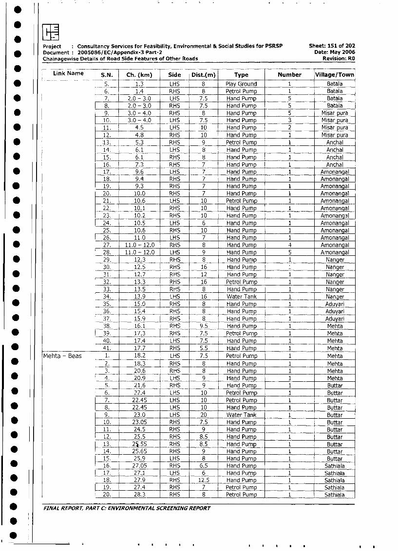
Project Consultancy Services for Feasibility, Environmental & Social Studies for PSRSP Sheet: 151 of 202
* Document 2005086/EC/Appendix-3 Part-2 Date: May 2006
Chainagewise Details of Road Side Features of Other Roads Revision: RO
Link Name S.N Ch. (km) Side Dist.(m) Type Number Village/Town
* -- 5. 1.3 LHS 8 Play Ground 1 Batala
6. 1.4 RHS 8 Petrol Pump 1 Batala
* l 7. 2.0 - 3.0 LHS 7.5 Hand Pump 5 Batala
8. 2.0 - 3.0 RHS 7.5 Hand Pump 5 Batala
* 9. 3.0 - 4.0 RHS 8 Hand Pump 5 Misar pura
10. 3.0 - 4.0 LHS 7.5 Hand Pump 3 Misar pura
* 11. _ 4.5 LHS 10 Hand Pump 2 Misar pura
12. 4.8 RHS 10 Hand Pump 1 Misar pura
*13. 5.3 RHS 9 Petrol Pump 1 Anchal
14. 6.1 LHS 8 Hand Pump 1 Anchal
* 15. 6.1 RHS 8 Hand Pump 1 Anchal
16. 7.3 RHS 7 Hand Pump 1 Anchal
* 17. 9.6 LHS 7 Hand Pump 1 Amonangal
18. 9.4 RHS 7 Hand Pump 1 Amonangal
* 19. 9.3 RHS 7 Hand Pump 1 Amonangal
20. 10.0 RHS 7 Hand Pump 1 Amonangal
* 21. 10.6 LHS 10 Petrol Pump 1 Amonangal
22. 10.1 RHS 10 Hand Pump 1 Amonangal
* 23. 10.2 RHS 10 Hand Pump 1 Amonangal
24. 10.5 LHS 6 Hand Pump 1 Amonangal
* 25. 10.6 RHS 10 Hand Pump 1 Amonangal
26. 11.0 LHS 7 Hand Pump 1 Amonangal
* 27. 11.0 - 12.0 RHS 8 Hand Pump 4 Amonangal
28. 11.0 - 12.0 LHS 9 Hand Pump 5 Amonangal
* 29. 12.3 RHS 8 Hand Pump 1 Nanger
30. 12.5 RHS 16 Hand Pump 1 Nanger
* l 31. 12.7 RHS 12 Hand Pump 1 Nanger
32. 13.3 P.HS 16 Petrol Pump 1 Nanger
* 33. 13.5 RHS 8 Hand Pump 1 Nanger
34. 13.9 LHS 16 Water Tank 1 Nanger
* 35. 15.0 RHS 8 Hand Pump 1 Aduyari
36. 15.4 RHS 8 Hand Pump 1 Aduyari
* 37. 15.9 RHS 8 Hand Pump 1 Aduyari
38. 16.1 RHS 9.5 Hand Pump 1 Mehta
* 39. 17.3 RHS 7.5 Petrol Pump 1 Mehta
40. 17.4 LHS 7.5 Hand Pump 1 Mehta
* __________ 41. 17.7 RHS 5.5 Hand Pump 1 Mehta
Mehta - Beas 1. 18.2 LHS 7.5 Petrol Pump 1 Mehta
* 2. 18.3 RHS 8 Hand Pump 1 Mehta
3. 20.6 RHS 8 Hand Pump 1 Mehta
* 4. 20.9 LHS 9 Hand Pump 1 Mehta
5. 21.6 RHS 9 Hand Pump 1 Buttar
* _ 6. 22.4 LHS 10 Petrol Pump 1 Buttar
7. 22.45 LHS 10 Petrol Pump 1 Buttar
* 8. 22.45 LHS 10 Hand Pump 1I _ Buttar
9. 23.0 LHS 20 Water Tank 1 Buttar
* 10. 23.05 RHS 7.5 Hand Pump 1 Buttar
11. 24.5 RHS 9 Hand Pump 1 Buttar
* 12. 25.5 RHS 8.5 Hand Pump 1 Buttar
13. 25.55 RHS 8.5 Hand Pump 1 Buttar
* _ 14. 25.65 RHS 9 Hand Pump 1 Buttar
15. 25.9 LHS 8 Hand Pump 1 Buttar
* 16. 27.05 RHS 6.5 Hand Pump 1 Sathiala
17. 27.1 LHS 6 Hand Pump 1 Sathiala
* 18. 27.9 RHS 12.5 Hand Pump 1 Sathiala
19. 27.4 RHS 7 Petrol Pump 1 Sathiala
* 20. 28.3 RHS 8 Petrol Pump 1 Sathiala
* FINAL REPORT, PART C: ENVIRONMENTAL SCREENING REPORT
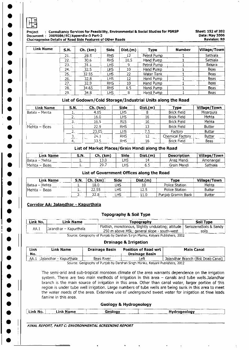
Project Consultancy Services for Feasibility, Environmental & Social Studies for PSRSP Sheet: 152 of 202Document 2005086/EC/Appendix-3 Part-2 Date: May 2006Chainagewise Details of Road Side Features of Other Roads Revision: RO
Link Name S.N. Ch. (km) Side Dist.(m) Type Number Village/Town
* _ 21. 28.5 RHS 12 Petrol Pump 1 Sathiala
22. 30.6 RHS 10,5 Hand Pump 1 Sathiala
23. 31.1 LHS 9 Petrol Pump 1 Bakara
* 24. 32.5 LHS 10 Hand Pump 1 Beas
25. 32.55 LHS 22 Water Tank 1 Beas
26. 32.8 LHS 12 Hand Pump 1 Beas
_ 27. 32.9 RHS 10 Hand Pump 1 Beas
28. 34.65 RHS 6.5 Hand Pump 1 Beas
29. 34.8 LHS 8 Hand Pump 1 Beas
* List of Godown/Cold Storage/Industrial Units along the Road
* Link Name S.N. Ch. (km) Side Dist.(m) Type Village/Town
Batala - Mehta 1. 4.05 LHS 8 Brick Field Misarpura
* 2. 16.0 LHS 16 Brick Field Mehta
3. 16.5 RLS 16 Brick Field Mehta
* Mehta - Beas 1. 22.9 RHS 13 Brick Field Buttar
2. 23.05 LHS 7.5 Factory Buttar
* 3. 24.1 RHS 12 Chemical Factory Buttar
l_____ _____ 4. 33.5 RHS 16 Brick Field Beas
* List of Market Places/Grain Mandi along the Road
Link Name S.N. Ch. (km) Side Dist.(m) Description Village/Town|Batala - Mehta 1. 13.0 LHS 14 Anaz Mandi Amonangal
* lMehta - Beas 1. 29.7 LHS 6.5 l Grain Mandi Sathiala
* List of Government Offices along the Road
Link Name S.N. Ch. (km) Side | Dist.(m) | Type Village/Town* Batala - Mehta 1. 18.0 LHS 10 Police Station Mehta
Mehta - Beas 1. 22.55 LHS 12.5 Police Station Buttar
_ 2. 22.8 LHS 11.0 Punjab Gramin Bank Buttar
* Corridor AA: Jalandhar - Kapurthala
Topography & Soil Type
* r Link No. | Link Name Topography | Soil Type
M.1 3alandhar - Kapurthala Flattish, monotonous, Slightly undulating; altitude SeriozemsSoils & Sandy250 m above MSL; general slope - south-west soils l
Source: Geography of Punjab by Darshan Singh Manku, Kalyani Publishers, 2002
Drainage & Irrigation
| * Link Link Name Drainage Basin Position of Road wrt Main CanalNo. L Drainage BasinAA. 1 Jalandhar - Kapurthala Beas River Left Jalandhar Branch (Bist Doab Canal)
Source: Geography of Punjab by Darshan Singh Manku, Kalyani Publishers, 2002
The semi-arid and sub-tropical monsoon climate of the area warrants dependence on the irrigation
* system. There are two main methods of irrigation in this area - canals and tube wells.Jalandhar
branch is the main source of irrigation in this area. Other than canal water, larger portion of this
l * region is under tube well irrigation. Large numbers of tube wells are being sunk in this area to meet
the water needs of the area. Extensive use of underground sweet water for irrigation at time leads
famine in this area.
| * Geology & Hydrogeology
| * | Link No. I Link Name | Geology I Hydrogeology
FINAL REPORT, PART C: ENVIRONMENTAL SCREENING REPORT
I00
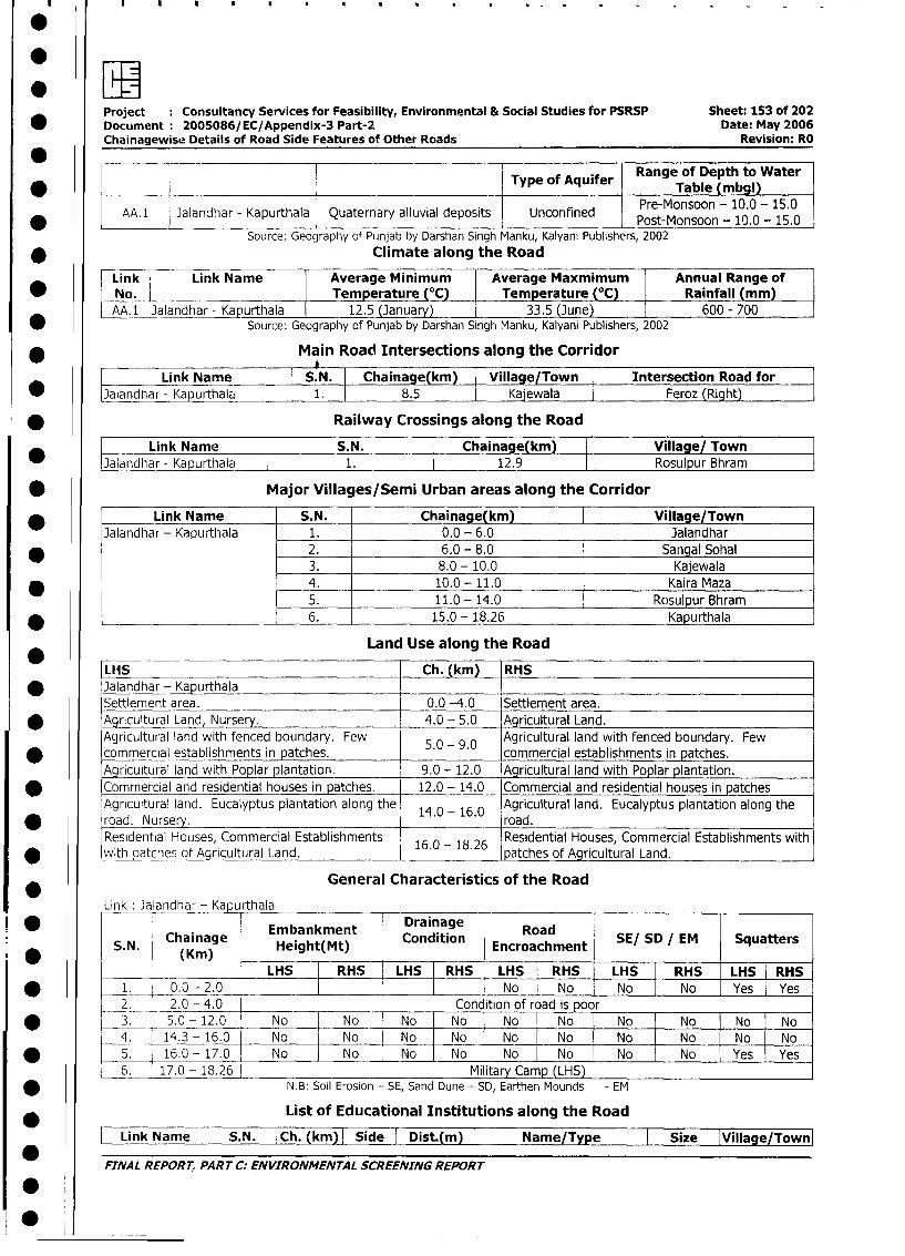
Project Consultancy Services for Feasibility, Environmental & Social Studies for PSRSP Sheet: 153 of 202* Document 2005086/EC/Appendix-3 Part-2 Date: May 2006
Chainagewise Details of Road Side Features of Other Roads Revision: RO
0 __Type of Aquifer Table (mbgl)
AA. 1 Jalandhar - Kapurthala Quaternary alluvial deposits Unconfined Pre-Monsoon - 10.0 - 15.0
Source: Geography of Punjab by Darshan Singh Manku, Kalyani Publishers, 2002
* Climate along the Road
Link Link Name Average Minimum Average Maxmimum Annual Range of
* _No. ___ ___ Temperature_( ___ Temperature (°C) Rainfall (mm)
AA.1 Jalandhar - Kapurthala 12.5 (January) 33.5 (June) 600 - 700
* SOUrce: Geography of Punjab by Darshan Singh Manku, Kalyani Publishers, 2002
* Main Road Intersections along the Corridor
Link Name S.N. Chainage(km) Village/Town Intersection Road for
* J_landhar - Kapurthala 1. 8.5 Kajewala Feroz (Right)
* Railway Crossings along the Road
Link Name S.N. Chainage(km) Village/ Town
* JLalandhar - Ka urthal l 1. 12.9 Rosulpur Bhram
* Major Villages/Semi Urban areas along the Corridor
* Link Name S.N. Chainage(km) Village/Town
Jalandhar - Kapurthala 1. 0.0 - 6.0 Jalandhar
* 2. 6.0 - 8.0 Sanqal Sohal3. 8.0 - 10.0 Kajewala
* 4. 10.0 - 11.0 Kaira Maza
5. 11.0 - 14.0 Rosulpur Bhram
* _______________ 6. 15.0 - 18.26 Kapurthala
Land Use along the Road
* ~~Ll15 Ch. (km) |RHS
* Jalandhar- KapurthalaSettlement area. 0.0 -4.0 Settlement area.
* Agricultural Land, Nursery. 4.0 - 5.0 Agricultural Land.
Agricultural land with fenced boundary. Few 5.0 - 9.0 Agricultural land with fenced boundary. Few
commercial establishments in patches.Agricultural land with Poplar plantation. 9.0 - 12.0 Agricultural land with Poplar plantation.
Commercial and residential houses in patches. 12.0 - 14.0 Commercial and residential houses in patches
Agricultural land. Eucalyptus plantation along the 14.0 - 16.0 Agricultural land. Eucalyptus plantation along the
road. Nursery. road.Residential Houses, Commercial Establishments Residential Houses, Commercial Establishments with
* withpatchesof Agricultral Land. 16.0 -18.26 patches of Agricultural Land.
General Characteristics of the Road
Link : Jalandhar - KapurthalaEmbankment Drainage Ra
Chainage embankMt Condition oad SE/ SD EM SquattersS.N. (K)Height(Mt) Encroachment SESDIM Sqatr
l____ L__| ___ LHS RHS LHS RHS LHS RHS LHS RHS | LHS RHS
I * -1. 0.0 - 2.0 No No o No | Yes Yes
2. _ t _2.0 - 4.0 Condition of road is poor l
| * t 3. 5.0-12.0 No No No No | No No I No No No No
4. 14.3 - 16.0 No No No No No No | No No No No
I* 5. 16.0-17.0 _ No No No No [ No No o No No Yes Yes
l6. 17.0 - 18.26 Military Camp (LHS)
* N.B: Soil Erosion - SE, Sand Dune - SD, Earthen Mounds - EM
0 * List of Educational Institutions along the Road
l BLink Name 4 S.N. | Ch. (km) I Side I Dist.(m) I Name/Type I Size IVillage/Town
l FINAL REPORT, PART C: ENVIRONMENTAL SCREENING REPORT
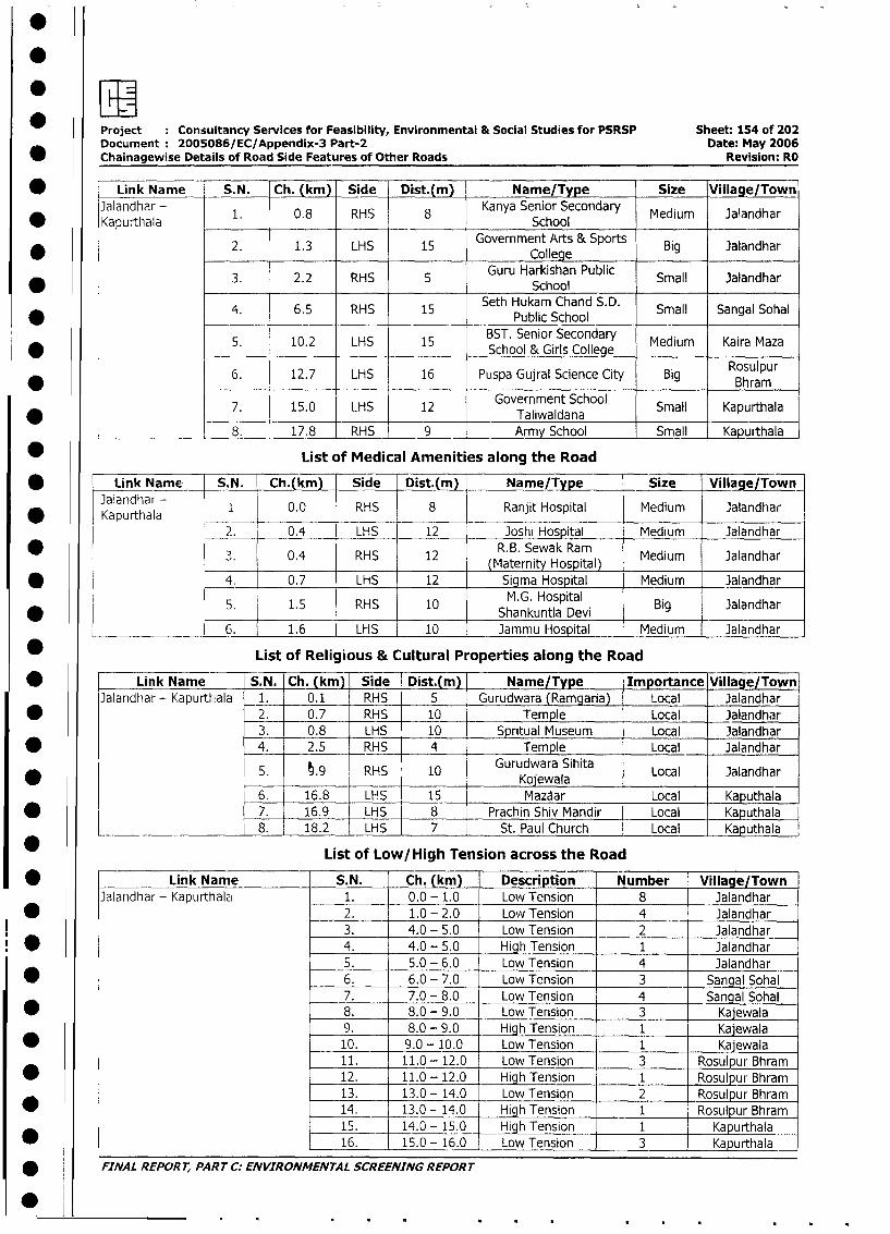
Project : Consultancy Services for Feasibility, Environmental & Social Studies for PSRSP Sheet: 154 of 202
Document: 2005086/EC/Appendix-3 Part-2 Date: May 2006
* Chainagewise Details of Road Side Features of Other Roads Revision: RO
* _ Link Name S.N. Ch. (km) Side Dist.(m) Name/Type Size Village/Town
Jalandhar - 1. 0.8 RHS 8 Kanya Senior Secondary Medium Jalandhar
* ~~~Kapurtlhala School _____
2. 1.3 LHS 15 Government Arts & Sports Big Jalandhar* ~~~~~~~~~~~~~~~~~~~~~College
3. 2.2 RHS 5 Guru Harkishan Public Small JalandharSchool
4. 6.5 RHS 15 Seth Hukam Chand S.D. Small Sangal SohalPublic School
5. 10.2 LHS 15 BST. Senior Secondary Medium Kaira Maza* ~~~~~~~~~~~~~~~~~~~School & Girls College ___________
6. 12.7 LHS 16 Puspa Gujral Science City Big Rosulpur_____ ____ Bhram
7. 15.0 LHS 12 Government School Small Kapurthala_____ ___ _ _____ _ __ ____ _____ ____T aliw aldana _ _ _ _ _ _ _ _ _ _ _
______________ 8. 17.8 RHS 9 Army School Small Kapuithala
* List of Medical Amenities along the Road
* Link Name S.N. Ch.(km) Side Dist.(m) Name/Type Size Village/Town
Jalandhar - 1 0.0 RHS 8 Ranjit Hospital Medium Jalandhar
* _ _ __ _ _ __Kapurthala .
2. 0.4 LHS 12 Joshi Hospital Medium Jalandhar
* 3. _ 0.4 RHS 12 R.B. Sewak Ram Medium Jalandhar~~~~~~~~~~~(Maternity Hosptl
* 4. 0.7 LHS 12 Sigma Hospital Medium Jalandhar
5. 1.5 RHS 10 Shankuntla Devi Big Jalandhar
_____ __ 6. 1.6 LHS 10 Jammu Hospital Medium Jalandhar
* List of Religious & Cultural Properties along the Road
* Link Name S.N. Ch. (km) Side Dist.(m) Name/Type Importance Village/Town
Jalandhar - Kapurthala _ 1. _ 0.1 RHS 5 Gurudwara (Ramgaria) Local Jalandhar
* _ 2. 0.7 RHS 10 Temple Local Jalandhar
3. 0.8 LHS 10 Spritual Museum Local Jalandhar
* 4. 2.5 RHS 4 Temple Local Jalandhar
5. t.9 RHS 10 Gurudwara Sihita Local Jalandhar____ ________ ~~ ~~Koj w ala _ _ _ _ _ _ _ _ _ _
6. 16.8 LHS 15 Mazaar Local Kaputhala
* l 7. 16.9 LHS 8 Prachin Shiv Mandir Local Kaputhala
___________________ 8. 1 18.2 LHS 7 St. Paul Church I Local Kaputhala
List of Low/ High Tension across the Road
* l Link Name S.N. Ch. (km) Description Number Village/Town
3alandhar - Kapurthalzi 1. 0.0 - 1.0 Low Tension 8 Jalandhar
* l | 2. 1.0 - 2.0 Low Tension 4 Jalandhar
3. 4.0 - 5.0 Low Tension 2 lJalandhar
* l l 4. 4.0 - 5.0 High Tension 1 Jalandhar
5. 5.0 - 6.0 Low Tension 4 Jalandhar
I w l l 6. 6.0 - 7.0 Low Tension 3 Sangal Sohal
7. 7.0 - 8.0 Low Tension 4 Sangal Sohal
* l l 8. 8.0 - 9.0 Low Tension 3 Kajewala
9. 8.0 - 9.0 HighTension 1 Kajewala
| * l L 10. 9.0 - 10.0 Low Tension 1 Kajewala
11. 11.0 - 12.0 Low Tension 3 Rosulpur Bhram
I * I I 12. 11.0 - 12.0 High Tension 1 Rosulpur Bhram
13. 13.0 - 14.0 Low Tension 2 Rosulpur Bhram
* t l 14. 13.0 - 14.0 High Tension 1 Rosulpur Bhram
15. 14.0 - 15.0 High Tension 1 Kapurthala
* l 16. 15.0 - 16.0 Low Tension 3 1 Kapurthala
| * j FINAL REPORT, PART C: ENVIRONMENTAL SCREENING REPORT
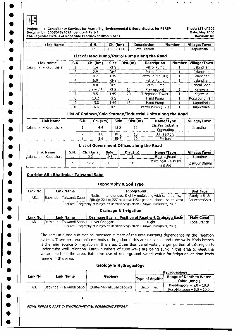
Project Consultancy Services for Feasibility, Environmental & Social Studies for PSRSP Sheet: 155 of 202
* Document: 2005086/EC/Appendix-3 Part-2 Date: May 2006
Chainagewise Details of Road Side Features of Other Roads Revision: RO
-Link Name S.N. Ch. (ki) I Description Number Village/Town
* V_ _ _ l 17. l16.0 -17.0 Low Tension 3 Kapurthala
List of Hand Pump/Petrol Pump along the Road
r Link Name S.N. Ch. (km) Side Dis tm) Description Number Village/Town
* Jalandhar - Kapurthala 1. 1.4 RHS Petrol Pump 1 Jalandhar
2. 2.9 RHS Petrol Pump 1 Jalandhar
* 3. 4.7 LHS Petrol Pump (IO) 1 Jalandhar
4. 5.9 RHS Petrol Pump 1 Jalandhar
* 5. 8.0 RHS Petrol Pump 4 Sangal Sohal
6. 8.2 - 8.,4 RHS 15 Play ground 1 Kajewala
* 7. 9.5 LHS 20 Telephone Tower 1 Kajewala
8. 13.2 RHS 8 Hand Pump 1 Rosulpur Bhram
* 9. 15.0 LHS 15 Hand Pump 1 Kapurthala
10. 16.6 RHS Petrol Pump (IBP) 1 Kapurthala
* List of Godown/Cold Storage/Industrial Units along the Road
* Link Name S.N. Ch. (km) Side Dist.(m) Name/Type Village/Town
3alandhar - Kapurthala 1. 4.4 LHS 15 Ess.Pee Industrial Jalandhar
2. 4.8 RHS 15 J.F. Factory
* ¢ _ 3. 5.6 RHS 10 Factory
* ________ List of Government Offices along the Road
Link Name S.N. Ch. (km) Side Dist.(m) Name/Type Village/Town
* Jalandhar - Kapurthala 1. 0.0 Ll-S 5 Electric Board Jalandhar
2. 12.7 LHS 18 Police post (also for Rosulpur Bhram_________________________________________________________First_Aid) _______
* Corridor AB: Bhatinda - Talwandi Sabo
Topography & Soil Type
* | Link No. Link Name Topography SoilType
ABl 1 Bathinda - Talwandi Sabo Flattish, monotonous, Slightly undulating with sand dunes; Sandy soils &* | AB.1 Bathtnda- Talwanl Sabo laltitude 224 to 227 m above MSL; general slope - south-west |SeriozemsSoils|
Source: Geography of Punjab by Darshan Singh Manku, Kalyani Publishers, 2002
Drainage & Irrigation
* | Link No. Link Name Drainage Basin Position of Road wrt Drainage Basin Main Canal
A B.i Bathinda - Talwandi Sabo River Ghaggar I Right l Kotla Branch
| * Source: Geography of Punjab by Darshan Singh Manku, Kalyani Publishers, 2002
The semi-arid and sub-tropical monsoon climate of the area warrants dependence on the irrigation
system. There are two main methods of irrigation in this area - canals and tube wells. Kotla branch
| * is the main source of irrigation in this area. Other than canal water, larger portion of this region is
under tube well irrigation. Large numbers of tube wells are being sunk in this area to meet the
water needs of the area. Extensive use of underground sweet water for irrigation at time leads
famine in this area.
Geology & Hydrogeology_
_ l l l ~~~~~~~~~~~ ~ ~ ~~HydrogeologyllLink No. | Link Name lGeology Typ of Aqie Range of Depth to Waterl
* 0_ 1 l ITypeofAqulferl ~~~~~~~~~~~Table (mbgl)l
* j AB.l Bathinda - Talwandi Sabo Quaternary alluvial deposits Unconfined Porset-Monsoon - 5.0- 10.0
* _ FINAL REPORT, PART C. ENVIRONMENTAL SCREENING REPORT
I 0
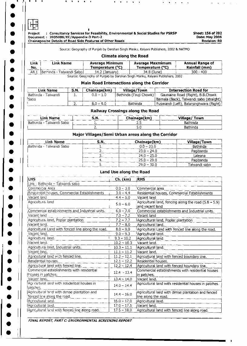
* Project : Consultancy Services for Feasibility, Environmental & Social Studies for PSRSP Sheet: 156 of 202
Document 2005086/EC/Appendix-3 Part-2 Date: May 2006
Chainagewise Details of Road Side Features of Other Roads Revision: RO
Source: Geography of Punjab by Darshan Singh Manku, Kalyani Publishers, 2002 & NATMO
Climate along the Road
Link Link Name Average Minimum Average Maxmimum Annual Range of
I No. Temperature (°C) Temperature (C) Rainfall (mm)
| AB.1 Bathinda - Talwandi Sabo 14.2 (January) __ 34.8 (June) 300 - 400
Source: Geography of Punjab by Darshan Singh Manku, Kalyani Publishers, 2002
Main Road Intersections along the Corridor
_ Link Name S.N. Chainage(km) Village/Town Intersection Road for
Bathirida - Talwandi 1. 0.0 - 1.0 Bathinda (Fauji Chowk) Gaunaina Road (Right), B.B.Chowk
Sabo Barnala (Back), Talwandi sabo (straight)
2. 8.0 - 9.0 Bathinda Fusmandi (Left), Balarsinghwara (Right)
Railway Crossings along the Road
Link Name I S.N. Chainage(km) Village/ Town
* Bathinda - Talwandi Sabo 1. 2.5 Bathinda
2. 5.0 Bathinda
* Major Villages/Semi Urban areas along the Corridor
* Link Name S.N. Chainage(km) Village/Town
Bathinda - Talwandi Sabo 1. 0.0 - 23.0 Bathinda
* 2. 23.0 - 24.0 Pagibanda
3. 24.0 - 25.0 Laleana
* 4. 25.0 - 29.0 Pagibanda
5. 29.0 - 30.0 _ Talwandi sabo
* Land Use along the Road
* LHS -_ Ch. (kn _ RH S
Link : Bathinda - Talwandi sabo
* Commercial Area 0.0 - 3.0 Commercial area
Residential houses, Commercial Establishments 3.0 - 4.4 Residential houses, Commercial Establishments
| * Vacant land 4.4 - 5.0 Vacant land
Agricultural land 5.0 - 6.0 Agricultural land, fencing along the road (5.8 - 5.9)
l* 5.0-6.0 and vacant land
Commercial establishments and Industrial units. 6.0 - 7.0 Commercial establishments and Industrial units.
| * Vacant land 7.0 - 7.2 Vacant land
Agricultural land, Poplar plantation 7.2 - 7.7 Agricultural land, Poplar plantation
| * Vacant land. 7.7-8.0 Agricultural land.
Agricultural Land with fenced line along the road. 8.0 - 9.0 Agricultural Land with fenced line along the road.
| * Vacant land. 9.0-9.3 Agricultural land.
Agricultural land. 9.3 - 10.2 Agricultural land.
* Vacant land. 10.2 - 10.3 Vacant land.
Agricultural land, Industrial units. 10.3 - 11.1 Agricultural land.
I * Vacant land. 11.1 - 11.2 Vacant land.
Agricultural land wi;h fenced line. 11.2 - 12.1 Agricultural land with fenced boundary line.
| * Residential houses. 12.1 - 12.2 Residential houses.
Agricultural land with fenced line. 12.2 - 12.4 Agricultural land with fenced boundary line.
Commercial establishments with residential 12.4 13.4 Commercial establishments with residential houses
lhousesinpatches. 1in patches.
I * _Vacant and. 13.4 - 14.0 Vacant land.
Agricultural land with residential houses in 14 - 14.4 Agricultural land with residential houses in patches.
* l tches. _ l
Agricultural land with dense plantation and 14.4 16.0 Agricultural land with dense plantation and fenced
* fenced line along the road. line along the road.
Agricultural land. 16.0 - 17.0 Agricultural land.
l * lAgricultural land. 17.0 - 17.5 Vacant land.
Agricultural land with fenced line along road. 17.5 - 18.0 Agricultural land with fenced line along road.
FINAL REPORT, PART C: ENVIRONMENTAL SCREENING REPORT
0
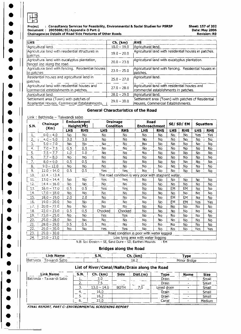
Project Consultancy Services for Feasibility, Environmental & Social Studies for PSRSP Sheet: 157 of 202
Document: 2005086/EC/Appendix-3 Part-2 Date: May 2006
Chainagewise Details of Road Side Features of Other Roads Revision: RO
* |LHS Ch. (km) RHS
AgricultLural land. 18.0 - 19.0_ Agricultural land.
* Agricultural land with residential structures in 19.0 - 20.0 Agricultural land with residential houses in patches.
atches.D Agricultural land with eucalyptus plantation, 20.0 - 23.0 Agricultural land with eucalyptus plantation.
fenced line along the road.* Agricultural land with fencing. Residential houses 23.0 - 25.0 Agricultural land with fencing. Residential houses in
in patches patches.
* Residential houses and agricultural land in 25.0 - 27.0 Agricultural land.
patches.* Agricultural land with residential houses and 27.0- 28.0 Agricultural land with residential houses and
commercial establishments in patches. commercial establishments in patches.
* Aqricultural land. 28.0 - 29.0 Agricultural land.
Settlement area (Town) with patches of 29.0 30.0 Settlement area (Town) with patches cf Residential
* Residential Houses, Commercial Establishments. . - . Houses, Commercial Establishments.
General Characteristics of the Road
Link Bathinda - Talwandi sabo
Chainage Embankmf!nt Drainage Road SE/ SD/ EM Squatters
S.. (Kmn) Hei ht( Nt) Condition Enchroachment S!S/E qatr*B (Km) LHS RHS LHS RHS LHS RHS LHS RHS LHS RHS
1. 0.0-4.0 No No No No No No No No Yes Yes
* _2. 4.0-5.0 3.0 3.0 No No No No No No No No
3. 5.0-7.0 No No No No No No No No No No
* _4. 7.0-7.5 0.5 0.5 No No No No No No No No
5. 7.5-7.7 1.0 1.0 No No No No No No No No
* 6. 7.7- 8.0 No No No No No No No No No No
7. 8.0-9.0 0.5 0.5 No No No No No No No No
* 8. 9.0-12.0 No No No No No No No No No No
9. 12.0 - 14.0 0.5 0.5 Yes Yes No No No No No No
* 10. 12.4 - 13.4 The road condition is v ry poor with stagnant water.
11. 13.0 - 14.4 No No Yes Yes No No No No No No
* 12. 14.4 -16.0 No No No No No No No No No No
13. 16.0 - 17.0 0.5 0.5 Yes Yes No No EM EM No No
* 14. 17.0 -18.0 No No No No No No No No No No
15. 18.0 - 19.0 2.0 2.0 No No No No EM EM No No
| * _16._ 19.0 - 20.0 No No No No No No EM EM Yes Yes
I7. 20.0 - 22.0 No No No No No No No No No No
| w 18. 22.0 - 23.0 0.5 0.5 Chocked Chocked No No No No No No
19. 23.0 - 25.0 No No Yes Yes No No No No No No
| * _20. 25.0 - 28.0 No No No No No No No No No No
21. 28.0 - 29.0 0.5 0.5 No No No No No _ No No No
| * 22. 29.0 - 30.0 No No Yes Yes No No No No Yes Yes
23. 29.0 - 30.0 Road condition is poor with water logged
I* 24. 20.0 - 23.0 Low lying area with water loggingN.B: Soil Erosion - SE, Sand Dune - SD, Earthen Mounds - EM
| * Bridges along the Road
| * __ Link Name S.N. Ch. (km) Type
Bathinda - Talwandi Sabo 1. 18.2 Minor Bridge
List of River/Canal/Nalla/Drain along the Road
* Link Name - S.N. - Ch. (km) Side Dist.(m) Type Name Size
Bathinda - Talwandi Sabo 1. 3,0 l l _ Drain - Small
2. 7.5 l l Drain - Small
- 3. - 13.0 - 14.0 BOTH . 7.0 Lined drain - Small
4. 16.0 [ l _ Drain - . Small
| * l | 5. | 16.2 l l Drain i Small
l l | 6. L 23.0 m l | Canal | - Medium
| * FINAL REPORT, PARrT C: ENVIRONMENTAL SCREENING REPORT
10
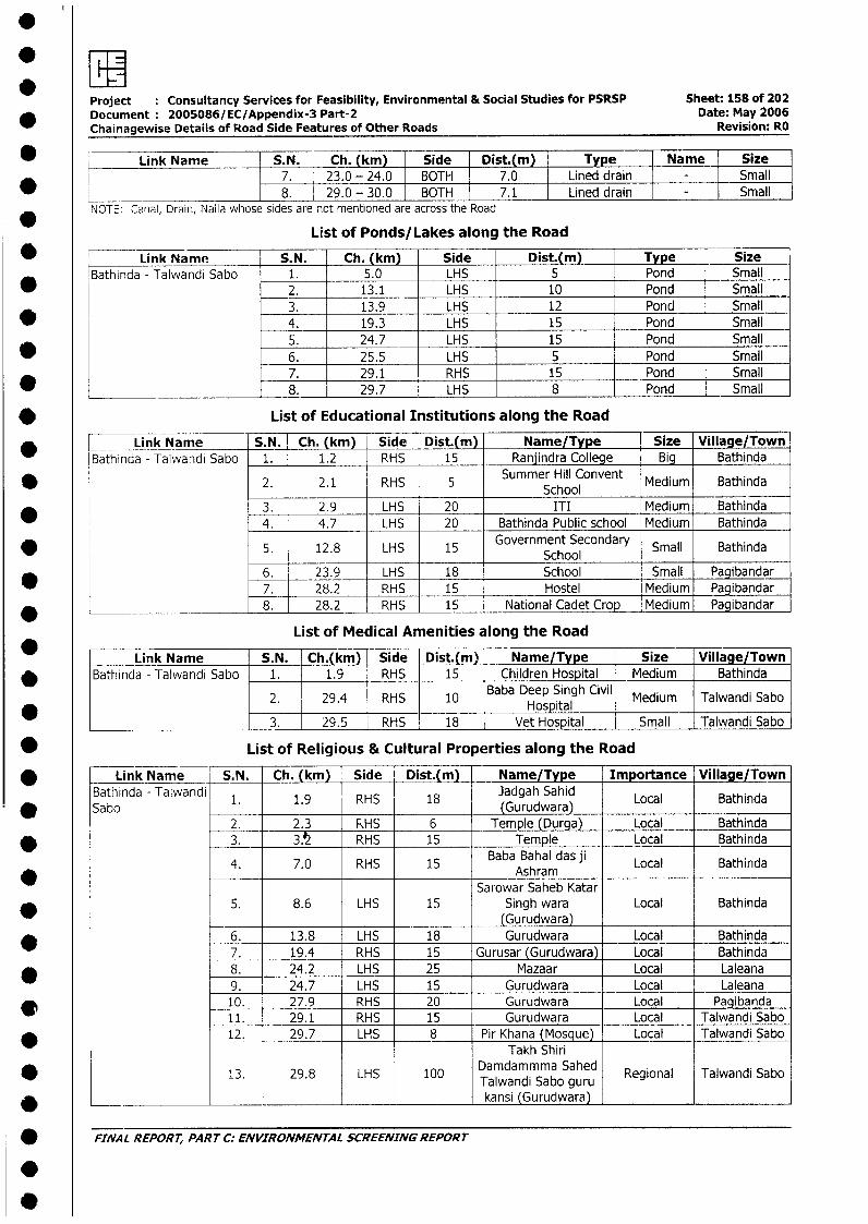
Project Consultancy Services for Feasibility, Environmental & Social Studies for PSRSP Sheet: 158 of 202_ Document 2005086/EC/Appendix-3 Part-2 Date: May 2006
Chainagewise Details of Road Side Features of Other Roads Revision: RO
_ Link Name S.N. Ch. (km) Side Dist.(m) Type Name Size
________________________ 87. 23.0 - 24.0 BOTH 7.0 Lined drain Small______ 8. 29.0 - 30.0 BOTH 7.1 Lined drain SmallNOTE: Canal, Drain, Nalla whose sides are not mentioned are across the Road
List of Ponds/Lakes along the Road
* Link Name S.N. Ch. (km) Side Dist.(m) Type SizeBathinda - Talwandi Sabo 1. 5.0 LHS 5 Pond Small
* _ 2. 13.1 LHS 10 Pond Small3. 13.9 LHS 12 Pond Small
* 4. 19.3 LHS 15 Pond Small5. 24.7 LHS 15 Pond Small
* 6. 25.5 LHS 5 Pond Small7. 29.1 RHS 15 Pond Small
* _ 8. 29.7 LHS 8 Pond Small
* List of Educational Institutions along the Road
* Link Name S.N. Ch. (km) Side Dist.(m) Name/Type Size Village/Town
Bathinda - Talwandi Sabo 1. 1.2 RHS 15 Ranjindra College _B g Bathinda
* 2. 2.1 RHS 5 Summer Hill Convent Medium BathindaSchool3. 2.9 LHS 20 ITI Medium Bathinda4. 4.7 LHS 20 Bathinda Public school Medium Bathinda
* 5. 12.8 LHS 15 Government SecondarY Small Bathinda
6. 23.9 LHS 18 School Small Pagibandar7. 28.2 RHS 15 Hostel Medium Pagibandar8. 28.2 RHS 15 National Cadet Crop Medium Pagibandar
List of Medical Amenities along the Road
* Link Name | S.N. Ch.(km) Side Dist.(m) Name/Tvpe Size Village/Town* |Bathinda - Talwandi Sabo 1. 1.9 - RHS 15 Children Hospital Medium Bathinda
2. 29.4 RHS 10 Baba Deep Singh Civil Medium Talwandi Sabo* ~~~~~~~~~~~~~~~~~~~~~~Hospital _ _ _ _ _ _
_________ ___________ 3. 29.5 , RHS | 18 - Vet Hospital Small | Talwandi Sabo |
* List of Religious & Cultural Properties along the Road
* | Link Name S.N. Ch. (km) Side Dist.(m)| Name/Type Importance Village/TownBathinda - Talwandi 1. 1.9 RHS 18 Jadgah Sahid Local Bathinda
* ~~~Sabo 1.(Gurudwara)2. 2.3 | RHS 6 Temple (Durga) Local Bathinda
* I L 3. 35 RHS 15 Temple Local Bathinda
4. 7.0 RHS 15 Baba Bahal das ji Local Bathinda* ~~~~~~~~~~~~~~~~~Ashram
Sarowar Saheb Katar* l | 5. 8.6 LHS 15 Singh wara Local Bathinda
(Gurudwara)* l L 6. 13.8 LHS 18 Gurudwara Local Bathinda
7. 19.4 RHS 15 Gurusar (Gurudwara) | Local Bathinda8. 24.2 LHS 25 Mazaar Local Laleana9. 24.7 LHS 15 Gurudwara Local Laleana
| 10. 27.9 RHS 20 Gurudwara Local Pagibanda11. 29.1 RHS 15 Gurudwara Local Talwandi Sabo
* 12. 29.7 LHS 8 Pir Khana (Mosque) Local Talwandi SaboTakh Shiri
13. 29.8 LHS 100 Damdammma Sahed Regional Talwandi SaboTalwandi Sabo guru
* _________________________________________________ kansi (Gurudwara) _______
* FINAL REPORT, PAR T C: ENVIRONMENTAL SCREENING REPORT
.
.
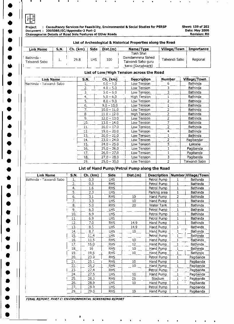
Project Consultancy Services for Feasibility, Environmental & Social Studies for PSRSP Sheet: 159 of 202
Docurnent 2005086/EC/Appendix-3 Part-2 Date: May 2006
Chainagewise Details of Road Side Features of Other Roads Revision: RO
List of Archeological & Historical Properties along the Road
* | Link Name _ S.N. Ch. (km) Side Dist.(m) Name/Type Village /Town ImportanceTakh Shiri
Taiwandi Sa bo 1. 29.8 LHS 100 Damdammma Sahed Talwandi Sabo RegionalTalwandi Sabo ~~~~~~~~Taiwandi Sabo guru
karisi (Gurudwara)
* List of Low/High Tension across the Road
Link Name S. N. Ch. km) Description Number Village/Town
* Bathinda - Talwandi Sabo 1. 0.0 - 1.0 Low Tension 6 Bathinda
2. 4.0 - 5.0 Low Tension 3 Bathinda
* 3. 5.0 - 6.0 Low Tension 3 Bathinda
4. 5.0 - 6.0 High Tension 1 Bathinda
* 5. 8.0 - 9.0 Low Tension 2 Bathinda
6. 9.0 - 10.0 Low Tension 1 Bathinda
* 7. 10.0 - 11.0 Low Tension 2 Bathinda
8. 11.0 - 12.0 High Tension 2 Bathinda
* 9. 12.0 - 13.0 Low Tension 2 Bathinda
10. 13.0 - 14.0 Low Tension 7 Bathinda
* 11. 16.0 - 17.0 Low Tension 2 Bathinda
12. 19.0 - 20.0 Low Tension 4 Bathinda
* 13. 20.0 - 21.0 Low Tension 1 Bathinda
14. 23.0 - 24.0 Low Tension 2 Pagibandar
* 15. 24.0 - 25.0 Low Tension 5 Laleana
16. 25.0 - 26.0 Low Tension 1 Pagibanda
* 17. 26.0 - 27.0 Low Tension 1 Pagibanda
18. 27.0 - 28.0 Low Tension 3 Pagibanda
* ___________________________ 19. 29.0 - 30.0 Low Tension 2 Talwandi Sabo
* List of Hand Pump/Petrol Pump along the Road
Link Name S.N. Ch. (km) Side Dist.(m) Description Number Village/Town
_ Bathinda - Ta;wandi Sabo 1. 0.3 LHS Petrol Pump 1 Bathinda
2. 0.3 RHS Petrol Pump 1 Bathinda
| * 4. 1.6 RHS Petrol Pump 1 Bathinda
5. 2.3 LHS Parking area 1 Bathinda
* _6. 3.1 RHS 10 Hand Pump 2 Bathinda
7. 3.3 LHS 10 Hand Pump 1 Bathinda
_ 8. 5.0 RHS 20 Water Tank 1 Bathinda
9. 6.3 LHS Petrol Pump 1 Bathinda
I t 10. 6.9 LHS Petrol Pump 1 Bathinda
11. 6.9 LHS Petrol Pump 1_ Bathinda
_ _12. 7.0 RHS 14.9 Hand Pump 1 Bathinda
13. 8.5 LHS 14.9 Hand Pump 1 Bathinda
* 14. 8.7 LHS 10 Hand Pump 1 Bathinda
15. 11.4 LHS Petrol Pump 1 Bathinda
* l 16. 11.5 RHS 10 Hand Pump 1 Bathinda
17. 15.0 RHS 12 Hand Pump 1 Bathinda
18. 16 RHS 10 Hand Pump 1 Bathinda
19. 19.6 RHS 10 Hand Pump 1 Bathinda
* l 20. 23.9 RHS Petrol Pump 1 Pagibanda
21. 25.1 RHS 10 Hand Pump 1 Pagibanda
22. 25.2 RHS 10 Hand Pump 1 Pagibanda
23. 27.4 RHS Petrol Pump 1 Pagibanda
* l 24. 27.5 LHS 10 Hand Pump 1 Pagibanda
25. , 28.3 RHS 25 Stadium 1 Pagibanda
* l 26. 28.9 LHS 10 Hand Pump 1 Pagibanda
I27. 28.9 LHS Petrol Pump 1 Pagibanda
29. 29.0 RHS 10 Hand Pump 1 Pagibanda
; FINAL REPORT, PART C: ENVIRONMENTAL SCREENING REPORT
I*
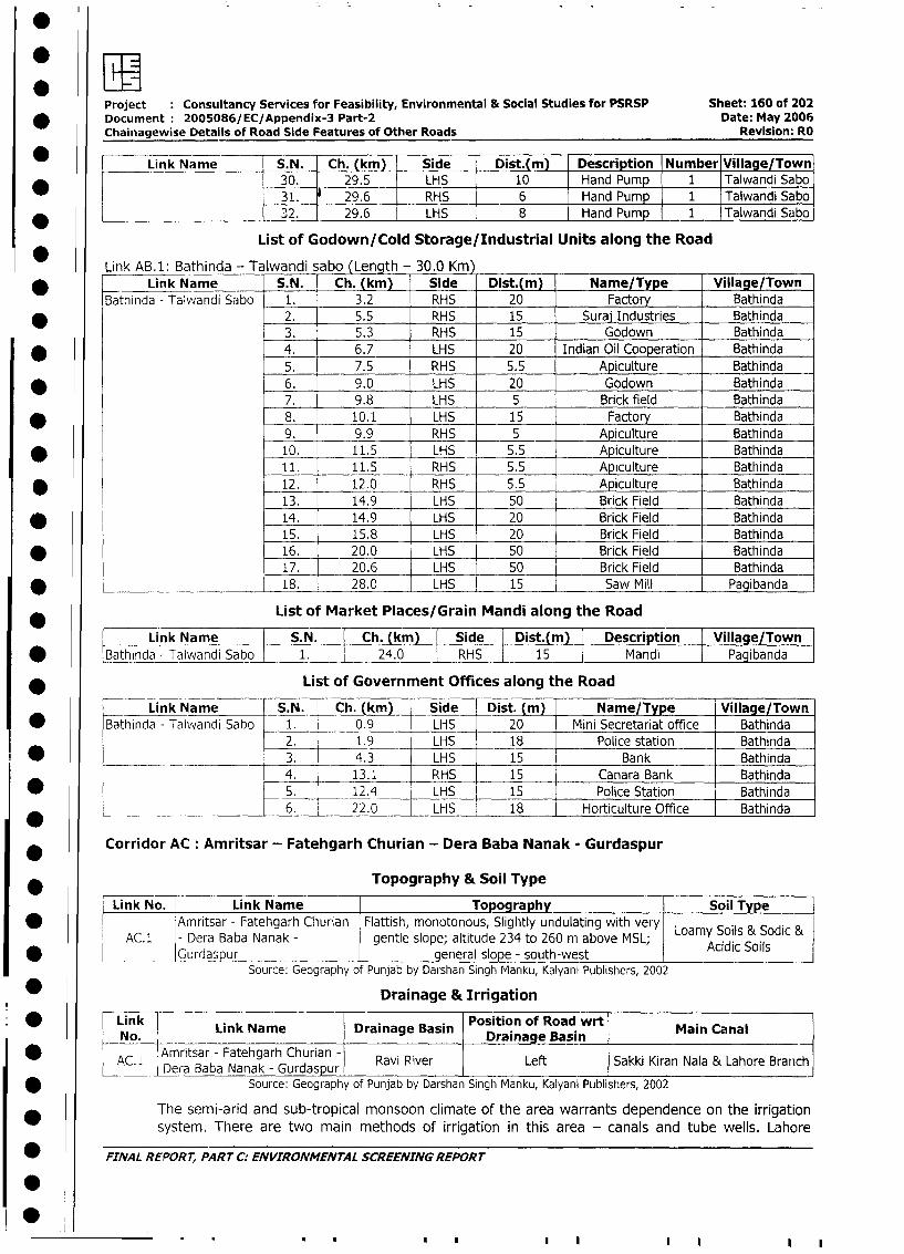
Project Consultancy Services for Feasibility, Environmental & Social Studies for PSRSP Sheet: 160 of 202
* Document 2005086/EC/Appendix-3 Part-2 Date: May 2006
Chainagewise Details of Road Side Features of Other Roads Revision: RO
Link Name S. N. Ch. (km) Side Dist.(ml Description Number Village/Town
* 30. 29.5 LHS 10 Hand Pump 1 Talwandi Sabo
31. RHS 6 Hand Pump 1 Talwandi Sabo
* '____________________ ______________________ 32. 29.6 LHS 8 Hand Pump 1 Talwandi Sabo
List of Godown/Cold Storage/Industrial Units along the Road
Link AB.1: Bathinda - Talwandi abo (Lenqth - 30.0 Km)
Link Name S.N. Ch. (km) Side Dist.(m) Name/Type Village/Town
Bathinda - Talwandi Sabo 1. 3.2 RHS 20 Factory Bathinda
* 2. 5.5 RHS 15 Suraj Industries Bathinda
3. 5.3 RHS 15 Godown Bathinda
* 4. 6.7 LHS 20 Indian Oil Cooperation Bathinda
5. 7.5 RHS 5.5 Apiculture Bathinda
* 6. 9.0 LHS 20 Godown Bathinda
7. 9.8 LHS 5 Brick field Bathinda
* 8. 10.1 LHS 15 Factory Bathinda
9. 9.9 RHS 5 Apiculture Bathinda
* 10. 11.5 LHS 5.5 Apiculture Bathinda
11. 11.5 RHS 5.5 Apiculture Bathinda
* 12. 12.0 RHS 5.5 Apiculture Bathinda
13. 14.9 LHS 50 Brick Field Bathinda
* 14. 14.9 LHS 20 Brick Field Bathinda
15. 15.8 LHS 20 Brick Field Bathinda
* 16. _ 20.0 LHS 50 Brick Field Bathinda
17. 20.6 LHS 50 Brick Field Bathinda
* ________ 18. 28.0 LHS 15 Saw Mill Pagibanda
List of Market Places/Grain Mandi along the Road
Link Name S.N. Ch. (km) | Side | Dist.(m) Description Village/Town
* rBathina - Talwandi Sabo 1. 24.0 RHS 15 Mandi Pagibanda
* __ ______ List of Government Offices along the Road
Link Name S.N. Ch. (km) Side Dist. (m) Name/Type Village/Town
* Bathinda - Talwandi Sabo 1. 0.9 LHS 20 Mini Secretariat office Bathinda
2. 1.9 LHS 18 Police station Bathinda
* _ __ _ 3. 4.3 LHS 15 Bank Bathinda
4. 13.1 RHS 15 Canara Bank Bathinda
I * L 5. 12.4 LHS 15 Police Station Bathinda
l6. 22.0 LHS 18 1 Horticulture Office Bathinda
Corridor AC: Amritsar - Fatehgarh Churian - Dera Baba Nanak - Gurdaspur
* _ Topography & Soil Type
Link No. Link Name Topography Soil Type
| w l lAmritsar - Fatehgarh Churian Flattish, monotonous, Slightly undulating with very Loamy Soils & Sodic &
AC.1 - Dera Baba Nanak - gentle slope; altitude 234 to 260 m above MSL; Acidic Soils
| *___Gurdaspur general slope - south-westSource: Geography of Punjab by Darshan Singh Manku, Kalyani Publishers, 2002
Drainage & Irrigation
* Link Link Name Drainage Basin Position of Road wrt Main CanalNo. ____________Drainage Basin
| * | AC. i Amritsar - Fatehgarh Churian - Ravi River Left Sakki Kiran Nala & Lahore BranchDera Baba Nanak - Gurdaspur
| * Source: Geography of Punjab by Darshan Singh Manku, Kalyani Publishers, 2002
The semi-arid and sub-tropical monsoon climate of the area warrants dependence on the irrigation
system. There are two main methods of irrigation in this area - canals and tube wells. Lahore
| * FINAL REPORT, PART C: ENVIRONMENTAL SCREENING REPORT
1 00 ~
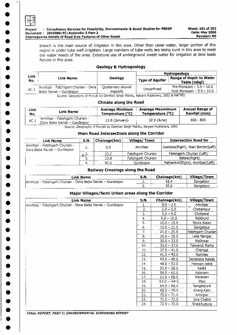
Project Consultancy Services for Feasibility, Environmental & Social Studies for PSRSP Sheet: 161 of 202* Document 2005086/EC/Appendix-3 Part-2 Date: May 2006
Chainagewise Details of Road Side Features of Other Roads Revision: RO
branch is the rnain source of irrigation in this area. Other than canal water, larger portion of this
* region is under tube well irrigation. Large numbers of tube wells are being sunk in this area to meetthe water needs of the area. Extensive use of underground sweet water for irrigation at time leads
* famine in this area.
* Geology & Hydrogeology
Link ~~~~~~~~~~~~~~Hydrogeology* LiNo. Link Name Geology Type of Aquifer Range of Depth to Water
No._Type of Aquifer Table (mbgl)
AC.1 Amritsar - Fatehgarh Churian - Dera Quaternary alluvial Unconfined Pre-Monsoon - 5.0- 10.0Baba Nanak - Gurdaspur deposits Post-Monsoon - 5.0 - 10.0
* Source: Geography of Punjab by Darshan Singh Manku, Kalyani Publishers, 2002 & NATMO
* Climate along the Road
ink LAverage Minimum Average Maxmimum Annual Range of* No. Link Name Temperature (°C) Temperature (°Cl Rainfall (mm)
AC.1 Amritsar - Fatehgarh Churian - 11.8 (January) 32.0 (3une) 600 - 800* ____ Dera Baba Nanak - Gurdaspur 1
Source: Geography of Punjab by Darshan Singh Manku, Kalyani Publishers, 2002
* Main Road Intersections along the Corridor
* Link Name S.N. Chainage(km) Village/ Town Intersection Road forAtnritsar - Fatehgarh Churian - 1. 0.0 Amritsar Jundiala(Right), Atari Border(Left)
* Dera Baba Nariak - Gurdaspur 2__ _2. 23.2 Fatehgarh Churian Fatehgarh Churian (Left)'
* 3. 23.8 Fatehgarh Churian Batala(Right)* __________ _____________ 4. 81.0 Gurdaspur Pathankot(Right), Amritsar(Left)
Railway Crossings along the Road
* Link Name S.N. Chainage(km) Village/TownAmritsar - Fatehgarh Churian - Dera Baba Nanak - Gurdaspur 1. 18.4 Sangatpur*________________________________________________________ 2. 20.6 Sangatpur
* Major Villages/Semi Urban areas along the Corridor
Link Name S.N. Chainage(km) Village/Town* Arnritsar - Fatehgarh Churian - Dera Baba Nanak - Gurdaspur 1. 0.0 - 2.0 Amritsar
2. 2.0 - 5.0 Chetampur3. 5.0 - 9.0 Chotewal4. 9.0 - 10.0 Palkhurd5. 10.0 - 15.0 Sonia Kalan6. 15.0 - 21.0 Sangatpur7. 21.0 - 25.0 Fatehgarh Churian8. 25.0 - 30.0 Lalle Nangar9. 30.0 - 33.0 Mallowar10. 33.0 - 37.0 Talwandi Rama11 37.0 - 41.0 Changgi12. 41.0 - 43.0 Ramdas13. 43.0 - 48.0 Derababa Nanak
* 14. 48.0 - 53.0 Harwan wara15. 53.0 - 58.0 Kadia16. 58.0 - 62.0 Kalanam
l 17. 62.0 - 68.0 Narawari* i _ 18. 63.0 - 64.0 Mazi
19. 64.0 - 68.0 Sangatpura* l 20. 68.0 - 70.0 Khera Katli
21. 70.0 - 71.0 Aminpur* i 23. 71.0 - 72.0 Jora Chatra
24. 72.0 - 73.0 Sheikhupura
*FINAL REPORT, PART C: ENVIRONMENTAL SCREENING REPORT
.
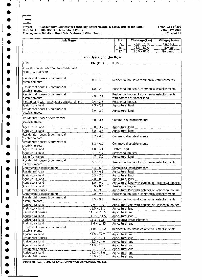
* Project : Consultancy Services for Feasibility, Environmental & Social Studies for PSRSP Sheet: 162 of 202
Document 2005086/EC/Appendix-3 Part-2 Date: May 2006
* Chainagewise Details of Road Side Features of Other Roads Revision: RO
Link Name S.N. Chaina e(km) Villa e/Town25. 73.0 - 78.0 Gajnipur26. 78.0 - 80.0 Navipur27. 80.0 - 81.0 Gurdaspur
* Land Use along the Road
* LHS Ch. (km) RHS
Amritsar- Fatehgarh Churian - Dera Baba* Nank - Gurudaspur
Residential houses & commercial 0.0 -1 0 Residential houses &commercial establishments.
|establishments . .
* Residential hous:s & commercial 1.0 - 2.0 Residential houses & commercial establishments
establishments* Residential houses & commercial 2 - 2 4 Residential houses & commercial establishments
establishments . - . with patches of Vacant land
* Plotted Land with patches of agricultural land 2.4 - 2.5 Residential houses
Agricultural land 2.5 - 2.9 Agricultural land
* Residential houses & commercial 2.9-3.0 Agricultural land
establishments
Residential houses &commercial 3.0 - 3.1 Commercial establishments
establishments
Agricultural land 3.0 - 3.7 Agricultural land
* Agricultural land 3.0 - 3.8 Agricultural land
Residential houses & commercial 3.7 - 4.0 Commercial establishments
* establishrnentsResidential houses & commercial 3.8 - 4.0 Commercial establishments
* establishmentsAgricultural land 4.0 - 4.1 Plotted Land
* Agricultural land 4.1 - 4.7 Residential houses
Sishu Plantation 4.7 - 5.0 Agricultural land
* Residential houses & commercial 5.0 - 5.3 Residential houses & commercial establishments
establishments* Commercial establishments 5.3 - 6.0 Commercial establishments
Residential Area 6.0 - 6.3 Agricultural land
* Agricultural land. 6.3 - 7.0 Agricultural land
Agricultural land 7.0 - 8.0 Aqricultural land
* Agricultural land 8.0 - 9.0 Agricultural land with patches of Residential houses
Agricultural land 8.0 - 8.6 Residential houses
* Residential houses 8.6 - 9.0 Agricultural land with patches of Residential houses
Commercial establishments 9.0 - 9.5 Residential houses & commercial establishments
Residential houses & commercial 9.5 - 9.9 Residential houses & commercial establishments
establishments* Agicultural lang d 9.9 - 11.0 Agricultural land with patches of Residential houses
Agricultural land 11.0 - 11.1 Agricultural land
Residen,tial houses 11.1 - 11.15 Agricultural land
Agricultural land 11.15 - 11.5 Agricultural land
* Agrisultural land 11.5 - 11.6 Commercial establishments
Agricultural land 11.6 - 11.85 _ Agricultural land
* Residential houses & commercial 11.85 - 12.0 Residential houses & commercial establishments
establishments ._.
* Agricultural land 12.0- 12.2 Agricultural land
Residential houses 12.2- 12.3 Agricultural land
_ Agricultural land 12.3- 14.0 Agricultural land
Agricultural land 14.0 - 16.1 Agricultural land
* Residential houses 16.1 - 16.2 Agricultural land
Agricultural land 16.2- 18.0 Agricultural land
* Residential houses 18.0 - 18.1 Agricultural land
FINAL REPORT, PART C: ENVIRONMENTAL SCREENING REPORT
0*0
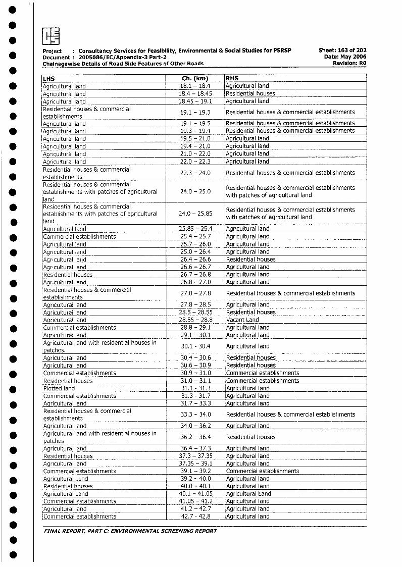
Project : Consultancy Services for Feasibility, Environmental & Social Studies for PSRSP Sheet: 163 of 202* Document 2005086/EC/Appendix-3 Part-2 Date: May 2006
Chainagewise Details of Road Side Features of Other Roads Revision: RO
LHS Ch. (km) RHS* Agricultural land 18.1 - 18.4 Agricultural land
Agricultural land 18.4 - 18.45 Residential houses* Agricultural land 18.45 - 19.1 Agricultural land
Residential houses & commercial 19.1 - 19.3 Residential houses & commercial establishments* establishments 11 9 Rinlo scmi____
Agricultural land 19.1 - 19.5 Residential houses & commercial establishments* Aqricultural land 19.3 - 19.4 Residential houses & commercial establishments
Agricultural land 19.5 - 21.0 Agricultural land* Agricultural land 19.4 - 21.0 Agricultural land
Agricultural larid 21.0 - 22.0 Agricultural land* Agricultural land 22.0 - 22.3 Agricultural land
Residential houses & commercial 22.3 - 24.0 Residential houses & commercial establishments* establishments
Residential houses & commercial Residential houses & commercial establishments* establishments with patches of agricultural 24.0 - 25.0 with patches of agricultural land
landResidential houses & commercial Residential houses & commercial establishmentsestablishments with patches of agricultural 24.0 - 25.85 with patches of agricultural land
* land with_patches_of_agricultural_landAgricultural land 25.85 - 25.4 Agricultural land
* Commercial establishments 25.4 - 25.7 Agricultural landAgricultural land 25.7 - 26.0 Agricultural land
* Agricultural land 25.0 - 26.4 Agricultural landAgricultural land 26.4 - 26.6 Residential houses
* Agricultural land 26.6 - 26.7 Agricultural landResidential houses 26.7 - 26.8 Agricultural land
* Agricultural land 26.8 - 27.0 Agricultural landResidential houses & commercial 27.0 - 27.8 Residential houses & commercial establishments
* establishmentsAgricultural land 27.8 - 28.5 Agricultural land
* Agricultural land 28.5 - 28.55 Residential housesALcultural land 28.55 - 28.8 Vacant Land
* Commercial establishments 28.8 - 29.1 Agricultural landAgricultural land 29.1 - 30.1 Agricultural land
* Agricultural land with residential houses in 30.1 - 30.4 Agricultural landpatches.
* Agricutural land 30.4 - 30.6 Residential housesAgricultural land 3U.6 - 30.9 Residential houses
* Commercial establishments 30.9 - 31.0 Commercial establishmentsResidential houses 31.0 - 31.1 Commercial establishments
* Plotted land 31.1 - 31.3 Agricultural landCommercial establishments 31.3 - 31.7 Agricultural land
* Agricultural land 31.7 - 33.3 Agricultural landResidential houses & commercial 33.3 - 34.0 Residential houses & commercial establishments
* establishmentsAgrcultural land 34.0 - 36.2 Agricultural land
* Agricultural land with residential houses in 36.2 - 36.4 Residential housespatches 36.2_-_36.4____________houses
* Agricultural land 36.4 - 37.3 Agricultural landResidential houses 37.3 - 37.35 Agricultural land
* Agrictural landcl 37.35 - 39.1 Agricultural landCommercial establishments 39.1 - 39.2 Commercial establishment;
* Agricultural Land 39.2 - 40.0 Agricultural landResidential houses 40.0 - 40.1 Agricultural land
* Agricultural Land 40.1 - 41.05 Agricultural LandCommercial establishments 41.05 - 41.2 Agricultural land
* ~ 9Acultural land 41.2 - 42.7 Agricultural landCommercial establishments 42.7 - 42.8 Agricultural land
FINAL REPORT, PART C: ENVIRONMENTAL SCREENING REPORT
0
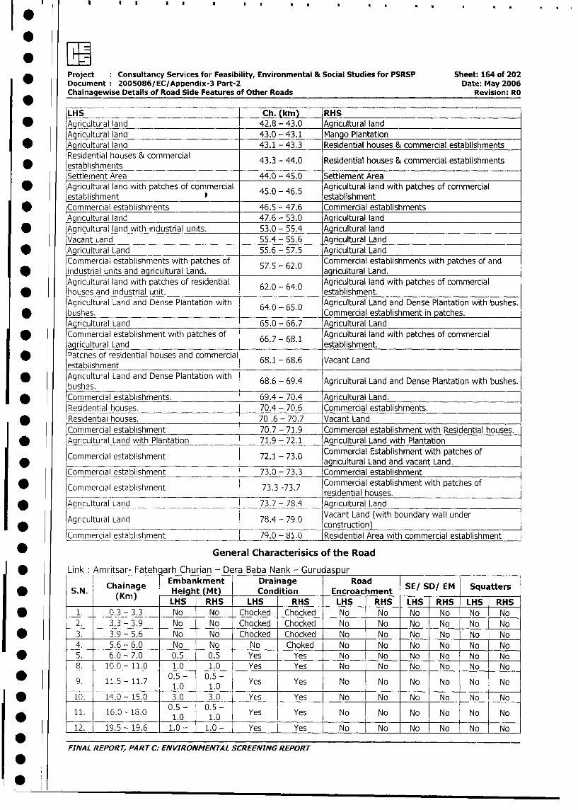
IlF
Project Consultancy Services for Feasibility, Environmental & Social Studies for PSRSP Sheet: 164 of 202
Document 2005086/EC/Appendix-3 Part-2 Date: May 2006
Chainagewise Details of Road Side Features of Other Roads Revision: RO
LHS Ch. (km) RHS
* Agricultural land 42.8 - 43.0 Agricultural land
Agricultural land 43.0 - 43.1 Mango Plantation
* Agricultural land 43.1 - 43.3 Residential houses & commercial establishments
Residential houses & commercial 43.3 - 44.0 Residential houses & commercial establishments
* establishments _-
Settlement Area 44.0 - 45.0 Settlement Area
* Agricultural land with patches of commercial 45.0 - 46.5 Agricultural land with patches of commercial
establishment establishment
* Commercial establishments 46.5 - 47.6 Commercial establishments
Agricultural land 47.6 - 53.0 Agricultural land
* Agricultural land with industrial units. 53.0 - 55.4 Agricultural land
Vacant Land 55.4 - 55.6 Agricultural Land
* Agricultural Land 55.6 - 57.5 Agricultural Land
Cornmercial establishments with patches of 57.5 62.0 Commercial establishments with patches of and
* industrial units and agricultural Land. . - . agricultural Land.
Agricultural land with patches of residential Agricultural land with patches of commercial
* houses and industrial unit. 62.0 64.0 establishment.
Agricultural Land and Dense Plantation with 64.0 - 65.0 Agricultural Land and Dense Plantation with bushes.
* bushes. . . Commercial establishment in patches.
Agricultural Land 65.0 - 66.7 Agricultural Land
Commercial establishment with patches of Agricultural land with patches of commercial
agricultural Land 66.7- 68.1 establishment.
Patches of residential houses and commercial 68.1 - 68.6 Vacant Land
establishment* Agricultural Land and Dense Plantation with 68.6 - 69.4 Agricultural Land and Dense Plantation with bushes.
bushes.* Commercial establishments. 69.4 - 70.4 Agricultural Land.
Residential houses. 70.4 - 70.6 Commercial establishments.
* Residential houses. 70 .6 - 70.7 Vacant Land
Commercial establishment 70.7 - 71.9 Commercial establishment with Residential houses.
* Agricultural Land with Plantation 71.9 - 72.1 Agricultural Land with Plantation
Commercial Establishment with patches ofCommercial establishment 72.1 - 73.0 arclua adadvcn ad
_ __ ~~~~~~~~~~~~~~~~~~~agricultural Land and vacant Land.
Commercial establishment 73.0 - 73.3 Commercial establishment
Commercial establishment 73.3 -73.7 Commercial establishment with patches of
_ Commercial establishment 73.3 -73.7 reintahos._ . _ ~~~~~~~~~~~~~~~residential houses.
* Aqc(rcultural Land _ __ _ 73.7 - 78.4 Agricultural Land
lAgricultu al Latid 78.4 - 79.0 Vacant Land (with boundary wall under* Ag riculItu ralI Land 78.4 - 79.0 construction)
LCommercial establishment 79.0 - 81.0 Residential Area with commercial establishment
* General Characterisics of the Road
* Link Amritsar- Fateh arh Churian - Dera Baba Nank - Gurudaspur
Chainage Embankment Drainage Road S/S/E qatr
* S.N (KChain)ge NHeig9t (Mt) _ Condition Encroachment SE/ SD/ EM Squatters
(Km) LHS RHS LHS RHS LHS RHS LHS RHS LHS RHS
* 1. 0.3 - 3.3 No No Chocked Chocked No No No No No No
2. 3.3 - 3.9 No No Chocked Chocked No No No No No No
* 3. 3.9 - 5.6 No No Chocked Chocked No No No No No No
4. 5.6 - 6.0 No No No Choked No No No No No No
* 5. 6.0 - 7.0 0.5 0.5 Yes Yes No No No No No No
8. 10.0- 11.0 1.0 _ 1.0 Yes Yes No No No No No No
9. 11.5-- 11.7 0.50- 0.50- Yes Yes No No No No No No1.0 1.0
* 1)0. 14.0 - 15.0 3.0 3.0 Yes Yes No No No No No No
11. 16.0-18.0 0.5.- 0.5°- Yes Yes No No No No No No* ____ ____________ ~~~1.0 1.0
12. 19.5 - 19.6 1.0 - 10- Yes Yes No No No No No No
FINAL REPORT, PART C: ENVIRONMENTAL SCREENTNG REPORT
0-
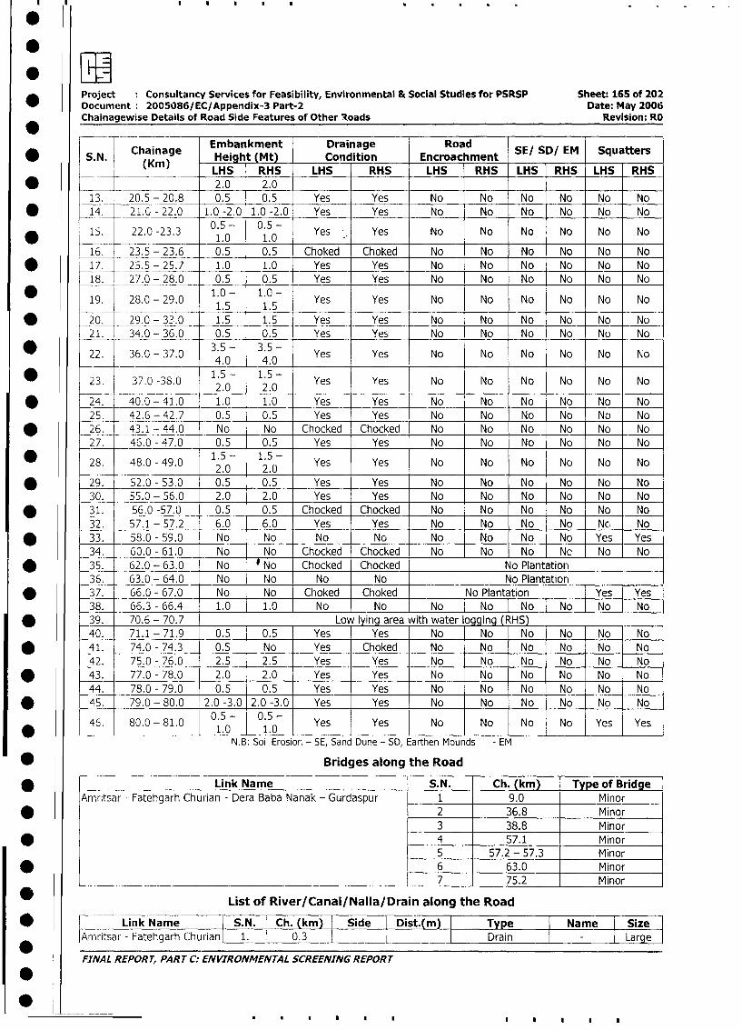
Project Consultancy Services for Feasibility, Environmental & Social Studies for PSRSP Sheet: 165 of 202
Document 2005086/ EC/Appendix-3 Part-2 Date, May 2006Chainagewise Details of Road Side Features of Other loads Revision: RO
Chainage Embankment Drainage Road SE/ SD/ EM Squatters
* ~~S. N. (Kin) -Heigh (Mt) Condition Encroachment~~~~~LHS RHS LHS RHS LHS RHS LHS RHS LHS RHS
* ~~~~ ~~~~~2.0 2.013. -20.5 - 20.8 0.5 0.5 Yes Yes No No No No No No
* ~~~14. 21.0- 22.0 1.0 -2.0 1.0 -2.0 Yes Yes No No No No No No
* ~~~15. 22.0 -23.3 0.5 - 0.5 - Yes Yes No No No No No No_____ _______ 1.0 1.0
16. 23.5 - 23.6 - 0.5 0.5 Choked Choked No No No No No No* ~~~17. -25.5 - 25.7 1.0 1.0 Yes Yes No No No No No No
18. 27.0 - 28.0 0.5 0.5 Yes Yes No No No No No No
19. 28.0 - 29.0 1.0 - 1.0 - Yes Yes No No No No No No1.5 1.5___
* 20. ~~~29.0 -33.0 1.5 1.5 Yes Yes No No No No No No
21. 34.0 - 36.0 0.5 0.5 Yes Yes No No No No No No
* ~~~22. 36.0 -37.0 35- 35- Yes Yes No No No No No No_____ __________ 4.0 4.0 _ _ _ _
23. 37.0 -38.0 1.5 - 1.5 - Yes Yes No No No No No No2.0 2.0_ _ _ _
* ~~~24. 40.0 -41.0 1.0 1.0 - Yes Yes N o N o N o N o N o N o
25. 42.6 - 42.7 0.5 0.5 Yes Yes N o N o N o N o N o N o
* ~~~26. 43.1 - 44.0 N o N o Chocked Chocked No No No No No No
27. 46.0 - 47.0 0.5 0.5 Yes Yes No No No No No No
* ~~~28. 48.0 -49.0 1.5 - 1.5 - Yes Yes No No No No No No2.0 2.0
* ~~~29. 52.0 - 53.0 0.5 0.5 Yes Yes No No No No No No
30. 55.0 - 56.0 2.0 2.0 Yes Yes No No No No No INo
* ~~~31. 56.0 -57.0 0.5 0.5 Chocked Chocked No No No No No No
32. 57.1 - 57.2 6.0 6.0 Yes Yes No No No No Nc, No
* ~~~33. 58.0 - 59.0 No No No No No No No No Yes Yes
34.- 60.0 - 61.0 No No Chocked Chocked No No No No No No
* ~~~35. 62.0 - 63.0 No No Chocked Chocked No Plantation
36. 63.0 - 64.0 No No No No -___No_Plantation ______
* ~~~37. 66.0 -67.0 - No No Choked Choked No Plantation ___[Yes Yes
38. 66.3-6. .0 10 No No No j~No INo N o N
* ~~~39. 70.6 - 70.7 Low lying area with water going (RHS) _
40. 71.1 - 71.9 0.5 0.5 Yes Yes No No No No No No
* ~~~41. 74.0 - 74.3 0.5 No Yes Choked No No No No No No
42. 75.0 - 76.0 2.5 2.5 Yes Yes No No No No No No
* ~~~43. 77.0 - 78,0 2.0 2.0 Yes Yes No No No No No No
44. 78.0 - 79.0 0.5 0.5 Yes Yes No No No No No No
* ~~~45.- 79.0 - 80.0 2.0 -3.0 2.0 -3.0 Yes Yes No No No No No No
46. 80.0 -81.0 0.5 - 0.5 - Yes Yes No No No No Yes Yes_ _ _ _ _ _ _ _ _ _ _ _ _ _ _ _ 1 .0 1 .0 _ _ __ _ _ _ _ _ _ _ _ _ _ __ _ _ _ _ _ _ _ _
N.B: Soil Erosior. - SE, Sand Dune - SD, Earthen Mounds - EM
* ~~~~~~~~~~~Bridges along the Road
* ~~~~~~~~~~Link Name S.N. Ch. (kin) Type of Bridge
Amritsar - Fatehgarh Churian - Dera Baba Nanak - Gurdaspur 1 9.0 Minor
* ~ ~ ~~~~ ~ ~~~~~~~~~~~~~~~~2 36.8 Minor3 38.8 Minor
* ~~~~~~ ~ ~~~~~~~~~~~~~~~~4 57.1 Minor5 57.2 - 57.3 Minor
* ~~~~~~ ~ ~~~~~~~~~~~~~~~~6 63.0 Minor7 75.2 Minor
List of River/Canal/Nalla/Drain along the Road
* ~~~~~Link Name S.N. Ch. (kmn) I Side DIst m Type Nam:e: ~SizeArnritsar - Fatehgarh Churian[ 1. 03I Drain I - Large
FI-NAL REPORT, PART C. ENVIRONMENTAL SCREENING REPORT
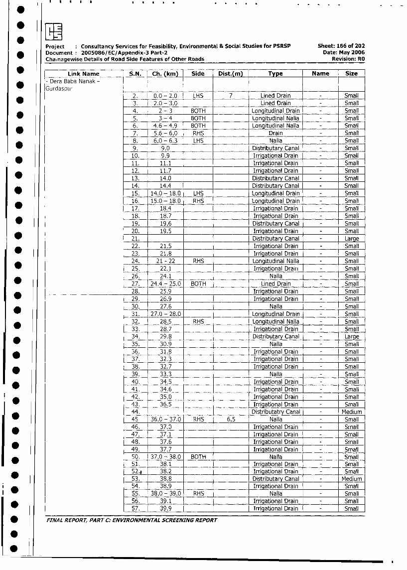
Project Consultancy Services for Feasibility, Environmental & Social Studies for PSRSP Sheet: 166 of 202
* Document 2005086/EC/Appendix-3 Part-2 Date: May 2006
Chainagewise Details of Road Side Features of Other Roads Revision: RO
* ~ Link Name S.N. - Ch. (km) Side Dist. Type Name Size
Dera Baba Nanak -Gurdaspur .
2. _ 0.0 - 2.0 LHS 7 Lined Drain - Small
3. 2.0 - 3.0 Lined Drain - Small
*4._ 2-.3 BOTH Longitudinal Drain - Small
5. __3 - 4 BOTH .Longitudinal Nalla _Small
* 6. 4.6 - 4.9 BOTH Longitudinal Nalla - Small
7. 5.6 - 6.0 RHS Drain - Small
8. 6.0 - 6.3 LHS Nalla - Small
* 9. 9.0 Distributary Canal - Small
10. 9.9 Irrigational Drain - Small
* 11. 11.1 Irrigational Drain - Small
12. 11.7 Irrigational Drain - Small
13. 14.0 Distributary Canal - Small
14. 14.4 Distributary Canal - Small
15. 14.0 - 18.0 LHS Longitudinal Drain - Small
16. 15.0 - 18.0 RHS Longitudinal Drain - Small
17. 18.4 Irrigational Drain - Small
18. 18.7 Irrigational Drain - Small
19. 19.6 Distributary Canal - Small
20. 19.5 Irrigational Drain - Small
* 21. Distributary Canal - Large
22. 21.5 Irrigational Drain - Small
* 23. 21.8 Irrigational Drain - Small
24. 21 - 22 RHS Longitudinal Nalla - Small
25. 22.1 Irrigational Drain - Small
26. 24.1 Nalla - Small
27. 24.4 - 25.0 BOTH Lined Drain - Small
______ 28. 25.9 Irriaational Drain - Small
_ 29. 26.9 Irrigational Drain - Small
* _ 30. 27.6 Nalla - Small
31. 27.0 - 28.0 Lonqitudinal Drain - Small
32. 28.5 RHS Longitudinal Nalla - Small
_ 33. 28.7 Irriqational Drain Small
34. 29.8 Distributary Canal - Large
35. 30.9 Nalla - Small
* 36. 31.8 Irrigational Drain - Small
37. 32.3 Irrigational Drain - Small
38. 32.7 Irrigational Drain - Small
39. 33.3 Nalla - Small
_ 40. 34.5 Irrigational Drain - Small
41. 34.6 _ rrigational Drain - Small
42. 35.0 Irrigational Drain - Small
43. 36.5 Irrigational Drain - Small
44. Distributatry Canal - Medium
* 45. 36.0 - 37.0 RHS 6.5 Nalla - Small
46. 37.0 Irrigational Drain - Small
47. 37.1 _ _ Irrigational Drain - Small
48. 37.6 Irrigational Drain - Small
49. 37.7 Irriqational Drain - Small
*50. 37.0 - 38.0 BOTH Nalla - Small
51. 38.1 Irrigational Drain - Small
52.* 38.2 Irrigational Drain - Small
53. 38.8 _ Distributary Canal - Medium
54. 38.9 Irrigational Drain - Small
55. 38.0 - 39.0 RHS Nalla - Small
56. 39.1 Irrigational Drain - Small
57. 39.9 Irrigational Drain - Small
I : FINAL REPORT, PART C: ENVIRONMENTAL SCREENING REPORT
1-0
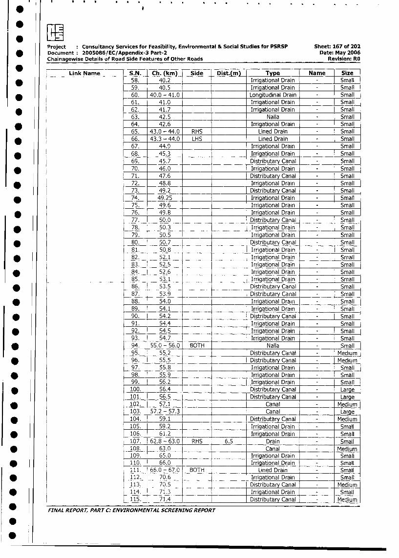
I- a
Project Consultancy Services for Feasibility, Environmental & Social Studies for PSRSP Sheet: 167 of 202
* Document 2005086/EC/Appendix-3 Part-2 Date: May 2006
Chainagewise Details of Road Side Features of Other Roads Revision: RO
Link Name S.N. Ch. (km) Side Dist.(m) Type Name Size
* 58. 40.2 Irrigational Drain - Small
59. 40.5 Irrigational Drain - Small
* 60. 40.0 - 41.0 Longitudinal Drain - Small
61. 41.0 Irrigational Drain - Small
* 62. 41.7 Irrigational Drain - Small
63. 42.5 Nalla - Small
* 64. 42.6 Irrigational Drain - Small
65. 43.0 - 44.0 RHS Lined Drain - Small
* 66. 43.3 - 44.0 LHS Lined Drain - Small
67. 44.9 Irrigational Drain - Small
* 68. 45.3 Irrigational Drain - Small
69. 45.7 Distributary Canal - Small
* 70. 46.0 Irrigational Drain - Small
71. 47.6 Distributary Canal - Small
* 72. 48.8 Irrigational Drain - Small
73. 49.2 Distributary Canal - Small
* 74. 49.25 Irrigational Drain - Small
75. 49.6 Irrigational Drain - Small
* 76. 49.8 Irrigational Drain - Small
77. 50.0 Distributary Canal - Small
* 78. 50.3 Irrigational Drain - Small
79. 50.5 Irrigational Drain - Small
* 80. 50.7 Distributary Canal - Small
81. 50.8 Irrigational Drain - Small
* l 82. 52.1 Irrigational Drain - Small
83. 52.5 Irrigational Drain - Small
* _84. [ 52.6 Irrigational Drain - Small
85. 53.1 Irrigational Drain - Small
* 86. 53.5 Distributary Canal - Small
87. 53.9 Distributary Canal - Small
* 88. 54.0 Irrigational Drain - Small
89. 54.1 Irrigational Drain - Small
* 90. 54.2 Distributary Canal - Small
91. 54.4 Irrigational Drain - Small
* 92. 54.5 Irrigational Drain - Small
93. 54.7 Irrigational Drain - Small
* 94. 55.0 - 56.0 BOTH Nalla - Small
95. 55.2 Distributary Canal - Medium
* 96. 55.5 Distributary Canal - Medium
97. 55.8 Irrigational Drain - Small
* 98. 55.9 Irrigational Drain - Small
99. 56.2 Irrigational Drain - Small
! ao100. 56.4 Distributary Canal - Larqe
101. 56.5 Distributary Canal - Large
* 102. 57.1 Canal - Medium
103. 57.2 - 57.3 Canal - Large
* 104. 59.1 Distributary Canal - Medium
105. 59.2 Irrigational Drain - Small
* 106. 61.2 Irrigational Drain - Small
107. 62.8 - 63.0 RHS 6.5 Drain - Small
* 8io. 63.0 Canal - Medium
109. 65.0 Irrigational Drain - Small
* l 110. 66.0 Irrigational Drain - Small
111. 66.0 - 67.0 BOTH Lined Drain = Small
I * l 112. 70.6 Irrigational Drain - Small
113. 70.5 Distributary Canal - Medium
I * l 114. 71.3 Irrigational Drain - Small
115. _ 71.4 1 Distributary Canal - Medium
FINAL REPORT, PART C: ENVIRONMENTAL SCREENING REPORT
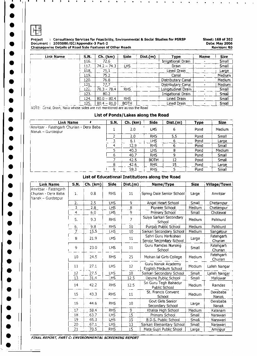
Project Consultancy Services for Feasibility, Environmental & Social Studies for PSRSP Sheet: 168 of 202
* Document 2005086/EC/Appendix-3 Part-2 Date: May 2006
Chainagewise Details of Road Side Features of Other Roads Revision: RO
* _ _Link Name S.N. Ch. (km) Side Dist.(m Type Name Size
* 116. 72.6 Irrigational Drain Small
117. 74.2 - 74.3 LHS __ _ Drain Small
* 118. 75.1 Lined Drain _ Large
119. 75.2 _ Canal Medium
* 120. 76.8 Distributary Canal _ Medium
121. 77.7 Distributary Canal Medium
* 12 2. 78.3 - 78.4 RHS Longitudinal Drain Small
123. 80.2 _ Irrigational Drain - Small
124. 80.0 - 80.4 RHS Lined Drain Small
125. 80.4 - 81.0 BOTH Lined Drain Small
NOTE: Canal, Drain, Nallc whose sides are not mentioned are across the Road
List of Ponds/Lakes along the Road
* Link Name e S.N. Ch. (km) Side Dist.(m) Type Size
* Amritsar - Fatehgarh Churian - Dera Baba 1 2.0 LHS 6 Pond Medium
Nanak - Gurdaspur* 2 2.0 RHS 5.5 Pond Small
3 6.1 LHS 6 Pond Large4 12.9 RHS 6 Pond Small
5 40.3 LHS 8 Pond Medium
* 6 40.7 RHS 9 Pond Small7 42.5 BOTH 12 Pond Small
* _ 8 42.6 RHS 15 Pond Large
____________________________________ 9 59.3 RHS 5 Pond Small
* List of Educational Institutions along the Road
* Link Name S.N. Ch. (km) Side Dist.(m) Name/Type Size Village/Town
Amritsar - Fatehgarh* Churian - Dera Baba 1. 0.8 RHS 11 Spring Dale Senior School Large Amritsar
Nanak - Gurdaspur l l
* 2. 2.5 LHS 9 Angel Heart School Small Chetampur
3 2.8 LHS 8 Pioneer School Medium Chetampur
* 4 6.0 LHS 9 Primary School Small Chotewal
5. 9.3 RHS 7 Suiya Sarkari Secondary Medium Palkhurd* __ ~~~~~~~~~~~~~~~~~~~School
6. 9.8 RHS 10 Punjab Public School Medium Palkhurd
* 7 15.5 LHS 10 Sarkari Secondary School Medium Sangatpur
8 21.9 LHS 11 Sahri Guru Harkishen Large Fatehgarh* l . l Senior Secondary School L Churian
9 23.0 LHS 11 Guru Ramdas Nursing Small Fatehgarh* ~~~~~~~~~~~~~~~~~ ~~~~~~~School _____ Churian
10 24.5 RHS 25 Mohan lal Girls College Medium Fatehgarhan
l11 27.1 LH 12 Guru Nanak Academy ChuNan1 __2_1 LH_1 English Medium School Medium Lalleh Nangar
12 27.5 - LHS 10 Sarkari Secondary School Small Lalleh Nangar
* I t 13 31.4 LHS 12.5 Devine Public School Small Mallowar
14 42.2 RHS 12.5 Sri Guru Tegh Bahadur Medium Ramdas_______ ~Public School
\ 15 43.3 | RHS i 11 St. Francis Convent Medium Derababa15 43.3 RHS 11 ~~~~~~School Meim Nanak
16 44.6 RHS 10 ~~~Govt Girls Senior Lre Derababa16 44.6 ! RHS 2 10 Secondary School arge Nanak
* 17 58.4 RHS 9 Khalsa High School Medium Kalanam
* l 18 63.7 LHS 15 Primary School Small Narawari
19 65.3 LHS 15 B.D.S. Public School Small Narawari
* I L 20 67.1 LHS 13 Sarkari Elemantary School Small Narawari21 70.5 RHS 15 Mata Gujri Public Shool | Large Aminpur
_ FINAL REPORr, PART C: ENVIRONMENTAL SCREENING REPORT
*
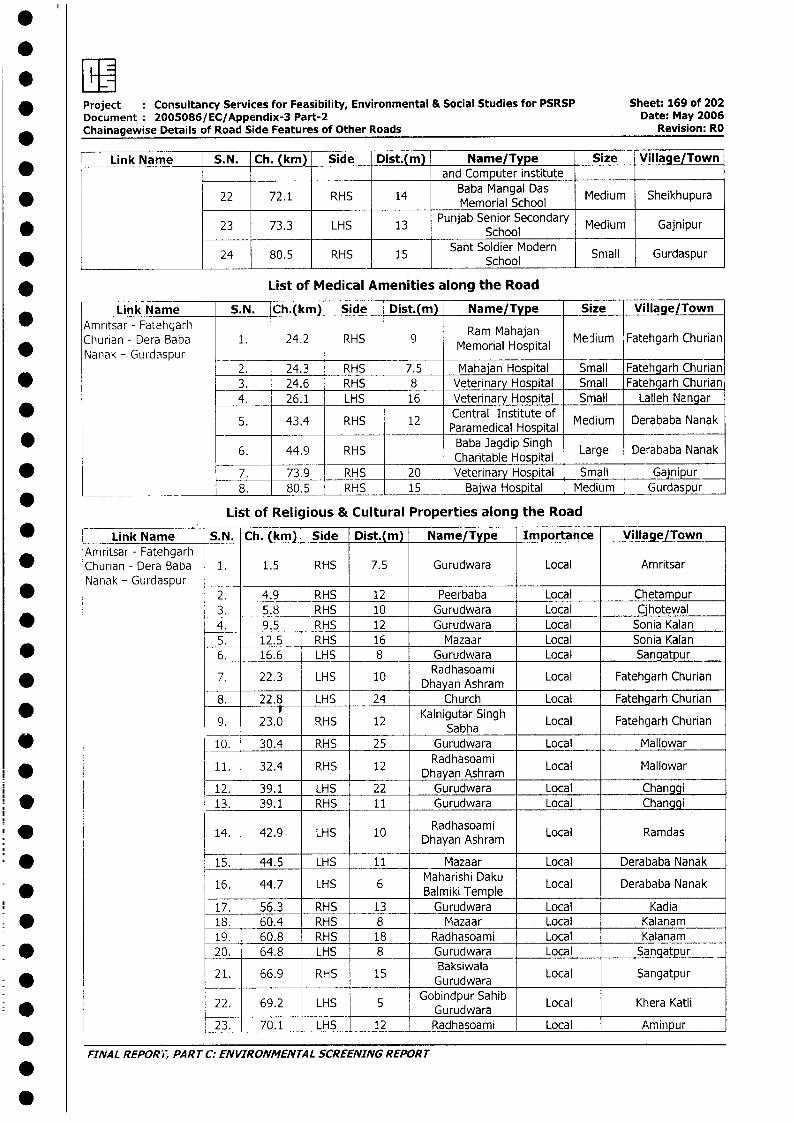
* Project Consultancy Services for Feasibility, Environmental & Social Studies for PSRSP Sheet: 169 of 202Document 2005086/ EC/Appendix-3 Part-2 Date: May 2006
* Chainagewise Details of Road Side Features of Other Roads Revision: RO
Link Name S.N. Ch. (km) Side Dist.(m) Name/Type Size Village/Town |* and Computer institute
22 72.1 RHS 14 BMemoria ScMa ol Medium Sheikhupura
23 73.3 LHS 13 Punjab Senior Secondary Medium Gajnipur* _______ ~~~~~~~~~~~~~~~~School
* < 24 80.5 RHS 15 Sant Soldier Modern Small Gurdaspur_ _ _ _ _ _ _ _ _ _ _ _ _ _ _ _ _ _ _ _ _ _ _ _ _ _ _ _ _ _ _ _ S c h o o l _ _ _ _ _ _ _ _ _ _
* List of Medical Amenities along the Road
Link Name S.N. Ch.(km) Side Dist.(m) Name/Type Size Village/TownAmntsar - Fatehgarh Ram Mahajan [FatehgarhChurian - Dera Baba 1. 24.2 RHS 9 MmraHoptl Medium FthahChurian)
* Nanak- Gurdaspur_2. 24.3 RHS 7.5 Mahajan Hospital Small Fatehgarh Churian
* 3. 24.6 RHS 8 Veterinary Hospital Small Fatehgarh Churian4. 26.1 LHS 16 Veterinary Hospital Small Lalleh Nangar
5. 43.4 RHS 12 Paramedical Hospital Medium Derababa Nanak
6. 44.9 RHS Baba Jagdip Singh Large Derababa Nanak
* 7. 73.9 RHS 20 Veterinary Hospital Small Gajnipur*_ _ ___ 8. 80.5 RHS 15 Bajwa Hospital Medium Gurdaspur
List of Religious & Cultural Properties along the Road
* -- Link Name S.N. Ch. (kin) Side Dist.(m) Name/Type Importance Village/TownAmritsar - Fatehgarh
* Churian - Dera Baba 1. 1.5 RHS 7.5 Gurudwara Local AmritsarNanak - Gurdaspur _Nanak - Gurdaspur 2. 4.9 RHS 12 Peerbaba Local Chetampur
3. 5.8 RHS 10 Gurudwara Local Cjhotewal* 4. 9.5 RHS 12 Gurudwara Local Sonia Kalan
5. 12.5 RHS 16 Mazaar Local Sonia Kalan6. 16.6 LHS 8 Gurudwara Local Sangatpur
Radhasoaimi* 7. 22.3 LHS 10 Dhayan Ashram Local Fatehgarh Churian
8. 22.8 LHS 24 Church Local Fatehgarh Churian
* 9. 23.0 RHS 12 Kalnigutar Singh Local Fatehgarh Churian
* Lo10. 30.4 RHS 25 Gurudwara Local Mallowar
11. 32.4 RHS 12 Radhasoami Local Mallowar| 12. 39.1 LHS 22 Dhayan Ashram Local
12. 39.1 LHS 22 Gurudwara Local Changgi* ~~~~~~~~~13. 39.1 RHS 11 Gurudwara Local Changgi
14. 42.9 LHS 10 Radhasoami Local RamdasDhayan Ashram
* 1 15. 44.5 LHS 11 Mazaar Local Derababa Nanak
16. 44.7 LHS 6 Maharishi Daku Local Derababa Nanak* ~~~~~~~~~~~~~~~~~Balmiki Temple
17. 56.3 RHS 13 Gurudwara Local Kadia* | 18. 60.4 RHS 8 Mazaar Local Kalanam
19. 60.8 RHS 18 Radhasoami Local Kalanam* 1 20. 64.8 LHS 8 Gurudwara Local Sangatpur
21. 66.9 RHS 15 Gurudwara Local Sangatpur
22. 69.2 LHS 5 ~Gobindpur Sahib LocalKhrKalg 22. 69.2 LHS ; Gurudwara Lher Kti
23. 70.1 LHS 12 Radhasoami Local Aminpur
FINAL REPORi, PART C: ENVIRONMENTAL SCREENING REPORT.
0
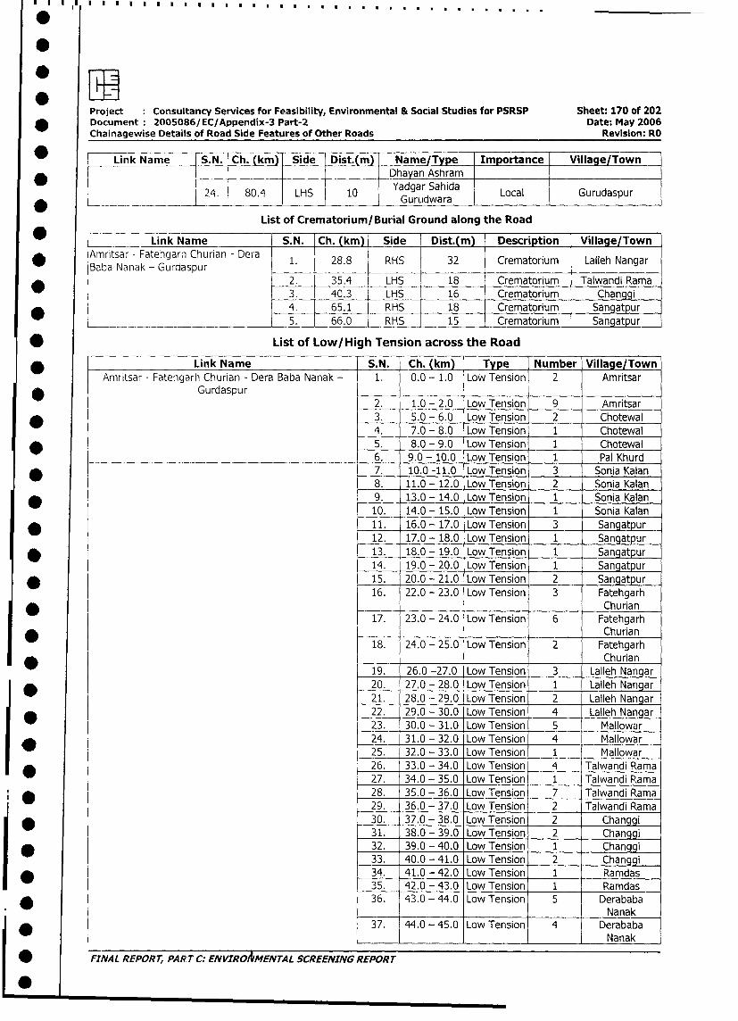
Project Consultancy Services for Feasibility, Environmental & Social Studies for PSRSP Sheet: 170 of 202
* Document 2005086/EC/Appendix-3 Part-2 Date: May 2006
Chainagewise Details of Road Side Features of Other Roads Revision: RO
*0 N Link Name S.N. Ch. (km) Side | Dist.(m) Name/Type I Importance Village/Town
*~~~~~~~~~~~~~~~~~~~~~~~~~ _hayan Ashram I 24. 804 LHS 10 Yadgar Sahida Local Gurudaspur
__ ~~~~~~~~~~~~~~GurLldwaraList of Crematorium/Burial Ground along the Road
Link Name S.N. Ch. (km) _Side Dist.(m) Description Village/Town
* Amritsar - Fatehgarh Churian - Dera 1. 28.8 RHS 32 Crematorium Lalleh Nangar
Baba Nanak - Gurdaspur _
* r 2. 35.4 LHS 18 Crematorium Talwandi Rama
3. 40.3 LHS 16 Crematorium Changgi
* 4. 65.1 RHS 18 Crematorium Sangatpur
___ _. ______ l5. 66.0 RHS 15 Crematorium Sangatpur
* List of Low/High Tension across the Road
* Link Name S.N. Ch. (km) Type Number Village/Town
Amritsar - Fatehgarh Churian - Dera Baba Nanak - 1. 0.0 - 1.0 Low Tension 2 Amritsar
Gurdaspur2. 1.0 - 2.0 Low Tension 9 Amritsar
* 3. 5.0 - 6.0 Low Tension 2 Chotewal
4. 7.0 - 8.0 Low Tension 1 Chotewal
* 5. 8.0 - 9.0 Low Tension 1 Chotewal
6. 9.0 - 10.0 Low Tension 1 Pal Khurd
* 7. 10.0 -11.0 Low Tension 3 Sonia Kalan
8. 11.0 - 12.0 Low Tension 2 Sonia Kalan
* 9. 13.0 - 14.0 Low Tension 1 Sonia Kalan
10. 14.0 - 15.0 Low Tension 1 Sonia Kalan
* 11. 16.0 - 17.0 Low Tension 3 Sangatpur
12. 17.0 - 18.0 Low Tension 1 Sangatpur
* 13. 18.0 - 19.0 Low Tension 1 Sangatpur
14. 19.0 - 20.0 Low Tension 1 Sangatpur
* 15. 20.0 - 21.0 Low Tension 2 Sangatpur
16. 22.0 - 23.0 Low Tension 3 Fatehgarh
_ _ _ _ _ _ _ _ Churian
17. 23.0 - 24.0 Low Tension 6 Fatehgarh
* Churian
18. 24.0 - 25.0 Low Tension 2 FatehgarhChurian
19. 26.0 -27.0 Low Tension 3 Lalleh Nangar
* 20. 27.0 - 28.0 Low Tension 1 Lalleh Nangar
21. 28.0 - 29.0 Low Tension 2 Lalleh Nangar
* 22. 29.0 - 30.0 Low Tension 4 Lalleh Nangar
23. 30.0 - 31.0 Low Tension 5 Mallowar
* 24. 31.0 - 32.0 Low Tension 4 Mallowar
25. 32.0 - 33.0 Low Tension 1 Mallowar
*_26. 33.0 - 34.0 Low Tension 4 Talwandi Rama
27. 34.0 - 35.0 Low Tension 1 Talwandi Rama
i * 28. 35.0 - 36.0 Low Tension 7 Talwandi Rama
29. 36.0 - 37.0 Low Tension 2 Talwandi Rama
30. 37.0 - 38.0 Low Tension 2 Changgi
31. 38.0 - 39.0 Low Tension 2 Changgi
* 32. 39.0 - 40.0 Low Tension 1 Changgi
33. 40.0 - 41.0 Low Tension 2 Changgi
34. 41.0 - 42.0 Low Tension 1 _Ramdas
35. 42.0 - 43.0 Low Tension 1 Ramdas
36. 43.0 - 44.0 Low Tension 5 DerababaNanak
37. 44.0 - 45.0 Low Tension 4 Derababa
I*_ l Nanak
| * FINAL REPORT, PART C: ENVIRORMENTAL SCREENING REPORT
L0
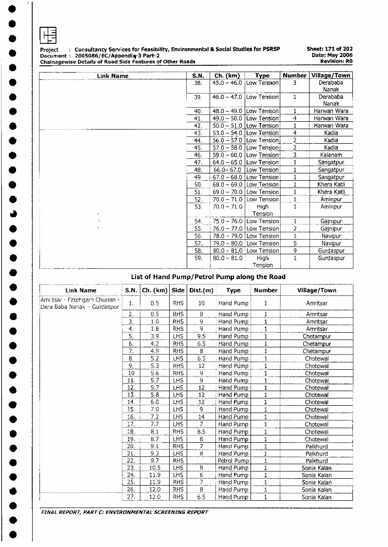
Project : Consultancy Services for Feasibility, Environmental & Social Studies for PSRSP Sheet: 171 of 202Document: 2005086/EC/Appendi,V3 Part-2 Date: May 2006Chainagewise Details of Road Side Features of Other Roads Revision: RO
Link Name S.N. Ch. (km) Type Number Village/Town* 38. 45.0 - 46.0 Low Tension 3 Derababa
Nanak* 39, 46.0 - 47.0 Low Tension 1 Derababa
Nanak* 40. 48.0 - 49.0 Low Tension 1 Harwan Wara
41. 49.0 - 50.0 Low Tension 4 Harwan Wara* _______ ___________________________________ 42. 50.0 - 51.0 Low Tension 1 Harwan Wara
43. 53.0 - 54.0 Low Tension 4 Kadia* 44. 56.0 - 57.0 Low Tension 2 Kadia
45. 57.0 - 58.0 Low Tension 2 Kadia* 46. 59.0 - 60.0 Low Tension 3 Kalanam
47. 64.0 - 65.0 Low Tension 1 Sangatpur* 48. 66.0- 67.0 Low Tension 1 Sangatpur
49. 67.0 - 68.0 Low Tension 1 Sangatpur* 50. 68.0 - 69.0 Low Tension 1 Khera Katli
51. 69.0 - 70.0 Low Tension 1 Khera Katli* 52. 70.0 - 71.0 Low Tension 1 Aminpur
53. 70.0- 71.0 High 1 Aminpur3 I _ Tension
54. 75.0 - 76.0 Low Tension 1 Gajnipur* . 55. 76.0 - 77.0 Low Tension 2 Gajnipur
56. 78.0 - 79.0 Low Tension 1 Navipur* 57. 79.0 - 80.0 Low Tension 5 Navipur
58. 80.0 - 81.0 Low Tension 9 Gurdaspur* l 59. 80.0 - 81.0 High 1 Gurdaspur
___ _ _ __________________________________ ___________________ T en sio n
List of Hand Pump/Petrol Pump along the Road
* I Link Name S.N. Ch. (km) Side Dist.(m) Type Number Village/Town
* Amritsar - Fatehgarh Churian - 1. 0.5 RHS 10 Hand Pump 1 AmritsarDera Baba Nanak - Gurdaspur
* 2. 0.5 RHS 8 Hand Pump 1 Amritsar3. 1.0 RHS 9 Hand Pump 1 Amritsar
* 4. 1.8 RHS 9 Hand Pump 1 Amritsar5. 3.9 LHS 9.5 Hand Pump 1 Chetampur
* _ 6. 4.2 RHS 6.5 Hand Pump 1 Chetampur7. 4.9 RHS 8 Hand Pump 1 Chetampur
* 8. 5.2 LHS 6.5 Hand Pump 1 Chotewal9. 5.3 RHS 12 Hand Pump 1 Chotewal
* 10 5.6 RHS 9 Hand Pump 1 Chotewal11. 5.7 LHS 9 Hand Pump 1 Chotewal
* 12. 5.7 LHS 12 Hand Pump 1 Chotewal13. 5.8 LHS 12 Hand Pump 1 Chotewal
* 14. 6.0 LHS 12 Hand Pump 1 Chotewal15. 7.0 LHS 9 Hand Pump 1 Chotewal
* 16. 7.2 LHS 14 Hand Pump 1 ChoteNal17. 7.7 LHS 7 Hand Pump 1 Chotewal
* 18. 8.1 RHS 8.5 Hand Pump 1 Chotewal19. 8.7 LHS 8 Hand Pump 1 Chotewal
* 20. 9.1 RHS 7 Hand Pump 1 Palkhurd21. 9.3 LHS 8 Hand Pump 1 Palkhurd
* 22. 9.7 RHS Petrol Pump 1 Palkhurd23. 10.5 LHS 8 Hand Pump 1 Sonia Kalan
* 24. 11.9 LHS 6 Hand Pump 1 Sonia Kalan25. 11.9 RHS 7 Hand Pump 1 Sonia Kalan
* _________________ 26. 12.0 RHS 8 Hand Pump 1 Sonia Kalan27. 12.0 RHS 6.5 Hand Pump 1 Sonia Kalan
*FINAL REPORT, PART C: ENVIRONMENTAL SCREENING REPORT
-
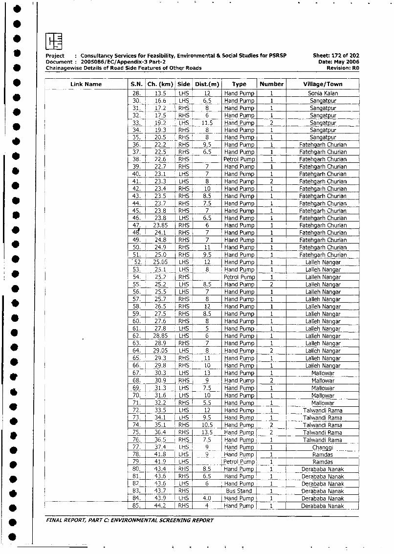
1 Project Consultancy Services for Feasibility, Environmental & Social Studies for PSRSP Sheet: 172 of 202Document 2005086/EC/Appendix-3 Part-2 Date: May 2006Chainagewise Details of Road Side Features of Other Roads Revision: RO
* Link Name S.N. Ch. (km) Side Dist.(m) Type Number Village/Town
28. 13.5 LHS 12 Hand Pump 1 Sonia Kalan
_ 30. 16.6 LHS 6.5 Hand Pump 1 Sangatpur31. 17.2 RHS 8 Hand Pump 1 Sangatpur32. 17.5 RHS 6 Hand Pump 1 Sangatpur33. 19.2 LHS 11.5 Hand Pump 2 Sangatpur34. 19.3 RHS 8 Hand Pump 1 Sangatpur35. 20.5 RHS 8 Hand Pump 1 Sangatpur36. 22.2 RHS 9.5 Hand Pump 1 Fatehgarh Churian37. 22.5 RHS 6.5 _ Hand Pump 1 Fatehgarh Churian38. 22.6 RHS Petrol Pump 1 Fatehgarh Churian39. 22.7 RHS 7 Hand Pump 1 Fatehgarh Churian
_ 40. 23.1 LHS 7 Hand Pump 1 Fatehgarh Churian41. 23.3 LHS 8 Hand Pump 2 Fatehgarh Churian42. 23.4_ RHS 10 Hand Pump 1 Fatehgarh Churian43. 23.5 RHS 8.5 Hand Pump 1 Fatehgarh Churian44. 23.7 RHS 7.5 Hand Pump 1 Fatehgarh Churian45. 23.8 RHS - 7 Hand Pump 1 Fatehgarh Churian
* 46. 23.8 LHS 6.5 Hand Pump 1 Fatehgarh Churian47. 23.85 RHS 6 Hand Pump 1 Fatehgarh Churian48 24.1 RHS 7 Hand Pump 1 Fatehgarh Churian49. 24.8 RHS 7 Hand Pump 1 Fatehgarh Churian50. 24.9 RHS 11 Hand Pump 1 Fatehgarh Churian
* 51. 25.0 RHS 9.5 Hand Pump 1 Fatehgarh Churian*52. 25.05 LHS 12 Hand Pump 1 Latleh Nangar53. 25.1 LHS 8 Hand Pump 1 Lalleh Nangar54. 25.2 RHS Petrol Pump 1 Lalleh Nangar55. 25.2 LHS 8.5 Hand Pump 2 Lalleh Nangar
* 56. 25.5 LHS 7 Hand Pump 1 Lalleh Nangar57. 25.7 RHS 8 Hand Pump 1 Lalleh Nangar
_ 58. 26.5 RHS 12 Hand Pump 1 Lalleh Nangar59. 27.5 RHS 8.5 Hand Pump 1 Lalleh Nangar
* 60. 27.6 RHS 8 Hand Pump 1 Lalleh Nangar61. 27.8 LHS 5 Hand Pump 1 Lalleh Nangar62. 28.85 LHS 6 Hand Pump 1 Lalleh Nangar63. 28.9 RHS 7 Hand Pump 1 Lalleh Nangar64. 29.05 LHS 8 Hand Pump 2 Lalleh Nangar65. 29.3 RHS 11 Hand Pump 1 Lalleh Nangar66. 29.8 RHS 10 Hand Pump 1 Lalleh Nangar67. 30.3 LHS 13 Hand Pump 1 Mallowar68. 30.9 RHS 9 Hand Pump 2 Mallowar69. 31.3 LHS 7.5 Hand Pump 1 Mallowar
* 70. 31.6 LHS 10 Hand Pump 1 Mallowar71. 32.2 RHS 5.5 Hand Pump 1 Mallowar
* 72. 33.5 LHS 12 Hand Pump 1 Talwandi Rama73. 34.1 LHS 9.5 Hand Pump 1 Talwandi Rama74. 35.1 RHS 10.5 Hand Pump 2 Talwandi Rama75. 36.4 RHS 13.5 Hand Pump 2 Talwandi Ramaw 76. 36.5 RHS 7.5 Hand Pump 1 Talwandi Rama77. 37.4 LHS 9 Hand Pump 1 Changgi78. 41.8 LHS 9 Hand Pump 1 Ramdas
* 79. 41.9 LHS Petrol Pump 1 Ramdas80. 43.4 RHS 8.5 Hand Pump 1 Derababa Nanak81. 43.6 RHS 6.5 Hand Pump 1 Derababa Nanak82. 43.6 LHS 6 Hand Pump 1 Derababa Nanak
83. 43.7 RHS Bus Stand 1 Derababa Nanak
______ ______________ 84 43 9 LHS 4.0 Hand Pump 1 Derababa Nanak
* 85. 44.2 RHS 4 Hand Pump 1 Derababa Nanak
FINAL REPORT, PART C: ENVIRONMENTAL SCREENING REPORT
0~~~~~~~~~~~~~~~~~~~~~~~~~~~~~~~~~~~~~~~~~~~~~~~~~~~~~~
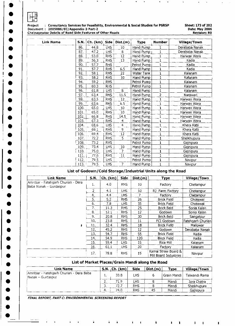
Project Consultancy Services for Feasibility, Environmental & Social Studies for PSRSP Sheet: 173 of 202
Document 2005086/EC/Appendix-3 Part-2 Date: May 2006
Chainagewise Details of Road Side Features of Other Roads Revision: RO
* _-_ILink Name S.N. Ch. (km) Side Dist.(m) Type Number Village/Town
* ._ 86. 44.8 LHS 10 Hand Pump 1 Derababa Nanak
87. 47.2 LHS 8 Hand Pump 1 Derababa Nanak
* l 88. 53.0 RHS 12 Hand Pump 1 Harwan Wara
89. 56.3 RHS 13 Hand Pump 1 Kadia
* 90. 57.7 RHS Petrol Pump 1 Kadia
91. 57.7 RHS 6.5 Hand Pump 1 Kadia
l * 92. 58.1 RHS 22 Water Tank 1 Kalanam
93. 58.2 RHS 10 Hand Pump 1 Kalanam
* 94. 59.2 RHS Petrol Pump 1 Kalanam
95. 60.3 RHS Petrol Pump 1 Kalanam
* 96. 61.8 LHS 8 Hand Pump 1 Kalanam
97. 63.4 RHS 11.5 Hand Pump 2 Narawari
* 98. 63.5 RHS 12 Hand Pump 1 Harwan Wara
99. 63.6 RHS 6.5 Hand Pump 1 Harwan Wara
* 100. 65.0 LHS 10 Hand Pump 1 Harwan Wara
101. 65.0 RHS 10 Hand Pump 1 Harwan Wara
* 102. 66.8 RHS 14.5 Hand Pump 1 Harwan VWara
103. 67.3 RHS 4 Hand Pump 1 Harwan Wara
* 104. 68.6 LHS 4 Hand Pump 1 Khera Katli
105. 69.1 RHS 9 Hand Pump 1 Khera Katli
* 106. 69.4 RHS 12 Hand Pump 1 Khera Katli
107. 72.2 RHS 5 Hand Pump 1 Sheikhupura
* 108. 73.2 RHS Petrol Pump 1 Gajnipura
109. 73.4 LHS 10 Hand Pump 1 Gainipura
* 110. 75.0 LHS 7 Hand Pump 1 Gajnipura
111. 77.6 RHS 11 Hand Pump 1 Gajnipura
* 112. 79.5 LHS Petrol Pump 1 Navipur
___ _. _____ 113. 79.5 LHS 7 Hand Pump 1 Navipur
* List of Godown/Cold Storage/Industrial Units along the Road
* Link Name S.N. Ch. (kmr) Side Dist.(m) Type Village/Town
Amritsar - Fatehgarh Churian - Dera 1. 4.0 RHS 10 Factory Chetampur
Baba Nanak - Gurdaspur _ -
2 4.1 LHS 10 RJ Farm Factory Chetampur
* 4. 4.4 LHS 7 Factory Chetampur
5. 5.2 RHS 26 Brick Field Chotewal
* 6. 7.8 LHS 35 Brick Field Chotewal
7. 11.3 RHS 25 Brick field Sonia Kalan
* 8. 12.1 RHS 12 Godown Sonia Kalan
9. 20.8 RHS 30 Brick field Sangatpur
* 10. 23.8 RHS 11 FCI Godown Fatehgarh Churian
11. 32.4 RHS 18 Brick Field Mallowar
* 12. 45.2 RHS 12 Godown Derababa Nanak
13. 54.7 RHS 55 Brick Field Kadia
* 14. 54.9 RHS 120 Brick Field Kadia
15. 59.4 LHS 15 Rice Mill Kalanam
* _________ 16. 61.1 LHS 20 Factory Kalanam
i7. 78.8 RHS 15 Kamal Straw Board & Navipur____ _________________________ ______ _______I_Mill Board IndustriesI
List of Market Places/Grain Mandi along the Road
______ Link Name S.N. Ch. (km) Side | Dist.(m) | Type Village/Town
| * Amritsar - Fatehgarh Churian - Dera Baba 1. 33.8 LHS 6 Grain Mandi Talwandi Rama
lanak - Gurdaspur l__ l__ _ _ l__ _ _ l__ _ _ l__ _ _ _ l__ _ __ _ _
| * 2. l 71.9 LHS 8 Mandi Jora Chatra
3. - 72.7 RHS 8 Mandi Sheikhupura
| * ______________________________________ 4. 74.0 RHS - 45 Mandi I Gajnipura
| * FINAIL REPORT, PART C: ENVIRONMENTAL SCREENING REPORT
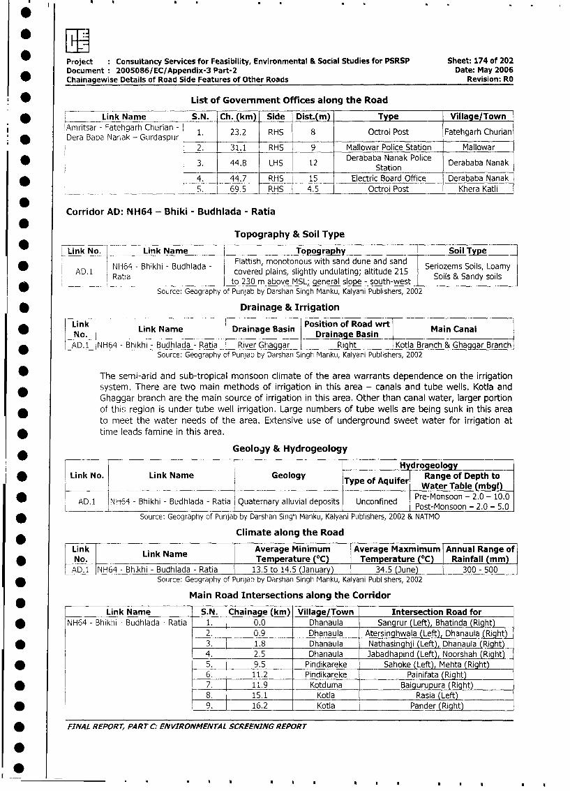
* LL-Project Consultancy Services for Feasibility, Environmental & Social Studies for PSRSP Sheet: 174 of 202Document 2005086/EC/Appendix-3 Part-2 Date: May 2006
Chairiagewise Details of Road Side Features of Other Roads Revision: RO
* List of Government Offices along the Road
* _____ Link Na me S. N. Ch. (km) Side Dist.(m) Type Village/Town
Amritsar - Fatehgarh Churian - 1 23.2 RHS 8 Octroi Post Fatehgarh Churian
Dera Baba Narak - Gurdaspur2. 31.1 RHS 9 Mallowar Police Station Mallowar
*3Derababa Nanak Police Derababa Nanak_______ _________ ______ ~Station
* < _4. 44.7 RHS 15 Electric Board Office Derababa Nanak69.S____________ _______6 _ RHS 4_5 Octroi Post Khera Katli
Corridor AD: NH64 - Bhiki - Budhiada - Ratia
Topography & Soil Type
*Link No. Link Name Topography Soil Type
NH64 - Bhikhi - Budhlada - Flattish, monotonous with sand dune and sand Seriozems Soils, Loamy
AD. 1 Rtacovered plains, slightly undulating; altitude 215 Sol&Sadsis
* Source: Geography of Punjab by Darshan Singh Manku, Kalyani Publishers, 2002
* Drainage & Irrigation
Link Link Name Drainage Basin Position of Road wrt Main CanalNo. Drainage Basin
* _AD.1 l1H64 - Bhikhi - Budhlada - Ratia River Ghaggar Right Kotla Branch & Ghaggar BranchSource: Geography of Punjab by Darshan Singh Manku, Kalyani Publishers, 2002
* The semi-arid and sub-tropical monsoon climate of the area warrants dependence on the irrigation
* system. There are two main methods of irrigation in this area - canals and tube wells. Kotla and
Ghaggar branch are the main source of irrigation in this area. Other than canal water, larger portion
* of this region is under tube well irrigation. Large numbers of tube wells are being sunk in this area
to meet the water needs of the area. Extensive use of underground sweet water for irrigation at
time leads famine in this area.
Geology & Hydrogeology
H drogeology
* Link No. Link Name Geology Type of Aquifer Range of Depth to________ _________________
~~~~~~Water Table (mbgl)
* AD1 JNH64 - Bhikhi - Budhlada - Ratia Quaternary alluvial deposits Unconfined Pre-Monsoon - 2.0 - 10.0_______ ____________________
~~~~~~~Post-Monsoon - 2.0 - 5.0
* Source: Geography of Punjab by Darshan Singh Manku, Kalyani Publishers, 2002 & NATMO
Climate along the Road
rLink L N Average Minimum Average Maxmimum Annual Range of
* No. | Lmk NameoTemperature (0C) Temperature (OC) Rainfall (mm)
AD1 |NH64 - Bhikhi - Budhiada - Ratia 13.5 to 14.5 (January) 34.5 (June) 300 -500
* Source: Geography of Punjab by Darshan Singh Manku, Kalyani Publishers, 2002
Main Road Intersections along the Corridor
___ _Link Name S.N. Chainage (km) Village/Town Intersection Road for
* |NH64 - Bhikhi - Budhlada - Ratia 1. 0.0 Dhanaula Sangrur (Left), Bhatinda (Right)
2. 0.9 Dhanaula Atersinghwala (Left), Dhanaula (Right)
* | l 3. 1.8 Dhanaula Nathasinghji (Left), Dhanaula (Right)
4. 2.5 Dhanaula Jabadhapind (Left), Noorshah (Right)
* l l 5. 9.5 Pindikareke Sahoke (Left), Mehta (Right)
6. 11.2 Pindikareke Painifata (Right)
* I L 7. 11.9 Kotduma Baigurupura (Right)8. 15.1 Kotla Rasia (Left) _
* l l 9. J 16.2 Kotla Pander (Right) J
* FINAL REPORT, PART C: ENVIRONMENTAL SCREENING REPORT
I 0~.....
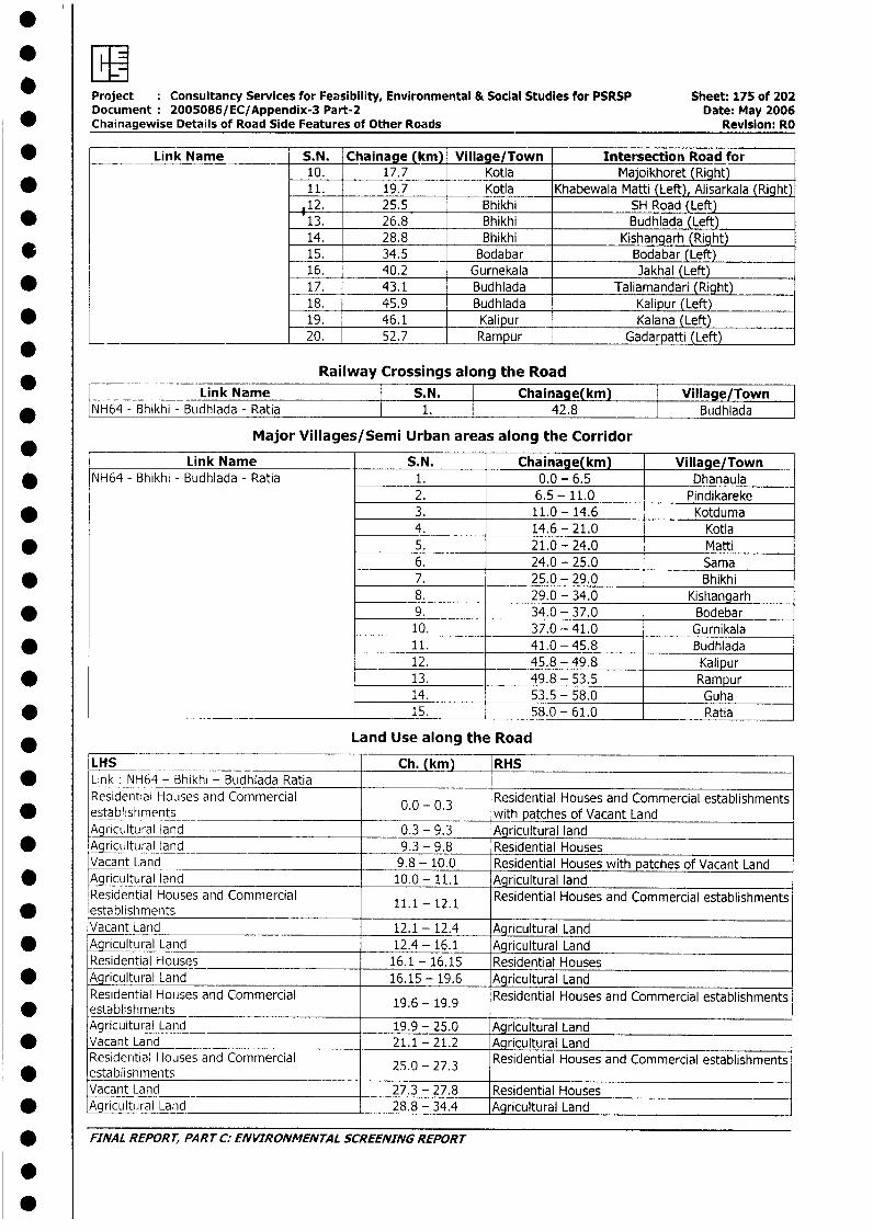
* r.
Project Consultancy Services for Feasibility, Environmental & Social Studies for PSRSP Sheet: 175 of 202Document 2005086/EC/Appendix-3 Part-2 Date: May 2006
_ Chainagewise Details of Road Side Features of Other Roads Revision: RO
* Link Name S.N. Chainage (kni) Village/Town Intersection Road for10. 17.7 Kotla Majoikhoret (Right)
* 11. 19.7 Kotla Khabewala Matti (Left), Alisarkala (Right)112. 25.5 Bhikhi SH Road (Left)
* 13. 26.8 Bhikhi Budhlada (Left)14. 28.8 Bhikhi Kishangarh (Right)
* 15. 34.5 Bodabar Bodabar (Left)16. 40.2 Gurnekala Jakhal (Left)
* 17. 43.1 Budhlada Taliamandari (Right)18. 45.9 Budhlada Kalipur (Left)
* 19. 46.1 Kalipur Kalana (Left)* ~ __20. 52.7 Rampur Gadarpatti (Left)
Railway Crossings along the RoadLink Name | S.N. | Chainage(km) Village/Town 7
* |NH64 - Bhikhi - Budhlada - Ratia 1. 42.8 Budhlada
Major Villages/Semi Urban areas along the Corridor
Link Name S.N. Chainage(kkm) Village/Town* NH64 - Bhikhi - Budhlada - Ratia 1. 0.0 - 6.5 Dhanaula
2. 6.5 - 11.0 Pindikareke* 3. 11.0 - 14.6 Kotduma
4. 14.6 - 21.0 Kotla* 5. 21.0- 24.0 Matti
6. 24.0 - 25.0 Sama* 7. 25.0 - 29.0 Bhikhi
8. 29.0 - 34.0 Kishangarh* 9. 34.0 - 37.0 Bodebar
10. 37.0 - 41.0 Gurnikala* 11. 41.0 - 45.8 Budhlada
12. 45.8 - 49.8 Kalipur* 13. 49.8 - 53.5 Rampur
14. 53.5 - 58.0 Guha* _______ _ ________________________ ______________ 15. 58.0 - 61.0 Ratia
Land Use along the RoadLHS Ch. (km) RHS
* Link NH64 - Bhikhi - Budhlada RatiaResidential Houses and Commercial Residential Houses and Commercial establishments
* establishments 0.0 - 0.3 with patches of Vacant LandAgricultural land 0.3 - 9.3 Agricultural land
* Agricultural land 9.3 - 9.8 Residential HousesVacant Land 9.8 - 10.0 Residential Houses with patches of Vacant Land
* Agricultural land 10.0-11.1 Agricultural landResidential Houses and Commercial 11.1 - 12.1 Residential Houses and Commercial establishments
* establishmentsVacant Land 12.1 - 12.4 Agricultural Land
* Agricultural Land 12.4 - 16.1 Agricultural LandResidential Houses 16.1 - 16.15 Residential Houses
* Agricultural Land 16.15 - 19.6 Agricultural LandResidential Houses and Commercial 19.6 - 19.9 Residential Houses and Commercial establishments
* establishmentsAgricultural Land 19.9 - 25.0 Agricultural Land
* Vacant Land 21.1 - 21.2 Agricultural LandResidential Houses and Commercial 25.0 - 27.3 Residential Houses and Commercial establishments
* establishmentsVacant Land 27.3 - 27.8 Residential Houses
* gAricultural Land 28.8 - 34.4 Agricultural Land
* FINAL REPORT, PART C: ENVIRONMENTAL SCREENING REPORT
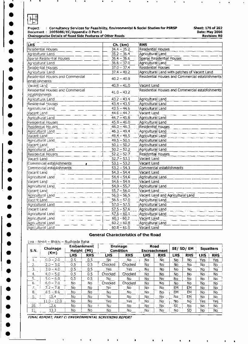
Project Consultancy Services for Feasibility, Environmental & Social Studies for PSRSP Sheet: 176 of 202
* Document: 2005086/EC/Appendix-3 Part-2 Date: May 2006
Chainagewise Details of Road Side Features of Other Roads Revision: RO
LHS Ch. (km) RHS
* Residential Houses 34.4 - 35.2 Residential Houses
Agricultural Land 35.2 - 36.4 Agricultural Land
Sp arse Residential Houses 36.4 - 36.6 Sparse Residential Houses
Agricultural Land 36.6 - 37.0 Agricultural Land
* Residential Houses 37.0 - 37.4 Residential Houses
Agrcultural Land 37.4 - 40.2 Agricultural Land with patches of Vacant Land
Residential Houses and Commercial 40.2 - 40.9 Residential Houses and Commercial establishments
establishments ___
* Vacant Land 40.9 - 41.0 Vacant Land
Residential Houses and Commercial 41.0 - 43.2 Residential Houses and Commercial establishments
establishmentsA ricultural Land 43.2 - 43.4 Agricultural Land
Residential Houses 43.4 - 43.5 Agricultural Land
_r icultural Land 43.5 - 44.6 Agricultural Land
* Vacant Land 44.6 - 44.7 Vacant Land
Agricultural Land 44.7 - 45.8 Agricultural Land
[Residential Houses 45.8 - 46.0 Agricultural Land
Residential Hoises 46.0 - 46.3 Residential Houses
* Aqricultural Land 46.3 - 49.4 Agricultural Land
Vacant Land 49.4 - 49.5 Agricultural Land
A ricultural Land 49.5 - 50.1 Agricultural Land
Vacant Land 50.1 - 50.2 Agricultural Land
* Agricultural Land 50.2 - 52.2 Agricultural Land
Residential Houses 52.2 - 52.7 Residential Houses
Vacant Land 52.7 - 53.1 Vacant Land
Commercial establishments 53.1 - 53.2 Vacant Land
Commercial establishnents 53.2 - 54.3 Commercial establishments
Vacant Land 54.3 - 54.4 Vacant Land
* Agricultural Land 54.4 - 54.6 Agricultural Land
Vacant Land 54.6 - 54.9 Vacant Land
* Agricultural Land 54.9 - 55.7 Agricultural Land
Vacant Land 55.7 - 56.0 Vacant Land
Aoricultural Land 56.0 - 56.5 Vacant Land and Agricultural Land
Vacant Land 56.5 - 57.0 Agricultural Land
* Agricultural Land 57.0 - 57.5 Agricultural Land
Vacant Land 57.5 - 57.6 Agricultural Land
_ Agricultural Land 57.6 - 60.1 Agricultural Land
Agricultural Land 60.1 - 60.2 Vacant Land
* Aj ultural Land 60.2 - 60.8 Agricultural Land
Agricultural Land 60.8 - 61.0 Vacant Land
* General Characteristics of the Road
Link: NH64 - Bhikhi - Budhlada Ratia
Chainage Embankment Drainage Road
* S.N. (Krin) Height (Mt) Condition EncroachmentLHS RHS LHS RHS LHS RHS LHS RHS LHS RHS
* 1. 0.0 - 2.0 0.5 0.5 No No No No No No Yes Yes
2. 2.0 - 3.0 0.5 0.5 Chocked Chocked No No No No No No
* 3. 3.0 - 4.0 0.5 0.5 Yes Yes No No No No No No
4. | 4.0 - 5.0 0.5 0.5 Chocked Chocked No No No No No No
* _5. 5.0 - 6.0 0.5 0.5 No No No No No No No No
6. 6.0 - 7.0 No No Chocked Chocked No No No No No No
I * L7. 1 7.2 - 7.8 No No No No No No EM EM No No
8. I 8.5 - 8.6 No No No No No No EM EM No No
9. _10.4 |No No No No No No No EM No No
l X -_|_ 11.0 - 12.0 No No Yes Yes No No No No Yes Yes
| * r10. 12.6 No No No No No No SE No No No
11. I 13.3 No No No No No No No SD No No
FINAL REPORT, PART C: ENVIRONMENTAL SCREENING REPORT
1-
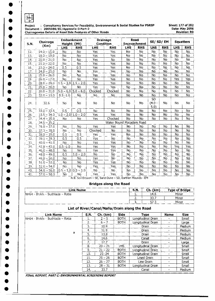
Project :Consultancy Services for Feasibility, Environmental & Social Studies for PSRSP Sheet: 177 of 202
*Document :2005086/EC/Appendix-3 Part-2 Date: May 2006
Chainagewise Details of Road Side Features of Other Roads Revision: RO
Chain Embankment Drainage Road S/S/E qatr
S. N. Chanag Height (Mt) Condition __Encroachment S/S/E qatr* (Kin) ~~~~~LHS RHS LHS RHS LHS RHS LHS RHS LHS RHS
* ~~~12._ 14.0 -15.0 No No Yes Yes -No No No No No No
13. 18.0 - 19.0 No No Yes Yes No No No No No No
* 1~~~4. 20.0 -21.0 No No Yes No No No No No No No
15. 21.0 -22.0 No No Yes Yes No No No No No No
* 1-6. 23.0 - 24.0 0.5 ,0.5 Yes Yes No No No INo No No
17. 24.0 - 25.0 No No Yes Yes No No No No No No
* ~~~18. 25.0 - 26.0 No No Yes Yes No No No No No No
19. 26.0 - 27.0 No No Yes Yes No No No No Yes Yes
* ~~~20. 28.0 - 29.0 1.5 - 3.0 1.5 - 2.0 Yes Yes No No No No No No
21. 29.0 - 30.0 No No Yes Yes No No No No No No
22__ 32.0 - 33.0 50. -16. 5.No-6. Nhoe Nhoe No No No No No No
* 22. ~~~30.0 -31.0 05.0-6.0 5.06. Choe Choe No No No No No0 No
* ~~~~~~~~~~~~~~~~~~~SD24. 32.6 No No No No No No (4.0 - No No No
* _ ~~~~~~~~~~~~~~~~~~~~~~~~~~5.0) _
25. 133.0 - 33.5 0.5 0.5 No No No No No No No No
* ~~~26. 33.5 - 34.0 1.0 - 2.0 1.0 - 2.0 Yes Yes No No No No No No
27. 34.4 - 35.0 No No Yes Chocked No No No No No No
* ~~~28.- _ 34.5 - 35.2 Water Bound Macadam Road ___
29. 316.0 - 37.0 No No Yes Yes No No No No No No
* ~~~~30. 37.0 - 38.0 No No Chocked No No No No No No No
31. 38.0 - 39.0 0.5 0.5 Yes Yes No No No No No No
* ~~~~32. 39.1 - 39.3 0.5 0.5 Yes No No No No No No No
33. 40.0 - 41.0 No No Yes Yes No No No No No No
* ~~~~34. -42.8 - 43.0 0.5 -1.0 No Yes Yes No No No No Yes Yes
35. 46.0 - 48.0 No No Yes Yes No No No No No No
* ~~~~36. 48.0 - 49.0 0.5 1.0 - 2.0 No No No No No No No0 No
37. 49.0 - 50.0 No No Yes No No No No No No No
* ~~~~38. 51.0 - 52.0 No No Yes Yes No No No No No No
39. 5.-5. No -[No Yes Yes No No No No No No-
* ~~~~40. 54.0 -56.0 0.5 -1.0 0.5 -1.0 No No No No No - No No No
41. 57.0 - 58.0 No No Yes Yes No No No No -No No
* ~~~~~~~~~~~~N.B: Soil Erosion - SE, Sand Dune - SD, Earthen Mounds - EM
Bridges along the Road
______ ~~~~~Link Name S.N. Ch. (kin) Type of Bridge
* ~~~NH64 - Bhikhi - Budhlada - Ratia I1. 14.6 Minor2. 33.7 Minor
* _________ ~~~ ~~~~ ~ ~~~~~~~~~~~~~3. 57.3 Minor
List of River/Canal/Nalla/Drain along the Road
Link Name S.N. Ch. (kmn) Side Type Name Size
* N~~~_H64 - Bhikhi - Budhlada - Ratia -1. 2 - 5 BOTH Longitudinal Drain - Small
2. 6 - 7 BOTH Longitudinal Drain - Large
* ~~~ ~~~~~~~~~~ ~ ~~3. 10.9 Drain - Medium
-4. _11.9 Drain - Medium
* ~~~ ~~~~~~~~~~ ~ ~~5. 13.8 Drain - Medium
6. 14.6 Canal - Medium
* ~~~ ~~~~~~~~~~ ~ ~~7. 17.7 Drain - Large
8. 20 - 21 LHS Longitudinal Drain - Small
* ~~~ ~~~~~~~~ ~~~~~~9. 21 - 22 BOTH Longitudinal Drain - Small
10. 23 -24 BOTH Longitudinal Drain - Small
* ~~~~~~~~~~~~~~ ~~11. .25 - 26 BOTH Lined Drain - Small12. 26 - 27 BOTH Line Drain I - Small
* ~~~~~~~~~~~~ ~~~~13. 28 - 31 BOTH Longitudinal Drain - Small
14. 33.7 Canal - Medium
* ~~FINAL REPORT, PARTrC: ENvIRONMENTAL sCREENING REPoRT
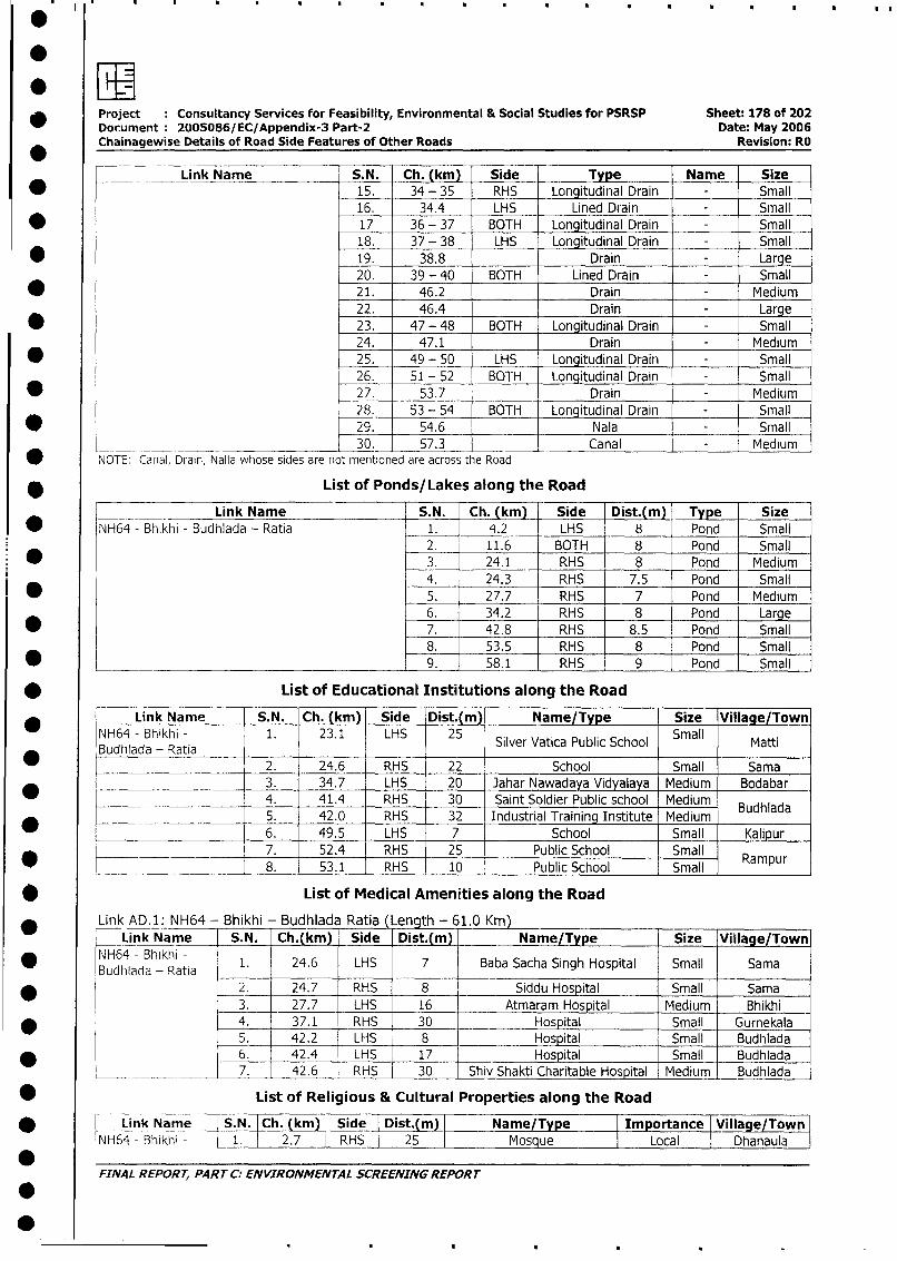
* Project : Consultancy Services for Feasibility, Environmental & Social Studies for PSRSP Sheet: 178 of 202Document: 2005086/ EC/Appendix-3 Part-2 Date: May 2006Chainagewise Details of Road Side Features of Other Roads Revision: RO
Link Name S.N. Ch. (km) Side Type Name Size
* 15. 34 - 35 RHS Longitudinal Drain - Small
16. 34.4 LHS Lined Drain - Small
* 17 36 - 37 BOTH Longitudinal Drain - Small
18. 37 - 38 LHS Longitudinal Drain - Small
* 19. 38.8 _ Drain - Large
20. 39 - 40 BOTH Lined Drain - Small
* 21. 46.2 Drain - Medium
22. 46.4 Drain - Large
* 23. 47 - 48 BOTH Longitudinal Drain - Small24. 47.1 Drain - Medium
* 25. 49 - 50 LHS Longitudinal Drain - Small26. 51 - 52 BOTH Longitudinal Drain - Small
* 27. 53.7 Drain - Medium
28. 53 - 54 BOTH Longitudinal Drain - Small
* 29. 54.6 Nala - Small30. 57.3 _ Canal - Medium
NOTE: Carial, Drain, Nalla whose sides are not mentioned are across the Road
* List of Ponds/Lakes along the Road
Link Name S.N. Ch. (kmL Side Dist.(m) __Type Size
L NH64 - Bhikhi - Budhlada - Ratia 1. 4.2 LHS 8 Pond Small
2. 11.6 BOTH 8 Pond Small
3. 24.1 RHS 8 Pond Medium
4. 24.3 RHS 7.5 Pond Small
l * 5. 27.7 RHS 7 Pond Medium6. 34.2 RHS 8 Pond Large
* 7. 42.8 RHS 8.5 Pond Small
8. 0 53.5 RHS 8 Pond Small
* _ __ 9. 58.1 RHS 9 Pond Small
* List of Educational Institutions along the Road
Link Name [ S.N. Ch. (km) Side Dist.(m) Name/Type Size Village/Town
NH64 - Bhikhi - 1. 23.1 LHS 25 Silver Vatica Public School Small Matti
_ ~~~Budtillada - Ratia Sive Vaic Puli Scollat
Budhiada - Ratia 2. 24.6 RHS 22 School Small Sama
3. 34.7 LHS 20 Jahar Nawadaya Vidyalaya Medium Bodabar
4. 41.4 RHS 30 Saint Soldier Public school Medium Budhlada
*____ 5. 42.0 RHS 32 Industrial Training Institute Medium
6. 49.5 LHS 7 School Small Kalipur
*__ ____|__ 7. | 52.4 RHS 25 Public School Small Rampur
* __ l___________ 8. 53.1 RHS 10 Public School Small | aPur
* List of Medical Amenities along the Road
Link AD.1: NH64 - Bhikhi - Budhlada Ratia (Length - 61.0 Krn)
Link Name S.N. Ch.(km) Side Dist.r(m) Name/Type Size Village/Town
Bud4adahik -Rata 1. 24.6 LHS 7 Baba Sacha Singh Hospital Small Sama
2. 24.7 RHS 8 Siddu Hospital Small Sama
3. 27.7 LHS 16 | Atmaram Hospital Medium Bhikhi I
4. 37.1 RHS 30 Hospital Small Gurnekala
5. 42.2 LHS 8 Hospital Small Budhlada
* | 1 6. 1 42.4 | LHS 17 Hospital Small Budhlada
L_ __ __ 7. 42.6 RHS 30 Shiv Shakti Charitable Hospital Medium Budhlada l
* List of Religious & Cultural Properties along the Road
* L _ink Name | S.N. I Ch. (km) I Side I Dist.(m) Name/Type | ortance Village/Town
|NH64 - Bhikhi - l1. 2.7 RHS 25 Mosque Local Dhanaula
FINAL REPORT, PART C: ENVIRONMENTAL SCREENING REPORT
.
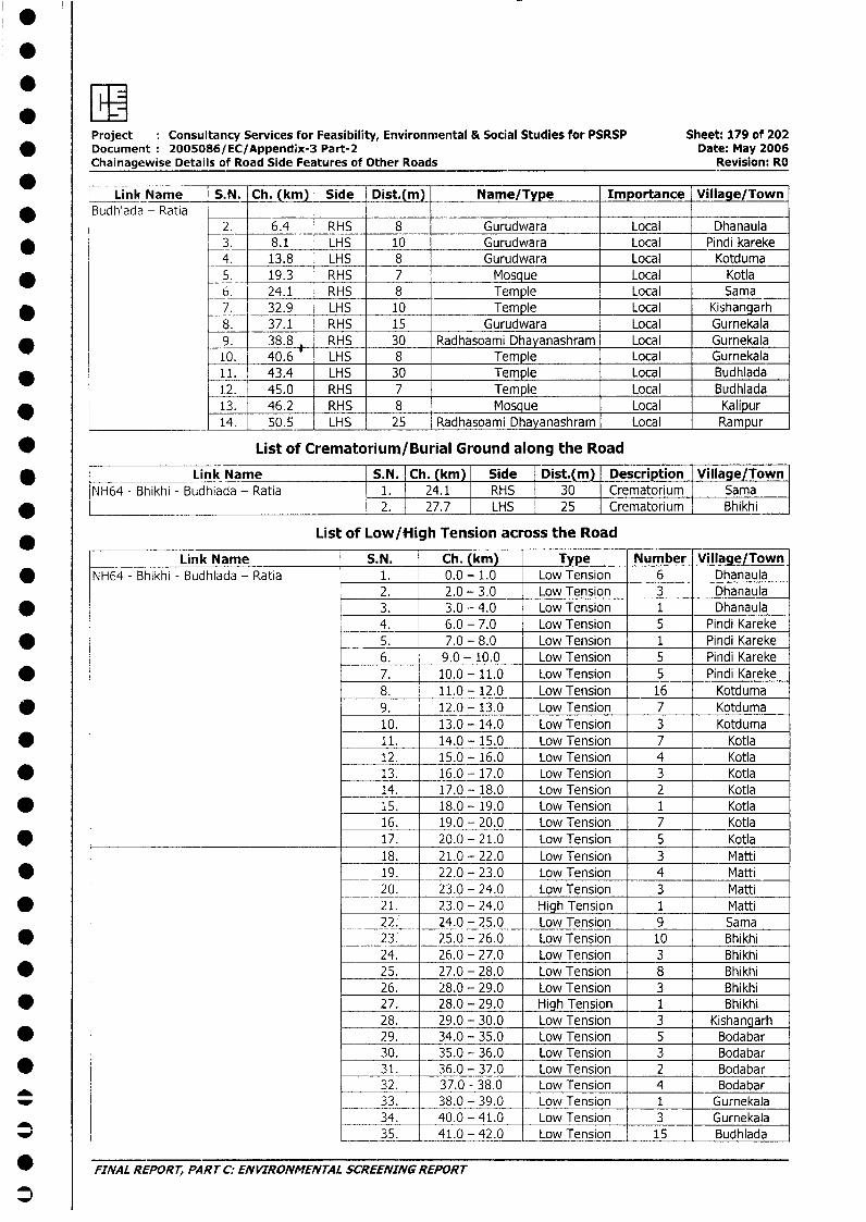
.EIProject Consultancy Services for Feasibility, Environmental & Social Studies for PSRSP Sheet: 179 of 202
* Document: 2005086/EC/Appendix-3 Part-2 Date: May 2006Chainagewise Details of Road Side Features of Other Roads Revision: RO
Li nkh Name S.N. Ch. (km) Side Dist.(m) Name/Type Importance Village/Town_ |Budhlada- Ratia
2. 6.4 RHS 8 Gurudwara Local Dhanaula* 3. 8.1 LHS 10 Gurudwara Local Pindi kareke
4. 13.8 LHS 8 Gurudwara Local Kotduma* 5. 19.3 RHS 7 Mosque Local Kotla
_6. 24.1 RHS 8 Temple Local Sama* 7. 32.9 LHS 10 Temple Local Kishangarh
8. 37.1 RHS 15 Gurudwara Local Gurnekala9. 38.8 RHS 30 Radhasoami Dhayanashram Local Gurnekala10. 40.6 LHS 8 Temple Local Gurnekala
* _11. 43.4 LHS 30 Temple Local Budhlada1.2. 45.0 RHS 7 Temple Local Budhlada13. 46.2 RHS _ 8 Mosque Local Kalipur14. 50.5 LHS 25 Radhasoami Dhayanashram Local Rampur
* List of Crematorium/Burial Ground along the Road
Bhikhi - Link Name S.N. | Ch. (km) Side Dist.(m) Description Village/TownNH64 - Bhikhi - Budhiada - Ratia 1. 24.1 RHS 30 Crematorium Sama
* _ _____________________________________ j 2. l 27.7 LHS 25 Crematorium Bhikhi
List of Low/High Tension across the Road
Link Name S.N. Ch. (km) Type Number Village/Town* NH64 - Bhikhi - Budhlada - Ratia 1. 0.0 - 1.0 Low Tension 6 Dhanaula
2. 2.0 - 3.0 Low Tension 3 Dhanaula* 3. 3.0 - 4.0 Low Tension 1 Dhanaula
4. 6.0 - 7.0 Low Tension 5 Pindi Kareke* 5. 7.0 - 8.0 Low Tension 1 Pindi Kareke
6. 9.0 - 10.0 Low Tension 5 Pindi Kareke* 7. 10.0 - 11.0 Low Tension 5 Pindi Kareke
8. 11.0 - 12.0 Low Tension 16 Kotduma*@ 9. 12.0 - 13.0 Low Tension 7 Kotduma
10. 13.0 - 14.0 Low Tension 3 Kotduma* 11. 14.0 - 15.0 Low Tension 7 Kotla
12. 15.0 - 16.0 Low Tension 4 Kotla* 13. 16.0 - 17.0 Low Tension 3 Kotla
14. 17.0 - 18.0 Low Tension 2 Kotla* 15. 18.0 - 19.0 Low Tension 1 Kotla
16. 19.0 - 20.0 Low Tension 7 Kotla* 17. 20.0 - 21.0 Low Tension 5 Kotla
18. 21.0 - 22.0 Low Tension 3 Matti* 19. 22.0 - 23.0 Low Tension 4 Matti
20. 23.0 - 24.0 Low Tension 3 Matti* 21. 23.0 - 24.0 High Tension 1 Matti
22. 24.0 - 25.0 Low Tension 9 Sama* 23: 25.0 - 26.0 Low Tension 10 Bhikhi
24. 26.0 - 27.0 Low Tension 3 Bhikhi* 25. 27.0 - 28.0 Low Tension 8 Bhikhi
26. 28.0 - 29.0 Low Tension 3 Bhikhi* 27. 28.0 - 29.0 High Tension 1 Bhikhi
28. 29.0 - 30.0 Low Tension 3 Kishangarh* _ 29. 34.0 - 35.0 Low Tension 5 Bodabar
30. 35.0 - 36.0 Low Tension 3 Bodabar* 31. 36.0 - 37.0 Low Tension 2 Bodabar
32. 37.0 - 38.0 Low Tension 4 Bodabar_ 33. 38.0 - 39.0 Low Tension 1 Gurnekala
34. 40.0 - 41.0 Low Tension 3 Gurnekala_ 35. 41.0 - 42.0 Low Tension 15 Budhlada
* FINAL REPORT, PART C: ENVIRONMENTAL SCREENING REPORT
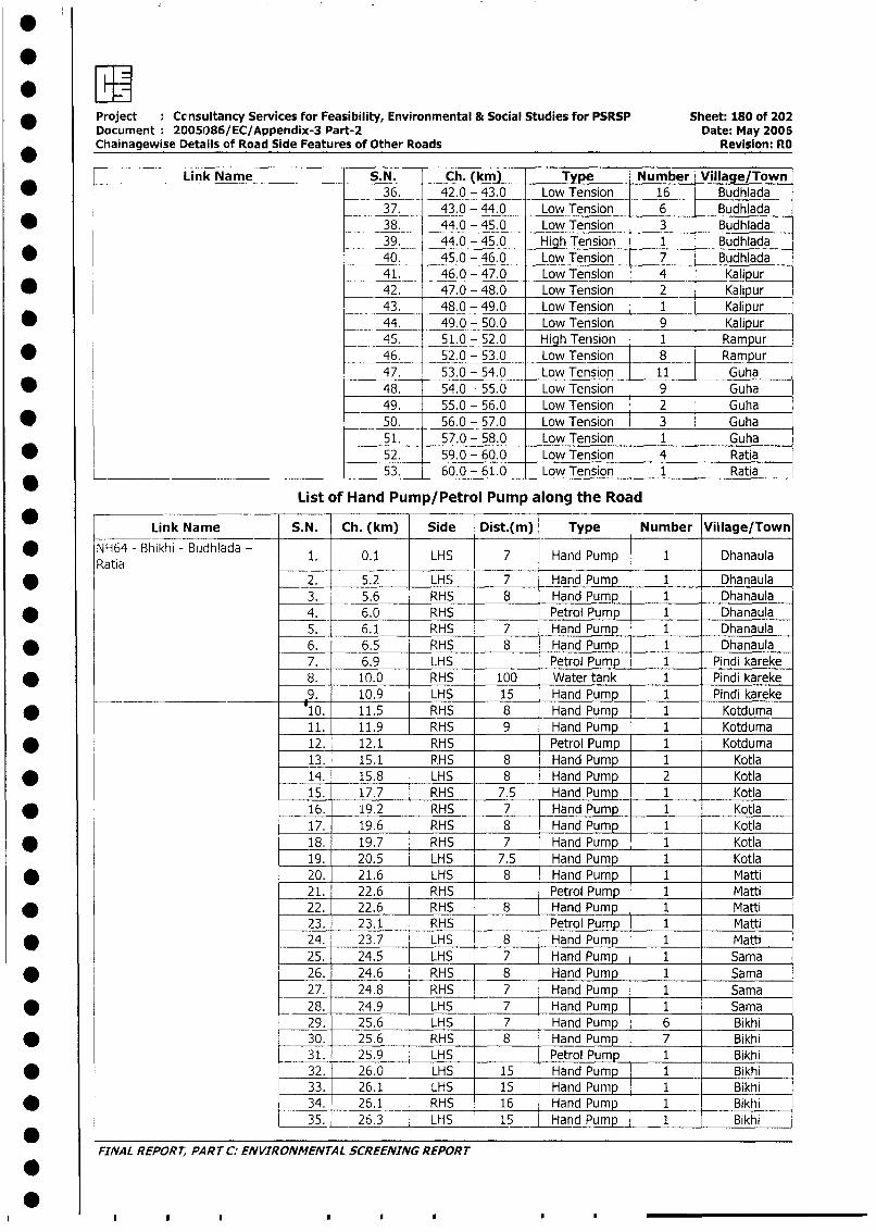
* Project : Ccnsultancy Services for Feasibility, Environmental & Social Studies for PSRSP Sheet: 180 of 202Document: 2005086/EC/Appendix-3 Part-2 Date: May 2006Chainagewise Details of Road Side Features of Other Roads Revision: RO
Link Name S.N. Ch. (km) Type Number Village/Town36. 42.0 - 43.0 Low Tension 16 Budhlada37. 43.0 - 44.0 Low Tension 6 Budhlada
* 38. 44.0 - 45.0 Low Tension 3 Budhlada39. 44.0 - 45.0 High Tension 1 Budhlada
* 40. 45.0 - 46.0 Low Tension 7 Budhlada41. 46.0 - 47.0 Low Tension 4 Kalipur
* 42. 47.0 - 48.0 Low Tension 2 Kalipur43. 48.0 - 49.0 Low Tension 1 Kalipur
* _ 44. 49.0 - 50.0 Low Tension 9 _ Kalipur45. 51.0 - 52.0 High Tension 1 Rampur
* 46. 52.0 - 53.0 Low Tension 8 Rampur47. 53.0 - 54.0 Low Tension 11 Guha
* 0 48. 54.0 - 55.0 Low Tension 9 Guha49. 55.0 - 56.0 Low Tension 2 Guha
* 50. 56.0 - 57.0 Low Tension 3 Guha51. 57.0 - 58.0 Low Tension 1 Guha
* 52. _59.0 - 60.0 Low Tension 4 Ratia*_____ 53. 60.0 - 61.0 Low Tension 1 Ratia
List of Hand Pump/Petrol Pump along the Road
* Link Name S. N. Ch. (kkm) Side Dist.(m) Type Number Viblage/Town* NH64 - Bhikhi - Budhiada - 1. 0.1 LHS 7 Hand Pump 1 Dhanaula
Ratia __ 52H7 a Pm1nu* ~~~ ~~~~ ~~~~ ~~2. 5.2 LHS 7 HnPup 1 Dhanaula
3. 5.6 RHS 8 Hand Pump 1 _ Dhanaula* 4. 6.0 RHS Petrol Pump 1 Dhanaula
5. 6.1 RHS 7 Hand Pump 1 Dhanaula* 6. 6.5 RHS 8 Hand Pump 1 Dhanaula
7. 6.9 I-HS Petrol Pump 1 Pindi kareke* 8. 10.0 RHS 100 Water tank 1 Pindi kareke
.9. 10.9 LHS 15 Hand Pump 1 Pindi kareke* 10. 11.5 RHS 8 Hand Pump 1 Kotduma
11. 11.9 RHS 9 Hand Pump 1 Kotduma* 12. 12.1 RHS Petrol Pump 1 Kotduma
13. 15.1 PHS 8 Hand Pump 1 Kotla* _ 14. 15.8 LHS 8 Hand Pump 2 Kotla
15. 17.7 RHS 7.5 Hand Pump 1 Kotla* 16. 19.2 RHS 7 Hand Pump 1 Kotla
17. 19.6 RHS 8 Hand Pump 1 Kotla* 18. 19.7 RHS 7 Hand Pump 1 Kotla
19. 20.5 LHS 7.5 Hand Pump 1 Kotla* 20. 21.6 LHS _8 Hand Pump 1 Matti
21. 22.6 RHS Petrol Pum 1 Matti* 22. 22.6 RHS 8 Hand Pump 1 Matti
23. 23.1 RHS Petrol Pump 1 Matti* 24. 23.7 LHS 8 Hand Pump 1 Matti
25. 24.5 LHS 7 Hand Pump 1 Sama* 26. 24.6 RHS 8 Hand Pump 1 Sama
27. 24.8 RHS 7 Hand Pump 1 Sama* _ 28. 24.9 LHS 7 Hand Pump 1 Sama
29. 25.6 LHS 7 Hand Pump 6 Bikhi* 30. 25.6 RHS 8 Hand Pump 7 Bikhi
31. 25.9 LHS Petrol Pump 1 Bikhi* 32. 26.0 LHS 15 Hand Pump 1 Bikhi
33. 26.1 LHS 15 Hand Pump 1 Bikhi* 34. 26.1 RHS 16 Hand Pump 1 Bikhi
35. 26.3 _ LHS 15 Hand Pump 1 Bikhi*
* ~~FINAL REPORT, PART C: ENVIRONMENTAL SCREENING REPORT
I ,,**

* Project Consultancy Services for Feasibility, Environmental & Social Studies for PSRSP Sheet: 181 of 202Document 2005086/EC/Appendix-3 Part-2 Date: May 2006
* Chainagewise Details of Road Side Features of Other Roads Revision: RO
Link Name S.N. Ch. (km) Side Dist.(m) Type Number Village/Town
36. 26.4 RHS 17 Hand Pump 1 Bikhi
* __37. 26.5 LHS Petrol Pump 1 Bikhi
38. 27.2 RHS 7 Hand Pump 1 Bikhi
39. 27.7 RHS 30 Hand Pump 1 Bikhi
40. 32.4 LHS 8 Hand Pump 1 Kishangarh
* 41. 34.0 RHS 9 Hand Pump 1 Kishangarh
42. 34.1 RHS Petrol Pump 1 Badabar
* _ 43. 34.2 LHS 8 Hand Pump 1 Badabar
44. 34.7 LHS 8 Hand Pump 1 Badabar
* 45. 34.7 RHS 7 Hand Pump 1 Badabar
46. 35.1 LHS 7 Hand Pump 1 Badabar
* 47. 36.6 RHS 8 Hand Pump 1 Badabar
48. 37.0 RHS 8 Hand Pump 1 Badabar
* 49. 37.1 RHS 8 Hand Pump 1 Gurnekala
50. 37.1 RHS 35 Water Tank 1 Gurnekala
* 51. 37.2 BOTH 8 Hand Pump 1 Gurnekala
52. 37.8 RHS 8 Hand PumP 1 Gurnekala
* 53. 38.9 RHS 9 Hand Pump 1 Gurnekala
54. 39.0 RHS Petrol Pump 1 Gurnekala
* 55. 39.4 RHS Petrol Pump 1 Gurnekala
56. 40.2 RHS 7 Hand Pump 1 Gurnekala
* 57. 40.4 RHS 7.5 Hand Pump 1 Gurnekala
58. 40.4 LHS Petrol Pump 1 Gurnekala
* 59. 40.6 LHS 7 Hand Pump 1 Gurnekala
60. 41.1 RHS 20 Hand Pump 1 Budhlada
* _ 61. 41.9 LHS 8 Hand Pump 2 Budhlada
62. 42.1 RHS 38 Water tank 1 Budhlada
* 63. _ 42.3 BOTH 7 Hand Pump 1 Budhlada
64. 42.4 LHS 8 Hand Pump 1 Budhlada
* 65. 42.6 LHS 7 Hand Pump 1 Budhlada
66. 42.6 RHS Petrol Pump 1 Budhlada
* _. 67. 42.9 LHS 7.5 Hand Pump 1 Budhlada
68. 43.1 RHS Petrol Pump 1 Budhlada
* 69. 43.1 LHS 7 Hand Pump 1 Budhlada
70. 43.3 LHS Petrol Pump 1 Budhlada
* 71. 43.4 LHS 7 Hand Pump 1 Budhlada
72. 43.8 LHS 8 Hand Pumnp 1 Budhlada
* 73. 44.5 LHS Petrol Pump 1 Budhlada
74. 45.0 RHS 7 Hand Pump 1 Budhlada
* 75. 45.3 LHS Petrol Pump 1 Budhlada
76. 45.6 RHS 9 Hand Pump 1 Budhlada
* 77. 45.6 RHS Petrol Pump 1 Budhlada
78. 46.2 LHS 8 Hand Pump 2 Kalipur* 79. 47.1 RHS 9 Hand_Pump 1 Kalipur
80. 48.1 LHS 9 Hand Pump 1 Kalipur
* 81. 48.5 LHS 7 Hand Pump 1 Kalipur
82. 49,4 LHS 7.5 Hand Pump 1 Kalipur
* 83. 49.7 LHS 8 Hand Pump 1 Kalipur
84. 49.8 RHS 7 Hand Pump 2 Kalipur
* 85. 50.5 LHS 8 Hand Pump 2 Rampur
86. 52.1 _ RHS 8 Hand Pump 1 Rampur
* 87. 52.5 LHS 8 Hand Pump 3 Rampur
88. 53.3 RHS 6 Hand Pump 1 Rampur
* 1 89. 53.7 RHS Petrol Pump 1 Guha
90. 53.8 RHS 7 Hand Pump 1 Guha
* 91. 54.1 RHS 6 Hand Pump 1 Guha
92. 54.3 RHS Petrol Pump 1 Guha
_^ ~~FINAL REPORT, PART C: ENVIRONMENTAL SCREENING REPORT
3
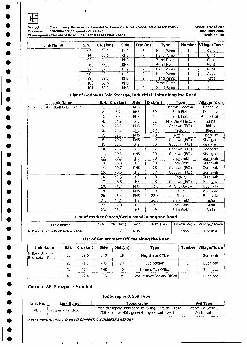
* Project : Consultancy Services for Feasibility, Environmental & Social Studies for PSRSP Sheet: 182 of 202Document 2005086/EC/Appendix-3 Part-2 Date: May 2006
* Chainagewise Details of Road Side Features of Other Roads Revision: RO
* Link Name S.N. Ch. (km) Side Dist.(m) Type Number Village/Town93. 54.9 LHS 6 Hand Pump 1 Guha94. 55.6 RHS 7 Hand Pump 1 Guha95. 55.6 RHS Petrol Pump 1 Guha96. 56.4 RHS Petrol Pump 1 Guha
* 97. 57.3 LHS 7 Hand Pump 1 Guha98. 58.6 LHS 7 Hand Pump 1 Ratia99. 59.3 RHS 9 Hand Pump 1 Ratia100 60.8 RHS Petrol Pump 1 Ratia
_ ~~~~101 60.9 RHS 9 Hand Pump 1 Ratia
List of Godown/Cold Storage/Industrial Units along the RoadLink Name S.N. Ch. (km) Side Dist.(m) Type Village/Town
* NH64 - Bhikhi - Budhlada - Ratia 1. 0.2 RHS 9 Marble Godown Dhanaula2. 3.7 RHS 50 Brick Field Dhanaula
* 3. 8.3 RHS 40 Brick Field Pindi Kareke4. 24.9 LHS 22 Milk Dairy Factory Sama
* 5. 28.2 RHS 35 Godown (FCI) Bhikhi6. 28.5 LHS 17 Factory Bhikhi
* 7. 29.1 RHS 20 Rice Mill Kisangarh8. 29.2 RHS 40 Godown (FCI) Kisangarh
* _ 9. 29.2 LHS 30 Godown (FCI) Kisangarh10. 29.7 LHS 32 Godown (FCI) Kisangarh
* 11. 30.3 RHS 30 Godown (FCI) Kisangarh12. 38.2 LHS 30 Brick Field Gurnekala
* 13. 38.8 LHS 30 Brick Field Gurnekala14. 39.7 RHS 28 Godown (FCI) Gurnekala
* [ ______ _________ 15. 40.0 LHS 27 Godown (FCI) Gurnekala16. 40.8 LHS 18 Factory Gurnekala
* 17. 43.8 LHS 18 Godown (FCI) Budhlada18. 44.7 RHS 32.5 A. N. Industry Budhlada
* 19. 44.9 RHS 30 Store Budhlada20. 45.3 RHS 28.5 Store Budhlada
* 21. 55.1 LHS 26.5 Brick Field Guha22. 57.8 LHS 27.0 Brick Field Guha
* _ 23. 58.4 LHS 19 Brick Field Ratia
List of Market Places/Grain Mandi along the Road
Link Name S.N. Ch. (km) Side Dist. (mi) Description 1Village/TownNH64 - Bhikhi - Budhlada - Ratia 1. 34.2 RHS 8 Mandi Bodabar
* List of Government Offices along the Road
* | Link Name S.N. Ch. (km) Side Dist.(m) Type Number Village/Town
i gBNuHdNh6ada - hRatia 1. 39.6 LHS 18 Magistrate Office 1 Gurnekala
2. 41.1 RHS 20 Sub-Station 1 Budhlada3. 41.4 RHS 10 Income Tax Office 1 Budhlada
l L ______ l___ 4. 42.4 LHS 8 Govt. Market Society Office 1 Budhlada
| * Corridor AE: Firozpur - Faridkot
| * Topography & Soil Type
I w LLink No. Link Name Topography | Soi Typel~ ~~~ ~E l Fiozu - Fardko Flattish to Slightly undulating to rolling; altitude 192 to Bet Soils & Sodic &| * t AE.1 lFirozpur - Faridkot | 208 m above MSL; general slope - south-west Acidic soils
| * FINAL REPORT, PART C: ENVIRONMENTAL SCREENING REPORT
I0
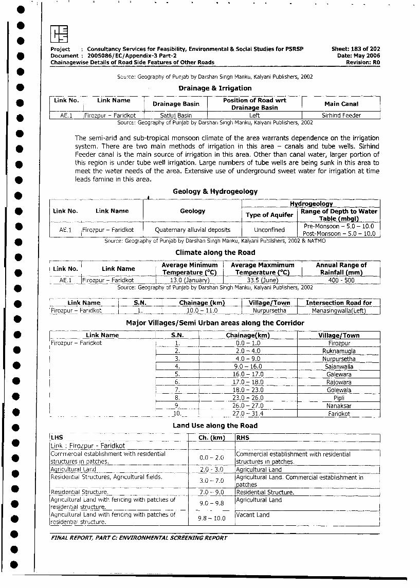
*~~ rpiProject Consultancy Services for Feasibility, Environmental & Social Studies for PSRSP Sheet: 183 of 202
* Document 2005086/EC/Appendix-3 Part-2 Date: May 2006
Chainagewise Details of Road Side Features of Other Roads Revision: RO
* Source: Geography of Punjab by Darshan Singh Manku, Kalyani Publishers, 2002
* Drainage & Irrigation
Link No. Link Name Drainage Basin Position of Road wrt Main Canal
___Drainage Basin I_9AE.1_ Firozpur - Faridkot I Satlui Basin I Left Sirhind Feeder
Source: Geography of Punjab by Darshan Singh Manku, Kalyani Publishers, 2002
The semi-arid and sub-tropical monsoon climate of the area warrants dependence on the irrigation
* system. There are two main methods of irrigation in this area - canals and tube wells. Sirhind
Feeder canal is the main source of irrigation in this area. Other than canal water, larger portion of
this region is under tube well irrigation. Large numbers of tube wells are being sunk in this area to
meet the water needs of the area. Extensive use of underground sweet water for irrigation at time
* leads farriine in this area.
* _______ _____ Geology & Hydrogeology
H drogeology
Link No. Link Name Geology Type ofRange of Depth to WaterType ofAquifer Table (mbgl)
* _____jAE.1 Firozpur - Faridkot Quaternary alluvial deposits Unconfined Pre-Monsoon - 5.0 - 10.0
* Source: Geography of Punjab by Darshan Singh Manku, Kalyani Publishers, 2002 & NATMO
Climate along the Road
Link No. Link Name Average Minimum Average Maxmimum Annual Range of
Temperature (°C) Temperature (°C) Rainfall (mm)
AE.1 Firozpur - Faridkot 13.0 (January) 33.5 (June) 400 - 500
* Source: Geography of Punjab by Darshan Singh Manku, Kalyani Publishers, 2002
* L Link Name S.N. Chainage km) Village Town Intersection Road for
Firozpur- Faridkot 1. 10.0 -11.0 Nurpursetha Manasingwalla(Left)
* Major Villages/Semi Urban areas along the Corridor
* = Link Name S.N. Chainage(km) Village/Town
Firozpur- Faridkot 1. 0.0 - 1.0 Firozpur
* 2. 2.0 - 4.0 Ruknamugla
3. 4.0 - 9.0 Nurpursetha
* 4. 9.0 - 16.0 Saianwalla
5. 16.0 - 17.0 Galewara
* 6. 17.0 -- 18.0 Rajowara
7. 18.0 - 23.0 Golewala
* 8. 23.0 - 26.0 Pipli
9. 26.0 - 27.0 Nanaksar
* _______________ 10. 27.0 - 31.4 Faridkot
* Land Use along the Road
LHS Ch. (km) RHS
* Link Firozpur - Faridkot _-
Commercial establishment with residential 0.0 - 2.0 Commercial establishment with residential
* struct_ues n patches. . . structures in patches.
Agricultural Land _ _ 2.0 - 3.0 Agricultural Land
Residential Structures, Agricultural fields. 3.0 7.0 Agricultural Land. Commercial establishment in
0 3.0 -- 7.0 ~~~~~~~~~~~~~patchesResidential Structure. 7.0 - 9.0 Residential Structure.
Agricultural Land with fencing with patches of 9.0 - 9.8 Agricultural Land
_ residential structure.Agricultural Land with fencing with patches of 9 -10.0 Vacant Land
residential structure. 9.8_- __._
* FINAL REPORT, PART C: ENVIRONMENTAL SCREENING REPORT
I-
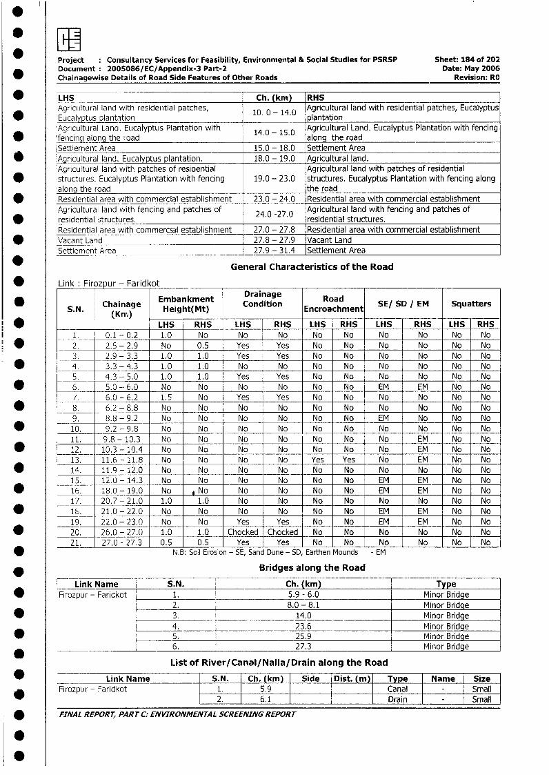
Project Consultancy Services for Feasibility, Environmental & Social Studies for PSRSP Sheet: 184 of 202Document 2005086/EC/Appendix-3 Part-2 Date: May 2006Chainagewise Details of Road Side Features of Other Roads Revision: RO
_ LHS Ch. (km) RHSAgricultural land with residential patches, 10. 0 - 14.0 Agricultural land with residential patches, EucalyptusEucalyptus plantation plantationAgricultural Lana. Eucalyptus Plantation with 14.0 - 15.0 Agricultural Land. Eucalyptus Plantation with fencingfencing along the road along the roadSettlement Area 15.0 - 18.0 Settlement Area
* Agricultural land. Eucalyptus plantation. 18.0 - 19.0 Agricultural land.Agricultural land with patches of resioential Agricultural land with patches of residential
* structures. Eucalyptus Plantation with fencing 19.0 - 23.0 structures. Eucalyptus Plantation with fencing alongalong the road the road
* Residential area with commercial establishment 23.0 - 24.0 Residential area with commercial establishmentAgricultural land with fencing and patches of 24.0 -27.0 Agricultural land with fencing and patches of
* residential structures. 24. . residential structures.Residential area with commercial establishment 27.0 - 27.8 Residential area with commercial establishment
* Vacant Land 27.8 - 27.9 Vacant LandSettlement Area 27.9 - 31.4 Settlement Area
General Characteristics of the Road
* Link: Firozpur - Faridkot
Embankment Drainage Road SE/ SD / EM SquatersChainage ~~~Condition EncroachmenttterS. N. Chamag Height(Mt) Ecocmn
* LHS RHS LHS RHS LHS RHS LHS RHS LHS RHS1. 0.1 - 0.2 1.0 No No No No No No No No No
* 2. 2.5 - 2.9 No 0.5 Yes Yes No No No No No No3. 2.9 - 3.3 1.0 1.0 Yes Yes No No No No No No
* 4. 3.3 - 4.3 1.0 1.0 No No No No No No No No5. 4.3 - 5.0 1.0 1.0 Yes Yes No No No No No No
* 6. 5.0 - 6.0 N o No No No No No EM EM No No7. 6.0 - 6.2 1.5 No Yes Yes No No No No No No
* _8. 6.2 - 8.8 No No No No No No No No No No9. 8.8 - 9.2 No No No No No No EM No No No
* 10. 9.2 - 9.8 No No _ No No No No No No -No No11. 9.8- 10.3 No No No No No No No EM No No
* 12. 10.3 - 10.4 No No No No No No No EM No No13. 11.6 - 11.8 No No No No Yes Yes No EM No No
* 14. 11.9- 12.0 No No No No No No No No No No15. 12.0- 14.3 No No No No No No EM EM No No
* 16. 18.0- 19.0 No *No No No No No EM EM No No17. 20.7 - 21.0 1.0 1.0 No No No No No No No No
* _ 18 . 21.0 - 22.0 No No No No No No EM EM No No1. 22.0 - 23,0 No No Yes Yes No No EM EM No No* 20. 26.0 - 27.0 1.0 1.0 Chocked Chocked No No No No No No
t_21_ 27.0 - 27.3 0.5 0.5 Yes Yes No No No No No No* N.B: Soil Erosion - SE, Sand Dune - SD, Earthen Mounds - EM
* Bridges along the Road
Link Name S.N. Ch. (km) Type* Firozpur - Faridkot 1. 5.9 - 6.0 Minor Bridge
2. 8.0 - 8.1 Minor Bridge* 3. 14.0 Minor Bridge
4. 23.6 Minor Bridge* 5. 25.9 Minor Bridge
6. 27.3 Minor Bridge
List of River/Canal/Nalla/Drain along the Road
* <_ Link Name S.N. Ch. (km) |_Side Dist. m Type Name SizeFirozpur - Faridkot 1. 5.9 | | Canal | - Small
2. 6.1 Drain - Small
* FINAL REPORT, PART C: ENVIRONMENTAL SCREENING REPORT
.

* Project Consultancy Services for Feasibility, Environmental & Social Studies for PSRSP Sheet: 185 of 202Document 2005086/EC/Appendix-3 Part-2 Date: May 2006
* Chainagewise Details of Road Side Features of Other Roads Revision: RO
* -- Link Name S.N. Ch. (km) Side Dist. (m) Type Name Size
3. 8.0 Drain Small* = 4. 7.1 RHS 7.0 Lined drain - Small
5. 7.7 Nalla - Small* 6. 10.0 _ __ Drain - Small
7. 11.1 BOTH 6.8 Lined Drain - Small* _8._ 14.0 _ _ LHS 6.6 Dried drain - Small
9. 19.7 Drain - Small* _ 10. 25.9 Canal - Small
_-__ 11 28.7 RHS 7.2 Lined Drain - Small* 6NOTE: Canal, Drain, Nalla whose sides are not mentioned, these are across the Road
* List of Ponds/Lakes along the Road
Link Name S.N. Ch. (km) Side Dist.(m) _ Type SizeFirozpur - Faridkot 1. 1.1 RHS Pond Small
2. 4.7 RHS 6.0 Pond Small3. 7.4 LHS Pond Small4. 10.8 LHS Pond Small
List of Educational Institutions along the Road
* Link Name SN. Ch. (km) Side Dist.(m) Name/Type Size Village/Town
Firozpui - 1. 2.9 RHS 15 School Small Ruknamugla
_ 2. 4.0 LHS 20 Government Elementary School Small Ruknamugla* 3. 9.6 LHS 25 Punjab College of Pharmacy Big Nupursetha
4. 10.3 LHS 25 Government High School Medium Saianwalla* 5. 10.7 RHS 8 S.M.S Ayanwala Memorial School Medium Saianwalla
* 6. 16.9 RHS 8 Government Senior Sikha Secondary Big GalewaraSchool
7. 23.9 RHS 10 School Small Pipli* 8. 24.4 RHS 15 Saint Soldier Public School Medium Pipli
9. 26.9 LHS 15 _ Government Primary School Small Nanaksar10. 28.7 LHS 12 Sandhu Sunder Singh Memorial Meim Frdo
School Medium Faridkot* 11. 28.7 LHS 12 Sri Guru Teg Bahadur Mission School Medium Faridkot
d _~ 12. 30.6 LHS 8 Government Kanya Secondary Medium Faridkot_____ _ _ _ _ _ _ _ _ _ _ _ _ _ _ _ _ _ _ _ _ _ _ _ _S ch o o l_ _ _ _ _ _ _
* List of Medical Amenities along the Road
Link Name _ S.N. Ch.(km) Side Dist. i Name/Type Village/Town Size|Firozpur -Far_kot l1. l 16.6 l RHS |d15ol Clinic Galewara Small
* List of Religious & Cultural Properties along the Road
Link Name S.N. Ch. (km) Side Dist. (m) Name/Type Importance Village/TownFirozpur-ik 1. 0.9 LHS 5 Mazaar Local Firozpur
* | | 2. 1.0 LHS 5 Worship place (Tree) Local Firozpur3. 2.2 LHS 8 Mazaar Local Ruknamugla
I L 4 . 7.6 LHS 8 Gurudwara Local Nupursetha5. 15.6 RHS 8 Worship place (Tree) Local Saianwalla6. 16.3 RHS 12 Gurudwara Local Galewara7. 19.2 LHS 12 Gurudwara Local Rajowara8. 20.7 RHS 23 Radhasoami Dhayanashram Local Golewala
.*L- 9. 23.4 LHS 10 Gurudwara Local Pipli_ ____ __ !10. 27.1 LHS 8 Worship place (Tree) Local Nanksar
* FINAL REPORT, PART C: ENVIRONMENTAL SCREENING REPORr
*
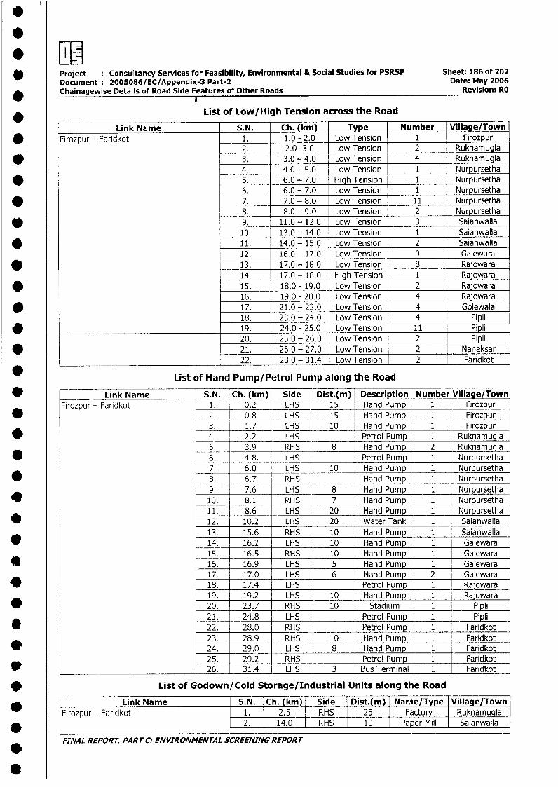
* Project Consultancy Services for Feasibility, Environmental & Social Studies for PSRSP Sheet: 186 of 202Document: 2005086/EC/Appendix-3 Part-2 Date: May 2006Chainagewise Details of Road Side Features of Other Roads Revision: RO
List of Low/High Tension across the Road
Link Name S.N. Ch. (km) Type Number Village/Town* Firozpur - Faridkot 1. 1.0 - 2.0 Low Tension 1 Firozpur
2. 2.0 -3.0 Low Tension 2 Ruknamugla* 3. 3.0 - 4.0 Low Tension 4 Ruknamugla
4. 4.0 - 5.0 Low Tension 1 Nurpursetha* 5. 6.0 - 7.0 High Tension 1 Nurpursetha
6. 6.0 - 7.0 Low Tension 1 Nurpursetha* 7. 7.0 - 8.0 Low Tension 11 Nurpursetha
8. 8.0 - 9.0 Low Tension 2 Nurpursetha* 9. 11.0 - 12.0 Low Tension 3 Saianwalla
10. 13.0 - 14.0 Low Tension 1 Saianwalla* 11. 14.0 - 15.0 Low Tension 2 Saianwalla
12. 16.0 - 17.0 Low Tension 9 Galewara* 13. 17.0 - 18.0 Low Tension 8 Rajowara
14. 17.0 - 18.0 High Tension 1 Rajowara* 15. 18.0 - 19.0 Low Tension 2 Rajowara
16. 19.0 - 20.0 Low Tension 4 Rajowara* 17. 21.0 - 22.0 Low Tension 4 Golewala
18. 23.0 - 24.0 Low Tension 4 Pipli* 19. 24.0 - 25.0 Low Tension 11 Pipli
20. 25.0 - 26.0 Low Tension 2 Pipli* 21. 26.0 - 27.0 Low Tension 2 Nanaksar
____________________________________ 22. 28.0 - 31.4 Low Tension 2 Faridkot
List of Hand Pump/Petrol Pump along the Road
* _ _Link Name S. N. Ch. (kmi) Side Dist.(m) Description Number Village/TownFirozpur - Faridkot 1. 0.2 LHS 15 Hand Pump 1 Firozpur
* 2. 0.8 LHS _ 15 Hand Pump 1 Firozpur3. 1.7 LHS 10 Hand Pump 1 Firozpur
* 4. 2.2 LHS Petrol Pump 1 Ruknamugla5. 3.9 RHS 8 Hand Pump 2 Ruknamugla
* _6. 4.8. LHS Petrol Pump 1 Nurpursetha7. 6.0 LHS 10 Hand Pump 1 Nurpursetha
* 8. 6.7 RHS Hand Pump 1 Nurpursetha9. 7.6 LHS 8 Hand Pump 1 Nurpursetha
* 10. 8.1 RHS 7 Hand Pump 1 Nurpursetha11. 8.6 LHS 20 Hand Pump 1 Nurpursetha
* 12. 10.2 LHS 20 Water Tank 1 Saianwalla13. 15.6 RHS 10 Hand Pump 1 Saianwalla14. 16.2 LHS 10 Hand Pump 1 Galewara15. 16.5 RHS 10 Hand Pump 1 Galewara
* 16. 16.9 LHS 5 Hand Pump 1 Galewara17. 17.0 LHS 6 Hand Pump 2 Galewara
* 18. 17.4 LHS Petrol Pump 1 Rajowara19. 19.2 LHS 10 Hand Pump 1 Rajowara
* 20. 23.7 RHS 10 Stadium 1 Pipli21. 24.8 LHS Petrol Pump 1Pipli
D 22. 28.0 RHS Petrol Pump 1 Faridkot23. 28.9 RHS 10 Hand Pump 1 Faridkot
d 24. 29.n LHS 8 Hand Pump 1 Faridkot25. 29.2 RHS Petrol Pump 1 Faridkot
d _____ 26. 31.4 LHS 3 Bus Terminal 1 Faridkot
v List of Godown/Cold Storage/Industrial Units along the Road
Link Name S.N. Ch. (km) Side Dist.(m) Nanie/Type Village/TownFirozpur - Faridkot 1. 2.5 RHS 25 Factory Ruknamugla
* 2. 14.0 RHS 10 Paper Mill Saianwalla
FINAL REPORT, PART C: ENVIRONMENTAL SCREENING REPORT
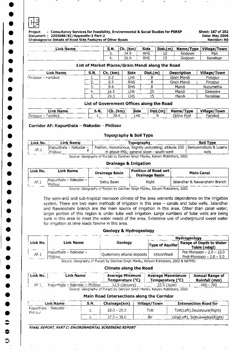
* Project Consultancy Services for Feasibility, Environmental & Social Studies for PSRSP Sheet: 187 of 202
Document 2005086/EC/Appendix-3 Part-2 Date: May 2006
Chainagewise Details of Road Side Features of Other Roads Revision: RO
* l __ ~~Link Name S.N. Ch. (km) |Side Dist.(m) Name/Type Village/Town
* X ~~~~~~~~~~~~~~~~~3. 24.9 lRHS 10 Godown Pipli4. 26.9 lRHS 15 Godown Nanaksar
List of Market Places/Grain Mandi along the Road
* L i Link Name S.N. Ch. (km) Side Dist.(m) Description Village/Town* |Firozpur - Faridkot 1. 0.2 LHS 8 Grain Mandi Firozpur
2. 0.5 RHS 8 Grain Mandi Firozpur
3. 8.8 RHS 8 Mandi Nupursetha4. 16.5 LHS 25 Mandi Galewara
* L____ -- 5. 29.3 LHS 15 Mandi Nanaksar
List of Government Offices along the Road
* -= Link Name S.N. Ch. (km)| Side Dist.(m) Name/Type Village/Town
* FIrozpur - Faridkot 1. 28.9 LHS 8 Octroi Post Faridkot
* Corridor AF: Kapurthala - Nakodar - Phillour
* _ _ _ _ _ Topography & Soil Type
Link No. Link Name Topography Soil Type
* AF.1 Kapurthala - Nakodar - Flattish, monotonous, Slightly undulating; altitude 250 SeriozemsSoils & LoamyAF___ I Phillour I m above MSL; general slope - south-west soils
_ Source: Geography of Punjab by Darshan Singh Manku, Kalyani Publishers, 2002
* Drainage & Irrigation
Link No. Link Name Drainage Basin Position of Road wrt Main Canal
* _____ _______ Drainage Basin
* AF. 1 Kapurthala - Nakodar - Satluj Basin Right Jalandhar & Nawanshahr BranchPhillour
Source: Geography of Punjab by Darshan Singh Manku, Kalyani Publishers, 2002
The semi-arid and sub-tropical monsoon climate of the area warrants dependence on the irrigation
system. There are two main methods of irrigation in this area - canals and tube wells. Jalandhar
and Nawanshahr branch are the main source of irrigation in this area. Other than canal water,
larger portion of this region is under tube well irrigation. Large numbers of tube wells are being
sunk in this area to meet the water needs of the area. Extensive use of underground sweet water
for irrigation at time leads famine in this area.
* Geology & Hydrogeology
* ____ HydrogeologyLink No. Link Name Geology Type of Aquifer Range of Depth to Water
TIfer Table (mbgl)
AF. 1 Pur Quaternary alluvial deposits Unconfined Pre-Monsoon - 2.0 - 10.0
Source: Geography of Punjab by Darshan Singh Manku, Kalyani Publishers, 2002 & NATMO
* Climate along the Road
* rLink No. Link Name Average Minimum Average Maxmimum Annual Range of
___ _ Temperature (°C) Temperature (°C) Rainfall (mm)
* L _ AF.1 rKapurthala - Nakodar - Phillour 12.5 (3anuary) 33.5 (June) | 600 - 700
Source: Geography of Punjab by Darshan Singh Manku, Kalyani Publishers, 2002
* Main Road Intersections along the Corridor
* r == Link Name S.N. Chainage(km) Village/Town Intersection Road for
Kapurthala - Nakodar - 1. 28.0 - 29.0 Tott Tott(Left),Daulatpura(Right)
1. 37.0 - 38.0 Bir Litra( Left), Sidhuswadesi(Right)
l_ ~~FINAL REPORT, PART C: ENVIRONMENTAL SCREENING REPORT
0
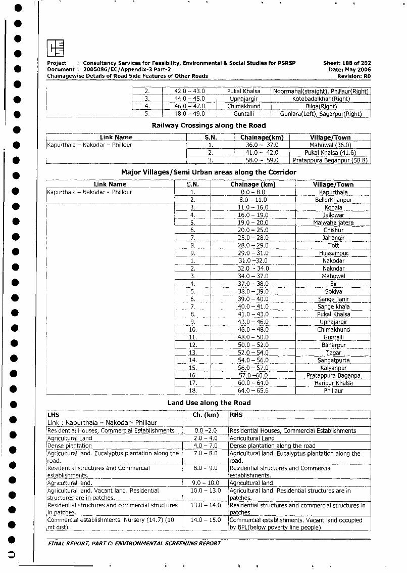
Project Consultancy Services for Feasibility, Environmental & Social Studies for PSRSP Sheet: 188 of 202
* Document 2005086/EC/Appendix-3 Part-2 Date: May 2006
Chainagewise Details of Road Side Features of Other Roads Revision: RO
2. 42.0 - 43.0 Pukal Khalsa Noormahal(straight), Phillaur(Right)
* 3. 44.0 - 45.0 Upnajargir Kotebadalkhan(Right)4. 46.0 - 47.0 Chimakhund Bilra(Right
* L _~ 5. 48.0 - 49.0 Guntalli Gunlara(Left), Sagarpur(Right)
*____- Link Name Railway Crossings along the Road
___ Link Name S.N. Chainage(km) Village/Town
* Kapurthala - Nakodar - Phillour 1. 36.0 - 37.0 Mahuwal (36.0)2. 41.0 - 42.0 Pukal Khalsa (41.6)
* _ | 3. 58.0 - 59.0 Pratappura Beganpur (58.8)
* ____ Major Villages/Semi Urban areas along the Corridor
Link Name S.N. Chainage (km) V/illage/Town
* Kapurthala - Nakodar- Phillour 1. 0.0 - 8.0 Kapurthala2. 8.0 - 11.0 BellerKhanpur
* 3. 11.0 -- 16.0 Kohala4. 16.0 - 19.0 Jallowar
* 5. 19.0 - 20.0 Malwaha iatere
6. 20.0 - 25.0 Chishur
* 7. 25.0 - 28.0 Jahangir
8. 28.0 - 29.0 Tott
* 9. 29.0 - 31.0 Hussainpur.1. 31.0 -32.0 Nakodar
* 2. 32.0 - 34.0 Nakodar
3. 34.0 - 37.0 Mahuwal
* 4. 37.0 - 38.0 Bir
5. 38.0 - 39.0 Sokiya
* 6. 39.0 - 40.0 Sange lanir7. 40.0 - 41.0 Sange khala8. 41.0 - 43.0 Pukal Khalsa
9. 43.0 - 46.0 Upnajargir
* 10. 46.0 - 48.0 Chimakhund11. 48.0 - 50.0 Guntalli
* 12. 50.0 - 52.0 Baharpur13. 52.0 - 54.0 Tagar
* 14. 54.0 - 56.0 Sangatpurta15. 56.0 - 57.0 Kalyanpur
* 16. 57.0 -60.0 Pratappura Baganpa17. 60.0 - 64.0 Haripur Khalsa
* _______________________________________ 18. 64.0 - 65.6 Phillaur
* Land Use along the Road
LHS __ _ Ch. (km) RHS* Link_ Kapurthala - Nakodar- Phillaur
Residential Hos,Commercial Establishments 0.0 -2.0 Residential Houses, Commercial Establishments
grricultural Land 2.0 - 4.0 Agricultural Land
Dense plantation 4.0 - 7.0 Dense plantation along the road
Agricultural land. Eucalyptus plantation along the 7.0 - 8.0 Agricultural land. Eucalyptus plantation along the
road. road.Residential structures and Commercial 8.0 - 9.0 Residential structures and Commercial
establishments. establishments.
_Aaricultural land. 9.0 - 10.0 Agricultural land.
Agricultural land. Vacant land. Residential 10.0 - 13.0 Agricultural land. Residential structures are in
* structures are in patches. patches.
Residential structures and commercial structures 13.0 - 14.0 Residential structures and commercial structures in
in patches. patches.
Commercial establishments. Nursery (14.7) (10 14.0 - 15.0 Commercial establishments. Vacant land occupied
* mt distL. _ by BPL(below poverty line people)
* FINAL REPORT, PART C: ENVIRONMENTAL SCREENING REPORT
S~
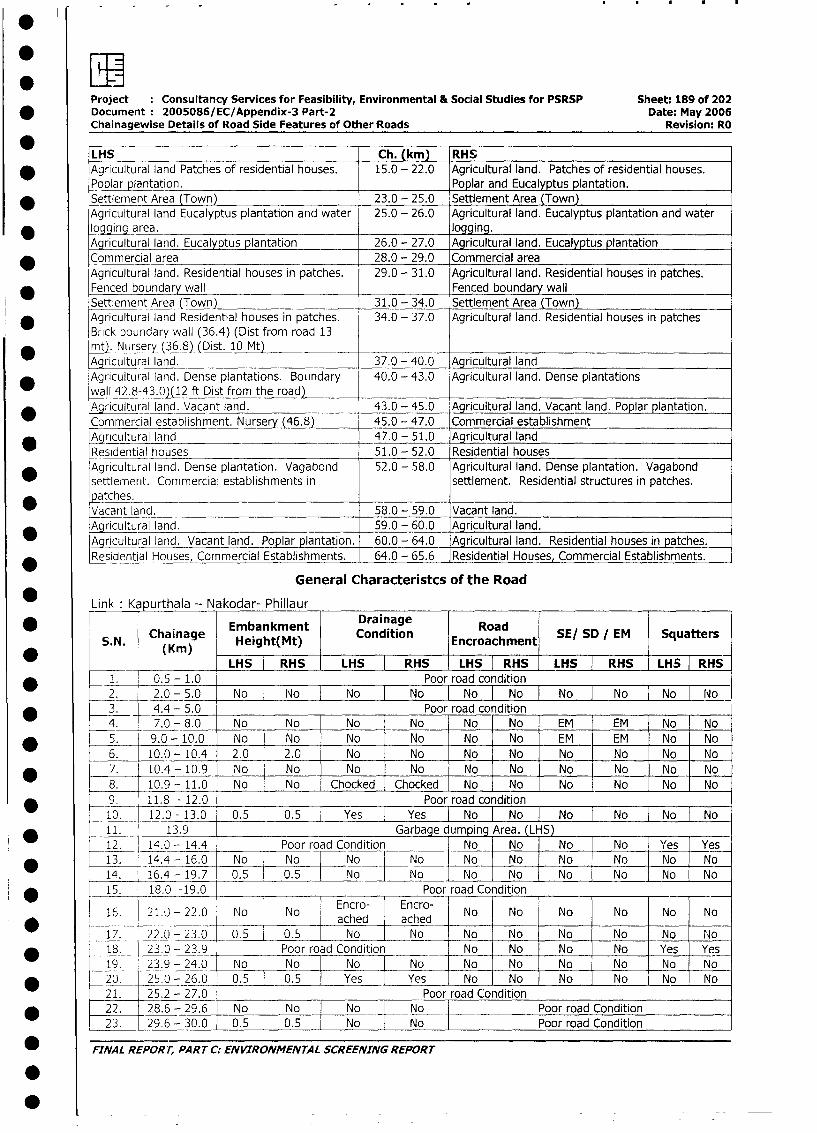
Project Consultancy Services for Feasibility, Environmental & Social Studies for PSRSP Sheet: 189 of 202* Document 2005086/EC/Appendix-3 Part-2 Date: May 2006Chainagewise Details of Road Side Features of Other Roads Revision: RO
LHS Ch. (km) RHS* Agricultural land Patches of residential houses. 15.0 - 22.0 Agricultural land. Patches of residential houses.
Po lar plantation. Poplar and Eucalyptus plantation.Settlement Area (Town) 23.0 - 25.0 Settlement Area (Town)Agricultural land Eucalyptus plantation and water 25.0 - 26.0 Agricultural land. Eucalyptus plantation and water
* logging area. logging.Agricultural land. Eucalyptus plantation 26.0 - 27.0 Agricultural land. Eucalyptus plantationCommercial area 28.0 - 29.0 Commercial areaAgricultural land. Residential houses in patches. 29.0 - 31.0 Agricultural land. Residential houses in patches.
* Fenced boundary wall Fenced boundary wallSettlement Area (Town) 31.0 - 34.0 Settlement Area (Town)
* Agricultural land Residential houses in patches. 34.0 - 37.0 Agricultural land. Residential houses in patchesBrick boundary wall (36.4) (Dist from road 13
* mtr. Nursey (36.8) (Dist. 10 Mt)Agricultural land. 37.0 - 40.0 Agricultural land
* Agricultural land. Dense plantations. BoLindary 40.0 - 43.0 Agricultural land. Dense plantationswall 42.8-43.0)(12 ft Dist from the road)
* Agricultural land. Vacant land. 43.0 - 45.0 Agricultural land. Vacant land. Poplar plantation.Commercial establishment. Nursery f46.8) 45.0 - 47.0 Commercial establishmentAgricultural land 47.0 - 51.0 Agricultural landResidential houses 51.0 - 52.0 Residential houses
* Agricultural land. Dense plantation. Vagabond 52.0 - 58.0 Agricultural land. Dense plantation. Vagabondsettlement. Commercial establishments in settlement. Residential structures in patches.*atches. _Vacant land. 58.0 - 59.0 Vacantland.Agricultural land. 59.0 - 60.0 Agricultural land.Agricultural land. Vacant land. Poplar plantation. 60.0 - 64.0 Agricultural land. Residential houses in patches.Residential Houses, Commercial Establishments. 64.0 - 65.6 Residential Houses, Commercial Establishments.
General Characteristcs of the RoadLink: Ka urthala - Nakodar- Phillaur
Chainaqe Embankment Draina~ge RoadS.N. Chainage Height(Mt) Condition Encroachment SE/ SD / EM Squatters
* _ LHS | RHS | LHS | RHS LHS I RHS LHS RHS |LS RHS1. 0.5 - 1.0 Poor road condition2. 2.0 - 5.0 No No No No No No No No [No|No
* 3. 4.4 - 5.0 Poor road condition4. 7.0- 8.0 No No No No No No EM EM_ No No
* 5. 9.0- 10.0 No No No No No No EM EM No No6. 10.0 - 10.4 2.0 2.0 No No No No No No No No
* 7. 10.4- 10.9 No No No No No No No No No No8. 10.9- 11.0 No No Chocked Chocked No No No No No No9. 11.8 - 12.0 Poor road condition10. 12.0 -13.0 _ 0.5 0.5 Yes Yes No I No I No I No I No 1 No11. 13.9 Garbage dumDing Area. (LHS)12. 14.0 - 14.4 Poor road Condition No No No No Yes Yes* 13. 14.4- 16.0 No | No |- No No No No No No No No14. _16.4- 19.7 0.5 0.5 No No No No No No No No
* | 15. _18.0 -19.0 Poor road Condition
_ 16. 21.0 - 22.0 No No Encro- 1 Encro- No No No No No No* ~~~~~~ ~~~~~~~ached ached ___ _ _ __ _ _ _
17. 22.0 - 23.0 _ 0.5 0.5 | No | No No | No No | No No No* 18.__ 23.0 - 23.9 Poor road Condition | No No No | No Yes Yes
19. 23.9 - 24.0 No No No No No No No | No No No* L_ 20. 25.0 - 26.0 0.5 0.5 Yes | Yes No No No No No No21. 25.2 - 27.0 | Poor road Condition
* 1 22. 28.6 - 29.6 No No NoNoPoor road Condition23. 29.6 - 30.0 0.5 0.5 No No I Poor road Condition
* FINAL REPORT, PART C: ENVIRONMENTAL SCREENING REPORT
0
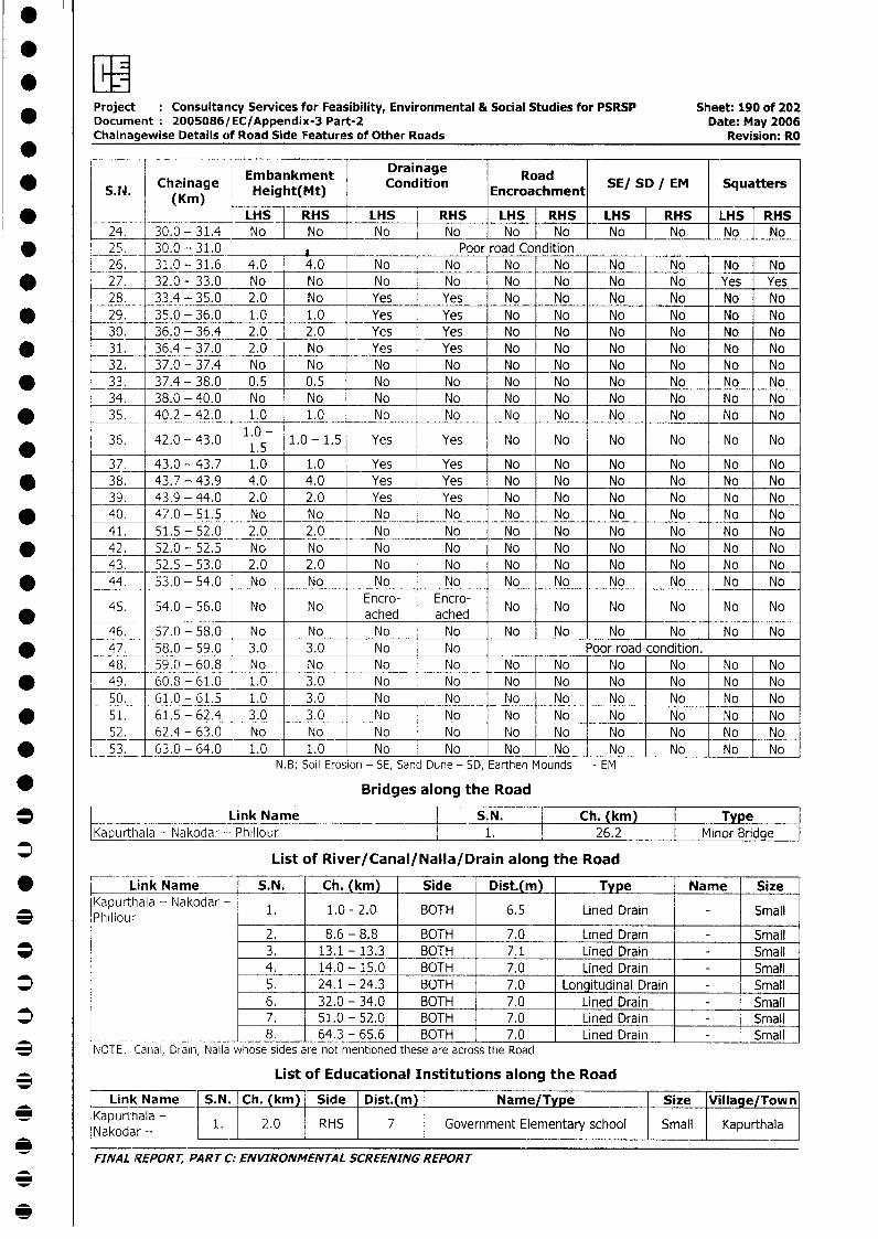
0
Project Consultancy Services for Feasibility, Environmental & Social Studies for PSRSP Sheet: 190 of 202* Document: 2005086/EC/Appendix-3 Part-2 Date: May 2006
Chainagewise Details of Road Side Features of Other Roads Revision: RO
S. W chainagle Height(Mt) Condition Encroachment SE/ SD EM Squatters(Kin) h(t
* _ LHS |RRHS LHS HS LHS RHS LH RHS LHS RHS24. 30.0-31.4 No No oNo No No No No No
* _ 25. 30.0-31.0 A Poor road Condition_ 26. 31.0-31.6 4.0 4.0 No No No No No No No No
* 27. 32.0 - 33.0 No No No No No No No No Yes Yes28. 33.4 - 35.0 2.0 No Yes Yes No No No No No No
* _ 29. 35.0 - 36.0 1.0 1.0 Yes Yes No No No No No No30. 36.0 - 36.4 2.0 2.0 Yes Yes No No No No No No
* _ 31. 36.4 - 37.0 2.0 No Yes Yes No No No No No No32. 37.0-37.4 No No No No No No No No No No
* _ 33. 37.4-38.0 0.5 0.5 No No No No No No No No34. 38.0-40.0 No No No No No No No No No No
* _35. 40.2 -42.0 1.0 1.0 No No No No No No No No
36. 42.0-43.0 1.0- 1.0-1.5 Yes Yes No No No No No No* _ 1.5
37. 43.0 -43.7 1.0 1.0 Yes Yes No No No No No No* 38. 43.7 - 43.9 4.0 4.0 Yes Yes No No No No No No
39. 43.9 - 44.0 2.0 2.0 Yes Yes No No No No No No* 40. 47.0-51.5 No No No No No No No No No No
41. 51.5- 52.0 2.0 2.0 No No No No No No No No* _ 42. 52.0-52.5 No No No No No No No No No No
43. 52.5 - 53.0 2.0 2.0 No No No No No No No No* 44. 53.0-54.0 No No No No No No No No No No
45. 54.0 - 56.0 No No Encro- Encro- No No No No No No* - - ~~~~~~ ~~~~~~~ached ached46. 57.0-58.0 No No No No No No No No No No
* _ 47. 58.0 - 59.0 3.0 3.0 No No Poor road condition.48. 59.0-60.8 No No No No No No No No No No
* 49. 60.8 - 61.0 1.0 3.0 No No No No No No | No | No50. 61.0-61.5 1.0 3.0 No No No No No No No No
* | 51. 61.5-62.4 3.0 3.0 No No No No No No No No52. 62.4-63.0 No No No No No No No No No No
* 53. 63.0-64.0 1.0 1.0 No No No No No No No NoN.B: Soil Erosion - SE, Sand Dune - SD, Earthen Mounds - EM
* Bridges along the Road
Link Name S.N. Ch. (km) TypeIKa urthala- Nakodar - Phillour : 1. 26.2 I Minor Bridge
List of River/Canal/Nalla/Drain along the Road
* W Link Name S.N. Ch. (km) Side Dist.(m) Type Name Size
Kapurthala - Nakodar - 1. 1.0 - 2.0 BOTH 6.5 Lined Drain - SmallPllour
2. 8.6 - 8.8 BOTH 7.0 Lined Drain - Small* | | 3. 13.1 - 13.3 BOTH 7.1 Lined Drain - Small
4. 14.0 - 15.0 BOTH 7.0 Lined Drain - Small* 1 5. 24.1-24.3 BOTH 7.0 Longitudinal Drain - Small
6. 32.0 - 34.0 BOTH 7.0 Lined Drain - Small* | | 7. 51.0 - 52.0 BOTH 7.0 Lined Drain - Small
L ________________ | 8. l 64.3 - 65.6 BOTH 7.0 Lined Drain | - Small3 NOTE: Canal, Drain, Nalla whose sides are not mentioned these are across the Road
* List of Educational Institutions along the Road
Link Name- S.N. ! Ch. (km) Side | Dist.(m) Name/Type Size Village/Town
Nakodu-hala - l 2.0 RHS 7 Government Elementary school Small Kapurthala
_ _ -_ ~~FINAL REPORT, PART C: ENVIRONMENTAL SCREENING REPORT
0
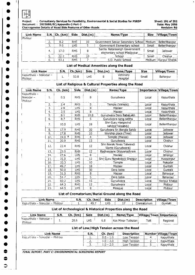
owProject Consultancy Services for Feasibility, Environmental & Social Studies for PSRSP Sheet: 191 of 202
* Document 2005086/EC/Appendix-3 Part-2 Date: May 2006Chainagewise Details of Road Side Features of Other Roads Revision: RO
* Link Name S.N. Ch. (km) Side Dist.(m) Name/Type Size Village/Town
Phillour 2. 8.2 RHS 10 Government Senior Secondary School Medium BellerKhanpur
3. 9.0 LHS 5 Government Elementary school Small BellerKhanpur
4. 17.0 RHS 8 Sardar Natarasingh Government Small Jallowar17.0 RHS 8 elementary school Madavpur
_ 5. 22.2 RHS 10 School Small Chishur
* ________ 6. 63.1 RHS 7 S.D. Public School Medium Haripur Khalsa
List of Medical Amenities along the Road
_ L Link Name S.N. Ch.(km) Side Dist.(m) Name/Type Size Village/Town
* Kapurthala - Nakodar - 1. 50.8 LHS 8 Vetrinary Small BaharpurW L~~Phillour L_____I____IHospital
* List of Religious & Cultural Properties along the Road
* Link Name S.N. Ch. kmm Side Dist.(m) Name/Type Importance Village/Town
Kapurthala -* Nakodar - 1. 0.5 RHS 8 Gurudwara Local Kapurthala
Phillour2. 2.4 RHS 5 Temple (Valmiki) Local __Kapurthala3. 2.8 LHS 8 Mazaar Local Kapurthala
* 4. 3.5 LHS 8 Mazaar Local Kapurthala
5. 8.1 RHS 10.8 Gurudwara Dera BabaLakh Local BellerKhanpur6. 8.7 RHS 5 Gurudwara sang sabha Local BellerKhanpur
7. 10.0 LHS 18 Shri Guru Hargovind Local BellerKhanpur_____ 17.9 RHS 20 ~~~~~~~sahibji(Talisabib) ____ _____
8. __17.9 _ _RHS 20 Gurudwara Sri Bangla Sahib Local Jallowar9. 17.8 RHS 10 Worship place (Tree) Local Jallowar
_10. 19.0 ' RHS 4 Temple (Mansa) Local Jallowar11. 20.9 RHS 13 Gurudwara Local Chishur
12. 22.4 RHS 12 Shri Nanak Nivas Talwandi Local Chishur-- ~~~~~~~~~Slame (Gurudwara)
13. _ 23.0 RHS 12 Radhasoami Dhayanashram Local Chishur14. 27.6 LHS 8 Mazaar Local Jahangir
15. 31.0 LHS 12 Shri Guru Nanakdevji Sherpur Local Hussainpur
16. 33.3 LHS 10 Temple Local Nakodar
17. 49.7 LHS 18 Mazaar Local Guntalli
18. 50.0 LHS 30 Dera baba Local Guntalli
_ 19. 51.5 RHS 8 Mazaar Local Baharpur
20. 51.7 LHS 5 Dera baba Local Baharpur
21. 60.2 LHS 15 Gurudwara Local Haripur Khalsa
22. 64.3 RHS 12 Gurudwara Local Phillaur23. 64.5 LHS 8 Mosque Local Phillaur
* List of Crematorium/Burial Ground along the Road
*______Link Name I S.N. Ch. (km) Side Dist.(m) Description [Village/Town
[Kapurthala - Nakodar - Phillour I 1. 49.7 LHS 1 17 1 Crematorium Guntalli
* List of Archeological & Historical Properties along the Road
* L Link Name S.N. Ch.(km) Side Dist.(m) Name/Type IVillage/Town Importance
Kapurthala - Nakodar 1. 28.6 | LHS 6.8 Kos Minar Tutkalan Tott Regional
* Y~~~hillour
List of Low/High Tension across the Road
Link Name __S.N. Ch. (km) Description Number Village/Town
* lKapurthala - Nakodar - Phillour 1. 0.0 - 1.0 Low Tension 4 Kapurthala2. 1.0 - 2.0 High Tension 2 Kapurthala
* l l 3. 1.0 - 2.0 Low Tension 5 Kapurthala
_ FINAL REPORT, PARTCC: ENVIRONMENTAL SCREENINGREPORT
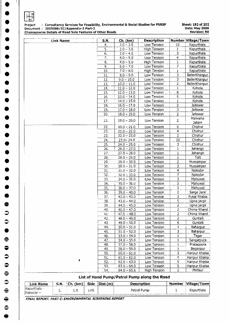
*ZLIProject Consultancy Services for Feasibility, Environmental & Social Studies for PSRSP Sheet: 192 of 202Document: 2005086/EC/Appendix-3 Part-2 Date: May 2006Chainagewise Details of Road Side Features of Other Roads Revision: RO
* e Link Name S.N. Ch. (km) Description Number Village/Town4. 2.0 - 3.0 Low Tension 10 Kapurthala
* l 5. 2.0 - 3.0 High Tension 1 Kapurthala6. 3.0 - 4.0 Low Tension 3 Kapurthala
* 7. 4.0 - 5.0 Low Tension 4 Kapurthala8. 4.0 - 5.0 High Tension 1 Kapurthala
* 9. 6.0 - 7.0 Low Tension 7 Kapurthala10. 7.0 - 8.0 High Tension 1 Kapurthala11. 8.0 - 9.0 Low Tension 3 BellerKhanpur12. 9.0 - 10.0 Low Tension 3 BellerKhanpur
* 13. 10.0 - 11.0 Low Tension 2 BellerKhanpur14. 11.0 - 12.0 Low Tension 1 Kohola
* 15. 12.0 - 13.0 Low Tension 8 Kohola16. 13.0 - 14.0 Low Tension 5 Kohola
* 17. 14.0 - 15.0 Low Tension 1 Kohola18. 16.0 - 17.0 Low Tension 2 Jallowar
* 19. 17.0 - 18.0 Low Tension 3 Jallowar20. 18.0 - 19.0 Low Tension 2 Jallowar
21. 19.0 - 20.0 Low Tension 2 Jatere
* 22. 20.0 - 21.0 Low Tension 6 Chishur23. 21.0 - 22.0 Low Tension 4 Chishur
* 23. 22.0 - 23.0 Low Tension 2 Chishur24. 23.0- 24.0 Low Tension 10 Chishur
* 25. 24.0 - 25.0 Low Tension 3 Chishur26. 26.0 - 27.0 Low Tension 1 Jahangir
* 27. 27.0 - 28.0 Low Tension 1 Jahangir28. 28.0 - 29.0 Low Tension 1 Tott
* 29. 29.0 - 30.0 Low Tension 2 Hussainpur30. 30.0 - 31.0 Low Tension 3 Hussainpur
* 31. 31.0 - 32.0 Low Tension 4 Nakodar32. 32.0 - 33.0 Low Tension 7 Nakodar
* 33. 34.0 - 35.0 Low Tension 3 Mahuwal34. 35.0 - 36.0 Low Tension 2 _ Mahuwal _
* 35. 36.0 - 37.0 Low Tension 3 Mahuwal36. 39.0 - 40.0 Low Tension 2 Sarge Janir37. 42.0 - 43.0 Low Tension 3 Pukal Khalsa38. 43.0 - 44.0 Low Tension 5 Upna jargir
_ 39. 44.0 - 45.0 Low Tension 2 Upna jargir40. 46.0 - 47.0 Low Tension 2 Chima Khand
* 41. 47.0 - 48.0 Low Tension 2 Chima Khand42. 48.0 - 49.0 Low Tension 2 Guntalli
* 43. 49.0 - 50.0 Low Tension 6 Guntalli44. 50.0 - 51.0 Low Tension 1 Baharpur
* 45. 51.0 - 52.0 Low Tension 3 _Baharpur46. 53.0 - 54.0 Low Tension 1 Tagar
* 47. 54.0 - 55.0 Low Tension 1 Sangatpura48. 57.0 - 58.0 Low Tension 1 Pratappura
* _ 49. 58.0 - 59.0 Low Tension 1 Beganpur50. 60.0 - 61.0 Low Tension 2 Haripur Khalsa
* t 51. 61.0 - 62.0 Low Tension 4 Haripur Khalsa_52. 62.0 - 63.0 Low Tension 5 Haripur Khalsa53. 63.0 - 64.0 Low Tension 5 Haripur Khalsa
3 _- 54. 64.0 - 65.6 High Tension 1 Phillaur
List of Hand Pump/Petrol Pump along the Road
3 Link Name S.N. Ch. (km) Side Dist.(m)| Description Number Village/Towni
Kapurthala - 1. 1.9 LHS Petrol Pump 1 KapurthalaNakodar - _ Il
_ FINAL REPORT, PART C: ENVIRONMENTAL SCREENING REPORT
S
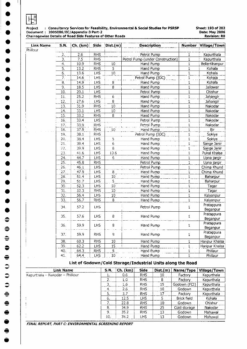
* RProject Consultancy Services for Feasibility, Environmental & Social Studies for PSRSP Sheet: 193 of 202
* Document: 2005086/EC/Appendix-3 Part-2 Date: May 2006Chainagewise Details of Road Side Features of Other Roads Revision: RO
* Link Name S.N. Ch. (km) Side Dist.(m) Description Number Village/Town* ~~~Phillour
2. 2.6 RHS _ Petrol Pump 1 Kapurthala* 3. 7.5 RHS Petrol Pump (under Construction) 1 Kapurthala
4. 10.9 RHS 10 Hand Pump 1 BellerKhanpur* 5. 13.2 RHS 5 Hand Pump 1 Kohala
6. 13.6 LHS 10 Hand Pump 1 Kohala* 7. 14.6 LHS Petrol Pump (IOC) 1 Kohala
8. 14.9 LHS 8 Hand Pump 1 Kohala* 9. 18.5 LHS 8 Hand Pump 1 Jallowar
10. 20.1 LHS Petrol Pump 1 Chishur11. 25.2 RHS 6 Hand Pump 1 Jahangir12. 27.6 LHS 8 Hand Pump 1 Jahangir13. 31.9 RHS 10 Hand Pump 1 Nakodar14. 33.1 LHS 10 Hand Pump 1 Nakodar
* _ 15. 33.2 RHS 8 Hand Pump 1 Nakodar16. 33.4 LHS _ Petrol Pump 1 Nakodar
* 17. 33.9 RHS Petrol Pump 1 Nakodar___ ________ 18. 37.9 RHS 10 Hand Pump 1 Bir
* 19. 38.1 RHS Petrol Pump (IOC) 1 Sokiya20. 38.4 LHS 5 Hand Pump 1 Sokiya
* 21. 39.4 LHS_ 6 _ Hand Pump 1 Sange Janir22. 39.9 LHS 8 Hand Pump 1 Sange Janir
* l _23. 41.6 LHS 10.6 Hand Pump 1 Pukal Khalsa24. 44.7 LHS 6 Hand Pump 1 Upna jargir
* 25. 45.8 RHS Petrol Pump 1 Upna jargir26. 46.1 LHS Petrol Pump 1 Chima Khund
* 27. 47.9 LHS 8 Hand Pump 1 Chima Khund28. 51.4 LHS 10 Hand Pump 1 Baharpur29. 51.7 LHS 1 Hand Pump 1 Baharpur30. 52.3 LHS 10 Hand Pump 1 Tagar31. 52.3 RHS 10 Hand Pump 1 Tagar32. 56.4 LHS 10 Hand Pump 1 Kalyanpur33. 56.7 RHS 8 Hand Pump 1 Kalyanpur
34. 57.2 LHS Petrol Pump 1 Pratappura* _ Beganpur
35. 57.6 LHS 8 Hand Pump 1 Pratappura
36. 59.9 LHS 8 Hand Pump 1 Pratappura3 Beganpur
37. 59.9 RHS 8 Hand Pump 1 Pratappura37. 59.9 Beganpur38. 60.3 RHS 10 Hand Pump 1 Haripur Khalsa39. 62.2 LHS 15 Hand Pump 1 Haripur Khalsa40. 64.3 RHS 8 Hand Pump 1 Phillaur
* ______________ 41. 64.4 LHS 10 Hand Pump 1 Phillaur
List of Godown/Cold Storage/Industrial Units along the Road
Link Name S.N. Ch. (km) Side Dist.(m) Name/Type Village/Town|* Kapurthala - Nakodar - Phillour 1. 0.6 RHS 10 Factory Kapurthala
2. 1.0 RHS 8 Factory Kapurthala* 3. 1.6 RHS 15 Godown (FCI) Kapurthala
4. 2.6 RHS 10 Godown Kapurthala* 5. 3.7 RHS 17 Factory Kapurthala
6. 12.5 LHS 5 Brick field Kohala* 7. 22.8 RHS 10 Godown Chishur
<8. l 34.9 RHS 25 Cold storage Nakodar_ | 9. l 35.2 RHS 13 Godown Mahuwal
e1L- 35.2 LHS 13 Godown Mahuwal
FINAL REPO'RT, PART C: ENVIRONMENTAL SCREENING REPORT
3
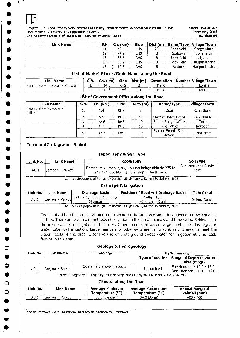
Project Consultancy Services for Feasibility, Environmental & Social Studies for PSRSP Sheet: 194 of' 202* Document 2005086/EC/Appendix-3 Part-2 Date: May 2006
Chainagewise Details of Road Side Features of Other Roads Revision: RO
Link Name S.N. Ch. (km) Side Dist.(m) Name/Type Village/Town
* l 11. 40.0 LHS 20 Brick field Sange Khala12. 44.9 LHS _ 8 Godown _Upna jargir
* 13. 56.5 RHS 8 Brick field Kalyanpur14. 60.2 LHS 8 Brick field Haripur Khalsa
D __________________________________ _15. 63.5 RHS 8 Factory Haripur Khalsa
List of Market Places/Grain Mandi along the Road
Link Name S.N. Ch. (km) Side Dist.(m) Description Number Village/Town
* Kapurthiala - Nakodar - Phillour 1. 14.0 RHS 8 Mandi 1 Kohala2. 14.5 RHS 10 Mandi 1 Kohala
* Litt of Government Offices along the Road
* Link Name S.N. Ch. (km) Side Dist. (m) Name/Type Village/Town
Kapurthala - Nakodar 1. 1.4 RHS 8 Octri Kapurthala
2. 5.5 RHS 18 Electric Board Office Kapurthala
* ________________________ 3. 28.6 RHS 10 Forest Range Office Tott
4. 33.5 RHS 10 Tehsil office Nakodar
* _5. 43.7 LHS 40 Electric Board (Sub- Upnajargir_ _ _ _ _ _ _ _ _ _ _ _ _ _ _ _ _ _ _ _ _ _ _ _ _ _ _ _ _ _ _ _ _ _ _ _ _ _ _ _ _ _ _ _ _ _ _ _S ta tio n ) _ _ _ _ _ _ _
Corridor AG Jagraon - Raikot
Topography & Soil Type
Link No. Link Name Topography Soil Type
AG.1 Jargaon - Raikot 2Flattish monotonous, slightly undulating; altitude 235 to Seriozems and Sandy- ~~~~~~~242 m above MSL; general slope - south-west
Source: Geography of Punjab by Darshan Singh Manku, Kalyani Publishers, 2002
* Drainage & Irrigation
* l Link No. Link Name Drainage Basin Position of Road wrt Drainage Basin Main Canal
AG. l Jargaon - Raikot In between Satluj and River Satlij - Left l Canal* N AG.1 lJargaon - Raikotl Ghaggar Ghaggar- Right Srhind Canal
Source: Geography of Punjab by Darshan Singh Manku, Kalyani Publishers, 2002
The semi-arid and sub-tropical monsoon climate of the area warrants dependence on the irrigation
system. There are two main methods of irrigation in this area - canals and tube wells. Sirhind canal
the main source of irrigation in this area. Other than canal water, larger portion of this region is
under tube well irrigation. Large numbers of tube wells are being sunk in this area to meet the
water needs of the area. Extensive use of underground sweet water for irrigation at time leads
* famine in this area.
Geology & Hydrogeology
Link No. Link Name Geology H drogeologY* | i | l Type of Aquifer Range of Depth to Water
_--_ _ _____I_____I____I___ Table (mbgl)l-----K---~ ~~ ~utenryaluil eost Pre-Monsoon - 10.0 - 15.0
AG. l Jargaon - Raikot Quaternary alluvial deposits Unconfined Post-Monsoon - 10.0 - 15.0
* Source: Geography of Punjab by Darshan Singh Manku, Kalyani Publishers, 2002 & NATMO
3 Climate along the Road
Link No. Link Name Average Minimum Average Maxmimum Annual Range of* __ | |Temperature (0C) Temperature (°C) Rainfall (mm)
AG.1 [Jargaon - Raikot 13.0 (January) 34.0 (June) 600 - 700
3
* FINAL REPORT, PART C: ENVIRONMENVTAL SCREENING REPORT
0
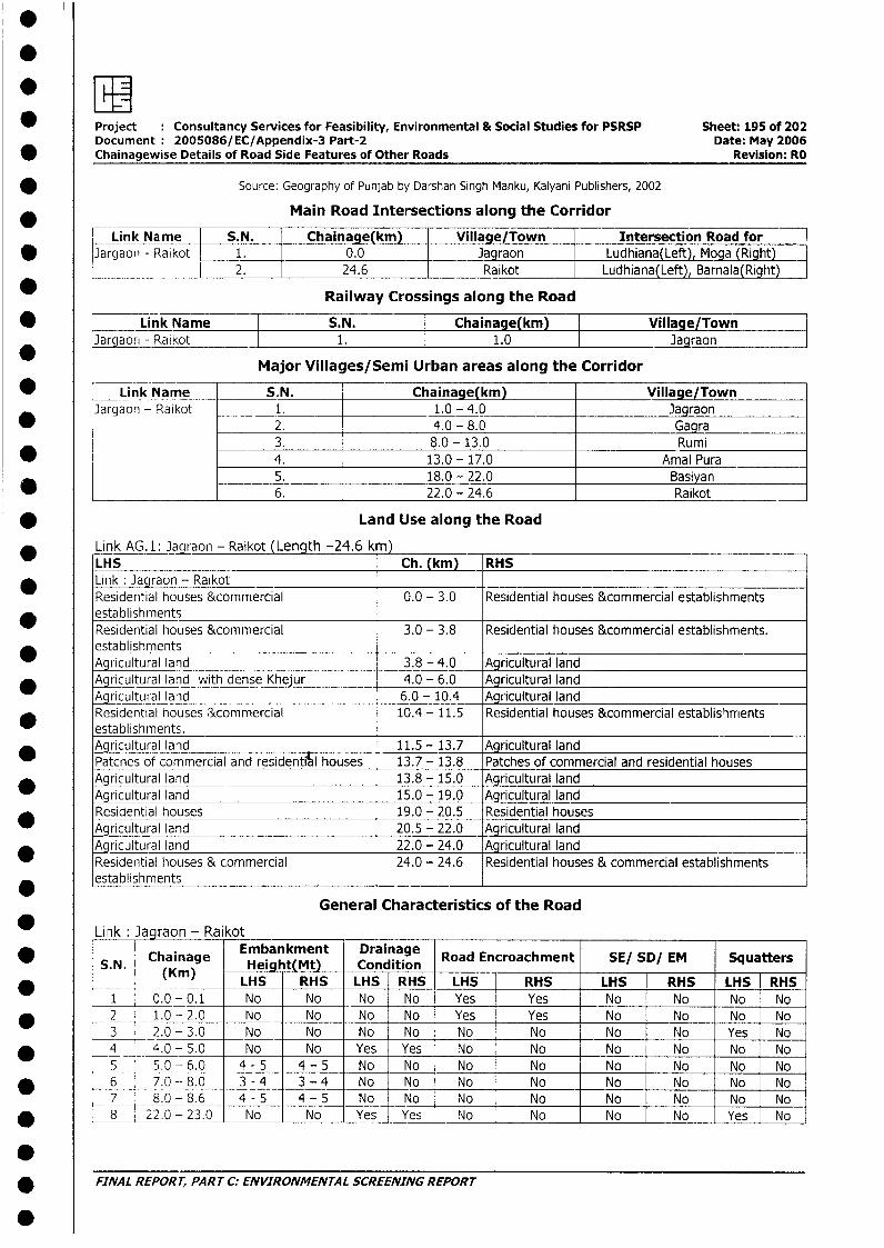
.
* Project Consultancy Services for Feasibility, Environmental & Social Studies for PSRSP Sheet: 195 of 202Document 2005086/EC/Appendix-3 Part-2 Date: May 2006
* Chainagewise Details of Road Side Features of Other Roads Revision: RO
Source: Geography of Punjab by Darshan Singh Manku, Kalyani Publishers, 2002
Main Road Intersections along the Corridor
Link Name S.N. Chainage(km) Village/Town Intersection Road for v
* Jargaon - Raikot 1. 0.0 Jagraon Ludhiana(Left) Moga (Right)2. 24.6 Raikot Ludhiana(Left) Barnala(Right)
Railway Crossings along the Road
* | Link Name S.N. Chainage(km) Village/TownJargaorn - Raikot I 1. 1.0 Jagraon
Major Villages/Semi Urban areas along the Corridor
* Link Name S.N. Chainage(km) Village/TownJargaon - Raikot 1. 1.0 - 4.0 Jagraon
* 2. 4.0 - 8.0 Gagra3. 8.0 - 13.0 Rumi
* 4. 13.0 - 17.0 Amal Pura- _ 5. 18.0 - 22.0 Basiyan
______________ 6. 22.0 - 24.6 Raikot
* Land Use along the Road
Link AG. 1: Jagraon - Raikot (Length -24.6 k )LHS Ch. (km) RHS
* Link : Jagraon - RaikotResidential houses &commercial 0.0 - 3.0 Residential houses &commercial establishments
* establishmentsResidential houses &commercial 3.0 - 3.8 Residential houses &commercial establishments.establishmentsAgricultural land 3.8 - 4.0 Agricultural land
* Agricultural land with dense Khejur 4.0 - 6.0 Agricultural landAgricultural land 6.0 - 10.4 Agricultural landResidential houses &commercial 10.4 - 11.5 Residential houses &commercial establishmentsestablishments.
_ Agricultural land 11.5 - 13.7 Agricultural landPatcnes of commercial and residential houses 13.7 - 13.8 Patches of commercial and residential houses
* ~Agricultural land 13.8 - 15.0 Agricultural landAgricultural land 15.0 - 19.0 Agricultural landResidential houses 19.0 - 20.5 Residential housesAgricultural land 20.5 - 22.0 Agricultural land
* Agricultural land 22.0 - 24.0 Agricultural landResidential houses & commercial 24.0 - 24.6 Residential houses & commercial establishmentsestablishments _
General Characteristics of the Road
Link Jagraon - Raikot
*S.N. Chainage Embatkmt Ditin Road Encroachment SE/ SD/ EM Squatters(K__ n) LHS RHS LHS RHS LHS RHS LHS RHS LHS RHS
1 0.0- 0.1 No No No No Yes Yes No No No No* 2 1.0-2.0 No No No No Yes Yes No No No No
3 2.0 - 3.0 No No No No No No No No Yes No* _ 4 _ 4.0-5.0 No No Yes Yes No No No No No No5 5.0 - 6.0 4-5 4 - 5 No No No No No No No No
* 6 7.0 - 8.0 3 - 4 3-4 No No No No No No No No7 8.0 - 8.6 4-5 4 - 5 No No No No No No No No8 22.0-23.0 No No Yes Yes No No No No Yes No
* FINAL REPORT, PART C: ENVIRONMENTAL SCREENING REPORT
.
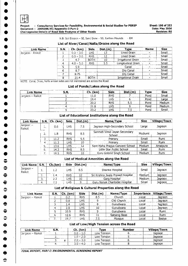
* Project : Consultancy Services for Feasibility, Environmental & Social Studies for PSRSP Sheet: 196 of 202Document 2005086/EC/Appendix-3 Part-2 Date: May 2006Chainagewise Details of Road Side Features of Other Roads Revision: RO
N.B: Soil Erosion - SE, Sand DLine - SD, Earthen Mounds - EM
List of River/Canal/Nalla/Drains along the Road
Link Name S.N. Ch. (km) Side Dist.(m) T e Name Size* Jargaon - Raikot 1 0.0 - 3.0 LHS 13 Lined Drain - Small
2 0.0-3.0 RHS 12 Lined Drain - Small* 3 4.7 BOTH 10 Irrigational Drain - Small
4 4.0_- 5.0 RHS 5.5 Longitudinal Drain - Small* _ 5 5.9 Canal - Small
6 8.7 Dry Canal - Small____7 8.75 Dry Canal - SmallL 8 21.4 BOTH Irrigational Drain - Small
NOTE: Canal, Drain, Nalla whose sides are not mentioned are across the Road
List of Ponds/Lakes along the Road
Link Name S.N. Ch. (km) Side Dist.(m) Type Size* Jargaon - Raikot 1 11.0 RHS 7 Pond Small
2 19.4 LHS 6 Pond Large* _- 3 20.2 RHS 5.5 Pond Medium
4 21.8 LHS 9 Pond Medium* ___________________ 5 23.2 LHS 7.5 Pond Small
List of Educational Institutions along the Road
Link Name S.N. Ch. (km) Side Dist.(m) Name/Type Size Village/Town* Jargaon - 1. 0.6 LHS 7.5 iagraon High-Secondary School Large Jagraon
Ra ikot
2. 1.8 RHS 8.5 Sanmati Vimal Jayan Secondary Mediuml JagraonSchool
* L 3 11.2 RHS 5.5 Primary Small Rumi4 11.3 LHS 10 Primary Small Rumi
* 5. 13.6 LHS 12 Sant Maha Pragya Convent School Medium Amalpura6. _14.3 RHS 8.5 Little Star Public School Small Rumi
* 7. 14.5 RHS [ 10 Guru Gobind Singh School Medium Rumi
List of Medical Amenities along the Road
Link Name | S.N. Ch.(km) Side Dist.(m) Name/Type Size Village/Town|
* Jargaon - 1 1 1.2 LHS 8.5 Sharma Hospital Small Jagraon
* | 2. 1.4 RHS 12 Sri Krishna Jwala Prasad Hospital Medium | Jagraon3. 2.2 LHS - 10 Garg Hospital Medium Jagraon
* 4. 7.1 LHS 9 Guru Nanak Charitable Hospital Small - Jagraon
3 List of Religious & Cultural Properties along the Road
Link Name S.N. Ch. (km) Side Dist.(m) Name/Type _ Importance Village/Town* l]argaon - Raikot 1 0.2 RHS 8.5 Church Local Jagraon
2 0.8 LHS 9 CNI Church Local __JagraoL* | l 3 1.4 LHS 8 Gurudwara Local 3agraon
4 2.8 LHS 10 Gurudwara Local Jaqraon* | l 5 10.9 RHS 9 Gurudwara Local Rumi
6 12.6 RHS 11 Satsang Beas Local Rumi* L ______ ________ 7. 19.7 LHS 7.5 Mosque Local Basiya
_ List of Low/High Tension across the Road
Link Name S.N. Ch. (km)_ Type Number Village/Tomfn]argaon - Raikot 1. 0.0 - 1.0 Low Tension 6 Jagraon
2. 1.0 - 2.0 Low Tension 5 Jagraon* I L 3. 0 2.0 - 3.0 Low Tension 6 Jagraon
4. 3.0 - 4.0 Low Tension 8 Jagraon
FINAL REPORT, PART C: ENVIRONMENTAL SCREENING REPORT
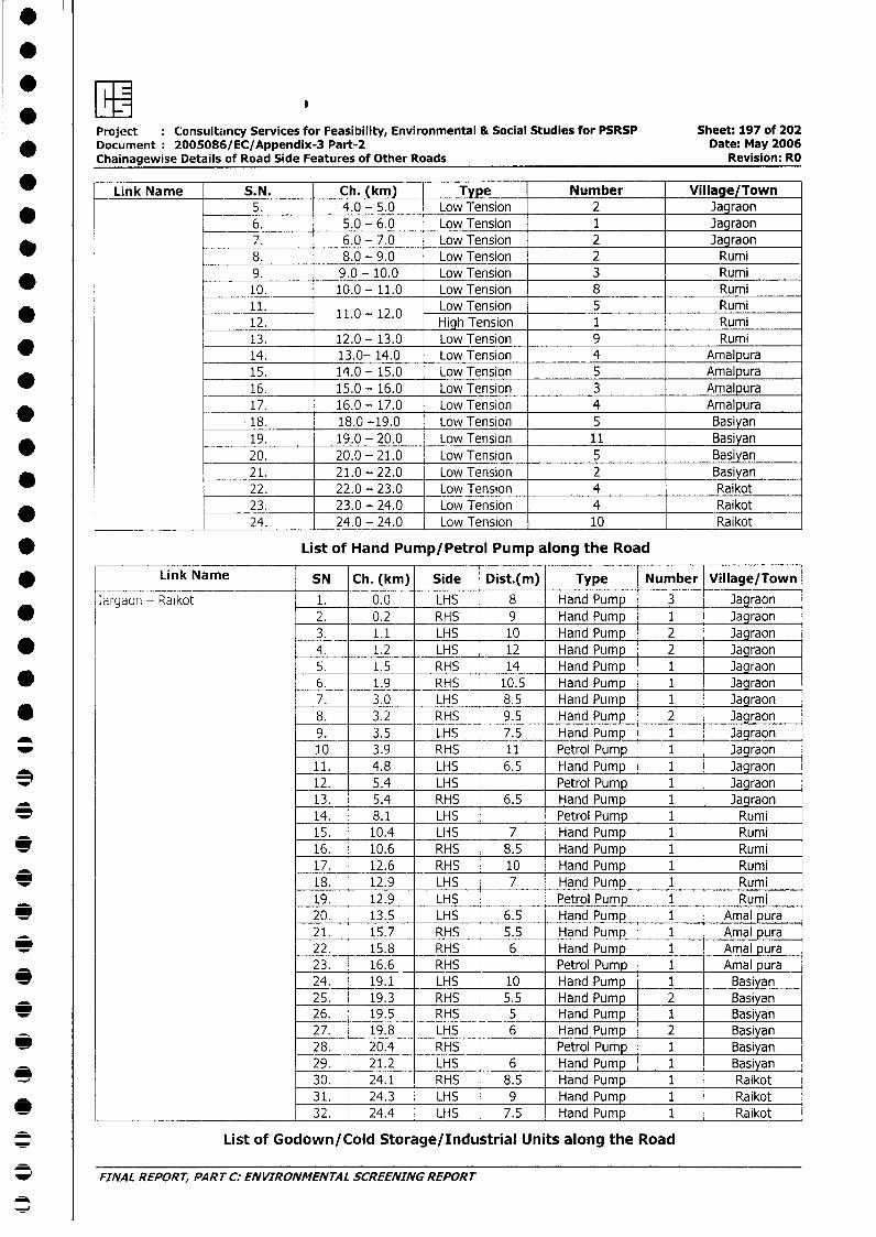
Project Consultancy Services for Feasibility, Environmental & Social Studies for PSRSP Sheet: 197 of 202* Document 2005086/EC/Appendix-3 Part-2 Date: May 2006
Chainagewise Details of Road Side Features of Other Roads Revision: RO
Link Name S.N. Ch. (km) Type Number Village/Town5. 4.0 - 5.0 Low Tension 2 Jagraon6. 5.0 - 6.0 Low Tension 1 Jagraon
_ 7. 6.0 - 7.0 Low Tension 2 Jagraon8. 8.0 - 9.0 Low Tension 2 Rumi9. 9.0 - 10.0 Low Tension 3 Rumi10. 10.0 - 11.0 Low Tension 8 Rumi11. 11.0 - 12.0 Low Tension 5 Rumi12. 1 High Tension 1 Rumi13. 12.0 - 13.0 Low Tension 9 Rumi
_ 14. 13.0- 14.0 Low Tension 4 Amalpura15. 14.0 - 15.0 Low Tension 5 Amalpura16. 15.0 - 16.0 Low Tension 3 Amalpura17. 16.0 - 17.0 Low Tension 4 Amalpura18. 18.0 -19.0 Low Tension 5 Basiyan19. 19.0 - 20.0 Low Tension 11 Basiyan20. 20.0 - 21.0 Low Tension 5 Basiyan21. 21.0 - 22.0 Low Tension 2 Basiyan22. 22.0 - 23.0 Low Tension 4 Raikot23. 23.0 - 24.0 Low Tension 4 Raikot
* ____ 24. 24.0 - 24.0 Low Tension 10 Raikot
* List of Hand Pump/Petrol Pump along the Road
i Link Name SN Ch. (kmi) Side Dist.(m) Type Number Village/Town
Jaigaon - Raikot 1. 0.0 LHS 8 Hand Pump 3 Jagraon2. 0.2 RHS 9 Hand Pump 1 Jagraon3. 1.1 LHS 10 Hand Pump 2 Jagraon* 4. 1.2 LHS 12 Hand Pump 2 Jagraon5. 1.5 RHS 14 Hand Pump 1 Jagraon
* 6. 1.9 RHS 10.5 Hand Pump 1 Jagraon7. 3.0 LHS 8.5 Hand Pump 1 Jagraon
* 8. 3.2 RHS 9.5 Hand Pump 2 Jagraon9. 3.5 LHS 7.5 Hand Pump 1 Jagraon
_ 10 3.9 RHS 11 Petrol Pump 1 Jagraon11. 4.8 LHS 6.5 Hand Pump 1 Jagraon
e 12. 5.4 LHS Petrol Pump 1 Jagraon13. _ 5.4 RHS 6.5 Hand Pump 1 Jagraon
X 14. 8.1 LHS Petrol Pump 1 Rumi15. 10.4 LHS 7 Hand Pum 1 Rumi
* 16. 10.6 RHS 8.5 Hand Pump 1 Rumi17. 12.6 RHS 10 Hand Pump 1 Rumi
e 18. 12.9 LHS 7 Hand Pump 1 Rumi19. 12.9 LHS Petrol Pump 1 Rumi
e 20. 13.5 LHS 6.5 Hand Pump 1 Amal pura21. 15.7 RHS 5.5 Hand Pump 1 Amal pura
_ 22. 15.8 RHS 6 Hand Pum 1 Amal pura23. 16.6 RHS Petrol Pump 1 Amal pura
e 24. 19.1 LHS 10 Hand Pump 1 Basiyan25. 19.3 RHS 5.5 Hand Pump 2 Basiyan
e 26. 19.5 RHS 5 Hand Pump 1 Basiyan27. 19.8 LHS 6 Hand Pump 2 Basiyan
* 28. 20.4 RHS Petrol Pump 1 Basiyan29. 21.2 LHS 6 Hand Pump 1 Basiyan
* 30. 24.1 RHS 8.5 Hand Pump 1 Raikot31. 24.3 LHS 9 Hand Pump 1 Raikot
* _______ ____ 32. 24.4 LHS 7.5 Hand Pump 1 Raikot
* List of Godown/Cold Storage/Industrial Units along the Road
* FINAL REPORT, PART C: ENVIRONMENTAL SCREENING REPORT
0
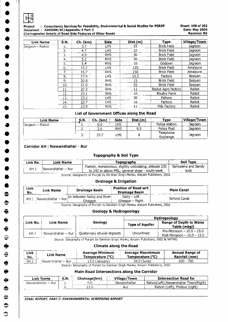
Project Consultancy Services for Feasibility, Environmental & Social Studies for PSRSP Sheet: 198 of 202* Document 2005086/EC/Appendix-3 Part-2 Date: May 2006
Chainagewise Details of Road Side Features of Other Roads Revision: RO
Link Name S.N. Ch. (km) Side | Dist.(m) Type Village/Town* J]argaon - Raikot 1. 3.7 LHS 25 Brick Field Jagraon
2. 4.7 LHS 22 Brick Field Jagraon3. 4.9 RHS 30 Brick Field Jagraon
l 4. 5.2 RHS 30 Brick Field Jagraon5. 5.4 RHS 10 Godown Jagraon6. 15.2 LHS 120 Brick Field Amalpura7. 15.7 RHS 150 Brick Field Amalpura8. 17.9 LHS 10.5 Factory Basiyan9. 20.8 RHS 15 Brick Field Basiyan10. 21.0 RHS 55 Brick Field Basiyan11. 22.2 RHS 11 Raikot Agro factory Raikot12. 23.1 RHS 10 Poultry Farm Raikot13. 23.2 LHS 30 Fishery Raikot14. 23.7 LHS 16 Factory Raikot
* _________ 15. 23.9 RHS 11 Milk Factory Raikot
List of Government Offices along the Road
Link Name ;.N. Ch. (km) Side Dist.(m) Type Village/Town* Jargaon - Raikot 1. 0.0 LHS 8 Police station Jagraon
2. 2.6 RHS 8.5 Police Post Jagraon
* _ 3. 19.7 LHS 8 Telephone Jagraon____________________________________________ ~Exchange I______
Corridor AH: Nawanshahar - Aur
Topography & Soil Type
Link No. Link Name Topography Soil TypeAH. 1 Nawanshahar - Aur Flattish, monotonous, slightly undulating; altitude 235 Seriozems and Sandyw AH.1 Nawanshahar - Aur to 242 m above MSL; general slope - south-west soils
* Source: Geography of Punjab by Darshan Singh Manku, Kalyani Publishers, 2002
Drainage & Irrigation
Link Link Name Drainage Basin Position of Road wrt Main Canal* ~~~No. Drainage Basin
AH_1 NawanshaharlAur In between Satluj and River Satlij - Left l lAH.1 Nawanshahar - Aur Ghaggar Ghaggar - Right Sirhind Canal
Source: Geography of Punjab by Darshan Singh Manku, Kalyani Publishers, 2002
3 Geology & Hydrogeology
*Y l l l HydrogeologyLink No Link Name Geology Type of Aquifer Range of Depth to Water
Table (mbgl)_ l l l l ~~~~~~~~~~~~~~~~~~~~Pre-Monsoon - 10.0 - 15.0l
AH.1 Nawanshahar - Aur Quaternary alluvial deposits Unconfined Post-Monsoon - 10.0 - 15.0
Source: Geography of Punjab by Darshan Singh Manku, Kalyani Publishers, 2002 & NATMO
3 Climate along the Road
Link L ink Na|eAverage Minimum Average Maxmimum Annual Range of-No. 1 __ Temperature (°C) Temperature (°C) Rainfall mm
3 L~~~AH.11 Nawanshahar -Aur 13.0 (]anuary) | 34.0 (June) |600 - 700Source: Geography of Punjab by Darshan Singh Manku, Kalyani Publishers, 2002
_ Main Road Intersections along the Corridor
* X Link Name S.N. Chainage( km) Village/Town Intersection Road forNawanshahar - Aur 1. 0.0 Nawanshahar _ Rahon(Left),Nawanshahar Town(Right)
0 L _ _ __ | 2. 13.0 Aur Rahon (Left), Phillour (right)
* FINAL REPORT, PART C: ENVIRONMENTAL SCREENING REPORT
3
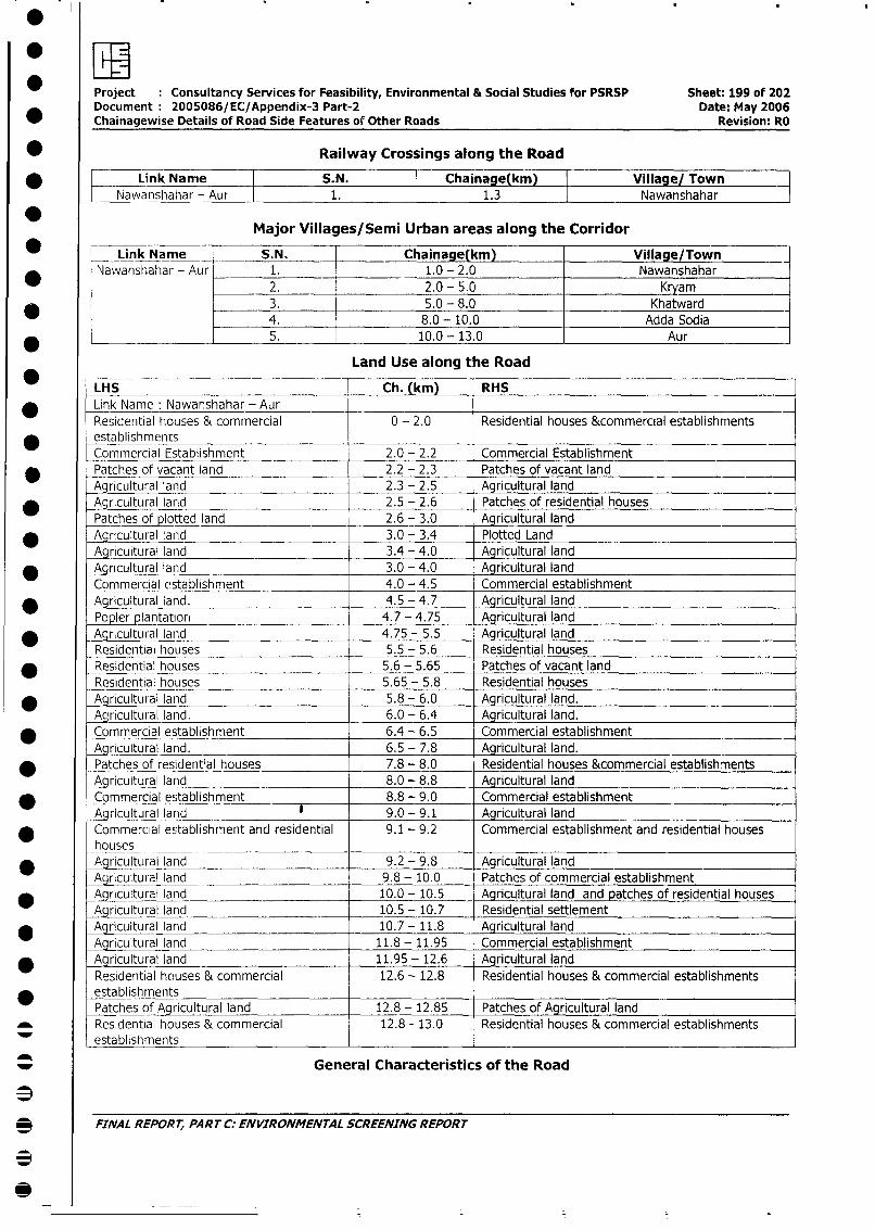
Project Consultancy Services for Feasibility, Environmental & Social Studies for PSRSP Sheet: 199 of 202Document 2005086/EC/Appendix-3 Part-2 Date: May 2006Chainagewise Details of Road Side Features of Other Roads Revision: RO
* Railway Crossings along the Road
* Link Name S.N. Chainage(km) Village/ TownNawanshahar - Aur 1. 1.3 Nawanshahar
Major Villages/Semi Urban areas along the Corridor
Link Name S.N. Chainage(km) Village/TownNawanshahar - Aur 1. 1.0 - 2.0 Nawanshahar
2. 2.0 - 5.0 Kryam
* 3. 5.0 - 8.0 Khatward4. 8.0 - 10.0 Adda Sodia
*_____________ 5. 10.0- 13.0 Aur
Land Use along the Road
LHS Ch. (km) RHSLink Name: Nawanshahar - AurResidential houses & commercial 0 - 2.0 Residential houses &commercial establishments
* establishmentsCommercial Establishment 2.0 - 2.2 Commercial Establishment
* Patches of vacant land 2.2 - 2.3 Patches of vacant landAgricultural land 2.3 - 2.5 Agricultural land
* Agricultural larid 2.5 - 2.6 Patches of residential housesPatches of plotted land 2.6 - 3.0 Agricultural land
* Agricultural land __ 3.0 - 3.4 Plotted Land-Agricultural land 3.4 - 4.0 Agricultural land
* Agricultural land 3.0 - 4.0 Agricultural landCommercial establishment 4.0 - 4.5 Commercial establishment
* Agricultural land. 4.5 - 4.7 Agricultural landPopler plantatior_ 4.7 - 4.75 Agricultural land
* Agricultural land 4.75 - 5.5 Agricultural landResidential houses 5.5 - 5.6 Residential houses
* _Residential houses 5.6 - 5.65 Patches of vacant landResidential houses __ __ 5.65 - 5.8 Residential houses _
_ Agricultural land 5.8 - 6.0 Agricultural land.Agricultural land. 6.0 - 6.4 Agricultural land.
_ Commercial establishment 6.4 - 6.5 Commercial establishmentAgricultural land. 6.5 - 7.8 Agricultural land.
* Patches of residential houses 7.8 - 8.0 Residential houses &commercial establishmentsAgricultural land 8.0 - 8.8 Agricultural land
* Commercial establishment 8.8 - 9.0 Commercial establishmentAgricultural land 9.0 - 9.1 Agricultural landCommercial establishrnent and residential 9.1 - 9.2 Commercial establishment and residential houseshouses _ _ -
* Agricultural land 9.2 - 9.8 Agricultural landAgricultural land 9.8 - 10.0 Patches of commercial establishment
* Aqricultural land 10.0 - 10.5 Agricultural land and patches of residential houses
Agricultural land 10.5 - 10.7 Residential settlement* gA cultural land 10.7- 11.8 Agricultural land
Agricultural land 11.8 - 11.95 Commercial establishment* Agricultural land 11.95 - 12.6 Agricultural land
Residential houses & commercial 12.6 - 12.8 Residential houses & commercial establishments* establishrnents
Patches of Agricultural land 12.8 - 12.85 Patches of Agricultural landRes.dential houses & commercial 12.8 - 13.0 Residential houses & commercial establishments
-establishments
_ General Characteristics of the Road
3 FINAL REPORT, PAR T C: ENVIRONMENTAL SCREENING REPORT
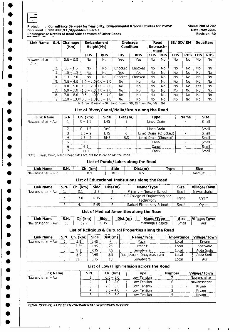
Project Consultancy Services for Feasibility, Environmental & Social Studies for PSRSP Sheet: 200 of 202Document 2005086/EC/Appendix-3 Part-2 Date: May 2006
Chainagewise Details of Road Side Features of Other Roads Revision: RO
* Li~~~nk Name ~S. N. Chainage Embankment Drainage Road SE/ SD/ EM Squatters(Kin) Height(Mt) Condition Encroach-
*~~~~~~~~~~~~~~~~mn__________ _______ ~LHS RHS LHS RHS LHS RHS LHS RHS LHS RHS
* ~~~Nawanshahar 1. 0.0 - 0.5 No No Yes Yes No No No No No No
-Aur
* ~~~~~~~-2. 05 - 1.0 No No Chocked Chocked No No No No No No
I3. 1.0 -1.3 No__ No Yes Yes No No No No No No
* 4. 1.3 - 2.0~4. No. _--No - Ch-ock.ed- -Choc.ked No No No No No No
5. 3.0 -4.0 1.0 -2.0 0.0 - 1.0 No No No No No No No No
* ~~~~~~~~6. -4.0-5.0 1.0 -2.0 1.0 -2.0 No No No No No No Yes No
7. 6.0 -7.0 1.0 -2.0 1.0 -2.0 No No No No No No No No
* ~~~~~~~~8. 7.0 -8.0 0.5 -1.0 0.5 -1.0 No No No No No No No No
________ 9 1i2.0 -13.010.5 -1. 0 0. 5 -1.0o No I No No INo INo INo INo INo
* ~~~~~~~~~~~~N.B: Soil Erosion - SE, Sand Dune - SD, Earthen Mounds - EM
* ~~~~~~~~List of River/Canal/Nalla/Drain along the Road
Link Name S.N. Ch. (kin) Side Dist.(mn) Type Name Size
* ~~~Nawanshahar - Aur 1 0 - 1.5 LHS 5 Lined Drain -Small
* ~ ~~~~~~~~~2 0 - 1.5 RH-S 5 Lined Drain -Small
3 1.5 - 2 LHS 6 Lined Drain (Chocked) - Small
* ~~ ~~~~~~~~4 1.5 - 2 __RHS 5.5 Lined Drain (Chocked) - Small
5 2.0 Canal - Small
* ~ ~ ~~~~ ~~~~ 6 6.9 _____Canal - Small
7 11.1 ______Canal - Small
NOTE: Canal, Drain, Nalla whose sides are not these are across the Road
List of Ponds/Lakes along the Road
Link_Name S.. Ch. (km) Side Dist.(m) Type Siz* Nawanshahar - Aur 1 8.9 RHS 4.5 medium
* ~~~~~~~~List of Educational Institutions along the Road
Link Name S.N. Ch. (km) Side Dist.(m) Name/Type Size Village/Town* ~~~Nawanshahar - Aur 1. 0.1 LHS 9 Primar - Nurser School Small Nawanshahar
2. 3.0 RHS 25 K. C College of Engineering and Large Kryam* ~~~~~~~~~~~~~~~~~~Technology
3 4.1 RHS 6 Sarkari Elementary School Small K amn
List of Medical Amenities along the Road
* ~~~~Link Name S.N. Ch.(km) Side Dist.(m) Name/T pe ISize IVillage/Towni
Nwshhar- Aur 1. 12.7 RHS 9 Maharaja Hospital ISmall I Aur I
List of Religious & Cultural Properties along the Road
* - ~~~Link Name S.N. Ch. (km)- Side Dist.(mn) Name/Type Importance IVillage/Town
Nawanshahar - Aur ___ 3.9 -LHS 4 Mazar 1 Local -Kryamn
2 7.55 -LHS 25 -Manidir I Local Khatward3 8.1 -RHS 7.5 Gurudwara 1 Local -Adda Sodia4__ 8.9 RHS 5.5 Radhasoami Dhaya~nahhram ~ Local -Adda Sodia
* -_______ L~~~~5 11.7 LHS 18 - Gurudwara I LocalAu
List of Low/High Tension across the Road
Link Name S.N. Ch. (kin) ___Type _ N umber Village/TownNawanshahar - Aur 1. 0.0 - 1.0 Low Tension 7 Nawanshahar
2. 1.0 - 2.0 Low Tension 6 .Nawanshahar
* ~~~ ~~~~~~~~~ ~~3. 2.0 - 3.0 Low Tension 1 Kryam4. 3.0 - 4.0 Low Tension 5 Kr-yam
* ~~~ ~~~~~~~~~~5. 4.0 - 5.0 Low Tension r 5 - Krya:m7
* ~~FINAL REPOR7; PART C: ENVIRONMENTAL SCREENING REPORT
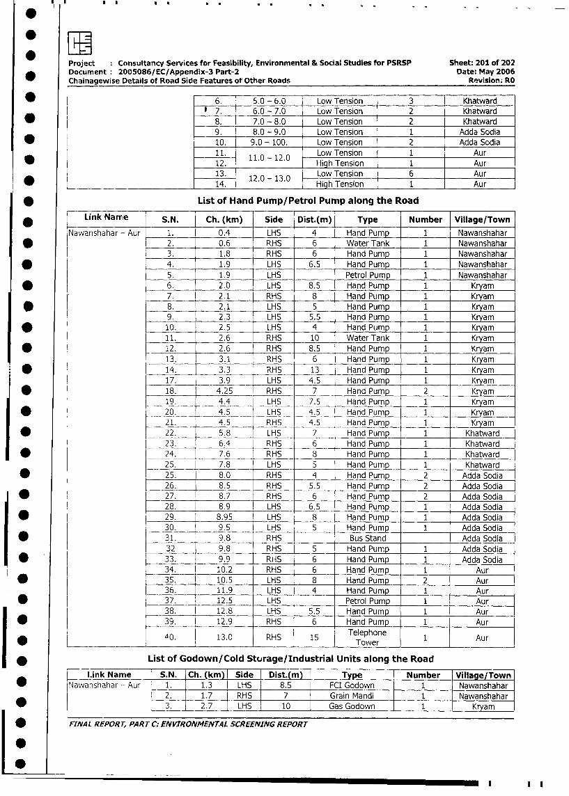
Project Consultancy Services for Feasibility, Environmental & Social Studies for PSRSP Sheet: 201 of 202
Document 2005086/EC/Appendix-3 Part-2 Date: May 2006
Chainagewise Details of Road Side Features of Other Roads Revision. RO
* 6. 5.0 - 6.0 Low Tension 3 Khatward
7. 6.0 - 7.0 Low Tension 2 Khatward
* 8. 7.0 - 8.0 Low Tension 2 Khatward
9. 8.0 - 9.0 Low Tension 1 Adda Sodia
* l 10. 9.0 - 100. Low Tension 2 Adda Sodia
11. 110 - 12.0 Low Tension 1 Aur
12. High Tension 1 Aur
13. Low Tension 6 Aur
*_14. 12.0 - 13.0 High Tension 1 Aur
* List of Hand Pump/Petrol Pump along the Road
Link Namie S.N. Ch. (km) Side Dist.(m) Type Number Village/Town
Nawanshahar - Aur 1. 0.4 LHS 4 Hand Pump 1 Nawanshahar
2. 0.6 RHS 6 Water Tank 1 Nawanshahar
3. 1.8 RHS 6 Hand Pump 1 Nawanshahar
* 4. 1.9 LHS 6.5 Hand Pump 1 Nawanshahar
5. 1.9 LHS Petrol Pump 1 Nawanshahar
*06. 2.0 LHS 8.5 Hand Pump 1 Kryam
_ _7. 2.1 RHS 8 Hand Pump 1 Kryam
* 8. 2.1 LHS 5 Hand Pump 1 Kryam
9. 2.3 LHS 5.5 Hand Pump 1 Kryam
* 10. 2.5 LHS 4 Hand Pump 1 Kryam
11. 2.6 RHS 10 Water Tank 1 Kryam
* 12. 2.6 RHS 8.5 Hand Pump 1 Kryam
13. 3.1 RHS 6 Hand Pump 1 Kryam
14. 3.3 RHS 13 Hand Pump 1 Kryam
17. 3.9 LHS 4.5 Hand Pump 1 Kryam
* 18. 4.25 RHS 7 Hand Pump 2 Kryam
19. 4.4 LHS 7.5 Hand Pump 1 Kryam
* l __20. _ 4.5 LHS 4.5 Hand Pump 1 Kryam
21. 4.5 RHS 4.5 Hand Pump 1 Kryam
* __22. 5.8 LHS 7 Hand Pump 1 Khatward
23. 6.4 RHS 6 Hand Pump 1 Khatward
* 24. 7.6 RHS 8 Hand Pump 1 Khatward
25. 7.8 LHS 5 Hand Pump 1 Khatward
* l 25. 8.0 RHS 4 Hand Pump 2 Adda Sodia
26. 8.5 RHS 5.5 Hand Pump 2 Adda Sodia
| * p 27. 8.7 RHS 6 Hand Pump 2 Adda Sodia
28. 8.9 LHS 6.5 Hand Pump 1 Adda Sodia
| * < 29. 8.95 LHS 8 Hand Pump 1 Adda Sodia
30. 9.5 LHS 5 Hand Pump 1 Adda Sodia
| * t L 31. 9.8 RHS I Bus Stand Adda Sodia
32 9.8 RHS 5 Hand Pump 1 Adda Sodia
* T l 33. 9.9 RHS 6 Hand Pump 1 Adda Sodia
34. 10.2 RHS 6 Hand Pump 1 Aur
* | l 35. 10.5 LHS 8 Hand Pump 2 Aur
36. 11.9 LHS 4 Hand Pump 1 Aur
* l l 37. 12.5 LHS I Petrol Pump 1 Aur
38. 12.8 LHS 5.5 Hand Pump 1 Aur
l * l l 39. 12.9 RHS 6 Hand Pump 1 Aur
40. 13.0 RHS 15 Telephone 1 Aur
____ ~ ~~~~~~ ~~~~~~Tower____
I * List of Godown/Cold Storage/Industrial Units along the Road
Link Name S.N. Ch. (km) Side I Dist.(m)_ Type Number Village/Town
* lNawanshahar - Aur 1. 1.3 LHS 8.5 FCI Godown 1 Nawanshahar
2. 1.7 RHS 7 Grain Mandi 1 Nawanshahar
* | | 3. 2.7 LHS 10 Gas Godown 1 Kryam
| FINAL REPORT, PART C: ENVIRONMENT.4L SCREENING REPORT
L 0~~~~~~~~~~~~~~~~~~~~~~~~~~~
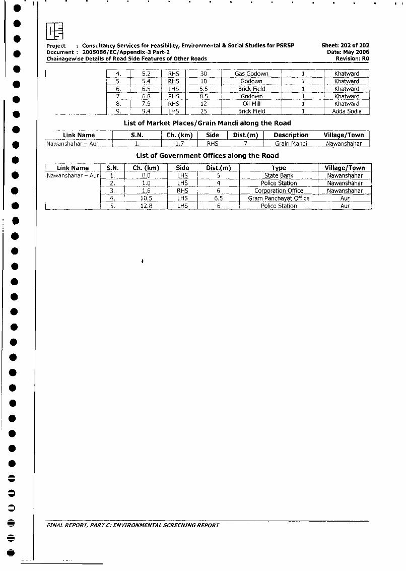
Project : Consultancy Services for Feasibility, Environmental & Social Studies for PSRSP Sheet: 202 of 202
* Document 2005086/EC/Appendix-3 Part-2 Date: May 2006Chainagewise Details of Road Side Features of Other Roads Revision: RO
* 4. 5.2 RHS 30 _ Gas Godown 1 Khatward5. 5.4 RHS 10 Godown 1 Khatward6. 6.5 LHS 5.5 Brick Field 1 _ Khatward
_ 7. 6.8 RHS 8.5 Godown 1 Khatward8. 7.5 RHS 12 Oil Mill 1 Khatward
* 1 _ _ _ _ _ _ _ _ _9. 9.4 LHS 25 Brick Field 1 Adda Sodia
List of Market Places/Grain Mandi along the Road
Link Name S.N. Ch. (km) Side Dist.(m) Description Village/Town
* Nawanshahar -. Aur 1. 1.7 RHS 7 Grain Mandi Nawanshahar
List of Government Offices along the Road
Link Name S.N. Ch. (km) Side Dist.(m) Type Village/Town
* Nawanshahar - Aur 1. 0.0 LHS 5 State Bank Nawanshahar2. 1.0 LHS 4 Police Station Nawanshahar
* - 3. 1.6 RHS 6 Corporation Office Nawanshahar
4. 10.5 LHS 6.5 _ Gram Panchayat Office Aur
* ___ ____ 5. 12.8 LHS 6 Police Station Aur
:*
_0 IA EOT ATC NIRNETLSREIGRPRS
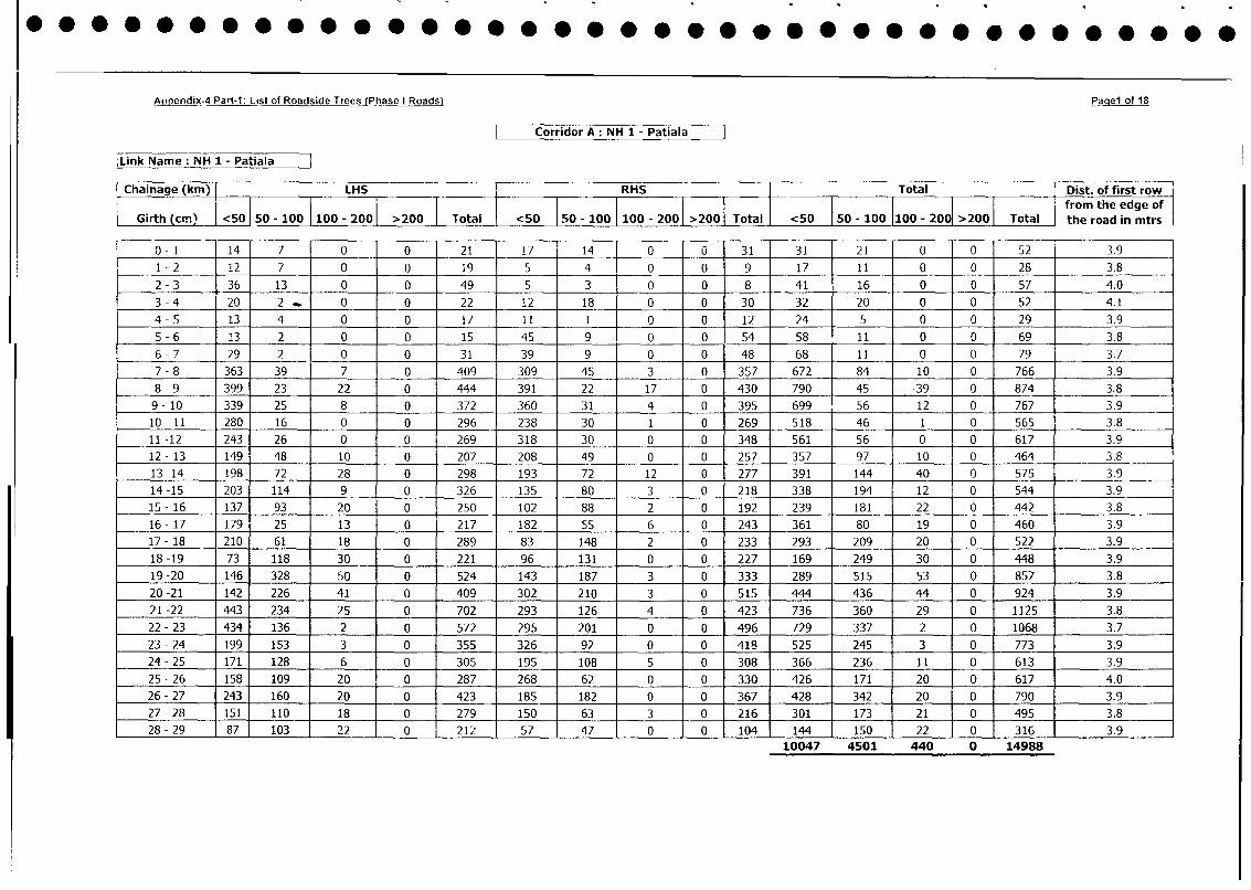
Appendin4 Part 1 List of Roadside Trees (Phase I Roads) Paae1 of 18
Corridor A: NH 1 - Patiala
Link Name: NH 1 - Patiala
Chainage (km) | LHS RHS Total Dist. of first row
_ _ _ _ _ _ _ _ _ _ _ _ _ _ _ _ _ _ _ _ _ _ _ _ _ I I .I I I I I from the edge of
Girth (ci. | <50 50 100 100 - 200 >200 Total <50 ISO - 100 I100 - 2001 >2001 Total I <50 150 - 100 1100 - 2001 >200 Total the road in mtrs
0- 1 14 7 0 0 21 17 14 0 u 31 31 21 0 0 52 3.9
1 - 2 12 7 0 0 19 5 4 0 0 9 17 11 0 0 28 3.8
2 - 3 36 13 0 0 49 5 3 0 0 8 41 16 0 0 57 4.0
3 - 4 20 2 0 0 22 12 18 0 0 30 32 20 0 0 52 4.1
4- 5 13 4 0 0 17 11 1 0 0 12 24 5 0 0 29 3.9
5 - 6 13 2 0 0 15 45 9 0 0 54 58 11 0 0 69 3.8
6 - 7 29 2 0 0 31 39 9 0 0 48 68 11 0 0 79 3.7
7-8 363 39 7 0 409 309 45 3 0 357 672 84 10 0 766 3.9
8 - 9 399 23 22 0 444 391 22 17 0 430 790 45 39 0 874 3.8
9- 10 339 25 8 0 372 360 31 4 0 395 699 56 12 0 767 3.9
10-11 280 16 0 0 296 238 30 1 0 269 518 46 1 0 565 3.8
11-12 243 26 0 0 269 318 30 0 0 348 561 56 0 0 617 3.9
12- 13 149 48 10 0 207 208 49 0 0 257 357 97 10 0 464 3.8
13-14 198 72 28 0 298 193 72 12 0 277 391 144 40 0 575 3.9
14-15 203 114 9 0 326 135 80 3 0 218 338 194 12 0 544 3.9
15-16 137 93 20 0 250 102 88 2 0 192 239 181 22 0 442 3.8
16-17 179 25 13 0 217 182 55 6 0 243 361 80 19 0 460 3.9
17- 18 210 61 18 0 289 83 148 2 0 233 293 209 20 0 522 3.9
18-19 73 118 30 0 221 96 131 0 0 227 169 249 30 0 448 3.9
19-20 146 328 50 0 524 143 187 3 0 333 289 515 53 0 857 3.8
20-21 142 226 41 0 409 302 210 3 0 515 444 436 44 0 924 3.9
21 -22 443 234 25 0 702 293 126 4 0 423 736 360 29 0 1125 3.8
22-23 434 136 2 0 572 295 201 0 0 496 729 337 2 0 1068 3.7
23-24 199 153 3 0 355 326 92 0 0 418 525 245 3 0 773 3.9
24-25 171 128 6 0 305 195 108 5 0 308 366 236 11 0 613 3.9
25 - 26 158 109 20 0 287 268 62 0 0 330 426 171 20 0 617 4.0
26-27 243 160 20 0 423 185 182 0 0 367 428 342 20 J 0 790 3.9
27-28 151 110 18 0 279 150 63 3 0 216 301 173 21 j 0 495 3.8
28- 29 87 103 22 0 1 212 57 47 0 0 104 144 150 22 10 316 3.9
10047 4501 440 0 14988
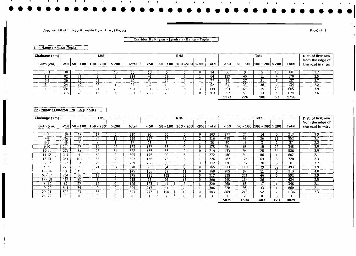
Appendix-4 Part-I: List of Roadside Trees (Phase I Roads) Paqe2 of 18
Corio B: Kharar - Landran - Banur -Tea
Link Name : Kharar-Tepla I
Cqhainage kin) 1LHS RHS [Total {Dist. of first rowGirth (cm'% I ~ ~ ~ ~ ~ ~ ~~~~~~~~~~~0- 0 10- 0 >0 Ttlfrom the edge of
Girth(cm' < 50 50 - 100 100 - 2001 >200 1Total <50 150 - 100 I100 --'2001 >200 Total <50 Q -olO-20 20 oa I the road in mtrs
0 -1 38 3 5 10 56 181 6 0 To 24 56 9 - 5 to 80 3.7
1-2 82 21 - 8 3 114 411 191 3 1 64 123 - 40 - 11 4 178 2.5
2-3 30 10 16 4 60 54j 171 5 1 77 84 - 27 21 5 137 2.7
3-4 24 19 38 1 82 371 141 0 1 52 61 - 33 - 38 2 134 2.2
4-5 391 34 - 1 1 25 461 103 30 8 3 144 494 64 19 28 605 3.9
L 5-6 315 28 - 14 4 361 238 25 0 ~ 0 263 553 53 14 4 624 2.6
____________ _______ _______ _______ ± ~~~~~ ~~~~ ~ ~~1371 226 - 108 - 53 1758
Link Name :Landran - NH 64 (Banur)
Chaina e (km) LHS RHS Total Dist. of first rowtheroad thn mtrso
Girth (cm) <50 5o0- 100 100 - 2001 > 200 1Total <50 50 - 100 100 201>01Total < 50 TS5 _I0-001100 - 2001 >2001 Total fro the eodg oftr
6-7 1184 12 14 0 210 93 10 0 0 103 277 22 14 0 313 3.9
7-8 268 29 26 13 336 167 37 10 2 216 435 66 36 15 552 3.7
8-9 46 7 3 1 57 23 6 0 1 _ 30 69 13 3 2 87 2.2
9-10 114 27 10 22 173 137 38 0 0 __ 175 251 65 10 22 348 3.9
10-11 277 35 26 34 372 156 56 2 0 __ 214 433 91 28 34 586 3.9
11-12 311 4 80 0 395 175 90 6 i _ 272 486 94 86 1 667 2.1
12-13 341 101 58 2 502 146 73 6 1 __ 226 487 174 64 3 728 2.3
13 -14 174 67 25 3 269 256 50 3 3 __ 312 430 117 28 6 581 2.7
14-15 220 55 21 32 328 93 64 8 0 165 313 119 29 32 493 3.9
15-16 100 45 0 0 145 105 52 11 0 168 205 97 11 0 313 4.0
16-17 204 56 15 0 275 121 165 31 0 _ 317 325 221 46 0 592 3.9
17 -18 167 39 8 4 218 93 95 18 0 206 260 134 26 4 424 2.5
18 -19 87 27 12 0 126 173 41 5 1 220 260 68 17 1 346 2.1
19-20 511 34 9 f 0 554 217 64 24 1 _ 306 728 98 33 1 860 2.1
20 -21 592 23 36 j 2 653 277 190 16 0 483 869 213 52 2 E 11362.
21 -22 0 0 0 0 0 1 2 0 0 3 1 2 0 0 3 _ _ _ _
5829 1594 483 123 8029
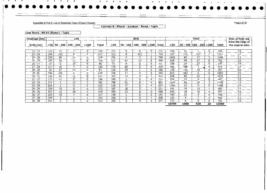
Appendix-4 Part-1: List of Roadside Trees (Phase I Roads) Paqe3 of 18
Corridor B: Kharar - Landran - Banur - Tepla
|Link Name: NH 64 (Banur) - Tepla
[Chainage (kin) LHS [RHS Total Dist. of first row
i 1 1100 2001 ~~~~~~~~~~~~~~~~~~~~~~~~~~~~~~from the edge OlfGirth (cm) 1<50 50- 100 900 2 000Total 50 500110021001 Total <50 o50 - 100 - >2001 Total the road in mtrs
22 -23 222 21 1 0 244 212 0 0 0 212 434 21 1 0 456 3.9
23 -24 244 163 6 4 417 313 9 411 1 734 557 172 417 5 1151 2.7
24 - 25 254 80 15 0 349 791 3 2 3 799 1045 83 17 3 1148 2.3
25 -26 297 36 17 8 358 331 63 10 0 404 628 99 27 8 762 2.9
26- 27 53 6 27 0 86 53 8 0 0 61 106 14 27 0 147 3.9
27 -28 127 26 7 0 160 179 80 0 0 259 306 106 7 0 419 3.9
28 - 29 10 57 14 0 81 126 59 1 0 186 136 116 15 0 267 4.0
29 -30 466 166 6 0 638 348 17 0 0 365 814 183 6 0 1003 3.9
30-31 536 65 21 0 622 392 19 0 1 412 928 84 21 1 1034 2.1
31 - 32 175 21 0 0 196 249 2 0 0 251 424 23 0 0 447 3.9
32 -33 371 5 12 3 391 798 61 8 0 867 1169 66 20 3 1258 2.3
33 - 34 624 2 9 0 635 536 17 0 0 553 1160 19 9 0 1188 3.9
34 -35 354 10 8 0 372 187 18 5 1 211 541 28 13 1 583 2.1
35 - 36 417 12 20 0 449 459 23 6 0 488 876 35 26 0 937 3.9
36 - 37 203 10 4 0 217 140 1 0 0 141 343 11 4 0 358 2.5
37 - 38 349 3 1 1 354 206 1 0 1 208 555 4 1 2 562 2.3
38 - 39 507 2 5 0 514 265 2 4 0 271 772 4 9 0 785 3.9
10794 1068 620 23 12505
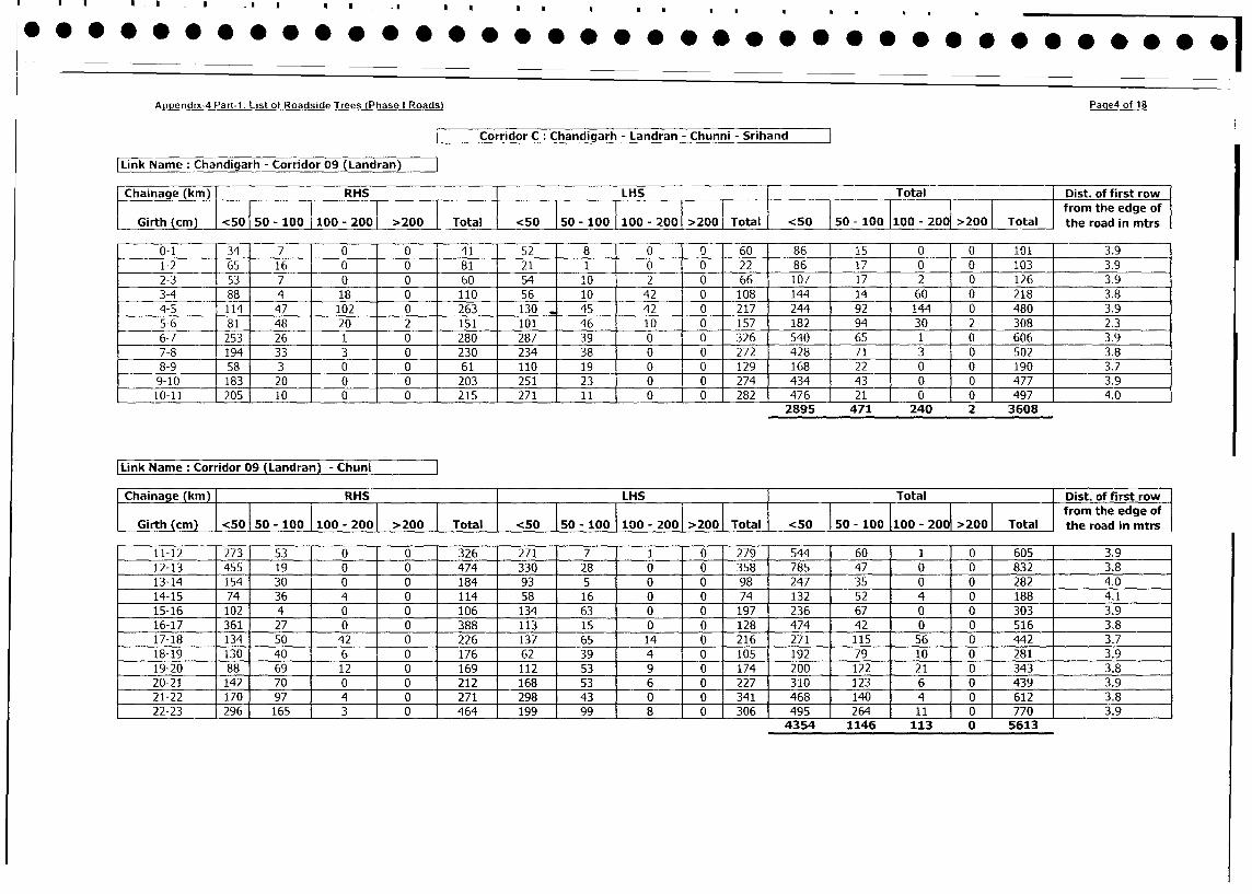
Appendix-4 Part-1: List of Roadside Trees (Phase I Roads) Page4 of 18
Corridor C Chandigarh - Landran - Chunni - Srihand
LikName :Chandigarh - Corridor 09 (Ladrn
Chainage (kin) fRHS LH-S Total 1Dist. of first row1
50' 0' I I so I 2001 >2001 j I I >2001 the ~~~~~~~~~~~~~~roa h dgein
Girth (cm) <50 50- 100 100 - 20 >20 Total <50 IO- 100 I100- 201>01Total <50 F50 -100 1100 -20 2001 Total fro the eodg oftr
0-1 34 7 0 0 41 52 8 0 0 60 86 15 0 01 101 3.9
1-2 65 16 0 0 81 21 1 0 0 22 86 17 0 01 103 3.9
2-3 53 7 0 0 60 54 10 2 0 66 107 17 2 01 126 3.9
3-4 88 4 18 0 110 56 10 42 0 108 144 14 60 Oj 218 3.8
4-5 114 47 102 0 263 130 45 42 0 217 244 92 144 0 I 480 3.9
5-6 81 48 20 2 151 101 46 10 0 157 182 94 30 2 I 308 2.3
6-7 253 26 1 0 280 287 39 0 0 326 540 65 1 01 606 3.9
7-8 194 33 3 0 230 234 38 0 0 272 428 71 3 01 502 3.8
8-9 58 3 0 0 61 110 19 0 0 129 168 22 0 011 03.7
9-10 183 20 0 0 203 251 23 0 0 27 3 30014 73.9
10-11 205 10 0 0 215 271 11 0 0 282 476 21 0 014 74.02895 471 240 2 3608
LinkNameCorridor 09 (Landran) - Chun
haae(kmn) RHS LHS Total Dist. of first row
I I I 1 1 I I I I I ~~~~~~~~~~~~~~~~~~~~~~~from the edge of
IGirth (cm) <501 50 - 100 I 100 - 2001 >200 1 Total <50 150 - 100 I 100 - 2001 >2001 TotalI <50 1 50 -100 1100 - 2001 >200 1 Total the road in mtrs
11-12 273 53 0 0 326 271 7 1 0 279 544 60 1 0 605 3.9
12-13 455 19 0 0 474 330 28 0 0 358 785 47 0 0 832 3.8
13-14 154 30 0 0 184 93 5 0 0 98 247 35 0 0 282 4.0
14-15 74 36 4 0 114 58 16 0 0 74 132 52 4 0 188 4.1
15-16 102 4 0 0 106 134 63 0 0 197 236 67 0 0 303 3.9
16-17 361 27 0 0 388 113 15 0 0 128 474 42 0 0 516 3.8
17-18 134 50 42 0 226 137 65 14 0 216 271 115 56 0 442 3.7
18-19 130 40 6 0 176 62 39 4 0 105 192 79 10 0 281 3.9
19-20 88 69 12 0 169 112 53 9 0 174 200 122 21 0 343 3.8
20-21 142 70 0 0 212 168 53 6 0 227 310 123 6 0 439 3.9
21-22 170 97 4 0 271 298 43 0 0 341 468 140 4 0 6121 3.8
22-23 296 165 3 0 464 199 99 8 0 306 495 264 11 0 7701 3.9
4354 1146 113 0 5613
Appendix-4 Part-1: List of Roadside Trees (Phase I Roads) PaaeS of 18
Corridor C: Chandigarh - Landran - Chunni - Srihand
Link Name: Chuni - Sirhind
Chainage (km) RHS LHS Total Dist. of first row
Ill l from the edge of
Girth (cm) 50 - 100 100 - 200 >200 Total <50 50 - 100 |100 - 200 >200 TotalI <50 1 50 - lOO 100 - 200 >200 Total the road in mtrs
23-24 353 65 40 18 382 39 2 0 423 7351 104 2 0 841 3.8
24-25 410 127 1 0 538 368 67 0 0 435 778 194 1 0 973 3.7
25-26 158 83 2 0 243 307 64 4 0 375 465 147 6 0 618 3.9
26-27 292 54 1 0 347 211 42 1 0 254 503 96 2 0 601 3.8
27-28 779 24 0 0 803 187 76 2 0 265 966 100 2 0 1068 3.9
28-29 189 47 J 0 0 236 99 40 1 0 140 288 87 1 0 376 3.8
29-30 94 57 0 0 151 106 28 2 0 136 200 85 2 0 287 I 3.9
30-31 0 0 72 42 114 0 0 72 21 93 0 0 144 63 207 4.0
31-32 0 0 41 23 64 0 0 50 10 60 0 0 91 33 124 3.9
32-33 0 0 22 16 38 0 0 33 12 45 0 0 55 28 83 3.8
33-34 0 0 26 19 45 0 0 18 28 46 0 0 44 47 91 3.7
34-35 0 0 24 19 43 0 0 13 26 39 0 0 37 45 82 3.9
35-36 0 0 32 27 59 0 0 41 33 74 0 0 73 60 133 4.0
3935 813 460 276 5484
Appendix-4 Part-1: List of Roadside Trees (Phase I Roads) Page6 of 18
Corridor D : Rahon - Aur - Phillour
Link Name :Rahon - Aur
Chainage (kin) RH-S LHS Total Dist. of first row1
___200 >200 Tota <5 50-10100 - 2001 >2001 Total I <50 150 - 100 1100 - 2001 >2001 Total frmthe eodg oftr
______ 42 22_ ___ 0 65 46 39 0 0 85 88 61 1 0 150 3.8
2-3 1193 ill 9 0 313 221 65 2 0 288 414 176 11 0 601 3.9
3-4 134 181 19 0 334 137 197 8 0 342 272 378 27 0 677 3.8
4-5 135 718 5 0 218 139 202 5 0 346 274 280 10 0 564 3.9
5-6 150 67 8 0 225 214 130 8 0 352 364 197 16 0 577 3.8
6-7 180 55 20 237 245 169 6 0 420 425 224 8 0 657 3.9
7-8 87 89 8 0 184 78 163 9 0 250 165 252 17 0 434 4.0
8-9 159 109 11 1 280 82 153 21 0 256 241 260 32 1 534 2.1
9-10 53 14 5 1 73 29 41 4 0 74 82 55 9 1 147 2.2
10-11 84 22 0 0 106 86 35 3 0 124 170 57 3 0 230 3.9
11-12 53 49 4 0 106 67 68 3 jO 138 120 117 7 0 244 3.8
12-13 33 14 10 48 47 18 2 10 67 80 32 3 0 115 3.9
2712 2109 146 2 4969
[Link Name Aur - Crossing of Mattiawara ( Phagwara road with Phillour - Aur Road)
Chainage (kin) RHS ILHS Total Dist. of first row
Girth(cm) <50 50-100 100-200 >200 Total <50~-5- 10 10 - 00 >00 Toal frm te dg o
Gith(m) I 5 150-10 10 -201_20_ Toa 505 IO- 100 1100 - 2001 >2001 Total 1 <50 50t0 0 0 20 Ttl fo he eodg of tr
114 2 1300 42 21 24 1 0 46 50 37 1 0 88 3.9
14-15 107 28 2 0 1371134 80 3 0 217 241 108 5 0 354 3.8
15-16 100 47 2 0 149 97 135 1 0 233 197 182 3 0 3821 3.7
16-17 49 23 0 0 72 74 41 0 0 115 123 64 I 0 0 1871 3.9
17-18 17 4 3 0 24 16 9 0 0 25 33 13 3 0 49 13.8644 404 12 0 1060
Appendix-4 Part-1: List of Roadside Trees (Phase I Roads) Paqe7 of 18
1 Corridor D: Rahon - Aur - Phillour
Link Name: Crossing of Mattiawara - Phagwara Road - Crossing of Makandpur - (APRA road with Phillaur - Aur Road)
Chainage (km) RHS LHS Total [GDist. of first row
G 6irth (cm) <501 50 - 100 100- 200 >200 Total 0 5 - 20 Total |<5 50 - 100 100 - 200 2 from the edge of[ 10110the road in mtrs
18-19 84 57 2 0 143 52 95 1 17 0 164 136 152 19 0 307 3.9
19-20 79 58 2 0 139 56 147 35 0 238 135 205 37 0 377 3.8
20-21 86 34 5 0 125 158 114 11 0 283 244 148 16 0 408 4.0
21-22 82 22 7 0 111 96 54 15 0 165 178 76 22 0 276 4.1
22-23 86 27 12 0 125 82 77 16 0 175 168 104 28 0 300 3.9
23-24 98 18 8 0 124 60 88 6 0 154 158 _106 14 0 278 3.8
24-25 145 56 18 0 219 88 153 12 0 253 233 209 30 0 472 3.7
25-26 293 26 8 0 327 80 225 9 0 314 373 251 17 0 641 3.9
26-27 122 22 11 0 155 107 135 6 0 248 229 157 17 0 403 3.8
27-28 1601 42 14 0 216 155 64 11 0 230 315 106 25 0 446 3.9
28-29 461 33 4 0 r 83 26 40 4 0 70 72 73 8 0 153 3.8
2241 1587 233 0 4061
|Link Name Crossing of Mukandpur - Apra road - Philloaur
Chainage (km) [ RHS LHS Total Dist. of first row
I Girth (cm) |<501 50 - 100 100 - 200 >200 1TotalI <S0 50 - 100 100 - 200 >2001 Total <50 50 - 10000 - 200 >200 Total f the road in mtrs
34-35 14 9 0 0 23 0 9 2 0 11 14 18 2 0 34 - 3.9
33-34 53 22 5 0 80 21 22 6 0 49 74 44 11 0 129 3.8
32-33 152 21 17 0 190 127 64 12 0 203 279 85 29 0 393 3.7
31-32 156 48 10 0 214 122 49 5 0 176 278 97 15 0 390 3.9
30-31 237 15 4 0 256 147 18 4 0 169 384 33 8 0 425 3.8
29-30 37 15 9 0 61 15 13 0 0 28 52 28 9 0 89 3.8
1081 305 74 0 1460
Appendix-4 Part-i: List of RasdTre PseIodsPaQeB of 18
Corridor E :Ludhiana - Dehion - Ahmedgarh - Malerkotla - Dhuri - Sangrur rTj7 -
Link Name: Ludhiana - Dehlon__
Chainae (kn LHS FRHS jTotal Dist. of first roIw
Girth (cm) <50 50 - 100 1100 - 2001 >200 Total <50 150 - 100 1100 - 2001 >2001 Total <5 0-10 1100 - 2001 >20 Toa fotteedeo
0 -1 __ 39 26 1 66 f 13 12 5 0 130 52 38 6 0 96 3.9
1 -2 15 7 1 0 23 11 4 2 0 17 26 11 3 _0 40 3.8
2 -3 117 30 6 0 153 145 44 5 0 194 262 74 11 _0 347 4.0
3 -4 82 14 1 0 -97 89 4 2 0 95 171 18 3 0 192 4.1
4 -5 164 36 8 0 208 153 15 5 1 174 317 51 13 1 382 2.1
5 -6 213 28 2 11 254 147 26 1 1 175 360 54 3 12 429 3.7
6 -7 __ 150 51 3 0 204 100 33 9 0 142 250 84 12 _0 346 3.7
7 -8 87 166 1 1 255 122 40 2 0 164 209 206 3 1 419 2.1
8 -9 188 76 8 0 272 128 63 0 0 191 316 139 8 0 463 3.8
9 -10 103 96 5 1 205 207 31 1 0 239 310 127 6 1 444 2.2
10 -11 480 32 1 0 513 223 38 5 1 267 703 70 6 _ 1 780 2.1
11 -12 357 43 3 11 414 278 9 9 1 297 635 52 12 12 711 3.8
12 -13 196 48 80 252 216 26 17 0 259 412 74 25 _0 511 3.8
13 -14 62 38 5 1 106 39 9 6 0 54 101 47 i1i 1 160 2.1
14 -15 103 63 1 0 167 51 49 10 0 110 154 112 11 _0 277 3.6
15 -16 126 34 2 0 162 126 35 12 0 173 252 69 14 _0 335 3.7
16 -17 2 66 7 1 1 1 0 348 280 37 24 1 342 546 108 3 5 1 690 j2.1
17-18 63 83 17 0 163 50 80 34 ~~~~~~ ~~~~ ~~~ ~~1 165 113 163 5 1 1 328 J2.117 - 18 63 83 1 7 0 163 so 80 34 ~ ~~~5189 1497- 233 3 1 6950
[Link Name: Dehion - Ahmedgarh (Pohir)
Chainage (kmn) LHS I- RHST Totalf Dist. of first row
Girth (cm) <50 50 - 100 1000 >200 Total <50 150 -100 10- 2001>0 Total <50 50 - 10 10-200 >2001 Total fo the eodg of tr
1 1 34 3 10 113 14 28 18 0 601 48 6659 0 173 4___ _
19 -20 105 27 3 1 136 81 21 11 0 113 186 48 14 1 249 2.2
20 -21 37 39 2 0 78 40 29 15 0 84 77 68 17 0 162 3.9
21 -22 42 76 34 0 152 3 32 15 0 78 73 108 49 0 230 3.8
22 -23 281 60 6 0 347 5 37 27 1 222 438 97 33 1 569 2.1
822 387 172 2 1383
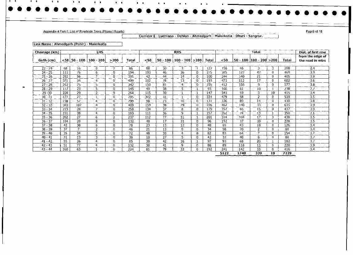
Ao~pendix-4 Part-1: List of Roadside Trees IPhase i Roads) Paae9 of 18
Appen xP LCorridor E: Ludhiana - Dehlon - Ahmedgarh - Malerkotla - Dhuri - Sangrur.
|Link Name: Ahmedgarh (Pohir) - Malerkotla
Chainage (km) LHS RHS Total Dist. of first row
I50 - 100 10- 20 > Ta l j i from the edge of
Girth (cm) |<50 | 50 - 100 100 - 200 >200 Total <50 | <50 - 100 |100 - 200 >200 Total the road in mtrs
23 - 24 68 16 0 2 86 88 30 3 1 122 156 46 3 3 208 2.4
24 - 25 112 76 6 0 194 193 46 36 0 275 305 122 42 0 469 3.9
25 - 26 202 96 7 0 305 42 44 14 0 100 244 140 21 0 405 3.9
26 - 27 371 34 4 0 409 102 78 13 0 193 473 112 17 0 602 3.6
27- 28 262 75 5 0 342 150 81 4 0 235 412 156 9 0 577 3.8
_ _ 28 - 29 117 23 5 0 145 49 38 5 1 93 166 61 10 1 238 2.7
29 -30 228 29 2 9 268 115 30 1 1 147 343 59 3 10 415 3.4
30-31 177 27 1 0 205 302 31 1 0 334 479 58 2 0 539 3.5
31 - 32 238 57 4 0 299 98 23 10 0 131 336 80 14 0 430 3.8
32 - 33 303 102 4 0 409 159 38 29 0 226 462 140 33 0 635 3.9
33 - 34 223 28 7 0 258 134 37 8 0 179 357 65 15 0 437 3.9
34 - 35 151 38 4 0 193 111 36 9 1 157 262 74 13 1 350 2.1
35-36 202 27 6 2 237 112 77 11 1 201 314 104 17 3 438 3.5
36-37 104 20 8 0 132 48 17 31 0 96 152 37 39 0 228 3.5
37-38 42 30 6 0 78 23 13 1 2 0 48 65 43 18 0 i26 3.4
38-39 37 7 2 0 46 21 13 0 0 34 58 20 2 0 80 3.4
39-40 35 34 3 0 72 48 30 4 0 82 83 64 7 0 154 3.7
40-41 22 13 3 0 38 10 27 5 0 42 32 40 8 0 80 3.7
41 - 42 55 26 4 0 85 38 42 16 1 97 93 68 20 1 182 3.7
42-43 -511 77 - 4 0 132 38 41 9 0 88 89 118 13 0 220 3.9
43 - 44 160 63 1 0 224 81 79 32 0 192 241 142 33 0 416 3.4
5122 1749 339 19 7229

Appendix-4 Part-i: List of Roadside Trees (Phase I Roads) PaaelO of 18
~Corridor E: Ludhiana - Dehlon - Ahmedgarh - Malerkotla - Dhuri - Sangrur.
Link Name:Malerkotla - Dhuri -
IChainage (kin) ILHS RHS Total Dist. of first row
I I I I I I I I I I ~~~~~~~~~~~~~~~~~~~~~~~~from the edge of
Girth (cm) 1<50 50 -100 I100 -2001 > 200 Toa0 <0 s- 100 I100 - 2001 >200 Toa <0 50 - 100 100 - 2001 >2001 Total Ithe road in mtrs
44 -45 162 72 3 0 237 163 96 22 0 281 325 168 25 o 518 3.7
45 -46 142 33 2 0 177 145 27 26 0 198 287 60 28 0 375 3.8
46 -47 278 80 7 0 365 188 62 24 0 274 466 142 31 0 639 3.7
47 -48 272 53 1 0 326 133 86 41 0 260 405 139 42 0 586 3.9
48 -49 96 81 1 0 178 74 62 28 0 164 170 143 29 0 342 3.7
49 -50 15S8 51 4 0 213 126 47 38 0 211 284 98 42 0 424 1.
50 -51 216 57 1 0 274 272 57 10 0 339 488 114 11 0 613 3.6
51 - 52 260 139 4 1 404 192 104 55 0 351 452 243 59 1 755 3.6
52 - 53 177 127 15 0 319 91 213 63 0 367 268 340 78 0 686 3.6
53 -54 195 169 5 0 369 113 167 39 0 319 308 336 44 0 688 3.6
54 -55 83 48 8 1 140 58 80 23 0 161 141 128 31 1 301 2.1
55 -56 10 4 35 30 79 4 12 42 0 58 14 16 77 30 137 4.1
56 -57 24 20 5 0 49 15 20 5 0 40 39 40 10 0 89 3.6
57 -58 29 36 0 0 65 20 7 0 0 27 49 43 0 0 92 3.5
58 -59 23 11 1 0 35 11 14 1 0 26 34 25 2 0 61 3.4
59 -60 38 28 3 0 69 27 46 4 0 77 65 74 7 0 146 3.8
60 -61 61 20 2 0 83 28 27 15 0 70 89 47 17 0 153 3.7
61 -62 47 36 13 1 97 70 46 -1 0- 127 117 82 24 1 224 3.7
62-63 32 23 2 1 58 29 41 11 0 81 ~~~ ~~~ ~~~ ~ ~~~~~~~~~~61 64 13 1 1393.
62 - 63 32 23 2 1 58 29 41 1 1 0 ~ ~~~4062 2302 570 34 696838
[Link Name: Dhuri - Sangrur
Chiae(kin) LHS RHS ITotal Dist. of first row
Chainage ____________________________________ 50 - 100 100 - 200 >200 Total fromm the edge of
Grth (cm ' <501 50 - 100 I100 - 2001 >200 1Total 1<50_ 50 - 100 100 - 200 >200 Total01>200<50a the road in mtrs
63 -64 243 22 1 0 266 149 126 1 71 0 346 392 148 72 0 612 2.9
64 - 65 249 101 2 0 352 326 181 83 0 590 575 282 85 0 942 2.9
65 -66 131 36 0 0 167 173 49 19 0 241 304 85 19 0 408 3.1
66 -67 285 17 0 0 302 267 147 24 0 438 552 164 24 0 740 3.5
67 -68 323 12 1 __ 0 336 404 87 1 1 0 502 727 99 12 0 838 3.9
68 -69 315 33 5 0 353 318 70 20 0 408 633 103 25 0 761 3.9
69 -70 404 42 1 447 309 58 18 0 385 713 100 19 0 832 3.7
70 -71 83 26 5 0 114 17 25 5 0 47 100 51 10 0 161 3.4
71 -72 6 4 0 0 10 3 0 0 0 3 9 4 0 0 1 .
4005 1036 266 0 5307
Corridor F :Attari - Chabal - Taran Taran -Fatehabad - Kapurtha
LinkNam :kttari - Chabal=
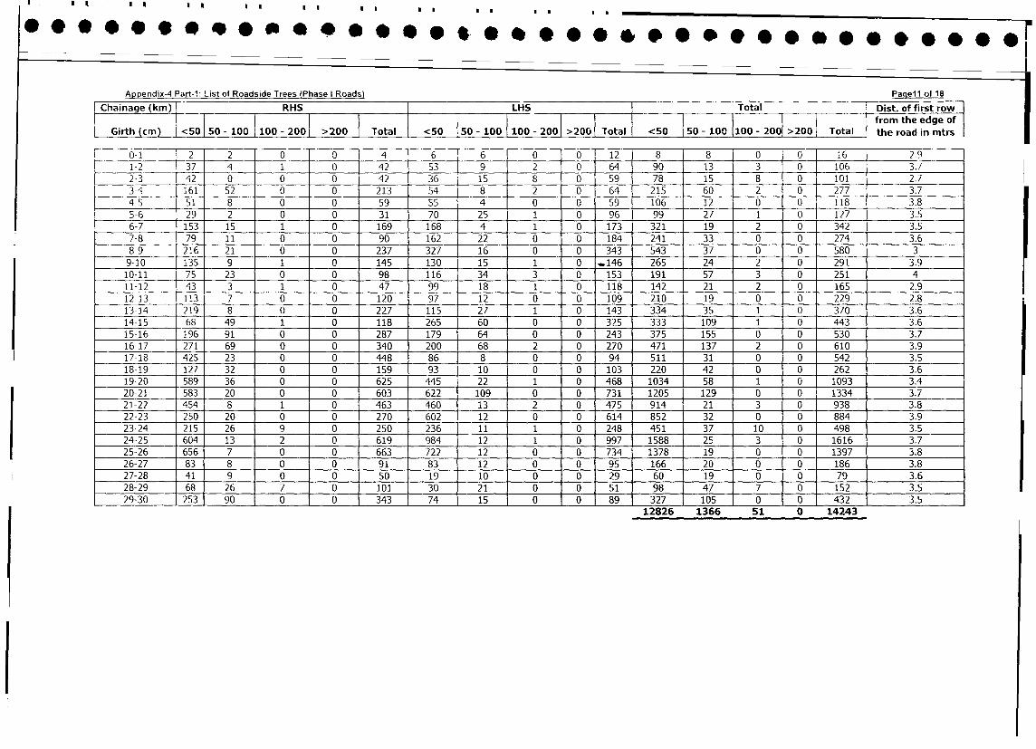
Appendix-4 Part-I: List of Roadside Total
(PaaseiI Rfa18
Chainage (kin) [H LH{Toal --- Dist. of first row
Ghirthe (k0m)00 10 20 20 Total <5 0-10100-20> 0 Toa from the edge of
(cm [<50 50011002100 0200 2000
Total0<5 Toa the road in mtrs
0-1 2 2 F 0 0 4 6 I 6 0 O 1 12J 8 8 0 0 16 ]2-9
1-2 37 4 1 0 42 53 9 2 0 [641 90 13 3 01 106 3.7
2-3 42 0 0 0 42 36 15 8 0 [591 78 15 8 01 101 2.7
3-4 161 52 0 0 213 54 8 2 __ [ 4 _ _ 215 60 2 0L 277 3.7
45 51 8 0 0 59 55 4 0 0 59 106 12 0 0 118 3.8
5-6 29 2 0 0 31 70 25 1 0 96 99 27 1 0 127 3.5
11-12 453 35 1 0 479 998 18 1 0 118 314 219 2 0 165 2.9
12-13 113 7 0 0 120 972 12 0 0 109 2410 19 0 0 229 2.8
13-14 219 81 0 0 227 115 27 1 0 143 533 35 1 0 370 3.6
15-16 196 91 0 0 287 179 64 0 0 2143 375 155 0 0 530 3.7
16-17 271 69 0 0 340 200 68 3 0 270 471 137 2 0 6510 3.
17-18 425 23 0 0 448 86 8s 0 0 94 5112 31 0 0 154 3.5
18-19 127 32 0 0 159 93 10 0 0 103 220 42 0 0 2629 3.6
19-20 589 36 0 0 6257 445 22 1 0 468 1034 358 1 0 1709 3.4
20-21 583 20 0 0 603 ~~~~ ~~622 109 0 0 731 12053 129 0 0 1433 3.7
215-22 454 81 1 0 463 460 13 2 0 2475 914 21 3 0 9380.
22-23 250 20 0 0 270 602 12 0 0 614 852 132 0 0 884 3.9
23-14 215 263 0 2504 236 11 1 0 248 451 37 10 0 5498 3.5
24-25 604 132 0 6159 984 12 1 0 997 1588 425 3 0 1616 3.7
25-26 6569 76 0 0 663 745 22 12 0 746 1037 8 19 0 1039 3.8
26-27 83 8 0 0 91 83 ~~~ ~ ~ ~ ~~~129 0 0 951 1665 120 0 0 1864 3.8
27-23 410 90 0 0 570 192 10 0 0 29, 602 19 0 0 794 3.6
23-29 685 26 7 0 1501 230 2 1 0 0 8 51 9837 70 0 152 3,5
29-30 253 90 0 0 343 74 15 0 0 89 327 105 0 0 432 3.5
12826 1366 51 0 14243
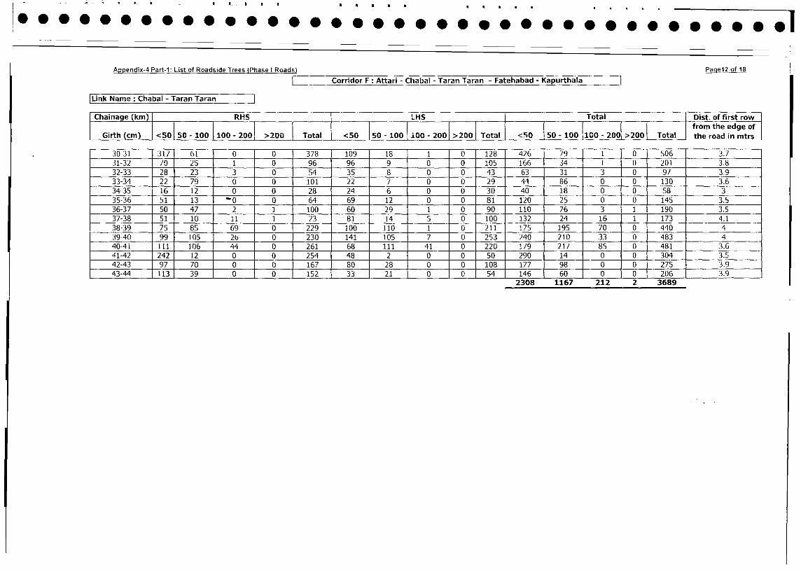
Appendix-4 Part-I: List of Roadside Trees (Phase I Roads) PaqeI2 of 18
Corridor F: Attari - Chabal - Taran Taran - Fatehabad - Kapurthala
Link Name: Chabal - Taran Taran
Chainage (km) I RHS L_HS Total | Dist. of first row
0 T5 l.O I - l from the edge of
Girth (cm) o<50 50- 100 100 - 2001 >200 I Total I<50 50- 100 100- 200 >200 Tctal <50 50- 100 100- 200 >200 Total the road in mtrs
30-31 317 61 0 0 378 109 18 1 1 0 128 426 79 1 0 506 3.7
31-32 70 25 1 0 96 96 9 0 0 105 166 34 1 0 201 3.8
32-33 28 23 3 0 54 [ 35 8 0 0 43 63 31 3 0 97 3.9
33-34 22 79 0 0 101 22 7 0 0 29 44 86 0 0 130 3.6
34-35 16 12 0 0 28 24 6 0 0 30 40 18 0 0 58 3
35-36 51 13 -0 0 64 69 12 0 0 81 120 25 0 0 145 3.5
36-37 50 47 2 1 100 60 29 1 0 90 110 76 3 1 190 3.5
37-38 51 10 11 1 73 81 14 5 0 100 132 24 16 1 173 4.1
38-39 75 85 69 0 229 100 110 1 0 211 175 195 70 0 440 4
39-40 99 105 26 0 230 141 105 7 0 253 240 210 33 0 483 4
40-41 111 106 44 0 261 68 111 41 0 220 179 217 85 0 481 3.6
41-42 242 12 0 0 254 48 2 0 0 50 290 14 1 0 0 304 3.5
42-43 97 70 0 0 167 80 28 0 0 108 177 98 1 0 0 275 3.9
43-44 113 39 0 0 152 33 21 0 0 54 146 60 1 0 0 206 3.9
2308 1167 212 2 3689
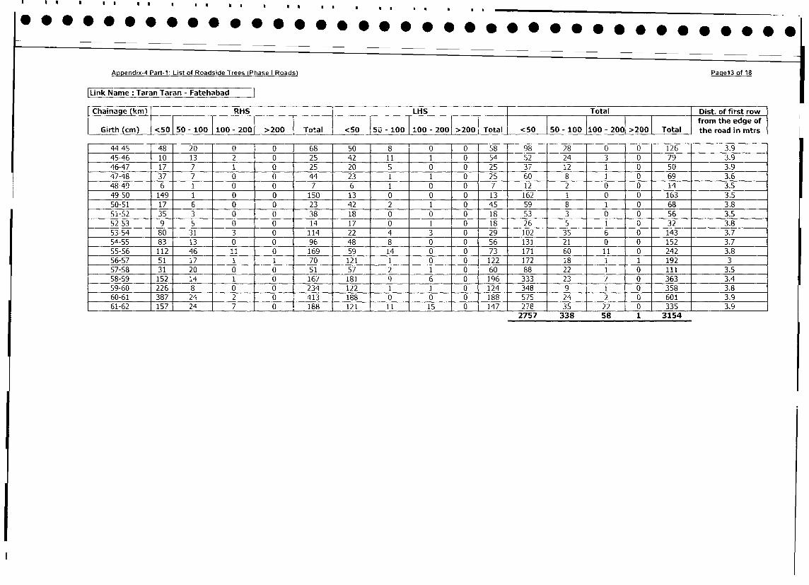
Appendix-4 Part-1: List of Roadside Trees (Phase I Roads) Paqe13 of 18
Link Name: Taran Taran - Fatehabad=
Chainage (km) I RHS LHS Total Dist. of first row
l l l I I I I I I I I I I I from the edge of
Girth (cm) | <50| 50 -100 1100 - 2001 >200 Total <50 50 -10OO100 - 200 >2001 Total <50 150-lO0110 - 2001 >200 Total the road in mtrs
44-45 48' 20 0 0 68 50 8 0 0 58 98 28 0 0 126 3.9
45-46 10 13 2 0 25 42 1 1 1 0 54 52 24 3 0 79 3.9
46-47 17 7 1 0 25 20 5 0 0 25 37 12 1 0 50 3.9
47-48 37 7 0 0 44 23 1 1 0 25 60 8 1 0 69 3.6
48-49 6 1 0 0 7 6 1 0 0 7 12 2 0 0 14 3.5
49-50 149 1 0 0 150 13 0 0 0 13 162 1 0 0 163 3.5
50-51 17 6 0 0 23 42 2 1 0 45 59 8 1 0 68 3.8
51-52 35 3 0 0 38 18 0 0 0 18 53 3 0 0 56 3.5
52-53 9 1 5 0 0 14 17 0 _ 1 0 18 26 5 1 0 32 3.8
53-54 80 31 3 0 114 22 4 3 0 29 102 35 6 0 143 3.7
54-55 83 13 0 0 96 48 8 0 0 56 131 21 0 0 152 3.7 -
55-56 112 46 11 0 169 59 14 0 0 73 171 60 11 0 242 3.8
56-57 51 1i7 1 1 70 121 1 0 0 122 172 18 1 1 192 3
57-58 31 20 0 0 51 57 2 1 0 60 88 22 1 0 111 3.5
58-59 152 14 1 0 167 181 9 6 0 196 333 23 7 0 363 3.4
59-60 226 8 0 0 0 10 124 348 9 1 0 358 3.8
60-61 387 24 2 0 413 188 0 0 0 188 575 241 2 0 601 3.9
61-62 157 24 7 0 188 121 11 15 0 147 278 35 22 0 335 3.92757 338 58 1 3154
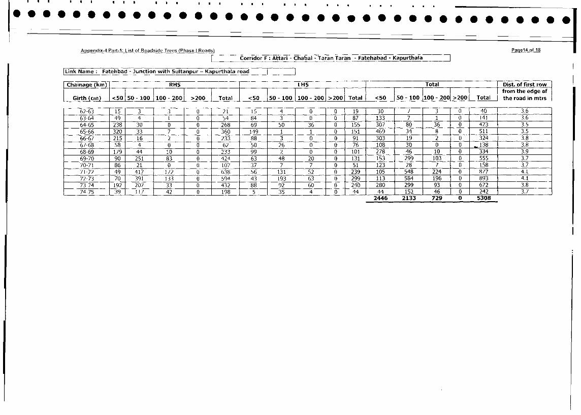
Appendix-4 Part-1: List of Roadside Trees (Phase I Roads) Paqe14 of 18
| Corridor F Attari - Chabal - Taran Taran - Fatehabad - Kapurthala 7
|Link Name: Fatehbad - Junction with Sultanpur - Kapurthala road I
| Chainage (km) RHS LHS Total Dist. of first row
_ i l l }~~~~~~~~~~ from the edge of
Girth (cm) <50 50 - 100 100 - 200 >200 Total <50 50 - 100 100 - 200 >200 Total <50 50 - 100 100 - 200 >200 Total the road in mtrs
62-63 15 3 3 0 21 15 4 0 0 19 30 0' 40 1 3.6
63-64 49 4 1 0 54 84 3 0 0 87 133 7 1 0 141 3.6
64-65 238 30 0 0 268 69 50 36 0 155 307 80 36 0 423 3.5
65-66 320 33 7 0 360 149 1 1 0 151 469 34 8 0 511 3.5
66-67 215 16 2 0 233 88 3 0 0 91 303 19 2 0 324 3.8
67-68 58 4 0 0 62 50 26 0 0 76 108 30 0 0 138 3.8
68-69 179 44 10 0 233 99 2 0 0 101 278 46 10 0 334 3.9
69-70 90 251 83 0 424 63 48 20 0 131 153 299 103 0 555 3.7
70-71 86 21 0 0 107 37 7 7 0 51 123 28 7 0 158 3.7
71-72 49 417 172 0 638 56 131 52 0 239 105 548 224 0 877 4.1
72-73 70 391 133 0 594 43 193 63 0 299 113 584 196 0 893 4.1
73-74 192 207 33 0 432 88 92 60 0 240 280 299 93 0 672 1 3.8
74-75 39 117 42 0 198 5 35 4 0 44 44 152 46 0 242] 3.7
2446 2133 729 0 5308
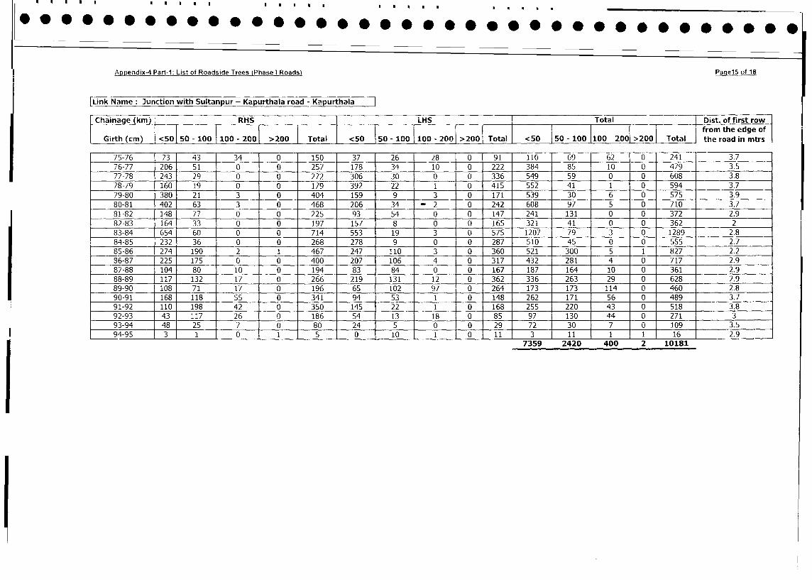
Appendix-4 Part-i: Lis' of Roadside Trees (Phase I Roads) Paqel5 of 18
|Link Name: Junction with Sultanpur - Kapurthala road - Kapurthala
Chainage (km) RHS LHS I Total Dist. of first row
_ ~~~~ ~~~~~~~~~~~~i I ifrom the edge of
Girth (cm <50 tal 5100 100 - 200 >200 Total <50 50 - 100 100 - 200 >200 Total <50 50 - 100 100 - 2001 >200 Total the road in mtrs
75-76 73 43 34 0 150 37 26 _ 28 '0 91 110 69 62 0 241 137
76-77 206 51 0 0 257 178 34 10 0 222 384 85 10 0 1479 3.5
77-78 243 29 0 0 272 306 30 0 0 336 549 59 0 0 608 3.8
78-79 160 19 0 0 179 392 22 1 0 415 552 41 1 0 594 3.7
79-80 380 21 3 0 404 159 9 3 _ 0 171 539 30 6 0 575 3.9
80-81 402 63 3 0 468 206 34 -2 0 242 608 97 5 0 710 3.7
81-82 148 77 0 0 225 93 54 0 0 147 241 131 0 0 372 2.9
82-83 164 33 0 0 197 157 8 0 0 165 321 41 0 0 362 2
83-84 654 60 0 0 714 553 19 3 0 575 1207 79 3 0 1289 2.8
84-85 232 36 0 0 268 278 9 0 0 287 510 45 0 0 555 2.7
85-86 274 190 2 1 467 247 110 3 0 360 521 300 5 1 827 2.2
36-87 225 175 0 0 400 207 106 4 0 317 432 281 4 0 717 2.9
87-88 104 80 10 0 194 83 84 0 0 167 187 164 10 0 361 2.9
88-89 117 132 17 0 266 219 131 12 0 362 336 263 29 0 628 2.9
89-90 108 71 17 0 196 65 102 97 0 264 173 173 114 0 460 2.8
90-91 168 118 55 0 341 94 53 1 0 148 262 171 56 0 489 3.7
91-92 110 198 42 0 350 145 22 1 0 168 255 220 43 0 518 3.8
92-93 43 117 26 0 186 54 13 18 0 85 97 130 44 0 271 3
93-94 48 25 7 0 80 24 5 0 0 1 29 72 30 7 0 109 _ _3.5
94-95 3 1 0 1 5 0 10 1 o 11 3 11 1 11 16 2.9
7359 2420 400 2 10181
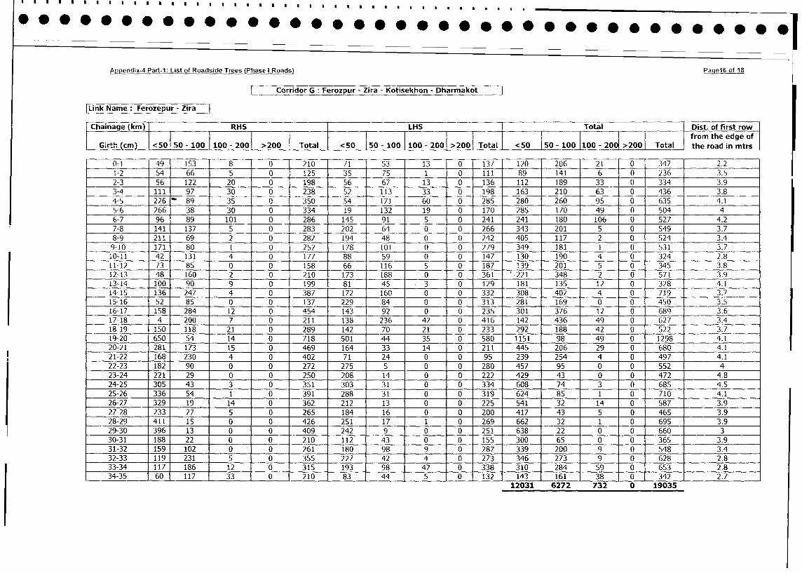
Appendix-4 Part-1: List of Roadside Trees (Phase I Roads) Paqe16 ot 18
Corridor G: Ferozpur - Zira - Kotisekhon - Dharmakot J
|Link Name: Ferozepur - Zira
Chainage (kin) RHS LHS _ Total Dist. of first row
Chainage ( 0 50 0 0 0 > I I I__ from the edge of
G.rth_____ (c) -0!5 - 100 100 -2001 >200 Total <50 150-100 100-200 >2001 Total <50 50-100 100 - 2001 >200 Total the road in mtrs
0-1 49 153 8 0 210 71 53 13 0 137 120 206 21 0 347 2.2
1-2 54 66 5 0 125 35 75 _ 1 0 II 89 141 6 0 236 3.5
2-3 56 122 20 0 198 56 67 13 0 136 112 189 33 0 334 3.9
3-4 III 97 30 0 238 52 113 33 0 198 163 210 63 0 436 3.8
4-5 226 89 35 0 350 54 171 60 0 285 280 260 95 0 635 4.1
5-6 266 38 30 0 334 19 132 19 0 170 285 170 49 0 504 4
6-7 96 89 101 0 286 145 91 5 0 241 241 180 106 0 527 4.2
7-8 141 137 5 0 283 202 64 0 0 266 343 201 5 0 549 3.7
8-9 211 69 282 194 48 0 242 405 117 2 0 524 3.4
9-10 171 80 1 0 252 178 101 0 0 279 349 181 1 0 531 3.7
10-11 42 131 4 __0 177 88 59 0 0 147 130 190 4 0 324 2.8
11-12 73 85 0 0 158 66 116 5 0 L87 139 201 5 0 345 3.8
12-13 48 160 2 0 210 173 188 0 0 361 '.221 348 2 0 571 3.9
13-14 100 90 9 0 199 81 45 .3 0 129 181 135 12 0 328 4.1
14-15 136 247 4 0 387 172 160 0 0 332 308 407 4 0 719 3.7
15-16 52 85 0 0 137 229 84 0 0 313 281 169 0 0 450 3.5
16-17 158 284 12 0 454 143 92 0 0 235 301 376 12 0 689 3.6
17-18 4 200 7 0 211 138 236 42 0 416 142 436 49 0 627 3.4
18-19 150 118 21 0 289 142 70 21 0 233 292 188 42 0 522 3.7
19-20 650 54 14 0 718 501 44 35 0 580 1151 98 49 0 1298 4.1
20-21 281 173 15 0 469 164 33 14 0 211 445 206 29 0 680 4.1
21-22 168 230 4 0 402 71 24 0 0 95 239 254 4 0 497 4.1
22-23 182 90 0 0 272 275 5 0 0 280 457 95 0 0 552 4
23-24 221 29 0 0 250 208 14 0 0 222 429 43 0 0 472 4.8
24-25 305 43 3 0 351 303 31 0 0 334 608 74 3 0 685 4.5
25-26 336 54 1 0 391 288 31 0 0 319 624 85 1 0 710 4.1
26-27 329 19 14 0 362 212 13 0 0 225 541 32 14 0 587 3.9
27-28 233 27 5 0 265 184 16 0 0 200 417 43 5 0 465 3.9
28-29 411 15 0 0 426 251 17 1 0 269 662 32 1 0 695 3.9
29-30 396 13 0 0 409 242 9 0 0 251 638 22 0 0 660 3
30-31 188 22 0 - 0 210 112 43 0 0 155 300 65 0 0 365 3.9
31-32 159 102 0 0 261 180 98 9 0 287 339 200 9 0 548 3.4
32-33 119 231 5 0 355 227 42 4 0 273 346 273 9 0 628 2.8
33-34 117 186 12 0 315 193 98 47 0 338 310 284 59 0 653 2.8
34-35 60 117 33 - 0 1210 83 44 5 0 132 143 161 38 0 342 2.7
12031 6272 732 0 19035
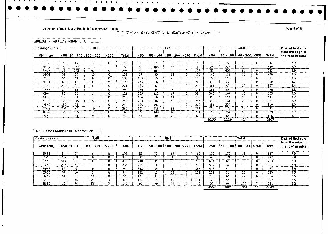
ApIoendix-4 Part-i: List of Roadside Trees (Phase I Roads) Paciei of 18
Cordr G : Ferozpur - Zira - Kotisekhon - Dharmakot
Link Name : Zira - Kotisekhan
Chainage (kin) IRHS LHu-S Total- Dist. of first row
Girth (m) <50 0 AOO 10 - 200 >200 Toal <5 I 100ta ~LOI 200 I20 oa the road in intrs
Girt (c) 1 50 so 10 110 - 001 ota 1 5 50 - 100] 100 - 2001 >20 Toa 5 0-10 - >00 Ttl fo h deo
r 35-36 4 15 1 0 2010 7 3 0 20 14 22 4 0 40 2.9
36-37 8 167 13 1 189 18 106 36 0 160 26 273 49 _1 349 2.9
37-38 28 225 42 0 295 30 184 44 0 258 58 409 86 __0 553 3.9
38-39 59 60 13 0 132 87 59 12 0 158 146 119 25 _0 290 3.8
39-40 56 49 0 0 105 1041 69 26 0 199 160 118 26 0 304 3.5
40-41 89 11 0 0 100 244 16 0 0 260 333 27 0 _0 360 3.7
41-42 245 21 5 0 271 236 42 18 0 296 481 63 23 _0 567 3.4
42-43 81 13 1 0 95 280 45 6 0 331 361 58 7 _0 42638
413-44 88 32 1 0 121 255 112 17 0 384 343 144 18 0 50536
44-45 157 54 2 0 213 156 60 14 0 230 313 114 16 _0 44337
45-46 1201 115 5 0 240 223 46 15 0 284 343 161 20 __0 52429
46-47 155 84 1 0 240 126 141 3 0 270 281 225 4 0 51029
47-48 204 57 19 - 0 280 105 118 38 0 261 309 175 57 _0 54127
48-49 31 105 12 0 14 9 1943 0 231 70 254 55 0 1 37937
49-50 4 34 9 0 47 14 30 25 0 69 18 64 J 34 _ 0 11U6 3_____1 _
3256 2226 424 1 5907
Link Name: Kotisekhan - Dharamkot
IChainage (kmn) LHIS RIHS Total Dist. of first rowfrom the edge of
Girth (cm) <50 50 - 100 100 - 20 20 Total <50 150 - 100 1100 - 2001 >2001 Total I <50 50s - 100 10 0 2001 Total the road in mtrs
50-51 94 98 6 0 198 85 72 12 0 169 179 170 18 0 367 3.9
51-52 268 58 0 1 0 326 322 73 1 0 396 590 131 1 0 722 3.8
52-53 444 31 0 1 0 475 240 35 3 0 278 684 66 3 0 753 2.9
53-54 233 27 3 j 0 263 284 10 0 0 294 517 37 3 0 557 2.9
54-55, 85 9 0 0 94 348 34 1 0 383 433 43 1 0 477 2.9
55-56 67 14 3 j 0 84 192 22 25 0 239 259 36 28 0 323 2.5
56-57 61 24 11i 0 96 197 42 31 0 20 258 66 42 0 366 3.5
57-58 18 3294 86 102 19 10 0 E1301 1054 39 4 217 2.5
58-59 12 7567 149 10 20 82 0 1112 22 94 138 7 1 261 2.2
3062 697 273 11 4043
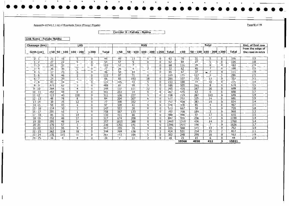
Appendix-4 Pan-1: List of Roadside Trees (Phase I Roads) Paqel8 of 18
Corridor H : Patiala - Nabha
| Link Name: Patiala-Nabha I
Cha;nage (km) LHS I RHS Total Dist. of first row
l i l l l [ ~~~~~~~~~~~~~~~~~~~~~~~from the edge wof
Girth (cm) <50 50 -100 100 - 2001 >200 Total < 50o 50 - 100 100 - 200 >2001 Total the road in mtrs
0-1 - I 21 18 5 0 44 49 13 0 0 62 70 31 5 0 106 3.9
1 - 2 27 22 5 0 54 57 5 0 0 62 84 27 5 0 116 3.8
2 - 3 64 32 7 0 103 52 7 1 0 60 116 39 8 0 163 2.9
3 - 4 36 36 5 0 77 26 4 2 0 32 62 40 7 0 109 2.9
4 - 5 17 23 6 0 46 50 14 1 0 65 67 37 _7 0 1il 2.9
5 - 6 74 46 2 0 122 97 71 0 1 169 171 117 2 1 291 2.5
6 - 7 24 39 3 0 66 83 193 10 0 286 107 232 13 0 352 3.5
7 - 8 83 34 5 0 122 105 43 5 0 153 188 77 10 0 275 3.4
8 - 9 423 62 3 0 488 82 99 5 0 186 505 161 8 0 674 3.5
9- 10 284 56 4 0 344 132 111 22 0 265 416 167 26 0 609 3.8
10- 11 292 49 0 0 341 253 14 0 0 267 545 63 0 0 608 3.7
11 -12 113 40 158 0 311 106 227 5 0 338 219 267 163 0 649 - 3.9
12- 13 48 28 8 0 84 204 307 6 0 517 252 335 14 0 601 3.9
13-14 30 35 12 0 77 398 352 7 0 757 428 387 19 0 834 3.4
14 -15 50 43 4 0 97 328 42 0 0 370 378 85 4 0 467 3.5
15- 16 114 30 3 0 147 553 20 0 0 573 667 50 3 0 720 3.8
16- 17 201 56 1 0 258 567 133 2 0 702 768 189 3 0 960 3.3
17- 18 85 3 1 14 0 130 411 66 3 0 480 496 97 17 0 610 3.5
18-19 252 48 17 0 317 674 208 0 0 882 926 256 17 0 1199 3.4
19-20 295 48 14 0 357 1015 388 0 0 1403 1310 436 14 0 1760 3.4
20-21 170 57 3 0 230 1251 141 4 0 1396 1421 198 7 0 1626 3.7
21 -22 313 95 9 0 417 255 76 4 0 335 568 171 13 0 752 3.9
22 -23 262 118 18 0 398 269 136 7 2 414 531 254 25 2 812 2.1
23 -24 135 115 1 1 0 261 113 184 5 0 302 248 299 16 0 563 2.9
24-25 16 4 4 0 24 7 11 2 0 20 23 1 5 6 0 44 2.9
10566 4030 412 3 15011
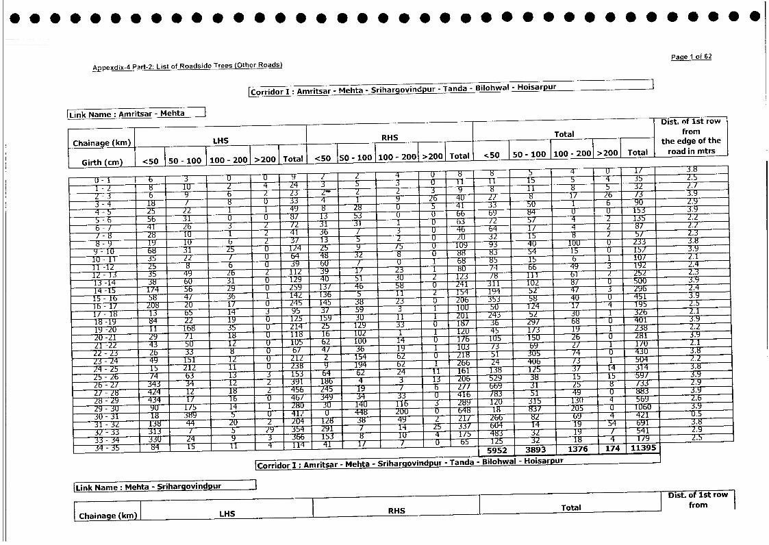
Appedix4 Prt-: Lst f Radsde Trees (Other Roads) Iq 1 o; 62
C Ordr I: AAmnritLsar - IMeh'ta-- S-riha,rgovind-pur - Tanda - Biloh-al - Hoisarpur|
Liklame : Amritsar - M~ehta lDist. oT lst ro
IChainage (km) LHS RHS Total from
l l l l l l l l l l l ~~~~~~~~~~~~~~~~~~~~~~~~~~~the edge of the
| Girth cm) <50l 50 - 00 l 100- 200|>00| Totl <50 15 - 100 100 - 00|>2GO Total 1:0 l~ 50 - 0 0 20>0|TtalI road in mtrs
:S~~~~~~~~~~~~~~~~~~~~~-4 1 / 8 -76- 4019:Z81 6/ 3.9
-821 !03 4 --- - / 4 1 5 4 u8/5
8 -9 19 10 6 5 ;! U F L S- 1 5 8 - 5 3 Z . : S
8- 9 - 1 U 3 1 5Z 7Z 519 : UlUZ: .
12- 1 : 9 2 W - 6 T - -F - 2:S 1 /4 -F - - ' 4 9 19 Z g 2.4 -
14 -125 8 2 5 6 2 9 -- 5Y 4- 58 Z 4 :0 1 U i - 8/M- 5UU-- --.
15-1 -1 4/--7 - -:7T- 1-T 5 11 1974- 52E 4/ : J 192>
12 - 13 -7- - 2U6- 1/7F- U-FF 747 z58 2:S7 :S 84 5
19 -Z 168 -5 U- - 47- 25(M 1 29 S:S gR:S Z84U1 3.9
16 -Z1/ rT8 -29 U7 - -1181Z1T45 1-T2- /: 9 1Z58 .
Z1 -Z5U19 s ZT lUUT 14V /71u 1U 8 3.9
ZZ~~~-T - Zz:rG8 b 35 1 9 U 1 /2 6 2/ - 1-2 18/ U 3 - -- 2.1 _-
Z4 -Z5 ---5- Z1 1 9wr-- --- 7r_ 14 62 1 55 4 U / 5U4BT 3.9
25- Z6 ___ra__ b3 13 153 7__sw__ -rosZ4-11 lbl-1T8T125-3/F14 314 3 8
22 -2/ 4 41 -:- 26-3E^33- 8-X7 --34 U 5Z99 38 15 -- 5- b9/ 3.8
Z/- Z8 --274- 1 -12 -E7 -2 194 /7T __S_ Z/ b 31055_a_ 3 2.Y
28~~ ~ ~~ --g -
Z9-6 --- z
/ 6 T-rT --- _zz 43 -7- 1 /35 9 _7_ 8
2U -25 18 rz 98 _5r -I- 4 ZUU __76__ b48 9 18 83 U5 U UU .
25 - 32 -- 728 44E3 ZU 1 _:_ -ZF--lir 84 21/ 266- 1 Z69 4 42 .
3Z 33 -3U3- 7 -TT 5 Y -3F- 21 / Y 25-- 64 1 1 Y --Em- bYl 3.
29 4-35 15-fT 116 4 G 11467 -- 41 1 / : 7125 1 o 1Y256
29 - 3(F- -- 99- 14 -T4u-- -- 3- -952 ZB893 176 17 1139
30~~~~~~~~~Crio I: Amita -M T9- Meta- Srhravndu -- T Tad Blhal-Hisru
[Link Name: Meh~~~~~~~~~~~~~~~ta - Sriharqovindpur -1a lha osru
l l | l D~~~~~~~~~~~~~~~~~~~~~~~~~~~~~~~ist of 1st row
|Chainage(m| LHS |RHS |Total | from
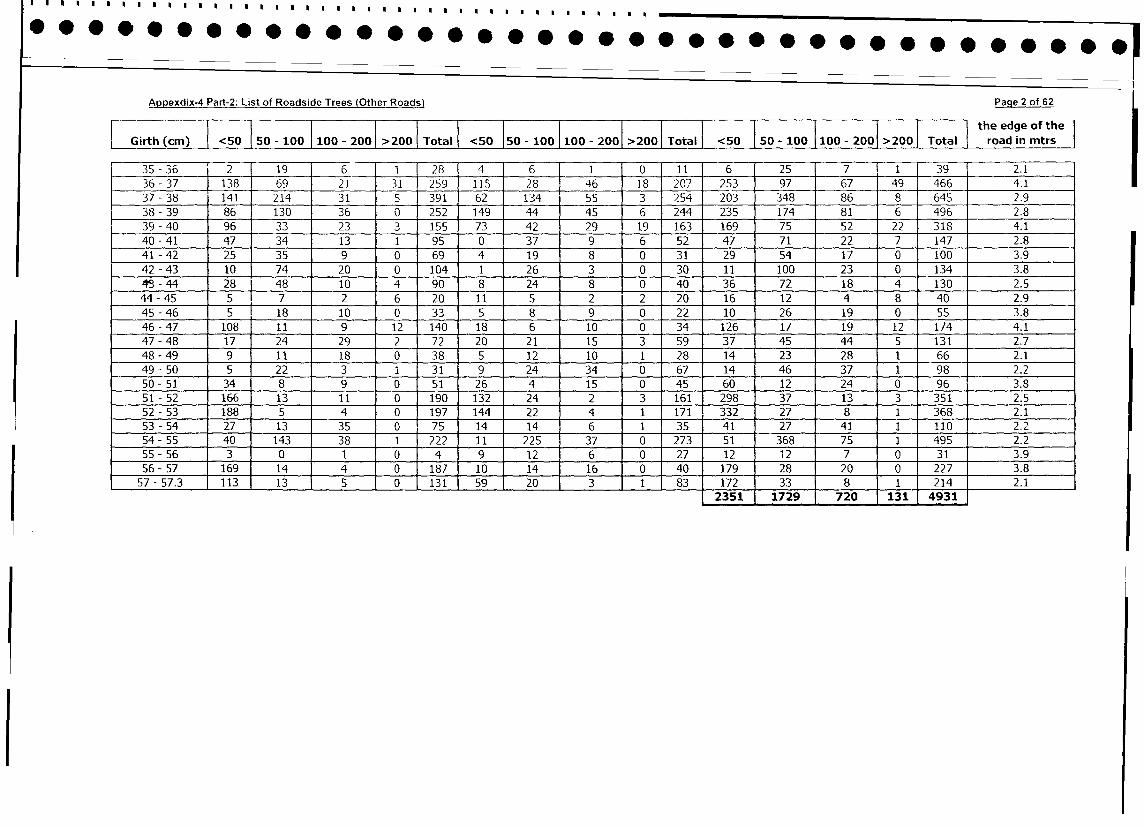
Appexdix-4 Part-2: List of Roadside Trees (Other Roads) Paqe 2 of 62
l l l I | l | | l l l l l l l | | the edge of the
Girth (cm) <50 50 - 100 100 - 2001 >200 | Total < c50 150 - 100 100 - 2001 >2001 Total I <50 1 50 - 100 100 - 200 >200 |Total t road in mtrs
35 - 36 j 2 19 6 - 1 28 4 6 1 0 11 6 25 7 1 39 2.1
36- 37 138 69 21 31 259 115 28 46 18 207 253 97 67 49 466 4.1
37 - 38 141 214 31 5 391 62 134 55 J 3 254 203 348 86 8 645 2.9
38-39 86 130 36 0 252 149 44 45 6 244 235 174 81 6 496 2.8
39 - 40 96 33 23 3 155 73 42 29 19 163 169 75 52 22 318 4.1
40 - 41 47 34 13 1 95 0 37 9 6 52 47 71 22 7 147 2.8
41 - 42 25 35 9 0 69 4 19 8 0 31 29 54 17 0 100 3.9
42 - 43 10 74 20 0 104 1 26 3 0 30 11 100 23 0 134 3.8
4t - 44 28 48 10 4 90 8 24 8 0 40 36 72 18 4 130 2.5
44 - 45 5 7 2 6 20 11 5 2 2 20 16 12 4 8 40 2.9
45 - 46 5S 18 10 0 33 5 8 9 0 22 10 26 19 0 55 3.8
46-47 108 11 9 12 140 18 6 10 0 34 126 17 19 12 174 4.1
47 - 48 17 24 29 2 72 20 21 15 3 59 37 45 44 5 131 2,7
48-49 9 1 1 18 0 38 5 12 10 1 28 14 23 28 1 66 2.1
49 - 50 5 22 3 1 31 9 24 34 0 67 14 46 37 1 98 2.2
50 - 51 34 8 9 0 51 26 4 15 0 45 60 12 24 0 96 3.8
51 - 52 166 13 11 0 190 132 24 2 3 161 298 37 13 3 351 2.5
52-53 188 5 4 0 197 144 22 4 1 171 332 27 8 1 368 2.1
53 - 54 27 13 35 0 75 14 14 6 1 35 41 27 41 1 110 2. 2
54-55 40 143 38 1 222 11 225 37 0 273 51 368 75 1 495 2.2
55 - 56 3 0 1 0 4 9 12 6 0 27 12 12 7 0 31 3.9
56- 57 169 14 4 0 187 10 14 16 0 40 179 28 20 0 227 3.8
57 - 57.3 113 13 5 0 131 59 20 3 1 83 172 33 8 1 214 2.1
l 2351 1729 720 131 4931
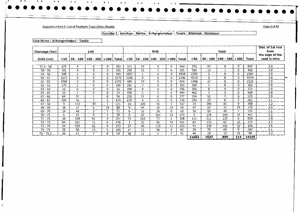
Appexdix-4 Part-2: List of Roadside Trees lOther Roads) Paqe 3 of 62
|Corridor I : Amritsar - Mehta - Srihargovindpur - Tanda - Bilohwal - Hoisarpur
Link Name: Srihargovindpur - TandaDist. of 1st row
Chainage (km) LHS RHS Total from
Girth (cm) <50 50- 100 100 - 2001 >2001 Total <50 otal <50 50- 100 100- 200 >2001 Total the edge of the
57.3 - 58 379 4 0 0 383 371 93 0 0 464 750 97 0 0 847 3.9
58- 59 101 4 0 0 105 292 12 1 0 305 393 16 1 0 410 3.8
59- 60 348 1 0 0 349 1957 1 0 0 1958 2305 2 0 0 2307 3.9
60 - 61 2273 0 0 0 2273 2246 0 0 0 2246 4519 0 0 0 4519 3.8 _
61 - 62 1098 3 0 0 1101 400 24 0 0 424 1498 27 0 0 1525 3.9
62 - 63 179 1 0 0 180 181 2 0 0 183 360 3 0 0 363 3.8
63 - 64 16 0 0 0 16 348 8 0 0 356 364 8 0 0 372 3.9
64 - 65 23 1 0 0 24 439 2 3 0 444 462 3 3 0 468 3.8
65 - 66 64 31 1 0 96 250 21 6 0 277 314 52 7 0 373 3.9
66- 67 105 16 1 2 124 129 4 5 0 138 234 20 6 2 262 2.1
67 - 68 9 172 39 1 221 10 108 42 7 167 19 280 81 8 388 3.2
68 - 69 38 17 6 19 80 9 47 25 14 95 47 64 31 33 175 3.9
69 - 70 24 44 2 1 71 6 16 38 0 60 30 60 40 1 131 2.1
70 - 71 5 27 5 1 38 0 97 261 15 373 5 124 266 16 411 3.2
71 - 72 38 148 61 4 251 73 163 71 1 308 111 311 132 5 559 2.8
72 - 73 64 101 11 0 176 3 32 56 10 101 67 133 67 10 277 3.2
73 - 74 14 193 62 4 273 27 46 119 11 203 41 239 181 15 476 3.5
74 - 75 28 58 13 5 104 11 12 56 4 83 39 70 69 9 187 3.1
75 -75.3 26 17 7 8 58 18 11 5 7 41 44 28 12 15 99 3.3
. 11602 1537 896 114 14149
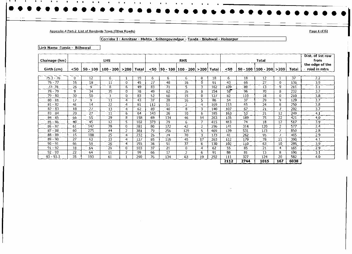
Appexdix-4 Part-2: List of Roadside Trees (Other Roads) Page 4 of 62
Corridor I: Amritsar - Mehta - Srihargovindpur - Tanda - Bilohwal - Hoisarpur
|Link Name :Tanda - Bilhowal lDist. of 1st row
Chainage (km) LHS RHS Total from
Girth (cm) <5 -50 so -__ithe
edge of the
Girth (cm) <50 lI50 - 100 100 - 200 >200 Total <50 50 - 100 100 - 200 >2001 Total <50 50 - 100 100 - 200 >200 Total road in mtrs
75.3 - 76 0 12 6 1 19 6 6 6 0 18 6 18 12 1 37 2.2
76 - 77 16 18 11 0 45 27 48 16 0 91 43 66 27 0 136 3.9
77- 78 26 9 8 6 49 83 71 5 3 162 109 80 13 9 211 3.1
78- 79 9 34 35 0 78 49 62 35 8 154 58- 96 70 8 232 3.2
79-80 30 50 3 0 83 52 60 15 0 127 82 110 18 0 210 3.8
80 - 81 17 9 - 13 4 43 37 28 16 5 86 54 37 29 9 129 3.7
81 - 82 41 14 22 4 81 112 51 2 4 169 153 65 24 8 250 3.8
82 - 83 18 27 13 4 62 89 40 8 3 140 107 67 21 7 202 3.7
83 - 84 20 27 11 6 64 143 26 10 6 185 163 53 21 12 249 4.1
84 - 85 66 55 29 8 158 69 134 46 14 263 135 189 75 22 421 4.0
85 - 86 40 45 12 5 102 373 29 6 7 415 413 74 18 12 517 3.9
86 - 87 61 142 78 0 281 80 172 42 2 296 141 314 120 2 577 2.4
87 - 88 60 275 44 2 381 79 256 129 5 469 139 531 173 7 850 2.8
88 - 89 15 188 25 4 232 26 74 70 3 173 41 262 95 7 405 2.9
89 - 90 27 63 33 4 127 85 116 45 17 263 112 179 78 21 390 4.1
90 - 91 66 59 26 4 155 36 51 37 6 130 102 110 63 10 285 3.9
91 - 92 18 64 21 0 103 37 21 0 4 62 55 85 21 4 165 2.9
92 - 93 22 64 11 2 99 66 17 2 6 91 88 81 13 8 190 3.1
93 - 93.3 35 193 61 1 290 76 134 63 19 292 111 327 124 20 582 4.0
2112 2744 1015 167 6038
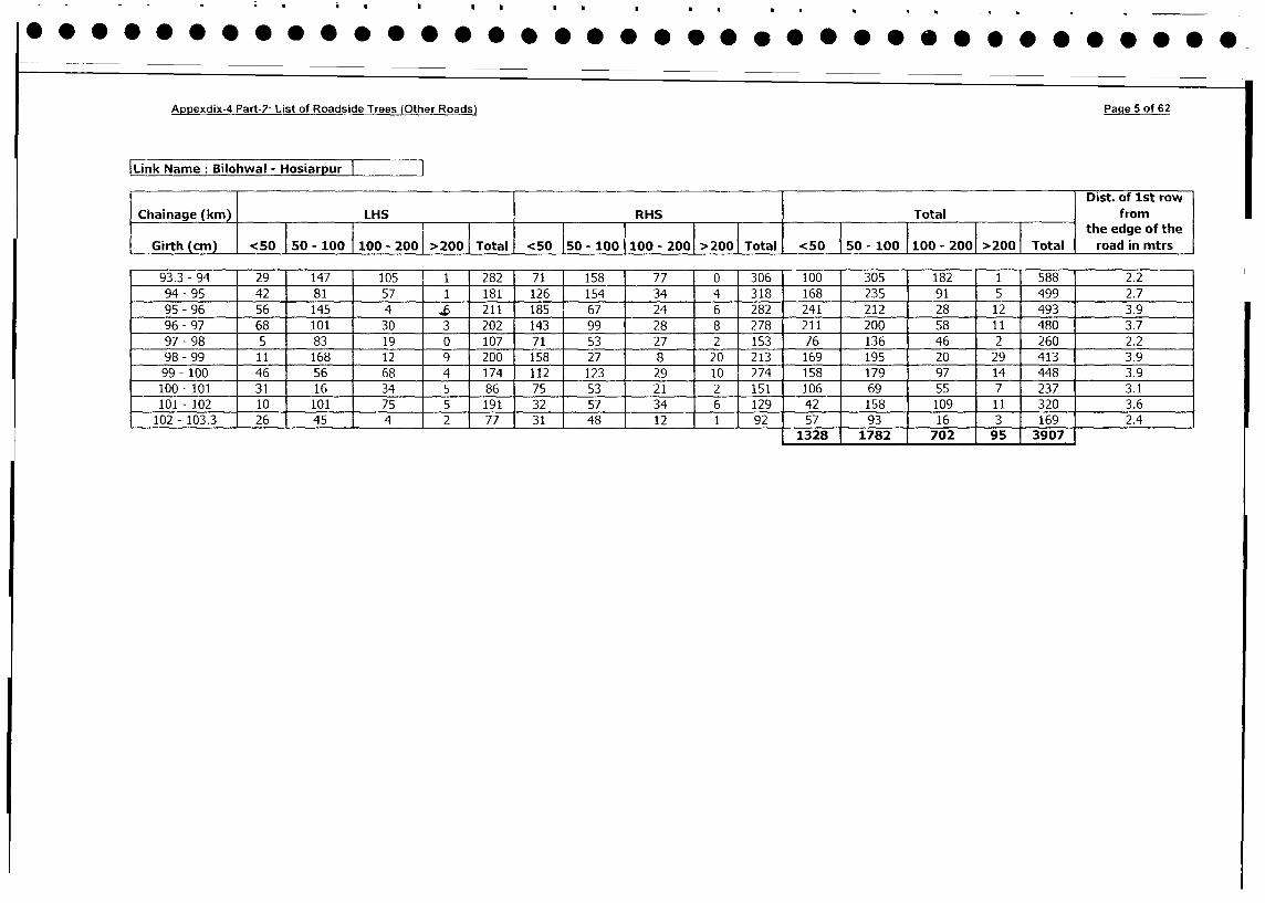
Appexdix-4 Part-2 List of Roadside Trees (Other Roads) Page 5 of 62
Link Name: Bilohwal - Hosiarpur
Dist. of 1st row
Chainage (km) LHS I RHS Total from
. ___________________________________ ___________________________________ ____l___l___l___l___l___l___l___l___l _ the edge of the
Girth (cm) <50 50 - 100 100 - 2001 >200 | Total I <50 150 - 100 100 - 200 >200 Total <50 | 50 - 100 |100 - 2001 >200 Total road in mtrs
93.3 - 94 29 147 105 1 1 282 71 158 77 0 306 100 305 182 1 588 2.2
94-95 42 81 57 1 181 126 154 34 4 318 168 235 91 5 499 2.7
95 - 96 56 145 4 6 211 185 67 24 6 282 241 212 28 12 493 3.9
96 - 97 68 101 30 3 202 143 99 28 8 278 211 200 58 11 480 3.7
97 - 98 5 83 19 0 107 71 53 27 2 153 76 136 46 2 260 2.2
98 - 99 11 168 12 9 200 158 27 8 20 213 169 195 20 29 413 3.9
99 - 100 46 56 68 4 174 112 123 29 10 274 158 179 97 14 448 3.9
100- 101 31 16 34 5 86 75 53 21 2 151 106 69 55 7 237 3.1
101 - 102 10 101 75 5 191 32 57 34 6 129 42 158 109 11 320 3.6
102 - 103.3 26 45 4 2 77 31 48 12 1 92 57 93 16 3 169 2.41328 1782 702 95 3907
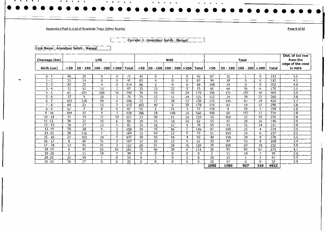
Appexdix-4 Part-2: List of Roadside Trees (Other Roads) Page 6 of 62
Corridor : Anandpur Sahib - Nanga!
Link Name Anandpur Sahib - Nangal
l Dist. of 1st row
Chainage (km) LHS RHS Total from the
| | | l | l | t l | | | ~~~~~~~~~~~~~~~~~~~~edge of the road
Girth (cm) <50 50 - 100 I 100 - 2001 >200 | Total <50 150 - 100 |100 - 2001 >2 <50 | 50 - 100 1100 - 2001 >2001 Total in mtrs
0- 1 46 25 0 0 71 41 0 1 0 42 87 25 1 0 113 3.5
1 - 2 31 14 0 0 45 63 4 0 0 67 94 18 0 0 112 4.1
2 - 3 82 32 0 0 114 86 2 0 0 88 168 34 0 0 202 4.0
3 - 4 32 51 13 1 97 33 13 22 5 73 65 64 35 6 170 3.5
4 - 5 67 107 100 16 290 39 24 92 24 179 106 131 192 40 469 3.9
5 - 6 37 9 28 1 75 75 15 11 24 125 112 24 39 25 200 3.8
6 - 7 103 128 59 6 296 72 17 28 13 130 175 145 87 19 426 3.7
7 - 8 69 23 13 7 112 102 40 6 30 178 171 63 19 37 290 3.8
8 - 9 67 7 8 0 82 51 2 21 3 77 118 9 29 3 159 2.6
9 - 10 104 42 9 3 158 386 18 148 14 566 490 60 157 17 724 3.8
10- 11 37 74 21 19 151 13 90 11 10 124 50 164 32 29 275 3.6
11 -12 36 32 10 6 84 19 15 18 10 62 55 47 28 16 146 3.8
12- 13 26 27 23 5 81 33 16 12 9 70 59 43 35 14 151 3.8
13 -14 58 38 9 3 108 29 70 16 1 116 87 108 25 4 224 3.4
14 -15 38 116 7 3 164 13 43 12 5 73 51 159 19 8 237 3.5
15- 16 21 103 18 5 147 19 53 16 4 92 40 156 34 9 239 3.5
16- 17 8 65 31 3 107 12 22 22 5 61 20 87 53 8 168 3.4
17 - 18 13 55 41 3 112 26 51 28 15 120 39 106 69 18 232 3.9
18-19 6 41 53 61 161 19 56 30 6 111 25 97 83 67 272 4.1
19-20 2 11 19 7 39 0 0 0 0 0 2 11 19 7 39 3.8
20-21 22 10 1 0 33 4 2 0 2 8 26 12 1 2 41 2.5
21-22 16 17 0 0 33 0 0 0 0 0 16 17 1 0 0 33 3.9
2056 1580 1 957 329 4922
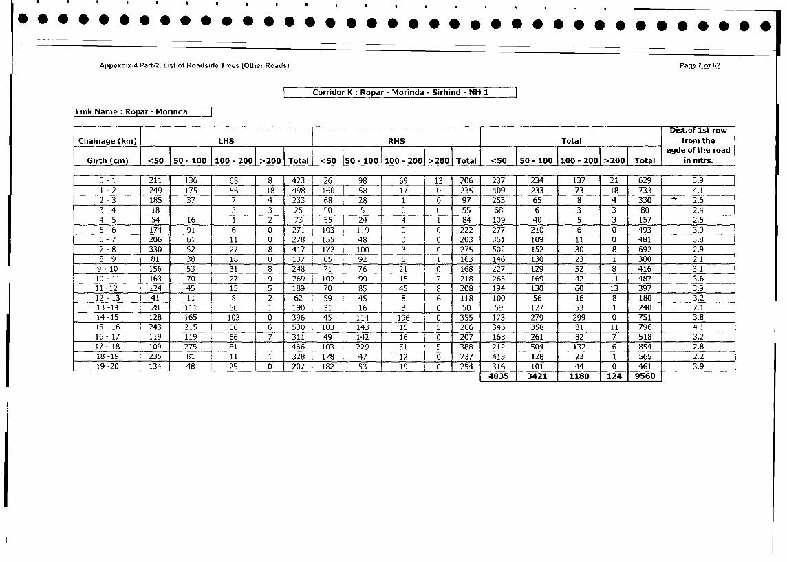
Appexdix-4 Part-2: List of Roadside Trees (Other Roads) Page 7 of 62
Corridor K: Ropar - Morinda - Sirhind - NH 1
Link Name: Ropar - Morinda
Dist.of 1st row
Chainage (km) LHS RHS Total | from the
i___________________________________ i__________________________________ i_________ _ i0_ i_ _ - 200 1 > 200 jTjtj egde ofi the road
Girth (cm) <50 j 50 - 100 100 - 200 >200 Total <50 550 - 100 100 - 2001 >200 Total <50 50 - 0 100 - 200 >200 Total in mtrs.
0- 1 211 136 68 8 423 26 98 69 13 206 237 234 137 21 629 3.9
1- 2 249 175 56 18 498 160 58 17 0 235 409 233 73 18 733 4.1
2 - 3 185 37 7 4 233 68 28 1 0 97 253 65 8 4 330 - 2.6
3 - 4 18 1 3 3 25 50 5 0 0 55 68 6 3 3 80 2.4
4 - 5 54 16 1 2 73 55 24 4 1 84 109 40 5 3 157 2.5
5- 6 174 91 6 0 271 103 119 0 0 222 277 210 6 0 493 3.9
6 - 7 206 61 11 0 278 155 48 0 0 203 361 109 11 0 481 3.8
7 - 8 330 52 27 8 417 172 100 3 0 275 502 152 30 8 692 2.9
8 - 9 81 38 18 0 137 65 92 5 1 163 146 130 23 1 300 2.1
9- 10 156 53 31 8 248 71 76 21 0 168 227 129 52 8 416 3.1
10 - 11 163 70 27 9 269 102 99 15 2 218 265 169 42 11 487 3.6
11 -12 124 45 15 5 189 70 85 45 8 208 194 130 60 13 397 3.9
12- 13 41 11 8 2 62 59 45 8 6 118 100 56 16 8 180 3.2
13 -14 28 111 50 1 190 31 16 3 0 50 59 127 53 1 240 2.1
14 -15 128 165 103 0 396 45 114 196 0 355 173 279 299 0 751 3.8
15 - 16 243 215 66 6 530 103 143 15 5 266 346 358 81 11 796 4.1
16 - 17 119 119 66 7 311 49 142 16 0 207 168 261 82 7 518 3.2
17 - 18 109 275 81 1 466 103 229 51 5 388 212 504 132 6 854 2.8
18-19 235 81 11 1 328 178 47 12 0 237 413 128 23 1 565 2.2
19 -20 134 48 25 0 207 182 53 19 0 254 316 101 44 0 461 3.94835 3421 1180 124 9560
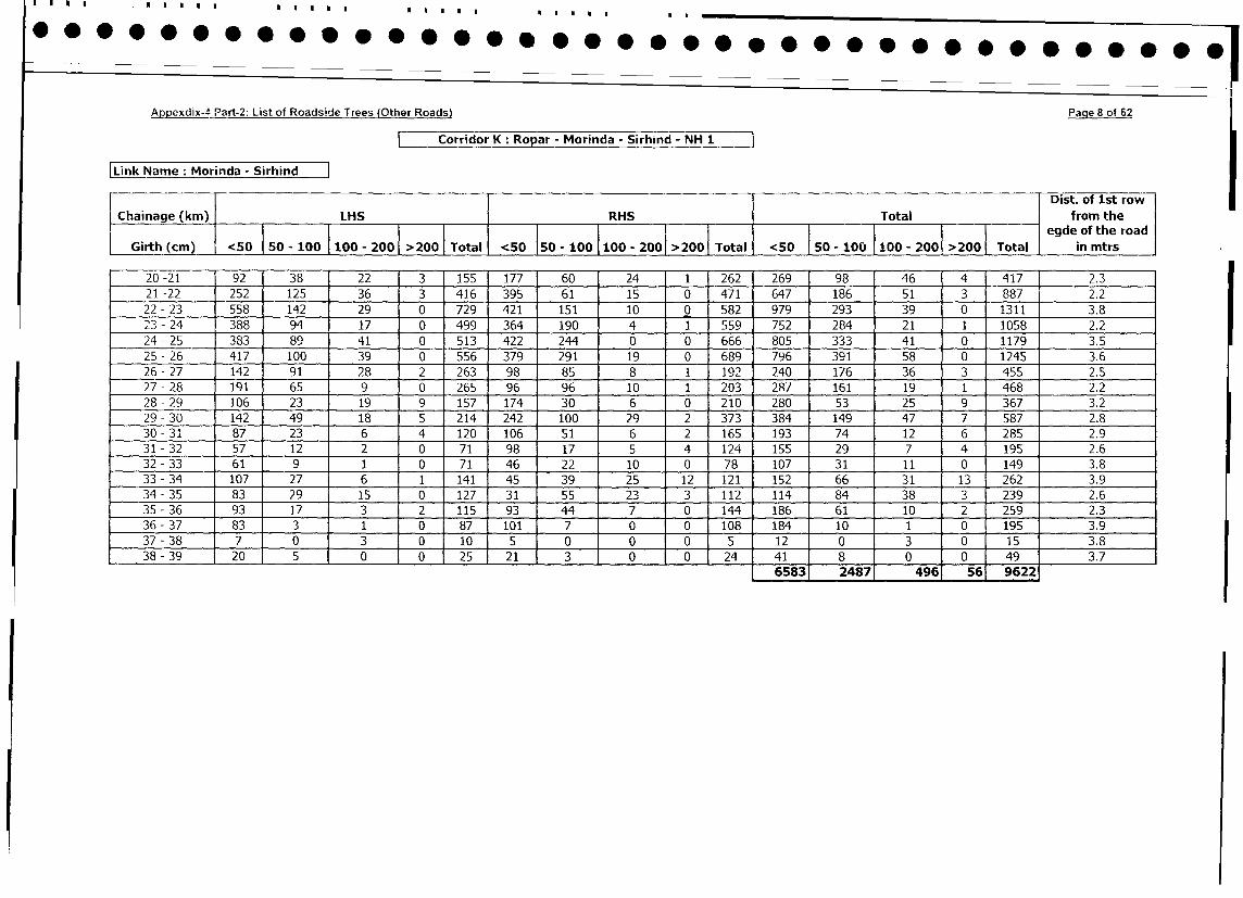
Appexdix-_ Part-2: List of Roadside Trees (Other Roads) Page 8 of 62
Corridor K: Ropar - Morinda - Sirhind - NH 1
|Link Name: Morinda - Sirhind
l I i Dist. of 1st row
Chainage (kin) LHS IRHS I Total from the
Chainage 50-100 100-200 I >200 Tlta-0 egde of the road
Girth (cm) <50 50 - 100 100 - 200 >200 T Total <50 ota <50 | 50 - 100 100 - 200 >200| Total in mtrs
20-21 92 38 22 3 155 177 60 24 1 262 269 98 46 4 417 2.3
21 -22 252 125 36 3 416 395 61 15 0 471 647 186 51 3 887 2.2
22 - 23 558 142 29 0 729 421 151 10 0 582 979 293 39 0 1311 3.8
23 - 24 388 94 17 0 499 364 190 4 1 559 752 284 21 1 1058 2.2
24 - 25 383 89 41 0 513 422 244 0 0 666 805 333 41 0 1179 3.5
25 - 26 417 100 39 0 556 379 291 19 0 689 796 391 58 0 1245 3.6
26- 27 142 91 28 2 263 98 85 8 1 192 240 176 36 3 455 2.5
27-28 191 65 9 0 265 96 96 10 1 203 287 161 19 1 468 2.2
28- 29 106 23 19 9 157 174 30 6 0 210 280 53 25 9 367 3.2
29 - 30 142 49 18 5 214 242 100 29 2 373 384 149 47 7 587 2.8
30-31 87 23 6 4 120 106 51 6 2 165 193 74 12 6 285 2.9
31 -32 57 12 2 0 71 98 17 5 4 12,4 155 29 7 4 195 2.6
32-33 61 9 1 0 71 46 22 10 0 78 107 31 11 0 149 3.8
33 - 34 107 27 6 1 141 45 39 25 12 121 152 66 31 13 262 3.9
34 -35 83 29 15 0 127 31 55 23 3 112 114 84 38 3 239 2.6
35 - 36 93 17 3 2 115 93 44 7 0 144 186 61 10 2 259 2.3
36- 37 83 3 1 0 87 1 101 7 _ 0 0 108 _184 10 1 0 195 3.9
37 - 38 7 0 3 ° 10 5 0 0 0 5 12 0 3 0 15 3.8
38 - 39 20 5 0 0 25 21 3 0 0 24 41 8 0 0 49 3.7
6583 2487 496 56 9622
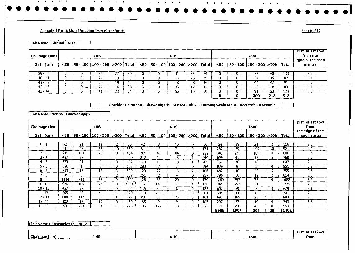
Appexdix-4 Part-2: List of Roadside Trees (Other Roads) Page 9 of 62
Link ame irhind - NHI
T I ~~~~~~~~~~~~~~~~~~~~~~~~~~~~~~~~Dist. of lst row
Chainage (kin) ILHS RHS ITotal [ from the
Girth_(cm) 1 <50 50 - 100 1100 - 2001 >200 1Total <50 50-1010- 0 20T50 - 100 0-10 00- 2001 >2001 Total in theroa
39 -40 10 0 32 27 59 0 0 41 33 74 0 0 73 60 133 3.9
40 -41 10 0 24 19 43 0 0 13 26 39 0 0 37 45 82 4.1
41 -42 0 0 26 19 45 0 0 18 128 46 0 0 44 47 91 3.8
42 -43 10 0. 22 16 38 0 0 33 12 45 0 0 55 28 83 ~ 4.1
43 -44 10 0 41 23 64 0 0 50 10 60t 0 0 - 91 33 124 3.8
0 0 1 300 1213 1513
ICorridor LI Nabha - Bhawanigarh - Sunam - Bhiki - Harsinghwala Mour - Kotfateh - Kotsamir
Link ame abha - Bhawanigarh
I ~~~~~~~~~~~~Dist. of lst row
-Chai nage (kmn) LHS RHS Total from
Girth(cm) <50 0 - 10 100- 200>200 otal 50 50- 100100 -200 >00 Toal j 50 50- 100100 -200 >00tToaleth eedgeoftth
Git_c_<0_________-20_20 oa <0 0-10 10- 01>01 oa 5015 0010 20 0 road_in_mtrs
0 -1 22 21 11 2 56 42 8 10 0 60 64 29 21 2 116 2.2
1 -2 231 43 66 10 350 51 46 74 0 171 282 89 140 10 521 2.9
2 -3 245 194 25 4 0 464 97 41 84 0 222 342 235 109 0 686 3.8
3 -4 487 27 2 4 520 212 14 13 1 240 699 41 15 5 760 2.7
4 -5 573 21 8 0 602 179 15 10 1 205 752 36 18 1 807 2.1
5 -6 556 1 1 0 0 557 283 8 3 0 294 839 9 3 0 851 3.8
6 -7 553 18 15 3 589 129 22 13 2 166 682 40 28 5 755 2.8
7 -8 539 8 8 2 557 251 2 4 0 257 790 10 12 2 814 2.2
8 -9 1134 319 56 0 1509 126 33 20 0 179 1260 352 76 0 1688 3.9
9 - 10 920 109 22 0 1051 25 143 9 1 178 945 252 31 1 1229 2.1
10 -11 457 37 0 0 494 145 32 8 0 185 602 69 8 0 679 3.8
11 -12 265 45 9 1 320 1119 255 1 7 0 381 384 300 16 1 701 2.1
12 -13 604 112 5 1 722 88 53 20 0 161 692 165 25 1 883 2.2
13 -14 132 18 10 0 160 165 9 9 0 183 297 27 19 0 343 3.8
14 -15 90 123 33 0 246 .186 127 10 0 323 276 250 j43 0 569 3.9
8906 1904 54 28 11402
lLink Name: Bhawanigarh- NH 711Dist. of 1st row
IChainage (kin) ILHS IRHS Total from
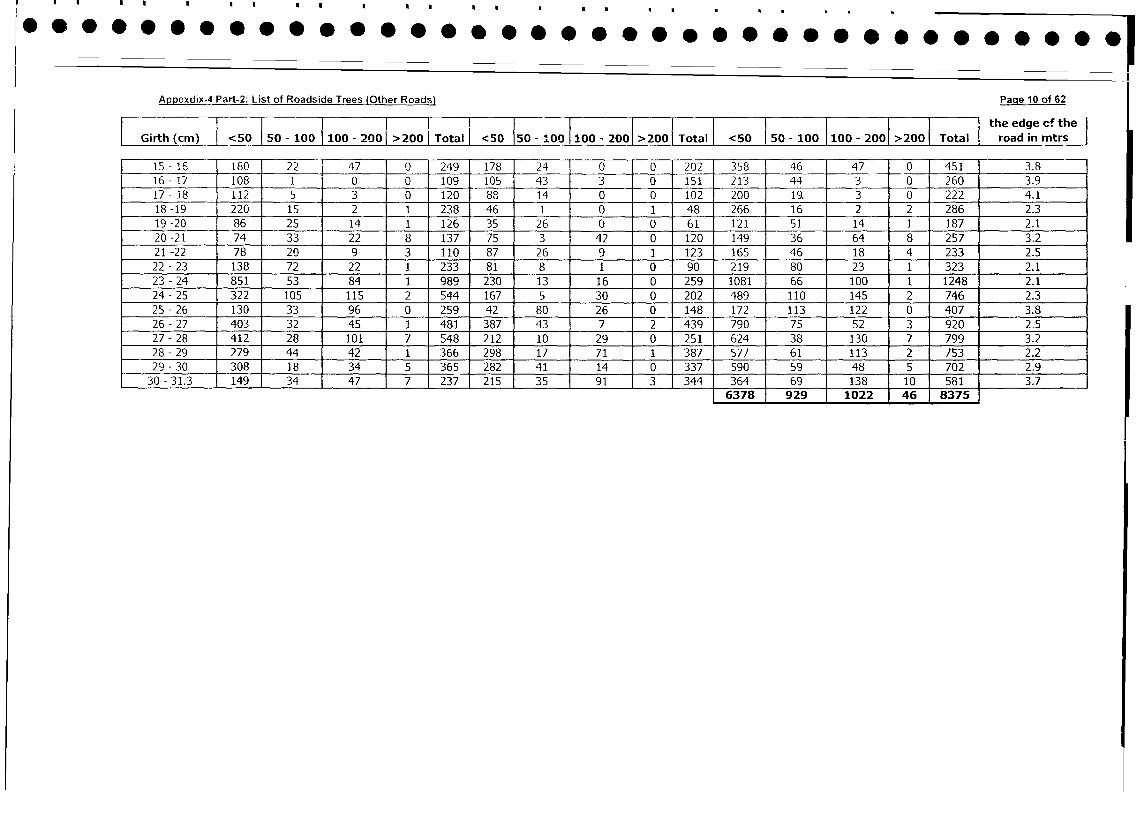
Appexdix-4 Part-2: List of Roadside Trees (Other Roads) Paqe 10 of 62
I l l I l I I I-- l l l l the edge cf the
Girth (cm) <50 |50 - 10 0 100 - 200 >200 Total <50 150 - 100 100 - 2001 >2001 Total | <50 | 50 - 100 1100 - 2001 >2001 Total r road in mtrs |
15-16 180 22 47 0 1249 178 24 0 0 202 358 46 47 0 451 3.8
16 - 17 108 1 0 0 109 105 43 3 0 151 213 44 3 0 260 3.9
17- 18 112 5 3 0 120 88 14 0 0 102 200 19. 3 0 222 4.1
18 -19 220 15 2 1 238 46 1 0 1 48 266 16 2 2 286 2.3
19-20 86 25 14 1 126 35 26 0 0 61 121 51 14 1 187 2.1
20 -21 74 33 22 8 137 75 3 42 0 120 149 36 64 8 257 3.2
21 -22 78 20 9 3 110 87 26 9 1 123 165 46 18 4 233 2.5
22- 23 138 72 22 1 233 81 8 1 0 90 219 80 23 1 323 2.1
23 - 24 851 53 84 1 989 230 13 16 0 259 1081 66 100 1 1248 2.1
24- 25 322 105 115 2 544 167 5 30 0 202 489 110 145 2 746 2.3
25 - 26 130 33 96 0 259 42 80 26 0 148 172 113 122 0 407 3.8
26 - 27 403 32 45 1 481 387 43 7 2 439 790 75 52 3 920 2.5
27 - 28 412 28 101 7 548 212 10 29 0 251 624 38 130 7 799 3.2
28 - 29 279 44 42 1 366 298 17 71 1 387 577 61 113 2 753 2.2
29 - 30 308 18 34 5 365 282 41 14 0 337 590 59 48 5 702 2.9
30 - 31.3 149 34 47 7 237 215 35 91 3 344 364 69 138 10 581 3.7
6378 929 1022 46 8375
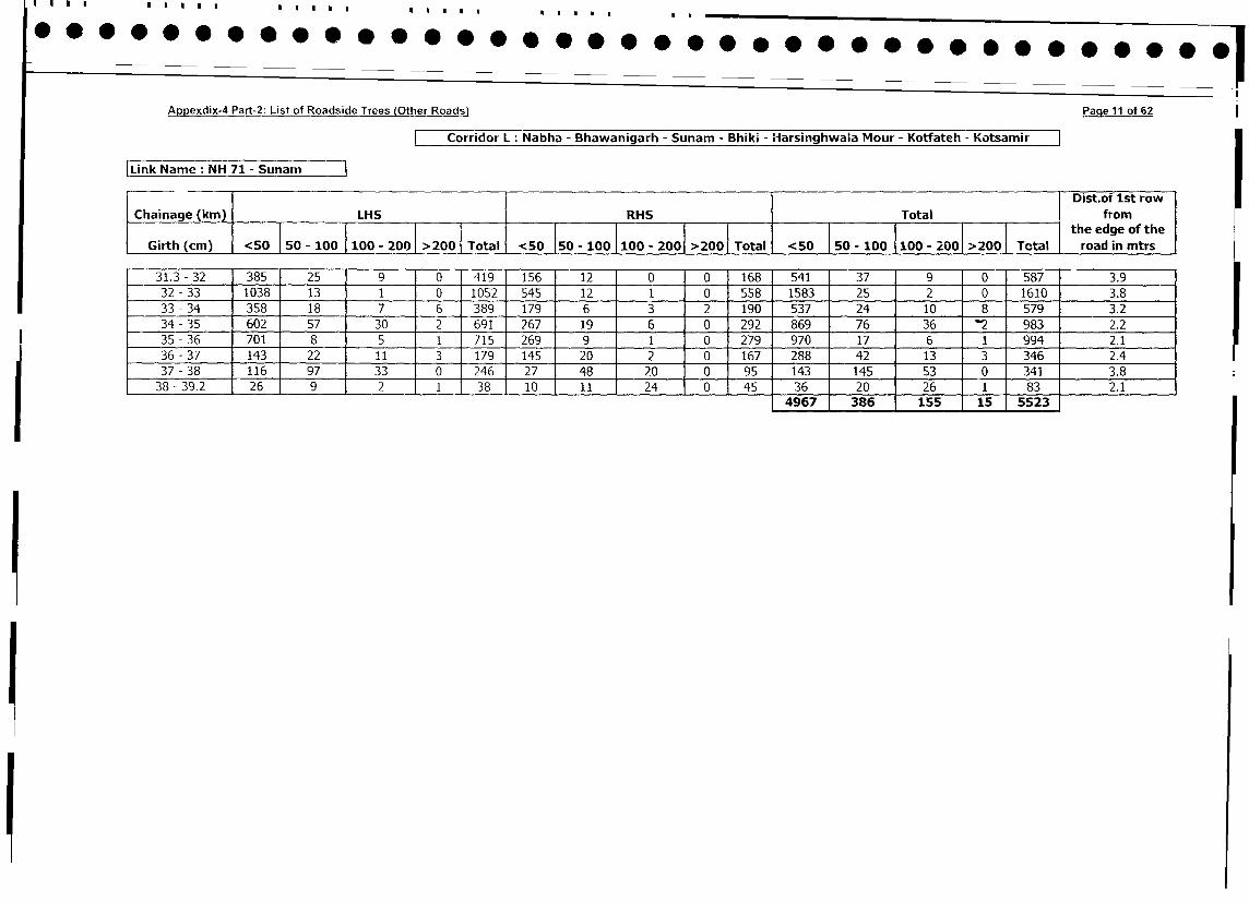
Appexdix-4 Part-2: List of Roadside Trees (Other Roads) Page 1i of 62
Corridor L: Nabha - Bhawanigarh - Sunam - Bhik. - Harsinghwaia Mour - Kotfateh - Kotsamir
|Link Name: NH 71 - Sunam
_ | ~~~~~~~~~~~~~~~~~~~~~~~~~~~~~~~~~~~Dist.of Ist row|
Chainage (km) LHS RHS I Total l from w
Girth (cm) <50 50 - 100 100 - 200 >200 Total <50 I50 - 100 100 - 200 >200 Total <50 50 - 100 |100 - 200 >2001 Total t road in mtrs
Girth (cm)__
100 road10 -
in mtr2sT
31.3 - 32 385 25 9 0 419 156 12 0 0 168 541 37 9 0 587 3.9
32 - 33 1038 13 1 0 1052 545 12 1 0 558 1583 25 2 0 1610 3.8
33 -34 358 18 7 6 389 179 6 3 2 190 537 24 10 8 579 3.2
34 - 35 602 57 30 2 691 267 19 6 0 292 869 76 36 2 983 2.2
35 - 36 701 8 5 1 715 269 9 1 0 279 970 17 6 1 994 2.1
36 - 37 143 22 11 3 179 145 20 2 0 167 288 42 13 3 346 2.4
37 - 38 116 97 33 0 246 27 48 20 0 95 143 145 53 0 341 3.8
38-39.2 26 9 2 1 38 10 11 24 0 45 36 20 26 1 1 83 2.1
4967 386 155 15 15523
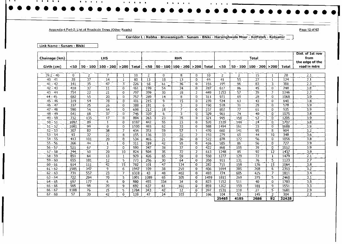
Appexdix-4 Part-2: List of Roadside Trees (Other Roads) Page 12 of 62
Corridor L: Nabha - Bhawanigarh - Sunam - Bhiki - Harsinghwala Mour - Kotfateh - Kotsamir
Link Name: Sunam - BhikiT Dist. of 1st row
Chainage (km) LHS RHS Total I from
_________
<50 50-100 100-20 >200 otal 1the edge of ithe
Girth (cm) <50<50 550 - 100 1100 - 2001 >2001 Total I road in mtrs
Girth (cm) <50 50 - 100 I100 - 2001 > 200 1Total <50___-_________201_> Z
39.2 - 40 0 2 7 1 10 2 0 8 0 10 2 2 15 11 201 2.1
40 - 41 28 37 14 1 80 13 18 13 0 44 41 55 27 1 124 2.1
41 - 42 141 35 47 3 226 58 61 36 0 155 199 96 83 3 381 2.3
42 - 43 418 32 11 0 461 199 54 34 0 287 617 86 45 0 748 3.8
43 - 44 754 22 21 0 797 399 30 18 2 449 1153 52 39 2 1246 2.2
44 - 45 682 55 20 0 757 289 14 8 0 311 971 69 28 0 1068 3.9
45 - 46 319 54 28 0 401 215 9 15 0 239 534 63 43 0 640 3.8
46 - 47 337 25 26 0 388 181 6 3 0 190 518 31 29 -0 578 3.9
47 - 48 590 54 54 0 698 212 18 7 0 237 802 72 61 0 935 3.9
48 - 49 641 68 37 _ 0 746 320 6 3 0 329 961 74 40 0 1075 3.8
49 - 50 732 135 17 0 884 263 23 35 0 321 995 158 52 0 1205 3.9
50 - 51 1097 89 1 0 1187 442 55 23 0 520 1539 144 24 0 1707 3.8
51 - 52 1001 99 0 0 1100 493 62 33 0 588 1494 161 33 0 1688 3.9
52- 53 307 82 38 7 434 353 59 57 1 470 660 141 95 8 904 3.2
53 - 54 93 32 22 8 155 136 33 22 2 193 229 65 44 10 348 3.6
54 - 55 413 101 20 0 534 465 21 36 0 522 878 122 56 0 1056 3.8
55 5-56 266 44 1 0 311 319 42 55 0 416 585 86 56 0 727 3.9
56-57 521 67 2 0 590 347 38 37 0 422 868 105 39 0 1012 3.9
57 - 58 744 50 20 10 824 504 35 72 2 613 1248 85 92 12 1437 3.9
58 - 59 851 64 13 1 929 426 65 59 0 550 1277 129 72 1 1479 2.1
59-60 655 101 12 5 773 256 30 64 0 350 911 131 76 5 1123 2.7
60 - 61 614 111 42 15 782 101 47 134 0 282 715 158 176 15 1064 3.8
61 - 62 1585 347 9 6 1947 109 38 259 0 406 1694 385 268 6 2353 3.2
62-63 731 557 23 7 1318 43 48 402 0 493 774 605 425 7 1811 3.4
63 - 64 722 204 70 5 1001 1089 65 305 0 1459 1811 269 375 5 2460 3.1
64-65 697 177 6 0 880 455 334 34 0 823 1 1152 511 40 0 1703 3.8
65-66 565 98 20 9 692 637 ( 61 161 0 859 1202 159 181 9 15511 3.3
66-67 1188 76 15 5 1284 343 42 12 0 397 1531 118 27 5 16811 2.9
67-68 57 39 42 0 138 47 14 103 2 166 104 53 145 2 3041 2.2
25465 4185 2686 92 32428]
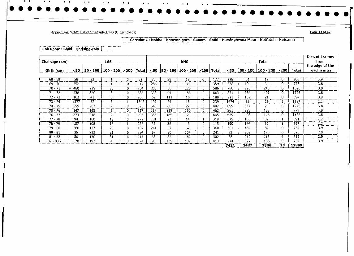
Appexdix-4 Part-2: List of Roadside Trees (Other Roads) Page 13 of 62
Corridor L: Nabha - Bhawanigarh - Sunam - Bhiki - Harsinghwala Mour - Kotfateh - Kotsamir ]
Link Name: Bhiki - Harisingwala
I l l Dist. of 1st row
L Chainage (km) LHS RHS Total from
i I <50 50-100 100- - 2001 > Total the edge of the
Girth(cm)| <50 |50 - 100 1100 - 200 >200 Total <50 50 - 100 100 - 200 >200 Total -100 100>200roadinmtrs
68-69 58 22 1 0 81 70 39 18 0 127 128 61 19 0 208 3.9
69- 70 352 64 1 0 417 286 40 33 0 359 638 104 34 0 776 3.8
70 - 71 480 229 25 0 734 300 66 220 0 586 780 295 245 0 1320 3.9
71 - 72 538 320 5 0 863 333 44 486 0 863 871 364 491 0 1726 3.8
72 - 73 162 41 3 0 206 59 111 18 0 188 221 152 21 0 394 3.9
73 - 74 1277 62 8 1 1348 197 24 18 _ 0 239 1474 86 26 1 1587 2.1
74 -75 559 267 2 0 828 340 80 27 0 447 899 347 29 0 1275 3.8
75 - 76 147 165 5 0 317 114 158 190 0 462 261 323 195 0 779 3.9
76- 77 273 218 2 0 493 356 185 124 0 665 629 403 126 0 1158 3.8
77 - 78 94 160 18 0 272 281 23 14 1 319 375 183 32 1 591 2.2
78- 79 157 108 16 1 282 33 36 46 0 115 190 144 62 1 397 2.2
79 - 80 260 127 20 0 407 241 57 62 0 360 501 184 82 0 767 3.9
80-81 35 222 21 6 284 57 80 104 0 241 92 302 125 6 525 2.9
81 - 82 50 130 31 6 217 38 82 182 0 302 88 212 213 6 519 2.9
82 - 83.2 178 192 4 0 374 96 135 182 0 413 274 327 186 0 787 3.9
7421 3487 1886 15 12809
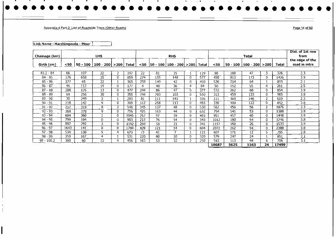
Appexdix-4 Part-2: List of Roadside Trees (Other Roads) Page 14 of 62
Link Name : Harshingwa-la - Maur
l Dist. of 1st row
Chainage (km) LHS RHS Total from_ _ _ _ _ _ _ _ _ _ _ _ _ _ _ 1 the edge of the
Girth (cm) <50 | 50 - 100 |100 - 200 |>200 I Total <50 150 - 100 |100 - 2001 >200 Total <50 I50 - 1100 100 - 200 >20 Total road in mtrs
83.2 - 84 66 107 22 2 197 22 81 25 1 129 88 188 47 3 326 2.3
84 - 85 176 658 25 0 859 274 155 148 0 577 450 813 173 0 1436 3.9
85 - 86 277 65 22 1 365 259 149 42 0 450 536 214 64 1 815 2.1
86 - 87 46 112 19 0 177 4 40 36 4 84 50 152 55 4 261 2.5
87 - 88 288 176 13 0 477 244 86 47 0 377 532 262 60 0 854 3.9
88 - 89 69 256 30 0 355 244 203 103 0 550 313 459 133 0 905 3.8
89 - 90 30 249 3 1 283 81 111 143 1 336 111 360 146 2 619 2.3
90 - 91 218 142 9 0 369 112 258 113 0 483 330 400 122 0 852 3.8
91 - 92 217 319 8 2 546 345 137 48 0 530 562 456 56 2 1076 2.3
92 - 93 369 378 9 0 756 425 163 44 0 632 794 541 53 0 1388 3.8
93 - 94 684 360 1 0 1045 267 97 39 0 403 951 457 40 0 1448 3.9
94 - 95 799 104 0 0 903 213 76 54 0 343 1012 180 54 0 1246 3.8
95 - 96 897 292 3 0 1192 260 58 23 0 341 1157 350 26 0 1533 3.9
96 - 97 1643 141 0 0 1784 429 121 54 0 604 2072 262 54 0 2388 3.8
97 - 98 534 130 5 4 673 73 41 7 1 122 607 171 12 5 795 2.8
98 - 99 359 167 4 1 531 220 80 20 0 320 579 247 24 1 851 2.1
99 - 100.2 380 60 12 4 456 163 53 32 2 250 543 113 44 6 706 3.110687 5625 1163 t24 117499
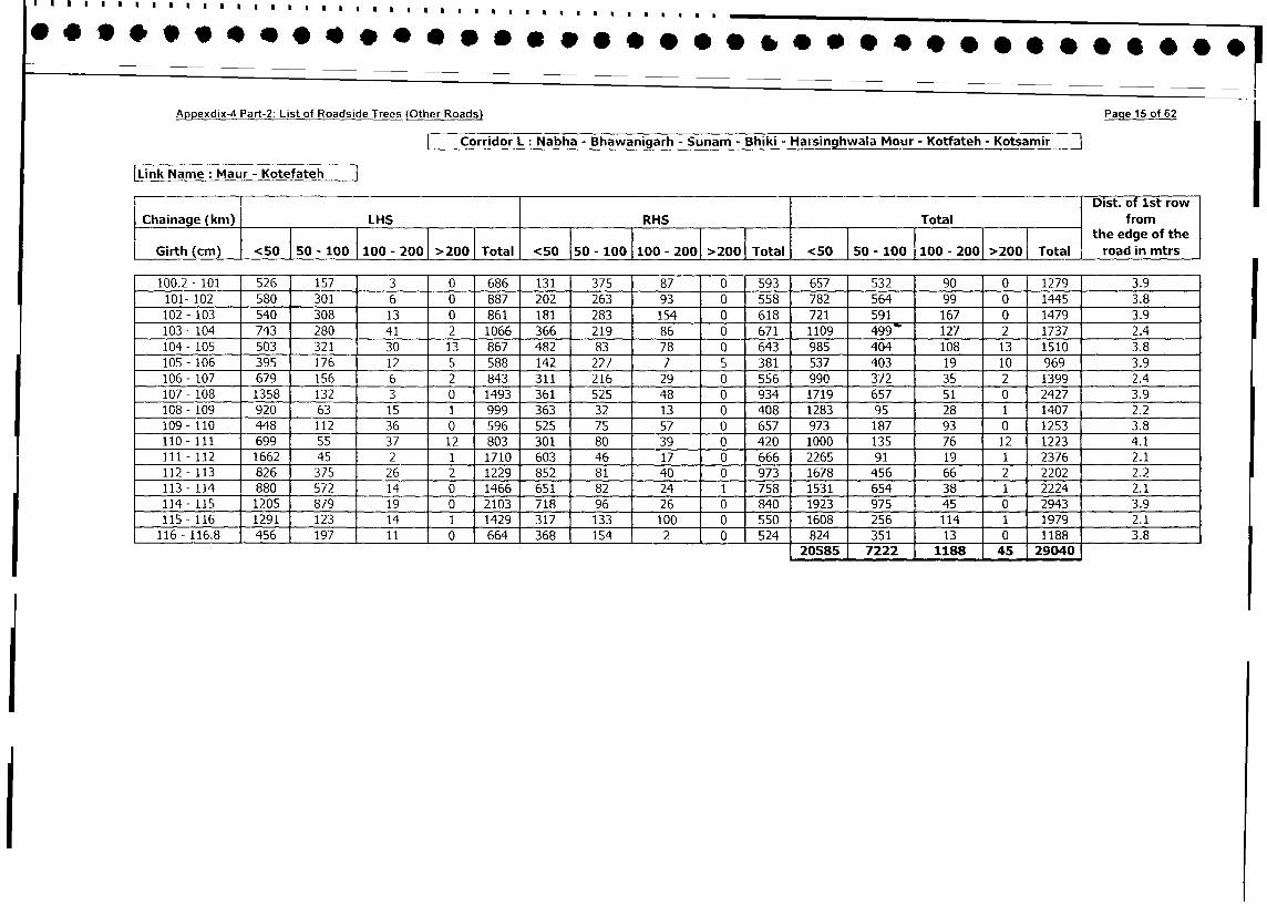
Appexdix-4 Part-2: List of Roadside Trees (Other Roads) Paqe 15 of 62
Corridor L: Nabha - Bhawanigarh - Sunam - Bhiki - Harsinghwala Mour - Kotfateh - Kotsamir
|Link Name: Maur - KotefatehDist. of 1st row
Chainage (km) LHS RHS Total from
I ~~~~~~the edge of the
Girth (cm) <50 F50 -100 100 - 200 >2001 Total <50 150 - 100 100 - 2001 >2001 Total <50 | 50 - 100 100 - 2001 >2001 Total road in mtrs
100.2 - 101 526 157 3 0 686 131 375 87 0 593 657 532 90 0 1279 3.9
101- 102 580 301 6 0 887 202 263 93 0 558 782 564 99 0 1445 3.8
102 - 103 540 308 13 0 861 i81 283 154 0 618 721 591 167 0 1479 3.9
103 - 104 743 280 41 2 1066 366 219 86 0 671 1109 499 127 2 1737 2.4
104 - 105 503 321 30 13 867 482 83 78 0 643 985 404 108 13 1510 3.8
105 - 106 395 176 12 5 588 142 227 7 5 381 537 403 19 10 969 3.9
106 - 107 679 156 6 2 843 311 216 29 0 556 990 372 35 2 1399 2.4
107 - 108 1358 132 3 0 1493 361 525 48 0 934 1719 657 51 0 2427 3.9
108 - 109 920 63 15 1 999 363 32 13 0 408 1283 95 28 1 1407 2.2
109- 110 448 112 36 0 596 525 75 57 0 657 973 187 93 0 1253 3.8
110 - 111 699 55 37 12 803 301 80 39 0 420 1000 135 76 12 1223 4.1
111 - 112 1662 45 2 1 1710 603 46 17 0 666 2265 91 19 1 2376 2.1
112 - 113 826 375 26 2 1229 852 81 40 0 973 1678 456 66 2 2202 2.2
113 - 114 880 572 14 0 1466 651 82 24 1 758 1531 654 38 1 2224 2.1
114 - 115 1205 879 19 0 2103 718 96 26 0 840 1923 975 45 0 2943 3.9
115 - 116 1291 123 14 1 1429 317 133 100 0 550 1608 256 114 1 1979 2.1
116 -116.8 456 197 11 0 664 368 154 2 0 524 824 351 13 0 1188 3.8
20585 1 7222 1188 45 29040
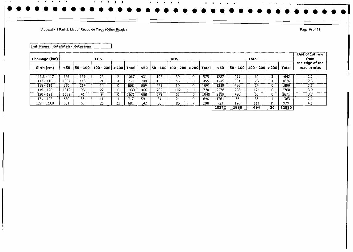
*.O...e .. e..e.e...O. @..e.............. ...............................................,
Appexdix-4 Part-2: List of Roadside Trees (Other Roads) Page 16 of 62
|Link Name: Kotefateh - Kotesamir
Dist.of 1st row
Chainage (km) LHS RHS Total from
l__ _ _ _ _ _ _ _ _ _ _ _ _ _ _ _ _ _ _ _ _ _ _ _ _ _ _ _ 1 l_ _ _ _ _ _ _ _ _ _ _ _ _ _ _ _ _ _ _ _ _ _ _ _ _ _ _ _ _ l l_ __l_ _l_ _ _ _ __l_ __l_ _ l _ _ _ l_ _ .__ _ _ th e e d g e o f th e
Girth (cm) <50 |50 - 100 10 - 200 >200 Total <50 150 - 100 100 - 2001 >200 Total <50 |50 - 100 1|00 - 200 >200 Total road in mtrs
116.8-117 856 186 23 2 1067 431 105 39 0 575 1287 291 62 2 1642 2.2
117- 118 1001 145 21 4 -1171 244 156 55 0 455 1245 301 76 4 1626 2.3
118 - 119 580 214 14 0 808 809 272 10 0 1091 1389 486 24 0 1899 3.8
119 - 120 1812 96 22 0 1930 466 202 102 0 770 2278 298 124 0 2700 3.9
120 - 121 1581 41 9 0 1631 608 379 53 0 1040 2189 420 62 0 2671 3.8
121 - 122 670 35 11 1 717 591 31 24 0 646 1261 66 35 1 1363 2.1
122- 123.8 581 63 25 12 681 142 63 86 7 298 723 126 111 19 979 4.1
110372 1988 494 26 12880
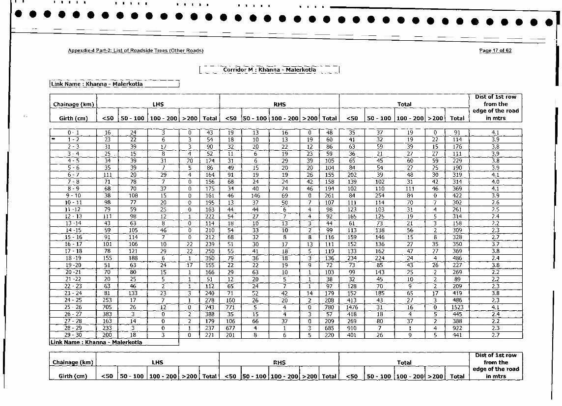
Appexdix-4 Part-2: List of Roadside Trees (Other Roads) _Paqe 17 of 62
Corridor M: Khanna - Malerkotla
Link Name : Khanna - MalerkotlaDist of 1st row
Chainage (km) LHS RHS Total from the
Girth (cm) <50 50 - 100 100 - 2001 >200 | Total <50 50 - 100 100 - 200 >200 Total <50 50 - 100 100 - 200 >200 Total in mtrs
0- 1 16 24 3 0 43 19 13 16 0 48 35 37 19 0 91 4.1
1 - 2 23 22 6 3 54 18 10 13 19 60 41 32 19 22 114 3.9
2 - 3 31 39 17 3 90 32 20 22 12 86 63 59 39 15 176 3.8
3 - 4 25. 15 8 4 52 11 6 19 23 59 36 21 27 27 111 3.9
4- 5 34 39 31 20 124 31 6 29 39 105 65 45 60 59 229 3.8
5 - 6 35 39 7 5 86 49 15 20 20 104 84 54 27 25 190 3.9
6 - 7 111 20 29 4 164 91 19 19 26 155 202 39 48 30 319 1 4.1
7- 8 71 78 7 0 156 68 24 24 42 158 139 102 31 42 3141 4.0
8 - 9 68 70 37 0 175 34 40 74 46 194 102 110 111 46 369 4.1
9- 10 38 108 15 0 161 46 146 69 0 261 84 254 84 0 422 3.9
10- 11 98 77 20 0 195 13 1 37 50 7 107 111 114 70 7 302 2.6
11-12 79 59 25 0 163 44 44 6 4 98 123 103 31 4 261 2.5
12- 13 111 98 12 1 222 54 27 7 4 92 165 125 19 5 314 2,4
13-14 43 63 8 0 114 18 10 13 3 44 61 73 21 3 158 2.2
14-15 59 105 46 0 - 210 54 33 10 2 99 113 138 56 2 309 2.3
15-16 91 114 7 0 212 68 32 8 8 116 159 146 15 8 328 2.7
16- 17 101 106 10 22 239 51 1 30 17 13 111 152 136 27 35 350 3.7
17- 18 78 121 29 22 250 55 41 18 5 119 133 162 47 27 369 3.8
18-19 155 188 6 1 350 79 36 18 3 136 234 224 24 4 486 2.4
19-20 51 63 24 17 155 22 22 19 9 72 73 85 43 26 227 1 3.8
20-21 70 80 15 1 166 29 63 10 1 103 99 143 25 2 _ 269 2.2
21 -22 20 25 5 1 51 12 20 5 1 38 32 45 10 2 _ 89 2.2
22 - 23 63 46 2 1 112 65 1 24 7 1 97 128 70 9 2 209 2.3
23 - 24 81 133 23 3 240 71 1 2 42 14 179 152 185 65 17 419 3.8
24 - 25 253 17 7 1 278 160 26 20 2 208 413 43 27 3 486 2.3
25 - 26 705 26 12 0 743 771 5 4 0 780 1476 31 16 0 1523 1 4.1
26- 27 383 3 0 2 388 35 15 4 3 57 418 18 4 5 445 2.4
27- 28 163 14 0 2 179 106 66 37 0 209 269 80 37 2 388 2.2
28- 29 233 3 0 1 237 677 4 1 3 685 910 7 1 4 922 2.3
29 - 30 200 18 3 10 221 201 8 6 5 220 401 26 9 5 441 2.7
Link Name: Khanna - Malerkotla IDist of 1st row
aIrh (ka ) m LHS RHS Total from the
(cm) <50 50 . 100 100 - 200 >200 Total <50 50 - 100 100 - 200 >200 Total <50 50 100 100|200>200 edgeTof the roads
|GiRth (cmn) |<50 so5 - l00 | 100 - 200| >2700 |Total |5010-00|00-20>0| ol<50 5 |50- 100|100 - 2001 >200 | aotll in mtrs
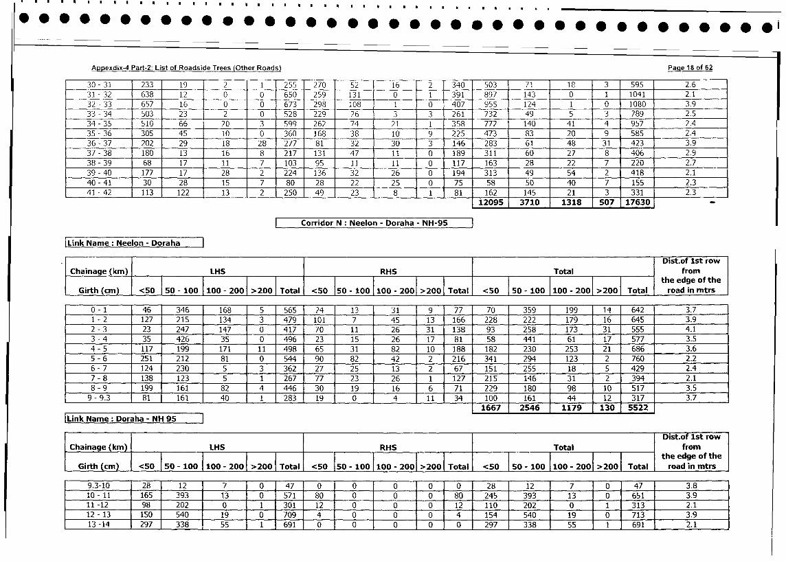
Appexdix-4 Part-2: List of Roadside Trees (Other Roads) Pae 8 of 62
30 -31 233 19 2 1 255 270 52 16 2 340 503 71 183 595 2.6
31 -32 638 12 0 0 650 259 131 0 1 391 897 143 0 1 1041 2.1
32 -33 657 16 1 0 0 673 298 108 1 0 407 955 141 0 1080 3.9
33 -34 503 23 2 0 528 229 26 3 3 261 732 495 3 789 2.5
34 -35 510 66 20 3 599 262 7,4 21 1 358 772 140 41 4 957 2.4
35 -36 305 1 45 10 0 360 168 1 38 10 9 ,225 473 8329 552.
36 -37 202 29 18 28 1277 81 32 30 3 146 283 61 48 31 423 3.9
37 -38 180 13 16 8 217 131 47 1 1 0 189 311 60 27 8 406 2.9
38 -39 68 17 1 1 7 103 95 11 1 1 0 117 163 28 22 7 220 2.7
39 -40 177 17 28 2 224 136 32 26 0 194 313 49 54 2 418 2.1
40 -41 30 28 15 7 80 28 22 25 0 75 58 50 40 7 155 2.3
41 -42 113 122 13 2 250 149 23 1 8 1 81 162 145 21 3 331 2.3
12095 3710 138 57 160 -
Corridor N Neelon - Doraha - NH-9
Link Name: Neelon - DorahDist.of lst row
Chainage (kin) LHS RHS Total from
___ __ __ __ __ __ __ __ ___ __ __ _ __ __ _so _ ___ __ __ __ __ ___I__ the edge of the
Girth (cm) <50 50 - 10 00-2001 >200 1Total <50 50O - 100 1100- 2001 >2001 Total <50 1 50o1010 0 20 Total road in mtrs
0 -1 46 346 168 5 565 24 13 31 J9 77 70 359 199 14 642 3.7
1 - 2 127 215 134 3 479 101 7 45 13 166 228 222 179 16 645 3.9
2 -3 23 247 147 0 417 70 11 26 31 138 93 258 173 31 555 4.1
3 -4 35 426 35 0 496 23 15 26 17 81 58 441 61 17 577 3.5
4 -5 117 199 171 11 498 65 31 82 10 188 182 230 253 21 686 3.6
5 -6 251 212 81 0 1544 90 82 42 2 216 341 294 123 2 ,760 2.2
6 -7 124 230 5 3 362 27 25 13 2 67 151 255 18 5 429 2.4
7 -8 138 123 5 1 267 77 23 26 1 127 215 146 31 2 394 2.1
8 -9 199 161 82 4 446 30 19 16 6 71 229 180 98 10 517 3.5
9 -9.3 81 161 40 1 283 19 0 4 it 34 100 161 44 12 317 3.7
___________________________ ~ ~ ~ ~ ~ ~ ~ ~ ~ ~ ~ ~ ~ 11667 2546 1179 1130. 5522
[Link Name: Doraha - NH 95~
I ~ ~ ~ ~ ~ ~ ~ ~ ~ ~ ~ ~ ~ ~ ~ ~ ~ ~~~~~Disto0 1stro
[Chainage (kin) LHS IRHS Total from
Girth 50- 100 100- 200 >200 Total <50 50- 100 100- 200 >200 Total ~~~~the edge of the1
Grh(cm <50 0-10010[20 >20 Toal <0Ij road in mtrs
9.3-10 28 12 7 0 47 0 0 0 0 0 28 12 7 0 471 3.8
10o- 11 165 393 13 0 571180 0 0 0 80 245 393 13 0 6511 3.9
11 -12 198 202 0 1 301 12 0 0 0 12 110 202 0 1 3131 2.1
12 -13 150 540 19 0 709 4 0 0 0 4 154 540 19 0 7131 3.9
13 -14 1297 338 55 1 691 0 0 0 0 0 297 338 55 1 6911 2.1
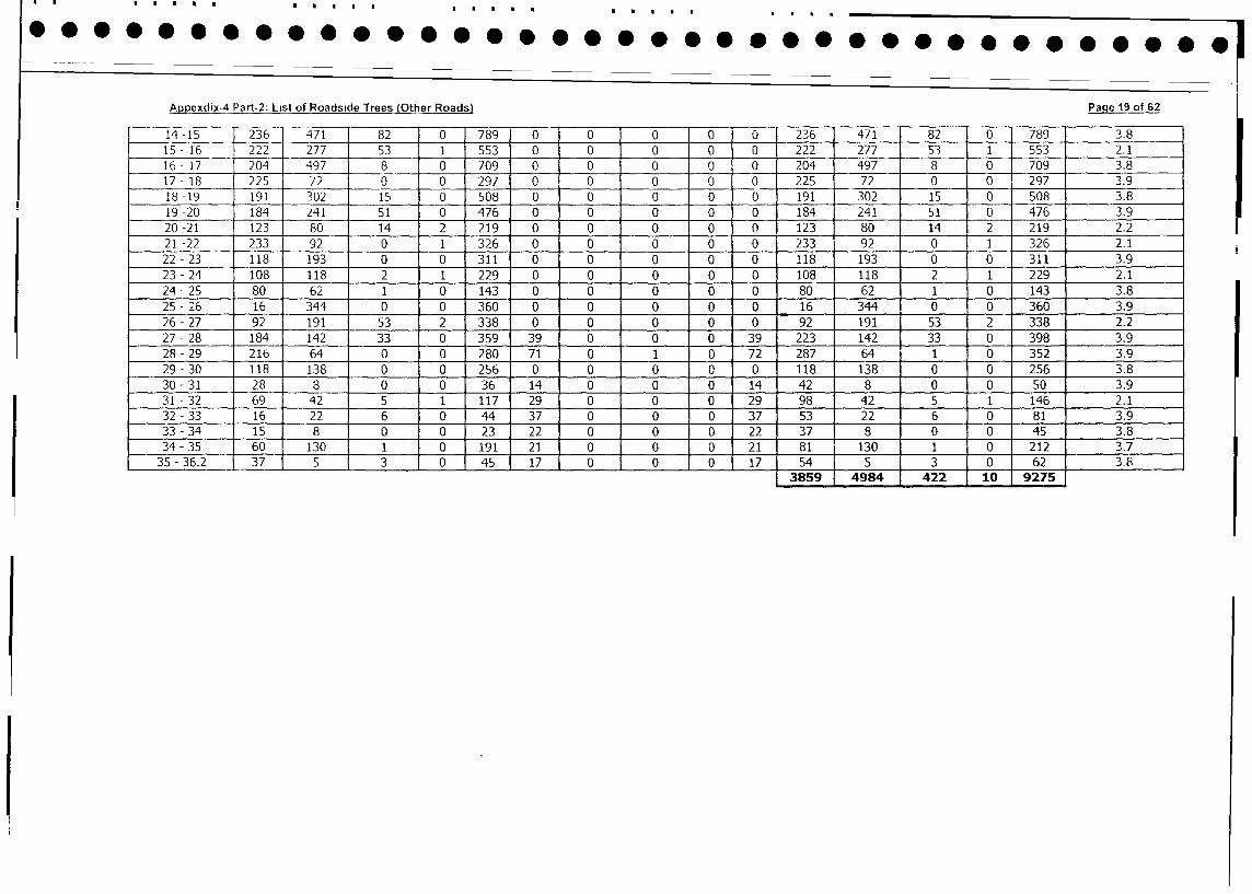
Appexdix-4 Part-2: List of Roadside Trees (Other Roads) Page 19 of 62
14-15 1236 471 82 0 789 0 0 1 0 0 0 236 471 [ 82 0 789 3.8
15- 16 222 277 53 1 553 0 0 1 0 0 0 222 277 I 3 1 553 2.1
16- 17 204 497 8 0 709 0 0 0 0 0 204 497 8 0 709 3.8
17- 18 225 72 0 0 297 0 0 0 0 0 225 72 0 0 297 3.9
18-19 191 302 15 0 508 0 0 0 0 0 191 302 15 0 508 3.8
19 -20 184 241 51 0 476 0 0 0 0 0 184 241 51 0 476 3.9
20 -21 123 80 14 2 219 0 0 0 0 0 123 80 14 2 219 2.2
21 -22 233 92 0 1 326 0 0 0 0 0 233 92 0 1 326 2.1
22 - 23 118 193 0 0 311 0 0 0 0 0 118 193 0 0 311 3.9
23 -24 108 118 2 1 229 0 0 0 0 0 108 118 2 1 229 2.1
24-25 80 62 1 0 143 0 0 0 0 0 80 62 1 0 143 3.8
25 -26 16 344 0 0 360 0 0 0 0 0 16 344 0 0 360 3.9
26-27 92 191 53 2 338 0 0 0 0 0 92 191 53 2 338 2.2
27-28 184 142 33 0 359 39 0 0 0 39 223 142 33 0 398 3.9
28-29 216 64 0 0 280 71 0 1 0 72 287 64 1 0 352 3.9
29 - 30 118 138 0 0 256 0 0 0 0 0 118 138 0 0 256 3.8
30 - 31 28 8 0 0 36 14 0 0 0 14 42 8 0 0 50 3.9
31 -32 69 42 5 1 117 29 0 0 0 29 98 142 5 1 146 2.1
32-33 16 22 6 0 44 37 0 0 0 37 53 22 6 0 81 3.9
33 - 34 15 8 0 0 23 22 0 0 0 22 37 8 0 0 45 3.8
34 - 35 60 130 1 0 191 21 0 0 0 21 81 130 1 0 212 3.7
35 - 36.2 37 5 3 0 45 17 0 0 0 117 541 5 3 0 62 3.8
3859 4984 422 1 10 9275
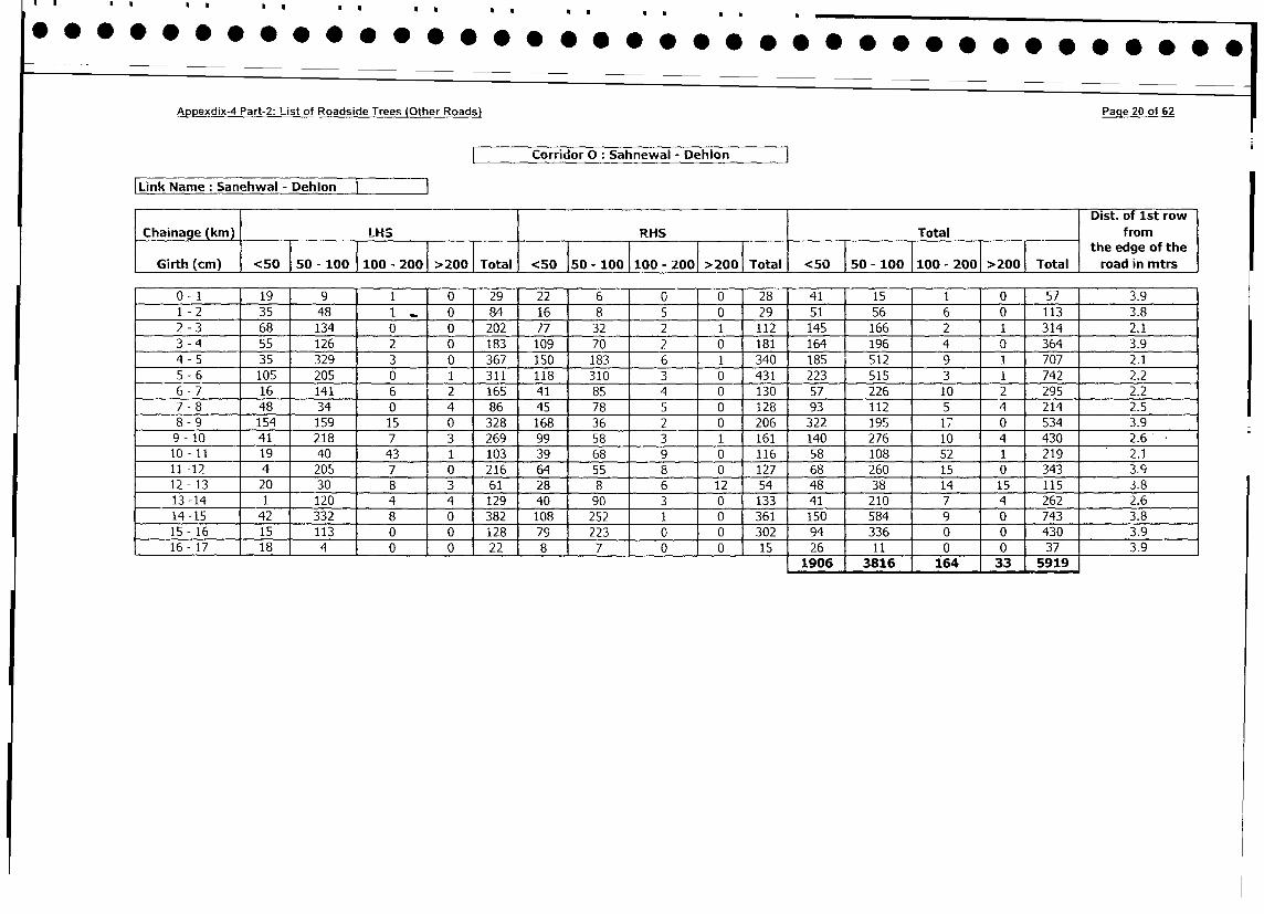
Appexdix-4 Part-2: List of Roadside Trees (Other Roads) Paqe 20 of 62
Corriuor 0: Sahnewal - Dehion
|Link Name: Sanehwal - Dehlon I IDist. of 1st row
Chainage (km) LHS RHS Total from
}~ ~~~~~~~~~~~~~5 - 10 110 - 200 >2 Tot 50 50 - the edge of the
Girth (cm) <50 50 - 100 100 - 200 >200 Total <50 50 - 100 100 - 200 >200 Total <50 50 - 100 100 - 2001 >200 Total road in mtrs
0- 1 19 9 1 0 29 22 6 0 0 28 41 15 1 0 57 3.9
1 - 2 35 48 1 0 84 16 8 5 0 29 51 56 6 0 113 3.8
2 - 3 68 134 0 0 202 77 32 2 1 112 145 166 2 1 314 2.1
3 - 4 55 126 2 0 183 109 70 2 0 181 164 196 4 0 364 3.9
4 - 5 35 329 3 0 367 150 183 6 1 340 185 512 9 1 707 2.1
5 - 6 105 205 0 1 311 118 310 3 0 431 223 515 3 1 742 2.2
6 - 7 16 141 6 2 165 41 85 4 0 130 57 226 10 2 295 2.2
7 - 8 48 34 0 4 86 45 78 5 0 128 93 112 5 4 214 2.5
8 - 9 154 159 15 0 328 168 36 2 0 206 322 195 17 0 534 3.9
9- 10 41 218 7 3 269 99 58 3 1 161 140 276 10 4 430 2.6
10- 11 19 40 43 1 103 39 68 9 0 116 58 108 52 1 219 2.1
11 -12 4 205 7 0 216 64 55 8 0 127 68 260 15 0 343 3.9
12- 13 20 30 8 3 61 28 8 6 12 54 48 38 14 15 115 3.8
13-14 1 120 4 4 129 40 90 3 0 133 41 210 7 4 262 2.6
14 -15 42 332 8 0 382 108 252 1 0 361 150 584 9 0 743 3.8
15- 16 15 113 0 0 128 79 223 0 0 302 94 336 0 0 430 3.9
16 -17 18 4 0 0 22 8 7 0 0 15 26 11 0 0 37 3.91906 3816 164 1 33 5919
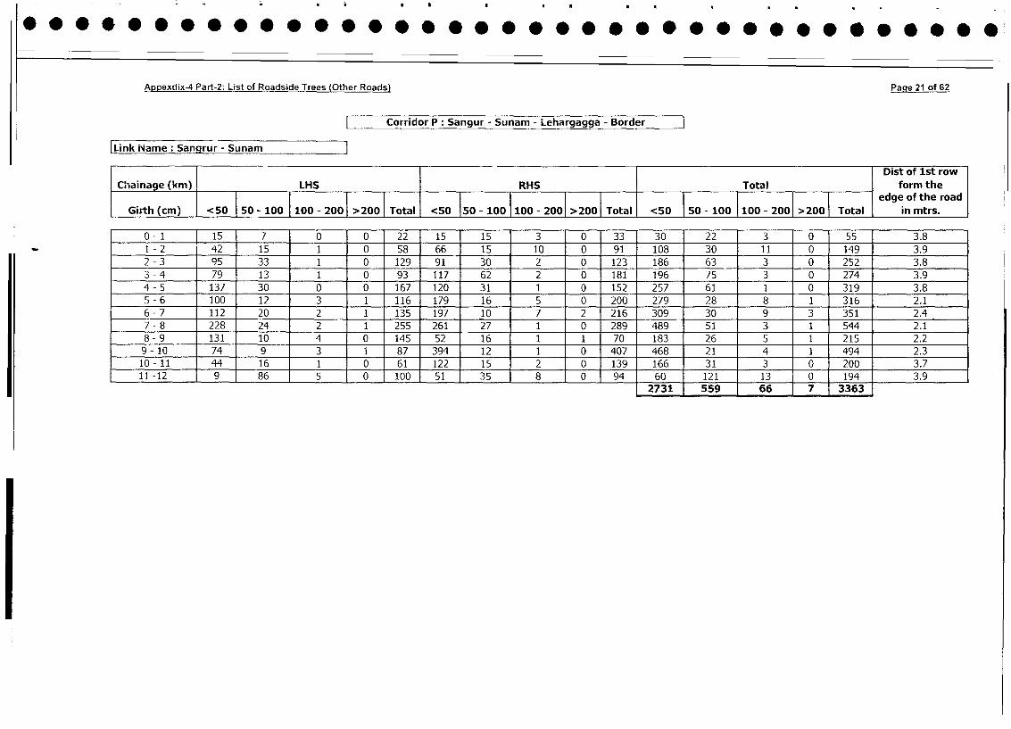
Appexdix-4 Part-2: List of Roadside Trees (Other Roads) Page 21 of 62
Corridor P: Sangur - Sunam - Lehargagga - Border
Link iName: Sangrur - Sunam
Dist of Ist row
Chainage (km) LHS RHS Total | form the
l l l l l l l l l | | l l ~~~~~~~~~~~~~~~~~~~~~~~~edge of the road
Girth (cm) <50 50 - 100 100 - 200 >200 Total <50 150 - 100 100 - 2001 >200 Total <50 I 50 - 100 100 - 2001 >200 Total in mtrs.
0- 1 15 7 0 0 22 15 15 3 0 33 30 22 3 0 55 3.8
I - 2 42 15 1 0 58 66 15 10 0 91 108 30 11 0 149 3.9
2 - 3 95 33 1 0 129 91 30 2 0 123 186 63 3 0 252 3.8
3 - 4 79 13 1 0 93 117 62 2 0 181 196 75 3 0 274 3.9
4 - 5 137 30 0 0 167 120 31 1 0 152 257 61 1 0 319 3.8
5 - 6 100 12 3 1 116 179 16 5 0 200 279 28 8 1 316 2.1
6 - 7 112 20 2 1 135 197 10 7 2 216 309 30 9 3 351 2.4
7 - 8 228 24 2 1 255 261 27 1 0 289 489 51 3 1 544 2.1
8 - 9 131 10 4 0 145 52 16 1 1 70 183 26 5 1 215 2.2
9- 10 74 9 3 1 87 394 12 1 0 407 468 21 4 1 494 2.3
10- 11 44 16 1 0 61 122 15 2 0 139 166 31 3 0 200 3.7
11 -12 9 86 5 0 100 51 35 8 0 94 60 121 13 0 194 3.92731 559 66 7 3363
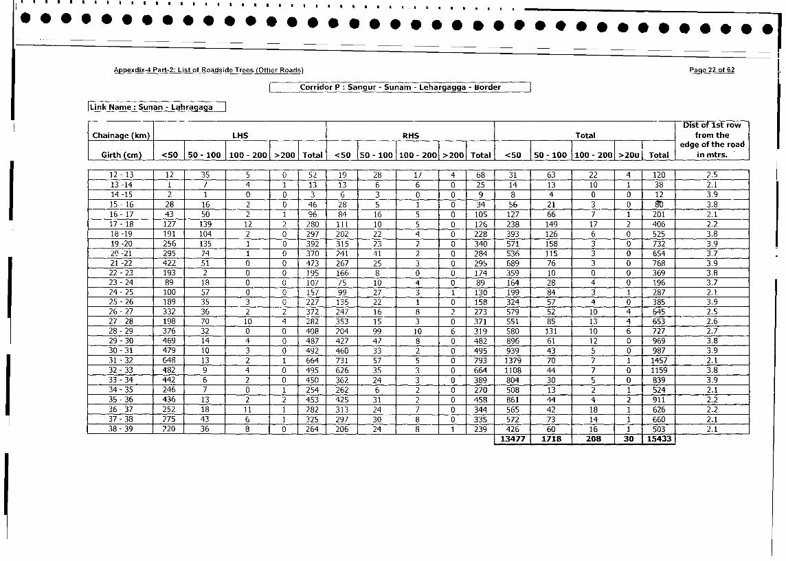
Appexdix-4 Part-2: List of Roadside Trees (Other Roads) Page 22 of 62
Corridor P: Sangur - Sunam - Lehargagga - Border
Link Name: Sunan - Lahra a a
_ _ _ I D Dist of 1st row
Chainage (km) LHS RHS Total from the
______ ___medge of the road
Girth (cm) <50 50 - 100 100 - 200 >200 Total <50 50 - 100 100 - 200 >200 Total <50 50 - 100 100 - 200 >200 Total in mtrs.
12-13 12 35 5 0 52 19 28 17 4 68 31 63 22 [4 120 2.5
13-14 1 7 4 1 13 13 6 6 0 25 14 13 10 1 38 2.1
14-15 2 1 0 0 3 6 3 0 0 9 8 4 0 0 12 3.9
15- 16 28 16 2 0 46 28 5 1 0 34 56 21 3 10 g 3.8
16- 17 43 50 2 1 96 84 16 5 0 105 127 66 7 1 201 2.1
17- 18 127 139 12 2 280 111 10 5 0 126 238 149 17 2 406 2.2
18-19 191 104 2 0 297 202 22 4 0 228 393 126 6 0 525 3.8
19-20 256 135 1 0 392 315 23 2 0 340 571 158 3 0 732 3.9
20-21 295 74 1 0 370 241 41 2 0 284 536 115 3 0 654 3.7
21-22 422 51 0 0 473 267 25 3 0 295 689 76 3 0 768 3.9
22 - 23 193 2 0 0 195 166 8 0 0 174 359 10 0 0 369 3.8
23 - 24 89 18 0 0 107 75 10 4 0 89 164 28 4 1 0 196 3.7
24- 25 100 57 0 0 157 99 27 3 1 130 199 84 3 1 287 2.1
25 - 26 189 35 3 0 227 135 22 1 0 158 324 57 4 0 385 3.9
26- 27 332 36 2 2 372 247 16 8 2 273 579 52 10 4 645 2.5
27 - 28 198 70 10 4 282 353 15 3 0 371 551 85 13 4 653 2.6
28- 29 376 32 0 0 408 204 99 10 6 319 580 131 10 6 727 2.7
29 - 30 469 14 4 0 487 427 47 8 0 482 896 61 12 0 969 3.8
30 - 31 479 10 3 0 492 460 33 2 0 495 939 43 5 0 987 3.9
31 - 32 648 13 2 1 664 731 57 5 0 793 1379 70 7 1 1457 2.1
32-33 482 9 4 0 495 626 35 3 0 664 1108 44 7 0 1159 3.8
33 - 34 442 6 2 0 450 362 24 3 0 389 804 30 5 0 839 3.9
34 - 35 246 7 0 1 254 262 6 2 0 270 508 13 2 1 524 2.1
35 - 36 436 13 2 2 453 425 31 2 0 458 861 44 4 2 911 2.2
36- 37 252 18 11 1 282 313 24 7 0 344 565 42 18 1 626 2.2
37 - 38 275 43 6 1 325 297 30 8 0 335 572 73 14 1 660 2.1
38 - 39 220 36 8 0 264 206 24 8 1 239 426 60 16 1 503 2.1
13477 1718 208 30 15433
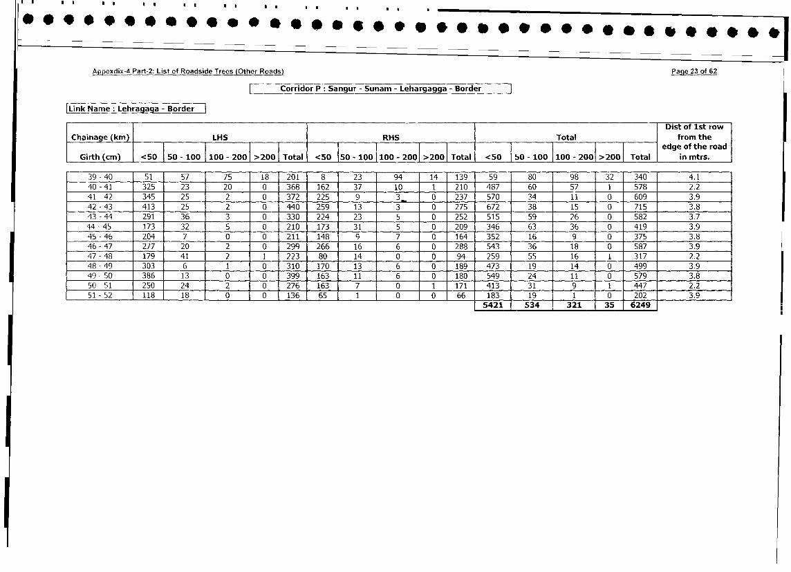
Appexdix-4 Part-2: List of Roadside Trees (Other Roads) Page 23 of 62
r Corridor P: Sangur - Sunam - Lehargagga - Border
Link Name: Lehragaga - BorderDist of 1st row
Chainage (km) LHS RHS Total from the
l 100 100- 200 >200 lllledge of the road
Girth (cm) <50 | 50 - 100 |100 - 2001 >2001 Total <50 1Total <50 50 - 100 1100 - 2001 >2001 Total in mtrs.
39 - 40 51 57 75 18 201 8 23 94 14 139 59 80 98 32 340 4.1
40 - 41 325 23 20 0 368 162 37 10 1 210 487 60 57 1 578 2.2
41 - 42 345 25 2 0 372 225 9 3_ 0 237 570 34 11 0 609 3.9
42-43 413 25 2 0 440 259 13 3 0 275 672 38 15 0 715 3.8
43 - 44 291 36 3 0 330 224 23 5 0 252 515 59 26 0 582 3.7
44 - 45 173 32 5 0 210 173 31 5 0 209 346 63 36 0 419 3.9
45 - 46 204 7 0 0 211 148 9 7 0 164 352 16 9 0 375 3.8
46 - 47 277 20 2 0 299 266 16 6 0 288 543 36 18 0 587 3.9
47 - 48 179 41 2 1 223 80 14 0 0 94 259 55 16 1 317 2.2
48 - 49 303 6 1 0 310 170 13 6 0 189 473 19 14 0 499 3.9
49 - 50 386 13 0 0 399 163 11 6 0 180 549 24 11 0 579 3.8
50 - 51 250 24 2 0 276 163 7 0 1 171 413 31 9 1 447 2.2
51 - 52 118 18 0 0 136 65 1 0 0 66 183 19 1 0 202 3.9
5421 534 321 35 6249
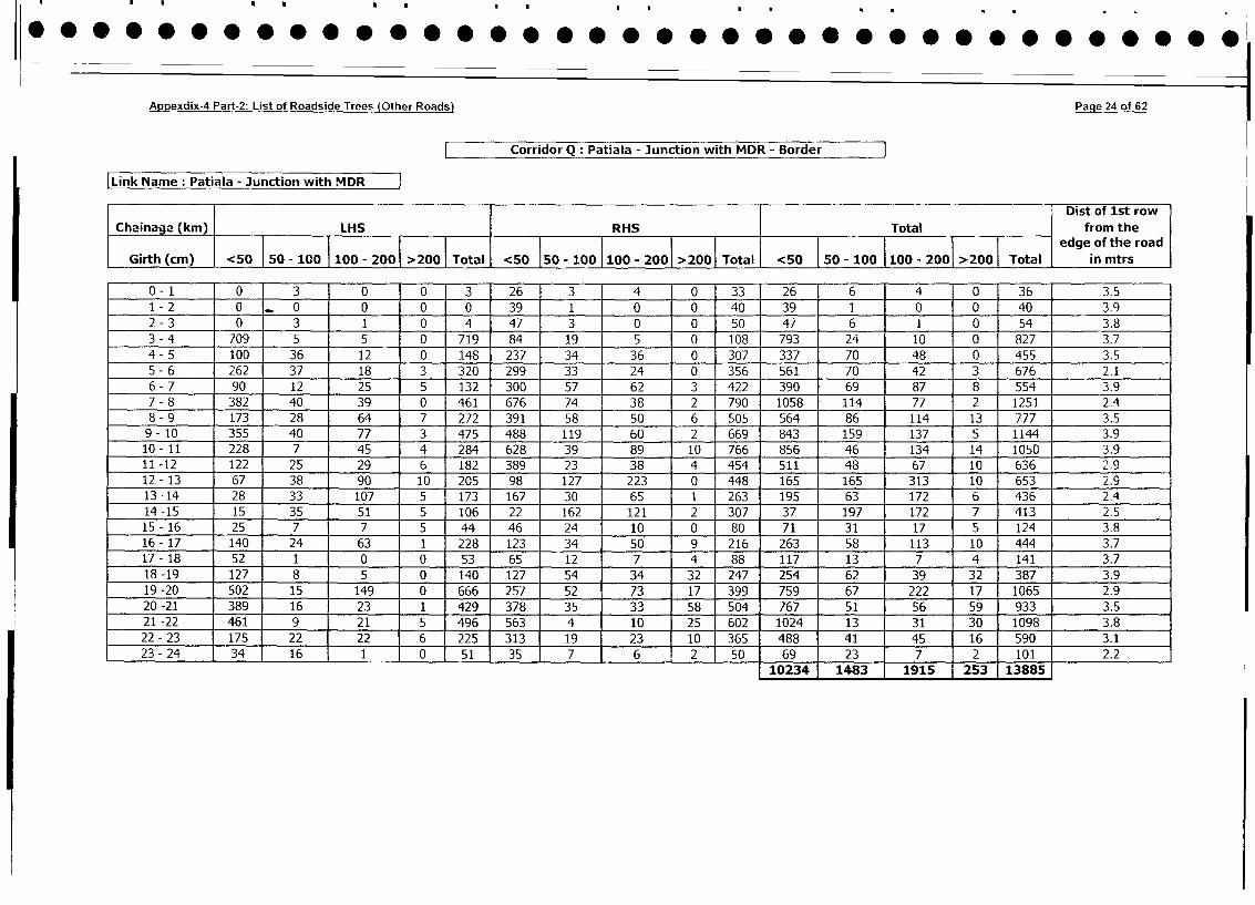
Appexdix-4 Part-2: List of Roadside Trees (Other Roads) Page 24 of 62
Corridor Q: Patiala - Junction with MDR - Border l
Link Name: Patiala - Junction with MDR
I Dist of 1st row
Chainage (km) LHS RHS Total from theedge of the road
Girth (cm) <50 50 - 100 I 100 - 2001 >200 1 Total <50 150 - 100 100 - 2001 >200 Total <50 |o50 - 100 100 - 2001 >200 Total in mtrs
0-1 0 3 0 0 3 26 3 4 01 33 26 6 4 0 36 3.5
1 - 2 0 _ 0 0 0 0 39 1 0 0 40 39 1 0 0 40 3.9
2 - 3 0 3 1 0 4 47 3 0 0 50 47 6 1 0 54 3.8
3 - 4 709 5 5 0 719 84 19 5 0 108 793 24 10 0 827 3.7
4 - 5 100 36 12 0 148 237 34 36 0 307 337 70 48 0 455 3.5
5 - 6 262 37 18 3 320 299 33 24 0 356 561 70 42 3 676 2.1
6- 7 90 12 25 5 132 300 57 62 3 422 390 69 87 8 554 3.9
7 - 8 382 40 39 0 461 676 74 38 2 790 1058 114 77 2 1251 2.4
8 - 9 173 28 64 7 272 391 58 50 6 505 564 86 114 13 777 3.5
9- 10 355 40 77 3 475 488 119 60 2 669 843 159 137 5 1144 3.9
10 - 11 228 7 45 4 284 628 39 89 10 766 856 46 134 14 1050 3.9
11 -12 122 25 29 6 182 389 23 38 4 454 511 48 67 10 636 2.9
12 - 13 67 38 90 10 205 98 127 223 0 448 165 165 313 10 653 2.9
13 -14 28 33 107 5 173 167 30 65 1 263 195 63 172 6 436 2.4
14 -15 15 35 51 5 106 22 162 121 2 307 37 197 172 7 413 2.5
15- 16 25 7 7 5 44 46 24 10 0 80 71 31 17 5 124 3.8
16- 17 140 24 63 1 228 123 34 50 9 216 263 58 113 10 444 3.7
17- 18 52 1 0 0 53 65 12 7 4 88 117 13 7 4 141 3.7
18-19 127 8 5 0 140 127 54 34 32 247 254 62 39 32 387 3.9
19 -20 502 15 149 0 666 257 52 73 17 399 759 67 222 17 1065 2.9
20 -21 389 16 23 1 429 378 35 33 58 504 767 51 56 59 933 3.5
21 -22 461 9 21 5 496 563 4 10 25 602 1024 13 31 30 1098 3.8
22 - 23 175 22 22 6 225 313 19 23 10 365 488 41 45 16 590 3.1
23-24 34 16 1_ 0 51 35 7 6 2 50 69 23 7 2 101 2.2
10234 1483 1915 253 13885
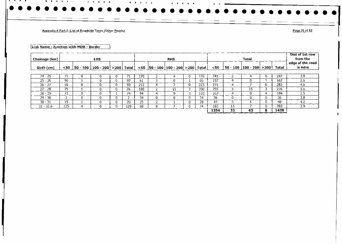
Appexdix-4 Part-2: List of Roadside Trees (Other Roads) Page 25 of 62
Link Name: Junction with MDR - Border
I .. Dist of 1st row
Chainage (km) LHS RHS Total from the
l__ _ _ _ _ _ _ _ _ _ _ _ _ _ _ _ _ _ _ _ _ _ _ _ _ _ _ _ _ _ _ _ _ _ _ _ _ _ _ _ _ _ _ _ _ _ _ _ _ _ _ _ _ _ _ _ _ _ _ _ _ _ _ __l_ _ _ _ _ _ _ _ __l_ _l_ __l_ __l_ _l_ __l e d g e o f th e ro a d
Girth (cm) <50 50 - 100 100 - 2001 >200 | Total <50 50 - 100 100 - 2001 >200 Total <50 | 50 - 100 100 - 2001 >200 Total in mtrs
24 - 25 71 0 0 0 71 170 2 4 0 176 241 2 4 0 247 3.9
25 - 26 96 1 0 0 97 61 3 0 1 65 157 4 0 1 162 2.1
26- 27 59 0 0 0 59 212 4 7 0 223 271 4 7 0 282 4.1
27 - 28 75 1 0 0 76 180 2 15 3 200 255 3 15 3 276 3.1
28 - 29 73 0 0 1 74 94 4 9 3 110 167 4 9 4 184 2.5
29 - 30 2 0 0 0 2 34 0 0 0 34 36 0 0 0 36 _ 3.8_
30 - 31 19 1 0 0 20 25 2 1_ 0b 28 44 3 1 0 48 4.2
31 - 32.6 125 4 0 0 129 58 9 7 0 74 183 13 7 0 203 3.9
1354 33 43 8 1438
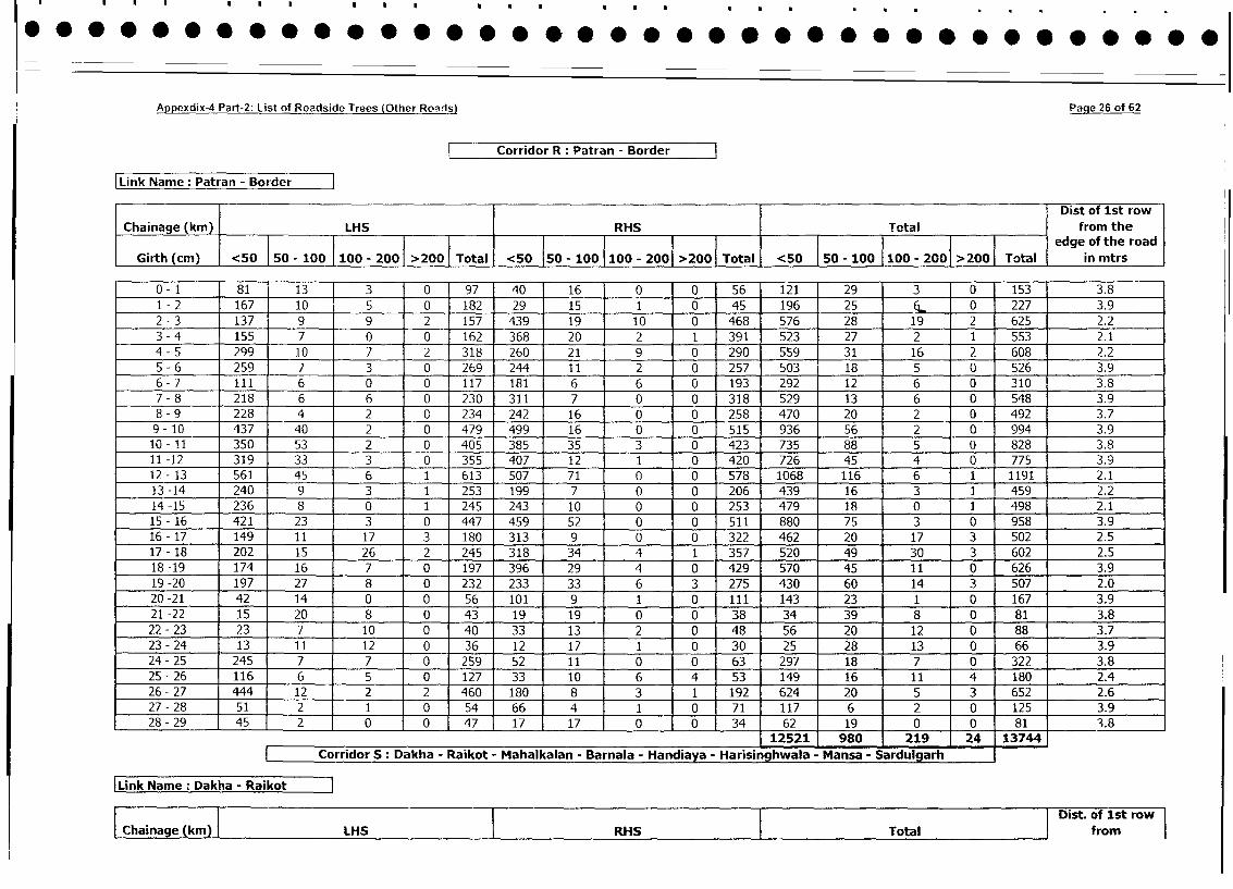
Appexdix-4 Part-2: List of Roadside Trees (Other Roairs) Pane 26 of 62
Corridor R: Patran - Border
Link Name : Patran - Border
Dist of 1st row
Chainage (km) LHS RHS Total from the
_ _ _ _ _ _ _ _ _ _ _ _ _ _ _ _ _ _ _ _ _ _ _ _ _ _ _ _ _ _ _ _ _ _ _ _ _ _ _ _ _ _ _ _ _ _ _ _ _ _ _ _ _ _ _ _ _ _ _ _ _ _ _ e d g e o f th e ro a d
Girth (cm) <50 50 - 100 100 - 200 >200 Total <50 50 100 | 100 - 2001 >200 Total <50 50 - 100 100 - 200 >200 Total in mtrs
0- 1 _ 81 1311 3 0 97 40 16 0 0 56 121 29 3 0 153 3.8
1 - 2 167 10 5 0 182 29 15 1 0 45 196 25 6 0 227 3.9
2 - 3 137 9 9 2 157 439 19 10 0 468 576 28 19 2 625 2.2
3 - 4 155 7 0 0 162 368 20 2 1 391 523 27 2 1 553 2.1
4 - 5 299 10 7 2 318 260 21 9 0 290 559 31 16 2 608 2.2
5 - 6 259 7 3 0 269 244 11 2 0 257 503 18 5 0 526 3.9
6 - 7 111 6 0 0 117 181 6 6 0 193 292 12 6 0 310 3.8
7 - 8 218 6 6 0 230 311 7 0 0 318 529 13 6 0 548 3.9
8 - 9 228 4 2 0 234 242 16 0 0 258 470 20 2 0 492 3.7
9- 10 437 40 2 0 479 499 16 0 0 515 936 56 2 0 994 3.9
10- 11 350 53 2 0 405 385 35 3 0 423 735 88 5 0 828 3.8
11 -12 319 33 3 0 355 407 12 1 0 420 726 45 4 0 775 3.9
12- 13 561 45 6 1 613 507 71 0 0 578 1068 116 6 1 1191 2.1
13 -14 240 9 3 1 253 199 7 0 0 206 439 16 3 1 459 2.2
14 -15 236 8 0 1 245 243 10 0 0 253 479 18 0 1 498 2.1
15- 16 421 23 3 0 447 459 52 0 0 511 880 75 3 0 958 3.9
16- 17 149 11 17 3 180 313 9 0 0 322 462 20 17 3 502 2.5
17- 18 202 15 26 2 245 318 34 4 1 357 520 49 30 3 602 2.5
18 -19 174 16 7 0 197 396 29 4 0 429 570 45 11 0 626 3.9
19 -20 197 27 8 0 232 233 33 6 3 275 430 60 14 3 507 2.0
20 -21 42 14 0 0 56 101 9 1 0 111 143 23 1 0 167 3.9
21-22 15 20 8 0 43 19 19 0 0 38 34 39 8 0 81 3.8
22 - 23 23 7 10 0 40 33 13 2 0 48 56 20 12 0 88 3.7
23- 24 13 11 12 0 36 12 17 1 0 30 25 28 13 0 66 3.9
24 - 25 245 7 7 0 259 52 11 0 0 63 297 18 7 0 322 3.8
25 - 26 116 6 5 0 127 33 10 6 4 53 149 16 11 4 180 2.4
26- 27 444 12 2 2 460 180 8 3 1 192 624 20 5 3 652 2.6
27 - 28 51 2 1 0 54 66 4 1 0 71 117 6 2 0 125 3.9
28- 29 45 2 0 0 47 17 17 0 0 34 62 19 0 0 81 3.8
12521 980 219 24 13744
Corridor S: Dakha - Raikot - Mahalkalan - Barnala - Handiaya - Harisinghwala - Mansa - Sardulgarh
Link Name: Dakha - RaikotDist. of 1st row
| Chainage (km) | LHS RHS Total from
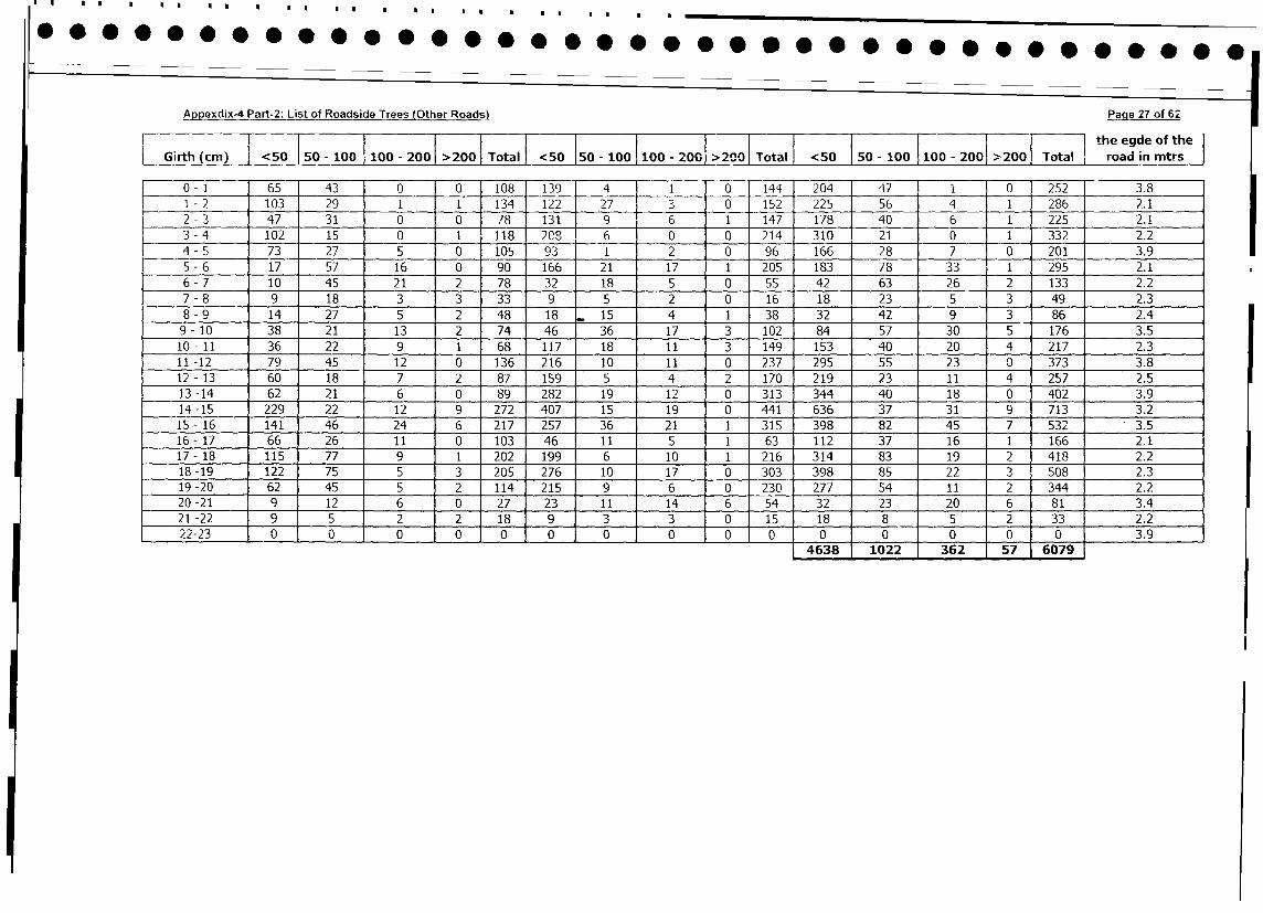
Appexdix-4 Part-2: List of Roadside Trees (Other Roads) Page 27 of 62
l Ii 1 l l l l l j l l l l | } S the egde of the
|Girth (cm) <50 SO - 100 1100 - 2001 >200 1 Total | <50 150 - 100 1100 - 2001 >200n Total I <50 | 50 - 100 1100 - 2001 >2001 Total road in mtrs |
0- 1 65 43 0 0 108 139 4 1 1 0 144 204 47 1 0 252 3.8
1 -2 103 29 1 1 134 122 27 3 0 152 225 56 4 1 286 2.1
2 - 3 47 31 0 0 78 131 9 1 6 1 147 178 40 6 1 225 2.1
3 - 4 102 15 0 1 118 2C8 6 0 0 214 310 21 0 1 332 2.2
4 - 5 73 27 5 0 105 93 1 2 0 96 166 28 7 0 201 3.9
5 - 6 17 57 16 0 90 166 21 17 1 205 183 78 33_ _ 1 295 2.1
6-7 10 45 21 2 78 32 18 5 0 55 42 63 26 2 133 2.2
7 - 8 9 18 3 3 33 9 5 2 0 16 18 - 23 5 3 49 2.3
8 - 9 14 27 5 2 48 18 15 4 1 38 32 42 9 3 86 2.4
9- 10 38 21 13 2 74 46 36 17 3 102 84 57 30 5 176 3.5
10 - 11 36 22 9 1 68 117 18 11 3 149 153 40 20 4 217 2.3
11 -12 79 45 12 0 136 216 10 11 0 237 295 55 23 0 373 3.8
12 -13 60 18 7 2 87 159 5 4 2 170 219 23 11 4 257 2.5
13-14 62 21 6 0 89 282 19 12 0 313 344 40 18 0 402 3.9
14 -15 229 22 12 9 272 407 15 19 0 441 636 37 31 9 713 3.2
15- 16 141 46 24 6 217 257 36 21 1 315 398 82 45 7 532 3.5
16- 17 66 26 11 0 103 46 11 5 1 63 112 37 16 1 166 2.1
17 - 18 115 77 9 1 202 199 6 10 1 216 314 83 19 2 418 2.2
18 -19 122 75 5 3 205 276 10 17 0 303 398 85 22 3 508 2.3
19 -20 62 45 5 2 114 215 9 6 0 230 277 54 11 2 344 2.2
20-21 9 12 6 0 27 23 11 14 6 54 321 23 20 6 81 3.4
21-22 9 5 2 2 18 9 3 3 0 15 181 8 5 2 33 2.2
22-23 0 0 0 0 0 0 0 0 0 0 0 1 0 0 0 0 3.9
4638 j 1022 362 57 6079
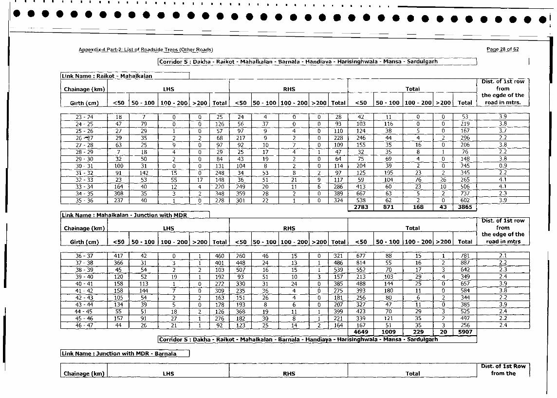
Appexdix-4 Part-2: List of Roadside Trees (Other Roads) Pacge 2 8 of 6 2
ICorridor 5 : Dakha - Raikot - Mahalkalan - Barnala - Handiava - Harisinghwala - Mansa - Sardulgarh
Link Name : Raikot ~~~~~ Mahalkalan ~TDist. of Ist row
Chainage (kin) LHS RHS Total fr edeom h
50 100 fl Total <50 ~~~50 - 100 1100 - 2001 >200 oa road in mtrs.
Girth (cm) <5015 1010 - 201 27_____5__Ttl_50____0010- 01 201Toa
23 -24 18 7 0 0 25 24 4 0 0 28 42 11 0 0 53 3.9
24 -25 47 79 0 0 126 56 37 0 0 93 103 116 0 0 219 3.8
25 -26 27 29 1 0 57 97 9 4 0 110 124 38 5 0 167 3.7
26 --27 29 35 2 2 68 217 9 2 0 228 246. 44 4 2 296 2.2
27 -28 63 25 9 0 97 92 10 7 0 109 155 35 16 0 206 3.8
28 -29 7 18 4 0 29 25 17 4 1 47 32 35 8 1 76 2.2
29 -30 32 50 2 0 84 143 19 2 0 64 75 69 4 0 148 3.8
30-31 100 31 0 0 131 104 82 0 114 204 39 2 0 245 0.9
31 -32 911142 15 0 248 34 53 8 2 97 125 195 23 2 345 2.2
32 -33 231 53 55 17 148 36 51 21 9 117 59 104 76 26 265 4.1
33 -34 1164] 40 12 14 220 249 20 11 6 28-6 413 60 23 10 506 4.1
34 -35 308] 35 3 2 348 359 28 2 0 389 667 63 5 2 737 2.3
35 -36 237] 40 1 0 27 301 22 1 0 324 538 62 2 0 602 3.9
2783 871 168 43 3865
Link Name: Mahalkalan - Junction with MDR Dist._______________of________Ist___________row______
Chaiage(km) LHS IRHS 1 Total f rom
- ~~~~~~~~~~~~~0-1010 0 20Ttlthe edge of the
Girth (cm) <50 50 - 100I 100 - 2001 > 200 Total <50 150 - 100 100 - 2001 >2001 Total <50 s 10 1_0-201>01Toa road in mtrs
36 -37 417 42 0 1 460 260 46 15 0 321 677 88 15 1 781 2.1
37 -38 366 31 3 1 401 448 24 13 1 486 814 55 16 2 887 2.2
38 -39 45 54 2 2 103 507 16 15 1 539 552 70 17 3 642 2.3
39 -40 120 52 19 1 192 93 51 10 3 157 213 103 29 4 349 2.4
40 -41 158 113 1 0 272 330 31 24 0 385 488 144 25 0 657 3.9
41 -42 158 144 7 0 1309 235 3 :6 4 0 275 393 1 180 11 0 584 3.8
42 -43 105 54 2 2 163 151 26 4 0 181 256 80 6 2 344 2.2
43 -44 134 39 5 0 178 193 8 6 0 207 327 47 11 0 385 3.9
44 -45 55 51 18 2 126 368 19 11 1 399 423 70 29 3 525 2.4
45 -46 157 91 27 1 276 182 30 8 1 221 339 121 35 2 497 2.2
46 -47 44 26 21 j1 ,92 123 25 14 2 164 167 51 35 3 256 2.4
_______________________________________________ 4649 ,1009 1 229 120 5907
[Corridor 5: Dakha - Raikot - Mahalkalan - Barnala - Handiaya - Harisinghwala - Mansa - Sardulgarh
Link Name : Junction with MDR - Barnl
Dist. of 1st Row
hange (kmn) LHS RHS Total from the
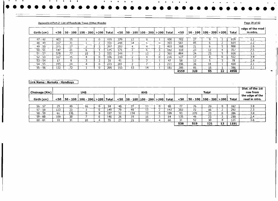
Appexdix-4 Part-2: List of Roadside Trees (Other Roads) Page 29 of 62
1 1 1~~~~I IIToa edge of the road I
LGirth (cm) <550 0-10 00- 200 >200 Total <50 150 - 100 1100 - 2001 >200 Totl I<5 50 - 100 I 100 -2001 >2001 Ttl in mtrs.
47 -488 403 15 1 0 1419 379 12 8 1 400 782] 27 9 1 819 2.1
48 -49 317 31 1 2 351 244 54 5 0 303 561 85 6 2 654 2__ _2 _
49 -50 375 17 2 3 397 393 4 4 2 403 768 21 6 5 80026
50 -51 147 21 6 1 175 171 2 6 3 182 318 23 12 4 357 2__ _5 _
51 -52 520 22 10 3 555 344 2 13 2 361 864 24 23 5 916 3___1 _
52 -53 317 15 4 0 336 210 2 4 0 216 1527 17 8 0 552 ___3__9
53 -54 17 9 3 2 31 41 3 2 1 47 58 12 5 3 78 2___4 _
54 -55 195 24 4 0 223 201 2 7 1 211 396 26 11 1 434 2_____1__
55 -56 132 72 1 0 205 153 13 14 1 181 285 85 15 1 386 2___1 _
[Link Name: Barnala - Hni
Dist. of the Ist
Chainage (Kin) LHS RHS Total row from
___ __ __ __ __ __ __ __ __ __ __ __ __ __ __ __ ___ __ __ __ __ __ __ __ ___ __ __ __ __ __ _ __ ___ __ __ __ __ __ __ __ ___ __ __ __ __ __ __ __ ___ __ __ __ _ __ __ __ __ __ __ __ __ __ __ __ ___ __ __ _t he__ _ _e d ge__ 1 t hoeg e o f t h
Girth (cm) -<50 50 - 100 I100 - 2001 > 20 Ttl <50 50O - 100 1100 - 2001 >2001 Total <50 50s - 100 1100 - 2001 >2001 Total road in mtrs.
56 -57 29 49 16 0 94 48 27 13 0 88 77 76 29 0 182 3.8
57 -58 123' 23 3 0 149 79 49 13 2 143 202 72 16 2 292 2.3
58 -59 61 136 0 0 197 32 134 23 0 189 93 270 23 0 386 3.8
59 -60 109 30 7 0 146 26 19 16 3 64 135 49 23 3 210 2.4
60 -61 10 31 10 4 55 21 21 20 4 66 31 52 30 8 121 3__ _6 _
1538 1 519 1 121 113 ,119136
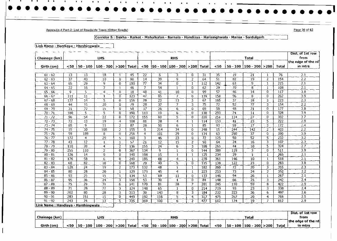
Appexdix-4 Part-2: List of Roadside Trees (Other Roads) Paqe 30 of 62
Corridor S: Dakha - Raikot - Mahalkalan - Barnala - Handiaya - Harisinghwala - Mansa - Sardulgarh I
Link Name: Handiaya - HarshingwalaDist. of 1st row
Chainage (km) LHS RHS Total from
_________ ________ ________ ________ I_______ ________ ________ ___ _ __I _ th e edge of th e rd
Girth (cm) <50 50 - 100 100 - 200 >200 Total <50 50 - 100 100 - 200 >200 Total <50 50 - 100 100 - 200 >200 Total in mtrs
61 - 62 13 13 18 1 45 22 6 3 0 31 35 19 21 1 76 2.1
62 - 63 37 43 10 0 90 14 39 9 2 64 51 82 19 2 154 2.2
63 - 64 65 29 9 0 103 77 34 0 1 112 142 63 9 1 215 2.1
64 - 65 22 16 7 1 46 7 54 1 0 62 29 70 8 1 108 2.1
65 - 66 9 5 4 0 18 48 41 10 0 99 57 46 14 0 117 3.8
66 - 67 111 11 I 1 0 123 47 85 7 0 139 158 96 8 0 262 1 3.9
67 - 68 137 14 5 0 156 28 23 13 3 67 165 37 18 3 223 2.3
68 - 69 44 15 20 0 79 28 37 7 3 75 72 52 27 3 154 2.2
69 - 70 21 22 15 0 58 37 26 6 0 69 58 48 21 0 127 3.8
70 - 71 180 5 5 0 190 113 19 6 0 138 293 24 11 0 328 3.9
71-72 96 54 22 0 172 155 60 5 0 220 251 114 27 0 392 3.7
72 - 73 72 13 19 4 108 81 28 4 1 114 153 41 23 5 222 2.9
73 - 74 65 9 11 2 87 28 50 6 1 85 93 59 17 3 172 2.4
74 - 75 15 30 108 2 155 0 214 34 0 248 15 244 142 2 403 2.2
75 - 76 59 189 8 0 256 4 101 29 0 134 63 290 37 0 390 3.9
76- 77 122 4 29 5 160 3 46 23 0 72 125 50 52 5 232 3.2
77 - 78 43 12 1 1 57 21 12 15 2 50 64 24 16 3 107 2.3
78 - 79 110 20 4 2 136 155 24 6 3 188 265 44 10 5 324 2.7
79 - 80 255 110 2 0 367 134 9 1 0 144 389 119 3 0 511 3.9
80 - 81 126 14 0 0 140 108 15 1 1 125 234 29 1 1 265 2.1
81 - 82 176 58 6 0 240 185 88 4 1 278 361 146 10 1 518 2.1
82 - 83 68 82 18 0 168 70 40 5 0 115 138 122 23 0 283 3.8
83 - 84 128 24 19 2 173 132 48 1 1 182 260 72 20 3 355 2.3
84 - 85 80 28 20 1 129 173 45 4 1 223 253 73 24 2 352 2.2
85 - 86 93 25 15 1 134 53 69 11 0 133 146 94 26 1 267 2.1
86 - 87 95 36 24 3 158 53 30 1 0 84 148 66 25 3 242 2.4
87 - 88 75 29 31 6 141 170 81 . 28 2 281 245 110 59 8 422 2.9
88 - 89 71 28 22 3 124 148 65 1 0 214 219 93 23 3 338 2.4
89- 90 202 80 28 3 313 30 143 8 3 184 232 223 36 6 497 2.6
90 - 91 283 151 15 0 449 192 116 5 4 317 475 267 1 20 4 766 2.5
91 - 92 243 74 13 1 5 335 369 100 6 2 477 612 174 19 7 1812 2.9
Link Name: Handiaya - HarshingwalaDist. of ist row
Chainage (km) LHS RHS Total from
I________I___________________1_____ the edge of the rd
| Girth (cm) | <50 | 50 - o0o| 100 - 200 200 Total <50 50 - 100 100 - 200 >2001 Total <50 50 - 100 100 - 2001 >2001 Total in mtrs
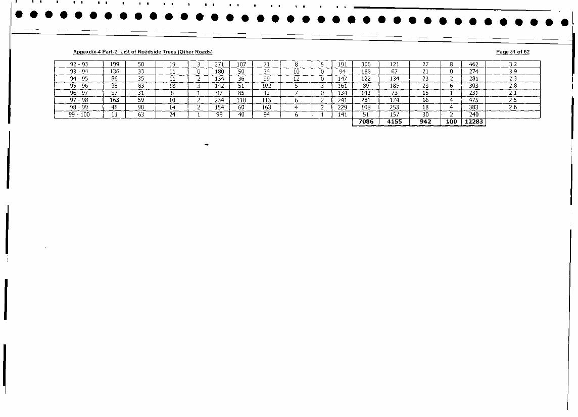
Appexdix-4 Part-2: List of Roadside Trees (Other Roads) Page 3i of 62
92 - 93 199 50 19 3 271 107 71 8 5 191 306 121 27 8 1 462 3.2
93 -94 136 33 11 0 180 50 34 10 0 94 186 67 21 0 274 3.9
94 - 95 86 35 11 2 134 36 99 12 0 147 122 134 23 2 281 2.3
95 - 96 38 83 18 3 142 51 102 5 3 161 89 185 23 6 303 2.8
96 - 97 57 31 8 1 97 85 42 7 0 134 142 73 15 1 231 2.1
97-98 163 59 10 2 234 118 115 6 2 241 281 174 16 4 475 2.5
98 - 99 48 90 14 2 154 60 163 4 2 229 108 253 18 4 383 2.6
99 - 100 11 63 ] 24 11 991 40 94 6 1 1141 51 157 30 2 240 l
7086 1 4155 942 100 12283
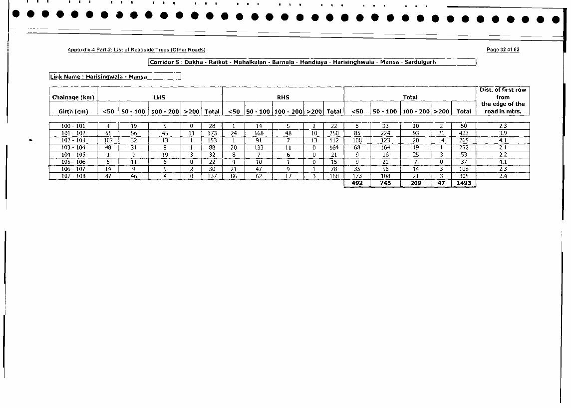
Appexdix-4 Part2: List of Roadside Trees (Other Roads) Page 32 of 62
|Corridor S: Dakha - Raikot - Mahalkalan - Barnala - Handiaya - Harisinghwala - Mansa - Sardulgarh
|Link Name: Harisingwala - Mansa |
l Dist. of first row
Chainage (km) LHS RHS Total from
_____50so_______0- 00 >20otTtal
{0 the edge of the
Girth (cm) <50 50 - 100 100 - 200 >200 Total <50 50 - 100 100 - 200 >200 <50 50 - 100 100 - 2001 >200 Total road in mtrs.
100-101 4 19 5 0 28 1 l 14 5 2 22 5 33 10 2 50 2.3
101 - 102 61 56 45 11 173 24 168 48 10 250 85 224 93 21 423 3.9
_ 102 -103 107 32 13 1 153 1 91 7 13 112 108 123 20 14 265 4.1
103-104 48 31 8 1 88 20 133 11 0 164 68 164 19 1 252 2.1
104-105 1 9 19 3 32 8 7 6 0 21 9 16 25 3 53 2.2
105-106 5 11 6 0 22 4 10 1 0 15 9 21 7 0 37 4.1
106-107 14 9 5 2 30 21 47 9 1 78 35 56 14 3 108 2.3
107-108 87 46 4 0 137 86 62 17 3 168 173 108 21 3 305 2.4
492 745 2 209 47 1493
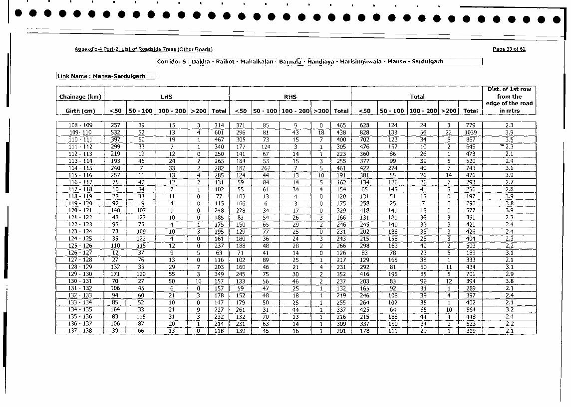
Appexdix-4 Part-2: List of Roadside Trees (Other Roads) Page 33 of 62
|Corridor S: Dakha - Raikot - Mahalkalan - Barnala - Handiaya - Harisinghwaia - Mansa - Sardulgarh
Link Name: Mansa-SardulgarhDist. of 1st row
Chainage (km) LHS RHS Total from the
________________-_2001_>001_Tota <5 __i edge of the road
Girth (cm) <50 50 - 100 100 - 200 >200 Total <50 50 - 100 100 - 2001 >200 Total <50 | 50 - 100 |100 - 2001 >200 Total in mtrs
10G8- 109 ] 257 39 15 3 314 371 85 9 0 465 628 124 24 3 779 2.3
109- 110 532 52 13 4 601 296 81 43 18 438 828 133 56 22 1039 3.9
110- 111 397 50 19 1 467 305 73 15 7 400 702 123 34 8 867 3.5
111 - 112 299 33 7 1 340 177 124 3 1 305 476 157 10 2 645 2.3
112 - 113 219 19 12 0 250 141 67 14 1 223 360 86 26 1 473 2.1
113- 114 193 46 24 2 265 184 53 15 3 255 377 99 39 5 520 2.4
114- 115 240 7 33 2 282 182 267 7 5 461 422 274 40 7 743 3.1
115 - 116 257 11 13 4 285 124 44 13 10 191 381 55 26 14 476 3.9
116 - 117 75 42 12 2 131 59 84 14 5 162 134 126 26 7 293 2.7
117- 118 10 84 7 1 102 55 61 34 4 154 65 145 41 5 256 2.8
118 -119 28 38 11 0 77 103 13 4 0 120 131 51 15 0 197 3.9
119- 120 92 19 4 0 115 166 6 3 0 175 258 25 7 0 290 3.8
120 - 121 140 107 1 0 248 278 34 17 0 329 418 141 18 0 577 3.9
121 - 122 48 127 10 0 185 83 54 26 3 166 131 181 36 3 351 2.3
122- 123 95 75 4 1 175 150 65 29 2 246 245 140 33 3 421 2.4
123 - 124 73 109 10 3 195 129 77 25 0 231 202 186 35 3 426 2.4
124- 125 35 122 4 0 161 180 36 24 3 243 215 158 28 3 404 2.3
125 - 126 110 115 12 0 237 188 48 28 2 266 298 163 40 2 503 2.2
126 - 127 12 37 9 5 63 71 41 14 0 126 83 78 23 5 189 3.1
127 - 128 27 76 13 0 116 102 89 25 1 217 129 165 38 1 333 2.1
128- 129 132 35 29 7 203 160 46 21 4 231 292 81 50 11 434 3.1
129 - 130 171 120 55 3 349 245 75 30 2 352 416 195 85 5 701 2.9
130- 131 70 27 50 10 157 133 56 46 2 237 203 83 96 12 394 3.8
131 - 132 106 45 6 0 157 59 47 25 1 132 165 92 31 1 289 2.1
132 - 133 94 60 21 3 178 152 48 18 1 219 246 108 39 4 397 2.4
133 - 134 85 52 10 0 147 179 50 25 1 255 264 102 35 1 402 2.1
134 - 135 164 33 21 9 227 261 31 44 1 337 425 64 65 10 564 3.2
135 - 136 83 115 31 3 232 132 70 13 1 216 215 185 44 4 448 2.4
136 - 137 106 87 20 1 214 231 63 14 1 309 337 150 34 2 523 2.2
137-138 j 39 66 13 0 118 139 45 j 16 1 j201j 17881 9 j 1 319 2.1
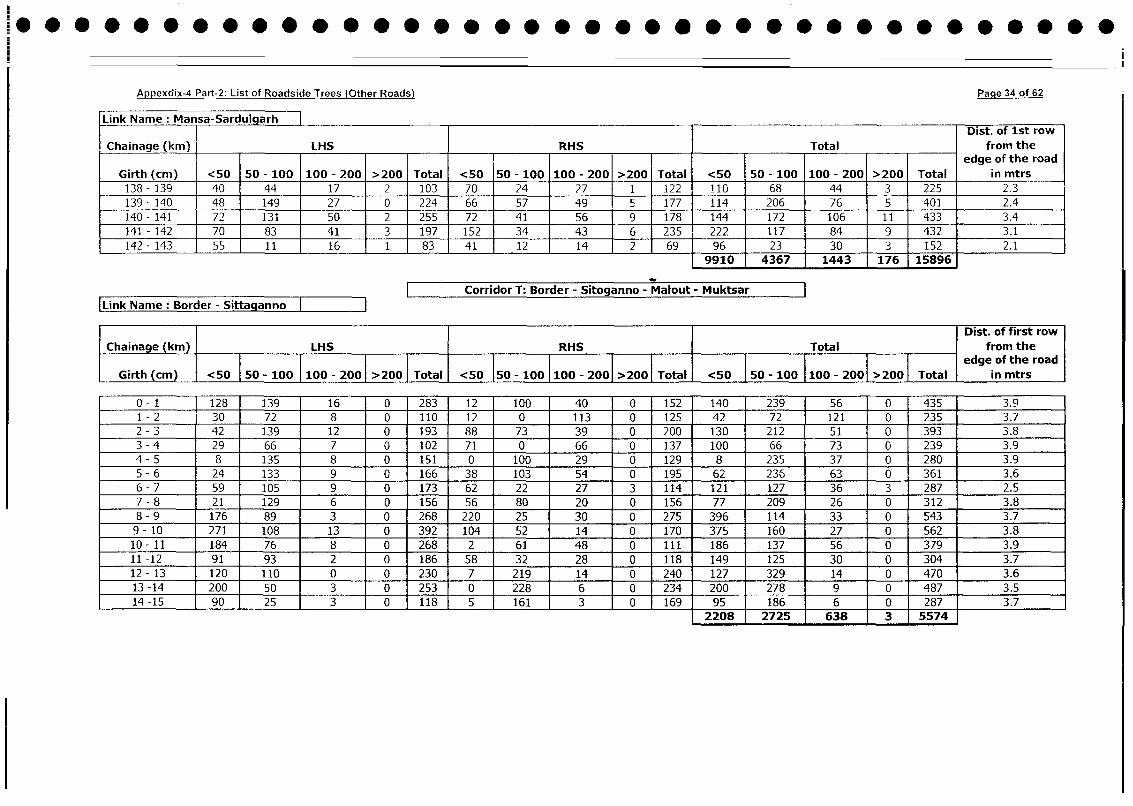
Appe dix-4 Part-2: List of Roadside Trees (Other Roads) Pacie4 of ~62
Link Nam e: M ansa-Sardulgarh _ _ _ _ _ _ _ _ _ _ _ _ _ _ _ _ _ _ _ _ _ _ _ _ _ _ _ _ _ _ _ _ _ _ _ _ _ _ _ _ _ _ _ _
I I ~~~~~~~~~~~~~~~~~~~~~~Dist. of 1st rowChainage (kin) ____ LHS jRHS ___ITotal from the
edge of the roadGirth (cmr) <50 50 - 100 100 - 200 >200 Total <50 50 - 100 100 - 200 >2001 Total <50 50 - 100 100 - 200 >200 Total in mtrs
138 -139 40 44 17 2 103 1 70 24 - 27 1 122 110 68 44 3 225 2.3
139 - 1410 48 149 27 0 224 66 57 49 Sf177 114 206 76 5 401 2.4
140 -141 72 131 50 2 255 72 41 56 19 178 144 172 106 11 433 3.4
141 -142 70 83 1 41 3 197 152~ 34 - 43 J6 235 222 1 117 84 9 432 3.1142 -143 55 1 1 16 1 83 41 1214 j 2 69 96 23 30 3 152.
9910 4367 1443 176 15896
-- Corridor T: Border - Sitoganno - Malout - Muktsar[Link Name : Border - Sitta anno
I ~~~~~~~~~~~~~Dist. of first rowChainage (kmn) LHS RHS jTotal from the
____________ Totalj~~~~~~~~~~~~~~~~~> 0O edge of the road
Girth (cm) <5 0 - 100 I100 - 2001 > 200] Total <50 5-10 100 - 2001 >200] Ttl <50 50 - 100 1100 - 2001>0 Total in mtrs
0 -1 128 139 16 0 283 12 100 40 0 152 140 239 [ 56 0 435 3.9
1 -2 30 72 8 0 110 12 0 113 0 125 42 72 [ 121 0 235 3.7
2 -3 42 139 12 0 193 88 73 39 0 200 130 212[ 51 0 393 3.8
3 -4 29 66 7 0 102 71 0 66 0 137 100 66 73 0 239 3.9
4 -5 8 135 8 0 151 0 100 29 0 129 8 235 37 0 280 3.9
5 -6 24 133 9 0 166 38 103 1 54 0 195 62 236 63 0 361 3.6
6 -7 59 105 9 0 173 62 22 27 3 114 121 127 36 3 287 2.5
7 -8 21 129 6 0 156 56 80 20 0 156 77 209 26 0 312 3.8
8 -9 176 89 3 0 268 220 25 30 0 275 396 114 33 0 543 3.7
9 - 10 271 108 13 0 392 104 52 14 0 170 375 160 27 0 562 3.8
10 -11 184 76 8 0 268 2 61 48 0 ill 186 137 56 0 379 3.9
11 -12 91 93 I 2 0 186 58 1 32 28 0 118 149 125 30 0 304 3.7
12 -13 120 110 0 0 230 7 219 14 10 240 127 329 14 0 470 3.6
13 -14 200 50 3 0 253 0 228 6 0 234 200 278 9 0 487 3.5
14 -15 90 25 3 0 118 5 161 3 Jo 169 95 186 6 0 287 3.7
12208 2725 638 3 5574
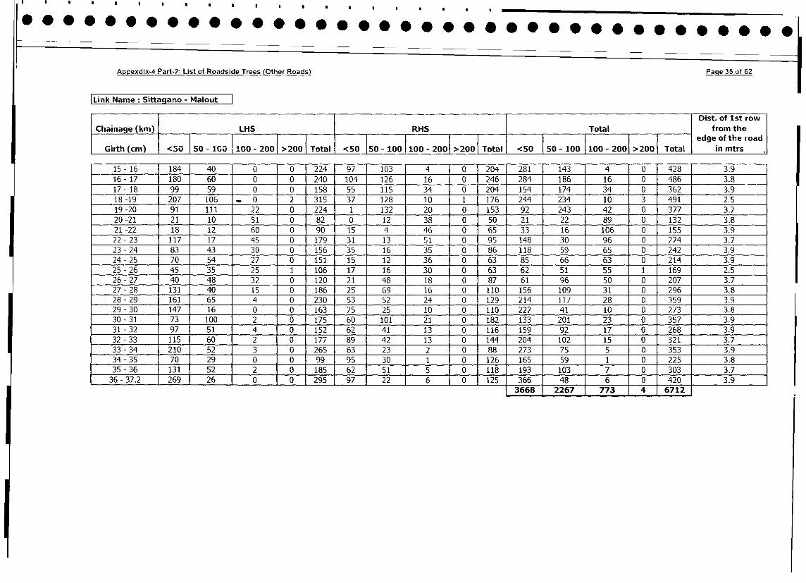
Appexdix-4 Part-2: List of Roadside Trees (Other Roads) Page 35 of 62
Link Name: Sittagano - MaloutDist. of 1st row
Chainage (km) LHS RHS Total from the
i a 5 0 i0 - 0 > 0 Ta i0 5 0 1 0 > T edge of the road
Girth (cm) <0 j50-100 100 - 2001 >200 | Total <50 j50 100 j l0 - 2001 > <50 j 50 - 100 |100 - 2001 >2005 Total in mtrs
15- 16 184 40 0 0 224 97 103 4 0 204 281 143 4 0 428 3.9
16- 17 180 60 0 0 240 104 126 16 0 246 284 186 16 0 486 3.8
17- 18 99 59 0 0 158 55 115 34 0 204 154 174 34 0 362 3.9
18-19 207 106 _ 0 2 315 37 128 10 1 176 244 234 10 3 491 2.5
19 -20 91 111 22 0 224 1 132 20 0 153 92 243 42 0 377 3.7
20 -21 21 10 51 0 82 0 12 38 0 50 21 22 89 0 132 3.8
21 -22 18 12 60 0 90 15 4 46 0 65 33 16 106 0 155 3.9
22- 23 117 17 45 0 179 31 13 51 0 95 148 30 96 0 274 3.7
23 - 24 83 43 30 0 156 35 16 35 0 86 118 59 65 0 242 3.9
24- 25 70 54 27 0 151 15 12 36 0 63 85 66 63 0 214 3.9
25 - 26 45 35 25 1 106 17 16 30 0 63 62 51 55 1 169 2.5
26- 27 40 48 32 0 120 21 48 18 0 87 61 96 50 0 207 3.7
27 - 28 131 40 15 0 186 25 69 16 0 110 156 109 31 0 296 3.8
28- 29 161 65 4 0 230 53 52 24 0 129 214 117 28 0 359 3.9
29- 30 147 16 0 0 163 75 25 10 0 110 222 41 10 0 273 3.8
30- 31 73 100 2 0 175 60 101 21 0 182 133 201 23 0 357 3.9
31 - 32 97 51 4 0 152 62 41 13 0 116 159 92 17 0 268 3.9
32 - 33 115 60 2 0 177 89 42 13 0 144 204 102 15 0 321 3.7
33 - 34 210 52 3 0 265 63 23 2 0 88 273 75 5 0 353 3.9
34 - 35 70 29 0 0 99 95 30 1 0 126 165 59 1 0 225 3.8
35 - 36 131 52 2 0 185 62 51 5 0 118 193 103 7 0 303 3.7
36- 37.2 269 26 0 0 295 97 22 6 0 125 366 48 6 0 420 3.9
3668 2267 773 4 6712
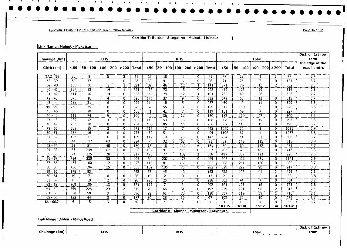
Appexdix-4 Part-2: List of Roadside Trees (Other Roads) Page 36 of 62
Corridor T- Border - Sitoganno - Malout - Muktsar
Link Name: Malout - Mukatsar
Dist. of 1st row
Chainage (km) LHS RHS Total form
_____________
j ~~~~~~~~~~~~~~~~~~~~~~~~~~~~~~the edge of the
Girth (cm) <50 50 - 100 100 - 2001 >200 Total <50 150 - 100 100 - 2001 >2001 Total <50 150 - 100 100 - 2001 >2001 Total road in mtrs
37.2 - 38 20 8 5 3 36 27 10 4 0 41 47 18 9 3 77 2.4
38 - 39 32 32 1 0 65 39 41 6 0 86 71 73 7 0 151 3.7
39 - 40 189 30 1 1 221 82 46 12 1 141 271 76 13 2 362 2.3
40 - 41 324 52 14 1 391 135 73 15 0 223 459 125 29 1 614 2.1
41 - 42 111 40 14 0 165 149 29 12 1 191 260 69 26 1 356 2.2
42-43 373 16 4 0 393 1 176 37 9 _ 0 222 1 549 53 13 0 615 3.7
43 - 44 255 31 6 0 292 214 18 5 0 237 469 49 11 0 529 3.8
44 - 45 250 75 0 0 325 62 55 3 0 120 312 130 3 0 445 3.8
45 - 46 80 28 0 0 108 71 41 7 0 119 151 69 7 0 227 3.9
46 - 47 111 74 5 0 1o190 - 42 86 22 0 150 153 160 27 0 340 3.7
47 - 48 289 12 3 0 304 119 53 16 0 188 408 65 19 0 492 3.8
48-49 206 28 0 0 234 156 85 15 0 256 362 113 15 0 490 3.7
49- 50 532 15 2 0 549 518 17 7 0 542 1050 32 9 0 1091 3.9
50 - 51 757 16 0 0 773 439 51 4 0 494 1196 67 4 0 1267 3.8
51 - 52 122 31 6 0 159 112 10 25 0 147 234 41 31 0 306 3.7
52- 53 44 117 63 0 224 7 32 52 0 91 51 149 115 0 315 3.9
53 - 54 39 51 40 0 130 15 18 112 6 151 54 69 152 6 281 3.7
54- 55 55 234 67 0 356 152 91 114 0 357 207 325 181 0 713 3.8
55 - 56 71 225 20 1 317 426 77 103 2 608 497 302 123 3 925 2.5
56- 57 424 220 53 5 702 84 207 178 0 469 508 427 231 5 1171 2.9
57-58 455 160 12 0 627 113 81 168 0 362 568 241 180 0 989 3.7
58 - 59 426 194 15 0 635 102 105 75 0 282 528 299 90 0 917 3.8
59 - 60 178 83 1 1 263 77 45 40 1 163 255 128 41 2 426 2.3
60 - 61 19 7 0 0 26 10 2 0 0 12 29 9 0 0 38 3.8
61 - 62 75 19 2 0 96 228 25 5 0 258 303 44 7 0 354 3.7
62 - 63 369 189 13 0 571 192 7 3 0 202 561 196 16 0 773 3.8
63 - 64 359 225 29 2 615 70 66 61 0 197 429 291 90 2 812 2.4
64 - 65 528 58 9 1 596 29 61 30 0 120 557 119 39 1 716 2.1
65 - 66 133 44 0 0 177 59 28 10 0 97 192 72 10 0 274 3.7
66- 66.7 4 1 15 3 8 30 0 4 1 0 5 4 19 4 8 35 3.7
10735 3830 1502 34 16101
I |Corridor U Abohar - Mukatsar - Kotkapura
|Link Name: Abhar - Malot Road
Chainage (kin) LHS I RHS Total Dist. of 1st row
|Chainage (km) |LHS RHS Total | from
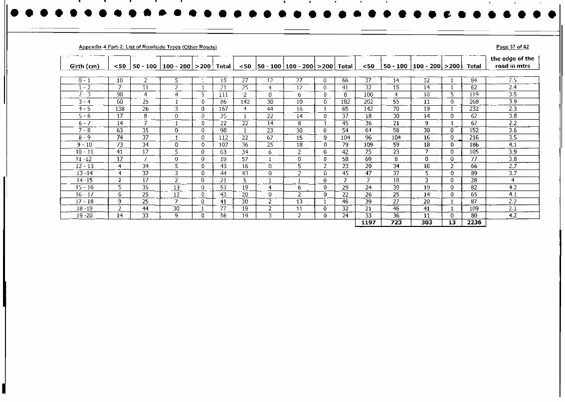
Appexdix-4 Part-2: List of Roadside Trees (Other Roads) Page 37 of 62
I I l l l l l l l l l i l l l l | the edge of theGirth (cm) <50 150 - 100 100 - 200 >200 | Total | <50 I50 - 100 100 - 2001 >200 Total | <50 50 - 100 |100 - 2001 >200 Total I road in mtrs |
0- 1 10 2 5 1 18 27 12 27 0 66 37 14 32 1 84 2.5
1 - 2 7 11 2 1 21 25 4 12 0 41 32 15 14 1 62 2.4
2 - 3 98 4 4 5 111 -2 0 6 0 8 100 4 10 5 119 3.5
3 - 4 60 25 1 0 86 142 30 10 0 182 202 55 11 0 268 3.9
4 - 5 138 26 3 0 167 4 44 16 1 65 142 70 19 1 232 2.3
5 - 6 17 8 0 0 25 1 22 14 0 37 18 30 14 0 62 3.8
6- 7 14 7 1 0 22 22 14 8 1 45 36 21 9 1 67 2.2
7 - 8 63 35 0 0 98 1 23 30 0 54 64 58 30 0 152 3.6
8 - 9 74 37 1 0 112 22 67 15 0 104 96 104 16 0 216 3.5
9- 10 73 34 0 0 107 36 25 18 0 79 109 59 18 0 186 4.1
10- 11 41 17 5 0 63 34 6 2 0 42 75 23 7 0 105 3.9
11 -12 12 7 0 0 19 57 1 0 0 58 69 8 0 0 77 3.8
12- 13 4 34 5 0 43 16 0 5 2 23 20 34 10 2 66 2.7
13 -14 4 37 3 0 44 43 0 2 0 45 47 37 5 0 89 3.7
14-15 2 17 2 0 21 5 1 1 0 7 7 18 3 0 28 4
15 - 16 5 35 13 0 53 19 4 6 0 29 24 39 19 0 82 4.2
16- 17 6 25 12 0 43 20 0 2 0 22 26 25 14 0 65 4.1
17- 18 9 25 7 0 41 30 2 13 1 46 39 27 20 1 87 2.2
18 -19 2 44 30 1 77 19 2 11 0 32 21 46 41 1 109 2.1
19-20 14 33 9 0 56 19 3 2 0 24 33 36 11 0 s8 4.2197 723 303 13 2236
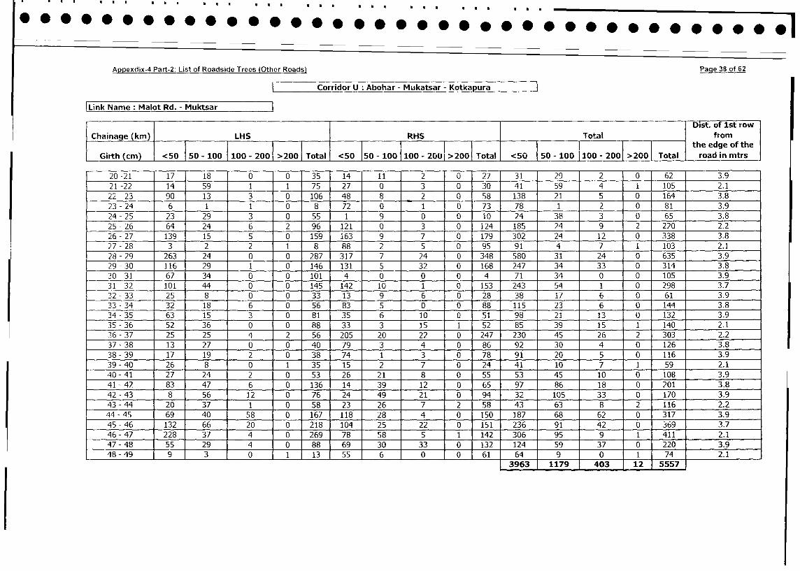
Appexdix-4 Part-2: List of Roadside Trees (Other Roads) Paqe 38 of 62
i Corridor U: Abohar - Mukatsar - Kotkapura
Link Name: Malot Rd. - MuktsarDist. of 1st row
Chainage (km) LHS RHS Total from
I I I ~~~~~~~~~~~~~~~the edge of the
Girth (cm) <50 I50 - 100 100 - 2001 200 Total <50 150 - 100 100 - 200>00 Total <50 50 - 100 100 - 2001 >2001 Total road in mtrs
20-21 17 18 0 0 35 14 11 2 0 27 31 29 2 0 62 3.9
21-22 14 59 1 1 75 27 0 3 0 30 41 59 4 i 1 105 2.1
22 -23 90 13 3 0 106 48 8 2 0 58 138 21 5 0 164 3.8
23 -24 6 1 1 0 8 72 0 1 0 73 78 1 2 0 81 3.9
24-25 23 29 3 0 55 1 9 0 0 iO 24 38 3 0 65 3.8
25 -26 64 24 6 2 96 121 0 3 0 i24 185 24 9 2 220 2.2
26-27 139 15 5 0 159 163 9 7 0 179 302 24 12 0 338 3.8
27 -28 3 2 2 1 8 88 2 5 0 95 91 4 7 1 103 2.1
28 - 29 263 24 0 0 287 317 7 24 0 348 580 31 24 0 635 3.9
29 - 30 116 29 1 0 146 131 5 32 0 168 247 34 33 0 314 3.8
30 - 31 67 34 0 0 101 4 0 0 0 4 71 34 0 0 105 3.9
31 -32 101 44 0 0 145 142 10 1 0 153 243 54 1 0 298 3.7
32 - 33 25 8 0 0 33 13 9 6 0 28 38 17 6 0 61 3.9
33 -34 32 18 6 0 56 83 5 0 0 88 115 23 6 0 144 3.8
34-35 63 15 3 0 81 35 6 10 0 51 98 21 13 0 132 3.9
35 - 36 52 36 0 0 88 33 3 15 1 52 85 39 15 1 140 2.1
36 - 37 25 25 1 2 56 205 20 22 0 247 230 45 26 2 303 2.2
37 - 38 13 27 0 0 40 79 3 4 0 86 92 30 4 0 126 3.8
38 - 39 17 19 2 0 38 74 1 3 0 78 91 20 5 0 116 3.9
39 - 40 26 8 0 1 35 15 2 7 0 24 41 10 7 1 59 2.1
40 - 41 27 24 2 0 53 26 21 8 0 55 53 45 10 0 108 3.9
41 - 42 83 47 6 0 136 14 39 12 0 65 97 86 18 0 201 3.8
42 - 43 8 56 12 0 76 24 49 21 0 94 32 105 33 0 170 3.9
43 - 44 20 37 1 0 58 23 26 7 2 58 43 63 8 2 116 2.2
44 - 45 69 40 58 0 167 118 28 4 0 150 187 68 62 0 317 3.9
45 - 46 132 66 20 0 218 104 25 22 0 151 236 91 42 0 369 3.7
46 - 47 228 37 4 0 269 78 58 5 1 142 306 95 9 1 411 2.1
47 - 48 55 29 4 0 88 69 30 33 0 132 124 59 37 0 220 3.9
48 - 49 9 3 0 1 13 55 6 0 0 61 64 9 0 1 74 2.1
3963 1179 403 12
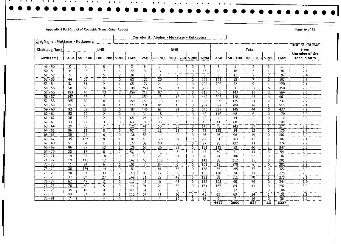
Appexdix-4 Part-2: List of Roadside Trees (Other Roads) Page 39 of 62
Corridor U * Abohar - Mukatsar - Kotkapura|
Link Name : Muktasar - Kotkapura Dist. of st row
Chainage (km) LHS RHS Total from_- I _ _ _ _the edge of the
Girth (cm) <50 |50 - 100 100 - 200 >200 Total <50 50 - 10 100 - 200 >200 Total <50 50 - 100 100 - 200 >200 Total road in mtrs
49 - 50 0 0 0 13 3 5 1 2 0 8 5 1 2 3 11 2.4
50- 51 6 13 2 11 22 9 3 4 0 16 15 16 6 1 38 2.1
51 - 52 5 8 5 2 20 1 3 2 0 6 6 11 7 2 26 2.4
52 - 53 44 15 1 0 60 107 20 6 0 133 151 35 7 0 193 3.9
53 - 54 3.1 31 2 1 65 177 21 7 0 205 208 52 9 1 270 2.1
54 - 55 58 55 26 5 144 250 25 31 0 306 308 80 57 5 450 2.9
55 - 56 193 45 13 3 254 213 97 5 0 315 406 142 18 3 569 2.5
56 - 57 247 53 7 4 311 259 75 16 0 350 506 128 23 4 661 2.7
57- 58 285 60 8 1 354 254 115 13 1 383 539 175 21 2 737 2.2
58 - 59 191 23 8 1 223 201 81 10 0 292 392 104 18 1 515 2.1
59 - 60 92 82 13 0 187 146 63 31 0 240 238 145 44 0 427 3.8
60 - 61 82 30 2 0 114 34 18 4 0 56 116 48 6 0 170 3.9
61 - 62 38 25 2 0 65 26 19 0 0 45 64 44 2 0 110 3.9
62 - 63 33 27 3 0 63 8 33 4 0 45 41 60 7 0 108 3.8
63 - 64 29 88 7 1 125 41 55 50 0 146 70 143 57 1 271 2.1
64 - 65 86 11 0 0 97 47 13 13 0 73 133 24 13 1 0 170 3.8
65 - 66 38 92 6 0 136 58 4 4 0 66 96 96 10 0 202 3.9
66- 67 35 137 8 1 181 46 126 34 0 206 81 263 42 1 387 1 2.1
67 - 68 51 64 11 1 127 39 58 0 0 97 90 122 11 1 224 2.2
68 - 69 86 27 12 1 126 67 26 28 0 121 153 53 40 1 247 2.2
69 - 70 25 17 8 2 52 34 4 3 1 42 59 21 1 11 3 94 2.4
70 - 71 14 82 18 0 114 10 24 34 0 68 24 106 52 0 182 3.8
71 - 72 18 1 112 12 0 142 40 100 3 0 143 58 212 15 0 285 3.9
72 - 73 11 84 6 0 101 7 94 0 0 101 18 178 6 0 202 3.8
73 - 74 36 134 14 0 184 19 61 58 0 138 55 195 72 0 322 3.9
74 - 75 48 57 33 2 140 80 17 38 0 135 128 74 71 2 275 2.3
75 - 76 37 89 22 1 149 51 22 48 0 121 88 111 70 1 270 2.1
76- 77 62 47 3 0 112 43 43 46 0 132 105 90 49 0 244 3.9
77 - 78 76 1 60 1 5 0 141 91 24 36 0 151 167 84 41 0 292 3.9
78 - 79 34 15 0 1 0 49 51 2 2 0 55 85 17 2 0 104 3.8
79- 80 49 52 8 1 110 14 11 16 0 41 63 63 24 1 151 2.1
80 - 81 7 3 J 4 0 14 2 _ 4 10 0 16 9 1 7 14 1 0 30 3.9
4477 1 2900 827 1 33 8237
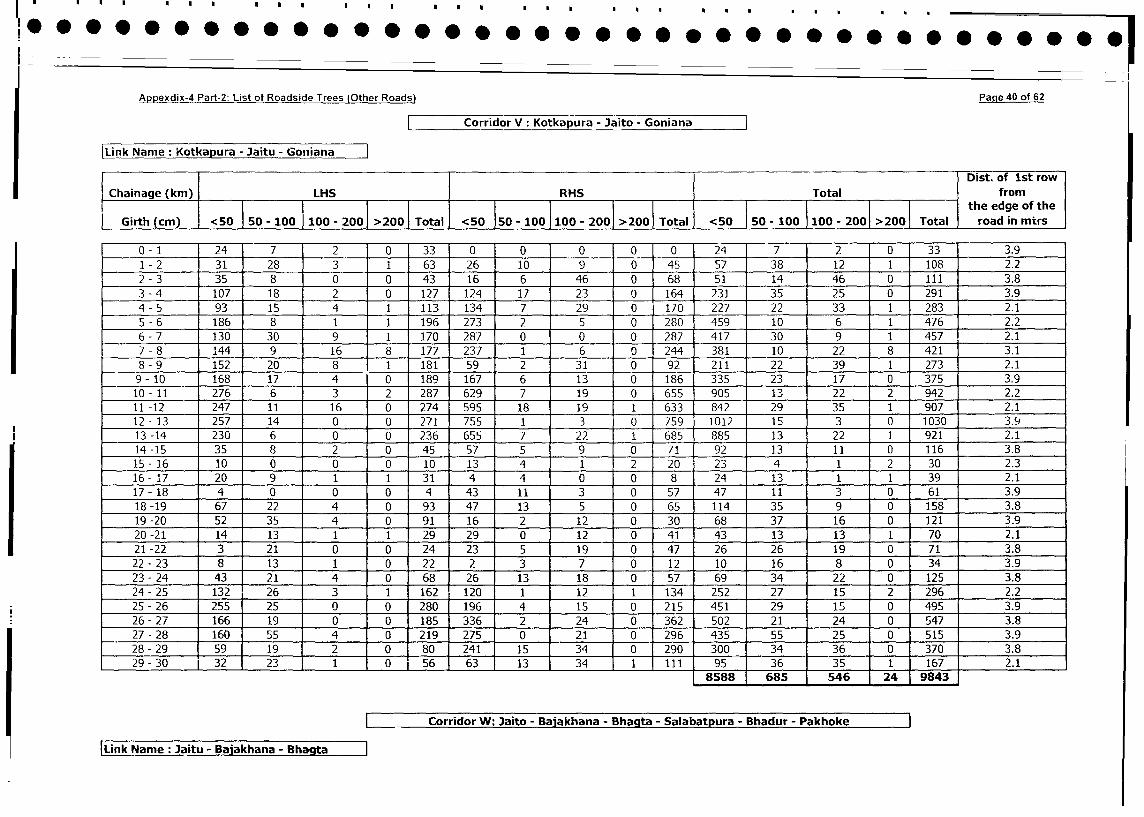
Appexdix-4 Part-2: List of Roadside Trees (Other Roads) Paqe 40 of 62
Corridor V: Kotkapura - Jaito - Goniana
|Link Name: Kotkapura - Jaitu - Goniana
[ Dist. of 1st row
Chainage (km) LHS RHS Total from
l l l l l ll l ll | the edge of the
Girth (cm) <50 50-100 100- 200 200 Total <50 50-100 100-2001 >200 Total <50 50-100 100 - 2001 >200 Total road in mirs
0- 1 24 7 2 0 33 0 0 0 0 0 24 7 2 0 33 3.9
1 - 2 31 28 3 1 63 26 10 9 0 45 57 38 12 1 108 2.2
2 - 3 35 8 0 0 43 16 6 46 0 68 51 14 46 0 111 3.8
3 -4 107 18 2 0 127 124 17 23 0 164 231 35 25 0 291 3.9
4 - 5 93 15 4 1 113 134 7 29 0 170 227 22 33 1 283 2.1
5 - 6 186 8 1 1 196 273 2 5 0 280 459 10 6 1 476 2.2
6 - 7 130 30 9 1 170 287 0 0 0 287 417 30 9 1 457 2.1
7 - 8 144 9 16 8 177 237 1 6 0 244 381 10 22 8 421 3.1
8 - 9 152 20 8 1 181 59 2 31 0 92 211 22 39 1 273 2.1
9- 10 168 17 4 0 189 167 6 13 0 186 335 23 17 0 375 3.9
10- 11 276 6 3 2 287 629 7 19 0 655 905 13 22 2 942 2.2
11 -12 247 11 16 0 274 595 18 19 1 633 842 29 35 1 907 2.1
12 - 13 257 14 0 0 271 755 3 0 759 1012 15 3 0 1030 3.9
13-14 230 6 0 0 236 655 7 22 1 685 885 13 22 1 921 2.1
14-15 35 8 2 0 45 57 5 9 0 71 92 13 11 0 116 3.8
15- 16 10 0 0 0 10 13 4 1 2 20 23 4 1 2 30 2.3
16- 17 20 9 1 1 _ 31 4 4 0 0 8 24 13 1 1 39 2.1
17 - 18 4 0 0 0 4 43 11 3 0 57 47 11 3 0 61 3.9
18-19 67 22 4 0 93 47 13 5 0 65 114 35 9 0 158 3.8
19-20 52 35 4 0 91 16 2 12 0 30 68 37 16 0 121 3.9
20-21 14 13 1 1 29 29 0 12 0 41 43 13 13 1 70 2.1
21-22 3 21 0 0 24 23 5 19 0 47 26 26 19 0 71 3.8
22 - 23 8 13 1 0 22 2 3 7 0 12 10 16 8 0 34 3.9
23 - 24 43 21 4 0 68 26 13 18 0 57 69 34 22 0 125 3.8
24 - 25 132 26 3 1 162 120 1 12 1 134 252 27 15 2 296 2.2
25 - 26 255 i 25 0 0 280 196 4 15 i 0 215 451 29 15 0 495 3.9
26-27 1661 19 0 0 185 336 2 24 10 362 502 21 24 0 547 3.8
27 - 28 1601 55 4 0 219 275 0 21 10 296 435 55 25 0 515 3.9
28 - 29 59 19 2 0 80 241 15 34 1 0 290 300 34 36 0 370 3.8
29 - 30 321 23 1 o 56 63 13 34 11 111 95 36 35 1 167 2.1
8588 685 546 24 9843
Corridor W: Jaito - Baiakhana - Bhagta - Salabatpura - Bhadur - Pakhoke
Link Name :Jaitu - Ba akhana - Bha ta
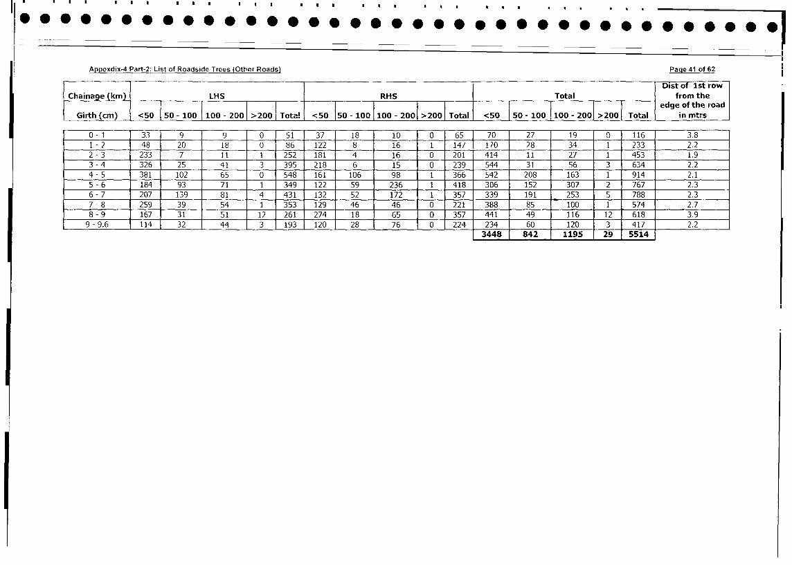
ApDexdix-4 Part-2: List of Roadside Trees (Other Roads) Paqe 41 of 62
_. . Dist of 1st row
Chainage (km) LHS RHS Total from the
Gi Tota'{ ~~~~~~~~~~~~~~~--edge of the road
Girth (cm) <50 |50-100 |100-200 |>200 |T ! <50 50-l00 |100 - 200 >200 Total <50 50 - 100 100-200 >200 Total in mtrs
0-1 33 9 9 0 51 37 18 10 0 65 70 27 J 19 0 116 3.8
1 -2 48 20 18 0 86 122 8 16 1 147 170 28 34 1 233 2.2
2 - 3 233 7 11 1 252 181 4 16 0 201 414 11 27 1 453 1.9
3 - 4 326 25 41 3 395 218 6 15 0 239 544 31 56 3 634 2.2
4 -5 381 102 65 0 548 161 106 98 1 366 542 208 163 1 914 2.1
5 - 6 184 93 71 1 349 122 59 236 1 418 306 152 307 2 767 2.3
6 - 7 207 139 81 4 431 132 52 172 1 357 339 191 253 5 788 2.3
7 - 8 259 39 54 1 353 129 46 46 0 221 388 85 100 1 574 2.7
8 - 9 167 31 51 12 261 274 18 65 0 357 441 49 116 12 618 3.9
9 - 9.6 114 32 44 3 193 120 28 76 0 224 234 60 120 3 417 2.2
3448 842 1195 29 5514
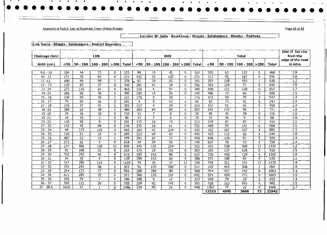
Appexdix-4 Part-2: List of Roadside Trees (Other Roads) Page 42 of 62
Corridor W: Jaito - Bajakhana - Bhagta - Salabatpura - Bhadur - Pakhoke
Link Name: Bhagta - Salabatpura - District Bounda
. 1 1 Dist of 1st row
Chainage (km) LHS RHS Total from the
<00 ta - l l l edge of the road
Girth (cm) <50 50-100 100- 200 >200 Total <50 150 - 100 100 - 200>00 > <50 | 50 -100 100 -200 >2001 Total in mtrs
9.6- 10 204 44 77 0 325 99 19 45 0 163 303 63 122 0 488 3.9
10 - 11 171 70 82 0 323 142 25 105 0 272 313 95 187 0 595 3.8
11 -12 190 89 98 1 378 67 29 65 0 161 257 118 163 1 539 2.2
12- 13 220 83 37 0 340 281 41 34 0 356 501 124 71 0 696 3.9
13 -14 272 116 81 0 469 326 5 57 0 388 598 121 138 0 857 3.7
14 -15 206 58 36 5 305 280 15 50 0 345 486 73 86 5 650 2.5
15- 16 239 50 40 2 331 176 9 30 1 216 415 59 70 3 547 2.4
16- 17 79 64 38 0 181 4 9 53 0 66 83 73 91 0 247 2.9
17- 18 110 47 41 5 203 227 4 24 0 255 337 51 65 5 458 2.4
18 -19 380 69 30 1 480 163 64 65 0 292 543 133 95 1 77z 1.9
19 -20 74 36 20 0 130 11 7 8 0 26 85 43 28 0 156 2.9
20 -21 18 19 3 0 40 15 7 6 0 28 33 26 9 0 68 3.8
21 -22 134 58 9 0 201 115 24 73 1 213 249 82 82 1 414 2.5
22- 23 153 43 80 0 276 255 16 61 0 332 408 59 141 0 608 3.5
23 - 24 98 215 143 4 460 164 47 224 0 435 262 262 367 4 895 2.5
24 - 25 116 51 33 4 204 313 64 63 0 440 429 115 96 4 644 2.8
25 - 26 407 52 15 5 479 291 87 72 0 450 698 139 87 5 929 2.9
26- 27 573 42 3 0 618 54 34 50 2 140 627 76 53 2 758 2.4
27 - 28 277 406 136 11 830 145 132 224 1 502 422 538 360 12 1332 2.2
28 - 29 82 108 25 0 215 173 29 101 0 303 255 137 126 0 518 2.9
29 - 30 333 297 43 0 673 393 153 86 0 632 726 450 129 0 1305 3.8
30 - 31 74 76 9 0 159 199 112 60 9 380 273 188 69 9 539 3.2
31 - 32 717 285 114 4 1120 74 26 37 13 150 791 311 151 17 1270 2.8
32 - 33 151 243 58 1 453 91 170 250 0 511 242 413 308 1 964 2.8
33 - 34 254 177 72 0 503 200 280 80 0 560 454 457 152 0 1063 3.4
34 - 35 611 285 15 0 911 360 135 197 0 692 971 420 212 0 1603 3.5
35 - 36 259 79 7 1 346 300 0 12 1 313 559 79 19 1 2 659 2.4
36 - 37 369 121 20 0 510 159 92 141 0 392 528 213 161 0 902 3.5
37 - 38.6 1028 37 1 0 1066 339 40 21 0 400 1367 77 22 j 0 1466 3.7
13215 4995 3660 j 72 21942
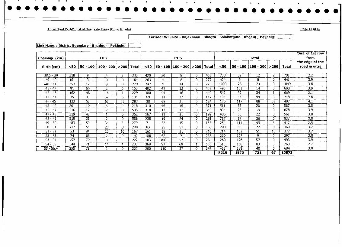
Appexdix-4 Part-2: List of Roadside Trees (Other Roads) Page 43 of 62
Corridor W: Jaito - Bajakhana - Bhagta - Salabatpura - Bhadur - Pakhoke
|Link Name: District Boundary - Bhadour - Pokhoke
Dist. of 1st row
Chainage (km) LHS RHS Total from
i___________________________________ _ lthe edge of the
Girth (cm) <50 50 - 100 100 - 200 >200 Total <50 50 - 100 100 - 200 >2001 Total <50 I 50 - 100 100 - 2001 >200 Total road in mtrs
38.6- 39 318 9 4 2 333 420 30 8 0 458 738 39 12 12 791 2.2
39 - 40 161 3 0 0 164 263 6 8 0 277 424 9 8 10 441 3.9
.40 - 41 753 17 9 0 779 247 9 14 0 270 1000 26 23 ! 0 1049 3.8
41 - 42 91 60 2 0 153 402 41 12 0 455 493 101 14 0 608 3.9
42 - 43 162 48 18 1 229 380 44 16 0 440 542 92 34 1 669 2.1
43 - 44 35 33 1 57 6 131 69 11 37 0 117 104 44 94 6 248 2.8
44 - 45 132 52 67 32 283 38 65 21 0 124 170 117 88 32 407 4.1
45 - 46 201 10 5 0 216 310 46 15 0 371 511 56 20 0 587 3.8
46 - 47 516 12 7 0 535 318 13 12 0 343 834 25 19 0 878 3.9
47-48 319 42 1 0 362 167 11 21 0 199 486 53 22 0 561 3.8
48 - 49 519 35 2 0 556 238 19 24 0 281 757 54 26 0 837 3.8
49- 50 183 59 34 3 279 71 52 15 0 138 254 111 49 3 417 2.5
50 - 51 117 55 20 8 200 83 25 52 0 160 200 80 72 8 360 3.2
51 - 52 53 84 1 20 10 167 161 18 31 0 210 214 102 51 1iO 377 3.7
52 - 53 74 66 2 0 142 186 62 7 0 255 260 128 9 0 397 3.8
53 - 54 157 70 0 0 227 103 106 57 0 266 260 176 57 0 493 3.9
54 - 55 144 71 14 4 233 369 97 69 1 536 513 168 83 5 769 2.7
55 - 56.4 J 255 79 3 0 337 200 110 37 0 347 455 189 40 0 684 3.8
8215 1570 721 167 10573
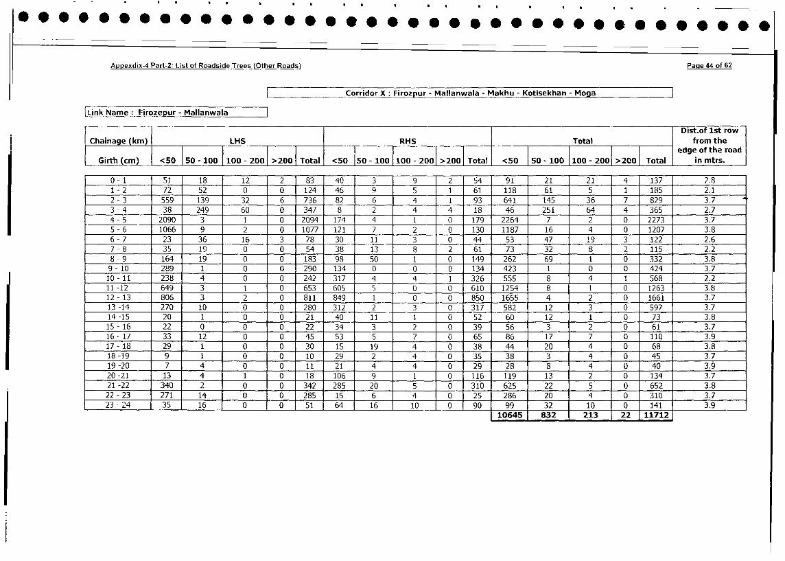
Appexdix-4 Part-2: List of Roadside Trees (Other Roads) Page 44 of 62
Corridor X: Firozpur - Mallanwala - Makhu - Kotisekhan - Moga
Link Name: Firozepur - MallanwalaDist.of 1st row 1
Chainage (km) LHS RHS Total from the
l_______________________________ _______________________________ _______l___l________________l__l edge of the road
Girth (cm) <50 I50 - 100 100 - 200 >200 Total <50 150 - 100 100 - 2001 >200 Total <50 | 50 - 100 |100 - 2001 >200 Total in mtrs.
0- 1 51 18 12 2 83 40 3 9 2 54 91 21 21 4 137 2.8
1 - 2 72 52 0 0 124 46 9 5 1 61 118 61 5 1 185 2.1
2 - 3 559 139 32 6 736 82 6 4 1 93 641 145 36 7 829 3.7
3 - 4 38 249 60 0 347 8 2 4 4 18 46 251 64 4 365 2.7
4- 5 2090 3 1 0 2094 174 4 1 0 179 2264 7 2 0 2273 3.7
5 - 6 1066 9 2 0 1077 121 7 2 0 130 1187 16 4 0 1207 3.8
6 - 7 23 36 16 3 78 30 11 3 0 44 53 47 19 3 122 2.6
7 - 8 35 19 0 0 54 38 13 8 2 61 73 32 8 2 115 2.2
8 - 9 164 19 0 0 183 98 50 1 0 149 262 69 1 0 332 3.8
9- 10 289 1 0 0 290 134 0 0 0 134 423 1 0 0 424 3.7
10- 11 238 4 0 0 242 317 4 4 1 326 555 8 4 1 568 2.2
11 -12 649 3 1 0 653 605 5 0 0 610 1254 8 1 0 1263 3.8
12- 13 806 3 2 0 811 849 1 0 0 850 1655 4 2 0 1661 3.7
13 -14 270 10 0 0 280 312 2 3 0 317 582 12 3 0 597 3.7
14 -15 20 1 0 0 21 40 11 1 0 52 60 12 1 0 73 3.8
15- 16 22 0 0 0 22 34 3 2 0 39 56 3 2 0 61 3.7
16- 17 33 12 0 0 45 53 5 7 0 65 86 17 7 0 110 3.9
17- 18 29 1 0 0 30 15 19 4 0 38 44 20 4 0 68 3.8
18 -19 9 1 0 0 10 29 2 4 0 35 38 3 4 0 45 3.7
19 -20 7 4 0 0 11 21 4 4 0 29 28 8 4 0 40 3.9
20 -21 13 4 1 0 18 106 9 1 0 116 119 13 2 0 134 3.7
21 -22 340 2 0 0 342 285 20 5 0 310 625 22 5 0 652 3.8
22 - 23 271 14 0 0 285 15 6 4 0 25 286 20 4 0 310 3.7
23- 24 35 16 0 0 51 64 16 10 0 90 99 32 10 0 141 3.9
10645 832 213 22 11712
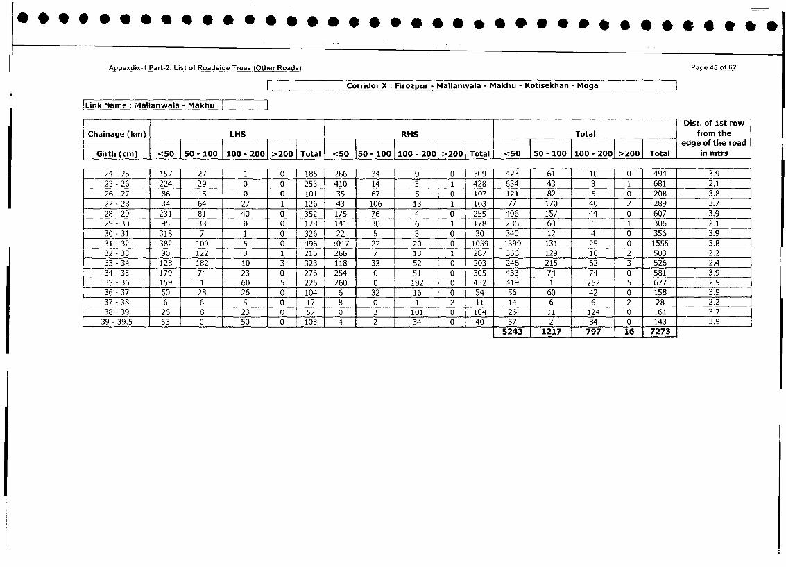
.... ........ ** 0*0 00 0 B.B ... 0 0 *.10000
Appexdix-4 Part-2: List of Roadside Trees (Other Roads) Paqe 45 of 62
Corridor X: Firozpur - Mallanwala - Makhu - Kotisekhan - Moga
Link Name: Mallanwala - Makhu
Dist. of 1st row
Chainage (km) LHS RHS Total from the
i__l_____l__l__l__l__l__l__l__l_ l edge ofthe road
Girth (cm) <50 50 - 100 I 100 - 200 >200 Total <50 I50 - 100 1100 - 2001 >200 Total <50 F50 - 100 100 - 2001 >2001 Total in mtrs
24- 25 1157 27 1 0 185 266 34 9 0 309 423 61 10 0 494 3.9
25 - 26 224 29 0 0 253 410 14 3 1 428 634 43 3 1 681 2.1
26- 27 86 15 0 0 101 35 67 5 0 107 121 82 5 0 208 3.8
27 - 28 34 64 27 1 126 43 106 13 1 163 77 170 40 2 289 3.7
28- 29 231 81 40 0 352 175 76 4 0 255 406 157 44 0 607 3.9
29 - 30 95 33 0 0 128 141 30 6 1 178 236 63 6 1 306 2.1
30 - 31 318 7 1 0 326 22 5 3 0 30 340 12 4 0 356 3.9
31 - 32 382 109 5 0 496 1017 22 20 0 1059 1399 131 25 0 1555 3.8
32-33 90 122 3 1 216 266 7 13 1 287 356 129 16 2 503 2.2
33 - 34 128 182 10 3 323 118 33 52 0 203 246 215 62 3 526 2.4
34 - 35 179 74 23 0 276 254 0 51 0 305 433 74 74 0 581 3.9
35 - 36 159 1 60 5 225 260 0 192 0 452 419 1 252 5 677 2.9
36- 37 50 28 26 0 104 6 32 16 0 54 56 60 42 0 158 3.9
37 - 38 6 6 5 0 17 8 0 1 2 11 14 6 6 2 28 2.2
38 - 39 26 8 23 0 57 0 3 101 0 104 26 11 124 0 161 3.7
39- 39.5 53 0 50 0 103 4 2 34 0 40 57 2 1 84 0 143 3.95243 1217 j 797 16 7273
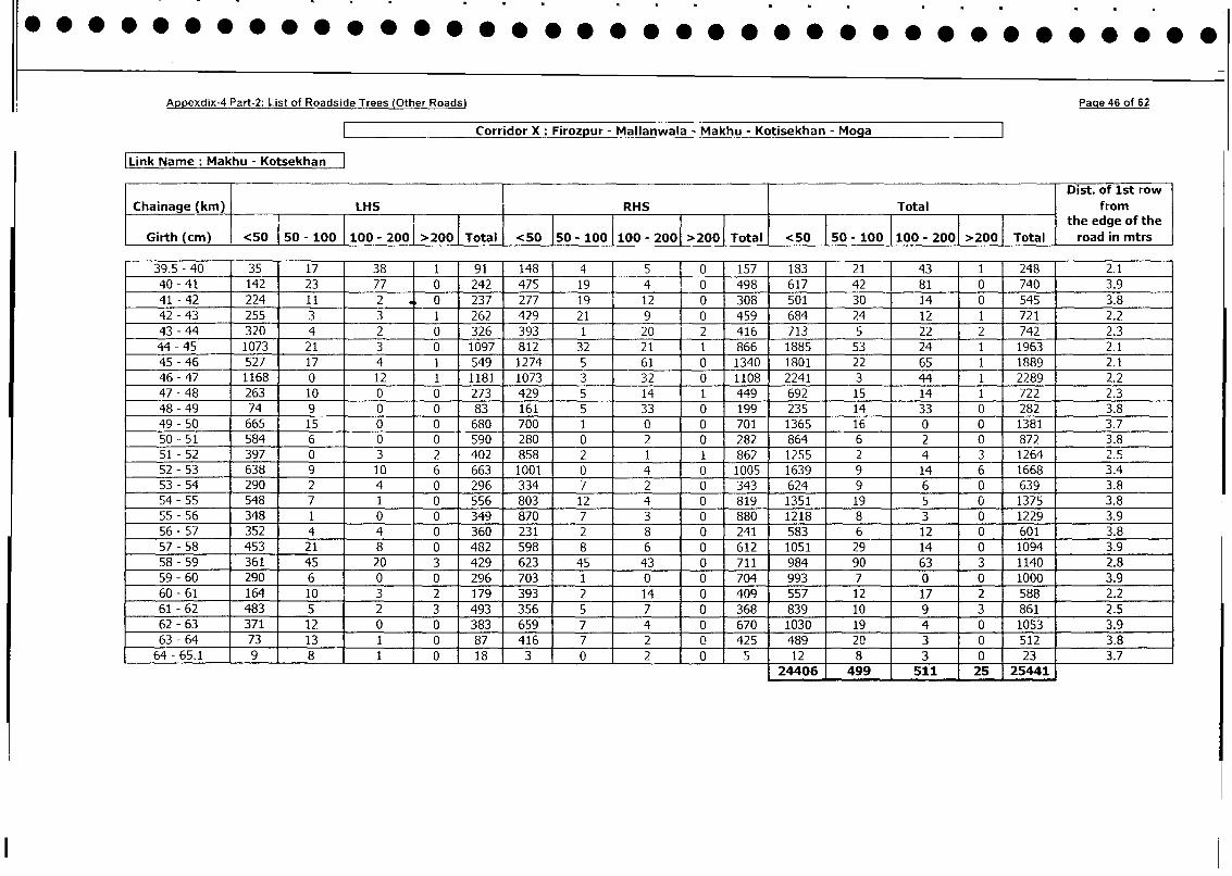
Appexdix-4 Part-2: List of Roadside Trees (Other Roads) Paqe 46 of 62
Corridor X: Firozpur - Mallanwala - Makhu - Kotisekhan - Moga
Link Name: Makhu - Kotsekhan
l Dist. of 1st row
Chainage (km) LHS RHS I Total fromI ~~~~~~~~~~~~~~the edge of the
Girth (cm) <50 |50 - 100 100 - 200 >200 Total <50 I50 - 100 100 - 2001 >200 Total <50 | 50 - 100 100 - 2001 >200| Total road in mtrs
39.5 - 40 35 17 38 1 91 148 4 ] 5 10 157 183 21 43 1 248 2.1
40 - 41 142 23 77 0 242 475 19 4 0 498 617 42 81 0 740 3.9
41 - 42 224 11 2 0 237 277 19 1 12 0 308 501 30 14 0 545 3.8
42 - 43 255 3 3 1 262 429 21 9 0 459 684 24 12 1 721 2.2
43 - 44 320 4 2 0 326 393 1 20 2 416 713 5 22 2 742 2.3
44 - 45 1073 21 3 0 1097 812 32 21 1 866 1885 53 24 1 1963 2.1
45 - 46 527 17 4 1 549 1274 5 61 0 1340 1801 22 65 1 1889 2.1
46- 47 1168 0 12 1 1181 1073 3 32 0 1108 2241 3 44 1 2289 2.2
47 - 48 263 10 0 0 273 429 5 14 1 449 692 15 14 1 722 2.3
48 - 49 74 9 0 0 83 161 5 33 0 199 235 14 33 0 282 3.8
49 - 50 665 15 0 0 680 700 1 0 0 701 1365 16 0 0 1381 3.7
50 - 51 584 6 0 0 590 280 0 2 0 282 864 6 2 0 872 3.8
51 - 52 397 0 3 2 402 858 2 1 1 862 1255 2 4 3 1264 2.5
52 - 53 638 9 10 6 663 1001 0 4 0 1005 1639 9 14 6 1668 3.4
53 - 54 290 2 4 0 296 334 7 2 0 343 624 9 6 0 639 3.8
54-55 548 7 1 0 556 803 12 4 0 819 1351 19 5 0 1375 3.8
55-56 348 1 0 0 349 870 7 3 0 880 1218 8 3 0 1229 3.9
56 - 57 352 4 4 0 360 231 2 8 0 241 583 6 12 0 601 3.8
57-58 453 21 8 0 482 598 8 6 0 612 1051 29 14 0 1094 3.9
58 - 59 361 45 20 3 429 1 623 45 43 0 711 984 90 63 3 1140 2.8
59-60 290 6 0 0 296 703 1 0 0 704 993 7 0 0 1000 3.9
60-61 164 10 3 2 179 393 2 14 0 409 557 12 17 2 588 2.2
61 - 62 483 5 2 3 493 356 5 7 0 368 839 10 9 3 861 2.5
62-63 371 12 0 0 383 659 7 4 0 670 1030 19 4 0 1053 3.9
63 - 64 73 13 1 0 87 416 7 2 0 425 489 20 3 0 512 3.8
64-65.1 9 8 1 0 18 1 3 0 2 0 5 12 8 3 0 23 3.7
24406 499 511 25 25441
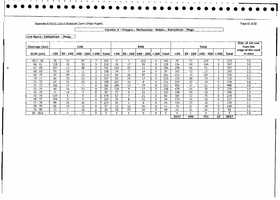
Appexdix-4 Part-2: List of Roadside Trees (Other Roads) Page 47 of 62
Corridor X: FirozDur - Mallanwala - Makhu - Kotisekhan - Moga
Link Name: Kotisekhan - MogaDist. of lst row
Chainage (kin) |LHS X RHS Total from the
Chainage_ _ (km LH_ _ _ _ _ l l l edge of the road
Girth (cm) <50 50 - 100 100 - 2001 >200 | Total <50 150 - 100 100 - 2001 >200 Total <50 50 - 100 |100 - 200 >200 Total in mtrs
65.1 - 66 36 51 87 7 181 9 1 132 0 142 45 52 219 7 323 3.5
66- 67 118 41 50 9 218 18 17 94 0 129 136 58 144 9 347 3.8
67- 68 107 12 40 2 161 142 43 11 0 196 249 55 51 2 357 2.2
68 - 69 93 10 3 2 108 74 7 14 0 95 167 17 17 2 203 2.3
69 - 70 42 49 22 1 114 89 26 47 0 162 131 75 69 1 276 2.1
70-71 60 35 12 0 107 65 21 17 0 103 125 56 29 0 210 3.9
71 - 72 67 31 10 0 108 207 16 8 0 231 274 47 18 0 339 3.8
72 - 73 166 13 7 0 186 284 14 14 0 312 450 27 21 0 498 3.8
73 - 74 40 16 13 0 69 130 9 17 0 156 170 25 30 0 225 3.9
74 - 75 71 19 3 0 93 77 9 15 1 102 148 28 18 1 195 2.3
75 - 76 129 5 0 0 134 52 7 25 0 84 181 12 25 0 218 3.8
76 - 77 149 8 6 0 163 24 8 22 0 54 173 16 28 0 217 3.8
77 - 78 89 24 10 1 124 45 1 8 0 54 134 25 18 1 178 2.1
78- 79 66 19 12 0 97 13 12 26 0 51 79 31 38 0 148 3.8
79 - 80 33 7 10 0 50 18 14 16 0 48 51 21 26 0 98 3.7
80 - 80.6 0 0 0 0 0 4 1 0 0 5 4 1 0 0 5 3.8
2517 546 751 23 3837
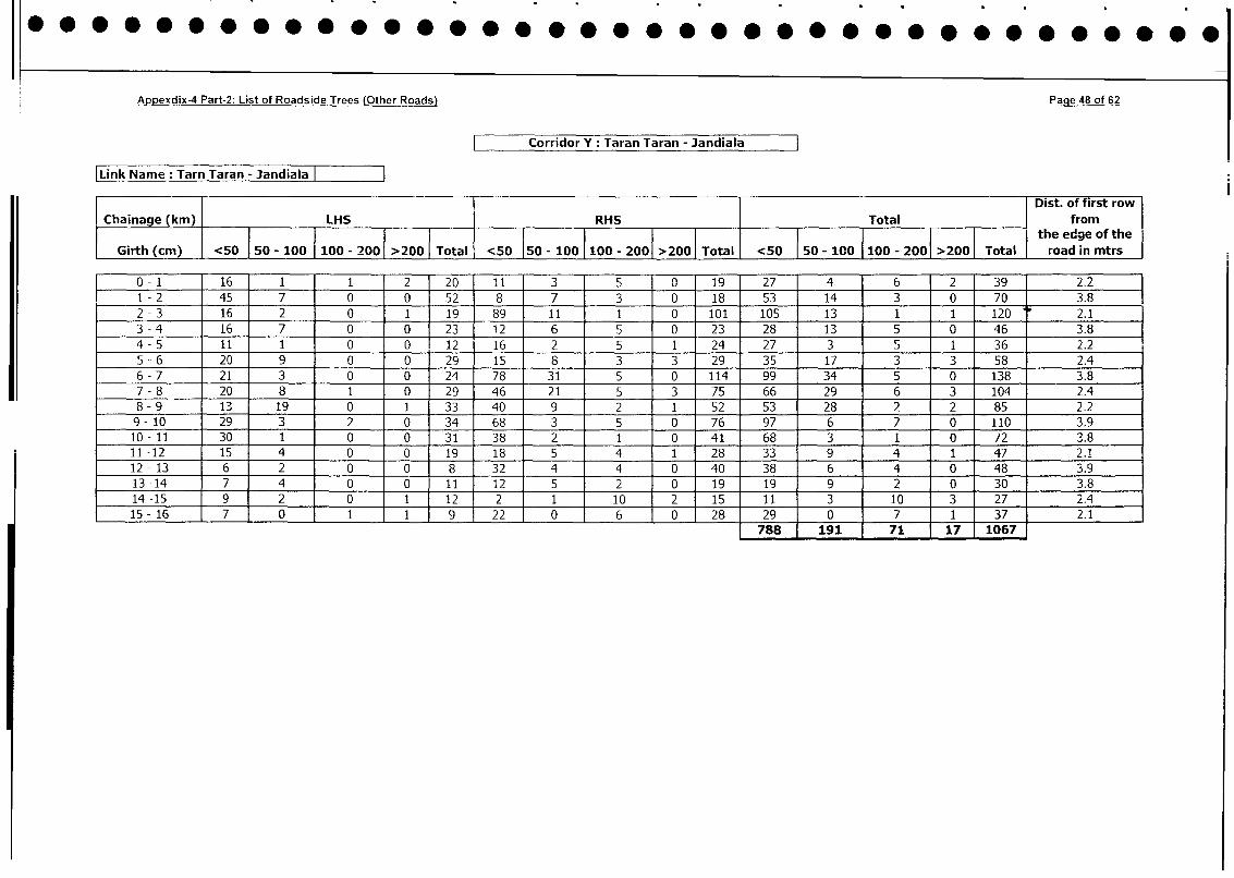
*@@*@OO@@Oe.....~0 00 00 @eeee@O@e@e@@.O..@..@ 0 0 0
Appexdix-4 Part-2: List of Roadside Trees (Other Roads) Page 48 of 62
Corridor Y :Taran Taran - Jandiala
Link Name :Tarn Taran - Jandiala
Dist. of first row
IChainage (kin) LHS RHS ITotal from
___________________________ ___________________________________________________the_theged ofoftth
Girth (cm) <50 50 - 100 1100 - 2001 >200 Total <50 150 - 100 1100 - 2001 >2001 Total <50 50 - 100 1100 - 2001 >200 Total road in mtrs
0 -1 16 1 1 2 20 1 1 3 5 0 19 27 4 6 2 39 2.2
1 -2 45 7 0 0 52 8 7 3 0 18 53 14 3 0 70 3.8
2 -3 16 2 0 1 19 89 11 I 0 101 105 13 1 1 120 2.1
3 -4 16 7 0 0 23 1 2 6 5 0 23 28 13 5 0 46 3.8
4 -5 11 1 0 0 12 16 2 5 1 24 27 3 5 1 36 2.2
5 -6 20 9 0 0 29 15 8 3 3 29 35 1 17 3 3 58 2.4
6 -7 21 3 0 0 24 78 31 5 0 114 99 34 5 0 138 3.8
7 -8 20 8 1 0 29 46 21 5 3 75 66 29 6 3 104 2.4
8 -9 13 19 0 1 33 40 9 2 1 52 53 28 2 2 85 2.2
9 -10 29 3 2 0 34 68 3 5 0 76 97 6 7 0 110 3.9
10 -11 30 1 0 0 31 38 2 1 0 41 68 3 1 0 72 3.8
11 -12 15 4 0 0 19 18 5 4 1 28 33 9 4 1 47 2.1
12 -13 6 2 0 0 8 32 4 4 0 40 38 6 4 0 48 3.9
13 -14 7 4 0 0 11 12 5 2 0 19 19 9 2 0 30 3.8
14 -15 9 2 0 1 12 2 i 10 2 15 11 3 10 3 27 2.4
15 -16 7 0 1 1 9 22 0 6 0 28 29 0 7 1 37 2.1
788 191 71 17 1067
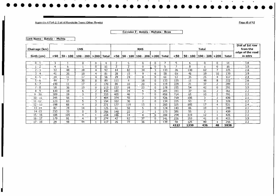
Appeyddx-4 Part-2: List of Roadside Trees (Other Roads) Page 49 of 62
Corridor Z: Batala - Mehata - Beas
Link Name: Batala - Mehta
1 Dist of 1st row
Chainage (km) LHS RHS Total from thelotalj l l l l l l |edge of the road
Girth (cm) <50 50 - 100 I 100 - 2001 >200 | Total <50 I50 - 100 1100 - 2001 >200 <50 50 - 100 100 - 2001 >200 Total | in mtrs
0-1 3 1 0 0 4 2 5 0 0 7 5 6 0 0 11 3.8
1 -2 4 6 1 0 11 3 2 0 0 5 7 8 1 0 16 3.9
2 - 3 12 48 28 4 92 14 82 34 3 133 26 130 62 7 225 2.8
3 - 4 41 26 10 4 81 28 15 9 6 58 69 41 19 10 139 3.9
4 - 5 24 11 17 4 56 29 24 8 0 61 53 35 25 4 117 2.4
5 - 6 44 7 30 8 89 111 4 18 0 133 155 11 48 8 222 2.6
6 - 7 140 11 17 2 170 89 10 20 0 119 229 21 37 2 289 2.1
7 - 8 58 36 19 0 113 137 18 23 0 178 195 54 42 0 291 3.9
8 - 9 130 18 6 2 156 181 19 5 0 205 311 37 11 2 361 2.2
9- 10 309 19 3 2 333 405 46 7 0 458 714 65 10 2 791 2.3
10 - 11 345 56 1 2 404 374 50 2 0 426 719 106 3 2 830 2.1
11 -12 123 63 5 3 194 102 30 2 0 134 225 93 7 3 328 2.3
12 - 13 198 66 4 3 271 127 119 13 1 260 325 185 17 4 531 2.4
13 -14 82 28 14 1 125 61 58 5 0 124 143 86 19 i 249 2.1
14 -15 233 33 0 0 266 148 22 2 1 173 381 55 2 1 439 2.2
15- 16 108 105 4 1 218 186 14 8 0 208 294 119 12 1 426 2.1
16- 17 179 91 4 0 274 42 62 37 0 141 221 153 41 0 415 3.9
17- 18 24 48 44 1 117 26 77 36 0 139 50 125 80 1 256 2.1
4122 1330 436 48 5936^
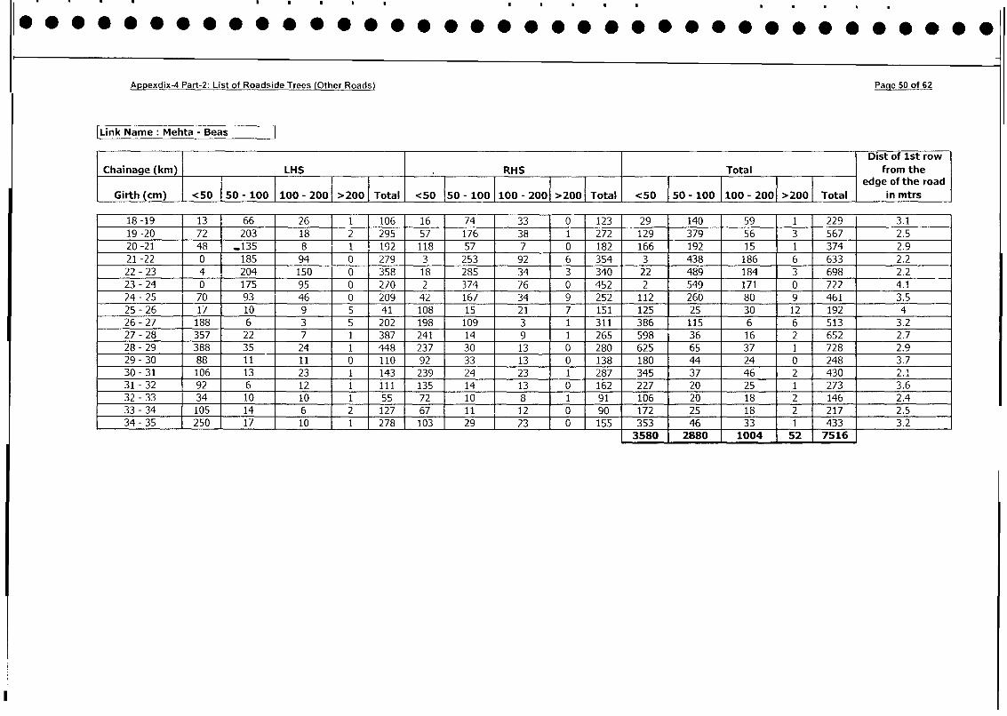
Appexdix-4 Part-2: List of Roadside Trees (Other Roads) Paqe 50 of 62
Link Name: Mehta - Beas
Dist of 1st row
Chainage (km) LHS RHS Total from the
Girth | l edge of the road
Girth (cm) <50 50 - 100 100 - 200 >200 Total <50 150 - 100 100 - 2001 >200 Total <50 150 - 100 100 - 2001 >200 Total in mtrs
18 -19 1 3 66 26 1 106 16 74 33 0 123 29 140 59 1 229 3.1
19-20 72 203 18 [ 2 295 57 176 38 1 272 129 379 56 3 567 2.5
20-21 48 _135 8 I 1 192 118 57 7 0 182 166 192 15 1 374 2.9
21-22 0 185 94 j0 279 3 253 92 6 354 3 438 186 6 633 2.2
22 - 23 4 204 150 0 358 18 285 34 3 340 22 489 184 3 698 2.2 _
23 - 24 0 175 95 0 270 2 374 76 0 452 2 549 171 0 722 4.1
24 - 25 70 93 46 0 209 42 167 34 9 252 112 260 80 9 461 3.5
25 - 26 17 10 9 5 41 108 15 21 7 151 125 25 30 12 192 4
26 - 27 188 6 3 5 202 198 109 3 1 311 386 115 6 6 513 3.2
27 - 28 357 22 7 1 387 241 14 9 1 265 598 36 16 2 652 2.7
28 - 29 388 35 24 1 448 237 30 13 0 280 625 65 37 1 728 2.9
29 - 30 88 11 11 0 110 92 33 13 0 138 180 44 24 0 248 3.7
30 - 31 106 13 23 1 143 239 24 23 1 287 345 37 46 2 430 2.1
31 - 32 92 6 12 1 111 135 14 13 0 162 227 20 25 1 273 3.6
32 - 33 34 10 10 1 55 72 10 8 1 91 106 20 18 2 146 2.4
33 - 34 105 14 6 2 127 67 11 12 0 90 172 25 18 2 217 2.5
34 - 35 250 17 10 1 278 103 29 23 0 155 353 46 33 1 433 3.23580 2880 1004 52 7516
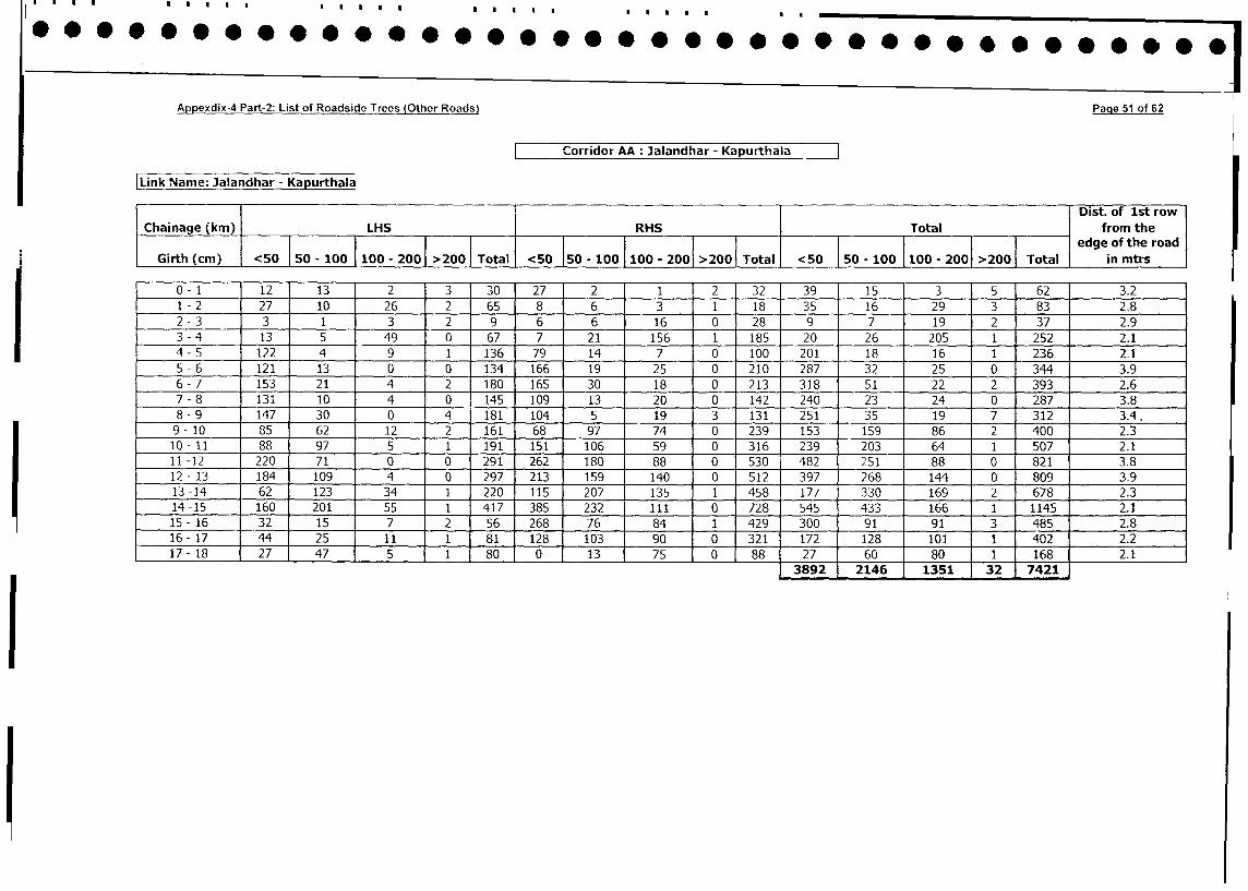
Appexdix-4 Part-2: List of Roadside Trees (Other Roads) Page 5i of 62
Corridor AA: Jalandhar - Kapurthala
Link Name: Jalandhar - Kapurthala
T 1 Dist. of 1st row
Chainage (km) LHS RHS Total from the
o 5 1 1 > T otl < 5 0 > edge of the road
Gi0th (cm) | 5-100 00- 2001 >200 Total <50 - 00 - 20 00 Total <5 - 100 |l0 - 200>200| Total in mtrs
0-1 12 13 2 3 30 27 2 1 2 32 39 15 3 5 62 3.2
1 -2 27 10 26 2 65 8 6 3 1 18 35 16 29 3 83 2.8
2 - 3 3 1 3 2 9 6 6 16 0 28 9 7 19 2 37 2.9
3 - 4 13 5 49 0 67 7 21 156 1 185 20 26 205 1 252 2.1
4 -5 122 4 9 1 136 79 14 7 0 100 201 18 16 1 236 2.1
5 -6 121 13 0 0 134 166 19 275 0 210 287 32 25 10 344 3.9
6 - 7 153 21 4 2 180 165 30 18 0 213 318 51 22 2 393 2.6
7-8 131 10 4 0 145 109 13 20 0 142 240 23 24 0 287 3.8
8 - 9 147 30 0 4 181 104 5 19 3 131 251 35 19 7 312 3.4.
9-10 85 62 12 2 161 68 97 74 0 239 153 159 86 2 400 2.3
10-tl 88 97 5 1 191 151 106 59 0 316 239 203 64 1 507 - 2.1
11 -12 220 71 0 0 291 262 180 _ 88 0 530 482 251 88 0 821 3.8
12 - 13 184 109 4 0 297 213 159 140 0 512 397 268 144 0 809 3.9
13 -14 62 123 34 1 220 115 207 135 1 458 177 330 169 2 678 2.3
14 -15 160 201 55 1 417 385 232 111 0 728 545 433 166 1 1145 2.1
15- 16 32 15 7 2 56 268 76 84 1 429 300 91 91 3 485 2.8
16- 17 44 25 11 1 81 128 103 90 0 321 172 128 101 1 402 2.2
17- 18 27 47 5 1 80 0 13 75 0 88 27 60 80 1 168 2.1
3892 2146 1351 32 7421
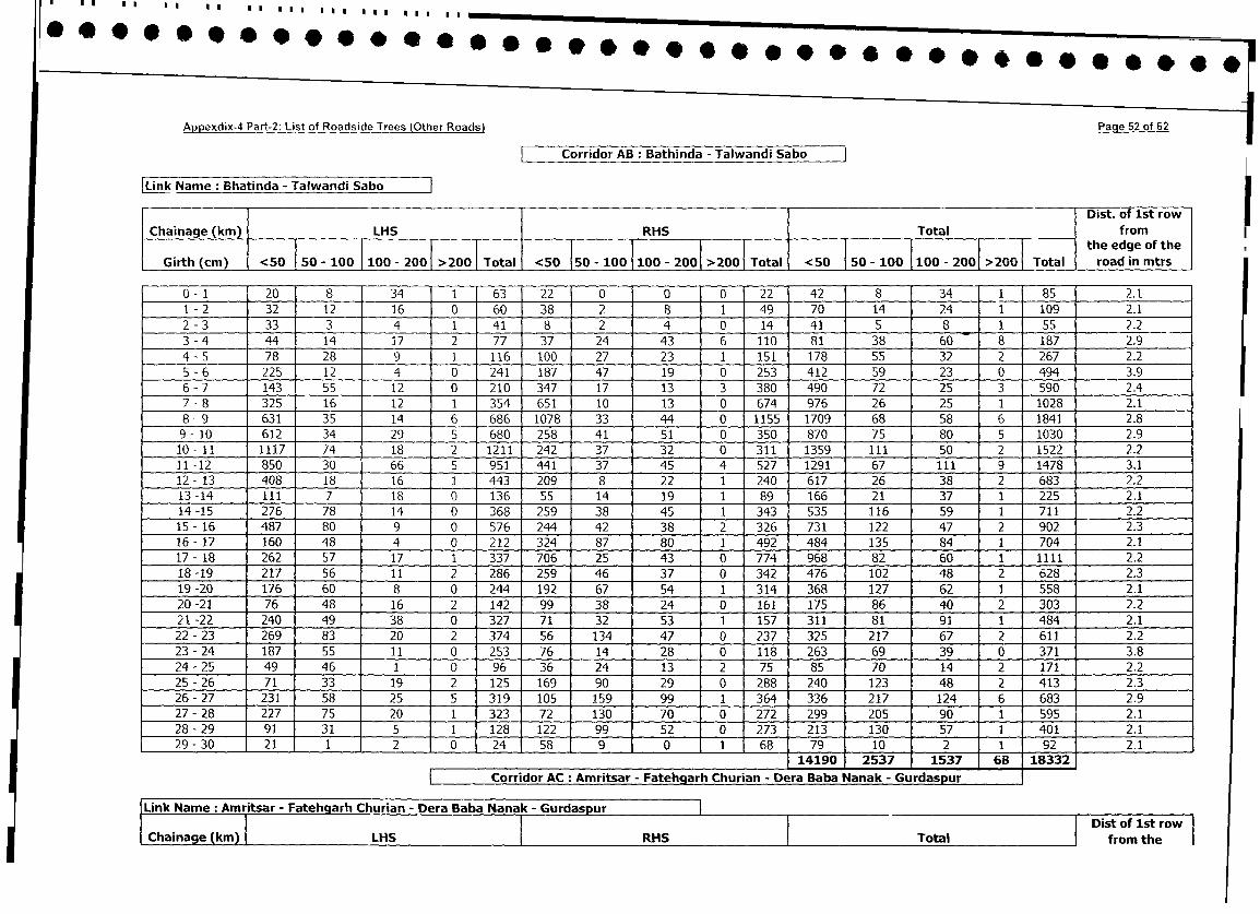
Apjpexdix-4 Part-2: List of Roadside Trees (Other Roads)
Page 52 of 62
Corridor AB: Bathinda - Talwandi Sabo
Link Name: Bhatinda - Talwandi Sabo Dist. of 1st row
Chainage (km) LHS RHS
Total from
Girth_(m)_<5____I ____-_2001__200______-_201
_>2 5 1 I-1020 the edge of the
Girth (cm) - <50 50 - 100 100 200 >200 Total <50 150 - 100 < 0 - 0 - 2001 >2GG Total road in mtrs
0- 1 120 8 34 1 63 22 0 0 0 22 42 8 34 1 85 2.1
1 - 2 32 12 16 0 60 38 2 8 1 49 70 14 24 1 109 2.1
2 - 3 33 3 4 1 41 8 2 4 0 14 41 5 8 1 55 2.2
-- 3-4 - 44 14 17 2 77 37 24 43 6 110 81 38 60 8 187 2.9
4 - 5 78 28 9 1 116 100 27 23 1 151 178 55 32 2 267 2.2
5 - 6 225 12 4 0 241 187 47 19 0 253 412 59 23 0 494 3.9
6 - 7 143 55 12 0 210 347 17 13 3 380 490 72 25 3 590 2.4
7_-8 325 16 12 1 354 651 10 13 0 674 976 26 25 1 1028 2.1
8-9 631 35 14 6 686 1078 33 44 0 1155 1709 68 58 6 1841 2.8
9- 10 612 34 29 5 680 258 41 51 0 350 870 75 80 5 1030 2.9
10- 11 1117 74 18 2 1211 242 37 32 0 311 1359 111 50 2 1522 2.2
11 -12 850 30 66 5 951 441 37 45 4 527 1291 67 111 9 1478 3.1
12 - 13 408 18 16 1 443 209 8 22 1 240 617 26 38 2 683 2.2
13-14 111 7 18 0 136 55 14 19 1 89 166 21 37 1 225 2.1
14-15 276 78 14 0 368 259 38 45 1 343 535 116 59 1 711 2.2
15- 16 487 80 9 0 576 244 42 38 2 326 731 122 47 2 902 2.3
16 - 17 160 48 4 0 212 324 87 80 1 492 484 135 84 1 704 2.1
17 - 18 262 57 17 1 337 706 25 43 0 774 968 82 60 1 1111 2.2
18 -19 217 56 11 2 286 259 46 37 0 342 476 102 48 2 628 2.3
19-20 176 60 8 0 244 192 67 54 1 314 368 127 62 1 558 2.1
20 -21 76 48 16 2 142 99 38 24 0 161 175 86 40 2 303 2.2
21-22 240 49 38 0 327 71 32 53 1 157 311 81 91 1 484 2.1
22 - 23 269 83 20 2 374 56 134 47 0 237 325 217 67 2 611 2.2
23 - 24 187 55 11 0 253 76 14 28 0 118 263 69 39 0 371 3.8
24 - 25 49 46 1 0 96 36 24 13 2 75 85 70 14 2 171 2.2
25-26 71 33 19 2 125 169 90 29 0 288 240 123 48 2 413 2.3
26- 27 231 58 25 5 319 105 159 99 1 364 336 217 124 6 683 2.9
27- 28 227 75 20 1 323 72 130 70 0 272 299 205 j 90 1 595 2.1
28 - 29 91 31 5 1 128 122 99 52 0 273 213 130 1 57 1 4011 2.1
29 - 30 21 1 2 0 24 58 9 0 1 68 79 10 j 2 1 921 2.1
14190 2537 4 1537 68 18332
| Corridor AC: Amritsar - Fatehgarh Churian - Dera Baba Nanak - Gurdaspur
jLink Name: Amritsar - Fatehglarh Churian - Dera Baba Nanak - Gurdaspur llTtl|Dso s o
Chainage (km) LHS RHS Total f~~~~~~~~~~~~~~~~~~~~~~~~~~~~~~~~~~~~~~rom the|
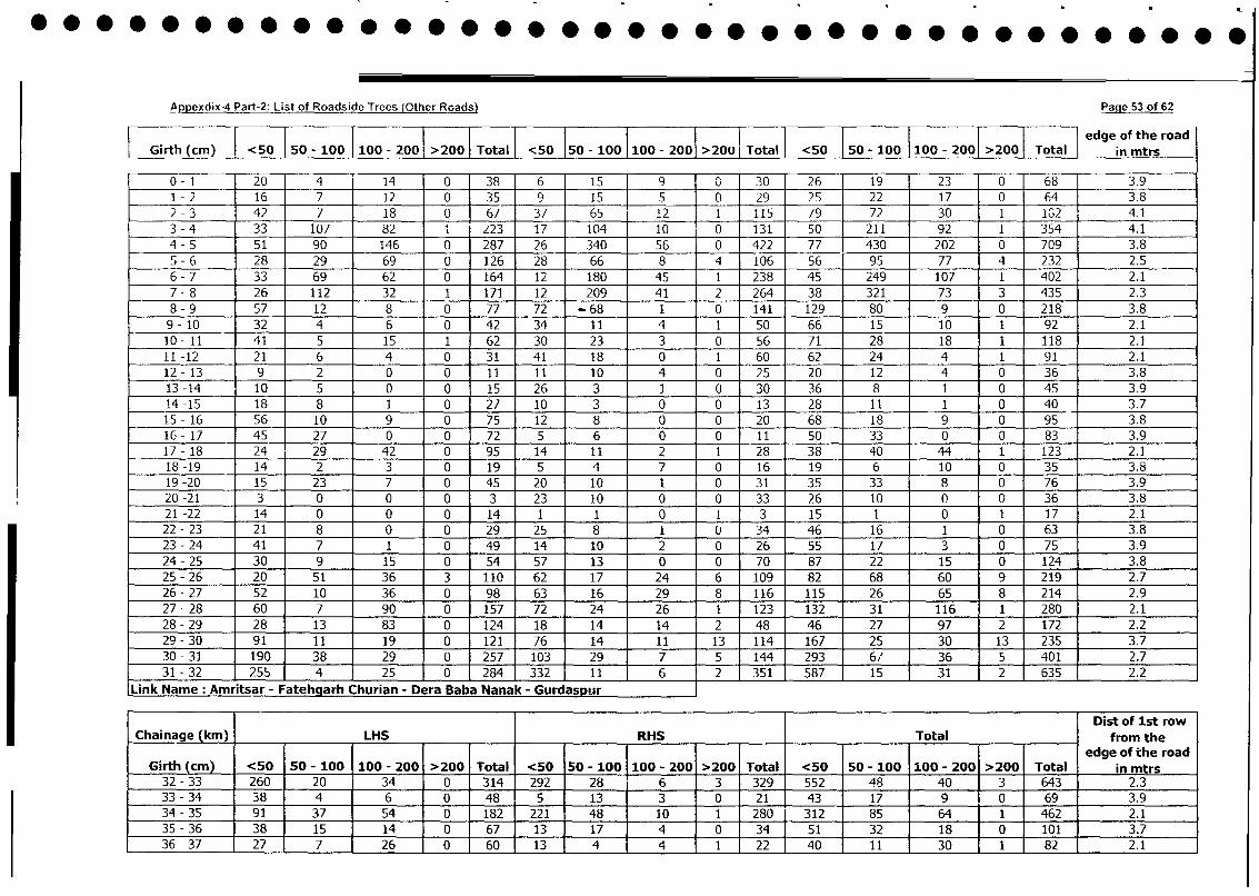
Appexdix-4 Part-2: List of Roadside Trees (Other Roads) Page 53 of 62
I I I I ~~~~~~~~~~~~~~~~~~~~~~~~~~~edge of the roadGrh(cm) < 50 I50 - 100 100 - 200 > 2001 Total < 5015 -10100 - 2001 >2001 Total <50 50 - 100 1100 - 2001 >2001 Total I in mtrs
0 -1 20 r 14 0138 6 15 T 9 0 30 26 1 9 2 3 0 68 3.9
1 -2 1 6 7 1 2 013 5 9 1 5 1 [0 2 9 2 5 2 2 1 7 0 64 3.8
2 -3 42 7 1 8 0 67_ 37 6 5 ____ 2 1 115 79 7 2 3 0 1 102 4.1
3 -4 33 107 82 1 223 1 7 104 1 0 0 131 5 0 211 9 2 1 354 4.1
4 -5 5 1 90 146 0 287 26 340 5 6 0 422 7 7 430 202 0 709 3.8
5 -6 2 8 29 69 0 126 28 66 8 4 1106 5 6 95 77 14 232 12.5
6 -7 33 69 62 0 164 1 2 180 45S 1 238 4 5 249 107 1 402 2.1
7 -8 26 112 32 1 171 1 2 209 4 1 2 264 3 8 321 73 3 435 2.3
8 -9 5 7 1 2 8 0 7 7 72 -68 1 1 0 141 129 80 9 0 218 3.8
9 -10 3 2 4 6 0 42 34 1 1 4 1 50 66 1 5 1 0 1 92 2.1
10 -11 4 1 5 1 5 1 62 30 2 3 3 0 5 6 7 1 2 8 1 8 1 118 2.1
11 -12 2 1 6 4 0 3 1 4 1 1 8 0 1 60 62 24 4 1 9 1 2.1
12 -13 9 2 0 0 1 1 1 1 1 0 4 0 2 5 2 0 1 2 4 0 3 6 3.8
13 -14 1 0 5 0 0 1 5 26 3 1 0 3 0 3 6 8 1 0 45 3.9
14 -15 1 8 8 1 0 2 7 1 0 3 0 0 1 3 2 8 1 1 1 0 40 3.7
15 -16 5 6 1 0 9 0 7 5 1 2 8 0 10 20 68 1 8 9 0 95 3.8
16 -17 4 5 27 0 0 7 2 5 6 0 0 1 1 5 0 33 0 0 83 3.9
17 -18 24 29 4 2 0 95 1 4 1 1 2 1 2 8 38 40 44 1 123 2.1
18 -19 1 4 2 __ 3 0 1 9 5 4 7 0 1 6 1 9 6 1 0 0 3 5 3.8
19 -20 1 5 23 7 0 45 20 1 0 1 0 3 1 35 3 3 8 0 76 3.9
20 -21 3 0 0 0 3 23 1 0 0 0 33 26 1 0 0 0 36 3.8
21 -22 1 4 0 0 0 1 4 1 1 0 1 3 1 5 1 0 1 1 7 2.1
22 -2 3 2 1 8 0 0- 29 2 5 8 1 0 34 46 1 6 1 0 63 3.8
23 -24 4 1 7 1 0 49 1 4 1 0 2 0 26 5 5 1 7 3 0 75 3.9
24 -25 30 9 1 15 0 54 57 1 3 0 0 70 87 2 2 1 5 -0 124 3.8
25 -26 20 5 1 3 6 3 110 62 1 7 24 6 109 82 68 60 9 219 2.7
26 -27 5 2 1 0 36 0 98 63 1 6 29 8 116 115 26 65 8 214 2.9
27 -28 60 7 90 0 157 72 24 26 1 123 132 3 1 116 1 280 2.1
28 -29 2 8 1 3 83 0 124 1 18 1 4 14 2 48 46 27 97 2 172 2.2
29 -30 9 1 1 1 1 9 0 121 76 14 1 1 1 3 114 167 2 5 30 1 3 235 3.7
30 -31 190 38 29 0 257 103 1 29 7 5 144 293 1 67, 36 5 401 2.7
31 -32 255 4 25 0 284 332 1. 11 6 2 351 587 15 31 2 635 2.2
Link Name Amritsar - FathahChurian - Dera Baba Nanak - Gurdaspuir
Dist of 1st row
Chainage (kin) ___ ___ LHS ___ ___ ___RHS __________Total ___from theI ~~~edge of the road
Girth (cm) <50 50 - 100 1100 - 200 >200 Total <50 50 - 100 100 - 200 >200 Total <50 50 - 100 1100 - 2001>200 Total in mtrs
32 -33 260 20 34 0 314 292 28 6 3 329 552 48 40 13 643 2.3
33 -34 38 4 6 0 48 5 13 3 0 21 43 17 9 tO 69 3.9
34 -35 91 37 54 0 182 221 48 10 1 280 312 85 64 11 462 2.1
35 -36 38 15 14 0 67 13 17 4 0 34151 32 18 10 101 3__ _7
36 -37 27 7 .26 0 60 13 1 4 4 1 22 40 11 30 11 82 .2.1

Appexdix-4 Part-2: List of Roadside Trees (Other Roads) Page 54 of 62
37 -38 133 8 16 0 57 24 3 1 7 0 34~ 57 ~ 11 23 0 91 3.8
38 -39 59 10 18 0 87 9 15 ~ 16 411 68 25 34 1 128 2.1
39 -40 32 17 22 0 71 17 21 1 49149 38 32 1 120 2.2
40 -41 36 7 5 0 148 9 5 9 0 23145 12 14 0 71 3.8
41 -42 44 23 16 0 83 28 9 7 0 44 72 32 23 0 127 3.9
42 -43 26 34 6 1 67 82 8 7 1 98 108 42 13 2 165 2.3
43 -44 66 18 17 0 101 104 6 1 1 2 123 170 24 28 2 224 2.3
44 -45 13 8 13 2 36 61 9 3 5 78 74 17 16 7 114 2-8
45 -46 40 3 1 0 44 30 6 9 2 47 70 9 10 2 191 2.3
46 -47 7 13 23 0 43 5I4 44 18 0 116 61 57 41 0 159 3.8
47 -48 30 25 54 0 109 34 18 5 1 58 64 43 59 1 167 2.1
48- 419 49 1 5 2 0 56 17 1 24 7 3 51 1 66 29 9 3 107 2.4
,49 -50 23 3 9 0 135 90 7 5 1 103 1113 10 14 1 138 2.1
50 -51 50 8 9 7 74 104 13 0 0 117 154 21 9 7 191 2.8
51 -52 74 11 29 0 114 53 32 5 0 90 127 43 34 0 204 3.8
52 -53 10 6 13 0 29 8 39 0 0 47 18 45 13 0 76 3.9
53 -54 53 8 7 0 68 46 36 3 0 85 99 44 1 10 0 153 13.9
54 -5 92 37 12 0 141 42 75 0 0 117 134 112 12 0 258 3.8
55 -56 124 70 14 0 208 195 208 0 0 403 319 278 14 0 611 3.9
56 -57 83 59 6 0 1148 34 174 4 0 212 117 233 10 0 360 3.9
57 -58 68 26 15 0 109 30 36 4 1 71 98 62 19 1 180 2.1
58 -59 47 10 5 0 62 35 9 0 i 45 82 19 5 1 107 2.1
59 -60 64 3 7 0 74 7 16 2 0 25 71 19 9 0 99 3.9
60 -61 23 23 53 0 99 22 132 98 1 253 45 155 151 1 352 2.5
61 -62 62 32 163 0 257 23 47 77 0 147 85 79 240 0 404 3.8
62 -63 41 1 1 iS 0 67 20 40 21 0 81 61 51 36 0 148 3.9
63 -64 58 20 18 0 96 38 41 33 6 118 96 61 51 6 214 3.5
64 -65 149 40 10 0 199 55 16 16 1188 204 56 26 1 287 2.1
65 -66 37 4 4 0 45 16 4 5 01 5 53 8 9 0 70 3.8
,Link Name: Amritsar - Fatehgarh Churian - Dera Baba Nanak - Gurdaspur ____
Dist of Ist rowChainage (kin) LHS RHS Total -- from the
edge of the roadGirth (cm) <50 50 - 100 100 - 200 >200 Total <50 50 - 100 100 - 200 >2001 Total <50 50 - 100 1100 - 200 >200 Total in mtrs
66 -67 60 10 44 0 114 42 8 1 3 54 102 18 45 3 168 2.6
67 -68 27 38 60 0 125 46 40 - 27 1 114 73 78 87 1 239 2.1
68 -69 35 2 0 0 37 19 35 - 118 14 186 54 37 118 14 223 3.8
69 -70 54 37 97 3 191 118 41 - 20 0 179 172 78 117 3 370 2.7
70 -71 11 1 2 0 14 35 43 I 52 1 131 46 44 54 1 145 2.1
72 -73 21 56 122 0 229 23 8 21 0 152 74 64 240 0 378 3.9721-72 22 56 137 2 1672 23 18 124 7 882 31 24 191 9 255 4.173 -74 4 1 4 2 125 0 208 95 64 60 0 219 136 106 185 0 427 3.8
74 -75 1 6 8 4 1 29 9 3 20 2 34125 1 1 24 3 163 2.575 -76 5 3 1 1 0 19 1 6 2 1 2 1 3 1121 5 23 1 50 2.176 -77 1 2 5 2 187 10 1 251 10 27' 3 0 110122 79 1 260 10 361 3.9
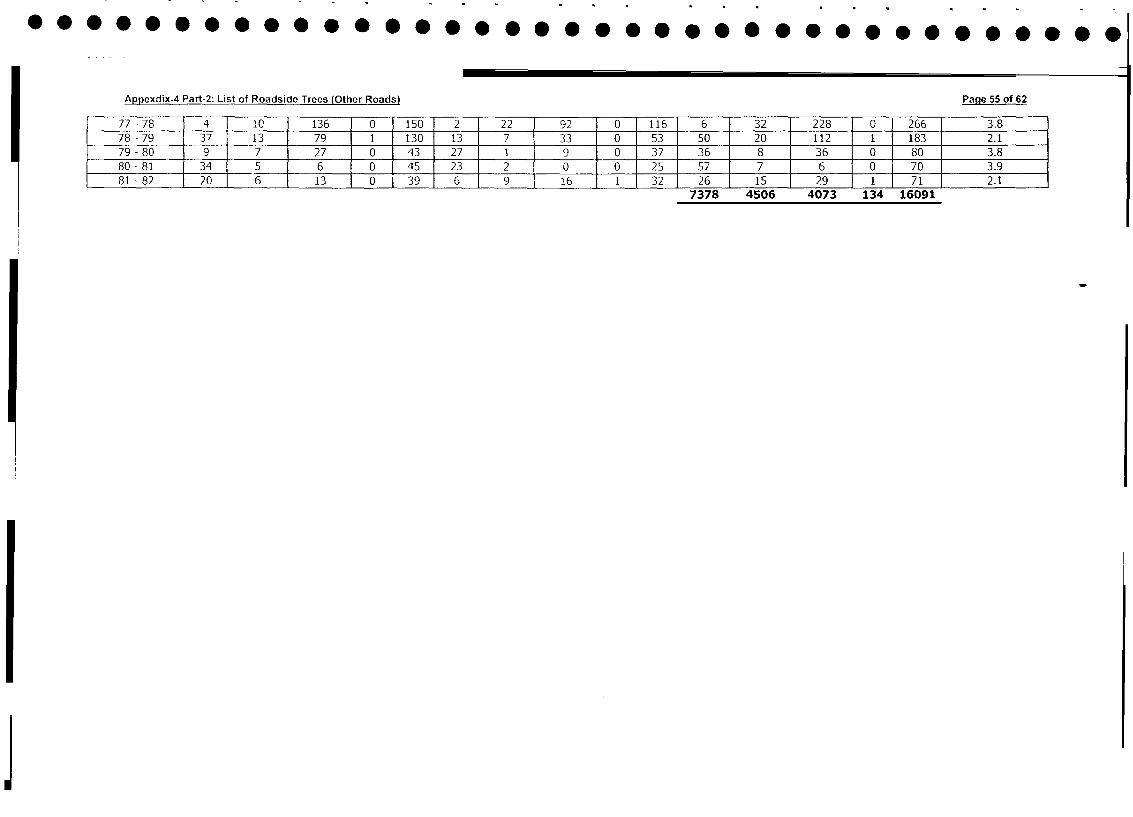
Appexdix-4 Part-2: List of Roadside Trees (Other Roads) Page 55 of 62
77 - 78 4 I 10 136 0 150 2 22 92 0 116 6 32 228 0 266 3.8
78 - 79 37 13 79 1 130 13 7 33 0 53 50 20 112 1 183 2.1
79 - 80 9 7 27 0 43 27 1 9 0 37 36 8 36 0 80 3.8
80- 81 34 5 6 0 45 23 2 0 0 25 57 7 6 0 70 3.9
81 - 82 20 6 13 0 39 6 9 16 1 32 26 15 29 1 71 2.17378 4506 4073 134 16091
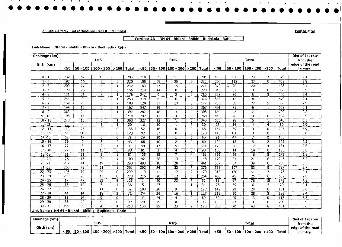
Appexdix-4 Part-2: List of Roadside Trees (Other Roads) Page 56 of 62
| Corridor AD: NH 64 - Bhikhi - Bhikhi - Budhiada - Ratia
Link Name: NH 64 - Bhikhi - Bhikhi - Budhiada - Ratia
Chainage (km) Dist of lst row
LHS RHS Total from the
Girth (cm) <50 0 1100 - 2001 >200 <50 0 - 2001 >2001 Total <50 i 50 - 100 1100 - 2001 >200 Total edge of the road
__________ <50~ 50 - 100 1020 20 Toa <5 5010 0-00 20<0__in mtrs.
0- 1 232 42 18 3 295 218 55 11 0 284 450 97 29 3 579 2.4
1 - 2 197 16 7 0 220 108 99 25 0 232 305 115 32 0 452 3.9
2 - 3 209 27 5 1 242 163 43 15 0 221 372 - 70 20 1 463 2.1
3 - 4 129 23 3 0 155 214 14 0 0 228 343 37 3 0 383 3.9
4 - 5 151 21 3 1 176 247 9 2 2 260 398 30 5 3 436 2.4
5 - 6 241 9 2 1 253 314 6 6 0 326 555 15 8 1 579 2.1
6 - 7 152 25 9 2 188 128 33 13 3 177 280 58 22 5 365 2.9
7 - 8 144 12 5 1 162 347 19 1 0 367 491 31 6 1 529 2.1
8 - 9 363 24 4 1 392 287 18 3 0 308 650 42 7 1 700 2.2
9- 10 198 11 5 0 214 247 17 4 0 268 445 28 9 0 482 3.9
10- 11 278 16 5 1 300 327 12 1 0 340 605 28 6 1 640 3.1
11 -12 12 4 3 1 20 16 10 1 3 30 28 14 4 4 50 2.9
12- 13 112 23 0 0 135 52 16 0 0 68 164 39 0 0 203 3.9
13 -14 51 119 9 0 179 92 37 0 0 129 143 156 9 0 308 3.8
14 -15 52 17 6 0 75 29 30 1 0 60 81 47 7 0 135 3.7
15- 16 36 2 3 2 43 68 10 2 0 80 104 12 5 2 123 2.2
16 - 17 77 3 7 4 91 48 17 5 0 70 125 20 12 4 161 2.5
17- 18 77 11 10 0 98 91 3 4 0 98 168 14 14 0 196 3.8
18-19 61 11 9 1 82 135 15 7 4 161 196 26 16 5 243 3.1
19 -20 78 13 8 1 100 92 38 13 5 148 170 51 21 6 248 3.2
20 -21 237 41 19 1 298 400 16 20 5 441 637 57 39 6 739 3.3
21 -22 266 73 21 1 361 302 34 32 8 376 568 107 53 9 737 3.7
22 - 23 196 79 24 0 299 119 41 17 2 179 315 120 41 2 478 2.1
23 - 24 240 25 13 0 278 216 20 12 6 254 456 45 25 6 532 2.8
24- 25 17 47 53 8 125 1 20 23 7 51 18 67 76 15 176 4.1
25 - 26 18 12 5 1 36 5 27 1 1 34 23 39 6 2 70 2.1
26 - 27 42 9 11 0 62 100 20 9 0 129 142 29 20 0 191 3.8
27- 28 44 14 12 2 72 74 36 16 1 127 118 50 28 3 199 2.4
28- 29 19 16 9 0 44 41 24 4 0 69 60 40 13 0 113 3.8
29 - 30 83 22 9 0 114 70 25 0 0 95 153 47 9 0 209 3.9
30- 31 199 35 20 4 258 136 35 23 2 196 335 70 43 6 454 3.6
Link Name: NH 64 - Bhikhi - Bhikhi - Budhiada - Ratia
Chainage (km) I I Dist of 1st row 1I__________ ILHS j RHS j Total from the
Girth (cm) < 5 1 > Ttl j - 1 1 > T edge of the road
| | <50 | 50 - 100 |1100 - 2001| >2001| Total | <50 150 - IOG I 100 - 2001 >200 | Total | <50 | 50 - 100 | 100 - 2001 >200 | Total | in mtrs.
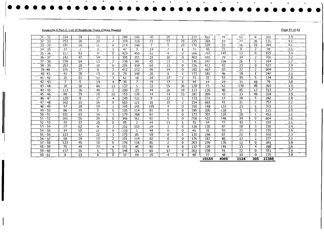
Appexdix-4 Part-2: List of Roadside Trees (Other Roads) Page 57 of 62
31 -32 224 39 23 __3 289 198 40 29 5 272 422 79 52 8 1 561 2.9
32 -33 253 30 20 7 310 116 23 57 29 225 369 53 77 36 535 4.1
33 - 34 181 16 11 6 214 148 7 5 10 170 329 23 16 16 384 4.1
34 -35 37 7 2 1 47 9 14 7 1 31 46 21 9 2 78 2.1
35 - 36 317 93 9 0 419 450 52 4 0 506 767 145 13 0 925 3.9
36- 37 242 47 14 2 3051 351 32 20 0 403 593 79 34 2 708 2.2
37 - 38 159 64 13 2 238 88 42 13 3 146 247 106 26 5 384 2.7
38 - 39 253 28 10 0 291 159 64 13 0 236 412 92 23 0 527 3.9
39 -40 375 27 8 2 412 212 56 14 0 282 587 83 22 2 694 2.2
40 -41 41 20 13 0 74 140 26 6 1 173 181 46 19 1 247 2.1
41 - 42 25 21 12 3 61 10 34 27 2 73 35 55 39 5 134 2.8
42 - 43 7 5 14 4 30 7 19 17 6 49 14 24 31 10 79 3.8
43 - 44 10 30 84 13 137 5 32 55 36 128 15 62 139 49 265 3.9
44 - 45 113 36 49 2 200 23 44 36 10 113 136 80 85 12 313 3.7
45 - 46 89 29 19 16 153 120 14 14 33 181 209 43 33 49 334 3.9
46-47 120 8 17 4 149 111 9 12 1 133 231 17 29 5 282 2.8
47 - 48 562 25 16 0 603 121 16 15 2 154 683 41 31 2 757 2.2
48 - 49 57 28 19 1 105 141 105 4 0 250 198 133 23 1 355 2.1
49 - 50 86 29 5 0 120 114 81 0 0 195 200 110 5 0 315 3.9
50- 51 101 63 14 1 179 206 61 6 0 273 307 124 20 1 452 2.1
51 - 52 261 56 29 0 346 161 92 5 0 258 422 148 34 0 604 3.8
52 - 53 32 33 20 0 85 2 44 23 1 70 34 77 43 1 155 2.1
53- 54 27 63 9 3 102 103 24 1 0 128 130 87 10 3 230 2.4
54 - 55 34 55 21 0 110 1 44 0 0 45 35 99 21 0 155 3.9
55 - 56 113 37 22 3 175 85 50 0 0 135 198 87 22 3 310 2.3
56 - 57 68 18 13 2 101 114 62 0 0 176 182 80 13 2 277 2.2
57 - 58 123 45 10 0 178 116 85 2 0 203 239 130 12 0 381 3.8
58- 59 75 49 23 4 151 45 92 0 0 137 120 141 23 4 288 2.6
59 - 60 117 26 5 0 148 121 65 17 0 203 238 91 22 0 351 3.9
60 - 61 8 23 6 0 37 69 25 4 0 98 77 48 10 0 135 3.8
16554 4005 1524 305 22388
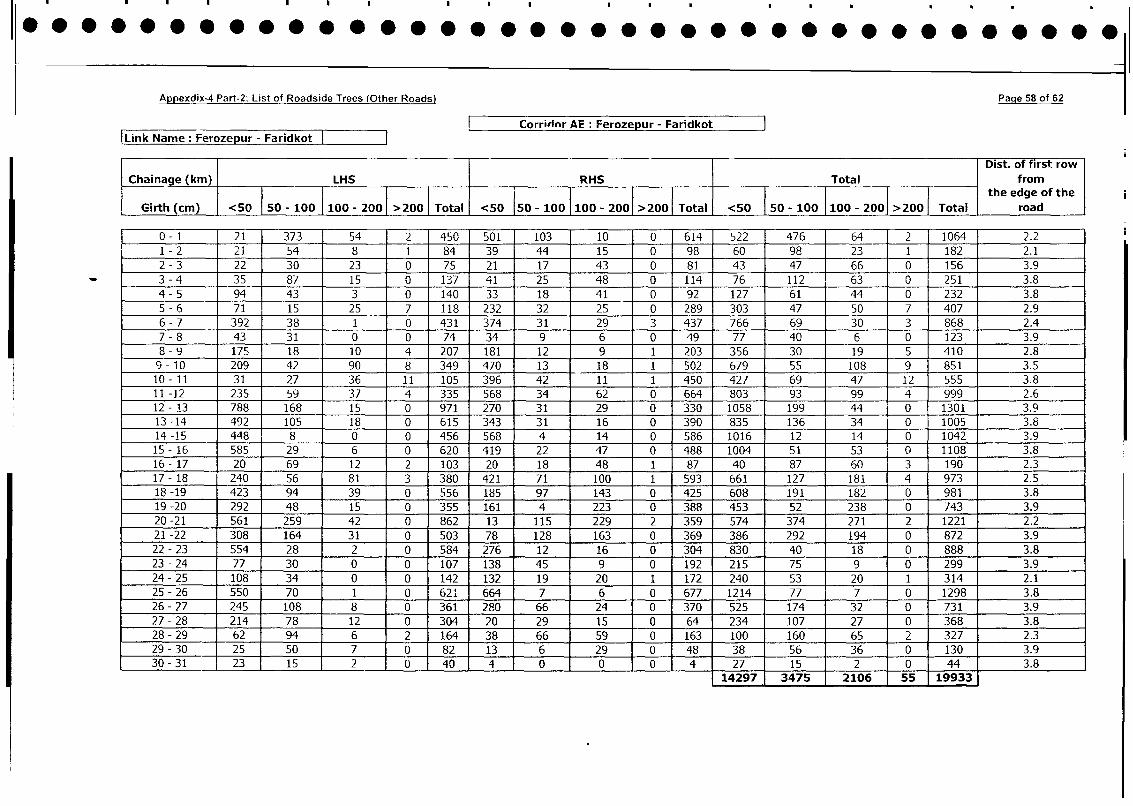
Appexdix-4 Part-2: List of Roadside Trees (Other Roads) Page 58 of 62
! Corridor AE: Ferozepur - Faridkot |
|Link Name: Ferozepur - Faridkot
Dist. of first row
| Chainage (km) LHS RHS Total fromthe edge of the
Girth (cm) <50 50 - 100 |100 - 200 >200 Total <50 150 - 100 100 - 2001 >2001 Total <50 | 50 - 100 |100 - 2001 >200 Total road
0 - 1 21 373 54 2 450 501 103 10 0 614 522 476 64 2 1064 2.2
1 - 2 21 54 8 1 84 39 44 15 0 98 60 98 23 1 182 2.1
2 - 3 22 30 23 0 75 21 17 43 0 81 43 47 66 0 156 3.9
3 - 4 35 87 15 0 137 41 25 48 0 114 76 112 63 0 251 3.8
4 - 5 94 43 3 0 140 33 18 41 0 92 127 61 44 0 232 3.8
5-6 71 15 25 7 118 232 32 25 - 0 289 _303 47 50 7 407 2.9
6 - 7 392 38 1 0 431 374 31 29 3 437 766 69 30 3 868 2.4
7 - 8 43 31 0 0 74 34 9 6 0 49 77 40 6 0 123 3.9
8 - 9 175 18 10 4 207 181 12 9 1 203 356 30 19 5 410 2.8
9- 10 209 42 90 8 349 470 13 18 1 502 679 55 108 9 851 3.5
10- 11 31 27 36 11 105 396 42 11 1 450 427 69 47 12 555 3.8
11 -12 235 59 37 4 335 568 34 62 0 664 803 93 99 4 999 2.6
12 - 13 788 168 15 0 971 270 31 29 0 330 1058 199 44 0 1301 3.9
13-14 492 105 18 0 615 343 31 16 0 390 835 136 34 0 1005 3.8
14-15 448 8 0 0 456 568 4 14 0 586 1016 12 14 0 1042 3.9
15 - 16 585 29 6 0 620 419 22 47 0 488 1004 51 53 0 1108 3.8
16- 17 20 69 12 2 103 20 18 48 1 87 40 87 60 3 190 2.3
17 - 18 240 56 81 3 380 421 71 100 1 593 661 127 181 4 973 2.5
18 -19 423 94 39 0 556 185 97 143 0 425 608 191 182 0 981 3.8
19-20 292 48 15 0 355 161 4 223 0 388 453 52 238 0 743 3.9
20-21 561 259 42 0 0 862 13 115 229 2 359 574 374 271 2 1221 2.2
21 -22 308 164 31 0 503 78 128 163 0 369 386 292 194 0 872 3.9
22 - 23 554 28 2 0 584 276 12 16 0 304 830 40 18 0 888 3.8
23 - 24 77 30 0 0 107 138 45 9 0 192 215 75 9 0 299 3.9
24- 25 108 34 0 0 142 132 19 20 1 172 240 53 20 1 314 2.1
25 - 26 550 70 1 0 621 664 7 6 0 677 1214 77 7 0 1298 3.8
26- 27 245 108 8 0 361 280 66 24 0 370 525 174 32 0 731 3.9
27 - 28 214 78 12 0 304 20 29 15 0 64 234 107 27 0 368 3.8
28-29 1 62 94 6 2 164 38 66 59 0 163 100 160 65 2 327 2.3
29- 30 25 50 7 0 82 13 6 29 0 48 38 56 36 0 130 3.9
30 - 31 23 15 2 40 4 0 4 27 15 2 0 44 3.8- _tb712973475 r2106 55l 193
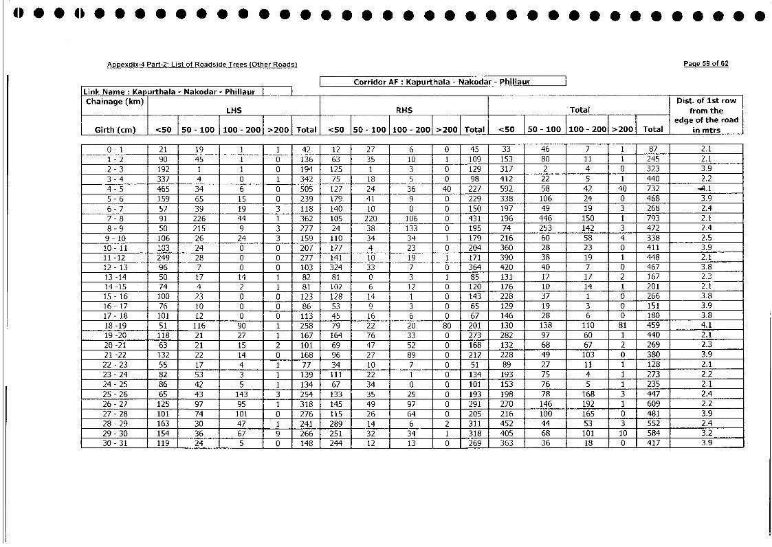
Appexdix-4 Part-2: List of Roadside Trees (Other Roads) Page 59 of 62
|__ _ _ __ Corridor AF: Kapurthala - Nakodar - Phillaur
Link Name: Kapurthala - Nakodar - Phillaur i _
Chainage (km) Dist. of 1st rowLHS RHS Total from the
I l l Total l edge of the road
Girth (cm) <50 j50 - 100 j100 - 200 >2001 Total <50 50 - 100 100 - 200al <50 Total <50 50 - 100 - 200 2001 >200 Total in mtrs
0- 1 21 19 1 1 42 12 27 6 0 45 33 46 7 1 87 2.1
1 - 2 90 45 1 0 136 63 35 10 1 109 153 80 11 1 245 2.1
2 - 3 192 1 1 0 194 125 1 3 0 129 317 2 4 0 323 3.9
3 - 4 337 4 0 1 342 75 18 5 0 98 412 22 5 1 440 2.2
4 - 5 465 34 6 0 505 127 24 36 40 227 592 58 42 40 732 .4.1
5 - 6 159 6S 15 0 239 179 41 9 0 229 338 106 24 0 468 3.9
6 - 7 57 39 19 3 118 140 10 0 0 150 197 49 19 3 268 2.4
7- 8 91 226 44 1 362 105 220 106 0 431 196 446 150 1 793 2.1
8 - 9 50 215 9 3 277 24 38 133 0 195 74 253 142 3 472 2.4
9- 10 106 26 24 3 159 110 34 34 1 179 216 60 58 4 338 2.5
10- 11 183 24 0 0 207 177 4 23 0 204 360 28 23 0 411 3.9
11 -12 249 28 0 0 277 141 10 19 1 171 390 38 19 1 448 2.1
12- 13 96 7 0 0 103 324 33 7 0 364 420 40 7 0 467 3.8
13 -14 50 17 14 1 82 81 0 3 1 85 131 17 17 2 167 2.3
14 -15 74 4 2 1 81 102 6 12 0 120 176 10 14 1 201 2.1
15 - 16 100 23 0 0 123 128 14 1 0 143 228 37 1 0 266 3.8
16- 17 76 10 0 0 86 53 9 3 0 65 129 19 3 0 151 3.9
17- 18 101 12 0 0 113 45 16 6 0 67 146 28 6 0 180 3.8
18 -19 51 116 90 1 258 79 22 20 80 201 130 138 110 81 459 4.1
19 -20 118 21 27 1 167 164 76 33 0 273 282 97 60 1 440 2.1
20-21 63 21 15 2 101 69 47 52 0 168 132 68 67 2 269 2.3
21 -22 132 22 14 0 168 96 27 89 0 212 228 49 103 0 380 3.9
22- 23 55 17 4 1 77 34 10 7 0 51 89 27 11 1 128 2.1
23 - 24 82 53 3 1 139 111 22 1 0 134 193 75 4 1 273 2.2
24 - 25 86 42 5 1 134 67 34 0 0 101 153 76 5 1 235 2.1
25 - 26 65 43 143 3 254 133 35 25 0 193 198 78 168 3 447 2.4
26 - 27 125 97 95 1 318 145 49 97 0 291 270 146 192 1 609 2.2
27 - 28 101 74 101 0 276 115 26 64 0 205 216 100 165 0 481 3.9
28- 29 163 30 47 1 241 289 14 6 2 311 452 44 53 3 552 2.4
29 - 30 154 36 67 9 266 251 32 34 1 318 405 68 101 10 584 3.2
30 - 31 119 24 5 0 148 244 12 13 0 269 363 36 18 0 417 3.9
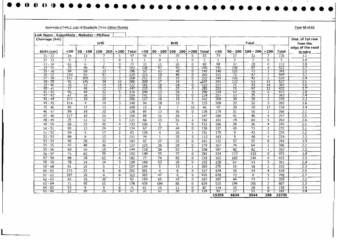
Appexdix-4 Part-2: List of Roadside Trces (Other Roads) Page 60 of 62
Link Name: Kapurthala - Nakodar - Phillaur | o .
Chainage (kin) TDist. of 1st row
Chainage_(km) LHS RHS J.Total from the
__ __ _ I i _ _ ___ __ __ I_ edge of the road
Girth (cm) <50 50 - 100 100 - 200 >200 Total <50 50 - 100 100 - 200 >200 Total <50 50 - 100 100 - 200 >200 Total in mtrs
31 - 32 26 13 7 1 47 48 4 25 6 83 74 17 32 7 i30 3.1
32 - 33 0 2 1 0 3 1 0 1 0 2 1 2 2 0 5 3.9
33 - 34 65 6 2 0 73 33 21 26 0 80 98 27 28 0 153 3.8
- 35 - 98 4/ 4 182 1U8 92 - 4U 2141 19U 8/ 422 2.135 - 3b Y4 b 8 3T T 1f 5T 53 4UT U 145 1 4b 1T2T 1 1 1 341 2.1
36 - 31/ TlU b 4 Z Z15 1U 4U U 7 3Z5 57 8 / 4Y4 3.Z
3/ - 38 T3T 1U5 2T 3 268 Z1Z 21 7 34Y lZ b T 4 57U Z.438 - 9 1T 145 34 -- TT 1U T zuu 2T -1Y9 1 7 291 i/2 53 11 52Z 3.5
39 - 4U2 3b 5 3 19 1T4 12 8 18 24 23 252 71 4 3 14 345 3.6
4U - 41 17 46 12 12 14 225 3 25 UE 3 29T 25 2 -T Y/ 4 : 2 3.941 - 42 95 4 4 3T -77 244 13 38 1 2 9 b 339 T 70 6 472 2.9
42 - 43 lT :3W TT 3 TYT 19 1 T5 1 8 75 53 35 T 343 _ 2.4
43 - 44 177 1 8 216 l b 32 3 326 2.3
44 - 45 114 4 19 3 140 94 18 13 0 125 208 22 32 3 265 2.6
45 - 46 82 12 13 1 108 15 8 7 16 46 97 20 20 17 154 3.4
46 - 47 89 18 20 1 128 89 13 36 0 138 178 31 56 1 266 2.1
47 - 48 117 10 20 3 150 89 31 26 1 147 206 41 46 4 297 2.5
48-49 35 51 32 3 121 66 23 51 2 142 101 74 83 5 263 2.6
49 - 50 66 33 30 4 133 100 6 6 0 112 166 39 36 4 245 2.5
50 - 51 90 13 29 2 134 67 27 44 0 138 157 40 73 2 272 2.1
51 - 52 59 5 17 2 83 120 4 26 1 151 179 9 43 3 234 2.2
52- 53 89 8 13 1 1ll 74 1 35 3 113 163 9 48 4 224 2.3
53 - 54 40 30 33 0 103 92 27 22 0 141 132 57 55 0 244 3.9
54-55 42 48 36 1 127 125 26 28 0 179 167 74 64 1 306 2.1
55 - 56 69 56 19 0 144 118 26 63 1 208 187 82 82 1 352 2.2
56 - 57 75 62 55 0 192 149 55 77 0 281 224 117 132 0 473 3.9
57 - 58 88 28 62 4 182 77 74 82 0 233 165 102 144 4 415 2.5
58 - 59 78 14 24 3 119 150 53 29 0 232 228 67 53 3 351 2.4
59 - 60 91 10 5 1 107 184 5 13 1 203 275 15 18 2 310 2.3
60 - 61 173 22 6 0 201 301 4 8 4 317 474 26 14 4 518 2.5
61 - 62 287 26 0 0 313 383 47 0 5 435 670 73 0 5 748 2.7
62-63 42 19 30 1 92 159 65 43 0 267 201 84 73 1 359 2.1
63 - 64 71 90 15 2 178 439 104 86 0 629 510 194 101 2 807 2.2
64 - 65 53 9 9 0 71 61 15 11 0 87 114 24 20 0 158 3.9bS - bb TT ZU 75 UF 57 3T 5T 3cF -F dU 2zr 4Y //77T -T8 U.8
15259 4634 3544 298 23735
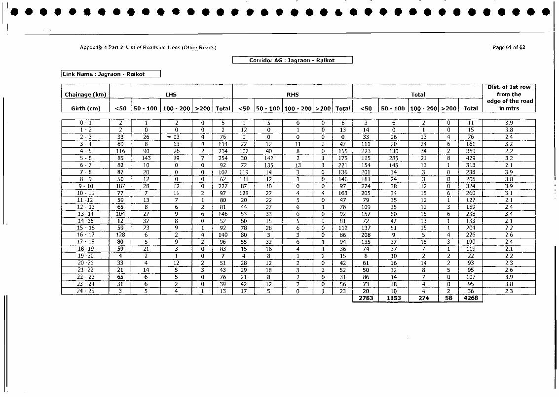
Appcxdix-4 Part-2: List of Roadside Trees (Other Roads) Page 61 of 62
Corridor AG Ja graon - Raikot
Link Name: Jagraon - Raikot
1 T Dist. of 1st rowChainage (kni) LHS RHS Total | from the1 50-100 100-200 >200 Tota iedge of the road
Girth (cm) | <50 50 - 100 100 - 200 >200 | Total <50 150 - 100 I 100 - otal <0 5 - 100 1100 - 2001 >2001 Total in mtrs
0 - 1 2 1 ' 2 0 5 i [ 0 0 6 3 6 2 0 11 3.91 - 2 2 0 0 0 2 12 0 1 0 13 14 0 1 0 15 3.82 - 3 33 26 - 13 4 76 0 0 0 0 0 33 26 13 4 76 2.43 - 4 89 8 13 4 114 22 12 11 2 47 111 20 24 6 161 3.24- 5 116 90 26 2 234 107 40 8 0 155 223 130 34 2 389 2.25 - 6 85 143 19 7 254 30 142 2 1 175 115 285 21 8 429 3.26- 7 82 10 0 0 92 72 135 13 1 221 154 145 13 1 313 2.17 - 8 82 20 0 0 102 119 14 3 0 136 201 34 3 0 238 3.98 - 9 50 12 0 0 62 131 12 3 0 146 181 24 3 0 208 3.89- 10 187 28 12 0 227 87 10 0 0 97 274 38 12 0 324 3.910- 11 77 7 11 2 97 128 27 4 4 163 205 34 15 6 260 3.111 -12 59 13 7 1 80 20 22 5 0 47 79 35 12 1 127 2.112 -13 65 8 6 2 81 44 27 6 1 78 109 35 12 3 159 2.413 -14 104 27 9 6 146 53 33 6 0 92 157 60 15 6 238 3.414 -15 12 32 8 0 52 60 15 5 1 81 72 47 13 1 133 2.115- 16 59 23 9 1 92 78 28 6 0 112 137 51 15 1 204 2.216- 17 128 6 2 4 140 80 3 3 0 86 208 9 5 4 226 2.617- 18 80 5 9 2 96 55 32 6 1 94 135 37 15 3 190 2.418-19 59 21 3 0 83 15 16 4 1 36 74 37 7 1 119 2.119-20 4 2 1 0 7 4 8 1 2 15 8 10 2 2 22 2.220-21 33 4 12 2 51 28 12 2 0 42 61 16 14 2 93 2.321-22 21 14 5 3 43 29 18 3 2 52 50 32 8 5 95 2.622- 23 65 6 5 0 76 21 8 2 0 31 86 14 7 0 107 3.923-24 31 6 2 0 391 42 12 2 0 56 73 18 4 0 95 3.824 - 25 3 5 4 1 13 17 5 0 1 23 20 10 4 2 36 2.3[ 2783 1153 274 58 4268
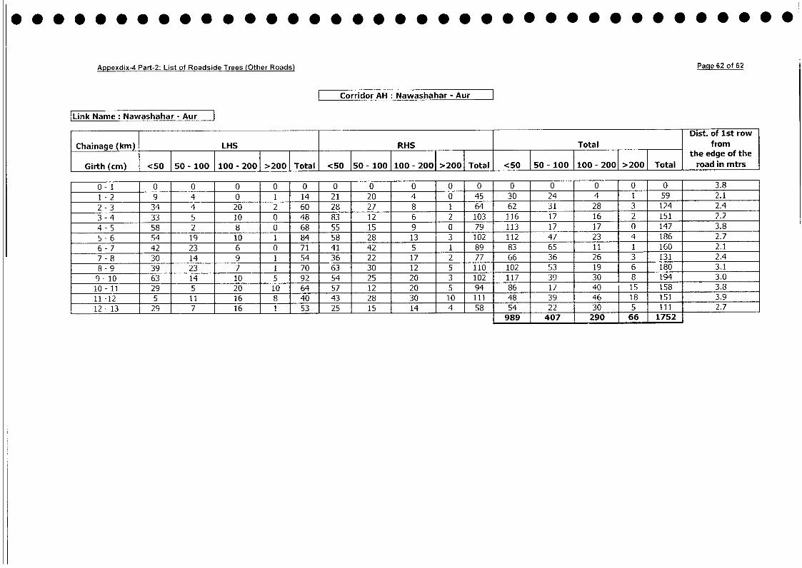
Appexdix-4 Part-2: List of Roadside Trees (Other Roads) Page 62 of 62
Corridor AH : Nawashahar - Aur
Link Name: Nawashahar - Aur
Dist. of 1st row
Chainage (km) LHS RHS Total from
Girth(cm) <50 50 - 100 |100 - 2001 >2001 Total <50 150 - 100 100 - 2001 >200 Total <50 T50 - 100 100 - 2001 >2001 Total roadgin mtrs
Giith rol in m llt e d eo the
0-1 0 0 0 0 0 0 0 0 10 0 0 0 0 0 0 3.8
1 - 2 9 4 0 1 14 21 20 4 0 45 30 24 4 1 59 2.1
2 - 3 34 4 20 2 60 28 27 8 1 64 62 31 28 3 124 2.4
3 - 4 33 5 10 0 48 83 12 6 2 103 116 17 16 2 151 2.2
4 - 5 58 2 8 0 68 55 15 9 0 79 113 17 17 0 147 3.8
5 - 6 54 19 10 1 84 58 28 13 3 102 112 47 23 4 186 2.7
6 - 7 42 23 6 0 71 41 42 5 1 89 83 65 11 1 160 2.1
7 - 8 30 14 9 1 54 36 22 17 2 77 66 36 26 3 131 2.4
8 - 9 39 23 7 1 70 63 30 12 5 110 102 53 19 6 180 3.1
9- 10 63 14 10 5 92 54 25 20 3 102 117 39 30 8 194 3.0
10- 11 29 5 20 10 64 57 12 20 5 94 86 17 40 15 158 3.8
11 -12 5 11 16 8 40 43 28 30 10 111 48 39 46 18 151 3.9
12- 13 29 7 16 1 53 25 15 14 4 58 54 22 30 5 111 2.7
989 407 290 66 1752