Guicadale Roads Project - WordPress.com
12
GUICADALE ECONOMIC PLATFORM: Guicadale Roads Project
-
Upload
khangminh22 -
Category
Documents
-
view
0 -
download
0
Transcript of Guicadale Roads Project - WordPress.com

GUICADALE ECONOMIC
PLATFORM:
Guicadale Roads Project

GUICADALE
PLATFORM PROJECT

GUINOBATAN
CAMALIG
DARAGALEGAZPI CITY
GUINOBATAN
CAMALIG
DARAGALEGAZPI CITY

Brief Description of the Project
The GUICADALE Platform is the principal
physical framework component of the central
economic growth strategy for Albay. Development of the continguous upland areas of
Camalig, Jovellar, Daraga and Legazpi City into a new
suburban sprawl surrounding/interconnecting the Bicol
International Airport , South Central Station and
Resettlement sites.
Instrument for spatial integration of Albay and Sorsogon
into a common economy resulting in a bigger domestic
market which could justify more investments
Principal geostrategic intervention for disaster risk
reduction by expand areas for
residential, commercial, industrial growth that is safer from
disaster risks

AMORE
RESETTLEMENT
(Tagaytay – Baligang – Taladong –
Comun – Inarado – Gapo – de la Paz
– Dinoronan –Peñafrancia)
TOTAL LENGTH – 12 Kms
PROJECT COST – 89.9 M
(Peñafrancia – Gabawan –
Estanza)TOTAL LENGTH – 4 Kms
PROJECT COST – 37.2 M
(Marquez Street – Puro)
TOTAL LENGTH – 2.9 Kms
PROJECT COST –27.0 M
(Puro-Lamba-Maslog-
Taysan)
TOTAL LENGTH – 7.5 Kms.
PROJECT COST – 56.5 M
(Taysan – Homapon)
TOTAL LENGTH – 3.3 Kms
PROJECT COST –24.8 M(Homapon-Mariawa-
Talahib- Bascaran)
TOTAL LENGTH – 4.7 Kms
PROJECT COST – 44.2 M
(Bascaran-Burgos-Mabini-
Kinawitan-Panoypoy)
TOTAL LENGTH – 6.1 Kms
PROJECT COST – 45.8 M
(Comun-Cotmon-Del
Rosario- Panoypoy)
TOTAL LENGTH – 11.2 Kms
PROJECT COST – 84.0 M
(Panoypoy-Florista-San
Isidro-White Deer-Quitinday)
TOTAL LENGTH – 14.9 Kms
PROJECT COST – 111.8 M
(Quitinday-Cabraran-Pariaan-
Iluluan-Mauraro)
TOTAL LENGTH – 9 Kms
PROJECT COST – 67.7 M
(Mauraro-Palanog-Bariw-
Tagaytay)
TOTAL LENGTH – 5.9 Kms
PROJECT COST –43.9 M
BICOL
INTERNATIONAL
AIRPORT
BU
RESETTLEMENT
FVR
RESETTLEMENT
BANQUEROHAN
RESETTLEMENT
TAYSAN
RESETTLEMENT
BALDO
RESETTLEMENT
AMORE
RESETTLEMENT
PROPOSED REGIONAL
CENTER EXTENSION
ROAD TO DONSOL
South Central
Station

Critical Components of Guicadale
Economic Platform
Southern Luzon International Airport – ongoing
construction with total budget of P3.4bn from DOTC
PNR South Central Station – part of PNR
Southrail modernization, it is targeted to be located
at Comun, Camalig with spurs to Legazpi and
Matnog
Resettlement sites providing safe house and lots
to 10,076 families at risk to Mayon eruption and
lahar
New Regional Center - 76 hectare lot repossessed
being acquired by Albay Rrovince as site for
expanding regional offices of the national
government

Critical Components of Guicadale
Economic Platform
Guicadale Roads Project- the road
network consists of 17 road sections with
11 sections comprising the circumferential
road and 6 sections of the arterial roads
Camalig-Airport-Donsol Road- this replaces
the MCA project of Guinobatan-Jovellar-
Donsol Road and would optimize tourism
traffice to Donsol by cutting travel time esp
southbound road travellers while passing
through relatively underdeveloped upland
areas

Brief Description of the Guicadale
Roads Project
Guicadale Roads Project consists of a
circumferential road and new arterial roads
cascading to the urban centers of
Camalig, Jovellar, Daraga and Legazpi City
surrounding/interconnecting the Bicol
International Airport , South Central Station
and Resettlement sites.
The road network consists of 17 road sections
of which 11 sections comprise the
circumferential road and 6 sections comprise
the arterial roads.

PROJECT COST
P 1.262 Billion
TARGET BENEFICIARIES
187,314 persons (2007 projection)
PROJECT TIMETABLE
WITHIN 3 YEARS

Expected Benefits
Multiple and efficient access to the Bicol
International Airport.
New economic investment opportunities and
human activities.
Increased farm income through reduced
transport cost of agricultural produce and
farm inputs.
Improved living condition of the local
populace through the provision of safer
location for doing business and for raising
families as well as through better access to
health and welfare facilities.

EXPECTED BENEFITS (cont’d)
Safer relocation sites for victims of
calamities
Linked the agricultural areas to major
markets
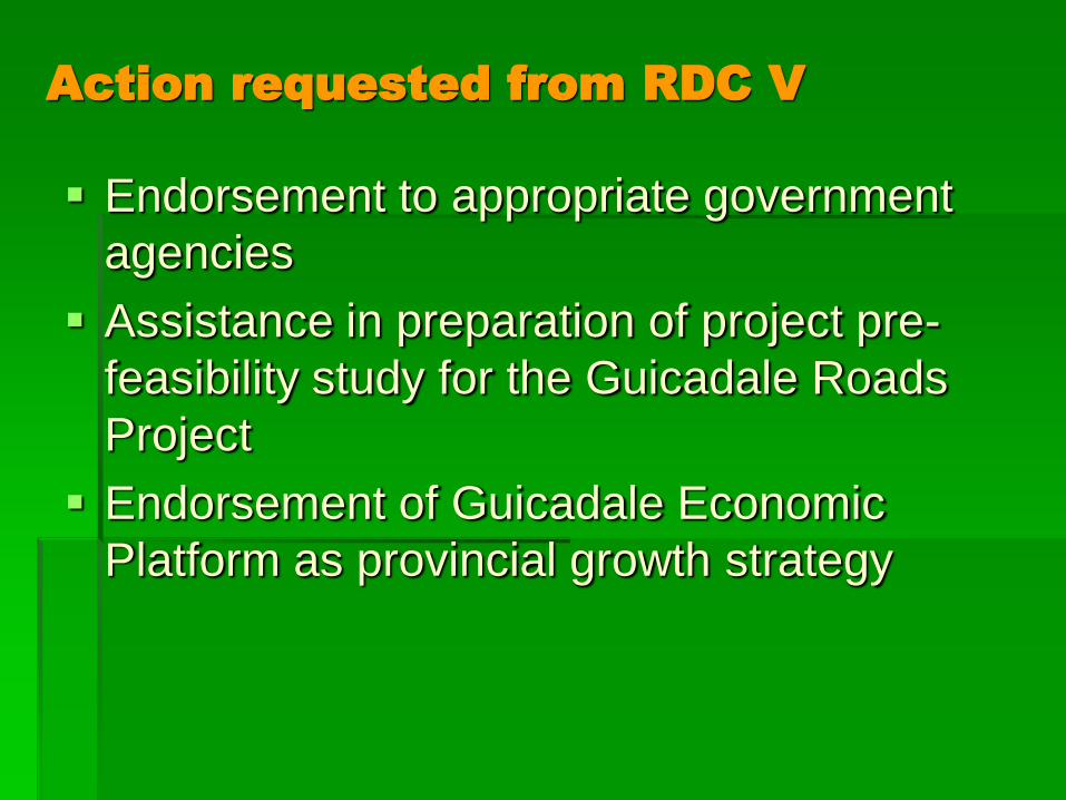
Action requested from RDC V
Endorsement to appropriate government
agencies
Assistance in preparation of project pre-
feasibility study for the Guicadale Roads
Project
Endorsement of Guicadale Economic
Platform as provincial growth strategy