utility manufacturing/wonderking chemical site
260
NEW YORK STATE SUPERFUND CONTRACT MULTISITE PSA REPORT REPORT AND APPENDICES A€ New Cassel Industrial Area Site North Hempstead, Nassau County UTILITY MANUFACTURING/WONDERKING CHEMICAL SITE Site No. 130043 H BLOCK 328 SITE Site No. 130043 I GARDENIHOPPER STREET SITE Site No. 130043 J KINKEWSYLVESTER STREET SITE Site No. 130043 K Work Assignment No. W0267612A hepared for: NEW YORK STATE DEPARTMENT OF ENVIRONMENTAL CONSERVATION 50 Wolf Road Albany, New York 12233 March 1996 Prepared by: LAWLER, MATUSKY & SKELLY ENGINEERS LLP Environmental Science & Engineering Consultants One Blue Hill Plaza Pearl River, New York 10%5 Project No. 650-123/125/127/129
-
Upload
khangminh22 -
Category
Documents
-
view
3 -
download
0
Transcript of utility manufacturing/wonderking chemical site

NEW YORK STATE SUPERFUND CONTRACT
MULTISITE PSA REPORT
REPORT AND APPENDICES A€
New Cassel Industrial Area Site North Hempstead, Nassau County
UTILITY MANUFACTURING/WONDERKING CHEMICAL SITE Site No. 130043 H
BLOCK 328 SITE Site No. 130043 I
GARDENIHOPPER STREET SITE Site No. 130043 J
KINKEWSYLVESTER STREET SITE Site No. 130043 K
Work Assignment No. W0267612A
hepared for:
NEW YORK STATE DEPARTMENT OF ENVIRONMENTAL CONSERVATION 50 Wolf Road
Albany, New York 12233
March 1996
Prepared by:
LAWLER, MATUSKY & SKELLY ENGINEERS LLP Environmental Science & Engineering Consultants
One Blue Hill Plaza Pearl River, New York 10%5
Project No. 650-123/125/127/129

TABLE OF CONTENTS
Page No.
LIST OF FIGURES
LIST OF TABLES
1 EXECUTIVE SUMMARY
2 OBJECTIVES
3 PREVIOUS STUDIES AND AGENCY FILE REVIEWS
3.1 NYSDEC Site Investigation
3.1.1 Overview and Objectives 3.1.2 Phase I 3.1.3 Phase II 3.1.4 Results
3.2 Agency File Review
3.2.1 Site Usage Database 3.2.2 Detailed Multisite PSA File Review
3.3 Private Investigations and Reports
3.3.1 Block 328 Sites 3.3.2 Utility ManufacturingAVonder King Chemical Site 3.3.3 KinlceVS ylvester Street Site 3.3.4 GardedHopper Street Site
3.4 NYSDEC 1995 Monitoring Well Sampling
4 FIELD INVESTIGATIONS
4.1 Facility Inspections 4.2 Ground-Penetrating Radar 4.3 Groundwater Probe Investigation
4.3.1 Groundwater Probes 4.3.2 Soil Probes 4.3.3 Mobile Laboratory 4.3.4 Sample Splits
Lawler, Matusky & Skelly Engineers LLP

TABLE OF CONTENTS ( Contr'nued)
4.4 Monitoring Well Sampling
4.4.1 Sampling Procedures 4.4.2 Monitoring Well Elevations
5 RESULTS
5.1 Facility Inspections
5.1.1 Block 328 Site
5.1.1.1 EZ-M
5.1.2 Utility ManufacturinglWonder King Chemical Site
5.1.2.1 Reliable Machine Works 5.1.2.2 Utility Manufacturing 5.1.2.3 EZ-EM 5.1.2.4 Precision Mechanisms
5.1 .3 Kinkel/S ylvester Street Site
5.1.3.1 Former Van Holland & Sons Ink
5.1.4 GardedHopper Street Site
5.1.4.1 Bilt Rite Buck 5.1.4.2 Express Steel
5.2 Ground-Penetrating Radar
5.2.1 Block 328 Site 5.2.2 Utility ManufacturinglWonder King Chemical Site 5.2.3 Kinkel/S ylvester Street Site 5.2.4 GardedHopper Street Site
5.3 Groundwater Probe Results
5.3.1 NY SDEC Site Investigation Groundwater Probe Results 5.3.2 Private Investigation Studies and Reports
5.3.2.1 Block 328 Site
Page No.
4-7
4-7 4-8
5- 1
5- 1
5-1
5- 1
5- 1
5- 1 5-1 5-2 5-2
5-2
5-2
5-3
5-3 5-3
5-3
5-3 5-4 5-5 5 6
5 6
5 6 5 6
5-7 5.3.2.2 Utility ManufacturinglWonder King Chemical Site 5-7
. . 11 Lawler, Matusky & Skelly Engineers LLP
m

TABLE OF CONTENTS (Com*nued)
5.3.2.3 Kinkel/Sylvester Street Site 5.3.2.4 GardedHopper Street Site
5.3.3 Multisite PSA Groundwater Probe Results
5.3.3.1 Block 328 Site 5.3.3.2 Utility ManufacturingAVonder King Chemical Site 5.3.3.3 KinkellSylvester Street Site 5.3.3.4 GardentHopper Street Site
5.4 Soil Probe Results
5.4.1 NYSDEC Site Investigation Soil Probe Results 5.4.2 Private Investigation Studies and Reports
5.4.2.1 Block 328 Site 5.4.2.2 Utility ManufacturingAVonder King Chemical Site 5.4.2.3 Kinkells ylvester Street Site 5.4.2.4 GardedHopper Street Site
5.4.3 Multisite PSA Soil Probe Results
5.4.3.1 Block 328 Site 5.4.3.2 Utility ManufacturingAVonder King Chemical Site 5.4.3.3 KinkellSylvester Street Site 5.4.3.4 GardedHopper Street Site
5.5 Monitoring Well Sampling Results
5.5.1 NY SDEC Site Investigation Well Sampling Results 5.5.2 NYSDEC 1995 Monitoring Well Sampling Results
5.5.2.1 Block 328 Site 5.5.2.2 Utility ManufacturingAVonder King Chemical Site 5.5.2.3 KinkellSylvester Street Site 5.5.2.4 GardedHopper Street Site
5.5.3 Private Investigation Studies and Reports
5.5.3.1 Block 328 Site 5.5.3.2 Utility ManufacturingMronder King Chemical Site 5.5.3.3 KinkellSylvester Street Site
Page No.
5-7 5-7
5-7
5-7 5-8 5-8 5-9
5-9
5-9 5-9
5-9 5- 10 5- 10 5- 10
5-10
5- 10 5-11 5-11 5-11
5-11
5-11 5-1 1
5-11 5-12 5-12 5-13
5-14
5-14 5-14 5-14
d ~ 2 7 - s 9: ~ ~ ~ ~ M S ~ ~ ~ I I ~ S C L ~ B T T O ~ C iii Lawler, Matusky & Skelly Engineers LLP

TABLE OF CONTENTS (com-llued)
r
Page No.
5.5.3.4 GardedHopper Street Site
5.5.4 Results of Multisite PSA Monitoring Well Groundwater Sampling
5.5.4.1 Block 328 Site 5.5.4.2 Utility ManufacturingNonder King Chemical Site 5.5.4.3 Kinkel/Sylvester Street Site
5.6 Sample Splits
6 CONCLUSIONS
6.1 Block 328 Site
6.1.1 Groundwater Plume 6.1.2 Soil Contamination 6.1.3 Facility Discussion
6.2 Utility ManufacturingNonder King Chemical Site
6.2.1 Groundwater Plume 6.2.2 Soil Contamination 6.2.3 Facility Discussion
6.3 Kinkel/Sylvester Street Site
6.3.1 Groundwater Plume 6.3.2 Soil Contamination 6.3.3 Facility Discussion
6.4 GardedHopper Street Site
6.4.1 Groundwater Plume 6.4.2 Soil Contamination 6.4.3 Facility Discussion
7 RECOMMENDATIONS
7.1 Block 328 Site 7.2 Utility ManuEhcturing/Wonder King Chemical Site 7.3 Kinkel/Sylvester Street Site 7.4 GardedHopper Street Site
iv Lawler, Matusky & Skelly Engineers LLP

TABLE OF CONTENTS ( ConRnRnued)
REFERENCES CITED
LIST OF SUPPORTING DOCUMENTATION
Page No.
R- 1
R-2
APPENDICES
A - Updated File Revew Database B - Detailed File Review C - Soil Conductivity Logs
v Lawler, Matusky & Skelly Engineers LLP

Figure No.
1-1
1 -2
3-1
3 -2
3-3
3-4
3-5
3 6
4- 1
4-2
4-3
4 4
5- 1
5-2
5-3
5 4
6- 1
LIST OF FIGURES
Title
Site Location
Site Plan
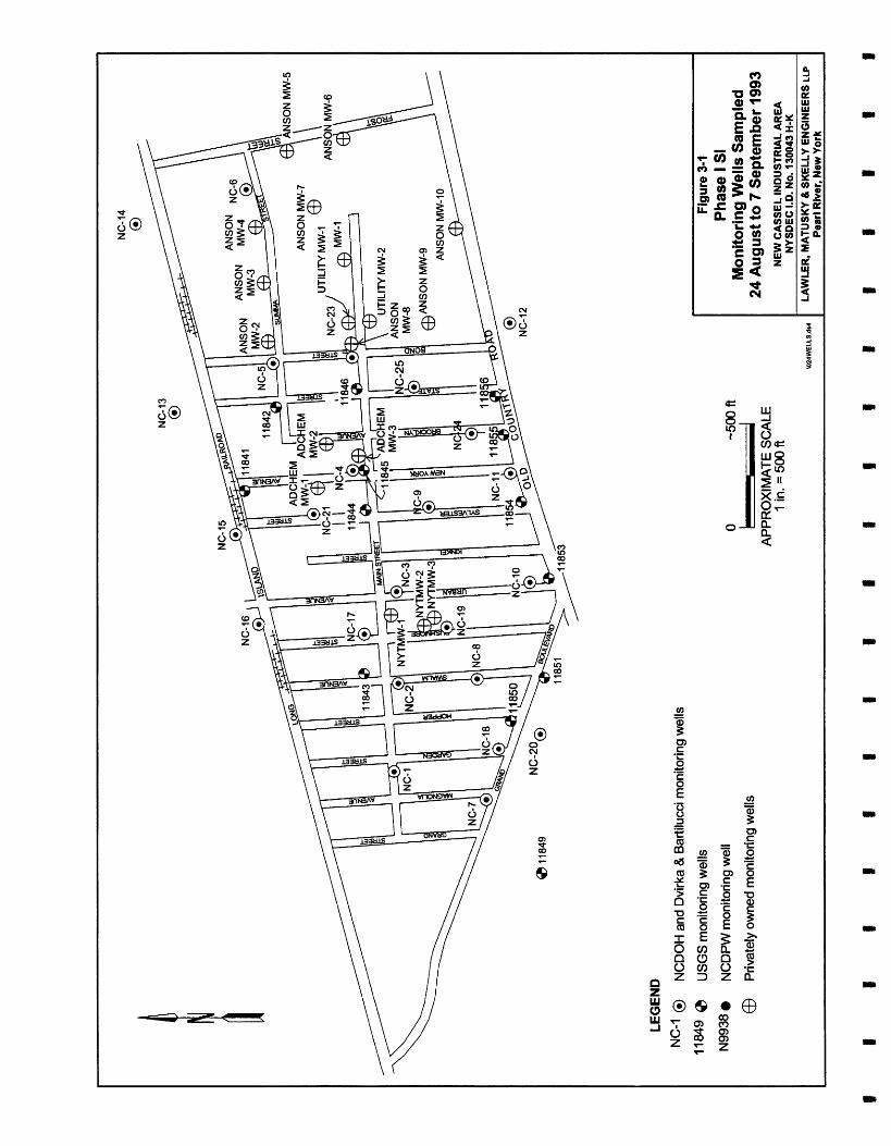
Phase I SI Monitoring Wells Sampled - 24 August - 7 September 1993
Phase I SI Geoprobe Locations Sampled - 18 October - 12 November 1993
Phase 11 SI Geoprobe Locations Sampled From 18 October to 12 November 1993
Phase 11 SI Monitoring Wells Sampled - 24 August - 7 September 1993
Contaminant Plumes Identified in the Site Investigation (1 993- 1994)
Tax Block Numbers for the New Cassel Industrial Area Sites H-K
GPR Survey Areas
Multisite PSA Geoprobe Locations Sampled From 18 October to 12 November 1993
Monitoring Well Locations
Water Table Contour - December 1995
GPR Survey Results - Block 328 and Utility ManufacturingAWonder King Chemical Site
GPR Survey Results - KinkellSylvester Street Site
GPR Survey Results - Gardemopper Street Site
Private Investigation Sampling Locations
Block 328 Site Groundwater Contaminants Concentrations (PCE: Water Table to 65 ft)
Following Page
vi Lawler, Matusky & Skelly Engineers LLP
m

Figure No.
LIST OF FIGURES (Contrhed)
Title Following
Page
6-2 Block 328 Site Groundwater Contaminants Concentrations 6-2 (PCE: 65 to 85 ft)
6-3 Block 328 Site Groundwater Contaminants Concentrations 6-2 (PCE: 85 ft +)
6-4 Block 328 Site Groundwater Contaminants Concentrations 6-2 (TCA: Water Table to 65 ft)
6-5 Block 328 Site Groundwater Contaminants Concentrations 6-2 (TCA: Water Table to 65 ft)
6 4 Block 328 Site Groundwater Contaminants Concentrations 6-2 (TCA: Water Table to 65 ft)
6-7 Block 328 Site Soil Data 6-3
6-8 Block 328: Summa/Frost Street (Water Table to 65 ft) 6-4
6-9 Block 328: Summa/Frost Street (65 to 85 ft) 6-4
6-10 Block 328: Summa/Frost Street (85 ft +) 6-4
6-1 1 Block 328: Main Street/Old Country Road (Water Table to 65 ft) 6-6
6-12 Block 328: Main Street/Old Country Road (65 to 85 A) 6-6
6-13 Block 328: Main Street/Old Country Road (85 ft +) 6 4
6-14 Utility Manufacturing/Former Wonder King Chemical Site 6-9 Groundwater Contaminants Concentrations (PCE: Water Table to 65 ft)
6-15 Utility Manu facturing/Former Wonder King Chemical Site 6-9 Groundwater Contaminants Concentrations (PCE: 65 to 85 ft)
6- 16 Utility Manufacturing/Former Wonder King Chemical Site 6-9 Groundwater Contaminants Concentrations (PCE: 85 ft +)
vii Lawler, Matusky & Skelly Engineers LLP

Figure No.
6-17
6- 18
6-19
6-20
6-2 1
6-22
6-23
6-24
6-25
6-26
6-27
6-28
6-29
6-30
6-3 1
6-32
LIST OF FIGURES (Continhed)
Following Title P e e
Utility ManufacturinglFormer Wonder King Chemical Site 6- 10 Groundwater Contaminants Concentrations (TCA: Water Table to 65 ft)
Utility Manu facturinglFormer Wonder King Chemical Site 6-10 Groundwater Contaminants Concentrations (65 to 85 ft)
Utility ManufacturinglFormer Wonder King Chemical Site 6-10 Groundwater Contaminant Concentrations (85 ft +)
Utility ManufacturingIFomer Wonder King Chemical Site Soil Data 6-10
Wonder King Site (Water Table to 65 ft) 6-1 1
Wonder King Site (65 to 85 ft) 6-1 1
Wonder King Site (85 ft +) 6-1 1
KinkellSylvester Street Site Groundwater Contaminants 6-13 Concetrations (PCE: Water Table to 65 ft)
KinkellSylvester Street Groundwater Contaminants Concentrations (PCE: 65 to 85 ft)
KinkellSylvester Street Groundwater Contaminants Concentrations (PCE: 85 ft +)
KinkellSylvester Street Groundwater Contaminants Concentrations (TCA: Water Table to 65 ft)
KinkellSylvester Street Groundwater Contaminants Concentrations (TCA: 65 to 85 ft)
KinkellSylvester Street Groundwater Contaminants Concentrations (TCA: 85 ft +)
KinkellSylvester Street Site Soil Data
Street Facilities (Water Table to 65 ft)
Street Facilities (65 to 85 ft)
viii Lawler, Matusky & Skelly Engineers

LIST OF FIGURES (Continued)
Figure No. Title
6-33 KinkeVSylvester Street Facilities (85 ft +)
6-34 GardenRIopper Street Site Groundwater Contaminants Concentrations (PCE: Water Table to 65 ft)
6-35 GardenRIopper Street Site Groundwater Contaminants Concentrations (PCE: 65 to 85 ft)
6-36 GardenRIopper Street Site Groundwater Contaminants Concentrations (PCE: 85 ft +)
6-37 GardenRIopper Street Site Groundwater Contaminants Concentrations (TCA: Water Table to 65 ft)
6-38 GardenRIopper Street Site Groundwater Contaminants Concentrations (TCA: 65 to 85 ft)
6-39 GardedHopper Street Site Groundwater Contaminants Concentrations (TCA: 85 ft +)
6-40 GardenRIopper Street Site Soil Data
6-41 GardenRIopper Street Site Facilities (Water Table to 65 ft)
6-42 GardenRIopper Street Site Facilities (65 to 85 ft)
6-43 GardenRIopper Street Site Facilities (85 A +)
Following page
Lawler, Matusky & Skelly Engineers LLP

LIST OF TABLES
Table No.
4-1
4-2
4-3
5- 1
5-2
5-3
5-4
5-5
5-6
5-7
5-8
5-9
5-10
5-1 1
5-12
5-13
5- 14
Title
List of Properties That Received Facility Inspections
Groundwater Confirmatory Sample Locations (November 1995)
SWL Survey Wells
Anson Environmental 1995 Groundwater Probe Data Summary
Geoprobe Groundwater Data Summary (October- December 1995) Water Table to 65-ft Range
Geoprobe Groundwater Data Summary (October- December 1995) 65- to 85-ft Range
Geoprobe Groundwater Data Summary (October- December 1995) 85-ft + Range
Anson Environmental 1995 Geoprobe Data Summary
WFC Assoc., P.C., January 1992 Soil Probe Data Summary
Geoprobe Soil Data Summary (October-December 1995)
NYSDEC Monitoring Well Sample Data (September- October 1995)
Anson Environmental 1989 Monitoring Well Data Summary
Anson Environmental 1991 Monitoring Well Data Summary
Adchem Corporation 1991 Monitoring Well Data Summary
EEA Inc. 1992 Monitoring Well Data Summary
Monitoring Well Groundwater Data Summary (November-December 1995)
Groundwater Confirmatory Sample Data Summary (November 1995)
Lawler, Matusky & Skelly Engineers LLP

CHAPTER 1
EXECUTIVE SUMlMARY
The New Cassel Industrial Area (NCIA) is located in the unincorporated village of Westbury in the Town of North Hempstead, Nassau County, New York (Figure 1-1). Approximately 200 industrial or commercial businesses occupy this 170-acre site (Figure 1-2). Due to extensive halogenated volatile organic contamination of groundwater beneath the site, the New York State Department of Environmental Conservation (NYSDEC) classified the entire industrial area as a hazardous waste site in 1988.
Lawler, Matusky & Skelly Engineers LLP (LMS) was contracted by NYSDEC in 1992 to conduct a site investigation for the NCIA. The objectives of the site investigation were to delineate the contaminant plumes under the site, locate the source of the contaminants, and redefine the site according to measured contamination.
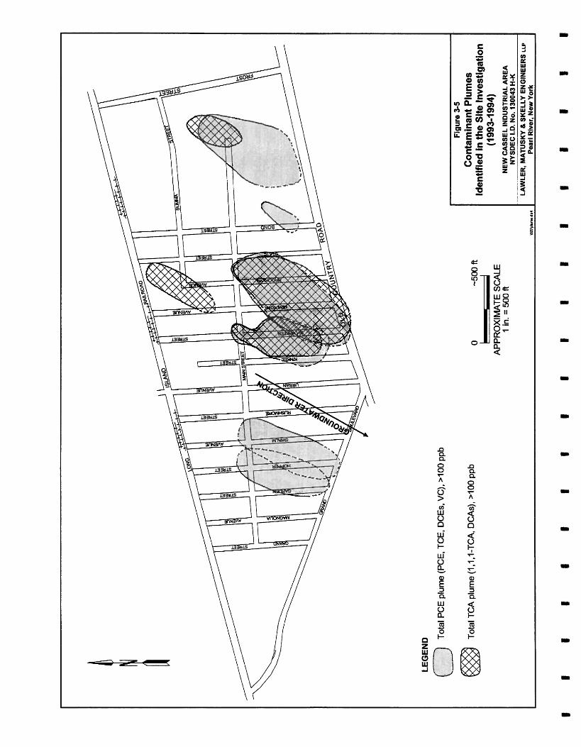
The initial investigations conducted in 1993 and 1994 identified several areas exhibiting significant groundwater contamination within the NCIA: two plumes in the western section, three in the central section, and two in the eastern section. Potentially responsible parties for the two central section plumes and one of the western section plumes were identified; those facilities were listed as Class 2 on the New York State Registry of Inactive Hazardous Waste Disposal Sites. The remaining four sites within the plume regions were designated as potential registry sites requiring additional investigation. The potential registry sites in the eastern section include the Block 328 site and the Utility Manufacturing/Wonder King site. The potential registry sites in the central and western section are the Kinkel/Sylvester Street site and the Garden/Hopper Street site, respectively. The original allencompassing New Cassel site was removed ftom the registry, thereby delisting all sites except those relisted.
LMS was assigned to conduct a Multisite Preliminary Site Assessment (PSA) in 1995 on the remaining four sites that required additional investigation. The objectives of the multisite PSA are to fuaher delineate the contaminant plumes at the four sites, locate the sources of the contaminants, and assess the threat of each source to the environment. The scope of the multi- site PSA included a detailed file review, ground-penetrating radar (GPR) surveys, a ground- water and soil probe investigation coupled with on-site mobile laboratory analysis, facility inspections, and monitoring well sampling.
The data generated from the PSA investigation documented usage of hazardous waste, identified on-site sources, and further delineated the plume. A previously undiscovered plume was found
1pf13-13-% 3:39pmNS8397/65@123/Chagl 1-1 Lawler, Matusky & Skelly Engineers LLP

0 2000 A - SCALE NEW YORK STATE
Figure 1-1
Site Location 1 in. = 2000 A
Map source: USGS 7.5rninute quadrangle series,
NEW CASSEL INDUSTRIAL AREA NYSDEC I.D. NO. 130043 H-K
Freeport, NY, 1969, photorevised 1979, Hicksville, NY, 1967, photorevised 1979. LAWLER, MATUSKY 8 SKELLY ENGINEERS up
IBYI\122USGSdT. Pearl River. New York


north of Main Street between Hopper Street and Swalm Street. Based on the data the following classification of facilities within the four sites are recommended:
Class 2 Hazardous Waste Sites:
101 Frost Street 89 Frost Street 770 Main Street 700-712 Main Street 62 Kinkel Street 33 Sylvester Street 550 Main Street
Potential Registry Sites:
717-765 Main Street 750 Summa Avenue 750 Main Street 1099 Old Country Road 45 Bond Street 49 Sylvester Street 69 Sylvester Street 1 18-138 Swalm Avenue 95 Hopper Street 542 Main Street 299 Main Street
Distribution Systems of America Korg USA Formerly Applied Fluidics Utility Manufactwing Doak Pharmacology Arkwin Industry Royal Guard Fence
EZ-EM EZ-EM Tops Appliance City Tops Appliance City Motorworks Micro-Ray Corporation T. Sarro Salvage Liqui-Mark Corporation Bilt-Rite Steel Buck Al's Tool & Die One Stop Auto & Truck Center
Sites that should not appear on the registry:
776-790 Summa Avenue 1 15 Frost Street 11 11 Old Country Road 44 Bond Street 50 Bond Street 694 Main Street 720 Main Street 38 Kinkel Street 54 Kinkel Street 70 Kinkel Street 67 Sylvester Street 71 Sylvester Street 534 Main Street 86 Garden Street 90 Hopper Street/558 Main Street
NY CE Liberty Tempest Westbury Nissan Coronet Juvenile Furniture Robert Allen Fabrics Precision Mechanisms Reliable Machine Works Tops Appliance City Glassblocks Warehouse The Karat Shop Loni-Jo Metals Doak Pharmacology Van Holland and Sons Ink IET Labs Harmon Associates Bilt-Rite Elevator
Lawler, Matusky & Skelly Engineers LLP

The following sites require additional information before classilieation is possible:
1226 Old Country Road 110 Hopper Street 11 1-1 17 Swalm Street
Westbury Toyota Express Steel Harco Trucking - Harmon Associates
1-3 Lawler, Matusky & Skelly Engineers LLP

CHAPTER 2
The overall objectives of the multisite Preliminary Site Assessment (PSA) at the New Cassel Industrial Area (NCIA) were to:
M e r &heate the con&m&Wphmcs in the site M. In order to isolate and identify potential source facilities, additional delineation of the contaminant plumes was needed.
Locate the source of the contumhiznts. At each of the four sites, the respon- sible source facility was identified by documentation of disposal or use of the target compound and presence of a contaminant plume downgradient from the facility.
Assess the threat of each some to the envhnment. If a source of contamina- tion was established on a site and a demonstrated impact to groundwater was found a significant threat to the environment was determined to exist as the underlying aquifer and groundwater are a sole-source drinking water supply.
Lawler, Matusky & Skelly Engineers LLP

CHAPTER 3
PREVIOUS STUDIES AND AGENCY FILE REVIEWS
3.1 NYSDEC SITE INVESTIGATION
3.1 .1 Overview and Objectives
In 1985 the Nassau County Department of Health (NCDOH) identified NCIA as a major source of groundwater contamination (NCDOH 1986). As a result of this investigation in 1988 NYSDEC classified the entire industrial area as a hazardous waste site (Class 2).
In 1992 LMS was contracted by NYSDEC to conduct a site investigation for the NCIA (LMS 1995). The objectives of this investigation included delineating the contaminant plume under the site, locating the sources of the contaminants, and redefining the site according to the field- measured contamination. As part of this site investigation a number of tasks were completed, including an agency ffle review, monitoring well sampling, facility inspections, and two phases of groundwater and soil probes. A majority of the available chemical analyses, collected during the two phases of groundwater and soil probes, are described in Sections 3.1.2 and 3.1.3.
3.1.2 Phase I
The first phase of the site investigation conducted in summer and autumn 1993 involved a file review to collect necessary background information regarding the various properties in the NCIA. Data regarding current and former uses, chemical use records, and regulatory information for each of the properties were assembled and compiled into a database. This phase also included the collection of groundwater fiom 56 existing wells at the NCIA (Figure 3-1). The samples were sent to a New York State Department of Health (NYSDOH) certified laboratory for volatile organic compound (VOC) analysis. The results were used to determine the placement of groundwater and soil probes at the industrial area. A total of 44 groundwater and soil probes (P-1, P-2; GP-1 to GP42) were strategically placed throughout the area (Figure 3-2). At each of the probe points soil and groundwater were collected at several discrete depth intervals to determine the vertical distribution of the contaminants. Each soil and groundwater sample collected fiom the 44 probes was analyzed in an on-site mobile laboratory using a modified U.S. Environmental Protection Agency (EPA) Method 8010/8020.
Lawler, Matusky & Skelly Engineers LLP

LEGEND
P-# Original geoprobe location
GP-# X Geoprobe location
Note: P I , P 2 , and P4 locations were sampled 3-31-93 (P4 is located off the map)
- APPROXIMATE SCALE
1 in. = 500 ft
Figure 3-2
Phase I SI Geoprobe Locations Sampled October and November 1993
PI, P2, and P4, and GP-1 to GP-42 NEW CASSEL INDUSTRIAL AREA
NYSDEC I.D. NO. 130043 H-K LAWLER, MATUSKY b SKELLY ENGINEERS LLP --
Pearl Rlver, New York

3.1.3 Phase II
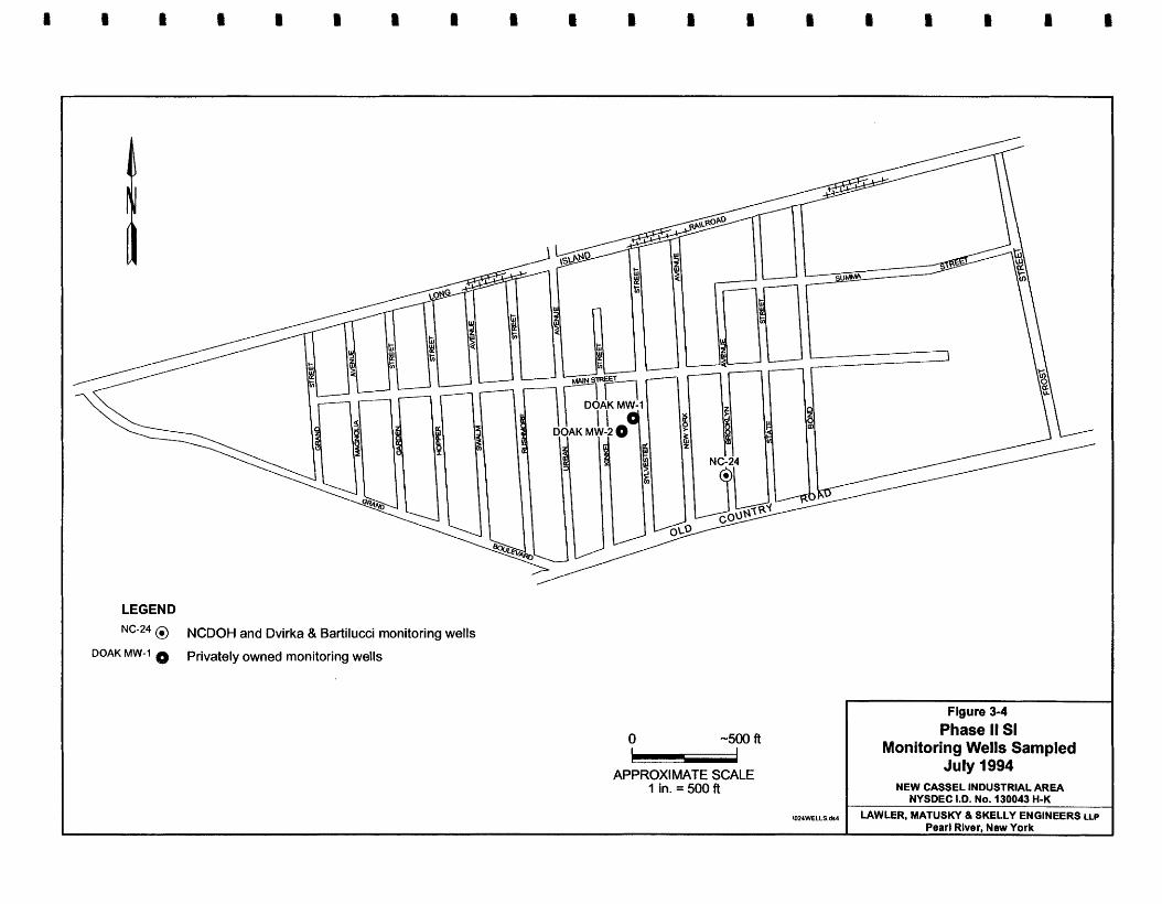
Analysis of the Phase I site investigation data indicated that widespread groundwater contamination existed at the NCIA. To delineate the contaminant plumes under the site, an additional 80 groundwater and soil probes were completed (Figure 3-3) and three additional monitoring wells were sampled, all in summer 1994 (Figure 34). In addition, a total of 33 properties were inspected to determine current and former usage and identify potential sampling points. The primary focus of the usage history was to determine whether the facility had a documented use of any of the target compounds.
3.1.4 Results
Data generated from the sampling and analysis during Phase I and Phase 11 of the site investigation were used to generate contaminant plume maps, which identified seven, apparently distinct, groundwater contaminant plumes (Figure 3-5). Two plumes were identified in the western section, three in the central section, and two plumes in the eastern section of the area (LMS 1995). Potentially responsible parties for the two central section plumes and one of the western section plumes were identified; those facilities were listed as Class 2 on the New York State Registry of Inactive Hazardous Waste Disposal Sites. The remaining sites within the four plume regions were designated as potential registry sites requiring additional investigation. The potential registry sites in the eastem section include the Block 328 site and the Utility ManufacturingIWonder King Chemical site. The potential registry sites in the central and western sections, respectively, are the Sylvester/Kinkel street site and the GardenIHopper Street site. The original allcncompassing New Cassel site was removed from the registry, thereby delisting all sites except those relisted.
3.2 AGENCY FILE REVIEW
3.2.1 Site Usage Database
During the site investigation conducted at the NCIA by LMS, a site usage database was compiled from the existing agency Nes and records. The intent of this database was to compile in one location all the pertinent information found in various agency files regarding the industrial area. Records from the Town of North Hempstead Tax Assessor's Office, fire department, library, and public works department were reviewed and copied. All NCDOH files pertinent to the industrial area were also copied.
I
Lawler, Matusky & Skelly Engineers LLP -

LEGEND GP-92
0
SGP-89 Geoprobe location
0
Approximate Scale 1 in. = 400 ft
Figure 3 3 Phase II SI Geoprobe Locations
Sampled June and July 1994 GP-43 to GP-124
NEW CASSEL INDUSTRIAL AREA NYSDEC I.D. No. 130043 H-K
AWLER, MATUSKY Pearl River. & SKELLY New York ENGINEERS u
I LEGEND
I NC-24 @ NCDOH and Dvirka & Bartilucci monitoring wells
I MW-l Privately owned monitoring wells
I Figure 3-4 - APPROXIMATE SCALE
Phase ll Sl Monitoring Wells Sampled
July 1994 I in. = 500 ft
\024WELLSds4
NEW CASSEL INDUSTRIAL AREA NYSDEC I.D. NO. 130043 H-K
LAWLER, MATUSKY & SKELLY ENGINEERS LLP Pearl Rlver, New York

The resulting database covered most of the known addresses in the area and was subdivided in into east, central, and western sections. It contained tax block and lot numbers, current uses, prior uses, chemical usage (if available), and any past sampling results (LMS 1995).
The database has several limitations, primarily as a result of the data sources. Addresses and site usages not on file are not in the database. In addition, any errors in the agency files are incorporated into the database. Ow of the objectives of the detailed Ne review conducted during this PSA was to verify and update the original database (Appendix A) for the specific properties in the PSA areas.
3.2.2 Detailed Multisite PSA File Review
As part of the multisite PSA investigation a detailed file review for each of the properties within each of the PSA areas was conducted by LMS' subconsultant, YEC Inc. Within each of the individual PSA areas a number of individual properties exist. The objectives of the detailed PSA file review were to:
Verify and update the original database.
Cross-reference any known addresses or past uses to locate untapped sources of information.
Document the existence or nonexistence of agency files for particular addresses.
Review chemical usage history with regard to the contaminants of concern.
Although this effort may duplicate much of the same information found during the original file review, it was believed that the various agencies would be more responsive to specific requests regarding addresses and current and past uses. Additional details and the results of the detailed file reviews are found in Appendix B.
3.3 PRIVATE INVESTIGATIONS AND REPORTS
Investigations involving groundwater and soil sampling have been conducted by private consultants for a number of properties in the NCIA. These investigations were conducted for a variety of reasons, including efforts aimed at delisting various properties from the New York State Registry of Inactive Hazardous Waste Disposal Sites. In general, sampling plans are site specific and oriented to the objectives defined by each client. Chapter 5 contains brief descriptions and results of investigations conducted since 1991 that have involved groundwater and/or soil sampling in the PSA areas. Many of the private investigations reference particular
rpf~-14-% 8: 19amMS839716~123lC~3 3-3 Lawler, Matusky & Skelly Engineers LLP

properties by tax block and lot numbers; Figure 3-6 illustrates the various block numbers as a guide to the location of the various investigations.
3.3.1 Block 328 Site
Plurse II Investigation Report for B k k 328, Lols 144, 157, 169, 174, 4,179; I8 Mwch 1991; Anson EnvhnmentaZ. A Phase 11 Investigation Repon for Nassau County Section 1 1, Block 328, Lots 144, 157, 169, 174, and 179 Located on Summa Avenue in the NCIA was submitted to NYSDEC by Anson Environmental on 18 March 1991. This report was submitted in response to questions raised by NYSDEC concerning the above-mentioned sites. It was also submitted to support a petition by Normal Realty to delete its property at 695 Summa Avenue fiom the New York State Registry of Inactive Hazardous Wastes Sites; 695 Summa Avenue is located at lot 175 within Block 328.
Analyses of groundwater by NCDOH in 1989 are included in this report. Additional ground- water samples were collected by Anson Environmental in September and December 1989.
Phase II Investigation Report for Bbck 328, Lors 142, 154, 160, 162, 178, 179, and 181; October 1995; Anson Environmental. A Phase I1 Investigation Report for Nassau County Section 11, Block 328, for Lots 142, 154, 160, 162, 178, 179, and 181, located at 750 and 770 Main Street and 1099 and 11 11 Old Country Road was submitted to NYSDEC in October 1995. The report was submitted in response to the Site Investigation Report published by NYSDEC in February 1995 (LMS 1995), which designated that site as a potential registry site. The designation denotes that additional investigation is required by NYSDEC in order to determine whether the site should be added to the New York State Registry of Inactive Hazardous Waste Disposal Sites. The purpose of the investigation was to demonstrate that the site should not be included on the registry.
Eleven subsurface soil samples taken from 30-32 ft below the surface were collected. Sample locations were located in close proximity to the former location of cesspools and dry wells associated with the demolished buildings.
3.3.2 Utility ManufacturinglWonder King Chemical Site
Phase II n v e s g n of Utility Mmtufocturing/Wonder f i g Chemic* October 1995; Anson Environmental. A Phase 11 Investigation for Utility Manufacturing/Wonder King Chemical Located at 700-712 Main Street in the New Cassel Industrial Area was submitted to NYSDEC in October of 1995. This investigation was conducted by Anson Environmental in response to
3-4 Lawler, Matusky & Skelly Engineers LLP Ir


NYSDEC designation of the site as a potential registry site site. The purpose of this study was to determine the presence and extent of soil contamination and its impact on the underlying groundwater quality.
Utility Manufacturing manufactures a variety of plumbing and heating products, primarily for commercial and industrial customers. Utility has operated at 700-712 Main Street since October 1975. The company utilizes a number of hazardous materials that are inventoried annually for NCDOH (Appendix B).
The property at 700-712 Main Street has a history of waste discharge to several on-site cesspools and dry wells. In 1989 NCDOH oversaw a removal action in which cesspools and dry wells were pumped and cleaned.
Phase ZI Investigation RepoH for Block 328, LotF 46 and 176; August 1992; Anson Environmental. A Phase 11 Investigation Report for Nassau County Section 11 Block 328, Lots 46 and 176 Located at 694 and 700 Main Street in NCIA was submitted to NYSDEC by Anson Environmental in August 1992. The purpose of this report was to demonstrate that the properties should not be included on the New York State Registry of Inactive Hazardous Waste Disposal Sites.
The property at 694 Main Street is occupied by Reliable Machine Works. A 1000-gal underground storage tank (UST) located on the north side of the property was scheduled for removal by December 1992. Two cesspools on the southwestern side of the property were backfilled when the facility was connected to the sewer on 1 February 1989.
\ The property at 700 Main Street is occupied by Utility Manufacturing Company, which manufactures a variety of cleaning and lubricating products for commercial and industrial customers. There are two 4000-gal USTs, both registered with NCDOH. Methyl ethyl ketone products are stored in an explosionproof room with air-driven mixers and filling machines. Two 250-gal diesel fuel tanks are used by the company for fueling delivery vehicles.
Anson Environmental's investigation included installing two monitoring wells (Anson MW-8 and Anson MW-9) and collecting one round of groundwater samples for laboratory analyses. Samples collected on 12 May 1992 were analyzed for target compound list (TCL) chemicals.
Phase II Investigation Report for Bloek 328, LotF 159, 170, 171, 164, 166, 23-26, 2 9 4 , 63- 67, 117, 58-61, 118, 162, 186, 142, 154, 178, 179, 181, 185, 183, 173, and Block 160, Lots 129-133, 173-177; May 1992; Anson Environmental. A Phase II Investigation Report for
3-5 Lawler, Matusky & Skelly Engineers LLP
Ir

Nassau County Section 1 1, Block 328, Lots 159, 170, 171, 164, 166,23-26,29-45,6347, 1 17, 58-61, 118, 162, 186, 142, 154, 178, 179, 181, 185, 183, 173, and Block 160, Lots 129-133, and 173-177 in the New Cassel Industrial Area was submitted to NYSDEC by Anson Environmental in May of 1992. This area includes much of Block 328 from Summa Avenue to Old Country Road. The purpose of this study was to demonstrate that the these properties should be removed from the New York State Registry of Inactive Hazardous Waste Disposal Sites.
This Phase I1 investigation included installation of six groundwater monitoring wells into the upper glacial aquifer. Groundwater samples were collected from the six newly installed monitoring wells plus an additional four preexisting monitoring wells on 5 December 1991 and analyzed for TCL chemical compounds.
The Anson investigation indicated the locations of 11 dry wells around the perimeter of the building at 750 Summa Avenue: six in front of the building used as sanitary cesspools, two on the western side of the building, and three in the rear. A degreaser vat was located in the rear of the manufacturing space. A floor drain near the degreaser was filled in 1978 on the recommendation of NCDOH. The degreaser sludge (I, 1,l-TCA and waste oil) was stored in 55-gal drums in the rear of the facility for removal by a licensed waste hauler. A private well was installed to provide water for air conditioning units in the parts storage area, four steps below grade in the warehouse area.
Precision Mechanisms is located at 50 Bond Street. The Anson investigation indicates lubricating solutions are stored and used on the premises. No floor drains exist within the building area. Spent solutions are removed from the premises.
3.3.3 KinkeUSylvester Street
Sire Investigation RepoH of Adchem Corporation; October 1991; Eder Associates. A site investigation of Adchem Corporation properties in the NCIA was performed by Eder Associates in 1991. The final investigation report was completed in October 1991. The facilities at 625 and 655 Main Street and 85 and 110 New York Avenue in the NCIA were examined.
The investigation was conducted in response to NYSDEC's 19 December 1990 potentially responsible parties (PRP) letter to industriaVcommercial owners and operators in the NCIA. The letter requested that an appropriate remedial program be designed and implemented to prevent further contaminant migration and to clean up contaminants, and that the respondents reimburse the state's costs.
Lawler, Matusky & Skelly Engineers LLP

The site investigation consisted of a soil gas survey; soil, sediment, and groundwater sampling and analysis; a review of NCDOH files relating to industrial/commercial activities in the NCIA; and a review of the site history and plant operations at Adchem's facilities.
Based on lcnown locations of current and prior septic systems, dry wells, and roof drains, field investigations were focused on the following areas: the site of a former chemical fire at 85 New York Avenue; the vacant property at the eastern side of 655 Main Street; and the parking lot at 655 Main Street.
Based on the results of this investigation, NYSDEC was requested to remove the Adchem properties from the New York State Registry of Inactive Hazardous Waste Disposal Site.
3.3.4 GardenlHop per Street Site
S u b s u ~ ~ e Investigation of 550 Main Streec October 1992; EEA, Inc. In October 1992 EEA, Inc., prepared a subsurface investigation of property located at 550 Main Street for Royal Guard Fence Co., Inc., located at this address. The Phase I1 investigation, conducted subsequent to a Phase I investigation, revealed that operations on the property have involved the storage, use, andlor production of significant quantities of hazardous materials. These materials include cutting, gear-motor, hydraulic, and waste oil; transmission fluid; antifreeze; paints and paint products; unspecified degreasing solvents; and gasoline.
Drainage structures on the property include three exterior dry wells located in paved storage and parking areas and one interior floor drain. Prior to 1983 sewage was discharged to an on- site septic system.
Closure Phn; Soil BonSIg Investigation for Petdeum Heat and Power Company, Inc.; 18 II
June 1992; William F. Cosukh Associcrtes, P.C. (WPC). On 18 June 1992 WFC responded to the Underground Injection Control Section of EPA regarding a Closure Plan for a Class VFI'ype 5 x 28 dry well at the Petroleum Heat and Power Company Facility located at 522
I
Grand Boulevard. In this response a soil boring investigation was conducted immediately adjacent to the Class V dry well. ~r
3.4 NYSDEC 1995 MONITORING WELL SAMPLING I
NYSDEC conducted a groundwater monitoring well sampling program at the NCIA in late September and early October 1995. During this sampling event several teams attempted to sample 54 wells located throughout the area. Forty-five of the 54 wells were sampled; the
P
3-7 Lawler, Matusky & Skelly Engineers LLP

remaining nine wells were dry or silted in. All sampling was conducted under NYSDEC protocols, and the samples were shipped to a NYSDOHcertified laboratory under chain-of- custody protocols for analysis of VOCs (EPA 8010/8020). The well sampling logs and VOC data were provided to LMS and are summarized in Section 5.5.2. Results also appear on the PSA summary figures for wells in the PSA areas.
3 -8 Lawler, Matusky & Skelly Engineers LLP

FIELD INYESITGATIONS
4.1 FACILITY INSPECTIONS
To aid in the placement of soil and groundwater probes, seven facility inspections were conducted during the PSA investigation. The inspections included one facility in each of the Block 328 site, one facility in the Kinkel StreetlSylvester Street site, three facilities in the Utility ManufacturingNonder King Chemical site, and two facilities in the GardenIHopper Street Site. During the site investigation prior to the 1995 PSA investigation a total of 33 facilities were inspected. The facility inspections were short, general inspections intended to identify the following:
Various work areas in the facility
Manufacturing process at each facility
Any site history, including past occupants
Any potential discharge points at the facility
Chemical use and storage
Relative cleanliness of the operation
Locations of any abandoned septic tankfleachpool systems
Table 4-1 provides a list of the facilities inspected in 1995; additional details and results of the facility inspections are found in Section 5.1.
4.2 GROUND-PENETRATING RADAR
A ground-penetrating radar (GPR) survey was conducted at NCIA on properties where leachpools or other types of discharges were suspected (Figure 4-1). The purpose of the GPR survey was to locate the position of any leachpools or leachfields or abandoned leachpools in these areas for soil sampling.
GPR is a nondestructive and nonintrusive geophysical exploration technique that uses radar waves to detect and record subsurface features. The method has been widely used in the environmental industry to locate buried features such as USTs, drums, and pipes. GPR involves
r p f t 3 - l ~ 11 :3OadHS8397/650-123/Chap-4 4- 1 Lawler, Matusky & Skelly Engineers LLP

TABLE 4-1
LIST OF PROPERTIES THAT RECEIVED FACILITY INSPECTIONS New Cassel Multisite PSA
SITE ADDRESS TAX BLOCK LOT
Block 328 Site
E-Z - EM Corporation 717 Main Street Tax Block 328 Lot 148 750 Summa Ave Tax Block 328 Lot 173
Utility Manufacturing/Former Wonder King Chemical Site
Utility Manufacturing 700 Main Street Tax Block 320 Lot 176 Reliable Machine Works 684 Main Street Tax Block 328 Lots 46-57 Precision Mechanisms 50 Bond Street Tax Block 328 Lots 62-67
Ganlen/Hopper Street Site
Express Steel 1 10 Hopper Street Tax Block 143 Lots 31 -37
Kinkel/SJlvester Street Site
Fonner Van Holland Sons Ink 71 Sylvester Street Tax Block 76 Lots 5-8
+Disk No.: HS8455 B:U)50122,XLS Table 4-2 3/21/86 10:19:27 AM+
t I a R 111 I 1 a I t I 1 i I I I I I 1


scanning the subsurface with a device that emits and records the return signals of electro- magnetic energy in the radar wavelength. The variation in r e m signals due to variable attenuation and reflection of the subsurface materials produces continuous, two-dimensional cross sections of the subsurface.
LMS' subcontractor, Subsurface Informational Surveys, Xnc., of East Longmeadow, Massachusetts, performed the GPR surveys. Subsurface Informational Surveys, Inc., used a GSSI Subsurface Interface Radar System-3 (SIR3) to survey over 30 localities in the NCIA. The SIR3 technique uses high-frequency impulse radar technology to obtain a continuous high- resolution profile of the subsurface. The system radiates repetitive short-term duration electromagnetic pulses into a dielectric material from a broad-bandwidth antenna electromagnetically coupled to the ground surface. The system functions as an echo-sounding system using EM impulses of only a few nanoseconds' (billionth of a second) duration and is able to detect the exact location and measure the approximate depth of reflected targets.
The SIR3 used in this investigation consisted of a radar control unit, a line-scan graph recorder, and a high-frequency transmitterlreceiver antenna across the soil/tar to be scanned. The pulses are transmitted into the subsurface and reflected by buried objects. Reflected signals are detected, processed by the control electronics, and printed on the graph recorder. The recorder produces an image by printing strong signals as black and weak signals as white. Intermediate signals such as noise between the surface and interface reflection are in the gray range. By adjusting threshold and controlling gain levels and the timing function, a highquality profile is obtained.
Subsurface objects reflect EM pulses and produce a hyperbola that identifies precisely the location of the center of the target.
4.3 GROUNDWATER PROBE INVESTIGATION
4.3.1 Groundwater Probes
A groundwater probe investigation was conducted concurrently at the four PSA areas in the industrial park. A truck- or van-mounted Geoprobe unit operated by Zebra Environmental Corp. of Cedarhurst, New York, was used to collect the necessary groundwater samples. Sample locations for the groundwater probes were selected to ensure sampling over suspected source areas and to provide upgradient and downgradient water quality information on suspected properties. Groundwater samples were attempted at 63 Geoprobe locations (Figure 4-2);
Lawler, Matusky & Skelly Engineers LLP
I

LEGEND
Gp-12.5 Geoprobe location
Approximate Scale 1 in. = 400 ft
Multisite PSA Geoprobe Locations Sampled
October to December 1995
I NEW CASSEL INDUSTRIAL AREA I NYSDEC I.D. No. 130043 H-K
LAWLER. MP 1- - , *sKf& SKELLY ENGINE€ Pearl River, New York

typically, the goal was to collect three water samples from each probe location at depths of 93- 95 ft, 73-75 ft, and 6062 ft below ground surface.
After a check for underground utilities clearance at each groundwater probe location, the groundwater sampling point was driven to 95 ft or refusal. Once at the desired depth the screened point sampler was disengaged from the sampler assembly and the probe rods pulled back to expose the screen. Water samples were collected using 5116-in. polyethylene tubing equipped with a balkheck valve. After groundwater was purged for a short period, the tubing (full of groundwater) was withdrawn from the probe hole. The sample was then collected by removing the foot valve and allowing the water to slowly decant into the laboratory-supplied sample vials. At each location a minimum of two 40-ml vials were collected if sufficient sample volume was found. Additional vials were collected as needed for mobile laboratory quality assurance1quality control (QA1QC) and base laboratory confirmation samples. After the deepest sample was retrieved the probe rods were pulled back to the next required sampling zone. Again, polyethylene tubing was used to purge the probe point. At the shallower depths a larger purge volume was used to ensure that a representative sample of the required sampling zone was collected. At each location this process was repeated so that three groundwater samples where possible were collected at each of the groundwater probe locations.
4.3.2 Soil Probes
In suspected source areas (as identified by the Ne reviews, facility inspections, and GPR survey) soil samples were collected using the Geoprobe unit supplied by Zebra Environmental. The required soil samples were obtained by using a 2-in. outside diameter (O.D.) macro-core sampler in 4-ft intervals. The sampler was then pushed or hammered to the desired depth using the Geoprobe hammer. As the sampler was driven into the ground the soil sample was retained in a dedicated acetate sampler fitted in the macrocore barrel. After the macro-core sampler was retrieved the liner and sample were slid from the core barrel and capped on both ends. The soil sample was then quickly transferred to the appropriate mobile laboratory sample containers to ensure minimal VOC loss. The soil sample was then scanned with a HNU photoionization detector (PID) and briefly described in the field logbook. Based on the PID results and visual observations a final decision was made as to whether the sample should be submitted to the mobile laboratory. If soil samples were collected at depths greater than those attainable using the macrMore, a large-bore sampler was used instead. The large-bore sampler has a smaller O.D. and is only 2 ft long, allowing it to be driven to deeper depths. Sample retrieval and preparation methods similar to those used for the macro-core sampler were utilized when using the large-bore sampler.
Lawler, Matusky & Skelly Engineers LLP

In addition to the soil probes, soil conductivity probing was conducted at two locations by Zebra Environmental. The purpose of the soil conductivity probing was to demonstrate its usefulness in future investigations at the industrial area. The soil conductivity logging is conducted using standard Geoprobe equipment fitted with a soil conductivity probe and string pot assembly.
The conductivity probe readings are transmitted to the surface through a cable that passes through the standard Geoprobe rods. The purpose of the string pot is to continuously measure depth and rate of probe penetration. The soil conductivity measurements are received and analyzed at the surface using a laptop computer and specially developed software. Based on the demonstration, the soil conductivity logging appears to be a viable tool in further investigations in the event that a particular site requires development of detailed hydrogeologic framework.
The conductivity logs accurately determine the depth to the water table and show differences in the subsurface geology through differences in conductivity. The two conductivity logs conducted at the NCLA are found in Appendix C.
4.3.3 Mobile Laboratory
All soil, groundwater, and surface water samples collected during the multisite PSA were analyzed by Commonwealth Analytical of Westfield, Massachusetts, which operated an on-site mobile gas chromatigraph (GC) laboratory for the duration of the PSAs conducted at the industrial area.
Samples were delivered to the mobile laboratory under chain-ofastody protocols as they were collected, then analyzed for VOCs as listed in EPA Methods 8010 and 8020. A total of a 188 samples were collected, consisting of 152 groundwater samples and 36 soil samples, over the 25-day period of the field work. An additional 1 1 dilutions on groundwater samples and four dilutiom on soils were required. Thus, the total number of samples analyzed during the multisite PSA for this project was 203.
The target compounds for this investigation consisted of:
Vinyl chloride (VC) Trichloroethene (TCE)
1 , 1 -Dichloroethene (1,l -DCE) Tetrachloroethene (PCE)
Methylene chloride Benzene
trans- 1,2-Dichloroethene (trans- 1,2-DCE) Toluene
I
4-4 Lawler, Matusky & Skelly Engineers LLP

1,l Dichloroethane (1, 1 -DCA) Chlorobenzene
cis- 1,2-Dichloroethene (cis- 1,2DCE) Ethylbenzene
l,l,l-Trichloroethane (1,1,1-TCA) m&pX ylene
Carbon tetrachloride 0-X ylene
All samples delivered to the mobile laboratory were analyzed for VOCs using a Hewlett- Packard Model 5890 11 GC with an electrolytic conductivity detector (ELCD) and PID. An 01 Analytical Model 4560 Purge & Trap sample concentrator was used to purge the VOCs from the sample matrix, concentrate them onto a sorbent trap, and desorb them onto the GC system. An 01 Analytical MPM-16 multisampler was used to allow sample analysis to continue while the mobile laboratory was unmanned. The analytical system and parameters were similar to those used in EPA Methods 801018020. Data were processed on a Dell 486 DXl50 personal computer using HP Chemstation Software. Reports were generated with a customized Microsoft Excel reporting program. Copies of each day's sample results were delivered to LMS as they were made available.
During the mobile laboratory analysis Commonwealth Analytical maintained strict QAlQC procedures to ensure data quality. The list below is a description of the QC analysis and the acceptance limits for the volatile organics analysis conducted in the field:
Initicrl Cal ibrhn. A three-point initial calibration was conducted on the analytical system prior to project initiation. The instrument was calibrated and the correlation coefficient (r) calculated for each analyte. For all analytes the (r) value should have been greater than 0.990 or recalibration was performed.
Calibratbn Cheek Slrmdards. At the beginning of each day, after every 10 samples, and at the end of each day a midpoint calibration check standard was analyzed to verify that the analytical sensitivity did not change from the initial calibration. Percent recovery (%R) values were calculated for each analyte and compared to the 75125% criteria. If the %R value was outside the control limits the analyst noted this on the QC form. If significant variances were observed, the system was recalibarted.
QC S-. A QC standard was analyzed on a daily basis and used to verify the accuracy of the calibration standards. The QC standard was a standard from a source other than the calibration standards. %R values were calculated and compared to the 75- 125% criteria.
Method B h k s . A sample of analyte-fYee water was processed at the beginning of the day and after every 10 sample analyses to verify that the analytical system
1 ~ f ~ 3 - 1 4 % 1 1 :3lamMS8397/650-123lChap4 4-5 Lawler, Matusky & Skelly Engineers LLP

was contaminant free. Concentrations of detected analytes should have been less than half the method detection limit. Low contaminant levels necessitated cor- rective action, i.e., cleaning of the instrument.
Sumgate Stmrdards. Surrogate standards were added to all samples, standards, and blanlcs to measure the potential for matrix interences. %R values were calculated (appear in comments section of the data pages) and were compared to the 80-120% criteria. Small deviations were marked as outside control limits, while large deviations necessitated reanalysis.
Duplicates. Ten percent of all samples were analyzed in duplicate on a daily basis to determine the precision of the analyses. Relative percent difference (RPD) values were calculated and compared to the 30% acceptance limit. Values over this level required corrective action if significant; otherwise, they were highlighted as outside QC limits.
MatrLr Spike Analyses. Ten percent of the samples analyzed on each day were spiked with a midlevel standard. The %R values were calculated and should have been 75-125%.
Base Loliomr0raW-y Confirmdon. Ten percent of the samples analyzed in the field were returned to the base laboratory for confirmation analysis following either EPA Method 8010/8020 or 8240. The field data and base laboratory data were compared and should not have differed by more than an order of magnitude for soils and five times for water samples. The confirmation results are included in of Commonwealth's report as well as a table comparing actual results and listing RPD.
4.3.4 Sample Splits
Fifteen samples submitted to the mobile laboratory for analysis were submitted as splits, i.e., additional sample vials were filled simultaneously with samples collected at each location and submitted under chain-of-custody protocol to Aquatec Laboratories, a NYSDOHartified laboratory. This measure was instituted to provide external QA regarding the mobile laboratory's performance. Two of the split samples were collected fkom monitoring wells and the remainder fkom groundwater probes; soils were not split due to limited sample volumes. Split samples are listed in Table 4-2. The same mobile laboratory equipment, methods, and protocols were used during the entire multisite investigation. Results of the mobile and base laboratory analyses are compared in Section 5.6.
Olr
4-6 Lawler, Matusky & Skelly Engineers LLP
I*

TABLE 4-2
GROUNDWATER CONFIRMATORY SAMPLE LOCATIONS (NOVEMBER 1995)
New Cassel Industrial Area Multisite PSA
POINTWELL # DEPTH (FT)
GP-140 G P-140 GP-141 GP-174 GP-174 GP-175 GP-176 GP-178 GP-178R GP-179 GP-179 GP-181 GP-181 DOAK MW-2 DOAK MW-3
NA - Not applicable.
+Disk No.: HS8455 B:\650122.XLS WELL LOCATIONS 3115188 10:17:28 AM+

4.4.1 Sampling Procedures
LMS attempted to sample 12 monitoring wells that were not sampled by NYSDEC in September and October 1995 (Figure 4-3). Three wells (776 Summa- 1, UT MW-2, and Adchem MW-3) were dry, so samples could not be collected; the remaining nine monitoring wells were successfully sampled.
In general, the wells had low to medium yields, generally less than 1 gallon per minute (gpm). Purged water was typically tan in color due to suspended silt. Most wells had quite a bit of silt on the bottom; no attempts were made to remove the silt.
Before each well was sampled, the initial static water level (SWL) and well depth were measured to within 0.01 ft using an electronic water level meter. This measurement allowed for an estimate of the volume of water to be purged before sampling. Each well was purged using a dedicated disposable bailer, discarded after use at each well. All wells were purged a minimum of three borehole volumes in accordance with NYSDEC protocol. An estimate of the volume of water to be purged from the well was calculated using the following equation:
Volume = 3 x (0.65 x H)
where:
H = height of the water column in feet 0.65 = constant, gdlft in a 44x1. well
The SWL indicator was decontaminated with deionized water between uses at each well.
Temperature, pH, and specific conductance were measured several times during the purging process; turbidity was estimated. After purging, each well was allowed to recover a minimum of 90%. Samples were collected using disposable Teflon bailers lowered to the approximate middepth of each water column. Field data, including water level, purge information, and other sampling information, were recorded on the well sampling logs.
Two 40-1111 vials provided by the mobile laboratory were filled for each sample so that no headspace was present in the sample. All sample bottles were labeled with the site name, sample identification, date, and time. The samples were submitted under chain-ofcustody protocol to the on-site laboratory operated by Commonwealth Analytical. The sample results are presented in Section 5.5.
m~#)-96 11:26emMS8397/650-123/Chap4 4-7 Lawler, Matusky & Skelly Engineers LLP

TO BOWLING GREEN
0 -500 ft r SCALE IN FEET
Figure 4-3
Monitoring Well Locations
NEW CASSEL INDUSTRIAL AREA NYSDEC I.D. NO. 130043 H-K
~ Z Z W E L L S . ~ ~ ~ LAWLER, MATUSKY 8 SKELLY ENGINEERS LLI Pearl River, New Yo*
Due to the small volume of water purged ftom the monitoring wells during this s w e y , purged water was discharged to the ground in the vicinity of the well.
4.4.2 Monitoring Well Elevations
One round of SWL measurements was taken on a representative set of monitoring wells (1 1-13 December 1995). This round of SWL measurements supplements two other rounds conducted
by LMS in 1993. Table 4-3 summarizes the results of the three rounds of water level measurements collected by LMS at the industrial area. Seven of the 37 wells measured in 1993
were not measured. Six of the seven unmeasured wells could not be located; the seventh was not measured because the well cap and exposed casing were under ice. In addition to the wells measured in 1993, 27 other wells were measured over a thteeday period in December 1995.
In total, the depth to water was measured in 61 wells.
Water table elevations were calculated for 55 of the wells measured (Table 4-3). Elevations to
the top of the PVC casing were known for 36 of the measured wells. All other elevations are estimates based on proximity to wells with known elevations. Maximum water table elevations were calculated ftom dry wells. These maximum values were determined ftom the elevation to the top of the PVC casing and the total depth of the well.
A water table contour map of the 1995 water table elevation data was compiled (Figure 4-4).
The water table at ANSON MW-9, located in the southeast quadrant of the site, was anomalously high as was also observed in the 1993 data. It was determined during the
Geoprobe survey in 1993 that groundwater is perched on a clayey silt deposit that underlies this area, fust encountered at a depth of 45 ft in GP-1 (located 50 ft west of ANSON MW-9). This unit continued to a depth of approximately 60 ft, then graded downward to a fine sand by 70
ft. As such, the unit is at least 15 ft thick.
No such perched water conditions were observed for the rest of the site. The water table slopes gently to the southwest at a gradient of 0.00124 (1993 gradient was 0.0015). Water table elevations measured in 1995 were approximately 2.7 ft lower than those measured in 1993.
Published average hydraulic conductivity values for the sediments typically screened by site wells (silty sands) range fkom 1.42 to 0.142 Wday . Assuming a porosity of 25 % , the average linear velocity of groundwater movement can be calculated using a derivation of Darcy's Law. The calculated flow velocities range from 7.0 x to 7.0 x lo4 Wday.
Lawler, Matusky & Skelly Engineers LLP

TABLE 4-3 (Page 1 of 3)
SWL SURVEY WELLS New Cassel Industrial Area Multisite PSA
NG1 NC-2 NC-3 NC-4 NC-5 NC-6 NC-7 NC-8 NG9 NGlO NC-11 NC-12 NC-13 NC-14 NC-15 NC-16 NC-17 NC-18 NG19 NC-20 NC-21 NC-22D NC-23 NC-24 NC-25
LMS LMS '93 DEPTH TO WATER TABLE
ELEVATION TOTAL WATER PLWNION TOP OF PVC D6PTH OF (fi) (It above MSL)
WELL I,O, (R above MSL) WELL (1995) 23 AUG 1993 23 AUO 1993
EE - Estimated elevation. UN -Unknown. NF - Not found. NM -Not measured. DRY - Dry to total measured depth dwell. FRZ -Frozen.
LMS 33 WATER TABLE
DEPTH TO ELEVATION WATER (R) (ft above MSL)
8 9 NOV 1993 8-9 NOV l9B3
LMb 96 TOTAL WATER TABLE
wpm OP DEPTH TO ELEVAT~W WELL WATER (ft) (ft above MSL)
DEC 1996 11-13 DEC 1996 1113 DEC 1996
DRY DRY 55.54 FRZ
57.84 NF FRZ
53.15 54.73 53.42 51.78 54.21 60.25
NF 57.1 NF
55.28 51.51 54.48 52.2 FRZ NF NF
53.16 '
51
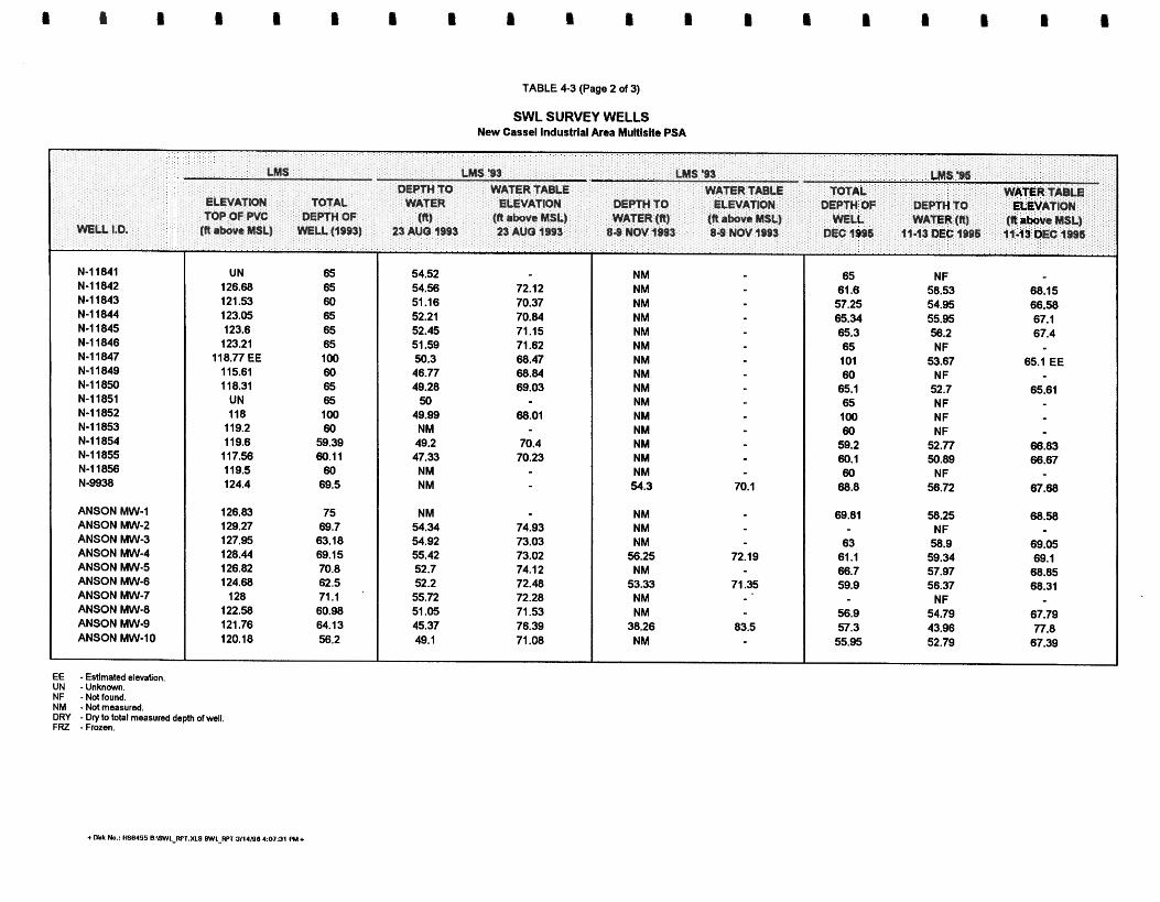
TABLE 4-3 (Page 2 of 3)
SWL SURVEY WELLS New Cassel Industrial Area Muttlstte PSA
LMS LMS 9 3 LMS '93 L M I '96 DEPTH TO WATER TABLE WATER TABLE TOTAL WATER ~ A ~ L E
E ~ V A T I C ~ TOTAL WATER ELEVATION D E m TO ELEVATION DEPTH OF D m 'i0 ELEVATION TOP OF PVC DEPTH OF (R) (N above MSL) WATER (R) (It above MIL) WELL WATER (ff) (ftabove MSL)
MU 1.0. (R above MSL) W L L (1993) 23 AUQ 1995 23 AUO 1993 8 8 NOV 1993 8 8 NOV 1993 bEC1996 tl13DEClB91i 11-13DEC1996
N-11841 N-11842 N-11843 N-11644 N-11845 N-11846 N-11847 N-11849 N-11850 N-11851 N-11852 N-11853 N-11854 N-11855 N-11856 N-9938
ANSON MW-1 ANSON MW-2 ANSON MW-3 ANSON MW-4 ANSON MW-5 ANSON MW-6 ANSON MW-7 ANSON MW-8 ANSON MW-9 ANSON MW-10
EC -Estimated elevation UN -Unknown. NF - Not found. NM - Not measured DRY - Dry to total measured depth of well FRZ - Frozen
UN 65 126.68 65 121 -53 60 123.05 65 123.6 65 123.21 65
116.77 EE 100 11 5.61 60 1 18.31 65
UN 65 118 100
119.2 60 11 9.6 59.39 117.56 60.11 119.5 60 124.4 69.5
126.83 75 129.27 69.7 127.95 63.18 128.44 69.15 126.62 70.8 124.68 62.5
128 71.1 122.58 60.98 121.76 64.13 120.18 56.2
54.52 54.56 72.12 51.16 70.37 52.21 70.84 52.45 71 .15 51.59 71.62 50.3 68.47 46.77 68.84 49.28 69.03
50 49.99 68.01 NM 49.2 70.4 47.33 70.23 NM NM
NM 54.34 74.93 54.92 73.03 55.42 73.02 52.7 74.1 2 52.2 72.48 55.72 72.28 51.05 71.53 45.37 76.39 49.1 71.08
NM NM NM NM NM NM NM NM NM NM NM NM NM NM NM 54.3 70.1
NM NM NM
56.25 72.19 NM
53.33 71.35 NM NM
38.26 83.5 NM
65 NF 61.6 58.53 68.15 57.25 54.95 86.58 65.34 55.95 67.1 65.3 58.2 67.4 65 NF 101 53.67 65.1 EE 60 N F
65.1 52.7 65.61 65 N F 100 N F 60 NF
59.2 52.77 68.83 60.1 50.89 68.67 60 NF
68.8 56.72 67.68
69.81 58.25 68.58 NF
63 58.9 69.05 61.1 59.34 69.1 66.7 57.97 68.85 59.9 56.37 68.31
NF 56.9 54.79 67.79 57.3 43.96 77.8 55.95 52.79 67.39

TABLE 4-3 (Page 3 of 3)
SWL SURVEY WELLS New Cassel Industrial Area Multislte PSA
GRAYCO MW-1 GRAYCO MW-2 GRAYCO MW-3
NYT MW-1 NYT MW-2 NYT MW-3
LMS LMS '93 LMS 96, DEPTH TO WATER TABLE WATER TABLE TOTAL WATER TABU
ELEVATION TOTAL WATER ELEVATION DEPTH TO ELEVATION DEPTH OF &PW TO ELEVATION TOP OF PVC DEPTH OF (fi) (R h o v e MSL) WATER (n) (R above MSL) WELL WATER (11) (fi a w e MSL)
WELL 1.0, (ft above MSL) WEU (1993) P A U O 1993 23 AUb 1993 8 8 NOV 1993 8-9 NOV 1993 DEC 1996 W-13 M C 1BD6 11.13 DEC 1996
ADCHEM MW-1 ADCHEM MW-2 ADCHEM MW-3
UN-1 UN-2 UN-3 UN-4 UN-10 UN-11 UN-22 UN-23 UN-24 UN-25 UN-68
AIMW-670 AIMW-658 Main-D AIMW-70 State-D AIMW-656 Main-U UTILITY MW-1 UTILITY MW-2 EZ-EM MW-1 EZ-EM MW-2
DRY DRY DRY
56.63 56.3 57.5 56.93 53.42 DRY 55.75 56.75
125.7 EE UN 125.2 EE UN 126.4 EE UN 124.2 EE UN 125.3 EE UN 125.4 EE UN 121.3 EE UN
UN UN UN UN UN UN
118 EE UN
EE -Estimated elevation. UN - U n k n m . NF -Not found. NM -Not measured. DRY - Dry to tobl measured depth of well. FRZ -Frozen.
NM NM NM NM NM NM NM NM NM NM NM
NM NM NM NM NM NM NM NM NM NM NM
56.9 DRY * 69.8 EE 57.1 DRY < 68.1 EE 60.6 58.31 68.09 EE 57.5 55.8 68.4 EE 61.3 57.93 67.37 EE 59.35 57.89 67.51 EE 119 54.8 66.5 EE 63.6 58.08 62.9 51.76
NF 100.5 53.08 64.92 EE


CHAPTER 5
RESULTS
5.1 FACILITY INSPECTIONS
5.1.1 Block 328 Site
5.1.1.1 EZEM. EZ-EM is located at 717 Main Street and 750 Summa Avenue. EZ-EM manufactures and ships barium diagnostic imaging products. Due to U.S. Food and Drug Administration regulations, the interior production spaces could not be inspected. EZ-EM has occupied these addresses since the late 1980s or early 1SWOs. The facility manager believed 717 Main Street was a warehouse and 750 Summa Avenue was occupied by Advanced Food Services prior to EZ-EM moving into the buildings. The 717 Main Street address was reportedly connected to the county sewer system in 1987. Numerous leachpools were found to the rear of 717 Main Street. It is believed they are used for parking lot runoff.
5.1.2 Utility ManufacturinglWonder King Chemical Site
5.1.2.1 Reliable Muchine Works. Reliable Machine Works, which has occupied this address since the building was built in 1957, manufactures tools and dies for the brake industries. In their manufactwing process they use some cutting oils. Plating or parts cleaning has never been part of the operation. Reliable has been connected to the county sewer system for approximately 10 years. Two former c e s s p ~ ~ l s are found to the south of the building off Bond Street. The property also houses a surgical products company (sales only) and is also used to store new cars for one of the dealers on Old County Road.
5.1.2.2 Ulilicy Manufucturing. The facility inspections at 700 Main Street revealed the building currently houses five separate companies: Utility Manufacturing , Utility Enterprises, Wonder King Chemical, Jem Lame Co., and West Equities, Inc. Utility Manufacturing, which has been at this property since 1975, blends and repackages plumbing and heating supplies. The bulk products are shipped in and then packaged for individual resale. In some cases a final blend is conducted before packaging.
In 1975 Utility Manufacturing acquired Wonder King Chemical of Port Chester, New York. Although they were in the same building and manufactured similar items, Wonder King Chemical used the 710-712 Main Street address. In 1985 Utility Manufacturing and Wonder King Chemical merged into one company under the Utility Manufacturing name. Later, the
~PTB-14-96 1 1 ~~~~~~~~~~~~IB/C+S 5-1 hwler, Matusky & Skelly Engineers LLP

710-712 Main Street address was dropped for convenience. It appears, that although several addresses were used by Utility ManufacDuriog and Wonder King Chemical, both operations were located on one lot (Lot 176) in Tax Block 328.
The site reportedly has been connected to the county sewer system since 1989. Testing was performed on the leachpools when the sewer was connected (Appendix B). No floor drains or
other discharges were noted within the building during the site inspection.
Two 4000-gal USTs were noted to the rear of the building. These approximately 10-year-old steel tanks are used to store methyl ethyl ketone (MEK) and 1,2,3,4-tetrahydro-9-fluorenone (THF). Former uses of the site include RADA Laboratory, Inc., in the early 1970s and ITM, Inc., prior to that.
5.1.2.3 EZEM. The EZ-EM facility at 717 Main Street is a large facility located upgradient
of the Block 328 sites and the Utility ManufacturingAVonder King Chemical site. Section 5.1.1.1 summarizes the results of the EZ-EM facility inspection.
5.1 .2.4 Precision Mechanisms. The facility inspection conducted for Precision Mechanisms at 50 Bond Street revealed that Precision Mechanisms has been at this address since 1990. The facility, owned by J.S. Realty, Inc., is a one-story brick building with a side (south) and back (east) alley. Precision Mechanisms machines and assembles small rotary cam switches; small
amounts of water-based cutting oils are used during these processes. Precision Mechanisms
reports that they use about 16 gallmonth of Safety Klean and have done so since 1990. NCDOH bulk storage and container storage records indicate that Precision Mechanisms stored 30 gal of TCA in 1991. The building is slab on grade, with no floor drains; it is connected to the county sewer system. Based on the layout of the building it is likely that a leachpool existed near the southwest comer of the building in the south alley.
5.1.3 KinkeVSylvester Street Site
5.1.3.1 Former Vm H o M & Sons Ink. This facility at 71 Sylvester Street was in the process of being remodeled at the time of the facility inspection. Prior to the remodeling the building housed an ink and printing supplier. The building covers most of the lot, with a single shared alley along the east wall. Paved parking areas or sidewalks are also found along the Sylvester and Main Street sides of the lot. This two-story block building appears to be slab on grade. No floor drains were noted inside the building. Former leachpools are suspected in the east alley and along Sylvester Street. It is not known when the property was connected to the county sewer system.
I
5-2 Lawler, Matusky & SkelIy Engineers LLP -
5.1.4 GardedHopper Street Site
5.1.4.1 Bilt RiCc Buck. Bilt Rite Buck, located at 95 Hopper Street, fabricates metal door frames for various uses. Processes at the facility include metal cutting, welding, and paint@. A large amount of paint-related products and petroleum-based solvents are used during the painting process. The two-story block building covers most of the lot fronting Hopper Street. Bilt Rite Buck also has frontage on Garden Saeet. lhis area is covered with a large two-story canopy used for covered shipping and storage. No obvious leachpools, floor drains, or other disposal locations were noted.
5.1.4.2 Erpress Steel. This facility, located at 1 10 Hopper Street, has just moved into the area. During the site investigation the building was occupied by Flexithem, Inc. Express Steel fabricates various steel products such as I-beams and other steel items used in the construction industry. The facility is used primarily for storage, shipping, and some welding.
5.2 GROUND-PENETRATING RADAR
The results of GPR investigations are summarized in Figures 5-1, 5-2, and 5-3. Anomalies were f m d at many of the survey areas, including minor variations in the subsurface, fill areas, leachpools, abandoned leachpools, USTs, and tank graves.
5.2.1 Block 328 Site
On 30 October 1995 a GPR survey was conducted in the corridor between the center of the parking area north of Coronet and the Coronet receiving buildinglfence at 770 Main Street (Figure 5-1). An anomalous region was located. Geoprobing was conducted within the anomalous region to determine whether the region was a leachpool in which contaminated wastes were disposed.
On 31 October 1995 two GPR surveys were conducted. The parking lot between the Revenue Computer System Division entrance at 750 Main Street (Figure 5-1) and Main Street behind Coronet was surveyed. No anomalies were located except for those caused by possible fill such as concrete. The rear loading lot of Distributions Systems of America, Inc., at 101 Frost Street was surveyed. Anomalies were found in areas of former suspect leachpools (cesspools). Those areas were marked out with white paint and probing was conducted in the area to attain groundwater samples.
5-3 Lawler, Matusky & Skelly Engineers LLP

- Approximate Scale
1 in.=200ft LEGEND
Building
Fence
Area of GPR survey I ~ GPR anomaly
\GPR-AREA ds4
Figure 5-1 GPR Survey Results
Block 328 and Utility Manufacturing1
Wonder King Chemical Site NEW CASSEL INDUSTRIAL AREA
NYSDEC I.D. NO. 130043 H-K
LAWLER, MATUSKY & SKELLY ENGINEERS up Pearl River, New York

LEGEND
Building
- Approximate Scale
1 in. = 200 ft
I Figure 5-2
I GPR Survey Res Area of GPR survey
GPR anomaly \GPRdREAds4
~inkell~ylvester Stn NEW CASSEL INDUSTRIAL
NYSDEC I.D. No. 130043
LAWLER, MATUSKY 8 SKELLY E Pearl River, New Yo1

1
LEGEND
Approximate Scale 1 in. = 200 ft
Building
Area of GPR survey
a GPR anomaly
Figure 5-3
GPR Survey Results GardenIHopper Street Site
NEW CASSEL INDUSTRIAL AREA NYSDEC I.D. NO. 130043 H-K
LAWLER, MATUSKY 8 SKELLY ENGINEERS Pearl River. New York

On 13 November 1995 four GPR surveys were conducted on the EZ-EM property. Two anomalies were detected in the 328 block: one on the eastern side of the southern building located at 717-765 Main Street (Figure 5-1) in a parking lot accessible from Main Street, and one in the area south of the northern EZ-EM building located at 750 Summa Avenue (Figure 5-1) in the eastern section of the lot accessible from Summa Avenue through gate No. 2. No samples were taken in this region because of the high risk of hitting electrical utilities.
On 14 November 1995 GPR surveys were continued on the EZ-EM property at 750 Summa Avenue. These surveys detectd anomalies along the western side of the comdor leading to the rear of the northern EZ-EM building (Figure 5-1) from Summa Avenue. This anomaly ran along the EZ-EM building and around the back of the building.
On 14 November 1995 the eastern side of the corridor between Kozy Shack, Inc., located at 762 Summa Avenue (Figure 5-l), and EZ-EM leading to the rear of the northern EZ-EM building from Summa Avenue was surveyed. No anomalous areas were detected.
Also surveyed on 14 November 1995 was the driveway west of the northern EZ-EM building (Figure 5-1) leading to the rear of EZ-EM and the area behind EZ-EM before gate 2. An anomaly was detected on the east side of the driveway, next to the EZ-EM building, starting at Main Street and extending south along half the length of the wall. Another anomaly was found along the dogleg of the south wall of the EZ-EM building.
5.2.2 Utility ManufacturingIWonder King Chemical Site
On 31 October 1995 a GPR survey was conducted in the northeast side of Precision Mechanisms at 50 Bond Street. No anomalies, other than shallow pipes, were found. A GPR swey was later conducted along the south side of the Precision Mechanisms building, where an anomaly was found adjacent to a vent along the side of the building between the vent and a sewer cover south of the building.
On 1 November 1995 two areas were surveyed on the Utility ManufacturinglWonder King Chemical site. The first area surveyed was the perimeter of the Reliable Machine Works building located at 694 Main Street (Figure 5-1). The grassy region between the building and Main Street and Bond Street on the north and west sides of the building was surveyed. Other than the confirmation of an existing UST, no unusual anomalies were located in this region. On the east side of the building two catch basins were confirmed; however, no other anomalies were found. The lot behind the Reliable building and north of Precision Mechanisms and the alleyway east of Precision Mechanisms were free of anomalous readings.
1pf13-14-% 11 :45am/HS83971650-123/ChapS 5-4 Lawler, Matusky & Skelly Engineers LLP

The second area swey was conducted at 720 Main Street, which is now Taps Appliance City. The second survey began on the west side driveway located between Tops Appliance City and Utility Manuhcturing, located at 700-712 Main Street (Figure 5-I), running from Main Street to the south. An anomaly was found west of loading dock No. 5. A second anomaly was found approximately 2 ft below the surface, 54 ft south of the loading dock area and 24 ft west of the w stereo installation center. A third anomaly was found approximately 35 ft directly north of the customer pickup area of Tops Appliance City. The area of comm was estimated to be 18 ft, east to west, by 20 8, north to south.
On 13 November 1995 four GPR surveys were conducted on the EZ-EM property at 717-765 Summa Avenue (Figure 5-1). Two anomalies were deteaed in an area upgradient of the Utility ManufachuingMonder King Chemical site. One anomaly was deteckd in the area south of the EZ-EM building in the eastern section of the lot accessible from Summa Avenue through gate No. 2. The second anomalous region was deteaed in the area south of the EZ-EM building in the westem section of the lot accessible fkom Summa Avenue through gate No. 2. Four small anomalies were detected in this region.
5.2.3 KinkeVSylvester Street Site
On 13 November 1995 five GPR surveys were conducted on the KinkellSylvester Street site. The survey began at 62 Kinkel Street in the alleyway between Doak Pharmacology located at 62 Kinkel Street (Figure 5-2) and Industrial Mets located at 68 Kinkel Street. No anomalies were found.
A survey was conducted in the alleyway between Loni-Jo Metals located at 70 Kinkel Street (Figure 5-2) and Industrial Mets located at 68 Kinkel Street (Figure 5-2). The reading indicated that the area in the alleyway is "very highly reflective and is certainly an area of concern." No individual anomalies, however, were detected.
The area between Van Holland & Sons Ink located at 71 Sylvester Street (Figure 5-2) and Loni- Jo Metals located at 70 Kinkel Street (Figure 5-2) just south of Main Street was surveyed. Two anomalous regions were detected adjacent to the northwest corner of the Van Holland & Sons Ink building and adjacent to the northeast corner of the Loni-Jo Metals building.
The area north and east of Van Holland & Sons Ink located at 71 Sylvester Street (Figure 5-2) along Main Street and along Sylvester Street was surveyed. No anomalies were detected.
Lawler, Matusky & Skelly Engineers LLP

The area east, south, and west of the Micro-Ray Corporation building at 49 Sylvester Street was surveyed. No anomalies were deteckd on the south side; an anomaly was detected in fiont of the southeastern comer of the building.
On 14 November 1995 a GPR survey was conducted in the parking area north of the Karat Shop on 54 Kinkel Street. A large anomaly was found in this parking area.
5 -2.4 GardenltIopper Street Site
On 14 November 1995 GPR surveys were conducted along the north and east face of ASS Tool and Die Enterprises located at 542 Main Street (Figure 5-3). An anomalous region was detead in a lot in fiont of the north face of Al's Tool and Die building. Another anomaly was detected in fiont of the east face of Al's Tool and Die along the sidewalk on Hopper Street, running midway between Main Street and the south edge of the property to the end of the garage door on the southeast comer of the building.
On 14 November 1995 the area surrounding the Bilt Rite Steel Buck Corporation located at 95 Hopper Street (Figure 5-3) was surveyed. The parking area for Bilt Rite was surveyed using GPR. No anomalies were detected. The parking area south of the Bilt Rite parking lot and north of Avanel Industries located at 75 Hopper Street (Figure 5-3) was also surveyed. An elliptical anomaly was found.
5.3 GROUNDWATER PROBE RESULTS
5.3.1 NYSDEC Site Investigation Groundwater Probe Results
The groundwater probe results fkom the NYSDEC site investigation include sample data collected in 1993 (Phase I SI) and 1994 (Phase I1 SI). A detailed presentation and discussion of these results is found in the site investigation report (LMS 1995). Results relevant to the multisite PSA area also plotted on the plume maps in Chapter 6 showing individual point locations and measured PCE-, TCA-, and BTEX-related contaminants.
5.3.2 Private Investigation Studies and Reports
The locations of soil and groundwater samples fiom private investigations done in the NCIA are depicted on Figure 5-4.
5-6 Lawler, Matusky & Skelly Engineers LLP

___c_ BOND ST.

5.3.2.1 Block 328 Site. None of the private reports reviewed in this investigation contained groundwater probe results in the Block 328 site.
5.3.2.2 U r n MaufacturbgNCronder Klrg Chemical Site.
Phase ZZ Znvestigaiion of Ulility MaufacturbgNCronder King Chemical Sitc; Ocuber 1995; Anson Environmental. Anson Environmental collected groundwater samples during a Phase I1 investigation of the Utility ManufBcturingAWonder King Chemical Site located at 700-712 Main Street. The groundwater samples were collected at 60. 75. and 95 ft below grade. Probes were installed through dry wells on-sire and in areas adjacent to current and former dry well locations. The results of this sampling are summarized in Table 5-1. Only contaminated samples are summarized.
5.3.2.3 &kzUSyIvester Street Site. None of the private reports reviewed in this investigation contained groundwater probe results for the Kinkel/Sylvester Street site.
5.3.2.4 Gcuden/Hopper Street S h . None of the private reports reviewed in this investigation contained groundwater probe results for the Garden/Hopper Street site.
5.3.3 Multisite PSA Groundwater Probe Results
The results of the mobile laboratory VOC analyses performed on the groundwater probe samples collected by LMS during the multisite PSA are found on Tables 5-2, 5-3, and 54 . The data are segregated into three depth ranges: samples from the water table to 65 ft below ground surface (Table 5-2), 65 to 85 ft below ground surface (Table 5-3), and 85 ft or greater (Table 5 ) The results are also plotted on plume maps in Chapter 6 showing individual point locations and measured PCE-, TCA-, and BTEX-related contaminants mapped for each depth range. The PCE-related contaminants are the sum of the individual measured concentrations of PCE, TCE, cis-1,2-DCE, trans- 1,2-DCE, and 1,1,1-DCE and vinyl chloride. The TCA- related coataminants mapped in Chapter 6 are the sum of the individual measured concentrations of 1,1,1 -TCA 1,l -DCA, and 1-2 DCA . The BTEX-related contaminants mapped in Chapter 6 are the sum of the individual measured concentrations of benzene, toluene, ethylbenzene, and total xylenes .
5.3.3.1 Bloek 328 Sire. Within the Block 328 PSA area a total of 20 groundwater probes were taken. Extremely high concentrations of PCE-related compounds were found in this area, with the highest concentrations found at the 65 to 85 ft depth. The highest concentrations of PCE- related contaminants were found in GP-13 1 and GP-145, 65 to 85 ft. At GP-13 1 PCE-related
r~f/3-20-% 11 : ~ ~ 8 3 9 7 1 6 5 0 - 1 2 3 1 ~ ~ 5 5-7 Lawler, Matusky & Skelly Engineers LLP

TABLE 5-1
ANSON ENVIRONMENTAL 1995 GROUNDWATER PROBE DATA SUMMARY
New Cassel Industrial Area Multisite PSA
GEOPROBE POINT DEPTH PCE TCE 1,I ,I-TCA 1,1-OCA 1,P-DCA
All data in pgn. ND - Not detected at analytical detection limit.
+Disk No.: HS8455 B:\REFORT.XLS Anson OW 3/14/98 4:10:38 PM+
I I I I I I e I 1 I I B I I I I @ II 1.

TABLE 5-2 (Page 1 of 3)
GEOPROBE GROUNDWATER DATA SUMMARY (OCTOBER-DECEMBER 1995) WATER TABLE TO 65 FT RANGE New Cassel lndustrlal Area Multlslte PSA
GP-128 GP-129 GP-130 GP-131 GP-132 GP-134 GP-136 GP-137 GP-I 38 GP-139 GP-140 GP-141 GP-142 GP-143 GP-I 44 GP-145 GP-146 GP-147 GP-148
ND ND ND ND ND ND ND ND ND ND ND ND ND ND ND BQL ND ND ND ND ND 5.0 ND ND ND ND ND BQL ND ND ND ND ND ND ND ND ND ND
ND ND ND ND ND ND ND ND ND ND ND ND ND ND ND ND ND ND ND ND ND ND ND BQL ND ND BQL ND ND ND ND ND BQL ND ND ND ND ND ND ND ND ND ND ND BQL ND ND ND ND ND ND ND ND 140.0 ND ND BQL
ND ND ND ND N D ND N D 48.0 32.0 N D BQL BQL N D N D N D
1300.0 N D N D ND
BQL ND ND ND ND ND 7.6 ND ND ND ND ND
230.0 ND BQL ND ND ND
400.0 ND ND 36.0 ND ND 34.0 ND ND ND ND ND
59.0 ND . ND ND ND ND
BQL ND ND 8.5 ND ND 12.0 ND ND ND ND ND
170.0 ND ND 210.0 ND ND 21.0 ND ND
ND ND ND
BQL ND
BQL ND
20.0 27.0 ND 5.6
BQL ND NO
BQL 1200.0
NO ND N D
6.5 BQL 7.1
2Mxlo.o ND
20000.0 2200.0 80.0 160.0 35.0 BQL
12000.0 BQL 6.3 49.0
20000.0 130.0 ND 14.0
All data in pgll. E - Estimated concentration, exceeds calibration range. BQL - Below quantltation liml. ND - Not detected at analytical detection lime.

TABLE 5-2 (Page 2 of 3)
GEOPROBE GROUNDWATER DATA SUMMARY (OCTOBER-DECEMBER 1995) WATER TABLE TO 6s FT RANGE New Cassel Industrial Area Multlslte PSA
- GP-149 GP-I 50 GP-I 51 GP-I 52 GP-157 GP-I 58 GP-I 59 GP-160 GP-161 GP-162 GP-162D G P-163 GP-164 GP-165 GP-166 GP-167 GP-171 GP-173 GP-174
10 ND 18.0 100 ND ND 10 ND ND 5 ND ND
100 ND ND 10 ND ND 10 ND ND 10 ND ND 100 ND ND 100 ND ND 10 ND ND 5 ND ND 10 BQL ND 100 ND ND 10 ND ND 100 ND ND 100 ND ND 100 ND 280.0 10 ND ND
All data in pgn. E - Estimated concentration, exceeds calibration range. BQL - Below quarttitation limit. ND - Not detected at analytical detection limit.
ND BQL ND ND ND ND ND 5.6 ND ND ND ND ND ND ND ND ND ND ND ND ND ND ND ND ND ND ND ND ND ND ND ND ND ND ND 180.0 ND ND
BQL 170.0 BQL BQL ND 13.0 ND ND
370.0 540.0 ND . ND
140.0 970.0 BQL 280.0 ND ND ND
100.0 ND BQL 5.9 ND
BQL 12.0 ND ND ND ND N D N D N D ND N D ND
780.0 34.0
48.0 490.0 36.0 BQL ND
36.0 43.0 BQL 140.0 190.0 22.0 ND 14.0 ND N D
240.0 BQL BQL I I .O
34.0 ND BQL BQL 320.0 20.0 130.0 97.0 ND ND 22.0 BQL ND BQL 28.0
300.0 N D BQL 320.0

TABLE 5-2 (Page 3 of 3)
GEOPROBE GROUNDWATER DATA SUMMARY (OCTOBER-DECEMBER 1995) WATER TABLE TO 65 FT RANGE New Cassel Industrial Area Multlslte PSA
5 ND BQL ND ND ND 5 ND ND ND ND ND
1000 ND ND ND ND ND 5 ND ND ND ND ND
100 ND ND ND ND ND 5 ND ND ND ND ND
100 ND ND NO ND ND 100 ND ND ND ND ND 100 ND ND ND ND ND
ND BQL ND
140.0 ND ND ND ND
BQL
ND 30.0 ND 36.0 100.0 NO
BQL ND ND
All data in pgR. E - Estimated concentration, exceeds calibration ran*. BQL - Below qwntitatiin limit. ND - Not deteded at anatytical detection Ilmlt.

TABLE 5-3 (Page 1 of 3)
GEOPROBE GROUNDWATER DATA SUMMARY (OCTOBER-DECEMBER 1995) 65 TO 85 FT RANGE
New Cassel Industrial Area Multlslte PSA
- GP-I 25 GP-126 GP-128 GP-129 GP-130 GP-131 GP-132 GP-133 GP-134 GP-135 GP-136 GP-137 GP-138 GP-139 GP-140 GP-141 GP-144 GP-145 GP-146
ND ND ND ND ND 8.0 ND ND ND BQL ND ND ND ND ND BQL ND ND ND BQL ND ND ND 16.0 ND BQL ND BQL ND ND ND ND ND BQL ND ND ND ND
All data In ud. E - ~stirnaiii concentration, exceeds calibration range. BQL - Below quantltation limn. ND - Not detected at analytical detection limit.
ND ND ND ND NO ND ND NO 5.8 ND ND ND ND ND 6.3 ND ND ND ND ND ND ND ND BQL ND ND ND ND ND BQL ND ND ND ND ND 24.0 ND ND ND ND ND ND ND ND ND ND ND ND ND ND BQL ND ND ND ND ND ND
ND ND ND N D ND ND ND ND ND ND ND 32.0 BQL N D 10.0
1100.0 N D
1000.0 N D
ND ND 26.0 N D 12.0 ND
460.0 100.0 N D 14.0 830.0 95.0 44.0 BQL N D ND 15.0 N D N D
ND N D 1.6 ND N D N D
BQL 10.0 ND
BQL ND
BQL 24.0 N D
20.0 1 100.0 13.0
2200.0 ND
NO 24000.0
6.2 1.8
BQL 50000.0
N D N D
2200.0 23.0 BQL 24.0 320.0 15.0 N D
l4OOO.O 48.0
37000.0 130.0
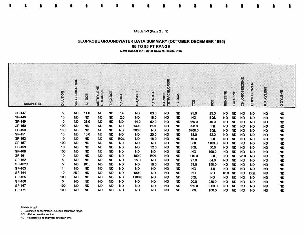
TABLE 5-3 (Page 2 of 3)
GEOPROBE GROUNDWATER DATA SUMMARY (OCTOBER-DECEMBER 1995) 65 TO 85 FT RANGE
New Cassel lndusblal Area Multlslte PSA
5 ND 14.0 ND ND 7.4 10 ND ND ND ND 12.0 10 ND 23.0 ND ND ND 100 ND ND ND ND ND 100 ND ND ND ND ND 10 ND 15.0 ND ND ND 10 ND ND ND ND BQL 100 ND ND ND ND ND 10 ND ND ND ND ND 100 ND ND ND ND ND 10 ND ND ND ND. ND 5 ND ND ND ND ND 5 ND BQL ND ND ND 1 ND ND ND ND ND 10 25.0 ND ND ND ND 100 ND ND ND ND ND 5 ND ND ND ND ND
100 ND ND ND ND ND 100 ND ND ND ND ND
63.0 ND ND 18.0 ND ND 62.0 ND ND BQL ND ND ND ND ND
20.0 ND ND 18.0 ND ND ND ND ND 12.0 ND ND ND ND ND BQL ND ND ND ND ND 10.0 ND ND ND ND ND ND ND ND ND ND ND ND ND ND ND ND ND ND ND ND
25.0 ND
150.0 990.0 3700.0 38.0 10.0 BQL BQL N D
1 10.0 27.0 89.0 N D N D BQL 20.0 560.0 BQL
25.0 BQL 40.0 BQL BQL 52.0 BQL
1100.0 50.0 190.0 BQL. 64.0 150.0 4.8 ND ND
230.0 3000.0 160.0
ND ND ND N D N D ND ND ND ND ND ND ND ND ND BQL ND ND ND ND
All data in pgil. E - Estimated concentration, exceeds calibration range. BQL - Below quantitation limit. NO - Not detected at analytical detection limit.

TABLE 5-3 (Page 3 of 3)
GEOPROBE GROUNDWATER DATA SUMMARY (OCTOBER-DECEMBER 1995) 65 TO 85 FT RANGE
New Cassel lndustrlal Area Multislte PSA
All data in pgA. E - Estimated concentration, exceeds calibration range. BQL - Below quantiiation iiml. ND - Not detected at analytical detection limit.
ND ND BQL ND ND ND ND ND BQL ND ND ND ND ND ND ND ND ND ND ND ND ND ND ND ND ND ND ND ND ND ND ND ND ND ND ND ND ND ND ND ND ND ND ND ND ND ND ND
120.0 ND ND N D ND ND
1900.0 17.0 BQL BQL ND N D N D ND N D ND
BQL 40.0 91 .o 12.0 ND BQL ND
43.0 14.0 ND
.5.0 21 0.0 N D ND ND N D
1900.0 14.0 5.3 11 .o 150.0 ND BQL 18.0 BQL 22.0 BQL ND ND N D ND 6.1
180.0 180.0 ND 17.0
1800.0 ND
11000.0 200.0 36.0 74.0 74.0 N D 32.0 ND BQL 150.0
ND ND ND ND ND ND ND ND ND ND ND ND ND ND ND BQL ND ND ND ND ND ND ND ND ND ND ND ND ND ND ND ND ND ND ND ND ND ND ND ND ND ND ND ND ND ND ND ND ND ND ND ND ND ND ND ND ND ND ND ND ND ND ND ND ND ND ND ND ND ND ND ND ND ND ND ND ND ND ND ND

TABLE 5-4 (Page I of 3)
GEOPROBE GROUNDWATER DATA SUMMARY (OCTOBER-DECEMBER 1995) 85 FT + RANGE
New Cassel lndustrlal Area Multlsite PSA
ND ND ND ND ND ND ND BQL ND BQL ND ND ND 2.9 ND ND ND ND ND ND ND ND ND 5.6 ND 12.0 ND BQL ND ND ND ND ND ND ND ND ND ND
BQL ND ND ND ND ND ND ND BQL ND ND 1.2 ND ND 14.0 ND ND ND ND ND ND ND ND ND ND ND ND ND ND ND ND ND ND ND ND 11.0 ND ND BQL ND ND 5.3 ND ND ND ND ND ND ND ND ND ND ND ND ND ND ND
ND ND ND ND ND N D BQL ND ND N D N D 14.0 ND N D N D BQL N D ND
BQL
BQL ND 1.6 5.2 24.0 ND 9.5 ND ND ND N D
22.0 20.0 8.9 ND ND ND ND 11.0
ND ND ND ND ND ND ND ND ND ND ND ND ND BQL ND ND ND ND ND ND ND ND ND ND ND ND ND ND ND ND ND ND ND ND ND ND ND ND
ND BQL 3.9 ND ND ND 4.3 BQL ND N D N D
BQL ND ND ND ND ND ND 15.0
l7ooO.O 21000.0
BQL N D 34.0
14000.0 7.7 16.0
4400.0 410.0 670.0 11.0 23.0 BQL ND
22000.0 BQL
3200.0 59.0
All data in pgil. E - Estimated conoentretion, exceeds calibration range. BQL - Belw quantitatlon limit. ND - Not detected at analytical detection limit.

TABLE 5-4 (Page 2 of 3)
GEOPROBE GROUNDWATER DATA SUMMARY (OCTOBER-DECEMBER 1995) 85 FT + RANGE
New Cassel industrial Area Multisite PSA
GP-147 GP-152 GP-157 GP-158 GP-159 GP-160 GP-161 GP-I 62 GP-162D GP-164 GP-165 GP-166 GP-167 GP-171 GP-174 GP-I 76 GP-178 GP-178R GP-179
ND 100.0 ND ND ND ND ND ND ND 11.0 ND ND ND ND ND ND ND ND ND ND ND ND ND ND ND ND ND ND ND ND ND ND ND ND ND ND ND ND ND ND ND ND ND ND ND 10.0 ND ND ND ND ND ND ND ND ND ND ND ND ND ND ND BQL ND ND BQL ND BQL ND ND ND ND ND ND ND ND ND ND ND ND ND ND ND ND ND ND ND ND ND ND ND ND ND ND ND ND
All data In wll. E - ~stimated concentration, exceeds calihtlon range. BQL - Below quantiiation limit. ND - Not detected at anawical detedlon Wmlt.
N D BQL ND ND 12.0 BQL 35.0 140.0 ND
130.0 1400.0
N D N D N D N D ND 9.1 N D N D
340.0 ND ND 31.0 ND ND ND ND ND ND ND ND 5.7 ND ND ND ND ND ND ND ND ND ND ND ND ND ND ND ND ND ND ND ND ND ND ND
340.0 ND ND 14.0 ND ND ND ND ND ND ND ND
BQL ND ND ND ND ND ND ND ND
160.0 23.0 BQL BQL 23.0 BQL 52.0 100.0 440.0 BQL 120.0 30.0 820.0 54.0 ND ND
28.0 ND ND
ND ND ND ND ND ND ND ND ND ND ND ND ND ND ND ND ND ND ND ND ND ND ND ND ND ND ND ND ND ND ND ND ND ND ND ND ND ND ND ND ND ND ND ND ND
BQL ND ND ND ND ND ND ND ND . ND ND ND ND ND ND ND ND ND ND ND ND ND ND ND ND ND ND ND ND ND BQL ND ND ND ND ND ND ND ND ND ND ND ND ND ND ND ND ND ND ND

TABLE 5-4 (Page 3 of 3)
GEOPROBE GROUNDWATER DATA SUMMARY (OCTOBER-DECEMBER 1995) 85 FT + RANGE
New Cassel Industrial Area Multlslte PSA
GP-I 80 GP-182 GP-183 GP-I 84 GP-I 85 GP-186 GP-187
1000 ND ND ND ND ND 1600.0 ND ND ND 1200.0 12000.0 ND ND ND ND ND ND 100 ND ND ND ND ND N D ND ND ND 240.0 490.0 ND ND ND ND ND ND 5 ND ND ND ND ND N D ND ND ND ND 11.0 ND ND ND ND ND ND 5 ND ND ND ND ND ND ND ND ND ND BQL ND ND ND ND ND ND 5 ND ND ND ND ND ND ND ND ND ND 56.0 ND ND ND ND ND ND 5 ND ND ND ND ND ND ND ND ND BQL ND ND ND ND ND ND N D 5 ND ND ND ND ND ND ND ND ND ND ND ND ND ND ND ND ND
All data in pgn. E - Estimated concentralion, exceeds calibration range. BQL - Below quantiiation limit. ND - Not detected at analytical detection limit.

amamham were found at 50,000 ppb (50,000 ppb PCE), while GP-145 had 40,200 ppb (1000 ppb cis-1,2-DCE, 2200 ppb TCE, 37,000 ppb PCE). At the shallow depth (water table to 65 ft) the highest concentrations of PCE-related contaminants were found near 770 Main Street, (GP-131, GP-134, and GP-145) while at the greatest depth (85 ft) the highest levels of PCE- related contaminants were found south of Main Street near 770 Main (GP-125, GP-131, GP- 126, and GP-141). A number of TCA-related contamjnantcs were also found in the area of the Block 328 site. These results indicate that TCA-related CO- in excess of 100 ppb are confined to only several points across each depth range.
5.3.3.2 UPlity Mcauf~~twjtg/Wonder Abg Ckmical SSi. Within the Utility Manufacturing/ Wonder King Chemical PSA area a total of 12 groundwater probes were taken. Moderate to low concentrations of PCE-related compounds were found in this area, with the highest concentration found at the 65 to 85 ft depth. The highest concentrations of PCE-related contaminants were found in GP-138 and GP-181, 65 to 85 ft. At GP-138 PCE-related co maminants were found at 344 ppb (24 ppb TCE, 320 ppb PCE), while GP-181 had 235 ppb (17 ppb cis-1,2-DCE, 18 ppb TCE, 200 ppb PCE). At the shallow depth (water table to 65 ft) the highest concentrations of PCE-related contaminants levels were found at GP-138 (32 ppb cis-1,2-DCE 27, ppb TCE, 160 ppb PCE), while at the greatest depth (85 ft) the highest PCE- related contaminant levels were found over a wider area encompassing GP-137, GP-138, and GP-130. However, the contaminant levels at the greatest depth were all less than 100 ppb of PCE-related contaminants. A number of TCA-related contaminants were also found in the Utility ManufacturinglWonder King Chemical site. The results indicate only one point in excess of 100 ppb at GP-137 (65 to 85 ft) located at 50 Bond Street.
5.3.3.3 EnkeUSylvester Street Site. Within the Kinkel/S ylvester Street PS A area a total of 12 groundwater probes were taken. The highest concentrations of PCE-related contaminants were found at point GP-150 (65 to 85 ft) at 62 Kinkel Street and at point GP-173 (65 to 85 ft) at 24 Kinkel Street. At GP-150 PCE-related contaminants were found at 4080 ppb (380 ppb cis-1,2-DCE, 3700 ppb TCE), while GP-173 had 2470 ppb (270 ppb 1, 1,l-DCE, 120 ppb cis- 1,2-DCE, 1900 ppb TCE, 180 ppb PCE). At shallow depths the highest concentrations of PCE- related contaminants were also found at 62 Kinkel Street and 24 Kinkel Street. Because of difficulty encountered in this area of geoprobing to depths greater than 75 ft, only a few samples were collected at depths greater than 85 ft. The highest concentration of PCE-related co *aminants at a depth greater than 85 ft was found at GP-147, upgradient of GP-150 yet still located at 62 Kinkel Street. The highest concentrations of TCA-related contaminants were faund at GP-147 (water table to 65 ft) and at GP-173 (water table to 65 ft). At GP-147 TCA- related contaminants were found at 350 ppb (140 ppb 1,l-DCA, 210 ppb 1 ,1 , 1-TCA), while GP- 173 had 960 ppb (1 80 ppb 1,l -DCA , 780 ppb 1,1,1 -TCA) . At greater depth, 65 to 85 ft,
5-8 Lawler, Matusky & Skelly Engineers LLP
m

the TCA-related compound concentrations were more evenly distributed throughout the area, yet the concentration values were generally less than those observed at shallow depth. Of the few points collected at the greatest depth sampled, the highest concentration of TCA-related contamination was detected at GP-147 at 62 Kinkel Street.
5.3.3.4 Gaden/Hopper S tmt SSi. Within the GardedHopper Street PSA area a total of 19 groundwater probes were installed. The highest concentration of PCE-related contaminants were found at the greatest depth sampled (greater than 85 ft); however, very high concentrations were also found at 65 to 85 ft north of Main Street. The highest concentrations of PCE-related co nimhnts were found at point GP-167 (85 ft +) located south of 95 Hopper Street. At GP- 167 PCE-related contmhnts were found at 3820 ppb (820 ppb TCE, 3000 ppb PCE). North of Main Street concentrations of PCE-related contaminants in excess of 1000 ppb were found at shallow depth (water table to 65 ft). Low concentrations (less than 20 ppb) of TCA-related contaminants were also found in the GardenMopper Street area. An anomalously high concentration of TCA-related contaminants (210 ppb) was found at GP-184 (65 to 85 ft) (210 ppb = 2 10 ppb TCA alone).
5.4 SOIL PROBE RESULTS
5.4.1 NYSDEC Site Investigation Soil Probe Results
The soil probe results from the NYSDEC site investigation include sample data collected in 1993 (Phase I SI) and 1994 (Phase 11 SI). A detailed presentation and discussion of these results is found in the SI report (LMS 1995). The data fiom these soil probes are shown on the soil maps in Chapter 6.
5 A.2 Private Investigation Studies and Reports
5 A2.l Block 328 Site.
P h e XI Investigation Report for Bbck 328, LoLF 142, 154, 160, 162, 178, 179, 181; October 1995; Anson aCVirr,nmental. Eleven subsurface soil samples, 30-32 ft below the surface, were collected by Anson Environmental during a Phase I1 investigation of properties located at 750 and 770 Main Street and 1099 and 11 11 Old Country Road. All analytical parameters tested had concentrations below the laboratory detection limit, with the exception of methylene chloride and acetone. These two compounds are common laboratory contaminants (used in the
sample drying process). These compounds were identified in the laboratory blank and, therefore, are not representative of the subsurface soil samples.
r~f~-14-96 9:3Qam/HSS397/650-123/ChapS 5-9 Lawler, Matusky & Skelly Engineers LLP

Phase II Investigation of Utility Manufucturing/Wonder King Chemical Site; October 1995; Anson Envirr,nmental. Anson Environmental colleaed subsurface soil samples during a Phase II investigation of Utility ManufacturingMronder King Chemical site located at 700-712 Main Street. The soil borings were installed through on-site dry wells and in areas adjacent to current and former dry well locations. Sampling results are summarized in Table 5-5; only contaminated samples are summarized.
5.4.2.3 KinkeUSy lvester Street Site.
Sit. Invdgation Report of A&hem Corpomtio~ October 1991; Edcr Associous. No VOCs were detected in any of the soil samples collected by Eder Associates in 1991 for Adchem
corp.
5.4.2.4 Garden/Hopper Street Site.
Subsurfae Investigation of 550 Moin Streer; Ocuber 1992; EEA, Inc. Soil sampling was conducted during a Phase I1 investigation of 550 Main Street by EEA, Inc., in 1992. No contamination was detected in any of the soil samples.
Closure P h ; Soil Boring Investigation for Petroleum Heat and Power Company, Inc.; 18 June 1992; WilIiant F. Cosulich Associates, P.C. (WFC) The results of a soil boring investigation conducted by WFC in June 1992 at the Petroleum Heat and Power Company
lli located at 522 Grand Boulevard are summarized in Table 54 .
5.4.3 Multisite PSA Soil Probe Results I
Multisite PSA soil probe data are summarized in Table 5-7. The data are also summarized by I
related contaminants and depth as shown in the soil maps in Chapter 6. In general, the contaminant levels in the soils are much lower than the groundwater. It is believed that many of the VOCs have migrated away or were lost during sampling due to the sandy, porous nature 111
of many of the soil samples.
mR 5.4.3.1 Block 328 Site. Soil probe sample concentrations ranged ffom none detected (ND) in SGP-132 and SGP-156 to as high as 70 ppb of PCE-related contaminants and 122 ppb BTEX- related contaminants in SGP-125 (15 to 17 ft). I,
I,
5- 10 Lawler, Matusky & Skelly Engineers LLP
IP


TABLE 5-6
WFC ASSOC., P.C. JANUARY 1992 SOIL PROBE DATA SUMMARY
New Cassel Industrial Area Multisite PSA
*
GEOPROBE POINT DEPTH 1,l-DCA 1,i-DCE t-I ,2-DCE ETHYLBENZ EN€ PC€ TOLUENE 1 , I ,I -TCA
.-. *
All data In vgll. ND - Not detected at analytical detection limit.
+Disk No.: HS8455 B\REWRT.XLS WFC 3/l4/084:1935 PM+
i 1 I I I I I I t I I 1 1 I I I I I I

TABLE 5-7 (Page 1 of 2)
OEOPROBE SOILS DATA SUMMARY (OCTOBER-DECEMBER 1995) New Catsel Industrial Area Multisite PSA
ND BQL ND 70.0 ND 390.0 ND 4.4 ND ND ND ND ND ND ND ND ND 5.5 ND ND ND ND ND ND ND ND ND ND ND ND ND ND ND 2.8 ND ND ND ND ND ND ND ND ND ND N D ND ND ND ND ND
ND ND ND BQL ND ND ND 16.0 ND ND ND ND ND ND ND ND ND ND ND ND ND ND ND ND ND ND ND ND ND ND ND ND ND ND ND ND ND ND ND ND ND ND ND ND ND ND ND ND ND ND ND ND ND ND ND ND ND ND ND ND ND ND ND ND ND ND ND ND ND ND ND ND ND ND ND ND ND ND ND ND ND ND ND ND ND ND ND ND ND ND ND ND ND ND ND ND ND ND ND ND
2.7 30.0 ND BQL N D N D N D ND N D N D N D N D ND ND ND ND ND ND ND ND ND N D ND ND N D
All data in pgn. E - Estimated concentration, exceeds calibration m e . BQL - Below quantitation limit ND -Not detected st analytical detedion limit.

TABLE 5-7 (Page 2 of 2)
GEOPROBE SOILS DATA SUMMARY (OCTOBER-DECEMBER 1995) New Cassel Industrial Area Multisite PSA
All data In eg/l. E . Estimated concentration, exceeds calibration range. BaL - Below quantibtion limit ND - Not detected at analytical dstsction limit.
ND 290000.0 640000.0
560 E BQL ND ND ND ND N D N D N D ND ND
ND ND ND ND ND ND ND ND ND ND ND BQL ND ND ND ND ND ND ND ND ND ND ND ND ND ND ND ND ND N D ND ND ND ND ND ND ND ND ND ND ND ND ND ND ND ND ND ND ND ND ND ND ND ND ND ND ND ND ND N D ND ND ND ND ND ND ND ND ND BQL 50.0 24.0 ND ND ND BQL 4800.0 2400.0 ND ND BQL ND 14000.0 BQL

5.4.3.2 UtBy Mmucf4ctwhg/Wonder King Chemical Site. Soil probe sample co~lcentrations ranged from ND in SGP-129, SGP-137, and SGP-140 to 5.5 ppb PCE-related comaminams (5.5 ppb PCE) in SGP-130 (10-12 ft).
5.4.3.3 &keUSyIvester Street Site. Soil probe sample concentrations ranged from ND in SGP-142, SGP-148, SGP-149, SGP-153, SGP-154, and SGP-168 to percent levels of PCE- related contaminants in SGP-150. The soils retrieved from SGP-150 were a fine-grained, sludge-like material believed to be associated with an abandoned leachpool in this area.
5.4.3.4 Gordm/Hopper Street Site. A single additional soil sample was and analyzed in the GardedHopper Street area during the muftisite PSA. SGP-172 showed increasing concentrations of B'IEX-related compounds with depth. At 40-42 ft BTEX-related contaminants were found at 14,000 ppb (14,000 ppb m,p-xylenes).
5.5 MONITORING WELL SAMPLING RESULTS
5.5.1 NYSDEC Site Investigation Monitoring Well Sampling Results
The monitoring well sampling results from the NYSDEC site investigation include sample data
collected in 1993 (Phase I SI) and 1994 (Phase II SI). A detailed presentation and discussion of these results is found in the site investigation report (LMS 1995). Data from this sampling event of these monitoring wells are shown on the plume maps in Chapter 6.
5.5.2 NYSDEC 1995 Monitoring Well Sampling Results
Table 5-8 presents the results of the VOC analyses performed on the groundwater samples collected by NYSDEC during the 1995 monitoring well sampling survey. Data from this sampling event are shown on the plume maps in Chapter 6.
5.5.2.1 B k k 328 Site. Seven of the monitoring wells sampled by NY SDEC in 1995 were in the Block 328 plume area (ANSON MW-6, ANSON MW-5, ANSON MW-3, ANSON MW-4, ANSON MW-1 lA, EZ-EM MW-2, UN-4). One of the wells sampled was upgradient of the Block 328 plume area (NC-14). None of the Anson well samples collected in the Block 328 plume area contained detectable concentrations of VOCs. Tbe sample collected at EZ-EM MW- 2 contained 17 ppb of FCE. The sample collected at UN-4 contained low concentrations of 1,2- DCE (17 ppb), moderate concentrations of TCE (81 ppb), and high concentrations of 1,1,1- TCA (130 ppb) and PCE (210 ppb). The sample from NC-14, upgradient of Block 328, contained trace amounts of 1 , 1 ,I -TCA (3 ppb).
r p f ~ ~ % 1 l:~~83971650-123/~hap~ 5-1 1 Lawler, Matusky & Skelly Engineers LLP

TABLE 5-8 (Page 1 of 4)
NYSDEC MONITORING WELL SAMPLE DATA SUMMARY (SEPTEMBER-OCTOBER 1995) New Cassel Industrial Area Multisite PSA
- . . . , . . . . . . . . , . .
W W W
P - 3 4 w z s E 0 5 s A
u U I w m 2 2 0 : w w e W
3 0 $ 2 W -.. N- Y r, 4ru g 9
WELL ID W 5 1 0 r - r r r O C 2 m e ~ w
AIMW-656 MAlN D AIMW-656 MAlN U ANSON MW-I IA ANSON MW-2 ANSON MW-3 ANSON MW-4 ANSON MW-5 ANSON MW-6 ANSON MW-9 EZ EM MW-2 GRAYCO MW-I GRAYCO MW-3 HlCKSVlLLE 5-2 HlCKSVlLLE 5-3 N-11850 N-11842 N-1 I843
All data in pg/l. d - Concentration recovered from diluted sample. j - Estimated concentration; compound present below quantiltlon limit. ND - Not detected at analytical detection Ilmit.
+Disk No.: HS8455 B:\NYSDEC.XLS NYSDEC 3H 1198 8:38:W AM+

Val- hat' C
vaa-z' C
nnnnnnnnnnnnnnnn Z Z Z Z Z Z Z Z Z Z Z Z Z Z Z Z
nnnnnnnnnnnnnnnn Z Z Z Z Z Z Z Z Z Z Z Z Z Z Z Z
n n n n n n n n n n n n n n ~ n Z Z Z Z Z Z Z Z Z Z Z Z Z Z Z Z

TABLE 5-8 (Page 3 of 4)
NYSDEC MONITORING WELL SAMPLE DATA SUMMARY (SEPTEMBER-OCTOBER 1995) New Cassel Industrial Area Multisite PSA
UI W W
9 3 P 3 3 UI s J Z W S W
9J " ).LL
. g 2 s $ w s -, C - W
'I W O U WELL ID 5 so r P F r r O + c e
NC-27 ND 9.0 b j 3.0 j ND ND ND 6.0 ND 8.0 7.0 ND ND ND ND ND NC-3 ND ND ND ND ND ND ND ND ND 3.0 ND ND ND ND ND NC-4 ND ND ND ND ND ND 20 ND 2.0 6.0 ND ND ND ND ND NC-5 ND ND ND ND ND ND 5.0 ND 1.0 4.0 ND ND ND ND ND NC-7 ND 13b 12 2.0 j ND ND 52 ND 26 20 7.0 7.0 6.0 ND ND NC-8 ND ND ND ND ND ND ND ND 2 11 ND ND ND ND ND NC-9 ND ND 8.0j 4.0 j 330d ND 62 ND 38 280d ND ND ND ND ND ROOSEVELTFlELD#l ND ND ND ND ND ND 1.0j ND ND 1.0j ND ND ND ND ND ROOSEVELT FIELD #I0 ND ND ND ND ND ND ND ND ND ND ND ND ND ND ND ROOSEVELT FIELD #2 ND ND 1.0 j ND ND ND ND ND 28 1.0 ND ND ND ND ND ROOSEVELTFlELD#S ND ND ND ND ND ND ND . ND 5 6 ND ND ND ND ND . UN-1 0 ND ND 4.0 j 14 ND ND 99 ND 10 120 ND ND ND ND ND UN-11 ND ND 1.Oj 12 ND ND 91 ND 5.0j 91 ND ND ND ND ND UN-19 ND ND ND 6.0 j 6.0 j ND 4.0 j ND 3.0 j 9.0 ND ND ND ND ND UN-22 ND ND ND 3.0j 87 ND 3.0j ND 100 290d ND ND ND ND ND UN-23 ND ND ND ND 8.0 ND 3.0j ND 340d 74 ND ND ND ND ND
All data In pg/l. b - Found in associated blanks. d - Concentration recovered from diluted sample. j - Estimated concentration; compound present below quantitation limit. ND - Not detected at analytical detection limit.
+Disk No.: HS8455 B:WYSDEC.XLS NYSDEC 3llltQ6 9:8:38:M) AM+

TABLE 5-8 (Page 4 of 4)
NYSDEC MONITORING WELL SAMPLE DATA SUMMARY (SEPTEMBER-OCTOBER 1995) New Cassel Industrial Area Multisite PSA
.. W
W 3 # E $ z 0 w $ 5; S x w g ? & 8 8 5 9
P p W
4 4 4 U1 3 3 Z J
w r -_ -.. "! v# -, u u ul WELL ID > S O - r - r r O + 2 a m E o w
UN-24 ND ND ND ND l.Oj ND 4.0j UN-25 ND ND ND ND ND ND ND UN-4 ND ND ND ND 17 ND 130 UN-68 ND ND ND ND 2.0j ND ND UN3 ND ND ND ND ND ND 7.0 j UT-1 ND ND 2.0j 1.0j 6.0j ND 13 WESTBURY WELLMO ND ND ND ND ND ND ND WESTBURY WELL#14 ND ND ND ND ND ND ND WESTBURY WELL#16 ND ND ND ND ND ND ND WESTBURY WELL#9 ND ND ND ND ND ND ND
All data In pgn. d - Concentration recovered from diluted sample. e - Estlmated concentration; exceeds GCIMS calibratlon range. j - Estimated concentration; compound present below quantitatlon Iimlt. NO - Not detected at analytical detection lirnlt.
+Dik No.: HS8455 8:WOEC.XLS NYSDEC W 1tW 8:38:00 AM*

5.5.2.2 Utility Mmufmturing/Wonder King Chemical Site. Three of the monitoring wells
sampled by the NYSDEC in 1995 were in the Utility ManufacatringWonder King Chemical site plume area (ANSON MW-9, NC-25, UT-I). No contaminstion was detec&d in the Anson well sample (ANSON MW-9). 1,l ,-DCE, 1,2-DCE, 1 , 1-DCA, 1,1,1-TCA, TCE, and PCE were found in concentrations ranging fiom 5 to 51 ppb in groundwater samples from NC-25. 1,l-DCE, 1,2-DCE, 1, IDCA, 1, 1, 1-TCA, TCE, and PCE were dekctd in low concentrations ranging from 1 to 13 ppb in samples from UT-1.
One of the monitoring wells sampled by NYSDEC in 1995 was upgradient of the Utility ManufaCturingWonder King Chemical site plume area (UN-3). The water sample from this well contained a concentration of 2 ppb of PCE and 7 ppb of TCA.
Five of the monitoring wells sampled by NYSDEC in 1995 were downgradient of the Utility ManufacauinglWonder King Chemical site plume area (N-11855, NC-12, NC-26, and NC-27). No contamination was detected in samples from monitoring wells NC-12 and NC-26. Low concentrations of 1,1,1-TCA were detected in samples from wells N- 1 1855 and NC-27 (12 and 6 ppb, respectively). Small amounts of 1,l-DCE (3 ppb), TCE (8 ppb), and FCE (7 ppb) were detected in samples from NC-27.
5.5.2.3 KfnkeI/SyIvester Street Site. Two of the monitoring wells sampled by NYSDEC in 1995 were located in the KinkeVSylvester Street site plume area (NC-9 and N-11844). The groundwater sample from N- 1 1844 contained low concentrations of 1,1,1 -TCA and FCE (8 and 5 ppb), respectively. The sample from NC-9 contained a variety of VOC compounds: 1,l- DCE and 1,l-DCA were detected at low levels (8 and 4 ppb, respectively), 1,1,1-TCA and
1
TCE were detected at moderate levels (62 and 38 ppb, respectively) and 1,2-DCE and PCE were detected at high concentrations (330 and 280 ppb, respectively).
I
Fourteen of the monitoring wells sampled by NYSDEC in 1995 were located upgradient of the Kinkel/Sylvester Street site plume area (N-11842, ANSON MW-2, NC-5, NC-4, GRAYCO
I
MW-1, NC-15, NC-13, N-11845, GRAYCO MW-3, UN-11, UN-10, AIMW 656 Main U, AIMW-656, and Main-D). VOC contamination was determined in every sample taken from these wells except NC-13, where no contamination was deteaed. Only five of the samples from Im
these wells contained any single VOC concentration greater than 30 ppb. Samples from UN-11 and UN-10 contained moderate to high concentrations of 1,1,1-TCA (91 and 99 ppb, I
respectively) and PCE (91 and 120 ppb, respectively). Groundwater sampled at AIMW-656 Main-D contained low concentrations of 1,2DCE (23 ppb) and TCE (28 ppb); a moderate to
.I high concentration of PCE (59 ppb), 1, IDCE (130 ppb), and 1, IDCA (150 ppb); and a very high concentration of 1 , 1 , 1-TCA (930 ppb). The sample from N- 1 1842 contained low
5-12 Lawler, Matusky & Skelly Engineers LLP
m

concentrations of 1,l-DCE (2 ppb), TCE (16 ppb), and PCE (3 ppb) and moderate concentrations of 1,1,1 -TCA (87 ppb) .
Two of the monitoring wells sampled by NYSDEC in 1995 were located downgradient of the Kinkel/Sylvester Street plume area (N-11854 and NC-3). The sample taken fiom N- 1 1854 contained a trace concentration of 1, 1,l-TCA (2 ppb). The sample taken from NC-3 contained a trace concentration of PCE (3 ppb).
5.5.2.4 G d e d H o p p e r Street Site. Nine of the monitoring wells sampled by NYSDEC in 1995 were in the GardedHopper Street plume area (UN-24, UN- 19, N-11874, N-11843, NC-8, UN-23, N- 1 1850, NC-18, and UN-22). Samples fiom four of these wells (UN-19, N-11843, NC-8, and NC-18) contained low cancentrations of VOC compounds, with no single compound concentration exceeding 24 ppb. The sample collected fiom UN-24 contained low concentrations of 1,2-DCE and l,l , 1-TCA (1 and 4 ppb, respectively) and moderate concentrations of TCE and PCE (51 and 39 ppb, respectively). Samples ftom UN-23, N- 11850, N-11847, and UN-22 contained concentrations of VOC compounds greater than 250
ppb. The sample from UN-23 contained TCE at a concentration of 340 ppb and PCE at a concentration of 74 ppb. The sample from N-11850 contained TCE at a concentration of 52 ppb and PCE at a concentration of 220 ppb. The sample from N-11847 contained a moderate to high concentration of TCE (96 ppb) and a high concentration of PCE (460 ppb). The sample from UN-22 contained TCE at a concentration of 100 ppb, FCE at a concentration of 290 ppb, and 1,2-DCE at a concentration of 87 ppb.
Two of the monitoring wells sampled by NYSDEC in 1995 were upgradient of the Garden, Hopper Street plume area (NC- 16 and NC- 17). No contamination was detected in the sample collected from NC-17. Moderate concentrations of FCE (56 ppb) were detected in the sample collected from NC- 16.
Four of the monitoring wells (N- 1 1858, UN-25, NC-20, and NC-7) sampled by NY SDEC in 1995 were downgradient of the GardedHopper Street plume area. No site-related VOC contamination was detected in the sample collected at N-11858. Low levels of PCE (2 ppb) were detected in the sample collected at UN-25. Low concentrations of VOCs, not in excess of 18 ppb for any one compound, were detected in samples from UN-68 and NC-20. Concentrations of chlorinated VOCs ranging from 2 to $2 ppb were detected in the sample collected from NC-7. Also detected in the sample collected at NC-7 were low concentrations of BTEX compounds: benzene (7 ppb), toluene (7 ppb), and chtorobenzene (6 ppb). The sample from NC-7 was the only sample in the entire monitoring well survey that contained any BTEX compounds.
~ft3-26-96 3:12pmMS8397/6%-127/Chap5 5-13 La wler , Matusky & Skelly Engineers LLP

5.5.3 Private Investigation Studies and Reports
5.5.3.1 Block328 Site.
Phase II Investigation Report for Block 328, Lots 144, 157, 169, 174, and 179; 18 M m h 199l; Anson Envhnmenfal. The results of groundwater samples collected by Anson Environ-
mental for the Phase 11 investigation of 695 Summa Avenue are summarized in Table 5-9. No
maps were contained in this report showing the locations of the wells that were sampled. We have assumed that these wells are ANSON MW-1, ANSON MW-2, ANSON MW-3, ANSON MW-4, and ANSON MW-5.
5.5.3.2 Utility Mmufacturing/Wonder King Chemical Site.
Phase II Investigation Repoi? for Block 328, Lots 46 and 176; August 1992; Anson Environmental. The results of groundwater sampling analyses conducted by Anson Environ- mental on 12 May 1992 for the Phase 11 investigation of Reliable Machine Works and Utility Manufacturing properties at 694 and 700 Main Street are as follows:
TOTAL VOCs (in ppb)
ANSON MW-8 49' ANSON MW-9 0
'1,2-DCE 13 1,1,1 -TCA 26 PCE 10
Phase II Investigation Report for B k k 328, LoLF 159, 170, 171, 161, 166, 23-26, 29-45, 63- 67, 117, 58-61, 118, 162, 186, 142, 154, I78, 179, 181, 185, 183, 173, mrd Block 160, LOB
I
129-133, 173-177; M q 1992; Anson Environmental. The results of a Phase 11 investigation conducted by Anson Environmental in May 1992 on lots 159, 170, 171, 164, 166, 23-26, 29- I
328 and lots 129-133, and 173-177 in Block 160 are summarized in Table 5-10. D
5.5.3.3 Kiitkel/Sylvester Street Site.
Sire Investigation Repoi? of Adchem Corporation; October 1991; Eder Associates. Aquifer
Driling and Testing installed three monitoring wells on Adchem properties in March 1991. The m
results of groundwater samples collected from these wells or NCDOH wells in the vicinity of the Adchem properties are summarized in Table 5-1 1. Groundwater from ADCHEM MW-1,
111
rpfl3-26% 3:12pdHS8397/650-123/C~S 5-14 Lawler, Matusky & Skelly Engineers LLP

TABLE 5-9
ANSON ENVIRONMENTAL 1989 MONITORING WELL DATA SUMMARY
New Cassel Industrial Area Multisite PSA
3 9 s a 2 Y UI
W 2 3 W
Z 3 3 e 'Y
W
W r: 0
3 0 C
W WELC ID u F I- w 2 T.
ANSON MW-1 ND ND ND ND ND ND ND ANSON MW-2 53 2.0 j ND ND ND ND ND ANSON MW-3 ND ND ND ND ND ND ND ANSON MW-4 ND ND ND ND ND ND ND ANSON MW-5 170 ND l . 0 j 3.0 j 13 2.0 j ND
All data in pg~l. j - Estimated value. ND - Not detected at analytical detection limit.
+Disk No.: HS8455 B:\REPORT.XLS 695 Summa Avenue 3/14/96 4:27:25 PM+
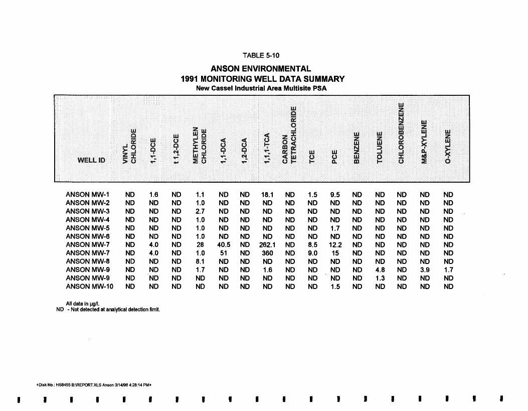
TABLE 5-10
ANSON ENVIRONMENTAL 1991 MONITORING WELL DATA SUMMARY
New Cassel Industrial Area Multisite PSA
ANSON MW-1 ANSON MW-2 ANSON MW-3 ANSON MW-4 ANSON MW-5 ANSON MW-6 ANSON MW-7 ANSON MW-7 ANSON MW-8 ANSON MW-9 ANSON MW-9 ANSON MW-10
All data in pgn. ND - Not detected at analytical detection limit.
+Disk No.: HS8455 B:\REPORT.XLS Anson 3/14/88 4:28:14 PMt

TABLE 5-1 1 ADCHEM CORPORATION
1991 MONITORING WELL DATA SUMMARY New Cassel Industrial Area Multisite PSA
ADCHEMMW-1 5/2/91 ND 22 ND ND 10 ND ND ND ND 36 72 16 ND ND ND ADCHEM MW-1 3/21/91 ND 38 ND ND 13 ND ND ND ND 44 140 19 ND ND ND ADCHEM MW-2 5/2/91 ND ND ND ND ND ND ND ND ND 10 12 ND ND ND ND ADCHEM MW-2 3/22/91 ND ND ND ND ND ND ND ND ND 7.0 9 ND ND ND ND ADCHEM MW-3 5/2/91 ND ND ND ND ND ND ND ND ND 4.0 16 ND ND ND ND ADCHEM MW-3 3/22/91 ND 6.0 ND, 5.0 ND ND ND ND ND 21 71 , 22 ND ND ND NC-4 3/18/91 ND ND ND ND ND ND ND ND ND 6.0 42 4.0j ND ND ND NC-5 3/19/91 ND ND ND ND ND ND ND ND ND ND 6.0 7.0 ND ND ND NC-6 3/19/91 ND ND ND ND ND ND ND ND ND ND ND ND ND ND ND NC-9 3/18/91 ND 20 ND 11 19 ND ND ND ND 150 110 16 ND ND ND NC-21 3/19/91 ND ND ND ND ND ND ND ND ND 140 11 10 ND ND ND NC-23 3/19/91 ND 5.0 ND ND ND ND ND ND ND ND 8.0 10 ND ND ND NC-24 3/18/91 ND ND 210 70 j ND ND ND ND ND 90 1,900 ND ND ND ND N9938 3/25/91 ND ND ND 170 ND ND ND ND ND 95 1,800 130 ND ND ND All data in pg/l.
j - Estimated value. ND - Not detected at analytical detection limit.
+Disk No.: HS8455 B:\REPORT.XLS Adchem 3/14/88 4:28:59 PM+

ADCHEM MW-2, ADCHEM MW-3, N C 4 , NC-5, NC-6, NC-9, NC-21, NC-23, NC-24, and N-9938 were sampled. Only data collected by Eder Associates are presented.
5.5.3.4 G(Uden/Hopper Street Site.
Subsurface Investigation of 550 M& Street; Ocuber 1992; EEA, Inc. Three permanent
monitoring wells were installed during a Phase II investigation of 550 Main Street conducted by EEA, Inc., in 1992. Groundwater samples were collected from these wells; results of this sampling are summarized in Table 5-12.
5.5.4 Results of Multisite PSA Monitoring Well Groundwater Sampling
Table 5-13 presents the results of the VOC analyses performed on the groundwater samples collected by LMS during the 1995 monitoring well sampling survey.
5.5.4.1 B k k 328 Site. The groundwater samples from monitoring wells EZ-EM MW-1 and ANSON MW-10 (located within Block 328) sampled by LMS in 1995 did not contain any of the VOCs tested for in this investigation.
5.5.4.2 Utility Mmuf&ringNYonder King Chemical Site. None of the monitoring wells sampled by LMS are directly within the Utility ManufacturinglWonder King Chemical site plume area.
5.5.4.3 K;inkeUSylves&r Street Site. Monitoring wells AIMW-33, DOAK MW-2, and DOAK I
MW-3 lie within the KinkellSylvester Street site plume area. Groundwater samples from DOAK MW-3 contained 340 ppb of cis-1,2-DCE. 1 , 1 ,I -TCA was detected in concentrations of 140 and 24 ppb in wells DOAK MW-2 and AIMW-33, respectively. Groundwater samples I
from monitoring well AIMW-33 also contained between 10 and 21 ppb of 1, 1-DCE, TCE, and PCE.
II,
5.6 SAMPLE SPLITS II
A total of 15 sample splits were collected during the multisite PSA and sent to Aquatec Laboratories as a quality control measure. With the exception of DOAK MW-2 and DOAK
I
MW-3, results of the base laboratory analyses were in close agreement with those furnished by the mobile laboratory, as shown in Table 5-14. The reasons for the differences seen in the two Doak wells are likely to be the results of sample dilution. Samples DOAK MW-2 and -3 were Is
both analyzed at a dilution of 100 to 1 by the mobile laboratory while the base laboratory used
5-15 Lawler, Matusky & Skelly Engineers LLP
I

TABLE 5-12
EEA INC. 1992 MONITORING WELL DATA SUMMARY
New Cassel Industrial Area Multisite PSA
- WELL ID 1,l ,I-TCA TCE PC€
,
All data in pgn. NO - Not detected at analytical detection limk.
+Disk No.: HSB455 B:\REPORT.XLS EEA Inc 3114196 4:29:28 PM+

TABLE 5-13
MONITORING WELL GROUNDWATER DATA SUMMARY (NOVEMBER-DECEMBER 1995) New Cassel lndustrlal Area Multislte PSA
AIMW-33-1 AIMW-670 MAIN-D AIMW-670 MAIN-U AIMW-70 STATE D ANSON MW-I0 DOAK MW-2 DOAK MW-3 EZ EM MW-I N-9938
All data in pgn. E - Estimated concentration, exceeds calibration range. BQL - Below quantiiatiin limit. ND - Not detected at analytical detection limit.
ND 32.0 BQL 18.0 ND ND ND BQL ND
ND 32.0 BQL ND ND ND
340.0 ND ND
24.0 320.0 19.0 62.0 ND
140.0 BQL ND
160.0
ND ND N D BQL N D N D N D ND ND
10.0 48.0 110.0 13.0 ND ND BQL ND ND
21 .o 220.0 ND BQL ND ND ND ND ND

TABLE 5-14 (Page 1 of 2)
GROUNDWATER CONFIRMATORY SAMPLE DATA SUMMARY (NOVEMBER 1995) New Cassel Industrial Area Mult is i te PSA
6P440 1 60' 622 GP-140 ( 93' -96& OP-141 (, 73' -75'1 6P-174 173' -75') QP-174 1 93' 45') BASE MOBILE . BASE MOBILE BASE MOBILE BASE MOBILE BASE MOBILE
PARAMETER LAB LAB LAB LAB LAB LAB LAB LAB LAB LAB
[DL: 500:Il VOLATILE OROANICS (pgll) Ill-Dichloroethylene 1.2 50 ND ND ND ND ND ND ND ND I, I -Dichloroethane 2.4 BQL 0.6 ND ND ND ND ND ND ND 1, I, I-Trichloroethane 17 59 ND ND ND ND 32 40 ND ND Trichloroethylene 4.0 5.6 ND ND 690 1,100 13 14 ND ND Tetrachloroethylene 1.6 BQL ND ND 12,000 14,000 150 180 110 220 cis-I ,2-dichloroethylene 2.4 BQL ND ND 550 1,100 ND ND ND ND
QP-175 (73' -75'1 OP-176 173' -75'1 OP-178 f93' -95'1 OPb178R (73' - 75'1 QP-17s V3' -753 EASE MOBILE BASE MOBILE BASE MOBILE BASE MOBILE BASE MOBILE
PARAMETER t A B LAB LAB LAB LAB LAB LAB LAB LAB LAB
[DL: 15:11 [DL: 0 1 1 VOLATILE OROANICS (MA) 1,l -Dichloroethylene I, I -Dichloroethane Benzene I ,I, I-Trichloroethane Trichloroethylene Tetrachloroethylene cis-I ,2-dichloroethylene o-Xylene
14.0 BQL ND 91 5.3 ND ND ND
ND ND BQL 12 ND 24 ND 5.6
ND ND ND BQL 28 170 9.1 ND
ND ND ND BQL ND ND ND ND
I
All data in pgn. ND - Not detected at analytical detection limit. DL - Diluted sample analysis BQL - Below quantitation limlt.
*Disk No.: HSB455 B:\BSOlZ.XLS VOAs (2) 3114198 43739 PM*

TABLE 5-14 (Page 2 of 2)
GROUNDWATER CONFIRMATORY SAMPLE DATA SUMMARY (NOVEMBER 1995) New Cassel Industrial Area Multisite PSA
L
OP-179 193' -95'1 QP-181 (93' -95') QP-181 (82' 84'1 DOAK MW-2 DOAK MW-3 BASE MOBILE BASE MOBILE BASE MOBILE BASE MOBILE BASE MOE1;ILE
PARAMETER LAB LAB LAB LAB LAB LAB LAB LAB LAB LAB
d
VOLATILE ORGANICS (pgll) I, I-Dichloroethylene ND I, I-Dichloroethane N D Benzene ND I, 1.1-Trichloroethane ND Trichloroethylene ND Tetrachloroethylene ND cis-I ,2-dichloroethylene ND o-Xylene ND Methylene chloride ND
ND ND N D 32 10 110 BQL ND ND
ND ND ND 14
BQL 36
BQL ND ND
ND ND ND BQL BQL ND 340 ND ND
AII data In pgn. DL - Diluted sample analysis
ND - Not detected at analytical detection limit BQL - Below quantitation Iimlt.
+Disk No.: HSB45b B:W122.XLS VOAs (2) 31141W) 4:37:3Q PM+
I 1 I I I I 1 1 E I t

a smaller dilution factor. The higher sample dilutions pedormed by mobile laboratory prevented the detection of several of the low-level contamhn~. For example, PCE was found at 9.3 ppb in DOAK MW-2 by the base laboratory while the mobile laboratory reported ND. The total VOCs appear to be in good agreement between both laboratories, even for the two samples with the highest differences among individual compounds. The high dilutions used by the mobile laboratory were necessary to avoid problems associated with high levels of cis-1,2- DCE and 1,l-TCA
Overall, the sample splits indicate the mobile laboratory data are of quality equal to a NY SDOHuxtified base laboratory.
5-16 Lawler, Matusky & Skelly Engineers LLP

CHAPTER 6
CONCLUSIONS
This chapter presents the conclusions of the investigation. The data collected at each of the sites, the impacted or plume areas, a discussion of each facility, and a determination whether each facility has discharged a hazardous waste and caused a significant environmental impact are presented. The chapter is divided according to site. For each site the groundwater plume and soil data compiled fkom all the data sources are presented. The plume maps show individual point locations and measured PCE- and TCA-related contaminants for each depth range. The PCE-related contaminants are the sum of the individual measured concentrations of PCE, TCE, cis-1,2DCE, trans-1,2DCE, 1,l-DCE, and vinyl chloride. The TCA-related contaminants are the sum of the individual measured concentrations of 1 , 1 ,1 -TCA, 1,l -DC A, and 1,2-DCA. The BTEX-related contaminants are the sum of the individual measured concentrations of benzene, toluene, ethylbenzene, and total xylenes, and are shown on the facility maps. If a sample point was sampled more than once, the highest documented concentrations are plotted. If a sample point on a map does not have a reported contaminant value next to it, either no sample was collected at that particular depth or a sample was collected but the contaminant being plotted was not analyzed in the sample.
According to Title 13, Article 27, of the State Environmental Conservation Law, the New Y ork State Registry of Inactive Hazardous Waste Disposal Sites must include all known hazardous waste sites. To be included in the registry, it must be confirmed that hazardous wastes were disposed of on the site or are present on the site. Sites with confmed hazardous wastes are then classified according to the effects of that contamination on the environment or human health. Classification 2 is for sites for which there is information sufficient to determine that they pose a significant threat to the public health or environment. Classification 2a is for sites with insufficient information to make a significant threat determination; and Class 3 is for sites that do not pose a significant threat. Sites without documentation of hazardous waste disposal are not included on the registry; however, they may be investigated further if it is suspected that hazardous wastes were disposed of at the site.
Past studies and this investigation at the NCIA site documented a significant impact to the environment or poses a public health concern; measured contaminant concentrations in an aquifer connected to a water supply aquifer are orders of magnitude higher than drinking water standards. The facility discussions correlate the relationship of hazardous waste usage or disposal at the facility with the measured contaminant plume. Documentation of hazardous waste disposal related to the contaminated plume at these sites considered the following factors:
IU~D-28-96 2 : 1 3 p ~ ~ 9 7 / ~ l ~ 3 ~ ~ h a p d 6- 1 Lawler, Matusky & Skelly Engineers LLP

Suspected sites were identified by existing or past site use, file data, or location within a highly contaminated plume area.
Through additional file or report research or information obtained during site inspections and/or site sampling, documentation of chemical usage and source data was obtained. "Chemical usageH documents the chemical and amounts used currently or (more importantly) in the past at the sites. Past usage is particularly important because prior to the late 1970s and 1980s the entire NCIA used septic systems for waste disposal. "Source data" refer to sampling data that indicate the presence of contaminant chemicals on-site, usually in old seepage pits.
The monitoring well and Geoprobe data were analyzed for each site to determine upgradient and downgradient contaminant concentrations. In general, if the downgradient concentrations were three times the upgradient concentrations of the same contaminant, then it would appear that the site was responsible for a release of that contaminant.
Hazardous waste disposal documentation considered chemical usage or source data, particularly if chemical usage correlated with the plume data, i.e., consisted of the same or related chemicals.
6.1 BLOCK 328 SITE
6.1.1 Groundwater Plume
The PCE-related contaminant-impacted area Block 328 PSA site is extensive (Figures 6-1, 6-2, and 6-3) and appears to extend from the water table to depths greater than 85 ft. PCE is the primary PCE-related contaminant; high levels of TCE and DCE were also found. The plume appears to extend from just south of 776790 Summa downgradient to at least Old Country Road (approximately 1200 ft). The size of the impacted area appears to be constant with depths up to 85 ft below ground surface.
The TCA-related contaminant-impacted area Block 328 PSA site is approximately one-third the size of the PCE-related contaminant location (Figures 64 , 6-5, and 66). The primary contaminant is almost exclusively 1 , 1 ,I -TCA. The impacted area extends from the rear of 776 790 Summa and downgradient to just south of the eastern end of Main Street (approximately 600 ft). With depth the areal extent of the impacted area becomes smaller; no trends in concentration with depth were noted, except that the single highest concentration was found in GP-32 at the deepest depth.
Rm
Lawler, Matusky & Skelly Engineers LLP I


- 129
w-2
9B-2
GP- 130 ), 34.0
'-65
-ANSON SB--3 69.0
CP- 139 ND
! - Geoprobe/Soi! A - Monitoring Well
Sample Locat~on Sample Location FIGURE 6.3 Scale in Feet BLOCK 328 SITE
!OO 0 400 1993 Sample Data GROUNDWATER CONTAMINANTS
200 CONCENTRATIONS 120 1994 Sample Data (PCE: 05 FT +) 120 1995 Sample Data Skelly Lawler. Engineers, M,atusky U P &

9 0 ND
ANSON UW-11A
- Ceoprobe/Soil onitori g Well sample ~ocat lon A - Yample focation FIGURE 6.4
Scale in Feet BLOCK 328 SITE 100 0 400 L20 19YS Sample Data GROUNDWATER CONTAMINAiiTS
200 CONCENTRATIONS 120 1994 Sample Data (TCA WATER TABLE TO 65 FT) 120 1995 Sample Data Lawler, Matusky &
Skelly Engineers, UP

.ANSON Mw-11A
- Geoprobe/Soil, onitori n Well sample ~ocatlon A- !!ample bcatlon FIGURE 6.5
Scale in Feet BLOCK 328 SITE
100 0 200 400 12U 1993 Sample Data GROUNDWATER CONTAMINANTS
CONCENTRATIONS i 2 O 1994 Sample Data (TCA: 65 TO 85 FT) 120 1995 Sample Data Skelly Lawler. Engineers. Matusky LLP &

6.1.2 SoiI Contamination
Soil sampling in Block 328 was performed at six points in 1995 (see Figure 6-7). A total of 11 points were sampled since 1993. No TCA-related compounds were detected in any of the soil samples. PCE-related compounds were detected at six points: SGP-9, SGP-32, SGP-97, SGP-125, SGP-126, and SGP-141. At 770 Main Street a concentration of 390 ppb of PCE was detected at SGP-125 (17-19 ft) in a suspected leachpool; this suggests that a source of PCE contamination exists on this property. One additional point taken at 770 Main Street also contained PCE-related contaminants: SGP-32 (53-55 ft) at 4.6 ppb PCE. At 750 Main Street, PCE contamination of 4.4 ppb was detected at SGP-126 (10-1 1 ft). This contamination is also believed to be associated with the presence of a source of PCE contamination on the property at this address. SGP-141, located at 1099 Old Country Road, is in a suspected cesspool area. PCE contamination was detected at 2.8 ppb in the sample collected at 17-19 ft. This contamination is assumed to be associated with a source of PCE located at 1099 Country Road. Concentrations of PCE detected at SGP-97 and SGP-9 existed in samples collected at depths greater than 45 ft. As these samples may have been in or at the water table, the measured contamination may have been a result of the contaminated groundwater and not from a source within the soil. BTEX compounds were detected at two points: SGP-97 and SGP-125. At SGP-97 mpxylene was found at a concentration of 3.7 ppb at 25-27 ft. At 50-52 ft, however, detection of m,pxylene was below the quantitation limit. At SGP-125 106 ppb of total xylenes and 16 ppb of ethylbenzene were detected at 15-17 ft. From 17 to 19 ft, however, no BTEX compounds were detected at SGP-125.
6.1.3 Facility Discussion
717-765 Main Street (Lot 148)
717-765 Main Street, occupied by EZ-EM since 1991, was constructed in 1959. Prior uses at this address include unspecified manufacturing and warehousing. The property was connected to the county sewer in 1987; a single cesspool was previously located along Main Street at the southeastern end of the property. Prior uses do not show a documented chemical use, except there was a record of the use of a "harsh" chemical in the Fortunoff warehouse. EZ-EM has documented use of a variety of chemicals; however, none of the chemicals are definitively related to the target compounds found in the groundwater. Concentrations of PCE- and TCA- related compounds found within the groundwater samples taken on the site are low for this area and do not exceed 100 ppb except at GP-174, where greater than 320 ppb ( ~ 6 5 ft) was detected. The elevated concentration of PCE at GP-174 is believed to be from dispersion and migration of contamination from 101 Frost Street. No sources of contamination were
r p f ~ 3 - ~ ~ - % 12:20p0pm/HS8397/650-123/Ckp-6 6-3 Lawler, Matusky & Skelly Engineers LLP

discovered at this site. As there is no documented hazardous waste discharge or spill at this site, there is not currently sufficient information to justify including this property on the registry. However, the suspected location of the cesspool puts it at the upgradient edge of the major PCE plume; therefore, additional investigations are recommended. This property should be considered a potential registry site.
750 Summa Avenue (Lot 173)
The building at 750 Summa Avenue, presently occupied by EZ-EM, was erected prior to 1970 and was formerly occupied by Advance Food Service. Alleyways, driveways, and parking areas are found on all sides of the building. No usage of PCE- or TCA-related compounds has been documented by EZ-EM at this site. Advance Food Service did have documented use of 1,1,1 -TCA. Under a recommendation of NCDOH, a floor drain near a degreaser was filled in 1978. The sludge from the degreaser contained high concentrations of l,l,l-TCA. Concentrations of target compounds within the groundwater sampled on the site and downgradient of the site were very low. At GP-175, PCE-related compound concentrations did not exceed 14 ppb, and TCA-related compound concentrations did not exceed 91 ppb. No VOC source was discovered at this site. The NCDOH data from 1978 documented a spillage of hazardous waste (TCA); however, the groundwater contaminant plume in this area is not significant. It is recommended that this site be considered a potential registry site.
776-790 Summa Avenue (Lats 141 and 151)
776-790 Summa Avenue, presently occupied by NYCE/Liberty/Tempest is a single-story building built in 1958 that covers the entire lot except for a narrow alley on the western property boundary and an enclosed storage area to the rear. Prior occupants of this property, Supreme Metal Fabricators, have reported usage of a variety of compounds; none of the compounds listed are known to be related to PCE or 1,1,1-TCA. Groundwater samples collected on this site have low concentrations of contamination (Figures 6-8, 6-9, and 6-10). Only GP-146 has PCE and TCA concentrations that exceed 100 ppb (130 and 170 ppb, respectively), and these concentrations are possibly caused by dispersion and migration of contamination at 101 Frost Street. No sources of contamination were discovered at this site. Based on a lack of usage, no documented on-site sources, and relatively low groundwater contamination, this site should not be included on the registry of inactive hazardous waste disposal sites.
Lawler, Matusky & Skelly Engineers LLP

Westbury Nissan
L i S O N MW- L1A

Westbury Nissan
Vacant

Westbury Nissan
Vacant

115 F m t Street (Lot 135)
115 Frost Street has been recently renovated and occupied by Westbury Nissan as a car maintenance garage. The on-site building is a single-story block building constructed prior to 1970. Alleyways and parking areas are found along all sides of the building with suspected cesspool areas near the southwest corner of the property. This property was reported tied to the sewer in May 1986. Prior occupants include numerous companies; of these Autoline Automotive reportedly used 40 gal per year of Safety-Kleen, and Sew Simple 300 gal per year of ink and 5000 gal per year of ink extender.
Groundwater samples collected on this site have trace levels of contamination (Figures 6-8,6-9, and 6-10). GP-68 contained 1.4 and 1.2 ppb of PCE-related contaminants at the water table to 65 ft level and 65 to 85 ft level, respectively, while TCA-related contaminants were found at 0.6 and 0.5 ppb at the same depth levels. At GP-33, 4.4 ppb of PCE-related contaminants were found at 65 to 85 ft. No sources of contamination were found at this site. Based on no documented on-site sources, and trace levels in the groundwater, this site should not be included on the registry of inactive hazardous waste disposal sites.
101 Fmst S a t (Lot 164)
101 Frost Street, presently occupied by Distribution Systems of America, Inc. (DSA), has a 35,000-ft2 building on the property built in 1%2 and connected to the county sewer in 1983. At the time of connection three cesspools were found on the site (Figures 6-8, 6-9, and 6-10). Prior uses of thii property include a textile company, a laboratory supply company, and a toy warehouse. DSA has no documented use of any chemical compounds. Autoline Automotive Corporation and Nation Bassen Textiles, prior occupants of 101 Frost Street, had documented use of degreasers and unknown chemicals, respectively. PCE- and TCA-related compounds were found in very high concentrations in the western portion of the site. Two dry wells/cesspools are believed to have existed in the western portion of this site. GPR surveys revealed two anomalous areas in the western portion of this site; however, the soil sample taken in this area, SGP-132 (17-19 ft), does not contain detectable concentrations of target compounds. PCE was found in very high concentrations directly downgradient of the western portion of this site. At GP-134 (<65 ft) the PCE concentration is 20,000 ppb. GP-136, 1ocated.at the southern property line of 101 Frost Street, had a PCE concentration of 2200 ppb in the shallow (< 65 ft) groundwater sample. Upgradient of this area PCE concentrations were found to be as high as 130 ppb (GP-146 [C65 ft, 65-85 ft]). Samples along the southern boundary of 101 Frost Street also contain high concentrations of TCA (GP-136 [65-85 ft], 830 ppb). Upgradient TCA-related compound concentrations are lower; however, the concentrations
Lawler, Matusky & Skelly Engineers LLP

are still substantial (GP-132 [65-85 ft], 460 ppb). Based on the high upgradientldowngradient difference across the site and the suspected usage of prior tenants (Autoline Automotive Corp. and Nation Bassen Textiles), it is recommended that this site be added to the registry of inactive hazardous waste disposal sites.
89 Frost Street (Lot 171)
89 Frost Street, is occupied by Korg USA. The structure on this property was built between 1968 and 1970. Korg has no documented use of any chemical compounds that may be related to the contamination in the groundwater. Marven, Unicord, and Adchem have all occupied this site at different times in the past. Although there is no documentation that these occupants used VOC-related chemicals at this facility, at least one, Adchem, does have a history of VOC usage at other facilities in the NCIA. Two dry wells/cesspools were documented to have existed in the western portion of this site and one in the eastern portion of this site; however, the exact locations of these cesspools are unknown. The source of contamination was not discovered. Downgradient of the western portion of this site, high concentrations of PCE were detected in the groundwater. These concentrations were 37,000 ppb at GP-145 (65-85 ft) and
20,000 ppb at GP-134 (<65 ft). Upgradient of the western portion of this site high concentrations of PCE-related compounds were detected in groundwater samples; however, the concentrations were found to be lower than the downgradient samples. The concentration of PCE at GP-136 (< 65 ft) was 2200 ppb. The high concentrations of PCE-related contaminants in the groundwater and Adchem's usage history at other facilities suggest that this site should be added to the registry of inactive hazardous waste disposal sites.
1226 Old Country Road (Lot 134)
1226 Old Country Road is presently occupied by Westbury Toyota. A detailed review for this property was not conducted as it was previously believed that extensive contamination did not extend into this property. No documentation of any chemical use at this site exists. GPR surveys revealed no anomalies on this site. High concentrations, in excess of 10,000 ppb of PCE-related compounds, were detected in groundwater samples taken along the western portion of this site (Figures 6-1 1, 6-12, and 6-13). Groundwater samples taken upgradient were shown to contain higher concentrations of PCE-related compounds (GP-134 [<65 ft] had 20,000 ppb and GP-136 [<65 ft] had 2200 ppb). Groundwater samples taken in the northern portion of this site at GP-145 (<65 ft, 68-85 ft) had 22,500 and 40,200 ppb, respectively, and the downgradient samples at GP- 180 (65-85 ft, > 85 ft) had l2,gOO and 14,800 ppb, respectively. The source of this contamination has not been fully determined, but because of the high concentrations of PCE-related contaminants this site should be a suspected site. It is
Lawler, Matusky & Skelly Engineers LLP

Vacant
ANSON M
M e n s Worlc
\ J - Geoprobe/Soil A - Monitorin Well
Sample Location Sample ~8cat lon FIGURE 6 .1 1
Scale in Feet BLOCK 328 SITE FACILITIES: 20 0 120 240 120 PCE contaminants MAIN STREET/OLD COUNTRY ROAl
J 120 TCA Contaminants (WATER TABLE TO 65 FT)
!20 BTEX Contaminants Lawler. Matusky & Skelly Engineers, LLP

West bury Toyota
Vacant
Men's World
- Geoprobe/Soi! A - Uonitori g Well Sample Location Sample rocation
FIGURE 6.12
Scale in Feet BLOCK 328 SITE FACILITIES. 120 0 120 240 120 PCE Contaminants MAIN STREET/OLD COUNTRY ROAI
120 TCA Contaminants (65 TO 85 FT) 120 BTEX Contaminants Lawler, Matusky k
Skelly Engineers. LLP

West b u r y royota
Men's Work

recommended that a record search be conducted on this property before classification of this site.
770 Main Street (Lots 182 and 154)
770 Main Street, presently occupied by Coronet Juvenile Furniture, was built in 1%1. It is a one-story block building that covers the entire lot except for a parking area along Main Street. The building at 770 Main Street is attached to the main Coronet building on Old Country Road by a walkway addition. Prior occupants of this property, Applied Fluidics (1974-1988), had a documented usage of TCE at 10 gal/year, as well as other compounds possibly containing PCE-related contaminants. Soil samples collected at SGP-125 at depths 15-17 fi and 17-19 ft contain PCE at concentrations of 70 and 390 ppb, respectively. This soil sample was taken in close proximity to a dry well/cesspool documented by Anson in a Phase I1 investigation study submitted to NYSDEC in February 1995. The location of the cesspool/dry well was confirmed by a GPR survey conducted as part of the multisite PSA. High concentrations of PCE were detected in groundwater samples from the site (Figures 6-1 1, 6-12, and 6-13). Groundwater samples collected on the site upgradient of Block 328 contain 5526.6 ppb of PCE-related compounds at GP-32 (> 85 ft). Downgradient of groundwater flow samples collected on the site contain concentrations of PCE-related compounds of up to 50,000 ppb at GP-131 (65-85 fi) and directly below the suspected cesspool source GP-125 (> 85 fi) had 17,000 ppb. Based on the documented usage of TCE, a documented on-site source, and elevated PCE-related contaminants downgradient, this site should be included on the registry of inactive hazardous waste sites.
750 Main Street (Lot 179)
750 Main Street, presently a parking lot for Tops Appliance City, was formerly the site of a building that was removed as part of the mall expansion in the early 1990s. No usage of PCE- related compounds by Tops Appliance City was documented at this site. The detailed file review did not reveal the former occupants of this property. A Phase I1 investigation conducted by Anson Environmental submitted to NYSDEC documented the approximate locations of dry wells and cesspools associated with the demolished building. The diagram in the Anson report was not drawn to scale, so the exact location of the cesspools could not be determined. GPR surveys conducted in this area did not reveal anomalous regions possibly associated with cesspool locations. Soil sample SGP-126 appears to be in close proximity to one of the cesspools; however, PCE contamination detected in this sample was low (4.4 ppb), not necessarily indicative of a source of PCE contamination. Concentrations of PCE-related compounds found in the groundwater sampled around this site are high (tens of thousands of
Lawler, Matusky & Skelly Engineers LLP

ppb) (Figures 6-1 1, 6-12, and 6-13). Samples collected downgradient of groundwater flow are generally higher in PCE concentration than those collected upgradient of groundwater flow. Groundwater sampled at GP-126 (>85 ft) revealed PCE concentrations of 21,000 ppb, while groundwater sampled upgradient of this point at GP-74 (65-85 ft) revealed PCE concentrations of 308 ppb. As this site is adjacent to the 770 Main Street and 1099 Old Country Road sites, which are suspected of discharging hazardous waste and have high concentrations of PCEs, it is difficult to distinguish between the contaminants from each site. A documented usage history for this property could not be established and soil samples do not suggest a residual source. The elevated PCE-related contaminants in the groundwater indicate a large discharge of hazardous waste. It is suggested that this property be considered a potential registry site based on the measured high plume concentrations.
1099 Old Counby Road (Lot 180)
1099 Old Country Road, presently a parking lot for Tops Appliance City, was formerly the site of a building that was removed as part of the mall expansion in the early 1990s. No use of PCE-related compounds by Tops Appliance City was documented at this site. A Phase II investigation conducted by Anson Environmental and submitted to NYSDEC in October 1995 revealed the location of a building that once existed on this site and the approximate locations of dry wells and cesspools associated with the building. Historical research has indicated that this building was occupied by Nationwide Autobody prior to 1988. Nationwide Autobody was listed as a generator of FOOl and F003 hazardous waste. FOOl waste is defined as spent halogenated solvents used in &greasing and includes PCE, TCE, and 1 , 1 ,I -TCA. The diagram in the Anson report showing the cesspools was not drawn to scale, so the exact location of the cesspools could not be determined. GPR surveys conducted in this area did not reveal anomalous regions possibly associated with cesspool locations. Soil sample SGP-141 appears to be in close proximity to one of the cesspools. PCE was detected in this sample (2.8 ppb); however, this level of contamination is too low to be indicative of a source of PCE contamination in the soil. Very high concentrations of PCE-related compounds were detected in groundwater samples taken in the upgradient section of this property (Figures 6-1 1 6-12, and 6-13). Both GP-72 and GP-141 appear to be in close proximity to preexisting cesspools; 91,327 ppb of PCE-related compounds were detected in GP-72 (65-85 ft) and 26,100 ppb of PCE- related compound was detected in GP-141 (65-85 ft). In the samples taken in the downgradient section of this property (GP-73) low levels of PCE-related compounds and BTEX compounds were detected in groundwater taken at 065 ft (7.7 and 20.5 ppb), respectively, and 65-85 f t
(210 and 37.6 ppb, respectively). Only one sample was taken downgradient of 1099 Old Country Road. The contaminant concentrations in groundwater downgradient of the property are lower than the concentrations in groundwater upgradient of property, so this site should not
Lawler, Matusky & Skelly Engineers LLP

be included on the registry. There is, however, a documented use of target compounds, a low level of contamination in the soil, and an elevated concentration of contamination of the groundwater on the property. It is recommended that this property be considered a potential registry site that requires additional investigations.
1111 Old Country Road (Lot 142)
11 11 Old Country Road is presently occupied by Coronet Juvenile Furniture. The building at this address was constructed between 1958 and 1959, and is currently attached to 770 Main Street by addition (Figures 6-11, 6-12, and 6-13). The site history indicates Coronet has occupied the site since 1971; prior uses could not be determined. The building was reportedly connected to the county sewer in 1983; a former dry well was found in front of the building (Appendix B). Several requests were made to conduct a GPR survey and additional sampling; however, the ownership did not respond and field personnel were not allowed on the property. There is no documented chemical use at this site. A source of contamination has not been detected in this investigation. Groundwater samples collected on and around this site reveal high concentrations of PCE-related compounds (between 1000 and 101,100 ppb) (Figures 6-1 1, 6-12, and 6-13). The highest concentrations were detected in samples collected upgradient of groundwater flow in relation to this site (GP-97 [65-85 A] - 101,100 ppb. and GP-145 [65-85 ft] - 40,200 ppb). The highest concentration detected in downgradient samples at GP-141(>85 ft) was 22,000 ppb, a concentration much lower than those found in upgradient samples. As there is no documented usage or measured source of hazardous waste at this site and the on-site contaminated groundwater appears to be coming from upgradient sources, it is recommended that the site not be listed.
6.2 UTILITY MANUFACTURING/WONDER KING CHEMICAL SITE
6.2.1 Groundwater Plume
The PCE-related contaminant-impacted area for the Utility ManufacturingNonder King Chemical site is isolated to the shallow and intermediate depths; the highest concentration was seen at GP-138 (Figure 6-14). At the intermediate depth only several points (GP-138, GP-137) exceeded 100 ppb (Figure 6-15). At the greatest depth none of the sampled points exceed 100 ppb (Figure 6-16). The plume appears to be emerging from the southern end of the 700-712 Main Street property, and the downgradient flow may be affected by the suspected perched water seen at ANSON MW-9.
Lawler, Matusky & Skelly Engineers LLP

GP- 175 ND
I I I I / h \ . \ J u ' - Geoprobe/Soi! onitoriff Well FIGURE 6.14
Sample Locatmn A- #ample catmn UTILITY JAANUFACTURING Scale in Feet WONDER KING CHEMICAL SiTE
50 0 150 300 120 1993 Sample Data CROUNDW T R CONTAMlNANTS C O M N T R A T ~ N S
I I 120 1994 sample Data (PCE: WATER TABLE TO 65 FT) 120 1995 Sample Data Lawler, Matusky &
Skelly Engineers, U P

26
- G e o p r o b e / S o i ! onitori r Well FIGURE 6 . 1 5 s a m p l e ~ocatlon A- k r n p l e bcation UTILITY MANUFACTURING
Scale in Feet WONDER KING CHEMICa d T E 150 0 150 300 120 1 9 9 3 S a m p l e D a t a GROUNDWATER CONTAMINANTS
120 1 9 9 4 S a m p l e D a t a CONCENTRATIONS PCE: 65 TO €45 FT)
120 1 9 9 5 S a m p l e D a t a I, wler. Matusky & Skelly Engineers, LLP

L- -
- Geoprobe/Soi! onitori g Well FIGURE 6.16 sample ~ o c a t ~ o n A- @ample tocatlon UTILITY MANUFACTURING
Scale in Feet WON?ER KING CHEMICAL SfTE 50 0 150 300 120 1993 Sample Data CROIINDWATER CONTAMINANTS
120 1994 Sample Data 120 1995 Sample Data

The TCA-related contaminant-impacted area in the Utility ManufacturingNonder King Chemical site exceeds 100 ppb in a single probe at the intermediate depth (GP-137 119 ppb). None of the other sample points in the shallow and intermediate depths exceed 100 ppb (Figures 6-17, 6-18, and 6-19).
6.2.2 Soil Contamination
LMS collected soil samples from eight points in the Utility ManufacturingMronder King Chemical area since 1993 (See Figure 6-20). Four points were sampled in 1995. VOC contamination was detected at two points, SGP-1 located just west of 32 Bond Street and SGP- 130 at 720 Main Street. TCA-related compounds were detected at SGP-1 (3.8 ppb 1 , 1 , 1-TCA), where the contaminated soil was collected at 60 to 62 ft depth. Also detected in this sample was 7.4 ppb of PCE. At these depths, the soil sample may have detected contaminated groundwater. A concentration of 5.5 ppb of PCE was detected at SGP-130 (10-12 ft). No other VOC contamination was detected at this point. SGP-130 is located close to an anomaly detected by a GPR survey conducted at 720 Main Street; it is believed that a source of contamination of PCE-related compounds exists on this property. No BTEX compounds were detected in any of the soil samples collected in this area.
Anson Environmental also collected soil samples as part of a Phase Il investigation of the Utility ManufacturingIWonder King Chemical site conducted in 1995. The result of this sampling is summarized in Table 5-5. Anson's results indicate that PCE contamination in the soil sampled ranges from 0.6 to 46 ppb.
6.2.3 Facility Discussion
44 Bond Street (Lots 62 to 67)
44 Bond Street, occupied by Robert Allen Fabrics, was built between 1950 and 1%2. Historical site usage prior to 1971 was not found. Since 1971 several business have occupied the property, including a music and record warehouse, a physical therapy clinic, and Supreme Edgelight. The building was connected to the county sewer in 1983 (Appendix B). The chemical use history includes target compounds (benzene, nonhalogenated solvents) by Supreme Edgelight. GPR surveys did not reveal anomalous regions on this site. No source of contamination was detected. Concentrations of VOCs in groundwater samples collected on and around this site are generally lower than 100 ppb. Groundwater samples at ANSON MW-9, GP-1 (65-85 ft), and GP-18 1 (65-85 ft) have concentrations of PCE-related compounds of 380, 2%. and 235 ppb, respectively. The source of this contamination is believed to be upgradient
mbo-26-96 3:56pmlHS8397/650-123IChp6 6-10 hwler, Matusky & Skelly Engineers LLP

26 \
- Geoprobe/Soil. A - Yonitorifg Well FIGURE 6.17 Sample Locat~on Sample ca t~on UTILITY MANUFACTURING
Scale in Feet WONDER KING CHEMICAL S h E 50 0 150 300 120 1993 Sample Data GROUNDWATER CONTAMINANTS
CONCENTRATIONS 120 1994 Sample Data (TCA. WATER TABLE TO 65 FT) 120 1995 Sample Data Lawler, Matusky &
Skelly Engineers. U P

!20 1994 Sample Data 120 1995 Sample Data

I
:;P ANSON SB- 5' I .qp- 65 GP~ANSON SB-:3
GP- 139 14.2
GP 181
1
- G e o p r o b e / S o i l . A -. onitoring Well FIGURE 6.19 S a m p l e L o c a t i o n a m p l e L o c a t ~ o n UTILITY MANUFACTURING
Scale in Feet WONDER KING CHEMICAL A T E 150 0 150 300 120 1 9 9 3 S a m p l e D a t a GROUNDWATER CONTAMLNANTS
120 1994 S a m p l e D a t a CONCENTRATIO S (TCA: 85 W +
120 1 9 9 5 S a m p l e D a t a Lawler, Matuskg 1 Skellv Engmeers. LLP

- Ceoprobe/Soil, A -. &nFg-ipg W e l l Sample Locat~on ocatlon FIGITRE 6.20
Scale in Feet PCE TCABTEX UTILITY MANUFACTURING 50 0 150 300 120 120 1201993 Sample Data W O V D E R K I N G C H E M I C ~ S C T E
120 120 I20 1994 Sample Data SOIL DATA
120 120 120 1995 Sample Data Lawler. Matusky & Skelly Engineers, U P

of this property. Based on a lack of chemical use history (PCE- and TCA-related compounds), no on-site sources, and little documented environmental impact, this site should not be included on the registry of inactive hazardous waste disposal sites.
45 Bond Street (Loa 92-96)
45 Bond Street is occupied by Motorworks. Neither a facility inspection nor a site history was conducted for this property. Chemical usage at this site is unknown. Based on the groundwater data, this property does not appear to be within the Utility ManufacturingIWonder King Chemical plume area. This site should be considered a potential registry site and additional studies are recommended.
50 Bond Street (Lots 58 to 6I)
50 Bond Street is occupied by Precision Mechanisms Corp. The building was constructed some time after 1950 and has been occupied by numerous businesses, including a furniture warehouse, retail outlets for fabrics and dresses, offices, and machine shops. The building was connected to the county sewer in 1983. No chemical usage data for the property are available except for Precision Mechanisms. In 1991 Precision reported using 30 gal of 1,1,1-TCA. Potential locations for leachpools or cesspools include alleyways along the southern and eastern property boundaries. The location of a possible cesspool was supported by an anomalous region detected by GPR surveys conducted on the site. Soil samples taken on the site, however, did not reveal any target compounds so a positive source identification could not be established. Groundwater samples taken on the site detected PCE-related compounds in concentrations below 150 ppb (Figures 6-21, 6-22, and 6-23). PCE-related compound concentrations upgradient of this site are greater than they are on the site. The source of contamination on this site is upgradient of 50 Bond Street. Based on a lack of an on-site source and no demonstrated environmental impact, this property should not be included on the registry of inactive hazardous waste disposal sites.
694 Main Street ( . 46 & 57)
694 Main Street is occupied by Reliable Machine Works. The building was constructed in 1955 and covers most of the lot except for an open rear storage lot and a grassy strip along Main Street. Reliable Machine Works has been the only occupant of the building; Reliable indicates it never used PCE- or TCA-related contaminants. Small amounts of cutting oils are used. A Phase I1 investigation conducted by Anson Environmental and submitted to NYSDEC in August 1992 documented the existence of two cesspools on the southwestern side of the building.
Lawler, Matusky & Skelly Engineers LLP

I I
b-4 - Existing Building - Geoprobe/Soil onitori g Well sample ~ocat lon A- !ample Eocatlon
FIGURE 6.21
Scale in Feet 120 PCE Contaminants
WONDER KING SITE FACILITIES .oo 0 100 200 (WATER TABLE TO 65 FT) 120 TCA Contaminants 120 BTEX Contaminants Lawler, Matuskg &
Skelly Engineers. LLP

GP-ANSON S
West b u r y Plaza
LEGEND
CP-F = Cesspool In front CP-R = Cesspool In r e a r DW = Dry well LP = Leach pool CP = Cesspool
E-j - Existing Building - Geoprobe/Soil. A - Monltori g Well Sample Location Sample tocat lon
FIGURE 6.22
Scale in Feet 120 PCE Contammants WONDER KING SITE FACILITIES
0 0 0 100 200 120 TCA Contaminants (65 TO 05 FT)
120 BTEX Contammants Lawler. Y.atuskg & Skellg Engmeern, UP

GP-ANSON S
Westbury Plaza
LEGEND
CP-F = Cesspool in front CP-R = Cesspool In rear DW = Dry well LP = Leach pool CP = Cesspool
r j - Existing Building - Geoprobe/Soil A - Monitoring Well Sample Locat~on Sample Location
FIGURE 6.23
Scale in Feet 120 PCE Contammants
WONDER KlNG SITE FACILITIES 00 0 100 200
120 TCA Contaminants (85 FT t)
120 BTEX Contarninants Lawler, Matusky 1L Skelly Engineers. LLP

These cesspools were not mapped, and in 1989 they were filled. GPR surveys conducted around the perimeter of the building did show several anomalous regions that may be associated with possible subsurface leachpools. No target compounds were detected in soil samples collected at a suspected former leachpool site (Figures 6-21, 6-22, and 6-23), SGP-140 (17-19 ft and 25-27 ft). Concentrations of VOCs found in groundwater samples collected upgradient and downgradient of the site were very low. None of the detected concentrations of PCE- related compounds in the groundwater samples taken on the site was greater than 20 ppb, and none of the detected concentrations of TCA-related compounds was greater than 60 ppb. Based on lack of chemical usage, a lack of documented on-site sources, and no environmental impact to the groundwater, this property should not be included on the registry of inactive hazardous waste disposal sites.
700 Main Street (Lot 176) and 712 Main Street (Lot 148)
700-712 Main Street was occupied by Utility Manufacturing and Wonder King Chemical from 1975 to 1988 and has been occupied Utility Manufacturing since 1988. There is documented use of a number of hazardous target compounds at this site, including PCE and TCE, as well as a history of discharge to cesspools and dry wells (Appendix B). A Phase I1 investigation conducted by Anson Environmental and submitted to NYSDEC in October 1995 reported the locations of dry wells on this site. The figure presented in the report is not drawn to scale, so the exact locations of the dry wells could not be determined. Varying amounts of PCE-related contamination were detected in soil samples collected by Anson Environmental; soil sample SGP-ANSON-SB-5 (10 ft) contained 46 ppb of PCE, positively identifying a source at 700 Main Street. Varying amounts of PCE-related compounds were detected in soil samples collected by Anson Environmental. Concentrations of VOC contamination in groundwater samples collected on and around the site are variable. Downgradient concentrations are higher than concentrations detected in samples collected upgradient of the site. Based on a documented history of chemical usage, a documented on-site source (including documented testing), and a demonstrated environmental impact to groundwater, this property should be included on the registry of inactive hazardous waste disposal sites.
720 Main Street (Lot 188)
720 Main Street, presently occupied by Tops Appliance City, has a two-story building constructed in 1983 and paved parking to the south, west, and north, of the building. Several dry wells exist (Figures 6-21, 6-22, and 6-23) and are believed to be for parking lot and roof runoff. The building originally housed Nassau Candy Company. No chemical usage history was found during the detailed file review (Appendix B). GPR surveys revealed a number of
Lawler, Matusky & Skelly Engineers LLP

anomalous regions at this site. A concentration of 5.5 ppb of PCE was found in one soil sample collected close to an anomalous area, SGP-130 (10-12 ft). Concentrations of VOC contamina- tion of the groundwater sampled on and around this site were very low. No single VOC compound concentration exceeded 35 ppb. Even though low levels of PCE-related contaminants were found in the soils, no documented use of target compounds could be found and no environmental impact to the groundwater exists; this property should not be included on the registry of inactive hazardous waste disposal sites.
6.3 KINKELISYLVESTER STREET SITE
6.3.1 Groundwater Plume
The PCE-related contaminant-impacted area in the water table in the KinkellSylvester Street site covers approximately half of the KinkellSylvester block south of Main Street (Figures 6-24, 6- 25, and 6-26). The impacted area appears to originate somewhere between 68 Kinkel Street and 69 Sylvester Street. At the intermediate depth the impacted area is much larger extending north across Main Street. PCE concentrations were as high as 2563 ppb at GP-51 (at 65 ft or less) and 4020 ppb at GP-150 (at 65-85 ft depth) At the deepest depth (85 ft +) the only probe point with a concentration greater than 100 ppb is GP-147 (460 ppb); however, few samples were collected at this depth.
The TCA-related contaminant-impacted area at the water table in the KinkellSylvester Street site covers approximately half of the KinkellSylvester block south of Main Street (Figures 6-27, 6- 28, and 6-29). Generally 1,1,1-TCA is found at concentrations up to approximately 1000 ppb at the shallow depth. The intermediate depth impacted location appears to consist of two small areas centered around GP-51 and GP-14. At the deepest depth a single point (GP-147) is the only location with concentrations over 100 ppb, again possibly a result of limited sampling at this depth.
6.3.2 Soil Contamination
Since 1993 soil samples were collected at 22 points in the KinkellSylvester Street area. In 1995 seven points were sampled (See Figure 6-30). VOC contamination was detected at eight points in this area. North of Main Street chlorinated VOCs were detected at SGP-59 and SGP-54 at low levels (SGP-59 [12-14 ft] - 0.3 ppb PCE; SGP-54 [17-19 ft] - 0.4 ppb TCA, 0.5 ppb PCE). These low levels of soil contamination and the lack of a significant groundwater plume emitting from the areas, did not indicate a significant hazardous waste source. Sources of chlorinated VOC contamination were suspected to exist at 70 Kinkel Street where point SGP-71 was
6-13 hwler , Matusky & Skelly Engineers LLP


sampled. Samples collected at SGP-71 contained PCE-related compounds at concentrations greater than 20 ppb at both 15-17 ft (1 ppb TCE, 19 ppb PCE) and 20-22 ft (1.4 ppb TCE, 32 ppb PCE). TCA-related compounds were also detected in these samples at concentrations of 12.5 ppb (3.3 ppb 1,l-DCA, 9.2 ppb 1.1.1-TCA) at 15-17 ft and 6ppb (2.6 ppb 1,l-DCA, 3.4 ppb 1,1,1-TCA) at 20-22 ft. At 62 Kinkel Strset a source of chlorinated VOC contamination was positively identified at point SGP-150. PCE-related compounds were detected in excess of 4,540,000 ppb at SGP- 150 at 16-16.8 ft (640,000 ppb cis-1,2-DCE, 3,900,000 ppb TCE). No TCA-related compounds were detected at SGP-150. In other areas low levels of VOC contaminants were found in SGP-109 at 67 Sylvester Street, SGP-14 west of 62 Kinkel Street, and SGP-60 at 70 Kinkel Street. These values do not indicate the presence of a source of contamination on these properties. BTEX contamination was found at three points: SGP-54 (17-19 ft) - 14.3 ppb; SGP-60 (10-21 ft) - 3.5 ppb; and SGP-71 (20-22 ft) - 53.5 ppb and SGP- 71 (15-17 ft) - 16.9 ppb.
6.3.3 Facility Discussion
38 Enkel Street (Tar Bhck 76, Lots 22 to 29)
This property is currently occupied by Glassblock Warehouse. The building covers the entire lot, with the exception of a small strip along Kinkel Street. Glassblock Warehouse assembles custom glassblock windows, walls, and partitions. The building was erected in 1952 and has been used to house a window and door shop, lock supplies, and printers. Prior occupants before 1971 could not be found. The only products used are glassblocks and cement or grout. Several upgradient and downgradient groundwater probes were completed; no soil samples were taken. The most representative upgradient point is GP-117; at a shallow depth, PCE-related contaminants were found at 119 ppb and TCA-related contaminants at 108 ppb. At greater depth PCE-related contaminants were found at 438 ppb and TCA-related contaminants at 39
ppb. Downgradient sample GP-124 contained PCE-related contaminants at 19 ppb and TCA- related contaminants at 31 ppb, which is much lower than the upgradient concentrations. At greater depth in GP-124, PCE- and TCA-related contaminants were found at 66.3 and 48.1 ppb, respectively. These downgradient concentrations are also much lower than the upgradient concentrations. Based on the lack of usage history, a comparatively low downgradient groundwater concentration, and no on-site sources, this property should not be included on the registry of inactive hazardous waste disposal sites.
Lawler, Matusky & Skelly Engineers UP

54 Kink2 Street (Tax Block 76, Lots 16 to 21)
This property currently houses the Karat Shop, a retail jewelry store. The Karat Shop does not use or store any target compounds. The site's history indicates a dental and medical equipment manufacturer and a electronics manufacturer previously occupied the building. The chemical use and waste disposal activities of the previous occupants are unknown. The building covers the entire southern two-thirds of the lot; a parking lot is located on the northern third of the lot. The GPR survey and inspections of this lot indicate several abandoned leachpools or dry wells exist in this parking lot. Upgradient groundwater monitoring points for this property include DOAK MW-2 and GP-117.
The downgradient monitoring point is GP-124. The concentrations of PCE- and TCA-related contaminants are higher in both upgradient points than the downgradient point. Soil samples taken from the on-site probes were scanned with a photoionization detector (PID) and visually examined; they appeared to be free of contamination. Analysis of SGP-168 (19-21 ft) did not detect any target compounds.
Based on a lack of documented chemical usage, downgradient groundwater concentrations less than upgradient concentrations, and soils free of contamination at identified leachpool locations, this property should not be included on the registry of inactive hazardous waste disposal sites.
62 Kinkel Street (Tax Block 76 Lea 13 to 15)
This address is also currently occupied by Doak Pharmacology. The building is a 1.5-story
block building that covers most of the lot, with the exception a narrow alley along the northern property line (Figures 6-31, 6-32, and 6-33). The detailed file review did not produce any information regarding occupants prior to 1971. Since 1971 a pen manufacturer and several machine shops occupied the property before Doak began operations in 1990. From 1971 to 1984 LAKA Tool and Stamping and later LAKA Industries occupied the property. A 1977 NCDOH industrial chemical survey listed LAKA Industries as using 55 gallyear TCE as a degreaser (Appendix B). The TCE was reportedly reused, and the sludges disposed of in the trash. The GPR survey and visual inspections of this property suggested former leachpools may be located in the alley along the northern property line. Soils collected from SGP-148 at 17-19 ft and 25-27 ft did not detect any target compounds. An additional soil probe (SGP-150) was conducted off the northwest comer of the building. At approximately 10 ft it was apparent that the probe was in fill material. Samples from 15-16 ft and 16-16.8 ft were taken from a black sludge material. Both samples contained extremely high levels of PCE-related contaminants, SGP-150 (15-16 ft) contained 2,600,000 ppb of TCE and 290,000 ppb of cis-1,2-DCE, and
6-15 Lawler, Matusky & Skelly Engineers LLP
Tapemaker Sales, Inc.
N a t War ( T i s
\ * 6 c -R = c e s s d LR = Leach ~ o o l
c 3 - Existing Building - Geoprobe/Soil A - 1 Sample Locat~on -
Scale in Feet 0 100 200 120 PCE
120 BTEX Contaminants Lewler. Matusky k Skelly Engineers, LLP

Tapemaker Sales, Inc

Tapemaker Sales [nc

SGP-150 (16-16.8 ft) contained 3,900,000 ppb of TCE and 640,000 ppb of cis-1,2-DCE. The contamination appears to decrease with depth; at 17-19 ft the PCE-related contaminants were present at a estimated concentration of 1560 ppb. A groundwater probe (GP-150) placed near this location showed high concentration (at the shallow depth [PCE-related contaminants at 660 ppb] and at the intermediate depth [4080 ppb]) when compared to the upgradient sample (GP- 151, 36 ppb at shallow depth and 105 ppb at intermediate depth). A deep sample was not collected due to refusal. Based on a documented chemical usage, an on-site source, and a demonstrated environmental impact, this site should be included on the registry of inactive hazardous waste disposal sites.
70 Kinkel Street (Tax Block 76, Lots 1 to 4)
Loni-Jo Metals has occupied this property since 1976; the detailed file review did not reveal any additional usage history. Review of facility inspection of this property conducted during the SI (LMS 1995) does not suggest chemical usage at this property. In general, the upgradient sample (GP-61) contains higher concentrations of PCE- and TCA-related contaminants. PCE- and TCA-related contaminants were found in surface waters and sediment taken from a dry well on the property. SGP-71 (15-17 ft) contained 12.5 ppb of TCA-related contaminants and 20 ppb of PCE-related contaminants. A deeper sample (20-22 ft) taken at SGP-71 contained 6 ppb of TCA-related contaminants and 33.4 ppb of PCE-related contaminants. The surface waters taken from this dry well contained 2.7 ppb of TCA-related compounds and 6.8 ppb of PCE- related compounds. Soil samples (SGP-60) (Figure 6-30) taken from a suspected leachpool also showed a trace of TCA-related contaminants @CA at 1.1 ppb). The levels of target compounds found on this property are too low to say that a source of contamination exists at this site. Furthermore, a documented environmental impact (groundwater contamination) could not be shown at this site. This site should not be included on the registry of inactive hazardous waste disposal sites.
33 Sylvester Street (Block 76, Lots 57 to 65)
The building on this property was constructed in 1961 and is currently used by Arkwin Industries as a warehouse. Although Arkwin Industries has a large usage history of 1,1,1-TCA at other sites, no documented use for 1.1.1-TCA was found for this address. The concentrations of both TCA- and PCE-related contaminants are very high on this property. Downgradient groundwater probes include GP-173 and GP-5 1; upgradient groundwater probes include GP-149 and GP-117. GP-149 and GP-51 at shallow depth have similar total TCA- related contaminants concentrations (100 ppb in GP-149 and 138 ppb in GP-51). For PCE-
Lawler, Matusky & Skelly Engineers LLP

related contaminants the downgradient point (GP-51) is 25 times the upgradient (100 ppb in GP- 149 and 2563 ppb in GP-5 1).
Target compounds were not found in the single soil probe (SGP-51) completed during the site investigation (LMS 1995). A GPR survey and additional sampling were p l a ~ e d for this facility; however, site access was not granted by Arkwin to complete these activities. Assuming that the historical use of target compounds by the facility occupant (Arkwin) is sufficient to document hazardous waste usage and because the groundwater concentrations indicate a significant impact, this site should be included on the registry of inactive hazardous waste disposal sites.
49 Sylvester Street (Tax B k k 76, Lots 66 to 68)
This address is currently occupied by Micro-Ray Corporation, a small precision machine shop where cutting oils are used. The building is of one-story block construction. There is an alley and an open rear storage yard on the south side of the building (Figures 6-3 1, 6-32, and 6-33). Suspected former leachpools are located off the southeast corner of the building and rear storage yard. The detailed file review indicated that International Ribbon and Carbon (IRC) was located at this address from 1977 to 1981. IRC has a documented TCA usage of 500 gal/year . In 1978 a leachpool sample showed DCA at 70 pg/l and PCE at 20 pgn (Appendix B). Additional potential source sampling was conducted during the site investigation (LMS 1995) but no target compounds were detected. An additional soil probe (SGP-149) was conducted during the multisite PSA; analysis of soil samples collected at three depth intervals (10-12, 17-19, and 25- 27 ft) did not detect target compounds. Due to the difficult probing in the Kinkel/Sylvester Street area, optimally placed upgradient and downgradient groundwater probes are not available. Two wells, DOAK MW-2 and NC-9, are in an upgradient position. Both contain similar TCA- related contaminants as the downgradient on-site point (GP-117) (Figure 6-31). If a further downgradient (GP-51) (possibly affected by other properties) is used in the upgradient/ downgradient comparison, PCE-related contaminants are shown to increase significantly across the site, while TCA-related contaminants are still at comparable concentrations as the upgradient locations. Because samples collected in this area are limited, it is recommended that this property be considered a potential registry site that requires additional investigations.
67 Sylvester Street (Tw Bbck 76, Luts 69 to 72)
This address is also known as 62 Kinkel Street. Renovations to the building have resulted in a connection to the building on 62 Kinkel Street (Tax Block 76 Lots 13 to 15). Both 67 Sylvester and 62 Kinkel Street are occupied by Doak Pharmacology. Doak manufactures and
Lawler, Matusky & Skelly Engineers LLP
packages shampoos and creams and has been at 67 Sylvester Street since 1990. The detailed record search produced no information regarding occupants prior to 1990 (Appendix B). This address was connected to the municipal sewer system in 1990. Other than its physical connection to the Doak Pharmacology property at 62 Kinkel Street, this address has no documented usage of hazardous waste, nor the presence of a significant groundwater contaminant plume emerging from it; therefore, it should not be included on the registry of inactive hazardous waste disposal sites.
69 Sylvester Street (Tax Block 76, Lo& 73 to 77)
This address is currently occupied by T. Sarro Salvage and was formerly Suzanna Knitting Mills. The building covers most of the lot except for narrow alleys on each side of the building (Figures 6-31, 6-32, and 6-33). Although there is an environmental impact to the groundwater at this site in the downgradient (GP-147) portion, no usage history (Appendix B) or sources could be located. The upgradient groundwater samples for this property include GP-143, GP- 35, and GP-152. Both PCE- and TCA-related contaminants did not exceed 100 ppb for any of these samples. The downgradient groundwater probe samples for this property include GP-147 and DOAK MW-1. The concentrations of PCE- and TCA-related compound concentration were 102.9 and 134 ppb, respectively, in DOAK MW-1. At shallow depth in GP-147, PCE- and TCA-related compound concentration were ND and 350 ppb, respectively. At the intermediate depth the PCE-related contaminant concentration increased (64 ppb) and the TCA-related contaminants decreased (70.4 ppb). At greatest depth elevated concentrations of both PCE- related contaminants (360 ppb) and TCA-related contaminants (340 ppb) were found. Based on a lack of documented chemical usage and a lack of documented on-site sources, hazardous waste disposal at this site cannot be proven. However, because a groundwater contaminant does appear to originate from the site, it should be considered a potential registry site and additional studies are recommended.
71 Sylvester Stnet (Tar Block 76, La& 5 to 8)
This property was formerly Van Holland and Sons Ink. The two-story block building on this property was built in 1965. Since 1971 a number of publishing and printing shops have occupied the building; uses prior to 1971 are not known. The facility inspections and GPR survey indicate several leachpools or cesspools are potentially located in the storage yard west of the building and off the northwest comer of the building (Figures 6-3 1.6-32, and 6-33). The upgradient shallow groundwater probe sample from GP-142 contained only trace amounts of PCE- and TCA-related compounds, while the downgradient shallow groundwater probe sample contained 11.5 ppb of TCA-related compounds and trace levels of PCE-related compounds.
Lawler, Matusky & Skelly Engineers LLP

Deeper groundwater probe samples could not be collected at GP-142 due to refusal. Deeper groundwater samples were collected at GP-152, where concentrations increased with depth. None of the groundwater probe samples at GP-152 exceeded 100 ppb of TCA- or PCE-related compounds. Four soil samples were taken in suspected cesspool areas identified during the facility inspection and GPR survey. No PCE- or TCA-related compounds were found in soil samples SGP-142 (17-19 ft and 25-27 ft), SGP-153 (17-19 ft), and SGP-154 (10-12 ft). Based on a lack of chemical usage history, apparently contaminant-free former cesspool areas, and a lack of demonstrated environmental impact to the groundwater, this property should not be included on the registry of inactive hazardous waste disposal sites.
6.4 GARDENIHOPPER STREET
6.4.1 Groundwater Plume
At the GardenMopper Street site the PCE-related contaminant-impacted area is large (1700 ft long) at the water table (Figure 6-34). The impacted area extends fiom GP-187 near the railroad tracks to NC-18 150 ft north of Grand Boulevard. The highest concentrations at the shallowest depth of this primarily PCE contamination are found at GP-188, GP-186, and GP- 184 in the northern portion and at HARMON MW-1 (2969 ppb) in the southern portion. At the intermediate depth (Figure 6-35), PCE-related contaminants were higher in the middle (GP- 178R at 1950 ppb and GP-95 at 13,923 ppb) and southern (GP-106 at 4274 ppb and GP-167 at 3560 ppb) portions of the plume. At the greatest depths (Figure 6-36) the northern portion of the PCE plume decreased substantially, whereas the southern end still had significantly high concentrations (GP- 167 at 3820 ppb).
TCA-related contaminants in the GardenMopper Street site impact only isolated points in the GardenlHopper Street site (Figures 6-37, 6-38, and 6-39); they include none at the shallow depth, GP-184 (210 ppb) and GP-23 (130 ppb) at the intermediate depth, and GP-137 (340 ppb) at the greatest depth.
6.4.2 Soil Contamination
Soil samples were collected from seven points in the GardenIHopper Street area since 1993 (see Figure 640). Chlorinated VOC contamination was detected in two points: SGP-22 and SGP- 89. The sample at SGP-22 located at 299 Main Street was collected at a depth of 49 to 51 fi; it is difficult to determine whether the source of contamination is contaminated soil on the property or elevated contamination concentrations in the groundwater. PCE-related compounds found in the sample collected at SGP-22 are at a concentration of 1730 ppb (1 100 ppb cis-1,2-
Lawler, Matusky & Skelly Engineers LLP


I I
I-' I I I B I


DCE, 460 ppb TCE, 170 ppb PCE) and TCA-related compounds are at a concentration of 92 ppb (92 ppb 1,l.l-TCA). At SGP-89 (19-21 ft) located at 75 Garden Street low concentrations of 1,1,1-TCA (1.7 ppb) and PCE (0.8 ppb) were detected. The source of contamination in this sample is unknown.
BTEX contamination in the GardeniHopper Street area was detected in five of the seven points sampled. This area is occupied by a number of industries that have underground storage tanks on their property. Low concentrations of BTEX compounds were detected at SGP-86 (4.6 ppb), SGP-89 (2.7 ppb), and SGP-95 (2.1 ppb). These levels may not indicate the presence of a source of BTEX contamination at the properties on which these points lie (SGP-86, 299 Main Street; SGP-89, 75 Garden Street; SGP-95, 543 Main Street). At 299 Main Street high levels of BTEX compounds (85,630 ppb) were detected at SGP-22 (49-51 ft). At 95 Hopper Street high levels of BTEX were also detected at SGP-172 (74 ppb at 17-19 ft, 7200 ppb at 19-21 ft, 14,000 ppb at 40-42 ft). The elevated concentrations detected in samples collected at SGP-22 and SGP-172 are indications that a source of BTEX contamination exists at the properties on which the points lie.
6.4.3 Facility Discussion
Prior to this phase of investigation, the VOC plumes associated with Garden Street and Hopper Street were assumed to be confined to the area south of Main Street. Geoprobe investigations, therefore, were focused on the area south of Main Street. On 4 December 1995 the second-to- lastday Geoprobe investigations were conducted; a sample that was expected to be an upgradient sample (GP-184) was collected at 1 17 Swalm Avenue. PCE (1500 ppb) was detected
in the shallow depth range of this sample. It became apparent that Gardenmopper Street plumes extended further upgradient than previously believed. Due to time constraints and this area being outside the scope of the investigation, groundwater samples could only be collected from three additional locations: GP-186, GP-187, and GP-188. Historical research of properties north of Main Street has not been conducted. Prior occupants and chemical use are unknown for these properties.
118-138 Swalm Avenue (Block 164, Lo& 19 to 29)
118-138 Swalm Avenue, now occupied by Liqui-Mark, Inc., is suspected as having been responsible for contributing to the groundwater contamination at the NCIA. Groundwater samples collected downgradient of the site contain concentrations of PCE ranging from 1300 ppb at GP-188 (<65 ft) to 1800 ppb at GP-186 (<65 ft). The upgradient concentrations of PCE are lower but indicate that the groundwater has been impacted by PCE contamination (GP-
6-20 Lawler, Matusky & Skelly Engineers LLP

187 [<65 ft] - 120 ppb PCE, NC-16 - 56 ppb PCE). It is recommended that this site be considered a potential registry site and additional investigation be conducted.
110 Hopper Street (Block 164, Loa 66 to 48)
110 Hopper Street is occupied by Express Steel. A detailed file review was not conducted at this property as it was believed to be upgradient of the plume boundary. GPR surveying and soil sampling were not conducted at this property for the same reason. Groundwater samples collected upgradient of the site contain concentrations of PCE-related compounds equal to those detected in groundwater samples collected downgradient of the site. Although the groundwater below this property has a demonstrated environmental impact, the source of groundwater contamination at 110 Hopper Street is believed to be upgradient of this property. Further examination of the existing records should be carried out before considering this property as a potential registry site.
I l l and 117 Swalnt Avenue (Block 164, Lots 69 and 64)
Adjacent properties 11 1 and 117 Swalm Avenue are occupied by Harco Trucking ant d Harmon Associates, respectively. A detailed Ne review was not conducted at these properties as it was believed to be upgradient of the plume boundary. GPR surveying and soil sampling were also not conducted on these properties. Groundwater samples collected upgradient of these sites contain concentrations of PCE-related compounds equal to the concentrations detected in groundwater samples collected downgradient of the sites. Although these sites have been environmentally impacted, the source of groundwater contamination at both 1 1 1 and 1 17 Swalm Avenue is believed to be upgradient of these properties. Further examination of the existing records should be carried out before considering this property as a potential registry site.
299 Main Street (Block 144, Lots 37 ro 44)
299 Main Street, occupied by One Stop Auto and Truck Center, was developed some time between 1950 and 1%2 and consists of a garage with a number of bays and office space. To the north of the building is a large fenced storage yard. The property was formerly used as a junk yard and a transportation company. Island Transport Corporation used large quantities of BTEX-related compounds and approximately 275 gal of TCE from July to December 1978 (Appendix B) to wash trucks. In GP-88, an upgradient point, PCE-related contaminants were not detected above 100 ppb. At GP-22, a downgradient position, PCE-related contaminates were found at 680 ppb in the intermediate depth sample. Soil samples collected at SGP-86 and SGP-88 did not show any target compounds. A soil sample collected at GP-22 did contain both
Lawler, Matusky & Skelly Engineers LLP

PCE- and TCA-related compounds in a 49-51 ft sample (Figure 6-40), however, it is not known if the contamination is in the soil or the groundwater. PCE-related contaminants were found at 1730 ppb and TCA-related contaminants at 92 ppb. In addition, total BTEX-related contaminants were found at 85,630 ppb in this soil sample. BTEX compounds ranging from 2 to 212 ppb were also found in the groundwater at the property. Although this site has a documented use of target compounds (TCE), an on-site source, and an environmental impact was not fully documented, therefore, this site should not be listed as a hazardous waste site. It is recommended that this property be considered a potential registry site and that additional upgradient groundwater sampling be conducted.
534 Main Strcct (Block 71, Lo& 1 to 4)
534 Main Stteets is occupied by IET Laboratories, Inc. (Figure 6-41, 642, and 643). GPR surveys conducted on the property did not reveal any anomalous areas that may be associated with cesspools or dry wells. No soil samples were taken and a source of contamination was not determined at this site. Concentrations of PCE-related compounds were detected in groundwater samples collected around this site; however, the concentrations did not exceed 230 ppb of PCE found at GP-166 (65 to 85 ft) upgradient of the site, and PCE-related compound concentrations upgradient of the site exceeded those concentrations downgradient of the site. Based on this lack, an increase in the groundwater contamination across the site, and no documented usage, it is recommended that this site not be included on the registry of inactive hazardous waste disposal sites.
86 Garden Street (Block 71, Lot 16 d 1 7 )
86 Garden Street has been owned by H a m Associates and Harmon Trucking since 1960, and
was owned by Island Transport from 1955 to 1960. Prior to that the property was owned by Nassau County. The two-story brick building on the site is used for office space (Figure 641); no chemicals are used or stored (Appendix B). A paved parking lot off Hopper Street is also owned by Harmon Associates. Past uses and a chemical usage history for this lot could not be determined. The GPR survey identified a number of anomalies, including a suspected former tank grave. Soil samples taken at SGP-172 suggest BTEX-related soil contamination extends to a depth of at least 42 ft (SGP-172 [40-42 ft] 14,000 ppb total BTEX) (Figure 641). Concentrations of PCE-related compounds in groundwater samples collected around the site are generally higher than 500 ppb, with a high of 4274 ppb (GP-106 intermediate depth). In general, the upgradient samples (GP-165, GP-182, GP-106, and GP-167) had higher concentrations of DCE-related compounds than the samples taken downgradient of the site (GP- 105, HARMON MW-1, GP-162, and GP-162D). The exception was at the shallowest depth,
Lawler, Matusky & Skelly Engineers LLP

69.0 10.0 ND
93.0 ND ND
120 TCA Contaminants
Continental Instruments Corp

GARDEN/HOPPER STREET
(RGF)
Bi l t -Ri te Elevator
Continental Instruments Gorp

Bi l t -R i t e Elevator
Continental Instruments Corp

where the HARMON MW-1 (2969 ppb) tended to show a higher downgradient plume. Based on a lack of chemical usage and sources and the on-site groundwater contamination apparently coming from an upgradient source, this property should not be included on the registry of inactive hazardous waste disposal sites. This site should be referred to the Petroleum Spills Program based on the presence of BTEX-related compounds in on-site soils.
550 Main Street (Block 72, Lots 1 to 5)
550 Main Street has been occupied by Royal Guard Fence Company since the 1950s. A subsurface investigation conducted by EEA, Inc., in October 1992 documented the storage and use of chemicals that may have contained target compounds, including degreasing solvents. The investigation also documented the existence of three dry wells located in exterior paved storage and parking areas (Figure 641). Soil samples collected by EEA near the preexisting dry wells did not contain detectable levels of target compounds. A source of contamination at the site has not been identified. Concentrations of PCE-related compounds within groundwater samples col- lected around this site indicate that this property has been impacted by PCE-related contamina- tion. Concentrations detected downgradient of the site at GP-95 (65-85 ft) is approximately 14,000 ppb and at GP- 157 (65-85 ft) is 1 100 ppb, while upgradient samples UN-23 and UN-22 are between 400 and 500 ppb (Figure 642).
Based on a documented use of suspected target compounds and a documented environmental impact, this property should be included on the registry of inactive hazardous waste disposal sites.
542 Main Street (Block 71, Lots 5 to 8)
542 Main Street has been occupied by Al's Tool and Die, Inc., since approximately 1x8. Past uses could not be determined by the detailed site review. There is no documentation of chemical use at this site. GPR surveys conducted reveal an anomalous area along the entire northern portion of the property and one anomaly in the southeast comer of the property. SGP- 95 (25-27 ft), a soil sample collected at the southeast comer of the property in the area of a suspected cesspool, contained no detectable PCE- or TCA-related compounds and only trace amounts of BTEX-related contaminants (2.1 ppb). A source of contamination was not positively identified. Contamination detected within the groundwater samples collected on and around this property are generally greater upgradient of the site than downgradient. This indicates that the source of contamination of groundwater at 542 Main Street may not be on the site. GP-95 (65- 85 ft) contains a high concentration of PCE-related compounds (13,923 ppb). The source of this contamination is unknown. The high concentration of PCE-related compounds in the area
mbt3-28-% 2:23p~S8397/650-123tChag6 6-23 Lawler, Matusky & Skelly Engineers LLP

of a suspected cesspool (GP-95) indicates that additional investigations should be conducted to determine whether the source is on-site or upgradient. It is recommended that the site be considered a potential registry site.
95 Hopper Street (Block 71, Lot 5 to 8)
95 Hopper Street is presently occupied by Bilt-Rite Steel Buck Corporation. Previous occupants or the date this lot was developed were not found in the detailed file review. There is documented use of many chemicals at this site: naphtha, toluene, xylol chromate, lead, xylene, ethylbenzene, polyster resin, and metals. According to NCDOH records, an authorized waste hauler removed F 0 3 waste (spent nonhalogenated solvent inclusive of but not limited to xylene, ethylbenzene, and methanol) from this address. Groundwater samples were taken immediately downgradient of this facility (GP- 165, GP- 167, GP- 17 1, GP-182). Many of these groundwater samples contained high concentrations of PCE-related compounds, averaging 200 ppb. Ground- water samples collected downgradient of the property generally contain higher concentrations of PCE-related compounds than samples collected upgradient of the property. The average concentration of PCE-related compounds in samples collected upgradient of 95 Hopper Street is approximately 300 ppb. This average value does not take into account the sample collected at GP-95 that had 13,900 ppb of PCE-related compounds. Because of the high PCE-related concentration detected in upgradient sample GP-85, additional investigations are required at this property. It is recommended that this property be considered a potential registry site.
90 Hopper Street and 558 Main Street (Block 72, Lot 14 to 17, 59 to 62 and Lot 5 to 8)
90 Hopper Street and 558 Main Street are occupied by Bilt-Rite Elevator Products, Inc. These properties are separated by property owned by Royal Guard Fence Company. Historical research of ownership or chemical use was not conducted for 558 Main Street. There is documented use of alcohol and printing inks by Contemporary Packaging Corporation at 90 Hopper Street in the past. GPR surveying and soil sampling were not conducted at the sites so sources of contamination were not identified on either site. Groundwater contamination levels upgradient and downgradient of both of the sites do not vary greatly. At GP-23, downgradient of 90 Hopper Street, a total of 545.8 ppb of PCE-related compounds was detected in a groundwater sample. At GP-99, upgradient of 90 Hopper Street, 330 ppb of PCE-related compounds was detected in a groundwater sample. Groundwater sampled at UN-24 located in the downgradient region of the property at 558 Main Street contained 91 ppb of PCE-related compounds. Groundwater sampled from upgradient wells located on the site, UN-22 and UN- 23, contained higher concentrations of PCE-related compounds (477 and 427 ppb, respectively). Based on the lack of a signifcant increase of contamination across these properties, it is
6-24 Lawler, Matusky & Skelly Engineers~~p I

recommended that these properties not be included on the registry of inactive hazardous waste disposal sites.
6-25 Lawler, Matusky & Skelly Engineers LLP

CHAPTER 7
RECOMMENDATIONS
Based on the conclusions of this multisite PSA investigation, presented in Chapter 6, LMS recommends the following classification of facilities within the four sites in the NCIA.
7.1 BLOCK 328 SITE
71 7-765 Main Street - EZEM
No documented usage NO source No groundwater plume from site, except possibly from cesspool in southeast comer Recommendation - this property is a potential registry site that requires additional investigation.
750 Summa Avenue - EZ-EM
Documented usagehpillage No source No groundwater plume Recommendation - this property is a potential registry site that requires additional investigation.
776790 Summa Avenue - NYCE, Liberty Tempest
No documented usage NO source Low level groundwater plume Recommendation - this property should not appear on the registry of hazardous waste sites.
115 Frost Street - Westbuy Nksan
Documented usagehpillage No source found on-site No groundwater plume Recommendation - this property should not appear on the registry of hazardous waste sites
101 F m t Street - Lhkh.iburion Systems of Amerieo
Documented use of degreasers NO source
Lawler, Matusky & Skelly Engineers LLP

Highconcentration groundwater plume emerging fiom site, apparently fiom cesspool locations Recommendation - this property should be listed on the registry of hazardous waste sites.
89 Frost Street - Korg USA
Usage history based on Adchem's usage at other NCIA facilities No source Highancentration groundwater plume emerging fiom site, apparently fiom cesspool locations Recommendation - this property should be listed on the registry of hazardous waste sites.
1226 Old Country Road - Westhry Toyota
No documented usage; detailed search not performed No source Highconcentration groundwater plume may be fiom upgradient sources or fiom discharge fiom site in northwest comer Recommendation - this property requires an additional records search to consider this property as a potential registry site.
770 Main Street - Former Appfied Fluidics
Usage of hazardous waste documented Source found on-site Highconcentration groundwater plume emerging from site Recommendation - this property should be listed on the registry of hazardous waste sites.
750 Moin Street - Tops Applimtce CiZy
No documented usage Trace contamination found in on-site soils Highconcentration groundwater plume emerging fiom site Recommendation - this property is a potential registry site that requires additional investigations
1099 Old Cowtoy Road - Tops Applimtce City
Documented usage of FOOl hazardous waste Small source found on-site Highconcentration groundwater plume emerging from site Recommendation - this property is a potential registry site that requires additional investigations.
3
Lawler, Matusky & Skelly Engineers LLP
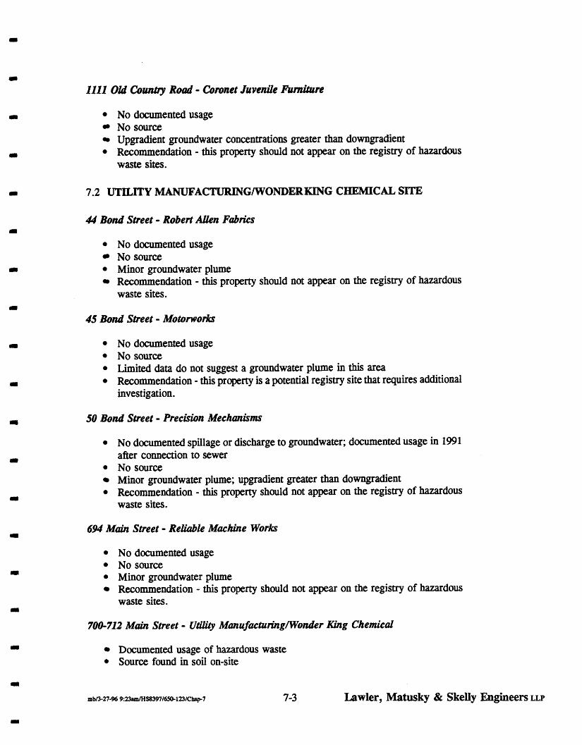
I l l 1 Old Cornby Road - & m e t Juvenile finiftcre
No documented usage NO source Upgradient groundwater concentrations greater than downgradient Recommendation - this property should not appear on the registry of hazardous waste sites.
7.2 UTILITY MANUFACTURINGlWONDERKING CHEMICAL SITE
44 Bond Stteet - Roberl AUen Fabrics
No documented usage No source Minor groundwater plume Recommendation - this property should not appear on the registry of hazardous waste sites.
45 Bond Street - Motorworks
No documented usage No source Limited data do not suggest a groundwater plume in this area Recommendation - this property is a potential registry site that requires additional investigation.
SO Bond Stteet - Precision Mechanisms
NO documented spillage or discharge to groundwater; documented usage in 1991 after connection to sewer NO source Minor groundwater plume; upgradient greater than downgradient Recommendation - this property should not appear on the registry of hazardous waste sites.
694 Main Street - R e W I e Machine Works
No documented usage NO source Minor groundwater plume Recommendation - this property should not appear on the registry of hazardous waste sites.
700-712 Main Street - U r n ManufmtudngNVonder King Chemical
Documented usage of hazardous waste Source found in soil on-site
Lawler, Matusky & Skelly Engineers LLP

Groundwater plume found emerging from site Recommendation - this property should be listed on the registry of hazardous waste sites.
720 Motr Street - Tops Appliance
No documented usage Minor source found in soil No groundwater plume emerging from site Recommendation - this property should not appear on the registry of hazardous waste sites.
7.3 KINKELISYLVWTER STREET SITE
38 Klinkel Street - Glassblocks Warehouse
No documented usage NO source Upgradient groundwater plume greater than downgradient Recommendation - this property should not appear on the registry of hazardous waste sites.
54 Enkel Street - The Komt Shop
No documented usage No source Upgradient groundwater plume greater than downgradient Recommendation - this property should not appear on the registry of hazardous waste sites.
62 Klinkel Street - Doak Pharmacology
Usage of hazardous waste documented Highconcentration soil source found Highconcentration groundwater plume emerging from site Recommendation - this property should be listed on the registry of hazardous waste sites.
70 Kinkel Street - Loni-Jo Metals
No documented usage Source found Upgradient groundwater plume greater than downgradient Recommendation - this property should not appear on the registry of hazardous waste sites.
w
7-4 Lawler, Matusky & Skelly Engineers LLP
m

33 Sylvester Street - Arkwin Industries
Documented usage of hazardous waste by Arkwin at other facilities in NCIA No source Highconcentration groundwater plume emerging from site Recommendation - this property should be listed on the registry of hazardous waste sites.
49 Sylvester Street - MieroRqy Corporation
Documented usage of hazardous waste Source of hazardous waste found in leachpool in 1978 Appears to have a groundwater plume emerging from site, but may require additional samples Recommendation - this property is a potential registry site that requires additional investigations.
67 Sylvester Street - Doak Pharmacology
No documented usage No source Minor groundwater plume Recommendation - this property should not appear on the registry of hazardous waste sites.
69 Sylvester Street - T. SMO Salvage
No documented usage No source Groundwater plume documented as emerging from site Recommendation - this property is a potential registry site that requires additional investigations.
71 Sylvester Street - Former Vim Hollmtd and Sons INK
No documented usage No source Minor groundwater plume Recommendation - this property should not appear on the registry of hazardous waste sites.
7.4 GARDENfHOPPER STREET SITE
llb138 Swalm Avenue - Liqui-Mark Corporhn
Usage not investigated Source not investigated
Lawler, Matusky & Skelly Engineers LLP

Groundwater plume documented as emerging from site Recommendation - this property is a potential registry site that requires additional investigation.
110 Hopper Street - Express Stcel
Usage not investigated Source not investigated Upgradient plume greater than downgradient plume Recommendation - a file search is required prior to considering this property as a potential registry site.
111-117 Swalrn Avenue - Harco Trucking - Harmon Associates
Usage not investigated Source not investigated Upgradient plume greater than downgradient plume Recommendation - a file search is required prior to considering this property as a potential registry site.
299 Main Street - One Stop Auto and Truck Center
Documented usage of hazardous waste Target compounds detected in soils from 49-51 ft require additional investigation before being considered a source. Groundwater plume was documented as emerging from site Recommendation - this property is a potential registry site that requires additional investigation.
534 Main Street - IET Labs
No documented usage No source Upgradient groundwater plume greater than downgradient plume Recommendation - this property should not appear on the registry of hazardous waste sites.
86 G d e n Street - Harmon Associates
No documented usage No source In general, upgradient groundwater is equal or greater than downgradient plume, but on-site concentrations are high. Recommendation - this property should not appear on the registry of hazardous waste sites.
II
Lawler, Matusky & Skelly Engineers LLP

550 Main Street - Royal G d Fence
Documented usage of degreasers No source Groundwater plume documented as emerging from site Recommendation - this should be listed on the registry of hazardous waste sites.
542 Main Street - Als Tool and Die
No documented usage No source In general, upgradient groundwater concentration greater than downgradient, but one sample had high concentration (13,900 ppb) over cesspool area. Recommendation - this property is a potential registry site that requires additional investigations.
95 Hopper Street - Ba-Rite Steel Buck
Documented usage of hazardous waste No source Groundwater plume documented as emerging from site Recommendation - this property is a potential registry site that requires additional investigations.
90 Hopper Street658 Moin Street - BiltRife Elev-r
No documented usage No source Upgradient groundwater plume greater than downgradient plume Recommendation - this property should not appear on the registry of hazardous waste site.
Lawler, Matusky & Skelly Engineers LLP
REFERENCES CITED
Lawler, Matusky & Skelly Engineers (LMS). 1995. Site Investigation Report, New Cassel Industrial Area. Prepared for the New York State Department of Environmental Conservation.
Nassau County Department of Health (NCDOH) and Dvirka and Bartilucci Consulting Engineers. 1986. Investigation of Contaminated Aquifer Segments Nassau County, NY.
I
R- 1 Lawler, Matusky, and Skelly Engineers LLP

LIST OF SUPPORTING DOCUMENTATION
i LMS Monitoring Well Sampling Logs (Volume I)
ii GPR Report (Volume I)
iii Mobile Laboratory Data (Volumes 11-IV)
R-2 Lawler, Matusky, and Skelly Engineers LLP

APPENDIX A
UPDATED FILE REVIEW DATABASE

EASTERN SECTION New Caaad Induddal Arm
Tom Is Westbuy ZIP Is 11590
1 2 0 m SI.
881008mdSt
694 Maln
44 Bmd
50 Bond
-pell60n.¶f h o n E f l b w m m a -700 Main mde a P site XW95
Rabect Alen FaMcs *sled 8120192 getlllwar: Roseman b Coln made a P dle I l 3 W O H 3R3/95
PeppeMgm Farms 1985-1994 m l d n g 1971-1984
Relable MscNm Works 1971-1992 OLR Cup. 1971-1992 Mldng Brske Ole Cup. 1 9 1
S. Unsser 19861994 Phyddlness LM. 1986-1991 ~ s s l 19851986 m lsllng 1984 Musk Wsraholae 19751883 A! Recad Dlst 1975-1983 no lsllng 1974 Nurrery Ou(leh 1973 S V m Edgelm 1971-1975 S u p r m Process Co. 1971 M a n Glvu Co. 1971
Wsim Mclmsms 19941995 no IsWg 198S1990
0 Ppparel 1 9 1 TI Knltling Mlls 1984-1988 Lads 19851984 RuMes FasUms 1982-1983 m M n g 1981 lana Knllwear 1978-1980 Magem Co. 19751976 DM-MO Adurtrng lnc.1074-1977 Cdmate C m . 1974-1977
-LOW- based m usage Hslory I s c k o f g o o d ~ d
WfJWpoint
-LOW- based m u q a Ndmy
-MODERATE- downgaasntancislQlrV
Sidegsdsnlol ANSON MW-8
(Ngh TCE) lpgrada of
ANSONMW-0 (h TCA. Ugh TCE)
GP-39 (hlgh TCA. Ugh TCE)
-MODERATE- upgadant of ANSONMW-9
(bw TCA. U@l TCE)
-MODERATE- M a W y aqacent to
snddowngaden(ol GP-39 (Hgh 1%
Hgh TCE) ~ d m t of
ANSON MW-9 (tdgh TCE. bw TCA)

EASTERN SECTION New Camd Indumtrlal Area
51 Frcat St.
33 M S I .
L.I. SpW6 WOlld 1991-1994 uulng Rm ~ ~ 1 9 9 1 - 1 9 9 2 MlSUtlg 1984-1990 Rensissace Cilfchs 1971-1987 Continental Cilfcb~ 1971-1987
-LOW- bnsedon usage Hsiq bdrdgwddo*ngsd
domepdnt W 8 s t ~ ~ D a u l s 1981 ( h l k Mart 19791980 CHgo (M Mart 1977-1978 Do Rl$d Svc. Ccnler 1973-1976 Frost Slreet Svc. Sta. 1971-1972
1137 Md Can. Rd. Men3 World Oulkt 19791992 KaH Inporters 1984-1986 Wald Brand Inc. 1979-1986 The Barn & )(n C8. 1972-1978 MHes Shoes 1971
1085 Md my Rd.
750 Maln
720 Mah
1111oldCan.Rd.
l o s o l d c a n Rd.
-MOMRATE- lp~adentd
GP-31 (I'W TCE, low TCA I'W B T W
Tope Appliance City Forbmoff'e Second Cholcs 1979 no ldng 1971-1992for750
Nassua Candy Co. 1991-1992 mlstlng 19861990 CygfI8 Desfem Ltd. 1985 m l d n g 1971-1984
-MODERATE- -dent Of
GP-39 (Hgh TCA, hl@ TCE)
coronet Jw. store 1971-1994 - L O W based on usage HsWy
Wesbuy Mssan 1992 m l d n g 19891991 NaU&dO Aub P$1971-1988
-MODERATE- based on usage NstDly lack of gwd dormgnd
~ t o m p d n t
11,328.112 1035 Md Can W e s h y bDdsa 1988-1992 -MOMRATE-
P q e 2
i t I I

EASTERN SECllON N.w Caanl Induddal Area
11.328.183 1055 Cid Can. Rd. Chdcal Bank 4 s t e d 8tiQFJ2 -peatloner: R o s m 6 Cdn
11.326.176 700 Malnsl. uaty M&cMng aywdsaw 1118WBblrsls.SeplCW 6900 ppb. GI 12-WE. 2900 ppb cMrofam 2700 ppb 1.1.1-TCA BlOO ppb TCE 3100ppbTol*ns. 1.040.OW)ppb(otal B N -able ddJorobsnr6Ms 80000 ppbbls-2 el%hex-phhal. sepk sampls 11: 36000 ppb c-112 DCE. 6000ppb 1,l.l TCA 7000ppbPCE. 6000 ppb ld. 100000 ppb total prgeable uchbrobecums, etc.
DRYWELLS AND LEACHPOOLS PUMPED AND CLEANED 10 6 11189
1 i 1BO - Wel Sampls: q1gnd.89 ppb tokl vat
Sand Mow Aulo Ph. 1986 nolsUrig 1971-1985
Checnlcal Bank 1971-1994
W t y Mlg. Co. 19791994 Wmda King Chenrlcal 1988 noSsUng 1971-1978
Utllly MarufacMng 1977-1988 Wader King Chsm. Co. 1977-1988 UWty Mfg. Co. 1977-1978 Texllle Flnandal1976 BTX Ind. Ltd. 1974-1976 VemitroncCrp. 1971-1973 Rada Lab Inc. 1971-1973
1.1.1 Trichloroelhara M 6 h y l E h y l m TeWalrjrhhw Tebachlaoslhybns S o d u n ~ ! d d e Whale Add Mucuy Span( HalageMted Wen& ualv we. co. samplng re- cemapool aample 11 : 160 ppb PCE
500 ppb CA-1 .2-DCE. m p p b M-ms dtywall umpla 111-2 130 ppb l. l.1-TW 250 ppb tobelle
1100ppb mbenz. phmal. 7700 ppb bls-2 e w x phmal. aywasanplsw: 1ooooppb-. 17MX)ppbmeh. CHM. 2150 ppb dmobem.. 6600 ppb ~phal. 1mppbphsnsm.. 14000 ppb anlhrac. wtc.
WONDER RNG MFG. CO. Dlehlombenr4009aI PCE-500 gal, 1.1.1-TCASOOpsl, Petr0lat.m -18000 pal. nrlneral sp4fipMts-750 gal 2-e(hoxyelhanoC225 gal mrlas sllcsles,adds. m d e s . TCE -1500 pslyr caklun Carbonate 1.2; l,Jal.-l Mrmoroberrrae Ehoky E m M O M E M Ketone
based m usage Hslory la& of good dormpad
monltwrng pdnl
-LOW- based m usage N- bat of good dDvnrqad
-ng pdnl
-HIOK- based m usage N- imnedat&f eyupgsdsnt and amerd to QP-39 (N* TCA Ngh TCE)
1mnedate)y adjacerd to UTlLlW MW-2 (low TCE.
low TCA) lpgadenl of ANSONMW-9
(low TCA Hgh TCE)
(Hgh T W Hgh TCE) Imnedalety aqacerd lo
uT lL ln MW-2 (low TCE, bw TCA)
upgadsot of A N S O N W (bw TCA. Hgh TCE)

EASTERN SECTION New Ca--el Indu-trlal Arm
Mulatlc Add (HCL) Naphtha Coal Tar Mlneral Oil Pebdam Ropy(ene*d S o a u n H y - j o ~ Soaun Sllcale W u l c Add Teba~owltr,4mm Tebahyctofrren Sodun T e b a w W a l e 1.1,l Trlchlaroehsne mc?kvm lmecllddes Uay Sllcates W C Csmmt
717-785 Mah St FZEMCorp. dslM 1 m m
71C716nolslng -paMona: Roren6Co*,
E-Z EM Co. hc. 1991-1995 F&mOUE Wareharts 1977-1989 Pl-(ZMale Mfg. 19741977 no Idng 1973 Bromine Mslffl b&. 1972 cargnmauc ~ i v . 1971-1972 Trldalr ~nd. 1971-1972
AFI 1981-1984 Corp. 1977-1978
Nard lnabusmenls 19751983 W e d FUdcs 1974-1968
Appld hkzhma& 19741978 C.W. Lkbachil Co. 19731975 Menufacchrafs Rap. 1972 Nard Insbunants 1971-1974
M n e 1994 m lsurg 1991-1992 Cokalm Mlg. Cap. 1984-1990 Auto UM Mfg. Cap. 1984.1990 Shamodc Wts 1981-1982 Perh In(emaUml1974-1982 Edmhlre FaMcs 1974-1983 Dressmaker Fabtlcs 1974-1982 N. Bassen Texllles 1974-19112 nol6Ung 1973 PhyJlPChem Cap. 1971-1972 Home Lab Sypbf 1971-1972 Bronm M&e!uaR 1971-1972
782 St KarvSadcRddna Ream Med Inc. 1-1992
E.t EM to. Inc. BaS04. Rln(ing Chams. 0 gal. WnLs and palM ltlmw 75 gal
Merit Carpal
-MODERATE- I m n e d a ~ aqacbnl to
and rpradent Of ANSON MW8 (hlgh TCE) UTILITY MW-2 (bw TCE.
lav TCA) -den! of E Z-EM (ND)
-MODERATE- no laage Nstuy
lmnsdataty agcent to ANSON MW-7 (bw TCE,
Ngh TC-4 ~pgadbnl of
GP32 (bw TCE, hlgh TCA)
...................... -site MSW snT,nn PAR mm ~nc. 198!3 no hems. k r m d a w agceni to
EAST-XLS
I I f I

EASTERN SECTION New Cmssel Indumlrlal Area
123 Frostst
725 SuNna Ave.
115 FroslSt.
695 SUrma Ave.
vmnt 4stedJRgm1 getltlm: R.C. Leland of Rmsman 6 C d n
Master8 Dapt Stae. central ~ e x l m -delsled ~ 9 1 9 1 -peUUau~: R.C. Leland of R m u m n 6 Cdn
Ran T d 6 Body Repair
UZWl98Owalar ram - 527ppb ffl. 646 ppb ld. 16158 ppb acelaw,
no ldng 198S1988 Tlrm Carpas 19761982 Metll Cap& 19761982 Ace Hardwcd Fkg 19761982 Salem Carpet Mils 19751975 PWL kr. 19751975 m a l Carpa MR 1973-1975 nolsllng 1971-1972
nolsllng 1892 Klng Arbu Ll@dalm 1991 Mr. Goodbuys 1988-1991 k e ~ MHg. 1988-1991 kens Ll@datm ~nc. 19861991 Inted, Prdm Fnd 1984 Gen'l ElK(rk Crdl1970-1978 Idand Leasing Cap. 1973-1982 Inn mprcmp. 1971-IDM J.P. Glordnm Ally 1971-1984 E.J. Frdch 1971-1973 Frfendy Frost W6.1971-1985
StmM lntamallonal1992-1994 Ran T W Body 1992 m lsllng 1991 Cobralm Mfg. Cbtp 1984-1990 Mdns Mfg. Cap. 1982-1990 Sew Simple Inc. 1977-1981 m kang 1976 Ward Baklng Co. 1975 Silver Cup Bakm 1975 Tip Top Bskwr 1974 Temple Carpet Co. 1973 Hoover Mfg. L Sales 1971-1972
K)eartm Rods 1971-1994 Clearlm Prod. 1971-1994 The LsbelCo. 19881894 Du@s P. N d 19851994 NU6 M w s 1983-1986 Cek Wrap 1971-1973 Camrand Dqst4 1971-1990
Masters Depl Store no chem.
Aumne Aulomowe carp. Safety-larm40 pal
KLEARTONE ehnd -18700 gal emyl awtale.2130 gl ehem nanm urlmomc 11170 gal hexana -21 6 gd. mehylane dlald6.165 gal pr* acelala.14400 gal pr* 1w+ha~.solvenb31'1 gal
GP-7 @w TCE)
-LOW- h n s a ~ a q a e e n t t o
ANSON MW-4 (lowTCA) NG5 (low TCE.)
krmedatety w d a n l of GP-34 (NO)
-MODERATE- lpgadenl of
ANSON MW7 (It* TCA. low TCE)
-MOMRATE- based on usage Nslay lmnedatal a@centto ANSON MW-2 (NO) NC5 (17 ppb W s )

EASTERN SECTION N m Cmaaol Indumtriml A r a
1065 Old Cby Rd. W e s h y Pkua
Suvdlance Enbprs 199&1994 M C Ind. 19881989 meal E m c s 19801989 KamtWs Ud. 1978 m a r k 19731978 Independent IMsl1971-1972 Sand Mes Inc. 1971-1979
m l s l ~ q 19831992 Eutecllc Cap. 19741982
Ism 1977-1978 Sew Slnpk 1972-1976 no IsUng 1971
--
OCG Rlsk Mgm( 19881994 Ncpe & Wanel 1991-1994 On c a l Ntrses 1991-1994 m. Thw. 13.1991-1994 111-Comty Hme Nrsg 1991-1994 Lamonce woq 1992-1994 Hamtiion Avnet Ex 19851992 Redstone Seculty 1991-1992 Jaybachksm. 1991 InlemaUmsl Data 1991 Block Bustar €neimml1991 Anerrnarkel Sales 198g1989 Great Eastem Mg(1989-1992 Gk& Ewne 1989 M c a n Tvon 1989 Norhastem Im. 19851989 WMam J. Monls 19851989 St- Sds Cup. 19881989 S l ) v m Jwekrs 1988 Nassau Cty Ccpntm 19881989 NY M a t Memahe 1988 Jeflermn Assac. 1988 lmwalhra RoAt Phng 1988 Flbmss S w c e 198E1992 &co hc. 1988 API Sub 1988 Valey Lmouslne 198S19.W
Rock W V 1986
KAEONICKS INC. 1 . 1 . 1 - T c A b 1 0 ~
-LOW- based on usage hlsbxy
-LOW- based on usage hlsbxy
F m MnW Co. 19861988 FM Stevens Secuity 1986 Raymond S. Vcrlo 1985 The Osmehler 1985
Page 8
I I I I

EASTERN SECTION New C a r d Induatrlal Area
V& Malnela Attys 19851986 Co. M Mpml19851986 Captaln Sports Urn 19851986 #&a Syst lnc. 19861986 A+ Todd Assoc. 1984 G w M v Mnbm 1984-1988 E m r e Matab 1984 Local Unlon 1430 1982-1989 Vay)uard CowMge 1982-19W Robertshsw Cbk 1982-1986 FUIm sVphon Mv. 1982-1988 specmcauon Ulsm\ts1981-1982 S a i t q Sales 1981-1~65 Nas. Cty Crpnt Apr. 1981-1982 Desoto Dslrbe 1981-1985 Peno lnc. 19801983 Steven's Air F r d M 197P1980 S 6 C TmnsportaUon 1978.1980 Hope For Youlh Inc. 1979-1984 IDS Mklg. Cap. 1978 NaUomide PmTrah 1977-1979 NaUomide Ulba Seal 1977-1979 SswV&es 1977-1988 Dab Canposlllon 1977-1979 S.R. weston 1976. J. S a m 1976. P. Oshvald 1976. BMkshlra Farm 19761984 RJ Laamey 19751976 Inveslws Mverslned 19751977 Rdance Research 1975 Stalefarm lnsmnce 19741977 Sherman sales 19761988 P a d Ageny Inc. 1974-1982 Gaetano Bamefl1974-1977 Malvlng Jewety 1973-1988 JJ BLake Assoc. 1972-1976 Bahama Reatty 1972-1974 Nas. Cty CrpnUs Fnd 1971-1989
1057 Md Cby Rd.
1083 Md Cby Rd
75 Frosl st Nassau candy 4% W S t d 8120192 -petllimr: R o m n h Coin
Dragon Paha 19881992 HouseOfGuq 19841988 FM E d kn 1971-1985
mlsEng 1991-1982 WalTak 1980-1990 no I.sUng 1977-1979 Rado Shack 1971-1978
-SAME AS ABOVE-
-SAME AS ABWE-
-LOW- based m usage hlstay
Ipgbbsntol

EASTERN SECTION New Caasel Industrial Ares
150 also?
Il.328.15l
750 snnm AW.
751 Sumt~ Avs.
776 Summ Aw.
790 Summ AM.
89 Hos1 st.
h Cdn
fa rent -dds!ad3Rglsl -psll(lonc R.C. Leland d R o ~ r m a n h Cdn
Kc,-g USA, Inc. -site delsled BR0192 -pe(iUoner: R o s c m n h Cdn
Hagstom Guitar 1980, Udcord Inc. 1971-1982. MersonMuslcal Rwkb 1971-1985. Ha@m Oullar 1971. m f l e r C q . 1971-1980.
U-EM 1992 Advanced Food Svc. 1971-1991 M l m Indrsbles 1971-1982
m b u n g 19751992 M n C e Food SVC. 1975 nOlSUng 1971-1974
Kug USA 1988-1994 Unlcord 1980-1987 MersonMurlcal 19801986 Hagstrun Oultar 1980-1986 AnplfiaCwp 1980-1986 m l 6 U n g 1977-1979 Marvex Roeesslng hflnlsldng 1974-1976. Uncoh Processing 1971-1973. Mehm Capaallon 1971-1973.
-ed M4mJ 1978 hqdan (Advsnca) r w w b MOI &dn benoah TCA vat leads to dyuaka s s n ~ I 8 data
ADVANCE FOOD SERVlCE EQUIP. 1,l.l-TCA 4 3 0 galMr. Waste s&Ws- 165 gal
APPLIED FLUIDICS MEK-40 gal pebo. drll. -10 gal TCE- 1OGM
-MODERATE- upgadmid
UTILITY MW-1 (lav TCE 29 P P ~
UTILITY MW-2 (I ppb TCA 70 ppb TCEIPDEIOCE )
ANSON MW-8 (ND)
-Low- Imnsaatetfadjamlia ANSON MW-3 (ND)
-MODERATE- upgadid d
w - 9 (low PCE)

CEMTRAL SECTION New Canel lndudrlal A n e
Tow Is Wesituy ZIP Is 11590
110mm8).
1 1 0 ~
70 U M n
50 Urban
32 Urban
28 U M
14 Urban
lnlo Is from NCWH BLR Hazardour ChernlcWste Storage L m U m databases M datesJIB7.2/88,6188,9189 Note: lhasa databases are not a h y a nnenf w e
Weslkry Jeep -Ee*
Rldc James Un!u~~ln, Serdce
M m c e Faslsnan Acknnce Fastenem 1972-19931 Ddco Roc&cts 1974-1992 CUM 6Co. Inc. 19731987 1 M a l M&. I W b i a l Waste Removal. Contlnsrtal TNck Malntermnce 1971.
Advanca - dsdwgas to cesspool
BbR MacNne and Tool B I R Maehlnr water4 anang dcloo g hYd dl40 gal. EDTA-lgal b. dC2O gal mr-sok100 gal
BLR Machine 6 T o o l 1 ~ 1 9 9 4 ArloAu(ano(hr0 Svc1979 Cardnal Tod 6 krhunents 1971-1978
m M n g 1987-1992 N W A u b Svc 1986 JFJ Cddon e. Inc. 1985 N a n Shae cfedl Cup. 1985 U~Cwfrmn Canlor 1985 /Uch Insbnml Co. 1971-1984
ALCH IW galcutllngdl
-MODERATE- no good daumqSd.
nudtorlng pdnt
ALUANCEMFGISUPPLY mineral splrlts- 10 gal cMng dl - logal
noldng 19901992 MGA h a 1989927 M. GreantleM Iw.. MGA Advalslng, MGA Gmphlc Art. MGA M. Grear(ldd. Martin ~ASYK. 19651989 Gordon C m Sls. 19781981 Alance Mfg. 6 Supp)y 1971-1984
Weslbvy Car Wash W e & q Cw Wash 1992-1994 Urbam A r n e Aulo Wash 1991 J IL Car Wash 19861990 Mr. Dleams Car Wash 19891991 M c a r wash 1982-1985 Urbancar Wash 198&1981 A C car wash 1976.1979
dulnghslleldsu~ysitwas -MODERATE- observed (hat Man fmm ths car wash appamntfeontalnlng g w s e or dl (heavy 6heen)wsshas dOrm hB road to the slcumbnln, akotheNClOuub-boxapparenlty rocelves nmeff- me lop had a blade dl resldveon It.

CENTRAL SECTION Now Cmmd Indumtrlal A r u
11.75.61-64 6s-a
11.75,6%71
11,75,72-73
l107S,l18
11,75.184-185 also 5147
11,75.51-57
11,75,186
11.75.187
Ucmlle T m 1982-1994 Wheatley M l M o 198g1994 m~sung lwCbl981 Pwcdah Repalr Go. 1972-1979 Llk Nu Porcelain 1972-1979 REL Svc Cap. 1972-1975 Rrlbn FudOil1971-1972
ALL-WRITE TYPEWRITER
safely-Idam - 60 gal
JweeCahacdng 1991-1994 m sang 19861990 Tlger Ti-uck Rental 1974-1983 F m k Rlland 1971-1978 Ell Rmnd 1971-1973
Marbla-lne Mnc. 198%1994 m Isding 1988 ABCO RM E M M 1982.1987 ABCO Addressing 1971-1987
ABCO ADDRESS MACHINE Trade nmm-organlc- 50 gal
-MODERATE- mgood* gad. monltorlng
pdd
64 U b n
939 Old Can. Rd.
privats residence
Wedbuy Nlssan -MOMRATE- nogood* pad. smrh
lo(a 5147 are lded lnlaxrscords as 15 Mrkd St lots 184185areormedby '15 Wcd S t Reaw
SBmTom Aulo Sales 1981-1982 SamTon 1981-1983 no lsllng 1980 fwreas Modenos 19751979 r n l s ~ n g 1971-1974
15 K l M 81. Lots 51-54:Mssan Dealer WWng bk 5557: Nlssan parnng bl
LanorrXCap.1978-1994 nOSsllnp 1977 M l y Mfg. Co. 1972-1976 DeerRM Ind. IW. 1971
-MOWIRATE- propay~~lpsa~
of GP-14- -appredable TCA. DCE contamlnallcm
-LOW- WBF R m (T*lchMlrlm 1991-1992 WBWF Chwch 1982-1990 WBF Medcal MTdaray Cfr. 1974-1990 FmMn Medeal Lab 19731090 FeicmsNp Medcel Lab 19731989 W d Bible Way 1973.1977 FekmW Mod. Center 1973


CENTRAL SECTION N w Canal Indumthl Area
54MnLalSt
24 Mnkd Sl.
i1-a 13 Sylvasta
947 Old cowl. Rd
33SvlwslerSt
me brat shop
Cams Tlb &toed 12nW93 geUllonw: Rmsn 6 Coln
Liberty Glass. L.I. dcmwd 1 m m +elltimar Rosen 6 Coln
Mmin IndusMes -dokt petition mkcted Blllgrl -petitioner: Amon Envi.
M. NlChOk NeedWOrk 1972-1978 Van Son Leisure Prcd. 1977 Mnrlon Nlehds 1972-1973 Eastem Rlniefs Mrl. 1971-1972 Holand I* 1971-1972 n. v-~nlccorp. 1971-1972 United Msblbutas Inc. 1971
The K.nt Shop 19801994 Lama-Mat Um3Ew 198&1983 World J w d y Treewe6 19791985 JawacS By Laton 19791985 no I* 1978 MM-mC Vacwnr 19751977 MM-Vnc Whln 1971-1973 Drl ChWCwp. 1971-1977 A4J Assoelates Inc. 1971-1973 oact. Mfg. 1965
Cams Tlb 1986-1994 no Wng 1986 Melas AutoBody lgb2-19.!4 GM EUprMnl CO. 1982 Franc~Mo M e s 1982-1985 mOs(lng 1971-1981
11 Sylvdar: LlbeftyG4ass.LI. 19851994 Bearlrgs h T m s l m 1981-1984 m l d n g 19761980 Wacku Cwp. 1975 Mike's Urda Cycle 1972-1974 no Sang 1971-1972 13 syiwe*ter: no Odng 1990-1992 OpUc Ute Inc. 1974-1989 Rota Master S a k 1972-1975 Ascot T c d 6 bbVM1( 1971-1978 R W m A W m l L o n 1971-1977
b w y sawgs Bank 197S1994 mlsllng 1973-1974 Fin&& Svc. Cant- 1972 BbBAutomo(lva 1971 AAmedted E@pMnt 1971
FrancoMo Ind. ~ ~ k - 7 ~ ~ l
optic Llle 1000 ga iace tm . Ascot Machine 6 Tool 6 8 gal cutUng dl
1.1.1 Mcthwhane M n . #2 Fuel MI. 0 gallons?
-LOW- based m slte usage a- w d . d
GP-14( Hlgh TC4 TCE)

CENTRAL SECTION New Caemel Indumlrld Ama
D o a k p h a m u l ~ d -delsted 27195 -peMcaer: Helen C o l a Mauch of R o s m n
L Caln w. Dmk Pharmaceullcal - ma& a P sne #13d043K ~ 8 1 9 s T. Sarro Selvage
Doak Phsnnacal hlc. 19881994 Fomrla 405 1990-1994 misting 1971-1989
-MODERATE- GP-15 Is domgad.
(Ngh TCE. modmte TCA)
SUSaM KFJtllng Mlb 1977-1988 Eastem Fdnters MT. 1973-1976 H o h d Inks 19751976
Ounnna Knffllng MIIIa 40 gal hh. ol
-MODERATE- GP-14. -15are
domgsd. (WE. TCA) V a m Hohnd Ink 19751976 m l dng 1971-1972
-MODERATE- GP-15 Is m a d .
(Nph TCE. moderate TCA)
9l29B9 TEMPO -
Bnmldn Wndow b Docr 1987-1992 1977-140 palfiwerA6 B to cesspool Bamldn LO& ~lqply 1989 1982 -30 gal h'ekfmr to cess Tenpo Ress IN. 1971-1986 15 gal flxer to cess
1Wgalrolerwashtocess 1981- 20 gal fixer. 40 gal darelopa to cess 1989 ceropod sanpb ND
lndusbisl Waste Remwal cwp. no chems Indumlrlal Mote Inc.
IndusWel Wasle Removal 1972-1994 kcel COeUngr IW. 1982-1983 866 I M e s IN. 1979-1980 Fr&Vin svap M k 1978 Cuem Metal Cop. 19731977 PciW+Tabla Saf-T 19731977 M a ! M&. 1972-1977 BeMmln PIrcrafl1971-1972
TElHCON CORP. c s p p a q ~ c e l C o a m ) NCWH Ind. dmm. arvey Isls Tlshca~lmB3-vltanlnndn coatlilg fadlty
Dyerpllpmts-16W bs. m e ~ c h b r l d e 8 d o g a l shelac - 30M) gal 1.1.1-TCA 1650gsl Fred Vln Scrap Metale 1000 batteries per yr. has p ~ d t ( l 9 7 8 )
-HIGH- fadltyls lmned
w d , from GP-14 (fairly N@ TTCA)
MimRay Cop. 1991-1994 nolSllng 1986-1990 M o i T y w l k . 1982-1985 I n n ~ ~ ~ a n b C a r h 19781981 no lstirg 1977 Blake Conshucllon Corp. 1974-1976 Long Island VenUlaUon 1974-1976 Long Island Finer 1974-1976 Empire ~aehines 1973 L.I. P8NIy Saver IN. 1971-1972
- MOMRATE- GP-151s-d
(high TCE. moderate TCA)
JIy'89- Eplll of varlws adds inlo m s t e r (cleaned), hach pool wih black sMg8
dscovered. m M o on fate of s- INTT Rlbbon 6 Carbon 1.1.1-TCA-500 gaw. ehyl&ohoC5000gal
No Name mlsllng 19851992 Laka IndaMes 197Sl984 Lake Tad L Slarprng 1971-1978
LAKA (machlne ahop) TCE -55 gal w.
." . Pndrea Pen Corp. 1971-1979 L A W INDUSTRIES (lalrN M@I TCA)
k t 1124196 HS84841650-123lAppendix A Page 5 CENTRAL.XLS

CENTRAL SECTION N m Caemel Indumtrlal Arm
hb. dC20 gal. TCE 25 gal
L.1.- P k k 1992 Meyu Emly lnc. 19gD1992 ACaCSpNd Comsclan 1989 Uasr Block Warehwss 1989.1993
moved to 38 Klnkel Metcqdinn wss ~lodc 198Sl99l no Isling 1974-19813 MOW Mfg. Cap. 1971-1973 SoCUpOsS Systems 1971-1973 N a m Shore Ullld Guldanee 19904994 M O l l y m 19861989 Salemaster Prua. 1977-IS% no lsnng 1976 Autmtlc Fastsnw 197S1975 Bmby EaUques 1972 no #sting 1971
norecudNCWnawnn -MODERATE- ~mentay nks fsclityisupgad,. from gene.ral
area 01 TCE. TCA oon$m.. l aause ln (o for l4y r (he~od
-LOW- famyls upgad,. tmn genml area d TCE.
TCA centam. however use h(o appears to
lnphlimetonoctm use.
-MODERATE- fsclltyfs tpgrfid,. tmn genml area 01 TCE.
TCAculIml. however lack usa hfo far 20- yr
Cme ptrlod.
NATIONALGEAR PRODS nwmal rplms-550 gal VaflWsdb- 1JOOgal.
-MODERATE- ladllyls lmnsd
upgad, from GP-12 (Ngh TCA. TCE)
Tesoro Rlslannta 1982-1994 no lsllng 1971-1981- Anson Repa( (5193)lndates property was Piua-Hd preNwsly
comw New Yak Smp Mal(4 q) 979 Old my. Rd.
Danle TlDmdos 19W-1994 WIsllng 1971-1985
59 Nw Yam Avo. Unoar Rotary Bearing 4 s l e d 1 m gelllloner: Anm Enulr. rep-. C. Raech, Jr,
Unmr RofqBealng 19791994 Orneral WapHcs 19791991 Caddy-Rac Co. 1971-1978 Kleeban TodCo. 1971-1978
UNEAR ROTARY BEARING Kerosene -5 gal d C 10 gal W a r d sobaft- 40 gal bade name organic- 10 gal.
-MODERATE- fadltylS tpgrfid.. han gmrd area ol TCE.
TCA comm
47 Nw Yuti Aw.. PV Tool Co.,ALM. Prsclsion Rolary B a v h g
W Tool Co. 1976 1994 nolsting 1972-1975 hdbd Co. 1971
PV TOOL d n g dl - 40 gal
-MODERATE- 1acMIy Is rpgad.. from g d area of TcE.
TCA m b m

CENTRAL SECTION New Camad lndumlrlal A m
29 New York Ave EcMmrl C-q Ecl6urtCap. 16901994 Tlshcon Cap. 1979-q NCWH) Cvaom Cae(ngs lnc. 1979-1980 Cooper BroWmrs Co. 1971-1984 s d d t i c ~ p p a m h 1971-1973 Black UgM Eastem 1971-1978 Speclronlcs Cup. 1971-1976 Money Scan System 1971-1984
-HIGH- nsheon has operated and sUl does operate at many adhsres In lw, NCIA. Thdr
process makes use of memylene C M d s ,
1.1.1-TC4melhanol. and shelac. Thls address was melr
mallng address, brcl pr-on ako took
place here
-NaknaI Warehouse 6 &-age bl moved In chning Geoproba lmrsst.lO-11193
l a ~ s t w st. M e msucs 4aed2118193 -peUara: M. Lax. Pros of Aubonlc Phr(lc6
26sytmslsrst 4mI7.9 shalowrrcn sarpls - TCMM)(I ppb, PCE- 600 ppb 1,l.l-TCA-5100ppb Wrwe4waterIrused fornmantad cwlng
Aubarlc Flasks 1971-1994 smwed8R0/84 Clear-Vu P w k b 1992-1994 tw wDdrywsb recdva
Aulronlc Plnllca I Y ~ Tobere-120 gm.
conteei codng water
BaWy PllblsNng 1992-1994 s ~ e d 10n311M 7 Afen@&ys Cap. 1991-1992 Balm Devehymd 1971-1974 Anmansen Metal 1971-1992
ANTHONSEN ALL METAL I a c M ~ m e r - 186 gal MEK- 1430galTOL- 2 2 0 M waste lmg. chemcr- 30 gclh waste adds -30 gbk
n011slln0 1971-1992 ssmrsd i i n imo Anmonrn MIhl1971-1992 1977- ascharged neub-alzed
causuc and ad8c wash Oaldte 160 and ALm. de-mfd l
ANTHONSEN ALL METAL l a q e r tlmer- 165 pal MEK - 1430 gal TOL- 220 gal waste wg. Chams- 30 waste acids -30 gola ANTHONSEN MEK-ZW gal+?.
Nolsdng 1971-1992 648656 Maln St.
ARKWIN INDUSTRIES cuMing dC4W gal 1.1,l-TCA-275gal w a s t e S ~ 1 1 O g u l waste db220 gal
28 New York lOeebsn Twl Co msben TO# ~ o . 19791994 Cad6y-Rac 19781980 No lsllng 1977-1978 Eve of Roma 1974-1976 No IsUng 1971-1973
1986-Tlshcon raw mterlak

CENTRAL SECTION New C e e d Induatrlal Area
getltoner: Rmen & Cdn Tishcon 1989-1990 no Ist[ng 1984-1988 WL Rayme W W n g 1976 RPM AWr!Jslng Agoncy 19761963 Retall PmW Mkt 1975-1983 L.I. Pennysew 1973-1983
Tech. Co. 1971 Aulum Englneerlng Dv. 1971-1972
8M2-waste 1.1.1-TCA skIdpreroved-715@1 lOn111992-wa* 1.1.1-TCA skIdp remaved- 1070 gal.
981 Old Coun. Rd. Dr. NlcUr Tralgrmsslon Dr. NlcKs Tralgrmsrlon 197894 M S Perfactlon Au(a 19761978 m l s w 1975 Carla Place T d n g 19781974 J a h Svc. StaUon 1971-1972
989 Old Can. Rd Usa's Sb Shop
Tlshcon Corp. 1992-1994 m M n g 19.S-1991 Hddsy GpUcs 1981-1984 slgna Opllcal cdectlon 1-1984 Coral Color Procesrlng 19761978 Cenbal Reproantlon 1975-1983 CeeJay Graphics 1974 Waband Comunlcalons 19781974 NdS Modda 1973-1975 DMlW Devdopnent 1971-1972
6ewered 8129187 CENTRAL REPRODUCTION ~ . ~ l . ~ s o l ph0lahamlcr)r NOS -390 gal late 70s- acllvdy dc waste pho1dm-n.- 130 gnl
charging photochemical msles to cess pool Tlahcon-
prochidm (nee) 1992: 385 45gal rbun6 MeCI 303 55-plbum 1.1,l-TCA 138 559x11 chms m&ond
36 New York Ave. Eq&alen( Phann. M. ECkh'l Corp. 1992-1994 T lm Cap Labs 1981-1994 L.I. Janllalal Svc. 19841991 mhconCorp. 1981-1983 CustomCoaungs 1981-1990 no ls1ng 1980 Step-ATrdcs Inc. 1974-1978 D M k r Dwebpnml Corp. 1972-1979 no Wng 1972 Board of EdxaUar Tech. Trade 1971
no reccfd of sewBrlng Cuntom Coallnge, Inc. 1983 -ramkc dscharged Melhykne etdcdde- lo s m c 200 saw. 6f318&oonplsln(kandr- CNamhene- mssed anployee: 1,1,1-TCA. meh c 2000 gnw. methand to tbw b i n m e w aleohoC200 gal no Info on fate of h s e wastes sawo-bc deanar -
1000 gal.
40 Naw Yark Ave. Un Indaldes. Inc. noSdng 19881992 Tisheon Corp. 1983 m ldng 1982 F m R Us 1981 I Q q Bear Aulo Svc. 1974-1980 P&M Msbibulors Inc. 1971-1973
w m r n d W 9 King Bear Entarprlnn Tishcabl986 paCka$ng no &em orhl (NCWH) 1980 Tiahcon
pacllaglng Mn 400 gal, mlsr waslbl5gal

CENTRAL SECTION Nm Camael Induatrlal Area
1007 Md Cwn. Rd.
999 old Cby. Rd. -MODERATE- no record of w e
25 state st Ziebart Rus~rooflng 1981-1994 ~ a r a r o t n t wash E- 1973-1 980 Statewide Auto Palntlng 1972 Miler Spatscar 1972 W m Nallorwlde Auto 1971
~auonal Transmission 6 Repalr
Nalonal Transmlssiars 6 Repair 1992-1994 no Idq 1989-1991 ImwaIIve Dlmarrlmr 19861987 Predse Akys 1984-1 988 league Assodates 1971-1984
-MODERATE- pmpatylsqqadfrom
NC24 (Ngh TCA)
51 State 8. m I* 1992 Healhcare Dlsposabk 1990.1991 no IsUng 1989 composnech Lld. 19861988 no lstlng 1985 G. Splcer cap . 191151984 Jau Reeord Conpclny 1978-1983 no lsUng 19761977 AukmmadCS IN. 1971-1973
L.I. Fabrlcatlona adhesives-4 gal. dennhred alcohol 2 gal.
L.I. Fabrlcallm L.I. FaMcaUm 1981-1994 Sa!sbf Ssles 1982 no lstlng 1980 Star Unflorm Rentals 1979 W l d n g 1978 Cardna Frelght 1975.1977 Leonard m e s s 19761977 Beck Leaslng LM. 1972-1973 Suherland TransportaUon 1971-1973 Jet cargo Ine. 1971-1973 Romenberg &sw. 1971
-MODERATE- pmpsrty 1s lmneuatety
a @ c d to GP-6 (NC TCE. hlgh TCA)
19 State Fro* Auto Body 19901994 Eqlpment Malnlenanee cop. 1971-1989
-MODERATE- based on slte usage
11.79.318 17 State IndusMal Bearing 6 Sq& I M a l Bearlq 6 Supp)y 1971-1994


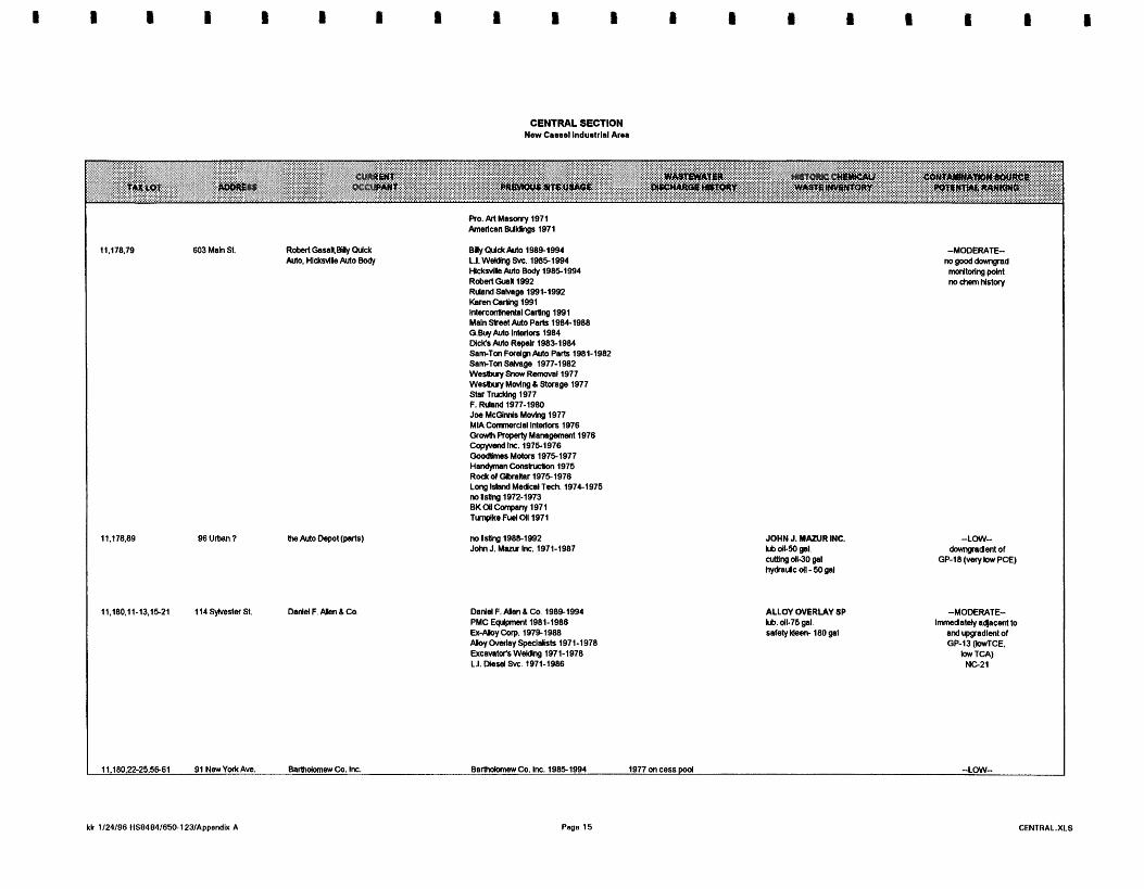
CENTRAL SECTION New Canel Indumlrld Aru
Blly WdtAuto 1989-1994 L.I. WdUng Svc. 19851994 HkkrvllleMa Body 19851994 Robat G l a M 1992 Rlbnd Salvsga 1991-1992 Karen Cadng 1991 lntar~artlnsntal carting 1991 Maln St'ot Ma Pwls 1984-1988 G.@q Aura Inleflaa 1984 DlcKs Auto Repalr 19851984 SamTon Fuelw Auto Parb 1981-1982 SamTon Satage 1977-1982 We- Smw R-11977 Wesituy Movlng 6 Stwage 1977 Star Tnxldng 1977 F. Rlland 1977-1980 Jba McGlmls Movlng 1977 MIA Cunmrdal Inleflors 1976 Gr& Roperty Managanwt 1978 COpyVd Inc. 19751976 GoodWms Mohn 19751977 Ha-n Combucllon 1975 Rock of a h h r 19751976 Long Island Medcsl Tbeh. 1974-1975 nolistlng 1972-1973 BKOIIConpany 1971 Tumplke Fuel 011 1971
Daniel F.& 6 Ca. 19891994 PMC E@pnent 1981-1988 Ex-Aloy Corp. 1979-1988 M y Cvalay Spalalists 1971-1978 Ewcmtds Waldng 1971-1978 L.I. Morel Svc. 1971-1986
JOHN J. MAZUR INC. Lb dl-50 gal. cuiUng &3O pal hydrallc dl - 50 gal
ALLOY OVERLAY SP Lb. dl-75 gal. saletyldem 180 gal
-LOW- domgadeni of
GP-18 (Very low PCE)
-MODERATE- l m d a l e t y awcenl to
and rggradleni ol GP-13 (WTCE,
low Tcn) NC21
11.180,22-25.W61 91 NewYotk Awr. Molanew Co. Inc. Barholomav Co. Inc. 1985-1994 1977 on cess pod -LOW-

CENTRAL SECTION N m Canal Induslrtal Area
J.B. Tool L Me Co.
101 NwYwlt Ave.
1 l l N w Y a l t A w . SLBMachlneWorks
625 Main a ~dchern
Vamn Steel Process 1983-1984 no lsUng 1982 Aqmfoma EMqfIsn 19801981 ~ s s s d o r Book 2977-1979 no lstlng 1976 M.GlbertSteal1971-1975
W o r A u l o R e s t y l ~ 1991-1994 M a h w d ~ a r Co. NATIONWOE ULTRA SEAL Slperlor Auto Glass 1991 Inst uses wkmwl solvab, vaslos no lstlng 1990 25 gay. wan chem~arch DCap ln~uance 1965 ND15Q - dnpr m d e to cesspool Dealer0 Chce. &do Plg .I9841 985 Wen Ku( Frc. Fm. 1982-1986 MLIIMII Protecllm 1981 Ath'm#ve w, MD Aan 1981-1983 Uha seal ku. 1980-1988 Nallamlde Seal 19801988 Natlamlde Power 1980-1989 no #sling 1979 Melard Gear Co. 1971-1978
Bel Mar constudon 1992 nolsllnp 1971-1991
SLB Machlna Wales 1B8b1994 no Mng 1986 Joy Opllcs Im. 197& 1985 nolsUrg 19761977 Apt& IndrsMes 1974 Kohtan Semlcormcbr 1971-1973
Dunmed Phamuceutlcalm IPA m6ndhr.l.l.lTCA Nutntec- IPA-880 gal 72 sylvemter Dunmod Pham(7) 1.1.1-TCA -1 chm MehdJor-1 chm
J.B. Tool & Die bb dl 50 gal cum- dC110 gal hydra& dl 35 gal
Joy Oplka no chems ShB Machlne Worka artsngdl110gd rrrneral splrlts 55 gal aWne 50 gal
ADCHEM COUP.
ad)acent l o ADCHEM MW-1
(low TCE, low TCA)
-HIGH- ~mmdately aqcentto
and lpgadient d GP-38 (moderste TCA)
aqaeent to and dormgadent d ADCHEM MW-3
(low TCE, low TCA)
-MODERATE- lmnedately aqacal b
K11841 (LOW TcA)

CENTRAL SECTION New Camsel Induelrlal Area
geliUmar: Edec Associates swge from a g chems. -1 100ga1 causlics-4750 bs aclds-450 bs. Lab. chems..reagentd~ bs
and lpgadent d AOCHEM MW-3
(low TCA, low TCE) GP-38 (moderate TCA)
85 New Y a k Ave.
100 New Y a k Ave.
Adchem delstad 8RO192 -peUliuw Eder Assodales
Tlahcon-1003 menylens cHo~lde-495 gal ADCHEM MEK-30000 bbEyr. TOLwne-30000 brlyr.
-LOW- lmnedatety afjncenllo
and m d e n l 01 ADCHEM MW-1
(low TCA, low TCE)
Alhlpe screw Machine 19881994 Skelbt~ P r u b d ~ 1971-1987
ALLMPE SCREW MACHINE ~ p t h a . coal tar-220 gal MI dC55 gsl culling oB -55 gal dl contam wl. went-295 gal
-MODERATE- rpgadenl of
AOCHEM MW-1 (low TCE, low TCA)
SKELTON 1200 gal cul(lng dl 300 gal mln. spms
90 New Y a k Ave. RGM Leasing 19861994 Fins M M ~ 1983-1991 Atban Twck Repalr 1983-1985 Pelfood WarahDuse 1982 R M l M o Transrissicm 1981-1982 D m ColSlon 1980 AnUmny Colsion 19761981 T&R M o Parks 19761975 ARC Aulo Elecblc 1974-1976 Hem)s Garage Inc. 1971 Syosset Tmnsportskn 1971-1977 Tom& C a n b y M o 1971-1975
Flne A d Autobody palnt, lacquerlhlmer-1W200 gal
-LOW- rpgadent of
ADCHEM MW-1 (kw TCE, low TCA)
HOLMES & SONS melhylerm cMalde-165 g a y d n g oil - 1100 gal BERNiTE mem chbr-moo g a y . PCE -500 gaw. mlneral splrlb500 p a y . A l used f a resala dy
84 New Y a k Ave.
655 Mah S t
B d t e Pro&& Inc. 1983-1994 Total FlasUc Concepts 1985 Rad lnc. 1984-1991 UMed Lab Supply Co. 1983-1985 Anthony C o C S l ~ 1982-1983 no lslrng 1981 H W s & Son6 Inc. 1975-1980 Beltennade Woodworldng 1971-1974
AddMm -ddsted 8R0192 -WJlioner: Eder Asroclales
no isllng 1981-1992 W B XRay E~pnent197C1980 Royal Sales 1971-1978 Beta Royal Sales 1971-1978 FICM Corp. 1971-1978 Kent 1971-1976
Filtnx Corp. arhedves 180 gal ADCHEM no chem. lstlng for lhls address
-MODERATE- lmnedatety afjncent to
and upgradenlo1 NC4 (low TCA, bw TCE) 1 1845 (low TCA, bw TCE)
lpgradenl Of ADCHEM W - 3
TCE. IOw TCA) GP-35 (moderate TCA,

CENTRAL SECTION New Cauol lndusirlal Area
NLLMrpaSllpply 1991-1992 nonsmlg Isaslsso m m L* 1986 nshcm cmp. prnnr 1980-1985 Lal-Lym Sahm 1978 D e c a t lnc. 1971-1976 Convood Lab lnc. 1971-1979
CORHEDOD LABS 200gslcumngdl (any adds, dk. mwlslllm. preservasves (CoMwnC mfg.)
-Low- mgooddovmgad d n g p d h -dent of GP-SO (Ugh TCE,
Ngh TCA)
Pencoa 1988-1994 Top Maal Corp. 1988-1994 Sate0 PrOckk 19861987 SaMe Rehls 197B1987 SatMta Whchab 1876-1987 nolstlng 1971-1975
sewsred 4113182 Sanlallghi Producta SatUeWght Rod. no d'wlcak(7)
dxharged Bas0 4 Ma, (4.6%) to c4yM ar basls rn sewared
-HIGH- [mmsdatety -dent
and aqaceni lo GP-30 (M@ TCE.
Ugh TCA)
no l d n g 19861992 hdgd Snack Incbidcs 1982 hdgd Swck C s t m 1972-1981 Jlmnv Legg olsfibulors 1980 AMnUc Caturn 1972-1981 State House Cateclng 1971
-LOW- lmmsdately aqacmt lo
N-11842 (low TCE. low TCA)
no lsllng 1977-1992 Eagle MaWsl H a d n g 1976 Nassau Farldn 1975 no #sung 1971-1974
ITM no lSUng 1976-1992 Texrla Rnaclnclal1977 ITM Ltd. 1977 no IsUng 1976 Bd Coop EdraUon Warelmuse 1975 no tsting 19781992
-HIGH-
3 Z Z b Ngh TCA)
OrsyeO Pm&& Cap. 1977-1994 no lstlng 1971-1976
-Low- Irn.tslr *entb
GRAYCO MW-3 (low TCE. lav TCA)
198d-Tiahcon wanhouse S&dge S a m 4115193: 285ppb 1.1.1 TCA Stcnm Draln S a m 4115133: 7Oppn 1,l.l TCA
-HIGH- l-fely-d
01 GP-30 (Ngh TCE, Ugh TCA)

E - I m m E - S E
g: 5 s g g 5
2 0 a 2
f s a ,l O - 8 E & = 8 5 = mE 2 y r BS g 8 2 ,E c- = ri &&-= - - D en?, $2 c. g- g" E ~ g r g c z o = P O rs 8 g g P Z d Z a n s g 3 2 5 5 o - u . a E E

WESTERN SECTION New Cmsel lnduarlal Area
BLOW 164 - FIVE SEPARATE PROPERTIES sewend 11.20.M) -3120179- all llquM wastes to cesspool, neutralized with CaC03 -197&45M)ppbTCE, 110 ppb 1.1.1-TCA In cess -198031876Oppb TCE 240 ppb TOL from sample from lnslde buHdlng
ATLAS GRAPHIC Nnrk acid-403W Ibs wsste acM -I 10 gal photochems. (hypokl50 gaVyr TCE -312 gall yr
11,164,68 567 MaR St Atlas Qnphk. Ine since 1977
Westbury Mill &Supply lntra- St Development Asc.. Electromatlk Heatlng M S a k Burton Constr. 1971-1976.
-HIQH- GP-20 k directly downgrad.
-heavy TCE contam.. lncreaslng with depth
Occupkd by Varltek Machlne 19801992; Louis Jordan Labs 19781980; no record 1975-1978: MI Rscord Dlst 1971-1974.
vacant LOUIS JORDAN LABS pharmsceutlcsls no record for Varltek h NCWH chem. inv.
-MODERATE- lacks goad downgrad. montorlng polnt data
11,184,5445, 115 Rushmon Bneh Untd Auto,P~corp 66-67 slnce 1984
no record 1971-1984 no record h NCWH chem. Inv.
11,184,47.53, 110 Swalm St. Hasko UtllHb8(Ske 1985) 69
No record 19801984,Holland &00~..1977-1980,Vanburen Industry. Midway Beverage Corp.1971-1976. no record prbr to 1982
no mord in NCDOH chem hv. -MODERATE- N-11843 dlreetly dormgrad.
=SO ppb P C m (5460 R screen)
-LOW- downgrad. water samples would confirm; loatbn Immed. adjacent
to Atlas Oraphks necmlhtsr collectbn
11,164,42-46 577 Maln a. A11 Seasons Commercbl Systtrns.Roallng (since 1982)
ALL-SEASONS potro. dktlllates sllkones polyurethane
BLOCK 174 -EIGHT SEPARATE PROPERTIES
11,174,6346 117 Urban St. vaunt For Sale By Owner MTD Knb 1979-92 Warren Machlne, Rockwln M(g. co., Aemsol Machlnery Corp.- 1971-1979 No record 1974-1989,Occupkd by Polkastro feed. 1974. no record 1971-1973 slnce 1971
WARREN MACHME Naptha ,VMLP-55gal PCE-55 gal.MEK-25 gal.
-MODERATE- QP-18 b downgnd.; 6870 R 192 ppb PCE
11.174,59-62 109 Urban AVO. G- Klng (printhg supplbs) no record NCMH chem. hv.
11.174.16-32. 91 Urban Avt. A Lag- Concrete, Ready- 49.51.52-53.58 Mbr, Nassau Mason Supply
A IAGREGA CONCRETE grease-260 bs motor 011-200 gal
-MODERATE- OP-18 b dwgnd . ;
92 ppb PCE NC17 also downgrad.; ND
11.174.37-44 589 Mah St Fmund Woodworking SIN 1987
~ IudJR5190 Occupbd by Natlonwlde Dkplays & WeMy Dbphp 19781987, aeupkd by Mlller Metal westiy ~ k p l a p 1971-1982.
as of 1977. hqutm and water WESnY DISPLAYS based palnt diiharged to Adhbslvsq NOS50 gal cesspool Lacquer Thlnner-260 gal
Lacquers 100 gal Palnt-200gal ToluendOgal.
-LOW- lacks imrnedYe1y
downgrad, sample point data
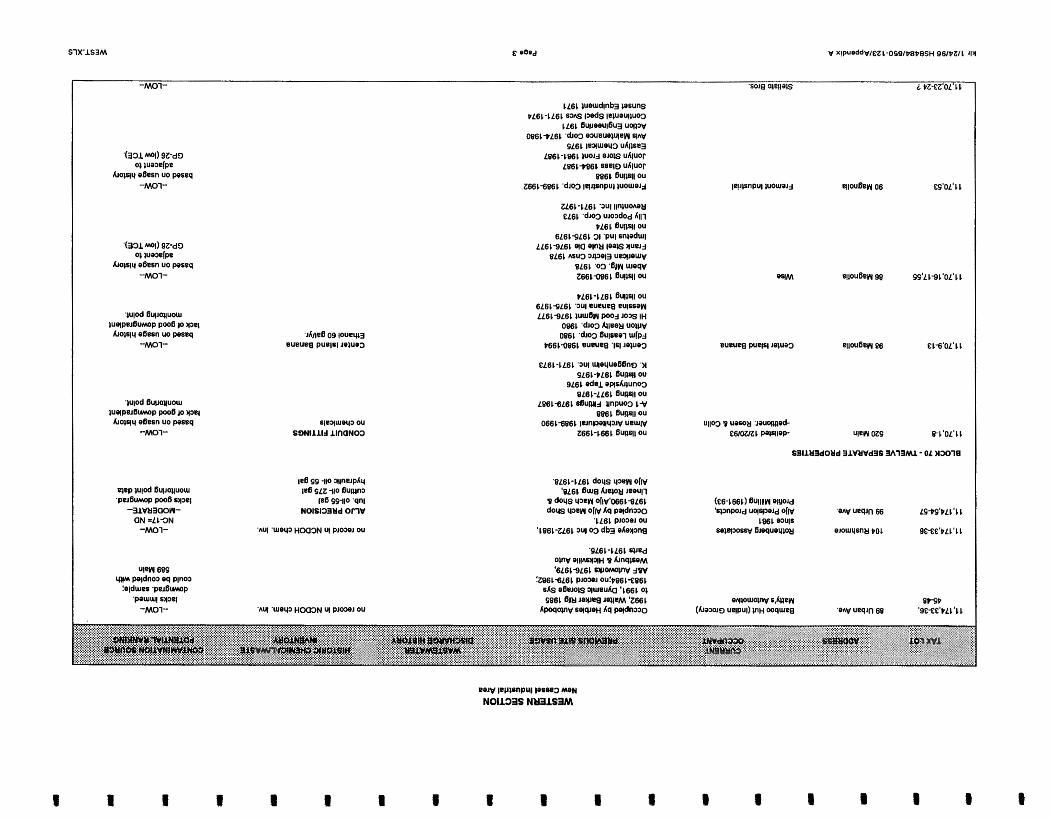

'IS UaPJPD 68

WESTERN SECTION New Camel lndushlal Area
11,70,51-52 101 Garden St. Prhmle Residence
BLOCK 71 -EIGHT SEPARATE PROPERTIES
Prhmte Residence 1971-1992 -LOW- based on usage hlrtory
upgradbnt of GP-26 (law TCE).
534 Maln
542 Maln
86 Garden Sl
80 Garden
no address
121 Hopper St
95 Hopper S t
IET Labs. Inc SIN0 1981
Occupled by IET Labs 6 A-1 Jarrb Lrno Svc 198&1990;Gmbs Mach Tool Co. Mach Tool Co. IET Labs 1982 lo 1985Aldom Electrk Corp 6 Gmbs Mach Tool Co. 1981; Aldom Elbctc Cop 1975 -1980; Aldoro Electc Corp 6 Space Savers lnd. 19791974;Aldoro Electc Corp. 1971-1972. slnce 1971
ALDORO ELECTRIC GROBS MACHINE TOOL cuttlng OIL 1 gal trade name organk-5 gal
-MODERATE- properly Is u p and al$htly
sldegradbnt to GP-24 (heavy DCE contam.)
DCE contam. lndkates TCE or PCE source in vlclnlty
Al's Tool 6 Dle AL'S TOOL L DIE cuttlng oW-5 gal no record In NCDOH chem. inv.
-MODERATE- property Is upgradknl of GP-24
(heavy DCE contam.) DCE contam. Indkates TCE or
PCE source In vklnlly
Harmon Assoc..slnce 1981 Harm Trucklng slnce 1972 -delkted 330195 -petitbner: Eric Welnstock of CA
Rkh Consultants - made a P sne X3130043J 3128195
Occupled by Hano Trckng, Harmon Assoc. C 0 r p . L ~ Flbtelnc.,1982-1983;~arco Tnkng Corp.Gemlnl Paper Flber.Harmon Paper Stock. 1974-1981;Harco Trckng Corp 1973;Asphalt Petroleum 6 Island Translt sp. 1971
-MODERATE- same as above
vacant lot Vacant 1980-1993;Occupbd by Unramar Petro. 1984-1988. Pillston Petro. 1980-1983, Metro Petro. 1971-1979. Plttston Ca. Mld-County Petroleum Harmon Assoc.
open lot
Avanel Ind.. Inc. manufactures degreaslng machines; repackages wlvenb for resale
Oecupled by Avanel Ind slnce 1980;CalUornla Petro. 6 Chevron Dlslrlbutr 1971-1979.
AVANEL INDUSTRIES mineral splrlts-$10 gal cultlng olb 25 gal Organk -trade name 550 gal
-consMs of 50% PCE. 50% naphthol 1,l.l- TCA-35gal. toluol - 550 gal JGL CUSTOM METAL DOORS palnt thlnner- 1100 gal palnl -350 gal
-LOW- NG18 la downgrad.. 2 ppb TVOCs
screen depth 5560 ft a slngle pmbb from deeper Interval may be begglng the questbn, but would conflrm
Blit-Rlte Steel Buck Co. occupied by mn Rite steel. Andre Hem,lMC Mgmnl Corp JGL Metal h r Corp.Splre Realty as of 1992;BIlt RHe Steel 6 JGL Metal Door Corp 1971-1991
-MODERATE- property la upgradlent of GP-24
(heavy DCE contam.) DCE contam. lndkates TCE or
PCE source In vklnlly lacquer thlnner-500 gal patnt-SMX) gal Naphtha. Toluene. Xylol.
klr 1/24/96 HS8484/650-123/Appndix A Pa08 5 WEST.XLS

WESTERN SECTION New Camel Induatdal Area
. . . . . . . . . . . . . . ...... ..... . . . . . . . Ethylbenzene. Polyester Resin. Metals
11.7 1.26-27, 522 Grand Blvd petroleum Heat 6 Powa, Mlb~own 3041 011 Corp, M Ksvmaugh Oil Corp
PETRO HEAT 8 POWER
fuel on, no specified arnl. Trade Name organlo350 gal.
lacks downgrad. rnonbrlng polnt sample data
BLOCK 72 - FOUR SEPARATE PROPERTIES 550 Maln St
558 Maln St
90 Hopper St
50 Hopper St
70 Hopper St
30 Hopper St
530 Grand Blvd
Royal Guard Fence CO. Occupied by Royal Ouard slnce 1971 Fence l9661993:Royal Guard -dellsled 342B4 Fence L Typhoon Fence 1984; -petltloner: Semon 6 Mondsheh Royal Guard 6 Typhoon Fence
1983;Royat Guard Fence 6 Davcon Gen Cntrclr 1981-1982; Royal Guard Fence 1971-1981.
no record of sewerlng
ROYAL GUARD muhtk ackl-2 gal cumg OIL15 gal palnt thlnner-5 gal palnt- 12 gal qlene -1 gal 4000 UST-gasoline; lnltalled 1978,falled lest 1989
Bulk Storage Tank (Palnt TMnner) -MODERATE- GP-23 b downgradbnt
PCE. TCE, 1,1,1-TCAcontam
BlCRlb Real Buck Corp. 19881992 no record:Loallo lnsvnn Sal Cnb Cap 1981-1987 Losb lnsunn Corp 1973-1980; b W e l l Ind L Research lnstrrnnt 1971-1972.
Bln-Rite Elevator 1966-lseO no mc0rd;lnter CIbbn Tlahp b Shger Brdcd 1985; Contemporary Pckng 1977-1984 Phllamon Inc. 1971-1976.
CONTEMPORARY PCKGNG Inks -500 Ibs IPA -5MK) gal PA -1000 gal Waste lnb24000 Ibs waste nowhalog soknts-2200 ga BILT-RITE ELEVATOR CO. PRIDE Cleaner X 40-100 gal. PRIDE laquer thlnner-50 gal. prlmen and palnts
-moderate- propetty b upgradbnt from GP-23 (moderato
PCE, TCE, TCA conbrnlnatbn)
Skyhe Merchandhtng Occupled by Vlglbttl Bm. Crtg 1983-1991;DJV Cartlng Corp b Wglbttl Bro. Crtg 197%1982; Sexauer Metal Craft 1971-1978.
no chemkals -LOW- no good dorm grad.
rnonlorlng polnt data
Conllnental lntlrumenl Contlnentsl Id denatured alcohol Steamllnar Alurnlnum no chemkals no record In NCDOH chsrn. Inv.
-MODERATE- 110 ppb PCE, 44ppb TCE 23ppb benz downgrad.
(N-11850) -MODERATE-
110 ppb PCE. 44ppb TCE 23ppb benz dormgrad.
(N-11850) -LOW-
At Home Health Care Trailer Transport, Inc.
ALlne Break 6 Front
klr 1124/96 HSB484/dSO-1231App.ndix A
t I I I B B

WESTERN SECTION New CaeseI lnduetrlal Area
11.72.3637 538 Grand Blvd Vlrlglb Traller Corp slnce 1980
11.72.3841 49 w l m A. Vendm bulldlng supplks
BLOCK TS - TWO SEPARATE PROPERTIES
11,73,1-21, 570 Maln St castle Colllsbn Corp. 6W5
arch.1993- 94.3 ppm PCE . 27 ppm Cr in septk tank sample (NE corner of prop.) ay, 1995 soll samples from around septk tank. 30.40 R 80, resulb are ND
arch. 1993- extremaly high concentratbn of tol.(5090 ppm) xylonss(3000 ppm) hloromethane (362 ppm) PcE (2970 ppm to 139000ppm) Ill-TCA (6E8ppm) 8 to 7500 ppm Cr, 21 ppb Cd -leachpools at NW corner of property lay 1995 sol1 sample from below leachpoools 30.50 R- essentially clean
Occupbd by IMC Magnetks CMp 19751992;lMC 6 County Data center 1972-1974; IMC Magnetks Corp 1971.
larch 1993- 60.2 ppm tol. and 112 ppm PcE in septk tank sample from southcrn end of prop. ~lso hlgh Cr 27-50 ppm In leachpool and ssptk lay 1995 SOH samples around septk and leachpools - 30.50 R- results reprledly below cleanup guldance values
larch and May 1993- Multlple floor draln also heavily wntamlnated espechlly wlVl metals
11,73.22-28, 65 Rushmore M 8 2
11.73.29-30. 29 Rushmore St(597) 54-55
11,73,41-45 562 Grand Blvd 11,73,4651 51 Rushmore St
Dbnks. Inc. Occupied by Dbnks. Inc. 1971- -dellsted 10104/91 1992 -petitbner: Dbnks, Inc. mtn. eleclronk components
It appeared that there were addnbnal occupants at thls address durlng the Geoprobe sulwy. (names unknown) Pete,s Towlng, Body Shop.Custom Tlns (since 1980)
parktng lot
A VendM, AMA Equip. A VendM Sand
4-Shores Electrical Dynamk Medkal Equlpment sewerad 9/28/80
fker, developer to cesspool
swuered 8/4/80 1977 - 110 ppb TCE, 1000 ppb PC€, nppb 1,1,1-TCA In cesspool
no record 4/78 85Oppb TCE In cesspool; ultra-sonk cleaner tank dralns to cesspool -1978
Howard Schuberl Co. photo chemkalr-25 gal blanket wash-200 gal
no record In NCDOH chem. Inv.
norecord In NCDOH chem. inv.
Xylene IMC MAGNETICS frwn-385 gal MEK -220 gal lacquer *Inner-110 gal PCE - 810 gal Toluene165 gal unapecUbd Organk-495 gal waste solvents- 450 gal 1000 gal #2 fuel oil UsT leaks
0-88
-HIGH- NG8 =55 ppb PCE, 32 ppb TCE
also svldence of splll
DlONlCS lacks good downgrad. sample IPA -109 gal methanol-234 gal polnt data bar. aclds4W gal TCE-275 gal. XYL-145 gal. WastaOrg. non-hal-560 gal waste solv-220 gal 1977- 1000 gal TCE

WESTERN SECTION New Casssl Indualrlal A m
BLOCK 74HINE SEPARATE PROPERTIES 81 Urban Ave. 75 urban AVO.
80 Ruahmom SI.
51 U M n Aw.
45 Urban Avo
35 Urban
59 Urban
66 Rushmare 8.
27 Urban
52 Rushmore St.
N.Y. Testhg Laboralorbs. Inc. slnce at least 1971 &l&d 9110193 - petitioner: Anson E M .
also Wllhm Pdntz Co.. Roger Hamy, Eng. Harvey-Westbury Ca. slnce at least 1971
ssmred 1Wl9181
1977- dlschargbg Indusbtal WaStbWBter to cesspool
N .Y . TESTINO LABORATORY Acetone144 lim methyl cyankle-112 l l m benz-16 lkem hexane46 l l m methylene chloride- 830 Iba. methylene chlorlde - 4.98 l b m trkhlorORouromelhanb 6.30 Iba treon-1384 Ibs. waste solvsnts -770 gal lnorgank mstwter-1279 gal
-MODERAlE== dormgrad wells essenttally ND,
one dormgrad sample from a deeper Interval
wu ld sew to mrm
no record In NcDOH chem. Inv.
S & J Body and Fender,sinwl986 Mlke'sl-&op Auto slnce 1986
B & G Llghtlng '82-86 Speetrum S l g ~ 'W86 F e d M Dbtbtg. slnce 1974 no record ~ r b r to 1974
86G Llghllng 15 gal palnt thlnner, palnt
PCE 53 ppb dngr.
Efficiency Systems rlnce 1984
Hlrsch Optkal 1981-&I aewered 7lW83 Gulllotlne Spllcer 1974-807 dlscharghg lndust IMl OpIkal1971 waste to canpool untH thb tlme records hcomplete
Hlnch Oplkal 1200 gal cutllng oil Gulllollns Spllcar Co. 1,1,1-TCA-12 gaVyr
-LOW- PCE nppb, upgr., PCE 53 ppb dngr.
Productbn Packaglng Equip. shce 1976
vaeant
Nuclear Ass#., Radtatbn Mdca1.1971-76 no record of chems NCDOH chem. Inv.
-LOW- lowlevel PCE contarn. upgrad., also sklegrad.
-LOW- Natbnwlde FumHum & Mat- Warehouse 1W92 ; IBEW 1971-91 no record '81-89
Jay-Rock Precbh. Inc slnce 1971
Jay-Rock lub. oil. cutting oll-135 gal ker0~&5 gal.
-LOW- lacks monttwlng good dormgmd. polnt data
-LOW- Old Country Ceramk Tile slnce 1978
Mkltorm Obplays, Mkltowns Slgn Advbg. 1971-74 no record '74-78
same as above
W w t l ~ r y t lmrkan Motonl97C90 no record 1-92
-LOW- same as abow
BLOCK 330- FOUR SEPARATE PROPERTIES 11 460 Grand B)vd Fhn Towna Rctrlgeralbn Co.
11,330 468 Grand Blvd. Eagle Home Products
1013111977- Bonded dumplng used solvent to cesspool
Bonded Packaglng Carp 15 gallyr Stoddard solvent
11.330.3 474 Grand Blvd. UnMex, Inc (slnce 1969) UNIFLEX
klr 1/24/98 HS8484/850-123lAppsndix A
I I I I


APPENDIX B
DETAILED SITE HISTORY

NEW YORK STATE SUPERFUND CONTRACT
MULTI-SITE PRELIMINARY SITE ASSESSMENT DETAILED SITE HISTORY
DRAFT
New Cassel Industrial Area Site North Hempstead, Nassau County
Site No. 130043 H-K
Work Assignment No. DO0267642
Prepared for:
Lawler, Matusky & Skelly, Engineers Environmental Science & Engineering Consultants
One Blue Hill Plaza Pearl River, New York 10965
Under Contract to:
NEW YORK STATE DEPARTMENT OF ENVIRONMENTAL CO
February 1996
Prepared by:
YEC, Inc 612 Corporate Way - Suite 4 M Valley Cottage, New York 10989

NEW CASSEL INDUSTRIAL AREA MULTI-SITE PRELIMINARY SITE ASSESSMENT
DETAILED SITE HISTORY
TABLE OF CONTENTS
Section Title P a ~ e No .
1.0 SITEHISTORY . . . . . . . . . . . . . . . . . . . . . . . . . . . . . . . . . . . . . . . . . . . . . . . . . . 1-1 1.1 BACKGROUND INFORMATION . . . . . . . . . . . . . . . . . . . . . . . . . . . . . . . . . . . 1-1
1.1.1 Location . . . . . . . . . . . . . . . . . . . . . . . . . . . . . . . . . . . . . . . . . . . . . 1-1 1.1.2 Historical Land Use . . . . . . . . . . . . . . . . . . . . . . . . . . . . . . . . . . . . . 1-1 1.1.3 Previous Investigations . . . . . . . . . . . . . . . . . . . . . . . . . . . . . . . . . . . 1-1
1 PURPOSEANDSCOPE . . . . . . . . . . . . . . . . . . . . . . . . . . . . . . . . . . . . . . . . . 1-2 1.2.1 Purpose . . . . . . . . . . . . . . . . . . . . . . . . . . . . . . . . . . . . . . . . . . . . . . 1-2 1.2.2 Scope . . . . . . . . . . . . . . . . . . . . . . . . . . . .. . . . . . . . . . . . . . . . 1-3
2.0 BLOCK 328 SITE . . . . . . . . . . . . . . . . . . . . . . . . . . . . . . . . . . . . . . . . . . . . . . . . 2-1 2.1 SITE HISTORY . . . . . . . . . . . . . . . . . . . . . . . . . . . . . . . . . . . . . . . . . . . . . . 2-1
2.1.1 Location . . . . . . . . . . . . . . . . . . . . . . . . . . . . . . . . . . . . . . . . . . . . . 2-1 2.1.2 Historical Land Use . . . . . . . . . . . . . . . . . . . . . . . . . . . . . . . . . . . . . 2-1
2.2 HISTOROCAL PROPERTY INFORMATION . . . . . . . . . . . . . . . . . . . . . . . . . . . . 2-2 2.2.1 776/790 Summa Avenue . . . . . . . . . . . . . . . . . . . . . . . . . . . . . . . . . 2-2 2.2.2 101 Frost Street . . . . . . . . . . . . . . . . . . . . . . . . . . . . . . . . . . . . . . . . 2-3 2.2.3 89 Frost Street . . . . . . . . . . . . . . . . . . . . . . . . . . . . . . . . . . . . . . . . 2-4 2.2.4 717 Main Street . . . . . . . . . . . . . . . . . . . . . . . . . . . . . . . . . . . . . . . . 2-5 2.2.5 730/740/750 Main Street . . . . . . . . . . . . . . . . . . . . . . . . . . . . . . . . . . 2-6 2.2.6 1085 Old Country Road . . . . . . . . . . . . . . . . . . . . . . . . . . . . . . . . . . 2-6 2.2.7 1099 Old Country Road . . . . . . . . . . . . . . . . . . . . . . . . . . . . . . . . . 2-6 2.2.8 770 Main Street . . . . . . . . . . . . . . . . . . . . . . . . . . . . . . . . . . . . . . . . 2-7 2.2.9 1111 Old Country Road . . . . . . . . . . . . . . . . . . . . . . . . . . . . . . . . . . 2-8
3.0 FORMER WONDER KING CHEMICAL SITE . . . . . . . . . . . . . . . . . . . . . . . . . . 3-1 3.1 SITE HISTORY . . . . . . . . . . . . . . . . . . . . . . . . . . . . . . . . . . . . . . . . . . . . . . . 3-1
3.1.1 Location . . . . . . . . . . . . . . . . . . . . . . . . . . . . . . . . . . . . . . . . . . . . . 3-1 3.1.2 Historical Land Use . . . . . . . . . . . . . . . . . . . . . . . . . . . . . . . . . . . . . 3-1
3.2 HISTOROCAL PROPERTY INFORMATION . . . . . . . . . . . . . . . . . . . . . . . . . . . . 3-2 3.2.1 44 Bond Street . . . . . . . . . . . . . . . . . . . . . . . . . . . . . . . . . . . . . . . . 3-2
. . . . . . . . . . . . . . . . . . . . . . . . . . . . . . . . . . . . . . . . . 3.2.2 50 Bond Street 3-3 . . . . . . . . . . . . . . . . . . . . . . . . . . . . . . . . . . . . . . . 3.2.3 694 Main Street 3-4
. . . . . . . . . . . . . . . . . . . . . . . . . . . . . . . . . . . . . 3.2.4 700-712 Main Street 3-5 . . . . . . . . . . . . . . . . . . . . . . . . . . . . . . . . . . . . . . . . 3.2.5 720 Main Street 3-9
3.2.6 717 Main Street (Western Portion) . . . . . . . . . . . . . . . . . . . . . . . . . . 3-9 . . . . . . . . . . . . . . . . . . . . . . . . . . . . . . . . . 4.0 KINKEUSYLVESTER STREET SITE 4-1
. . . . . . . . . . . . . . . . . . . . . . . . . . . . . . . . . . . . . . . . . . . . . . 4.1 S I ~ H I S T O R Y 4-1 . . . . . . . . . . . . . . . . . . . . . . . . . . . . . . . . . . . . . . . . . . . . . 4.1.1 Location 4-1
. . . . . . . . . . . . . . . . . . . . . . . . . . . . . . . . . . . . . 4.1.2 Historical Land Use 4-1

NEW CASSEL INDUSTRIAL AREA SITE MULTI-SITE PRELIMINARY SITE ASSESSMENT
DETAILED SITE HISTORY
TABLE OF CONTENTS
Section Title Page . No .
. . . . . . . . . . . . . . . . . . . . . . . . . . . . 4.2 HISTOROCAL PROPERTY INFORMATION 4-3 . . . . . . . . . . . . . . . . . . . . . . . . . . . . . . . . . . . . . . . 4.2.1 84 Kinkel Street 4-3
. . . . . . . . . . . . . . . . . . . . . . . . . . . . . . . . . . . . . . . . 4.2.2 615 Main Street 4-3 . . . . . . . . . . . . . . . . . . . . . . . . . . . . . . . . . . . . . . . 4.2.3 70 Kinkel Street 4-3 . . . . . . . . . . . . . . . . . . . . . . . . . . . . . . . . . . . . . . 4.2.4 71 Sylvester Street 4-3
........................................ 4.2.5 68 Kinkel Street 4-3
. . . . . . . . . . . . . . . . . . . . . . . . . . . . . . . . . . . . . . . . 4.2.6 62 Kinkel Street 4-5 . . . . . . . . . . . . . . . . . . . . . . . . . . . . . . . . . . . . . . . 4.2.7 54 Kinkel Street 4-5
. . . . . . . . . . . . . . . . . . . . . . . . . . . . . . . . . . . . . . . . 4.2.8 38 Kinkel Street 4-6
. . . . . . . . . . . . . . . . . . . . . . . . . . . . . . . . . . . . . . . . 4.2.9 24 Kinkel Street 4-6 . . . . . . . . . . . . . . . . . . . . . . . . . . . . . . . . . . . . . 4.2.10 33 Sylvester Street 4-7 . . . . . . . . . . . . . . . . . . . . . . . . . . . . . . . . . . . . . 4.2.11 49 Sylvester Street 4-7 . . . . . . . . . . . . . . . . . . . . . . . . . . . . . . . . . . . . . 4.2.12 67 Sylvester Street 4-8 . . . . . . . . . . . . . . . . . . . . . . . . . . . . . . . . . . . . . 4.2.13 69 Sylvester Street 4-9
. . . . . . . . . . . . . . . . . . . . . . . . . . . . . . . . . . . 5.0 GARDEN/HOPPER STREET SITE 5-1 5.1 SITEHISTORY . . . . . . . . . . . . . . . . . . . . . . . . . . . . . . . . . . . . . . . . . . . . . . 5-1
. . . . . . . . . . . . . . . . . . . . . . . . . . . . . . . . . . . . . . . . . . . . . 5.1.1 Location 5-1 . . . . . . . . . . . . . . . . . . . . . . . . . . . . . . . . . . . . . 5.1.2 Historical Land Use 5-1
. . . . . . . . . . . . . . . . . . . . . . . . . . . . 5.2 HISTOROCAL PROPER^ INFORMATION 5-2 . . . . . . . . . . . . . . . . . . . . . . . . . . . . . . . . . . . . . . . 5.2.1 299 Main Street 5-2 . . . . . . . . . . . . . . . . . . . . . . . . . . . . . . . . . 5.2.2 95 Hopper Street .. . . . 5-3 . . . . . . . . . . . . . . . . . . . . . . . . . . . . . . . . . . . . . . 5.2.3 121 Hopper Street 5-3
. . . . . . . . . . . . . . . . . . . . . . . . . . . . . . . . . . . . . . . 5.2.4 534 Main Street 5-4 . . . . . . . . . . . . . . . . . . . . . . . . . . . . . . . . . . . . . . . . 5.2.5 542 Main Street 5-4
. . . . . . . . . . . . . . . . . . . . . . . . . . . . . . . . . . . . . . 5.2.6 86 Garden Street 5-4 . . . . . . . . . . . . . . . . . . . . . . . . . . . . . . . . . . . . . . . . 5.2.7 550 Main Street 5-4
. . . . . . . . . . . . . . . . . . . . . . . . . . . . . . . . . . 5.2.8 Lot (Block 72, Lots 1-4) 5-4 . . . . . . . . . . . . . . . . . . . . . . . . . . . . . . . 5.2.9 Lot (Block 145, Lots 38-40) 5-4
. . . . . . . . . . . . . . . . . . . . . . . . . . . . . . . . . . . . . . . 5.2.10 90 Hopper Street 5-4
REFERENCES

1.0 SITE HISTORY
1.1.1 Location
The New Cassel Industrial Area (NCIA) site is in the unincorporated village of Westbury in the town of North Hempstead, Nassau County, New York (Figure 1-1 LMS 1996). The site comprises approximately 170 acres and is bounded by the Long Island Railroad on the north, Old Country Road on the south, Frost Street on the east and Grand Street on the west (Figure 1-2 LMS 1996).
1.1.2 Historical Land Use
An aerial photograph fiom 1950 indicates that the NCIA was primarily a residential and agricultural community. By 1962, the primary land use at the site changed to commercial and industrial. Industrial and commercial development continued throughout the 1970's and 1980's. At present, the NCIA consists of over one hundred (100) facilities which include machine shops, factories, warehouses, automobile body shops, recycling facilities, laboratories and textile and plastics manufacturing facilities (NCDOH 1994).
1.13 Previous Investigations
In 1977, the Nassau County Department of Health (NCDOH) began inspecting the businesses at the NCIA. As a result, NCDOH identified fifty five (55) facilities using chemicals in amounts significantly high enough to warrant permits for storage and handling of toxic and hazardous chemicals and wastes, that would, if handled improperly, pose a threat to the drinking water supply in the area (NCDOH 1989a). In 1985, NCDOH installed and sampled several monitoring wells in the area as part of an investigation to evaluate groundwater quality in the vicinity of the site and other areas in Nassau County (NYSDEC b).
In June 1986, NCDOH released a report entitled " Investigation of Contaminated Aquifer Segments, Nassau County, New York."(NYSDEC 1993a). The report identified volatile organic compounds (VOCs) that ranged from 2 to 9,800 parts per billion (ppb) in 36 of the 39 wells sampled in the NCLA. Both the Upper Glacial and Magothy aquifers were contaminated. The plume was migrating towards three (3) public water supply wells that were located within 800 feet downgradient (south west) of the site and served 30,000 persons (NYSDEC a). According to the Westbury Water District, two wells (12 and 12 A) were recently taken out of service due to VOC (Tetrachloroethylene) contamination (WWD 1995).
In 1988, based on the results of the NCDOH investigation, the New York State Department of Environmental Conservation (NYSDEC) included the NCIA in the Registry
of Inactive Hazardous Waste Disposal Sites as a Class 2 site. A Class 2 site is one that may pose a significant threat to public health or the environment (Ref. Registry).
In 1992, the owners of several properties located within the NCIA site petitioned NYSDEC to delist their lots. The petition was based on the findings of an investigation conducted for the property owners by an independent consulting firm. As a result, several parcels within the site were delisted with the stipulation that they would be relisted if further NYSDEC investigations found the properties to be a source of contamination (LMS 1995).
In 1995, under contract to the NYSDEC, Lawler, Matusky & Skelly Engineers (LMS) released a Site Investigation (SI) report that presented the results of their investigation of the NCIA site. The purpose of the investigation was to identify the likely source(s) of the contamination due to past or present operations at the various facilities in the NCIA. The investigation included an extensive file review and data base development, groundwater sampling of 56 monitoring wells and 40 groundwater probes, a second phase of groundwater probe sampling and site inspections of several facilities. The results of the investigation indicated several areas within the NCIA site that exhibited VOC and heavy metal groundwater contamination. The NCIA site was subdivided into eastern, central and western sections based on the location of several defined groundwater contaminant plumes. The SI report recommended that individual properties, with documented hazardous waste disposal, be added to the registry while others, suspected of hazardous waste disposal, be investigated further.
1.2.1 Purpose
Based on the findings of the LMS SI Report (LMS 1995), it was concluded that an additional field investigation and detailed site history of various properties within each of four areas (Block 328 and The Former Wonder King Chemical Site in the eastern section, Kinkel/Sylvester Street Site in the central section and the Gardenmopper Street Site in the western section) was required. In order to obtain information for a detailed site history, YEC, Inc. (YEC), under contract to Lawler, Matusky & Skelly Engineers (LMS), conducted a file review for each of the properties within the four areas. The objectives of this task were to:
Verify and update original data base Cross reference addresses/uses for untapped sources of information 0
Document existence/non-existence of agency files for each address Review historical chemical usage and waste disposal activities regarding chemicals of concern

1.2.2
YEC
Scope
conducted a review of the following:
Existing LMS data base and files
Aerial photography
Historical maps
Files from federal, state, county and local agencies
Additionally, YEC reviewed the LMS data base from the SI Report which summarized the current and past occupants of the properties in the NCIA site. The information in the data base was reviewed for accuracy and supplied to various agencies. YEC collected additional information tiom federal, state, county and local files. This information was used to update the data base and create a reference file for the detailed site history of the parcels within each of the areas of the NCIA site.
Historical aerial photographs of the NCIA site were used to develop a land use history of each parcel. The scale was selected to provide identification of the smaller features on site. The following is a list of the dates and scales of the reviewed aerial photographs:
YEC reviewed the following historical maps to obtain information on the NCIA prior to, during and after the industrial development of the area:

Sanborn 1968 1" = 100'
USGS Topographic 1897 1" = 5,208'
USGS Topographic 1898 1" = 5,208'
US Army Corps of Engineers 1911 1" = 5,208'
USGS Topographic 1950 1" = 2,000'
USGS Topographic 1954 1" = 2,000'
USGS Topographic 1967 1" = 2,000'
NYSDOT/USGS Topographic 1991 1" = 2,000'
As part of the detailed site history task, YEC conducted a file search to determine if I
information existed documenting chemical usage and waste disposal activities at each parcel within the four areas of the NCIA site. The following is a list of all agencies contacted and
tm the information requested and received:
United States Environmental Protection Agency Region I1 26 Federal Plaza New York, New York 10270
II
Information Requested: File Information from: Office of Solid Waste RCRA (Hazardous Waste Data Mgt. Sy s tem) I
Office of Air and Radiation (Compliance Data System) Office of Pesticides and Toxic Substances (Pesticides and TSCA Enforcement) I
Information Received: File information from: #
Pesticides and Toxic Substance Branch II
Hazardous Waste Data System, Office of Solid Waste (RCRA)

New York State Department of Environmental Conservation Chemical Bulk Storage Data Base, Region I
Information: Bulk storage of chemicals at facilities in the NCZA, name of chemical, how stored and amount stored.
New York State Department of Environmental Conservation Region I SUNY Campus Building 40 Stony Brook, New York 11794 (516) 444-0373
Information Requested: File review (SPDES, Hazardous Waste and RCRA files)
Information Received: Miscellaneous files
Nassau County Tax Assessors Office 240 Old Country Road Mineola, New York 11501 (516) 571-2664
Information Requested: Occupancy information from 1940
Information Received: None available
Nassau County Planning Commission 222 Willis Avenue Mineola, New York 11501 (516) 571-5844
Information Requested: 1957 aerial photograph and information on NCIA businesses
Information Received: None available
Nassau County Department of Commerce 1550 Franklin Avenue Mineola, New York 11501 (516) 571-4160

Information Requested: Directo~y of Manufacturers for Nassau County ~r
Information Received: 1987/88 Directory of Manufacturers for Nassau County 1995 Companies with 100+ Employees I
Nassau County Department of Public Works 1 West Street I
Mineola, New York 11501 (516) 571-3139
I
Information Requested: Plans showing location of cesspools, dxywells or leachpools.
Information Received: Plans for various properties showing locations of cesspools, m
drywells and leachpools
Nassau County Fire Commission Office of the Fire Marshall 899 Jerusalem Avenue P.O. Box 128 Uniondale, New York 11553 (516) 572-1038
Information Requested: File Review (Hazardous Materials, Emergency Response, and Regulatory Tank Storage Divisions) I
Information Received: Miscellaneous files and site plans
Nassau County Department of Health 240 Old Country Road Mineola, New York 11501 (516) 571-2307
Information Requested: File review (Hazardous Waste, Spills, Article XI, and Industrial r
Chemical Survey files)
Information Received: Miscellaneous files and data base information I
Nassau County Clerks Office 240 Old Country Road Mineola, New York 11501 (516) 571-2664
Information Requested: Owner names and addresses

Information Received: Owner names and addresses for Section 11, Block 76, Lots 69- 72 and 73-77
Westbury Water Department 160 Drexel Avenue Westbury, New York 11590 (516) 333-0427
Information Requested: Status of public drinking water supply wells
Information Received: Information on public wells 12 and 12A
Town of North Hempstead Building Department 210 Plaindome Road Manhasset, New York 11030 (516) 869-7680
Information Requested: Building plans, Certificates of Occupancy for NCIA
Information Received: None
Historical Society of the Westbury 445 Jefferson Street Westbury, New York 11590 (516) 333-0176
Information Requested: Historical information
Information Received: None available
Westbury Chamber of Commerce P.O. Box 474 Westbury, New York 11590 (516) 997-5987
Information Requested: Information on businesses in the NCIA
Information Received: None available
Mineola Memorial Library 195 Marcellus Road Mineola, New York 11501

Information Requested: Historical Information
Information Received: None Available
Westbury Memorial Library 454 Rockland Avenue Westbury, New York 11590 (516) 333-0176
Information Requested: Historical Information
Information Received: None Available
Mr. Steven Schneider, P.E 21 Henearly Drive Miller Place, New York 11764
Mormation Requested: Copy of additional plans of properties on Old Country Road
Information Received: None

2.0 BLOCK 328 SITE
2.1.1 Location
The Block 328 site is in the eastern portion of the New Cassel Industrial Area in Westbury, New York. The site lies within Section 11, Block 328 between Old Country Road, Summa Avenue, Frost and Bond Streets (Figure 1-2 LMS 1996). The following ten (10) building address with their associated Lot numbers were included in the Block 328 fiIe review:
776 Summa Avenue (Lot 150) 790 Summa Avenue (Lot 151) 101 Frost Street (Lot 164) 89 Frost Street (Lot 171) 717 Main Street (Lot 148) 730 to 750 Main Street (Lots 181,178,179) 1085 Old Country Road (Lot 178) 1099 Old Country Road (Lot 160) 770 Main Street (Lot 162) 1111 Old Country Road (Lots 142, 154)
2.1.2 Historical Land Use
Aerial photographs and United States Geological Survey (USGS) topographical maps dating back to 1950 show the Block 328 site to be a large, gassy or vegetated area with no industrial or commercial buildings evident Summa Avenue and Main Street did not extend into the block 328 site as did Old Country Road. Additionally, Frost Street appears as a partial or unpaved road.
Between 1962 and 1978, considerable commercial and industrial development of the site occurred. A 1962 aerial photograph shows a large building (or possibly two buildings with one roof) at 776/790 Summa Avenue. According to a 1968 Sanborn Map, this building was erected in 1958. The building at 717 Main Street has a parking lot and possibly an above ground storage tank at the north end of the lot. The Sanborn Map indicates that this building was erected in 1959. The 1962 aerial photograph also shows structures at 1099 Old Country Road (erected in the early 1960s), 1111 Old Country Road (erected between 1958 and 1959) and 770 Main Street (erected in 1961) (Ref Sanborn). All of the buildings have parking lots.
A 1970 aerial photograph indicates three (3) new buildings at the Block 328 site. The structure at 101 Frost Street, erected in 1962, (Sanborn 1968) shows a parking lot on the west side of the building as does the structure at 89 Frost Street 1085 Old Countxy Road has a parking lot in front of the southern portion (Old Country Road) of the structure.

Both 89 Frost Street and 1085 Old Country Road appear as vacant lots on the 1968 Sanborn Map. The exact construction date of these buildings is unknown. However, both structures were built sometime between 1968 and 1970.
A 1978 aerial photograph indicates that a structure (730 to 750 Main Street) was added to the building at 1085 Old Country Road.
Other than the addition of paved parking areas and truck loading ramps, no major additions or external modifications were obsemed in the 1984, 1990 and 1992 aerial photographs.
Prior to 1971, information about the occupants or business activities of the parcels within the Block 328 site is incomplete. An extensive record search of federal, state, county and local agencies produced only a 1968 Sanborn Map for information prior to 1971. The Sanborn map contained the following infoxmation regarding the business activities of the properties on the site:
776/790 Summa Avenue Food Service Equipment Manufacturer 1099 Old Country Road Automotive Paint Spraying Facility 770 Main Street A Factory Building 101 Frost Street A Toy Warehouse
From 1971 to the present, various business activities took place at the properties on site. In general, the ten (10) properties included warehouses, auto body and painting shops, manufacturers, textile companies, a laboratory supply company, an adhesives manufacturer and a newspaper distriiuter. A list of current and former occupants is included in Appendix A of the Multi-Site Preliminary Site Assessment Report (LMS 1996).
2.2.1 776/790 Summa Avenue
This 42,000 square foot building (NCDC 1975) was erected in 1958 (Sanborn 1968). Supreme Metal Fabricators (1971-1992) and Advance Food Service Company (1975) (both manufacturers of metal food service equipment) were located at this address (NCDC 1975 and 1988). Nassau County Department of Health (NCDOH) records indicate that both companies were owned by Bar King Metal Fabricators, Inc. (NCDOH 1977a).
The 776/790 Summa Avenue building connected to the municipal sewer system in May 1983. The sewer permit application showed no indication of floor drains or cesspools (NCDPW 1983a).
Of the various businesses occupying this address, Supreme Metal Fabricators reported using chemicals during its operation. The NCDOH records (NCDOH 1987a) indicate that

Supreme Metal Fabricators used the following chemicals:
Grease 4 pounds Lacquer Thinner 100 gallons Lacquers 260 gallons Lubricating Oil 50 gallons Cutting Oil 1 gallon MisceUaneous Organics 100 pounds Petroleum Distillates 275 gallons Unknowns 175 gallons/100 pounds
The final disposition of these chemicals is unknown. However, a NCDOH document (NCDOH 1977a) indicates that cutting oil, mixed with water, was discharged to the municipal sewer system. According to a report published by the New York Public Information Research Group (NYPIRG), Supreme Metal Fabricators generated hazardous waste (spent non-halogenated solvents) (NYPIRG 1994). A record search with the United States Environmental Protection Agency (USEPA) did not disclose any file infomation for this company.
Advance Food Service, listed at 776/790 Summa Avenue in 1975 also occupied 750 Summa Avenue from 1971 to 1991. A record search uncovered no documentation of chemical usage by this company at 776/790 Summa Avenue. However, NCDOH and USEPA files indicate that Advance Food Service used 1,1,1 Trichloroethane (1,1,1 TCA) at the 750 Summa Avenue address (NCDOH 1988a and USEPA 1980a). In June 1978, NCDOH sampled a drywell at the 750 Summa Avenue property. The sample contained 480 parts per billion (ppb) of 1,1,1 TCA (H2M 1978a). According to the 6/21/88 NCDOH Air Pollution Source Management System Current Application Data List, Advance Food Service (750 Summa Avenue) released 14.6 pounds/hour of 1,1,1 TCA into the atmosphere 8 hours/day 150 daysbear.
A record search provided no information regarding either the chemical usage or waste disposal practices of other occupants at this address.
2.2.2 101 Frost Street
Records dating back to 1968 indicate that several facilities occupied this address including, textile companies (1974-1983), a home laboratory supply company (1972), a toy warehouse (1968) and an automotive ignition parts manufacturer (1984-1992).
The 35,000 square foot structure (Anson 1992a) was built in 1962 (Sanborn 1968). The building connected to the municipal sewer system in February 1983. Nassau County Department of Public Works (NCDPW) plans show three (3) cesspools. Two (2) cesspools are located on the west side of the building and one (1) cesspool on the east side of the building (NCDPW 1983b). A property inspection, made during a Site Investigation (SI)

for the Department of Environmental Conservation (NYSDEC), indicated no floor drains I
in the building (LMS 1995).
Autoline Automotive Corporation, a manufacturer of ignition wires and wire harness sets (NCDC 1988), occupied this address from 1984 to 1992. Additionally, the company occupied 115 Frost Street from 1982 to 1990 (NCDC 1988). NCDOH records indicate that Autoline Automotive used degreasers at 115 Frost Street (NCDOH 1987a). However, no documents were discovered of chemical usage by Autoline Automotive at 101 Frost Street
According to NCDOH documents (NCDOH 1987a), Nat Bassen Textiles (1974 to 1982) used 300 gallons of unknown chemicals annually. A record search produced no additional information indicating that this company occupied this address after 1982.
A record search provided no information regarding either the chemical usage or waste disposal practices of other occupants at this address.
2.23 89 Frost Street
Records indicate that the 50,000 square foot (NCDC 1975) structure was built between 1968 and 1970. Records dating back to 1971 indicate that several facilities occupied this building including a musical amplifier manufacturer, a manufacturer of double coated adhesive tapes and a processing and f ishing company.
The building connected to the municipal sewer system in February 1983. NCDPW plans show two cesspools located on the west side of the building and one cesspool on the east side of the building (NCDPW 1983b). A 1994 property inspection made during a SI for NYSDEC indicated no floor drains in the building (LMS 1995).
Unicord, a manufacturer 1987. NCDOH records chemicals:
of musical amplifiers, occupied the building between 1980 and (NCDOH 1987a) indicate that Unicord used the following I
a Solder Flux 5 gallons a Varnish 10 gallons a Varnish Thinners 10 gallons
I
From 1971 to 1973 ADCHEM Corporation, a double coated adhesive tape manufacturer (NCDC 1975) occupied this address. A record search produced no information , documenting chemical usage by ADCHEM 89 Frost Street However, NCDOH records 111
(NCDOH 1988a) indicate that ADCHEM used the following chemicals at 625 Main Street (1971 to 1974, 1986 to 1994):
I
Hydrocarbon Resins a Toluene
I 30,000 pounds
2-4

Methylethyl Ketone 30,000 pounds
In 1992, Marvex Corporation (a processing and finishing company) was issued a USEPA identification number born the Office of Air and Radiation (NYPIRG 1994). The occupancy dates for Marvex Corporation are unknown.
A record search produced no additional information regarding either the chemical usage or waste disposal activities of Marvex Corporation or other occupants of this address.
2.2.4 717 Main Street
The building at this address was erected in 1959 (Sanborn 1968). Since 1971, several businesses occupied these premises, including a manufacturing and development company and a warehouse.
The building connected to the municipal sewer system in December 1987. NCDPW plans show one cesspool in the front of the building (NCDPW 1987).
Since 1991, E-Z EM, a developer and manufacturer of diagnostic imaging products, (LIBN 1995) occupied this building. According to NCDOH records (NCDOH 1992a), E-Z EM used the following chemicals:
Barium Sulfate Paints and Thinners Printing Chemicals (Inks and Cleaners) Sodium Saccharine Powder Vinyl Cement (Solvent Based Adhesive) Laboratov Analytical Chemicals
The chemicals were stored inside the building. An authorized hazardous waste hauler removed waste oil, flammable waste solvents, and Barium Sulfate from the premises.
In July 1992, NCDOH issued EZ-EM a Toxic or Hazardous Materials Storage Facility Permit for the bulk storage of unspecified chemicals and Barium Sulfate (NCDOH 1992b).
Records indicate that Fortunoff's Warehouse occupied this address born 1977 to 1989. In .
1989, the Office of the County [Nassau] Executive (OCE) received an anonymous complaint regarding employee health problems due to the use of "harsh chemicals" during working hours (OCE 1989). No further information was discovered regarding the incident.
A record search produced no additional information regarding either the chemical usage or waste disposal activities of other occupants of this address.
2.2.5 730/740/750 Main Street
A 1978 aerial photograph indicates an east and west addition (730 and 750 Main Street) to the northern section (740 Main Street) of 1085 Old Country.
740 Main Street was the warehouse space for 1085 Old Country Road (Anson 1992b). Fortunoff s and Tops Appliance City (two retail establishments) are the only documented occupants of 1085 Old Country Road and 740 Main Street No additional information was discovered regarding other occupants of 740 Main Street.
In 1979, a municipal sewer permit was issued for the building at 730 Main Street The sewer permit indicates this building was occupied by Fortunoffs Second Choice (a department store) (NCDOH 1979). Currently, Tops Appliance City occupies this building. No further information was discovered regarding other occupants at this address.
According to NCDPW documents (LSA 1993), 750 Main Street was demolished sometime between 1993 and 1995. Currently, a parking facility occupies this lot (Anson 1995). No information was discovered documenting any occupants of this address.
No information was discovered documenting chemical usage or waste disposal activities at 730, 740 or 750 Main Street.
2.2.6 1085 Old Country Road
The 100,196 square foot (Anson 1992b) building, located at 1085 Old Country Road, was erected in 1968 (Sanborn 1968). The building extends from Old Country Road north to Main Street (740 Main Street).
Records dating back to 1968 indicate that two (2) businesses, Fortunoffs (1971-1982) and Tops Appliance City (current occupant) occupied this address. Both companies are retail establishments.
According to NCDPW files, the building connected to the municipal sewer system in April 1993. NCDPW sewer connection plans also show a drywe11 and septic tank with overflow in the front of the building along Old Country Road (NCDPW 1993).
A record search did not produce any information regarding chemical usage or waste disposal activities at this address.
2.2.7 1099 Old Country Road
According to a 1962 aerial photograph and a 1968 Sanborn Map, a structure was built at this address in the early 1960's. Records dating back to 1968 indicate the building was occupied by an auto body shop and an auto painting company.

NCDPW documents show this building was demolished sometime between 1993 and 1995 (LSA 1993). A parking lot currently occupies this lot (Anson 1995). Additionally, NCDPW records indicate drywells in front of the building along Old Country Road. The municipal sewer connection date is unknown. However, the sewer was disconnected and capped in June 1993, perhaps prior to demolition (LSA 1993).
In 1987 the Nassau County Fire Commission (NCFC 1987) issued a violation notice to Nationwide Auto Body at 1099 Old Country Road. The notice listed the following:
Obstructed sprinkler control valves Improper storage of 55 gallon drums of flammable liquids
A 1988 NCDOH site inspection indicated that Nationwide Auto Body no longer occupied the building. Thirty (36) drums (paint thinners, grease and antifreeze) were left inside the building and one drum appeared to be leaking. NCDOH contacted the property owner and instructed the drums be overpacked, tested for contents and removed from the building (NCDOH 1988b). On August 8 1988, the USEPA issued a Notification of Hazardous Waste Activity form (USEPA 1988a) stating that the property owner was a generator of hazardous waste, which included (but was not limited to) the following:
FOOl (Spent halogenated solvents used in degreasing) F003 (Spent non-halogenated solvents)
According to NYSDEC Title 6 of the Official Compilation of Codes, Rules and Regulations (6 NYCRR) Part 371, FOOl and F003 wastes include (but are not limited to) the following chemicals:
FOOl (Tetrachloroethylene, Trichloroethylene, 1,1,1 Trichloroethane) F003 (Xylene, Ethylbenzene, Methanol)
Records indicate that the chemical waste was removed from the building by authorized hazardous waste haulers in October 1988 (SA 1988).
2.2.8 770 Main Street
The 10,000 square foot (NCDC 1975) structure at 770 Main Street was built in 1961 (Sanborn 1968).
Records dating back to 1968 indicate that several businesses occupied this facility including a manufacturer of research instruments.
According to NCDPW documents, the building connected to the municipal sewer system in May, 1983. The sewer permit application listed Applied Fluidics (a warehouse) as the occupant. Additionally NCDPW records show a cesspool in the front of the building

(along Main Street) (NCDPW 1983~).
Applied Fluidics (1974-1988) is documented as using the following chemicals at 770 Main Street (NCDOH 1988a):
Adhesives 1 gallon Methylethyl Ketone 10 gallons Paint Thinner 1 gallon Petroleum Distillates 10 gallons Trichloroethylene 10 gallons Paint 5 gallons
The final disposition of these chemicals or any waste generated from their use is unknown.
N a r d Instruments, a division of Applied Fluidics, (1975 to 1983) was a government contractor (NCDOH 1973) that manufactured research instruments and leak detectors (NCDC 1975).
A record search produced no additional information regarding the chemical usage or waste disposal activities at this address.
2.2.9 1111 Old Country Road
The 19,766 square foot (Anson 1992a) building located at this address was constructed between 1958 and 1959.
Coronet Juvenile Toy store (a retail establishment) has occupied this building since 1971.
The building connected to the municipal sewer system in May 1983. NCDPW files show a drywell in front of the building (NCDPW 1980a).
In July 1980, the NCFC Office issued a notice of violation for 1111 Old Country Road. The violations that were cited did not refer to the presence of chemicals or hazardous wastes at the facility.
A record search produced no additional information regarding chemical usage or hazardous waste disposal activities at this address.

3.0 FORMER WONDER KING CHEMICAL SITE
3.1.1 Location
The Former Wonder King Chemical Site is in the eastern portion of the New Cassel Industrial Area in Westbury, New York. The site lies on the western edge of Section 11, Block 328 at the comer of Bond and Main Street (Figure 1-2 LMS 1996). The following six (6) building addresses with their associated Lot numbers were included in the Former Wonder King file review:
44 Bond Street (Lots 63-67, 117) 50 Bond Street (Lots 58-61, 118) 694 Main Street (Lots 46-57) 700-712 Main Street (Lot 176) 720 Main Street (Lot 186) 717 Main Street (Western Portion) (Lot 148)
3.1.2 Historical Land Use
Aerial photographs and United States Geological Survey (USGS) topographical maps dating back to 1950 show the Former Wonder King site to be a large, grassy or vegetated area with no buildings or structures evident. Additionally, Main Street did not extend into the site and Bond Street existed as only a partial dirt road.
Between 1950 and 1983, considerable development of the site occurred. Both Bond Street and Main Street were constructed sometime between 1950 and 1962. Aerial photographs from 1962 show three (3) buildings occupying the section of the site along Bond Street to the comer of Main Street (44 and 50 Bond Street and 694 Main Street). Between 50 Bond Street and 694 Main Street, there is a grassy, vacant lot which appears to be used as a parking area. The remaining area of the site, 700-712 Main Street and 720 Main Street, appears to be a vacant, gassy lot. A 1968 Sanborn map for the site shows that the building at the comer of Bond and Main Streets (694 Main Street) was built in 1955. The construction dates for the two buildings at the Bond Street addresses are unknown.
A 1970 aerial photograph shows a building occupying the 700-712 Main Street address. The Sanborn maps state that 700-712 Main Street building was erected in 1968 (Sanbom 1968). The 720 Main Street address remained a grassy, vacant lot with some parked cars along the western side of the lot until 1983. Aerial photographs from 1970 to 1992 show that the five (5) lots within the Former Wonder King site remained unchanged after initial construction without any noticeable additions or external modifications.

Information about the occupants or business activities of the addresses within the Former Wonder King Site is incomplete before 1971. An extensive record search of federal, state and local authorities produced only a 1968 Sanborn map for information prior to 1971. The map contained the following information regarding the business activities of the properties on the site:
a 44 Bond Street Electronics Manufacturer a 50 Bond Street Offices a 694 Main Street Machine Shop a 700-712 Main Street Electronics Manufacturer
From 1971 to present, various business activities took place at the different addresses. In general, the five (5) properties of the site included such businesses as machine shops, offices, clothing distributors, knitting factories, electronics manufacturers, warehouses, and a candy factory. A list of current and former ocmpants is included in Appendix A of the Multi-Site Preliminary Site Assessment Report (LMS 1996).
3.2.1 44 Bond Street
The 5,012 square foot building at this address was built sometime between 1950 and 1962. A record search was unable to provide an accurate date for the building's construction. Aerial photos dated 1950 show the parcel to be a grassy or vegetated lot Subsequent aerial photos from 1962 show a building occupying the lot. Since 1962, no major additions or external modifications to the initial structure are evident.
Records dating back to 1971 show that numerous businesses occupied 44 Bond Street. A music and record warehouse and distributor, a physical therapy clinic and several other companies conducted business at this address. A record search produced no information regarding occupants prior to 1971.
The 44 Bond Street building connected to the municipal sewer system in May 1983. The sewer permit application showed no indication of floor drains or cesspools (NCDPW 1983e).
Of the historical businesses occupying this address, Supreme Edgelight (1971 and 1973) reported using chemicals. Nassau County Department of Health (NCDOH) records (NCDOH 198%) indicate that Supreme Edgelight used the following chemicals at 5 Bond Street which the company occupied in 1977 (NCDOH 1987a):
Benzene Lacquers Lacquer Thinner

Xylol
The quantities and final disposition of these chemicals are unknown. Other than Supreme Edgelight, no additional information was available regarding the chemical usage of other occupants.
3.2.2 50 Bond Street
The 5,012 square foot building at this address was built sometime between 1950 and 1962. A record search did not provide an accurate date for the building's construction. Similar to 44 Bond Street, aerial photos dated 1950 show the lot to be a grassy or vegetated lot Subsequent aerial photos from 1962 show a building occupying the property. Since 1962, no major additions or external modifications to the initial structure are evident.
Records dating back to 1971 show that numerous businesses occupied 50 Bond Street. A furniture warehouse, retail outlets for fabric and dresses, offices, clothing manufacturers and distributors, machine shop and several other companies conducted business at this address. A record search produced no information regarding occupants prior to 1971.
The 50 Bond Street building connected to the municipal sewer system in May 1983. The sewer permit application showed no indication d floor drains or cesspools (NCDPW 1983f). However, the sewer permit application reported that a knit wear factory occupied the building (perhaps Lasondra or TI Knitting Mills). This knitwear factory had a commercial dryer on the premise but no washing facilities and produced no industrial waste. No other information regarding the chemical usage or business practices of the other occupants was revealed during the record search except for Precision Mechanisms.
Since 1990, Precision Mechanisms has occupied the 50 Bond Street address. The company manufactures servomechanisms, limit controls and precision gearing. Established in 1957 at 44 Brooklyn Avenue, Precision Mechanisms uses several chemicals and oils in its manufacturing process.
In an October 1977 New York State Department of Environmental Conservation (NYSDEC) industrial chemical survey of the 44 Brooklyn address, Precision Mechanisms reported improperly dumping Stoddard solvent (a petroleum distillate based dry cleaning solvent) sludge on the ground adjacent to the building (NYSDEC 1992). In a November 1980 United States Environmental Protection Agency (USEPA) Hazardous Waste Activity Application, Precision Mechanisms reported "treating/ storing and disposing" FOOl type spent halogenated solvents used in degreasing (USEPA 1980b).
According to March 1987 NCDOH documents for the 44 Brooklyn Avenue address (NCDOH 1987a), Precision Mechanisms used the following chemicals:
Mineral Spirits 55 gallons

Cutting Oil 55 gallons Unknown Tradename Chemical 55 gallons
Additionally, a June 1988 NCDOH document (NCDOH 1988a) reported the following I
chemical usage by Precision Mechanisms:
Naphtha Coal Tars 80 gallons Petroleum Distillates 60 gallons Oil contaminated with solvent 100 gallons
I
In March 1991, NCDOH Bulk and Container Storage records (NCDOH 1991a) indicated the following chemical usage by Precision Mechanisms:
Mineral Spirits 30 gallons Cutting Oil 30 gallons Petroleum Naphtha 20 gallons Waste Petroleum Naphtha 20 gallons 1, 1,l-Trichloroethane (TCA) 30 gallons Compressor Oil 5 gallons Lubricating Oil 10 gallons Hydraulic Oil 2 gallons Kerosene 50 gallons.
The final disposition of these chemicals is unknown. Precision Mechanisms used an authorized hazardous waste hauler for some chemical waste removal (SK 1994). II,
3.2.3 694 Main Street I
This 10,000 square foot building contains several offices and a large manufacturing warehouse. According to a 1968 Sanborn map, the building was constructed in 1955. Since 1962, no major additions or external modifications to the initial structure are evident. I
Records dating back to 1971 show that only Reliable Machine Works/ GLR Corp. has r
occupied the building. Reliable Machine Works, a division of Viking Brake and Die Corp., manufactures dies for brake shoes, metal TV and file cabinets, light fixtures, submarine periscope rails, racing sulQ rails and telescoping table legs (Anson 1992b).
I
The building connected to the municipal sewer system in February 1989. At that time, the two (2) cesspools at the southwestern side of the building (Anson 1992b). A 1000 gallon underground storage tank located at the north side of the lot (Anson 1992b). A record or not the tank was removed.
Reliable Machine Works reported using several chemicals
were pumped and backfilled I
containing Fuel Oil #2 was search did not reveal whether
Y
and oils in its manufacturing I

process. According to a March 1987 NCDOH document (NCDOH 1987a), the company reported the following chemical usage:
Ethylene Glycol Monobutyl Ether 12 gallons Cuttingoil 25 gallons
a Sodium Metasillicate 9 gallons a Surfactants 3 gallons
The final disposition of these chemicals was reported as either through evaporation or solid waste (rags, etc).
3.2.4 700-712 Main Street
The facility at this address was built in 1968 (Sanborn 1968). No major additions or external modifications to the initial structure are evident in historical aerial photographs. Presently, the building has a 25,000 square foot first floor manufacturing and storage area. There is a 10,000 square foot second floor with offices, a laboratory, silk screening operation and storage area (Anson 1992b). This building maintains two Main Street addresses, 700 Main Street and 710-712 Main Street.
Prior to 1977, there is no record of any occupants at the 700 or 710 Main Street address. However, several businesses including a laboratory and a textile company occupied the 712 Main Street address between 1971 and 1977. From 1977 to 1988, two businesses operated out of the building, Utility Manufacturing Inc. and Wonder King Chemical Company. Utility Manufacturing used 700 Main Street as its address while Wonder King Chemical Company used 710-712 Main Street. Documents suggest that Wonder King Chemical Company was a subsidiary or division of Utility Manufacturing. Both companies had the same corporate officers (NCDOH 1986a). Since 1988, Utility Manufacturing is the sole business operating out of the 700-712 Main Street.
A record search produced very little detailed information about the businesses prior to 1977. Department of Defense documents revealed that Rada Lab Inc. (1971 - 1973) held some defense contracts in 1973 (NCDOH 1973). No additional information was obtainable.
A significant amount of information pertaining to the Utility Manufacturing Inc. and Wonder King Chemical Company surfaced during a record search. Utility Manufacturing Inc. manufactures a variety of cleaning and lubricating products primarily for industrial and commercial uses. Wonder King Chemical Company manufactured and distributed plumbing compounds. Several previous investigations conducted by NCDOH showed significant volatile organic compound (VOC) concentrations in the storm and sanitary system for the facility (H2M 1978b).
Both Utility Manufacturing and Wonder King Chemical use a variety of chemicals in their business operations and final products. There are six (6) chemical bulk storage tanks

currently in service at the facility. In October 1971, two (2) 550 gallon steel/ carbon steel double walled above ground tanks were installed at the facility. Currently, Utility Manufacturing stores Tetrachloroethylene (PCE) and Trichloroethylene (TCE) in these tanks. Prior to 1977 (the documented date when Utility Manufacturing first occupied the facility), the type of chemicals stored in these two tanks is unknown. In April 1976, a 3500 gallon steel/ carbon steel double walled indoor above ground tank was installed. Utility Manufacturing presently stores Sulfuric Acid in this tank. In June 1982, Utility Manufacturing installed a 4000 gallon stainless steel alloy double walled above ground tank. This tank contains Sodium Hydroxide. In July 1985, Utility Manufacturing installed two (2) 4000 gallon steel/ fiberglass coated double walled underground storage tanks at the rear of the building in the yard area. These tanks contain Methylethyl Ketone (MEK) and Tetrahydrofuran (THF) (NYSDEC 1995).
In July 1981, NCDOH investigated Utility Manufacturing. NCDOH sampled a dry well at the southeast comer of the property. The sample showed naphthalene at a concentration of 120 parts per billion (ppb) (@I,) (NCDOH 1981a). Records pertaining to this NCDOH investigation were incomplete. It is not clear what subsequent actions were taken by NCDOH or what even prompted the investigation.
On December 16, 1986, NCDOH received an anmymous complaint about the "pumping" of approximately one hundred (100) 55 gallon drums on pallets in the driveway. The informant noted that the ground was wet and covered with dirt around the off-loading area. Upon further investigation, NCDOH determined that the drums contained a virgin material called Red Petrolatum. NCDOH warned Utility Manufacturing about proper off-loading procedures and spill protection requirements (NCDOH 1986b). No further action was taken by NCDOH.
Numerous investigations began at the Utility Manufacturing/ Former Wonder King Chemical Company property after the facility attempted to connect to the municipal sewer system. In April 1988, NCDOH records show that a sanitary scavenger refused to pump the cesspool prior to sewer hookup because of possible contamination (NCDOH 1988~). Consequently, Utility Manufacturing hired an independent consultant to evaluate the extent and possible sources of contamination at the 700-712 Main Street address.
In November 1988, Utility Manufacturing's consultant sampled several on-site stormwater dry wells and septic disposal system (i.e. two (2) leaching pools and the septic tank). The samples contained the following concentrations of VOCs:
Methylene Chloride 180 ppb Cis/ Trans-1,2 Dichloroethene (DCE) 500 ppb PCE 160 ppb 1,2-Dichlorobenzene 290 ppb 1,3-Dichlorobenzene 110 ppb 1,4-Dichlorobenzene 100 ppb

These sample results "confirmed that organic contaminants are present in the sanitary disposal system and stormwater dry wells at levels which would warrant remediation" (H2M 1989a).
A subsequent investigation by Utility Manufacturing's consultant involved soil boring "to access the vertical profile of contaminants emanating from the sanitary disposal system." In April 1989, soil boring sample results further "confirmed the presence of elevated levels of priority pollutant organic contamination" (H2M 1989b). The soil boring samples contained the following VOCs in varying concentrations:
Methylene Chloride a TCE a TCA a PCE
1,l-Dichloroethane (DCA) a Cis/ Trans-1,2 DCE a Dichlorobenzene
Remediation of the Utility Manufacturing's sanitary disposal system occurred on three (3) separate dates (10116, 10/23 and 11/2/1989). Remedial activities consisted of pumping and power washing the side walls and removing the bottom sediments from each drywell until a sandy bottom was reached. Six (6) stormwater dry wells were remediated on the two (2) October dates and two (2) sanitary leaching pools were pumped and cleaned on the November date. Post remedial sampling by Utility Manufacturing's consultant showed successful reduction in VOCs to NCDOH acceptable levels. Subsequently, during the week of November 6, 1989, Utility Manufacturing's facility connected to the municipal sewer. Remediation of the septic tank was scheduled for January 5th, 1990 (H2M 1990a). A record search produced no further information pertaining to the septic tank remediation.
On December 28, 1989, Utility Manufacturing installed an on-site monitoring well. Soil samples from the well borings showed above background levels for zinc. However, the zinc concentration was within an acceptable range cited in the literature (H2M 1990b). On January 16, 1990, Utility Manufacturing's consultant sampled from the on-site monitoring well. The groundwater samples contained the following VOCs:
a 1,l-DCE a 1,l-DCA a Cis/ Trans 1,2-DCE a TCA a TCE a PCE
8 P P ~ 260 ppb 280 ppb 430 ppb 17 P P ~ 110 ppb
These results were inconclusive because of the lack of groundwater results from an off-site, upgradient well. (H2M 1990b).
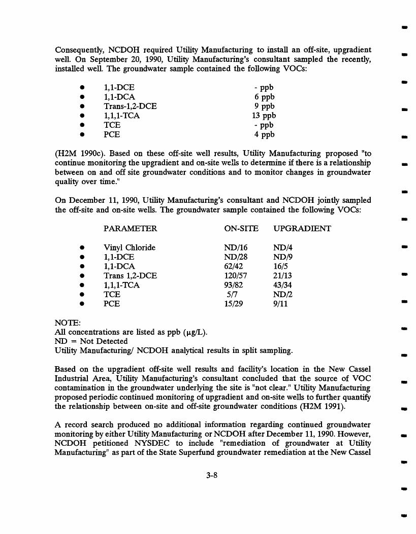
Consequently, NCDOH required Utility Manufacturing to install an off-site, upgradient well. On September 20, 1990, Utility Manufacturing's consultant sampled the recently, installed well. The groundwater sample contained the following VOCs:
1,l-DCE 1,l-DCA Trans-1,2-DCE 1, 1,l-TCA TCE PCE
(H2M 1990~). Based on these off-site well results, Utility Manufacturing proposed "to continue monitoring the upgradient and on-site w e h to determine if there is a relationship between on and off site groundwater conditions and to monitor changes in groundwater quality over time."
On December 11, 1990, Utility Manufactu~g's consultant and NCDOH jointly sampled the off-site and on-site wells. The groundwater sample contained the following VOCs:
PARAMETER ON-SITE UPGRADIENT
Vinyl Chloride 1,l-DCE 1,l-DCA Trans 1,2-DCE 1,1,1-TCA TCE PCE
NOTE: All concentrations are listed as ppb ( p a ) . ND = Not Detected Utility Manufacturing/ NCDOH analytical results in split sampling.
Based on the upgradient off-site well results and facility's location in the New Cassel Industrial Area, Utility Manufacturing's consultant concluded that the source of VOC contamination in the groundwater underlying the site is "not clear." Utility Manufactu~g proposed periodic continued monitoring of upgradient and on-site wells to further quantify the relationship between on-site and off-site groundwater conditions (H2M 1991).
A record search produced no additional information regarding continued groundwater monitoring by either Utility Manufacturing or NCDOH after December 11,1990. However, NCDOH petitioned NYSDEC to include "remediation of groundwater at Utility Manufacturing" as part of the State Superfund groundwater remediation at the New Cassel

Industrial Area (NCDOH 1991b).
3.2.5 720 Main Street
The 18,140 square foot building occupying this lot was constructed in 1983 for the Nassau Candy Company. The building serves as a manufacturing and distribution warehouse for the company's operation.
The facility connected to the municipal sanitary sewer in June 1984. The sewer permit application noted one (1) utility sink and no floor drains (NCDPW 1984). No further information was discovered documenting the use of chemicals at this address.
3.2.6 717 Main Street (Western Portion)
The western portion of 717 Main Street is upgradient to 700-712 Main Street (Utility Manufacturing). Therefore, 717 Main Street is located in both the Former Wonder King Chemical Company and Block 328 areas.
The building was erected in 1959 (Sanbom 1968) and since 1971, several business, including a manufacturing and development company and a warehouse, occupied this address.
E-Z EM, a developer and manufacturer of diagnostic imaging products (LIBN 1995), occupied this building from 1991 to the present. According to NCDOH records (NCDOH 1992a), E-Z EM used the following chemicals at 717 Main Street:
a Barium Sulfate a Paints and Thinners
Printing Chemicals (Inks and Cleaners) a Sodium Saccharine Powder
Vinyl Cement (Solvent Based Adhesive) Laboratory Analytical Chemicals
The chemicals were stored inside the building. An authorized hazardous waste hauler removed waste oil, flammable waste solvents, and Barium Sulfate from the premises.
See Section 2 (Detailed Site History Report) for additional information on 717 Main Street.

4.0 KINKEWSYLVESTER STREET SITE
4.1.1 Location
The Kinkel/ Sylvester Street Site lies in the central portion of the New Cassel Industrial Area in Westbury, New York. The site is part of Section 11 and encompasses most of Block 76 and the southeastern portion of Block 178 (Figure 1-2 LMS 1996). The following thirteen (13) building addresses with their associated Block and Lot numbers are included in the Kinkel/ Sylvester Street file review:
84 Kinkel Street (Block 178, Lot 72) 615 Main Street (Block 178, Lots 43-45) 70 Kinkel Street (Block 76, Lots 1-4) 71 Sylvester Street (Block 76, Lots 5-8) 68 Kinkel Street (Block 76, Lots 9-12) 62 Kinkel Street (Block 76, Lots 13-15) 54 Kinkel Street (Block 76, Lots 16-21) 38 Kinkel Street (Block 76, Lots 22-29) 24 Kinkel Street (Block 76, Lots 30-35, 51-56) 33 Sylvester Street (Block 76, Lots 57-65) 49 Sylvester Street (Block 76, Lots 66-68) 67 Sylvester Street (Block 76, Lots 69-72) 69 Sylvester Street (Block 76, Lots 73-77, 80 & 81)
4.1.2 Historical Land Use
Aerial photographs dated 1950 show that most of the Kinkel/ Sylvester Street site below Main Street was wooded or vegetated. However, a house with a separate, smaller building was located near 49 or 67 Sylvester Street. The area of the site north of Main Street was also primarily wooded and vegetated. Two structures appear on 84 Kinkel Street. Additionally, Sylvester Street did not extend north of Main Street except as a dirt road. Between 1950 and 1962, considerable development of the site occurred. All structures previously evident in the 1950 aerial photo were razed. Two (2) new structures appear at the 84 Kinkel and 615 Main Street addresses, respectively. Several new structures were built south of Main Street. New buildings were constructed at the following addresses between 1950 and 1962:
68 Kinkel Street 62 Kinkel Street 49 Sylvester Street 33 Sylvester Street 24 Kinkel Street

38 Kinkel Street 54 Kinkel Street
Between 33 and 49 Sylvester Street, there is a grassy or vegetated lot which appears to be used as a car park. The building at 54 Kinkel Street only occupied the southern section of the property lot. The northern section of the lot was used for a car park. Similarly, the building at 38 Kinkel Street occupied the northern section of the lot with the southern section used for a car park.
The other properties within the Kinkel/ Sylvester site (70 Kinkel Street and 69 and 71 Sylvester Street) remained grassy or vegetated, vacant lots. Additionally, Sylvester Street was extended north of Main Street to the Long Island Railroad tracks.
Aerial photographs dated 1970 show that two (2) new buildings were constructed at the 70 Kinkel Street and 71 Sylvester Street addresses. Additionally, the initial structures at 38 and 54 Kinkel Street were expanded.
Additional development of the Kinkel/ Sylvester Street site occurred between 1970 and 1978. The building at 67 Sylvester Street in the 1970 aerial photo was demolished and a new structure was erected in its place. The building at 84 Kinkel Street in the 1970 aerial photo was expanded.
Between 1978 and 1992, several other buildings were expanded. The buildings at the following addresses experienced major additions:
70 Kinkel Street 71 Sylvester Street 33 Sylvester Street
Prior to 1971, information about the occupants or business activities at the addresses within the Kinkel/ Sylvester site is incomplete. An extensive record search of federal, state, county and local authorities produced only a 1968 Sanborn map for information prior to 1971. See Appendix A of the Multi-Site Preliminary Site Assessment Report (LMS 1996) for a list of current and former occupants. The Sanborn map contained the following information regarding the business activities of the properties (Sanborn 1968):
84 Kinkel Street 615 Main Street 71 Sylvester Street 68 Kinkel Street 62 Kinkel Street 54 Kinkel Street 38 Kinkel Street 33 Sylvester Street
Waste Paper & Rags No Listing Art Warehouse Airplane Parts Warehouse Tool Manufacturer Electronics Manufacturer Warehouse Office

49 Sylvester Street Printing Shop 69 Sylvester Street Warehouse
4.2.1 84 Kinkel Street w
Since 1971, a sewer and cesspool cleaning service, a plumbing and heating company, a sand and gravel company, an awning manufacturer, an autobody shop and a paper recycling center conducted business at 84 Kinkel Street (LMS 1995). A record search produced no I
infomation regarding occupants prior to 1971. The chemical usage or waste disposal activities of these occupants is unknown.
II
4.2.2 615 Main Street
Since 1971, primarily welding shops operated at this address (LMS 1995). A record search 1.
produced no infomation regarding occupants prior to 1971. The chemical usage or waste disposal activities of these shops is unknown.
4.23 70 Kinkel Street
Since 1976, a metal recycling facility operated at this address (LMS 1995). A record search produced no infomation regarding occupants prior to 1976. The chemical usage or waste disposal activities of this metal recycling business is unknown.
4.2.4 71 Sylvester Street
The building at this address was constructed in 1965 (Sanborn 1968). A leachpool is underneath the open lot located to the east of the existing building (LMS PSA). Additionally, a site survey noted a stomwater basin located between the building and Kinkel Street. There was no direct evidence of waste deposition into the basin. However, there was an oily runoff from the parking lot, where numerous oil soaked parts and chips were stored (LMS 1995). Numerous businesses consisting primarily of publishing and printing shops occupied 71 Sylvester Street. A record search produced no infomation regarding occupants prior to 1971.
The chemical usage or waste disposal activities of the occupants is unknown. However, a May 1989 chemical spill at this address resulted in a dumpster fire. The incident involved less than five (5) gallons of a material called Tolu-Sol. The chemical fire was contained and no industrial waste was discharged to the ground (NCDOH 1989b).
4.2.5 68 Kinkel Street
A 1968 Sanborn map lists this address as 66 Kinkel Street. Since 1971, numerous businesses

such as an aircraft parts warehouse, materials recovery, recycling and transfer facilities and a vitamin manufacturer conducted business at 68 Kinkel Street (LMS 1995). A record search produced no information regarding occupants prior to 1971.
A one (1) story concrete block structure resides on this 0.23 acre lot. In January 1978, an aboveground, 550 gallon diesel fuel storage tank was installed at the rear of the building. The facility connected to the municipal sewer system in June 1982. A site survey discovered no direct evidence of leachpools or cesspools. However, the site survey noted the likelihood of an abandoned leachpool near the northwest comer of the building in the alleyway (LMS 1995).
Since 1972, Industrial Mets, Inc. used this building as a materials recovery, recycling and transfer facility for construction and demolition (CBrD) debris. The company operates under a Part 360 permit to sort and recover C&D waste (RCP 1992). A site survey noted the operation to proceed without chemical usage (LMS 1995).
Industrial Mets apparently shared the building with several other companies. Some of these companies reported chemical usage or handling. Fred Vin Scrap Metals (1978) recovered approximately one thousand (1000) batteries per year (LMS 1995). No further information regarding the specific disposal practices of this company was uncovered.
Another company, Tischon Corp. (apparently also known as Excel Coatings) shared the building with Industrial Mets, Inc. between 1982 and 1983. Tischon Corp., a vitamin manufacturer, reported using chemicals during it's manufacturing operation. A December 1983 Nassau County Department of Health (NCDOH) industrial chemical survey listed the following chemical usage for Tischon Corp. at this address:
Methylene Chloride 8000 gallons Shellac (edible) 3000 gallons Powdered Coloring Dye 1600 pounds Gelatin (w/ sugar) 1450 pounds 1, 1, 1-Trichloroethane(TCA) 1650 gallons
The final disposition of these chemicals was listed as either part of the final product or evaporation. Specifically, the disposal of 1,1,1-TCA was noted as evaporation (NCDOH 1983a).
In March 1989, Tischon Corp. improperly stored approximately fifteen (15) drums at another of its facilities located at 33 Brooklyn Avenue. Some drums apparently overturned and leaked their contents to the ground. A subsequent spill investigation report noted that one drum label read TCA (NCDOH 1989~). A record search produced no further information regarding this incident

4.2.6 62 Kinkel Street
This address is also listed in the Nassau County Tax Assessors office as 67 and 72 Sylvester Street.
Since 1971, a pen manufacturer, several machine shops and a cosmetics manufacturer conducted business at this address (LMS 1995). A record search produced no information regarding occupants prior to 1971.
Laka Industries (1979- 1984) and Laka Tool and Stamping (1971- 1978) reported chemical usage during their business operation. Documents suggest that Laka Tool and Stamping operated as a subsidiary or division of Laka Industries. Both companies have the same corporate officers and operate as a machine shop specializing in tools, dies and precision stamping (NCDOH 1977b).
In 1973, Laka Industries Inc. Tool and Stamping held some defense contracts (NCDOH 1973). A September 1977 NCDOH industrial chemical survey listed the following chemical usage for Laka Industries, Inc.:
Trichloroethylene (TCE) 55 gallons Lubricating Oil 15-20 gallons
The final disposition of these chemicals was listed as evaporation (NCDOH 1979~).
In March 1979, NCDOH sent a letter to Laka Industries Inc. instructing the company to file for a New York State Pollutant Discharge Elimination System (SPDES) permit. After filing the SPDES permit application form, NCDOH determined that a permit was not necessary because of limited chemical usage and no sludge generation (NCDOH 1979~).
In a November 1981 NCDOH industrial chemical survey (NCDOH 1981b), Laka Industries Inc. reported the following chemical usage or waste generation:
TCE 25 gallons Sludge fiom Degreaser 3 pounds
The final disposition for these chemicals was listed as follows:
TCE Reused Sludge from Degeaser Disposed in Container Trash
4.2.7 54 Kinkel Street
Since 1971, several jewelry shops, a dental and medical equipment manufacturer, and an electronics manufacturer conducted business at 54 Kinkel Street (LMS 1995). A record

search produced no information regarding occupants prior to 1971. The chemical usage or waste disposal activities of all occupants is unknown.
4.2.8 38 Kinkel Street
The building at this address was constructed in 1952 (Sanborn 1968). Since 1971, a glass, concrete and stone specialty block supplier, a window, door and lock supplier and a printing shop operated out of the 8000 square foot building at 38 Kinkel Street (LMS 1995). A record search produced no information regarding occupants prior to 1971.
Tempo Press, Inc., a printing shop, reported on several NCDOH industrial chemical survey to discharge chemical waste to its cesspool. A September 1977 NCDOH industrial chemical survey listed 140 gallons of film developing chemicals being discharged to a 38 Kinkel Street cesspool (NCDOH 1977~). A subsequent October 1981 NCDOH industrial chemical survey (NCDOH 1981b) listed the following chemicals being released to the building's cessp 001:
a Photographic Developer (hypo) 40 gallons Film Processing Fixer 20 gallons
a Hardener 1 quart Stop Wash (acetic acid) 3 gallons
In January 1983, Tempo Press, Inc. began collecting the Photographic Developer (hypo) waste for proper disposal (NCDOH 1983b).
In September 1989, the building at 38 Kinkel Street connected to the municipal sewer system. At that time, the cesspool was pumped and subsequently backfilled. NCDOH sampled the cesspool prior to the sewer hookup. The soil sample showed below minimum reportable results for volatile halogenated and aromatics hydrocarbons (NCDOH 1989d).
4.2.9 24 Kinkel Street
Since 1971, a tile company, an autobody shop and an auto engine rebuilding shop conducted business at this address (LMS 1995). A record search produced no information regarding occupants prior to 1971.
A February 1983 NCDOH industrial chemical survey (NCDOH 1983c) reported that Franco-Mo Industries Corp. (1982-1985) used the following chemicals:
Mineral Spirits 700 gallons Okite PB 181 (Biodegradable cleaning agent) 20 pounds
a Okite Rust Preventer 20 gallons.
The final disposition of the above chemicals was listed as follows:

Mineral Spirits An authorized hazardous waste hauler collected the liquid. Sludge was discarded in the dumpster
a Okite PB 181 Machine not cleaned as of the time of inspection Okite Rust Preventer Remained on parts.
4.2.10 33 Sylvester Street
The building at this address was constructed in 1961 (Sanborn 1968). A record search uncovered information about only two (2) occupants after 1971 (Tennis Only and Arkwh Industries, Inc.). Prior to 1971, no occupant information was obtained.
Arkwin Industries, Inc. (current occupant) manufactures hydraulic and pneumatic fuel components for air craft accessories and missiles. The company uses l,l,l-'TCA in varying quantities. However, there was no information found documenting Arkwin's use of chemicals at this address. Arkwin Industries uses 33 Sylvester Street as a storage and maintenance area (LMS 1995).
A record search produced no additional information pertaining to any chemical usage at this address.
4.2.11 49 Sylvester Street
Since 1971, a construction company, a ventilation and filter service company, printing shops, and an electro-mechanical parts manufacturer conducted business at 49 Sylvester Street (LMS 1995). A record search produced no information regarding occupants prior to 1971.
In December 1988, the building connected to the municipal sewer system. There are two (2) cesspools located in the rear southwest comer of the property (LMS 1995).
International Ribbon and Carbon (1977-1981) and Molty Stryk Inc. (1982-1985) are two (2) companies reportedly using chemicals during their business operation. Documents suggest that Molty Stryk, Inc. operated as a subsidiary or division of International Ribbon and Carbon. Both companies had the same corporate officers (LMS 1995). While International Ribbon and Carbon manufactured correctable ribbon, a record search did not reveal an exact type of business operation for Molty Stryk Inc..
A September 1977 NCDOH industrial chemical survey (NCDOH 1977d) noted the following chemical usage at International Ribbon and Carbon:
TCA Ethyl Alcohol
500 gallons 5000 pounds
The final disposition of these chemicals was listed as either part of the final product or

evaporation.
An April 1978 building inspection noted a 1,1,1-TCA storage tank located approximately 5 to 10 feet away from a floor drain that connected to a cesspool located in the rear southwest comer of the building. Additionally, the inspection report noted ethyl alcohol drums staged inside the building at the southeast comer. There was no change in chemical usage for the facility. An illustration accompanying the inspection report noted the words "sample" next to one of the cesspools which may have connected to the floor drain. A subsequent laboratory report dated June 4, 1978, shows results for water sample taken at International Ribbon and Carbon (NCDOH 1978). The sample results showed the following ppb (&L,) concentrations:
Methylene Chloride 130 ppb 1,l-Dichloroethane (DCA) 70 P P ~ PCE 20 ppb.
A March 1981 United States Environmental Protection Agency (USEPA) Notification of Hazardous Activity application, Molty Stryk, Inc. reported generating F005 type spent non- halogenated solvents. The application noted a "first notification" for waste generation by the company (USEPA 1982).
On July 21, 1989, a chemical spill occurred in the dumpster outside the vacant building at 49 Sylvester Street. A painter cleaning up in the abandoned building discarded a bottle of chemicals in the dumpster. An NCDOH inspector investigating the cleanup of the site discovered that the chemicals were leaking and fuming in the dumpster. State, county and local authorities responded to the incident and discovered the following chemicals in the dumpster:
Formic Acid Two (2) Pints Hydrochloric Acid One (1) Pint Sulfuric Anhydride Three (3) Pints Sulfuric Acid One (1) Pint
Following the incident., these chemicals were repacked and properly discarded. Additionally, NYSDEC and NCDOH investigators opened several manhole covers. The investigators discovered "a leachpool with a black liquid and floating sludge (NCDOH 1989c)." A record search revealed no additional information regarding any subsequent actions following this chemical spill incident or the leachpool sludge discovery.
4.2.12 67 Sylvester Street
This address is also listed in the Nassau County Tax Assessors office as 62 Kinkel and 72 Sylvester Street.

Since 1990, a cosmetics manufacturer operated at 67 Sylvester Street. Doak Pharmaceutical (1990-1994) manufactures and packages shampoos and creams. A site survey observed the operation to be clean (LMS 1995). A record search produced no information regarding occupants prior to 1990.
The 10,800 square foot facility at 67 Sylvester Street connected to the municipal sewer system in 1990. A 550 gallon underground fuel oil storage tank is located on the Sylvester side of the building. A site survey showed no floor drains in the building. Additionally, a number of leachpools were discovered in the southern parking area (LMS 1995). The chemical usage or waste disposal activities of this cosmetics manufacturer or any other occupants is unknown.
4.2.13 69 Sylvester Street
Since 1973, several printing shops, a knitting mill and a salvage company conducted business at this address (LMS 1995). A record search produced no information regarding occupants prior to 1973.
Of the business occupying this address, Suzana Knitting Mills reported using oils. A September 1977 NCDOH industrial chemical survey (NCDOH 1977d) listed 30 to 40 gallons of machine lubricating oil. The final disposition of the oil was reported as being absorbed onto rags. The chemical usage or waste disposal activities of the other occupants is unknown.

5.0 GARDENIHOPPER STREET SITE
5.1.1 Location
The Gardenmopper Street site is in the western portion of the New Cassel Industrial Area in Westbury, New York. The site is in Section 11 and lies between Main Street, Grand Boulevard, Garden Street and Swalm Avenue (Figure 1-2 LMS 1996). The following nine (9) building addresses with their associated Block and Lot numbers are included in the Gardenmopper Street file review:
299 Main Street (Block 144, Lots 31-50) 95 Hopper Street (Block 71, Lots 9-15, 50-58) 534 Main Street (Block 71, Lots 1-4) 542 Main Street (Block 71, Lots 5-8) 86 Garden Street (Block 71, Lots 16-17) 550 Main Street (Block 72, Lots 1-4) Lot (Block 72, Lots 9-13) Lot (Block 145, Lots 38-40) 90 Hopper Street (Block 72, Lots 14-17, 59-62)
One additional parcel (121 Hopper Street - Block 71, Lots 42 and 60), not part of the original site area, was included in the Garden/Hopper Street file review because of documented chemical usage.
5.1.2 Historical Land Use
A 1950 aerial photograph shows the presence of Main Street and Grand Boulevard with Urban and Swalm Avenues, and Hopper and Garden Streets connecting the two. Swalm Avenue was partially developed between Main Street and the Long Island Railroad (LIRR). The area was mostly a grassy or vegetated area with farms or abandoned farms occupying the land. A few houses and out buildings were present, mostly along Grand Boulevard and along Main Street. No industrial buildings were obvious at that time.
A 1962 aerial photograph shows that almost all of the previously existing buildings were razed. The entire length of Rushmore Street was constructed, as were Garden and Hopper Streets, and Urban Avenue between Main Street and the LIRR. Approximately fifty (50) industrial or commercial buildings were constructed in the area, most of which remain today. There was minimal development between Swalm Avenue and Garden Streets north of Main Street. An automobile junk yard operated between Garden and Hopper Streets, north of Main Street in 1961.
A 1969/1970 aerial photograph shows that an additional twelve (12) buildings were erected

at various locations around the site with several additions to existing buildings. Between 1970 and 1978, eight (8) additional structures were built. By 1984, five (5) buildings and several more additions were constructed. Additionally, several 1950-1962 structures were demolished near Grand Avenue between Hopper Street and Swalm Avenue.
Between 1984 and 1990, two (2) new buildings and several additions were constructed.
Infoxmation about the occupants or business activities of the properties with the Garden/Hopper Street Site is incomplete before 1971. An extensive record search of federal, state, county and local agencies produced only a 1968 Sanborn Map for information prior to 1971. The map contained the following information regarding the business activities of the properties on the site:
534 Main Street Post Office 543 Main Street Fence Manufacturer 95 Hopper Street Iron Works
0 86 Garden Street Craneway and Office 550 Main Street Lift Truck Sales and Service 90 Hopper Street Electronics Equipment Mfr. 299 Main Street Truck Repair
From 1971 to the present, various business activities took place at the different addresses. A list of current and former occupants is included in Appendix (?) of this report. In general, the ten (10) properties of the site included steel products manufacturers, truckers, an automobile wrecking yard, an analytical laboratory, a bulk petroleum distributor, a machine shop, electronics manufacturers, vehicle repair shops (mechanical and body), and a variety of other businesses.
5.2.1 299 Main Street
The western portion of the existing building at 299 Main Street was erected between 1950 and 1962 with the eastern portion added between 1962 and 1970. Since April 1994, One Stop Auto and Truck Center (formerly Island Transportation Corporation) occupied this address. Island Transportation Corporation (ITC), a trucking company, occupied the property from at least 1963 until 1994. Additionally, Sam Ton Salvage, a junkyard, used this address from before 1970 until 1993. The company apparently occupied the rest of the Block 144 but used 299 Main Street as its address. In 1993, Sam Ton Salvage moved to 96 Urban Avenue.
In January 1963, underground diesel fuel tanks were installed (NCFC 1980b). ITC used Trichloroethylene (TCE) to wash asphalt residues from its tank trailers prior to 1980. Approximately 275 gallons were used during a period from July to December 1978

(NCDOH 1979a). The TCE was reclaimed on-site and reused. ITC replaced the TCE with Dubois Chemical SpraJel (NCDOH 1979b). During 1979, NCDOH sampled groundwater at Island Transport. The samples contained the following petroleum product parts per billion (ppb) concentrations:
Benzene 359 ppb Xylene 2,003 ppb
(NCDOH 1979b). In 1980, a 10,000 gallon diesel tank failed a pressure test (NCFC 1980b). A record search produced no further information regarding this incident.
An authorized hazardous waste hauler maintained two (2) solvent parts washing stations for ITC. However, there is no record of loss from those self-contained stations.
On November 2, 1993, a fire occurred at the former Sam Ton Salvage address (NYSDEC 1993b). A New York State Department of Environmental Conservation spill report noted that at least seven (7) drums of unknown contents spilled during the fire.
5.2.2 95 Hopper Street
NCDOH records indicate that the current occupant of this address, Built-Rite Steel Buck Corporation, used the following chemicals:
Naphtha Toluene xy lo1 Chromate Lead Xylene Ethylbenzene Polyester Resin Metals
According to NCDOH records, an authorized waste hauler removed F003 waste (spent non-halogenated solvents) from this address.
5.2.3 121 Hopper Street
This property was included in the Garden/Hopper Street site history because of the documented use of 1,1,1 Trichloroethane (1,1,1 TCA)
The structure at this address was built between 1950 and 1962. According to the Nassau County Department of Health (NCDOH), Avanel Industries, a organic solvent repackaging company, used 35 gallons per year of 1,1,1 TCA (NCDOH 1987a). A me search produced no further information regarding waste disposal activities at this address.

5.2.4 534 Main Street
This property is owned by IET Laboratories, Incorporated. No other file documents were found to indicate prior ownership or to indicate what chemicals were used at this address.
5.2.5 542 Main Street
This building has been occupied by Al's Tool and Die, Inc. since approximately 1968. No prior ownership is known. There is no documentation of any chemical usage at this site.
5.2.6 86 Garden Street
Owned by Harco Associates, and Harmon Trucking since 1960, and by Island Transport Company from 1955 to 1960, the property was owned by Nassau County prior to that time. There is no documentation of chemical usage at the property. A petition to delist was filed by CA Rich Consultants, Inc. in December 1994.
5.2.7 550 Main Street
Owned by Royal Guard Fence Company since the 1950's, this site has only petroleum underground storage tanks documented at this address. Chemical usage at this site is limited to minimal amounts of cutting oil, muriatic acid, and paint thinners (EEA 1992).
5.2.8 Lot (Block 72, Lots 1-4)
This address serves as a parking lot for Royal Guard Fence Co., Inc.
5.2.9 Lot (Block 145, Lots 38-40)
These lots serve as parking for Andy's Auto and Cassel Auto Parts, and there is no record of prior ownership, or of any chemical usage at this address.
5.2.10 90 Hopper Street
This site, owned by Contemporary Packaging Corporation , a manufacturer of polyethylene bags since at least the late 1970's listed only alcohol and printing inks on a Industrial Chemical Survey.
Preliminary results from the Multi-Site Preliminary Site Assessment field investigation (LMS 1996) indicate that several properties on the Swalrn Avenue and Hopper Street block may potentially be within the plume area of Garden and Hopper Streets. These properties were not originally included in the Gardenmopper Street site area and consequently not included in the file review. However, some information was available for the following:
110 Hopper Street (Block 145, Lots 31-37, 41, 65)
Records dating back to 1968 indicate the building at 110 Hopper Street was erected in 1958

and has been occupied by three (3) businesses (Sanborn 1968 and Appendix A LMS 1996).
According to available NCDOH information, Contemporary Packaging Corporation (CPC), a manufacturer and printer of polyethylene bags (NCDOH 1977e) occupied this address from 1972 to 1987 (NCDOH 1987a and NCDOH 198%).
NCDOH records indicate that CPC used the following chemicals and generated the following waste at 110 Hopper Street (NCDOH 1987a):
Chemicals
a Ethanol Isopropyl Alcohol Propyl Acetate
a Waste
22,000 gallons 1,300 gallons 1,300 gallons
Inks 24,000 pounds Non-Halogenated Solvents 2,200 pounds
A September 1979 NCDOH site inspection of 110 Hopper Street states that CPC discharged non-contact cooling water into drywells in the rear of the building. No chemical discharge was observed. The inspection report also stated that a waste hauler removed all wastes in sealed cans and drums. However, the waste removal company was not on the NYSDEC list of approved waste scavengers (NCDOH 1979d).
According to the NCDOH Air Pollution Management System Current Application Data List (NCDOH 198%), CPC discharged the following chemicals into the atmosphere from their facility at 110 Hopper Street:
a Ethanol a Isopropyl Alcohol
Aliphatic Alcohol Isopropyl Acetate
25,272 poundslyear 2,527 poundslyear 1,404 poundslyear 2,527 poundsbear
A report released by the New York Public Interest Research Group (NYPIRG 1994) stated that the USEPA issued an identification number to Contemporary Packaging Corporation at 110 Hopper Street.
No additional information was available for this address or others on the Swalm Avenue/ Hopper Street block.

REFERENCES CITED
Anson Environmental (Anson). 1992a. Phase I1 Investigation Report for Nassau County Section 11, Block 328, Block 160, etc., New Cassel Industrial Area. Prepared for property owners.
Anson Environmental Ltd. (Anson). 1992b. Phase I1 Investigation Report for Nassau County, Section 11, Block 328, Lots 46 and 176, New Cassel Industrial Area. Prepared for property owners.
Anson Environmental Ltd. (Anson). 1993. 1993 Closure Plan Implementation, IMC Magnetics Corp. Prepared for the New York State Department of Environmental Conservation.
Anson Environmental Ltd. (Anson). 1995. Phase I1 Investigation Report for Nassau County, Section 11, Block 328, Lots 142, 154, 160, 178, 179, and 181), New Cassel Industrial Area. Prepared for property owners.
Arkwin Industries Incorporated (Arkwin). 1994. Letter to A. Gara (NYSDEC) born D.G. Noto (Arkwin) regarding waste water entering water evaporator.
CA Rich Consultants, Inc. 1994. Petition for Delisting Property within the New Cassel Industrial Area, Harmon Associates Corporation, 86 Garden Street and an Adjacent Parking Lot on Hopper Street. Prepared for Harmon Associates Corporation.
EEA, Inc. 1992. Subsurface Investigation Property Located at 550 Main Street Westbury, New York, Prepare for Royal Guard Fence Co., Inc.
H2M Corp (H2M). 1978a. Laboratory Report, Advance Food Service. Prepared for the Nassau County Department of Health.
H2M Corp (H2M). 1978b. Laboratory Report, Utility Manufacturing Co., Inc. Prepared for the Nassau County Department of Health.
H2M Group (H2M). 1989a. Laboratory Report, Utility Manufacturing Co., Inc. Prepared for the Nassau County Department of Health.
H2M Group (H2M). 1989b. Laboratory Report, Utility Manufacturing Co., Inc. Prepared for the Nassau County Department of Health.
H2M Group (H2M). 1990a. Laboratory Report, Utility Manufacturing Co., Inc. Prepared for the Nassau County Department of Health.
H2M Group (H2M). 1990b. Laboratory Report, Utility Manufacturing Co., Inc. Prepared for the Nassau County Department of Health.

REFERENCES CITED (Continued)
HZM Group (H2M). 1990c. Laboratory Report, Utility Manufacturing Co., Inc. Prepared for the Nassau County Department of Health.
H2M Group (H2M). 1991. Laboratory Report, Utility Manufacturing Co., Inc. Prepared for the Nassau County Department of Health.
Lawler, Matusky & Skelly Engineers (LMS). 1995. Site Investigation Report, New Cassel Industrial Area. Prepared for the New York State Department of Environmental Conservation.
Lawler, Matusky & Skelly Engineers (LMS). 1996. Multi-Site Preliminary Site Assessment (PSA Report, New Cassel Industrial Area. Prepared for the New York State Department of Environmental Conservation.
Litwornia, Schneider & Associates (LSA). 1993. Drainage and Grading Plan, Westbury Plaza, Port Jefferson, New York.
Long Island Business News (LIBN). 1995. Companies With 100+ Employees, Ronkonkoma, New York.
Nassau County Department of Commerce and Industry (NCDC). 1975. 1975 Directory of Manufacturers, Nassau County, New York.
Nassau County Department of Commerce and Industry (NCDC). 1988. 1987-88 Directory of Manufacturers, Nassau County, New York.
Nassau County Department of Health (NCDOH). 1973. List of Nassau County Defense Contractors.
Nassau County Department of Health (NCDOH). 1977a. Industrial Chemical Survey, Supreme Metal Fabricators, Inc. Bureau of Water Pollution Control.
Nassau County Department of Health (NCDOH). 1977b. Industrial Chemical Survey, Laka Industry, Inc.. Bureau of Water Pollution Control.
Nassau County Department of Health (NCDOH). 1977c. Industrial Chemical Survey, Tempo Press. Bureau of Water Pollution Control.
Nassau County Department of Health (NCDOH). 1977d. Industrial Chemical Survey, Suzana Knitting Mills. Bureau of Water Pollution Control.

REFERENCES ClTED (Continued)
Nassau County Department of Health (NCDOH). 1977e. Industrial Chemical Survey, Contemporary Packaging Corporation, 110 Hopper Street. Bureau of Water Pollution Control.
Nassau County Department of Health (NCDOH). 1978. Industrial Chemical Survey, International Ribbon and Carbon. Bureau of Water Pollution Control.
Nassau County Department of Health (NCDOH). 1979a. Semi-Annual Waste Report, Island Transportation Corp.
Nassau County Department of Health (NCDOH). 1979b. Inspection Report, Island Transportation Corp.
Nassau County Department of Health (NCDOH). 1979c. Letter to Mr. J. Laka (Laka Industry, Inc.) regarding use/discharge of chemicals at 62 Kinkel Street.
Nassau County Department of Health (NCDOH). 1979d. September 14 Site Inspection Report, Contemporary Packaging Corporation, 110 Hopper Street. Division of Environmental Health.
Nassau County Department of Health (NCDOH). 1980. Industrial Waste Survey, Arbwin Industries. Bureau of Water Pollution Control.
Nassau County Department of Health (NCDOH). 1981a. Results of Examination, Utility Manufacturing Co., Inc. Prepared by the Division of Laboratories & Research, Environmental Health Laboratories.
Nassau County Department of Health (NCDOH). 1981b. Industrial Chemical Survey, Laka Industry, Inc. Bureau of Water Pollution Control.
Nassau County Department of Health (NCDOH). 1981c. Industrial Chemical Survey, Tempo Press, Inc. Bureau of Water Pollution Control.
Nassau County Department of Health (NCDOH). 1981d. Industrial Chemical Survey, Contemporary Packaging, Inc. Bureau of Water Pollution Control.
Nassau County Department of Health (NCDOH). 1983a. Industrial Chemical Survey, Tishcon Corp. Bureau of Water Pollution Control.
Nassau County Department of Health (NCDOH). 1983b. Industrial Chemical Survey, Tempo Press, Inc. Bureau of Water Pollution Control.

REFERENCES CITED (ConttDmed)
Nassau County Department of Health (NCDOH). 1983c. Industrial Chemical Survey, Franco-Mo Industries Corp. Bureau of Water Pollution Control.
Nassau County Department of Health (NCDOH). 1986a. Complaint Investigation, Utility Manufacturing Co., Inc. Bureau of Land Resources Management.
Nassau County Department of Health (NCDOH). 1986b. Complaint Investigation, Utility Manufacturing Co., Inc. Bureau of Land Resources Management.
Nassau County Department of Health (NCDOH). 1987a. Hazardous Chemicalwaste Storage Locations. Bureau of Land Resources Management.
Nassau County Department of Health (NCDOH). 198% Air Pollution Management System, Current Application Data List.
Nassau County Department of Health (NCDOH). 1988a. Hazardous Chemical/Waste Storage Locations. Bureau of Land Resources Management.
Nassau County Department of Health (NCDOH). 1988b. Initial Report of Petroleum Spill, Nationwide Auto Body. Office of Industrial and Hazardous Waste.
Nassau County Department of Health (NCDOH). 1988~. Complaint Investigation, Utility Manufacturing Co., Inc. Bureau of Land Resources Management.
Nassau County Department of Health (NCDOH). 1989a. Memorandum from J. Schechter to S. Juczak regarding a summary of the Health Department's involvement in the Westbury-New Cassel Area, September 11.
Nassau County Department of Health (NCDOH). 1989b. Initial Report of Spill, 71 Sylvester Street. Office of Industrial and Hazardous Waste.
Nassau County Department of Health (NCDOH). 1989c. Inspection Report, Tishcon Gorp*
Nassau County Department of Health (NCDOH). 1989d. Results of Investigation, Barnkin Window/Door. Environmental Health Division.
Nassau County Department of Health (NCDOH). 1989e. Spill Investigation, International Ribbon and Carbon. Bureau of Land Resources Management.
Nassau County Department of Health (NCDOH). 1991a. Article XI - Application for a Toxics or Hazardous Materials Storage Facility, Precision Mechanisms Corp.

REFERENCES CITED (Continued)
Nassau County Department of Health (NCDOH). 1991b. Letter from Terese M. Kinsley, (NCDOH) to Tony Candela (NYSDEC) regarding Voluntary Enforcement Action, Utility Manufacturing Co., Inc.
Nassau County Department of Health (NCDOH). 1992a. Article XI - Application for a Toxics or Hazardous Materials Storage Facility, EZ-EM Inc.
Nassau County Department of Health (NCDOH). 1992b. Toxic or Hazardous Materials Storage Facility Permit, EZ-EM, Inc.
Nassau County Department of Health (NCDOH). 1994. 1994 Activity in the Investigation of Odor Complaints in the Westbury/New Cassel Area.
Nassau County Department of Public Works (NCDPW). 1979. Sewer Connection Permit Application, 730 Main Street. Division of Sanitation and Water Supply.
Nassau County Department of Public Works (NCDPW). 1983a. Sewer Connection Permit Application, 790 Summa Avenue. Division of Sanitation and Water Supply.
Nassau County Department of Public Works (NCDPW). 1983b. Sewer Connection Permit Application and Plans, 101 and 89 Frost Street. Division of Sanitation and Water Supply*
Nassau County Department of Public Works (NCDPW). 1983c. Sewer Connection Permit Application and Plans, 770 Main Street. Division of Sanitation and Water Supply*
Nassau County Department of Public Works (NCDPW). 1983d. Sewer Connection Permit Application and Plans, 1111 Old Country Road. Division of Sanitation and Water Supply*
Nassau County Department of Public Works (NCDPW). 1983e. Sewer Connection Permit Application, 44 Bond Street Division of Sanitation and Water Supply.
Nassau County Department of Public Works (NCDPW). 1983f. Sewer Connection Permit Application, 50 Bond Street Division of Sanitation and Water Supply.
Nassau County Department of Public Works (NCDPW). 1984. Sewer Connection Permit Application, 720 Main Street. Division of Sanitation and Water Supply.
Nassau County Department of Public Works (NCDPW). 1987. Sewer Connection Permit Application and Plans, 717 Main Street. Division of Sanitation and Water Supply.

REFERENCES CITED (Continued)
Nassau County Department of Public Works (NCDPW). 1993. Sewer Connection Permit Application and Plans, 1085 Old Country Road. Division of Sanitation and Water Supply
Nassau County Fire Commission (NCFC). 1980a. Notice of Violations, Coronet Warehouse Outlet, Inc..
Nassau County Fire Commission (NCFC). 1980b. Application for Underground Flammable/Combustible Liquid Tank Registration, Island Transportation Corporation.
Nassau County Fire Commission (NCFC). 1987. Notice of Violations, Nationwide Auto Body.
New York Public Interest Research Group (NYPIRG). 1994. The New Cassel Indusmmal Area, A Toxic Pollution Profile. New York.
New York State Department of Environmental Conservation (NYSDEC). a. Inactive Hazardous Waste Disposal Report. Division of Hazardous Waste Remediation.
New York State Department of Environmental Conservation (NYSDEC). b. Standby Contract Work Assignment for State Superfund, New Cassel Industrial Area.
New York State Department of Environmental Conservation (NYSDEC). 1992. Memorandum to Robert L. Marino from Robert R. Stewart regarding petition to delist 44 Brooklyn Avenue (Precision Mechanisms).
New York State Department of Environmental Conservation (NYSDEC). 1993a. Fact Sheet, New Cassel Industrial Area, Site Investigation.
New York State Department of Environmental Conservation (NYSDEC). 1993b. NYSDEC Region I Initial Spill Report, SamTon Salvage.
New York State Department of Environmental Conservation (NYSDEC). 1994. Memorandum to N. Aaronson from D.L. Aldrich regarding Arkwin Industries.
New York State Department of Environmental Conservation (NYSDEC). 1995. Chemical Bulk Storage Data Base, Region I.
Office of the County Executive, County of Nassau (OCE). 1989. Inter-Departmental Memo, anonymous complaint regarding odors at 717 Main Street.

REFERENCES CITED (Continued)
R.C. Pustorino, P.C. (RCP). 1992. Pre-RI/FS Report, Industrial Mets, Inc., Materials Recovery, Recycling and Transfer Facility.
Safety Kleen Corp. (SK). 1994. Hazardous Waste Manifests, Precision Mechanisms Corp.
Sanborn. 1968. Sanbom Map, New Cassel Industrial Area, Sheets 19,20 and 23. Sanborn Map Co., New York.
Spiegel Associates (SA). 1988. Letter from Charles S. Schnepper (SA) to Mr. Pat Mount (NCDOH) regarding copies of manifests for 1099 Old Country Road.
United States Environmental Protection Agency (USEPA). 1980a. Notification of Hazardous Waste Activity, Advance Food Service.
United States Environmental Protection Agency (USEPA). 1980b. Notification of Hazardous Waste Activity, Precision Mechanisms Corp.
United States Environmental Protection Agency (USEPA). 1982. Notification of Hazardous Waste Activity, Molty-Stryk.
United States Environmental Protection Agency (USEPA). 1988a. Notification of Hazardous Waste Activity, Jesco Company.
Westbury Water District (WWD). 1995. Telephone interview with T. Schneider (YEC, Inc.), November 20.

APPENDIX C
SOIL CONDUCTIVIITY LOGS