
Use of Systematic, Palaeoflood and Historical Data for the Improvement of Flood Risk Estimation....
22
Natural Hazards 31: 623–643, 2004. © 2004 Kluwer Academic Publishers. Printed in the Netherlands. 623 Use of Systematic, Palaeoflood and Historical Data for the Improvement of Flood Risk Estimation. Review of Scientific Methods GERARDO BENITO 1 , MICHEL LANG 2 , MARIANO BARRIENDOS 3 , M. CARMEN LLASAT 3 , FELIX FRANCÉS 4 , TAHA OUARDA 5 , VARYL R. THORNDYCRAFT 1 , YEHOUDA ENZEL 6 , ANDRAS BARDOSSY 7 , DENIS COEUR 8 and BERNARD BOBÉE 5 1 CSIC-Env. Sciences Centre, Serrano 115 bis, Madrid, Spain; 2 CEMAGREF, 3 bis quai Chauveau, Lyon cedex 09, France; 3 Faculty of Physics, University of Barcelona, Spain; 4 Univ. Politécnica de Valencia, Apdo. 22012, Spain; 5 INRS-Eau, 2800 Einstein, C.P. 7500, Ste-Foy (QC), G1V 4C7 Canada; 6 Inst. Earth Sciences, Hebrew University, Jerusalem, Israel; 7 Inst. Für Wasserbau, University of Stuttgart, Germany; 8 ACTHYS, Irvoy 3, Grenoble, France (Received 1 December 2000; accepted 18 November 2002) Abstract. The catastrophic floods recently occurring in Europe warn of the critical need for hydro- logic data on floods over long-time scales. Palaeoflood techniques provide information on hydrologic variability and extreme floods over long-time intervals (100 to 10,000 yr) and may be used in com- bination with historical flood data (last 1,000 yr) and the gauge record (last 30–50 yr). In this paper, advantages and uncertainties related to the reconstruction of palaeofloods in different geomorpho- logical settings and historical floods using different documentary sources are described. Systematic and non-systematic data can be combined in the flood frequency analysis using different methods for the adjustment of distribution functions. Technical tools integrating multidisciplinary approaches (geologic, historical, hydraulic and statistical) on extreme flood risk assessment are discussed. A discussion on the potential theoretical bases for solving the problem of dealing with non-systematic and non-stationary data is presented. This methodology is being developed using new methodolo- gical approaches applied to European countries as a part of a European Commission funded project (SPHERE). Key words: Palaeofloods, historical floods, hydrometeorological hazards, flood frequency analysis, Europe 1. Introduction Over recent years Europe has witnessed severe flooding with immense social im- pact, including loss of human life and major damage to property and infrastructure. Of particular importance, recently, were the floods of 1993, at the time the worst Author for correspondence: Gerardo Benito, Centro de Ciencias Medioambientales-CSIC, Serrano 115 bis, 28006 Madrid, Spain, Tel: 34 91 7452500; Fax: 34 91 5640800; E-mail: [email protected].
Transcript of Use of Systematic, Palaeoflood and Historical Data for the Improvement of Flood Risk Estimation....
Natural Hazards 31: 623–643, 2004.© 2004 Kluwer Academic Publishers. Printed in the Netherlands.
623
Use of Systematic, Palaeoflood and Historical Datafor the Improvement of Flood Risk Estimation.Review of Scientific Methods
GERARDO BENITO1�, MICHEL LANG2, MARIANO BARRIENDOS3, M.CARMEN LLASAT3, FELIX FRANCÉS4, TAHA OUARDA5, VARYL R.THORNDYCRAFT1, YEHOUDA ENZEL6, ANDRAS BARDOSSY7, DENISCOEUR8 and BERNARD BOBÉE5
1CSIC-Env. Sciences Centre, Serrano 115 bis, Madrid, Spain; 2CEMAGREF, 3 bis quai Chauveau,Lyon cedex 09, France; 3Faculty of Physics, University of Barcelona, Spain; 4Univ. Politécnica deValencia, Apdo. 22012, Spain; 5INRS-Eau, 2800 Einstein, C.P. 7500, Ste-Foy (QC), G1V 4C7Canada; 6Inst. Earth Sciences, Hebrew University, Jerusalem, Israel; 7Inst. Für Wasserbau,University of Stuttgart, Germany; 8ACTHYS, Irvoy 3, Grenoble, France
(Received 1 December 2000; accepted 18 November 2002)
Abstract. The catastrophic floods recently occurring in Europe warn of the critical need for hydro-logic data on floods over long-time scales. Palaeoflood techniques provide information on hydrologicvariability and extreme floods over long-time intervals (100 to 10,000 yr) and may be used in com-bination with historical flood data (last 1,000 yr) and the gauge record (last 30–50 yr). In this paper,advantages and uncertainties related to the reconstruction of palaeofloods in different geomorpho-logical settings and historical floods using different documentary sources are described. Systematicand non-systematic data can be combined in the flood frequency analysis using different methodsfor the adjustment of distribution functions. Technical tools integrating multidisciplinary approaches(geologic, historical, hydraulic and statistical) on extreme flood risk assessment are discussed. Adiscussion on the potential theoretical bases for solving the problem of dealing with non-systematicand non-stationary data is presented. This methodology is being developed using new methodolo-gical approaches applied to European countries as a part of a European Commission funded project(SPHERE).
Key words: Palaeofloods, historical floods, hydrometeorological hazards, flood frequency analysis,Europe
1. Introduction
Over recent years Europe has witnessed severe flooding with immense social im-pact, including loss of human life and major damage to property and infrastructure.Of particular importance, recently, were the floods of 1993, at the time the worst
� Author for correspondence: Gerardo Benito, Centro de Ciencias Medioambientales-CSIC,Serrano 115 bis, 28006 Madrid, Spain, Tel: 34 91 7452500; Fax: 34 91 5640800; E-mail:[email protected].
624 G. BENITO ET AL.
for 60 years in central and north-western Europe, that resulted in 14 fatalities and¤2100 million in insurance losses (Munich Re Group, 2000). The Rhineland inGermany was severely affected, as were the Oise, Moselle and Meuse rivers inFrance, the latter, in Belgium, reaching the highest flood levels recorded since1926 and cutting off the city of Dinant. This widespread scene of devastation wasrepeated in January 1995, with similar flood levels in both the Rhine and Meuserivers causing 28 fatalities and¤3677 million losses. In both years the events werereported as “the flooding of the century”. However, these floods were surpassedeven further, in terms of casualties and damages, by the floods of August 2002,affecting rivers such as the Danube, Vltava and Elbe causing economic losses inthe region of ¤55 billion and 230 fatalities.
Recent catastrophic flash floods in smaller drainage basins (<500 km2), pre-dominantly in Spain, France, Switzerland and Italy, also resulted in large numbersof fatalities and economic losses. Most recent examples include the Spanish floodsof Biescas in the Pyrenees (1996; 87 deaths) and Badajoz (1997; 24 deaths and¤300 million losses), floods in south-eastern part of France such as in Vaison-La-Romaine (1992, 42 deaths), Nîmes (1988, <500 million losses) and Languedoc(1999, 37 deaths and ¤500 million losses), among others.
Throughout Europe, national legislation on flood risk assessment is basedon flood-frequency analysis to estimate discharges associated with different re-turn periods (50, 100, 500 yrs). The usual procedure involves extrapolation fromgauged hydrological records documenting 30–40 year records of observed (nor-mally small) floods to the estimation of the quantiles of very large, rare floods.This conventional method of addressing flood risk assessment can be improved byincluding information on past floods, which should be accomplished using clearsystematic procedures and methodologies.
Past flood information can be obtained from palaeoflood hydrology (a new anddeveloping branch of hydrology and geomorphology based on geologic indica-tors) and from historical information (based on documents and chronicles). Bothsources are types of non-systematic information and use the same statistical ana-lysis approach (Stedinger and Baker, 1987; Francés et al., 1994, Francés, 1998).Documentary records provide a catalogue of the largest flood events that occurredduring periods of settlement, while palaeoflood investigations using palaeostagegeological indicators can document the magnitudes of the largest floods over welldefined periods of time (usually from decades to millennia), and provide evidenceof all other events below or above specified flow stages or thresholds (Stedingerand Baker, 1987). Long records of extreme floods are then applied successfully inrisk analysis together with the more traditional empirical, statistical and determi-nistic methods to estimate the largest floods. These extreme floods are the ones theplanners and engineers are most interested in but are very rare in the observationalrecord (Enzel et al., 1993).
This paper reviews the scientific approach for reconstructing past flood eventsand its use in flood frequency analysis, as well as the theoretical difficulties re-
PALAEOFLOOD, HISTORICAL FLOOD AND FLOOD RISK ESTIMATION 625
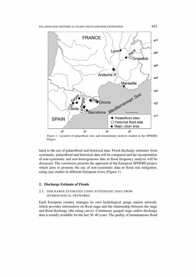
Figure 1. Location of palaeoflood sites and documentary archives studied in the SPHEREProject.
lated to the use of palaeoflood and historical data. Flood discharge estimates fromsystematic, palaeoflood and historical data will be compared and the incorporationof non-systematic and non-homogeneous data in flood frequency analysis will bediscussed. The conclusion presents the approach of the European SPHERE projectwhich aims to promote the use of non-systematic data in flood risk mitigation,using case studies in different European rivers (Figure 1).
2. Discharge Estimate of Floods
2.1. DISCHARGE ESTIMATES USING SYSTEMATIC DATA FROM
HYDROLOGICAL NETWORKS
Each European country manages its own hydrological gauge station network,which provides information on flood stage and the relationship between the stageand flood discharge (the rating curve). Continuous gauged stage and/or dischargedata is usually available for the last 30–40 years. The quality of instantaneous flood
626 G. BENITO ET AL.
data is generally lower than measurements on average flow because direct meas-urement of the largest floods is an unusual situation due to logistic constraints on itsmeasurement: high flow velocities, danger for personnel and field gear; operationaldelay for someone to be present during the peak flood etc. In addition, duringlarge floods conventional stream gauge stations have great difficulty in accuratelyrecording extreme floods – they may be inundated, damaged by floodwaters or eventotally destroyed producing gaps in the gauged flood record of the largest floods.Therefore, in many cases, data of the largest floods within systematic gauge recordsare actually post-flood indirect estimates. Extrapolation of the rating curve, fromlow stage-discharge to high stage-discharge, is then a fundamental step for dis-charge estimation and can add substantial errors. It could be improved by includinghydraulic considerations, for example taking into account the river topography andspecific roughness conditions during floods. Errors on flood discharge estimate aregenerally considered to be in the range of 10% to 100%, depending on the qualityof the rating curve and its extrapolation to large floods.
2.2. FLOOD LEVEL DERIVED FROM PALAEOFLOOD DATA USING GEOLOGICAL
INDICATORS
Techniques to estimate peak discharge based on palaeostage indicators have beensuccessfully employed in several regions of the USA (see latest works in House etal., 2002) such as Texas (Kochel et al., 1982), Arizona (Partridge and Baker, 1987;Ely et al., 1993, O’Connor et al., 1994) Utah (Webb et al., 1988), Colorado (Jarret,1990, 1991) Wisconsin (Knox, 1985), Washington (Chatters and Hoover, 1986)and Southern California (Enzel, 1992) as well as in other countries including India(Ely et al., 1996, Kale et al., 1994), South Africa (Boshoff et al., 1993; Zawada,1997), Israel (Greenbaum et al., 2000), Peru (Wells, 1990) and Australia (Pickup etal., 1988). In Europe, studies using palaeoflood hydrology in combination with his-torical flood information data showed an improvement in estimating flood hazards(Benito et al., 1998, 2003; Thorndycraft et al., 2003).
A palaeoflood record is obtained from interdisciplinary techniques that combinedifferent sources of past flood information from geomorphological settings andstratigraphic criteria separating and correlating flood units. Sources of palaeoflooddata are geological indicators such as flood deposits, silt lines and/or erosion linesfound along a river’s channel, valley walls and/or terraces etc. Palaeoflood dataand its meaning as minimum, maximum or exact flow stage value depend upon themark type (see review in Section 2.4), although most of them represent minimumflood stage indicators. It is relatively easy to reconstruct the size of the largestpalaeoflood(s) in a given time period, and frequently most efforts are directed atreconstructing the complete record (number and size) of large-intermediate palaeo-floods. Two different geomorphologic settings can be considered: (a) bedrock riverreaches and (b) alluvial river reaches. Different methodological procedures areapplied in each case for reconstructing the palaeoflood record, or stage constraints
PALAEOFLOOD, HISTORICAL FLOOD AND FLOOD RISK ESTIMATION 627
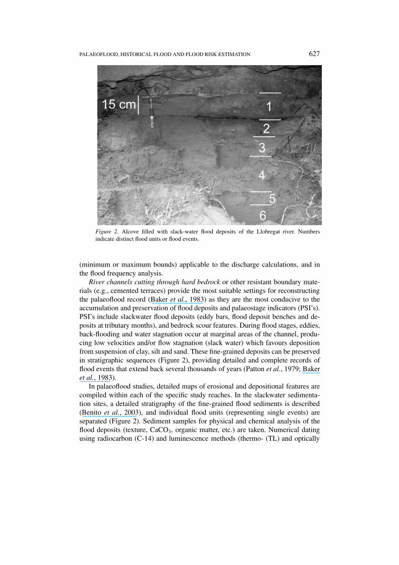
Figure 2. Alcove filled with slack-water flood deposits of the Llobregat river. Numbersindicate distinct flood units or flood events.
(minimum or maximum bounds) applicable to the discharge calculations, and inthe flood frequency analysis.
River channels cutting through hard bedrock or other resistant boundary mate-rials (e.g., cemented terraces) provide the most suitable settings for reconstructingthe palaeoflood record (Baker et al., 1983) as they are the most conducive to theaccumulation and preservation of flood deposits and palaeostage indicators (PSI’s).PSI’s include slackwater flood deposits (eddy bars, flood deposit benches and de-posits at tributary months), and bedrock scour features. During flood stages, eddies,back-flooding and water stagnation occur at marginal areas of the channel, produ-cing low velocities and/or flow stagnation (slack water) which favours depositionfrom suspension of clay, silt and sand. These fine-grained deposits can be preservedin stratigraphic sequences (Figure 2), providing detailed and complete records offlood events that extend back several thousands of years (Patton et al., 1979; Bakeret al., 1983).
In palaeoflood studies, detailed maps of erosional and depositional features arecompiled within each of the specific study reaches. In the slackwater sedimenta-tion sites, a detailed stratigraphy of the fine-grained flood sediments is described(Benito et al., 2003), and individual flood units (representing single events) areseparated (Figure 2). Sediment samples for physical and chemical analysis of theflood deposits (texture, CaCO3, organic matter, etc.) are taken. Numerical datingusing radiocarbon (C-14) and luminescence methods (thermo- (TL) and optically

628 G. BENITO ET AL.
stimulated- (OSL), for example) is obtained, through collection of organic (seeds,charcoal, wood debris, etc.) and sand samples, respectively.
Common dating techniques such as C-14, TL and OSL may contain deviationsfrom the true age. In the case of radiocarbon this depends upon the age (years BP)and the amount of carbon in the sample. For samples with an age ranging from 0to 5000 years BP, standard deviations are between ±9 to ±12 years for samplescontaining 25 g of C, and between ±80 to ±110 years for <0.005 g of C in thesample (Mook and Waterbolk, 1985). Due to atmospheric C-14 fluctuations duringthe last 450 years, multiple calendar dates, or a much broader spectrum of calendaryears, may be derived from a single radiocarbon date (Stuiver, 1978). However,the main problem of numerical dating is not the error of the measurement but thescarcity of organic remains within the flood deposits and the residence time of theorganic material in the environment prior to its deposition within the flood depositsequence (Ely et al., 1992). New C-14 dating techniques based on accelerated massspectrometry (AMS) have helped resolve the problem since it permits the dating ofminute remnants such as seeds or small fragments of charcoal. For young floods(last 200 years) dating can be completed using distinctive archaeological materials(Benito et al., 1998) and/or radio-isotopes, for example 137Cs which is derived fromatmospheric nuclear testing (Baker et al., 1985; Ely et al., 1992).
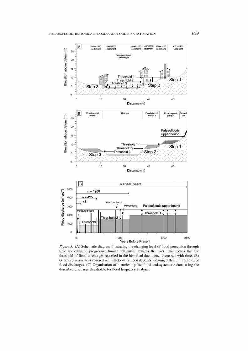
The final palaeoflood record is completed using available stratigraphical andgeomorphological criteria and correlation at multiple sites. The palaeoflood resultscomprise the stratigraphy with the number of the palaeofloods, sedimentologicalanalysis, and their minimum palaeostages and the chronology (absolute or relative)of each palaeoflood record. To address the evaluation of the magnitude and fre-quency of flooding, over a long time span (decades to millennia), the constructionof a complete catalogue of palaeodischarges, exceeding or not exceeding variouscensoring levels or threshold discharges (Figure 3B), over specific time periods, isrequired. A censoring level is a threshold of discharge or stage above which thepalaeoflood record can be assumed to be complete over a specific time interval(Baker, 1989), i.e., all discharges exceeding the censoring level (threshold), duringthis time period, have left evidence in the palaeoflood record.
In alluvial valleys, an approach using floodplain terraces as palaeohydrologicbounds can be applied. The palaeohydrologic bound methodology is based on thestatement that if ages can be derived for preserved and/or flood-modified surfaces,then the surfaces can become conservative datum for the magnitude of large floods(Levish et al., 1997; Levish, 2002). The absence of features indicative of signifi-cant inundation is positive evidence of non-exceedence of a specific, limiting floodstage over the time spanned by the surface. This palaeohydrologic bound approachis less sensitive to record a complete catalogue of floods over distinct periodsof time, but the potential for identifying non-exceedence bounds in most riversprovide this technique with a near universal applicability. Within the study reaches,floodplains and lower terraces are mapped. Their altitudes are determined by ac-curately plotting their positions by surveying with theodolites or GPS. Erosional
PALAEOFLOOD, HISTORICAL FLOOD AND FLOOD RISK ESTIMATION 629
Figure 3. (A) Schematic diagram illustrating the changing level of flood perception throughtime according to progressive human settlement towards the river. This means that thethreshold of flood discharges recorded in the historical documents decreases with time. (B)Geomorphic surfaces covered with slack-water flood deposits showing different thresholds offlood discharges. (C) Organisation of historical, palaeoflood and systematic data, using thedescribed discharge thresholds, for flood frequency analysis.
630 G. BENITO ET AL.
and depositional flood-related features are located, as well as non-flooded surfaces(non-exceedence bounds). Detailed stratigraphic description of the late Holoceneflood deposits overlying different geomorphological units and their numerical dat-ing together with dating of non-flooded terraces will provide a suite of hydrologicbounds exceeded and non-exceeded during different time spans.
Three major uncertainties are associated with palaeoflood analysis: (1) waterdepth above the flood deposits during flood stage, (2) uncertainties related withnumerical dating of the flood deposits, (3) continuity and completeness of thepalaeoflood record. Palaeostage indicators can be in a range of between 0.3 and2 m lower than water stage during peak discharge. New criteria such as the highestend-point of the flood unit at the contact with the canyon slope used by Yang et al.(2000) provide a better approximation to the flood stage during peak discharge.
Regarding the continuity in the palaeoflood record, erosion of the flood benchesnear the main channel may lead to record gaps. However, for time spans recordedwithin a stratigraphic sequence or site, periods with no sediment deposition resultfrom a lack of major flood events at this time. In some cases this can be corrob-orated where there is the opportunity to correlate palaeoflood deposits with thehistorical record. For example, in the Ter Basin at Girona (NE Spain; Figure 1),an alcove located approximately 15 m above the river contains a record of threeextreme flood events. A coin preserved within the oldest flood unit dates from1650–52. Comparison with the historical flood record from this area (Barriendos1996–97) indicates four extreme events post-dating the age of this coin: Septem-ber 1678, October 1919, October, 1940 and October 1970. This site, therefore,indicates a continuous record of the extreme events occurring since the mid 17thcentury.
2.3. FLOOD LEVEL DERIVED FROM HISTORICAL DATA USING DOCUMENTARY
SOURCES
Documentary evidence not only provides historical facts about a society at a par-ticular time but can also provide information on environmental themes. Using suchrecords it is possible to analyse different environmental phenomena in terms oftheir temporal dimension or extreme expression.
The recovery of environmental information is not devoid of certain short-comings. Firstly, there is the large volume and variety of documents in whichinformation may sporadically or systematically appear. Further, this informationdoes not always directly describe a particular phenomenon but rather may exposeits effects or impact (proxy-data). And lastly, not all information is of optimumreliability and necessitates the critical analysis of its sources (Glaser, 1996). Thisproblem arises from the tradition of making successive copies, reinterpretations,selections or résumés of original texts and is aggravated by the printing andtranscription of documents.
PALAEOFLOOD, HISTORICAL FLOOD AND FLOOD RISK ESTIMATION 631
Information regarding past floods documented in Western Europe comes fromriverside societies where flooding can lead to damage of the infrastructure of theparticular locality. In pre-industrial societies, dependence on hydraulic energy andthe inability to construct large flood control systems resulted in a high degree ofvulnerability. It may be possible to compile a chronology of events dating from the13–15th centuries to the present day for societies with a well documented past.
Data acquisition should be undertaken from original document sources to en-sure their quality. This may involve consulting hundreds of manuscript volumes.The best information on floods and their effects is generally found in local ad-ministration records and in the more personal diaries and bibliographies. The needfor auxiliary techniques also arises, e.g., chronology for calendar adjustments ormetrology for the conversion of units of measure or palaeography for the correctinterpretation of writing styles.
According to present experience, the minimum information that may be ob-tained from historical archives would be the precise dating of past flood events,damages incurred, some reference to peak flood levels (Figure 4) and certain in-formation on the prevailing meteorological situation. This allows a straightforwardbut standardised classification of simple flood events, extreme floods causing dis-crete damage and floods that cause the total destruction of different infrastructures(Figure 3A). Most historical floods provide information on the water stage duringpeak discharge which can be precisely marked on buildings and landmarks or itcan be related to a datum (bridges, houses, gates, walls, and so on) exceededor non-exceeded by the flood waters. In the specific case of the River Ter inGirona (NE-Spain), 170 flood events for the period 1322–1987 have been iden-tified (Barriendos, 1996–97, Barriendos and Martin-Vide, 1998), 77 contain exactinformation on the flood stage, 89 are associated with levels exceeded or not ex-ceeded by the flood water and only 4 events do not provide any information on theflood stage.
2.4. SPECIFIC ERRORS IN FLOOD DISCHARGE ESTIMATES USING
NON-SYSTEMATIC DATA
Non-systematic data provides information related to water levels during flood epi-sodes (Figure 3A, B). Information regarding water stage associated with historicalflooding are: (1) sites or landmarks reached by the flood (e.g., churches, bridges,etc.), (2) flooded areas (e.g., orchards, floodplain areas), and (3) non-flooded areasor landmarks. Similarly, palaeostage indicators provide water stage informationon (1) elevations reached by the flood (e.g., erosion lines or silt and clay lines),(2) flooded areas (flood deposits and erosion landforms), and (3) non-flooded areas(unmodified geomorphic surface or soil profiles or areas lacking any allochthonousmaterial). This historical and palaeoflood information can be interpreted as differ-ent flood stage indicators: (1) exact discharge level (equal to the flood stage), (2)minimum flood stage, (3) maximum flood stage (Figure 3).
632 G. BENITO ET AL.
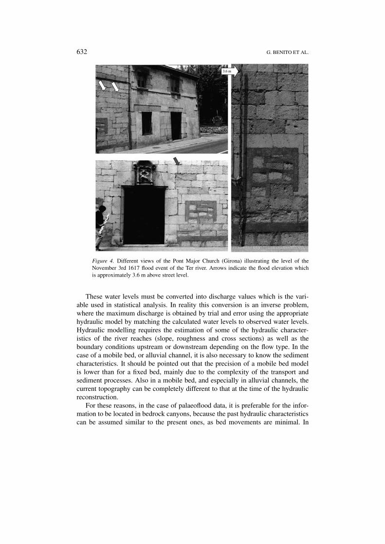
Figure 4. Different views of the Pont Major Church (Girona) illustrating the level of theNovember 3rd 1617 flood event of the Ter river. Arrows indicate the flood elevation whichis approximately 3.6 m above street level.
These water levels must be converted into discharge values which is the vari-able used in statistical analysis. In reality this conversion is an inverse problem,where the maximum discharge is obtained by trial and error using the appropriatehydraulic model by matching the calculated water levels to observed water levels.Hydraulic modelling requires the estimation of some of the hydraulic character-istics of the river reaches (slope, roughness and cross sections) as well as theboundary conditions upstream or downstream depending on the flow type. In thecase of a mobile bed, or alluvial channel, it is also necessary to know the sedimentcharacteristics. It should be pointed out that the precision of a mobile bed modelis lower than for a fixed bed, mainly due to the complexity of the transport andsediment processes. Also in a mobile bed, and especially in alluvial channels, thecurrent topography can be completely different to that at the time of the hydraulicreconstruction.
For these reasons, in the case of palaeoflood data, it is preferable for the infor-mation to be located in bedrock canyons, because the past hydraulic characteristicscan be assumed similar to the present ones, as bed movements are minimal. In
PALAEOFLOOD, HISTORICAL FLOOD AND FLOOD RISK ESTIMATION 633
the case of historical data, it will be critical to have information regarding thetopography of the river and on the settlement evolution of its surroundings, contem-poraneously with the historical information (Figure 3A). This available historicalcartography has to be used to determine the range of possible flow conditions. Iffor the first step (compilation of the flood events) lengthy work is needed, for thissecond step the research is more difficult still, and for this reason it is only appliedto certain selected rivers and cities.
One main concern regarding non-systematic information is the error that canbe introduced in the flood frequency analysis, although systematic information isnot free of errors either. At a flow gauge station, measurement error increases thevariability of flood quantile estimators (Potter and Walker, 1981), but if the stan-dard error is smaller than 10% the influence is negligible (Cong and Xu, 987). Thisstandard error is typical for the interpolation of rating curves at a gauge station. Fora large flood, however, the discharge must be obtained by extrapolation of the ratingcurve resulting in a greater error due to the change in hydraulic characteristicswhen the floodplain is flooded. In these cases it is advisable to obtain the max-imum discharge by following the methods described above for the non-systematicinformation, especially if the gauge station was destroyed, as the uncertainty of thisinformation will be similar to that of the largest floods in the systematic record.Even with a standard error of 60%, additional information regarding large floods isalways valuable (Cong and Xu, 1987).
3. Flood Frequency Analysis Using Non-systematic and Non-stationary Data
3.1. CLIMATIC NATURE OF EXTREME FLOODS
Advances in this topic are mainly devoted to improving knowledge of the at-mospheric factors involved in heavy rain events and their forecasting, usingdeterministic and statistical approaches. Climatic analysis of the flood-producingevents include the classification, characterisation and variability analysis of theseflood events (Hirschboeck, 1991; Webb and Betancourt, 1990; Enzel et al., 1989;Ely et al., 1993, 1994; Llasat, 1997; Redmond et al., 2002). This analysis canbe made from a local and/or regional point of view. However, regarding the tem-poral variability of the floods, it is necessary to consider that it can be relatedboth to changes in meteorological factors (connected with climatic fluctuations)and changes in environmental factors (mainly connected with human activity). Inthis case, the main problem is the lack of long term quantitative and instrumentalinformation that forces the use of palaeoflood and documentary flood sources toestablish links between flood occurrence and climate variability.
A basic question dealing with a long temporal flood series is whether theflood-producing mechanisms in the past have been similar to those of the present(Hirschboeck, 1991). The analysis of the monthly distribution of historical floods inthe Iberian Peninsula for the last millennium shows a similar pattern to the presentmonthly flood distribution (Barriendos, 1996–97, Benito et al., 1996, Barriendos
634 G. BENITO ET AL.
and Martín-Vide, 1998), indicating that flood-producing mechanisms in the pasthave been similar to those operating at present. It is thought that general featuresof present-day atmospheric circulation were probably in existence by the mid- tolate Holocene (Knox, 1993). However, flood distributions in the Iberian Peninsulahave changed through time as indicated by the clusters of flood events at specificperiods both in the historical record (Sánchez Rodrigo et al., 1995, Barriendos,1996–97, Benito et al., 1996, Barriendos and Martín-Vide, 1998) and in the pa-laeoflood record (Benito et al., 2003). It has been established that floods are highlysensitive to even modest changes in climate (Enzel et al., 1989; Knox, 1993, 2000;Ely, 1997; Barriendos, 1996–97, Redmond et al., 2002). Historical flood and pa-laeoflood analysis permits the identification of periods showing a greater frequencyof a particular behaviour, or pattern, related to changes in the atmospheric globalcirculation and, in some way, allows the estimation of the size of these anomaliesover time. The linkages between past floods and climate is critical to address thecomplexity of the non-stationarity problem in flood frequency analysis.
For the north east of Spain, the historical flood record, with more than 248flood events, shows clusters of floods during specific time periods: AD 1588–1610,AD 1760–1800 and AD 1840–1859 with an additional minor phase between AD1660–1700 (Barriendos, 1996–97). A climatic characterisation of these periodswas possible using historical documentary sources. The period AD 1588–1610 wascharacterised by a flood frequency twice the mean, and included the great flood ofAD 1617 that affected several basins of the Mediterranean coast. By contrast theperiod AD 1760–1800 was characterised by high climatic irregularity accompaniedby both hydrologic extremes, catastrophic floods and drought. The final period AD1840–1859 was characteristically similar to the AD 1588–1610 cluster, includinga sharp increase in the number of floods and a decrease in periods of drought. Thisphase represented the end of the Neoboreal episode in Mediterranean latitudes.These marked clusters of historical floods are associated with changes in the cli-matic pattern at both the regional and global scales (Barriendos and Martín Vide,1998; Brázdil et al., 1999). Any realistic analysis of flood frequency projectedover time spans greater than a 100 years must consider these types of changes intemporal flood distribution.
In order to evaluate the size of these anomalies through time a detailed meteo-rological analysis of each historical flood event is required. The problem in thiscase is the lack of the instrumental data (pressure, temperature and humidity atdifferent atmospheric levels) that prevents the reconstruction of the synoptic frame-work of each event. One possibility is to use a public pressure database (e.g., thoseof the Climate Research Unit or of the NOAA), but in this case daily data are onlyavailable for less than 100 years and monthly data can be obtained only for one ortwo centuries. Another possibility is to use daily temperature and pressure series fora longer period obtained within the framework of other international projects. Forinstance, the daily series of Padua, Milan, San Fernando/Cádiz, Belgium, Uppsalaand Stockolm, from the 18th century to the present, are available in European data-
PALAEOFLOOD, HISTORICAL FLOOD AND FLOOD RISK ESTIMATION 635
bases (Camuffo and Jones, 2002). The third possibility is to reconstruct each eventon the basis of meteorological information included in the flood event descriptionfound in the manuscripts and other contemporaneous information. This techniquehas already been applied for the analysis of catastrophic naval events based onlogbooks (García et al., 2000). This kind of analysis can be improved by the in-troduction of conceptual models based on the complete meteorological analysisof recent flood events. Here, collaboration between meteorologists, climatologistsand historians is needed.
3.2. STATISTICAL FRAMEWORK
Flood frequency analysis (FFA) with systematic data is generally developed usingannual maximum values and the assumptions of interannual independence andstationarity of the flood population. Use of historical and palaeoflood informationgives rise to two specific problems dealing with: (a) non-systematic data (onlythe major floods remain known) and (b) non-homogeneous data (hydroclimat-ically induced non-stationarity due to natural climatic variability within the last1000–10000 years).
Non-Systematic Data
The basic hypothesis in the statistical modelling of historical and palaeoflood in-formation is that a certain perception of water level exists and that over a specifiedtime interval (historical or prehistorical), all exceedances of this level have beenrecorded, either in newspapers, in people’s memory, or through geological pa-laeoflood evidence left along the river channels such as sediment deposits (Figure3).
In the United States, the U.S. Water Resources Council (1982) recommendedthe use of the method of adjusted moments for fitting the log Pearson type IIIdistribution. A weighting factor is applied to the data below the threshold observedduring the gauged period to account for the missing data below the threshold inthe historical period. Several studies have pointed out that the method of adjustedmoments is inefficient. Maximum likelihood estimators (Condie and Lee, 1982)based on partially censored data have been shown to be much more efficient andto provide a practical framework for incorporating imprecise and categorical data.Unfortunately, for most of the 3-parameter distributions commonly used in hydro-logy, the maximum likelihood method poses numerical problems. More recently,Lane and Cohn (1996) proposed use of the method of expected moments, a variantof the method of adjusted moments, which gives less weight to observations belowthe threshold (Figure 3C). According to preliminary studies, estimators based onexpected moments are almost as efficient as maximum likelihood estimators, buthave the advantage of avoiding the numerical problems related to the maximisationof likelihood functions.
636 G. BENITO ET AL.
Bayesian methods have been used with a great success to solve various prob-lems of statistical and stochastic hydrology. Van Gelder (1996) proposed a bayesianframework for the inclusion of historical information in flood frequency analysis.Bayesian approaches can also be used to improve the performance of existingmethods. For instance, in the method of expected moments, a bayesian method-ology can be developed to estimate the weight of observations below the detectionthreshold for the historical period (previous to systematic gauging). The Bayesianmethod is being used by the U.S. Bureau of Reclamation for the evaluation of damsafety, for guiding hydrologic dam safety decisions and management of reservoirsin the western United States (Levish et al., 1997; O’Connell et al., 1997).
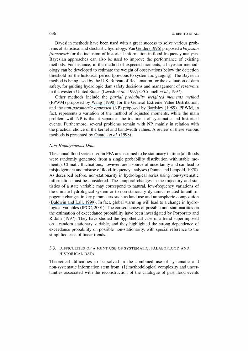
Other methods include the partial probability weighted moments method(PPWM) proposed by Wang (1990) for the General Extreme Value Distribution;and the non-parametric approach (NP) proposed by Bardsley (1989). PPWM, infact, represents a variation of the method of adjusted moments, while the mainproblem with NP is that it separates the treatment of systematic and historicalevents. Furthermore, several problems remain with NP, mainly in relation withthe practical choice of the kernel and bandwidth values. A review of these variousmethods is presented by Ouarda et al. (1998).
Non-Homogeneous Data
The annual flood series used in FFA are assumed to be stationary in time (all floodswere randomly generated from a single probability distribution with stable mo-ments). Climatic fluctuations, however, are a source of uncertainty and can lead tomisjudgement and misuse of flood-frequency analyses (Dunne and Leopold, 1978).As described before, non-stationarity in hydrological series using non-systematicinformation must be considered. The temporal changes in the trajectory and sta-tistics of a state variable may correspond to natural, low-frequency variations ofthe climate hydrological system or to non-stationary dynamics related to anthro-pogenic changes in key parameters such as land use and atmospheric composition(Baldwin and Lall, 1999). In fact, global warming will lead to a change in hydro-logical variables (IPCC, 2001). The consequences of possible non-stationarities onthe estimation of exceedance probability have been investigated by Porporato andRidolfi (1997). They have studied the hypothetical case of a trend superimposedon a random stationary variable, and they highlighted the strong dependence ofexceedance probability on possible non-stationarity, with special reference to thesimplified case of linear trends.
3.3. DIFFICULTIES OF A JOINT USE OF SYSTEMATIC, PALAEOFLOOD AND
HISTORICAL DATA
Theoretical difficulties to be solved in the combined use of systematic andnon-systematic information stem from: (1) methodological complexity and uncer-tainties associated with the reconstruction of the catalogue of past flood events
PALAEOFLOOD, HISTORICAL FLOOD AND FLOOD RISK ESTIMATION 637
(historical and/or palaeoflood data); (2) data processing of non-systematic in-formation – setting the appropriate censuring levels (threshold discharge) andnon-exceeded levels through different time spans – in such a way that increas-ing the amount of information produces an increase in the flood quantile estimatereliability, and (3) the influence and evidence of non-stationarity in long timescaleflood records.
The methodological complexity associated with reconstructing past flood re-cords can be solved selecting the most appropriate settings such as bedrock canyonsfor palaeoflood analysis using slackwater flood deposits, and cities or villages withcomplete documentary sources in the case of historical floods. In terms of purescientific research it is of interest to reconstruct the most complete catalogue ofpast floods and estimate the most accurate peak discharges possible, so that issuessuch as the water depth above slackwater flood deposits become of key importance.In practice, however, the critical issue for flood risk estimation is not the accuratecompilation of the whole past flood record, but the frequency of floods that mighthave impact on human activities. In this case, the number of floods exceeding ornot exceeding a surface or altitudinal level during a time period, which representsstage and subsequently discharge limits, may result in a significant improvementin the flood frequency analysis.
A major effort must be focused on flood frequency analysis for managing thisnon-systematic and, even more importantly, non-stationary information. Differentstatistical tools, such as the maximum likelihood and Bayesian methodologies,have been successful in managing non-systematic data, even data with a high de-gree of uncertainty regarding peak discharge values which has been solved usingcensuring levels and thresholds. In the analysis of non-stationary flood series it isalso critical to reach a better understanding of flood producing mechanisms andflood-climate links during different time periods. A change in flood generatingmechanisms, or in flood frequency patterns, can be related to climatic variations,and therefore, a study of these variations, quantifying the frequency of climaticpatterns responsible for flooding, is required.
Interest in past flood information will increase proportionally to the avail-ability and knowledge of methodological guides for reconstructing dischargesand tools (such as software) for flood frequency analysis using non-systematicand non-stationary data. To this end a new synergetic approach is being under-taken within the European Commission funded SPHERE project (Figure 5), basedon a multidisciplinary combination of pure and applied research, using palaeo-flood, historical flood and systematic data, combined with new statistical tools, foraddressing flood risk assessment.
4. Conclusions and Future Perspectives
In times when catastrophic floods have provoked European debate on the adequatestructural and non-structural measures needed to prevent and mitigate flood-
638 G. BENITO ET AL.
Figure 5. Flow diagram illustrating the SPHERE methodology.
associated hazards, palaeoflood and historical flood data provide a feasible solutionfor assessing and mapping flood risks, and planning flood-prone zones. These im-proved flood-potential estimates using palaeoflood and historical flood data alsohave significant beneficial economic and environmental implications, related tofloodplain planning, management design of hydraulic structures, management ofcritical water-resources and environmental conservation issues.
The European Commission funded SPHERE project (2000–2003) representsthe European effort in creating new approaches in the joint use of palaeoflood anddocumentary flood data as widely integrated long-term records in conventional hy-drology and engineering flood studies. From this point of view the SPHERE projectaims to address the standardisation of methodological procedures of reconstructingpast floods and to develop tools (methodologies and software) for its efficient in-tegration into flood frequency analysis for flood design and planning. Palaeofloodand documentary flood information is ideally suited for hydrological design ofstructures at risk from extreme floods (e.g., dam design) and for the delineationof flood prone areas with high levels of desired and/or tolerated protection againstfloods.
There are several ways in which future research in other disciplines, and thesearch for solutions to various practical problems, might benefit from the applica-tion of the results of this project to other disciplines and to practical problems. TheSPHERE project will contribute to the improvement of methods directed towardsthe reconstruction of past flood peak discharges, extending the hydrological recordsof extreme floods to include the last several millennia. In Europe, palaeoflood hy-
PALAEOFLOOD, HISTORICAL FLOOD AND FLOOD RISK ESTIMATION 639
drology is still a developing field with a great potential for being complementedfor the last thousand years with detailed documentary records. Inundation levelsidentified in the palaeoflood and documentary data analysis can be transformedinto flood magnitude and frequency through conventional hydraulic modelling.
An added value of documentary records is obtained from description and quan-tification of flood impacts on past societies, including economic losses, recoverystrategies and flood management at different periods. The history of past floods,such as the one that occurred in 1617 in NE-Spain (“year of the dilluvium”),provide a unique opportunity to understand the flood hydrology and the socialimpact of “catastrophic floods” with magnitudes far beyond the ones recorded ingauge stations. This, in turn, means gaining an understanding of individual extremeevents not available and perhaps not predicted by the instrumental record, as wellas to gain a new dimension on socio-economic impacts and perception of extremeevents, which needs to be evaluated according to different historical contexts. Flooddamage exerted on riverside societies during centuries is very valuable informationto be used in risk education tasks directed to Civil Protection technicians, volunteerbodies and in schools.
Hydrologic design of high risk structures, such as dams, or floodplain delin-eation for nuclear power plants, currently obtained using the probable maximumflood (PMF), can also benefit from palaeoflood hydrology. So far, the PMF is ob-tained from a combination of meteorological and physical assumptions producinga valuable but uncertain result. In some cases, the PMF appears to be unreason-ably large in comparison to the palaeoflood record (Levish et al., 1997). Here, wepropose the development of methodologies to obtain extreme flood data throughdirect measurements (past inundation levels) of the river systems, to be used forthe selection of appropriate hydrological model parameters, and for improvingflood frequency analysis. Many researchers have emphasised the potential gainof the statistical methods for estimating flood quantiles by the use of palaeofloodand documentary information. Because palaeoflood and documentary floods arelarge by definition, their introduction into a flood frequency analysis improvesthe estimates of the probabilities of rare floods. This is particularly true when 3-parameter distributions are considered. Moreover, historical information increasesand tests the representation of outliers in the systematic data.
In terms of the hydrological effects of climate change, future global circulationmodel projections incorporate too much uncertainty to accurately specify expectedpatterns of precipitation change, and even less the frequency and magnitude ofextreme storm and flood events. Predictions can be improved by incorporatinglong-term flood records (several millennia) in climatic modelling and statisticalanalysis. The study of temporal variability of past climate-flood links can establishshort- and long-term relationships at regional levels and in areas within differentclimatic zones. Regional studies of long-term climate-flood links involve calibrat-ing the relationships, detecting trends (where they exist) and revising estimatesof return periods. This integration will greatly advance our understanding of flood
640 G. BENITO ET AL.
frequency and magnitude in the context of changing climates where the assumptionof stationarity (implicit in most current flood risk models) is being questioned.
Acknowledgements
This research was supported by the Spanish Committee for Science and Techno-logy (CICYT) grant HID99-0858, FEDER Project 1FD97-2110-CO2-02, REN-2001-1633 and by the European Commission (DG XII), through research contractnumber EVG1-CT-1999-00010 (Systematic, Palaeoflood and Historical data forthe improvement of flood Risk Estimation, “SPHERE” Project). SPHERE ProjectWeb page http://www.ccma.csic.es/dpts/suelos/hidro/sphere/home.html
References
Baker, V. R., Kochel, R. C., Patton, P. C., and Pickup, G.: 1983, Paleohydrologic analysis of Holoceneflood slack-water sediments, Internat. Assoc. of Sedimentologists Special Publ. 6, 229–239.
Baker, V. R., Pickup, G., and Polach, H. A.: 1985, Radiocarbon dating of flood events, KatherineGorge, Northern Territory, Australia, Geology 13, 344–347.
Baker, V. R.: 1989, Magnitude and frequency of palaeofloods, In: K. Beven and P. Carling (eds),Floods, Their Hydrological, Sedimentological and Geomorphological Implications, John Wiley,Chichester, pp. 171–183.
Baldwin, C. K. and Lall, U.: 1999, Seasonality of streamflow: the Upper Mississippi River, WaterResour. Res. 35, 1143–1151.
Bardsley, W. E.: 1989, Using historical data in nonparametric flood estimation, J. Hydrol. 108, 249–255.
Barriendos, M.: 1996–97, El clima histórico de Catalunya (siglos XIV–XIX). Fuentes, métodos yprimeros resultados, Revista de Geografía 30–31, 69–96.
Barriendos, M. and Martín Vide, J.: 1998, Secular climatic oscillations as indicated by catastrophicfloods in the Spanish Mediterranean Coastal Area (14th–19th Centuries), Climatic Change 38,473–491.
Benito, G., Machado, Ma.J. and Pérez-González, A.: 1996, Climate change and flood sensitivityin Spain, In: J. Branson, A. G. Brown and K. J. Gregory (eds), Global Continental Changes:The context of Palaeohydrology, Geological Society of London Special Publication No. 115, pp.85–98.
Benito, G., Machado, Ma. J., Pérez-González, A., and Sopeña, A.: 1998, Palaeoflood hydro-logy of the Tagus river, Central Spain, In: G. Benito, V. R. Baker and K. G. Gregory (eds),Palaeohydrology and Environmental Change, John Wiley, Chichester, pp. 317–333.
Benito, G., Sánchez-Moya, Y., Sopeña, A.: 2003, Sedimentology of high-stage flood deposits of theTagus River, Central Spain, Sediment. Geol. 157, 107–132.
Boshoff, P., Kovacs, Z., Van Bladeren, D., and Zawada, P. K.: 1993, Potential benefits frompalaeoflood investigation in South Africa, South African Civil Engineer 35, 25–26.
Brázdil, R., Glaser, R., Pfister, C., Antoine, J. M., Barriendos, M., Camuffo, D., Deutsch, M., Enzi,S., Guidoboni, E., and Rodrigo, F. S.: 1999, Flood events of selected rivers of Europe in theSixteenth Century, Climatic Change 43, 239–285.
Camuffo, D. and Jones, P. (eds): 2002, Improved understanding of past climatic variability from earlydaily European instrumental sources, Climatic Change 53, 1–392.
Chatters, J. C. and Hoover, K.A.: 1986, Changing later Holocene flooding frequencies on theColumbia River, Washington, Quaternary Res. 26, 309–320.
PALAEOFLOOD, HISTORICAL FLOOD AND FLOOD RISK ESTIMATION 641
Condie, R. and Lee, K. A.: 1982, Flood frequency analysis with historic information, J. Hydrol. 58,47–61.
Cong, A. and Xu, Y.: 1987, Effect of discharge measurement errors on flood frequency analysis,In: V. P. Singh (ed.), Application of Frequency and Risk in Water Resources, Reidel PublishingCompany, pp. 175–190.
Dunne, T. and Leopold, L. B.: 1978, Water in Environmental Planning, W. H. Freeman, SanFrancisco, 818 pp.
Ely, L. L.: 1997, Response of extreme floods in the southwestern United States to climatic variationsin the late Holocene, Geomorphology 19, 175–201.
Ely, L. L., Webb, R. H., and Enzel, Y.: 1992, Dating Historic flood deposits using post-bomb 14Cand 137Cs, Quaternary Res. 38, 196–204.
Ely, L. L., Enzel, Y., and Cayan, D. R.: 1994, Anomalous North Pacific atmospheric circulation andlarge winter floods in the southwestern United States, J. Climate 7, 977–987.
Ely, L. L., Enzel, Y., Baker, V. R., and Cayan, D. R.: 1993, A 5000-year record of extreme floods andclimate change in the southwestern United States, Science 262, 410–412.
Ely, L. L., Enzel, Y., Baker, V. R., Kale, V. S., and Mishra, S.: 1996, Changes in the magnitude andfrequency of Holocene monsoon floods on the Narmada River, Central India, Geol. Soc. Am.Bull. 108, 1134–1148.
Enzel, Y.: 1992, Flood frequency of the Mojave River and the formation of the late Holocene playalakes, southern California USA, Holocene 2, 11–18.
Enzel, Y., Cayan, D. R., Anderson, R. Y., Wells, S. G.: 1989, Atmospheric circulation duringHolocene lake stands in the Mojave Desert: evidence of regional climate change, Nature 341,44–47.
Enzel, Y., Ely, L. L., House, P. K., Baker, V. R., and Webb, R. H.: 1993, Paleoflood evidence fora natural upper bound to flood magnitudes in the Colorado River basin, Water Resour. Res. 29,2287–2297.
Francés, F.: 1998, Using the TCEV distribution function with systematic and non-systematic data ina regional flood frequency analysis, Stoch. Hydrol. Hydraul. 12, 267–283.
Francés, F., Salas, J. D., and Boes, D. C.: 1994, Flood frequency analysis with systematic, historicaland paleoflood data based on the GEV model, Water Resour. Res. 30, 1653–1664.
García, R., Gimeno, L., Hernández, E., Prieto, R., and Ribera, P.: 2000, Reconstructing the NorthAtlantic atmospheric circulation in the 16th, 17th and 18th centuries from historical sources,Climate Res. 14, 147–151.
Glaser, R.: 1996, Data and methods of climatological evaluation in historical climatology, HistoricalSocial Research 21, 56–88.
Greenbaum, N., Schick, A. P., and Baker, V. R.: 2000, The palaeoflood record of a hyperaridcatchment, Nahal Zin, Negev Desert, Israel, Earth Surf. Proc. Land. 25, 951–971.
Hirschboeck, K. K.: 1991, Climate and floods, In: National Water Summary 1988–1989, Floods andDroughts: Hydrologic Perspectives on Water Issues, US Geol. Surv. Water-Sup. Paper 2375, pp.67–88.
House, P. K., Webb, R. H., Baker, V. R., and Levish, D. R. (eds): 2002, Ancient Floods, ModernHazards: Principles and Applications of Palaeoflood Hydrology, Water Science and Application,Vol. 5, American Geophysical Union, 385 pp.
IPCC: 2001, In: R. T. Watson and the Core Writing Team (eds), Climate Change 2001: SynthesisReport. A contribution of Working Groups I, II and III to the Third Assessment Report of theIntergovernmental Panel on Climate Change. Cambridge University Press, Cambridge UK, 398pp.
Jarret, R. D.: 1990, Paleohydrologic techniques used to define the spatial occurrence of floods,Geomorphology 3, 181–195.
Jarret, R. D.: 1991, Paleohydrology and its value in analyzing floods and droughts, US Geol. Surv.Water-Sup. Paper 2375, 105–116.
642 G. BENITO ET AL.
Kale, V. S., Ely, L. L., Enzel, Y., and Baker, V. R.: 1994, Geomorphic and hydrologic aspects ofmonsoon floods in the Narmada and Tapi rivers in central India, Geomorphology 10, 157–168.
Knox, J. C.: 1985, Responses of floods to Holocene climatic change in the upper Mississippi Valley,Quaternary Res. 23, 287–300.
Knox, J. C.: 1993, Large increases in flood magnitude in response to modest changes in climate,Nature 361, 430–432.
Knox, J. C.: 2000, Sensitivity of modern and Holocene floods to climate change, Quaternary Sci.Rev. 19, 439–457.
Kochel, R. C., Baker, V. R., Patton, P. C.: 1982, Paleohydrology of Southwestern Texas, WaterResour. Res. 18, 1165-1183.
Lane, W. L. and Cohn, T. A.: 1996, Expected moments algorithm for flood frequency analysis, NorthAmerican Water and Environment Congress ’96, June 22–28, Anaheim, Ca, USA, 6 pp.
Levish, D. R., Ostenaa, D. A., and O’Connel, D. R. H.: 1997, Paleoflood Hydrology and dam safety,In: Proceedings of the International Conference on Hydropower, Waterpower ’97, August 5–8,1997, Atlanta, GA, pp. 2205–2214.
Levish, D. R.: 2002, Palaeohydrologic bounds – non-exceedance information for flood hazard as-sessment, In: P. K. House, R. H. Webb, V. R. Baker and D. Levish (eds), Ancient Floods, ModernHazards: Principles and Applications of Palaeoflood Hydrology, Water Science and Application,Vol. 5, American Geophysical Union, pp. 175–190.
Llasat, M. C.: 1997, Meteorological conditions of heavy rains, UNESCO: FRIEND Flow Regimesfrom International Experimental and Network Data. Third report: 1994–1997, pp. 269–276.
Mook, W. G. and Waterbolk, H. T.: 1985, Radiocarbon Dating, Handbooks for Archaeologists No.3, European Science Foundation, Strasbourg, 65 pp.
Munich Re Group: 2000, Welt der Naturgefahren/World of Natural Hazards, MünchenerRückversicherungs-Gesellschaft, Munich, CD-ROM.
O’Connell, D. O., Levish, D. R., and Ostenaa, D.: 1997, Bayesian flood frequency analysis withpaleohydrologic bounds for late Holecene paleofloods, Santa Ynez River, California, In: E. C.Gruntfest (ed.), Twenty Years Later: What We Have Learned Since the Big Thompson Flood, Spe-cial Publication 33, Natural Hazards Research and Applications Information Center, Universityof Colorado, pp. 183–196.
O’Connor, J. E., Ely, L. L., Wohl, E. E., Stevens, L. E., Meli, T. S., Kale, V. S., Baker, V. R.: 1994,4000-year record of large floods on the Colorado River in the Grand Canyon, J. Geol. 102, 1–9.
Ouarda, T. B. M. J., Rasmussen, P. F., Bobée, B., and Bernier, J.: 1998, Use of historical informationin hydrologic frequency analysis, Water Sciences Journal/Revue des Sciences de l’Eau 11, 41–49.
Partridge, J. and Baker, V. R.: 1987, Palaeoflood hydrology of the Salt River, Arizona, Earth Surf.Proc. Land. 12, 109–125.
Patton, P. C., Baker, V. R., and Kochel, R. C.: 1979, Slackwater deposits: a geomorphic techniquefor the interpretation of fluvial palaeohydrology, In: D. D. Rhodes and G. P. Williams (eds),Adjustments of the Fluvial System, Kendall-Hunt, Dubuque, IO, USA, pp. 225–252.
Pickup, G., Allan, G., and Baker, V. R.: 1988, History, paleochannels and paleofloods of the Finkeriver, Central Australia, In: Warner, R.F. (ed.), Fluvial Geomorphology of Australia, AcademicPress, Sydney, pp. 177–200.
Porporato, A. and Ridolfi, L.: 1998, Influence of weak trends on exceedance probability, Stoch.Hydrol. Hydraul. 12, 1–14.
Potter, K. W. and Walker, J. F.: 1981, A model of discontinuous measurement error and its effects onthe probability distribution of flood discharge measurements, Water Resour. Res. 17, 1505–1509.
Redmond, K. T., Enzel, Y., House, P. K., and Biondi, F.: 2002, Climate impact on flood frequencyat the decadal to millennial time scales, In: P. K. House, R. H. Webb, V. R. Baker and D. Levish(eds), Ancient Floods, Modern Hazards: Principles and Applications of Palaeoflood Hydrology,Water Science and Application, Vol. 5, American Geophysical Union, pp. 21–45.

PALAEOFLOOD, HISTORICAL FLOOD AND FLOOD RISK ESTIMATION 643
Sánchez Rodrigo, F., Esteban-Parra, M.J. and Castro-Díez, Y.: 1995, The onset of the Little Ice Age inAndalusia (Southern Spain): Detection and characterisation from documentary sources, AnnalesGeophysicae 13, 330–338.
Stedinger, J. R. and Baker, V. R.: 1987, Surface water hydrology: historical and paleofloodinformation, Rev. Geophys. 25, 119–124.
Stuiver, M.: 1978, Radiocarbon timescale tested against magnetic and other dating methods, Nature273, 271–274.
Thorndycraft, V. R., Benito, G., Barriendos, M., and Llasat, M. C. (eds.): 2003, Palaeofloods, Histor-ical Data and Climatic Variability: Applications in Flood Risk Assessment, CSIC, Madrid, 372pp.
U.S. Water Resources Council: 1982, Guidelines for Determining Flood Flow Frequency, U.S.Interagency Advisory Committee on Water Data, Hydrology Subcommittee, Bulletin 17B,Washington D.C., 28 pp.
Van Gelder, P. H. A. J. M.: 1996, A new statistical model for extreme water levels along the Dutchcoast, In: K. S. Tickle, I. C. Goulter, C. Xu, S. A. Wasimi, and F. Bouchart (eds), StochasticHydraulics ’96, Balkema, Rotterdam, pp. 243–249.
Wang, Q. J.: 1990, Unbiased estimation of probability weighted moments and partial probabilityweighted moments from systematic and historical flood information and their application toestimating the GEV distribution, J. Hydrol. 120, 115–124.
Webb, R. H. and Betancourt, J. L.: 1990, Climatic Variability and Flood Frequency of the Santa CruzRiver, Pima County, Arizona, US Geological Survey, Open-File Report 90-553, 69 pp.
Webb, R. H., O’Connor, J. E., and Baker, V. R.: 1988, Paleohydrologic reconstruction of floodfrequency on the Escalante River, South-Central Utah, In: R. V. Baker, R. C. Kochel and P.C. Patton (eds), Flood Geomorphology, Wiley, New York, pp. 403–418.
Wells, L. E.: 1990, Holocene history of the El Niño phenomenon as recorded in flood sediments ofthe northern coastal Peru, Geology 18, 1134–1137.
Yang, D., Yu, G., Xie, Y., Zhan, D., and Zhijia, L.: 2000, Sedimentary records of large Holocenefloods from the middle reaches of the Yellow River, China, Geomorphology 33, 73–88.
Zawada, P. K.: 1997, Paleoflood hydrology: method and application in flood-prone southern Africa,South Africa Journal of Science 93, 111–132.


![.Noah's Flood WTJ2004[1]](https://static.fdokumen.com/doc/165x107/631c39e73e8acd997705cf6b/noahs-flood-wtj20041.jpg)