US Coral Reefs in the Line and Phoenix Islands, Central Pacific Ocean: Status, Threats and...
47
15.1 Introduction (by J. Maragos and J. Miller) Pacific remote island areas (PRIA) are sovereign United States unincorporated and unorganized terri- tories not falling within the jurisdiction of any other US territory or State (GAO 1997; US DOI 2003). There are eight PRIA and all are under the jurisdic- tion of the US Department of Interior (DOI). All are low reef islets or atolls in the central Pacific Ocean. Table 15.1 and Fig. 15.1 present the size, location, and regional geography of the five PRIA that are the primary focus in this chapter: Baker and Howland Islands in the Phoenix Islands; and Jarvis Island, Kingman Reef, and Palmyra Atoll in the Line Islands. All five are located between Hawai’i and Samoa and are National Wildlife Refuges (NWR) administered by the US Fish and Wildlife Service (USFWS). The remaining three PRIA: Johnston Atoll NWR, Midway Atoll NWR, and Wake Atoll, are the subject of other chapters in this volume (Chapter 13, Rooney et al.; Chapter 17, Lobel and Lobel). Johnston Atoll is mentioned in this chapter because it is geologically part of the Line Islands archipelago. Wake Atoll, administered by the US. Air Force, is north of the Republic of the Marshall Islands. Midway Atoll is located at the northwest end of the Hawaiian Islands and is a PRIA because it was excluded from state jurisdiction in the Hawaii Statehood Act of 1959. This chapter covers the cultural, geological, and biophysical characteristics and history of the five PRIA. The following chap- ter (Chapter 16, Maragos et al.) covers the status, threats and significance of the five PRIA. Howland and Baker Islands are geologically part of the northwest–southeast trending Tokelau submarine ridge and located just 68 and 53 km north of the Equator, respectively, with Howland about 66 km northwest of Baker. They are normally referred to as outliers of their nearest island neigh- bors: the eight Phoenix Islands to the southeast that are within the jurisdiction of the Republic of Kiribati. The Tokelau submarine ridge extends further southeast through the western Phoenix Islands to the Tokelau Islands (a New Zealand Protectorate of three atolls) and Swains Island (within the US Territory of American Samoa). The nearest population center from Howland and Baker is Kanton Atoll (the only inhabited island of the Phoenix group) about 350 km to the southeast. The next closest inhabited islands are Tarawa Atoll, capital of Kiribati in the Gilbert Islands about 900 km to the west, and Funafuti Atoll, capital of Tuvalu (Ellice Islands), 900 km to the southwest of Howland and Baker. 15 US Coral Reefs in the Line and Phoenix Islands, Central Pacific Ocean 1 : History, Geology, Oceanography, and Biology James Maragos, Joyce Miller, Jamison Gove, Edward DeMartini, Alan M. Friedlander, Scott Godwin, Craig Musburger, Molly Timmers, Roy Tsuda, Peter Vroom, Elizabeth Flint, Emily Lundblad, Jonathan Weiss, Paula Ayotte, Enric Sala, Stuart Sandin, Sarah McTee, Todd Wass, Daria Siciliano, Russel Brainard, David Obura, Scott Ferguson, and Bruce Mundy 1 The opinions of the authors included in this report do not necessarily represent those of the agencies or insti- tutions at which they are employed. B.M. Riegl and R.E. Dodge (eds.), Coral Reefs of the USA, 595 © Springer Science + Business Media B.V. 2008
-
Upload
independent -
Category
Documents
-
view
3 -
download
0
Transcript of US Coral Reefs in the Line and Phoenix Islands, Central Pacific Ocean: Status, Threats and...

15.1 Introduction (by J. Maragos and J. Miller)
Pacific remote island areas (PRIA) are sovereign United States unincorporated and unorganized terri-tories not falling within the jurisdiction of any other US territory or State (GAO 1997; US DOI 2003). There are eight PRIA and all are under the jurisdic-tion of the US Department of Interior (DOI). All are low reef islets or atolls in the central Pacific Ocean. Table 15.1 and Fig. 15.1 present the size, location, and regional geography of the five PRIA that are the primary focus in this chapter: Baker and Howland Islands in the Phoenix Islands ; and Jarvis Island, Kingman Reef , and Palmyra Atoll in the Line Islands . All five are located between Hawai’i and Samoa and are National Wildlife Refuges (NWR) administered by the US Fish and Wildlife Service (USFWS). The remaining three PRIA: Johnston Atoll NWR, Midway Atoll NWR, and Wake Atoll, are the subject of other chapters in this volume (Chapter 13, Rooney et al.; Chapter 17, Lobel and Lobel). Johnston Atoll is mentioned in this chapter because it is geologically part of the Line Islands archipelago. Wake Atoll, administered by the US.
Air Force, is north of the Republic of the Marshall Islands. Midway Atoll is located at the northwest end of the Hawaiian Islands and is a PRIA because it was excluded from state jurisdiction in the Hawaii Statehood Act of 1959. This chapter covers the cultural, geological, and biophysical characteristics and history of the five PRIA. The following chap-ter (Chapter 16, Maragos et al.) covers the status, threats and significance of the five PRIA.
Howland and Baker Islands are geologically part of the northwest–southeast trending Tokelau submarine ridge and located just 68 and 53 km north of the Equator, respectively, with Howland about 66 km northwest of Baker. They are normally referred to as outliers of their nearest island neigh-bors: the eight Phoenix Islands to the southeast that are within the jurisdiction of the Republic of Kiribati . The Tokelau submarine ridge extends further southeast through the western Phoenix Islands to the Tokelau Islands (a New Zealand Protectorate of three atolls) and Swains Island (within the US Territory of American Samoa). The nearest population center from Howland and Baker is Kanton Atoll (the only inhabited island of the Phoenix group) about 350 km to the southeast. The next closest inhabited islands are Tarawa Atoll, capital of Kiribati in the Gilbert Islands about 900 km to the west, and Funafuti Atoll, capital of Tuvalu (Ellice Islands), 900 km to the southwest of Howland and Baker.
15US Coral Reefs in the Line and Phoenix Islands , Central Pacific Ocean1: History, Geology, Oceanography, and BiologyJames Maragos, Joyce Miller, Jamison Gove, Edward DeMartini, Alan M. Friedlander, Scott Godwin, Craig Musburger, Molly Timmers, Roy Tsuda, Peter Vroom, Elizabeth Flint, Emily Lundblad, Jonathan Weiss, Paula Ayotte, Enric Sala, Stuart Sandin, Sarah McTee, Todd Wass, Daria Siciliano, Russel Brainard, David Obura, Scott Ferguson, and Bruce Mundy
1 The opinions of the authors included in this report do not necessarily represent those of the agencies or insti-tutions at which they are employed.
B.M. Riegl and R.E. Dodge (eds.), Coral Reefs of the USA, 595© Springer Science + Business Media B.V. 2008

596 J. Maragos et al.
Palmyra Atoll , Kingman Reef , and Jarvis Island are part of the 12 Line Islands and associated with the northwest–southeast trending Line Islands sub-marine ridge. Kingman and Palmyra are near the north and Jarvis at the center of the ridge. Despite Johnston’s locale at the far north end of the sub-merged Line Islands ridge, it is closest to the Hawaiian Islands in terms of distance (700 km vs 1,600 km from Kingman Reef) and biogeography (Maragos and Jokiel 1986). The remaining eight emergent Line Islands belong to the Republic of Kiribati with three inhabited (Teraina, Tabuaeran, and Kiritimati) between Palmyra and Jarvis and the remaining five uninhabited (Malden, Starbuck, Vostok, Millennium, and Flint) south of Jarvis and accounting for the southern portion of the archipel-ago. Jarvis is located near the Equator approximately 1,600 km due east of Howland and Baker . Kingman and Palmyra are at latitude ~6° N, with Kingman about 61 km northwest of Palmyra. Their nearest population centers are Honolulu 1,880 km to the north, and Teraina, Tabuaeran, and Kiritimati about 220–600 km to the south. Jarvis is about 365 km southwest of inhabited Kiritimati and about 730 km south of Palmyra and Kingman.
Before Kiribati assumed jurisdiction of 16 Line and Phoenix Islands in 1979, Teraina, Rawaki, Tabuaeran,
Kiritimati, Millennium, and Kanton were previously named Washington Island; Phoenix Islands; and Fanning, Christmas, Caroline, and Canton Atolls, respectively, and are referred to the latter in earlier scientific literature cited in this chapter.
15.2 Political and Cultural History (by J. Maragos, M. Timmers, and J. Miller)
Archaeological evidence at neighboring islands and atolls in the Line and Phoenix Islands indicate that early Polynesians and Micronesians were likely the first visitors to the five PRIA during the previous millennium, although brief archaeologi-cal surveys to date at Palmyra (C. Streck 1987) and Baker and Howland (Shun 1987) have not revealed supporting evidence. The five PRIA were all uninhabited at their time of rediscovery by European and American explorers, whalers, and miners during the past two centuries. All five are presently uninhabited except for caretak-ers and a dozen or more researchers at Palmyra during the field season. The lack of land at Kingman; arid conditions at Baker, Howland, and Jarvis ; and remote locations for all five are factors that probably discouraged or prevented their long-term occupation in the past.
The five PRIA were claimed for the United States under the Guano Islands Act of 1856. Guano consists of seabird droppings rich in phosphates that were commercially valuable as fertilizer for agriculture and for military pro-duction of explosives. The Act provided the discoverer of uninhabited islands, unclaimed by other nations, the exclusive right to mine guano for US citizens, and these rights extended to their heirs (GAO 1997). Baker , Howland , and Jarvis Islands were also claimed by the United Kingdom as British Overseas Territories from 1886 to 1934, and guano mining was conducted by both British and American companies through the end of the nineteenth century, after which guano deposits were largely depleted. Palmyra Atoll and Kingman Reef were not actively mined because Palmyra was too wet for guano accumu-lation while Kingman was mostly submerged and lacked guano.
Table 15.1. Emergent and submerged areas within the NWR boundaries of the five PRIA (GAO 1997; 2003–2004 Quickbird Imagery for Baker , Howland and Jarvis ; US DOI 2003).
Submerged Emergent lands (toName reefa/ land 3b or 12 nmic)
Baker Island NWRb 172.5 ha (426.2 ac) 12,680 ha (31,332 ac)
Howland Island NWRb 183.3 ha (453 ac) 12,989 ha (32,096 ac)
Jarvis Island NWRb 447.5 ha (1107 ac) 14,744 ha (36,432 ac)
Kingman Reef NWRc 1.2 ha (3 ac)a 195,752 ha (483,703 ac)
Palmyra Atoll NWRc 275.2 ha (680 ac) 208,512 ha (515,233 ac)
nmi = nautical mile = 1.828 km; ha = hectare; ac = acrea Emergent reef area only for Kingman which lacks landb Areas based on 3 nm offshore boundaries for Baker, Howland and Jarvisc Areas based on 12 nm offshore boundaries for Palmyra and Kingman

15. US Coral Reefs in the Line and Phoenix Islands , Central Pacific Ocean 597
15.2.1 Baker , Howland and Jarvis Islands
Baker and Jarvis were first sighted in 1832 by Michael Baker, the captain of an American whal-ing ship. After discovering guano deposits at Jarvis, he claimed Jarvis for the United States. Captain Baker returned to Baker Island in 1838 to claim it for the United States as well. In 1855 Captain Baker sold his interest in Baker and Jarvis Islands to the American Guano Company (AGC), who in turn claimed both islands under the Guano
Islands Act of 1856. The company mined guano at both islands until the 1880s, and then abandoned them. Howland was discovered in 1842 by a New England whaler, George Netcher who reported it overrun by rats from an earlier shipwreck. Later the AGC and a competing firm owned by Arthur Benson claimed Howland. Both companies mined guano there between 1857 and 1878 and then abandoned the island (GAO 1997).
In the interest of developing the islands for com-mercial aviation stopovers and firmly establishing American jurisdiction, the US organized military
Fig. 15.1. Location of the five US Line and Phoenix Islands PRIA covered in this chapter (Baker , Howland , Jarvis , Kingman and Palmyra) plus Johnston Atoll. Map from Coral Reef Ecosystem Division (CRED) of NOAA’s Pacific Islands Fisheries Science Center (PIFSC), with seafloor topography derived from satellite altimetry and ship-based soundings (Smith and Sandwell 1997)

598 J. Maragos et al.
personnel and Hawaiian high school graduates of Kamehameha Schools from Honolulu, later to be known as the Hui Panala’au (Bryan 1974; Kikiloi and Tengan 2002), to occupy the three islands and others beginning in 1935. In 1936 President Roosevelt moved to place all three islands under the jurisdiction of the Secretary of Interior. Airfields were constructed at Howland in 1937 prior to Amelia Earhart’s and Fred Noonan’s failed attempt to land there. After a 1942 Japanese military attack that killed two of the Hawaiians at Howland, the US evacuated all civilians from the islands and destroyed all facilities at Jarvis . In 1943, American troops continued to occupy Howland and Baker and built an airstrip at Baker in preparation for the American assault on Japanese forces at Tarawa Atoll . The island housed up to 120 officers and 2,000 men. By March 1944, after the successful outcome of war efforts, the US military abandoned Howland and Baker. In 1974, the US Fish and Wildlife Service assumed administrative responsi-bility for all three islands and established them as National Wildlife Refuges . Later, the USFWS sur-veyed the islands and sponsored the eradication of cats from Howland and Jarvis, promoting the return of ground-nesting seabirds (see Rauzon 1985).
15.2.2 Kingman Reef
Kingman was first discovered by Captain Fanning, an American whaler, in 1798 and again by Captain Kingman in 1853. The US Guano Company claimed the atoll reef in 1860. Kingman was claimed again in 1922 by Lorrin Thurston on behalf of the Palmyra Copra Company for use as a fishing base. Later the Fullard-Leo family of Hawai’i claimed that the Palmyra Copra Company had ceded its interest in Kingman to the family. Despite the lack of guano at Kingman Reef , it was the fact that an American had first discovered the reef and no other nation had claimed it. Consequently, in 1934 President Roosevelt placed Kingman under the control of the US Navy, formally asserting American rights to it. In 1941, Kingman was among several of the PRIA around which Naval Defensive Seas and over which National Airspace Reservations were declared by President Roosevelt to exclude their use or occupation by foreign military powers. In 1937, Kingman was used as a temporary landing area for Pan American Airways seaplanes traveling between Hawai’i and Samoa. In January 2001 the
Navy agreed to convey Kingman Reef to the US Department of Interior, and Kingman was established as a NWR under administration of the USFWS. In contrast to the earlier designated PRIA refuges, the Kingman and Palmyra NWR boundaries extended to 12 nm due to President Reagan’s 1988 decision to extend US territorial waters to 12 nm offshore. In retrospect, a 3 nm boundary around Kingman would have been insufficient to protect all shallow reefs. At present (August 2007), a 2006 lawsuit filed by the Fullard-Leo heirs and associates in federal court contesting federal ownership of Kingman Reef was decided in favor of the federal owners.
15.2.3 Palmyra Atoll
Palmyra was discovered by the captain of the American ship Palmyra in 1802, but was not claimed until 1862 when ownership was asserted by Captain Zenas Bent and J.B. Wilkinson for the Kingdom of Hawai’i (GAO 1997). The British also claimed Palmyra in 1889. The Pacific Navigation Company bought Palmyra in 1885 and the com-pany’s interests were conveyed in 1911 to Judge Henry Cooper via petition to the Land Court of the Territory of Hawai’i. Judge Cooper sold all of Palmyra except two islets to the Fullard-Leo fam-ily in 1922. In preparation for possible war, the US Navy attempted to lease Palmyra from the Fullard-Leo family in 1938. However, in 1939 the US Congress authorized construction of a naval base at Palmyra, and the US filed suit to annex the atoll. Up to 6,000 servicemen occupied Palmyra Atoll Naval Air Station during the World War II (WWII) era. In 1947 the US Supreme Court, returned own-ership of the atoll to the Fullard-Leo family. The 1959 Hawai’i Statehood Act specifically excluded Palmyra, and by that time US Navy occupation had ceased and all other federal presence at the atoll ended. Subsequently, the atoll remained aban-doned except for resident caretakers supported by the Fullard-Leo family (GAO 1997). In 2000, The Nature Conservancy (TNC) purchased Palmyra, and later the US Department of Interior bought all reefs and islands from TNC except for the main island (Cooper), its airfield, and dock. In January 2001, the atoll was established as a NWR under administration of the USFWS. In 2005, TNC established a field research station capable of hous-ing up to 20 scientists and staff on Cooper Island which is now maintained by several caretakers.

15. US Coral Reefs in the Line and Phoenix Islands , Central Pacific Ocean 599
15.3 History of Biophysical Research (by J. Maragos and R. Tsuda)
Early scientific research focused on botanical and seabird surveys at all islands except Kingman which lacked land. The Whippoorwill expedition of 1924 and others sponsored terrestrial surveys and marine collections at many of the PRIA (G.C. Munro 1924, unpublished data; Christopherson 1927; Fowler 1927). The Pacific Ocean Biological Survey Program of the Smithsonian Institution sponsored several bird and vegetation surveys at the PRIA islands during the 1960s (Sibley et al. 1965). Based on specimens collected during the Smithsonian Institution surveys in July and October 1964, Tsuda and Trono (1968) reported 11 and 16 marine algae species, respectively, from Howland Island and Baker Island. In a monographic treat-ment of the Pacific red algae Polysiphonia and Herposiphonia, Hollenberg (1968a, b) included two species of Polysiphonia and three species of Herposiphonia from Jarvis Island; and one species of Herposiphonia from Howland Island. The only previous records of marine algae from Palmyra were 12 species reported by Howe and Lyon (1916).
The outbreak of ciguatera fish poisoning during the WWII Navy occupation of Palmyra stimulated extensive investigations beginning in the 1950s on marine algae and fish carrying the toxicity (Dawson et al. 1955; Goe and Halstead 1955; Halstead and Schall 1958; Helfrich et al. 1968). During this period marine phycologist E.Y. Dawson (1959) published an early assessment of environmental impacts on lagoon and vegetation caused by con-struction of the US Naval base at Palmyra, the first scientific documentation of anthropogenic impacts on an atoll reef. Other marine research included oceanography (Barkley 1962; Wyrtki 1967 and others later reviewed in this report), geology (later reviewed in this report), meteorology (Vitousek et al. 1980), and commercial fisheries, mostly by the National Oceanic and Atmospheric Administration and its predecessors. In 2000 research on bonefish populations was initiated at Palmyra because the atoll offered the opportunity to evaluate the effects of its low-intensity catch-and-release sport fishery on bonefish population structure and function in a protected and largely unaltered environment (Friedlander et al., in press).
The first coral surveys at any of the five PRIA began at Palmyra (Maragos 1979, 1987), and collection and identification of a few dozen cor-als were accomplished for Baker and Howland (J. Schmerfeld and J.E. Maragos 1998, unpub-lished data). Comprehensive research on coral reefs began in 2000, under the mandate of the US Coral Reef Task Force . NOAA has sponsored joint Pacific Reef Assessment and Monitoring Program (RAMP) investigations carried out by scientists from NOAA, USFWS, and several other institu-tions, to establish baseline parameters, collect oceanographic data, accomplish towed diver sur-veys around the perimeters of all reefs, and conduct biennial monitoring of the coral reef ecosystems at all eight PRIA, other US Pacific territories, and Hawai’i. The regular use of NOAA research vessels has facilitated these expeditions, and all five PRIA covered in this chapter have been investigated during expeditions in 2000, 2001, 2002, 2004, and 2006, with the next expedition scheduled in early 2008. The ecosystem research investigations have adopted uniform scientific methods to assess, map and monitor all other US-affiliated islands in the Pacific, including the Hawaiian, Samoan, and Mariana archipelagos and remaining PRIA, thus allowing comparisons of the status and health of all US coral reef ecosystems in the Pacific. These methods are detailed in earlier reports by Turgeon et al. (2002) and Brainard et al. (2005) and in the companion state of the reefs report (SORR) to be concurrently released at the 2008 International Coral Reef Symposium in Florida (Anon., in preparation), with Miller et al. (in preparation) authoring the PRIA chapter.
The Palmyra Atoll Research Consortium (PARC), established in 2005, is operated by TNC and pri-marily funded by the Gordon and Betty Moore Foundation and nine member research institu-tions. At present the American Museum of Natural History, California Academy of Science, Scripps Institution of Oceanography of the University of California (UC) at San Diego, Stanford University, UC at Irvine, UC at Santa Barbara, UC at Santa Cruz, University of Hawai’i, and Victoria University of Wellington are all presently members or affiliates of PARC. In addition, Stanford, Scripps, UC Santa Barbara and other PARC institutions have sponsored recent expeditions to Kingman Reef and neighbor-ing Kiribati islands and atolls in the northern Line Islands (Teraina, Tabuaeran, and Kiritimati).

600 J. Maragos et al.
15.4 Regional Setting
15.4.1 Geology and History of Reef Building in the Central Pacific (by J. Miller)
The Central Pacific seafloor in the vicinity of the Line and Tokelau ridges is a complex area, not well understood from a geological perspective. The Line Island ridge (Fig. 15.2) has numerous parallel and NW–SE trending features and is intersected by three fracture zones : Molokai , Clarion , and Clipperton . The volcanic structures of the Line Islands are diverse in shape, size, composition, and morphology (Davis et al. 2002). The Tokelau ridge lies near the termination of the Clipperton Fracture
Zone and is intersected by the Nova Canton trough (Fig. 15.1). The Tokelau ridge has two bends in its lineation and may be a possible hotspot trace or the result of plate extension, as discussed by Koppers and Staudigel (2005). Limited geological drilling and dredging has been done in both the Line (Schlanger et al. 1976, 1984; Garcia et al. 1983; Haggerty et al. 1982; Davis et al. 2002) and Tokelau (Koppers and Staudigel 2005) submarine ridges. Recent multibeam mapping around all of the US Pacific remote island areas (Vroom et al. 2006a; Ferguson et al. 2006) provides a detailed look at the morphology of the Line and Phoenix Islands covered here and provide the potential for a better understanding of their individual geologi-cal histories.
Fig. 15.2. Major geological features of East and Central Pacific Ocean discussed in this chapter (Map from CRED/PIFSC with seafloor topography from Smith and Sandwell (1997) )

15. US Coral Reefs in the Line and Phoenix Islands , Central Pacific Ocean 601
15.4.1.1 Tectonic Origins and Seafloor Ages of the Central Pacific
McNutt and Fisher (1987) identified the South Pacific Superswell (Fig. 15.2) and argued that the Darwin Rise area (Menard 1964) in the NW and Central Pacific, was located over the same Superswell area during the Cretaceous (144–65 Ma) (Jordahl et al. 2004). The northwestern part of the Darwin Rise is also called the West Pacific Seamount Province by Koppers et al. (2003). The Darwin Rise and the Superswell are both areas that are 200–700 m shallower than would be predicted by lithospheric subsidence models proposed by Sclater and Francheteau (1970), and Parsons and Sclater (1997). Various mechanisms were originally proposed to explain these depth anomalies, including an anomalously thin 75 km thick thermal plate (McNutt and Fisher 1987), uplift of the Darwin Rise during the Cretaceous (McNutt et al. 1990), and/or a Cretaceous super-plume (Larson, 1991). Koppers et al. (2003) point out that concentrated intra-plate volcanism in several island chains, including the Line Islands , was causally related to the thermal rejuvenation that formed the Darwin Rise and that this ancient Superswell resulted in lithospheric uplift of the seafloor. Lithospheric thinning and superplume models would predict that heat flow in the Darwin Rise and Superplume areas would be higher than normal, but heat flow has been shown to be no higher in these areas than for comparable age lithosphere in other areas (Stein and Abbott 1991; Stein and Stein 1993). Thus, alternate mechanisms that are currently proposed for the anomalously shallow areas include the presence of a buoyant volcanic layer beneath the crust-mantle boundary (Moho) (McNutt and Bonneville 2000), reheating events (Smith and Sandwell 1997), the dynamic effects of mantle plumes (Sleep 1992), and areas of the asthenosphere that are either more fertile or warmer than surrounding mantle (Natland and Winterer 2005).
The Line and Tokelau ridges lie within the Darwin Rise, on magnetically “quiet” seafloor formed during the Cretaceous Normal Superchron (120–83 Ma) (Atwater et al. 1993). The underlying seafloor along the Line Islands chain ranges from mid-Cretaceous (119 Ma) at the northern end to late Cretaceous at the southern end (83 Ma) (Davis
et al. 2002; Fig. 15.3). According to Natland and Winterer’s (2005) model, the Line Islands were formed near a spreading center on the eastern edge of the Pacific Plate between 70 and 122 Ma. The seafloor underlying the northern part of the Tokelau ridge is dated between 120.4 and 131.9 Ma (Early Cretaceous) (Muller et al. 1997; Clouard and Bonneville 2005).
In addition to the underlying seafloor ages, another critical element in understanding the evolution of island chains is accurate dating of dredge, drilling, and paleontological samples from the individual seamounts and islands. Davis et al. (2002) presented revised age estimates in the north-ern Line Islands (6–20° N) based upon previous studies (Schlanger et al. 1984; Garcia et al. 1983) and new 40Ar/39Ar geochronological evidence from nine volcanic edifices. These authors concluded that there were two major episodes of volcanism in the northern Line Islands, which lasted approxi-mately 5 Myr and were separated by approximately 8 Myr. The older episode (81–86 Ma) occurred along the eastern part of the northern islands over a distance of 1,200 km, while volcanism during the younger episode (68–73 Ma) was concen-trated along the western edge of the chain and may have extended over 4,000 km. Haggerty et al. (1982), using paleontological techniques, reported Cretaceous (70–75 Ma) ages at the southern end of the Line Island chain (9° S) near Caroline Atoll (Millennium) as well as Eocene sediments (33.7–54.8 Ma) engulfed by a volcanic eruption in the same area, indicating the volcanism in both the Cretaceous and the Eocene.
Because of these studies showing multiple, syn-chronous episodes of volcanism over large seg-ments of the Line Island chain in multiple time periods, Morgan’s (1972) hypothesis, that the Line Islands are a simple hotspot trace similar to the Hawaiian–Emperor chain that increases steadily in age from east to west, has been repeatedly challenged. A number of alternate models for formation of the Line Island chain and for cen-tral Pacific Cretaceous volcanoes in general have been proposed. Jackson and Schlanger (1976) suggested a mid-ocean ridge crest origin for the Line Islands, but petrologic results from DSDP (Deep Sea Drilling Project) Leg 33 showed that the Line Island basalts were similar to Hawaiian basalts, which argues against a ridge crest origin.

602 J. Maragos et al.
Fig. 15.3. Seafloor and seamount ages in the Central Pacific. See Table 15.2 for sources and error parameters for seamount ages. Triangles indicate locations of dredge or drill age data, and stars indicate location of multibeam data at six PRIA locations (Baker , Howland , Jarvis , Johnston, Kingman and Palmyra; Figs. 15.4–15.10) (Seafloor ages from Muller et al. 1997; Map by CRED/PIFSC)
Winterer (1976) and Orwig and Kroenke (1980) first proposed fractures in the Line Islands as mech-anisms for volcanic activity. Schlanger et al. (1984) and Garcia et al. (1983) suggested two or possibly
more hotspots as the origin of the Line Islands. Epp (1984) suggested a variety of mechanisms to explain the age distributions in the Line Islands including lithospheric melting and interaction with

15. US Coral Reefs in the Line and Phoenix Islands , Central Pacific Ocean 603
transform faults . Davis et al. (2002) discuss lithos-pheric extension as the mechanism for formation of these islands, while Koppers et al. (2003) propose that plate tension, hotlines, faulting, wetspots, and self-propagating volcanoes may work in conjunc-tion with hot spot volcanism over larger areas of the Pacific. Natland and Winterer (2005) discuss five sets of stresses in the upper mantle that combine to produce the patterns of great fissures and systems of fissures through the lithosphere along which seamount provinces and linear chains form.
Recent research by Koppers and Staudigel (2005) along the Tokelau ridge and Gilbert Island chain establishes seamount ages from dredge samples in these areas, particularly focusing on dating the bends that occur in the two chains. These seamount ages are combined with predicted hotspot traces from extinct hotspots (Wessel et al. 2003; Kroenke et al. 2004) to compare the age of Tokelau (57 Ma) and Gilbert (67 Ma) bends with the 47 Ma age of the Hawaiian–Emperor Bend (Dalrymple and Clague 1976), which has recently been revised to 50 Ma (Sharp and Clague 2006). Koppers and Staudigel (2005) argue that because the ages of the three bends are asynchronous, these data do not support a stationary hot spot paradigm, but may point to either hot spot motion or mag-matism caused by short-term local lithospheric extension as the origin of the Tokelau ridge.
15.4.1.2 Reef Growth and History
The history of reef growth and subsidence in the Line Islands was researched by Schlanger et al. (1984) based upon stratigraphy from three DSDP sites (165, 315, 316) in the north and central sections of the Line Islands and four dredge hauls in the southern Line Islands (Fig. 15.3, Table 15.2). DSDP site 315 was drilled near Fanning Atoll (Tabuaeran ) which lies on the eastern (older)2 side of the Line Islands, approximately 330 km south of Kingman Reef . The oldest mid-Cretaceous reefs in the Line Islands are from this site and were dated from Cenomanian -Albian age fossils (93.5–112 Ma) in basalts found in turbidites that were determined to be 93.3 Ma. Similar mid-Cretaceous reefs are also found at DSDP site 217 near Horizon
Guyot, which lies approximately 550 km to the north of Johnston Island (Winterer et al. 1973) at the far northern end of the Line Island chain.
Schlanger et al. (1984) identified Late Cretaceous (70–75 Ma) reefs along 2,500 km of the Line Island chain – at Kingman Reef (DSDP Site 165), Fanning Atoll (DSDP Site 315), south of Christmas Atoll (Kiritimati ) (DSDP Site 316), and on seamounts just north of Caroline Atoll (Millennium) (Dredges 44 and 45). The only evidence for post-Cretaceous reef formation was found at Kingman Reef and north of Caroline Atoll (Millennium) at the opposite ends of the Line Island chain. Late Eocene (33.9–40.4 Ma) fossils were found in Oligocene (23.0–33.9 Ma) turbidites at Kingman Reef. Dredge samples from north of Caroline Atoll (Millennium) con-tained reef limestones of Eocene through Plio–Pleistocene (0.1–55.8 Ma) age. Schlanger et al. (1984) also note that no reef limestone samples were found in eight dredge hauls taken between Johnston Atoll and Kingman Reef.
Reef growth, emergence, and subsidence on the six PRIA including Johnston Atoll since the Plio–Pleistocene have not been extensively docu-mented, and only a few studies exist on any of the Central Pacific reefs, reef islands, and atolls. All six of the PRIA for which multibeam data are presented in this paper are very low lying with little remaining subaerial evidence of previous sea stands. In addition, the surface and/or lagoons of the islands have been extensively modified by either guano mining (Baker , Howland , and Jarvis ) or by military construction activities (Johnston and Palmyra).
On Christmas Atoll (Kiritimati), which lies ~600 km southeast of Kingman Reef , a previous +0.5–1.0 m sea-level stand was documented with evidence of lagoon reefs that flourished 1.5–4.5 ka (1,000s of years before present) (Woodroffe and McLean 1998). An outcrop of limestone was dated at 130 ka and interpreted as being from the Last Interglacial period. Twenty-four cores were taken for a water resources survey. These cores consisted of highly fractured Pleistocene lime-stones to depths of 20–30 m, overlain by 1–4 m of sand and/or gravel. Radiocarbon dates from these cores ranged in age from 1.9 to ~40 ka. Woodroffe and McLean (1998) concluded that there has been little Holocene reef accumulation
2 However, according to the isochron map in Fig. 15.3, the eastern side of the Line Island chain is younger.

604 J. Maragos et al.
Table 15.2. Date estimates in Ma (millions of years before present) from seafloor samples, error estimates and sources of information (From Clouard and Bonneville 2005).
Long. Lat. Date Error Name Source
!150.4 !9 70.5 1.1 RD45-26D Schlanger et al. 1984!151.5 !7.5 71.9 1.4 RD44-3 Schlanger et al. 1984!155.28 0.7 59.0 0.8 RD43-1 Schlanger et al. 1984!157.35 2.1 35.5 0.9 RD41-1 Schlanger et al. 1984!158.5 4.2 91.2 2.7 DSDP-315 Lanphere and Dalrymple 1976!160.25 5.83 76.4 0.5 123D-15 Schlanger et al. 1984!162.9 6.3 69.8 0.3 SO33 D29 Davis et al., 2002!161.5 8.1 39.3 1.5 RD33 Schlanger et al., 1984!165 9 69.4 0.3 SO33 D49 Davis et al. 2002!160.4 9.1 78.7 1.3 128D-11 Schlanger et al. 1984!165.8 12.1 84.4 0.9 133D Saito and Ozima 1976!167 12.5 85.0 1.1 RD59-12 Schlanger et al. 1984!170 14 68.1 0.2 SO37 D10 Davis et al. 2002!166.5 15 82.3 0.6 RD61-1 Schlanger et al. 1984!169.2 15.5 68.2 0.2 SO33 D43 Davis et al. 2002!170.4 15.7 71.3 0.2 SO33 D28 Davis et al. 2002!169.5 16.4 71.0 0.2 Johnston Davis et al. 2002!168.22 16.5 86.0 0.9 RD63-7 Schlanger et al. 1984!168.6 17 84.8 0.2 Karin Ridge Davis et al. 2002!169 18 128.0 5 142D Saito and Ozima 1976!169 19.5 88.1 0.4 143D-102 Schlanger et al. 1984!168.75 19.5 82.5 0.4 Horizon Davis et al. 2002!171 20 73.5 0.1 S033 D72 Davis et al. 2002!176.19 !1.07 70.1 0.5 Lelei Koppers and Staudigel 2005!175.4 !2.6 66.1 0.6 Siapo Koppers and Staudigel 2005!175.15 !2.78 66.4 0.6 Polo Koppers and Staudigel 2005!175.47 !6.7 61.3 0.6 Matai Koppers and Staudigel 2005!172.88 !8.27 58.4 0.3 Ufiata Koppers and Staudigel 2005
and that Christmas Atoll (Kiritimati) reached its present form in the Middle Pleistocene or earlier. The Last Interglacial and the Holocene Interglacial seem to have deposited only a minor veneer of coral over these Pleistocene surfaces. Woodroffe and McLean (1998) also concluded that Christmas Island (Kiritimati) has not under-gone significant subsidence through the Late Quaternary. Local residents have claimed the contrary, rapid emergence over the past 30 years based upon lagoon shrinking, land expansion and shoreline shifts in the inner lagoon areas (U. Bukareiti, personal communication 2004).
Emery (1956), Ashmore (1973), and Keating (1987, 1992) all concluded that Johnston does not have a true atoll structure with emergent reef surrounding a central lagoon and described the anomalous structure with the only emergent reef being on the leeward (NW) side of the edi-fice, rather than on the windward side as more commonly found on oceanic islands and atolls.
Ashmore (1973) suggested that Johnston Atoll is tilted to the south-east, and Keating’s research sup-ports this hypothesis. Carbonate samples, but no volcanic rocks, were collected during four submers-ible dives on Johnston Island (Keating 1987) down to depths of 400 m, and all ages were determined to be less than 11,000 ybp. Keating concluded that all of the samples collected during the dives were formed on the shallow carbonate bank, dislodged and deposited at these deeper sites.
15.4.2 Geomorphology of the PRIA (by J. Miller, E. Lundblad, J. Weiss, and S. Ferguson)
Recently collected, high-resolution multibeam bathymetric data provide a detailed look at the submarine geomorphology of six islands, atolls and reefs in the US Line and Phoenix Islands (NOAA 2008 State of the Reefs Report) and can provide insight into the origin of the volcanic

15. US Coral Reefs in the Line and Phoenix Islands , Central Pacific Ocean 605
edifices and the history of the reefs. Bathymetric and backscatter data were collected in early 2006 using EM3002D and EM300 multibeam sonars aboard the NOAA Ship Hi’ialakai and a Reson 8101ER sonar aboard the survey launch R/V AHI (Vroom et al. 2006a; Ferguson et al. 2006).
Statistics for each of the islands, reefs or atolls to highlight possible similarities and differences among the six volcanic edifices are presented in Table 15.3. While no ages are available for Baker Island or Palmyra Atoll , these features lie very close to Howland Island (66 km) and Kingman Reef (61 km), respectively, and support the hypoth-esis that Baker is similar in age to Howland (70–72 Ma) and that Palmyra is similar in age to Kingman Reef. If this assumption can be made, five of the six PRIA were formed between 69 and 72 Ma during the second major pulse of volcanism in the area, although they lie on seafloor with a much wider range of ages (111–126.7 Ma).
As shown in Table 15.3, the summit areas of these islands range in size from 2–57 km2, yet all still remain near or above sea level approximately 70 Ma after their formation. These islands are con-siderably older than Kure Atoll (29.8 Ma), which is the oldest emergent edifice in the Hawaiian/Emperor chain. According to seafloor subsid-ence models (Sclater and Francheteau 1970; and Parsons and Sclater 1977), none of these old, very small islands should remain above sea level. Their continued emergence also contradicts work in the Hawaiian Archipelago by Grigg and Epp (1989) that showed that the depth of drowned banks is inversely related to summit area, and that the sum-mits of smaller banks were progressively deeper.
All of these island summit areas are considerably smaller than any emergent summit in the Hawaiian Archipelago, except for Nihoa Island, which is the youngest of the NWHI submerged banks with an age of approximately 7.2 Ma (Dalrymple et al. 1974). This might be explained by faster reef growth in areas further south than the Hawaiian Archipelago; however, Grigg and Epp (1989) indicate that Hawai’i and Johnston Island have similar coral growth rates of up to 9 mm/year, with the fastest known growth rate in the world being only 15 mm/year at St. Croix, USVI. In addition, there is little evidence of significant Holocene reef accretion at Christmas Atoll (Kiritimati), a process that is not possible if the atoll is emerging rather than subsiding.
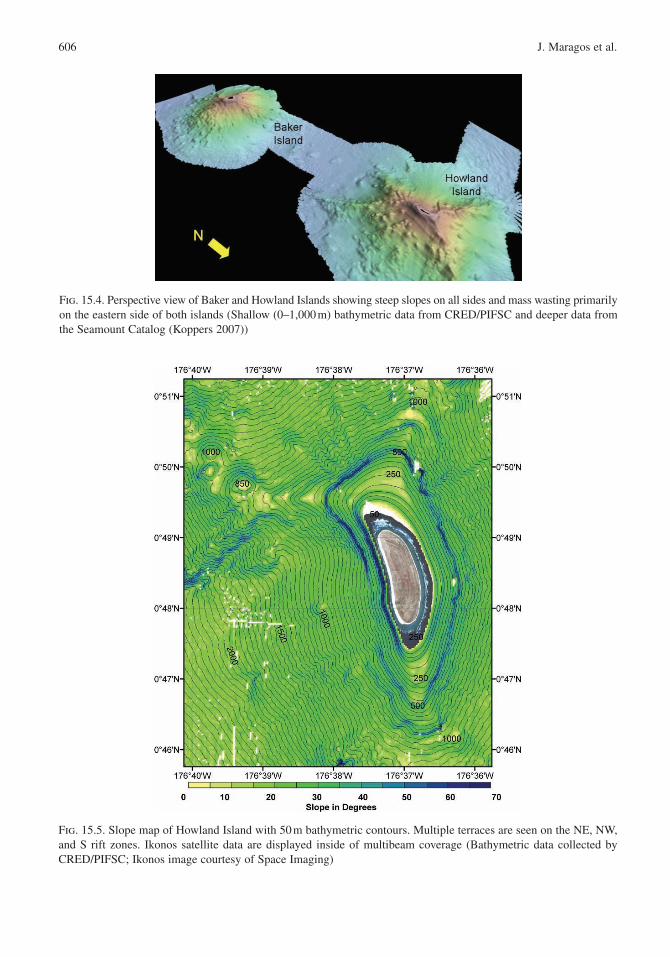
The summits of Baker , Howland (Fig. 15.4), and Jarvis Islands are the smallest of the PRIA, and the highest point on any of these lies just 8 m above sea level. Their tops are all isolated peaks rising from the deep ocean (3,000 m or greater) with no surrounding ridges or other connected features (refer to Fig. 15.1). Although the flanks of these islands are very steep with slopes between 30° and 40° down to a depth of about 1,000 m, all three also have small shallow terraces that prob-ably reflect previous sea level stands. The terraces (Fig. 15.5), marked by the areas of low slope, are present between ~7 and 17 m and between ~90 and 130 m around all three islands. Additional terraces are present at multiple depths off Howland Island.
Whereas Howland , Baker , and Jarvis Islands are isolated features with no underlying ridge structures, Kingman Reef and Palmyra Atoll are located on the same, very large shallow ridge structure that stretches
Table 15.3. Characteristics and age estimates of Baker , Howland , and Jarvis Islands, Kingman Reef, ; and Palmyra and Johnston Atolls. Emergent area, total area, and maximum elevation from the CIA World Fact Book 2007. Summit area is calculated as area above the 100 fathoms/182 m depth curve from recently collected multibeam data. Island ages from Clouard and Bonneville 2005. Volume, ocean bottom and seafloor ages from the Seamount Catalogue (Koppers 2007).
IslandLand area
(km2)Summit
area (km2)
Total area
(km2)Volume (km3)
Ocean bottom
(m)Max.
Elev. (m)Seafloor age
(Ma)Island age
(Ma)
Baker Island 2.1 4.21 129 2,302 5,015 8 123.8–124.3 n/aHowland Island 2.6 2.37 139 2,889 4,850 3 124.6–125.2 70–72Jarvis Island 5 5.07 152 4088 4580 7 111.6 n/aKingman Reef 0.01 32.52 1958 12,352 3,495 1 111.7–113.0 69.76Palmyra Atoll 3.9 20.48 1,950 2,168 2,715 2 111.7–112.2 n/aJohnston Atoll 2.6 56.61 276 n/a n/a 10 120.4–126.7 71.01
606 J. Maragos et al.
Fig. 15.4. Perspective view of Baker and Howland Islands showing steep slopes on all sides and mass wasting primarily on the eastern side of both islands (Shallow (0–1,000 m) bathymetric data from CRED/PIFSC and deeper data from the Seamount Catalog (Koppers 2007))
Fig. 15.5. Slope map of Howland Island with 50 m bathymetric contours. Multiple terraces are seen on the NE, NW, and S rift zones. Ikonos satellite data are displayed inside of multibeam coverage (Bathymetric data collected by CRED/PIFSC; Ikonos image courtesy of Space Imaging)

15. US Coral Reefs in the Line and Phoenix Islands , Central Pacific Ocean 607
from Kingman Reef at 6° N to past Christmas Atoll (Kiritimati) at 1° N (Fig. 15.1). This ridge structure is intersected by the Clipperton Fracture Zone, which stretches on towards the Tokelau ridge as the Nova Canton trough. Ages from dredge and drilling samples along this ridge range from 35 to 91 Ma and indicate three periods of volcanism. Both Kingman Reef and Palmyra Atoll connect to nearby secondary peaks on platforms in the 1,000–2,500 m depth range. Kingman is anomalous in that it has numerous conical features (Fig. 15.6), not seen on any of the other five forma-tions that follow the rift zone structures. Because there have been three different periods of volcanism in the Kingman area, we hypothesize that these cone struc-tures might represent resurgent volcanism in the area. Further dredging or submersible work on Kingman Reef would be necessary to test this hypothesis and to date the features.
Unexpectedly, Kingman Reef (Fig. 15.7) lacks shallow terrace structures outside of the central lagoons, such as those on Howland , Baker , and Jarvis Islands, although Palmyra Atoll (Fig. 15.8) has broad terraces off the east and west ends of the atoll. On both Kingman Reef and Palmyra Atoll, only limited multibeam data were collected in the central lagoon area due to operational and time constraints. Further mapping in the lagoons or on the islands and sample collection for age dating would be necessary to reconstruct the sea level records of the areas. On the western edge of Palmyra there is a shallow shelf or terrace where depths between 13 and 20 m were mapped. In the large area inside Kingman Reef (Fig. 15.8), the few multibeam lines that were run showed rapidly vary-ing depths down to over 100 m. The central lagoon area of Palmyra also has rapidly varying depths,
Fig. 15.6. Multibeam bathymetry of Kingman Reef showing a shallow area to the east and numerous conical features on the rift zones surrounding the atoll reef (Bathymetric map from CRED/PIFSC)

Fig. 15.7. Shallow multibeam data collected by CRED/PIFSC around and inside of Kingman Reef
Fig. 15.8. Slope map from CRED/PIFSC with 50 m bathymetric contours for Palmyra Atoll . Ikonos image (courtesy of Space Imaging) is shown in the center of the multibeam data

15. US Coral Reefs in the Line and Phoenix Islands , Central Pacific Ocean 609
but significant dredging in this lagoon during the WWII era has modified its bathymetry.
Multibeam bathymetric data were also collected around Johnston Atoll in 2006 but no data were collected inside the lagoon, which has also been extensively dredged. Johnston is located at the northern end of the Line Island chain and is in an elevated area much less extensive than the Kingman Reef to Christmas Island ridge structure. Johnston is underlain by a smaller ridge structure that was discussed by Keating (1987). The multibeam bathymetry data (Fig. 15.9) show extensive evi-dence of mass wasting on the S and NE side of the atoll and a broader shelf on the N/NW. The major slope break around the entire island is at a depth of 1,000 m. Overall, the geomorphology of Johnston Atoll is much more similar to Kingman Reef and Palmyra Atoll than it is to Jarvis , Howland , or Baker Islands. However, Johnston has much more
evidence of previous sea-level stands on very narrow, but almost continuous terraces around the atoll at 20–33 m, 50–90 m, and 115–120 m (Fig. 15.10).
15.4.3 Local Shallow-Water Geomorphology of the PRIA Coral Reefs (by R. Brainard, J. Maragos and D. Siciliano)
15.4.3.1 Reef Classification
Baker , Howland , and Jarvis are classified as low reef islands, Palmyra as an atoll, and Kingman as an atoll reef. The geological processes that formed all five are essentially the same: reef develop-ment began when the volcanic foundations were still emergent islands in the Cretaceous to Eocene periods, followed by subsidence and upward reef
Fig. 15.9. Multibeam bathymetry of Johnston Atoll from CRED

610 J. Maragos et al.
Fig. 15.10. Johnston Atoll slope map with 50 m bathymetric contours. Bathymetric data from CRED. Superimposed multi-spectral “color” Ikonos image shows emergent reef only on NW side of island (Image courtesy of Space Imaging)
growth maintaining proximity to the sea surface during prolonged time periods. The differences among the five are the contemporary nature of their islands and reefs. Kingman is an atoll reef because it lacks islands, but its shallow reefs encircle a large deep lagoon. Palmyra is a true atoll because it has reefs encircling three sub-lagoons and sup-porting many islets. Baker, Howland, and Jarvis are low reef islands resting atop and encircled by shallow reef summits too narrow in breadth to create contemporary lagoons at present sea level stands.
Towed divers have been able to survey the perimeters of all PRIA reefs, plot the positions of all surveys, and quantitatively characterize local oceanographic processes and bottom habitats during NOAA RAMP expeditions. These data have been supplemented by the observations of RAMP divers at fixed sampling sites, multibeam surveys, towed camera surveys, and interpretation of Ikonos satel-
lite imagery acquired in 2000 and Quickbird satellite imagery acquired in 2003–2004.
15.4.3.2 Baker , Howland and Jarvis Islands
For illustrations see Figs. 15.4, 15.5, 15.11–15.13 and 15.17. Baker and Jarvis are elongated in an east–west direction, have similar geological features, and experience similar oceanographic processes. Narrow fringing reef crests emerge at extreme low tides and encircle all three islands. Reef slopes are steep and descend to great depths off the west, north and south sides of Baker (Fig. 15.11) and Jarvis (Fig. 15.13). Broad submerged fore reef terraces are found off the eastern sides of both islands that gradually descend from 3 to 20 m depth, beyond which they plummet to great depths. Howland (Fig. 15.12) is elongated along a north–south axis, and only towed divers have been

Fig. 15.11. Satellite image of Baker Island acquired on January 9, 2004 by Quickbird imager. Image processed to highlight the submerged reef terraces (Image courtesy of DigitalGlobe)
Fig. 15.12. Satellite image of Howland Island acquired on October 16, 2003 by Quickbird sensor (courtesy of DigitalGlobe). Image processed to highlight the submerged reef terraces. The blue spots over the southern fore reef terrace are clouds

612 J. Maragos et al.
Fig. 15.13. Satellite image of Jarvis Island acquired on August 24, 2004 by Quickbird imager. Image processed to highlight the submerged shallow fringing reefs and reef terrace. The blue spots at the south edge of the fore reef are clouds (Image courtesy of DigitalGlobe)
able to characterize the reefs along its east coast, north tip and south tip due to persistent onshore winds, associated swells, and strong currents. Satellite imagery and multibeam bathymetric data indicate Howland lacks the broad fore reef ter-races characterizing the eastern sides of Baker or Jarvis, although narrow pointed fore reef ter-races are present off the north and south ends of Howland. Fringing reef crests on the western side of Howland are narrow, and the reef slope beyond plummets to great depths. Small channels have been blasted through the shallow perimeter reefs off the western sides of all three islands and the south side of Jarvis. These allowed small boat transport of supplies and personnel during the guano and WWII eras.
15.4.3.3 Kingman Reef
Kingman (Figs. 15.6–15.7) is a roughly triangular reef 20 km long in an east–west direction, with its acute apex facing due east into windward seas (Fig. 15.6). The perimeter reefs are shallowest and broadest at the eastern apex, and their crests gradu-ally deepen to the west to depths of 10–15 m. The elongated south perimeter reef is bisected by one named natural pass (La Paloma Channel) with a depth of 5–7 m near the eastern apex, and another shallower and narrower pass located about 2 km west of La Paloma. Towards the southwest corner, a much broader pass bisects the south perimeter reef and has sill depths of about 10–15 m. Most of the shorter western perimeter reef (10 km in

15. US Coral Reefs in the Line and Phoenix Islands , Central Pacific Ocean 613
a north–south direction) itself is submerged and mostly a broad pass varying in depth from 12 to 35 m. There is one pass cutting through the elon-gated northern perimeter reef and a few narrow rills and irregular depressions. The lagoon is divided into a smaller reef pool, 5–7 m in depth, inside the eastern apex of the perimeter reef, with a shallow (0–2 m) north–south linear reef separating the pool from the rest of the lagoon that gradually widens and deepens to the west. The deep lagoon floor, 50 to >100 m deep, is unexplored and punctuated with about two dozen known pinnacles and patch reefs whose crests reach near sea level in its shallower east and central sections. All accessible fore reefs appear to have steep slopes although those off the northeast perimeter and eastern apex reefs have terraces at ~10 m depths that gradually descend to seaward.
15.4.3.4 Palmyra Atoll
Palmyra (Fig. 15.8) is an elliptical reef 20 km in length with unusual elongated fore reef terraces extend-ing 3–5 km in breadth off the east and west ends of the atoll from depths of 7–25 m. The central part of the atoll is encircled by shallower perimeter reefs that supported up to 50 islets and three sub lagoons separated by shallow north–south linear reefs before 1940. Beyond the eastern end of the lagoon and ring of islets are three large reef pool complexes (3–15 m deep), one deeper and circular in shape, just east of East Lagoon and the other two elongated depressions farther east in the otherwise expansive shallow east-ern reef flat (1–5 m depth). No natural deep passes originally connected the lagoons to ocean areas.
Early visitors characterized the atoll as one of the “Pearls” of the Pacific and Polynesia and a “necklace of emerald islets” (Boddam-Whetham 1876; Bryan 1940; Wright 1948). Beginning in 1939, the US Navy dredged a 9 m deep and 60 m wide ship channel through the shallow perimeter reef between the southwest ocean reef and West Lagoon, dredged the reef separating the West and Center Lagoons to a depth of 3 m for a seaplane runway, and connected all but a few islets by con-structing elevated road causeways on the shallow perimeter reefs around most of West and Center Lagoons. East Lagoon, including a north–south road causeway on the elongated reef wall sepa-rating West and East Lagoons was completely
encircled and cut off from surface water circulation with adjacent reefs (Dawson 1959; Maragos 1993). Two small runways were also constructed in Center Lagoon. The main island (Cooper-Menge) was also greatly enlarged to support a larger, 1,800 m long runway, a deep draft dock and other facilities. The lingering effects of these modifications and associated oceanographic changes are covered in Chapter 16 and are being investigated by the Victoria University of Wellington (J. Gardner, personal communication 2007) and other PARC institutions.
15.5 Climate, Oceanography, and Ocean Currents in the Central Pacific (J. Gove)
The equatorial region is dominated by easterly Trade Winds spanning the Pacific basin. These winds force a complex system of westward-flow-ing surface currents and eastward-flowing sur-face and subsurface counter-currents (Fig. 15.14). Baker Island (0°12¢ N, 176°29¢ W), Howland Island (0°48¢ N, 176°37¢ W), and Jarvis Island (0°22¢ S, 160°03¢ W) all lie within one degree lati-tude of the equator in the central Pacific and are in the mean flow path of two major ocean currents: the Equatorial Undercurrent (EUC ) and South Equatorial Current (SEC ). The EUC, a cold and nutrient rich (Chavez et al. 1999) eastward-flowing subsurface counter-current, lies along the equator and within the thermocline , with Undercurrent core depths ranging from 200 m in the western Pacific to 20 m in the east, and with an extraordi-narily wide range of velocities between that aver-age about 1.0 ms!1 (Yu and McPhaden 1999). The South Equatorial Current (SEC), is a westward-flowing current, lying directly above the EUC. It is generally weaker (fluctuating around a mean of ~0.3 m s!1) and warmer than the EUC (Yu and McPhaden 1999; Keenlyside and Kleeman 2002). Kingman Reef (6°24¢ N, 162°24¢ W) and Palmyra Atoll (5°52¢ N, 162°6¢) are located farther north and lie predominantly in the North Equatorial Countercurrent (NECC ); a warm, eastward flowing surface counter-current (Fig. 15.14).
Oceanographic conditions in the equatorial Pacific display a prominent seasonal cycle. The EUC and upper thermocline undergo large seasonal

614 J. Maragos et al.
Fig. 15.14. Cross-sectional sketch of the equatorial current system in the central Pacific Ocean (170° W). Shown in crosshatch are the North and South Equatorial Countercurrent (NECC and SECC), subsurface Equatorial Intermediate Current (EIC), North and South Subsurface Countercurrents (NSCC and SSCC), and Equatorial Undercurrent (EUC ). Eastward flow is colored green or brown, and all westward flow is white, including the North Equatorial Current (NEC) north of 5° N and the South Equatorial current (SEC ) south of 5° N and outside the EIC. Black numbers in italics were observations from January 1984 to June 1986 (latitude 165° E), and bold red numbers were observations from April 1979 to March 1980 (latitude 155° W), with both representing transports in Sverdrups (Sv = 106 m3/s) (Modified from Tomczak and Godfrey (2003))
vertical migrations in the central Pacific begin-ning in January, with maximum shoaling occur-ring during boreal springtime (Yu and McPhaden 1999; Keenlyside and Kleeman 2002). Sea surface heights seasonally vary 180° out of phase with thermocline depth, with minima (maxima) surface heights corresponding roughly to periods of shal-lowest (deepest) thermocline depth (Wyrtki and Eldin 1982; Yu and McPhaden 1999). Eastward zonal subsurface currents are strongest in boreal spring as a result of Trade Wind relaxations in the eastern Pacific, which cause a basin-wide adjustment of the pressure gradient (McPhaden et al. 1998). From the surface to the EUC core, a pronounced basin wide eastward surge occurs around April–July causing the EUC to strengthen and shoal, and the SEC to weaken (McPhaden et al. 1998; Yu and McPhaden 1999; Keenlyside and Kleeman 2002). The NECC , just north of the SEC, also varies seasonally in strength and position. During February–April, monsoonal vari-ability in the western Pacific prevents the South Equatorial Current from feeding into the NECC at the western boundary; the countercurrent is fed only from the north as is then restricted to 4–6° N with maximum flow speeds of 0.2 m s!1. During May–January, NECC surface flow increase to 0.4–0.6 m s!1 and lies between 5° N and 10° N as the current is fed from both hemispheres (Tomczak and Godfrey 2003)
Mean sea surface temperature (SST) across the equatorial Pacific has two prominent features: the western warm pool, characterized by temperatures greater than 28°C located east of 170° W, and the equatorial cold-tongue, a narrow band of cooler waters in the eastern Pacific derived from Trade-wind-forced equatorial upwelling (Yu and McPhaden 1999) (Fig. 15.15). Located further west than Jarvis , Howland and Baker Islands are consist-ently bathed in the hot temperatures (28°C) of the western warm pool, with little seasonal variation. Jarvis resides in the transition zone between the warm pool and the equatorial cold-tongue, where mean SST is slightly cooler (~27°C). Kingman Reef and Palmyra Atoll , too far north to be influ-enced by equatorial upwelling, experience similar annual SSTs as Howland and Baker Islands.
Sea surface temperatures, ocean currents, precipi-tation, winds, and biological production, are highly variable in the vicinity of the PRIA on inter-annual time scales due to the El Niño Southern Oscillation (ENSO) (Philander 1990; McPhaden et al. 1998). ENSO has two distinct signatures: El Niño and La Niña, which are defined by sustained SST anomalies of magnitude greater than 0.5°C across the equa-torial Pacific (Trenberth 1997). During El Niño conditions, trade winds weaken and occasionally reverse, resulting in anomalously warm SSTs in the central and eastern Pacific, eastward surface transport, a deepening of the thermocline (Yu and

15. US Coral Reefs in the Line and Phoenix Islands , Central Pacific Ocean 615
Fig. 15.15. Pathfinder sea surface temperature climatology of the equatorial Pacific with the Pacific Remote Island Areas; Howland , Baker , and Jarvis Islands, Kingman Reef , and Palmyra Atoll , shown in black stars (After NOAA/NASA Pathfinder radiometric satellite data)
McPhaden 1999), and a considerable weakening of the EUC (Firing et al. 1983; Roemmich 1984). Conversely, La Niña conditions are characterized by anomalously strong trade winds, cool SSTs, enhanced westerly surface transport, a shallow thermocline, and a strong EUC. Due to the location of the PRIA, surface temperatures there are highly variable on interannual time scales, particularly at Jarvis , where SSTs can range over 7°C from year to year due to ENSO forcing (Fig. 15.16).
Embedded in the large scale forcing and regional oceanographic variability of the PRIA are local hydrographic affects which can have substantial influence on near-shore dynamics. Jarvis Island, and to some extent Howland and Baker Islands, experience variable intrusions of cool, nutrient rich waters to the near surface due to the physical interaction with EUC (Fig. 15.17). Jarvis has been the focus of two historical surveys which showed that the blocking of the EUC by the island results in current flow stagnation and positive vertical isotherm displacement to the upstream or western side of the island (Hendry and Wunsch 1973; Roemmich 1984). More recently, a study by Gove et al. (2006) focused on the time dependency of near shore temperature fluctuations and showed that upwelling at Jarvis can be highly variable on
seasonal to interannual timescales due to fluctua-tions in the depth and strength of the EUC. On sea-sonal timescales, upwelling is observed strongest at Jarvis (and by proxy, Howland and Baker Islands) during boreal spring (April–June) when a weaken-ing of the Trade Winds in the eastern and central Pacific coincides with a locally shallow thermo-cline and a shallow and strong EUC. Year-to-year differences in upwelling are associated with Trade Wind strength variations in the western Pacific caused by ENSO; a strengthening (weakening) of the Trades associated with La Niña (El Niño) conditions favor the strengthening (weakening) and shoaling (deepening) of the EUC at Jarvis. Additionally, the study found that superposition of internal tides on EUC driven upwelling can produce rather remarkable temperature changes near the surface several times a day, some as great as 4°C.
Variable intrusions of upwelled water to the sur-face layer serve as an important source of nutrients and suspended particles to the local ecosystem (Leichter and Miller 1999), thereby enhancing overall productivity. The EUC is known to be laden with nutrients when compared to surface waters (Chavez et al. 1999), but until a recent survey of Jarvis , no historical nutrient or chlorophyll data

616 J. Maragos et al.
Fig. 15.16. Pathfinder SST from Jarvis Island, Baker Island, Palmyra Atoll and Johnston Atoll (top) with the ENSO Multivariate Index (MEI) (bottom) from 1985 to 2006. NOAA Pacific Islands Fisheries Science Center and Coral Reef Ecosystem Division unpublished data. The blue bars in the lower graph show the temporal variability, and the red line reflects the central tendency of the data shifts for the multivariate ENSO index (After NOAA/NASA Pathfinder radiometric satellite data)
Fig. 15.17. Temperature (left panel) and total Nitrogen (right panel) at 30 m depth at Jarvis derived from nearest neigh-bor interpolation of near shore CTD casts (locations indicated by triangles) (PIFSC-CRED, 2006, unpublished data)
has been collected at the equatorial PRIA. Based on the new data, the spatial variation of nutrient levels at Jarvis Island corresponds markedly with the spatial upwelling pattern; with the greatest
nutrient concentrations occurring on the western side (Fig. 15.17).
In terms of importance to higher trophic levels, ENSO has a rather profound affect on EUC -driven

15. US Coral Reefs in the Line and Phoenix Islands , Central Pacific Ocean 617
upwelling, and therefore nutrient availability and productivity at Jarvis , Howland , and Baker Islands. The Equatorial Undercurrent can be influenced greatly in both depth and strength during each phase of ENSO. The 1982–1983 El Niño, for example, was the strongest recorded El Niño on record and resulted in a significant weakening and eventual shutting down of the EUC from July 1982 to January 1983 (Firing et al. 1983). A considerable weakening in the EUC causes a cessation in local-island upwelling, resulting in a significant increase in sea surface temperatures around the entire island (Roemmich 1984). No biological observations were made during this time, but with upwelling no longer providing copious amounts of nutrients and cooler waters to the surface, biological production was likely reduced. No physical or biological data have ever been recorded during a strong La Niña phase at any of the equatorial PRIA; the greatest upwelling and subsequent enhancement of produc-tivity has yet to be observed.
Kingman Reef and Palmyra Atoll , located far-ther north, are influenced by disparate oceanic con-ditions and ocean–atmospheric interactions when compared to the other PRIA. As mentioned above, the NECC seasonally varies in both position and strength; so too does the boundary between the NECC and the SEC . At times, the horizontal shear between the NECC and the westward flowing SEC is so large that wave-shaped instabilities develop between the two currents, causing enhanced mix-ing and an uplift of isotherms along the bound-ary (Tomczak and Godfrey 2003). Kingman and Palmyra are located near this latitudinal boundary and are likely affected by temperature and nutri-ent fluctuations stemming from this interaction. Additionally, the NECC is normally positioned below the Inter-tropical Convergence Zone, the cli-matic and oceanographic equator where the south-east trade winds of the southern hemisphere collide with the northeast trade winds of the northern hem-isphere. The collision forces upward movement of air masses and heavy precipitation at the ITCZ as the masses cool. Thus, Kingman and Palmyra often experience light, variable winds and a humid tropical climate. Palmyra averages approximately 175 in. of rain per year. Precipitation is likely the same at Kingman; however, the heavy rainfall affects the two reefs differently. Kingman lacks permanent land and vegetation while Palmyra
contains several large, vegetated islands supporting significant bird populations. Terrigenous runoff and associated nutrient input is likely substantial at Palmyra when compared to Kingman, potentially enhancing productivity and affecting local coral reef ecosystem dynamics.
15.5.1 Local Oceanographic Processes at PRIA Coral Reefs (by R. Brainard, J. Gove, and J. Maragos)
15.5.1.1 Baker , Howland and Jarvis
The largest swells to periodically strike reefs off all three islands originate from the north and northwest, usually during winter months. The most persistent influences are the trade winds and associated swells approaching all islands from the east, with the western sides of all islands protected from onshore winds and seas. When the wind shifts to the north-east, the south coast of Baker and Jarvis Islands form lee shores. Howland is elongated in a north–south direction and thus lacks any lee when winds shift to the north or south. Normally, easterly trade winds and associated swells strike Howland along the broad eastern shoreline generating strong wave setup, eddies and rip currents at both the north and south ends of the island. Rip currents often occur in the small blasted channels of all three islands when swell breaks on adjacent reefs. Alongshore currents also run to the west off the north and south sides of Baker and Jarvis during seas from the east, but are not as strong as those off Howland.
As noted earlier, upwelling from the EUC occurs at all three islands along their western sides and appears to be strongest at Jarvis . The upwelling subsidizes higher levels of marine productivity that likely benefits fisheries and reef biota. This phenomenon may be rare since there are few other Pacific islands subjected to subsurface currents as strong as the EUC. The Galapagos Islands strad-dle the Equator and the only other Pacific islands within one degree latitude of the Equator are Banaba Island, Nonouti Atoll, Abemama Atoll, and Aranuka Island in the Gilbert Islands of Kiribati and Nauru Island. In addition to upwelling by the EUC which is limited to the western sides of the three islands, equatorial upwelling characteristic of the entire Pacific also increases productivity in the waters around Baker , Howland and Jarvis.

618 J. Maragos et al.
15.5.1.2 Kingman Reef
Wave action and associated wave driven cur-rents control the shallow biotic composition of Kingman reef. Large swell from the NW Pacific periodically strike the northern shallow reefs, especially during the winter months. Because the apex reef points due east, it receives chronic wave action during prevailing trade wind condi-tions, with wave set-up driving oceanic waters over the reef and into the eastern pool, and alongshore currents accelerating as they move westward along the eastern ocean-facing sides of both the northern and southern perimeter reefs. As these reefs deepen to the west, the alongshore currents continue to gain speed and then begin moving over the perimeter reef crests into the lagoon.
During NOAA RAMP cruises towed divers have explored the western half of Kingman. Ordinarily, during trade wind driven wave action, this is too dangerous for stationary dives because of strong currents everywhere. In the central and western lagoon, during trade wind condi-tions and the NEC approaching from the east, a continuous mass of lagoon waters sets up to the west and exits the lagoon over broad passes and deeper perimeter reefs at the western end of the atoll reef. Kingman may also experience flow from at least one other separate ocean bound-ary current: the eastward flowing NECC when the Inter-tropical Convergence Zone (ITCZ) is overhead. Kingman may also be exposed to the westward flowing SEC when the ITCZ shifts well north of the atoll reef.
Changes in Palmyra’s ocean circulation over the past 60 years are covered in the next chapter. During trade wind conditions and the presence of the NEC, Palmyra’s eastern reefs receive ocean swells from the east that refract around both the elongated north and south sides of the atoll, generating alongshore currents that move to west-ward. As with Kingman, Palmyra also is affected by the eastward flowing NECC and possibly the westward flowing SEC , depending on the posi-tion of the ITCZ. Periods of heavy rainfall and corresponding runoff/discharges from the islands have been observed by J. Maragos to temporarily modify lagoon and near-shore circulation close to the islands.
15.5.2 Global Climate and Ocean Change in the PRIA (by R. Brainard and J. Maragos
Field observation of corals at Palmyra in 1987 and 1998, and at all five PRIA during five separate expeditions from 2000 to 2006 indicate that corals appear to be recovering from a massive die-off of unknown origin (possibly a bleaching event) that likely took place around 1997. However, corals have not recovered off the southwest reefs near the dredged channel and West Lagoon where ambient water temperatures are higher (Friedlander 2004). Since 2000, Acropora (known to be sensitive to bleaching) has increased in size and abundance at Howland and Baker , although it is still uncommon at Jarvis . Although coral bleaching was predicted to occur along the Equator in 2003 based upon NOAA satellite-based temperature and wind data, no evidence of bleaching was reported during the early 2004 visits to Baker, Howland or Jarvis.
Sea level rise is well documented throughout the world’s oceans (Vitousek 1994), but local data at the PRIA are lacking. Thus, the magnitude of changes in sea level and their impacts on PRIA ecosystems are currently speculative. The impacts of changes in atmospheric and oceanic chemical concentrations are also mostly unknown. Many of the impacts of global climate change are not cur-rently being documented at the equatorial Pacific island refuges (especially Howland , Jarvis and Baker ). However, the refuges could provide unique baselines for monitoring future changes at the Equator. In addition, analysis of coral cores from reefs never affected by prolonged human use or habitation may reveal historical patterns of varia-tion in environmental factors.
15.5.2.1 Ocean Acidification
Ocean acidification , in response to increasing levels of atmospheric carbon dioxide, has been projected to have widespread and chronic negative impacts on marine calcifiers (Kleypas et al. 2006). The calcifiers on PRIA reefs, including corals, crustose coralline algae, sand-producing Halimeda algae, and many shell producing invertebrates are likely to be affected by these global carbon chem-istry changes.

15. US Coral Reefs in the Line and Phoenix Islands , Central Pacific Ocean 619
15.6 Reef Zonation and Community Patterns
15.6.1 Benthic Community Patterns for Algae, Coral and Other Invertebrates
Earlier companion state of the reefs reports (SORR) (Turgeon et al. 2002; Brainard et al. 2005) and the upcoming SORR to be released by NOAA in 2008 provide comprehensive quantitative information on the abundance, distribution and temporal changes in reef biota at all US reefs to 2006. Hence, this report provides only a brief, descriptive and con-temporary overview of the distribution of reef biota at the five PRIA.
In general, stony corals dominate the upper ocean-facing reef slopes of all five PRIA from depths of 1 to 15 m. Crustose coralline algae domi-nate all shallow reef crests and the upper windward reef slopes from depths of 0 to 5 m and remain abundant to depths of 10 m. Fleshy and turf algae become progressively more abundant and corals less abundant at depths greater than 10–15 m. Little is known of the benthic biota of the deep lagoons (> 30 m) of Kingman and Palmyra.
15.6.1.1 Baker , Howland and Jarvis
Corals on the upper reef slopes of all three islands are recovering from a likely 1997 coral bleaching event based upon permanent transect data collected over a 6-year period by J. Maragos (Anon., in preparation). Together with coralline algae, cor-als are the dominant benthic reef life at shallow depths (<5 m). Other algae are more abundant and diverse at greater depths. Table corals (Acropora) are increasing in abundance and size on the west-ern reef slopes of all three islands, while staghorn corals of Acropora cover much of the eastern reef terrace at Baker to depths of 15 m. Towed diver surveys revealed that similar Acropora formations are present on the southeastern terrace of Howland . Plate corals (Montipora) flourish off most reef slopes at Jarvis to similar depths. The soft coral Sinularia dominates the southwestern facing reef slope and may be stimulated by elevated nutrient levels in upwelled waters.
Although the fringing reef habitat of these three islands is very similar, there are differences in the associated invertebrate species. Echinoids were
the most common echinoderm class present in surveys at all islands. Diadema sauvignyi is the most common echinoid at Howland and Baker , while Echinothrix calamaris is most common at Jarvis . Holothurians are uncommon at all islands and only three species are recorded as conspicuous: Holothuria atra, Actinopyga obesa, and Actinopyga mauritiana. The asteroid Linckia multifora is most common and Linckia guildingi also common at Jarvis. Noticeable differences in the composition of species of molluscs were observed between all three islands. The gastropod Turbo argyrostomus is common at Baker but extremely rare at Howland and Jarvis. A similar disparity exists for the trochid gastropod Astralium rhodostomum, which is com-mon at Baker and Jarvis but is rare at Howland. The giant clam Tridacna maxima is found at all three islands but is extremely rare at Jarvis and most abundant at Howland. The only mollusk commonly found at all islands is the cephalopod Octopus cyanea. The hermit crab Dardanus lon-gior are seen at all islands, as is Calcinus haigae and Calcinus isabellae, while Calcinus lineapro-podus is only recorded from Howland and Baker.
15.6.1.2 Kingman Reef
Fleshy algae and corals co-dominate the shallow lagoon reef slopes at Kingman to depths of 15 m below which algae and sand become progres-sively more dominant. The highest coral cover and diversity at Kingman occurred off the southeastern and eastern apex fore reefs where table corals Acropora and a large variety of other corals and other cnidarians predominated in 2005. However, by the time of the next surveys in early 2006, the Acropora colonies were nearly all preyed upon by the crown-of-thorns sea star, Acanthaster planci. The shallow eastern reef pool is unique in being dominated by crustose coralline algal substrates and multitudes of mushroom corals (Fungia), giant clams (Tridacna), anemones (Heteractis), fire cor-als (Millepora), and table corals (Acropora). The presence of Tridacna squamosa at Kingman Reef represents its northernmost record in the Pacific. Corals are more abundant and varied on seaward slopes vis-à-vis lagoon slopes, but attenuate to the west with increasing exposure to currents and predation by Acanthaster. The common genera Acropora, Pocillopora, and Montipora diminish in

620 J. Maragos et al.
succession to the west eventually leaving Porites as the only consistently common shallow water coral along the western shallow reefs of the atoll. Interestingly, a single stationary dive to 35 m in the deep wide pass off the western rim of Kingman in 2006 revealed a reef community entirely cov-ered by foliose forms of stony corals (especially Pachyseris) and sea fans (Subergorgia) not seen elsewhere at the atoll reef. More extensive towed diver surveys in 2006 revealed that soft corals predominated along most of the western fore reef terrace and northeastern facing fore reefs.
Other common mollusks at Kingman included the bivalve Spondylus, coralliophilid snails associ-ated with Porites coral, and the large predatory spe-cies Lambis lambis, Cassis cornuta and Charonia tritonis. The echinoderms are less abundant than mollusks, but more diverse, with holothurians the most abundant and varied, followed by echinoids and asteroids. Holothuroids are the dominant echinoderms on patch reefs and noteworthy in fore reef habitats and eastern back reef habitats. Acanthaster planci is patchy across all habitats, but appears to be the main driver of disturbance within the Kingman Reef atoll system. This is especially true in back reef and lagoon patch reef habitats. There is obvious evidence of incremental predation by A. planci beginning with favored prey (Acropora, Pocillopora, and Montipora) and followed by prey-switching to less favored spe-cies of stony corals (Fungia, Porites, Turbinaria, Pavona and Faviidae) and soft corals (Sinularia). Hermit crabs were commonly seen in the fore reef/terrace habitats with Calcinus haigae, Calcinus lineapropodus the most common.
15.6.1.3 Palmyra
Numerous observations by J. Maragos reveal that corals, crustose coralline algae, and other typical lagoon reef species are almost entirely absent on lagoon reefs, a lasting legacy of earlier military dredging and filling operations. The most unique and healthy habitats are the two shallowest and easternmost of the reef pools off the southeast and northeast corners of the shallow eastern reef flat. These are dominated by crustose coralline algae and many species of Acropora, Montipora and Astreopora and Pocillopora, and are commonly
referred to as the “coral gardens”. Other healthy reef substrates occur along the entire north ocean-facing reef slopes of the atoll where many spe-cies of corals, algae, reef fish and invertebrates appear to thrive and were apparently unaffected by the recent coral die-off event. Halimeda sands are prevalent in the fore reef habitats of Palmyra although nearly absent from comparable habitats at Kingman.
Stony and soft corals on the southern half of the western reef terrace and southern ocean-facing reef slopes are recovering rapidly from a massive die-off (possibly caused by bleaching, Acanthaster predation, or storm damage) that occurred between surveys by Maragos in 1987 and 1998. Continuous platforms of staghorn Acropora covering more than 90% of the bottom stretched along the entire south-ern half of the western reef terrace in September 1987. These were reduced to rubble fields before the next survey in November 1998. Other cor-als, mostly massive Porites and Pocillopora (J.E Maragos 1998, unpublished data) remain and appear to be increasing. Although there have been some recolonization of Acropora thickets on the terrace since 2000 reported by towed divers (R. Brainard personal communication 2007), they are nowhere near their dominance reported by Maragos (1987). Corals are recovering much more slowly on the “Penguin Spit” and neighboring reefs near the southwest dredged channel and western perimeter reef crests. Crustose coralline algae are abundant and cover many large dead standing cor-als that offer lingering evidence of the magnificent coral communities reported on these reefs by Maragos (1987).
The low abundance of macro-invertebrates fauna on the reef habitats at Palmyra Atoll is presently inexplicable, although under investigation by the Victoria University at Wellington (J. Gardner, per-sonal communication 2007). Lingering effects from WWII era construction may be one explanation, especially from elevated temperatures and water residence times in the lagoon. The abundance of macro-invertebrate on the fore reef is low throughout the atoll, while it is higher in restricted littoral and shallow subtidal locations in the lagoon. Echinoderms, usually the dominant macro- invertebrate component of coral reefs, are rare in Palmyra Atoll’s fore reef habitats. Rare occurrences

15. US Coral Reefs in the Line and Phoenix Islands , Central Pacific Ocean 621
of the sea cucumber Holothuria atra, the echinoid Echinothrix calamaris, and the asteroid Echinaster luzonicus have been recorded on the fore reef. The holothurians Holothuria atra, Holothuria edulis, and Stichopus chloronotus can be found com-monly in restricted shallow habitats in the lagoon. The giant clam Tridacna maxima is present in low numbers on the southern fore reef and at the south-eastern back reef and shallow “coral gardens” pool habitat. The most common mobile macro inverte-brates are trapezid crabs and diogenid hermit crabs, which are mostly associated with Pocillopora cor-als. The most commonly seen hermit crab species is Calcinus haigae. More speciose communities made up of sponges, crustaceans, echinoderms, and gastropod mollusks are associated with supra-littoral and littoral zones in the lagoon. The gas-tropods Cypraea moneta and Strombus maculatus are extremely abundant in shallow intertidal zones associated with lagoon islands, as were a variety of brachyuran crustaceans (Xanthidae).
15.7 Biogeography of the Central Pacific Ocean
Within the region stretching from the Red Sea east to the central Pacific Ocean, Ekman (1953) proposed abroad biogeographic region for warm water fauna, termed the Indo-west Pacific marine faunal region. Within the Pacific Ocean, Ekman identified four sub-regions based upon ende-mism and distribution patterns of key fauna: (1) the islands of the Central Pacific excluding Hawai’i, (2) Hawai’i, (3) subtropical Japan, and (4) Australia. The dramatic west-to-east attenua-tion in the diversity of shallow water stony corals across the Pacific Ocean was further quantified by Stehli and Wells (1971) and Veron (1986, 1993, 2000). Stoddart (1992) compiled similar diversity attenuation patterns for several other groups of reef biota and wetland vegetation, and proposed several geological provinces to further character-ize and explain the regional biogeography of the tropical Pacific. The largest of these provinces is the Pacific geological province of low reef islands and atolls that stretches from Micronesia in the northwestern tropical Pacific to French Polynesia in the southeastern tropical Pacific. The Line
and Phoenix Islands lie near the middle of this geological province at the geographic center of the Pacific Ocean, straddling the Equator and just east of the International Dateline. The two chains account for 23 of the approximately 300 atolls and low reef islands within the Pacific Ocean (Bryan 1953; Dahl 1991; Maragos and Holthus 1995).
Based upon the above considerations and the distribution of atolls, reef islands and coral taxa, the tropical Pacific Ocean can be subdivided into five biogeographic provinces, excluding adjacent continents (Fig. 15.18).The provinces consist of:
! The southeast tropical Pacific: including scat-tered volcanic islands and 83 atolls and reef islets in French Polynesia and a few United Kingdom atolls
! The central tropical Pacific: including col-lectively about 47 mostly isolated atolls and reef islets in eastern American Samoa, Phoenix and Line Island (including the 5 PRIA), north-ern Cook Islands, Tokelau, and Ellice Islands (Tuvalu)
! The northwest tropical Pacific: including a few volcanic islands, many raised reef islands, and approximately 90 atolls and reef islets in the Marshall Islands (including Wake Atoll), Gilbert Islands of Kiribati, Caroline Islands (Palau and Federated States of Micronesia), Mariana Islands, and Nauru
! The southwest tropical Pacific: dominated by many large volcanic and continental islands, numerous raised reef islands, and approximately 69 atolls and reef islets in Papua New Guinea, Solomon Islands, Vanuatu, Fiji, Tonga, Samoan Islands, and New Caledonia
! Hawaiian Islands: including ~20 large and small volcanic islands: seven atolls and reef islets; and Johnston Atoll in the isolated tropi-cal/subtropical north Pacific
Tropical marine biogeographic provinces are arbi-trary and largely based upon the chosen reef taxa and other criteria. Provinces based upon fish, non-coral invertebrates, or benthic algae criteria would likely have different bio-geographical patterns and boundaries based on differential capacities and strategies for larval and spore dispersal, settlement and survival.

622 J. Maragos et al.
15.7.1 Biodiversity and Distribution of the Flora and Fauna at the PRIA
The major biota of the US Line and Phoenix Islands from emergent land to the depth limits of the NWR includes the following groupings:
! Terrestrial vegetation! Terrestrial invertebrates and insects! Resident seabirds and migratory shorebirds! Shallow-water corals and other macro-
cnidarians! Shallow benthic invertebrates other than cni-
darians! Marine algae! Deep reef corals and other benthos! Inshore fishes! Marine reptiles and mammals
All occur at the five PRIA except vegetation is absent at Kingman. Terrestrial mammals are absent at the five PRIA except introduced rats
(Rattus rattus) at Palmyra, and the house mouse (Mus musculus) at Jarvis and Baker Islands. Most marine biological surveys in the PRIA have not extended to depths below 30 m. Marine biological data at greater depths have been mostly based on towed camera and video surveys at all PRIA during NOAA Pacific RAMP surveys and 16 submers-ible dives to depths of 200–1,000 m sponsored by Hawai’i Undersea Research Laboratory (HURL) off Kingman, Jarvis and Palmyra in 2005. It is beyond the scope of this paper to address the deep reef biota (due to lack of adequate information) and terrestrial biota except for seabirds that spend much of their time near the reefs and seasonally nest on most PRIA.
15.7.1.1 Seabirds (by E. Flint)
Very few islands in the entire insular Pacific have been spared from the introduction of rats, a group of species that have dramatically modified the
Fig. 15.18. Ellipses the approximate locations of coral reef bio-geographic provinces in the tropical Pacific Ocean basin (Base map courtesy of NASA Earth Wind)

15. US Coral Reefs in the Line and Phoenix Islands , Central Pacific Ocean 623
Table 15.4. Seabirds historically reported on land from the US Line and Phoenix Islands (Data compiled by E. Flint).
Seabirds species Scientific name HOW BAK KIN PAL JAR
Wedge-tailed shearwater Puffinus pacificus X X XChristmas shearwater Puffinus nativitatis XAudubon’s shearwater Puffinus lherminieri XWhite-throated Storm-petrel Nesofregetta fuliginosa XWhite-tailed Tropicbird Phaethon lepturus X Red-tailed Tropicbird Phaethon rubricauda X X X XMasked Booby Sula dactylatra X X X X XBrown Booby Sula leucogaster X X X X XRed-Footed Booby Sula sula X X X XGreat Frigate bird Fregata minor X X X XLesser Frigate bird Fregata ariel X X XGray-backed Tern Onychoprion lunatus X X XSooty Tern Onychoprion fuscatus X X X XBlack Noddy Anous minutus X Brown Noddy Anous stolidus X X X X XBlue Noddy Procelsterna cerulea X X XWhite Tern Gygis alba X X X X Totals 12 11 3 11 15
HOW = Howland Island, BAK = Baker Island, KIN = Kingman Reef , PAL = Palmyra Atoll , and JAR = Jarvis Island
distribution and diversity of breeding seabirds (Flint 1999). All of the islands of the Line and Phoenix archipelagos except for Phoenix (Rawaki) and McKean islands, and some islets of Kiritimati have been infested with Rattus species since human contact first occurred. Rats and cats are now eradicated from Jarvis , Howland , and Baker , leading to the return of ground-nesting terns , shearwaters and petrels vulnerable to mammalian predators. Kingman Reef has limited emergent reef not suitable for permanent vegetation or sea-bird nesting, although birds rest on the three small emergent features. Table 15.4 is a historical listing of all breeding seabirds reported at the five PRIA though it is possible that there were a few more central tropical Pacific species that occurred but were extirpated prior to the first ornithological documentation.
Baker
No records of birds at Baker existed for the time before rats were introduced, and only a few birds were left at the time of the first ornithological surveys. Today 11 seabird species nest at Baker including almost one million pairs of sooty terns . Baker (along with Howland and Jarvis ) is also one of the few known areas where lesser Frigate
birds nest on the ground, rather than in trees. Several migratory shorebirds use Baker including Wandering Tattlers (Tringa incana), Sharp-tailed Sandpipers (Calidris acuminata), Bristle-thighed Curlews (Numenius tahitiensis), Ruddy Turnstones (Arenaria interpres), and Pacific Golden Plovers (Pluvialis fulva), the last three being species of High Concern in the US Shorebird plan (Engilis and Naughton 2004).
Howland
Nesting seabird species have increased from 4 to 12 species since cats were eradicated from Howland in the early 1990s, and restoration potential exists for seven more species, including the Blue Noddy (the world’s smallest tern and limited to the central Pacific), the Phoenix Petrel , and White-throated Storm-petrel. These last two have been extirpated from most of their range in the Pacific due to vulnerability to rats and other mammalian preda-tors. Howland is also a regular wintering station for eight species of arctic migrant shorebirds. Three of these, the Pacific Golden Plover, Ruddy Turnstone and Bristle-thighed Curlew are species of High Concern in the US conservation priority plan for shorebirds (USFWS 2002, 2005; Engilis and Naughton 2004).

624 J. Maragos et al.
Jarvis
Cats, rats, goats and mice brought by human settlers modified the landscapes and limited seabird use to three species at the time of the ornithological surveys in 1966. Elimination of these, including eradication of the last cats by the FWS, was completed by 1990, and since then the numbers of birds and species have climbed dramatically. With 15 species of breeding sea-birds, Jarvis is second only to Kiritimati Atoll in the Line Islands . Its Sooty Tern colony is one of the largest left in the world estimated at three million pairs. The importance of Jarvis continues to increase as human pressures at nearby inhab-ited Kiribati reef islets and atolls continues to diminish the numbers and species of seabirds (Pierce et al. 2007). White-throated Storm- petrels (Nesofregetta fuliginosa), a species that has been extirpated from much of its range by rodent introductions, have recently been observed on the ground at Jarvis Island. The strong upwelling off Jarvis may be supporting hundreds of pairs of breeding Blue Noddies that forage just offshore (M. Rauzon and J. Gove 2007). Several species of shorebirds over-winter at Jarvis, including the Bristle-thighed Curlew.
Palmyra
Palmyra supports the third largest Red-footed Booby colony in the world. The atoll also supports healthy populations of Brown Noddy , Black Noddy, and Brown Booby. A total of 227 Bristle-thighed Curlews were counted at Palmyra in 1992, a large number considering that the entire world popula-tion totals only 7,000 birds. Other numerous seabird nesters include the Great Frigate bird, Sooty Tern, White Tern, Red-tailed Tropicbird, and Masked Booby. Seabird species that prefer trees for nesting are dominant at this atoll. The atoll’s proximity to the higher primary productivity of the convergence zone may enhance foraging opportunities for breed-ing seabirds there.
15.7.1.2 Marine Mammals
Marine mammals have been commonly observed near the PRIA during NOAA Pacific RAMP and Scripps Institution sponsored ship expeditions since 2000. Species observed include Bottle-nose
dolphins Tursiops truncatus and spinner dolphins Stenella longirostris. Pods of melon-headed whales Peponocephala electra appear to be residents off Palmyra, were also observed at Kingman in 2005, and have been regularly reported off Kiritimati (K. Andersen, personal communication 2004). The endangered Hawaiian monk seal, Monachus shauinslandi, is occasionally seen off Palmyra (E. Flint, personal communication 1999). According to Rice (1977) approximately 30 species of marine mammals are residents in the insular Pacific, and Eldredge (1999) has compiled a list of species of all marine mammals known from the tropical Pacific including associated references. Since 2005 three small beaked whales have stranded and been collected at Palmya Atoll. Originally identified as the Ginkgo-toothed Beaked Whale Mesoplodon ginkgodens these specimens are now being re-evaluated by marine mammalogists and may represent a new species (Dalebout et al., in press)
15.7.1.3 Sea Turtles
There have been few recent reports of turtle nesting at Howland , Jarvis and Baker (NMFS and USFWS 1998; Gyuris 1999). At Jarvis, low density of nesting of the green turtle Chelonia mydas was reported in the 1930s by Bryan (1974) and Balazs (1982) at Jarvis, but information from the other islands is largely absent. There are unpublished records of a few green turtles nesting along the north coast of Palmyra in 1987 (S. Fefer, 1998, in NMFS and USFWS, personal communication). Earlier military construction may have caused extensive beach erosion now evident along the north coast, in turn leaving very little sandy beach habitat to support nesting (see Palmyra case study in the next chapter). The small emergent reefs at Kingman are not consid-ered suitable for nesting sea turtles, although sea turtles may occasionally rest on them.
Earlier inhabitants and visitors to the Line and Phoenix Islands may have harvested nesting tur-tle populations at the three islands and Palmyra Atoll , as documented at Flint Island (Fig. 15.19), a neighboring reef island in the southern Line Islands . Prolonged harvesting of large sea turtles for consumption by local residents (miners, soldiers) or trade with visiting ships during the

15. US Coral Reefs in the Line and Phoenix Islands , Central Pacific Ocean 625
Fig. 15.19. Hand-hauled rail trucks carry guano, copra, timber and large green turtles in this anonymous 1908 photo taken at Flint Is. (Photo courtesy of the Mary Lea Shane Archives, Lick Observatory, University of California, Santa Cruz)
guano mining and WWII eras may have depleted or extirpated local nesting populations. However, swimming green turtles Chelonia mydas (a threat-ened species) and hawksbill turtles Eretmochelys imbricata (an endangered species) have been reported during recent dive surveys at all five PRIA, and swimming green turtles at Palmyra are especially numerous.
15.7.1.4 Corals and Other Macro Cnidarians (by J. Maragos, S. Godwin,and D. Obura)
Approximately 200 species of stony corals and two dozen other conspicuous cnidarians (soft cor-als, anemones , black corals, corallimorphs, and hydrozoans) have collectively been reported at the five PRIA. However, the taxonomy of stony corals (Order Scleractinia) to the species level is still largely unresolved which in turn compromises accurate estimates of the distribution and diversity of stony coral species among the five PRIA. For this reason, the description and distribution of the corals and other cnidarians will be focused at the generic level, including estimates of the number of observed species per genus (Table 15.5). Although all five PRIA have been visited five to six times
by coral biologists since 2000, mostly as a part of NOAA’s Pacific RAMP expeditions, for safety reasons most diving has been limited to depths of 30 m or less. Moreover, surveys along windward reefs have sometimes been thwarted by dangerous waves, swells, currents, and onshore winds, espe-cially at Howland and Kingman.
Additional coral data collected at neighboring Kiribati atolls and reef islets in the Line and Phoenix Islands are similarly compiled for comparison in Table 15.5. Data on non-stony cnidarians were not collected during some earlier surveys at Kanton and McKean in the Phoenix Islands (Dana 1975; Maragos and Jokiel 1978), and data for non-stony coral taxa were not collected at Tabuaeran until the latest surveys in 2005.
Stony Corals
A total of 51 genera of stony corals have been reported collectively at six of the Line Island (from north to south: Kingman, Palmyra, Teraina, Tabuaeran, Kiritimati, and Jarvis ) and four of the Phoenix Islands (Howland , Baker McKean and Kanton), with 48 of these genera reported in the five PRIA of this chapter. Table 15.5A reveals that stony corals range from 34 to 38 genera for each atoll or atoll reef, regardless of atoll size, location,

626 J. Maragos et al.
Table 15.5. Line and Phoenix Islands corals and benthic cnidarian genera and number of species reported at depths < 30 m.
15.5A Stony corals
Coral genera Phoenix Islands Line Islands
Stony corals BAK HOW KAN MCK KIN PAL TER TAB KIR JAR
Acanthastrea 1 1 1 Acropora 24 22 13 5 38 45 1 31 19 7Alveopora 1 1 1 Astreopora 1 1 3 5 3 6 6 Balanophyllia 1 Barabattoia 1 Cladopsammia 1 1Coscinaraea 2 1 1 1 1 2 1 1Cycloseris 1 1 2 2 1 2 6 Ctenactis 1 Culicia 1 1 1 Cyphastrea 1 1 1 1 1 1 1 Diploastrea 1 Distichoporaa 1 1 1 1 1 1Echinophyllia 1 1 2 1 1 1Echinopora 1 1 1 1 Favia 3 5 4 2 9 8 2 6 6 2Favites 2 5 2 2 6 8 4 6 4 2Fungia 4 3 5 2 10 9 7 7 10 2Gardineroseris 1 1 1 1 1 1 1 1 Goniastrea 2 1 2 3 1Halomitra 1 1 1 1 1 1 1 1 1 Herpolitha 1 1 1 2 1 1 1 2 Hydnophora 1 3 2 2 3 3 1 2 3 1Leptastrea 2 4 2 2 4 8 5 5 5 Leptoria 1 1 Leptoseris 1 1 2 1 2 1 1 2 3 1Lobophyllia 1 1 1 3 3 1 3 3 Merulina 1 1 1 1 Milleporaa 1 1 1 2 1 1 1 1 1 1Montastrea 2 2 2 3 1 3 2 Montipora 10 13 4 6 21 21 7 16 16 7Oxypora 1 1 Pachyseris 1 1 1 1 1 1 1 1Pavona 4 4 6 5 7 8 11 8 6 5Platygyra 2 2 1 6 2 6 7 Plerogyra 1 1 1 Plesiastrea 1 1 1 Pocillopora 3 3 6 5 6 8 3 8 6 5Podabacia 1 1 Porites 5 10 7 8 12 12 5 7 6 4Psammocora 4 4 4 1 4 6 3 5 2 3Rhizopsammia 1 Sandalolitha 1 1 1 1 1 1 1 1 Scapophyllia 1 Stylastera 1 1 1 1 1 1Stylocoeniella 1 Stylophora 1 1 1 1 Symphyllia 1 1 1 Tubastraea 1 1 2 1 1 1 1 1Turbinaria 1 1 1 2 4 1 1 2

15. US Coral Reefs in the Line and Phoenix Islands , Central Pacific Ocean 627
or sampling intensity in the Line or Phoenix Islands . These levels are higher than would be expected for the SE Pacific (French Polynesia) but lower than would be expected at atolls and islands in the northwest (Micronesia) and south-west Pacific (Melanesia and western Polynesia). The few genera that were not reported at the five
PRIA are cryptic or rare in the central Pacific (Barabattoia, Culicia, Leptoria). The numbers of genera are consistent with what has been reported by Stehli and Wells (1971) and Veron (1986, 2000) for the Central Pacific region, and reflect the con-sistency and success of stony corals colonizing many remote atolls.
Table 15.5. (continued)
15.5A Stony corals
Coral genera Phoenix Islands Line Islands
Stony corals BAK HOW KAN MCK KIN PAL TER TAB KIR JAR
Total surveys 35 31 100 30 59 90 2 61 32 30Reef areas 11.6 8.4 9.1 1.5 105 65 7.4 34 328 7.4Total genera 33 26 34 21 38 36 27 36 34 20Total species 87 93 81 51 162 176 68 143 136 48
aOrder Scleractinia, Class Hydrozoa 15.5B Other benthic Cnidaria
Phoenix Islands Line Islands
Other cnidarians BAK HOW KIN PAL TER TAB KIR JAR
Aiptasiaa 1 Antipathesb Cirrhipathesb 1 1 Cladiella 1 1 1 1 Cryptodendruma 1 1 1 1 Dendronephthya 1 1 Discosomad 1 1 Entacmaeaa 1 Gorgonians 1 1 2 2 Gymnagiume 1 1 1 Heteractisa 1 4 2 hydrozoan #1e 1 hydrozoan #2e 1 1 1 Lobophytum 1 2 1 1 1 1Pachyclavularia 1 1 1 Palythoac 1 1 2 2 1 1 1 Phymanthusa 1 Rhodactisd 1 1 1 1 1 Sarcophyton 1 1 1 1 Sinularia 1 1 1 1 1Sterionephthya 1 1 Stichodactylaa 1 1 1 Subergorgia 1 1 Zooanthusc 1 Total surveys 35 31 59 69 2 12 31 30Total genera 5 4 16 15 6 11 10 2Total species 5 4 22 17 7 12 10 2
Orders Alcyonacea, aActiniaria, bAntipatharia, c Zoanthidea, d Corallimorpharia, and e Class Hydrozoabold = US PRIA. Non-bold = Kiribati islands. BAK = Baker I., HOW = Howland I., KAN = Kanton A. (Maragos and Jokiel 1978), MCK = McKean I. (Dana 1975), KIN = Kingman R., PAL = Palmyra A., TER = Teraina I. (TAB = Tabuaeran A. (Maragos 1974), KIR = Kiritimati A. (Maragos 1974, 1997), and JAR = Jarvis I. One unpublished record by Kenyon, Acanthastrea, is included in the totals (Shallow reef area estimates ( in km2) from Dahl 1991, Maragos and Holthus 1995, Hunter 1995 and USFWS 2007)

628 J. Maragos et al.
The numbers of stony coral genera observed at individual reef islets were generally lower, and more variable (Table 15.5A). For example, Teraina I. in the Line Islands surveyed at only two sites to date, revealed substantially more genera (27) than Jarvis I. (20) surveyed at 30 sites since 2000. In the Phoenix Islands , Baker had the highest total for stony coral genera (33) compared to the other reef islands, including neighboring Howland (26) and McKean (21). However, McKean, about 480 km to the southeast of Baker, is much smaller than the other two, and the constantly inaccessible wind-ward (eastern) half of Howland has not yet been adequately surveyed, a habitat expected to yield additional genera. Eight genera out of a combined total of 35 for both islands were reported only at Baker, with a ninth reported only at Howland. The number of genera at Baker (33) was comparable to that at Kanton (34), the only atoll in the Phoenix Islands with published coral data. The highest numbers of species and genera of stony corals have been recorded at Kingman reef and Palmyra Atoll . The lowest numbers of corals and genera were reported at Jarvis Island. Overall, there was higher atoll generic diversity in the Line Islands, but higher reef island generic diversity in the Phoenix Islands, although further surveys at Teraina will likely disprove the latter generalization.
Other Cnidarians
A total of 24 genera of non-stony coral cnidarians were reported collectively at two Phoenix Islands (Howland and Baker ) and at seven Line Islands (Table 15.5B). As noted above, surveys of non-stony cnidarians were limited, and these genera may be underrepresented at some reefs. However, four Line Islands atolls reported 10–16 genera for these cnidarians. The low reef islands ranged from two to six genera of non-stony coral cnidarians, much lower than the levels reported for the atolls. As with the stony corals, the highest numbers of species and genera of non-stony coral cnidarians were recorded at Palmyra and Kingman, and the lowest numbers recorded at Jarvis .
15.7.1.5 Marine Algae (by P. Vroom and R. Tsuda)
Approximately 200 species of marine turf and macroalgae have been documented from the PRIA.
Comprehensive species lists did not exist for these locations before the efforts of NOAA’s Pacific RAMP surveys that began in 2000, and previous collections of algae were limited to relatively few shallow water, incidental samples collected by researchers sent to various islands principally to conduct terrestrial and avian surveys. No published records of algae from Kingman Reef exist in the literature, and all collections for this reef repre-sent new records. Floras discussing the marine plants for Howland , Baker , and Jarvis Islands and Kingman Reef are currently being written. NOAA algal collections from Palmyra Atoll are being processed and have not yet been taxonomically identified.
A total of 120 genera of cyanophytes (blue-green algae), red algae, brown algae, and green algae have been reported cumulatively from Howland Island, Baker Island, Jarvis Island, Tabuaeran Atoll (Tsuda et al. 1973), and Kingman Reef , with each island containing from 34 to 71 genera (48–147 species) that typically cover 50–80% of suitable substrate (Vroom et al. 2006b). As is expected for tropical marine floras, diversity among red algae is high while brown algal diversity is low. The Line Islands appear to support higher algal diversity than the Phoenix Islands . Despite being of similar size and geomorphology, Jarvis Island (Line Islands) supports 1.4–2.3 times the number of species found at Howland and Baker Islands (Phoenix Islands). Of biogeographic interest is that geographically close islands (e.g. Howland and Baker, 66 km apart) contain substantially different species. For instance, in Table 15.6, it might be assumed that because both Baker and Howland Islands contain species in genera such as Lyngbya , Jania , Peyssonnelia , Gelidiopsis that the same species occur at both islands. However, species that occur at one island often do not occur at neighboring islands.
Algal colonization of remote islands across the tropical Pacific is not well understood. As discussed by Silva (1992), Pacific islands vary in structure, age, stability, and degree of isolation. Large volcanic islands support more diverse algal populations than small sand islets, but the specific mechanisms by which algal propagules reached the remote PRIA remain unknown. Algal spores have not been found to survive for exceptionally long periods of time in the water column. It is hypoth-esized that ancestral algal populations reached

15. US Coral Reefs in the Line and Phoenix Islands , Central Pacific Ocean 629
Table 15.6. Number of species recorded for each algal genus for Howland and Baker Is. (US Phoenix Islands ), Tabuaeran Atoll (Kiribati Line Islands ), and Kingman Reef and Jarvis Island (US Line Islands).
Phoenix Islands Line Islands
Algal genera BAK HOW Other 8 Is. KIN TAB JAR
Blue-green algae Merismopedia 1 Chroococcus 1 Entophysalis 2 Lyngbya 2 2 4 5 3Blennothrix 1 1 1 1 Calothrix 1 1 Scytonematopsis 1 Hormothamnion 1 Hydrocoleum 1 Spirocoleus 1 1 1Schizothrix 1 1 2 2 1Oscillatoria 1 1 Phormidium 1 Rivularia 1 Red algae Bangia 1 Chroodactylon 1 Stylonema 1 1 2 1 2Sahlingia 1 Acrochaetium 1 1 1 2Galaxaura 1 1 Liagora 1 Gelidiella 1 4 2 2Gelidium 5 2 2Parviphycus 1 Wurdemannia 1 Pterocladiella 1 1 1 1 4Asparagopsis 1 Gracilaria 1 1 1Hydropuntia 1 Hydrolithon 1 3 Amphiroa 1Jania 2 2 1 4 2 2Lithothamnion 1 Cryptonemia 1 2 Grateloupia 1Halymenia 1 1 1Hypnea 3 1 1 2 5 2Predaea 3 Peyssonnelia 1 1 1 1 1 1Asteromenia 1 Champia 2 Coelarthrum 1 Chrysymenia 1Rhodymenia 1 2Gelidiopsis 2 1 1 1 1 1Lomentaria 2 2 1 1Aglaothamnion 2 1 1 1Anotrichium 1 1 2 1 1Antithamnionella 1 1 2 1Antithamnion 1 3 3
(continued)

630 J. Maragos et al.
Table 15.6. (continued).
Phoenix Islands Line Islands
Algal genera BAK HOW Other 8 Is. KIN TAB JAR
Callithamnion 2 Centroceras 1 Ceramium 6 2 3 5 2 9Corallophila 3 2 1 3 2 3Crouania 1 1 2 Diplothamnion 1 Griffithsia 1 2 1 2Lejolisea 1 1 1 1Monosporus 1 Ptilothamnion 1 1 1 2 1Spyridea 1 Tiffaniella 1 1Wrangelia 1 1 1 1 Dasya 1 1 1 4 3Heterosiphonia 1 1 1 1Branchioglossum 1Cottoniella 1 1 1Dotyella 3 Hypoglossum 2 4 5Taenioma 1 Chondria 2 2 3 2 5Chondrophycus 1 Digenia 1 Herposiphonia 2 2 1 3 1 7Laurencia 1 2 2 1Lophocladia 1 2 Neosiphonia 1 2 Polysiphonia 5 1 9 2 6Spirocladia 1Brown algae Asteronema 1 1 Cutleria 1 1Dictyopteris 1 1 1 1 1Dictyota 2 2 2 1 1 2Feldmannia 1 Hincksia 1 Lobophora 1 1 1 1 1 1Padina 1 Sphacelaria 2 Turbinaria 1 1 1 Green algae Palmophyllum 1 Ulvella 1 Ulva 3 2 2 2 1Microdictyon 1 2 2Chaetomorpha 1 Cladophora 3 2 1 1 6 1Rhizoclonium 1 Boodlea 1 1 2 Cladophoropsis 1 2 1 4 2 2Dictyosphaeria 2 1 2 3 2 3Rhipdophyllon 1 Valonia 1 1 1 2 1 2Valoniopsis 1
(continued)

15. US Coral Reefs in the Line and Phoenix Islands , Central Pacific Ocean 631
Table 15.6. (continued).
Phoenix Islands Line Islands
Algal genera BAK HOW Other 8 Is. KIN TAB JAR
Ventricaria 1 1 Bryopsis 1 1 2 2 2 3Caulerpa 2 2 4 3 4 1Caulerpella 1 1 Codium 1 1 1Derbesia 1 1 1 Halimeda 3 1 7 7 7 3Ostreobium 1 Avrainvillea 2 2 1 Chlorodesmis 1 Pseudochlorodesmis 1 1Rhipidosiphon 1 Rhipilia 3 Siphonogramen 1 Udotea 1 Bornetella 1 Neomeris 1 2 1 Parvocaulis 1 2 Total genera 56 34 48 71 59 54Total species 86 48 69 147 97 115
Bold = US islands. Non-bold = Kiribati islands. BAK = Baker, HOW = Howland, “Other 8 Islands” = combined totals for eight Kiribati Phoenix Islands (after South et al. 2001), TAB = Tabuaeran (after Tsuda et al. 1973), KIN = Kingman, and JAR = Jarvis
remote islands through drifting fragments of adult individuals, but this remains speculative (van den Hoek 1987). For the PRIA, the age of each island and the existing ocean currents that existed at the time of their formation would have greatly influenced the type of ancestral algal populations present, and help explain the differences in algal populations that exist on these islands today. These colonizing populations would have, in turn, influ-enced subsequent species introductions through competition.
15.7.1.6 Macro-invertebrates Other than Cnidarians (by S. Godwin and M. Timmers)
If only conspicuous non-coral macro-inverte-brates are considered (Actiniaria, Mollusca and Echinoderms), there have been roughly 370 spe-cies identified by various survey efforts in the Phoenix and Line Islands (Kay 1971; Townsley and Townsley 1973; Godwin 2002; Brainard et al. 2005; Ferguson et al. 2006). This number would reach into the thousands if other representative groups and cryptic mobile and sessile invertebrates
were included. Only a brief overview of the con-spicuous mollusks and echinoderms at the five PRIA is presented in Table 15.7 below. Table 15.5 above covers corals and other cnidarians.
The majority of the data are from fore reef and adjacent terrace habitats that dominate the ocean side all six reefs. Only Kingman Reef , Palmyra Atoll , and Tabuaeran Atolls have lagoon habitats, and quantitative survey data are provided only for Kingman. Palmyra’s lagoon remains in a degraded state since the WWII era that has discouraged invertebrate surveys therein.
The giant clam, Tridacna maxima, is found at all six of the reefs, and is most abundant in Kingman’s lagoon (especially in the shallow eastern reef pool) and also more abundant on Kingman’s fore reefs compared to the other PRIA. A second and larger giant clam, T. squamosa, has been reported only from Kingman. Records of conspicuous echino-derms include 10–12 species at five reefs, but at Kingman they total 25 species. Furthermore, the densities of the echinoderms are generally highest at Kingman compared to the other reefs. The most common echinoderms across all reefs are the sea

632 J. Maragos et al.
Table 15.7. Inventory and abundance of conspicuous giant clams and echinoderms for Howland and Baker Is. (US Phoenix Islands ), Kingman Reef , Palmyra Atoll , and Jarvis I. (US Line Islands ), and Tabuaeran Atoll (Kiribati Line Islands) (After Kay 1971; Townsley and Townsley 1973; Godwin 2002; Godwin 2004 in Brainard et al. 2005; Godwin in Ferguson et al. 2006).
Phoenix Islands Line Islands
PHYLA, Class and species BAK HOW KIN PAL TAB JAR
Habitat F F F & L F & B all F
MOLLUSCABivalvia Tridacna maxima 0.0008 0.015 0.8–222 1.8 X XTridacna squamosa X ECHINODERMATA Holothuroidea Holothuria atra 0.0005 0.002 0.35–1.98 0.146 X XHolothuria edulis X X X Holothuria whitmaei 0.250.22 X Actinopyga mauritiana X X X X X Actinopyga obesa 0.3–2.64 0.0009Stichopus chloronotus X X X Stichopus cf. horrens X Bodhadschia argus X X Bodhadschia graeffei X Bodhadschia paradoxa X Thelanota ananas X Euapta sp. X Polyplectana kerfersteini X X Other holothuroid 0.65–1.36 0.0004Echinoidea Diadema sauvignyi 0.043 0.108 0.844 0.013Echinothris calamaris X X X X XEchinothrix diadema X X X X XEchinothrix sp. 0.002 0.01 7.3–6.0 0.038Echinostrephus sp. X X X X X XEchinometra sp. X X X X X XHeterocentrotus mammillatus X 0.133 X Toxopnuestes pileolus X X X X Tripnuestes gratilla 0.125 X Asteroidea Acanthaster planci 1.311 Fromia milleporella X X Mithrodia fisheri Echinaster luzonicus X Linckia multifora 0.052 0.0003 0.044 X 0.009Linckia guildingi X X X 0.005Other asteroid 0.036 Total species 12 11 27 12 13 11
BAK = Baker, HOW = Howland, JAR = Jarvis, PAL = Palmyra, KIN = Kingman, and TAB = Tabuaeran (Fanning) Atoll. F = fore reef, B = back reef, and L = lagoon. X = species present at reef but abundance not estimated. Numbers are estimates of densities of species present at reefs (number per 100 m2)
cucumber, Holothuria atra, and the sea urchin, Diadema. The predatory asteroid, Acanthaster planci, is common in lagoon habitats at Kingman. Towed diver surveys in 2002 and 2004 revealed
that the sea star was abundant on southern fore reefs and northeastern back reefs and slopes. By 2006 it was still abundant on both northeastern and southeastern fore reefs.

15. US Coral Reefs in the Line and Phoenix Islands , Central Pacific Ocean 633
15.7.1.7 Inshore Fishes (by C. Musburger, E. DeMartini, A. Friedlander, E. Sala,S. Sandin, P. Ayotte, S. McTee, T. Wass, and B. Mundy)
Over 200 species of nearshore, reef-associated fishes have been documented at each of the US Phoenix and Line Islands through 2006. Palmyra Atoll , with records of 418 species to date from all sources, is currently known as the most diverse of these islands. As discussed above, there are habitats present at Palmyra that are not represented at the other islands that likely enable additional species to inhabit this atoll. However, fish collec-tion activity has been considerably more intense at Palmyra than at any of the other locations (B. Mundy et al. 2002, unpublished manuscript). As such, many of the records of species recorded at Palmyra and not currently known from the other islands likely occur at other islands as well. This is especially likely for cryptic species that have been collected using chemical techniques at Palmyra but not elsewhere. Similarly, substantially less survey effort has been made at Kiritimati and Tabuaeran Atolls and this may explain why their family and species totals are slightly lower than those reported from the other islands. Table 15.8 includes records of all known species from each island to date with the number of species and families recorded from all reliable sources totaled at the bottom.
Despite differences in past survey effort, there are patterns in fish diversity which have emerged at these islands even when including all known records. Six families make up about half of the known species records. Surgeonfish (Acanthuridae ), butterflyfish (Chaetodontidae ), wrasses (Labridae ), damselfishes (Pomacentridae ), parrotfishes (Scaridae ), and groupers (Serranidae ) are extremely diverse at each island. The high diversity among these families is similar to patterns reported in coral reef fish communities at other locations. Some typically diverse fish families are composed of many cryptic species which have likely gone unobserved at most of these locations. For example, the recorded number of 29 goby spe-cies from Palmyra – much more than the number known from any of the other locations – is largely the result of extensive collection there. The 2006 survey team observed only three goby species there. This disparity is largely a result of the previ-
ous extractive surveys (chemical and otherwise) that have been conducted at Palmyra and highlights the limitations of accurately documenting cryptic species with the visual census method employed in 2005 and 2006. Other families that will undoubt-edly yield higher species counts as survey effort increases include blennies (Blennidae), moray eels (Muraenidae), and scorpionfishes (Scorpaenidae).
Detailed discussion of species-level patterns in fish diversity at these locations cannot be included here due to space limitations. For a more complete discussion, B. Mundy et al. (2002, unpublished manuscript) is a recommended reference.
15.7.2 Regional Diversity Patterns for Reef Biota (by J. Maragos, P. Vroom, and E. DeMartini)
Several factors could explain the geographic pat-terns for the reef biota described above:
! Geographic isolation: Five of the six Line Islands and atolls (except Kingman) rank between 3rd and 16th as the most isolated in the Pacific, based upon indices of isolation values between 121 and 129 reported by Dahl (1991). Kingman is a reef (and not an island or atoll), and it is not included in the index. Baker , Howland , Kanton and McKean in the Phoenix Islands also ranked high with indices of isola-tion values from 103 to 105. The long distances to neighboring reefs may prevent the larvae of many species from successfully establishing at smaller low reef islands, leading to lower levels of diversity, such as that documented for cnidarians at Jarvis . However, marine algae species diversity at Jarvis was highest among all reef islands, perhaps related to the enhanced upwelling off the island.
! Habitat variety: Atolls have a greater variety of reef habitats including sheltered lagoon pin-nacles, patch reefs, sandy bottom, and passes that are lacking on low reef islands. As a con-sequence species adapted to sheltered habitats have a better chance of surviving at atolls. Atolls also have areas of semi-enclosed circula-tion that could retain larvae longer, increasing the likelihood of colonization. As a group, the atolls/atoll reef supported greater numbers of cnidarian genera compared to the reef islands.

634 J. Maragos et al.
Table 15.8. Number of species recorded for inshore fish families for Howland and Baker Island (US Phoenix Islands ), Kingman Reef , Palmyra Atoll and Jarvis Island (US Line Islands ) during 2006 surveys conducted by Musburger, Ayotte, McTee and Wass (2006) and from all surveys and number of species and families for Tabuaeran Atoll and Kiritimati Atoll (Kiribati Line Islands) from 2005 surveys conducted by DeMartini et al., submitted, and surveys in 1972 at Tabuaeran (Chave and Eckert 1974).
Phoenix Islands Line Islands
Family BAK HOW KIN PAL TAB KIR JAR
Acanthuridae 28 28 32 31 29 27 26Albulidae 1 Antennariidae 1 Apogonidae 2 1 2 2 7 3 1Aulostomidae 1 1 1 1 1 Balistidae 8 10 9 10 9 9 11Belonidae 1 1 1 Blenniidae 4 7 2 1 9 8 5Bothidae 1 Caesionidae 3 2 2 2 2 2 1Callionymidae 1 1 3 Caracanthidae 1 1 1 1Carangidae 6 6 6 6 8 6 6Carcharhinidae 3 4 2 3 2 3Chaetodontidae 11 12 19 17 16 18 12Chanidae 1 1 1 1 Cirrhitidae 5 5 4 4 5 5 7Dasyatidae 1 1Diodontidae 1 1 1 1 Echeneidae 1 Ephippidae 2 Fistulariidae 1 1 1 1 1Gobiidae 2 1 3 10 4 Holocentridae 6 6 8 7 11 5 7Kyphosidae 2 2 3 3 3 1 3Labridae 29 38 42 43 42 37 33Lethrinidae 4 4 1 4 5 5 1Lutjanidae 8 8 4 6 7 7 4Malacanthidae 1 2 1 1 1 1Microdesmidae 1 2 5 2 Mobulidae 1 1 1 1Monacanthidae 4 3 5 4 3 4 3Moringuidae 1 Mugilidae 2 5 2 Mullidae 5 4 5 6 7 8 4Muraenidae 4 3 2 1 5 9 3Myliobatidae 1 1 1 1 1 Ostraciidae 1 1 1 1 1 1Pempheridae 1 2 1 1 1 1 1Pinguipedidae 1 2 Pomacanthidae 8 8 5 4 4 3 5Pomacentridae 13 19 15 15 18 15 13Priacanthidae 1 1 Pseudochromidae 1 Ptereleotridae 4 5 Scaridae 4 7 16 19 17 11 9Scombridae 2 2 1 1 2Scorpaenidae 1 2 1 1 2 5 2Serranidae 22 22 16 14 19 19 19Sphyraenidae 1 3 3 3 1 2

15. US Coral Reefs in the Line and Phoenix Islands , Central Pacific Ocean 635
Table 15.8. (continued).
Phoenix Islands Line Islands
Family BAK HOW KIN PAL TAB KIR JAR
Sphyrnidae 1 Syngnathidae 1 Synodontidae 2 1 4 Tetraodontidae 1 2 2 1 4 4 3Tripterygiidae 1 1 2 Zanclidae 1 1 1 1 1 1 1Totals: 2006 species 194 220 229 220 1932006 families 34 38 40 37 34All species 311 342 297 418 274 243 284All families 46 52 47 63 46 41 46
Bold = US PRIA and non-bold = Kiribati areas. BAK = Baker, HOW = Howland, KIN = Kingman, PAL = Palmyra, TAB = Tabuaeran, KIR = Kiritimati, and JAR = Jarvis I
Algal species and generic diversity at Kingman was highest for all sites, with Tabuaeran Atoll ranking second in generic diversity and third in species diversity behind Kingman and Jarvis . However, Kingman was the only one of three atolls/atoll reef to support more species of conspicuous echinoderms and mollusks, and Palmyra was the only atoll to report high num-bers of inshore fish families, although the latter is likely due to greater sampling effort.
! Habitat quantity: The total quantity of reef habitat on the atolls is greater than at any of the low reef islands. The larvae of reef biota have a better chance of reaching larger reefs compared to smaller reefs, and the leeward sides of larger reefs provide more shelter from wave exposure. Again as a group, the larger reefs (all atolls) sup-ported more cnidarian genera than the smaller reefs. McKean, the smallest reef island, had fewer genera and species compared to Howland and Baker , its closest neighbors. Two atolls were highest in number of genera of algae and ranked first (Kingman) and third (Tabuaeran) in species totals.
! Proximity to the biodiversity rich western Pacific: The Phoenix Islands are nearly 1,300 km closer to the western Pacific than the Line Islands . The three reef islands in the Phoenix Islands as a group supported greater numbers of cnidarian genera than Jarvis Island in the Line Islands, but the Line Islands atolls supported higher diversity than the one atoll, Kanton in the Phoenix Islands, for which data are available.
Biodiversity of marine algae was also higher in the Line Islands and biodiversity of echino-derms higher at Kingman.
! Proximity to the North Equatorial Countercurrent (NECC ): The eastward-moving NECC, at roughly 5° N latitude, can carry the larvae of corals and other reef life from the biodiversity-rich western Pacific over distances of thousands of kilom-eters downstream to reefs close to the current in the Central Pacific. Seasonally both Kingman and Palmyra are in the path of the NECC, with Teraina only one half degree latitude farther south. Teraina registered 27 genera and 68 spe-cies of cnidarians after surveys at just two sites, in contrast to 20 genera and 50 species at Jarvis after surveys at 30 sites. Palmyra and Kingman recorded the highest number of genera and species of corals, and Kingman supported the most species and genera of marine algae and conspicuous echinoderm compared to any of the other atolls or reef islands. Similar patterns were not evident for inshore fishes. Marine algae data are not available for Palmyra.
! Proximity to the Equatorial Undercurrent: The EUC and associated upwelling may have contrib-uted to the greater diversity of marine algae and higher abundance of soft corals at Jarvis .
! El Niño, La Niña and tropical cyclones: Previously documented and undocumented coral bleaching, cooling water, and tropical cyclone events have affected the composition and diversity of corals and other reef species. These effects may continue. Generally, tropical

636 J. Maragos et al.
cyclones weaken towards the Equator as the Coriolis force approaches zero, but there have been some intense tropical cyclones at low lati-tudes in the central Pacific that greatly impacted coral reefs (Blumenstock 1958; Maragos et al. 1973; Holthus et al. 1993).
! Variation in survey intensity: Survey inten-sity varied considerably among the reefs and biotic groups and among representative habitats. Inadequate sampling of some reefs and habitats likely led to lower numbers of species, genera, and families. Clearly, more of all three would be expected at Teraina after additional sites are surveyed. The same may apply to Howland after windward sites can be surveyed. Species and genera totals might also be higher at Kiritimati, and possibly Tabuaeran after additional surveys. The lower totals of species and genera of marine algae at the eight Kiribati Phoenix Islands vis-à-vis other islands may also be related to less sam-pling intensity in Kiribati. Certainly the higher numbers of species and families of inshore fishes at Palmyra can be attributed to greater collection and survey effort there.
The preceding interpretation of species richness pat-terns is limited by complications of uneven survey effort among habitats and generally among the PRIA island reefs and atolls and should be considered pre-liminary. A more formal analysis is needed that con-trols for survey method, stratifies diversity by major habitat type within each island reef and atoll, and adjusts for sampling effort (both area and number of stations surveyed). S. Sandin et al. (personal com-munication 2007) describes richness patterns in the northern Line Islands based on data collected at Kiritimati, Tabuaeran, Palmyra Atoll , and Kingman Reef on the 2005 Scripps Line Islands Expedition. It provides an example of such an approach and insights into what might be expected at an expanded geographic scale including all of the PRIA.
15.8 Local Monitoring and Assessment Programs
The companion NOAA report: “State of the Coral Reefs 2008” includes a full chapter on the assess-ment and monitoring programs in all PRIA includ-ing the five covered here. The first report (Turgeon
et al. 2002), emphasized assessment, abundance and distribution of reef biota at the PRIA and most other US reefs. The second report (Brainard et al. 2005) increased emphasis on monitoring. These reports cover corals, algae, other inver-tebrates, fish, geology and oceanography. It is beyond the space limitations here to address these further. In addition, the Pacific Islands Fisheries Science Center’s Coral Reef Ecosystem Division is preparing a series of comprehensive Coral Reef Ecosystem Monitoring Reports for the PRIA to be published in 2009. These reports will be based on the findings of Pacific RAMP surveys between 2000 and 2008.
15.9 Conclusion
The Pacific Remote Islands Area (PRIA) encom-passes in total eight islands and atolls, of which five are discussed in detail in this chapter (Palmyra, Kingman, Howland, Baker, and Jarvis). These reefs form part of Line and the Phoenix Islands, and are associated with the Line and Tokelau Ridges of Cretaceous age. They consist of a basaltic core with limestone caps dated to variable age, some to the Cretaceous but not all are sufficiently cored. The atolls harbor a typical Indo-Pacific and rich coral reef fauna. All atolls are protected as National Wildlife Refuges and include some of the most pristine coral reef ecosystems in the United States.
Acknowledgements We thank the crews of the NOAA research vessels, Townsend Cromwell, Oscar Elton Sette, and Hi’ialakai for fantastic support, safety, and teamwork during the five expeditions to the PRIA between 2000 and 2006 and thank the leadership of CRED, the Pacific Islands Fisheries Science Center of NOAA, and principal investiga-tors of these cruises for sponsorship, including those not contributing directly to this chapter. We also thank the Center for its critical review of the draft report. We thank the organizers and crew of the 2005 Scripps Institution of Oceanography cruise to the northern Line Islands . We also thank the fol-lowing for contributing information and helping us during preparation of this report: Greta Aeby, Jake Asher, Bill Austin, Steve Barclay, Suzanne Case, Joe Chojnacki, John Collen, Charles Cook, Bonnie

15. US Coral Reefs in the Line and Phoenix Islands , Central Pacific Ocean 637
DeJoseph, Elizabeth Dinsdale, Ainsley Fullard-Leo, Jonathan Gardiner, Phyllis Ha, Amy Hall, Kyle Hogrefe, Ron Hoeke, Jeremy Jackson, David Johnson, Elizabeth Keenan, Jean Kenyon, Nancy Knowlton, Matt Lange, Roger Lextrait, Anders Lyons, Jo Ann MacIsaac, Nancy MacKinnon, Karla McDermid, Megan Moews, Michael Molina, Robin Newbold, Chris Olsen, Donald Palawski, Olga Pantos, John Randall, Melissa Roth, John Schmerfeld, Robert Schroeder, Jennifer Smith, Robert Smith, William Smith, Bernardo Vargas-Angel, Martin Vitousek, Richard Wass, Alex Wegmann, Shawn White, Lee Ann Woodward, and Brian Zgliczynski. The first author expresses his utmost appreciation for the outstanding contributions of the co-authors, all who responded on short notice and produced magnifi-cently and collaboratively for this report.
References
Ashmore SA (1973) The geomorphology at Johnston Atoll, Technical Report TR-237. Naval Oceanographic Office, Washington, DC, 1–25
Atwater T, Sclater J, Sandwell D, Severinghaus J, Marlow MS (1993) Fracture zone traces across the North Pacific Cretaceous Quiet Zone and their tec-tonic implications. In Pringle MS, Sager WW, Sliter WV, Stein S (eds) The Mesozoic Pacific: Geology, Tectonics and Volcanism. Geophys Monogr Ser, 77, AGU, Washington, DC, pp 137–154
Balazs G (1982) Status of sea turtles in the central Pacific Ocean. In Bjorndal KA (ed) Biology and Conservation of Sea Turtles. Smithsonian Institution, Washington, DC, pp 243–252
Barkley RA (1962) A review of the oceanography of the Central Pacific Ocean in the vicinity of the Line Islands . US Bureau of Commercial Fisheries, Biological Laboratory, Honolulu, HI, 22 p
Blumenstock DI (1958) Typhoon effects at Jaluit Atoll in the Marshall Islands. Nature 182:1267–1269
Boddam-Whetham JW (1876) Pearls of the Pacific. Hurst & Blackett, London
Brainard R, Maragos J, Schroeder R, Kenyon J, Vroom P, Godwin S, Hoeke R, Aeby G, Moffitt R, Lammers M, Gove J, Timmers M, Holzwarth S, Kolinski S (2005) Pacific remote island areas . In Waddell JE (ed) The State of Coral Reef Ecosystems of the United States and Pacific Freely Associated States. NOAA Tech Memo. NOS NCCOS 11, pp 338–372
Bryan EH Jr (1940) Palmyra, necklace of emerald islets. Honolulu Advertiser Feb. 4, 1940, magazine sec-tion:116
Bryan EH Jr (1953) Check list of atolls. Atoll Res Bull 19:1–39
Bryan EH Jr (1974) Panala’au Memoirs. Pacific Science Information Center. Bernice P Bishop Museum, Honolulu, HI
CIA World Fact Book (2007) https://www.cia.gov/cia/publications/factbook
Chave EH, Eckert DB (1974) Ecological aspects of the distribution of fishes at Fanning Island. Pac Sci 28:297–317
Chavez F, Strutton P, Friederich G, Feely R, Feldman G, Foley D, McPhaden M (1999) Biological and chemi-cal response of the equatorial Pacific Ocean in the 1997–1998 El Niño. Science 286:2126–2131
Christopherson E (1927) Vegetation of Pacific equatorial islands. Bernice P Bishop Museum Bulletin 44:1–79
Clouard V, Bonneville A (2005) Ages of seamounts, islands, and plateaus on the Pacific Plate. In Plate, Plumes and Paradigms, Geol Soc Am Bull, Special Paper 388:71–90
Dahl AL (1991) Island Directory. UNEP Regional Seas Directories and Bibliographies No 35. United Nations Environment Programme
Dalebout ML, Baker CS, Steel D, Robertson KM, Chivers SJ, Perrin WF, Mead JG, Grace RV, Schofield D (2008) A divergent mtDNA lineage among Mesoplodon beaked whales: molecular evidence for a new whale in the Trophical Pacific? Marine Mammal Science (in press)
Dalrymple GB, Lanphere MB, Jackson ED (1974) Contributions to the petrology and geochronology of volcanic rocks from the leeward Hawaiian Islands. Geol Soc Am Bull 85:727–738
Dalrymple GB, Clague DA (1976) Age of the Hawaiian Emperor bend. Earth Planet Sci Lett 31:313–329
Dana TF (1975) Ecological aspects of hermatypic coral distribution in three different environments. Ph.D. the-sis. University of California, San Diego, CA
Davis AS, Gray LB, Clague DA, Hein JR (2002) The Line Islands revisited: new 40Ar/39Ar geochronologic evidence for episodes of volcanism due to lithospheric extension. Geochem Geophys Geosyst 3:1018
Dawson EY (1959) Changes in Palmyra Atoll and its vegetation through the activities of man 1913–1958. Pacific Naturalist 1:1–51
Dawson EY, Aleem AA, Halstead BW (1955) Marine algae from Palmyra Island with special reference to the feeding habits and toxicology of reef fishes. A. Hancock Found Pub Occ Paper 17:1–39
Ekman S (1953) Zoogeography of the Sea. Sidgwick & Jackson, London, xiv + 417 pp.
Eldredge LG (1999) Marine mammals in the tropical island Pacific, pp 211–212. In Eldredge LG, Maragos JE, Holthus PF, Takeuchi, HF (eds) Marine and Coastal Diversity in the Tropical Island Pacific. Program on

638 J. Maragos et al.
Environment, East-West Center and Pacific Science Association, Bishop Museum, Honolulu, HI, 456 pp
Emery KO (1956) Marine geology of Johnston Island and its surrounding shallows, Central Pacific Ocean. Geol Soc Am Bull 67:1505–1519
Engilis, A Jr, M Naughton (2004) U.S. Pacific Islands Regional Shorebird Conservation Plan. US Department of the Interior, Fish and Wildlife Service. Portland, OR
Epp D (1984) Possible perturbations to hotspot traces and implications for the origin and structure of the Line Islands . J Geophys Res 89:11273–11286
Ferguson S, Musburger C, Ayotte P, Wass T, Vargas-Angel B, Maragos J, Godwin S, Tribollet A, DeJoseph B, Hall A, Timmers M, Coccagna E, Dobbs E, Hogrefe K, Merritt D, Young C, Lino K, Lundblad E, Jones J, Weiss J, Charette S, Bostick J (2006) Hi’ialakai HI0604 Cruise Report. NOAA Publication. www.soest.hawaii.edu/pibhmc/
Firing E, Lukas R, Sadler J, Wyrtki K (1983) Equatorial Undercurrent disappears during 1982–1983 El Niño. Science 222:1121–1123
Flint E (1999) Status of seabird populations and con-servation in the tropical island Pacific. In Eldredge LG, Maragos JE, Holthus PF, Takeuchi HF (eds) Marine and Coastal Diversity in the Tropical Island Pacific. Program on Environment, East-West Center and Pacific Science Association, c/o Bishop Museum, Honolulu, HI, pp. 189–212
Fowler HW (1927) Fishes of the tropical Central Pacific. Bernice P Bishop Museum Bulletin 38:1–32
Friedlander A (2004) Unpublished temperature data col-lected in the lagoons at Palmyra between 2003–2004.
Friedlander A, Caselle J, Beets J, Lowe C, Bowen B, Ogawa T, Kelly K, Calitri T, Lange M, Anderson B (2007) Aspects of the biology, ecology, and recrea-tional fishery for bonefish at Palmyra Atoll National Wildlife Refuge, with comparisons to other Pacific Islands. In Ault J (ed) Biology and Management of the World’s Tarpon and Bonefish Fisheries. CRC, Boca Raton, FL, pp 28–56
(United States General Accounting Office) (1997) U.S. Insular Areas, application of the U.S. Constitution. GAO/OGC-98–5. Washington, DC, 71 p
Garcia MO, Park KH, Davis GT, Staudigel H, Mattey DP (1983) Petrology and isotope geochemistry of lavas from the Line Islands Cahin, Central Pacific Basin. In Pringle MS, Sager WW, Sliter WV, Stein S (eds) The Mesozoic Pacific: Geology, Tectonics and Volcanism. Geophys Monogr Ser 77, Amer Geophys Union, Washington, DC, pp 217–231
Godwin S (2002) Rapid ecological assessment of the marine invertebrate fauna of American Samoa and the U.S. Phoenix and Line Islands . Report submit-ted to the NOAA-NMFS Coral Reef Ecosystem Investigation, 17 p
Goe DR, Halstead BW (1955) A case of fish poisoning from Caranx ignobilis Forskal from Palmyra Island, with comments on the sensitivity of the mouse-injec-tion technique for the screening of toxic fishes. Copeia 1955(3):238–240
Gove JM, Merrifield MA, Brainard R (2006) Temporal variability of current driven upwelling at Jarvis Island. J Geophys Res 111(C12):C12011
Grigg RW, Epp D (1989) Critical depth for the survival of coral islands: effects on the Hawaiian Archipelago. Science 243:638–641
Gyuris E (1999) Marine turtles. In Eldredge LG, Maragos JE, Holthus PF, Takeuchi HF (eds) Marine and Coastal Diversity in the Tropical Island Pacific. Program on Environment, East-West Center and Pacific Science Association, Bishop Museum, Honolulu, HI, pp 177–188
Haggerty JA, Schlanger SO, Premoli-Silva I (1982) Late Cretaceous and Eocene volcanism in the southern Line Islands and implications for hotspot theory. Geology 10:433–437
Halstead BW, Schall DW (1958) A report on the poisonous fishes of the Line Islands . Acta Tropica 15(3):193–223
Helfrich P, Piyakarchana T, Miles P (1968) Ciguatera fish poisoning. Part I. The ecology of ciguatera reef fish in the Line Islands . Occ Pap Bernice P Bishop Museum 23(14):305–369
Hendry R, Wunsch C (1973) High Reynolds number flow past an equatorial island, J Flu Mech 58:97–114
Hollenberg GJ (1968a) An account of the species of Polysiphonia of the central and western tropical Pacific Ocean. I. Oligosiphonia. Pac Sci 22:56–98
Hollenberg GJ (1968b) An account of the species of the red alga Herposiphonia occurring in the central and western tropical Pacific Ocean. Pac Sci 22:536–559
Holthus PF, Maragos JE, Naughton J, Dahl C, David D, Edward A, Gawel M, Liphei S (1993) Oroluk Atoll and Minto Reef Resource Survey. East-West Center Program on Environment. Honolulu, HI, 94 p
Howe MA, Lyon HL (1916) Algae. In Rock JF (ed) Palmyra Island with a description of its flora. Honolulu Star Bulletin: 31–32.
Hunter CL (1995) Review of status of coral reefs around American flag Pacific Islands and assess-ment of need, value and feasibility of establishing a coral reef fishery management plan for the Western Pacific Region. Prepared for Western Pacific Regional Fishery Management Council, Honolulu, HI
Jackson ED, Schlanger SO (1976) Regional Synthesis, Line Islands Chain, Tuamotu Island Chain and Manihiki Plateau, Central Pacific Ocean, Initial Rep Deep Sea Drill Proj 33:915–927
Jordahl K, Caress D, McNutt M, Bonneville A (2004) Seafloor topography and morphology of the Superswell

15. US Coral Reefs in the Line and Phoenix Islands , Central Pacific Ocean 639
region. In Hekinian R, Stoffers P, ChemineeJ-L (eds) The Pacific Ocean Hot Spots. Springer, Berlin, pp 9–28
Kay EA (1971) The littoral marine mollusks of Fanning Island. Pac Sci 25(2):260–281
Keating B (1992) Geology and offshore mineral resources of the Central Pacific Basin. Springer, New York
Keating BH (1987) Structural Failure and Drowning of Johnston Atoll, Central Pacific Basin, in Seamounts, Islands, and Atolls. In Keating BH, Fryer P, Batiza R, Boehlert GW (eds) Amer Geophys Union Geophys Monogr 43:49–60
Keenlyside N, Kleeman R (2002) Annual cycle of equa-torial zonal currents in the Pacific. J Geophys Res 107:1–13
Kikiloi SK, Tengan TK (2002) Hui Panal ’au. (pamphlet). Bernice P Bishop Museum, Honolulu, HI, 15 p
Kleypas JA, Feely RA, Fabry VJ, Langdon C, Sabine CL, Robbins LL (2006) Impacts of ocean acidification on coral reefs and other marine calcifiers: a guide for future research. Rep Workshop NSF, NOAA, USGS, 85 pp
Koppers AAP (2007) The Seamount Catalog. http://earthref.org/cgi-bin/er.cgi?s = sc-s0-main.cgi
Koppers AAP, Staudigel H (2005) Asynchronous Bends in Pacific Seamount Trails: a Case for Extensional Volcanism? Science 307:904–907
Koppers AAP, Staudigel H, Pringle MS, Wijbrans JR (2003) Short-lived and discontinuous intraplate vol-canism in the South Pacific: hot spots or extensional volcanism? Geochem Geophys Geosys 4:1089
Kroenke LW, Wessel P, Sterling A (2004) Motion of the Ontong Java plateau in the hot-spot frame of reference: 122 Ma-present. In Fitton JG, Mahoney JJ, Wallace PJ, Saunders AD (eds) Origin and Evolution of the Ontong Java Plateau. Geol Soc Lond Spec Pub 229: 9–20
Lanphere M, GB Dalrymple (1976) Identification of excess 40Ar by the 40Ar/39Ar age spectrum technique. Earth Planet Sci Lett 32:141–148
Larson RL (1991) Latest pulse of earth: evidence for a mid-Cretaceous superplume. Geology 19:547–550
Leichter J, Miller S (1999) Predicting high-frequency upwelling: spatial and temporal patterns of tempera-ture anomalies on a Florida coral reef. Cont Shelf Res 19:911–928
Maragos JE (1974) Reef corals of Fanning Island. Pac Sci 28:247–255
Maragos JE (1979) Palmyra. Appendix. Preliminary Environmental Survey and Assessment. U.S. Army Corps of Engineers, Pacific Ocean Division, Fort Shafter, HI, 31 p + App.
Maragos JE (1987) Notes on the Abundance and Distribution of Reef Corals and Reef Features at Palmyra Atoll , Line Islands . U.S. Army Corps of Engineers, Pacific Ocean Division, Defense Environmental Restoration Program. Fort Shafter, HI, 17 p
Maragos JE (1993) Impact of coastal construction on coral reefs in the U.S.-affiliated Pacific Islands. Coast Manage 21:235–69
Maragos JE (1997) Ecological surveys of corals and reef environments at Kiritimati Atoll for the proposed HOPE-X landing site project. Dames & Moore, Honolulu, HI, 36 p
Maragos JE, Holthus PF (1995) A status report on the coral reefs of the insular tropical Pacific. In Eldredge LG, Maragos JE, Holthus PF, Takeuchi HF (eds) Marine and Coastal Diversity in the Tropical Island Pacific. Program on Environment, East-West Center and Pacific Science Association, Bishop Museum, Honolulu, HI, pp 47–118
Maragos JE, Jokiel PL (1978) Reef corals of Canton Atoll: I. Zoogeography. Atoll Res Bull 221:57–70
Maragos JE, Jokiel PL (1986) Reef corals of Johnston Atoll: one of the world’s most isolated reefs. Coral Reefs 4:141–150
Maragos JE, Baines GBK, Beveridge PJ (1973) Tropical cyclone Bebe creates a new land formation on Funafuti Atoll. Science 181:1161–1164
McNutt MK, Fisher KM (1987) The South Pacific Superswell. In Keating B, Fryer P, Batiza R, Boehlert G (eds) Seamounts, Islands and Atolls. Amer Geophys Union, Washington, DC, pp 25–34
McNutt MK, Winterer EL, Sager W, Natland JH, Ito G (1990) The Darwin Rise: a cretaceous superswell? Geophys Res Lett 17:1101–1104
McNutt MK, Bonneville A (2000) Chemical origin for the Marquesas swell. Geochem Geophys Geosys 1–6, doi:10.1029/1999GC000028
McPhaden MJ, Busalacchi AJ, Cheney R, Donguy J-R, Gage KS, Halpern D, Ji M, Julian P, Meyers G, Mitchum G, Niiler PP, Picaut J, Reynolds JR, Smith N, Takeuchi K (1998) The Tropical Ocean-Global Atmosphere (TOGA) observing system: a decade of progress. J Geophys Res 103:14169–14240
Menard HW (1964) Marine Geology of the Pacific. McGraw-Hill, New York, 271 pp
Morgan WJ (1972) Deep mantle convection plumes and plate motion. Am Assoc Petrol Geol Bull 56:203–213
Muller RD, Roest WR, Royer JY, Gahagan LM, Sclater JG (1997) Digital isochrons of the world’s ocean floor. J Geophys Res 102:3211–3214
National Marine Fisheries Service and US Fish and Wildlife Service (1998) Recovery Plan for the U.S. Pacific Populations of the Green Turtle (Chelonia mydas). National Marine Fisheries Service. Silver Spring, MD, 84 pp
Natland JH, Winterer EL (2005) Fissure control on volcanic action in the Pacific. In Plates, Plumes and Paradigms. Geol Soc Am Special Pap 388: 687–710
Orwig TL, Kroenke LW (1980) Tectonics of the eastern central Pacific basin, Mar Geol 34:29–43

640 J. Maragos et al.
Parsons B, Sclater JG (1977) An analysis of the variation of ocean floor bathymetry and heat flow with age. J Geophys Res 82:803–827
Philander SG (1990) El Nino, La Nina, and the Southern Oscillation. Academic, San Diego, CA
Pierce RJ, Etei T, Kerr V, Saul E, Teatata A, Thorson M, Wragg G (2007) Phoenix Islands conservation survey and assessment of restoration feasibility: Kiribati. (draft of 12–9–06). Preparation for Conservation International Samoa and Pacific Islands Initiative New Zealand. Prepared by Oceania, Whangarei, New Zealand, 122 p + appendices 25 p.
Rauzon MJ (1985) Feral cats on Jarvis Island: their effects and their eradication. Atoll Res Bull 282–292:1–32
Rice DW (1977) A list of the marine mammals of the world. NOAA Technical Report NMFS SSRF-711, 15 pp
Roemmich D (1984) Indirect sensing of equatorial currents by means of island pressure measurements. J Phys Oceanogr 14:1458–1469
Saito K, M Ozima (1976) (super 40) Ar/ (super 39) Ar ages of submarine rocks from the Line Islands ; impli-cations on the origin of the Line Islands. In Sutton, GH, Manghnani MH, Moberly R (eds) The Geophysics of the Pacific Ocean Basin and its Margins, Geophysical Monograph Series 19. American Geophysical Union, Washington, DC, pp 369–374
Schlanger SO, Jackson ED, Boyce RE, Cook HE, Jenkyns HC, Johnson DA, Kaneps AG, Kelts KR, Martini E, McNulty CL, Winterer CL (1976) Initial Reports of the Deep Sea Drilling Project 33, US Government Printing Office, Washington, DC
Schlanger SO, Garcia MO, Keating BH, Naughton JJ, Sager WW, Haggerty JA, Philpotts JA, Duncan RA (1984) Geology and geochronology of the Line Islands. , J Geophys Res 89(11):261–272
Sclater JG, Francheteau J (1970) The implications of ter-restrial heat-flow observations on current tectonic and geochemical models of the crust and upper mantle of the earth. Geophys J R Astr Soc 20:509–542
Sharp WD, Clague RA (2006) 50-Ma Initiation of Hawaiian–Emperor Bend Records Major Change in Plate Motion. Science 313:1281–1284
Shun K (1987) Archaeological reconnaissance site sur-vey and limited subsurface testing of Baker and Howland Islands. Final Report. Prepared for the US Army Engineer District under contract No. DACA83–86-M-0120, April 1987, 55 pp
Sibley FC, Clapp RB, Long CR (1965) Biological Survey of Howland Island, March 1963–May 1965. Unpublished Report of Pacific Ocean biological Survey Program. Division of Birds Smithsonian Institution, Washington, DC
Silva PC (1992) Geographic patterns of diversity in ben-thic marine algae. Pac Sci 46:429–437
Sleep NH (1992) Hotspots and mantle plumes. Ann Rev Earth Planet Sci 20:19–43
Smith WHF, Sandwell DT (1997) Global sea floor topography from satellite altimetry and ship depth soundings. Science 277:1956–1962
South GR, Skelton PA, Yoshinaga A (2001) Subtidal benthic marine algae of the Phoenix Islands , Republic of Kiribati, Central Pacific. Bot Mar 44:559–570
Stehli FG, Wells JW (1971) Diversity and age patterns in hermatypic corals. Syst. Zool. 20(2):115–126
Stein C, Abbott D (1991) Heat flow constraints on the South Pacific Superswell, J Geophys Res 96:16038–16100
Stein CA, Stein S (1993) Constraints on Pacific midplate swells from global depth-age and heat flow-age mod-els. In Pringle M, Sager WW, Sliter W, Stein S (eds) The Mesozoic Pacific. Amer Geophys Union Geophys Monogr Ser 77, Washington, DC, pp 53–76
Stoddart DR (1992) Biogeography of the tropical Pacific. Pac Sci 46:276–293
Tomczak M, Godfrey JS (2003) Regional oceanography: an Introduction, 2nd edition, Daya, Delhi.
Townsley SJ, Townsley M (1973) A preliminary investi-gation of the biology and ecology of the holothurians at Fanning Island, pp 173–186. In Fanning Island Expedition, July and August, 1972. Hawaii Institute of Geophysics, University of Hawaii, Hawaii, HIG-73–13, 320 pp
Trenberth KE (1997) The Definition of El Niño. Bull Am Meteorol Soc 78 (12):2771–2777
Tsuda RT, Trono G Jr (1968) Marine benthic algae from Howland Island and Baker Island, Central Pacific. Pac Sci 22:194–197
Tsuda RT, Russell DJ, Doty MS (1973) Checklist of the marine benthic algae from Fanning Atoll, Line Islands, pp 61–67. In Fanning Island Expedition, July and August, 1972. Hawaii Institute of Geophysics, University of Hawaii, Hawaii, HIG-73–13, 320 pp
Turgeon DD et al. (37 additional co-authors) (2002) Condition of U.S. Pacific Remote Insular Reef Ecosystems. In The State of Coral Reef Ecosystems in the United States and Pacific Freely Associated States. NOAA, in cooperation with partners from fed-eral, state, territorial and commonwealth agencies and the freely associated states. Silver Spring, MD, p 88
US Department of the Interior (2003) Protecting the Nation’s Coral Reefs. Office of the Assistant Secretary for Fish and Wildlife and Parks. Washington, DC, 13 pp
US Fish and Wildlife Service (2002) Birds of Conservation Concern. Arlington, VA
US Fish and Wildlife Service (2005) Regional Seabird Conservation Plan, Pacific Region. US Fish and

15. US Coral Reefs in the Line and Phoenix Islands , Central Pacific Ocean 641
Wildlife Service, Migratory Birds and Habitat Programs, Pacific Region, Portland, OR
Van den Hoek C (1987) The possible significance of long-range dispersal for the biogeography of sea-weeds. Helgol Meeresunters 41:261–272
Veron JEN (1986) Corals of Australia and the Indo-Pacific. Australian Institute of Marine Science. University of Hawaii Press. Honolulu, HI, 644 pp
Veron JEN (1993) A biogeographic database of her-matypic corals. Australian Institute of Marine Science Monograph Series 10, Australia, 433 pp
Veron JEN (2000) Corals of the World. Australian Institute of Marine Science, 3 vols, Cape Fergeson, Australia
Vitousek MJ, Kilonsky B, Leslie WG (1980) Meteorological Observations in the Line Islands , 1972–1980. Honolulu, HI, 74 pp
Vitousek PM (1994) Beyond global warming: ecology and global change. Ecology 75:1861–1876
Vroom P, Dailer M, Timmers M, Maragos J, Vargas-Angel B, Musburger C, Ayotte P, McTee S, Richards B, Keenan E, Charette S, Hall A, Gove J, Hogrefe K, Hoeke R, Jones J, Miller J, Chojnacki J, Woodward L, Eggleston C, Cooper-Alletto S, Heikkenin R (2006a) Hi’ialakai HI0601 Cruise Report. NOAA Publication available at www.soest.hawaii.edu/pib-hmc/
Vroom P, Page KN, Kenyon JC, Brainard RE (2006b) Algae-Dominated Reefs. Am Sci 94:429–437
Wessel P, Harada Y, Kroenke LW, Sterling A (2003) The Hawaii-Emperor Bend: Clearly a Record of Pacific Plate Motion Change. EOS 84, V32A
Wessel P, Harada Y, Kroenke LW (2006) Towards a self-consistent, high-resolution absolute plate motion model for the Pacific. Geochem Geophys Geosys 7:Q03L12, doi:10.1029/2005GC001000
Winterer EL (1976) Bathymetry and regional tectonic setting of the Line Islands chain. Initial Reports of Deep Sea Drilling Project 33. US Government Printing Office, Washington, DC, pp 731–748
Winterer EL, Ewing JI et al. (1973) Initial Reports Of Deep Sea Drilling Project 17. US Government Printing Office, Washington, DC
Woodroffe CD, McLean RF (1998) Pleistocene mor-phology and Holocene emergence of Christmas (Kiritimati) Island, Pacific Ocean. Coral Reefs 17:235–248
Wright TT (1948) Palmyra, pearl of Polynesia. Honolulu Advertiser. Sunday Polynesian Section June 6, 1948: 1–2
Wyrtki K (1967) Oceanographic observations during the Line Islands Expedition, February-March 1967. University of Hawaii, Hawaii Institute Geophysics HIG-67–19, Hawaii
Wyrtki K, Eldin G (1982) Equatorial upwelling events in the central Pacific. J Phys Oceanogr 12:984–988
Yu X, McPhaden M (1999) Seasonal variability in the equatorial Pacific. J Phys Oceanogr 29:925–947