HISTORIA ECOLOGICA. SOCIEDADES HUMANAS Y MEDIO AMBIENTE COMO SUJETOS DEL PROCESO HISTORICO
at SciVerse ScienceDirect
Habitat International 36 (2012) 287e294
Contents lists available
Habitat International
journal homepage: www.elsevier .com/locate/habitat int
Urban heritage endangerment at the interface of future cities and past heritage:A spatial vulnerability assessment
Eric de Noronha Vaz a,b,*, Pedro Cabral a, Mário Caetano a, Peter Nijkamp c, Marco Painho a
a Institute of Statistics and Information Management, Universidade Nova de Lisboa, Lisbon, PortugalbCIEO e Research Centre for Spatial and Organizational Dynamics, University of the Algarve, Faro, Portugalc Faculty of Economics and Management, Vrije Universiteit Amsterdam, Amsterdam, The Netherlands
Keywords:Geographic information systemsUrban growthHeritage endangermentSpatial decision- makingSpatial vulnerability
* Corresponding author. CIEO e Research Centre foDynamics, University of the Algarve, Faro, Portugal.
E-mail address: [email protected] (E. de Noronha Va
0197-3975/$ e see front matter � 2011 Elsevier Ltd.doi:10.1016/j.habitatint.2011.10.007
a b s t r a c t
Uncontrolled urban growth has been an increasing concern in many regions throughout the world.Generated by a natural tendency of population growth in relation to unsustainable land use, city sprawlhas led to complex spatial developments that are creating both benefits to, and challenges for decisionmakers. A major problem inherent in the uncontrolled growth of cities is the threat to the fragile culturaland ecological heritage, which may escalate to permanent and irreversible damage as a result of factorssuch as environmental depletion and landscape decay. Using modern geosciences and spatial informa-tion technologies as predictive tools to analyse and forecast urban growth, a regional spatial decisionsystem may be useful in order to provide seemly and timely information on the risk of overburdening thecarrying capacity regarding the historico-cultural heritage at local and regional levels.The present paperdevelops a predictive toolkit for urban heritage in relation to urban cultural endangerment. This commonproblem is shared through many regions of the world and is increasingly jeopardizing fragile archaeo-logical landscape due to urban pressure. In this sense, and to forecast an example of this commonpressure, the Algarve is exemplified as a laboratory for testing this novel methodology, relying ona combined analysis of urban growth potential and threats to the abundant presence of archaeologicalheritage in the area. Our appro ach supports the paradigm of city growth in the context of a commonagenda emerging from the Valetta Treaty, in which preserving the archaeological heritage is recognizedas a key element for sustainable development. The study provides novel empirical results from the abovementioned modelling approach, with important lessons for the developing world. This paper proposes assuch, an integrative spatial analysis methodology on the issue of historico-cultural endangerment, whichis a new approach to comparative spatial analysis for decision making on urban heritage endangermentat the regional scale. Later, the discussion extends to a more conceptual level of urban planning byconsidering the questions: Is urban sprawl influencing the way we perceive cities? If so, are therepositive advantages in the paradigm of urban growth and urban sprawl which might help us to protectpast heritage while ensuring sustainable and modern cities?
� 2011 Elsevier Ltd. All rights reserved.
Introduction
On urban growth and urban sprawl
Changes in the landscape of cities and regions have accelerated inthe last few decades. Most of these changes have been directlyrelated to socio-economic activity which affects the environment.With the increasing growth of cities, irreversible land use change hasbecome an important fact for planning (EEA Report, 2006). The
r Spatial and Organizational
z).
All rights reserved.
structural changes of city landscapes havemainly been influenced bythe rapid population growth, as well as by the concentration ofeconomic activities in urban regions. While cities often representa positive externality, leading to the better management ofcommuting costs, and may significantly contribute to sustainabledevelopment, urban areas must be treated with special care, as theirmismanagement may result in irrecoverable landscapes and severeimbalances in urban areas. As cities grow on their supportinginfrastructures, and population density rises due to job concentra-tion in the service sector, territorial occupation often becomesoverburdened, and consequently market failure is common.Congestion, pollution and loss of landscape aesthetics are but a fewexamples of the different downsides of urban change, this has been

E. de Noronha Vaz et al. / Habitat International 36 (2012) 287e294288
increasingly the case in Asia and Middle East. However, theseconsequences are not a result of growth per se, but rather stem fromthe excessive and scattered concentration of urban areas into rurallands (Vaz, Vaz, & Nijkamp, 2011), which negates the spatial agendaof urban planners. By definition, urban growth is defined as urbansprawl. This phenomenon has a chaotic essence, and is becoming ofincreasing concern especially in coastal regions where urbandevelopment in Europe has expanded increasingly over recentdecades. Predominantly, this growth has been the result of economicactivity related to the service sectors: tourist areas, for instance,have, with the increase of mobility, experienced astonishing growthin urban perimeters. Within a Schumpeterian vision, the concen-tration of urban regions has been the result of an increase in thedemand for specific factors (e.g. tourism-leisure activities andnatural landscapes in marine regions), while the supply of thosegoods has been produced excessively without sufficient of innova-tion, leading to the depletion and scarcity of the available goods(natural landscape). The spatial analysis of the available data onurban growth in Europe shows that the natural landscape isbecoming a ‘scarce resource’ often incapable of offering high-qualitytourism, as important regions for tourism have become lost due toincreasing human pressure. In this sense, the maintaining of tradi-tional heritage within metropolitan areas has long been recognized(Rapoport, 1983). While this problem has been widely studied froman ecological perspective, little work has been carried out on theconsequences of the loss of the landscape resource from a historicalheritage perspective. In fact, historical (and archaeological) heritagerepresents an important asset for tourism, and an increasinglyimportant tool for sustainable development. Archaeological heritageis becoming lost e not only because it is vulnerable to pollution andcoastal erosion but because of the invisible hand of urban growth.Under the European umbrella, the importance of preserving historiccities and fragile monuments has been widely recognized. But noeffective solution that fully takes into account the cost of urbangrowth has been offered or studied. Spatial monitoring serves,however, to use both types of tools to include the preservation ofarchaeological heritage, as well as to monitor the increasing conse-quences of urban growth. The European Spatial DevelopmentPerspective (ESDP) has had in its agenda natural and cultural heri-tage as a major topic of discussion, asserting that: “Natural andcultural heritage in the EU is endangered by economic and socialmodernization processes. European cultural landscapes, cities andtowns, as well as a variety of natural and historicmonuments are part ofthe European heritage. Its fostering should be an important task formodern architecture, urban and landscape planning in all regions of theEU” (European Commission, 1999).
Coping with urban change is a prerequisite to maintain ourpresent quality of life. While, in the short term, local sustainabilityis of major relevance, in the long term common structural changesmust be considered (Capello, 2001). This observation clearlydemonstrates the importance of the conservation of our heritage, inwhich archaeological heritage preservation has a vital role in thesustainable development of cities where spatial land use patternshave changed dramatically (Steinberg, 1996).
The city region: past archaeology and modern infrastructures
The aesthetics of the natural landscape are strongly linked to thepreservation of open spaces and the maintenance of the natural andcultural heritage. In recent years, heritage has enjoyed increasingattention from policy makers, as it often represents an importantresource for economic growth. It is thus plausible that the preser-vation of that resource is an essential ingredient for sustainabledevelopment and also for sustainable tourism. Over time, landscapeshave changed rapidly and constantly as a result of human impact
since before the 18th century (Antrop, 2005). Antrop’s definition ofpost-modern landscapes recognizes that a “visible break in thecontinuity with the past is created. However, all these changes are madewith the same concern of improving the living environment to the newneeds of a growing population, which is mainly urban. People becomeincreasingly mobile and the ecological footprint of the urbanites nowstretches far beyond their city”. In the case of many modern cities, thespatial movements of the extending urban fringes are encroachingon archaeological sites which could be an important resource fortourism alternatives to rebalance the asymmetries of the urban andrural areas (Vaz, Nainggolan, Nijkamp, & Painho, 2011). Hence, urbansprawl in the city region resulted in the inclusion in that area ofvarious jeopardized archaeological sites and historic buildings. Thelocal identity of the place becomes increasingly lost, and losing thisprecious local identity in a region may lead to an excessive pop-ulation and economic growth, overburdening the fragile marineecosystems, ecological systems and historical landscapes. The reba-lancing of sustainable industries has in this sense a fundamentalimpact on the stability of the environment. Increasing change andconstruction on the landscape is leading to an unprecedented pace oflandscape change.
Monitoring urban growth and heritage tourism offers an alter-native to the process of the centralization of tourist activities andjust tracking those changes. The centralization of tourism attrac-tions is the result of lack of effort regarding heritage preservationand the exploitation of neglected historico-cultural landscapes. Asa consequence, the overburdening tourism in certain heritage sitesnot only challenges the carrying capacity of local areas in a viciousnegative cycle (Russo, 2002) but may also lead to permanent loss offragile archaeological sites in the long run.
Application of landscape strategies can reverse these negativeimpacts by (1) in the short run (local measures): protection of theexisting urban heritage often endangered due to air pollution e
a consequence of human activity within an urban area due to gasemissions e through the creation of a supply of diversified culturalheritage and; (ii) in long run (regional measures): promotion of thedesign for future urban growth that leads to a balanced choice forfuture urban development which may benefit urban planningdirectly by reducing the negative impacts of urbanization.
The solution to avoid negative externalities in the long run shouldtake into account the use of predictive modelling approaches,regarding both urban growth and archaeological heritage. Both thesemodels should be spatially explicit, and are of crucial importance forsustainable development. The possible addition of Stonehenge inUNESCO’s endangered sites list is a clear example of the importanceof understanding the future impacts of urban planning.
Predicting urban change and protecting archaeological heritage
The notion of urban sustainability and “living cities” is charac-terized by their possession of a unique historic heritage. The impactof growing cities should not jeopardize the continuum of secularmemories of urban areas, but should rather articulate their pres-ence in the modern conception of the urban preservation agenda.This can only be accomplished through a multidisciplinary effortinvolving the different areas in which planners can contribute tounderstanding the synergetic dimension of economic positiveexternalities and the carrying capacity of vulnerable areas.
Understanding the dynamics of spatial land use change is ofvital importance to restore and preserve the aesthetics of thelandscape, and to avoid further loss to marine environments. Theobjective of this paper is to present a two-fold approach based onlocation awareness of the urban growth continuum as well as of theprobable location of archaeological heritage sites. The city is seen asa complex and non-linear system, which is extending into

E. de Noronha Vaz et al. / Habitat International 36 (2012) 287e294 289
archaeological heritage sites that may have an important role inavoiding continuous pressure on the coastal regions throughout theworld. Thus, the logical organization of this paper followsa systematic understanding of the urban changes experienced (asempirical evidence we use the region of the Algarve, given theimportance of the region in a historical and archaeological contextsince the Roman Empire) and aim to predict future urban change ata spatial level. Furthermore, a spatial Archaeological PredictiveModel based on the known site location of archaeological sites willbe developed to link the spatial location of important remains ofthe archaeological cultural heritage.We argue that the combinationof archaeological landscapes vis-à-vis economic activity may shedan important vision for more sustainable urban habitats ina context of archaeological landscape preservation, common basisfor a more sustainable future. It is in the convergence of two spatialmodels e the Urban Growth Model (UGM) which informs of thespatial distribution of current and future urban sprawl and theArchaeological Predictive Model (APM) that shows the propensityof finding archaeological sites and that a strategy may be defined atthe level of decision making, to enhance both the local value ofcultural heritage and existing cities.
Research methodology
The study area
With a total area of 5412 km2 and a population of 458,734inhabitants, the Algarve provides a vast and rich historical andethnographical landscape. Owing to its moderate Atlantic climateof short winters and agreeable summers, the Algarve has long beena region of tourism. With a total of 16 municipalities, the Algarve isfamous for its sandy beaches, which since the 1960s have led to thedevelopment of one of Europe’s most large and important touristindustries. While the region itself has benefit economically fromthe growth brought by the tourism sector, nowadays, the Algarve issuffering from some of the consequences of this uncontrolledgrowth for the carrying capacity of the coastal regions, as a result ofthe excessive concentration of tourist activities in coastal areas ofthe Algarve. Nevertheless, in the light of the definition of sustain-able tourism, the exploitation of the Algarve in a wider sense thanjust sun and beach, might help to avoid this excessive concentrationand reshape the asymmetries of rural Algarve and its littoral fringe.
The Algarve represents a particularly interesting region of study,as it is suffering from an increasing friction between naturalecosystems and urban growth. The historico-cultural richness ofthe Algarve, as well as its ecological diversity and available land useinventories of European interest (Painho & Caetano, 2006), markthis region as an example of the consequences of unmonitoredurban growth (see Fig. 1). The coastal fringe in the Algarve hassignificantly changed over the last 20 years. In response to thepopulation increase and the concomitant demand for new infra-structures to cope with the tourism sector, the Algarve has mainlyexpanded along the coastal shores, putting at risk the fragileecosystems which are part of the NATURA network, such as theReserva Natural da Ria Formosa.
Cities in the Algarve have a very diverse cultural legacy,inherited from the Moorish influence combined with Roman andtraditional Portuguese styles. It is therefore a cradle of differentcivilizations which have shaped the region since the Neolithic age(Calado and Rocha, 2006).
Data types and sources
The approach in this study involves a comparative assessment ofareas with higher propensity for urban sprawl with regions have
the potential to become archaeological landscapes. While urbansprawl is unavoidable, the earmarking of certain regions for citygrowth may help to protect areas of archaeological interest. Themajor reason for this protection is a result of the Valletta Treaty,which emphasizes the importance of the preservation of a collec-tive Archaeological memory.
Several data types have been adjusted to enable the followingresearch projects: (1) the creation of an urban growthmodel (UGM)based on socio-economic and environmental variables to assess thepropensity for urban growth, and (2) inclusion of a predictivemodel showing the regions with a high probability of havingimportant archaeological sites. To enable the generation of theUGM, the data types used were derived from the CORINE LandCover data over a period of 1990e2006. The major classes relatingman-made land use were filtered through the spatial inventory, inorder to assess land use change.
Urban growth models
The urban growth model (UGM) follows a classical SLEUTHmodelling approach, incorporating socio-economic and geophys-ical variables that reflect to the most plausible outcome of urbansprawl in the Algarve in the forthcoming years. These variablestrace the tendency for urban growth up until 2020, based onMarkov transition probabilities, and thus are then compared withthe spatial location of the most probable archaeological sites. Theintegration of both these spatial information systems, allowed us todevelop on a spatial model which could predict reported thelocation of probable endangered archaeological sites and valuedhistorico-cultural places in the vicinity of existing urban fringes.
Cell-based models allow an accurate interpretation of urbangrowth dynamics and the changes facing land use, as well as theresulting impacts (Ogyz, Klein, & Srinivasan, 2007). The importanceof such models is intrinsically related to the need to monitorsustainable urbanization, which is closely linked to globalsustainable development (Camhis, 2006). Urban Growth Modelsfollow a long tradition in the spatial sciences (Wilson, 1974) and fordecades have been considered of great interest in simulating futuregrowth patterns (Tobler, 1970).
The cell-based model approach, due to its similarity to urbangrowth behaviour, is an optimal choice for tracking urban change(Batty, 2005). As such, these models may have an important role inthe decision-making process regarding future urban growth andregional planning strategies (Piyathamrongchai & Batty, 2007). Thechange is conditioned by the distinct states of urban or non-urban,represented as S. These states, S, are influenced by the subsequentpropensity to change derived from theMarkov transitionmatrix (f).Thus, the state of the cells (Sc) may be defined as:
Sctþ1 ¼ f�Sct ; SnðcÞt
�(1)
The transition rule takes into account the previous time (t) togetherwith the propensity to change of the surrounding neighbourhood(Sn) then moving forward to the state in t þ 1.
TheMarkov transitionmatrix (f) is calculated by the relationshipof the existing change from one kind of land-cover to another andmay be represented as:
Pt ¼0@
p11 / p1Nw« 1 «
pNw1 / pNwNw
1A (2)
where Pt is the probability of transition for xi to xj in t steps, giventhe weights:

Fig. 1. Change in urban regions in the Algarve.
E. de Noronha Vaz et al. / Habitat International 36 (2012) 287e294290
Pij�xi; xj
� ¼ xij�xi; xj
�di
(3)
and
di ¼XNw
j¼1
wij (4)
Due to the capacity to create a transition matrix based onconditional probabilities of Pij, land use change probabilities may beassessed on the basis of multi-temporal land use covers. Thus, theresulting matrix will necessarily evoke the changes occurringwithin a defined timespan. The mechanisms of change between tand t þ 1 are thus detected and repeated so as to allow an accurateperception of the next moment t þ 2, in which every pixel changes

E. de Noronha Vaz et al. / Habitat International 36 (2012) 287e294 291
based on a transition rule as a function of the neighbouring pixels,as to form the t þ 2 moment expressed as a land-use map.
The importance of this known time reference is that of a vali-dation that allows a future projection of urban growth for 2020. Aswe can see, the coastal areas of the Algarve have shown the largestincrease in urban growth in the last decades and have a tendency togrow evenmore thus becoming most probably continuous artificialareas.
The propensity map (Fig. 2) for urban growth used the CORINELand Cover data information for urban areas, proximity to roadnetworks, population density per parish, and proximity to coastalareas.
Understanding spatial dynamic models and urban growthscenarios is important and has been studied widely in the literature(Al-Kheder & Shan, 2005; Meaille & Wald, 1990).
Urban growth in the Algarve began suddenly in the 1960s withthe development of the tourist industry in this region. On account ofits temperature climate and beaches, the Algarve expanded and itslittoral cities became major foci of mass tourism, especially duringthe summer season. The demand generated increasing economicprosperity in the Algarve which has continued over four decades.The Algarve has prospered due to this active industry, while itscoastline is in fact one of the most expensive residential areas ofPortugal, where many large and expensive investments are found.
The population in the Algarve in the winter season is a tenth ofthe population in the summer season. Hence, one of the problemsof the hospitality industry in the Algarve has been to cope with theseasonality of the tourist industry which has far less activity duringthe winter. Tourism, as such, has had both, a symbiotic andantagonistic impact for the Algarve, where antagonistic relation-ships are strongly linked to the rigidity of the supply in the shortterm compared with the elasticity of demand (Matias, 2004).
The Algarve has specific fauna, flora and cultural characteristicsthat make this region a viable alternative for tourism opportunitiesthat generate more symbiotic effects rather than the already existingantagonistic ones. The main problem lies in the reassessment of the
Fig. 2. Propensity of urban growth m
existing urban fabric and the capacity to cope with the furtherurbanization of those areas. Also, new urban areas cause theaggregation of previously existing urban areas, leading to a contin-uous built-up land-cover which highly endangers the natural land-scapes, as well as the existing ecosystem. As a consequence, smalltowns such as Olhão have become cities. Its proximity to the districtcapital of Faro has transformed Olhão into a dormitory city. Theconsequence of this agglomeration generated a continuous urbanarea of circa 5 km reaching from Faro to Olhão. This continuousurban area, owing to its proximity to the Natural Reserve and theexistence of important cultural heritage resources, has in factendangered this highly valued inheritance. The Monitoring andcreation of prospective future scenarios is an important task to avoidsimilar situations in future.
Currently, ongoing regional policies, such as the ProgramaRegional de Ocupação do Território do Algarve (PROTAL), protectsome aspects of growth in the region. Still, it is important tounderstand urban growth in this region, as it has been little studied.If assessed correctly, it may prevent future environmental collapseby having a direct impact on strategic planning or sensitizing andcreating social awareness.
An archaeological predictive model for the Algarve
Since 1970 there has been an ongoing scientific debate regardingarchaeological predictive modelling (APM). This debate wasaccompanied by technological advances which led to possibilities ofbetter understanding and predicting the archaeological past. Theinitial models presupposed a strong statistical backgrounds (Savage,1990) mainly as a result of studying archaeological processes.
It was at the beginning of the 1990s that APM prompted variousdiscussions in an attempt to design new approaches. This prag-matic decade of modelling is marked by a stage in which archae-ologists became quite certain that not only should predictivemodelling rely on correlations with environmental factors, but alsothat historic non-quantifiable data are an important tool for
ap and urban growth by 2006.
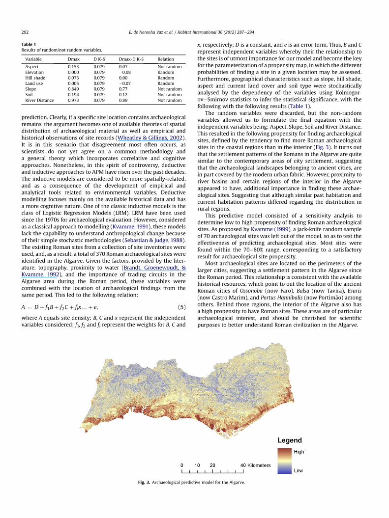
Table 1Results of random/not random variables.
Variable Dmax D K-S Dmax-D K-S Relation
Aspect 0.153 0.079 0.07 Not randomElevation 0.000 0.079 �0.08 RandomHill shade 0.075 0.079 0.00 RandomLand use 0.005 0.079 �0.07 RandomSlope 0.849 0.079 0.77 Not randomSoil 0.194 0.079 0.12 Not randomRiver Distance 0.973 0.079 0.89 Not random
E. de Noronha Vaz et al. / Habitat International 36 (2012) 287e294292
prediction. Clearly, if a specific site location contains archaeologicalremains, the argument becomes one of available theories of spatialdistribution of archaeological material as well as empirical andhistorical observations of site records (Wheatley & Gillings, 2002).It is in this scenario that disagreement most often occurs, asscientists do not yet agree on a common methodology anda general theory which incorporates correlative and cognitiveapproaches. Nonetheless, in this spirit of controversy, deductiveand inductive approaches to APM have risen over the past decades.The inductive models are considered to be more spatially-related,and as a consequence of the development of empirical andanalytical tools related to environmental variables. Deductivemodelling focuses mainly on the available historical data and hasa more cognitive nature. One of the classic inductive models is theclass of Logistic Regression Models (LRM). LRM have been usedsince the 1970s for archaeological evaluation. However, consideredas a classical approach to modelling (Kvamme, 1991), these modelslack the capability to understand anthropological change becauseof their simple stochastic methodologies (Sebastian & Judge, 1988).The existing Roman sites from a collection of site inventories wereused, and, as a result, a total of 370 Roman archaeological sites wereidentified in the Algarve. Given the factors, provided by the liter-ature, topography, proximity to water (Brandt, Groenewoudt, &Kvamme, 1992), and the importance of trading circuits in theAlgarve area during the Roman period, these variables werecombined with the location of archaeological findings from thesame period. This led to the following relation:
A ¼ Dþ f1Bþ f2C þ fix.þ e; (5)
where A equals site density; B, C and x represent the independentvariables considered; f1, f2 and fi represent the weights for B, C and
Fig. 3. Archaeological predicti
x, respectively; D is a constant, and e is an error term. Thus, B and Crepresent independent variables whereby their the relationship tothe sites is of utmost importance for our model and become the keyfor the parameterization of a propensitymap, inwhich the differentprobabilities of finding a site in a given location may be assessed.Furthermore, geographical characteristics such as slope, hill shade,aspect and current land cover and soil type were stochasticallyanalysed by the dependency of the variables using Kolmogor-oveSmirnov statistics to infer the statistical significance, with thefollowing with the following results (Table 1).
The random variables were discarded, but the non-randomvariables allowed us to formulate the final equation with theindependent variables being: Aspect, Slope, Soil and River Distance.This resulted in the following propensity for finding archaeologicalsites, defined by the tendency to find more Roman archaeologicalsites in the coastal regions than in the interior (Fig. 3). It turns outthat the settlement patterns of the Romans in the Algarve are quitesimilar to the contemporary areas of city settlement, suggestingthat the archaeological landscapes belonging to ancient cities, arein part covered by the modern urban fabric. However, proximity toriver basins and certain regions of the interior in the Algarveappeared to have, additional importance in finding these archae-ological sites. Suggesting that although similar past habitation andcurrent habitation patterns differed regarding the distribution inrural regions.
This predictive model consisted of a sensitivity analysis todetermine low to high propensity of finding Roman archaeologicalsites. As proposed by Kvamme (1999), a jack-knife random sampleof 70 archaeological sites was left out of the model, so as to test theeffectiveness of predicting archaeological sites. Most sites werefound within the 70e80% range, corresponding to a satisfactoryresult for archaeological site propensity.
Most archaeological sites are located on the perimeters of thelarger cities, suggesting a settlement pattern in the Algarve sincethe Roman period. This relationship is consistent with the availablehistorical resources, which point to out the location of the ancientRoman cities of Ossonoba (now Faro), Balsa (now Tavira), Esuris(now Castro Marim), and Portus Hannibalis (now Portimão) amongothers. Behind those regions, the interior of the Algarve also hasa high propensity to have Roman sites. These areas are of particulararchaeological interest, and should be cherished for scientificpurposes to better understand Roman civilization in the Algarve.
ve model for the Algarve.

Table 2Urban heritage Endangermenta (urban growth, archaeological heritage).
Municipality Urbangrowth
Heritage Averagerisk
UHE(%)
Pressure:
Lagoa 181 185 182.92 71.74 UGb
Olhão 182 166 174.23 68.33 UGb
Faro 185 157 171.16 67.12 UGb
Portimão 181 153 166.81 65.42 UGb
Albufeira 171 157 163.91 64.28 UGb
Vila Real deSanto António
156 150 153.11 60.04 UGb
Vila do Bispo 109 148 128.61 50.43 AHc
Loulé 121 125 122.96 48.22 AHc
Tavira 76 119 97.38 38.19 UGb
Castro Marim 93 141 117.43 46.05 AHc
Silves 108 120 114.35 44.84 AHc
Aljezur 100 115 107.35 42.10 AHc
São Brás de Alportel 104 104 104.22 40.87 UGb
Alcoutim 79 118 98.72 38.71 AHc
Monchique 92 95 93.38 36.62 AHc
a UHE ¼ Urban Heritage Endangerment.b UG ¼ Urban Growth.c AH ¼ Archaeological Heritage.
E. de Noronha Vaz et al. / Habitat International 36 (2012) 287e294 293
Urban cultural endangerment - a spatial modellingframework for the Algarve
In order to determine the importance of cultural assets weconstructed a model which compares urban growth with archae-ological site propensity in the Algarve. Understanding thesedynamics leads to a better decision process with respect to: (i)preserving archaeological sites from a cultural heritage perspec-tive; (ii) taking proactive measures on construction sites to protectexisting heritage, (iii) being aware of archaeological heritagepreservation while sharing local information on existing heritage.The comparison of both (the urban growth model and thearchaeological predictive model) was achieved by the analysis ofurban growth and archaeological heritage propensity (see Table 2).
Based on the average mean of those propensities per munici-pality, the urban heritage endangered per municipality wasassessed.
The municipalities with the highest probability of urban heri-tage endangerment were identified as Lagoa (71.74%), Olhão(88.33%), Portimão (65.42%) and the district capital of Faro (67.12%).All these municipalities also had the highest propensity for urbangrowth, identifying urban growth as a key pressure for archaeo-logical heritage endangerment.
The role of Archaeological Predictive Models (APMs) is twofold.First, as the analysis of site location allows a better understandingof behavioural civilization patterns as proposed by traditional APMliterature, nowadays it has an important (but less explored) impacton the decision-making process for sustainable development.Second, in a region such as Portugal, where the historico-culturalheritage is an important asset for the tourism industry, the evalu-ation of the site potential can create regions with specific niches forheritage tourism. This is an issue of increasing interest, as it mayhelp to mitigate the consequences of urban pressure on fragileheritage (Vaz, Caetano, & Nijkamp, 2011).
Concluding remarks
It has been shown that Predictive Archaeological Models (APMs)may be important to understand spatial dynamics from the past.They not only make sense in a historical context, but, in particular,their capability to accurately predict the location of archaeologicalsites may help future technology to discover new findings, as wellas understand the behavioural patterns of past societies. There is
much need for such work in an area such as Portugal, where littlehas been done so far, although there is a vast amount of historic andcivilization background material.
We may conclude therefore, that in general, the Romans in theAlgarve had a similar preference to our spatial occupation, as thehighest propensity for sites is, in fact, in proximity to current urbanareas. This characteristic together with ongoing urban expansionand sprawl, justifies the need for the present study. Urban growthhas been a constant process in past decades. This is an importantconcern, and has been largely discussed in a wider Europeancontext. Regionally, the Algarve is suffering from this problem, andthe continuous growth at a constant rate that it has experienced inrecent years, will in the next 15 years rapidly endanger the naturaland man-made legacy. One of the possible causes which appears tobe related to the urban growth areas in the Algarve, is tourism, asurban areas with higher tourist activity are more rapidly expandingthan others. As cultural heritage is a phenomenonwhich may workas a tourist product by itself, it is up to stakeholders to envision themore sustainable development of further tourist growth, bearing inmind cultural inheritance. It seems clear that urban growth isinevitable, and that the tendency is for the creation of mega-cities.The question is then: How can cosmopolitan areas be sustainableand balance the needs of fauna, flora and man-made legacysimultaneously? This is indeed a challenge for the near future andmay be a decisive step for future generations.
In the coming years monitoring the proposed areas may bea proactive approach for future preservation. As cities grow, culturalheritage teams may eventually become engaged as housing is plan-ned, in order to recover archaeological sites and catalogue this valu-able legacy which is considered to be “the most universally valuedand most even distributed resource in the world”. (Box, 1999). Inaddition, thedecision-makingprocess onwhere tobuildmaybecomemore accurate, as strategies such as the PROT (Plano Regional deOrdenamento do Território) exist. Until 2020 at least, the urbanlandscape is expected to change rapidlyand the cultural heritagemaybe jeopardized. The need for action is absolute and urgent in order toavoid future endangerment of the municipalities we have studied.Special care should be taken in themunicipalities of Lagoa, Olhão andAlbufeira which, due to a mix of existing archaeological remains andhistorico-cultural background, aswell as rapidgrowth, seemtobe themost jeopardized. Olhão has a very high propensity for the presencecultural heritage and further excavations and ongoing researchregarding this municipality is necessary especially in the areas ofimminent urban construction.Muchwork can still be done regardingboth studied dimensions (i.e. urban growth and cultural heritage).Regarding Archaeological Predictive Modelling, it has been shownthat despite differences of opinion within the scientific community,they are an important tool which may be used in a regional context.Thus, new methodologies that take into account the doubts of thescientific community are of great importance. As APM become morereliable by avoiding the problems of inaccuracy and inconsistency(Berman, 2006), the significance of urban growth models (UGMs)becomes clearer. Using GIS for UGMs is a mandatory direction forfuture urban planning and predicting the scenarios in such a contextis very important. Analysing urban growth with CORINE Land Coverdata seems to be a sound direction, as it is the current Europeanspatial data inventory that can be used to create scenarios for thegeneral European tendencyof urban growth.However, theMinimumMapping Unit of the CORINE Land Cover as we have seen is still quitelarge, and as a result, it would be an interesting opportunity to studyhow accurate CORINE Land Cover may become, or actually, is in anurban growth study context.
The future challenge is indeed the question of harnessingEuropean and regional synergies in an attempt to build solidinformation, as well as to create knowledge. The interdisciplinary

E. de Noronha Vaz et al. / Habitat International 36 (2012) 287e294294
research areas required for such a venture share common ground intheir use of IT and GIS in order to shed clear light onmonitoring andsustainable planning. Above all, the present study has made usrealize that the most important future step for sustainability is theneed to work together and think together in an attempt to graspnew processes and ideas that may create more accuracy inproposed methodologies in the hope of sustainable preservationand growth. From a short term perspective, stakeholders shouldfocus more strongly on the promotion of cultural awareness bysupporting, for example, tourist services related to heritage tourismwhich might boost the local and regional economy, while reducingnegative externalities (Vaz & Nijkamp, 2009).
As the Algarve presents an interesting analysis for the combinedpressure of urban growth/sprawl and loss of archaeological andhistorical landscapes, this region represents an utmost importantlesson for a common concern throughout many regions of theworld. While the tendency in Asian cities and the Middle East forinstance, is of increasing urbanization driven by population growth,many policies should be readjusted as to mitigate the risk onhistorical landscapes, especially in the developing world. Thepressures of urban change on monuments, archaeological land-scapes and historical regions alike, are an increasing concern forour future, where sound decision making combined with spatialmodelling and GIS may help in mitigating the risk on valuablepatrimony, preserving our habitats and our landscapes of the past.
Acknowledgements
We would like to thank a blind reviewer and the editor, for theuseful comments and kind attention given to our paper.
References
Al-Kheder, S. & Shan J. (2005) Cellular Automata urban growth simulation andevaluation - A case study of Indianapolis, Proceedings of the 8th InternationalConference on GeoComputation, pp. 1e19.
Antrop, M. (2005). Why landscapes of the past are important for the future.Landscape and Urban Planning, 70(1e2), 21e34.
Batty, M. (2005). Cities and complexity e Understanding cities with cellular automata,agent based models and fractals. Cambridge, MA: MIT Press.
Berman, (2006), Persistence or transience? Tracking the evolution of places overtime with historical Geographic Information Systems, Tagung Clio, "Geschichteim Netz - Praxis, Chancen und Visionen (URL: http://www.fas.harvard.edu%7Echgis/work/docs/papers/,consultedon16-11-07).
Box, P. (1999). GIS and cultural resource management: A manual for heritagemanagers. Bangkok: UNESCO.
Brandt, R., Groenewoudt, B. J., & Kvamme, K. (1992). An experiment in archaeo-logical site location: modeling in the Netherlands using GIS techniques. WorldArchaeology, 24(2), 268e282.
Calado, M. & Rocha, L. (2006), Menires e Neolitização: História da Investigação noAlgarve, pp. 75e88. Proceedings of the 4th Meeting of Archaeology in theAlgarve, 24-25th November, 2006.
Camhis, M. (2006). Sustainable development and urbanization. In M. Keiner (Ed.),The future of sustainability. Springer.
Capello, R. (2001). Urban growth in Italy: economic determinants and socio-environmental consequence. Report 10:. CERUM.
EEA Report. (2006). Urban sprawl in Europe e The ignored challenge. EuropeanEnvironment Agency. Report 10e2006, EEA.
ESDP Discussion Paper (1999) Discussion paper on future Co-operation in Europeanspatial planning and development, final Version 22 September 1999, preparedfor the Informal Meeting of EU Ministers Responsible for spatial planning andUrban/Regional policy on 4e5 October 1999, Tampere.
Kvamme, K. (1991). Geographic information systems and archaeology. In G. Lock, &J. Moffett (Eds.), Computer applications and quantitative methods in archaeology(pp. 77e84). Oxford: BAR International Series.
Kvamme, K. (1999). Recent directions and developments in geographical informa-tion systems. Journal of Archaeological Research, 75, 153e201.
Matias, A. (2004). Economic geography, gravity and tourism trade e The case forPortugal. I Congress on tourism Economics. Palma: Universitat de les IllesBalears. 28e29 May 2004.
Meaille, R., & Wald, L. (1990). Using geographical information system and satelliteimagery within a numerical simulation of regional growth. International Journalof Geographical Information Systems, 4(4), 445e456.
Ogyz, H., Klein, A. G., & Srinivasan, R. (2007). Using the Sleuth urban growth modelto Simulate the impacts of future policy scenarios on urban land use in theHouston-Galveston-Brazoria. Research Journal of Social Sciences, 2, 72e82.
Painho, M., & Caetano, M. (2006). Cartografia de Ocupação do Solo: Portugal Conti-nental, 1985-2000: CORINE land cover 2000. Amadora: Instituto do Ambiente.
Piyathamrongchai, K., & Batty, M. (2007). Integrating cellular automata and regionaldynamics using GIS. In E. Koomen, J. Stillwell, A. Bakema, & H. J. Scholten (Eds.),Modelling land-use change progress and applications (pp. 258e277). Dordrecht:Springer.
Rapoport, A. (1983). Environmental quality, metropolitan areas and traditionalsettlements. Habitat International, 7(3), 37e63.
Russo, A. P. (2002). The «Vicious Circle» of tourism development in heritagedestinations. Annals of Tourism Research, 29(1), 165e182.
Savage, S. H. (1990). GIS in archaeological research. In K. M. S. Allen, S. W. Green, &E. B. W. Zubrow (Eds.), Interpreting space: GIS and archaeology (pp. 22e32).London: Taylor & Francis.
Sebastian, L., & Judge, J. (1988). Predicting the past: correlation, explanation, and theuse of archaeological models. In J. Judge, & L. Sebastian (Eds.), Quantifying thepresent and predicting the past (pp. 325e418). Denver: US Department of theInterior, Bureau of Land Management.
Steinberg, F. (1996). Conservation and rehabilitation of urban heritage in developingcountries. Habitat International, 20(3), 463e475.
Tobler, A. (1970). A computer movie simulating urban growth in the Detroit region.Economic Geography, 46, 234e240.
Vaz, E., Caetano, M., & Nijkamp, P. (2011). A multi-level spatial urban pressureanalysis of the Giza pyramid plateau in Egypt. Journal of Heritage Tourism, 6(2),99e108.
Vaz, E., Nainggolan, D., Nijkamp, P., & Painho, M. (2011). Crossroads of tourism:a complex spatial systems analysis of tourism and urban sprawl in the Algarve.International Journal of Sustainable Development, 14(3), 225e241.
Vaz, E., & Nijkamp, P. (2009). Historico-cultural sustainability and urban dynamics.In G. Maciocco, & S. Serreli (Eds.), Enhancing the city: New perspectives fortourism and leisure (pp. 155e177). UK: Springer.
Vaz, E., Vaz, M. T., & Nijkamp, P. (2011). Spatial analyses for policy evaulation of therural world: agriculture in the last decade. In A. Torre, & B. J- Traversac (Eds.),Territorial governance: Local development, rural areas and agrofood systems.Berlin: Springer.
Wheatley, D., & Gillings, M. (2002). Spatial technology and archaeology: Thearchaeological applications of GIS. London: Taylor & Francis.
Wilson, A. G. (1974). Urban and regional models in geography and planning. NewYork: Wiley & Sons.
Copyright © 2022 FDOKUMEN