Ubiquitous Public Transportation Route Guide for a Developing Country
6
Ubiquitous Public Transportation Route Guide for a Developing Country Erwin Adi School of Computer Science Binus International University – Binus Business School Jakarta, Indonesia [email protected] Sri Ayu Ningsih School of Computer Science Binus International University – Binus Business School Jakarta, Indonesia [email protected] Abstract—Public transportation in developing country such as Indonesia does not have a definite guide that tells where the routes go. Websites that provides such information often misleads since the information changes from time to time. This paper discusses the development of an application to provide updated information about public transportation route guide that can be accessed through a website. The application has worked successfully in searching routes, searching places, adding routes, adding places, editing routes, and editing places for the city of Jakarta, Indonesia. Based on the survey done by author, 73% respondents are willing to use the site and 80% respondents are willing to contribute information to the site. The test showed that 50% of the respondents can use the application's function in the first try without any difficulty. The application has managed to provide useful functions for the target users therefore attracted enough attention to build a growing and informative e-society. Keywords: Public transportation, Google Map Geocoding, route guide. I. INTRODUCTION Jakarta is a metropolitan city with busy traffic all over the year. There are numerous mass transportations available in Jakarta such as bajaj, taxi, train, mikrolet, etc. Out of those transportations available, only train, bus and mikrolet have a fixed route path. These transportations, which are considerably cheaper than private vehicle, are the artery of Jakarta public transportation. A study conducted by SITRAMP-JICA in 2002 estimated that daily trip demand in Jakarta will reach 14.2 million in 2015, and the average "to work" trip length had increased from 2.69 km in 1985 to 3.52 km in 2000. By 2005, 50% trips are made by bus, 30% by car and 13% by motorcycles. Aside from Jakarta citizen, there are also low-budget tourists who are not yet included into the statistic [1]. According to a survey [2], 93% of the respondents have a trouble of going to certain places, even using the fixed-path mass transportation. One of the prominent reasons is a lack of direction information. Therefore to ease the information sharing, the author is inspired to create an open source graphic application to search and show transportation route in Jakarta. Another similar application ever created is Peta Jakarta software (commercial software) where it lists all the station and bus stop in Jakarta. However, it is not enough to help a person to know the path of a public transportation that one needs to take (map image is available but not enough information). There is also a lot of text information spread in the internet, such as Angkot Jakarta [3] or backpacker yahoo group. However it doesn’t provide helpful information such as the availability of map and images. The application the author aims to create is combining the two important aspects: text and image. The path of the mass transportation will be drawn in the map, accompanied with additional information (such as fare, etc). II. PROBLEM DESCRIPTION Mass transportation is a type of transportation which is used by most of the people to reach destination places. In Jakarta, nearly a hundred of routes are covered by mass transportation. However, up until this point, there is no single software or instance that provides the route of these transportations. Therefore even if there is a person who is thinking to use mass transportation; it is hard for him/her to search for the needed information. This problem is proved by doing a small random sampling survey. There are a total of 45 respondents, all of them are students. 56% from respondents are using mass transportation. Figure 1. Graphic of respondents using and not using mass transportation. From these respondents, 38% use mass transportation rarely, 4% occasionally, 9% often, and 13% regularly. Use Mass Transportation Not Using Mass Transportation
-
Upload
independent -
Category
Documents
-
view
7 -
download
0
Transcript of Ubiquitous Public Transportation Route Guide for a Developing Country

Ubiquitous Public Transportation Route Guide for a Developing Country
Erwin Adi School of Computer Science
Binus International University – Binus Business School Jakarta, Indonesia [email protected]
Sri Ayu Ningsih School of Computer Science
Binus International University – Binus Business School Jakarta, Indonesia
Abstract—Public transportation in developing country such as Indonesia does not have a definite guide that tells where the routes go. Websites that provides such information often misleads since the information changes from time to time. This paper discusses the development of an application to provide updated information about public transportation route guide that can be accessed through a website. The application has worked successfully in searching routes, searching places, adding routes, adding places, editing routes, and editing places for the city of Jakarta, Indonesia. Based on the survey done by author, 73% respondents are willing to use the site and 80% respondents are willing to contribute information to the site. The test showed that 50% of the respondents can use the application's function in the first try without any difficulty. The application has managed to provide useful functions for the target users therefore attracted enough attention to build a growing and informative e-society.
Keywords: Public transportation, Google Map Geocoding, route guide.
I. INTRODUCTION Jakarta is a metropolitan city with busy traffic all over the
year. There are numerous mass transportations available in Jakarta such as bajaj, taxi, train, mikrolet, etc. Out of those transportations available, only train, bus and mikrolet have a fixed route path. These transportations, which are considerably cheaper than private vehicle, are the artery of Jakarta public transportation.
A study conducted by SITRAMP-JICA in 2002 estimated that daily trip demand in Jakarta will reach 14.2 million in 2015, and the average "to work" trip length had increased from 2.69 km in 1985 to 3.52 km in 2000. By 2005, 50% trips are made by bus, 30% by car and 13% by motorcycles. Aside from Jakarta citizen, there are also low-budget tourists who are not yet included into the statistic [1].
According to a survey [2], 93% of the respondents have a trouble of going to certain places, even using the fixed-path mass transportation. One of the prominent reasons is a lack of direction information. Therefore to ease the information sharing, the author is inspired to create an open source graphic application to search and show transportation route in Jakarta.
Another similar application ever created is Peta Jakarta software (commercial software) where it lists all the station and
bus stop in Jakarta. However, it is not enough to help a person to know the path of a public transportation that one needs to take (map image is available but not enough information). There is also a lot of text information spread in the internet, such as Angkot Jakarta [3] or backpacker yahoo group. However it doesn’t provide helpful information such as the availability of map and images. The application the author aims to create is combining the two important aspects: text and image. The path of the mass transportation will be drawn in the map, accompanied with additional information (such as fare, etc).
II. PROBLEM DESCRIPTION Mass transportation is a type of transportation which is used
by most of the people to reach destination places. In Jakarta, nearly a hundred of routes are covered by mass transportation. However, up until this point, there is no single software or instance that provides the route of these transportations. Therefore even if there is a person who is thinking to use mass transportation; it is hard for him/her to search for the needed information. This problem is proved by doing a small random sampling survey.
There are a total of 45 respondents, all of them are students. 56% from respondents are using mass transportation.
Figure 1. Graphic of respondents using and not using mass transportation.
From these respondents, 38% use mass transportation rarely, 4% occasionally, 9% often, and 13% regularly.
Use MassTransportationNot Using MassTransportation
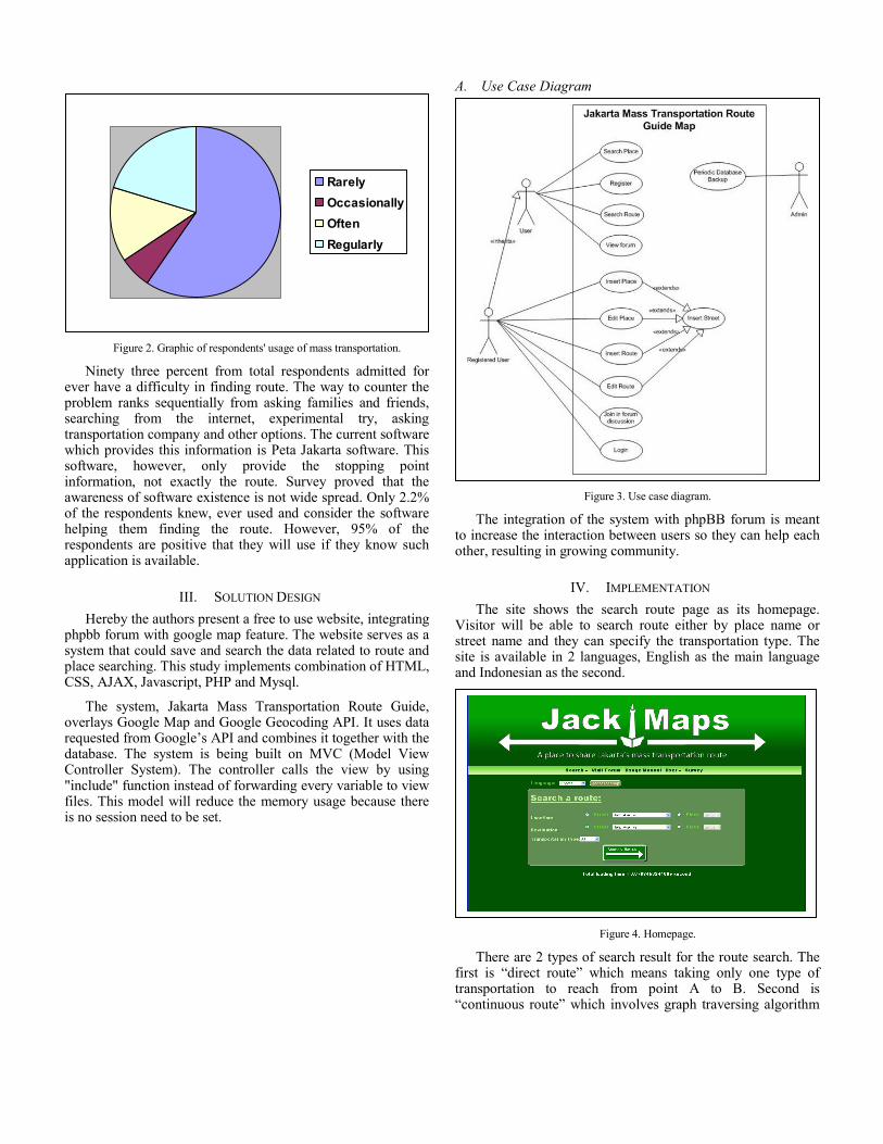
Figure 2. Graphic of respondents' usage of mass transportation.
Ninety three percent from total respondents admitted for ever have a difficulty in finding route. The way to counter the problem ranks sequentially from asking families and friends, searching from the internet, experimental try, asking transportation company and other options. The current software which provides this information is Peta Jakarta software. This software, however, only provide the stopping point information, not exactly the route. Survey proved that the awareness of software existence is not wide spread. Only 2.2% of the respondents knew, ever used and consider the software helping them finding the route. However, 95% of the respondents are positive that they will use if they know such application is available.
III. SOLUTION DESIGN Hereby the authors present a free to use website, integrating
phpbb forum with google map feature. The website serves as a system that could save and search the data related to route and place searching. This study implements combination of HTML, CSS, AJAX, Javascript, PHP and Mysql.
The system, Jakarta Mass Transportation Route Guide, overlays Google Map and Google Geocoding API. It uses data requested from Google’s API and combines it together with the database. The system is being built on MVC (Model View Controller System). The controller calls the view by using "include" function instead of forwarding every variable to view files. This model will reduce the memory usage because there is no session need to be set.
A. Use Case Diagram
Figure 3. Use case diagram.
The integration of the system with phpBB forum is meant to increase the interaction between users so they can help each other, resulting in growing community.
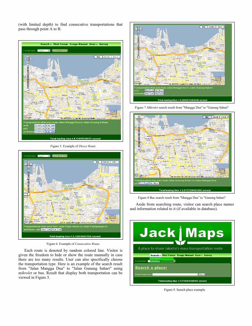
IV. IMPLEMENTATION The site shows the search route page as its homepage.
Visitor will be able to search route either by place name or street name and they can specify the transportation type. The site is available in 2 languages, English as the main language and Indonesian as the second.
Figure 4. Homepage.
There are 2 types of search result for the route search. The first is “direct route” which means taking only one type of transportation to reach from point A to B. Second is “continuous route” which involves graph traversing algorithm
RarelyOccasionallyOftenRegularly
(with limited depth) to find consecutive transportations that pass through point A to B.
Figure 5. Example of Direct Route.
Figure 6. Example of Consecutive Route.
Each route is denoted by random colored line. Visitor is given the freedom to hide or show the route manually in case there are too many results. User can also specifically choose the transportation type. Here is an example of the search result from "Jalan Mangga Dua" to "Jalan Gunung Sahari" using mikrolet or bus. Result that display both transportation can be viewed in Figure 5.
Figure 7 Mikrolet search result from "Mangga Dua" to "Gunung Sahari"
Figure 8 Bus search result from "Mangga Dua" to "Gunung Sahari"
Aside from searching route, visitor can search place names and information related to it (if available in database).
Figure 9. Search place example.

Figure 10. Detail of selected place example.
If the visitor wants to contribute information, they need to become a member first. The history of place/route insertion or update will be saved by the system. As a member, the user will have the privilege to add/update the route/place.
Figure 11. Add route example.
The user will just need to click on the map to have red line drawn. System will update the street location based on the
point the user has clicked. The users will also have the freedom to edit the street location manually since the street name information might be invalid or not available at all. The system will save the route that was saved by user and utilize the data in the route search later. The edit process is approximately the same. The user will need to search for the particular route name that s/he wants to edit then proceed to the similar page.
Figure 12. Add place example.
The add place function is comparatively similar. User will need to click on a point in the map to mark the place with a marker and the system will try to update the street location automatically. Again, the user will be given freedom to update the street location manually by choosing 'other' option in the selection box.
The system is using Google Geocoder function to extract the street name. Geocoder is called using "geocoder = new GClientGeocoder();" code from the script. By sending the coordinate of click point, google library will send back the information available of the particular coordinate on various level of accuracy in the format of Javascript JSON or XML.
To search for the connecting street, the system will create an adjacency graph based on the search query, database data available, and branch limit defined by the system (server with better capability will allow deeper limit search). By using breadth first search algorithm, the system will search for all possible routes and display it as a result to the user. The time spent to search the route is quadratic.
V. TESTING Technical testing was divided into 3 sections which are
module testing, integration testing and loading time testing. Unit testing was done weekly as each module finished being coded. It was to ensure that each unit worked correctly.

Generally after the first test, bugs were found and corrected. The revised module was tested again in the following week when another test was being performed for the scheduled module. Integration testing was being done every time a module finished, starting from the second module. This testing was to ensure that the operation connecting modules and units work properly as it was expected. Script loading test was a test of how fast the script executed when there are a number of concurrent connections to the server. It could be observed that this result varied widely depending on the burst of the data traffic at the time. The average of script loading time is 0.110506 seconds by using Bluehost server.
To get the sense of its usability, the author conducted a survey. There were a total of 26 respondents, most of them aged between 20-30 years old, which was the right range of population that one could see populating the public transportation. 73% of respondent declare that they were willing to use the site and 80% of respondents declare they were willing to contribute information to the site if they had any. The reasons of those who were reluctant to use the site were either because the website’s interface was boring or that they were not using any mass transportation. The reason of those who refused to contribute to the site was more related to apathy, although the content of the information were useful to them.
VI. DISCUSSION In general, it could be said that the Jakarta Mass
Transportation Route Guide was well received by 73% of the respondents as a portal to search for transportation information. On the other hand, the system does not catch the attention of 27% of the remaining users.
A. Application Development Aside from Google Map which is available for public, there
is also Yahoo! Map. These two maps provide the view for Jakarta either map based, satellite or hybrid based. The authors chose to utilize Google Map because they are more widely known; it has tutorial, tips and tricks information spread over the internet. This aspect is expected to ease the effort in integrating the map into the application.
Google Map Geocoding's data is sent either by XML or JSON. My observation reveals that both JSON and XML can be imported to any website. XML is widely known already and the most easily human readable format. However, javascript required to insert/get the data from XML are quite complicated. This is the reason why the authors chose to use JSON to read the data received from Google Map Geocoding. JSON data is technically easier to capture and code, although it is harder to be intuitively understood by human eyes.
All the application pages are compiled in PHP language except the manual. Since it doesn’t need any programming, it uses simple HTML and CSS.
B. Survey Result From 26 respondents, there are a total of 39% respondents
which declare that they don’t know that the site provides the
search function. It is probably caused by lack of information in the application’s homepage. Despite of that, 81% of respondents understand how to use the search function. The author believes the 19% has trouble related to user interface friendliness. This is also the reason about 46% of respondents need to try more than once (and less than four times) to learn to use the search function.
There are only a total of 38.46% respondents who know about the feature available of becoming a member. Again, I believe this is because of the lack of information in the application. This is important and shall need to be fixed and re-tested in the next development phase because member is the backbone of the system. Without a big number of members, contribution from the community cannot be maximally shaped.
The part of the survey which asked about the manual usefulness has received 10 neutral responses out of those 26 respondents. This relatively high number, which does not represent as negative or positive value, is produced probably due to user’s nature to test things without reading the instruction. Therefore, it is important to create the application as easy to learn/use as possible to increase the willingness of the user to use the site and contribute information in the end.
By adding more information in the application and having a better user interface, I strongly believe it will yield a more positive response in user willingness to use and contribute to the site.
VII. CONCLUSION The application has managed to provide useful functions
for the target users. Application has worked successfully in searching route, searching place, adding route, adding place, editing route, and editing place. Based on the survey done by author, 73% respondents are willing to use the site and 80% respondents are willing to contribute information to the site. In general, 50% respondents can use the application's function in the first try without any difficulty. The application needs a rigorous research on interface to attract user and enhance the learnability. In order to have a better study result, it also recommended that the survey include the tourists (either foreign or local) as the respondents. In the future, the web application can easily cater the need of more diverse language by translating the language file and updating the language choice script. The application can also be extended to cover not only Jakarta city but even other countries aside from Indonesia.
REFERENCES [1] M.. Zulfiki and Y. Hino, "Principal Issues to Improve the Urban
Transport Problems in Jakarta," Mem. Fac. Eng. Osaka City Univ. vol. 47, p. 31-38, September 2006. [Online]. Available: http://dlisv03.media.osaka-cu.ac.jp/infolib/user_contents/kiyo/DBf0470006.pdf . [Accessed: February 10, 2009].
[2] S.A. Ningsih and S.F. Amelia, "Jakarta mass transportation route guide," unpublished.
[3] Angkot Jakarta. “Rute Transportasi Angkutan Umum Jakarta,” kopaja44.web44.net, July 18, 2008. [Online]. Available: http://kopaja44.web44.net/angkot/2008/07/rute-transportasi-angkutan-umum-jakarta/ . [Accessed: February 10, 2009].

[4] R.F. Gilbert and B.A. Forouzan. Data Structures: A Pseudocode Approach with C, 2nd ed. USA: Thomson Course Technology, 2007.
[5] Alison, “Depth first vs Breadth first Search,” macs.hw.ac.uk, August 19, 1994. [Online]. Available: http://www.macs.hw.ac.uk/~alison/ai3notes/paragraph2_6_2_1_0_1.html . [Accessed: March 12, 2009].
[6] M. Purvis, J. Sambells, and C. Turner. “Foreword,” in Beginning Google Maps Application With PHP and AJAX: From Novice to Professional. New York: Appress, 2006.
[7] D.W. Goldberg, A Geocoding Best Practices Guide. Springfield: North American Association of Central Cancer Registries, Inc., 2008. [E-book]
Available: http://www.naaccr.org/filesystem/pdf/Geocoding_Best_Practices.pdf . [Accessed: March 1, 2009].
[8] Google. “Google Maps/Google Earth APIs Terms of Service,” Google Inc., November 26, 2008. [Online]. Available: http://code.google.com/apis/maps/terms.html#section_10_12 . [Accessed: March 1, 2009].
[9] Google. “Geocoding,” Google Inc., 2009. [Online] . Available: http://code.google.com/apis/maps/documentation/geocoding/ . [Accessed: February 18, 2009].