Twyfelfontein /Ui-//aes World Heritage Nomination Dossier 2006
96
1 Twyfelfontein World Heritage Site Nomination Twyfelfontein /Ui-//aes World Heritage Site Nomination Dossier NAMIBIA 2006
Transcript of Twyfelfontein /Ui-//aes World Heritage Nomination Dossier 2006

1Twyfelfontein World Heritage Site Nomination
Twyfelfontein/Ui-//aes
World Heritage Site Nomination Dossier
NAMIBIA
2006

State Party
State, Province or Region
Name of Property
Geographical coordinates
Textual description of the Property boundaries
JustificationStatement of Outstanding Universal Value
Criteria under which property is nominated
Name and contact information of official localinstitution/agency
Namibia
Kunene
Twyfelfontein, or /Ui-//aes
Central co-ordinates: North corner (Beacon A) S20º 35' 26" E14º 22' 20"S20º 35' 44.1" E14º22' 21.3" NE corner (Beacon B) S20º 35' 31" E14º 22' 34"
ENE corner (Beacon C) S20º 35' 35"E14º 22' 38"SE corner (Beacon D) S20º 35' 51" E14º 22' 46"South corner (Beacon E) S20º 36' 10" E14º22' 25"
The northern boundary of the property runs from Beacon A, marked by a stone cairn adjacent toroad D3214, to Beacon B, at the top of a high sandstone cliff overlooking the site from the east. Theeastern and south-eastern boundaries proceed from Beacon B to Beacon E, all on top of the sand-stone cliff and marked by stone cairns. The western boundary runs from Beacon E to Beacon A.
See map of nominated property showing boundary of core area proposed for inscription, and mapof proposed buffer zone.
• Twyfelfontein has the largest single concentration of prehistoric rock engravings in southernAfrica
• With over 2000 engravings documented, the site is an order of magnitude larger than any otherrock-engraving site in Namibia
• The engravings are exceptionally well preserved and show a very wide repertoire of subjectmatter relating to hunter-gatherer ritual practices
• The site represents the final florescence of ritual art under the combined impact of environ-mental stress and the rapid expansion of nomadic pastoralism
• Twyfelfontein engravings show deliberate positioning on the landscape and exemplify theintegration of ritual and nature
II.D.77 (iii) Twyfelfontein bears “a unique or at least exceptional testimony to a cultural tradition ...which has disappeared”
(v) Twyfelfontein is “an outstanding example of ...human interaction with the environment... when it has become vulnerable under the impact of irreversible change”
Organization: National Heritage Council of NamibiaAddress: Private Bag 12043, Ausspannplatz, Windhoek, NamibiaTelephone: 061+ 244375; Fax: 061+246872Email: [email protected] Web address: www.natmus.cul.na
EXECUTIVE SUMMARY

3Twyfelfontein World Heritage Site Nomination

4Twyfelfontein World Heritage Site Nomination
Cristo Botha, Rudi Loutit, Erhard Roxin, John Molin and PatCraven generously contributed their knowledge and expertise,as did Trevor Nott, Johan du Plessis, Hannes Marais, EdHumphries, Nina Maritz and Dennis MacDonald.
Special acknowledgement is due to Michiel Levin for hiswhole-hearted support of research into the history of his par-ent’s farming activities at Twyfelfontein, and his generous loanof family photographs and film footage.
Thanks are due to the following local stakeholders in theTwyfelfontein area who supported and assisted the fieldworkand research for the Nomination Dossier: Twyfelfontein-Uibasen Conservancy; Twyfelfontein Tour Guides Association;Twyfelfontein Country Lodge, Aba-Huab Camp, andFrancolino Fly-ins.
We are grateful to Dawson Munjeri and Webber Ndoro forcommenting on an earlier version of the dossier.
Gerty Basson, of The Office Shop, and Anita De Wethelped with the layout and design of the dossier, giving ad-vice and material assistance. The Namibia ArchaeologicalTrust sponsored the cover design.
ACKNOWLEDGEMENTSThis nomination dossier was compiled by John and Jill Kinahan,archaeologists, Quaternary Research Services, Namibia, un-der contract to the National Heritage Council of Namibia andto the National Committee for the Implementation of theWorld Heritage Convention in Namibia.
We appreciate the support and guidance of the National Com-mittee for the Implementation of the World Heritage Con-vention in Namibia, especially Trudie Amulungu, FriedaKanime, Karl Aribeb, Andre Strauss, Esther Moombolah-Goagoses and Ellen Namhila, who gave valuable assistanceduring compilation of the Dossier and Management Plan.
We gratefully acknowledge the following members of the Tech-nical Committee for the Implementation of the World Herit-age Convention in Namibia for their specialist contributionswhich are incorporated in various parts of the Nominationdossier: Peter Cunningham (vertebrates), Tharina Bird (in-vertebrates), Gabi Schneider (geology), Marianne Hochobes(botany) and Pombili Ipinge (local history).
The following institutions generously gave assistance, adviceand permission to use various source materials: National Her-itage Council of Namibia; National Archives of Namibia; Na-tional Museum of Namibia; Deeds Office, Ministry of Lands,Resettlement and Rehabilitation; Geological Survey of Na-mibia, and the National Botanical Research Institute.

5Twyfelfontein World Heritage Site Nomination
CONTENTS1. IDENTIFICATION OF THE PROPERTYa. Country .................................................................................. 8b. Region .................................................................................... 8c. Name of Property ................................................................ 8d. Geographical coordinates to the nearest second ............ 8e. Maps and plans showing the boundaries of the
nominated property and buffer zone ............................... 8f. Area of nominated property (ha.) and proposed buffer ..
zone (ha.).....................................................................11
2. DESCRIPTIONa. Description of Property ....................................................13
(i) Site name ........................................................................13(ii) Location .........................................................................13(iii) Setting ...........................................................................14(iv) Geology ........................................................................15(v) Archaeology ..................................................................18(vi) Rock art ........................................................................21(vii) Climate ........................................................................30(viii) Flora ............................................................................30(ix) Fauna .............................................................................34
b. History and Development ................................................35(i) Tenure .............................................................................35(ii) History of research ......................................................40(iii) Site developments.......................................................41
3. JUSTIFICATION FOR INSCRIPTIONa. Criteria under which inscription is proposed (and
justification for inscription under these criteria)..........44b. Statement of Outstanding Universal Value ..................45c. Comparative analysis .........................................................48d. Integrity/Authenticity .......................................................53
4. STATE OF CONSERVATION & FACTORSAFFECTING THE PROPERTY
a. Present state of conservation ..........................................58b. Factors affecting the property
(i) Development Pressures ..............................................61(ii) Environmental Pressures ...........................................62(iii) Natural disasters and risk preparedness .................64(iv) Visitor/tourism pressures ..........................................64(v) Number of inhabitants within the property and the buffer zone .............................................................66(vi) Other ...........................................................................66
5. PROTECTION & MANAGEMENT OF THEPROPERTY
a. Ownership ...........................................................................68b. Protective designation .......................................................68c. Means of implementing protective measures ...............69d. Existing plans related to municipality and region in
which the proposed property is located ........................69

6Twyfelfontein World Heritage Site Nomination
CONTENTS (continued)
e. Property management plan (summary).........................70f. Sources and levels of finance.......................................71g. Sources of expertise and training in conservation
and management techniques.........................................71h. Visitor facilities and statistics.......................................72
(i) Design and construction..........................................72(ii) Visitor flow.............................................................74(iii) Facilities in the buffer zone...................................76(iv) Visitor statistics.....................................................77
i. Policies and programmes related to thepresentation and promotion of the property .................79
j. Staffing levels (professional, technical, maintenance)..80
6. MONITORINGa. Key indicators for measuring state of conservation ...83b. Administrative arrangements for monitoring
property ................................................................................84c. Results of previous reporting exercises ..........................84
7. DOCUMENTATIONa. Photographs, slides, image inventory and authorization .
table and other audiovisual materials...........................86
b. Texts relating to protective designation, copies ofproperty management plans or documentedmanagement systems and extracts of other plansrelevant to the property................................................88
c. Form and date of most recent records ...........................88d. Address where inventory, records and archives
are held........................................................................88e. Bibliography ........................................................................89
8. CONTACT INFORMATIONa. Preparer........................................................................94b. Official local institution/agency. ....................................94c. Other local institutions................................................94d. Official web address ..........................................................94
9. SIGNATURE ON BEHALF OFTHE STATE PARTY..................................................96

7Twyfelfontein World Heritage Site Nomination
CHAPTER 1Identification of the property

8Twyfelfontein World Heritage Site Nomination
1. IDENTIFICATION OF THEPROPERTY
a. CountryNamibia
b. RegionKunene
c. Name of propertyTwyfelfontein (Afrikaans: “Doubtful fountain”) or/Ui-//aes (Khoekhoegowab: “Place among rocks”)
d. Geographical coordinates to the nearest secondNorth corner (Beacon A) S20º 35' 26" E14º 22' 20"NE corner (Beacon B) S20º 35' 31" E14º 22' 34"ENE corner (Beacon C) S20º 35' 35" E14º 22' 38"SE corner (Beacon D) S20º 35' 51" E14º 22' 46"South corner (Beacon E) S20º 36' 10" E14º 22' 25"Central co-ordinate: S20º 35' 44.1" E14º 22' 21.3"
e. Maps and plans, showing the boundariesof the nominated property and buffer zone
All maps except the topographic map required under sub-section (i), and the extract from it, under (iii), appear withinthis chapter. All maps are also submitted in digital form onthe CD bound into the envelope at the back of this dossier.
(i) An original copy of a topographic map showing theproperty nominated:2014 Cb Verbrandeberg (1st Edition), Surveyor General1980, scale: 1: 50 000 is annexed and submitted in theaccompanying map roll.
(ii) Location Map showing the location of the property within the State Party.:The Location map shows the location of Twyfelfonteinwithin Nambia, scale 1: 10 000 000 (see p. 9)
(iii) Plans and specially prepared maps of the property showing individual features are listed below:
• Extract from the official Surveyor-General topographicmap 2014 Cb Verbrandeberg (1980) of the Twyfelfonteinarea, on the scale of 1: 100 000, showing area fornomination and buffer zone (see p. 3)
• Namibia Surveyor-General property diagram ofTwyfelfontein Reserve (873) buffer zone, showing exactpositions of corner beacons
• Namibia Surveyor-General property diagram ofTwyfelfontein Prehistoric Reserve (722) core area, show-ing exact positions of corner beacons
• Twyfelfontein visitor routes and site infrastructure,scale 1: 2 500 (fold-out map )
• Twyfelfontein rock art distribution and access,scale 1: 2 500 (fold-out map)

9Twyfelfontein World Heritage Site Nomination

10Twyfelfontein World Heritage Site Nomination
Nambia Surveyor General property diagram Twyfelfontein Reserve(873) , sketch A89/87 (12 April 1989), Deeds Office, Windhoek ,
showing exact positions of buffer zone corner beacons
11Twyfelfontein World Heritage Site Nomination
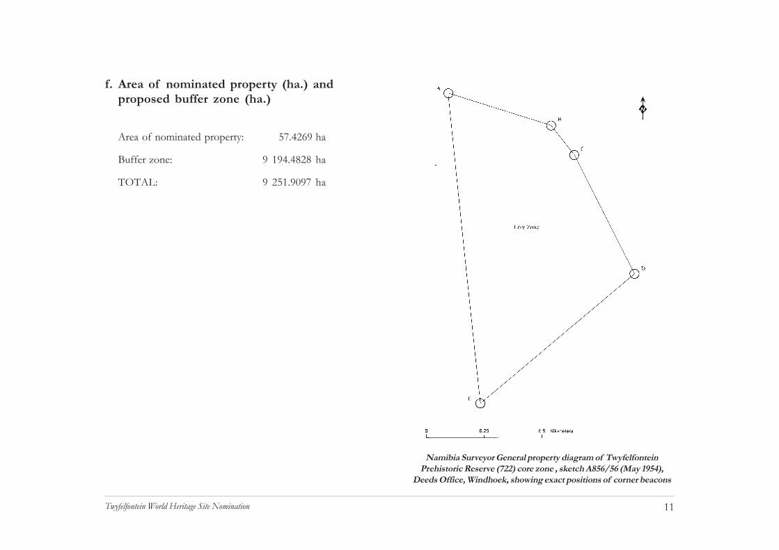
f. Area of nominated property (ha.) andproposed buffer zone (ha.)
Area of nominated property: 57.4269 ha
Buffer zone: 9 194.4828 ha
TOTAL: 9 251.9097 ha
Namibia Surveyor General property diagram of TwyfelfonteinPrehistoric Reserve (722) core zone , sketch A856/56 (May 1954),
Deeds Office, Windhoek, showing exact positions of corner beacons

12Twyfelfontein World Heritage Site Nomination
CHAPTER 2Description

13Twyfelfontein World Heritage Site Nomination
2. DESCRIPTIONa. Description of property(i) Site nameThe name Twyfelfontein was registered in 1951 (NationalArchives LAN 1588), the site having been known previouslyas /Ui-//aes which refers to a place “among packed stones”(see Scherz 1975: 172 which gives the outmoded orthogra-phy). The origins of the name Twyfelfontein, Afrikaans for“doubtful fountain”, lie in the following anecdote related byMichiel Levin (in litt.):
“My [father, David Levin] sank some wells in an effort to findwater…This digging was endless ... Day after day. Monthafter month... Occasionally neighbours visited [us]. When theyarrived my mother would tell them my father is at the foun-tain. ...Andries Blaauw of Blaauwpoort happened to visit usmore often than the other neighbours in those early days. Everytime he greeted my father – who was more than likely on hisknees somewhere – digging. He would … ask: How is it David?My father would answer, invariably: Good…but I doubt if thefountain will make October (when the first rains could be ex-pected). Every time [it was] the same answer. Andries Blaauw,as was common practice in those days, then started to refer tomy father in ordinary conversation as David Twyfelfontein.That’s it.”
(ii) LocationTwyfelfontein is located in the Khorixas Constituency of theKunene Region of northwestern Namibia, approximately 90kmwest of Khorixas, the nearest centre, and 480km northwestof the capital, Windhoek. The core area nominated for in-scription under the World Heritage Convention is theTwyfelfontein Prehistoric Reserve (722), measuring 57.4269ha.The buffer zone is a rationalized combination of surroundingproperties, known as the Twyfelfontein Reserve (873), meas-uring 9194.4828ha, and including within its boundaries theproclaimed Verbrandeberg geological monument and a numberof important archaeological sites. There is public access tothe core area via a gravelled district road, D3214, which endsat the site. Existing infrastructure in the core area is limitedto basic site facilities, and there are no people resident on theproperty.
Ella and David Levin, circa 1947

14Twyfelfontein World Heritage Site Nomination
(iii) SettingThe southern part of the Kunene Region, in the vicinity ofTwyfelfontein, is a dry, thinly populated area, mainly givenover to communal livestock farming. All land in this part ofNamibia is owned by the State, with the exception of certaindesignated freehold properties. Livestock carrying capacity isestimated at 10-20kg/ha, and a large proportion of the area isconsidered entirely unsuitable for farming. Population densi-ties are consequently very low, ranging between 0.01 and 1.0/km2, and comprising mainly rural Damara, or Khoekhoegowabspeakers. The area has a poorly developed infrastructure, butin recent years there has been a steady growth of tourism,both formal and community-based, as an additional form ofland use and livelihood that supplements farming.Twyfelfontein is the most important single locality for bothforms of tourism in northwestern Namibia. Both the corearea and buffer zone of the proposed World Heritage site fallwithin the boundaries of the Twyfelfontein-Uibasen Conserv-ancy. However, the core area, being a proclaimed monument,does not fall under the jurisdiction of the conservancy.
Twyfelfontein lies within the Huab basin, in a minor tributaryto the Aba Huab River, part of an important ephemeral streamdraining westwards to the Atlantic Ocean. The terrain con-sists of deeply dissected sedimentary and volcanic deposits,dramatically exposed to view by the thin soil and vegetation
cover. The core area of the site encloses the main concentra-tion of rock engravings and associated archaeological remains,on a west-facing slope below high sandstone cliffs, while thebuffer zone encloses a larger area comprising both sides ofthe valley and a significant portion of the surrounding hills.
Twyfelfontein valley viewed from the north, showing dense annualgrass cover after above average rainfall in the summer of 2005

15Twyfelfontein World Heritage Site Nomination
(iv) GeologyThe visual character of the Twyfelfontein valley, and to anextent its attraction for visitors, is largely determined by thelocal geology. The following remarks are based largely on thespecialist contribution of G. Schneider (see technical appen-dix on CD). There are three main litho-stratigraphic compo-nents to the geology: the Etjo Formation sandstones; the Gai-As Formation shales underlying the sandstones, and theKuiseb Formation schists underlying both of these units (Geo-logical Survey 2001: Sheet 2014 Doros). The schists areNeoproterozoic in age (1 000 to 460 million years) and be-long to the Damara Orogen, formed during a tectonic cyclethat laid down the basic geological structures underlying muchof northwestern and central Namibia. These structures werereduced by erosion and eventually formed large sedimentarybasins in which were deposited the rocks of the later Carbon-iferous to Jurassic Karoo sequence, now exposed in the highcliffs surrounding the Twyfelfontein valley (Schneider 2004: 118).
The Karoo sequence began with an extensive glaciation event,which ended about 280 million years ago, leaving tillite andrelated meltwater deposits of the Dwyka Formation in thebasins of the Damara Orogen. These extensive lake catch-ments received a succession of shale, mudstone, limestoneand coal bearing deposits comprising the Gai-As Formation.Lake Gai-As was approximately 1.5 million km2 in extent,covering part of present-day Brazil.
Palaeoenvironmental evidence from the Gai-As Formationsediments indicates a warm to temperate, sub-humid climate,although the extent of the lake body was such that it experi-enced powerful storms, as is indicated by disturbance and re-deposition of somesedimentary struc-tures. Fossils are abun-dant, although therehave been no signifi-cant finds in the corearea or buffer zone.
Fossil material includesstromatolites formedby periodic salinizationof the lake, as well asbivalves reflecting theexistence of episodicfreshwater conditions.Two palaeoniscoid fishhave been recognizedin the deposits, includ-ing a predatory speciesof the Atherstoniae.Few remains of tetrapod fauna have been recovered from theGai-As Formation, one example being a member of the am-phibious Stereospondyli group of predators.
Gai-As Formation fossils, fromSchneider & Marais (2004)

16Twyfelfontein World Heritage Site Nomination
The shores of the lake were well covered with typical Permianflora, including various ferns, cycads and conifers; petrifiedwood is fairly common in the Gai-As Formation. These moistconditions came to an end about 200 million years ago, withthe onset of an extremely arid climate, which prevailed dur-ing the Triassic and Jurassic. The Etjo Sandstone Formation,largely composed of fossil sand dunes, dominates theTwyfelfontein landscape and overlies the middle Permian rocksthroughout the Huab Basin. It was during this period of in-creasing aridity that dinosaurs first appeared, becoming morediverse and well adapted over time. But as the climate be-came drier the reptiles would have concentrated near to therapidly shrinking bodies of open water. Among the trace fos-sils most frequently found in the Etjo sandstone are the tracksof dinosaurs, presumably left in wet sediment near standingwater and then covered by windblown sand.
These conditions were interrupted and dramatically changedby a period of intense volcanic activity beginning about 180million years ago. In some places lava issued through vol-canic pipes, or cracks at the surface, and layers of volcanicdebris partly covered the desert landscape. It was at this timethat the African and South American continents began to driftapart.
The geology of the Twyfelfontein area directly determinesthe type of rock available for engravings, as well as their du-rability under harsh weathering conditions, and the stabilityof the terrain on which the engraved rocks are situated.Aeolian beds of the Etjo sandstone provide the majority ofthe engraved surfaces. Surfaces that are parallel to the bed-ding plane of the rock predominate, although these are oftenprone to rapid weathering. Engravings also occur on fractureplanes running semi-perpendicular to the bedding plane, andthese surfaces are generally resistant to weathering.
A minority of engravings occur on rocks of the fluvial Etjosandstone beds (Krone Member). These rocks are often ex-tremely hard and the engravings tend to be rather shallow.The most important geological influence on the site is, how-ever, the aquifer that feeds the Twyfelfontein spring. Thespring emerges on the contact between the permeable Etjosandstones and the relatively impermeable Gai-As shales.
Artist's reconstruction of Massospondylus habitat,Etjo Formation after Schneider & Marais (2004)

17Twyfelfontein World Heritage Site Nomination
Analytical results from a sample of water from the spring atTwyfelfontein are listed below. The results indicate a generalclassification (B) as water good for human consumption. Nodata are available on the yield of water from the spring, but itappears to be very low. The water emerges as a weak seepage,under gravity. Despite this, there are no records of the springhaving ceased to flow at any time in the last 50 years.
Twyfelfontein water quality test results:Parameter mg/l RatingpH: 7.7 ATurbidity: 1.6 BTotal Dissolved Solids (calc.) 1273Total Alkalinity (CaCO3) 236Total Hardness (CaCO3) 284 AChloride 350 BFluoride 0.7 ASulphate 116 ANitrate 10 ANitrite 0.08Sodium 315 BPotassium 11 AMagnesium 49 ACalcium 33 AManganese 0.01 AIron 0.51 B
The geological importance of northwestern Namibia is re-flected in the number of geological sites in this area which areNational Monuments. These include the Verbrandeberg andPetrified Forest sites, as well as the Brandberg, a Creta-ceous ring complex that is also a major concentration of rockpainting sites.
18Twyfelfontein World Heritage Site Nomination
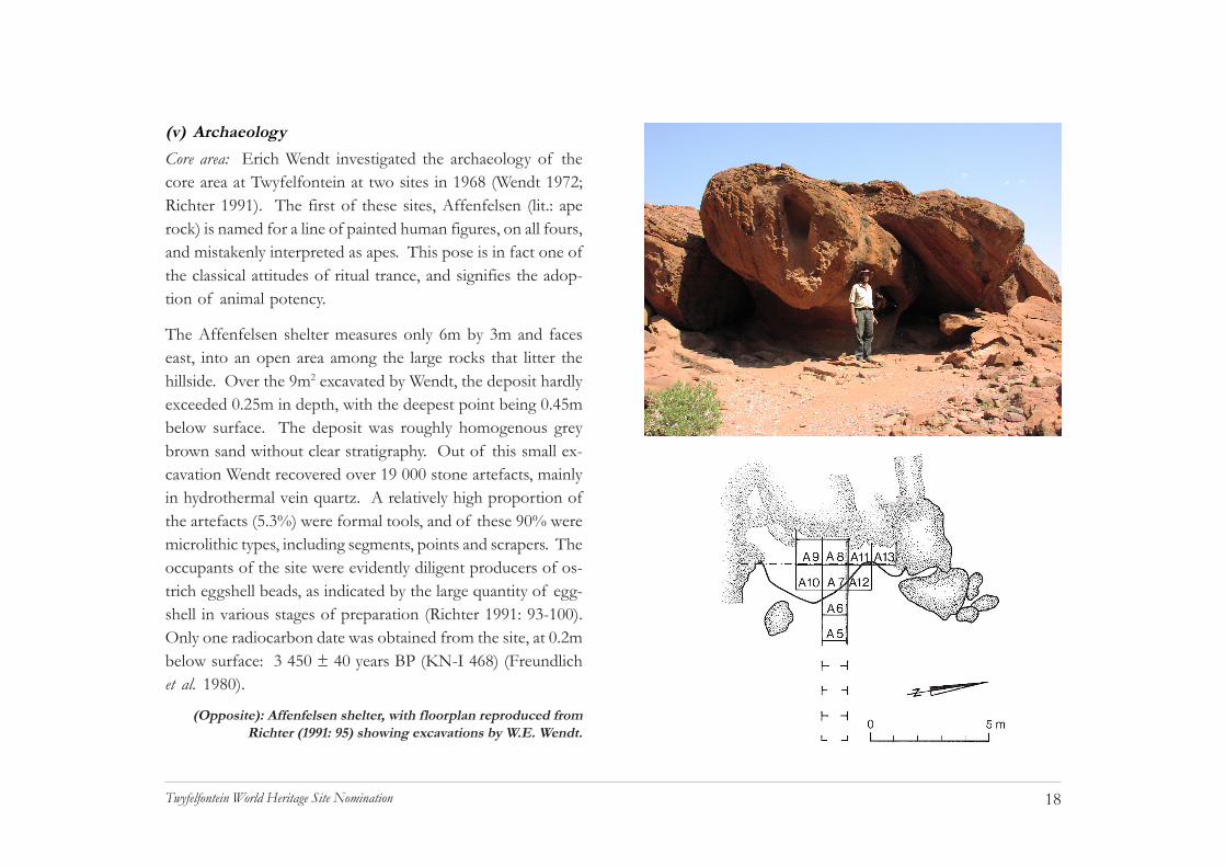
(v) ArchaeologyCore area: Erich Wendt investigated the archaeology of thecore area at Twyfelfontein at two sites in 1968 (Wendt 1972;Richter 1991). The first of these sites, Affenfelsen (lit.: aperock) is named for a line of painted human figures, on all fours,and mistakenly interpreted as apes. This pose is in fact one ofthe classical attitudes of ritual trance, and signifies the adop-tion of animal potency.
The Affenfelsen shelter measures only 6m by 3m and faceseast, into an open area among the large rocks that litter thehillside. Over the 9m2 excavated by Wendt, the deposit hardlyexceeded 0.25m in depth, with the deepest point being 0.45mbelow surface. The deposit was roughly homogenous greybrown sand without clear stratigraphy. Out of this small ex-cavation Wendt recovered over 19 000 stone artefacts, mainlyin hydrothermal vein quartz. A relatively high proportion ofthe artefacts (5.3%) were formal tools, and of these 90% weremicrolithic types, including segments, points and scrapers. Theoccupants of the site were evidently diligent producers of os-trich eggshell beads, as indicated by the large quantity of egg-shell in various stages of preparation (Richter 1991: 93-100).Only one radiocarbon date was obtained from the site, at 0.2mbelow surface: 3 450 ± 40 years BP (KN-I 468) (Freundlichet al. 1980).
(Opposite): Affenfelsen shelter, with floorplan reproduced fromRichter (1991: 95) showing excavations by W.E. Wendt.

19Twyfelfontein World Heritage Site Nomination
The second site excavated by Wendt in the core area atTwyfelfontein was Zwei Schneider, another small rock shel-ter about 150m north of the previous site. Zwei Schneider(lit.: two tailors) is just as small as Affenfelsen and is namedfor two painted human figures shown sitting “tailor fashion”.As with the previous site, the deposit of grey brown sandyearth was only 0.4m in its maximum depth. The site yielded atotal of 4 625 stone artefacts with a typological range similarto that of Affenfelsen. The site yielded only one radiocarbondate, from a hearth in sealed context: 5 850 ± 70 BP (Pta-2654) (Freundlich et al. 1980). Both excavations were of lim-ited scale and yielded no evidence in the way of faunal orplant remains that might reflect on the details of subsistence.There are unfortunately no other sites in the core area ofTwyfelfontein with any potential for larger scale excavation.
A striking archaeological feature associated with the engrav-ings at Twyfelfontein are the semi-circular stone windbreaksoften surrounded by dense scatters of mainly hydrothermalvein-quartz flake debris. The windbreaks appear to be typicalsurface features, perhaps representing temporary hunting en-campments. The remains have, however, never been investi-gated in detail. They would certainly appear to be of approxi-mately the same age range as the Affenfelsen and ZweiSchneider deposits, on the grounds that they lack the potterywhich is a ubiquitous feature of more recent sites. The appar-ent association between these remains and the rock art is in-
triguing; if they are approximately the same age there mightbe a more complex explanation than that of temporary hunt-ing shelters. The windbreak features might have been enclo-sures for purposes of ritual seclusion, such as in women’s ini-tiation rites, for example. It is also possible, by extension ofthe female association, that the quartz flakes littering theground are not simply tool-making debris, but symbolic fat ormilk, powerful female substances.

20Twyfelfontein World Heritage Site Nomination
Buf fer zone: Wendt made one further excavation atTwyfelfontein, at the rock shelter known as Hasenbild, in thebuffer zone. The shelter measures 10m by 3m and faces tothe southeast over the course of a dry streambed. This site infact contains the largest painted frieze in the Twyfelfonteinarea but it is extremely weathered and much of its complexdetail has been lost to spalling of the rock surface. A figurewith what appear to be the ears of a hare, after which the siteis named, is now barely visible.
The excavation ex-tended over 8m2, to amaximum depth of0.6m, yielding a broadlysimilar microlithic as-semblage as the previ-ous two sites. Two ra-diocarbon dates fromthe site proved com-paratively recent, how-ever: 370 ± 50 years BP(KN-I 469) (Freundlichet al. 1980), and 180 ±60 years BP (Pta-2014)(Vogel & Visser 1981).
The surface of the deposit yielded a broken blue glass tradebead, suggesting an age of no more than 300 years (Jill Kinahan2000), and a possible link with more recent settlement re-
mains in the Twyfelfontein valley. In his description of thevalley, Scherz (1975) states that the Damara community wholived at Twyfelfontein when the Levins arrived in 1946 hadtheir huts on the west side of the streambed that bisects thevalley floor. There is indeed a string of stone cairns and otherfeatures close to the streambed, and several of these could bethe remains of huts.
There is also a grave, some 250m south west of the Levinhomestead ruin. The grave is a roughly rectilinear arrange-ment of river cobbles, about 2m in length and aligned east-west. According to Botha (2001) the Damara people of north-western Namibia had been subject to missionary attentionsfrom the nineteenth century and it is quite likely, therefore,that the grave dates from before the arrival of the Levins.
Remains of farm worker's dwelling, circa 1950
Hasenbild

21Twyfelfontein World Heritage Site Nomination
Certainly, none of the Levins died at Twyfelfontein (M. Levin,pers. comm.).
The Levin homestead and its associated features are of somehistorical archaeological interest, firstly because it is one ofthe very few surviving examples of a settler homestead fromthe period and secondly, it has a well documented history.The ruins of the three-roomed house have been preservedbut there are only traces of the other features, such as whatmay have been the farm-workers’ huts, and the sheep pens.The brick casing of the well excavated by Levin is largelyintact, as are the two concrete reservoirs and drinking trough.
There are other features of significance to the settler farmingepisode, including timber anchor posts for Levin’s camp fencesand the remains of a primitive gangway, or crush, that wasprobably used to immobilize the sheep during inoculation.
(vi) Rock artCore area: Detailed field records were made of rock art in thecore area of the site during February 2005 as part of the dos-sier preparation exercise. These observations are summarizedhere and a detailed description of methods presented in 7c.Form and date of most recent records (p. 88).
Altogether 235 painted and engraved surfaces were docu-mented in the course of the survey, with a total of 2 075identifiable images. Within the core area at Twyfelfontein the
rock art, primarily engravings, and associated archaeologicalremains, occur in several loose clusters among the boulderson the lower slopes of the scarp. There are ten such clusters,of varying density and with varying amounts of rock art, sothat this division is a descriptive convenience rather than animmediately apparent spatial structure. The general descrip-tion of these clusters that follows after a brief account of thetechniques and subject matter of the rock art, should be con-sidered as an overview, or summary of the detailed inventorycontained in the Property Management Plan submitted withthe dossier.
The engravings at Twyfelfontein were produced by two dif-ferent techniques: pecking, either with a crudely pointed stone,or with a hammer and punch combination, and by grinding, orpolishing, possibly with the aid of an abrasive. The peckedengravings vary from very simple designs in which the weath-ered cortex of the rock is broken by many small blows tocreate lines and in-filled shapes, to complex works. Thesimpler examples are often the geometric designs thought torepresent phosphenes or entoptic phenomena. Some of theseare very lightly engraved and appear comparatively fresh, whileothers are much deeper and appear very old, with deeplyweathered edges and a completely restored surface patina.Indeed, the geometric, or entoptic designs are associated withnearly every variety of subject matter at the site, and exhibit-ing every stage of weathering, they seem to have been an

22Twyfelfontein World Heritage Site Nomination
important element of the rock art repertoire throughout thehistory of the site.
There is great variety in the more complex examples of peckedengraving. The most developed applications of this techniqueare found in the large animal depictions, where a simple typeof shading was used. This entailed deep and very precise etch-ing of the outline, with a gradual reduction in the depth of the
giraffe executed in this technique, which is so refined that itmight even be the work of a single artist. The pecked tech-nique is also used in a form of false relief engraving. Thisinvolves complete removal of the cortex in the central partof the subject and a delicate rounding of the body towardsthe outline. Again, these engravings might be the work of asingle artist. The use of refined pecking techniques only ac-counts for a small proportion of the Twyfelfontein engrav-ings, most being far less refined in their execution.
A rare example of super-positioning: anantelope over a bird
Many of the panels show a variety of techniques and levelsof refinement in one mass of engravings. These panels wereclearly cumulative compositions with some elements appar-ently added in juxtaposition to others already present. Un-like the practice of superpositioning which is so common in
engraving in the body of the animal. Commonly the cortexwas left intact in the middle of the body, or slightly reduced bypolishing. The well-known “Lion Man” engraving is a goodexample of this technique. The site also has a number of large

23Twyfelfontein World Heritage Site Nomination
the painted rock art, the engravings generally appear as sepa-rate but adjacent or conjoined elements. There are a few veryrefined examples of superpositioning, however, as well as ex-perimental perspective work such as is found in the paintedrock art of this area.
Polished engravings at Twyfelfontein include the very numer-ous cupule depressions, which seem to have involved rotat-ing a smooth pebble against the inner surface of the depres-sion. Some naturalistic engravings, including the famous“Dancing Kudu”, were made by polishing the area within asharply defined shape. These are uncommon, and might rep-resent another example of a single artist’s work. Of particu-lar interest are small areas of rock near to engravings, wherethe surface cortex has been worn away apparently without theintention of creating an image. Some of these patches mayhave been caused by rubbing, or braying small animal hideson the rock. However, one flat rock is highly polished overan area of about 4m2, partially obscuring a number of geo-metric engravings. It is possible that the rock surface wasused in some activity linked to the engravings, such as a ritualdance.
One very clear feature of the rock art at Twyfelfontein is itsintegration with the terrain. There is a repeated associationof engravings such as human footprints and animal spoor withtunnels, deep fissures and inaccessible surfaces. This posi-tioning is clearly deliberate, as is that of engravings in cramped
A footprint, situated at least 5 metres above ground level in anarrow defile between boulders

24Twyfelfontein World Heritage Site Nomination
places where the art would have been difficult to view. Moresubtle but nonetheless common is the association ofgeometrics with the broken edges of large rock faces (see p.50). At first glance it appears that the engraving itself hasbeen accidentally broken, but none of these examples havethe matching piece of rock and it is clear that the edge isintegral to the engraving. In other words, the engraving wasdeliberately positioned at the sharp edge of the rock face. Thefact that nearly all such engravings are entoptics, which areassociated with the onset of trance, or the edge of conscious-ness, is probably significant.
The survey of rock art at Twyfelfontein that was conductedfor the preparation of this dossier recorded a total of 2 075engravings, in 38 descriptive categories. This total is some-what less than the 2 404 engravings recorded by Scherz (1975),the discrepancy being due to his inclusion of all engravingsites in the Twyfelfontein valley (i.e. the core area and bufferzone). Other discrepancies between the two surveys aremainly to do with the range of descriptive categories, whichare in certain instances rather subjective. For example, Scherzrecords a number of animal species that were not recognizedby the present survey, such as leopard, hyena, warthog andaardvark. On the other hand, Scherz did not recognize thepresence of impala, nor that of cattle, in his survey. Easilyrecognized species, such as lion and rhino, have the same orvery similar values in both surveys. Among the subjects iden-
tifiable to species level (comprising about one quarter of theengravings), the most numerically important constituents ofthe Twyfelfontein imagery are giraffe, at 40% the most impor-tant of all, followed by rhino at 19%, zebra at 12%, oryx at8%, ostrich at 6%, and cattle at 5%. Human figures compriseunder 0.5% of the identifiable subjects. The scarcity of hu-man figures is a well-known characteristic of the Namibianengravings, and contrasts with the preponderance of humanfigures in Namibian rock paintings, where they usually com-prise about 80% of identifiable subject matter (Kinahan 2001).A larger estimate of the number of engravings at Twyfelfonteinhas been suggested by Coulson and Campbell (2001), whoconsider that the site contains approximately 5 000 figures.However, this figure is not supported by any systematic docu-mentation of the site and cannot be taken as authoritative.
The numerical importance of various subjects in the rock artof Twyfelfontein is an immediate indication that the rock artis a cultural selection of significant species, and not merely areflection of their natural abundance in the area. Indeed, nu-merical importance in itself may be misleading, as animalssuch as giraffe might be more numerous because they were amore common element of ritual art as opposed to being morepowerful as, for example, the lion might have been. Anothercaution against simplistic identification of species is raised bythe common occurrence of details that refer to the ritual trans-formation of humans into animals. Among the birds depicted

25Twyfelfontein World Heritage Site Nomination
at Twyfelfontein there are no passerine(hopping/perching) species; all the birdsare non-passerine, or striding species,such as the ostrich. In the engravings,the birds are often shown walking in line,as they naturally do, but in a depictionthat resembles the ritual dance. Birds arealso shown with extended wings, in the classical “armsback” posture of the ritual dance. One of the ostrich in thepainted rock art at Twyfelfontein has on its legs the same deco-ration as human dancers in the same frieze. It appears, there-fore, that the birds at Twyfelfontein are actually people.
More subtle examples of species conflation include giraffe withfive protrusions on the top of the head, instead of the usualfour: two ears and two horns. These giraffe are sometimesjuxtaposed with human footprints with five toes, perhaps in-dicating a transformation from human to giraffe. The mostcelebrated example among the engravings at Twyfelfontein isthe “Lion Man”, a lion with five rather than four toes on eachpaw. The lion is clearly a man.
Horizontal rock surface polished, possibly by dancing
Impala in false relief
Shaded antelope

26Twyfelfontein World Heritage Site Nomination
Giraffe are among the most important metaphors of trance experience at Twyfelfontein. The giraffe on the left is shown with five (rather than four)protuberances from the head, indicating the human foot, while that on the right is juxtaposed with two footprints
27Twyfelfontein World Heritage Site Nomination
The ten clusters of rock art panels indicated on the accompa-nying map are briefly described below. Detailed informationon the sites is presented in the Property Management Plan. Asecond accompanying map indicates which of the sites is ac-cessible to visitors and which have been placed off route.These maps should be examined together with the map of theTwyfelfontein core area infrastructure.
1. A loose cluster of 14 engraved panels covering an area ofapproximately 300m2, and mainly associated with a promi-nent isolated sandstone boulder. The boulder and the imme-diately surrounding rocks form the site of the TwyfelfonteinVisitor Centre.
The engravings in this cluster are almost exclusively geomet-ric, or entoptic images. They are well preserved but in severalcases the engravings are deeply weathered. The boulders aresurrounded by a light scatter of stone artefact debris. Specialprotection measures apply to these panels as they form partof the visitor orientation experience (see Property Manage-ment Plan, and Twyfelfontein Visitor Centre ManagementPlan).
2. An extended cluster of 30 engraved panels covering anarea of approximately 15 000m2, close to the Levin home-stead ruin and the former site reception point. Most of theengravings are on boulders less than 3m in height, being loosedebris from the cliffs above. A number of the engravings are
on deeply weathered blocks of aeolian Etjo sandstone andsome of these have been vandalized in the past. Most of theengravings are on more resistant Krone Member conglomer-ate rocks and are undamaged. This cluster forms part of theself-guided route for visitors walking between the VisitorCentre, the Levin homestead ruin and the Twyfelfonteinspring. The route conducts the visitor to more than tenengraved panels, leaving the majority off route.
3. A cluster of nine engraved panels covering an area of ap-proximately 1 200m2, in the near vicinity of the Twyfelfonteinspring. The area around the spring has been extensively dis-turbed in the past, by well-digging and construction work. Anumber of the engraved panels have been vandalized. Noneof the panels in this cluster are indicated to visitors.
4. A cluster of nine engraved panels covering an area of ap-proximately 1 000m2, centring on the well-known “DancingKudu” panel. In this cluster the “Dancing Kudu” is the onlypanel open to visitor access and is provided with a viewingplatform and rest shelter. The “Dancing Kudu” panel is one ofthe major attractions at Twyfelfontein and is the main exampleof polished technique engraving that is open to visitor access.Also associated with this cluster are a number of the enig-matic windbreak features with open scatters of stone artefactdebris.
5. A dense cluster of seven engraved panels associated with

28Twyfelfontein World Heritage Site Nomination
two painted sites, one being the Zwei Schneider shelter. Thecluster covers an area of approximately 3 000m2. Becausethe Zwei Schneider shelter is the only painted site open tovisitors at Twyfelfontein, a guard-rail has been installed at thesite and coarse gravel has been spread within the shelter as adust control measure.
6. A small cluster of three engraved panels covering an areaof approximately 2 000m2, centring on a natural rock tunnelthat also serves as a rest shelter. Adjacent to the tunnel is afine example of a pecked and shaded engraving of a giraffe,and some outline pecked engravings of cattle.
7. This is a major concentration of 53 engraved panels in thenear vicinity of the Affenfelsen rock painting shelter, cover-ing an area of approximately 3 000m2. This cluster is entirelyclosed to visitor access following major soil erosion and con-servation work. It is envisaged that a extension of the “Danc-ing Kudu” route will be established in the future when sitemanagement permits. Such access would be by way of a loopfrom the tunnel shelter in cluster 6. Onward access to clus-ters 8 and 9 is not possible due to the high erosion risk on theslopes below the engraved panels. Cluster 7 contains somevery fine examples of pecked and shaded engraving in a widevariety of subject matter. However, good examples of thesame technique and subjects may be seen elsewhere on thesite.
8. A dense cluster of twenty engraved panels covering an areaof approximately 1 200m2. The centre of this cluster is onthe visitor route to the “Lion Man” panel and contains a widerange of engravings mainly in the pecked and shaded tech-nique. A guard-rail has been installed around the main view-ing area in this cluster to discourage visitors from clamberingonto the engraved panels.
9. This cluster of 57 engraved panels covers an area of ap-proximately 15 000m2, with the main attraction being the “LionMan” panels and the surrounding engravings. Due to the highpressure of visitors to this particular panel a viewing platformhas been erected, as well as a rest shelter. A large number ofother engravings are accessible to the visitor in the immediatevicinity of the “Lion Man” panel, although the majority arepresently off route due to extensive erosion control and con-servation work. As in the case of cluster 7, it is envisagedthat a loop will be created to provide visitor access to moreengravings at some time in the future. A second viewing plat-form has been erected in cluster 9 to provide access to an-other panel.
10. This cluster of four engraved panels and two painted friezesis entirely off route to visitors due to the extreme delicacy ofthe paintings. One of the painted friezes is a very rare exam-ple of shamanistic art and is mainly of specialist interest.

29Twyfelfontein World Heritage Site Nomination
Buffer zone: A basic archaeological survey of the buffer zonewas carried out in 2004 as part of a data-gathering exercise tocompile an area management GIS. All the rock art sites in thebuffer zone had been previously described by Scherz (1975)and for the purposes of the GIS survey these were revisited.
One of the most significant rock engraving sites atTwyfelfontein, the so-called Seremonienplatz, is located in thebuffer zone. This site has been incorporated as the entranceto the Twyfelfontein Country Lodge. The site has been se-verely degraded by this, as is explained elsewhere in the dos-sier (see chapter 4, section a. Present state of conservation, p.58). Seremonienplatz is a group of large boulders forming apassage into an open space with a small vestibule-like caveon the one side. The significance of the site, over and aboveits great wealth of engravings, is the series of men’s penisesengraved on the side of the passage and again over the en-trance of the cave. The association of erect penises as anobvious symbol of maleness and manhood, with the passagesuggests that the site was literally a passage to manhood. Thevestibule cave with its engraved penises represents a furtherelaboration of this theme.
Several other significant rock art sites occur in the vicinity ofthe Seremonienplatz. One of these, the so-calledSiebenplatten, lies several hundred metres away to the south-east and consists of a large concentration of engravings among
sandstone boulders on the bank of the same stream where theHasenbild rock shelter is located. In the opposite direction,to the north-west are two more significant sites, the KleinSeremonienplatz, a large isolated boulder with paintings andengravings, and the so-called Adam and Eve which features apair of painted bichrome human figures on the underside of aseverely weathered sandstone boulder. All of these sites arehighly significant components of the archaeology and rockart of the Twyfelfontein buffer zone. Details of the site loca-tions, as well as contents and condition assessments are pro-vided in the Property Management Plan.
Klein Seremonienplatz has paintings and engravings

30Twyfelfontein World Heritage Site Nomination
(vii) ClimateBy Namibian standards, Twyfelfontein is a moderately hot lo-cation, with an average annual temperature of 20 - 22ºC (avg.maximum 34 - 36ºC and avg. minimum 8 - 10ºC). However,summer maximum temperatures in excess of 45ºC have beenrecorded, mainly due to the effects of re-radiation from thesurface of the rocky terrain. Solar radiation levels are moder-ately high, ranging from 5.8 – 6.0 kWh/m2/day. Average rain-fall is approximately 100mm/annum, with a coefficient ofvariation exceeding 80%.
The average water deficit is in the region of 2 100 – 2 300mm/annum, meaning that in strict terms of precipitation,Twyfelfontein receives about one twentieth of the amountof water that it loses to evaporation (Mendelsohn et al2002: 78 ff).
Direct rainfall is not the only source of moisture atTwyfelfontein, as the Huab Basin is subject to periodic flood-ing caused by high rainfall events above the Namibian escarp-ment. Although flooding occurs almost every year, the eventsare short-lived and generally destructive. Groundwater is gen-erally scarce, and springs such as Twyfelfontein tend to beweak and fickle. Boreholes are needed to obtain water forfarming purposes and the rest level of the water supply isfrequently more than 100m below surface.
It is possible that the climatic aridity of the last 5 000 years
has been offset by the long-term availability of water fromaquifer recharge on a far longer time-scale than that of annualflooding in the Huab basin. Moisture requirements of theTwyfelfontein environment may have been supplied by oldreservoirs of subterranean water as well as infrequent rain.Since no sustained period of comparably moist conditions hasoccurred since the inter-glacial it is possible that water re-sources several millennia old are being slowly depleted throughseaward flow and evaporation, and pumping from boreholes.
(viii) FloraFlooding of the mainwatercourses helps tosustain fairly denseriparian vegetation,characterized in thisarea by large tree spe-cies such as the AnaFaidherbia albida, Lead-wood Combretumimberbe, Camelthorn Acacia erioloba and Mopane Colophospermummopane. Vegetation cover diminishes within only a few me-ters of the watercourses, and on the open sandy plainsColophospermum mopane is the dominant species, along withMaerua schinzii and Boscia albitrunca although the trees tend tobe small and widely spaced. The sandy plains support densestands of annual grasses after rain, and clumps of the
Milkbush (Euphorbia mauretanica)

31Twyfelfontein World Heritage Site Nomination
succulent MilkbushEuphorbia damarana.Vegetation alongsmall stream coursesis dominated by Colo-phospermum mopane, aswell as drought toler-ant species such asFalse ebony Eucleapseudabenus.
Rocky hillside envi-ronments such as thatof the core area nearTwyfelfontein springsupport a specializedtree and shrub flora.Foot slope vegetation includes Shepherd’s tree Boscia albitruncaand Stinkbush B. foetida, as well as Camelthorn Acacia erioloba,Deurmekaarbos Terminalia prunoides and Maerua schinzii, as wellas occasional specimens of Welwitschia mirabilis. The mid-slopeshave Mustard tree Salvadora persica, Brandberg acacia Acaciamontis-usti and Sterculia africana. The higher slopes and clifftops have Sterculia quinqueloba and the unusual Radio tree Aca-cia robynsiana as a feature of the skyline. The perennial herbPetalidium variabile occurs in profusion on the rocky slopes,possibly having become established during a succession of
higher than average rain-fall events during the lastdecade (P. Craven, pers.comm.).
Although the Kunene Re-gion contains a significantnumber of plants en-demic to Namibia (Cra-ven 1999), Twyfelfonteinitself appears to supportonly one confirmed localendemic, Hemizygia floccose(P. Craven, pers. comm.)Numerous plants in thisarea have well docu-mented applications in traditional medicine and cosmetics. Awide range of plants also formed part of the diet until recenttimes, although collection of plants for food and medicine nolonger occurs at Twyfelfontein and traditional knowledge ofthe plant uses may well have died out. One of the most inter-esting practices was the collection of underground grass-seedcaches from the nests of harvester ants (Sullivan 1999). Theseed was used to make gruel and beer, and the first Europeansettler farmers quickly learned from Damara people how tocollect and prepare this resource in times of need (M. Levin,pers. comm.).
Boscia albitruncaSterculia africana

32Twyfelfontein World Heritage Site Nomination
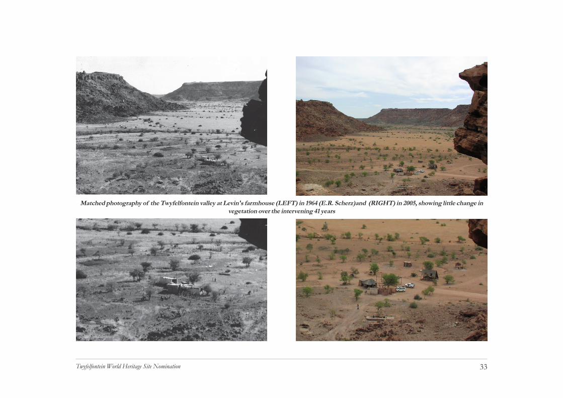
Human impacts on the vegetation of the Twyfelfontein areaare difficult to assess. However, since it is clear that pro-longed residence was not possible in pre-colonial times, thereare unlikely to be any long-lasting anthropogenic features ofthe vegetation. Permanent settlement was only attempted inthe 1940s, and was interrupted by long periods of drought.Matched photography of the farmhouse area in 1964 and thenin 2005 shows no substantial difference, and most of themore established trees are still in place after 40 years (see ac-companying photographs on p. 33). Fruit trees planted at thefarmhouse during the 1950s have all died, and there appear to
be no exotic species within the core area of Twyfelfontein. Itis worth noting, however, that when David Levin improvedthe spring sufficiently to water his 230 sheep and goats, fourdonkeys and two horses, the pasture near the site was almostimmediately exhausted, and the livestock had to be moveddown to the Aba Huab River (Michiel Levin in litt.).
Mustard tree (Salvadora persica) and Camelthorn (Acacia erioloba)below the Twyfelfontein spring
Brandberg acacia (Acacia montis-usti)
33Twyfelfontein World Heritage Site Nomination
Matched photography of the Twyfelfontein valley at Levin's farmhouse (LEFT) in 1964 (E.R. Scherz)and (RIGHT) in 2005, showing little change invegetation over the intervening 41 years

34Twyfelfontein World Heritage Site Nomination
(ix) FaunaThe fauna of Twyfelfontein is both abundant and diverse, butthe presence of species and their population size are prone tosevere fluctuation according to season and rainfall. The fol-lowing remarks are based largely on the specialist contribu-tions of P. Cunningham and T. Bird (see tech-nical appendix on accompanying CD). Themammal fauna includes many small speciesof shrews, mice, gerbils and bats, which arenot readily observed. Larger and more ob-vious mammal species include the ScrubHare Lepus saxatilis, Cape Ground SquirrelXerus inauris, Dassie Rat Petromys typicus,Chacma Baboon Papio ursinus, African WildCat Felis lybica, Black-backed Jackal Canismesomelas, Springbok Antidorcas marsupialis,and Gemsbok Or yx gazella. ElephantLoxodonta africana, Lion Panthera leo, SpottedHyena Crocuta crocuta, Leopard Panthera pardusand Black Rhinoceros Diceros bicornis are allregularly recorded in the area (Griffin 1998).
In the late 1940s elephant, rhinoceros and giraffe occurred atTwyfelfontein, as did lion, leopard and hyena (M. Levin inlitt.). Contrary to popular opinion, the game was not greatlyaffected by the arrival of settler farmers such as Levin, for atthe end of World War II nearly everything, including rifle
ammunition, was subject to strict rationing. Predators werekept from the livestock with fires and loud noise, and accord-ing to Levin, his father did not shoot any wildlife other thanoccasional antelope that were turned into biltong (salted, driedmeat) in the winter months.
More than 140 bird species occur in theTwyfelfontein area, and during times ofhigher than average rainfall, certain migra-tory species will extend their range to includethis part of the country. In both mammaland avian populations, the high species di-versity of Twyfelfontein is the result of bothan ecotone effect associated with theNamibian escarpment, creating an overlapof environmental niches, and the presenceof rather specialized conditions within thepatchy environment of the Namib edge. Theescarpment of Namibia is associated with ahigh degree of avian endemicity and morethan half of the fourteen birds endemic toNamibia are recorded as resident in the vi-
cinity of Twyfelfontein (Brown et al. 1998). Among the morecommon birds of Twyfelfontein are the Grey Hornbill Tockusnasutus, Red-crested Korhaan Eupodotis ruficrista, Pearl-spot-ted Owl, Glaucidium perlatum, Rock Bunting Emberiza tahapisi,Black-chested Prinia Prinia flavicans, Plum-coloured
Namibian rock agama

35Twyfelfontein World Heritage Site Nomination
Starling Cinnyricinclus leucogaster, Black Eagle Aquila verreauxi,Booted Eagle Hieraaetus pennatus, Rock pigeon Columba guinea,Namaqua sandgrouse Pterocles namaqua, Pririt Batis Batis pririt,Dusky Sunbird Nectarinia fusca, Familiar Chat Cercomelafamiliaris, Mountain Chat Oenanthe monicola and BokmakierieTelophorus zeylonus. Most of these birds are easily observedwithin the core area of Twyfelfontein, several having becomehighly habituated to the presence of people.
Reptiles are well represented at Twyfelfontein, and among thesnakes Anchieta’s Dwarf Python Python anchietae, Angola FileSnake Mehelya vernayi, Black-necked Spitting Cobra Nayanigricollis nigricincta and Horned Adder Bitis caudalis have beenobserved recently. The diversity of reptiles and the presenceof several endemics is a reflection of the same escarpmentecotone effect noted for the mammal and avian fauna. A va-riety of skinks, lizards and geckoes have been recorded, in-cluding two large species, the Rock Monitor Varanus albigularisand Giant Plated Lizard Gerrhosaurus validus. The unusuallyvocal Common Barking Gecko Ptenopus garrulous maculates is anocturnal feature of Twyfelfontein. Most of the reptile faunaare retiring species and the only species regularly encounteredby the visitor are the Namibian Rock Agama Agama planicepsand the Striped Skink Mabuya striata wahlbergi (Griffin 2003).
Little in the way of detailed information is available on theinvertebrate fauna of Twyfelfontein, although it is certain toinclude a rich diversity of species. Some indication of the
potential richness of the invertebrate fauna is provided by thediversity of scorpions at the site. A total of fourteen specieshas been identified, with the greatest number found on thepredominant red sand substrate. Other scorpions appear tobe associated with gravel substrates or rocky slopes, and trees.
Some selected elements of the mammalian, avian and reptilefauna are depicted in the rock art of Twyfelfontein and it istherefore a great asset to the core area and buffer zone of thesite that a large proportion of the natural wildlife still exists inthe area. It is however important to note that the naturalfauna and flora are not maintained as a living backdrop to therock art. The wildlife of this area is subject to dramatic changesin density and species composition, mainly as a result of vari-ations in rainfall. The good rains during the years 2003 - 2005have brought both elephant and giraffe back to the generalarea.
b. History & development(i) TenureThe history of land tenure and occupation at Twyfelfontein isan epitome of events and processes in the whole of north-western Namibia during the last one hundred years. The mod-ern history of the site begins in 1946 with the arrival of DavidLevin from Bethanie (M. Levin in litt.). After an insecurebeginning, Levin was granted a licence to pasture his live-stock at Twyfelfontein in 1952 (National Archives LAN 1588),and for the next twelve years attempted to make a living by

36Twyfelfontein World Heritage Site Nomination
farming in this most unpredictable environment. Levin coinedthe name Twyfelfontein (doubtful spring), that has become firmly es-tablished as an alternative to the Khoekhoegowab name /Ui-//aes.
When Levin and his small family arrived at Twyfelfontein bydonkey cart, they followed an elephant track, for there was noroad. They found a clan of Damara people living close to thespring in a settlement of thirty-two huts, according to infor-mation from Levin quoted by Ernst Scherz (1975). MichielLevin (in litt.), who was a six-year old boy at the time relatesthat there was only one man, named Eliphas, his wife, threechildren and an elderly woman. However, soon thereafter the
Damara people and theirflocks of goats and long-tailed sheep were removedby police truck to Sesfontein,following the governmentdecision to secure the areafor settler farmers. MichielLevin (in litt.) recalls that be-fore they left Twyfelfonteinthe Damara family showedhis hard-pressed parents howto dig and winnow wild grassseed to make porridge. As itturned out, Levin and hisfamily spent more time ontrek in search of better pasture than they did at Twyfelfonteinitself; the arid environment drew no distinction between in-digenous nomads and settler farmers.
Archival records of David Levin’s tenure at Twyfelfontein pro-vide detailed accounts of his efforts to establish a viable sheepfarm, producing karakul lamb pelts for the export market.Levin was described by one land inspector as a “flukse”, orhardworking, farmer: he excavated the spring to a depth ofmore than 5m, cleaned it and lined the shaft with bricks; heerected fences, reservoirs, drinking troughs, a wool shed andvarious other improvements, all with very modest resources
The Levin twins, Davina and Dirk, born 1952 - products ofTwyfelfontein! (M. Levin)
Michiel Levin, circa 1954
37Twyfelfontein World Heritage Site Nomination
(LAN 1588). Water was always in short supply, and accord-ing to Susanna Levin (now Kriel), her parents recycled laun-dry water to mix the mud they needed to make bricks for theirhouse. The Twyfelfontein spring was weak, but it never failed,and the government drilled boreholes for Levin as alternativewaterpoints. Pasture was equally scarce, and after repeatedrequests from Levin whose farming activities were limited moreby a shortage of grazing than a shortage of water, an exten-sion to the farm of 3799 ha was grudgingly granted by theauthorities in July 1961 (LAN 1807).
Then, in 1964, Levin was informed that Twyfelfontein was toform part of a communal area for Damara farmers, as pro-posed by the Odendaal Commission (Report of the Commis-sion of Enquiry into South West African Affairs, 1962-1963;RP No. 12/1964). He left the farm one year later and for thenext five years it was leased out as additional pasture to asuccession of other farmers whose land had not been expro-priated. In 1971 the government decided that communal landssuch as Twyfelfontein were for the exclusive use of Damarafarmers, but despite good rain the farm lay abandoned foralmost 20 years, gradually falling into disrepair. There werefew incentives to farm and, as the Odendaal Commission it-self had noted (Botha 2001), the Damara had become largelyurbanized long before the arrival of settler farmers such asLevin. Only a small number of people remained on the landand even more left during the disastrous drought in the early 1980s.
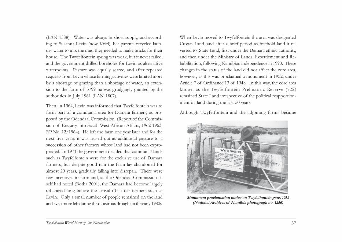
When Levin moved to Twyfelfontein the area was designatedCrown Land, and after a brief period as freehold land it re-verted to State Land, first under the Damara ethnic authority,and then under the Ministry of Lands, Resettlement and Re-habilitation, following Namibian independence in 1990. Thesechanges in the status of the land did not affect the core area,however, as this was proclaimed a monument in 1952, underArticle 7 of Ordinance 13 of 1948. In this way, the core areaknown as the Twyfelfontein Prehistoric Reserve (722)remained State Land irrespective of the political reapportion-ment of land during the last 50 years.
Although Twyfelfontein and the adjoining farms became
Monument proclamation notice on Twyfelfontein gate, 1952(National Archives of Namibia photograph no. 1256)
38Twyfelfontein World Heritage Site Nomination
communal land following the implementation of the OdendaalCommission Report, the land remained subdivided into farmsfor administrative purposes. There were numerous changesin the boundaries of these subdivisions after they were firstsurveyed in the 1950s (LAN 1588, 1807) and in the case ofTwyfelfontein Reserve (873) a final rationalization of bounda-ries was only decided in 1989 (Title Deed T935/1989,Reference No. 19/5/1/7). This area constitutes the proposedbuffer zone and is also designated State Land.
A development that has bearing on the definition of bounda-ries is the establishment of community-based conservancies,under the Nature Conservation Amendment Act No. 151 of1996, Section 24A (2)(i). Conservancy status confers limitedrights of usufruct, mainly with respect to wildlife resourcesand tourism, but it does not alter the status of proclaimedareas such as monuments. Twyfelfontein Reserve, as definedabove, falls entirely within the Twyfelfontein-UibasenConservancy which covers an area of 286km2 and includestwo neighbouring farms (NACSO 2004).
In this connection it is important to note that in its registra-tion documents the area defined as the Twyfelfontein-UibasenConservancy specifically excludes the Twyfelfontein Prehis-toric Reserve (722), the core area nominated for World Herit-age List inscription. It also excludes the Verbrandeberg (725)geological monument, and two pieces of land subject to Per-
mission To Occupy (PTO) permit numbers 11/3/1/211 andX/2/E, both in the name of Elias Xoagub of Aba-Huab Camp.Currently, in terms of the Communal Land Reform Act, allPTOs are being converted to 99 year leases.
Beyond the bare facts cited above there are no documentaryrecords concerning the Damara clan that lived at Twyfelfonteinin 1946. The size of the settlement is no indication of per-manency; indeed, it is unlikely that residence could be sus-tained at any one site in this area for more than one year. Ar-chaeological evidence from the area to the west and southwest of Twyfelfontein shows that nomadic pastoralists didcongregate at reliable springs after rains because this enabledthem to exploit the ephemeral pastures within range of thewater (Kinahan 2001). Because the actual distribution ofrainfall tended to be very patchy these encampments mightnot be used during successive years. These are exactly thecircumstances experienced by Levin, who found that althoughhe had water for his stock, in most years there was nothing forthe animals to eat.
The viability of nomadic pastoralism in arid north westernNamibia was entirely destroyed during the last one hundredyears, first by the Rinderpest epidemic of 1897 (Schneider 1994:149), and then by a series of government policies which en-couraged people to leave the land and take up employment inthe growing commercial economy. This means that cultural
39Twyfelfontein World Heritage Site Nomination
and historical links with specific places such as Twyfelfonteintend to be tenuous and limited in their time-depth. Inter-views with three elderly men Tomas Taniseb (68), AbsolomGaeb (89) and Herman Goraseb (68) yielded little informa-tion about the site and its history (interview notes from P.Ipinge). The interviews were conducted in April 2004 withresidents of the farms Blaauwpoort and Morewag, in an ef-fort to collect oral history on the earlier occupation of thearea and the significance of the rock art sites.
It emerges from these interviews that over the last three gen-erations people knew of the rock art but stayed away fromthe sites because they were thought to be powerful places,“like graves”. There was reference to ritual activities beingcarried out in the mountains but the rock art itself is not men-tioned. Although the consensus was that the rock art was thework of the “ancestors”, the fact that there were no specificreferences to the art or its meaning suggested either that itwas the domain of specialists, or that there was no longer aliving link with the rock art during the lives of the threeinformants.
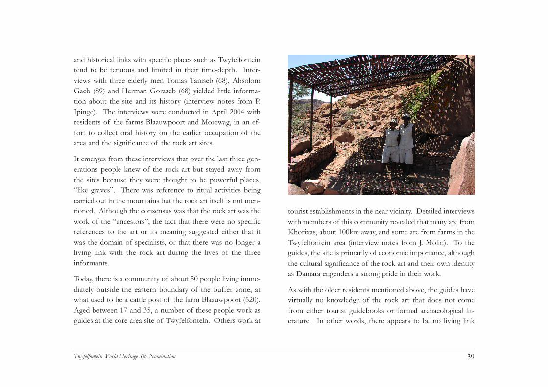
Today, there is a community of about 50 people living imme-diately outside the eastern boundary of the buffer zone, atwhat used to be a cattle post of the farm Blaauwpoort (520).Aged between 17 and 35, a number of these people work asguides at the core area site of Twyfelfontein. Others work at
tourist establishments in the near vicinity. Detailed interviewswith members of this community revealed that many are fromKhorixas, about 100km away, and some are from farms in theTwyfelfontein area (interview notes from J. Molin). To theguides, the site is primarily of economic importance, althoughthe cultural significance of the rock art and their own identityas Damara engenders a strong pride in their work.
As with the older residents mentioned above, the guides havevirtually no knowledge of the rock art that does not comefrom either tourist guidebooks or formal archaeological lit-erature. In other words, there appears to be no living link
40Twyfelfontein World Heritage Site Nomination
with the rock art or with the site as a ritual centre. Someambivalence exists concerning the cultural affinity of the rockart: while many accept the conventional view that the art isof San (Bushman) origin, others dispute this, usually on thegrounds that San never lived at Twyfelfontein. Others be-lieve that since the ancient San and Damara were alike in be-ing hunter-gatherers, both would have made rock art and sinceTwyfelfontein is their (i.e. Damara) place, it would follow thatthe rock art was produced by their own ancestors. This con-tributes to a powerful, yet vague, feeling of ownership.
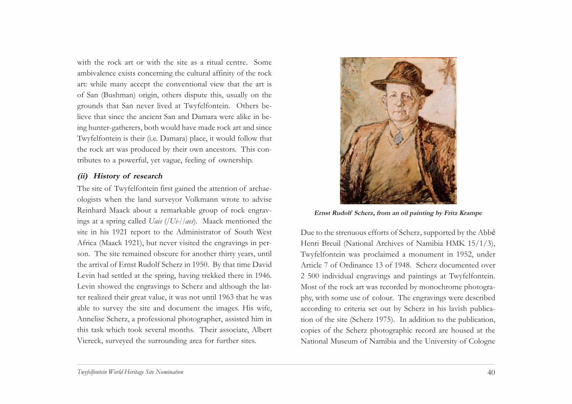
(ii) History of researchThe site of Twyfelfontein first gained the attention of archae-ologists when the land surveyor Volkmann wrote to adviseReinhard Maack about a remarkable group of rock engrav-ings at a spring called Uais (/Ui-//aes). Maack mentioned thesite in his 1921 report to the Administrator of South WestAfrica (Maack 1921), but never visited the engravings in per-son. The site remained obscure for another thirty years, untilthe arrival of Ernst Rudolf Scherz in 1950. By that time DavidLevin had settled at the spring, having trekked there in 1946.Levin showed the engravings to Scherz and although the lat-ter realized their great value, it was not until 1963 that he wasable to survey the site and document the images. His wife,Annelise Scherz, a professional photographer, assisted him inthis task which took several months. Their associate, AlbertViereck, surveyed the surrounding area for further sites.
Due to the strenuous efforts of Scherz, supported by the AbbéHenri Breuil (National Archives of Namibia HMK 15/1/3),Twyfelfontein was proclaimed a monument in 1952, underArticle 7 of Ordinance 13 of 1948. Scherz documented over2 500 individual engravings and paintings at Twyfelfontein.Most of the rock art was recorded by monochrome photogra-phy, with some use of colour. The engravings were describedaccording to criteria set out by Scherz in his lavish publica-tion of the site (Scherz 1975). In addition to the publication,copies of the Scherz photographic record are housed at theNational Museum of Namibia and the University of Cologne
Ernst Rudolf Scherz, from an oil painting by Fritz Krampe
41Twyfelfontein World Heritage Site Nomination
in Germany. Additional publications emanating from the sur-vey of Twyfelfontein were the guidebooks of Krynauw (1968)and Viereck (1959), both long out of print. A short paper byViereck and Rudner (1957) also contributed to the recogni-tion of the site as an important rock art locality.
An archaeological investigation of Twyfelfontein was carriedout by Erich Wendt in 1968, with the intention of establish-ing the age and cultural affinities of the rock art. Two exca-vations were carried out in the core area of the site, at thesites Affenfelsen and Zwei Schneider, respectively yieldingdates of 3 450 and 5 850 years before present. One excava-tion was carried out in the buffer zone, at the site Hasenbild,yielding dates of 370 and 180 years before present (Richter1991: 98, 105, 117; Wendt 1972). All three excavationsyielded typical Later Stone Age assemblages with some asso-ciated pottery in the younger layers, thus confirming an ar-chaeological affinity with late Holocene hunter-gatherers. Thearchaeological deposits were in all three instances rather shal-low and the area offered no immediate prospects for moredetailed investigation. More details of this work appear in theprevious section 2 (a) (v) on archaeology.
Further investigations of the rock art were carried out in the1980s, including a detailed archaeological assessment of thesite by Kinahan and Kinahan (1988, unpublished report tothe National Museum). Selective documentation by Dowson
(1992) was carried out for a regional review of southern Afri-can rock engravings; copies of these items are housed at theRock Art Research Institute at the University of theWitwatersrand in Johannesburg.
During the last few years field research on the social historyof the Twyfelfontein area was carried out by Pombili Ipinge,Bennet Kangumu, John Molin and Goodman Gwasira.
(iii) Site developmentsFor more than 30 years following its proclamation as a monu-ment in 1952, there were no facilities for visitors toTwyfelfontein. According to the records of the National Ar-chives, David Levin served as honorary curator while he wasfarming at Twyfelfontein (National Archives HMK 15/1/3Twyfelfontein). However, the farm was expropriated in 1965as part of the land set aside by the Odendaal Commission forresettlement of Damara people. After a succession of tem-porary leaseholders had left the farm (LAN 1807) it fell intodisuse. Following a spate of public complaints (RNG 16/S/T-F/1; NMC 14/4/2/5) renewed attempts were made to ap-point a caretaker (RNG 16/S/T-F/1 and A664 2/59 Box 7Correspondence: Damaraland). In 1988, the National Monu-ments Council and the National Museum of Namibia carriedout extensive repairs to the network of paths in the core areaof the site and erected a simple information shelter (NMC14/2/2/5). The paths were constructed with concrete and

42Twyfelfontein World Heritage Site Nomination
local stone, and at certain points ceramic numbers were at-tached to the rocks with epoxy cement. Direct supervision ofthe site was lacking until 1995 when the Ministry of Environ-ment and Tourism granted local concession rights to EliasXoagub, owner of the Aba-Huab Camp (RNG 16/S/T-F/1).
Periodic public complaints continued, mainly with regard tothe lack of visitor facilities, the lack of trained guides and theabsence of site management. In January 2003, the NationalMonuments Council in partnership with the Namibia Tour-ism Development Programme (NTDP) in the Ministry ofEnvironment and Tourism, commissioned a detailed devel-opment proposal for the site (Kinahan 2003). Theproposal recommended that the site should be taken underdirect control of the National Monuments Council, which itwas the following year with the appointment of cashiers andthe establishment of regular visits to the site by Council headoffice personnel. The proposal also set out detailed require-ments for site management and conservation measures, in-cluding a complete revision of the path network, erection ofviewing platforms at certain sites, dust control measures, train-ing of guides, and provision of toilet facilities. Finally, theproposal recommended that a purpose designed visitor centrebe established at the northern perimeter of the site.
In October 2003 the NMC and NTDP hosted a consultativeworkshop entitled “Giving the Past a Future: Sustainable Tourism
for Rock Art Sites in Namibia”. Theworkshop was attended by local andforeign experts, as well as representa-tives of the local community and thetourism sector. The proposal recom-mendations were discussed in detailand approved in the form of a worksagreement. Work commenced on thesite in October 2004 and was com-pleted in February 2005. In 2004,cashiers were officially appointedfrom the ranks of the informal guidesand National Monument Council head office personnel beganregular visits to the site. Construction of the Visitor Centrecommenced in February 2005 and is due for completion inJune 2005. Details of the site conservation measures are givenbelow in subsection 4a (p.58).

43Twyfelfontein World Heritage Site Nomination
CHAPTER 3Justification for Inscription
44Twyfelfontein World Heritage Site Nomination
by which means shamans or specialist healers were able todraw upon the powers of the supernatural to mediate humanrelations with the desert environment. The ritual traditionsrepresented in the rock art of Twyfelfontein saw their great-est florescence during the last 5 000 years, in the period sincethe mid-Holocene inter-glacial. This was a time of increasingaridity during which hunter-gatherer communities developedand perfected a wide range of economic survival strategies.
One of the most important components of the hunter-gath-erer economy was a pattern of settlement based on dry sea-son aggregation at reliable water sources such as Twyfelfontein.These sites became important ritual centres associated withrainmaking, initiation and various other ceremonies. There isreason to believe that the aridity of the last 5 000 years wasameliorated, in respect of hunter-gatherer survival, by thelong-term availability of water from aquifer recharge at inter-vals over the last few millennia.
Moisture requirements of the Twyfelfontein environment maythus have been supplied by old reservoirs of subterranean wa-ter as well as infrequent rain. It is possible that the climaticaridity of the last 5 000 years has been offset by the long-termavailability of water from aquifer recharge on a far longer time-scale than that of annual flooding in the Huab basin. In thesecircumstances, Twyfelfontein provides an eloquent statementof human strategy under increasingly inimical conditions.
3. JUSTIFICATION FOR INSCRIPTIONa. Criteria under which inscription is proposedTwyfelfontein bears “a unique or at least exceptional testi-mony to a cultural tradition ... which has disappeared” (WHCOperational Guidelines II.D.77 iii).
The site of Twyfelfontein represents the largest concentra-tion of rock engravings in southern Africa. With over 2 000engravings documented, the site is more than double the sizeof any other rock-engraving site in Namibia. The engravingsare exceptionally well preserved and show a very wide reper-toire of subject matter relating to hunter-gatherer ritual prac-tices. As such, the site is without parallel in the rock art ofsouthern Africa and may be regarded as the single most im-portant expression of the engraving tradition. The practiceof hunter-gatherer rock art probably died out several centu-ries ago in Namibia, although related ritual practices still sur-vive in some parts of the country.
Twyfelfontein is “an outstanding example of ... human inter-action with the environment ... when it has become vulner-able under the impact of irreversible change” (WHC Opera-tional Guidelines II.D.77 v).
The rock art of Twyfelfontein provides an excellent exampleof the intimate links between ritual practices and the eco-nomic base of hunter-gatherer society. The engravings con-tain a wide variety of culturally important animal metaphors
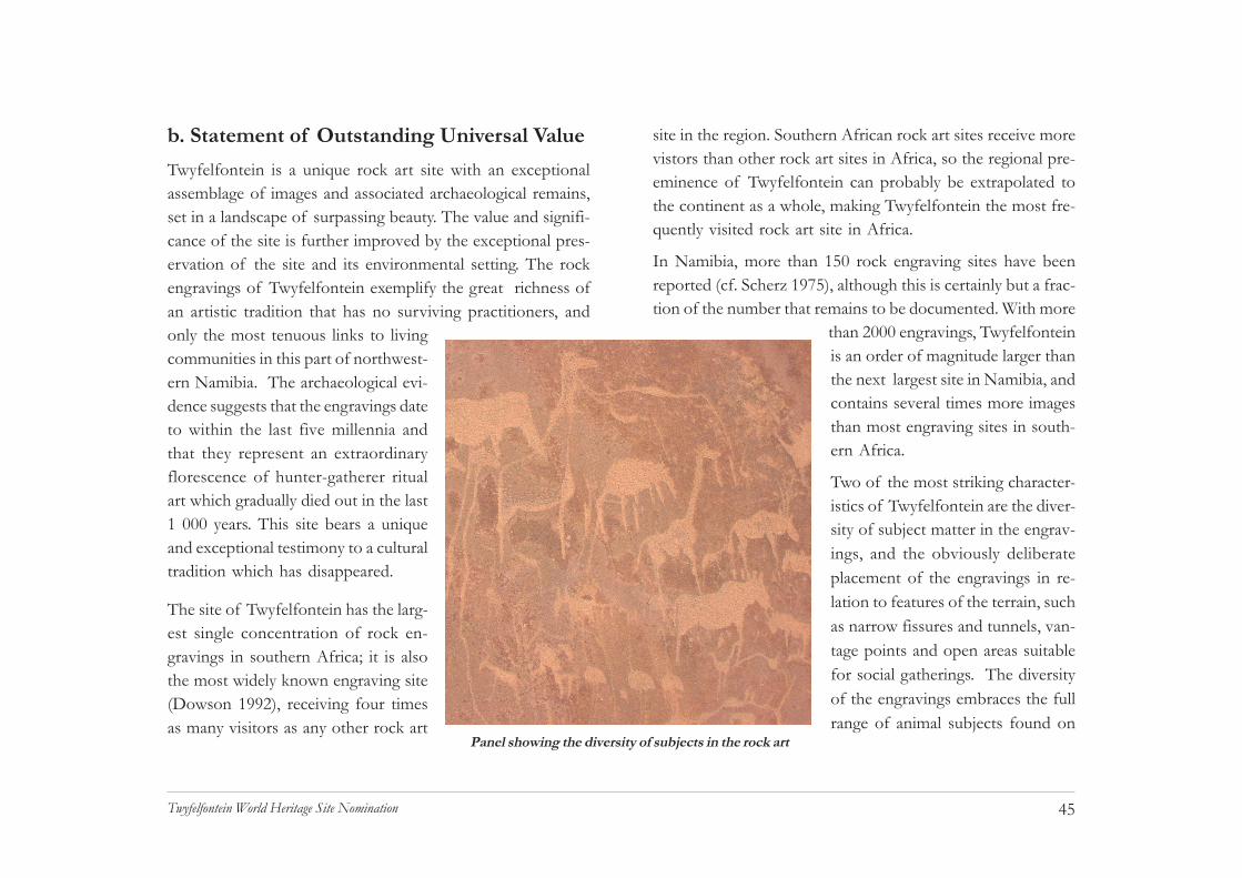
45Twyfelfontein World Heritage Site Nomination
b. Statement of Outstanding Universal ValueTwyfelfontein is a unique rock art site with an exceptionalassemblage of images and associated archaeological remains,set in a landscape of surpassing beauty. The value and signifi-cance of the site is further improved by the exceptional pres-ervation of the site and its environmental setting. The rockengravings of Twyfelfontein exemplify the great richness ofan artistic tradition that has no surviving practitioners, andonly the most tenuous links to livingcommunities in this part of northwest-ern Namibia. The archaeological evi-dence suggests that the engravings dateto within the last five millennia andthat they represent an extraordinaryflorescence of hunter-gatherer ritualart which gradually died out in the last1 000 years. This site bears a uniqueand exceptional testimony to a culturaltradition which has disappeared.
The site of Twyfelfontein has the larg-est single concentration of rock en-gravings in southern Africa; it is alsothe most widely known engraving site(Dowson 1992), receiving four timesas many visitors as any other rock art
site in the region. Southern African rock art sites receive morevistors than other rock art sites in Africa, so the regional pre-eminence of Twyfelfontein can probably be extrapolated tothe continent as a whole, making Twyfelfontein the most fre-quently visited rock art site in Africa.
In Namibia, more than 150 rock engraving sites have beenreported (cf. Scherz 1975), although this is certainly but a frac-tion of the number that remains to be documented. With more
than 2000 engravings, Twyfelfonteinis an order of magnitude larger thanthe next largest site in Namibia, andcontains several times more imagesthan most engraving sites in south-ern Africa.
Two of the most striking character-istics of Twyfelfontein are the diver-sity of subject matter in the engrav-ings, and the obviously deliberateplacement of the engravings in re-lation to features of the terrain, suchas narrow fissures and tunnels, van-tage points and open areas suitablefor social gatherings. The diversityof the engravings embraces the fullrange of animal subjects found on
Panel showing the diversity of subjects in the rock art

46Twyfelfontein World Heritage Site Nomination
Namibian sites and includes many of the finest specimensknown so far, as well as examples of every technique of en-graving and representation. These characteristics elevate thesignificance of the site well above the ordinary and provide astrong motivation for its protection.
For many visitors, the rich array of animals depicted atTwyfelfontein is made all the more compelling by the seemingparadox of its harsh environmental setting: a wide sandy val-ley with a sparse semi-desert vegetation and little sign of ani-mal life, surrounded by barren red sandstone cliffs. The exist-ence of a weak but persistent spring provides the reason forits importance to hunter-gatherer bands that roamed the fringesof the Namib Desert in the past. In fact, Twyfelfontein wasbut one of many remote seepages, ponds and waterholes onwhich these people depended, especially during the long dryseason when much of the area was entirely without water andtherefore outside the range of hunters on foot. The sitepresents an outstanding example of human interaction withthe environment when it has become vulnerable under theimpact of irreversible change.
Most rock art sites in Namibia are located along the country’sbroken longitudinal escarpment. Hunter-gatherers set out fromthese sites into the desert during the brief and unpredictablesummer rains. A pattern of social aggregation and dispersalbecame established during the last 5 000 years, as a finely
tuned human response to increasing aridity (Kinahan 2005).Excavations at rock shelters in the Namib Desert show thatsites with reliable water supplies became vital foci of hunter-gatherer settlement during this period. Cave sediment studiesshow that this development is associated with increasinglyarid conditions from the mid-Holocene to the present day.
Distribution of rock art sites along Namibia's escarpment.

47Twyfelfontein World Heritage Site Nomination
Today, the average annual precipitation on the edge of theNamib Desert at sites such as Twyfelfontein is about 100mm,with a coefficient of variation exceeding 80%. Rainfall is un-predictable not only in its quantity, however, but most criti-cally in its distribution. These conditions required that hunter-gatherer bands pursued a highly mobile existence, and this iswell reflected in the archaeological evidence for long-rangemovement and exchange, such as marine shell at interior sites,and other objects found well beyond their expected distribu-tion. Against this background of mobility and chance, themore reliable water sources served as fixed points on the land-scape and it is around these that much of the rock art is concen-trated.
Archaeological evidence from detailed survey and excavationprogrammes in the Namib Desert shows that concentrationsof rock art are associated with prolonged periods of socialaggregation. Rock art reflects a heightened intensity of ritualactivity in response to social stress arising from limited, anddiminishing, food and water (Kinahan 2001). Indeed, a sig-nificant number of depictions are obviously related to rain-making and many others suggest similar, albeit less direct ref-erences (Kinahan 1999). A dry season aggregation site suchas Twyfelfontein was not merely an ecological lifeline; it wasa critical nexus of hunter-gatherer society, showing by itsgraphic repertoire the human response to nature and vicissi-tude.
The hunter-gatherer way of life that is intimately associatedwith the rock art and its ritual context, gave way to the rise ofnomadic pastoralism during the last 1 000 years. The overlapbetween these two greatly contrasting economies is shown atTwyfelfontein by a small number of cattle depictions amongthe rock engravings. Further changes followed in more recenttimes, and nomadic pastoralism in turn collapsed under theimpact of colonial rule, cattle disease, drought and the appro-priation of land for settler farming. Although these eventsand processes disrupted traditional links with the site, it re-tains the alternative name of /Ui-//aes, meaning “among therocks”, from /ui meaning rock and //aes something in the
Depictions of cattle show the overlap between hunter-gatherer and

48Twyfelfontein World Heritage Site Nomination
centre (Aribeb, pers. com.). Recently, the site has begun torecover its social significance as Namibia’s premier culturaltourism destination.
Twyfelfontein has considerable research potential, owing toits large size among rock engraving sites, and its central posi-tion within a much wider distribution of rock art and relatedarchaeological sites. As suggested in the following section c.,there are significant differences between the rock engravingsof Twyfelfontein and its surrounding area that may provide abasis for important revision of current interpretative modelsapplied to southern African rock art. It is a measure of itsimportance when a single site such as Twyfelfontein can serveas a basis for commentary on the regional rock art.
As is elaborated in the comparative analysis below, the site ofTwyfelfontein is an exceptional representative of the south-ern African rock engraving genre, in its size, complexity, de-gree of preservation and its acknowledged importance in thefield of rock art studies. Its importance extends beyond theregion, to the rock art of Africa as a whole, and from thisvantage point it may be favourably compared with major siteselsewhere in the world. On these grounds, Twyfelfontein isconsidered to be a rock art site of outstanding universalsignificance.
c. Comparative analysis(i) Regional and global contextSeveral major rock art sites in southern Africa are listed ortentatively listed under the World Heritage Convention. Theseare Tsodilo in Botswana, Matobos in Zimbabwe andDrakensberg in South Africa. One other site, Brandberg, istentatively listed for Namibia. All of these are rock-paintingsites, with associated archaeology: none contain appreciablenumbers of engravings, and Twyfelfontein would thereforebe the first southern African rock-engraving site to be listedunder the World Heritage Convention.
However, the significance of Twyfelfontein as a rock art siteextends well beyond the immediate southern African region.Major concentrations of rock engravings occur in both Westand North Africa (Coulson & Campbell 2001), but few ofthese can rival Twyfelfontein in size, state of preservation oraccessibility. It is important also to note that the rock engrav-ings of West and North Africa do not refer to the same ritualand artistic traditions as those of southern Africa. The south-ern African rock art, of which Twyfelfontein is a premier ex-ample, has benefited from long and sustained research, lead-ing to advances in understanding which have greatly increasedthe significance of the art.

49Twyfelfontein World Heritage Site Nomination
The sustained research effort focused on southern African rockart and the cognate fields of folklore, historical ethnographyand archaeology has had a cumulative impact on rock art stud-ies around the world. It is generally acknowledged that south-ern African rock art is the most comprehensively understoodof the various rock art traditions known worldwide. Now,the advantage of this superior understanding has been usedto suggest important new interpretations of the EuropeanUpper Palaeolithic rock art and its relation to the evolutionof human cognitive capacity in post-glacial Europe. South-ern African rock art has in this way contributed to a majoradvance in our knowledge of how the human intellect devel-oped during the last 20 000 years. Large sites, among themTwyfelfontein, are the crucial repositories of evidence reflect-ing the process.
The global value of southern African rock art is increasinglyappreciated. Within this context, the importance ofTwyfelfontein is assured, not only because it is the most sig-nificant representative of the engraving genre; its size andcomplexity is such that the site contains some elements ofthe art that challenge generally agreed views on the produc-tion of the art, its social and vocational context, and the ide-ology of hunter-gatherer communities. As studies in this fieldadvance, sites such as Twyfelfontein will need to be studiedover and again, underlining the critical need to protect thesite. At the same time, as the wider importance of the rock
Antelope spoor leading into a fissure inthe rock
art is recognized, increasing numbers of people will be moti-vated to visit the site, as is reflected by statistics presentedelsewhere in this nomination dossier
(ii) Special featuresThere are important general differences between rock paint-ing and rock engraving traditions in southern Africa whichmerit special consideration of the engravings. Although bothbelong to the same Khoisan cultural complex (with the ex-ception of Bantu rock art, a relatively minor component), thecontent, techniques and physical placement of rock engrav-ing imagery differs from that of rock paintings. For example,while human figures are the predominant component of rockpainting imagery throughout southern Africa, they are uncom-mon in the rock engravings, and entirely absent from someimportant sites.

50Twyfelfontein World Heritage Site Nomination
The techniques employed in rock painting and rock-engrav-ing imagery present a more obvious point of distinction. Rockpaintings are generally, but not always, finer in their execu-tion, with highly developed techniques evident among shadedpolychrome work and in complex superpositioning of images.The pigments themselves are sophisticated preparations, of-ten with remarkable durability. While the techniques of en-graving are more limited, theirapplication at Twyfelfonteinshows advanced mastery ofthe medium, with the use ofpolishing, false relief and ex-perimental superpositioning.
To most observers, the thirdmost striking differencebetween the paintings and en-gravings is that while theformer are generally found inrock shelters, frequently witharchaeological evidence of oc-cupation, the latter occur in theopen air, on hillsides and val-ley bottoms, most often with-out any accompanying evidence of occupation. The clearlydomestic context of most rock paintings, and their well-knownritual associations, form the empirical basis of current con-
The famous "Dancing kudu" is a polished engraving full of movement
sensus on the interpretation of southern African rock art. Therock engravings are thus of special importance because theyprovide a number of distinctions which, in turn, may lead tonew developments in rock art interpretation. In the specificcontext of Twyfelfontein, the rock engravings confirm manyof the key ritual characteristics of southern African rock art:the site shows culturally mediated selection of subject mat-
ter, with emphasis on spe-cies of known ritual im-portance such as elandand giraffe; the imagesshow certain points ofdetail that are diagnosticof ritual activity or super-natural transformation;and the sites are closelyassociated with lateHolocene archaeologicaldeposits that are attribut-able to hunter-gatherergroups who were prob-ably the authors of theengravings. There are,
however, some features of the Twyfelfontein rock art that areof special significance for a comparative view of the site, andthese need to be emphasized here. So-called abstract images,
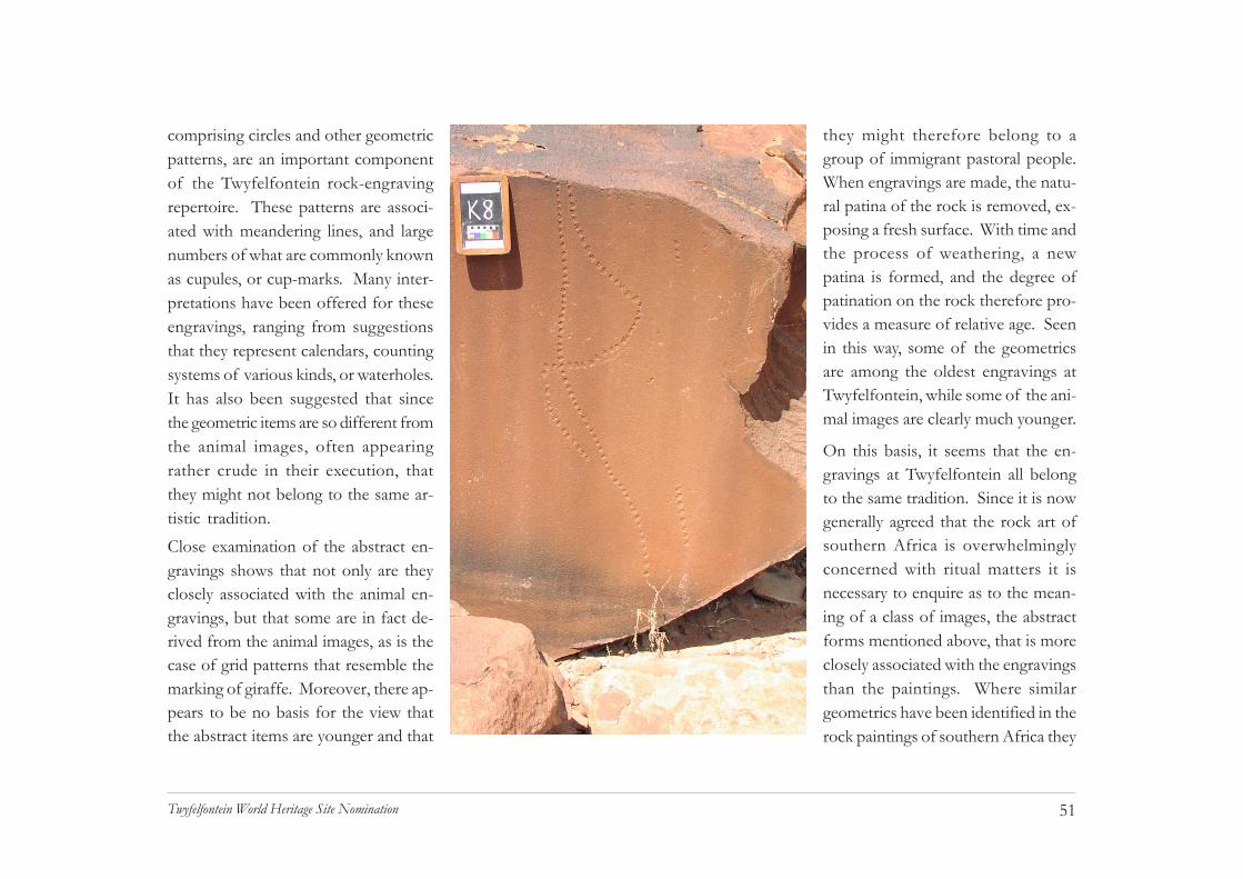
51Twyfelfontein World Heritage Site Nomination
comprising circles and other geometricpatterns, are an important componentof the Twyfelfontein rock-engravingrepertoire. These patterns are associ-ated with meandering lines, and largenumbers of what are commonly knownas cupules, or cup-marks. Many inter-pretations have been offered for theseengravings, ranging from suggestionsthat they represent calendars, countingsystems of various kinds, or waterholes.It has also been suggested that sincethe geometric items are so different fromthe animal images, often appearingrather crude in their execution, thatthey might not belong to the same ar-tistic tradition.Close examination of the abstract en-gravings shows that not only are theyclosely associated with the animal en-gravings, but that some are in fact de-rived from the animal images, as is thecase of grid patterns that resemble themarking of giraffe. Moreover, there ap-pears to be no basis for the view thatthe abstract items are younger and that
they might therefore belong to agroup of immigrant pastoral people.When engravings are made, the natu-ral patina of the rock is removed, ex-posing a fresh surface. With time andthe process of weathering, a newpatina is formed, and the degree ofpatination on the rock therefore pro-vides a measure of relative age. Seenin this way, some of the geometricsare among the oldest engravings atTwyfelfontein, while some of the ani-mal images are clearly much younger.
On this basis, it seems that the en-gravings at Twyfelfontein all belongto the same tradition. Since it is nowgenerally agreed that the rock art ofsouthern Africa is overwhelminglyconcerned with ritual matters it isnecessary to enquire as to the mean-ing of a class of images, the abstractforms mentioned above, that is moreclosely associated with the engravingsthan the paintings. Where similargeometrics have been identified in therock paintings of southern Africa they

52Twyfelfontein World Heritage Site Nomination
have been recognized as representations of phosphenes, whichare entoptic phenomena associated with the onset of trance.This would confirm that abstract or geometric images resem-bling phosphenes refer to the same ritual concerns generallyfound in the southern African rock art.
Where an important point of difference may lie is in the inter-pretation of abstract engravings in relation to the actual prac-tice of ritual. It is generally agreed on the basis of evidence
from rock paintings that the art was produced in the after-math of ritual experience. This is held as an explanation forthe fact that most of the art is found in the domestic settingof a rock shelter where all could see, but not necessarily un-derstand its content. Part of this argument rests on the viewthat ritual was a communal undertaking, and that group par-ticipation was necessary to its success. What this does notsatisfactorily explain is why the rock art at Twyfelfontein de-picts imagery from the onset of trance, rather than its fullydeveloped state. This, together with some other characteris-tics of the Twyfelfontein engravings suggests that the site mayprovide a different explanation of ritual practice.
In contrast to the rock art found elsewhere in southern Africa,that of Twyfelfontein and certain other Namibian sites, in-cludes a significant number of hidden images. These occur-rences contradict the general view that the art was openly dis-played because it was part of a communal ritual practice. TheTwyfelfontein examples, described in detail elsewhere in thedossier suggest a contemplative rather than performance-basedapproach to achieving altered conciousness for ritual activity.At Twyfelfontein some ritual specialists isolated themselvesin rock niches and may have practised a form of sensory dep-rivation as a means to attaining the required state of trance.
This possibility suggests an alternative explanation for the oc-currence of abstract or entoptic images related to the onset
Trance dancers in the Kalahari photographed by LornaMarshall in the 1950s

53Twyfelfontein World Heritage Site Nomination
of trance. The abstract engravings may have been part of thepreparation carried out by the ritual specialist in isolation ratherthan in the context of a social gathering. The notion thatritual practitioners could achieve trance by themselves wouldexplain the presence of the abstract images if they were usedas an aid to altered consciousness.
Contemplating, or even executing such images may have beena powerful aid to achieving the first stage of trance. Indeed,the method of percussion used in most of the engravings wouldhave been rhythmic and repetitive, as is the clapping of womenat the ritual trance dance. This more satisfactorily explainsimages relating to the onset of trance than the commonly heldview that the art depicted, in the sense of Wordsworth, “pow-erful emotion recollected in tranquillity” (Lewis-Williams 1995:147). The evidence at Twyfelfontein allows for the possibil-ity that rock art and ritual traditions in Namibia developed adegree of specialization beyond that which has been recog-nized elsewhere in the southern African rock art.
d. Integrity and Authenticity(i) MotivationThe site of Twyfelfontein provides a uniquely comprehensiveexpression of the hunter-gatherer rock engraving tradition inNamibia and the southern African region. The site exempli-fies the intimate connection between ideology and nature, andbetween artistic practice and its physical setting. The most
important components of the religious framework of the rockart tradition are represented at Twyfelfontein, thus clearly es-tablishing its authenticity within the southern African genre.
The nomination of Twyfelfontein for inclusion in the WorldHeritage List is supported by a detailed documentation of therock art at the site; including its contents, archaeological as-sociations, physical setting and current state of preservation.This documentation is the result of field surveys carried outspecifically for the nomination process. The site documenta-tion is the most recent of several successive documentationefforts, all of which are described in a later section of thisdossier.
During the preparation of the nomination dossier several at-tempts were made to investigate the possible existence ofsurviving links between the rock art and the modern inhabit-ants of the area surrounding the site. Studies elsewhere insouthern Africa (e.g. Ndoro 2001) have shown such links toexist in certain specific localities. At a more general level, thewidely accepted correspondence between southern Africanrock art and the cultural traditions of the San have encour-aged the articulation of claims to cultural and intellectualownership of the art (Geingos & Oreseb 2005).
Investigations in the Twyfelfontein area included selectiveinterviews by National Heritage Council staff with elderlyresidents, as well as research by the National Museum of
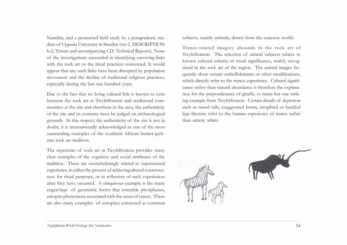
54Twyfelfontein World Heritage Site Nomination
subjects, mainly animals, drawn from the concrete world.
Trance-related imagery abounds in the rock art ofTwyfelfontein. The selection of animal subjects relates toknown cultural criteria of ritual significance, widely recog-nized in the rock art of the region. The animal images fre-quently show certain embellishments or other modifications,which directly refer to the trance experience. Cultural signifi-cance rather than natural abundance is therefore the explana-tion for the preponderance of giraffe, to name but one strik-ing example from Twyfelfontein. Certain details of depictionsuch as raised tails, exaggerated horns, atrophied or buckledlegs likewise refer to the human experience of trance ratherthan artistic whim.
Namibia, and a protracted field study by a postgraduate stu-dent of Uppsala University in Sweden (see 2. DESCRIPTIONb.(i) Tenure and accompanying CD: Technical Reports). Noneof the investigations succeeded in identifying surviving linkswith the rock art or the ritual practices concerned. It wouldappear that any such links have been disrupted by populationmovement and the decline of traditional religious practices,especially during the last one hundred years.
Due to the fact that no living cultural link is known to existbetween the rock art at Twyfelfontein and traditional com-munities at the site and elsewhere in the area, the authenticityof the site and its contents must be judged on archaeologicalgrounds. In this respect, the authenticity of the site is not indoubt; it is internationally acknowledged as one of the mostoutstanding examples of the southern African hunter-gath-erer rock art tradition.
The repertoire of rock art at Twyfelfontein provides manyclear examples of the cognitive and social attributes of thetradition. These are overwhelmingly related to supernaturalexperience, in either the process of achieving altered conscious-ness for ritual purposes, or in reflection of such experiencesafter they have occurred. A ubiquitous example is the manyengravings of geometric forms that resemble phosphenes,entoptic phenomena associated with the onset of trance. Thereare also many examples of entoptics construed as common

55Twyfelfontein World Heritage Site Nomination
Even though the rituals associated with the rock art are nolonger performed in the area around Twyfelfontein, and localresidents have no traditional knowledge of the content or pur-pose of the art, it nonetheless has a strong significance for thepeople of the area. Its significance is well understood andnotions of respect for the art as a religious artefact are wellgrounded in the local com-munity. There is howeverno reliable evidence thatthe site was used for ritualpurposes during historicaltimes, and there is no indi-cation that elements wereadded to the corpus ofrock art in living memory.
(ii) ConservationAs a final reflection of itsauthenticity, the site hasnot been subject to any at-tempt at reconstruction,and appears to be quite un-altered apart from the ef-fects of erosion and a fewminor acts of vandalismand inappropriate management attempts. The integrity of thesite can therefore be regarded as intact apart from some
damage that is either remediable or of minor concern: somedigging and opening up of the natural spring, carried out inthe 1940s and 1950s; some poorly backfilled archaeologicalexcavations in the 1960s (now stabilized); and some inappro-priate signage applied to the rocks in the 1980s. Remains of a farmhouse and related structures built between the late
1940s and early 1960sare considered to bepart of the historicalrecord of the site,rather than an un-wanted legacy. Theseremains have beenstabilized to retardtheir natural deteriora-tion. However, anumber of poorlyplanned amenities, in-cluding picnic tables,an information shel-ter and pit latrines areto be demolished andthe area surroundingthe old farmhousewill be restored to anatural appearance.
Likewise, approximately 450m of dirt road leading to the housewill be removed.

56Twyfelfontein World Heritage Site Nomination
The integrity of the site was seriously threatened by uncon-trolled tourist access until the late 1980s. In 1988, a short-ened and rationalized path network was installed as a site con-servation measure. In 2005, new paths were constructed usinga minimally invasive approach following the Burra Charter(1999) principles, and dry compost toilets as well as restingshelters were installed. A new visitor centre has been con-structed on the periphery of the core area of the site, alsowith a view to minimizing the impact of visitors.
Although these measures have greatly reduced the vulnerabil-ity of the rock art, some damage to the integrity of the sitehas not been repaired and may be considered irreversible. Suchdamage includes vandalism in the form of graffiti, and somefragmentation resulting from attempts by thieves to removeparts of engraved panels. One large engraved slab wasremoved to the National Museum for safekeeping in the 1980s;it is unknown whether any other pieces have been removedfrom the site.

57Twyfelfontein World Heritage Site Nomination
CHAPTER 4STATE OF CONSERVATION & FACTORSAFFECTING THE PROPERTY

58Twyfelfontein World Heritage Site Nomination
Severely eroded pathway showing depth of gulleying prior torestoration work in 2005
4. STATE OF CONSERVATION &FACTORS AFFECTING THE PROPERTYa. Present state of conservationThe incidence of graffiti and other vandalism in the core areaof the site was documented in 1988 (Kinahan & Kinahan1988). Damage of various kinds was noted at a smallnumber of panels during the 1988 survey, and a few furtherexamples were noted during the 2005 survey. Records of thevandalism are incorporated within the site data lodged withthis dossier.
Considering the lack of effective supervision at the site andthe extreme vulnerability of the rock art there is remarkablylittle damage due to direct and intentional vandalism. Ofmore concern is the evidence of increasing wear and tear atcertain key sites where visitors tended to clamber over someof the minor engravings in order to reach suitable viewpointsfor taking photographs. Equally serious is the developmentof deep erosion gullies in pathways that are perpendicular tothe slope of ground. The first indications of severe soil ero-sion were noted at Twyfelfontein during the field survey ofKinahan and Kinahan in 1988. This neglect, together withthe lack of formal reception facilities, toilets and other ameni-ties contributed to the steady deterioration of the site duringthe last two decades.
In view of the fact that damage to the engravings ispractically impossible to repair, and that the presence of graf-fiti seems to engender further vandalism, new access paths inthe core area of the site were deliberately routed away fromdamaged art. One exception to this rule is a panel on theself-guided trail where the visitor is intentionally led to anexample of severe vandalism, in order to illustrate theseriousness of the problem. The strategy behind the design

59Twyfelfontein World Heritage Site Nomination
practices. Both of these problems have been solved and thepresent state of conservation in the core area can be describedas good: eroded pathways have been repaired or re-routed;pathways have been constructed to minimize the impact ofvisitor traffic; paths have been laid out to enable efficientone-way flow of visitors; shaded rest areas have been pro-vided on the site, with toilet facilities available on each walk-ing route; viewing platforms have been constructed at threeof the most popular (and vulnerable) panels. Added to this,the guides are now uniformed and properly trained to con-duct visitors around the site.
Two further points regarding the present conservation statusof the site are that documentation of the rock art is integratedwithin the site management plan, and that a large proportionof the site (in extent about 50%, and in terms of accessiblerock art about 75%) is currently out of bounds to visitors.The rock art that is out of bounds falls into three categories:damaged and therefore not suitable for viewing; highly vul-nerable to damage; or beyond the present capacity of the guidesto control. Rock art in the latter category is held in reservefor future development and elaboration of the present routes.
Residents of the buffer zone and adjacent conservancy areahave put the buffer zone environment and its archaeologicalsites at risk. The Twyfelfontein Country Lodge has incorpo-rated Seremonienplatz, one of the major rock art sites of the
Dry compost toilet erected during site restoration work in 2005
of the new pathways, viewing platforms and other amenitiesat the site, is to show the visitor by positive example that thesite is valued by its custodians, and that the area is under for-mal management.
The poor state of the site prior to the present interventionswas attributable to two main causes: uncontrolled movementof visitors, and inappropriate management and conservation

60Twyfelfontein World Heritage Site Nomination
area, as part of its entrance. The site has been seriouslydamaged in the process and is placed continually at risk bythe fact that the rock art forms part of a passage without anyprotection for the engravings. These activities are in contra-vention of the National Heritage Act, Part V, Section 46. Thefact that the lodge was built in this location indicates theprevious lack of co-ordination and foresight amongst theresponsible authorities, in the face of a suddenly boomingentrepreneurial tourism after national independence. Repairand rehabilitation of the site is a major conservationchallenge. The use of the site as an entranceway disrupts the“sense of place” at the site and more seriously presents a di-rect contradiction of the authorities' intentions with regard topreservation of the national heritage.
The Twyfelfontein Country Lodge also provides touristaccess to a number of rock art sites within the buffer zone:Klein Seremonienplatz and Adam and Eve shelter, and guidedwalking trails to Hasenbild Shelter and the Siebenplatten en-gravings. The lodge guides are not trained to interpret rockart, and there are no site management arrangements for anyof these sites. Consequently, these sites are at risk and anumber of acts of vandalism have been committed. Neitherthe Twyfelfontein-Uibasen Conservancy, nor the NationalHeritage Council has made any attempt to protect the sites.However, the protection measures and developments at thecore zone of Twyfelfontein have been well received, con-
Use of rock art site as entrance to theTwyfelfontein Country Lodge
sciousness of the vulnerability of the rock art has been height-ened, and there is a better appreciation of what must be doneto use the archaeology as a tourist attraction. The owner ofthe Twyfelfontein Country Lodge has expressedwillingness to support an initiative to better conserve sites inthe buffer zone, and the National Heritage Council has thefinancial resources of the gate fees charged at the core zone.

61Twyfelfontein World Heritage Site Nomination
b. Factors affecting the property(i) Development PressuresThe core area of Twyfelfontein is effectively protected by itsstatus as a national monument and this, together with the factthat no people live within the core area, should ensure that itwill not be subjected to development pressures without dueprocess. In terms of the National Heritage Act, Part V,activities which may negatively affect the monument are pro-scribed, and in terms of Part VI, Section 58, the Council isobliged to formulate and implement an appropriate site man-agement plan. Protection of the buffer zone at Twyfelfonteinis at present limited to archaeological sites, although the Act,Part VI, Section 54 empowers the Council to declare the bufferzone a Conservation Area. Under this provision all develop-ments are subject to environmental impact assessment. Toensure smooth implementation of the buffer zone conceptand resolve potential conflicts, the conservancy, Kunene Re-gional Land Board, ≠Ao Daman Traditional Authority and tour-ism concession holders in the buffer zone should be consultedas interested and affected parties (K. Aribeb, pers. com.)
Tourism is Namibia’s fastest growing economic sector. Sincethere are no other significant economic activities in the vicin-ity of Twyfelfontein it follows that development pressures aremost likely to be in some way linked to the tourism sector.Twyfelfontein is also an important tourism hub in the north-
western part of Namibia and is therefore likely to attractdevelopments that have a wider focus than the site ofTwyfelfontein itself. Expected development pressures willinclude expansion of tourist accommodation facilities,improved road access, construction of power transmission linesand other demands. Without appropriate planning suchdevelopments tend to spawn smaller, related developmentssuch as informal settlements, shops and places of entertain-ment. The existing Joint Management Agreement betweenthe Council, the Twyfelfontein Country Lodge, Tour GuidesAssociation and Twyfelfontein-Uibasen Conservancy with itslimited brief of liaison and co-ordination among thestakeholders, does not provide an adequate forum for devel-opment planning (see also (vi), Other, below).
The main concerns as far as development pressure in the bufferzone is concerned, are: that development will directly encroachon archaeological sites located in the buffer zone; that it willgenerally diminish the attractiveness of the area; that it willencroach visually on the core area; and that it will disturb thenatural environment by driving out sensitive species such aselephant, rhino and giraffe that are an important componentof the core area environment. At present the buffer zone ishighly vulnerable to all of these threats: there is no agreedmanagement plan for the area; there are no protection meas-ures at archaeological sites in the buffer zone; there are no

62Twyfelfontein World Heritage Site Nomination
limitations on environmentally disturbing activities such asgame drives; there is no effective monitoring of tourism ac-tivity in the Twyfelfontein-Uibasen Conservancy (see also (vi)Other, below).
(ii) Environmental PressuresThe core area of Twyfelfontein is highly vulnerable to envi-ronmental pressures related to the geology of the terrain. Thehigh cliffs overlooking the site are made up of fossilized dunesbelonging to the Etjo Formation sandstones. Large sectionsof the cliff have broken away and fallen onto the lower slopesbelow the scarp. Here they provide the majority of the rocksurfaces on which the engravings and paintings were executed.
The rock surfaces themselves are somewhat fragile and proneto weathering, as will be emphasized below. The fallensections of cliff sandstone have broken apart on impact or asa result of weathering and the lower slopes are denselycovered with large rocks up to the size of a modest house.
The slopes below the scarp are made up of alternating shale,dolomite and sandstone beds belonging to the Gai-As Forma-tion. At Twyfelfontein, the shale is uppermost and thisprovides the impermeable layer that conducts groundwater tothe surface at the Twyfelfontein spring. Where it is exposedto the elements the shale weathers to mudstone and forms agreasy clay. Protection from weathering is provided by a sur-face lag, composed mainly of dolomite rubble. The lag gradu-ally moves down the slope (gradient varies from 13º to 18º),exposing the shale to rapid weathering. It is on this unstableinclined surface that many of the engraved rocks are found.Although no dramatic movements have been recorded in thelast fifty years there is evidence of shifting at some stage inthe past, mainly in the form of engraved surfaces where itwould not be possible to execute the engraving in the presentposition of the rock.
Calving of large rocks from the cliffs is an entirely naturalprocess that is neither predictable nor preventable. The insta-bility of the lower slopes is likewise geologically determinedand cannot be engineered to prevent the gradual retreat of
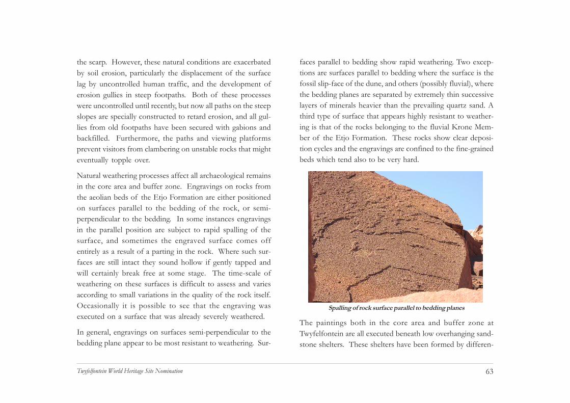
63Twyfelfontein World Heritage Site Nomination
the scarp. However, these natural conditions are exacerbatedby soil erosion, particularly the displacement of the surfacelag by uncontrolled human traffic, and the development oferosion gullies in steep footpaths. Both of these processeswere uncontrolled until recently, but now all paths on the steepslopes are specially constructed to retard erosion, and all gul-lies from old footpaths have been secured with gabions andbackfilled. Furthermore, the paths and viewing platformsprevent visitors from clambering on unstable rocks that mighteventually topple over.
Natural weathering processes affect all archaeological remainsin the core area and buffer zone. Engravings on rocks fromthe aeolian beds of the Etjo Formation are either positionedon surfaces parallel to the bedding of the rock, or semi-perpendicular to the bedding. In some instances engravingsin the parallel position are subject to rapid spalling of thesurface, and sometimes the engraved surface comes offentirely as a result of a parting in the rock. Where such sur-faces are still intact they sound hollow if gently tapped andwill certainly break free at some stage. The time-scale ofweathering on these surfaces is difficult to assess and variesaccording to small variations in the quality of the rock itself.Occasionally it is possible to see that the engraving wasexecuted on a surface that was already severely weathered.
In general, engravings on surfaces semi-perpendicular to thebedding plane appear to be most resistant to weathering. Sur-
faces parallel to bedding show rapid weathering. Two excep-tions are surfaces parallel to bedding where the surface is thefossil slip-face of the dune, and others (possibly fluvial), wherethe bedding planes are separated by extremely thin successivelayers of minerals heavier than the prevailing quartz sand. Athird type of surface that appears highly resistant to weather-ing is that of the rocks belonging to the fluvial Krone Mem-ber of the Etjo Formation. These rocks show clear deposi-tion cycles and the engravings are confined to the fine-grainedbeds which tend also to be very hard.
Spalling of rock surface parallel to bedding planes
The paintings both in the core area and buffer zone atTwyfelfontein are all executed beneath low overhanging sand-stone shelters. These shelters have been formed by differen-

64Twyfelfontein World Heritage Site Nomination
tial weathering of sedimentary beds lying approximately hori-zontal; most therefore have a pedestal, or mushroom shape.The quality of the rock surface is in all cases rather poor andthe paintings show extensive spalling due to wind abrasion aswell as fracturing of the surface possibly caused by the me-chanical effect of recrystallization by dissolved salts and otherminerals. In all cases significant parts of the painted friezeshave disappeared. Added to this, the extensive use of unsta-ble pigments such as whites have reduced the visual impactof the paintings. Only one painted site, Zwei Schneider, isnow open to visitors in the core area, the others being consid-ered too fragile. Paintings in the buffer zone are highly vul-nerable to the combined effects of natural weathering andvisitor impact (see (iv), below).
(iii) Natural disasters and risk preparednessThe Twyfelfontein area is considered to be inactive in seismicterms. However, the stability of the cliffs above the site is inquestion and it is possible that seismic activity propagatedfrom elsewhere might cause a sudden fall of rock. There aresome instances where engravings on precarious rocks mightbe braced or reinforced but in general the size of the engravedrocks and the instability of the surface precludes suchmeasures.
Seasonal flooding of the Aba-Huab River does not affect thecore area of the site, although it may temporarily preventaccess to the buffer zone. The low risk of natural disaster atTwyfelfontein means that there is a correspondingly low levelof preparedness. However, some of the Guides are trained inelementary first aid skills and there is an airstrip at theTwyfelfontein Country Lodge which would be suitable forevacuation purposes.
(iv) Visitor/tourism pressuresThe pressure of visitors on the core area has been greatlyreduced through the construction of suitable paths, steps andviewing platforms. Without these measures the site wouldhave continued to suffer from rapid wear and tear in the formof eroded paths, displaced engravings and actual wear of theengravings themselves where visitors clambered over them.
Rocks belonging to thefluvial Krone membertend to be very hard

65Twyfelfontein World Heritage Site Nomination
Under the present layout of paths and general accessarrangements there are no engravings subject to this sort ofwear. Futhermore, a large proportion of the site is no longeraccessible to visitors and will be held in “reserve” pendingdemand for extended walking routes or possible reorganiza-tion of access at some future date.
Visitor impact has also been greatly reduced by the provisionof toilets on the site, where previously there were none. Thishas also greatly reduced the volume of tourist litter on thesite. There are no litter bins on the site due to the presence ofbaboons, and visitors are simply requested to carry all refuseaway with them. This is not effective in the case of cigaretteends, however, which continue to be a nuisance at some ofthe engravings. It appears that where groups are brought to ahalt by the Guide in order to point out some or otherattraction, many of the visitors immediately light cigaretteswhich they simply discard on the site.
The viewing platforms have notices requesting visitors to putaside any food or drink they may be carrying before mountingthe platform. Shelves have been provided at the viewingplatforms for this purpose. It is intended that this will greatlyreduce the risk of food or drink being spilled on the engrav-ings, although Guide supervision is essential for this to work.At the rock paintings (only Zwei Schneider in the core area)gravel has been laid within the shelter to reduce the amount
of dust stirred up by visitors. The dust adheres to the paint-ings and eventually forms a permanent crust, which obscuresthe images. A knee-high barrier has been installed at this siteto indicate the area where visitors may stand to view the paint-ings.
Visitor pressure in the form of large noisy groups or veryfrequent groups has the main effect of detracting from theexperience of other visitors. The paths, viewing platformsand other facilities in the Twyfelfontein core area are designedfor a capacity of approximately 350 visitors per 8 hour day,with a capacity of 5 eight-person groups on the guided routesat any one time. This will ensure a pleasant, peaceful walk forthe visitor. It is the task of the Site Manager and other staff
Two local guides at the Zwei Schneider site

66Twyfelfontein World Heritage Site Nomination
to manage the flow of visitors by making use of regulatingoptions such as prior reservations for large groups; the facili-ties at the Visitor Centre to retard movement onto the site,and the self-guided route as an option for excess visitors.
If visitor numbers continue to grow as steeply as they haveover the last ten years it will be necessary to impose a strictcarrying capacity limit on the core area at Twyfelfontein.Before doing this, however, it will be possible to develop twoextensions of the guided routes, thus absorbing an extra 25%visitor flow. At the same time, it will be necessary to developalternative attractions at rock art sites in the buffer zone. Thereare several suitable sites and these could cope with about 100visitors per day, altogether. The present arrangements atTwyfelfontein allow for an approximate doubling of visitornumbers before these modifications need be considered.
(v) Number of inhabitants within the property and thebuffer zoneEstimated population located within:
Area of nominated property: 0Buffer zone: 95Total: 95Year: 2005
There are no people resident in the core area at Twyfelfontein.In the buffer zone approximately 80 people are in residence asstaff of the Twyfelfontein Country Lodge, and 15 as staff of
the Aba Huab Camp. The Guides and their families, number-ing approximately 50 people, live immediately outside the east-ern boundary of the buffer zone, on a portion of the propertyBlaauwpoort (520), a part of the Twyfelfontein-UibasenConservancy area.
(vi) OtherA further two factors affecting the property are the lack ofinstitutional capacity among the key stakeholders, and ageneral lack of clarity regarding the powers and functions ofthe different parties. The key problems of institutional ca-pacity in the National Heritage Council have already beendescribed; these amount to a lack of appropriately qualifiedstaff and a lack of direct experience in site management.
There is a very serious lack of capacity in the Twyfelfontein -Uibasen Conservancy, which cannot at the moment functionas an active stakeholder. In view of the fact that the bufferzone of the Twyfelfontein site falls entirely within the bounda-ries of the conservancy it will be necessary to obtain the com-mitment of the conservancy to the Management Plan. A jointmanagement arrangement would be desirable if the conserv-ancy took upon itself certain specific functions in the bufferzone. These are set out in the Management Plan. However,the poor capacity of the conservancy is a compelling reasonfor the buffer zone to be given Conservation Area status un-der the National Heritage Act, Part VI, Section 54.

67Twyfelfontein World Heritage Site Nomination
CH
Caaaaaah
CHAPTER 5Protection & Management of the Property
68Twyfelfontein World Heritage Site Nomination
5. PROTECTION & MANAGEMENT OFTHE PROPERTY
a. OwnershipThe core area and the buffer zone of Twyfelfontein are bothState Land, and therefore property of the Government ofNamibia. The core area, originally registered as TwyfelfonteinPrehistoric Reserve (722), title deed A856/56, is now subsumedwithin the Twyfelfontein Reserve (873), title deed T935/1989.
b. Protective designation The core area of Twyfelfontein is a national monument, origi-nally proclaimed under Article 7 of Ordinance 13 (1948) (Of-ficial Gazette of SWA, Govt Notice 234), as repealed by theNational Monuments Act, 1969 (Act No. 28 of 1969), itssubsequent amendments (Act No. 22 of 1970; Act No. 30 of1971; Act No. 7 of 1979; Act No. 35 of 1979), all repealed bythe National Heritage Act, 2004 (Act No. 27 of 2004). Thesame status applies to the Verbrandeberg geological monu-ment (725), originally proclaimed under Article 7 of Ordi-nance 13 (1948). These and the remainder of the buffer zone,constituting the Twyfelfontein Reserve (873), have the legalstatus of State Land.
The core area of Twyfelfontein is served by a proclaimed road,D3214, which has the legal status of Government property
(Official Gazette 1/08/64, issued under Section 5 of theRoads Ordinance No. 28 of 1962). The road terminates atthe Levin ruin and the last 500 metres of the road have beende-proclaimed and erased, so that the road will end at theTwyfelfontein Visitor Centre. A 4x4 track bypassing the corearea provides access to Doros Crater and is a public right ofway. Roads constructed and maintained within the buffer zoneby the Twyfelfontein Country Lodge also have public rightsof way. Boreholes in the buffer zone, registered (e.g. ZB20030)and unregistered, are all Government property.
Since it constitutes a possible source of confusion, it is help-ful to clarify the legal relationship between the site and theTwyfelfontein-Uibasen Conservancy. The core area and bufferzone fall within the boundaries of the Twyfelfontein-UibasenConservancy (registered 1999, in terms of Section 24A(2)(i)of the Nature Conservation Amendment Act No. 151 of1996). However, the registered boundaries of theTwyfelfontein-Uibasen Conservancy specifically exclude thecore area of Twyfelfontein. The archaeological sites locatedin the buffer zone, which are defined in terms of Section 46of the National Heritage Act (No. 27 of 2004) also lieoutside the jurisdiction of the Conservancy, as do certain otherpieces of land falling within its boundaries that are subject toPTO permit 11/3/1/211 and X/2/E, issued in the name ofElias Xoagub.

69Twyfelfontein World Heritage Site Nomination
c. Means of implementing protectivemeasuresThe principal instrument of protection for the site is theNational Heritage Act (No. 27 of 2004), particularly Section46 (1) (a) in terms of which it is prohibited to (a) remove ordemolish; (b) damage or despoil; (c) develop or alter; or (d)excavate all or any part of a protected place. A protected placeis defined as a place declared and registered as a heritage placeunder Division 3, Part IV of the Act. Implementationmechanisms for these measures are set out under Division 4,Part VII, Section 63, which defines the offences and penaltiesin terms of the Act.
A comprehensive management plan has been compiled as apractical framework for the protection of the site, coveringissues such as access control, monitoring, maintenance,visitor flow, provision of visitor information and amenities.The management plan is outlined below in section h Visitorfacilities and statistics. Rules and conditions of admissionto the site are made known to the visitor upon arrival, andaccess to the site is strictly supervised, all visitors beingaccompanied by an official, uniformed guide. Certainphysical protection measures such as barriers are also in place.
d. Existing plans related to propertyThe National Heritage Council has no formal plans regardingthe property. There was, however, an agreement, now lapsed,covering issues of joint management between the Council,the Twyfelfontein Tour Guides Association, theTwyfelfontein-Uibasen Conservancy, and the TwyfelfonteinCountry Lodge. The agreement could serve as a frameworkfor mutual consultation as well as practical administration.
At the country level, the general issues of cultural develop-ment and tourism are considered in the Second National Devel-opment Plan (NDP2) (National Planning Commission 2001/2002 – 2005/2006). At the regional level, the site is consid-ered under the North-west Region Tourism Master Plan (Volume 1)(Ministry of Environment and Tourism, 2000). Section 2.5of the plan provides an overview of tourism facilities andSome engravings at Twyfelfontein do not require artificial barriers for
protection

70Twyfelfontein World Heritage Site Nomination
development options in the whole of the north-west of Na-mibia. Unfortunately, the plan is very weak in its treatmentof cultural heritage sites.
A second document North-west Tourism Options Plan (Phase II)(NACOBTA, 2002) provides a more detailed treatment ofthe regional picture but is equally weak with regard to themanagement of cultural heritage sites. Both documentsappear to have been compiled without any consultationinvolving the National Monuments Council (now HeritageCouncil) or professional archaeological advice. The result isthat the documents are almost entirely useless as a basis forplanning tourism activity at cultural heritage sites such asTwyfelfontein.
e. Property management plan and statementof objectives(i) Summary of key management objectives1. To maintain the integrity of the site and its setting
2. To present the site in a clear and informative way
3. To promote rock art and related research at the site
4. To develop a sustainable visitor attraction
5. To provide appropriate training and employment
(ii) Summary of management measures
For immediate attention (mid- to late 2005):
1. Formulate and implement a property management scenario
2. Facilitate business planning and a common vision forstakeholders
3. Adopt and implement the site database managementsystem
4. Train and appoint management and support staff
5. Effect proclamation of buffer zone as a Section 54 Conser-vation Area
Medium-term management priorities (end 2006):
1. Establish an environmental monitoring baseline
2. Establish a digital visitor data system.
3. Facilitate a local enterprise participation scheme
4. Develop and implement a training scheme for guides
5. Develop a code of conduct and licensing scheme for guides
Long-term management priorities (no later than 2010):
1. Complete the extension of visitor access routes and re-lated facilities
2. Articulate a national rock art tourism network centred onTwyfelfontein

71Twyfelfontein World Heritage Site Nomination
3. Provide on-site training facilities for rock art managementin Namibia
4. Achieve global visibility as a rock art tourism and researchdestination
5. Develop management capacity to perform site audit
f. Sources and levels of financeThe activities of the National Heritage Council are financiallysupported by an appropriation of Parliament, as well as byfees levied, interest accrued and other money receivedaccording to the stipulations of the National Heritage Act(Part III). The level of finance provided by the appropriationof Parliament is proportionate to the staff establishment andits functions. As a statutory body, the Council is able tosupplement its financial resources, principally through thecollection of gate fees.
Currently the Council has a staff establishment of 17, exclud-ing the Twyfelfontein site manager, and receives approximatelyN$1.7 million with which to manage monuments throughoutNamibia. Of these monuments Twyfelfontein receives thelargest number of visitors; see i, below. In gate fees, the sitegenerated just under N$1million between March 2004 andFebruary 2005. Of this amount 20% is paid to theTwyfelfontein Tour Guides Association, and 5% to theTwyfelfontein-Uibasen Conservancy.
The costs of site management interventions and variousrepairs and constructions during 2004 and 2005 have beenalmost entirely financed by donor contributions, principallythe European Community support to the Namibia TourismDevelopment Programme, implemented through the Ministryof Environment and Tourism and the National Monuments(now Heritage) Council of Namibia. The fact that incomegenerated through gate fees has not been committed to sitedevelopment work thus far means that from 2005 the opera-tions of the Council at Twyfelfontein may be considered fi-nancially sustainable on the basis of gate fees alone.
g. Sources of expertise and training inconservation and management techniquesThe National Heritage Council of Namibia does not have atrained archaeologist or appropriately trained heritage site man-ager on its staff establishment. No training facilities or pro-grammes currently exist in Namibia to fill this requirement.For this reason, all professional and technical activities un-dertaken by the Council at Twyfelfontein have relied on con-tract archaeological services. Competent professional exper-tise is available only on a contract/consultancy basis inNamibia. In view of these circumstances the site manage-ment plan e., outlined above, is devised for practical imple-mentation by staff who do not possess the necessary trainingto manage a large archaeological site or to develop the site toits full potential.

72Twyfelfontein World Heritage Site Nomination
To be fully independent in its management of the site, theCouncil should make certain to avail itself of training oppor-tunities offered by UNESCO and subsidiary bodies such asICOMOS for the long term development of skills. At thesame time it can endeavour to obtain appropriate professionaladvice within Namibia and in the southern African region forimmediate requirements. While attempting to secure trainingand professional experience for its staff, the Council must re-tain local archaeological support in a programme of staffmentoring. The staff mentoring arrangement should be sub-ject to formal agreement and implemented concurrently withthe appointment of a site manager at Twyfelfontein.
h. Visitor facilities and statistics(i) Design and constructionFacilities in the core area at Twyfelfontein consist of a spe-cially designed Visitor Centre, three established walking routes,shaded rest areas on the site and on site emergency toilet fa-cilities (dry compost type), all under the supervision of uni-formed guides.
The Visitor Centre and all other physical installations havebeen designed in accordance with the Burra Charter (AustraliaICOMOS 1999), to have the least possible physical and aes-thetic impact on the site, and to be reversible. No concretehas been employed in any of the constructions. Walls, as wellas steps and other constructions of similar type use reinforc-
ing steel weld mesh and wire diamond mesh gabions, filledwith dry-packed stone. Where possible the inner packing hasbeen made up with building rubble from demolished struc-tures.
The faces of the gabions aremade from hand-selected localstone, collected from designatedsites where the removal of stonewould have the least impact onthe physical surroundings. Anadditional advantage of the dry-
Visitor Centre under construction, showing combination of buildingmaterials and techniques (Nina Maritz Architects)
Steel gabion and gravel steps
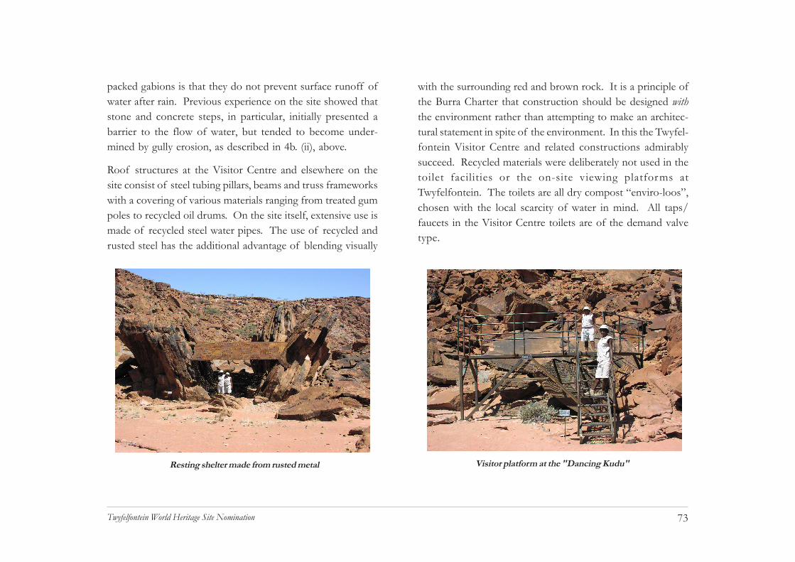
73Twyfelfontein World Heritage Site Nomination
packed gabions is that they do not prevent surface runoff ofwater after rain. Previous experience on the site showed thatstone and concrete steps, in particular, initially presented abarrier to the flow of water, but tended to become under-mined by gully erosion, as described in 4b. (ii), above.
Roof structures at the Visitor Centre and elsewhere on thesite consist of steel tubing pillars, beams and truss frameworkswith a covering of various materials ranging from treated gumpoles to recycled oil drums. On the site itself, extensive use ismade of recycled steel water pipes. The use of recycled andrusted steel has the additional advantage of blending visually
with the surrounding red and brown rock. It is a principle ofthe Burra Charter that construction should be designed withthe environment rather than attempting to make an architec-tural statement in spite of the environment. In this the Twyfel-fontein Visitor Centre and related constructions admirablysucceed. Recycled materials were deliberately not used in thetoilet facilities or the on-site viewing platforms atTwyfelfontein. The toilets are all dry compost “enviro-loos”,chosen with the local scarcity of water in mind. All taps/faucets in the Visitor Centre toilets are of the demand valvetype.
Resting shelter made from rusted metal Visitor platform at the "Dancing Kudu"

74Twyfelfontein World Heritage Site Nomination
The viewing platforms are constructed from standard modu-lar design materials used for steps, platforms and raised walk-ways on industrial sites, and therefore conform to the highestsafety standards. These are South African-made “Mentis” sys-tems comprising rigid steel grid sections for platforms and steeltubing stanchions and railings, as well as standard pre-fabri-cated steps. The platforms are supported on large diametersquare steel tubing frames. The frames rest on sheet-metalfootplates, held in place with heavy stones, or guyed withlengths of steel bar. The platforms are easily removable,should this be required.
Pathways on the site have been laid out and constructed withminimal disturbance of the surface. Where possible, all pathsare simply raked open routes defined on either side with loosepacked stones. This means it is possible to erase and re-routepaths with minimum effort. Direction, warning and informa-tion signs have been placed where needed. These are castaluminium panels approximately 100x150mm, made fromrecycled engine parts. Where necessitated by steep slopes oruneven, difficult surfaces, gabions have been used to constructdry packed steps as described above. These, too, can beremoved, although this would require more effort. The pathshave been kept to an average width of about 1m, again tominimize the impact on the site. The narrow paths are onlypracticable because all movement on the site is based onone-way flows, as described below.
(ii) Visitor flowThe Twyfelfontein Visitor Centre is situated in the northern-most corner of the core area. From the parking area, thevisitor walks approximately 100m to the Centre, on a narrowfootpath through rocky terrain with typical Twyfelfontein floraof low herbaceous plants such as Petalidium. The initial walkis intended to break the link between the visitor and the car,and bring the visitor into the world of the site: the path passesthrough a narrow passage among the rocks, some with clearlyvisible engravings, and into the entrance area of the VisitorCentre. At this point the visitor sees the Twyfelfontein valleyfor the first time.
In the Centre, the flow of visitors is first directed to an openarea with seating and shade. At this point the visitor canchoose to proceed via the reception and orientation area, tothe site, or make use of the toilets, kiosk and rest area. Theorientation area presents a three-part experience: first a seriesof simple displays on the site and the rock art; then an “expe-rience chamber” where the visitor sees some of the visualeffects of altered consciousness expressed in the rock art; andfinally the visitor is shown the link between the visual effectsand the concrete world. With this orientation the visitor isable to comprehend the basic purpose and meaning of the art.
There is a one-way flow from the Visitor Centre to the startof a self-guided trail, which proceeds to a series of easily ac-
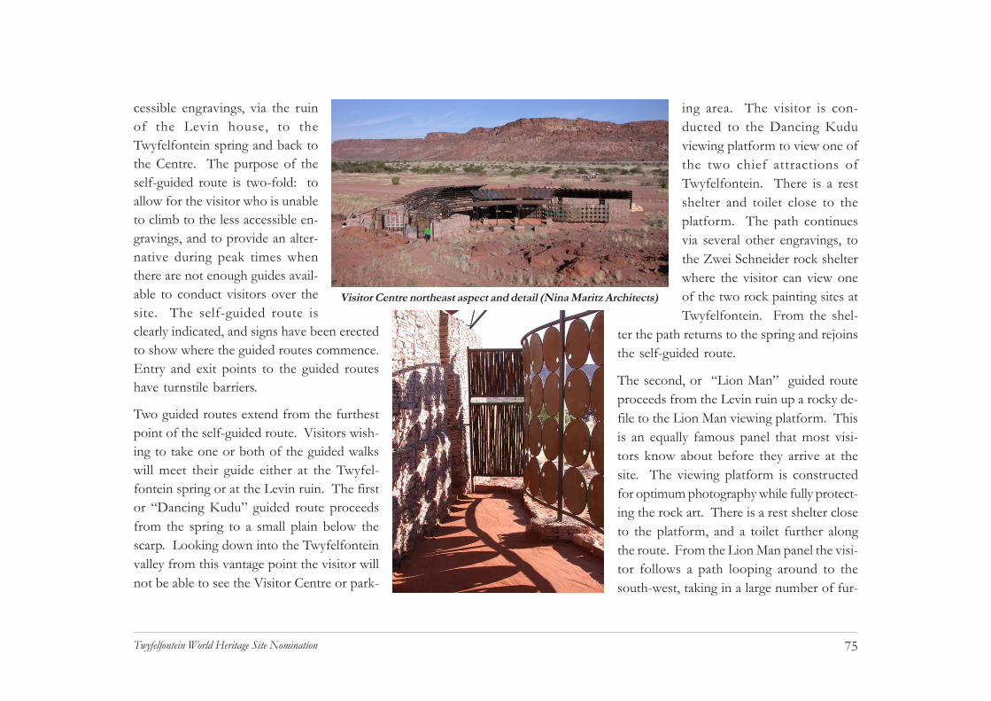
75Twyfelfontein World Heritage Site Nomination
cessible engravings, via the ruinof the Levin house, to theTwyfelfontein spring and back tothe Centre. The purpose of theself-guided route is two-fold: toallow for the visitor who is unableto climb to the less accessible en-gravings, and to provide an alter-native during peak times whenthere are not enough guides avail-able to conduct visitors over thesite. The self-guided route isclearly indicated, and signs have been erectedto show where the guided routes commence.Entry and exit points to the guided routeshave turnstile barriers.
Two guided routes extend from the furthestpoint of the self-guided route. Visitors wish-ing to take one or both of the guided walkswill meet their guide either at the Twyfel-fontein spring or at the Levin ruin. The firstor “Dancing Kudu” guided route proceedsfrom the spring to a small plain below thescarp. Looking down into the Twyfelfonteinvalley from this vantage point the visitor willnot be able to see the Visitor Centre or park-
ing area. The visitor is con-ducted to the Dancing Kuduviewing platform to view one ofthe two chief attractions ofTwyfelfontein. There is a restshelter and toilet close to theplatform. The path continuesvia several other engravings, tothe Zwei Schneider rock shelterwhere the visitor can view oneof the two rock painting sites atTwyfelfontein. From the shel-
ter the path returns to the spring and rejoinsthe self-guided route.
The second, or “Lion Man” guided routeproceeds from the Levin ruin up a rocky de-file to the Lion Man viewing platform. Thisis an equally famous panel that most visi-tors know about before they arrive at thesite. The viewing platform is constructedfor optimum photography while fully protect-ing the rock art. There is a rest shelter closeto the platform, and a toilet further alongthe route. From the Lion Man panel the visi-tor follows a path looping around to thesouth-west, taking in a large number of fur-
Visitor Centre northeast aspect and detail (Nina Maritz Architects)

76Twyfelfontein World Heritage Site Nomination
ther engravings. These have been selected to present the visi-tor with as wide a selection of subject matter as possible. The“Lion Man” route caters for the visitor with a slightly strongerinterest in the rock art, whereas the “Dancing Kudu” route isshorter and has a more general interest attraction.
Group size on all routes, guided and self-guided, as well as onthe viewing platforms has been set at a maximum of eightpersons. This number is based on the following observations:the median group size for visitors to Twyfelfontein is less thanten; a guide is not able to control effectively a group of morethan eight; larger groups tend to spread out and clamber overthe rocks, thus endangering the engravings. Large groups veryclearly spoil the experience for smaller groups and present anunacceptable threat to the rock engravings.
To optimise visitor flow it is intended that group tours of anysize, but most particularly groups of more than ten, shouldmake advance arrangements to visit the site. This presentsno difficulty as most coach tours run on a strict schedule.Advance reservations are particularly required in the case ofvisitors staying over at one of the local lodges or campsites.On arrival at the Visitor Centre large groups will be broken upand dispatched at intervals of five minutes. There is no mini-mum group size: if a guide is available it is possible to have aguided walk for one person.
(iii) Facilities in the buffer zoneThe buffer zone has one tourist accommodation establishment,the Twyfelfontein Country Lodge, and one tourist campsite,the Aba-Huab Camp. The lodge has 114 beds and caters mainlyfor the middle market foreign tourist, including coach groups.The camp caters mainly for self-drive parties, small coachgroups and budget travellers in general. The lodge has itsown airstrip and receives fly-in parties, which are conductedto the engravings at Twyfelfontein in the lodge’s gameviewingvehicles. The lodge also sells petrol.
Several other tourist establishments are located in the nearvicinity, two within the Twyfelfontein-Uibasen Conservancyarea. These are the Mowani Mountain Camp, catering to theupper middle market, with accommodation for 26, andFrancolino Fly-Ins, which provides scenic balloon, micro-lightand fixed-wing flights, with accommodation for eight guests.An upper market establishment, Damaraland Camp, is situ-ated near the Huab River with accommodation for 20 guests.Good all weather gravel roads connect Twyfelfontein with sev-eral regional centres and tourist routes.
The movement of tourists in the buffer zone is not subject toeffective control. Several rock art sites are located in the nearvicinity of the Twyfelfontein Country Lodge and the lodgeoffers guided access to the sites as one of its services. This is

77Twyfelfontein World Heritage Site Nomination
in the form of visits by game viewing vehicle to two sites,Klein Sermonien-platz and Adam and Eve shelter, and oneguided walking trail to Hasenbild Shelter and the Siebenplattenengravings. The lodge guides are not trained to interpret rockart, and there are no site management arrangements for anyof these sites.
(iv) Visitor statisticsIrregular and somewhat contradictory visitor statistics are avail-able for Twyfelfontein over the years 1988 to 2002, with moreregular information becoming available only in the last twoyears. Although David Levin was issued with a visitor’s regis-ter in the 1950s when he was honorary curator of the site(National Archives HMK 15/1/3 Twyfelfontein), theserecords appear to have been lost. It was probably from 1964,with the construction of the road (D3214), that the site be-gan to receive regular visitors. However, Levin leftTwyfelfontein in 1965, and there was no caretaker to collectvisitor statistics at the site until the late 1980s.
Visitor figures from the 1980s indicate an increase from11 030 in 1988 to 18 103 in 1991. This growth of almost40% probably reflects an overall increase in tourism to Na-mibia after independence in 1990. Visitor numbers have grownsteeply over the last ten years, first reaching 20 000 in 1994(Mäscher 1996). Projections based on sampling of visitor sta-tistics for 2002 indicate that numbers had begun to approach
40 000 per year (W. Schalken, pers. comm.). The growth pat-tern that emerges from these statistics is as follows: from1990 to 1996 numbers grew by 44%; between 1996 and 2002numbers grew by 64%; and overall growth during the last tenyears has been approximately 70% (Kinahan 2003).
Detailed visitor records are collected by the Twyfelfontein TourGuides Association on behalf of NACOBTA, the NamibianAssociation of Community Based Tourism Enterprises. Un-fortunately the records are not systematically analysed or ar-chived. The most recent available records cover the periodNovember 2003 to August 2004. During this period 32 817visitors were received at the site, indicating an average of3 281 per month, or 109 per day. The flow of visitors variesconsiderably through the year, however. The peak season isduring the months of July and August; visitors at this timeaccount for 38% of all arrivals. There is a sharp decline invisitor numbers during the hot months; between Novemberand the end of January arrivals drop by 33%.
More than 80% of visitors to Twyfelfontein are from Europe.German visitors represent the largest national group. Duringthe peak season, Germans comprise 26% of all visitors fromEurope, and 21% of the visitor total. The picture changesduring the low season, when Germans comprise 52% of allvisitors from Europe, and 44% of the visitor total. In con-trast, Namibians comprise approximately 1% of visitors, irre-

78Twyfelfontein World Heritage Site Nomination
spective of season. It must be emphasized that visitor pat-terns are highly dynamic: while the German component issolid and reliable, Italian visitors showed a dramatic seven-fold increase from 2003 to 2004.
The available visitor figures unfortunately do not reflect theactual flow of visitors through the day. However, there is amarked mid-morning peak,which probably accountsfor at least 50% of thedaily flow, and a lesserpeak of about 15% in thelate afternoon. This meansthat guides may have toconduct fifty or more visi-tors at the same time dur-ing peak flow, requiring sixto eight guides on duty. Ifthe peak flow consists ofsmall groups, even moreguides will be required.Even with very detailedvisitor statistics the flowof visitors is somewhat unpredictable. It is for this reasonthat larger groups will be required to make advance reserva-tions.
The relative size of visitor groups is to a large extent deter-mined by the capacity of vehicle transport. Couples arrivingby car or pick-up account for just over 15% of all visitors.Large coaches carrying between 30 and 40 passengers accountfor slightly less than 4% of all visitors. Between these ex-tremes there are four different coach sizes. If the group sizes
are simplified as fol-lows: small (5 orfewer passengers),medium (6 to 20 pas-sengers), and large (21or more passengers),these account for37%, 50% and 12%of visitors, respec-tively. These figuresshow that small andmedium groups pre-dominate, althoughthe small groups obvi-ously represent a largernumber of parties.
Mini-buses carrying six to eight people represent the mediangroup size, and this corresponds with the maximum group sizefor visitors entering the site.
0 10 20 30 40 50 60
Austria
Benelux
UK
France
Germany
Italy
Spain
Switzerland
Scandinavia
percentage
20042003
Visitors from Europe to Twyfelfontein during 2003 and 2004

79Twyfelfontein World Heritage Site Nomination
The visitor statistics reveal certain variations of group sizeaccording to nationality, although the mean group size onlyvaries between four and six persons, overall. This is comfort-ably within the maximum group size for visitors entering thesite. The largest recorded group of German visitors was 39,but even in the case of German visitors, the median is three,and large groups comprise only 2.5% of all German visitors.Austrian, French and Italian visitors account for some large
groups in the range of 25 to 30, but the median does not ex-ceed four. Although no figures are collected to reflect this, atleast 50% of visitors are middle- and late middle-aged. Thesite attracts many young budget travellers, but remarkably fewchildren visit the site whether in family or school groups.
i. Programmes & policiesThere are at present no established programmes or policiesfor the site of Twyfelfontein, as stipulated in Articles 4 and 5of the Convention. It is intended that such programmesand policies will be developed on the basis of the presentdocument and within the framework of the Management Plan.
�����������������������������������������������������������������������������������������������������������������������������������������������������������������������������������������������������������������������������������������������������
�����������������������������������������������������������������������������������������������������������������������������������������������������������������������������������������������������������������������������������������������������������������������������������������������������������������������������������������������������������������������������������������������������������������������������������������������������������������������������������������������������������������������������������������������������������������������������������������������������������������������������������������������������������������������������������������������������������������������������������������������������������������������������������������������������������������������������������������������������������������������������������������������������������������������������������������������������������������������������������������������������������������������������������������
��������������������������������������������������������
Other Africa3%
Namibia17%
RSA80%
����������������������������������������������������������������������������������������������������������������������������������������������������������
����������������������������������������������������������������������������������������������������������������
Europe90%
Australasia2%
Americas2%
Asia0%
Africa6%
International visitors to Twyfelfontein, 2003 - 2004
Visitors from Africa to Twyfelfontein, 2003 - 2004

80Twyfelfontein World Heritage Site Nomination
be directly answerable to the Director of the National Herit-age Council and will have peace officer status, including pow-ers of arrest. The Site Manager will be required to supervisedaily reconciliation of gate fee income and receipts issued.The supervisory duties of the Site Manager will also includecollection and basic analysis of visitor statistics for theCouncil; deployment of Guides on a day-to-day basis; liaisonwith the Guides Association, Twyfelfontein-Uibasen Conserv-ancy and other stakeholders; and implementation of the Prop-erty Management Plan audit scheme. The Site Manager willbe expected to have a sound working knowledge of the site,of the rock art and its basic interpretation, and to answer rou-tine queries from visitors.
The Cashiers are responsible for the reception of visitors,including correct recording of details, receipt of gate fees,issuing of receipts and tickets, and allocation of Guides tovisitor groups. The Cashiers will collect visitor data and passit on to the Site Manager. Where necessary the Cashiers willhelp to subdivide visitor groups and despatch them to the siteat correct intervals, thus ensuring a smooth flow of visitors.The Cashiers will also be responsible for the overall cleanli-ness of the Visitor Centre, including the basic housekeepingcomponent of the Site Management Plan as it applies tothe Visitor Centre. The Cashiers will fall under the directsupervision of the Site Manager.
It must however be noted that the National Museum ofNamibia has a public education programme which addressesthe need for community involvement in rock art site manage-ment (Gwasira 2003). The programme, although presentlydormant, involves consultation with local communities, slideshows and workshops, all prompted by the gradual move bycommunities to use rock art sites as visitor attractions.
j. Staffing levels (professional, technical,maintenance)Staffing of the Twyfelfontein site and Visitor Centre will fallwithin the administrative framework of the National Herit-age Council (see Act 27, Part II, Division 2, Section 17). Thestaff forming part of the Council establishment will comprisea Site Manager and two Cashiers. The Site Manager will haveat least a bachelor’s degree in an appropriate field, preferablyarchaeology, and several years experience at a lower manage-ment or professional officer level. The Cashiers (officiallyappointed as casual workers) are Grade 10/12 level clericalemployees with some basic experience in office administra-tion.
The duties of the Site Manager will include local responsibil-ity for site management based on the Property ManagementPlan accompanying this dossier, as well as day-to-day super-vision of the Cashiers and the Guides. The Site Manager will

81Twyfelfontein World Heritage Site Nomination
Guiding services at Twyfelfontein are exclusively supplied bymembers of the Twyfelfontein Tour Guides Association, whopresently number 24. These guiding services are subject toan agreement between the Council and the Association, whichsets out a basic code of conduct for the Guides, as well as theterms and conditions of work. The Association receives 20%of the gate fees levied and this is divided among the Guidesaccording to days worked each month. The Guides are to beindividually licensed by the Council to work on the site, eachGuide being issued with a licence in the form of an identitycard. Guides will be expected to perform according to a basicstandard set out in the Site Management Plan. In addition toguiding visitors, the Guides are expected to render service inthe general maintenance of the site, including litter collectionand repairs to pathways, as determined by the Site Manager.
Regular and timely maintenance of the site infrastructure,including the Visitor Centre, is essential. There are alterna-tive ways of ensuring this. The maintenance could beoutsourced and placed on a renewable annual contract basis.The contract should include a simple checklist of maintenancetasks, which could be forwarded to the contractor by the SiteManager. The contractor would be expected to estimate timeand costs for additional tasks, as may be determined by theCouncil and the Site Manager from time to time. Alternatively,the National Heritage Council could recruit a maintenancetechnician. In the intervening period, "call-out arrangements"
could be made as the need arises (K. Aribeb, pers. com.).
The Council will formulate an appropriate staff developmentplan for Twyfelfontein. This will enable the Site Manager toimprove his/her professional qualifications and remain up todate with developments in the field of rock art in general andsite management in particular. The Council will ensure thatthe Site Manager and Cashiers are provided with propersupport in carrying out their functions. The Council willconsider a professional mentoring arrangement for the SiteManager, to ensure a smooth implementation of the SiteManagement Plan. The Council will also take responsibilityfor the training and provision of uniforms for the Guides.

82Twyfelfontein World Heritage Site Nomination
CHAPTER 6Monitoring

83Twyfelfontein World Heritage Site Nomination
6. MONITORINGa. Key indicators for measuring state ofconservationThe implementation of the Property Management Plan is themost important indicator of the state of conservation atTwyfelfontein. In particular, the implementation of the planwill ensure that there is no avoidable deterioration in the rockart of Twyfelfontein, its most significant asset.
In practical terms, the state of conservation would be reflectedby the annual audit of the site as set out in the plan. The keyitems of the audit to be carried out by the Heritage Councilare:
• the condition of the rock art, primarily those panels thatare accessible to the visitor
• the state of paths, viewing platforms, toilets and otherinstallations, including the Visitor Centre
Additional indicators include the institutional state of the site,as reflected by:
• the existence of a formal working agreement among keystakeholders at the site, including the Council, Guides,Conservancy and lodge owners
• an acceptable level of competence among the Guidesconducting visitors to the engravings
• the proclamation of the Twyfelfontein buffer zone as a con-servation area in terms of the National Heritage Act, Part VI,Section 54
Key indicators of the biophysical state of the site include:
• high diversity of invertebrate fauna, to be determinedperiodically by sampling
• maintenance of vegetation diversity and structure, to bedetermined by sampling (after rains) and matched photogra-phy of pre-selected views
• stability of soil lag surface, to be determined by measure-ment of permanent reference pegs
• stability of large sandstone blocks, to be determined bylaser theodolite positioning of permanent reference pegs
A final indicator of the conservation status of the site is theresponse of visitors, as reflected by:
• the number of visitors in relation to national trends
• the continued importance of the site as a destination inthe local tourism industry
• visitor comments compiled from annual exit interviews
• visitor comments extracted from checklist data on visitorresponse forms

84Twyfelfontein World Heritage Site Nomination
b. Administrative arrangements for monitoringpropertyThe National Heritage Council will implement the PropertyManagement Plan in full, carrying out an annual site audit.The site audit will be the responsibility of the Site Manager,but until such time as the Site Manager has the requisite pro-fessional qualifications, the audit will be contracted out to anestablished archaeologist with site assessment and audit ex-perience. The annual audit will be carried out as an in-housetraining exercise for Heritage Council staff.
Name and contact information:
Mr Karl AribebDirectorNational Heritage Council of NamibiaPrivate Bag 12043AusspannplatzWindhoek
c. Results of previous reporting exercisesPrevious reporting exercises have not been carried out withinthe framework of the Property Management Plan. However,these provide useful background assessment data:
• site description and photographic documentation carriedout by E.R. Scherz in 1964 (published Scherz 1975). Copiesof photographic documentation housed at the National Mu-seum of Namibia.
• site survey, description and condition assessment, withlimited photographic documentation and tracing, carried outby J. & J. Kinahan in 1988 (unpublished data, housed Quater-nary Research Services, P.O. Box 22407, Windhoek, Namibia)
• site description and condition assessment carried out byS. Ouzman, results available at:
http://www.bradshawfoundation.com/twyfelfontein/appendix_k.html
• buffer zone GIS survey carried out by J. Kinahan in 2004(limited circulation by Namibia Tourism DevelopmentProgramme, digital data housed National Heritage Council)
• core area digital survey and digital photographic record withdata base of rock art, carried out by J. & J. Kinahan in 2005for World Heritage Convention dossier and management plancompilation (data housed National Heritage Council)

85Twyfelfontein World Heritage Site Nomination
CHAPTER 7Documentation

86Twyfelfontein World Heritage Site Nomination
7. DOCUMENTATIONa. Image inventory and photograph authorization form
ID. No Format Caption Date Photographer & Copyright holdera Cession of rightsA1-6 35mm Views of site from north 12/05 J. Kinahan grantedA7-16 35mm Visitor Centre 12/05 J. Kinahan grantedA17-19 35mm Access pathway 12/05 J. Kinahan grantedA20-22 35mm Levin house 12/05 J. Kinahan grantedA23-29 35mm Access pathways 12/05 J. Kinahan grantedA30-31 35mm Visitor barriers 12/05 J. Kinahan grantedA32-33 35mm Visitor toilet, exterior 12/05 J. Kinahan grantedA34-36 35mm Visitor rest shelter 12/05 J. Kinahan grantedB1 35mm Viewing platform 12/05 J. Kinahan grantedB2-13 35mm Views of site terrain 12/05 J. Kinahan grantedB14-21 35mm Protective barriers 12/05 J. Kinahan grantedB22 35mm Engraving of zebra 12/05 J. Kinahan grantedB23 35mm Engraving of antelope 12/05 J. Kinahan grantedB24 35mm Engraving of giraffe 12/05 J. Kinahan grantedB25 35mm Engraving of zebra 12/05 J. Kinahan grantedB26-27 35mm Engravings of cup marks 12/05 J. Kinahan grantedB28-35 35mm Views of “Dancing kudu” 12/05 J. Kinahan grantedB36 35mm Engraving of giraffe 12/05 J. Kinahan grantedC1 35mm Engraving of giraffe 12/05 J. Kinahan grantedC2-3 35mm Engraving of cattle 12/05 J. Kinahan grantedC4 35mm Engraving of bird 12/05 J. Kinahan grantedC5 35mm Visitors at rock paintings 12/05 J. Kinahan grantedC6-10 35mm Visitors at “Zwei Schneider” 12/05 J. Kinahan granted

87Twyfelfontein World Heritage Site Nomination
a. Image inventory (cont.)C11-14 35mm Various engravings 12/05 J. Kinahan grantedC15-17 35mm Views of “Lion Man” 12/05 J. Kinahan grantedC18-20 35mm Engraving of elephant 12/05 J. Kinahan grantedC21-23 35mm Engravings of rhino 12/05 J. Kinahan grantedC24-34 35mm Various engravings 12/05 J. Kinahan grantedD1-8 35mm Various engravings 12/05 J. Kinahan grantedD9 35mm View of dance platform 12/05 J. Kinahan grantedD10-12 35mm Views of cup marks 12/05 J. Kinahan grantedD13-22 35mm Views of entoptic images12/05 J. Kinahan granted
(Footnotes)a Contact details of copyright owner: J. Kinahan, Quaternary Research Services, P.O. Box 22407, Windhoek, Namibiatel.: +264+61+256702fax: +264+61+236216Email [email protected]

88Twyfelfontein World Heritage Site Nomination
b. Texts relating to protective designation, &c.The Property Management Plan is annexed as a separate docu-ment. Digital copies of the Management Plan and protectivelegislation (National Heritage Act 27 of 2004) are on the CDin the pocket bound into the back of this document.
c. Form & date of most recent recordsCore area: Detailed field records were made of rock art in thecore area of the site during February 2005 as part of thedossier preparation exercise. Altogether 235 painted andengraved surfaces, with a total of 2 075 identifiable images,were documented. The latitude, longitude and elevation ofeach panel were determined by hand-held GPS instrument.Orientation of the panel was determined by compass, andinclination by Abney level. The position, orientation and in-clination data are intended to aid relocation of the panel forpurposes of periodic site audit as set out in the Property Man-agement Plan.
To aid recognition of each panel, the dimensions of the en-graved surface were recorded, as well as the proportion of thesurface covered by paintings or engravings. With someisolated exceptions, the panels were photographed in naturallight with a board indicating the panel number and including acentimetre scale and a standard IFRAO colour scale. In thecourse of the site survey, each panel was assessed to deter-
mine its condition and the presence of any damage, especiallyin the form of graffiti, or in the form of surface damage re-sulting from visitor traffic. A condition assessment and riskexposure assessment carried out in 1988 (Kinahan & Kinahan1988) was revised according to the new layout of paths. Allmeasurements, descriptions and images are included with thedossier in either hardcopy, digital format or both. An interac-tive GIS version of the core area site survey is included withthe dossier. Copies of all the documentation referred to aboveare lodged with the National Heritage Council in Windhoek.
Buffer zone: All the rock art sites in the buffer zone previouslydescribed by Scherz (1975) were revisited and inspected fordamage in 2004 as part of an area management GIS survey.Position co-ordinates were established by hand-held GPS. Thearea management GIS is lodged with the National HeritageCouncil of Namibia in Windhoek.
d. Address where inventory, records andarchives are heldThe National Heritage Council of NamibiaPrivate Bag 12043AusspannplatzWindhoekNamibia

89Twyfelfontein World Heritage Site Nomination
e. Bibliography(i) Published literature
Australia ICOMOS. 1999.The Burra Charter. AustraliaICOMOS.
Botha, C. 2001. “Develop-ment”, survival and adapta-tion in the former Damara“homeland” of Namibia .Co-publication Departmentof Geography and Environ-mental Studies, Universityof Namibia, and Universityof Paris X, Nanterre.
Blundell, G. 2004.Nqabayo’s Nomansland:San rock art and thesomatic past. UppsalaUniversity: Studies inGlobal Archaeology 2.
Brown, C.J. Jarvis, A.,Robertson, T. & Simmons,R. 1998. Bird diversity. InBarnard, P. ed. Biological diver-
sity in Namibia: a country study.Windhoek: Namibian Na-tional Biodiversity Task-force.
COMRASA 1999. Rock artmanagement training manual(CD).
Dowson, T. A. 1992. Rock en-gravings of southern Africa.Johannesburg: WitwatersrandUniversity Press.
Dowson, T. and Lewis-Williams, J.D. (eds) 1994.Contested images: diversity insouthern African rock artresearch. Johannesburg:Witwatersrand UniversityPress.
F r e u n d l i ch , J. C . , S c h wa -bedissen, H. and Wendt,W.E. 1980. Köln radio-carbon measurements II.Radiocarbon 22,1: 68-81.
Geingos, S. and Oreseb, C.2005. The San of Namibia:our role as custodians of our cul-ture and heritage. Paper readat Homecoming of Rock ArtConference, Windhoek.
Geological Survey ofNamibia, 2001. Sheet 2014Doros. (Open file map).
Griffin, M. 1998. Mammaldiversity. In Barnard, P. ed.Biological diversity in Namibia:a country study. Windhoek:Namibian National Bio-diversity Taskforce.
Griffin, M. 2003. Annotatedchecklist and provisional na-tional conservation status ofNamibian reptiles. Wind-hoek: Ministry of Environ-ment & Tourism.
Gwasira, G. 2003. Commu-nity involvement in rock artsite management in Na-mibia. Rock Art Research20 (1): 34-36.
Kinahan, J. & Kinahan,J. 1988. Recording andevaluation of the Twyfelfonteinrock engravings for the submis-sion of management recom-mendations. Report sub-mitted to the Directorate ofNature Conservation andlodged as an Internal Re-port, State Museum,Windhoek.
Kinahan, J. 1999. Towards anarchaeology of mimesis andrain-making in Namibianrock art. In Ucko, P.J. andLayton, R. eds The archaeol-ogy of landscape. London:Routledge pp 336-357.

90Twyfelfontein World Heritage Site Nomination
ies in African Archaeology17 & Windhoek: NamibiaArchaeological Trust.
Krynauw, D.W. 1968. Twyfelfontein. Windhoek: Na-
tional Monuments Commis-sion of South West Africa.
Lewis-Williams, J.D. 2002.The mind in the cave.London: Thames &Hudson.
Lewis-Williams, J.D. andBlundell, G. 2000. Fragileheritage: a rock art fieldguide.Johannesburg:Witwatersrand UniversityPress.
Lewis-Williams, J.D. andDowson, T. 1989. Imagesof power : understandingBushman rock art.Johannesburg: Southern
Maack, R. 1921. Ueber dieBuschleute und ihre Felsenbilderin Suedwest-Afrika. Unpub-
lished typescript, NationalLibrary of Namibia.
Mäscher, M. 1996. Nachaltige Entwicklung durch “communitybased tourism”? Potentiale undProbleme touristiche Kleinst-projekte am Beispiel derKunene Region in Namibia.Diplomarbeit, Institut fürGeographie, WestfalischeWilhelms-Universitat, Mun-ster.
Mendelsohn, J., Jarvis, A., Roberts, C. and Robertson,T. 2002. Atlas of Namibia:a portrait of the land and itspeople. Cape Town: DavidPhilip.
Ministry of Environment &Tourism 2000. Namibia:North-west Region TourismMaster Plan (Volume 1).Windhoek: Urban DynamicsAfrica.
Ndoro, W. 2001. Your monu-ment our Shrine: the preserva-tion of Great Zimbabwe.Uppsala: Studies in AfricanArchaeology 19.
NACOBTA 2002. Namibia: North-west Tourism OptionsPlan (Phase II). Windhoek:Ministry of Environment &Tourism.
NACSO 2004. Namibia’s com-munal conservancies: a review ofprogress and challenges.Windhoek: NACSO.
National Planning Commis-sion 2001. Second NationalDevelopment Plan (NDP2) 3volumes. Windhoek: Na-tional Planning Commis-sion.
Report of the Commission of En-quiry into South West Africa Af-airs, 1962-1963. RP No. 12/1964. [copy in National Ar-chives of Namibia].
Kinahan, J. 2001. Pastoral no-mads of the Namib Desert: thepeople history forgot. 2nd edi-tion. Windhoek: NamibiaArchaeological Trust.
Kinahan, J. 2003. A Proposalfor the Development of Commu-nity-Based Tourism at Three Ar-chaeological Sites in North-West-ern Namibia. Quaternary Re-search Services Report 48.Commissioned by Deloitteand Touche, London.
Kinahan, J. 2005. The lateHolocene human ecology ofthe Namib Desert. In Smith,M. and Hesse, P. eds 23ºSArchaeology and EnvironmentalHistory of the Southern Deserts.Canberra.
Kinahan, Jill. 2000. Cattle forbeads: the archaeology ofhistorical contact and trade on theNamib coast. Uppsala: Stud-

91Twyfelfontein World Heritage Site Nomination
Richter, J. 1991. Studien zurUrgeschichte Namibias:Holozane Stratigraphien imUmkreis des Brandberges. 3Afrika Praehistorica.Cologne: Heinrich BarthInstitut.
Scherz, E.R. 1975. Felsbilderin Suedwest-Afrika, Teil II.Koeln: Bohlau Verlag.
Schneider, G. 2004. The road-side geology of Namibia.Stuttgart: GebruederBorntraeger.
Schneider, G. & Marais, C.2004. Passage throughTime: the fossils of Namibia.Windhoek: GamsbergMcMillan.
Schneider, H. 1994. AnimalHealth and Veterinar yMedicine in Namibia.Windhoek: AGRIVET.
Smith, B.W. and Ouzman, S.2004. Taking stock:identifying Khoekhoenherder rock art in southernAfrica. CurrentAnthropology 45 (4): 499-526.
Sullivan, S. 1999. Folk andformal, local and national:Damara knowledge andcommunity conservation insouthern Kunene, Namibia.Cimbebasia 15: 1-28.
Viereck, A. 1959. DieFelsbilder von Twyfel-fontein. Journal der SWAWissenschaftliche Gesellschaft13.
Viereck, A. and Rudner, J.1957. Twyfelfontein – acentre of prehistoric art inSouth West Africa. South Af-rican Archaeological Bulletin 12:15-26.
Vogel, J.C. and Visser, E.1981. Pretoria radiocarbondates II. Radiocarbon23,1: 43-80.
Wendt, W.E. 1972.Preliminary report on anarchaeological researchprogramme in South WestAfrica. Cimbebasia (B) 2,1-61.
Yates, R., Manhire, A. andParkington, J.E. 1990.Pictures from the Past: a his-tory of the interpretation ofrock paintings and engrav-ings in southern Africa.Pietermaritzburg: CentaurPublications.
Zimbabwe n.d. Nominationdossier for the proposedMatobo Hills World Herit-age Area.

92Twyfelfontein World Heritage Site Nomination
(ii) Archival sources:National Archives of Namibia
RNG 16/S/T-F/1
NMC 14/4/2/5
HMK 15/1/3/ Twyfelfontein; 22.05.1954 Letter of thanksto owner of Twyfelfontein for his co-operation, to appointhim honorary curator and to furnish him with a visitor’s book.
Minutes of Historical Monuments Commission meeting A.23Lemmer Collection vol.1. 17.11.1951
Fourth Annual Report of the Historical MonumentsCommission. A.23 Lemmer Collection vol. 1
LAN 1588 ref. 4974 vol. 1 1951-59: various letters,applications, decisions relating to tenure of D. Levin atTwyfelfontein
LAN 1807 G.A. 534 1959-1972
DALB 4. 6/19/5/1
A664 2/59

93Twyfelfontein World Heritage Site Nomination
CHAPTER 8Contact information

94Twyfelfontein World Heritage Site Nomination
8. CONTACT INFORMATIONa. PreparersName: John & Jill KinahanTitle: Dr & DrAddress: Quaternary Research Services
P.O. Box 22407WindhoekNamibia
Tel : +264 (61) 236216 or 256702Fax: +264 (61) 236216
Email [email protected]
b. Official local institution/agency (responsiblefor nomination & management)National Heritage Council of Namibia
Contact person: Mr Karl Aribeb
Private Bag 12043
Ausspannplatz
Windhoek
Tel: +264 (61) 244375Fax: ++264 (61) 246872
Email: [email protected]
d. Official web address:http://www.natmus.cul.na
Contact name: Ms Esther Moombolah-Goases
email: [email protected]
c. Other local institutionsNational Museum of NamibiaP.O. Box 1203WindhoekNamibia
Tel: +264 (61) 276 800 (Reception)or +264 (61) 276813 (Head)
Fax: +264 (61) 228 636
Namibia Tourism BoardP.O. Box 13244WindhoekNamibia
Tel: +264 (61) 290 6000Fax: +264 (61) 254 848email: [email protected]
95Twyfelfontein World Heritage Site Nomination
CHAPTER 9Signature on behalf of the State party

96Twyfelfontein World Heritage Site Nomination
9. SIGNATURE ON BEHALF OF THESTATE PARTY
I, John Mutorwa, the undersigned, hereby submit thisnomination file on behalf of the Government of the Republicof Namibia, in my capacity as Minister of Youth, NationalService, Sports and Culture.
Place Date Signature