Tsunami-Related Data: A Review of Available Repositories ...
31
water Review Tsunami-Related Data: A Review of Available Repositories Used in Scientific Literature Tomáš Nacházel 1 , František Babiˇ c 2 , Marco Baiguera 3 , Pavel ˇ Cech 1 , Martina Husáková 1 , Peter Mikulecký 1 , Karel Mls 1 , Daniela Ponce 1 , Dimitra Salmanidou 3 , Kamila Štekerová 1 , Ioanna Triantafyllou 4 , Petr Tuˇ cník 1 , Marek Zanker 1 and Vladimír Bureš 1, * Citation: Nacházel, T.; Babiˇ c, F.; Baiguera, M.; ˇ Cech, P.; Husáková, M.; Mikulecký, P.; Mls, K.; Ponce, D.; Salmanidou, D.; Štekerová, K.; et al. Tsunami-Related Data: A Review of Available Repositories Used in Scientific Literature. Water 2021, 13, 2177. https://doi.org/10.3390/ w13162177 Academic Editor: Marcel J. F. Stive Received: 7 June 2021 Accepted: 6 August 2021 Published: 9 August 2021 Publisher’s Note: MDPI stays neutral with regard to jurisdictional claims in published maps and institutional affil- iations. Copyright: © 2021 by the authors. Licensee MDPI, Basel, Switzerland. This article is an open access article distributed under the terms and conditions of the Creative Commons Attribution (CC BY) license (https:// creativecommons.org/licenses/by/ 4.0/). 1 Faculty of Informatics and Management, University of Hradec Kralove, 500 03 Hradec Kralove, Czech Republic; [email protected] (T.N.); [email protected] (P. ˇ C.); [email protected] (M.H.); [email protected] (P.M.); [email protected] (K.M.); [email protected] (D.P.); [email protected] (K.Š.); [email protected] (P.T.); [email protected] (M.Z.) 2 Faculty of Electrical Engineering and Informatics, Technical University of Košice, 042 00 Košice, Slovakia; [email protected] 3 UCL Department of Civil, Environmental and Geomatic Engineering, and Department of Statistical Science, University College London, London WC1E 6BT, UK; [email protected] (M.B.); [email protected] (D.S.) 4 Department of Geology and Geoenviroment, National & Kapodistrian University of Athens, 106 79 Athens, Greece; [email protected] * Correspondence: [email protected]; Tel.: +420-493332259 Abstract: Various organizations and institutions store large volumes of tsunami-related data, whose availability and quality should benefit society, as it improves decision making before the tsunami occurrence, during the tsunami impact, and when coping with the aftermath. However, the existing digital ecosystem surrounding tsunami research prevents us from extracting the maximum benefit from our research investments. The main objective of this study is to explore the field of data repositories providing secondary data associated with tsunami research and analyze the current situation. We analyze the mutual interconnections of references in scientific studies published in the Web of Science database, governmental bodies, commercial organizations, and research agencies. A set of criteria was used to evaluate content and searchability. We identified 60 data repositories with records used in tsunami research. The heterogeneity of data formats, deactivated or nonfunctional web pages, the generality of data repositories, or poor dataset arrangement represent the most significant weak points. We outline the potential contribution of ontology engineering as an example of computer science methods that enable improvements in tsunami-related data management. Keywords: tsunami; repository; data set; data format; review; evaluation; ontology 1. Introduction Tsunamis are long waves with periods ranging from a few minutes to about an hour and wavelengths from tenths to hundreds of kilometers depending on the type and dimensions of the causative source [1]. Various sources can produce tsunamis as long- propagating waves. Seismically triggered tsunamis represent approximately 80% of all tsunamis worldwide [2]. This means that most of the sudden displacements of the water column are associated with earthquakes as the main trigger. Furthermore, volcanic activity, submarine and subaerial mass wasting, atmospheric disturbances, and cosmic impacts can generate tsunamis [3,4]. Once generated, tsunamis travel at high speed and spread over a large area of water. In deep water, the tsunami wave amplitude may remain small, typically ranging up to a few meters. The waves become higher and shorter in shallow water and may have run-up heights exceeding several tens of meters. After reaching coastal areas, waves inundate land up to several kilometers in the case of large tsunamis. Water 2021, 13, 2177. https://doi.org/10.3390/w13162177 https://www.mdpi.com/journal/water
-
Upload
khangminh22 -
Category
Documents
-
view
3 -
download
0
Transcript of Tsunami-Related Data: A Review of Available Repositories ...
water
Review
Tsunami-Related Data: A Review of Available RepositoriesUsed in Scientific Literature
Tomáš Nacházel 1, František Babic 2 , Marco Baiguera 3, Pavel Cech 1, Martina Husáková 1, Peter Mikulecký 1 ,Karel Mls 1 , Daniela Ponce 1 , Dimitra Salmanidou 3, Kamila Štekerová 1, Ioanna Triantafyllou 4, Petr Tucník 1,Marek Zanker 1 and Vladimír Bureš 1,*
�����������������
Citation: Nacházel, T.; Babic, F.;
Baiguera, M.; Cech, P.; Husáková, M.;
Mikulecký, P.; Mls, K.; Ponce, D.;
Salmanidou, D.; Štekerová, K.; et al.
Tsunami-Related Data: A Review of
Available Repositories Used in
Scientific Literature. Water 2021, 13,
2177. https://doi.org/10.3390/
w13162177
Academic Editor: Marcel J. F. Stive
Received: 7 June 2021
Accepted: 6 August 2021
Published: 9 August 2021
Publisher’s Note: MDPI stays neutral
with regard to jurisdictional claims in
published maps and institutional affil-
iations.
Copyright: © 2021 by the authors.
Licensee MDPI, Basel, Switzerland.
This article is an open access article
distributed under the terms and
conditions of the Creative Commons
Attribution (CC BY) license (https://
creativecommons.org/licenses/by/
4.0/).
1 Faculty of Informatics and Management, University of Hradec Kralove,500 03 Hradec Kralove, Czech Republic; [email protected] (T.N.); [email protected] (P.C.);[email protected] (M.H.); [email protected] (P.M.); [email protected] (K.M.);[email protected] (D.P.); [email protected] (K.Š.); [email protected] (P.T.);[email protected] (M.Z.)
2 Faculty of Electrical Engineering and Informatics, Technical University of Košice, 042 00 Košice, Slovakia;[email protected]
3 UCL Department of Civil, Environmental and Geomatic Engineering, and Department of Statistical Science,University College London, London WC1E 6BT, UK; [email protected] (M.B.);[email protected] (D.S.)
4 Department of Geology and Geoenviroment, National & Kapodistrian University of Athens,106 79 Athens, Greece; [email protected]
* Correspondence: [email protected]; Tel.: +420-493332259
Abstract: Various organizations and institutions store large volumes of tsunami-related data, whoseavailability and quality should benefit society, as it improves decision making before the tsunamioccurrence, during the tsunami impact, and when coping with the aftermath. However, the existingdigital ecosystem surrounding tsunami research prevents us from extracting the maximum benefitfrom our research investments. The main objective of this study is to explore the field of datarepositories providing secondary data associated with tsunami research and analyze the currentsituation. We analyze the mutual interconnections of references in scientific studies published in theWeb of Science database, governmental bodies, commercial organizations, and research agencies. Aset of criteria was used to evaluate content and searchability. We identified 60 data repositories withrecords used in tsunami research. The heterogeneity of data formats, deactivated or nonfunctionalweb pages, the generality of data repositories, or poor dataset arrangement represent the mostsignificant weak points. We outline the potential contribution of ontology engineering as an exampleof computer science methods that enable improvements in tsunami-related data management.
Keywords: tsunami; repository; data set; data format; review; evaluation; ontology
1. Introduction
Tsunamis are long waves with periods ranging from a few minutes to about anhour and wavelengths from tenths to hundreds of kilometers depending on the type anddimensions of the causative source [1]. Various sources can produce tsunamis as long-propagating waves. Seismically triggered tsunamis represent approximately 80% of alltsunamis worldwide [2]. This means that most of the sudden displacements of the watercolumn are associated with earthquakes as the main trigger. Furthermore, volcanic activity,submarine and subaerial mass wasting, atmospheric disturbances, and cosmic impactscan generate tsunamis [3,4]. Once generated, tsunamis travel at high speed and spreadover a large area of water. In deep water, the tsunami wave amplitude may remain small,typically ranging up to a few meters. The waves become higher and shorter in shallowwater and may have run-up heights exceeding several tens of meters. After reachingcoastal areas, waves inundate land up to several kilometers in the case of large tsunamis.
Water 2021, 13, 2177. https://doi.org/10.3390/w13162177 https://www.mdpi.com/journal/water
Water 2021, 13, 2177 2 of 31
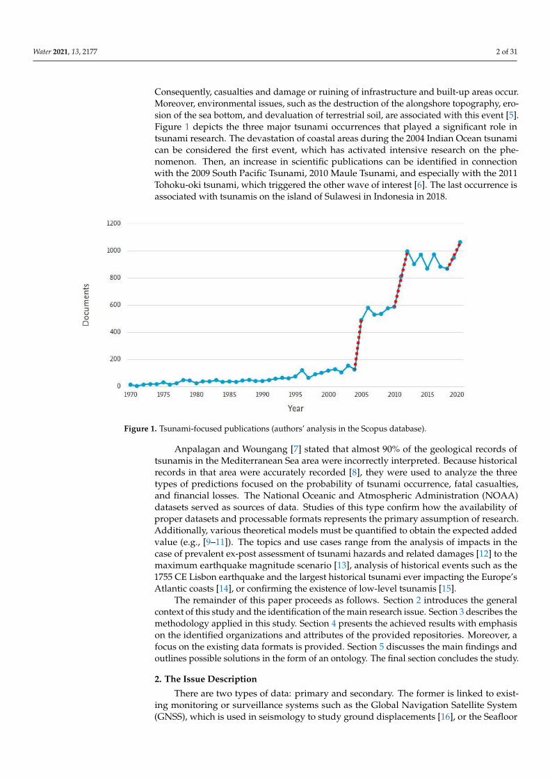
Consequently, casualties and damage or ruining of infrastructure and built-up areas occur.Moreover, environmental issues, such as the destruction of the alongshore topography, ero-sion of the sea bottom, and devaluation of terrestrial soil, are associated with this event [5].Figure 1 depicts the three major tsunami occurrences that played a significant role intsunami research. The devastation of coastal areas during the 2004 Indian Ocean tsunamican be considered the first event, which has activated intensive research on the phe-nomenon. Then, an increase in scientific publications can be identified in connectionwith the 2009 South Pacific Tsunami, 2010 Maule Tsunami, and especially with the 2011Tohoku-oki tsunami, which triggered the other wave of interest [6]. The last occurrence isassociated with tsunamis on the island of Sulawesi in Indonesia in 2018.
Water 2021, 13, x FOR PEER REVIEW 2 of 31
shallow water and may have run-up heights exceeding several tens of meters. After
reaching coastal areas, waves inundate land up to several kilometers in the case of large
tsunamis. Consequently, casualties and damage or ruining of infrastructure and built-up
areas occur. Moreover, environmental issues, such as the destruction of the alongshore
topography, erosion of the sea bottom, and devaluation of terrestrial soil, are associated
with this event [5]. Figure 1 depicts the three major tsunami occurrences that played a
significant role in tsunami research. The devastation of coastal areas during the 2004
Indian Ocean tsunami can be considered the first event, which has activated intensive
research on the phenomenon. Then, an increase in scientific publications can be identified
in connection with the 2009 South Pacific Tsunami, 2010 Maule Tsunami, and especially
with the 2011 Tohoku-oki tsunami, which triggered the other wave of interest [6]. The last
occurrence is associated with tsunamis on the island of Sulawesi in Indonesia in 2018.
Figure 1. Tsunami-focused publications (authors’ analysis in the Scopus database).
Anpalagan and Woungang [7] stated that almost 90% of the geological records of
tsunamis in the Mediterranean Sea area were incorrectly interpreted. Because historical
records in that area were accurately recorded [8], they were used to analyze the three
types of predictions focused on the probability of tsunami occurrence, fatal casualties, and
financial losses. The National Oceanic and Atmospheric Administration (NOAA) datasets
served as sources of data. Studies of this type confirm how the availability of proper
datasets and processable formats represents the primary assumption of research.
Additionally, various theoretical models must be quantified to obtain the expected added
value (e.g., [9–11]). The topics and use cases range from the analysis of impacts in the case
of prevalent ex-post assessment of tsunami hazards and related damages [12] to the
maximum earthquake magnitude scenario [13], analysis of historical events such as the
1755 CE Lisbon earthquake and the largest historical tsunami ever impacting the Europe’s
Atlantic coasts [14], or confirming the existence of low-level tsunamis [15].
The remainder of this paper proceeds as follows. Section 2 introduces the general
context of this study and the identification of the main research issue. Section 3 describes
the methodology applied in this study. Section 4 presents the achieved results with
emphasis on the identified organizations and attributes of the provided repositories.
Moreover, a focus on the existing data formats is provided. Section 5 discusses the main
findings and outlines possible solutions in the form of an ontology. The final section
concludes the study.
Figure 1. Tsunami-focused publications (authors’ analysis in the Scopus database).
Anpalagan and Woungang [7] stated that almost 90% of the geological records oftsunamis in the Mediterranean Sea area were incorrectly interpreted. Because historicalrecords in that area were accurately recorded [8], they were used to analyze the threetypes of predictions focused on the probability of tsunami occurrence, fatal casualties,and financial losses. The National Oceanic and Atmospheric Administration (NOAA)datasets served as sources of data. Studies of this type confirm how the availability ofproper datasets and processable formats represents the primary assumption of research.Additionally, various theoretical models must be quantified to obtain the expected addedvalue (e.g., [9–11]). The topics and use cases range from the analysis of impacts in thecase of prevalent ex-post assessment of tsunami hazards and related damages [12] to themaximum earthquake magnitude scenario [13], analysis of historical events such as the1755 CE Lisbon earthquake and the largest historical tsunami ever impacting the Europe’sAtlantic coasts [14], or confirming the existence of low-level tsunamis [15].
The remainder of this paper proceeds as follows. Section 2 introduces the generalcontext of this study and the identification of the main research issue. Section 3 describes themethodology applied in this study. Section 4 presents the achieved results with emphasison the identified organizations and attributes of the provided repositories. Moreover, afocus on the existing data formats is provided. Section 5 discusses the main findings andoutlines possible solutions in the form of an ontology. The final section concludes the study.
2. The Issue Description
There are two types of data: primary and secondary. The former is linked to exist-ing monitoring or surveillance systems such as the Global Navigation Satellite System(GNSS), which is used in seismology to study ground displacements [16], or the Seafloor
Water 2021, 13, 2177 3 of 31
Observation Network for Earthquakes and tsunamis along the Japan Trench (S-net), whichis currently the world’s largest network of ocean bottom pressure sensors for real-timetsunami monitoring [17]. These data are considered primary, as they are original andcollected from the primary resources with the help of sensors. Although web-based ser-vices provide these data in real time, the availability and ability to process them are notstraightforward and easy for researchers. Therefore, secondary data, that is, data collectedby someone else and stored in a repository, are used. These data can be either experimentalor empirical. The former is connected to the experiments and acquired results. For instance,Mulia and Satake [17] analyzed the efficacy of tsunami forecasting through exhaustive syn-thetic experiments. They considered 1500 hypothetical tsunami scenarios from megathrustearthquakes with magnitudes ranging from 7.7 to 9.1. These types of data are associatedwith published papers and studies. They enable the testing of various scenarios withoutthe necessity of possessing empirical data. Empirical data are collected in the environmentof interest, for instance, in the form of field surveys.
For certain types of digital objects, well-curated, deeply integrated, special-purposedatasets such as those provided by the NOAA. Various organizations and institutions storelarge volumes of data, the availability of which should benefit society, as it can improvedecision-making before the tsunami occurrence, during the tsunami impact, and after cop-ing with the aftermath. Nevertheless, the existing digital ecosystem surrounding tsunamiresearch prevents researchers from extracting the maximum benefit from their research in-vestments. We see the emergence of numerous general-purpose data repositories, at scalesranging from institutional to open globally scoped datasets. Furthermore, other specificssuch as geographical location, data formats, or applied data models make the situationeven more complicated from a technical perspective. The wide scale and multipurposenature of repositories is understandable. Multidisciplinary research has been perceivedas a mode of exploration or investigation with great potential to uncover new knowledge,understanding, and insight for a long time. In tsunami research, profit is expected frombridging different disciplines, helping advance disaster-related science. Tsunami researchis multidisciplinary, as it is explored from the perspectives of not only natural sciencedisciplines (e.g., geology, geomorphology, volcanology, meteorology, seismology, and geo-chemistry), but also technical disciplines (e.g., civil engineering or computer science) orsocial science disciplines (e.g., psychology or decision science). Thus, repositories associ-ated with tsunamis are plentiful from various perspectives, such as research domains, dataformat, access mode, and type of institution.
This study emphasizes the existence of data-related issues in tsunami research. Pararas-Carayannis [18] provides a brief insight into the history of tsunami research, showinga significant role of data generation, storage, and sharing. Regardless of the existingvolume of data, several studies stress the existing limitations in data availability and theeffectiveness of their handling. To provide two illustrations, studies written by Behrenset al. [3] and Trinaistich, Mulligan, and Take [19] are reviewed. Behrens et al. [3] exploredexisting research gaps in the field of probabilistic tsunami hazard and risk analysis. Theyprioritized research gaps and evaluated whether closing a gap is a data-related issue ora problem of missing theoretical understanding. Several findings have been reported.For instance, we believe that the lack of tsunami exposure data is just as important as ismodeling complicated aspects of inundation, but the former is assumed to be easier toachieve. Several other similar examples are found in this study. The second example isassociated with the run-up of landslide-generated waves, which can significantly damagethe environment. Although data focused on the run-up of non-breaking waves are available,there is a lack of data on the run-up of waves at the point of breaking before interactionwith the opposing shore [19].
The availability of sufficient data in the required quality remains a principal bottleneckin tsunami research. There is an urgent need to improve the infrastructure to support datareuse [2]. What constitutes “good data management” is, however, largely undefined, andis left as a decision for the data or repository owner. The main objective of this study is to
Water 2021, 13, 2177 4 of 31
explore the environment of datasets and data repositories associated with tsunami research,analyze the current situation in associated data management, and propose possible waysof coping with identified issues.
3. Methodology3.1. Process of Selection
As this study intends to review data repositories and their datasets used in scientific re-search, papers published in the Web of Science database were analyzed. Using the keyword“tsunami” the database returns an initial set of papers that can be further filtered. First, thesearch term “water” had to be added to avoid papers dealing with tsunamis in differentcontexts, for example, the tsunami of obesity among children. Further, filters includinglanguage (English), document type (article), and publishing date (last five years from thesearch date, i.e., 1 August 2020) were applied. This procedure returned 1047 research papersfrom the Web of Science categories, such as Geosciences Multidisciplinary, EngineeringMultidisciplinary, Civil Engineering, Meteorology, Atmospheric Sciences, Oceanography,Engineering Ocean, Geochemistry Geophysics, Engineering Marine, and MultidisciplinarySciences. References or acknowledgments of any data repository were identified andcollected. A data source was not used when the found data were no longer available, adataset was stored on a private server without any further description, or a citation ledonly to another article. When a found citation pointed at a dataset in a data repository,this source was added, explored, and described by the criteria presented in the sectionbelow. When the paper did not provide a direct link to a data repository, information wassearched in the relevant resources (e.g., government agencies, national and internationalinstitutions, including universities or NGOs).
3.2. Evaluation of Data Repositories
Different repositories provide different sets of features for browsing and searchingdatasets. This section lists and explains all the parameters used to describe and comparerepositories. Since the availability and general overview of repositories vary from well-structured catalogs to obsolete web pages without any searchability, some details aboutrepositories could not have been conclusively acquired.
The parameters used for the repository comparison were selected based on severalaspects. First, parameters were collected either from databases focusing on data repositoriesor our experience with found repositories. Some of these characteristics were excludedas they were unhelpful to users in searching datasets (e.g., institution type and funding).Second, additional parameters were added during the search. Some repositories offerfeatures specific to this field of research. Filters based on the time or location of the eventthat a dataset describes can serve as an example. A few repositories help users by offeringa preview of data before downloading or even by the manual rating of dataset contentregarding its openness and usability.
After identifying features and criteria for comparing dataset repositories, some wereremoved because they are either unobtainable or getting their values would cost an ex-cessive amount of time. Comparing the overlap of datasets in all repositories is such anexample. Because various formats and availability of metadata hinder automatic process-ing of most repositories, manual searching and comparisons of individual datasets arerequired. The evaluation of datasets and data repositories was based on the attributespresented in the following subsections.
3.2.1. Repository Content
Datasets total: The total number of datasets in a repository. The number is shownwhen accessing the repository or is often listed as the number of results for an empty search.(Note that the number of datasets differs from the number of files as datasets usuallycontain more than one file.)

Water 2021, 13, 2177 5 of 31
Tsunami datasets: The number of datasets that the repository lists as search resultsof the term tsunami. Therefore, only datasets with this word in the title, description, orkeywords were counted. Note that many valuable datasets for tsunami research are nottagged by the tsunami keyword (e.g., general bathymetry data). Hence, this number is notconclusive because none of the repositories offer a usability-for-tsunami filter. It serves solelyas an approximate indicator of the orientation of the repository. If a repository lacks asearch feature, then the number is not investigated unless it contains only units of datasetsallowing manual count.
Last update: The year of the last update or addition of dataset directly related totsunami (i.e., set of datasets described in the previous paragraph). It provides a roughestimate of the activity of content creators on a repository of tsunamis. The conditionfor acquiring this repository parameter is a sorting feature based on the last updates oradditions. Alternatively, it was collected for repositories with a limited number of datasets,thus allowing a manual check.
Repository domain: Repositories have varying breadth of focus. This characteristicdescribes a preference for a specific area of interest if there is one. Generally, catalogrepositories are either completely general or have broad topics covering various researchareas to encourage public contributors to share data on their platforms. Databases and webpresentations typically keep the narrow focus of the organization responsible for the data,which is also allowed by the unified format of all presented data.
3.2.2. General Availability
Availability: Online availability of repositories. Most of them had free access withoutrestrictions. Some repositories may be behind a paywall or require logging. For restrictedrepositories, there may be different levels of access to the data. While the search featureand viewing metadata of datasets may be free, it requires a paid account to download data.
Downloadable data: Datasets usually need to be downloaded to obtain data. How-ever, some listed repositories are structured collections of links to datasets on other plat-forms. Here, the repositories contained only metadata. To download data, a user shouldacquire data from the linked storage.
Data usability rating: Repositories rate the usability of stored datasets based on vari-ous criteria. The objective of this rating is to indicate the level of potential obstacles duringdata processing. Standardized rating schemas exist (e.g., Tim Berners-Lee’s Five Stars ofOpenness), but repositories create their own system to incorporate their specific features.
Metadata: Metadata is a structured description of datasets. It may be downloadableas a JSON or XML file or listed in a table on the dataset profile page. This feature enablesthe automatic processing of datasets outside a repository or reading of additional detailsthat are not explicitly stated in a repository’s dataset profile.
Dataset preview: Some repositories allow users to preview data before downloadingit. This feature enables users to investigate the structure of data and make the selection ofappropriate data easier. However, this is impossible in every format.
3.2.3. Filter/Search Options
Search: The ability to search for terms in title or metadata is an essential feature of alldatabases or online catalogs. However, some included repositories were in the form of asimple list of links to the datasets. These repositories usually contain only a few datasetsand focuses on presenting a project or organization rather than offering a structured catalogof datasets.
Dataset filter: If the repository contains items other than datasets, this parameterdescribes whether it is possible to filter results to datasets only. This feature simplifies thesearch for users interested in data. Repositories with sections dedicated to datasets andrepositories containing only datasets are appropriately marked (e.g., datasets only), as theyare missing this filter.
Water 2021, 13, 2177 6 of 31
The location filter: Unlike repositories with geological focus, general repositoriesusually miss the location filter because data validity is not usually limited to a location.However, this recognition is important for searching for historical data about tsunamis in aspecific region.
Field/topic filter: The ability of filter-selected topics or research fields is useful forgeneral repositories with a great variety of datasets. It allows users to browse amongpossibly related datasets without necessarily knowing the exact keywords that label therequired data.
Format filter: Datasets contain data in various formats; some are proprietary, andsome are not suitable for automatic processing. Therefore, this filter helps to narrow a setof datasets to one fitting an intended use.
License filter: Datasets are shared under various licenses. Research or educationaluse is usually not limited and requires only a citation, but some datasets may be restrictedfor noncommercial use. Thus, some repositories offer a license filter along with a licensestatement in the dataset details.
Year/Date filter: Whether the user searches for data from a specific historical eventor prefers to look through recent data only, a time-based filter is a useful tool to narrowdatasets to the most relevant set. Note that only repositories focusing on historical eventsoffer this filter based on the date of an event. The vast majority of repositories that allow thisfiltering consider only dates of addition or updates of datasets, which does not correspondto the date of the event that the dataset may be describing.
Tsunami magnitude filter: When browsing tsunami data, some tsunami databases(other types of repositories do not offer such specific features) allow users to filter resultsbased on the magnitude of tsunamis. All magnitude and intensity scales were included inthis characteristic because this feature is rare, and repositories in some occurrences do notspecify the exact scale they used.
3.3. Ontological Contribution into the Data Repositories and Datasets
To outline possible solutions to the identified data-related issues, an approach basedon ontological engineering as a subarea of artificial intelligence is provided. Ontologyrepresents a well-defined collection of concepts that describe a specific domain. Conceptsare the abstractions of a particular set of instances, that is, in ontology engineering, con-cepts are regarded as classes and instances as individuals. An example of a class can bea data repository, and an example of an individual is the Japan Tsunami Trace Database.Ontology also encompasses the links between individuals that are described as specialtypes of concept properties. A dataset containing wave parameters can thus be linked to adataset containing geospatial parameters. Even more advanced hierarchical relations canbe represented, allowing concepts to be generalized or aggregated into other concepts todecompose even the most complex domain. Concepts and properties can be associatedwith various types of logical constraints that enable the inference of facts not explicitlystated in the ontology. Ontology is expressed as a graph-based structure in which thenodes represent concepts, and the edges represent relations. In this respect, ontology canbe viewed as a semantic map of a given domain that can serve to navigate in that domainusing complex queries. For instance, we have a statement: ”Oceanography is Earth andEnvironmental Science.”. This statement can be easily expressed in the resource descriptionframework (RDF), a data model, which is the actual standard for semantic graph databasedevelopment. Oceanography (a subject/an instance) and Earth and Environmental Science(a parental class) are uniquely identifiable “resources.” Natural science is the parental classfor Earth and Environmental Science (a child class). Various methodologies can be usedto develop formal ontologies [20–22]. The Noy and McGuiness methodology [23] wasused for the ontology development in this study. It is based on an iterative developmentalapproach and can be used for any kind of application domain and developmental tool.This methodology is influenced in part by the Protégé environment, which was also usedin our study for ontology development. It provides the following seven developmen-
Water 2021, 13, 2177 7 of 31
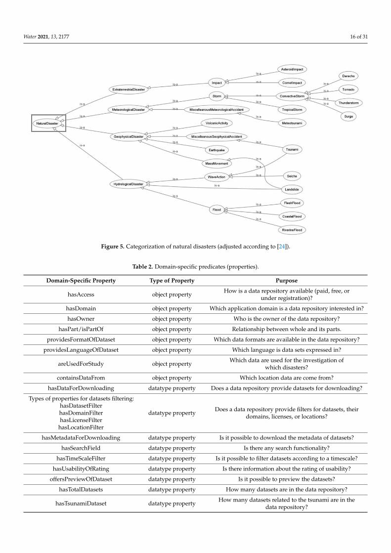
tal phases for ontology building: domain and scope specification, the reuse of existingontologies, enumeration of important terms with their properties, class definitions andclass hierarchy development, modeling properties of classes, and inclusion of details forproperties and instance modeling. The categories are based on the International Disas-ter Database EM-DAT [24], which is slightly customized for tsunami research, and theLibrary of Congress Recommended Formats Statement (2020–2021), providing categoriesof creative content [25].
4. Results
This section presents the presentation of required results. A list of identified reposito-ries and data resources is provided, and an evaluation of a single resource is provided on apre-defined scale of alternatives. Then, an analysis of existing formats is presented.
4.1. Repositories
Altogether, 60 repositories with tsunami-relevant datasets were identified.Table A1 in Appendix A provides basic information on the resources found. The ac-quired list represents the number of datasets that the repository lists as the search resultsof the term tsunami. Therefore, only datasets with this word in the title, description, orkeywords were counted. Many more useful datasets for tsunami research exist; however,they are not tagged with the tsunami keyword (e.g., general bathymetry data). Hence, thisnumber is not conclusive because none of the repositories offer a usability-for-tsunamifilter. It serves solely as an approximate indicator of the orientation of the repository. Ifa repository lacks a search feature, then the number is not investigated unless it containsonly units of datasets that allow manual counting.
There are three types of repositories: catalog, database, and presentation. Catalogoffers a sortable list of items usually accompanied by search and filter features. The items inthe catalog represent individual datasets. Here, datasets are usually uploaded by multipleorganizations. A database is also a sortable list of items, but these items already representindividual records. A database can be perceived as a single-structured dataset. Theyare usually focused on a narrow topic (e.g., database of tsunamis and water level). Theorganization operating the database is responsible for inserting data into the database. Inthis context, the presentation refers to a static web page presenting a single dataset or anon-sortable list of links that lead to projects or datasets. There are usually no searching orfiltering features, as the presentation pages show few items. Its purpose is to share resultsfrom a project or organization; therefore, the organization running the presentation page isresponsible for the data as well.
From a general perspective, repositories incorporate distinct volumes of datasetsranging from hundreds of thousands (global multidomain resources such as Data.gov,Mendeley, or OSF share) to single units (e.g., the Novosibirsk Tsunami Laboratory or theJapan Tsunami Trace database). From the perspective of tsunami research, the volume ofdatasets is significantly lower, ranging from thousands (e.g., Pangea) or hundreds (e.g.,Data.gov or Data World) to single units (e.g., the Queensland Government database orthe Humanitarian Data Exchange). Repositories were created and maintained by privateorganizations, public institutions, or governmental bodies. Twenty-nine data repositorieshave been updated during the last three years, which indicates the general usability of thecurrent research. It is possible to find data at a global scale, that is, data are associated withvarious geographical locations from Australia to the Mediterranean Sea and the UnitedStates. Apparently, data related to tsunami-jeopardized regions with advanced technologiessuch as Japan (IRIDeS), European countries (EMODnet), and the United States (NOAA,NASA) are available in large volumes. Multinational organizations such as the WorldBank Group or the World Health Organization support tsunami-related research with datarepositories. This is not the case for regions with less developed countries. Therefore,global technologically intensive initiatives and activities are crucial for tsunami research.NOAA or the Japan Tsunami Trace Database with tens of thousands of records can serve as
Water 2021, 13, 2177 8 of 31
examples. Unsurprisingly, considerable heterogeneity is the main attribute of the generatedlist. From the domain perspective, repositories contain data related to various disciplines,such as seismology, meteorology, hydrology, and bathymetry. This makes the list of datarepositories difficult to compare, and evaluation bias is almost inevitable.
Most of the datasets had free access without any restrictions. Some repositories maybe hidden behind a paywall or require logging in, for example, the European MarineObservation and Data Network. For restricted repositories, there may be different levelsof access to the data. Moreover, websites such as Study of the Tsunami Aftermath andRecovery (STAR) does not always respond. While the search feature and viewing metadataof datasets may be free, it requires a paid account to download data. Datasets need to bedownloaded to obtain the data. However, some listed repositories do not enable downloads(e.g., the Japan Tsunami Trace database) or are structured collections of links to datasetson other platforms. Here, the repositories contained only metadata. To download data,the user must acquire data from linked storages. Data usability is likely to representthe most serious issue associated with datasets. Some repositories rate the usability ofstored datasets based on various criteria. The objective of this rating is to indicate thelevel of potential obstacles during data processing. Standardized rating schemas exist (e.g.,Tim Berners-Lee’s Five Stars of Openness), but repositories often create their own systemto incorporate their specific features. Metadata represent the structured description ofdatasets. It may be downloadable as JSON or XML files (see the discussion section) orlisted in a table on the dataset profile page. This feature allows the automatic processingof dataset outside a repository or reading additional details that are not explicitly statedin the dataset profile in a repository. Only a few datasets enable metadata download(e.g., Queensland Government or the Spanish National Center of Geographic Information).However, these repositories are mostly general data repositories with a small fragment oftsunami-focused datasets. This is also the case for datasets that only enable the view ofmetadata. As for the search or filtering abilities, the capability to search for terms in the titleor metadata and use filter queries are essential features of all databases or online catalogs.We identified only one repository that enabled the filtration of a search query by location,topic, file format, license, and time. However, most datasets were only in Portuguese.However, some of the identified repositories were in the form of a simple list of links todatasets. These repositories usually contain a few datasets and focuses on presenting aproject or organization rather than offering a structured catalog of many datasets. Theevaluation of repositories is presented in Table A2.
4.2. Data Formats
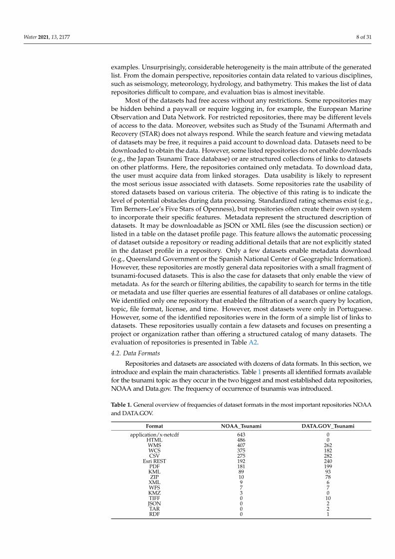
Repositories and datasets are associated with dozens of data formats. In this section, weintroduce and explain the main characteristics. Table 1 presents all identified formats availablefor the tsunami topic as they occur in the two biggest and most established data repositories,NOAA and Data.gov. The frequency of occurrence of tsunamis was introduced.
Table 1. General overview of frequencies of dataset formats in the most important repositories NOAAand DATA.GOV.
Format NOAA_Tsunami DATA.GOV_Tsunami
application/x-netcdf 643 0HTML 486 0WMS 407 262WCS 375 182CSV 275 282
Esri REST 192 240PDF 181 199KML 89 93ZIP 10 78
XML 9 6WFS 7 7KMZ 3 0TIFF 0 10JSON 0 2TAR 0 2RDF 0 1
Water 2021, 13, 2177 9 of 31
Of this number, eight formats proved to be the most common in the “tsunami” category(they represent more than 90% of records in particular databases). We provide examples ofdatasets using these data formats (all accessed on 8 August 2021).
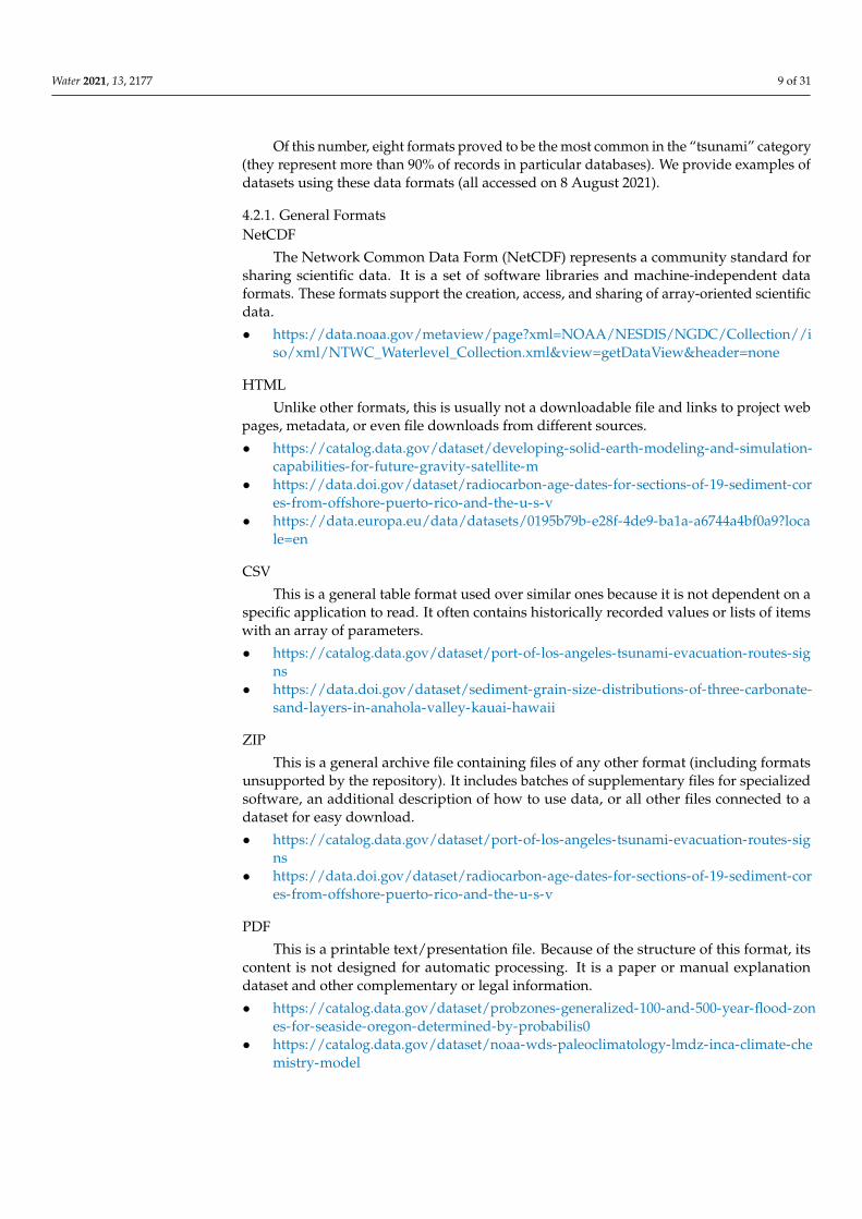
4.2.1. General FormatsNetCDF
The Network Common Data Form (NetCDF) represents a community standard forsharing scientific data. It is a set of software libraries and machine-independent dataformats. These formats support the creation, access, and sharing of array-oriented scientificdata.
• https://data.noaa.gov/metaview/page?xml=NOAA/NESDIS/NGDC/Collection//iso/xml/NTWC_Waterlevel_Collection.xml&view=getDataView&header=none
HTML
Unlike other formats, this is usually not a downloadable file and links to project webpages, metadata, or even file downloads from different sources.
• https://catalog.data.gov/dataset/developing-solid-earth-modeling-and-simulation-capabilities-for-future-gravity-satellite-m
• https://data.doi.gov/dataset/radiocarbon-age-dates-for-sections-of-19-sediment-cores-from-offshore-puerto-rico-and-the-u-s-v
• https://data.europa.eu/data/datasets/0195b79b-e28f-4de9-ba1a-a6744a4bf0a9?locale=en
CSV
This is a general table format used over similar ones because it is not dependent on aspecific application to read. It often contains historically recorded values or lists of itemswith an array of parameters.
• https://catalog.data.gov/dataset/port-of-los-angeles-tsunami-evacuation-routes-signs
• https://data.doi.gov/dataset/sediment-grain-size-distributions-of-three-carbonate-sand-layers-in-anahola-valley-kauai-hawaii
ZIP
This is a general archive file containing files of any other format (including formatsunsupported by the repository). It includes batches of supplementary files for specializedsoftware, an additional description of how to use data, or all other files connected to adataset for easy download.
• https://catalog.data.gov/dataset/port-of-los-angeles-tsunami-evacuation-routes-signs
• https://data.doi.gov/dataset/radiocarbon-age-dates-for-sections-of-19-sediment-cores-from-offshore-puerto-rico-and-the-u-s-v
This is a printable text/presentation file. Because of the structure of this format, itscontent is not designed for automatic processing. It is a paper or manual explanationdataset and other complementary or legal information.
• https://catalog.data.gov/dataset/probzones-generalized-100-and-500-year-flood-zones-for-seaside-oregon-determined-by-probabilis0
• https://catalog.data.gov/dataset/noaa-wds-paleoclimatology-lmdz-inca-climate-chemistry-model

Water 2021, 13, 2177 10 of 31
4.2.2. Mapping Formats
These formats contain a data layer meant to be placed over a map to mark points/areasof interest with additional information. Some formats may be downloadable and viewableas XML, but they need to be viewed over a map with the appropriate tool for humanreadability. It provides an overview of historical tsunamis, sea levels, or other geospatialdata on a map and offers additional information.
KML
Keyhole Markup Language (KML) is an XML notation made for 2D and 3D Earthbrowsers (e.g., Google Earth). It is one of the international standards of the Open Geospa-tial Consortium.
• https://catalog.data.gov/dataset/port-of-los-angeles-tsunami-evacuation-routes-signs
• https://data.humdata.org/dataset/hotosm_idn_sunda_strait_tsunami_waterways• https://catalog.data.gov/dataset/misr-level-2-aerosol-parameters-v002
WMS
Additionally, localized data, the Web Mapping Service contain map images. The OpenGeospatial Consortium developed it.
• https://catalog.data.gov/dataset/california-state-waters-map-series-offshore-of-pigeon-point-web-services88b54
• https://data.doi.gov/dataset/california-state-waters-map-series-salt-point-to-drakes-bay-web-services
• https://www.geonode-gfdrrlab.org/layers/hazard:ts_mih_rp10
WCS
Web Coverage Service is a more dynamic map format than WMS, as it can repre-sent time-varying phenomena. The Open Geospatial Consortium also contributed tothis creation.
• https://catalog.data.gov/dataset/chignik-alaska-1-arc-second-coastal-digital-elevation-model
• https://catalog.data.gov/dataset/1-9th-arc-second-digital-elevation-models-dems-usgs-national-map-3dep-downloadable-data-collect
• https://catalog.data.gov/dataset/1-arc-second-digital-elevation-models-dems-usgs-national-map-3dep-downloadable-data-collection
Esri REST
The map format developed by Esri. It can be viewed in the ArcGIS application.
• https://catalog.data.gov/dataset/california-state-waters-map-series-offshore-of-pigeon-point-web-services88b54
• https://data.doi.gov/dataset/california-state-waters-map-series-salt-point-to-drakes-bay-web-services
5. Discussion
This study builds on the work of Gusiakov, Dunbar, and Arcos [26], who outlinedand discussed the existing issues with data compilation, cataloging, and distribution, aswell as the incompleteness of certain types of data. Hence, we intend to support theimprovement of data management in tsunami research. The importance of archiving datain this domain is in fact the same as in other disciplines: verification of published results,better meta-analysis, new questions, increased citation and credit, new opportunities forteaching and learning, and reducing the risk of loss [27].
Water 2021, 13, 2177 11 of 31
5.1. Identified Issues and Perspectives
Sharing data usable in tsunami research has several advantages. Different inter-pretations or approaches to existing data contribute to scientific progress, especially ina multidisciplinary setting characteristic of tsunami research. Proper management andlong-term preservation help retain data integrity. Furthermore, when data are available,re/collection of data is minimized, optimizing resource use. Finally, the availability ofdata enables replication studies, which can be used as training tools for new tsunamiresearchers [28]. While sharing data is the first step toward reuse, it is also critical that thedata be simple to understand and use [29]. However, proper data management is not agoal, but rather is the key conduit leading to knowledge discovery and innovation [30],and subsequent data and knowledge integration and reuse by the community after thedata publication process.
White et al. [29] suggested nine recommendations for improving data managementin research: sharing your data, providing metadata, providing an unprocessed form ofthe data, using standard data formats, using good null values, making it easy to combineyour data with other datasets, perform basic quality control, use an established repository,and use an established and open license. Unfortunately, this study reveals that mostrecommendations are not met in the case of tsunami-related data repositories. This issomewhat in contradiction to the opinions of scientists within specific disciplines [28].
The analysis of data repositories reveals issues with which researchers searching forreliable data should cope with. First, the most common technique for data managementin the form of metadata description is insufficient for many datasets. For our analysis,their existence was not as necessary as it was for researchers who needed data for theirexperiments or decision-makers for their decisions. There is also an overlap among variousdatabases, which may seem to be an advantage. However, in some cases, redundancy canlead to confusion because research may need the latest version of the dataset or work indistributed teams. Thus, coordination or synchronization might be a more significant issuethan expected. Initially, there were other evaluation criteria on the list, which, in the end,remained unused. To give two examples, the detailed orientation of the repository wouldbe an interesting piece of information. The problem is that it is not usually specified, andit is necessary to go inside and through datasets to determine whether there is no topicfilter available. Furthermore, licenses associated with repositories are rarely specified, asthey are usually a property of individual datasets. This criterion would be applicable if anorganization running the repository is also the author of its content.
We encountered issues during the evaluation process, which exhibited weak points ofexisting repositories:
1. Data resources are heterogeneous and poorly arranged, which prevents automatic ma-chine processing. Moreover, in some cases, even searching or filtering tools aremissing, which significantly reduces the effectiveness of manual work with thesource repository.
2. Even the most significant actors in the field, such as NOAA or data.gov, change theform of presentation or search in their repositories from time to time [31]. Althoughthis issue seems minor, user interface or interface usability plays a significant rolewhen a huge volume of data needs to be searched and processed.
3. Research papers and studies refer to datasets that are not directly associated withtsunamis (e.g., general geography), but their data can be used, and it is impossibleto identify them when searching with relevant search terms. This reveals that thedemarcation line between the tsunami and non-tsunami fields of study is difficult todefine. The multidisciplinary nature of tsunami-oriented research makes the analysisof datasets and repositories more complicated.
4. The semantic differences among concepts of datasets, data, resources, and repositoriesgenerate confusion. These concepts are used in various contexts. The developmentof a virtual data collection system can help improve the organization of tsunami-related datasets.
Water 2021, 13, 2177 12 of 31
5. There are many deactivated, nonfunctional, or unavailable files, even found duringthe search in the dataset. This issue is typical of the outcomes of research projects.Project documents or data are available only within the sustainability period, afterwhich websites or interfaces are not managed or maintained.
6. Although there are datasets offering one or more formats of the same data, there arespecific formats of data associated with specific software applications unreadable forstandard available SW solutions. Typically, old data prepared for obsolete applicationsare impossible to run in existing operating systems.
7. Noise is often present in the data that must be filtered out, and void data that need tobe dealt with (at least from the modeling side).
8. Not all datasets are the primary resources and only contain a reference. However,their features can be used as catalogs or guideposts as they work with datasets moreappropriately than pages in which datasets are originally uploaded.
5.2. Demonstration of Ontology-Engineering Help
Various efforts leading to improved data have already been made. For instance,Murnane et al. [32] considered the lack of a consistent data structure, which hinders thedevelopment of tools that can be used with more than one set of data. They report on aneffort to solve these problems through the development of extensible, internally consistentschemas for risk-related data. This study contributes to these endeavors and outlinespossible solutions in the form of ontology-based systems. In the domains of naturalhazards, natural disasters, disaster management, or emergency management, ontologiesare mentioned in two lines of research:
1. The first line of research is focused on the usage of ontologies for categorizationof concepts related to the above-mentioned domains, sharing of these ontologicalstructures between interested parties (humans, humans and computers, or betweencomputers), and system interoperability.
2. The second line illustrates how ontologies can be directly integrated or connected tothe designed system.
As for the first line, the Wikipedia project provides a huge collection of informationrelated to different application domains, including disaster or emergency management,categorization of natural hazards, and natural disasters. The issue is that the informationpresented by Wikipedia is not well machine processable. More specific queries definedby the user often fail. The DBPedia project [33] solves this issue by encoding facts (foundin the Wikipedia info-boxes) into more formal structures expressed in RDF. Wikidata isa complementary project to DBPedia, which is continuously updated by users and bots(computational autonomous robots). The content of the DBPedia was automatically ex-tracted from Wikipedia. Vocabularies related most to natural hazards or disasters arecross-domain or geography-related. If we are interested in vocabularies related to emer-gency management, we can visit the Linked Open Data (LOV) web. The vocabulary usedfor the annotation dataset repositories expressed in RDF is available in [34]. The authors ofthe paper did not find any ontologies (vocabularies) used for annotating datasets expressedin other formats (or datasets repositories).
As for the second research line, an ontology-based conceptual framework is proposedfor improving shared situation awareness among teams of rescuers in case of emergencyincidents. Mass evacuation during a tsunami event is a case study for framework demon-stration [35]. Infrastructure failures caused by natural hazard events were modeled usingthe InfraRisk ontology. A software prototype using infrared ontology was introducedin [36]. It also provides a visualization of the data published using the ontology. Zhonget al. [37] presented a meteorological disaster system in which an ontological approachwas used to model the domain knowledge of meteorological events, emergency manage-ment, disaster-specific knowledge, and geographical (geospatial) characteristics. Sermetand Demir [38] presented a different system called the flood artificial intelligence system.It is based on the flood ontology, which covers geological hazards, meteorological haz-
Water 2021, 13, 2177 13 of 31
ards, diseases, wildfires, floods, monitoring devices, and environmental concepts. It is aquestion-answering and decision support system that can provide factual responses usingdomain-specific ontological knowledge in case of flood-related events. Voice-based andtext-based communication channels are available to users. The unified knowledge-basedCrisis Response Ontology (CROnto) was introduced in [39]. This ontology provides asharable vocabulary for facilitating communication and problem-solving between emer-gency response organizations during disaster events. It is obvious that during disasterhazards, such as earthquakes, fast reactions are inevitable for mitigating damage to life andproperty. Formal ontology has been developed and integrated into a rule-based and case-based reasoning system that develops recommendations based on similar cases (disasterevents) from the past. Ontology has been used to manage earthquake data in intelligentsystems [40]. Liu et al. [41] presented a knowledge model called the geologic hazardemergency response (GHER) used for modeling emergency knowledge, which is inevitablefor providing a fast emergency response during geological hazards. This model has beenimplemented in the GHERS system.
The main purpose of the ontology is to provide a semantics-based structure that canhelp the user.
• To receive fundamental insights into tsunami-related and tsunami-not-directly relateddata repositories.
• To discover which characteristics are shared by more data repositories.• To explore the backbone of the ontology consisting of core ontological classes together
with the relationships between them.• To ask concrete questions on data repositories and related facts.
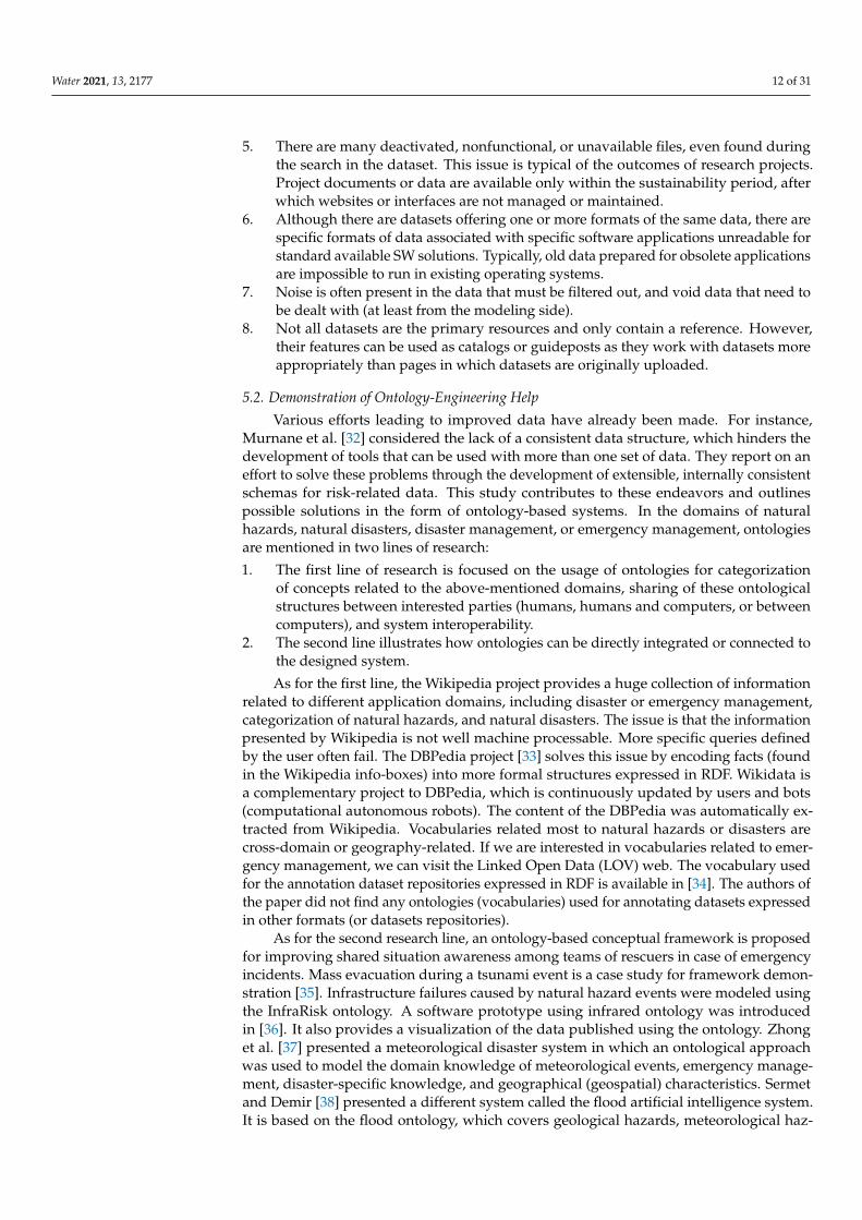
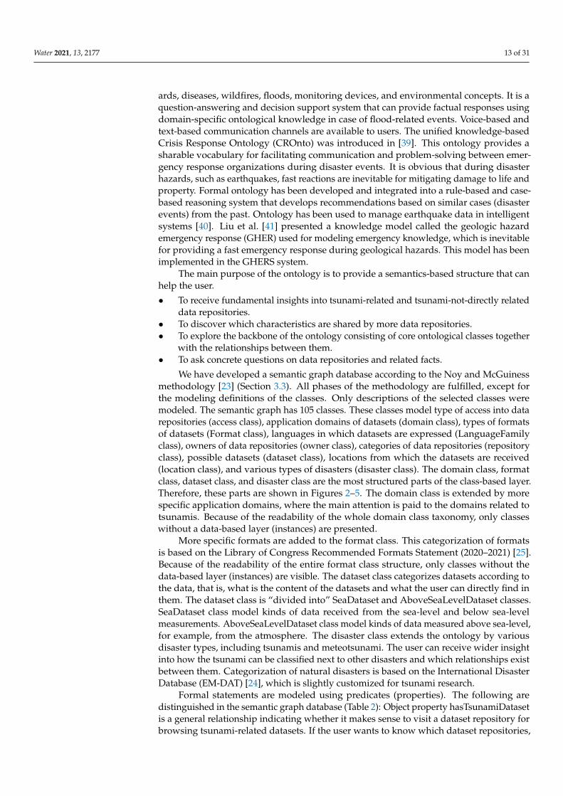
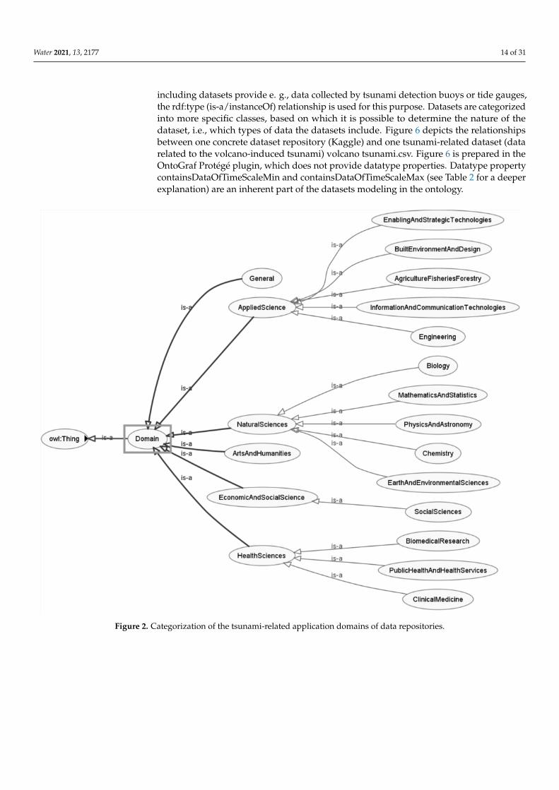
We have developed a semantic graph database according to the Noy and McGuinessmethodology [23] (Section 3.3). All phases of the methodology are fulfilled, except forthe modeling definitions of the classes. Only descriptions of the selected classes weremodeled. The semantic graph has 105 classes. These classes model type of access into datarepositories (access class), application domains of datasets (domain class), types of formatsof datasets (Format class), languages in which datasets are expressed (LanguageFamilyclass), owners of data repositories (owner class), categories of data repositories (repositoryclass), possible datasets (dataset class), locations from which the datasets are received(location class), and various types of disasters (disaster class). The domain class, formatclass, dataset class, and disaster class are the most structured parts of the class-based layer.Therefore, these parts are shown in Figures 2–5. The domain class is extended by morespecific application domains, where the main attention is paid to the domains related totsunamis. Because of the readability of the whole domain class taxonomy, only classeswithout a data-based layer (instances) are presented.
More specific formats are added to the format class. This categorization of formatsis based on the Library of Congress Recommended Formats Statement (2020–2021) [25].Because of the readability of the entire format class structure, only classes without thedata-based layer (instances) are visible. The dataset class categorizes datasets according tothe data, that is, what is the content of the datasets and what the user can directly find inthem. The dataset class is “divided into” SeaDataset and AboveSeaLevelDataset classes.SeaDataset class model kinds of data received from the sea-level and below sea-levelmeasurements. AboveSeaLevelDataset class model kinds of data measured above sea-level,for example, from the atmosphere. The disaster class extends the ontology by variousdisaster types, including tsunamis and meteotsunami. The user can receive wider insightinto how the tsunami can be classified next to other disasters and which relationships existbetween them. Categorization of natural disasters is based on the International DisasterDatabase (EM-DAT) [24], which is slightly customized for tsunami research.
Formal statements are modeled using predicates (properties). The following aredistinguished in the semantic graph database (Table 2): Object property hasTsunamiDatasetis a general relationship indicating whether it makes sense to visit a dataset repository forbrowsing tsunami-related datasets. If the user wants to know which dataset repositories,
Water 2021, 13, 2177 14 of 31
including datasets provide e. g., data collected by tsunami detection buoys or tide gauges,the rdf:type (is-a/instanceOf) relationship is used for this purpose. Datasets are categorizedinto more specific classes, based on which it is possible to determine the nature of thedataset, i.e., which types of data the datasets include. Figure 6 depicts the relationshipsbetween one concrete dataset repository (Kaggle) and one tsunami-related dataset (datarelated to the volcano-induced tsunami) volcano tsunami.csv. Figure 6 is prepared in theOntoGraf Protégé plugin, which does not provide datatype properties. Datatype propertycontainsDataOfTimeScaleMin and containsDataOfTimeScaleMax (see Table 2 for a deeperexplanation) are an inherent part of the datasets modeling in the ontology.
Water 2021, 13, x FOR PEER REVIEW 14 of 31
of the class-based layer. Therefore, these parts are shown in Figures 2–5. The domain class
is extended by more specific application domains, where the main attention is paid to the
domains related to tsunamis. Because of the readability of the whole domain class
taxonomy, only classes without a data-based layer (instances) are presented.
Figure 2. Categorization of the tsunami-related application domains of data repositories. Figure 2. Categorization of the tsunami-related application domains of data repositories.
Water 2021, 13, 2177 15 of 31
Water 2021, 13, x FOR PEER REVIEW 15 of 31
Figure 3. Categorization of the tsunami-focused data formats provided by data repositories.
Figure 4. Categorization of the datasets related to the tsunami research.
Figure 3. Categorization of the tsunami-focused data formats provided by data repositories.
Water 2021, 13, x FOR PEER REVIEW 15 of 31
Figure 3. Categorization of the tsunami-focused data formats provided by data repositories.
Figure 4. Categorization of the datasets related to the tsunami research. Figure 4. Categorization of the datasets related to the tsunami research.
Water 2021, 13, 2177 16 of 31Water 2021, 13, x FOR PEER REVIEW 16 of 31
Figure 5. Categorization of natural disasters (adjusted according to [24]).
More specific formats are added to the format class. This categorization of formats is
based on the Library of Congress Recommended Formats Statement (2020–2021) [25].
Because of the readability of the entire format class structure, only classes without the
data-based layer (instances) are visible. The dataset class categorizes datasets according
to the data, that is, what is the content of the datasets and what the user can directly find
in them. The dataset class is “divided into” SeaDataset and AboveSeaLevelDataset classes.
SeaDataset class model kinds of data received from the sea-level and below sea-level
measurements. AboveSeaLevelDataset class model kinds of data measured above sea-
level, for example, from the atmosphere. The disaster class extends the ontology by
various disaster types, including tsunamis and meteotsunami. The user can receive wider
insight into how the tsunami can be classified next to other disasters and which
relationships exist between them. Categorization of natural disasters is based on the
International Disaster Database (EM-DAT) [24], which is slightly customized for tsunami
research.
Formal statements are modeled using predicates (properties). The following are
distinguished in the semantic graph database (Table 2): Object property
hasTsunamiDataset is a general relationship indicating whether it makes sense to visit a
dataset repository for browsing tsunami-related datasets. If the user wants to know which
dataset repositories, including datasets provide e. g., data collected by tsunami detection
buoys or tide gauges, the rdf:type (is-a/instanceOf) relationship is used for this purpose.
Datasets are categorized into more specific classes, based on which it is possible to
determine the nature of the dataset, i.e., which types of data the datasets include. Figure
6 depicts the relationships between one concrete dataset repository (Kaggle) and one
tsunami-related dataset (data related to the volcano-induced tsunami) volcano
tsunami.csv. Figure 6 is prepared in the OntoGraf Protégé plugin, which does not provide
datatype properties. Datatype property containsDataOfTimeScaleMin and
containsDataOfTimeScaleMax (see Table 2 for a deeper explanation) are an inherent part
of the datasets modeling in the ontology.
Figure 5. Categorization of natural disasters (adjusted according to [24]).
Table 2. Domain-specific predicates (properties).
Domain-Specific Property Type of Property Purpose
hasAccess object property How is a data repository available (paid, free, orunder registration)?
hasDomain object property Which application domain is a data repository interested in?
hasOwner object property Who is the owner of the data repository?
hasPart/isPartOf object property Relationship between whole and its parts.
providesFormatOfDataset object property Which data formats are available in the data repository?
providesLanguageOfDataset object property Which language is data sets expressed in?
areUsedForStudy object property Which data are used for the investigation ofwhich disasters?
containsDataFrom object property Which location data are come from?
hasDataForDownloading datatype property Does a data repository provide datasets for downloading?
Types of properties for datasets filtering:hasDatasetFilterhasDomainFilterhasLicenseFilter
hasLocationFilter
datatype property Does a data repository provide filters for datasets, theirdomains, licenses, or locations?
hasMetadataForDownloading datatype property Is it possible to download the metadata of datasets?
hasSearchField datatype property Is there any search functionality?
hasTimeScaleFilter datatype property Is it possible to filter datasets according to a timescale?
hasUsabilityOfRating datatype property Is there information about the rating of usability?
offersPreviewOfDataset datatype property Is it possible to preview the datasets?
hasTotalDatasets datatype property How many datasets are in the data repository?
hasTsunamiDataset datatype property How many datasets related to the tsunami are in thedata repository?

Water 2021, 13, 2177 17 of 31
Table 2. Cont.
Domain-Specific Property Type of Property Purpose
containsDataOfTimeScaleMin datatype property When were the data of datasets measured (min.year-month-day)?
containsDataOfTimeScaleMax datatype property When were the data of datasets measured (max.year-month-day)?
alternativeName annotation property Expression of an alternative name for the data repository.
description annotation property Specification of more details of data repository.
identifier annotation property Identifier of the data repository (if it is available).
url annotation property URL link to the data repository.Water 2021, 13, x FOR PEER REVIEW 17 of 31
Figure 6. Relationships between datasets repositories and datasets (the example).
Table 2. Domain-specific predicates (properties).
Domain-Specific Property Type of Property Purpose
hasAccess object property How is a data repository available (paid, free, or under
registration)?
hasDomain object property Which application domain is a data repository interested in?
hasOwner object property Who is the owner of the data repository?
hasPart/isPartOf object property Relationship between whole and its parts.
providesFormatOfDataset object property Which data formats are available in the data repository?
providesLanguageOfDataset object property Which language is data sets expressed in?
areUsedForStudy object property Which data are used for the investigation of which disasters?
containsDataFrom object property Which location data are come from?
hasDataForDownloading datatype property Does a data repository provide datasets for downloading?
Types of properties for datasets
filtering:
hasDatasetFilter
hasDomainFilter
hasLicenseFilter
hasLocationFilter
datatype property Does a data repository provide filters for datasets, their
domains, licenses, or locations?
hasMetadataForDownloading datatype property Is it possible to download the metadata of datasets?
hasSearchField datatype property Is there any search functionality?
hasTimeScaleFilter datatype property Is it possible to filter datasets according to a timescale?
hasUsabilityOfRating datatype property Is there information about the rating of usability?
offersPreviewOfDataset datatype property Is it possible to preview the datasets?
hasTotalDatasets datatype property How many datasets are in the data repository?
hasTsunamiDataset datatype property How many datasets related to the tsunami are in the data
repository?
containsDataOfTimeScaleMin datatype property When were the data of datasets measured (min. year-month-
day)?
containsDataOfTimeScaleMax datatype property When were the data of datasets measured (max. year-month-
day)?
alternativeName annotation property Expression of an alternative name for the data repository.
description annotation property Specification of more details of data repository.
identifier annotation property Identifier of the data repository (if it is available).
url annotation property URL link to the data repository.
Figure 6. Relationships between datasets repositories and datasets (the example).
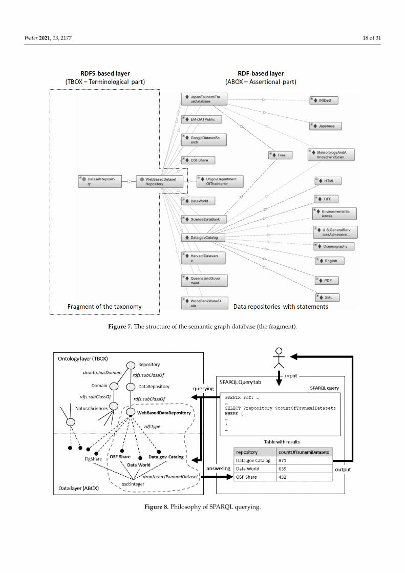
The RDF-based semantic graph database in Figure 7 depicts the fragment of thesemantic graph database, where 15 web-based data repositories are visible: Data.govCatalog, US gov–Department of the Interior, OSF Share, OSF Home, Japan Tsunami Tracedatabase, NCEI (formerly NGDC), Queensland Government, EM-DAT Public, Fishare,Science Data Bank, Kaggle, Data World, Harvard Dataverse, Google—Dataset Search, andWorld Bank Water data—Data catalog. This data repository has links to various resources(individuals), which provide more detail about the repository, e.g.,:
• hasDomain; MeteorologyAndAtmosphericSciences, EnvironmentalSciences, orOceanography.
• hasOwner; U.S.GeneralServicesAdministration.• hasAccess; free.• providesFormatOfDataset; PDF, XML, HTML, or TIFF (most cited data formats).• providesLanguageOfDataset; English.
Consequently, Protocol and RDF Query Language (SPARQL), a W3C standard forquerying RDF graphs, can be used for “mining” the content of the semantic graph databasewith data repositories. Examples follow.
Figure 8 shows how SPARQL-based querying is realized in the Protégé ontologicaleditor. The user is the author of the SPARQL queries encoded in the SPARQL Query tabavailable in Protégé. The query is the input for the query engine, which searches the contentof ontological and data layers. Specific results are provided in the resulting table based onthe SPARQL-based query structure.
Water 2021, 13, 2177 18 of 31
Water 2021, 13, x FOR PEER REVIEW 18 of 31
The RDF-based semantic graph database in Figure 7 depicts the fragment of the
semantic graph database, where 15 web-based data repositories are visible: Data.gov
Catalog, US gov–Department of the Interior, OSF Share, OSF Home, Japan Tsunami Trace
database, NCEI (formerly NGDC), Queensland Government, EM-DAT Public, Fishare,
Science Data Bank, Kaggle, Data World, Harvard Dataverse, Google—Dataset Search, and
World Bank Water data—Data catalog. This data repository has links to various resources
(individuals), which provide more detail about the repository, e.g.,:
• hasDomain; MeteorologyAndAtmosphericSciences, EnvironmentalSciences, or
Oceanography.
• hasOwner; U.S.GeneralServicesAdministration.
• hasAccess; free.
• providesFormatOfDataset; PDF, XML, HTML, or TIFF (most cited data formats).
• providesLanguageOfDataset; English.
Consequently, Protocol and RDF Query Language (SPARQL), a W3C standard for
querying RDF graphs, can be used for “mining” the content of the semantic graph
database with data repositories. Examples follow.
Figure 7. The structure of the semantic graph database (the fragment).
Figure 8 shows how SPARQL-based querying is realized in the Protégé ontological
editor. The user is the author of the SPARQL queries encoded in the SPARQL Query tab
Figure 7. The structure of the semantic graph database (the fragment).
Water 2021, 13, x FOR PEER REVIEW 19 of 31
available in Protégé. The query is the input for the query engine, which searches the
content of ontological and data layers. Specific results are provided in the resulting table
based on the SPARQL-based query structure.
Figure 8. Philosophy of SPARQL querying.
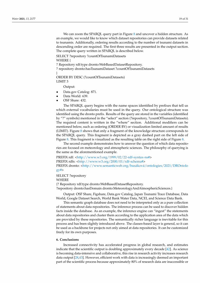
We can zoom the SPARQL query part in Figure 8 and uncover a hidden structure. As
an example, we would like to know which dataset repositories can provide datasets
related to tsunamis. Additionally, ordering results according to the number of tsunami
datasets in descending order are required. The first three results are presented in the
output section. The complete query written in SPARQL is described below.
SELECT ?repository ?countOfTsunamiDatasets
WHERE {
? Repository rdf:type dronto:WebBasedDatasetRepository.
?repository dronto:hasTsunamiDataset ?countOfTsunamiDatasets
}
ORDER BY DESC (?countOfTsunamiDatasets)
LIMIT 3
Output:
• Data.gov Catalog: 871.
• Data World: 639.
• OSF Share: 432.
The SPARQL query begins with the name spaces identified by prefixes that tell us
which external vocabularies must be used in the query. Our ontological structure was
identified using the dronto prefix. Results of the query are stored in the variables
(identified by “?” symbols) mentioned in the “select” section (?repository,
?countOfTsunamiDatasets). The required content is written in the “where” section.
Additional modifiers can be mentioned below, such as ordering (ORDER BY) or
visualization limited amount of results (LIMIT). Figure 8 shows that only a fragment of
the knowledge structure corresponds to the SPARQL query. This fragment is depicted as
a gray dashed part on the left side of Figure 8. This fragment is visualized as the resulting
table on the right side of Figure 8.
The second example demonstrates how to answer the question of which data
repositories are focused on meteorology and atmospheric sciences. The philosophy of
querying is the same as the aforementioned example.
Figure 8. Philosophy of SPARQL querying.
Water 2021, 13, 2177 19 of 31
We can zoom the SPARQL query part in Figure 8 and uncover a hidden structure. Asan example, we would like to know which dataset repositories can provide datasets relatedto tsunamis. Additionally, ordering results according to the number of tsunami datasets indescending order are required. The first three results are presented in the output section.The complete query written in SPARQL is described below.
SELECT ?repository ?countOfTsunamiDatasetsWHERE {? Repository rdf:type dronto:WebBasedDatasetRepository.? repository dronto:hasTsunamiDataset ?countOfTsunamiDatasets}ORDER BY DESC (?countOfTsunamiDatasets)LIMIT 3
Output:
• Data.gov Catalog: 871.• Data World: 639.• OSF Share: 432.
The SPARQL query begins with the name spaces identified by prefixes that tell uswhich external vocabularies must be used in the query. Our ontological structure wasidentified using the dronto prefix. Results of the query are stored in the variables (identifiedby “?” symbols) mentioned in the “select” section (?repository, ?countOfTsunamiDatasets).The required content is written in the “where” section. Additional modifiers can bementioned below, such as ordering (ORDER BY) or visualization limited amount of results(LIMIT). Figure 8 shows that only a fragment of the knowledge structure corresponds tothe SPARQL query. This fragment is depicted as a gray dashed part on the left side ofFigure 8. This fragment is visualized as the resulting table on the right side of Figure 8.
The second example demonstrates how to answer the question of which data reposito-ries are focused on meteorology and atmospheric sciences. The philosophy of querying isthe same as the aforementioned example.
PREFIX rdf: <http://www.w3.org/1999/02/22-rdf-syntax-ns#>PREFIX rdfs: <http://www.w3.org/2000/01/rdf-schema#>PREFIX dronto: <http://www.semanticweb.org/husáková/ontologies/2021/DROntology#>
SELECT ?repositoryWHERE{? Repository rdf:type dronto:WebBasedDatasetRepository.?repository dronto:hasDomain dronto:MeteorologyAndAtmosphericSciences.}
Output: OSF Share, Figshare, Data.gov Catalog, Japan Tsunami Trace Database, DataWorld, Google Dataset Search, World Bank Water Data, NCEI, and Science Data Bank.
This semantic graph database does not need to be interpreted only as a pure collectionof statements about data repositories. The inference process can be used to discover hiddenfacts inside the database. As an example, the inference engine can “ingest” the statementsabout data repositories and cluster them according to the application area of the data whichare provided by these repositories. The semantically richer language is inevitable for thisprocess and has been slightly introduced above. The classes-based layer is general, so it canbe used as a backbone for projects not only aimed at data repositories. It can be customizedfreely for its own purposes.
6. Conclusions
Increased connectivity has accelerated progress in global research, and estimatesindicate that the scientific output is doubling approximately every decade [42]. As scienceis becoming data-intensive and collaborative, this rise in research activity increases researchdata output [28,43]. However, efficient work with data is increasingly deemed an importantpart of the scientific process because approximately 80% of research data are inaccessible or
Water 2021, 13, 2177 20 of 31
unpublished [42]. Making data publicly available allows original results to be reproducedand new analyses to be conducted [27,29]. Nevertheless, there is a growing debate abouthow quickly scientific findings can and should influence disaster mitigation policies [44].Although a relatively new research area, tsunami science depends on data from variousdisciplines falling within the scope of geosciences, oceanography, engineering, physics,mathematics, and disaster management, including politics, media, communication, andeducation [4]. Furthermore, tsunami hazard assessment and mitigation plans based onnumerical modeling and simulation of tsunamis have gained increasing importance.
In the realm of tsunami research, a growing number of scientists are trained in survey-ing techniques. Thus, more data will be collected [45]. Because data are the infrastructureof tsunami research, this study provides a unique, extensive review of tsunami-relateddatasets and repositories. Existing data repositories have several issues, ranging frommissing updates or dysfunctional webpages to limited search filtering, metadata down-loadability, and data usability. Although the list of repositories presented in this study isnot exhaustive because of the applied methodological approach, diverse sets of expertsand practitioners can take advantage of the repositories identified and evaluated in thisstudy as datasets contain data related to volcanology, geoscience, water research, or civilengineering. By using data, their teams and institutions will provide various types ofdatasets and repositories, which can be used for analysis, modeling, simulation, or pre-diction of tsunami occurrence. Thus, multidisciplinary research, suggested by the latestresearch [46], to design and propose practical solutions can be supported. Hopefully, theprimary outcome of this study will catalyze the data lifecycle in tsunami research.
Indeed, there are ways to mitigate these issues. Computer science techniques andmethods from artificial intelligence, such as k-Nearest Neighbors (k-NN) models [47],C4.5 algorithm [48], the Random Forest method [49], Bayes classifier [50], or non-linearparametric model [51] are worth mentioning. They all process data to acquire new knowl-edge and insights. We briefly outline ontology engineering as an approach that we believecan help the global research community reduce the analytical workload of all stakeholdersand enhance the quality of the recorded data. It plays the role of a metadata providerthat can improve orientation in existing tsunami-related data repositories. The proposedsolution is presented only as an outline. It shows viability, usability, and feasibility ofsolving the issues identified in this review. Its development to a full version with allsuggested functionalities can improve work with tsunami-related data repositories.
Author Contributions: Conceptualization, T.N., V.B., M.H. and D.P.; methodology, T.N., K.M. andV.B.; software, M.H., P.C., P.T. and M.Z.; validation, K.Š., P.M. and V.B.; formal analysis, M.H. and I.T.;resources, all authors.; data curation, T.N. and K.M.; writing—original draft preparation, all authors;writing—review and editing, all authors; visualization, M.H.; project administration, V.B.; fundingacquisition, V.B. All authors have read and agreed to the published version of the manuscript.
Funding: The APC was funded by the VES20 Inter-Cost LTC 20020 project.
Acknowledgments: The VES20 Inter-Cost LTC 20020 project supported this research. The authorsalso express gratitude to the COST Action AGITHAR leaders and team members.
Conflicts of Interest: The authors declare no conflict of interest.
Appendix A
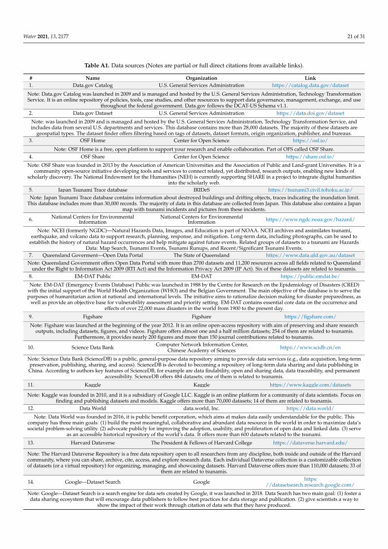
Water 2021, 13, 2177 21 of 31
Table A1. Data sources (Notes are partial or full direct citations from available links).
# Name Organization Link1. Data.gov Catalog U.S. General Services Administration https://catalog.data.gov/dataset
Note: Data.gov Catalog was launched in 2009 and is managed and hosted by the U.S. General Services Administration, Technology TransformationService. It is an online repository of policies, tools, case studies, and other resources to support data governance, management, exchange, and use
throughout the federal government. Data.gov follows the DCAT-US Schema v1.1.2. Data.gov Dataset U.S. General Services Administration https://data.doi.gov/dataset
Note: was launched in 2009 and is managed and hosted by the U.S. General Services Administration, Technology Transformation Service, andincludes data from several U.S. departments and services. This database contains more than 28,000 datasets. The majority of these datasets are
geospatial types. The dataset finder offers filtering based on tags of datasets, dataset formats, origin organization, publisher, and bureaus.3. OSF Home Center for Open Science https://osf.io/
Note: OSF Home is a free, open platform to support your research and enable collaboration. Part of OFS called OSF Share.4. OSF Share Center for Open Science https://share.osf.io/
Note: OSF Share was founded in 2013 by the Association of American Universities and the Association of Public and Land-grant Universities. It is acommunity open-source initiative developing tools and services to connect related, yet distributed, research outputs, enabling new kinds of
scholarly discovery. The National Endowment for the Humanities (NEH) is currently supporting SHARE in a project to integrate digital humanitiesinto the scholarly web.
5. Japan Tsunami Trace database IRIDeS https://tsunami3.civil.tohoku.ac.jp/Note: Japan Tsunami Trace database contains information about destroyed buildings and drifting objects, traces indicating the inundation limit.
This database includes more than 30,000 records. The majority of data in this database are collected from Japan. This database also contains a Japanmap with tsunami incidents and pictures from these incidents.
6. National Centers for EnvironmentalInformation
National Centers for EnvironmentalInformation https://www.ngdc.noaa.gov/hazard/
Note: NCEI (formerly NGDC)—Natural Hazards Data, Images, and Education is part of NOAA. NCEI archives and assimilates tsunami,earthquake, and volcano data to support research, planning, response, and mitigation. Long-term data, including photographs, can be used to
establish the history of natural hazard occurrences and help mitigate against future events. Related groups of datasets to a tsunami are HazardsData: Map Search, Tsunami Events, Tsunami Runups, and Recent/Significant Tsunami Events.
7. Queensland Goverment—Open Data Portal The State of Queensland https://www.data.qld.gov.au/datasetNote: Queensland Government offers Open Data Portal with more than 2700 datasets and 11,200 resources across all fields related to Queensland
under the Right to Information Act 2009 (RTI Act) and the Information Privacy Act 2009 (IP Act). Six of these datasets are related to tsunamis.8. EM-DAT Public EM-DAT https://public.emdat.be/
Note: EM-DAT (Emergency Events Database) Public was launched in 1988 by the Centre for Research on the Epidemiology of Disasters (CRED)with the initial support of the World Health Organization (WHO) and the Belgian Government. The main objective of the database is to serve thepurposes of humanitarian action at national and international levels. The initiative aims to rationalize decision making for disaster preparedness, as
well as provide an objective base for vulnerability assessment and priority setting. EM-DAT contains essential core data on the occurrence andeffects of over 22,000 mass disasters in the world from 1900 to the present day.
9. Figshare Figshare https://figshare.com/
Note: Figshare was launched at the beginning of the year 2012. It is an online open-access repository with aim of preserving and share researchoutputs, including datasets, figures, and videos. Figshare offers almost one and a half million datasets; 254 of them are related to tsunamis.
Furthermore, it provides nearly 200 figures and more than 150 journal contributions related to tsunamis.
10. Science Data Bank Computer Network Information Center,Chinese Academy of Sciences https://www.scidb.cn/en
Note: Science Data Bank (ScienceDB) is a public, general-purpose data repository aiming to provide data services (e.g., data acquisition, long-termpreservation, publishing, sharing, and access). ScienceDB is devoted to becoming a repository of long-term data sharing and data publishing inChina. According to authors key features of ScienceDB, for example are data findability, open and sharing data, data traceability, and permanent
accessibility. ScienceDB offers 484 datasets; one of them is related to tsunamis.
11. Kaggle Kaggle https://www.kaggle.com/datasets
Note: Kaggle was founded in 2010, and it is a subsidiary of Google LLC. Kaggle is an online platform for a community of data scientists. Focus onfinding and publishing datasets and models. Kaggle offers more than 70,000 datasets; 14 of them are related to tsunamis.
12. Data World data.world, Inc. https://data.world/
Note: Data World was founded in 2016, it is public benefit corporation, which aims at makes data easily understandable for the public. Thiscompany has three main goals: (1) build the most meaningful, collaborative and abundant data resource in the world in order to maximize data’ssocietal problem-solving utility. (2) advocate publicly for improving the adoption, usability, and proliferation of open data and linked data. (3) serve
as an accessible historical repository of the world’s data. It offers more than 600 datasets related to the tsunami.
13. Harvard Dataverse The President & Fellows of Harvard College https://dataverse.harvard.edu/
Note: The Harvard Dataverse Repository is a free data repository open to all researchers from any discipline, both inside and outside of the Harvardcommunity, where you can share, archive, cite, access, and explore research data. Each individual Dataverse collection is a customizable collectionof datasets (or a virtual repository) for organizing, managing, and showcasing datasets. Harvard Dataverse offers more than 110,000 datasets; 33 of
them are related to tsunamis.
14. Google—Dataset Search Google https://datasetsearch.research.google.com/
Note: Google—Dataset Search is a search engine for data sets created by Google, it was launched in 2018. Data Search has two main goal: (1) foster adata sharing ecosystem that will encourage data publishers to follow best practices for data storage and publication. (2) give scientists a way to
show the impact of their work through citation of data sets that they have produced.
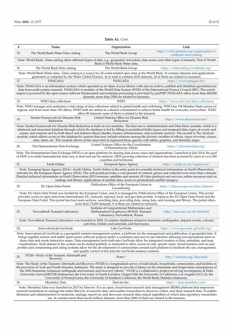
Water 2021, 13, 2177 22 of 31
Table A1. Cont.
# Name Organization Link
15. The World Bank Water Data catalog The World Bank Group https://wbwaterdata.org/organization/worldbank-data-catalog
Note: World Bank—Data catalog offers different types of data, e.g., geospatial, microdata, time series, and other types of datasets. Part of WorldBank is World Bank Water data.
16. The World Bank Data catalog The World Bank Group https://datacatalog.worldbank.org/
Note: World Bank Water data—Data catalog is a source for all water-related open data at the World Bank. It contains datasets and applicationsgenerated or compiled by the Water Global Practice. In to total it contains 2654 datasets, 26 of them are related to tsunamis.
17. PANGAEA PANGAEA https://www.pangaea.de/
Note: PANGAEA is an information system, which operated as an Open Access library with aim on archive, publish and distribute georeferenceddata from earth system research. PANGAEA is member of the World Data System (WDS) of the International Science Council (ISC). The search
engine is powered by the open-source software Elasticsearch and metadata processing is provided by panFMP. PANGAEA offers more than 400,000datasets; more than 3500 are related to tsunamis.
18. WHO data collections WHO https://www.who.int/data/collections
Note: WHO manages and maintains a wide range of data collections related to global health and well-being. WHO has 194 Member States across sixregions, and from more than 150 offices, WHO staff are united in a shared commitment to achieve better health for everyone, everywhere. WHO
offers 80 datasets; none of them is related to the tsunami.
19. Sendai Framework for Disaster RiskReduction
United Nations Office for Disaster RiskReduction https://www.desinventar.net/
Note: Sendai Framework for Disaster Risk Reduction is built on two modules. The first one is Administration and Data Entry module, which is arelational and structural database through which the database is fed by filling in predefined fields (space and temporal data, types of events and
causes, and sources) and by both direct and indirect effects (deaths, houses, infrastructure, and economic sectors). The second is The Analysismodule, which allows access to the database by queries that may include relations among the diverse variables of effects, types of events, causes,
sites, dates, etc. This module allows at the same time to represent those queries with tables, graphics, and thematic maps.
20. The Humanitarian Data Exchange United Nations Office for the Coordinationof Humanitarian Affairs https://data.humdata.org/
Note: The Humanitarian Data Exchange (HDX) is an open platform for sharing data across crises and organizations. Launched in July 2014, the goalof HDX is to make humanitarian data easy to find and use for analysis. HDX growing collection of datasets has been accessed by users in over 200
countries and territories.21. Earth Online European Space Agency https://earth.esa.int/eogateway/
Note: European Space Agency (ESA)—Earth Online. Earth Online is the entry point for scientific-technical information on Earth Observationactivities by the European Space Agency (ESA). The web portal provides a vast amount of content, grown and collected over more than a decade:Detailed technical information on Earth Observation (EO) missions; satellites and sensors; EO data products and services; online resources such as
catalogs and library; applications of satellite data; access to promotional satellite imagery.
22. EU Open Data Portal Publications Office of the European Union inLuxembourg https://data.europa.eu/data/datasets
Note: EU Open Data Portal was funded by the European Union, and it is managed by Publications Office of the European Union. This portalprovides access to open data from international, EU, national, regional, local, and geo data portals. It replaces the EU Open Data Portal and theEuropean Data Portal. This portal has four main sections: searching data, providing data, using data, and training and library. The portal offers
more than 15,000 datasets; 9 of them are related to tsunamis.
23. Novosibirsk Tsunami LaboratoryInstitute of Computational Mathematics andMathematical Geophysics SB RAS, Tsunami
Laboratory, Novosibirsk, Russiahttp://tsun.sscc.ru/nh/list.html
Note: Novosibirsk Tsunami Laboratory was founded in 2004. It contains databases related to tsunamis, earthquakes, impacts events, volcanicactivities, bolides and asteroids, and hurricanes.
24. InnovationLab GeoNode Labs GeoNode https://www.geonode-gfdrrlab.org/
Note: InnovationLab GeoNode is a geospatial content management system, a platform for the management and publication of geospatial data. Itbrings together mature and stable open-source software projects under a consistent and easy-to-use interface allowing non-specialized users to
share data and create interactive maps. Data management tools built into GeoNode allow for integrated creation of data, metadata, and mapvisualizations. Each dataset in the system can be shared publicly or restricted to allow access to only specific users. Social features such as user
profiles and commenting and rating systems allow for the development of communities around each platform to facilitate the use, management,and quality control of the data the GeoNode instance contains.
25. STAR—Study of the Tsunami Aftermath andRecovery None * http://stardata.org/data.html
Note: The Study of the Tsunami Aftermath and Recovery (STAR) is a longitudinal survey of individuals, households, communities, and facilities inthe provinces of Aceh and North Sumatra, Indonesia. The study is designed to provide evidence on the immediate and longer-term consequences of
the 2004 Sumatran-Andaman earthquake and tsunami and recovery efforts. * STAR is a collaborative project involving investigators at DukeUniversity; SurveyMETER (Indonesia); the University of North Carolina, Chapel Hill; the University of California, Los Angeles (UCLA); the
University of Pennsylvania; the University of Southern California; the World Bank; Statistics Indonesia.26. Mendeley Data Elsevier Inc. https://data.mendeley.com/
Note: Mendeley Data was launched in 2015 by Elsevier. It is an open, cloud-based research data management (RDM) platform that empowersresearch institutions to manage the entire lifecycle of research data, and enables researchers to discover, collect, and share research data. It enableslibrarians and administrators to moderate, manage, report on, and showcase research data output regardless of which data repository researchers
use. It contains more than seven million datasets; more than 2000 of them are related to the tsunami.

Water 2021, 13, 2177 23 of 31
Table A1. Cont.
# Name Organization Link27. Dryad Dryad https://datadryad.org/search?q=
Note: Dryad is an open source, community driven project that takes a unique approach to data publication and digital preservation. Dryad focuseson search, presentation, and discovery and delegates the responsibility for the data preservation function to the underlying repository with which it
is integrated. Dryad’s original iteration launched in 2009, in 2019, Dryad merged with Dash.
28. National Center for BiotechnologyInformation Support Center National Library of Medicine https://www.ncbi.nlm.nih.gov/search/
Note: NCBI (National Center for Biotechnology Information Support Center) was established in 1998. NCBI is now a leading source for publicbiomedical databases, software tools for analyzing molecular and genomic data, and research in computational biology. Today NCBI creates and
maintains over 40 integrated databases for the medical and scientific communities as well as the general public.29. Qualitative Data Repository Qualitative Data Repository https://data.qdr.syr.edu/
Note: Qualitative Data Repository (QDR) is a dedicated archive for storing and sharing digital data (and accompanying documentation) generatedor collected through qualitative and multi-method research in the social sciences. QDR provides search tools to facilitate the discovery of data, and,also, serves as a portal to material beyond its own holdings, with links to U.S. and international archives. The repository’s initial emphasis is on
political science.30. DataCite DataCite https://search.datacite.org/
Note: Datacite is a leading global non-profit organization that provides persistent identifiers (DOIs) for research data and other research outputs.Organizations within the research community join DataCite as members to be able to assign DOIs to all their research outputs. This way, their
outputs become discoverable and associated metadata is made available to the community. DataCite then develops additional services to improvethe DOI management experience, making it easier for our members to connect and share their DOIs with the broader research ecosystem and toassess the use of their DOIs within that ecosystem. DataCite is an active participant in the research community and promotes data sharing and
citation through community-building efforts and outreach activities.
31. Open data initiative of the Government ofSpain Government of Spain https://datos.gob.es/en/catalogo
Note: The Aporta Initiative was launched in 2009 to promote the opening of public information and development of advanced services based ondata. It is backed by the Ministry of Economy and Business, the Ministry of Territorial Policy and Civil Service, and the Public Corporate EntityRed.es. The main goal of the Aporta initiative, a key element in the Spanish government’s open data policy, is to harmonize and efficiently take
advantage of the synergies between ongoing open data projects. It seeks to always drive and coordinate actions being carried out by different levelsthe administration, the private sector, and academic field, according to an integrating governance model. It does all of this in order to promote new
products and services from the private sector and civil society to benefit society.32. Malta Data Portal Government of Malta https://open.data.gov.mt/dashboard.html
Note: Malta Data Portal was founded by the Republic of Malta in 2014. It was financed by the Malta government and European Union. It offers 205datasets related to the republic of Malta.
33. National Opendata Portal Republic of Cyprus https://www.data.gov.cy/
Note: National Opendata Portal was founded by the Ministry of Finance of the Republic of Cyprus in 2014, and it offers datasets related to theRepublic of Cyprus. In total, it offers more than 1100 datasets. Most of them are related to the environment, economy and finance, population,
government, and health.34. Open Data From Public Administration Agenzia per l’Italia Digitale https://dati.gov.it/
Note: Open Data From Public Administration was born as a project promoted in 2011 by the Italian government and since 2015 it has been managedby the Agency for Digital Italy. The data.gov.it Portal is the national catalog of metadata relating to open type data released by public
administrations and constitutes the search tool and the access point to the data made available according to the open data paradigm, in accordancewith the provisions from art. 9 of the legislative decree n. 36/2006 (transposition of the European Directive on the reuse of public sector
information). Dati.gov.it is also the tool with which the Agency for Digital Italy promotes the policies for the enhancement of national publicinformation assets. To this end, the portal makes available to administrations and developers a series of useful resources to deepen the topic of open
data, to improve the quality of the data exposed and, ultimately, to encourage their reuse.
35. O catálogo central de dados abertos emPortugal
Agência para a ModernizaçãoAdministrativa https://dados.gov.pt/en/
Note: O catálogo central de dados abertos em Portugal is the Portuguese Public Administration’s open data portal. Its function is to aggregate,reference and store open data from different Public Administration’s bodies and sectors, therefore creating the central catalogue of open data in
Portugal. Besides working as a shared data storing and publication service, it may be used by any public body, also working as an indexing portal ofcontents in other open data portals/catalogues. It also provides several interaction mechanisms between data suppliers and re-users, such as the
possibility to commend, submit complementary data versions and suggest improvements to the platform.
36. OECD Data Organisation for Economic Co-operationand Development https://data.oecd.org/
Note: The Organisation for Economic Co-operation and Development (OECD) is an international organization that works to build better policies forbetter lives. OECD’s goal is to shape policies that foster prosperity, equality, opportunity, and well-being for all. OECD draws on 60 years of
experience and insights to better prepare the world of tomorrow. Data OECD is part of OECD and offers more than 7500 datasets, two of them arerelated to tsunamis. Another part of OECD, which focuses on datasets, is OECD iLibrary.
37. OECD iLibrary Organisation for Economic Co-operationand Development https://www.oecd-ilibrary.org/
Note: OECD iLibrary is the online library of the Organisation for Economic Cooperation and Development (OECD) featuring its books, papers, andstatistics and is the knowledge base of OECD’s analysis and data.
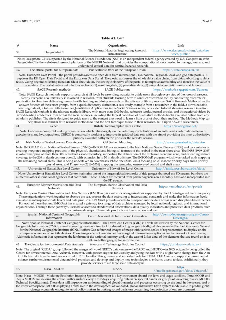
Water 2021, 13, 2177 24 of 31
Table A1. Cont.
# Name Organization Link
38. DesignSafe-CI The Natural Hazards Engineering ResearchInfrastructure
https://www.designsafe-ci.org/data/browser/public/
Note: DesignSafe-CI is supported by the National Science Foundation (NSF) is an independent federal agency created by U.S. Congress in 1950.DesignSafe-CI is the web-based research platform of the NHERI Network that provides the computational tools needed to manage, analyze, and
understand critical data for natural hazards research.39. The official portal for European data Publications Office of the European Union https://data.europa.eu/en
Note: European Data Portal—the portal provides access to open data from international, EU, national, regional, local, and geo data portals. Itreplaces the EU Open Data Portal and the European Data Portal. The portal addresses the whole data value chain, from data publishing to data
reuse. Going beyond collecting metadata (data about data), the strategic objective of the portal is to improve accessibility and increase the value ofopen data. The portal is divided into four sections: (1) searching data, (2) providing data, (3) using data, and (4) training and library.
40. SAGE Research methods SAGE Publications https://methods.sagepub.com/Datasets
Note: SAGE Research methods supports research at all levels by providing material to guide users through every step of the research process.Nearly everyone at a university is involved in research, from students learning how to conduct research to faculty conducting research for
publication to librarians delivering research skills training and doing research on the efficacy of library services. SAGE Research Methods has theanswer for each of these user groups, from a quick dictionary definition, a case study example from a researcher in the field, a downloadable
teaching dataset, a full-text title from the Quantitative Applications in the Social Sciences series, or a video tutorial showing research in action.SAGE Research Methods is the ultimate methods library with more than 1000 books, reference works, journal articles, and instructional videos byworld-leading academics from across the social sciences, including the largest collection of qualitative methods books available online from any
scholarly publisher. The site is designed to guide users to the content they need to learn a little or a lot about their method. The Methods Map canhelp those less familiar with research methods to find the best technique to use in their research. Built upon SAGE’s researchers.
41. Gebco British Oceanographic Data Centre https://www.gebco.net/
Note: Gebco is a non-profit making organization which relies largely on the voluntary contributions of an enthusiastic international team ofgeoscientists and hydrographers. GEBCO is continually working to improve its gridded data sets with the aim of providing the most authoritative
publicly available bathymetric grids for the world’s oceans.42. Irish National Seabed Survey Data Access GSI Seabed Mapping http://www.gsiseabed.ie/data.htm
Note: INFOMAR /Irish National Seabed Survey (INNS)—INFOMAR is a successor to the Irish National Seabed Survey (INSS) and concentrates oncreating integrated mapping products of the physical, chemical and biological features of the seabed in the near-shore area. The INSS (1999–2005)involved mapping of more than 80% of Ireland’s seabed territory, supporting the delineation of the exclusive economic zone, and extending inshorecoverage to the 200 m depth contour overall, with extension in to 50 m depth offshore. The INFOMAR program which was tasked with mapping
the remaining coastal areas. This is being undertaken in two phases; Phase one (2006–2016) focusing on 26 inshore priority bays and 3 prioritycoastal areas, and Phase two (2016–2026) mapping the remaining unsurveyed coastal and shelf areas.
43. University of Hawaii Sea Level Center University of Hawaii Sea Level Center http://uhslc.soest.hawaii.edu/data/
Note: University of Hawaii Sea Level Center maintains one of the largest global networks of tide gauges that feed the FD stream, but there arenumerous other international agencies that contribute. These FD data are received from partner agencies on a monthly basis and incorporated into
the FD stream.
44. European Marine Observation and DataNetwork
The European Marine Observation and DataNetwork https://emodnet.eu/en/portals
Note: European Marine Observation and Data Network (EMODnet) is a network of organizations supported by the EU’s integrated maritime policy.These organizations work together to observe the sea, process the data according to international standards and make that information freely
available as interoperable data layers and data products. EMODnet provides access to European marine data across seven discipline-based themes.For each of these themes, EMODnet has created a gateway to a range of data archives managed by local, national, regional, and international
organizations. Through these gateways, users have access to standardized observations, data quality indicators, and processed data products, suchas basin-scale maps. These data products are free to access and use.
45. Spanish National Center of GeographicInformation Centro Nacional de Información Geográfica http://centrodedescargas.cnig.es/Centro
Descargas/
Note: Spanish National Center of Geographic Information—The Download Center (CdD) is a web site created by the National Center forGeographic Information (CNIG), aimed at serving users as a free tool for downloading geographic digital files generated by the Directorate General
for the National Geographic Institute (IGN). It offers Geo-referenced images of maps with various scales of representation, to display on thecomputer screen or on mobile devices. These images do not contain neither marginal information (captions) nor framework of coordinates,
Altimetric information that represents the landform of the national territory, and, in the case of Lidar data, of the elements that are found on it aswell, and other geographic information.
46. The Centre for Environmental Data Analysis Science and Technology Facilities Council https://catalogue.ceda.ac.uk/
Note: The original “CEDA” group followed the merger of two of NERC’s data centers—the BADC and NEODC—in 2005, originally being called theCentre for Environmental Data Archival. However, with greater support for users by analyzing the data with a slight name change from the A in
CEDA from Archival to Analysis occurred in 2015 to reflect this growing and important role for CEDA. CEDA aims to support environmentalscience, further environmental data archival practices, and develop and deploy new technologies to enhance access to data. Additionally, they
provide services to aid large scale data analysis.
47. Nasa—MODIS NASA https://modis.gsfc.nasa.gov/data/dataprod/
Note: Nasa—MODIS—Moderate Resolution Imaging Spectroradiometer is a key instrument aboard the Terra and Aqua satellites. Terra MODIS andAqua MODIS are viewing the entire Earth’s surface every 1 to 2 days, acquiring data in 36 spectral bands, or groups of wavelengths (see MODISTechnical Specifications). These data will improve our understanding of global dynamics and processes occurring on the land, in the oceans, and inthe lower atmosphere. MODIS is playing a vital role in the development of validated, global, interactive Earth system models able to predict global
change accurately enough to assist policy makers in making sound decisions concerning the protection of our environment.
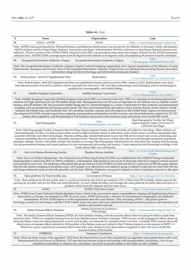
Water 2021, 13, 2177 25 of 31
Table A1. Cont.
# Name Organization Link
48. NASA—ASTER NASA https://asterweb.jpl.nasa.gov/gdem.asp
Note: ASTER (Advanced Spaceborne Thermal Emission and Reflection Radiometer) was founded by the Ministry of Economy, Trade, and Industry(METI) of Japan and the United States National Aeronautics and Space Administration (NASA), and focus on spaceborne thermal emission and
reflection. The first version of the ASTER GDEM, released in June 2009, was generated using stereo-pair images collected by the ASTER instrumentonboard Terra. ASTER GDEM coverage spans from 83 degrees north latitude to 83 degrees south, encompassing 99 percent of Earth’s landmass.
49. Geospatial Information Authority of Japan Geospatial Information Authority of Japan https://fgd.gsi.go.jp/download/menu.php
Note: The Geospatial Information Authority of Japan is Japan’s national mapping organization and a special organization of the Ministry of Land,Infrastructure, Transport, and Tourism. Part of The Geospatial Information Authority of Japan focus on collecting and providing disaster prevention
information using the latest technology, and information about past disasters.
50. RadioCarbon—IntCal13 Supplemental Data Radiocarbon http://www.radiocarbon.org/IntCal13.htm
Note: RadioCarbon—IntCal13 Supplemental Data was published in Radiocarbon journal in 55th volume in 2013. Radiocarbon is the maininternational journal of record for research articles and date lists relevant to 14C and other radioisotopes and techniques used in archaeological,
geophysical, oceanographic, and related dating.
51. Satellite Imaging Corporation Satellite Imaging Corporation https://www.satimagingcorp.com/gallery/
Note: Satellite Imaging Corporation Satellite Imaging Corporation (SIC) was formed in the early 1990’s as a response to increasing demand formedium and high resolution 2D and 3D satellite image data. Management has over 40 years of experience in on/offshore survey, satellite remotesensing, and GIS industry. SIC has processed satellite image data for clients belonging to a variety of industries for their domestic and internationalmapping, GIS, environmental and design project needs. SIC have performed projects throughout Africa, Europe, Russia, North America, SouthAmerica, the Middle East, and Southeast Asia. SICs portfolio includes cadastre and GIS projects for the United States Agency for International
Development (USAID), precision agriculture mapping, transportation and pipeline corridor surveys, near shore bathymetry, support for 2D/3Dseismic data acquisition, and the planning of well locations and access roads located in rural, and remote areas around the world.
52. OpenTopography https://portal.opentopography.org/datasets
OpenTopography Facility, San DiegoSupercomputer Center, University of
California San Diego
Note: OpenTopography Facility is based at the San Diego Supercomputer Center at the University of California, San Diego. Main missions ofOpenTopography Facility is to democratize online access to high-resolution (meter to sub-meter scale), Earth science-oriented, topography dataacquired with lidar and other technologies. Harness cutting edge cyberinfrastructure to provide Web service-based data access, processing, andanalysis capabilities that are scalable, extensible, and innovative. Promote discovery of data and software tools through community populated
metadata catalogs. Partner with public domain data holders to leverage OpenTopography infrastructure for data discovery, hosting and processing.Provide professional training and expert guidance in data management, processing, and analysis. Foster interaction and knowledge exchange in the
Earth science lidar user community.
53. Sea Level Station Monitoring Facility Flanders Marine Institute http://www.ioc-sealevelmonitoring.org/list.php
Note: Sea Level Station Monitoring—The Global Sea Level Observing System (GLOSS) was established by the UNESCO IntergovernmentalOceanographic Commission (IOC) in 1985 to establish a well-designed, high-quality in situ sea level observing network to support a broad researchand operational user base. The backbone of the global tide gauge network is the GLOSS Core Network (GCN), a global set of 300 tide gauge stationsthat provide optimal sampling of the global ocean. GCN gauges were allocated to each island or group of islands at intervals not closer than 500 km,and along continental coasts at intervals generally not less than 1000 km. Preference was given to islands in order to maximize exposure to the open
ocean.54. Open platform for French public data Government of France https://www.data.gouv.fr/en/datasets/
Note: Open platform for French public data is a portal governed by the French government. Part of Data.Gouv.FR is Etalab, which supports theopening up of public data for the State and administrations. As such, Etalab develops and manages the open platform for public data data.gouv.fr, a
platform which hosts the datasets and lists their reuse.55. AVISO AVISO CNES Data Center https://aviso-data-center.cnes.fr/
Note: AVISO from Centre National d’Etudes Spatiales (Cnes), which is the government agency responsible for shaping and implementing France’sspace policy in Europe, was founded in 1998. In recent years, AVISO has become a reference in international oceanographic and altimetric
communities. In 2014 AVISO opens to wider applications than the ocean themes. Thus, becoming AVISO +, the portal opens tohydrology/coastal/ice and merges with the CTOH website to provide users with more operational and demonstration products, and expertise in an
intuitive and modern web site.
56. Italian Tsunami Effects Database Istituto Nazionale di Geofisica eVulcanologia https://tsunamiarchive.ingv.it/ited.1.0/
Note: The Italian Tsunami Effects Database (ITED), the first database dealing with the tsunami effects observed along the Italian coasts fromhistorical times. ITED was compiled starting from the Euro Mediterranean Tsunami Catalogue. ITED focuses on the propagation effects observedalong the Italian coasts providing information on how each locality was interested by tsunamis effects over time. Currently ITED contains about 300
observations of tsunami effects referred to 184 localities of the Italian coasts and related to the 70 Italian tsunami events present in EMTC v2.Whenever a place experienced a tsunami effects more than once, details of each observation is supplied to allow the user to build the
tsunami-history of the locality57. WEBRITEC European Commission https://webritech.jrc.ec.europa.eu
Note: There are three section of the repository. TAD show the theorical Sea Levels Tide calculated by an algorithm and compare them with a realMeasurements for each buoys in Database. TAT provides the tsunami analysis tool dealing with tsunami public calculations, a list of user
calculations and ability to submit a new calculation. Sea levels at specific points on the Globe are also available.
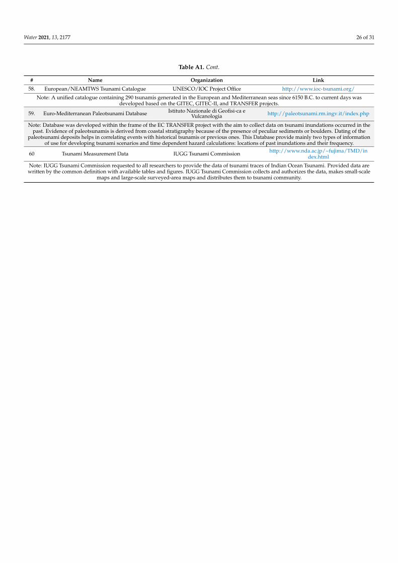
Water 2021, 13, 2177 26 of 31
Table A1. Cont.
# Name Organization Link
58. European/NEAMTWS Tsunami Catalogue UNESCO/IOC Project Office http://www.ioc-tsunami.org/
Note: A unified catalogue containing 290 tsunamis generated in the European and Mediterranean seas since 6150 B.C. to current days wasdeveloped based on the GITEC, GITEC-II, and TRANSFER projects.
59. Euro-Mediterranean Paleotsunami Database Istituto Nazionale di Geofisi-ca eVulcanologia http://paleotsunami.rm.ingv.it/index.php
Note: Database was developed within the frame of the EC TRANSFER project with the aim to collect data on tsunami inundations occurred in thepast. Evidence of paleotsunamis is derived from coastal stratigraphy because of the presence of peculiar sediments or boulders. Dating of the
paleotsunami deposits helps in correlating events with historical tsunamis or previous ones. This Database provide mainly two types of informationof use for developing tsunami scenarios and time dependent hazard calculations: locations of past inundations and their frequency.
60 Tsunami Measurement Data IUGG Tsunami Commission http://www.nda.ac.jp/~fujima/TMD/index.html
Note: IUGG Tsunami Commission requested to all researchers to provide the data of tsunami traces of Indian Ocean Tsunami. Provided data arewritten by the common definition with available tables and figures. IUGG Tsunami Commission collects and authorizes the data, makes small-scale
maps and large-scale surveyed-area maps and distributes them to tsunami community.
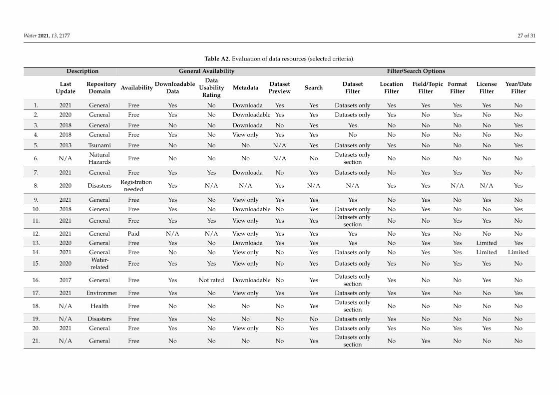
Water 2021, 13, 2177 27 of 31
Table A2. Evaluation of data resources (selected criteria).
Description General Availability Filter/Search Options
LastUpdate
RepositoryDomain Availability Downloadable
Data
DataUsability
RatingMetadata Dataset
Preview Search DatasetFilter
LocationFilter
Field/TopicFilter
FormatFilter
LicenseFilter
Year/DateFilter
1. 2021 General Free Yes No Downloadable Yes Yes Datasets only Yes Yes Yes Yes No
2. 2020 General Free Yes No Downloadable Yes Yes Datasets only Yes No Yes No No
3. 2018 General Free No No Downloadable No Yes Yes No No No No Yes
4. 2018 General Free Yes No View only Yes Yes No No No No No No
5. 2013 Tsunami Free No No No N/A Yes Datasets only Yes No No No Yes
6. N/A NaturalHazards Free No No No N/A No Datasets only
section No No No No No
7. 2021 General Free Yes Yes Downloadable No Yes Datasets only No Yes Yes Yes No
8. 2020 Disasters Registrationneeded Yes N/A N/A Yes N/A N/A Yes Yes N/A N/A Yes
9. 2021 General Free Yes No View only Yes Yes Yes No Yes No Yes No
10. 2018 General Free Yes No Downloadable No Yes Datasets only No Yes No No Yes
11. 2021 General Free Yes Yes View only Yes Yes Datasets onlysection No No Yes Yes No
12. 2021 General Paid N/A N/A View only Yes Yes Yes No Yes No No No
13. 2020 General Free Yes No Downloadable Yes Yes Yes No Yes Yes Limited Yes
14. 2021 General Free No No View only No Yes Datasets only No Yes Yes Limited Limited
15. 2020 Water-related Free Yes Yes View only No Yes Datasets only Yes No Yes Yes No
16. 2017 General Free Yes Not rated Downloadable No Yes Datasets onlysection Yes No No Yes No
17. 2021 Environment Free Yes No View only Yes Yes Datasets only Yes Yes No No Yes
18. N/A Health Free No No No No Yes Datasets onlysection No No No No No
19. N/A Disasters Free Yes No No No No Datasets only Yes No No No No
20. 2021 General Free Yes No View only No Yes Datasets only Yes No Yes Yes No
21. N/A General Free No No No No Yes Datasets onlysection No Yes No No No
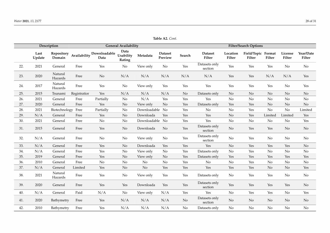
Water 2021, 13, 2177 28 of 31
Table A2. Cont.
Description General Availability Filter/Search Options
LastUpdate
RepositoryDomain Availability Downloadable
Data
DataUsability
RatingMetadata Dataset
Preview Search DatasetFilter
LocationFilter
Field/TopicFilter
FormatFilter
LicenseFilter
Year/DateFilter
22. 2021 General Free Yes No View only No Yes Datasets onlysection Yes Yes Yes No No
23. 2020 NaturalHazards Free No N/A N/A N/A N/A N/A Yes Yes N/A N/A Yes
24. 2017 NaturalHazards Free Yes No View only Yes Yes Yes Yes Yes Yes No Yes
25. 2015 Tsunami Registration Yes N/A N/A N/A No Datasets only No No No No No
26. 2021 General Free Partially No N/A Yes Yes Yes No No No No No27. 2020 General Free Yes No View only No Yes Datasets only Yes Yes No No No
28. 2021 Biotechnology Free Partially No Downloadable No Yes No No Yes No No Limited
29. N/A General Free Yes No Downloadable Yes Yes Yes No Yes Limited Limited Yes
30. 2021 General Free No No Downloadable No Yes Yes No No No No Yes
31. 2015 General Free Yes No Downloadable No Yes Datasets onlysection No Yes Yes No No
32. N/A General Free No No View only No Yes Datasets onlysection No Yes No No No
33. N/A General Free Yes No Downloadable Yes Yes Yes No Yes Yes Yes No
34. N/A General Free Yes No View only No Yes Datasets only No Yes No No No35. 2019 General Free Yes No View only No Yes Datasets only Yes Yes Yes Yes Yes
36. 2010 General Free No No No No Yes No No Yes No No No
37. N/A General Limited Yes No No Yes Yes Yes Yes Yes No No Yes
38. 2021 NaturalHazards Free Yes No View only Yes Yes Datasets only No Yes Yes No No
39. 2020 General Free Yes Yes Downloadable Yes Yes Datasets onlysection Yes Yes Yes Yes No
40. N/A General Paid N/A No View only N/A Yes Yes No Yes Yes No Yes
41. 2020 Bathymetry Free Yes N/A N/A N/A No Datasets onlysection No No No No No
42. 2010 Bathymetry Free Yes N/A N/A N/A No Datasets only No No No No No
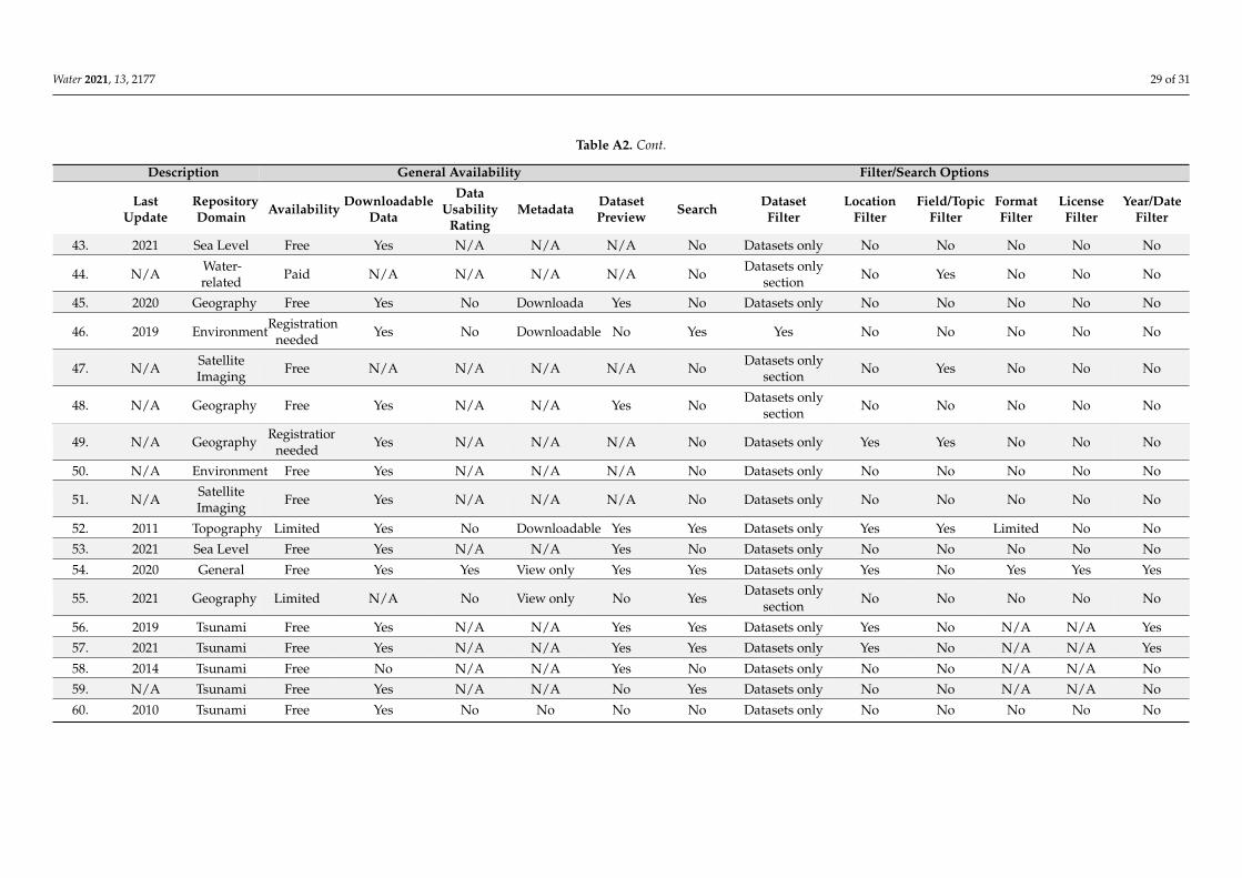
Water 2021, 13, 2177 29 of 31
Table A2. Cont.
Description General Availability Filter/Search Options
LastUpdate
RepositoryDomain Availability Downloadable
Data
DataUsability
RatingMetadata Dataset
Preview Search DatasetFilter
LocationFilter
Field/TopicFilter
FormatFilter
LicenseFilter
Year/DateFilter
43. 2021 Sea Level Free Yes N/A N/A N/A No Datasets only No No No No No
44. N/A Water-related Paid N/A N/A N/A N/A No Datasets only
section No Yes No No No
45. 2020 Geography Free Yes No Downloadable Yes No Datasets only No No No No No
46. 2019 EnvironmentRegistrationneeded Yes No Downloadable No Yes Yes No No No No No
47. N/A SatelliteImaging Free N/A N/A N/A N/A No Datasets only
section No Yes No No No
48. N/A Geography Free Yes N/A N/A Yes No Datasets onlysection No No No No No
49. N/A Geography Registrationneeded Yes N/A N/A N/A No Datasets only Yes Yes No No No
50. N/A Environment Free Yes N/A N/A N/A No Datasets only No No No No No
51. N/A SatelliteImaging Free Yes N/A N/A N/A No Datasets only No No No No No
52. 2011 Topography Limited Yes No Downloadable Yes Yes Datasets only Yes Yes Limited No No
53. 2021 Sea Level Free Yes N/A N/A Yes No Datasets only No No No No No
54. 2020 General Free Yes Yes View only Yes Yes Datasets only Yes No Yes Yes Yes
55. 2021 Geography Limited N/A No View only No Yes Datasets onlysection No No No No No
56. 2019 Tsunami Free Yes N/A N/A Yes Yes Datasets only Yes No N/A N/A Yes
57. 2021 Tsunami Free Yes N/A N/A Yes Yes Datasets only Yes No N/A N/A Yes
58. 2014 Tsunami Free No N/A N/A Yes No Datasets only No No N/A N/A No
59. N/A Tsunami Free Yes N/A N/A No Yes Datasets only No No N/A N/A No
60. 2010 Tsunami Free Yes No No No No Datasets only No No No No No

Water 2021, 13, 2177 30 of 31
References1. Papadopoulos, G.; Lorito, S.; Løvholt, F.; Rudloff, A.; Schindele, F. Geophysical risk: Tsunami. In Science for Disaster Risk
Management 2017: Knowing Better and Losing Less; Poljanšek, K., Marín Ferrer, M., De Groeve, T., Clark, I., Eds.; Publications Officeof the European Union: Luxembourg, 2017; pp. 162–176. ISBN 978-92-79-60678-6.
2. Harbitz, C.B.; Løvholt, F.; Bungum, H. Submarine Landslide Tsunamis: How Extreme and How Likely? Nat. Hazards 2014, 72,1341–1374. [CrossRef]
3. Behrens, J.; Løvholt, F.; Jalayer, F.; Lorito, S.; Salgado-Gálvez, M.A.; Sørensen, M.; Abadie, S.; Aguirre-Ayerbe, I.; Aniel-Quiroga,I.; Babeyko, A.; et al. Probabilistic Tsunami Hazard and Risk Analysis—A Review of Research Gaps. Front. Earth Sci. 2021, 9.[CrossRef]
4. Röbke, B.R.; Vött, A. The Tsunami Phenomenon. Prog. Oceanogr. 2017, 159, 296–322. [CrossRef]5. Shinozaki, T. Geochemical Approaches in Tsunami Research: Current Knowledge and Challenges. Geosci. Lett. 2021, 8, 6.
[CrossRef]6. Chagué-Goff, C.; Szczucinski, W.; Shinozaki, T. Applications of Geochemistry in Tsunami Research: A Review. Earth Sci. Rev.
2017, 165, 203–244. [CrossRef]7. Anpalagan, A.; Woungang, I. Tsunami Prediction and Impact Estimation Using Classifiers on Historical Data. In Proceedings of
the 2020 International Conference on Intelligent Data Science Technologies and Applications (IDSTA), Valencia, Spain, 19–22October 2020; pp. 119–126.
8. Papadopoulos, G.A.; Gràcia, E.; Urgeles, R.; Sallares, V.; De Martini, P.M.; Pantosti, D.; González, M.; Yalciner, A.C.; Mascle, J.;Sakellariou, D.; et al. Historical and Pre-Historical Tsunamis in the Mediterranean and Its Connected Seas: Geological Signatures,Generation Mechanisms and Coastal Impacts. Mar. Geol. 2014, 354, 81–109. [CrossRef]
9. Ai, C.; Ma, Y.; Yuan, C.; Xie, Z.; Dong, G. A Three-Dimensional Non-Hydrostatic Model for Tsunami Waves Generated bySubmarine Landslides. Appl. Math. Model. 2021, 96, 1–19. [CrossRef]
10. Titov, V.; Moore, C. Meteotsunami Model Forecast: Can Coastal Hazard Be Quantified in Real Time? Nat. Hazards 2021, 106,1545–1561. [CrossRef]
11. Macías, J.; Escalante, C.; Castro, M.J. Multilayer-HySEA Model Validation for Landslide-Generated Tsunamis-Part 2: GranularSlides. Nat. Hazards Earth Syst. Sci. 2021, 21, 791–805. [CrossRef]
12. Sugawara, D. Numerical Modeling of Tsunami: Advances and Future Challenges after the 2011 Tohoku Earthquake and Tsunami.Earth Sci. Rev. 2021, 214. [CrossRef]
13. Kurniawan, T.; Yuliatmoko, R.S.; Sunardi, B.; Prayogo, A.S.; Muzli, M.; Rohadi, S. Tsunami Simulation for Disaster MitigationBased on Earthquake Scenarios in the Molucca Subduction Zone (Case Study of the Molucca Sea Earthquake on 7 July 2019). AIPConf. Proc. 2021, 2320, 040026-1–04006-7.
14. Bosnic, I.; Costa, P.J.M.; Dourado, F.; La Selle, S.; Gelfenbaum, G. Onshore Flow Characteristics of the 1755 CE Lisbon Tsunami:Linking Forward and Inverse Numerical Modeling. Mar. Geol. 2021, 434, 106432. [CrossRef]
15. Kim, J.; Omira, R. The 6–7 July 2010 Meteotsunami along the Coast of Portugal: Insights from Data Analysis and NumericalModelling. Nat. Hazards 2021, 106, 1397–1419. [CrossRef]
16. Ravanelli, M.; Occhipinti, G.; Savastano, G.; Komjathy, A.; Shume, E.B.; Crespi, M. GNSS Total Variometric Approach: FirstDemonstration of a Tool for Real-Time Tsunami Genesis Estimation. Sci. Rep. 2021, 11, 3114. [CrossRef]
17. Mulia, I.E.; Satake, K. Synthetic Analysis of the Efficacy of the S-Net System in Tsunami Forecasting. Earth Planets Space 2021, 73.[CrossRef]
18. Pararas-Carayannis, G. Brief History of Early Pioneering Tsunami Research—Part A. Sci. Tsunami Hazards 2018, 37, 49–129.19. Trinaistich, W.C.; Mulligan, R.P.; Take, W.A. Runup of Landslide-Generated Waves Breaking on Steep Slopes Captured Using
Digital Imagery and Hydrochromic Paint. Coast. Eng. 2021, 166, 103888. [CrossRef]20. Keet, M. Methodologies for Ontology Development. Available online: https://eng.libretexts.org/Bookshelves/Computer_Scienc
e/Programming_and_Computation_Fundamentals/Book%3A_An_Introduction_to_Ontology_Engineering_(Keet)/06%3A_Methods_and_Methodologies/6.01%3A_Methodologies_for_Ontology_Development (accessed on 14 July 2021).
21. Contreras, M.C.B.; Reyes, L.F.H.; Ortiz, J.A.R. Methodology for Ontology Design and Construction. Contad. Adm. 2019, 64, 134.[CrossRef]
22. Gómez-Pérez, A.; Fernández, M.; Vicente, A. de Towards a Method to Conceptualize Domain Ontologies. In Proceedings Workshop:Ontological Engineering, Proceedings of the 12th European Conference on Artificial Intelligence (ECAI’96), Budapest, Rumanía, 13 August1996; Facultad de Informática (UPM): Budapest, Rumanía, 1996.
23. Noy, N.F.; McGuinness, D.L. Ontology Development 101: A Guide to Creating Your First Ontology 2001. Available online:https://protege.stanford.edu/publications/ontology_development/ontology101.pdf (accessed on 8 August 2021).
24. CRED EM-DAT: The International Disaster Database. Available online: https://www.emdat.be/classification (accessed on14 July 2021).
25. Library of Congress Recommended Formats Statement. Available online: https://www.loc.gov/preservation/resources/rfs/TOC.html (accessed on 26 April 2021).
26. Gusiakov, V.K.; Dunbar, P.K.; Arcos, N. Twenty-Five Years (1992–2016) of Global Tsunamis: Statistical and Analytical Overview.Pure Appl. Geophys. 2019, 176, 2795–2807. [CrossRef]
27. Whitlock, M.C. Data Archiving in Ecology and Evolution: Best Practices. Trends Ecol. Evol. 2011, 26, 61–65. [CrossRef] [PubMed]
Water 2021, 13, 2177 31 of 31
28. Tenopir, C.; Allard, S.; Douglass, K.; Aydinoglu, A.U.; Wu, L.; Read, E.; Manoff, M.; Frame, M. Data Sharing by Scientists:Practices and Perceptions. PLoS ONE 2011, 6, e21101. [CrossRef]
29. White, E.; Baldridge, E.; Brym, Z.; Locey, K.; McGlinn, D.; Supp, S. Nine Simple Ways to Make It Easier to (Re)Use Your Data.Ideas Ecol. Evol. 2013, 6. [CrossRef]
30. Wilkinson, M.D.; Dumontier, M.; Aalbersberg, I.J.; Appleton, G.; Axton, M.; Baak, A.; Blomberg, N.; Boiten, J.-W.; da Silva Santos,L.B.; Bourne, P.E.; et al. The FAIR Guiding Principles for Scientific Data Management and Stewardship. Sci. Data 2016, 3, 160018.[CrossRef]
31. Wernet, G.; Bauer, C.; Steubing, B.; Reinhard, J.; Moreno-Ruiz, E.; Weidema, B. The Ecoinvent Database Version 3 (Part I):Overview and Methodology. Int. J. Life Cycle Assess. 2016, 21, 1218–1230. [CrossRef]
32. Murnane, R.J.; Allegri, G.; Bushi, A.; Dabbeek, J.; de Moel, H.; Duncan, M.; Fraser, S.; Galasso, C.; Giovando, C.; Henshaw, P.; et al.Data Schemas for Multiple Hazards, Exposure and Vulnerability. Disaster Prev. Manag. Int. J. 2019, 28, 752–763. [CrossRef]
33. Auer, S.; Bizer, C.; Kobilarov, G.; Lehmann, J.; Cyganiak, R.; Ives, Z. DBpedia: A Nucleus for a Web of Open Data. In Proceedingsof the The Semantic Web, Busan, Korea, 11–15 November 2007; Aberer, K., Choi, K.-S., Noy, N., Allemang, D., Lee, K.-I., Nixon, L.,Golbeck, J., Mika, P., Maynard, D., Mizoguchi, R., et al., Eds.; Springer: Berlin/Heidelberg, Germany, 2007; pp. 722–735.
34. Alexander, K.; Cyganiak, R.; Hausenbals, M.; Zhao, J. Describing Linked Datasets with the VoID Vocabulary. Available online:https://www.w3.org/TR/void/ (accessed on 31 May 2021).
35. Javed, Y.; Norris, T.; Johnston, D. Ontology-Based Inference to Enhance Team Situation Awareness in Emergency Management. InProceedings of the 8th International ISCRAM Conference, Lisbon, Portugal, 8–11 May 2011; pp. 1–9.
36. Roman, D.; Sukhobok, D.; Nikolov, N.; Elvesæter, B.; Pultier, A. The InfraRisk Ontology: Enabling Semantic Interoperability forCritical Infrastructures at Risk from Natural Hazards. In Proceedings of the On the Move to Meaningful Internet Systems. OTM2017 Conferences, Rhodes, Greece, 23–28 October 2017; Panetto, H., Debruyne, C., Gaaloul, W., Papazoglou, M., Paschke, A.,Ardagna, C.A., Meersman, R., Eds.; Springer International Publishing: Cham, Switzerland, 2017; pp. 463–479.
37. Zhong, S.; Fang, Z.; Zhu, M.; Huang, Q. A Geo-Ontology-Based Approach to Decision-Making in Emergency Management ofMeteorological Disasters. Nat. Hazards 2017, 89, 531–554. [CrossRef]
38. Sermet, Y.; Demir, I. Towards an Information Centric Flood Ontology for Information Management and Communication. EarthSci. Inform. 2019, 12, 541–551. [CrossRef]
39. Bannour, W.; Maalel, A.; Ben Ghezala, H.H. Ontology-Based Representation of Crisis Response Situations. In Proceedings of theComputational Collective Intelligence, Hendaye, France, 4–6 September 2019; Nguyen, N.T., Chbeir, R., Exposito, E., Aniorté, P.,Trawinski, B., Eds.; Springer International Publishing: Cham, Switzerland, 2019; pp. 417–427.
40. Jain, S.; Mehla, S.; Agarwal, A.G. An Ontology Based Earthquake Recommendation System. In Proceedings of the AdvancedInformatics for Computing Research, Shimla, India, 15–16 June 2019; Luhach, A.K., Singh, D., Hsiung, P.-A., Hawari, K.B.G.,Lingras, P., Singh, P.K., Eds.; Springer: Singapore, 2019; pp. 331–340.
41. Liu, X.; Liu, Z.; Liu, Y.; Tian, J. Integration of a Geo-Ontology-Based Knowledge Model and Spatial Analysis into EmergencyResponse for Geologic Hazards. Nat. Hazards 2021. [CrossRef]
42. Gonzalez, A.; Peres-Neto, P.R. Act to Staunch Loss of Research Data. Nature 2015, 520, 436. [CrossRef]43. Perrier, L.; Blondal, E.; Ayala, A.P.; Dearborn, D.; Kenny, T.; Lightfoot, D.; Reka, R.; Thuna, M.; Trimble, L.; MacDonald, H.
Research Data Management in Academic Institutions: A Scoping Review. PLoS ONE 2017, 12, e0178261. [CrossRef]44. Normile, D. Scientific Consensus on Great Quake Came Too Late. Science 2011, 332, 22–23. [CrossRef] [PubMed]45. Arcos, N.P.; Dunbar, P.K.; Stroker, K.J.; Kong, L.S.L. The Impact of Post-Tsunami Surveys on the NCEI/WDS Global Historical
Tsunami Database. Pure Appl. Geophys. 2019, 176, 2809–2829. [CrossRef]46. Jain, N.; Virmani, D.; Abraham, A. Tsunami in the Last 15 Years: A Bibliometric Analysis with a Detailed Overview and Future
Directions. Nat. Hazards 2021, 106, 139–172. [CrossRef]47. Dilectin, H.D.; Mercy, R.B.V. Classification and Dynamic Class Detection of Real Time Data for Tsunami Warning System.
In Proceedings of the 2012 International Conference on Recent Advances in Computing and Software Systems, Chennai, India,27–27 April 2012; pp. 124–129.
48. Kusumah, Y.; Irawan, B.; Setianingsih, C. Sea Wave Detection System Using Web-Based Decision Tree Algorithm. In Proceedingsof the 2020 10th Electrical Power, Electronics, Communications, Controls and Informatics Seminar (EECCIS), Malang, Indonesia,26–28 August 2020; pp. 231–236.
49. Pughazhendhi, G.; Raja, A.; Ramalingam, P.; Elumalai, D.K. Earthosys—Tsunami Prediction and Warning System Using MachineLearning and IoT. In Proceedings of the International Conference on Computational Intelligence and Data Engineering, Chennai,India, 21–23 February 2019; Chaki, N., Devarakonda, N., Sarkar, A., Debnath, N.C., Eds.; Springer: Singapore, 2019; pp. 103–113.
50. Liliana, D.Y.; Priharsari, D. Tsunami Early Warning Detection Using Bayesian Classifier. In Proceedings of the 2019 2ndInternational Conference of Computer and Informatics Engineering (IC2IE), Banyuwangi, Indonesia, 10–11 September 2019;pp. 44–48.
51. Yoshikawa, M.; Igarashi, Y.; Murata, S.; Baba, T.; Hori, T.; Okada, M. A Nonlinear Parametric Model Based on a Power LawRelationship for Predicting the Coastal Tsunami Height. Mar. Geophys. Res. 2019, 40, 467–477. [CrossRef]