TRANSIENT SEEPAGE AND SLOPE STABILITY ANALYSIS FOR RAINFALL-INDUCED LANDSLIDE: A CASE STUDY
13
Malaysian Journal of Civil Engineering 18(1) : 1-13 (2006) 1 TRANSIENT SEEPAGE AND SLOPE STABILITY ANALYSIS FOR RAINFALL-INDUCED LANDSLIDE: A CASE STUDY Nurly Gofar 1,* , Lee Min Lee 1 , Marwan Asof 2 1 Faculty of Civil Engineering, Universiti Teknologi Malaysia, 81310 Skudai, Johor Bahru, Malaysia 2 Faculty of Engineering, Sriwijaya University, Palembang , Indonesia *Corresponding Author: [email protected] Abstract: A transient seepage and slope stability analyses were carried out for a case of rainfall- induced landslide in Air Laya Indonesia. The landslide occurred in December 2002 on a dumping area of an open coal mining site. This study examined the mechanism causing the slope failure based on transient analysis between April 21, 2001 and December 1, 2002. The slope profile was simulated using a seepage analyzing tool, VADOSE/W and the soil properties were determined based on field and laboratory data. The saturation profile resulted from seepage analysis was exported to SLOPE/W for the slope stability evaluation. The results show that the main factor contributing to the landslide is the reduction of shear strength due to increase in soil moisture content impelled by the formation of tension cracks on the ground surface of the slope. Keywords: Transient analysis; Rainfall; Seepage; Slope stability; Moisture content. Abstrak: Analisis transien resipan dan kestabilan cerun telah dijalankan untuk satu kes gelinciran tanah akibat curahan hujan di kawasan pembuangan sisa perlombongan terbuka batubara, Air Laya Indonesia pada Disember 2002. Objektif kajian ini adalah untuk mendapatkan gambaran yang lebih dalam pada mekanisme yang menyebabkan kegagalan Berdasarkan analisis transien yang dijalankan untuk jangka masa 589 hari, dari 21hb April 2001 hingga 1hb Disember 2002. Profil cerun dimodelkan dengan bantuan perisian analisis resipan, VADOSE/W dan ciri-ciri tanah ditentukan berdasarkan data dari tapak dan makmal. Profil ketepuan tanah hasil daripada keputusan analisis resipan diekspot ke SLOPE/W untuk penilaian kestabilan cerun. Keputusan menunjukkan faktor utama yang mengakibatkan kejadian gelinciran tanah adalah pengurangan kekuatan ricih tanah disebabkan peningkatan kandungan air tanah yang disebabkan oleh kewujudan rekahan tegangan pada tanah cerun. KataKunci: Analisis transien; Curahan hujan; Resipan; Kestabilan cerun; Kandungan air.
-
Upload
independent -
Category
Documents
-
view
1 -
download
0
Transcript of TRANSIENT SEEPAGE AND SLOPE STABILITY ANALYSIS FOR RAINFALL-INDUCED LANDSLIDE: A CASE STUDY
Malaysian Journal of Civil Engineering 18(1) : 1-13 (2006) 1
TRANSIENT SEEPAGE AND SLOPE STABILITY ANALYSIS FOR
RAINFALL-INDUCED LANDSLIDE: A CASE STUDY
Nurly Gofar 1,*, Lee Min Lee1, Marwan Asof2 1Faculty of Civil Engineering, Universiti Teknologi Malaysia,
81310 Skudai, Johor Bahru, Malaysia 2Faculty of Engineering, Sriwijaya University,
Palembang , Indonesia
*Corresponding Author: [email protected] Abstract: A transient seepage and slope stability analyses were carried out for a case of rainfall-induced landslide in Air Laya Indonesia. The landslide occurred in December 2002 on a dumping area of an open coal mining site. This study examined the mechanism causing the slope failure based on transient analysis between April 21, 2001 and December 1, 2002. The slope profile was simulated using a seepage analyzing tool, VADOSE/W and the soil properties were determined based on field and laboratory data. The saturation profile resulted from seepage analysis was exported to SLOPE/W for the slope stability evaluation. The results show that the main factor contributing to the landslide is the reduction of shear strength due to increase in soil moisture content impelled by the formation of tension cracks on the ground surface of the slope. Keywords: Transient analysis; Rainfall; Seepage; Slope stability; Moisture content. Abstrak: Analisis transien resipan dan kestabilan cerun telah dijalankan untuk satu kes gelinciran tanah akibat curahan hujan di kawasan pembuangan sisa perlombongan terbuka batubara, Air Laya Indonesia pada Disember 2002. Objektif kajian ini adalah untuk mendapatkan gambaran yang lebih dalam pada mekanisme yang menyebabkan kegagalan Berdasarkan analisis transien yang dijalankan untuk jangka masa 589 hari, dari 21hb April 2001 hingga 1hb Disember 2002. Profil cerun dimodelkan dengan bantuan perisian analisis resipan, VADOSE/W dan ciri-ciri tanah ditentukan berdasarkan data dari tapak dan makmal. Profil ketepuan tanah hasil daripada keputusan analisis resipan diekspot ke SLOPE/W untuk penilaian kestabilan cerun. Keputusan menunjukkan faktor utama yang mengakibatkan kejadian gelinciran tanah adalah pengurangan kekuatan ricih tanah disebabkan peningkatan kandungan air tanah yang disebabkan oleh kewujudan rekahan tegangan pada tanah cerun. KataKunci: Analisis transien; Curahan hujan; Resipan; Kestabilan cerun; Kandungan air.

Malaysian Journal of Civil Engineering 18(1) : 1-13 (2006) 2
1.0 Introduction
Landslides induced by rainfall are most common in tropical region where the climatic condition is governed by the wet and dry periods. Shrinkage or creep of the soil during dry periods after prolonged wet-and-dry cycles lead to the development of tension cracks on the surface of a sloping land. During wet seasons, large amount of water infiltrated through the tension cracks and further seeped into the soil layers. The presence of tension crack also initiates a seepage pattern different from those predicted based on the original slope geometry and soil properties. If the tension crack was not developed, the rainfall infiltration will have an effect on reducing the negative pore water pressure in unsaturated zone and increasing the positive pore water pressure that induced the seepage force in the saturated zone; thus decreasing the shear strength of the soil (Rahardjo et al., 2000). Infiltration of rainwater into soil will increase the moisture content of the soils, alter the structure of soils and thus reduce or eliminate frictional and cohesive strength (Reddi, 2003). A correlation between soil moisture content and cohesive shear strength has been developed by Zhang et al. (2005). It is obvious from the preceding paragraph that (1) the rainfall induced landslide cannot be treated as an occurrence but a process, and (2) rainfall infiltration plays an important role in the process. Therefore, steady state analysis which is conventionally used to analyze slope failure is not suitable for the case of rainfall induced landslide. The steady state analysis is normally used to investigate the cause of the failure by back-calculation of the stability based on the strength properties of soil sampled along the known failure plane or by setting up the factor of safety at time of failure to unity. For evaluation purposes, the steady state analysis is performed by assuming that the slope is either dry or fully saturated as the worst case a slope may experience. However, this type of analysis does not give an insight into the process of instability and therefore cannot be used as a basis for stability evaluation before failure actually take place, and hence preventive measures are impossible to be implemented during that critical period. Transient seepage analysis is very useful in the prediction of rainfall induced landslide. From the definition, transient or unsteady state analysis is defined as a time-dependent analysis due to spatial and temporal changes in the environmental conditions (Lu and Likos, 2004). Related to the rainfall, many landslides can be attributed to: (1) seepage force and seepage erosion, (2) the loss of shear strength of the soil, and (3) the formation of tension cracks. Which mechanisms will be dominant depend primarily on the relative shape of unsaturated characteristics curve for the soil (Collins and Znidarcic, 2004). The transient seepage and slope stability analysis is capable of demonstrating the process and the mechanism of instability by incorporating the development of seepage forces and movement of saturation profile in the soil due to alternating wet and dry conditions. Thus, it can be used as a tool for defining the relative importance of factors contributing to landslide. This study aimed at getting better insights on the mechanism of rainfall induced landslides by carrying out a transient seepage and slope stability analysis using a combination of VADOSE/W and SLOPE/W programs (Geoslope, 2002).

Malaysian Journal of Civil Engineering 18(1) : 1-13 (2006) 3
2.0 Methodology The study used field observation and secondary data from well documented case of a landslide occurred in November 2002 on dumping area of an open coal mining site in Bukit Asam, South Sumatra, Indonesia (Marwan Asof et al., 2005). The case was selected because most of the data needed for the analysis such as climatic condition, geometry of the slope, rainfall and soil properties including suctions were available over the period of analysis (Nurly Gofar et al., 2003). Slope stability analyses were conducted for various conditions such as the existence of tension cracks and variation of shear strength parameters in order to investigate the dominant factors causing the landslide. Saturated/unsaturated seepage finite element code VADOSE/W (Geoslope, 2002) was used to investigate the infiltration pattern, seepage pattern, pore-water-pressure distribution, and volumetric water content in the soil profile.
Three seepage models were simulated, namely Case 1, Case 2, and Case 3. Case 1 modeled the initial condition where tension crack does not exist; Case 2 modeled the condition observed in the mid October 2002 where some tension cracks had developed near the crest. In this case, a 10 m deep tension crack was assigned at the actual location near the crest. Case 3 modeled the condition at failure where the tension cracks at the crest were believed to have extended to Layer 2. The tension cracks were emulated by assigning a soil material with high hydraulic conductivity of 8.64 m/day. This assumption is supported by the fact that the existence of tension cracks will lead to direct infiltration where higher pore-water-pressure can be expected compared to normal infiltration. The propagation of the cracks with time was not simulated due to limitation of the modeling tool.
The seepage pattern and seepage forces computed from VADOSE/W were subsequently exported to SLOPE/W (Geoslope, 2002) to perform slope stability analysis.
3.0 The Case Study The landslide involved a translation movement of soil-fill of 1.5 km long and several rotational slope failures along the movement. The average angle of the slope surface is about 5° (1V : 15.5 H). Rapid movement of soil has lasted for about 4 days i.e. between the November 27 and 30, 2002, then gradually diminished within the following 10 days. The highest rate of movement of 724 mm/hour took place on the second day (Marwan Asof et al., 2005).
Figure 1 shows the geometry of the critical section of the slope concerned. Site investigation indicated that the general stratification of the dumping area consisted of three layers, namely Layer 1, 2, and 3. Layer 1 is the dumped material consists of overburden soil from the mining activity. Due to its mineral content (montmorilonite and kaolinite), soil in Layer 1 exhibits a high potential for swelling and shrinkage under wet-dry conditions. The soil absorbs water quickly, but the low permeability inhibits the water to flow within the soil. Layer 2 is the interface between the natural ground and fill material. Due to inadequate clearance before dumping, Layer 2 existed in loose

Malaysian Journal of Civil Engineering 18(1) : 1-13 (2006) 4
condition and it contains a lot of organic materials. Layer 3 is the natural ground consists mainly of unconsolidated clay-stone. The shear strength properties of the soil before and after failure, based on laboratory test, indicated that layer 2 is relatively weaker than layers 1 and 3 (Nurly Gofar, 2003).
Figure 1: Critical cross section plan and soils stratification
According to the Unified Soil Classification System, Layer 1, Layer 2 and Layer 3 were classified as Inorganic clays of high plasticity (CH), Organic clays or Organic silts (OH) and Inorganic silts (MH), respectively. These classifications were used as guidelines to predict some unknown soils parameters in this study. The soil properties for each layer of soils are presented in Table 1.
Like any other areas in tropical regions, Air Laya experiences distinctive climatic changes through out a year. Normally wet weather condition dominated by North-East monsoon occurs from November to April. The mean annual rainfall for the area is 3030mm, of which approximately 68.5% fall during wet season. The average ambient temperature is 27oC. The evaporation is limited by high relative humidity, which is about 75%.
The year 2002 experienced a longer and much dryer period than the 20 years rainfall average (Figure 2). On the other hand, November and December 2002 received excessive rainfall. This distinctive climate changes is expected to be one of the factors that lead to the landslide.
Measurements of suction were made by jet-fill tensiometer at depth of 1.5 m. The initial suction on April 21, 2001 at that particular depth was 6 kN/m2, which was approximately equal to 1 m pressure head. Based on this data, the water table (hp = 0) was predicted at about 3 m beneath the slope surface compare with the concurrent measurement made during rainy seasons of 4 m.

Malaysian Journal of Civil Engineering 18(1) : 1-13 (2006) 5
Dry Season
0
50
100
150
200
250
300
350
400
450
Jan Feb Mar Apr May Jun Jul Aug Sep Oct Nov Dec
Month
Rai
nfa
ll (
mm
)
20 Years Average (1982-2002)
Year 2002
Dry Season
Table 1: Soil properties for each soil layers
Layer 1 Layer 2 Layer 3
Composition Sand (%) 22.74 4.35 36.05 Silt (%) 32.71 46.15 28.50 Clay (%) 44.17 49.50 35.45 γb (kN/m3) 18.94 17.30 18.33 γd (kN/m3) 15.00 13.30 14.10 LL (%) 66.41 58.50 60.60 PI 36.44 23.00 24.83 Gs 2.66 2.64 2.66 e 0.73 0.90 0.80 ω (%) 26.86 33.80 30.40
UU Test cu (kPa) 36.27 12.00 453.00 CU Test c (kPa) 23.67 42.73 73.7 φ(o) 16.6 5.8 26.3 DS Test c' (kPa) 14.69 9.07 44.52
φ' (o) 17.6 21.0 37.6
Note: γb=bulk density; γd=dry density; LL=liquid limit; PI=plastic index; Gs=specific gravity; e=void ratio; w=water content; cu=undrained cohesion; φ=friction angle; c’=effective cohesion
Figure 2: Monthly rainfall in year 2002 and 20 years average
No tension crack was discovered at the time of tensiometer installation. The tension crack was first observed at the crest of the slope in mid October 2002. At that time, the tension cracks were about 5 to 10 cm width and were believed to have reached beyond 4 m deep due to the presence of water coming out from the ground surface. The tension cracks allow water to infiltrate deeper into the soil fill causing increases in moisture content and subsequently softened the fill material. This lead to the propagation of the tension crack to as deep as 40 m or reaching Layer 2 prior to the landslide occurrence.

Malaysian Journal of Civil Engineering 18(1) : 1-13 (2006) 6
3.0 Numerical Modeling The initial condition of the numerical model of the case study was simulated based on the critical section shown in Figure 1. The model has been simplified in terms of surface and bedrock inclination beyond point A because at this point the mass movement has already started. The initial condition was established prior to transient analysis. The suction values near the surface were extrapolated based on the data obtained by tensiometer at depth of 1.5 m, which gives a value of 20 kN/m2.
Figure 3: Numerical model simulated using VADOSE/W
The transient analyses were performed with daily time increment over 589 days, i.e. from April 21, 2001 to December 1, 2002. The time range was selected because the tensiometer was installed on April 21, 2001 and the landslide movement ceased on December 1, 2002. As many as 6887 element meshes were designed to represent the 97 m deep and 1185 m long slope profile (Figure 3). Climatic data was applied as boundary condition at the surface. Head boundary equal to the water level of the pond measured from datum is applied at the toe of the slope where the mud collecting pond is located. The bottom and side boundaries were assigned as a drained boundary.
The required soil parameters were assigned based on interpretation of the available field and laboratory data. The Soil Water Content Curve (SWCC) and hydraulic conductivity function were predicted based on the soil types and saturated hydraulic conductivity, ksat of each soil layer. In this manner, it was assumed that a typical soil type with the specified saturated hydraulic conductivity, ksat will have the same water retaining and water flowing properties with the actual soil condition. The value of ksat equal to 1.296x10⁻³ m/day was assigned for Layer 1. The thermal conductivity and volumetric heat capacity functions were estimated based on the method suggested in the VADOSE/W manual (Geoslope, 2002). The vegetation properties were neglected in the computer simulation because the surface is uncompacted fill which is free of turf and tree.

Malaysian Journal of Civil Engineering 18(1) : 1-13 (2006) 7
The shear strengths from consolidated undrained (CU) test were used for soils in Layer 1 and Layer 3 assuming that suitable compaction has been applied to the soil during dumping. The effective cohesions of 27.63 kN/m2 and 73.7 kN/m2 and effective internal frictions of 16.6°and 26.3°were assigned for Layer 1 and 3, respectively. Unsaturated friction angle, φb for soils in Layer 1 was assumed to be 15o, which was a conservative assumption for typical clayey soils (Rahardjo et al., 2000). The presence of tension crack at the crest allows a large amount of water to seep rapidly into Layer 2, which led to the reduction of shear strength. The reduction of shear strength was modeled based on the shear strength data obtained before and after failure and the correlation between moisture content and shear strength developed by Zhang et al. (2005). Initially, the undrained shear strength was assigned as 42.73 kN/m2, and subsequently reduced to 25 kN/m2 at the time of failure.
The seepage pattern and seepage forces computed from VADOSE/W were exported to SLOPE/W to perform slope stability analysis. In this analysis, the slip surface is fully specified based on observation. Morgenstern-Price method which satisfies both force and moment equilibrium was adopted to evaluate the stability of the slope. The Fredlund-Wilson-Fan inter-slice force function was used to estimate the direction of inter-slice force.
4.0 Results and Discussion Figure 4 shows the difference in seepage pattern and water table condition resulted from the transient analysis for the initial condition (April 21, 2001) and during the actual failure (November 27, 2002). For Case 1 where no tension crack was assigned, the water level does not change significantly (Figure 4a). For case 2, only little amount of water infiltrated into the slope through the 10 m deep tension crack at crest (Figure 4b). However, for case 3 where 40 m deep tension crack was simulated, large amount of water have infiltrated into the soils and significantly increased the water table (Figure 4c).
The slope stability analysis was carried out with one month interval based on the seepage pattern and pore-water profile obtained from transient seepage analysis for the case where tension cracks have propagated to Layer 2. The result of stability analysis using SLOPE/W for the most critical condition is shown in Figure 5 with the seepage pattern near the tension crack shown in the zoom-in diagram.
Figures 6a and 6b show the seepage pattern and pore-water pressure profile of the slope at two calculation steps before the actual failure on October 14 and November 13, 2002, respectively. The results showed that large amount of water infiltrated into the slope on October 14, 2002, but only little infiltration was observed on November 13 despite the large amount of rainfall. This is because the infiltration potential on October 14, 2002 is higher than that of November 13, 2002. The site experienced few months of dry seasons prior to October 14, 2002. Thus, large amount of water was allowed to infiltrate into the dry slope. As the rainfall amount increase dramatically in November 2002, the slope must be in saturated condition and only limited rainwater can infiltrate.

Malaysian Journal of Civil Engineering 18(1) : 1-13 (2006) 8
(a) Case 1: without the presence of tension crack
(b) Case 2: with the presence of 10 m deep tension crack
(c) Case 3: with the presence of 40 m deep tension crack
Figure 4: Water table and pore water profile at time steps 585
Scale: (H) 1: 80000, (V) 1: 12500
Scale: (H) 1: 80000, (V) 1: 12500
Scale: (H) 1: 80000, (V) 1: 12500

Malaysian Journal of Civil Engineering 18(1) : 1-13 (2006) 9
Scale: (H) 1: 9000, (V) 1: 1800
Figure 5: Slope stability analysis computed from SLOPE/W
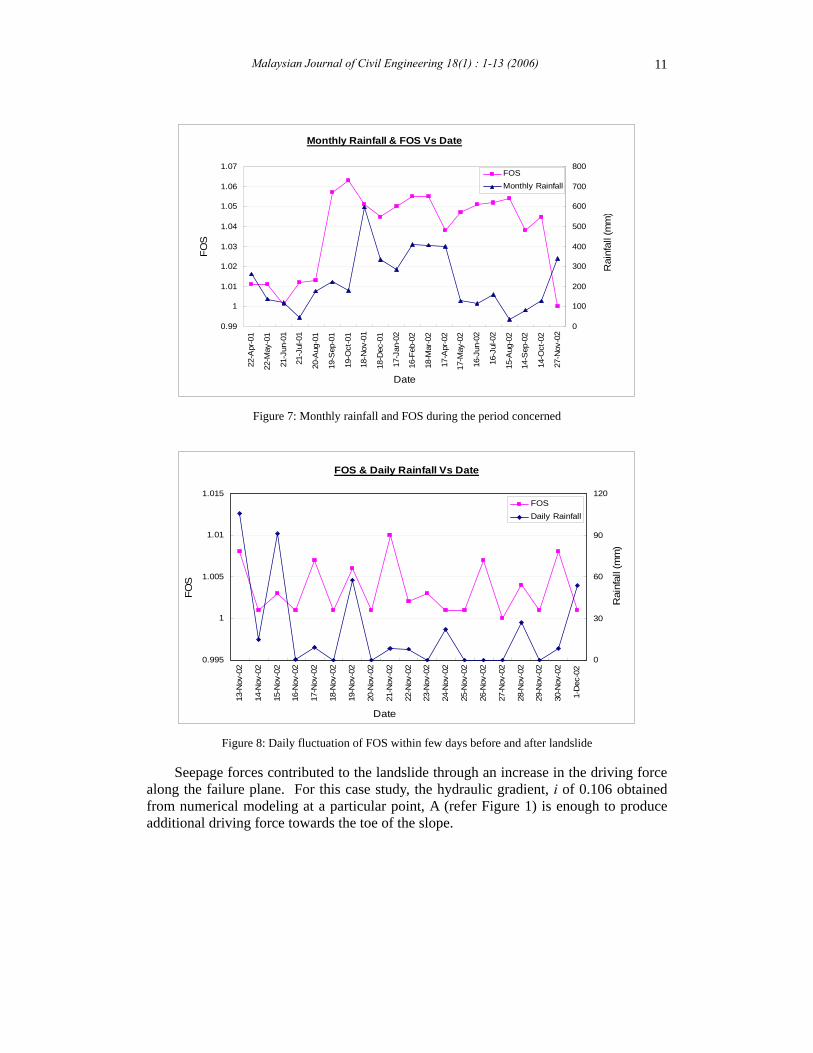
Figure 7 shows the factor of safety and the corresponding monthly rainfall. The
minimum factors of safety were obtained on day 61 and day 585. Failure did not occur on day 61 (June 21, 2001) but occurred on day 585 (November 27, 2002). This information suggests that the main cause of the failure was not the rainfall itself but other factor that was not present on June 21, 2001, which is a dramatic change in the climate and rainfall pattern. Detailed analysis was conducted on a daily basis over 19 days which included few days before and after the landslide occurrence (November 13, 2002 to December 1, 2002). The changes in the factor of safety and rainfall intensity during these periods are shown in Figure 8.
The highest daily rainfall of 106 mm recorded on November 13, 2002 after a prolonged dry season was expected to be the main factor contributing to the landslide on November 27, 2002. However, analysis showed that within 14 days, the water managed to infiltrate only about 0.04 m from the surface, which is unlikely to trigger the failure. Therefore, it is expected that direct infiltration from tension cracks had increased the soil moisture content, and hence slope failure. As water infiltrated directly from the top of tension crack into Layer 2, it flowed horizontally within the soils layer and distributed the excess moisture to a larger portion of the slope causing reduction in the soil shear strength. In many instances, these processes can be explained by the presence of so-called preferential flow, which is the movement of fluids through preferred pathways in soils (Culligan et al., 2002).
Scale: (H) 1: 80000, (V) 1: 12500

Malaysian Journal of Civil Engineering 18(1) : 1-13 (2006) 10
Scale: (H) 1: 80000, (V) 1: 12500
(a) Seepage pattern and pore-water pressure head profile on October 14, 2002.
(b) Seepage pattern and pore-water pressure head profile on November 13, 2002
Figure 6: Seepage pattern and pore-water pressure head profile
Scale: (H) 1: 80000, (V) 1: 12500
Malaysian Journal of Civil Engineering 18(1) : 1-13 (2006) 11
Monthly Rainfall & FOS Vs Date
0.99
1
1.01
1.02
1.03
1.04
1.05
1.06
1.07
22-A
pr-0
1
22-M
ay-0
1
21-J
un-0
1
21-J
ul-0
1
20-A
ug-0
1
19-S
ep-0
1
19-O
ct-0
1
18-N
ov-0
1
18-D
ec-0
1
17-J
an-0
2
16-F
eb-0
2
18-M
ar-0
2
17-A
pr-0
2
17-M
ay-0
2
16-J
un-0
2
16-J
ul-0
2
15-A
ug-0
2
14-S
ep-0
2
14-O
ct-0
2
27-N
ov-0
2
Date
FO
S
0
100
200
300
400
500
600
700
800
Rai
nfal
l (m
m)
FOS
Monthly Rainfall
Figure 7: Monthly rainfall and FOS during the period concerned
FOS & Daily Rainfall Vs Date
0.995
1
1.005
1.01
1.015
13-N
ov-0
2
14-N
ov-0
2
15-N
ov-0
2
16-N
ov-0
2
17-N
ov-0
2
18-N
ov-0
2
19-N
ov-0
2
20-N
ov-0
2
21-N
ov-0
2
22-N
ov-0
2
23-N
ov-0
2
24-N
ov-0
2
25-N
ov-0
2
26-N
ov-0
2
27-N
ov-0
2
28-N
ov-0
2
29-N
ov-0
2
30-N
ov-0
2
1-D
ec-0
2
Date
FO
S
0
30
60
90
120
Rai
nfal
l (m
m)
FOS
Daily Rainfall
Figure 8: Daily fluctuation of FOS within few days before and after landslide
Seepage forces contributed to the landslide through an increase in the driving force along the failure plane. For this case study, the hydraulic gradient, i of 0.106 obtained from numerical modeling at a particular point, A (refer Figure 1) is enough to produce additional driving force towards the toe of the slope.

Malaysian Journal of Civil Engineering 18(1) : 1-13 (2006) 12
Another finding from this study is that the matric suction in unsaturated soils did not play significant role on the slope stability as the factor of safety values computed by both matric suction applied and fully saturated analyses are quite similar. This proofed that high rainfall intensity during wet season has reduced or eliminated the matric suction in unsaturated regime. 5.0 Conclusions The transient analysis on Air Laya landslide indicates that the main cause of the landslide was the formation of tension cracks after prolonged dry season on surface soil which has high shrinkage potential. The presence of deep tension crack at the crest has given ways for the water to infiltrate deep into Layer 2, causing seepage force and horizontal flow of water through the layer, increased the moisture content, and hence reduced the soil cohesion from 42 kN/m2 to 12 kN/m2. These conditions result in the formation of weak plane which lead to failure. The study also revealed that without the presence of tension crack, only limited infiltration could take place, generally not exceeding 2.5 m from the slope surface Both suction reduction and development of positive pore water pressure have contributed to the landslide at Air Laya, but their influence on the factor of safety and slope stability was not significant.
Numerical simulation has indicated that the worst case of pore-water-pressure profile occurred exactly on the date of the landslide. This proved that infiltration has increased the pore-water-pressure within the slope and reduced the suction in unsaturated regime. In dealing with risk of land slide, level of awareness and preventive measures must be increased when there is obvious climatic change from dry to wet. Acknowledgment The authors would like to express their gratitude to PT. Tambang Batubara Bukit Asam Persero, Tanjung Enim, Indonesia for the permission to use the data for analysis. References Collins B.D. and Znidarcic D. (2004) Stability Analyses of Rainfall Induced Landslides. Journal
of Geotechnical and Geoenvironmental Engineering, ASCE: April, 362-372 Culligan P.J., Banno K., Barry D.A., Steenhuis T.S. and Parlange J.-Y. (2002) Preferencial Flow
of Nonaqueous Phase Liquid in Dry Sand. Journal of Geotechnical and Geoenvironmental
Engineering, ASCE: April, 327-337 GEO-SLOPE International Ltd. (2002) SLOPE/W User’s guide for Slope Stability Analysis.
Version 5., Calgary, Alta., Canada. GEO-SLOPE International Ltd. (2002) VADOSE/W User’s guide for finite element seepage
analysis. Version 5., Calgary, Alta., Canada. Lu Ning and Likos J. (2004) Unsaturated Soil Mechanics, John Wiley & Sons, Inc, Hoboken,
New Jersey

Malaysian Journal of Civil Engineering 18(1) : 1-13 (2006) 13
Marwan Asof, Nurly Gofar and Ahmad Rivai (2005) Analysis of Landslide at Outside Dumping Area Air Laya Coal Mining Site, Indonesia, Proc. 3rd Intl. Conf. on Geotechnical
Engineering: 170-181. Nurly Gofar, Marwan Asof, Budhi Setiawan, Ratna Dewi, and Syarifuddin (2003) Analisis
Longsor pada Lereng Timbunan Outside Dump, Tambang Air Laya Bukit Asam. Laporan
Penelitian L.P. UNSRI-PTBA Persero (Unpublished). Rahardjo H., Leong E. C., Deutsher M.S., Gasmo J.M. and Tang S.K. (2000) Rainfall-Induced
Slope Failures, Geotechnical Engineering Monograph 3, NTU-PWD Geotechnical Research Centre, NTU, Singapore.
Reddi L.N. (2003) Seepage in Soils, John Wiley & Sons, Inc, New Jersey, Zhang Z., Tao M. and Morvant, M. (2005) Cohesive Slope Surface Failure and Evaluation.
Journal of Geotechnical and Geoenvironmental Engineering, ASCE: July, 898-906.