Topological simultaneous localization and mapping: a survey
19
Robotica: page 1 of 19. © Cambridge University Press 2013 doi:10.1017/S0263574713001070 Topological simultaneous localization and 1 mapping: a survey 2 Jaime Boal ∗ , ´ Alvaro S´ anchez-Miralles and 3 ´ Alvaro Arranz 4 Institute for Research in Technology (IIT),ICAI School of Engineering, Comillas Pontifical 5 University, Madrid, Spain 6 (Accepted October 29, 2013) 7 SUMMARY 8 One of the main challenges in robotics is navigating autonomously through large, unknown, and 9 unstructured environments. Simultaneous localization and mapping (SLAM) is currently regarded 10 as a viable solution for this problem. As the traditional metric approach to SLAM is experiencing 11 computational difficulties when exploring large areas, increasing attention is being paid to topological 12 SLAM, which is bound to provide sufficiently accurate location estimates, while being significantly 13 less computationally demanding. This paper intends to provide an introductory overview of the most 14 prominent techniques that have been applied to topological SLAM in terms of feature detection, map 15 matching, and map fusion. 16 17 KEYWORDS: Mobile robots; SLAM; Topological modeling of robots; Feature detection; Robot 18 localization 19 1. Introduction 20 Mobile robotics’ ultimate aim is to develop fully autonomous entities capable of performing rather 21 complicated tasks, without the need for human intervention, during extended periods of time. Over 22 the past three decades, this objective has constantly faced harsh difficulties, which have hindered 23 progress. The most recurrent issues in the literature, which are yet to be completely resolved, are 24 stated below. 25 A mobile robot must be able to navigate through the environment in order to achieve its goals. 26 According to Leonard and Durrant-Whyte, 63 this general problem can be summarized in three 27 questions: “Where am I?,” “Where am I going?,” and “How should I get there?” The first question 28 addresses the localization problem, which intends to estimate the robot’s pose (i.e., location and 29 orientation) using data gathered by distinct sensors and knowledge of previous locations. However, 30 the presence of noisy sensor measurements makes this problem harder than it may seem at first 31 sight. The precision with which this problem is solved decisively affects the answer to the other two 32 questions, as it is necessary to localize oneself in the environment to safely interact with it, decide 33 what the following step should be, and how to accomplish it. 34 During the localization process, a robot must resort to some kind of reference system; in other 35 words, it requires a map. The extensive research survey carried out by Thrun 110 collects the main 36 open issues concerning robotic mapping, which are succinctly presented henceforth. Currently, there 37 are robust methods for mapping structured, static, and bounded environments, whereas mapping 38 unstructured, dynamic, or large-scale unknown environments remains largely an unsolved problem. 39 According to Thrun, 110 the robotic mapping problem is “that of acquiring a spatial model of a 40 robot’s environment.” To this end, robots must be equipped with sensors that enable them to perceive 41 the outside world. Once again, sensor errors and range limitations pose a great difficulty. 42 The first challenge in robotic mapping develops from the measurement noise. Usually, this issue 43 can be overcome if the noise is statistically independent, as it can be canceled out performing enough 44 measurements. Unfortunately, this does not always occur in robotic mapping because, whenever 45 * Corresponding author. E-mail: [email protected]
-
Upload
upcomillas -
Category
Documents
-
view
1 -
download
0
Transcript of Topological simultaneous localization and mapping: a survey

Robotica: page 1 of 19. © Cambridge University Press 2013doi:10.1017/S0263574713001070
Topological simultaneous localization and1
mapping: a survey2
Jaime Boal∗, Alvaro Sanchez-Miralles and3
Alvaro Arranz4
Institute for Research in Technology (IIT), ICAI School of Engineering, Comillas Pontifical5University, Madrid, Spain6
(Accepted October 29, 2013)7
SUMMARY8One of the main challenges in robotics is navigating autonomously through large, unknown, and9unstructured environments. Simultaneous localization and mapping (SLAM) is currently regarded10as a viable solution for this problem. As the traditional metric approach to SLAM is experiencing11computational difficulties when exploring large areas, increasing attention is being paid to topological12SLAM, which is bound to provide sufficiently accurate location estimates, while being significantly13less computationally demanding. This paper intends to provide an introductory overview of the most14prominent techniques that have been applied to topological SLAM in terms of feature detection, map15matching, and map fusion.16
17KEYWORDS: Mobile robots; SLAM; Topological modeling of robots; Feature detection; Robot18localization19
1. Introduction20Mobile robotics’ ultimate aim is to develop fully autonomous entities capable of performing rather21complicated tasks, without the need for human intervention, during extended periods of time. Over22the past three decades, this objective has constantly faced harsh difficulties, which have hindered23progress. The most recurrent issues in the literature, which are yet to be completely resolved, are24stated below.25
A mobile robot must be able to navigate through the environment in order to achieve its goals.26According to Leonard and Durrant-Whyte,63 this general problem can be summarized in three27questions: “Where am I?,” “Where am I going?,” and “How should I get there?” The first question28addresses the localization problem, which intends to estimate the robot’s pose (i.e., location and29orientation) using data gathered by distinct sensors and knowledge of previous locations. However,30the presence of noisy sensor measurements makes this problem harder than it may seem at first31sight. The precision with which this problem is solved decisively affects the answer to the other two32questions, as it is necessary to localize oneself in the environment to safely interact with it, decide33what the following step should be, and how to accomplish it.34
During the localization process, a robot must resort to some kind of reference system; in other35words, it requires a map. The extensive research survey carried out by Thrun110 collects the main36open issues concerning robotic mapping, which are succinctly presented henceforth. Currently, there37are robust methods for mapping structured, static, and bounded environments, whereas mapping38unstructured, dynamic, or large-scale unknown environments remains largely an unsolved problem.39
According to Thrun,110 the robotic mapping problem is “that of acquiring a spatial model of a40robot’s environment.” To this end, robots must be equipped with sensors that enable them to perceive41the outside world. Once again, sensor errors and range limitations pose a great difficulty.42
The first challenge in robotic mapping develops from the measurement noise. Usually, this issue43can be overcome if the noise is statistically independent, as it can be canceled out performing enough44measurements. Unfortunately, this does not always occur in robotic mapping because, whenever45
* Corresponding author. E-mail: [email protected]

2 Topological simultaneous localization and mapping: a survey
incremental sensors (e.g., encoders) are used, errors in navigation control accumulate progressively46and condition the way in which subsequent measurements are interpreted. As a result, if a robot does47not rely on the layout of the environment whatever it infers about its surroundings is plagued by48systematic, correlated errors. Leonard and Durrant-Whyte64 state the correlation problem as follows:49
If a mobile robot uses an observation of an imprecisely known target to update its50position, the resulting vehicle position estimate becomes correlated with the feature51location estimate. Likewise, correlations are introduced if an observation taken from an52imprecisely known position is used to update the location estimate of a feature in the map.53
The second difficulty of the robot mapping problem derives from the amount and complexity of the54features required to describe the objects that are being mapped, as the computational burden grows55exponentially as the map becomes more detailed. Obviously, it is absolutely different to restrict to56the description of corridors, intersections, and doors, than to build a 3D visual map.57
A third, and perhaps the hardest, issue is the correspondence problem, which attempts to determine58if sensor measurements taken at different times correspond to the same physical entity. A specific59instance of this problem occurs when returning to an already visited area, because the robot has to60realize that it has arrived at a previously mapped location. This is known as the loop-closing problem.61Another particular case is the so-called first location problem or kidnapped robot problem,53 which62occurs when a robot is placed in an unknown position of an environment for which it has a map.63
Fourth, the vast majority of environments are dynamic. Doh et al.28 further classify the concept of64dynamic environments in temporary dynamics, which are instantaneous changes that can be discarded65by consecutive sensor measurements (e.g., moving objects like walking people), and semi-permanent66dynamics or scene variability,58 which are changes that persist for a prolonged period of time. This67second type of dynamics makes the correspondence problem even more difficult to solve, as it provides68another manner in which apparently inconsistent sensor measurements can be interpreted. Suppose a69robot perceives a closed door that was previously modeled as open. This observation may be explained70by two equally plausible hypotheses: either the door position has changed, or the robot is in error71about its current location. At present, there are almost no mapping algorithms capable of coping with72this difficulty. On the contrary, most approaches assume a static world and, as a consequence of this73simplification, anything that moves apart from the robot is regarded as noise. In fact, the majority74of the experimental tests in the literature are carried out in rather controlled environments and never75mention how to deal with these troublesome dynamics. Doh et al.28 are an exception to this trend due76to the fact they take door position changes into consideration.77
Finally, robots must navigate through the environment while mapping on account of sensor78range limitations. The operation of generating navigation commands with the aim of building a79map is known as robotic exploration. Although the commands issued during the exploration of the80environment provide relevant information about the locations at which different sensor measurements81were obtained, motion is also subject to errors (e.g., wheel slippage). Therefore, these controls alone82are insufficient to determine a robot’s pose.83
2. The Simultaneous Localization and Mapping (SLAM) Problem84As mentioned by Thrun,110 the localization and mapping problems are often tackled together in85the literature. Essentially, both problems are uncertain and, when trying to solve them individually,86the other introduces systematic error. By contrast, estimating both at the same time makes the87measurement and control noises independent. Notice, nevertheless, that robot mapping is like the88chicken and egg problem: “A robot needs to know its position to build a map, and it requires a map89in order to determine its position.120”90
The immediate question inferred from this idea is if it is possible for a mobile robot to be placed at91an unknown location in an unknown environment and, despite this, incrementally build a consistent92map of the environment using local information while simultaneously determining its location within93this map. This is known as the simultaneous localization and mapping (SLAM) problem.8, 33 During94more than a decade, a solution to this issue has been regarded as a key milestone in the pursuit for95truly autonomous robots. At present, it can be safely asserted that the SLAM problem has been solved96in different manners, at least, from a theoretical point of view. Notwithstanding, substantial issues97remain open concerning the implementation of these SLAM solutions.98
Topological simultaneous localization and mapping: a survey 3
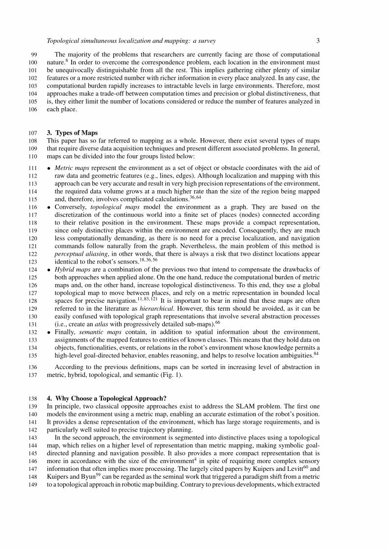
The majority of the problems that researchers are currently facing are those of computational99nature.8 In order to overcome the correspondence problem, each location in the environment must100be unequivocally distinguishable from all the rest. This implies gathering either plenty of similar101features or a more restricted number with richer information in every place analyzed. In any case, the102computational burden rapidly increases to intractable levels in large environments. Therefore, most103approaches make a trade-off between computation times and precision or global distinctiveness, that104is, they either limit the number of locations considered or reduce the number of features analyzed in105each place.106
3. Types of Maps107This paper has so far referred to mapping as a whole. However, there exist several types of maps108that require diverse data acquisition techniques and present different associated problems. In general,109maps can be divided into the four groups listed below:110
• Metric maps represent the environment as a set of object or obstacle coordinates with the aid of111raw data and geometric features (e.g., lines, edges). Although localization and mapping with this112approach can be very accurate and result in very high precision representations of the environment,113the required data volume grows at a much higher rate than the size of the region being mapped114and, therefore, involves complicated calculations.36, 64115
• Conversely, topological maps model the environment as a graph. They are based on the116discretization of the continuous world into a finite set of places (nodes) connected according117to their relative position in the environment. These maps provide a compact representation,118since only distinctive places within the environment are encoded. Consequently, they are much119less computationally demanding, as there is no need for a precise localization, and navigation120commands follow naturally from the graph. Nevertheless, the main problem of this method is121perceptual aliasing, in other words, that there is always a risk that two distinct locations appear122identical to the robot’s sensors.18, 36, 56123
• Hybrid maps are a combination of the previous two that intend to compensate the drawbacks of124both approaches when applied alone. On the one hand, reduce the computational burden of metric125maps and, on the other hand, increase topological distinctiveness. To this end, they use a global126topological map to move between places, and rely on a metric representation in bounded local127spaces for precise navigation.11, 83, 121 It is important to bear in mind that these maps are often128referred to in the literature as hierarchical. However, this term should be avoided, as it can be129easily confused with topological graph representations that involve several abstraction processes130(i.e., create an atlas with progressively detailed sub-maps).66131
• Finally, semantic maps contain, in addition to spatial information about the environment,132assignments of the mapped features to entities of known classes. This means that they hold data on133objects, functionalities, events, or relations in the robot’s environment whose knowledge permits a134high-level goal-directed behavior, enables reasoning, and helps to resolve location ambiguities.84135
According to the previous definitions, maps can be sorted in increasing level of abstraction in136metric, hybrid, topological, and semantic (Fig. 1).137
4. Why Choose a Topological Approach?138In principle, two classical opposite approaches exist to address the SLAM problem. The first one139models the environment using a metric map, enabling an accurate estimation of the robot’s position.140It provides a dense representation of the environment, which has large storage requirements, and is141particularly well suited to precise trajectory planning.142
In the second approach, the environment is segmented into distinctive places using a topological143map, which relies on a higher level of representation than metric mapping, making symbolic goal-144directed planning and navigation possible. It also provides a more compact representation that is145more in accordance with the size of the environment4 in spite of requiring more complex sensory146information that often implies more processing. The largely cited papers by Kuipers and Levitt60 and147Kuipers and Byun59 can be regarded as the seminal work that triggered a paradigm shift from a metric148to a topological approach in robotic map building. Contrary to previous developments, which extracted149

4 Topological simultaneous localization and mapping: a survey
Fig. 1. (Colour online) Level of abstraction hierarchy for maps.
the geometry of the environment from sensor measurements and then inferred the topology from it150(see Chatila and Laumond, 198517 for instance), they proposed constructing a topological description151based on simple control strategies in the first place, and incorporate local metric information in each152of the identified nodes afterwards.153
Albeit, considering that metric maps are more accurate and that a hybrid approach helps to154overcome storage problems, why should purely topological maps be used? To begin with, topological155navigation is a behavior employed by a variety of different animal species, including human beings.156We do not need to answer the question “Where am I?” in millimeters and degrees in order to safely157move through the environment.15 On the contrary, rather than navigating using coordinates, we have158an abstract notion of distance but are still able to recognize where we are in space.89 Moreover,159Brooks14 supports the belief that topological maps are a means of coping with uncertainty in mobile160robot navigation. The absence of metric and geometric information, which is replaced by notions of161proximity and order, eliminates dead-reckoning error issues, which no longer accumulate.162
In conclusion, topological representation resembles human intuitive navigation system, which has163been proven to deal efficiently with uncertainty, and results in a straightforward map from which path164planning follows naturally.165
5. Topological SLAM166
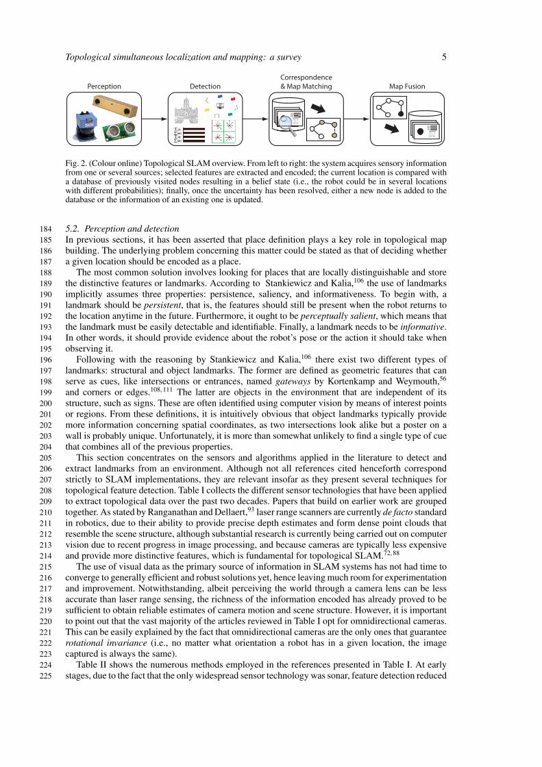
5.1. Breaking up the problem167Implementing a topological SLAM algorithm is a four step process. First of all, it is essential to168define what is going to be considered a landmark in the environment and choose the appropriate169sensor technologies to perceive them. Once this decision is made, the following step is to determine170which feature extraction algorithms are going to be applied.171
Afterwards, the gathered data must be compared with the stored nodes, starting with the last172observed. Due to the fact that it is almost impossible to extract exactly the same features when173revisiting a place, and that several locations may look alike, the most common situation is that the174robot is uncertain about its position after performing this comparison. This is depicted in Fig. 2 with175gray nodes. The robot may either be in various known positions or, alternatively, have reached a new176node (illustrated in Fig. 2 by a discontinuous line).177
Consequently, the robot is forced to keep record of the probability of being in each node until178the uncertainty is somehow resolved. At this point, both the robot’s location and the map become179simultaneously unambiguous. Should it happen to be no match, the system must determine if the180current location is susceptible of being labeled as a distinctive place according to the adopted criteria.181Otherwise, data should be added to the current node definition in order to enhance its distinctiveness182for future revisiting.183
Topological simultaneous localization and mapping: a survey 5
Perception DetectionCorrespondence& Map Matching Map Fusion
Fig. 2. (Colour online) Topological SLAM overview. From left to right: the system acquires sensory informationfrom one or several sources; selected features are extracted and encoded; the current location is compared witha database of previously visited nodes resulting in a belief state (i.e., the robot could be in several locationswith different probabilities); finally, once the uncertainty has been resolved, either a new node is added to thedatabase or the information of an existing one is updated.
5.2. Perception and detection184In previous sections, it has been asserted that place definition plays a key role in topological map185building. The underlying problem concerning this matter could be stated as that of deciding whether186a given location should be encoded as a place.187
The most common solution involves looking for places that are locally distinguishable and store188the distinctive features or landmarks. According to Stankiewicz and Kalia,106 the use of landmarks189implicitly assumes three properties: persistence, saliency, and informativeness. To begin with, a190landmark should be persistent, that is, the features should still be present when the robot returns to191the location anytime in the future. Furthermore, it ought to be perceptually salient, which means that192the landmark must be easily detectable and identifiable. Finally, a landmark needs to be informative.193In other words, it should provide evidence about the robot’s pose or the action it should take when194observing it.195
Following with the reasoning by Stankiewicz and Kalia,106 there exist two different types of196landmarks: structural and object landmarks. The former are defined as geometric features that can197serve as cues, like intersections or entrances, named gateways by Kortenkamp and Weymouth,56198and corners or edges.108, 111 The latter are objects in the environment that are independent of its199structure, such as signs. These are often identified using computer vision by means of interest points200or regions. From these definitions, it is intuitively obvious that object landmarks typically provide201more information concerning spatial coordinates, as two intersections look alike but a poster on a202wall is probably unique. Unfortunately, it is more than somewhat unlikely to find a single type of cue203that combines all of the previous properties.204
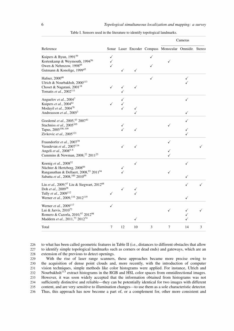
This section concentrates on the sensors and algorithms applied in the literature to detect and205extract landmarks from an environment. Although not all references cited henceforth correspond206strictly to SLAM implementations, they are relevant insofar as they present several techniques for207topological feature detection. Table I collects the different sensor technologies that have been applied208to extract topological data over the past two decades. Papers that build on earlier work are grouped209together. As stated by Ranganathan and Dellaert,93 laser range scanners are currently de facto standard210in robotics, due to their ability to provide precise depth estimates and form dense point clouds that211resemble the scene structure, although substantial research is currently being carried out on computer212vision due to recent progress in image processing, and because cameras are typically less expensive213and provide more distinctive features, which is fundamental for topological SLAM.72, 88214
The use of visual data as the primary source of information in SLAM systems has not had time to215converge to generally efficient and robust solutions yet, hence leaving much room for experimentation216and improvement. Notwithstanding, albeit perceiving the world through a camera lens can be less217accurate than laser range sensing, the richness of the information encoded has already proved to be218sufficient to obtain reliable estimates of camera motion and scene structure. However, it is important219to point out that the vast majority of the articles reviewed in Table I opt for omnidirectional cameras.220This can be easily explained by the fact that omnidirectional cameras are the only ones that guarantee221rotational invariance (i.e., no matter what orientation a robot has in a given location, the image222captured is always the same).223
Table II shows the numerous methods employed in the references presented in Table I. At early224stages, due to the fact that the only widespread sensor technology was sonar, feature detection reduced225
6 Topological simultaneous localization and mapping: a survey
Table I. Sensors used in the literature to identify topological landmarks.
Cameras
Reference Sonar Laser Encoder Compass Monocular Omnidir. Stereo
Kuipers & Byun, 199159 � �Kortenkamp & Weymouth, 199456 � �Owen & Nehmzow, 199885 � �Gutmann & Konolige, 199945 � �
Hafner, 200046 � �Ulrich & Nourbakhsh, 2000113 �Choset & Nagatani, 200118 � � �Tomatis et al., 2002111 �
Anguelov et al., 20047 � �Kuipers et al., 200461 � �Modayil et al., 200478 � �Andreasson et al., 20053 � �
Goedeme et al., 2005,43 200741 �Stachniss et al., 2005105 � �Tapus, 2005108, 109 � � �Zivkovic et al., 2005121 �
Fraundorfer et al., 200739 �Vasudevan et al., 2007114 � � �Angeli et al., 20084–6 �Cummins & Newman, 2008,22 201125 �
Koenig et al., 200852 � �Nuchter & Hertzberg, 200884 �Ranganathan & Dellaert, 2008,93 201194 � �Sabatta et al., 2008,100 201099 �
Liu et al., 2009,67 Liu & Siegwart, 201268 � �Doh et al., 200928 � �Tully et al., 2009112 � �Werner et al., 2009,116 2012119 �
Werner et al., 2009117 �Lui & Jarvis, 201072 � � �Romero & Cazorla, 2010,97 201298 �Maddern et al., 2011,73 201274 � �
Total 7 12 10 3 7 14 3
to what has been called geometric features in Table II (i.e., distances to different obstacles that allow226to identify simple topological landmarks such as corners or dead ends) and gateways, which are an227extension of the previous to detect openings.228
With the rise of laser range scanners, these approaches became more precise owing to229the acquisition of dense point clouds and, more recently, with the introduction of computer230vision techniques, simple methods like color histograms were applied. For instance, Ulrich and231Nourbakhsh113 extract histograms in the RGB and HSL color spaces from omnidirectional images.232However, it was soon widely accepted that the information obtained from histograms was not233sufficiently distinctive and reliable—they can be potentially identical for two images with different234content, and are very sensitive to illumination changes—to use them as a sole characteristic detector.235Thus, this approach has now become a part of, or a complement for, other more consistent and236

Topologicalsimultaneous
localizationand
mapping:
asurvey
7
Table II. Landmark extraction techniques for topological navigation grouped according to sensor technologies: range sensors (i.e., sonar and laser), cameras, and both; and thetype of features obtained: distances, lines, frequency-based, edges, keypoints, affine regions, and probabilistic.
Range sensors Cameras R/C
Distances Lines Frequency Edges Keypoints Regions Prob.
Reference Geometric
features
Gateways Douglas-
Peucker
EM RANSAC Hough
trans.
Hist. Haar
wavelets
Sobel
operator
Invariant
columns
SIFT SURF KLT Harris-
affine
MSER Bayesian
surprise
Kuipers & Byun, 199159 �Kortenkamp & Weymouth, 199456 � �Owen & Nehmzow, 199885 �Gutmann & Konolige, 199945 �Hafner, 200046 �Ulrich & Nourbakhsh, 2000113 �Choset & Nagatani, 200118 �Tomatis et al., 2002111 � �Anguelov et al., 20047 � � � � �Kuipers et al., 200461 �Modayil et al., 200478 �Andreasson et al., 20053 � �Goedeme et al., 2005,43 200741 � �Stachniss et al., 2005105 �Tapus, 2005108, 109 � � �Zivkovic et al., 2005121 �Fraundorfer et al., 200739 �Vasudevan et al., 2007114 � �Angeli et al., 20084–6 �Cummins & Newman, 2008,22 201125 �

8Topologicalsim
ultaneouslocalization
andm
apping:a
survey
Table II. Continued.
Range sensors Cameras R/C
Distances Lines Frequency Edges Keypoints Regions Prob.
Reference Geometric
features
Gateways Douglas-
Peucker
EM RANSAC Hough
trans.
Hist. Haar
wavelets
Sobel
operator
Invariant
columns
SIFT SURF KLT Harris-
affine
MSER Bayesian
surprise
Koenig et al., 200852 �Nuchter & Hertzberg, 200884 � �Ranganathan & Dellaert, 2008,93 201194 � � � �Sabatta et al., 2008,100 201099 �Doh et al., 200928 � �Liu et al., 2009,67 Liu & Siegwart, 201268 � �Tully et al., 2009112 �Werner et al., 2009,116 2012119 �Werner et al., 2009117 �Lui & Jarvis, 201072 � � �Romero & Cazorla, 2010,97 201298 �Maddern et al., 2011,73 201274 �Total 11 6 2 1 1 1 8 1 3 1 7 3 1 1 3 1

Topological simultaneous localization and mapping: a survey 9
informative methods. In addition, other procedures like line extractors, Haar wavelets, edge, keypoint,237and affine covariant region detectors, and Bayesian surprise saw the light of day.238
The rest of this section concentrates on the detection methods found in the literature. For those239techniques that are common knowledge in the field, only references to surveys or seminal papers are240put forward. Emphasis is put on the more recent and original techniques.241
5.2.1. Line extractors. Human-made environments are full of vertical and horizontal lines and,242therefore, constitute an invaluable source of topological information. Line extraction techniques are243usually employed in conjunction with laser range scanners. There exist many approaches for line244extraction, some of which are compared by Nguyen et al.82 As far as topological feature detection245is concerned, the Douglas-Peucker algorithm108 (also known as split-and-merge), EM (Expectation-246Maximization) applied to line fitting,87 the Hough transform,38 and RANSAC (RANdom SAmple247Consensus)37 have been employed. Finally, it is worth mentioning that the latter is a general algorithm248for model adjustment in the presence of many data outliers, which has further applications, for249instance, Nuchter and Hertzberg,84 adopt this technique for plane extraction.250
5.2.2. Haar wavelets. Yet another attempt to topological feature extraction is that of Lui and Jarvis72251who use a feature extraction method for unwarped stereo panoramic images based on the standard2522D Haar wavelet decomposition proposed by Jacobs et al.49 and adapted for mobile robotics by Ho253and Jarvis.47 Similarly to the Fourier transform, which is used to decompose complex signals into254a series of sine waves, Haar wavelets are applied to obtain a summation of simpler images that can255be used to extract a discriminative and robust to occlusions and light changes signature, although256rotation variant.257
5.2.3. Edge-based detectors. They are used to obtain outlines in the context of computer vision. In258particular, Tapus108 utilizes the Sobel operator as an intermediate step to obtain segments of vertical259edges, whereas Goedeme et al.42 employs this operator to apply the so-called invariant column260segments method, which is not an edge detector strictly speaking but a specialization of the so-called261affine invariant regions that are commented below. For further reference, a comparison of several262edge detectors can be found in Maini and Aggarwal.76263
5.2.4. Keypoint detectors. In the context of feature detection using computer vision, blobs are points264in the image that are either significantly brighter or darker than its neighbors. An initial comment265is required before proceeding with the most remarkable algorithms. Although the title alludes to266detectors, most of the methods cited below also include a descriptor to encode the distinguishing data267that can be extracted from the features localized using the detector. For the sake of simplicity, they268will be treated as a whole because they are usually presented together. Nevertheless, it is important269to bear in mind that detectors and descriptors are interchangeable.270
The most pre-eminent blob detector algorithm is Scale Invariant Feature Transform (SIFT),69, 70, 102271which is the current standard for vision-based SLAM. Later on, Bay et al.9 developed Speeded-Up272Robust Features (SURF) with the aim of reducing the computational burden of SIFT. This fact makes273it a better candidate for real-time applications. Last but not least, it is worth mentioning another274promising feature detector named Center Surround Extremas (CenSurE),1 which is much faster than275the previous two methods at the expense of a slight increase in rotation sensitivity. More recently,276Ebrahimi and Mayol-Cuevas34 presented SUSurE, an interest point detector and descriptor based on277CenSurE, which is capable of executing two to three times faster with only a slight loss in repeatability.278
However, there exist other type of interest points apart from blobs. An example of these is Kanade-279Lucas-Tomasi (KLT), included within the OpenCV library,13 which is a corner detector that has also280been applied in topological SLAM systems to perform visual odometry.72281
5.2.5. Affine covariant region detectors. Affine covariant region detectors emerged with the idea of282extracting features from images that were robust to perspective transformations. It is unclear which283is the best among them, as they are often complementary and well suited for extracting regions with284different properties. Mikolajczyk et al.77 carried out a survey comparing the most common detectors,285among which Harris-affine and Maximally Stable Extremal Regions (MSER) can be found.286
It is also interesting to point out that Romero and Cazorla97 run the JSEG segmentation algorithm27287prior to applying MSER described with SIFT with the aim of grouping features according to the image288region to which they belong and produce a graph with them.289

10 Topological simultaneous localization and mapping: a survey
5.2.6. Bayesian surprise. Mainly based on the concept of saliency, it states that relevant stimuli290represent statistical outliers or, in other words, sudden or unexpected changes in the environment.48, 93291Thus, at least one of its attributes needs to be unique or rare over the entire scene (e.g., a red coat292is perceptually salient among black suits but not among many other red coats). This method, which293claims to fire at almost all locations that would be regarded as landmarks by a human being, as well as294at some others that would not, can be implemented for different sensor technologies, predominantly295laser and cameras, and applied to several elementary features such as color, intensity, orientation, or296motion. For example, Ranganathan and Dellaert93 illustrate this technique using laser range scanners297and, in the context of computer vision, by simultaneously applying this method to SIFT descriptors298computed over Harris-affine and MSER features.299
5.2.7. A hybrid approach: fingerprint of places. Once set forth the most common feature extraction300methods, it is clear that they all have advantages and disadvantages that make them suitable for301specific applications. Thus, in the pursuit of a more generally applicable method, some authors have302tried to combine several of the aforementioned techniques.303
An interesting approach has its origin in the paper by Lamon et al.62 where the term fingerprint304of places was coined to refer to a circular list of complementary simple features (color patches and305vertical edges), obtained from omnidirectional images, whose order matches their relative position306around the robot. This idea led to the publication of a series of pieces of work that further developed307on the concept of fingerprint. Of special relevance is that of Tapus and Siegwart109 where, thanks to308the information provided by two 180◦ laser range scanners, corners and empty areas (i.e., when there309are more than 20◦ of free space between two features) are additionally detected.310
More recently, Liu et al.67 proposed a much simpler fingerprint procedure, exclusively based on311panoramic images, which extracts vertical edges under the belief that the prevailing lines naturally312segment a structured environment into meaningful areas, and uses the distance among those lines and313the mean U-V chrominance of the defined regions as a lightweight descriptor called FACT, which314was later granted with statistical meaning and renamed DP-FACT68.315
5.3. Correspondence and map matching316After detecting the distinguishing features in the environment with any of the hitherto presented317algorithms, the subsequent step in traditional metric SLAM implementations is to track the features318detected between two consecutive sensor samples. The distance between equal features is then used319to compute how much the robot has moved and, if there is an encoder available, both measurements320are merged with the aim of minimizing errors. Afterwards, according to the movement, the current321location in the map is calculated.322
By contrast, in pure topological SLAM systems, correspondence and map matching are the same.323In general, there is no need to know how much the robot has moved, but only to identify if it has324returned to an already visited place. Thus, it forces to repeatedly solve a loop-closing problem because325correspondence is computed among the already encoded nodes instead of with the previous sample.117326
It is important to remember that it is almost impossible to obtain two identical samples because327of measurement noise, changes in the environment, and, in addition, because when revisiting328a place the robot performs the measurements in a slightly different location or with another329orientation. For these reasons, correspondence and map matching are usually carried out by means330of dissimilarity measurements, like the Mahalanobis,40, 100 Euclidean,3, 40 and χ2 distances35, or331the Jeffrey divergence,113 whereas Tapus and Siegwart109 employ a modified version of the global332alignment algorithm, proposed by Needleman and Wunsch80 to compare DNA sequences, which takes333the uncertainty of the detected features into consideration. The latter opted for this approach—which334accounts for an average 83.82% of correct classifications in indoor and outdoor environments—after335comparing it with Bayesian programming and a hybrid technique which merges the global alignment336with uncertainty and Bayesian programming methods.337
Moreover, in the context of visual topological SLAM Angeli et al.4 and Romero and Cazorla97338utilize the relative position of the features within the images as a matching criteria. However, while339the former uses RANSAC to ensure that epipolar geometry constraints are met, the latter applies340the Graph Transformation Matching (GTM) algorithm by Aguilar et al.2 In addition, Li and Olson65341proposes the Incremental Posterior Joint Compatibility (IPJC) test to match constellations of features342together rather than considering them individually. Although its formulation is equivalent to the343

Topological simultaneous localization and mapping: a survey 11
well know Joint Compatibility Branch and Bound (JCBB) test,81 it is faster and more accurate, and344performs better on non-linear problems.345
Finally, because map matching becomes more demanding as the mapped area grows, some authors346like Goedeme et al.42 or Romero and Cazorla97 propose applying clustering techniques like kd-trees347to reduce the dimensionality of the features in order to optimize the search and comparison processes.348Cummins and Newman22 employ a Chow-Liu tree. Notice, nevertheless, that both Goedeme et al.42349and Cummins and Newman22 perform tree building offline due to time constraints.350
5.4. Map fusion: dealing with loop-closing uncertainty351The final stage in topological SLAM involves updating the recorded map. If the current location does352not correspond to any node known in advance, then the robot is in an unexplored area and, therefore,353if the measurements meet the requirements to be considered a distinctive place, it should be added354to the map. A more complex situation occurs when there is a positive match. Remember that for355topological SLAM one of the most awkward problems is perceptual aliasing, and suppose that for356map matching only sensory information is used. Consequently, there may be several nodes in the map357that coincide with the measurements. Notwithstanding, this by no means signifies that it is an already358visited place. This section concentrates on the different manners in which loop-closing uncertainty359in topological maps has been tackled in the literature.360
5.4.1. The consistent pose estimation paradigm. Some of the early developments on map fusion361are inspired by the concept of consistent pose estimation (CPE) introduced by Lu and Milios,71362which attempts to globally optimize the recorded set of poses based on how well neighboring sensor363scans match. Gutmann and Konolige45 presented the Local Registration/Global Correlation (LRGC)364algorithm that is based on building local metric maps (named local patches) from the last few365measurements in order keep the accumulated odometric error low and ensure topological correctness.366The global metric map is then incrementally updated by comparing the topological structure of the367latest patch with older portions of the map. A high match score with low ambiguity and variance368indicates a loop closure. The experiments, carried out with robots equipped with laser sensors and369encoders in four different environments of up to 80 by 25 m, yield fairly good metric maps under370the assumption that local patches are accurate enough. Later on, Konolige55 presented an efficient371algorithm for multiple-loop maps that allows to extend the CPE method to map much larger areas372(i.e., around 105 distinct locations).373
5.4.2. Spatial semantic hierarchy. The Spatial Semantic Hierarchy (SSH) is a model of knowledge374for large-space introduced by Kuipers.57 It involves four qualitative and quantitative representations.375At the control level, the agent continuously seeks distinctive states with a combination of trajectory-376following and hill-climbing strategies. The causal level abstracts this pattern of behavior into a377discrete model described in terms of states, sensory views, actions, and the causal relations among378them. The topological level introduces the concepts of places, paths, and regions, and links them379through turn and travel actions in order to explain the regularities observed among views in the380control level. Finally, the metrical level represents a global geometric map of the environment in a381single frame of reference. This framework was subsequently formalized using non-monotonic logic382by Remolina and Kuipers.96383
Kuipers et al.61 extended the basic SSH with local perceptual maps (LPMs), a bounded occupancy384grid. In this work, they identify gateways in corridors as the locations where the distance between385the medial axis edge and the obstacles is a local minimum close to a larger maximum. However, they386believe that other alternatives are possible. In addition, they include path fragments associated to the387gateways. This information, along with travel control laws, is employed to obtain a local topology of388a place in terms of distinctive states and directed paths.389
In order to obtain the global topological map, a tree whose nodes are topological map-distinctive390state pairs is maintained and pruned over time by matching local topologies, and LPMs if necessary.391Instead of pruning, Johnson and Kuipers50 proposed expanding only the most probable hypothesis to392ensure that you can always backtrack in case of error and find the correct map. Further developments393of this research line include improvements to loop-closing with the incorporation of the planarity394constraint,101 and the construction of accurate global metric maps from the topological skeleton395obtained.78396

12 Topological simultaneous localization and mapping: a survey
5.4.3. Markov decision processes. Markov decision processes—Hidden Markov Models397(HMMs)44, 103 and their extension, Partially Observable Markov Decision Processes398(POMDPs)16, 51, 54—have also been employed to determine the navigation policy that the robot should399follow in order to reduce uncertainty. Subsequently, Tomatis et al.111 and Tapus and Siegwart109400extended POMDPs to perform multi-hypothesis tracking and determine a pose distribution. However,401as computing an optimal policy is intractable in large environments, Tomatis et al.111 suggested using402the most likely state (MLS) criterion to choose the following action, whereas Tapus and Siegwart109403opted for another heuristic, the entropy of the current location probability distribution, to decide the404control commands. In the latter case, whenever the entropy falls below an experimentally determined405threshold, the robot’s location is assumed certain and the map is updated accordingly, either by adding406a new node or by merging the latest fingerprint information with the node representative.407
Loop closures are also identified by means of the POMDP. Whenever the robot returns to a408previously visited location, the probability distribution should split in two. One hypothesis would409correspond to a new location and the other to a node already present in the map. If both divergent410peaks evolve similarly over time, a loop closure is assumed.108411
5.4.4. Probabilistic topological maps. A Bayesian inference framework has also been explored412for topological mapping. Ranganathan and Dellaert coined the term Probabilistic Topological413Map (PTM), a sample-based representation that estimates the posterior distribution over all the414possible topologies that can be built given a set of sensor measurements.90, 91 Due to the fact415that this is a problem of a combinatorial nature, they proposed approximating the solution by416drawing samples from the distribution using Markov-Chain Monte Carlo (MCMC) sampling.91, 95417In principle, this technique is applicable to any landmark detection scheme as long as the landmark418detection algorithm does not provide false negatives (i.e., the robot’s sensors do not fail to recognize419landmarks).420
Afterwards, they presented Rao-Blackwellized Particle Filters (RBPFs)29, 79 as an alternative to421MCMC sampling for PTMs.90, 92, 94 Particle filters is yet another Monte Carlo localization technique422used to probabilistically estimate the state of a system under noisy measurement conditions. They423claim that this technique permits incremental inference in the space of topologies—conversely to424MCMC, which is a batch algorithm—and can therefore be computed in real time. In order to425overcome the samples degeneracy problem over time,30 that can lead to convergence issues, they426suggest integrating odometric data to draw more likely particles with higher probability. However,427the selection of the appropriate number of particles still remains an open issue, as particle filtering428inherently has the risk of disposing the correct map. Koenig et al.52 also employ a RBPF. Each particle429incrementally constructs its own graph of the environment using color histograms and odometry430information. Local graphs are compared with the global graph to determine the best matches and,431simultaneously, the resampling weights for each particle.432
The main advantage of PTMs is that all decisions are reversible and the algorithm is therefore433capable of recovering from incorrect loop closures. In the end, only a small set of similar topologies434have non-negligible probabilities. The experiments conducted suggest that, if the environment is435unambiguous, the ground-truth topology is assigned a much higher posterior probability mass than436the other alternatives.437
5.4.5. Voronoi graphs and neighboring information. Choset and Nagatani18 represent the environment438by means of a generalized Voronoi graph (GVG). A GVG is a one-dimensional set of points equidistant439to n obstacles in n dimensions. When used in the plane, it reduces to the set of points equidistant440to two (or more) obstacles, and define a roadmap of the robot’s free space. Voronoi nodes, which441are locations equidistant to n + 1 obstacles, are used as natural landmarks because they provide442topologically meaningful information that can be extracted online (e.g., junctions, dead-ends, etc.).443The main problem with Voronoi nodes is that they are very sensitive to changes in the configuration444of the environment. If non-structural obstacles are moved, Voronoi vertices may appear or vanish.445
In order to achieve SLAM, the robot follows simple control commands looking for these nodes in446the environment. Loop-closing is carried out by comparing the subgraph built from the latest observed447nodes to the already encoded map. Ambiguity is resolved by following a candidate path and ruling448out inconsistent matches based on the new visited places. This method as is assumes that the robot449is equipped with infinite range sonar sensors, and is only suitable for static and planar environments450

Topological simultaneous localization and mapping: a survey 13
with plenty of obstacles. Based on this idea, Beeson et al.10 introduced extended Voronoi graphs451(EVGs) to address the problems of GVGs derived from limited sensory horizons by means of local452perceptual maps (LPMs).453
The research path initiated by Werner et al.115, 118 is also remarkable. They apply Bayesian inference454to obtain a topological map in ambiguous environments that explains the set of observations without455the need for motion knowledge. The method is based on guaranteeing consistency between the local456neighboring information extracted from the latest n images and the constructed map while keeping the457number of topological vertices as low as possible, following the Occam’s razor principle. Topological458places, where captures are acquired, are identified by means of a GVG using sonar readings. The459algorithm assumes that there exist some prior information about the connectivity but not about the460number of distinct locations in the environment.461
Initially, a sequential Monte Carlo technique was employed to maintain a series of candidate462maps,116 which was later replaced by a particle filter.117 In order to be able to recover from incorrect463loop closures, Tully et al.112 introduced a multi-hypothesis approach based on a tree expansion464algorithm specifically conceived for edge-ordered graphs,32 as well as a series of pruning rules465to keep the number of hypothesis under control. Recently, Tao et al.107 discussed the benefits of466saturated generalized Voronoi graphs (S-GVG), that employ a wall-following behavior to navigate467within sensor range limits, and performed SLAM using a similar hypothesis tree. Finally, Werner468et al.119 suggested applying stochastic local search (SLS) to produce the topological map.469
Before concluding this section, it is worth mentioning the work by Doh et al.,28 who deal with semi-470permanent dynamics induced by door opening and closing. They classify GVG nodes in invariant471(i.e., junctions, corners, and ends of corridors) and variant (i.e., doors). Nodes are told apart using472the areas between two local minimums of a sensor scan (which identify doors), and looking for a473vanishing point from a range scan or in an image (for invariant nodes).474
5.4.6. Appearance-based topological SLAM. Most early approaches to inferring topological maps475based only on visual information—they discard employing odometric data because it is prone476to cumulative errors, especially on slippery surfaces—rely on SIFT keypoints extracted from477omnidirectional images. Some examples include the work by Zivkovic et al.,121 who solve the478map building process using graph-cuts, and Goedeme et al.,41 who resort to Dempster-Shafer theory479of evidence26 for loop-closing. Unfortunately, these solutions require offline computation.480
Later on, Fraundorfer et al.39 presented a real-time framework based on the bag-of-words481paradigm,19 where images are quantized in terms of unordered elementary features taken from482an offline-built dictionary. Loop-closing is identified by visual word comparison following a voting483scheme. Romero and Cazorla97, 98 take a similar approach but without the need for a dictionary.484They build graphs from homogeneous regions using MSER features described with SIFT and use the485GTM algorithm for matching. They then compare the graphs from newly acquired images with the486latest visited topological node representative. If the matching score is below a threshold, it is then487compared—using another threshold—with the rest of the encoded vertices in order to identify loop488closures. If no match is found, a new node is added to the map. The main drawback of this algorithm489is that it is extremely sensitive to the two thresholds. The value of these parameters has a decisive490impact on the final topology obtained.491
Angeli et al.4–6 proposed a method that builds the vocabulary online, following the procedure492developed by Filliat.35 The problem of loop-closing is addressed following a Bayesian approach. The493probability of transition between locations is modeled using a sum of Gaussians to assign higher494probability to adjacent states, whereas the correspondence likelihood is computed by means of voting495using the tf-idf coefficient.104496
Furthermore, Fast Appearance-Based Mapping (FAB-MAP), which is a Bayesian framework for497navigation and mapping exclusively based on appearance information developed by Cummins and498Newman as a solution to loop closure detection,20–22, 24 has attracted a great deal of attention. It relies499on a vocabulary model built offline from the clustering of SURF features extracted from a large500collection of independent images. The words obtained are then organized using a Chow-Liu tree to501capture the dependencies among them (i.e., car wheels and car doors are likely to appear together).502This vocabulary model is used to approximate the partition function in the Bayesian formulation,503which provides a natural probabilistic measure of when an observation should be labeled as a new504location.505

14 Topological simultaneous localization and mapping: a survey
The experiments conducted outdoors suggest that it performs well in repetitive environments506and is fast enough for online loop-closing. The fact that it requires offline training is an drawback,507although tests carried out indoors with the bag-of-words model built for outdoor environments produce508surprisingly good results according to the authors.509
Some improvements have been introduced to the original algorithm since its presentation. First,510speed was increased by more than 25 times, with only a slight degradation in accuracy, thanks to the511usage of concentration inequalities to reduce the number of hypothesis considered.23 The formulation512of the algorithm was also modified to operate on very large environments (over trajectories of around5131000 km).25 Finally, Paul and Newman86 incorporated the spatial arrangement of visual words to514improve distinctiveness.515
5.4.7. Continuous appearance-based trajectory SLAM. Continuous Appearance-based Trajectory516SLAM (CAT-SLAM)73 incorporates odometry, following the approach of FastSLAM,79 to517appearance-based SLAM using FAB-MAP. The current location is modeled as a probability518distribution over a trajectory and appearance is treated as a continuous variable. The evaluation519of the distribution is carried out using a RBPF. Compared to FAB-MAP, it identifies three times520as many loop closures at 100% precision (i.e., with no false positives). By contrast, FAB-MAP is521capable of recognizing places when approached from a different direction, whereas CAT-SLAM522cannot because it relies on odometric information. Enhancements to computational and memory523storage requirements, like pruning those nodes in the trajectory that are locally uninformative once524a preset maximum number of nodes is reached, were subsequently introduced to allow continuous525operation on much larger environments.74, 75526
5.4.8. Closing the loop with visual odometry. Lui and Jarvis72 have implemented a different correction527algorithm for loop closure detection, which relies on visual odometry. They employ the Kanade-528Lucas-Tomasi (KLT) features present in the OpenCV computer vision library13 to estimate the529distance traveled and column image comparison using the Sum of Absolute Differences (SAD) for530the front 180◦ field of view (FOV) of the robot to estimate the bearing. These are then used to531reduce the matches retrieved from the database, using a Haar wavelet-based signature, utilizing the532relaxation algorithm proposed by Duckett et al.31 The current location is then told apart by means of533SURF.9 This system has been proven effective in indoor and semi-outdoor environments. However, its534main drawback lies in the complexity of the robot infrastructure, which includes an omnidirectional535stereovision system and a web camera to perform visual odometry, as well as a stereo camera for536obstacle avoidance.537
5.4.9. The final stage: updating the map. Finally, once the uncertainty has been resolved, the new538information gathered should be incorporated to the map for future reference. On the one hand, some539authors suggest removing any unobserved nodes, features, and relations or, better, implementing a540gradual “forgetting” process that could take into account changes in the environment (e.g., an open541door appears closed when revisiting a place).114 On the other hand, Kuipers and Beeson58 and Tapus542and Siegwart109 propose applying clustering techniques to create a mean node representative with a543view to reducing the impact of scene variability.544
6. Conclusion545There is still a long way to go as far as topological SLAM is concerned. Although there exist plenty546of partial implementations and ideas for some of the phases, a robust and globally applicable method547is yet to be developed.548
In detection, it seems that the best results have been achieved with a wisely chosen collection of549features. Nevertheless, the selection of these features is crucially affected by the sensory technology550used. Computer vision is rising as a promising alternative because, even though processing the data551gathered can be more difficult and computationally expensive, it provides richer information than552other sensors, like laser range scanners, and can be easily installed in any mobile entity.553
In map matching and updating, the probabilistic approach seems to be the most consolidated554research line. However, in spite of the topological representation being less computationally555demanding, there are still some open issues in unbounded, dynamic, and ambiguous unknown556environments. Constantly solving a loop-closing problem can be cumbersome in large maps as557the robot can simultaneously believe to be in several locations, which results in having to deal with558

Topological simultaneous localization and mapping: a survey 15
a huge pose distribution that multiply the calculations required. Because of this, new tracks are559being explored in the pursuit of scalability in metric SLAM. The work by Blanco et al.,12 which560demonstrates that an appropriate formulation of the SLAM problem can pose an upper limit on loop561closure complexity in unbounded environments, is a remarkable example.562
References5631. M. Agrawal, K. Konolige and M. R. Blas, “CenSurE: Center Surround Extremas for Realtime Feature564
Detection and Matching,” LNCN 5305, 102–115 (2008).5652. W. Aguilar, Y. Frauel, F. Escolano, M. E. Martınez-Perez, A. Espinosa-Romero and M. A. Lozano, “A566
robust graph transformation matching for non-rigid registration,” Image Vis. Comput. 27, 897–910 (2009).5673. H. Andreasson, A. Treptow and T. Duckett, “Localization for Mobile Robots Using Panoramic Vision,568
Local Features and Particle Filter,” Proceedings of the IEEE International Conference Robotics and569Automation, Barcelona, Spain (2005) pp. 3348–3353.570
4. A. Angeli, S. Doncieux, J.-A. Meyer and D. Filliat, “Incremental Vision-Based Topological SLAM,”571Proceedings of the IEEE/RSJ International Conference on Intelligent Robots and Systems, Nice, France572(2008a) pp. 1031–1036.573
5. A. Angeli, D. Filliat, S. Doncieux and J.-A. Meyer, “A fast and incremental method for loop-closure574detection using bags of visual words,” IEEE Trans. Robot. 24(5), 1027–1037 (2008b).575
6. A. Angeli, D. Filliat, S. Doncieux and J.-A. Meyer, “Real-Time Visual Loop-Closure Detection,”576Proceedings of the IEEE International Conference on Robotics and Automation, Pasadena, CA (2008c)577pp. 1842–1847.578
7. D. Anguelov, D. Koller, E. Parker and S. Thrun, “Detecting and modeling doors with mobile robots,”579Proc. IEEE Int. Conf. Robot. Autom. 4, 3777–3784 (2004).580
8. T. Bailey and H. F. Durrant-Whyte, “Simultaneous localization and mapping (SLAM): Part II,” IEEE581Robot. Autom. Mag. 13(3), 108–117 (2006).582
9. H. Bay, A. Ess, T. Tuytelaars and L. van Gool, “SURF: Speeded up robust features,” Comput. Vis. Image583Underst. 110(3), 346–359 (2008).584
10. P. Beeson, N. K. Jong and B. Kuipers, “Towards Autonomous Topological Place Detection Using the585Extended Voronoi Graph,” Proceedings of the IEEE International Conference on Robotics and Automation,586Barcelona, Spain (2005) pp. 4373–4379.587
11. J. L. Blanco, J. A. Fernandez-Madrigal and J. Gonzalez, “Toward a unified Bayesian approach to hybrid588metric-topological SLAM,” IEEE Trans. Robot. 24(2), 259–270 (2008).589
12. J. L. Blanco, J. Gonzalez-Jimenez and J. A. Fernandez-Madrigal, “Sparser Relative Bundle Adjustment590(SRBA): Constant-Time Maintenance and Local Optimization of Arbitrarily Large Maps,” Proceedings591of the IEEE International Conference Robotics and Automation, Karlsruhe, Germany (2013) pp. 70–77.592
13. G. Bradski, “The OpenCV library” (2000). http://opencv.willowgarage.com/.59314. R. A. Brooks, “Visual map making for a mobile robot,” Proc. IEEE Int. Conf. Robot. Autom. 2, 824–829594
(1985).59515. R. A. Brooks, “Elephants don’t play chess,” Robot. Auton. Syst. 6, 3–15 (1990).59616. A. R. Cassandra, L. P. Kaelbling and J. A. Kurien, “Acting Under Uncertainty: Discrete Bayesian Models597
for Mobile-Robot Navigation,” Proceedings of the IEEE/RSJ International Conference on Intelligent598Robots and Systems, Vol. 2, Osaka, Japan (1996) pp. 963–972.599
17. R. Chatila and J.-P. Laumond, “Position referencing and consistent world modeling for mobile robots,”600Proc. IEEE Int. Conf. Robot. Autom. 2, 138–145 (1985).601
18. H. Choset and K. Nagatani, “Topological simultaneous localization and mapping (SLAM): Toward exact602localization without explicit localization,” IEEE Trans. Robot. Autom. 17(2), 125–137 (2001).603
19. G. Csurka, C. Dance, L. Fan, J. Williamowski and C. Bray, “Visual Categorization with Bags of Keypoints,”604ECCV International Workshop on Statistical Learning in Computer Vision, Prague, Czech Republic (2004)605pp. 59–74.606
20. M. Cummins, Probabilistic Localization and Mapping in Appearance Space Ph.D. Thesis (University of607Oxford, 2009).608
21. M. Cummins and P. Newman, “Probabilistic Appearance Based Navigation and Loop Closing,”609Proceedings of the IEEE International Conference on Robotics and Automation, Rome, Italy (2007)610pp. 2042–2048.611
22. M. Cummins and P. Newman, “FAB-MAP: Probabilistic localization and mapping in the space of612appearance,” Int. J. Robot. Res. 27(6), 647–665 (2008).613
23. M. Cummins and P. Newman, “Accelerating FAB-MAP with concentration inequalities,” IEEE Trans.614Robot. 26(6), 1042–1050 (2010a).615
24. M. Cummins and P. Newman, “FAB-MAP: Appearance-Based Place Recognition and Mapping Using a616Learned Visual Vocabulary Model,” Proceedings of the International Conference on Machine Learning,617Haifa, Israel (2010b) pp. 3–10.618
25. M. Cummins and P. Newman, “Appearance-only SLAM at large scale with FAB-MAP 2.0,” Int. J. Robot.619Res. 30(9), 1100–1123 (2011).620
26. A. P. Dempster, “Upper and lower probabilities induced by a multivalued mapping,” Ann. Math. Stat.62138(2), 325–339 (1967).622

16 Topological simultaneous localization and mapping: a survey
27. Y. Deng and B. S. Manjunath, “Unsupervised segmentation of color-texture regions in images and video,”623IEEE Trans. Pattern Anal. Mach. Intell. 23(8), 800–810 (2001).624
28. N. L. Doh, K. Lee, W. K. Chung and H. Cho, “Simultaneous localisation and mapping algorithm for625topological maps with dynamics,” IET Control Theor. Appl. 3(9), 1249–1260 (2009).626
29. A. Doucet, N. de Freitas, K. Murphy and S. Russell, “Rao-Blackwellised Particle Filtering for Dynamic627Bayesian Networks,” Proceedings of the 16th Conference on Uncertainty in Artificial Intelligence,628Stanford, CA (2000a) pp. 176–173.629
30. A. Doucet, S. Godsill and C. Andrieu, “On sequential Monte Carlo sampling methods for Bayesian630filtering,” Stat. Comput. 10, 197–208 (2000b).631
31. T. Duckett, S. Marsland and J. Shapiro, “Learning Globally Consistent Maps by Relaxation,” Proceedings632of the IEEE International Conference on Robotics and Automation, San Francisco, CA, USA (2000)633pp. 3841–3846.634
32. G. Dudek, P. Freedman and S. Hadjres, “Using Local Information in a Non-Local Way for Mapping635Graph-Like Worlds,” International Joint Conference on Artificial Intelligence, Chambery, France (1993)636pp. 1639–1647.637
33. H. F. Durrant-Whyte and T. Bailey, “Simultaneous localization and mapping: Part I,” IEEE Robot. Autom.638Mag. 13(2), 99–110 (2006).639
34. M. Ebrahimi and W. W. Mayol-Cuevas, “SUSurE: Speeded up Surround Extrema Feature Detector640and Descriptor for Realtime Applications,” Proceedings of the IEEE Computer Society Conference on641Computer Vision and Pattern Recognition, Miami, FL (2009) pp. 9–14.642
35. D. Filliat, “A Visual Bag of Words Method for Interactive Qualitative Localization and Mapping,”643Proceedings of the IEEE International Conference on Robotics and Automation, Rome, Italy (2007)644pp. 3921–3926.645
36. D. Filliat and J.-A. Meyer, “Map-based navigation in mobile robots: I. A review of localization strategies,”646Cogn. Syst. Res. 4(4), 243–282 (2003).647
37. M. A. Fischler and R. C. Bolles, “Random sample consensus: A paradigm for model fitting with648applications to image analysis and automated cartography,” Commun. ACM 24(6), 381–395 (1981).649
38. D. A. Forsyth and J. Ponce, Computer Vision: A Modern Approach (Prentice Hall, Upper Saddle River,650NJ, 2003).651
39. F. Fraundorfer, C. Engels and D. Nister, “Topological Mapping, Localization and Navigation Using Image652Collections,” Proceedings of the IEEE/RSJ International Conference on Intelligent Robots and Systems,653San Diego, CA, USA (2007) pp. 3872–3877.654
40. T. Goedeme and L. van Gool, “Robust Vision-Only Mobile Robot Navigation with Topological Maps,”655In: Mobile Robots Motion Planning, New Challenges (X.-J. Jing, ed.) (InTech, Austria, 2008) chap. 4,656pp. 63–88.657
41. T. Goedeme, M. Nuttin, T. Tuytelaars and L. van Gool, “Omnidirectional vision based topological658navigation,” Int. J. Comput. Vis. 74(3), 219–236 (2007).659
42. T. Goedeme, T. Tuytelaars and L. van Gool, “Fast wide baseline matching for visual navigation,” Proc.660IEEE Comp. Soc. Conf. Comp. Vision Pattern Recogn. 1, 24–29 (2004).661
43. T. Goedeme, T. Tuytelaars, L. van Gool, G. Vanacker and M. Nuttin, “Feature Based Omnidirectional662Sparse Visual Path Following,” Proceedings of the IEEE/RSJ International Conference on Intelligent663Robots and Systems, Edmonton, Canada (2005) pp. 1806–1811.664
44. R. Gutierrez-Osuna and R. C. Luo, “LOLA Probabilistic navigation for topological maps,” AI Mag. 17(1),66555–62 (1996).666
45. J.-S. Gutmann and K. Konolige, “Incremental Mapping of Large Cyclic Environments,” Proceedings667of the International Symposium on Computational Intelligence in Robotics and Automation (1999),668pp. 318–325.669
46. H. H. Hafner, “Learning Places in Newly Explored Environments,” In: Proceedings of the International670Conference on Simulation of Adaptive Behavior (Meyer, Berthoz, Floreano, Roitblat and Wilson, eds.)671(International Society for Adaptive Behavior, Honolulu, HI, USA, 2000) pp. 111–120.672
47. N. Ho and R. Jarvis, “Vision Based Global Localisation Using a 3D Environmental Model Created by673a Laser Range Scanner,” Proceedings of the IEEE/RSJ International Conference Intelligent Robots and674Systems, Nice, France (2008) pp. 2964–2969.675
48. L. Itti and P. Baldi, “A principled approach to detecting surprising events in video,” Proc. IEEE Comp.676Soc. Conf. Comp. Vision Pattern Recogn. 1, 631–637 (2005).677
49. C. E. Jacobs, A. Finkelstein and D. H. Salesin, “Fast Multiresolution Image Querying,” Proceedings678of the Annual Conference on Computer Graphics and Interactive Techniques, Los Angeles, CA (1995)679pp. 277–286.680
50. C. Johnson and B. Kuipers, “Efficient Search for Correct and Useful Topological Maps,” Proceedings of681the IEEE/RSJ International Conference on Intelligent Robots and Systems, Vilamoura, Algarve, Portugal682(2012) pp. 5277–5282.683
51. L. P. Kaelbling, M. L. Littman and A. R. Cassandra, “Planning and acting in partially observable stochastic684domains,” Artif. Intell. 101(1–2), 99–134 (1998).685
52. A. Koenig, J. Kessler and H.-M. Gross, “A Graph Matching Technique for an Appearance-Based, Visual686SLAM-Approach Using Rao-Blackwellized Particle Filters,” Proceedings of the IEEE/RSJ International687Conference on Intelligent Robots and Systems, Nice, France (2008) pp. 1576–1581.688

Topological simultaneous localization and mapping: a survey 17
53. S. Koenig, A. Mudgal and C. Tovey, “A Near-Tight Approximation Lower Bound and Algorithm for the689Kidnapped Robot Problem,” Proceedings of the Symposium on Discrete Algorithms, Miami, FL (2006)690pp. 133–142.691
54. S. Koenig and R. G. Simmons, “Unsupervised Learning of Probabilistic Models for Robot Navigation,”692Proceedings of the IEEE International Conference on Robotics and Automation, Minneapolis, MN, USA6931996) pp. 2301–2308.694
55. K. Konolige, “Large-Scale Map-Making,” Proceedings of the National Conference on Artificial695Intelligence, San Jose, CA (2004) pp. 457–463.696
56. D. Kortenkamp and T. Weymouth, “Topological Mapping for Mobile Robots Using a Combination of697Sonar and Vision Sensing,” Proceedings of the American Association for Artificial Intelligence (AAAI)698Conference, Seattle, WA, USA (1994).699
57. B. Kuipers, “The spatial semantic hierarchy,” Artif. Intell. 119, 191–233 (2000).70058. B. Kuipers and P. Beeson, “Bootstrap Learning for Place Recognition,” Proceedings of the 18th National701
Conference on Artificial Intelligence, Edmonton, Alberta, Canada (2002) pp. 174–180.70259. B. Kuipers and Y.-T. Byun, “A robot exploration and mapping strategy based on a semantic hierarchy of703
spatial representations,” Robot. Auton. Syst. 8(1), 47–63 (1991).70460. B. Kuipers and T. Levitt, “Navigation and mapping in large-scale space,” AI Mag., 9(2), 25–43 (1988).70561. B. Kuipers, J. Modayil, P. Beeson, M. MacMahon and F. Savelli, “Local metrical and global topological706
maps in the hybrid spatial semantic hierarchy,” Proc. IEEE Int.Conf. Robot. Autom. 5, 4845–4851 (2004).70762. P. Lamon, I. Nourbakhsh, B. Jensen and R. Siegwart, “Deriving and Matching Image Fingerprint Sequences708
for Mobile Robot Localization,” Proceedings of the IEEE International Conference on Robotics and709Automation, Seoul, Korea (2001).710
63. J. J. Leonard and H. F. Durrant-Whyte, “Mobile robot localization by tracking geometric beacons,” IEEE711Trans. Robot. Autom. 7(3), 376–382 (1991a).712
64. J. J. Leonard and H. F. Durrant-Whyte, “Simultaneous Map Building and Localization for an Autonomous713Mobile Robot,” Proceedings of the IEEE/RSJ International Workshop on Intelligent Robots and Systems,714Osaka, Japan (1991b) pp. 1442–1447.715
65. Y. Li and E. B. Olson, “IPJC: The Incremental Posterior Joint Compatibility Test for Fast Feature716Cloud Matching,” Proceedings of the IEEE/RSJ International Conference Intelligent Robots and Systems,717Vilamoura, Algarve, Portugal (2012) pp. 3467–3474.718
66. B. Lisien, D. Morales, D. Silver, G. Kantor, I. Rekleitis and H. Choset, “Hierarchical Simultaneous719Localization and Mapping,” Proceedings of the IEEE/RSJ International Conference on Intelligent Robots720and Systems, Las Vegas, NV (2003) pp. 448–453.721
67. M. Liu, D. Scaramuzza, C. Pradalier, R. Siegwart and Q. Chen, “Scene Recognition with Omnidirectional722Vision for Topological Map Using Lightweight Adaptive Descriptors,” Proceedings of the IEEE/RSJ723International Conference Intelligent Robots and Systems, St. Louis, MO, USA (2009) pp. 116–121.724
68. M. Liu and R. Siegwart, “DP-FACT: Towards Topological Mapping and Scene Recognition with Color725for Omnidirectional Camera,” IEEE International Conference on Robotics and Automation, Saint Paul,726MN, USA (2012).727
69. D. G. Lowe, “Object recognition from local scale-invariant features,” Proc. IEEE Int. Conf. Computer728Vision 2, 1150–1157.729
70. D. G. Lowe, “Distinctive image features from scale-invariant keypoints,” Int. J. Comput. Vis. 60(2), 91–110730(2004).731
71. F. Lu and E. Milios, “Globally consistent range scan alignment for environment mapping,” Auton. Robots7324, 333–349 (1997).733
72. W. L. D. Lui and R. Jarvis, “A Pure Vision-Based Approach to Topological SLAM,” Proceedings of the734IEEE/RSJ International Conference on Intelligent Robots and Systems, Taipei, Taiwan (2010).735
73. W. Maddern, M. Milford and G. Wyeth, “Continuous Appearance-Based Trajectory SLAM,” Proceedings736of the IEEE International Conference on Robotics and Automation, Shanghai, China (2011) pp. 3595–7373600.738
74. W. Maddern, M. Milford and G. Wyeth, “Capping Computation Time and Storage Requirements for739Appearance-Based Localization with CAT-SLAM,” Proceedings of the IEEE International Conference on740Robotics and Automation, Saint Paul, MN, USA (2012a) pp. 822–827.741
75. W. Maddern, M. Milford and G. Wyeth, “Towards Persistent Indoor Appearance-Based Localization,742Mapping and Navigation Using CAT-SLAM,” Proceedings of the IEEE/RSJ International Conference on743Intelligent Robots and Systems, Vilamoura, Algarve, Portugal (2012b) pp. 4224–4230.744
76. R. Maini and H. Aggarwal, “Study and comparison of various image edge detection techniques,” Int. J.745Image Process. 3(1), 1–11 (2009).746
77. K. Mikolajczyk, T. Tuytelaars, C. Schmid, A. Zisserman, J. Matas, F. Schaffalitzky, T. Kadir and L. van747Gool, “A comparison of affine region detectors,” Int. J. Comput. Vis. 65(1), 43–72 (2006).748
78. J. Modayil, P. Beeson and B. Kuipers, “Using the Topological Skeleton for Scalable Global Metrical Map-749Building,” Proceedings of the IEEE/RSJ International Conference on lntelligent Robots and Systems,750Sendai, Japan (2004) pp. 1530–1536.751
79. M. Montemerlo, S. Thrun, D. Koller and B. Wegbreit, “FastSLAM: A Factored Solution to the752Simultaneous Localization and Mapping Problem,” Proceedings of the AAAI National Conference on753Artificial Intelligence, Edmonton, Canada (2002).754

18 Topological simultaneous localization and mapping: a survey
80. S. B. Needleman and C. D. Wunsch, “A general method applicable to the search for similarities in the755amino acid sequence of two proteins,” J. Mol. Biol. 48, 443–453 (1970).756
81. J. Neira and J. D. Tardos, “Data association in stochastic mapping using the joint compatibility test,” IEEE757Trans. Robot. Autom. 17(6), 890–897 (2001).758
82. V. Nguyen, A. Martinelli, N. Tomatis and R. Siegwart, “A Comparison of Line Extraction Algorithms759Using 2D Laser Rangefinder for Indoor Mobile Robotics,” Proceedings of the IEEE/RSJ International760Conference Intelligent Robots and Systems, Edmonton, Canada (2005) pp. 1929–1934.761
83. J. I. Nieto, J. E. Guivant and E. M. Nebot, “The Hybrid Metric Maps (HYMMs): A novel map representation762for DenseSLAM,” Proc. IEEE Int. Conf. Robot. Autom. 1, 391–396 (2004).763
84. A. Nuchter and J. Hertzberg, “Towards semantic maps for mobile robots,” Robot. Auton. Syst. 56, 915–926764(2008).765
85. C. Owen and U. Nehmzow, “Landmark-Based Navigation for a Mobile Robot,” In: Proceedings of the766Simulation of Adaptive Behaviour (MIT Press, 1998) pp. 240–245.767
86. R. Paul and P. Newman, “FAB-MAP 3D: Topological Mapping with Spatial and Visual Appearance,”768Proceedings of the IEEE International Conference on Robotics and Automation, Anchorage, AK, USA769(2010) pp. 2649–2656.770
87. S. T. Pfister, S. I. Roumeliotis and J. W. Burdick, “Weighted line fitting algorithms for mobile robot map771building and efficient data representation,” Proc. IEEE Int. Conf. Robot. Autom. 1, 1304–1311 (2003).772
88. P. Pirjanian, N. Karlsson, L. Goncalves and E. di Bernardo, “Low-cost visual localization and mapping773for consumer robotics,” Ind. Robot Int. J. 30(2), 139–144 (2003).774
89. F. T. Ramos, B. Upcroft, S. Kumar and H. F. Durrant-Whyte, “A Bayesian Approach for Place Recognition,”775Proceedings of the IJCAI Workshop on Reasoning with Uncertainty in Robotics, Edinburgh, Scotland776(2005).777
90. A. Ranganathan, Probabilistic Topological Maps Ph.D. Thesis (Georgia Institute of Technology, 2008).77891. A. Ranganathan and F. Dellaert, “Inference in the Space of Topological Maps: An MCMC-Based779
Approach,” Proceedings of the IEEE/RSJ International Conference Intelligent Robots and Systems, Sendai,780Japan (2004) pp. 1518–1523.781
92. A. Ranganathan and F. Dellaert, “A Rao-Blackwellized Particle Filter for Topological Mapping,”782Proceedings of the IEEE International Conference on Robotics and Automation, Orlando, FL, USA783(2006) pp. 810–817.784
93. A. Ranganathan and F. Dellaert, Automatic Landmark Detection for Topological Mapping Using Bayesian785Surprise Technical Report (Georgia Institute of Technology, 2008).786
94. A. Ranganathan and F. Dellaert, “Online probabilistic topological mapping,” Int. J. Robot. Res. 30(6),787755–771 (2011).788
95. A. Ranganathan, E. Menegatti and F. Dellaert, “Bayesian inference in the space of topological maps,”789IEEE Trans. Robot. 22(1), 92–107 (2006).790
96. E. Remolina and B. Kuipers, “Towards a general theory of topological maps,” Artif. Intell. 152, 47–104791(2004).792
97. A. Romero and M. Cazorla, “Topological SLAM Using Omnidirectional Images: Merging Feature793Detectors and Graph-matching,” Proceedings of the Advanced Concepts for Intelligent Vision Systems,794Sydney, Australia (2010) pp. 464–475.795
98. A. Romero and M. Cazorla, “Topological visual mapping in robotics,” Cogn. Process. 13(1 Supplement),796305–308 (2012).797
99. D. Sabatta, D. Scaramuzza and R. Siegwart, “Improved Appearance-Based Matching in Similar and798Dynamic Environments Using a Vocabulary Tree,” Proceedings of the IEEE International Conference on799Robotics and Automation, Anchorage, AK (2010).800
100. D. G. Sabatta, “Vision-Based Topological Map Building and Localisation Using Persistent Features,”801Robotics and Mechatronics Symposium, Bloemfontein, South Africa (2008) pp. 1–6.802
101. F. Savelli and B. Kuipers, “Loop-Closing and Planarity in Topological Map-Building,” Proceedings of the803IEEE/RSJ International Conference on Intelligent Robots and Systems, Sendai, Japan (2004) pp. 1511–8041517.805
102. S. Se, D. G. Lowe and J. J. Little, “Vision-based global localization and mapping for mobile robots,” IEEE806Trans. Robot. 21(3), 364–375 (2005).807
103. H. Shatkay and L. P. Kaelbling, “Learning Topological Maps with Weak Local Odometric Information,”808Proceedings of the International Conference on Artificial Intelligence, Nagoya, Japan (1997) pp. 920–929.809
104. J. Sivic and A. Zisserman, “Video Google: A text retrieval approach to object matching in videos,” Proc.810IEEE Int. Conf. Comput. Vis. 2, 1470–1477 (2003).811
105. C. Stachniss, O. Martınez-Mozos, A. Rottmann and W. Burgard, “Semantic Labeling of Places,”812Proceedings of the International Symposium of Robotics Research, San Francisco, CA, USA (2005).813
106. B. J. Stankiewicz and A. A. Kalia, “Acquisition of structural versus object landmark knowledge,” J. Exp.814Psychol. Hum. Perception Perform. 33(2), 378–390 (2007).815
107. T. Tao, S. Tully, G. Kantor and H. Choset, “Incremental Construction of the Saturated-GVG for Multi-816Hypothesis Topological SLAM,” Proceedings of the IEEE International Conference on Robotics and817Automation, Shanghai, China (2011) pp. 3072–3077.818
108. A. Tapus, Topological SLAM – Simultaneous Localization and Mapping with Fingerprints of Places Ph.D.819Thesis (Ecole Polytechnique Federale de Lausanne, Switzerland, 2005).820

Topological simultaneous localization and mapping: a survey 19
109. A. Tapus and R. Siegwart, “Incremental Robot Mapping with Fingerprints of Places,” Proceedings of the821IEEE/RSJ International Conference on Intelligent Robots and Systems, Edmonton, Canada (2005) pp.8222429–2434.823
110. S. Thrun, “Robotic Mapping: A Survey,” In: Exploring Artificial Intelligence in the New Millenium824(G. Lakemeyer and B. Nebel, eds.) (Morgan Kaufmann, San Francisco, CA, 2002) pp. 1–35.825
111. N. Tomatis, I. Nourbakhsh and R. Siegwart, “Hybrid Simultaneous Localization and Map Building:826Closing the Loop with Multi-Hypotheses Tracking,” Proceedings of the IEEE International Conference827Robotics and Automation, Washington, DC (2002) pp. 2749–2754.828
112. S. Tully, G. Kantor, H. Choset and F. Werner, “A Multi-Hypothesis Topological SLAM Approach for Loop829Closing on Edge-Ordered Graphs,” Proceedings of the IEEE/RSJ International Conference on Intelligent830Robots and Systems, St. Louis, MO, USA (2009) pp. 4943–4948.831
113. I. Ulrich and I. Nourbakhsh, “Appearance-Based Place Recognition for Topological Localization,”832Proceedings of the IEEE International Conference on Robotics and Automation, San Francisco, CA,833USA (2000) pp. 1023–1029.834
114. S. Vasudevan, S. Gachter, V. Nguyen and R. Siegwart, “Cognitive maps for mobile robots: an object based835approach,” Robot. Auton. Syst. 55, 359–371 (2007).836
115. F. Werner, C. Gretton, F. Maire and J. Sitte, “Induction of Topological Environment Maps from Sequences837of Visited Places,” Proceedings of the IEEE/RSJ International Conference on Intelligent Robots and838Systems, Nice, France (2008a) pp. 2890–2895.839
116. F. Werner, F. Maire and J. Sitte, “Topological SLAM Using Fast Vision Techniques,” Proceedings of the840Advances in Robotics: FIRA RoboWorld Congress, Incheon, Korea (2009a) pp. 187–198.841
117. F. Werner, F. Maire, J. Sitte, H. Choset, S. Tully and G. Kantor, “Topological SLAM Using Neighbourhood842Information of Places,” Proceedings of the IEEE/RSJ International Conference on Intelligent Robots and843Systems, St. Louis, MO, USA (2009b).844
118. F. Werner, J. Sitte and F. Maire, “Visual Topological Mapping and Localisation Using Colour Histograms,”845Proceedings of the International Conference on Control, Automation, Robotics and Vision, Hanoi, Vietnam846(2008b) pp. 341–346.847
119. F. Werner, J. Sitte and F. Maire, “Topological map induction using neighbourhood information of places,”848Auton. Robots 32(4), 405–418 (2012).849
120. B. Yamauchi, A. Schultz and W. Adams, “Mobile Robot Exploration and Map-Building with Continuous850Localization,” Proceedings of the International Conference on Robotics and Automation, Leuven, Belgium851(1998).852
121. Z. Zivkovic, B. Bakker and B. Krose, “Hierarchical Map Building Using Visual Landmarks and Geometric853Constraints,” Proceedings of the IEEE/RSJ International Conference on Intelligent Robots and Systems,854Edmonton, Canada (2005) pp. 2480–2485.855