Late Holocene tectonic land-level changes and tsunamis at Mitla lagoon, Guerrero, Mexico
Nat. Hazards Earth Syst. Sci., 10, 2659–2675, 2010www.nat-hazards-earth-syst-sci.net/10/2659/2010/doi:10.5194/nhess-10-2659-2010© Author(s) 2010. CC Attribution 3.0 License.
Natural Hazardsand Earth
System Sciences
The unperceived risk to Europe’s coasts: tsunamis and thevulnerability of Cadiz, Spain
J. Birkmann 1, K. v. Teichman1, T. Welle1, M. Gonzalez2, and M. Olabarrieta2
1UNITED NATIONS UNIVERSITY, Institute for Environment and Human Security, Bonn, Germany2Instituto de Hidraulica Ambiental “IH Cantabria”, Universidad de Cantabria, Santander, Spain
Received: 9 November 2009 – Revised: 27 April 2010 – Accepted: 28 October 2010 – Published: 21 December 2010
Abstract. The development of appropriate risk and vulner-ability reduction strategies to cope with tsunami risks is amajor challenge for countries, regions, and cities exposed topotential tsunamis. European coastal cities such as Cadiz areexposed to tsunami risks. However, most official risk reduc-tion strategies as well as the local population are not aware ofthe probability of such a phenomenon and the potential threatthat tsunami waves could pose to their littoral. This paperoutlines how tsunami risks, and particularly tsunami vulner-ability, could be assessed and measured. To achieve this, avulnerability assessment framework was applied focusing onthe city of Cadiz as a case study in order to highlight thepractical use and the challenges and gaps such an assessmenthas to deal with. The findings yield important informationthat could assist with the systematic improvement of soci-etal response capacities of cities and their inhabitants to po-tential tsunami risks. Hazard and vulnerability maps weredeveloped, and qualitative data was obtained through, for ex-ample, focused group discussions. These maps and surveysare essential for the development of a people-centred earlywarning and response system. Therefore, in this regard, theTsunami Early Warning and Mitigation System in the NorthEastern Atlantic, the Mediterranean, and connected seas pro-moted by the UNESCO-Intergovernmental OceanographicCommission (IOC) should encompass these assessments toensure that action is particularly intensified and fostered bythose potentially exposed. That means that besides the neces-sary technical infrastructure for tsunami detection, additionalresponse and adaptation measures need to be promoted – par-ticularly those that reduce the vulnerability of people and re-gions exposed – in terms of national systems. In addition, itis important to develop emergency preparedness and aware-ness plans in order to create an integrated regional Tsunami
Correspondence to:T. Welle([email protected])
Early Warning System (TEWS) by 2011. The findings of thepaper are based on research conducted within the frameworkof the EC funded project TRANSFER: “Tsunami Risk ANdStrategies For the European Region”, a project that aims toimprove the understanding of tsunami processes in the Euro-Mediterranean region, to develop methods and tools to assessvulnerability and risk, and to identify strategies for the reduc-tion of tsunami risks.
1 Introduction
Work on tsunamis affecting Europe’s coasts often provokesscepticism among the public. Most people are unaware of thefact that European coasts on the Mediterranean or Atlanticare tsunami-prone. This unawareness is prominent not onlyamong people living far away from these coasts but, alarm-ingly, also among people directly exposed to the potentialhazards. Although tsunamis are a low-frequency hazard inmost regions, the recent tsunami that hit the island of Samoain September 2009, the tsunami in Indonesia in 2007, and themajor Indian Ocean Tsunami in December 2004 revealed thedevastating effect of this type of unexpected hazard.
Interestingly, the Mediterranean and adjacent areas rankamong the most seismically active regions in the world, to-gether with the Pacific and Indian Oceans as well as theCaribbean (Frisch and Meschede, 2007, p. 18; Schellmann,2007, p. 269), and are therefore the second largest generatorsof tsunamis around the globe (NEAMTWS website, 2008).In this regard, the international community, IOC/UNESCOin particular, is promoting the development of a North East-ern Atlantic Tsunami Warning System (NEANTWS). Thereason for the seismicity of this region is the collision be-tween the African and the Eurasian tectonic plates. Fur-thermore, there exist other tsunami-genic sources besidesseismicity, such as volcanic eruptions and submarine land-slides (Tinti, 2007). The seismic sources provoke small to
Published by Copernicus Publications on behalf of the European Geosciences Union.

2660 J. Birkmann et al.: The unperceived risk at Europe’s coasts
medium scale tsunamis that happen rather frequently withinthe Mediterranean Sea, but which can also unleash rare butpotentially very destructive tsunamis in the Atlantic Ocean(Carreno, 2005). The movement of the plates and thebathymetry of the Mediterranean Sea floor do not allow forlarge waves within the Mediterranean basin, but the dam-age caused to fishing boats and docks in the ports of theBalearic Islands in May 2003 provided proof that even smallsized tsunamis can be destructive. The best known exam-ple of the larger tsunamis that can be generated in the At-lantic Ocean is the one that started in the Gorringe Bank areasouth-westwards of Cape St. Vincent (Portugal) in 1755. Theseaquake that caused the tsunami had a magnitude of 8.5–9.0 and was responsible for significant damage not only inLisbon, which was the most affected city, but also in Cadizand other villages along the Spanish coast (Tinti, 2007, p. 3).Tsunamis of comparable size have an estimated recurrenceperiod of eight times in 450 years (Carreno, 2005).
The possibility of this type of event occurring, however,is hardly publicised and therefore rarely known amongstthe wider public. This experience from regions with low-frequency but potentially disastrous hazards is mirrored onthe Atlantic coasts of Spain: low-frequency often goes handin hand with the fact that local authorities and people tendto forget the possibility of occurrence. thus becoming com-placent about potential tsunami risks and dismissing thempsychologically. The result is the aforementioned lack ofawareness, the absence of any kind of tsunami warning sys-tem such as the one that exists in the Pacific or the one cur-rently being put in place in the Indian Ocean, as well as theabsence of education and information about such a potentialthreat. Science is not completely free from blame for thisdeficiency since tsunami research including hazard and vul-nerability assessments in Europe only started about 30 yearsago, and has never received appropriate attention.
Furthermore, the European coasts – in particularly theSpanish coasts on the Atlantic and the Mediterranean – haveundergone an enormous physical and socio-economic trans-formation. While at the beginning of the 1950s most of thecoasts were still untouched, today the entire coastline is char-acterized by large hotel buildings and a dense tourist infras-tructure. Thus, the number of people, buildings, and otherforms of infrastructure potentially exposed to tsunamis hasincreased substantially within the last few decades.
This paper focuses on selected results derived from stud-ies carried out by the UNITED NATIONS UNIVERSITYInstitute for Environment and Human Security (UNU-EHS)in cooperation with project partners from Spain, Italy, andSwitzerland on the project site in Cadiz, Spain, within theTRANSFER project, which aims to detect and estimatethe dimensions of the tsunami risk in Europe. UNU-EHShas conducted a vulnerability assessment based on differ-ent tsunami inundation scenarios developed by the Ocean &Coastal Research Group, Instituto de Hidraulica Ambientalof the University of Cantabria (UC), in the form of inunda-
tion vector data sets (UC and IGN, 2009).1 These scenarioswere used to estimate the potential inundation areas and theirrespective socio-economic vulnerabilities. Thus, UNU-EHShas estimated the different degrees of vulnerability of socialgroups and the economy, and particularly critical infrastruc-tures (e.g. electricity networks, etc.) by developing vulnera-bility indicators and additional criteria that are presented invulnerability maps.
The conceptual framework applied and key findings willbe shown and discussed in the following sections.
1.1 Theoretical background
The topic of risk and vulnerability studies has become a widefield combining the interests and efforts of different aca-demic and non-academic disciplines, policy makers, and de-velopment agencies. This is the reason for the existence ofmany different theoretical and practical approaches on howto define and conceptualize the different terms such as haz-ard, risk, and vulnerability. Thywissen (2006) has collected36 definitions for the term “vulnerability” alone. Therefore,it is essential that any vulnerability assessment be based onan approach that clearly outlines how it uses those terms.
This paper and the corresponding research are based onthe approach developed by Bogardi and Birkmann in 2004,called the BBC (Bogardi, Birkmann, Cardona) framework.This framework grew out of three discussions: how to linkvulnerability, human security, and sustainable development;the need for a holistic approach to disaster risk assessment;and the broader debate on developing causal frameworks formeasuring environmental degradation in the context of sus-tainable development (Birkmann, 2006, p. 35). It describesvulnerability as being composed of the three factors of “ex-posure”, “susceptibility”, and “coping capacity”. In addi-tion, vulnerability is closely linked to all three spheres of theconcept of sustainable development, namely the social, eco-nomic, and environmental spheres. If a hazard is likely tostrike, the respective vulnerability of all three spheres com-bines with the hazard to constitute an environmental, social,and economic risk. This risk can be reduced by the respectivereduction of the existing vulnerabilities through prepared-ness and other disaster management measures that intervenein the system through feedback processes. The integrationof the coping capacities of the people affected and potentialintervention tools as possible ways to reduce vulnerabilitiesemphasizes the view that vulnerability should be consideredwithin a dynamic perspective. In this way, the frameworkencompasses a problem-solving perspective and shows the
1UCA developed a methodology to elaborate tsunami hazardthematic maps. Using this methodology, deterministic and prob-abilistic high resolution tsunami inundation maps have been devel-oped for Cadiz. The probabilistic maps combine the occurrenceof earthquakes from various potential sources in the zone, sourcemechanisms, epicenter locations, and sea level (astronomical andmeteorological tides).
Nat. Hazards Earth Syst. Sci., 10, 2659–2675, 2010 www.nat-hazards-earth-syst-sci.net/10/2659/2010/

J. Birkmann et al.: The unperceived risk at Europe’s coasts 2661
importance of being proactive in order to reduce vulnerabil-ity before an event strikes the society, the economy, or theenvironment (Birkmann, 2006, p. 36) instead of solely fo-cusing on emergency management after a disaster has oc-curred. The BBC framework points out that vulnerabilityreduction in terms of forward-looking and mitigating inter-ventions should be part of the daily political decision-makingprocess which all cost-benefit analyses have clearly revealedto be more effective.
The three factors composing vulnerability, namely (a) ex-posure, (b) susceptibility, and (c) coping capacity, based onthe assumption that vulnerability consists of an external side,which refers to the exposure to certain hazards, and an inter-nal side consisting of susceptibility, meaning the “conditionsof the exposed element or community” (Birkmann, 2006,p. 16) and the ability to cope with the hazard, namely “themeans by which people or organizations use available re-sources and abilities to face adverse consequences” (Thywis-sen, 2006a, p. 456). There is no vulnerability if there is no ex-posure to a certain type of hazard. When developing vulner-ability indicators, it is sometimes difficult to distinguish pre-cisely between aspects that reduce susceptibility and thosethat increase coping capacity. Certain overlaps are thereforeunavoidable. The splitting of vulnerability into two sides wasfirst proposed by Chambers (1989) and was then elaboratedmore prominently by Watts and Bohle in 1993. Assuminga dualistic structure and multiple dimensions (environmen-tal, social, economic, and institutional) of vulnerability, theBBC model represents a conceptual framework that under-lines the notion of vulnerability within a dynamic perspec-tive, going beyond a mere exposure assessment (Birkmann,2006). Thus, this conceptual model also allows for the inte-gration of other approaches such as the sustainable livelihoodapproach which emphasizes the necessity of having access tovarious types of assets in order to reduce vulnerability suc-cessfully.
Risk and vulnerability assessment is an important aspect ofthe development of an effective Tsunami Early Warning Sys-tem and contributes significantly to disaster risk reduction.The development of frameworks and methodologies to con-duct risk assessments with the purpose of identifying mea-sures to be implemented to reduce existing risks, or to en-hance the capacities of the population to respond efficientlywas carried out by Villagran (2008) in Sri Lanka. Post etal. (2009) developed a methodology for the assessment ofhuman immediate response capability related to tsunamis atthe sub-national scale for Indonesia, especially the coastalareas of Sumatra, Java, and Bali, in order to integrate this in-formation into intervention measures such as an early warn-ing chain, evacuation and contingency planning, and aware-ness and preparedness strategies. The vulnerability assess-ment within the German Indonesian Tsunami Early WarningSystem (GITEWS) project focuses on vulnerability factorsof people exposed to tsunamis in terms of loss of life, in-jury, and loss of livelihood. The assessment addresses the
following components: the susceptibility and degree of ex-posure of vulnerable elements (population, critical facilities,built environment, and regions affected), and the ability torespond (coping) and recover from the disastrous impact ofa tsunami (IOC/UNESCO, 2009; Taubenboeck et al., 2009).According to the BBC framework mentioned above, the vul-nerability assessment for Cadiz took into account exposedelements and their susceptibility as well as their coping ca-pacities, both of which influence the likelihood of harm andinjury when a hazard strikes (Birkmann and Fernando, 2008,p. 85).
1.2 Study site
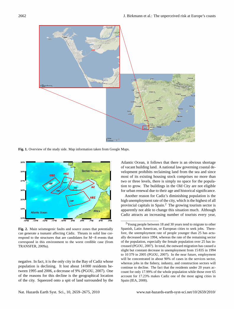
The Bay of Cadiz is geographically between longitude 6◦ Wand 6◦25′ W and latitude 36◦20′ N and 36◦40′ N, in thesouth-west of the Iberian Peninsula (Fig. 1). It faces westto the Gulf of Cadiz and is landlocked by the mainland at itssouth-western, southern, and eastern margins. This area is anaturally protected zone with large tidal flatbeds, tidal chan-nels, and several beaches. Its geomorphology, being a penin-sula, its location between the Strait of Gibraltar and the rivermouth of the Guadalquivir, and the natural port formed by theBay of Cadiz have made the city of Cadiz along with the en-tire surrounding region a first order strategic area in terms ofmaritime, commercial, and military activities (PGOU, 2007).Cadiz is not only a city but also an important port in south-western Spain. It is the capital of the province of Cadiz,which represents one of the eight provinces that make up theautonomous community of Andalusia.
Cadiz is the oldest permanently inhabited city of theIberian Peninsula. It was founded by the Phoenicians be-tween 1104 and 900 BC. Ever since, it has functioned asan important trade, commercial, and naval base under dif-ferent cultural governances. These have endowed the citywith a rich historical and cultural heritage, which now makeit a great tourist attraction. Its commercial importance hassteadily increased, currently representing the strongest eco-nomic sector owing to its local shipyards and ports (PGOU,2007). The net business revenue at Cadiz port yields about21.31 million Euros (in 2007, Puerto de la Bahıa de Cadiz,2008), and the port also serves as an important node forcruises to the Canary Islands and South America. In 2006,about 300 cruises arrived at the port, bringing more than176 000 tourists, which helped to sustain the local economy(PGOU, 2007). The port of Cadiz contributes most to thecity’s economy since it also stimulates the complementaryeconomic activities in the third sector. In comparison, the in-dustrial sector has been constantly declining in importance,and manufacturing jobs and their spin-off businesses are ex-pected to continue to weaken in the future (PGOU, 2007).
Referring to the demography, in 2007 Cadiz had a pop-ulation of 128 554 inhabitants (IEA, 2008), making it thecity with the highest population density in Spain (29 672 95inhabitants/km2). Despite this, the demographic trend is
www.nat-hazards-earth-syst-sci.net/10/2659/2010/ Nat. Hazards Earth Syst. Sci., 10, 2659–2675, 2010
2662 J. Birkmann et al.: The unperceived risk at Europe’s coasts
Fig. 1. Overview of the study side. Map information taken from Google Maps.
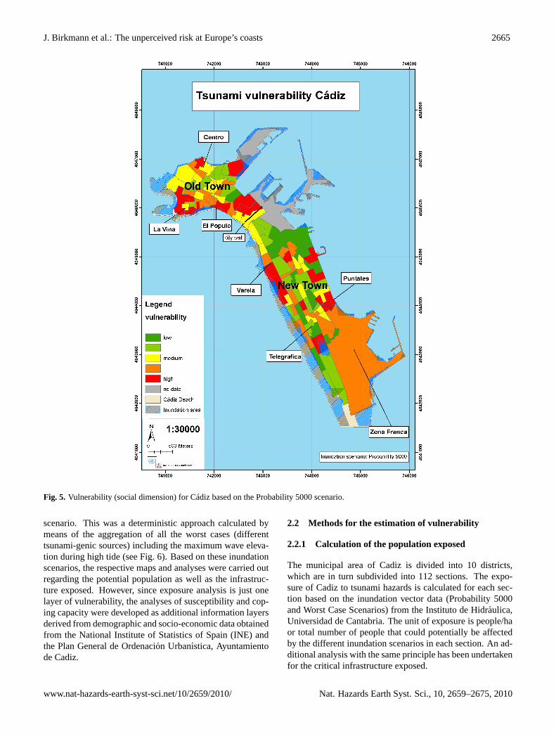
Fig. 2. Main seismogenic faults and source zones that potentiallycan generate a tsunami affecting Cadiz. Thrusts in solid line cor-respond to the structures that are candidates for M∼8 events thatcorrespond in this environment to the worst credible case (fromTRANSFER, 2009a).
negative. In fact, it is the only city in the Bay of Cadiz whosepopulation is declining. It lost about 14 000 residents be-tween 1995 and 2006, a decrease of 9% (PGOU, 2007). Oneof the reasons for this decline is the geographical locationof the city. Squeezed onto a spit of land surrounded by the
Atlantic Ocean, it follows that there is an obvious shortageof vacant building land. A national law governing coastal de-velopment prohibits reclaiming land from the sea and sincemost of its existing housing stock comprises no more thantwo or three levels, there is simply no space for the popula-tion to grow. The buildings in the Old City are not eligiblefor urban renewal due to their age and historical significance.
Another reason for Cadiz’s diminishing population is thehigh unemployment rate of the city, which is the highest of allprovincial capitals in Spain.2 The growing tourism sector isapparently not able to change this situation much. AlthoughCadiz attracts an increasing number of tourists every year,
2Young people between 18 and 30 years tend to migrate to otherSpanish, Latin American, or European cities to seek jobs. There-fore, the unemployment rate of people younger than 25 has actu-ally decreased since 1994, whereas the rate of the remaining sectorof the population, especially the female population over 25 has in-creased (PGOU, 2007). In total, the outward migration has caused aslight but constant decrease in unemployment from 15 835 in 1994to 10 379 in 2005 (PGOU, 2007). In the near future, employmentwill be concentrated in about 90% of cases in the services sector,whereas jobs in the fishery, industry, and construction sectors willcontinue to decline. The fact that the residents under 20 years ac-count for only 17.99% of the whole population while those over 65account for 17.23% makes Cadiz one of the most aging cities inSpain (IEA, 2008).
Nat. Hazards Earth Syst. Sci., 10, 2659–2675, 2010 www.nat-hazards-earth-syst-sci.net/10/2659/2010/

J. Birkmann et al.: The unperceived risk at Europe’s coasts 2663
Fig. 3. Initial surface displacement for the worst case scenario for the CWF fault (see location in Fig. 2) and the propagation of the tsunami(from TRANSFER, 2009a).
mainly because of its beautiful beaches, the tourism sectordoes not significantly increase the income of families or re-duce the unemployment rate. In general, the economic sit-uation of Cadiz is quite alarming, which has meant that thegovernorate has had to call on federal support several timesand the city has received financial support from the EuropeanUnion (PGOU, 2007).
1.3 Exposure to tsunamis
Cadiz’s geographical location (Fig. 1) as a peninsula reach-ing into the open Atlantic makes it especially exposed toall sorts of ocean-related hazards, such as storm surges andtsunamis. It follows that several historical records of destruc-tive tsunamis have surfaced. The oldest accounts date backto the years 218–210 BC, and were determined by histori-cal, geo-morphological, sedimentary, palaeontological, andgeo-chronological data records (Luque et al., 2002, p. 623;Fernandez Reina, 2001). In fact, the seismic chronicles sum-marized in a catalogue by Galbis (1937, 1940, cited in Luqueet al., 2002) speak of 18 tsunamis affecting the Spanish At-lantic coast between the third century BC and 1900. Themost prominent occurrence, described in great detail, was
the earthquake and subsequent tsunami in 1755 which origi-nated about 200 km southwest of Cape St. Vincent. Sedimen-tary records prove that this event must have had a minimumwave height of at least the 1.5 m required to overtop the bar-rier of the city, but the extent of deposition suggests an eventwith a wave of a much greater height of approximately 10 m(Carreno, 2005; La Voz, 2008). It had its strongest impacton the city of Lisbon, but it also accounted for 270 victims inCadiz (La Voz, 2008).
The most damaging earthquakes and tsunamis that haveaffected the coasts of Portugal, Morocco, and Spain wereprobably generated in the SWIT zone (the Azores – Gibral-tar fault zone), including the mega tsunami that struck on 1November 1755. In order to define the location and charac-teristics of possible tsunami-genic sources in the frame of theTRANSFER Project (see TRANSFER, 2009a), four individ-ual source zones including five potential tsunami sources andsource mechanisms were distinguished in the SWIT area (seeFigs. 2 and 3). The identified areas were the Gorringe Bankzone (GBZ), the Horseshoe/Marques de Pombal zone (HSZ),the South Algarve zone (AZ), and the Alboran Slab zone(ABZ). The five potential tsunami sources are the GorringeBank Fault (GBF), the Horseshoe Fault (HSF), the Marques
www.nat-hazards-earth-syst-sci.net/10/2659/2010/ Nat. Hazards Earth Syst. Sci., 10, 2659–2675, 2010

2664 J. Birkmann et al.: The unperceived risk at Europe’s coasts
Fig. 4. Adapted BBC-framework for the social dimension of vulnerability.
de Pombal Fault (MPF), the Portimao Bank Fault (PBF), theCadiz Wedge Fault (CWF). In each source zone a MaximumCredible Earthquake (MCE) was envisaged. This maximumcredible earthquake was associated with the typical faults ineach source, generating the maximum credible tsunami sce-nario for each fault. As additional data for the probabilisticinundation maps, the magnitude of the scaling relationshipbased on fault lengths and length/width relations was used.The dip attributed to the faults is due to taking into consider-ation the geodynamic significance and evolution.
2 Assessment data and methodologies to estimateTsunami vulnerability and risk
Based on the BBC conceptual framework (see Birkmann,2006, p. 34), this study only considers the social and theeconomic dimension of vulnerability – including critical in-frastructure. In order to derive information for all three vari-ables of vulnerability – exposure, susceptibility, and copingcapacity (see Fig. 4), statistical as well as spatial data wereneeded. The data were obtained from following institutes:statistical data based on socio-economic factors from the Na-tional Institute of Statistics of Spain (INE;http://www.ine.es/welcoing.htm), demographic and socio-economic data fromthe regional government in Andalucia, and geospatial datafrom the Plan General de Ordenacion Urbanistica, Ayun-tamiento de Cadiz (http://www.cadiz.es/app). Based on thequality criteria for indicators, a list of desired data and in-dicators to be obtained for Cadiz was developed (Nardo etal., 2005). However, due to different limiting factors, not allof these data could be received and therefore included in thevulnerability assessment.
2.1 Tsunami hazard assessment and potentialinundation areas
The analysis of those areas and elements exposed to tsunamiimpacts requires the development of hazard scenarios andtheir respective inundation areas. In this regard, the expo-sure was calculated according to specific tsunami scenar-ios termed Worst Case scenario and Probability 5000 sce-nario. Both scenarios and respective inundation maps weredeveloped by the University of Cantabria. In methodologicalterms, that means that deterministic as well as probabilis-tic high resolution tsunami inundation maps were developedfor Cadiz. The deterministic approximation combines theworst scenario for each potential tsunami-genic source withthe local tides. Based on this methodology, inundation lines,maximum water depth, maximum water velocities, the max-imum Froude number, as well as maximum hydrodynamicand hydrostatic forces of the Worst Case scenario coincidingwith the most probable tidal level were elaborated, derivedfrom the hazard analysis. The second level of analysis en-compassed probabilistic maps based on Monte Carlo meth-ods. This method combines the occurrence of earthquakesin the potential sources, source mechanisms, epicentre loca-tions, sea level (astronomical and meteorological tides), andmore than 800 numerical simulations using a specific model,the so-called C3 model (Olabarrieta et al., 2009). Respectiveinundation scenarios for Cadiz and the larger region aroundCadiz could be generated for return periods of 500, 1000,5000, and 10 000 years.
For this study we chose two scenarios, the first one calledProbability 5000. Scenarios are useful to include the effectsof different variables or uncertainties in the calculation ofthe probabilistic hazard due to tsunamis. Within these meth-ods, the tidal effect as well as other random variables caneasily be taken into account. Hence the maximum waveelevation for a 5000-year return period was used to derivethe inundation scenario and respective exposure estimations(see Fig. 5). The second scenario is called the Worst Case
Nat. Hazards Earth Syst. Sci., 10, 2659–2675, 2010 www.nat-hazards-earth-syst-sci.net/10/2659/2010/
J. Birkmann et al.: The unperceived risk at Europe’s coasts 2665
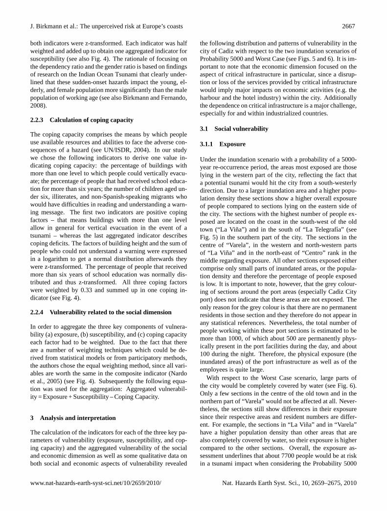
Fig. 5. Vulnerability (social dimension) for Cadiz based on the Probability 5000 scenario.
scenario. This was a deterministic approach calculated bymeans of the aggregation of all the worst cases (differenttsunami-genic sources) including the maximum wave eleva-tion during high tide (see Fig. 6). Based on these inundationscenarios, the respective maps and analyses were carried outregarding the potential population as well as the infrastruc-ture exposed. However, since exposure analysis is just onelayer of vulnerability, the analyses of susceptibility and cop-ing capacity were developed as additional information layersderived from demographic and socio-economic data obtainedfrom the National Institute of Statistics of Spain (INE) andthe Plan General de Ordenacion Urbanıstica, Ayuntamientode Cadiz.
2.2 Methods for the estimation of vulnerability
2.2.1 Calculation of the population exposed
The municipal area of Cadiz is divided into 10 districts,which are in turn subdivided into 112 sections. The expo-sure of Cadiz to tsunami hazards is calculated for each sec-tion based on the inundation vector data (Probability 5000and Worst Case Scenarios) from the Instituto de Hidraulica,Universidad de Cantabria. The unit of exposure is people/haor total number of people that could potentially be affectedby the different inundation scenarios in each section. An ad-ditional analysis with the same principle has been undertakenfor the critical infrastructure exposed.
www.nat-hazards-earth-syst-sci.net/10/2659/2010/ Nat. Hazards Earth Syst. Sci., 10, 2659–2675, 2010

2666 J. Birkmann et al.: The unperceived risk at Europe’s coasts
Fig. 6. Vulnerability (social dimension) for Cadiz based on the worst case scenario.
2.2.2 Calculation of susceptibility
Based on the age structure of the demographic dataset, weextracted the predisposition of people easily affected or in-fluenced by tsunamis. The following two indicators weredefined for susceptibility: the first indicator comprises thepercentage of population younger than six and older than 65years. These thresholds are based on findings from studies inSri Lanka and Indonesia that were carried out after the De-cember tsunami 2004 (Rofi and Doocy, 2006). Examinationsof dead and missing by age group demonstrated that smallchildren and people older than 61 were most affected andthus were more vulnerable compared with other age groups
(Jayasingam and Birkmann, 2007). The second indicator isderived from the following Eq. (1):(
1−
(male(15−65 years)
total population
))·100 (1)
This equation encompasses a combination of dependencyratio and gender ratio and states the percentage of the totalpopulation to be supported in case of a tsunami. That meansit outlines areas that need external assistance the most, andis therefore a relative measure of vulnerability. Both indica-tors were tested on normal distribution but the gender-relateddependency ratio was not normally distributed. Hence, thisindicator was denominated as a logarithm and thereafter
Nat. Hazards Earth Syst. Sci., 10, 2659–2675, 2010 www.nat-hazards-earth-syst-sci.net/10/2659/2010/
J. Birkmann et al.: The unperceived risk at Europe’s coasts 2667
both indicators were z-transformed. Each indicator was halfweighted and added up to obtain one aggregated indicator forsusceptibility (see also Fig. 4). The rationale of focusing onthe dependency ratio and the gender ratio is based on findingsof research on the Indian Ocean Tsunami that clearly under-lined that these sudden-onset hazards impact the young, el-derly, and female population more significantly than the malepopulation of working age (see also Birkmann and Fernando,2008).
2.2.3 Calculation of coping capacity
The coping capacity comprises the means by which peopleuse available resources and abilities to face the adverse con-sequences of a hazard (see UN/ISDR, 2004). In our studywe chose the following indicators to derive one value in-dicating coping capacity: the percentage of buildings withmore than one level to which people could vertically evacu-ate; the percentage of people that had received school educa-tion for more than six years; the number of children aged un-der six, illiterates, and non-Spanish-speaking migrants whowould have difficulties in reading and understanding a warn-ing message. The first two indicators are positive copingfactors – that means buildings with more than one levelallow in general for vertical evacuation in the event of atsunami – whereas the last aggregated indicator describescoping deficits. The factors of building height and the sum ofpeople who could not understand a warning were expressedin a logarithm to get a normal distribution afterwards theywere z-transformed. The percentage of people that receivedmore than six years of school education was normally dis-tributed and thus z-transformed. All three coping factorswere weighted by 0.33 and summed up in one coping in-dicator (see Fig. 4).
2.2.4 Vulnerability related to the social dimension
In order to aggregate the three key components of vulnera-bility (a) exposure, (b) susceptibility, and (c) coping capacityeach factor had to be weighted. Due to the fact that thereare a number of weighting techniques which could be de-rived from statistical models or from participatory methods,the authors chose the equal weighting method, since all vari-ables are worth the same in the composite indicator (Nardoet al., 2005) (see Fig. 4). Subsequently the following equa-tion was used for the aggregation: Aggregated vulnerabil-ity = Exposure + Susceptibility – Coping Capacity.
3 Analysis and interpretation
The calculation of the indicators for each of the three key pa-rameters of vulnerability (exposure, susceptibility, and cop-ing capacity) and the aggregated vulnerability of the socialand economic dimension as well as some qualitative data onboth social and economic aspects of vulnerability revealed
the following distribution and patterns of vulnerability in thecity of Cadiz with respect to the two inundation scenarios ofProbability 5000 and Worst Case (see Figs. 5 and 6). It is im-portant to note that the economic dimension focused on theaspect of critical infrastructure in particular, since a disrup-tion or loss of the services provided by critical infrastructurewould imply major impacts on economic activities (e.g. theharbour and the hotel industry) within the city. Additionallythe dependence on critical infrastructure is a major challenge,especially for and within industrialized countries.
3.1 Social vulnerability
3.1.1 Exposure
Under the inundation scenario with a probability of a 5000-year re-occurrence period, the areas most exposed are thoselying in the western part of the city, reflecting the fact thata potential tsunami would hit the city from a south-westerlydirection. Due to a larger inundation area and a higher popu-lation density these sections show a higher overall exposureof people compared to sections lying on the eastern side ofthe city. The sections with the highest number of people ex-posed are located on the coast in the south-west of the oldtown (“La Vina”) and in the south of “La Telegrafıa” (seeFig. 5) in the southern part of the city. The sections in thecentre of “Varela”, in the western and north-western partsof “La Vi na” and in the north-east of “Centro” rank in themiddle regarding exposure. All other sections exposed eithercomprise only small parts of inundated areas, or the popula-tion density and therefore the percentage of people exposedis low. It is important to note, however, that the grey colour-ing of sections around the port areas (especially Cadiz Cityport) does not indicate that these areas are not exposed. Theonly reason for the grey colour is that there are no permanentresidents in those section and they therefore do not appear inany statistical references. Nevertheless, the total number ofpeople working within these port sections is estimated to bemore than 1000, of which about 500 are permanently phys-ically present in the port facilities during the day, and about100 during the night. Therefore, the physical exposure (theinundated areas) of the port infrastructure as well as of theemployees is quite large.
With respect to the Worst Case scenario, large parts ofthe city would be completely covered by water (see Fig. 6).Only a few sections in the centre of the old town and in thenorthern part of “Varela” would not be affected at all. Never-theless, the sections still show differences in their exposuresince their respective areas and resident numbers are differ-ent. For example, the sections in “La Vina” and in “Varela”have a higher population density than other areas that arealso completely covered by water, so their exposure is highercompared to the other sections. Overall, the exposure as-sessment underlines that about 7700 people would be at riskin a tsunami impact when considering the Probability 5000
www.nat-hazards-earth-syst-sci.net/10/2659/2010/ Nat. Hazards Earth Syst. Sci., 10, 2659–2675, 2010

2668 J. Birkmann et al.: The unperceived risk at Europe’s coasts
Table 1. Root causes of vulnerability and possible measures of prevention in different sectors.
Elements of Demography Tourism Education Urban Infrastructure Planning Communicationvulnerability structure
Aspects Elderly citizens Lack of knowledge Different Different Infrastructure not (1) Lack of risk Low probability andabout the risk behaviour of geological adapted/prepared maps and plans high uncertainty with
children levels within (2) Lack of plans of respect to tsunamithe city shelters occurrence
Principal Aging Tourism sector Existing plans Naturalcauses population interested in not appropriate causes
ignoring the risk (e.g. evacuation)
Possible measures (1) Information in (1) Adopt Define non (1) Hermetic Regular revisions (1) Regular educationof prevention various languages evacuation floodable areas protection (at low and updates and and communication
provided by tourist plans (legally) of the city/ cost) evacuationoffices shelters on exercises in the
higher grounds most importantinstitutions
(2) Information (2) Educate and (2) Identify critical (2) Identify criticaltourist centres staff train teachers infrastructure and institutions
and parents adapt it(3) Monitoring (3) Simulationsregulations at local, and exercisesregional, andnational level
Responsible Civil protectioninstitution Education
centres
Table 2. Total number of people and area exposed for probabilityscenario 5000 years.
Exposure of Number % of all
People 7684 5.9Area in [ha] 83.32 11.7
Table 3. Total number of people and area exposed for worst casescenario.
Exposure of Number % of all
People 79 854 61.2Area in [ha] 83.32 73.7
scenario, and nearly 80 000 people (61% of the total popu-lation of Cadiz) are at risk when considering the Worst Casescenario (see Tables 1 and 2).
3.1.2 Susceptibility
As the susceptibility of the population living in Cadiz was ba-sically calculated on the basis of age and gender distribution– due to non-availability of other indicators such as health,employment, and income data at a finer resolution – the dif-ferent levels of this factor of vulnerability show the followingdistribution.
Most of the sections representing high susceptibility lie inthe old town of Cadiz. Some others can be found in the northwestern part of “Varela” and some are distributed through-out the central part of “Puntales”. A main hypothesis thatwas verified during the Indian Ocean Tsunami (see Birkmannand Fernando, 2008; Rofi and Doocy, 2006; Jayasingam andBirkmann, 2007) posited that the population over 65 and un-der six years had greater difficulty in taking flight and seek-ing rescue in the event of a tsunami since children are usu-ally dependent on their parents, not aware of the potentialthreat, and not able to take the necessary decisions. Old peo-ple would be less able to escape to higher levels of build-ings and might have greater difficulty in receiving and un-derstanding warning messages. The gender ratio combinedwith the dependency ratio also shows that in these populationsegments, a high number of people beyond working age areeconomically dependent on the male population of workingage. Thus, the economic dependency on the male popula-tion is very high and consequently the susceptibility of theentire segment is higher than in those areas where the mainpopulation is male and of working age. The generally higheremployment numbers of males compared to females is alsoevident for Spain, which means that higher economic depen-dency can be assumed.
In general, the distribution of the levels of susceptibilityreflects the fact that a large proportion of the population ofCadiz is composed of old people that would have greaterdifficulty in dealing with a tsunami situation and wouldhave to receive strong economic support from the working
Nat. Hazards Earth Syst. Sci., 10, 2659–2675, 2010 www.nat-hazards-earth-syst-sci.net/10/2659/2010/

J. Birkmann et al.: The unperceived risk at Europe’s coasts 2669
Fig. 7. Exposure of critical infrastructure for Cadiz based on the Probability 5000 scenario.
population in order to recover. The current population datadoes not allow for factoring in the fluctuations in numbersof people during the winter and summer periods (the touristseason) as well as the exposure of people at their workplace.
3.1.3 Coping capacity
The lowest coping capacity can be observed in the urban sec-tions in the south-east of Cadiz, in “Zona Franca” and “Pun-tales”, in the quarters around the city wall separating the oldand new town, and in some sections in the west and northof the old town. The reason for the poor coping capacityin the south-eastern sections is the low level of education ofthe inhabitants and the high number of migrants and illiter-
ates who are unlikely to be able to understand information ontsunami risks and warnings properly in the case of an acutehazard event. The reason for the low coping capacity in thesections of “Puntales” is also poor levels of education anda high number of children under six years who would havethe same difficulties as those described for migrants and il-literates. The same factors also account for the low copingcapacity in the sections around the border between the oldand the new parts of the city as well as parts in the old town.
The higher levels of coping capacity throughout most ofthe sections in the old town can be explained by the largenumber of buildings that have more than one level, thusoffering evacuation opportunities (vertical evacuation). In
www.nat-hazards-earth-syst-sci.net/10/2659/2010/ Nat. Hazards Earth Syst. Sci., 10, 2659–2675, 2010

2670 J. Birkmann et al.: The unperceived risk at Europe’s coasts
Fig. 8. Exposure of critical infrastructure for Cadiz based on the worst case scenario.
addition, the level of education in this part of the city is com-paratively high and the number of migrants and illiterates islow.
3.1.4 Social dimension of vulnerability
Following the distribution of the levels of (a) exposure, (b)susceptibility, and (c) coping capacity throughout the city ofCadiz, the following results can be outlined:
Referring to the Probability 5000 scenario , the most vul-nerable sections lie in the coastal areas of the old town, espe-cially in “La Vi na”, “El Populo”, and in the north of “Cen-tro”. This is due to the high exposure of these sections, thehigh percentage of old people living in them (high suscepti-
bility), and a low coping capacity, especially in the sectionslocated in “La Vina” and the central-northern sector of “Cen-tro” (see Fig. 5).
The high vulnerability in the sections in “Varela” is dueto a very low coping capacity (especially in the sections onthe eastern coast of the city) and the high susceptibility insome of them. The high vulnerability in the section aroundthe Free Port Zone (“Zona Franca”) is the result of a verylow coping capacity (very low education levels and a highnumber of migrants and illiterates).
With respect to the Worst Case scenario, the most vulnera-ble sections are concentrated in “La Vina”, the north of “Cen-tro”, and “Puntales”. Their high vulnerability compared to
Nat. Hazards Earth Syst. Sci., 10, 2659–2675, 2010 www.nat-hazards-earth-syst-sci.net/10/2659/2010/

J. Birkmann et al.: The unperceived risk at Europe’s coasts 2671
Fig. 9. Exposure of critical infrastructure for Cadiz based on the worst case scenario.
the Probability 5000 scenario is explained by a higher expo-sure in comparison to the other sections. Furthermore, thedegree of susceptibility and coping capacity is the same as inthe Probability 5000 scenario.
3.2 Economic vulnerability/vulnerability ofcritical infrastructures
Only the exposure of critical infrastructure (transformer sta-tions for the provision of electricity, hospitals, hotels andpensions as well as evacuation shelters) has been calcu-lated when analysing the city’s economic vulnerability (seeFigs. 7–10). Diverse geospatial data such as transformer sta-
tions, hospitals, hotels, and pensions were combined with themodelled inundation scenarios (Probability 5000 and worstcase scenario) using GIS-techniques in order to establish thepotential impact on diverse elements of critical infrastruc-ture. The physical susceptibility of individual infrastructureelements could not be derived from the existing data. How-ever, qualitative studies such as expert interviews, laymeninterviews, and focus group discussions carried out duringan empirical field trip in March 2009 allow for some estima-tions of the coping capacity, which in this case would consistof evacuation plans or measures of prevention and prepara-tion.
www.nat-hazards-earth-syst-sci.net/10/2659/2010/ Nat. Hazards Earth Syst. Sci., 10, 2659–2675, 2010
2672 J. Birkmann et al.: The unperceived risk at Europe’s coasts
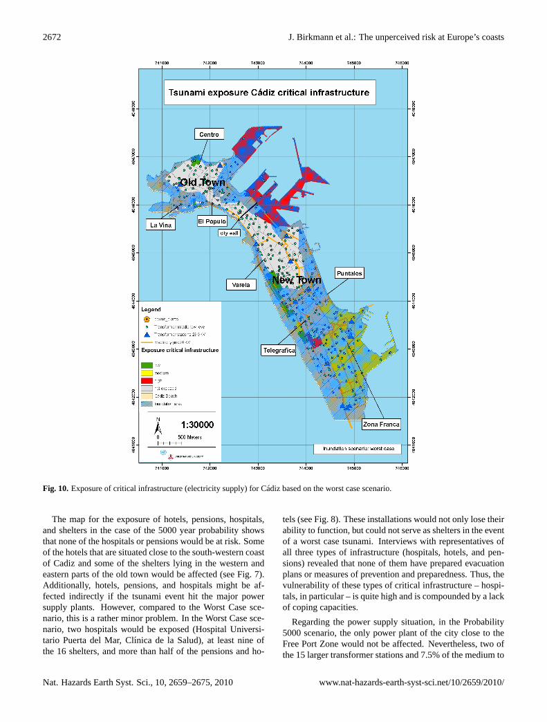
Fig. 10. Exposure of critical infrastructure (electricity supply) for Cadiz based on the worst case scenario.
The map for the exposure of hotels, pensions, hospitals,and shelters in the case of the 5000 year probability showsthat none of the hospitals or pensions would be at risk. Someof the hotels that are situated close to the south-western coastof Cadiz and some of the shelters lying in the western andeastern parts of the old town would be affected (see Fig. 7).Additionally, hotels, pensions, and hospitals might be af-fected indirectly if the tsunami event hit the major powersupply plants. However, compared to the Worst Case sce-nario, this is a rather minor problem. In the Worst Case sce-nario, two hospitals would be exposed (Hospital Universi-tario Puerta del Mar, Clınica de la Salud), at least nine ofthe 16 shelters, and more than half of the pensions and ho-
tels (see Fig. 8). These installations would not only lose theirability to function, but could not serve as shelters in the eventof a worst case tsunami. Interviews with representatives ofall three types of infrastructure (hospitals, hotels, and pen-sions) revealed that none of them have prepared evacuationplans or measures of prevention and preparedness. Thus, thevulnerability of these types of critical infrastructure – hospi-tals, in particular – is quite high and is compounded by a lackof coping capacities.
Regarding the power supply situation, in the Probability5000 scenario, the only power plant of the city close to theFree Port Zone would not be affected. Nevertheless, two ofthe 15 larger transformer stations and 7.5% of the medium to
Nat. Hazards Earth Syst. Sci., 10, 2659–2675, 2010 www.nat-hazards-earth-syst-sci.net/10/2659/2010/

J. Birkmann et al.: The unperceived risk at Europe’s coasts 2673
low level transformer stations would probably be impactedand inundated. According to the technical director of theelectricity provider of Cadiz, a water level higher than onemetre would render each transformer inoperative. Consider-ing that each of the 371 transformers provides 1–200 houseswith electricity, an electricity outage could affect a maximumof 5565 houses, with severe consequences for the basic func-tions of living (see Fig. 9).
If the Worst Case scenario became reality, not only would12 of the larger transformer stations and 65% of the mediumto low level transformer stations collapse, but in addition, thepower plant would be inundated by sea water. That wouldmean that power outages could affect around 65–100% ofthe households in Cadiz.
Although water pipes are not explicitly shown on the map,an interview with the technical director of the water supplycompany in Cadiz has revealed that there are only two wa-ter pipes that deliver fresh water to the whole city. Bothpipes are installed along the route between San Fernando andCadiz. Since this route is only a narrow land connection, atsunami hitting this route from the west would probably seri-ously damage or even destroy both pipes. In this case, therewould only be a fresh water supply for 24 h, since the watertanks for emergency situations can only cater for this amountof time.
Although not classified as critical infrastructure, the pos-sibility of a larger break in the functionality of the port ofCadiz poses an additional threat to the city. The importanceof the port of Cadiz can be illustrated by the fact that inthe year 2007, the port possessed real estate with a value of239 million Euros. Its working capital was 16 million Eurosand the net amount of business totalled 21 million Euros. Inaddition, about five merchant vessels (around 66 000 tons)entered the port each day and around 1884 passengers tran-sited due to the arrival and departure of cruises that sail toother European as well as Latin American and North Ameri-can coasts. About 3918 employees are directly dependent onthe functioning of services provided by the port. These fig-ures underline even further the serious economic and socialconsequences that a large tsunami could imply, including thedisruption of the port activities.
3.2.1 Institutional awareness and lack of preparedness
Besides the revealed levels of vulnerability using socio-economic and demographic data and qualitative assessmentsthe research highlights a very low awareness of tsunami riskin the city of Cadiz and in local government authorities.
In the risk guide provided by the Civil Protection Agency,the risk of inundation caused by tsunamis is classified as“practically non-existent in this area of the globe”. Addi-tionally, the chapter on seismic risks includes one paragraphabout tsunamis, but it just describes their genesis in general,and no specific information is given that can be used as a real
basis to develop appropriate preparedness and coping strate-gies (see also Aparicio, 2002, p. 2).
The General Urban Development Plan (Plan General deOrdenacion Urbanıstica) developed by the local government(Ayuntamiento de Cadiz) in 2007, also includes a chapter onnatural and technological risks. However, the risk of inun-dation caused by tsunamis which would bring about massivedestruction is not included. Furthermore, interviews carriedout with local people as well as expert interviews confirmedthat the potential threat of a tsunami is not present in theminds of most residents and officials. In the cases wherethey knew about past events, such as the tsunami in 1755,they were not aware of the present risk or of possible signs toidentify a tsunami, and even less of appropriate measures ofprevention or vulnerability reduction. Interviews with repre-sentatives of schools, the tourist sector, the port authority andpublic and private companies showed that no risk or emer-gency plans or educational measures exist with respect totsunami risk awareness and tsunami response. Overall, theinterviews conducted also demonstrate the absence of a lo-cal perception of tsunami risk, and that organizational andinstitutional strategies for risk reduction do not yet includetsunamis. Therefore, the so-called institutional dimension ofvulnerability is also an important aspect that needs to receivemore attention in the future in order to create a basis for ef-fective preparedness strategies.
4 Results and outlook
The hazard and vulnerability assessment of Cadiz regardingtsunamis revealed that although the probability of a tsunamiis relatively low, its consequences – particularly consider-ing the Worst Case scenario possibility - would have severenegative consequences for the city and its inhabitants. Thesystematic analysis of the key components of vulnerability:(a) exposure, (b) susceptibility, and (c) coping capacities,revealed that some parts of the population and some areaswithin the city are clearly more vulnerable than others. Thatmeans the assessment also allows for identifying priority ar-eas where future development should consider tsunamis asone of the risk factors stemming from the sea. It is importantto note that until now there has been no mention of tsunamisas a possible hazard in the coastal region. Moreover, theawareness and also the knowledge of what a tsunami meansis very limited among the population potentially exposed tothem. Furthermore, the assessment criteria used emphasizethat measures for improving coping capacities – such as ver-tical evacuation options – could become part of strategic fu-ture urban development planning. However, to date, thesemeasures or aspects have not been taken into account. Addi-tionally, the survey and the underlying framework also showsthat the mapping of potential inundation areas for tsunamihazards is important, but not sufficient if the aim is to de-velop a more comprehensive risk and vulnerability reduction
www.nat-hazards-earth-syst-sci.net/10/2659/2010/ Nat. Hazards Earth Syst. Sci., 10, 2659–2675, 2010

2674 J. Birkmann et al.: The unperceived risk at Europe’s coasts
strategy. Besides physical inundation, vulnerability also de-pends – as shown by the selected indicators – on the socialcomposition of the population exposed and their response ca-pacities in terms of the ability to cope with the potential im-pact of a tsunami. In this context, one is confronted by thefact that in a European city like Cadiz, a quantitative vulner-ability assessment is hampered by a lack of appropriate data.While at the sub-national scale additional data for importantsocio-economic indicators such as unemployment, etc. ex-isted, this data was not available at a fine spatial resolution tocover, for example, parts of the city of Cadiz. Therefore, itis recommended to combine quantitative and qualitative ap-proaches within a vulnerability assessment. This would al-low the vulnerability to tsunami risk to be captured in a morecomprehensive way than just by mapping the exposure.
Moreover, the issue of critical infrastructure, where datacould be obtained for power plants, middle and low leveltransformer stations, and electricity lines, also shows that apotential tsunami could cut off 5565 households (based onProbability 5000 scenario) from electricity within seconds.This could entail particularly severe consequences for othercritical elements of infrastructure such as the piped watersupply or the ability of hospitals to run normally. Therefore,tsunamis – even if the probability of occurrence is relativelylow – should be considered within the further developmentand renewal of critical infrastructure, particularly since suchinfrastructure is critical in emergencies and crisis situations.In addition, it is characterized by lack of mobility and highcost.
Lastly, it is worth pointing out that the discussion of theassessment results in Cadiz has also allowed the identifica-tion of the first measures and actions required to reduce riskand vulnerability. During an expert meeting conducted inMarch 2009 in Cadiz, the different vulnerable sections of thecity, the root causes of their vulnerability, as well as poten-tial measures to reduce vulnerability were discussed withina focused group discussion. Interestingly, the key measuresthat participants and experts proposed should be taken as afirst step do not require large financial resources, but mainlyencompass information and communication as well the iden-tification of the most critical infrastructure (see Table 1). Fur-thermore, the discussion revealed that the evacuation of thecity would not be an option for Cadiz, since the only tworoutes leading out of the city (N-443 and CA-33) could onlyaccommodate the exit of 4000 cars per hour, while the to-tal number of cars in Cadiz is about 50 000. Thus, the onlypossibility of rapid evacuation is a vertical evacuation withinbuildings that have more than one floor and that are con-structed in a suitable fashion. This is an important messagethat must be communicated to the people via all possible in-formation channels, starting in schools and through the me-dia. In addition, evacuation simulations and exercises shouldbe carried out on a regular basis in schools and other impor-tant public and private institutions. In this regard, lessonscould be learned from countries in South East Asia where
awareness raising campaigns and school training on tsunamirisk have been conducted in every country, e.g. Indonesia(Taubenboeck et al., 2009). The experts concluded that thesemeasures are relatively easy to implement and require onlylimited funding. Conversely, it was admitted by local stake-holders that more costly and intense activities would proba-bly be difficult to put in place due to the lack of governmental(and therefore financial) support because of the high level ofuncertainty and the infrequencyof tsunamis in Cadiz. How-ever, vulnerability maps clearly indicate that different fea-tures of vulnerability should be considered and that prioritiescan be defined in terms of improving the situation, particu-larly in the most vulnerable parts of the city with respect tosocial groups and critical infrastructure. The main purposeof this assessment and the information it has developed isto help local decision-makers and civil protection managersto approach the people in greatest need of direct protectionbefore an adverse event occurs.
Particularly in the context of the further development ofthe NEAMTWS (http://www.ioc-tsunami.org/content/view/35/1035/), it needs to be underlined that besides the warninginfrastructure and the detection of geomorphological faultslikely to cause tsunamis, people-centred early warning alsorequires appropriate information about the people and re-gions potentially affected, their vulnerability, and responsecapacities. In this regard, the maps presented in this studyprovide an essential basis to better understand the suscepti-bility and response capacity of communities and cities ex-posed to potential tsunami threats in Europe.
Acknowledgements.This research work has been conducted withinthe framework of the TRANSFER (Tsunami Risk and Strategiesfor the European Region) project. The project was funded by theSixth Framework Programme of the European Commission. Theauthors are very thankful to all colleagues and for the valuablecomments of the reviewers.
Edited by: T. GladeReviewed by: two anonymous referees
References
Aparicio Florido, J. A.: Guıas de Riesgo. Sismos, Proteccion CivilAndalucıa, 20 pp., http://www.iaem.es/GuiasRiesgos/Sismos.pdf, 2002.
Aparicio Florido, J. A. : Guıas de Riesgo, Lluvias e inunda-ciones, Proteccion Civil Andalucıa, 15 pp.,http://www.iaem.es/GuiasRiesgos/Lluviaseinundaciones.pdf, 2003.
Birkmann, J.: Measuring vulnerability to promote disaster-resilientsocieties: Conceptual frameworks and definitions, in: MeasuringVulnerability to Natural Hazards, edited by: Birkmann, J., UNUPress., 9–54, 2006.
Birkmann, J. and Fernando, N.: Measuring revealed and emergentvulnerabilities of coastal communities to tsunami in Sri Lanka,Disasters, 32, No. 1, 82–105, 2008.
Nat. Hazards Earth Syst. Sci., 10, 2659–2675, 2010 www.nat-hazards-earth-syst-sci.net/10/2659/2010/

J. Birkmann et al.: The unperceived risk at Europe’s coasts 2675
Carreno Herrero, E.: La peligrosidad de tsunamis en las costasespanolas, Simulaciones, Ensenanza de las Ciencias de la Tierra(13.1), 60–64, 2005.
Chambers, R.: Vulnerability. Editorial Introduction, IDS Bulletin,20, 2. Sussex, 1–7, 1989.
Estadıstica, Madrid, (http://www8.madrid.org/cerrarapli/apli-iestadis-migrada.htm), last access 18 November 2008.
Fernandez Reina, J.: La ciudad insular, Cadiz, 158 pp., 2001.Frisch, W. and Meschede, M.: Plattentektonik – Kontinentver-
schiebung und Gebirgsbildung, 2. Aufl. Darmstadt, 2007.Galbis R. J.: Catalogo sısmico de la zona comprendida entre los-
meridianos 5◦ E y 20◦ W de Greenwich y los paralelos 45◦
y 25◦ N. Direccion General del Instituto Geografico Catastral.Madrid, 1940.
Galbis, R. J.: Catalogo sısmico de la zona comprendida entre losmeridianos 5◦ E y 20◦ W de Greenwich y los paralelos 45◦ y25◦ N. Direccion General del Instituto Geografico, Catastral y deEstadıstica, Madrid, 1932.
Garcin, M., Desprats, J. F., Fontaine, M., Pedreros, R., Attanayake,N., Fernando, S., Siriwardana, C. H. E. R., De Silva, U.,and Poisson, B.: Integrated approach for coastal hazards andrisks in Sri Lanka, Nat. Hazards Earth Syst. Sci., 8, 577–586,doi:10.5194/nhess-8-577-2008, 2008.
IEA (Instituto de Estadıstica de Andalucıa) (2008): Sis-tema de Informacion Multiterritorial de Andalucıa. Cadiz,http://www.juntadeandalucia.es/institutodeestadistica/sima/htm/sm11012.htm, (latest access: 16 January 2009).
Jayasingam, T. and Birkmann, J.: Vulnerabiltity Comparsion be-tween Galle and Batticaloa based on the Household Survey usingQuestionnaires, in: SOURCE No. 7., 39–47, Publication Seriesof UNU-EHS, Bornheim, 2007.
La Voz de Cadiz Newspaper: “Tsunami: la amenza 253 anos de-spues ”, 1 November 2008.
Luque, L., Lario, J., Silva, P. G., Zazo, G., Goy, J. L., and Dabrio,C. J.: Sedimentary Record of a Tsunami during Roman Times,Bay of Cadiz, Spain, J. Quaternary Sci., 17 (5–6), 623–631,2002.
Nardo, M., Saisana, M., Saltelli, A., Tarantola, S., Hoff-man, A., and Giovannini, E.: HANDBOOK ON CON-STRUCTING COMPOSITE INDICATORS: METHODOL-OGY AND USER GUIDE, OECD Statistics Working Pa-per, http://www.oecd.org/LongAbstract/0,2546,en264934257352316821196841 1 1,00.html, 2005.
Olabarrieta, M., Medina, R., Gonzalez, M., and Otero,L.: C3: A finite volume- Finite difference hybrid modelfor tsunami propagation and run- up, Comput. Geosci.,doi:10.1016/j.cageo.2010.09.016, PI: S0098-3004(10)00336-5,2009.
PGOU (Plan General de Ordenacion Urbanistica): Ayuntamientode Cadiz: Avance de la Adaptacion-Revision del, Cadiz, 2007.
Post, J., Wegscheider, S., Mck, M., Zosseder, K., Kiefl, R., Stein-metz, T., and Strunz, G.: Assessment of human immediate re-sponse capability related to tsunami threats in Indonesia at asub-national scale, Nat. Hazards Earth Syst. Sci., 9, 1075–1086,doi:10.5194/nhess-9-1075-2009, 2009.
Puerto de la Bahıa de Cadiz : Memoria Anual, 2007, 2008.Ribeiro, A.: Deformable plate tectonics of the Azores–Gibraltar
boundary–where the next 1755 earthquake will strike again?Actas del 1er Simposio sobre a margem continental IbericaAtl antica, 46–47, 1995.
Rofi, A. and Doocy, S.: Tsunami mortality and displacement inAceh province, Indonesia, Disasters, 30, 3, 340–350, 2006.
Schellmann, G.: Geologische Grundlagen, in: Geographie – Ph-ysische Geographie und Humangeographie, edited by: Gebhardt,H., Glaser, R., Radtke, U., Reuber, P., et al., Munchen, 264–282,2007.
Taubenbock, H., Goseberg, N., Setiadi, N., Lammel, G., Moder,F., Oczipka, M., Klupfel, H., Wahl, R., Schlurmann, T., Strunz,G., Birkmann, J., Nagel, K., Siegert, F., Lehmann, F., Dech, S.,Gress, A., and Klein, R.: “Last-Mile” preparation for a poten-tial disaster – Interdisciplinary approach towards tsunami earlywarning and an evacuation information system for the coastalcity of Padang, Indonesia, Nat. Hazards Earth Syst. Sci., 9, 1509–1528, doi:10.5194/nhess-9-1509-2009, 2009.
Thywissen, K.: ,,Components of Risk – A Comparative Glossary“,SOURCE, No. 2., Publication Series of UNU-EHS, Bornheim,2006.
Thywissen, K. : Core terminology of disaster reduction: A compar-ative glossary, in: Measuring Vulnerability to Natural Hazards,edited by: Birkmann, J., UNU Press, 448–496, 2006a.
Tinti, S.: Tsunami Research in Europe, Terra Nova, 2, 1, 19–22,2007.
TRANSFER: Scenario flooding and risk maps, probabilistic riskmaps for Cadiz city and Huelva community. Risk reduction mea-sures for Cadiz, Deliverable D8.2 of project TRANSFER, 6thEuropean Framework Programme, 2009a.
UC and IGN: Tsunami inundation maps along the south west Span-ish Coast, Deliverable D7.1 of project TRANSFER, 5th Euro-pean Framework Programme, 2009.
UNESCO- IOC - Intergovernmental Coordination Group forthe Tsunami Early Warning and Mitigation System inthe North Eastern Atlantic, the Mediterranean and Con-nected Seas, http://www.ioc-tsunami.org/index.php?option=com content&view=article&id=10&Itemid=14&lang=en, (lastaccessed 12 January 2009), 2009.
Villagran De Leon, J. C.: Vulnerability – A Conceptual andMethodological Review, SOURCE, Publication Series of UNU-EHS, Bornheim, 2006.
Villagran De Leon, J. C.: Rapid assessment of potential impactsof a tsunami: Lessons from the port of Galle in Sri Lanka. No.9, SOURCE Publication Series of UNU-EHS. Bonn, 96 pp,http://www.ehs.unu.edu/article:545?menu=36, 2008.
Watts, M. J. and Bohle, H.-G.: The Space of Vulnerability: theCausal Structure of Hunger and Famine, in: Progress in HumanGeography, 17, 1, 43–67,http://www.ine.es/welcoing.htm, 1993.
www.nat-hazards-earth-syst-sci.net/10/2659/2010/ Nat. Hazards Earth Syst. Sci., 10, 2659–2675, 2010
Copyright © 2022 FDOKUMEN