The unperceived risk to Europe's coasts: tsunamis and the vulnerability of Cadiz, Spain

ELSEVIER Marine Geology 155 (1999) 83–98
Surface facies and sediment dispersal patterns: southeastern Gulf ofCadiz, Spanish continental margin
Alberto Lopez-Galindo Ł, Jesus Rodero, Andres Maldonado
Instituto Andaluz de Ciencias de la Tierra. CSIC-Universidad de Granada, Avda. Fuentenueva s=n, 18002 Granada, Spain
Received 4 March 1996; revised version received 20 November 1997
Abstract
Grain size of 294 samples and mineralogical analysis of 364 surface samples from the Spanish continental shelf and up-per slope of the Gulf of Cadiz delineate four sediment facies that derive mainly from siliciclastic sources. The northern areais formed by the mud-rich prodelta of the Guadalquivir River, parallel to the coast and progradational towards the southeast.It exhibits a typical bulk mineral association of illite × smectite > kaolinite C chlorite. In the north-central area, there isa smaller, coarser-grained prodelta in the Bay of Cadiz, linked to the Guadalete River, which offshore becomes connectedto the Guadalquivir prodelta. Its mineral association is quartz × illite > kaolinite C chlorite. In the southern area, wherefluvial input is negligible, the characteristic coarse-grained facies generally corresponds to relict, Late Pleistocene reworkeddeposits. The typical mineral association is quartz > calcite > aragonite× smectite–mixed layer clay minerals. The fourtharea corresponds to the shelf break and upper slope offshore Cadiz Bay, where a westward grain-size coarsening differenti-ates the deposits of the last low sea-level stand and no typical mineral association exists. The mineralogy of the terrigenousdeposits indicates a source area from Paleozoic sequences of the Sierra Morena to the north and the Subbetic Units andGibraltar flysch to the east. The Neogene deposits of the Guadalquivir depression are an additional source of shelf sedi-ments. The surface sediment distribution on the inner continental shelf is largely determined by the southeastern Atlanticwater flow, the terrigenous input from rivers, and the shelf physiography. Sediment dispersal on the outer continental shelfand upper slope, in contrast, largely reflects the location of low sea-level stand, the development of palimpset deposits, andthe location of the Mediterranean undercurrent over the margin. 1999 Elsevier Science B.V. All rights reserved.
Keywords: Gulf of Cadiz; sediment facies; mineralogy; continental shelf processes; sediment dynamics
1. Introduction
The margin of the Gulf of Cadiz between themouth of the Guadalquivir River and the westernentrance to the Strait of Gibraltar has a predominantNW–SE orientation, although locally the coastlinedisplays an E–W trend (Fig. 1). These orientationsare mainly controlled by tectonic lineations that have
Ł Corresponding author. Tel.: C34-58-246207; Fax: C34-58-243075; E-mail: [email protected]
been recently active (Maldonado et al., 1999). Theshelf analysed corresponds to a typical example ofsiliciclastic sedimentation, and is included in theAtlantic-type passive margins of the Iberian Penin-sula (Maldonado and Nelson, 1988). This shelf isrelatively wide, with an average width of 50 km,although there are important variations in the areaclose to the Straits of Gibraltar, where it narrows to20–30 km. The shelf break occurs at 140–150 mwater depth and shows significant variations north tosouth in cross section. Thus, in the northern area the
0025-3227/99/$ – see front matter 1999 Elsevier Science B.V. All rights reserved.PII: S 0 0 2 5 - 3 2 2 7 ( 9 8 ) 0 0 1 4 2 - X
84 A. Lopez-Galindo et al. / Marine Geology 155 (1999) 83–98
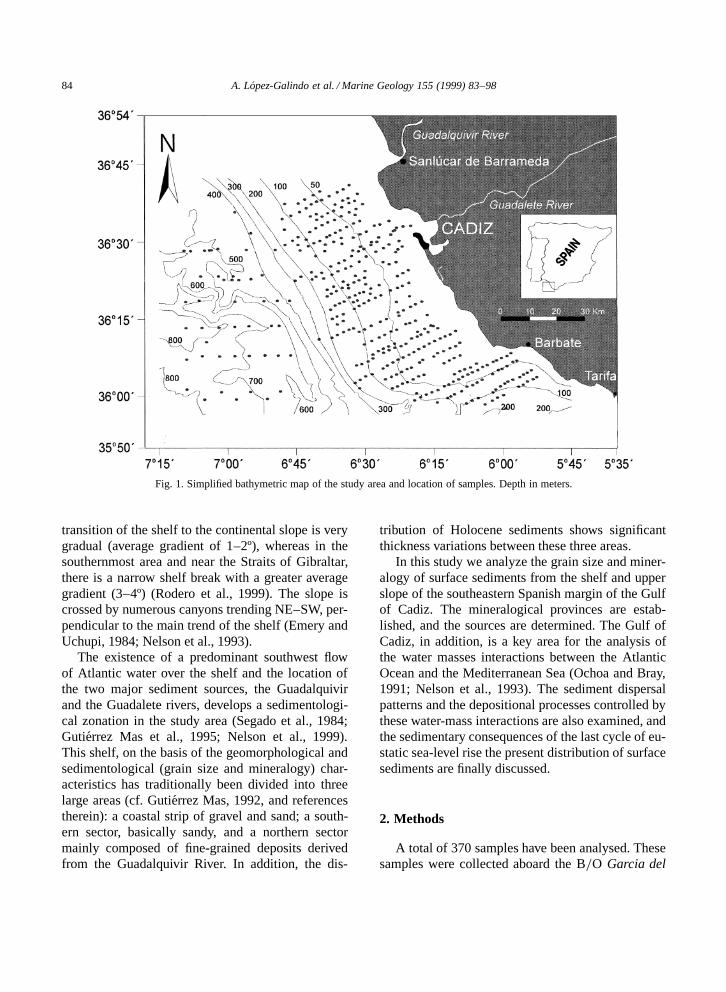
Fig. 1. Simplified bathymetric map of the study area and location of samples. Depth in meters.
transition of the shelf to the continental slope is verygradual (average gradient of 1–2º), whereas in thesouthernmost area and near the Straits of Gibraltar,there is a narrow shelf break with a greater averagegradient (3–4º) (Rodero et al., 1999). The slope iscrossed by numerous canyons trending NE–SW, per-pendicular to the main trend of the shelf (Emery andUchupi, 1984; Nelson et al., 1993).
The existence of a predominant southwest flowof Atlantic water over the shelf and the location ofthe two major sediment sources, the Guadalquivirand the Guadalete rivers, develops a sedimentologi-cal zonation in the study area (Segado et al., 1984;Gutierrez Mas et al., 1995; Nelson et al., 1999).This shelf, on the basis of the geomorphological andsedimentological (grain size and mineralogy) char-acteristics has traditionally been divided into threelarge areas (cf. Gutierrez Mas, 1992, and referencestherein): a coastal strip of gravel and sand; a south-ern sector, basically sandy, and a northern sectormainly composed of fine-grained deposits derivedfrom the Guadalquivir River. In addition, the dis-
tribution of Holocene sediments shows significantthickness variations between these three areas.
In this study we analyze the grain size and miner-alogy of surface sediments from the shelf and upperslope of the southeastern Spanish margin of the Gulfof Cadiz. The mineralogical provinces are estab-lished, and the sources are determined. The Gulf ofCadiz, in addition, is a key area for the analysis ofthe water masses interactions between the AtlanticOcean and the Mediterranean Sea (Ochoa and Bray,1991; Nelson et al., 1993). The sediment dispersalpatterns and the depositional processes controlled bythese water-mass interactions are also examined, andthe sedimentary consequences of the last cycle of eu-static sea-level rise the present distribution of surfacesediments are finally discussed.
2. Methods
A total of 370 samples have been analysed. Thesesamples were collected aboard the B=O Garcia del

A. Lopez-Galindo et al. / Marine Geology 155 (1999) 83–98 85
Cid, cruise M-86-3 and M-86-4, June 1991 and Oc-tober 1994, respectively. All the samples analysedwere obtained from surface sediments collected bydredges, and gravity and rock cores (Fig. 1). Thesamples were accurately positioned with MAXI-RAM and GPS satellite and the water depth recordedwith echo-sounders. All the samples were positionedalong the tracks of high-resolution reflection profiles(Rodero et al., 1999)
The grain sizes of 294 samples were determinedby standard sieve procedures for the coarse-grainedfraction (>63 µm) and a computerized laser inspec-tion system (CIS-1, GALAI) for the fine-grainedfraction. The composition of the sand fraction of265 samples were established by optical microscopycounting 300–400 grains in each sample. The miner-alogical analysis of 364 samples was performed witha Philips PW1710 X-ray diffractometer, equippedwith automatic slit, CuKÞ radiation, Ni filter, scanspeed of 2º=minute, using the crystalline powdertechnique for the bulk mineralogy and oriented ag-gregates of the <2 µm for the clay mineralogy.Quantification of the different phases was carried outby the classic method of area measurement of peaksand reflective power (cf. Mellinger, 1979; Pevear andMumpton, 1989).
Factor analysis (Principal Components Analysis,PCA) is used to establish the relation between thedifferent minerals, grain-size fractions, and their as-sociations. The factors (principal components, PCs)have been selected for eigenvalues >1 (Kaiser,1960), applying a Varimax rotation. According toDavis (1973), Reyment and Joreskog (1993), andSwan and Sandilands (1995), among others, PCA is atechnique for finding linear compounds of correlatedvariables, and it is used to characterize the data ob-tained from the analyses, thus reducing the complex-ity of the ‘natural model’ and classifying the miner-alogical and granulometric variables into groups.
3. Results
3.1. Grain size
Samples are mostly composed of, in order ofabundance, sand and clay size, and subordinate
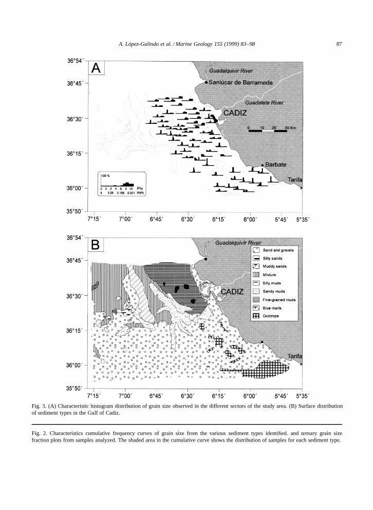
amounts of silt and gravel. The grain-size distribu-tion histograms and cumulative frequency diagramsreveal the existence of 7 main sediment types (Figs. 2and 3). Fine-grained muds correspond to sedimentslocated in isolated pockets off the Bay of Cadiz, withgrain sizes between 8 and 1 µm (8-10�) and smallvariance. Silty muds have a sand content of less than10%, with cumulative curve shapes similar to thefine-grained muds, although the sorting is poorer.These type of samples cover a large part of themiddle continental shelf in the northern area. Sandymuds have a grain-size distribution that is clearlybimodal, with 30% of the sample coarser than 62µm (mode around 2:75�) and the rest of the samplewith an average grain size of less than 8 µm (modearound 9�). They are distributed to the southwestof the silty muds, offshore of the Bay on Cadiz inthe outer shelf. Muddy sands contain about 10% ofmaterial larger than 250 µm .2�/, 60% between 250and 62 µm (2-4�), with the rest smaller than 8 µm.7�/. They are largely located to the south and eastof the silty muds, with a maximum presence on theouter shelf, off Cadiz. Silty sands are composed of50% fraction larger than 125 µm, well sorted, 20%between 125 and 30 µm, poorly sorted, and the restsmaller than 30 µm. They are mostly located onthe outer shelf and the upper slope, also near thecoast in the northern area and in the Bay of Cadizforming part of the prodelta lobe of the GuadaleteRiver. Sands are well sorted with 90% of the grainsbetween 500 and 200 µm. These sands occupy mostof the southern part and they are also located insidethe Bay of Cadiz. Gravels have 40% of the grainslarger than 2000 µm and 50% of the grains between2000 and 200 µm. They form pockets within thesands in the southern area, and is abundant in theinner continental shelf of the southern area and intwo locations of the slope.
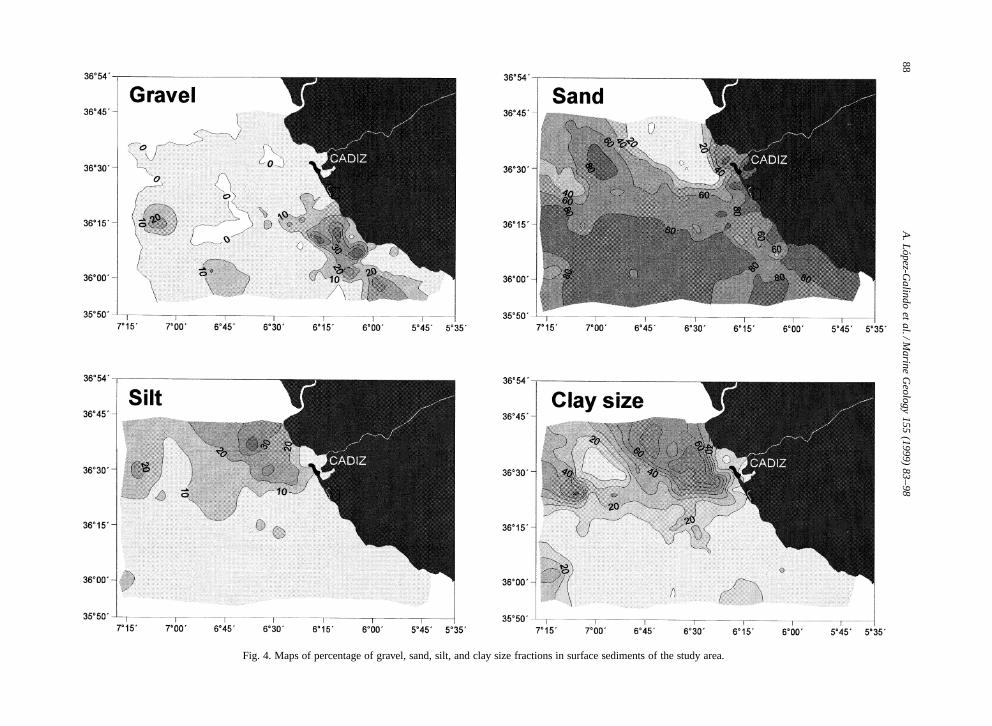
The surface distribution of the grain sizes showthat sand and clay size are the most abundant frac-tions (Fig. 4). Sand is more than 60% of the sedimentthroughout the study area, except in the middle shelfof the northern sector, where the prodelta lobe of theGuadalquivir River is located. The silt fraction, incontrast, is mostly represented in the Guadalquivirprodelta, where clay sizes constitutes, also, morethan 60% of the sediment.

86 A. Lopez-Galindo et al. / Marine Geology 155 (1999) 83–98
A. Lopez-Galindo et al. / Marine Geology 155 (1999) 83–98 87
Fig. 3. (A) Characteristic histogram distribution of grain size observed in the different sectors of the study area. (B) Surface distributionof sediment types in the Gulf of Cadiz.
Fig. 2. Characteristics cumulative frequency curves of grain size from the various sediment types identified. and ternary grain sizefraction plots from samples analyzed. The shaded area in the cumulative curve shows the distribution of samples for each sediment type.
88A
.Lopez-G
alindoet
al./Marine
Geology
155(1999)
83–98
Fig. 4. Maps of percentage of gravel, sand, silt, and clay size fractions in surface sediments of the study area.

A. Lopez-Galindo et al. / Marine Geology 155 (1999) 83–98 89
3.2. Composition of the sand fraction
Table 1 shows the average composition of thesand fraction. The content of mica, detrital grains(quartz, feldspars, glauconite, etc.), planktonic andbenthonic foraminifers, bivalves, bryozoans and oth-ers biogenic compounds (gastropods, echinoderms,ostracods, etc.) have been determined.
3.3. Mineralogy
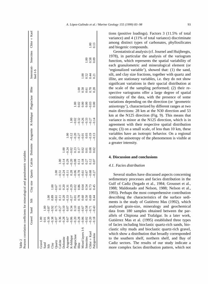
Minerals in practically all samples are phyllosil-icates, quartz, calcite, and feldspars (Fig. 5A; Ta-ble 1). Dolomite and aragonite are occasionallypresent, though in small quantities. Other miner-als found include gypsum, zeolites (clinoptilolite-heulandite, phillipsite), opal A, pyrolusite, ankerite,apatite, celestite, and strontianite.
Quartz is the most abundant terrigenous mineral,with an average content of 37%. It is present inall samples, being most abundant in the southeast
Table 1General univariate statistics from mineralogy, composition of sand fraction and grain size analysis
Variable Mean Median Mode S.D. Variance Curtosis Skewness Minimum Maximum
MineralsQuartz 37.2 34.8 16.5 19.73 389.43 �0.90 0.30 4 83Calcite 20.8 20.4 20.6 7.60 5775 3.93 0.69 3 68Dolomite 4.8 3.2 0.0 4.84 23.44 7.58 2.29 0 34Aragonite 2.7 0.0 0.0 5.61 31.47 12.61 3.30 0 42K-feldspar 2.7 2.0 0.0 2.91 8.44 6.60 2.12 0 19Plagioclase 3.5 3.1 3.1 2.15 4.60 2.49 0.92 0 13Illite 13.6 10.2 3.0 9.70 94.16 �0.75 0.68 0 43Mixed layers 4.3 3.1 3.0 3.08 9.50 4.59 1.40 2 23Smectites 5.0 5.0 3.0 3.32 11.00 1.44 0.97 0 20Kaol C Chlor 3.5 3.0 1.0 3.38 11.44 2.96 1.47 0 21Palygorskite 0.6 0.0 0.0 1.85 3.44 13.94 3.66 0 13
Composition of sand fractionMica 1.9 1.0 0.0 2.85 8.10 4.70 2.17 0 15Detrital grains 71.0 81.0 90.0 23.41 548.25 0.25 �1.19 1 97Planktonic foram. 8.5 4.0 2.0 10.60 112.44 3.69 1.90 0 62Benthonic foram. 8.1 4.0 2.0 9.59 91.95 4.29 2.02 0 60Bivalves 3.4 2.0 0.0 5.69 32.38 59.47 6.45 0 66Bryozoans 1.9 0.0 0.0 3.42 11.67 6.21 2.43 0 20Others biogenic compounds 5.3 3.0 2.0 7.15 51.15 20.37 4.07 0 52
Grain-size fractions (%)Gravel 7.78 0.50 0.00 13.12 172.18 7.26 2.81 0.00 80.96Sand 63.23 65.39 0.50 31.45 989.11 �0.38 �0.31 0.20 98.69Silt 8.28 1.60 0.50 10.11 102.26 1.39 1.76 0.14 50.00Clay 20.48 3.20 1.60 25.00 625.04 �0.15 1.48 0.17 81.40
study area, off Barbate, where it forms up to 83%of the total (Fig. 6), in isolated parts of the middleshelf of this sector, and on the upper slope of thesouthern sector. Its average size exceeds 63 µm, andit is mainly found in the sand fraction. Phyllosil-icates are most in abundance, forming on average28% (Table 1). They are closely correlated to thesilt .r D 0:81/ and clay sized .r D 0:88/ fractionsand negatively correlated to quartz .r D �0:83/(Table 2). The greatest concentrations occur in thenorthern part of the study area, where there is a largelobe lying parallel to the coast, NW–SE oriented,clearly related to the fine-grained sediments trans-ported by the Guadalquivir River. A second area ofaccumulation is on the upper slope, off Cadiz, asso-ciated with the presence of diapiric marl (Fig. 3B).Finally, proportions of 20 to 40% are found on south-ern part of the study area. Feldspars (K-feldsparand plagioclase) are not particularly abundant, andthe average content does not exceed 5%. However,K-feldspar may locally reach 19%, and plagioclases

90 A. Lopez-Galindo et al. / Marine Geology 155 (1999) 83–98
Fig. 5. (A) Mineralogical composition of the surface samples from the Gulf of Cadiz. (B) Distribution of the several grain-size fractionsvs. carbonates.
may rise to 13%. They are clearly detrital, and spa-tially associated with quartz, and therefore the south-eastern sector is the richest in these components.
Calcite occurs in all the samples, the averagecontent being 21%, with maxima of up to 68%. Itsdispersal is fairly irregular and the middle shelf ofthe southern sector is the area where calcite is mostcommon (Fig. 6). It is basically of biogenic origin,with numerous bentonic and plantonic foraminifers,bryozoans, bivalve clasts, gastropods, and ostracods.There is an average of 5% dolomite, and range of 0 to34%. The greatest concentrations occur on the mid-dle and outer shelf, off the Bay of Cadiz, and in areasnear the coast at the mouths of the Guadalquivirand Guadalete rivers. Aragonite is from fragmentsof bivalves shells and echinoderms, and significantlycorrelated .r D 0:67/ to gravel (Table 2). Althoughits average content is less than 5%, in some sectorsof the middle shelf off Barbate it forms up to 40%of the sample. Most of the carbonates are associatedwith the gravel and sand fractions (Fig. 5B).
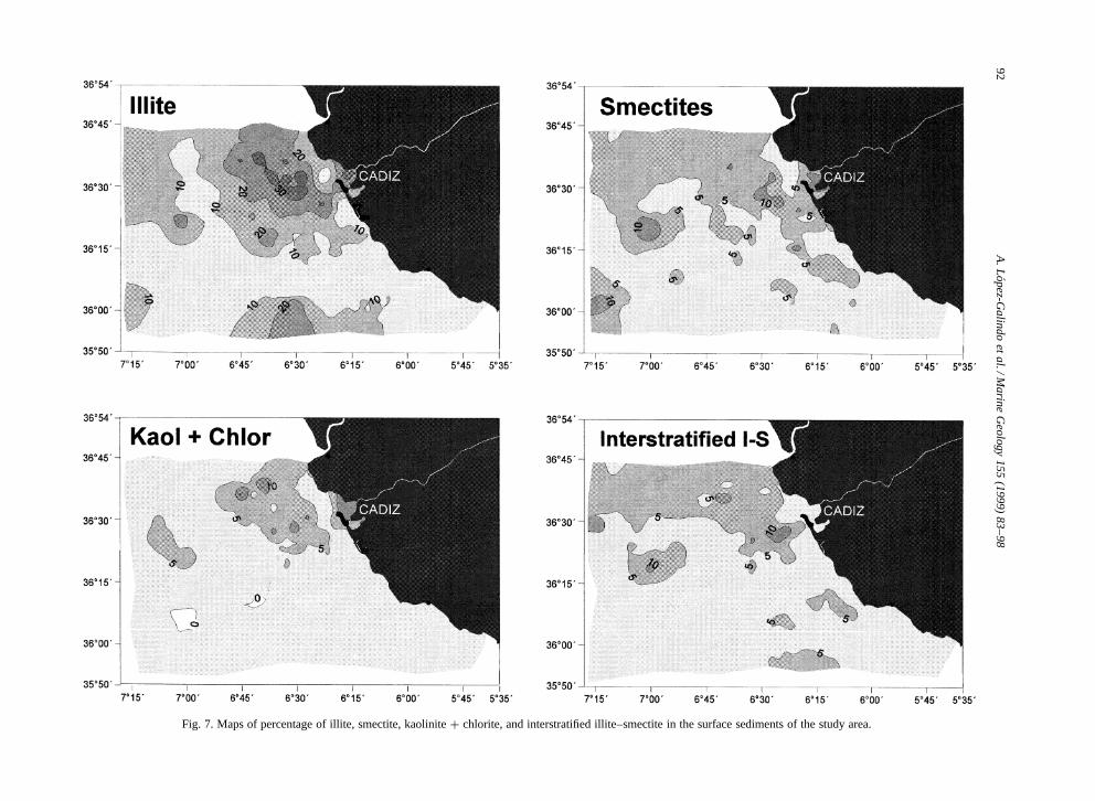
Illite is the most abundant clay mineral (14% aver-age content of the bulk sample), reaching the highestcontent (up to 43%) and a high degree of crystallinityin the central part of the lobe in the northern sector,and, further offshore, in the central and southern sec-tors of the outer shelf and continental slope (Fig. 7;Table 1). Smectite is of low crystallinity and, there-
fore, clearly detrital; it is concentrated (10–15%) inthe Bay of Cadiz and surrounding areas, as well as onthe upper slope of the central sector and is associatedwith the gravels of the central-south sector. Chloriteand kaolinite occur mainly in the Bay of Cadiz, at-taining a concentration of 20%, and in the northernmuddy lobe. Irregularly interstratified illite–smectitedoes not usually exceed 10–15%, and has differentswelling phase proportions. Illite–smectite is con-centrated in isolated pockets on the shelf, off Cadiz,and further offshore, related to the muddy and siltysands. Palygorskite occurs in isolated samples, witha content of less than 10%.
Principal components analysis have been appliedto the granulometric, sand compounds, and miner-alogical variables. Four factors (PCs) explaining the79% of the total variance were obtained (Fig. 8).These factors are lineal combination of original vari-ables. Factor 1 (42% of total variance) is clearlyinterpretable as a grain size and mineralogical factor,which relates with loadings >0.75 the fine-grainedfractions and clay minerals, and with negative load-ings the coarser fractions and biogenic compounds.Factor 2 (14.5% of total variance) is also a grainsize and mineralogical factor, which groups somecarbonates (calcite and aragonite) with gravel and bi-valves (negative loadings) and, on the other hand, thedetrital silicates with the sand, silt and clay size frac-

A.L
opez-Galindo
etal./M
arineG
eology155
(1999)83–98
91Fig. 6. Maps of percentage of phyllosilicates, quartz, feldspars, and calcite in the surface sediments of the study area.
92A
.Lopez-G
alindoet
al./Marine
Geology
155(1999)
83–98
Fig. 7. Maps of percentage of illite, smectite, kaolinite C chlorite, and interstratified illite–smectite in the surface sediments of the study area.
A. Lopez-Galindo et al. / Marine Geology 155 (1999) 83–98 93Ta
ble
2Pe
arso
nco
rrel
atio
nco
effic
ient
sfo
rm
iner
alog
ical
and
gran
ulom
etri
cva
riab
les
Gra
vel
Sand
Silt
Cla
ysi
zeQ
uart
zC
alci
teD
olom
iteA
rago
nite
K-f
elds
par
Plag
iocl
ase
Illit
eIn
ters
trat
i-Sm
ectit
esC
hlorC
Kao
lfi
edI-
S
Gra
vel
1.00
Sand
0.01
1.00
Silt
�0.3
9�0
.87
1.00
Cla
y�0
.38�0
.92
0.89
1.00
Qua
rtz
�0.0
70.
75�0
.61�0
.67
1.00
Cal
cite
0.36�0
.27
0.11
0.11
�0.5
11.
00D
olom
ite�0
.28�0
.10
0.20
0.20
�0.2
4�0
.14
1.00
Ara
goni
te0.
670.
07�0
.33�0
.31
�0.1
10.
29�0
.24
1.00
K-f
elds
par
�0.0
60.
34�0
.27�0
.29
0.28�0
.20�0
.02
�0.1
21.
00Pl
agio
clas
e�0
.20
0.10
0.01�0
.02
�0.0
6�0
.08
0.23
�0.2
0�0
.02
1.00
Illit
e�0
.28�0
.81
0.78
0.86
�0.7
80.
110.
17�0
.27
�0.3
20.
021.
00M
ixed
laye
rsI-
S�0
.06�0
.67
0.60
0.64
�0.6
10.
180.
02�0
.01
�0.2
60.
000.
581.
00Sm
ectit
es�0
.02�0
.58
0.50
0.54
�0.6
70.
270.
010.
03�0
.33
0.00
0.61
0.52
1.00
Chl
orC
Kao
l�0
.20�0
.71
0.69
0.73
�0.6
80.
120.
08�0
.19
�0.2
7�0
.03
0.78
0.44
0.58
1.00
Paly
gors
kite
�0.1
8�0
.43
0.44
0.45
�0.2
70.
070.
02�0
.13
�0.1
40.
000.
280.
210.
090.
13
tions (positive loadings). Factors 3 (11.5% of totalvariance) and 4 (11% of total variance) discriminateamong distinct types of carbonates, phyllosilicatesand biogenic compounds.
Geostatistical analysis (cf. Journel and Huijbregts,1978), in particular the analysis of the variogramfunction, which represents the spatial variability ofeach granulometric and mineralogical element (or‘regionalized variable’), showed that: (1) the sand,silt, and clay size fractions, together with quartz andillite, are stationary variables, i.e. they do not showsignificant variations in their spacial distribution atthe scale of the sampling performed; (2) their re-spective variograms offer a large degree of spatialcontinuity of the data, with the presence of somevariations depending on the direction (or ‘geometricanisotropy’), characterized by different ranges at twomain directions: 28 km at the N30 direction and 53km at the N125 direction (Fig. 9). This means thatvariance is minor at the N125 direction, which is inagreement with their respective spatial distributionmaps; (3) on a small scale, of less than 10 km, thesevariables have an isotropic behavior. On a regionalscale, the anisotropy of the phenomenon is visible ata greater intensity.
4. Discussion and conclusions
4.1. Facies distribution
Several studies have discussed aspects concerningsedimentary processes and facies distribution in theGulf of Cadiz (Segado et al., 1984; Grousset et al.,1988; Maldonado and Nelson, 1988; Nelson et al.,1993). Perhaps the most comprehensive contributiondescribing the characteristics of the surface sedi-ments is the study of Gutierrez Mas (1992), whichanalyzed grain-size, mineralogy and geochemicaldata from 180 samples obtained between the par-allels of Chipiona and Trafalgar. In a later work,Gutierrez Mas et al. (1995) established three typesof facies including bioclastic quartz-rich sands, bio-clastic silty muds and bioclastic quartz-rich gravel,which show a distribution that broadly correspondedto the southern shelf, northern shelf, and Bay ofCadiz sectors. The results of our study indicate amore complex facies distribution pattern, which not

94 A. Lopez-Galindo et al. / Marine Geology 155 (1999) 83–98
Fig. 8. R-mode factor analysis showing the contribution of statistically dominant variables of grain size, mineralogy, and components ofthe sand fraction and binary diagram of factor 1 and 2.
only reflects the present sediment dynamics but alsoseveral characteristics of the surface sediment distri-bution inherited from the last low sea-level stand andHolocene sea-level rise (Fig. 3B).
The type of facies better represented occupiesmost of the southern part, from south of Cadiz toTarifa and it is characterized by the presence of rockoutcrops, generally covered by a layer of sedimentswith variable thickness. Basement outcrops consistof Gibraltar flysch, which constitutes the externalpart of a tectonic arc (Malod, 1982; Maldonadoet al., 1998). The overlying sediments are mainlycomposed of sand, with lesser amounts of graveland with a high content of bioclastic remains. Theside-scan records of this area depict a variety ofbedforms, mostly several types of sand dunes, whichindicate strong bottom currents (Nelson et al., 1993,1998). Areas without a sedimentary cover generallycorrespond to morphological and structural highs,where strong currents sweep the bottom.
A large area is located in the northeasternsector (Fig. 3B). This area occupies the middleshelf and delineates a southeastward trending lobe.The sediments are predominantly fine-grained mudsthat correspond to the submerged prodelta of theGuadalquivir River. Fine-grained sediments from theriver mouth are advected by geostrophic currents
toward distal areas resulting in southward prograda-tion of the mud over the sand layers. The sedimentis distributed by the surface Atlantic water flow-ing southeastward towards the entrance of the Straitof Gibraltar, which carries mid-water turbid layersand surface-water sediment plumes. This relativelyhigh-energy shelf, with strong tide and wave currentsdoes not allow for the development of a fine-grainedshallow prodelta, which is confined in the studyarea to water depths below 15–20 m. The fine-grained deposits developed a thick prodelta wedge,characterized by acoustic maskings, probably due toaccumulation of gases (Acosta, 1984; Rodero et al.,1998). Another smaller prodelta facies is located sea-ward of the entrance to the Bay of Cadiz (Fig. 3B).This facies derives from the fine-grained materialssupplied by the Guadalete River and from resuspen-sion of fine-grained material in the marsh-lands ofthe bay (Gutierrez Mas et al., 1994).
A transitional area is delimited between theGuadalquivir prodelta and the sand and gravel faciesto the south. This is a palimpsest facies characterizedby the mixture of fine-grained materials advected tomore distal areas from the prodeltas, mixed with therelict facies of the transgressive sands developed dur-ing the Holocene transgression (Rodero et al., 1998).There is a Holocene sandy and gravel coastal facies

A. Lopez-Galindo et al. / Marine Geology 155 (1999) 83–98 95
Fig. 9. Variogram function of variable ‘clay size fraction’ in the N30E and N125E directions. The adjust has been spherical.
that extends along the coast. This facies is over-lapped by the Guadalete prodelta off the entrance tothe Bay of Cadiz and it is transitional in the southernsector with the sand and gravel facies of the shelf.
The outer shelf and slope in the northern areashow a large variety of sediment facies. Near theshelf break are relict transgressive sands, developedduring the initial stages of the last eustatic sea-levelrise. These are muddy sands that probably representa variety of coastal and estuarine deposits recording acomplex transgressive history (Rodero et al., 1998).The facies distribution on the slope of this northernarea is also very complex. The presence of diapiriclinear ridges and submarine canyons perpendicularto the slope, and the development of large bedformfields and erosional surfaces by the contour-flow ofthe Mediterranean undercurrent, influence a large va-riety of sediment facies (Nelson et al., 1993, 1999).These facies include muddy sands, sand and graveland marls, with a general distribution characterizedby a westward increase of grain size. Although mostof the coarse-grained facies on the slope representpalimpsest and relict deposits, the presence of gulliesand canyons on the slope and the strong Mediter-ranean undercurrent facilitate the development ofgravity and contour flows that are influencing thepresent sediment distribution patterns.
4.2. Sedimentary processes
The sedimentary processes are largely controlledby two factors: the location of terrigenous sources
and the Mediterranean undercurrent and Atlantic sur-face-water flows. The main terrigenous source is theGuadalquivir River, where a large prodelta detachedfrom the river mouth is developing below wave base(Maldonado and Nelson, 1988); and the output fromthe Bay of Cadiz where fine-grained terrigenous sed-iment plumes from the Guadalete River and bottomsediment resuspension are injected onto the shelf.Most of the coarse-grained material is retained inthe estuaries of these rivers, or transported by waves,long-shore, and tidal currents to the sandy beachesof the coast. Most of the sediment supply of theGuadalete River is trapped, however, in the bay andonly minor amounts are transported to the shelf,mostly by the currents generated by ebb tides andstrong easterly winds. These materials generated asmall detached prodelta offshore from the mouth ofthe bay, which is initially oriented westward andthen diverts southeastward due to the influence ofthe surface Atlantic flow, becoming parallel to theGuadalquivir prodelta (Fig. 3B).
South of Cadiz, the only terrigenous sedimentsource to the shelf are local ephemeral streamsand erosion from beaches and coastal cliffs. Inthis area the present sediment dynamics are largelycontrolled by the Atlantic and Mediterranean waterflows (Ochoa and Bray, 1991; Price et al., 1993).Sediment facies in this southern area are mostly ofpalimpsest type and they form a large variety ofbedforms (Nelson et al., 1993, 1999).
The outer shelf transgressive sands are also in-fluenced by the present sediment dynamics as fine-

96 A. Lopez-Galindo et al. / Marine Geology 155 (1999) 83–98
Fig. 10. Source areas and sediment dynamic in the study area based on the distribution patterns of clay minerals. The size of lettersis proportional to the quantity of phyllosilicates (I D illite; Sm D smectite; K D kaolinite; CH D chlorite; I-Sm D interstratifiedillite–smectite; Q D quartz).
grained sediments are advected from the coastal en-vironments. On the slope the most active processesare developed by down-slope gravity sediment flowsand the Mediterranean undercurrent (Nelson et al.,1993). The bluish-green marls cropping out in theaxis of the linear diapirs are a source of fine-grainedsediments as they are eroded by the Mediterraneanundercurrent.
4.3. Source areas
The clay mineralogy provides additional infor-mation about the nature of the source areas. Inthe northern sector of the shelf, the minerals in-clude illite, smectite, kaolinite and chlorite, whichis a similar association to that observed in Neogeneand Quaternary rocks in the region of the Bay ofCadiz (Viguier, 1974). The greater crystallinity ofillite compared to that observed in other sectors,together with the presence of chlorite and kaolin-ite in significant quantities, suggests, however, thatthere is in addition a source area basically composedof igneous and metamorphic rocks. The Paleozoicrocks of Sierra Morena, which are drained by the
Guadalquivir River are most probably the sourcerocks. The typical mineral association of the south-ern sector is, in contrast, quartz and illite of lowcrystallinity. These minerals indicate a source fromthe Subbetic and the Gibraltar flysch, which aredrained by the Guadalete and Barbate rivers. Theexistence of minerals that are ultrastable in the heavyfraction (cf. Gutierrez Mas, 1992) also supports thisconclusion. The presence in this area of smectite,interstratified clay minerals and kaolinite may alsoindicate a Mediterranean origin for the fine-grainedsediments transported by the Mediterranean under-current (Fig. 10).
4.4. Sea-level changes and surface faciesdistribution
During the last low sea-level stand, margin deltasdeveloped in the northern area of the Cadiz outershelf (Rodero et al., 1998). The nearshore and coastaldeposits were reworked during the Flandrian trans-gression (14,000–6000 yr B.P.), which produced alayer of transgressive sands over most of the conti-nental shelf. Some coastal deposits were abandoned

A. Lopez-Galindo et al. / Marine Geology 155 (1999) 83–98 97
relatively undisturbed near the shelf break, whichare represented by the relatively coarser muddy sandfacies with higher quartz content.
A transgressive prodelta lobe facies began to de-velop about 6000 years ago, as a result of a slowingin the rate of sea-level rise, as in other margins ofthe Iberian Peninsula (Checa et al., 1988; Diaz andMaldonado, 1990; Farran and Maldonado, 1990).In the southern area, largely depleted from sig-nificant sediment supply, only reworked transgres-sive sands developed. When present sea level wasreached, the two prodeltas of the Guadalquivir andGuadalete rivers prograded offshore over the trans-gressive sands in a southeasterly direction followingthe Atlantic surface-water flow.
The sedimentary processes on the slope, in con-trast, are controlled by the northwestard flowingMediterranean outflow, which impinges over themargin and contributes with some fine-grained sedi-ments.
Acknowledgements
We thank the assistance at sea of the officers andcrew of the B.O. Garcıa del Cid. We also appreci-ate the critical review of an earlier version of themanuscript by J.M. Gutierrez Mas, as well as theconstructive criticism of two anonymous reviewers.The statistics has been revised by Professor MarioChica (Geostatistics, Univ. Granada) and Profes-sor Francisco Torres (Statistic, Univ. Granada). Thisstudy was supported by Project 125=94 of the ITGEand group RNM-0179 of the Junta de Andalucıa.
References
Acosta, J., 1984. Occurrence of acoustic masking in sedimentsin two areas of the continental shelf of Spain: Ria de Muros(NW) and Gulf of Cadiz (SW). Mar. Geol. 58, 427–434.
Checa, A., Dıaz, J.I., Farran, M., Maldonado, A., 1988. Sis-temas deltaicos holocenos de los rıos Llobregat, Besos y Foix:modelos evolutivos transgresivos. Acta Geol. Hisp. 23, 241–255.
Davis, J.C., 1973. Statistical and Data Analysis in Geology.Wiley, New York, 550 pp.
Diaz, J.I., Maldonado, A., 1990. Transgressive sand bodies onthe maresme continental shelf, Western Mediterranean Sea.Mar. Geol. 91, 53–72.
Emery, M., Uchupi, E., 1984. The Geology of the AtlanticOcean. Springer, New York, 1050 pp.
Farran, M., Maldonado, A., 1990. The Ebro continental shelf:Quaternary seismic stratigraphy and growth patterns. Mar.Geol. 95, 289–312.
Grousset, F.E., Joron, J.L., Biscaya, P.E., Latouche, C., Treuil,M., Faugeres, J.C., Goutier, E., 1988. Mediterranean outflowthrough Strait of Gibraltar since 18000 years B.P. Mineralogi-cal and geochemical argument. Geomar. Lett. 8, 25–35.
Gutierrez Mas, J.M., 1992. Estudio de los sedimentos recientesde la plataforma continental y Bahıa de Cadiz. Ph.D. Diss.Univ. Cadiz, 364 pp.
Gutierrez Mas, J.M., Hernandez-Molina, F.J., Lopez-Galindo,A., Lopez-Aguayo, F., 1994. Establecimiento de la traza de unflujo desde la bahıa de Cadiz a la plataforma continental. Gaia8, 125–128.
Gutierrez Mas, J.M., Lopez Galindo, A., Gonzalez Caballero,J.L., Lopez Aguayo, F., 1995. Las facies detrıticas de laplataforma continental de Cadiz (tramo Chipiona–Trafalgar)en relacion con la evolucion de la dinamica sedimentariareciente. Rev. Soc. Geol. Esp. 8 (12), 61–71.
Journel, A., Huijbregts, C.H., 1978. Mining Geostatistics. Aca-demic Press, New York, 600 pp.
Kaiser, H.F., 1960. The application of electronic computers tofactor analysis. Educ. Psychol. Meas. 20, 141–151.
Maldonado, A., Nelson, C.H., 1988. Dos ejemplos de margenescontinentales de la Penınsula Iberica: El margen del Ebro y elGolfo de Cadiz. Rev. Soc. Geol. Esp. 1, 317–325.
Maldonado, A., Somoza, L., Lorenzo, P., 1999. The Betic oro-gen and the Iberian–African boundary in the Gulf of Cadiz:geological evolution (central North Atlantic). Mar. Geol. 155,9–43.
Malod, J.A., 1982. Comparaison de l’evolution des merges con-tinentales au Nord et au Sud de la Peninsule Iberique. Ph.D.Diss., Univ. Pierre et Marie Curie, Paris, 235 pp.
Mellinger, R.M., 1979. Quantitative X-ray diffraction analysis ofclay minerals. An evaluation. SRC Rep. Saskatchewan Res.Counc. G-79, 1–46.
Nelson, C.H., Baraza, J., Maldonado, A., 1993. Mediterraneanundercurrent sandy contourites, Gulf of Cadiz, Spain. Sedi-ment. Geol. 82, 103–131.
Nelson, C.H., Baraza, J., Barber, J., Rodero, J., Maldonado, A.,1999. Influence of the Atlantic inflow and Mediterranean out-flow currents on Late Pleistocene and Holocene sedimentaryfacies of Gulf of Cadiz continental margin. Mar. Geol. 155,99–129.
Ochoa, J., Bray, A., 1991. Water mass exchange in the Gulf ofCadiz. Deep-sea Res. 38, S465–S503.
Pevear, D.R., Mumpton, D.R., 1989. Quantitative Mineral Anal-ysis of clays. CMS Workshop Lectures 1. The Clay MineralSociety, Colorado.
Price, J.F., O’Neil, M., Lueck, R.G., Johnson, G.C., Ambar, I.,Parrilla, G., Cantos, A., Kennelly, M.A., Sanford, T.B., 1993.Mediterranean outflow mixing and dynamics. Science 259,1277–1282.
Reyment, R., Joreskog, K.G., 1993. Applied Factor Analysis inthe Natural Sciences. Cambridge Univ. Press, 369 pp.

98 A. Lopez-Galindo et al. / Marine Geology 155 (1999) 83–98
Rodero, J., Pallares, L., Maldonado, A., 1999. Late Quaternarysequence stratigraphy and continental shelf model controlledby eustatic and paleoceanographic events. Gulf of Cadiz,southwest Iberia. Mar. Geol. 155, 131–156.
Segado, M., Gutierrez, J.M., Hidalgo, F., Martinez, J.M., Cepero,F., 1984. Estudio de los sedimentos recientes de la plataformacontinental gaditana entre Chipiona y Cabo Roche. Bol. Geol.
Min. Esp. 95, 310–324.Swan, A.R.H., Sandilands, M., 1995. Introduction to Geological
Data Analysis. Blackwell, Oxford, 446 pp.Viguier, C., 1974. Le Neogene de l’Andalousie Nord-occidentale
(Espagne). Histoire geologique du bassin du bas Guadalquivir.Ph.D. Diss. Univ. Bordeaux, 449 pp.
Copyright © 2022 FDOKUMEN