Sea level change and vertical land movements since the last two millennia along the coasts of...
8
Sea level change and vertical land movements since the last two millennia along the coasts of southwestern Turkey and Israel M. Anzidei a, b, * , F. Antonioli c , A. Benini d , K. Lambeck e , D. Sivan f , E. Serpelloni a , P. Stocchi g a Istituto Nazionale di Geofisica e Vulcanologia, via di Vigna Murata 605, 00143 Roma, Italy b Università della Calabria, Dipartimento di Fisica, Cosenza, Italy c ENEA, Italy d Università della Calabria, Dipartimento di Archeologia e Storia delle Arti, Cosenza,Italy e Research School of Earth Sciences, The Australian National University, Canberra 0200, Australia f Department of Maritime Civilizations and the Leon Recanati Institute for Maritime Studies, School of Marine Studies, University of Haifa, Israel g DEOS, Faculty of Aerospace Engineering, TU Delft, Delft, The Netherlands article info Article history: Available online 19 May 2010 abstract This paper provides new relative sea level data inferred from coastal archaeological sites located along the Turkish coasts of the Gulf of Fethye (8 sites), and Israel, between Akziv and Caesarea (5 sites). The structures selected are those that, for effective functioning, can be accurately related to sea level at the time of their construction. Thus their positions with respect to present sea level provide a measure of the relative sea level change since their time of construction. Useful information was obtained from the investigated sites spanning an age range of e 2.3e e 1.6 ka BP. The inferred changes in relative sea level for the two areas are distinctly different, from a rise of 2.41 to 4.50 m in Turkey and from 0 to 0.18 m in Israel. Sea level change is the combination of several processes, including vertical tectonics, gla- cioehydro-isostatic signals associated with the last glacial cycle, and changes in ocean volume. For the Israel section, the present elevations of the MIS-5.5 Tyrrhenian terraces occur at a few meters above present sea level and vertical tectonic displacements are small. Data from GPS and tide gauge measurements also indicate that any recent vertical movements are small. The MIS-5.5 shorelines are absent from the investigated section of the Turkish coast, consistent with crustal subsidence associated with the Hellenic Arc. The isostatic signals for the Israel section of the coast are also small (ranging from 0.11 mm/yr to 0.14 mm/yr, depending on site and earth model) and the observed (eustatic) average sea level change, corrected for this contribution, is a rise of 13.5 2.6 cm during the past e 2 ka. This is attributed to the time-integrated contribution to sea level from a combination of thermal expansion and other increases in ocean volume. The observed sea levels from the Turkish sites, in contrast, indicate a much greater rise of up to 2.2 mm/yr since 2.3 ka BP occurring in a wide area between Knidos and Kekova. The isostatic signal here is also one of a rising sea level (of up toe 1 mm/yr and site and earth- model dependent) and the corrected tectonic rate of land subsidence ise 1.48 mm/yr. This is the primary cause of dramatic relative sea level rise for this part of the coast. Ó 2010 Elsevier Ltd and INQUA. All rights reserved. 1. Introduction During past decades, sea level change within the Mediterranean has been estimated from instrumental measurements, as well as from archaeological, geological, and biological indicators (Pirazzoli, 1976; Flemming and Webb, 1986). This paper examines mainly archaeological and geological evidence for the late Holocene relative sea level change along the coastline of Turkey and Israel (Fig. 1). Geological indicators are a powerful source of information from which the relative sea level change can be estimated for selective periods back to the last interglacial (Ferranti et al., 2008), while the archaeological and instrumental data fill a gap between geological and present time. A particularly good estimate of relative sea level change can be obtained for the last e 2 ka from archaeo- logical coastal installations (Lambeck et al., 2004b; Antonioli et al., 2007). The Mediterranean, with its small tidal range and contin- uous human settlement throughout historical times, has the most complete archaeological record relevant for sea level studies, with a large number of coastal archaeological sites that are often well * Corresponding author. Istituto Nazionale di Geofisica e Vulcanologia, via di Vigna Murata 605, 00143 Roma, Italy. E-mail address: [email protected] (M. Anzidei). Contents lists available at ScienceDirect Quaternary International journal homepage: www.elsevier.com/locate/quaint 1040-6182/$ e see front matter Ó 2010 Elsevier Ltd and INQUA. All rights reserved. doi:10.1016/j.quaint.2010.05.005 Quaternary International 232 (2011) 13e20
-
Upload
independent -
Category
Documents
-
view
5 -
download
0
Transcript of Sea level change and vertical land movements since the last two millennia along the coasts of...
lable at ScienceDirect
Quaternary International 232 (2011) 13e20
Contents lists avai
Quaternary International
journal homepage: www.elsevier .com/locate/quaint
Sea level change and vertical land movements since the last two millennia alongthe coasts of southwestern Turkey and Israel
M. Anzidei a,b,*, F. Antonioli c, A. Benini d, K. Lambeck e, D. Sivan f, E. Serpelloni a, P. Stocchi g
a Istituto Nazionale di Geofisica e Vulcanologia, via di Vigna Murata 605, 00143 Roma, ItalybUniversità della Calabria, Dipartimento di Fisica, Cosenza, Italyc ENEA, ItalydUniversità della Calabria, Dipartimento di Archeologia e Storia delle Arti, Cosenza,ItalyeResearch School of Earth Sciences, The Australian National University, Canberra 0200, AustraliafDepartment of Maritime Civilizations and the Leon Recanati Institute for Maritime Studies, School of Marine Studies, University of Haifa, IsraelgDEOS, Faculty of Aerospace Engineering, TU Delft, Delft, The Netherlands
a r t i c l e i n f o
Article history:Available online 19 May 2010
* Corresponding author. Istituto Nazionale di GeoVigna Murata 605, 00143 Roma, Italy.
E-mail address: [email protected] (M. Anzidei
1040-6182/$ e see front matter � 2010 Elsevier Ltd adoi:10.1016/j.quaint.2010.05.005
a b s t r a c t
This paper provides new relative sea level data inferred from coastal archaeological sites locatedalong the Turkish coasts of the Gulf of Fethye (8 sites), and Israel, between Akziv and Caesarea (5 sites).The structures selected are those that, for effective functioning, can be accurately related to sea level atthe time of their construction. Thus their positions with respect to present sea level provide a measureof the relative sea level change since their time of construction. Useful information was obtained fromthe investigated sites spanning an age range ofe2.3ee1.6 ka BP. The inferred changes in relative sea levelfor the two areas are distinctly different, from a rise of 2.41 to 4.50 m in Turkey and from 0 to 0.18 m inIsrael. Sea level change is the combination of several processes, including vertical tectonics, gla-cioehydro-isostatic signals associated with the last glacial cycle, and changes in ocean volume. For theIsrael section, the present elevations of the MIS-5.5 Tyrrhenian terraces occur at a few meters abovepresent sea level and vertical tectonic displacements are small. Data from GPS and tide gaugemeasurements also indicate that any recent vertical movements are small. The MIS-5.5 shorelines areabsent from the investigated section of the Turkish coast, consistent with crustal subsidence associatedwith the Hellenic Arc. The isostatic signals for the Israel section of the coast are also small (ranging from�0.11 mm/yr to 0.14 mm/yr, depending on site and earth model) and the observed (eustatic) average sealevel change, corrected for this contribution, is a rise of 13.5 � 2.6 cm during the paste2 ka. This isattributed to the time-integrated contribution to sea level from a combination of thermal expansion andother increases in ocean volume. The observed sea levels from the Turkish sites, in contrast, indicatea much greater rise of up to 2.2 mm/yr since 2.3 ka BP occurring in a wide area between Knidos andKekova. The isostatic signal here is also one of a rising sea level (of up toe1 mm/yr and site and earth-model dependent) and the corrected tectonic rate of land subsidence ise1.48 mm/yr. This is the primarycause of dramatic relative sea level rise for this part of the coast.
� 2010 Elsevier Ltd and INQUA. All rights reserved.
1. Introduction
During past decades, sea level change within the Mediterraneanhas been estimated from instrumental measurements, as well asfrom archaeological, geological, and biological indicators (Pirazzoli,1976; Flemming and Webb, 1986). This paper examines mainlyarchaeological and geological evidence for the late Holocene
fisica e Vulcanologia, via di
).
nd INQUA. All rights reserved.
relative sea level change along the coastline of Turkey and Israel(Fig. 1). Geological indicators are a powerful source of informationfrom which the relative sea level change can be estimated forselective periods back to the last interglacial (Ferranti et al., 2008),while the archaeological and instrumental data fill a gap betweengeological and present time. A particularly good estimate of relativesea level change can be obtained for the laste2 ka from archaeo-logical coastal installations (Lambeck et al., 2004b; Antonioli et al.,2007). The Mediterranean, with its small tidal range and contin-uous human settlement throughout historical times, has the mostcomplete archaeological record relevant for sea level studies, witha large number of coastal archaeological sites that are often well
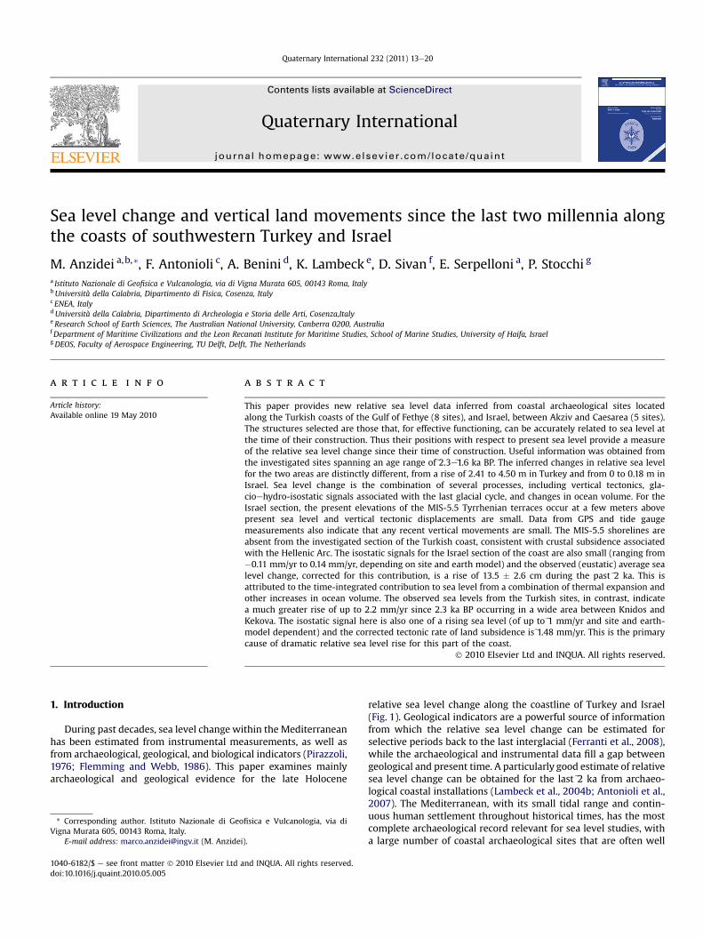
Fig. 1. Current seismicity and focal mechanisms of the studied region (CMT cataloguesfrom: www.globalcmt.org; www.bo.ingv.it/RCMT; www.seismo.ethz.ch/mt). Mainfaults, the North Anatolian Fault (NAF) and the Dead Sea Fault are shown on the map.The detailed maps of Fig. 2 are identified by the red rectangles.
Fig. 2. Investigated sites (white dots with numbers as in Table 1) along the coast of a)Turkey and b) Israel. Yellow lines identify the principal faults. CF is the Carmel Fault. Inb) the locations of the tide gauge of Hadera and the GPS network are also shown.Vertical GPS velocities (in mm/y) are estimated for the time span 1998e2008. See alsoTable 1 for site data.
M. Anzidei et al. / Quaternary International 232 (2011) 13e2014
dated and well preserved with functional features that can beprecisely related to sea level at the time of their construction.Hence, they can be successfully used to constraint past local sealevels. Fish tanks, piers, docks, pools, quarries, harbors and slipwaysconstructions, generally built around 2 � 0.3 ka BP are reliableindicators and provide a valuable insight of the regional variation insea level during the last two millennia (Flemming, 1969; Schmiedt,1974; Caputo and Pieri, 1976; Pirazzoli, 1976; Flemming and Webb,1986; Lambeck et al., 2004a,b; Antonioli et al., 2007; Lambeck et al.,in press, and references therein).
Local sea level change is a combination of various factors,including changes in ocean volume from the addition or subtrac-tion of water. This includes contributions from temperaturechanges in the water column and contributions from changes in icesheets and glaciers. The response of the ocean and the earth tochanging ice and water loads, usually referred to as glacio-hydro-isostasy, is important, as are vertical tectonic movements of theland surface, local compaction of sediments or changes in meteo-rological forcing of the ocean surface. Of these, through the natureof the observational data used, subsidence arising from compactionof sediments or from the extraction of ground water is unlikely tobe important and the dominant contributions considered here aretectonics and the isostatic factors. The latter have been previouslyevaluated for Mediterranean sites and the same models andparameters are used here as have previously been found satisfac-tory (Lambeck, 1995; Sivan et al., 2001; Lambeck et al., 2004a,b;Antonioli et al., 2007; Anzidei et al., 2011). Geological evidence, inthe form of the present elevation of the MIS-5e shoreline, alongwith instrumental data from GPS and tide gauge recordings, hasbeen used to examine tectonic stability of the sites, relevantelements for the understanding of the recent geodynamic evolu-tion of these areas of the Mediterranean basin. These isostatic andtectonic components are then compared with the observed sealevels to establish whether there have been additional changes inlocal and regional levels.
This paper examines archaeological evidence from the easternMediterranean coast of southeastern Turkey and Israel (Figs. 1 and
2a,b), where the development of maritime constructions reachedits greatest concentration in Hellenistic and Lycian times (e2.3 ka BP)and continued during the Roman and Byzantine ages (e2 ka ande1.6 ka respectively). Particularly, the coasts of Israel contains manystill very well preserved remains The best preserved sites providenew information on constructional levels that can be accuratelyrelated to mean local sea levels betweene2300 ande1600 BP.
2. Geodynamic setting of Eastern Mediterranean
The geological and geodynamic features of Israel and Turkeyreflect those of the eastern Mediterranean region, which is sub-jected to the long-lasting plate convergence between Africa/Arabiaand Eurasia (Dewey et al., 1973; Le Pichon et al., 1988; Dewey et al.,1989), active since the Late Cretaceous (DeMets et al., 1994; Calaiset al., 2003). The current dynamics of the Africa-Eurasia plateboundary, as delineated by earthquake distribution, runs roughlyeast-west across the basin and is characterized by narrow to broadseismic belts of seismicity and deformation that result in a complexpattern of crustal stress and strain fields (Jackson and Mckenzie,1988; Rebai et al., 1992; Jiménez-Munt et al., 2003; Vannucci andGasperini, 2004). The several lithospheric blocks move accordingto their different structural and kinematic features includingsubduction, back-arc spreading, rifting, thrusting, normal and strike

Fig. 3. Annual mean sea level trends estimated from the tide gauges of Hadera (top)and Antalya (bottom), located along the coast of Israel and SW Turkey, respectively.Although the duration of recordings are too short at both stations (time span1996e2003 at Hadera and 1985e2005 at Antalya) to provide a reliable secular sea leveltrend, their data are in agreement with archaeological sea level indicators and models.Note the anomalous oscillations in Antalya compared with Hadera (valid data from thePMSLS database, www.pol.ac.uk).
M. Anzidei et al. / Quaternary International 232 (2011) 13e20 15
slip faulting (Jolivet and Faccenna, 2000; Faccenna et al., 2001;Mantovani et al., 2001). In this geodynamic framework, the Ana-tolia and the Levantine areas are both dominated by the northwardmotion of the Arabian plate that produces the westward extrusionof the Anatolia peninsula and the two important and still activestrike slip fault systems of the Dead Sea in Israel and the NorthAnatolia in Turkey along which large earthquakes have occurredthroughout historical times (Guidoboni et al., 1994; Boschi et al.,1995; www.globalcmt.org; www.bo.ingv.it/RCMT; www.seismo.ethz.ch/mt) (Fig. 1). In addition, the Gulf of Fethye will also beaffected by the convergence along the Hellenic arc (McKenzie,1970; Kalafat et al., 2004; Serpelloni et al., 2007 and referencestherein), as also reflected in previous estimates of the uplift ofRhodes and Karpathos and further to the north and with subsi-dence of the eastern part of the Gulf (see Fig. 17b of Lambeck, 1995).
Of importance for the current investigation is the vertical landmovement and one indicator of vertical stability is provided by theelevation of the Last Interglacial shoreline. From areas believed tobe tectonically stable elsewhere within the Mediterranean, thisshoreline usually occurs ate5e7 m above mean sea level and itsactual position can therefore be indicative of vertical movementson a time scale of 105 years. This shoreline feature, readily identifiedby sediments containing Strombus bubonius and other Senegalesefauna, has not been identified within the Fethye area, and itsabsence is consistent with a continuous broad subsidence of thisregion, in agreement with independent observations which esti-mate subsidence trends in the Gulf of Gökova (Ulu�g et al., 2005) andat Gemile Island (Lambeck, 1995).
Previous research along the Israel coast has identified LastInterglacial fossil deposits at between 12 and 2m above present sealevel (Sivan et al., 1999; Galili et al., 2007), and this has used toargue for a tectonically stable coast (Sneh, 2000; Galili et al., 2007).The stratigraphic relationship of these particular deposits to coevalsea level is not well known, and tectonic stability can only beassumed to within e�5 m over the past 120,000 years, yieldinga vertical tectonic rate of �0.04 mm/yr. Inland from the coast, thevertical tectonics are likely to become increasingly dominated bydeformation along the Dead Sea Fault.
3. Instrumental data
There are 6 tide gauge stations along the Mediterranean coast ofTurkey but only the station of Antalya (Fig. 2a) is located near theinvestigated archaeological sites. For Israel, there is the Hadera tidegauge station, south of Caesarea (Fig. 2b). The data used from thesesites are from the Permanent Service for Mean Sea Level (PSMSL)(Woodworth and Player, 2003; www.pol.ac.uk/psmsl/). The timeseries records for both Antalya and Hadera (Fig. 3), are too short(<20 years, with missing years for the former, and 11 years withtwo missing years for the latter) to provide significant estimates forlong-term trends, although the record for Antalya points to a risingsea level, consistent with the subsidence noted for the Gulf ofFethye. The record from Hadera is consistent with the inferencefrom the LIG elevations for vertical stability to within�0.04 mm/yr.
GPS position information also only provide limited constraintson the vertical motions because the record lengths are sub-decadal,and then only for the Israel coast (Fig. 2b). The Israel network hasbeen analysed together with about 500 stations belonging toseveral CGPS networks in the Euro-Mediterranean and African area,using GAMIT software (Herring, 2004) as well as regional andglobal solutions from SOPAC (http://sopac.ucsd.edu) using theST_FILTER software (http://gipsy.jpl.nasa.gov/qoca). The final posi-tion time series were computed in the IGS05 reference frame.Velocities were estimated from the time series after removingjumps due to stations’ equipment changes (or co-seismic offsets)
and the seasonal signals (with annual and semi-annual period).Uncertainties were computed adopting a white þ colored errornoisemodel (Williams et al., 2004), to produce a self-consistent andhomogeneous three-dimensional velocity field and estimates ofvertical land movements. The results are consistent with earlierinferences that this region is undergoing horizontal northwesternmotion with an average velocity ofe1 cm/yr (McClusky et al., 2000).The vertical displacements present a less systematic pattern(Fig. 2b). All coastal sites indicate an upwards displacement witha weighted average value that is barely significant in view ofunresolved questions about the GPS reference frame stability(Altamimi et al., 2007). If the reference frame correction to thevertical rate of 1.8sin(latitude) mm/yr proposed by these authors isapplied, then the weighted mean vertical rate is 0.6 � 0.7 mm/yrand consistent with tectonic stability for the coastal sites. Of greatersignificance is that larger vertical movements occur only in theinner regions, approaching the tectonic area dominated by theDead Sea Fault zone (Fig. 2b) and consistent with higher elevationsof LIG sediments at these more inland sites.
4. Materials and methods
Thirteen archaeological sites were surveyed along the coasts ofTurkey and Israel (Fig. 1). Eight are located in Turkey (Fig. 2a) andfive in Israel (Fig. 2b), all of different ages and with multiple sealevel indicators (Table 1). Analysis follows the procedures alreadyapplied in other areas of the Mediterranean (Lambeck et al., 2004b;Antonioli et al., 2007), and consisted of four sequential steps: 1) themeasurements of the elevation of the significant archaeologicalmarkers of maritime structures with respect to the present sea levelby simple optical or mechanical methods and during favorablemeteorological conditions (calm sea, absence of wind); 2) correc-tion of the elevation measurements for tide and atmosphericpressure affecting the level of the sea surface at the time of surveys,using the data and algorithms adopted by the Permanent Servicefor Mean Sea Level (www.pol.ac.uk, as well as Woodworth, 1991;Woodworth and Player, 2003) for the Mediterranean Sea (atmo-spheric corrections are based on the inverted barometer
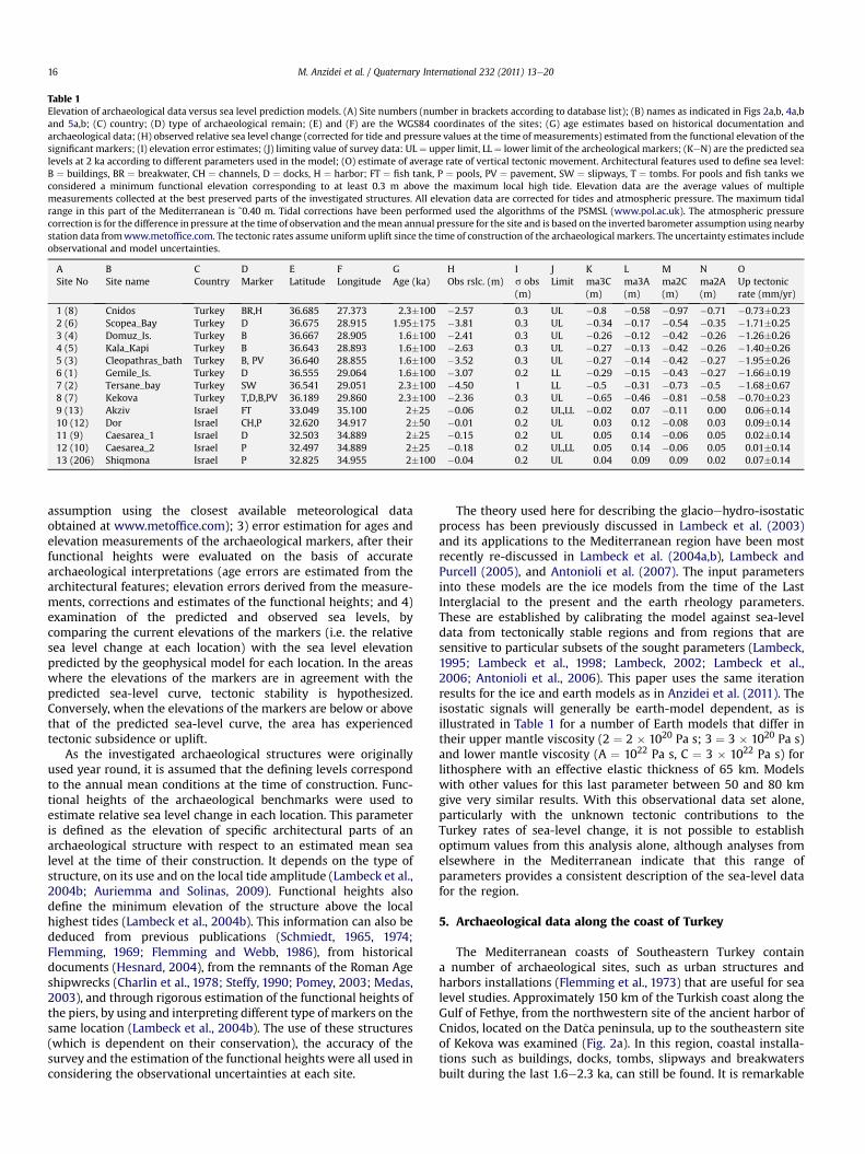
Table 1Elevation of archaeological data versus sea level prediction models. (A) Site numbers (number in brackets according to database list); (B) names as indicated in Figs 2a,b, 4a,band 5a,b; (C) country; (D) type of archaeological remain; (E) and (F) are the WGS84 coordinates of the sites; (G) age estimates based on historical documentation andarchaeological data; (H) observed relative sea level change (corrected for tide and pressure values at the time of measurements) estimated from the functional elevation of thesignificant markers; (I) elevation error estimates; (J) limiting value of survey data: UL ¼ upper limit, LL ¼ lower limit of the archeological markers; (KeN) are the predicted sealevels at 2 ka according to different parameters used in the model; (O) estimate of average rate of vertical tectonic movement. Architectural features used to define sea level:B ¼ buildings, BR ¼ breakwater, CH ¼ channels, D ¼ docks, H ¼ harbor; FT ¼ fish tank, P ¼ pools, PV ¼ pavement, SW ¼ slipways, T ¼ tombs. For pools and fish tanks weconsidered a minimum functional elevation corresponding to at least 0.3 m above the maximum local high tide. Elevation data are the average values of multiplemeasurements collected at the best preserved parts of the investigated structures. All elevation data are corrected for tides and atmospheric pressure. The maximum tidalrange in this part of the Mediterranean is ˜0.40 m. Tidal corrections have been performed used the algorithms of the PSMSL (www.pol.ac.uk). The atmospheric pressurecorrection is for the difference in pressure at the time of observation and themean annual pressure for the site and is based on the inverted barometer assumption using nearbystation data fromwww.metoffice.com. The tectonic rates assume uniform uplift since the time of construction of the archaeological markers. The uncertainty estimates includeobservational and model uncertainties.
ASite No
BSite name
CCountry
DMarker
ELatitude
FLongitude
GAge (ka)
HObs rslc. (m)
Is obs(m)
JLimit
Kma3C(m)
Lma3A(m)
Mma2C(m)
Nma2A(m)
OUp tectonicrate (mm/yr)
1 (8) Cnidos Turkey BR,H 36.685 27.373 2.3�100 �2.57 0.3 UL �0.8 �0.58 �0.97 �0.71 �0.73�0.232 (6) Scopea_Bay Turkey D 36.675 28.915 1.95�175 �3.81 0.3 UL �0.34 �0.17 �0.54 �0.35 �1.71�0.253 (4) Domuz_Is. Turkey B 36.667 28.905 1.6�100 �2.41 0.3 UL �0.26 �0.12 �0.42 �0.26 �1.26�0.264 (5) Kala_Kapi Turkey B 36.643 28.893 1.6�100 �2.63 0.3 UL �0.27 �0.13 �0.42 �0.26 �1.40�0.265 (3) Cleopathras_bath Turkey B, PV 36.640 28.855 1.6�100 �3.52 0.3 UL �0.27 �0.14 �0.42 �0.27 �1.95�0.266 (1) Gemile_Is. Turkey D 36.555 29.064 1.6�100 �3.07 0.2 LL �0.29 �0.15 �0.43 �0.27 �1.66�0.197 (2) Tersane_bay Turkey SW 36.541 29.051 2.3�100 �4.50 1 LL �0.5 �0.31 �0.73 �0.5 �1.68�0.678 (7) Kekova Turkey T,D,B,PV 36.189 29.860 2.3�100 �2.36 0.3 UL �0.65 �0.46 �0.81 �0.58 �0.70�0.239 (13) Akziv Israel FT 33.049 35.100 2�25 �0.06 0.2 UL,LL �0.02 0.07 �0.11 0.00 0.06�0.1410 (12) Dor Israel CH,P 32.620 34.917 2�50 �0.01 0.2 UL 0.03 0.12 �0.08 0.03 0.09�0.1411 (9) Caesarea_1 Israel D 32.503 34.889 2�25 �0.15 0.2 UL 0.05 0.14 �0.06 0.05 0.02�0.1412 (10) Caesarea_2 Israel P 32.497 34.889 2�25 �0.18 0.2 UL,LL 0.05 0.14 �0.06 0.05 0.01�0.1413 (206) Shiqmona Israel P 32.825 34.955 2�100 �0.04 0.2 UL 0.04 0.09 0.09 0.02 0.07�0.14
M. Anzidei et al. / Quaternary International 232 (2011) 13e2016
assumption using the closest available meteorological dataobtained at www.metoffice.com); 3) error estimation for ages andelevation measurements of the archaeological markers, after theirfunctional heights were evaluated on the basis of accuratearchaeological interpretations (age errors are estimated from thearchitectural features; elevation errors derived from the measure-ments, corrections and estimates of the functional heights; and 4)examination of the predicted and observed sea levels, bycomparing the current elevations of the markers (i.e. the relativesea level change at each location) with the sea level elevationpredicted by the geophysical model for each location. In the areaswhere the elevations of the markers are in agreement with thepredicted sea-level curve, tectonic stability is hypothesized.Conversely, when the elevations of the markers are below or abovethat of the predicted sea-level curve, the area has experiencedtectonic subsidence or uplift.
As the investigated archaeological structures were originallyused year round, it is assumed that the defining levels correspondto the annual mean conditions at the time of construction. Func-tional heights of the archaeological benchmarks were used toestimate relative sea level change in each location. This parameteris defined as the elevation of specific architectural parts of anarchaeological structure with respect to an estimated mean sealevel at the time of their construction. It depends on the type ofstructure, on its use and on the local tide amplitude (Lambeck et al.,2004b; Auriemma and Solinas, 2009). Functional heights alsodefine the minimum elevation of the structure above the localhighest tides (Lambeck et al., 2004b). This information can also bededuced from previous publications (Schmiedt, 1965, 1974;Flemming, 1969; Flemming and Webb, 1986), from historicaldocuments (Hesnard, 2004), from the remnants of the Roman Ageshipwrecks (Charlin et al., 1978; Steffy, 1990; Pomey, 2003; Medas,2003), and through rigorous estimation of the functional heights ofthe piers, by using and interpreting different type of markers on thesame location (Lambeck et al., 2004b). The use of these structures(which is dependent on their conservation), the accuracy of thesurvey and the estimation of the functional heights were all used inconsidering the observational uncertainties at each site.
The theory used here for describing the glacioehydro-isostaticprocess has been previously discussed in Lambeck et al. (2003)and its applications to the Mediterranean region have been mostrecently re-discussed in Lambeck et al. (2004a,b), Lambeck andPurcell (2005), and Antonioli et al. (2007). The input parametersinto these models are the ice models from the time of the LastInterglacial to the present and the earth rheology parameters.These are established by calibrating the model against sea-leveldata from tectonically stable regions and from regions that aresensitive to particular subsets of the sought parameters (Lambeck,1995; Lambeck et al., 1998; Lambeck, 2002; Lambeck et al.,2006; Antonioli et al., 2006). This paper uses the same iterationresults for the ice and earth models as in Anzidei et al. (2011). Theisostatic signals will generally be earth-model dependent, as isillustrated in Table 1 for a number of Earth models that differ intheir upper mantle viscosity (2 ¼ 2 � 1020 Pa s; 3 ¼ 3 � 1020 Pa s)and lower mantle viscosity (A ¼ 1022 Pa s, C ¼ 3 � 1022 Pa s) forlithosphere with an effective elastic thickness of 65 km. Modelswith other values for this last parameter between 50 and 80 kmgive very similar results. With this observational data set alone,particularly with the unknown tectonic contributions to theTurkey rates of sea-level change, it is not possible to establishoptimum values from this analysis alone, although analyses fromelsewhere in the Mediterranean indicate that this range ofparameters provides a consistent description of the sea-level datafor the region.
5. Archaeological data along the coast of Turkey
The Mediterranean coasts of Southeastern Turkey containa number of archaeological sites, such as urban structures andharbors installations (Flemming et al., 1973) that are useful for sealevel studies. Approximately 150 km of the Turkish coast along theGulf of Fethye, from the northwestern site of the ancient harbor ofCnidos, located on the Dat�ca peninsula, up to the southeastern siteof Kekova was examined (Fig. 2a). In this region, coastal installa-tions such as buildings, docks, tombs, slipways and breakwatersbuilt during the last 1.6e2.3 ka, can still be found. It is remarkable
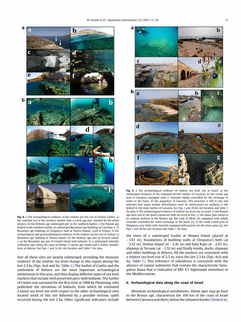
Fig. 4. a The archaeological evidence of the relative sea live rise in Turkey. Cnidos: a)the coastline out of the northern harbor with a Greek age pier (marked by the whitearrows), b) the Hellenic age submerged pier in the southern harbor, c) the Roman agebollard in the southern harbor, d) submerged Byzantine age buildings at Cala Kapi, eef)Byzantine age buildings of Cleopatra’s bath at Twelve Islands. (Gulf of Fethye). b Thearchaeological and geomorphological evidence of the relative sea live rise in Turkey: a)Byzantine age building at Domuz Island, (b) the Hellenic age pier of Tersane island,ceg) the Byzantine age pier of Gemile Island with bollards; h) a submerged stalactite(unknown age) along the coast of Fethye; i) Lycian age tombs and j) harbor installa-tions at Kekova. See Figs 1 and 2a for site location and Table 1 for data.
Fig. 5. a The archaeological evidence of relative sea level rise in Israel: a) thesubmerged remnants of the collapsed Herod’s harbor of Caesarea; b) the roman agepool of Caesarea, equipped with c) channels tidally controlled for the exchange ofwater in the basin; d) the acqueduct of Caesarea. This structure is still in situ andindicates that major seismic disturbances since its construction are unlikely, e) thebollard in the inner harbor of Caesarea. See Figs 1 and 2b for site location and Table 1for data. b The archaeological evidence of relative sea level rise in Israel: a) the Romanage dock and b) the pools connected with sea level at Dor; c) the sluice gate raised inits original position in the Roman age fish tank of Akziv (d), equipped with tidallychannels controlled for water exchange in the basin (e); f) the small round pool ofShiqmona, near Haifa with channels equipped with grooves for the sluice gates (g). SeeFigs 1 and 2b for site location and Table 1 for data.
M. Anzidei et al. / Quaternary International 232 (2011) 13e20 17
that all these sites are largely submerged, providing the dramaticevidence of the relative sea level change in this region during thelast 2.3 ka (Figs. 4a,b and 6a; Table 1). The harbor of Cnidos and thesettlement of Kekova are the most important archaeologicalsettlements in this area, and they display different types of sea levelmarkers that includewell preserved piers with bollards. The harborof Cnidos was surveyed for the first time in 1968 by Flemming, whopublished the elevations of bollards, from which he estimateda minor sea level rise with respect to the other archaeological siteslocated south of this site followed by a possible tectonic upliftoccurred during the last 2 ka. Other significant indicators include
the stairs of a submerged harbor at Skopea Island (placed at�3.81 m), foundations of building walls at Cleopatra’s bath (at�3.52 m), Domuz Island (at �2.41 m) and Kala Kapi (at �2.63 m),slipways at Tersane (at �3.52 m) and finally tombs, docks, slipwaysand other buildings at Kekova. All the markers are consistent witha relative sea level rise of 2.3 m, since the last 2.3 ka (Figs. 4a,b and6a; Table 1). This inference of subsidence is consistent with theabsence of coastal sediments that contain the characteristic Sene-galese fauna that is indicative of MIS 5.5 highstands elsewhere inthe Mediterranean.
6. Archaeological data along the coast of Israel
Abundant archaeological installations, whose ages may go backto the Bronze age, characterize the 100 km of the coast of IsraelbetweenCaesareaandAkziv, belowtheLebaneseborder (Sivanet al.,
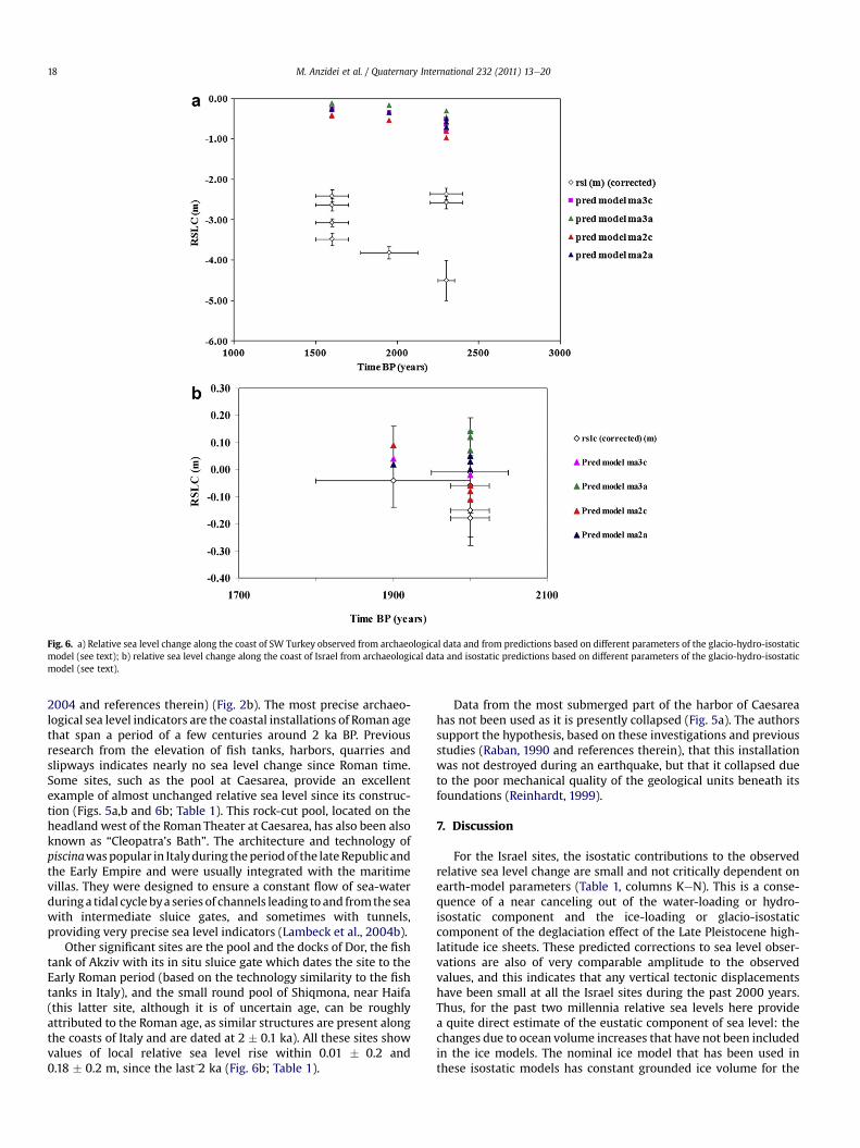
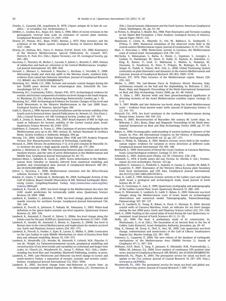
Fig. 6. a) Relative sea level change along the coast of SW Turkey observed from archaeological data and from predictions based on different parameters of the glacio-hydro-isostaticmodel (see text); b) relative sea level change along the coast of Israel from archaeological data and isostatic predictions based on different parameters of the glacio-hydro-isostaticmodel (see text).
M. Anzidei et al. / Quaternary International 232 (2011) 13e2018
2004 and references therein) (Fig. 2b). The most precise archaeo-logical sea level indicators are the coastal installations of Roman agethat span a period of a few centuries around 2 ka BP. Previousresearch from the elevation of fish tanks, harbors, quarries andslipways indicates nearly no sea level change since Roman time.Some sites, such as the pool at Caesarea, provide an excellentexample of almost unchanged relative sea level since its construc-tion (Figs. 5a,b and 6b; Table 1). This rock-cut pool, located on theheadland west of the Roman Theater at Caesarea, has also been alsoknown as “Cleopatra’s Bath”. The architecture and technology ofpiscinawaspopular in Italyduring theperiodof the lateRepublic andthe Early Empire and were usually integrated with the maritimevillas. They were designed to ensure a constant flow of sea-waterduringa tidal cycle bya series of channels leading to and fromthe seawith intermediate sluice gates, and sometimes with tunnels,providing very precise sea level indicators (Lambeck et al., 2004b).
Other significant sites are the pool and the docks of Dor, the fishtank of Akziv with its in situ sluice gate which dates the site to theEarly Roman period (based on the technology similarity to the fishtanks in Italy), and the small round pool of Shiqmona, near Haifa(this latter site, although it is of uncertain age, can be roughlyattributed to the Roman age, as similar structures are present alongthe coasts of Italy and are dated at 2 � 0.1 ka). All these sites showvalues of local relative sea level rise within 0.01 � 0.2 and0.18 � 0.2 m, since the laste2 ka (Fig. 6b; Table 1).
Data from the most submerged part of the harbor of Caesareahas not been used as it is presently collapsed (Fig. 5a). The authorssupport the hypothesis, based on these investigations and previousstudies (Raban, 1990 and references therein), that this installationwas not destroyed during an earthquake, but that it collapsed dueto the poor mechanical quality of the geological units beneath itsfoundations (Reinhardt, 1999).
7. Discussion
For the Israel sites, the isostatic contributions to the observedrelative sea level change are small and not critically dependent onearth-model parameters (Table 1, columns KeN). This is a conse-quence of a near canceling out of the water-loading or hydro-isostatic component and the ice-loading or glacio-isostaticcomponent of the deglaciation effect of the Late Pleistocene high-latitude ice sheets. These predicted corrections to sea level obser-vations are also of very comparable amplitude to the observedvalues, and this indicates that any vertical tectonic displacementshave been small at all the Israel sites during the past 2000 years.Thus, for the past two millennia relative sea levels here providea quite direct estimate of the eustatic component of sea level: thechanges due to ocean volume increases that have not been includedin the ice models. The nominal ice model that has been used inthese isostatic models has constant grounded ice volume for the

M. Anzidei et al. / Quaternary International 232 (2011) 13e20 19
past 2000 years and the difference between the observed andpredicted sea levels provide a measure of any change in ice volumein this interval, including changes in mountain glaciers, and anyother contributions such as thermal expansion of the oceans. Theformer contribution will be associated with its own loading andgravitational terms, but since the locations are far from anysignificant ice loads this additional contribution will be small.
While the data set is limited, an estimate of the eustatic correc-tion and the optimum earth-model parameters within a restrictedrange of (2e4) � 1020 Pa s for the upper mantle and (1e3) for thelower mantle can be attempted. This yields values of 2.5 � 1020 and2�1022 Pa s for the two layers respectivelyand an eustatic rise in sealevel during the past 2000 years of only 13.5� 2.6 cm. For a present-day eustatic sea level rise ofe1.2e1.5 mm/yr, this implies that if thepresent-day rise is extrapolatedback in time theRomanepoch levelswere reached only about 100 years ago, confirming the earlier resultof Lambeck et al. (2004b) and consistent with the similar resultsfrom Roman sites in Tunisia and Libya (Anzidei et al., 2011).
Archaeological data from other periods, mainly from archaeo-logical indicators such as coastal quarries, water wells and Romanand Byzantine installations (Fig. 4a) (Nir and Eldar, 1987; Mart andPerecman,1996; Nir, 1997; Galili and Sharvit, 1998; Sivan and Galili,1999; Sivan et al., 2004; Galili et al., 2007) have confirmed thegenerally good agreement between the observed and isostaticpredicted values consistent with an absence of vertical tectonicdeformation (within the observational limits) as far back ase10,000 BP (Sivan et al., 2001), that the sea-level curve here reflectsprimarily the eustatic component, and that it can be used as a first-order reference for other eastern Mediterranean coasts to establishrates of tectonic uplift or subsidence. This can be effectively illus-trated with the information discussed above for the section of theTurkish coast between Cnidos and Kekova that is dominated bydiffuse tectonics (strike slip and normal faulting) at the eastern endof the Hellenic arc tectonic system (Jackson and Mckenzie, 1988;Altunel et al., 2003). The archaeological sites provide evidence ofmajor submergence of this region, of between 2.4 and 4.5 m,depending on site, over the past 2300 years (Fig. 5).
The isostatic corrections for these sites are larger than for theIsrael sites and also show a greater dependence on the Earth model(Table 1) although the range of the corrections lie within theuncertainties of the observations and the tectonic subsidence signalclearly dominates the other contributions. Using the optimumearth and eustatic parameters established from the Israel data, theaverage tectonic rates of uplift for the past 1.6e2.3 ka can becalculated (column O in Table 1). The uncertainties of these esti-mated rates aree0.2 mm/yr and are dominated by the observationaluncertainties. Within uncertainties, the sites within the Gulf ofFethye yield consistent rates of subsidence of 1.48 � 0.3 mm/yr.
The absence of elevated Last Interglacial shorelines is consistentwith these rates of subsidence. If the above rates are representativeof longer time intervals, then these shorelines can be expected atdepths of up toe200 m below present sea level. The subsidencerecorded at the Antalya tide gauge, albeit of limited quality butindependently confirmed by Burkay et al. (2007), indicate that thepresent rate may be higher than the longer-term average, buta longer record will be required before significance can be attachedto this observation.
8. Conclusion
The evidence from archaeological data shows that the coasts ofSW Turkey underwent a maximum relative sea level rise between2.4 and 4.5 � 0.3 m over the last 2.3 ka. During about the sameperiod, the coast of Israel shows a near constancy of sea level. Theobserved changes can be attributed to the glacioehydro-isostatic
signal, eustatsy and vertical tectonics. The glacioehydro-isostaticcontribution to the observed changes plays approximately a nullrole along the coasts of Israel and has a minor contribution inTurkey. The estimated eustatic change since 2 ka BP of 13.5� 2.6 cmis in agreementwith previous results for central Mediterranean andNorth Africa. If the present-day rise ate1.2e1.5 mm/y shown by tidegauge data is extrapolated back in time to the Roman epoch, levelswere reached e100 years ago establishing that the onset of themodern sea level rise occurred in the late nineteenth or earlytwentieth century. The sea level prediction model fits the archae-ological observation in Israel. In Turkey, which is one of the highestseismic regions of the Mediterranean, all the archaeologicalmarkers largely fall below the predictions due to interveningvertical tectonics. Recent sea level and crustal deformation trendsinferred from the available geodetic data, although of short dura-tion, are consistent with tectonic stability for the coast of Israel anda still active subsidence of SW Turkey.
Finally, this analysis show that the coast of Israel is tectonicallystable since the laste2.0 ka while a broad tectonic subsidence hasaffected the SW coast of Turkey between Cnidos and Kekova, at anaverage rate of 1.48 � 0.3 mm/y since the laste2.3 ka. Estimates arein agreement with the elevation of the MIS-5.5 shorelines whichare at normal elevation along the coast of Israel and absent alongthe Turkish coasts, consistent with the long-term crustal subsi-dence associated with tectonics of the eastern ending of theHellenic Arc which is the primary cause of dramatic relative sealevel rise for this region.
Acknowledgments
We are thankful to Eng. Paolo Gaburro and Cap. Mustafà Yiltirfor their skilled assistance during marine surveys in Turkey. Theanonymous reviewers and Norm Catto and Sanja Faivre improvedthis paper with their suggestions. This study has been partiallyfunded by INGV, ENEA, Leon Recanati Institute, Australian NationalUniversity and MIUR e Prin 2006, Grant Project “Il ruolo del riag-giustamento isostatico post-glaciale nelle variazioni del livellomarino globale e Mediterraneo: nuovi vincoli geofisici, geologici edarcheologici”, coordinator Prof. Giorgio Spada.
References
Altamimi, Z., Collilieux, X., Legrand, J., Garayt, B., Boucher, C., 2007. ITRF2005: a newrelease of the International Terrestrial Reference Frame based on time series ofstation positions and earth orientation parameters. Journal of GeophysicalResearch 112, B09401. doi:10.1029/2007JB004949.
Altunel, E., Stewart, I.S., Barka, A., Piccardi, L., 2003. Earthquake faulting at ancientCnidus, SW Turkey. Turkish Journal of Earth Sciences 12, 137e151.
Antonioli, F., Ferranti, L., Lambeck, K., Kershaw, S., Verrubbi, V., Dai Pra, G., 2006.Late Pleistocene to Holocene record of changing uplift rates in southern Cala-bria and eastern Sicily (southern Italy, Central Mediterranean Sea). Tectono-physics 422, 23e40.
Antonioli, F., Anzidei, M., Auriemma, R., Gaddi, D., Furlani, S., Lambeck, K., Orrù, P.,Solinas, E., Gaspari, A., Karinja, S., Kova�ci�c, V., Surace, L., 2007. Sea level changeduring Holocene from Sardinia and northeastern Adriatic (Central Mediterra-nean sea) from archaeological and geomorphological data. Quaternary ScienceReviews 26, 2463e2486.
Anzidei, M., Antonioli, F., Lambeck, K., Benini, A., Soussi, M., 2011. New insights onthe relative sea level change during Holocene along the coasts of Tunisia andwestern Libya from archaeological and geomorphological markers. QuaternaryInternational 232, 5e12.
Auriemma, R., Solinas, E., 2009. Archaeological remains as sea level changemarkers: a review. Quaternary International 206, 134e146.
Boschi, E., Guidoboni, E., Ferrari, G., Valensise, G., Gasperini, P., 1995. Catalogo deiforti terremoti in Italia dal 461 a.C. al 1980. ING SGA, Bologna.
Burkay, S., Ebru, E., Ercan, K., 2007. Trend analysis of sea levels along Turkish coasts.Hydrology Days 2007, 152e160.
Calais, E., DeMets, C., Nocquet, J.M., 2003. Evidence for a post-3.16-Ma change inNubia-Eurasia-North America plate motions? Earth and Planetary SciencesLetters 216, 8e92.
Caputo, M., Pieri, L., 1976. Eustatic variation in the last 2000 years in the Mediter-ranean. Journal of Geophysical Research 81, 5787e5790.
M. Anzidei et al. / Quaternary International 232 (2011) 13e2020
Charlin, G., Gassend, J.M., Lequèment, R., 1978. L’èpave antique de la baie de cav-alière e Le Levandou, Var. Archeonautica 2.
DeMets, C., Gordon, R.G., Argus, D.F., Stein, S., 1994. Effect of recent revisions to thegeomagnetic reversal time scale on estimates of current plate motions.Geophysical Research Letters 21, 2191e2194.
Dewey, J.F., Pitman, W.C., Ryan, W.B.F., Bonnin, J., 1973. Plate tectonics and theevolution of the Alpine system. Geological Society of America Bulletin 84,3137e3180.
Dewey, J.F., Helman, M.L., Turco, E., Hutton, D.H.W., Knott, S.D., 1989. Kinematicsof the Western Mediterranean. Special Publication. In: Coward, M.P.,Dietrich, D., Park, R.G. (Eds.), Alpine Tectonics, vol. 45. Geological Society, pp.265e283.
Faccenna, C., Thorsten, W., Becker, L., Lucente, F., Jolivet, L., Rossetti, F., 2001. Historyof subduction and back-arc extension in the Central Mediterranean. Geophys-ical Journal International 145, 809e820.
Ferranti, L., Monaco, C., Antonioli, F., Maschio, L., Kershaw, S., Verrubbi, V., 2008.Alternating steady and stick-slip uplift in the Messina straits, southern Italy:evidence from raised late Holocene shorelines. Journal of Geophysical Research112, B06401. doi:10.1029/2006JB004473.
Flemming, N.C., Webb, C.O., 1986. Tectonic and eustatic coastal changes during thelast 10,000 years derived from archaeological data. Zeitschrift für Geo-morphologie N.F 62, 1e29.
Flemming, N.C., Czartoryska, N.M.G., Hunter, P.M., 1973. Archaeological evidence foreustatic and tectonic components of relative sea level change in the SouthAegean.In: Blackman, D.J. (Ed.), Marine Archaeology. Butterworths, London, pp. 1e16.
Flemming, N.C., 1969. Archaeological Evidence for Eustatic Changes of Sea Level andEarth Movements in the Western Mediterranean in the Last 2000 Years.Geological Society of America. Special Paper 109.
Galili, E., Sharvit, J., 1998. Ancient coastal installations and the tectonic stability of theIsraeli coast in historical times. Special Publications. In: Stewart, I.S., Vita-Finzi, C.(Eds.), Coastal Tectonics, vol. 146. Geological Society, London, pp. 147e163.
Galili, E., Zviely, D., Ronen, A., Mienis, H.K., 2007. Beach deposits of MIS 5e high seastand as indicators for tectonic stability of the Carmel coastal plain, Israel.Quaternary Science Reviews 26, 2544e2557.
Guidoboni, E., Comastri, A., Traina, G., 1994. Catalogue of ancient earthquakes in theMediterranean area up to the 10th century. In: Istituto Nazionale di GeofisicaRome. Societa Geofisica e Ambiente, Bologna, 504 pp.
Herring, T.H., 2004. GLOBK: Global Kalman Filter VLBI and GPS Analysis ProgramVersion 10.0. Massachussetts Institute of Technology, Cambridge.
Hesnard, A., 2004. Vitruve, De architectura, V 12, et le port romaine de Marseille. In:Le strutture dei porti e degli approdi antichi. ANSER, pp. 175e204.
Jackson, J., Mckenzie, D., 1988. The relationship between plate motions and seismicmoment tensors, and the rates of active deformation in the Mediterranean andMiddle East. Geophysical Journal International 93, 45e73.
Jiménez-Munt, I., Sabadini, R., Gardi, A., 2003. Active deformation in the Mediter-ranean from Gibraltar to Anatolia inferred from numerical modeling andgeodetic and seismological data. Journal of Geophysical Research 108 (B1).doi:10.1029/2001JB001544 2006.
Jolivet, L., Faccenna, C., 2000. Mediterranean extension and the Africa-Eurasiacollision. Tectonics 19, 1095e1106.
Kalafat, D., Günes, Y., Kekovali, K., Berbero�glu, M., 2004. Earthquake Activity of theGulf of Gökova. Report Kandili Observatory & ERI, National Earthquake Moni-toring Center, Cengelkoy/Istanbul, Turkey. http://www.emsc-csem.org/Doc/Gokova_0804.pdf.
Lambeck, K., Purcell, A., 2005. Sea-level change in the Mediterranean Sea since theLGM: model predictions for tectonically stable areas. Quaternary ScienceReviews 24, 1969e1988.
Lambeck, K., Smither, C., Johnston, P., 1998. Sea-level change, glacial rebound andmantle viscosity for northern Europe. Geophysical Journal International 134,102e144.
Lambeck, K., Purcell, A., Johnston, P., Nakada, M., Yokoyama, Y., 2003. Water-loaddefinition in the glacio-hydro-isostatic sea-level equation. Quaternary ScienceReviews 22, 309e318.
Lambeck, K., Antonioli, F., Purcell, A., Silenzi, S., 2004a. Sea level change along theItalian coast for the past 10,000 yrs. Quaternary. Science Reviews 23,1567e1598.
Lambeck, K., Anzidei, M., Antonioli, F., Benini, A., Esposito, E., 2004b. Sea level inRoman time in the central Mediterranean and implications for modern sea levelrise. Earth and Planetary Science Letters 224, 563e575.
Lambeck, K., Purcell, A., Funder, S., Kjær, K., Larsen, E., Möller, P., 2006. Constraintson the Late Saalian to early Middle Weichselian ice sheet of Eurasia from fielddata and rebound modelling. Boreas 35, 539e575.
Lambeck, K., Woodroffe, C.D., Anzidei, M., Antonioli, F., Gehrels, W.R., Plassche, O.van de., Wright, A.J. Palaeoenvironmental records, geophysical modelling andreconstruction of sea-level trends and variability on centennial and longer timescales. In: Church J.A., Woodworth P.L., Aarup T., Wilson, W.S., (Eds.), Under-standing Sea-level Rise and Variability. Blackwell Publishing, London, in press.
Lambeck, K., 1995. Late Pleistocene and Holocene sea-level change in Greece andsouth-western Turkey: a separation of eustatic, isostatic and tectonic contri-butions. Geophysical Journal International 122, 1022e1044.
Lambeck, K., 2002. Sea-level change from mid-Holocene to recent time: anAustralian example with global implications. In: Mitrovica, J.X., Vermeersen, B.
(Eds.), Glacial Isostatic Adjustment and the Earth System. American GeophysicalUnion, Washington, DC, pp. 33e50.
Le Pichon, X., Bergerat, F., Roulet, M.J., 1988. Plate Kinematics and Tectonics Leadingto the Alpine Belt Formation: a New Analysis. Geological Society of America.Special Paper 218111e131.
Mantovani, E., Cenni, N., Albarello, D., Viti, M., Babbucci, D., Tamburelli, C.,D’Onza, F., 2001. Numerical simulation of the observed strain field in thecentral-eastern Mediterranean region. Journal of Geodynamics 31 (5), 519e556.
Mart, Y., Perecman, I., 1996. Neotectonic activity in Caesarea, the Mediterraneancoast of central Israel. Tectonophysics 254, 139e153.
McClusky, S., Balassanian, S., Barka, A., Demir, C., Ergintasv, S., Georgiev, I.,Gurkan, O., Hamburger, M., Hurst, K., Kahle, H., Kastens, K., Kekelidze, G.,King, R., Kotzev, V., Lenk, O., Mahmoud, S., Mishin, A., Nadariya, M.,Ouzounis, A., Paradisssis, D., Peter, Y., Prilepin, M., Reilinger, R., Sanli, I.,Seeger, H., Tealeb, A., Toksoz, M.N., Veis, G., 2000. Global Positioning Systemconstraints on plate kinematics and dynamics in the eastern Mediterranean andCaucasus. Journal of Geophysical Research 105 (B3), 5695e5719.
McKenzie, D.P., 1970. Plate tectonics of the Mediterranean region. Nature 226,239e243.
Medas, S., 2003. The Late-Roman Parco di Teodorico Wreck, Ravenna, Italy:preliminary remarks on the hull and the shipbuilding. In: Beltrame, C. (Ed.),Boats, Ships and Shipyards. Proceedings of the Ninth International Symposiumon Boat and Ship Archaeology, Venice 2000, pp. 42e48. Oxford.
Nir, Y., Eldar, I., 1987. Ancient wells and their geoarchaeological significance indetecting tectonics of the Israel Mediterranean coastline region. Geology 15,3e6.
Nir, Y., 1997. Middle and late Holocene sea-levels along the Israel Mediterraneancoast e evidence from ancient water wells. Journal of Quaternary Science 12(2), 143e151.
Pirazzoli, P.A., 1976. Sea level variations in the northwest Mediterranean duringRoman times. Science 194, 519e521.
Pomey, P., 2003. Reconstruction of Marseilles 6th century BC Greek ships. In:Beltrame, C. (Ed.), Boats, Ships and Shipyards. Proceedings of the Ninth Inter-national Symposium on Boat and Ship Archaeology, Venice 2000, pp. 57e65.Oxford.
Raban, A., 1990. Oceanographic understanding of ancient harbour engineers of theLevant. In: Proc. 4th International Congress on the History of Oceanography.Deutsch Hydrographie Zietschrift vol. 22, pp. 257e271.
Rebai, S., Philip, H., Taboada, A., 1992. Modern tectonic stress field in the mediter-ranean region: evidence for variation in stress directions at different scale.Geophysical Journal International 110, 106e140.
Reinhardt, E., 1999. Destruction of Herod the Great’s harbour at Caesarea Maritima,Israel, Geoarcheological evidence. Geology 27, 811e814.
Schmiedt, G., 1965. Antichi porti d’Italia, vol. 45. L’Universo. 234e238.Schmiedt, G., 1974. Il livello antico del mar Tirreno. In: Olschki, E. (Ed.), Testimo-
nianze da resti archeologici, Firenze, 323 pp.Serpelloni, E., Vannucci, G., Pondrelli, S., Argnani, A., Casula, G., Anzidei, M., Baldi, P.,
Gasperini, P., 2007. Kinematics of the Western Africa-Eurasia plate boundaryfrom focal mechanisms and GPS data. Geophysical Journal International.doi:10.1111/j.1365-246X.2007.03367.x.
Sivan, D., Galili, E., 1999. Holocene tectonic activity in the Galilee coast and shallowshelf, Israel, a geological and archaeological study. Israel Journal of EarthScience 48, 47e61.
Sivan, D., Gvirtzman, G., Sass, E., 1999. Quaternary stratigraphy and paleogeographyof the Galilee Coastal Plain, Israel. Quaternary Research 51, 280e294.
Sivan, D., Wdowinski, S., Lambeck, K., Galili, E., Raban, A., 2001. Holocene sea-levelchanges along the Mediterranean coast of Israel, based on archaeologicalobservations and numerical model. Palaeogeography, Palaeoclimatology,Palaeoecology 167, 101e117.
Sivan, D., Lambeck, K., Toueg, R., Raban, A., Porat, Y., Shirman, B., 2004. Ancientcoastal wells of Caesarea Maritima, Israel, an indicator for sea level changesduring the last 2000 years. Earth and Planetary Science Letters 222, 315e330.
Sneh, A., 2000. Faulting in the coastal plain of Israel during the Late Quaternary, re-examined. Israel Journal of Earth Sciences 49 (1), 21e29.
Steffy, J.R., 1990. The boat: A preliminary study of its construction. In:Wachsmann, S., et al. (Eds.), The Excavation of an Ancient Boat in the Sea ofGalilee (Lake Kinneret). Israel Antiquities Authority, Jerusalem, pp. 29e47.
Ulu�g, A., Duman, M., Ersoy, X., Özel, E., Avci, M., 2005. Late quaternary sea-levelchange, sedimentation and neotectonics of the Gulf of Gfkova: SoutheasternAegean Sea. Marine Geology 221, 381e395.
Vannucci, G., Gasperini, P., 2004. The new release of the database of earthquakemechanisms of the Mediterranean Area (EMMA Version 2). Annals ofGeophysics 47 (1), 307e334.
Williams, S.D.P., Bock, Y., Fang, P., Jamason, P., Nikolaidis, R.M., Prawirodirdjo, L.,Miller, M., Johnson, D.J., 2004. Error analysis of continuous GPS position timeseries. Journal of Geophysical Research 109, B03412. doi:10.1029/2003JB002741.
Woodworth, P.L., Player, R., 2003. The permanent service for mean sea-level: anupdate to the 21st century. Journal of Coastal Research 19, 287e295. http://www.pol.ac.uk/PSMSL/.
Woodworth, P.L., 1991. The permanent service for mean sea-level and global sea-level observing system. Journal of Coastal Research 7, 699e710.