Simon Leyson - Backs.qxd - West Wales Football Association -
Upload
khangminh22Category
view
0download
0
Coasts and seas of the United Kingdom
Region 12 Wales: Margam to Little Orme
edited byJ.H. Barne, C.F. Robson, S.S. Kaznowska & J.P. Doody
Joint Nature Conservation CommitteeMonkstone House, City Road
Peterborough PE1 1JYUK
©JNCC 1995
This report has been produced by the Coastal Directories Project of the JNCCon behalf of the project Steering Group

JNCC Coastal Directories Project Team
Project directors Dr J.P. Doody, Dr N.C. DavidsonProject management and co-ordination J.H. Barne, C.F. Robson
Editing and publication S.S. Kaznowska, F.J. WrightInformation systems M. Jones
Administration & editorial assistance C.A. Smith, J.A. Mitchell, R. Keddie, E. Leck, S. Palasiuk
The project receives guidance from a Steering Group which has more than 200 members. More detailed information andadvice comes from the members of the Core Steering Group, which is composed as follows:
Dr. J.M. Baxter Scottish Natural HeritageR.J. Bleakley Department of the Environment, Northern Ireland
R. Bradley The Association of Sea Fisheries Committees of England and WalesDr. K. Hiscock Joint Nature Conservation Committee
Prof. G.A.D. King National Coasts and Estuaries Advisory GroupProf. S.J. Lockwood MAFF Directorate of Fisheries Research
Dr J.P. Doody Joint Nature Conservation CommitteeC.R. Macduff-Duncan Esso UK (on behalf of the UK Offshore Operators Association)
Dr. D.J. Murison Scottish Office Agriculture & Fisheries DepartmentM.L. Pickles National Rivers Authority
Dr. H.J. Prosser Welsh OfficeDr. J.S. Pullen WWF UK (Worldwide Fund for Nature)
Dr. G.P. Radley English NatureDr. P.C. Reid Plymouth Marine LaboratoryM.J. Roberts Water Resources and Marine, Department of the Environment
S.L. Soffe Countryside Council for WalesM.L. Tasker Joint Nature Conservation Committee
R.G. Woolmore Countryside Commission
Recommended citation for this volume:Barne, J.H., Robson, C.F., Kaznowska, S.S., & Doody, J.P., eds. 1995. Coasts and seas of the United Kingdom. Region 12Wales: Margam to Little Orme. Peterborough, Joint Nature Conservation Committee.
Recommended citation for a chapter in this volume (example):Davidson, N.C. 1995. Chapter 4.1 Estuaries. In: Barne, J.H., Robson, C.F., Kaznowska, S.S., & Doody, J.P., eds. 1995.Coasts and seas of the United Kingdom. Region 12 Wales: Margam to Little Orme. Peterborough, Joint Nature ConservationCommittee.
Region 1: ISBN 1 873701 75 6 Region 10: ISBN 1 873701 84 5 Region 2: ISBN 1 873701 76 4 Region 11: ISBN 1 873701 85 3 Region 3: ISBN 1 873701 77 2 Region 12: ISBN 1 873701 86 1 Region 4: ISBN 1 873701 78 0 Region 13: ISBN 1 873701 87 x Region 5: ISBN 1 873701 79 9 Region 14: ISBN 1 873701 88 8 Region 6: ISBN 1 873701 80 2 Region 15: ISBN 1 873701 89 6 Region 7: ISBN 1 873701 81 0 Region 16: ISBN 1 873701 90 x Region 8: ISBN 1 873701 82 9 Region 17: ISBN 1 873701 92 6 Region 9: ISBN 1 873701 83 7 Set of 17 regions: ISBN 1 873701 91 8
2

Foreword 5How to use this book 6Acknowledgements 7
Chapter 1 Introduction Dr J.P. Doody 9
1.1 The Coastal Directories project 91.2 Regional summary 13
Chapter 2 Geology and physical environment Dr C.D.R Evans 19
2.1 Coastal geology 192.2 Offshore environment 232.3 Wind and water 292.4 Sediment transport 342.5 Sea-level rise and flooding 372.6 Coastal landforms 38
Chapter 3 Terrestrial coastal habitats 41
3.1 Cliffs and cliff-top vegetation Dr T.C.D. Dargie 413.2 Sand dunes Dr T.C.D. Dargie 443.3 Vegetated shingle structures and shorelines Dr R.E. Randall 483.4 Coastal lagoons Dr R.S.K. Barnes, Dr R.N. Bamber 513.5 Coastal grazing marsh Dr H.T. Gee 533.6 Saltmarsh Dr M.I. Hill 57
Chapter 4 Marine and estuarine environments 61
4.1 Estuaries Dr N.C. Davidson 614.2 The sea bed R.A. Irving 654.3 Plankton Dr J.M. Colebrook, A.W.G. John 71
Chapter 5 Important species 75
5.1 Terrestrial lower plants N.G. Hodgetts 755.2 Flowering plants and ferns V.M. Morgan 805.3 Land and freshwater M.S. Parsons, A.P. Foster 855.4 Rare sea-bed species Dr W.G. Sanderson 925.5 Exploited sea-bed species Dr. M.G. Pawson, C.F. Robson 975.6 Amphibians and reptiles Dr M.J.S. Swan 1025.7 Fish: exploited sea fish Dr. M.G. Pawson, C.F. Robson 1075.8 Fish: salmon, sea trout Dr. M. Aprahamian, C.F. Robson 1115.9 Fish: other species Dr G.W. Potts, S.E. Swaby 1135.10 Seabirds M.L. Tasker 1165.11 Other breeding birds D.M. Craddock, D.A. Stroud 1205.12 Migrant and wintering D.M. Craddock, D.A. Stroud 1245.13 Land mammals Dr C.E. Turtle 1295.14 Seals C.D. Duck 1335.15 Whales, dolphins and porpoises Dr P.G.H. Evans 137
3
Contents
4
Chapter 6 Archaeology and human history A.B. Gale 141
Chapter 7 Protected coastal sites R.G Keddie 151
7.1 Introduction 1517.2 Sites designated under international conventions
and directives 1537.3 Sites established under national statute 1567.4 Sites identified by statutory agencies 1627.5 Other types of protected site 165
Chapter 8 Land use, infrastructure and coastal defence 171
8.1 Introduction M.J. Dunbar, S.J. Everett, S.L. Fowler 1718.2 Land use M.J. Dunbar, S.J. Everett, S.L. Fowler 1728.3 Infrastructure M.J. Dunbar, S.J. Everett, S.L. Fowler, 175
C.A. Crumpton, M.J. Goodwin8.4 Coastal defence M.J. Dunbar, S.J. Everett, S.L. Fowler 183
Chapter 9 Human activities 187
9.1 Fisheries C.F. Robson 1879.2 Mariculture C.F. Robson 1969.3 Wildfowling, grazing and collection of other plants Dr N.C. Davidson, D.A. Stroud, C.A. Crumpton, 201
and animals M.J. Goodwin9.4 Quarrying and landfilling C.A. Crumpton, M.J. Goodwin 2049.5 Marine aggregate extraction, dredge spoil C.A. Crumpton, M.J. Goodwin 2079.6 Oil and gas development C.A. Crumpton, M.J. Goodwin, J.H. Barne 2119.7 Water quality and effluent discharges C.A. Crumpton, M.J. Goodwin 2139.8 Leisure and tourism M.J. Dunbar, S.J. Everett, S.L. Fowler 218
Chapter 10 Coastal management S.L. Fowler, M.J. Dunbar, S.J. Everett 225
10.1 Coastal management in the UK 22510.2 Regional coastal management groups and initiatives 227
AppendixA.1 Frequently cited contact organisations and addresses 237A.2 Local planning authorities 238A.3 Core reading list 238A.4 Contributing authors 239

Information is vital for sound policy formulation. Decisionmakers at national and local level need to know more thanjust the scale, location and importance of natural resourcesthat are of value to humans. They have to understand howhuman activities affect the value of those resources and howto conduct those activities in an environmentally sustainableway. This is true for virtually every activity that impingeson the natural environment. In the coastal zone thecomplexity of the relationships between the physical andbiological systems adds another dimension to the problemsof formulating management policy.
I am pleased, therefore, to be introducing the Coasts andseas of the United Kingdom series. The Coastal Directoriesproject, of which this series of seventeen regional reports,covering the whole of the UK coast, is an important product,has brought together an encyclopaedic range of informationon our coastal resources and the human activities that areassociated with them. Amongst the topics covered are thebasic geology of the coasts around the United Kingdom andmeasures taken for coast defence and sea protection, thedistribution and importance of the wildlife and habitats ofour coasts and seas, including fish and fisheries, and theclimate and sea level changes to which they all are subject.
In addition to the value of the information itself, the waythe project has been run and the data collected has made animportant contribution to the quality of the product. A widerange of individuals and organisations concerned with theconservation and use of the coastal margin havecollaborated in collating the information, their variety
Foreword
The Earl of SelborneChairman, Joint Nature Conservation Committee
reflecting the extent of the interplay between the coastalenvironment and human activities. These organisationsincluded the Ministry of Agriculture, Fisheries and Food,the Scottish Office Agriculture and Fisheries Department,the National Rivers Authority, the CountrysideCommission, the Scottish Office, the Welsh Office, theDepartment of the Environment, the Sea FisheriesCommittees, English Nature, Scottish Natural Heritage andthe Countryside Council for Wales, together with localauthorities, voluntary conservation organisations andprivate companies (notably those in the oil industry,through the UK Offshore Operators Association). I am alsopleased to be able to acknowledge the contribution made bythe staff of the Joint Nature Conservation Committee. Asthe work has evolved since the first meetings of the SteeringGroup in 1990, the value of involving such a broad span ofinterests has been highlighted by the extent to which it hasallowed new approaches and information sources to beidentified.
The regional reports will be of value to all who live andwork in the maritime areas of the UK, where informedmanagement is the key to the sustainable use of resources.The reports should become indispensible reference sourcesfor organisations shouldering new or expandedresponsibilities for the management of marine Special Areasof Conservation under the EC Habitats Directive. Inaddition, the reports will make an important contribution tothe implementation of the UK Biodiversity Action Plan.
5

These notes provide some general guidance about findingand interpreting the information in this book.
Structure
The book is divided into ten chapters, each split intosections containing summary data on the topics shown inthe Contents list. Chapter 2 provides a general physicalbackground to the region. Sections in Chapters 3, 4 and 5have been compiled to the following standard format: • Introduction: presents the important features of the
topic as it relates to the region and sets the region in anational context.
• Important locations and species: gives more detail onthe region’s features in relation to the topic.
• Human activities: describes management and otheractivities that can have an effect on the resource in theregion.
• Information sources used: describes the sources ofinformation, including surveys, on which the section isbased, and notes any limitations on their use orinterpretation.
• Further sources of information: lists references cited,recommended further reading, and names, addressesand telephone numbers of contacts able to give moredetailed information.
• AcknowledgementsSections in the remaining chapters all have the last three
subsections and follow the other elements as closely aspracticable, given their subject nature.
At the end of the book there is a list of the addresses andtelephone numbers of organisations most frequently cited ascontacts, as well as a core reading list of books that cover theregion or the subject matter particularly well. Finally thereis a full list of authors’ names and addresses.
Definitions and contexts
The word ‘region’ (as in ‘Region 12’) is used throughout thisbook to refer to the coastal and nearshore zone, broadlydefined, between the two points given in the title of this
How to use this book
6
book. The area covered varies between chapter sections,depending on the form in which data is available. Coverageis usually either coastal 10 km squares, sites within onekilometre of Mean High Water Mark, or an offshore areathat may extend out to the median line between the UK andneighbouring states. Inland areas of the counties concernedare not included unless specifically stated.
‘Britain’ here means Great Britain, i.e. including onlyEngland, Scotland and Wales. ‘United Kingdom’ alsoincludes Northern Ireland.
The term ‘North Sea Coast’, as used here, means thecoast of Britain covered by The directory of the North Seacoastal margin (Doody, Johnston & Smith 1993): that is, fromCape Wrath (longitude 5°W) along the east and south coastsof Britain to Falmouth (again longitude 5°W), and includingOrkney and Shetland.
The ‘West Coast’, as used here, normally includes thecoast and seas from Falmouth to Cape Wrath along the westcoast of Britain. Only where explicitly stated have data forthe Isle of Man and/or Northern Ireland been included inWest Coast descriptions.
Sites within each chapter section are described inclockwise order around the coast, incorporating islandswithin the sequence. Maps and tables are numberedsequentially within their chapter section; for example insection 5.4, Map 5.4.1 is the first map referred to and Table5.4.2 is the second table.
Throughout the book, the information given is asummary of the best available knowledge. The sitesmentioned as important, the numbers and distributions ofspecies, archaeological features discovered and informationon all the other elements of the natural and man-madeenvironment are as known at December 1994, unlessotherwise stated. The fact that no information is presentedabout a topic in relation to a locality should not be taken tomean that there are no features of interest there, and fullerdetails should be sought from the further sources ofinformation listed at the end of each section. Note,however, that under the Environmental InformationRegulations (1992; Statutory Instrument No. 3240) you maybe asked to pay for information provided by organisations.

7
This regional report is one of a series of products from the Coastal Directories Project of the JNCC. The compilation andpublication of the series has been made possible by generous contributions from the members of the Coastal DirectoriesFunding Consortium listed below:
1 Funding from these companies was given to the CardiganBay Forum to fund the supply of information to the project.
2 Members of the Standing Conference on Regional Policy inSouth Wales are: Blaenau Gwent Borough Council, CardiffCity Council, Dinefwr Borough Council, Gwent CountyCouncil, Llanelli Borough Council, Lliw Valley BoroughCouncil, Mid Glamorgan County Council, MonmouthBorough Council, Port Talbot City Council, SouthGlamorgan County Council, Swansea City Council, Taff ElyBorough Council, West Glamorgan County Council.
3 The UK Offshore Operators Association is therepresentative organisation for the British offshore oil andgas industry. Its 34 members are the companies licensed byHM Government to explore for and produce oil and gas inUK waters.
We thank publishers and authors indicated in the figurecaptions for permission to reproduce illustrations. CrownCopyright material is reproduced with the permission of theController of HMSO.
Notes
Arco British Ltd 1
Avon County CouncilCeredigion District CouncilCheshire County CouncilChevron UK Ltd 1
Cleveland County CouncilClwyd County CouncilClyde River Purification BoardColwyn Borough CouncilCopeland Borough CouncilCountryside CommissionCountryside Council For WalesCumbria County CouncilCunninghame District CouncilDepartment of the EnvironmentDepartment of the Environment for Northern IrelandDevon County CouncilDorset County CouncilDumfries and Galloway Regional CouncilDyfed County CouncilEnglish NatureFife Regional CouncilForest of Dean District CouncilGwynedd County CouncilHamilton Oil Company Ltd 1
Highland River Purification BoardIsle of Man Government, Department of IndustryIsle of Man Government, Department of Local Government
and the Environment
Isle of Man Government, Department of TransportKyle and Carrick District CouncilLancashire County CouncilLincolnshire County CouncilMarathon Oil UK Ltd 1
Ministry of Agriculture, Fisheries and Food Directorate ofFisheries ResearchNational Rivers AuthorityNeath Borough CouncilNorfolk County CouncilNorth Cornwall District CouncilNuclear Electric plcPreseli Pembrokeshire District CouncilScottish Natural HeritageScottish Office Agriculture and Fisheries DepartmentScottish Salmon Growers Association LtdSefton Borough CouncilSolway River Purification BoardSomerset County CouncilSouth Pembrokeshire District CouncilStanding Conference on Regional Policy In South Wales2
Stroud District CouncilTayside Regional CouncilTorridge District CouncilUK Offshore Operators Association 3
Vale of Glamorgan Borough CouncilWater Services AssociationWelsh OfficeWorld Wide Fund For Nature (UK)
Acknowledgements

8
This collaborative project involves many other branches ofJNCC in addition to the project team listed on page 2. Theseare: Marine Conservation Branch (Keith Hiscock, Tim Hill,Bill Sanderson, Colin McLeod), Vertebrate Ecology andConservation Branch (Deirdre Craddock, David Stroud,Steve Gibson), Species Conservation Branch (Nick Hodgetts,Deborah Procter, Martin Wigginton), and Seabirds andCetaceans Branch (Mark Tasker, Paul Walsh, Andy Webb).We thank them all for their help and support.
The project has also received widespread support fromthe country conservation agencies: Countryside Council forWales, English Nature, Scottish Natural Heritage and theDepartment of the Environment (Northern Ireland). We aregrateful to the many regional and headquarters staff listedbelow as well as the representatives on the Core SteeringGroup.
The editors would like to thank the members of theCardigan Bay Forum and the many people who haveprovided information or editorial assistance for the report orgiven their time to comment on drafts. Where appropriate,individual acknowledgements are given also at the end ofeach section.Nigel Ajax Lewis, Glamorgan Wildlife Trust; MiranAprahamian, NRA; Roger Bamber, Fawley Aquatic ResearchLaboratories Ltd.; Mr R.F. Beale, West Glamorgan CountyCouncil; Trevor Beebee, University of Sussex, Brighton;Tricia Bradley, RSPB; Blaise Bullimore, CCW; Alastair Burn,EN; Andrew Burr, Department of Transport; TonyCadwalladr, CCW; Frances Cattanach, North Wales WildlifeTrust; Clive Chatters, Hampshire Wildlife Trust; TimCleeves, RSPB; Phil Coates, SWSFC; Bill Cook, NW &NWSFC; Keith Corbett, Herpetological Conservation Trust;Martyn Cox, The Crown Estate; Peter Cranswick, TheWildfowl & Wetlands Trust; Joan Edwards, The Wildlife
Trusts; Brian Elliott, Dyfed Wildlife Trust; Matthew Ellis,CCW; Stephen Evans, CCW; Ben Ferrari, NationalMonuments Records Centre; Ian Francis, RSPB; Chris Fuller,CCW; Mike Gash, CCW; Tony Gent, EN; David George,Natural History Museum; Lucy Gilkes, CCW; Tony Green,Cardigan Bay Forum; Wells Grogan, Marathon Oil; PaulHarding, Institute of Terrestrial Ecology; John Hartley,AMOCO (UK); David Hewett, North Wales Wildlife Trust;Richard Howell, NRA; Eira Hughes, CCW; Antony Jensen,University of Southampton; Rod Jones, CCW; Graham King,National Coasts and Estuaries Advisory Group; J.W.Lambert, NRA; Owain Lewis, Neath Borough Council;Barry Long, CCW; Colin Macduff-Duncan, ESSO; SteveMay, Field Studies Council Research Centre & DyfedCounty Council; Thomas McOwat, Dyfed Bat Group; CliveMorgan, Cardigan Bay Forum; A J Murray, The CrownEstate; Elwyn Owen, Wales Tourist Board; Steve Parr, CCW;Frank Parrish, The Crown Estate; Mike Pawson, MAFF;Lindsay Pickles, NRA; Iowerth Rees, CCW; Ivor Rees,University of Wales Bangor; Jane Rees, North Wales WildlifeTrust; Chris Reid, Plymouth Marine Laboratory; PeterRhind, CCW; Mandy Richards, CCW; Mike Roberts,Department of the Environment; Mark Robins, RSPB; ChrisRollie, RSPB; David Rye, Milford Port Health Authority; PatSargeant, EN; Alister Scott, Cardigan Bay Forum; JohnSharpe, RSPB; Duncan Shaw, Irish Sea Forum; PaulineSimpson, Institute of Oceanographic Sciences; RebeccaSinton, RSPB; Peter Slater, Standing Conference on RegionalPolicy in South Wales; Sarah Soffe, CCW; Mr P M Stainer,NRA; Phil Stone, Cardigan Bay Forum; Chris Stroud, Whaleand Dolphin Conservation Society; Stephanie Tyler, RSPB;C. Vivian, MAFF; Sarah Welton, Marine ConservationSociety; D.C. Williams, West Glamorgan County Council;Ray Woolmore, Countryside Commission.
Chapter 1 Introduction
1.1 The Coastal Directories projectDr J.P. Doody
The Coastal Directories project sets out to collect and collatesummary information that will provide an overview ofcoastal and marine resources and human activities atnational and regional levels. It also provides an index tomore detailed references and other sources of information.
Information on the coastal resource and its use is vital tothe development of policy for environmental management.Because of the inter-related nature of the many componentsof the coastal zone, including both habitats and species,coastal management requires a knowledge of theinteractions between human activities and the physicalfunctioning of the zone and its biological components. Inaddition, it is essential to adopt a wide-ranging approach tocollecting and collating this information.
For these reports, the definition of the coastal marginencompasses all the main marine, coastal and maritimezones, from offshore waters to terrestrial maritime habitats.By their nature the limits of the coastal, shoreline andmarine zones are indistinct, as tidal movement, storms andthe effects of sea level rise influence their relative positions.A wide definition of maritime habitats has been adoptedhere: tidal areas (mudflats, sand flats, saltmarshes andtransitions to brackish marsh, swamps and salt-influencedgrasslands) are included; rocky shores, shingle beaches,cliffs subject to salt spray, and terrestrial features includingsand dunes and shingle structures that are maintained bymarine processes are also covered. In addition, we haveconsidered areas where combinations of these habitatsoccur. Examples include estuaries where lagoons or landclaimed from the sea, such as coastal grazing marsh, formpart of the functioning system. Also covered are habitatsused by coastal species for at least part of their life cycle.
In the marine and nearshore environment we have notset any artificial limits to the areas to be discussed, exceptthose imposed by the availability of information or thelimits of national jurisdiction. A minimum distance of 35km offshore has been agreed as a notional limit to thecoastal zone for the Coastal Directories project, but in effectthe median line between Britain and neighbouring statesmay be said to form the boundary in many instances. Theoffshore limits of geomorphological processes, affectingboth the coast and the subtidal waters, and the seawardboundaries of nearshore benthic plant and animalcommunities, are important factors.
Because of the potentially wide influence of human use,the area from which we have derived data is occasionallywider than the strictly coastal zone. Fisheries, infrastructuredevelopment and sources of pollution are among theactivities for which it is difficult to define a precise limit.The historical context, derived from archaeologicalevidence, must also be taken into account. However, whenall these interactions are revealed they will help to inform
the process of planning and delivering coastal managementso that it allows for sustainable use and the maintenance ofbiological diversity.
1.1.1 Origins and aims of the work
Recognising the significant gaps that existed in scientificunderstanding of the North Sea, the Second InternationalConference on Protection of the North Sea established theNorth Sea Task Force in 1987. Under the guidance of theInternational Council for the Exploration of the Sea (ICES)and the Oslo and Paris Commissions, it organised a co-ordinated programme of research and monitoring with aprimary aim of producing an assessment of the North Sea(the Quality Status Report (QSR)) by 1993.
The Coastal Directories project began following asuggestion in 1989 by the UK at the second meeting of theNorth Sea Task Force to include consideration of coastalhabitats and species of conservation importance in theNorth Sea QSR. The work initially involved the collectionand collation of information along the coastal margin of theNorth Sea, from Cape Wrath around the North Sea and theEnglish Channel to the Fal Estuary. Funded as a jointproject between the Department of the Environment and theNature Conservancy Council (NCC), the information wascompiled during 1990 and 1991 and a draft Directory of theNorth Sea coastal margin was circulated for comment inAugust 1991.
The principal original aim was to produce “acomprehensive description of the North Sea coastal margin,its habitats, species and human activities, as an example toother North Sea states” (North Sea Task Force 1993). It washoped that this would help to ensure that habitats andspecies were considered in the QSR. The programmefulfilled this original aim, and the QSR published in 1993included descriptions of both habitats and species in severalof the sub-regional reports, together with an assessment ofthe human impacts on the ecosystems.
The Directory of the North Sea coastal margin waspublished in December 1993 (Doody et al. 1993). It waspresented to Ministers at the Intermediate MinisterialMeeting on the North Sea held in Denmark in the samemonth.
The North Sea Task Force was wound up in December1993 following completion of the QSR. Continuing workwas subsumed into a new Assessment and MonitoringCommittee (ASMO) under the 1992 Convention for theProtection of the Marine Environment of the North EastAtlantic (the OSPAR Convention). The new OSPARConvention requires that assessments similar to the NorthSea Quality Status Report be produced for all the constituent
9

Region 12 Chapter 1 Introduction
parts of the north-east Atlantic and for that area as a whole(which we have called for simplicity ‘the West Coast’) by theyear 2000. The Irish Sea will be one of the first areas subjectto assessment. The extension of the Coastal Directoriesproject to the West Coast of Great Britain (thereby coveringall the coast not included in the Directory of the North Seacoastal margin, and also including the Isle of Man andNorthern Ireland) and the production of regional reportssuch as this one contribute to that assessment.
1.1.2 Methods - the North Sea and WestCoast Directories
Throughout the work on the directories a simple approachto compiling the information has been adopted. This hasinvolved identifying existing sources of compiledinformation at national, regional and local levels. TheDirectory of the North Sea coastal margin was largely producedby staff within the Nature Conservancy Council (NCC);following reorganisation of the NCC in 1991, responsibilityfor the work has rested with the Joint Nature ConservationCommittee (JNCC). Table 1.1.1 shows how the CoastalDirectories project is managed.
At the outset it was agreed that the work should involvea wide variety of individuals and organisations concernedwith the conservation and use of the coastal margin, toreflect the complex nature of the habitats and species andthe wide-ranging influence of human activities. Initially, asmall group of individuals and organisations (including theMinistry of Agriculture, Fisheries and Food (MAFF), theNational Rivers Authority (NRA), the CountrysideCommission (CC), the Scottish Office (SO), the Welsh Office(WO), the Department of the Environment (DoE) and theconservation agencies for England, Scotland and Wales(English Nature, Scottish Natural Heritage, CountrysideCouncil for Wales)) was invited to help steer the project andto identify and provide information. As the work evolvedfrom the first meetings in 1990, the value of this approachwas highlighted by the extent to which new approaches andinformation sources were identified.
Unlike for the preceding work on the North Sea coastalmargin, which was funded principally through the DoE andthe NCC/JNCC, a decision was made to seek funding forthe continuation of the work on the West Coast from aconsortium of private organisations and public bodies,including coastal local authorities. Early in 1993, JNCCappointed a co-ordinator for this work, part of whoseresponsibility was to obtain funding for the project. In theevent a large number of organisations agreed to participateand showed a keen interest in the development of the work.Members of the Funding Consortium are listed in theAcknowlegements section of the book.
10
Table 1.1.1 The structure of the management arrangements
Group Role
JNCC Coastal Conservation Branch (CCB) Day to day management
Management Board Liaison & executive deci
Core Steering Group Steer work, provide info
Main Steering Group Review progress, considprovide advice
This interest was reflected in the extent of externalfunding that the project received (including an injection offunds from the UK Offshore Operators Association, seebelow), and in the commitment shown by the steeringgroups, which meet regularly. Of particular importance isthe annual Main Steering Group seminar: so far it hasreviewed the Role of the Directories in the development of coastalzone management (January 1994), and considered the Use ofelectronic storage and retrieval mechanisms for data publication(February 1995).
e
1.1.3 The Coastal Directories’contribution tocoastal management
As the work on the Directory of the North Sea coastal marginproceeded, the emphasis of the approach changed. In theUK during the period 1990 - 1993 there was a considerableupsurge of interest in the principles of coastal management.The House of Commons Environment Committee examinedthe issues during November 1991 and in January/February1992 and published their report on Coastal zone protection andplanning in March 1992 (House of Commons EnvironmentCommittee 1992).
That report, together with other initiatives at UK andEuropean levels, continues to encourage a more integratedapproach to management issues. The dialogue between theproject consortium members has confirmed the importanceof the Coastal Directories in providing basic resourceinformation to support these new approaches. Increasingly,therefore, the Directories are seen as providing essentialinformation to inform the development of coastal zonemanagement policy at national levels.
The Directories provide information that complementsthe sectoral approach (control of different activities byseparate regulations) currently being promoted by a rangeof Government reports. These include PPG 20: Coastalplanning (Department of the Environment/Welsh Office1992), and the two consultation documents that followed upthe House of Commons Environment Committee report:Development below low water mark (Department of theEnvironment/Welsh Office 1993) and Managing the coast(Department of the Environment/Welsh Office 1993).MAFF too is promoting the setting up of ‘coastal cellgroups’, to encourage sustainable shoreline management.
1.1.4 Regional reports
The coastal management developments fostered interest inthe Coastal Directories project, and also increased demandfor information at a regional level. It was decided, therefore,to produce a series of regional reports to cover the wholecoast of Britain, in addition to the two overview volumes
Undertaken by
Head of CCB
sions Country agencies/JNCC Coastal Conservation Branch
rmation and support See page following title page
r new developments, All Steering Group members, conferring annually at Steering Group Meeting

1.1 The Coastal Directories project
1
2
3
3
4
5
6
13
14
17
15
16
16
5°W
(The Directory of the North Sea coastal margin, published in1993, and the West Coast Directory). Discussions amongconsortium members indicated that early completion of theregional volumes should be the priority. Seventeen regionswere identified for which reports are being prepared. Theseprovide a more detailed level of information than theoverview volumes, to help set each region in a nationalcontext and facilitate the preparation of regional plans.
It was also recognised that the summary data in theregional reports is valuable in preparing and assessingapplications for oil and gas licensing around the coastalmargin. An injection of funds from the United KingdomOffshore Operators Association (UKOOA) made possiblethe early production of reports for most of the potentiallicensing areas in the 16th Offshore Oil and Gas LicensingRound.
The areas covered by the complete series of regionalreports are shown in Map 1.1.1: Regions 1 - 10 cover the areaof the Directory of the North Sea coastal margin; Regions 11 - 17deal with the area of the West Coast Directory.
7
89
10
11
12
5°W
1.1.5 Outputs
The reports are published as conventional paper reports; inaddition a first version using UKDMAP (the electronic atlasdeveloped by the British Oceanographic Data Centre,Birkenhead) was published in 1994 (Barne et.al, 1994).Other forms of electronic publication are being evaluated.The position on publication as at March 1995 is shown inTable 1.1.2.
Map 1.1.1 Regions in the series. Region names are given in Table1.1.2.
1.1.6 Further sources of informationA. References cited
Barne, J., Davidson, N.C., Hill, T.O., & Jones, M. 1994. Coastal andMarine UKDMAP datasets: a user manual. Peterborough, JointNature Conservation Committee.
DoE/Welsh Office. 1992. Planning policy guidance - coastal planning.PPG 20. London, HMSO.
DoE/Welsh Office. 1993. Development below Low Water Mark - areview of regulation in England and Wales. London, HMSO.
DoE/Welsh Office. 1993. Managing the coast: a review of coastal
Table 1.1.2 Provisional titles and publication dates of the Coastal Dire
Directory of the North Sea Coastal MarginRegional Report 1. ShetlandRegional Report 2. OrkneyRegional Report 3. North-east Scotland (Cape Wrath to St Cyrus)Regional Report 4. South-east Scotland (Montrose to Eyemouth)Regional Report 5. North-east England (Berwick-on-Tweed to Filey BaRegional Report 6. Eastern England (Flamborough Head to Great YarmRegional Report 7. South-east England (Lowestoft to Dungeness)Regional Report 8. Sussex (Rye Bay to Chichester Harbour)Regional Report 9. Southern England (Hayling Island to Lyme Regis)Regional Report 10. South-west England (Seaton to Falmouth Bay)Regional Report 11. The Western Approaches (Falmouth Bay to KenfigRegional Report 12. Wales (Margam to Little Orme)Regional Report 13. Northern Irish Sea (Colwyn Bay to Stranraer)Regional Report 14. South-west Scotland (Ballantrae to Mull)Regional Report 15. The Outer HebridesRegional Report 16. North-west Scotland (Loch Linnhe to Cape WrathRegional Report 17. Northern IrelandWest Coast DirectoryCoastal and marine UKDMAP datasets: Version 1
management plans in England and Wales and the powers supportingthem. London, HMSO.
Doody, J.P., Johnson, C., & Smith, B. 1993. Directory of the North Seacoastal margin. Peterborough, Joint Nature ConservationCommittee.
House of Commons Environment Committee. 1992. Coastal zoneprotection and planning. Second Report. 2 volumes. London,HMSO.
North Sea Task Force. 1993. North Sea quality status report. London,Oslo and Paris Commissions.
11
ctories reports
Published 1993Publication due 1997Publication due 1997Publication due 1995Publication due 1996
y) Publication due 1995outh) Publication due 1995
Publication due 1996Publication due 1996Publication due 1995Publication due 1996
) Publication due 1996Published 1995
Publication due 1995Publication due 1996Publication due 1996
) Publication due 1996Publication due 1996Publication due 1996
Published 1994

Region 12 Chapter 1 Introduction
B. Further reading
Bird, E.C.F. 1984. Coasts - an introduction to coastal geomorphology. 3rd ed. Oxford, Basil Blackwell.
C. Contact names and addresses
Type of information Contact address and telephone no.
Information about the *Project Co-ordinator, CoastalDirectories project and Conservation Branch, JNCC,UKDMAP version Peterborough, tel: 01733 62626
Sales outlet for the Natural History Book Serviceregional volumes, the Ltd, 2-3 Wills Road, Totnes, DevonDirectories and other TQ9 5XN, tel: 01803 865913JNCC publications
* Starred contact addresses are given in full in the Appendix
12
Whitesands Bay, St David’s Head, Dyfed. Rocky cliffs and sweeping sandy bays are characteristic and important features of this region andare popular with holidaymakers for their beauty and tranquility. Photo: JNCC Geological Conservation Review.

1.2 Regional summary
1.2.1 Introduction and scope
This chapter gives a brief introduction to the character of theregion and the extent of its human use and development,summarising the information presented in the followingnine chapters. Region 12 covers the major part of thecoastline of Wales, including the whole of its west coast.The area is influenced by south-westerly and westerlyAtlantic winds, has a varied geology and has an open,predominantly agricultural hinterland. Major industrialdevelopment is concentrated in the south, particularlyaround Swansea Bay. Much of the coast is unspoiled andincludes thirteen sections designated as Heritage Coasts.Two National Parks also include substantial coastal sectionsand the area is a popular tourist destination. Map 1.2.1shows the main locations in the region that are mentioned inthe text.
1.2 Regional summaryDr J.P. Doody
1.2.2 General description of the coastline
The coast is 1,322 km long when measured at high watermark as shown on the 1:50,000 Ordnance Survey maps,which is 84% of the total coastline of Wales and 7% of that ofGreat Britain. From south to north the rocks from which thecoast is constructed are progressively older. In the south,rocks of the Carboniferous period (300 million years)include the sediments (shales and limestone) of the CoalMeasures. The bulk of the area north of Pembrokeshire iscomposed of rocks of Lower Palaeozoic age (570 - 400million years), though even older rocks occur on Angleseyand the Llyn Peninsula. The nature of the underlying rock,together with the more recent influence of glacial action,including the deposits of material left as the ice retreated,provide the basis for the present-day landscape. Offshorethere are thick deposits of sedimentary rocks, which areyounger than those on the land but pre-date the glacialperiod.
In the south several large estuaries and associated sanddunes and saltmarshes surround Swansea and CarmarthenBays. These are separated by the Gower Peninsula, apopular tourist destination. Swansea Bay includes the onlysubstantial area of infrastructure development to havecaused major loss of coastal habitats. Here the sand dunesand estuaries of the area around Swansea, Neath and PortTalbot have largely been destroyed by various urban,industrial and port developments, including one ofEurope’s largest steel works. By contrast, the estuaries ofCarmarthen Bay are largely intact and include completesequences of habitats that have been lost, by enclosure, frommany other sites in Great Britain.
The Pembrokeshire Coast National Park includes thelimestone cliffs, with their rich grasslands, around St.Govan’s Head and the exposed westerly-facing headlandsand adjacent cliffs of St. Anne’s and St. David’s Head,where important cliff and cliff-top heathland vegetationoccurs. Together with the offshore islands and theirinternationally important breeding bird colonies and themarine interest in the waters around Skomer and the
adjacent Marloes Peninsula, the whole area is of exceptionalconservation interest. Milford Haven is also of specialinterest: the site of a major oil terminal, it still retains muchof its natural beauty and wildlife importance.
The southern part of Cardigan Bay, the Ceredigion coast,is remote, with cliffs and small sandy bays. North ofAberystwyth the coastline has a generally more low-lyingtopography. Here the coastal fringe includes a sequence ofestuaries (Dyfi, Mawddach and Glaslyn) and enclosing sanddunes of considerable interest for their structure, historyand vegetation. Cardigan Bay is an important marine areaand has some of the least polluted coastal waters in Wales.
The northern rocky coast, with its cliffs and offshoreislands, supports cliff-face and cliff-top plant communitiesof considerable importance, ranging from the limestones ofGreat Orme’s Head to the geologically older, heath coveredslopes of Holy Island coast and the cliffs of the LlynPeninsula. On the south-west corner of Anglesey there areseveral sand dune systems, of which Newborough Warren isthe largest, with more than 1,000 ha of wind-blown sand.
Offshore of Region 12, marine life is also very rich. Bothsub-littoral and littoral habitats exhibit a wide range ofvariation. Milford Haven (a drowned river valley), thewaters around Skomer Island and Ynys Enlli (BardseyIsland) and the Menai Strait are all nationally importantmarine areas.
1.2.3 Coastal habitats and species
The coast of Region 12 includes a mixture of all the maincoastal habitat types, with nationally important examples ofsea cliffs, sand dunes and saltmarshes. The sea cliffs andcliff tops, particularly those associated with the offshoreislands, also support important sea bird colonies. Theestuaries are numerous and ecologically varied, though notlarge in a national context. There are no nationallyimportant examples of shingle structures and only onelagoon with nationally important brackish-waterinvertebrates.
Sand dunes
The region includes a high proportion of the total area ofsand dune in Great Britain (14%). The prevalence ofonshore westerly winds has encouraged the growth of anumber of large systems. These include two of the tenlargest areas of wind-blown sand in Great Britain, onAnglesey (Newborough Warren) and the Pembrey Burrowsin the south (1,257 and 1,559 ha respectively). Both of thesesites have been extensively planted with pines intended toprevent sand movement. This has reduced the area of openhabitat, with losses of 56% and 45% for Pembrey andNewborough respectively, based on measurements takenfrom OS 1:50,000 scale maps. As with other sites in Britainand the Netherlands this is thought to have contributed to alowering of the water table within the dunes, which mayhave affected the development of the important andcharacteristic dune slack vegetation.
13

Region 12 Chapter 1 Introduction
14
4°W5°W
53°N
52°N
WESTGLAMORGAN
GWYNEDD
DYFED
Penmaenmawr
Abersoch
Llanbedrog
Porth Neigwl
St Tudwal’sPeninsula
MochrasMorfa Dyffryn
GlaslynEstuary
Mawddach Estuary
Dyfi Estuary
Aberaeron
Llangranog
Little Haven
PendinePembrey
LoughorEstuary
RhossiliBay
Margam
Cefni
Glaslyn
Conwy
Maw
ddac
h
Dyfi
Ystwyth
Teifi
W. C
leddau
E. C
ledd
au
Taf
Tywi
Loughor Tawe
Neath
ConwyBay
Snowdonia
CaernarfonBay
CardiganBay
CarmarthenBay
SwanseaBay
Gower
Peninsula
Llyn Peninsula
PortTalbot
NeathSwansea
LlanelliPembroke
Milford Haven
Cardigan
Fishguard
Aberystwyth
Caernarfon
Holyhead
Bangor
ConwyLlandudno
Great Orme
Red Wharf BayLittle Orme
Ynys Mon(Anglesey)
Ynys Gybi
Ynys Enlli
Yr Eifl
Tremadog Bay
Cardigan IslandCemaes Head
Strumble Head
Penmaen Dewi(St David’s Head)
Ramsey Island
St BridesBay
Grassholm
Skomer Island
Skokholm
St Ann’s Head
Marloes Peninsula
St Govan's HeadCaldey IslandCastlemartin Peninsula
Worms Head
Burry Inlet Afan
Gwendraeth
Rheidol
Leri
Dysyn
ni
Wnio
nArtr
o
DwyrydDw
yfor
Erch
Gw
yrfai
Seiont
Cegin
Ogw
en
Alaw Goch
Ffra
w
Braint
(Holy Island)
Menai Stra
it
(Bardsey Island)
Map 1.2.1 Rivers, major towns and other coastal locations. The dashed lines show the coastal limits of Region 12.

1.2 Regional summary
The vegetation of the dunes is predominantly composedof species-rich calcareous communities, which aredependent on periodic low-level grazing for their survival.They include a number of fungi that are restricted to sanddunes and a rare liverwort that is confined to dune slacks inthis area. The richness of the sand-dune vegetation ismatched by its invertebrate fauna, which includes bothspecies characteristic of open sandy habitats and rarerspecies including those of wet slacks. In some areas areduction in grazing levels has led to an increase in thegrowth of coarse grasses and scrub development at theexpense of the species-rich grassland.
Recreational activity has locally increased the extent ofsand movement at several sites, including the NationalNature Reserves of Morfa Harlech and Morfa Dyffryn.
Saltmarshes
Both large and small saltmarshes occur within the region.They are mostly grazed and support a relatively richvegetation. The absence of major enclosure for agricultureis an important element in sustaining a complete zonation(all the stages of development of saltmarsh, from the water’sedge to the limit of tidal influence) at several estuarine sites.Thus the saltmarshes of the Loughor Estuary (notablyLlanridian Marsh) have the true marsh-mallow in theirupper levels - a species absent from many other sites wheresaltmarsh enclosure has taken place. Within the region,where saltmarshes are enclosed by a sand spit, transitions tosand-dune vegetation may include elements of theMediterranean flora, including sharp rush Juncus acutus,which helps provide a geographical link between thecommunities of the colder north and those of the warmersouth. Significant areas of upper saltmarsh are dominatedby sea rush Juncus maritimus, another species that iscommon and characteristic of the Mediterranean flora.
Although these areas have been relatively free fromdestruction by enclosure, compared with those in the south-east of England, many estuaries do show loss of habitat.This loss includes the development of grazing marsh onformer saltmarsh, though even the larger areas in the region,such as Malltraeth Marsh on Anglesey (1,365 ha) and thegrazing marshes associated with Carmarthen Bay and theDyfi Estuary, are still relatively small when compared withthe extensive grazing marshes of other regions.
Cord grass Spartina anglica is a major factor in saltmarshdevelopment around the region. Extensive areas occur inalmost all the estuaries, and at some sites, such as the Dyfiestuary, there is a correlation between a loss of winteringwaders such as dunlin and the spread of cord grass (Davis& Moss 1984). At the Malltraeth estuary, which is part of theNational Nature Reserve at Newborough, a programme ofcontrol underway for several years has preventedencroachment onto the tidal flats.
Estuaries
The region includes 23 estuaries identified in the EstuariesReview (Davidson et al. 1991). They are ecologically varied,though not among the largest in Britain. The LoughorEstuary and Milford Haven are the largest estuaries (each inexcess of 5,000 ha) and represent 60% of the resource in theregion. However, they are small by comparison with themajor estuaries such as the Wash (65,000 ha) and
Morecambe Bay (45,000 ha), the two biggest estuaries inGreat Britain. The Welsh mudwort Limosella australis is ofparticular note, as it is a typically North American species,found at a number of estuarine sites in the region, thoughnowhere else in Europe.
Sea cliffs
The cliffs and cliff tops of the Gower and Castlemartinpeninsulas are rich in plant species, with a wealth of lime-loving plants including several rare species. Similarly, GreatOrme’s Head in the north is also important for a number ofrare plants that inhabit the limestone cliffs and cliffs tops.These are, botanically, among the most species-rich cliff sitesin Britain and compare well with those of the Dorset coastand the Isle of Wight.
On the headlands of Strumble Head and St. David’s inthe south-west and Holy Island in the north-west there aregood examples of maritime and para-maritime vegetationon sea cliffs. These cliffs are composed of older, moreresistant rocks and support communities that includeexamples of acid-loving vegetation. On the more exposedcliffs, a sequence of salt-spray influenced vegetation withtypical maritime plants such as golden samphire and seathrift grade into maritime heath, with a close-cropped andsometimes extensive vegetation composed of heather, bellheather and western gorse. In the late summer these slopesprovide a spectacle of purple and yellow flowers coveringthe cliff tops. Another feature in these exposed cliffs,particularly in Pembrokeshire, is the presence of a closelywind-pruned shrub community of privet and blackthorn,which is often so dense as to be completely impenetrable.The oceanic climate is also important for the presence of anumber of lichen populations, which require the dampconditions of the cliff-top grassland and coastal woodlandsto survive.
The cliffs in the region are not only important for theirrich and varied vegetation but also have some significantseabird populations. Some of the very few remainingcolonies of the chough in Britain occur on the cliffs ofGwynedd and Dyfed.
Islands
One of the features of the coast is the presence of a numberof islands important for nature conservation. Notableamongst these are Ynys Enlli in the north, and Ramsey,Grassholm, Skomer and Skokholm in the south. Each ofthese has its own suite of breeding bird species, whichattract thousands of visitors each year. Access by boat fromthe mainland is limited, but regular trips take place, landingon the islands or sailing round them. Skomer Island is oneof the most visited offshore island sites anywhere in Britain.The written history of nearby Skokholm Island, by R.M.Lockley, charts the farming history and wildlife interest in aseries of classic books (Lockley 1943a, 1943b, 1946 and 1969).
1.2.4 The marine environment
The importance of the region’s marine habitats is reflectedin the number of sites identified as potential Marine NatureReserves. The waters around Skomer Island are now theUK’s second (and Wales’s first) designated statutory Marine
15
Region 12 Chapter 1 Introduction
Nature Reserve, and the Menai Strait and Ynys Enlli, alongwith part of the Llyn Peninsula, have both been identifiedfor potential future designation. The particular value of themarine communities lies in the great diversity of their floraand fauna, associated with the turbulent and clear waters,which are relatively free from pollution when comparedwith other parts of southern Britain.
Benthic (sea-bed) communities
The waters off the Pembrokeshire coast have a high densityof sites of marine biological importance. A wide range ofshore types occur here, ranging from exposed bedrock onheadlands to sheltered sandy bays. The exposed limestonecliffs west of St. Govan’s Head have some of the finestexamples of rocky shore communities in Wales. Sublittoralhabitats around Skomer Island exhibit an outstanding rangein a very small area. The whole of the MilfordHaven/Daucleddau estuary system is one of the bestexamples of a ria system (drowned river valley) in Britain,with a wide range of benthic habitats and communities.
In Cardigan Bay, the sub-littoral, shallow boulder reefs(‘sarnau’) provide outcropping hard substrates which aresubject to strong wave action and tidal currents and areespecially rich in species.
In the north the Menai Strait includes rich tide-sweptcommunities tolerant of extreme current strengths. Againthe range of communities throughout the area is large,developing on rocky shores and in sandy bays and muddyinlets.
Table 1.2.1 Summary of main site protection measures
Site type Total area No. of sites % of areain this in region of GB
region (ha) coastal sites
Sites of Special Scientific Interest 38,229 176 5.5National Nature Reserves 6,793 12 8.0
Fish
This region contains all eight of the British species protectedunder national, European and international legislation.However, only the lamprey, lampern and the two shadspecies are considered threatened in a national context.These four species are recorded throughout the region andare particularly associated with the estuaries and coastalwaters around Gwynedd and south Wales. The south Walesestuaries feed into the Bristol Channel, where a populationof shad occurs that is of considerable importance, being theonly one in the UK known to be viable.
Marine Nature Reserve 1,500 1 51.9Ramsar sites 9,418 3 4.0Special Protection Areas 10,753 7 4.3Local Nature Reserves 3,045 8 22.8National Trust sites 6,840 88 10.9Wildlife Trusts sites 1,128 38 4.8RSPB Reserves 1,603 8 4.3
Marine mammals
The grey seal is present throughout the region (commonseals rarely visit and do not breed in the region). Breedingis concentrated around the Pembrokeshire coast, with asmall population around Ynys Enlli. The colonies representapproximately 5% of the national population of grey seals.The diversity of regularly-recorded cetacean species is notparticularly rich in the region, although a total of fourteendifferent species have been recorded offshore. However,Cardigan Bay is noteworthy for having the only recognisedresident community of bottlenose dolphins in England andWales.
Archaeology
Offshore from Region 12 there is an extensive former coastalplain, which was populated by Mesolithic and Neolithicpeoples when sea-level was much lower (by up to 40 m)than today. Submerged forests offshore provide evidence
16
for a former wooded landscape, and other prehistoric landsurfaces are now buried beneath the extensive dunes of thewest coast.
More recent history is derived from onshore sites, whichtestify to Roman occupation, though surprisingly littlesurvives from the next 700 years. In modern times thepresence of coal provided the impetus for the developmentof ports on the south coast, mirroring the Bronze Ageimportance of the north Wales coast, which was also rich inrelatively accessible mineral resources.
Birds
Cliff-nesting choughs are present on Anglesey and inPembrokeshire, representing about 26% of the Britishpopulation. The peregrine falcon also breeds on the moreinaccessible cliffs. The seabird colonies on the islands ofSkomer, Skokholm and Grassholm are the most importantin the region. Wintering waterfowl occur in nationallyimportant numbers at three sites, Burry Inlet andCarmarthen Bay in the south and Lafan Sands in the north.The rocky nature of much of the rest of the coast restricts thesize of available sites and the numbers of waterfowl usingthem.
1.2.5 Site protection
The value of the area for nature conservation is reflected inthe large number of official site protection measures thathave been applied to a large proportion of the coast. Thetotal number of sites and the area of the main designationsare given in Table 1.2.1. In addition to these there are threeAreas of Outstanding Natural Beauty, two National Parksand thirteen Heritage Coasts, including a Marine HeritageCoast pilot project in Ceredigion.
The extent and importance of the interest is reflected in theapproach to coastal management being adopted by Arfordir.This group is a partnership of practitioners in Walespromoting integrated coastal management and ‘bestpractice’ environmental management for the whole of theWelsh coast.
1.2.6 Human activities and infrastructuredevelopment
Early occupation of the region dates back to prehistorictimes, when scattered settlements existed along the coastal
1.2 Regional summary
fringe. Sea routes were of major importance and there isconsiderable evidence of the importance of the area fromRoman times. The ports of Swansea (coal and steel),Fishguard, Holyhead and Milford Haven (oil) are the onlysignificant port and port-related developments in theregion, though there are a number of smaller, older ports.
Carmarthen and Swansea Bays, with their gentlyshelving sub-tidal areas, are important for shellfisheries.Cockles are abundant and gathered commercially in theLoughor Estuary and Traeth Lafan; other species are morewidely dispersed and are not considered to be important formajor fisheries. The Spartina marshes on the west coast areknown to be valuable as nursery areas for sea bass.
The majority of the coastal hinterland is in agriculturaluse. Although some areas of coastal land within estuarieshave been enclosed, this represents much less of anincursion than has occurred in many estuaries in otherregions. By contrast, the ploughing of the grassland andheathlands of the cliff tops has affected a number of areasand a relatively higher proportion of cliff-top than estuarineland. In some places the cliff-top margin has been left as anarrow strip with little or no surviving interest. At the sametime the decline of rough grazing on the cliff tops and slopeshas caused further loss of species-rich grassland and heath,as bracken and scrub have spread.
There is a concentration of tourist use and associatedfacilities in some parts of the region, which can put pressurelocally on coastal habitats such as sand dunes. Whereproblems have arisen, such as on the National NatureReserves at Ynyslas and Whiteford, management of peopleby providing access and walkways and the rehabilitation of
Anglesey
Caernarfonshireand
Merionethshire
Aberconwyand
Colwyn
Cardiganshire
Pembrokeshire Carmarthenshire
Swansea Nea
th &
Por
t Tal
bot
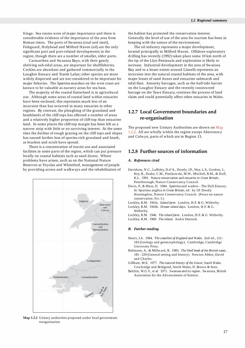
Map 1.2.2 Unitary authorities proposed under local governmentreorganisation
the habitat has protected the conservation interest.Generally the level of use of the area for tourism has been inkeeping with the nature of the environment.
The oil industry represents a major development,located principally in Milford Haven. Offshore exploratorydrilling has recently (1992) taken place some 10 km north ofthe tip of the Llyn Peninsula and exploration is likely toincrease. Industrial development in the area of SwanseaBay and to a lesser extent around Llanelli represents anincursion into the natural coastal habitats of the area, withmajor losses of sand dunes and estuarine saltmarsh andtidal flats. Amenity barrages, such as the half-tide barrieron the Loughor Estuary and the recently constructedbarrage on the Tawe Estuary, continue the process of landclaim and could potentially affect other estuaries in Wales.
1.2.7 Local Government boundaries and re-organisation
The proposed new Unitary Authorities are shown on Map1.2.2. All are wholly within the region except Aberconwyand Colwyn, parts of which are in Region 13.
1.2.8 Further sources of information
A. References cited
Davidson, N.C., Laffoley, D.d’A., Doody, J.P., Way, L.S., Gordon, J.,Key, R., Drake, C.M., Pienkowski, M.W., Mitchell, R.M., & Duff,K.L. 1991. Nature conservation and estuaries in Great Britain.Peterborough, Nature Conservancy Council.
Davis, P., & Moss, D. 1984. Spartina and waders - The Dyfi Estuary.In: Spartina anglica in Great Britain, ed. by J.P. Doody.Huntingdon, Nature Conservancy Council. (Focus on natureconservation, No. 5.)
Lockley, R.M. 1943a. Island farm. London, H.F. & G. Witherby.Lockley, R.M. 1943b. Dream island days. London, H.F. & G.
Witherby.Lockley, R.M. 1946. The island farm. London, H.F. & G. Witherby.Lockley, R.M. 1969. The island. Andre Deutsch.
B. Further reading
Steers, J.A. 1964. The coastline of England and Wales. 2nd ed., 112 -183 (Geology and geomorphology). Cambridge, CambridgeUniversity Press.
Robinson, A., & Millward, R. 1983. The Shell book of the British coast,185 - 229 (General setting and history). Newton Abbot, Davidand Charles.
Gillham, M.E. 1977. The natural history of the Gower, South Wales.Cowbridge and Bridgend, South Wales, D. Brown & Sons.
Balchin, W.G.V., et al. 1971. Swansea and its region. Swansea, BritishAssociation for the Advancement of Science.
17

Region 12 Chapter 1 Introduction
18
Stackpole Head, Dyfed (Site of Special Scientific Interest). These limestone cliffs are nationally important for both their geological interestand their plants and animals. Photo: J.P. Doody, JNCC.

Chapter 2 Geology and physicalenvironment
2.1.1 Introduction
This section describes the geological structure, stratigraphy(history of the rock units) and glacial history of the regionand relates them to the coastal landforms.
The Palaeozoic and Precambrian rocks of the region holda special place in the history of geological science in thatnames of many stratigraphic units, now used world-wide,were derived from them (Table 2.1.1). A broad range ofthese rock units and their associated structures are wellexposed along these coasts.
2.1 Coastal geologyDr C.D.R. Evans
2.1.2 Stratigraphy
Map 2.1.1 shows the onshore coastal geology of the region.Locations mentioned in the text are shown on Map 1.2.1.
Table 2.1.1 Geological column
Era Period Epoch Age (mil
Cenozoic Quaternary HolocenePleistocene
Tertiary (Neogene) PlioceneMiocene 2
Tertiary (Palaeogene) Oligocene 3
Eocene 5Palaeocene 6
Mesozoic Cretaceous 14Jurassic 21
Triassic 24Palaeozoic (Upper) Permian 28
Carboniferous StephanianWestphalianNamurianDinantian 36
Devonian 40Palaeozoic (Lower) Silurian 43
Ordovician 50Cambrian 59Precambrian
Note: Stippling = ages of rocks with important or extensive exposuresdeposits at Mochras (see Map 2.2.4).
Swansea Bay – St. Bride’s Bay
Swansea Bay, lying on the southern flank of the south Walessyncline, is surrounded by poorly exposed, locallycarbonaceous shales of the Coal Measures. The bulk of theGower Peninsula comprises shelly, coral-rich CarboniferousLimestone but an inlier of Old Red Sandstoneconglomerates outcrops at Rhossili Bay. The bays along thesouth coast result from erosion of softer shales, which formsynclinal cores in the Millstone Grit. Numerous faults andfolds traverse the rocks of southern Gower. Glacial deposits,raised beaches and cliffs are found along this southern coast,though mantling glacial deposits are absent inland.
The coast of Carmarthen Bay north-west of Gower isformed largely of sand dunes backed by alluvial flats. RedMarls of Old Red Sandstone age reach the coast at theconfluence of the Rivers Tywi and Taf.
Southern Pembrokeshire is composed of a wide varietyof rocks ranging in age from Precambrian to Carboniferous,
19
of start Stratigraphic units Significant geological eventslion yrs) mentioned in the text
0.01 Rapid sea-level rise1.6 Glaciations (Devensian,
Wolstonian, Anglian)5.158 Subsidence of sedimentary
basin in Tremadog Bay5543 Subsidence of sedimentary
basins in Cardigan Bay andSt George’s Channel
86
Armorican earth movementsCoal MeasuresMillstone Grit
0 Carboniferous Limestone8 Old Red Sandstone Caledonian earth movements850
Holyhead Quartzite
along the coast of the region. Hatching = underlie Quaternary

Devonian
Silurian/Devonian
Silurian
Cambrian
Ordovician volcanics
Ordovician
Precambrian
Tertiary
Triassic
Westphalian
Namurian
Dinantian
Acid — granite, granophyre
Intermediate — diorite
Basic — dolerite
Anticline
Map 2.1.1 Onshore coastal geology
Stratigraphy Rock Types Igneous Intrusive Rocks
Structures
Lignitic sandstone and clay
Red sandstone and siltstone
Sandstone, shale and coal
Sandstone
Limestone
Red sandstone and siltstone
Slate and sandstone
Slate, volcanic tuffand sandstone
Slate and sandstone
Gneiss, schist and granite
Ca
rbo
nife
rou
s
}
}
Fault, tick on downthrow side
Syncline
Source: British GeologicalSurvey. Geology of the UnitedKingdom, Ireland and theadjacent continental shelf
20
Region 12 Chapter 2 Geology and physical environment

2.1 Coastal geology
which are formed into a series of complex, tight and locallyoverturned folds. The area south of Milford Haven issimilar to the Gower peninsula, with continuous high cliffedsections delimiting the onshore plateau surface. To thenorth, inliers of Ordovician volcanic, sedimentary andintrusive rocks form Skomer island, the mainland to the eastand an elongate zone which reaches the coast south of LittleHaven. The coast along the southern part of St Bride’s Bayis formed of folded and faulted Coal Measures withnumerous coal seams.
Cardigan Bay
From the northern shores of St Bride’s Bay to Fishguard, theextensive raised plateau surface is terminated at the coast bysteep cliffs. The intrusive rocks within the Precambrian toOrdovician sequence form isolated hills that rise above theplateau surface and form steep, high sea cliffs, while erosionof the softer slates has resulted in narrow bays, and thethicker, more resistant volcanic rocks form promontoriessuch as Strumble Head.
The coast sweeping north-eastwards from aboutFishguard to the Dyfi estuary is formed of well-beddedOrdovician and Silurian slates and sandstones in major andminor folds, and is locally faulted. From north of Cardiganto Llangranog the rocks are mostly slates. The cliffs alongthis section of coast are higher than to the south and reach amaximum height of nearly 200 m at Cemaes Head. Some ofthe small, steep-sided valleys along the coast betweenCardigan and Fishguard are glacial overflow channels, andthe steep cliffs backing the coast around Aberaeron areblanketed by glacial till.
Northwards from the Dyfi to the Glaslyn estuary thecoast is formed of extensive sand dunes and alluvium,backed by steep cliffs of Cambrian grits and shales. Thedunes and alluvium extend furthest into Cardigan Bay atMochras, which is underlain by nearly 2,000 m of Tertiaryand Jurassic sediments. These rocks are typical of thoseforming the sedimentary basin in Cardigan Bay. The steepbedrock cliffs along this section of coast mark major faults,which form the boundary to this basin.
Llyn Peninsula – Great Orme’s Head
The eastern Llyn peninsula is formed mainly of Ordoviciansedimentary, volcanic and intrusive rocks. The intrusionsform peaks along the northern part of the peninsula whichslope steeply into the sea at Yr Eifl. The acid igneousintrusion at Llanbedrog forms a prominent upstandingcoastal feature that contrasts with the bays at Porth Neigwland Abersoch, which are carved into softer Ordovicianslates. Much of the western part of the peninsula is formedof highly resistant Precambrian rocks similar to those foundon Anglesey. They include a wide range of metamorphicand igneous rock types.
The northern coasts of the Llyn, Arfon and southernAnglesey are traversed by major NE-SW faults. The MenaiStrait in part follows the path of some of these faults, whichmark the boundary between the high ground of Snowdoniato the south-east and the lower plateau that forms much ofAnglesey to the north-west.
Anglesey is formed of a range of Precambrian andPalaeozoic rocks, with a general NE-SW structural trend.The east and west coasts of the island are aligned at right
angles to this structural trend, and this results in a variedcoastal morphology. The relief of the island is generally low,except where more resistant units, such as the HolyheadQuartzite near South Stack, form high ground.Carboniferous Limestone occupies Red Wharf Bay, parts ofthe Menai Strait shores and the easternmost extremity of theisland, and extends eastwards under Conwy Bay toreappear at the Great Orme. The fault system along theMenai Strait dies out to the east but is replaced by the moresoutherly Aber-Dinlle fault, which extends eastwards,occupying the low ground to the south of the Great Orme.The coast at Conwy Bay is formed generally of low ground,but where intrusive rocks are close to the fault, as atPenmaenmawr, spectacular cliffs fall steeply into the sea.South of the bay the ground rises steeply into the foothills ofeastern Snowdonia. The Great Orme, north of Llandudno,is a spectacular upstanding mass of CarboniferousLimestone, which continues as a faulted outcrop eastwardstowards Colwyn Bay and into Clwyd.
2.1.3 Structure
North of St Bride’s Bay the form of the coast is controlled byNE-SW structures associated with the Devonian Caledonianearth movements. The coasts of southern Cardigan Bay andthe Llyn peninsula, along with the Menai Strait and thevalleys of the Mawddach and Dyfi, lie parallel to structuresof this age. The region is flanked offshore by basinscontaining thick sequences of Mesozoic sedimentary rocksthat are younger than the onshore rocks.
Across the southern part of the region, westwards to StBride’s Bay, the geological structures are alignedapproximately E-W, and are associated with the UpperCarboniferous Armorican earth movements (see Table 2.1.1).The main structure here is the south Wales syncline, whichencloses the south Wales coalfield in Glamorgan andextends westwards into south Pembrokeshire.
2.1.4 Glacial history
The ice-sheet that originated from the Welsh landmassduring the last glaciation reached its maximum southernextension along the southern coast of the area. However,the contemporaneous ice-sheet filling the Irish Sea extendedas a broad tongue well to the south, into the Celtic Sea. Theinteraction of the two ice-sheets along the northern andwestern coasts of Wales led to the deposition of especiallycomplex glacial deposits. Evidence from offshore boreholesand isolated coastal sections suggests that more extensive,earlier (Anglian and Wolstonian) ice-sheets once covered theregion.
2.1.5 Further sources of information
A. Maps
British Geological Survey. 1991. Geology of the United Kingdom,Ireland and the adjacent continental shelf (South Sheet). 1:1 000 000scale.
British Geological Survey. 1978. Liverpool Bay Sheet. 53°N - 04°W,Solid Geology. 1:250 000 series.
21

Region 12 Chapter 2 Geology and physical environment
British Geological Survey. 1982. Anglesey. Sheet 53°N - 06°W, SolidGeology. 1:250 000 series.
British Geological Survey. 1982. Cardigan Bay. Sheet 52°N - 06°W,Solid Geology. 1:250 000 series.
British Geological Survey. 1988. Bristol Channel. Sheet 52°N - 06°W,Solid Geology. 1:250 000 series.
Geological Survey of Great Britain (England and Wales). 1972.Swansea (Sheet 247), Drift Geology. 1:50 000 scale.
Note that similar 1:50 000 scale sheets are available for much ofcoast of the region and further information may be obtained fromthe British Geological Survey, Keyworth, Nottingham.
B. Further reading
Challinor, J., & Bates, D. E. B. 1973. Geology explained in North Wales.Newton Abbot, David and Charles.
Owen, T. R. 1973. Geology explained in South Wales. Newton Abbot,David and Charles.
Owen, T.R., ed. 1974. The Upper Palaeozoic and Post-Palaeozoic rocks ofWales, 285-294. Cardiff, University of Wales Press.
George, T. N. 1970. British Regional Geology: South Wales. 3rd ed.London, HMSO.
Woodland, A. W. 1971. The Llanbedr (Mochras Farm) borehole.Institute of Geological Sciences, Report No. 71/18.
Detailed descriptions of Welsh Geological Conservation Review(GCR) sites can be found in published volumes of the GeologicalConservation Review (eg: Campbell, S., & Bowen, D.Q. 1989.Geological Conservation Review: Quaternary of Wales. London,Chapman and Hall.). See also section 7.4 of this book for adiscussion of the GCR sites in the region.
C. Contact names and addresses
Type of information Contact address and telephone no.
Geological information Coastal Geology Group, Britishfor region and the whole Geological Survey, Keyworth,of Britain Nottingham NG12 5GG,
tel: 0115 936 3100
GCR sites north Wales *Senior Officer, CCW North WalesRegion, Bangor, tel. 01248 372333
GCR sites mid-Wales *Senior Officer, CCW Dyfed/MidWales Region, Aberystwyth,tel. 01970 828551
GCR sites south Wales *Senior Officer, CCW South WalesRegion. Cardiff, tel. 01222 485111
*Starred contact addresses are given in full in the Appendix
22

2.2 Offshore environment
This section deals briefly with the geology of the rocks andsediments at, and below, the sea bed. The bulk of theinformation is shown on Maps 2.2.1 - 2.2.4, with someadditional explanation provided by the text. Locations areshown on Map 1.2.1.
2.2 Offshore environmentDr C.D.R. Evans
2.2.1 Bathymetry
The dominant bathymetric feature in the region is the widetrough, having a maximum depth in excess of 100 m, whichruns the length of St George’s Channel between Wales andIreland. The Bristol Channel is less than 60 m deep andshallows to the east (Map 2.2.1).
Cardigan Bay is a shallow, smooth-floored embaymentwith the 60 m isobath close to shore off the Llyn Peninsulaand west of Pembrokeshire. In the southern part of the bay,the 20 m isobath lies within a few kilometres of the coast.The northern part is shallower and its bathymetry isdominated nearshore by a series of shore-transverse ridges(sarnau), the crests of which locally dry at extreme lowwater.
Caernarfon Bay is shallow, but the zone of deeper waterextends to within about 15 km of the north-west corner ofAnglesey. Water depths reach 20 m within a few kilometresoff the north Anglesey coast and the isobath continuestowards the Great Orme, with shallower waters in ConwyBay to the south.
2.2.2 Holocene sea-bed sediments
Sea-bed sediments are defined here as the unconsolidatedsediments on the sea bed that have been laid down since thesea transgressed across the area during the early Holocene(Map 2.2.2).
In the Bristol Channel, tidal streams are especially strongand in general the Holocene sediments become coarsergrained and thinner towards the east. In the centre of thechannel, south of Gower, extensive areas of the sea bed arecovered only by a thin veneer of gravel, and to the east,bedrock is widely exposed at the sea bed. Swansea Bay andCarmarthen Bay lie outside the main tidal steams, and as aresult thicker sequences of fine grained Holocene sedimentshave accumulated within them. Sediments are generallythin and coarse grained off the Pembrokeshire coast. Withinthe outer part of Cardigan Bay the bulk of the sediments atthe sea bed are gravelly, formed by the winnowing of finermaterial from a substrate of glacial till. Tidal currents havemoved the finer sediment towards the coast, where thickersands and, in Tremadog Bay, muds have accumulated.
A similar sediment distribution exists around Anglesey,with generally gravelly sediments offshore and thickersands within Caernarfon Bay and Conwy Bay. Bedrock isextensively exposed at the sea bed north of the island.
2.2.3 Pleistocene geology
The Pleistocene is the period of time from about 1.6 millionyears to about 10,000 years before present during which thesurface of the Earth was subject to a number of glacial andinter-glacial climatic cycles.
The last major ice sheet to cover Wales reached itsmaximum extent during the late Devensian, some 20,000years ago. It extended southwards as far as Swansea Bayand Pembrokeshire. A separate tongue of ice flowing downSt George’s Channel extended southward into the CelticSea, possibly as far as the Isles of Scilly. Offshore the icedeposited a blanket of glacial till, which extends onshore tomantle many of the cliffs in the region.
This blanket of till (the Irish Sea Till) is extensive andover 10 m thick across much of Cardigan Bay. The till wasproduced in part by ice eroding the extensive areas ofTriassic rocks underlying St George’s Channel to the northand west, thereby producing a brownish-red deposit tillwith fewer boulders than its greyer, landward equivalent.In the centre of the main channel west of Anglesey the till isoverlain by a thick succession of sands and muds, whichwere deposited during the melting of the ice sheet (see Map2.2.3).
Offshore seismic and borehole evidence indicates thatearlier, more extensive glaciations affected the region. Theage of these events is uncertain but the consensus is that onesuch glaciation occurred about 150,000 years ago and wasequivalent to the Wolstonian (Saalian) glaciation of EastAnglia. Seismic evidence suggests that an even older,Anglian glaciation may have covered parts of the centralIrish Sea. Some of these middle Pleistocene sediments cropout beneath Holocene sediments in the outer part ofCardigan Bay. The general thickness of the Pleistocenesediments, comprising both the glacial tills, glaciomarinesediments and inter-glacial deposits, exceeds tens of metresin parts of Cardigan Bay and St George’s Channel, with amaximum in excess of 100 m. Raised beaches along thesouth and west coasts of Wales indicate that sea levels werehigher than at present during parts of the Pleistocene.
2.2.4 Pre-Quaternary geology
Rocks formed before the start of the Quaternary Period (1.6 million years BP) are included by geologists in thecategory of ‘solid geology’. Offshore in this region, theserocks are largely concealed by sea-bed sediments andpalaeovalley infill sediments.
Sedimentary basins containing thick sequences ofMesozoic sediments surround the coasts of the region, butonly at Mochras (where they are covered by Pleistocenedeposits) do these sediments extend onshore (see Map2.2.4). Elsewhere around this part of Wales the Precambrianand Palaeozoic rocks exposed at the coast extend at the seabed for a few tens of kilometres offshore. The basins have ageneral synclinal form and, commonly, faulted margins.
23

24
40
2060
80
80
60
60
80
80
100
6020
40
601020
20
40
40
10
20
20
20
40
60
80
100
80
20
40
20
40
60
60
80
100
120
100100
80
100
80
100
80
4020
40
20
80
80
8010
0
100
120
120
80
100
100
60
4020
6040
60 80
100 80
100
140
140
140
120
20
60 Bathymetric contours in metres;figures on the deep side of the line.
Source: British Geological Survey. Sea bed sedimentaround the UK (South Sheet). 1:1,000,000 scale.
St George’sChannel
Bristol Channel
CardiganBay
LiverpoolBay
Map 2.2.1 Bathymetry
Region 12 Chapter 2 Geology and physical environment
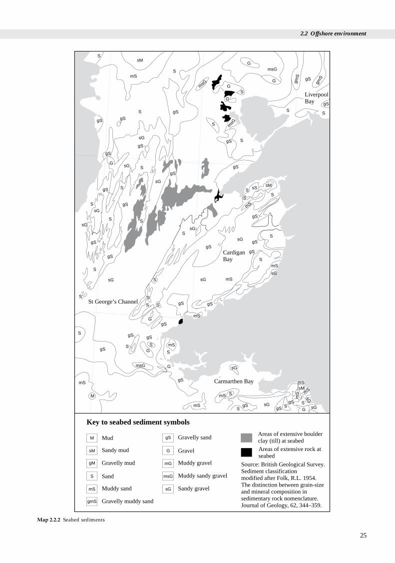
25
Source: British Geological Survey.Sediment classificationmodified after Folk, R.L. 1954.The distinction between grain-sizeand mineral composition insedimentary rock nomenclature.Journal of Geology, 62, 344–359.
M
sM
gM
S
mS
gmS
gS
G
mG
msG
sG
Mud
Sandy mud
Gravelly mud
Sand
Muddy sand
Gravelly muddy sand
Gravelly sand
Gravel
Muddy gravel
Muddy sandy gravel
Sandy gravel
Areas of extensive boulderclay (till) at seabedAreas of extensive rock atseabed
Key to seabed sediment symbols
St George’s Channel
Carmarthen Bay
CardiganBay
LiverpoolBay
gS
S
S
S
S
S
SS
S
S
G
G
G
sM
mS
gS
gS
gS
gSgS
gS
gS
gS
gS
gS
gS
gS
gS
gS
gS
gSgS
sG
sG
msG
msG
msG
G
G
gmS
gmS
sG
sG
sG
sG
sG
sGS
SS
S
S
S
S
S
S
S
S
SS
S
S
mS
mS
mS
sMsS
gS
gS
gSgS
gS
gS
gS
mS
mS
mS
mS
mS
mS
mSsM
G
G
G
sG
sG
sG
M
mS
gS
gS gSS
S
S
S
SS
S
S
S
msG
G
sG
sG
sG
Map 2.2.2 Seabed sediments
2.2 Offshore environment

26
Late Pleistocene soft muds
Late Pleistocene sands
Middle Pleistocene sediments, mostly muds
Late Pleistocene incision and channel-fill
No information, line shows seaward limit
Mostly bedrock at sea bed
Quaternary (generally < 5 m thick)
Sarn — marine morainic ridge
Late Pleistocene glacial till
Source: Modified from British Geological Survey Quaternary Geology around the United Kingdom(South Sheet). 1:1,000,000 scale (1994).
Key to symbols
XXX
XXXXXXXX
XXXXX
XXXX
Q
Q
Q
Q
QLP/1
QLP/1
QLP/1
QLP/1
QLP/1
QLP/1
QLP/1
QLP/1
QLP/1
QLP/1
QLP/1
QLP/1
QLP/1
QLP/1
QLP/1
QLP/1
QLP/6
QLP/6
QLP/6
QLP/6
QLP/6
QLP/6
QLP/6
QLP/6
QLP/6
QLP/6QLP/6
QLP/6
QLP/2
QLP/2
QLP/2
QLP/2
QLP/2QLP/2
QLP/2
QLP
/2
QLP/4
QLP/4
QLP/4QLP/4
QMP/2
QMP/2
QMP/2
QMP/2
QMP/2
QMP/2
QMP/2
QMP/2
QMP/2
QMP/2
QMP/2
QMP/2
Map 2.2.3 Offshore Pleistocene deposits
Region 12 Chapter 2 Geology and physical environment

27
Source: British GeologicalSurvey, Geology of the UnitedKingdom, Ireland and the adjacentcontinental shelf (South Sheet).1:1,000,000 scale (1991).
B B
B
B
C
C
C
C
C
g
pt
pt
pt
j
jj
Kish BankBasin
B
B
g
g
pt
pt
pt
C
C
j
g
g
j g
pt
St George’s Channel Basin
g
pt
B
B
k
k
k
dc
dc
ptpt
pt
ptj
j
kj
ptpt j
Bristol ChannelBasin
dc
B
j
jpt
pt
dc
dc
Cpt
pt
j
ptB
TremadocBay Basin
MochrasBorehole
B
C
B
B
C
C
B BB
B
C
LiverpoolBay Basin
pt
Tertiary
Cretaceous
Jurassic
Permo-Triassic
Carboniferous
Devonian and Carboniferous
Basement (Precambrian andLower Palaeozoic)
Stratigraphy Rock Types
Clays and sands
Chalk
Mudstones and limestones
Sandstones, siltstonesand evaporitesShales, limestones andsandstones
Sandstones and shales
Slates, volcanic andigneous rocks
Salt dome or wall
Fault, tick ondownthrow side
Kish BankBasin
Name and locationof the majorsedimentary basins
Map 2.2.4 Offshore pre-Quaternary geology
2.2 Offshore environment

Region 12 Chapter 2 Geology and physical environment
West of the Pembrokeshire coast the St George’s ChannelBasin contains Mesozoic sediments that are over 5 km thickand include a thick Permo-Triassic salt unit. Locally, thissalt has intruded into the heavier, overlying sediments toform an elongated salt wall some 20 km long and about akilometre wide, which reaches the base of the overlyingPleistocene cover.
The Cardigan Bay Basin is aligned NE-SW, following thetrend of Caledonian lines of structural weakness, whilst theBristol Channel Basin follows an E-W Armorican trend. Thebasins formed over a long period of time by subsidence ofthe crust and infilling by sediment eroded off the adjacentbasement rocks (mainland Wales). Major fault movementduring early Tertiary time led to the formation of the Welshuplands and subsidence in localised basins such asTremadog Bay. The existence of thick mid-Tertiarysediments, deposited from rivers flowing off the Welshlandmass, was proved in the Tremadog Bay Basin by aborehole drilled at Mochras in 1969.
The deep Mesozoic sedimentary basins, especially inCardigan Bay, have been of interest to the hydrocarbonsindustry since the late 1960s. Extensive seismic explorationtook place in the early 1970s, and the first deep wells weredrilled in 1974. Although source, reservoir and cap rockshave been identified in the basins, none of the wells drilledto date has proved the existence of economic hydrocarbondeposits.
2.2.5 Further sources of information
A. Maps
British Geological Survey. 1982. Anglesey, Sheet 53°N-06°W, SolidGeology. 1:250,000 series.
British Geological Survey. 1990. Anglesey, Sheet 53°N-06°W, withpart of Dublin, 53°N 08°W, Quaternary Geology. 1:250,000 series.
British Geological Survey. 1982. Anglesey, Sheet 53°N-06°W, withpart of Dublin, 53°N 08°W, Seabed Sediments. 1:250,000 series.
British Geological Survey. 1988. Cardigan Bay, Sheet 52°N-06°W,including parts of Waterford, 52°N-08°W and Mid-Wales and theMarches, 52°N-04°W, Sea Bed Sediments. 1:250,000 series.
British Geological Survey. 1982. Cardigan Bay, Sheet 52°N-06°W,Solid Geology. 1:250,000 series.
British Geological Survey. 1982. Cardigan Bay Sheet 52°N-06°W,with part of Waterford, 52°N 08°W, Quaternary Geology.1:250,000 series.
British Geological Survey. 1983. Lundy, Sheet 51°N-06°W, Sea BedSediments. 1:250,000 series.
British Geological Survey. 1991. North Celtic Sea including parts ofthe 1:250,000 series sheets Nymphe Bank, 51°N-08°W, Lundy 51°N-06°W, Labadie Bank, 50°N-10°W, Haig Fras 50°N-08°W and LandsEnd 50°N-06°W, Quaternary Geology. 1:250,000 series.
British Geological Survey. 1983. Lundy, Sheet 51°N-06°W, SolidGeology. 1:250,000 series.
British Geological Survey. 1991. Geology of the United Kingdom,Ireland and the adjacent continental shelf (South Sheet).1:1,000,000 scale.
British Geological Survey. 1994. Quaternary Geology around theUnited Kingdom (South Sheet). 1:1,000,000 scale.
British Geological Survey. 1987. Sea bed sediment around theUnited Kingdom (South Sheet). 1:1,000,000 scale.
28
B. References cited
Folk R.,L. 1954. The distinction between grain-size and mineralcomposition in sedimentary rock nomenclature. Journal ofGeology, 62: 344-359.
C. Further reading
Banner, F. T., Collins, M. B., & Massie, K. S. 1980. The north-westEuropean shelf sea: the sea bed and the sea in motion. II. Physicaland chemical oceanography, and physical resources. ElsevierOceanography Series. Cambridge, Elsevier.
Barne, J., Davidson, N.C., Hill, T.O., & Jones, M. 1994. Coastal andMarine UKDMAP datasets: a user manual. Peterborough, JointNature Conservation Committee.
Bowen, D. Q. 1973. The Pleistocene succession of the Irish Sea.Proceedings of the Geologists’ Association, 84: 249-272.
Jackson, A. In press. The geology of the Irish Sea. HMSO. (BritishGeological Survey, Regional Offshore Report.)
Tappin, D. R. In press. The geology of Cardigan Bay and the BristolChannel. HMSO. (British Geological Survey, Regional OffshoreReport.)
D. Contact names and addresses
Type of information Contact address and telephone no.
Geological information Coastal Geology Group, Britishfor region and the whole Geological Survey, Keyworth,of Britain Nottingham NG12 5GG,
tel. 0115 936 3100
UKDMAP 1992. Version 2. British Oceanographic Data Centre,United Kingdom digital Proudman Oceanographic marine atlas. Laboratory, Bidston Observatory, Oceanographic maps Birkenhead, Merseyside L43 7RA,
tel. 0151 652 3950
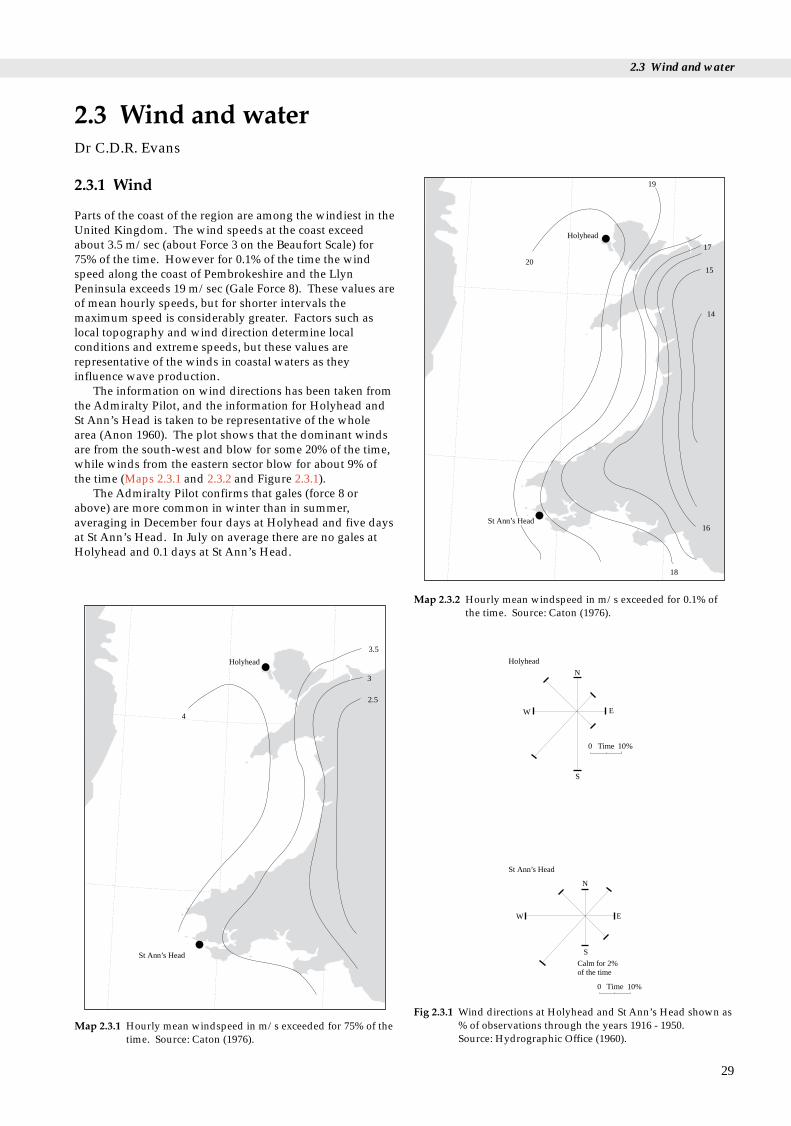
2.3 Wind and water
Holyhead
St Ann’s Head
20
19
16
14
17
15
2.3.1 Wind
Parts of the coast of the region are among the windiest in theUnited Kingdom. The wind speeds at the coast exceedabout 3.5 m/sec (about Force 3 on the Beaufort Scale) for75% of the time. However for 0.1% of the time the windspeed along the coast of Pembrokeshire and the LlynPeninsula exceeds 19 m/sec (Gale Force 8). These values areof mean hourly speeds, but for shorter intervals themaximum speed is considerably greater. Factors such aslocal topography and wind direction determine localconditions and extreme speeds, but these values arerepresentative of the winds in coastal waters as theyinfluence wave production.
The information on wind directions has been taken fromthe Admiralty Pilot, and the information for Holyhead andSt Ann’s Head is taken to be representative of the wholearea (Anon 1960). The plot shows that the dominant windsare from the south-west and blow for some 20% of the time,while winds from the eastern sector blow for about 9% ofthe time (Maps 2.3.1 and 2.3.2 and Figure 2.3.1).
The Admiralty Pilot confirms that gales (force 8 orabove) are more common in winter than in summer,averaging in December four days at Holyhead and five daysat St Ann’s Head. In July on average there are no gales atHolyhead and 0.1 days at St Ann’s Head.
2.3 Wind and waterDr C.D.R. Evans
29
Holyhead
St Ann’s Head
4
3.5
3
2.5
Map 2.3.1 Hourly mean windspeed in m/s exceeded for 75% of thetime. Source: Caton (1976).
18
Map 2.3.2 Hourly mean windspeed in m/s exceeded for 0.1% ofthe time. Source: Caton (1976).
Time
N
EW
S
0 10%
Calm for 2%of the time
N
W E
S
0 10%Time
Holyhead
St Ann’s Head
Fig 2.3.1 Wind directions at Holyhead and St Ann’s Head shown as% of observations through the years 1916 - 1950. Source: Hydrographic Office (1960).

Region 12 Chapter 2 Geology and physical environment
30
1
1
1
2
2
2
2
2
3
3
3
4
Map 2.3.3 Maximum tidal current (knots) at mean spring tides.Source: Sager & Sammler (1968).
2 2.5 3 3.5 4
4
4
5
5
5.5
5.5
4.5
4.5
6
6
6.5
6.5
7
7 7.5 8.58
Map 2.3.4 Tidal range (m) at mean spring tides. Source: Lee & Ramster (1981). © Crown copyright.
2.0
2.0
2.5 2.5
2.53.0
3.0
4.0
4.0
1.5
Significant wave height in metres
Landward limit of prediction
Map 2.3.5 Significant wave height (m) exceeded for 10% of thewinter (January, February and March). Source: Draper (1992).
1.5
1.5
2.0
2.5
2.5
2.0
2.0
Significant wave height in metres
Landward limit of prediction
Map 2.3.6 Significant wave height (m) exceeded for 10% of theSummer (July, August, September). Source: Draper (1992).

2.3 Wind and water
2.3.2 Tidal currents
Tidal currents during mean spring tides (Map 2.3.3) are attheir maximum of over 4 knots (2 m/sec) south of SwanseaBay. Values locally exceed 3 knots around the islands off thePembrokeshire coast but decrease to less than a knot withinthe northeastern parts of Cardigan Bay. Maximum tidalcurrents along the northern coasts of the region are about 2 knots. Tidal currents nearshore are more variable, withswift-flowing races where the tides are constrained betweennarrow inter-island channels, for example off Skomer and inthe Menai Strait.
2.3.3 Tidal range
The tidal range along the coasts of the area (Map 2.3.4) isgenerally high, ranging from a maximum of over 7 m in theeastern parts of Swansea Bay and off the Great Orme, toabout 4 m in Cardigan Bay. The tidal range may be furthermodified by climatic effects, and the estimated 50-yearstorm surge may increase these values by over 1.5 m.
2.3.4 Wave exposure and sea state
Much of the coast of the region is open to the prevailingsouth-westerly winds, and locally, where deep waterapproaches the coast, it is subject to severe wave attack.During winter the significant wave height exceeded for 10%of the time varies from about 4 m off the westernPembrokeshire coast to less than 1.5 m in Conwy Bay east ofAnglesey (Map 2.3.5). During the quieter summer monthswave height exceeded about 2.5 m for 10% of the time offPembrokeshire, while the value in Conwy Bay is similar tothe winter value (Map 2.3.6). The predicted 50-yearmaximum wave height in open water is between 18 m and16 m, being highest off south-west Pembrokeshire.
The wave heights quoted above are gross values, basedon data from fully exposed sites, modified for water depthvariations. At the coast there may be greater variation dueto coastal orientation and nearshore bathymetry, which canhave a significant effect on wave erosion and the residualdrift of sediment.
A detailed study of wave climate was carried out in theeastern part of Swansea Bay by Heathershaw et al. (1980).They report that for 10% of the time at Port Talbot wavesexceed a height of 1.6 m in winter and 1 m in summer.Local variations were predicted, depending on theorientation of the waves in relation to the protectingoffshore sand banks.
2.3.5 Water characteristics
Most of the region is open to the flow of oceanic water fromthe Atlantic. Suspended sediment loads are greater wherethere is an influx of turbid flood water from a river and inparts of Swansea Bay at the seaward limit of the SevernEstuary turbid plume. The tidal flows in the region arestrong enough to move sand grains along or near the seabed and generate a range of bedforms such as sandwaves
and sand banks (Helwich Sand). See section 9.6 for adiscussion of waste inputs and pollutants generated byhuman activities.
Temperature of sea water
The surface temperature of the sea water (Maps 2.3.7 and2.3.8) varies with the seasons, being coldest inFebruary/March at between 6° to 8.5°C, and warmest inAugust/September, when it varies between 14°and 16°C.The magnitude of this variation is greater in coastal waters(12°C) than in offshore waters (6°C). In winter, coastalwaters are cooler than those offshore, and in summer theyare warmer.
Gross flow
Summer warming of surface water encourages stratificationof the water column so that warmer water overlies denser,colder water. Across most of the Irish Sea, energetic tidalstreams ensure that most of the water column is mixedthroughout the year. However to the west of the Isle of Mana two-layer system develops between April and October, thesurface water being 20-30 m thick and up to 5° warmer thanthe bottom layer. A less pronounced stratification may formin Cardigan Bay during summer periods of calm weather. A‘front’ some 5 to 10 km wide separates the stratified fromthe well-mixed regions. Biological activity may be highalong this meandering front during spring when blooms ofphytoplankton may occur (see section 4.3).
Flow through the Irish Sea averaged over a year (alsotermed residual flow) is northward from St George’sChannel to the North Channel between Scotland andIreland. The flow is weak, and water takes at least a year totraverse the full length of the Irish Sea. Thus in the longterm discharges into the Bristol Channel form an input intothe Irish Sea, and those from the north Irish Sea have alimited impact on the coast of this region. This flow isgraphically illustrated by the distribution of radioactivematerials from Sellafield within the waters of the Irish Sea.Caesium-137 on average shows a value five times higheralong the coasts of Lancashire and Cumbria than aroundCardigan Bay (see section 9.6).
Salinity of sea water
The salinity of the sea water varies slightly with the seasons,being generally greater in the summer than in the winter.Maps 2.3.9 and 2.3.10 show gross data with salinity valuesin summer ranging from 33‰ east of Anglesey to 35‰ atthe mouth to St George’s Channel. Greater variation occursnear the coast, especially near river mouths, where Atlanticwater is diluted by river water. The input of fresh waterfrom the rivers is unevenly distributed around the Irish Sea,with Cardigan Bay receiving an average 113 cu.m/sec.Rainfall into the Irish Sea contributes about one third of theriverine input. The freshwater input is small compared withthe volume of the Irish Sea and is highly variable throughthe year and between years.
31

Region 12 Chapter 2 Geology and physical environment
32
14.5
14.5
14.5
14.0
14.0
14.0
15.0
15.0
16.0
16.015
.5
15.5
Map 2.3.7 Mean surface water temperature in summer (°C). Source: Lee & Ramster (1981). © Crown copyright.
8.0
8.5
7.5
7.5
7.57.5
7.0
7.0
7.0 7.0 6.5 6.0
Map 2.3.8 Mean surface water temperature in winter (°C). Source: Lee & Ramster (1981). © Crown copyright.
35.0
0
34.7
5 34.5
0
34.2
5
34.2
5
34.0
0
34.0
0
33.0
0
Map 2.3.9 Mean surface salinity of seawater in summer in g/kg oftotal dissolved salt. Source: Lee & Ramster (1981).© Crown copyright.
32.0
0
33.0
0
34.0
0
34.0
0
34.2
5
34.2
5
34.2
5
34.5
0
34.5
0
34.5
0
34.75
35.00
Map 2.3.10 Mean surface salinity of seawater in winter in g/kg oftotal dissolved salt. Source: Lee & Ramster (1981).© Crown copyright.

2.3 Wind and water
2.3.6 Further sources of information
A. References cited
Anon. 1960. West coast of England pilot. 10th ed. London,Hydrographic Office.
Heathershaw, A. D., Carr, A. P., & King, H. L. 1980. Wave data:observed and computed wave climates. Swansea Bay (Sker) Project:Topic Report: 5/Institute of Oceanographic Sciences Report No.99.
Orford, J.D., & Bowden, R. 1984. Prediction of coastal erosion insouthern Cardigan Bay. Cardiff, Welsh Office (unpublished).
Caton, P.G. 1976. Maps of hourly wind speed over the UK 1965 - 73.Bracknell, Meteorological Office. (ClimatologicalMemorandum No. 79.)
Draper, L. 1992. Wave climate atlas of the British Isles. Department ofEnergy. (Offshore Technology Report.)
Hydrographic Office. 1960. West coast of England pilot. Tenth ed.London, Hydrographic Office.
Lee, A. J., & Ramster, J. W. 1981. Atlas of the seas around the BritishIsles. Lowestoft, Directorate of Fisheries Research (MAFF).
Sager, G., & Sammler, R. 1968. Atlas der Gezeitenströme für dieNordsee, den Kanal und die Irische See. Rostock,Seehydrographischer Dienst der DDR.
B. Further reading
Barne, J., Davidson, N.C., Hill, T.O., & Jones, M. 1994. Coastal andMarine UKDMAP datasets: a user manual. Peterborough, JointNature Conservation Committee.
Collins, M. B., Banner, F. T., Tyler, P. A., Wakefield, S. J., & James, A.E. 1980. Industrialised embayments and their environmentalproblems - a case study of Swansea Bay. Pergamon Press.
Huckbody, A.J., Taylor, P.M., Hobbs, G., & Elliott, R. 1992.Caernarfon and Cardigan Bays: an environmental appraisal.London, Hamilton Oil Company.
C. Contact names and addresses
Type of information Contact address and telephone no.
Windroses for rectangular Meteorological Office Marine Enquiryareas defined by latitude Service, Johnstone House, Londonand longitude for Road, Bracknell RG12 2SY,monthly/seasonal or tel: 01344 854979 annual periods, based on10 or 20 year data from ships of passage.
UKDMAP 1992. Version 2. British Oceanographic Data Centre,United Kingdom digital Proudman Oceanographic Laboratory,marine atlas. Bidston Observatory, Birkenhead,Oceanographic maps Merseyside L43 7RA,
tel: 0151 652 3950
33

Region 12 Chapter 2 Geology and physical environment
2.4.1 Description
The coasts of the region are subject to a wide range of waveand tidal energies, these being dependent on the orientationand morphology of each coastal sector. Motyka &Brampton (1993) divided the coast of England and Walesinto a number of major littoral cells and sub-cells, eachdefining a section of coast within which sediment erosionand accretion are inter-related and largely independent ofother cells. In this region there are parts of four majorlittoral cells and nine sub-cells (Map 2.4.1). Each cell isdescribed below. Note that the sediment transport shownon the map is of sand and gravel ‘bed load’, not suspendedsediments.
2.4 Sediment transportDr C.D.R. Evans
Margam – St David’s Head
This stretch of coast is considered part of a cell whichextends eastwards to Lavernock Point in Region 11. It iscontrolled by the strong tidal currents of the Bristol Channeland open to wave attack due to the predominantly south-westerly winds.
The sub-cell from Lavernock Point to Worms Head (8b)displays low to moderate littoral drift, which is variable indirection in the embayments but predominantly eastwardsalong the more open lengths of coast. Large-scalenavigational dredging has modified the natural processes inthe eastern part of Swansea Bay. Beach erosion is limited inthis sub-cell to the upper parts of beaches under attackduring south-westerly storms; these beaches largely repairthemselves once the storm has abated. Helwick Sands, offWorms Head, may be an important part of the sandcirculation budget of the immediate coastal area.
Carmarthen Bay, covered by a sub-cell from WormsHead to St Govan’s Head (8c), is essentially a depositionalembayment infilled with thick deposits of sand. Littoraldrift is generally variable and low in volume, withmovement into the Loughor, Gwendraeth and Twyiestuaries. Erosion is taking place at the major dune systemsat both Pendine and Pembrey. Minor sections of coast showbeach erosion (at Amroth) and accretion (at Burry Port).
The sub-cell covering St Govan’s Head to St David’sHead (8d) has a highly crenulate form and could be dividedinto even smaller units. Except for within St Bride’s Bayand Milford Haven, there is limited sediment in the littoralzone and little interdependence between beaches. Waveaction producing transient onshore/offshore movement inbeach profiles is locally important. Cliff erosion continuesalong this stretch of coast but is so slow as to be difficult toquantify regionally.
Cardigan Bay
This cell (9) is divided into two in the north-eastern part ofthe bay, with Tremadog Bay acting as a sink for offshore finesand and mud.
Within the sub-cell from St David’s Head to the Glaslynestuary (9a), the moderate littoral drift is to the north,though there is some drift reversal at estuary mouths. Thenorthward prolongating spits on the southern shores of the
34
Dyfi, Mawddach and Glaslyn estuaries, along with MorfaDyffryn, were produced by this longshore movement ofsediment. The accreting sediment is supplied largely byerosion of the glacial till cliffs in the southern part of the bay.Erosion of beaches (at Aberystwyth, from Barmouth toLlanaber and in parts of Morfa Dyffryn) is also widespreadin parts of the sub-cell.
Within the sub-cell from the Glaslyn estuary to YnysEnlli (9b), littoral drift is to the east and increases inmagnitude in that direction. Accretion of sand is takingplace at Pwllheli, where shingle is also accreting across theharbour mouth. Widespread erosion occurs along the coast,of both the glacial till cliffs and the sand dune systems.
Llyn Peninsula – Great Orme
The cell from the north coast of the Llyn Peninsula to GreatOrme (10) is divided into three sub-cells. The sub-cellcovering the north coast of the Llyn (10a) has low, north-eastward littoral drift towards the Menai Strait. Erosion ofrocky cliffs occurs at Nefyn and Trefor, and erosion of glacialtill and shingle banks occurs at Dinas Dinlle. Accretionwithin the sub-cell is largely restricted to the northern endof Dinas Dinlle, but parts of this spit are also eroding.
Littoral drift within the sub-cell covering Anglesey (10b)is very low and variable in direction. Most of the beaches orembayments are themselves closed littoral cells, but little isknown about the gross coastal processes around the island.Most of the erosion is taking place in the softer glacial tillcliffs on the western side of the island. Accretion continuesto take place locally along the coast of the sand dunecomplex at Newborough Warren.
The sub-cell embracing the Menai Strait and Conwy Bayexperiences limited littoral drift, and there is littleinteraction of sediment between the two ends of the Strait.Minor erosion is taking place at the ends of the Strait (westof Caernarfon), on the shores of Conwy Bay (Llanfairfechan)and on the western shore of the Conwy estuary. Accretion istaking place locally on Lavan and Conwy Sands.
Great Orme eastwards
The Great Orme forms the western limit of the LiverpoolBay cell (11). Littoral drift is moderate across the limitedpart of the cell within this region, and is to the east. Muchof this area is backed by limestone cliffs and erosion islimited, but littoral drift increases in importance to the eastwhere the beaches are wider and backed by cliffs formed ofsofter sediments.
2.4.2 Further sources of information
A. References cited
Motyka, J. M., & Brampton, A. H. 1993. Coastal management:Mapping of littoral cells. HR Wallingford Report SR 328.

35
10b
10c
11a
10a
9b
9a
8d
8c
8b
Dominant sand transport direction
Limits of coastal cell and number
Drift divide (bed load parting zone)
Location of coastal erosion
Location of coastal accretion
9b
R. Glaslyn
Anglesey
Menai Strait
Great Orme
Bardsey Sound
Cardigan Bay
St David’sHead
St Govan’s Head
Worms Head
Map 2.4.1 Sediment transport and coastal cells. Source: Motyka & Brampton (1993). Adapted with permission from MAFF Flood andCoastal Defence Division.
2.4 Sediment transport

Region 12 Chapter 2 Geology and physical environment
B. Further reading
Carter, R. W. G. 1988. Coastal environments. London, AcademicPress.
Rendel Geotechnics. 1995. Coastal planning and management: areview of earth science information needs. London, HMSO.
C. Contact names and addresses
Type of information Contact address and telephone no.
Sediment cells Ministry of Agriculture, Fisheries andFood (MAFF), Flood and CoastalDefence Division, Eastbury House,30/34 Albert Embankment, LondonSE1 7TL tel: 0171 238 3000
Sediment cells HR Wallingford Ltd, Howbury Park, Wallingford, Oxon, OX10 8BAtel: 01491 835381
36
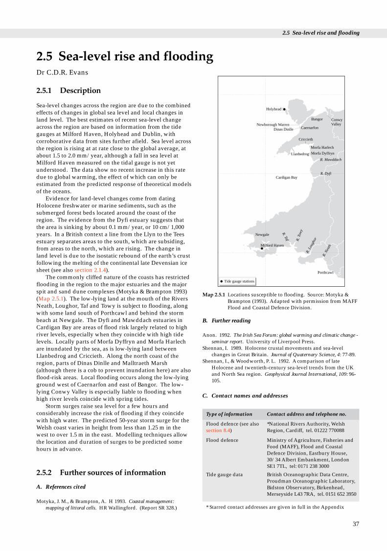
2.5 Sea-level rise and flooding
Holyhead
Bangor ConwyValleyNewborough Warren
Dinas Dinlle Caernarfon
Llanbedrog
Criccieth
Morfa Harlech
Morfa Dyffryn
Cardigan Bay
R. Mawddach
R. Dyfi
Newgale
Milford Haven
Porthcawl
R. Taf R
. Tow
y
R. L
ough
or
R. N
eath
Tide gauge stations
Map 2.5.1 Locations susceptible to flooding. Source: Motyka &Brampton (1993). Adapted with permission from MAFFFlood and Coastal Defence Division.
ng
2.5.1 Description
Sea-level changes across the region are due to the combinedeffects of changes in global sea level and local changes inland level. The best estimates of recent sea-level changeacross the region are based on information from the tidegauges at Milford Haven, Holyhead and Dublin, withcorroborative data from sites further afield. Sea level acrossthe region is rising at at rate close to the global average, atabout 1.5 to 2.0 mm/year, although a fall in sea level atMilford Haven measured on the tidal gauge is not yetunderstood. The data show no recent increase in this ratedue to global warming, the effect of which can only beestimated from the predicted response of theoretical modelsof the oceans.
Evidence for land-level changes come from datingHolocene freshwater or marine sediments, such as thesubmerged forest beds located around the coast of theregion. The evidence from the Dyfi estuary suggests thatthe area is sinking by about 0.1 mm/year, or 10 cm/1,000years. In a British context a line from the Llyn to the Teesestuary separates areas to the south, which are subsiding,from areas to the north, which are rising. The change inland level is due to the isostatic rebound of the earth’s crustfollowing the melting of the continental late Devensian icesheet (see also section 2.1.4).
The commonly cliffed nature of the coasts has restrictedflooding in the region to the major estuaries and the majorspit and sand dune complexes (Motyka & Brampton 1993)(Map 2.5.1). The low-lying land at the mouth of the RiversNeath, Loughor, Taf and Towy is subject to flooding, alongwith some land south of Porthcawl and behind the stormbeach at Newgale. The Dyfi and Mawddach estuaries inCardigan Bay are areas of flood risk largely related to highriver levels, especially when they coincide with high tidelevels. Locally parts of Morfa Dyffryn and Morfa Harlechare inundated by the sea, as is low-lying land betweenLlanbedrog and Criccieth. Along the north coast of theregion, parts of Dinas Dinlle and Malltraeth Marsh(although there is a cob to prevent inundation here) are alsoflood-risk areas. Local flooding occurs along the low-lyingground west of Caernarfon and east of Bangor. The low-lying Conwy Valley is especially liable to flooding whenhigh river levels coincide with spring tides.
Storm surges raise sea level for a few hours andconsiderably increase the risk of flooding if they coincidewith high water. The predicted 50-year storm surge for theWelsh coast varies in height from less than 1.25 m in thewest to over 1.5 m in the east. Modelling techniques allowthe location and duration of surges to be predicted somehours in advance.
2.5 Sea-level rise and floodiDr C.D.R. Evans
2.5.2 Further sources of information
A. References cited
Motyka, J. M., & Brampton, A. H 1993. Coastal management:mapping of littoral cells. HR Wallingford. (Report SR 328.)
B. Further reading
Anon. 1992. The Irish Sea Forum: global warming and climatic change -seminar report. University of Liverpool Press.
Shennan, I. 1989. Holocene crustal movements and sea-levelchanges in Great Britain. Journal of Quaternary Science, 4: 77-89.
Shennan, I., & Woodworth, P. L. 1992. A comparison of lateHolocene and twentieth-century sea-level trends from the UKand North Sea region. Geophysical Journal International, 109: 96-105.
C. Contact names and addresses
Type of information Contact address and telephone no.
Flood defence (see also *National Rivers Authority, Welshsection 8.4) Region, Cardiff, tel. 01222 770088
Flood defence Ministry of Agriculture, Fisheries andFood (MAFF), Flood and CoastalDefence Division, Eastbury House,30/34 Albert Embankment, LondonSE1 7TL, tel: 0171 238 3000
Tide gauge data British Oceanographic Data Centre,Proudman Oceanographic Laboratory,Bidston Observatory, Birkenhead,Merseyside L43 7RA, tel. 0151 652 3950
* Starred contact addresses are given in full in the Appendix
37

Region 12 Chapter 2 Geology and physical environment
2.6.1 Introduction
This section describes the landforms of the coast, focusingon the areas subject to short and longer-term accretion anderosion (see also section 2.4). Along most of the region’scoasts, which are predominantly rocky and cliffed, suchchanges are minimal on a historic timescale. However,along some sections of the coast, especially in northernCarmarthen Bay and northern Cardigan Bay, such changesare rapid and of economic significance. The coastallandforms of the region are typical of western Britain, andcoastal change is generally not as rapid, nor as likely toendanger human life and property, as along the southernand eastern coasts of Britain. The major coastal landformsin the region are shown in Map 2.6.1.
2.6 Coastal landformsDr C.D.R. Evans
2.6.2 Description
Swansea Bay – St Bride’s Bay
Most of the land fringing Swansea Bay is built over, withonly a few surviving remnants of the sand dunes that usedto extend around its margins. The rivers Tawe and Neathdrain into the bay, which is surrounded, at low tide, by awide expanse of muddy sand.
The southern part of the Gower peninsula is a plateausurface at a height of about 70-90 m. Numerous raisedbeach levels are preserved in the cliffs where the plateausurface reaches the coast. Rare remains of Pleistocene floraand fauna have been found in beach sediments and cavesassociated with these levels. In contrast the eastward-facingsandy beaches within the bays at Oxwich and Port Eynonare backed by sand dunes and woods. Rhossili beach on thewest coast of Gower faces the dominant wave direction andis a broad sandy beach backed by sand dunes. These dunescontinue to the north at Whiteford Burrows, where they arebuilt on a north-eastward-trending gravel spit. The wideLlanrhidian salt marshes along the northern coast of Gowerpass northward into the channelled sand bank system of theLoughor estuary.
Carmarthen Bay from Burry Port to Amroth issurrounded by broad, gently-sloping, sandy beaches backedby extensive sand dune systems. Along this coast low cliffsof bedrock are exposed only around the Llanstephanpeninsula.
Much of the Pembrokeshire coast from Amroth to southof Strumble Head is formed of steep cliffs falling from aplateau surface between 30 m and 130 m high. The varietyof the rocks forming the cliffs has led to the formation of seastacks, caves and natural bridges. The ria at Milford Haven,into which the Daugleddau drains, is one of the world’sgreat natural harbours. It is fringed in its lower reaches bysandy coves, though industry has occupied lengths of thenorthern and southern shorelines.
Buried forests and peat beds are found at about lowwater mark in Swansea Bay, Amroth, Freshwater West andSt Bride’s Bay. Similar deposits are found in the Dyfi
38
estuary and on the south Llyn coast. Much of St Bride’s Bay has a broad sandy beach, which
is backed, in the northern part at Newgale, by a shinglestorm beach. The attraction of the coastline is furtherenhanced by the rugged islands of Palaeozoic rocks off theDale and St David’s peninsulas. Many of the beaches, suchas Marloes Sand, are of outstanding beauty and geologicalinterest.
Cardigan Bay
From St Bride’s Bay to Fishguard are a series of small pocketbeaches alternating with steep and varied cliffs. WhitesandBay forms the largest sandy beach along this section ofcoast, and many of the more exposed beaches such asAbermawr are backed by shingle storm ridges.
From Fishguard northward to the Dyfi estuary thecoastline is generally cliffed, but in some places there aresmall estuaries such as the Teifi and Ystwyth and pocketbeaches commonly related to glacial channels, such as atMwnt. The cliffs are at their grandest at Dinas Head andCemaes Head, where they reach nearly 200 m in height.Elsewhere they range from 100 m to 30 m in height. AtAberaeron the foreshore is formed of glacial till bankedagainst an older cliff line to landward.
The northern shores of Cardigan Bay are dominated bydepositional features, and the old cliff line lies somedistance from the modern coast. The glacially over-deepened valleys of the Dyfi, Mawddach and Glaslyn riversare now occupied by estuaries largely choked withsediment. These estuaries are surrounded by wide expansesof saltmarsh passing out into constantly changing channelswith sand banks. Spits growing northwards, now coveredby sand dunes, extend from the southern shores of theestuaries. The spits have led to the enclosure of maturemarsh areas such as Borth Bog and Fairbourne Marshes.
Two major spit complexes have built out into CardiganBay between the Mawddach and Glaslyn estuaries. Theyindicate active sediment transport towards the north andeast along this part of the coast. The southernmost spit,Morfa Dyffryn, has a linear shingle ridge at the coastpassing landward into sand dunes and sandy pastures. Thespit complex is over 3 km wide at its northern end nearMochras, a low island of glacial till marking the site of amoraine. The northernmost spit, Morfa Harlech, showsactive accretion and northward extension of the seawardshingle ridge. Morfa Harlech passes northwards into thebroad sandy expanse of Traeth Bach, which forms thesouthern part of the Glaslyn estuary. The estuary containsthe dune complex of Morfa Bychan on its north-westernmargin and extensive enclosure of originally intertidal landin its upper part.
Extending seaward in a WSW direction frompromontories in Cardigan Bay are five ‘sarnau’, causewaysof boulders that are only exposed at low tide. The largest ofthese, Sarn Badrig, extends as a submarine feature for some34 km, with up to 14 km exposed at lowest tides. Legendsof buried villages (Cartref Gwaelod) have been attributed tothe sarns, but it is likely that they were formed as morainic

39
xxxxxxxxxxxx
xxxxxx
xxxx
xxxx
xxxx
xxx
xxxxx
Predominantly cliffed coast
Major areas of blown sand
Large estuarine systems
Sarn or offshore morainic ridge
Great OrmeDulas Bay
Red Wharf Bay
Rhos Neigr
Newborough Warren Men
aiStra
it LafanSands
Dinas DinlleMorfa Dinlle
R. Conwy
Yr Eifl
Pwllheli
MorfaBychan
PorthmadogNefyn
PorthNeigwl
SarnBadrig
Llanbedrog
Glaslyn Estuary
Traeth Bach
Morfa Harlech
Morfa Dyffryn
Mawddach Estuary
Dyfi Estuary
R. Ystwyth
Aberaeron
Mwnt
R. Teifi
Cemaes Head
Dinas Head
Fishguard
Strumble Head
St David’s
Whitesands Bay
Newgale
Dale
Freshwater West
Milford Haven
Amroth
Llanstephan
Burry PortR. Cleddau
R.
Taw
e
R. Neath
Loughor Estuary
Llanrhidian
Whiteford Burrows
Rhossili Bay
Worms Head OxwichPort Einon
Map 2.6.1 Major coastal landforms. Source: British Geological Survey.
2.6 Coastal landforms

Region 12 Chapter 2 Geology and physical environment
features during a period of ice retreat (see section 2.1).
Llyn Peninsula – Great Orme
The Llyn Peninsula has a complex glacial history, reflectedin the variety of glacial landforms and deposits exposed atthe coast. A smooth, sweeping series of sandy beachesbacked by sand dunes extends from St Tudwal’s peninsulaeastwards to Porthmadog. The sweep is interrupted only bythe limited outcrops of bedrock or till, as at Llanbedrogmountain. The coast to the west is more varied andincludes the exposed, narrow shingle beach at PorthNeigwl, which is backed to the east by thick glacial till.High, rugged cliffs with minor pocket beaches dominate thesouth-western end of the peninsula. The cliffs ofPrecambrian rocks north-westwards to Nefyn are lower,though steep and irregular in form.
Extensive sections of glacial till are exposed along thecoast from Nefyn to Dinas Dinlle. At Porth Dinllaen the tillsections are over 30 m high, and display a range ofsedimentary and glacial tectonic structures. Steeper cliffsare found at Yr Eifl, where the coast is formed of ruggedacid intrusive rocks. Morfa Dinlle and Dinas Dinlle form aspit complex at the southwestern entrance to the MenaiStrait. Opposite the former, on the northern shore of thestrait, are the extensive sand dunes of Newborough Warren.Around Rhosneigr are low cliffs separated by a maze ofsandy coves. Spectacular cliffs carved into a variety of rocktypes occur along the northern part of Holyhead island andthe northern coast of Anglesey. A shingle bar beach atCemlyn Bay impounds a shallow lagoon. Wide sandybeaches are formed in Lligwy Bay and Red Wharf Bay.
40
The Menai Strait is generally only a few hundred metreswide, with some gentle flanking, often wooded slopes, andsome steeper, more rocky sections. The strait has beenlocally deepened by glacial action. Lavan Sands, at theeastern entrance, is a broad, sandy, intertidal belt linked tothe mainland. To the east a narrow sandy coastal sectionextends to the Conwy estuary, where areas of sand duneshave formed along both sides of the river mouth.
Massive vertical cliffs almost encircle the Great Ormebut along its southern side it passes into a low-lying area ofrecent marine sediment that joins it to the mainland.Between Great Orme and Little Orme shingle deposits arenow mainly obscured by buildings and promenades.
2.6.3 Further sources of information
A. Further reading
Bowen, E. G., ed. 1957. Wales: a physical, historical andregional geography. London, Methuen.
Campbell, S., & Bowen, D.Q. 1989. Geological ConservationReview: Quaternary of Wales. London, Chapman andHall.
Matley, C. A. 1938. The geology of the country aroundPwllheli, Llanbedrog and Madryn. Quarterly Journal ofthe Geological Society, 94: 555-606.
Steers, J. A. 1969. The coastline of England and Wales.Cambridge University Press.

Table 3.1.1 Table of lengths (km) of cliff types
Cliff type West Dyfed Gwynedd Region Wales West GreatGlam. 12 Coast Britain
Vertical >20 m 4.5 241.5 59 305 328.5 724.5 1,325height
Vertical <20 m 0 14.5 24.5 39 45.5 438.5 818height
Non-vertical 19.5 41 49 109.5 109.5 812.5 1,371>20m height
Non-vertical 0 5 33.5 38.5 38.5 284 545<20m height
Total 24 302 166 492 522 2,259.5 4,059% in Region 12 - - - - 94 22 12
Source: JNCC Coastal Resources Database.
Chapter 3 Terrestrial coastal habitats
ation
Map 3.1.1 Cliffs and cliff-top habitat. Marked sectors have >90%cliffed coast. Source: JNCC Coastal Database.
3.1.1 Introduction
The coast of West Glamorgan, Dyfed and Gwynedd containsmuch cliff and cliff-top habitat. Sea cliffs are generally steepslopes (>15 degrees), but in this region they show greatdiversity of form, from very tall vertical or near-vertical clifffaces, through long steep slopes with a vertical facerestricted to the base, to low cliffs with a great variety oflocal slope forms. Geology and geological structure, withpast environmental history (marine erosion (past andpresent) and glacial processes), determine cliff form (see alsosections 2.1 and 2.4). The most distinctive cliff types areconsolidated (hard cliffs developed from resistant bedrock)and unconsolidated (soft cliffs developed in easily-eroded,predominantly Quaternary deposits).
Cliff and cliff-top vegetation varies with slope angle, soiltype, salt spray deposition and, locally around headlands,degree of exposure. The major natural and semi-naturalcliff and cliff-top habitats in the region are: bare ground,spray-zone lichen-covered rock, rock crevice, cliff-ledge, sea-bird colony, maritime grassland and maritime heath.Seabird colonies may contribute a high level of nutrientenrichment, for example on Grassholm and Ynys Seiriol(Anglesey). Very sheltered cliffs and cliff-top sectors thatreceive little salt spray input are not here treated as coastalhabitats. Of the twelve National Vegetation Classification(NVC) maritime cliff vegetation communities in the UK(Rodwell in prep.), ten are recorded for the region, theremaining two being confined to Scotland.
The large extent of cliffs and the great diversity of cliff andcliff-top habitats, which vary markedly even over shortdistances, make the region of great interest. This is reflectedin the presence of 55 Sites of Special Scientific Interest (SSSIs)and seven National Nature Reserves (NNRs) containing cliffs.Most of the Pembrokeshire Coast National Park coastline iscomposed of sea cliffs and there are small lengths in theSnowdonia National Park. Outstanding cliffs are present inthe Gower Area of Outstanding Natural Beauty and the LlynPeninsula Environmentally Sensitive Area. The importanceof the cliff features is also recognised in the fourteen HeritageCoasts, covering in total 472 km of regional coastline (40% ofthe region’s total length), in which cliffs are the dominantlandform (Heritage Coast Forum 1993). There is muchoverlap between Heritage Coast and land identified as SSSI,Environmentally Sensitive Area or National Park.
The region has a total cliff length of 492 km (Table 3.1.1and Map 3.1.1) but the full extent of cliff-top habitat has notbeen surveyed. Most cliffs (over 60%) are high verticalcliffs, and most are in Dyfed. The total cliff lengthrepresents 12% of the British resource, the second largestlength of any Coastal Directories region, and is therefore ofgreat importance in the national context.
3.1 Cliffs and cliff-top vegetDr T.C.D. Dargie
3.1.2 Important locations and species
Cliffs in the region are extensive and exhibit great diversityin form. High, near-vertical cliffs >80 m in height are
41
Region 12 Chapter 3 Terrestrial coastal habitats
present around the Gower peninsula, at Dinas Head,Cemaes Head and the Great Orme, and on Ramsey, Bardseyand Holy Island. However, such sectors represent only asmall proportion of the region’s cliffs and most of the othersare not as high as these. Long sectors of the southPembrokeshire, Cardigan Bay, Llyn Peninsula and Angleseycoast, for example, have lower, near-vertical, 30 - 50 m cliffs.Cliffs <20 m height are uncommon in the region and makeup only 16% of total cliffed coast. In a few places wind-blown sand has accumulated at the base of cliffs, formingclimbing dunes (as at Gilter Point, for example).
The Gower peninsula coast and Stackpole (PembrokeCoast) contain some of the finest examples of limestonecliffs in Britain. Other large, high quality mainland cliffsectors include Castlemartin Cliffs, Druidston and NoltonHaven Cliffs, Saint David’s Peninsula Coast, and StrumbleHead - Llechdafad Cliffs (all on the Pembroke Coast),Glannau Ynys Gybi (Holy Island Coast) and the GreatOrme. Many of the major islands of the region, particularlySkomer, Ramsey and Bardsey, have extensive cliffs. Tables5.2.2 and 5.2.3, in section 5.2, list rare higher plants found oncliffs.
The lichens of maritime heath on climbing dunes overlimestone cliffs at Stackpole are rated as the best of theirtype in Europe, and the maritime heaths on more acidicsoils at Bardsey, Skomer, Aberdaron coast (Braich y Pwll,Pen y Cil), the Great Orme and Strumble Head are rated ofnational importance (James et al. 1979; Fletcher et al. 1984).Glannau Ynys Gybi, Anglesey, is also of national importancefor its maritime heath.
The regional cliff fauna is notable, especially on islands(see also sections 5.4, 5.10 and 7.2). Important seabirdcolonies with Special Protection Area status (Stroud etal.1990) are present at Holy Island Coast (Gwynedd),Glannau Aberdaron/Ynys Enlli coast (Gwynedd),Grassholm (Dyfed), and Skokholm and Skomer (Dyfed); thePembrokeshire Cliffs (Dyfed) are also of great importancefor their seabird colonies. Chough Pyrrhocorax pyrrhocorraxbreed on South Stack (Anglesey), Bardsey and Ramsey. Theadder Vipera berus is moderately common in maritimeheaths.
No systematic invertebrate survey of cliff and cliff-tophabitats has been carried out, but because of their diversitythese habitats support large numbers of species (Mitchley &Malloch 1991). Several sites in the region have longinvertebrate lists, with many notable and rare (Red DataBook) species. Outstanding Invertebrate Site Registerlocations containing notable cliff habitat include OxwichBay (West Glamorgan), Stackpole to Castlemartin Cliffs,Gwbert Cliffs, Skokholm and Ynys Eidiol - Ynys Hir, SaintDavid’s Peninsula Coast, Skomer Island (all Dyfed), and theGreat Orme (Gwynedd) (see also section 5.3.2).
3.1.3 Human activities
Cliffs are among the least modified of terrestrial habitats,although the cliff-top zone, especially its inner sectors, hasbeen affected by a variety of human impacts, sometimesleading to major habitat loss. Footpaths (notably thePembrokeshire Coast long distance path) are heavily used insome parts of the region and local erosion is common,particularly on climbing dune sectors of the South GowerCoast, where visitor numbers are heavy (Dargie 1989). Rock
42
climbing on Great Orme has contributed to a seriousrockfall, and a code of conduct based on marked routes hasbeen introduced to minimise risk and erosion upon the site.Erosion is also present around climbing routes at StackpoleHead. Large sectors of cliff between Linney Head andTrevallen (near Stackpole, Dyfed) are used for militarytraining, with tank erosion present in places. Quarries(many abandoned) are common, especially on the LlynPeninsula, at Holyhead, and at Penmon (Anglesey). Ingeneral, visitor erosion, military activity and quarryingcause only local habitat loss and vegetation disturbance.
The most extensive influences upon cliff vegetation aregrazing and burning, the major management techniques forcliff-top habitat (Mitchley & Malloch 1991). Rabbits,formerly managed in warrens, have a major influence onvegetation type: in areas affected by myxomatosis,grassland can grow rank quickly if ungrazed; wherepopulations are allowed to grow out of control, rabbits cancause erosion and loss of species diversity. Grazinggenerally, particularly by sheep, cattle and horses (and feralgoats on the Llyn Peninsula), is important for maintainingspecies richness and has been re-introduced by the NationalTrust for this reason into parts of the South Gower Coast.Burning encourages regrowth on grassland and heath anddiscourages gorse scrub, but accidental fires are a seriouscause of local erosion. Scrub and weed control (particularlyon Skomer Island) is often necessary at the rear of cliff-topsectors. Some stretches of cliff-top have been converted toarable land; grassland improvement using lime andfertiliser additions, together with re-seeding, has causedmore serious modification of the habitat (Etherington &Clarke 1987). Former arable land at Stackpole is nowreverting to grassland through grazing management by theNational Trust.
3.1.4 Information sources used
NVC (National Vegetation Classification) surveys have beencarried out at Stackpole, Strumble Head and Holyhead(Cooper 1988a,b,c), covering a total coastal length of 22 km(4.5% of the region’s cliffs). The work was part of pilotstudy to assess the feasibility of mapping all cliff habitat inBritain. These surveys, all carried out in the summer of1987, are detailed and use a consistent methodology. Thedata provide a sound baseline for future cliff vegetationstudies and local management of the cliff resource. TheNational Trust have carried out NVC surveys on theirproperties, particularly on the Llyn Peninsula, and surveysof Skomer, Skokholm and Bardsey have been done by CCWand the Dyfed Wildlife Trust. The coastal heaths of Llynand Anglesey have been surveyed by CCW. There is nosurvey information at all for the soft cliffs of the region,although the soft cliffs of Porth Neigwl have been studiedfor their invertebrates (Fowles 1994). Cliff lengths arederived from the JNCC’s Coastal Resources Database, whichrecords lengths and areas of coastal habitats in 10 kmsquares, measured at 1:50,000 scale.

3.1 Cliffs and clifftop vegetation
3.1.5 Further sources of information
A. References cited
Cooper, E.A. 1988a. Survey of sea-cliff vegetation of Great Britain. 1.Holyhead, Anglesey. Peterborough, Nature ConservancyCouncil.
Cooper, E.A. 1988b. Survey of sea-cliff vegetation of Great Britain. 5.Stackpole, Pembrokeshire. Peterborough, Nature ConservancyCouncil.
Cooper, E.A. 1988c. Survey of sea-cliff vegetation of Great Britain. 6.Strumble Head, Pembrokeshire. Peterborough, NatureConservancy Council.
Dargie, T.C.D. 1989. South Wales 1989 dune survey: regionalreport. Nature Conservancy Council, CSD Report, No. 1127.
Etherington, J.R., & Clarke, E. 1987. Impact of agriculture on thecliff vegetation of South Gower, West Glamorgan. NatureConservancy Council, CSD Report, No. 731.
Fletcher, A., Coppins, B.J., Gilbert, O.L., James, P.W., & Lambley,P.W. 1984. Survey and assessment of lowland heathland lichenhabitats. (Contractor: British Lichen Society.) NatureConservancy Council, CSD Report, No. 522.
Fowles, A. 1994. The invertebrates of Wales. JNCC. Peterborough.Heritage Coast Forum. 1993. Heritage coasts in England and Wales: a
gazetteer. Manchester, Manchester Metropolitan University.James, P., Crump, R., Leach, S., Holden, P., & Dyke, L. 1979.
Stackpole Warren - Report 2. Lichen survey - preliminaryreport. Nature Conservancy Council, CSD Report, No. 361b.
Mitchley, J., & Malloch, A.J.C. 1991. Sea cliff management handbookfor Great Britain. Lancaster, University of Lancaster.
Rodwell, J.S., ed. In prep. British plant communities. Volume 5:maritime and weed communities. Cambridge, CambridgeUniversity Press.
Stroud, D.A., Mudge, G.P., & Pienkowski, M.W. 1990. Protectinginternationally important bird sites. Peterborough, NatureConservancy Council.
B. Further reading
Further details of coastal habitat sites, including cliffs, is availableon the Coastal & Marine UKDMAP datasets module disseminated byJNCC Coastal Conservation Branch, Peterborough.Barne, J., Davidson, N.C., Hill, T.O., & Jones, M. 1994. Coastal and
Marine UKDMAP datasets: a user manual. Peterborough, JointNature Conservation Committee.
Davidson, N.C., Laffoley, D.d’A., Doody, J.P., Way, L.S., Gordon, J., Key, R., Drake, C.M., Pienkowski, M.W., Mitchell, R.M., &Duff, K.L. 1991. Nature conservation and estuaries in GreatBritain. Peterborough, Nature Conservancy Council.
Gillham, M.E. 1955. Ecology of the Pembrokeshire Islands. III.The effects of grazing on the vegetation. Journal of Ecology, 43:172-206.
Glading, P. 1984. Ecological studies upon Carboniferous limestonevegetation in South Wales. PhD Thesis, University of Wales.
Goldsmith, F.B. 1973. The vegetation of exposed sea-cliffs at SouthStack, Anglesey. II. Experimental studies. Journal of Ecology, 61:819-29.
Liddle, M.J. 1975. A selective review of the ecological effects ofhuman trampling on natural ecosystems. BiologicalConservation, 7: 17-36.
Mitchley, J. 1989. A sea cliff bibliography. Peterborough, NatureConservancy Council. (Research and survey in natureconservation, No. 18).
Nature Conservancy Council. 1981. Vegetation survey andmonitoring on the hard coast areas of the South Gower Coast NNRsite, West Glamorgan. Unpublished report (Rep NC 203H).Bangor, Wales Field Unit.
Rodwell, J.S., ed. 1991a. British plant communities. Volume 1:woodlands and scrub. Cambridge, Cambridge University Press.
Rodwell, J.S., ed. 1991b. British plant communities. Volume 2: miresand heaths. Cambridge, Cambridge University Press.
Rodwell, J.S., ed. 1992. British plant communities. Volume 3:grasslands and montane vegetation. Cambridge, CambridgeUniversity Press.
Rodwell, J.S., ed. In prep. British plant communities. Volume 4:aquatic communities, swamps and tall herb fens. Cambridge,Cambridge University Press.
Steers, J.A. 1964. The coastline of England and Wales. Cambridge,Cambridge University Press.
C. Contact names and addresses
Type of information Contact address and telephone no.
Flora, fauna, habitat *Coastal Ecologist, CCW HQ, Bangor,information, site reports, tel. 01248 370444site management
Issues, coastal zone *Projects Officer, Cardigan Baymanagement initiatives Forum, Aberystwyth,
tel. 01970 624471 ext 147
Recreation and access *Arfordir Officer, CCW Aberystwyth,tel. 01970 828551
Cliff conservation *Head of Coastal ConservationBranch, JNCC, Peterborough, tel. 01733 62626
Invertebrate fauna *Invertebrate Site Register, SpeciesConservation Branch, JNCC,Peterborough, tel. 01733 62626
* Starred contact addresses are given in full in the Appendix
3.1.6 Acknowledgements
Assistance with sources was kindly provided by CardiganBay Forum and JNCC Species Conservation Branch.
43

Region 12 Chapter 3 Terrestrial coastal habitats
3.2.1 Introduction
The coast of West Glamorgan, Dyfed and Gwynedd containsa large number of sand dune systems associated with bays,estuaries and hard cliffs. The region has 45 dune sites (seeTable 3.2.1 and Map 3.2.1) containing 7,172 ha of vegetatedsand and other land cover. Together they represent 14% ofthe British sand dune resource (see Table 3.2.2), for whichthe region is therefore nationally important.
3.2 Sand dunesDr T.C.D. Dargie
44
Table 3.2.1 Sand dune sites in region
Code Name Grid ref Are
1 Margam Burrows SS779839 12 Baglan Bay SS7299173 Crymlyn Burrows SS714929 14 Black Pill to Bryn Mill SS6379125 Pennard Burrows SS5438836 Penmaen Burrows SS5328807 Nicholaston Burrows SS5208788 Oxwich Burrows SS5088719 Port-Eynon to Horton SS47385310 Hillend to Hills Tor SS421920 211 Whiteford Burrows SS438953 112 Pembrey Coast SN397033 1,513 Laugharne Burrows SN286078 414 Pendine Burrows SN251076 115 Tenby Burrows SS12799316 Caldey Island SS13696717 Lydstep Haven SS09298318 Manorbier/Swanlake SS05397819 Freshwater Bay East SS01897920 Stackpole Warren SR974945 121 Brownslade/Linney SR898982 222 Broomhill Burrows SM890003 123 Whitesand Bay SM73726824 The Bennett SN05440425 Poppit Sands SN15348526 Towyn Warren SN16348927 Ynyslas SN60793328 Tywyn to Aberdovey SN596978 129 Fairbourne SH61413430 Morfa Dyffryn SH564241 331 Morfa Harlech SH573325 332 Morfa Bychan SH539372 133 Pwllheli/Pen Y Chain SH40735034 Traeth Crugan SH36533635 Tai Morfa SH28226436 Morfa Dinlle SH44059437 Newborough Warren SH414634 1,238 Penhrhynoedd-Llangadwaladr SH37165739 Aberffraw SH367689 240 Valley SH314739 141 Tywyn Gwyn SH29381442 Traeth Dulas SH48888543 Traeth Lligwy SH49487344 Red Wharf Bay SH56780745 Conwy/Deganwy SH771798Total 16,9
Source: Dargie (1995). Code refers to mapped site location (Map 3.2.1).Environmentally Sensitive Area; LNR Local Nature Reserve; NNR NatiSpecial Scientific Interest; NWWT North Wales Wildlife Trust Reserve.
The large extent and diverse range of habitats (somevery rare) make the sand dunes of the region of greatinterest. This is reflected in twenty Site of Special ScientificInterest designations, eight National Nature Reserves, andone Local Nature Reserve. Several sites fall within theGower, Llyn and Anglesey Coasts Areas of OutstandingNatural Beauty; others are within the Pembrokeshire Coastand Snowdonia National Parks. Three sites are within theLlyn Peninsula Environmentally Sensitive Area.
a (ha) Dune type Conservation status
01 Hindshore SSSI78 Ness/foreland18 Ness/foreland, climbing SSSI16 Bay AONB87 Bay, climbing AONB17 Climbing AONB17 Spit, bay, climbing SSSI, NNR, AONB76 Hindshore, spit SSSI, NNR, AONB19 Bay AONB24 Bay, climbing AONB43 Spit SSSI, NNR, AONB59 Hindshore, spit SSSI31 Spit SSSI73 Spit SSSI92 Bay, climbing SSSI3 Bay NP
23 Bay, climbing NP10 Bay NP17 Bay, climbing NP79 Bay, climbing SSSI, NNR, NP53 Bay, climbing SSSI, NP83 Hindshore, climbing SSSI, NP28 Bay NP20 Spit NP11 Ness/foreland NP30 Spit, climbing SSSI68 Spit SSSI, NNR11 Ness/foreland or spit15 Spit13 Spit SSSI, NNR, NP41 Ness/foreland, spit SSSI, NNR, NP69 Bay SSSI, NWWT, ESA45 Bay ESA22 Bay, spit20 Bay, climbing SSSI, ESA, AONB67 Spit57 Hindshore, spit SSSI, NNR, AONB, ESA25 Bay, climbing SSSI, AONB, ESA48 Hindshore SSSI, AONB, ESA92 Bay, spit ESA17 Spit AONB, ESA, SSSI
4 Bay AONB, ESA, SSSI3 Bay AONB, ESA6 Bay AONB, ESA
75 Spit06
Abbreviations: AONB Area of Outstanding Natural Beauty; ESAonal Nature Reserve; NP National Park; SSSI Biological Site of

3.2 Sand dunes
Dune area1–50 ha51–100 ha>100 ha
4243
39
41
40
4445
38
29
30
31323334
35
3637
2827
2625
24
23
1234
567
8
9
10
1112
13141516
1718
19
2021
22
Map 3.2.1 Sand dune sites. Source: JNCC Coastal Database.
The major dune habitats are: strand and embryo dune;mobile and semi-fixed dune; acidic fixed dune grassland;neutral and calcareous fixed dune grassland; dune heath;dune slack; other dune wetland; dune woodland; transitionsto saltmarsh; transitions to maritime cliff; other vegetation;and other land cover (e.g. bare ground, car park, caravanpark). These are used here to set the dunes of the region inthe context of counties and Wales (Table 3.2.2). Survey ofdunes in Scotland is still in progress and it is not possible to
Table 3.2.2 Areas (ha) of dune vegetation types in the region
Dune vegetation type West Dyfed GwyneGlamorgan
Strand and embryo dune 43 24 58Mobile and semi-fixed dune 307 593 719Acidic fixed dune grassland 56 6 100Neutral and calcareous fixed
dune grassland 198 720 635Dune heath and bracken 27 1 15Dune slack 55 116 304Other dune wetland 15 93 66Dune woodland and scrub 112 1,308 855Transitions to saltmarsh 6 29 21Transitions to maritime cliff - 9 6Other vegetation types 2 79 38Other land cover 98 253 205Total 919 3,231 3,022% in Region 12 - - -
Sources: Dargie (1993), Dargie (1995), Radley (1994), JNCC Coastal Resfor Scotland.
give detailed figures on extent for either the West Coast orGreat Britain. An estimate of dune habitats for Scotland,based on a sample set of sites (Dargie 1993), is used here toallow some form of GB context to be indicated.
Some 90 National Vegetation Classification communitieswere recorded for all Welsh dunes, with a total of 156 typesfor communities and sub-communities combined. Wales isparticularly notable in having the largest national areas oftwo rare dune slack communities (SD13 Salix repens - Bryumpseudotriquetrum slack and SD14 Salix repens - Campyliumstellatum slack). Wales also has the largest area in Britain ofnon-dune scrub on its dunes, suggesting a lack of grazing inrecent decades. There are also large expanses of dunegrassland (SD8 Festuca rubra - Galium verum fixed dune),which are species-poor, an unusual feature for a communitynormally rich in species. Such areas are tall and rank,excluding many species typical of a grazed short sward,again suggesting insufficient grazing in recent years.
3.2.2 Important locations and species
The largest dunes are hindshore types (e.g. MargamBurrows, Pembrey Coast, Broomhill Burrows, NewboroughWarren), developed above beaches with a good sand supplyand an onshore prevailing wind, which drives sand inlandas a series of dune ridges or mobile parabolic dunes. Theseare found in the most exposed sectors of the Welsh coastand in Swansea Bay, Carmarthen Bay, Cardigan Bay andCaernarfon Bay. Ness/foreland dunes develop on shoreswith sand supply coming from two directions, and theygradually extend seawards (e.g. Crymlyn Burrows, MorfaHarlech). Spit dunes (e.g. Whiteford Burrows, MorfaDyffryn, Morfa Bychan) develop at the mouths of estuariesand depend strongly on river sediment for their sandsupply. Bay dunes (e.g. Whitesand Bay) are verywidespread in the region and develop upon sand trappedwithin the shelter of rock headlands. Climbing dunes (e.g.Penmaen Burrows) represent sand blown up on to terraininland of the main dune system, in some cases covering
45
dd Region 12 Wales West GreatCoast Britain**
125 136 * 3401,619 1,961 * 8,504
162 162 * 4,953
1,553 2,034 * 15,22843 136 * 2,615
475 614 * 2,175174 221 * 4,114
2,275 2,364 * 8,96556 59 * 83615 21 * 64
119 123 * 540556 652 * 1,866
7,172 8,483 31,298 50,200- 85 23 14
ources Database. Key: *not available; **GB figures include estimates
Region 12 Chapter 3 Terrestrial coastal habitats
large areas of steep cliff. The sand often forms only a thinveneer and there is a strong influence from the underlyinggeology. The larger dune systems in the region develop afresh (or, rarely, brackish) watertable, which influences thevegetation of depressions, forming a distinct type ofwetland termed dune slack. This habitat is common onhindshore dunes and the larger ness/foreland and spit dunetypes. It is rare or absent from most bay and climbingdunes.
In Great Britain, four nationally rare and thirteennationally scarce higher plants are found mainly orexclusively on dunes. Only two of them, dune helleborineEpipactis leptochila (ssp. dunensis) and dune gentianGentianella uliginosa (confined to Wales), are present in theregion (see also Tables 5.2.2 and 5.2.3). Variegated horsetailEquisetum variegatum, sea stork’s bill Erodium maritimum,Portland spurge Euphorbia portlandica, sea spurge E. paralias,and dune fescue Vulpia membranacea are nationally scarceplants found on dunes. Other nationally rare and scarcespecies more typical of other habitats also occur on dunes inthe region, including sea stock Matthiola sinuata, striatedcatchfly Silene conica, fen orchid Liparis loeselii, sharp rushJuncus acutus and early sand-grass Mibora minima. Rarebryophytes (e.g. Southbya nigrella, Pleurochaete squarrosa) andlichens (e.g. Fulgensia fulgens, Toninia caeruleonigricans) alsooccur. Most dune site reports contain details of some of thenotable species present.
Detailed ecological studies on animal populations arefew (e.g. Miles (1983) at Ynyslas), but the invertebrate faunaof dunes in the region is well-studied. Many sites have longinvertebrate lists, with many notable and rare (Red DataBook) species. Outstanding locations in the InvertebrateSite Register include Oxwich Burrows (as part of OxwichBay), Whiteford Burrows, Newborough Warren, PembreyCoast, Ynyslas, Stackpole Warren, Morfa Harlech,Laugharne Burrows, Whitesand Bay, Morfa Dyffryn andBroomhill Burrows (see also section 5.3). Some dunewetlands (swamp, mire and open water habitats, rather thantypical dune slack) are important for waterbirds (e.g.Laugharne and Pendine Burrows).
3.2.3 Human activities
In general sand dunes are among the least heavily modifiedof terrestrial habitats. However, the inner edge of manysand dune sites in the region has been strongly affected by avariety of human impacts, sometimes leading to majorhabitat loss or conversion to common vegetation lackingtypical dune species (and thus of less interest). Most notableare the loss of large dune areas to industrial developmentaround Swansea Bay and the afforestation of the PembreyCoast and Newborough Warren (Doody 1989). MargamBurrows have been largely destroyed by sand-winning andtipping. Residential and recreational development hasencroached on many sites, especially in south Wales,because of their high recreational amenity value. Car parks,caravan and camp sites and golf courses are very commonon and adjacent to many sites. Military use is present onseveral sites but the total area of impact and damage isslight. Conservation is now a major activity in manylocations, with many sites having one or more designationsor forms of planning control (Table 3.2.1). Details ofdevelopment for each site are given in Dargie (1995).
46
Management is now common on many sites.Recreational use is managed by car parking and theprovision of hardened paths and boardwalks to reduce patherosion. Many sites in the Gower Area of OutstandingNatural Beauty, plus Morfa Bychan, show the effects ofheavy visitor pressure. The most serious long-term problemis reduced grazing activity by stock and rabbits, leading toreduced floristic diversity as species-rich short grassland isreplaced by taller, rank grassland and scrub (Hodgkin 1984).Several sites have required scrub removal (notably seabuckthorn Hippophae rhamnoides) and the reintroduction ofgrazing (a long-term monitoring programme has beeninitiated at Newborough Warren), with cutting in a fewother sites. Coastal erosion is not a serious problem at mostsites, but major measures were required at Port-Eynon toHorton following storms in March 1978, when sandmovement resulted in the inundation of adjacent housing.
3.2.4 Information sources used
All 45 areas of vegetated sand dune in the region (Map 3.2.1and Table 3.2.1) have been surveyed in recent years usingthe National Vegetation Classification (Rodwell 1991a,1991b, 1992, in prep. a, in prep. b). This work was part ofthe Sand Dune Survey of Great Britain initiated by theNature Conservancy Council in 1987 and continued after1991 by the Joint Nature Conservation Committee.
These surveys, all carried out in the summer months, arevery detailed and use a consistent methodology. One sitewas surveyed in 1986, thirteen in 1988 and all remainingsites in 1991. The vegetation is mapped and described, andinformation on coastal erosion and accretion, atypicalvegetation and adjoining land use is also recorded.Individual site reports are available, as well as a nationalreport for Wales (Dargie 1995). The data provide a soundbaseline for future dune vegetation studies and bothstrategic and local management of the dune resource. Allinformation presented here is derived from the nationalreport.
No other comprehensive surveys exist for the region,though a small number of sites have specific information oninvertebrates.
3.2.5 Further sources of information
A. References cited
Dargie, T.C.D. 1993. Sand dune vegetation survey of Great Britain.Part 2 - Scotland. Peterborough, Joint Nature ConservationCommittee.
Dargie, T.C.D. 1995. Sand dune vegetation survey of Great Britain.Part 3 - Wales. Peterborough, Joint Nature ConservationCommittee.
Doody, J.P. 1989. Conservation and development of the coastaldunes in Great Britain. In: Perspectives in coastal dunemanagement, ed. by F. van der Meulen, P.D. Jungerius & J. Visser,53-67. The Hague, SPB Academic Publishing.
Hodgkin, S.E. 1984. Scrub encroachment and its effects on soilfertility on Newborough Warren, Anglesey, Wales. BiologicalConservation, 29: 99-119.
Miles, P.M. 1983. Terrestrial sand dune fauna at Ynyslas,Cardiganshire. Nature in Wales New Series, 2 (1-2): 75-79.
3.2 Sand dunes
Radley, G.P. 1994. Sand dune vegetation survey of Great Britain. Part 1- England. Peterborough, Joint Nature ConservationCommittee.
Rodwell, J.S., ed. 1991a. British plant communities. Volume 1:woodlands and scrub. Cambridge University Press.
Rodwell, J.S., ed. 1991b. British plant communities. Volume 2: miresand heaths. Cambridge University Press.
Rodwell, J.S., ed. 1992. British plant communities. Volume 3:grasslands and montane vegetation. Cambridge University Press.
Rodwell, J.S., ed. In prep., a. British plant communities. Volume 4:aquatic communities, swamps and tall herb fens. CambridgeUniversity Press.
Rodwell, J.S., ed. In prep., b. British plant communities. Volume 5:maritime and weed communities. Cambridge University Press.
B. Further reading
Further details of coastal habitat sites are given in the Coastal &Marine UKDMAP datasets module, available from JNCC CoastalConservation Branch, Peterborough.
Barne, J., Davidson, N.C., Hill, T.O., & Jones, M. 1994. Coastal andMarine UKDMAP datasets: a user manual. Peterborough, JointNature Conservation Committee.
Atkinson, D., & Houston, J., eds. 1993. The sand dunes of the Seftoncoast. Liverpool, National Museums & Galleries on Merseyside.
Brooks, A., & Agate, E. 1986. Sand dunes: a practical conservationhandbook. Wallingford, British Trust for ConservationVolunteers.
Davidson, N.C., Laffoley, D.d’A., Doody, J.P., Way, L.S., Gordon, J., Key, R., Drake, C.M., Pienkowski, M.W., Mitchell, R.M., &Duff, K.L. 1991. Nature conservation and estuaries in GreatBritain. Peterborough, Nature Conservancy Council.
Doody, J.P., ed. 1985. Sand dunes and their management.Peterborough, Nature Conservancy Council. (Focus on natureconservation, No. 13.)
Doody, J.P., ed. 1991. Sand dune inventory of Europe. Peterborough,Joint Nature Conservation Committee.
Hodgkin, S.E. 1981. Scrub encroachment on Newborough Warren.MSc Thesis, University College, London.
Radley, G.P., & Woolven, S.C. 1990. A sand dune bibliography.Peterborough, Nature Conservancy Council. (Contract Surveys,No. 122.)
Ranwell, D.S. 1972. Ecology of salt marshes and sand dunes. London,Chapman and Hall.
Ranwell, D.S., & Boar, R. 1986. Coast dune management guide.Huntingdon, Institute of Terrestrial Ecology.
Williams, A.T., & Randerson, P.F. 1989. Nexus: ecology, recreationand management of a dune system in South Wales. In:Perspectives in coastal dune management, ed. by F. van derMeulen, P.D. Jungerius & J. Visser, 217-227. The Hague, SPBAcademic Publishing.
C. Contact names and addresses
Type of information Contact address and telephone no.
Flora, fauna, habitat *Coastal Ecologist, CCW HQ, information, site Bangor, tel. 01248 370444management
Issues, coastal zone *Projects Officer, Cardigan Bay Forummanagement initiatives Aberystwyth, tel. 01970 624471 ext 147
National and international *Coastal Conservation Branch, advice on dune JNCC, Peterborough, conservation, sand dune tel. 01733 62626survey site reports
Invertebrate fauna *Invertebrate Site Register, SpeciesConservation Branch, JNCC,Peterborough, tel. 01733 62626
* Starred contact addresses are given in full in the Appendix
3.2.6 Acknowledgements
Assistance with sources was kindly provided by CardiganBay Forum and the Species Conservation Branch, JNCC.
47
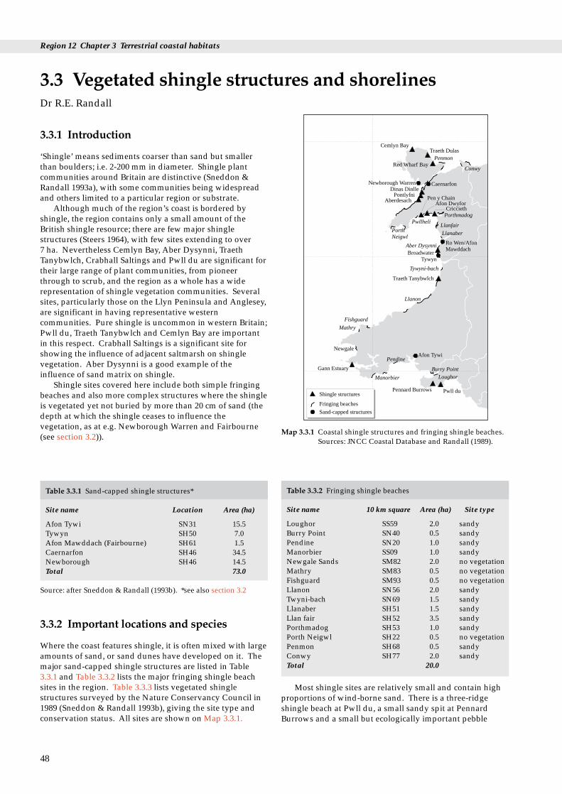
Region 12 Chapter 3 Terrestrial coastal habitats
res and shorelines
Cemlyn BayTraeth Dulas
Penmon
ConwyRed Wharf Bay
Newborough WarrenDinas Dinlle
Pontlyfni
Caernarfon
Aberdesach
PorthNeigwl
Pwllheli
Pen y ChainAfon Dwyfor
CricciethPorthmadog
Llanfair
Llanaber
Aber Dysynni Ro Wen/AfonMawddach
BroadwaterTywyn
Tywyni-bach
Llanon
Traeth Tanybwlch
Fishguard
Mathry
Newgale
Gann Estuary
Manorbier
PendineAfon Tywi
Pennard Burrows
Burry PointLoughor
Pwll duShingle structures
Sand-capped structures
Fringing beaches
Map 3.3.1 Coastal shingle structures and fringing shingle beaches.Sources: JNCC Coastal Database and Randall (1989).
3.3.1 Introduction
‘Shingle’ means sediments coarser than sand but smallerthan boulders; i.e. 2-200 mm in diameter. Shingle plantcommunities around Britain are distinctive (Sneddon &Randall 1993a), with some communities being widespreadand others limited to a particular region or substrate.
Although much of the region’s coast is bordered byshingle, the region contains only a small amount of theBritish shingle resource; there are few major shinglestructures (Steers 1964), with few sites extending to over 7 ha. Nevertheless Cemlyn Bay, Aber Dysynni, TraethTanybwlch, Crabhall Saltings and Pwll du are significant fortheir large range of plant communities, from pioneerthrough to scrub, and the region as a whole has a widerepresentation of shingle vegetation communities. Severalsites, particularly those on the Llyn Peninsula and Anglesey,are significant in having representative westerncommunities. Pure shingle is uncommon in western Britain;Pwll du, Traeth Tanybwlch and Cemlyn Bay are importantin this respect. Crabhall Saltings is a significant site forshowing the influence of adjacent saltmarsh on shinglevegetation. Aber Dysynni is a good example of theinfluence of sand matrix on shingle.
Shingle sites covered here include both simple fringingbeaches and also more complex structures where the shingleis vegetated yet not buried by more than 20 cm of sand (thedepth at which the shingle ceases to influence thevegetation, as at e.g. Newborough Warren and Fairbourne(see section 3.2)).
3.3 Vegetated shingle structuDr R.E. Randall
Table 3.3.1 Sand-capped shingle structures*
Site name Location Area (ha)
Afon Tywi SN31 15.5Tywyn SH50 7.0Afon Mawddach (Fairbourne) SH61 1.5Caernarfon SH46 34.5Newborough SH46 14.5Total 73.0
Source: after Sneddon & Randall (1993b). *see also section 3.2
Table 3.3.2 Fringing shingle beaches
Site name 10 km square Area (ha) Site type
Loughor SS59 2.0 sandyBurry Point SN40 0.5 sandyPendine SN20 1.0 sandyManorbier SS09 1.0 sandyNewgale Sands SM82 2.0 no vegetationMathry SM83 0.5 no vegetationFishguard SM93 0.5 no vegetationLlanon SN56 2.0 sandyTwyni-bach SN69 1.5 sandyLlanaber SH51 1.5 sandyLlan fair SH52 3.5 sandyPorthmadog SH53 1.0 sandyPorth Neigwl SH22 0.5 no vegetationPenmon SH68 0.5 sandyConwy SH77 2.0 sandyTotal 20.0
3.3.2 Important locations and species
Where the coast features shingle, it is often mixed with largeamounts of sand, or sand dunes have developed on it. Themajor sand-capped shingle structures are listed in Table3.3.1 and Table 3.3.2 lists the major fringing shingle beachsites in the region. Table 3.3.3 lists vegetated shinglestructures surveyed by the Nature Conservancy Council in1989 (Sneddon & Randall 1993b), giving the site type andconservation status. All sites are shown on Map 3.3.1.
48
Most shingle sites are relatively small and contain highproportions of wind-borne sand. There is a three-ridgeshingle beach at Pwll du, a small sandy spit at PennardBurrows and a small but ecologically important pebble

3.3 Vegetated shingle structures and shorelines
Table 3.3.3 Vegetated shingle structures
Site name Site type Location Area surveyed Conservation Activities/(ha) status management
disturbances
Pwll du multiple ridge beach SS 574875 2.6 SSSI/NT, AONB light recreationPennard Burrows sandy shingle spit SS 540870 1.1 SSSI/NT recreationCrabhall spit SM 817060 3.5 SSSI light rabbit grazingSaltings/PickleridgeTraeth Tanybwlch sandy shingle spit SN 577800 5.6 SSSI recreationAber Dysynni (Broadwater) Complex spit with SH 582027 19.3 SSSI rabbit grazing (light)
sand & saltmarsh recreationCriccieth multiple ridge SH 525375 19.6 None light grazing &
recreationAfon Dwyfor spit SH 475375 0.9 None nonePen-y-chain (Abersoch) sandy multiple ridge SH 440355 6.3 None grazing
shingle beachAberdesach double ridge with SH 425515 1.4 None recreation,
sand matrix constructionPontlyfni sandy shingle ridge SH 433533 2.5 None sewerage works,
grazingDinas Dinlle sandy foreshore and SH 440580 4.0 None (partly in recreation, rabbit
multiple ridge spit proposed MNR) grazingCemlyn Bay pebble bar SH 331932 3.0 SSSI, NWWT, past gravel extraction
ESA,NTTraeth Dulas Shingle spit with sand SH 485888 3.2 SSSI, ESA none
overlayRed Wharf Bay sandy calcareous spit SH 545802 0.3 ESA recreationTotal 73.3
Source: after Sneddon & Randall (1993b). Key: NT: National Trust; NWWT: North Wales Wildlife Trust, ESA: Environmentally SensitiveArea; AoNB: Area of Outstanding Natural Beauty; MNR: Marine Nature Reserve.
ridge, the Pickleridge, fronting the Crabhall Saltings inMilford Haven. The Newgale shingle beach comprises 2 kmof well-rounded shingle of local Cambrian sandstone andvolcanics but is largely unvegetated. Northerly growingspits in Cardigan Bay have significantly vegetated shingle atAber Dysynni and Traeth Tanybwlch. The latter is analmost pure shingle ridge deflecting the Ystwyth over 1 kmnorth of its original course. The spit at Ro Wen is totallysand-capped. South Llyn has significant fluvioglacial sandand shingle structures. The shingle content increaseseastward from Pwllheli, and there is a large shinglestructure deposited at Pen-y-chain, where up to four stormridges have built up. An almost pure shingle foreshoregives way to older ridges with over 20 cm depth of sandcap. Glacial cliffs at Criccieth also provide a shingle source.On the north of the Llyn coast, longshore drift has led to thenortherly growth of Morfa Dinlle, a shingle spit withvariable depths of sand capping. In Anglesey there aresandy/shingle spits at Red Wharf Bay and Traeth Dulas anda pure shingle bar at the head of Cemlyn Bay.
The sandy nature of the substrate at most of the westWales shingle sites is strongly reflected in the vegetation. A common group near the water’s edge on sandy shinglestrands and structures is a cosmopolitan communitydominated by sea sandwort Honkenya peploides, sea couch-grass Elymus pycnanthus and marram grass Ammophilaarenaria, with sea holly Eryngium maritimum and sea spurgeEuphorbia paralias. Further up the shore, the vegetation isfrequently dominated by curled dock Rumex crispus, seamayweed Tripleurospermum maritimum and yellow hornedpoppy Glaucium flavum, another cosmopolitan community.A more western community dominated by sea mayweedbut with spear-leaved orache Atriplex prostrata and curled
dock occurs in some places. On pure shingle, communitiesdominated by sea beet Beta maritima are present and atCemlyn there is a western community of sea campion Silenevulgaris subsp. maritima and sea kale.
Most Welsh shingle behind the backshore comprisesgrassland communities, with red fescue Festuca rubra subsp.litoralis, thrift Armeria maritima and buck’s-horn plantainPlantago coronopus where there are saltmarsh influences andred fescue Festuca rubra subsp. arenaria, bird’s-foot trefoilLotus corniculatus and moss Hypnum cupressiformecommunities where sand influences are strong. Elsewherethere are a range of communities based on creeping bentAgrostis stolonifera and red fescue, with a western open-grassland community based on red fescue - rest harrowOnonis repens - kidney vetch Anthylis vulneraria in a fewplaces.
Heath communities are poorly represented on shingle inWales, except at at Pwll du and Pen-y-chain, where lingCalluna vulgaris - lichen Cladonia impexa heath is present andwet heath with reed Phragmites australis and water mintMentha aquatica also occurs. On the most inland parts ofshingle sites there are communities based on gorse Ulexeuropaeus and in some sites communities dominated byblackthorn Prunus spinosa or bramble Rubus fruiticosus.
The most important shingle plant species in the regionare sea kale Crambe maritima, which is declining in Britain,sea heath Frankenia laevis, which has its only western site inBritain on Anglesey (Roberts 1975), and Ray’s bistortPolygonum raii, which occurs at Pickleridge on the GannEstuary and a few fringing beaches in west and north-westGwynedd.
There are tern colonies at Cemlyn Bay and AberDysynni. Rabbits and domestic livestock influence the
49
Region 12 Chapter 3 Terrestrial coastal habitats
vegetation at many sites. Cemlyn and Pickleridge areimportant for their invertebrates, for which other sites havenot been fully surveyed.
3.3.3 Human activities
Many of the Welsh shingle sites have no nationalconservation status and can experience high levels ofrecreational pressure, including trampling, litter and thenutrient input from dogs (see Table 3.3.3). Recentconstruction and development have occurred at DinasDinlle, Pontlyfni and Aberdesach. Parts of Dinas Dinllehave been ploughed and Pontlyfni is also grazed, as areCriccieth and Pennard Burrows. Artificial reworking of thesite has occurred over parts of Crabhall Saltings, AberDysynni and Criccieth. At Aber Dysynni, active wardeningof the tern colony reduces trampling of the nest sites in thebreeding season but increases the visitor pressure elsewhereon site. Traeth Dulas, Cemlyn Bay, Aber Dysynni, TraethTanybwlch, Crabhall Saltings, Pennard Burrows and Pwlldu are Sites of Special Scientific Interest (SSSIs).
Several shingle structures in the region are heavilygrazed by domestic stock. Here short swards occur with apoor range of plants.
3.3.4 Information sources used
All the shingle structures of the region were surveyedduring the NCC’s national shingle structures survey carriedout between May and August 1989 (Tables 3.3.1 and 3.3.3).This survey used the National Vegetation Classification(NVC), applying a standard methodology (Sneddon &Randall 1993b). Unvegetated and minor sites wereexcluded. Many of the fringing beaches in Gwynedd wereexamined by the author in the early 1980s as part of asurvey sponsored by British Petroleum (BP). These siteswere examined only qualitatively (see Randall 1989). TheDale area has been surveyed by the Field Studies CouncilResearch Centre over many years. Not all shingle sites arevegetated, especially not those on exposed high-energycoasts (e.g. Hell’s Mouth - Porth Neigwl) or wheredisturbance is great (e.g. Pendine). These have not beensurveyed.
3.3.5 Further sources of information
A. References cited
Randall, R.E. 1989. Geographical variation in British shinglevegetation. Botanical Journal of the Linnean Society, 101: 3-18.
Roberts, R.H. 1975. Frankenia laevis in Anglesey. Watsonia, 10: 291-292.
Sneddon, P., & Randall, R.E. 1993a. Coastal vegetated shinglestructures of Great Britain: main report. Peterborough, JointNature Conservation Committee.
Sneddon, P., & Randall, R.E. 1993b. Coastal vegetated shinglestructures of Great Britain: Appendix I Wales. Peterborough, JointNature Conservation Committee.
Steers, J.A. 1964. The coastline of England and Wales. London,Cambridge University Press.
50
B. Further reading
Further details of vegetated shingle sites may be found on theCoastal & Marine UKDMAP datasets module, available from JNCCCoastal Conservation Branch, Peterborough.Barne, J., Davidson, N.C., Hill, T.O., & Jones, M. 1994. Coastal and
Marine UKDMAP datasets: a user manual. Peterborough, JointNature Conservation Committee.
Chapman, V.J. 1976. Coastal vegetation. Oxford, Pergamon Press.Ferry, B., et al. 1990. Dungeness: a vegetation survey of a shingle beach.
Peterborough, Nature Conservancy Council. (Research andSurvey in nature conservation, No.26.)
Fuller, R.M. 1987. Vegetation establishment on shingle beaches.Journal of Ecology, 75: 1077-1089.
Howarth, W.O. 1920. Notes on the habitats and ecologicalcharacters of three sub-varieties of Festuca rubra. Journal ofEcology, 8: 216-231.
National Trust. 1981. Biological survey - Cemlyn, Anglesey.Cheltenham (unpublished report).
Scott, G.A.M. 1963. The ecology of shingle beach plants. Journal ofEcology, 51: 517-527.
Scott, G.A.M., & Randall, R.E. 1976. Biological flora of the BritishIsles: Crambe maritima L. Journal of Ecology, 64: 1077-1091.
Sneddon, P., & Randall, R.E. 1989. Vegetated shingle structures surveyof Great Britain: Bibliography. Peterborough, NatureConservancy Council. (Research and Survey in natureconservation, No.20.)
C. Contact names and addresses
Type of information Contact address and telephone no.
Pwll du/Pennard Burrows *Chief Adviser Conservation, TheNational Trust HQ, CirencesterGL7 1QW, tel. 01285 651818
Pickleridge-Crabhall Saltings Warden, Field Studies CouncilResearch Centre, Dale Fort FieldCentre, Dale, Pembroke SA62 3RD,tel. 01646 636205
Flora, fauna, habitat *Coastal Ecologist, CCW HQ, information, site Bangor, tel. 01248 370444management
Site information, South *District Officer, CCW Llandeilo, Wales shingle tel. 01558 822111
Site information, North *North Wales Regional Officer, Wales shingle CCW, Bangor, tel. 01248 372333
Cemlyn Bay *Conservation Officer, North WalesWildlife Trust, Bangor, tel. 01248 351541
* Starred contact addresses are given in full in the Appendix

Table 3.4.1 Lagoons surveyed
Name Grid ref. Area (ha) Type
Pickleridge, Dyfed SM810070 4 EstuarineMorfa Gwyllt, Gwynedd SH565030 0.1 Percolation
poolCemlyn, Gwynedd SH330932 12 Semi-
natural, typical
Note: others: none surveyed; individually small; <10 ha in total.
Table 3.4.2 Total lagoonal areas for region and country
Region Lagoonal Overall % % of GB totalarea (ha) of GB total excluding
the Fleet
Gwynedd 12 1 2Other counties 0 0 0Region 12 12 1 2West Coast 98 8 13North Sea coast 1,163 92 87Great Britain 1,261
Note: the residual unsurveyed resource of other than semi-natural‘lagoons’ is unknown, but is less than a further 10 ha.
Table 3.4.3 ‘Nationally noteworthy’ lagoonal areas for regionand country
3.4 Coastal lagoons
3.4.1 Introduction
The term coastal lagoons is used here to include truelagoons, i.e. those wholly or partially separated from the seaby a natural sedimentary barrier, and also artificial brackishponds and coastal pools, of a similarly restricted tidal rangeand often containing comparable lagoonal wildlife.Lagoons are commonly shallow, often with a varyingsalinity ranging from above to below normal sea-waterlevels (35‰). Freshwater systems are not considered.
Lagoons are a nationally rare habitat and a ‘priorityhabitat type’ under Annex 1 of the EU Habitats Directive.
The region is therefore significant in the national contexteven though it contains but one natural lagoon. The singlesemi-natural lagoon in the region (Cemlyn Lagoon,Anglesey - see Map 3.4.1) covers 12 ha, amounting to (a) 1%of Britain’s total lagoonal resource, (b) 2% of that resourceexcluding the Fleet, Dorset (by far Britain’s largest lagoon,comprising nearly 70% of the total resource) and (c) 19% ofthe lagoonal resource that was regarded by Barnes (1989) asbeing ‘especially noteworthy in the national context’, againexcluding the Fleet (Tables 3.4.1, 3.4.2 and 3.4.3). Otherlagoonal sites in the region are a small natural percolationpool of 0.1 ha at Morfa Gwyllt, Tywyn, Gwynedd, andbehind the Pickleridge in the Gann Estuary (CrabhallSaltings).
3.4 Coastal lagoonsDr R.S.K. Barnes & Dr R.N. Bamber
Region Lagoonal Overall % % of GB totalarea (ha) of GB total excluding
the Fleet
Gwynedd 12 2 19Other counties 0 0 0Region 12 12 2 19West Coast 24 4 37North Sea coast 521 96 63Great Britain 545
Source: after Barnes (1989)
Cemlyn
Afon Alaw
CefniOgwen Estuary
Porthmadog
Morfa Gwyllt Tywyn
Pickleridge
Semi-natural lagoons
Other surveyed saline pools
Other locations mentioned in the text
Map 3.4.1 Coastal lagoons
3.4.2 Important locations and species
Apart from the Cemlyn lagoon and the pool at MorfaGwyllt, there are a number of small percolation pools,artificial ponds and pools within estuarine systemsthroughout the region (see Map 3.4.1). They range in scalefrom a large low-tide pool on the Afon Alaw, Anglesey,which retains water at low tide but which is fully flushed oneach high tide and is thus essentially estuarine, via excisedmeanders (Ogwen Estuary) and retained estuary pools(Cefni, Tywyn, Porthmadog), to a number of shingle pools,all very small and undoubtedly ephemeral, for examplethose within the Menai Straits. The cliff topography of mostof the coastline generally precludes the development oflagoon-like features.
Many of these sites, being for example fully-flushed tidalpools, or too small to act as stable habitats, or now artificialboating lakes, are outside the present context of coastal
51

Region 12 Chapter 3 Terrestrial coastal habitats
lagoons. Estimates of the residual total resource are littlemore than guesswork.
There are no important plant species in lagoons in theregion, although sea-kale Crambe maritima occurs on theenclosing shingle spit at Cemlyn. The seaweed Fucusceranoides occurs in the artificial pool at Porthmadog. Truelagoons support only three types of aquatic vegetation,namely stands of green algae (Chaetomorpha, Ulva andEnteromorpha), of sea-grasses and similar plants(predominantly Ruppia spp.) and, much more rarely, ofstoneworts (especially Lamprothamnium). Much of the areaof their beds, however, is in the form of bare sediment,devoid of vegetation cover. Fringing stands of reedsPhragmites spp., salt-marsh plants and/or sedges Scirpusmaritimus are usual. All these communities, with theexception of the stoneworts, occur in Cemlyn Lagoon,although its fringing vegetation is poorly developed.
No protected lagoonal invertebrate species occur in theregion, although the presence of the lagoonal snails Hydrobiaventrosa and Littorina lagunae and the bryozoan Conopeumseurati at Cemlyn is notable (see also section 5.4). Thislagoon also supports waders and wildfowl, and issignificant for the colonies of Sandwich, common and arcticterns that nest on its small islands (see also section 5.11).
The estuarine fauna of Pickleridge lagoon is typical ofsuch habitats, being dominated by ragworm Nereisdiversicolor, lugworm Arenicola marina, serpulid worms, theopposum shrimp Praunus flexuosus and the mud snailHydrobia ulvae. None of these species is of conservationimportance.
3.4.3 Human activities
Active management is applied to Cemlyn Lagoon itself,including regulating its water level with a weir, and it ismaintained as a nature reserve (North Wales Wildlife Trust),largely for its birdlife.
No known ecological management exists for the otherlagoons in the region.
3.4.4 Information sources used
All potential lagoons in the region were surveyed as part ofthe NCC’s national lagoon survey in 1987 (Barnes 1991).Only Cemlyn Lagoon and Morfa Gwyllt have been thesubject of specific and detailed lagoonal surveys. Othersaline pools to have experienced incidental sampling arePickleridge ‘Lagoon’, Gann Estuary, Dale, Dyfed (records inCrothers 1966) and the tidal-sluice-retained pool on theR. Glaslyn, Porthmadog (e.g. Gubbay 1988).
52
3.4.5 Further sources of information
A. References cited
Barnes, R.S.K. 1991. A survey of the coastal lagoons of North Wales(R. Clwyd - Aberystwyth), September 1987. Nature ConservancyCouncil, CSD Report, No. 1123.
Barnes, R.S.K. 1989. The coastal lagoons of Britain: an overviewand conservation appraisal. Biological Conservation, 49: 295-313.
Crothers, J.H. 1966. Dale Fort marine fauna, 2nd ed. Field Studies,2: Supplement, xxiv + 1-169.
Gubbay, S. 1988. Coastal directory for marine nature conservation.Ross-on-Wye, Marine Conservation Society.
B. Further reading
Barne, J., Davidson, N.C., Hill, T.O., & Jones, M. 1994. Coastal andMarine UKDMAP datasets: a user manual. Peterborough, JointNature Conservation Committee.
Bamber, R.N., Batten, S.D., & Bridgwater N.D. 1992. On theecology of brackish water lagoons in Great Britain. AquaticConservation: Marine and Freshwater Ecosystems, 2: 65-94.
NERC. 1991. United Kingdom Digital Marine Atlas (UKDMAP).British Oceanographic Data Centre.
C. Contact names and addresses
Type of information Contact address and telephone no.
Brackish lagoons of the Dr R.S.K. Barnes, St Catharine’s region College, Cambridge CB2 1RL,
tel. 01223 336606
Cemlyn Lagoon *Conservation Officer, North WalesWildlife Trust, Bangor, tel. 01248 351541
* Starred contact addresses are given in full in the Appendix
3.4.6 Acknowledgements
We are grateful for information supplied by Ivor Rees, AndyMackie and Dr Robin Crump.

3.5 Coastal grazing marsh
16
1718
19
2021
2223
2425
26
27
28
29
12
3 4
567
89
10
11
13
12
14
15
Map 3.5.1 Coastal grazing marsh sites. Numbers refer to Table3.5.1.
3.5.1 Introduction
In this region, large areas of semi-natural coastal wetgrassland have been lost through improvement orconversion to arable use. All the surviving resource isgrazed, producing coastal grazing marsh. This is adistinctive habitat consisting of low-lying grassland drainedby a series of ditches that may be either brackish orfreshwater. No figures exist for the total area of grazingmarsh or associated coastal wetland habitat in this region orthe GB as a whole. In terms of total GB area the regionalresource is relatively small: probably less than half of theWelsh total occurs in the region, although it hasapproximately three quarters of the Welsh coastline.Nevertheless, coastal grazing marsh is a widespread habitatand an important natural resource in this region, present insmall pockets of land next to most of the region’s estuaries,often in association with a range of other habitats such assaltmarsh, sand dunes, fen and reed swamp. Even thelarger areas of grazing marsh in the region, such asMalltraeth Marsh on Anglesey (1,365.6 ha) and the grazingmarshes associated with Carmarthen Bay and the DyfiEstuary, are still relatively small when compared with theextensive grazing marshes of other regions. Grazing marshforms part of a number of sites of designated conservationinterest.
No sites are of importance because of their size. Many,however, contain unusual features, for example the grazingmarsh adjacent to the Dyfi estuary and Glaslyn Marshes, orare part of a rich mosaic of habitats, indicating significantconservation interest. See Map 3.5.1 for major sites in theregion.
The conservation value of most of the grazing marshresource of this region is poorly known, although morecomprehensive data do exist for its breeding waders andbirds of associated wetland habitats. The ditch flora andfauna of Malltraeth Marshes are of significant conservationinterest.
3.5 Coastal grazing marshDr H.T. Gee
3.5.2 Important locations and species
Grazing marsh forms part of at least 12 Sites of SpecialScientific Interest (SSSIs) in this region. Some of these sitesare also designated as National Nature Reserves (NNRs) orNorth Wales Wildlife Trust Reserves, whilst there are alsoRSPB reserves on grazing marsh at Malltraeth Marsh and atYnys Hir on the Dyfi estuary, and a Wildfowl and WetlandsTrust Reserve at Penclacwydd on the ‘Llanelli Levels’.Further important areas of grazing marsh include theDolgarrog Reed Bed on the Afon Conwy and the Aber LeriFields and Penllyn Fields adjacent to Dyfi SSSI; others lieadjacent to a number of other SSSIs such as Pembrey Coast,Broadwater on the Afon Dysynni, Penmaenpool Reed-bedon the Afon Mawddach, Morfa Harlech and Foryd Bay. Alist of grazing marsh sites in this region is given in Table3.5.1.
Of particular note within the region are areas of atypicalgrazing marsh, where changing management practices, poordrainage or disuse have resulted in the development ofother habitats, e.g. at Castlemartin Corse and Tre’r Gof,where reclamation of fen has been only partially successful;at Slebech Reed-bed and Carr, where the sea wall has beenbreached; and at Oxwich NNR, where the cessation of ditchmaintenance has allowed the development of a freshwatermarsh. Significant areas along the Carmarthen coast, atPembrey - Kidwelly and at Pendine, have developed behindsand dunes.
Typically, the botanical interest is associated with theditch systems rather than the fields between them. Wheresemi-improved grassland remains on grazing marsh it isusually National Vegetation Classification (NVC) MG5Cynosurus cristatus/Centaurea nigra grassland. Exceptions tothis include Dolgarrog Reedbeds, Glaslyn Marshes andAber Leri Fields, where survey has shown the presence ofsaltmarsh communities that are interesting because of theirbrackish nature. Glaslyn Marshes includes an area of thenationally rare dwarf spike-rush Eleocharis parvula saltmarshcommunity (Rhind & Jones in press). At Aber Leri Fieldsthere is an unusual transition from vegetation withsaltmarsh character to acid bog. Other atypical sites includethe fen meadows at Cors Penally, Castlemartin Corse and
53

Region 12 Chapter 3 Terrestrial coastal habitats
Table 3.5.1 Grazing marsh sites shown on Map 3.5.1
No. Site Grid ref. Conservation status of grazing marsh
W Glamorgan1 Margam Moor SS783846 108 ha SSSI2 Oxwich Bay SS505870 reverted to fresh marsh SSSI and NNR3 Cwm Ivy Marsh SS442941 part of SSSI4 Burry Inlet, W Glamorgan adjacent to Burry Inlet SSSI, SPA and Ramsar site
Dyfed5 ‘Llanelli Levels’ SS535985 adjacent to Burry Inlet SSSI SPA and Ramsar site and
Penclacwydd WWT Reserve6 Pembrey-Kidwelly SN410020 adjacent to Pembrey Coast SSSI7 Pendine SN300090 adjacent to Whitehill Down SSSI8 Cors Penally SS118989 part of SSSI9 Castlemartin Corse SR905995 part of marsh designated SSSI10 Slebech Reedbed and Carr SN053142 SSSI - grazing marsh reverting to reedbed11 Gann Estuary SM812070 SSSI - grazing marsh recolonised by saltmarsh12 Teifi Marshes SN16547513 Dyfi Estuary SN608920 Hen Afon Leri SSSI
Gwynedd14 Afon Dysynni SH585015 grazing marsh adjacent to Broadwater SSSI15 Mawddach Estuary SH709188 grazing marsh adjacent to Penmaenpool SSSI and Arthog
SH645147 Bog SSSI16 Glastraeth/Talsarnau marshes SH610367 grazing marsh adjacent to Morfa Harlech SSSI and NNR17 Glaslyn Marshes SH582585 SSSI and
SH590393 NWWT Reserve18 Llyn Ystumllyn SH526385 SSSI19 Afon Dwyfor SH526385 Glan y mor and Ty’ny Morfa NSSNCI20 Morfa Abererch SH420360 NSSNCI21 Penrhos floodplain SH357340 NSSNCI22 Afon Llyfni SH522529 Ynys and Trwyn maen Dylan NSSNCI23 Afon Foryd SH445575 adjacent to Foryd Bay SSSI, LNR24 Malltraeth Marsh SH440710 SSSI (1366.5ha), ESA, RSPB Reserve. ~2,000 ha of marsh25 Afon Crigyll SH325745 ESA26 Bodlasan Groes SH298818 ESA27 Tre’r Gof SH359936 SSSI, ESA28 Traeth Lafan SH613722 Aber Ogwen NWWT Reserve, LNR29 Afon Conwy (Dolgarrog Reedbeds) SH780665 (not protected)
Source: JNCC and CCW. Key: SSSI = Site of Special Scientific Interest; SPA = Special Protection Area; NNR = National Nature Reserve;Ramsar site = internationally important wetland; ESA = Environmentally Sensitive Area; NWNT = North Wales Wildlife Trust; NSSNCI =Non Statutory Sites of Nature Conservation Interest.
Tre’r Gof, where poor drainage has resulted in the retentionof fenland communities.
Cors Penally supports a rich-fen example of theMolinia/Myrica community, rarely encountered in Britain.At Slebech Reed-bed and Carr SSSI on the Eastern Cleddau,the grazing marsh has reverted to a mixture of brackishmarsh, reed-bed and carr because the site is periodicallyinundated by sea water. Margam Moor and the LlanelliLevels support fen meadows and ditch communities similarto the Gwent Levels and areas of grazing marsh in southernEngland.
Glaslyn Marshes support the nationally rare plantsEleocharis parvula and Welsh mudwort Limosella australis.Other species present at Glaslyn include the nationallyscarce sharp rush Juncus acutus, small water pepperPolygonum minus and brackish water-crowfoot Ranunculusbaudotii. The ditches on Castlemartin Corse support thenationally scarce fen pondweed Potamogeton coloratus and anumber of locally uncommon species.
The flora of the ditches and ponds at Malltraeth isnotably rich and supports the nationally rare pillwortPilularia globulifera and locally uncommon plants such as
54
water violet Hottonia palustris and marsh stitchwort Stellariapalustris (Knott 1993). The ditches at Margam Moor supporta range of species found widely on the Gwent Levels andgenerally typical of grazing marsh in southern England,including relatively uncommon species such as lesser water-plantain Baldellia ranunculoides and frogbit Hydrocharismorsus-ranae. See section 5.2 for more information on rareplants.
Grazing marsh is recognised as an important habitat forbreeding waders, especially in lowland Britain, although itusually supports lower densities than saltmarsh (Davidson1991) (see also section 5.11). Malltraeth Marsh and LlynYstumllyn are both potential nesting sites for species such asgarganey, ruff, blacktailed godwit, marsh harrier andbittern. The management plan for Malltraeth Marshproduced by CCW (Knott 1993) is designed to encouragethe establishment of breeding of these species. Themanagement proposed by the Wildfowl and Wetlands Trustis likely greatly to increase the ornithological interest ofPenclacwydd, which has already become important as amigration staging site for several waders includinggreenshank, spotted redshank and black-tailed godwit.

3.5 Coastal grazing marsh
There are records for a number of invertebrate speciesfrom Margam Moor, including the nationally notable beetleHaliplus mucronatus. Morgan (1994) provided relativelyextensive lists of invertebrate species that contain a numberof species of conservation interest recorded from the‘Llanelli Levels’. Machynys Ponds - a site on these levels -support an outstanding assemblage of breeding dragonflies,including five species that are considered nationally notable(Morgan 1990). Another nationally notable species ispresent at Penclacwydd. Other invertebrate records for theLlanelli Levels include one vulnerable hoverfly Parhelophilusconsimilis plus a further sixteen nationally notable species.Malltraeth supports two nationally notable dragonflies.Post-1980 records from the Welsh Peatland InvertebrateSurvey (Holmes et al. 1992) for Dolgarrog Reedbed includeone nationally rare insect and a further five nationallynotable and 27 locally important invertebrate species (seesection 5.3 for more detail on terrestrial invertebrates).
Table 3.5.2 Selected survey data
Site Survey data Date
Margam Moors list from CCWOxwich Marsh NCC Botanical &
Hydrological Survey 1981Dyfi Estuary IDB Ditches River
Corridor Survey 1992Aber Leri Fields Phase II CCW 1994Penllyn Fields Phase II CCW 1994Morfa Harlech and JNCC Phase II of dunes Morfa Dyffryn and associated marshes 1991Glaslyn Marshes JNCC Phase II 1991(adjacent to SSSI) WFU Phase II 1990Llyn Ystumllyn Phase II NVCMorfa Abererch Phase I survey with
target notesMalltraeth Marsh Botanical survey WFU 1986
3.5.3 Human activities
Agricultural intensification has reduced the conservationvalue of many grazing marshes in the region. As in the restof Britain, grazing marsh in West Glamorgan has sufferedsignificantly from loss to industrial land claim, and MargamMoors SSSI (108 ha) are the last remnant of the onceextensive levels in this county. In a few places grazingmarsh has been lost to secondary natural habitats e.g. thefreshwater marsh at Oxwich NNR, or the Gann Estuary,where the sea wall was breached in 1920 allowing the re-establishment of saltmarsh.
A number of grazing marsh sites, e.g. at Penclacwydd,Aber Leri Fields and Malltraeth Marsh, are now beingmanaged in places to improve their ornithological interest.This involves raising water-levels and encouraging theestablishment of extensive reedbeds, which may result in asignificant change to the habitat and, in the case of somesites, loss of as yet undescribed conservation interest.
3.5.4 Information sources used
There is no survey of the total wet grassland resource inWales comparable to that undertaken in England for EnglishNature (Dargie 1993). Although limited, Phase 2information for lowland grasslands forms the mostextensive botanical survey database and is available foreight sites (Wales Field Unit 1990). Surveys of ditch florahave been undertaken at Malltraeth Marsh (Smith &Humphreys 1986; Collonello, Graves & Wade 1992), andriver corridor survey data exist for the grazing marshes ofthe Dyfi Estuary (NRA 1992). Botanical records for CorsPenally SSSI go back 130 years.
Survey data are probably most extensive for breedingbirds and are available for Oxwich, Malltraeth Marsh andDolgarrog Marsh. Grazing marsh sites were included in thesurvey of breeding redshank throughout Wales (Griffin,Saxton & Williams 1992), whilst those on Anglesey and theLlyn Peninsula were also surveyed as part of the breedingbird surveys for these parts of Wales (Seddon 1988).
A brief study of the Aber Leri fields was undertaken byBoyce in 1989 (Boyce 1990). An invertebrate survey has
been undertaken at Malltraeth Marsh where the aquaticcoleoptera were surveyed by Foster & Bilton (1985) and theterrestrial invertebrate fauna was surveyed by Morgan(1992). The dragonfly fauna of Malltraeth Marsh, OxwichFresh Marsh and the ‘Llanelli Levels’ are well recorded,whilst there are also dragonfly records for the Dyfi Estuaryand ad hoc invertebrate records for Margam Moor and theLlanelli Levels. A survey of the molluscs of Cwm IvyMarsh, West Glamorgan, was undertaken by theConchological Society of Great Britain. Information onparticular sites may be held on the JNCC’s Invertebrate SiteRegister, and some grazing marsh sites, including theDolgarrog Reedbeds, were included in the Welsh PeatlandInvertebrate Survey (Holmes, Boyce & Reed 1992).
Large areas of former grazing marsh are not likely to beincluded in any detailed surveys of grasslands in Wales, asmany of the pastures are agriculturally improved, or turnedover to arable farming.
Table 3.5.2 lists sites for which survey data are available.
3.5.5 Further sources of information
A. References cited
Boyce, D.C. 1990. Coleoptera recording in Ceredigion (VC 46)during 1989. Dyfed Invertebrate Group Newsletter, 16: 16-20.
Collonello, G., Graves, R., & Wade, P.M. 1992. A survey andevaluation of ditch flora of Malltraeth Marsh SSSI, Anglesey, withrecommendations on the management of the drainage system.Loughborough University, International Centre of LandscapeEcology. (Report for CCW.)
Dargie, T.C. 1993. The distribution of lowland wet grassland inEngland. English Nature Research Report, No. 49.
Davidson, N.C. 1991. Breeding waders on British estuarinegrasslands. Wader Study Group Bulletin 61, Supplement: 36-41.
Foster, G.N., & Biton, D.T. 1985. A survey of the aquatic Coleoptera ofthe Malltraeth Marshes, Anglesey. CCW (File SH47.5.1).
Griffin, B., Saxton, N., & Williams, I. 1992. Breeding redshanks inWales 1991. RSPB unpublished report.
Holmes, P.R., Boyce, D.C., & Reed, D.C. 1992. The Welsh peatlandinvertebrate survey: Meirionnedd. Bangor, CCW.
Knott, H.A. 1993. Malltraeth Marsh/Cors Ddyga management plan.Bangor, CCW.
Morgan, I.K. 1990. Machynys Ponds - an important local wildlifesite threatened by development. Llanelli Naturalists’ Newsletter,summer 1990: 3-4.
55
Region 12 Chapter 3 Terrestrial coastal habitats
Morgan, I.K. 1994. The Llanelli Levels. The Llanelli Naturalists’Society Bulletin, 1: winter 1994-95.
Morgan, M.J. 1992. Malltraeth Marsh SSSI invertebrate survey 1992.CCW (File SH47.5.1.)
National Rivers Authority Welsh Region. 1992. River corridor surveyfor IDD Ditches, Dyfi Estuary. Unpublished.
Rhind, P.M., & Jones, A. In press. Brackish saltmarsh communitiesin the Glaslyn Marsh Trust Reserve. Field Studies.
Sedden, A. 1988. Breeding bird surveys of the Lleyn Peninsula andAnglesey in 1986 and 1987. RSPB unpublished report.
Smith, I.R., & Humphreys, E.A. 1986. A botanical survey andevaluation of drainage ditches on the Malltraeth Marsh SSSI, YnysMôn, Gwynedd. Unpublished Wales Field Unit report to NCC.
Wales Field Unit. 1990. WFU Wales lowland grassland survey draftPhase II report - Glaslyn Marshes (north-west). Unpublishedreport to NCC.
B Further reading
Coleshaw, T. 1995. Rising to the water levels challenge. Enact, Vol. 3 No. 1: 7-9.
Harold, R. 1995. Creating wetlands at Holkham. Enact, Vol. 3 No. 1: 12-15.
Meade, R. 1982. Botanical and hydrological survey of Oxwich Marsh,1981. Peterborough, NCC.
Scholey, G. 1995. Return of the “drowners”. Enact, Vol. 3 No. 1: 10-11.
Thomas, G., José, P., & Hirons, G. 1995. Wet grassland in themillenium. Enact, Vol. 3 No. 1: 4-6.
C. Contact names and addresses
Type of information Contact address and telephone no.
Breeding bird survey *RSPB Wales, Newtown, tel. 01686 626678
Survey reports *Grasslands Team, CCW HQ,Bangor, tel. 01248 370444
Invertebrate Site Register *ISR, Species Branch, Joint NatureConservation Committee,Monkstone House, Peterborough,tel. 01733 62626
* Starred contact addresses are given in full in the Appendix
3.5.6 Acknowledgements
Thanks are due to the District Officer Staff of CCW forproviding information on coastal grazing marsh in theirdistricts. Information was also received from StephanieTyler of the RSPB, Peter Rhind of CCW headquarters andDeborah Procter of the JNCC’s Invertebrate Site Register.
56

3.6 Saltmarsh
Traeth Dulas
Traeth CochConwy
Traeth LafanAlaw
CefniForyd Bay
Traeth Bach
Artro
Traeth Melynog
Mawddach
Dysynni
Dyfi
TeifiNyfer
Milford HavenTaf Tywi
Gwendraeth
Afon Aeron
Afon Ystwyth & Rheidol
PwllheliAbersoch
Rhosneigr Menai StraitAfon Ffraw
3.6.1 Introduction
The saltmarshes in Region 12 are largely estuarine, on bothlarge and small sites. The largest areas occur in estuarieswith extensive intertidal flats: the Burry Inlet, and ‘ThreeRivers’ - Taf/Tywi/Gwendraeth and Dyfi. Both Snowdoniaand Pembrokeshire Coast National Parks contain areas ofsaltmarsh, as does the proposed Menai Strait Marine NatureReserve.
The total amount of saltmarsh in the region is 5,461hectares - 24% of the area on the west coast of Britain, 12%of the British resource and 81% of that in Wales (Table 3.6.2).West Glamorgan contains the most, although there are moresites in Gwynedd. JNCC’s Coastal Resources Databaseshows that 27% of the coastline (at Mean High Water) ofWest Glamorgan supports saltmarsh, compared with only7% in Dyfed and 4% in Gwynedd. Compared with mostother regions, much comprises mid to upper marshcommunities (Table 3.6.1). This is because there has beenless land claim of saltmarsh here than elsewhere, and so thesaltmarsh succession is less often truncated byembankments. Common cord-grass Spartina anglica is themost extensive pioneer vegetation and has colonisedsubstantial areas of intertidal flats since the 1930s and 1940s.
3.6 SaltmarshDr M.I. Hill
Pembrey
Burry Inlet NeathOxwich
Sites with <10 ha of saltmarsh
Sites with >10 ha of saltmarsh
Map 3.6.1 Saltmarsh sites. Source: JNCC Coastal Database.
3.6.2 Important locations and species
Map 3.6.1 shows the locations of saltmarsh sites in theregion (Burd 1989a). The largest saltmarshes in the regionare on the Burry Inlet and the Three Rivers Estuary. TheBurry Inlet is particularly noteworthy as it has the fourthlargest saltmarsh area in Britain and has suffered little landclaim. The landward transition is a natural one to sanddunes and a wide variety of plant communities are present.Elsewhere, the ria (drowned river valley) system of MilfordHaven contains many pockets of saltmarsh. In addition, theestuaries and bays of mid and north Wales have significantareas of saltmarsh, with the Mawddach, Traeth Bach
Table 3.6.1 Areas (ha) of saltmarsh communities for region
Spartina Pioneer Low- Midmid uppe
West Glamorgan 404 302 581 98Dyfed 660 40 523 49Gwynedd 342 23 84 77Region 12 1,406 364 1,188 2,25
Wales 1,681 468 1,555 248West Coast 3,487 1,340 4,159 11,27GB 6,948 3,470 12,353 16,04
Source: Burd (1989a).
(estuaries of Glaslyn and Dwyryd), Foryd Bay, Cefni andConwy all containing more than 100 ha. A particular featureof the region is the development of saltmarsh in the shelterof sand and shingle spits.
Saltmarshes in the region generally have a sandysubstrate and are grazed, which greatly influences the type
57
- Drift- Upper Transi- Wet Total % of r line Swamp tions depression region
total incounty
1 1 19 7 0 2,296 425 5 85 43 0 1,850 344 0 64 29 0 1,315 240 6 168 79 0 5,461 -
% of total in
region
6 267 202 89 0 6,748 810 473 410 1,327 <1 22,582 242 1,824 1,475 1,670 2 44,370 12
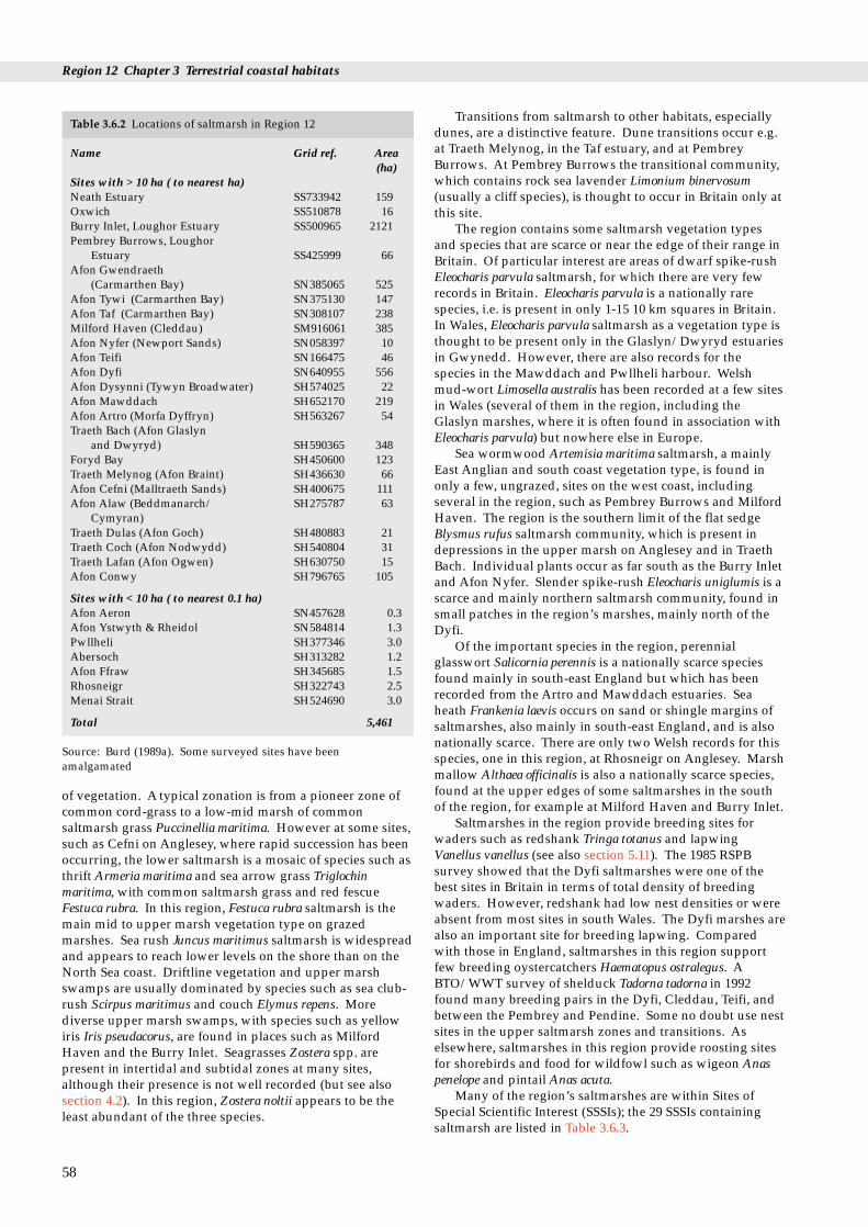
Region 12 Chapter 3 Terrestrial coastal habitats
Table 3.6.2 Locations of saltmarsh in Region 12
Name Grid ref. Area(ha)
Sites with > 10 ha ( to nearest ha)Neath Estuary SS733942 159Oxwich SS510878 16Burry Inlet, Loughor Estuary SS500965 2121Pembrey Burrows, Loughor
Estuary SS425999 66Afon Gwendraeth
(Carmarthen Bay) SN385065 525Afon Tywi (Carmarthen Bay) SN375130 147Afon Taf (Carmarthen Bay) SN308107 238Milford Haven (Cleddau) SM916061 385Afon Nyfer (Newport Sands) SN058397 10Afon Teifi SN166475 46Afon Dyfi SN640955 556Afon Dysynni (Tywyn Broadwater) SH574025 22Afon Mawddach SH652170 219Afon Artro (Morfa Dyffryn) SH563267 54Traeth Bach (Afon Glaslyn
and Dwyryd) SH590365 348Foryd Bay SH450600 123Traeth Melynog (Afon Braint) SH436630 66Afon Cefni (Malltraeth Sands) SH400675 111Afon Alaw (Beddmanarch/ SH275787 63
Cymyran)Traeth Dulas (Afon Goch) SH480883 21Traeth Coch (Afon Nodwydd) SH540804 31Traeth Lafan (Afon Ogwen) SH630750 15Afon Conwy SH796765 105
Sites with < 10 ha ( to nearest 0.1 ha)Afon Aeron SN457628 0.3Afon Ystwyth & Rheidol SN584814 1.3Pwllheli SH377346 3.0Abersoch SH313282 1.2Afon Ffraw SH345685 1.5Rhosneigr SH322743 2.5Menai Strait SH524690 3.0
Total 5,461
Source: Burd (1989a). Some surveyed sites have beenamalgamated
of vegetation. A typical zonation is from a pioneer zone ofcommon cord-grass to a low-mid marsh of commonsaltmarsh grass Puccinellia maritima. However at some sites,such as Cefni on Anglesey, where rapid succession has beenoccurring, the lower saltmarsh is a mosaic of species such asthrift Armeria maritima and sea arrow grass Triglochinmaritima, with common saltmarsh grass and red fescueFestuca rubra. In this region, Festuca rubra saltmarsh is themain mid to upper marsh vegetation type on grazedmarshes. Sea rush Juncus maritimus saltmarsh is widespreadand appears to reach lower levels on the shore than on theNorth Sea coast. Driftline vegetation and upper marshswamps are usually dominated by species such as sea club-rush Scirpus maritimus and couch Elymus repens. Morediverse upper marsh swamps, with species such as yellowiris Iris pseudacorus, are found in places such as MilfordHaven and the Burry Inlet. Seagrasses Zostera spp. arepresent in intertidal and subtidal zones at many sites,although their presence is not well recorded (but see alsosection 4.2). In this region, Zostera noltii appears to be theleast abundant of the three species.
58
Transitions from saltmarsh to other habitats, especiallydunes, are a distinctive feature. Dune transitions occur e.g.at Traeth Melynog, in the Taf estuary, and at PembreyBurrows. At Pembrey Burrows the transitional community,which contains rock sea lavender Limonium binervosum(usually a cliff species), is thought to occur in Britain only atthis site.
The region contains some saltmarsh vegetation typesand species that are scarce or near the edge of their range inBritain. Of particular interest are areas of dwarf spike-rushEleocharis parvula saltmarsh, for which there are very fewrecords in Britain. Eleocharis parvula is a nationally rarespecies, i.e. is present in only 1-15 10 km squares in Britain.In Wales, Eleocharis parvula saltmarsh as a vegetation type isthought to be present only in the Glaslyn/Dwyryd estuariesin Gwynedd. However, there are also records for thespecies in the Mawddach and Pwllheli harbour. Welshmud-wort Limosella australis has been recorded at a few sitesin Wales (several of them in the region, including theGlaslyn marshes, where it is often found in association withEleocharis parvula) but nowhere else in Europe.
Sea wormwood Artemisia maritima saltmarsh, a mainlyEast Anglian and south coast vegetation type, is found inonly a few, ungrazed, sites on the west coast, includingseveral in the region, such as Pembrey Burrows and MilfordHaven. The region is the southern limit of the flat sedgeBlysmus rufus saltmarsh community, which is present indepressions in the upper marsh on Anglesey and in TraethBach. Individual plants occur as far south as the Burry Inletand Afon Nyfer. Slender spike-rush Eleocharis uniglumis is ascarce and mainly northern saltmarsh community, found insmall patches in the region’s marshes, mainly north of theDyfi.
Of the important species in the region, perennialglasswort Salicornia perennis is a nationally scarce speciesfound mainly in south-east England but which has beenrecorded from the Artro and Mawddach estuaries. Seaheath Frankenia laevis occurs on sand or shingle margins ofsaltmarshes, also mainly in south-east England, and is alsonationally scarce. There are only two Welsh records for thisspecies, one in this region, at Rhosneigr on Anglesey. Marshmallow Althaea officinalis is also a nationally scarce species,found at the upper edges of some saltmarshes in the southof the region, for example at Milford Haven and Burry Inlet.
Saltmarshes in the region provide breeding sites forwaders such as redshank Tringa totanus and lapwingVanellus vanellus (see also section 5.11). The 1985 RSPBsurvey showed that the Dyfi saltmarshes were one of thebest sites in Britain in terms of total density of breedingwaders. However, redshank had low nest densities or wereabsent from most sites in south Wales. The Dyfi marshes arealso an important site for breeding lapwing. Comparedwith those in England, saltmarshes in this region supportfew breeding oystercatchers Haematopus ostralegus. ABTO/WWT survey of shelduck Tadorna tadorna in 1992found many breeding pairs in the Dyfi, Cleddau, Teifi, andbetween the Pembrey and Pendine. Some no doubt use nestsites in the upper saltmarsh zones and transitions. Aselsewhere, saltmarshes in this region provide roosting sitesfor shorebirds and food for wildfowl such as wigeon Anaspenelope and pintail Anas acuta.
Many of the region’s saltmarshes are within Sites ofSpecial Scientific Interest (SSSIs); the 29 SSSIs containingsaltmarsh are listed in Table 3.6.3.

Table 3.6.3 SSSIs in Region 12 containing saltmarsh
West GlamorganCrymlyn BurrowsPennard ValleyOxwich Bay (part NNR)Whiteford Burrows - Landimore Marsh (SPA, Ramsar, partNNR)Burry Inlet (SPA, Ramsar)
DyfedPembrey Coast (part SPA, Ramsar)West Williamston QuarriesSlebech Reedbed and CarrHook WoodGann EstuaryNetpool WoodAngle BayDaugleddauCarew & Cresswell RiversCosheston PillPembroke River & Pwllcrochan FlatsTeifi Estuary Woodlands and MarshesDyfi (part NNR, Ramsar)
GwyneddDyfi (part NNR, Ramsar)BroadwaterPenmaenpool ReedbedMorfa Dyffryn (part NNR)Morfa Harlech (part NNR)Glaslyn MarshesForyd BayNewborough Warren - Ynys LlanddwynCemlyn BayBeddmanarch - CymyranCoed y Gell and Morfa DulasTraeth Lafan (SPA)
Source: JNCC Coastal Conservation Branch; CCW
3.6.3 Human activities
Most saltmarshes in the region have been stable or haveaccreted in the last 30 years (Pye & French 1993). Commoncord-grass Spartina anglica, the main colonist of newmudflats, has spread widely since its introduction, andcontrol measures have been attempted at several sites,including the Malltraeth Estuary. However, its spreadseems to have slowed in many estuaries. No overall policyfor Spartina management exists. Most saltmarshes in thisregion require management by grazing to maintain theirexisting vegetation. In general, current grazing levelsappear to be sustainable.
3.6.4 Information sources used
Saltmarshes in this region were surveyed in 1982/3 as partof the NCC’s national saltmarsh survey. This provided aintermediate level of detail between Phase 1 habitat surveyand the National Vegetation Classification (NVC). It did notinclude all areas of transition to other habitats, such as sanddune, shingle and freshwater marsh. Areas of seagrassesZostera spp. were not recorded, nor was saltmarsh in theembanked Glaslyn marshes and Dolgarrog flood plain (seeTable 3.6.1 and 3.6.2). Detailed reports are available and
results are summarised in Burd (1989a-d). Data presentedhere are derived from that database.
Other saltmarsh surveys in the region include those onthe Burry Inlet (Kay & Rojanavipart 1977), Milford Haven(Dalby 1970), Afon Cefni (Packham & Liddle 1970; Jones1990) and Conwy (Thorburn & Rees 1979). Surveys ofSpartina have been carried out at many sites, e.g. MilfordHaven (Baker et al. 1984; Wilson 1988), the Dyfi (Chater1973), the Mawddach (Rughani 1985), and the Conwy(Institute of Terrestrial Ecology 1980). There have been fewsurveys using the National Vegetation Classification, exceptfor Jones (1990) at Cefni and CCW in the Dolgarrogreedbeds of the upper Conwy and Glaslyn marshes (Jones1990). The latter two sites contain saltmarsh vegetation, butare embanked and only partially tidal.
3.6.5 Further sources of information
A. References cited
Baker, J.M., Wilson, M., & Levell, D. 1984. Dieback of the saltmarshgrass Spartina in Milford Haven. Field Studies Council ReportFSC/RD/5/84.
Burd, F. 1989a. The saltmarsh survey of Great Britain. Peterborough,Nature Conservancy Council. (Research & survey in natureconservation, No. 17.)
Burd, F. 1989b. Saltmarsh survey of Great Britain. RegionalSupplement No.9. North Wales. Peterborough, NatureConservancy Council.
Burd, F. 1989c. Saltmarsh survey of Great Britain. RegionalSupplement No.10. Dyfed Powys. Peterborough, NatureConservancy Council.
Burd, F. 1989d. Saltmarsh survey of Great Britain. RegionalSupplement No.11. South Wales. Peterborough, NatureConservancy Council.
Chater, D.H. 1973. Spartina in the Dyfi estuary. In: A handbook forYnyslas., ed. by E.E. Watkin. Nature Conservancy Council &School for Biological Sciences, Aberystwyth.
Dalby, D.H. 1970. The saltmarshes of Milford Haven,Pembrokeshire. Field Studies, 3:297-330.
Institute of Terrestrial Ecology. 1980. Effects of proposed A55 tunnelworks on the growth of Spartina anglica in the Conwy estuary.Contract with R.Travers Morgan & Partners on behalf of WelshOffice. (ITE Project 600 Final Report.)
Jones, A.M. 1990. An asssessment of changes in the vegetation of theCefni saltmarsh 1966-90. Bangor, University College of NorthWales.
Kay, Q.O.N., & Rojanavipart, R. 1977. Saltmarsh ecology and trace-metal studies. In: Problems of a small estuary, ed. by A.Nelson-Smith & E.M. Bridges, 2:2/1 to 2:2/16. Swansea, Institute ofMarine Studies.
Packham, J.R., & Liddle, M.J. 1970. The Cefni saltmarsh, Anglesey,and its recent development. Field Studies, 3:331-356.
Pye, K., & French, P.W. 1993. Erosion and accretion processes onBritish saltmarshes. (Contractor: Cambridge EnvironmentalResearch Consultants Ltd.) Report to Ministry of Agriculture,Fisheries & Food, London. (Contract No. CSA 1976.)
Rughani, P. 1985. Spartina control programme for the Mawddachestuary. Report to the Snowdonia National Park.
Thorburn, I.W., & Rees, E.I.S. 1979. An ecological survey of the Conwyestuary. Peterborough, Nature Conservancy Council. (CSTReport 233. NCC Contract F3/03/99.)
Wilson, C.M. 1988. A re-survey of the dieback of the saltmarsh grassSpartina in Milford Haven (1983-87). Field Studies CouncilReport FSC/OPRU/1/88.
59

Region 12 Chapter 3 Terrestrial coastal habitats
B. Further reading
Further details of saltmarsh sites may be found in the Coastal &Marine UKDMAP datasets module, available from JNCC CoastalConservation Branch, Peterborough.
Adam, P. 1990. Saltmarsh ecology. Cambridge University Press.Barne, J., Davidson, N.C., Hill, T.O., & Jones, M. 1994. Coastal and
Marine UKDMAP datasets: a user manual. Peterborough, JointNature Conservation Committee.
Ellis, R.G. 1983. Flowering plants of Wales. Cardiff, NationalMuseum of Wales.
Rhind, P. In prep. A conservation review of saltmarsh vegetation surveysin Wales. Bangor, Countryside Council for Wales.
60
C. Contact names and addresses
Type of information Contact address and telephone no.
Reports on the surveys of *Coastal Ecologist, CCW HQ, saltmarshes in the region. Bangor, tel. 01248 370444Management and site information
Data from the National *Coastal Conservation Branch, Saltmarsh Survey; Coastal JNCC, Peterborough, Resource Database; tel. 01733 62626UKDMA
* Starred contact addresses are given in full in the Appendix
3.6.6 Acknowledgements
Dr Peter Rhind of CCW kindly provided many referencesand survey reports.
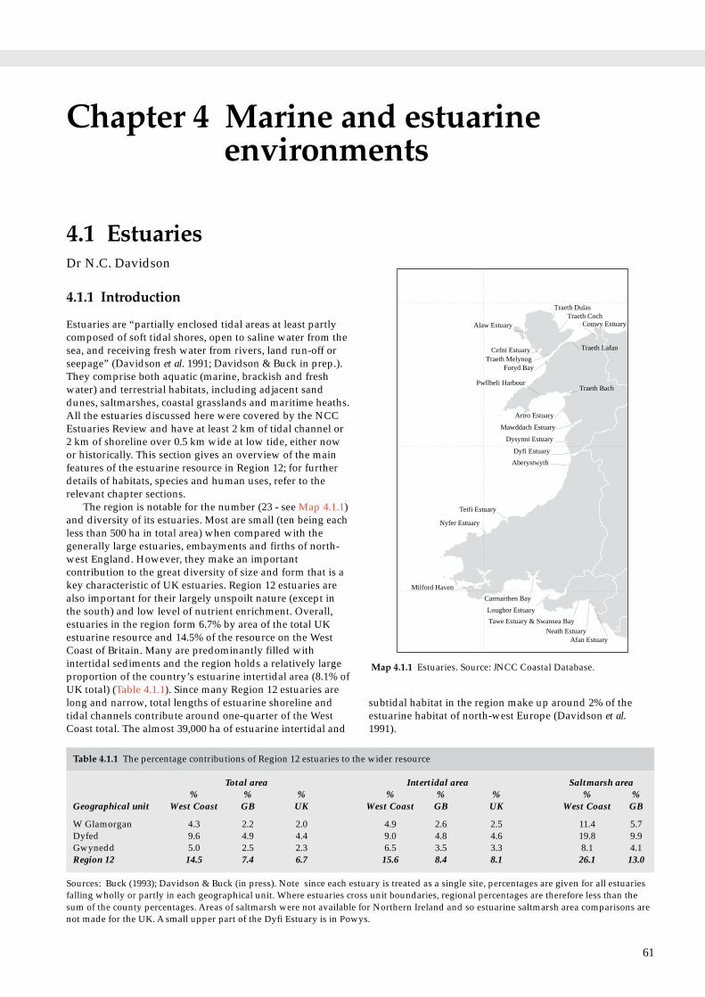
Chapter 4 Marine and estuarineenvironments
Conwy EstuaryTraeth Coch
Traeth Dulas
Alaw Estuary
Cefni EstuaryTraeth Melynog
Traeth Lafan
Foryd Bay
Pwllheli HarbourTraeth Bach
Artro Estuary
Mawddach Estuary
Dysynni Estuary
Dyfi Estuary
Aberystwyth
Teifi Estuary
Nyfer Estuary
Milford Haven
Carmarthen Bay
Loughor Estuary
Tawe Estuary & Swansea Bay
Neath EstuaryAfan Estuary
Map 4.1.1 Estuaries. Source: JNCC Coastal Database.
4.1.1 Introduction
Estuaries are “partially enclosed tidal areas at least partlycomposed of soft tidal shores, open to saline water from thesea, and receiving fresh water from rivers, land run-off orseepage” (Davidson et al. 1991; Davidson & Buck in prep.).They comprise both aquatic (marine, brackish and freshwater) and terrestrial habitats, including adjacent sanddunes, saltmarshes, coastal grasslands and maritime heaths.All the estuaries discussed here were covered by the NCCEstuaries Review and have at least 2 km of tidal channel or 2 km of shoreline over 0.5 km wide at low tide, either nowor historically. This section gives an overview of the mainfeatures of the estuarine resource in Region 12; for furtherdetails of habitats, species and human uses, refer to therelevant chapter sections.
The region is notable for the number (23 - see Map 4.1.1)and diversity of its estuaries. Most are small (ten being eachless than 500 ha in total area) when compared with thegenerally large estuaries, embayments and firths of north-west England. However, they make an importantcontribution to the great diversity of size and form that is akey characteristic of UK estuaries. Region 12 estuaries arealso important for their largely unspoilt nature (except inthe south) and low level of nutrient enrichment. Overall,estuaries in the region form 6.7% by area of the total UKestuarine resource and 14.5% of the resource on the WestCoast of Britain. Many are predominantly filled withintertidal sediments and the region holds a relatively largeproportion of the country’s estuarine intertidal area (8.1% ofUK total) (Table 4.1.1). Since many Region 12 estuaries arelong and narrow, total lengths of estuarine shoreline andtidal channels contribute around one-quarter of the WestCoast total. The almost 39,000 ha of estuarine intertidal and
4.1 EstuariesDr N.C. Davidson
Table 4.1.1 The percentage contributions of Region 12 estuaries to the
Total area% % %
Geographical unit West Coast GB UK
W Glamorgan 4.3 2.2 2.0Dyfed 9.6 4.9 4.4Gwynedd 5.0 2.5 2.3Region 12 14.5 7.4 6.7
Sources: Buck (1993); Davidson & Buck (in press). Note since each estufalling wholly or partly in each geographical unit. Where estuaries crossum of the county percentages. Areas of saltmarsh were not available fnot made for the UK. A small upper part of the Dyfi Estuary is in Powy
subtidal habitat in the region make up around 2% of theestuarine habitat of north-west Europe (Davidson et al.1991).
61
wider resource
Intertidal area Saltmarsh area% % % % %
West Coast GB UK West Coast GB
4.9 2.6 2.5 11.4 5.79.0 4.8 4.6 19.8 9.96.5 3.5 3.3 8.1 4.115.6 8.4 8.1 26.1 13.0
ary is treated as a single site, percentages are given for all estuariess unit boundaries, regional percentages are therefore less than theor Northern Ireland and so estuarine saltmarsh area comparisons ares.

Region 12 Chapter 4 Marine and estuarine environments
Table 4.1.2 Total size of Region 12 estuaries
Geographical unit Total area Intertidal Saltmarsh Shoreline Longestarea length channel
ha ha ha km km
W Glamorgan 11,476 8,398 2,346 139.3 49.8Dyfed 25,641 15,417 4,085 457.5 131.4Gwynedd 13,242 11,126 1,677 337.5 125.3Region 12 total 38,881 26,864 5,375 797.4 256.9
Note: Since each estuary is treated as a single site, totals are givenfor all estuaries falling wholly or partly in each geographical unit.Where estuaries cross unit boundaries, regional totals are less thanthe sum of the county totals. Areas of saltmarsh were not availablefor Northern Ireland and so estuarine saltmarsh area comparisonsare not made for the UK. A small upper part of the Dyfi Estuary isin Powys.
4.1.2 Important sites, species and features
Within Region 12 much of the resource is in Dyfed, since thethree largest estuaries are partly or wholly within thecounty: almost 60% of total estuary area in the region lieswithin Dyfed, as does over three-quarters of saltmarsh area.The four estuaries partly or wholly in West Glamorgan formalmost 30% of the total regional area, mainly because thisincludes the large Loughor Estuary, whose major areas ofsaltmarsh lie on the southern (West Glamorgan) shore. Inthe north of the region, Gwynedd contains more than half ofthe region’s estuaries, although these small, varied andlargely unspoilt estuaries together form only 30-40% ofareas and shoreline and channel lengths. Only a small partof the upper reaches of the Dyfi Estuary lies within Powys.Table 4.1.2 gives the total size of estuarine features in theregion.
All the region’s estuaries are macrotidal (i.e. their springtidal range exceeds 4 m). Tidal ranges are greatest (over 8 m)in the south of the region and least around Cardigan Bay(4.0-4.5 m). Physical characteristics of each estuary aresummarised in Table 4.1.3.
The largest estuaries in the region are in the south: theLoughor Estuary, Carmarthen Bay and Milford Haven arethe only estuaries in the region larger than 5,000 ha; together
62
Table 4.1.3 Physical characteristics of Region 12 estuaries
Estuary Centre Geomorphologicagrid reference type
W Glamorgan10. Afan Estuary SS7588 Bar-built11. Neath Estuary SS7292 Ria12. Tawe & Swansea Bay SS6694 Embayment
W Glamorgan/Dyfed13. Loughor Estuary SS4897 Coastal plain
Dyfed14. Carmarthen Bay SN3408 Embayment15. Milford Haven SM9403 Ria16. Nyfer Estuary SN0540 Bar-built17. Teifi Estuary SN1648 Bar-built18. Aberystwyth SN5980 Bar-built
Dyfed/ Powys/Gwynedd19. Dyfi Estuary SN6495 Bar-built
Gwynedd20. Dysynni Estuary SH5802 Bar-built21. Mawddach Estuary SH6416 Bar-built22. Artro Estuary SH5725 Bar-built23. Traeth Bach SH5736 Bar-built24. Pwllheli Harbour SH3835 Bar-built25. Foryd Bay SH4559 Bar-built26. Traeth Melynog SH4364 Bar-built27. Cefni Estuary SH4067 Bar-built28. Alaw Estuary SH3081 Fjard29. Traeth Dulas SH4888 Bar-built30. Traeth Coch SH5380 Embayment31. Traeth Lafan SH6375 Linear shore32. Conwy Estuary SH7976 Coastal plain
Sources: Buck (1993); JNCC Integrated Coastal database. Note: Estuary‘Geomorphological type’ classifies estuaries into nine categories, descriof Davidson & Buck (in press). ‘Spring tidal ranges’ are for the closest sremaining water-filled at mean low water.
they form almost 60% of the total estuary area in the region.They also contain by far the largest areas of saltmarsh andsupport nationally and internationally important numbersof wintering waterfowl. Further north are nine bar-builtestuaries flowing into Cardigan Bay - predominantly sandyestuaries almost completely draining at low tide and closedby shingle spits and bars derived from offshore glacialdeposits. Many of these spits are now capped by sandcomprising some of the best examples in Britain of well-
l Total Inter- Salt- Shore- Main Spring Subarea tidal marsh line channel tidal tidal
area length length rangeha ha ha km km m %
38 18 0 4.9 2.5 8.6 52.61,129 1,079 159 26.9 10.6 8.6 4.4
785 748 0 22.8 6.5 8.6 4.7
9,524 6,553 2,187 84.7 30.2 7.1 31.2
8,295 5,369 910 115.7 30.7 7.5 35.35,448 1,710 385 170.7 35.4 6.3 68.6
100 75 10 6.1 3.1 4.0 25.0302 181 46 21.0 10.0 4.1 40.0
18 5 1 7.1 2.4 4.3 72.2
1,954 1,524 546 52.2 19.6 4.3 22.0
117 69 22 9.9 4.4 4.3 41.01,159 976 219 37.7 13.6 4.3 15.8
120 114 10 7.4 1.7 4.4 5.02,050 1,750 348 54.0 15.7 4.4 14.6
85 60 3 4.6 2.4 4.5 29.4343 285 123 9.4 4.5 4.7 16.9365 314 66 10.9 5.4 4.7 14.0744 614 111 26.1 12.7 4.7 17.5
1,085 721 63 38.2 10.4 5.0 33.5103 103 21 5.2 2.9 6.4 0.0583 583 31 10.0 4.4 6.4 0.0
3,040 2,932 9 16.1 2.9 6.9 3.61,494 1,081 105 55.8 24.7 7.1 27.6
numbers are those used in An inventory of UK estuaries.bed further in Chapter 5.7 of Davidson et al. (1991) and Chapter 4.5tation to the mouth of the estuary. Subtidal includes tidal channels

4.1 Estuaries
Table 4.1.4 Human influences and water flows on Region 12 estuaries
Estuary Centre grid Human use type Water Catchment Averagereference quality area freshwater
urban industrial rural recreational km2 m3s-1
10. Afan Estuary SS7588 • • A -11. Neath Estuary SS7292 • • B(A) 321 13.412. Tawe & Swansea Bay SS6694 • • • A 246 13.113. Loughor Estuary SS4897 • • • • A 262 5.614. Carmarthen Bay SN3408 • • (B)A 1,849** 50.5**15. Milford Haven SM9403 • • • • A 550 18.5*16. Nyfer Estuary SN0540 • A -17. Teifi Estuary SN1648 • • A 1,008 31.418. Aberystwyth SN5980 • • A 193 6.519. Dyfi Estuary SN6495 • • A 471 58.420. Dysynni Estuary SH5802 • • A 75 4.621. Mawddach Estuary SH6416 • • A 249 (11.2)22. Artro Estuary SH5725 • • A - -23. Traeth Bach SH5736 • • • A(B) 192 (10.0)24. Pwllheli Harbour SH3835 • • - - -25. Foryd Bay SH4559 • • A 48 2.426. Traeth Melynog SH4364 • • - - -27. Cefni Estuary SH4067 • • B(A) - -28. Alaw Estuary SH3081 • • A - -29. Traeth Dulas SH4888 • • - - -30. Traeth Coch SH5380 • • - - -31. Traeth Lafan SH6375 • • • A 82 (4.1)32. Conwy Estuary SH7976 • • • A(B) 345 17.8
Sources: Buck (1993) An inventory of UK estuaries. Vol. 2. South-west Britain; National Rivers Authority (1991); Hobbs & Morgan (1992);CCW (1993). Note: ‘Human use types’ are coded as major (•) or minor (•) use types. Where more than one ‘water quality’ code is shown,these are in downstream sequence, with brackets indicating a water quality referring in a small part of the estuary. * indicates median flowmeasure; ** excludes Gwendraeth; bracketed water flow figures are estimates.
developed sand-dune systems, notably at the mouths of the Dyfi Estuary and Traeth Bach, and also borderingCarmarthen Bay further south. In the northern part of theregion are the bays and inlets forming parts of the MenaiStrait and the largely unspoilt estuaries and bays around thecoasts of Anglesey, including the shallow, sheltered glacialbasin of the Alaw Estuary/Inland Sea.
There are sand dunes and saltmarshes of nationalconservation significance on several of the larger estuariesin the region, and some estuaries, notably Milford Havenand those in the Menai Strait, are important for their marinebiological interest. Many, especially in south Dyfed and inGwynedd, are of conservation importance for fish (notablyshad and lamprey). A nationally rare plant (Welsh mudwortLimosella australis) is known in Britain only from the DysinniEstuary and Traeth Bach; and three large estuaries in theregion support internationally important waterfowlpopulations. All but one of the region’s estuaries are at leastin part Sites of Special Scientific Interest (SSSIs) for theirgeological or wildlife interest; four (Loughor Estuary,Carmarthen Bay, Dyfi Estuary and Lavan Sands) aredesignated as internationally important for their wetlandhabitat and the migratory waterfowl they support.
4.1.3 Human activities
Table 4.1.4 summarises the major human influences andwater quality for estuaries in the region.
Estuaries in the south of the region have been muchmodified by past and present industrial use and arebordered at least in part by urban landscapes. In contrast,the estuaries of Dyfed and Gwynedd are predominantly
rural and include some of the most unspoilt estuaries insouthern Britain, although large parts of some, such asTraeth Bach, the Artro Estuary and Pwllheli Harbour, havebeen claimed or otherwise modified during the last 200years. In the north-west of Region 12 the long narrowConwy estuary has been extensively modified in its lowerreaches by recent road tunnel construction. Although low-lying parts of most of the estuaries have sea-defences(usually low sea-walls), the often steeply rising or rockyshores mean than much of the shoreline is natural. Manyestuaries in the west and north of the region are usedextensively for recreation and there is widespreadexploitation of natural resources, for instance throughsaltmarsh grazing, shellfisheries and bait collection.
Estuaries in this region, particularly those in CardiganBay, are generally very shallow and sandy and have lownutrient status, a consequence of their mountainouscatchments with low intensity agriculture. The largestcatchment areas discharge through Carmarthen Bay, TeifiEstuary and Milford Haven, with the largest freshwaterdischarges being through Carmarthen Bay, Dyfi Estuary andTeifi Estuary. Estuarine water quality is mostly rated goodthroughout the region, although the Conwy and some otherestuaries (e.g. Traeth Dulas and the Mawddach Estuary) inthe northern half of the region have high levels of heavymetals, derived from both natural leachate and former mineworkings, in their river inflows.
Historically many of the region’s estuaries wereimportant ports, notably during Roman times for thetransport of metals, and later for coal in the south and forslate in the north. Now there are important ports in thesouth, and Milford Haven is a major centre for oil transportand refining.
63

Region 12 Chapter 4 Marine and estuarine environments
4.1.4 Information sources used
This chapter is summarised chiefly from JNCC’s Aninventory of UK estuaries, being published in six regionalvolumes along with an introduction and methods volume.All estuaries in Region 12 are included in Volume 2. South-west Britain (Buck 1993). Data presented in the inventory aredrawn largely from material collected during 1989-90(updated to 1993 where appropriate) for the NCC’sEstuaries Review (Davidson et al. 1991). Saltmarsh datacome originally from Burd (1989), whose surveys coveredsaltmarshes mostly >0.5 ha.
Hydrological data, for example on catchment areas andriver flows, for some but not all estuaries as defined here,are available from sources including National RiversAuthority Catchment Management Plans (from early 1995for the Tawe Estuary, Milford Haven, Menai Strait andConwy Estuary). For other estuaries, information is readilyavailable for only some parts of the catchment, often thoseupstream of tidal limits.
4.1.5 Further sources of information
A. References cited
Buck, A.L. 1993. An inventory of UK estuaries. 2. South-west Britain.Peterborough, Joint Nature Conservation Committee. (Coversall Region 12 estuaries. Copies of separately-bound individualsite dossiers are also available from Coastal ConservationBranch, JNCC.)
Burd, F. 1989. The saltmarsh survey of Great Britain. Peterborough,Nature Conservancy Council. (Research & survey in natureconservation, No. 17.)
Countryside Council for Wales. 1993. A review of Welsh estuaries.Bangor, Countryside Council for Wales.
Davidson, N.C., Laffoley, D.d’A., Doody, J.P., Way, L.S., Gordon, J.,Key, R., Drake, C.M., Pienkowski, M.W., Mitchell, R.M., & Duff,K.L. 1991. Nature conservation and estuaries in Great Britain.Peterborough, Nature Conservancy Council.
Davidson, N.C., & Buck, A.L. In prep.. An inventory of UK estuaries.1. Introduction and methods. Peterborough, Joint NatureConservation Committee.
Hobbs, G., & Morgan, C.I., eds. 1992. A review of the environmentalknowledge of the Milford Haven waterway. Pembroke, FieldStudies Council Research Centre.
National Rivers Authority. 1991. The quality of rivers, canals andestuaries in England and Wales. Bristol, National RiversAuthority. (Water Quality series, No. 4.)
B. Further reading
Further details of estuaries are in the Coastal & Marine UKDMAPdatasets module (Barne et al 1994), available from JNCC CoastalConservation Branch, Peterborough. A list of selected furtherreading for each estuary discussed in section 4.1 is given inBuck (1993) (above).
Barne, J., Davidson, N.C., Hill, T.O., & Jones, M. 1994. Coastal andMarine UKDMAP datasets: a user manual. Peterborough, JointNature Conservation Committee.
Davidson, N.C. 1991. Estuaries, wildlife and man. Peterborough,Nature Conservancy Council.
Davidson, N.C., & Buck, A.L. In prep. An inventory of UK estuaries.1. Introduction and methods. Peterborough, Joint NatureConservation Committee.
64
Noble, L., ed. 1993. Estuaries and coastal waters of the British Isles. Anannual bibliography of recent scientific papers. Number 17.Plymouth, Plymouth Marine Laboratory and Marine BiologicalAssociation.
Peck, K. 1993. Estuaries Inventory - research towards a betterunderstanding of the interactions between birds and humanactivities on UK estuaries. RSPB Conservation Review 7, 42-46.
Young, G.A. Undated. The Menai Strait: a review and bibliography ofliterature from the Wolfson Library. Unpublished report to CCW.
Marsh, T.J., & Lees, M.L., eds. 1993. Hydrometric register and statistics1986-90. Wallingford, Institute of Hydrology.
C. Contact names and addresses
Type of information Contact address and telephone no.
National database of *Coastal Conservation estuaries;coastal habitats; Branch, JNCC, Peterborough, statutory & non-statutory tel. 01733 62626 protected sites.
Statutory protected sites; *Coastal & Marine Ecologists/detailed wildlife site Coastal Scientist/Marine &information; coastal Coastal Policy Officer, CCWgeomorphology. Numerical HQ, Bangor, tel. 01248 370444and some digitised data.
RSPB Estuaries Inventory: *Estuaries Inventory Projectmapped and numerical Officer, RSPB, Sandy,information on land use and tel. 01767 680551selected human activities for57 major UK estuaries, including Loughor Estuary andMilford Haven in Region 12.
National River Flow Archive: National Water Archive catchments and river flows Manager, Institute of from upstream gauging Hydrology, Maclean Building,stations; interpreted analyses Crowmarsh Gifford,for whole estuaries. Wallingford, Oxfordshire
OX10 8BB, tel. 01491 838800
* Starred contact addresses are given in full in the Appendix
4.1.6 Acknowledgements
Thanks to John Barne for help in preparing data used in thischapter and to Dr Rod Jones (CCW) and Steve May (DyfedCounty Council) for helpful comments.

4.2 The sea bed
Table 4.2.1 Locations (1 kilometre squares) of sites of importancementioned in the text
Site no. Name Grid ref.
1 Margam Sands SS77852 Oxwich Bay SS51873 Rhossili Bay SS41904 Whiteford Sands SS43955 Whiteford Scar SS44976 Caldey Island SS12977 Greenala Point SS00968 Stackpole Head SR99949 Castlemartin peninsula SR889910 West Angle Bay SM850311 Angle Bay SM880212 Pennar Gut/Pennar Mouth SM940313 Pembroke River SM950214 Lawrenny SN010715 Stack Rock SM870416 Dale/Gann Flats SM810617 Marloes peninsula SM7018 Skokholm SM730519 Broad Sound SM730720 Skomer Island SM720921 Grassholm SM590922 St David's peninsula SM7223 Ramsey Sound SM712424 Abereiddy Quarry SM7931
4.2.1 Introduction
This section covers the occurrence and distribution of raregroups of species (communities) that live on the sea bed; thedistribution and occurrence of indivually rare and scarcespecies in covered in section 5.4.
There are a large number of areas within this region thatare of considerable conservation importance because of theirmarine biological interest, especially the Pembrokeshire coast,which has a particularly high density of such sites.Information on the precise extent of shore and sea bed types ina GB context is not yet available. However, the whole of theMilford Haven and Daugleddau estuary system is of nationalnature conservation importance as one of the best examples ofa ria system (a flooded valley) in Britain, presenting a widevariety of habitats and communities (Davies 1991). Thewaters and intertidal areas of Skomer and the adjacentMarloes peninsula became Wales’s first (and Britain’s second)statutory Marine Nature Reserve in 1990. The Menai Straitand its adjacent areas have been put forward as a possiblefuture Marine Nature Reserve, as has Ynys Enlli with part ofthe Llyn Peninsula. The Menai Strait and Bardsey Soundexperience some of the strongest tidal streams in the Irish Sea,and the Menai Strait also provides extreme shelter from waveaction. There are a number of biogeographic boundariespresent within the region, at Swansea Bay (Hiscock 1979), St David’s Head (Davies 1991), the Llyn Peninsula, andCarmel Head on Anglesey (Crisp & Knight Jones 1955).
Awide variety of both littoral (shoreline) and sublittoralhabitats and their associated communities is represented.Shores range from exposed vertical rocky cliffs and boulderbeaches to open sandy bays and sheltered muddy estuaries.Near-shore sublittoral habitats are also rich and varied.Sheltered areas of sand and mud are found within the region'sestuaries and those bays not facing south-west. Coarsersediments, ranging from clean sand to pebbles and cobbles,occur off exposed bays and in tidal channels. In general,sheltered sites have greater conservation interest, as onexposed sites wave action increases the mobility of sediment,leading to reduced species richness and lower biomass in thecommunities present. Rocky substrates in the region areaffected by a wide range of physical conditions includingvarying exposure to waves and tidal currents. Anumber ofwrecks (ships, aircraft and other solid material) occur off theregion's coast. They offer hard substrate in areas that mayotherwise be largely sedimentary, providing habitats foropportunistic colonising species that otherwise would not bepresent.
4.2 The sea bed R.A. Irving
25 Sarn Badrig SH472026 Criccieth SH503827 St Tudwall’s Island SH342628 Pen-y-Cil SH152429 Ynys Enlli SH122230 Bardsey Sound SH132431 Porth Dinllaen SH274132 Menai Strait SH5733 'Inland Sea', Anglesey SH277934 Penrhyn Bay SH8381
4.2.2 Important locations and communities
Swansea Bay and Carmarthen Bays (including the Gowerpeninsula)
An extensive area of muddy sand borders much of SwanseaBay, with clean sand on the more exposed beaches of Margam
Sands, Oxwich Bay and Rhossili Bay. The Gower peninsulaexhibits some of the best moderately-exposed limestoneshores in Britain, the whole of the peninsula being describedby Powell et al. (1979) as of prime marine biologicalimportance. The whole of the Burry Inlet is of regionalconservation importance for its intertidal sedimentcommunities and the tide-swept boulder and mussel scarcommunities at Whiteford Scar, which include rich algalcommunities (Moore 1989). Whiteford Sands were consideredby Bishop & Holme (1980) to be of prime marine biologicalimportance for their well-developed Tellina (a burrowingbivalve) community.
In the near-shore sublittoral, particularly rich animalcommunities have been recorded growing on vertical andoverhanging surfaces of rock around the Gower peninsula(Hiscock 1979). The high turbidity of the water here restrictsthe depth to which algae can grow to no more than 3 m belowchart datum.
65
Region 12 Chapter 4 Marine and estuarine environments
The Pembrokeshire coast: Tenby to Cardigan
Awide range of shore types is present along this dramaticstretch of coast, from exposed bedrock on headlands tosheltered sandy coves, and sheltered mud in the estuaries (e.g.the Pembroke River). On the north-west tip of Caldey Islandrich shore communities were recorded by Warren & George(1988, in Davies (1991)). At the base of the exposed limestonecliffs of the Castlemartin peninsula are some of the finestexamples of rocky shore communities in Wales (Powell et al.1979).
At the mouth of Milford Haven, the shore platforms atWest Angle Bay are of considerable importance, particularlyfor the algal communities within rockpools (Powell et al. 1979).Within the Haven, several sediment areas are of merit: AngleBay has particularly rich infaunal communities (Powell et al.1979); the embayment of the Pembroke River was consideredby Rostron et al. (1986) to exhibit high species diversity,compared with other estuarine areas in the British Isles;sediment shores at Lawrenny had a rich polychaetecommunity (Powell et al. 1979); and the ‘Arenicola’ and‘Pullastra’ communities present at Dale/Gann Flats wereconsidered by Bishop & Holme (1980) to be of prime marinebiological importance. At Pennar Gut/Pennar Mouth, Little &Hiscock (1987) considered the sheltered bedrock and stableboulders to be regionally important, owing to their rich biotaand some rarely encountered species. Beds of seagrass Zosteraspp., providing a rarely encountered shallow-water habitat,are present in Angle Bay and in the embayment of thePembroke River. The larger seagrass Zostera marina ispresent on shallow sublittoral sand/mud near Stack Rock,Milford Haven (Little & Hiscock 1987), with extensive bedsoccurring close by between the Esso and Amoco jetties.Important maerl beds (an unusual calcareous alga) have alsobeen recorded near Stack Rock (Little & Hiscock 1987), andalthough scattered and broken, their algal communities wereregarded as even richer than those found in the Fal estuary inCornwall.
Outside Milford Haven, to the west, the rocky shores ofthe Marloes peninsula (and those of the St David’s peninsulaat the northern end of St Bride's Bay) are considered to be ofprimary marine biological importance (Powell et al. 1979).Skomer Island’s rocky shores provide a wide variety ofhabitats and communities, as well as providing classicexamples of extremely exposed shores (Bunker et al. 1983). Asmall bed of the seagrass Zostera marina occurs in NorthHaven. Well-developed rockpool communities have beenidentified at West Tump on Grassholm (Powell et al. 1979); andboth Grassholm and Skokholm also exhibit good examples ofvery exposed rocky shores.
The near-shore sublittoral habitats and communities alongmuch of the Pembrokeshire coast are also rich and varied. Thecommunities present on limestone and sandstone bedrockfrom Greenala Point to Stackpole Head were considered byHiscock (1981) to be of “outstanding scientific interest”. Ofspecial note here are the communities found on, and boringinto, limestone. There are also rich sediment communities inthis area, with dense populations of the heart urchinEchinocardium cordatum and razor-clams Ensis spp. (Davies1991). In Milford Haven, the wave-sheltered bedrock andboulder habitats exposed to moderate tidal streams areconsidered to be of national conservation importance becauseof their highly distinctive ‘ria’ communities (Little & Hiscock1987). Here there are few interesting algal communities
66
because of the shallowness of the water, but animalcommunities include large numbers of a small range ofspecies characteristic of ria communities. Communitiespresent in the Daugleddau are the best-developed and mostextensive examples of their type known in south-west Britain(Davies 1991). The sublittoral sediment communitiesthroughout Milford Haven have a strong southern influence,with many species reaching their northern distributional limitwithin the region (Rostron et al. 1983). The cobble and pebblehabitat present off Lawrenny in the Daugleddau is of regionalconservation importance (Little & Hiscock 1987).
Pembrokeshire’s islands are also of considerable marinebiological interest. Skomer Island exhibits an outstandingrange of sublittoral habitats in a small area. The undisturbedbedrock and large boulders are of national marine natureconservation importance, and the communities on disturbedbedrock and boulders; medium and small boulders; stonesand pebbles; and wrecks are regionally important (Bunker &Hiscock 1987). The circalittoral animal communities(especially of sponges) subject to tidal water movement withinBroad Sound are particularly interesting. The shelteredsediments found at Skomer are of regional conservationimportance (Bunker & Hiscock 1987). Though a similar rangeof habitats and communities exists at Grassholm and atSkokholm, the diversity is not as high as at the adjacent islandof Skomer (Hiscock 1980, 1981). Ramsey Sound is an area of“outstanding scientific interest” (Hiscock 1981), the verystrong tidal streams in the centre of the Sound giving rise to adistinctive community not encountered elsewhere in south-west Britain. The communities of southern St Bride's Bay areunusual for the large number of echinoderm speciesencountered (Hiscock 1980). Abereiddy Quarry is a disusedslate quarry flooded with sea water, giving rise to an unusualsheltered habitat, thought to be unique in south-west Britain.
Cardigan Bay: Cardigan to Abersoch
The shores of Cardigan Bay range from rock, boulders andshingle (mostly found in the south), backed by low cliffs, toextensive sandy beaches (predominating in the north).Descriptions of littoral communities are extremely limited,though some sites in the south of the Bay were surveyed byPowell et al. (1979). At a number of locations, for example atCriccieth, patch reefs of the polychaete Sabellaria alveolataoccur. The sandy estuarine sediments support fewinvertebrate species, in relatively now numbers.
In the near-shore sublittoral, shallow boulder reefs (knownas ‘sarnau’) provide outcrops of hard substrata within the bay.These are subject to considerable wave exposure and strongtidal streams. In particular, Sarn Badrig, also known as St Patrick’s Causeway, is a very impressive topographicalfeature (Hiscock 1986). Rising from a depth of 10 m, thejumble of boulders, cobbles and pebbles breaks the surface atlow water at intervals along its length, up to 17 km offshore.Elsewhere, the sea bed is largely sandy sediment: there areextensive sand banks in the outer bay aligned in the directionof tidal streams. The marine fauna and flora of the bay iscomparatively poorly-known.
The Llyn Peninsula, Anglesey and the Menai Strait
This stretch of coast again has a varied range of habitats, withrocky shores interspersed with small sandy bays and muddyinlets. The habitats present in a cave on St Tudwall’s Island
4.2 The sea bed
3433
32
31
30
2928 27
26
25
24
23
22
21
9–1115–20 12, 13 8 7 6
14
54
3
21
Map 4.2.1 Littoral surveys recorded on the MNCR database(source: JNCC) and key locations of marine biologicalimportance described in the text.
are of high conservation interest (Rostron 1984), as are those ina subtidal tunnel at Pen-y-Cil, opposite Ynys Enlli (Hiscock1984). The wide variety of littoral communities present atYnys Enlli are of conservation importance (Rostron 1984), andinclude good examples of exposed rocky shore communitiesand several rare algal species (see section 5.4). The tide-sweptcircalittoral communities on bedrock, boulders, cobbles andpebbles in Bardsey Sound are of considerable conservationimportance (Hiscock 1984), as this habitat type is uncommonin southern Britain.
Extensive Zostera marina seagrass beds occur in thesheltered bay of Porth Dinllaen on the north of the Llyn coast,considerably larger than those found within the 'Inland Sea'on the west coast of Anglesey (I. Rees, pers. comm). TheInland Sea, a shallow partially enclosed sea area studied byJones (1978, in Davies (1991)), has only a limited waterexchange with the open sea, giving rise to an unusual tidalregime and consequent peculiarities in the zonation patternsof its biota. Hiscock (1976) described the fauna from 32 rockysublittoral sites around Anglesey, identifying characteristiccommunities from the west, north and east coasts and theMenai Strait. West coast communities were typified by densebryozoan cover with polyclinid tunicates, the hydroidNemertesia antennina and the feather star Antedon bifida. Alsopresent were the soft coral Alcyonium digitatum, the massiveform of the sponge Cliona celata and the anemone Actinothoesphyrodeta. On the north coast Antedon bifida and the brittlestarOphiothrix fragilis were present in dense beds, with thesponges Polymastia spp. and Suberites carnosus. On the eastcoast, Alcyonium digitatum and the anemone Metridium seniledominated. The distribution of species was found to berelated primarily to water quality and geographical locationaround Anglesey, and secondly to the degree of exposure towave action and the strength of tidal streams.
The Menai Strait has been put forward by the NatureConservancy Council (1988) and CCW (1992) as a MarineNature Reserve. The shallow tide-swept communities presenthere (determined largely by the strength of the current theycan tolerate) are of national marine nature conservationimportance, owing in part to the wide range of habitats andspecies present. Asummary of the biological interest of theStrait's littoral zone is provided by Jones (1983), and of thesublittoral zone by Lumb (1983). The Lafan Sands areextensive sediment flats at the northern entrance to the MenaiStrait, whose invertebrate macrofauna was described by Eagleet al. (1974, in Davies (1991)). Beyond the peninsula of theGreat Orme, a small area of peat beds (a rare intertidal habitat)is present at Penrhyn Bay, near Little Orme's Head.
Offshore
The offshore zone is taken to mean areas either more than 3 km offshore or greater than 50 m in depth. Far less recentinformation is available on benthic habitats and communitiesfrom offshore locations. The early pioneering work of Laurie& Watkin (1922) provided valuable records of Cardigan Bay'sbenthic fauna. More recently, the full results from benthicsurveys of the southern Irish Sea by the National Museum ofWales were published in October 1994, following informationpublished by Mackie (1990). Survey details for Caernarfonand Cardigan Bays can be found in Huckbody et al. (1992),where four communities are distinguished: the 'shallow Venuscommunity' typical of clean, mobile sands, the 'deep Venuscommunity' in deeper areas with muddier but coarser sands,
and the 'Amphiura' and 'Abra' communities typical of moresheltered areas in Cardigan Bay. The paucity of information tothe north and west of Anglesey is largely due to the hardnessof the substrata, which cannot be sampled effectively usinggrabs.
An area approximately 10 km north of the tip of the LlynPeninsula was surveyed in late 1992, as part of anenvironmental assessment study prior to proposedexploratory oil drilling; it found a substratum of tide-sweptcobbles and pebbles embedded in a sediment matrix (Rees1992).
4.2.3 Human activities
The human activities that affect sea-bed habitats andcommunities in the region are described in Sections 9.1and 9.2.
4.2.4 Information sources used
JNCC’s Marine Nature Conservation Review (MNCR) uses astandard recording methodology for littoral and sublittoralsurveys, which describe both habitats and their associatedcommunities (Hiscock 1990). Survey information from othersources may vary considerably in its methodology andcoverage. Two major NCC resource surveys include coverageof this region: the South-west Britain sublittoral survey
67

Region 12 Chapter 4 Marine and estuarine environments
Map 4.2.2 Near-shore sublittoral surveys recorded on the MNCRdatabase. Source: JNCC.
(1978-81); and the Survey of harbours, rias and estuaries insouthern Britain (1985-89). The Smalls, a group of isolatedrocky islets situated 25 km west of Skomer, were investigatedby an MNCR diving team in August 1994. The MNCR willsurvey Cardigan Bay during 1995/96. Table 4.2.2 shows thenumber of sites with marine benthic (sea-bed) habitat andspecies information held on the MNCR database. Maps 4.2.1and 4.2.2 show the locations of surveys recorded on thedatabase. Note, however, that this information is not yet fullycomprehensive. Records additional to those cited here mayexist in sources that have yet to be consulted.
Anglesey's rocky shores are described in Lewis (1953) and
Table 4.2.2 Number of sites with marine benthic habitat andspecies information held on the MNCR database
Littoral Near-shore sublittoral Offshore Total
237 314 0 551
its general marine biology in Jones (1990). The MarineLaboratories at Menai Bridge have been involved with manystudies of the island's shores over the years (see section 4.2.5).By contrast, sublittoral areas are poorly recorded. Astudy of apopulation of the sea pen Virgularia mirabilis in HolyheadHarbour (SH2484) was reported by Hoare & Wilson (1977).
The Countryside Council for Wales (CCW) is currentlyundertaking an initial survey of littoral habitats of the wholeWelsh coast. The sublittoral habitats and communities ofCardigan Bay are currently being investigated by sports diversas part of the Marine Conservation Society’s ‘Seasearch’
68
project. Additional information on biotope mapping (incentral Cardigan Bay, on the north side of the Llyn Peninsulaand the central Menai Strait) is being gathered by the BioMarproject (see section 4.2.5). Other sources of informationinclude Admiralty charts and British Geological Survey maps.
4.2.5 Further sources of information
A. References cited
Bishop, G.M., & Holme, N.A. 1980. Survey of the littoral zone ofthe coast of Great Britain. Final Report - part 1: The sedimentshores - an assessment of their conservation value. (Contractor:Marine Biological Association/Scottish Marine biologicalAssociation, Plymouth.) Nature Conservancy Council, CSDReport, No. 326.
Bunker, F.St.P.D., & Hiscock, S. 1987. Sublittoral habitats,communities and species of the Skomer marine reserve - areview. (Contractor: Field Studies Council, Pembroke.) NatureConservancy Council, CSD Report, No. 747. FSC Report, No.OFC/1/87.
Bunker, F.St.P.D., Iball, K., & Crump, R. 1983. Skomer MarineReserve. Littoral survey. (Contractor: Field Studies Council OilPollution Research Unit, Pembroke.) Nature ConservancyCouncil, CSD Report, No. 901.
Countryside Council for Wales. 1992. Menai Strait proposed MarineNature Reserve. Revised Consultative document. Bangor, CCW.
Crisp, D.J., & Knight Jones, E.W. 1955. Discontinuities in thedistribution of shore animals in north Wales. Report of BardseyBird and Field Observatory, 2: 29-34.
Davies, J. 1991. Benthic marine ecosystems of Great Britain: a review ofcurrent knowledge. Bristol Channel and approaches (MNCR Sector9). Peterborough, Joint Nature Conservation Committee,Marine Nature Conservation Review Report.
Hiscock, K. 1976. The influence of water movements on the ecology ofsublittoral rocky areas. PhD thesis, University College of NorthWales, Bangor.
Hiscock, K. 1979. South-west Britain sublittoral survey. Fieldsurveys of sublittoral habitats and species along the Gowercoast. June 25th to 30th, 1978. (Contractor: Field StudiesCouncil Oil Pollution Research Unit, Pembroke.) NatureConservancy Council, CSD Report, No. 274.
Hiscock, K. 1980. South-west Britain sublittoral survey. Fieldsurveys of sublittoral habitats and species in westPembrokeshire (Grassholm, Skomer and Marloes Peninsula).(Contractor: Field Studies Council Oil Pollution Research Unit,Pembroke.) Nature Conservancy Council, CSD Report, No. 301.
Hiscock, K. 1981. South-west Britain sublittoral survey. FinalReport. (Contractor: Field Studies Council Oil PollutionResearch Unit, Pembroke.) Nature Conservancy Council, CSDReport, No. 327.
Hiscock, K. 1984. Sublittoral survey of Bardsey and the Lleynpeninsula. 13-27 August, 1983. (Contractor: Field StudiesCouncil Oil Pollution Research Unit, Pembroke.) NatureConservancy Council, CSD Report, No. 612.
Hiscock, K. 1990. Marine Nature Conservation Review: Methods.Nature Conservancy Council, CSD Report, No. 1072. (MarineNature Conservation Review Report, No. MNCR/OR/5.)
Hiscock, S. 1986. Sublittoral survey of the mid-Wales sarns (reefs):Sarn Badrig, Sarn-y-bwch and Cynfelin patches. July 2nd-9th1986. Nature Conservancy Council, CSD Report, No. 696.
Hoare, R., & Wilson, E.H. 1977. Observations on the behaviour anddistribution of Virgularia mirabilis O.F. Müller (Coelenterata:Pennatulaceae) in Holyhead harbour, Anglesey. In: Biology ofbenthic organisms. 11th European Symposium on Marine Biology,Galway, October 1976, ed. by B.F. Keegan, P.O. Céidigh and P.J.S.Boaden, 329-337. Oxford, Pergamon Press.

4.2 The sea bed
Huckbody, A.J, Taylor, P.M., Hobbs, G., & Elliott, R. 1992.Caernarfon and Cardigan Bays - an environmental appraisal.Aberdeen, Hamilton Oil Company Ltd.
Jones, W.E. 1983. Littoral hard substrata of the Menai Strait.(Contractor: University College of North Wales, Marine ScienceLaboratories, Menai Bridge.) Nature Conservancy Council, CSDReport, No. 486.
Jones, W.E. 1990. The marine biology of Anglesey. In: A newnatural history of Anglesey, ed. by W.E. Jones, 109-133. Llangefni,Anglesey Antiquarian Society and Field Club. (Studies inAnglesey History, No. 8.)
Laurie, R.D., & Watkin, E.E. 1922. Investigations into the fauna ofthe sea floor of Cardigan Bay. A preliminary account ofworking the northern portion of a region between Aberystwythand Newquay known as ‘The Gutter’. Aberystwyth Studies, 5:229-249.
Lewis, J.R. 1953. The ecology of rocky shores around Anglesey.Proceedings of the Zoological Society of London, 123: 481-549.
Little , A., & Hiscock, K. 1987. Survey of harbours, rias andestuaries in southern Britain: Milford Haven and the estuary ofthe rivers Cleddau. (Contractor: Field Studies Council, OilPollution Research Unit, Pembroke.) Nature ConservancyCouncil, CSD Report, No. 1002.
Lumb, C.M. 1983. Menai Strait sublittoral survey. (Contractor:University College of North Wales, Marine ScienceLaboratories, Menai Bridge.) Nature Conservancy Council, CSDReport, No. 467.
Mackie, A.S.Y. 1990. Offshore benthic communities of the Irish Sea.In: The Irish Sea: an environmental review. Part 1: natureconservation, ed. by Irish Sea Study Group, 169-218. Liverpool,Liverpool University Press for Irish Sea Study Group.
Mills, D.J.L. In prep. Benthic Marine Ecosystems in Great Britain: areview of current knowledge. Cardigan Bay and north Wales (MNCRSector 10). Peterborough, Joint Nature ConservationCommittee. (Marine Nature Conservation Review Report.)
Moore, J. 1989. Surveys of harbours, rias and estuaries in southernBritain: Loughor estuary incorporating the Burry Inlet.(Contractor: Field Studies Council Oil Pollution Research Unit,Pembroke.) Nature Conservancy Council, CSD Report, No. 1004.
Nature Conservancy Council. 1988. Menai Strait proposed MarineNature Reserve. Consultative document. Peterborough, NatureConservancy Council.
Powell, H.T., Holme, N.A., Knight, S.J.T., Harvey, R., Bishop, G., &Bartrop, J. 1979. Survey of the littoral zone of the coast of GreatBritain. 4. Report on the shores of south west Wales.(Contractor: Scottish Marine Biological Association/MarineBiological Association Intertidal Survey Unit.) NatureConservancy Council, CSD Report, No. 269.
Rees, E.I.S. 1992. Environmental study of a proposed exploratorydrilling location north of Bardsey Island: benthic habitats.(Contractor: University College of North Wales, Unit for Coastaland Estuarine Studies, Menai Bridge.) Unpublished report toHamilton Oil Company Ltd. (UCES Report, No. U92-6.)
Rostron, D. 1984. Littoral survey of Bardsey and the LleynPeninsula. 8-13 August 1983. (Contractor: Field StudiesCouncil, Oil Pollution Research Unit, Pembroke.) NatureConservancy Council, CSD Report, No. 540.
Rostron, D.M., Staggs, M., & Evans, L.J. 1983. Biological survey ofsediments within Milford Haven estuary. April 1982. (Contractor:Field Studies Council Oil Pollution Research Unit, Pembroke.)Oil Companies Panel of the Institute of Petroleum.
Rostron, D.M., Little, D. I., & Howells, S.E. 1986. A study of thesediments and communities in Milford Haven, Wales. Oil andChemical Pollution, 3: 131-166.
B. Further reading
Further details of marine survey sites are in the Coastal & MarineUKDMAP datasets module (Barne et al. 1994), available from JNCCCoastal Conservation Branch, Peterborough.Barne, J., Davidson, N.C., Hill, T.O., & Jones, M. 1994. Coastal and
Marine UKDMAP datasets: a user manual. Peterborough, JointNature Conservation Committee.
Bunker, F.St.P.D., Picton, B.E., & Morrow, C.M. 1992. Newinformation on species and habitats in the Skomer Marine NatureReserve (and other sites off the Pembrokeshire coast). Bangor,Countryside Council for Wales.
Conneely, M.E. 1988. Swansea Bay benthic studies. Final Report.Unpublished, Welsh Water Authority, Directorate of ScientificServices, Tidal Waters Unit. (Tidal Waters Report.)
Countryside Council for Wales (CCW). 1993. Welsh estuaries review.Bangor, Countryside Council for Wales. (Science Report.)
Davies, J. In prep. Benthic marine ecosystems of Great Britain: a reviewof current knowledge. Bristol Channel and approaches (MNCRSector 9). Peterborough, Joint Nature Conservation Committee,Marine Nature Conservation Review Report.
Evans, R.G. 1947. The intertidal ecology of Cardigan Bay. Journal ofEcology, 34: 273-309.
Gilkes, L. 1994. A preliminary bibliography to the water and coastaround Bardsey Island and the south-western Lleyn Peninsula.
Gubbay, S. 1988. Coastal directory for marine nature conservation.Ross-on-Wye, Marine Conservation Society.
Hobbs, G., & Morgan, C.I. 1992. A review of the current state ofenvironmental knowledge of the Milford Haven waterway.(Contractor: Field Studies Council Research Centre, Pembroke.)Unpublished report to Milford Haven EnvironmentalMonitoring Steering Group. (FSC Research Centre Report, No.FSC/RC/5/92.)
Mills, D.J.L., Hill, T.O., Thorpe, K., & Connor, D.W., eds. 1993. Atlasof marine biological surveys in Britain. JNCC Report, No. 167.(Marine Nature Conservation Review Report MNCR/OR/17.)
Moore, J. In prep. Surveys of harbours, rias and estuaries in southernBritain. Final report and assessment of marine biological interest andnature conservation importance. Peterborough, Joint NatureConservation Committee. (Marine Nature ConservationReview Report.)
Nelson-Smith, A. 1974. The ecology of rocky shores aroundSwansea Bay. In: Report on the working party on possible pollutionin Swansea Bay. Technical Report, No. 2, 55-70. Cardiff, WelshOffice.
Warwick, R.M., & Davies, J.R. 1977. The distribution of sublittoralmacrofauna communities in the Bristol Channel in relation tothe substrate. Estuarine and Coastal Marine Science, 5: 267-288.
Wood, E., ed. 1988. Sea life of Britain and Ireland. London, Immel.(Marine Conservation Society.)
Young, G.A. 1992. The Menai Strait. A review and bibliography ofliterature from the Wolfston Library. University College of NorthWales (Bangor). Unpublished report to Countryside Councilfor Wales.
69

Region 12 Chapter 4 Marine and estuarine environments
C. Contact names and addresses
Type of information Contact address and telephone no.
Marine nature conservation *Marine Ecologist, CCW HQ,Bangor, issues in Wales; tel. 01248 370444mapping of littoral habitats
Offshore survey information, Andy Mackie, Department of southern Irish Sea Zoology, National Museum of
Wales, Cathays Park, Cardiff CF1 3NP, tel. 01222 397951
Littoral & sublittoral studies Dr Peter Dyrynda, School of in Swansea Bay, the Gower Biological Sciences, University peninsula and environs College of Wales, Singleton Park,
Swansea SA2 8PP, tel. 01792 295456
Littoral & sublittoral studies, Jon Moore, Field Studies Council partic. in south-west Wales Research Centre, Fort Popton,
Angle, Pembroke, Dyfed SA71 5AD, tel. 01646 641404
Skomer MNR *MNR Warden, CCW Skomer, tel. 01646 636736
General information on *Projects Officer, Cardigan Bay activities occurring within Forum, Aberystwyth, Cardigan Bay tel. 01970 624471 x147
Various littoral studies Dr John Fish, Institute of Biological (particularly of autecology) Sciences, University College of in Cardigan Bay, as listed Wales, Edward Llwyd Building, in Mills (in prep.) Aberystwyth, Dyfed SY23 3DA,
tel. 01970 622321
MCS/JNCC Seasearch Francis Bunker, project co-project: diving survey in ordinator, Marine Seen, Estuary Cardigan Bay Cottage, Bentlass, Hundleton,
Dyfed SA71 5RN, tel. 01646 621277
Mapping of sublittoral Dr Bob Foster-Smith, project co-benthic habitats (BioMar ordinator (Newcastle), Dove project) Marine Laboratory, Cullercoats,
Tyne & Wear NE30 4PZ, tel. 0191 252 4850
Proposals for MNRs at Ynys *Marine Conservation Officer, Enlli (Bardsey) and CCW North Wales Region, Menai Strait tel. 01248 372333
Littoral & sublittoral studies Ivor Rees, Senior Lecturer, School in the Menai Strait, Llyn of Ocean Sciences, University of peninsula and Anglesey. Wales (Bangor), Menai Bridge, Also offshore information. Gwynedd LL59 5EY,
tel. 01248 351151
* Starred contact addresses are given in full in the Appendix
4.2.6 Acknowledgements
The author acknowledges the considerable help of JNCC’sMarine Nature Conservation Review team (particularly Dr Tim Hill) in compiling and presenting the informationgiven here.
70

4.3 Plankton
4.3.1 Introduction
Plankton include the bacteria (bacterio-), plant (phyto-) andanimal (zoo-) plankton. This section discusses only thephyto- and zooplankton of the region. In temperatecontinental shelf seas, such as those in this region, thephytoplankton assemblage is dominated by diatoms anddinoflagellates, and the zooplankton, although containingrepresentatives of most animal phyla at some stage, isdominated by crustaceans, principally copepods. Theplankton’s abundance is strongly influenced by factors suchas depth, tidal mixing and temperature stratification, whichdetermine the vertical stability of the water column. Thedistribution of species, here and elsewhere, is influenceddirectly by salinity and temperature (see section 2.3), bywater flows into the area (see section 2.3) and by thepresence of local benthic (bottom-dwelling) and littoral(shoreline) communities (see section 4.2 and Chapter 3).Many of the species of these communities, includingcommercially important fish and shellfish, have temporaryplanktonic larval forms (meroplankton). Tidal fronts(boundary zones between stratified and well-mixed watermasses) in the region are likely to be of significant biologicalimportance, since they are usually rich in plankton, whichattracts other marine life. Phytoplankton blooms (transient,unsustainable growths, usually of single species and oftenassociated with a visible discolouration of the water) are anormal feature in the seasonal development of plankton.Some blooms may reach exceptional proportions (>106
cells/l) or contain species (principally dinoflagellates) thatcould be toxic to humans and possibly have an importanteconomic impact on mariculture, fisheries and tourism.There have been various such “red tide” events off WestWales, including one in St Bride’s Bay in August 1994.
In Region 12, as elsewhere, the plankton has afundamental role in the food chain of both benthic andpelagic (upper layers of open sea) wildlife. For both, theavailability of food and nutrients, larval survival,maintaining populations and timing of egg production arehighly dependent on the amount of phyto/zooplanktonavailable. Any environmental stress on the plankton willhave consequences throughout the food chain and mayaffect the amount of food available to fish, birds, marine
4.3 PlanktonDr J.M.Colebrook and A.W.G. John
Table 4.3.1 Details of plankton surveys (see map 4.3.1 for locations)
Identification in Map 4.3.1 Frequency
LBS MonthlyIMER MonthlyMumbles Pier Monthly
Williamson OccasionalCPR: ‘IB’ route MonthlyCPR: ‘IN’ route MonthlyCPR: ‘IS’ route MonthlyMilford Haven Monthly
Key: LBS: Liverpool Biological Society; IMER: Institute for Marine Env
mammals etc. In coastal management, plankton can alsogive early warning of adverse human impacts (e.g. theeffects of eutrophication) and highlight different watermasses.
Estimates of amounts of plankton produced in the IrishSea are summarised in Savidge & Kain (1990); the values arevery variable and none of the stations is actually in theregion, but, by inference, values of 50-80 mg C m-2 day-1 inApril rising to between 100-400 mg C m-2 day-1 in May andJune might be anticipated. The overall production ofphytoplankton in the region is determined less by the levelsof production than by the relatively short season. Thespring increase in the phytoplankton occurs at least a monthlater than is normal for other regions, and the productiveseason is short (Figure 4.3.1). St George’s Channel and theIrish Sea are areas of relatively low plankton production,particularly of zooplankton: peak numbers of copepods areless than half of those for the Celtic Sea and the shelf area offthe west coast of Scotland (Savidge & Kain 1990).
4.3.2 Important locations and species
The surveys indicate that the composition of the region’splankton is fairly typical of shallow and enclosed watersaround the British Isles. The spring growth ofphytoplankton is dominated by the diatom Thalassiosira spp.in April and May, followed by the dinoflagellates Ceratiumfusus and C. furca. The main components of thezooplankton appear to be the mixed water copepods Acartiaclausi, Pseudocalanus elongatus and Temora longicornis.
Compared with the offshore waters, in the inshore areasthe larvae of benthic and littoral species are well representedfor limited periods, particularly cirripedes in April andechinoderms in April and again in July/August. The BristolChannel bays are generally similar, with the addition ofmore neritic (inshore) species: diatoms such as Rhizosoleniahebetata, Leptocylindrus danicus, Coscinodiscus spp. andBiddulphia spp., and in the zooplankton some mysids. Thereare also, in small numbers, species characteristic of moreopen waters, such as Metridia lucens and Meganyctiphanesnorvegica.
71
Period Reference
1905-1906 Scott 1906, 19071973-1975 Williams & Collins 1981970-1971 Isaac 19811973-1974 Paulraj & Hayward 19811949-1952 Williamson 1952, 19561986 to present1970 to present1970-19851958-1960, Gabriel, Dias & Nelson-Smith 19751970-1971
ironmental Research; CPR: Continuous Plankton Recorder

Region 12 Chapter 4 Marine and estuarine environments
72
Williamson
LBS
IMER
Mumbles Pier
Milford Haven
Approximate positionof fronts
Map 4.3.1 Plankton surveys and ‘fronts’. See Table 4.3.1 for detailsof surveys.
1.6
1.4
1.2
1.0
0.8
0.6
0.4
0.2
0.0
1200
1000
800
600
400
200
0J F M A M J J A S O N D
Tota
l cop
epod
s (n
os. p
er s
ampl
e)
Months
Phy
topl
ankt
on C
olou
r In
dex
(arb
itrar
y un
its)
Colour IndexTotal copepods
Fig 4.3.1 The seasonal cycles of an index of phytoplankton colour (avisual estimate of chlorophyll) and the numbers ofcopepods per sample (approximately 3 cubic metres ofwater filtered), derived from CPR data for 1958-1992.
Joint (1981) reports plankton production values of 340-410 mg C m-1 day-1 for Swansea Bay in August. Jones &Haq (1963) described a large bloom of Phaeocystis in theMenai Straits in the spring of 1957. Subsequent surveysshowed that Phaeocystis occurs regularly in this area, butonly occasionally is there a pronounced bloom. A series ofstations worked in August 1973 from north to south, moreor less along the midline of St George’s Channel and intothe Celtic Sea, demonstrated the presence of a pronouncedtidal front at about 52°15’N (Savidge 1976). This front maybe a regular feature and may extend from the coast ofIreland across into the Bristol Channel (Pingree & Griffiths1978).
4.3.3 Information sources used
As is clear from Map 4.3.1 and Table 4.3.1, the coverageof survey data is poor and concentrated near the northern,southern and western boundaries. The only data fromCardigan Bay date from 1905 and 1906 (Scott 1906, 1907).The station locations are not specified and, while fullmonthly species lists are provided, the data record onlypresence or absence. The Continuous Plankton Recorder(CPR) surveys in this region are of particular importancebecause they contain long-term plankton data, which can beused to assess the effects of environmental variability andclimatic changes on the marine biota. Isaac (1981) includesspecies lists for inshore communities found in Swansea Bayand details the medusae and the larvae of lamellibranchs,cirripedes and decapods.
4.3.4 Further sources of information
A. References cited
Gabriel, P.L., Dias, N.S., & Nelson-Smith, A. 1975. Temporalchanges in the plankton of an industrialised estuary. Estuarineand Coastal Marine Science, 3: 145-151.
Isaac, M.J. 1981. The zooplankton of Swansea Bay. In: Industrialisedembayments and their environmental problems, ed. by M.B.Collins,F.T.Banner, P.A.Tyler, S.J.Wakefield & A.E.James, 487-505.Oxford, Pergamon Press.
Joint, I.R. 1981. Phytoplankton production in Swansea Bay. In:Industrialised embayments and their environmental problems, ed. byM.B.Collins, F.T.Banner, P.A.Tyler, S.J.Wakefield & A.E.James,469-479. Oxford, Pergamon Press.
Jones, P.G.W., & Haq, S.M. 1963. The distribution of Phaeocystis inthe eastern Irish Sea. Journal du Conseil Permanent Internationalpour l’Exploration de la Mer, 28: 8-20.
Paulraj, P.J., & Hayward, J. 1981. The phytoplankton of inshoreSwansea Bay. In: Industrialised embayments and theirenvironmental problems, ed. by M.B.Collins, F.T.Banner,P.A.Tyler, S.J.Wakefield & A.E.James, 481-486. Oxford,Pergamon Press.
Pingree, R.D., & Griffiths, D.K. 1978. Tidal fronts on the shelf seasaround the British Isles. Journal of Geophysical Research, 83: 4615-4622.
Savidge, G. 1976. A preliminary study of the distribution ofchlorophyll a in the vicinity of fronts in the Celtic and westernIrish seas. Estuarine and Coastal Marine Science, 4: 617-625.
Savidge, G., & Kain, J.M. 1990. Productivity of the Irish Sea. In:Irish Sea Study Group Report, part 3: exploitable living resources, ed.by T.A. Norton & A.J. Geffen. Liverpool, The University Press.

4.3 Plankton
Scott, A. 1906. Report on the tow-nettings. Proceedings andTransactions of the Liverpool Biological Society, 20: 164-191.
Scott, A. 1907. Report on the tow-nettings. Proceedings andTransactions of the Liverpool Biological Society, 21: 137-191.
Williams, R., & Collins, N.R. 1985. Zooplankton Atlas of the BristolChannel and Severn Estuary. Plymouth, Institute for MarineEnvironmental Research.
Williamson, D.I. 1952. Distribution of plankton in the Irish Sea in1949 and 1950. Proceedings and Transactions of the LiverpoolBiological Society, 58: 1-46.
Williamson, D.I. 1956. The plankton in the Irish Sea, 1951 and 1952.Bulletins of Marine Ecology, 4: 87-114.
B. Further reading
Dickson, R.R., ed. 1987. Irish Sea status report of the Marine PollutionMonitoring Management Group. Aquatic EnvironmentalMonitoring Report, MAFF Directorate of Fisheries Research,Lowestoft, No.17, p 83.
Hobbs, G., & Morgan, C.I. 1992. A review of the current state ofenvironmental knowledge of the Milford Haven waterway. FieldStudies Council Research Centre Report No. FSC/RC/5/92, p 140.
Huckbody, A.J., Taylor, P.M., Hobbs, G., & Elliott, R., eds. 1992.Caernarfon and Cardigan Bays: an environmental appraisal.London, Hamilton Oil Company Ltd.
Norton, T.A., & Geffen, A.J., eds. 1990. Irish Sea Study GroupReport, part 3: exploitable living resources. Liverpool, TheUniversity Press.
Comprehensive bibliographies are included in Dickson (1987) andNorton & Geffen (1990).
C. Contact names and addresses
Type of information Contact address and telephone no.
IMER Bristol Channel Director, Plymouth Marinedata Laboratory, Prospect Place, The Hoe,
Plymouth PL1 3DH, tel: 01752 222772
CPR survey data Director, Sir Alister HardyFoundation for Ocean Science, TheLaboratory, Citadel Hill, Plymouth PL1 2PB,tel: 01752 222772
Ichthyoplankton MAFF Directorate of Fisheries(fish larvae) Research, Fisheries Laboratory,
Lowestoft, Suffolk NR33 0HT,tel: 01502 562244
4.3.5 Acknowledgements
The authors acknowledge the assistance of Dr P.C. Reid forcommenting on the draft.
73

Region 12 Chapter 4 Marine and estuarine environments
74
The gannet colony on Grassholm Island, Dyfed, is internationally important. The island has been designated a Special Protection Area forthe more than 28,000 pairs of gannets that breed there. Photo: A. Webb, JNCC.

Chapter 5 Important species
53
54
55
56
575859
606162
63
6465
66
6768
69
7071
72 7374
75
3031
32 3334
353637 3839
40 41
42
4344
4546
47
4849
5051
52
25
2627
28
29
1
23
456
789
10
111213
14
1516
1718
1920
21
22 23
24
Map 5.1.1 Sites known to be important for lower plants. Sitenumbers refer to those in Table 5.1.2. Source: JNCC Red
5.1.1 Introduction
This section covers lichens, bryophytes (mosses andliverworts), stoneworts (a group of freshwater and brackishwater algae) and fungi occurring in the coastal 10 kmsquares within the boundaries of the region. As it lies on thewestern seaboard of Britain, Region 12 is particularlyimportant for lower plants with an oceanic distributionpattern. Many of these species have a very restrictedinternational distribution, and several are almost confinedto Britain and Ireland, where they grow only in stronglyoceanic sites near the west coast.
The region is of national and international importancefor its lower plants. About 63% of the British bryophyteflora and about 41% of the stonewort flora occur in theregion. Similar figures are not available for the othergroups, but a high percentage of both the lichen and fungusfloras can be expected, as there is a great variety of habitatsand an oceanic climate. Wales is particularly rich as there isa mixture of southern and northern species growing in closeproximity.
Several of the region’s habitat types support importantlower plant communities. Dune systems, for instance, areimportant for bryophytes, lichens and fungi. Somebryophytes and many fungi are dune specialists. Many ofthe fungi are mycorrhizal with higher plants, with willowand marram grass apparently being important associates.Fungi are therefore probably instrumental in the process ofdune stabilisation. Temporarily water-filled dune hollowscan be important for stoneworts. The region has extensivedune systems, notably dune slacks, with good populationsof the liverwort Petalophyllum ralfsii and a number of fungithat are restricted to sand dunes. The region has a highproportion of Britain’s dune sites important for lowerplants.
The extensive hard rock coasts of Wales are among therichest in Britain (and Europe) for coastal lichens. The areaof exposed rock between high water mark and the clifftopson hard rock coasts is typically very important for lichens.Many distinctive species and communities grow ondifferent rock types. Some lichens are distinctivecomponents of the saxicolous vegetation in cliff bird roosts,where the rocks are enriched with bird droppings.
Important areas of coastal (usually clifftop) grasslandand heath, in the region and elsewhere, usually have thinturf with complex vegetation mosaics rich in bryophytes,lichens and higher plants. The often extensive unstableareas are important in maintaining bare ground forcolonisation by some of the rare ephemeral lower plants ofthis habitat. Calcareous grassland is usually richer thanneutral or acidic grassland. Exposed rocks within the
5.1 Terrestrial lower plants N.G. Hodgetts
grassland or health habitat are often good for southernwarmth-loving species of bryophyte.
Oceanic woodlands and ravines, both in the region andelsewhere, are important for bryophytes, lichens and fungi,particularly myxomycetes (slime moulds). Many oceanicspecies (most notably small liverworts of the familyLejeuneaceae) are confined to this habitat. Fungi areimportant as wood decomposers. The few remainingoceanic woodlands in the region are of internationalimportance. Western Scotland is much richer in oceanicwoodlands, but the Welsh woodlands are somewhatdifferent in lower plant species composition and are veryimportant both phytogeographically and as places of highbiodiversity. Some specialist aquatic species of all groupsoccur where there are streams and rivers. Reservoir andpool margins support important specialist bryophytecommunities of bare mud exposed in drought years. Theregion’s coastal bogs and flushes feature bryophytes,
75
Data Book database.

Region 12 Chapter 5 Important species
particularly Sphagnum spp., which are often dominant or co-dominant. Some specialist fungi also occur. There aresometimes important stonewort communities where there issome open water associated with the site. The region’s fewremaining good quality bogs are amongst the richest inBritain for lower plants and are of international importance.
Important specialist bryophyte and lichen communitiesoccur on sites contaminated with heavy metals, both hereand elsewhere, with several species virtually confined to oldmine-waste sites.
5.1.2 Important locations and species
The region contains a number of threatened species, some ofwhich are given special protection under national andinternational legislation. Species protected under Annex IIof the EC Habitats & Species Directive and Appendix I ofthe Bern Convention are: Drepanocladus vernicosus (moss) inbase-rich upland and coastal flushes at numerous localitiesthroughout Wales, some of which are in this coastal region;and Petalophyllum ralfsii (liverwort) on open damp dune
76
Table 5.1.1 Red Data Book lower plant species in Region 12
Liverworts Locations
Cephaloziella calyculata Thin soil over limestone on Gowercoast
Cephaloziella massalongi Copper-rich mine-waste in Gwynedd& Anglesey
Gymnocolea acutiloba Block scree in the Rhinog mountains(only British site)
Pallavicinia lyellii Borth Bog and bog by MawddachEstuary
Riccia huebeneriana Exposed mud on reservoir margin inAnglesey
Riccia nigrella Thin soil over rocks at Harlech CastleSouthbya tophacea Calcareous dune grassland at
Newborough, Anglesey
MossesBryum calophyllum Calcareous dune slacks in GwyneddBryum knowltonii Calcareous dune slacks in GwyneddBryum marratii Calcareous dune slacks in GwyneddBryum neodamense Coastal fen in GwyneddBryum warneum Calcareous dune slacks in Gwynedd
& AngleseyDicranum leioneuron Borth BogDicranum undulatum Borth BogDitrichum plumbicola Lead-mine spoil at sites in GwyneddFissidens algarvicus Several sites on shaded soils on cliffs
in Dyfed & GwyneddFissidens monguillonii Silty substrates by water at two sites
in Dyfed & AngleseyFissidens serrulatus Near HarlechFunaria pulchella Thin soil over limestone on Great
Orme’s Head and Gower coastGrimmia arenaria Crevices of slate walls in and around
FfestiniogGrimmia elongata Acidic rocks on Yr Eifl, GwyneddTortula cuneifolia Bare soil near Barmouth, GwyneddWeissia levieri Thin soil over limestone on cliffs on
the Gower coast
StonewortsNitella tenuissima Cattle-poached calcareous pools,
Anglesey
slacks throughout the area. Additional species protectedunder Schedule 8 of the Wildlife & Countryside Act 1981 areCaloplaca luteoalba (lichen) on elm bark, Gwynedd;Micromitrium tenerum (moss) on mud at a reservoir margin,Anglesey; Sematophyllum demissum (moss) in a few oceanicwoodlands in Gwynedd; and Teloschistes flavicans (lichen) oncoastal rocks in Gwynedd and Dyfed. Additional Red DataBook species, excluding those with a status ofIndeterminate, Insufficiently Known or Extinct (out of atotal of 223 bryophytes, 17 stoneworts and 368 lichens onthe British Red Lists) are listed in Table 5.1.1. For fungithere is insufficient information for a comprehensive count.The following very rare species listed by Ing (1992) occur oncoastal dune systems in the area: Coprinus ammophilae(Gower), Leucoagaricus pilatianus (Gower), Melanoleucacinereifolia (Gower, Ynyslas), Tulostoma melanocyclum(Gower).
In addition the region contains 127 of the 313 nationallyscarce bryophytes and four of the six nationally scarcestoneworts; there is currently not enough informationavailable to provide regional lists of nationally scarcelichens and fungi.
Lichens Locations
Arthonia astroidestra On smooth bark at two sites in Dyfedand Gwynedd
Bacidia herbarum On bryophytes in calcareous turf,Stackpole Warren, Dyfed
Blarneya hibernica Epiphytic in ancient woodlandCaloplaca flavorubescens On tree in Glynliffon Park, GwyneddCladonia peziziformis Undisturbed peaty soil, Dowrog
Common, DyfedCollema subnigrescens On nutrient-rich bark & rocksDiploschistes gypsaceus On hard, calcareous rock, the Great
OrmeFulgensia fulgens Thin, calcareous soil, Stackpole area,
Dyfed Gyalidea subscutellaris Heavy metal-rich soil (untraced
record near Aberystwyth)Heterodermia leucomelos Rocks or turf on exposed coastal cliffs,
Anglesey Lecanactis amylacea On ancient oak trees, Gower CoastLecania chlorotiza On shaded, basic bark, Coed More,
DyfedLecanora strobilina On bark of conifers, Artro Valley,
GwyneddLeptogium diffractum On hard limestone, the Great OrmeNephroma tangeriense Exposed rocks and soil, two sites in
Gwynedd and DyfedParmelia quercina On nutrient-rich bark, near Barmouth,
Gwynedd Parmelia tinctina On sunny coastal boulders, SkomerPorocyphus kenmorensis On siliceous rocks by stream, Nant
Gwynant, GwyneddProtoparmelia atriseda On hard acid rocks, near Barmouth,
GwyneddRamalina polymorpha On nutrient-enriched rocks,
Grassholm and SkomerRoccella fuciformis On vertical coastal rocks, Skomer and
adjacent mainlandStaurothele rufa On dry limestone near Porthkerry,
Glamorgan (only British site)Sticta canariensis Damp, shaded rocks and trees, Ynys
Enlli and Bontddu Valley Synalissa symphorea On limestone rocks, Penrhynside,
Llandudno, Gwynedd

5.1 Terrestrial lower plants
Table 5.1.2 lists all the sites in the region that are knownto be important for lower plants and that have had at leastsome degree of survey work, and their protected status.Many are large, in which case the grid reference given refersto a reasonably central point. Most of the sites in Table 5.1.2are notified or designated at least partly on the basis of theirbryophyte and lichen interest. Many of the others containrare and scarce species and qualify for Site of SpecialScientific Interest status on the basis of their lower plantflora (Hodgetts 1992). Locations are shown on Map 5.1.1.
Table 5.1.2 Important lower plant sites
Site no. on Site name Grid ref. Site statusMap 5.1.1
West Glamorgan1 Crymlyn Bog SS6994 NNR2 Oxwich SS5087 NNR3 Gower Coast SS4286 NNR4 Whiteford Burrows-
Landimore Marsh SS4495 NNR
Dyfed5 Caldey Island SS1396 not protected6 Tenby Cliffs SS1198 SSSI7 Stackpole SR9894 NNR8 Stackpole to Castlemartin
Cliffs & Bosherston Lake SR9794 SSSI9 Broomhill Burrows SM8800 SSSI10 Angle headland SM8401 not protected11 Lawrenny Wood SN0106 SSSI12 Monk Haven SM8206 not protected13 Dale Point only SM8205 SSSI14 Marloes Sands & Gateholm SM7807 SSSI15 Skokholm SM7304 SSSI16 Skomer SM7209 NNR17 Goultrop Roads Cliffs &
Musselwick Bay SM8412 SSSI18 Broad Haven to
Settling Nose Cliffs SM8514 SSSI19 Ramsey Island SM7023 SSSI20 St. David’s Peninsula Coast SM7228 SSSI21 Strumble Head - Llechdafad
Cliffs SM8941 SSSI22 Preseli summits & Carningli
Common (plus surroundingarea outside SSSI) SN0536 SSSI
23 Ty Canol SN0937 NNR24 Creigiau Mwnt SN1952 SSSI25 Clarach Bay SN5883 not protected26 Dyfi a Cors Fochno SN6093 NNR27 Cwm Einion SN6994 not protected
Gwynedd28 Craig-yr-Aderyn SH6406 SSSI29 Arthog Bog SH6314 SSSI30 Coed Abergwynant SH6816 SSSI31 Barmouth Hills SH6116 SSSI32 Morfa Dyffryn SH5525 NNR33 Coed Lletywalter SH5927 NNR34 Rhinog SH6331 NNR
Sources: see Section 5.1.5A; also JNCC protected sites data. Key: NNR - National Trust site; LNR - Local Nature Reserve; CP - Country Park.
5.1.3 Human activities
Current issues that may have a bearing on the lower plantflora of the region include the construction of (mainly small)hydro-electric and wind power schemes, road constructionprogrammes and acid rain. Lowering of the water tablemay have an effect on wetland sites, particularly bogs anddune slacks. Some dune areas may be affected by holidayand leisure developments such as caravan sites and golfcourses. Most of the old derelict mine sites rich in heavymetals and that are important for lower plants are at leastpotential targets for reclamation. Cliff-top grassland andheathland may be subject to erosion in some places.Pollution is a general problem and may be aggravated insome areas by new power stations, oil spillages, etc.
77
Site no. on Site name Grid ref. Site statusMap 5.1.1
Gwynedd (cont.)35 Cwm Bychan SH6431 SSSI36 Coed Llechwedd SH5932 SSSI37 Morfa Harlech SH5634 NNR38 Coed y Rhygen SH6837 NNR39 Ceunant Llennyrch SH6638 NNR40 Coed Camlyn SH6539 NNR41 Ceunant Cynfal SH6941 SSSI42 Hafod Garegog SH6044 SSSI43 Cors Graianog SH4945 SSSI44 Cors Geirch SH3235 NNR45 Cors Llyferin SH3127 SSSI46 Glannau Aberdaron SH1726 SSSI47 Ynys Enlli SH1121 NNR48 Gallt y Bwlch SH3443 SSSI49 Yr Eifl SH3645 SSSI50 Cors Gyfelog SH4548 SSSI51 Dinas Dinlle SH4356 not protected52 old lead mines in
Llanberis area SH5660 not protected53 Newborough Warren &
Ynys Llandwyn SH4064 NNR54 Cors Bodwrog SH3976 SSSI55 Llynnau Fali SH3177 SSSI56 Rhoscolyn Coast SH2774 SSSI57 Glannau Ynys Gybi SH2182 SSSI58 Llyn Garreg-lwyd SH3188 SSSI59 Hen Borth SH3193 SSSI60 Cemlyn Bay SH3393 SSSI61 Llyn Hafodol SH3988 SSSI62 Parys Mountain SH4490 not protected63 Coed y Gell & Morfa Dulas SH4888 SSSI64 Cors Erddreiniog SH4780 NNR65 Cors Goch SH4981 SSSI66 Cors Bodeilio SH5077 NNR67 Bwrdd Arthur SH5881 SSSI68 Penmon Point SH6380 not protected69 Baron Hill Park SH6077 SSSI70 Plas Newydd SH5269 NT71 Coedydd Aber SH6671 NNR72 Great Orme’s Head SH7583 SSSI, LNR,CP73 Little Orme’s Head SH8182 SSSI74 Gloddaeth SH8081 SSSI75 Pydew SH8179 SSSI
- National Nature Reserve; SSSI - Site of Special Scientific Interest; NT
Region 12 Chapter 5 Important species
Many of the larger and more important sites in theregion are National Nature Reserves and are thereforemanaged for nature conservation. Overgrazing in theimportant oceanic woodland sites has an effect on the lowerplant communities in the long term, as the woods age. Thespread of rhododendron has altered the character of manyof these sites, where it should be controlled. Any insensitiveburning of bog and moorland sites is damaging to the lowerplant communities. Dune slacks important for bryophytesare vulnerable to scrub encroachment and eventual dryingout, often the result of insufficient or no grazing. The sameis true for coastal grassland sites, where grazing, oftencoupled with a certain amount of instability in the soil and alow level of nutrient input, is desirable.
5.1.4 Information sources used
Data for bryophytes and the larger lichens are generallygood, but are less complete for fungi, algae and the smallerlichens.
Most important bryophyte sites in the region are welldocumented. The computerised database at the BiologicalRecords Centre (BRC), Monks Wood, and the Red Data Bookdatabase at JNCC include recent records collected overdecades by expert bryologists as well as important historicalrecords. North Wales (Gwynedd and Dyfed north ofAberystwyth) is particularly well known because of thelarge number of expert bryologists who have lived thereover the last thirty years and the systematic recording of itsbryophyte flora (Hill 1988). Dyfed south of Aberystwythand West Glamorgan is less comprehensively known, butdata are still reasonably good and most important sites willhave been identified.
Most important and potentially important coastal lichensites have been identified in recent surveys (Fletcher 1984;James & Wolseley 1991). However, relatively few of thesesites have been comprehensively surveyed, so there may bemore lichen sites than appear in Tables 5.1.1 or 5.1.2. Manyof the sites in these tables have only rather inadequateinformation for lichens, particularly microlichens. However,most of the larger and better-known sites and oceanicwoodland sites have had at least some degree of lichensurvey in recent years.
Data collation for fungi is still at a relatively early stageand it is not yet possible to incorporate fungi in the criteriafor selecting sites for SSSI designation, except in rather an ad hoc fashion. All British Mycological Society foray data arecurrently being put onto a computer database at theInternational Mycological Institute under a JNCC contract.Important work on coastal dune fungi in the region hasbeen done recently by Rotheroe (1986 et seq.). This hasresulted in records of many rare and scarce species that arefound only on relatively intact dune systems.
With the exception of stoneworts, algae are poorlyknown. Sites are not currently selected for designation onthe basis of algae, except for stoneworts. Computerisedstonewort data are held at BRC and JNCC. Moreinformation on other freshwater algae may be availablefrom the Freshwater Biological Association.
78
5.1.5 Further sources of information
A. References cited
Fletcher, A. ed. 1984. Survey and assessment of lowland heathlichen habitats. Nature Conservancy Council, CSD Report, No.522.
Hill, M.O. 1988. A bryophyte flora of North Wales. Journal ofBryology 15: 377-491.
Hodgetts, N.G. 1992. Guidelines for selection of biological SSSIs: non-vascular plants. Peterborough, Joint Nature ConservationCommittee.
Ing, B. 1992. A provisional Red Data list of British fungi. TheMycologist, 6: 3. (British Mycological Society.)
James, P.W., & Wolseley, P.A. 1991. A preliminary report of coastallichen sites in England, Wales and Scotland. Unpublished report tothe NCC.
Rotheroe, M. 1986. Ynyslas Mycoflora Survey, 1985. Unpublishedreport to NCC.
Rotheroe, M. 1987. A comparative survey of the Mycoflora of Welshsand dunes, 1985, 1986 - a preliminary survey. Unpublished reportto NCC.
Rotheroe, M. 1989. A comparative survey of the Mycoflora of Welshsand dunes - report on 1988 survey work. Unpublished report tothe NCC.
Rotheroe, M., Hedger, J., & Savidge, J. 1987. The fungi of Ynyslassand-dunes - a preliminary survey. The Mycologist 1:1, January,1987. (British Mycological Society.)
B. Further reading
Hill, M.O., Preston, C.D., & Smith, A.J.E. 1991. Atlas of thebryophytes of Britain and Ireland. Volume 1. Liverworts.Colchester, Harley Books.
Hill, M.O., Preston, C.D., & Smith, A.J.E. 1992. Atlas of thebryophytes of Britain and Ireland. Volume 2. Mosses (exceptDiplolepideae). Colchester, Harley Books.
Hill, M.O., Preston, C.D., & Smith, A.J.E. 1994. Atlas of thebryophytes of Britain and Ireland. Volume 3. Mosses (Diplolepideae).Colchester, Harley Books.
Ratcliffe, D.A. ed. 1977. A nature conservation review. Cambridge,Cambridge University Press.
Rotheroe, M. 1990. Welsh sand-dune Mycoflora survey, 1989.Unpublished report to NCC.
Rotheroe, M. 1991. Welsh sand-dune Mycoflora survey, 1990.Unpublished report to NCC.
Schumacker, R. 1988. Distribution maps of endangered bryophytes inEurope including Macaronesia with special attention to EECcountries. Mont-Rigi, Station scientifique des Hautes-Fagnes.(Unpublished .)

5.1 Terrestrial lower plants
C. Contact names and addresses
Type of information Contact address and telephone no.
Lichens (hard rock coasts) T. Duke, Sandrock, The Compa,Kinver, Staffs. DY7 6HS,tel. 01384 872798
Lichens (general coastal) P.W. James, c/o Department ofBotany, The Natural History Museum,Cromwell Road, London SW7 5BD,tel. 0171 938 9123
Lichens (woodland and Dr A. Fletcher, Leicester Ecologygeneral: British Lichen Centre, Holly Hayes, 216 Birstall Society database) Road, Birstall, Leicester LE4 4DG,
tel. 0116 267 1950
Lichens (general Welsh) R. Woods, Countryside Council forWales, 3rd Floor, The Gwalia, IthonRoad, Llandrindod Wells, PowysLD1 6AA, tel. 01597 824661
Lichens (general; A. Orange, Department of Botany,survey etc.) National Museum of Wales, Cardiff
CF1 3NP, tel. 01222 397951
Fungi (general and sand M. Rotheroe, Fern Cottage,dune) Falcondale, Lampeter, Dyfed
SA48 7RX, tel. 01570 422041
Fungi (British Dr P. Cannon, International InstituteMycological Society of Mycology, Bakeham Lane,database) Englefield Green, Egham, Surrey
TW20 9TY, tel. 01784 470111
Bryophytes (general *T. H. Blackstock, CCW HQ, Bangor,Welsh) tel. 01248 370444
Bryophytes (Dyfed) *A. Hale, CCW Aberystwyth,tel. 01970 828551
Bryophytes (BRC *C.D. Preston, Biological Recordsdatabase) Centre, ITE, Monks Wood,
tel. 01487 773381
Bryophytes (British A.R. Perry, Department of Botany,Bryological Society National Museum of Wales, Cardiffherbarium) CF1 3NP, tel. 01222 397951
Lower plants (species *N.G. Hodgetts, JNCC, Peterborough,status; Red Data Book tel. 01733 62626Database; site register etc)
* Starred contact addresses are given in full in the Appendix
79

Region 12 Chapter 5 Important species
rns
Table 5.2.1 Number of rare and scarce coastal species
Protected Other Red Data Scarce species Book species species
West Glamorgan 4 7 37Dyfed 4 9 50Gwynedd 5 7 64Region 12 8 19 89
5.2.1 Introduction
This section describes the importance of the region forvascular plants (i.e. flowering plants and ferns) occurring inthe coastal 10 km squares within the boundaries of theregion, particularly species that are rare or scarce in GreatBritain. The region is of national importance for the manyrare and scarce species it contains. Classic British botanicallocalities include the south Gower coast and the GreatOrme. In addition to the key localities noted for rarities,shown in Map 5.2.1, there are many moderately species-richsites throughout the region. Centres of plant biodiversityresult from a combination of geology, climate and history. Itis notable that four of the key localities include limestonecliffs, which typically support large numbers of rare andscarce plants; others have complex Pre-Cambrian andigneous rocks. The climate is characterised by mild winters,cool summers and a prolonged growing season of over 320 days per year. Many sites are also very exposed.
Some of Europe’s most threatened species are present,including three listed on Annexes IIb and IVb of the ECHabitats Directive (of nine such species in Great Britain),and eight from Schedule 8 of the Wildlife and CountrysideAct (1981) (107 in Great Britain). There are 27 speciesdefined as nationally rare or ‘Red Data Book’ species (317 inGreat Britain in 1983 (Perring & Farrell 1983)). 79 species are
5.2 Flowering plants and feV.M. Morgan
80
Great Orme’s Head
Anglesey:Newborough–South Stack
Traeth Bacharea
Ramsey Island &St David’s Head
Stackpole–CastlemartinGiltar Point& Penally
Carmarthen Bay
Loughor Estuary area
SouthGowercoast
NeathEstuaryarea
Map 5.2.1 Key localities for rare and scarce higher plants. Sites arelisted in Table 5.2.4.
nationally scarce (known from up to 100 ten km squares inGreat Britain), of 254 such species in Great Britain (Stewart,Pearman & Preston 1994). A number of taxa are endemic tothe region, that is, they do not occur anywhere else; all ofthese are subspecies or species whose allocation to a taxon isdifficult, such as rock sea-lavenders Limonium ssp., wildcotoneaster Cotoneaster cambricus (C. integerrimus var.anglicus) and field fleawort Tephroseris integrifolia ssp.maritima. Others, such as yellow whitlowgrass Drabaaizoides, are not native elsewhere in Great Britain. Of themore widespread species, some such as hoary rockroseHelianthemum canum and sharp rush Juncus acutus have theirstronghold in the region, whereas others occur as outliers ofpopulations centred elsewhere, for example divided sedgeCarex divisa and bulbous foxtail Alopecurus bulbosus. Table5.2.1 lists the numbers of rare and scarce species by county.
Source: JNCC rare plants database; Stewart et al. (1994); BRCdatabase. Note: excludes known introductions and records frombefore 1970.
5.2.2 Important locations and species
Rare and scarce species grow in a wide range of habitats,but of particular importance in the region are limestonecliffs, raised beaches, muddy estuaries and dunes. It is rarefor the associations of uncommon species to have beenstudied in detail and little information is available. Anumber of different geographical elements are found in theflora as a result of the region’s geology, position and climatichistory over the last 25,000 years (Ellis 1983). There arespecies characterised as ‘Mediterranean’, such as treemallow Lavatera arborea and wild clary Salvia verbenaca; afew alpine elements such as yellow whitlow grass Drabaaizoides; many oceanic western European species such assquinancy wort Asperula occidentalis, sea stork’s-bill Erodiummaritimum and Wilson’s filmy-fern Hymenophyllum wilsonii;a continental component including marsh mallow Althaeaofficinalis; northern oceanic elements (some of them alsoknown from North America), including grass-of-ParnassusParnassia palustris and brown bent-grass Agrostis vinealis;and southern oceanic species such as bulbous foxtailAlopecurus bulbosus, small restharrow Ononis reclinata andsubterranean clover Trifolium subterraneum. One species,Welsh mudwort Limosella australis, is more typically NorthAmerican and is known from nowhere else in Europe.
Tables 5.2.2 and 5.2.3 list, respectively, protected andother rare species in the region.

5.2 Flowering plants and ferns
Table 5.2.2 Protected species
Schedule Hab Species Species present in Key localities Habitat8 Dir +
Bern
Approx no. No. of Total no. ofof sites in coastal 10 10 km
region km squares squares inin region GB
✔ Wild cotoneaster 2 1 1 Gt Orme cliffsCotoneaster cambricus (C.integerrimus var. anglicus)
✔ Slender cottongrass 3 3 6 Neath estuary area; bogsEriophorum gracile Llyn Peninsula (SH23)*
Dune gentian 9 5 7 south Gower coast; dunesGentianella uliginosa Loughor estuary area;
Carmarthen Bay; Penally
✔ Welsh mudwort 8 6 6 Dysinni estuary (SH 50)* mudLimosella australis Traeth Bach area
✔ ✔ Fen orchid 1 1 7 Whiteford Burrows dunesLiparis loeselii
✔ ✔ Floating water- 4 4 40 Ramsey Island; Anglesey freshwaterplantain Luronium natans
Small rest-harrow 8 6 8 south Gower coast; grassy Ononis reclinata Giltar Pt; Lydstep (SS 09)*; cliffs
Stackpole to Castlemartin
✔ ✔ Shore dock 2 2 13 Newborough dunesRumex rupestris
Source: JNCC Rare Plants Database and rare plant survey reports. Key: Schedule 8 - listed for special protection in the Wildlife &Countryside Act (1981). Hab Dir + Bern - listed on Annexes IIb & IVb of EC Habitats Directive and Annex I of the Bern Convention.Numbers of 10 km squares - those in which the species has been recorded in GB since 1970. *Grid references are given for localities notshown in Map 5.2.1. Spiked speedwell Veronica spicata is listed on Schedule 8 of the Wildlife and Countryside Act (1981); however it hasbeen excluded from this table, as the sub-species found in the region is V. spicata subsp. hybrida, which is scarce rather than nationally rare.
Areas that support two or more rare and/or many scarcespecies together with some notable species are listed inTable 5.2.4 and shown on Map 5.2.1.
5.2.3 Human activities
In the past some species have been threatened by collecting,particularly in the era of botanical exchange clubs aroundthe end of the last century, when herbarium specimens wereswapped amongst botanists. Apart from certain ‘choice’horticultural species (possibly including yellow whitlowgrass), this threat has passed.
Many sand and mud species depend on bare substratefor regeneration and do not thrive if a closed sward or scrubdevelops. Examples include fen orchid and early sand-grass.Closed vegetation can develop where such environmentsare artificially stabilised or where traditional grazing hasceased. Changes in land use such as afforestation oragricultural intensification can also affect populations ofuncommon plants. Recreation may affect species, but some,such as dune gentian and early sand-grass Mibora minima,will benefit from moderate trampling and problems canoften be overcome by careful design of footpaths andclimbing routes. Aquatic species, such as floating water-plantain and pillwort Pilularia globulifera, are vulnerable tochanges in water quality.
5.2.4 Information sources used
All the counties were covered by rare plant surveys between1979 and 1988 and a series of detailed confidential reportswere produced, now held by CCW and the JNCC. Scarcespecies were also surveyed in Gwynedd and parts of Dyfedin 1987. Further work has been carried out by CCW as partof their programme of monitoring. Records of Red DataBook species are kept in JNCC’s rare plants database. TheBotanical Society of the British Isles (BSBI) has recentlycompiled up-to-date records of scarce species, held at theBiological Records Centre and summarised in Stewart,Pearman & Preston (1994). Relationships within andbetween populations of rare and scarce species are nowbeing studied by eco-geneticists (Kay & John 1993) and thiswork should shed light on the evolutionary history andconservation needs of individual species.
81
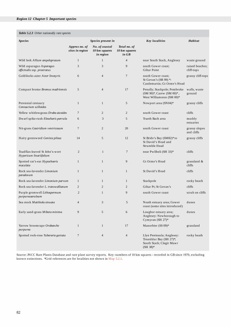
Region 12 Chapter 5 Important species
82
Table 5.2.3 Other nationally rare species
Species Species present in Key localities Habitat
Approx no. of No. of coastal Total no. of sites in region 10 km squares 10 km squares
in region in GB
Wild leek Allium ampeloprasum 1 1 4 near South Stack, Anglesey waste ground
Wild asparagus Asparagus 3 3 9 south Gower coast; raised beaches;officinalis ssp. prostratus Giltar Point cliff-tops
Goldilocks aster Aster linosyris 6 4 7 south Gower coast; grassy cliff-topsSt Govan’s (SR 99) *- Castlemartin; Gt Orme’s Head
Compact brome Bromus madritensis 5 4 17 Penally; Stackpole; Pembroke walls, waste (SM 90)*, Carew (SM 00)* , groundWest Williamston (SM 00)*
Perennial centaury 1 1 5 Newport area (SN04)* grassy cliffsCentaurium scilloides
Yellow whitlowgrass Draba aizoides 7 2 2 south Gower coast cliffs
Dwarf spike-rush Eleocharis parvula 6 3 5 Traeth Bach area muddy estuaries
Nit-grass Gastridium ventricosum 7 2 20 south Gower coast grassy slopes and cliffs
Hairy greenweed Genista pilosa 14 5 12 St Bride’s Bay (SM82)* to grassy cliffsSt David’s Head and Strumble Head
Toadflax-leaved St John’s-wort 2 1 7 near Pwllheli (SH 33)* cliffsHypericum linariifolium
Spotted cat’s-ear Hypochoeris 1 1 9 Gt Orme’s Head grassland & maculata cliffs
Rock sea-lavender Limonium 1 1 1 St David’s Head cliffsparadoxum
Rock sea-lavender Limonium parvum 1 1 1 Stackpole rocky beach
Rock sea-lavender L. transwallianum 2 2 2 Giltar Pt; St Govan’s cliffs
Purple gromwell Lithospermum 2 1 9 south Gower coast scrub on cliffspurpurocaeruleum
Sea stock Matthiola sinuata 4 3 5 Neath estuary area; Gower dunescoast (some sites introduced)
Early sand-grass Mibora minima 9 5 6 Loughor estuary area; dunesAnglesey: Newborough to Cymyran (SH 27)*
Yarrow broomrape Orobanche 1 1 17 Manorbier (SS 09)* grasslandpurpurea
Spotted rock-rose Tuberaria guttata 7 4 4 Llyn Peninsula; Anglesey: rocky heathTrearddur Bay (SH 27)*; South Stack; Clegir Mawr (SH 38)*
Source: JNCC Rare Plants Database and rare plant survey reports. Key: numbers of 10 km squares - recorded in GB since 1970, excludingknown extinctions. *Grid references are for localities not shown in Map 5.2.1.

5.2 Flowering plants and ferns
Table 5.2.4 Key localities for rare and scarce plants
Locality Status Species
Neath Estuary area part SSSI, part NNR, 2 Red Data Book species, plus Deptford pink Dianthus armeria,part undesignated round-leaved wintergreen Pyrola rotundifolia ssp. maritima, sharp
rush Juncus acutus, long-stalked orache Atriplex longipes, and 11other scarce species.
South Gower coast part SSSI, part NNR, part 8 Red Data Book species, plus round-leaved wintergreen, spiked LNR, part undesignated speedwell Veronica spicata ssp. hybrida, hoary rockrose
Helianthemum canum, white horehound Marrubium vulgare, Sorbusporrigentiformis, western clover Trifolium occidentale, long-stalkedorache, Isle of Man cabbage Coincya monensis ssp. monensis, sharprush, and 17 other scarce species.
Loughor estuary area SSSI, part NNR 3 Red Data Book species, plus sharp rush, white horehound,round-leaved wintergreen, long-stalked orache, Deptford pink,and 14 other scarce species.
Carmarthen Bay part SSSI, part undesignated 2 Red Data Book species, plus maidenhair fern Adiantum capillus-veneris, long-stalked orache, sharp rush, marsh pea Lathyruspalustris, round-leaved wintergreen, three-lobed crowfootRanunculus tripartitus, and 17 other scarce species.
Giltar Point and Penally part SSSI, part undesignated 5 Red Data Book species, plus galingale Cyperus longus, sharp rush,and 8 other scarce species
Stackpole to St Govan’s to SSSI, part NNR 5 Red Data Book species, plus white horehound, hoary rockrose, Castlemartin 10 other scarce species.
Ramsey Island and SSSI 3 Red Data Book species, plus chives Allium schoenoprasum, yellowSt David’s Head centaury Cicendia filiformis, and 10 other scarce species.
Traeth Bach area part SSSI, part NNR, part 2 Red Data Book species, plus galingale, sharp rush, round-leaved undesignated wintergreen, and 11 other scarce species.
Anglesey: Newborough to part SSSI, part NNR , part 5 Red Data Book species, plus eight-stamened waterwortSouth Stack undesignated Elatine hydropiper, six-stamened waterwort E. hexandra, round-
leaved wintergreen, and 19 other scarce species.
The Great Orme SSSI, part LNR 2 Red Data Book species, plus hoary rock-rose, white horehound,spiked speedwell, and 13 other scarce species.
Source: Rare Plants Database; Stewart et al. (1994); SSSI citation sheets; BRC database. Note: scarce species may occur near to rather thanwithin some localities. Only scarce species known from 16-30 10 km squares in GB are listed by name. Key: SSSI - Site of Special ScientificInterest; NNR - National Nature Reserve; LNR - Local Nature Reserve.
5.2.5 Further sources of information
A. References cited
Ellis, R.G. 1983. Flowering plants of Wales. Cardiff, National Museumof Wales.
Kay, Q.O.N., & John, R. 1993. Fragmented ranges and uncertainfutures: population genetics, reproduction and dispersal inscarce grassland species. BSBI News, 63:51.
Perring, F.H., & Farrell, L. 1983. British Red Data books: 1 Vascularplants. 2nd ed. Nettleham, Lincoln, Royal Society for NatureConservation.
Stewart, A., Pearman, D.A., & Preston, C.D. 1994. Scarce plants inBritain. Peterborough, Joint Nature ConservationCommittee/Institute of Terrestrial Ecology/Botanical Society ofthe British Isles.
B. Further reading
Hutchinson, G., & Thomas, B.A. 1992. Distribution of Pteridophytain Wales. Watsonia, 19(1): 1-19.
Hyde, H.A., Wade A.E., & Harrison, S.G. 1978. Welsh ferns. 6th ed. -7th ed. in prep. Cardiff, National Museum of Wales. Keys,descriptions and illustrations with notes on habitat anddistribution.
Stace, C. 1991. New flora of the British Isles. Cambridge UniversityPress.
Stewart, A., Pearman, D.A., & Preston, C.D. 1994. Scarce plants inBritain. Peterborough, Joint Nature Conservation Committee.
83

Region 12 Chapter 5 Important species
C. Contact names and addresses
Type of information Contact address and telephone no.
Species on SSSIs and NNRs, *Coastal specialist, CCW HQ, other protected areas, rare Bangor, tel. 01248 370444and scarce species, rare plant surveys, licensing and protected species.
Distribution and history Department of Botany, National of plants in Wales, Museum of Wales, Cardiff herbarium records, local CF1 3NP, tel. 01222 397951‘flora’s’ and archives
Local BSBI vice-county Hon. Secretary, Welsh Committee, recorders’ detailed records Botanical Society of the British Isles,
c/o National Museum of Wales,Cardiff CF1 3NP, tel. 01222 397951
Database of rare and *Species Conservation Branch, protected species JNCC, Peterborough,
tel. 01733 62626
* Starred contact addresses are given in full in the Appendix
5.2.6 Acknowledgements
Thanks are due to J.H. Barne, G. Ellis, D. Evans, G. Hutchinson, R. John, A. Jones, M.A. Palmer, J. Ratcliffe,M.J. Wigginton, J. Wookey and the Biological RecordsCentre for their help in compiling this section.
84
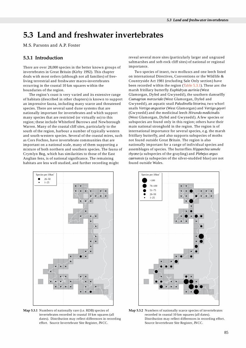
5.3 Land and freshwater invertebrates
ertebrates
5.3.1 Introduction
There are over 28,000 species in the better known groups ofinvertebrates in Great Britain (Kirby 1992). This chapterdeals with most orders (although not all families) of free-living terrestrial and freshwater macro-invertebratesoccurring in the coastal 10 km squares within theboundaries of the region.
The region’s coast is very varied and its extensive rangeof habitats (described in other chapters) is known to supportan impressive fauna, including many scarce and threatenedspecies. There are several sand dune systems that arenationally important for invertebrates and which supportmany species that are restricted (or virtually so) to thisregion; these include Whiteford Burrows and NewboroughWarren. Many of the coastal cliff sites, particularly to thesouth of the region, harbour a number of typically westernand south-western species. Several of the coastal mires, suchas Cors Fochno, have invertebrate communities that areimportant on a national scale, many of them supporting amixture of both northern and southern species. The fauna ofCrymlyn Bog, which has similarities to those of the EastAnglian fens, is of national significance. The remaininghabitats are less well studied, and further recording might
5.3 Land and freshwater invM.S. Parsons and A.P. Foster
26–501–25
Species per 10km2
Map 5.3.1 Numbers of nationally rare (i.e. RDB) species ofinvertebrates recorded in coastal 10 km squares (alldates). Distribution may reflect differences in recordingeffort. Source Invertebrate Site Register, JNCC.
reveal several more sites (particularly larger and ungrazedsaltmarshes and soft-rock cliff sites) of national or regionalimportance.
Two species of insect, two molluscs and one leech listedon international Directives, Conventions or the Wildlife &Countryside Act 1981 (excluding Sale Only section) havebeen recorded within the region (Table 5.3.1). These are: themarsh fritillary butterfly Euphidryas aurinia (WestGlamorgan, Dyfed and Gwynedd), the southern damselflyCoenagrion mercuriale (West Glamorgan, Dyfed andGwynedd), an aquatic snail Paludinella littorina, two whorlsnails Vertigo angustior (West Glamorgan) and Vertigo geyeri(Gwynedd) and the medicinal leech Hirundo medicinalis(West Glamorgan, Dyfed and Gwynedd). A few species orsubspecies are found only in this region; others have theirmain national stronghold in the region. The region is ofinternational importance for several species, e.g. the marshfritillary butterfly, and also supports subspecies of mothsnot found outside Great Britain. The region is alsonationally important for a range of individual species andassemblages of species. The butterflies Hipparchia semelethyone (a subspecies of the grayling) and Plebejus arguscaernensis (a subspecies of the silver-studded blue) are notfound outside Wales.
85
76–100
>100
51–75
26–501–25
Species per 10km2
Map 5.3.2 Numbers of nationally scarce species of invertebratesrecorded in coastal 10 km squares (all dates).Distribution may reflect differences in recording effort.Source Invertebrate Site Register, JNCC.

Region 12 Chapter 5 Important species
86
Table 5.3.1 Coastal Red Data Book (RDB) species in Region 12
Species Description and notes on recorded occurrence in the region
RDB 1Aegialia rufa Small beetle found amongst plant litter just below the sand surface of coastal dunes.
Barmouth, Gwynedd*.Agroeca lusatica Coastal dune spider. Ynyslas Dunes, Dyfed.Segmentina nitida Ramshorn snail. Ponds and marsh drains, particularly when well oxygenated and with lush
vegetation. An unconfirmed record from Stackpole to Castlemartin Cliffs, Dyfed.Vertigo angustior Small whorl snail found in permanently marshy grassland in dunes and lowland fens. IUCN
threat category K (Insufficiently known) (Groombridge 1993). Whiteford Burrows and OxwichBay, West Glamorgan.
Proposed RDB 1Harpalus melancholicus Phytophagous ground beetle associated with sand dunes. Sparsely vegetated sand at
Stackpole to Castlemartin Cliffs, Dyfed.Meloe brevicollis Beetle found on heathland and coastal cliffs. Larvae parasitic, probably on bees. Coed cors y
Gedol, Gwynedd.Panagaeus cruxmajor Red and black ground beetle found at the margins of standing or slow flowing water amongst
rich vegetation. Pembrey Coast, Dyfed.Pyrausta sanguinalis Small pyralid moth inhabiting coastal dunes; larva feed from within a silken tube amongst the
flowers of thyme. Oxwich Bay, West Glamorgan*.RDB 2Andrena rosae Mining bee associated with soft rock cliffs, coastal grasslands and heaths.
Trefeiddan Moor, Dyfed..Luperina nickerlii gueneei Sub-species of the sandhill rustic moth; found only in North Wales. Larvae feed in the stems
and root crowns of Elymus farctus. Morfa Conwy, Gwynedd.Psen bicolor Small black and red solitary wasp nesting in moist sandy soil, predatory on planthoppers.
Oxwich Bay, West Glamorgan*.
Proposed RDB 2Cardiophorus erichsoni Click beetle, in sandy soil on the coast. Larvae feed on grass roots. St. David’s Peninsula
Coast, Dyfed.Cicindela hybrida Bronze-purple tiger beetle that hunts over open ground, particularly sand and gravel. Usually
a coastal species. Morfa Dyffryn, Gwynedd*.Dicronychus equiseti Click beetle of coastal dunes and cliffs. Larvae are root feeders. Several dune sites.Gonomyia bradleyi Cranefly of boulder clay coastal cliff seepages. Gwbert Cliffs, Dyfed.Nephrotoma quadristriata Dune cranefly found at the backs of mobile dunes, especially near the edges of dune slacks.
Morfa Dyffryn, Tywyn Aberffraw, and Newborough Warren, Gwynedd.
RDB 3Cicindela germanica Bronze-green tiger beetle that hunts on bare substrate associated with soft rock cliff sites.
Wharley Point Cliffs, Dyfed*. Clubiona genevensis Spider associated with coastal cliffs and grassland. Found under stones and low vegetation.
Skokholm, Dyfed*.Coelioxys mandibularis Cuckoo bee known only from coastal dunes sites. Several dune sites.Colletes cunicularius Mining bee, confined to the sand dunes of north-west England and Wales. Colonises old
erosion hollows, forming dense colonies on steep inclines. Oxwich Bay, Whiteford Burrowsand Penmaen Burrows, West Glamorgan.
Eubria palustris Small black beetle associated with soft rock cliffs, fens and marshes. Cors Geirch & CorsErddreiniog Gwynedd and Banc y Mwldan, Dyfed.
Graptodytes bilineatus Water beetle associated with brackish water ditches. Unconfirmed record from Skomer Island,Dyfed.
Haematopota grandis Horse fly associated with estuarine habitats. Ryers Down & Whiteford Burrows, W. Glam.;Pembrey, Dyfed and Morlais Colliery, Dyfed/West Glamorgan.
Limonia goritiensis Cranefly found on seepages on coastal cliffs and rock faces. Several sites.Lionychus quadrillum Small bronze-black ground beetle associated with river and coastal shingle, sand or gravel.
Several sites along the Afon Ystwyth and the Afon Rheidol, Dyfed.Lycia zonaria Belted beauty moth: associated with coastal dunes. Morfa Conwy, Gwynedd.Monosynamma maritima Plant bug associated with coastal dunes and shingle. Tywyn Aberffraw, Gwynedd.Myopites eximia Picture-winged fly occurring in saltmarshes and saline shingle banks where the larval
foodplant, golden-samphire Inula crithmoides, thrives. Gower coast (Rhossili to Port EnyonBay), West Glamorgan.
Ochthebius poweri Very small black water beetle that lives in small seepages on cliff faces, especially those of RedSandstone. Saint David’s peninsula coast, Dyfed.
Odontoscelis fuliginosa Burrowing shieldbug found in coastal dunes and the East Anglian breckland. Barafundle Bay,Dyfed.
Paludinella littorina Small brackish-water snail found around the high water mark among moist rotting vegetationor in crevices high on the shore. Listed on schedule 5 of the Wildlife & Countryside Act 1981(added in 1992). Stackpole to Castlemartin Cliffs, Dyfed.

5.3 Land and freshwater invertebrates
87
Table 5.3.1 Coastal Red Data Book (RDB) species in Region 12 (continued)
Species Description and notes on recorded occurrence in the region
Phlegra fasciata Jumping spider found mainly on coastal dunes and sometimes shingle. Pennard Cliff, W.Glam.
Pionosomus varius Groundbug associated with coastal dunes. Several dune sites.Psen littoralis Digger wasp that frequents marram dunes. Oxwich Bay, Penmaen Burrows, West Glamorgan,
& Pembrey Country Park, Dyfed.Trapezonotus ullrichi Rare groundbug found on short grassland on clifftops. St David’s peninsula coast, Dyfed.
Proposed RDB 3
Agriotes sordidus Click beetle of coastal and esturine habitats: banks of tidal rivers and beneath stones on abeach. Skokholm, Dyfed*.
Anthicus scoticus Small beetle found within strand line debris on saltmarshes. Adults are flower feeders. TywynAberffraw, Gwynedd.
Apion rubiginosum Weevil associated with sheep’s sorrel Rumex acetosella and with a preference for ruderal coastalhabitats. Dolcniw, Pen Dinas and Penglais Quarry, Dyfed.
Dialineura anilis Stiletto fly associated with sand dunes. Several dune sites.Drapetis setigera Fly recorded from coastal sand flats. Oxwich Bay, West Glamorgan*.Hypocaccus metallicus Predatory beetle occurring in dung and carrion on coastal dunes and shingle. Unconfirmed
record for Whiteford Burrows, West Glamorgan.Pamponerus germanicus Robber fly frequenting sand dunes just behind the marram grass belt. Several dunes sites.Tachytrechus ripicola Fly associated with coastal sand near fresh water.
Dyffryn, Gwynedd*, Dulas Bay, Gwynedd* and Oxwich Bay, West Glamorgan.Thereva fulva Fly associated with dunes and other sandy areas near the coast, apparently preferring areas of
fixed sand with well-established vegetation and small open areas. Several dune sites.RDB KAllomelita pellucida Brackish-water amphipod recorded from harbours and ditch systems. Saltings of the river
Tywi, Dyfed*.Lithobius tenebrosus Centipede known only from the cliffs at Aberystwyth, Dyfed.Metatrichoniscoides celticus Small woodlouse discovered new to science in 1979 on the Glamorgan coast. Now known from
7 sites along a 48 km stretch of the Glamorgan coast. IUCN threat category K (Insufficientlyknown) (Groombridge 1993).
Proposed RDB KBibloplectus minutissimus Small beetle known from coastal shingle and river margins. Glanyrafon (Afon Rheidol), Dyfed.Calligypona reyi Planthopper found on rushes Juncus and Scirpus spp. in coastal marshes. Saline swamp at
Glynea, W. Glamorgan.Ocyusa nitidiventris Rove beetle found on sand dunes and in quarries and sand pits. Cors Goch, Anglesey and Cors
Geirch, Gwynedd (unconfirmed).Omalium rugulipenne Exclusively maritime rove beetle found under dead seaweed on sandy coasts. Pembry Forest,
Dyfed.Phytosus nigriventris Rove beetle reported from seaweed and egg capsules of the common whelk. Rhossili Down,
West Glamorgan.Thinobius brevipennis Small black rove beetle found at coastal cliff and dune sites as well as fens. Newborough
Warren, Gwynedd.
RDB IPhilonthus pullus Rove beetle associated with coastal sand dunes. Found at the roots of Juncus spp. and in
depressions. Oxwich Bay, Llangennydd Burrows and Whiteford Burrows, West Glamorgan.
Key: Red Data Book categories: RDB 1 = endangered; RDB 2 = vulnerable; RDB 3 = rare; RDB K = insufficiently known; RDB I =indeterminate; p = Proposed species (as categorised in e.g. Hyman & Parsons 1992); *= Old records (before approx. 1970). Some records aredoubtful (identified as ‘unconfirmed’). For further description of RDB categories see Shirt (1987) and Bratton (1991).

Region 12 Chapter 5 Important species
88
Table 5.3.2 Important invertebrate sites in Region 12
Localities Grid ref. Status
West GlamorganMargam Moors SS7884 SSSIPant-y-Sais SS7194 SSSICrymlyn Bog SS6994 NNR/SSSI,
Ramsar sitePwll Du Head & Bishopston SS5787 SSSI, NT
ValleyPenmaen Burrows/ SS5388 SSSI (in part), NT
Nicholaston BurrowsNicholaston Woods SS5187Oxwich SS5087 NNR/SSSIPort-Eynon Point SS4684 NT, County Trust
reservePort-Eynon Bay SS4784 County Trust
reserveGower Coast: Rhossili SS4486 NNR/SSSI, NT (in
to Port Eynon part), Country Trustreserve (in part)
Horton SS4785Rhossili Down SS4289 SSSI, NTLlangennith Burrows SS4192Whiteford Burrows SS4595 NNR/SSSI, NT (in
part)Cefn Bryn and Broadpool SS5090 SSSI, County Trust
reserveWelsh Moor SS5292 SSSI, NT
DyfedTechon Marsh SS5499Machynys Ponds SS5198Stradey Estate SN4801Ffrwd Farm SN4202 SSSI, County Trust
reserve
Dyfed/West GlamorganPembrey Country Park SN3901
(Pembrey Forest)
DyfedTywyn Gwendraeth & SN3705 SSSI
Cefn SandsCors Goch, Llanllwch SN3618 SSSIBeacon Bog SN3516Laugharne Burrows SN3007 SSSIPendine Sands SN2407Marros-Pendine Coast SN2007 SSSIRitec (Cors Penally) SN1101 SSSIFreshwater East SS0298Stackpole to Castlemartin SR8899 NNR/SSSI, NT
Cliffs (includes Bosherston (in part)Lake)
Castlemartin Range SR9196Broomhill Burrows SM8800 SSSI, NT (in part)West Williamston SN0206 SSSI, NT (in part),
County Trust reserveLawrenny Wood SN0107 SSSI, NTMarloes Cliffs SM7707 SSSIMarloes Mere & Deer Park SM7708 SSSI, NT, County
Trust reserveSkokholm Island SM7305 SSSI, County Trust
reserveSkomer Island SM7209 NNR/SSSITrefeiddan Moor SM7325 SSSISt David’s Peninsula Coast SM7629 SSSI, NT (in part)St David’s Airfield Heaths SM7826 SSSI, NT (in part)Dowrog Common SM7727 SSSI, NT, County
Trust reservePorthiddy Moor SM8031 SSSIYnys Barri SM8032 SSSI (in part), NT
Localities Grid ref. Status
Strumble Head to Llechdafad SM8835 SSSI, NT (in part)Cliffs
Good Hope SM9140 NTGoodwick Moor SM9437 County Trust reserveDinas Cliffs SN0040 NTCwm Dewi SN0039Gernos Cliffs SN1248 NTTeifi Estuary SN1549Coedydd a chorsydd Aber SN1845 SSSI
TeifiPentwd Marshes SN1845 SSSIBanc y Mwldan SN1948 SSSIPen yr Ergyd SN1648 SSSICreigiau Gwbert SN1550Cwm Byrlip a Chreigau SN3657 SSSI, NT (in part)
Castell BachRhos Rydd SN5773 SSSICoed nant Llolwyn SN5877 SSSIAllt Wen a Traeth Tanybwlch SN5779 SSSIGlandwr SN6080Glanyrafon SN6180Lovesgrove SN6281Cors Fochno SN6391 NNR/SSSI, Ramsar
site
Dyfed/PowysDyfi (includes Ynys-Eidiol - SN6495 NNR/SSSI, Ramsar
Ynys-Hir) site, Biosphere reserve
Dyfed/GwyneddCwm Llyfnant SN7297
GwyneddArthog Bog SH6314 SSSICaerleon Reedbed SH6417 SSSIAfon Mawddach SH7119Morfa Dyffryn SH5525 NNR/SSSIMorfa Harlech SH5635 NNR/SSSICoed Tremadog SH5640 NNRMorfa Bychan SH5436 SSSI, NT (in part),
County Trustreserve (in part)
Llyn Ystumllyn SH5238 SSSIPorth Neigwl SH2428Mynydd Penarfynydd SH2226 SSSI, NT (in part)Glannau Aberdaron SH1325 SSSI, NT (in part)Cors Geirch SH3136 SSSICors Gyfelog SH4648 SSSICors Graianog SH4945 SSSINewborough Warren SH4461 NNR/SSSINewborough Forest SH4065 SSSITywyn Aberffraw SH3669 SSSITre Wilmot SH2381 SSSIGlannau Ynys Gybi (includes SH2182 SSSI
South Stack)Salbri SH3788 SSSICors Clegyrog SH3889 SSSILlyn Hafodol SH3989 SSSICors Erddreiniog SH4781 NNR/SSSICors Nant Isaf SH4782 NNR/SSSICors Goch SH4981 SSSI, County Trust
reserveCors Bodeilio SH5077 NNR/SSSIRhos-y-gad SH5078 SSSICoed Gorswen SH7570 NNR/SSSIGreat Orme’s Head SH7683 SSSI, County Trust
reserve (in part)
Key: NNR - National Nature Reserve; NT - National Trust; SSSI - Site of Special Scientific Interest; SPA - Special Protection Area.

5.3 Land and freshwater invertebrates
According to JNCC’s Invertebrate Site Register there are232 Red Data Book (RDB) species and 947 nationally scarcespecies recorded in the coastal 10 km squares of the region.As defined by Kirby (1994), there are 54 coastal RDB speciesand 242 coastal scarce species recorded in the region; coastalRDB species are listed in Table 5.3.1. Map 5.3.1 shows thedistribution of all nationally rare (RDB) invertebratesrecorded in coastal 10 km squares in the region; Map 5.3.2shows that of nationally scarce invertebrates. Note thatsurvey effort has not been equivalent throughout the region,so actual occurrence may differ from recorded distribution.
5.3.2 Important locations and species
Sites listed in Table 5.3.2 are those considered particularlyimportant for invertebrate conservation. Nationally rarecoastal species are listed in Table 5.3.1. Other nationallyimportant species in the region include the ground beetleHarpalus melancholicus, which has recently been recordedfrom just a single site in Great Britain (Dyfed), and the rosymarsh moth Eugraphe subrosea, which is known from only avery few sites in Wales (Dyfed and Gwynedd). Severalinsects are largely restricted to this part of the country,including the ground bug Pionosomus varius, the click beetleDicronychus equiseti, the Welsh subspecies of the sandhillrustic moth Luperina nickerlii gueenei, the craneflyNephrotoma quadristriata, and the mining bee Colletescunicularis. Several other species reach their northern limitin Great Britain along the coast of this region, e.g. the lessercockroach Ectobius panzeri. Roesel’s bush cricket Metriopteraroeselii is an example of a species with a disjunctdistribution: most of its British distribution is along theThames Estuary, but it is also known from the fringes of theDyfi Estuary.
Table 5.3.1 shows that the nationally rare coastal speciesdepend on a wide variety of the different coastal habitats ofthe region. Dune systems, here and elsewhere, have a rangeof microhabitats, all of which have their own distinctiveinvertebrate faunas. Undisturbed sandy strandlines have acharacteristic invertebrate fauna which can include theground beetle Nebria complanata, known from a few sites inthe south of the region. Only a few species are found on theunstable fore dunes, but many of them are restricted to thishabitat, for example the sand dart moth Agrotis ripae. Dunegrassland can be important for a range of species, which caninclude in this region the marsh fritillary Euphydryas aurinia,and the compacted sand of the mature dunes is importantfor bees as it provides nesting sites and an abundance ofnectar sources. The cuckoo bee Coelioxys mandibularis hasbeen found on several dune sites in the region, in sunny andmore sparsely vegetated areas, particularly those with asouthern aspect. In the south of the region, damper areas inthe slacks support characteristic species such as the hoverflyMicrodon mutabilis. Wetter slacks, as at Morfa Harlech, cansupport important assemblages of wetland flies, and slacksdominated by creeping willow have their own distinctivefaunas.
Cliff habitats fall broadly into two categories: hard-rockand soft-rock, which support different invertebrate faunas.Cliff paths provide suitable habitat for species that rely onareas of bare ground, for instance bees and wasps.Grassland associated with cliff sites, particularly whenunimproved, can be important for a range of scarcer species,
which can include the pyralid moth Dolicanthria punctalis.Seepages and trickles are important for a number of species,such as the water-beetle Octhebius poweri. This species hasbeen found on St David’s Peninsula, where these trickles arewithin the reach of salt spray. Intertidal rocky shoressupport a distinctive, if limited, community that includesthe ground beetles Aepus robini and A. marinus. Both ofthese beetles are known from several sites in the region.Calcareous habitats have a different range of species fromthose found on more acidic or neutral substrates, and cansupport significant bee populations. Coastal heathland ismore usually found on cliff tops in the region. Some ofthese coastal heathlands, e.g. South Stack, Anglesey, havelarge populations of the silver-studded blue Plebejus argus,the larvae of which are attended by ants of the genus Lasius.
The soft-rock cliffs of the region, such as those at PorthNeigwl, support several nationally scarce species, e.g. theground beetle Tachys micros. Species typical of this habitattend to occupy less stable situations prone to slippages,which in this region are significant for their invertebrates.
Estuaries have a range of habitats, from tidal mud flats,through saltmarsh to areas of river shingle in their upperregions. All these habitats support their own specialistgroupings of invertebrate species. The ground beetleBembidion laterale is typical of tidal mudflats. The richestsaltmarsh invertebrate communities are usually foundwhere the upper saltmarsh has not been modified bygrazing. Many saltmarsh invertebrates are more dependenton substrate conditions than on vegetation structure, andsaltmarshes with a higher proportion of sandy material tendto hold more invertebrate species than those with siltiersubstrates. Banks of creeks provide suitable conditions formany species in the region, and saltpans and brackishditches can contain a small, but distinctive, water-beetlefauna which includes Enochrus bicolor and Octhebiusauriculatus. A scarce ground beetle, Perileptus areolatus, canbe found in the more shingly habitats.
The region includes a number of coastal mires that areknown to have nationally significant invertebrateassemblages and include the rosy marsh moth Eugraphesubrosea and the hoverfly Lejogaster splendida. Coastal fens,flooded brickpits and grazing levels in the region are allknown to support distinctive faunas.
The invertebrate fauna of the coastal woodlands of thispart of the coast is relatively poorly known. However, arange of interesting species have been recorded from severalsites and Lawrenny Wood is known to support a regionallysignificant fauna of over-mature and dead wood habitats.
5.3.3 Human activities
Invertebrates occur in the full range of coastal microhabitatsfound in the region. Many use subtle features of vegetationstructure, others areas of bare ground. As often as not, thesefeatures are overlooked even in site management for natureconservation, many species surviving by default.Invertebrates generally have annual life cycles and, hence,these features must be present in the right condition in eachand every year. The management of coastal habitats forinvertebrates is covered by Kirby (1992) and managementfor different Welsh habitats by Fowles (1994).
89
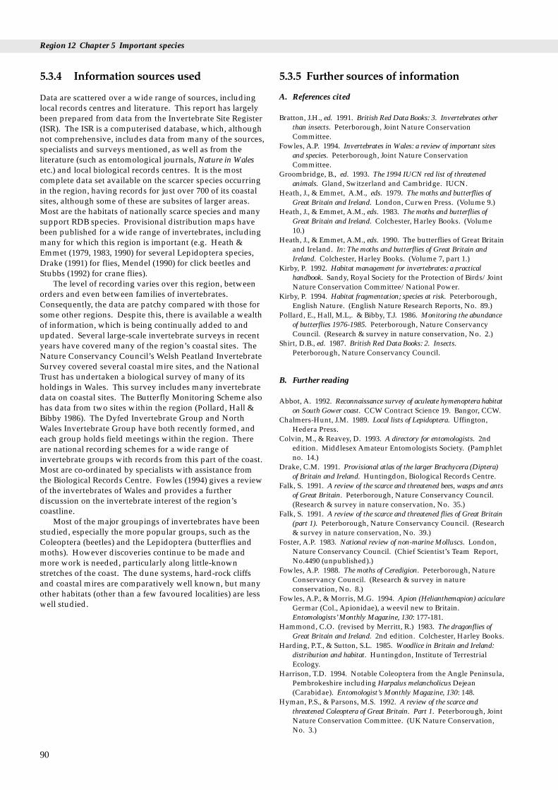
Region 12 Chapter 5 Important species
5.3.4 Information sources used
Data are scattered over a wide range of sources, includinglocal records centres and literature. This report has largelybeen prepared from data from the Invertebrate Site Register(ISR). The ISR is a computerised database, which, althoughnot comprehensive, includes data from many of the sources,specialists and surveys mentioned, as well as from theliterature (such as entomological journals, Nature in Walesetc.) and local biological records centres. It is the mostcomplete data set available on the scarcer species occurringin the region, having records for just over 700 of its coastalsites, although some of these are subsites of larger areas.Most are the habitats of nationally scarce species and manysupport RDB species. Provisional distribution maps havebeen published for a wide range of invertebrates, includingmany for which this region is important (e.g. Heath &Emmet (1979, 1983, 1990) for several Lepidoptera species,Drake (1991) for flies, Mendel (1990) for click beetles andStubbs (1992) for crane flies).
The level of recording varies over this region, betweenorders and even between families of invertebrates.Consequently, the data are patchy compared with those forsome other regions. Despite this, there is available a wealthof information, which is being continually added to andupdated. Several large-scale invertebrate surveys in recentyears have covered many of the region’s coastal sites. TheNature Conservancy Council’s Welsh Peatland InvertebrateSurvey covered several coastal mire sites, and the NationalTrust has undertaken a biological survey of many of itsholdings in Wales. This survey includes many invertebratedata on coastal sites. The Butterfly Monitoring Scheme alsohas data from two sites within the region (Pollard, Hall &Bibby 1986). The Dyfed Invertebrate Group and NorthWales Invertebrate Group have both recently formed, andeach group holds field meetings within the region. Thereare national recording schemes for a wide range ofinvertebrate groups with records from this part of the coast.Most are co-ordinated by specialists with assistance fromthe Biological Records Centre. Fowles (1994) gives a reviewof the invertebrates of Wales and provides a furtherdiscussion on the invertebrate interest of the region’scoastline.
Most of the major groupings of invertebrates have beenstudied, especially the more popular groups, such as theColeoptera (beetles) and the Lepidoptera (butterflies andmoths). However discoveries continue to be made andmore work is needed, particularly along little-knownstretches of the coast. The dune systems, hard-rock cliffsand coastal mires are comparatively well known, but manyother habitats (other than a few favoured localities) are lesswell studied.
90
5.3.5 Further sources of information
A. References cited
Bratton, J.H., ed. 1991. British Red Data Books: 3. Invertebrates otherthan insects. Peterborough, Joint Nature ConservationCommittee.
Fowles, A.P. 1994. Invertebrates in Wales: a review of important sitesand species. Peterborough, Joint Nature ConservationCommittee.
Groombridge, B., ed. 1993. The 1994 IUCN red list of threatenedanimals. Gland, Switzerland and Cambridge. IUCN.
Heath, J., & Emmet, A.M., eds. 1979. The moths and butterflies ofGreat Britain and Ireland. London, Curwen Press. (Volume 9.)
Heath, J., & Emmet, A.M., eds. 1983. The moths and butterflies ofGreat Britain and Ireland. Colchester, Harley Books. (Volume10.)
Heath, J., & Emmet, A.M., eds. 1990. The butterflies of Great Britainand Ireland. In: The moths and butterflies of Great Britain andIreland. Colchester, Harley Books. (Volume 7, part 1.)
Kirby, P. 1992. Habitat management for invertebrates: a practicalhandbook. Sandy, Royal Society for the Protection of Birds/JointNature Conservation Committee/National Power.
Kirby, P. 1994. Habitat fragmentation; species at risk. Peterborough,English Nature. (English Nature Research Reports, No. 89.)
Pollard, E., Hall, M.L,. & Bibby, T.J. 1986. Monitoring the abundanceof butterflies 1976-1985. Peterborough, Nature ConservancyCouncil. (Research & survey in nature conservation, No. 2.)
Shirt, D.B., ed. 1987. British Red Data Books: 2. Insects.Peterborough, Nature Conservancy Council.
B. Further reading
Abbot, A. 1992. Reconnaissance survey of aculeate hymenoptera habitaton South Gower coast. CCW Contract Science 19. Bangor, CCW.
Chalmers-Hunt, J.M. 1989. Local lists of Lepidoptera. Uffington,Hedera Press.
Colvin, M., & Reavey, D. 1993. A directory for entomologists. 2ndedition. Middlesex Amateur Entomologists Society. (Pamphletno. 14.)
Drake, C.M. 1991. Provisional atlas of the larger Brachycera (Diptera)of Britain and Ireland. Huntingdon, Biological Records Centre.
Falk, S. 1991. A review of the scarce and threatened bees, wasps and antsof Great Britain. Peterborough, Nature Conservancy Council.(Research & survey in nature conservation, No. 35.)
Falk, S. 1991. A review of the scarce and threatened flies of Great Britain(part 1). Peterborough, Nature Conservancy Council. (Research& survey in nature conservation, No. 39.)
Foster, A.P. 1983. National review of non-marine Molluscs. London,Nature Conservancy Council. (Chief Scientist’s Team Report,No.4490 (unpublished).)
Fowles, A.P. 1988. The moths of Ceredigion. Peterborough, NatureConservancy Council. (Research & survey in natureconservation, No. 8.)
Fowles, A.P., & Morris, M.G. 1994. Apion (Helianthemapion) aciculareGermar (Col., Apionidae), a weevil new to Britain.Entomologists’ Monthly Magazine, 130: 177-181.
Hammond, C.O. (revised by Merritt, R.) 1983. The dragonflies ofGreat Britain and Ireland. 2nd edition. Colchester, Harley Books.
Harding, P.T., & Sutton, S.L. 1985. Woodlice in Britain and Ireland:distribution and habitat. Huntingdon, Institute of TerrestrialEcology.
Harrison, T.D. 1994. Notable Coleoptera from the Angle Peninsula,Pembrokeshire including Harpalus melancholicus Dejean(Carabidae). Entomologist’s Monthly Magazine, 130: 148.
Hyman, P.S., & Parsons, M.S. 1992. A review of the scarce andthreatened Coleoptera of Great Britain. Part 1. Peterborough, JointNature Conservation Committee. (UK Nature Conservation,No. 3.)
5.3 Land and freshwater invertebrates
Hyman, P.S., & Parsons, M.S. 1994. A review of the scarce andthreatened Coleoptera of Great Britain. Part 2. Peterborough, JointNature Conservation Committee. (UK Nature Conservation,No. 12.)
Kirby, P. 1992. A review of the scarce and threatened Hemiptera of GreatBritain. Peterborough, Joint Nature Conservation Committee.(UK Nature Conservation, No. 2.)
Marshall, J.A., & Haes, E.C.M. 1988. Grasshoppers and allied insectsof Great Britain and Ireland. Colchester, Harley Books.
Mendel, H. 1990. Provisional atlas of the click beetles (Coleoptera:Elateroidea) of the British Isles. Huntingdon, Biological RecordsCentre.
Merrett, P. 1990. A review of the nationally notable spiders of GreatBritain. Peterborough, Nature Conservancy Council. (Contractsurveys, No. 127.)
Parsons, M.S. 1993. A review of the scarce and threatened pyralid mothsof Great Britain. Peterborough, Joint Nature ConservationCommittee. (UK Nature Conservation, No. 11.)
Plant, C.W. 1994. Provisional atlas of the lacewings and allied insects(Neuroptera, Megaloptera, Raphidioptera and Mecoptera) of Britainand Ireland. Huntingdon, Biological Records Centre.
Smith, K., & Smith, V. 1983. A bibliography of the entomology of thesmaller British offshore islands. Faringdon, E.W. Classey.
Stubbs, A.E. 1992. Provisional atlas of the long-palped craneflies(Diptera: Tipulinae) of Britain and Ireland. Huntingdon, BiologicalRecords Centre.
Thomas, J., & Lewington, R. 1991. The butterflies of Britain andIreland. London, National Trust/Dorling Kindersley.
Waring, P., in prep. A review of the scarce and threatenedmacrolepidoptera of Great Britain. Peterborough, Joint NatureConservation Committee.
C. Contact names and addresses
Type of information Contact address and telephone no.
Occurrence of land and *Biological Records Centre, ITE,freshwater invertebrates in Monks Wood, tel. 01487 773381Britain and Ireland
Conservation of butterflies Butterfly Conservation, South and moths in Great Britain Wales Branch, 31 Drummau Road,
Birchgrove, Swansea SA7 9QA, tel. 01792 813600
Invertebrate conservation *Invertebrate Zoologist, CCW HQ, in Wales Bangor, tel. 01248 370444
Invertebrates in Dyfed *Dyfed Invertebrate Group, c/oCCW Aberystwyth, tel. 01970 828551
Invertebrates in Dyfed *Dyfed Wildlife Trust (Vice Countyrecorders), Dyfed, Haverfordwest, tel. 01437 765462
National inventory of *Invertebrate Site Register, JNCC,invertebrate conservation Peterborough, tel. 01733 62626sites; records of local, scarceand threatened species
Invertebrate interest of the *The National Trust HQ, National Trusts holdings Cirencester, tel. 01285 651818
Invertebrates in Pembrokeshire Biological Records Pembrokeshire Centre, Scolton House and
Museum, Spittal, Haverfordwest,Pembrokeshire SA62 5QLtel. 01437 731328
Dragonflies in Glamorgan Glamorgan Dragonfly SurveyGroup, Kenfig Reserve Centre, Ton Kenfig, Pyle, Mid GlamorganCF33 4PT
North Wales invertebrates North Wales Invertebrate Group,North Wales Biological RecordsCentre, School of Animal Biology,University College of North Wales,Bangor, Gwynedd LL57 2UW, tel. 01248 351151
* Starred contact addresses are given in full in the Appendix
5.3.6 Acknowledgements
Most of the data used in this section came from theInvertebrate Site Register, and thanks are due to D. A. Procter and Dr S.G. Ball (JNCC) for help with this.Thanks are also due to Dr K.N.A. Alexander (NationalTrust) for additional records and to Mr A.P. Fowles (CCW).
91
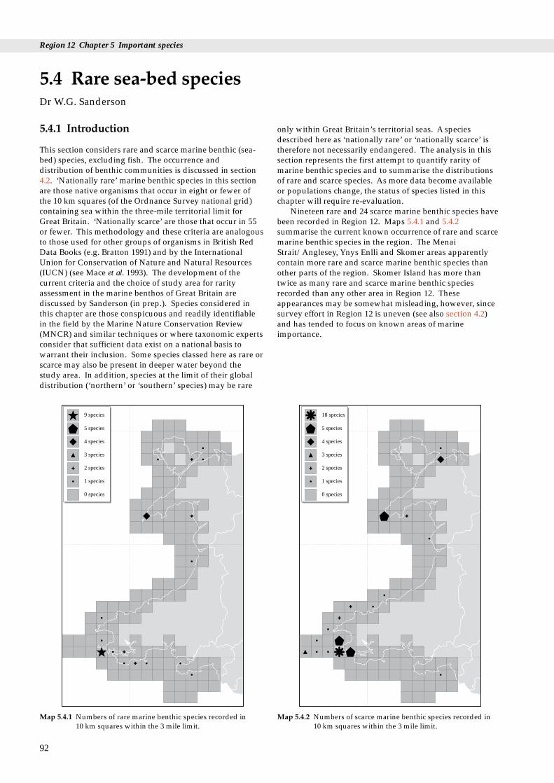
Region 12 Chapter 5 Important species
5.4.1 Introduction
This section considers rare and scarce marine benthic (sea-bed) species, excluding fish. The occurrence anddistribution of benthic communities is discussed in section4.2. ‘Nationally rare’ marine benthic species in this sectionare those native organisms that occur in eight or fewer ofthe 10 km squares (of the Ordnance Survey national grid)containing sea within the three-mile territorial limit forGreat Britain. ‘Nationally scarce’ are those that occur in 55or fewer. This methodology and these criteria are analogousto those used for other groups of organisms in British RedData Books (e.g. Bratton 1991) and by the InternationalUnion for Conservation of Nature and Natural Resources(IUCN) (see Mace et al. 1993). The development of thecurrent criteria and the choice of study area for rarityassessment in the marine benthos of Great Britain arediscussed by Sanderson (in prep.). Species considered inthis chapter are those conspicuous and readily identifiablein the field by the Marine Nature Conservation Review(MNCR) and similar techniques or where taxonomic expertsconsider that sufficient data exist on a national basis towarrant their inclusion. Some species classed here as rare orscarce may also be present in deeper water beyond thestudy area. In addition, species at the limit of their globaldistribution (‘northern’ or ‘southern’ species) may be rare
5.4 Rare sea-bed speciesDr W.G. Sanderson
92
5 species
9 species
4 species
3 species
2 species
1 species
0 species
Map 5.4.1 Numbers of rare marine benthic species recorded in 10 km squares within the 3 mile limit.
only within Great Britain’s territorial seas. A speciesdescribed here as ‘nationally rare’ or ‘nationally scarce’ istherefore not necessarily endangered. The analysis in thissection represents the first attempt to quantify rarity ofmarine benthic species and to summarise the distributionsof rare and scarce species. As more data become availableor populations change, the status of species listed in thischapter will require re-evaluation.
Nineteen rare and 24 scarce marine benthic species havebeen recorded in Region 12. Maps 5.4.1 and 5.4.2summarise the current known occurrence of rare and scarcemarine benthic species in the region. The MenaiStrait/Anglesey, Ynys Enlli and Skomer areas apparentlycontain more rare and scarce marine benthic species thanother parts of the region. Skomer Island has more thantwice as many rare and scarce marine benthic speciesrecorded than any other area in Region 12. Theseappearances may be somewhat misleading, however, sincesurvey effort in Region 12 is uneven (see also section 4.2)and has tended to focus on known areas of marineimportance.
5 species
18 species
4 species
3 species
2 species
1 species
0 species
Map 5.4.2 Numbers of scarce marine benthic species recorded in 10 km squares within the 3 mile limit.

5.4 Rare sea-bed species
5.4.2 Important locations and species
Table 5.4.1 shows important marine benthic species andoccurrences in Region 12. The species codes given (afterHowson 1987) are often used in marine conservation andsurvey work. Most of the species are identified by scientificname and group only, as very few have common names.
Within this region certain species are nationally rare orscarce because they are ‘southern’ (Mediterranean-Atlantic) species at the margins of their distributions. Rareand scarce southern species found in Region 12 include:the sponge Axinella damicornis, the hydroid Aglaopheniakirchenpaueri, the anthozoans (e.g. ‘corals’, sea fans and
Table 5.4.1 Nationally rare* and nationally scarce marine benthic spe
Species Species Common name/group code
C0150 Stelletta grubii SpongeC0156 Stryphnus ponderosus* SpongeC0207 Thymosia guernei* Sponge
C0351 Axinella damicornis SpongeC0445 Tethyspira spinosa* SpongeC0842 Plocamilla coriacea* SpongeD0589 Tamarisca tamarisca HydroidD0715 Hartlaubella gelatinosa HydroidD0720 Laomedea angulata HydroidD0552 Aglaophenia kirchenpaueri HydroidD1030 Parerythropodium coralloides Soft coralD1043 Eunicella verrucosa# Sea fanD1115 Parazoanthus axinellae Yellow trumpet anemoneD1121 Isozoanthus sulcatus Anemone
D1303 Halcampoides elongatus* Burrowing anemoneD1314 Mesacmaea mitchellii Burrowing anemoneD1371 Caryophyllia inornata* Cup coralD1386 Hoplangia durotrix* Carpet coralD1404 Balanophyllia regia Gold and scarlet star coralP1689 Ophelia bicornis* WormS0522 Nannonyx spinimanus* AmphipodS0783 Pectenogammarus planicrurus* AmphipodW0379 Paludinella littorina*# Sea snailW1245 Tritonia nilsodhneri Sea slugW1302 Okenia elegans* Sea slugW1313 Trapania maculata* Sea slugW1367 Greilada elegans Sea slugW1397 Doris sticta Sea slugW1442 Hero formosa Sea slugW1536 Caloria elegans* Sea slugY0243 Amathia pruvoti* BryozoanY0715 Hincksina flustroides* BryozoanZB0184 Stichastrella rosea StarfishZD0092 Polysyncraton lacazei* Colonial sea squirtZD0159 Phallusia mammillata* Sea squirtZD0258 Molgula oculata Sea squirtZM0230 Gelidiella calcicola*## Red seaweedZM0559 Schmitzia hiscockiana Red seaweedZM0618 Gigartina pistillata Red seaweedZM0701 Cruoria cruoriaeformis## Red seaweed
ZR0485 Carpomitra costata Brown seaweed
Note: Species codes are after Howson (1987). Key: * nationally rare; #association with the maerl species Phymatolithon calcareum and Lithotha
anemones) Balanophyllia regia, Caryophyllia inornata,Hoplangia durotrix, Eunicella verrucosa, Parazoanthus axinellaeand Parerythropodium coralloides, the sea slugs and snailsCaloria elegans, Doris sticta, Greilada elegans, Thecacerapennigera, Trapania maculata, Tritonia nilsodhneri andPaludinella littorina, the bryozoan Amathia pruvoti, the seasquirt Phallusia mammillata and the alga Carpomitra costata(see e.g. Picton 1985; Graham 1988; Manuel 1988; Ackers,Moss & Picton 1992; Picton & Morrow 1994). Thedistributions of the sponge Stelletta grubii and the bryozoanHincksina flustroides are also known to include theMediterranean. Populations of many sessile (non-mobile)southern species are often long-lived and recruit
93
cies found in Region 12 and their known distribution
Area(s) of occurrence
West Anglesey, Ynys Enlli, S. Llyn Peninsula, Skomer IslandNW Puffin Island (Menai Strait), Skomer IslandYnys Enlli, off Abereiddy (North Pembrokeshire), Skomer Island,Skokholm IslandGrassholm Island, Skomer Island, St. Ann’s HeadMenai Strait, Ynys Enlli, Skomer IslandMenai Strait, Skomer IslandMenai StraitMenai StraitMenai Strait, Skomer IslandThe Smalls, Skomer Island, Skokholm IslandNorth Pembrokeshire (inc. Cardigan Island), Skomer IslandThe Smalls, Skomer Island, Strumble HeadYnys Enlli, N. Pembrokeshire, Skomer IslandLlyn Peninsula/Ynys Enlli, Sarn-y-Bwch (N. Cardigan Bay),Skomer Island, SW. PembrokeshireSkomer Island, Stackpole QuaySkomer IslandYnys Enlli, Skomer IslandSkomer IslandN. Pembrokeshire, Ramsey Island, Skomer IslandLlandidian sands, Three Cliffs Bay (Gower)Menai StraitAberystwythBroad Haven, Caldey Island (S. Pembrokeshire)Skomer IslandSkomer Island, Stackpole QuayOff Shell Island (Sarn Badrig)Skomer Island, Milford HavenSkomer IslandMenai StraitOff Shell Island (Sarn Badrig)Milford HavenYnys EnlliMenai StraitSkomer IslandYnys EnlliYnys Enlli, Skomer IslandMilford HavenYnys Enlli, N. Pembrokeshire, Skomer Island, Milford HavenSkomer Island, GowerSt. Tudwal’s Island & Ynys Gwylan-fawr (Llyn Peninsula), MilfordHavenSkomer Island
protected under Wildlife & Countryside Act 1981; ## - occurs inmnion corallioides, both listed on the EC Habitats Directive 1992.

Region 12 Chapter 5 Important species
(² reproduce) slowly here; they are therefore particularlyvulnerable to even the most minor, infrequent damage.This makes these communities particularly important asreference sites for monitoring the marine environment(Fowler & Laffoley 1993).
In contrast to the Mediterranean species, thedistribution of the hydroid Tamarisca tamarisca is known toextend to the Arctic, and the sponge Stryphnus ponderosus,the hydroid Hartlaubella gelatinosa and the anemonesIsozoanthus sulcatus and Mesacmaea mitchellii all havebroader distributions to the north and south of GreatBritain. The worm Ophelia bicornis and the starfishStichastrella rosea are known from other Atlantic coasts inEurope (see e.g. Hayward & Ryland 1990; Picton 1993).
The sponge Stryphnus ponderosus is known to have awide depth range, and so may be rare only in the near-shore sea area which is the focus of this analysis.
The rare colonial sea squirt Polysyncraton lacazei,although reasonably distinctive, may be more under-recorded than other listed species (B.E. Picton pers. comm.),and although scarce on a national basis, some sea slugsand algae are recorded only sporadically; populations areprone to fluctuate from year to year. Such short-livedorganisms may require more regular re-evaluation of theiroccurrence. In addition, other species, e.g.Pectenogammarus planicrurus, Mesacmaea mitchellii andSchmitzia hiscockiana, although rare or scarce in terms oftheir areas of occurrence, may not be uncommon wherethey do occur.
Many rare and scarce marine benthic species in Region12 occur on sublittoral rock: the sponges Axinelladamicornis, Plocamilla coriacea, Stelletta grubii, Stryphnusponderosus, Tethyspira spinosa and Thymosia guernei, thehydroids Aglaophenia kirchenpaueri and Hartlaubellagelatinosa, the anthozoans Balanophyllia regia, Caryophylliainornata, Eunicella verrucosa, Hoplangia durotrix, Isozoanthussulcatus, Parazoanthus axinellae and Parerythropodiumcoralloides, the bryozoan Hincksina flustroides, the sea squirtsPhallusia mammillata and Polysyncraton lacazei and the algaeCarpomitra costata, Gelidiella calcicola, Gigartina pistillata andSchmitzia hiscockiana (see e.g. Picton 1985; Manuel 1988;Dixon & Irvine 1977; Ackers, Moss & Picton 1992). Ofthese, Caryophyllia inornata, Hoplangia durotrix, Phallusiamammillata, Polysyncraton lacazei and Stelletta grubii tend tofavour sheltered localities, whereas Gigartina pistillata,Stichastrella rosea, Tethyspira spinosa and Thymosia guerneiprefer wave-exposed coasts and Plocamilla coriacea andThymosia guernei favour flowing water conditions. Thesponge Stryphnus ponderosus, the hydroid Obelia bidentataand the anthozoans Isozoanthus sulcatus and Parazoanthusaxinellae may also be found on other substrata, such asshells and wrecks and, in the case of Stryphnus ponderosusand Obelia bidentata, on sand. Hincksina flustroides iscommonly found on shell. Isozoanthus sulcatus andParazoanthus axinellae sometimes occur on organicsubstrata as well although records from this region aremostly from rock (F.St.P.D. Bunker pers. comm.). Thehydroid Laomedea angulata grows on eel grass and thebryozoan Amathia pruvoti is often found tangled in a turf ofother organisms.
Halcampoides elongatus, Mesacmaea mitchellii and Molgulaoculata are found in sediments, where they are neverthelessusually partially exposed. The polychaete worm Opheliabicornis, however, lives buried in loose-packed intertidal
94
sand and the amphipod Pectenogammarus planicrurus livesintertidally in clean shingle beaches (Hayward & Ryland1990). Paludinella littorina can be found high on the shorein crevices or amongst rotting vegetation (Bratton 1991);see also Table 5.3.1.
Several of the species in this region are often associatedwith other benthic organisms. The sponge Stelletta grubii isassociated with a variety of epifaunal organisms (growingattached), which can cover it over (Ackers, Moss & Picton1992). Despite this it is still safe to regard it as scarce ratherthan as inconspicuous and so under-recorded (D. Mosspers. comm.). The sponges Plocamilla coriacea andStryphnus ponderosus also have other sponges growing onthem. Axinella damicornis, however, is sometimes foundpartly hidden by bryozoan and hydroid undergrowth.Another rare species of sponge in Region 12, Thymosiaguernei, is regularly associated with Polydora worms, andjuvenile brittlestars Ophiothrix fragilis also often occur inthe same location (Ackers, Moss & Picton 1992).
The alga Gelidiella calcicola is at the northern limit of itsdistribution at Milford Haven, and, as with Cruoriacruoriaeformis, it is found associated with maerl (Hiscock inprep.).
Nudibranchs (sea slugs) are predatory and many arevery specialist predators. The rare nudibranch Okeniaelegans, found around Skomer, feeds on the sea squirtPolycarpa rustica and is often found partially buried into thebody of the prey animal (Picton & Morrow 1994). For thesame reason Greilada elegans and Thecacera pennigera areoften found in association with bryozoans (Bugula spp.);Tritonia nilsodhneri on the sea fan Eunicella verrucosa; andTrapania maculata with small invertebrates on the surface ofbryozoans, sponges, and hydroids. The foods of the seaslugs Caloria elegans, Doris sticta and Hero formosa are notknown but they have all been found on the hydroidsNemertesia, Plumularia and Halecium. The food of Simniapatula, however, is known to be coelenterates (e.g. ‘corals’,anemones and hydroids) such as Alcyonium, Eunicella andTubularia.
5.4.3 Information sources used
The sites of littoral (shore) and sublittoral benthic surveysused in the present work for Region 12 are those mapped insection 4.2. A large proportion of the available dataoriginates from MNCR survey work and former NCC-funded surveys, many of which are available as JNCCreports. Other available published sources have been usedas well as the personal records of taxonomic experts. It hasonly been possible to list recent and review publications inthe further reading section. This list, as well as thereferences cited in section 4.2, will allow access to theliterature on which the analysis for the current section isbased.
MNCR survey work uses a consistent methodology toassess conspicuous species (Hiscock 1990). Not all the dataavailable from other studies in this region are as broad inscope, and sometimes they have not included less commonspecies or those less familiar to the specialist worker, thusreducing the data available for rarity assessment.
Some areas within Region 12 have a long history ofstudy; for example, records for the Menai Strait go back to

5.4 Rare sea-bed species
the 19th century. Data from reports more than 30 years oldhave not been used in this section. Elsewhere in this region,particularly some areas in Cardigan Bay, suitableinformation is lacking. The MNCR of Great Britain is atpresent incomplete but in future will substantially increasethe quality and evenness of distribution of the availabledata. This will almost certainly expand our knowledge ofthe ‘nationally rare’ species in Region 12, making the re-evaluation of their status necessary and possibly alsorequiring the addition of further species. A re-evaluation ofstatus will be more likely with certain faunal and floralgroups that are less well understood, for example hydroidsand bryozoans.
5.4.4 Further sources of information
A. References cited
Ackers, R.G., Moss, D., & Picton, B.E. 1992. Sponges of the BritishIsles (‘Sponge V’) - a colour guide and working document. 5th ed.Ross-on-Wye, Marine Conservation Society.
Bratton, J.H., ed. 1991. British Red Data Books: 3. Invertebrates otherthan insects. Peterborough, Joint Nature ConservationCommittee.
Dixon, P.S., & Irvine, L.M. 1977. Seaweeds of the British Isles. Vol. 1.Rhodophyta. Part 1. Introduction, Nemaliales, Gigartinales.London, British Museum (Natural History).
Fletcher, R.L. 1987. Seaweeds of the British Isles. Vol. 3 Fucophyceae(Phaeophyceae). London, British Museum (Natural History).
Fowler, S., & Laffoley, D. 1993. Stability in Mediterranean-Atlanticsessile epifaunal communities at the northern limits of theirrange. Journal of Experimental Marine Biology & Ecology, 172: 109-127.
Graham, A. 1988. Molluscs: Prosobranch and pyramellid gastropods.Keys and notes for the indentification of the species. 2nd ed. Leiden,E.J. Brill/Dr W. Backhuys for Linnean Society ofLondon/Estuarine and Brackish-water Sciences Association.(Synopses of the British Fauna (New Series), No. 2).
Hayward, P.J., & Ryland, J.S., eds. 1990. The marine fauna of theBritish Isles and north-west Europe. 2 Vols. Oxford, ClarendonPress.
Hiscock, K. 1990. Marine nature conservation review: methods.Nature Conservancy Council, CSD Report, No. 1072. (MarineNature Conservation Review Report, No. MNCR/OR/5.)
Hiscock, K., ed. In prep. Surveys of harbours, rias and estuaries insouthern Britain. Final report and assessment of marine biologicalinterest and nature conservation. Peterborough, Joint NatureConservation Committee (Marine Nature Conservation ReviewReport).
Howson, C.M., ed. 1987. Directory of the British marine fauna and flora.A coded checklist of the marine fauna and flora of the British Isles andits surrounding seas. 1st ed. Ross-on-Wye, Marine ConservationSociety.
Mace, G., Collar, N., Cooke, J., Gaston, K., Ginsberg, J., Leader-Williams, N., Maunder, M., & Milner-Gulland, E.J. 1993. Thedevelopment of new criteria for listing species on the IUCN Red List.Unpublished IUCN article.
Manuel, R.L. 1988. British Anthozoa (Coelenterata: Octocorallia andHexacorallia); keys and notes for the identification of the species. 2nded. Leiden, Linnean Society of London/Estuarine and BrackishWater Sciences Association.
Picton, B.E. 1985. Ascidians of the British Isles. A colour guide. Ross on Wye, Marine Conservation Society.
Picton, B.E. 1993. A field guide to the shallow-water echinoderms of theBritish Isles. London, IMMEL Publishing, for MarineConservation Society.
Picton, B.E., & Morrow, C.C. 1994. A field guide to the nudibranchs ofthe British Isles. London, Immel Publishing.
Sanderson, W.G. In prep. Rare marine benthic fauna and flora in GreatBritain: the development of criteria. Peterborough, Joint NatureConservation Committee.
B. Further reading
Bunker, F.St.P.D., & Hiscock, S. 1987. Sublittoral habitats,communities and species of the Skomer Marine Reserve - areview. (Contractor: Field Studies Council, Pembroke.) NatureConservancy Council, CSD Report, No. 747. (FSC Report, No.(OFC)/1/87.)
Bunker, F.St.P.D., Picton, B.E., & Morrow, C.M. 1992. Newinformation on species and habitats in the Skomer Marine NatureReserve (and other sites off the Pembrokeshire coast). (Contractor:Marine Seen/Ulster Museum, Belfast.) Unpublished report toCountryside Council for Wales.
Davies, J. 1991. Benthic marine ecosystems of Great Britain: areview of current knowledge. Western Channel and the BristolChannel and approaches (MNCR coastal sectors 8 & 9). NatureConservancy Council, CSD Report, No. 1173.
Killeen, I.J., & Light, J.M. 1994. A survey of the prosobranch molluscPaludinella littorina on the Pembrokeshire coast. Unpublished,Countryside Council for Wales. (CCW Science Report, No. 62.)
Maggs, C.A., & Guiry, M.D. 1987. Gelidiella calcicola sp. nov.(Rhodophyta) from the British Isles and northern France.British Phycological Journal, 22: 417-434.
Maggs, C.A., & Guiry, M.D. 1989. A re-evaluation of the crustosered algal genus Cruoria and the family Cruoriaceae. BritishPhycological Journal, 24: 253-269.
Maggs, C.A., & Hommersand, M.H. 1993. Seaweeds of the BritishIsles. Volume 1: Rhodophyta. Part 3A: Ceramiales. London,HMSO, for Natural History Museum, London.
Mills, D.J.L. 1991. Benthic marine ecosystems in Great Britain: areview of current knowledge. Cardigan Bay, north Wales,Liverpool Bay and the Solway (MNCR Coastal sectors 10 and11). Nature Conservancy Council, CSD Report, No. 1174.
Rees, E.I.S. 1992. Environmental study of a proposed exploratorydrilling location north of Bardsey Island: benthic habitats.(Contractor: University College of North Wales, Unit for Coastaland Estuarine Studies, Menai Bridge.) Unpublished report toHamilton Oil Company Ltd. (UCES Report, No. U92-6.)
95

Region 12 Chapter 5 Important species
C. Contact names and addresses
Type of information Contact address and telephone no.
Rhodophycean algae Dr J. Brodie, Bath College of HigherEducation, Newton Park, NewtonStreet, Loe, Bath BA2 9BN, tel: 01225 873701
Tunicates *D.W. Connor, Marine ConservationBranch, JNCC, Peterborough, tel: 01733 62626
Phaeophycean algae Dr F.L. Fletcher, University ofPortsmouth, Marine Laboratory,Ferry Road, Hayling Island, HantsPO11 0DG, tel: 01705 876543
Pectenogammarus Dr J.D. Fish, University College ofWales, Institute of BiologicalScience, Edward Llwyd Building,Aberystwyth, Dyfed SY23 3DA, tel: 01970 623111
Ophelia Dr T. Harris, Department ofBiological Sciences, University ofExeter, Hatherly Laboratories,Prince of Wales Road, Exeter EX4 4PS, tel: 01392 263263
Bryozoans Dr P.J. Hayward, School ofBiological Sciences, UniversityCollege Swansea, Singleton Park,Swansea, West Glamorgan SA2 8PP,tel: 01792 205678
Molluscs J. Light, 88 Peperharow Road,Godalming, Surrey GU7 2PN, tel: 01483 417782
Rhodophycean algae Dr C.A. Maggs, School of Biology &Biochemistry, Queen’s University ofBelfast, Belfast BT7 1NN, tel: 01232 245133
Amphipods Prof. P G Moore, University MarineBiological Station, Millport, Isle ofCumbrae KA28 0EG, tel: 01475 530581
Sponges D. Moss, Department ofMathematics, University ofManchester, Manchester M13 9PL,tel: 0161 275 2000
Echinoderms, nudibranchs, B.E. Picton, BioMar, Environmental hydroids, sponges. Science Unit, University of Dublin,
Trinity College, Dublin 2, Republicof Ireland, tel: 010 353 167 72941
* Starred contact addresses are given in full in the Appendix
96
5.4.5 Acknowledgements
The author is grateful for the assistance of the JNCCMarine Conservation and Coastal Conservation Branches,as well as for the expert advice of Dr J. Brodie, Mr F.St.P.D. Bunker, Mr D.W. Connor, Dr M.J. Costello, Dr R.L. Fletcher, Dr J.D. Fish, Dr J. Hall-Spencer, Dr . T. Harris, Dr P.J. Hayward, Dr K. Hiscock, Mrs J. Light,Dr C.A. Maggs, Prof. P.G. Moore, Mr D. Moss, Dr J.D. Nunn, Mr B.E. Picton, Dr S.M. Smith and Dr R. Williams. Data from the Marine Nature ConservationReview database and the Northern Ireland Biological andEarth Sciences Record Centre have been invaluable.

5.5 Exploited sea-bed species
a a a a a a a a a a a a a a a a a a a a a a a a a a a a a a a a a a a a a a aaaaaaaaaaaaaaaaaaaaaaaaaaaaaaaaaaaaaaaaaaaaaaaaaaaaaaaaaaaaaaaaaaaaaaaaaaaaaaa
aaaaaaaaaaaaaaaaaaaaaaaaaaaaaaaaaaaaaaaaaaaaaaaaaaaaaaaaaaaaaaaaaaaaaaaaaaaaaa
aaaaaaaaaaaaaaaaaaaaaaaaaaaaaaaaaaaaaaaaaaaaaaaaaaaaaaaaaaaaaaaaaaaaaaaaaaaaaa
aaaaaaaaaaaaaaaaaaaaaaaaaaaaaaaaaaaaaaaaaaaaaaaaaaaaaaaaaaaaaaaaaaaaaaaaaaaaaa
aaaaaaaaaaaaaaaaaaaaaaaaaaaaaaaaaaaaaaaaaaaaaaaaaaaaaaaaaaaaaaaaaaaaaaaaaaaaaa
aaaaaaaaaaaaaaaaaaaaaaaaaaaaaaaaaaaaaaaaaaaaaaaaaaaaaaaaaaaaaaaaaaaaaaaaaaaaaa
aaaaaaaaaaaaaaaaaaaaaaaaaaaaaaaaaaaaaaaaaaaaaaaaaaaaaaaaaaaaaaaaaaaaaaaaaaaaaa
aaaaaaaaaaaaaaaaaaaaaaaaaaaaaaaaaaaaaaaaaaaaaaaaaaaaaaaaaaaaaaaaaaaaaaaaaaaaaa
aaaaaaaaaaaaaaaaaaaaaaaaaaaaaaaaaaaaaaaaaaaaaaaaaaaaaaaaaaaaaaaaaaaaaaaaaaaaaa
aaaaaaaaaaaaaaaaaaaaaaaaaaaaaaaaaaaaaaaaaaaaaaaaaaaaaaaaaaaaaaaaaaaaaaaaaaaaaa
aaaaaaaaaaaaaaaaaaaaaaaaaaaaaaaaaaaaaaaaaaaaaaaaaaaaaaaaaaaaaaaaaaaaaaaaaaaaaa
aaaaaaaaaaaaaaaaaaaaaaaaaaaaaaaaaaaaaaaaaaaaaaaaaaaaaaaaaaaaaaaaaaaaaaaaaaaaaa
aaaaaaaaaaaaaaaaaaaaaaaaaaaaaaaaaaaaaaaaaaaaaaaaaaaaaaaaaaaaaaaaaaaaaaaaaaaaaa
aaaaaaaaaaaaaaaaaaaaaaaaaaaaaaaaaaaaaaaaaaaaaaaaaaaaaaaaaaaaaaaaaaaaaaaaaaaaaa
aaaaaaaaaaaaaaaaaaaaaaaaaaaaaaaaaaaaaaaaaaaaaaaaaaaaaaaaaaaaaaaaaaaaaaaaaaaaaa
aaaaaaaaaaaaaaaaaaaaaaaaaaaaaaaaaaaaaaaaaaaaaaaaaaaaaaaaaaaaaaaaaaaaaaaaaaaaaa
aaaaaaaaaaaaaaaaaaaaaaaaaaaaaaaaaaaaaaaaaaaaaaaaaaaaaaaaaaaaaaaaaaaaaaaaaaaaaa
aaaaaaaaaaaaaaaaaaaaaaaaaaaaaaaaaaaaaaaaaaaaaaaaaaaaaaaaaaaaaaaaaaaaaaaaaaaaaa
aaaaaaaaaaaaaaaaaaaaaaaaaaaaaaaaaaaaaaaaaaaaaaaaaaaaaaaaaaaaaaaaaaaaaaaaaaaaaa
aaaaaaaaaaaaaaaaaaaaaaaaaaaaaaaaaaaaaaaaaaaaaaaaaaaaaaaaaaaaaaaaaaaaaaaaaaaaaa
aaaaaaaaaaaaaaaaaaaaaaaaaaaaaaaaaaaaaaaaaaaaaaaaaaaaaaaaaaaaaaaaaaaaaaaaaaaaaa
aaaaaaaaaaaaaaaaaaaaaaaaaaaaaaaaaaaaaaaaaaaaaaaaaaaaaaaaaaaaaaaaaaaaaaaaaaaaaa
aaaaaaaaaaaaaaaaaaaaaaaaaaaaaaaaaaaaaaaaaaaaaaaaaaaaaaaaaaaaaaaaaaaaaaaaaaaaaa
aaaaaaaaaaaaaaaaaaaaaaaaaaaaaaaaaaaaaaaaaaaaaaaaaaaaaaaaaaaaaaaaaaaaaaaaaaaaaa
aaaaaaaaaaaaaaaaaaaaaaaaaaaaaaaaaaaaaaaaaaaaaaaaaaaaaaaaaaaaaaaaaaaaaaaaaaaaaa
aaaaaaaaaaaaaaaaaaaaaaaaaaaaaaaaaaaaaaaaaaaaaaaaaaaaaaaaaaaaaaaaaaaaaaaaaaaaaa
aaaaaaaaaaaaaaaaaaaaaaaaaaaaaaaaaaaaaaaaaaaaaaaaaaaaaaaaaaaaaaaaaaaaaaaaaaaaaa
aaaaaaaaaaaaaaaaaaaaaaaaaaaaaaaaaaaaaaaaaaaaaaaaaaaaaaaaaaaaaaaaaaaaaaaaaaaaaa
aaaaaaaaaaaaaaaaaaaaaaaaaaaaaaaaaaaaaaaaaaaaaaaaaaaaaaaaaaaaaaaaaaaaaaaaaaaaaa
aaaaaaaaaaaaaaaaaaaaaaaaaaaaaaaaaaaaaaaaaaaaaaaaaaaaaaaaaaaaaaaaaaaaaaaaaaaaaa
aaaaaaaaaaaaaaaaaaaaaaaaaaaaaaaaaaaaaaaaaaaaaaaaaaaaaaaaaaaaaaaaaaaaaaaaaaaaaaaaaaaaaaaaaaaaaaaaaaaaaaaaaaaaaaaaaaaaa
a a a aaaaaaaaa
aaaaaaaaaaaa
Lobster
Crawfish
5.5.1 Introduction
This section describes the distribution of large populationsof species that live on, near, or in the bottom sediments ofthe sea bed (the benthos) and that are routinely exploited byhumans, mainly for human food The exploitation itself isdescribed in sections 9.1 and 9.2. Many of these species alsoprovide an essential food source for other species, such asfish and birds, for example migrant and wintering wadersand wildfowl. Most of the species discussed haveplanktonic larvae; the dispersal of planktonic larvae and theinterrelation between populations of the same species canonly be inferred from studies on movements of watermasses. Their distributions are often determined by watertemperature (see section 2.3) and available habitat/substratetype (see section 4.3). The species described may also befound elsewhere in the region, but in smaller numbers.
All species apart from Nephrops are referred to by theircommon names in the text. The scientific names of thespecies are given in Table 5.5.1.
5.5 Exploited sea-bed speciesDr M.G. Pawson and C.F. Robson
5.5.1 Table of species names
Common name Scientific name
Lobster Homarus gammarusEdible crab Cancer pagurusSpider crab Maja squinadoCrawfish, spiny lobster Palinurus elephasDublin Bay prawn, scampi,
Norway lobster or langoustine Nephrops norvegicusDeep water prawn (or shrimp -
referred to as both) Pandalus borealisBrown shrimp Crangon crangonPink prawn (or shrimp - referred
to as both) Pandalus montaguiCockle Cerastoderma eduleMussel Mytilus edulisNative oyster Ostrea edulisPacific oyster (non-native) Crassostrea gigasPeriwinkle Littorina littorinaScallop Pecten maximusQueen scallop Chlamys opercularisWhelk Buccinum undatumLugworm Arenicola marinaRagworm Nereis spp.Maerl Lithothamnion spp.Laver weed Porphyra spp.
a a a a a a a aaaaaaaaaaaaaaaaaaaaaaaaaaaaaaaaaaaaaaaaaaaaaaaaaa a a a a a a a
aaaaaaaaaaaaaaaaaaaaaaaaaaaaaaaaaaaaaaaaaaaaaaaaaaaaaaaaaaaaaaaaaaaaaaaaaaaaaa
aaaaaaaaaaaaaaaaaaaaaaaaaaaaaaaaaaaaaaaaaaaaaaaaaaaaaaaaaaaaaaaaaaaaaaaaaaaaaa
aaaaaaaaaaaaaaaaaaaaaaaaaaaaaaaaaaaaaaaaaaaaaaaaaaaaaaaaaaaaaaaaaaaaaaaaaaaaaa
aaaaaaaaaaaaaaaaaaaaaaaaaaaaaaaaaaaaaaaaaaaaaaaaaaaaaaaaaaaaaaaaaaaaaaaaaaaaaa
aaaaaaaaaaaaaaaaaaaaaaaaaaaaaaaaaaaaaaaaaaaaaaaaaaaaaaaaaaaaaaaaaaaaaaaaaaaaaa
aaaaaaaaaaaaaaaaaaaaaaaaaaaaaaaaaaaaaaaaaaaaaaaaaaaaaaaaaaaaaaaaaaaaaaaaaaaaaa
aaaaaaaaaaaaaaaaaaaaaaaaaaaaaaaaaaaaaaaaaaaaaaaaaaaaaaaaaaaaaaaaaaaaaaaaaaaaaa
aaaaaaaaaaaaaaaaaaaaaaaaaaaaaaaaaaaaaaaaaaaaaaaaaaaaaaaaaaaaaaaaaaaaaaaaaaaaaa
aaaaaaaaaaaaaaaaaaaaaaaaaaaaaaaaaaaaaaaaaaaaaaaaaaaaaaaaaaaaaaaaaaaaaaaaaaaaaa
aaaaaaaaaaaaaaaaaaaaaaaaaaaaaaaaaaaaaaaaaaaaaaaaaaaaaaaaaaaaaaaaaaaaaaaaaaaaaaa a a a a a a a a a a a a a a a a a a a a a a a a a a a a a a a a a a a a a a
Map 5.5.1 Distribution of exploited crustacea: lobster and crawfish.Copyright of the Shellfish Resource Group, MAFFDirectorate of Fisheries Research (Lowestoft).
In the region there are exploitable populations ofcrawfish and spider crab which are of national importance.Lobster and edible crab, though important in the region, arealso important in most other parts of Great Britain and theIsle of Man. Compared with other areas there are only smallquantities of Nephrops and brown shrimp. Althoughmussels and cockles are present elsewhere, the region’s sitesfor these species, for example Burry Inlet for cockles and theMenai Strait for mussels, sustain nationally significantshellfisheries.
5.5.2 Important locations and species
Crustacea: Relatively small stocks of lobster are distributedthroughout the region wherever there is suitable habitat,such as rocky reefs with crevices for protection. Crawfishhave a more limited distribution in the region and are foundoff the Pembrokeshire peninsula and to a lesser extent offYnys Enlli. The broad-scale distributions of lobster andcrawfish in the region are shown in Map 5.5.1. Edible crabsare found along exposed or rocky shorelines throughoutmost of the region, often on softer sediments (ranging fromsand/gravel to rock) than lobsters. Juveniles tend to befound inshore and adults further offshore (Rees & Dare1993). Spider crabs are mainly present south from CemaesHead around the Pembrokeshire islands as far as, andincluding, Carmarthen Bay. The distribution of Nephrops isdetermined by its preference for a sea bed of muddy sand,into which it burrows, and in this region it is restricted tosmall populations occurring between the Smalls andMilford Haven. Deep-water prawns and brown shrimps arenot found in exploitable quantities in the region, althoughsome pink prawns are found around Cardigan Bay. Thebroad-scale distributions of edible crabs and spider crabs inthe region are shown in Map 5.5.2.
97
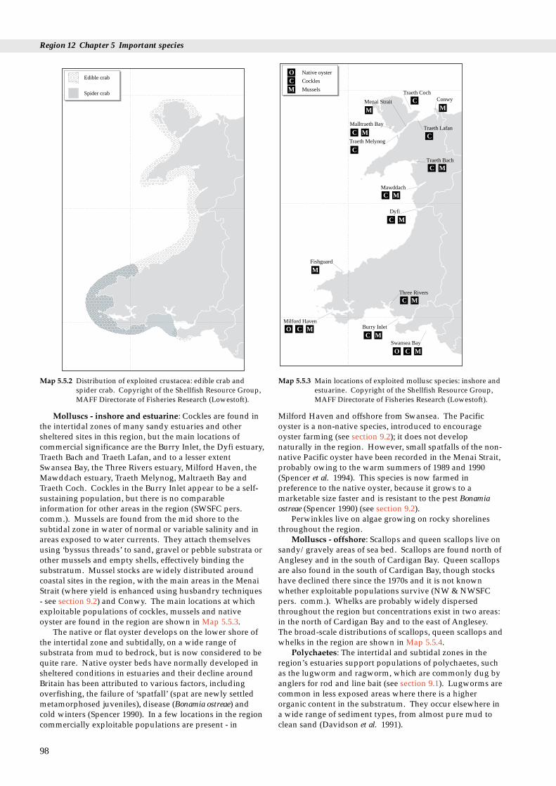
Region 12 Chapter 5 Important species
a a a a a a a a aaaaaaaaaaaaaaaaaaaaaaaaaaaaaaaaaaaaaaaaaaaaaaaaaaaaaaaa a a a a a a a a
a a a a a a a a a a a a a a a a a a a a a a a a a a a a a a a a a a a a a a aaaaaaaaaaaaaaaaaaaaaaaaaaaaaaaaaaaaaaaaaaaaaaaaaaaaaaaaaaaaaaaaaaaaaaaaaaaaaaa
aaaaaaaaaaaaaaaaaaaaaaaaaaaaaaaaaaaaaaaaaaaaaaaaaaaaaaaaaaaaaaaaaaaaaaaaaaaaaa
aaaaaaaaaaaaaaaaaaaaaaaaaaaaaaaaaaaaaaaaaaaaaaaaaaaaaaaaaaaaaaaaaaaaaaaaaaaaaa
aaaaaaaaaaaaaaaaaaaaaaaaaaaaaaaaaaaaaaaaaaaaaaaaaaaaaaaaaaaaaaaaaaaaaaaaaaaaaa
aaaaaaaaaaaaaaaaaaaaaaaaaaaaaaaaaaaaaaaaaaaaaaaaaaaaaaaaaaaaaaaaaaaaaaaaaaaaaa
aaaaaaaaaaaaaaaaaaaaaaaaaaaaaaaaaaaaaaaaaaaaaaaaaaaaaaaaaaaaaaaaaaaaaaaaaaaaaa
aaaaaaaaaaaaaaaaaaaaaaaaaaaaaaaaaaaaaaaaaaaaaaaaaaaaaaaaaaaaaaaaaaaaaaaaaaaaaa
aaaaaaaaaaaaaaaaaaaaaaaaaaaaaaaaaaaaaaaaaaaaaaaaaaaaaaaaaaaaaaaaaaaaaaaaaaaaaa
aaaaaaaaaaaaaaaaaaaaaaaaaaaaaaaaaaaaaaaaaaaaaaaaaaaaaaaaaaaaaaaaaaaaaaaaaaaaaa
aaaaaaaaaaaaaaaaaaaaaaaaaaaaaaaaaaaaaaaaaaaaaaaaaaaaaaaaaaaaaaaaaaaaaaaaaaaaaa
aaaaaaaaaaaaaaaaaaaaaaaaaaaaaaaaaaaaaaaaaaaaaaaaaaaaaaaaaaaaaaaaaaaaaaaaaaaaaa
aaaaaaaaaaaaaaaaaaaaaaaaaaaaaaaaaaaaaaaaaaaaaaaaaaaaaaaaaaaaaaaaaaaaaaaaaaaaaa
aaaaaaaaaaaaaaaaaaaaaaaaaaaaaaaaaaaaaaaaaaaaaaaaaaaaaaaaaaaaaaaaaaaaaaaaaaaaaa
aaaaaaaaaaaaaaaaaaaaaaaaaaaaaaaaaaaaaaaaaaaaaaaaaaaaaaaaaaaaaaaaaaaaaaaaaaaaaa
aaaaaaaaaaaaaaaaaaaaaaaaaaaaaaaaaaaaaaaaaaaaaaaaaaaaaaaaaaaaaaaaaaaaaaaaaaaaaa
aaaaaaaaaaaaaaaaaaaaaaaaaaaaaaaaaaaaaaaaaaaaaaaaaaaaaaaaaaaaaaaaaaaaaaaaaaaaaa
aaaaaaaaaaaaaaaaaaaaaaaaaaaaaaaaaaaaaaaaaaaaaaaaaaaaaaaaaaaaaaaaaaaaaaaaaaaaaa
aaaaaaaaaaaaaaaaaaaaaaaaaaaaaaaaaaaaaaaaaaaaaaaaaaaaaaaaaaaaaaaaaaaaaaaaaaaaaa
aaaaaaaaaaaaaaaaaaaaaaaaaaaaaaaaaaaaaaaaaaaaaaaaaaaaaaaaaaaaaaaaaaaaaaaaaaaaaa
aaaaaaaaaaaaaaaaaaaaaaaaaaaaaaaaaaaaaaaaaaaaaaaaaaaaaaaaaaaaaaaaaaaaaaaaaaaaaa
aaaaaaaaaaaaaaaaaaaaaaaaaaaaaaaaaaaaaaaaaaaaaaaaaaaaaaaaaaaaaaaaaaaaaaaaaaaaaa
aaaaaaaaaaaaaaaaaaaaaaaaaaaaaaaaaaaaaaaaaaaaaaaaaaaaaaaaaaaaaaaaaaaaaaaaaaaaaa
aaaaaaaaaaaaaaaaaaaaaaaaaaaaaaaaaaaaaaaaaaaaaaaaaaaaaaaaaaaaaaaaaaaaaaaaaaaaaa
aaaaaaaaaaaaaaaaaaaaaaaaaaaaaaaaaaaaaaaaaaaaaaaaaaaaaaaaaaaaaaaaaaaaaaaaaaaaaa
aaaaaaaaaaaaaaaaaaaaaaaaaaaaaaaaaaaaaaaaaaaaaaaaaaaaaaaaaaaaaaaaaaaaaaaaaaaaaa
aaaaaaaaaaaaaaaaaaaaaaaaaaaaaaaaaaaaaaaaaaaaaaaaaaaaaaaaaaaaaaaaaaaaaaaaaaaaaa
aaaaaaaaaaaaaaaaaaaaaaaaaaaaaaaaaaaaaaaaaaaaaaaaaaaaaaaaaaaaaaaaaaaaaaaaaaaaaa
aaaaaaaaaaaaaaaaaaaaaaaaaaaaaaaaaaaaaaaaaaaaaaaaaaaaaaaaaaaaaaaaaaaaaaaaaaaaaa
aaaaaaaaaaaaaaaaaaaaaaaaaaaaaaaaaaaaaaaaaaaaaaaaaaaaaaaaaaaaaaaaaaaaaaaaaaaaaa
aaaaaaaaaaaaaaaaaaaaaaaaaaaaaaaaaaaaaaaaaaaaaaaaaaaaaaaaaaaaaaaaaaaaaaaaaaaaaa
aaaaaaaaaaaaaaaaaaaaaaaaaaaaaaaaaaaaaaaaaaaaaaaaaaaaaaaaaaaaaaaaaaaaaaaaaaaaaa
aaaaaaaaaaaaaaaaaaaaaaaaaaaaaaaaaaaaaaaaaaaaaaaaaaaaaaaaaaaaaaaaaaaaaaaaaaaaaa
aaaaaaaaaaaaaaaaaaaaaaaaaaaaaaaaaaaaaaaaaaaaaaaaaaaaaaaaaaaaaaaaaaaaaaaaaaaaaa
aaaaaaaaaaaaaaaaaaaaaaaaaaaaaaaaaaaaaaaaaaaaaaaaaaaaaaaaaaaaaaaaaaaaaaaaaaaaaa
aaaaaaaaaaaaaaaaaaaaaaaaaaaaaaaaaaaaaaaaaaaaaaaaaaaaaaaaaaaaaaaaaaaaaaaaaaaaaa
aaaaaaaaaaaaaaaaaaaaaaaaaaaaaaaaaaaaaaaaaaaaaaaaaaaaaaaaaaaaaaaaaaaaaaaaaaaaaa
aaaaaaaaaaaaaaaaaaaaaaaaaaaaaaaaaaaaaaaaaaaaaaaaaaaaaaaaaaaaaaaaaaaaaaaaaaaaaa
aaaaaaaaaaaaaaaaaaaaaaaaaaaaaaaaaaaaaaaaaaaaaaaaaaaaaaaaaaaaaaaaaaaaaaaaaaaaaa
aaaaaaaaaaaaaaaaaaaaaaaaaaaaaaaaaaaaaaaaaaaaaaaaaaaaaaaaaaaaaaaaaaaaaaaaaaaaaa
aaaaaaaaaaaaaaaaaaaaaaaaaaaaaaaaaaaaaaaaaaaaaaaaaaaaaaaaaaaaaaaaaaaaaaaaaaaaaa
aaaaaaaaaaaaaaaaaaaaaaaaaaaaaaaaaaaaaaaaaaaaaaaaaaaaaaaaaaaaaaaaaaaaaaaaaaaaaa
aaaaaaaaaaaaaaaaaaaaaaaaaaaaaaaaaaaaaaaaaaaaaaaaaaaaaaaaaaaaaaaaaaaaaaaaaaaaaa
a a a aaaaaaaaa
aaaaaaaaaaaa
Edible crab
Spider crab
Map 5.5.2 Distribution of exploited crustacea: edible crab andspider crab. Copyright of the Shellfish Resource Group,MAFF Directorate of Fisheries Research (Lowestoft).
Native oyster
Cockles
Mussels
ConwyTraeth Coch
Malltraeth Bay
Menai Strait
Traeth Melynog
Traeth Lafan
Traeth Bach
Mawddach
Dyfi
Fishguard
Three Rivers
Milford HavenBurry Inlet
Swansea Bay
C
C
C
C
C
C
C
C
C
CO
O
M
M
M
M
M
M
M
CO M
M
C M
M
M
Map 5.5.3 Main locations of exploited mollusc species: inshore andestuarine. Copyright of the Shellfish Resource Group,MAFF Directorate of Fisheries Research (Lowestoft).
Molluscs - inshore and estuarine: Cockles are found inthe intertidal zones of many sandy estuaries and othersheltered sites in this region, but the main locations ofcommercial significance are the Burry Inlet, the Dyfi estuary,Traeth Bach and Traeth Lafan, and to a lesser extentSwansea Bay, the Three Rivers estuary, Milford Haven, theMawddach estuary, Traeth Melynog, Maltraeth Bay andTraeth Coch. Cockles in the Burry Inlet appear to be a self-sustaining population, but there is no comparableinformation for other areas in the region (SWSFC pers.comm.). Mussels are found from the mid shore to thesubtidal zone in water of normal or variable salinity and inareas exposed to water currents. They attach themselvesusing ‘byssus threads’ to sand, gravel or pebble substrata orother mussels and empty shells, effectively binding thesubstratum. Mussel stocks are widely distributed aroundcoastal sites in the region, with the main areas in the MenaiStrait (where yield is enhanced using husbandry techniques- see section 9.2) and Conwy. The main locations at whichexploitable populations of cockles, mussels and nativeoyster are found in the region are shown in Map 5.5.3.
The native or flat oyster develops on the lower shore ofthe intertidal zone and subtidally, on a wide range ofsubstrata from mud to bedrock, but is now considered to bequite rare. Native oyster beds have normally developed insheltered conditions in estuaries and their decline aroundBritain has been attributed to various factors, includingoverfishing, the failure of ‘spatfall’ (spat are newly settledmetamorphosed juveniles), disease (Bonamia ostreae) andcold winters (Spencer 1990). In a few locations in the regioncommercially exploitable populations are present - in
98
Milford Haven and offshore from Swansea. The Pacificoyster is a non-native species, introduced to encourageoyster farming (see section 9.2); it does not developnaturally in the region. However, small spatfalls of the non-native Pacific oyster have been recorded in the Menai Strait,probably owing to the warm summers of 1989 and 1990(Spencer et al. 1994). This species is now farmed inpreference to the native oyster, because it grows to amarketable size faster and is resistant to the pest Bonamiaostreae (Spencer 1990) (see section 9.2).
Perwinkles live on algae growing on rocky shorelinesthroughout the region.
Molluscs - offshore: Scallops and queen scallops live onsandy/gravely areas of sea bed. Scallops are found north ofAnglesey and in the south of Cardigan Bay. Queen scallopsare also found in the south of Cardigan Bay, though stockshave declined there since the 1970s and it is not knownwhether exploitable populations survive (NW & NWSFCpers. comm.). Whelks are probably widely dispersedthroughout the region but concentrations exist in two areas:in the north of Cardigan Bay and to the east of Anglesey.The broad-scale distributions of scallops, queen scallops andwhelks in the region are shown in Map 5.5.4.
Polychaetes: The intertidal and subtidal zones in theregion’s estuaries support populations of polychaetes, suchas the lugworm and ragworm, which are commonly dug byanglers for rod and line bait (see section 9.1). Lugworms arecommon in less exposed areas where there is a higherorganic content in the substratum. They occur elsewhere ina wide range of sediment types, from almost pure mud toclean sand (Davidson et al. 1991).

5.5 Exploited sea-bed species
a a a a a a a a a a a a a a a a a a a a a a a a aaaaaaaaaaaaaaaaaaaaaaaaaaaaaaaaaaaaaaaaaaaaaaaaaaa
aaaaaaaaaaaaaaaaaaaaaaaaaaaaaaaaaaaaaaaaaaaaaaaaaa
aaaaaaaaaaaaaaaaaaaaaaaaaaaaaaaaaaaaaaaaaaaaaaaaaa
aaaaaaaaaaaaaaaaaaaaaaaaaaaaaaaaaaaaaaaaaaaaaaaaaa
aaaaaaaaaaaaaaaaaaaaaaaaaaaaaaaaaaaaaaaaaaaaaaaaaa
aaaaaaaaaaaaaaaaaaaaaaaaaaaaaaaaaaaaaaaaaaaaaaaaaa
aaaaaaaaaaaaaaaaaaaaaaaaaaaaaaaaaaaaaaaaaaaaaaaaaa
aaaaaaaaaaaaaaaaaaaaaaaaaaaaaaaaaaaaaaaaaaaaaaaaaa
aaaaaaaaaaaaaaaaaaaaaaaaaaaaaaaaaaaaaaaaaaaaaaaaaa
aaaaaaaaaaaaaaaaaaaaaaaaaaaaaaaaaaaaaaaaaaaaaaaaaaaaaaaaaaaaaaaaaaaaaaaaaaaaaaaaaaaaaaaaaaaaaaaaaaaaaaaaaaaaaaaaaaaaaaaaaaaaaaaaaaaaaaaaaaaaaaaaaaaaaaaaaaaaaaaaaaaaaaaaaaaaaaaaaaaaaaaaaaaaaaaaaaaaaaaaaaaaaaaaaaaaaaaaaaaaaaaaaaaaaaaaaaaaaaaaaaaaaaaaaaaaaaaaaaaaaaaaaaaaaaaaaaaaaaaaaaaaaaaaaaaaaaaaaaaaaaaaaaaaaaaaaaaaaaaaaaaaaaaaaaaaaaaaaaaaaaaaaaaaaaaaaaaaaaaaaaaaaaaaaaaaaaaaaaaaaaaaaaaaaaaaaaaaaaaaaaaaaaaaaaaaaaaaaaaaaaaaaaaaaaaaaaaaaaaaaaaaaaaaaaaaaaaaaaaaaaaaaaaaaaaaaaaaaaaaaaaaaaaaaaaaaaaaaaaaaaaaaaaaaaaaaaaaaaaaaaaaaaaaaaaaaaaaaaaaaaaaaaaaaaaaaaaaaaaaaaaaaaaaaaaaaaaaaaaaaaaaaaaaaaaaaaaaaaaaaaaaaaaaaaaaaaaaaaaaaaaaaaaaaaaaaaaaa
Scallop
Queen scallop
Whelks
a a a aaaaaaaaaaaaaaaaaa
Map 5.5.4 Main locations of exploited mollusc species: offshore.(Queen scallop may not be present in commercialquantities throughout area shown.) Copyright of theShellfish Resource Group, MAFF Directorate of FisheriesResearch (Lowestoft).
Others: Maerl (see also section 4.2) is a collective namegiven to various species of calcareous algae within theRhodophyta (red seaweeds) that in this region liveunattached on the substratum in sheltered areas in MilfordHaven (Gubbay 1988) (see also section 4.2). Laver weed iscommon on exposed bedrock in intertidal areas in south andwest Wales.
5.5.3 Human activities
The exploitation by fisheries of the species covered in thissection is described in Section 9.1, and by mariculture inSection 9.2. There are two issues relating to the shellfishindustry in the region: firstly, the general levels ofexploitation, unregulated except for crustacea (currentlylobster and crab minimum sizes) and the restrictions placedon the exploitation of cockles and mussels throughRegulating Orders (see sections 9.1.2 & 9.1.4); and, secondly,the possible effects of mechanical harvesting on the benthos,feeding birds and cockle stocks (Evans & Clark 1993). Bothmobile and, to a lesser extent, static gears damage and/ormodify sea-bed habitats and their associated animal andplant communities by direct physical impact. For examplein 1985, scallop dredging was shown to cause significanthabitat, community and species damage in the thenproposed Skomer Marine Nature Reserve (Bullimore 1985),
and it is now prohibited within the Marine Nature Reserveunder SWSFC Byelaws.
Bait collection, especially digging, can have majorlocalised effects on intertidal habitats and communities andcan also cause disturbance to birds, when concentrated inestuaries and embayments. These issues are explored in thereferences given in section 5.5.5.
Industrial effluents, domestic sewage and estuarine run-off are sources of chemical pollutants (e.g. PCBs, heavymetals) and pathogenic organisms and can elevate nutrientlevels or increase the oxygen demand; these can all impactdirectly on exploited sea-bed species.
5.5.4 Information sources used
The four maps in this section show schematically theknown broad-scale distribution of the main species ofinterest, based on current knowledge from MAFF scientistsand fishery officers on the location of the species and theirfisheries. Barring substantial climate change or over-exploitation, these distributions and relationships are likelyto remain stable over several decades. The seawardboundaries on the maps are only indicative, and becauseonly large, exploitable populations are described, thespecies may also be found elsewhere in the region, but insmaller numbers. There is supporting information in theform of catch statistics for commercial landings, biologicalsamples of crustacea collected at the main ports and somesecondary ports, and intertidal surveys for molluscs inselected areas. These data provide some information aboutthe location of spawning and nursery areas, but to establishthe links between individual spawning, nursery and adultsareas would require specific research vessel investigationson the planktonic stages, the hydrography, and themovement (or otherwise) of juveniles and adults.
5.5.5 Further sources of information
A. References cited
Bullimore, B. 1985. An investigation into the effects of scallop dredgingwithin the Skomer Marine Reserve. A report to the NatureConservancy Council from the Skomer Marine Reserve SubtidalMonitoring Project (unpublished).
Davidson, N.C., Laffoley, D.d’A., Doody, J.P., Way, L.S., Gordon, J.,Key, R., Drake, C.M., Pienkowski, M.W., Mitchell, R., & Duff,K.L. 1991. Nature conservation and estuaries in Great Britain.Peterborough, Nature Conservancy Council.
Evans, J., & Clark, N.A. 1993. Disturbance studies on Swansea Bayand the Burry Inlet in relation to bird populations. Thetford, BritishTrust for Ornithology (Research Report No. 107).
Gubbay, S. 1988. A coastal directory for marine nature conservation.Ross-on Wye, Marine Conservation Society.
Rees, H.L., & Dare, P.J. 1993. Sources of mortality and associated life-cycle traits of selected benthic species: a review. Lowestoft, MAFF.(Directorate of Fisheries Research, Fisheries Research DataReport No. 33.)
Spencer, B.E. 1990. Cultivation of Pacific oysters. Lowestoft, MAFF.(Directorate of Fisheries Research Laboratory Leaflet No. 63.)
Spencer, B.E., Edwards, D.B, Kaiser, M.J., & Richardson, C.A. 1994.Spatfall of the non-native Pacific oyster Crassostrea gigas inBritish waters. Aquatic Conservation: Marine and FreshwaterEcosystems, 4: 203-217.
99
Region 12 Chapter 5 Important species
B. Further reading
Further details of marine survey sites are in the Coastal & MarineUKDMAP datasets module (Barne et al. 1994), available from JNCCCoastal Conservation Branch, Peterborough.Barne, J., Davidson, N.C., Hill, T.O., & Jones, M. 1994. Coastal and
Marine UKDMAP datasets: a user manual. Peterborough, JointNature Conservation Committee.
Cadman, P.S. 1989. Environmental impact of lugworm digging.(Contractor: University College of Swansea, Marine,Environmental and Evolutionary Research Group.) NatureConservancy Council, CSD Report, No. 910.
Chatfield, J. 1979. Marine molluscs in Wales. Journal of Conchology,30: 1-34.
Clark, P.F. 1986. North-east Atlantic crabs; an atlas of distribution.Ross-on-Wye, Marine Conservation Society.
Coates, P.J. 1983. Fishing bait collection in the Menai Strait and itsrelevance to the potential establishment of a Marine Nature Reservewith observations on the biology of the main prey species, theragworm Nereis virens. MSc thesis, Centre for EnvironmentalTechnology, Imperial College of Science and Technology,University of London.
Cook, W. 1991. Studies on the effects of hydraulic dredging on cockleand other macroinvertebrate populations 1989 - 1990. NorthWestern and North Wales Sea Fishery Committee.
Countryside Council for Wales. 1994. A preliminary bibliography tothe water and coast around Bardsey Island and the southwesternLleyn Peninsula. Unpublished draft.
Cryer, M., Whittle, G.N., & Williams, R. 1987. The impact of baitcollection by anglers on marine intertidal invertebrates.Biological Conservation, 42: 83-93.
Eno, N.C., ed. 1991. Marine conservation handbook. 2nd ed.Peterborough, English Nature.
Ferns, P.N., & Siman, H.Y. 1993. Effects of mechanised cockleharvesting on bird feeding activity in the Burry Inlet.Countryside Council for Wales Science Report, No. 34.
Franklin, A., Pickett, G.D., & Connor, P.M. 1980. The scallop and itsfishery in England and Wales. Lowestoft, MAFF. (Directorate ofFisheries Research Laboratory Leaflet No. 51.)
Hancock, D.A. 1971. The role of predators and parasites in afishery for the mollusc Cardium edule L. In: Dynamics ofpopulations, ed. by P.J. den Boer & G.R. Gradwell. Proceedingsof the Advanced Study Institute, Oosterbeck, 1970, Centre forAgric. Publ. and Documentation, Wageningen.
Huggett, D. 1992. Foreshore fishing for shellfish and bait. Sandy,Royal Society for the Protection of Birds.
McLusky, D.S., Anderson, F.E., & Wolfe-Murphy, S. 1983.Distribution and population recovery of Arenicola marina andother benthic fauna after bait digging. Marine Ecology ProgressSeries, 11: 173 - 179.
Moore, J. 1991. Studies on the impact of hydraulic cockle dredging onintertidal sediment flat communities. Final report to NCC from theField Studies Council Research Centre. (FSC/RC/4/91.)
Norton, T.A., & Geffen, A.J. 1990. Exploitable living resources.Liverpool University Press. (Irish Sea Study Group Report Part3.)
Olive, P.J.W. 1993. Management of the exploitation of the lugwormArenicola marina and the ragworm Nereis virens (Polychaeta) inconservation areas. Aquatic Conservation: Marine and FreshwaterEcosytems, 3: 1-24.
Rostron, D.M. 1993. The effects of tractor towed cockle dredgingon the invertebrate fauna of Llanrhidian Sands, Burry Inlet.Countryside Council for Wales Science Report, No. 36. Bangor,Countryside Council for Wales.
Seaward, D.R. 1990. Distribution of the marine molluscs of north-westEurope. Peterborough, NCC, for Conchological Society of GreatBritain and Ireland.
Seaward, D.R. 1993. Distribution of the marine molluscs of north-west Europe (1990). Additions and amendments. JNCC Report,No. 165.
100
Simpson, A.C. 1961. A contribution to the bionomics of the lobsterHomarus vulgaris (Edw.) on the coast of North Wales. MAFFFishery Invest., Lond., Ser II, 23 (7).
Young, G.A. 1992. The Menai Strait: a review and bibliography ofliterature from the Wolfson Library. Unpublished report toCountryside Council for Wales. (Contractor: University Collegeof North Wales, Bangor.)

5.5 Exploited sea-bird species
C. Contact names and addresses
Type of information Contact address and telephone no.
Fish stocks and fisheries advice to assist with management Director, MAFF Directorate of Fisheries Research, Fisheriesand policy decisions for the coastal zone Laboratory (Conwy), Benarth Road, Conwy,
Gwynedd LL32 8UB, tel: 01492 593883
Assessment and provision of advice on the conservation of Director, MAFF Directorate of Fisheries Research, Fisheries commercial fish and shellfish stocks. Publications leaflet. Laboratory (Lowestoft), Pakefield Road, Lowestoft,
Suffolk NR33 OHT, tel: 01502 562244
Reviews and bibliography. Information and advice on marine *Marine and Coastal Section, CCW HQ, Bangor,conservation issues in Wales tel: 01248 370444. Also Regional Offices.
Benthic surveys: (Marine Nature Conservation Review Database) *Marine Conservation Branch, JNCC, Peterborough,tel: 01733 62626
Library and scientific advice Director/Librarian, University College of North Wales,School of Ocean Sciences, Menai Bridge, Gwynedd LL59 5EY, tel: 01248 716367
Reports and publications from work undertaken Director, Field Studies Council Research Centre, OilPollution Research Unit, Fort Popton, Angle, Pembroke,Dyfed SA71 5AD, tel: 01646 641404
Milford Haven monitoring studies and reports produced for and Trevor D. Lloyd, Milford Haven Waterway Environmental compiled by the Steering Group Monitoring Steering Group, Civil Protection Planning Unit,
Dyfed County Council, Hill House, Picton Terrace,Carmarthen, Dyfed SA31 3BS, tel: 01267 236651
Information and advice on marine conservation issues in the *Warden, CCW Skomer, Haverfordwest, tel: 01646 636736Skomer Marine Nature Reserve
Marine Fisheries Task Group paper and advice on marine *Marine Advisory Officer, Marine Conservation conservation issues Branch, JNCC, Peterborough, tel: 01733 62626
Information and advice on marine conservation issues in Wales *Marine and Coastal Section, CCW HQ, Bangor, tel: 01248 370444
Information and advice on marine conservation issues *Marine Conservation Officer, RSPB Sandy, tel: 01767 680551
Information and advice on marine conservation issues *Fisheries Officer, Marine section, WWF-UK, Godalming,tel. 01483 426444
Information and advice on marine conservation issues *Conservation Officer, Marine Conservation Society, Ross-on-Wye, tel: 01989 566017
Information and advice on issues in Cardigan Bay *Projects Officer, Cardigan Bay Forum, Aberystwyth, tel: 01970 624471
Information on issues in Irish Sea Study Group area *Chairman, Irish Sea Forum, University of Liverpool, tel: 0151 794 4089
Information and advice on marine conservation issues Administrator, The Marine Forum for EnvironmentalIssues, Department of Zoology, The Natural HistoryMuseum, Cromwell Road, London SW7 5BD, tel: 0171 938 9114
* Starred contact addresses are given in full in the Appendix
5.5.6 Acknowledgements
Thanks to R.C.A. Bannister (Shellfish Resource Group,MAFF Directorate of Fisheries Research, Lowestoft) andBlaise Bullimore (CCW) for their helpful comments andadditional written sections.
101
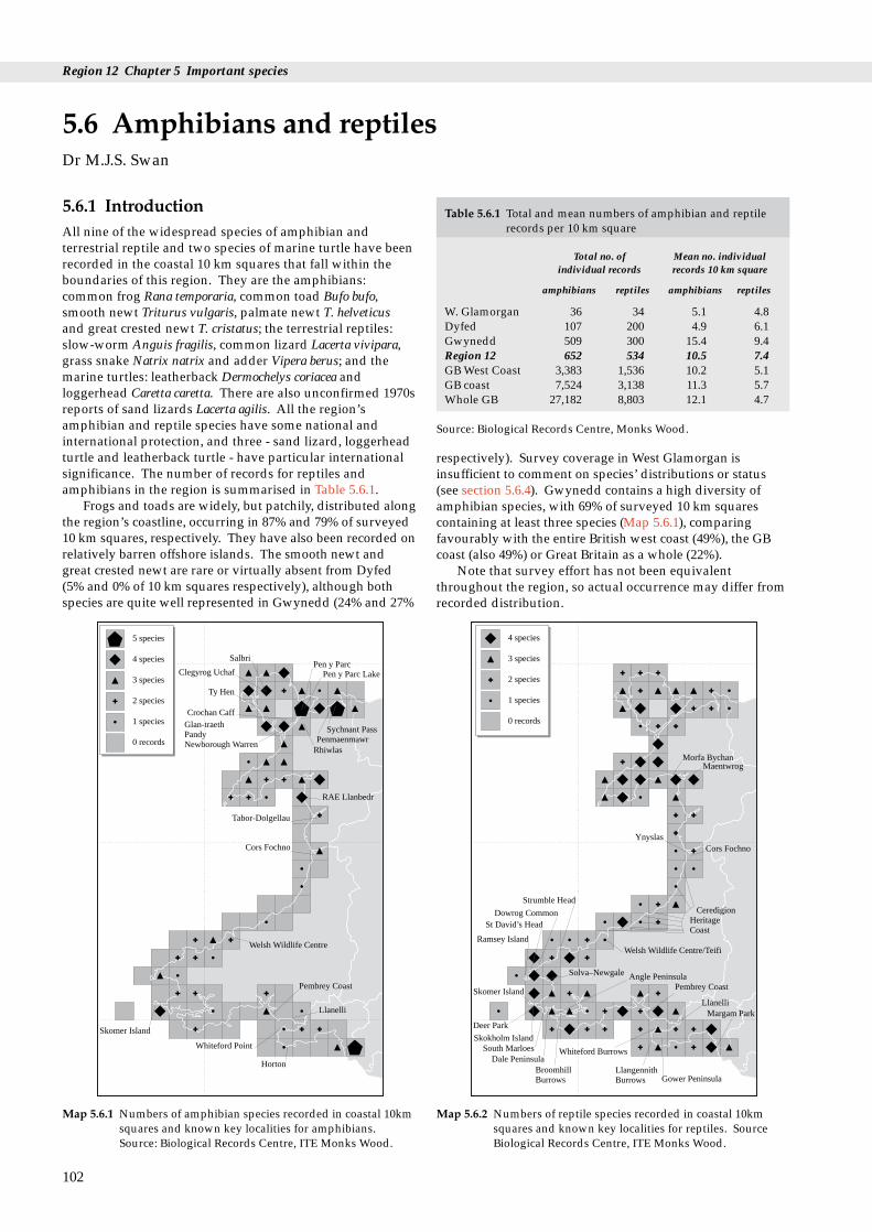
Region 12 Chapter 5 Important species
s
Table 5.6.1 Total and mean numbers of amphibian and reptilerecords per 10 km square
Total no. of Mean no. individualindividual records records 10 km square
amphibians reptiles amphibians reptiles
W. Glamorgan 36 34 5.1 4.8Dyfed 107 200 4.9 6.1Gwynedd 509 300 15.4 9.4Region 12 652 534 10.5 7.4GB West Coast 3,383 1,536 10.2 5.1GB coast 7,524 3,138 11.3 5.7Whole GB 27,182 8,803 12.1 4.7
Source: Biological Records Centre, Monks Wood.
5.6.1 IntroductionAll nine of the widespread species of amphibian andterrestrial reptile and two species of marine turtle have beenrecorded in the coastal 10 km squares that fall within theboundaries of this region. They are the amphibians:common frog Rana temporaria, common toad Bufo bufo,smooth newt Triturus vulgaris, palmate newt T. helveticusand great crested newt T. cristatus; the terrestrial reptiles:slow-worm Anguis fragilis, common lizard Lacerta vivipara,grass snake Natrix natrix and adder Vipera berus; and themarine turtles: leatherback Dermochelys coriacea andloggerhead Caretta caretta. There are also unconfirmed 1970sreports of sand lizards Lacerta agilis. All the region’samphibian and reptile species have some national andinternational protection, and three - sand lizard, loggerheadturtle and leatherback turtle - have particular internationalsignificance. The number of records for reptiles andamphibians in the region is summarised in Table 5.6.1.
Frogs and toads are widely, but patchily, distributed alongthe region’s coastline, occurring in 87% and 79% of surveyed10 km squares, respectively. They have also been recorded onrelatively barren offshore islands. The smooth newt andgreat crested newt are rare or virtually absent from Dyfed(5% and 0% of 10 km squares respectively), although bothspecies are quite well represented in Gwynedd (24% and 27%
5.6 Amphibians and reptileDr M.J.S. Swan
102
5 species
4 species
3 species
2 species
1 species
0 records
Salbri
Clegyrog Uchaf
Ty Hen
Pen y Parc LakePen y Parc
PenmaenmawrSychnant Pass
Rhiwlas
Crochan CaffGlan-traethPandyNewborough Warren
RAE Llanbedr
Tabor-Dolgellau
Cors Fochno
Welsh Wildlife Centre
Skomer Island
Whiteford Point
Pembrey Coast
Llanelli
Horton
Map 5.6.1 Numbers of amphibian species recorded in coastal 10kmsquares and known key localities for amphibians.Source: Biological Records Centre, ITE Monks Wood.
respectively). Survey coverage in West Glamorgan isinsufficient to comment on species’ distributions or status(see section 5.6.4). Gwynedd contains a high diversity ofamphibian species, with 69% of surveyed 10 km squarescontaining at least three species (Map 5.6.1), comparingfavourably with the entire British west coast (49%), the GBcoast (also 49%) or Great Britain as a whole (22%).
Note that survey effort has not been equivalentthroughout the region, so actual occurrence may differ fromrecorded distribution.
4 species
3 species
2 species
1 species
0 records
Morfa BychanMaentwrog
Cors FochnoYnyslas
Strumble Head
Dowrog CommonSt David’s Head
Ramsey Island
Skomer Island
Deer Park
Skokholm IslandSouth Marloes
Dale PeninsulaBroomhillBurrows
LlangennithBurrows
Whiteford Burrows
Gower Peninsula
Margam ParkLlanelli
Pembrey CoastAngle PeninsulaSolva–Newgale
Welsh Wildlife Centre/Teifi
CeredigionHeritageCoast
Map 5.6.2 Numbers of reptile species recorded in coastal 10kmsquares and known key localities for reptiles. SourceBiological Records Centre, ITE Monks Wood.

5.6 Amphibians and reptiles
Table 5.6.2 Important sites for amphibians
Site name Grid ref. Species Information
Horton, Gower (farm pond - only recorded SS4786 great crested newts qualitativebreeding site in W. Glamorgan)
Whiteford Point (dune slack) SS4595 frog, palmate newt qualitativeLlanelli (dune slack) SS5-9- frog, palmate newt qualitativePembrey Coast (dune slack) SN3-0- frog, palmate newt qualitativeSkomer Island SM725096 frog, toad, palmate newt *Welsh Wildlife Centre/Teifi Estuary (marsh) SN1845 frog, toad, palmate newt qualitativeCors Fochno (raised mire) SN6292 frog, toad, palmate newt qualitativeTabor-Dolgellau SH747176 frog, toad, palmate newt *RAF Llanbedr (50 m from Morfa Dyffryn) SH564257 great crested newts Glan-traeth SSSI SH415665 great crested newts (large population)Pandy SH412658 frog, toad, palmate newt *Newborough Warren NNR/SSSI (4 locations) SH392648 great crested newts (moderate population)
SH398651 great crested newts (moderate population)SH404637 great crested newts (moderate population)SH404651 great crested newts (moderate population)
Crochan Caffo SH436692 frog, toad, palmate newt *Ty Hen Farm SH327734 frog, toad, palmate newt *Clegyrog Uchaf (100 m from Llyn Hafodol SH386888 great crested newts
and Cors Clegyrog SSSI)Salbri (200 m from Salbri SSSI) SH376890 great crested newts Pen y Parc SH586752 frog, toad, palmate newt, great crested newt, *
smooth newtPen y Parc Lake SH585753 frog, toad, palmate newt, great crested newt *Rhiwlas SH583661 frog, toad, palmate newt *Sychnant Pass SSSI SH755766 great crested newts (moderate population)
Sources: Welsh Wildlife Trusts, CCW, Vice-county recorders, National Park, National Nature Reserve (NNR), Heritage Coast and Sites ofSpecial Scientific Interest (SSSI) managers, Swan & Oldham (1993a,b). Note: * = important sites, based on NCC amphibian communityscoring system described in Swan & Oldham (1989).
This region contains a slightly higher percentage of 10km squares supporting at least three reptile species (50%)(Map 5.6.2) than the west coast (44%), the GB coast (43%) orGreat Britain as a whole (45%). Coastal habitats in theregion may provide a stronghold for reptiles, which areparticularly abundant on some clifftops and areas of coastalheath and grassland. A national pilot study (Corbett 1994)has identified several sand dune systems in the region aspotential sand lizard re-introduction sites. Common lizardsand adders are widely distributed along the coast, occurringin over 70% of recorded squares in each county. Slow-worms are also present throughout the region but have beenobserved less frequently (47% of surveyed 10 km squares),possibly because of their more secretive nature. Slow-worms also occur on the offshore islands of Skokholm,Skomer and Ramsey. Grass snakes have been recordedmore frequently on the south-facing than the west-facingcoasts of each of the three counties and generally in wetter,lusher areas (e.g. Winterton Marsh, Dyfed) than the otherreptiles. Adders and common lizards are particularlyabundant on the Pembrokeshire coast.
5.6.2 Important locations and species
This region contains one of only nine SSSIs in Britainnotified for their great crested newt populations. Greatcrested newts in the region are concentrated in Gwynedd,being apparently absent from Dyfed and recorded so far inonly one site in West Glamorgan. The region also supports11% (see Table 5.6.2) of the best amphibian community
assemblage sites in Great Britain. Table 5.6.2 lists importantsites for great crested newts and other amphibian species.
The mainly narrow coastal strip between farmland andthe shoreline provides habitat for adders and commonlizards - sand dunes, coast paths, short grassland, heathland(wet and dry) and exposed bare rocks. The region’s duneslacks and coastal scrub are also excellent amphibianhabitat.
Fewer quantitative data are available for theidentification of prime reptile sites than for amphibian sites,so most of the information presented is anecdotal. Reptilepresence in most of the named areas, if not their level ofabundance, is confirmed by National Amphibian andReptile Surveys (NARS) data. Important reptile areas arelisted in Table 5.6.3.
Five species of marine turtle have been recorded inBritish waters, two of which, the leatherback turtleDermochelys coriacea and the loggerhead turtle Caretta caretta,have been recently reported in the region. In 1991 twostranding incidents were recorded: a loggerhead and anunidentified turtle were found at Newgale and at Tenbybeaches, respectively. The loggerhead was still alive whenfound, but died within days of rescue. In 1993, aleatherback was found at Hell’s Mouth on the LlynPeninsula, entangled in lobster pot lines, and in 1994 anunidentified turtle was found at Rhosneigr.
103

Region 12 Chapter 5 Important species
Table 5.6.3 Important areas for reptiles
Site/area Grid ref. Habitat Species
W. GlamorganMargam Park SS7887 grass snake, slow worm, adder Gower Peninsula coastal grassland, wet heath common lizard, grass snake, slow worm, adder Llangennith Burrows SS4291 sand dunes common lizard, grass snake, adderWhiteford Burrows SS4595 sand dunes common lizard, grass snake, slow worm, adder
DyfedLlanelli SS5-9- sand dunes slow worm, common lizard, grass snake, adder Pembrey Coast SN3-0- sand dunes slow worm, common lizard, grass snake, adderBroomhill Burrows SM8900 sand dunes, shingle adderAngle Peninsula SM8603 path, cliff grassland, slow worm, common lizard, grass snake (uncommon),
exposed rocks, heath adder (particularly abundant)Dale Peninsula SM8205 path, cliff grassland, exposed slow worm, common lizard, grass snake (uncommon),
rocks, heath adder (particularly abundant)South Marloes Coast SM7808 path, cliff grassland, exposed slow worm, common lizard, grass snake (uncommon),
rocks, heath adder (particularly abundant)Deer Park SM7509 path, cliff grassland, exposed slow worm, common lizard, grass snake (uncommon),
rocks, heath adder (particularly abundant)Skokholm Island SM7305 heath, grassland slow wormSkomer Island SM7209 heath, grassland slow wormSolva to Newgale SM8223 path, cliff grassland, exposed slow worm, common lizard, grass snake (uncommon),
rocks, heath adder (particularly abundant)Ramsey Island SM7023 heath, grassland slow wormSt David’s Head SM7629 path, cliff grassland, exposed slow worm, common lizard, grass snake (uncommon),
rocks, heath adder (particularly abundant)Dowrog Common SM7727 wet heath common lizard, adderStrumble Head SM9141 path, cliff grassland, exposed slow worm, common lizard, grass snake (uncommon),
rocks, heath adder (particularly abundant)Teifi Estuary/Welsh SN1945 slate quarry, woodland, low common lizard, slow worm, adder, probably grass snake
Wildlife Centre cliff, grazing marsh, reedbed
8 locations along coastal strip SN1648 to path, shingle, cliff, cliff common lizard, slow worm, adderbetween Towyn Warren SN5987 grassland, heathand Brynbala
Cors Fochno SN6393 raised mire slow worm, common lizard, grass snake, adderYnyslas SN6094 sand dunes common lizard, sand lizard*
GwyneddMaentwrog SH6540 woodland, wetland, slow worm, common lizard, grass snake, adder
scrub, heathMorfa Bychan SSSI SH5436 sand dune, reed bed slow worm, common lizard, grass snake, adder
Sources: Welsh Wildlife Trusts, CCW, Vice-county recorders, National Park, Nature Reserve, Heritage Coast and SSSI wardens,Swan & Oldham (1993a,b). * - not reported since 1970s.
5.6.3 Human activities
Currently, few land-use issues affect the herpetofauna ofthis region. In Gwynedd, only 10% of potential amphibianbreeding sites are thought to be affected by harmful humanactivities, compared with 35% of recorded sites nationally(Swan & Oldham 1993a,b). Coastal reptile habitats subjectto visitor pressure are being damaged, but those relativelyremote from human population centres are not thought tobe at risk.
5.6.4 Information sources used
Of the coastal 10 km squares in Britain, 69% have beensurveyed for amphibians and reptiles. Table 5.6.4 indicatesthe percentage of 10 km squares which have been surveyedfor herpetofaunal species throughout Great Britain and in 10 km coastal squares nationally, along the west coast ofBritain, the coastline of Wales and of each of the counties of
104
this region. Overall, therefore, the coast of Wales has beenwell recorded, especially Gwynedd. Reptile recording effortin Dyfed is also high but for amphibians is low; WestGlamorgan, however, is a particularly under-recordedcounty for both amphibian and reptile species. Records ofreptiles and amphibians are concentrated in the north andsouth-west of the region, largely reflecting recording effort.However, anecdotal evidence suggests that the paucity ofrecords from the centre of the region could also be due to ashortage of small water-bodies and to the narrowness of theundisturbed coastal strip, relative to areas to the north andsouth.
National distribution data after 1970 for amphibians andterrestrial reptiles were provided by the Biological RecordsCentre (BRC) at Monk’s Wood (Arnold 1983; Arnold inprep.). These include all the data collected during theNational Amphibian and Reptile Surveys (NARS)undertaken by De Montfort University for English Nature(Oldham & Nicholson 1986; Swan & Oldham 1989, 1993 a,b). Qualitative information was provided by the

5.6 Amphibians and reptiles
Table 5.6.4 Percentage of 10 km squares surveyed foramphibians and reptiles
Total 10 km %10 km squares surveyedsquares
Any herp Amphibians Reptilesspecies
W Glamorgan 12 67 58 58Dyfed 44 75 50 75Gwynedd 38 87 87 84Region 12 90 82 69 80GB West Coast 620 63 53 49GB coast 1,124 69 59 49Whole GB 2,862 84 79 66
Source: Biological Records Centre, Monks Wood.
Countryside Council for Wales (CCW), the Welsh WildlifeTrusts, vice-county recorders of amphibians and reptiles andstaff of coastal Country Parks, Heritage Coasts and localauthorities, as well as being extracted from the NARSdatabases. Turtle information was supplied by the NaturalHistory Museum and Southampton University. CCW andthe Welsh Wildlife Trusts hold lists of recorded great crestednewt and other amphibian breeding sites throughout Wales.
5.6.5 Further sources of information
A. References cited
Arnold, H.R., ed. 1983. Distribution maps of the amphibians andreptiles of the British Isles. Huntingdon, Biological RecordsCentre.
Arnold, H.R., ed. In prep. Atlas of amphibians and reptiles in Britainand Ireland. Huntingdon, Biological Records Centre.
Corbett, K. 1994. Pilot study for sand lizard UK recoveryprogramme. English Nature Research Report, No 102.(Contractor: Herpetological Conservation Trust.)
Oldham, R.S., & Nicholson, M. 1986. Status and ecology of the wartynewt Triturus cristatus. Final Report. (Contractor: LeicesterPolytechnic.) Peterborough, unpublished report to the NatureConservancy Council.
Swan, M.J.S., & Oldham, R.S. 1989. Amphibian communities, finalreport. Peterborough, unpublished report to the NatureConservancy Council. (Contractor: Leicester Polytechnic.)
Swan, M.J.S., & Oldham, R.S. 1993a. Herptile sites. Volume 1:National amphibian survey. English Nature Research Report, No.38. (Contractor: De Montfort University.)
Swan, M.J.S., & Oldham, R.S. 1993b. Herptile sites. Volume 2:National reptile survey. English Nature Research Report, No. 39.(Contractor: De Montfort University.)
Whitten, A.J. 1990. Recovery: A proposed programme for Britain’sprotected species. Peterborough, Nature Conservancy Council.
B. Further reading
British Herpetological Society. 1990. Save our reptiles. (Advisoryleaflet issued by the BHS Conservation Committee.)
British Herpetological Society. 1990. Surveying for amphibians.(Advisory leaflet issued by the BHS Conservation Committee.)
British Herpetological Society. 1990. Garden ponds as amphibiansanctuaries. (Advisory leaflet issued by the BHS ConservationCommittee.)
Corbett, K. 1990. Conservation of European reptiles and amphibians.London, Christopher Helm.
Mallinson, J.J. 1990. Turtle rescue. Marine Conservation, Winter1990/91: 8-9.
Mallinson, J.J. 1991. Stranded juvenile loggerheads in the UnitedKingdom. Marine Turtle Newsletter, 54: 14-16.
Wisniewski, P.J. 1984. Distribution of amphibians and reptiles inGlamorgan, South Wales. British Herpetological Society Bulletin,9: 29-34.
105

Region 12 Chapter 5 Important species
C. Contact names and addresses
Type of information Contact address and telephone no.
Conservation and captive breeding of herptiles The British Herpetological Society, c/o The Zoological Society of London,Regent’s Park, London NW1 4RY, tel. 0181 452 9578
Conservation of threatened reptiles and amphibians Conservation Officer, The Herpetological Conservation Trust, 655A ChristchurchRoad, Boscombe, Bournemouth, Dorset BH1 4AP, tel. 01202 391319
Amphibian and reptile conservation and recording Common Species Co-ordinator, Herpetofauna Groups of Britain and Ireland,groups (national secretariat) c/o HCIL, Triton House, Bramfield, Halesworth, Suffolk IP19 9AE,
tel. 0198 684 518
Herpetological conservation in Britain (lead Lowlands Team, English Nature, Northminster House, Peterborough PE1 1UA,conservation agency) tel. 01733 340345
National distribution data and recording schemes *Biological Records Centre, ITE Monks Wood, tel. 01487 773381
Turtles Dr Colin McCarthy, Natural History Museum, Cromwell Road,London SW7 5BD, tel. 0171 938 9123
as above Dept of Oceanography, Southampton University, Highfield,Southampton SO9 5NH, tel. 01703 595000
Amphibians and reptiles in Wales *Phase 1 Coordinator, CCW North Wales Region, Bangor, Gwynedd, tel. 01248 372333
as above University of Wales - Llysdinam Field Centre, Newbridge-on-Wye, LlandrindodWells, Powys LD1 6NB, tel. 0159 789308
as above *Vice-county recorders for Pembrokeshire, Ceredigion and Carmarthen, c/o Dyfed Wildlife Trust, Haverfordwest, tel. 01437 765462
as above *North Wales Wildlife Trust, Bangor, tel./fax. 01248 351541
as above *Glamorgan Wildlife Trust, Tondu, tel. 01656 724100
Herptiles on the West Glamorgan Coast *CCW South Wales Region, Cardiff, tel. 01222 485111
Herptiles on the Ceredigion Heritage Coast Planning Department, Cyngor Dosbarth Ceredigion, Penmorfa, Aberaeron,Dyfed SA46 0AT, tel. 01545 571115
Herptiles on the Pembrokeshire Coast National Park National Park Ecologist, County Offices, St Thomas’s Green, Haverfordwest,Pembrokeshire SA61 1QZ, tel. 01437 764591
Herptiles in the Welsh Wildlife Centre/Teifi Marshes Welsh Wildlife Centre, Aberteifi, Cilgerran, Cardigan, Dyfed SA43 2TB, tel. 01239 621600
Herptiles in Ynyslas NNR *Ynyslas NNR Warden, CCW North Wales Region, Bangor, tel. 01248 372333
Herptiles on the Pembrokeshire Coast *CCW Fishguard, tel. 01348 874602
Herptiles on the Cardigan Coast, Stackpole *CCW Aberystwyth, tel. 01970 828551
* Starred contact addresses are given in full in the Appendix
5.6.6 Acknowledgements
The author thanks the following people for providinginformation and for commenting on drafts: Liz Allan,Henry Arnold, Sue Byrne, Ian Callan, Jo Exell, Jim Foster,Jane Garner, Holly Harris, Jane Hodges, Robin Howard, LizHowe, Alan Lewis, Gordon Lumby, Jenny Mallinson, ColinMcCarthy, Morgan Parry and Annie Poole.
106

5.7 Fish: exploited sea fish
Table 5.7.2 Demersal species and their protected status in region
Species Protected status
ElasmobranchsSpurdog Squalus acanthias -Thornback ray Raja clavata -Small-eyed ray Raja microocellata -
GadoidsCod Gadus morhua MLS/QMWhiting Merlangius merlangus MLS/QMLing Molva molva -Pollack Pollachius pollachius MLS/QMSaithe Pollachius virens MLS/QMHake Merluccius merluccius MLS/QM
FlatfishPlaice Pleuronectes platessa MLS/QMDab Limanda limanda MLSSole Solea solea MLS/QMTurbot Psetta maxima MLSBrill Scophthalmus rhombus MLSMegrim Lepidorhombus whiffiagonis MLS/QMFlounder Platichthys flesus MLS
Other demersal fishBass Dicentrarchus labrax Nursery areas, MLS and
mesh size in gill netsGrey mullets Chelon labrosus, MLS (mesh size in Liza ramada and Liza aurata gill nets)Monkfish (angler) Lophius piscatorius QMConger eel Conger conger MLSGurnards Triglidae spp. -Wrasse Labridae spp. -Sandeels Ammodytes spp. -
Key MLS = minimum landing size; QM = catch quota
5.7.1 Introduction
This section describes the distributions of sea fish speciesthat are of interest because they are exploited by people,mainly for food. Their exploitation through fisheries isdescribed in section 9.1 and through mariculture in section9.2. Sea fish described as pelagic (Table 5.7.1) are mostcommonly found in shoals swimming in midwater; theytypically make extensive seasonal movements or migrationsbetween sea areas. ‘Demersal’ fish are those found living ator near the bottom of the sea. For this report, all sea fishthat are not ‘pelagic’ are termed ‘demersal’, the latter termthus including bass and grey mullet. Demersal species arehere divided into four groups: elasmobranchs (sharks,skates and rays), gadoids (the cod family), flatfish, and otherdemersal fish (Table 5.7.2). Most demersal species gather inlate winter or spring on persistent and recognisablespawning grounds, to release millions of minute free-floating eggs. From these hatch larvae, which feed on andmove with the plankton, often for a hundred miles or more,before metamorphosing into tiny fish, which recruit toinshore nursery grounds.
The distribution of each exploited sea fish species can bemapped from expert analysis of catch data, but this isoutside the scope of this report. This description of theirdistribution covers only their occurrence at identifiablelocalities during particular phases of their life history, andthe three maps are restricted to showing the knownspawning areas (Map 5.7.1 and 5.7.2) and nursery areas(Map 5.7.3) of key species in the region. Barring substantialclimate change, or complete over-exploitation, thesedistributions and relationships will remain stable overseveral decades.
5.7 Fish: exploited sea fish Dr M.G. Pawson and C.F. Robson
management.
5.7.2 Important locations and species
Mackerel is the region’s most abundant pelagic fish. Theyspawn along the edge of the continental shelf from Februaryto July, after which the majority of adult fish migrate to thearea around the north of Scotland, although shoals of
Table 5.7.1 Pelagic species and their protected status in region
Species Protected status
Mackerel Scomber scombrus QM and gear restrictions insouthern margin of theregion
Horse mackerel Trachurus trachurus QM/MLSHerring Clupea harengus QM/MLS and mesh
regulations on pelagictrawls and gill nets
Sprat Sprattus sprattus -‘Whitebait’ - juvenile sprat Limits on proportion of Sprattus sprattus and herring herring permitted in catchClupea harengus
Key MLS = minimum landing size; QM = catch quotamanagement.
smaller fish occur in coastal waters of the region throughoutthe summer. Herring are locally abundant and are foundaround the Pembrokeshire coast. There are noautumn/winter spawning areas in the region, but localspring spawning occurs in Milford Haven (Hobbs &Morgan 1992). Sprat are widely dispersed throughout theregion and their main egg and larval distribution covers thewhole region apart from Cardigan Bay. Juvenile sprats areoften found mixed with young herring in inshore areas,when they are known as ‘whitebait’.
All elasmobranch species produce relatively smallnumbers of live young (10-100 per annum, sometimes fewerin big sharks) or lay large eggs on the sea bed close to theirnursery areas. Several species of shark occur at lownumbers during their summer migrations off the west coast,but only the spurdog is found regularly in sufficientabundance to be exploited. Another elasmobranch, thethornback ray, is also important locally, especially en route toits spring spawning grounds in shallow bays around theregion. A number of other ray species are patchilydistributed in the area, for example the small-eyed ray offthe Gower Peninsula.
Of the gadoids, cod and whiting are abundant and
107
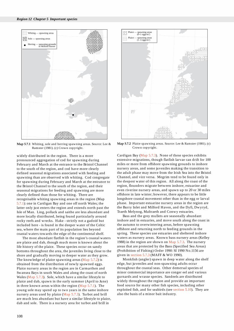
Region 12 Chapter 5 Important species
Whiting — spawning areas
Sole — spawning areas
Herring — spawning groundsin Milford Haven
Map 5.7.1 Whiting, sole and herring spawning areas. Source: Lee &Ramster (1981). (c) Crown copyright.
Plaice — spawning areas(0–1 eggs/m )2
Plaice — spawning areas(1–3 eggs/m )2
Map 5.7.2 Plaice spawning areas. Source: Lee & Ramster (1981). (c)Crown copyright.
widely distributed in the region. There is a morepronounced aggregation of cod for spawning duringFebruary and March at the entrance to the Bristol Channelto the south of the region, and cod have more clearlydefined seasonal migrations associated with feeding andspawning than are observed with whiting. Cod congregatefor spawning during February and March at the entrance tothe Bristol Channel to the south of the region, and theirseasonal migrations for feeding and spawning are moreclearly defined than those for whiting. There arerecognisable whiting spawning areas in the region (Map5.7.1): one in Cardigan Bay and one off north Wales; thelatter only just enters the region and extends north past theIsle of Man. Ling, pollack and saithe are less abundant andmore locally distributed, being found particularly aroundrocky reefs and wrecks. Hake - strictly not a gadoid butincluded here - is found in the deeper water of the Celticsea, where the main part of its population lies beyondcoastal waters towards the edge of the continental shelf.
The most abundant flatfish in the region’s coastal watersare plaice and dab, though much more is known about thelife history of the plaice. These species occur on sandybottoms throughout the area, the juveniles living close to theshore and gradually moving to deeper water as they grow.The knowledge of plaice spawning areas (Map 5.7.2) isobtained from the distribution of newly spawned eggs.Plaice nursery areas in the region are in Carmarthen andSwansea Bays in south Wales and along the coast of northWales (Map 5.7.3). Sole, which have a similar lifestyle toplaice and dab, spawn in the early summer (April to June)in three known areas within the region (Map 5.7.1). Theyoung sole may spend up to two years in the same inshorenursery areas used by plaice (Map 5.7.3). Turbot and brillare much less abundant but have a similar lifestyle to plaice,dab and sole. There is a nursery area for turbot and brill in
108
Cardigan Bay (Map 5.7.3). None of these species exhibitsextensive migrations, though flatfish larvae can drift for 100miles or more from offshore spawning grounds to inshorenursery areas, and some juveniles making the transition tothe adult phase may move from the Irish Sea into the BristolChannel, and vice versa. Megrim tend to be found only inthe deepest water of this region. All along the coast of theregion, flounders migrate between inshore, estuarine andeven riverine nursery areas, and spawn up to 20 or 30 milesoffshore in late winter; however, there appears to be littlelongshore coastal movement other than in the egg or larvalphase. Important estuarine nursery areas in the region arethe Burry Inlet and Milford Haven, and the Dyfi, Dwyryd,Traeth Melynog, Maltraeth and Conwy estuaries.
Bass and the grey mullets are seasonally abundantinshore and in estuaries, and move south along the coast inthe autumn to overwintering areas, before spawningoffshore and returning north to feeding grounds in thespring. These species use estuaries and sheltered inshorewaters as nursery areas. Known bass nursery areas (Kelley1988) in the region are shown on Map 5.7.3. The nurseryareas that are protected by the Bass (Specified Sea Areas)(Prohibition of Fishing) Order 1990: SI 1990 No.1156 aregiven in section 5.7.3 (MAFF & WO 1990).
Monkfish (angler) spawn in deep water along the shelfedge, but juveniles and non-spawning adults occurthroughout the coastal seas. Other demersal species ofminor commercial importance are conger eel and variousgurnards and wrasse species. Sandeels are distributedwidely throughout the region and provide an importantfood source for many other fish species, including otherexploited fish, and for seabirds (see section 5.10). They arealso the basis of a minor bait industry.

5.7 Fish: exploited: sea fish
Herring nursery area
Plaice and sole nursery area
Turbot and brill nursery area
Bass nursery area Conwy Estuary
Malltraeth Bay
Dwyryd
Mawddach
DysynniDyfi
Inland Sea
TeifiNefern
Milford Haven
Three Rivers
Burry Inlet
AssumedKnown }
Map 5.7.3 Pelagic and demersal fish species nursery areas. Source:Lee & Ramster (1981). (c) Crown copyright.
5.7.3 Human activities
A feature of all fish stocks, and the primary reason for theirfluctuation, is the variability of recruitment of juvenile fishto the exploited populations. This variability, the causes ofwhich are not fully understood, is determined largely byenvironmental conditions at the time of spawning and in thesubsequent larval survival. Exploitation of fish stocks mayincrease the extent of these fluctuations.
Efforts are made to conserve stocks of pelagic anddemersal species by giving them categories of protectedstatus (see Tables 5.7.1 and 5.7.2) reflecting their commercialimportance or state of exploitation. Management measuresare applied, including minimum landing sizes (MLS), closedfishing areas and seasons, mesh size regulations andquantitative controls on catches (QM) or fishing effort(further explained in section 9.1.3). Their implementationmeans that species caught below minimum landing size orfor which the quota is exhausted may be discarded at sea,and this may affect the exploited species fish stocks as wellas other fish species, birds and species that live on the seabed.
Spawning and nursery areas may be vulnerable to otherhuman activities and their effects occurring in the coastalzone, such as sewage sludge dumping, dredging anddredge spoil dumping and the development ofinfrastructure, such as barrages and pipelines. MAFF is astatutory consultee for activities such as these, in which thedistributions of exploited fish populations and theirspawning and nursery areas have to be taken into accountbefore permission is granted.
Out of 34 established bass nursery areas in England andWales, there are seven in this region, at Burry Inlet, ThreeRivers Estuary (Carmarthen Bay), Milford Haven, RiverDyfi, River Mawddach, Dwyryd and Glaslyn Estuary, and
the River Conwy (MAFF & WO 1990). They are locatedwhere juvenile bass usually predominate and are moreeasily caught, particularly during the summer. Thelegislation prohibits fishing for bass from any vessel duringthe close season, which in these nursery areas is from 1 Mayto 31 October, and although fishing from the shore is notcovered, anglers are expected to return to the sea any basscaught from within the nursery area.
The elasmobranch species have no protected status andare potentially vulnerable because they take a relativelylong time to reach reproductive maturity and produce onlysmall numbers of young. Elasmobranchs, particularly rays,have been declining in catches from Cardigan andCarmarthen Bays.
5.7.4 Information sources used
Whereas the life histories of the exploited crustacean andmollusc species can largely be observed at or near the sitesat which they are harvested, the distributions of fishpopulations can change considerably between juvenile andadult phases and with seasonal migrations. Therefore theinformation used in this section is based on the distributionand relative abundance of fish species revealed by fisheriescatch statistics obtained from recorded commercial landingfigures. In addition, information is used from researchvessel catch data and data from biological sampling duringfishing surveys. Data from these surveys on the occurrenceof spawning fish and juveniles can be used to identifyspawning and nursery areas. However, this information issometimes limited and there may therefore be other areas inaddition to those described or shown on the maps where thespecies might also occur. Research surveys involvingplankton sampling, hydrographic studies, fishing andtagging are required to establish the links betweenspawning groups and specific nursery areas, and betweengrowing juveniles there and the adult populations to whichthey eventually recruit. Lee & Ramster (1981) has beenextensively used as a source for the maps.
5.7.5 Further sources of information
A. References cited
Hobbs, G., & Morgan, C.I. 1992. A review of the current state ofenvironmental knowledge of the Milford Haven Waterway.Commissioned by the Milford Haven Waterway EnvironmentalSteering Group. FSC/RC/5/92.
Kelley, D.F. 1988. The importance of estuaries for sea-bassDicentrarchus labrax (L.). Journal of Fish Biology, 33 (SupplementA): 25-33.
Lee, A.J., & Ramster, J.W. 1981. Atlas of the seas around the BritishIsles. MAFF, Lowestoft.
Ministry of Agriculture, Fisheries and Food & Welsh OfficeAgriculture Department. 1990. Bass nursery areas and otherconservation measures. London, Ministry of Agriculture,Fisheries and Food.
B. Further reading
Barne, J., Davidson, N.C., Hill, T.O., & Jones, M. 1994. Coastal andMarine UKDMAP datasets: a user manual. Peterborough, JointNature Conservation Committee.
109

Region 12 Chapter 5 Important species
Earll, R.C., ed. 1992. Shark, skate and ray workshop. Ross-on-Wye,Marine Conservation Society. (Report for Joint NatureConservation Committee.)
Fowler, S.L., & Earll, R.C., eds. 1994. Proceedings of the secondEuropean Shark and Ray Workshop, 15-16 February 1994. Tag andRelease Schemes and Shark and Ray Management Plans.Unpublished report, Peterborough, JNCC.
Norton, T.A., & Geffen, A.J. 1990. Exploitable living resources.Liverpool University Press. (Irish Sea Study Group Report Part 3.)
Pawson, M.G., & Pickett, G.D. 1987. The bass Dicentrarchus labraxand management of its fishery in England and Wales. Lowestoft,MAFF Directorate of Fisheries Research. (Laboratory LeafletNo. 59.)
C. Contact names and addresses
Advice to assist with management and policy for the Head of Laboratory, MAFF Directorate of Fisheries Research, Fisheries coastal zone Laboratory (Conwy), Benarth Road, Conwy, Gwynedd LL32 8UB,
tel: 01492 593883
Assessment and advice on the conservation of Director, MAFF Directorate of Fisheries Research, Fisheries Laboratory commercial fish stocks. MAFF Databases (Lowestoft), Pakefield Road, Lowestoft, Suffolk NR33 OHT, e.g. young fish and ground fish surveys, commercial tel: 01502 562244landing statistics. Publications leaflet.
UKDMAP software with maps showing distributions of Project Manager, British Oceanographic Data Centre, Proudman selected sea fish Oceanographic Laboratory, Bidston Observatory, Birkenhead, Merseyside
L43 7RA, tel: 0151 652 3950
Library and scientific advice Director/Librarian, University College of North Wales, School of OceanSciences, Menai Bridge, Gwynedd, North Wales LL59 5EY, tel: 01248 716367
Information and advice on marine conservation issues *Warden, CCW Skomer, Haverfordwest, tel: 01646 636736in the Skomer Marine Nature Reserve
Marine Fisheries Task Group papers and advice on marine *Marine Advisory Officer, Marine Conservation Branch, JNCC, conservation issues Peterborough, tel: 01733 62626
Information and advice on marine conservation issues *Marine and Coastal Section, CCW HQ, Bangor, tel: 01248 370444in Wales
Information and advice on marine conservation issues *Marine and Coastal Policy Officers, Conservation Policy Division, RSPBSandy, tel: 01767 680551
Information and advice on marine conservation issues *Fisheries Officer, Marine section, WWF-UK, Godalming, tel. 01483 426444
Information and advice on marine conservation issues *Conservation Officer, Marine Conservation Society, Ross-on-Wye,tel: 01989 566017
Information and advice on issues in Cardigan Bay *Projects Officer, Cardigan Bay Forum, Aberystwyth, tel: 01970 624471
Information issues in Irish Sea Study Group area *Chairman, Irish Sea Forum, University of Liverpool, tel: 0151 794 4089
Information and advice on marine conservation issues Administrator, The Marine Forum for Environmental Issues, Departmentof Zoology, The Natural History Museum, Cromwell Road, London SW75BD, tel: 0171 938 9114
* Starred contact addresses are given in full in the Appendix
Type of information Contact address and telephone no.
110
5.7.6 Acknowledgements
Thanks to the following for providing information SteveMay (FSCRC & Dyfed CC), Phil Coates (South Wales SeaFisheries Committee), Bill Cook (NW & NWSFC), BlaiseBullimore (CCW) and David Rye (Milford Port HealthAuthority).

5.8 Fish: salmon, sea trout and eels
d eels
ConwayOgwen
Seiont
Gwyrfrai
Llyfni
DwyfawrGlaslyn
DwyrydArtro
Mawddach
Dysynni
Dyfi
RheidolYstwyth
Aeron
Teifi
5.8.1 Introduction
Diadromous fish migrate between fresh water and the sea.The three diadromous fish species covered in this sectionbecause they are exploited for human consumption - theAtlantic salmon, sea trout and eel - are widespread in Britishwaters, and all are present in this region. (Twaite shad isalso diadromous but is included in section 5.9, as it is notroutinely exploited.) The salmonids (salmon and sea trout)spawn in fresh water and then migrate out to sea to mature,but eels mature in fresh water and reproduce at sea. Seatrout and brown trout are the same species, but the latter is afreshwater form and is therefore not covered in this section.Information on the life-cycles of these fish can be found inJones (1959), Mills (1971, 1989), Moriarty (1978), Shearer(1992), Sinha & Jones (1975) and Tesch (1977). Table 5.8.1gives the protected status of salmon, sea trout and eels inthe region.
5.8 Fish: salmon, sea trout anDr M. Aprahamian and C.F. Robson
Nefern
West Cleddau
East Cleddau TafTywi
GwendraethLoughor
TaweNeath
Afan
Map 5.8.1 Salmon and sea trout rivers. Source: NRA. River namesare as used by NRA for catch statistics.
Table 5.8.1 Species and their protected status
Species name Protected status
Atlantic salmon Habitats Directive Salmo salar Annexes IIa, Va (freshwater only);
close seasonSea trout Salmo trutta Minimum landing size, close seasonEel Anguilla anguilla None
5.8.2 Important locations
Salmon, sea trout and eels have a widespread distribution inBritish waters, and most of the rivers and coastal seas withinthe region support populations. The principal rivers thatare known from NRA catch statistics to contain salmon andsea trout are shown on Map 5.8.1. Distribution of thesespecies in rivers is controlled by natural factors, such aswater levels and the presence of impassable falls or man-made barriers that may limit the extent to which they can goupstream. Sea trout generally have a westerly distributionin Britain and have a modest stronghold in Welsh rivers,which are particularly noted for large fish (i.e. fish that havespawned in a number of successive years). Eels probablyoccur in all river systems in the region, as elsewhere inBritain.
5.8.3 Human activities
Under the 1991 Water Resources Act, the Welsh Region ofthe NRA has a duty to maintain, improve and developsalmon, trout, freshwater fish and eel fisheries. Its authorityextends from the rivers to coastal waters out to the6 nautical mile limit, and it shares this responsibility withthe two Sea Fisheries Committees of the region (seesection 9.1). The NRA uses a variety of techniques, such as
netting, electric fishing and monitoring of angling catches,to assess fish stocks of salmon and sea trout. They arecurrently working on a ‘Fisheries Classification Scheme’where fisheries will be allocated a quality class on the basisof fish and river habitat data. The NRA construct fishpasses around barriers such as falls, or make them passableby fish in other ways. This has been done at the ConwyFalls, with the construction of the longest rock tunnel fishpass in Britain. The NRA also undertakes habitatimprovement by, for example, creating pools and addingspawning gravels, riffles and trees for cover.
The effects of exploitation, especially by the differentcatch methods, i.e. the use of rod and line or nets(MAFF/SO 1991), is an issue for salmon and sea troutstocks. Catch statistics of salmon and sea trout from theregion’s rivers compared with those for the rest of GreatBritain are presented in section 9.1.5. Maitland & Campbell(1992) list the possible effects of a variety of factors onfreshwater fish. Issues mentioned which are of relevance inthe region include the possible effect of acid deposition onfish stocks (Edwards & Stoner 1990) and the effects ofobstructing rivers with amenity and tidal barrages(Dyrynda 1991).
111

Region 12 Chapter 5 Important species
5.8.4 Information sources used
The rivers shown in Map 5.8.1 either support net fisheries orhave mean annual rod catches in excess of 30 salmon or 100sea trout (NRA 1994); some small rivers selected by theWelsh Region of the NRA are also included. Tributaries andminor rivers with a shared estuary are included under themain river, and any remaining rivers in each NRA region arerecorded separately in the ‘others’ category. Diadromousfish are therefore probably also present in rivers not shown.NRA Welsh Region counts fish on the Rivers Usk andConwy, yielding information on the number of salmon andsea trout migrating upstream.
5.8.5 Further sources of information
A. References cited
Dyrynda, P. 1991. Tawe Estuary Barrage monitoring Phase 1.Assessment of the existing environment prior to impoundment.WWF UK (Worldwide fund for Nature).
Edwards, R.W., & Stoner, J.H., eds. 1990. Acid waters in Wales.Monographiae Biologicae, Vol. 66. Kluwer Academic Publishers.
Jones, J.W. 1959. The salmon. London, Collins.MAFF/SO. 1991. Salmon net fisheries: report of a review of salmon net
fishing in the areas of the Yorkshire and Northumbria regions of theNational Rivers Authority and the salmon fishery districts from theRiver Tweed to the River Ugie. Presented to Parliament by theMinister of Agriculture, Fisheries and Food, and the Secretaryof State for Scotland, pursuant to section 39 of the Salmon Act1986. London, HMSO.
Maitland, P.S., & Campbell, R.N. 1992. Freshwater fishes of the BritishIsles. Harper Collins. (New Naturalist Library.)
Mills, D.H. 1971. Salmon and trout: a resource, its ecology, conservationand management. Edinburgh, Oliver and Boyd.
Mills, D.H. 1989. Ecology and management of Atlantic salmon.London, Chapman and Hall.
Moriarty, C. 1978. Eels. Newton Abbot, David and Charles.National Rivers Authority. 1994. Salmonid and freshwater fisheries
statistics for England and Wales, 1992. London, HMSO & NRA.Shearer, W.M. 1992. The Atlantic salmon: natural history, exploitation
and future management. Oxford, Blackwell Scientific.Sinha, V.R.P, & Jones, J.W. 1975. The European freshwater eel.
Liverpool, University of Liverpool press.Tesch, F.W. 1977. The eel: biology and management of anguillid eels.
London, Chapman and Hall.
B. Further reading
Davidson, N.C., et al. 1991. Nature conservation and estuaries in GreatBritain. Peterborough, Nature Conservancy Council. (Containsa review of fish found in estuaries.)
Jenkins, D., & Shearer, W.M. 1986. The status of the Atlantic salmonin Scotland. NERC Institute of Terrestrial Ecology symposiumNo.15. Banchory Research Station, 13 and 14 February 1985.
National Rivers Authority. 1992. Sea trout in England and Wales.NRA, Fisheries Technical Report No. 1.
National Rivers Authority. 1992. Sea trout literature review. NRA,Fisheries Technical Report No. 3.
National Rivers Authority. 1992. The feasibility of developing andutilising gene banks for sea trout Salmo trutta conservation. NRA,Fisheries Technical Report No. 4.
112
C. Contact names and addresses
Type of information Contact address and telephone no.
Regional scientific *Regional Fisheries Manager, information and advice National Rivers Authority - Welsh
Region, Cardiff, tel. 01222 770088
Scientific advice and policy. *Head of Department, National Information on Fisheries Rivers Authority - Fisheries Classification Scheme Department, Bristol,
tel. 01454 624400
General enquiries *Public Relations Officer, National including publications Rivers Authority - Public Relations
Department, address as above
Advice on a range of The Director, Institute of environmental services and Freshwater Ecology - Head Office, scientific advice on its Windermere Laboratory, Far programme of research into Sawrey, Ambleside, Cumbria freshwater habitats and LA21 0LP, tel. 015394 42468.species
Conservation of wild salmon; The Director, The Atlantic Salmon salmonid research Trust, Moulin, Pitlochry
PH16 5JQ, tel. 01796 473439
* Starred contact addresses are given in full in the Appendix
5.8.6 Acknowledgements
Thanks are due to Catherine Smith (JNCC) for compilinginformation for Map 5.8.1. The following commented ondrafts: Steve May (Field Studies Council Research Centre),David Rye (Milford Port Health Authority), Mark Tasker(JNCC), Mike Pawson (MAFF Directorate of FisheriesReasearch), Phil Coates (SWSFC), John Barne (JNCC) andRichard Howell (NRA - Welsh Region).
5.9 Fish: other species
5.9.1 Introduction
The estuaries and coastal waters of the region have rich anddiverse fish fauna. 166 fish species have been recorded: onehagfish and two lampreys (Agnatha), 26 sharks and rays(elasmobranchs) and 137 bony fishes (teleosts) (Potts &Swaby 1994b). The region contains a great variety of marinehabitats. It is affected by the North Atlantic Drift and theLusitanian Current, and so the species found include somemore characteristic of southern and Mediterranean areas.All seven of Britain’s protected fish species occur here. Theyare the lampern Lampetra fluviatilis, the sea lampreyPetromyzon marinus, the sturgeon Acipenser sturio, the allisand twaite shads Alosa alosa and A. fallax, and the sand andcommon gobies Potamoschistus minutus and P. microps. Thesturgeon is now considered a vagrant in British waters andthe two gobies are common and not considered threatenedin the UK and Europe. The lampreys and shad have beenrecorded throughout the region, particularly aroundGwynedd and, especially, south Dyfed (see Maps 5.9.1 and5.9.2). The estuaries that feed into the Bristol Channelcontain the only known viable populations of shad in theUK and some significant populations of lamperns and sealampreys (Potts & Swaby 1993b). For this reason the regionis of national importance.
5.9 Fish: other speciesDr G.W. Potts and S.E. Swaby
Sea lamprey
Lampern
Map 5.9.1 Distribution records on the British Marine FishesDatabase of sea lamprey Petromyzon marinus andlampern Lampetra fluviatilis. After Potts & Swaby (1993a).
5.9.2 Important locations and species
West Glamorgan is popular with anglers, and many specieshave been recorded. Swansea, Blackpill and the Mumblesare regular angling sites, as is Oxwich Bay on Gower.Important records from Oxwich Bay include increasingnumbers of triggerfish Balistes carolinensis, which have beenrecorded from wrecks by anglers, and the first confirmedcapture of the blackfish Centrolophus niger. In 1985 an anglermade the first confirmed catch in Wales of a Cornishblackfish Schedophilus medusophagus, off Cefn Sidan Sands,Dyfed.
The River Twyi and the estuaries of the Gwendraeth andTaf are important for allis and twaite shad, as recent recordssuggest they hold viable populations of both species.Carmarthen Bay and the coasts off Saundersfoot, Tenby andLydstep are angled frequently. Milford Haven is a centre forboat hire for angling trips, which operate out toapproximately 30 miles. Several sunfish Mola mola weresighted in 1993 during a survey carried out from Skomer bythe Dyfed Wildlife Trust. Non-exploited species caught inCardigan Bay are occasionally landed at Milford Haven,Fishguard, New Quay and Aberystwyth, including the firstWelsh record of the bogue Boops boops, which was landed atNew Quay in 1985. The first recorded Spanish mackerel
113
Allis shad
Twaite shad
Map 5.9.2 Distribution records on the British Marine FishesDatabase of allis shad Alosa alosa and twaite shad Alosafallax. After Potts & Swaby (1993a).
Region 12 Chapter 5 Important species
Scomber japonicus was netted off Aberporth.Gwynedd is an important county for three protected
species: the sturgeon and the allis and twaite shads. TheDyfi, Mawddach, and Glaslyn/Dwyryd estuaries all haverecords of allis and twaite shads and there are moresturgeon records from Gwynedd than from either Dyfed orWest Glamorgan (Potts & Swaby 1993b). North CardiganBay, including Tremadog Bay, is renowned for unusual fishrecords, including the only Welsh records for the dentexDentex dentex, from Pwllheli in 1905, and a yellowfin tunaThunnus albacares from Portmerion in 1972. Caernarfon Bayis a commercial fishing ground frequented by many speciesof ray, including some less common species, e.g. the electricray Torpedo nobiliana, starry ray Raja radiata and sting rayDasyatis pastinaca. Sturgeon were once regularly recorded inthe Conwy but have declined since the 1950s.
The associations of fish with habitats in Wales are givenin Potts & Swaby (1993c). Major marine habitat typesidentified include estuarine, littoral, sublittoral, offshore andspecialist habitats (symbiotic and other relationships),further divided by substrate type (mud, sand, gravel andparticulate substrate, bedrock or boulders (reef)) and watercolumn, where appropriate. However, many fish occupyseveral habitats during different phases of their life-cycles.
5.9.3 Human activities
Human activities affecting estuaries and adjacent coasts aresummarised in Buck (1993), and many of these activitiesaffect the abundance and distribution of fishes. Humanactivities in the region include the following: urban andindustrial development and agricultural pollution, whichhave been shown to have a detrimental impact on theestuarine environment; dams, weirs and barrages, whichcan impede the passage of migratory fish, for example onthe Tawe estuary (Dyrynda 1991); salmon ‘passes’, whichallow some selected species to migrate up or down riversand estuaries but provide obstacles to the majority of fish,which are unable to reach spawning and feeding grounds;and the disposal of untreated sewage in estuaries, whichresults in a reduction in dissolved oxygen, to which fish areparticularly sensitive (they leave the area, returning onlywhen sewage levels are reduced and oxygen levels increase(Potts & Swaby 1993a)). An additional activity which mayhave a detrimental effect on the fish fauna is powergeneration, for example at Wylfa Power Station on Anglesey(Spencer 1989).
5.9.4 Information sources used
The Factsheet Book (Potts & Swaby 1994b) and the furtherreports (Potts & Swaby 1993a & b, 1994a) give thedistribution of all marine and estuarine fish recorded fromWelsh waters, including this region, based on a recentsurvey (1993/4) by the Marine Biological Association for theCountryside Council for Wales (CCW). The survey was themost comprehensive on fish in the UK and is part of theBritish Marine Fishes Database. The information wasgathered from a variety of sources, including universities,NRA, MAFF, Sea Fisheries Committees, anglers andfishermen. The Factsheet Book provides a baseline of
114
information against which to measure changes in thedistribution of fishes and also environmental changes.However, more field surveys are needed, as is still greaterinvolvement of the fishing community and thoseorganisations responsible for the inshore environment.
Surveys of different parts of the region have been carriedout by the National Rivers Authority (NRA), universitiesand other research institutes. Swansea University recordscoastal and estuarine fishes; Aberystwyth University keepsrecords of fishes in Cardigan Bay; the University of NorthWales keeps records of fish in the Menai Strait area; and allthree act as recording centres for the Welsh rod-caught FishCommittee. Fish lists are available for Swansea Bay andGower (Cox & King 1987). The Menai Strait is regularlysurveyed by the University of North Wales. Wylfa PowerStation has been surveyed for fishes caught on the intakescreens (Spencer 1989). MAFF Fisheries Laboratory haverecords of the fish in Conwy Bay and the surrounding riversand estuaries, including non-commercial species takenduring their sampling programmes, conducted throughoutthe Bristol Channel and Irish Sea. The information obtainedfrom these sources has been collated on the British MarineFishes Database (see below).
This region is covered by an ongoing monitoringprogramme to identify the impact of environmental changeon fish populations. A network of those with a professionalor personal interest in fish in Wales has been established,providing the basis of the recording scheme, managed bythe British Marine Fishes Database.
5.9.5 Further sources of information
A. References cited
Buck, A.L. 1993. An inventory of UK estuaries. Volume 2. South-westBritain. Peterborough, Joint Nature Conservation Committee.
Cox, J.H.S., & King, P.E. 1987. Marine fish of Gower. [Checklistincluding first records for 18 species]. Gower, 38: 37-44.
Dyrynda, P. 1991. Tawe Estuary Barrage monitoring Phase I.Assessment of the existing environment prior to impoundment.Godalming, WWF UK.
Potts, G.W., & Swaby, S.E. 1993a. Review of the status of estuarinefishes. Peterborough, English Nature. (English Nature ResearchReports No. 34.
Potts, G.W., & Swaby, S.E. 1993b. Marine fishes on the EC Habitatsand Species Directive. Confidential report to the JNCC.Peterborough, JNCC.
Potts, G.W., & Swaby, S.E. 1993c. Marine and estuarine fishes ofWales. The development of the British Marine Fishes Database andmonitoring programme for Wales. Bangor, Countryside Councilfor Wales.
Potts, G.W., & Swaby, S.E. 1994a. Marine and estuarine fishes ofWales. Review of the monitoring programme and 1993/94 results.Bangor, Countryside Council for Wales.
Potts, G.W., & Swaby, S.E. 1994b. Marine and estuarine fishes ofWales. Factsheet Book. 2nd ed. Bangor, Countryside Council forWales.
Spencer, B, J.F. 1989. The impingement of fish, invertebrates and weedon the cooling water screens of Wylfa Power Station, September 1985- September 1987. National Power. (Research Report.ESTD/L/0076/R89.)

5.9 Fish: other species
B. Further reading
Jones, G. 1992. Shad - their status and exploitation in Welsh region.National Rivers Authority, internal report.
Rees, E.I.S., & Grove, D.J. 1973. Some recent rare and unusualmarine fish in north Wales. Nature in Wales, 13: 226-228.
Shackley, S.E., King, P.E., & Rhydderch, J. 1979. Fish and fisheries inGreater Swansea Bay. In: Industrial embayments and theirenvironmental problems. A case study of Swansea Bay, ed. byM.B. Collins, F.T. Banner, P.A. Tyler, S.J. Wakefield & A.E. James,555-563. Oxford, Pergamon Press.
C. Contact names and addresses
Type of information Contact address and telephone no.
British Marine Fishes Prof. Geoffrey W Potts or Miss Silja Database E Swaby, Marine Biological
Association UK, Citadel Hill,Plymouth PL1 2PB, tel: 01752222772, or British Marine FishesDatabase, FREEPOST PY 1767,Plymouth PL1 2BR
Conservation *Marine Ecologist, CCW HQ,Bangor, tel: 01248 370444
Fisheries Director, Ministry of Agriculture,Fisheries and Food, FisheriesLaboratory, Benarth Road, Conwy,GwyneddLL32 8UB, tel: 01492 593883
* Starred contact addresses are given in full in the Appendix
5.9.6 Acknowledgements
The authors wish to thank Dr Mandy Richards (CCW) forher help in compiling this section.
115
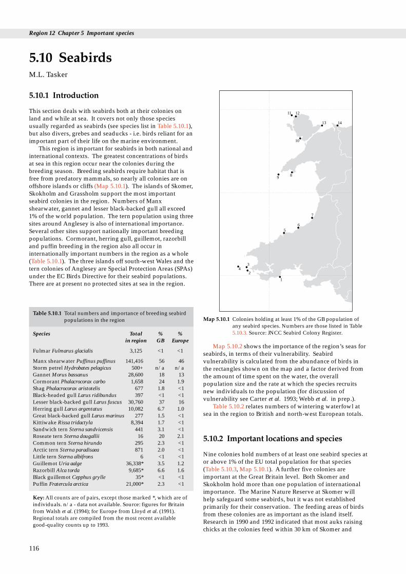
Region 12 Chapter 5 Important species
1
2
34
56
7
89
10
11 12
13 14
5.10.1 Introduction
This section deals with seabirds both at their colonies onland and while at sea. It covers not only those speciesusually regarded as seabirds (see species list in Table 5.10.1),but also divers, grebes and seaducks - i.e. birds reliant for animportant part of their life on the marine environment.
This region is important for seabirds in both national andinternational contexts. The greatest concentrations of birdsat sea in this region occur near the colonies during thebreeding season. Breeding seabirds require habitat that isfree from predatory mammals, so nearly all colonies are onoffshore islands or cliffs (Map 5.10.1). The islands of Skomer,Skokholm and Grassholm support the most importantseabird colonies in the region. Numbers of Manxshearwater, gannet and lesser black-backed gull all exceed1% of the world population. The tern population using threesites around Anglesey is also of international importance.Several other sites support nationally important breedingpopulations. Cormorant, herring gull, guillemot, razorbilland puffin breeding in the region also all occur ininternationally important numbers in the region as a whole(Table 5.10.1). The three islands off south-west Wales and thetern colonies of Anglesey are Special Protection Areas (SPAs)under the EC Birds Directive for their seabird populations.There are at present no protected sites at sea in the region.
5.10 SeabirdsM.L. Tasker
116
Map 5.10.1 Colonies holding at least 1% of the GB population ofany seabird species. Numbers are those listed in Table5.10.3. Source: JNCC Seabird Colony Register.
Table 5.10.1 Total numbers and importance of breeding seabirdpopulations in the region
Species Total % %in region GB Europe
Fulmar Fulmarus glacialis 3,125 <1 <1
Manx shearwater Puffinus puffinus 141,416 56 46Storm petrel Hydrobates pelagicus 500+ n/a n/aGannet Morus bassanus 28,600 18 13Cormorant Phalacrocorax carbo 1,658 24 1.9Shag Phalacrocorax aristotelis 677 1.8 <1Black-headed gull Larus ridibundus 397 <1 <1Lesser black-backed gull Larus fuscus 30,760 37 16Herring gull Larus argentatus 10,082 6.7 1.0Great black-backed gull Larus marinus 277 1.5 <1Kittiwake Rissa tridactyla 8,394 1.7 <1Sandwich tern Sterna sandvicensis 441 3.1 <1Roseate tern Sterna dougallii 16 20 2.1Common tern Sterna hirundo 295 2.3 <1Arctic tern Sterna paradisaea 871 2.0 <1Little tern Sterna albifrons 6 <1 <1Guillemot Uria aalge 36,338* 3.5 1.2Razorbill Alca torda 9,685* 6.6 1.6Black guillemot Cepphus grylle 35* <1 <1Puffin Fratercula arctica 21,000* 2.3 <1
Key: All counts are of pairs, except those marked *, which are ofindividuals. n/a - data not available. Source: figures for Britainfrom Walsh et al. (1994); for Europe from Lloyd et al. (1991).Regional totals are compiled from the most recent availablegood-quality counts up to 1993.
Map 5.10.2 shows the importance of the region’s seas forseabirds, in terms of their vulnerability. Seabirdvulnerability is calculated from the abundance of birds inthe rectangles shown on the map and a factor derived fromthe amount of time spent on the water, the overallpopulation size and the rate at which the species recruitsnew individuals to the population (for discussion ofvulnerability see Carter et al. 1993; Webb et al. in prep.).
Table 5.10.2 relates numbers of wintering waterfowl atsea in the region to British and north-west European totals.
5.10.2 Important locations and species
Nine colonies hold numbers of at least one seabird species ator above 1% of the EU total population for that species(Table 5.10.3, Map 5.10.1). A further five colonies areimportant at the Great Britain level. Both Skomer andSkokholm hold more than one population of internationalimportance. The Marine Nature Reserve at Skomer willhelp safeguard some seabirds, but it was not establishedprimarily for their conservation. The feeding areas of birdsfrom these colonies are as important as the island itself.Research in 1990 and 1992 indicated that most auks raisingchicks at the colonies feed within 30 km of Skomer and

5.10 Seabirds
Highest vulnerabilityrating for 1–2 months
Highest vulnerabilityrating for 3–4 months
Highest vulnerabilityrating for 5–12 months
Map 5.10.2 Relative importance of region and adjacent seas forseabirds. The grid is of 15’N x 30’W rectangles; see textfor explanation of vulnerability ratings. Source: JNCCSeabirds at Sea Team.
Table 5.10.2 Peak numbers of wintering waterfowl at sea inthree areas in relation to British and north-westEuropean populations
Species Peak 1% 1% NWnumbers GB Europe
Northern Cardigan BayRed-throated diver Gavia stellata 960 50 750Great crested grebe Podiceps cristatus 380 100 1,000+Common scoter Melanitta nigra c. 6,000 230 8,000Red-breasted merganse 210 100 1,000
Mergus serrator
Southern Conwy BayGreat crested grebe Podiceps cristatus 156 100 1,000+Red-breasted merganser 441 100 1,000
Mergus serrator
Carmarthen BayCommon scoter Melanitta nigra 2,500 230 8,000
Peak numbers from Green & Elliott (1993), Kirby et al. (1993),Owen et al. (1986) and JNCC Birds database; 1% GB from Waters &Cranswick (1993); 1% NW Europe from Rose & Scott (1994).
Skokholm (Stone et al. 1992). Gannets and lesser black-backed gulls forage frequently near fishing fleets. There isno particular area where auks feed.
At sea, seabirds food sources range from zooplankton tosmall fish and waste from fishing fleets. Habitats thatconcentrate any of these foods are preferred. Zooplanktoncan be concentrated in zones where water masses meet, orwhere tides converge around islands or over some seabedfeatures (see section 4.3). Many seabirds feed on sandeelsAmmodytes spp.: offshore sandbanks are the preferredhabitat for these fish, and so the waters over them areimportant for seabirds. Common scoter feed on a range of
Table 5.10.3 Counts of seabird colonies in the region holding more thfor particular species
Site no. on Colony OS ref SpeciMap 5.10.1
1 St. Margaret’s Island SS122972 Cormo2 Skokholm SM736050 Manx s
Lesser 3 Skomer SM725095 Manx s
Lesser RazorbPuffin
4 Grassholm SM598093 Gannet5 Cardigan Island SN160516 Lesser 6 Trwyn-Crov - Cwntydu SN341563 Cormo7 Penderi SN545725 Cormo8 Trwyn Cilan SH287240 Cormo9 Ynys Enlli SH120216 Manx s10 Cwningar Bodowen SH373656 Lesser 11 Ynysoedd y Moelrhoniaid SH269949 Arctic t
Lesser 12 Cemlyn SH331933 Sandw13 Ynys Seiriol SH650820 Cormo14 Creigiau Rhiwledyn SH814826 Cormo
Source: JNCC/Seabird Group Seabird Colony Register. Note: A single a(nationally important population), while two asterisks indicates >1% owhether a site receives any formal conservation protection as a Site of Smost species the most recent available good-quality count is presented.year, reflecting inter-colony movements), the highest count from the pecolonies indicates no major changes in size.
small or immature shellfish and are likely to prefer areaswith high spatfalls of these species. In general, scoters,divers and grebes tend to be found in areas with less thanabout 20 m water depth.
117
an 1% of the European Union (EU) or 1% of the Great Britain total
es Year Count 1% SPA/SSSI
rant 1993 320 ** SSSIhearwater 1969 35,000 ** SPAb.-b. gull 1993 4,652 **hearwater 1981 100,000 ** SPAb.-b. gull 1992-93 15-20,000 **ill 1993 3,676 **
1984 7,250 **1987 28,535 ** SPA
b.-b. gull 1993 3,541 **rant 1987 92 *rant 1993 86 * SSSIrant 1986 85 *hearwater 1986 4,250 ** SSSIb.-b. gull 1989 964 * SSSIern 1994 803 * SPA, SSSIb.-b. gull 1994 926 *ich tern 1993 564 ** SPA,SSSIrant 1993 400 ** SSSIrant 1993 279 ** SSSI
sterisk in the 1% column indicates count >1% of the GB totalf the EU total (internationally important). The final column indicatespecial Scientific Interest (SSSI) or Special Protection Area (SPA). For For terns (whose numbers may fluctuate markedly from year toriod 1989-93 is presented. Recent reappraisal of Manx shearwater
Region 12 Chapter 5 Important species
Most of the birds from the south-west Wales islands feedto the south-west of the islands, but nearshore areas to thenorth of the islands are also important for auks. Thenorthern part of Cardigan Bay supports at least nationallyimportant wintering populations of red-throated diver, greatcrested grebe, red-breasted merganser and common scoter(Green & Elliott 1993). At times, the populations of red-throated diver and common scoter may be of internationalimportance. In autumn and early winter the southern partof Cardigan Bay is important for Manx shearwater,guillemot and razorbill (Stone et al. in prep.). CarmarthenBay has held very large numbers of common scoter in thepast (25,000 in 1974, 10,600 in 1986/87), and up to 11,000have been counted in recent winters. This bay is, however,difficult to census. In the past, the area off Traeth Lafan hasbeen nationally important for great crested grebes and red-breasted mergansers (Owen et al. 1986). Seabird surveyshave recorded large, probably nationally important,common scoter flocks further offshore. The offshore watersof the region are populated by moderate densities offulmars, kittiwakes, auks, gannets and Manx shearwaters.
5.10.3 Human activities
Seabirds can be particularly affected by marine oil pollution.Spills near the main colonies during the breeding seasoncould be particularly damaging. There was concern thatoffshore oil exploration in the area would add to the risks ofoil spillage, but so far there have been no major spills fromthis source. The risk of accidents from tankers serving theMilford Haven terminals has been recognised and offshorerouteing schemes are in operation off south-west Wales (seeMap 8.3.3). Spills can also occur from non-tanker shippingmovements; the major shipping route from the west andsouth-west into Liverpool passes close to coastlines in thisarea.
Land management raises issues for seabirds. Burrow-nesting seabirds require about 0.5 m of soil to dig into;excessive burrowing into slopes (by rabbits, for instance),coupled with grazing animals, can lead to erosion andeventual abandonment of colonies. This is believed to havehappened in the past on Grassholm. Introduction of ratsand cats onto islands presently free of these mammalswould damage their seabird populations.
5.10.4 Information sources used
All seabird colonies in the region were counted orreappraised between 1984 and 1987. These counts, and allthose made since 1979, are held on the JNCC/SeabirdGroup Seabird Colony Register. Numbers and breedingperformance of several species are evaluated annually atcolonies throughout the region, particularly on Skomer,which is one of the UK Seabird Monitoring Programme’skey sites. Surveys of birds at sea and around the islands ofsouth-west Wales have been carried out by JNCC’s Seabirdsat Sea Team. The Team’s survey effort from ships has beengreatest off south-west Wales and near Anglesey. Waters at2 km and 5 km from the shore have been surveyed from theair by SAST on a bi-monthly basis over one year. Fewsurveys have taken place in the past in Cardigan Bay,
118
particularly the northern half, apart from some from smallvessels in recent years. Coverage of Carmarthen Bay hasbeen irregular, and counts of common scoter within theTaf/Twyi estuaries may be duplicates, both betweenthemselves and with the larger offshore concentration inCarmarthen Bay. Coverage, from the land, of mostnearshore waters in the region has been generally poor.
5.10.5 Further sources of information
A. References cited
Carter, I.C., Williams, J.M., Webb, A., & Tasker, M.L. 1993. Seabirdconcentrations in the North Sea: an atlas of vulnerability to surfacepollutants. Aberdeen, Joint Nature Conservation Committee.
Green, M., & Elliott, D. 1993. Surveys of wintering birds andcetaceans in northern Cardigan Bay, 1990-93. (Contractor:Friends of Cardigan Bay.) Countryside Council for Wales, ContractScience Report, No. 60.
Kirby, J.S., Evans, R.J., & Fox, A.D. 1993. Wintering seaducks inBritain and Ireland: populations, threats, conservation andresearch priorities. Aquatic Conservation: Marine and FreshwaterEcosystems, 3:105-137.
Lloyd, C.S., Tasker, M.L., & Partridge, K. 1991. The status of seabirdsin Britain and Ireland. London, Poyser.
Owen, M, Atkinson-Willes, G.L., & Salmon, D.G. 1986. Wildfowl inGreat Britain. 2nd ed. Cambridge, Cambridge University Press.
Rose, P.M., & Scott, D.A. 1994. Waterfowl population estimates.Slimbridge, International Waterfowl and Wetlands ResearchBureau. (IWRB publication No.29).
Stone, C.J., Webb, A., Barton, T.R., & Gordon, J.R.W. 1992. Seabirddistribution around Skomer and Skokholm Islands, June 1992.JNCC Report, No. 152.
Stone, C.J., Webb, A., Barton, C., Ratcliffe, N., Reed, T.C., Tasker,M.L., & Pienkowski, M.W. In prep. An atlas of seabirddistribution in north-west European waters. Peterborough, JointNature Conservation Committee.
Walsh, P.M., Brindley, E., & Heubeck, M. 1994. Seabird numbers andbreeding success in Britain and Ireland, 1993. Peterborough, JointNature Conservation Committee. (UK Nature Conservation,No. 17.)
Waters, R.J., & Cranswick, P.A. 1993. The wetland bird survey 1992-93: wildfowl and wader counts. Slimbridge, British Trust forOrnithology/The Wildfowl & Wetlands Trust/Royal Society forthe Protection of Birds/Joint Nature Conservation Committee.
Webb, A., Stone, C.J., Stronach, A., & Tasker, M.L. In prep.Vulnerable concentrations of seabirds south and west of Britain.Peterborough, Joint Nature Conservation Committee
B. Further reading
Donovan, J. & Rees, G. 1994. Birds of Pembrokeshire. Dyfed WildlifeTrust.
Prater, A.J. 1981. Estuary birds of Britain and Ireland. Calton, Poyser.Webb, A., Harrison, N.M., Leaper, G.M., Steele, R.D., Tasker, M.L., &
Pienkowski, M.W. 1990. Seabird distribution west of Britain.Peterborough, Nature Conservancy Council.

5.10 Seabirds
C. Contact names and addresses
Type of information Contact address and telephone no.
Seabird colonies *Co-ordinator, Seabird ColonyRegister, JNCC, Aberdeen, tel:01224 642863
Seabirds at sea *Head, Seabirds at Sea Team,JNCC, Aberdeen, tel: 01224 642863
Birds database *Head, Vertebrate Ecology andConservation Branch, JNCCPeterborough, tel: 01733 62626
Nearshore waterfowl *The Wildfowl & Wetlands TrustHQ, Slimbridge, tel: 01453 890333
* Starred contact addresses are given in full in the Appendix
119
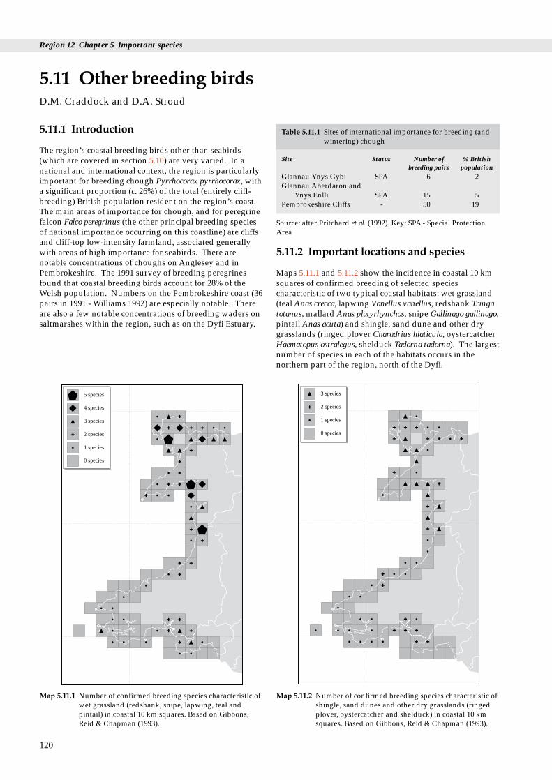
Region 12 Chapter 5 Important species
Table 5.11.1 Sites of international importance for breeding (andwintering) chough
Site Status Number of % British breeding pairs population
Glannau Ynys Gybi SPA 6 2Glannau Aberdaron and
Ynys Enlli SPA 15 5Pembrokeshire Cliffs - 50 19
Source: after Pritchard et al. (1992). Key: SPA - Special ProtectionArea
5.11.1 Introduction
The region’s coastal breeding birds other than seabirds(which are covered in section 5.10) are very varied. In anational and international context, the region is particularlyimportant for breeding chough Pyrrhocorax pyrrhocorax, witha significant proportion (c. 26%) of the total (entirely cliff-breeding) British population resident on the region’s coast.The main areas of importance for chough, and for peregrinefalcon Falco peregrinus (the other principal breeding speciesof national importance occurring on this coastline) are cliffsand cliff-top low-intensity farmland, associated generallywith areas of high importance for seabirds. There arenotable concentrations of choughs on Anglesey and inPembrokeshire. The 1991 survey of breeding peregrinesfound that coastal breeding birds account for 28% of theWelsh population. Numbers on the Pembrokeshire coast (36pairs in 1991 - Williams 1992) are especially notable. Thereare also a few notable concentrations of breeding waders onsaltmarshes within the region, such as on the Dyfi Estuary.
5.11 Other breeding birdsD.M. Craddock and D.A. Stroud
120
5 species
4 species
3 species
2 species
1 species
0 species
Map 5.11.1 Number of confirmed breeding species characteristic ofwet grassland (redshank, snipe, lapwing, teal andpintail) in coastal 10 km squares. Based on Gibbons,Reid & Chapman (1993).
5.11.2 Important locations and species
Maps 5.11.1 and 5.11.2 show the incidence in coastal 10 kmsquares of confirmed breeding of selected speciescharacteristic of two typical coastal habitats: wet grassland(teal Anas crecca, lapwing Vanellus vanellus, redshank Tringatotanus, mallard Anas platyrhynchos, snipe Gallinago gallinago,pintail Anas acuta) and shingle, sand dune and other drygrasslands (ringed plover Charadrius hiaticula, oystercatcherHaematopus ostralegus, shelduck Tadorna tadorna). The largestnumber of species in each of the habitats occurs in thenorthern part of the region, north of the Dyfi.
3 species
2 species
1 species
0 species
Map 5.11.2 Number of confirmed breeding species characteristic ofshingle, sand dunes and other dry grasslands (ringedplover, oystercatcher and shelduck) in coastal 10 kmsquares. Based on Gibbons, Reid & Chapman (1993).
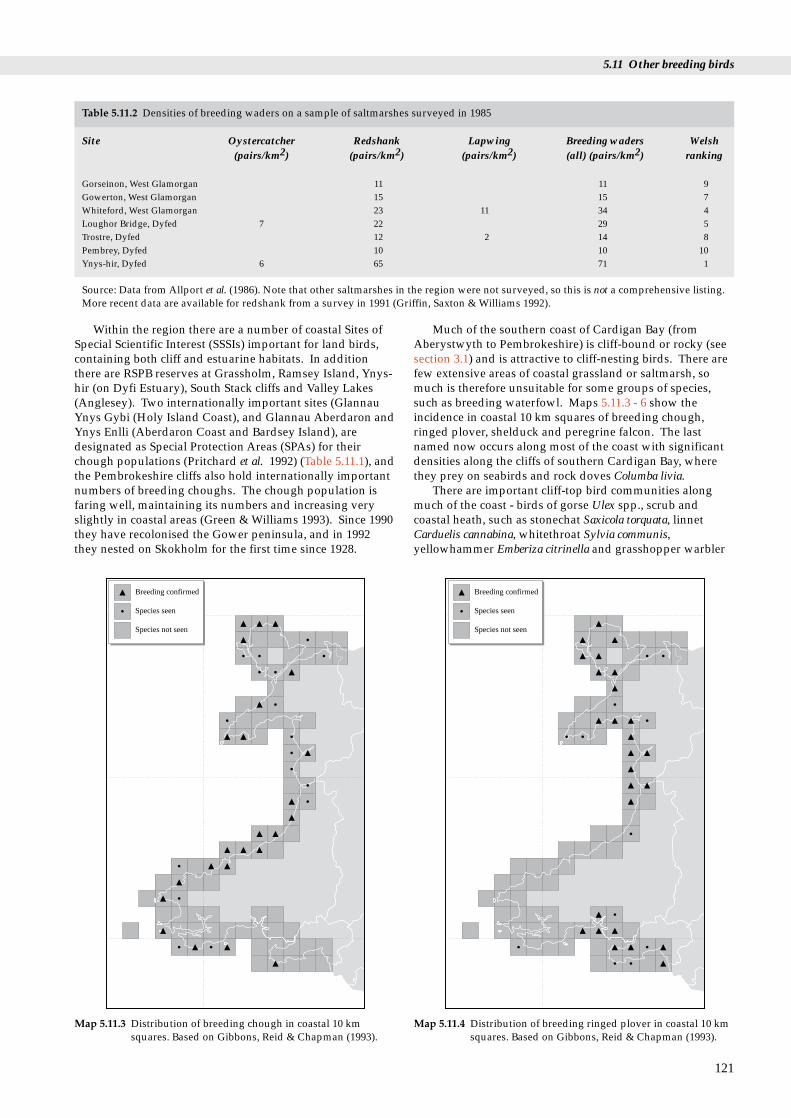
5.11 Other breeding birds
Table 5.11.2 Densities of breeding waders on a sample of saltmarshes surveyed in 1985
Site Oystercatcher Redshank Lapwing Breeding waders Welsh(pairs/km2) (pairs/km2) (pairs/km2) (all) (pairs/km2) ranking
Gorseinon, West Glamorgan 11 11 9Gowerton, West Glamorgan 15 15 7Whiteford, West Glamorgan 23 11 34 4Loughor Bridge, Dyfed 7 22 29 5Trostre, Dyfed 12 2 14 8Pembrey, Dyfed 10 10 10Ynys-hir, Dyfed 6 65 71 1
Source: Data from Allport et al. (1986). Note that other saltmarshes in the region were not surveyed, so this is not a comprehensive listing.More recent data are available for redshank from a survey in 1991 (Griffin, Saxton & Williams 1992).
Within the region there are a number of coastal Sites ofSpecial Scientific Interest (SSSIs) important for land birds,containing both cliff and estuarine habitats. In additionthere are RSPB reserves at Grassholm, Ramsey Island, Ynys-hir (on Dyfi Estuary), South Stack cliffs and Valley Lakes(Anglesey). Two internationally important sites (GlannauYnys Gybi (Holy Island Coast), and Glannau Aberdaron andYnys Enlli (Aberdaron Coast and Bardsey Island), aredesignated as Special Protection Areas (SPAs) for theirchough populations (Pritchard et al. 1992) (Table 5.11.1), andthe Pembrokeshire cliffs also hold internationally importantnumbers of breeding choughs. The chough population isfaring well, maintaining its numbers and increasing veryslightly in coastal areas (Green & Williams 1993). Since 1990they have recolonised the Gower peninsula, and in 1992they nested on Skokholm for the first time since 1928.
Breeding confirmed
Species seen
Species not seen
Map 5.11.3 Distribution of breeding chough in coastal 10 kmsquares. Based on Gibbons, Reid & Chapman (1993).
Much of the southern coast of Cardigan Bay (fromAberystwyth to Pembrokeshire) is cliff-bound or rocky (seesection 3.1) and is attractive to cliff-nesting birds. There arefew extensive areas of coastal grassland or saltmarsh, somuch is therefore unsuitable for some groups of species,such as breeding waterfowl. Maps 5.11.3 - 6 show theincidence in coastal 10 km squares of breeding chough,ringed plover, shelduck and peregrine falcon. The lastnamed now occurs along most of the coast with significantdensities along the cliffs of southern Cardigan Bay, wherethey prey on seabirds and rock doves Columba livia.
There are important cliff-top bird communities alongmuch of the coast - birds of gorse Ulex spp., scrub andcoastal heath, such as stonechat Saxicola torquata, linnetCarduelis cannabina, whitethroat Sylvia communis,yellowhammer Emberiza citrinella and grasshopper warbler
121
Breeding confirmed
Species seen
Species not seen
Map 5.11.4 Distribution of breeding ringed plover in coastal 10 kmsquares. Based on Gibbons, Reid & Chapman (1993).

Region 12 Chapter 5 Important species
Breeding confirmed
Species seen
Species not seen
Map 5.11.5 Distribution of breeding shelduck in coastal 10 kmsquares. Based on Gibbons, Reid & Chapman (1993).
Breeding confirmed
Species seen
Species not seen
Map 5.11.6 Distribution of breeding peregrine falcon in coastal 10km squares. Based on Gibbons, Reid & Chapman (1993).
Locustella naevia. Some of these species are scarce orlocalised elsewhere in Wales.
Wet grassland, although now limited in extent (see section3.5), contains small but significant numbers of breedingwaterfowl. Numbers (and species diversity) of breedingwaders on saltmarshes (Table 5.11.2) and coastal drygrasslands are low in the region, compared with other partsof Britain (Davidson 1991; Davidson et al. 1991). The DyfiEstuary, however, has significant populations of severalgrassland waders (particularly redshank), whose breeding isencouraged by positive conservation management within theSSSI (Griffin, Saxton & Williams 1992). Oystercatchers occurat low density along much of the coast, becoming moreabundant in northern Wales. The highest density of breedingringed plover occurs in the northern part of Cardigan Bayand especially on the Llyn Peninsula (Prater 1989). Both thenational survey of 1984 (Prater 1989) and the atlas surveys of1988-91 (Gibbons, Reid & Chapman 1993) found this speciespatchily distributed elsewhere (Map 5.11.4).
Other breeding waterfowl are variably located. Asignificant number of breeding teal occur on the Dyfi (Fox1987) as well as elsewhere around northern Cardigan Bay,and there is a nationally significant concentration ofbreeding red-breasted mergansers Mergus serrator in thisarea. Breeding mallard occur in small numbers along thewhole non-cliff coastline, whilst mute swans Cygnus olorbreed in small numbers in suitable wetland habitats.Breeding shelduck occur along much of coastal Wales (Map5.11.5) with particularly dense populations on the Gowerpeninsula and along the coast of north Wales (Gibbons et al.1993).
122
In south and west Wales, the coastal woodlands ofsessile oak Quercus petraea support a characteristicassemblage of passerines, including pied flycatcher Ficedulahypoleuca, as well as dense populations of buzzard Buteobuteo and sparrowhawk Accipiter nisus.
5.11.3 Human activities For choughs, appropriate low-intensity agricultural landmanagement is critically important in the areas they usethroughout the year (see e.g. papers in Bignal & Curtis1989). The withdrawal of stock from coastal land can affectchoughs as ungrazed land is unsuitable for them. Inparticular, ‘support ground’ for non-breeders and juvenilebirds is crucial for maintaining a healthy chough population(Bignal, Bignal & Curtis 1989). Breeding birds, includingchough and peregrine falcon, can be disturbed by tourists,walkers and climbers on the coast, and this disturbanceinfluences their feeding and breeding success (Owen 1989).The British Mountaineering Council have producedguidance for rock-climbers, and there are local schemes insome parts of Wales where certain cliffs are wardened toreduce climbing disturbance in the breeding season, as wellas some voluntary bans. Chough and peregrine nests on theCastlemartin coast in south Pembrokeshire have benefitedfrom such cooperation and wardening.
The correct agricultural and hydrological management ofwet grassland is of crucial importance for breeding waterfowlpopulations (see e.g. Coleshaw 1995; Harold 1995; Scholey1995; Thomas et al. 1995), which have been in national declinefor several decades (see papers in Hötker 1991).
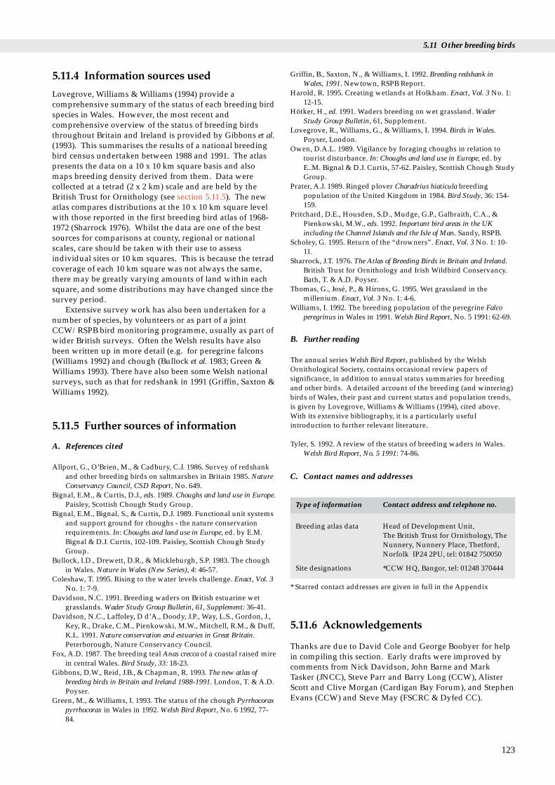
5.11 Other breeding birds
5.11.4 Information sources used
Lovegrove, Williams & Williams (1994) provide acomprehensive summary of the status of each breeding birdspecies in Wales. However, the most recent andcomprehensive overview of the status of breeding birdsthroughout Britain and Ireland is provided by Gibbons et al.(1993). This summarises the results of a national breedingbird census undertaken between 1988 and 1991. The atlaspresents the data on a 10 x 10 km square basis and alsomaps breeding density derived from them. Data werecollected at a tetrad (2 x 2 km) scale and are held by theBritish Trust for Ornithology (see section 5.11.5). The newatlas compares distributions at the 10 x 10 km square levelwith those reported in the first breeding bird atlas of 1968-1972 (Sharrock 1976). Whilst the data are one of the bestsources for comparisons at county, regional or nationalscales, care should be taken with their use to assessindividual sites or 10 km squares. This is because the tetradcoverage of each 10 km square was not always the same,there may be greatly varying amounts of land within eachsquare, and some distributions may have changed since thesurvey period.
Extensive survey work has also been undertaken for anumber of species, by volunteers or as part of a jointCCW/RSPB bird monitoring programme, usually as part ofwider British surveys. Often the Welsh results have alsobeen written up in more detail (e.g. for peregrine falcons(Williams 1992) and chough (Bullock et al. 1983; Green &Williams 1993). There have also been some Welsh nationalsurveys, such as that for redshank in 1991 (Griffin, Saxton &Williams 1992).
5.11.5 Further sources of information
A. References cited
Allport, G., O’Brien, M., & Cadbury, C.J. 1986. Survey of redshankand other breeding birds on saltmarshes in Britain 1985. NatureConservancy Council, CSD Report, No. 649.
Bignal, E.M., & Curtis, D.J., eds. 1989. Choughs and land use in Europe.Paisley, Scottish Chough Study Group.
Bignal, E.M., Bignal, S., & Curtis, D.J. 1989. Functional unit systemsand support ground for choughs - the nature conservationrequirements. In: Choughs and land use in Europe, ed. by E.M.Bignal & D.J. Curtis, 102-109. Paisley, Scottish Chough StudyGroup.
Bullock, I.D., Drewett, D.R., & Mickleburgh, S.P. 1983. The choughin Wales. Nature in Wales (New Series), 4: 46-57.
Coleshaw, T. 1995. Rising to the water levels challenge. Enact, Vol. 3No. 1: 7-9.
Davidson, N.C. 1991. Breeding waders on British estuarine wetgrasslands. Wader Study Group Bulletin, 61, Supplement: 36-41.
Davidson, N.C., Laffoley, D d’A., Doody, J.P., Way, L.S., Gordon, J.,Key, R., Drake, C.M., Pienkowski, M.W., Mitchell, R.M., & Duff,K.L. 1991. Nature conservation and estuaries in Great Britain.Peterborough, Nature Conservancy Council.
Fox, A.D. 1987. The breeding teal Anas crecca of a coastal raised mirein central Wales. Bird Study, 33: 18-23.
Gibbons, D.W., Reid, J.B., & Chapman, R. 1993. The new atlas ofbreeding birds in Britain and Ireland 1988-1991. London, T. & A.D.Poyser.
Green, M., & Williams, I. 1993. The status of the chough Pyrrhocoraxpyrrhocorax in Wales in 1992. Welsh Bird Report, No. 6 1992, 77-84.
Griffin, B., Saxton, N., & Williams, I. 1992. Breeding redshank inWales, 1991. Newtown, RSPB Report.
Harold, R. 1995. Creating wetlands at Holkham. Enact, Vol. 3 No. 1:12-15.
Hötker, H., ed. 1991. Waders breeding on wet grassland. WaderStudy Group Bulletin, 61, Supplement.
Lovegrove, R., Williams, G., & Williams, I. 1994. Birds in Wales.Poyser, London.
Owen, D.A.L. 1989. Vigilance by foraging choughs in relation totourist disturbance. In: Choughs and land use in Europe, ed. byE..M. Bignal & D.J. Curtis, 57-62. Paisley, Scottish Chough StudyGroup.
Prater, A.J. 1989. Ringed plover Charadrius hiaticula breedingpopulation of the United Kingdom in 1984. Bird Study, 36: 154-159.
Pritchard, D.E., Housden, S.D., Mudge, G.P., Galbraith, C.A., &Pienkowski, M.W., eds. 1992. Important bird areas in the UKincluding the Channel Islands and the Isle of Man. Sandy, RSPB.
Scholey, G. 1995. Return of the “drowners”. Enact, Vol. 3 No. 1: 10-11.
Sharrock, J.T. 1976. The Atlas of Breeding Birds in Britain and Ireland.British Trust for Ornithology and Irish Wildbird Conservancy.Bath, T. & A.D. Poyser.
Thomas, G., José, P., & Hirons, G. 1995. Wet grassland in themillenium. Enact, Vol. 3 No. 1: 4-6.
Williams, I. 1992. The breeding population of the peregrine Falcoperegrinus in Wales in 1991. Welsh Bird Report, No. 5 1991: 62-69.
B. Further reading
The annual series Welsh Bird Report, published by the WelshOrnithological Society, contains occasional review papers ofsignificance, in addition to annual status summaries for breedingand other birds. A detailed account of the breeding (and wintering)birds of Wales, their past and current status and population trends,is given by Lovegrove, Williams & Williams (1994), cited above.With its extensive bibliography, it is a particularly usefulintroduction to further relevant literature.
Tyler, S. 1992. A review of the status of breeding waders in Wales.Welsh Bird Report, No. 5 1991: 74-86.
C. Contact names and addresses
Type of information Contact address and telephone no.
Breeding atlas data Head of Development Unit, The British Trust for Ornithology, TheNunnery, Nunnery Place, Thetford,Norfolk IP24 2PU, tel: 01842 750050
Site designations *CCW HQ, Bangor, tel: 01248 370444
* Starred contact addresses are given in full in the Appendix
5.11.6 Acknowledgements
Thanks are due to David Cole and George Boobyer for helpin compiling this section. Early drafts were improved bycomments from Nick Davidson, John Barne and MarkTasker (JNCC), Steve Parr and Barry Long (CCW), AlisterScott and Clive Morgan (Cardigan Bay Forum), and StephenEvans (CCW) and Steve May (FSCRC & Dyfed CC).
123

Table 5.12.2 Overall densities of wintering waders on non-estuarine coasts in the region
Number of Total number Extent of Extent of Overallwader species of waders non-cliff, coast wader
recorded non-estuarine (surveyed) densitycoast in (km)
(birds/kmcounty (km) coast)
Gwynedd 15 13,042 339.1 337.1 38.7Dyfed 15 7,760 148.0 140.4 55.3Glamorgan 14 6,505 106.4 106.4 61.1
Region 12 Chapter 5 Important species
waterfowl
5.12.1 Introduction
Waterfowl are defined as waders and wildfowl (ducks,geese and swans together with coot Fulica atra). This sectiondetails the importance of the region to these birds duringtheir non-breeding period. The importance of offshore areasfor wintering sea duck species, divers, grebes andcormorant Phalacrocorax carbo is outlined in section 5.10.Large stretches of the coast are cliff-bound, especially Gowerand Pembrokeshire in the south and around the LlynPeninsula in the north. These areas are of generally lowimportance for waterfowl.
Table 5.12.1 gives the total January 1993 waterfowl countfor this coastal region as a proportion of the totals (coastaland inland) for Wales and for British coastal sites. It shouldbe noted that such comparisons can give only a roughapproximation of relative regional importance, however,since the data are uncorrected for coverage - some areas ofBritain are better counted for waterfowl than others.
5.12 Migrant and winteringD.M. Craddock and D.A. Stroud
Source: Data from Winter Shorebird Count (Moser & Summers1987).Table 5.12.1 Overall coastal waterfowl count of Region 12
related to the total waterfowl count for Wales andGreat Britain in January 1993
Total waterfowl Number of Region 12 coastalcount in sites counted waterfowl total
January 1993 as a percentage ofthe comparison area
Coastal sites inRegion 12 79,738 29
All counted Welshcoastal sites 131,642 33 60.4
All counted Welshwetlands (coastal and inland) 276,129 122 28.9
All counted Britishcoastal sites 2,060,961 214 3.8
Sources: Data from Waters & Cranswick (1993) and Rose & Taylor(1993).
Although absolute numbers of wintering waterfowl inWelsh coastal areas are often small, the restricted extent ofinland wetlands in Wales, including in this region, meansthat the coastal areas are of special significance inmaintaining national distributions for many waterfowl.There are sites of importance in Welsh, UK and internationalcontexts although the region as a whole is not one of themost important areas of coastal Britain for winteringwaterfowl. Map 5.12.1 shows the distribution of the mainconcentrations of wintering intertidal waterfowl in theregion. The region lies on a major migratory flyway, andmany birds moving to and from other wintering areas onthe African, Mediterranean and south-west European coaststo arctic breeding grounds pass through and stage on itsestuaries and coasts. The region can increase in importancein periods of severe cold weather further east in Britain orEurope, since it is on the relatively mild west coast of theBritish mainland. Under these conditions, there may bemajor influxes of waterfowl, such as wigeon Anas penelope
124
and teal Anas crecca, from other coastal regions or inlandareas (Ridgill & Fox 1990). Locally some sites also act ascold weather refuges: the sheltered embayments of theCleddau estuarine system freeze more slowly than othercoastal and inland wetlands in south Wales, and thusprovide open-water feeding when conditions make othersites unavailable (Owen, Atkinson-Willes & Salmon 1986).
5.12.2 Important locations and species
Three coastal wetlands (Burry Inlet, Lafan Sands andCarmarthen Bay) are internationally important for theirwintering waterfowl populations, although the latter has yetto be designated as either a Ramsar site or Special ProtectionArea (SPA) (see section 7.2). The Dyfi Estuary has beendesignated as a Ramsar site (but largely on habitat grounds)as well as being a Biosphere Reserve (see section 7.2). TheDyfi Estuary is especially important as the sole remainingregular wintering site for Greenland white-fronted geeseAnser albifrons flavirostris in Wales and England ( Fox &Stroud 1985; Fox et al. 1994). The Burry Inlet qualifies as aninternationally important wetland by holding over 20,000waterfowl (an average of 37,600 in the period 1988/89 -1992/93), in addition to being of international importancefor wintering populations of pintail Anas acuta andoystercatcher Haematopus ostralegus. The Cleddau Estuaryholds five populations of waterfowl of importance at aGreat Britain level, whilst the Cefni Estuary is also of Britishimportance for two species. Densities of wintering waderson non-estuarine coasts (Table 5.12.2) are generally low tomoderate, compared with other areas of Great Britain(Moser & Summers 1987)).
The areas of sheltered soft coastline in the region,particularly the estuaries, and especially in south Wales andto a lesser extent in the general shelter of Anglesey, giveideal conditions for wintering waterfowl and for somemigrant waterfowl in spring and autumn. Densities ofwintering waders on non-estuarine coasts are higher on themore sheltered coasts of South Glamorgan than on thecoasts of Dyfed and Gwynedd, which are exposed to theIrish Sea (see Table 5.12.2). Other western-facing estuariesof Cardigan Bay (such as the Teifi, Dyfi and Mawddachestuaries) are more exposed and sandy, with generallysmaller over-wintering waterfowl populations. Shelteredmuddy substrates (such as occur in the Inland Sea and parts

5.12 Migrant and wintering waterfowl
10
10
10
20
20
20
30
30
30 40 50
40 50
Oystercatcher
Oystercatcher
Sheldock
Snipe
Ringed plover
Wigeon
Purple sandpiper
Golden plover
Teal
Sanderling
Grey plover
Mallard
Dunlin
Lapwing
Pintail
Knot
Knot
Shoveler
Redshank
Dunlin
Red breasted merganser
Curlew
Bar-tailed godwit
16 other spp.
Golden plover
Curlew
Grey plover
Redshank
5 other spp.
Turnstone
8 other spp.
% of assemblage
% of assemblage
% of assemblage
Non-estuarine waders
Estuarine waders
Estuarine wildfowl
Fig 5.12.1 Relative species composition of non-breeding waterfowlon coastal areas of the region. Estuarine waterfowl datafrom Prater (1981), non-estuarine wader data from Moser& Summers (1987).
Traeth DulasTraeth Coch
ConwyEstuaryInland Sea
Cefni EstuaryLafan Sands
Foryd Bay
Traeth Bach
Artro Estuary
Traeth Melynog
Pwllheli Harbour
Mawddach Estuary
Dysynni Estuary
Dyfi Estuary
Aberystwyth Harbour
Teifi Estuary
Nyfer Estuary
Cleddau EstuaryCarmarthen Bay
Burry Inlet Neath Estuary
AfanEstuarySwansea Bay
> 20,000
15,000–19,999
10,000–14,999
5,000–9,999
1,000–4,999
< 999
Map 5.12.1 Distribution of main concentrations of winteringestuarine waterfowl. Size of circle is proportional to the5-year mean of waterfowl numbers, from Waters &Cranswick (1993). Offshore sea-duck concentrations arenot shown (see Fox & Roderick (1990); Kirby, Evans &Fox (1993) and section 5.10), nor is the distribution ofthose waterfowl, mainly waders, wintering on the non-estuarine coast (see Moser & Summers (1987)).
of the Cleddau Estuary) are especially attractive to dunlinCalidris alpina, whilst sandier estuaries and embaymentshold larger numbers of oystercatchers and curlewsNumenius arquata (e.g. the Mawddach Estuary). On non-estuarine shores (Figure 5.12.1), oystercatcher is the mostabundant species, followed in order of decreasingabundance by redshank Tringa totanus, golden ploverPluvialis apricaria, snipe G. gallinago, knot and curlew (Moser& Summers 1987).
Table 5.12.3 lists sites important for wintering waterfowl.There are two species that occur at levels of internationalimportance on at least one estuary, and a further elevenspecies that occur at levels of national (i.e. Great Britain)importance. Of particular significance are the numbers ofoystercatchers on the coast of south Wales, whilst there arenationally important numbers of curlew on at least threesites (Burry Inlet, Carmarthen Bay and Cleddau Estuary)and of shelduck at two sites (Burry Inlet and the Cleddau).The small Cefni Estuary is notable for its nationallyimportant populations of pintail and black-tailed godwit.
At nearly all regularly-counted estuaries, the winteringwaterfowl assemblage is dominated by a small number ofspecies occurring in varying proportions according to thecharacteristics of the habitat. Figure 5.12.1 shows that themost abundant estuarine waders in the region are
oystercatcher and dunlin, whilst the estuarine wildfowlassemblage is dominated by wigeon Anas penelope. Sitesdominated by wigeon typically have extensive areas ofsaltmarsh or grazing marsh close to inter-tidal areas. Theseare also attractive to lapwing V. vanellus, curlew and goldenplover (as at Dulas Bay and the Dyfi Estuary), as theyprovide a wide range of feeding opportunities. Such sitesinclude all the larger sites (e.g. the Cleddau, Mawddach andDyfi estuaries) as well as some smaller sites (e.g. the Artroand Dysynni estuaries and Traeth Melynog). On themajority of estuaries, however, oystercatcher is the mostfrequently occurring wader, and at some sites it is also themost abundant waterfowl species (e.g. Cefni Estuary, TraethLafan and Carmarthen Bay).
Other regularly-occurring waterfowl include pintail, tealAnas crecca, mallard A. platyrhynchos, shelduck T. tadorna,dunlin, lapwing, curlew, golden plover and redshank.Common scoter Melanitta nigra occur offshore in importantnumbers in Cardigan Bay and Carmarthen Bay (see section5.10, and Kirby, Evans & Fox (1993). Less frequentlyoccurring waders include knot Calidris canutus and bar-tailed godwit Limosa lapponica, which occur at only a fewsites.
125
Region 12 Chapter 5 Important species
Table 5.12.3 Wintering waterfowl numbers (including seaducks, divers and grebes) on estuaries and other coastal areas in the region
Estuary/area Site protection Five year mean 1992/93 peak 1992/93 peak 1992/93 peak Species occurring atstatus wintering waterfowl wildfowl wader levels of national or
waterfowl numbers numbers numbers international*numbers importance
Burry Inlet SPA **37,614 27,777 5,497 22,280 Pintail*, Oystercatcher*, Black- & Ramsar tailed godwit, Shelduck,
Shoveler, Dunlin, Curlew,Carmarthen Bay 19,083 26,058 933*** 25,125 Common scoter, Sanderling,
Golden plover, OystercatcherCleddau Estuary 17,254 15,769 7,314 8,455 Shelduck, Wigeon, Teal,
Curlew, RedshankLafan Sands SPA 11,769 10,297 2,314 7,983 Oystercatcher, CurlewDyfi Estuary Ramsar, 10,232 9,780 6,046 3,734 Wigeon
BiosphereReserve
Inland Sea 5,812 7,187 2,018 5,169Swansea Bay 5,204 3,950 124 (3,826)Traeth Bach 4,205 2,699 2,396 1,303Foryd Bay 3,901 4,304 2,744 1,560Conwy Estuary 3,717 3,297 1,074 3,223Cefni Estuary 3,305 3,041 1,147 1,894 Pintail, Black-tailed godwitTraeth Coch 2,704 2,245 589 1,656Traeth Melynog 2,519 1,378 256 1,122Mawddach Estuary 2,032 1,612 873 739Dysynni Estuary 1,855 2,737 1,842 895Teifi Estuary 1,320 1,215 634 581Nyfer Estuary 1,029 548 194 354Dulas Bay 948 782 81 701Artro Estuary 648 805 346 349Afan Estuary 239 239 83 156
Key: * - Species occurring in internationally important numbers, i.e. >1% of the international total for the species: other species are nationallyimportant (>1% of the British population); ** - sites holding >20,000 waterfowl are of international importance by virtue of absolutenumbers; *** - Number used to determine national importance excludes common scoter. Bracketed figures are incomplete counts. SPA =Special Protection Area; Ramsar = site classified as internationally important under the Ramsar Convention. Note: Estuaries arranged indescending order of average waterfowl numbers for the period 1988/89 to 1992/93. Sources: WeBS data from Waters & Cranswick (1993), towhich refer for further detail on interpretation of counts and limitations of data. The winter season used by WeBS is November to March forwaders and September to March for wildfowl. Protected status follows Pritchard et al. (1992).
5.12.3 Human activities
Wintering waterfowl are potentially affected by a widerange of human activities, either directly or indirectly.Wildfowling occurs, especially in estuaries, although it isgenerally well regulated (see also section 9.3). On theNational Nature Reserves (NNRs) of the Dyfi, Traeth Bach(Morfa Harlech NNR), and Cefni (Newborough/YnysLlanddwyn NNR), the impacts and regulation ofwildfowling have been reviewed by Owen (1992). Permitsystems generally operate and there is close liaison in theregulation of wildfowling between local shooting clubs, theBASC and CCW local staff. On the Dyfi, a voluntaryshooting ban on Greenland white-fronted geese is inoperation. This has been instrumental in the survival of thisonce declining stock, which in the late 1970s had reachedcritically small numbers (Fox & Stroud 1985).
Incremental land claim, including barrage schemes, canaffect waterfowl populations through loss of feedinghabitat. In sensitive areas, coastal windfarm developmentsalso have the potential to be highly disruptive to winteringwaterfowl (Crockford 1992).
There has been a long history of conflict betweencommercial cockle fisheries and oystercatchers on the BurryInlet. In the early 1970s, cockle fishermen claimed that
126
natural predation on cockles by oystercatchers greatlyreduced commercial catches, and 11,000 oystercatchers wereshot under licence between 1972 - 1974. Conservationorganisations have not accepted that numbers ofoystercatchers are the major determinant of cockle numbers(see review in Prater 1981).
Shellfish collection and bait digging from inter-tidalsediments could limit waterfowl access to feeding areasthrough disturbance. The significance of this disturbance forbirds and that from other sources varies not only from siteto site but also with the time of year: especially in coldperiods, it is crucial for the survival of wintering waterfowlthat they are able to feed for extended periods when thesediments are exposed. Further information is needed onthe extent of such disturbance and its significance forwaterfowl populations (see Davidson & Rothwell 1993 andpapers therein).
Oil pollution is well known as a serious potential threatto wintering waterfowl in areas where high densities ofbirds occur. In areas of the highest risk, however, such asaround the Milford Haven oil refinery, there are well-developed contingency plans for dealing with accidentalspillages.

5.12 Migrant and wintering waterfowl
5.12.4 Information sources used
As with other areas of the UK, migrant and winteringwaterfowl are well surveyed by the Wetland Bird Survey(WeBS - organised by the British Trust for Ornithology, TheWildfowl & Wetlands Trust, the Royal Society for theProtection of Birds and the JNCC), which collates monthlycounts from coastal and inland wetlands through the UK.Coastal coverage is generally good for Welsh estuaries,although the open coast is not thoroughly surveyed on anannual basis. The whole Welsh coastline was surveyed forwintering waders during the Winter Shorebird Count of1984/85 (Moser & Summers 1987), and there are currentWeBS plans for a repeat national survey, possibly in1995/96. Sites in the region for which WeBS information isalready available are Swansea Bay, Burry Inlet, CarmarthenBay, Cleddau Estuary, Dyfi Estuary, Mawddach Estuary,Artro Estuary, Glaslyn/Dwyryd/Foryd Bay and LafanSands. The non-estuarine coast of Cardigan Bay isparticularly poorly counted (Waters & Cranswick 1993).More detailed studies of the wintering waterfowl of theCleddau Estuary and of Carmarthen Bay have beenundertaken by Prys-Jones (1989) and Prys-Jones & Davis(1990) respectively.
5.12.5 Further sources of information
A. References cited
Crockford, N.J. 1992. A review of the possible impacts ofwindfarms on birds and other wildlife. JNCC Report, No. 27.
Davidson, N.C., & Rothwell, P.I. 1993. Disturbance to waterfowl onestuaries: the conservation and coastal managementimplications of current knowledge. Wader Study Group Bulletin,68: 97-105.
Fox, A.D., & Roderick, H.W. 1990. Wintering divers and grebes inWelsh coastal waters. Welsh Bird Report, 1989, 53-60.
Fox, A.D., & Stroud, D.A. 1985. The Greenland white-frontedgoose in Wales. Nature in Wales (New Series), 4: 20-27.
Fox, A.D., Norriss, D.W., Stroud, D.A., & Wilson, H.J. 1994.Greenland white-fronted geese in Ireland and Britain 1982/83 -1993/94 - the first twelve years of international conservationmonitoring. National Parks and Wildlife Service and GreenlandWhite-fronted Goose Study Report.
Kirby, J.S., Evans, R.J., & Fox, A.D. 1993. Wintering seaducks inBritain and Ireland: populations, threats, conservation andresearch priorities. Aquatic conservation: marine and freshwaterecosystems, 3: 105-137.
Moser, M., & Summers, R.W. 1987. Wader populations on the non-estuarine coasts of Britain and Northern Ireland: results of the1984-85 Winter Shorebird Count. Bird Study, 34: 71-81.
Owen, M. 1992. An analysis of permit systems and bag records onNNRs. JNCC Report, No. 68.
Owen, M., Atkinson-Willes, G.L., & Salmon, D.G. 1986. Wildfowl inGreat Britain. 2nd ed. Cambridge, Cambridge UniversityPress.
Prater, A.J. 1981. Estuary birds in Britain and Ireland. Carlton,Poyser.
Pritchard, D.E., Housden, S.D., Mudge, G.P., Galbraith, C.A., &Pienkowski, M.W., eds. 1992. Important bird areas in the UKincluding the Channel Islands and the Isle of Man. Sandy, RSPB.(Summarises data on the important bird populations andhabitats of each site.)
Prys-Jones, R.P. 1989. The abundance and distribution of wildfowland waders on the Cleddau (Milford Haven). NatureConservancy Council, CSD Report, No. 964.
Prys-Jones, R.P., & Davis, P.E. 1990. The abundance of wildfowland waders on Carmarthen Bay (Taf/Tywi/Gwendrath).Nature Conservancy Council, CSD Report, No. 1053.
Ridgill, S.C., & Fox, A.D. 1990. Cold weather movements of waterfowlin western Europe. Slimbridge, IWRB. (IWRB SpecialPublication No. 13.)
Rose, P.M., & Taylor, V. 1993. Western Palearctic and south-west Asiawaterfowl census 1993. Mid-winter waterfowl counts, January 1993.Slimbridge, IWRB.
Waters, R.J., & Cranswick, P.A. 1993. The Wetland Bird Survey 1992-1993: wildfowl and wader counts. Slimbridge,BTO/WWT/RSPB/JNCC. (Annual summary report on speciestrends, based on counts at wetlands throughout the UK).
B. Further reading
The WeBS waterfowl count scheme is the primary source ofinformation on wintering and migrant waterfowl in the UK. Theannual reports (most recently Waters & Cranswick 1993) can onlysummarise what are very detailed data, and in summary form suchcounts may be subject to misinterpretation for a number of reasons.Detailed count data for sites can be provided by WeBS, as detailedbelow, and inspection of these data is recommended for anyplanning-related activity. A detailed account of the wintering (andbreeding) birds of Wales, their past and current status andpopulation trends is given by Lovegrove, Williams & Williams(1994). With its extensive bibliography, it is a particularly usefulintroduction to further relevant literature. Buck (1993) summarisesthe wintering waterfowl assemblage on each estuary in the region.Davidson et al. (1991) provides a detailed analysis of British migrantand overwintering waterfowl on estuaries.
Buck, A.L. 1993. An inventory of UK estuaries. Volume 2, South-westBritain. Peterborough, JNCC.
Davidson, N.C., Laffoley, D d’A., Doody, J.P., Way, L.S., Gordon, J.,Key, R., Drake, C.M., Pienkowski, M.W., Mitchell, R.M., & Duff,K.L. 1991. Nature conservation and estuaries in Great Britain.Peterborough, Nature Conservancy Council.
Lovegrove, R., Williams, G., & Williams, I. 1994. Birds in Wales.London, Poyser.
C. Contact names and addresses
Type of information Contact address and telephone no.
High tide and low tide WeBS National Organiser counts of wintering and (wildfowl), The Wildfowl & migrant wildfowl (WeBS) Wetlands Trust, Slimbridge,
Gloucestershire GL2 7BX,tel: 01453 890333
High tide counts of WeBS National Organiser wintering and migrant (waders), British Trust for waders (WeBS) Ornithology, The Nunnery,
Nunnery Place, Thetford,Norfolk IP24 2PU,tel: 01842 750050
Low tide counts of WeBS National Organiser (Low wintering and migrant Tide Counts), British Trust for waders (WeBS) Ornithology, address as above
Site designations *CCW HQ, Bangor,tel: 01248 370444
* Starred contact addresses are given in full in the Appendix
127

Region 12 Chapter 5 Important species
5.12.6 Acknowledgements
Thanks to Dave Cole, George Boobyer, Humphrey Crick,Eric Steer and Simon Delany for providing unpublishedshelduck data. Early drafts were improved by commentsfrom Nick Davidson, John Barne and Mark Tasker (JNCC),Steve Parr and Barry Long (CCW), and Peter Cranswick(WWT).
128

5.13 Land mammals
Table 5.13.1 Records of protected mammal species distribution
Protected species Estimate of occurrence in the region
Greater horseshoe bat Stronghold in south-west (Englandand Wales)
Lesser horseshoe bat Frequent; predominantly Welsh andsouth-west distribution
Whiskered/Brandt’s bats WidespreadWhiskered bat RareNatterer’s bat WidespreadDaubenton’s bat Frequent; roosts rareNoctule RarePipistrelle FrequentBrown long-eared bat FrequentRed squirrel RareDormouse RarePine marten RarePolecat Common; predominantly Welsh
distributionOtter Frequent
Adapted from Arnold (1993). Note: all the above species are listedon Schedule 5 of the Wildlife & Countryside Act 1981, except thepolecat (Schedule 6).
5.13.1 Introduction
This section covers land mammals that occur in the coastal10 km squares within the region, concentrating on thosespecies that are truly coastal, such as otters, and those thatoccur on the coast for reasons of shelter and foraging, suchas the greater horseshoe bat. Other mammals - commonand widespread throughout Britain, feral or recentlyintroduced - are not considered in any detail.
Large parts of the coastal area are dominated by semi-natural habitats, particularly the coastal strip (see section 2.6and Chapter 3). The water quality of both coastal andestuarine waters is good throughout most of the region(National Rivers Authority 1991). The quality of the coastalhabitat and rivers is partly reflected in the incidence anddistribution of terrestrial mammals, with several nationallyrare species occurring. The frequently cliffed coast limitsthe occurrence of some lowland species.
There are no reliable estimates of the numbers ofmammals in the region or in Britain that could be used toassess the relative importance of the region in nationalterms. Using the data from Arnold (1993), an assessmenthas been made for the frequency of occurrence of mammalswithin the coastal area, but some of the records areanecdotal (see Table 5.13.1). On this assessment, the regionis important for some of the nationally important mammal
5.13 Land mammalsDr C.E. Turtle
1975 onwards
1960–1974
Not Recorded
Map 5.13.1 Recorded coastal distribution of otters by coastal 10 kmsquare. Source: Arnold (1993).
species, most of which are vulnerable and declining (Morris1993). The Skomer vole Clethrionymus glareolus skomerensis isendemic to the island. Ten of the fourteen species of Britishbats are recorded for this region (Arnold 1993), of which thetwo horseshoe bats are the most important, owing to theirlimited national distribution and declining numbers. All ofthe other species listed on Schedule 5 of the Wildlife andCountryside Act 1981 (except the wildcat) are recorded fromthis region. They are the red squirrel Sciurus vulgaris, pinemarten Martes martes, common dormouse Muscardinusavellanarius and otter Lutra lutra. Of note is the strongholdin Wales of the polecat Mustela putorius, which is protectedunder Schedule 6 of the Wildlife and Countryside Act. AllBritish bats are listed under Appendix II of the BernConvention, and the dormouse and red squirrel are listedunder Appendix III.
5.13.2 Important locations and species
Otters are extinct or endangered over most of mainlandBritain except the north-west (Morris 1993). The Welshpopulation is important because of its size and geneticdiversity. The otter is the terrestrial mammal which usescoastal areas most frequently. Three surveys of otters inWales, in 1977-78 (Crawford et al. 1979), in 1984-85(Andrews & Crawford 1986) and in 1991 (Andrews, Howell& Johnson 1993), have all demonstrated the importance ofthe region for otters. Although the species was formerlyfound throughout the coastal region (Map 5.13.1), accordingto Arnold (1993) it was not recorded from Anglesey duringthe 1991 survey. That survey showed that positive signs ofotters are widely but patchily distributed: signs of otterswere found on none of the surveyed sites on Anglesey but78% of those in the Cleddau area near Pembroke. Their
129
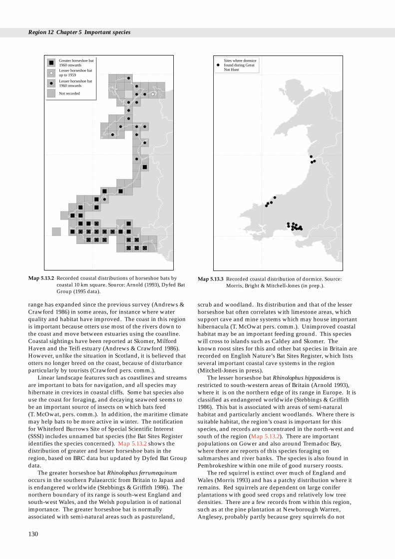
Region 12 Chapter 5 Important species
Greater horseshoe bat1960 onwardsLesser horseshoe batup to 1959
Lesser horseshoe bat1960 onwards
Not recorded
Map 5.13.2 Recorded coastal distributions of horseshoe bats bycoastal 10 km square. Source: Arnold (1993), Dyfed BatGroup (1995 data).
Sites where dormicefound during GreatNut Hunt
Map 5.13.3 Recorded coastal distribution of dormice. Source:Morris, Bright & Mitchell-Jones (in prep.).
range has expanded since the previous survey (Andrews &Crawford 1986) in some areas, for instance where waterquality and habitat have improved. The coast in this regionis important because otters use most of the rivers down tothe coast and move between estuaries using the coastline.Coastal sightings have been reported at Skomer, MilfordHaven and the Teifi estuary (Andrews & Crawford 1986).However, unlike the situation in Scotland, it is believed thatotters no longer breed on the coast, because of disturbanceparticularly by tourists (Crawford pers. comm.).
Linear landscape features such as coastlines and streamsare important to bats for navigation, and all species mayhibernate in crevices in coastal cliffs. Some bat species alsouse the coast for foraging, and decaying seaweed seems tobe an important source of insects on which bats feed (T. McOwat, pers. comm.). In addition, the maritime climatemay help bats to be more active in winter. The notificationfor Whiteford Burrows Site of Special Scientific Interest(SSSI) includes unnamed bat species (the Bat Sites Registeridentifies the species concerned). Map 5.13.2 shows thedistribution of greater and lesser horseshoe bats in theregion, based on BRC data but updated by Dyfed Bat Groupdata.
The greater horseshoe bat Rhinolophus ferrumequinumoccurs in the southern Palaearctic from Britain to Japan andis endangered worldwide (Stebbings & Griffith 1986). Thenorthern boundary of its range is south-west England andsouth-west Wales, and the Welsh population is of nationalimportance. The greater horseshoe bat is normallyassociated with semi-natural areas such as pastureland,
130
scrub and woodland. Its distribution and that of the lesserhorseshoe bat often correlates with limestone areas, whichsupport cave and mine systems which may house importanthibernacula (T. McOwat pers. comm.). Unimproved coastalhabitat may be an important feeding ground. This specieswill cross to islands such as Caldey and Skomer. Theknown roost sites for this and other bat species in Britain arerecorded on English Nature’s Bat Sites Register, which listsseveral important coastal cave systems in the region(Mitchell-Jones in press).
The lesser horseshoe bat Rhinolophus hipposideros isrestricted to south-western areas of Britain (Arnold 1993),where it is on the northern edge of its range in Europe. It isclassified as endangered worldwide (Stebbings & Griffith1986). This bat is associated with areas of semi-naturalhabitat and particularly ancient woodlands. Where there issuitable habitat, the region’s coast is important for thisspecies, and records are concentrated in the north-west andsouth of the region (Map 5.13.2). There are importantpopulations on Gower and also around Tremadoc Bay,where there are reports of this species foraging onsaltmarshes and river banks. The species is also found inPembrokeshire within one mile of good nursery roosts.
The red squirrel is extinct over much of England andWales (Morris 1993) and has a patchy distribution where itremains. Red squirrels are dependent on large coniferplantations with good seed crops and relatively low treedensities. There are a few records from within this region,such as at the pine plantation at Newborough Warren,Anglesey, probably partly because grey squirrels do not

5.13 Land mammals
have such an advantage over reds in this habitat. In Britain the dormouse is on the western edge of its
range in Europe (Corbet & Harris 1991), and although thereare only low numbers in this region, they are of importancebecause they are close to the northern edge of the Britishrange. Dormice are associated with ancient semi-naturalwoodland and edge habitats, such as broadleaved trees onthe edge of forestry plantations or mature, diversehedgerows. Isolated areas of suitable habitat are unlikely tohold viable populations if they are less than 20 ha in extent(Bright, Mitchell & Morris 1994). In 1993 English Naturecoordinated the Great Nut Hunt, a volunteer surveycovering the whole of England and Wales, which recordedthe incidence of nut shells nibbled in characteristicdormouse fashion. Its preliminary findings have shownthat dormice occur in north Wales, although not on the coast(Morris, Bright & Mitchell-Jones in prep.). Records ofdormice in Dyfed (see Map 5.13.3) are likely to be associatedwith suitable habitat occurring on the coast, rather thancoastal habitats themselves, such as sea cliffs andsaltmarshes.
The pine marten is extinct over most of England andWales and there are few reliable records within this region(Arnold 1993); actual numbers are likely to be low. Pinemartens depend on large, mixed conifer plantations,although the more mature plantations are less valuable(Corbet & Harris 1991). Some areas of suitable habitat in theregion might be selected for re-introduction programmes.Records do suggest the presence of pine martens at somecoastal sites, and these may be verified by the latest (as yetunpublished) survey.
Wales holds most of the known British polecatpopulation, and some are recorded throughout the regionfrom the coastal strip. Polecats are recorded from a varietyof habitats, particularly farmland that is not intensivelymanaged. They are known to use coastal dunes, forexample at Ynyslas, and strips of remnant semi-naturalhabitat between farmland and the coast, such as occur inPembrokeshire; these support high rabbit populations,important to the local polecat population (J. Birks pers.comm.).
5.13.3 Human activities
Disturbance on the coast during the holiday season detersotters from breeding in these areas. This is particularly trueof leisure activities such as ‘coastaleering’ (cliff scrambling),which may also disturb important bat roosts. Industrialdevelopment resulting in habitat loss and poor waterquality has an adverse effect on the otter population andprevents recolonisation. Oil spills could result in the deathof otters using the coastal area. The increasing numbers ofpolecat deaths on roads may be significant for the species.
Intensification of farming, especially pesticide use, hasan adverse effect on all species of bat. The removal ofhedgerows and woodland is particularly significant, as batsrely heavily on shelter and good insect populations tosurvive; this will also have a severe effect on dormice,especially where hedgerows link two woods.Fragmentation or inappropriate management of ancientwoodlands within coastal areas would also reduce localdormouse populations. The decline in the rate of softwoodplanting in large areas may contribute to both the decline of
the red squirrel and the extinction of the pine marten inWales. The control of predators and pests can result in thedecline of other species. For instance, incidental poisoningand trapping during the control of rodents, mink and greysquirrel have affected polecat populations in the past.
5.13.4 Information sources used
There have been no specifically coastal mammal surveyswithin this region, and therefore even the nationallycomprehensive surveys, such as for otters, have theirlimitations when assessing the importance of the coast. Norhave there been any nationally comprehensive surveys thatcover coastal and inland areas equally for red squirrels,dormice, polecats or any of the bats, although there arerecent records of all of these species (Biological RecordsCentre (BRC) data). Therefore Arnold (1993) has been usedhere to provide a guide to the occurrence of mammals in theregion. As a general observation, mammal surveys are notrecorded with the same intensity as botanical ones and theoccurrence of mammals within 10 km squares is not enoughto establish the status of species (Morris 1993).
The known roosts of the greater and some of the lesserhorseshoe bats have been monitored regularly, and there arerecent records for many sites (BRC data); the commonerbats, however, are under-recorded.
5.13.5 Further sources of information
A. References cited
Andrews, E., & Crawford, A.K. 1986. Otter survey of Wales 1984-85.London, The Vincent Wildlife Trust.
Andrews, E., Howell P., & Johnson K. 1993. Otter survey of Wales1991. London, The Vincent Wildlife Trust.
Arnold, H.R. 1993. Atlas of mammals in Britain. London, HMSO.(ITE research publication No. 6.)
Bright, P.W., Mitchell, P., & Morris, P.A. 1994. Dormousedistribution: survey techniques, insular ecology and selection ofsites for conservation. Journal of Applied Ecology, 31:329- 339.
Corbet, G.B., & Harris, S.H., eds. 1991. The handbook of Britishmammals. 3rd ed. Oxford, Blackwell Scientific Publications.
Crawford, A.K., Evans, D., Jones, A,. & McNulty, J. 1979. Ottersurvey of Wales 1977-78. Nettleham, Lincoln, Society for thePromotion of Nature Conservation.
Mitchell-Jones, A.J. In press. The status and conservation ofhorseshoe bats in Britain. Myotis, Vol 32.
Morris, P.A. 1993. A red data book for British mammals. London, TheMammal Society.
Morris, P.A., Bright, P.W., & Mitchell-Jones, A.J. In press. The GreatNut Hunt. Peterborough, English Nature.
National Rivers Authority. 1991. The quality of rivers, canals andestuaries in England and Wales: Report of the 1990 survey. NationalRivers Authority, Water Quality Series No 4.
Stebbings, R.E. & Griffith, F. 1986. Distribution and status of bats inEurope. Huntingdon, Institute of Terrestrial Ecology, MonksWood Experimental Station.
131

Region 12 Chapter 5 Important species
B. Further reading
Bright, P.W. Undated. Distribution, status and conservationrequirements of the dormouse Muscardinus avellanarius in Wales: apreliminary review. Report to the Countryside Council for Wales.
Chanin, P.R.F. 1985. The natural history of otters. London, CroomHelm.
Cresswell, P., Harris, S., & Jefferies, D.J. 1990. The history,distribution, status and habitat requirements of the badger in Britain.Peterborough, Nature Conservancy Council.
Hurrell, E., & McIntosh, G. 1984. Mammal Society dormousesurvey, January 1975 - April 1979. Mammal Review, 14: 1-18.
MacDonald, S.M., & Mason, C.F. 1983. Some factors influencingthe distribution of otters Lutra lutra. Mammal Review, 13: 1-10.
MacDonald, S. M. 1983. The status of the otter Lutra lutra in theBritish Isles. Mammal Review, 13: 11-23.
Neal, E. 1986. The natural history of badgers. London, Croom Helm.Schober W., & Grimmberger, E. 1987. A guide to bats of Britain and
Europe. London, Hamlyn.Strachan, R., & Jefferies, D.J. 1993. The water vole Arvicola terrestris
in Britain 1989-90: its distribution and changing status. VincentWildlife Trust.
Stebbings, R.E. 1988. Conservation of European bats. London,Christopher Helm.
Verlander, K.A. 1983. Pine marten survey of England, Scotland andWales 1980-1982. London, Vincent Wildlife Trust.
132
C. Contact names and addresses
Information held Contact address and telephone no.
Local site and species *Conservation Officer, Dyfed information Wildlife Trust, Haverfordwest,
tel: 01437 765462
as above *Conservation Officer, GlamorganWildlife Trust, Tondu,tel: 01656 724100
as above *Conservation Officer, North WalesWildlife Trust, Bangor,tel: 01248 351541
Bats T. McOwat, Dyfed Bat Group,19 Parc Puw, Drefach, VelindreLlandyssul SA44 5UZ,tel: 01559 370846
Bat Sites Register *Mammal Ecologist, EnglishNature HQ, Peterborough,tel: 01733 340345
Otters in Wales project Geoff Liles, Llwyn Ffynnon,Harfod, Pwmpsaint, Llanwrda,SA19 8DJ, tel: 01267 223571
Polecats Johnny Birks, 3 Knell Cottages,Harcourt Road, Mathan,Nr. Malvern, Worcestershire,WR13 5PG tel: 01684 575876
Coordinates national *Biological Records Centre, ITE recording schemes and Monks Wood, tel: 01487 773381 collates biological data fromthroughout UK
Species monitoring, *CCW HQ, Bangor,protected sites tel: 01248 370444
General mammal The Mammal Society, Unit 15, information Cloisters House, Cloisters Business
Centre, 8 Battersea Park Road,London SW8 4BG,tel: 0171 498 4358
as above Gower Countryside Service,Planning Department, SwanseaCity Council, Guildhall, SwanseaSA1 4PH, tel: 01792 301301
* Starred contact addresses are given in full in the Appendix
5.13.6 Acknowledgements
The author would like to thank all those people cited inthe text for their valuable information and their time.The Biological Records Centre, Monks Wood, and ThomasMcOwat, Dyfed Bat Group, provided recent data for thearea.
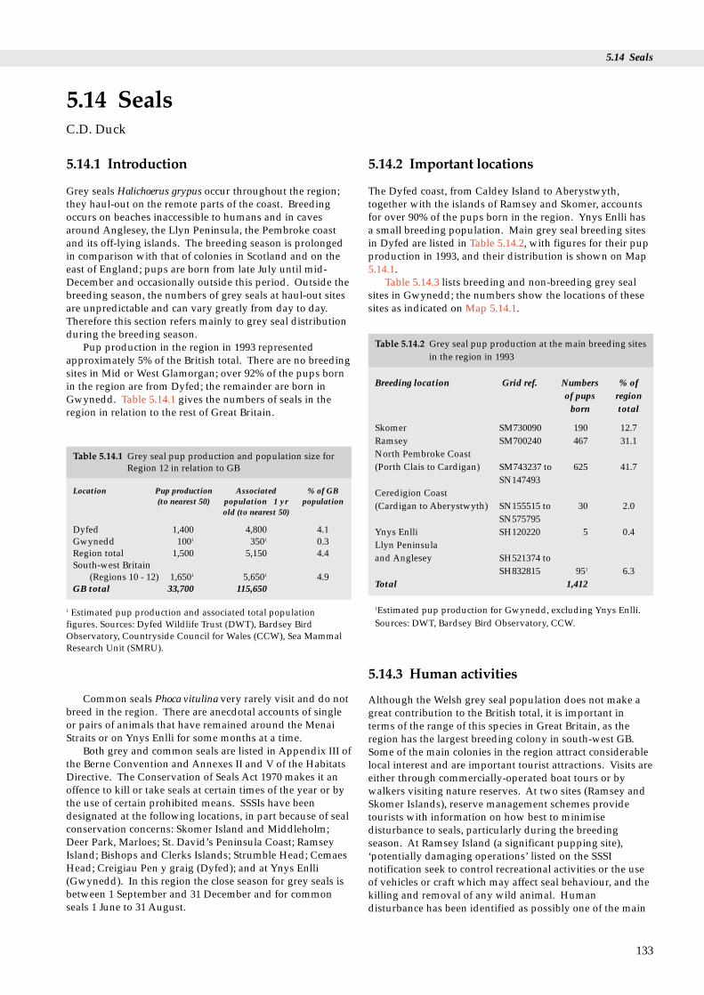
5.14 Seals
Table 5.14.2 Grey seal pup production at the main breeding sitesin the region in 1993
Breeding location Grid ref. Numbers % ofof pups region
born total
5.14.1 Introduction
Grey seals Halichoerus grypus occur throughout the region;they haul-out on the remote parts of the coast. Breedingoccurs on beaches inaccessible to humans and in cavesaround Anglesey, the Llyn Peninsula, the Pembroke coastand its off-lying islands. The breeding season is prolongedin comparison with that of colonies in Scotland and on theeast of England; pups are born from late July until mid-December and occasionally outside this period. Outside thebreeding season, the numbers of grey seals at haul-out sitesare unpredictable and can vary greatly from day to day.Therefore this section refers mainly to grey seal distributionduring the breeding season.
Pup production in the region in 1993 representedapproximately 5% of the British total. There are no breedingsites in Mid or West Glamorgan; over 92% of the pups bornin the region are from Dyfed; the remainder are born inGwynedd. Table 5.14.1 gives the numbers of seals in theregion in relation to the rest of Great Britain.
5.14 SealsC.D. Duck
Skomer SM730090 190 12.7Ramsey SM700240 467 31.1North Pembroke Coast(Porth Clais to Cardigan) SM743237 to 625 41.7
SN147493Ceredigion Coast(Cardigan to Aberystwyth) SN155515 to 30 2.0
SN575795Ynys Enlli SH120220 5 0.4Llyn Peninsulaand Anglesey SH521374 to
SH832815 951 6.3Total 1,412
1Estimated pup production for Gwynedd, excluding Ynys Enlli.Sources: DWT, Bardsey Bird Observatory, CCW.
Table 5.14.1 Grey seal pup production and population size forRegion 12 in relation to GB
Location Pup production Associated % of GB (to nearest 50) population � 1 yr population
old (to nearest 50)
Dyfed 1,400 4,800 4.1Gwynedd 1001 3501 0.3Region total 1,500 5,150 4.4South-west Britain
(Regions 10 - 12) 1,6501 5,6501 4.9GB total 33,700 115,650
1 Estimated pup production and associated total populationfigures. Sources: Dyfed Wildlife Trust (DWT), Bardsey BirdObservatory, Countryside Council for Wales (CCW), Sea MammalResearch Unit (SMRU).
Common seals Phoca vitulina very rarely visit and do notbreed in the region. There are anecdotal accounts of singleor pairs of animals that have remained around the MenaiStraits or on Ynys Enlli for some months at a time.
Both grey and common seals are listed in Appendix III ofthe Berne Convention and Annexes II and V of the HabitatsDirective. The Conservation of Seals Act 1970 makes it anoffence to kill or take seals at certain times of the year or bythe use of certain prohibited means. SSSIs have beendesignated at the following locations, in part because of sealconservation concerns: Skomer Island and Middleholm;Deer Park, Marloes; St. David’s Peninsula Coast; RamseyIsland; Bishops and Clerks Islands; Strumble Head; CemaesHead; Creigiau Pen y graig (Dyfed); and at Ynys Enlli(Gwynedd). In this region the close season for grey seals isbetween 1 September and 31 December and for commonseals 1 June to 31 August.
5.14.2 Important locations
The Dyfed coast, from Caldey Island to Aberystwyth,together with the islands of Ramsey and Skomer, accountsfor over 90% of the pups born in the region. Ynys Enlli hasa small breeding population. Main grey seal breeding sitesin Dyfed are listed in Table 5.14.2, with figures for their pupproduction in 1993, and their distribution is shown on Map5.14.1.
Table 5.14.3 lists breeding and non-breeding grey sealsites in Gwynedd; the numbers show the locations of thesesites as indicated on Map 5.14.1.
5.14.3 Human activities
Although the Welsh grey seal population does not make agreat contribution to the British total, it is important interms of the range of this species in Great Britain, as theregion has the largest breeding colony in south-west GB.Some of the main colonies in the region attract considerablelocal interest and are important tourist attractions. Visits areeither through commercially-operated boat tours or bywalkers visiting nature reserves. At two sites (Ramsey andSkomer Islands), reserve management schemes providetourists with information on how best to minimisedisturbance to seals, particularly during the breedingseason. At Ramsey Island (a significant pupping site),‘potentially damaging operations’ listed on the SSSInotification seek to control recreational activities or the useof vehicles or craft which may affect seal behaviour, and thekilling and removal of any wild animal. Humandisturbance has been identified as possibly one of the main
133

Region 12 Chapter 5 Important species
134
Table 5.14.3 Sites in Gwynedd used by breeding and non-breeding
Location (see Map 5.14.1) Grid ref. Rees (1973
Llyn Peninsula1. Criccieth - Afon Wen SH455372 yes2. St Tudwal’s Islands SH340250 yes3. Pencilan Head SH290235 yes4. Porth Cadlan -Ynys SH183245 yes
Gwylan5. Porthor - Penrhyn Mawr SH165315 ?6. Porth Gwylan SH216366 ?7. Aber Geirch - Porth
Dinllaen SH265405 ?8. Trefor - Penrhyn Glas SH348455 yes9. Gored - Clynnog SH415505 ?
Anglesey10. Ynys Llanddwyn SH385620 yes11. Holy Island (west coast) SH210800 yes12. The Skerries SH270950 yes13. Ynys Dulas SH502902 yes14. Puffin Island SH650820 yes
Sources: Anderson (1977), Rees (1973), Thomas (1993); CCW, RSPB, Usince 1974. Key: n/a - not covered in this source.
1
234
5
67
89
10
11
1213
14
10100
500
Map 5.14.1 Grey seal pup production. Circles represent thenumbers of pups born along sections of the coast (asdefined by Dyfed Wildlife Trust). Figures aroundGwynedd refer to locations in Table 5.14.2. Data fromDWT, CCW and Bardsey Bird Observatory; Anderson(1977); Baines et al. (1994); Rees (1973) and Thomas(1993).
factors affecting the distribution of sites used for breeding(Baines & Pierpoint 1993; Baines 1993). Tour boat operatorsare co-operating with local conservation organisations(Countryside Council for Wales (CCW), Dyfed WildlifeTrust (DWT), Royal Society for the Protection of Birds(RSPB)) in defining the most instructive and least disturbingmethods for approaching colonies (Baines 1993; Thomas1994). The Skomer Marine Nature Reserve, encompassingSkomer and the Marloes Peninsula, is managed by the CCWunder byelaws and a voluntary code of conduct. The code,which is not legally enforceable, advises that breeding andhaul-out sites should not be approached within 100 mbetween 1 September and 28 February. Though no byelawsexplicitly relate to seals, a general byelaw provides thateither a permit from CCW or a reasonable excuse is requiredbefore any animal may be disturbed. The effects of humandisturbance are currently being studied in conjunction withDWT’s breeding season survey of grey seals in west Wales.
Throughout the region the use of leisure craft(particularly jet-skis, inflatables and sea-kayaks) hasrecently increased and may increase the disturbance to seals.
There is a locally important inshore coastal fishingindustry in the region (see section 9.1). Fishing methodsvary from recreational sea angling to gill, tangle andtrammel netting. Studies of interactions with fisheries haveshown that a small number of seals drown in tangle and gillnets, and occasionally some are shot (Thomas 1992, 1993).
Concern has been expressed about the potential effectson marine mammals of oil-related developments in theregion. Richardson et al. (1989) conclude, from a literaturereview, that they are relatively minor. The risk to seals fromcontamination with oil also appears to be small. There hasbeen one report of small numbers of grey seal pups dying asa result of severe oiling (Davies & Anderson 1976), but suchevents appear to be rare. The air-gun arrays used in seismicsurveys generate high levels of low frequency sound. Mostof the energy in the output from these arrays is outside theknown hearing range of seals and is unlikely to disturbthem. There is a very small risk of injury to seals in the
grey seals
) Anderson (1977) Breeding in Non-breeding1993? haul-out
no ? no yes? ? no yesno ? no ?yes ? yes in 1991 ?
n/a ? yes ? yesn/a ? yes ? yes
no ? yes ? yesno ? no ?no ? no ?
? ? no ?yes ? yes ? yesyes yes yes? yes yes? ? no yes
CNW (Bangor). Note: Many sites have not been officially surveyed

5.14 Seals
immediate vicinity of a vessel conducting seismic surveys.
5.14.4 Information sources used
Pup production around the Pembroke and Ceredigion coast,from Caldey Island to Aberystwyth, has been systematicallymonitored throughout each breeding season since 1991 byDWT (Baines 1992, 1993, 1994; Baines, Earl & Strong 1994),under contract to CCW, with funding from thePembrokeshire Coast National Park, Welsh Water andothers; most of the information presented here wassummarised from those reports. The most recent breedingsurvey of the entire region was carried out between20 September and 11 October 1974 (Anderson 1977). Mostbreeding sites were visited once, and counts of pups wereobtained from inflatable boats and by swimmers. A surveyof breeding sites on Anglesey and the Caernarfonshire(Gwynedd) coast was made by Rees (1973). Pup productionon Ynys Enlli is monitored by Bardsey Bird Observatory.Pup production on Skomer has been monitored annuallysince 1983.
Information on seal distribution outside the breedingseason is collected routinely at a number of sites: on YnysEnlli by Bardsey Bird Observatory; on The Skerries (north-west Anglesey from mid-May to mid-August) by the RSPB;on the north Pembroke coast (DWT and CCW); on Ramsey(RSPB); and on Skomer (DWT). There are anecdotalaccounts from haul-out sites elsewhere, particularly roundthe Gwynedd coast (Table 5.14.2).
5.14.5 Further sources of information
A. References cited
Anderson, S.S. 1977. The grey seal in Wales. Nature in Wales, 15:114-123.
Baines, M.E. 1992. West Wales grey seal census - report on the 1991survey. Unpublished report to the Countryside Council forWales from the Dyfed Wildlife Trust.
Baines, M.E. 1993. West Wales grey seal census - report on the 1992season. Unpublished report to the Countryside Council forWales from the Dyfed Wildlife Trust.
Baines, M.E. 1994. Grey seals in west Wales. British Wildlife, 5: 341-348.
Baines, M.E., Earl, S.J., & Strong, P.G. 1994. West Wales grey sealcensus - interim report on the 1993 season. Unpublished report tothe Countryside Council for Wales from the Dyfed WildlifeTrust.
Baines, M.E., & Pierpoint C.J.L. 1993. Ramsey Island grey seal census1992. Unpublished report to Dyfed Wildlife Trust.
Davies, J.D., & Anderson S.S. 1976. Effects of oil pollution onbreeding grey seals. Marine Pollution Bulletin, 7: 115-118.
Rees, S. 1973. Survey of grey seal breeding sites on the Anglesey andCaernarfonshire coasts. Unpublished internal NatureConservancy Report (held by the Countryside Council forWales, Bangor).
Richardson, W.J., Hickie, J.P., Davis, R.A., & Thomson, D.H. 1989.Effects of offshore petroleum operations on cold water marinemammals: a literature review. American Petroleum InstitutePublication No. 4485.
Thomas, D. 1992. Marine wildlife and net fisheries around Wales.RSPB/CCW Report.
Thomas, D. 1993. Marine wildlife and net fisheries in Cardigan Bay.RSPB/CCW Report.
Thomas, D. 1994. Observations on disturbance to breeding seals onRamsey, 1993. Unpublished report to Dyfed Wildlife Trust.
B. Further reading
Cullen, M.S. 1978. The stock of grey seal Halichoerus grypus offPembrokeshire, Dyfed. 1977. Nature in Wales, 16: 20-24.
Evans S.B. 1979. Oil pollution of west Wales by the CHRISTOS BITAS12 October to 20 November, 1978. Unpublished NCC Report(Held by CCW).
Gubbay, S. 1988. A coastal directory for marine nature conservation.Ross-on-Wye, Marine Conservation Society.
McGillivray, D. 1995. Seal conservation legislation in the UK: past,present and future. International Journal of Marine and CoastalLaw, 10: 19-52.
C. Contact names and addresses
Type of information Contact address and telephone no.
Seals on Ynys Enlli The Warden, Bardsey Bird andField Observatory, Aberdaron,Pwllheli, Ynys Enlli LL53 8DE,Gwynedd
Seals on West Hoyle Bank, a Dee Estuary Ranger, Hilbre major haul-out site just Reserve, c/o The Post outside the region Office, Grange Road, West Kirby,
Wirral L46 4HA
Seals around the Dyfed coast *DWT Seal Survey Team, DyfedWildlife Trust, Haverfordwest, tel: 01437 765462
Seals around the Gwynedd *North Wales Wildlife Trust, coast Bangor, tel: 01248 351541
Seals in the region’s SSSIs *CCW Fishguard, tel: 01348874602, or CCW HQ Bangor, tel:01248 370444
Seals around Skomer MNR *CCW Skomer, tel: 01646 636736
Licences to kill seals Welsh Office AgricultureDepartment, Cathays Park, Cardiff CF1 3NQ, tel: 01222 823176
Seals on The Skerries, The Warden, RSPB Office, Anglesey Swn-y-Mor, South Stack, Holy
Island, Anglesey, Gwynedd OL65 3HB, tel: 01407 764973
Seals on Ramsey Island The Warden, RSPB, ‘Tegfan’,Caerbwdi, St Davids, Dyfed SA62 6QT, tel: 01437 720065
Seal numbers and Callan Duck, Sea Mammal distribution around the UK Research Unit, High Cross,
Madingley Road, CambridgeCB3 0ET, tel: 01223 311354
* Starred contact addresses are given in full in the Appendix
135

Region 12 Chapter 5 Important species
5.14.6 Acknowledgements
Kim Atkinson and the Bardsey Bird Observatory; SallyBudd, Steve Evans, Michael Gash and Peter Hope Jones ofCCW; Mick Baines, Margaret Brooke and David Saunders ofDWT; Vicky Seager, Ranger for the Dee Estuary; Ian Bullock,Alistair Moralee and Dave Thomas of the RSPB and IvorRees of UCNW (Bangor) kindly provided information onseal distributions. On seal conservation law, grateful thanksare due to Donald McGillivray, Kent University, forinformation and comments, and to Mick Baines, DyfedWildlife Trust; Amanda Richards and Caroline Naylor,CCW, and Caroline Robson and Rob Keddie, JNCC, for helpin gathering information on protected sites.
136

5.15 Whales, dolphins and porpoises
orpoises
5.15.1 Introduction
Fourteen species of cetaceans have been recorded since 1980along the coasts or in nearshore waters (within 60 km of thecoast) of the region. In terms of the diversity of regularlyoccurring cetacean species, the region is not particularlyrich, with less than 25% (six out of 26 species) of the UKcetacean fauna recorded regularly in the region since 1980(Table 5.15.1). These six species - harbour porpoise,common dolphin, bottlenose dolphin, killer whale, long-finned pilot whale and Risso’s dolphin - are either presentthroughout the year or are recorded annually as seasonalvisitors. The region is, however, nationally important forhaving the only recognised resident community ofbottlenose dolphins in England and Wales. The populationnumbers at least 130 individuals (and probably many more,although only a proportion of these are likely to beresident), and at least some individuals occur in severalmonths of the year (Evans 1992; Arnold 1993; Lewis &Evans 1993). The harbour porpoise and bottlenose dolphinare both listed in Annex II of the Habitats Directive asspecies whose conservation requires the designation ofSpecial Areas of Conservation. Maps 5.15.1 - 4 show thedistribution of sightings of common dolphins, harbourporpoise and bottlenose dolphins in the region.
Other cetacean species recorded in the region include finwhale Balaenoptera physalus, minke whale B. acutorostrata,humpback whale Megaptera novaeangliae, pygmy spermwhale Kogia breviceps, Blainville’s beaked whale Mesoplodondensirostris (only British record, and only of strandedspecimens), striped dolphin Stenella coeruleoalba, Atlanticwhite-sided dolphin Lagenorhynchus acutus, and white-beaked dolphin L. albirostris. For geographical comparisonsof sightings rates for various cetacean species, see Evans(1990, 1992) and Northridge et al. (in prep.).
5.15 Whales, dolphins and pDr P.G.H. Evans
Table 5.15.1 Cetacean species regularly recorded in the region
Species name Status
Harbour porpoise Phocoena phocoena Fairly common
Common dolphin Delphinus delphis Common
Bottlenose dolphin Tursiops truncatus Common
Killer whale Orcinus orca Uncommon Long-finned pilot whale Globicephala melas Fairly common
Risso’s dolphin Grampus griseu Uncommon
5.15.2 Important locations and species
Most nearshore cetacean sightings in the region are ofbottlenose dolphin or harbour porpoise, althoughpopulations of the latter are small compared with those innorthern Britain. Both species typically occur in the shallowseas bordering the North Atlantic. The species mostfrequently recorded offshore is the common dolphin.
Along the West Glamorgan coast, conditions do notfavour concentrations of food fishes and so cetaceans areuncommon (Evans 1987).
The coastal waters of Dyfed support a number ofdifferent cetacean species at various times, as follows.Harbour porpoises are reported throughout the year aroundthe islands of Skomer, Skokholm and Ramsey, butparticularly between June and October, and there is a locallyimportant concentration in St Bride’s Bay. In coastal watersaround Strumble Head, the Teifi Estuary and CardiganIsland and also off the series of headlands (Mwnt, Pen Peles,Aberporth, Ynys Lochtyn) reaching up to Newquay, theyoccur in small numbers throughout the year but particularlybetween late July and September. In Cardigan Bay, harbourporpoises are seen in greatest numbers between July andOctober over sandbanks and undersea mounts, notably thePatches, Sarn y Bwch and Sarn Badrig.
Bottlenose dolphins are most commonly seen within tenmiles of the coast between Cardigan and Borth, from Aprilto October, although they are also seen off Skokholm andSkomer and sometimes off Strumble Head, especiallybetween July and September. Headlands at Mwnt, PenPeles, Aberporth, Ynys Lochtyn and New Quay areparticularly favoured feeding areas for bottlenose dolphins.Like harbour porpoises, they are also seen in significantnumbers further north in Cardigan Bay, especially inshallower water.
137
Distribution/seasonal occurrence
All months of the year but with greatest numbers April -November, particularly early September. Widely distributed,particularly around the Pembrokeshire islands and offshore sandbanks and sea mounts.Offshore in the Irish Sea & St George’s Channel. All months of theyear but with greatest numbers July - September.All months of the year, but peak numbers August - December, withpossible spring (late April - May) and autumn (October -November) influxes. Nearshore waters, particularly betweenCardigan and New Quay (but extending north to Criccieth) andaround several offshore sand banks and sea mounts in central andnorthern Cardigan Bay.Mainly off the Dyfed coast, April - September.Mainly offshore. All months of the year but most sightings andgreatest numbers August - December.Nearshore waters, with most sightings around the Pembrokeshireislands and western end of the Llyn Peninsula, including YnysEnlli, mainly April - September.

Region 12 Chapter 5 Important species
6.1–8.0
4.1–6.0
2.1–4.0
0.1–2.0None
†
Map 5.15.1 Sightings of common dolphins, summer 1992. Numberof sightings per 1,000 km travelled (from ‘platforms ofopportunity’). Source: Evans (1992).
6.1–8.0
4.1–6.0
2.1–4.0
0.1–2.0None
††
† †
†
†
Map 5.15.2 Sightings of harbour porpoise, summer 1992. Numberof sightings per 1,000 km travelled (from ‘platforms ofopportunity’). Source: Evans (1992).
Common dolphins are also seen off Skokholm andSkomer (as are Risso’s dolphins) but are more typicallyencountered further offshore in the Irish Sea and St George’sChannel. In the summer a frontal system develops in theIrish Sea (see section 4.3), with concentrations of plankton,fish and squid, which attracts feeding concentrations ofcetaceans otherwise found only in the open sea, such aslong-finned pilot whales and baleen whales, as well as thecommon dolphins. Other species sometimes recorded faroffshore include fin whale (October - December) and minkewhale (July - September).
Cetaceans have been sighted in coastal waters aroundGwynedd, particularly in Caernarfon Bay. Harbourporpoises occur around Ynys Enlli and Holy Island,Anglesey, from at least June to October. Other speciesrecorded in small numbers include Risso’s dolphin andbottlenose dolphin.
Off the north coast of Gwynedd, coastal waters are againinfrequently visited by cetaceans.
5.15.3 Human activities
Cetaceans in the region face three main pressures fromhuman activities: conflicts with fisheries (either bycompetition for a common food resource, or accidentalcapture in fishing gear), habitat degradation (mainly fromuntreated sewage, but possibly other contaminants), anddisturbance (from underwater sounds).
Tangle nets set for demersal fish in Caernarfon andCardigan Bays have been reported accidentally catchingharbour porpoises (Thomas 1992). Although local sourcesof pollution (besides untreated sewage) have not been
138
identified, two bottlenose dolphins found stranded on theDyfed coast in 1988 and 1992 respectively contained highlevels of PCBs (max. 290 ppm), DDT (max. 150 ppm), andmercury (max. 190 ppm) (Morris et al. 1989; Law et al. 1992).It is not known how these dolphins ingest these levels incomparatively unpolluted waters.
Recreational activities (speedboats, jet skis, etc.) aroundresorts such as Cardigan, Aberporth, New Quay and Borth,pose threats of disturbance from the high frequency (>1kHz) noise generated by these vessels (Evans et al. 1992).Negative responses (vessel avoidance and increased divetimes) by both bottlenose dolphins and harbour porpoisesto such sounds have been reported by Evans et al. (1992; inpress). Other underwater sounds from seismic activities (aspart of oil and gas exploration) are at lower frequencies, andtherefore are most likely to affect baleen whales, whichcommunicate primarily at these frequencies (20-500 Hz),although Baines (1993) reported a possible temporarynegative correlation between porpoise presence offStrumble Head and seismic activities, during summer 1993.Results obtained during seismic surveys by Marathon andHamilton oil companies (Evans et al. 1993) wereinconclusive and experimental evidence remains lacking.
5.15.4 Information sources used
Information on cetacean status and distribution comesprimarily from the national sightings database (1973 -present) maintained by the Sea Watch Foundation (SWF)and the strandings scheme organised by the LondonNatural History Museum (1913-present). In addition,dedicated surveys for bottlenose dolphins and harbour

5.15 Whales, dolphins and porpoises
6.1–8.0
8.1–10.0
10.1–12.0
4.1–6.0
2.1–4.00.1–2.0None
†
†
Map 5.15.3 Sightings of bottlenose dolphins, summer 1992.Number of sightings per 1,000 km travelled (from‘platforms of opportunity’). Source: Evans (1992).
40.1–60.0
60.1–80.0
80.1–100.0
20.1–40.0
10.1–20.00.1–10.0None
Map 5.15.4 Sightings of bottlenose dolphins in Cardigan Bay,summers 1991 and 1992. Number of sightings per 1,000km travelled (from dedicated cruises). Source: Evans(1992).
porpoises have been carried out in recent years in CardiganBay, mainly between June and September, by the Sea WatchFoundation (see Lewis & Evans 1993), the University ofAberdeen and Greenpeace (Arnold 1993). Systematic land-based watches have been carried out by the wardens ofSkomer and Skokholm Islands, and Ynys Enlli, and bymembers of Dyfed Wildlife Trust, Friends of Cardigan Bay,and other volunteers at Strumble Head, overlookingRamsey Sound, at Newquay and Holy Island. Offshoreeffort-related data are also collected by trained observersaboard various sea-angling vessels operating between Mayand October; Sea Link ferries operating throughout the yearbetween Rosslare and Cherbourg, passing down the centreof the southern Irish Sea; seabird surveys of the Irish Sea byJNCC’s Seabirds at Sea Team, mainly between 1986 and1990; and a survey of the Irish Sea utilising yachts, ferries,and the Royal Navy, between May and September 1992. Aspart of surveillance of seismic exploration activities,cetacean observations were collected during systematicsurveys of the southern Irish Sea, with Marathon Oil (May-June 1993), and Hamilton Oil (January 1994).
Survey effort remains patchy, with some areas poorlycovered (e.g. West Glamorgan and north Gwynedd), andeffort is highest between the months of July and Septemberwhen sea conditions also tend to be most favourable.Although the list of important sites partly reflects the factthat they are better known, other systematic data supporttheir regional importance.
5.15.5 Further sources of information
A. References cited
Arnold, H. 1993. Distribution, abundance and habitat use of bottle-nosed dolphins in Cardigan Bay, Wales, 1992. In: Europeanresearch on cetaceans: 7, ed. by P.G.H. Evans, 63-66. Cambridge,European Cetacean Society.
Baines, M.E. 1993. Marine mammal monitoring during the seismicexploration of block 107/21 in Cardigan Bay, Autumn 1993.Haverfordwest, Dyfed Wildlife Trust.
Evans, P.G.H. 1987. The natural history of whales and dolphins.London, Christopher Helm.
Evans, P.G.H. 1990. Whales, dolphins and porpoises. The orderCetacea. In: Handbook of British mammals, ed. by G.B. Corbet &S. Harris, 299-350. Oxford, Blackwell.
Evans, P.G.H. 1992. Status review of cetaceans in British and Irishwaters. Oxford, Sea Watch Foundation. (Report to the UK Dept.of the Environment, London.)
Evans, P.G.H., Canwell, P.J., & Lewis, E.J. 1992. An experimentalstudy of the effects of pleasure craft noise upon bottle-noseddolphins in Cardigan Bay, West Wales. In: European research oncetaceans - 6, ed by P.G.H. Evans, 43-46. Cambridge, EuropeanCetacean Society.
Evans, P.G.H., Lewis, E.J., & Fisher, P. 1993. A study of the possibleeffects of seismic testing upon cetaceans in the Irish Sea. Oxford, SeaWatch Foundation. (Report to Marathon Oil UK.)
Evans, P.G.H., Carson, Q., Fisher, P. Jordan, W., Limer, R., & Rees, I.In press. A study of the reactions of Harbour Porpoises tovarious boats in the coastal waters of SE Shetland. In: Europeanresearch on cetaceans - 8, ed. by P.G.H. Evans. Cambridge,European Cetacean Society.
Law, R.J., Jones, B.R., Baker, J.R., Kennedy, S., Milne, R., & Morris,R.J. 1992. Trace metals in the livers of marine mammals fromthe Welsh coast and the Irish Sea. Marine Pollution Bulletin, 24:296-304.
139

Region 12 Chapter 5 Important species
Lewis, E.J., & Evans, P.G.H. 1993. Comparative ecology of bottle-nosed dolphins Tursiops truncatus in Cardigan Bay and theMoray Firth. In: European research on cetaceans: 7, ed. by P.G.H.Evans. 57-62. Cambridge, European Cetacean Society.
Morris, R.J., Law, R.J., Allchin, C.R., Kelly, C.A., & Fieleman, C.1989. Metals and organochlorines in dolphins and porpoises ofCardigan Bay, West Wales. Marine Pollution Bulletin, 20: 512-523.
Northridge, S., Tasker, M.L., Webb, A., & Williams, J.M. 1995.Seasonal distribution and relative abundance of harbourporpoises Phocoena phocoena (L.), white-beaked dolphinsLagenorhynchus albirostris (Gray) and minke whales Balaenopteraacutorostrata (Lacepède) in the waters around the British Isles.ICES Journal of marine Science.
Thomas, D. 1992. Marine wildlife and net fisheries around Wales.Newtown and Bangor, Royal Society for the Protection ofBirds/Countryside Council for Wales.
B. Further reading
Evans, P.G.H. 1990. European cetaceans and seabirds in anoceanographic context. Lutra, 33: 95-125.
Mayer, S., Arnold, H., & Evans, P.G.H. 1991. Preliminary findingsfrom a photo-identification study of bottle-nosed dolphinsTursiops truncatus in Cardigan Bay, Wales, UK, during 1990. In:European research on cetaceans: 5, ed. by P.G.H. Evans, 45-46.Cambridge, European Cetacean Society.
Natural History Museum. 1990-present. Annual Reports. London,Natural History Museum.
Pierpoint, C., Earll, S., & Baines, M.E. In press. Observation ofharbour porpoise in West Wales, 1993. In: European research oncetaceans: 8, ed. by P.G.H. Evans. Cambridge, EuropeanCetacean Society.
140
C. Contact names and addresses
Type of information Contact address and telephone no.
Cetacean strandings Dr D. George & Mr A. Muir,Natural History Museum,Cromwell Road, SouthKensington, London SW7 5BD, tel: 0171 938 8861
Cetacean strandings R. Penrose, Welsh StrandingsCo-ordinator, Penwalk, Llechryd,Cardigan, Dyfed SA43 2PS, tel: 01348 875000/875281
Cetacean sightings and Dr P.G.H. Evans, c/o Dept. of surveys Zoology, University of Oxford,
South Parks Road, Oxford 0X1 3PS,tel: 01865 727984
Cetacean sightings *JNCC Seabirds & CetaceansBranch, Aberdeentel: 01224 642863
Cetacean organochlorine Dr R.J. Law, MAFF Fisheries and heavy metal levels Laboratory, Remembrance Avenue,
Burnham-on-Crouch, EssexCM0 8HA, tel: 01621 782658
Cetacean bycatches in *D. Thomas, RSPB Wales,Cardigan and Caernarfon tel: 01686 626678Bays
Conservation issues facing *M. Taylor, Cardigan Bay Forum, cetaceans in Cardigan Bay tel: 01970 624471
Cetacean surveys in southern M.E. Baines, Dyfed Wildlife Trust, Cardigan Bay Cefn Garth, Cilgerran, Cardigan,
SA61 1NF, tel: 01239 682548
Studies of bottlenose Dr P.G.H. Evans & E.-J. Lewis, dolphins; effects of sound c/o Zoology Department,disturbance University of Oxford, South
Parks Road, Oxford 0X1 3PS, tel: 01865 72798
Bottlenose dolphin studies H. Arnold, c/o AberdeenUniversity Lighthouse FieldStation, Cromarty, Ross-shire IV11 8YJ, tel: 01381 600548
Harbour porpoise watches C. Pierpoint, 7 Parkway, Wallasey,Merseyside L45 3HU, tel: 0151 639 3813
Dolphin acoustic studies Dr R.J. Morris, 38b Old Burleigh around New Quay Road, Surfers Paradise,
Queensland, Australia 4217
* Starred contact addresses are given in full in the Appendix
5.15.6 Acknowledgements
Thanks are due to J. Heimlich-Boran and E.-J. Lewis for helpin the preparation of the maps, and to the following personsfor contributing valuable sightings data: M.E. Baines, T.Bristow, B. Bullerose, P. Dare, J. Durrant, P. Fisher, M. Green,J. Hagan, S. Hartley, N. Hughes, I. Hutchin, P.H. Jones, R.J.Law, E.-J. Lewis, S. Mayer, M. Morgan-Jenks, G. Reading, S.Sutcliffe, D. Taylor, M. Taylor, D. Thomas, A. Webb and T.Wenden.

Chapter 6 Archaeology and humanhistory
A.B. Gale
Wreck of the Mary
Morfa Conwy
Bangor
Beaumaris
Red Wharf Bay
Holyhead
Caenarfon
Caer Arinrhod
Aberystwyth
Cardigan
Skomer
Pembroke
Kidwelly
Preseli Hills
Penmaenmawr
Pwll FanogWreckClynnog Fawr
Dwyryd BoatPorth Felen
Tal Y Bont Wreck
Smalls Reef Wreck
CastlemartinArtillery Range
Stackpole Dunes
Ritec
Lydstep
Rhossili Bay Margam
Map 6.2.1 Archaeology: locations mentioned in the text.
6.1 IntroductionThis chapter provides a brief introduction to thearchaeological evidence which is an integral part of the coastalresource.
Archaeology can be broadly defined as the study of thepast through physical evidence. It uses a wide variety ofscientific techniques to record and analyse the availableevidence. As for other areas of Britain, there is a growinginterest in the archaeology and history of the coast of thisregion, which arises from an increasing awareness of thepotential to recover high quality information fromarchaeological sites in the intertidal and sub-tidal zones.
This coastal region, although narrow, broadening out onlyin Pembrokeshire and across Anglesey, has been a major focusfor human activity in all periods. This low-lying land and thetidal river valleys provide a more fertile area for habitationthan the hills and mountains of the interior, which also form abarrier to communication. The coastal strip has, however,been constantly changing: contracting through erosion andinundation, widening through accretion and land claim.There is an increasing interest in reconstructing pastenvironments and correlating them with evidence for sea-level change. Instances of marine and intertidalarchaeological material associated with evidence indicative ofterrestrial palaeo-environments demonstrate the potential ofsites in this region to extend current knowledge hitherto basedsolely on terrestrial sites.
Map 6.2.1 shows some of the principal locationsmentioned in the text.
6.1.1 History and archaeology of the region
Hunters, gatherers and early farmers (Mesolithic andNeolithic): During the last Ice Age sea-level was about 40 mlower than today and Britain was joined to continentalEurope. The coastal plain of Wales was much more extensivethan now and was occupied by roaming bands of Mesolithicpeoples (hunter-gatherers with stone tools). Communicationwith the Cornish Peninsula was easier as the Bristol Channelwas then a river valley (Wainwright 1963). The ice-sheetsbegan melting around 10,000 years ago, and since then thecoastal plain has been much narrowed by rising sea-level.
The present intertidal area lies at the landward limit of theformer coastal plain. Sites can be anticipated, therefore, on theseabed and in inundated rias as well as sealed beneath alluvialdeposits. Mesolithic artefacts found are characterised by‘limpet scoops’ indicative of fish eating. Submerged forestsand peat have been recorded since the 19th century, duringthe construction of Swansea Docks for example. Similarpalaeo-environmental deposits are now being recorded fromaround the whole region. Flint tools and animal debris havebeen found in the submerged forests, particularly in
Carmarthen Bay and on the coast of Pembrokeshire. Materialfrom Lydstep included the skeleton of a boar containing themicrolith (flint tip) from a Mesolithic weapon (Lewis 1991).
Prehistoric landsurfaces have not only been submerged:they have also been sealed beneath massive accumulations ofsand dunes. These are known on the coasts of WestGlamorgan and Dyfed, with notable sites at Rhossili,Stackpole Dunes and the River Ritec near Tenby.
The Neolithic population, who cleared land for farming,often occupied sites once used by Mesolithic peoples. Theircharacteristic polished stone axes were made from the igneousrocks found in the Preseli Hills (Dyfed) and Penmaenmawr(Gwynedd) (McCough & Cummins 1988). Occupation of thecoast is indicated by long barrows, especially gallery graves,which occur in the former counties of Pembrokeshire,Caernarfonshire, Anglesey, Merioneth and Denbighshire.Such burial sites might have provided navigation markersduring crossings of the Irish Sea (Corcoran 1972).
Metal-working peoples (Bronze Age and Iron Age): TheBronze Age people also occupied coastal sites. Theirsettlements, too, are marked by burial mounds, and also bycircular huts and defended enclosures. Coastal mineralresources, particularly copper and lead, were exploited and
141
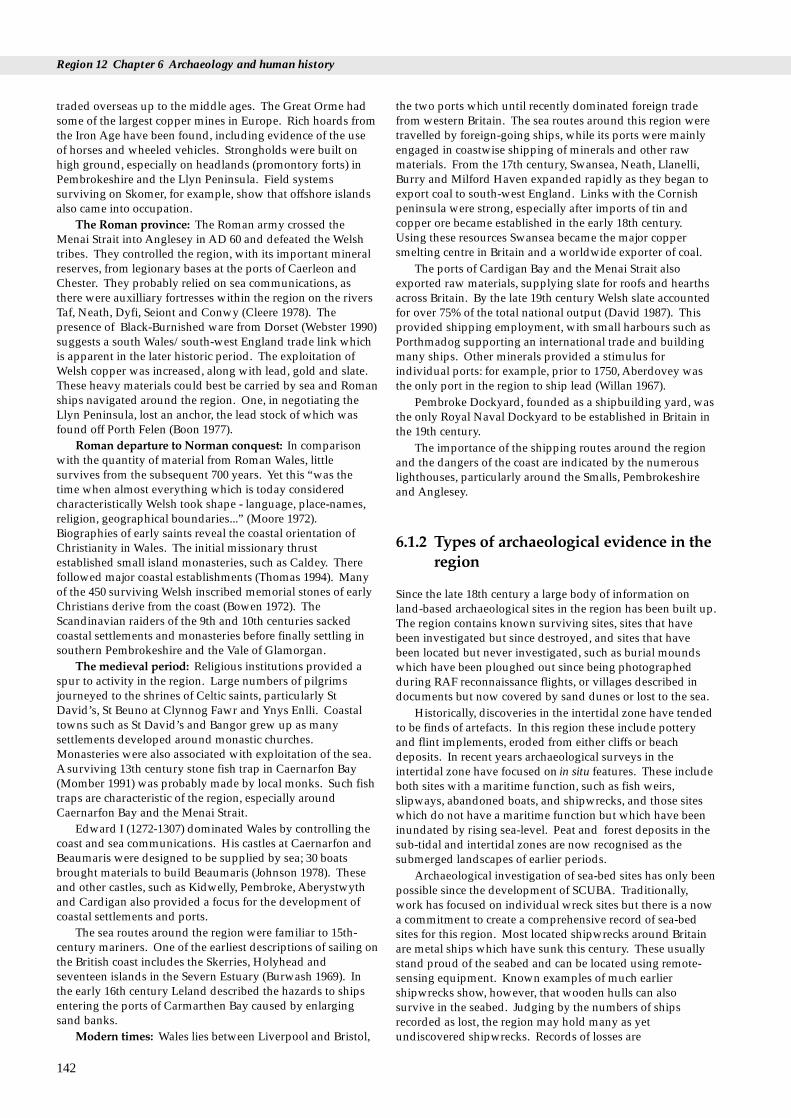
Region 12 Chapter 6 Archaeology and human history
traded overseas up to the middle ages. The Great Orme hadsome of the largest copper mines in Europe. Rich hoards fromthe Iron Age have been found, including evidence of the useof horses and wheeled vehicles. Strongholds were built onhigh ground, especially on headlands (promontory forts) inPembrokeshire and the Llyn Peninsula. Field systemssurviving on Skomer, for example, show that offshore islandsalso came into occupation.
The Roman province: The Roman army crossed theMenai Strait into Anglesey in AD 60 and defeated the Welshtribes. They controlled the region, with its important mineralreserves, from legionary bases at the ports of Caerleon andChester. They probably relied on sea communications, asthere were auxilliary fortresses within the region on the riversTaf, Neath, Dyfi, Seiont and Conwy (Cleere 1978). Thepresence of Black-Burnished ware from Dorset (Webster 1990)suggests a south Wales/south-west England trade link whichis apparent in the later historic period. The exploitation ofWelsh copper was increased, along with lead, gold and slate.These heavy materials could best be carried by sea and Romanships navigated around the region. One, in negotiating theLlyn Peninsula, lost an anchor, the lead stock of which wasfound off Porth Felen (Boon 1977).
Roman departure to Norman conquest: In comparisonwith the quantity of material from Roman Wales, littlesurvives from the subsequent 700 years. Yet this “was thetime when almost everything which is today consideredcharacteristically Welsh took shape - language, place-names,religion, geographical boundaries...” (Moore 1972).Biographies of early saints reveal the coastal orientation ofChristianity in Wales. The initial missionary thrustestablished small island monasteries, such as Caldey. Therefollowed major coastal establishments (Thomas 1994). Manyof the 450 surviving Welsh inscribed memorial stones of earlyChristians derive from the coast (Bowen 1972). TheScandinavian raiders of the 9th and 10th centuries sackedcoastal settlements and monasteries before finally settling insouthern Pembrokeshire and the Vale of Glamorgan.
The medieval period: Religious institutions provided aspur to activity in the region. Large numbers of pilgrimsjourneyed to the shrines of Celtic saints, particularly StDavid’s, St Beuno at Clynnog Fawr and Ynys Enlli. Coastaltowns such as St David’s and Bangor grew up as manysettlements developed around monastic churches.Monasteries were also associated with exploitation of the sea.Asurviving 13th century stone fish trap in Caernarfon Bay(Momber 1991) was probably made by local monks. Such fishtraps are characteristic of the region, especially aroundCaernarfon Bay and the Menai Strait.
Edward I (1272-1307) dominated Wales by controlling thecoast and sea communications. His castles at Caernarfon andBeaumaris were designed to be supplied by sea; 30 boatsbrought materials to build Beaumaris (Johnson 1978). Theseand other castles, such as Kidwelly, Pembroke, Aberystwythand Cardigan also provided a focus for the development ofcoastal settlements and ports.
The sea routes around the region were familiar to 15th-century mariners. One of the earliest descriptions of sailing onthe British coast includes the Skerries, Holyhead andseventeen islands in the Severn Estuary (Burwash 1969). Inthe early 16th century Leland described the hazards to shipsentering the ports of Carmarthen Bay caused by enlargingsand banks.
Modern times: Wales lies between Liverpool and Bristol,
142
the two ports which until recently dominated foreign tradefrom western Britain. The sea routes around this region weretravelled by foreign-going ships, while its ports were mainlyengaged in coastwise shipping of minerals and other rawmaterials. From the 17th century, Swansea, Neath, Llanelli,Burry and Milford Haven expanded rapidly as they began toexport coal to south-west England. Links with the Cornishpeninsula were strong, especially after imports of tin andcopper ore became established in the early 18th century.Using these resources Swansea became the major coppersmelting centre in Britain and a worldwide exporter of coal.
The ports of Cardigan Bay and the Menai Strait alsoexported raw materials, supplying slate for roofs and hearthsacross Britain. By the late 19th century Welsh slate accountedfor over 75% of the total national output (David 1987). Thisprovided shipping employment, with small harbours such asPorthmadog supporting an international trade and buildingmany ships. Other minerals provided a stimulus forindividual ports: for example, prior to 1750, Aberdovey wasthe only port in the region to ship lead (Willan 1967).
Pembroke Dockyard, founded as a shipbuilding yard, wasthe only Royal Naval Dockyard to be established in Britain inthe 19th century.
The importance of the shipping routes around the regionand the dangers of the coast are indicated by the numerouslighthouses, particularly around the Smalls, Pembrokeshireand Anglesey.
6.1.2 Types of archaeological evidence in theregion
Since the late 18th century a large body of information onland-based archaeological sites in the region has been built up.The region contains known surviving sites, sites that havebeen investigated but since destroyed, and sites that havebeen located but never investigated, such as burial moundswhich have been ploughed out since being photographedduring RAF reconnaissance flights, or villages described indocuments but now covered by sand dunes or lost to the sea.
Historically, discoveries in the intertidal zone have tendedto be finds of artefacts. In this region these include potteryand flint implements, eroded from either cliffs or beachdeposits. In recent years archaeological surveys in theintertidal zone have focused on in situ features. These includeboth sites with a maritime function, such as fish weirs,slipways, abandoned boats, and shipwrecks, and those siteswhich do not have a maritime function but which have beeninundated by rising sea-level. Peat and forest deposits in thesub-tidal and intertidal zones are now recognised as thesubmerged landscapes of earlier periods.
Archaeological investigation of sea-bed sites has only beenpossible since the development of SCUBA. Traditionally,work has focused on individual wreck sites but there is a nowa commitment to create a comprehensive record of sea-bedsites for this region. Most located shipwrecks around Britainare metal ships which have sunk this century. These usuallystand proud of the seabed and can be located using remote-sensing equipment. Known examples of much earliershipwrecks show, however, that wooden hulls can alsosurvive in the seabed. Judging by the numbers of shipsrecorded as lost, the region may hold many as yetundiscovered shipwrecks. Records of losses are

6.1 Introduction
comprehensive for the 19th century, relatively complete for the18th, and patchy for the 14th to 17th centuries. For earlierperiods it is necessary to examine documentary evidence forsea-borne trade and extrapolate the opportunities for shiplosses by considering the hazards to navigation. This processhas then to be extended into the prehistoric period by lookingat archaeological evidence for trade and seafaring.
143
Originally a Norman stronghold, Caernarfon Castle (Gwynedd) was rebuilt in the late 13th century by Edward I as the seat of his court inWales. It dominates a natural harbour important since at least Roman times. Photo: N.C.Davidson.

Region 12 Chapter 6 Archaeology and human history
In Wales, three statutory designations are intended toprotect in situ remains of archaeological or historicimportance: the Ancient Monuments & Archaeological AreasAct 1979 (AMAA) provides for Scheduled AncientMonuments; the Planning (Listed Buildings and ConservationAreas) Act 1990 provides for Listed Buildings; and theProtection of Wreck Act 1973 provides for Historic WreckSites.
Many sites in the region, particularly promontory fortsand burial monuments, are among the 2,700 ScheduledAncient Monuments in Wales. For England and Wales there isa published list of criteria for determining the nationalimportance of a monument (Welsh Office 1991); the number ofscheduled sites is expected to increase following currentreview programmes. Table 6.2.1 shows the numbers ofScheduled Monuments in England, Scotland and Wales.Cadw (see section 6.3.3) inspects monuments, assists ownersby drawing up management agreements which are supportedby grants, and directly manages those monuments inGuardianship.
6.2 Important locations
Table 6.2.1 Numbers of scheduled monuments
Country No. of scheduled No. of monuments monuments in Guardianship
Wales 2,700 125England 13,000 400Scotland 5,300 330
Source: Breeze (1993)
The AMAAdefinition of monument includes sites both onland and in UK territorial waters, including remains ofvehicles, vessels and aircraft. In practice, however, scheduling
144
Table 6.2.2 Historic wrecks designated in the region
Site name & designation order Location
Smalls wreck site (1991 No. 2 1991/2746) Smalls Reef, Dyfed
Tal-y-Bont wreck site (1979 No.1 1979/31) Off Barmouth, DyfedAmendment Order 26.10.1989 (1989/1766)Pwll Fanog wreck site (1978 No.1 1978/199) Menai Strait, Gwyned
Mary (1974 No.4 1974/58) Anglesey, Gwynedd
Source: Department of National Heritage
has only been applied above low water mark in England andWales (Firth 1993). There is a presumption against thedestruction of Scheduled Monuments: prior consent isnecessary for any works which will destroy, damage, repair orremove such a monument.
Buildings considered of special architectural or historicimportance may be Listed. Listed Buildings in the regioninclude maritime structures such as docks, dock gates,warehouses and lighthouses. There is no presumption againstthe destruction of Listed Buildings, but consent is requiredprior to any demolition, alteration or extension (Suddards1993).
There are four Historic Wrecks designated in the region(Table 6.2.2). Shipwrecks that are considered ofarchaeological, historical or artistic importance may bedesignated; there are no standard criteria for designation butCadw receives guidance from the Advisory Committee onHistoric Wreck. Fewer than 45 wrecks have been designatedfor the whole of Britain: these do not form a representativesample of the total seabed resource. Designation usuallyapplies to an area of seabed in which the wreck is consideredto lie. Except under licence from Cadw, it is illegal to tamperwith or remove material, to use diving or salvage equipment,or to deposit anything which may damage or obliterate thewreck (Firth 1993). Sites may be inspected on behalf of Cadwby the Archaeological Diving Unit, which is contracted by theDepartment of National Heritage (DNH) to provide fieldinspection.
Information on designated sites in Wales is available fromCadw. Guidance notes for finders of historic wreck areavailable from DNH.
Grid ref. Description
SM464087 300 m radius around find spot. Hiberno-Norse sword guard c.AD 1100.
SH566222 300 m radius of wreck carrying marble blocks. Also called Bronze Bell wreck.
d SH534707 150 m radius of wreck carrying slates.Medieval or later.
SH265947 Yacht given to Charles II in 1660. Lost 1675.Radius 100 m.

6.3 Human activities
6.3.1 Activities and processes affecting thearchaeological resource
The archaeological resource does not consist solely of discretesites such as intact wrecks: many sites are scattered, andpalaeo-environmental deposits can be extensive, crossing theboundaries between the terrestrial, intertidal and subtidalzones.
Terrestrial activities: Coastal sites experience both naturaland human influences. Cliff erosion can threaten sites such aspromontory forts and the scatters of flints worked byprehistoric man. Trampling causes erosion, particularly onlong distance coastal paths. Erosion has been recorded inDyfed (Dyfed Archaeological Trust (DAT) 1994) and inGwynedd (Smith 1993). Developments such as caravan parksand car parks can also affect archaeological sites, as can theextension of agriculture to the cliff edge. Rising sea level mayaffect the integrity of sites, as might any coastal protection andflood defence works.
Many docks and harbours of the region are beingredeveloped to support economic regeneration. There arelarge-scale initiatives such as the Llanelli Coast Venture andthe barrage projects, and changes to smaller ports such asAberyswyth and Cardigan. Redevelopment often involvesremodelling of the coast edge and landscape features. Suchprojects require skilful planning to provide new uses whileretaining the fabric and character of historic buildings andstructures. Demolition and rebuilding can both reveal anddestroy fragile remains of earlier waterfronts sealed beneathexisting structures. Medieval and earlier waterfront structuresmay survive in locations which were not favoured bynineteenth century developers.
Intertidal activities: Foreshore deposits are sensitive toerosive or depositional action of the sea. Remodelling orprotection of the coast in one area may threaten archaeologicaldeposits in another. Developments which directly impinge onthe intertidal area such as sewage outfalls and oil and gaspipelines can disturb archaeological sites, as can individualactivities such as bait digging.
Sub-tidal activities: The influence of human activities onthe subtidal resource is poorly understood because so littlesurvey work has been done. There is clearly scope foractivities to directly damage or destroy sites, for examplethrough salvage diving, dredging or the use of fishing gearwhich is in contact with the seabed. Chemical or physicalchange of the marine environment may also alter the stabilityof sites.
6.3 Human activities
6.3.2 Development control
Terrestrial and intertidal development: To landward of meanlow water mark archaeology is considered within the unifiedsystem of development control provided by the planningsystem. The Welsh Office has issued guidance notes (WelshOffice 1991) explaining the requirements on planningauthorities and developers regarding archaeological remains.In essence there is a presumption in favour of the preservationin situ of archaeological remains and their settings. Theytherefore recommend that it is in the interest of developers, as
part of their research, to make an initial assessment of whetherthe site is known or likely to contain such remains. The Sitesand Monuments Records (SMRs - see section 6.3.3) provideinformation on the location of archaeological sites and shouldbe consulted at an early stage.
Planning decisions should take into account the moredetailed policies which appear in Development Plans. Thusthe Structure Plans for the counties of West Glamorgan,Dyfed, and Gwynedd, and the Local Plans for theirconstituent districts, all contain policies on archaeology.Where county boundaries extend beyond low water mark, forexample on the coast of West Glamorgan, these policies mayapply to seabed sites.
Further policies and information related to archaeologyappear in a variety of management plans. The policies dealwith the resource generally and not specifically with coastalarchaeology. Heritage Coast Plans exist for parts of Gower,the Ceredigion coast and parts of the Llyn Peninsula (see alsosection 7.3). The existence of the seabed archaeologicalresource is recognised in the draft Pembrokeshire CoastNational Park plan, as is the lack of inventory and survey(Pembrokeshire Coast National Park 1994).
For certain types of development (listed in Schedules 1and 2 to the Town & County Planning (Assessment ofEnvironmental Effects) Regulations 1988) formalEnvironmental Assessments (EA) may be necessary. The EAshould include information on any effects on the culturalheritage.
Subtidal development: To seaward of low water markthere is a sectoral approach to development control(Department of the Environment 1993). Regulation, includingthe requirement for EA, is divided between a range ofgovernment departments and agencies. Until recently, thelack of databases and management structures for archaeologyin the subtidal zone has precluded its consideration by manyauthorities. For example, the procedure (under review) bywhich the Crown Estate Commissioners consider licences forsurvey and extraction of aggregates only specifies the need toweigh the impact on designated wrecks. However growingawareness of marine archaeology is leading to voluntaryconsideration of the archaeological resource and a Code ofpractice for seabed developers (Joint Nautical ArchaeologyPolicy Committee 1995) has been published by the JointNautical Archaeology Policy Committee (see section 6.5 C).
6.3.3 Key organisations and theirresponsibilities
‘Cadw: Welsh Historic Monuments’ (known as Cadw)executes the responsibilities of the Secretary of State for Walesin respect of the Ancient Monuments and ArchaeologicalAreas Act (1969) and the Protection of Wrecks Act (1973).Cadw funds rescue archaeology and survey work.
The Royal Commission on the Ancient and HistoricalMonuments of Wales (RCAHMW) has a statutoryresponsibility for survey and inventory of archaeological sitesin Wales. Since 1964 it has maintained a card index ofterrestrial sites as part of the National Monuments Record(NMR). In 1992 new Royal Warrants extended the remit of
145

Region 12 Chapter 6 Archaeology and human history
RCAHMW to the territorial seas. An officer has beenappointed to create a Maritime Section of the NMR.RCAHMW is now the lead agency responsible for overseeingand grant-aiding the local inventories known as Sites andMonuments Records (SMRs).
The Region is covered by three SMRs, maintainedrespectively by Glamorgan-Gwent Archaeological Trust(GGAT), Dyfed Archaeological Trust (DAT) and GwyneddArchaeological Trust (GAT). These Trusts were created in the1970s in reponse to the increasing threat to the archaeologicalresource. Their role has recently been restated as themaintenance of the SMRs and “therefore provision of adviceto local planning authorities and the implementation ofschemes to mitigate the archaeological consequences ofdevelopment” (Welsh Office 1991).
RCAHMW, in collaboration with the Trusts, and inassociation with Cadw and bodies such as the National Trustand National Park authorities, is working towards anintegrated information system. This will provide acomputerised version of elements of the NMR and SMRs in asingle national index for Wales (ENDEX).
Management initiatives within the Heritage Coasts, theNational Trust, the RSPB, Wildlife Trusts and the NationalPark authorities all provide for consideration of thearchaeological resource. Schemes such as Tir Cymen (seesection 7.4) (CCW 1992), on the Gower peninsula, providefurther scope for archaeological conservation in agriculturalareas. The study of historic landscapes being undertaken bythe Countryside Council for Wales (CCW) and Cadw mayprovide management options; the six proposed pilot TirCymen schemes in Dyfed, for example, include intertidal andsub-tidal areas of archaeological significance.
Archaeological representation on management andadvisory bodies is important: for example, DAT is representedon the Range Advisory Committee for Castlemartin RoyalArtillery Range, and the voluntary North Wales Marine StudyGroup (NWMSG) is a member of Cardigan Bay Forum.
6.3.4 Reporting archaeological information
RCAHMW and the SMRs are the accepted reporting pointsfor new archaeological information. The only legalrequirement to report archaeological and historical artefactsarises when the objects fall within the laws on Treasure Troveor Salvage. The law of Treasure Trove is used to secureimportant treasures for the nation (Longworth 1993). Objectsof gold or silver found on land must be reported to theNational Museum of Wales, the police or the coroner. Shoulda coroner’s inquest then declare the objects Treasure Trove, theNational Museum of Wales may retain them and, in return,provide an ex gratia payment to the finder. The NationalMuseum may waive its right in favour of another museum.
The Merchant Shipping Act (1894) requires any recoveredwreck to be reported to the Receiver of Wreck. Wreck isdefined as any ship, aircraft, hovercraft or parts of these, theircargo, or equipment, found in or on the shores of the sea, orany tidal water. The Receiver advertises reported wreck,regardless of age, in order that owners may claim theirproperty. After one year, unclaimed wreck becomes theproperty of the Crown and is disposed of in order to pay theexpenses of the Receiver and any salvage awards. During thestatutory year, such items may be lodged with an appropriatemuseum or conservation facility with suitable storage
146
conditions. Finders are often allowed to keep unclaimedwreck in lieu of a salvage award.
There is a policy of offering unclaimed wreck of historic,archaeological or artistic interest to registered museums. Theresponsibility of the Receiver to the finder, with regard tosalvage awards, remains regardless of the historic character ofthe wreck.
The Receiver is preparing new forms for reporting wreck.These include a form which finders may use to volunteer tothe RCAHMW information on the identity and condition ofwreck sites.
6.4 Information sources
6.4.1 Terrestrial surveys
Few surveys have specifically addressed coastal sites withinthe region. However, some studies of economic activities,such as coal and lime production, include surveys of extantcoastal sites (Moore-Colyer 1988).
RCAHMW includes 260 buildings in the Industrial:Maritime category of their index. The new IndustrialArchaeology Section has recently published Hague’s Welshlighthouse survey (Hughes 1994) and has undertaken asurvey of the industrial area of Swansea including the docks.Cadw have funded a number of the survey projectsmentioned below by county. Their in-house SchedulingEnhancement Programme has included a review of cavescontaining archaeological deposits.
There has been no formal programme of survey in WestGlamorgan. Amember of Glamorgan-Gwent ArchaeologicalTrust (GGAT) has, however, examined changing sea levels andthe sealing of palaeo-environments by sand dunes in historicand prehistoric periods (Toft 1993).
In Dyfed individual research interests have focusedattention on the potential for archaeological sites to bepreserved through natural changes to the coastline, e.g. bybeing covered by sediments or wind-blown sand (James 1991).There have been a number of thematic surveys in the county:Dyfed Archaeological Trust (DAT) has undertaken a survey ofcoastal promontory forts (DAT 1994), and the PembrokeshireCoast National Park has commissioned studies of historicbuildings, including a survey of military buildings whichdescribed 431 sites with extant 19th and 20th centurystructures (Thomas 1994). Many of these defensive structureslie on the coast. DAT has also studied individual locations inresponse to management requirements, for example, the landuse of south-east Llanelli (James 1993), the Ministry of DefenceCastlemartin Range (DAT 1993), Skomer Island, and thecoastline of Carmarthen Bay.
Gwynedd Archaeological Trust (GAT) has completed asurvey of the coastal resource on a 139 km stretch from theLlyn Peninsula to the Great Orme (Smith 1993). Fieldwalkingof the foreshore and a 150 m strip inland tripled the number ofsites in the Sites and Monuments Records (SMRs) for this areafrom 45 to 130.
6.4 Information sources
6.4.2 Intertidal surveys
Knowledge of intertidal sites in West Glamorgan has onlyarisen as a result of chance discoveries. For instance,Glamorgan-Gwent Archaeological Trust (GGAT) have recentlyrecorded a prehistoric trackway on peat deposits in SwanseaBay (GGAT 1993).
Dyfed Archaeological Trust (DAT) has carried out a pilotproject for the Royal Commission on the Ancient andHistorical Monuments of Wales (RCAHMW) recordingintertidal and maritime sites in Carmarthen Bay. The existingDyfed SMR records 11 wrecks in the intertidal sands offCarmarthen. Similar wrecks appear in Rhossili Bay, WestGlamorgan, which are not included in the SMR. The survivalof wrecks in areas with many documented ship lossesindicates the potential for surveys to reveal more sites.
Individual research projects have examined aspects of theintertidal area. These include studies of fish traps inCaernarfon Bay and the Menai Strait (Jones 1982; Summers1990; Momber 1991); an investigation of palaeo-environmentalevidence from submerged forests in Pembrokeshire; and apreliminary consideration of the potential of submergedmaterial as an adjunct to excavation of cliff-top Mesolithicmaterial (David, 1990).
Chance finds on beaches, such as at Margam, Newgale,Whitesands, Borth and Rhyl, have been the subject of detailedinvestigation by the Department of Archaeology andNumismatics of the National Museum of Wales. One ongoingstudy is that of 16th century finds from Margam, possiblyderived from the ‘Anne Francis’ (wrecked in 1583). Themuseum is also surveying the hulk of a mid-19th centurybarque on the Taf in cooperation with local divers through theNautical Archaeological Society training scheme.
In Gwynedd the coastal survey by GAT (Smith 1993)included the foreshore. The area is also studied by the NorthWales Marine Study Group (NWMSG). Members work inassociation with the Extra-Mural and History Departments ofthe University College of Wales, Bangor. Fieldwork hasfocused on a few vessels, such as a boat engulfed in the marshof the Dwyryd River, Porthmadog, hulks in Bangor harbourand wrecks on the shore (Table 6.4.1). Some members ofNWMSG are currently looking at submerged forest sites withmembers of the Great Orme Exploration Society (Jones pers.comm.).
147
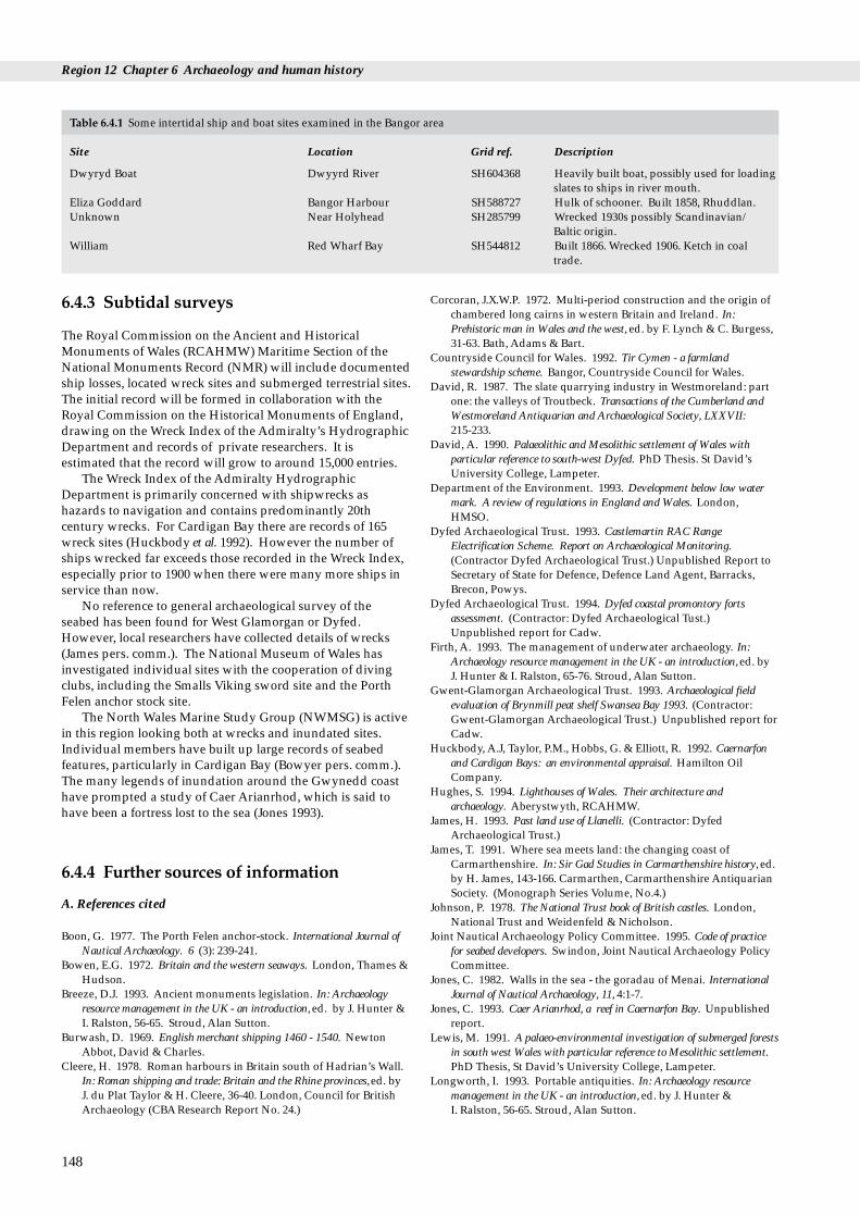
Region 12 Chapter 6 Archaeology and human history
Table 6.4.1 Some intertidal ship and boat sites examined in the Bangor area
Site Location Grid ref. Description
Dwyryd Boat Dwyyrd River SH604368 Heavily built boat, possibly used for loadingslates to ships in river mouth.
Eliza Goddard Bangor Harbour SH588727 Hulk of schooner. Built 1858, Rhuddlan.Unknown Near Holyhead SH285799 Wrecked 1930s possibly Scandinavian/
Baltic origin.William Red Wharf Bay SH544812 Built 1866. Wrecked 1906. Ketch in coal
trade.
6.4.3 Subtidal surveys
The Royal Commission on the Ancient and HistoricalMonuments of Wales (RCAHMW) Maritime Section of theNational Monuments Record (NMR) will include documentedship losses, located wreck sites and submerged terrestrial sites.The initial record will be formed in collaboration with theRoyal Commission on the Historical Monuments of England,drawing on the Wreck Index of the Admiralty’s HydrographicDepartment and records of private researchers. It isestimated that the record will grow to around 15,000 entries.
The Wreck Index of the Admiralty HydrographicDepartment is primarily concerned with shipwrecks ashazards to navigation and contains predominantly 20thcentury wrecks. For Cardigan Bay there are records of 165wreck sites (Huckbody et al. 1992). However the number ofships wrecked far exceeds those recorded in the Wreck Index,especially prior to 1900 when there were many more ships inservice than now.
No reference to general archaeological survey of theseabed has been found for West Glamorgan or Dyfed.However, local researchers have collected details of wrecks(James pers. comm.). The National Museum of Wales hasinvestigated individual sites with the cooperation of divingclubs, including the Smalls Viking sword site and the PorthFelen anchor stock site.
The North Wales Marine Study Group (NWMSG) is activein this region looking both at wrecks and inundated sites.Individual members have built up large records of seabedfeatures, particularly in Cardigan Bay (Bowyer pers. comm.).The many legends of inundation around the Gwynedd coasthave prompted a study of Caer Arianrhod, which is said tohave been a fortress lost to the sea (Jones 1993).
6.4.4 Further sources of information
A. References cited
Boon, G. 1977. The Porth Felen anchor-stock. International Journal ofNautical Archaeology. 6 (3): 239-241.
Bowen, E.G. 1972. Britain and the western seaways. London, Thames &Hudson.
Breeze, D.J. 1993. Ancient monuments legislation. In: Archaeologyresource management in the UK - an introduction,ed. by J. Hunter &I. Ralston, 56-65. Stroud, Alan Sutton.
Burwash, D. 1969. English merchant shipping 1460 - 1540. NewtonAbbot, David & Charles.
Cleere, H. 1978. Roman harbours in Britain south of Hadrian’s Wall.In: Roman shipping and trade: Britain and the Rhine provinces, ed. byJ. du Plat Taylor & H. Cleere, 36-40. London, Council for BritishArchaeology (CBAResearch Report No. 24.)
148
Corcoran, J.X.W.P. 1972. Multi-period construction and the origin ofchambered long cairns in western Britain and Ireland. In:Prehistoric man in Wales and the west, ed. by F. Lynch & C. Burgess,31-63. Bath, Adams & Bart.
Countryside Council for Wales. 1992. Tir Cymen - a farmlandstewardship scheme. Bangor, Countryside Council for Wales.
David, R. 1987. The slate quarrying industry in Westmoreland: partone: the valleys of Troutbeck. Transactions of the Cumberland andWestmoreland Antiquarian and Archaeological Society, LXXVII: 215-233.
David, A. 1990. Palaeolithic and Mesolithic settlement of Wales withparticular reference to south-west Dyfed. PhD Thesis. St David’sUniversity College, Lampeter.
Department of the Environment. 1993. Development below low watermark. A review of regulations in England and Wales. London,HMSO.
Dyfed Archaeological Trust. 1993. Castlemartin RAC RangeElectrification Scheme. Report on Archaeological Monitoring.(Contractor Dyfed Archaeological Trust.) Unpublished Report toSecretary of State for Defence, Defence Land Agent, Barracks,Brecon, Powys.
Dyfed Archaeological Trust. 1994. Dyfed coastal promontory fortsassessment. (Contractor: Dyfed Archaeological Tust.)Unpublished report for Cadw.
Firth, A. 1993. The management of underwater archaeology. In:Archaeology resource management in the UK - an introduction, ed. byJ. Hunter & I. Ralston, 65-76. Stroud, Alan Sutton.
Gwent-Glamorgan Archaeological Trust. 1993. Archaeological fieldevaluation of Brynmill peat shelf Swansea Bay 1993. (Contractor:Gwent-Glamorgan Archaeological Trust.) Unpublished report forCadw.
Huckbody, A.J, Taylor, P.M., Hobbs, G. & Elliott, R. 1992. Caernarfonand Cardigan Bays: an environmental appraisal. Hamilton OilCompany.
Hughes, S. 1994. Lighthouses of Wales. Their architecture andarchaeology. Aberystwyth, RCAHMW.
James, H. 1993. Past land use of Llanelli. (Contractor: DyfedArchaeological Trust.)
James, T. 1991. Where sea meets land: the changing coast ofCarmarthenshire. In: Sir Gad Studies in Carmarthenshire history, ed.by H. James, 143-166. Carmarthen, Carmarthenshire AntiquarianSociety. (Monograph Series Volume, No.4.)
Johnson, P. 1978. The National Trust book of British castles. London,National Trust and Weidenfeld & Nicholson.
Joint Nautical Archaeology Policy Committee. 1995. Code of practicefor seabed developers. Swindon, Joint Nautical Archaeology PolicyCommittee.
Jones, C. 1982. Walls in the sea - the goradau of Menai. InternationalJournal of Nautical Archaeology, 11, 4:1-7.
Jones, C. 1993. Caer Arianrhod, a reef in Caernarfon Bay. Unpublishedreport.
Lewis, M. 1991. A palaeo-environmental investigation of submerged forestsin south west Wales with particular reference to Mesolithic settlement.PhD Thesis, St David’s University College, Lampeter.
Longworth, I. 1993. Portable antiquities. In: Archaeology resourcemanagement in the UK - an introduction, ed. by J. Hunter &I. Ralston, 56-65. Stroud, Alan Sutton.
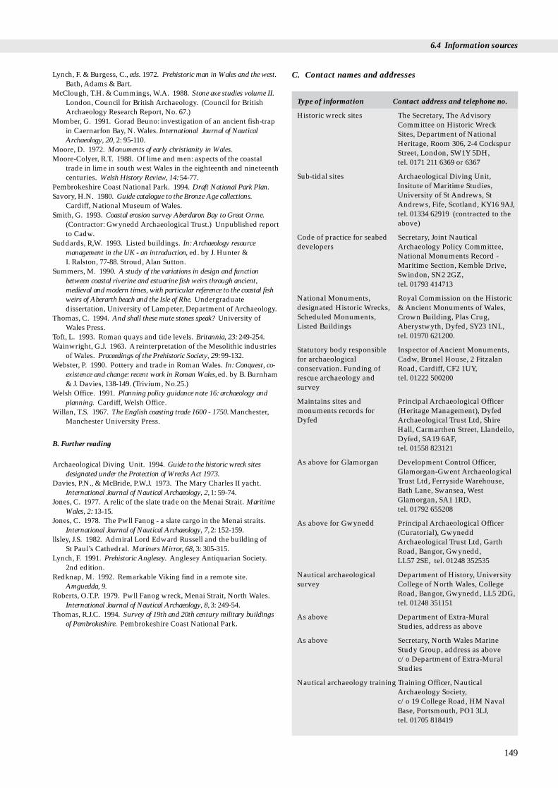
6.4 Information sources
Lynch, F. & Burgess, C., eds. 1972. Prehistoric man in Wales and the west.Bath, Adams & Bart.
McClough, T.H. & Cummings, W.A. 1988. Stone axe studies volume II.London, Council for British Archaeology. (Council for BritishArchaeology Research Report, No. 67.)
Momber, G. 1991. Gorad Beuno: investigation of an ancient fish-trapin Caernarfon Bay, N. Wales. International Journal of NauticalArchaeology, 20, 2: 95-110.
Moore, D. 1972. Monuments of early christianity in Wales.Moore-Colyer, R.T. 1988. Of lime and men: aspects of the coastal
trade in lime in south west Wales in the eighteenth and nineteenthcenturies. Welsh History Review, 14: 54-77.
Pembrokeshire Coast National Park. 1994. Draft National Park Plan. Savory, H.N. 1980. Guide catalogue to the Bronze Age collections.
Cardiff, National Museum of Wales.Smith, G. 1993. Coastal erosion survey Aberdaron Bay to Great Orme.
(Contractor: Gwynedd Archaeological Trust.) Unpublished reportto Cadw.
Suddards, R,W. 1993. Listed buildings. In: Archaeology resourcemanagement in the UK - an introduction, ed. by J. Hunter &I. Ralston, 77-88. Stroud, Alan Sutton.
Summers, M. 1990. A study of the variations in design and functionbetween coastal riverine and estuarine fish weirs through ancient,medieval and modern times, with particular reference to the coastal fishweirs of Aberarth beach and the Isle of Rhe. Undergraduatedissertation, University of Lampeter, Department of Archaeology.
Thomas, C. 1994. And shall these mute stones speak? University ofWales Press.
Toft, L. 1993. Roman quays and tide levels. Britannia, 23: 249-254.Wainwright, G.J. 1963. Areinterpretation of the Mesolithic industries
of Wales. Proceedings of the Prehistoric Society, 29: 99-132.Webster, P. 1990. Pottery and trade in Roman Wales. In: Conquest, co-
existence and change: recent work in Roman Wales, ed. by B. Burnham& J. Davies, 138-149. (Trivium, No.25.)
Welsh Office. 1991. Planning policy guidance note 16: archaeology andplanning. Cardiff, Welsh Office.
Willan, T.S. 1967. The English coasting trade 1600 - 1750. Manchester,Manchester University Press.
B. Further reading
Archaeological Diving Unit. 1994. Guide to the historic wreck sitesdesignated under the Protection of Wrecks Act 1973.
Davies, P.N., & McBride, P.W.J. 1973. The Mary Charles II yacht.International Journal of Nautical Archaeology, 2,1: 59-74.
Jones, C. 1977. Arelic of the slate trade on the Menai Strait. MaritimeWales, 2: 13-15.
Jones, C. 1978. The Pwll Fanog - a slate cargo in the Menai straits.International Journal of Nautical Archaeology, 7,2: 152-159.
llsley, J.S. 1982. Admiral Lord Edward Russell and the building ofSt Paul’s Cathedral. Mariners Mirror, 68, 3: 305-315.
Lynch, F. 1991. Prehistoric Anglesey. Anglesey Antiquarian Society.2nd edition.
Redknap, M. 1992. Remarkable Viking find in a remote site.Amguedda, 9.
Roberts, O.T.P. 1979. Pwll Fanog wreck, Menai Strait, North Wales.International Journal of Nautical Archaeology, 8, 3: 249-54.
Thomas, R.J.C. 1994. Survey of 19th and 20th century military buildingsof Pembrokeshire. Pembrokeshire Coast National Park.
C. Contact names and addresses
Type of information Contact address and telephone no.
Historic wreck sites The Secretary, The AdvisoryCommittee on Historic WreckSites, Department of NationalHeritage, Room 306, 2-4 CockspurStreet, London, SW1Y 5DH, tel. 0171 211 6369 or 6367
Sub-tidal sites Archaeological Diving Unit,Insitute of Maritime Studies,University of St Andrews, StAndrews, Fife, Scotland, KY16 9AJ,tel. 01334 62919 (contracted to theabove)
Code of practice for seabed Secretary, Joint Nautical developers Archaeology Policy Committee,
National Monuments Record -Maritime Section, Kemble Drive,Swindon, SN2 2GZ, tel. 01793 414713
National Monuments, Royal Commission on the Historic designated Historic Wrecks, & Ancient Monuments of Wales, Scheduled Monuments, Crown Building, Plas Crug, Listed Buildings Aberystwyth, Dyfed, SY23 1NL,
tel. 01970 621200.
Statutory body responsible Inspector of Ancient Monuments, for archaeological Cadw, Brunel House, 2 Fitzalan conservation. Funding of Road, Cardiff, CF2 1UY, rescue archaeology and tel. 01222 500200survey
Maintains sites and Principal Archaeological Officer monuments records for (Heritage Management), Dyfed Dyfed Archaeological Trust Ltd, Shire
Hall, Carmarthen Street, Llandeilo,Dyfed, SA19 6AF, tel. 01558 823121
As above for Glamorgan Development Control Officer,Glamorgan-Gwent ArchaeologicalTrust Ltd, Ferryside Warehouse,Bath Lane, Swansea, WestGlamorgan, SA1 1RD, tel. 01792 655208
As above for Gwynedd Principal Archaeological Officer(Curatorial), GwyneddArchaeological Trust Ltd, GarthRoad, Bangor, Gwynedd, LL57 2SE, tel. 01248 352535
Nautical archaeological Department of History, University survey College of North Wales, College
Road, Bangor, Gwynedd, LL5 2DG,tel. 01248 351151
As above Department of Extra-MuralStudies, address as above
As above Secretary, North Wales MarineStudy Group, address as above c/o Department of Extra-MuralStudies
Nautical archaeology training Training Officer, NauticalArchaeology Society,c/o 19 College Road, HM NavalBase, Portsmouth, PO1 3LJ, tel. 01705 818419
149

Region 12 Chapter 6 Archaeology and human history
Reporting point for Receiver of Wreck, Coastguard recovered wreck Agency, Spring Place, 105
Commercial Road, Southampton,S015 1EG, tel. 01703 329474
Advice on finds; reporting National Museum of Wales, point for treasure in trove Department of Archaeology andin Wales Numismatics, Cathys Park,
Cardiff, CF1 3NP, tel. 01222 397951
6.4.5 Acknowledgements
Particular thanks go to Valerie Fenwick for help inpreparing this chapter. Thanks are also due to the staff of allthe organisations mentioned in the text, who gave their timeto provide information, and to Dr Ben Ferrari for his advicein developing the chapter.
150
Chapter 7 Protected coastal sites
7.1.1 Chapter structure
This chapter incorporates statutory and non-statutory siteprotection mechanisms operating at international, nationaland local level, including those administered by voluntarybodies and other organisations who own land. It coversonly the various types of site protection mechanismcurrently found within this region, giving a brief descriptionfor each category and listing sites and their locations. Forthe purposes of this chapter, any site that is wholly or partlyintertidal, and any terrestrial site at least partly within 1 kmof the Mean High Water Mark, or any tidal channel asdepicted on 1:50,000 Ordnance Survey maps, is included as‘coastal’. Where a site straddles the boundaries of twoCoastal Directories Project regions and there is no easy wayof calculating the percentage of the site lying in each, the sitearea has been halved, one half being included in eachregion. Data included in this section are correct as atOctober 1994, unless otherwise stated.
Statutory protected sites are those notified, designatedor authorised under European Directives and/orimplemented through British legislation (most notably theWildlife and Countryside Act 1981) by a statutory body,thereby having recognised legal protection. ‘Non-statutorysites’ include a wide variety of kinds of site not directlyprotected by legislation but which are either identified bystatutory bodies or owned, managed or both by non-statutory organisations for their nature conservation oraesthetic value. Note that the categories of conservationprotection (e.g. National Nature Reserve, RSPB Reserve) arenot mutually exclusive. In many localities several differenttypes of protected site overlap, since they have beenidentified for different wildlife and landscape conservationpurposes. Patterns of overlap are often complex, since siteboundaries for different categories of site are not alwayscoterminous.
Further explanation of the various site protectionmechanisms can be found in Davidson et al. (1991). ForEngland, Planning Policy Guidance Note (PPG) 9 - NatureConservation (DOE 1994) also gives useful summaries ofexisting site protection mechanisms. It also includes copiesof the Ramsar Convention, the Birds Directive and theHabitats Directive (including lists of important species andhabitat types). However, at the time of writing, nocomparable Welsh Office guidance has yet been issued.
The following types of protected site have not beenincluded in this chapter:• Archaeological designations and protected sites, covered
in Chapter 6.• Special Areas of Conservation (SACs), one of the tools to
be used to implement the Habitats Directive. They areareas considered to be important for habitat and non-
7.1 Introduction R.G. Keddie
avian species interest in a European context. A list ofpossible SACs was announced by the Government on 31 March 1995. There are ten SACs proposed for theircoastal/marine interest in Region 12, from a total of 71 inGB (see JNCC (1995) for more information). Theprotection measures for SACs are based around a seriesof six annexes: Annexes I & II require the designation ofSACs for certain habitats and species; Annex IVprohibits the taking of certain species; Annex V requiresthe taking of certain species to be monitored; Annex VIprohibits some means of capture or killing of mammalsand fish. In the UK the Directive will be implementedthrough the Habitats etc. Regulations 1994.
• ‘Sites of Importance for Nature Conservation’ (SINCs): ageneral term for the variously-named non-statutory sitesidentified by local authorities and wildlife trusts ashaving special local value for nature conservation butnot currently managed for nature conservation; the mostcommon are Sites of Nature Conservation Importance.For more information, see Collis & Tyldesley (1993).
Non-site based measures contained in conventions anddirectives aimed at broad species and habitat protection,such as the Bonn Convention, CITES, parts of the EC BirdsDirective and parts of the EC Habitats Directive, are also notcovered. For further information, see references in section7.1.3A.
This chapter is divided into five sections. A regionalsummary of all categories of site is given in section 7.1.2.Section 7.2 covers those site-based protection measuresfalling under international conventions or Europeandirectives. Section 7.3 discusses sites identified undernational statute, whereas section 7.4 covers sites withoutstatutory protection but which are identified, owned ormanaged by statutory bodies; and finally, section 7.5describes other types of sites (i.e. those identified, owned ormanaged by charities, trusts etc.). For each category ofprotected site, a list of coastal sites is given (clockwisearound the coast), showing their type, area/length andlocation, with an accompanying map. Each sectionconcludes with further information sources and contactpoints relevant to the region.
151
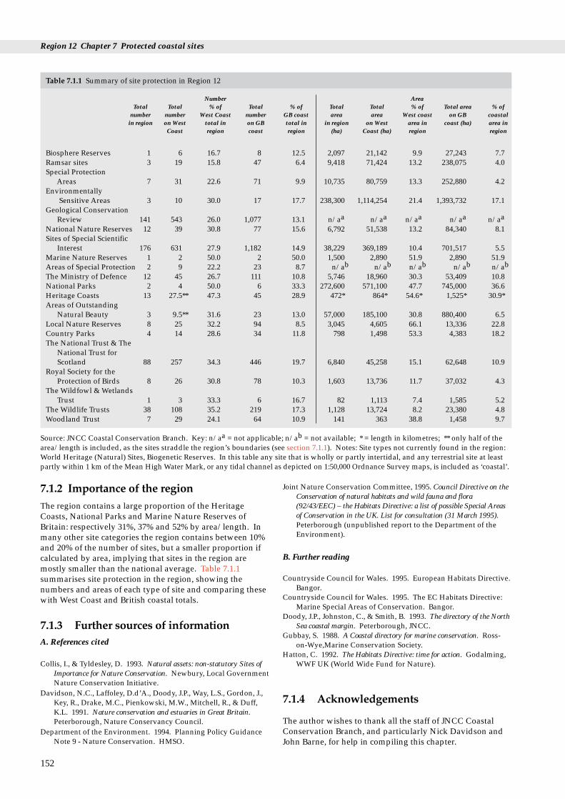
Region 12 Chapter 7 Protected coastal sites
Table 7.1.1 Summary of site protection in Region 12
Number AreaTotal Total % of Total % of Total Total % of Total area % of
number number West Coast number GB coast area area West coast on GB coastalin region on West total in on GB total in in region on West area in coast (ha) area in
Coast region coast region (ha) Coast (ha) region region
Biosphere Reserves 1 6 16.7 8 12.5 2,097 21,142 9.9 27,243 7.7Ramsar sites 3 19 15.8 47 6.4 9,418 71,424 13.2 238,075 4.0Special Protection
Areas 7 31 22.6 71 9.9 10,735 80,759 13.3 252,880 4.2Environmentally
Sensitive Areas 3 10 30.0 17 17.7 238,300 1,114,254 21.4 1,393,732 17.1Geological Conservation
Review 141 543 26.0 1,077 13.1 n/aa n/aa n/aa n/aa n/aa
National Nature Reserves 12 39 30.8 77 15.6 6,792 51,538 13.2 84,340 8.1Sites of Special Scientific
Interest 176 631 27.9 1,182 14.9 38,229 369,189 10.4 701,517 5.5Marine Nature Reserves 1 2 50.0 2 50.0 1,500 2,890 51.9 2,890 51.9Areas of Special Protection 2 9 22.2 23 8.7 n/ab n/ab n/ab n/ab n/ab
The Ministry of Defence 12 45 26.7 111 10.8 5,746 18,960 30.3 53,409 10.8National Parks 2 4 50.0 6 33.3 272,600 571,100 47.7 745,000 36.6Heritage Coasts 13 27.5** 47.3 45 28.9 472* 864* 54.6* 1,525* 30.9*Areas of Outstanding
Natural Beauty 3 9.5** 31.6 23 13.0 57,000 185,100 30.8 880,400 6.5Local Nature Reserves 8 25 32.2 94 8.5 3,045 4,605 66.1 13,336 22.8Country Parks 4 14 28.6 34 11.8 798 1,498 53.3 4,383 18.2The National Trust & The
National Trust forScotland 88 257 34.3 446 19.7 6,840 45,258 15.1 62,648 10.9
Royal Society for theProtection of Birds 8 26 30.8 78 10.3 1,603 13,736 11.7 37,032 4.3
The Wildfowl & WetlandsTrust 1 3 33.3 6 16.7 82 1,113 7.4 1,585 5.2
The Wildlife Trusts 38 108 35.2 219 17.3 1,128 13,724 8.2 23,380 4.8Woodland Trust 7 29 24.1 64 10.9 141 363 38.8 1,458 9.7
Source: JNCC Coastal Conservation Branch. Key: n/aa = not applicable; n/ab = not available; * = length in kilometres; ** only half of thearea/length is included, as the sites straddle the region’s boundaries (see section 7.1.1). Notes: Site types not currently found in the region:World Heritage (Natural) Sites, Biogenetic Reserves. In this table any site that is wholly or partly intertidal, and any terrestrial site at leastpartly within 1 km of the Mean High Water Mark, or any tidal channel as depicted on 1:50,000 Ordnance Survey maps, is included as ‘coastal’.
7.1.2 Importance of the regionThe region contains a large proportion of the HeritageCoasts, National Parks and Marine Nature Reserves ofBritain: respectively 31%, 37% and 52% by area/length. Inmany other site categories the region contains between 10%and 20% of the number of sites, but a smaller proportion ifcalculated by area, implying that sites in the region aremostly smaller than the national average. Table 7.1.1summarises site protection in the region, showing thenumbers and areas of each type of site and comparing thesewith West Coast and British coastal totals.
7.1.3 Further sources of information A. References cited
Collis, I., & Tyldesley, D. 1993. Natural assets: non-statutory Sites ofImportance for Nature Conservation. Newbury, Local GovernmentNature Conservation Initiative.
Davidson, N.C., Laffoley, D.d’A., Doody, J.P., Way, L.S., Gordon, J.,Key, R., Drake, M.C., Pienkowski, M.W., Mitchell, R., & Duff,K.L. 1991. Nature conservation and estuaries in Great Britain.Peterborough, Nature Conservancy Council.
Department of the Environment. 1994. Planning Policy GuidanceNote 9 - Nature Conservation. HMSO.
152
Joint Nature Conservation Committee, 1995. Council Directive on theConservation of natural habitats and wild fauna and flora(92/43/EEC) – the Habitats Directive: a list of possible Special Areasof Conservation in the UK. List for consultation (31 March 1995).Peterborough (unpublished report to the Department of theEnvironment).
B. Further reading
Countryside Council for Wales. 1995. European Habitats Directive.Bangor.
Countryside Council for Wales. 1995. The EC Habitats Directive:Marine Special Areas of Conservation. Bangor.
Doody, J.P., Johnston, C., & Smith, B. 1993. The directory of the NorthSea coastal margin. Peterborough, JNCC.
Gubbay, S. 1988. A Coastal directory for marine conservation. Ross-on-Wye,Marine Conservation Society.
Hatton, C. 1992. The Habitats Directive: time for action. Godalming,WWF UK (World Wide Fund for Nature).
7.1.4 Acknowledgements
The author wishes to thank all the staff of JNCC CoastalConservation Branch, and particularly Nick Davidson andJohn Barne, for help in compiling this chapter.

7.2 Sites designated under international conventions and directives
Biosphere reserve
RAMSAR site
SPA
ESA
nternational conventions
This section describes those types of site designated underinternational conventions to which the UK is a contractingparty, and sites designated under UK statute to implementEC Directives concerning wildlife and landscapeconservation. Sites protected by domestic legislation onlyare covered in section 7.3.
7.2 Sites designated under iand directives
7.2.1 Biosphere Reserves
Biosphere Reserves are non-statutory protected areasrepresenting significant examples of biomes - terrestrial andcoastal environments, throughout the world - protected forconservation purposes. They have particular value asbenchmarks or standards for the measurement of long-termchanges in the biosphere as a whole. They were devised byUNESCO as project number 8 of their Man and theBiosphere (MAB) ecological programme, and were launchedin 1970. Criteria and guidelines for selection of sites wereproduced by a UNESCO task force in 1974.
There is one Biosphere Reserve (2,097 ha) in Region 12,at the Dyfi Estuary (see Table 7.2.1 and Map 7.2.1). Thiscompares with a total of eight coastal Biosphere Reserves(27,243 ha) in Great Britain, six of which (21,142 ha) are onthe West Coast. Britain has thirteen Biosphere Reserves(44,258 ha), all of them designated in 1976 and 1977. Allthese sites are also National Nature Reserves (data providedby International Policy Branch, JNCC).
Map 7.2.1 Coastal Biosphere Reserves, Environmentally SensitiveAreas, Ramsar sites and Special Protection Areass.Source: JNCC, WOAD.
7.2.2 Wetlands of international importance(Ramsar sites)
Ramsar sites are statutory areas designated by the UKgovernment on the advice of the conservation agenciesunder the ‘Ramsar Convention’ (the Convention onwetlands of international importance especially aswaterfowl habitat). Contracting parties (of which the UK isone) are required to designate wetlands of internationalimportance and to promote their conservation and ‘wiseuse’. Ramsar sites are thus designated for their waterfowlpopulations, their important plant and animal assemblages,their wetland interest or a combination of these. So far,most Ramsar sites in Britain have been designated for theirwaterfowl, although two of the sites in this region (CrymlynBog and Cors Fochno & Dyfi) are designated partly for,respectively, wetland habitats and rare species. There arethree coastal Ramsar sites (9,418 ha) in Region 12 (see Table7.2.1 and Map 7.2.1). This compares with a total of 47coastal Ramsar sites (238,075 ha) in Great Britain, of whichnineteen (71,424 ha) are on the West Coast. There arecurrently 82 designated Ramsar sites (342,019 ha) in GreatBritain, as at November 1994 (data provided by VertebrateEcology and Conservation Branch, JNCC). Sections 5.10,5.11 and 5.12 describe the importance of these sites for theregion’s birds.
7.2.3 Special Protection Areas
The 1979 EC Directive on the Conservation of Wild Birds(the Birds Directive) requires member states to takeconservation measures particularly for certain rare orvulnerable species and for regularly occurring migratoryspecies of birds. In part this is achieved through thedesignation of statutory Special Protection Areas (SPAs) bythe UK government on the advice of the statutoryconservation agencies. This designation is implementedthrough the Wildlife and Countryside Act 1981; all SPAsmust first be notified as SSSIs.
There are seven coastal SPAs (10,735 ha) in Region 12(see Table 7.2.1 and Map 7.2.1). This compares with a totalof 71 coastal SPAs (252,880 ha) in Great Britain, of which 31(80,759 ha) are on the West Coast. There are currently 96(292,878 ha) designated SPAs in Britain, as at November1994 (data provided by Vertebrate Ecology andConservation Branch, JNCC). Again, sections 5.10, 5.11 and5.12 describe the importance of these sites for the region’sbirds.
153
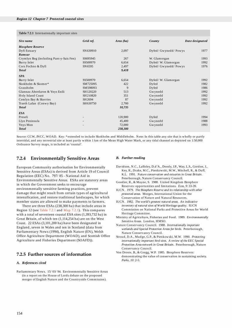
Region 12 Chapter 7 Protected coastal sites
Table 7.2.1 Internationally important sites
Site name Grid ref. Area (ha) County Date designated
Biosphere ReserveDyfi Estuary SN630910 2,097 Dyfed/Gwynedd/Powys 1977RamsarCrymlyn Bog (including Pant-y-Sais Fen) SS695945 267 W. Glamorgan 1993Burry Inlet SS500970 6,654 Dyfed/W. Glamorgan 1992Cors Fochno & Dyfi SN6595 2,497 Dyfed/Gwynedd/Powys 1976Total 9,418
SPABurry Inlet SS500970 6,654 Dyfed/W. Glamorgan 1992Skokholm & Skomer* SM725095 422 Dyfed 1982Grassholm SM598093 9 Dyfed 1986Glannau Aberdaron & Ynys Enlli SH120220 513 Gwynedd 1992Holy Island Coast SH210820 351 Gwynedd 1992Cemlyn Bay & Skerries SH2694 87 Gwynedd 1992Traeth Lafan (Conwy Bay) SH630750 2,700 Gwynedd 1992Total 10,735
ESAPreseli - 120,900 Dyfed 1994Llyn Peninsula - 45,400 Gwynedd 1988Ynys Mon - 72,000 Gwynedd 1993Total 238,300
Source: CCW, JNCC, WOAD. Key: * extended to include Skokholm and Middleholm. Note: In this table any site that is wholly or partlyintertidal, and any terrestrial site at least partly within 1 km of the Mean High Water Mark, or any tidal channel as depicted on 1:50,000Ordnance Survey maps, is included as ‘coastal’.
7.2.4 Environmentally Sensitive Areas
European Community authorisation for EnvironmentallySensitive Areas (ESAs) is derived from Article 19 of CouncilRegulation (EEC) No. 797/85 - National Aid inEnvironmentally Sensitive Areas. ESAs are statutory areasin which the Government seeks to encourageenvironmentally sensitive farming practices, preventdamage that might result from certain types of agriculturalintensification, and restore traditional landscapes, for whichmember states are allowed to make payments to farmers.
There are three ESAs (238,300 ha) that include areas inRegion 12 (see Table 7.2.1 and Map 7.2.1). This compareswith a total of seventeen coastal ESA sites (1,393,732 ha) inGreat Britain, of which ten (1,114,254 ha) are on the WestCoast. 22 ESAs (3,101,200 ha) have been designated inEngland, seven in Wales and ten in Scotland (data fromParliamentary News (1994), English Nature (EN), WelshOffice Agriculture Department (WOAD), and Scottish OfficeAgriculture and Fisheries Department (SOAFD)).
7.2.5 Further sources of information
A. References cited
Parliamentary News. 15/03/94. Environmentally Sensitive Areas(in a report on the House of Lords debate on the proposedmerger of English Nature and the Countryside Commission).
154
B. Further reading
Davidson, N.C., Laffoley, D.d’A., Doody, J.P., Way, L.S., Gordon, J.,Key, R., Drake, M.C., Pienkowski, M.W., Mitchell, R., & Duff,K.L. 1991. Nature conservation and estuaries in Great Britain.Peterborough, Nature Conservancy Council.
Goodier, R., & Mayne, S. 1988. United Kingdom BiosphereReserves: opportunities and limitations. Ecos, 9: 33-39.
IUCN. 1979. The Biosphere Reserve and its relationship with otherprotected areas. Morges, International Union for theConservation of Nature and Natural Resources.
IUCN. 1982. The world’s greatest natural areas. An indicativeinventory of natural sites of World Heritage quality. IUCNCommission on National Parks and Protective Areas for WorldHeritage Committee.
Ministry of Agriculture, Fisheries and Food. 1989. EnvironmentallySensitive Areas. London, HMSO.
Nature Conservancy Council. 1988. Internationally importantwetlands and Special Protection Areas for birds. Peterborough,Nature Conservancy Council.
Stroud, D.A., Mudge, G.P., & Pienkowski, M.W. 1990. Protectinginternationally important bird sites. A review of the EEC SpecialProtection Area network in Great Britain. Peterborough, NatureConservancy Council.
Von Droste, B., & Gregg, W.P. 1985. Biosphere Reserves:demonstrating the value of conservation in sustaining society.Parks, 10: 2-5.

7.2 Sites designated under international conventions and directives
C. Contact names and addresses
Type of information Contact address and telephone no.
Biosphere Reserves *European International AffairsOfficer, Science and PolicyDevelopment Directorate, CCWHQ, Bangor, tel: 01248 370444
Ramsar sites, SPAs, Special *Senior Officer, CCW North Wales Areas of Conservation in Region, Bangor, tel: 01248 372333Gwynedd
Ramsar sites, SPAs, Special *Senior Officer, CCW Dyfed/Mid Areas of Conservation in Wales Region, Aberystwyth,Dyfed tel: 01970 828551
Ramsar sites, SPAs, Special *Regional Officer, CCW South Areas of Conservation in Wales Region, Cardiff, W. Glamorgan tel: 01222 485111
Ramsar sites, SPAs *Conservation Officer, RSPB WalesOffice, Newtown, tel: 01686 626678
Environmentally Sensitive *Agriculture Section, Planning, Areas Land Use and Landscape
Designation Branch, CCW HQ,Bangor, tel: 01248 370444
Environmentally Sensitive WOAD, Welsh Office Agriculture Areas Department, Trawsgoed,
Aberystwyth, Dyfed SY23 4HT,tel: 01974 261301
Special Areas of Conservation European Wildlife Division, DoE,Room 9/03B, Tollgate House,Houlton Street, Bristol BS2 9DJ,tel: 0117 9878811 ext. 8341
* Starred contact addresses are given in full in the Appendix.
7.2.6 Acknowledgements
Thanks are due to Alan Law and International Policy Branch(JNCC), Siaron Hooper (EN), Site Safeguard Team (CCW)and Welsh Office Agriculture Department (WOAD).
155

Region 12 Chapter 7 Protected coastal sites
SSSINNR
national statute
Included in this section are the eight types of siteidentification made under national legislation relating towildlife, landscape and amenity value. Identifications aremade by the statutory conservation agencies (in this regionthe Countryside Council for Wales), local authorities or thegovernment acting on advice from these bodies.
7.3 Sites established under
7.3.1 National Nature Reserves
National Nature Reserves (NNRs) contain examples of someof the most important natural and semi-natural ecosystemsin Great Britain. They are managed to conserve theirhabitats, providing special opportunities for scientific studyof the habitats, communities and species represented withinthem (Marren 1994). They are statutorily declared by thecountry agencies (in this region by the Countryside Councilfor Wales) under section 19 of the National Parks and Accessto the Countryside Act 1949, or section 35 of the Wildlifeand Countryside Act 1981.
There are twelve National Nature Reserves (NNRs)(6,792 ha) in Region 12 (see Table 7.3.1 and Map 7.3.1). Thiscompares with a total of 77 coastal NNRs (84,340 ha) inGreat Britain, of which 39 (51,538 ha) are on the West Coast.As at March 1994, the total number of NNRs in Britain was269 (187,210 ha) (data provided by CCW, EN, SNH andBiotopes Conservation Branch, JNCC).
156
Table 7.3.1 NNRs in Region 12
Site name Grid ref. Area (ha) Date lastdeclared
W.GlamorganOxwich SS506870 289 1963Gower Coast SS383876 47 1958Whiteford SS450955 782 1964
DyfedStackpole SR882996 199 1981Skomer Island SM725095 307 1959
Dyfed/GwyneddDyfi SN640955 2,262 1969
SN633910
GwyneddMorfa Dyffryn SH550250 202 1962Morfa Harlech SH650350 884 1958Coed Camlyn SH661399 64 1959Ynys Enlli - Bardsey SH120220 180 1986Newborough Warren & SH410630 1,507 1955
Ynys LlanddwynCoed Dolgarrog SH769665 69 1986Total 6,792
Note: In this table any site that is wholly or partly intertidal, andany terrestrial site at least partly within 1 km of the Mean HighWater Mark, or any tidal channel as depicted on 1:50,000 OrdnanceSurvey maps, is included as ‘coastal’.
Map 7.3.1 Coastal National Nature Reserves and Sites of SpecialScientific Interest. Source: CCW, JNCC Note: a singlesymbol may represent more than one site in closeproximity.
7.3.2 Sites of Special Scientific Interest
Sites of Special Scientific Interest (SSSIs) are statutorilynotified under the Wildlife and Countryside Act 1981. Theyare intended to form a national network of areas,representing in total the parts of Britain in which the naturalfeatures, especially those of greatest value for wildlife orearth science conservation, are most highly concentrated orof highest quality. Within the area of an SSSI the provisionsof the Wildlife & Countryside Act 1981 and its 1985amendments aim to ensure that actions damaging to thewildlife interest of the area are not carried out, unlessappropriately consented.
There are 176 coastal Sites of Special Scientific Interest(SSSIs) (38,229 ha) in Region 12, as at September 1994 (seeTable 7.3.2 and Map 7.3.1). This compares with a total of1,182 coastal SSSIs (701,517 ha) in Great Britain, of which631 (369,189 ha) are on the West Coast. The total number ofSSSIs in Britain as at June 1994 was 6,055 (1,920,527 ha), or7.98% of the total land mass, with 3,794 (871,066 ha) inEngland, 1,371 (846,869 ha) in Scotland and 890 (202,592 ha)in Wales (data provided by CCW, EN, SNH and BiotopesConservation Branch, JNCC).
Of the 176 coastal SSSIs in the region, almost two-thirdsinclude intertidal land to mean low water mark; only one
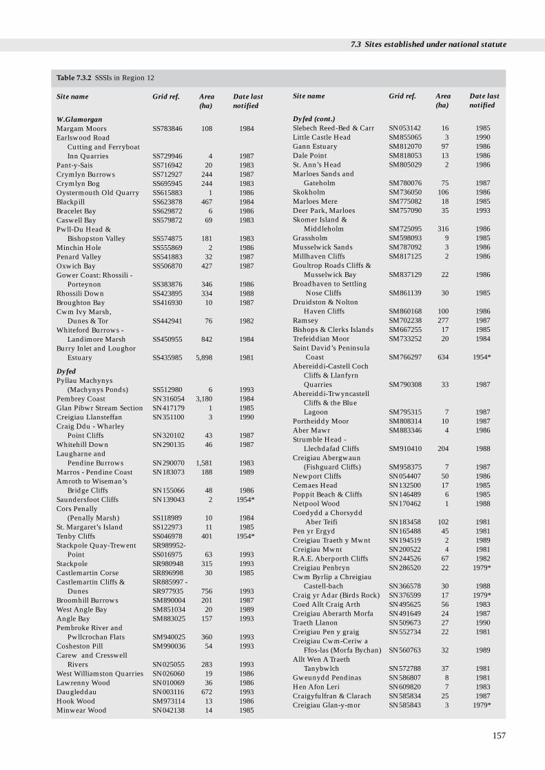
7.3 Sites established under national statute
157
Site name Grid ref. Area Date last (ha) notified
W.GlamorganMargam Moors SS783846 108 1984Earlswood Road
Cutting and Ferryboat Inn Quarries SS729946 4 1987
Pant-y-Sais SS716942 20 1983Crymlyn Burrows SS712927 244 1987Crymlyn Bog SS695945 244 1983Oystermouth Old Quarry SS615883 1 1986Blackpill SS623878 467 1984Bracelet Bay SS629872 6 1986Caswell Bay SS579872 69 1983Pwll-Du Head &
Bishopston Valley SS574875 181 1983Minchin Hole SS555869 2 1986Penard Valley SS541883 32 1987Oxwich Bay SS506870 427 1987Gower Coast: Rhossili -
Porteynon SS383876 346 1986Rhossili Down SS423895 334 1988Broughton Bay SS416930 10 1987Cwm Ivy Marsh,
Dunes & Tor SS442941 76 1982Whiteford Burrows -
Landimore Marsh SS450955 842 1984Burry Inlet and Loughor
Estuary SS435985 5,898 1981
DyfedPyllau Machynys
(Machynys Ponds) SS512980 6 1993Pembrey Coast SN316054 3,180 1984Glan Pibwr Stream Section SN417179 1 1985Creigiau Llansteffan SN351100 3 1990Craig Ddu - Wharley
Point Cliffs SN320102 43 1987Whitehill Down SN290135 46 1987Laugharne and
Pendine Burrows SN290070 1,581 1983Marros - Pendine Coast SN183073 188 1989Amroth to Wiseman’s
Bridge Cliffs SN155066 48 1986Saundersfoot Cliffs SN139043 2 1954*Cors Penally
(Penally Marsh) SS118989 10 1984St. Margaret’s Island SS122973 11 1985Tenby Cliffs SS046978 401 1954*Stackpole Quay-Trewent SR989952-
Point SS016975 63 1993Stackpole SR980948 315 1993Castlemartin Corse SR896998 30 1985Castlemartin Cliffs & SR885997 -
Dunes SR977935 756 1993Broomhill Burrows SM890004 201 1987West Angle Bay SM851034 20 1989Angle Bay SM883025 157 1993Pembroke River and
Pwllcrochan Flats SM940025 360 1993Cosheston Pill SM990036 54 1993Carew and Cresswell
Rivers SN025055 283 1993West Williamston Quarries SN026060 19 1986Lawrenny Wood SN010069 36 1986Daugleddau SN003116 672 1993Hook Wood SM973114 13 1986Minwear Wood SN042138 14 1985
Site name Grid ref. Area Date last (ha) notified
Dyfed (cont.)Slebech Reed-Bed & Carr SN053142 16 1985Little Castle Head SM855065 3 1990Gann Estuary SM812070 97 1986Dale Point SM818053 13 1986St. Ann’s Head SM805029 2 1986Marloes Sands and
Gateholm SM780076 75 1987Skokholm SM736050 106 1986Marloes Mere SM775082 18 1985Deer Park, Marloes SM757090 35 1993Skomer Island &
Middleholm SM725095 316 1986Grassholm SM598093 9 1985Musselwick Sands SM787092 3 1986Millhaven Cliffs SM817125 2 1986Goultrop Roads Cliffs &
Musselwick Bay SM837129 22 1986Broadhaven to Settling
Nose Cliffs SM861139 30 1985Druidston & Nolton
Haven Cliffs SM860168 100 1986Ramsey SM702238 277 1987Bishops & Clerks Islands SM667255 17 1985Trefeiddian Moor SM733252 20 1984Saint David’s Peninsula
Coast SM766297 634 1954*Abereiddi-Castell Coch
Cliffs & Llanfyrn Quarries SM790308 33 1987
Abereiddi-Trwyncastell Cliffs & the Blue Lagoon SM795315 7 1987
Portheiddy Moor SM808314 10 1987Aber Mawr SM883346 4 1986Strumble Head -
Llechdafad Cliffs SM910410 204 1988Creigiau Abergwaun
(Fishguard Cliffs) SM958375 7 1987Newport Cliffs SN054407 50 1986Cemaes Head SN132500 17 1985Poppit Beach & Cliffs SN146489 6 1985Netpool Wood SN170462 1 1988Coedydd a Chorsydd
Aber Teifi SN183458 102 1981Pen yr Ergyd SN165488 45 1981Creigiau Traeth y Mwnt SN194519 2 1989Creigiau Mwnt SN200522 4 1981R.A.E. Aberporth Cliffs SN244526 67 1982Creigiau Penbryn SN286520 22 1979*Cwm Byrlip a Chreigiau
Castell-bach SN366578 30 1988Craig yr Adar (Birds Rock) SN376599 17 1979*Coed Allt Craig Arth SN495625 56 1983Creigiau Aberarth Morfa SN491649 24 1987Traeth Llanon SN509673 27 1990Creigiau Pen y graig SN552734 22 1981Creigiau Cwm-Ceriw a
Ffos-las (Morfa Bychan) SN560763 32 1989Allt Wen A Traeth
Tanybwlch SN572788 37 1981Gweunydd Pendinas SN586807 8 1981Hen Afon Leri SN609820 7 1983Craigyfulfran & Clarach SN585834 25 1987Creigiau Glan-y-mor SN585843 3 1979*
Table 7.3.2 SSSIs in Region 12

Region 12 Chapter 7 Protected coastal sites
158
Site name Grid ref. Area Date last (ha) notified
Dyfed (cont.)Dyfi SN640955 2,785 1985Ynys-Eidiol-Ynys-Hir SN676957 93 1982
GwyneddCoed y Gofer SN640967 25 1987Craig y Don SN611960 1 1987Broadwater SH582027 263 1982Arthog Bog SH633145 64 1983Arthog Hall Woods SH647144 12 1988Cregennen SH655145 11 1983Coedydd Abergwynant SH682165 88 1982Penmaenpool Reedbed SH703188 93 1982Barmouth Hillside SH615164 66 1983Morfa Dyffryn SH550250 506 1982Morfa Harlech SH560350 1,536 1983Glaslyn Marshes SH582385 54 1985Morfa Bychan SH542365 346 1988Llyn Ystumllyn SH526385 154 1988Criccieth Coastal Section SH507381 5 1987Glanllynnau SH459373 42 1990Penmaen SH363348 1 1985Cors Llyferin SH311271 32 1986Porth Ceiriad SH290252 233 1987Mynydd Penarfynnydd SH225265 160 1986Ynysoedd y Gwylanod:
Gwylan Islands SH184245 5 1984Glannau Aberdaron SH167263 358 1985Ynys Enlli: Bardsey Island SH120220 201 1984Porth Dinllaen SH270410 32 1987Carreg y Llam SH334437 14 1984Gallt y Bwlch SH345440 18 1985Yr Eifl SH365447 423 1986Coed Elernion SH378461 17 1985Gwydir Bay SH391481 56 1989Coed Cwmgwared SH413481 30 1992Dinas Dinlle SH437562 27 1986Foryd Bay SH450600 283 1979*Newborough Warren-Ynys
Llanddwyn SH410630 1,552 1990Newborough Forest SH400650 702 1986Glan -traeth SH416667 14 1989Malltraeth Marsh
(Cors Ddyga) SH440710 1,367 1992Penrhynoedd
Llangadwaladr SH365655 180 1990Tywyn Aberffraw SH365690 364 1985Llyn Maelog SH 326729 36 1991
Site name Grid ref. Area Date last (ha) notified
Rhosneigr Reefs SH313727 27 1987Rhosneigr SH317734 4 1991Ynys Feurig SH305737 25 1985Llynnau y Falin: Valley
Lakes SH310770 101 1986Rhoscolyn Reedbed SH275753 15 1989Rhoscolyn Coast SH269746 54 1987Pant yr Hyman SH262764 13 1985Porth Diana SH254781 1 1984Glannau Ynys Gybi: Holy
Island Coast SH237796 351 1987Tre Wilmot SH230817 63 1986Beddmanarch-Cymyran SH275790 911 1986Clegir Mawr SH299900 10 1986Carmel Head SH293928 8 1985The Skerries SH269949 17 1984Henborth SH321931 11 1989Cemlyn Bay SH331933 45 1985Tre’r Gof SH359936 10 1987Llanbadrig-Dinas Gynfor SH372941 28 1986Traeth Lligwy SH491884 26 1993Coed y Gell and Morfa
Dulas SH483880 19 1985Trwyn Dwlban SH512817 17 1985Fedw Fawr SH573808 68 1992Bwrdd Arthur SH586815 17 1985Tandinas Quarrya SH585821 14 1994Fedw Fawr - Caeau Ty
Cydwysa SH606819 31 1994Puffin Island: Ynys Seiriol SH650820 32 1984Lleiniog SH619787 18 1988Baron Hill Park SH605770 113 1985Cadnant Dingle SH558735 19 1985Menai Straits Shore SH538737 26 1957*Coedydd Afon Menai SH536707 22 1986Traeth Lafan SH630750 2,700 1984Friars Road Shore SH610774 -
SH630790 71 1949*Coed Dolgarrog SH769665 69 1986Sychnant Pass SH747773 109 1983Benarth Wood SH788770 22 1982Deganwy Quarries and
Grasslands SH785791 7 1982Great Orme’s Head SH767833 321 1982Gloddaeth SH803810 90 1983Little Orme’s Head SH814826 25 1960*Total 38,229
Table 7.3.2 SSSIs in Region 12 (continued)
Source: data from CCW, JNCC. Key: a= 1995 data. * Sites notified before the 1981 Wildlife and Countryside Act and not yet renotified arenot afforded protection under this Act: these sites may later be renotified. Note: In this table any site that is wholly or partly intertidal, andany terrestrial site at least partly within 1 km of the Mean High Water Mark, or any tidal channel as depicted on 1:50,000 Ordnance Surveymaps, is included as ‘coastal’.

7.3 Sites established under national statute
AOSP
Skomer MNR
LNR
Map 7.3.2 Coastal Local Nature Reserves, Marine Nature Reservesand Areas of Special Protection. Source: CCW, DoE.
NP
Country Park
AONB
Map 7.3.3 Landscape designations. Source: CountrysideCommission, CCW.
quarter are purely terrestrial. More than three-quarterswere selected at least partly for their biological interest andmore than one third at least partly for their geological orgeomorphological interest. Of the total, nearly a quarterhave both biological and earth science interest. Examples ofa very wide range of habitats and species occur within theSSSIs in this region, the most frequently occurring habitatsbeing grassland, woodland, maritime heath, cliffs, saltmarsh
Table 7.3.3 Local Nature Reserves
Site name Grid ref. Area (ha) Datedesignated
W. GlamorganPant-y-Sais Fen SS716942 20* 1987Mumbles Hill SS625875 21 1989Bishops Wood SS592880 14 1976
DyfedSwansea Canal SS438996 4 1987Pembrey Burrows &
Saltings SN361054 208 1993
GwyneddY Foryd (Foryd Bay) SH450600 283 1993Traeth Lafan SH630750 2,200 1979Great Orme’s Head SH767833 195 1981Total 3,045
Source: CC, CCW, 1994 data (*1995 data). Note: In this table anysite that is wholly or partly intertidal, and any terrestrial site atleast partly within 1 km of the Mean High Water Mark, or any tidalchannel as depicted on 1:50,000 Ordnance Survey maps, isincluded as ‘coastal’.
and tidal flats, all of which occur in more than 15% of sites.SSSIs in the region include many sites of interest for theirlower and higher plants, terrestrial invertebrates, breedingseabirds, other birds and migrant and wintering waterfowl.In addition, at least 15% of sites have important marinebiological interest.
7.3.3 Local Nature Reserves
Local Nature Reserves (LNRs) are statutorily designated bylocal authorities, under Section 21 of the National Parks andAccess to the Countryside Act 1949, for the same purposesas NNRs, but because of the local rather than the nationalinterest of the site and its wildlife. Local authorities havepowers to issues bylaws to protect LNRs. There are eightcoastal LNRs (3,045 ha) in Region 12, as at March 1994 (seeTable 7.3.3 and Map 7.3.2). This compares with a total of 94 coastal LNRs (13,336 ha) in Great Britain, of which 25 (4,605 ha) are on the West Coast. There are a total of 396 LNRs (21,513 ha) in Britain (data provided by EN, CCW and SNH).
159

Region 12 Chapter 7 Protected coastal sites
Table 7.3.5 Areas of Outstanding Natural Beauty (AONB)
Site name Area (ha) Date designated
Gower, W.Glamorgan 18,800 1956Lleyn, Gwynedd 16,100 1957Anglesey, Gwynedd 22,100 1967 Total 57,000
7.3.4 Marine Nature Reserves
Marine Nature Reserves (MNRs) are created by statute(under the Wildlife and Countryside Act 1981) to conservemarine flora and fauna and geological or physiographicalfeatures of special interest, while providing opportunitiesfor study of the systems involved. MNRs may beestablished within 3 nautical miles of the coast or, by anOrder in Council, to the limits of UK territorial waters; theyinclude both the sea and the sea bed. MNRs can beprotected by bye-laws. There is one Marine Nature Reservein Region 12: Skomer (1,500 ha), off south-west Wales(Countryside Council for Wales 1992) (see Table 7.3.4 andMap 7.3.2), and only one other statutory designated MarineNature Reserve in Britain - Lundy Island.
Table 7.3.4 Skomer Marine Nature Reserve (MNR) and Areas ofSpecial Protection (AoSPs)
Site name Grid ref. Area (ha) Date designated
MNRSkomer, Dyfed SM725095 1,500 1990
AoSPBurry Estuary ( No. 1795),
W. Glam. SS449947 naa 1969Cleddau (No. 72), Dyfed SN005115 naa 1970
Source: CCW, DOE. Key: naa = not available. Note: In this tableany site that is wholly or partly intertidal, and any terrestrial site atleast partly within 1 km of the Mean High Water Mark, or any tidalchannel as depicted on 1:50,000 Ordnance Survey maps, isincluded as ‘coastal’.
Source: CC,CCW. Note: In this table any site that is wholly orpartly intertidal, and any terrestrial site at least partly within 1 kmof the Mean High Water Mark, or any tidal channel as depicted on1:50,000 Ordnance Survey maps, is included as ‘coastal’.
Table 7.3.6 National Parks
Site name Area (ha) Date designated
Pembrokeshire Coast, Dyfed 58,400 1952Snowdonia, Gwynedd 214,200 1951Total 272,600
Source: CC,CCW. Note: In this table any site that is wholly orpartly intertidal, and any terrestrial site at least partly within 1 km
7.3.5 Areas of Special Protection
‘Area of Special Protection’ (AoSP) is a statutory protectionmechanism replacing Bird Sanctuary Orders under the 1954to 1967 Protection of Birds Acts, which were repealed andamended under the Wildlife and Countryside Act 1981. Itaims to prevent the disturbance and destruction of the birdsfor which the area is identified, by making it unlawful todamage or destroy either the birds or their nests and insome cases by prohibiting or restricting access to the site.There are two AoSPs in Region 12 (Table 7.3.4 and Map7.3.2), compared with a total of 23 sites identified as coastalin Great Britain, nine of them located on the West Coast. Soalmost two-thirds of great Britain’s 38 AoSPs are coastal(data supplied by DoE, European Wildlife Division).
of the Mean High Water Mark, or any tidal channel as depicted on1:50,000 Ordnance Survey maps, is included as ‘coastal’.
7.3.6 Areas of Outstanding Natural Beauty
The primary purpose of the Area of Outstanding NaturalBeauty (AONB) designation is to conserve natural beauty,but account is taken of the need also to safeguardagriculture, forestry and other rural industries, and of theeconomic and social needs of local communities(Countryside Commission 1994). AONBs are statutorilydesignated, in England by the CC and since 1991 in Walesby CCW, under the National Parks and Access to theCountryside Act 1949. There are three coastal Areas ofOutstanding Natural Beauty (AONBs) (57,000 ha) in Region
160
12 (Table 7.3.5 and Map 7.3.3). This compares with a total of23 (880,400 ha) that include coastal areas in Great Britain, ofwhich nine whole sites and part of one other, togethercovering 185,100 ha, are on the West Coast. In 1993 the totalarea covered by AONBs (2,104,200 ha) represented nearly14% of the countryside of England and Wales (CountrysideCommission 1994).
7.3.7 National Parks
The purpose of National Parks is to preserve and enhancethe most beautiful, dramatic and spectacular expanses ofcountryside in England and Wales (CountrysideCommission 1993), while promoting public enjoyment of it,and having regard for the social and economic well-being ofthose living within it. National Parks in England and Waleswere statutorily designated by the National ParksCommission and confirmed by the Government between1951 and 1957, and one area with similar status, The Broads,was established in 1989. The Countryside Commission(England) and CCW (Wales) advise government onNational Parks, each of which is administered by a ParkAuthority. There are two National Parks (272,600 ha) inRegion 12 (Table 7.3.6 and Map 7.3.3). This compares with atotal of six identified National Parks (745,000 ha) thatinclude coastal areas in Great Britain, of which four sites(571,100 ha) are on the West Coast.
7.3.8 Country ParksCountry Parks are primarily intended for recreation andleisure opportunities close to populations and do notnecessarily have any nature conservation interest.Nevertheless, many are in areas of semi-natural habitat andso form a valuable network of locations at which informalrecreation and the natural environment co-exist. They arestatutorily declared and managed by local authorities undersection 7 of the Countryside Act 1968. There are four coastal
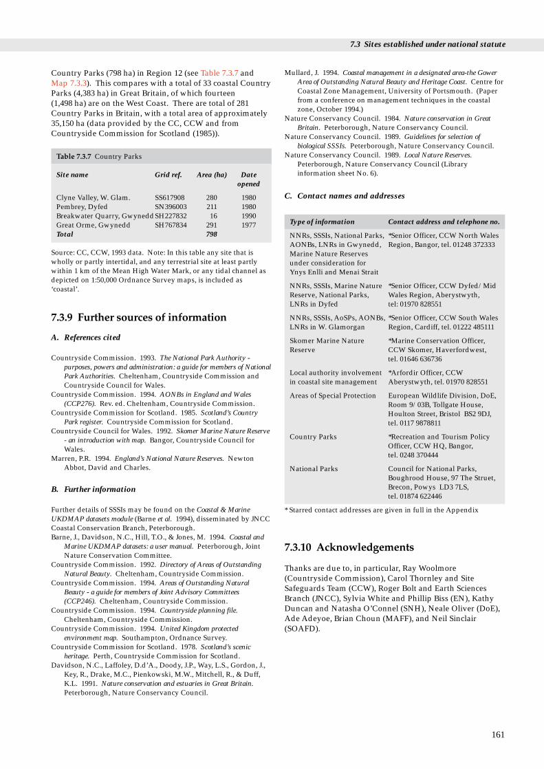
7.3 Sites established under national statute
Country Parks (798 ha) in Region 12 (see Table 7.3.7 andMap 7.3.3). This compares with a total of 33 coastal CountryParks (4,383 ha) in Great Britain, of which fourteen(1,498 ha) are on the West Coast. There are total of 281Country Parks in Britain, with a total area of approximately35,150 ha (data provided by the CC, CCW and fromCountryside Commission for Scotland (1985)).
Table 7.3.7 Country Parks
Site name Grid ref. Area (ha) Date opened
Clyne Valley, W. Glam. SS617908 280 1980Pembrey, Dyfed SN396003 211 1980Breakwater Quarry, GwyneddSH227832 16 1990Great Orme, Gwynedd SH767834 291 1977Total 798
Source: CC, CCW, 1993 data. Note: In this table any site that iswholly or partly intertidal, and any terrestrial site at least partlywithin 1 km of the Mean High Water Mark, or any tidal channel asdepicted on 1:50,000 Ordnance Survey maps, is included as‘coastal’.
7.3.9 Further sources of information
A. References cited
Countryside Commission. 1993. The National Park Authority -purposes, powers and administration: a guide for members of NationalPark Authorities. Cheltenham, Countryside Commission andCountryside Council for Wales.
Countryside Commission. 1994. AONBs in England and Wales(CCP276). Rev. ed. Cheltenham, Countryside Commission.
Countryside Commission for Scotland. 1985. Scotland’s CountryPark register. Countryside Commission for Scotland.
Countryside Council for Wales. 1992. Skomer Marine Nature Reserve- an introduction with map. Bangor, Countryside Council forWales.
Marren, P.R. 1994. England’s National Nature Reserves. NewtonAbbot, David and Charles.
B. Further information
Further details of SSSIs may be found on the Coastal & MarineUKDMAP datasets module (Barne et al. 1994), disseminated by JNCCCoastal Conservation Branch, Peterborough.Barne, J., Davidson, N.C., Hill, T.O., & Jones, M. 1994. Coastal and
Marine UKDMAP datasets: a user manual. Peterborough, JointNature Conservation Committee.
Countryside Commission. 1992. Directory of Areas of OutstandingNatural Beauty. Cheltenham, Countryside Commission.
Countryside Commission. 1994. Areas of Outstanding NaturalBeauty - a guide for members of Joint Advisory Committees(CCP246). Cheltenham, Countryside Commission.
Countryside Commission. 1994. Countryside planning file.Cheltenham, Countryside Commission.
Countryside Commission. 1994. United Kingdom protectedenvironment map. Southampton, Ordnance Survey.
Countryside Commission for Scotland. 1978. Scotland’s scenicheritage. Perth, Countryside Commission for Scotland.
Davidson, N.C., Laffoley, D.d’A., Doody, J.P., Way, L.S., Gordon, J.,Key, R., Drake, M.C., Pienkowski, M.W., Mitchell, R., & Duff,K.L. 1991. Nature conservation and estuaries in Great Britain.Peterborough, Nature Conservancy Council.
Mullard, J. 1994. Coastal management in a designated area-the GowerArea of Outstanding Natural Beauty and Heritage Coast. Centre forCoastal Zone Management, University of Portsmouth. (Paperfrom a conference on management techniques in the coastalzone, October 1994.)
Nature Conservancy Council. 1984. Nature conservation in GreatBritain. Peterborough, Nature Conservancy Council.
Nature Conservancy Council. 1989. Guidelines for selection ofbiological SSSIs. Peterborough, Nature Conservancy Council.
Nature Conservancy Council. 1989. Local Nature Reserves.Peterborough, Nature Conservancy Council (Libraryinformation sheet No. 6).
C. Contact names and addresses
Type of information Contact address and telephone no.
NNRs, SSSIs, National Parks, *Senior Officer, CCW North Wales AONBs, LNRs in Gwynedd, Region, Bangor, tel. 01248 372333Marine Nature Reservesunder consideration for Ynys Enlli and Menai Strait
NNRs, SSSIs, Marine Nature *Senior Officer, CCW Dyfed/Mid Reserve, National Parks, Wales Region, Aberystwyth,LNRs in Dyfed tel: 01970 828551
NNRs, SSSIs, AoSPs, AONBs, *Senior Officer, CCW South Wales LNRs in W. Glamorgan Region, Cardiff, tel. 01222 485111
Skomer Marine Nature *Marine Conservation Officer, Reserve CCW Skomer, Haverfordwest,
tel. 01646 636736
Local authority involvement *Arfordir Officer, CCW in coastal site management Aberystwyth, tel. 01970 828551
Areas of Special Protection European Wildlife Division, DoE,Room 9/03B, Tollgate House,Houlton Street, Bristol BS2 9DJ,tel. 0117 9878811
Country Parks *Recreation and Tourism PolicyOfficer, CCW HQ, Bangor,tel. 0248 370444
National Parks Council for National Parks,Boughrood House, 97 The Struet,Brecon, Powys LD3 7LS, tel. 01874 622446
* Starred contact addresses are given in full in the Appendix
7.3.10 Acknowledgements
Thanks are due to, in particular, Ray Woolmore(Countryside Commission), Carol Thornley and SiteSafeguards Team (CCW), Roger Bolt and Earth SciencesBranch (JNCC), Sylvia White and Phillip Biss (EN), KathyDuncan and Natasha O’Connel (SNH), Neale Oliver (DoE),Ade Adeyoe, Brian Choun (MAFF), and Neil Sinclair(SOAFD).
161

Region 12 Chapter 7 Protected coastal sites
tory agencies
This section covers sites which, although not protected bystatute, have been identified by statutory agencies as beingof nature conservation or landscape importance.
7.4 Sites identified by statu
7.4.1 Nature Conservation Review sites
There are 953 confirmed Nature Conservation Review(NCR) sites (approximately 1,500,000 ha) in Britain. NCRsites are non-statutory sites identified by statutoryconservation bodies. As defined by Ratcliffe (1977), whosedefinition differs from that adopted in this chapter (seesection 7.1.1), there are 149 ‘coastal’ NCR sites(approximately 360,000 ha) in Region 12 (data provided byBiotopes Conservation Branch, JNCC). Coastal NCR sitesinclude sites supporting nationally and internationallyimportant bird populations, as well as sites holding the bestrepresentative examples of vegetative habitats. The NCRseries helps to identify suitable candidates for biologicalNNR designation.
7.4.2 Geological Conservation Review sites
Geological Conservation Review (GCR) sites are non-statutory sites identified by the statutory conservation
162
GCR site
Map 7.4.1 Coastal Geological Conservation Review sites. Source:CCW, JNCC Note: a single symbol may represent morethan one site in close proximity.
agencies; they are sites of national and international earthscience importance. The GCR selection process describesand assesses key sites in the context of an aspect of thegeology, palaeontology, mineralogy or geomorphology;GCR sites are the earth science equivalent of NCRs. GCRsite descriptions are being published as a series of volumes,each covering sites selected for one aspect of earth scienceinterest. Several volumes describe some Welsh sites,including Campbell & Bowen (1989), which deals with theQuarternary in Wales (see also Chapter 2). Almost 3,000individual GCR Single Interest Localities (SIL) have beenidentified, of which 1,077 are coastal; 543 of them are on theWest Coast (data provided by the JNCC Earth SciencesBranch). The 141 GCR SILs within Region 12 are listed inTable 7.4.1, with an indication of whether they were selectedfor their geological or their coastal geomorphologicalinterest (see also Map 7.4.1).
7.4.3 Heritage Coasts
Heritage Coasts are areas selected for having a coastline ofexceptionally fine scenic quality, exceeding one mile inlength, substantially undeveloped and containing featuresof special significance and interest. This non-statutoryprotection is agreed between local authorities and (in Wales)CCW, as a aid to local authorities in planning and managingtheir coastlines. There are thirteen Heritage Coasts (472 km)
Heritage Coast
Map 7.4.2 Heritage Coasts. Source: Countryside Commission.

7.4 Sites identified by statutory agencies
163
Table 7.4.1 GCR Single Interest Localities (SILs)
Site name
West GlamorganOystermouth Old QuarryBracelet Bay (2)RothersladeCaswell Bay (2)Pwll-Du*Pwll Du HeadHunts BayBacon Hole (2)Bosco’s DenMinchin Hole (2)Three Cliffs BayOxwich Bay*Eastern and Western SladeHortonLonghole CaveLong HoleWorms HeadRhosili BayBroughton BayWest Glamorgan/Dyfed Burry Inlet* (Landimore, Llanrhidian and Berthlwyd)DyfedCraig y FulfranLlanstephanCarmarthen Bay*MarrosWiseman’s Bridge - Amroth CoastTenby - Saundersfoot CoastFreshwater EastTenby BeachFreshwater East (Dyfed/S. Pembrokeshire)Tenby Cliffs (2)Freshwater EastStackpole QuarrySouth Pembroke Cliffs*Freshwater West (South)Blucks Pool - Bullslaughter BayFreshwater West (North)West Angle BayWest Angle Bay (North)Little Castle HeadSt Ann’s HeadMarloes (2)Albion Sands and Gateholm IslandMarloes Sands to Albion SandsSkomer IslandDeer ParkMusselwick SandsMill HavenMusselwick BayBroadhaven to Settling NoseDruidstonDruidston HavenNolton Haven CoastSolfach*Solva HarbourDwrhyd PitPorth y RhawSt Noris-Caerfai BayTrywyn CynddeiriogPorth ClaisMarrosAber Mawr-Porth LleuogOgoffhenSt David’s Coast (Preseli)St David’s HeadWhite Sands Bay
Site name
Castell Coch-TrwyncastellLlanvirn-AbereiddyAbermawrPen CaerAbergwaunDinas and Esgyrn BottomPoppitMwntTraeth PenbrynCwmtuduAberarth-MorfaMorfa BychanAllt - WenCraig y FulfranClarachNorth ClarachYnyslas and BorthYnyslas*GwyneddBarmouth HillsideMorfa Dyffryn*Morfa Harlech*Rhiw-for-fawrMoranneddGlanllynnauLlanbedrogPen BenarPorth Ceiriad (2)Trwyn-llech-y-dollTrwyn Carreg-y-tirPorth Neigwl* (2)Mynydd PenarfynyddBenalltNant y GadwynWig BachBraich y Pwll to ParwydPorth OerPenrhyn Nefyn foreshore sectionPenrhyn BodeilasTrywyn-y-Gorlech to Yr-eifl QuarriesDinas DinlleLlanonCadnant CuttingDeganwy QuarriesBwlch MineGreat OrmeLittle OrmeNewborough Warren*Llanddwyn IslandTywyn AberffrawRhosneigrRhoscolynSouth StackCarmel Head (2)Hen BorthLlanbadrig areaOgof Gynfor-Hells MouthOgof GynforRhosmynach-FawrPorth y MorLligwy BayLligwy BayRed Wharf BayTrwyn DwlbanTandinas QuarryFlagstaff QuarryLleiniogMarquis of Anglesey’s Column
Source: CCW, JNCC. Key: * Sites selected wholly or partly for their coastal geomorphological interest (all other sites geological). (2) = twoSILs at this location. Note: In this table any site that is wholly or partly intertidal, and any terrestrial site at least partly within 1 km of theMean High Water Mark, or any tidal channel as depicted on 1:50,000 Ordnance Survey maps, is included as ‘coastal’.

Region 12 Chapter 7 Protected coastal sites
in Region 12 (see Table 7.4.2 and Map 7.4.2). This compareswith a total of 45 Heritage Coasts (1,525 km) on the Englishand Welsh coasts, as at May 1993. The Heritage Coastcoastline in this region is predominantly cliffed or rocky,with sandy bays. In Wales 37% by length of the HeritageCoasts is protected by the National Trust (Heritage CoastForum 1993).
Table 7.4.2 Heritage Coasts
Site name Grid ref. Length Date (km) designated
W. GlamorganGower Coast SS520954-SS593876 59 1973
DyfedSouth Pembrokeshire SS125983-SM871029 62 1974Marloes and Dale SM815055-SM852128 46 1974St. Bride’s Bay SM860143-SM854204 7 1974St. David’s Peninsula SM845225-SM955394 83 1974Dinas Head SM961375-SN045398 15 1974St. Dogmael’s and
Molygrove SN054407-SN160485 19 1974Ceredigion Coast SN159501-SN218524 34 1982
SN278517-SN386605SN532702-SN556746SN586842-SN602886
GwyneddLleyn (Lyn) SH424514-SH324266 90 1974Aberffraw Bay SH378654-SH339674 8 1973Holyhead Montain SH243796-SH224837 12 1973North Anglesey SH300892-SH491911 30 1973Great Orme* SH768823-SH783832 7 1976Total 472
Sources: CC, CCW. All Heritage Coasts are laterally defined(boundary defines extent of coast along shore) except for thatmarked *, which is completely defined (i.e. also has a definedlandward boundary).
7.4.4 Tir Cymen
The Countryside Council for Wales has set up a non-statutory pilot scheme, Tir Cymen, which expands upon theconcept of Environmentally Sensitive Areas (ESAs). Itrequires farmers to follow a simple code of environmentalgood practice (the Tir Cymen code) over the whole farm fora 10 year period, in return for financial incentives. Itencourages appropriate environmental management forvarious habitat types, including one defined as ‘coastalland’. It emphasises enjoyment of the countryside coupledwith positive environmental management, including the useof traditional methods, a reduction of pollution and a moveto organic fertilisers. Two of the three pilot regions,Meirionnydd and Abertawe Swansea, contain areas withinRegion 12.
164
7.4.5 Further sources of information
A. References cited
Campbell, S., & Bowen, D.Q. 1989. Quaternary of Wales.Peterborough, Nature Conservancy Council.
Heritage Coast Forum. 1993. Heritage Coasts in England and Wales; agazetteer. Manchester, Heritage Coast Forum.
Mullard, J. 1994. Coastal management in a designated area-the GowerArea of Outstanding Natural Beauty and Heritage Coast. Centre forCoastal Zone Management, University of Portsmouth. (Paperfrom a conference on management techniques in the coastalzone, October 1994.)
Ratcliffe, D.A, ed. 1977. A nature conservation review. Cambridge,Cambridge University Press.
B. Further reading
Countryside Commission. 1970. The coastal heritage. A conservationpolicy for coasts of high quality scenery. London, HMSO.
Countryside Commission. 1992. Heritage Coasts in England,policies and priorities 1992. Cheltenham, CountrysideCommission.
Countryside Council for Wales. 1992. Tir Cymen - a farmlandstewardship scheme. Bangor, Countryside Council for Wales.
Davidson, N.C., Laffoley, D.d’A., Doody, J.P., Way, L.S., Gordon, J.,Key, R., Drake, M.C., Pienkowski, M.W., Mitchell, R., & Duff,K.L. 1991. Nature conservation and estuaries in Great Britain.Peterborough, Nature Conservancy Council.
C. Contact names and addresses
Type of information Contact address and telephone no.
NCRs, GCRs in Gwynedd *Senior Officer, CCW North WalesRegion, Bangor, tel: 01248 372333
NCRs, GCRs in Dyfed *Senior Officer, CCW Dyfed/MidWales Region, Aberystwyth, tel: 01970 828551
NCRs, GCRs in *Regional Officer, CCW South W. Glamorgan Wales Region, Cardiff,
tel: 01222 485111
Tir Cymen *Tir Cymen Officer, Headquarters,CCW Bangor, tel: 01248 370734
*Starred contact addresses are given in full in the Appendix
7.4.6 Acknowledgements
Thanks are due to, in particular, Ray Woolmore(Countryside Commission), Carol Thornley and SiteSafeguards Team (CCW), Roger Bolt and Earth SciencesBranch (JNCC), Sylvia White and Phillip Biss (EN), KathyDuncan and Natasha O’Connel (SNH) and David Masters(Heritage Coast Forum).

7.5 Other types of protected site
site
7.5.1 The National Trust
The National Trust (NT) is an independent charity that iscurrently the largest private landowner in Britain. TheNational Trust owns about 230,000 ha of land in England,Wales and Northern Ireland, and over 200 buildings ofoutstanding importance. It has also accepted or boughtcovenants, which protect against development, for a further31,600 ha of land and buildings. Many of the tenantedproperties have individual intrinsic value; when viewedcumulatively, they protect large areas of unique landscapeand countryside. The National Trust has statutory powersto protect its properties, under an Act of Parliament (1907)which declares its holdings of land and buildingsinalienable; these properties cannot be sold or mortgaged.In addition, National Trust properties can be protected bybye-laws. In 1985 the National Trust relaunched its 1965campaign ‘Enterprise Neptune’ to raise funds for thepurchase of coastal areas. A total of 850 km of coast are nowprotected by the National Trust (National Trust 1993). TheNational Trust is currently in the process of preparing acoastal strategy for Wales.
There are 88 National Trust sites (6,840 ha) in Region 12(see Table 7.5.1 and Map 7.5.1). This compares with a totalin Britain of 446 coastal sites (62,648 ha) under theprotection of the National Trust or National Trust forScotland (NTS), of which 257 sites (45,258 ha) are on the
7.5 Other types of protected
NT site
Map 7.5.1 Coastal National Trust sites. Source: National Trust.Note: a single symbol may represent more than one sitein close proximity.
West Coast. The National Trust (England and Wales) has426 coastal sites (37,478 ha) (data extracted from NationalTrust (1992)); the National Trust for Scotland has nineteencoastal sites (25,170 ha) (data extracted from National Trustfor Scotland (1993)).
7.5.2 The Royal Society for the Protection ofBirds
The Royal Society for the Protection of Birds (RSPB) hassubstantial non-statutory reserve holdings and currentlymanages over 130 reserves (over 84,000 ha) in Britain (RSPB1993). Wherever possible, reserves are purchased, so thatthe level of safeguard for the wildlife and its habitats ishigh. Where reserves are leased, the RSPB aims to acquirelong leases (longer than 21 years) with appropriatemanagement rights. There are eight RSPB reserves(1,603 ha) in Region 12 (see Table 7.5.2 and Map 7.5.2). Thiscompares with a total of 78 coastal RSPB reserves (37,032 ha)in Great Britain, of which 26 (13,736 ha) are on the WestCoast (data extracted from RSPB (1993) and RSPB (in litt.)).Reserves in the region include several islands and cliffedcoasts with major seabird colonies, including largepopulations of breeding choughs and peregrine falcons;estuarine habitats; coastal fringing woodland, and coastalfreshwater wetlands.
165
Table 7.5.2 RSPB reserves
Site name Grid ref. Area Date (ha) acquired
DyfedGrassholm SM599093 9 1948Ramsey Island SM700237 253 1992Ynys-hir SN686956 424 1985
GwyneddMawddach Valley SH660175 521 1983Ynys Feirig island SH304735 2 1975Valley Lakes SH310775 61 1983South Stack Cliffs SH205823 316 1977The Skerries SH269949 17 1983Total 1,603
Source: RSPB (1993, 1994 and in litt.). Note: In this table any sitethat is wholly or partly intertidal, and any terrestrial site at leastpartly within 1 km of the Mean High Water Mark, or any tidalchannel as depicted on 1:50,000 Ordnance Survey maps, is includedas ‘coastal’.
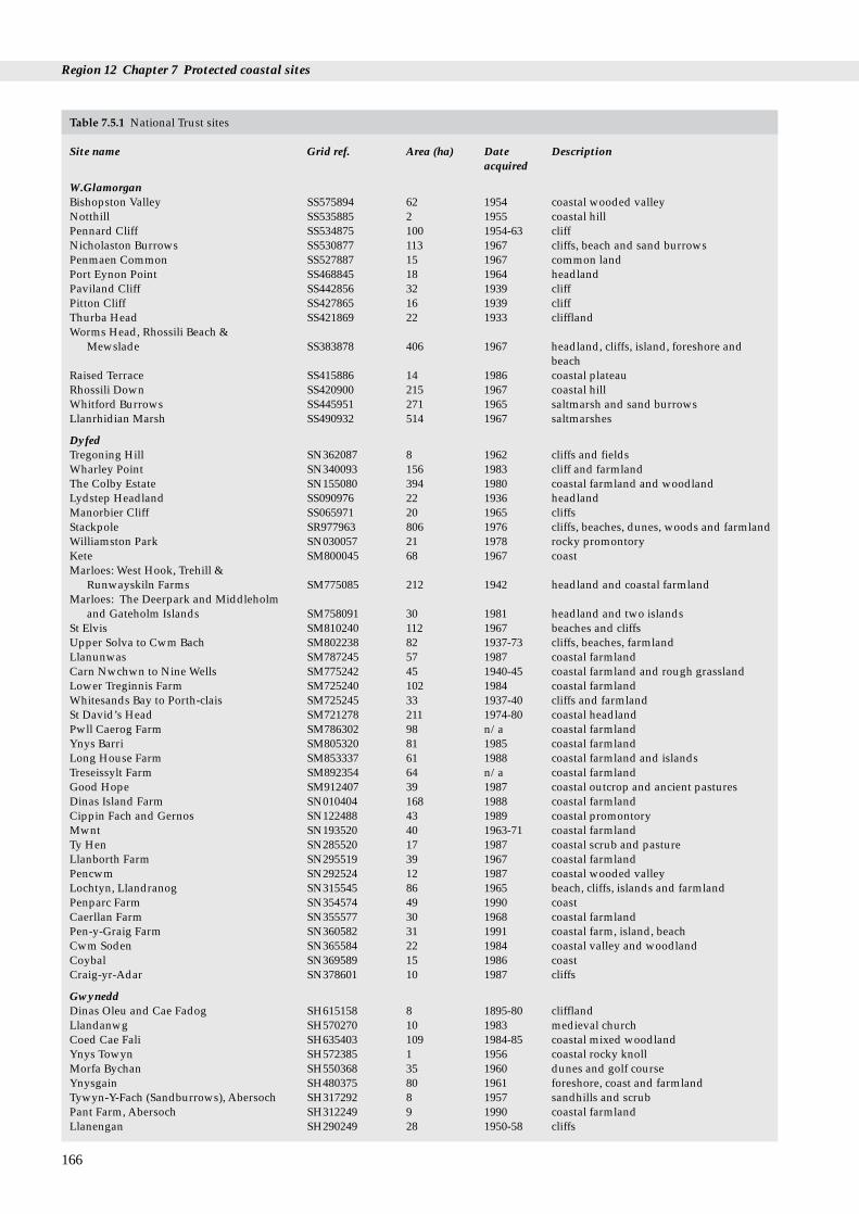
Region 12 Chapter 7 Protected coastal sites
166
Table 7.5.1 National Trust sites
Site name Grid ref. Area (ha) Date Descriptionacquired
W.GlamorganBishopston Valley SS575894 62 1954 coastal wooded valleyNotthill SS535885 2 1955 coastal hillPennard Cliff SS534875 100 1954-63 cliffNicholaston Burrows SS530877 113 1967 cliffs, beach and sand burrowsPenmaen Common SS527887 15 1967 common landPort Eynon Point SS468845 18 1964 headlandPaviland Cliff SS442856 32 1939 cliffPitton Cliff SS427865 16 1939 cliffThurba Head SS421869 22 1933 clifflandWorms Head, Rhossili Beach &
Mewslade SS383878 406 1967 headland, cliffs, island, foreshore andbeach
Raised Terrace SS415886 14 1986 coastal plateauRhossili Down SS420900 215 1967 coastal hillWhitford Burrows SS445951 271 1965 saltmarsh and sand burrowsLlanrhidian Marsh SS490932 514 1967 saltmarshes
DyfedTregoning Hill SN362087 8 1962 cliffs and fieldsWharley Point SN340093 156 1983 cliff and farmlandThe Colby Estate SN155080 394 1980 coastal farmland and woodlandLydstep Headland SS090976 22 1936 headlandManorbier Cliff SS065971 20 1965 cliffsStackpole SR977963 806 1976 cliffs, beaches, dunes, woods and farmlandWilliamston Park SN030057 21 1978 rocky promontoryKete SM800045 68 1967 coastMarloes: West Hook, Trehill &
Runwayskiln Farms SM775085 212 1942 headland and coastal farmlandMarloes: The Deerpark and Middleholm
and Gateholm Islands SM758091 30 1981 headland and two islandsSt Elvis SM810240 112 1967 beaches and cliffsUpper Solva to Cwm Bach SM802238 82 1937-73 cliffs, beaches, farmlandLlanunwas SM787245 57 1987 coastal farmlandCarn Nwchwn to Nine Wells SM775242 45 1940-45 coastal farmland and rough grasslandLower Treginnis Farm SM725240 102 1984 coastal farmlandWhitesands Bay to Porth-clais SM725245 33 1937-40 cliffs and farmlandSt David’s Head SM721278 211 1974-80 coastal headlandPwll Caerog Farm SM786302 98 n/a coastal farmlandYnys Barri SM805320 81 1985 coastal farmlandLong House Farm SM853337 61 1988 coastal farmland and islandsTreseissylt Farm SM892354 64 n/a coastal farmlandGood Hope SM912407 39 1987 coastal outcrop and ancient pasturesDinas Island Farm SN010404 168 1988 coastal farmlandCippin Fach and Gernos SN122488 43 1989 coastal promontoryMwnt SN193520 40 1963-71 coastal farmlandTy Hen SN285520 17 1987 coastal scrub and pastureLlanborth Farm SN295519 39 1967 coastal farmlandPencwm SN292524 12 1987 coastal wooded valleyLochtyn, Llandranog SN315545 86 1965 beach, cliffs, islands and farmlandPenparc Farm SN354574 49 1990 coastCaerllan Farm SN355577 30 1968 coastal farmlandPen-y-Graig Farm SN360582 31 1991 coastal farm, island, beachCwm Soden SN365584 22 1984 coastal valley and woodlandCoybal SN369589 15 1986 coastCraig-yr-Adar SN378601 10 1987 cliffs
GwyneddDinas Oleu and Cae Fadog SH615158 8 1895-80 clifflandLlandanwg SH570270 10 1983 medieval churchCoed Cae Fali SH635403 109 1984-85 coastal mixed woodlandYnys Towyn SH572385 1 1956 coastal rocky knollMorfa Bychan SH550368 35 1960 dunes and golf courseYnysgain SH480375 80 1961 foreshore, coast and farmlandTywyn-Y-Fach (Sandburrows), Abersoch SH317292 8 1957 sandhills and scrubPant Farm, Abersoch SH312249 9 1990 coastal farmlandLlanengan SH290249 28 1950-58 cliffs
7.5 Other types of protected site
Table 7.5.1 National Trust sites (continued)
Site name Grid ref. Area (ha) Date Descriptionacquired
Gwynned (cont.)Penrallt Neigwl SH248287 4 1966 cliff and farmhousePlas-yn-Rhiw SH237282 168 1950-66 coastal estateMynydd-y-Graig SH230270 81 1955 coastal summitPenarfynydd, Rhiw SH217265 99 1974 clifftop rough and farmlandPorth Ysgo SH208266 9 1967 beach, cliffs, waterfallCwrt Farm, Aberdaron SH159259 96 1990 coastal farmlandPen-Y-Cil, Aberdaron SH158240 12 1968 clifftop and common landMynydd Bychestyn SH158240 19 1981-84 common landBraich-Y-Pwll SH140254 49 1948 coastPorth Llanllawen SH145265 17 1980 cliffs and coastlandMynydd Anelog SH150275 49 1981 common landPorth Orion SH156285 4 1961 clifflandDinas Fawr and Dinas Bach SH156285 17 1981 islands and clifflandCarreg Farm, Aberdaron SH162292 58 1986 headlandPorthor (Whistling Sands) SH166298 30 1990 beach, cliffs and farmlandPorth Gwylan SH215365 22 1982 harbour and coastPorthdinllaen SH275415 9 1994 coastal village, cliffs and beachPistyll Farm, Nefyn SH325421 109 1990 coastal farmlandPen-Y-Graig SH303897 4 1985 coastal farmlandMynachdy SH295920 167 1987 coastal farmlandClegir Mawr SH315913 61 1978 coastal farmlandCemlyn SH325933 130 1968 farmland and nature reserveFelin Cafnan and Trwyn Pencarreg SH340937 15 1982 headlandDinas Gynfor SH392951 2 1913 clifflandLlangoed SH603818 19 1982 common landPlas Newydd SH521696 68 1976 coastal estate and woodlandGlan Faenol SH530695 127 1985 coastal wood and farmlandCae Glan-Y-Mor SH546718 5 1938-80 coastYnys Welltog SH549717 1 1982 islandPenrhyn Castle SH603720 19 1951 castle and groundsTotal 6,840
Source: The National Trust. Key: n/a - not available.. Note: In this table any site that is wholly or partly intertidal, and any terrestrial site atleast partly within 1 km of the Mean High Water Mark, or any tidal channel as depicted on 1:50,000 Ordnance Survey maps, is included as‘coastal’.
7.5.3 The Wildfowl & Wetlands Trust (WWT)
As well as their wildfowl collections, used extensively foreducation, The Wildfowl & Wetlands Trust (WWT - formerlythe Wildfowl Trust) has established non-statutory reservesin a number of key wintering areas for migrant wildfowl.The level of protection afforded to such sites is high, sincethe land is either owned or held on long leases. There is onecoastal WWT site (82 ha) in Region 12 (see Table 7.5.3 andMap 7.5.2). This compares with a total of six coastal WWTsites (1,585 ha) in Great Britain, of which three (1,113 ha) areon the West Coast (data provided by WWT).
Table 7.5.3 Wildfowl and Wetlands Trust sites
Site name Grid ref. Area (ha) Date acquired
Llanelli, Dyfed SS530984 82 1991
Source: WWT 1994 data. Note: In this table any site that is whollyor partly intertidal, and any terrestrial site at least partly within1 km of the Mean High Water Mark, or any tidal channel asdepicted on 1:50,000 Ordnance Survey maps, is included as‘coastal’.
7.5.4 The Wildlife Trusts
The Wildlife Trusts have been established to promote non-statutory nature conservation at a local level in both themarine and terrestrial environments. They own, lease andmanage (by agreement with owners) over 1,800 naturereserves, covering more than 52,000 ha. In most areas onetrust covers a whole county or group of counties, althoughboth Scotland and the Isle of Man each have a single Trust.The Trusts in the region are the North Wales Wildlife Trust,the Dyfed Wildlife Trust and the Glamorgan Wildlife Trust.There are 38 coastal Wildlife Trust sites (1,128 ha) in theregion (see Table 7.5.4 and Map 7.5.2). This compares with atotal of 219 coastal Wildlife Trust sites (23,380 ha) in GreatBritain, of which 108 (13,724 ha) are on the West Coast. Ofthe 220 coastal sites in Britain covering the coast, there are26 Scottish sites (13,805 ha), 189 English/Welsh sites (9,280ha) and six Isle of Man sites (14 ha). The Wildlife Trustswere revising their databases at the time this section wascollated; 1990 data on English/Welsh Wildlife Trust Siteshave therefore been utilised, except where indicatedotherwise in Table 7.5.4.
167

Region 12 Chapter 7 Protected coastal sites
168
Table 7.5.4 Wildlife Trusts sites
Site name Grid ref. Area (ha) Date acquired
Glamorgan Wildlife TrustRidgewood Park Mayals SS611906 1 1962Peel Wood SS607883 1 1969Redley Cliff S589875 4 1970Redden Hill Wood SS539894 1 1979Segders Bank SS470844 35 1966Port Eynon/Overton SS465845 34 1964Long Hole Cave Cliff SS450850 21 1970Deborah’s Hole Cliff SS435862 7 1972Cwm Ivy Woods SS443938 6 1964Castle Wood Field SS472931 1 1968Hambury Wood SS472929 5 1977LLanrhidian Hill SS495922 3 1976
Dyfed Wildlife TrustSt Margaret’s Island SS120973 6 1950West Williamston SN027060 19 1979Sam’s Wood SN004093 12 1985Old Mill Grounds SM953165 3 1973Brunt Hill SM816074 3 1982Skokholm SM735050 100 1948Marloes Mere SM775083 11 1969Skomer Island SM725095 292 1959Llangoffan Fena SM894397 13 1984Goodwick Moor SM946377 15 1975Cemaes Head SN132500 16 1984Teifi Marshesa SN185450 370 1968Teifi Foreshore SN187457 14 1968Cardigan Island SN160515 16 1944Aber Stinchell Lime Kilnsa SN519684 1 1993Penderi a SN550732 12 1966
North Wales Wildlife Trust (Gwynedd)Traeth Glaslyna SH587384 36 1974Morfa Bychan SH548367 11 1964Porth Diana SH254781 2 1979Cemlyna SH331932 16 1971Mariandyrys SH604812 6 1980Coed Porthamela SH508679 3 1982Nantportha SH567718 14 1969Spinnies Aberogwen SH613722 3 1983Gogarth, Great Orme SH760832 3 1972Rhiwledyna SH813821 5 1995Total 1,128
Source:- The Wildlife Trust. Key: a data correct at 1995; otherwisedata correct at 1990. Note: In this table any site that is wholly orpartly intertidal, and any terrestrial site at least partly within 1 kmof the Mean High Water Mark, or any tidal channel as depicted on1:50,000 Ordnance Survey maps, is included as ‘coastal’. Somesites in this table are very close together; they have beenrepresented on Map 7.5.2 by a single dot.
Wildlife Trust Reserve
RSPB Reserve
Woodland Trust site
WWT Reserve
MOD site
Map 7.5.2 Other voluntary and private sites. Source: Ministry ofDefence, Wildlife Trusts, RSPB, Woodland Trust,Wildfowl & Wetlands Trust (NB not all sites are shown ifseveral are located very close together).

7.5 Other types of protected site
Table 7.5.6 MOD sites
Site name Area (ha)* Habitats Protectedstatus
DyfedPembrey 614 saltmarsh and sand SSSI
dunePendine 1,928 sand dunes SSSIPenally 86 cliffs SSSI, NPManorbier 42 cliffs SSSI, NPCastlemartin 2,390 sand dunes and SSSI, NP
7.5.5 The Woodland Trust
The Woodland Trust was established in 1972 with the aim ofconserving, restoring and re-establishing trees (particularlybroad-leaved) and woodland plants and wildlife in theUnited Kingdom. There are seven non-statutory WoodlandTrust sites (141 ha) in Region 12 (Table 7.5.5 and Map 7.5.2).This compares with a total of 64 coastal Woodland Trustsites (1,458 ha) in Great Britain, of which 29 (363 ha) are onthe West Coast (data extracted from Woodland Trust (1993)).
Table 7.5.5 The Woodland Trust sites
Site name Grid ref. Area (ha)
W.GlamorganCommon Wood SS508926 16
DyfedBeech Hill Wood SN365095 1Coed Ystrad SN395189 12
GwyneddCoed Friog SH657390 3Coed Felinrhyd SH657390 88Coed Elernion SH378462 20Coed Avens SH476923 1Total 141
Source: Woodland Trust (1993). Note: In this table any site that iswholly or partly intertidal, and any terrestrial site at least partlywithin 1 km of the Mean High Water Mark, or any tidal channel asdepicted on 1:50,000 Ordnance Survey maps, is included as‘coastal’.
cliffsAngle 19 cliffs SSSI, NPPembroke Dock 15 foreshore of mud -Aberporth 224 cliffs -
GwyneddTywyn 0.4 estuary bank NPTy Croes 25 rocky foreshore AONBHolyhead RAF Valley 399 sand dunes SSSI, AONBHolyhead RAF Craft Unit 4 rock outcrops -Total 5,746
Source: Ministry of Defence. Key: * All areas are approximate andnot definitive and include land leased or used under licence. SSSI= Site of Special Scientific Interest; NP = National Park; AONB =Area of Outstanding Natural Beauty. Note: In this table any sitethat is wholly or partly intertidal, and any terrestrial site at leastpartly within 1 km of the Mean High Water Mark, or any tidalchannel as depicted on 1:50,000 Ordnance Survey maps, isincluded as ‘coastal’.
7.5.6 The Ministry of Defence
As at August 1994, the Ministry of Defence (MOD) owned,leased or used under licence landholdings covering some320 km of coastline around the UK, not all of it significantfor its nature conservation value. The MOD gives highpriority to nature conservation on the Defence Estate,subject to the overriding importance of military training.The restrictions to public access on some sites mean thatthey can be amongst the most pristine areas of wildlifehabitat in the region. There are twelve coastal Ministry ofDefence (MOD) sites (5,746 ha) in Region 12 (see Table 7.5.6and Map 7.5.2). This compares with a total of 111 identifiedMOD coastal sites (approximately 53,409 ha) around theUK, of which 45 sites (approximately 18,960 ha) are on theWest Coast of Britain (data provided by MOD).
7.5.7 Further sources of information
A. References cited
National Trust. 1992. Properties of the National Trust. National Trust.National Trust. 1993. Enterprise Neptune - saving our unspoiled
coastline. Coastline 1993, No.2: 1-11.National Trust for Scotland. 1993. Guide to over 100 properties. The
National Trust for Scotland.Royal Society for the Protection of Birds. 1993. Nature Reserves -
information for visitors. Sandy, RSPB.Woodland Trust. 1993. Directory of Woodland Trust properties 1993.
The Woodland Trust.
B. Further reading
Davidson, N.C., Laffoley, D.d’A., Doody, J.P., Way, L.S., Gordon, J.,Key, R., Drake, M.C., Pienkowski, M.W., Mitchell, R., & Duff,K.L. 1991. Nature conservation and estuaries in Great Britain.Peterborough, Nature Conservancy Council.
169
Region 12 Chapter 7 Protected coastal sites
C. Contact names and addresses
Type of information Contact address and telephone no.
National Trust sites in GB *Coast and Countryside Adviser,The National Trust HQ,Cirencester, tel. 01285 651818
National Trust sites in north *Land Agent, The National Trust Wales North Wales Office, Llandudno,
tel. 01492 860123
National Trust sites in south *Area Manager, The National Trust Wales South Wales Office, Llandeilo,
tel. 01558 822800
Royal Society for the *Regional Officer, RSPB Wales Protection of Birds sites Office, Newtown, tel. 01686 626678
Wildfowl and Wetlands *Dr G.Proffitt, The Wildfowl and Trust site Wetlands Trust, Llanelli,
tel. 01554 741087
North Wales Wildlife *Conservation Officer, NWWT, Trust sites Bangor, tel. 01248 351541
Dyfed Wildlife Trust sites *Director and Marine ConservationOfficer, DWT, Haverfordwest, tel. 01437 765462 / 767062
Glamorgan Wildlife *Conservation Officer, GWT, Trust sites Tondu, tel. 01656 724100
Woodland Trust sites The Woodland Trust, AutumnPark, Dysart Road, Grantham,Lincolnshire NG31 6LL, tel. 01476 74297
MOD sites Conservation Officer, MODConservation Office, B2/3,Government Buildings,Leatherhead Road, Chessington,Surrey KT9 2LU, tel. 0181 391 3028/9
* Starred contact addresses are given in full in the Appendix
7.5.8 Acknowledgements
The author wishes to thank Andrea Firth for MOD text anddata, Jo Burgon and Richard Offen (The National Trust),Dr J. Fenton (National Trust for Scotland), Bob Scott (RSPB),Mark Pollitt (Wildfowl and Wetlands Trust), SarahHawkswell (The Wildlife Trusts), Dr A. Somerville (ScottishWildlife Trust), Meryl Eales (Manx Trust for NatureConservation), Andrew Johnson (Manx Natural Heritage),The Woodland Trust, and Martin Mathers (WWFN).
170

Chapter 8 Land use, infrastructure andcoastal defence
This chapter is divided into three sections: land use,covering agriculture and woodlands; infrastructure,covering population distribution, industry, ports, harboursand shipping lanes, road and rail communications, airfieldsand airports, ferries, pipelines, cables and power generation;and coastal defence, including sea defence and coastprotection.
8.1 IntroductionM.J. Dunbar, S.J. Everett and S.L. Fowler
Dyfi National Nature Reserve, on the Dyfed/Gwynedd border. Railwaythe north shore of the Dyfi estuary. Photo: P. Wakely, English Nature.
Most of the coastal land in the region is in agriculturaluse. There are, however, three main urban and industrialareas. In the south, the Swansea/Port Talbot area isdominated by residential, port and industrial uses. On thewest coast, the Milford Haven waterway is bordered byseveral major industrial sites, mainly associated with the oilrefining industry. And to the north, much of the Gwyneddcoast north-east of Caernarfon is also urbanised.
171
s run alongside the sea in several parts of the region, here hugging

Region 12 Chapter 8 Land use, infrastructure and coastal defence
8.2.1 Introduction
Agriculture is the region’s most widespread land use. Theregional proportion of tilled land (see Map 8.2.1) is broadlycomparable to that for agricultural coastal areas elsewhereon the west coast and on much of the south coast ofEngland. Arable farming and horticulture is mostwidespread on the south coast of the region, in south-eastGower and south-west Dyfed, where there is a highproportion of cultivated land and intensive dairying. Mostof the coastal land is grades 3 or 4 (MAFF grades), withsmaller areas of grade 2 land. In the coastal plain of south-east Gower there is some mixed farming and horticulture ongrade 2 and a small amount of grade 1 land.
In the west and north of the region, arable farming is amuch less important activity and the emphasis is onlivestock production, with coastal farmed areas dominatedby grazing on managed grassland land and semi-naturalrough grassland and heath. The whole of the Welsh coast isimportant for livestock production. A large amount of theBritish extent of managed coastal grassland is located in theregion, particularly in south and south-west Dyfed and onAnglesey (Map 8.2.2). The map does not differentiatebetween land used for dairying (mainly along the southcoast of the region) and beef or sheep rearing (on the west
8.2 Land use M.J. Dunbar, S.J. Everett and S.L. Fowler
172
Map 8.2.1 Tilled land. Note: area of circle indicates the area of thisland cover type in the 10 km square. Source:Countryside Survey (1990), ITE Monks Wood.
and north coasts). In contrast to this region, the North Seacoast of England and Scotland has limited amounts ofmanaged grassland.
Most of the woodlands in Wales are located away fromthe coast, with the exception of some conifer plantations onareas of sand dune. Those ancient semi-natural and mixedwoodlands on or near the coast are often located on steepslopes and alongside estuaries, streams and rivers. Woodedareas are listed in Table 8.2.1 and shown on Map 8.2.3.
8.2.2 Effects of agriculture and forestry
In parts of the Pembrokeshire Coast National Park, land hasbeen agriculturally improved and cultivated up to the cliffedge, leaving only a very narrow margin of semi-naturalvegetation. Set-aside and agri-environment projects are alsolikely to have an impact on agriculture on the coastal fringe.Many farms are trying to develop farm tourism as a sourceof alternative income. See Chapter 7 for more details ofEnvironmentally Sensitive Areas and the Tir Cymeninitiative.
Map 8.2.2 Mown/grazed turf. Note: area of circle indicates thearea of this land cover type in the 10 km square. Source:Countryside Survey (1990), ITE Monks Wood.

8.2 Land use
Table 8.2.1 Main areas of coastal woodland in Region 12
Location Grid ref. Details
W Glamorgan1 Nicholaston Woods SS5188 Broadleaved strips on steep slopes adjacent to coast2 Oxwich SS5086 Broadleaved strips on steep slopes to sea3 Whiteford Burrows SS4494 Small blocks of mature conifer plantation on sand dunes
Dyfed4 Pembrey Forest SS3802 Conifer plantation covering 897 ha of sand dunes5 Benton Wood SN0006 Conifer plantation on steep slopes of Daugleddau.
Broadleaved woodland on east bank slopes6 Dyfi Estuary SN6495 Extensive wooded slopes along south and north banks of the estuary:
coniferous, mixed and broadleaved.Gwynedd
7 Mawddach Estuary (both sides) SH6615 Extensive mixed & coniferous woodland on steep banks8 Morfa Harlech SH5732 Conifer plantation on 14 ha of sand dunes 9 Newborough Forest, Anglesey SH4063 Conifer plantation covering 741 ha of sand dunes10 Myndd Llwydiarth SH5479 Conifer plantation abutting Red Wharf Bay (but mostly extending
inland) over approx. 3 km2
11 Menai Straits, Anglesey SH5270 Coastal woodland fringe along approx. 2.5 km west of Pont Britannia12 Menai Straits (south bank) SH5370 Mixed woodland over approx 0.5 km2
13 Menai Straits (both banks) SH5471 Mixed woodland for approx. 2 km west of suspension bridge (southbank); a small block on Anglesey near Pont Britannia.
14 Penrhyn SH6072 Mixed woodland along approx. 1 km of coast east of Bangor
Note: location numbers refer to sites shown on Map 8.2.3.
Some saltmarsh areas such as at Burry Inlet andLlanridian Marsh are heavily grazed (see section 3.6 and9.3): the agricultural use of the latter site combined with itsrelative remoteness from urban centres has helped to protect
9
10
11, 12, 13
14
8
7
6
5
43
2 1
Map 8.2.3 Coastal woodland. Larger (numbered) sites are thoselisted in Table 8.2.1. Source: Ordnance SurveyLandranger maps. © Crown copyright.
it from other developments. Other vegetation types used inthe region for rough grazing and which are mapped in ITE(1993) but not presented in this chapter are roughgrass/marsh, moorland grass, bracken and open shrubheath/moor. Agricultural intensification has destroyedparts of the major dune systems (see section 3.2). Today,many such areas lie under arable fields, as in parts of MorfaHarlech (Gwynedd), or are permanent pastures. See section9.3 for further details of grazing on saltmarsh and sanddunes.
Afforestation has affected large areas of sand dune. Ofthe thirteen major dune afforestation schemes in Britainidentified by Doody (undated), three are in this region, atPembrey, Morfa Harlech and Newborough Warren.
8.2.3 Information sources
The main source of information for this section was theCountryside Survey 1990 (ITE 1993), which is basedprimarily on high resolution satellite images. These imagesshow the dominant land cover for each 25 m x 25 m area(pixel) of Great Britain, classified into 17 key types. Fieldsurveys of randomly selected areas were used to ‘ground-truth’ the results. The Countryside Information System canprovide data on a 1 km square framework, but this level ofdetail was not considered appropriate here. More detailedinformation on agricultural land use is held by thePembrokeshire Coast National Park Plan, local plans andAgricultural Development Advisory Service (ADAS) (e.g.information on set-aside targets).
Information on forestry was obtained from the 1:50,000scale Ordnance Survey Landranger maps, which distinguishbetween coniferous, mixed and broadleaved woodland.The NCC’s inventory of ancient woodlands (Spencer &Kirby 1992) may provide another source of comparativedata for the region, and the Forestry Commission is able toprovide maps of forestry areas throughout the country.
173

Region 12 Chapter 8 Land use, infrastructure and coastal defence
8.2.4 Further sources of information
A. References cited
Doody J.P. Undated. Coastal habitat change - a historical review ofman’s impact on the coastline of Great Britain. Peterborough, JointNature Conservation Committee (unpublished draft).
Institute of Terrestrial Ecology. 1993. Countryside survey 1990: mainreport. London, Department of the Environment.
Spencer, J.W., & Kirby, K.J. 1992. An inventory of ancient woodlandfor England and Wales. Biological Conservation 62: 77-93.
B. Further reading
Etherington, J.R, & Clark, E.A. 1987. Impact of agriculture on thecliff vegetation of South Gower, West Glamorgan. NatureConservancy Council, CSD Report, No 731.
Welsh Office. 1993. Environmental Digest for Wales. No. 7, 1992.Cardiff, Welsh Office.
C. Contact names and addresses
Type of information Contact address and telephone no.
Land use, grades, set-aside MAFF, Whitehall Place, London (MAFF/ADAS Land Service) SW11 2HH, tel: 0171 270 3000
ADAS, Oxford Spire BusinessPark, The Boulevard, Kidlington,Oxford OX5 1NZ, tel: 01865 842742
Countryside Survey 1990 Department of Rural Affairs,Department of the Environment,Room 919, Tollgate House,Houlton Street, Bristol BS2 9DJ, tel: 0117 9218811
as above *Land Use Group, ITEMerlewood, tel: 01539 532264
as above *Environmental InformationCentre, ITE Monks Wood, tel:01487 773381
Woodland extent, ownership, Chief Conservator, Forestry management Commission Wales Conservancy,
North Road, Aberystwyth, DyfedSY23 2EF, tel: 01970 612367
Ancient Woodland Inventory *Woodland Ecologist, CCW HQ,Bangor, tel: 01248 370734
* Starred contact addresses are given in full in the Appendix
8.2.5 Acknowledgements
Thanks to Robin Fuller, ITE Monks Wood for providinginformation on the Countryside Survey.
174

8.3 Infrastructure
Llandudno
Conwy
Bangor
Holyhead
Caernarfon
Abersoch
Pwllheli
Porthmadog
Barmouth
Aberdyfi
Aberystwyth
Cardigan
Fishguard
HaverfordwestMilford Haven Carmarthen
LlanelliSwansea
Port TalbotMumbles
Neath
TenbyPembroke
Equivalent area in 10km square
Map 8.3.1 Urban, suburban and rural development. Note: area ofcircle indicates the combined area of these land covertypes in the 10 km square. Major towns and cities arealso shown. Source: Countryside Survey (1990); ITEMonks Wood.
Table 8.3.1 Main coastal towns and cities in Region 12
Town or city PopulationPort Talbot 51,300Neath 66,000Swansea 187,600Llanelli 75,300Pembroke 15,600Milford Haven 13,900Aberystwyth 8,700Caernarfon 9,500Holyhead 10,500Bangor 12,100Conwy 13,000Llandudno 19,000
8.3.1 IntroductionThis section summarises the infrastructure of the region,including population distribution, industry, ports, harboursand shipping lanes, road and rail communications, airfieldsand airports, ferries, pipelines, cables and power generation,and land claim for these developments. Oil and gasexploration and development are covered in section 9.6.
This is one of the least densely populated regions insouthern Britain, with a total population in WestGlamorgan, Dyfed and Gwynedd of only 960,000 (1991figure from Cook 1993) - 5% of the UK’s population -although much of this total is concentrated along the coast.Residential development on the south and north coasts ofthe region is as intensive as in the more heavily populatedareas of England, whereas on the west coast it is more akinto that along the National Park coasts of the Lake Districtand North York Moors.
The main centres of population in the region are on thesouth coast, from Swansea Bay to Llanelli and MilfordHaven, and on the north coast, where there are severaltowns and the small city of Bangor. Aberystwyth is the onlysizeable town on the west coast. Most of the industrial areasin the region are situated along estuaries or other marineinlets. Industries generally take the form of locally-basedundertakings mainly dealing with the processing of localagricultural output or related regional crafts (Smith &Geffen 1990). The most important ports in the regioninclude Port Talbot, Swansea and Milford Haven/PembrokeDock in the south and Holyhead in the north. Except foraround Swansea and Milford Haven, industrial areas in theregion are mainly of only regional or local importance.
The region is a net energy exporter (Countryside Councilfor Wales 1992). Energy is produced here by a variety ofmethods, including nuclear, conventional, hydro-electric andwind-derived methods. The diversity and locations ofproduction methods reflect the variety of sources of poweravailable. Pembroke Power station accounts for 1.2% of theconventional power output in the UK. Only 3% of the totalUK energy production in 1990 was from renewable sources,of which only 5% is accounted for by wind energy (Country-side Council for Wales 1992). The wind farm in this regionaccounts for 4.5 % of the UK’s wind energy output capacity of160 MW. In 1989, of the 2,570 MW of hydro power energybeing produced in Wales, 82% was produced with the help ofimported electricity at off-peak times for pumping of water tostorage (Countryside Council for Wales 1992).
8.3 Infrastructure M.J. Dunbar, S.J. Everett, S.L. Fowler, C.A.
Source: Cook (1993)
8.3.2 Important locations Residential development
Apart from the main populations centres in the northand south and Aberystwyth in the west, there are numeroussmaller towns that house considerable populations duringthe summer tourist season but whose permanentpopulations are smaller (<5,000). These include includeMumbles, Tenby, Fishguard, Cardigan, Aberdyfi, Barmouth,Portmadog, Pwllheli and Abersoch (see Map 8.3.1). Table8.3.1 lists the main towns and cities in the region and theirpopulations.
175

Industrial development
Region 12 Chapter 8 Land use, infrastructure and coastal defence
Table 8.3.2 Major areas of coastal industrial development
Site/area Location Details
1 Port Talbot, Margam and Baglan Bay, Glamorgan SS78 >10 km2 industrial area, including steel works at MargamDocks and chemical works at Baglan Bay.
2 Llandarcy, nr. Neath, Glamorgan SS7295 2 km2 area oil refinery and oil storage3 Swansea SS69 3 km2 area of docks, petrochemical storage along coast to
east of docks, motor works (1 km2)4 Llanelli SS5199 1 km2 area of works at Trostre, dock, 50 ha of other works.5 Burry Port SN4401 Power station, 50 ha.6 BP Angle Bay Ocean Terminal, Milford Haven SR9003 Reception and storage facility, >100 km oil pipeline to
Llandarcy near Swansea. Closed 1985, jetty now operated byTexaco
7 Texaco Refinery, Rhoscrowther, Milford Haven SR9203 Opened 1964, catalytic cracker built in 1982. 8 Pembroke Power Station, Milford Haven 2 km2 of land occupied by four 500 MW fuel oil units and
three 25 MW gas turbine generators. Plans to convert toOrimulsion
9 Pembroke Dock, Milford Haven SR9604 Land fill associated with dock developments.10 Gulf Refinery, Waterston, Milford Haven SM9305 Opened 1968. Shares catalytic cracker at Rhoscrowther with
Texaco.11 Elf Refinery, Milford Haven SM8808 1 km2 in area, located 2 km inland. Opened in 1973, with
catalytic cracker built 1981.12 Former Esso Refinery, jetties, Milford Haven SM8706 3 km2 area on coast occupied by oil refinery, opened in 1960,
closed in 1983 and dismantled. Jetty now operated byMilford Haven Port Authority.
13 Penrhyndeudraeth, near Portmadog, Gwynedd SH6139 Explosives works14 Menai Straits, north east of Caernarfon, Gwynedd SH4965 Bricks and plastics works, around 10 ha.15 Holyhead, Anglesey SH2583 Aluminium smelting works, (25 ha) and other small
industries16 Wylfa, Anglesey SH3534 Nuclear power station17 Amlwch, Anglesey SH4594 Chemical works (Associated Octel), former Anglesey
offshore marine terminal, now decommissioned.
The region’s significant industries are listed in Table8.3.2 and the main industrial areas are shown on Map 8.3.2.
In total, about 22 km2 of land in the region is occupied byheavy industrial activity, with over 60% of this industry(1,300 ha) located in West Glamorgan, in the Port Talbot,Neath and Swansea area. There are about 200 ha of land inindustrial use around Llanelli and Burry Port, and 625 ha onthe shores of Milford Haven. Other industrial areas in theregion each occupy around 10-25 ha at most.
The industrial area around Swansea Bay is the mostimportant, initially developed in parallel with the nearbysouth Wales coal fields. The Swansea-Neath-Port Talbotcomplex has economically important metal refiningindustries and other heavy industries (e.g. plastics), whichnow rely heavily on imports of raw materials. There is alarge British Steel works at Margam, where there areextensive ore importation facilities, although some of theformer industrial land has now been converted into acountry park (Clyne Valley Country Park - see section 7.3.8).Several modern industrial estates are also being developedin this area, taking advantage of the proximity of the M4motorway. There is a British Petroleum refinery atLlandarcy (Neath), chemical works and oil storage facilitiesat Baglan Bay (Port Talbot) and a Ford works at JerseyMarine, Neath. The Lower Swansea Valley has historicallybeen a metallurgical industrial area. The ‘Five Parks’initiative, including the designation of an Enterprise Zone,was developed in the early 1980s to tackle the problems ofindustrial dereliction.
Llanelli is a significant industrial and commercial centre,with its importance again originally stemming from the coal
176
mining industry. Heavy industry includes steel and tinplateworks, manufacturing of machinery and metal casting.There is a chemical works at nearby Bynea.
Another major centre of industrial activity is situatedaround Milford Haven and at Pembroke Dock, where thereare oil refineries, extensive oil storage facilities, facilities forcatalytic cracking of hydrocarbons and other petrochemical-based industries. The Milford Haven waterway is an idealdeep water port, taking tankers of up to 250,000 tonnes, andalthough it has a long history of industrial activity (Hobbs &Morgan 1992), it has largely been developed since 1960 toserve the oil refining industry. At one stage there were fourmajor oil refineries and an oil terminal on or very close to theshores of the other parts of the Haven, but the first refinerybuilt and the terminal have since been dismantled. Four oilrefineries are now located in the region, two at MilfordHaven, one at Pembroke and one at Llandarcy. These dealwith crude oil bought in by tanker. Section 9.6 describes oiland gas exploration and developments in the region, andMap 9.6.1 shows the locations of the region’s refineries, alsoshown as locations 2, 7, 10 and 11 on Map 8.3.2.
There are a few other locally important areas of industryon the west coast, such as the explosives works atPenrhyndeudraeth near Portmadog and a brick and plasticsworks along the Menai Straits north-east of Caernarfon.Anglesey has an aluminium smelting works at Holyheadand a chemical works (Associated Octel) at Amlwych. Anoil terminal and transhipping jetty nearby have now beendecommissioned.
Enterprise Zones, lasting ten years and designed topromote the rejuvenation of employment and theencouragement of new industry, were designated by thegovernment covering the Lower Swansea Valley (March
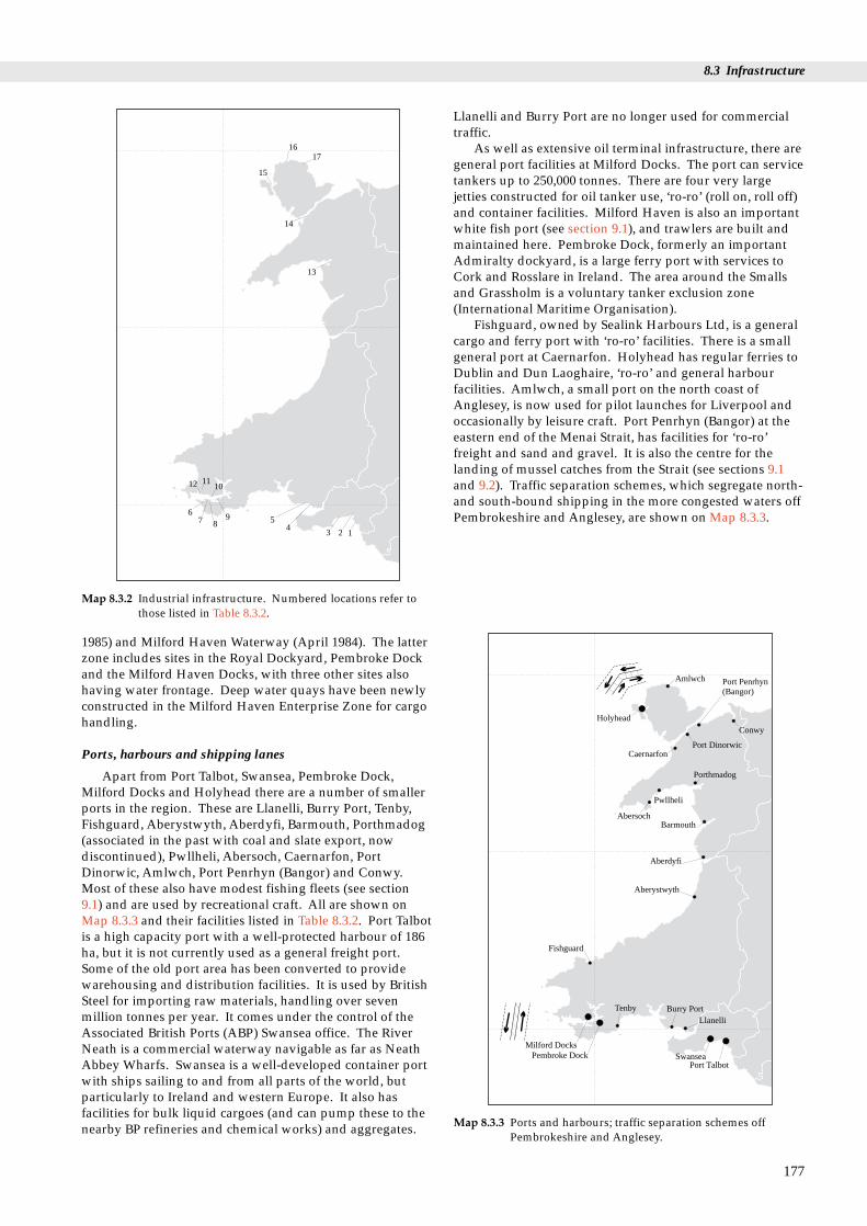
8.3 Infrastructure
Port Penrhyn(Bangor)
Amlwch
HolyheadConwy
67 8
9
101112
54
3 2 1
1716
15
14
13
Map 8.3.2 Industrial infrastructure. Numbered locations refer tothose listed in Table 8.3.2.
1985) and Milford Haven Waterway (April 1984). The latterzone includes sites in the Royal Dockyard, Pembroke Dockand the Milford Haven Docks, with three other sites alsohaving water frontage. Deep water quays have been newlyconstructed in the Milford Haven Enterprise Zone for cargohandling.
Aberystwyth
Aberdyfi
Barmouth
Pwllheli
Abersoch
Porthmadog
CaernarfonPort Dinorwic
Fishguard
Milford DocksPembroke Dock Swansea
Port Talbot
Llanelli
Tenby Burry Port
Map 8.3.3 Ports and harbours; traffic separation schemes offPembrokeshire and Anglesey.
Ports, harbours and shipping lanes
Apart from Port Talbot, Swansea, Pembroke Dock,Milford Docks and Holyhead there are a number of smallerports in the region. These are Llanelli, Burry Port, Tenby,Fishguard, Aberystwyth, Aberdyfi, Barmouth, Porthmadog(associated in the past with coal and slate export, nowdiscontinued), Pwllheli, Abersoch, Caernarfon, PortDinorwic, Amlwch, Port Penrhyn (Bangor) and Conwy.Most of these also have modest fishing fleets (see section9.1) and are used by recreational craft. All are shown onMap 8.3.3 and their facilities listed in Table 8.3.2. Port Talbotis a high capacity port with a well-protected harbour of 186ha, but it is not currently used as a general freight port.Some of the old port area has been converted to providewarehousing and distribution facilities. It is used by BritishSteel for importing raw materials, handling over sevenmillion tonnes per year. It comes under the control of theAssociated British Ports (ABP) Swansea office. The RiverNeath is a commercial waterway navigable as far as NeathAbbey Wharfs. Swansea is a well-developed container portwith ships sailing to and from all parts of the world, butparticularly to Ireland and western Europe. It also hasfacilities for bulk liquid cargoes (and can pump these to thenearby BP refineries and chemical works) and aggregates.
Llanelli and Burry Port are no longer used for commercialtraffic.
As well as extensive oil terminal infrastructure, there aregeneral port facilities at Milford Docks. The port can servicetankers up to 250,000 tonnes. There are four very largejetties constructed for oil tanker use, ‘ro-ro’ (roll on, roll off)and container facilities. Milford Haven is also an importantwhite fish port (see section 9.1), and trawlers are built andmaintained here. Pembroke Dock, formerly an importantAdmiralty dockyard, is a large ferry port with services toCork and Rosslare in Ireland. The area around the Smallsand Grassholm is a voluntary tanker exclusion zone(International Maritime Organisation).
Fishguard, owned by Sealink Harbours Ltd, is a generalcargo and ferry port with ‘ro-ro’ facilities. There is a smallgeneral port at Caernarfon. Holyhead has regular ferries toDublin and Dun Laoghaire, ‘ro-ro’ and general harbourfacilities. Amlwch, a small port on the north coast ofAnglesey, is now used for pilot launches for Liverpool andoccasionally by leisure craft. Port Penrhyn (Bangor) at theeastern end of the Menai Strait, has facilities for ‘ro-ro’freight and sand and gravel. It is also the centre for thelanding of mussel catches from the Strait (see sections 9.1and 9.2). Traffic separation schemes, which segregate north-and south-bound shipping in the more congested waters offPembrokeshire and Anglesey, are shown on Map 8.3.3.
177
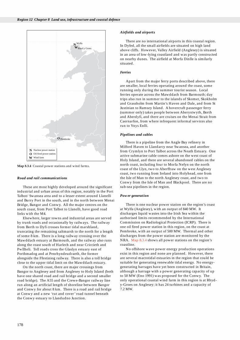
Region 12 Chapter 8 Land use, infrastructure and coastal defence
N
O
OW
N
W
Pembroke
Wylfa
Rhyd y Groes
Nuclear power station
Oil-fired power station
Wind farm
Map 8.3.4 Coastal power stations and wind farms.
Road and rail communications
These are most highly developed around the significantindustrial and urban areas of this region, notably in the PortTalbot/Swansea area and to a lesser extent around Llanelliand Burry Port in the south, and in the north between MenaiBridge, Bangor and Conwy. All the major centres on thesouth coast, from Port Talbot to Llanelli, have good roadlinks with the M4.
Elsewhere, larger towns and industrial areas are servedby trunk roads and occasionally by railways. The railwayfrom Borth to Dyfi crosses former tidal marshland,truncating the remaining saltmarsh to the north for a lengthof some 8 km. There is a long railway crossing over theMawddach estuary at Barmouth, and the railway also runsalong the coast south of Harlech and near Criccieth andPwllheli. Toll roads cross the Glaslyn estuary east ofPorthmadog and at Penrhyndeudraeth, the formeralongside the Ffestiniog railway. There is also a toll bridgeclose to the upper tidal limit on the Mawddach estuary.
On the north coast, there are major crossings fromBangor to Anglesey and from Anglesey to Holy Island (bothhave one shared road and rail bridge and a second smallerroad bridge). The A55 and the Crewe-Bangor railway linerun along an artificial length of shoreline between Bangorand Conwy for about 8 km. There is a road and rail bridgeat Conwy and a new ‘cut and cover’ road tunnel beneaththe Conwy estuary to Llandudno Junction.
178
Airfields and airports
There are no international airports in this coastal region.In Dyfed, all the small airfields are situated on high landabove cliffs. However, Valley Airfield (Anglesey) is situatedin an area of low-lying coastland and was partly constructedon nearby dunes. The airfield at Morfa Dinlle is similarlysituated.
Ferries
Apart from the major ferry ports described above, thereare smaller, local ferries operating around the coast, somerunning only during the summer tourist season. Localferries operate across the Mawddach from Barmouth; daytrips also run in summer to the islands of Skomer, Skokholmand Grassholm from Martin’s Haven and Dale, and from StJustinian to Ramsey Island. A hovercraft passenger ferry(summer only) takes people between Aberystwyth, Borthand Aberdyfi, and there are cruises on the Menai Strait fromCaernarfon, from where infrequent informal services alsorun to Ynys Enlli.
Pipelines and cables
There is a pipeline from the Angle Bay refinery inMilford Haven to Llandarcy near Swansea, and anotherfrom Crymlyn to Port Talbot across the Neath Estuary. Oneactive submarine cable comes ashore on the west coast ofHoly Island, and there are several abandoned cables on thenorth coast, including four to Morfa Nefyn on the northcoast of the Llyn, two to Aberffraw on the west Angleseycoast, two running from Ireland into Holyhead, one fromthe Isle of Man to the north Anglesey coast, and two toConwy from the Isle of Man and Blackpool. There are nosub-sea pipelines in the region.
Power generation
There is one nuclear power station on the region’s coastat Wylfa (Anglesey), with an output of 840 MW. Itdischarges liquid wastes into the Irish Sea within theauthorised limits recommended by the InternationalCommission on Radiological Protection (ICRP). There isone oil fired power station in this region, on the coast atPembroke, with an output of 500 MW. Thermal and otherdischarges from the power station are monitored by theNRA. Map 8.3.4 shows all power stations on the region’scoastline.
No offshore wave power energy production operationsexist in this region and none are planned. However, thereare several macrotidal estuaries in the region that could besuitable for generating renewable tidal energy. No energy-generating barrages have yet been constructed in Britain,although a barrage with a power generating capacity of upto 50 MW (Eno 1991) was proposed for the Conwy. Theonly operational coastal wind farm in this region is at Rhyd-y-Groes on Anglesey; it has 24 turbines and a capacity of 7.2 MW.

8.3 Infrastructure
8.3.3 Effects of human activities
The populations of the Gwynedd and Dyfed coastal townsare predicted to increase by around 5% from 1985-2001(Evans & Thomason 1990). Land use policies are nowincreasingly geared to strengthening the identities ofexisting towns and restricting countryside development.For example, all the County Councils have policies tominimise urban expansion into agricultural land. There arealso increasing efforts being put into stemming the declineof the rural population, particularly in Dyfed and Gwynedd(see also Tir Cymen - section 7.4.4).
The scale and impacts of industrial land-claim in theregion and elsewhere in Britain are discussed in Davidson etal. (1991) and Buck (1993). Doody (undated) hasinvestigated the impacts of industrial land claim on thecoastline of south Wales, measuring the loss of semi-naturalhabitat at fourteen sites on the industrialised south Walescoast by comparing Ordnance Survey maps from 1889 and1985. The sites were: Port Talbot/Margam, Baglan Burrows,River Neath, Crymlyn Burrows, Crymlyn Bog, Swansea Bay,Swansea Docks, Pennard Burrows, Whiteford/BroughtonBurrows, Loughor Bridge, Loughor River, Llanelli Harbour,Burry Port and Pembrey Burrows. He found that, out of anoriginal area of 4,330 ha of semi-natural habitat, there hadbeen a total loss of 2,689 ha of sand dune, saltmarsh,‘marsh’, bog, intertidal flats and coastal grassland as a resultof human developments, including industry, docks, forestry,agriculture and housing.
8.3.4 Information sources used
The information on population statistics comes from Cook(1993), who uses data from population censuses from anumber of dates, including the 1981 census; some figuresmay therefore be slightly out of date. Map 8.3.1 is based onthe ITE (1993) Countryside Survey 1990 database and areasshown include both continuous urban areas andsuburban/rural developments.
Industrial development data came from Buck (1993),Cook (1993), Ordnance Survey Landranger 1:50,000 maps,Bown (1990), Dyfed County Council (1980, 1987), GwyneddCounty Council (1991), Hobbs & Morgan (1992), WestGlamorgan County Council (1993), and Doody (undated).
Areas of coastal industrial developments in Table 8.3.2and Map 8.3.2 are as shown on OS 1:50,000 Landrangermaps; however some of these sites will undoubtedly havesince been abandoned (as indicated by Hobbs & Morgan1992 for Milford Haven). Up to date information is held bylocal planning authorities (see Appendix). Most of theinformation on ports was derived from the two nationalhandbooks for the British Ports Federation (BPF) (undated)and Sutton (1989), which may be incomplete or out of date.In 1991 the BPF was replaced by the British PortsAssociation and the UK Major Ports Group. LordDonaldson (1994) records that there is little clearinformation available on where ships go within UK waters.
Most of the information on road and rail links, bridges,ferries and airfields was derived from 1:50,000 Land RangerOrdnance Survey maps. Cables and pipelines are shown onthe UKDMAP and Admiralty Charts. It is not always clearfrom these sources which of these communicationsinfrastructures are still in use.
8.3.5 Further sources of information
A. References cited
Bown, D.P. 1990. Coastal resources and proposed developments.In: The Irish Sea, an environmental review. Part 4. Planning,development and management, ed. by H.D. Smith & A.J. Geffen.Liverpool, Irish Sea Study Group, Liverpool University Press.
British Oceanographic Data Centre, Proudman Laboratory. 1991.UKDMAP (United Kingdom Digital Marine Atlas). Version 2.Computer software. British Oceanographic Data Centre,Proudman Laboratory, Birkenhead.
British Ports Federation. Undated. UK member ports directory.London, British Ports Federation.
Buck, A.L. 1993. An inventory of UK estuaries. Volume 2. South-WestBritain. Peterborough, Joint Nature Conservation Committee.
Cook, C. 1993. Pears cyclopaedia 1993-1994. London, Penguin BooksLtd.
Countryside Council for Wales. 1992. Energy: policy and perspectivesfor the Welsh countryside (policy document) (CCC031). Bangor.
Davidson, N.C., Laffoley, D.d’A., Doody, J.P., Way, L.S., Gordon, J.,Key, R., Drake, M.C., Pienkowski, M.W., Mitchell, R., & Duff,K.L. 1991. Nature conservation and estuaries in Great Britain.Peterborough, Nature Conservancy Council.
Doody, J.P. Undated. Coastal habitat change - a historical review ofman’s impact on the coastline of Great Britain. Peterborough, JointNature Conservation Committee (unpublished draft).
Dyfed County Council. 1980. Dyfed county structure plan writtenstatement. Carmarthen, Dyfed County Council.
Dyfed County Council. 1987. Dyfed county structure plan proposalsfor alteration. Carmarthen, Dyfed County Council.
Eno, N.C., ed. 1991. Marine conservation handbook. 2nd ed.Peterborough, English Nature.
Evans D.M., & Thomason, H. 1990. Tourism and recreationaldevelopments. In: The Irish Sea, an environmental review. Part 4.Planning, development and management, ed. by H.D. Smith & A.J.Geffen. Liverpool, Irish Sea Study Group, Liverpool UniversityPress.
Gwynedd County Council. 1991. Gwynedd county structure planwritten statement. Caernarfon, Gwynedd County Council.
Hobbs, G., & Morgan, C.I. 1992. A review of the current state ofenvironmental knowledge of the Milford Haven Waterway.Report to the Milford Haven Waterway Environmental MonitoringSteering Group. Field Studies Council Research Centre, 5/92.Pembroke.
Institute of Terrestrial Ecology. 1993. Countryside survey 1990: mainreport. London, Department of the Environment.
Lord Donaldson. 1994. Safer seas, cleaner ships. Report of LordDonaldson’s Inquiry into the prevention of pollution from merchantshipping. CM2560. HMSO, London.
Smith, H.D., & Geffen, A.J., eds. 1990. The Irish Sea: an environmentalreview. Part 4. Planning, development and management.Liverpool, Liverpool University Press. (Irish Sea Study Group.)
Sutton, G, ed. 1989. ABP ’89, A guide to the ports and shipping servicesof Associated British Ports Holdings plc. King’s Lynn, CharterInternational Publications Ltd.
Welsh Office. 1993. Environment digest for Wales. No.7, 1992.Cardiff, Welsh Office.
West Glamorgan County Council. 1993. West Glamorgan structureplan. Swansea, West Glamorgan County Council.
179
Region 12 Chapter 8 Land use, infrastructure and coastal defence
B. Further reading
ACOPS. 1990. Survey of oil pollution around the coasts of the UnitedKingdom. Advisory Committee on Pollution of the Sea. AnnualReport.
Barne, J., Davidson, N.C., Hill, T.O., & Jones, M. 1994. Coastal andMarine UKDMAP datasets: a user manual. Peterborough, JointNature Conservation Committee.
British Ports Association. 1994. British Ports Association 1994.King’s Lynn, Charter International.
Chris Blandford Associates. 1994. Wind turbine power stationconstruction monitoring study. Chris Blandford Associates, inassociation with University of Wales, Bangor. (A reportcommissioned by the Countryside Council for Wales.)
Countryside Council for Wales. 1992. Wind turbine power stations(policy document CCC031). Bangor.
Department of the Environment. 1992. Enterprise zones. London,Department of the Environment.
Department of Transport. 1991. Port statistics 1990. Department ofTransport & British Ports Federation.
European Sea Ports Organisation. 1994. Environmental Code ofPractice. Brussels.
Huckbody, A.J, Taylor, P.M., Hobbs, G., & Elliott, R. 1992.Caernarfon and Cardigan Bays: an environmental appraisal.London, Hamilton Oil Company.
Institute of Petroleum Information Service. 1993. UK petroleumindustry statistics: consumption and refinery production. London,Institute of Petroleum.
Irish Sea Study Group. 1990. The Irish Sea; an environmental review.Liverpool, Liverpool University Press.
North Sea Task Force. 1993. North Sea Quality Status Report 1993.Oslo and Paris Commissions, London.
Scottish Office. 1993. The Scottish environment - statistics, No. 4 1993.Edinburgh, The Government Statistical Service.
Taylor, P.M., & Parker, J.G., eds. 1993. The coast of north Wales andnorth-west England: an environmental appraisal. London,Hamilton Oil Company Ltd.
Technica. 1995. Shipping routes in the area of the United Kingdomcontinental shelf. Prepared by Technica for the Department ofEnergy. London, HMSO.
180

C. Contact names and addresses
Type of information Contact address and telephone no.
Industrial development, David Gleave, Department of the Enterprise Zones, oil Environment, 2 Marsham Street, terminals London SW1P 3EB,
tel. 0171 276 6166
Lower Swansea Valley John Weston, Lower Swansea Enterprise Zone Valley Enterprise Zone, Swansea
City Council, Guild Hall, SwanseaSA1 4PH, tel. 01792 302748
Milford Haven Waterway Economic Development Officer, Enterprise Zone Milford Haven Waterway
Enterprise Zone, EconomicDevelopment Unit, SouthPembrokeshire District Council,Pier House, Pier Road, PembrokeDock SA72 6TR, tel. 01646 684914
Oil and gas development Public Relations Officer, policy Department of Trade and Industry,
1 Palace Street, London SW1E5HE, tel: 0171 238 3214
Oil refinery environmental The Chairman, Milford Haven problems and general marine Waterway Environmental environmental issues Monitoring Steering Group, (Milford Haven) County Civil Protection Planning
Unit, Hill House, Picton Terrace,Carmarthen, Dyfed SA31 3BS, tel: 01267 236651
Oil transportation and Technical Adviser, Oil Companies terminals International Marine Forum
(OCIMF), OCIMF, 15th Floor,96 Victoria Street, London SW1E 5JW, tel: 0171 828 7966
Oil developments and *Projects Officer, Cardigan Bay general issues Forum, Aberystwyth,
tel: 01970 624471
as above *Secretary, Carmarthen Bay Forum,Whitland, Dyfed, tel: 01994 419313
as above *Chairman, North Wales CoastalForum, Pwllheli, tel. 01758 83423
Research on local issues The Director, Field Studies CouncilResearch Centre, Fort Popton,Angle, Pembroke, Dyfed SA71 5AD, tel: 01646 641404
Ports, harbours and shipping lanes
International Maritime 4 Albert Embankment, London Organisation SE1 7SR, tel. 0171 735 7611
Associated British Ports; Associated British Ports (Swansea), Port Talbot Harbour Harbour Office, Adelaide Street,
Swansea, West Glamorgan SA1 1QR, tel. 01792 650855
British Ports Association British Ports Association, AfricaHouse, 64-78 Kingsway, LondonWC2B 6AH, tel. 0171 242 1200
The UK Major Ports The UK Major Ports Group Ltd, Group Ltd 150 Holborn, London EC1N 2LR,
tel. 0171 404 2008
Neath Harbour Bankside, The Green, Neath, Commissioners tel. 01639 633486
Swansea Bay Port Health Swansea Bay Port Health Authority Authority, Kings Dock Lock,
Swansea SA1 8RU, tel. 01792 653523
Milford Haven Port Milford Haven Port Authority, PO Box 14, Milford Haven,Pembrokeshire, Dyfed SA73 3ER,tel. 016462 3091/4
Milford Docks The Milford Docks Company, The Docks, Milford Haven, DyfedSA73 3AF, tel. 016462 2271/3
Milford Haven Port Health Milford Haven Port Health Authority Authority, Gorsewood Drive,
Hakin, Milford Haven, Pembs.SA73 3EP, tel. 01646 69486
Fishguard Harbour Sealink Harbours Ltd, FishguardHarbour, Dyfed SA64 0BU, tel. 01348 872220
Caernarfon Harbour Caernarfon Harbour Trust,Harbour Office, Slate Quay,Caernarfon, Gwynedd LL55 2PB,tel. 01286 2118
Holyhead Harbour Sealink Harbours Ltd, SealinkHouse, Turkey Shore Road,Holyhead, Gwynedd, tel. 01407 2304
Power generation
Energy production general Department of Energy, 1 PalaceStreet, London SW1E 5HE, tel. 0171 238 3000
Energy production general Secretary, Institute of Energy, 18 Devonshire Street, London W1N 2AU, tel. 0171 580 7124
Wave and hydro power Project Director, Energy SystemsGroup, Department of Electrical,Electronic and SystemsEngineering, Priory Street,Coventry CV1 5FB, tel. 01203 838861
Hydro, solar, tidal, wave Business Development Manager, and wind power Energy Technology Support Unit
(ETSU), Building 156, Harwell,Oxfordshire OX11 0RA, tel. 01235 43317
Offshore wind farms The Senior Lecturer, School ofOcean Sciences, University ofWales, Menai Bridge, Bangor,Gwynedd LL59 5EY, tel. 01248351151
Wind energy- general Chairman, British Wind EnergyAssociateion (BWEA), 4 HamiltonPlace, London W1V 0BQ, tel. 0171 499 3515
Wind farms - general Public Information Officer, CoastalGeology Group. British GeologicalSurvey, Kingsey Dunham Centre,Keyworth, Nottingham NG12 5GG, tel. 01602 363100
8.3 Infrastructure
181
Type of information Contact address and telephone no.

C. Contact names and addresses (continued)
Region 12 Chapter 8 Land use, infrastructure and coastal defence
* Starred contact addresses are given in full in the Appendix
Type of information Contact address and telephone no.
Energy resources Energy Officer, WelshDevelopment Agency, Ash RoadNorth, Wrexham Industrial Estate,Wrexham, Clwyd LL13 9FU, tel. 01978 661011
Conventional power Public Relations Officer, Pembroke Station production/Pembroke Power
Station, Pembroke, Dyfed Power SA71 5SF, tel. 01646 661011
Pollution from energy Her Majesty’s Inspectorate ofproduction (Wales) Pollution (HMIP), Public Registry,
Brunel House, Cardiff CF2 1SH,tel. 01222 495558
Pollution from energy Pollution Control Officer, NRAproduction (Wales) (Welsh Region), Glan Teifi, Barley
Mow, Lampeter, Dyfed SA48 7BY, tel. 01570 422455
Pollution from conventional Pollution Control Officer, National power production (Pembroke Rivers Authority (NRA), Llys power station) Afon, Hawthorne Rise,
Haverfordwest, Dyfed SA71 2BQ,tel. 01437 760081
Type of information Contact address and telephone no.
Nuclear power (Wylfa NPS) Public Relations Officer, WylfaNPS, Nuclear Electric, Cemaes Bay,Anglesey, Gwynedd LL67 0DH,tel. 01407 733733
Radioactive discharges Information Officer, NationalRadiological Protection Board(NRPB), Chilton, Didcot,Oxfordshire OX11 0RQ, tel. 01235 831600
General energy issues *Projects Officer, Cardigan BayForum, Aberystwyth, tel. 01970 624471
as above *Secretary, Carmarthen Bay Forum,Whitland, Dyfed, tel. 01994 419313
as above *Chairman, North Wales CoastalForum, Pwllheli, tel. 01758 83423
Nuclear issues - general Secretary-General, British NuclearForum, 22 Buckingham Gate,London SW1E 6LB, tel. 0171 828 0166
8.3.6 Acknowledgements
Thanks to Colin Macduff-Duncan (Esso), for providinginformation and commenting on drafts.
182

8.4 Coastal defence
8.4.1 Introduction
Coastal defence covers two types of works: coast protectionand sea or flood defence. Coast protection works prevent orslow the erosion of land and encroachment by the sea, andare generally the responsibility of District Councils. Sea orflood defence works are built to protect low-lying land fromflooding by high tides and are the responsibility of theNational Rivers Authority, although Internal DrainageBoards and local authorities can also undertake flooddefence works. Some coastal defences are owned andmaintained privately or by other bodies such as the MoD.Railtrack (formerly British Rail) maintains some importantstretches of coastal defence alongside railway lines.
The hard rock and rugged nature of much of the Welshcoast greatly reduces the requirement for coast protection inthe region. Here such works are built mainly to protectcoastal settlements, industrial areas or historic sites, and arealso located alongside bridges or road and railembankments. Sea defences in the region are built mainlyin low-lying estuaries and inlets, or where natural coastalhabitats such as sand dunes have been lost or damagedthrough man’s activities. Sand dune systems are importantfor providing natural dynamic coastal defences (see section3.2). Where human activities have caused erosion or duneshave been used for housing and industrial purposes, thisnatural form of defence is lost and artificial defences becomenecessary. This has occurred in the region, especially alonglengths of the south and north coasts.
Flood defences are common in the region where areas offormer intertidal land have been claimed from the sea foragricultural or industrial use. They usually take the form ofartificial embankments bordering areas of land claim. Apartfrom on estuaries, there are not many areas of land claim inthe region that are vulnerable to flooding. However, insome parts of the region, for example Swansea Bay, theextremely high tidal range contributes to the land’ssusceptibility to flooding.
8.4 Coastal defenceM.J. Dunbar, S.J. Everett and S.L. Fowler
Table 8.4.1 Lengths of defended and undefended coastline in the regi
District Coast Sea defenceprotection
Port Talbot 9.1 0Neath 3.5 0Swansea 13.9 2.2Lliw Valley 0 0Llanelli 9.3 5.3Carmarthen 3.1 4.7S. Pembrokeshire 12.0 0.1Preseli 12.3 1.5Ceredigion 14.6 11.2Meirionnydd 27.7 27.5Dwyfor 16.4 10.0Arfon 16.7 5.1Anglesey 32.4 1.9Aberconwy 23.4 2.4Region total 137.7 34.4
Source: Welsh Office 1995. ‘Hard’ natural coastline includes sections of
Although coastal protection works are generally on asmall scale compared with other parts of the UK, theirimpacts may be locally significant. For example, the ‘Cob’embankment and road/rail bridge at Porthmadogdramatically changed the form of the Glaslyn estuary whenit was built in the 19th century.
8.4.2 Important locations
The coastal defence works in the region are shown on Map8.4.1 (adapted from undated Welsh Office map) and arefound mainly on the open coast, but occasionally withinestuaries and inlets. In some areas, notably around SwanseaBay, the shoreline is completely artificial for severalkilometres. Several ports have large breakwaters, forexample Port Talbot, Fishguard and Holyhead.
The scattered flood defence works in the region arelocated chiefly along the Loughor Estuary, in CarmarthenBay, in the Dyfi, Mawddach and Glaslyn estuaries andMalltraeth Bay on Anglesey. In some of the mid-Walesestuaries the shoreline is completely artificial for severalkilometres, and virtually all estuaries have been altered tosome extent as a result of flood defence works, land claim,dredging or canalisation. More details on coastal defenceworks in estuaries may be found in Buck (1993).
The results of a recent coast protection survey by theWelsh Office are given in Table 8.4.1.
8.4.3 Information sources
The Welsh Office have compiled the results of the 1994 coastprotection survey into a database. British Rail (nowRailtrack) have also surveyed their coastal works.
More detailed information on flood defences can beobtained from the NRA, who carried out a sea defence
183
on by district (km)
‘Soft’ natural ‘Hard’ natural Total lengthcoastline coastline of coastline
3.6 0 12.73.0 0 6.5
35.1 32.4 83.63.0 0 3.0
20.9 2.0 37.518.0 7.2 32.9
6.3 72.0 90.48.6 145.1 167.6
19.3 51.3 96.428.7 13.8 97.743.6 60.5 130.522.5 4.3 48.543.8 127.9 205.917.0 8.2 51.0
194.5 450.4 817.0
cliff and rocky coast; other sections are ‘soft’.

Region 12 Chapter 8 Land use, infrastructure and coastal defence
184
Ynys Enlli–LlandudnoCoastal Group
Liverpool BayCoastal Group
Cardigan BayCoastal Group
Carmarthen BayCoastal Group
Swansea BayCoastal Group
Sea defence (NRA)
Coast protection (LAs)
Other defences (e.g. MOD, BR)
Map 8.4.1 Coastal defences and lengths of coast covered by Coastal Groups (see also section 10.3). Source: Welsh Office. © Crowncopyright.

8.4 Coastal defence
survey in 1991. The results of this are held in a proprietarydatabase cross-referenced to maps, and may be viewed atregional NRA offices by prior arrangement. This surveyincludes coast protection structures in areas where wavesplash-over would also cause flooding.
8.4.4 Further sources of information
A. References cited
Buck, A.L. 1993. An inventory of UK estuaries. 3. South-west Britain.Peterborough, Joint Nature Conservation Committee.
B. Further reading
Barber, P.C., & Thomas, R.C. 1989. Case study at Carmarthen Bay.In: Coastal management, proceedings of ICE Conference, May 1989.Thomas Telford.
Bullen and Partners. 1994. Swansea Bay Sea Defence Assessment.Bristol. Unpublished report to the NRA.
Bullen and Partners & James and Nicholas, Consulting Engineers.1993. Coastline response study: Worms Head to Penarth Head.Unpublished report to local authorities group, NRA and CCW.
House of Commons. 1992. Environment Select Committee report oncoastal zone protection and planning.
Hydraulics Research Ltd. 1991. A summary guide to the selectionof coast protection works for geological Sites of SpecialScientific Interest. Nature Conservancy Council, CSD Report, No.1245. (Unpublished report.)
Ministry of Agriculture, Fisheries and Food. 1993. Coastal defenceand the environment: a guide to good practice. London, MAFF.
Ministry of Agriculture, Fisheries and Food. 1993. Coastal defenceand the environment: a strategic guide for managers and decisionmakers in the National Rivers Authority, local authorities and otherbodies with coastal responsibilities. London, MAFF.
Ministry of Agriculture, Fisheries and Food. 1993. Flood and coastaldefence project appraisal guidance note.
Ministry of Agriculture, Fisheries and Food/Welsh Office. Flood andcoastal defence strategy for England and Wales.
National Rivers Authority. 1993. NRA flood defence strategy.London, NRA.
Rendel Geotechnics. 1995. Coastal planning and management: areview of earth science information needs. London, HMSO.
C. Contact names and addresses
Type of information Contact address and telephone no.
Responsibility for coastal Hugh Payne, Environment defence policies & provision Division, Welsh Office (Y Swyddfa of grants. Coastal defence Gymreig), Parc Cathays, Cardiff survey database (1994). CF1 3NQ, tel: 01222 823176
Coast protection. Power to Responsibility of Maritime District carry out works to protect Councils (see Appendix).land from erosion and encroachment by the sea andto prevent the flooding ofnon-agricultural land.
Flood defence National Rivers Authority, WelshRegion, Rivers House, Cardiff CF3 0LT, tel. 01222 770088
Co-operation between Welsh Coastal Groups Forum, parties responsible for coastal Welsh Office Environment defences, identification of Division, Parc Cathays, research needs and Cardiff CF1 3NQpromotion of strategic planning of coastal defences
as above Swansea Bay Coastal Group,Chairman: M E Thomas, ChiefTechnical Officer, Ogwr BoroughCouncil, P.O. Box 4, Civic Offices,Angel Street, Bridgend, MidGlamorgan CF31 1LX, tel. 01656 643643
as above Carmarthen Bay Coastal Group,Chairman: R Paul Thomas,*Llanelli Borough Council, tel. 01554 741100
as above Cardigan Bay Coastal Group,Chairman: Martin Wright,*Meirionnydd District Council, tel. 01341 422341
as above Ynys Enlli to Llandudno CoastalGroup, Chairman: M F Davies,National Rivers Authority, BrynMenai, Holyhead Road, Bangor,Gwynedd LL57 2EF, tel. 01248 370970
as above Liverpool Bay Coastal Group,Chairman: A M Rhodes, BoroughEngineer, Metropolitan Borough ofWirral, Town Hall, Bebington,Wirral L63 7PT, tel. 0151 645 2080
Wildlife and landscape *Coastal Scientist, CCW HQ, conservation issues and Bangor, tel: 01248 370734advice
Coastal Engineering Secretary: Anne-Marie Ferguson, Advisory Panel Institute of Civil Engineers, Great
George Street, London SW1P 3AA,tel. 0171 222 7722
* Starred contact addresses are given in full in the Appendix
185

Region 12 Chapter 8 Land use, infrastructure and coastal defence
8.4.5 Acknowledgements
Thanks to Hugh Payne (Welsh Office), the Cardigan BayForum and the University of Greenwich for their kindassistance in obtaining information for this region.
186

Penrhyn
ConwyBangor
Caernarfon
PortmadogPwllheli
Barmouth
Aberdaron
MenaiBridge
HolyheadBeaumaris
Aberdovey
Ynyslas
Aberystwyth
Aberaeron
New QuayCardigan
Fishguard
Three Rivers Area
Llanelli
Swansea
Port TalbotPenclawdd
Milford Haven
Solva
St Davids
South WalesSea FisheriesCommittee
North West andNorth WalesSea FisheriesCommittee
Other portMajor port
Map 9.1.1 Landing ports and coverage of the region by SeaFisheries Committees.
Chapter 9 Human activities
9.1.1 Introduction
This section gives an overview of the main fishing activities inthe coastal waters and rivers of the region. There are fisheriesfor pelagic and demersal fish (demersal fish live on or near thesea bed; pelagic fish do not), marine shellfish species, anddiadromous fish - salmon, sea trout and eels - which spendpart of their lives in fresh water and part at sea. The sectionalso covers sea angling and bait collection. For this section,West Coast figures include figures for the Isle of Man, exceptwhere stated otherwise. For more information about thespecies concerned, see sections 5.5, 5.7 and 5.8.
Milford Haven is now the only port with a substantialmarket and is the single 'major port' (as identified in MAFF(1994b) from fish landings) in the region (Map 9.1.1). Map9.1.1 also shows the 25 other smaller ports where landings aremade in the region and are recorded by the Ministry ofAgriculture, Fisheries and Food (MAFF). The fishing industryis important to many sectors of the local economy but itsdevelopment is limited in many areas in the region by poorroad and rail links with major markets. The tonnage ofshellfish and pelagic and demersal fish landed reflects this fact(see Table 9.1.1). Of all recorded landings of fish and shellfishspecies in GB and the Isle of Man, the proportions landed inthis region are below average for regions in GB and very smallcompared with those for some regions, for example inScotland. Nevertheless, the region is of major importance forcertain demersal species (see section 9.1.2).
The northern and southern coasts of the region are themost important for fin fish (i.e. pelagic, demersal anddiadromous species) landings, with Milford Haven inparticular being an important landing centre for fish caughtlocally, in the Bristol Channel and to the south and west ofIreland.
Holyhead is an important landing centre for both fin fishand shellfish. In the central part of the region, from Pembroketo the Llyn Peninsula, the fishery is predominantly for a wide
9.1 FisheriesC.F. Robson
Table 9.1.1 Total tonnages of pelagic and demersal fish and shellfish lan
Species group Tonnage Tonnagetotals landed in landed in West
region Coast (includes EIsle of Man)
Pelagic 28 68,029Demersal 4,936 47,409Shellfish 3,411 42,987All groups 8,375 158,425
Sources: Scottish Office Agriculture and Fisheries Department (1993), MinDepartment of Agriculture, Fisheries & Forestry. Note: Amounts landed this table is complex: refer to section 9.1.4.
range of shellfish species taken by local boats close to theirhome base. For shellfish species such as cockles, lobster andwhelk, the landing figures in the region are important in thenational context.
187
ded in the region in 1992
Tonnage Total tonnage % of West % of GB andlanded in landed in GB Coast total Isle of Manngland and and Isle of landed in total landed in
Wales Man region region
23,809 252,339 <0.1 <0.181,237 275,476 10.4 1.855,360 104,926 7.9 3.3
160,406 632,741 5.2 1.3
istry of Agriculture, Fisheries and Food (1994a,b,c) and Isle of Manare rounded up to the next whole tonne. Interpretation of the figures in
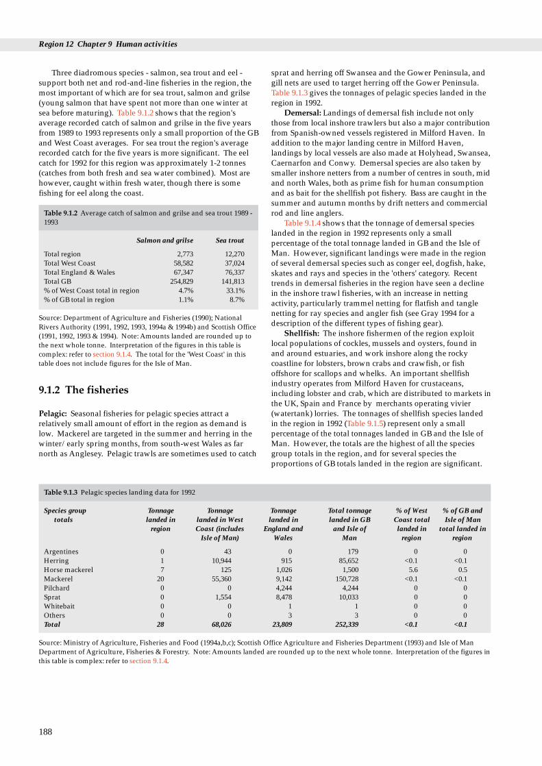
Region 12 Chapter 9 Human activities
Three diadromous species - salmon, sea trout and eel -support both net and rod-and-line fisheries in the region, themost important of which are for sea trout, salmon and grilse(young salmon that have spent not more than one winter atsea before maturing). Table 9.1.2 shows that the region'saverage recorded catch of salmon and grilse in the five yearsfrom 1989 to 1993 represents only a small proportion of the GBand West Coast averages. For sea trout the region's averagerecorded catch for the five years is more significant. The eelcatch for 1992 for this region was approximately 1-2 tonnes(catches from both fresh and sea water combined). Most arehowever, caught within fresh water, though there is somefishing for eel along the coast.
Table 9.1.2 Average catch of salmon and grilse and sea trout 1989 -1993
Salmon and grilse Sea trout
Total region 2,773 12,270Total West Coast 58,582 37,024Total England & Wales 67,347 76,337Total GB 254,829 141,813% of West Coast total in region 4.7% 33.1%% of GB total in region 1.1% 8.7%
Source: Department of Agriculture and Fisheries (1990); NationalRivers Authority (1991, 1992, 1993, 1994a & 1994b) and Scottish Office(1991, 1992, 1993 & 1994). Note: Amounts landed are rounded up tothe next whole tonne. Interpretation of the figures in this table iscomplex: refer to section 9.1.4. The total for the 'West Coast' in thistable does not include figures for the Isle of Man.
9.1.2 The fisheries
Pelagic: Seasonal fisheries for pelagic species attract arelatively small amount of effort in the region as demand islow. Mackerel are targeted in the summer and herring in thewinter/early spring months, from south-west Wales as farnorth as Anglesey. Pelagic trawls are sometimes used to catch
188
Table 9.1.3 Pelagic species landing data for 1992
Species group Tonnage Tonnagetotals landed in landed in West
region Coast (includesIsle of Man)
Argentines 0 43Herring 1 10,944Horse mackerel 7 125Mackerel 20 55,360Pilchard 0 0Sprat 0 1,554Whitebait 0 0Others 0 0Total 28 68,026
Source: Ministry of Agriculture, Fisheries and Food (1994a,b,c); Scottish ODepartment of Agriculture, Fisheries & Forestry. Note: Amounts landedthis table is complex: refer to section 9.1.4.
sprat and herring off Swansea and the Gower Peninsula, andgill nets are used to target herring off the Gower Peninsula.Table 9.1.3 gives the tonnages of pelagic species landed in theregion in 1992.
Demersal: Landings of demersal fish include not onlythose from local inshore trawlers but also a major contributionfrom Spanish-owned vessels registered in Milford Haven. Inaddition to the major landing centre in Milford Haven,landings by local vessels are also made at Holyhead, Swansea,Caernarfon and Conwy. Demersal species are also taken bysmaller inshore netters from a number of centres in south, midand north Wales, both as prime fish for human consumptionand as bait for the shellfish pot fishery. Bass are caught in thesummer and autumn months by drift netters and commercialrod and line anglers.
Table 9.1.4 shows that the tonnage of demersal specieslanded in the region in 1992 represents only a smallpercentage of the total tonnage landed in GB and the Isle ofMan. However, significant landings were made in the regionof several demersal species such as conger eel, dogfish, hake,skates and rays and species in the 'others' category. Recenttrends in demersal fisheries in the region have seen a declinein the inshore trawl fisheries, with an increase in nettingactivity, particularly trammel netting for flatfish and tanglenetting for ray species and angler fish (see Gray 1994 for adescription of the different types of fishing gear).
Shellfish: The inshore fishermen of the region exploitlocal populations of cockles, mussels and oysters, found inand around estuaries, and work inshore along the rockycoastline for lobsters, brown crabs and crawfish, or fishoffshore for scallops and whelks. An important shellfishindustry operates from Milford Haven for crustaceans,including lobster and crab, which are distributed to markets inthe UK, Spain and France by merchants operating vivier(watertank) lorries. The tonnages of shellfish species landedin the region in 1992 (Table 9.1.5) represent only a smallpercentage of the total tonnages landed in GB and the Isle ofMan. However, the totals are the highest of all the speciesgroup totals in the region, and for several species theproportions of GB totals landed in the region are significant.
Tonnage Total tonnage % of West % of GB andlanded in landed in GB Coast total Isle of Man
England and and Isle of landed in total landed inWales Man region region
0 179 0 0915 85,652 <0.1 <0.1
1,026 1,500 5.6 0.59,142 150,728 <0.1 <0.14,244 4,244 0 08,478 10,033 0 0
1 1 0 03 3 0 0
23,809 252,339 <0.1 <0.1
ffice Agriculture and Fisheries Department (1993) and Isle of Man are rounded up to the next whole tonne. Interpretation of the figures in
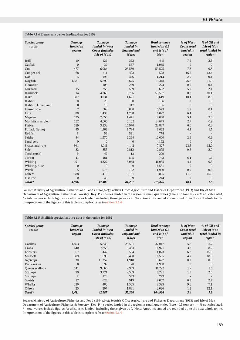
9.1 Fisheries
189
Table 9.1.4 Demersal species landing data for 1992
Species group Tonnage Tonnage Tonnage Total tonnage % of West % of GB andtotals landed in landed in West landed in landed in GB Coast total Isle of Man
region Coast (includes England and and Isle of landed in total landed inIsle of Man) Wales Man region region
Brill 10 126 392 445 7.9 2.3Catfish 0 39 557 1,935 0 0Cod 477 6,084 23,530 59,525 7.8 0.8Conger eel 68 411 403 508 16.5 13.4Dab 5 198 456 1,214 2.5 0.4Dogfish 1,581 5,899 3,625 13,348 26.8 11.9Flounder 1 106 269 274 0.9 0.4Gurnard 15 253 589 622 5.9 2.4Haddock 14 4,365 3,706 53,587 0.3 <0.1Hake 307 3,031 1,621 3,619 10.1 8.5Halibut 0 28 80 196 0 0Halibut, Greenland 0 18 117 136 0 0Lemon sole 7 569 3,000 5,573 1.2 0.1Ling 88 1,433 1,708 6,027 6.1 1.5Megrim 135 2,658 1,471 4,038 5.1 3.3Monkfish/angler 132 4,865 3,102 14,679 2.7 0.9Plaice 189 3,138 15,970 23,887 6.0 0.8Pollack (lythe) 45 1,102 1,734 3,022 4.1 1.5Redfish P 56 581 774 - -Saithe 44 1,570 2,284 12,600 2.8 0.3Sand eels 0 0 0 4,152 0 0Skates and rays 941 4,011 4,142 7,827 23.5 12.0Sole 82 855 2,812 2,875 9.6 2.9Torsk (tusk) P 42 13 209 - -Turbot 11 181 545 743 6.1 1.5Whiting 191 4,322 5,088 41,055 4.4 0.5Whiting, blue 0 0 0 6,531 0 0Witch 5 576 192 1,980 0.9 0.3Others 588 1,415 3,151 3,835 41.6 15.3Fish roe 0 48 99 244 0 0Total* 4,936 47,409 81,237 275,476 10.4 1.8
Source: Ministry of Agriculture, Fisheries and Food (1994a,b,c); Scottish Office Agriculture and Fisheries Department (1993) and Isle of ManDepartment of Agriculture, Fisheries & Forestry. Key: P = species landed in the region in small quantities (here <0.5 tonnes); - = % not calculated;* = total values include figures for all species landed, including those given as P. Note: Amounts landed are rounded up to the next whole tonne.Interpretation of the figures in this table is complex: refer to section 9.1.4.
Table 9.1.5 Shellfish species landing data in the region for 1992
Species group Tonnage Tonnage Tonnage Total tonnage % of West % of GB andtotals landed in landed in West landed in landed in GB Coast total Isle of Man
region Coast (includes England and and Isle of landed in total landed inIsle of Man) Wales Man region region
Cockles 1,853 5,848 29,501 32,047 5.8 31.7Crabs 640 7,853 9,453 16,971 3.8 8.2Lobsters 67 447 504 1,073 6.3 15.0Mussels 309 1,690 3,488 6,555 4.7 18.3Nephrops 30 11,257 1,918 19,627 0.2 0.3Periwinkles 0 1,592 70 1,908 0 0Queen scallops 141 9,066 2,989 11,272 1.7 1.6Scallops 99 3,771 2,589 8,291 1.3 2.6Shrimps P 128 563 743 - -Squids 17 623 919 2,007 0.9 2.7Whelks 230 488 1,535 2,393 9.6 47.1Others 25 207 1,831 2,026 1.2 12.1Total* 3,411 42,987 55,360 104,926 3.4 7.9
Source: Ministry of Agriculture, Fisheries and Food (1994a,b,c); Scottish Office Agriculture and Fisheries Department (1993) and Isle of ManDepartment of Agriculture, Fisheries & Forestry. Key: P = species landed in the region in small quantities (here <0.5 tonnes); - = % not calculated;* = total values include figures for all species landed, including those given as P. Note: Amounts landed are rounded up to the next whole tonne.Interpretation of the figures in this table is complex: refer to section 9.1.4.

Region 12 Chapter 9 Human activities
Table 9.1.6 presents the tonnages of certain shellfishspecies landed to some of the ports in the region in 1992.
Table 9.1.6 Tonnages of selected shellfish species landed in 1992 toports/areas within the jurisdiction of the South WalesSea Fisheries Committee (SWSFC )
Species Port/landing area Tonnes
Mussels Three Rivers 13Cockles Burry Inlet 1,827
Three Rivers 238Lobster Swansea 6
Burry Inlet <1South Pembrokeshire 7Milford Haven and surrounds 23North Pembrokeshire 16
Crawfish South Pembrokeshire <1Milford Haven and surrounds 11North Pembrokeshire <1
Edible crab Swansea 5Burry Inlet <1South Pembrokeshire 18Milford Haven and surrounds 199North Pembrokeshire 241
Spider crab Swansea 1Burry Inlet <1South Pembrokeshire 12Milford Haven and surrounds 98North Pembrokeshire 14
Source: SWSFC. Note: 'Swansea' includes vessels fishing fromPorthcawl. 'South Pembrokeshire' includes Saundersfoot, Tenby andFreshwater East; 'north Pembrokeshire' includes Solva, Porthclais,Abereiddy, Porthgain, Abercastle, Fishguard and Newport andincludes vessels fishing from Port of Cardigan. Amounts landed arerounded up to the next whole tonne. Interpretation of the figures inthis table is complex: refer to section 9.1.4. Figures often varymarkedly from year to year. Information was not available for portsin the north of the region (see section 9.1.3).
The flat or native oyster is exploited by dredging underpermit from the South Wales Sea Fisheries Committee(SWSFC) as an occasional natural fishery in Milford Haven.The fishery is permitted for a limited period of approximatelysix weeks commencing in November. The annual productionof the native oyster in Milford Haven in 1992 (contained in theshellfish 'others' category in Table 9.1.5) was approximately10.2 tonnes (SWSFC pers. comm.). Although a small quantity,this is about 2% of the GB total of approximately 500 tonnes(Shellfish Association of GB, pers. comm.).
There is a growing fishery for mussels at Conwy (wherethere is a Regulating Order - see section 9.1.3 and Table 9.1.8)and in the Menai Strait (where there is a Several Order - seesection 9.1.3 - and yield is enhanced using husbandrytechniques - see section 9.2.2). Mussels are collectedincreasingly in the Burry Inlet area and the Three Rivers area.There is a fishery for mussels near Swansea and in a numberof estuaries such as the Dyfi and Mawddach.
The fishery for cockles is important in the Burry Inlet,where there is a Regulating Order (see section 9.1.3 and Table9.1.8). Cockles are also periodically important to the fishery inthe Three Rivers area, the Dyfi and Dwyryd estuaries and atTraeth Lafan. Landing totals for cockles fluctuate from year toyear, but in 1993 over 7,500 tonnes of cockles were landedfrom the combined area of Burry Inlet and the Three Riversalone and 1,100 tonnes were landed from Traeth Lafan. At
190
Traeth Lafan in recent years (1989, 1990 and 1993) the NorthWales and North Western Sea Fisheries Committee (NW &NWSFC) have issued authorisation for a limited period ofthree months for vessel-borne suction dredging over varyingareas. Landings from Traeth Lafan are recorded by NW &NWSFC only for these authorised operations: no authorisationwas issued in 1991, 1992 and 1994. Asmaller, unrecorded,amount of cockles is also taken in the area by hand gatherers.
Whelks are caught using pots twelve miles or furtheroffshore in the northern part of Cardigan Bay and off the northof Anglesey. Scallops are dredged mainly north ofPembrokeshire.
The lobster fishery operates mostly from late spring toearly autumn, from most ports in the region. Most lobsters aretaken by potting from small inshore vessels, the scale ofoperations ranging from part-time fishermen with only a fewpots to professional operators using up to 800 - 1,000 pots.Lobster fishing effort in Cardigan Bay, although greatest closeinshore, can extend twelve miles or further offshore. Crawfishare taken between Govan and Strumble Heads by potting andtangle netting, and also around Ynys Enlli by tangle nettersand occasionally by commercial divers.
Edible crabs are caught throughout the region, and animportant autumn fishery for this species exists betweenFishguard and Cardigan. Spider crabs are landed at andaround Milford Haven and also around north Pembrokeshire,with smaller amounts landed in south Pembrokeshire andSwansea.
Other species fished in the region include pink prawns,caught by potters operating from Pembroke and CardiganBay, and there is a developing fishery for velvet swimmingcrabs in the south of the region. Green (or shore) crabs havebeen fished commercially in Milford Haven and the MenaiStrait. Squid are present off the east of Gower and are fishedin September and October. Periwinkles are exploited whensituated in dense aggregations on accessible shores. Razorshells are also exploited locally around Milford Haven.
Diadromous fish: Table 9.1.7 lists the locations in theregion (shown on Map 5.8.1) from which salmon, grilse andsea trout catches have been recorded, details the catchmethods used and gives five-year average catch statistics for1989-1993. Note that rods are used mainly by gamefishermen; rod angling is the most widespread method ofcatching in the region. On fourteen estuaries from the ThreeRivers area north to the Conwy a variety of nets are used, andmost of the region's catch is from rivers where nets are used inaddition to rods. Coracles remain in use by fishermen onseveral estuaries in the region, including the Tywi, Taf andTeifi. The overall salmon and grilse catch is highest on theTywi and Teifi, with large catches also on the Conwy, Ogwen,Mawddach and Dyfi. Large catches of sea trout are morewidespread but again are largest on the Tywi. Eels areexploited from the time they enter fresh water as elvers,during their stay in fresh and estuarine water and as theymigrate to sea as silver eels. The main areas of exploitation ofeels in the region are in the lakes of North Wales.
Sea angling: Sea angling has three main forms: anglingfrom the shore, inshore fishing within about 5 km of the shoreand deep sea fishing. It is distinguished from two other typesof sport fishing: game fishing, for salmon, sea trout, brownand rainbow trout (the first two are discussed above), andcoarse fishing (for freshwater fish species - not covered here).Sea angling is a popular and widespread pastime in the regionand is practised by over two million people in Great Britain

9.1. Fisheries
Table 9.1.7 Methods used to catch salmon, grilse and sea trout in 1993 for each river/fishery in the region and the five-year average (1989 -1993) of catch (as numbers of fish reported to NRA)
River/fishery Method used in 1993, and no. of Five year average Five year average net licences issued for (1989 - 1993) for (1989 - 1993)
salmon & grilse salmon & grilse for sea trout
Afan rod 5 138Neath rod 12 152Tawe rod 45 281Loughor rod 7 133Gwendraeth rod 0 105Tywi rod, seine (7) & coracle (10) nets 550 725Taf rod, coracle (1) & wade (1) nets 48 175SW Coastal wade (11) nets 17 85E+W Cleddau rod, compass nets (8) 68 549Nevern rod, seine nets (1) 29 304Teifi rod, seine (3) & coracle (10) nets 530 518Aeron rod 5 356Ystwyth rod 8 111Rheidol rod 35 175Dyfi rod, seine nets (2) 258 409Dysynni rod, seine net (1) 25 343Mawddach rod, seine nets (2) 201 384Artro rod 5 73Dwyryd rod 20 132Glaslyn rod, seine net (2) 62 482Dwyfawr rod, seine nets (2) 83 549Llyfni rod 14 93Gwyrfai rod 4 5Seiont rod 47 88Seiont/Gwyrfai seine nets (1) 139 75N.Anglesey last year 1990 0 3Ogwen rod, seine nets (1) 200 89Conwy rod, seine nets (4) & basket trap (1) 356 218Total region 68* 2,773 12,270Total England & Wales 780* 67,347 76,337
Source: Department of Agriculture and Fisheries (1990); National Rivers Authority (1991, 1992, 1993, 1994a & 1994b) and Scottish Office (1991,1992, 1993 & 1994). Key: * = total number of licences issued (net methods). Note: interpretation of the figures in this table is complex: refer tosection 9.1.4. The total for the 'West Coast' in this table does not include figures for the Isle of Man. 'Sea trout' here includes all migratory trout.'Nets' are defined as instruments other than rod and line. Rivers with very small recorded catches have been excluded from this table, so thedistribution of the fishing methods may be more widespread than appears here. Map 5.8.1 shows the locations of rivers in this table.
(Fowler 1992). The governing body of sea angling in theregion, the Welsh Federation of Sea Anglers, hasapproximately 62 affiliated clubs with approximately 4,000individual members, many in this region.
Bait collection: Many sea anglers normally collect theirown live bait locally, and this activity occurs in many areas inthe region, although some areas are targeted more than othersand may attract commercial collectors, who travel in teams tosuitable shores. Many species are collected in this region,mainly by digging and boulder turning, including ragworm,lugworm, peeler crabs (moulting shore crabs), mussels,cockles, limpets and razor shells. Different bait species arecollected according to the fish being targeted as well as thelocation and time of year. Baitdigging, especially forlugworms, is carried out over the lower part of muddy andsandy shores around the time of low water. Fowler (1992)identified that the exploitation of bait species was taking placein the region at locations in south Wales, e.g. Milford Haven,Pendine Beach, along the South Gower coast, Swansea Bayand at Penclawdd in the Burry inlet. Occasional small-scaledigging also occurs in the Dyfi and Dwyryd estuaries and atMorfa Harlech. In north Wales, areas such as Holy Island, RedWharf Bay and the Menai Strait experience larger numbers ofdiggers.
9.1.3 Management and issues
Responsibility for the management of fisheries in coastalwaters, extending from low water mark, rests with theCommission for the European Union, who delegate it tomember states under the Common Fisheries Policy. Thispolicy seeks to manage stocks of fish in EU waters on abiological basis (MAFF 1994b) by setting agreed annual TotalAllowable Catches (TACs) for particular stocks. The CommonFisheries Policy came into effect in 1983 and was subject to amid-term review in 1993, with a full review planned for 2002.Under the Common Fisheries Policy, fishing in this region isrestricted to national boats in an area of up to 12 nautical milesfrom the coast, in order to protect the interests of localfishermen. Outside this 12 mile limit, all European Unionmember countries have equal access to the Exclusive FishingZone, whereas under European, national and local byelawlegislation, non-member countries are only allowed to fish byagreement. The coastal waters of the region are part of the'Irish box', which has historically excluded Spanish vessels.However, as of 1 January 1996 Spanish vessels will be allowedaccess (MAFF 1994c).
For the purpose of stock management, the UK coastalwaters have been designated by the International Council for
191

Region 12 Chapter 9 Human activities
the Exploration of the Sea (ICES) into statistical areas. Thecoastal seas around this region are part of three 'divisions':VIIa (Irish Sea), VIIf (Bristol Channel) and VIIg (East CelticSea). ICES provides scientific advice on the management of allthe important commercial species of fin fish and someshellfish stocks in all areas of the north-east Atlantic. Thiswork is summarised in the annual report of the AdvisoryCommittee on Fishery Management, which is responsible forproviding scientific advice on TACs and other conservationmeasures. The TACs and catch quotas themselves are decidedby the European Council of Ministers on the basis of thisadvice, and having taken socio-economic considerations intoaccount. The TACs, UK quotas and 'uptake' for 1991 and 1992for each species in the three ICES statistical divisions in theregion are given in MAFF (1994b). Further restrictionsapplying in the region, on minimum landing sizes, annualquotas and mesh sizes for the important pelagic and demersalspecies, are listed in Tables 5.7.1 and 5.7.2.
In this region the North Wales and North Western SeaFisheries Committee (NW & NWSFC) and the South WalesSea Fisheries Committee (SWSFC) manage the inshorefisheries from the high water mark out to 6 nautical miles (3 nautical miles until October 1993) offshore from the UKbaselines (as defined by the Territorial Water Order in Council1964). The boundary between these two Sea FisheriesCommittees (SFCs) lies between the Districts of PreseliPembrokeshire and Ceredigion (Map 9.1.1). The WelshRegion of the National Rivers Authority (NRA) has jointresponsibility with the Sea Fisheries Committees (SFCs) forthe fishery for diadromous fish in coastal waters in the region.
There are two Regulating Orders in this region (in theBurry Inlet and the Conwy estuary - Table 9.1.8), coveringaround 5,300 ha, out of eight (covering 94,584 ha) in GB, as atJuly 1994. Regulating Orders are granted in Wales by theWelsh Office to a responsible body to enable it to regulate thenatural fishery. The specified shellfish may be taken only inaccordance with the terms of the order and any regulationsmade under it.
The SWSFC operates a crustacean authorisation schemefor the commercial exploitation of lobster, crawfish, edible andspider crabs. The NW & NWSFC operated a similar schemein 1992, but only for lobster in the Aberystwyth area. SWSFCalso operate an authorisation scheme for cockles in the BurryInlet (where most of the south Wales cockles are taken), undertheir Regulating Order. 47 permits were issued in 1992. Thesemeasures prohibit the unauthorised collection of the speciesconcerned and limit the authorised catch.
MAFF's Directorate of Fisheries Research (DFR)Laboratory at Lowestoft is responsible for collecting andcollating information on fish stocks exploited by UK vessels.The MAFF DFR Fisheries Laboratory at Conwy is the
192
Table 9.1.8 Regulating Orders in the region
Title Species Grid ref.
Burry Inlet Cockle Fishery Order 1965 Cockles SS449968 toSS436998; aSS560980 toSS564978
Conwy Mussel Fishery Order 1912 Mussels SH763801
Source: MAFF (1994a) and Grantees. Note: Several Orders are listed in Ta
Directorate's centre for assessing the implications of non-fisheries activities and coastal zone usage on fish stocks andfisheries. MAFF DFR databases are described in Flatman(1993). Local MAFF fishery officers based in Milford Havendeal with quota management, enforcement of UK and EUfisheries legislation and licensing of fishing vessels.
Issues relating to the fisheries for pelagic, demersal andshellfish species and sea angling and bait collection are closelylinked to wildlife conservation in several ways. Issues includethe effects on target species as major components in marineecosystems, the changed availability of food for predators, theeffects on non-target fish species (due to multi-speciesfisheries, especially those directed at demersal species), andeffects on species and habitats of nature conservation interest.These issues are under consideration by the 'Marine FisheriesTask Force', an inter-agency team of the statutory natureconservation organisations (the Countryside Council forWales, English Nature, Scottish Natural Heritage and theDepartment of the Environment (Northern Ireland), togetherwith the JNCC). Aconsultation draft paper prepared by thegroup, entitled Developing an action programme for sea fisheriesand wildlife (Marine Fisheries Task Force 1994), identifies themain areas where marine fisheries (broadly defined toencompass the exploitation of all living marine resources)affect wildlife and identifies any action needed.
Further information relating to fisheries issues is given insections 5.5.3, 5.7.3, 5.8.3 and 9.2.3.
9.1.4 Information sources used and theirinterpretation
Inshore fisheries review of England, Scotland and Wales, 1992/1993(Gray 1994) has been used extensively in compiling thissection. It gives details of the numbers of boats operatingfrom ports in the region, the amount of fishing effort involvedby various methods and which species or species groups aretargeted during the different seasons. Figures given in Tables9.1.1 and 9.1.3 - 9.1.5 come from three sources and the methodof their adaptation is described below.
Pelagic, demersal and shellfish: Statistics given here arefor landings recorded in the region, not estimated catchesmade in the region. Some fish caught in the region may not belanded in the region's ports or even in the UK; other fish arelanded in the region but are caught outside it; and until 1993,boats under 10 m were not obliged to register their landings.The tonnages of various pelagic, demersal and shellfishspecies (fresh and frozen) landed at the major ports inEngland and Wales by UK vessels come from UK sea fisheriesstatistics for 1991 and 1992 (MAFF 1994b): this applies toMilford Haven, the single 'major port' in the region. Atotal for
Location Grantee Approx. Expiry area (ha) date
Llanelli,Dyfed, SWSFC 4,528 2025nd W. Glamorgan
Gwynedd NW & 777 2008NWSFC
ble 9.2.2.

9.1 Fisheries
the 'other' smaller ports (see Map 9.1.1), was provided by theMAFF Fisheries Statistics Unit. These data have beencombined to give the 'tonnage landed in region' column inTables 9.1.1, 9.1.3, 9.1.4 and 9.1.5. The 'tonnage landed inEngland and Wales' column was obtained by adding togetherall of the MAFF data for England and Wales, and the 'totaltonnage landed in GB and Isle of Man' column was obtainedby combining MAFF, SOAFD and Isle of Man data. BecauseMAFF and SOAFD do not use the same categories, fishlandings in some of their categories have been added to the'others' columns in the tables in this section. Also, SOAFDpublish the weight of fish as 'standard landed weight' (guttedfish with head on), whereas MAFF publish them as 'nominallive weight' (whole fish). These two are the same for pelagicand shellfish species, but converted data from SOAFD wereused for all demersal species, apart from sandeels (which arenot gutted), so that all the data presented are in 'nominal liveweight'. The 'total landed in West Coast' column wascalculated by adding together all the landings data for the sixregions in the GB West Coast and the Isle of Man.
Aspecialist subset of the electronic mapping systemUKDMAP (see 'Core reading list' - section A3 in theAppendix), called SHELLMAP, is being prepared by theMAFF Shellfish Division in Weymouth, to meet therequirements of the EC shellfish harvesting and hygienedirectives (section 9.2.3; see also Ramster et al. in press). Thesoftware includes charts of all coastal areas (principallyestuaries) which support known molluscan shellfisheries,showing all details of the production areas and theirclassification.
Diadromous: NRAreported catches for salmon, grilse andsea trout vary in accuracy from year to year, as they representonly declared catches by individuals with a net or rod and linelicence; in addition, catches themselves fluctuate, and so therelationship between catch and stock is not straightforward.Further, in 1992, changes to the catch recording system mayhave resulted in a reduced level of recording: there is evidenceto suggest that catches were higher than shown in Table 9.1.7.Therefore the figures given in Table 9.1.7 should be used onlyas an indication of the pattern of the catch in the region. Theannual NRASalmonid and freshwater statistics for England andWales (National Rivers Authority 1991, 1992, 1993, 1994a &1994 b) contain more detailed information.
Bait collection: Information on bait collection comes froma survey around the coast of Britain in 1985 (Fowler 1992). Asurvey of bait digging was carried out in 1993 around MilfordHaven by Palmer (1993), in conjunction with the Milford PortHealth Authority and the Field Studies Council ResearchCentre (Milford Haven Waterway Environmental MonitoringSteering Group 1994).
9.1.5 Further sources of information
A. References cited
Department of Agriculture and Fisheries. 1990. Scottish salmon and seatrout catches: 1989. (DAFS Statistical Bulletin 1/90.)
Fowler, S.L. 1992. Survey of bait collection in Britain. JNCC Report,No.17.
Gray, M. 1994. Inshore fisheries review of England, Scotland and Wales,1992/1993. World -Wide Fund for Nature, Godalming.
Marine Fisheries Task Force. 1994. Developing an action programme forsea fisheries and wildlife. Peterborough, JNCC. (Draft consultationpaper by the Marine Fisheries Task Group.)
Milford Haven Waterway Environmental Monitoring Steering Group.1994. Report of the Milford Haven Waterway EnvironmentalMonitoring Steering Group. Civil Protection Planning Unit, DyfedCounty Council (unpublished report).
Ministry of Agriculture, Fisheries and Food. 1994a. List of Orders inEngland and Wales. MAFF (unpublished).
Ministry of Agriculture, Fisheries and Food. 1994b. UK sea fisheriesstatistics 1991 and 1992. London, HMSO.
Ministry of Agriculture, Fisheries and Food. 1994c. Spanish fishermento be controlled in Irish Box. London (News Release 22 December1994).
National Rivers Authority. 1991. Salmonid and freshwater fisheriesstatistics for England and Wales, 1989. Almondsbury, NRA.
National Rivers Authority. 1992. Salmonid and freshwater fisheriesstatistics for England and Wales, 1990. Almondsbury, NRA.
National Rivers Authority. 1993. Salmonid and freshwater fisheriesstatistics for England and Wales, 1991. Almondsbury, NRA.
National Rivers Authority. 1994a. Salmonid and freshwater fisheriesstatistics for England and Wales, 1992. London, HMSO & NRA.
National Rivers Authority. 1994b. Salmonid and freshwater fisheriesstatistics for England and Wales, 1993. London, HMSO & NRA.
Palmer, T. 1993. Bait digging in Milford Haven. Bangor, UniversityCollege of North Wales MSc thesis.
Ramster, J.W., Tabor, A.R., Lockwood, S.J., & Sheehan R. In press.Access to coastal zone information: a possible common approachfor the UK. In: Proceedings of the conference on managementtechniques in the coastal zone, University of Portsmouth: October 24-251994. Portsmouth, University of Portsmouth.
Scottish Office Agriculture and Fisheries Department. 1993. Scottishsea fisheries statistical tables 1992. Edinburgh, Scottish Office.
Scottish Office. 1991. Scottish salmon and sea trout catches: 1990.Edinburgh, Scottish Office. (Scottish Office Statistical Bulletin,Fisheries Series.)
Scottish Office. 1992. Scottish salmon and sea trout catches: 1991.Edinburgh, Scottish Office. (Scottish Office Statistical Bulletin,Fisheries Series No. Fis/1992/1.)
Scottish Office. 1993. Scottish salmon and sea trout catches: 1992.Edinburgh, Scottish Office. (Scottish Office Statistical Bulletin,Fisheries Series No. Fis/1993/1.)
Scottish Office. 1994. Scottish salmon and sea trout catches: 1993.Edinburgh, Scottish Office. (Scottish Office Statistical Bulletin,Fisheries Series No. Fis/1994/1.)
B. Further reading
Bergman, M.J.N, Fonds, M., Hup, W., & Uyl, D. den. 1990. Directeffects of beam trawling fishing on benthic fauna. In: Effects ofbeam trawl fishery on the bottom fauna in the North Sea. BeleidgerichtEcologisch Onderzoek Norddzee - Wadenzee. Rapport, 8: 33 - 57.
Boon, M.J. 1992. Landings into England and Wales from the UK demersalfisheries of the Irish Sea and Western Approaches, 1979 - 1990.Lowestoft, MAFF Directorate of Fisheries Research. (FisheriesResearch Data Report No. 26.)
Bullimore, B. 1985. An investigation into the effects of scallop dredgingwithin the Skomer Marine Reserve. Areport to the NatureConservancy Council from the Skomer Marine Reserve SubtidalMonitoring Project.
Fowler, S.L. 1989. Nature conservation implications of damage to theseabed by commercial fishing operations. Peterborough, NatureConservancy Council (unpublished report).
Flatman, S. 1993. MAFF Fisheries Databases. In: The Irish Sea: anenvironmental review. Part five. Liverpool University Press.
Franklin, A. Pickett, G.D., & Connor, P.M. 1980. The scallop and itsfishery in England and Wales. Lowestoft, MAFF Directorate ofFisheries Research. (MAFF Laboratory Leaflet No. 51.)
Huggett, D. 1992. Foreshore fishing for shellfish and bait. Sandy, RoyalSociety for the Protection of Birds.
193

Region 12 Chapter 9 Human activities
Irish Sea Forum/Marine Forum. 1993. Managing marine fisheries: acase study of the Irish Sea. Joint Seminar Report, Liverpool, 16/17September 1993. Liverpool University Press.
Kaiser, M.J., & Spencer, B.E. 1993. A preliminary assessment of theimmediate effects of beam trawling on a benthic community in the IrishSea. Copenhagen, Denmark, International Council for theExploration of the Sea (ICES).
Lucas, M.C., Diack, I.,& Laird, L. 1991. Interactions between fisheriesand the environment. Proceedings of the Institute of FisheriesManagement 22nd Annual study course, 10-12th September 1991.University of Aberdeen.
Lutchman, I. 1992. A general overview of European and UK fisheries.WWF International.
Ministry of Agriculture, Fisheries and Food. 1992. Directorate ofFisheries Research, Fisheries Laboratory, Conwy: Handout4. MAFF,Lowestoft.
Mason, J. 1987. Scallop and queen fisheries in the British Isles. Farnham,Fishing News Books for Buckland Foundation.
Norton, T.A., & Geffen, A.J. 1990. Exploitable living resources. The IrishSea: an environmental review. Part three. Liverpool UniversityPress.
Pawson, M.G., & Rogers, S.I. 1989. The coastal fisheries of England andWales. Part ii: A review of their status in 1988. Lowestoft, MAFFDirectorate of Fisheries Research. (Internal Report No.19.)
C. Contact names and addresses
194
Type of information Contact address and telephone no.
Central contact for the local Sea Fisheries Committees Chief Executive, Association of Sea Fisheries Committees, Buckrose and advice on general policy issues House, Commercial Street, Norton, Malton, North Yorkshire YO17 9HX,
tel: 01653 698219
Affiliated angling clubs Secretary, Welsh Federation of Sea Anglers, 46 Lydstep Crescent, Gabalf,Cardiff CF4 2RA, tel: 01222 621795
Scientific advice on the management of the most General Secretary, International Council for the Exploration of the Sea important fish and shellfish stocks. Leaflets and (ICES), Palaegade 2 -4, DK-1261 Copenhagen K, Denmark, publications list. tel: (+45) 33157092
Assessment of implications of non-fisheries activities Head of Laboratory, MAFF Directorate of Fisheries Research, Fisheries and coast usage on fish stocks and fisheries; advice to Laboratory, Benarth Road, Conwy, Gwynedd LL32 8UB, assist with management and policy decisions for the tel: 01492 593883coastal zone
Fish stocks exploited by UK vessels; assessment and Director, MAFF Directorate of Fisheries Research, Fisheries Laboratory, advice on their conservation. MAFF Publications leaflet. Pakefield Road, Lowestoft, Suffolk NR33 OHT, tel: 01502 562244.
Additional statistics other than in publications MAFF Fisheries Statistics Unit, Nobel House, 17 Smith Square, London (available from HMSO) SW1P 3JR, tel: 0171 238 6000
Local fisheries information, quota management, District Inspector, MAFF Sea Fisheries Inspectorate, Fisheries Office, licensing of fishing vessels and enforcement and advice 5 Hamilton Terrace, Milford Haven, Dyfed SA73 2AL, tel: 01646 693412on UK and EC legislation
Bivalve molusc production areas, the classification of Director, MAFF Shellfish Division, Fish Diseases Laboratory, Barrack shellfish waters and shellfish diseases; preparation of Road, The Nothe, Weymouth, Dorset DT4 8UB, tel: 01305 206600SHELLMAP (a subset of UKDMAP)
Local inshore fisheries information and advice on Clerk and Chief Fisheries Officer, North Wales and North Western Sea byelaws, National and EC legislation Fisheries Committee (NW & NWSFC), University of Lancaster, Bailrigg,
Lancaster, Lancashire LA1 4XY, tel: 01524 68745
Local inshore fisheries information and advice on Director, South Wales Sea Fisheries Committee (SWSFC), Queens byelaws, National and EC legislation Buildings, Cambrian Place, Swansea, West Glamorgan SA1 1TW,
tel: 01792 654466
Details of planned projects and national NRA fisheries *NRA Head Office - Fisheries Department, Bristol, tel: 01454 624400 policy; salmonid and freshwater statistics for England and Wales.
Regional information and advice on diadromous *Regional Fisheries Officer, NRA Welsh Region, Cardiff, fisheries; salmonid and freshwater statistics for tel: 01222 770088Wales
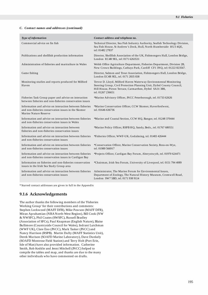
9.1 Fisheries
C. Contact names and addresses (continued)
Type of information Contact address and telephone no.
Commercial advice on fin fish Technical Director, Sea Fish Industry Authority, Seafish Technology Division,Sea Fish House, St Andrew’s Dock, Hull, North Humberside HU3 4QE, tel: 01482 27837
Publications and shellfish production information Director, Shellfish Association of the UK, Fishmongers Hall, London Bridge,London EC4R 9EL, tel: 0171 6263531
Administration of fisheries and mariculture in Wales Welsh Office Agriculture Department, Fisheries Department, Division 2B, New Crown Buildings, Cathays Park, Cardiff CF1 3NQ, tel: 01222 823567.
Game fishing Director, Salmon and Trout Association, Fishmongers Hall, London Bridge,London EC4R 9EL, tel. 0171 2835 838
Monitoring studies and reports produced for Milford Trevor D. Lloyd, Milford Haven Waterway Environmental Monitoring Haven Steering Group, Civil Protection Planning Unit, Dyfed County Council,
Hill House, Picton Terrace, Carmarthen, Dyfed SA31 3BS, tel. 01267 236651
Fisheries Task Group paper and advice on interaction *Marine Advisory Officer, JNCC Peterborough, tel. 01733 62626between fisheries and non-fisheries conservation issues
Information and advice on interaction between fisheries *Marine Conservation Officer, CCW Skomer, Haverfordwest, and non-fisheries conservation issues in the Skomer tel. 01646 636736Marine Nature Reserve
Information and advice on interaction between fisheries *Marine and Coastal Section, CCW HQ, Bangor, tel. 01248 370444and non-fisheries conservation issues in Wales
Information and advice on interaction between *Marine Policy Officer, RSPB HQ, Sandy, Beds., tel. 01767 680551fisheries and non-fisheries conservation issues
Information and advice on interaction between fisheries *Fisheries Officer, WWF-UK, Godalming, tel. 01483 426444and non-fisheries conservation issues
Information and advice on interaction between fisheries *Conservation Officer, Marine Conservation Society, Ross-on-Wye, and non-fisheries conservation issues tel. 01989 566917
Information and advice on interaction between fisheries *Projects Officer, Cardigan Bay Forum, Aberystwyth, tel. 01970 624471and non-fisheries conservation issues in Cardigan Bay
Information on fisheries and non-fisheries conservation *Chairman, Irish Sea Forum, University of Liverpool, tel. 0151 794 4089issues in the Irish Sea Study Group area
Information and advice on interaction between fisheries Administrator, The Marine Forum for Environmental Issues, and non-fisheries conservation issues Department of Zoology, The Natural History Museum, Cromwell Road,
London SW7 5BD, tel. 0171 938 9114
* Starred contact addresses are given in full in the Appendix
9.1.6 Acknowledgements
The author thanks the following members of the 'FisheriesWorking Group' for their contributions and comments:Stephen Lockwood (MAFF DFR), Mike Pawson (MAFF DFR),Miran Aprahamian (NRANorth-West Region), Bill Cook (NW& NWSFC), Phil Coates (SWSFC), Russell Bradley(Association of SFCs), Paul Knapman (English Nature), BlaiseBullimore (Countryside Council for Wales), Indrani Lutchman(WWF UK), Clare Eno (JNCC), Mark Tasker (JNCC) andNancy Harrison (RSPB). Martin Dufty (MAFF Statistics Unit),Derek Murison (SOAFD Marine Laboratory), Dave Dunkely(SOAFD Montrose Field Station) and Terry Holt (Port Erin,Isle of Man) have also provided information. CatherineSmith, Rob Keddie and Jenni Mitchell (JNCC) helped tocompile the tables and map, and thanks are due to the manyother individuals who have commented on drafts.
195
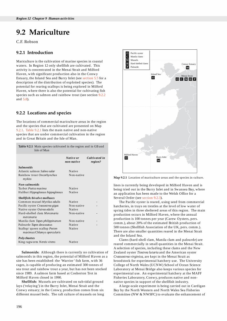
Region 12 Chapter 9 Human activities
Pacific oyster
Manila clams
Hard shelled clams
Mussels
PalourdeConwy Estuary
Inland SeaMenai Strait
O MO HC P
C
H
O
M
M
P
9.2.1 Introduction
Mariculture is the cultivation of marine species in coastalwaters. In Region 12 only shellfish are cultivated. Thisactivity is concentrated in the Menai Strait and MilfordHaven, with significant production also in the ConwyEstuary, the Inland Sea and Burry Inlet (see section 5.5 for adescription of the distribution of exploited species). Thepotential for rearing scallops is being explored in MilfordHaven, where there is also the potential for cultivating fishspecies such as salmon and rainbow trout (see section 9.2.2and 5.8).
9.2 MaricultureC.F. Robson
9.2.2 Locations and species
The locations of commercial mariculture areas in the regionand the species that are cultivated are presented on Map9.2.1. Table 9.2.1 lists the main native and non-nativespecies that are under commercial cultivation in the regionand in Great Britain and the Isle of Man.
Milford HavenBurry InletOM
Map 9.2.1 Location of mariculture areas and the species in culture.
Table 9.2.1 Main species cultivated in the region and in GB andIsle of Man
Native or Cultivated in non-native region?
SalmonidsAtlantic salmon Salmo salar NativeRainbow trout Oncorhynchus Non-native
mykiss
Non-salmonidsTurbot Psetta maxima NativeHalibut Hippoglossus hippoglossus Native
Shellfish: bivalve molluscsCommon mussel Mytilus edulis Native -Pacific oyster Crassostrea gigas Non-native -Native oyster Ostrea edulis NativeHard-shelled clam Mercenaria Non-native -
mercenariaManila clam Tapes philippinarum Non-native -Palourde Tapes decussatus Native -Scallop/queen scallop Pecten Native
maximus/Chlamys opercularis
PolychaetesKing ragworm Nereis virens Native
Salmonids: Although there is currently no cultivation ofsalmonids in this region, the potential of Milford Haven as asite has been established: the ‘Warrior’ fish farm, with 36cages, is capable of producing an estimated 300 tonnes ofsea trout and rainbow trout a year, but has not been stockedsince 1989. A salmon farm based at Cosherton Trot inMilford Haven closed in 1990.
Shellfish: Mussels are cultivated on sub-tidal groundlays (‘relaying’) in the Burry Inlet, Menai Strait and theConwy estuary; in the Conwy, production comes from sixdifferent mussel beds. The raft culture of mussels on long
196
lines is currently being developed in Milford Haven and isbeing tried out in the Burry Inlet and in Swansea Bay, wherean application has been made to the Welsh Office for aSeveral Order (see section 9.2.3).
The Pacific oyster is reared, using seed from commercialhatcheries, in trays on trestles at the level of low water ofspring tides in three sheltered areas of this region. The mainproduction occurs in Milford Haven, where the annualproduction is 100 tonnes per year (Carew Oysters, pers.comm.), about 20% of the estimated British production of500 tonnes (Shellfish Association of the UK, pers. comm.).There are also smaller quantities reared in the Menai Straitand the Inland Sea.
Clams (hard-shell clam, Manila clam and palourde) arereared commercially in small quantities in the Menai Strait.A selection of species, including these clams and the NewZealand oyster Tiostrea lutaria and the American oysterCrassostrea virginica, are kept in the Menai Strait asbroodstock for experimental hatchery use. The UniversityCollege of North Wales (UCNW) School of Ocean ScienceLaboratory at Menai Bridge also keeps various species forexperimental use. An experimental hatchery at the MAFFFisheries Laboratory, Conwy, produces native and non-native species in support of the shellfish industry.
A large-scale experiment is being carried out in CardiganBay by the North Western and North Wales Sea FisheriesCommittee (NW & NWSFC) to evaluate the enhancement of

9.2 Mariculture
lobster stocks using hatchery-reared juveniles. BetweenSeptember 1984 and October 1988 a total of 19,957 taggedjuvenile lobsters, reared by NW & NWSFC at the hatchery atUCNW School of Ocean Sciences Laboratory, were releasedinto the sea off Aberystwyth. Early results wereencouraging and may lead to large-scale restocking oflobster grounds or to ranching of the species (Cook, Fish &Sankey 1989). Beard & Wickins (1992) summarise therearing and tagging aspects of this work.
9.2.3 Management and issues
In the areas where mariculture occurs in the region andwhich also have high human population densities, there isconcern about the effects of sewage discharges on exploitedspecies - both on stocks that are fished (see section 9.1) andthose that are cultivated. The Food Safety (Live BivalveMolluscs) Regulations (implementing European CouncilDirectives) require that all waters from which bivalvemolluscs are taken for human consumption are classified byMAFF, and depending on the resulting category (A - D),restrictions may be imposed (Milford Haven WaterwayEnvironmental Monitoring Steering Group 1994). Samplesare taken regularly and the classification can change.
The consent of the owners or managers of the sea bed isrequired and a lease may be needed before structures formariculture can be erected on the sea bed. In many areasconsent must be sought from the Crown Estate, since itowns or manages 55% of the foreshore and the sameproportion of the beds of tidal rivers between mean highand low water in GB, together with virtually the entireterritorial sea bed. If the structures are potentiallyhazardous to navigation the Department of Transport mustalso authorise their construction, and if they are to be abovemean low water mark planning permission must be soughtfrom the local authority. Within Milford Haven mariculturalactivities are concentrated in or near SSSIs and within aNational Park, so nature conservation and landscapeconsiderations also apply. The former also apply in theMenai Strait, which is proposed as a Marine Nature Reserve.
Several Orders granted under section 1 of the SeaFisheries (Shellfish) Act 1967 are administered in the regionby the Welsh Office. They are granted to an individual, a co-operative or a responsible body to cultivate the sea bedwithin a designated area and to conserve and developstocks of molluscan shellfish. Out of a total of 22 shellfishSeveral Orders in GB there are two in this region (Table9.2.2), both granted to the North Wales and North West SeaFisheries Committee, who have leased the rights to others,with the consent of the Welsh Office.
The introduction of non-native shellfish species for
Table 9.2.2 Several Orders in the region
Title Species covered Grid ref.
Menai Strait Oyster and Oysters and mussels SH600740Mussel Fishery Order 1962Menai Strait (West) Oyster, Oysters, mussels SH479652Mussel and Clam Fishery and clams SH515674Order 1978
Source: MAFF (1994) and Grantees. Note: Regulating Orders are prese
cultivation has caused concern over their potential toestablish self-sustaining populations and so affect marineecosystems. Since January 1993 there have been new, lessstringent, requirements for the control of shellfish disease inGreat Britain and for the ‘deposit’ and importation ofmolluscan shellfish and lobsters, under the EC Fish HealthDirective (Directive 91/67). Under this legislation, only thedeposit of shellfish originating from areas in which Bonamiaostreae occurs is now controlled. (Bonamia is a parasite thatinfects the blood cells of native oysters, causing highmortalities of infected oysters.) These changes in thelegislation have caused concern that the transfer ofmolluscan shellfish may be accompanyied by accidentalreleases of associated non-native predators, pests, parasitesand diseases. Shellfish and fish farms in the region have tobe registered with MAFF and the Welsh Office AgricultureDepartment, under the Fish Farming and Shellfish FarmingBusiness Order 1985. Registration is designed to assistMAFF in dealing with any outbreaks of pests and diseases.
Mariculture and its effects are limited in this regioncompared with some other parts of Britain, and concerns atcurrent cultivation levels in the region are generally site-specific. Issues relating to the cultivation of marine speciesare closely linked to marine nature conservation interests,particularly the possible effects on species and habitats ofnature conservation interest. These issues are underconsideration by the ‘Marine Fisheries Task Force’, an inter-agency team of the statutory nature conservationorganisations (the Countryside Council for Wales, EnglishNature, Scottish Natural Heritage and the Department ofthe Environment (Northern Ireland) together with theJNCC). A consultation draft paper prepared by the group,entitled Developing an action programme for sea fisheries andwildlife (Marine Fisheries Task Force 1994), identifies themain areas where marine fisheries (broadly defined toencompass the exploitation of all living marine resourcesand which therefore includes mariculture) affect wildlifeand identifies any action needed.
9.2.4 Information sources used
Addison & Bannister (1994) review lobster stockenhancement generally, and results from experiments inother parts of the UK are summarised by Burton (1993) andBannister et al. (1994). For details of the currentclassification categories in the Designated Bivalve MolluscProduction Areas in the region, reference should be made tothe relevant Port Health or Local Authority. A specialistsubset of the electronic mapping system UKDMAP (see‘Core reading list’, section A3 in the Appendix), calledSHELLMAP, is being prepared by the MAFF Shellfish
197
Location Grantee Approx. Year of area (ha) expiry
Bangor, Gwynedd NW & 780 2022NWSFC
and Bangor, Gwynedd NW & 96 2008NWSFC
nted in Table 9.1.8.

Region 12 Chapter 9 Human activities
Division in Weymouth in order to meet the requirements ofthe EC shellfish harvesting and hygiene directives (Ramsteret al. in press). The software gives charts of all coastal areas(principally estuaries) that support known molluscanshellfisheries, showing all details of the production areasand their classification.
9.2.5 Further sources of information
A. References cited
Addison, J.T., & Bannister, R.C.A. 1994. Re-stocking and enhancingclawed lobster stocks: a review. Crustaceana, 67 (2): 131-155.(Proceedings of the Fourth International Workshop on LobsterBiology and Management, Sanriku, Japan.)
Bannister, R.C.A., Addison, J.T., & Lovewell, S.R.J. 1994. Growth,movement, recapture rate and survival of hatchery-rearedlobsters Hommarus gammarus Linnaneus, 1758, released into thewild on the English east coast. Crustaceana, 67 (2): 156-172.(Proceedings of the Fourth International Workshop on LobsterBiology and Management, Sanriku, Japan.)
Beard, T.W., & Wickins, J.F. 1992. Techniques for the production ofjuvenile lobsters Homarus gammarus. Lowestoft, MAFF.(Fisheries Research Technical Report No. 92.)
Burton, C.A. 1993. The United Kingdom lobster stockenhancement experiments. In: Proceedings of the 1st Britishconference on artificial reefs and restocking. Stromness, Orkney. 12September, 1992, 22-35.
Cook, W., Fish, J.D., & Sankey, S.A. 1989. Lobster stock enhancementexperiments in Cardigan Bay - an interim report 1984 - 1988.Mimeo, North Western and North Wales Sea FisheryCommittee.
Ministry of Agriculture, Fisheries and Food. 1994. List of Orders inEngland and Wales (unpublished).
Marine Fisheries Task Force. 1994. Developing an action programmefor sea fisheries and wildlife. Peterborough, JNCC. (Draftconsultation paper by the Marine Fisheries Task Group.)
Milford Haven Waterway Environmental Monitoring SteeringGroup. 1994. Report of the Milford Haven WaterwayEnvironmental Monitoring Steering Group. Civil ProtectionPlanning Unit, Dyfed County Council (unpublished report).
Ramster, J.W., Tabor, A.R., Lockwood, S.J., & Sheehan R. In press.Access to coastal zone information: a possible commonapproach for the UK. In: Proceedings of the conference onmanagement techniques in the coastal zone, University ofPortsmouth: October 24-25 1994. Portsmouth, University ofPortsmouth.
B. Further reading
Cobham Resource Consultants. 1987. An environmental assessmentof fish farms. Final report to Countryside Commission forScotland, Crown Estate Commissioners, Highlands and IslandsDevelopment Board and Scottish Salmon Growers Association.
Dixon, F. 1986. Development of the bottom culture mussel industry inthe UK. Sea Fish Authority Industrial Development Unit.(Internal Report Number 1271.)
Frid, C.L.J., & Mercer, T.S. 1989. Environmental monitoring ofcaged fish farming in macrotidal environments. MarinePollution Bulletin, 20: 379-383.
Ministry of Agriculture, Fisheries and Food. 1982. Bonamia, a newthreat to the native oyster fishery. Lowestoft, MAFF. (Directorateof Fisheries Research Fisheries Notices Number 71.)
Ministry of Agriculture, Fisheries and Food, Welsh Office andScottish Office Agriculture and Fisheries Department. 1994. Aguide to shellfish health controls. Lowestoft, MAFF.
198
Ministry of Agriculture, Fisheries and Food, Welsh Office andScottish Office Agriculture and Fisheries Department. 1994. Aguide to importing fish. Lowestoft, MAFF.
Nature Conservancy Council. 1989. Fish farming in the UK.Memorandum to the House of Commons AgricultureCommittee. Peterborough.
Pawson, M.G., & Rogers, S.I. 1989. The coastal fisheries of Englandand Wales. Part ii: A review of their status in 1988. Lowestoft,MAFF. (Directorate of Fisheries Research Internal ReportNo.19.) (Being updated.)
Ross, A. 1988. Fish farms and wildlife: are they really compatible?Marine Conservation, summer 1988.
Scottish Office Agriculture and Fisheries Department. 1993. Areport of the SOAFD annual survey of Shellfish farms for 1992.Aberdeen, SOAFD.
Scottish Office Agriculture and Fisheries Department. 1993. Areport of the SOAFD annual survey of Salmon farms for 1992.Aberdeen, SOAFD.
Spencer, B.E. 1990. Cultivation of Pacific oysters. Lowestoft, MAFF.(Directorate of Fisheries Research Laboratory Leaflet No. 63.)
Spencer, B.E., Edwards, D.B., & Millican, P.F. 1991. Cultivation ofManila clams. Lowestoft, MAFF. (Directorate of FisheriesResearch Laboratory Leaflet No. 65.)
Scottish Salmon Growers Association. 1990. Salmon farming andpredatory wildlife. Perth, Scottish Salmon Growers Association.

9.2 Mariculture
199
C. Contact names and addresses
Type of information Contact address and telephone no.
Central contact for the local Sea Fisheries Committees Chief Executive, Association of Sea Fisheries Committees, Buckrose House, and advice on general policy issues Commercial Street, Norton, Malton, North Yorkshire YO17 9HX,
tel: 01653 698219
Shellfish reports and other publications, details of Director, South Wales Sea Fisheries Committee (SWSFC), Queens Buildings, Fishery Orders and other advice and information on Cambrian Place, Swansea, West Glamorgan SA1 1TW, tel: 01792 654466mariculture activities
Shellfish reports and other publications, details of Clerk and Chief Fisheries Officer, North Wales and North Western Sea Fisheries Fishery Orders and other advice and information on Committee (NW & NWSFC), Bailrigg, University of Lancaster, Lancaster, mariculture activities Lancashire LA1 4XY, tel: 01524 68745
Bivalve molluscs, water quality and environmental and Director of Port Health Services, Milford Port Health Authority, Gorsewood shipping matters Drive, Hakin, Milford Haven, Pembrokeshire SA73 3EP, tel: 01646 692486
Bivalve molluscs, water quality and environmental and Director of Port Health Services, Swansea Bay Port Health Authority, Kings shipping matters Dock Lock, Swansea SA1 8RU, tel: 01792 653523
Leases The Crown Estate, Marine Estates, 16 Carlton House Terrace, London SW1Y 5AH, tel: 0171 210 4377
Scientific advice on marine fish and shellfish cultivation. Head of Laboratory, MAFF Directorate of Fisheries Research, Fisheries Advice to assist with management and policy decisions Laboratory, Benarth Road, Conwy, Gwynedd LL32 8UB, tel: 01492 593883for the coastal zone.
Scientific advice relating to the mariculture industry Director, MAFF Directorate of Fisheries Research, Fisheries Laboratory,Pakefield Road, Lowestoft, Suffolk NR33 OHT, tel: 01502 562244
Bivalve molusc production areas, the classification of Director, MAFF Shellfish Division, Fish Diseases Laboratory, Barrack Road, The shellfish waters and shellfish diseases Nothe, Weymouth, Dorset DT4 8UB, tel: 01305 206600
Commercial advice and information on shellfish Sea Fish Industry Authority, Sea Fish House, St Andrews Dock, Hull, NorthHumberside HU3 4QE, tel: 01482 27837
Reports and publications on mariculture Director, Field Studies Council Research Centre, Oil Pollution Research Unit,Fort Popton, Angle, Pembroke, Dyfed SA71 5AD, tel: 01646 641404
Details of monitoring studies and reports produced for Trevor D. Lloyd, Milford Haven Waterway Environmental Monitoring Steering and compiled by the Steering Group Group, Civil Protection Planning Unit, Dyfed County Council, Hill House,
Picton Terrace, Carmarthen, Dyfed SA31 3BS, tel: 01267 236651
Funds projects and reports on various aspects of Director, Scottish Salmon Growers Association, Drummond House, cultivating salmonids Scott Street, Perth PH1 5EJ, tel: 01738 635420
Commercial information and advice on shellfish Director, Shellfish Association of the UK, Fishmongers Hall, London Bridge,London EC4R 9EL, tel: 0171 6263531
Administration of fisheries and mariculture in Wales Welsh Office Agriculture Department, Fisheries Department, Division 2B,including Several Orders New Crown Buildings, Cathays Park, Cardiff CF1 3NQ, tel: 01222 823567
Fisheries Task Group paper and advice on interaction *Marine Advisory Officer, JNCC Peterborough, tel: 01733 62626between mariculture activities and marine nature conservation issues
Information and advice on interaction between *Marine Conservation Officer, CCW Skomer, Haverfordwest, tel: 01646 636736mariculture activities and marine nature conservation issues in the Skomer Marine Nature Reserve
Information and advice on interaction between *Marine and Coastal Section, CCW HQ, Bangor, tel: 01248 370444mariculture activities and marine nature conservation issues in Wales
Information and advice on interaction between *Coastal Policy Officer, RSPB HQ, Sandy, Beds., tel: 01767 680551mariculture activities and marine nature conservation issues, especially in relation to birds
Information and advice on interaction between *Fisheries Officer, WWF-UK, Godalming, tel: 01483 426444mariculture activities and marine nature conservationissues
Information and advice on interaction between *Conservation Officer, Marine Conservation Society, Ross-on-Wye, mariculture activities and marine nature conservation tel: 01989 566017issues

Region 12 Chapter 9 Human activities
C. Contact names and addresses (continued)
Type of information Contact address and telephone no.
Information and advice on interaction between *Projects Officer, Cardigan Bay Forum, Aberystwyth, tel: 01970 624471mariculture activities and marine nature conservation issues in Cardigan Bay
Information and advice on interaction between *Chairman, Irish Sea Forum, University of Liverpool, tel: 0151 794 4089mariculture activities and marine nature conservation issues in the Irish Sea Study Group area
Information and advice on interaction between Administrator, The Marine Forum for Environmental Issues, Department of mariculture activities and marine nature conservation Zoology, The Natural History Museum, Cromwell Road, London SW7 5BD, issues tel: 0171 938 9114
* Starred contact addresses are given in full in the Appendix
9.2.5 Acknowledgements
Thanks to the following members of the Fisheries WorkingGroup for their contributions and comments: Bill Cook (NW& NWSFC), Phil Coates (SWSFC), Brian Spencer (MAFFDFR Conwy), Dr McGovern (Crown Estate, Scotland), PaulKnapman (English Nature), Blaise Bullimore (CountrysideCouncil for Wales), Indrani Lutchman (WWF UK), ClareEno (JNCC), Mark Tasker (JNCC) and Nancy Harrison(RSPB). Additional information was contributed by DavidRye (Milford Port Health Authority), Tony Green and PhilStone (Cardigan Bay Forum), Alan Herbert and AndyPanayi (Crown Estate Commissioners). Thanks also go tothe several others who have commented on drafts.
200

d collection of other plants
d M.J. Goodwin
Saltmarsh with recorded stock grazing
Sand dunes with recorded stock grazing
Map 9.3.1 Saltmarshes and sand dunes with recorded grazing. SeeMaps 3.6.1 and 3.2.1 for distribution of saltmarsh andsand dune sites. Source: JNCC Coastal Database.
9.3.1 Wildfowling
A traditional coastal activity formerly commerciallypractised for food, wildfowling is now solely recreational.Quarry species and shooting seasons (the open season forcoastal wildfowling is 1 September to 20 February) areregulated through the Wildlife and Countryside Act 1981:coastal quarry species are most ducks, some geese and threewaders (only one of which (golden plover Pluvialis apricaria)is regularly coastal), and in this region it is chiefly ducks(especially wigeon Anas penelope, teal A. crecca and mallardA. platyrhynchos) that are targeted.
As well as statutory constraints on species shot, severalsites are subject to further regulation self-imposed bywildfowlers. For example, since 1972 local shooting clubson the Dyfi Estuary have voluntarily banned the shooting ofGreenland white-fronted geese Anser albifrons flavirostris,although it is legal quarry in Wales (Fox & Stroud 1985). Aselsewhere in Britain, much of the wildfowling in Region 12is operated and managed through wildfowling clubs andsyndicates. The representative body for sport shooting inthe UK, the British Association for Shooting andConservation (BASC), has 19,000 wildfowling members,most of whom belong to 200 affiliated wildfowling clubs: ofthese there are 31 clubs (15% of all affiliated clubs) with over880 members operating in the counties of the region.Shooting at some coastal sites (such as the Dyfi) can involveclubs and individuals from inland areas also (in this case theWest Midlands).
Much of the wildfowling in the region is coastal andfocused on estuaries. Most of this activity is on the largerestuaries, notably Loughor, Carmarthen Bay, MilfordHaven, Dyfi and Traeth Bach. It occurs occasionally, at lowintensity or on small parts of at least ten of the smallerestuaries in the region but is usually absent from smallurban and industrialised estuaries. Much of thewildfowling is well regulated through permit systems (e.g.on National Nature Reserves) and there is close liaisonbetween the Countryside Council for Wales (CCW), theBASC and the wildfowling clubs. Since much of the landshot over is notified as SSSI, clubs that are owners andoccupiers also operate under Notices of Consent from CCW,and there are refuge areas established on several estuaries,including the Loughor (see also section 5.12.3 and Owen(1992) for information on wildfowling regulation at severalsites in the region).
Disturbance to waterfowl (including non-quarry species)from shooting during periods of severe winter weather risksthe birds’ survival: at these times national statutorywildfowling bans can be imposed after fourteen days offreezing conditions (voluntary restraint is called for afterseven days). Such bans are important in this region sincethe weather is often relatively mild and the region is used asa refuge by birds moving from more severe weather furthernorth and east (Ridgill & Fox 1990). Further information onthe history and operation of cold-weather shooting bans isgiven by Stroud (1992).
9.3 Wildfowling, grazing anand animals
Dr N.C. Davidson, D.A. Stroud, C.A. Crumpton an
9.3.2 Dune grazing
The dunes of Wales have been affected by agriculture formany centuries (see also section 3.2). During the NationalSand Dune Survey grazing by domestic stock was recordedat 17 of the 49 sand dune sites, with undergrazing the norm(Dargie 1995). Most large sites are grazed, usually by sheepor cattle and occasionally by ponies and goats, although twoof the larger sites, Laugharne and Pendine Burrows, areungrazed (these sites do, however, have deer populations asalternative grazers). Information on grazing intensity isunavailable for most sites but it is known to variy by season.Over-grazing was recorded as occurring in this region onlyat Tywyn Gwyn. At Newborough Warren, a long-termexperiment by the Institute of Terrestrial Ecology isunderway on dune grazing. Small sites are rarely grazed(Penmaen and Pennard on the Gower Peninsula are notableexceptions). The absence of grazing from the majority ofsites is due largely to displacement by other land uses,including leisure development and military use (see section8.2.2).
201

Region 12 Chapter 9 Human activities
9.3.3 Saltmarsh grazing
There are approximately 44,000 ha of saltmarsh in GreatBritain, approximately 31,600 ha of which are grazed. Ofthe 5,461 ha of saltmarsh in the region, 4,995 ha (91%) isgrazed to some extent - more than the national average (seealso section 3.6). Significant saltmarsh grazing in this regionoccurs at the Dyfi Estuary, at Barmouth and at Traeth Bach(Map 9.3.1). It also takes place at the Burry Inlet, and to alesser extent at the Neath Estuary and Milford Haven.Saltmarshes in south Wales are mostly ungrazed.
9.3.4 Collection of other plants and animals
Collection of seaweed and other plants and animals iscontrolled by the Coastal Protection Act (1949) andprohibited (with certain exceptions) by the Wildlife &Countryside Act (1981). No large-scale commercialcollection of plants and animals (other than exploited fishand shellfish - see sections 5.5, 5.7 and 5.8) is known to occurin this region. The most significant collection, mainly insouth Wales and around Milford Haven, is of the seaweedPorphyra from the shore for food (laver bread) (Eno 1991).Collection of laver weed is sometimes carried out usingtrailers, which can remove up to half a tonne at a time, butthe total amounts involved are not known. Other collection,for small-scale or private consumption, is usually done byhand using simple tools and equipment. Curio collection inEngland and Wales mainly involves the species of sea fanEunicella verrucosa, whose empty shells are collected in thisregion on south coast beaches (Eno 1991).
9.3.5 Information sources used
Some information about the distribution and managementof wildfowling comes from the 1989 Estuaries Review datacollection, now held as part of JNCC’s integrated coastaldatabase (see also Davidson et al. 1991), and some from theBASC. Information on sand dune and saltmarsh grazingwas collected during national vegetation surveys of thesehabitats (Dargie 1995; Burd 1989).
9.3.6 Further sources of information
A. References cited
Dargie, T.C.D. 1995. Sand dune vegetation of Great Britain. Part 3,Wales. Peterborough, Joint Nature Conservation Committee.
Davidson, N.C., Laffoley, D.d’A., Doody, J.P., Way, L.S., Gordon, J.,Key, R., Drake, M.C., Pienkowski, M.W., Mitchell, R., & Duff,K.L. 1991. Nature conservation and estuaries in Great Britain.Peterborough, Nature Conservancy Council.
Eno, N.C., ed. 1991. Marine conservation handbook, 2nd ed.Peterborough, English Nature.
Fox, A.D., & Stroud, D.A. 1985. Greenland white-fronted geese inWales. Nature in Wales, New Series, 4(1-2): 20-27.
Owen, M. 1992. An analysis of permit systems and bag records onNNRs. JNCC Report, No. 68.
Ridgill, S.C., & Fox., A.D. 1990. Cold weather movements of waterfowlin western Europe. Slimbridge, International Waterfowl &Wetlands Research Bureau. (IWRB Special Publication No. 13.)
202
Stroud, J.M. 1992. Statutory suspension of wildfowling in severeweather: review of past winter weather and actions. JNCCReport, No. 75.
B. Further reading
Burd, F. 1989. The saltmarsh survey of Great Britain. Peterborough,Joint Nature Conservation Committee.
Beeftink, W.G. 1977. Saltmarshes. In: The coastline, ed. by R.S.K.Barnes. London, John Wiley and Sons.
Bell, D.V., & Fox, P.J.A. 1991. Shooting disturbance: an assessmentof its impact and effects on overwintering waterfowlpopulations and their distribution in the UK. NatureConservancy Council, CSD Report, No. 1242.
Doody, J.P. 1987. Botanical and entomological implications ofsaltmarsh management in inter tidal areas. RSPB Symposium.Sandy, Royal Society for the Protection of Birds.
Doody, J.P. 1988. The management of saltmarshes. Coastal HabitatNetwork, No.2. April.
Guiry, M.D., & Blunden, G., eds. 1991. Seaweed resources in Europe:uses and potential. Chichester, Wiley & Sons.
Mudge, G.P. 1989. Night shooting of wildfowl in Great Britain; anassessment of its prevalence, intensity and disturbance impact.Nature Conservancy Council, CSD Report, No.987.
Pain, D. 1990. Lead poisoning of wildfowl: the waste of a naturalresource. IWRB News, No.4, July.
Rothwell, P. 1989. Saving our saltmarsh. Shooting and countrysidetimes, July/Aug. 1989.
Scott, R., & Hodson, L.M. 1988. Preliminary review ofmanagement practices on the saltmarshes of north-westEngland. Nature Conservancy Council, CSD Report, No. 935.
Wells, S., & Wood, E., eds. 1991. The marine curio trade. Conservationguidelines and legislation. Ross-on-Wye, Marine ConservationSociety.
9.3 Wildfowling, grazing and collection of other plants and animals
C. Contact names and addresses
Type of information Contact address and telephone no.
Wildfowl and wetlands *Publicity Officer, Wildfowl & (conservation) Wetlands Trust HQ,
tel. 01453 890333
Wildfowling (general, Information Officer, British including information on Association for Shooting and affiliated clubs) Conservation, Marford Mill,
Rossett, Wrexham, Clwyd LL12 0HL, tel. 01244 570881
Wildfowling (general *RSPB HQ, Sandy, information on wildfowl, tel. 01767 680551habitats and conservation)
Wildfowling/saltmarsh *CCW HQ, Bangor, grazing & dune grazing tel. 01248 370444(policy and general information)
Severe weather wildfowling *Licensing Officer, CCW HQ bans Bangor, tel. 01248 370444
Dune grazing experiment, Unit Secretary, Institute of Newborough Warren Terrestrial Ecology, Bangor
Research Unit, University Collegeof North Wales, Deiniol Road,Bangor, Gwynedd LL57 2UP, tel. 01248 370045
Saltmarsh and dune grazing Ministry of Agriculture Fisheries and agriculture and Food, Whitehall Place, London
SW1A 2HH, tel. 0171 270 8080
Shellfish (curios) Secretary, Shellfish Association ofGreat Britain, Fishmongers’ Hall,London Bridge, London EC4R 9EL, tel. 0171 283 8305
* Starred contact addresses are given in full in the Appendix
9.3.7 Acknowledgements
The authors wish to thank the BASC for help in compilingthis section.
203
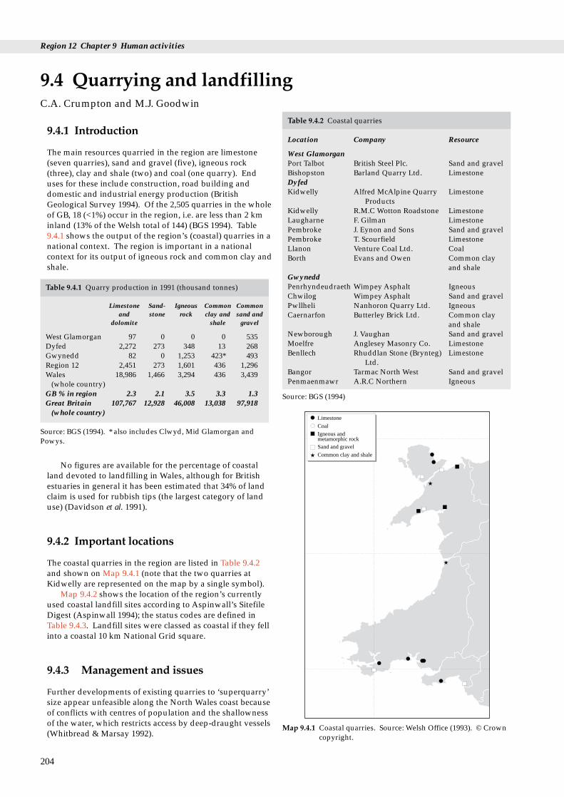
Region 12 Chapter 9 Human activities
g
Table 9.4.2 Coastal quarries
Location Company Resource
West GlamorganPort Talbot British Steel Plc. Sand and gravelBishopston Barland Quarry Ltd. LimestoneDyfedKidwelly Alfred McAlpine Quarry Limestone
ProductsKidwelly R.M.C Wotton Roadstone LimestoneLaugharne F. Gilman LimestonePembroke J. Eynon and Sons Sand and gravelPembroke T. Scourfield LimestoneLlanon Venture Coal Ltd. CoalBorth Evans and Owen Common clay
and shale
9.4.1 Introduction
The main resources quarried in the region are limestone(seven quarries), sand and gravel (five), igneous rock(three), clay and shale (two) and coal (one quarry). Enduses for these include construction, road building anddomestic and industrial energy production (BritishGeological Survey 1994). Of the 2,505 quarries in the wholeof GB, 18 (<1%) occur in the region, i.e. are less than 2 kminland (13% of the Welsh total of 144) (BGS 1994). Table9.4.1 shows the output of the region’s (coastal) quarries in anational context. The region is important in a nationalcontext for its output of igneous rock and common clay andshale.
9.4 Quarrying and landfillinC.A. Crumpton and M.J. Goodwin
Table 9.4.1 Quarry production in 1991 (thousand tonnes)
Limestone Sand- Igneous Common Commonand stone rock clay and sand and
dolomite shale gravel
West Glamorgan 97 0 0 0 535Dyfed 2,272 273 348 13 268Gwynedd 82 0 1,253 423* 493Region 12 2,451 273 1,601 436 1,296Wales 18,986 1,466 3,294 436 3,439
(whole country)GB % in region 2.3 2.1 3.5 3.3 1.3Great Britain 107,767 12,928 46,008 13,038 97,918
(whole country)
Source: BGS (1994). * also includes Clwyd, Mid Glamorgan andPowys.
GwyneddPenrhyndeudraeth Wimpey Asphalt IgneousChwilog Wimpey Asphalt Sand and gravelPwllheli Nanhoron Quarry Ltd. IgneousCaernarfon Butterley Brick Ltd. Common clay
and shaleNewborough J. Vaughan Sand and gravelMoelfre Anglesey Masonry Co. LimestoneBenllech Rhuddlan Stone (Brynteg) Limestone
Ltd.Bangor Tarmac North West Sand and gravelPenmaenmawr A.R.C Northern Igneous
Source: BGS (1994)
Coal
Limestone
Igneous andmetamorphic rockSand and gravel
Common clay and shale
No figures are available for the percentage of coastalland devoted to landfilling in Wales, although for Britishestuaries in general it has been estimated that 34% of landclaim is used for rubbish tips (the largest category of landuse) (Davidson et al. 1991).
9.4.2 Important locations
The coastal quarries in the region are listed in Table 9.4.2and shown on Map 9.4.1 (note that the two quarries atKidwelly are represented on the map by a single symbol).
Map 9.4.2 shows the location of the region’s currentlyused coastal landfill sites according to Aspinwall’s SitefileDigest (Aspinwall 1994); the status codes are defined inTable 9.4.3. Landfill sites were classed as coastal if they fellinto a coastal 10 km National Grid square.
Map 9.4.1 Coastal quarries. Source: Welsh Office (1993). © Crowncopyright.
9.4.3 Management and issues
Further developments of existing quarries to ‘superquarry’size appear unfeasible along the North Wales coast becauseof conflicts with centres of population and the shallownessof the water, which restricts access by deep-draught vessels(Whitbread & Marsay 1992).
204
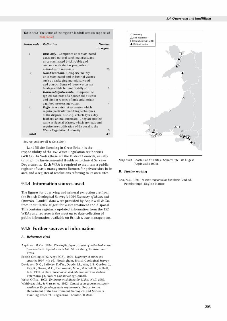
9.4 Quarrying and landfilling
Inert only
Non-hazardous
Difficult wastesHousehold/putrescible
Map 9.4.2 Coastal landfill sites. Source: Site File Digest(Aspinwalls 1994).
Table 9.4.3 The status of the region’s landfill sites (in support ofMap 9.4.2)
Status code Definition Numberin region
1 Inert only. Comprises uncontaminatedexcavated natural earth materials, anduncontaminated brick rubble and concrete with similar properties to natural earth materials. 29
2 Non-hazardous. Comprise mainlyuncontaminated and industrial wastessuch as packaging materials, wood and plastic. Some of these wastes arebiodegradable but not rapidly so. 1
3 Household/putrescible. Comprise the typical contents of a household dustbin and similar wastes of industrial origin e.g. food processing wastes. 4
4 Difficult wastes. Any wastes which require particular handling techniques at the disposal site, e.g. vehicle tyres, dry feathers, animal carcasses. They are not the same as Special Wastes, which are toxic andrequire pre-notification of disposal to the Waste Regulation Authority. 9
Total 43
Source: Aspinwall & Co. (1994)
Landfill site licensing in Great Britain is theresponsibility of the 152 Waste Regulation Authorities(WRAs). In Wales these are the District Councils, usuallythrough the Environmental Health or Technical ServicesDepartments. Each WRA is required to maintain a publicregister of waste management licences for private sites in itsarea and a register of resolutions referring to its own sites.
9.4.4 Information sources used
The figures for quarrying and mineral extraction are fromthe British Geological Survey’s 1994 Directory of Mines andQuarries. Landfill data were provided by Aspinwall & Co.from their Sitefile Digest for waste treatment and disposal.This contains regularly updated information from the 152WRAs and represents the most up to date collection ofpublic information available on British waste management.
9.4.5 Further sources of information
A. References cited
Aspinwall & Co. 1994. The sitefile digest: a digest of authorised wastetreatment and disposal sites in GB. Shrewsbury, EnvironmentPress.
British Geological Survey (BGS). 1994. Directory of mines andquarries 1994. 4th ed. Nottingham, British Geological Survey.
Davidson, N.C., Laffoley, D.d’A., Doody, J.P., Way, L.S., Gordon, J.,Key, R., Drake, M.C., Pienkowski, M.W., Mitchell, R., & Duff,K.L. 1991. Nature conservation and estuaries in Great Britain.Peterborough, Nature Conservancy Council.
Welsh Office. 1993. Environmental digest for Wales. No.7, 1992.Whitbread, M., & Marsay, A. 1992. Coastal superquarries to supply
south-east England aggregate requirements. Report to theDepartment of the Environment Geological and MineralsPlanning Research Programme. London, HMSO.
B. Further reading
Eno, N.C. 1991. Marine conservation handbook. 2nd ed.Peterborough, English Nature.
205

Region 12 Chapter 9 Human activities
C. Contact names and addresses
Type of information Contact address and telephone no.
Quarries (Directory of Mines Director, British Geological Survey, and Quarries) Keyworth, Nottingham
NG12 5GG, tel. 0115 936 3393
Landfill sites (Sitefile Digest) Senior Consultant, Aspinwall &Co., Walford Manor, Baschurch,Shrewsbury SY4 2HH, tel. 01939 261144
Waste regulation (Arfon) Chief Environmental HealthOfficer, Arfon Waste RegulatoryAuthority, Swyddfa, Arfon,Penralt, Caernarfon LL55 1BN, tel. 01286 673113
Waste regulation Director of Technical Services, (Carmarthen) Carmarthen Waste Regulatory
Authority, (*District Council), tel. 01267 234567
Waste regulation (Ceredigion) Director of Technical Services,Ceredigion Waste RegulatoryAuthority, (*District Council),tel. 01970 617911
Waste regulation (Llanelli) Director of Technical Services,Llanelli Waste RegulatoryAuthority, (*Borough Council),tel. 01554 741100
Waste regulation (Neath) Director of Engineering andOperations, Neath WasteRegulatory Authority, TregellesCourt, Neath Abbey, Neath SA10 7DF, tel. 01639 641121
Waste regulation (Port Talbot) Borough Engineer, Port TalbotWaste Regulatory Authority, CivicCentre, Port Talbot SA13 1PJ, tel. 01639 883141
Waste regulation (South Director of Works and Services, Pembrokeshire) South Pembrokeshire Waste
Regulatory Authority, (*DistrictCouncil), tel. 01646 683122
Waste regulation (Preseli Central Services Manager, Preseli Pembrokeshire) Pembrokeshire Waste Regulatory
Authority, (*District Council), tel. 01437 764551
Waste regulation (Swansea City Engineer, Swansea City Waste City) Regulatory Authority, (*City
Council), tel. 01792 301301
Waste regulation (Ynys Mon- Director of Cont. Services, Ynys Isle of Anglesey) Mon-Isle of Anglesey Waste
Regulatory Authority, (*BoroughCouncil Office), tel. 01248 750057
* Starred contact addresses are given in full in the Appendix
9.4.6 Acknowledgements
Thanks to Dr Ron Moore and Susan Morley (Aspinwall &Co) for providing information on landfill sites from theSitefile Digest.
206

tion, dredging, and disposal
Penrhyn65,446
Pembroke55,132
Burry Port24,720
Swansea216,711 Briton Ferry
330,504
Licensed dredging area
Map 9.5.1 Tonnages of marine dredged aggregates landed: 1993.Source: Crown Estate.
9.5.1 Introduction
Sand and gravel on the sea bed are important sources ofindustrial aggregate for concrete production, construction,beach replenishment and beach protection. They areextracted by commercial mineral companies under licencefrom the Crown Estate. Marine extraction in England andWales reached a peak of 28 million tonnes in 1989 and fellsteadily to 18 million tonnes in 1993, of which some sixmillion tonnes was exported (Crown Estates 1994). In 1992marine aggregates accounted for 15% of the nationaldemand for aggregates. The quantity of marine dredgedaggregate (692,513 tonnes) landed at the five ports in theregion represents 3.7% of the total quantity of aggregatelanded in 1993 (Crown Estate 1994).
Capital dredging refers to the one-off removal ofsediment, chiefly when deepening shipping channels andduring the construction of new dock facilities. Maintenancedredging is the regular dredging of existing ports and theirapproaches to maintain safe navigation. The majority ofdredged material, which can range in composition from clayand silt to rock, is dumped at sea, but it may also be used forland claim and increasingly for beach recharge. Dredgedmaterial is the dominant input by man of inert solids to theIrish Sea and levels are considered to be unlikely to changesignificantly in the future. There may, however, beoccasional peaks due to new harbour and marinadevelopments (Irish Sea Study Group 1990a). During theNature Conservancy Council’s Estuaries Review surveyscarried out in 1989, out of a total of 155 sites around GreatBritain, capital dredging was taking place in 15 estuaries(10%) and maintenance dredging was taking place in 72(47%) (Davidson et al. 1991), of which two and seven,respectively, were in the region.
The amount of dredged material dumped in the regionin 1993 (1,401,365 tonnes) constitutes 4.7% of the totaldredged material deposited around the UK as a whole(29,866,256 tonnes) in 1993. This contrasts with a figure of
9.5 Marine aggregate extracof dredge spoil
C.A. Crumpton and M.J. Goodwin
Table 9.5.2 The amounts of dredged material disposed of at eachlicensed site in the region in 1992 and 1993
Site name MAFF Depth Dredging Dumped Dumped code (m) type tonnage tonnage
1992 1993
Swansea Bay LU130 20 Capital 0 0(outer) Maintenance 1,632,692 1,401,365
Milford Haven LU170 30 Capital 0 0Maintenance 156,000 0
Menai Strait IS030 0-10 Maintenance 0 n/aHolyhead Deep IS040 50-80 Capital 0 0
Maintenance 3,500 0Holyhead East IS042 64 Capital 0 n/aConwy Bay IS055 20 Maintenance 0 0Total 1,792,192 1,401,365
Source: MAFF
6.1% in 1992, when 1,792,192 tonnes were deposited in theregion and 29,161,946 tonnes were deposited around the UKas a whole. During the Estuaries Review surveys carriedout in 1989, dredged material was being dumped in 10(6.5%) of the estuaries surveyed (Davidson et al. 1991), butnone was in the region.
9.5.2 Important locations
Map 2.2.2 (in Chapter 2: Geology and PhysicalEnvironment) shows the seabed sediments in the region.Map 9.5.1 shows the landings of marine dredged aggregatesin the regions’s ports in 1993. The Helwick Bank,approximately 7 km south of Worms Head (see Map 1.2.1) isdredged by Llanelli Sand Dredging Limited. The greaterpart of the marine aggregate landed at Briton Ferry,Swansea and Pembroke Dock is dredged from Nash Bankand Holme Sand further east up the Severn Estuary: onlythat landed at Burry Port is likely to have come fromHelwick Bank (Welsh Office, pers. comm.). A limitedamount of material was landed at Briton Ferry and Swanseafrom the licensed area off Merseyside (Crown Estate pers.comm.). No aggregate prospecting or production takes
207

Region 12 Chapter 9 Human activities
LU170
LU130
LU160LU050
IS055
IS030
IS040
IS042
Licensed dumping sites
Map 9.5.2 Dredge spoil dumping sites. See Table 9.5.2. Source:MAFF (1994). © Crown copyright.
place in Cardigan Bay or Caernarfon Bay (Crown Estate1994). Penrhyn in the north of the region is hampered bytidal conditions and a lack of space (Crown Estate 1994).Coarse gritty sand with a minor gravel component isworked on a small scale from two licences on a sharedground off the coast of north Wales. Few of the knowngravel grounds in this area have been prospected (Nunneyet al. 1986).
Map 9.5.2 shows the main marine disposal sites used forthe dumping of dredged material in the region in 1992. Thespoil dumping grounds in Swansea Bay take spoil from themaintenance dredging of Port Talbot Tidal Harbour (thegreatest contributor) and the Neath River as well as fromSwansea Docks (Welsh Office pers. comm.). Much lessdredged material was disposed of in the Milford Havendumping ground because the port of Milford Haven isrelatively deep and so requires less dredging. In recentyears, substantial quantities of material from the extensivecapital dredging works involved in the Conwy estuary roadtunnel project were dumped off-shore in Conwy Bay andnorth of Anglesey (Irish Sea Study Group 1990a).
9.5.3 Management and issues
Government policy for the provision of aggregate,formulated in 1982 and 1989, has encouraged marineextraction of sand and gravel: Minerals Planning GuidanceNote 6 states that “it has a very important role to play inmaintaining supplies of aggregate and, as far as possible, itsuse is to be encouraged” (Crown Estate 1992). Aggregates
208
from terrestrial sources are insufficient to meet demand(Doody et al. 1993). Dredging for marine aggregates tendsto be a less controversial activity than terrestrial extraction,and ‘high quality’ aggregate exists in coastal areas adjacentto the main markets in south-east England (Kenny et al.1994). The government promotes environmentallysustainable coastal defences, and as a result the use of sandand gravel for beach recharge is predicted to growsubstantially (NERC undated). The national demand foraggregates increased steadily during the 1980s. In response,the aggregate industry invested in new ships, whichallowed more efficient exploitation of licence areas and new,deeper waters to be dredged (Kenny et al. 1994).
Disposal of dredged material in the UK is controlled bythe Water Resources Act (1991), the Food andEnvironmental Protection Act (1985) (dumping at sea andinter-tidal areas) and the Town and Country Planning andEnvironmental Protection Acts, both 1990 (dumping onland). The 1992 Paris Convention includes within its scopedumping of dredged material at sea. Licences to dumpdredged material are granted in Wales by the Welsh Office.Each licence is subject to certain conditions, which havebecome more stringent in the last few years (Milford HavenPort Authority pers. comm.). Illegal dumping may occur; forinstance, in 1986 and 1987 six and three cases respectively ofalleged illegal dumping were investigated in England andWales (MAFF 1989).
9.5.4 Information sources
The statistics on the tonnage of marine dredged aggregatesfrom the Crown Estate relate to royalty returns for 1993.The regional landing port totals do not equal the amountdredged from each region because some is exported andsome landed outside the region to meet home marketdemands.
9.5.5 Further sources of information
A. References cited
Crown Estate. 1994. Marine aggregates - Crown Estate licences -summary of statistics 1993. Crown Estate.
Crown Estate. 1992. Marine aggregate extraction and the Governmentview procedure. Crown Estate.
Davidson, N.C., Laffoley, D.d’A., Doody, J.P., Way, L.S., Gordon, J.,Key, R., Drake, M.C., Pienkowski, M.W., Mitchell, R., & Duff,K.L. 1991. Nature conservation and estuaries in Great Britain.Peterborough, Nature Conservancy Council.
Doody, J.P., Johnston, C., & Smith, B. 1993. Directory of the North Seacoastal margin. Peterborough, Joint Nature ConservationCommittee.
Irish Sea Study Group. 1990b. The Irish Sea; an environmental review.Part 2; waste inputs and pollution. Liverpool, LiverpoolUniversity Press.
Kenny, A.J., & Rees, H.L. 1994. The effects of marine gravelextraction on the macrobenthos: early post-dredgingrecolonisation. Marine Pollution Bulletin, 7: 442-447

9.5 Marine aggregate extraction, dredging, and disposal of dredge spoil
Ministry of Agriculture, Fisheries and Food. 1989. Coastal defenceand the environment: a strategic guide for managers and decisionmakers in the National Rivers Authority, local authorities and otherbodies with coastal responsibilities. London, HMSO.
Ministry of Agriculture, Fisheries and Food. 1994. Annual report:report on the disposal of waste at sea 1992. London, HMSO.
Nunney, R.S., & Chillingworth, P.C.H. 1986. Marine dredging forsand and gravel. Department of the Environment. (MineralsPlanning Research Project No. PECD 7/1/163 - 99/84.)
B. Further reading
Barne, J., Davidson, N.C., Hill, T.O., & Jones, M. 1994. Coastal andMarine UKDMAP datasets: a user manual. Peterborough, JointNature Conservation Committee.
BMAPA. 1993. Aggregates from the sea : why dredge? British MarineAggregate Producers Association.
British Geological Survey. Undated. Marine aggregate survey phase 4:Irish Sea, 53°N - 55°N and UK waters between 3°W and 5°30’W.(BGS ref: WB/92/10.)
British Oceanographic Data Centre. 1992. UK Marine DigitalMapping Atlas Project (UKDMAP) (on diskette).
Campbell, J.A. 1993. Guidelines for assessing marine aggregateextraction. Lowestoft, MAFF (Directorate of Fisheries Research).(Laboratory leaflet No. 73.)
Collins, M.B., et al., eds. 1979. Industrialised embayments and theirenvironmental problems: a case study of Swansea Bay. UniversityCollege, Swansea, Pergamon Press.
ICES. 1978. Input of pollutants to the Oslo Commission area. Coop.Res. Rep., Int. Coun. Explor. Sea, 77: 57.
Irish Sea Study Group. 1990. The Irish Sea; an environmental review.Part 1; nature conservation. Liverpool, Liverpool UniversityPress.
Finney, N.H. 1987. Maintenance dredging and spoil disposal at UKports. Maintenance dredging. London, TTL.
MAFF (Directorate of Fisheries Research). 1992. Monitoring ofactivities related to aggregate extraction. Monitoring andsurveillance of non-radioactive contaminants in the aquaticenvironment and activities regulating the disposal of wastes atsea, 1990. Aquatic Environment Monitoring Report, 30: 46-49.
NERC. Undated. Marine sand and gravel: resources and exploitation.NERC.
Parker, M.M. 1987. The future for the disposal of dredged materialin the UK. Maintenance dredging. London, TTL.
Posford Duvivier Environment. 1992. Capital and maintenancedredging a pilot case study to review the potential benefits for natureconservation. Unpublished report.
Pullen, S. Undated. Dumping of dredged spoils from ports:contamination, pollution controls.
Welsh Office, 1993. Environment Digest for Wales; No. 7, 1992.
C. Contact names and addresses
Type of information Contact address and telephone no.
Marine sand and gravel Secretary, British Marine extraction Aggregate Producers Association
(BMAPA), 156 Buckingham PalaceRoad, London SW1 9TR, tel. 0171 730 8194
Marine aggregate extraction Corporate Services Manager,Marine Estates (Offshore), TheCrown Estate, 16 Carlton HouseTerrace, London SW1Y 5AH, tel. 0171 210 4377
Marine resource management Technical Manager, PosfordDuvivier (Managing AgentsOffshore for The Crown Estate),Eastchester House, Harlands Road,Haywards Heath, West SussexRH16 1PG, tel. 01444 458551
Offshore geoscience data Director, British Geological Survey, including 1:250,000 maps of Keyworth, Nottingham coastal geology NG12 5GG, tel. 0115 936 3100
Sand and gravel Director, Sand and GravelAssociation (SAGA), 1 BramberCourt, 2 Bramber Road, LondonW14 9PB, tel. 0171 381 8778
Mineral Planning Mineral Planning Officer, WestGlamorgan County CouncilMinerals Planning Department,County Hall, Swansea SA1 3SN,tel. 01792 471111
Mineral Planning Mineral Planning Officer, DyfedCounty Council Minerals Section(Planning Dept), County Hall,Carmarthen, Dyfed SA31 1JP, tel.01267 233333
Mineral Planning Mineral Planning Officer,Gwynedd County Council.Minerals Section (EconomicDevelopment and Planning Dept),County Offices, Shire Hall Street,Caernarfon, Gwynedd LL55 1SH,tel. 01286 672255
Dumping of dredge spoil The Oslo and Paris Commissions,New Court, 48 Carey Street,London WC2A 2JE, tel: 0171 242 9927
Database containing all Marine Environmental Protection dredge spoil dumping Division, Ministry of Agriculture, licensing information. Fisheries and Food, Nobel House,
17 Smith Square, London SW1P 3JR, tel. 0171 238 6558
Dumping of dredge spoil Information Officer, International at sea Maritime Organisation (IMO),
4 Albert Embankment, LondonSE1 7SR, tel. 0171 735 7611
Dumping of dredge spoil The Department of the at sea Environment, 2 Marsham Street,
London SW1P 3EB, tel. 0171 276 3000
209

Region 12 Chapter 9 Human activities
C. Contact names and addresses (continued)
Type of information Contact address and telephone no.
Dumping of dredge spoil Technical Secretary, Waste at sea Management Forum (WMF), c/o
Institute of Wastes Management, 9 Saxon Court, St Peter’s Gardens,Northampton NN1 1SX, tel. 0160420426
Dumping of dredge spoil in Milford Haven Port Authority, the region P.O. Box 14, Milford Haven, Dyfed
SA73 3ER, tel. 01646 693091
Dumping of dredge spoil International Council for the at sea Exploration of the Seas, Palaegade
2-4, Dk 1261, Copenhagen K.,Denmark, tel. 010 45 1154 225
* Starred contact addresses are given in full in the Appendix
210
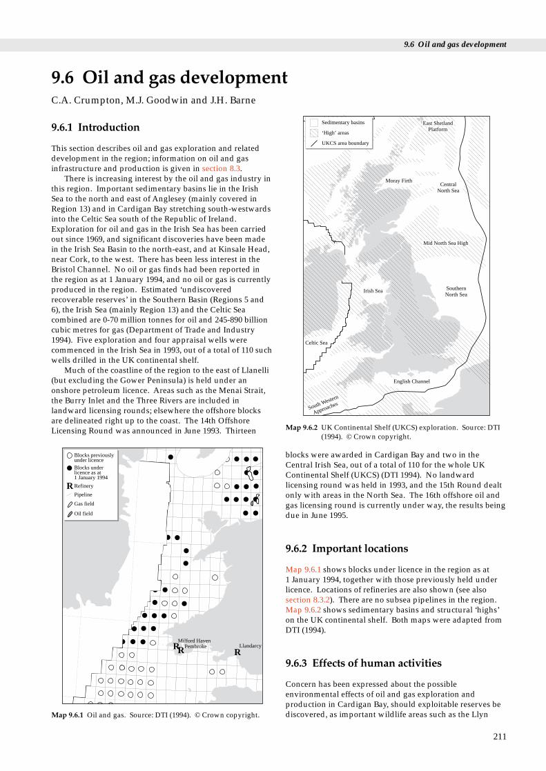
9.6 Oil and gas development
t
South Western
Approaches
English Channel
SouthernNorth Sea
Mid North Sea High
CentralNorth Sea
Moray Firth
East ShetlandPlatform
Irish Sea
Celtic Sea
Sedimentary basins
‘High’ areas
UKCS area boundary
Map 9.6.2 UK Continental Shelf (UKCS) exploration. Source: DTI
9.6.1 Introduction
This section describes oil and gas exploration and relateddevelopment in the region; information on oil and gasinfrastructure and production is given in section 8.3.
There is increasing interest by the oil and gas industry inthis region. Important sedimentary basins lie in the IrishSea to the north and east of Anglesey (mainly covered inRegion 13) and in Cardigan Bay stretching south-westwardsinto the Celtic Sea south of the Republic of Ireland.Exploration for oil and gas in the Irish Sea has been carriedout since 1969, and significant discoveries have been madein the Irish Sea Basin to the north-east, and at Kinsale Head,near Cork, to the west. There has been less interest in theBristol Channel. No oil or gas finds had been reported inthe region as at 1 January 1994, and no oil or gas is currentlyproduced in the region. Estimated ‘undiscoveredrecoverable reserves’ in the Southern Basin (Regions 5 and6), the Irish Sea (mainly Region 13) and the Celtic Seacombined are 0-70 million tonnes for oil and 245-890 billioncubic metres for gas (Department of Trade and Industry1994). Five exploration and four appraisal wells werecommenced in the Irish Sea in 1993, out of a total of 110 suchwells drilled in the UK continental shelf.
Much of the coastline of the region to the east of Llanelli(but excluding the Gower Peninsula) is held under anonshore petroleum licence. Areas such as the Menai Strait,the Burry Inlet and the Three Rivers are included inlandward licensing rounds; elsewhere the offshore blocksare delineated right up to the coast. The 14th OffshoreLicensing Round was announced in June 1993. Thirteen
9.6 Oil and gas developmenC.A. Crumpton, M.J. Goodwin and J.H. Barne
(1994). © Crown copyright.
RR R
Blocks previouslyunder licenceBlocks underlicence as at1 January 1994
Refinery
Pipeline
Oil field
Gas field
R
LlandarcyPembrokeMilford Haven
Map 9.6.1 Oil and gas. Source: DTI (1994). © Crown copyright.
blocks were awarded in Cardigan Bay and two in theCentral Irish Sea, out of a total of 110 for the whole UKContinental Shelf (UKCS) (DTI 1994). No landwardlicensing round was held in 1993, and the 15th Round dealtonly with areas in the North Sea. The 16th offshore oil andgas licensing round is currently under way, the results beingdue in June 1995.
9.6.2 Important locations
Map 9.6.1 shows blocks under licence in the region as at 1 January 1994, together with those previously held underlicence. Locations of refineries are also shown (see alsosection 8.3.2). There are no subsea pipelines in the region.Map 9.6.2 shows sedimentary basins and structural ‘highs’on the UK continental shelf. Both maps were adapted fromDTI (1994).
9.6.3 Effects of human activities
Concern has been expressed about the possibleenvironmental effects of oil and gas exploration andproduction in Cardigan Bay, should exploitable reserves bediscovered, as important wildlife areas such as the Llyn
211
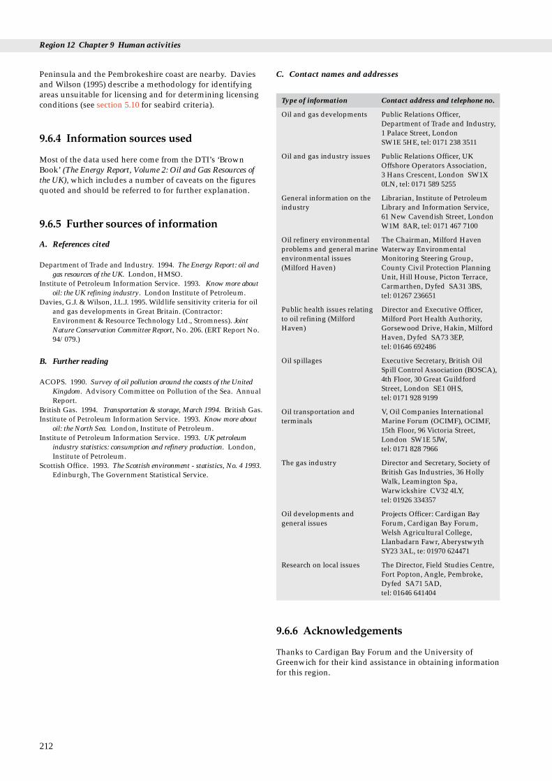
Region 12 Chapter 9 Human activities
Peninsula and the Pembrokeshire coast are nearby. Daviesand Wilson (1995) describe a methodology for identifyingareas unsuitable for licensing and for determining licensingconditions (see section 5.10 for seabird criteria).
9.6.4 Information sources used
Most of the data used here come from the DTI’s ‘BrownBook’ (The Energy Report, Volume 2: Oil and Gas Resources ofthe UK), which includes a number of caveats on the figuresquoted and should be referred to for further explanation.
9.6.5 Further sources of information
A. References cited
Department of Trade and Industry. 1994. The Energy Report: oil andgas resources of the UK. London, HMSO.
Institute of Petroleum Information Service. 1993. Know more aboutoil: the UK refining industry. London Institute of Petroleum.
Davies, G.J. & Wilson, J.L.J. 1995. Wildlife sensitivity criteria for oiland gas developments in Great Britain. (Contractor:Environment & Resource Technology Ltd., Stromness). JointNature Conservation Committee Report, No. 206. (ERT Report No.94/079.)
B. Further reading
ACOPS. 1990. Survey of oil pollution around the coasts of the UnitedKingdom. Advisory Committee on Pollution of the Sea. AnnualReport.
British Gas. 1994. Transportation & storage, March 1994. British Gas.Institute of Petroleum Information Service. 1993. Know more about
oil: the North Sea. London, Institute of Petroleum.Institute of Petroleum Information Service. 1993. UK petroleum
industry statistics: consumption and refinery production. London,Institute of Petroleum.
Scottish Office. 1993. The Scottish environment - statistics, No. 4 1993.Edinburgh, The Government Statistical Service.
212
C. Contact names and addresses
Type of information Contact address and telephone no.
Oil and gas developments Public Relations Officer,Department of Trade and Industry,1 Palace Street, London SW1E 5HE, tel: 0171 238 3511
Oil and gas industry issues Public Relations Officer, UKOffshore Operators Association, 3 Hans Crescent, London SW1X0LN, tel: 0171 589 5255
General information on the Librarian, Institute of Petroleum industry Library and Information Service,
61 New Cavendish Street, LondonW1M 8AR, tel: 0171 467 7100
Oil refinery environmental The Chairman, Milford Haven problems and general marine Waterway Environmental environmental issues Monitoring Steering Group, (Milford Haven) County Civil Protection Planning
Unit, Hill House, Picton Terrace,Carmarthen, Dyfed SA31 3BS, tel: 01267 236651
Public health issues relating Director and Executive Officer, to oil refining (Milford Milford Port Health Authority, Haven) Gorsewood Drive, Hakin, Milford
Haven, Dyfed SA73 3EP, tel: 01646 692486
Oil spillages Executive Secretary, British OilSpill Control Association (BOSCA),4th Floor, 30 Great GuildfordStreet, London SE1 0HS, tel: 0171 928 9199
Oil transportation and V, Oil Companies International terminals Marine Forum (OCIMF), OCIMF,
15th Floor, 96 Victoria Street,London SW1E 5JW, tel: 0171 828 7966
The gas industry Director and Secretary, Society ofBritish Gas Industries, 36 HollyWalk, Leamington Spa,Warwickshire CV32 4LY, tel: 01926 334357
Oil developments and Projects Officer: Cardigan Bay general issues Forum, Cardigan Bay Forum,
Welsh Agricultural College,Llanbadarn Fawr, AberystwythSY23 3AL, te: 01970 624471
Research on local issues The Director, Field Studies Centre,Fort Popton, Angle, Pembroke,Dyfed SA71 5AD, tel: 01646 641404
9.6.6 Acknowledgements
Thanks to Cardigan Bay Forum and the University ofGreenwich for their kind assistance in obtaining informationfor this region.
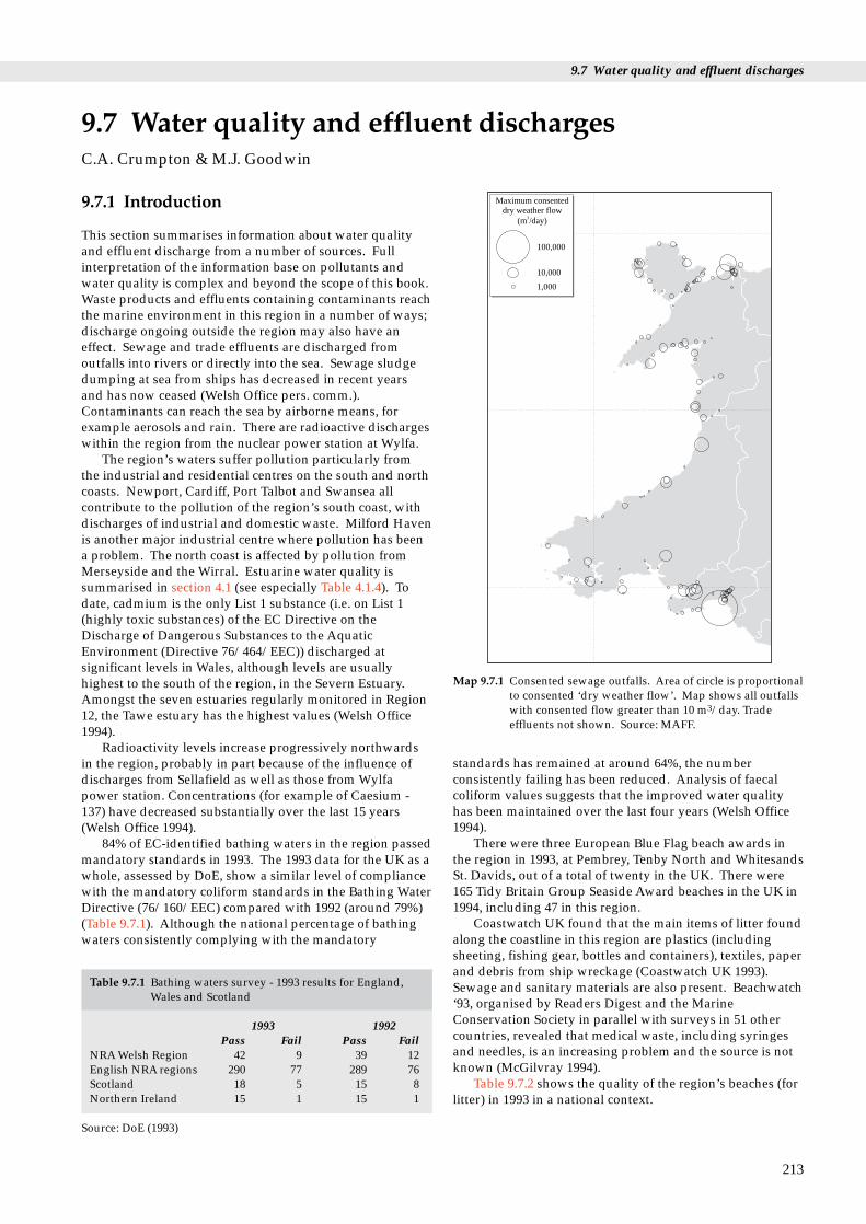
9.7 Water quality and effluent discharges
100,000
10,000
1,000
Maximum consenteddry weather flow
(m /day)3
Map 9.7.1 Consented sewage outfalls. Area of circle is proportionalto consented ‘dry weather flow’. Map shows all outfallswith consented flow greater than 10 m3/day. Tradeeffluents not shown. Source: MAFF.
nt discharges
9.7.1 Introduction
This section summarises information about water qualityand effluent discharge from a number of sources. Fullinterpretation of the information base on pollutants andwater quality is complex and beyond the scope of this book.Waste products and effluents containing contaminants reachthe marine environment in this region in a number of ways;discharge ongoing outside the region may also have aneffect. Sewage and trade effluents are discharged fromoutfalls into rivers or directly into the sea. Sewage sludgedumping at sea from ships has decreased in recent yearsand has now ceased (Welsh Office pers. comm.).Contaminants can reach the sea by airborne means, forexample aerosols and rain. There are radioactive dischargeswithin the region from the nuclear power station at Wylfa.
The region’s waters suffer pollution particularly fromthe industrial and residential centres on the south and northcoasts. Newport, Cardiff, Port Talbot and Swansea allcontribute to the pollution of the region’s south coast, withdischarges of industrial and domestic waste. Milford Havenis another major industrial centre where pollution has beena problem. The north coast is affected by pollution fromMerseyside and the Wirral. Estuarine water quality issummarised in section 4.1 (see especially Table 4.1.4). Todate, cadmium is the only List 1 substance (i.e. on List 1(highly toxic substances) of the EC Directive on theDischarge of Dangerous Substances to the AquaticEnvironment (Directive 76/464/EEC)) discharged atsignificant levels in Wales, although levels are usuallyhighest to the south of the region, in the Severn Estuary.Amongst the seven estuaries regularly monitored in Region12, the Tawe estuary has the highest values (Welsh Office1994).
Radioactivity levels increase progressively northwardsin the region, probably in part because of the influence ofdischarges from Sellafield as well as those from Wylfapower station. Concentrations (for example of Caesium -137) have decreased substantially over the last 15 years(Welsh Office 1994).
84% of EC-identified bathing waters in the region passedmandatory standards in 1993. The 1993 data for the UK as awhole, assessed by DoE, show a similar level of compliancewith the mandatory coliform standards in the Bathing WaterDirective (76/160/EEC) compared with 1992 (around 79%)(Table 9.7.1). Although the national percentage of bathingwaters consistently complying with the mandatory
9.7 Water quality and efflueC.A. Crumpton & M.J. Goodwin
Table 9.7.1 Bathing waters survey - 1993 results for England,Wales and Scotland
1993 1992Pass Fail Pass Fail
NRA Welsh Region 42 9 39 12English NRA regions 290 77 289 76Scotland 18 5 15 8Northern Ireland 15 1 15 1
Source: DoE (1993)
standards has remained at around 64%, the numberconsistently failing has been reduced. Analysis of faecalcoliform values suggests that the improved water qualityhas been maintained over the last four years (Welsh Office1994).
There were three European Blue Flag beach awards inthe region in 1993, at Pembrey, Tenby North and WhitesandsSt. Davids, out of a total of twenty in the UK. There were165 Tidy Britain Group Seaside Award beaches in the UK in1994, including 47 in this region.
Coastwatch UK found that the main items of litter foundalong the coastline in this region are plastics (includingsheeting, fishing gear, bottles and containers), textiles, paperand debris from ship wreckage (Coastwatch UK 1993).Sewage and sanitary materials are also present. Beachwatch‘93, organised by Readers Digest and the MarineConservation Society in parallel with surveys in 51 othercountries, revealed that medical waste, including syringesand needles, is an increasing problem and the source is notknown (McGilvray 1994).
Table 9.7.2 shows the quality of the region’s beaches (forlitter) in 1993 in a national context.
213

Region 12 Chapter 9 Human activities
Table 9.7.2 The quality of the region’s beaches (for litter) in 1993
Area % of beaches % of beaches % of beaches Commentsrated as rated as rated asexcellent moderate polluted
West Glamorgan 9 44 47 All levels of littering better than national averages except for largemetal objects, ship wreckage, dumped crops, oil and medical waste.
Dyfed 29 46 25 All litter types found to be consistent in quantity with nationalaverages although general quality above average.
Gwynedd 8 44 48 Majority of litter types found at above national average.Region 12 15 45 40Wales 7 39 54Great Britain 8 42 50
(Source: Coastwatch UK 1993)
9.7.2 Important locations
Map 9.7.1 shows the locations in Region 12 of all the 166consented (see section 9.7.3) sewage outfalls with aconsented ‘dry weather flows’ (i.e. undiluted by rain) inexcess of 10 m3 per day. Table 9.7.3 lists the nineteen sewageoutfalls in the region whose consented ‘dry weather flows’are in excess of 6,000 m3 per day, showing their locationsand the type of discharge. These data do not include tradeeffluent discharges.
214
Table 9.7.3 Sewage outfalls in the region with consented ‘dry weath
Name of outfall Location Grid ref
The Baglan Sewage Outfall Baglan SS70488Jersey Marine Outfall Neath SS72392Gowerton Sewage Treatment Works Gowerton SS56297Llanant Sewage Treatment Works Llanant SS57299Bynea And Halfway Sewage Treatment Bynea SS55298
WorksLlanelli Northumberland Ave Sewage Llanelli SS50298
Treatment WorksParc Y Splotts Sewage Treatment Works Carmarthen SN4011Tenby Marine Outfall Tenby SS15598Pembroke Supply Base Hancock Co Pembroke SM9770Llanina Point Sewage Treatment Works New Quay SN4035
Llanina PointAberystwyth Sewage Treatment Works Aberystwyth SN6008Tywyn Outfall Tywyn SH5700Pwllheli Outfall Pwllheli SH3893Abersoch Outfall Abersoch SH3262Porth Gwr Mawr Outfall Trearddur SH2537Turkey Shore Outfall Holyhead SH2538Tynygongl Outfall Benllech SH5258Dwygyfylchi Outfall Penmaenmawr SH7327West Shore Outfall Llandudno SH7568
Source: MAFF database of discharges to saline waters in England and
Table 9.7.4 and Map 9.7.2 show the 38 EU identifiedbathing waters in the region, 32 of which complied withmandatory coliform standards in the 1993 season (NRA1994b). Bacterial quality of a selection of 130 non-EUidentified bathing waters in the region in 1992 is listed inWelsh Office (1994). There are no statutory standards forthese bathing waters: 12% were more polluted than thelevels set for the EU bathing waters. Estuarine water qualityis summarised in chapter 4.1 (see especially Table 4.1.4).
er flows’ >6,000 m3 per day
. Type of discharge Consented ‘dry weather flow’ in cu.m /day
3 Secondary Treated Sewage 119,0006 Untreated Sewage 6,5208 Secondary Treated Sewage 21,1405 Secondary Treated Sewage 9,5441 Primary Treated Sewage 6,181
4 Primary Treated Sewage 11,333
78 Secondary Treated Sewage 12,6308 Macerated/Comminuted Sewage 7,95340 Secondary Treated Sewage 9,30895 Primary Treated Sewage 11,100
03 UV Treated Sewage 18,74918 Macerated/Comminuted Sewage 10,23048 Macerated/Comminuted Sewage 6,81562 Primary Treated Sewage 9,51574 Untreated Sewage 9,00027 Screened Sewage (>6mm) 9,40028 Untreated Sewage 6,14079 Macerated/Comminuted Sewage 22,74525 Macerated/Comminuted Sewage 26,740
Wales

9.7 Water quality and effluent discharges
Passed in 1993
Failed in 1993
Map 9.7.2 Bathing water quality. Results of 1993 sampling of EC-identified bathing waters. Source: NRA (1994b).Adapted with permission.
Table 9.7.4 The state of the region’s EU identified bathingwaters - 1993 season
Bathing water Pass or fail
Swansea Bay FailBracelet Bay PassLimeslade Bay PassLangland Bay FailCaswell Bay PassOxwich Bay PassPort Eynon Bay PassRhossili Beach PassPembrey Beach PassPendine Beach PassAmroth Beach PassSaundersfoot Beach PassTenby N. Beach PassTenby S. Beach PassBroadhaven PassNewgale Beach PassWhitesands PassNewport Sands N. FailTraeth Gwyn, New Quay PassAberystwyth S. Beach FailAberystwyth N. Beach PassAberdyfi FailBorth PassTywyn PassFairbourne Beach PassBarmouth PassLlandanwg Beach PassHarlech PassMorfa Bychan PassCriccieth Beach E. PassPwllheli Beach PassAbersoch PassMorfa Dinlle PassBenllech PassTreardurr Bay PassRhosneigr PassLlandudno W. FailLlandudno N. Pass
Source: NRA (1993)
9.7.3 Management and issues
The Water Resources Act (1991) is the main legislation thatcontrols discharges to the aquatic environment in Wales.The National Rivers Authority (NRA) has overallresponsibility for the control of discharges and themaintenance of water quality. It authorises sewagedischarges by issuing ‘consents’, with the Welsh OfficeAgriculture Department (WOAD) as a statutory consultee totake into account the fishery interests. Trade effluentinvolving ‘scheduled’ (hazardous) processes must beauthorised by Her Majesty’s Inspector of Pollution underthe Environmental Protection Act 1990, with the NRA as astatutory consultee. WOAD issues licences for the dumpingof sewage at sea. From early 1992 all dumping of liquidwaste into the sea from ships ceased and all sewage sludgedumping by marine vessels is set to be phased out by 1998,under the Urban Waste Water Treatment Directive(91/271/EEC). Under the same Directive all significantsewage discharges, except those in ‘High NaturalDispersion Areas’, will require minimum secondarytreatment, to be phased in by 2005. Sewage disposal onland is controlled by the local Waste Regulation Authorities(see section 9.4). The UK produces some 1.1 million tonnesof dry solids (tds) of sewage sludge annually and disposesof approximately 300,000 tds into the sea. UK sewagesludge production is set to increase dramatically over thenext decade, with predicted increases totalling 2.2 milliontds by 2006. This will have to be disposed of on land, eitherby dumping or by incineration.
215

Region 12 Chapter 9 Human activities
9.7.4 Information sources
There are currently several schemes for assessing the qualityof coastal waters and beaches. The NRA monitors identifiedbathing waters for levels of coliforms (bacteria that indicatesewage presence) under the EC Bathing Water Directive.There are schemes such as the European Blue Flags andTidy Britain Group Seaside Awards for beaches which meetstandards of beach and water quality. The Welsh Officepublish an annual Environmental Digest for Wales, coveringthis region, which provides datasets on pollution indicators,including estuarine water quality, bathing waters andcoastal water quality (heavy metals, sewage andradioactivity) (see Welsh Office 1994). The Ministry ofAgriculture Fisheries and Food hold a database ofconsented sewage outfalls in England and Wales, andprovide technical backup to WOAD.
Pollution levels in coastal waters north fromPembrokeshire are described further in Irish Sea StudyGroup (1990). The NRA’s quarterly ship and air-borneNational Coastal Baseline Survey monitors a large numberof water quality parameters in coastal waters, includingmetals, nutrients and turbidity. Finally, there are the annuallitter surveys of Coastwatch UK and Beachwatch, both ofwhich use volunteers to survey lengths of coastline for litterand other signs of pollution. Coastwatch UK andBeachwatch do not sample the whole coastline in the regionbecause of a shortage of volunteers. In consequence theresults may be unrepresentative, especially as monitoringtakes place over only one or two days per year.
9.7.5 Further sources of information
A. References
Coastwatch UK. 1993. 1993 survey report. Farnborough College ofTechnology.
Department of the Environment. 1993. Minute No. 818. 1/12/93.Irish Sea Study Group. 1990. The Irish Sea. An environmental review.
Part 2. Waste inputs and pollution. Liverpool University Press.(Irish Sea Study Group Report.)
McGilvray, F. 1994. Marine debris on Britain’s coast. North SeaMonitor, Vol. 12, Issue 1, March 1994.
National Rivers Authority. 1994. Bathing water quality in Englandand Wales - 1993. Bristol, National Rivers Authority.
National Rivers Authority. 1993. Bathing waters report 1993, WelshRegion. Bristol, National Rivers Authority.
Welsh Office. 1994. Environmental digest for Wales. No. 8. 1993.Cardiff.
B. Further reading
Anon. 1993. Lies, damned lies and statistics in the great waterdebate. ENDS Report. No. 227 (12/93): 16-19.
Anon. 1987. Shift on sewage sludge disposal methods. MarinePollution Bulletin, Vol. 18, No. 12: 619.
Anon. 1989. Sewage sludge statistics. Marine Pollution Bulletin, Vol.20, No. 2: 54.
Baker, B. 1993. The burning issue. Surveyor. 2/12/93, 18-19.Clark, R.B. 1986. Marine pollution. Oxford, Blackwell Scientific
Publications.Department of Environment. 1990. The digest of environmental
protection and water statistics, No. 13. London, HMSO.Department of the Environment. 1992. The UK environment.
London, HMSO.
216
Eno, N.C., ed. 1991. Marine conservation handbook. 2nd ed.Peterborough, English Nature.
European Community. 1991. Directive on urban waste watertreatment 1991. (91/271/EEC.)
Hoare, R., & Hiscock, K. 1974. An ecological survey of the rockycoast adjacent to a bromine extraction works. Estuarine andCoastal Marine Science, 2: 329-348.
Horsman, P. 1982. The amount of garbage pollution from merchantships. Marine Pollution Bulletin, 13: 167-169.
House of Commons Environment Committee. 1990. Fourth report:pollution of beaches. Vol.1. London, HMSO.
National Rivers Authority. 1994. Discharge consents and compliance:the NRA’s approach to control of discharges to water. Bristol,National Rivers Authority.
Irish Sea Study Group. 1990. The Irish Sea; an environmental review.Part 2; Waste inputs and pollution. Liverpool, LiverpoolUniversity Press.
Irving, R. 1993. Too much of a good thing: nutrient enrichment in theU.K.’s coastal waters. A report to the World Wide Fund forNature (WWF). London, WWF.
Kay, D., & Wyer, M. 1994. Making waves: recreational waterquality. Biologist, Vol. 41, No. 1: 17-20.
Lees, D.N. Undated. Shellfish monitoring. In: Viruses in the marineenvironment, 43-57. Liverpool, Irish Sea Forum. (Irish SeaForum Seminar Report.)
Marine Conservation Society. 1994. The good beach guide. Ross-on-Wye, Marine Conservation Society. (Details sewage outfallsclose to beaches in the guide (not all coastal outfalls) and whattreatment the sewage has had.)
Marine Pollution Monitoring Management Group (Monitoring Co-ordination Subgroup). 1994. UK. national monitoring plan.HMIP.
MAFF Directorate of Fisheries Research. 1991. Utility ofexperimental measures of biological effects for monitoring marinesewage-sludge disposal sites. MAFF, Lowestoft. (AquaticEnvironment Monitoring Report No.24.)
MAFF Directorate of Fisheries Research. 1991. Second report of theMarine Pollution Monitoring Management Group’s Co-ordinatingGroup on monitoring of sewage sludge disposal sites. MAFF,Lowestoft. (Aquatic Environment Monitoring Report No. 25.)
MAFF Directorate of Fisheries Research. 1991. Monitoring andsurveillance of non-radioactive contaminants in the aquaticenvironment and activities regulating the disposal of wastes at sea,1988-89. MAFF, Lowestoft. (Aquatic Environment MonitoringReport No.26.)
MAFF Directorate of Fisheries Research. 1991. Third report of theMarine Pollution Monitoring Management Group’s Co-ordinatingGroup on monitoring of sewage sludge disposal sites. MAFF,Lowestoft. (Aquatic Environment Monitoring Report No.27.)
NRA. 1993. Bathing water quality in England and Wales, 1992.Bristol, National Rivers Authority. (Water Quality Series No.11.)
Welsh Office. 1993. Environment digest for Wales, No. 7, 1992.Cardiff, Welsh Office.
Worldwide Fund for Nature UK. 1995. Reassessing pollution: wildlife,humans and toxic chemicals in the environment. Godalming,Worldwide Fund for Nature UK.

C. Contact names and addresses
Waste disposal. Statutory consultee for sewage Welsh Office Agriculture Department, Fisheries Department, Division 2B, New discharges. Crown Buildings, Cathays Park, Cardiff CF1 3NQ, tel: 01222 823567
Aquatic environment research relating to waste disposal. Senior Licensing Officer (Dumping), Ministry of Agriculture Fisheries and Effects of dumping wastes at sea. Database of Food Fisheries Laboratory, Remembrance Ave., Burnham-upon-Crouch, Essex discharges to saline waters. CM0 8HA, tel. 01621 782658
Bathing waters, as outlined in EC Directive (76/160/EEC) Enquiries Officer, Department of the Environment (Public Enquiries Unit), tel.only: 0171 276 0900
Water quality, including bathing waters and *Technical Manager, NRA Welsh Region, Cardiff, tel. 01222 770088National Coastal Baseline Survey. Discharge consents.
as above Public Relations Manager, NRA, Highfield, Priestly Road, Caernarfon LL55 1HR, tel. 01286 672247
as above Pollution Control Officer, NRA, Glan Teifi, Barley Mow, Lampeter, Dyfed SA48 7BY, tel. 01570 422455
Waste disposal, pollution, conservation issues *Coastal ecologist, CCW HQ, Bangor, tel: 01248 370444
Sewage outfalls/effluent discharges Chief Scientist (Environment), Dwr Cymru Cyfyngedig (Operating Companyfor Welsh Water Plc), Plas Y Ffyynnon, Cambrian Way, Brecon, Powys LD3 7HP, tel: 01874 623181
Industrial waste disposal The Oslo and Paris Commissions, New Court, 48 Carey Street, London WC2A 2JE, tel. 0171 242 9927
Pollution from industrial sites. ‘Scheduled’ processes HM Inspector of Pollution (HMIP), Brunel House, 11th Floor, 2 Fitzalan Road, (hazardous discharges). Cardiff CF2 1TT, tel. 01222 495558
Environmental pollution Secretary, Royal Commission on Environmental Pollution, Church House,Great Smith Street, London SW1P 3BZ, tel. 0171 276 2080
Waste regulatory authorities (Local authoritity offices) see table in section 9.4.5C.
Litter (Beachwatch ‘93) and “The Good Beach Guide” *Campaigns Manager, Marine Conservation Society, Ross-on-Wye, tel. 01989 66017
Litter Public Affairs Executive, Keep Wales Tidy Campaign, 8a Cambrian Estate,Pontyclun, Mid Glamorgan CF7 9EW, tel. 01443 228032
Seaside Awards Information Officer, Tidy Britain Group, Trencherfield Mill, The Pier, Wigan,Lancs. WN3 4EX, tel: 01942 824620
Litter Project Officer, Coastwatch UK, Farnborough College of Technology, BoundaryRoad, Farnborough, Hampshire GU14 6SB, tel. 01252 377503
Issues relating to Cardigan Bay *Projects Officer, Cardigan Bay Forum, Aberystwyth, tel. 01970 624471
Issues relating to Carmarthen Bay *Secretary, Carmarthen Bay Forum, Whitland, Dyfed, tel: 01994 419313
Issues relating to North Wales *Chairman, North Wales Coastal Forum, Pwllheli, tel: 01758 83423
Marine processes and general research Director, Centre for Marine and Coastal Studies, University of Liverpool, PO Box 147, Liverpool L69 3BX, tel: 0151 794 3653
9.7 Water quality and effluent discharges
217
* Starred contact addresses are given in full in the Appendix
Type of information Contact address and telephone no.

Region 12 Chapter 9 Human activities
9–10 Sites
5–6 Sites
3–4 Sites
1–2 Site
7–8 Sites
Camping and caravansites per 10 km square
Car park
Golf course
Table 9.8.1 Land- and water- based recreation sites within 10 kmof the coast, by local authority district
District No. of land- No. of water-based sites based sites
Port Talbot 10 12Neath 11 6Swansea 36 42Lliw Valley 6 12Dinefwr 1 0Llanelli 11 13Carmarthen 12 22South Pembrokeshire 19 36Preseli 35 58Ceredigion 25 45Montgomery 2 1Meirionnydd 53 57Dwyfor 43 44Arfon 43 21Ynys Mon 23 57Aberconwy 38 33Total Region 12 368 459
Source: Natural Facilities Database (Sports Council forWales/CCW). Figures for Preseli, Montgomery, Arfon, Lliw Valley
Map 9.8.1 Land-based leisure. Source: Ordnance SurveyLandranger maps. © Crown copyright.
9.8.1 Introduction
Tourism and the leisure industry are major contributors tothe Welsh economy and provide many jobs in areas wherethere are otherwise few. Over 7 million residential holiday-makers visit Wales each year, as well as up to one millionday visitors on fine summer weekends. More than 60% ofthe residential holiday-makers come to the coast. Most ofthe region’s coast is of great leisure and tourist valuebecause of its beautiful scenery, National Parks, historictowns, rocky coasts for angling and diving, fine beaches andclear, relatively warm sea water. It has been popular forleisure and tourism since the last century, especially for thepopulation of the southern half of Britain, and is comparablein importance with the south-west peninsula of England.As well as attracting visitors from outside the region, coastaltowns provide important leisure facilities for local people.
Virtually all kinds of leisure activities take place aroundthe coast, including walking, camping, golf, bird-watching,climbing on sea cliffs, hang gliding and paragliding, landyachting on a few beaches, and general beach use byholiday-makers. Some of the most significant land-uses fortourism on the coast are golf courses, caravan/camping sitesand rural car parks (which provide the access pointsnecessary for many land- and water-based leisure activities).These are located on Map 9.8.1. A total of 133 caravan/camping sites have been identified along the coast. Therewere 23 golf courses and 86 car parks (excluding urban carparks not marked on the Ordnance Survey 1:50,000 mapsfrom which these figures were obtained).
The main infrastructure developments for water-basedleisure activities in the region include marinas, yachtmoorings, dinghy parks and launching slips. Both long-established and modern yachting, power boating and otherwater sports centres are widely distributed along the coast.Many are concentrated in the sheltered waters of bays andinlets and near centres of population, where the newercentres are sometimes associated with the regeneration ofwaterfronts or areas where employment and/or tourismhad been in decline. The northern half of Cardigan Bay,where the towns of Pwllheli and Abersoch were involved inthe recent unsuccessful Manchester Olympic Games bid, hasbeen described as the second most important sailing centrein Britain after the Solent (Heritage Coast Forum 1993).Limited facilities (primarily recreational craft moorings) arealso found in most of the small fishing ports and harboursaround the coastline, often where traditional harbouractivities have declined. Other important water sportsusing the same basic recreational infrastructure or notrequiring infrastructure, other than land access to the coast,include scuba diving, sea angling, jet-skiing, water skiing,canoeing, wind surfing, surfing and bathing. Boat trips arean important coastal activity in some areas during the maintourist season. Important areas for marine leisure areshown on Map 9.8.2.
9.8 Leisure and tourismM.J. Dunbar, S.J. Everett and S.L. Fowler
218
and Neath include sites shared with adjoining districts (1 in eachcase). Figures for Swansea and Ynys Mon include sites sharedwith adjoining districts (2 in each case). Sites may be important forboth land- and water-based leisure; the figures are not exclusive.

9.8 Leisure and tourism
LlandudnoConwy
Bangor
CaernarfonForyd BayPlas Menai
Port Dinorwic
Porthmadog
Artro
Pwllheli
Barmouth
Abersoch
Cefni
Menai Strait
HolyheadAlaw
Traeth Dulas Traeth Coch
BeaumarisTraeth Lafan
Aberdyfi
Aberystwyth
Aberaeron
New Quay
Cardigan
NyferSolva
Haverfordwest
Important areasfor water-basedleisureRYA-affiliatedorganisations
9.8.2 Important locations
In Wales as a whole there are currently 549 recorded sites ofland- and air-based recreation identified as being within 10 km of the coast, the most numerous recorded activitiesbeing riding (at 138 sites), golf (78), hill-walking (65), rockclimbing (58), orienteering (36) and cross-country races (30).619 recorded sites of water-based recreation are identified asbeing within 10 km of the coast, the most numerousrecorded activities being game angling (at 105 sites), seabathing (86), sailing (74), boardsailing (53), sub-aqua (47)and canoeing (44). Table 9.8.1 shows the breakdown ofland- and water-based sites within the region, by localauthority district.
Table 9.8.2 shows the distribution of knownaccommodation in coastal districts in 1991: the originaldocument (Wales Tourist Board 1991) should be referred tofor an explanation of the assumptions and constraints inusing the data. It is not known how much of thisaccommodation is on or near the coast, but in most areas itis probably a large proportion.
Fishguard
Llanelli
Carmarthen
SwanseaMumbles
Port Talbot
Neath
LoughorMilford Haven
St Brides Bay
Little Haven
Skomer
Pembroke
Neyland
Saundersfoot
Amroth
Tenby
Map 9.8.2 Water-based leisure. Named locations are those listed inTable 9.8.4. (RYA: Royal Yachting Association). Sources:Tourist Offices.
Table 9.8.2 Known bedspaces in tourist accommodation incoastal districts
District Serviced Self- Caravan/catering camping
Port Talbot 215 96 0Neath 269 4 240Swansea 3,218 570 9,245Lliw Valley 52 0 0Llanelli 625 0 2,305Carmarthen 1,675 1,285 2,281South Pembrokeshire 6,488 1,476 15,260Preseli 3,834 1,176 5,930Ceredigion 4,095 2,038 12,680Meirionnydd 4,731 1,531 13,248Dwyfor 4,896 6,017 9,561Arfon 3,269 1,262 4,466Ynys Mon 2,887 1,212 6,683Aberconwy 14,420 1,661 3,630Total Region 12 50,674 18,328 85,529
Source: Wales Tourist Board (1991)
The Gower Peninsula is an important tourism centre inthe south-east of the region, with a high concentration ofcaravan/camping sites and rural car parks, and manyvisitors as a result of its proximity to the conurbations ofSouth Wales and the M4. Rhosilly Down on the peninsula isa popular area for hang gliding and paragliding.
Further west, a major concentration of leisure activitiesis located around the tourist centres of Tenby andSaundersfoot. This high density of leisure land-usedecreases slightly around the Pembrokeshire National Parkcoastline and into the southern section of Cardigan Bay, butthe National Park coastline is popular with visitors forwalking and beach recreation. The Pembrokeshire CoastPath is the only National Trail in the region and extendsfrom Amroth to Cardigan.
Much of the west Wales coast of Dyfed and Gwynedd isrugged and undeveloped, but there are significant touristareas. These include (in Cardigan Bay): Aberporth, NewQuay, Aberaeron, Aberystwyth, Borth, Tywyn, Barmouth,Harlech, Porthmadog, Criccieth, Pwllheli and Abersoch.
Maps 9.8.1 and 9.8.2 show quite large numbers of facilitiesscattered along this coast, particularly bordering SnowdoniaNational Park. There is a large holiday camp (StarcoastWorld) between Pwllheli and Criccieth, major new tourismcentres are planned for Harlech, Barmouth and Tywyn, andBarmouth has a new leisure centre. Walking and campingare popular activities on the Llyn peninsula, where remotelengths of coast remain free of leisure infrastructure.
The beaches of Caernarfon Bay and Anglesey have allattracted leisure developments. A major and regionallyimportant tourist area is located at Llandudno on ConwyBay, in the north-east corner of the region. This resort, alongwith Colwyn Bay to the east (in Region 13), serves manyvisitors from the industrial towns of north-west England,and is a significant traditional seaside recreational area.Great Orme is a popular Country Park and attracts manyvisitors, particularly for walking.
The sea cliffs of Gower, Pembrokeshire, Llyn, HolyIsland and the Great Orme are popular climbing areas, butcodes of conduct generally restrict this activity to outsidethe bird breeding season (see section 5.10 and 5.11).
Table 9.8.3 summarises the distribution of some land-based recreational activities in or near Heritage Coasts.
Many marinas are under construction or planned in thisregion: 39 potential Welsh marina sites were identified bythe Council (now Campaign) for the Protection of RuralWales in 1989 (Council for the Protection of Rural Wales1989). Sixty-three affiliated sailing or yacht clubs are listedfor the region by the RYA (1992), and there are numerousother water-sports clubs, particularly along the sheltered
219

Region 12 Chapter 9 Human activities
220
Table 9.8.3 Sites of land-based recreational activities in (and within 1 km inland of) selected Heritage Coasts
Activity Gower S. Pemb. Ceredigion Llyn Holyhead Great Orme
Rock climbing 7 7 - 5 6 3Pony trekking 1 - 1 (2) (1) (1) (1)Paragliding or hang gliding 1 - - 1 - 1
Source: Sports Council for Wales (1992). Note: bracketed numbers of sites are inland within 1 km of the coast.
Table 9.8.4 Existing and proposed water-based leisure and tourism facilities
Site Grid ref. Marinas and leisure harbours Additional moorings/ Amenity barragesanchorages
Neath SS7292 Monkstone Marina, Briton FerrySwansea SS6694 Swansea dock (recent redevelopment yes One present on the Tawe
of 400-berth marina in old dock area)Loughor SS4897 New marinas proposed for Llanelli yes Proposed for Pembrey Dock
North Dock and Burry Port and Burry Port(Doody unpub.)
Carmarthen SN4020 yesSaundersfoot SN1304 yesTenby SN1301 harbour yesMilford Haven SM9403 Pembroke, Milford Docks and Marina Many. Major centre Proposed at Haverfordwest,
(151 berths), Neyland Yacht Haven for sailing and water- Cosheston, Pembroke, (420 berths). New marinas proposed sports Neyland at Castle Pill, Pennar Park, Haverfordwest
Skomer SM7309 anchorageSt Bride’s Bay/Little Haven SM8613 several anchoragesSolva SM8023 yesFishguard SM9638 proposed marina yesNyfer Estuary SN0540 yesCardigan SN1648 proposed marina yesNew Quay SN4060 yesAberaeron SN4663 yesAberystwyth SN5980 proposed marina yesAberdyfi SN6495 yes yesBarmouth/Mawddach SH6416 yesArtro SH5725 yesPortmadog/ SH5736 harbour, proposed marina yesTraeth Bach (Glaslyn/Dwyryd)Pwllheli harbour SH3835 yes (400 berths completed 1993 as part yes, more proposed
of unsuccessful ManchesterOlympic bid)
Abersoch SH3128 Important sailing centre, part of yesOlympic bid.
Foryd Bay (Fort Belan) SH4461 proposed marinaCaernarfon SH4863 proposed marina yesMenai Strait SH5471 yes, manyPlas Menai SH5066 (sailing centre) yesBangor/Penrhyn SH5973 harbour, proposed marina yes, manyBeaumaris SH6176 harbour yesPort Dinorwic SH5268 harbour, 230 berths yesCefni SH4067 yesAlaw Estuary/Holyhead SH3081 proposed marina at Holyhead yesTraeth Dulas SH4888 yesTraeth Coch SH5380 yesTraeth Lafan SH6375 proposed yesConwy SH7976 marina, 243 berths yes
Sources: Buck (1993), D’Olivera & Featherstone (1993) and miscellaneous, e.g. tourist brochures

9.8 Leisure and tourism
coastal areas such as Swansea Bay, Milford Haven,Carmarthen Bay, Tremadoc Bay, Abersoch to Pwllheli andthe Menai Strait, where the Welsh National Water SportsCentre is based. Several other informal sailing groups usead hoc beach hut facilities during the summer months.Casual surfing, canoeing and wind-surfing take place frommany of the region’s beaches and there has recently been adramatic increase in jet-skiing, particularly in the SwanseaBay/Mumbles area and off the Pembrokeshire coast. Scubadiving is a widespread activity on the west coast,particularly off the Gower Peninsula (sixteen sites on theHeritage Coast listed in Sports Council (1992)),Pembrokeshire (50 sites on the Heritage Coasts) and theshores of the Llyn peninsula and Anglesey. Angling takesplace from the shore and at sea.
Existing and major proposed water-based leisuredevelopments are listed in Table 9.8.4. The activitiesundertaken at ports and harbours in the region aredescribed in section 8.3.2 and listed in Table 8.3.2; theirlocations are shown on Map 8.3.3. Many of them haverecreational moorings and launching slips.
9.8.3 Management and issues
The Wales Tourist Board is the independent statutory bodyfinanced primarily by the Welsh Office to encourage tourismin Wales. It liaises closely with private sector partners suchas the three regional tourism companies (for North, Mid andSouth Wales), local authorities and statutory agencies suchas the Welsh Development Agency, the Development Boardfor Rural Wales and Countryside Council for Wales. All thelocal authorities are concerned with tourism developmentsand consider them within their structure and local plans.Local authority coastal planning responsibilities andinitiatives are described in section 10.4.
Since the 1950s there has been strong growth in manysectors of the tourist industry, including coastal camp sitesand caravan parks. Many coastal campsites were initiatedin the early days of planning controls and would not now bepermitted by local authorities. More recently, efforts havebeen made to provide a greater choice of accommodationand interest away from the coastal zone, including theprovision of ‘gateway’ facilities such as visitor centres in keylocations. Coastal resorts have in the past acted somewhatas ‘dormitories’ for inland attractions such as SnowdoniaNational Park. The European Union’s ‘Leader’ programmehas been drawn upon to promote lesser known areas, ofteninland, in order to reduce tourist pressure on the ‘honeypot’areas. As the structure of the tourist industry has changed,with more people travelling overseas for their holidays andexpecting higher standards in domestic accommodation,hotels have been upgraded, whereas new campsites havebecome relatively less popular.
‘Environmentally friendly’ development is stronglyfavoured by the planning authorities. This includes crafts,bed-and-breakfast and farm-based tourism. There isincreasing emphasis on the provision of qualityaccommodation rather than new caravan sites. Attention isalso focused on expanding the tourist season outside theJune-August season.
The popularity of Gower as a tourism centre has createdproblems for traffic management and, in some cases, themanagement of coastal habitats. Intensive tourist-related
developments are not now encouraged in this area. Thereare now restrictions on new coastal caravan and campingsites in Merionnydd. On the Llyn peninsula, cases ofunsympathetic tourism development have been halted bythe planning authority. Planning permission will no longernormally be granted for new camping and caravan sites onAnglesey.
A report by the Wales Tourist Board (1988) proposed anetwork of marinas all along the coast, but an up-to-datereview is required for the current position to be assessed.Since the commercial viability of marina developments isclosely related to that of property development in general,falling property prices over the last few years may beexpected to have reduced enthusiasm for marinadevelopment, and some proposals may never come tofruition (Wales Tourist Board pers. comm).
The economic boom of the 1980s stimulated a substantialnumber of speculative developments associated with leisureand tourism. Amenity barrages became a particularlypopular idea and some proposals are still underconsideration in this region.
9.8.4 Information sources
Most of the above information is derived from materialsreceived from Tourist Information Centres (up to date, butof varying detail within the region), from facilities shown onOrdnance Survey 1:50,000 Land Ranger maps andAdmiralty Charts, from Huckbody et al. (1992) and from anautical almanac (D’Olivera & Featherstone 1993). It is notpossible to indicate the scale (size and capacity) of eachcampsite or car park from this information, and these willnaturally vary considerably from the very small to the verylarge. The map and other information can only therefore beused to give an indication of the scale of this land usethroughout the region’s coastline. The Sports Council forWales, in conjunction with the Countryside Council forWales, is creating a Geographic Information System (GIS)database of Natural Facilities in Wales, logging more than2,200 sites used for recreation, including information onlocation, activity type, club, access and site protection data.
9.8.5 Further sources of information
A. References cited
Buck, A.L. 1993. An inventory of UK estuaries. Volume 2 South-westBritain. Peterborough, Joint Nature Conservation Committee.
Council for the Protection of Rural Wales. 1989. A green paper onmarinas in Wales. Welshpool, CPRW.
D’Olivera, B., & Featherstone, N.L. 1993. The Macmillan and SilkCut Nautical Almanac 1994. Basingstoke, Macmillan Press Ltd.
Huckbody, A.J, Taylor, P.M., Hobbs, G. & Elliott, R. 1992.Caernarfon and Cardigan Bays: an environmental appraisal.London, Hamilton Oil Company.
Heritage Coast Forum. 1993. Llyn Heritage Coast. In: HeritageCoasts in England and Wales: a gazetteer. Manchester, HeritageCoast Forum.
Royal Yachting Association. 1992. RYA affiliated organisations.Eastleigh, RYA.
Sports Council for Wales. 1992. Sport, recreation and protected areasin Wales. Cardiff, Sports Council.
221

Region 12 Chapter 9 Human activities
Wales Tourist Board. 1988. Tourism in Wales. Developing thepotential. Cardiff.
Wales Tourist Board. 1991. Compendium of statistical information ontourist accommodation. Cardiff.
B. Further reading
British Tourist Authority. 1989. Walking in Britain. London, BritishTourist Authority.
Doody, J.P. Undated. Coastal habitat change - a historical review ofman’s impact on the coastline of Great Britain. Peterborough, JointNature Conservation Committee (unpublished draft).
Evans, D.M., & Thomason, H. 1990. Tourism and recreationaldevelopments. In: The Irish Sea, an environmental review. Part 4.Planning, development and management, ed. by H.D. Smith & A.J.Geffen. Liverpool, Liverpool University Press. (Irish Sea StudyGroup.)
Robinson, A., & Millward, R. 1983. The Shell book of the British coast,185 - 229. Newton Abbot, David and Charles.
Sports Council for Wales. 1991. Sport and recreation in the naturalenvironment: a digest for Wales. Cardiff, Sports Council.
Sports Council. 1992. Planning and managing watersports on the coast:lessons from Canada and the USA. Factfile 3: Countryside and waterrecreation. London, Sports Council.
C. Contact names and addresses
222
Type of information Contact address and telephone no.
Tourist facilities Wales Tourist Board, Brunel House, 2 Fitzalan Road, Cardiff CG2 1UY, and 34 Piccadilly, London W1, tel. 0171 409 0969
Tourism information service British Tourist Authority, Commercial Information Library, Thames Tower, Black’s Road,Hammersmith, London W6 9EL, tel. 0181 846 9000 x 3011/3015
Tourist facilities Tourist Information Centres Swansea, PO Box 59, Singleton Street SA1 3QG, tel. 01792 468321Mumbles, Oystermouth Square SA3 4DQ, tel. 01792 361302Llanelli, Public Library, Vaughan Street SA15 3AS, tel. 01554 772020Tenby, The Croft SA70 8AP, tel. 01974 298144Pembroke, Visitor Centre, Commons Road SA71 4EA, tel. 01646 622388Milford Haven, 94 Charles Street SA73 2HL, tel. 01646 690866Haverfordwest, Old Bridge SA61 2EZ, tel. 01437 763110St. Davids, City Hall SA62 6SD, tel. 01437 720392Fishguard, 4 Hamilton Street SA65 9HL, tel. 01348 873484Cardigan, Theatr Mwldan, Bath House Road SA43 2JY, tel. 01239 613230New Quay, Church Street SA45 9NZ, tel. 01545 560865Aberaeron, The Quay SA46 0BT, tel. 01545 570602Aberystwyth, Terrace Road SY23 2AG, tel. 01970 612125Borth, High Street, The Promenade SY24 5HY, tel. 01970 871174Aberdyfi, The Wharf Gardens LL35 0ED, tel. 01654 767321Tywyn, High Street LL36 9AD, tel. 01654 710070Barmouth, The Old Library, Station Road LL42 1LU, tel. 01341 280787Harlech,Gwyddfir House, High Street LL46 2YA, tel. 01766 780658Portmadog, High Street LL49 9LP, tel. 01766 512981Pwllheli, Min y Don, Station Square LL53 5HG, tel. 01758 613000Caernarfon, Oriel Pendeitsh, Castle Street LL55 2NA, tel. 01286 672232Holyhead, Marine Square, Salt Island Approach LL65 1DR, tel. 01407 762622Bangor, Theatr Gwynedd, Deiniol Road, Gwynedd LL57 2TL, tel. 01248 352786Conwy, Conwy Castle Visitor Centre LL32 8LD, tel. 01492 592248Llandudno, 1-2 Chapel Street LL30 2YU, tel. 01492 860490
Funding for tourism-related Welsh Development Agency, Pearl House, Greyfriars Road, Cardiff CF1 3XX, tel. 01222 222666developments
Funding for tourism-related The Development Board for Rural Wales, Lady Well House, Newtown, Powys SY16 1JB, developments tel. 01686 626965
Development in rural Wales Campaign (formerly Council) for the Protection of Rural Wales, Ty Gwyn, 31 High Street,Welshpool, Powys SY21 7JP, tel: 01938 552525
Natural Facilities database Rural Surveys Research Unit, Institute of Earth Studies, University College of Wales, Aberystwyth,Dyfed SY23 3DB, tel: 01970 622585

Sports Council. 1992. Heritage Coasts: good practice in the planning,management and sustainable development of sport and activerecreation. London, Sports Council.
Sports Council. 1993. Water skiing and the environment. London,Sports Council.
Taylor, P.M., & Parker, J.G., eds. 1993. The coast of north Wales andnorth-west England: an environmental appraisal. London,Hamilton Oil Company Ltd.
Wales Tourist Board. 1994. Tourism 2000 - a strategy for Wales.Cardiff.
9.8.6 Acknowledgements
Thanks to Mr Elwyn Owen (Wales Tourist Board) andProfessor Aitchison (Rural Surveys Research Unit) forproviding information.
223

Region 12 Chapter 9 Human activities
224
Chapter 10 Coastal management
the UK
10.1.1 Introduction
In this chapter, unlike in most others in this book, the namesand addresses of many contacts are given at the end of therelevant section, as well as the whole chapter concludingwith a list of contacts with a wider involvement or interestin coastal management.
A great many, frequently competing, issues and activitiesaffect the coastal environment and inshore waters. As aresult, the task of coastal planning and management is avery complex one, not eased by the fact that numerousdifferent authorities are individually responsible forparticular statutory duties. Coastal management seeks topromote an inter-disciplinary approach to multiple use andthe resolution of conflict between interest groups, “to ensurethe long-term future of the resources of the coastal zonethrough environmentally sensitive programmes, based onthe principle of balanced, sustainable use” (Gubbay 1990).Coastal management ensures that all land and sea use issuesare co-ordinated, including development, conservation,waste disposal, fisheries, transport, and coastal protectionand flood defence. The advantages of this have beenrecognised by coastal planners in many areas, with anumber of local authorities and other bodies nowpromoting coastal management by various means.However, approaches differ from area to area, with overlapin some places and patchy coverage elsewhere (Earll 1994).
This chapter concentrates on those local and regionalcoastal management initiatives taking place wholly or partlywithin Region 12. GB and UK national initiatives, notablythose led by non-governmental agencies and user groups,are outside its scope. Contact points for some of theseorganisations are, however, included in section 10.4C. Thedirection of national policy-making, within which many ofthe regional initiatives operate, is outlined below.
The House of Commons Environment CommitteeSecond Report (House of Commons 1992), although limitedin scope to England and the estuaries it shares with Wales(and Scotland), made recommendations for the planningand implementation of coastal management that have hadpolicy and practical implications throughout the UK.Amongst these recommendations were:• the endorsement of an integrated approach to coastal
management, incorporating maritime land, sea andintertidal areas;
• a review of existing legislation; the need for international(EU-wide) policy initiatives; clearer responsibilities forplanning and action in the coastal zone, based on anational strategic framework;
• appropriate funding for accountable bodies withresponsibilities;
10.1 Coastal management inS.L. Fowler, M.J. Dunbar and S.J. Everett
• research into the physical functioning of the coastal zoneand associated protection and conservation measures;
• a review of planning mechanisms to allow effectivesafeguard of the coastal resource;
• monitoring and environmental assessment of coastalactivities to assess their impacts;
• the involvement of local communities in coastalmanagement planning;
• the integration of responsibility for coast protection andsea defence under one body;
• better statutory protection for sites of natureconservation importance;
• better provisions for control of marine pollution; • the need for fisheries activities to take account of marine
conservation issues.Later in 1992, the Department of the Environment and
the Welsh Office issued Planning Policy Guidance: CoastalPlanning (PPG 20), which made clearer the requirement forplanning decisions to take account of environmental andconservation issues.
The Environment Select Committee’s recommendationswere followed up, in 1993, by the publication of Developmentbelow low water mark: a review of regulation in England andWales (Department of the Environment/Welsh Office 1993a),in parallel with the discussion paper Managing the coast: areview of coastal management plans in England and Wales andthe powers supporting them (Department of the Environment/Welsh Office 1993b). That same year, The Ministry ofAgriculture, Fisheries and Food (MAFF) and the WelshOffice brought out their Strategy for flood and coastal defence inEngland and Wales (MAFF/WO 1993). In this their policy isspelled out: “. . . reducing the risks to people and thedeveloped and natural environment from flooding andcoastal erosion by encouraging the provision of technically,environmentally and economically sound and sustainabledefence measures.” Section 10.4B gives additional notes onthe content of these publications.
By the end of 1994, Government had published itsRegulations to implement the EU Habitats Directive(Department of the Environment/Welsh Office 1994). Asthey relate to the coast, these regulations provide for singlemanagement groups to be set up for whole sites, making theproduction of unified management plans a practicalproposition. Where these sites are of European importancefor their nature conservation interest, the conservation ofthat interest must be the primary consideration of themanagement plan. For this, the regulations require allrelevant authorities to exercise a general duty of care fortheir long-term conservation. At the time of writing,discussions are continuing on how these requirements willwork in practice.
225

Region 12 Chapter 10 Coastal management
10.1.2 National coastal management groupsand initiatives
Partly as a result of these developments at a UK andinternational level, many national bodies are now becominginvolved in the promotion of coastal managementinitiatives, despite most not having any direct managementrole through a statutory remit or ownership of coastal land.These include the National Coasts and Estuaries AdvisoryGroup (NCEAG) and non-governmental organisations witha particular interest in the conservation of the coastal zone:the Marine Conservation Society, World Wide Fund forNature (UK) and the Royal Society for the Protection ofBirds (RSPB) (see section 10.3). Many other diverse interestgroups and organisations now have national policies withregard to coastal management and estuaries management,for example the British Association for Shooting andConservation, Royal Yachting Association, and theirrepresentatives are involved in most local or regionalgroups or fora.
226
Oxwich Bay, South Glamorgan (on the Gower Peninsula), where the variety of wildlife habitats coupled with many leisure activitiespresents a challenge for integrated management. Photo: J.P. Doody, JNCC.

10.2 Regional coastal management groups and initiatives
ement groups and
Cefni &Braint
Menai Strait
Gwrfai, Seiont,Ogwen & Llyfni Conwy
Dwyfor & Erch
Glaslyn,Dwyryd& Artro
Mawddach& Wnion
Dysyn
ni
Dyfi & Leri
Rheidol,Ystwyth
& Clarach
Aeron, Arth& Wyre
Nevern, Gwaun,Solva & Pembroke
coastal rivers Teifi
Cleddau
Tywi & Taf
Gwendraeth,Fach & Fawr
Llwch
wr &
North
Gow
er ri
vers
Tawe & SouthGower rivers
Neath
Afan &Kenfig
10.2.1 Introduction
There are currently numerous recent regional coastalmanagement initiatives arising around the coastline underthe leadership of local planning, harbours and portsauthorities. For example, the Countryside Council for Walesis to launch its marine and coastal policy statement in mid1995. Some local authorities are beginning to produce non-statutory coastal management plans to inform theirstatutory plans, and local authorities, harbour authorities,the National Rivers Authority, Sea Fisheries Committeesand the Countryside Council for Wales will be amongst thewide range of statutory and non-statutory bodies that willhave responsibilities in the management of marine SpecialAreas of Conservation under the EC Habitats Directive.Additionally, a number of local or regional coastalmanagement projects are part of national initiatives beingpursued by organisations such as the statutory natureconservation agencies or non-governmental bodies. Otherinitiatives, although not strictly integrated as defined insection 10.1, are also underway. These include CoastalEngineering Groups (section 10.2.5), which are primarilyconcerned with promoting co-ordination and liaisonbetween organisations undertaking coastal works, andShoreline Management Plans (sections 8.4.4, 8.4.5 and10.2.6), National Rivers Authority River CatchmentManagement Plans (section 10.2.7), and Management Plansfor protected areas of coast (section 10.2.8). Major regionalcoastal management initiatives are described in more detailbelow.
10.2 Regional coastal managinitiatives
Map 10.2.1 River catchment areas. Reproduced by kind permissionof the NRA.
10.2.2 Local planning authority andports/harbours initiatives
The maritime local planning authorities are involved inmost, if not all, of the major coastal management initiativesdescribed in this chapter. Their own planning documents(County Structure Plans and Local Plans) also usually payparticular attention to coastal matters, particularly whenproduced following PPG20 (DoE/WO 1992) (see sections10.1 and 10.3). In Wales the Welsh Office invited theAssembly of Welsh Counties, in liaison with the DistrictCouncils, to draw up proposals for Strategic PlanningGuidance, the equivalent of Regional Guidance in England.As part of this process a number of topic groups wereformed, including a Coastal Strategy Working Party(chaired by David Bown, County Planning Officer ofDyfed). The report prepared by this group is, at the time ofwriting, with the Welsh Office awaiting their response.
Port and Harbour Authorities also have a statutory remitto control activities within their areas of authority, whichmay include coastal waters, and will have additionalresponsibilities in the management of marine Special Areasof Conservation under the EC Habitats Directive (section10.2.1). The Milford Haven Port Authority Waterway Planhas control over a ‘box’ which extends approximately three
miles out to sea outside the Haven. While its statutoryconcerns are primarily navigational, it also has a remit toinvestigate oil pollution incidents and prosecute, and hasproduced an oil pollution plan. Initiatives led by localauthorities or port/harbour authorities are listed inTable 10.2.1.
10.2.3 Afordir group
The Arfordir group is the local authority coastal officers’forum. It aims to promote integrated coastal managementand best management practice for the whole of the Welshcoast, and to achieve Wales-wide representation after localgovernment re-organisation. Membership is free and opento all maritime local authorities. Region 12 membersinclude Ceredigion DC, Pembrokeshire Coast NP,Snowdonia NP, Dwyfor DC, Ynys Mon DC, Arfon DC,Aberconwy DC and Swansea City Council (plus localauthorities from other Welsh regions).
227

Region 12 Chapter 10 Coastal management
228
Management Frameworkfor the Crymlyn & NeathEstuary
Covers coast between Swansea andNeath including Swansea Bay andNeath Estuary. Provides a detailedplanning framework, objectives andmanagement prescriptions for thearea.
West Glamorgan CC, Swansea CC,Neath BC and the CountrysideCouncil for Wales (CCW).
Directorate of Developmentand Control, *Neath BoroughCouncil, tel. 01639 641121
Gower CountrysideService
Covers AONB, Heritage Coast and thenorth-eastern part of the Burry Inletand Loughor Estuary. 1990 GowerManagement Plan currently in use,supplementing the draft Coast ZoneStrategy (in prep.) for Black Pill toLoughor.
Managed by Swansea City Council’sGower Countryside Service.Assisted by the Gower CountrysideForum (see below)
Countryside Officer, GowerCountryside Service, PlanningDepartment, Swansea CityCouncil, Guildhall, SwanseaSA1 4PH, tel: 01792 302741
Aberffraw Bay, HolyheadMountain and NorthAnglesey HeritageCoasts
Managed under Coastal ManagementPlan for Isle of Anglesey (whichcovers the Area of OutstandingNatural Beauty (AONB)). Ynys Montreats the whole island as anintegrated management unit.
Managed by Anglesey CoastalHeritage, part of Ynys Mon PlanningDepartment.
Coastal Officer, TreftadaethGlannau Mon, Llys Llywelyn,Tyddyn Hwrdd, Aberffraw,Anglesey LL63 5AQ, tel. 01407 840845
Arfon (including MenaiStrait)
Several management projects underway along the coast
Arfon Borough Council (in liaisonwith Countryside Council for Walesover Menai Strait proposed MarineNature Reserve)
Countryside Officer, ArfonBorough Council, Penrallt,Caernarfon, Gwynedd LL55 1BN, tel: 01286 673113
Gower CountrysideForum
Provides liaison between numerousinterest groups and assists theCountryside Service.
Cadw (Welsh Historic Monuments),Country Landowners Association,Glamorgan/Gwent ArchaeologicalTrust, National Trust, RamblersAssociation (Wales), Wales TouristBoard, Countryside Council forWales, Gower Society, NationalFarmers Union, Gower CommonersAssociation, Farming and WildlifeAdvisory Group (FWAG), WestGlamorgan CC, Glamorgan WildlifeTrust, Welsh Office, West GlamorganAssociation of Local Councils,Swansea City Council, British HorseSociety, Gower Outdoor EducationCentres, Campaign for the Protectionof Rural Wales and 14 CommunityCouncils.
Countryside Officer, GowerCountryside Service, PlanningDepartment, Swansea CityCouncil, Guildhall, SwanseaSA1 4PH, tel. 01792 302741
Milford HavenWaterway RecreationPlan (published 1992)
Non-statutory document. Sets outguidance and a shared vision for themanagement of recreational activitiesand aims to strike a balance betweenthese interests.
Milford Haven Port Authority,Pembrokeshire National ParkAuthority and National RiversAuthority (NRA)
Milford Haven Port Authority,PO Box 14, Milford Haven,Pembrokeshire, Dyfed SA73 3ER, tel. 01646 693091
Milford HavenWaterwayEnvironmentalMonitoring SteeringGroup
Covers Milford Haven Waterwaybelow High Water Mean Tides. Co-ordinates and commissions a widerange of environmental monitoringwithin the waterway. The grouphopes that its work will help tomaintain and enhance a rich anddiverse marine environment withinthe Haven.
Countryside Council for Wales, DwrCymru Welsh Water, Elf Oil Refinery,Gulf Oil Refinery, Dyfed CC, FieldStudies Council Research Centre,Milford Haven Port Authority,National Power, National RiversAuthority, Pembrokeshire CoastNational Park, Preseli Pembrokeshireand South Pembrokeshire DistrictCouncils, Texaco Refinery.
Trevor Lloyd, Dyfed CountyCouncil, Civil ProtectionPlanning Unit, Hill House,Picton Terrace, Carmarthen,Dyfed SA31 3BS, tel. 01267 236651
Table 10.2.1 Local authority/port and harbour-based coastal management initiatives
*Starred contact addresses are given in full in the Appendix
Initiative name Activities Organisations involved Contact name & address

10.2 Regional coastal management groups and initiatives
10.2.4 The Welsh Coastal Groups Forum
The Welsh Coastal Groups Forum, established in 1991, co-ordinates the work of the Welsh Coastal EngineeringGroups (section 10.2.5). Its remit includes the following: topromote the formation of coastal groups that include bodieswith responsibilities for coastal defence and management inWales and the strategic and local planning functions thatwould influence coastal defence; to further co-operationbetween those bodies; to act as a link between centrally-based organisations and coastal groups; to facilitate thedevelopment of a coastal zone appraisal and managementapproach, ensuring that the most environmentallyconsistent practice is adopted in relation to physicaldevelopment in the coastal zone; to promote commonstandards of approach; and to identify policy, administrativeand research requirements. Forum members include onerepresentative from each coastal group in Wales (CardiganBay Coastal Group, Carmarthen Bay Coastal EngineeringGroup, Swansea Bay Coastal Group, Liverpool Bay CoastalGroup, Tidal Dee Users Group (Region 13), Ynys Enlli toLlandudno Coastal Group, Severn Estuary Coastal Group(Region 13), Assembly of Welsh Counties, Council of WelshDistricts, Countryside Council for Wales and NationalRivers Authority, Countryside Council for Wales, BritishRail/Railtrack, Welsh Office Planning Division and the WOEnvironment Division). The Forum normally meets twice ayear.
10.2.5 Coastal engineering groups
Five non-statutory coastal groups (sometimes known ascoastal engineering groups) have been established withinthe region to improve co-ordination and liaison betweenagencies undertaking coastal works (see section 8.4 andTable 10.2.2). Map 8.4.1 shows the geographical coverage ofthese groups. (See Map 2.4.1 for further information onsediment cells in the region.) Their main aim is to seek a co-ordinated approach to all coastal engineering works bymember authorities; reduce the risk of works adverselyaffecting the neighbouring coastline; and improve theirunderstanding of coastal processes.
10.2.6 Shoreline management plans
Shoreline management plans are coastal defence planscompiled in accordance with government guidelines onassessing the environmental impacts of proposals (includingsoft defence and ‘do nothing’ options) (MAFF 1994). Theirpreparation is being considered by several of the coastalgroups in the region (Carmarthen Bay Coastal Cell Groupand Liverpool Bay Group); one is already in existence forMeirionnydd and others are proposed for other parts of theCardigan Bay Coastal Group area.
10.2.7 Catchment management plans
River catchments, including estuaries and coastal waters,are the basic management unit around which theorganisation, operations and statutory duties of the National
Rivers Authority (NRA) are based. Catchment managementplans are prepared by the National Rivers Authority andexpress an agreed strategy to realise the environmentalpotential of the catchment, within prevailing economic andpolitical constraints. River catchments are shown in Map10.2.1, and the rivers themselves on Map 1.2.1. Table 10.2.3gives the Welsh National Rivers Authority’s five yearprogramme for the completion of consultation reports forriver catchment management plans in the region.
10.2.8 Designated sites
Discussed in detail in Chapter 7, statutory and non-statutory designations are also relevant here because theyprovide a degree of coastal management through theirarea/site management plans. These often tend to focusstrongly on the conservation of landscapes, buildingsand/or habitats and species, rather than wider and moreintegrated coastal issues, although in management planningfor some sites a focus on visitor use and communityinvolvement is important. Site-based initiatives in theregion are listed in Table 10.2.4.
10.2.9 Coastal fora
In some places wider coastal fora have developed from arange of coastal designations and various managementinitiatives. There are three major coastal fora operating inthe region, in Carmarthen Bay, Cardigan Bay and NorthWales. A fourth, the Gower Countryside Forum, covers thewhole of Gower, but is also involved in the work of theGower Heritage Coast. The Burry Inlet and LoughorEstuary Liaison Group, whilst not constituted as a forum,acts in that capacity. The great value of these fora is thatthey bring all interest and user groups together and enableissues of concern to be examined from all points of view.The first of the coastal fora to be established, in 1991, wasthe Cardigan Bay Forum. This regional coastal liaisoncommittee works to protect the environment of CardiganBay (coasts and marine areas) and promotes responsible useof its resources (see Table 10.2.5). The establishment of theCarmarthen Bay Forum and North Wales Coastal Forumwere partly inspired by work of the Cardigan Bay Forum.
229

Region 12 Chapter 10 Coastal management
230
Table 10.2.3 Catchment management plans timetable
Action Catchments
Consultation Plans published Cleddau, Conwy, Menai Strait, Tawe, Taf, TywiFinal Action Plans to be published by April 1995 Cleddau, Conwy, Menai Strait, Tawe, TafFinal Action Plan to be published later in 1995 TwyiConsultation Plans to be published in 1994/95 Afan/Kenfig, Dyfi/Leri, Glaslyn/Dwyryd/ArtroConsultation Plans to be published in 1995/96 Llwchwr/North Gower, Teifi, Rheidol/Ystwyth/Clarach, Cefni / Braint,
Mawddach/WnionConsultation Plans to be published in 1996/97 Neath, Nevern/Gwaun/Solva, Gwyrfai/Seiont/Ogwen/Lyfni,
Dwyfor/ErchConsultation Plans to be published in 1997/98 Aeron/Arth/Wyre, DysynniConsultation Plans to be published in 1998/99 Gwaendraeth/Fach/Fawr
Source: NRA (1994). Note: Final Action Plans are normally published within six months of the Consultation Plan.
Swansea Bay CoastalGroup
Aims to improve co-ordination andliaison between agenciesundertaking coastal works. CoversLavernock Point (nr Penarth), toWorm’s Head (SW Gower).Produced Swansea Bay CoastalResponse Study (1993)
Ogwr Borough Council, SwanseaCity Council, Neath, Port Talbotand Vale of Glamorgan BoroughCouncils, National RiversAuthority, British Steel,Countryside Council for Wales,Welsh Office (observer)
Chairman: M E Thomas,Chief Technical Officer,Ogwr Borough Council, PO Box 4, Civic Offices,Angel Street, Bridgend, Mid Glamorgan CF31 1LX, tel. 01656 643643
Carmarthen BayCoastal EngineeringGroup
Steering group, from Worm’s Headto Milford Haven; aim as above.Database being compiled.Wave/tide computer model 1987-90. Carmarthen Bay CoastalEngineering Study Report (1989).Shoreline management plan underconsideration.
Llanelli Borough Council, SwanseaCity Council, Carmarthen DistrictCouncil, National RiversAuthority, Railtrack, Ministry ofDefence, Countryside Council forWales, National Power, WelshOffice (observer)
Chairman: R Paul Thomas,Director of TechnicalServices, Llanelli BoroughCouncil, Ty Elwyn, Llanelli,Dyfed SA15 3AP, tel. 01554 741100
Cardigan Bay CoastalGroup
Steering group, from Milford Havento Ynys Enlli (Bardsey Island); aimas above. Database being compiled.Monitors beach cross sections andstorm waves. Programme of beachprofiling, study of coastal processes.Have produced MeirionnyddCoastal Management Study 1993, aShoreline Management Plan forMeironnydd, and proposedShoreline Management Plans forother parts of the coast.
Meirionnydd, Ceredigion, Dwyforand Preseli District Councils,Dyfed County Council (HighwaysDept), Gwynedd County Council(Snowdonia National ParkAuthority), Railtrack, NationalRivers Authority (N and SWareas), Countryside Council forWales, Welsh Office (observer).Associate membership: AberdyfiGolf Club, Lord Harlech, Ownersof various caravan sites
Chairman: Martin Wright,Meirionnydd DistrictCouncil, Cae Penarlag,Dolgellau, Gwynedd LL40 2YB, tel. 01341 422341
Ynys Enlli toLlandudno CoastalGroup
Aims to improve co-ordination andliaison between agenciesundertaking coastal works. Photomonitoring dunes at Nefyn.Database being compiled. Analysisof coastal processes at Dinas Dinlle.
National Rivers Authority,Aberconwy, Arfon & Ynys MonBorough Councils, GwyneddCounty Council, Cyngor DosbarthDwyfor, Caernarfon HarbourTrust, Cadw (Welsh HistoricMonuments), Railtrack,Countryside Council for Wales,Welsh Office (observer)
Chairman: M F Davies,National Rivers Authority,Bryn Menai, HolyheadRoad, Bangor, GwyneddLL57 2EF, tel. 01248 370970
Liverpool Bay CoastalGroup
Aims to improve co-ordination andliaison between agenciesundertaking coastal works.Databases of coastal structures andreferences, and flood risk areasmap. Preparation of a shorelinemanagement plan is underconsideration.
Aberconwy, Colwyn, Delyn &Rhuddlan Borough Councils, WestLancs DC, Wirral & SeftonMetropolitan Borough Councils,National Rivers Authority (Welshand NW regions), Railtrack, MAFF(observer), Welsh Office (observer).Other observers includeCountryside Council for Wales
Chairman: A M Rhodes,Borough Engineer,Metropolitan Borough ofWirral, Town Hall,Bebington, Wirral L63 7PT, tel. 0151 645 2080
Table 10.2.2 Coastal engineering groups
Initiative name Activities Organisations involved Contact address
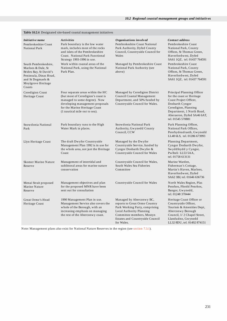
10.2 Regional coastal management groups and initiatives
231
South Pembrokeshire,Marloes & Dale, StBrides Bay, St David’sPeninsula, Dinas Head,and St Dogmaels &Moylgrove HeritageCoasts
Work within coastal areas of theNational Park, using the NationalPark Plan.
Managed by Pembrokeshire CoastNational Park Authority (seeabove)
Pembrokeshire CoastNational Park, CountyOffices, St Thomas Green,Haverfordwest, Dyfed SA61 1QZ, tel. 01437 764591
Ceredigion CoastHeritage Coast
Four separate areas within the HC(but most of Ceredigion’s coast ismanaged to some degree). Nowdeveloping management proposalsfor the Marine Heritage Coast (1 nautical mile out to sea).
Managed by Ceredigion DistrictCouncil Coastal ManagementDepartment, and 50% funded byCountryside Council for Wales.
Principal Planning Officerfor the coast or HeritageCoast Project Officer,Dosbarth CyngorCeredigion, PlanningDepartment, 1 North Road,Aberaeron, Dyfed SA46 6AT,tel. 01545 570881
Llyn Heritage Coast The draft Dwyfor CountrysideManagement Plan 1992 is in use forthe whole area, not just the HeritageCoast
Managed by the DwyforCountryside Service, funded byCyngor Dosbarth Dwyfor &Countryside Council for Wales
Planning Department,Cyngor Dosbarth Dwyfor,Swyddfeydd y Cyngor,Pwlheli LL53 5AA,tel. 01758 613131
Skomer Marine NatureReserve
Management of intertidal andsublittoral areas for marine natureconservation
Countryside Council for Wales,South Wales Sea FisheriesCommittee
Marine Warden,Fisherman’s Cottage,Martin’s Haven, Marloes,Haverfordwest, Dyfed SA62 3BJ, tel. 01646 636736
Menai Strait proposedMarine NatureReserve
Management objectives and planfor the proposed MNR have beensent out for consultation
Countryside Council for Wales North Wales Region, PlasPenrhos, Ffordd Penrhos,Bangor, Gwynedd,tel. 01248 370444
Great Orme’s HeadHeritage Coast
1990 Management Plan in use.Management Service also covers thewhole of the Borough, with anincreasing emphasis on managingthe rest of the Aberconwy coast.
Managed by Aberconwy BC,reports to Great Orme CountryPark Working Party, comprisingLocal Authority PlanningCommittee members, MostynEstates and Countryside Councilfor Wales.
Heritage Coast Officer orCountryside Officer,Tourism & Amenities Dept,Aberconwy BoroughCouncil, 1/2 Chapel Street,Llandudno, Gwynedd LL32 8DU, tel. 01492 874151
Snowdonia NationalPark
Park boundary runs to the HighWater Mark in places.
Snowdonia National ParkAuthority, Gwynedd CountyCouncil, CCW
Park Planning Officer,National Park Offices,Penrhydeudraeth, GwyneddLL48 6LS, tel. 01286 673993
Pembrokeshire CoastNational Park
Park boundary is the low watermark, includes most of the rocksand islets of the PembrokeshireCoast. National Park FunctionalStrategy 1993-1996 in use.
Pembrokeshire Coast NationalPark Authority, Dyfed CountyCouncil, Countryside Council forWales
Pembrokeshire CoastNational Park, CountyOffices, St Thomas Green,Haverfordwest, Dyfed SA61 1QZ, tel. 01437 764591
Table 10.2.4 Designated site-based coastal management initiatives
Initiative name Activities Organisations involved Contact address
Note: Management plans also exist for National Nature Reserves in the region (see section 7.3.1).

Region 12 Chapter 10 Coastal management
Table 10.2.5 Coastal fora
Initiative name Activities Organisations involved Contact address
Burry Inlet andLoughor EstuaryLiaison Group
Act as a forum; Conference inMarch 1995; considering otheraction for the future.
Countryside Council for Wales,Swansea City Council, Dyfed CC,Llanelli BC, Wildfowl andWetlands Trust, West Glamorgan &Lliw Valley BCs, NRA, RSPB andSouth Wales Sea FisheriesCommittee.
County PlanningDepartment, Dyfed CountyCouncil, 40 Spilman Street,Carmarthen, Dyfed SA311LQ, or David Grace,Swansea City Council SA1 4PE, tel. 01792 302727
Carmarthen BayForum
Formed with SERA (SocialistEnvironmental Resources, LabourParty) and Friends of the Earth(Carmarthen) in 1993. Same generalaims as Cardigan Bay Forum (seebelow)
About 12 members. Close linkswith Burry Inlet Group andCardigan Bay Forum
Secretary: Jean Myers,Waungron, Cefnypant,Whitland, Dyfed SA34 0TS,tel. 01994 419313
Cardigan Bay Forum A coastal liaison committee on aregional scale, established 1991.Aims to promote wider awareness& respect for the environmentalimportance, interest and naturalbeauty of Cardigan Bay and toencourage its harmonious use &enjoyment.
97 members, including usergroups, interest groups, localauthorities, statutory andvoluntary national bodies,fisheries, tourism and recreationalinterests, scientific andconservation bodies, commercialorganisations (including oilcompanies) etc.
*Projects Officer, CardiganBay Forum, Aberystwyth,tel. 01970 624471
North Wales CoastalForum
Established 1992. Covers areaextending south from lat. 53°40’Nincluding coast and hinterland.Aims to help members exchangeinformation and views on coastalissues, develop relationships withinternational and nationalgovernment, agencies and bodies,and agree action on matters ofmutual interest.
Clywd County Council, District,Borough and Town Councils,Countryside Council for Wales,National Rivers Authority, SeaFisheries Committee, non-governmental organisationsincluding National Trust, RSPB,Wildlife Trust, commercialinterests and scientific bodies.
Chairman, StephenPritchard, Ysgoldy,Bryncroes, Pwllheli,Gwynedd LL53 8EB, tel. 01758 83423
* Starred contact addresses are given in full in the Appendix
10.3 Further sources of information
A. References cited
DoE/Welsh Office. 1992. Planning policy guidance - coastal planning.PPG 20. London, HMSO.
Department of the Environment/Welsh Office. 1993a. Developmentbelow low water mark: a review of regulation in England and Wales.London, HMSO.
Department of the Environment/Welsh Office. 1993b. Managing thecoast: a review of coastal management plans in England and Walesand the powers supporting them. London, HMSO.
Department of the Environment/Welsh Office. 1994. Theconservation (natural habitats etc.) Regulations. London, HMSO(SI 2716).
Earll, R.C., ed. 1994. Statutory and non-statutory plans in the estuarineand coastal environment. Overlapping plans - is this an issue?Unpublished report of a meeting in July 1994.
Gubbay, S. 1990. A future for the coast? Proposals for a UK coastalzone management plan. A report to the World Wide Fund forNature from the Marine Conservation Society (unpublished).
House of Commons. 1992. Coastal zone protection and planning.London, HMSO. (Environment Committee Second Report.)
National Rivers Authority. 1994. Corporate Plan 1994/95. Bristol,NRA.
Ministry of Agriculture, Fisheries and Food/Welsh Office. 1993.Strategy for flood and coastal defence in England and Wales.London, MAFF.
Ministry of Agriculture, Fisheries and Food. 1994. Shorelinemanagement plans. London, MAFF. (4th draft, July 1994.)
232
B. Further reading
Countryside Council for Wales. 1994. A policy framework for thecoastal and marine zone of Wales: a discussion document. Bangor.
Countryside Council for Wales. In press. A review of coastalmanagement of three test areas in Wales (Swansea Bay, Ceredigioncoast and the Menai Strait). University of Cardiff (unpublishedreport to CCW).
Gubbay, S. 1994. Seas: the opportunity. Working together to protect ourmarine life. Sandy, RSPB.
Jones, R. 1993. Coastal cell studies - a basis for coastal zonemanagement. Earth Science Conservation, 32: 12-15.
King, G., & Bridge, L. 1994. Directory of coastal planning andmanagement initiatives in England. Maidstone, National Coastsand Estuaries Advisory Group.
National Coasts and Estuaries Advisory Group. 1993. Coastalplanning and management: a good practice guide. Maidstone.
Rendel Geotechnics. 1994. Coastal planning and management: areview. HMSO. (Report for the Department of theEnvironment.) (Supports recent coastal policy initiatives(including PPG20 Coastal Planning). Presents a broad synthesisof legislation, policy advice and research relevant to CZM.Measures effectiveness of coastal planning and management.)
Rothwell, P.I. Y, & Housden, S.D. 1990. Turning the tide, a future forestuaries. RSPB, Sandy.
RSPB. 1992. A shore future. RSPB vision for the coast. RSPB, Sandy. Shaw, D. 1990. Irish Sea Forum conference: an environmental review.
Liverpool University, Irish Sea Study Group. Smith, H.D., & Geffen, A.J., eds. 1990. The Irish Sea, an environmental
review. Part 4. Planning, development and management.Liverpool, Liverpool University Press.
10.2 Regional coastal management groups and initiatives
NewslettersMany national statutory, non-governmental and scientific bodiesare now producing publications or newsletters on the subject ofcoastal management. These either provide information onparticular local or national initiatives (such as the statutory or non-governmental organisations’ estuaries and firths initiatives) orgeneral information on a range of coastal news (for example thenewsletters of Eurocoast UK and the European Union for CoastalConservation). Some of these publications are listed below.Addresses of those publishing the newsletters are given in section10.3C.Coastal News. Newsletter of the Coastal Research and Management
Group. Publication intended to stimulate co-operation andcommunication between the many disciplines working in thecoastal zone. Contains information on coastal management,reviews of publications and notices of meetings. Published byJNCC.
Coastline. Quarterly magazine of the European Union for CoastalConservation (EUCC). Intended to establish a pan-Europeanforum on coastal issues, including coastal management.Published by EUCC.
CZM News. Occasional Newsletter of Eurocoast UK, reporting onprojects and developments in the field of coastal zonemanagement. Published by Eurocoast UK.
Coastline UK. Newsletter of the National Coasts and EstuariesAdvisory group (NCEAG). Aimed at local authority planners.Published by NCEAG.
National and local planning/management publicationsHouse of Commons Environment Committee. 1992. Second report -
coastal zone protection and planning. London, HMSO.(Recommended that coastal zone management be adopted asthe framework for all coastal zone planning and managementpractice in the United Kingdom. Called for a national coastalstrategy, a review of the many organisations responsible for thecoast, the extension of planning controls offshore, and theestablishment of a Coastal Zone Unit in Department of theEnvironment.)
DoE/Welsh Office. 1992. Planning policy guidance - coastal planning.PPG 20. London, HMSO. (Recognises the need to define acoastal zone incorporating areas affected by natural near-shoreprocesses. Advises local authorities to consider the impacts ofoff-shore and on-shore developments within the full coastalzone. Endorses the precautionary approach.)
DoE/Welsh Office. 1993. Managing the coast: a review of coastalmanagement plans in England and Wales and the powers supportingthem. London, HMSO. (Includes proposals for coastalmanagement plans to be based on a voluntary, multi-agencyapproach, generally led by local authorities.)
DoE/Welsh Office. 1993. Development below Low Water Mark - areview of regulation in England and Wales. London, HMSO.(Rejects the 1992 Environment Committee’s recommendationsfor the extension of development controls off-shore. Seeks tostrengthen existing arrangements to overcome limitations anddraw-backs in the present land-use planning system.)
MAFF. 1994. Shoreline management plans. (A procedural guide foroperating authorities. 4th draft, July 1994.)
DoE/Welsh Office. In prep. National coastal policy guidancestatement. (Government undertaking to produce this Statementmade on 15 July 1994. Remit may go beyond PPG20 on coastalplanning.)
Local planning authority plans and publicationsBown, D.P. Undated. Strategic planning guidance for coastal Wales.
Carmarthen, Coastal Strategy Topic Group County PlanningDepartment.
Ceredigion District Council. 1992. Ceredigion Marine Heritage Coast:an introductory report. Aberystwyth, Ceredigion DistrictCouncil.
Dyfed County Council. 1980. Dyfed county structure plan writtenstatement. Carmarthen, Dyfed County Council.
Dyfed County Council. 1987. Dyfed county structure proposals foralteration. Carmarthen, Dyfed County Council.
Gwynedd County Council. 1991. Gwynedd county structure planwritten statement. Caernarfon, Gwynedd County Council.
Pembrokeshire Coast National Park. 1994. Park functional strategies,1995 - 1998. Pembrokeshire Coast National Park.
Pembrokeshire Coast National Park. 1994. National Park Plan. 2ndreview: 1994 - 1995 (consultation draft). Pembrokeshire CoastNational Park.
Pembrokeshire District Council. 1994. Draft local plan.Pembrokeshire District Council.
West Glamorgan County Council. 1978. West Glamorgan structureplan. Swansea, West Glamorgan County Council.
233

C. Contact names and addresses
(See also Tables 10.2.1, 10.2.2, 10.2.4 and 10.2.5.)
Welsh Coast Groups Forum See section 10.2.4 Hugh Payne, Welsh Coastal Forum, Environment Division, WelshOffice, Parc Cathays, Caerdydd CF1 3NQ, tel. 01222 823176
Arfordir Group See section 10.2.3 *Arfordir Officer, CCW Aberystwyth, tel 01970 828314
Marine Conservation Society Provides advice and supports local coastal *Marine Conservation Society, management initiatives: runs grant-aided coastal Ross-on-Wye, tel: 01970 566017management workshops and courses for coastal managers; promotes the establishment of voluntary coastal groups.
Countryside Council for Wales Coastal management of designated sites. *CCW HQ, Bangor. tel. 01248 370444Heritage Coast Forum Funded by the Countryside Commission. Heritage Coast Forum, Centre for
Provides up to date factual information Environmental Interpretation, The on 45 Heritage Coasts in England and Wales. Manchester Metropolitan University, Provides contact between individuals and groups St Augustines, Lower Chatham Street, concerned with the management of Heritage Manchester M15 6BY,Coasts in England and Wales. tel. 0161 247 1067
Ministry of Agriculture, Fisheries Shoreline Management Plans (mainly aimed at MAFF, Eastbury House, 30/34 Albert and Food formulating a coast protection strategy) Embankment, London SE1 7TL,
tel. 0171 238 3000National Rivers Authority Catchment management planning, *Flood Defence Section, NRA HQ,
5-year programme Bristol, tel. 01454 624400, or NRAWelsh Region, Cardiff, tel. 01222 770088
Royal Society for the Protection of Birds Launched national campaign in 1990 to promote *Coastal Policy Officer, RSPB HQ,Sandy, the importance of estuaries in the UK. Monitors the tel: 01767 680551
development of coastal zone initiatives around the UK. In 1994, launched Marine Life campaign, to increase awareness and to promote integrated coastal and marine management.
Coastal Research and Management Established to aid the process of communication *Coastal Research and Management Group between research workers and managers in the Group (CR&MG), Coastal
field of coastal ecology. Concentrates on research Conservation Branch, and management issues relevant to landscape and JNCC Peterborough, tel. 01733 866825.wildlife conservation in the coastal zone (marine and terrestrial).
Coastal Technical Officers Group The GB conservation agencies group (English *Coastal Technical Officers Group, Nature, Scottish Natural Heritage, Countryside Secretariat: Coastal Conservation Council for Wales, Department of the Environment Branch, JNCC Peterborough, for Northern Ireland, Joint Nature Conservation tel. 01733 866825Committee and the Countryside Commission).
Esturiales Environmental Study Group International programme for co-operation, the Professor Graham King, Esturiales exchange of experience on estuarine management Environmental Study Group, Swansea and personal contacts between local authority Institute of Higher Education, Facultypractitioners in Europe. of Leisure and Tourism, Mount
Pleasant Campus, Swansea SA1 6ED, tel. 01792 456326
Eurocoast UK Aims to improve the basis for protection, Eurocoast UK, Burderop Park, development and management of the coastal zone. Swindon, Wiltshire SN4 0QD, Projects and developments in the field of coastal tel. 01793 812479management.
European Union for Coastal International grouping of organisations and Secretariat, European Union for Conversation individuals with an interest in coastal nature Coastal Conservation (EUCC),
conservation matters, including coastal management. P.O. Box 11059, NL-2301 EB Leiden tel. +31 71 122900/123952
Marine Forum National network provides forum for discussion of Marine Forum, Natural History marine issues relating to the seas around UK. Museum, Cromwell Road, London Members include governmental and non- SW7 5BD, tel. 0171 938 9114 governmental organisations and individuals. Occasional seminars are held, covering a range oftopics including coastal management.
Region 12 Chapter 10 Coastal management
234
Major regional and national bodies Activities Contact address and telephone no.
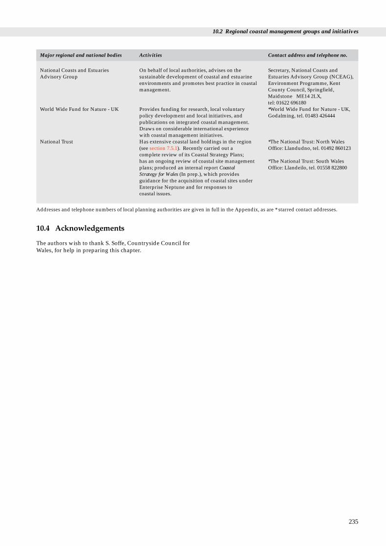
10.2 Regional coastal management groups and initiatives
National Coasts and Estuaries On behalf of local authorities, advises on the Secretary, National Coasts and Advisory Group sustainable development of coastal and estuarine Estuaries Advisory Group (NCEAG),
environments and promotes best practice in coastal Environment Programme, Kent management. County Council, Springfield,
Maidstone ME14 2LX, tel: 01622 696180
World Wide Fund for Nature - UK Provides funding for research, local voluntary *World Wide Fund for Nature - UK, policy development and local initiatives, and Godalming, tel. 01483 426444publications on integrated coastal management. Draws on considerable international experience with coastal management initiatives.
National Trust Has extensive coastal land holdings in the region *The National Trust: North Wales (see section 7.5.1). Recently carried out a Office: Llandudno, tel. 01492 860123complete review of its Coastal Strategy Plans; has an ongoing review of coastal site management *The National Trust: South Wales plans; produced an internal report Coastal Office: Llandeilo, tel. 01558 822800Strategy for Wales (In prep.), which provides guidance for the acquisition of coastal sites under Enterprise Neptune and for responses to coastal issues.
Addresses and telephone numbers of local planning authorities are given in full in the Appendix, as are * starred contact addresses.
Major regional and national bodies Activities Contact address and telephone no.
10.4 Acknowledgements
The authors wish to thank S. Soffe, Countryside Council forWales, for help in preparing this chapter.
235

Region 12 Chapter 10 Coastal management
236

237
Name Contact address and telephone no.
Statutory bodiesCountryside Council for Plas Penrhos, Fford Penrhos, Wales (CCW) HQ Bangor, Gwynedd LL57 2LQ,
tel: 01248 370444CCW South Wales Region 43-44 The Parade, Roath, Cardiff
CF2 3UH, tel: 01222 485111CCW Dyfed/Mid Wales Plas Gogerddan, Aberystwyth, Region Dyfed SY23 3EE,
tel: 01970 828551CCW North Wales Region Hafod Elfyn, Penrhos Road,
Bangor, Gwynedd LL57 2LQ, tel: 01248 372333
CCW Fishguard Sycamore Lodge, HamiltonStreet, Fishguard, Dyfed,tel: 01348 874602
CCW Llandeilo Yr Hen Bost, 56 Rhosmaen St,Llandeilo, Dyfed SA19 6HA, tel: 01558 822111
CCW Skomer MNR Fishermans Cottage, Martin’sHaven, Marloes, Haverfordwest,Dyfed SA62 3BJ, tel: 01646 636736
Institute of Terrestrial Abbots Ripton, Huntingdon, Ecology (ITE), Monks Wood Cambridgeshire PE17 2LS,
tel: 01487 773381ITE Merlewood Windermere Road, Grange-over-
Sands, Cumbria LA11 6JU, tel: 01539 532264
Joint Nature Conservation Monkstone House, City Road, Committee (JNCC), Peterborough PE1 1JY, Peterborough tel: 01733 62626JNCC, Aberdeen 17 Rubislaw Terrace, Aberdeen
AB1 1XE, tel: 01224 642863National Rivers Authority Rivers House, St Mellons
Business (NRA), Welsh RegionPark, St Mellons, Cardiff CF3 0LT, tel: 01222 770088
NRA Head Office Rivers House, Waterside Drive,Aztec West, Almondsbury, BristolBS12 4UD, tel: 01454 624400
Wildlife TrustsDyfed Wildlife Trust 7 Market Street, Haverfordwest,
Dyfed SA61 1NF, tel: 01437 765462
Glamorgan Wildlife Trust Nature Centre, Fountain Road,Tondu, Mid Glamorgan CF32 OE, tel: 01656 724100
North Wales Wildlife Trust 376 High Street, Bangor,Gwynedd LL57 1YE, tel: 01248 351541
Name Contact address and telephone no.
Coastal foraCardigan Bay Forum Welsh Agricultural College,
Llanbadarn Fawr, Aberystwyth,Dyfed SY23 3AL, tel: 01970 624471
Carmarthen Bay Forum Secretary: Jean Myers,Waungron, Cefnypant, Whitland,Dyfed SA34 0TS, tel: 01994 419313
North Wales Coastal Forum Chairman, Stephen Pritchard,Ysgoldy, Bryncroes, Pwllheli,Gwynedd LL53 8EB, tel: 01758 83423
Irish Sea Forum Irish Sea Forum Administrator,Oceanography Laboratories,Faculty of Science, University ofLiverpool, PO Box 147, LiverpoolL69 3BX, tel: 0151 794 4089
National voluntary bodiesMarine Conservation Society 9 Gloucester Road, Ross-on-Wye,
Herefordshire HR9 5BU, tel: 01989 566017
The National Trust HQ 33 Sheep Street, Cirencester,Gloucestershire GL7 1QW, tel: 01285 651818
The National Trust North Trinity Square, Llandudno, Wales Office Gwynedd LL30 2DE,
tel: 01492 860123The National Trust South The Kings Head, Bridge Street, Wales Office Llandeilo, Dyfed SA19 6BB,
tel: 01558 822800Royal Society for the The Lodge, Sandy, Bedfordshire Protection of Birds SG19 2DL, tel: 01767 680551(RSPB) HQRSPB Wales Office Bryn Adern, The Bank,
Newtown, Powys SY16 2AB, tel: 01686 626678
The Wildfowl & Wetlands Slimbridge, Gloucestershire Trust (WWT) HQ GL2 7BX,
tel: 01453 890333WWT, Llanelli Penclacwydd, Llwynhendy,
Llanelli, Dyfed SA14 9SH, tel: 01554 741087
Worldwide Fund for Nature - Panda House, Weyside Park, UK (WWF-UK) Cattershall Lane, Godalming,
Surrey GU7 1XR, tel: 01483 426444
Appendix
A.1 Frequently cited contact names and addresses

A.2 Local planningauthorities
Name Address and telephone no.
Aberconwy Borough Council Bodlondeb, Conwy LL32 8DU, tel: 01492 592000
Arfon Borough Council Town Hall, Bangor LL57 2RE, tel: 01248 370666
Carmarthen District Council 3 Spilman Street, CarmarthenSA31 1LE, tel: 01267 234567
Ceredigion District Council Town Hall, Aberystwyth SY23 2EB, tel: 01970 617911
Dwyfor (Cyngor Dosbarth) Swyddfeydd y Cyngor, Pwllheli District Council LL53 5AA, tel: 01758 613131
Dyfed County Council County Hall, Carmarthen SA31 1JP, tel: 01267 233333
Gwynedd County Council County Offices, Caernarfon LL55 1SH, tel: 01286 672255
Llanelli Borough Council Town Hall, Llanelli SA15 3AH, tel: 01554 741100
Lliw Valley Borough Council Civic Centre, Penllergaer, SwanseaSA4 1GH, tel: 01792 893081
Merionnydd District Council Cae Penarlag, Dolgellau,Gwynedd LL40 2YB, tel: 01341 422341
Neath Borough Council Civic Centre, Neath, WestGlamorgan SA11 3QZ, tel: 01639 641121
Pembrokeshire Coast County Offices, St Thomas Green, National Park Haverfordwest, Dyfed SA61 1QZ,
tel: 01437 764551
Port Talbot Borough Council Civic Centre, Port Talbot SA13 1PJ,tel: 01639 875200
Preseli (Pembrokeshire) Cambria House, PO Box 27, District Council Haverfordwest SA61 1TP,
tel: 01437 764551
Snowdonia National Park Park Planning Officer, NationalPark Offices, Penrhydeudraeth,Gwynedd LL48 6LS tel: 01766 770274
South Pembrokeshire District Llanion Park, Pembroke Dock Council SA72 6DZ, tel: 01646 683122
Swansea City Council Guildhall, Swansea SA1 4PE, tel: 01792 301301
West Glamorgan County County Hall, Swansea SA1 3SN,Council tel: 01792 471111
Ynys Môn (Isle of Anglesey) Council Offices, Langefni Borough Council LL77 7TW, tel: 01248 750057
A.3 Core reading list
There are a number of imporant publications that eitherprovide information on a variety of topics covered in theseregional reports (and so are frequently referred to) or give agood overview of regional and national information oncoasts and seas. They are listed below.
Barne, J., Davidson, N.C., Hill, T.O., & Jones, M. 1994. Coastal andMarine UKDMAP datasets: a user manual. Peterborough, JointNature Conservation Committee.
British Oceanographic Data Centre. 1992. United Kingdom DigitalMarine Atlas. User Guide. Version 2.0. Birkenhead, NaturalEnvironment Research Council, British Oceanographic DataCentre.
Buck, A.L. 1993. An inventory of UK estuaries. 2. South West Britain.Peterborough, Joint Nature Conservation Committee.
Countryside Council for Wales. 1994. A preliminary bibliography tothe water and coast around Bardsey Island and the southwesternLleyn Peninsula. Unpublished draft.
Davidson, N.C., Laffoley, D.d’A., Doody, J.P., Way, L.S., Gordon, J.,Key, R., Drake, M.C., Pienkowski, M.W., Mitchell, R., & Duff,K.L. 1991. Nature conservation and estuaries in Great Britain.Peterborough, Nature Conservancy Council.
Doody, J.P., Johnston, C., & Smith, B. 1993. The directory of the NorthSea coastal margin. Peterborough, JNCC.
Eno, N.C., ed. 1991. Marine conservation handbook. 2nd ed.Peterborough, English Nature.
Gubbay, S. 1988. A coastal directory for marine conservation. Ross-on-Wye, Marine Conservation Society.
Hobbs, G., & Morgan, C.I., eds. 1992. A review of the environmentalknowledge of the Milford Haven Waterway. Pembroke, FieldStudies Council.
Huckbody, A.J, Taylor, P.M., Hobbs, G., & Elliott, R. 1992.Caernarfon and Cardigan Bays: an environmental appraisal.London, Hamilton Oil Company.
Irish Sea Study Group. 1990. The Irish Sea; an environmental review.Part 1; Nature conservation. Part 2; Waste inputs and pollution.Part 3; Exploitable living resources. Part 4; Planning developmentand management. Liverpool, Liverpool University Press.
Lee, A. J., & Ramster, J. W. 1981. Atlas of the seas around the BritishIsles. MAFF Atlas Office.
North Sea Task Force. 1993. North Sea Quality Status Report 1993.London; Oslo and Paris Commissions.
Robinson, A., & Millward, R. 1983. The Shell book of the British coast,185 - 229. Newton Abbot, David and Charles.
Smith, J., Yonow, N., & Elliot, R. 1995. The coast of Dyfed and southwest Glamorgan: an environmental appraisal. Aberdeen, MarathonOil UK.
Steers, J.A. 1964. The coastline of England and Wales. 2nd ed., 112 -183 (Geology and geomorphology). Cambridge, CambridgeUniversity Press.
Taylor, P.M., & Parker, J.G., eds. 1993. The coast of north Wales andnorth-west England: an environmental appraisal. London,Hamilton Oil Company Ltd.
Young, G.A. 1992. The Menai Strait: a review and bibliography ofliterature from the Wolfson Library. (Contractor: UniversityCollege of North Wales, Bangor.) Unpublished report to theCountryside Council for Wales.
Welsh Office. 1994. Environmental digest for Wales. No. 8. 1993.Cardiff.
Chapter 12 Appendix
238

A.4 Contributing authors
Author Address
Dr M. Aprahamian National Rivers Authority - North WestRegion, Fisheries Department, PO Box 12,Richard Fairclough House, KnutsfordRoad, Warrington WA4 1HG
Dr R.N. Bamber Fawley Aquatic Research Labs Ltd, Marineand Freshwater Biology Unit, Fawley,Southampton, Hants. SO4 1TW
J.H. Barne Coastal Conservation Branch, JNCC,Monkstone House, City Road,Peterborough PE1 1JY
Dr R.S.K. Barnes Department of Zoology, Downing Street,Cambridge CB2 3EJ
Dr J. M. Colebrook Sir Alister Hardy Foundation for OceanScience, c/o Plymouth Marine Laboratory,Citadel Hill, Plymouth, Devon PL1 2PB
D.M. Craddock Vertebrate Ecology and ConservationBranch, JNCC, Monkstone House, CityRoad, Peterborough PE1 1JY
C.A. Crumpton RSK Environment, 47 West Street, Dorking,Surrey RH4 1BU
Dr T.C.D. Dargie Loch Fleet View, Skelbo Street, Dornoch,Scotland IV25 3QQ
Dr N.C. Davidson Coastal Conservation Branch, JNCC,Monkstone House, City Road,Peterborough PE1 1JY
Dr J. P. Doody Coastal Conservation Branch, JNCC,Monkstone House, City Road,Peterborough PE1 1JY
C.D. Duck Sea Mammal Research Unit, MadingleyRoad, Cambridge CB3 OET
M.J. Dunbar Nature Conservation Bureau, 36,Kingfisher Court, Hambridge Road,Newbury, Berkshire RG14 5SI
Dr C.D.R. Evans Coastal Ecology Group, British GeologicalSurvey, Keyworth, Nottingham NG12 5GG
Dr P.G.H. Evans Seawatch Foundation, Dept of Zoology,University of Oxford, South Parks Road,Oxford OX1 3PS
S.J. Everett Nature Conservation Bureau, 36,Kingfisher Court, Hambridge Road,Newbury, Berkshire RG14 5SI
A.P. Foster 61 Pittsfield, Cricklade, Swindon, Wiltshire SN6 7AW
S.L. Fowler Nature Conservation Bureau, 36,Kingfisher Court, Hambridge Road,Newbury, Berkshire RG14 5SI
A.B. Gale Riverbank House, River Road, Taplow,Maidenhead SL6 0BG
Author Address
Dr H.T. Gee SGS Environment, Yorkshire House,Chapel St, Liverpool L3 9AG
M.J. Goodwin RSK Environment, 47 West Street, Dorking,Surrey RH4 1BU
Dr M.I. Hill SGS Environment, Yorkshire House,Chapel St, Liverpool L3 9AG
N.G. Hodgetts Species Conservation Branch, JNCC,Monkstone House, City Road,Peterborough PE1 1JY
R.A. Irving 14 Brookland Way, Coldwaltham,Pulborough, W. Sussex RH20 1LT
A.W.G. John Sir Alister Hardy Foundation for OceanScience, c/o Plymouth Marine Laboratory,Citadel Hill, Plymouth, Devon PL1 2PB
R.G. Keddie Coastal Conservation Branch, JNCC,Monkstone House, City Road,Peterborough PE1 1JY
V.M. Morgan 2, Flaxen Walk, Warboys, HuntingdonPE17 2TR
M.S. Parsons 3, Stanton Road, Raynes Park, London SW20 8RL
Dr M.G. Pawson Ministry of Agriculture, Fisheries andFood, Directorate of Fisheries Research,Fisheries Laboratory, Pakefield Road,Lowestoft, Suffolk NR33 OHT
Dr G.W. Potts The Marine Biological Association of theUK, The Laboratory, Citadel Hill,Plymouth PL1 2PB
Dr R.E. Randall Girton College, Huntingdon Road,Cambridge CB3 0JG
C.F. Robson Coastal Conservation Branch, JNCC,Monkstone House, City Road,Peterborough PE1 1JY
Dr W.G. Sanderson Marine Conservation Branch, JNCC,Monkstone House, City Road,Peterborough PE1 1JY
D.A. Stroud Vertebrate Ecology and ConservationBranch, JNCC, Monkstone House, CityRoad, Peterborough PE1 1JY
S.E. Swaby The Marine Biological Association of theUK, The Laboratory, Citadel Hill,Plymouth PL1 2PB
Dr M.J.S. Swan 19 St Judith’s Lane, Sawtry, Huntingdon,Cambs. PE17 5XE
M.L. Tasker Seabirds and Cetaceans Branch, JNCC, 17 Rubislaw Terrace, Aberdeen AB1 1XE
Dr C.E. Turtle SGS Environment, Units 15 & 16, Pebble Close, Amington, Tamworth, Staffs B77 4RD
A.3 Core reading list
239
Copyright © 2022 FDOKUMEN