CENTRAL AMERICA'S COASTS - USAID
297
' .. '«) ........... ;... . .. ;L ' ' ,, . . ,...,.· . . . '· . . (; . . . . .. . ' . . ...... . . " . . . . . . i ! llOC'.Al'L I =--===-- . . ,,· • lll • • • • --'<?." .. : . .. . . USAJD\_. . ' . llll\l,,,,,.41\,, U•ll>ll\I••• 5 ' - • \.. J • .. ' •.- .¥· ", CENTRAL AMERICA'S COASTS Profiles and an Agenda for Action / .. GUATEMALA \.· ........ <' .·-·\ :" ,/ -··-··-. /./ .. ./ ,• AcajuJ/a j 1 : LA Union• .. Edited by Gordon Poer and Stephen Olsen .. , . ' . . . .. ... · .• for .. D:Pclo11111c11J, l-.,, · \ Al fl Rcs1t11111/ OJJ1t .. c fc>r Cc11t ml Al/l('rlt"ll Pni;.:n1111:-. • • . ' ' · Thc Co11sl11/ [mtc1;, The Lb1il1crsily of Rltodc ls/1111d . . · ·
-
Upload
khangminh22 -
Category
Documents
-
view
0 -
download
0
Transcript of CENTRAL AMERICA'S COASTS - USAID

' .. '«)...........;... . .. ;L ' ' ,, . . ,...,.· . . . '· ~. . . (; . . . . .. . ' . . ...... . . " . . . . . . i ! llOC'.Al'L I =--===-- . .
~ ,,· • lll • • • • --'<?." .. : . ~ -=-~ .. . . USAJD\_. . ' ~:..::1-'0 . llll\l,,,,,.41\,, U•ll>ll\I•••
5 ' - ~ • \.. J • .. ' .~· •.- .¥· ",
CENTRAL AMERICA'S
COASTS Profiles and an Agenda for Action
/ .. GUATEMALA \.· ........
<' HONDUl~AS .·-·\ :"
,/ -··-··-. /./ .. ./ ,• AcajuJ/a j
1:
LA Union• ..
Edited by Gordon Poer and Stephen Olsen
.. , . ' . . . .. ...
· .• U.~:~A,-.:l:11t"y for lu/cr~111/io1111~ .. D:Pclo11111c11J, f~t'Sc1i~ch l-.,, Dc1•1•/0111111~l/L'Ni~ · \ Al fl Rcs1t11111/ OJJ1t .. c fc>r Cc11t ml Al/l('rlt"ll Pni;.:n1111:-. • ~ ~ • . '
' · Thc Co11sl11/ Rcsourc_~·s [mtc1;, The Lb1il1crsily of Rltodc ls/1111d . . · ·
jharold
Rectangle

CENTRAL AIVIERICA'S COAST Profiles and an Agenda for Action
Edited by Gordon Foer and Stephen Olsen
1992
The University of Rhode Island Coastal Resources Center
U.S. Agency for International Development Research & Development Environment and Natural Resources
Agency for International Development RegionJl Office for Central America Programs
I '2· r~ / I I ! {)

The four major goals of the International Coastal Resources Management Project (CRMP) are to: l) apply, as appropriate, existing experience in coastal resources management to low income countries; 2) assist three low income nations in the design and implementation of integrated coastal resources management programs: 3) advance the state-of-L'1e-art of coastal resources management; and 4) build The university of Rhode Island's capability to assist nations with coastal resources management.
The CRMP works with the cooperating countries to:
formulate and implement integrated coastal resources management strategies develop procedures for the assessment of the impacts ... if coastal development proposals develop instirntional and technical solutions for resource use conflicts support research to better understand the issues that affect the condition and use of coastal ecosystems improve the capabilities of in-country professional staff to plan for and manage coastal development
The International Coastal Resources Management Project is funded by the Office of Research and Development, Environment and Natural Resources, U.S. Agency for International Development through a cooperative agreement with The University of Rhode Island. Supplemental funJs this project were provided by AID Regional Office for Central America Programs as a part of their REN ARM Project.
The individual coastal profiles included in ts report represent the views of the authors and do not necessarily reflect the views of the sponsoring agencies.
For information on the project, contact:
Stephen Olsen, Director International Coastal Resources Management Project The University of Rhode Island Coastal Resources Center Narragan~tt. RI 02882-1197
Telephone: (401) 792-6224 Fax: (401) 789-4670
Cooperative Agreement LAC-5518-A-00-5054-00
Photography credits: Gordon Foer, Margorie Rosenthal, William Branan
Maps were prepared by the Coastal Resources Center, using Map@ Hammond Incorporated, Maplewood, New Jersey.

TABLE OF CO:\TE~TS
Preface ill
Part 1. An Agenda for the Managem;:-nt of Coastal Ecosystems in Central America . . . .
Stephen Olsen and Gordon Foer
Regional Tables and Maps . Major Coastal Resource Management Issues . Institutional Issues in Coastal Resources Management Shrimp Mariculture Marine Fisheries Topography Agro-Expon Zones Watershed Degradation Critical Coastal Habitats and Features Geographic Areas of Panicular Concern . Priority Sites for Coastal Resources Management
Part 2. Coastal Resources Profiles
Belize Profile Figures References
Costa Rica Profile . . Roundtable Participants Figures References
El Salvador Profile . . Roundtable Participants Figures References
Guatemala. Profile . . Roundtable Participants Figures References
21 22 23 24 25 26 27 28
. 29 30 31
32
33 34 55 59
61 62 85 86 96
99 100 120 121 129
131 132 146 148 161
Honduras Profile . . Roundtable Panicipants Figures References
Nicaragua Profile . . Roundtable Panicipants Figures References
Panama Profile . Roundtable Participants Figures References
163 164 184 186 196
199 200 219 221 228
. 231
. 232
. 249 250
. 260
Part 3. Recommendations of the Working Groups at the . 261 Regional Workshop on the Mar.agement of Coastal Ecosystems in Central America
Estuaries and Watersheds
Coastal Tourism
Fisheries and Habitats
Maricuirure
Appendices
A. WorkshPp Agenda
B. List of Workshop Participants
C. Workshop Resolutions
ii
262
268
272
276
. 279
PREFACE
This volume is che outcome of a year-long effort to formulate a srrategic approach co tackling che problems and opportunities posed by the mirnagement of coastal ecosystems in Central America. The project was carried our as a piloc activity of the Regional Natural Resources Management Project (RENARM) chat is being sponsored by L:SAID and is expected to continue throughout the l 990's. The goal of RENARM is co produce, with che citizens of Cenrral America, the conditions for sustained exploitation of natural resources in a manner char minimizes damage co che environment, protects bio-diversity, and provides the means for equitable and sustainable economic growth.
In January 1991, che URI Coastal Resources Center began co identify and interview people in che region ~nvolved in various aspects of coastal resources management, collect documents and ocher available information, and assess the level of interest in coastal issues. Draft profiles or "diagnosticos" were prepared by members of che CRC which were then reviewed and modified at roundtable discussions in each country, co which a cross section of government agency representatives, user group representatives and NGOs were invited. The purpose of che profiles was nor ro produce comprehensive, in-depth synopses of all available infom1arion on coastal resources but co provide issue-driven analyses that would identify the principal resource management problems and opportunities in each country.
Dunng September 24-27, 1991, more than 60 people from all seven countries met in Guatemala Cicy for a "Regional Workshop on Coastal Ecosystems Management" char was co-sponsored by the Central American Commission for:- Environment and Development. The Workshop focused upon four major themes identified through the profiling process: Watersheds and Escuaries, Mariculture, Fisheries and Habitats, and Coastal Tourism. Working Groups formulated recommendations char are presented in the final section of chis volume. The Coastal Resources Center then drew together the ideas from the profiles, the ;oundtables and the workshop and prepared the Agenda for Coastal Ecosystems Management in Central America chat is presented as Part One of this volume.
It was a major undertaking to organize a regional workshop, convene roundtables, and coordinate discussion and comments in seven different countries. Adalgisa LaForgia wrote che Guatemala profile ·and provided substantial assistance in translating profiles, as well as helping coordinate the logistics of tl"1e Regional Workshop. Jose Vasconez, from the Ecuador Coastal Managcme:H Program, draftee. the Panama profile and participated in th~ roundtable discussion in that counrry. Bruce Epler wroce an initial draft of the Costa Rica profile which was subsequently revised and er.panded by Steve Mack and others at CEDARENA in Costa Rica. Rob Young wrote the Belize profile with substantial assistance from Janet Gibson and Howard Winn.
In-countty persons who helped organize the roundtable discussions or who otherwise provided particular assistance are:
Honduras:
El Salvador: Nicaragua: Panama: Costa Rica: Belize: Guatemala:
Mirna Marin, Rafael Calderon, Lisa Villela, Elena Fulka1on, Nohemy Luna Ricardo Hernandez, Jose Antenor Romero, Peter Gore Juan Jose Montiel, Jaime Alegria Dionisio Batista, Gustavo Juscines Steve Mack Janet Gibson, Vincent Gillett Nury Rojas, Berta Callen
iii

At ROCAP, Claudie Saito, Bill Sugrue and Many Schwarz provided much helpful advice and assistance. The Coastal Resources Center owes a big thank you to Cristian Munduate de Ponce. Alma Irene Gonzalez Mazariegos, Elida Carreto Lopez, ~vforlene Betancur, Helen Marroquin de Gonzalez and others Jt ASI'.\DES L.\soL'iaci6n de Encid;.ides de Desarrollo y de Servicio ~o Gubemarnentales de Guatem;.1.IJJ \\ho 111:1 • ..,ten·ully nun;.igeJ .ti! the logistiL'S for the Regional Workshop and provided us with assistance on innumerable other matters. Nanci Macias Guerra assisted in proofreading Spanish rranslations, and ~!ichelle MacDonald finalized the profile figures and tabks for priming. Pan I v. as translated from English into Spanish by David Gitlitz. Carol Hunter coordinated final production and Annette Burgess designed the cover, regional maps in the first section. profile country maps and final layout.
Stephen Olsen Director, Coastal Resources Center The University of Rhcxie Island
iv
Gordon Foer Project Manager Coastal Resources Center

PART 1. AN AGENDA FOR COASTAL ECOSYSTEMS MANAGEMENT
IN CENTRAL AMERICA
July 1992
Stephen Olsen and Gordon Foer
1. INTRODUCTION
This document summarizes the highlights of a ten-month process designed to identify the most significant management issues affecting the coastal ecosystems of Central America and to prepare an initial agenda for action. This involved preparing profiles for each of the seven counaies that attempt to assess the social and environmental significance of the coastal management issues identified, their causes and possible responses. Each profile was reviewed and modified at least or.ce in each country at a roundtable discussion anended by a cross section of governmental officials, NGOs and private sector representatives. These were usually the first occasions in which policy-makers, scientists and activists met together to discuss the issues affecting the condition of their coasts. In September, 1991 a "Regional Workshop on the Management of Coastal Ecosystems in Central America" was held in Guatemala City to identify and discuss trends and priorities from a regional perspective. This project was carried out by the Coastal Resources Center of The University of Rhode Island with funding from AID/RD/ENR and USAID/ROCAP. The Regional Workshop was co-hosted by the Central American Commission for Environment and Development.
This Agenda draws from both the country profiles and the discussion5 at the regional workshop. It attempts to characterize the major coastal management issues and outline the approach that we reconunend for addressing the need for the improved management of coastal ecosystems in the region.
2. RECOMMENDED APPROACH AND ACTIONS
The Crisis in Implementation. In Central America the dominant characteristic of initiatives to improve the management of natural resources is the absence of effective implementation. Any new initiative in resource management, particularly where common property rights are important, must recognize the gu!f between planning and implementation. Even when the plans, regulations and laws produced are of technically good quality and have been officially adopted, effective action is usually the missing ingredient. The barriers to effective resource management and sustainable relationships between people and coastal ecosystems are numerous. They include:
• Fragmented authority within and among agencies of government; • Overlapping jurisdictions between institutions; • Inadequate training in the concepts and techniques of integrated resource
management; • Inadequate budgets, equipment and personnel; • Little connection between sustainability and the incentive structures facing
governmental agencies; • The calculation and incorporation of net long-term benefits of natural resource
management into development decisions is rarely made;
I

• Centralized government results in decisions being made by people unaffected by direct costs, benefits, and implications of the projects they launch;
• Centralized government control over finances and decision-making results in weak local governance.
Such impediments to effective coastal management are present in many countries, but in Central America they are compounded by the short tenure of both top administrators and the higher level technical personnel in most governmental agencies. Both levels commonly change when new administrations follow an election or even with a change in ministers within the same administration. When new procedures or approaches to resource management are attempted the effort is often not sustained long enough to yield positive results. Powerful interest groups often exert their influence to override or circumvent local interests and government policies. Perhaps the most fundamental problem is that there is an absence of constituencies who are involved in and actively support resource management initiatives.
Unless new and effective policies and procedures are put in place. the accelerating, and often needless degradation of coastal ecosystems will continue. Such action, however, cannot occur if the impetus comes only from centralized governmental agencies. The support of central government is essential but it must be marched by responsibility and action at the community level. Unless resource m~rnagement initiatives have a constituency among the people affected by the program or strategy, ineffective implementation will continue to undermine the sustained effectiveness uf such initiative5 however wellintentioned and technically sound they may be.
For all these reasons we do not feel that it is useful or appropriate to make specific recommendations for new l~gislation or new institutions at this stage. In many instances, new legislation would only further confuse matters and would deflect attention away from the priority needs which are for collaborative action, constituency building and a focus on the implementation of existing laws, regulations and procedures. The approach taken here is to begin to lay the groundwork for building constituencies primarily at the local level that can effectively promote and sustain the changes in behavior and values that are required if well e~tablished trends in the misuse and degradation of ecosystems are to be reversed. Once experience has been gained from sustained efforts to work with the legal and policy instruments already available and constituencies have been built at the grass roots level, the needs for institutional reorganization and new legislation will become clear and should be pursued. When individual countries have made headway and there are tangible examples of more effective resource management with the SAMs, then the foundations for regional treaties and strategies will have been laid.
A Two-Track Strategy: One promising strategy for confronting the widespread absence of effective implementation is to proceed simultaneously along two tracks. The first, and commonly the major focus, is to strengthen the capabilities of central government. This is essential and obvious. The second track sho'Jld be to build a capacity to set priorities, formulate management strategics and above all to implement at the local level. It is important, however, that central gove:-nment agencies which for decades have been consolidating power at the expense of local governmental institutions, not view the second track as an attack on their authority. Geog1·aphically specific special area management planning is proving to be an effective way of accomplishing this by linking central government to loc:1l community efforts.
Special Area Management (SAM) Plans should address the most salient resource management issues of the place and develop strategies for their resolution that embcxiy a transdisciplinary, ecosystem-based approach to both issue analysis and an agenda for
2

action. Working at the community level makes a highly parocipatory approach to both planning and implementation feasible and presents opportunities for linking planning and implementation through an overtly, iterative process whereby all panicipanrs learn from tangible experience. 111e local offices of the national government agencies actively participate in rhe process, providing a direct conduit ro rhe central government. In most cases a high level inter-agency commission oversees SAM initiatives and provides a focus for central government support and collaborative action. The SAM approach is being successfully adopted in the United Scares by the Environmental Protection Agency (EPA) ro rhe management of estuaries. The foc~s on local initiative is prooucing exciting, localized progress through the municipal bay and island management schemes in rhe Philippines and the Zonas Especiales de Manejo program in Ecuador .
This community-based approach and its emphasis upon a s;ewardship ethic has many advocates (see for example, Konen, 1990). The rwo-tr:.ick approach was discussed in each country during the profiling process and ar rhe Guarc:mala City workshop and was endorsed as an effective approach for launching coastal management in the region. Candidate SAM sites were identified for ench country. Participants at the regional workshop were unanimous that the immediate priority for a SAM process is rhe Gulf of Fonseca region in Honduras.
A second track brings many benefits. It rrovides the equivalent for policy makers of the field uials so imponanr ro agronomists or rhe microcosm studies that are emerging as one of the most powerful tools for ecologists. Geographically-specific special area management plans allow policies and management techniques lo be reseed quickly ·..v·i~!:out the risk or expense of attempting to implement a program nationwide. Nothing is as eloquent as success and when local-level experiments in governance go well, the word spreads quickly. A second track gives focus ro public education programs and provides essential on-the-ground case studies and experience that make training programs compellingly relevant. Poli('.y dialogue rakes on a reality that is otherwise often missing. Finally, the cmcial problems of public support and implementation can be dealt with directly by working with the people most directly affected by new resourc:e management initiatives.
Two Possible Levels of Intervention: The process of preparing this initial agenda for coasw.l ecosystem management in the region ha..> led us to recommend two strategics for further action (see Section 5). A minimalist approach would focus upon training. A sustained two to three-year effort could produce cadres of people familiar with the philosophy and practice of integrated coastal management. Such training would identify and empower potential leaders, create a network of professionals across the region and, through .the preparation of case studies and trainee exercises, further analyze the nature of the issues and suggest possible approaches to their resolution.
A second level of action, tha~ would complement and build upon a training program, would e.;tablish a network of special area management sites in the region. These could include some sites that already the targets of donor-funded management initiatives. The network of sites should be supported by region-wide programs in education, monitoring and extension. The objective of the SAM network would be to generate as quickly as possible models for improved coastai management with strong local constituencies.
3

. 3. THE IDENTITY AND SIGNIFICANCE OF COAST AL
ECOSYSTEMS IN CENTRAL AMERICA
As the population of the isthmus swells, socioeconomic conditions deteriorate. and unsustainable forms of agriculture and forestry reduce the capacity of in!Jnd ecosystems to produce wealth and sustain an adequate quality of life for human populations (Leonard, 1987). there is an ever-increasing movement of people to the coasts. Coastal cities and towns are now among the most rapidly growing in the region wi~h some. like Panama City, doubling in size within a decade. The remaining sparsely-populated and isolated coastal regions are Central America's last frontier.
Coastal ecosystems may be defined narrowly to include only the transition art. ·s between the ocran and the land. These systems have a distinct identity and include:
Definition of the Coastal Region
• The several hundred riverine esturuies and many magnificent lagoons that are among the most productive ecosystems on the planet (Odum, 1971 ).
• The Western Hemisphere's largest barrier reef and a great many coral cays that suppon rich fisheries and have enonnous and yet untapped potential for tourism. These reefs also contain biodiversity reserves that match or exceed those of the region's remaining fragments of tropical rain forest.
• A combined coastline of some 6,600 km that provides the region with a land to coast ratio rivaled only by small island nations. The coastline is dynamic, constantly reshaped by the forces of erosion and accretion and, on the Caribbean side, periodically devastated by hurricanes.
• A rich diversity of fish and shellfish populations, the great majority of which depend upon healthy estuuries and coral reefs for their survival.
• Other habitats and features that are uniquely coastal in nature including rapidly dwindling mangrove wetlands, seagrass beds and morl! than a thousand kilometers of sandy beaches.
From a resource management perspective, however, it is best to look one scale bigger and consider coastal waters, the shorefront and the adjoining watershed as a single, closely coupled ecosyste1n. In Central America, managing by watershed is both practicable and desirable. Along the Pacific coast the closeness of the cordillera to the ocean produces a string of small watersheds. Since the region's economy is based on agriculture and both human economies and me quality of life depend directly on how land is allocated and utilized, resource management schemes will be most effective if they consider each watershed as a unit. This is the approach being taken by the PROMESA project, a U.S. A.I.D.-sponsored n:source management initiative with a large coastal component in El Salvador. Along much of the Atlantic coast the watersheds are far larger. However, here significant regions are as y-=t sparsely developed and have not been fragmented into complex patterns of ownership and use. In these areas, which include much '1f Belize, the Mosquitia, and segments of Costa Rica and Panama, managing coastal resources and coastal activities within the context of integrated watershed strategies is also practicable.
In practice the delineation of the coastal region and selection of specific inland and marine boundaries is always a compromise between the institutional and legal realities for a given country and the resource management issues that are selected as the focus of a coastal
4

management program. If shorefront development is the primary concern, then a narrow strip of land and water extending a few hundred meters in either direction of the low water mark may suffice at least as an initial approximation. But if the interrelationships among such primary problems as water quality, estuarine fisheries and coastal land use are to be considered together then a larger area must be considaed that includes ;..di or much of the watershed and adjoining coastal waters.
Coastal-Dependent Activities are making incre:..isingly significant contributions to the economies of the region. Tourism, most of which is cor:..il dependent, is now the largest source of foreig(j exchange for Belize. Coastal tourism is a potential growth industry of great significance for the region as a whole but in the other countries of the region it is at the first stages of development. Fisheries and mariculture produce a quaner of Panama's export revenues. Shrimp is the third most important export for Honduras, more than half of which is cultured. Mangrove-dependent populations in El Salvador alone are estimated dt 24,000 families (CENREN, 1989, cited in Yanez Paredes, et al, 1990) and the subsistence economies cf the Mosquitia rely upon healthy and productive estuaries for their rontinued survival. In the absence of a coastal data base such scattered statistics can only suggest the imponance of coastal resources and coastal-dependent activities in the Central American region.
4. TRENDS IN THE CONDITION AND USE OF COAST AL ECOSYSTEMS
Aithough the existing data on the condition and use of coastal ecosystems is scattered and of uneven quality, it is clear that the losses in coastal environmental quality, and therefore many quality of life indicators within coastal communities, are accelerating throughout the region. This tragic situation has implications for the social and environmental stability of the region. The problems are rooted in:
• Rapid population growth; • Deeply entrenched land use practices and economic structures and incentives which
maximize shon tenn economic gains often to the detriment of long-term uses; • Skewed distribution of land and wealth; • Ineffective governance of the resource base.
These features of the social structure have produced a long history of social unrest. Any meaningful attempt to improve how coastal ecosystems are managed must be based in an appreciation for the driving forces that fuel the trend towards ecosystem misuse. In the region's coastal ecosystems the following trends, all of which directly impact the long-term potential for sustaining or improving quality of life for human populations, are discernible.
Water quality is declining in estuaries adjacent to the region's rapidly growing urban centers and areas of intensive agriculture as well as in coastal aquifers and rivers that provide water for drinking and irrigation. The scanty available data sugges~ that bacterial contamination from untreated sewage make coastal waters unsafe according to internationally accepted coliform standards for swimming at a growing number of beach resons. The increasing load of untreated sewage and agricultural fertilizers is producing eutrophic conditions in an increasing number of estuaries and lagoons which destroys or reduces their value as a habitat for desirable species of fish and shellfish. Toxic residues, primarily from agrochemicals, are causing fish kills that have been documented in Costa Rica and El Salvador. High levels of toxic pesticides, mostly imponed and used primarily for the production of export-oriented crops - bananas, cotton, coffee - by large land owners are also being recorded in the flesh of fish and shellfish. Salinizarion of coastal aquifers is
5

. a problem where water is being rapidly withdrawn. The widespread decline in water quality has major implications for human health. In all countries gastrointestinal diseases related directly to poor water quality are among the leading causes of human mortality.
The extraordinary productivity of estuaries is dependent not onl! on adequate 1,1,ater quality but also upon the volume and timing of fresh water inflow. This, too, is being altered by the .:onstruction of dams and by deforestation caused largdy by logging and the expansion of beef production for expon. The roundtable discussions produced numerous examples of rivers that recently flowed all year but ..ire now reduced to intennittent seasonal flows. Such changes in the salinity regime and water quality may be expected to have major impacts on fisheries, wildlife populations and mangrove wetlands.
The destruction of habitats critical to sustaining fisheries, wildlife and the many human activities, including tourism and mariculture, that depend upon them is also accelerating in many areas. Mangrove habitat has been reduced by more than 50 percent in some countries and the rate of destruction appears to be accelerating (Jimenez, 1991; Gutierrez Ocon, et al, 1990; Arcia, et al, 1987; Rodas Camas, 1990; D'Croz, et al, 1990; Leonard, 1987; Hartshorn, G., et al, 1984)
Many lagoons along the Atlantic coast known to be the spawning and nursery grounds for species that support both indigenous populations and industrial fr;heries off shore are still in excellent condition. However, the pressure to build roads and exploit these populations for export businesses are mounting. In areas where population density is already high or to which there is ready access, the destruction of mangroves, seagrass beds and coral habitat is all too apparent. Coral adjacent to the Bay Islands of Honduras has been degraded by sedimentation and losses in water clarity (Clark and Smith, et al, 1988) as is frequently the case for the isolated reefs off the Atlantic coast of Costa Rica and Nicaragua and close to the mainland along the Pacific (Ryan, 1991; UNEP/IUCN, 1988).
Fishery Resources and especially estuarine-dependent fisheries have declined. The available fishery assessment and catch statistics demonstrate that from a regional perspective all economically-important fish and shellfish stocks except, perhaps, for a few deep water and open ocean pelagic stocks, are either over-exploited or fully exploited. Such data, although generally quite unreliable, focus upon industrial fisheries and seldom adequately document the many artisanal and subsistence fisheries that often provide significant employment and whose catches supplement the diets of the region's people. With the possible exception of some as yet undeveloped areas of Nicaragua, artisanal fisheries are universally recognized to have declined significantly in the past twenty years. Important export fisheries for shrimp and lobster have declined since 1970, while harvest of queen conch in the Caribbean have declined by 75 percent in Belize by 1984 (Hartshorn, et al, 1984b). Industrial fleets have been over-built along the Pacific coast, particularly in Panama and El Salvador.
Such over-exploitation is producing conflicts among inshore ar:isanal fishermen and industrial trawler fleets and, in Costa Rica, between game fishermen and commercial fishermen. The reduction in the abundance of nearshore finfish populations is illustrated by drastic declines in the magnitude of the by-catch of shrimp trawlers operating off El Salvador from 670 pounds per hour in 1958 to 10 pounds per hour in 1984 (personal communication, R. Hernandez). Increasing competition for a dwindling resource produces increased piracy whereby fishermen encroach upon the grounds and stocks of neighboring nations and there is often a wholesale disregard of closed seasons. The most recent FAO data suggests that at least one hundred thousand people depend directly upon fisht:ries for their livelihood. This estimate, however, apparendy does not include many pan-time artisanal and subsistence fishermen including 100,000 Garifuna people of Belize,
6

Guatemala and Honduras, nor the 15,000 (of a total 40,000 Miskito Indians) who reside in small villages along the coasts of eastern Honduras and Nicaragua. Similarly. the vast majority of the 50,000 Kuna Indians of nonheastern Panama who live on some 50 offshore coral is!Jnds comprising the San Blas Archipelago and adjacent mainland do not appear co h:ive tx:en included. If stocks were better m:imged and allo>\ed to i1.·cupcr:ice. che benefits in terms of employment, income and high quality protein for resident populations could also increase.
Declines in coastal-dependent wildlife mirror the combination of overfishing and loss::s in habitat that are the cause of declines in fish and shellfish populations. Unregulated huncing parties of foreign sponsmen still operate in Honduras and growing resident populations and intensifying land use threaten coastal-dependent wildlife, particularly waterfowl and such species as the manatee. crocodiles and tunles. International conservation group~ have focused primarily on turtle populations and as a result several important nesting beaches are now protected.
Inappropriate shorefront construrtion is proliferating as development intensifies. Every country in che region now possesses examples of buildings, roads and "erosion conrrol" structures that have been badly designed or inappropriately sited. The unexpected coastal erosion or accretion which they often cause nearby bring large and avoidable economic losses. Public access to beaches is emerging as a significant problem along the coast of El Salvador and in specific areas of intense development throughout the region.
Along the Caribbean coast hurricane dam~ge can be enormous. Hurricane Joan blew down 10 percent of Nicaragua's forests and destroyed thousands of houses and other buildings. Such damage and hardship will be repeated and even increase in the absence of good planning and the application of storm damage mitigation techniques.
An international tourism boom may be on the horizon as social unrest dies down in the region. The region's magnificent scenery, diverse habitats and rich cultural heritage can, if properly managed, provide for a tourism experience distinctly different from the sun-sand-sea resons of the Caribbean and coastal Mexico. Tourism can bring many benefits but, if it is to be sustained, requires protecting, and in some cases restoring, environmental quality. The coasts of Belize and Costa Rica are already major tourist destinations. Costa Rica is considering closing the Parque Nacional Manuel Antonio due to degradation from the overwhelming number of visitors.
Mariculture is another coastal-dependent activity chat, over the long term, may bring significant benefits to the region. Until now, mariculture has focused almost exclusively on the high profit shrimp farm industry. Experience elsewhere in the world, particularly Southeast Asia, demonstrates that mariculture can provide substantial employment and protein for local populations if it diversifies. At present, some 13,000 hectares are being used as shrimp farms and initial estimates suggest that at least 70,000 hectares may be suitable (Arrivillaga-Cortez, 1989; Morales de Ruiz, 1991; Myvett, 1991; Taracena, 1991; Soborio Coze, 1991 ). Such estimates, however, often do not adequately consider the social or environmental suitability of converting such large areas to mariculture. Culture of mollusks and finfish could utilize large areas of protected waters. This option will be lost, however, if water quality and other expressions of good environmental quality are allowed to decline, which has already happened in several countries. In Honduras, controversy over the destruction of mangroves for ponds, destruction of non-shrimp species by shrimp larvae collectors, obstruction of access to traditional fishing grounds, and concentration of resources and income among a relatively small group of people are among the perceived results of mariculcure development. This is producing social conflicts.
7

S. AN INITIAL STRATEGY FOR THE MANAGEMENT OF COASTAL ECOSYSTEMS IN CENTRAL AMERICA
Efforts co link inco coherent programs the closely coupkd issues of land use. wacer quality and fisheries have been underway in the l..Jniced St:.ices and some other ~ounrries since the early 1970s. Exciting coastal management programs are also underway in low income tropical nations including Sri Lanka, Ecuador, Indonesia and the Philippines. This body of worldwide experience should be applied co the problems and opportunities that now urgently require attention in Central America. The principal~ for meaningful progress towards improving the management of coastal ecosystems char emerge from chis body of experience suggest that an effective rpproach:
• Provides for both development and conservarion. • Includes the active involvement of all major stakeholders in the definition of
problems and in negoLiation over resource management objectives and the means to attain them.
• Considers che best available infonnacion on how che ecosystems in question function and respond co human activities.
• Focuses on a few carefully selected issues. • Is incrementally developed and reseed, with management and development ideas
implemented quickly so char che experience gained can be fed back into the ongoing planning process. ·
• Includes a strong public education and rraining program. • Strengthens locally-based institutions, both governmental and non-governmental
and utilizes existing laws and institutions before creating new ones.
The natural resources of the region and the problems and opportunities posed by accelerating change co their condition and use combine to produce needs for management initiatives similar in scope and content for each of the seven countries of the region. A region-wide strategy for the management of coastal ecosystems built upon the above principals therefore is appropriate and, if appropriately designed, should greatly increase the efficiency of the learning process throughout the region.
The pressures of a rapidly expanding populaticn and the development process make it inevitable that huma:l impacts upon coastal ecosystems on both coasts will continue to intensify. There are, however, no effective structures in place to bring order to the process of change and thereby avoid needless social conflict and needless degradation of environmental quality. The top priority for a region-wide srrategy must therefore be to fonn the human capacity and a body of positive experience in how the development process can be guided to achieve sustainable forms of resource utilization and improvements to the quality of life for the people involved. As described in the introduction, two regional strategies can be considered for achieving this end. The first would focus upon training and creation of cadres of people who can practice rransdisciplinary and participatory resource management and are familiar with techniques of coastal management. Such a strategy would be relatively inexpensive and easy to implement and could produce professionals throughout the region prepared and committed to improve the management of coastal ecosystems. The second, and more ambitious strategy, calls for adopting the twotrack approach to the needs of Central America. This second option would feature a network of SAM initiatives bal:ked up by supporting programs in education, monitoring and extension. Since programs are now being launched by several donors that feature community-bastd resource management, much can be gained by developing a set of indicators and procedures for assessing progress and sharing the experience gained.
8
A. Training
The rising tide of preoccupation with the pace of environmental degradation and its many social and economic implications is spurring the. creation of NGOs. numerous schemes to reorganize and retool governmental agencies and a great many donor-sponsored projects with environmental themes. There are therefore large numbers of people in both the public and private sectors that can be readily identified chat would benefit from training in the practice of integrated resource management for coastal ecosystems. There is now nearly twenty years of experience in coastal and estuarine management in the United States and some other high income nations as well as a rapidly expanding body of experience from low income tropical nations. Boch should be drawn upon to prepare training curricula and case studies for use in Central America. Experiential, adult learning approaches should be used, which emphasize panicipatory, interactive processes which build upon the participants own experience and education. Special short courses exist, some of which adopt the experiential approach. These include the four-week Summer Institute in Coastal Management at the University of Rhode Island, the biennial course on Coastal Parks and Protected Areas at the University of Miami, and the new coastal planning course at the Delft Institute in the Netherlands. Some individuals could receive degree training in coastal management and marine affairs
Tr.e most effective training strategy would be to organize a training program tailored to the needs of Central America. Such regional training courses will be most effective if they focus upon topics and locations important to the region. Training workshops can be a highly efficient vehicle for producing first or second generation strategies that may then lead to the design of specific full-scale projects. For example, a training program could be an appropriate mechanism for:
• Thinking through the options for a second generation shoreline management program for Costa Rica that builds upon the 25 years of experience gained in attempting to implement the Ley de la Zona Maritimo-Terrestre;
• Fonnulating the objec,~ves and major features of an integrated management strategy for the problems pose<.'. by development along the Gulf of Fonseca in Honduras;
• Region viide courses on designing and implementing CRM programs, followed by a series on such specific topics as leadership skills, conflict resolution, habitat fisheries and ·.vater quality management, managing mariculture, tourism and shorefront development, anJ Special Area Management planning.
In all cases an examination of the experience, both positive and negative, now emerging around the world would be very useful to Central Americans struggling with similar issues and similar ecosystems. Training programs can be an efficient and effective way to make such exper.ence available and relevant, particularly if they are linked to on-the-ground activity such as SAM planning, where skills learned can be immediately applied.
Faculty strP,agthening, curriculum development, and the creation of educational specializations in coastal resources management at selected regional universities are important elements of a strategy to build in situ capacity in coastal management. Several oceanograpi1ic and marine studies depanments or institutes exist in the region, including Centro de Investigaciones de Mar (Universidad de Costa Rica), Centro de Estudios de Mar y Acuicultura (CEMA: Universidad de San Carlos, Guatemala), the lalx>ratories in Belize, Nicaragua and Honduras which are associated with CARICOMP (Caribbean Coastal Marine Productivity program), and the Smithsonian Tropical Research Institute stations in Panama, among others. None of these, however, have a strong coastal management orientation.
9

B • A Network of Special Area Management (SAM) Sites
A second alternative is to demonstrate in tangible tenns how the techniques and philosophy of coastal management can be applied to specific geographic sites. Since the objective of this strategy is to produce examples of successful resource management \\ ithin the region as quickly as possible, the emphasis should be upon a few carefully selected SAM sites. This approach allows for experimenting with a variety of techniques and involving both communities and government agencies in highly focused attemplS to address resource management iss•Jes that are common throughout the region. The components of a SAM strategy should be designed so that synergism between them is maximized and a coherent mutually reinforcing set of actions is carried forward. SAM sites should be:
• Microcosms for issues of regi00-wide significance, so that results are transferable; .. Areas where the chances for tar1~ble successes are judged to be good, panicularly
in the short-tenn; • Appropriately sized so <ts to have a distinct identity, present minimal logistical
problems, and ideally are within an existing administrative unit.
The special area management approach often appeals to government agencies that are willing to experiment with new procedures and approaches in a specific area but unwilling to support proposals that would redistribute authority or cha1 ge established modes of behavior agency-wide. An overtly experimental approach is i.!ppropriate when so little experience exists upon which to base new approaches to management appropriate to the traditions and needs of the region.
Some existing integrated resource management projects, such as the Llanuras de Tortuguero in Costa Rica, and the integrated planning for the Bay Islands of Honduras can be viewed as first generation SAM programs and :;hould be monitored with a view to disseminating the experience gained. The Honduran coast of the Gulf of Fonseca appears to be a prime site for a Special Area Management initiative. h was unanimously endorsed by the participants of the Guatemala City Conference as the top priority site in the region where integrated coastal management should be applied. In the beginning, such a program would:
• Provide training in integrated coastal management for the governmental agencies, NGOs, community leaders and representative mariculturists most directly involved in the area.
• Fonn, under the highest possible auspices, a representative Commission and charge ~t with the formulation of a detailed management plan and the development of procedures and decision-making criteria by which coastal lands and resources will be allocated and managed.
• Produce detailed maps of the area.
• Assess the long-tenn impacts of plans and changes in land use in the Gulfs watersheds upon the environmental qualities of the Gulf and the sustainability of mariculture.
• Launch an energetic public education program.
• Implement a monitoring program focused on water quality, estuarine fisheries and mangroves.
lO

These initial activities, if accompanied by a panicipatory approach to issue analysis and the framing of alternative courses of action that involve all major stakeholders in the area, would then lead to fonnulation of specific management strategies. Such sa-acegies should be tested quickly through "practical exercises" in improved r\!source management so char funher planning and imp.ementacion becomes rooted in real experience. Through this process local conscicuenci es for an overall management plan can be developed and tangible progress made quickly on at least some important issues. Ir is reasonable to expect chat an integrated resource management plan for this sire could be fomrnlaced an( l fonnally adopled within cwo years. if key stakeholders continue co express their suppon for such an initiative.
Other areas specifically sired by roundcable discussion and Regional W 01 kshop participants as priority SAM's, some of which already have related activities, include:
• Panama: Chame-San Carlos-Farallon; Golfo de Parica; Bocas de! Toro/Laguna de Chiriqui; Ciudad de David and adjacent archipelago (Golfo de Chiriqui); Archipelago de San Blas;
• Honduras: Islas de la Bahia; Atlantic lagunal areas; Gulf of Fonseca; • Belize: Cays and reefs of Belize; Belize City area; • Nicaragua: Cayos Miskicos; Bluefields; Escero Real; • El Salvador: Barra de Santiago; Escero de Jaicepeque; Bahia de Jiquilisco; Lempa
River Watershed and Estuary; • Costa Rica: Golfo de Nicoya; Cahuica area; • Guatemala: Canal de Chiquimulilla; Rio Dulce;
C. Public Education And University Programs
Significant new initiatives in how natural resources are managed and allocated will succeed only if there are constituencies inside government and among the public char support them. A carefully-cargered public education program is rhereforc essential co successful progress towards the improved management of coastal ecosystems. Such a program, however, muse be rooted in the specific problems and characteristics of the region and nor serve merely co promote a general awarene~s. A constituency, if it is co be effective, needs specifics. Such specifics will emerge to a degree from the training programs but most directly from the SAM initiatives. A public education initiative should have three linked components: infonnal education programs, school programs aud a university center for environmental management. Post-secondary educational opportunities should incorporate research which supports and documents the development of SAM initiatives.
• The informal education program should focus on the interrelationships between environmental quality and quality of life. The implications of such specific actions as deforestation and misuse of agrochemicals, and for coastal resources, of overfishing and destruction of mangroves, should be stressed.
• The school program would require the development of curriculum materials and the training of teachers.
• The capabilities of regional and national universities to teach and undertake research in CRM need to be strengthened. A university center for environmental management is crucial since environmental management can never be effective without a sizable cadre of locally-rrained, motivated professionals. Efforts should be focused on a few key imcicucions. Curriculum development and faculty
11

strengthening must be major elements of this component. It will be necessary to provide scholarship and funds for research and internshios.
D. Monitoring
Both region-wide and country-specific resource management initiatives must be grounded upon a set of reliable indicators for the condition and use of selected resources. It is impressive that the current data base is fragmented and of very uneven quali!y. At present:
• Data on water quality (bacterial contamination, toxics and eutrophication) in estuaries, lagoons and heavily-utilized bathing beaches is virtually nonexistent.
• Artisanal fisheries are monitored infrequently or not at all so that rrends in estuarinedependent fisheries can seldom be documented with any confidence. The situation is somewhat better for industrial fisheries, but data collection and '1.nalysis techniques as well as quality varies markedly from country to country.
• Critical habitats, including mangroves, have in many instances not been mapped at an adequate scale and there is no program for monitoring trends in their condition and destruction.
• Rates of sedimentation and changes to the flow rates of rivers are known to be changing significantly but are not monitored.
• For large stretches of the coast base maps at adequate scales for management are unavailable or are severely out of date.
Worldwide experience has demonstrated that long-term monitoring programs are most likely to succeed and survive when they are inexpensive and rely on uncomplicated measuring techniques. Great care should be taken to select the variables and the sites that would most usefully serve to track trends in coastal ecosys•ems and their socioeconomic implications. Careful consideration should be given to programs underway in the United States (EPA/NOAA, 1990) that involve school teachers, private citizens and local officials in the monitoring process. Such an approach can be highly cost effective and generates information that cannot be produced by agencies or universities working alone. Remote sensing and othi!r geographic information systems should also play an important role. The data collected must be applied directly to: ( l) evaluate the impacts of resource management strategies, (2) periodically review management priorities, and (3) very importantly, develop the public education program. Such data will also document the importance of resources held in common by several nations, and the need for collaborative management strategies.
A monitoring program should link trends in the condition and quality of coastal ecosystems to trends in how they are utilized and the benefits they prcxluce. This monitoring must simultaneously address environmental and socioeconomic parameters. Of particular importance in Central America are relationships between water quality and human health and the development of two potential growth industries~oastal tourism and mariculture.
E. The Sharing of Experience
Both the country roundtables and the regional workshop made it clear that there is a great need to bring together those working on various aspects of coastal management to share experience and better coordinate their work. Participants at the regional workshop were impressed by how Belize is attempting to manage its fisheries and the explosive growth of tourism. Other countries in the region were unaware that Panama was successfully
12

experimenting with mariculture for species other than shrimp.' Costa Rica's experience with its Ley de La Zona Maritimo Terrestre should be more widely discussed and could prove very useful for countries with stretches of as yet undeveloped coastline. An imponant component of a region-wide coastal management initiative should be information exchange. This will be most effective if it is directed towards a regional network and sense of mission. This in turn can be an outcome of a region-wide training program, a set of SAM initiatives that are designed and implemented as a coherent set of "field nials in integrated resource management" and the public education initiatives. A document distribution service, "region-wide state of the coasr" as:)essments, a newsletter and periodic issue-specific workshops would all contribute to a shared sense of purpose and to an efficient learning curve for all concerned.
F. Extension Programs
There is currently little policy relevant research on coastal ecosystems being undenaken in Central America. Funhermore, there are few consistent, organized effons to apply the findings of Central American based researchers to resolve practical issues through extension programs. In fact, research is often designed and undenaken without adequate concern or understanding of the actual needs of local communities or governmental resource managers. Extension programs can provide a much needed two-way bridge between scientists and resource users.
Priority topics that an exrension service should focus upon include:
• Infonnation on proper shorefront construction practices; • Training of artisanal fishermen in stewardship practices rather than new capture
technologies; • Sustainable mangrove use and management; • Development and transfer of mruiculture practices for non-shrimp species; • The handling, transpon and marketing of shrimp post-larvae to minimize their
monality and reduce by-catch.
Extension program managers and agents can be trained to operate region-wide. CRM research agendas must have a strong link to extension programs, and the technological, social and economic feasibility of extension programs should initially be tested in the Special Area Management sites prior to any major dissemination of information and technologies.
6. HIGHLIGHTS OF STRATEGIES FOR PRIORITY RESOURCES AND. ACTIVITIES
A . Coastal Tourism
Tourism is projected t0 be the world's biggest industry by the tum of the century. Although tourism can produce enonnous economic, social and environmental impacts it is not usually given the attention it deserves in donor-sponsored development schemes or resource management strategies. Tourism is often viewed as a topic that the private sector should deal with on its own. In Central America, however, tourism, and coastal tourism in particular, has the potential for being a growth industry of major significance.
The goal of a tourism element of a coastal management strategy for Central America should be to improve the quality of life of the Central Americans affected and to develop tourism offerings with a distinct identity in the international tourism market. Enormous investments
13
in infrastructure for tourism have been made in the Caribbean and in Mexico. Yet the sustained economic return on many of these investments has been dwindling rapidly and the social and environmental costs have in some cases been very high. Central America must avoid overcapitalizing tourism infrastructure as it develops a distinct market that emphasizes the diversity and richness of the cultures and ecosystems that are present on the isthmus and which appeals to increasingly large numbers of potential visitors. Full accounting of the economic, social and environmental costs and benefits must be made before deciding upon a course of action. Initial steps tcwards achieving these objectives should include:
• An assessment of the specific coastal sites with major potential for tourism.
• An assessment of appropriate forms and intensities of tourism development that will not threaten the cultural integrity of the host communities or require infrastructure and services that are out of keeping with the capabilities of the area. Inappropriate development can produce demands for electricity, water and local foodstuffs that (compete with or) have significant negative effects on local residents.
• Design of tourism development strategies that, based on such assessments, set limits on development by determining the infrastructure that can be made available for defined levels of development. Worldwide experience keeps demonstrating that sustainable forms of tourism development occur when such infrastructure as roads, water supply, water rreatment and elecrric power keeps pace with development, and the impulse for quick profit is not permitted to outsrrip the capacity of a site to maintain adequate environmental and social quality.
• Design of the institutional mechanisms necessary to implement the resource management schemes. In some cases a form of land and water use zoning and permit programs will be required. Costa Rica and Belize already provide experience, both good and bad, with such techniques.
• Programs in rraining, experience sharing and public education directed specifically at the opportunities and problems posed by tourism, with the aim of maximizing the benefits to the local communities.
• Consideration of economic feedback mechanisms whereby a portion of the revenues generated by tourism are utilized to maintain and protect tourism amenities and the overall environmental quality of the areas concerned. Such revenues can be a significant source for the funds required to sustain a coastal management initiative.
B . Mariculture
The culture of fish and shellfish in marine and brackish waters is proliferating at an explosive rate in many regions of the world, but particularly in South East Asia and China where traditions and experience in mariculture have existed for generations. In Latin America, shrimp mariculture dominates because prime coastal sites are available at a negligible cost, and very large profits can be made on the international shrimp market. It should not, however, be assumed that high market prices for shrimp will be sustained. Many nations are building shrimp ponds and China alone is projected to produce as much as the entire current annual world crop by the year 2000. The industry may experience a severe price/cost squeeze in the near future. Experience demo11strates that where "free" environmental subsidies (i.e., unpriced or underpriced inputs of good water, mangroves and wild postlarvae) to mariculture are eroded by pollution or overharvesting, the
14

profitability of shrimp mariculture becomes marginal. It should not be assumed that mariculture requires the destruction of mangrove or other imponant habitats. At present, shrimp mariculture is most developed in Panama and Honduras, and to a much lesser degree in Belize. El Salvador and Nicaragua, the latter containing the greatt'St area of land in the regi0n potentially sui~able for maric:ulture (\fariculture Working Group. 1991 ). Only Panama is diversifying into species other than shrimp and attempting to produce for domestic as well as export markets. Diversification of mariculture, primarily into species suitable for local c:onsumption, is worth pursuing as a strategy for producing a variety of fish and crustaceans in intertidal areas and estuaries. Technologies and a wealth of experience already exist in South Asia and elsewhere. Since the region's population is growing rapidly and malnutrition is becoming more widespread, the potential for mariculture to provide high quality but inexpensive protein merits careful attention.
A regional maric:ulture strategy should first address che need to bring order to the development process to avoid self-defeating environmental degradation and needless social conflict. The need for immediate action is most urgently needed in the Gulf of Fonseca. Here major social conflicts and a number of important environmental issues are b~ing raise~ by the rapid and essentially unregulated growth of shrimp fanns in Honduras. The Nicaraguan segment of the Gulf has so far developed less rapidly but here, loo, the potential for growth and the need for effective management is great.
A region-wide strategy should assess the potential for diversified maricuitural operations in the region that would attempt to balance the need for export crops with focx:i prcx:iuction for local populations. Specific priority sites should be identifieci. A SAM initiative in the Gulf of Fonseca, combined with existing experience in Panama, could provide a basis for promoting a rational and balanced mariculture development program targeted at these sites. Care!ul attention must be given to the potential for the escape and proliferation of exotic species.
Since mariculture depends on adequate water quality, monitoring techniques and procedures should be put in place where mariculture operations become significant. Training programs are needed to alert mariculturists of their dependence on adequate environmental quality and to promote a diversified industry.
C. Estuarine and Coral-Dependent Fisheries
A coastal management initiative must recognize the many ongoing programs designed to exploit, market and manage the fisheries resources of the region. Coastal management strategies, this one included, generally do not directly address the many important issues posed by industrial scale fisheries. Coastal Management initiatives should focus on the protection and restoration of the coastal habitats upon which the majority of the stocks depend by integrating fisheries-related issues into comprehensive management strategies for geographically specific areas. The focus should be upon community level resource management strategies, such as those in the Philippines Fisheries Sector, that integrate the sustainable utilization of fisheries resources into a comprehensive, internally-consistent strategy. Such strategies must address:
• The need for alternative livelihoods for fishennen where fishing pressure is so intense that stocks are being over-exploited.
• The identification of key habitats and levels of environmental quality required to sustain fisheries populations.
15

• The need for improved monitoring that links fishing effort, the condition of stocks and the condition of key habitats.
A number of sites and coastal habitat-dependent stocks were identified through the roundtabks and regional workshop that should be considered as prioritic~,:
• The lagoons of the Mosquitia region. These large, as yet virtually undisturbed, estuaries are known to be nurseries for the shrimp and several ~~ecies of finfish that support important indusoial fisheries offshore as well as the local native communities. If fisheries for outside markets become established in these lagoons, it will be very difficult not to severely overfish these populations. Lagoons are also particularly vulnerable to changes brought by altering inlets, reducing water quality and degrading habitats.
• The fisheries of the Gulf of Fonseca are being threatened by growing pressure on traditional fisheries, a new and large-scale fishery for the juvenile shrimp required to stock shrimp ponds, destruction of mangroves, mud and salt flats, and changes to both water quality and fresh water inflow.
• Coral reef fish populations off the northern Caribbean coast are in places severely threatened by a combin~tion of overfishing, habitat degradation and uncontrolled use by tourists.
• The fishery resources of the Canal de Chiquimulilla are under severe stres:; from overfishing, habitat degradation and declining water quality.
Areas such as these illustrate sites where important threats to fishery resources can only be approached through an integrated community-based management strategy.
7. CONCLUSION
This agenda does not specify which groups should take lead responsibility for particular activities. This must be carefully decided after in-depth, case by case evaluations. The Central American Commission for Environment and Development, however, is a prime candidate for promoting a regional network for the free exchange of information, and the evaluation of experience in managing coastal ecosystems.
The roundtable dis:.::ussions and the Regional Workshop connected with this project clearly demonstrate that there is a growing level of awareness and concern about the deteriorating conditions of Central America's coastal resources. What is needed now is leadership and sustained commitment to put and keep these issues on national and regional agendas, and, through training and the preparation of site-specific integrated management initiatives, to build the base for more effective stewardship of coastal ecosystems throughout the region.
8. ADDENDUM
The country roundtables and regional workshop in Guatemala made it clear that the urgent need for new resource management initiatives is being recognized. The timing for a concerted region-wide coastal management initiative is excellent. A first generation coastal program based on the Ley Maritime Terrestre has existed in Costa Rica since 1977, and provides a rich body of experience. The Costa Rica program needs to be re-examined and revived and this is recognized by officials in both central and municipal government, many private sector interests and the NGO community. Belize has been working to establish a coastal management program since 1990, and will probably launch a formal governmental
16

initiative in 1992. Other countties, including Honduras and Guatemala, have designated a lead agency for the issuance of permits and concessions along the shorefront. Panama is <leveloping mangrove management plans for several areas with the intention of gradually expanding this into a coastal management program. l n all cases, however. the link to communiry level pa.rticiparion is srill weak or non-cxi.~tcnt and the Jgen~:ies imoh·ed are understaffed, undert"unded and lack sufficient political support.
Current Coastal Management Initiatives
A number of specific projects and/or programs currently exisr or have been proposed thar address from various perspecrives the management of coasral resources or environments in Central America. The following summary is not complere, but includes most major initiatives of which we are aware.
IUCN-ORCA (International Union for the Conservation of Nature - Regional Office for Central America), based in San Jose, Costa Rica, ;,: initiating a coasral and marine program (Programa Marino y Cosrero en el Caribe de Cen:rnamerica) to complement its other regional programs in werlands, warersheds, wildlife, women and sustainable development The first phase calls for preparing a regional diagnosis, holding national and regional workshops, training, and implementing small projects. These actions will focus on 15 Caribbean coastal localities.
PROMESA (Proreccion Medio Ambiente Salvadorena) is a recently initiated project fund\!d by USAID which includes community-based demonstration projects designed to improve natural resource management in several coastal watersheds and estuaries of EI Salvador.
111e RENARM (Regional Natural Resources Management) Project of the USA ID ROCAP (Regional Office for Central American Programs) is a project comprising a number of initiatives aiming to produce rhe conditions for sustained exploitation of natural resources in Central America. One of irs components, managed by consortia of U.S. non-governmental organizations, has coastal implications: Paseo Pantera, and PACA (Proyecto Ambiental para Centro America). Paseo Pantera seeks to preserve biological diversity and enhance wildlands management by focusing effons in at least six coastal environments: the Bay Islands and the Rio Platano Biosphere Reserve in Hondurl!s; the Belize Banier Reef; Tonuguero Park on the Nicaragua/Costa Rica border; the coastal bays of Bocas del Toro, Panama; and the Miskito Cays off the Caribbean coast of Nicaragua. PACA has a wildlands conservation focus; two of its projects, the Area de Conservacion Tempisque/Nicoya, in Costa Rica, and the Maya Mountains in Belize contain large coastal areas.
UNDP is funding economic and environmental planning studie!: of the Bay Islands of Honduras and associated reefs. The IDB is supporting this effon and is also conducting feasibility studies on ecotourism promotion and conservation around the two Costa Rican coastal parks of Cahuita and Manuel Antonio.
IDB is considering funding projects for the management of the Gulf of Fonseca.
The IICA (lnstituto Internacional para Ia Cooperacion en Agricultura) has submitted a proposal to the UNDP to conduct project identification studies as well as formulate a regional policy for the "sustainable development" of the natural resources of the Humid Forests of the Atlantic. Not explicitly coastal, it will have potentially significant coastal impact. IICA is also seeking funding to profile development projects in the Gulfs of Honduras and Fonseca.
17

OLDEPESCA, the regional fisheries organization, receives funding from the European Economic Community and other international agencies to conduct fisheries surveys and develop management srrategiec; for marine fisheries.
Belize, as a member of the CARICOM tC:uibbean Community and Common .\1arketJ, has recently been chosen as the headquarters for an eight year, $20 million project to srrengthen the regional management of fisheries in the Caribbean Commonwealth. with funds primarily from the Canadian government. The project will evaluate all major stocks and underexploited species in the region, provide rr:.:ining opportunities. and establish fisheries management systems. It will also srrengthen relationships between fisheries management units and subregional initiatives in environmental management related to safeguarding of coastal habitats.
CARICOMP (Caribbean Coastal Marine Productivity) is a regional scientific program to study land-sea interactions, focusing on understanding productivity, structure. and function of mangrove, seagrass, and coral reef ecosystems. It involves the linking of 26 Caribbean laboratories in over 20 countries, including four in Belize, Honduras, Nicaragua and Panama. The four program objectives are to conduct research, educate and train personnel, exchange information and data and develop research applications for the managemenc of coastal ecosystems.
18

REFERENCES
Arcia, D. et al, I 987. A. Castro; C. Garibaldi; C. Ramirez, etc. Estrategia para la Conservacion y Ordenamiento de los Manglares. Institute Nacional de Recurses Renovahks, Direccion Tecnica. P::rnama.
Arrivillaga-Cortez, A. 1989. Culrivo de Peneidos: Proyecto de Guatemala. Presented at Reunion Regular del Subprograma Acuicultura. Programa Cienc1a y Tecnologia para el Desarrollo y Centenario, San Jose. Costa Rica, May 22-25. 1989. . Escuela de Biologia, Universidad de San Carlos de Guatemala.
Clark, John and Allan Smith, et al. Programa de Manejo de Recursos Costeros Para las Islas de la Bahia, Honduras. Submitted to Peace Corps, Honduras.
D'Croz, L., L. Herrera, C. Miro, R. Anguizola, V. Cedeno, A. Castro, C. Arcia. 1990. Los Manglares de la Republica de Panama: Situacion Actual y Perspectivas. Documento presentado por Panama al Primer Taller Regional sobre Manglares en Centro America. Centro de Ciencias de! Mary Limnologia, Fae. Ciencias Naturales y Exactas, Univesidad de Panama.
EPA/NOAA 1990. National Directory of Citizen Volunteer Environmental Monitoring Program:.. Third Edition. Rhode Island Sea Grant Program. Narragansett, Rhode Island.
Gutierrez Ocon, H.; Jaime Martinez, C., Juarez Juarez, D., Pablo Moreno, P., Otero Ortuno. 1990. Diagnostico Preliminar de Manglares en Nicaragua. Universidad Nacional Autonoma de Nicaragua, Escuela de Biologia y Quimica. Managua.
Hartshorn, G. et al. 1984. Costa Rica II: A Field Study. Prepared for AID. San Jose. Costa Rica: Tropical Science Center.
Hartshorn, G. et al. 1984. Belize II, Belize: A Field Study. Prepared for AID. Belize City: Robert Nicoloait and Associates.
Hernandez, Ricardo. Director of CENDEPESCA. Personal communication. Jimenez, Jorge. Diagnostico Sobre la Situacion Actual de los Manglares de Co:;ta Rica.
Laboratoriu de Ecologica y Manejo de Bosques de Manglar, Universidad Nacional, Heredia, Costa Rica.
Korten, D. 1990. Getting co the 21st Century. Kumarian Press.
Mariculture Working Group, 1991. Data provided at the Regional Workshop on the Management of Coastal Ecosystems in Central America. Guatemala City, September 1991.
Morales de Ruiz, V. 1991. Perspectiva de la Maricultura en Panama. Presented at the Regional Workshop on the Management of Coastal Ecosystems in Central America, Guatemala City, September 24-27, 1991. ·
Myvett, G. 1991. An Update on The Status of Aquaculture in Belize. Presented at the Regional Workshop on the Management of Coastal Ecosystems in Central America, Guatemala, September 24-27, 1991. (Fisheries Department, Belize).
Odum, Eugene. 1971. Fundamentals of Ecology. 3rd ed., Philadelphia: W.B. Saunders.
19

Rodas Camas, Ogden Antonio. 1990. Situacion de! Recurso Mangle en Guatemala. Jefe de Parques Nacionales, Guatemala.
Ryan, Joe. University of ~laryland, Center for ~larine and Estuarine Studies. Personal Communication.
Saborio Coze, Agnes. 199 l. El Cultivo de Camarnnes ~n Nicaragua. Paper prepared for Regional Workshop on Management of Coastal Ecosystems in Central America, Guatemala City, September 24-27, 199 l
Taracena, Olga de. 199 l. Estado de! Cultivo del Camaron en Guatemala. Paper presented at Simposio Centroamericano sobre Camaron Cultivado; Tegucigalpa, Honduras. April 23-27, 1991 Mayasal, S.A. Guatemala City
UNEP/IUCN. 1988. Coral Reefs of the World. Volume l: Atlantic and Eastern Pacific. IUCN Monitoring Centre, Cambridge, U.K.
Weinberg, l 99 l. War on the Land: Ecology and Politics in Central America. Zed Books, Ltd. Atlantic Highlands, New Jersey.
Yanez Paredes, B.et al. 1990 Diagnostico Preliminar de la Situacion de los Manglarcs en El Salvador. Yanez Parede~, N. E. Ventura Centeno, M. Gonzalo Salazar, T.A. Chavez Rosales. Universidad de El Salvador.
20

REGIONAL TABLES AND MAPS
21

MAJOR COASTAL RESOURCE MANAGEMENT ISSUES IN CENTRAL AMERICA
Belize Guatemala Honduras El Salvador Nicaragua Costa Rica Panama
Management Issues
Degraded Water Quality in Estuaries/Lagoons 2 3 3 3 3 3
Losses in Estuarine-dependent Fisheries 1 3 3 3 2 3 3
Desnuction of Mangroves I 3 3 3 3 3
Poor Shorefront Development Practices 2 2 3 3 3 2
Degradation of Scenic/ Cuhura! Resources 1 2 3 2 2 3 2
Ocean Storms and/or Severe Hooding 3 1 3 2 3 2
Desnuction of Coastal Wetlands I 2 2 3 2 2
Dams on Major Rivers I 2 2 2 1 2 2
3 = Priority; 2 = Significant; I = Minor, localized

INSTITUTIONAL ISSUES IN COASTAL RESOURCES MANAGEMENT IN CENTRAL AMERICA
Belize Guatemala Honduras El Salvador Nicaragua Costa Rica Panama
issue
Inadequate Implementation of Exisring Regulations 3 3 3 3 3 3 3
Lack of Trained Personnel 3 3 3 3 3 2 3
Overlapping Jurisdictions/lnteragency 2 3 3 3 2 3 3 Conflicr
lnadequare Public Suppon for Existing Management 2 3 2 2 3 2 3 Initiatives
3 = Priority; 2 = Significant; 1 = Minor or localized

SHRIMP MARICULTURE IN CENTRAL AMERICA, 1991
El Costa Ponds Belize Guatemala Honduras Salvador Nicaragua Rica
In Production (Ha) 190 600-1,368 7,000 200-400 1,040
Estimated Potential (Has) ? 2,500-3000 23,000 8-14,000 30-39,000 Total Production
Value in U.S.$ 482,700 30,000,000 Weight* 96,544 kg 1,400,000 kg 3,600,000 kg 136,000 kg
Employment
Direct 55 2,000 13,000 240 Indirect 6-8,000 12,000 1,200
*It is not ckar whether these figures refer to weight with heads on or off.
Source: Mariculture Working Group, Regional Workshop on Management of Coastal Ecosystems in Central America, Seprember l 9lJ I ; also, see individual country coastal profiles in this volume.
Panama
4,438
10,000
893,000 kg
780 3,120

Fishermen
Total Artisanal and Industrial
Artisan al
Total Dependent on Fishing Industry (inc. processing, marketing)
Belize
2,300
MARINE FISHERIES IN CENTRAL AMERICA
Guatemala
5,000+
Rough Estimates
El Honduras Salvador
10,000+
5,000 17,000
12-15,000 20,000
Nicaragua
5,000
3,500
Costa Rica
6,000
12,000
Source: See individual Country Coastal Resources Profiles in this volume. University of Rhode Island, 1991, Various Sources.
Panama
8,400
6,500
These figures drastically underestimate the number of subsistence fishermen in Central America, i.e., the more than I 00-3CX),000 Garifuna, Miskito and Kuna peoples located along the Caribbean coast in Belize, Guatemala and Hondums.

m Sea level 10 lOOm
D lOOmtoSOOm
1ZJ SOOm 10 1 OOOm
• 1OOOm10 SOOOm
C. GraciCJ.J "Dios
0
(Map elaborated by the Coastal Resources Center, using Map@ Hammond lncorporated, Maplewood, New Jersey)
Topography
75 150 Ml.
0 75 150 KM.
Pen.de Azucro

Agro-Export Zones (with commodity ports)
d
c:::J Conon
U!!i Coffee
l!;!;!:!J Bananas
• Commodity Pon
~Ci1rus
C. Gracia. "Dio1
Pucro Cabczu
Pen. de Azucro
(Map elaborated by the Coastal Resources Center, using Map© Hammond Incorporated, Maplewood, New Jersey)

d ~
Belize City
Watershed Degradation
m9 Watershed Destruction/Severe Soll Erosion
~ Increased Flooding
C. Grai:itu "Dios
Source: Leonard, 1987. Natural Resources and Economic Development in Central America
Pen. de Azucro
(Mmp elaborated by lhe Coastal Resources Center, using Map@ Hammond Incorporated, Maplewood, :'licw Jersey)
.> V,

Geographic Areas or Particular Concern
[I] Tourism Center
B Mangrove Desiruclion
rn Degraded Water Quality (pesticides, sewage, etc.)
td1 Pon Issues
~ Shrimp ~ariculrure I• I Coral Reef Damage
(Map elaborated by the Coastal Resources Center, using Map© Hammond Incorporated, Maplewood, :'llew Jersey)

Critical Coastal Habitats and Features
B Mangrove Areas
B Maj<X' Bcacbc~ l•I Reefs
~ Turtle Nesting Grounds
(Map elaborlled by the Coastal Resources Center, using Map© Hanunond Incorporated, Maplewood, New Jersey)
BELIZE
Estcrode Jaltcpcque Balua d
EL SALVADOR Jiquilisco
Priority Sites for Coastal Resources Management
D 0
Priority relatively undisiul'bed areas where major degradation of ecosysiem quality can still be avoided, but r.hreau are mounting
Area.s of intense use conflict linked to ecosystem degradation
C. Cracuu • ,• a D101
, ·,;._!\ti.kilo Cays : . . . ' ' ·'.
Pucno C .ihezu
(Map elaborated by lhe Coastal Resources Center, using Map© Hammond Incorporated, ~aplewOO<.I, New Jersey)
Pen. de Azucro

PART 2. COASTAL RESOURCES PROFILES
32

BELIZE -------
' • I .' I ·. -.,
Belize Ci1y I )BEq~E I : Dangriga I tf7
\ ,,. ...,
.~·,.
Puerto Cor ez
q
I I I I I
Puer10 Berrios ":" 1 l'ru11/lo
GUATEMALA :
- - ~Ce1ba
/.• San Pedro Sula
J HONDURAS ,........ •• , . ' ~ ,,,-·............ ./'· •-'
·~cajuila - •• ) 1' LA Uruon.' .· Puerto Qiu1zal
.. .. . . .. ,
' . . , . ·, ,, 1.
" ' .... ..... •,,., , .... :
.. ,, . . ,
(Map elaborated by the Coastal Resources Center, using Map <C> Hammor.d Incorporaled, Maplewood, New Jersey.)

PROFILE OF THE
COAST AL RESOURCES OF BELIZE
November, 199 l
This document is an attempt to identify the most significant resource management issues affecting the coastal ecosystems of Belize and currer.t effons to address these issues. It is not a comprehensive summary of all potentially peninent information on the coastal resources of the country. We have instead attempted to assess both the social and environmental significance of the issues identified including their possible causes. Preliminary plans for the Belize coastal zone management program are presented. Although in an advanctd state, the plan being formulated by the Coastal Zone Management Unit of Belize is not yet complete, and is currently in the process of government review and approval.
The responsibility for coastal zone planning lies with the Fisheries Department of the Minisrry of Agriculture and Fisheries which has established a Coastal Zone Management Unit (CZMU) under the direction of Mr. Vincent Gillett, Fisheries Administrator, Fisheries Department. This unit coordinates its CZM activities with the other ministries involved in the coastal zone.
This profile was prepared for the Central American Regional Workshop on Coastal Ecosystems Management held in Guatemala City on September 24-27. The profile was produc'!d through a cooperative effon between the Coastal Resources Center of the Univernity of Rhode Island and the Coastal Zone Management Unit of the Belize Deparnnent of Fisheries. Primary authors were: Robert Young, Research Biologist, University of Rhode Island; Janet Gibson, Project Coordinator, CZMU, Belize Fisheries Department; and Howard Winn, Professor, University of Rhode Island.
Special thanks are due to Mr. Gillett for assigning Ms. Gibson to contribute to the Profile. Thanks are also due to George Myvett, the Senior Fisheries Officer of the Belize Fisheries Department, and G. W. Miller of Programme for Belize, for their contributions to the regional workshop.
This project was commissioned by the U.S. Agency for International Development's Regional Office for Central America Programs (A/DIROCAP) and A/D!Office of Natural Resources/Bureau for Research and
Development (R&D). The University of Rhode Island's (URI) Coastal Resources Center assumed responsibility for the program through its Cooperative Agreement with AIDIR&D.
34

PART 1. THE COAST FROM A NATIONAL PERSPECTIVE
A. Definition of the Coastal Region
lncemational experience in the management of coastal ecosystems suggesb th;.H the boundaries of a coastal zone should be pragmatically defined to include those geographic; areas that must be considered when formulating management srrategies for the selected issues that che program will address. The Belize:.m coastal zone can be broadly defined to include all resources and activities that are present ( 1) on, or immediately :.idjacent to the shoreline, (2) on all cays and atolls, (3) in coastal alluvial plains and small coastal watersheds wherein human activities directly and :-;ignificantly impact coastal activities and features, and (4) within the three mile tenitorial limit (a 12 mile limit and a 2CX) mile EEZ will be declared shortly). As such. approximately 40 percent of the population is located within the Belizean coastal zone.
Belize is unique among Central American countries due to its strong ties with the Caribbean Community, and the fact that English is the national language. This interesting mix of Caribbean and Central American culture emphasizes the importance of the Caribbean coast and coastal issues.
B. Economic significance of the Coastal Zone
Hist0rically, the economy of Belize was almost entirely dependent upon the logging industry (85% of the total domestic exports in 1950). In the last 30 years, however, the economy has diversified, such that tourism, agriculture, and fisheries - all of which are highly dependent upon or directly effect the coastal zone - are now the three major sectors of the economy (Figure I).
In the last five years, tourism in Belize, particL1!'1.riy eco-tourism, has grown faster then any other secror and is now the number one indu~rry in the country. In 1990 tourism accounted for over BZ $100 million ar.d attracted over 200,000 foreign tourists. The coastal zone, which contains approximately 75% of the hotels in the country, accounted for the majority of this figure. Although inland Belize is popular among tourists, the primary destinations are the cays and coastal resorts, where diving, snorkeling, and sport fishing are the major attractions. With its close proximity to the reef ~nd the Ho! Chan Marine Reserve, Ambergris Cay is the most popular destination. A large number of the smaller \·ays have recently developed tourist operations.
Marine reserves are economically important as sanctuaries for marine species and as tourist attractions. A number of marine protected areas are either in existence or have been proposed, including the Ho! Chan Marine Reserve at Ambergris Cay, Half Moon Cay National Monument on Lighthouse Reef, and proposed sites at Glover's Reef Atoll, Laughing Bird Cay, Sapodilla Cays, the Tobacco Reef area off Dangriga (including South Water Cay, Carrie Bowe Cay, Wee Wee Cay, and possibly Tobacco Cay), and a manatee biosphere in Northern and Southern Lagoons (Figure 2).
Fisneries production accounts for 2.5 % of the Belizean economy. The most important fisheries are for '0bster, shrimp, finfish, and conch (Figure 3). Both lobster and conch show signs of over-exploitation, desµite closed seasons. The shrimp fishery has grown rapidly and is now ranked second behind lobster. primarily due to a young but successful shrimp fann industry. A Honduran shrimp trawler fleet fishes the lagoon between the Stann Creek Disnict and the barrier reef as part of a joint venture with several local fishermen's cooperatives. Various finfish, especially grouper and snapper, are of economic importance. and there is a limited season on sea turtles, as well. The Fisheries
35

Department has an aquaculture program, including a conch hatchery on Ambergris Cay. Belize has one licensed aquarium fish collector/exporter, and the Fisheries Deparnnent does issue additional licenses provided they meet the department's criteria.
Large-scak agricultural projects in the lowland L·oastal plains c;u1 tx: L'l)llsiJereJ pan of the coastal zone due to the impact of freshwater run-off laden with silt, fertilizer, and pesticides. Agriculture is second only to tourism in the Belizean economy. The citrus and banana indusaies in panicular are in a rapid growth stage, which has resulted in a largescale clearing of lands over the past I 0 years. Other agricultural products have become established, including corn, rice, red kidney beans, beef, and poultry, but these have not had the large-scale impact of the citrus and banana industries.
C. Major Coastal ~esources and Ecosystems
The Belizean coastal zone contains a wide diversity of resources and ecosystems (Figure 4). The most striking feature is undoubtedly the 220 km Jong Belize Barrier Reef, longest in the western hemisphere and second only to Australia's Great Barrier Reef. The reef ranges from only a few hundred meters offshore along Ambergris Cay in the Nonh to about 40 km offshore in the south. Along the reef and between the reef and the mainland are about 450 cays of various sizes. Most are mangrov\! islands, though a number are primarily sand and coconut palms. Outside the reef are three large atolls: Turneffe Islands, with extensive mangroves, Li);;hthouse Reef, which contains the Blue Hole, and Glover's Reef, which has been described as the best example of an atoll in the Caribbean. The mainland coastline consists of low lying coastal plains, largely dominated by mangrove habitat, nnd some narrow beaches. Numerous lagoons, rivers, and estuaries are located along the coast. Particularly in the southern half o~· the counrry, run-off from heavy rains ~11 the nearby mountains has a significant impact on the coastal zone.
The various habitats are essential for flood and erosion control, water purification, nursery grounds for juvenile fish and marine invertebrates, and as important habitats for such high profile species as the manatee, crocodile, and sea turtles. Vibrant fishery, agriculture, and tourism indusaies depend on the health of the coastal zone ecosystems. Agriculture and development in the coastal zone must be carried out in such a way as to maintain the integrity of the system.
D. Population and Settlement Patterns
The estimated population for Belize in 1988 was 179,814, with 43% of this figure living within the coastal zone. With a population density of 7 .8 per sq. km, Belize is the least densely populated counrry in Central America. Slightly more than half of the population live in Belize City and seven other significant urban towns (Orange Walk, Corozal, Dangriga, San Ignacio, Belmopan, Benque Viejo, and Punta Gorda). Belize City, with a population of 40,000 ( 1980 census), is by far the most populated city. However, the Belize District is growing slowly (only one percent between 1970 and 1980, compared to a national average of 19 %), while Corozal, Orange Walk, and Cayo are rapidly increasing. The rural population of Belize lives primarily in over 300 villages, located mainly between Corozal and Orange Walk Towns, along the Southern Coast of Belize, along the Belize River and Western Highway, and in Southern Toledo.
The population of Belize is culturally and ethnically diverse. The largest ethnic 5:riUp are the Creoles, of mixed African and British descent, who constituted 40% of the population in 1980. This group is stroneest in the Belize District, where they make up 7 sc,o of the population of Belize City. The nex: largest group is the Mestizo, locally called "Spanish," who make up 33% of the population. This group is primarily agricultural, and dominates in
36

Orange Walle and Corozal. Spanish is generally the preferred language for this group. Th~ Maya make up about 9.5% of the population, with the Ketchi Maya (2.7%) primarily in the Toledo District, and the Yucatec and Mopan Maya (6.8%) in the Northern, Central, and Western areas. T:1e Maya have their own language. and are primarily self-sufficient subsistence farrnas. The Garif una, of mixed African :.ind Carib tEast Cari hbcan) descent. make up eight percent of the population. Althoug;1 found throughout the country, 70% of the Gruifuna live in Dangriga. This group also h<!:> it-; own language and ';ultural traditions. The r~mainder of the population is primruily East Indian, Oriental, Mennonite, Eurnpean, and North American. Despite this ethnic diversity. there is a strong feeling of being "Belizean" first.
Strong cultural influences have historically come from Britain, but since World War II, the United States has become the primary influence. An estimated 60,000 Belizeans have emigrated to the U.S. over the last four decades. In the last decade, though, an estimated 30,000 refugees/migrants have entered Belize. These are mainly Mestizos who have settled in Cayo and Orange Walk. As the ethnic balance of the country shifts, it will be a challenge to avoid confrontation and discrimination.
English is the official language of Belize, although a large proportion of the people are multi-lingual. In the 1980 census, 50.6% of the population considered English their first language. Spanish was preferred by 3 l.6 %, Maya by 6.4%, and Gruifuna by 6%. In the Belize District, nine out of ten people µrefer English, while in.Corozal and Orange Walk the same figures hold for Spanish. Officially, the literacy rate for Bdize is an impressive 90%. The accuracy of this figure is widely questioned, however.
Without a net emigration, the population would be rapidly increasing. An estimated 45% of the population is 14 years old or less. a direct result of one of the highest birth rates in the region (36.1/1000) and decreasing infant mortality rates. At the same time, monality rates are increasing for those over 45, due mainly to hean disease, cancer, bronchitis, pneumonia, and accidents.
Safe drinking water seems to be less of a problem in Belize than in most Central American countries. However, the 1980 census reported that only 29% of all households (51 % of rural households) have access to a safe water supply. Belize City possesses a sewage system that was recently upgraded with the assistance of the Canadian International Development Agency (CIDA), but the rest of the country relies on either septic systems or no treatment at all.
The labour force in Belize totals about 58,000. Without emigration, this figure will grow rapidly given the age structure of the population. About 40% of the male labor force is employed in agriculture and fisheries. Another 25% are in industry and tr< ;port.The professional and technical, clerical, sales, and service sectors employ about 30% of the labor force, including most of the employ~d women. Because many of the skilled labor force emigrate, Belize has a shortage of professional and technical workers. The World Bank has estimated that 12,000 Belizeans are unemployed, making the unemployment rate 18%-20%.
PART II. THE COASTAL SUB-REGIONS
The Belizean coastal zone can be divided into three broad catego1ies, the Caribbean mainland coast, the barrier reef system and associated cays, and the off shore atolls. Each region provides unique challenges for proper management and coastal zone planning.
37

A. The Caribbean M2inland Coast
The Caribbean mainland cr1st runs 280 km North and South. It consists largely of lowland coastal plains and manr:,rrove swamp:;. Rainfall ranges from about 53 inches per year in the north to about 178 inches in the south. The nonhern half of the coast is marked by numerous inland lagoons and mangroves, and significant rivers include the New River, which empties into Corozal Bay in the north, and the Belize and Sibun Rivers. The southern half of the coast. is defined by numerous rivers that carry the heavy run-off from the Maya Mountains.
The lagoon between the mainland coast and the barrier reef increases in width from about 20 km in the north to 40 km in the south. Water depth averages just a few meters in the north, but the lagoon becomes a channel south of Belize City and reaches depths of 65 m in the Gulf of Honduras. The bottom is primarily sea grass, sand, and patch reefs.
The entire coastal zone of Belize is vulnerable to hurricanes. Most of the r.ountry's urban centers lie within the lowland coastal plains. In 1961, Hurricane Hattie wreaked extensive damage on Belize City, prompting the relocation of the country's capital to inland Belmopan.
Demographic patterns are widely dispersed and variable along the coast. Few coastal settlements exist between Belize City and the Corozal Region in the north, but the Stann Creek and Toledo Districts both have a number of coastal towns. The Corozal District is primarily Mestizo, Creoles are the vast majority in Belize City, and the Garifuna are numerous in Dangriga. Agriculture is especially prevalent in the Stann Creek and Toledo Districts.
Major marine resource issues along the mainland coast include:
• The protection of mangrove habitats. • The regulation of river-borne chemicals and siltation resulting from large scale
agriculture, primarily citrus and bananas. • The regulation of port dredging and de•1elopment •The regulation of sand bar mining and erosion control • The protection of threatened and endangered species (manatees, crocodiles, sea
turtles)
B. The Barrier Reef and Associated Cays
Approximately 450 mangrove and sand cays lie along and within the Belize Banier Reef and atolls. Solitary fishing camps exist on a number of these cays, but only about six support significant human settlements.
The largest settlements are on cays located north of the Belize City region. Ambergris Cay, which is actually an extension of the Yucatan Peninsula, supports the largest population. San Pedro Town, located near the southern tip, is the number one tourist destination in Belize, and is serviced by two commuter airlines. The Hol Chan Marine Reserve, located 4 and a half miles from the town, was visited by 25,000 tourists in 1988. Cay Caulker, located between Ambergris Cay and Belize City, is also a popular destination. Plans have been approved for the construction of an airstrip on this cay. Other cays with significant resident populations include St. George's Cay, South Water Cay, Tobacco Cay, and Cay Chapel. The economy of the cays is supported entirely by fishing and tourism. A conflict of interest frequently occurs between these two sectors.
38

·Major resource issues for the cays include:
• The management of tourism growth • The protection of reefs from anchor, boat, and tourist damage • The protection of mangrove habitats • Development of fisheries and enforcement of regulations • The establishment of marine protected areas •The management of waste and water quality on the cays
C. The Offshore Atolls
Three atolls lie outside of the Barrier Reef: Turneffe Islands, Lighthouse Reef, and Glover's Reef. These lie on two discontinuous marine ridges separated by waters up to 1100 m deep. Seaward of Glover's and Lighthouse Reefs, the Cayman Trough descends more than 4000 m. All three are remote and large'.y isolated from the activities of the mainland and major cays, but their reputation as the best dive sites in Belize threatens to bring increasing development pressure. Presently, Turneffe Islands and Lighthouse Reef, which are closer to San Pedro and Belize City, are serviced mainly by live-aboard dive boats and day-trip excursion boats. Several small lodges already exist on Tumeffe Islands, and two large resons have been proposed for Blackbird and Calabash Cays. A single reson is located on Light!1ouse Reef. Glover's Reef has been traditional!~· more isolated, but two resorts now operate there, as well.
All three atolls are unique environmental treasures. Turneffe Islands is a collection of numerous mangrove cays and is home to a large population of American crocodiles. Lighthouse Reef contains the famous Blue Hole sinkhole, as well as the Half Moon Cay Natural Monument, a sanctuary that includes a significant ponion of the reef and inner lagoon as well as the only breeding colony for the red-footed booby in Belize. American crocodiles are also numerous on Lighthouse Reef. Finally, Glover's Reef is .:onsidered by many to be the best diving in Belize, as well as one of the best examples of an atoll in the Caribbean.
Given their isolation from the other regions of Belize, and the fact that their direct economic importance is due entirely to tourism and fisheries, chese atolls are excellenl candidates for protected zones, with multiple tourism and fisheries use. Uncontrolled development will radically change the isolated character of these atolls.
PART III. ISSUES AND OPPORTUNITIES FOR A COASTAL RESOURCES MANAGEMENT PROGRAM
All coastal zone issues in Belize trace their roots to increasing economic development, primarily in response to increases in domestic, tourist, and foreign populations. Tourism is now the number one industry in Belize, and the potential for growth is enormous. Unlike many countries, tourism in Belize is almost completely oriented toward nature and scenic beauty. As said before, two of the top three industries in Belize, tourism and fisheries, depend depend directly upon a healthy and vibrant coastal zone. The de~radation of the coastal zone is therefore synonymous with the degradation of the Belizean economy.
The following issues have been divided into those directly related to increasing population and development, including the rapid growth of tourism, fisheries, agriculture, and aquaculture, and those relating to the management of the available resourc.:es. The distinction between these two categories is by no means clear.
39

Management is required to deal with the increasing population l.l.nd development pressures that are at the root of each issue.
POPULATION AND DEVELOPMENT ISSCES
Issue #1: Managing Tourism Growth
Betwren 1980 and 1990, the number of tourists visiting Belize each year rose from 66,735 to over 200,000. The number of annual visitors is now equa~ to the total population of the cm .. ntry itself. Therefore, the functional population at major tourist destinations has increased much more than Belizean census figures may indicate. The majority of the tourism is oriented toward the coastal zone, with SP.venty-five percent of the 188 hotels in Belize locat\Xl on lhe coast (1988 figures). Diving and snorkeling are the primary attractions, and sport fishing is also popular. Major tourist destinations, such as Ambergris Cay, benefit from increased tourist revenues, but they must also deal with a greater strain on the water supply, waste management facilities, and the local habitats. The government has, for the mosl part, avoided the invasion of large foreign hocels and resorts, and has instead favored smaller, locally operated facilities. However, since Belize has been "discovered" in the last few years, there are a number of pressures to change this policy. Uncontrolled development of hotels and other infrastructure such as marinas would ultimately degrade the appealing character of the Belizean coast and lead to economic disaster. In the process, critical habitats such as mangroves, cays, reefs, and turtle nesting beaches will be destroyed. Many of these issues can be resolved by proper planning, e.g. by setting aside specific areas for tourism development; intrcxiucing strict conditions for this development; requiring environmental impact assessments; establishing a system of pennanent anchor buoys to minimize anchor damage; and educating visitors on the regulations and the need to protect the coastal habitats.
Maintaining Recreation Areas for Belizeans
The ultimate goal of increased tourism development is to enhance the economy and quality of life for Belizeans. The "prime" destinations must not be developed to the point of excluding the Belizeans themselves. Very little land along the coast is public or Crown land, and a number of cays are owned or leased to foreigners. Access to beaches and recreational areas is restricted in some regions. Areas must be retained for public use and community parks which cater to local interests and recreation. As the coast is the common heritage of the nation, the right of access along beachfronts should also be clarified. Many cays are presently used as holiday and weekend get-aways by mainland residents. Although interaction between tourists and Belizeans is encouraged, care must be taken not to make Belizeans feel like strangers in their own country.
40

Issue #2: Development and Protection of Fishery and Wildlife Resources in the Face of Overfishing and Aquaculture Expansion
Traditional Fisheries
The Belizean fisheries industry employs approximately 2,300 fishennen. In 1990, approximately 775 metric tons of fishery products valued at over BZ $18 million were exported. The Belize:ln Fisheries Deparunent consists of a staff of approximately a dozen officers. Their duties include enforcement, planning, management , research and monitoring of catc:1 _:;:-tistics, and public education for the entire coastline. They are vastly understaffed and require training and equipment. Working with the fishennen, however, is easier than in many countries, because approximately 60% are orgJniud into nine cooperatives throughout the country. Four of the co-ops in particular are of economic and political significance. They are respected throughout the region for their efficiency and for their support of regulation and management to maintain a healthy fishery resource.
Lobster is the most valuable fishery in Belize. Both lobster and conch have shown signs of over-e:ii:ploitation, despite closed seasons and size limits. Lobster tail size and catch per unit effort (CPUE) appear to be decreasing, and conch production has plummeted from 1.25 million pounds in 1972 to 365,000 pounds in 1990. Given the economic importance of these two species, it is unlikely that fishing pressure will decrease, or their numbers will rebound significantly. However, careful management should prevent the fisheries from collapsing.
The shrimp fishery has developed rapidly and although currently ranked second in importance behind lobster, is expected to be the number one fishery commodity earner by 1992. This is primarily due to a rapidly growing shrimp aquaculture industry. In addition.the coastal waters of the Stann Creek District are fished by a Honduran shrimp trawler fleet as part of a joint venture with the Belizean fishermen's cooperatives. The trawling fleet is highly disruptive to the grass bed habitats. The Fisheries Department may investigate the possibility of Belizean cooperatives assuming control of the shrimp industry.
Numerous species of finfish are also commercially important, especially grouper and snapper. Throughout Belize, the reefs are somewhat depleted of these larger predators (except in the Hol Chan Marine Reserve where fishing is prohibited on thP reef). Preliminary results from a reef fish study show that the CPUE of this fishery is stable, but more research is necessary before a finn management strategy can be adopted. Several points exist along the reef where grouper and snapper congregate at specific times of the year to spawn. These areas are heavily fished during the spawning season. The taking of large numbers of fish from their spawning grounds may have severe effects on the health of the stocks. The implementation of a management program for grouper spawning areas is needed.
The over-exploitation of commercial stocks combined with an increasing number of fishermen (and poachers) presents a difficult challenge for the Fisheries Department. Dependence on a few key fisheries may lead to major economic loss if they collapse. The fishing industry in Belize must pursue a more diversified approach. Target fisheries are deep sea and offshore fisheries and under-utilized species. Marine species do not recognize international boundaries, and the Fisheries Department must continue its negotiations with Honduras to introduce c.ut-- :· le size limits and closed seasons for conch and lobster. Poaching by fishermen from neighboring countries is common. The Fisheries Department is addressing the problem of illegal fishing by increasing its surveillance and enforcement capabilities. Through funding from US-AID, a Compliance Unit will be established which
41

should significantly reduce the incidents of illegal fishing. In addition to the Fisheries Depanment, the Maritime Wing of the Belize Defense Force, with a compliment of over 40 individuals and numerous vessels, has come to play a crucial role in the enforcement of fisheries regulations. as well as other maritime crimes.
Through a CARICOM regional project, supported by the Canadian International Development Agency (CIDA) and the International Council for Ocean Development (ICOD), assessments of the lobster and conch fisheries will be carried out and appropriate management strategies developed. This CARICOM Fisheries Resource Assessment and Management Programme (CFRAMP) will also conduct assessment studies on reef fisheries and deep-slope and pelagic fisheries. The latter two resource studies will be of special significance to Belize which will need a resource assessment of its soon-to-be-declared EEZ.
Aquaculture
Aquaculture programs in Belize have been pursued by government and private interests. The Fisheries Department has been operating a USAID-funded research conch hatchery at San Pedro since 1985. Juveniles are raised to a suitable release size in the hope that they will supplement the depleted natural stocks. The Government of Belize is also involved in cooperative shrimp mariculture projects with Taiwan and the World Bank. Recently, the Fisheries Department has designed an aquaculture inventory which will identify suitable coastal areas for aquaculture.
Aquaculture in the coastal area is expanding with approximately 900 acres under shrimp ponds. Two operations have been successful and have plans for further expansion. A single freshwater ornamental fish culture facility specializing in Africa11 lake cichlids has also been quite successful. The estimated export earnings from cultu•ed shrimp and ornamental fish were BZ $197, 164 in 1987. By 1990, this figure had reached BZ $1,955,000, and the estimated earnings for 1991 are BZ $11,280,429. The success of fanned shrimp operations is very encouraging, but there are potential (and avoidable) problems. Major concerns with this acti11ity would include the need to clear mangroves, the nutrient-loaded waste water that is flushed into the coastal water, and the possible introduction of exotics which may harmfully affect the native fauna, causing a decrease in biodiversity. At this time, shrimp culture does not pose a significant environmental threat in Belize, but successful operations may lead to iapid expansion of the industry. Shrimp ponds have become ecological disasters in many countries in the region. Shrimp mariculture shows great potential, but regulations are needed to ensure appropriate ecological guidelines.
Aquaculture projects have been proposed by private interests for additional species, including tilapia, channel catfish, redfish, Louisiana crayfish, and Australian freshwater lobster. Several local species, such as snook, nassau grouper, blue catfish, and queen conch have aquaculture potential as well. The possibility of raising marine aquarium fish is also a potentially lucrative business.
So far, permits for private aquaculture facilities have been considered on a case by case basis. As this industry expands, however, there is a need for a consistent government policy that will consider the potentially harmful effects of introduced species and environmental impacts associated with these ventures. Areas suitable for aquaculture should be clearly designated so that the destruction of critical habitats can be avoided. The fishing cooperatives should also be encouraged to panicipate in aquaculture programs. Aquaculture holds great promise for sustainable economic growth if conducted in an ecologically responsible manner.
42

Threatened and Endangered Species
The Belize Coast is also home to manatees, sea curries. crocodiles. and numerous species of birds. Several offshore mangrove cays are important habitats for Amtrican crocodile~. In addition to Half Moon Cay National Monument, six additional cays have been established as protected nesting colonies for several species of birds. ~anarees and crocodiles are protected in Belize, bur there is still a legal season for sea cunles. Green, loggerhead. and hawksbill tunles nest on several cays and beaches in Belize. These areas are not procecced. bur ic is illegal to collect eggs. Amendments to the current proceccive legislation are being considered. Many nesting beaches. however, are being threatened by development on che coast and cays. A special plan needs to be devised to manage these endangered species. Belize is working with WIDECAST to prepare a Rernvery Plan.
An estimated 300 to 700 manatees inhabit Belizean waters, making ic the largest population in Central America. Historirally, manatees in Belize have nor been regular victims of boat propellors as commonly occurs in Florida. This is probably because recreational boat traffic has been infrequent and che manatees, which were hunted until recently, are apparently more wary. Recently, however, with an increase in boar traffic, repons of prop-scarred manatees have increased. This issue is likely to grow as tourism and boar traffic increases. A manatee biosphere reserve has been proposed for Gale's Point and the Southern and Nonhern Lagoon areas. The biosphere would be a center for tourism, research, and education.
Issue #3: Managing Waste Disposal and Water Quality on Offshore Cays
As mentioned previously, 'Nater quality and waste disposal have become major concerns on the cays, due to increasing resident and tourist populations. The cays are one of the most fragile ecosystems in Belize and many are being threatened by inappropriate tourism development. In many cases, che natural vegetation has been stripped from the island, leaving bare sand. Consequently, the cay is vulnerable co wind and water erosion, especially during stonns. As the number of visitors co a small cay increases, the demand for fresh water increases, leading to a draw-down on the limited freshwater lens and salt water intrusion. With often inadequate sewage disposal, this ground water can become contaminated, as has happened on several cays. Eucrophicarion of surrounding waters is apparent on some cays, wh'.!re sewage is disposed directly into the sea or where septic systems overload the capacity of the cay. Nearby reefs become :overed with algal growths, blooming in response to the input of nutrients. Residents of South Water Cay have reported an increase in algal over-growth on the reef, presumably as a result of an increased nutrient load from human waste.
Disposal of solid waste (garbage) is also a problem, particularly on smaller cays which do not have an organized waste disposal system. Garbage is frequently dumped into the ocean or on uninhabited mangrove cays. This is a shon tenn solution, and may eventually lead to permanent damage to the reef. Cities and towns which serve as departure points for offshore cays need co have some means of accommodating the garbage from these cays, and residents must be encouraged to cooperate.
A cays policy needs to be developed which would allow for some cays co be developed under strict conditions, others to remain in their natural state, and others to be set aside for the use and enjoyment of Belizeans. A 1991 inventory un cay ownership and use, and the moratorium on the lease of cays are the first steps toward fonnuhLting chis policy. Further research is also required to detennine the optimum carrying capacity of the cays.
43

Issue #4: Degradation of Habitats Important to the Economy and Quality of Life
Mangroves and coral reefs are both fragile environments of immeasurable importance. Belize has been blessed with a significant distribution of both of these habitats (figure-'). Short-sighted planning can quickly destroy these habitats which may not recover within the span of a human lifetime. For precisely this reason. a top priority in Belize must be the management and regulation of development to prevent damage and support the long tenn sustainable use of these areas and resources.
Mangrove Habitat
Mangroves serve a number of vital functions such as controlling coastal erosion, limiting hwTicane and storm damage. providing important nursery grounds for marine and estuarine fish and invertebrates as well as important habitat for crocodiles and birds, and serving as natural water purifiers. Uncontrolled clearing of mangroves could lead to severe propeny loss, the collapse of important fisheries, and increases in pollution-related problems from agrochemicals and human and indusnial waste. Like most tropical/sub-tropical countries, Belize has a history of clearing mangroves for coastal development. Increasing awareness of their importance, however. prompted the government of Belize to pass legislation in 1989 requiring a permit to develop mangrove areas. Unfortunately, this legislation has been largely ignored, partly because no authority exists that is qualified to grant a pennit or determine environmental impacts. Mangroves are still being rapidly cleared, particularly in the vicinity of Belize City, to create housing for a growing urban population. A close examination of the legislation protecting mangrove is required in order to determine a policy for enforcement. A declaration of the Belize City area as a Special Management Area has been suggested as a means of studying the problem.
There is also pressure to develop mangrove c~y.) and turn them into tourist beaches, although a moratorium on leases for government-owned cays is presently in effect. Turneffe Islands is an area of marine mangroves which is threatened by tourism development. A management plan for this atoll is urgently required to resolve the resource use conflicts between tourism developers and fishennen.
A preliminary mapping of the mangroves of Belize from satellite imagery has been carried out by the University of Edinburgh, and this has been followed up with a rapid ecological assessment in the summer of 1991. As a result of this study, recommendations will be made to protect specific stands of mangroves.
Coral Reefs
Like mangroves, the coral reef is the basis of a number of economically important fisheries. Belize's· spectacular and healthy reef fonnations are also the main reason that tourism is the country's largest industry. Severe reef degradation would therefore be a direct blow to both the first and third leading economic sectors in Belize. The potential for coral damage increases as tourism and boating increase, particularly at dive sites where anchor and diver damage are common. To minimize this misuse, a national systt;m of mooring anchorages has been proposed. Moorings have been installed in the Ho! Chan Marine Reserve, some sites along the Ambergris Cay Reef, a few at Turneffe Islands, and a few at Lighthouse Reef. Plans are underway to install ~ore at the Cay Caulker and St. George's Cay reefs, working in cooperation with the communities of these islands.
Indirect causes are perhaps more dangerous to the reef. Increasing chemical loads in the water due to sewage and agricultural waste are a threat to the health of the marine
44

environment. These topics are covered in this document as separate issues, given their importance. In order to monitor change£. in water quality due to these and other causes, the establishment of a water quality monitoring program for the entire reef was recommended in the 1989 Belize Coastal Zone Management Workshop. This will require training in chemical analysis and should be initiated as soon as possible in order to rrack potentially rapid changes. The Coastal Zone Management (CZM) Project of Belize is presently negotiating with the Caribbean Environmental Health Institute (CEHI) for assistance in this environmental monitoring component.
Issue #5: Establishment of Agricultural Guidelines to Limit Erosion and Run-off of Soil and Chemicals
In the last five years, the citrus and banana indusrries have rapidly expanded in the Stann Creek and Toledo Disrricts. Few legal guidelines exist to regulate imponanr farming practices that would reduce erosion and the run-off of agricultural chemicals. Plastic bag waste is a major problem for the banana industry. Agricultural development is essential to the Belizean economy, but it is counter-productive if by-products such as siltation, agrochemicals, and plastics damage the tourism and fisheries sectors by degrading the reef and mangrove habitats. Similar problems with agricultural run-off and sewage in Florida are believed to be causing uncontrolled algae growth and coral death in the Florida Keys. Presently in Belize, land is often cleared down to the edge of rivers, accelerating erosion and the run-off of pesticides and fenilizers. Steep hillsides are cleared for "milpas," especially by refugees. Land use and the refugee situation need to be addressed. Simple zoning regulations, such as vegetated buffer zones between agricultural fields and rivers, can significantly reduce harmful environmental impacts. Agrochemical run-off represents a significant health risk, as well as an ecological hazard. Coastal towns which are downstream from citrus and banana plantations, such as Monkey River Town, repon severely polluted drinking water. Water quality monitoring along rivers and the coast is in order. This problem will only increase as large scale monocultures such as citrus and bananas continue to expand in south and central Belize. The CZM Project of Belize should work closely with the responsible agencies to encourage the use of organic pesticides, the maintenance of a scrip of vegetation along the banks of waterways, and the suitable land use of steep slopes.
Issue #6 : Control of Beach Erosion
Beach erosion is a major issue for several areas of Belize, including Ambergris Cay, where natural beach erosion is threatening shorefront propenies. The sand bar mining operations of Dangriga, Monkey River, Placencia, and the mouth of the Si bun River are also causing erosion.
A construction boom has accompanied economic development in Belize, and an increasing quantity of sand is required for land fill and cement. Sand bar mining is conducted mainly at the mouth of the Sibun River and Dangriga's Nonh Stann Creek. This is basically an anisanal operation, but it may expand with increasing demands. A number of overlapping issues are involved. As the sand is removed, current patterns are altered, resulting in coastal erosion. Coastal land owners are understandably upset, but have little control over sand mining that is not on their property. Traditionally, the local inhabitants have collected sand from these bars for their own lots as well. This complex web of interests will likely require some form of compromise legislation.
In addition to sand bar mining, natural beach erosion is threatening shorefront properties in San Pedro, Ambergris Cay. The construction of protective structures frequently results in accelerated erosion elsewhere. A review of protective structure construction and set-backs
45

for shoreline development is required. The protection of natural buffers such as mangroves and beach plants is essential.
The Belize Coastal Zone Management Unit supports the addition of a coastal engineer to the Office of Perroleum and Geology to advise on beach erosion and to recommend appropriate regulatory measures, such as mandatory setback lines for construction of buildings and management of shoreline protection structures. Studies should also be initiated, in collaboration with the Hydrology Depanrnent, to monitor sea level rise and to draft plans to deal with increasing sea levels. This is of great significance to Belize, since a substantial area of the coast is very low-lying.
Issue #7: Port Dredging and Development
Belize has only J major ports: Belize City, Commerce Bight (South of Dangriga), and Big Creek (near Placencia). Commerce Bight and Big Creek are primarily agricultural ports, while the Belize City Port handles most other goods. The Big Creek Port, which is privately operated, became operational in 1989, but it is fast becoming a major shipping point for bananas and cirrus.
The need for deep water ports is undeniable. Both the Belize City and Big Creek ports require dredging. There is also a need, however, for dredging controls and regulations to minimize the environmental damage. During the dredging of Big Creek, the spoils were dumped directly on the nearby coastal mangroves, resulting in unnecessary waste and destruction. Fishermen also complained that the fine silt and sedimentation was detrimental to their fishing efforts. Proper management can minimize the problems associated with dredging, but a cor sistent p,olicy is required.
The possibility of a major oil spill in Belize must also be considered. Two oil tankers, carrying a total of about 55,000 barrels of fuel, visit Belize each month. In 1990, a minor spill occurred from an oil barge near San Pedro, and in 1988, a barge sank on its way to Belize from Honduras. The development of an oil spill contingency plan is needed, as is the acquisition of emergency equipment and personnel rraining.
HUMAN RESOURCE MANAGEMENT ISSUES
Issue #8: Establishment and Management of Marine and Coastal Protected Areas
A number of marine and coastal protected areas have been established in Belize. Such areas serve as a sanctuary for threatened or depleted species and habitats, as a protected reseeding ground for depleted species, and as tourist attractions. These include the Hol Chan Marine Reserve at Ambergris Cay, the Half Moon Cay Natural Monument on Lighthouse Reef, and six small cays throughout the country set aside as nesting colony bird sanctuaries. The Half Moon Cay Natural Monument, established in 1982, in~ludes Half Moon Cay, which is home to a red-footed booby colony, as well as significant portions of the reef, inner lagoon, and deep water. An observation tower and paths with information plaques are located on the Cay. The Hol Chan Reserve, established in 1987, is the only marine reserve actively supervised and managed on a daily basis. The Reserve encompasses a portion of the barrier reef surrounding the Hol Chan Channel, as well as adjacent grass beds and mangroves. It is located only 4 and a half miles from San Pedro, Belize's most popular tourist destination. In 1988 alone, 25,000 tourists visited Hol Chan. Large predatory fish such as grouper, which are scarce throughout most of the barrier reef, are plentiful within the Reserve. There have been reports that fishing catches have actually
46

increased in the waters surrounding the Reserve, though this is conrroversiaJ and requires further investigation.
The success of the Hol Chan Reserve has encouraged the proposal of se\eral additional reserves. The Belizean CZ.M project has been acti\·ely working with numerous groups to expand the network of marine and coastal protected areas. Potential sites include Glover's Reef Atoll (a management plan has been completed and accepted), an area from just nonh of South Water Cay stretching south to Wee Wee Cay, Sapoclilla Cays. the Rocky Poinr/Bacalar Chico area of northern Ambergris Cay . .\ilexico Rocks near Ambergris Cay. the Monkey River Area, and a Manatee Community Reserve in Nonhern and Southern Lagoons. The status of each of these projects is discu:·sed in more detail in the final section of this document. Finally, the CZM project is working with UNESCO and IUCN to discuss the possible nominLltion of the barrier reef complex as a Biosi:here Reserve and World Heritage Site.
At this time, there is no consistent policy for the management of marine protected areas. The Belize Audubon Society has a fonnal agreement with the government to manage Half Moon Cay and the other six protected nesting colonies. The Hol Chan Reserve, however, is managed by the Fisheries Depanment. Future plans may consolidate all marine reserves under one management body. In addition. the potential series of reserves along the reef coincides with a regional plan, Paseo Pantero, sponsored by ROCAP and WCI, which may include marine reserves along the coasts of Mexico, Guatemala, and Honduras.
Issue #9: Obtaining the Training and Education Required for Local Management of the Coastal Zone in Belize
The management of the coastal zone in Belize requires educated coastal managers, researchers with technical skills. and infonnation analysts. Foreign rraining programs frequently result in the loss of qualified individuals who choose to emigrate. In addition, the absence of a program in Belize fails to inspire Belizeans to pursue a career in coastal zone planning and marine research. Considering the stature of the Belize Barrier Reef, it is appropriate for an education and research facility of regional stature to be established in Belize. A facility has been proposed linked with the University College of Belize, with degree programs in marine science and marine affairs. In addition to training and education, the facility would conduce basic and applied marine resP.arch by Belizean and international researchers, and would monitor the status of the Belize Reef. This should include a wet lab for the chemical analysis of sea water and may be associated with the water quality monitoring program. A series of simple field stations along the reef and atolls would compliment the facility. The New York Zoological Society has recently purchased Middle Cay on Glover's Reef and plans to establish a field station. Other centers of research exist on Ambergris Cay (the Hol Chan Reserve), Carrie Bowe Cay (the Smithsonian Research Station), South Water Cay, Tobacco Cay, and Wee Wee Cay.
Of equal importance is the promotion of public awareness of coastal zone and conservation issues. Any management plan is worthless without enforcement and compliance with its regulations. This compliance is dependent, for the most pare, on the cooperation of all involved. Every effort must be made to educate the Belizean people of the importance of coastal zone issues and the rationale behind regulations. They must gain a srrong appreciation for the national treasure that is the Belize Coastal Zone, and they must "want" to cooperate with the management plan. Programs by the school systems, the Belize Audubon Society, and the Belize Zoo promote cnvironmenml education. These programs must be expanded where possible. Special seminars for those involved in tourism, development, agriculture, and fishing may help to develop an ethic of sound environmental practices while maintaining economic growth.
47

Issue #10: Strengthening Belize's Nascent Coastal Zone Management Program
The govanment of Belize has already established J framev.ork for the impkmentation of l.:Oastal zone planning. A Coastal Zone Management unit (CZ.MU), under the auspices of the Fisheries DepL!ftment, has been established to initiate programs and fonnalize coastal management in Belize, as recommended by the 1989 Belize Coastal Zone ~vtanagement Workshop. This body ensures both governmc-:ntal suppon and governmental authority for coastal zone management issues. Other organizations which are involved. or have expressed interest in coastal zone management in Belizr. include: the Belize Audubon Society, Programme for Belize, RENARM, USAID, the World Wildlife Foundation (WWF), the Overseas Development Agency (ODA), the University of Rhode Island's Coastal Resources Center, the Belize Environmental Center, Coral Cay Conservation, and others. Thus, a great deal of expertise and potential funding is available for coastal zone planning in Belize. Although just beginning, the CZM project has a solid framework on which to build. Every effort should be made to support the goals and programs of the CZMU, and to promote the coordination of efforts between the CZMU and the many excellent NGOs (Non-Governmental Organizations). A more detailed summary of the Belize Coastal Zone Management Project is included in the following section.
PART IV. CURRENT STATUS OF COASTAL ZONE MANAGEMENT IN BELIZE
Belize is unique among Central American countries, because its coastal zone includes not only the mainland coast, but also the largest reef system in the Western Hemisphere. As such, it is not merely a national concern, bur an international treasure. The reef and mainland coast are intimately related in Belize, and any management plan must include both regions.
The Coastal Zone Management Unit
In 1989, the Belize Coastal Zone Management Workshop was held in San Pedro to develop a strategy for a Beli:t.e Coastal Zone Management Plan. The workshop included participants and coastal zone managers from nine countries. Several recommendations emanated from this meeting, one of which was the need to establish a coastal zone management unit.
The Coastal Zone Management Unit (CZMU) was established in March 1990, with three staff members: a Director, Project Coordinator and Research Biologist. The Director is the Fisheries Administrator, the Coordinator's position is funded by Wildlife Conservation International (WCI); the Research Biologist was funded originally by Programme for Belize and Manomet, and is now supported by World Wildlife Fund (WWF) and WCI.
In June 1991, the CZMU was joined by a fourth staff member, an Environmental Education Trainee, working under the Belize Audubon Society and supported by WWF.
In April 1990, IUCN sent three experts to assist the CZMU draft a planning document on coastal zone management. As a result of this exercise, the project was divided into three major phases.
Phase I has been completed and included the collection and compilation of data relevant to the coastal zone. The data was collected from the literature, field work, and interviews with knowledgeable persons. This information has been mapped on a series of acetate overlays
48

·at the 1 :250,000 scale. This data has also been stored on a dBase III computerized database. The types of data include the following:
I. Physical parameters - bathymerry, salinity. currents, \varersheJs. renirorial limits. 2. Habitats and resources - reefs, mangroves, seagrass beds, nesting grounds for
tunles and birds and other critical habitats, fishing resources, protected areas (and proposed sites).
3. Uses/Impacts - tourism centers, dive sites, sponfishing areas, shipping channels, fishing cooperatives, communities, roads, fishing grounds. research stations, archaeological sites, pores, dredge-and-fill sires, mangrove clearance sites, development concessions, concession blocks fur oil exploration and salvage of wrecks.
4. Inventory of c~ys - ownership and use.
The Project Coordinator has digitized these map overlays and entered the data into a Geographic Information System (GIS) using Arcinfo at IUCN's World Conservation Monitoring Center in Cambridge. This was completed in May 1991 and copies of the map printouts have been sent to IUCN headquaners and to the CZMU. Once Belize has an operational GIS, this infonnation can be easily rransferred from the Center in Cambridge to Belize on diskettes.
It must be emphasized that this phase is ongoing, as the maps and database are continually being updated. Enough data has been collected, however, to start the analysis or Phase II of the project in which the CZMU is currently involved. During this phase, the mapped data and the various issues facing the coastal zone will be analyzed. It is hoped that a coastal zone planning expen from the Great Barrier Reef Marine Park Authority or from IUCN will assist the CZMU staff in this section of the project. Concurrent with this phase, special management plans are being prepared for critical areas.
Phase III will involve the development of an Action Plan which will include a zoning scheme for the coastal zone, definitions of a management framework, policies and legislation, recommendations for additional protected areas, introduction of monitoring mechanisms, and a description of priority areas for funher research.
Institutional Arrangements
The Fisheries Depanment, with support from WCI, has spearheaded the Project which is headquarteed at the Fisheries Department. The CZMU should, however, seek to receive formal government approval to gain full authority to carry out its coordinating role.
The forerunner of the Coastal Zone Management Advisory Committee was established as the CZM Technical Committee in July, 1991. This Committee has representatives from the Fisheries Department, the CZMU, the Lands Depanment, the Department of the Environment, the Housing and Planning Depanment, the Deparunent of Geology and Petroleum, the Belize Audubon Society and Programme for Belize. To date, this Committee has been considering the many developments taking place in the vicinity of Belize City which are involving the destruction of mangroves, dredge-and-fill operations and the deterioration of coastal water quality. By coordinating the activities of the departments involved, it is hoped that improved pla11ning for development projects will be initiated.
In July 1990, the CZMU submitted a "concept paper" to the Minisrry of Agriculture a.nd Fisheries in which it was recommended that an Intenninisterial Commission comprised of the Minister of Agriculture and Fisheries, the Minister of Natural Resources and the
49
Minister of Tourism and the Environment be established. The Commission is required to ensure full coordination of activities at the highest possible level. The formation of this Commission should be considered a top priority and should take place before the end of 1991.
lt was also recommended that the CZMU be lai:er established as a Statutory Body, a CZM Authority, in order to implement the CZM Action Plan. It is felt that such a body is essential to ensure impaniality and to manage finances more efficiently.
The CZM Authority, working with the Technical Committee and the lnterministerial Commissbn, will be responsible for implementing the policy strategies as defined in the CZM Action Plan. It will act primarily as a coordinating lxxly to manage this multisectoral program, but some direct regulatory management and research will be required to complement the responsibilities of the other government agencies. Some of the regulatory measures required may include permits for all development activities within the coastal zone which may alter environmenral quality, e.g., aquaculture, dredge-and-fill operations, removal of vegetation, disposal of wastes, and shoreline protection works. Fishing licenses are already required by the Fisheries Department but the sport fishing industry should also be regulated by permits.
The CZMU has successfully coordinated activities w1m the Lands Department in conducting the cay inventory, and in mapping exercises. It has also worked well with the Office of Petroleum and Geology on the revision of dredging projects, but this input has been consultative and informal, and therefore needs to be formalized. The Unit has also worked to a lesser extent with the Foresrry Department on the management of mangroves. The CZM Plan needs to address jurisdictional gaps and overlaps, and formalize arrangements between departments, possibly through a series of memoranda of understanding.
It was agreed that the Celize Audubon Society, a non-governmental conservation organization with a wealth of experience in environmental education, should be responsible for this aspect of the Project. The CZMU was successful in securing funds for this Project component from WWF.
Training and Staff
In 1990, the Director of the CZMU was attached to the Planning Section of the Great Barrier Reef Marine Park Authority for three months. During this period, he became familiar with various aspects of the running of the marine park. This study trip was sponsored by AIDAB with support from IUCN.
In ApriVMay 1991 th~ Project Coordinator underwent basic rraining in the use of a GIS at the World Conservation Monitoring Center in Cambridge. This was funded by IUCN. She also took a graduate course in coastal resources management at the University of Rhode Island in June 1991. Her attendance at this course was funded by U.S. A.LO.
The Research Biologist has attended many in-country rraining sessions. These include: coral reef monitoring techniques with the Coral Cay Conservation group based at South Water Cay; rapid envimnmental assessmenL of mangroves, in particular the fish fauna, at the Gales Point area with the Overseas Development Administration-sponsored field team; general environmental assessment techniques on Ambergris Cay with a research team from Quintana Roo; and a workshop on remote sensing techniques conducted by a FAQ consultant. The biologist attended a workshop on the management of marine turtles held in Tortuguero, Costa Rica, in September 1991. His participation was funded by WCI.
50

The Environmental Education Trainee spent a few days with a mangrove specialist on Twin Cays. to gain a better understanding of this ecosystem. Her attachment was sponsored by the Smithsonian Institution. She has also spent a week ar the runk nesting :;ire on Ambergris Cay.
It is envisaged th<'.t the staff for the CZMU needs to be increased to include a chemist and a field biologist. These increases will be necessary to implement the reef assessment/water quality monitoring and environmental impact assessment sections of the Project. In addition, a data analyst will be required to manage the databases and GfS, when this equipment becomes available. The addition of a coastal engineer to the staff of the Petroleum and Geology Office is also b~ing supported.
Training for all pe1.,onnel is required, both abroad at the postgraduate and undergraduate level, and in-country with attachments to technical advisors. Attendance at appropriate regional workshops and seminars is, and should continue to be, encouraged.
Environmental Education and Public Awareness
Prior to the appointment of the Education Trainee, presentations on the CZMP were given as the opponunity arose. These included slide shows to students of SJC sixth form and primary school children, presentations to fishing cooperatives, civic groutis and local conservation organizations, press releases and a paper given at an ecotourism conference. A display was mounted at the annual Agriculture and Trade Show.
The Coordinator and Research Biologist were involved in a film produced by the Royal Geographic Society on ecotourism in Belize. The CZMP was highlighted in the film. The Coordinator was also interviewed for a television documentary on ecotourism provided by the National Audubon Society.
A Project logo has been designed and decals printed. A brochure which explains the project to the general public has been !Jroduced and will be ready for distribution in 1991.
Since the Education Trainee was appointed, weekly radio programs have been produced on coastal issues such as mangroves, ecotourism, coastal zone management, aquaculture, and marine turtles. She is presently preparing slide shows on coral reefs, mangroves and tunles to be given to school children.
In September 1991, the Coastal Zone Management Project was the central theme for a display at the Festival Grand Market. A CZM exhibition is planned for late October 1991.
Environmental education material has been requested from many different agencies abroad and the response has been very encouraging. Using this background materia~. a comprehensive program will be planned. Tl.~ Project is panicularly interested in holding a workshop for dive guides for training in general reef ecology and the need to protect this valuable resource.
The Project is collaborating with the Smithsonian Institution to intrcduce a workshop on mangrove ecology for biology teachers in the summer of 1992.
In addition, the Project is actively promoting the introduction of a marine and coastal studies program at the University College of Belize. It was strongly recommended by the Coastal Resources Workshop in 1989 that Belize should work towards having a marine research station which is appropriate to the country's world-class marine resources.
51

Public Participation
It has been recognized from the inception of the project that its successful implementation hinges on the panicipation of the public. Therefore emphasis will be placed on increasing the public awareness of coastal issues and the general understanding of the value of coastal habitats. The Plan will be presented to the public at various stages for their comment and input. By active panicipation in the planning process, suppon for the management programs will be greatly enhanced.
Protected Areas
A major focus of the CZM Project has been the expansion of the network of marine and coastal protected areas. The Project maintains close ties with the Hol Chan Marine Reserve, which is serving as the model for future marine reserves.
A Management plan for Glover's Reef Atoll has been completed and accepted. Declaration of this marine reserve is expected to take piace in the near future.
The Project took part in the Critical Habitat Survey carried out by the Belize Center for Environmental Studies in 1990. Based on the results of this survey, several coastal and marine areas were recommended for protection or special management. Plans for some of these areas are currently being drafted.
A plan is being prepared for the South Water Cay/Carrie Bow Cay area jointly by Coral Cay Conservation (CCC) and Program for Belize (PFE). CCC has successfully obtained funding from the Overseas Development Agency for satellite imagery of the coastal area of Belize and has made arrangements with the University of Edinburgh to have this data interpreted. To date, the area just nonh of South Water Cay stretching south to Wee Wee Cay has been mapped, both on the barrier reef and lagoon, and biological data on the reef communities of chis area has been collected. This data has yet to be analyzed.
PFB has just recently started their marine program and initially will be concentrating on the Carrie Bow Cay area, coordinating their activities with CCC. They have also expressed interest in working in the Pon Honduras area.
The Project has started work on a plan for the Sapodilla Cays. The base maps have been prepared using aerial photographs and then ground-truthing the area. CCC has assi:ted in the mapping and rapid ass•:!ssment of the surrounding reefs. Data is being collected on the use of these cays and reefs.
Initial work has also begun on a plan for the Rocky Pt./Bacalar Chico area of northern Ambergris Cay. A couple of field trips have been conducted to make a prelif1?inary assessment of the region. The fishermen of Sarteneja are very supportive of this project. The International Tropical Conservation Foundation has offered assistance, and has secured funds from a German foundation to carry out the planning process.
The San Pedro Town Board has requested the staff of the Ho! Chan Marine Reserve to draft a plan for the Mexico Rocks area, another of the proposed marine reserves near Ambergris Cay.
Dr. Roben Horwich has drafted a multiple-use management plan for the Manatee Community Reserve which encompasses the Northern and Southern Lagoons. This area has been highly recommended as a coastal protected area and would serve to protect the
52

coastal lagoon system, an imponant nesting beach for hawksbill tunles, a large population of manatees, several populations of crocodiles, a couple of important bird rookeries, and stands of mangrove.
Another coastal reserve is being planned for the ~v1onkcy River area. Ah hough !.his region is not on !.he list of critical habitats, it has substantial community suppon and will protect an imponant watershed and estuary.
Funding
Major funding for coastal zone planning effons thus far has come from WCI, WWF, IUCN, ODA, and Programme for Belize. Funding has also been sought from USAID and the Global Environmental Facility (GEF).
Summary of Progress on Coastal Zone Management Planning in Belize: 1987 to the Present
198 7 • Hol Chan Marine Reserve Established 198 9 • August: Belize Coastal Zone Management Workshop, San Pedro 1990 •April: Drafting of a planning document entitled "Guidelines for Developing
a Coastal Zone Management Plan for Belize" with IUCN consultants • June: Memo of Understanding establishing a Coastal Zone Management
Unit (CZMU), including a director, coordinator, and a research biologist •July: Concept paper for the Coastal Zone Management Authority drafted
for government approval • September: Completion of WWF Critical Habitat Study
1991 • Completion of mapping overlays •June: Environmental Education Trainee added to the CZMU • July: CZM Technical Committee established • Completion of "Provisional Index to the Cays of Belize" • Maps digitized for a GIS • Various public education programs •Planning for several proposed marine protected areas
Concluding Remarks
Belizeans have long been able to handle their own problems individually. However, tl:te individual solutions that have worked in the past are no longer entirely effective. The rapidly developing coastal zone requires effective coordination and long term planning at the community, national, and regional leveis. Great strides have been made toward coastal zone planning in Belize, and it is important to continue to move from the planning stage into the action stage.
It must be emphasized that the sustainable development of the cc 'Stal zone of Belize is critical to the economic and social well-being of the country. Two of tt;; major industries, tourism and fisheries, depend on its health. With approximately 40% of the population, the coastal zone is the area under the greatest development pressure. The coral reef and coastal ecosystems of Belize and its neighboring countries are extremely fragile. If the present rate of waste and pollution continues, the coastal zone will be pennanently damaged. This is particularly alarming for the coral reefs, which could take thousands of years to recover. The result would be severe damage to the Belizean economy which would merely accelerate the cycle of abuse for the coastal zone. Effective, enforceable policies are of the utmost urgency to guarantee that habitats and ecological processes are not degraded
53

. beyond the limit of rehabilitation, or beyond the limit at wtHch restoration becomes prohibitively expensive. This world heritage is too important to ignore.
54

Figure 1. Belize: Value of ~1ajor Sectors of the Belize Economy. Figura 1. Belize: Valor de los Sectores Principales de la Economfa de Belize.
16.5 %
41.0 %
18.5 %
2.5 °/o 2.5 %
25.0 %
• Agriculture-$90 mill. f&I Fisheries -$12 mill fl Forestry· $12 mill £iJ Secondary Activities-$118 mill. El Trade, Restaurants, Hotels-$96 mill. D Other Services-$220 mill.
Source/Fuente: El Programa de Manejo Castera de Costa Rica: Lo Positivo y Lo Negativo. Noviembre, 1989.
55

Figure 2. Belize: Marine Protected Areas in Belize. Figura 2. Belize: Areas Marinas Protegidas en Belize.
I -I r~~--:.~- . 11 }=•>:1•1~--~--;-··· I 1' ( , ... •1,· l '.·) .,, •• :·-: -
I ~ .. · ...• :.·• II "-------,,:)-,-;-••!I ,/
I i
<
< :I
~ / . r;~;.
/ -~ • :
0 l•'"';C t'•it I
j I
.'/ )1 j'I
/
.,
I
I
,.
.·
I /
/,/
~ .. -~ **
D :::·r :'CO:·;-:- ::l r_,; .;-r • .,.;
CARIBBEAN
SEA
Source: Belize Country Environmental Profile. 1984. Gary Hartshoren et al. Robert Nicolait & Associates Ltd., Belize City, Belize.
56

Figure 3. Belize: Fishery Exports of Major Products, 1990. Figura 3. Belize: Exponaci6n de Principales Prcxiuctos Pesqueros, 1990
6%
64 %
17 % f:3 Lobster- $10.3 Million
• Conch· $2. 7 million
D Shrimp· $2.2 million
m Fish· $0.9 million
Source/Fuente: Universidad de El Salvador, Facultad de Ciencias y Humanidades Deparunento de Biologia. San Salvador, El Salvador, C.A. Noviem:.ire, 1990.
57

Figure 4. Belize: Major Coastal Ecosystems of Belize. Figura 4. Belize: Principales Ecosistemas Costeras en Belize.
i I
I io I
;o
I i I I !
<
< 2
)
.. , ..
... ~ ' ; :
----- ---..(
.......
::;. C·Jr31 '"°"°"rs
CARIBBEAN
Source: Belize Country Environmental Profile. 1984. Gary Hartshorn et al. Robert Nicolait & Associates Ltd., Belize City, Belize. Modified by Janet Gibson.
58

REFERENCES
Anonymous. 1989. Atlas of Belize. Cubola Productions. Belize.
Anonymous. 1990. Proceedings of the Internacional Co~tscal Resources ~ Ltnagement Workshop, San Pedro, Belize.
Barry. T. 1990. Belize, A Country Guide. The Inter-Hemisphere Education Resource Center. Albuquerque.
Belize Center for Environmental Studies. 1990. Belize Critical Habitat Survey.
Bohnsack, J.A. et al. 1990. The Potential of Marine Fishery Reserves for Reef Fish Management in the U.S. Sou chem Atlantic. Plan Development Team, Reef Fish Management Plan, South Atlantic Fishery Management Council, Coastal Resources Division.
Bolland, O.N. 1986. Belize: A New Nation in Central America. Westview Press. Boulder and London.
Dickinson, J.C. "Artisanal Fisheries and the Ho! Chan Marine Reserve: Convergence of Conservation and Economic Interests?" Tropical Research and Development, Inc.
Gibson, Janet. 1991. Coastal Zone Management Planning in Belize: An Assessment and an Outlook for the Future. Presented at "Central America and the Coast: Establishing an Agenda for the Management of Coastal Ecosystems in Cenrral America." Guatemala City, Guatemala. September 24 -27, 1991.
Gray, D.A., S.A. Zisman, and C. Corves. 1990. Mapping the Mangroves of Belize. Department of Geography, University of Edinburgh.
Hartshorn, G. et. al. 1984. Belize: Country Environmental Profile, a Field Study. USAID Contract No. 505-0000-C-00-3001-00. Roben Nicolait and Associates, Ltd., Belize City.
Horwich, RH. and J.Lyon. 1991. Proposal for a Multiple Land Use System for the Community Manatee Reserve.
ICOD. 1991. Management Plan for the CARICOM Fisheries Resource Assessment and Management Program.
Midwest Universities Consortium :..'.>r International Activities, Inc., USAID, and the Ministry of Agriculture, Government of Belize. 1988. An Assessment of Belize's Agricultural Sector.
Miller, G.W. 1991. Some Aspects of the Fishing Industry of Belize. Presented at "Central America and the Coast: Establishing an Agenda for the Management of Coastal Ecosystems in Central America." Guatemala City, Guatemala. September 24-27, 1991.
Myvett, G. 1991. An Update on the Starus of Aquaculture in Belize. Presented at "Central America and the Coast: Establishing an Agenda for the Management of Coastal Ecosystems in Central America." Guatemala City, Guatemala. September 24 -27, 1991.
59

Perkins, J.S. 1983. The Belize Barrier Reef Ecosystem: An Assessment of its Resources, Conservation Status and Management. New York Zoological Society Repon.
Price, A.R.G., A.P. Heinanen, J.P. Gibson, and E.R. Youn~. 1990. Gu1Jdines for Developing a Coastal Zone Management Plan for Belize.
Spear. 1989. Profile of Belize.
Wells, S.M. (ed.). 1988. Coral Reefs of the World, Volume 1: Atlantic ~nd Eastern Pacific. It.;CN Conservation Monitoring Center.
White, A. 1986. Marine Reserves: How Effective as \.fanagement Strategies for Philippine, Indonesian and Malaysian Coral Reef Environments? 0cean Management, 10: 137-159.
White, A. 1988. The Effect of Community-Managed Marine Reserves in the Philippines on their Associated Coral Reef Fish Populations. Asian Fisheries Science 2: 27-41.
60

PUl!rlO Qiutzal
\ ,
COSTAR/CA
Q
'•'• . . ,., J .. . , . ·.
'' i .. ' \ • ' • •,41\ •
;......- -, I I .
Piurtf umdn
(M•p elaborated by lhe Coastal Resources Center, using Map ~ Hammond Incorporated, Maplewood, New Jersey.)
c. \

PROFILE OF THE
COASTAL RESOURCES OF COST A RICA
November, 1991
This document is an initial attempt to identify the most significant resource management issues affecting the coastal ecosystems of Costa Rica. This document is not a comprehensive summary of all potentially peninent infonnation on the coastal resources of the country. We have instead attempted to assess both the social and environmental significance of the issues identified, their possible causes, and possible responses. A draft version of this profile was reviewed and modified at a roundtable to which a cross-section of private and public sector representatives were invited.
This profile was prepared by:
Stephen Mack, CEDARENA (Centro de Derecho Ambiental de los Recursos Renovables), San Jose, Costa Rica
Bruce Epler, Coastal Resources Center, URI Paul Atelsek, CEDARENA David Dudenhoefer
This project was commissioned by the U.S. Agency for International Development's Regional Office for Central America Programs (AlDIROCAP) and AJD!Office of Natural Resources/Bureau/or Research and
Development (R&D ). The University of Rhode Island's (URI) Coastal Resources Center assumed responsibility for the program through its Cooperative Agreement with AIDIR&D.
62
PROFILE OF THE COASTAL RESOURCES OF COSTA RICA
PART I. INTRODUCTION
Costa Rica is aptly named. Its two coastlines harbor some of the world's most beautiful beaches, are lined by rich. diverse forests, and are home to a great variety of marine and terrestrial fauna. They are also relatively unpopulated and undeveloped. L' nlike most coastal nations, Costa Rica's agricultural frontier has progressed out from its geographical center, a high fertile plateau, rather than inward from the coasts. Currently. only 5% of Costa Rica's population lives in coastal areas (Chaverri, no date) but as recently as 15 years ago the coastal zone was mostly unspoi!ed and undisturbed (Figure 1). The few Costa Ricans living in Pacific coastal areas developed a robust but primitive fishing industry based on the rich inshore fisheries in Guanacaste and the Gulf of Nicova. On the Caribbean coast, fish, sea turtles, game from coastal forests, and agriculture were the basis of the subsistence economy of the Afro-Caribbean inhabitants. Important ports were established at Puntarenas on the Pacific and Limon on the Atlantic which linked the insular central valley with the outside world and stimulated the development of these coastal cities.
However, Costa Rica and its coasts are changing rapidly. The country has begun to attract tourists in large numbers, and with them has come booming development. Resorts and second homes are rapidly being built along much of the coast. Small fishing villages, once isolated and ignored, are now the destinations for international rravelers, and land prices are rapidly rising beyond the reach of the residents. As land ownership is transferred into the hands of foreigners and developers, resentment and social tensions are growing. While much past development has been small-scale and relatively benign, recent years have seen the introduction of much larger and more ambitious projects that could have serious environmental, social and aesthetic impacts. The cumulacive effect of even small projects can have a great impact as well: many coastal towns have changed dramatically in a short time and lost much of the flavor that attracted the tourists in the first place.
Inland, a search for new agricultural lands by a rapidly increasing population has resulted in the deforestation of much of the country in the last half century. The agricultural frontier has arrived at much of the coastline and the remaining coastal forests are under tremendous pressure. At the present rate, they could disappear within a few years. Not all agricultural expansion has been the work of independent farmers. Banana piantations and other large monocultures are expanding rapidly throughout the country, but most quickly near the coasts. Besides resulting in the deforestation of watersheds, agricul rural expansion can cause water pollution from agrochemicals and increased turbidity in rivers and coastal waters.
Costa Rica's fisheries are also under increasing pressure. Because the Costa Rican government does not have the means to control off shore fishing, the offshore fisheries are illegally exploited by foreign fishing fleets and several stocks are in decline. At the same time, overfishing, pollution, and destruction of habitat have decimated the nearshore fisheries. The once thriving, traditional fishing industry in the Gulf of Nicoya, formerly the principal source of fish for the nation as well as for export, is in a state of crisis. As commercial fishing has declined, sport fishing is becoming an important industry. Wealthy foreigners, attracted by excellent billfishing in the Pacific and tarpon and snook in the Caribbean, are arriving in Costa Rica and spending large amounts of money. The industry, however, is largely controlled by foreigners, and relatively little of the profits find their way to local economies.
The increasing popularity of the coasts among Costa Ricans and foreigners alike presents both opportunities and problems. Tourism has become Costa Rica's third largest earner of
63

foreign currency (Figure 2), and is expected to continue growing rapidly. If properly managed, growth in tourism can be an important element in the development and modernization of Costa Rica. with minimal impacts on natural resources. Agricultural expansion in coaswl areas likewise could be in the best interests of the nation and its people. but only if it is carried out for sustainable proJudion and in a manner that minimizes impacts on the environment.
Costa Rica has a unique opportunity to demonsrrate the benefits of wise coastal resource management. With its numerous parks and reserves. Costa Rica has a well deserved reputation as one of the most ecologically-minded of the developing countries. If C0sta Rica can benefit from the growing tourism industry without suffering the negative consequences of rapid, uncontrolled coastal development experienced in ~exico and the Caribbean. other deveici:ing coastal nations might follow its example. Because the rapid expansion of tourism and coastal agriculture is recent, there is still time to manage coastal development to maximize economic benefits for the nation and its people and minimize environmental and social impacts. However, the extent of the damage already done and the growing pressure on these resources dictate that any meaningful solution must be arrived at soon.
PART II. DESCRIPTION OF THE COASTAL REGION
Geography and Physiography of the Coastal Region
The total land area of Costa Rica is approximately 51,CJOO square kilometers, making it the second smallest republic in Central America. Though separated by less than 120 kilometers, Costa Rica's Atlantic and Pacific coasts differ greatly in their physiography, history, demographics, economics, societal pressures, amount and type of coastal resources, and environmental problems. The length of the Pacific coast, at l, 164 kilometers, is more than five times that of the Caribbean coast, 212 kilometers. The dispari!y in length is primarily because the Pacific coast is sinuous and has two large peninsulas, Nicoya and Osa, which shelter inland gulfs, while the Caribbean coast is fairly straight. Costa Rica's only oceanic island is the 24 km2 Coco Tsland, which is located about 500 km southwest of the mai11land in the Pacific. There are dozens of smaller coastal islands, the largest of which are Cano island, near the Osa Peninsula, and a series of islands in the Gulf of Nicoya (Figure 3).
The Atlantic coastal plain is very broad in the nonh, where it reaches a width of nearly 50 kilometers, but it narrows as iL sweeps to the southeast, maintaining a width of around 10 kilometers from the city of Limon south to the border. The coastal zone to the north of the city of Limon comprises a complex of deltas, freshwater swamps and canals protected by a series of barrier beaches, whereas there are fewer swamps and no canals to the south of the city. The Atlantic coast's coral :eefs are located around the city of Limon and between the mouths of the Estrella and Sixaola Rivers. stretching from Punta Cahuita south to Punta Mona. In contrast to the breadth of the coastal plain, the continental shelf on the Atlantic side is relatively narrow, with a fairly constant width or about 10 kilometers.
The Pacific coastal plain itself is narrow, with a series of low rugged hills rising quickly from the coast, while the continental shelf on the Pacific side is generally broader and more variable in width. Mangrove forests cover about 15 percent of the Pacific coast, and can be divided between "dry" mangroves to the north of Jaco, and the "wet" mangroves to the south. The largest mangrove forests are found in the G11lf of Nicoya and the area north of the Osa Peninsula. The Pacific continental shelf is more extensive and less steep than the Caribbean shelf, and has a richer assembli!ge of litroral fauna (littoral flora is richer on the
64

Atlantic side). Whereas the Caribbean coast is lined with long stretches of sand, the Pucific coast has hundreds of smaller beaches, separated by rocky outcroppings, river mouths and mangrove swamps. Also, tides on the Pacific are much more pronounced than on the Atlantic, where they are nardly noticeable.
The coastal climate varies both between the two coasts and laterally along them, whereas temperature varies more with altitude than with season. Costa Rica's low latitude and proximity to the moderating influence of oceanic waters keep the coastal temperatures fairly constant and wann. Because of the influence of the Atlantic tradewinds. the Pacific slope and Central Valley experience distinct wet (May-November) and dry (December-April) seasons. The Atlantic does not have a distinct dry season and the southern Pacific zone experiences a less pronounced dry season. Moreover, the average annual rainfall gradient varies laterally along both coasts: the southern Pacific and nonhern Atlantic zones are the wettest areas, each receiving about 500 cm of rain per year. In contrast, the southern Atlantic coast gets only half that much rain, and the northern Pacific coast in Guanacaste province is the driest area of the country, receiving only 125 cm per year.
Costa Rica's moderate climate and plentiful precipitation constitute excellent conditions for agricultural production, but its precipitous topography and marginal soils leave much of the country unsuitable for most traditional agricultural systems. Only about 20 percent of the soil in Costa Rica is suitable for pennanent production of clean tilled field crops (USAID, 1982). The most appropri.ite area for agricultural production is the Central Valley, Costa Rica's breadbasket, where the rich soil derives from mineral-laden volcanic ash. Ironically, the Central Valley is where more than half of the country's populatiun resides, and much of the country's best farmland is now covered by concrete. Thus, agriculture, forestry and fishing activities contribute approximately 13% of the GNP, aproximately equal to the contribution ::if industry and mining (Figure 4 ). Coastal plain soils are generally alluvial in origin, although some organic soils exist in the Atlantic humid tropical zone. The soils of the coastal plains, while generally suitable for agriculture, require irrigation on the northern Pacific coasr and drainage elsewhere. Rainforest ecosystems recycle nutrients very quickly and, as a result, organic material exists only in the highest soil horizons. The scarcity of nutrients and widespread mountainous terrain means that about 32 percent of the national territory is appropriate for sustained timber production (AID, 1982) while 24 percent should be covered with protected forests.
Though the need to keep more than half of the national territory under forest might appear to stand in the way of development, the country's growing eco-tourism industry shows that wilderness can be a marketable asset. With between 4 and 5 percent of the world's plant and animal species found in .4 percent of the planet's :;urface (WWF, no date), Costa Rica is a biological superpower. Its 12 ecological life zones provide a visitor with incredible biodiversity in a relatively small area. The country boasts more than 1,200 species of orchids (25 percent of which are endemic), 218 species of reptiles, 160 species of amphibians, 850 bird species, 205 species of mammals, and innumerable insect species including 10% of all the butterflies in the world. Although habitat destruction is widespread (Figure 5), Costa Rica has taken steps to protect its many ecosystems. As of 1990, almost 11 percent of the country was protected within national parks and biological reserves (Figure 6). The biodiversity protected within these areas ha"> long attracted foreign scientists, who have made a significant contribution to the national economy, and is now the focus of a booming ecorourism ir.dustry.
65
B. History, Society and Economy of Coar,tal Regions:
Guanacaste, Nicoya and Puntarenas
After the Central Valley, the Guanacaste and Nicoy:~ region, in the north\\estem pan of the country, was the most significant area of colonial settlement in Costa Rica, and the region retains a distinct culture. In Guanacaste, cattle ranching became the dominant activity, and its open plains were covered by imported grasses. with broad Guanacaste trees providing islands of shade for the cattle. Enamored with ranching and horsemanship. "Guanacastecos," as the inhabitants are called, have traditionally ~ad little interest in crop agriculture. On the coast, small sleepy fishing villages grew up along the and coves and sweeping beaches, where the Pacific fisheries provided an easy livelihood. On holidays, Guanacastecos from throughout the province would go to the beaches and camp. Playas del Coco, the most frequented beach, became famous through a popular romantic song that has become pan of Costa Rican folklore.
As elsewhere, the huge influx of foreign money invested in land and development is changing Guanacaste. Inland, foreign capital has sequestered vast areas of land for agricultural projects such as citrus raising. The traditional use of rangeland for extensive grazing of cattle is a far less attractive option in the face of rising land prices; the people of Guanacaste are generally selling the land and moving on to another way of life. On the coasts, tourism development is rapid. Lands are changing hands at an accelerating rate, and prices for beachfront land are soaring. Playas del Coco is today often mentioned as an example of the negative imp~.cts of unplanned and rapid development. Exclusive resorts are beginning to monopolize the coves and beaches. In coastal towns, smaller and more modest hotels responsive to the lean travel budgets of surfers and backpackers are proliferating. Attracted by soaring prices. long-time residents are often selling their lands and going to work in the hotels.
Conservation is another growth industry in Guanacaste. Large amounts of money are being invested in parks, and "ecotourism" has become popular, even though most of the province has long been deforested. Santa Rosa National Park, established to enshrine the hacienda where Costa Ricans rallied in 1856 to drive the North American filibusterer William Walker out of the country, has become the hean of an ambitio•Js attempt to protect and regenerate the last remaining tropical dry forest in Central America. The beaches of Naranjo and Nancite, important nesting sites for the Olive Ridley, Leatherback, and Pacific Green Sea Tmtles, and arguably among the most beautiful beaches in Costa Rica, are included in the park, as is the entire peninsula of Santa Elena. Recently, the park has been expanded to reach inland to cover the Orosi volcano, a 1,500 meter volcano 25 kilometers from the sea. Wildlife Refuges have also been established at Tamarindo and Ostional to protect turtle nesting sites, and on the southern tip of the Nicoya Peninsula, the Cabo Blanco Strict Nature Reserve was the first strictly protected area in Costa Rica. The protected areas are popular with tourists and must be considered important to the region's economy.
The Gulf of Nicoya is the traditional source of fish for Costa Ricans, and Puntarenas, a spit of land near the mouth of the gulf, was the first port. Thus, Puntarenas and the Gulf of Nicoya is where most Costa Ricans first felt the economic benefits of the sea. It was also a popular vacation site because of its accessibility by train from the central valley, and if inland Costa Ricans ever saw the sea from other than a mountain top it was probably at Puntarenas. The gulf was a thriving fishery, providing fish for the nation and for export. Puntarenas was the principal base for the fishing industry, although artisanal fishermen lived all along the banks of the Gulf. The estuary of the Rio Tempisque at the northern end of the gulf provided habitat for a great number and variety of waterfowl.
66

Today, the principal Pacific port has been moved slightly south to Caldera, and most commerce bypasses Puntarenas completely. Though it is still popular with some vacationing Costa Ricans, many national and most foreign tourists prefer the now easily accessible and more impressive beaches of the Pacific coast, and likewise avoid Puntarenas. The cown retains the character of a hot and diny seapon, with a depressed economy and growing social problems including crime and drugs.
The fishery of the Gulf has been decimated by overfishing and pollution, and commercial fisherman must go much farther out to sea to catch fish. Much of the existing industry has moved to sites wirh more direct access to the sea, such as Quepos. The Gulf of Nicoya and the Rio Tempisque are lined by large productive fanns which produce mostly rice. Although of great 1mponance to the economy of the region and the nation, there is growing concern over the environmental impacts of these operations, especially the impact of runoff of agricultural chemicals on rhe resources of the Gulf.
The Central and Southern Pacific Coasts
The two largest towns on the central anll sou:hern Pacific coast, Quepos and Golfito, are largely the creation of the United Fruit Company. The company established banana plantations and pons in the two areas after Panama Disease decimated the crop on the Atlantic zone. Many of the people in the zone were brought in to serve as laborers or are their descendents. The plantations were perhaps the most imponant factors in shaping the society and economy of this ponion of the country.
Golfito is on a bay opening onto the Golfo Dulce, which is formed by the Osa Peninsula. Its career as a banana growing and shipping hub ended abruptly in 1986, when the United Fruit company stopped all operations in the zone in response to the demands of striking workers and beuer opponunities in other Pacific countries. They left behind the infrastructure of the plantation, but not the capital and expertise to operate it. Since they left, Golfito has endured a severe depression. One impact of the shutdown of the banana plantations, was that many of the workers, seeking lands of their own, drifted to the Osa peninsula, or south near the Panamanian border. Organized large scale plantation agriculture has in many cases been replaced by subsistence farming and ranching. One result has been massive deforestation, particularly within the Golfo Dulce Forest reserve on the peninsula, as former workers sought to establish their own fanns on unoccupied lands within the reserve. The process of deforestation has been facilitated by loggers, who buy timber from those colonizing the lands. Gold prospecting is another imponant economic activity on the peninsula. Most of the prospectors work by panning in streams, while others are using more sophisticated methods, such as using water pressure to extract gold from stream banks and beds, causing siltation and pollution of streams.
Another pressing social and c::onomic issue is the occupation of state and private lands by legally landless persons, both a:i individuals acting on their own and as organized groups. This problem has had the most serious consequences in frontier areas, such as the Osa peninsula and more recently, in the area of Pavones, on the coast near Panama. Violence and dissension arising from land invasions have been a serious problem since the 1970s. Violence between the supervisors of a large Nonh American corporation which owned large tracts of land on the peninsula and campesinos, many of whom were already occupying and farming on lands claimed by the corporation, forced intervention by the government. In the past year, o~ganized invasions of farms belonging to foreigners in the Pavones area have precipitated violent confrontations which have drawn national attention.
In an attempt to revive the economy of the region, the Costa Rican government declared Golfito to be a free port in 1990, allowing merchants to impon and sell consumer goods
67
duty-free. While this has certainly revived the fortunes of many merchants in the region, the opening of the free port also generated much opposition amongst influential merchants in San Jose, and it is probably too early to say whether the free port is more than a fleeting experiment. The difficulty of travei to and within the area, as well as the very hot climate, has meant that tourism has had a much smaller impa<.:t on the economy of the Golfiro region than elsewhere in the counrry.
The plantations in Quepos are still functioning, although bananas have been replaced by oil palms. Although the plantations are still the mainstay of the local economy and the principal employer of residents, tourism in the area has expanded explosively over the past decade. The beaches in and adjacent to Manuel Antonio National Park have frequently been described as among the most beautiful in the world, a:id are attracting an increasing number of tourists and investors. Property values near these beaches are among the highest in Costa Rica. The pace of development has been so rapid that there has been much concern expressed by residents that unplanned and overextended development may in the long term have negative social and economic impacts on the area.
Quepos also supports a growing fishing fleet and a small boar building industry, as well as several recently established fish and seafood processing plants. Popular sport fishing operations have also been established in Quepos, whose boats range southward as far as the Golfo Dulce.
Jn general the coastline between Quepos and the mangrove estuary of the Rio Sierpe at the northern exrremiry of the Osa Peninsula are lined by :ice fields and cattle ranches, and there are few population centers of any size. Dominical and Uvita, the largest towns on this portion of the coast, support artisanal fishermen and modest tourist enterprises, and also serve as centers for the provision of governmental services.
3. Limon and the Atlantic Coast
Limon has always been a singular province. Economically, it has in the past been dominated by the activities of transnational fruit corr.panies such as the United Fruit Company and the Standard Fruit Company, and only marginally integrated into the economy of the Central Valley and the rest of Costa Rica. The principal importance of the province ro the economy of Costa Rica was the port at Puerto Limon, connected to San Jose and the rest of Costa Rica by a railway consrrucred towards the end of the last century. The railway was built under very arduous conditions over a number of years by the North American Minor Keith. As part of his payment for overseeing construction of the railway, Keith received vast amounts of land in the Atlantic lowlands. When construction of the railway proved more difficult and expensive than anticipated, Keith began planting bananas on the lands that he had received and exported them to the United S Lares to help finance the effort. From this episode the United Fruit Company was born. Ports were established at Moin and Limon, and Limon becan1e an important and thriving seaport.
The inhabitants of the province were largely Jamaican blacks who, along with a number of Chinese, were brought in to work on the construction of the railroad from Lim6n, and remained to work on plantations. There was also a much smaller indigenous population which survived in the remote southern part of the province, which by and large had been able to retain its independence and customs by rerreating to more remote areac;. While Lim6n was the center of economic activity in the region and the largest settlement, other towns were established. The banana company established settlements for its workers amongst the plantations along the railway line. The most important of these inland towns was Siquerres, where the railway line ro San Jose intersected the lines serving the
68

plantations. In the south, the United Fruit Company soon introduced plantations in the valleys of the Rio Estrella and the Rio Sixaola.
On the coast, small villages were established by blacks more content to make their living by capturing sea turtles, fishing, hunting, and small-scak fanning. Barra dt:I Colorado, Tortuguero, Cahuita, Puerto Viejo and Manzanilla were such villages. Some of these villages predated the railway, having been settled in the first half of the nineteenth century.
Imerracial conflicts were a growing problem fueled by increasing immigration into the zone of landless peasants from the central ·1alley. The problem was aggravated by the fact that the North American managers of the banana plantations favored hiring and working with the black population, who spoke english as their principal language. The Cosca Rican government, for its pan, did not consider the blacks co be Costa Ricans, and restricted their movement out of the province. It was not until after 1950 that the blarks of Lim6n were granted the privileges of citizens. Since that time, racial tensions have abated as the province has increasingly been integrated into the national economy and blacks have been afforded access co government servic.:-s, among them schools which taught them spanish.
In the 1920 and 1930s, the Fruit companies largely abandoned their plantations in Limon when Panama Disease decimated their crops, and as would happen in Golfito when the Banana company left, Limon entered into a severe and prolonged depression. While Limon continued to be an important port, many of the residents of the province were forced to tum to subsistence farming. The cultivation of cacao proved to be an important element in the economic recovery of Limon, and by the l 970's was providing a gocxi income for many of the province's farmers. Disease resistant strains of bananas were reintroduced. In the early l 970's the first highway from San Jose co Limon was opened, further integrating the province with the rest of Costa Rica. One result of this was an increase in settlement and an increase in logging and deforestation.
In the early l 980's Monilia disease abruptly ended cacao's importance. This period also marked the beginning of two extremely important economic and social crends that eased the impact of Monilia: the rapid expansion of a revitalized banana industry and the discovery and marketing of the Atlantic coast as a tourist destination.
Tcxiay, these trends are firmly established. Inland, banana companies, loggers, land spet.ulators, and small farmers compete for land and resource!:. The indigenous population, ensconced in reserves established by the government in San Jose, are struggling to protect their lands from squatters and loggers. On the coast, particularly in Tortuguero to the north and Cahuita, Puerto Viejo and Manzanilla in the south, large and small developers are building hotels and cabins at a rapid rate. As on the Pacific, land prices are rising quickly in coastal areas.
On April 22, 1991, an earthquake measuring 7.4 on the Richter Scale hit the province. Although fortunately fewer than 100 persons lost their lives, there was a tremendous economic impact, as the destruction of roads and bridges isolated the southern half of the province, cutting off access to markets for crops and stopping the influx of tourists. Large landslides in the steep watersheds above Limon severely impa.ired Limon's supply of potable water. In August of the same year, serious floods hit the same region, destroying crops and washing away temporary bridges erected after the eanhquake.
69

PART III. PRINCIPAL ISSUES AFFECTING COASTAL ECOSYSTEMS
ISSUE #1 REGULATION OF DEVELOPMENT AND LAND USE IN THE MARINE TERRESTRIAL ZO~E
To date, efforts to manage the coastal zone have concentrated on assuring public access and regulating development within the "marine terrestrial zone" (MTZ) which extends inland 200 meters from the mean high tide mark. The law which defines this zone was passed in 1977 and is titled the Law on the Marine and Terrestrial Zone (Ley Sabre la Zona Maritime Terresrre), but is commonly referred to as Law 6043.
Law 6043 divides the ZMT into two sections; a "public zone," defined as the first 50 meters inland from the high tide mark, and a "restricted zone" which comprises the remaining 150 meters of the MTZ (Art. 10). As a general rule, no development at all is permitted in the public zone. Development is allowed in the resrricted zone, at the discretion of the responsible agencies, but only after a permit has been obtained. The MTZ applies to all islands, except Coco Island and other islands that are administered under other provisions or laws.
The location and width of these zones are not static, however, because the coastline itself is not static. If the coastline is being ercxied, at least a WO meter MTZ must be maintained and the zones move inland to reflect the loss of land to the sea. However, if accretion occurs, the zones do not move seaward to take advtmtage of the new land. Instead the public zone widens to encompass the emerged :and. An ill:isrration of the importance of this provision resulted from the April 22, 1991 earthquake that occurred in Limon. The seismic movement that accompanied the quake caused the entire southern Caribbean coast to rise by as much as 1.5 meters. The concomitant retreat of the sea resulted in a significant widening of the public zone in some areas.
As important as the legal definition of the MTZ, however, are the many limits placed on its jurisdiction. Law 6043 excludes many different categories of land use. Some impor..ant exclusions are coastal cities and ports, national parks and refuges, estuaries and mangroves, within the restricted zone categories, private property that was registered before 1970 (a grandfather clause), and certain areas of the northern Atlantic coast that are ~iiuer t.he jurisdiction of another agency (Figure 7). Taking all of these exclusions into account, 6043 is in force over only 45 percent cf the coastal areas in Costa Rica. However, this amount includes nearly 80 percent of the coast with "national tourism value" (Sorensen, 1990)
Because the adminisrration and development of lands within the ZMT is contingent on whether the land is designated public or private, a critical first step towards improving coastal management is to carry out an inventory of the legal status of coastal lands. Because no such inventory exists, it is often unclear as to where Law 6043 should be applied and who should exercise jurisdiction. An inventory of coastal lands would bring the government up to date on which lands it owns and which are private. This would not only clarify where Law 6043 applies, but would provide the municipalities, ICT, INVU and the National Regisrry with an ordering and mapping of all public ~nd private lands. Another positive outcome of an inventory may be that the government and the municipalities would identify public lands which could provide them with additional revenue from concessions.
Instead of a single agency charged with implementing the provisions of Law 6043, several agencies share in the responsibility for implementing various aspects of the law. The Costa Rican Institute of Tourism (ICT) is designated as the agency with responsi~ility for. oversight, but in practice its regulatory power is restncted to the non-urbanized pornons of
70

the coast. The !CT is also charged, along with other agencies, with the responsibility for devising a general plan for land use in the MTZ that gives priority co the interests of national development. while talcing into account conservation interests (Art. 26). Another indication that Law 6043 is targeted at promoting development is the requirement that the ICT demarcate areas of tourism interes• and fonnulate det:liled regulation plans only for those areas. Less detailed "regulation schemes" are required for the non-tourist areas. While this might seem a pmctical concession co the economic limitations of the agency, it foils co cake into account non-tourist types of developn1ent, such as agriculture or industry, that might be occurring in the MTZ.
Although Law 6043 doesn't apply to coastal cities, the National Institute of Housing and Urban Planning (INVU) uies to integrate Law 6043's objectives into its regulatory plans. The INVU must approve all plans for urban or tourist development that could affect the MTZ. Regulatory plans for the cities, however, cake longer and are more heavily beset by political opposition.
The coastal municipalities themselves have the direct, and therefore ultimately the most important, responsibility for caring for the coastal environment and enforcing the law. The municipalities are given the responsibility for granting concessions in the restricted zone, although the JCT or INVU muse approve them if there is no development plan in force. They are charged with naming inspectors to enforce the law. However, powerful developers are often able to avoid compliance with the law. Municipalities also typically lack both monetary and human resources to meet the burden of regulation.
Other agencies sharing administrative responsibilities in coastal areas are the Junta Administrativa Portuaria de Desarrollo Economico de la Vertiente Atlantica (JAPDEVA) and Ministerio de Obras Publica y Transporte (MOPT), the National Parks Service, the Forest Service, the Wildlife Service, and Port Authorities. There is little coordination between these agencies, and the inevitable bureaucratic turf-wars make the system work even more inefficiently. Moreover, the overlapping responsibilities foster the assumption that some other agenc: will cake care of enforcing the law, and illegal developments often occur. For example, when planners began investigations to develop a regulatory plan for the coastal zone in Tortuguero in 1989, it was learned chat the municipality, INVU, JAPDEV A, and the Instituto Geografico Nacional, which is responsible for delineating the public zone, had all been operating under inconsistent interpretations of their obligations under the law. Bue because the law had never been fully implemented by any of the agencies, the conflicts never became enough of an issue to force resolution. The making of the regulatory plan finally forced one.
The implementation of Law 6043 involves determining its geographical jurisdiction, determining which areas possess national tourism value, developing regulatory plans for those areas, and enforcing the provisions of the law within the MTZ (Sorensen, 1990). The necessary first step of determining the jurisdiction of the law means establishing the inland limit of the coastal wetlands and estuaries, as defined by salt water or tidal influence. The boundaries of national parks, cities, and other areas excepted from jurisdiction must also be determined. Once this is accomplished, the public zone within the MTZ must be surveyed and marked with concrete boundary markers.
Development is allowed in the public zone in "exceptional" cases for coastal-dependent activities that must be situated next to the sea, such as mariculture, sport fishing docks, and pons. Concessions are granted in the restricted zone by the municipalities for use and enjoyment of the restricted zone. The law prohibits ownership of concessions by officials in charge of granting chem.
71

Enforcement of the law, at least as regards the restricted zone, is lacking. Detection of violations is comparatively <.:asy -- Costa Rica is a small country and the locals take great interest in local development. The primary problem is that the municipalities, which are in charge of enforcement, have neither the motivation nor the resources to prosecute violators. Moreover, the courts Jo not have much experience in enforcement of 60-L~ and, perhaps in an attempt to avoict stepping into unknown legal territory, h:we traditionally suspended the few sentences that they have handed down. This lenient sentencing policy further reinforc~s the feeling among the municipal authorities that Law 6043 is not really worth enforcing. Even if the courts do hand down a demolition order, the municipal governments sometimes permit the illegal activity to continue.
Financing for implementation of the law should come from taxes levied ngainst the property owners who have concessions in the ZMT, based on the location of the property and the value of the improvements on it. This money is collected by the municipalities and 60% of the revenues should be spent by them fo!:' maintaining the ZMT. However, there is a tradition of tax-avoidance in Costa Rica which extends to non-payment of concession fees. In addition, the municipalities do not always spend the proper proportion of the revenues on ZMT maintenance. There is a great advantage to be gained from proper collection of concession fees because the largely foreign-owned concerns which are planning development on the coast are accustomed to paying taxes, and in most cases could afford them. These foreign interests could lead the way in convincing the local developers that concession charges are to be taken seriously. lf the municipalities could be assisted in assessing and collecting realistic concession fees, the resulting income could greatly strengthen local government.
While Law 6043 has serious flaws, it is has one very strong point: the inherent simplicity of the concept of the ZMT. Practically everybody living in coastal zones knows and understands that the first fifty me~ers from the high tide line is off limits to development, and that a concession is needed to develop the adjacent one hundred and fifty meters. Thus the principal problem with the law is not education, but rather implementation and enforcement.
The limited scope of Law 6043 in coc.stal zone management and land use planning could be mitigated to some degree by a provision in the Law of Urban Planning (Ley de Planificacion Urbana), which allows the municipalities to plan and control urban development within its jurisdiction. Although the definition of "urban development" and "urban areas" in the law is vague, another clause allows the municipality to to extend planning to "other sectors," presumably rural. Although rural land use planning is untried in Costa Rica -- except in the ZMT -- it could be a useful tool for coastal zone management.
ISSUE #2: DEGRADATION OF WATERSHEDS
As noted in the previous section, a serious drawback of Costa Rica's existing coastal zone management program is its limited scope. In focusing on the first 200 meters of the coast, the law does not address what is probably the most serious threat to coastal and marine resources in Costa Rica: deforestation, pollution, and environmentally unsound uses of lands in watersheds. Although legislation regulr.ting deforestation and pollution in watersheds does exist, it is not comprehensive or unified, and administration is scattered among a great many institutions. '":.-herefore, enforcement of the legislation is we:ik.
According to the classification developed by the Costa Rican Electricity Institute, the country has 34 major watersheds which vary in area from 207 km to slightly over 5000 km (Figure 8). At the community or municipal level, some 1,400 microwatersheds are being used for potable water and irrigation (Abt, 1990). Virtually every major watershed is being
72

degraded by deforestation, agrochemicals, and other fonns of pollution, with significant consequences. Among these are deterioration of the quality and quantity of water supplies for consumption and inigation, erosion, the deterioration of riparian and coastal ecosystems, increased flooding, and siltation leading to the reduced effic:icnc:y and projected longevity of hydroelectric plants, which supply :ibout 9C percc:nt of the counrry's el ec a-ici ty.
The principal cause of the deterioration of watersheds is deforestation. Despite many positive seeps such as the establishment of parks and reserves, Cosca Ric:.! has one of the highest deforestation races in Latin America (Figur~ 5). The problem of <.kforescation is complex, driven by a series of economic and social factors. Among these are the search for new lands by larbe agribusinesses (principally banana companies), ranchers, speculators and subsistence fanners, as well as an aggressive logging industry. Enforcement of forest legislation is very weak and it is estimated chat more than half of all deforestation is illegal. Land distribution and titling legislation also encourage deforestation, as persons seeking to claim lands deforest in order to establish and demonstrate possession.
The removal of forests causes rainfall to reach screams and rivers much more quickly, increasing the chances of flooding, and aggravating periods of drought. In Guanacaste, shortages of water in screams during the dry season have caused important losses in agricultural production in recent years. In wee Limon, flooding has caused great hardship and destruction, particularly in the south. Bue perhaps the single greatest problem affecting Costa Rica's watersheds is soil erosion. The high amount of rainfall in most of the country combines with the steepness of the terrain to ensure that the loss of protective forest cover results in serious erosion. This situation is exacerbated when forests are replaced by land uses that aggravate erosion. These include cattle grazing and the planting of annual crops on steep lands, the establishment of monoculture plantations in areas of high rainfall, and underutilization of soil conservation practices in the agricultural sector in general. Erosion nor 0nly depletes the productive capability of the land, but has important impacts on coastal areas and marine resources as well. Specific instances of these impacts are discussed below.
Land uses which pollute are also impacting watersheds. The wastes of urban areas located in watersheds have polluted some of the most important rivers in Costa Rica. The Rio Grande de Tarcoles, which drains much of the central valley, is the most obvious example of this. Raw sewage, garbage, road runoff, and industrial and agricultural wastes from numerous cities and towns have rendered the river's waters dangerous to downstream users.
Agricultural pollution is an issue as well. Pesticide and fertilizer runoff is undoubtedly contributing to the degradation of the rivers and coastlines of Costa Rica, although the extent and seriousness of the problem are only beginning to receive the analysis that they deserve. Large banana, coffee and sugarcane plantations are the focus of most scrutiny. One well-documented fonn of agricultural pollution is the dumping of wastes from coffee and sugarcane processing plants into rivers. This has long been a serious problem, which is recognized in numerous laws and regulations; nevertheless, the pollution persists.
Perhaps the best 'mown example of the impact of watershed degradation on marine resources is the severe degradation of the coral reefs on the southern Atlantic coast. Located between the mouths of the Estrella and Sixaola Rivers -- which drain two significantly deforested watersheds -- these reefs are by far the most important in Costa Rica. Concern that the coral reef was dying prompted the government to establish Cahuita National Park in 1979 and was an important consideration in the creation of tht Gandoca Manzanillo National Wildlife Refuge in 1987.
73

However, deterioration of the 5000 year old reef has not subsided. As of 1987, approximately 75 percent of the reef building coral throughout the southern Atlantic region was dead. Similarly, 90 percent of the gorgoneans and sea fans were dead. Tropical fish were becoming scarce as were species of commercial imrortance such as lobsters. crabs, conch, snapper, bass, etc. (Robinson, 1927). There is fear that continued degradation of the reef and Gandoca Lagoon, which is the only known spawning area for Tarpon in Costa Rica, may lead to the demise of the multimillion dollar sport fishery off Tortuguero.
As the percentage of living coral cover on a reef is the primary determinant of productivity in both fish and invertebrate populations, the alarming and continuing loss of living coral cover is both an environmental and social rragedy of grave consequence. The social implications of this are now unfolding as the diminution of both sustenance and livelihood from sealife is now being felt by residents all up arirl down the Limon and Talamanca coast. Lobster divers and fishermen are currently reaping the survivors of an already deteriorated resource and no doubt accelerating the pace of rlepletion. This is a clear case where designating protected areas has failed to protect the resource, primarily because the main cause of damage came from outside of the protected areas.
Increased sedimentation from the Rio Esrrella, which reduces light and dissolved oxygen, is primarily responsible for killing the reef. The increase in sedimentation has been caused primarily by deforestation and runoff from extensive banana plantations in the Valley of the Rio Esrrella. Contamination from commercial, municipal and private operations, particularly in the Port of Limon, are also contributing to the demise of these reefs. Recuperation can only be achieved when the problems affecting upland watersheds and urban contamination are resolved.
A second area where mismanagement of a watershed has caused serious problems is the estuary of the Rio Tempisque at the northern end of the gulf of Nicoya. The estuary is an important nursery and feeding area for the shrimp and fish of the Gulf of Nicoya -- Costa Rica's most important fishing area, and an important habitat for waterfowl such as woodstorks, ibis and spoonbills. The estuary is highly vulnerable to silt, organic materials and agricultural chemicals generated by farming operations in the watershed. Largescale irrigated rice and sugarcane production are a major threat to the estuary, primarily through overuse and inefficient application of fertilizers and pesticides. Cattle ranching, rraditionally the principal economic activity in the watershed, conrributes to siltation of the waters of the Rio Tempisque throub~ deforestation and erosion caused by allowing grazing on steep lands. It is widely believed that the degradation of the watershed is an important factor contributing to the drastic decrease of the fishery in the Gulf of Nicoya over the last decade.
According to Carlos Vargas, the head of the Watershed Management Department of the National Water and Sewage Service, the greatest problem affecting watersheds in Costa Rica is the lack of regulation of land use. While the state has the authority to control land uses on government property, its ability to regulate private property is very weak. There is no zoning in rural areas, and the state does not have the authority to impose soil conservation measures. Conrrol of the use of Agricultural chemicals and fertilizers is also weak, lir1rited primarily to poorly enforced registration requirements. While the state does have the power to control deforestation on both private and public lands, its has not demonstrated the ability to effectively slow deforestation. It has been estimated that over half of all logging in Costa Rica is carried on illegally, much of it on public lands. Urban wastes are openly discharged in rivers despite legislation prohibiting dumping, and only a very small percentage of sewage generated in Costa Rica is presently being treated before it is discharged.
74

As with the issue of development on the coast, much progress in the short tenn could probably be made at the municipal or community level. Where communities depend on a small watershed for their water supply, their members have often worked together to protect it. There are numerous instances where community organizations have successfully pressured the government to declare protected zones, pressured h.tndO\'- 11crs to manage their lands adequately. undertaken reforestation and environmental education. filed lawsuits to stop deforestation and pollution, and have even gone so far as to attempt to physically resaict the activities of loggers by blocking roads. While planning and action on the national level are also very imponant, and are in their initial stages, they will take much longer to implement.
ISSUE #3: FISHERIES
In spite of Costa Rica's substantial mtl.line resources, commercial fishing has never made a major conaibution to the country's economy. Currently the fishing industry hardly generates .025 percent of Costa Rica's GNP. Less than 6,000 Costa Ricans work as fishennen, and a total of 12,000 depend on the fishing industry for their livelihoods. Approximately 98 percent of total production and 90 percent of fishermen are found on the Pacific coast (FAO, 1986), with the small Caribbean tleet concentrating on the capture of lobster and green turtles (Figure 9).
The fisheries resource is characterized by a high diversity of species, but the tendency in Costa Rica has been to exploit only those species which have traditionally been utilized and are most accessible. The demand of the international market has, however, led to the exploitation of previously ignored species. as was the case with the dorado (dolphin or mahi mahi). The percentages by weight of types the of fish and seafood caught by Costa Rican fishermen between 1970 and 1985 are as follows (Figure 10):
Shrimp Fish Sardines Tuna Lobster Green Turtle Mollusks
25.2% 55.8% 7.4% 8.7% 1.3% .9% .7%
The fishing industry can conveniently bt divided into three categories of panicipants. Artisanal fishing is conducted on both coasts from small vessels that generally operate within sight of land. Anisanal fishing is labor intensive and relatively inefficient, and does not usually imply the processing of the catch. Semi-industrial fishing is carried out from larger vessels that primarily target shrimp and sardines, while a few industrial vessels fish for tuna far offshore in the Pacific. Large foreign vessels illegally take the bulk (36,000 tons per year) of Costa Rica's offshore tuna catch and are decimating several species of marine mammals (Abt, 1990).
The bulk of Costa Rica's fishing fleet could be classified a~ lli°L;~anal, and consequently most of the fishing takes place within 19 kilometers of sh0re. Thanks to the country's claim to Cocos Island, some 500 kilometers from the mainland, and the national claim to 200 miles of "patrimonial" waters, Costa Rica's territorial waters cc..ver some 520,000 square kilometers, an area ten times that of the national land area. But since few national vessels are equipped to fish for days on the open sea, most of the fishing tah~s place within about 4 percent of the country's territorial waters.
75

The annual catch of fish rose from 3,400 metric tons in 1966 to 22,300 metric tons in 1979, fell to 10,600 metric tons in 1982 and recovered to 20,400 in 1988. The drastic decline between 1979 and 1983 has been attributed both to the El NF1o phenomenon and the economic crisis and consequent fuel shortage that Costa Rica suffc:rc:d during those years. In the Gulf of Nicoya, the catch fell .+0.7 pc:rcc:nr from the 1975 pe;ik of 7,312 metric tons to 4,335 tons in 1987, while the number of fishing vessels doubled between 1980 and 1988 (Abt, 1990). Though the industry may be expanding in other areas, the Nicoya fishing fleer, a large part of which is based in che city of Puntarenas. has been in a state of crisis for years.
Most of Costa Rica's coastal nearshore waters are being intensively fished, and areas like the Gulf of Nicoya have long been overtisherl. Add to this the contamination and degradation of estuaries, and the future of the country's coastal fisheries looks dim. Catches of many species have been declining over the years, such as corvina (or sea bass), shark, sardines and several species of shrimp. Local sardine canneries now impon fish from Peru and Ecuador, and a three-month prohibition on the capture of 3 species of corvina was instituted in 1987.
Though many commercial species are being overexploited in Costa Rica, there are also opponunities to increase dor: iestic landings of off shore species, such as tuna, and to diversify by ~xploiting non-traditional underutilized species. An attempt in the late 1970s to establish an internationally competitive tuna fleet ended in 1986, when the national tunafishing cooperative was liquidated with $18.6 million of debts. The country now settles for collecting fees from a fraction of the foreign vessels that fish its waters, and most of the tuna sold by local canneries is purchased from foreign vessels. There are also opponunities to curtail waste, particularly in the shrimping industry, where large numbers of fish, including economically valuable species, are caught and discarded. It has been estimated that between 4,000 and 6,000 metric tons of by-catch, many of them commercial species, are killed and discarded by the nation's shrimp fleer.
Spons fishing, which is usually considered a sector of the tourism industry, is experiencing rapid growth in Cosw. Rica. What began with several charter boats in the early l 980's is now a multi-million dollar industry consisting of nearly 100 bm.:s operating out of more than a dozen ports; several fishing lodges and countless hotels and restaurants are benefitting from spons-fishing dollars. The recreational fishing industry is also based predominantly in the Pacific, primarily out of the beach resorts on the Gulf of Papagayo. Costa Rica's potential as a spans-fishing destination was illustrated during the International Sailfish Tournament in May of 1991, when a record breaking 1,691 fish were caught in three days. Recreational fishing is a fairly species-specific industry, which concentrates on billfish (mostly sailfish) in the Pacific and snook anct tarpon in the Atlantic canals and rivennouths. Unlike commercial fishing, the majority of fish caught are released alive.
Effective management is essential in promoting sustainable exploitation of fisheries stocks but is not a panacea. As mentioned, the bulk of the harvest is taken nearshore, so the quality of nearshore waters and estuarine habitats that provide food and nursery grounds for marine organisms is crucial to maintain the health of these valuable and sustainable stocks. The drastic decline of the fisheries in the Gulf of Nicoya cited above is the best example of the effects of overtishing and environmental degradation on the resource. On the Atlantic coast, extremely valuable species such as the spiny lobster and tarpon are threatened by damage to their habitat.
In Costa Rica, the institution responsible for fisheries is the Ministry of Agriculture's (MAG) General Division for Fishing Resources and Aquaculture. Because fishing constitutes such a small part of the national economy, the MAG is unable to invest much in
76

its management; between 1964 and 1980 the percentage of the MAG's budget assigned to the fishing sector oscillated between 2.5 and 4 percent. The University of Costa Rica, through CIMAR (Center for Marine Studies), has completed research and provided technical support for the country's fishing sector. \Veak management of the fishing industry seems co resulc not from a lack of knowledge, but from lack of funJs and political will. The government is unable to effectively enforce laws governing exploitation of marine resources, and the steps needed co halt overfishing, such as limiting the number of fishing permits and ending government subsidies, have v·ery high social and political costs which few democratic leaders are willing to risk.
ISSUE #4: MANAGEMENT OF COASTAL AND MARINE PROTECTED AREAS
Costa Rica has made tremendous achievements in the area of conservation over the past twu decades, but only a fraction of the country's efforts have been focused on protecting and managing its coastal resources. Nearly 30 percent of the national territory is under some legally mandated management, though the level of protection ranges from wellmanaged national parks and biological refuges that serve important conservation roles to neglected protected zones and forest reserves that are often little more than lines on paper.
Whereas only about 20 percent of the Pacific coast lies within the boundaries of national parks and refuges, about half of the Caribbean coast is comprised of protected areas. However, much of the conservation and management activities of the country's protected areas are concentrated on inland resources, and the coastal zones are consistently neglected. In fact, the only park where the marine resources are being effectively managed is the recently created Ballena Marine National Park, on the Pacific coast south of Dominica!.
Conservation of coastal species and species that depend on coastal resources has been effective in cenain areas. Fishing and collection of coral is prohibitt>.d in the marine sectors of Manuel Antonio and Cahuita Natiom · .~arks and Cabo Blanco Ab~olute Nature Reserve, though enforcement is difficult due to limited personnel and lack of boats. Protection of imponant marine tunle nesting sites has been fairly successful at Nancite Beach in Santa Rosa National Park, on the beaches of Tortuguero National Park and to a certain degree at Playa Grande, which was formerly protected within the Tamarina·~) National Wildlife Refuge and was recently declared Las Baulas National Marine Park. An innovative and controversial resource management project has been underway for some six years at the Ostional National Wildlife Reserve, where a local community of about 300 families is allowed to collect and market tunle eggs gathered during the first 36 hours of monthly "arribadas:" massive nestings by olive ridley tunles that last several nights. Scientists who designed and monitor the project believe that gathering the first batch of eggs improves the survival rate of eggs laid on following nights, but critics claim that the marketing of legal Ostional eggs creates a cover for illegal egg harvesting from other beaches, which are consumed throughout the country to the detriment of other turtle populations
Protected Zones
The largest protected coastal zones on the Pacific are the coastlines of Santa Rosa and Corcovado National Parks. Although there has been ongoing sea tunle research at Nancite beach in Santa Rosa, the coastal sectors of both parks hav~ received little attr.ntion in conservation effons. Nevenheless, the coastal resources of those parks have suffered little degradation thanks to their relative inaccessibility. Cano Island Biological Reserve, a 3-square-kilometer island surrounded by coral, is located about 20 kilometers nonhwest of Corcovado and is under the jurisdiction of the park, but is neither Hctively managed nor patrolled.
77

Other protected Pacific coastal areas include Bolanos lsland National Wildlife Reserve, near the Nicaraguan border, Cun.J Wildlife Reserve, on the southeastern Nicoya Peninsula and th:: Islands of ~kgritos, GLnyabo and Pajaros. thrl'l' hi11lugical reserves lt1L·;1tl'd in the Gulf of I\'ic.:oya, all of which n:ce1ve only :ninimal ma;1ageml'm anJ protection . .\Lrnagement of Cabo Blanco Absolute Nature Reserve, on the southern tip of the Nicoya Peninsula, is concentrated on tarestrial fauna and flora. The bead1 sector of Tamarindo ~ationa..1 Wildlife Reserve was rL'CL'rHly declared Las Baulas 1\'.ational .\larine Park. which '>hlluld bring incre;1seJ vigilance of this vital katherback turtle rn::-iting area. Howevt:r. the reserve's eswary and SL'rrounding forest receive little or no protection and are thre:uened by tourism development. The Conte 13urica Indian Reserv~~tion includt's a considerable stn:tc.:h of coast nc·1r the border with Panama. hut only traditional n:source management is practiced there.
Almost 70 kilometers cf the Atlantic.: coast are comprised within a conservation unit consisting of Tonugucro National Park, Barra de Colorado National Wildlife Refuge and a biological corridor that stretches between them. Though vigilance of the beach at Tortuguero is fair1 y thorough, the coast receives little attention in the under-staffed refuge, which is the home of a growing population of squatters. The coral reef and coastal forest of Cauhita National Park are fairly well protected, though the coral has been damaged !·-0th by chronic sedimentation and the earthquake of April 22. 1991. The southern stretch of the Atlantic coast lies withir. the hounda1ics of the Gandcx:a-Manzanillo National Wildlife Reserve and a corner of the Cc·:les ( Kekoldi) Indian Reservation. Projects run by Association ANA[ are prornotir.g manage1.1ent of the reserve's resources by its inhabitants, but sedimentation due to immigr.nion, deforestation and tourism development are threatening the equilibrium of th~ area.
Some 500 kilometers from the mainland and vi:-1.ually uninhabited, 24-square-kilometer Cocos lslands is covered with pristine forest and surrounded by a wealth of marine life. The island was declare<J a national park in 1978, and the protected area has since been expanded to include thr. surrounding 15 kilometers of ocean, but protection and management of the :1rea have been weak and sporadic. The National Parks Service lacks the funding needed to patrol or maintain a presence on the island, and rangers from other parks who volunteer to spend time there have to travel to and frorr. the park with fishermen, who regularly travel to the island from Punt~lfenas. The only permanent presence on the island is maintained by coasr guard officers, who have no training in conservatior., and who entertain themselves by hunting on the island. Much of the park's marine fauna has been decimated by fishermen from Puntarenas, and coral is regularly damaged by the anchors of private yachts. Costa Rica ht>.s pcdlloned UNESCO to declare Cocos lsland a World Heritage site, which might make help the government rai:;e conservation funding, and a new daily admission fee of¢ 1,000 (about $7 .50) may help finance more consistent vigilaHce l)f the park.
Mangrove forests, which are found almost exclusively on the Pacific coast, are protected under the jurisdiction of the National Forestry Directorate (DGF). but only one employee of the under-funded DGF is responsible for all the country's mangrove forests. With some 420 square kilometers of mangrove forests covering 15 percent of the Pacific coast, and two patche~. of mangroves near Gandoca and Matina on the Atlant:~ coast, mangroves are an important coastal resource. Though degradation of mangrove forests is widespread, less than 5 percent of the forests have been completely destroyed. While some sma..11 mangrove areas have been destrcyed for tourist development, for the constmction of shrimp tanks or to accommocfate salt production, th1; most common cause of damage is the cutting of wood for the extrnction of tannin or the production of charccal. The National Autonomous University'~ Mang;'we program has begun a projee;t with a communny near the _ Terraba/Sierpe delta, which crmsists of susutinable harvest of mangrove wood for charcoal
78

and tannin production, and similar projects are planned for other areas. The general health of mangrove estuaries is also threatened by pollu!ion, both from pesticides, as in the Tempisque area, and sewage, as in the area nonh of Puntarenas.
Reorganization
Costa Rica's protected areas are in the midst of a major reorganization, through which nearby parks and refuges are being joined in regional conservation areas and much of their management is being moved from San Jose to regional offices. The idea is to integrate conservation with the needs of local communitie", and to avoid the problems that arise when decisions affecting nearby Cahuita National Park, Cocles Indian Reservation and Gandoca-Manzanillo Wildlife Refuge are being made in three separate offices in distant San Jose. Pan of this reorganization meant the creaticn of a System of Marine Parks and Reserves, through which all marine and coastal conservation should be organized through one office. The Marine Parks and Reserves System has only seven employees at the moment, four of whom are pennanently stationed at the Ballena National Marine Park. The office's current priority is to obtain funding and hire personnel for the management of Cocos and Cafios Islands. Eventually, the office should develop a nation-wide strategy for conservation of protected coastal areas.
ISSUE #5: USER CONFLICTS
User conflicts will always exist between groups that exploit coastal resources and those exploiting the resource~ ~~the hinterland, especially on issues concerning the use of watersh:-;ds and rivers, \·1hich connect the coasts with the rest of the country. Widespread deforestation and cons .!quent soil erosion as well as contamination from agricultural runoff, industrial and urban waste have left many of the country's major rivers polluted, which leads to the sedimentation and contamination of marine ecosyst'!ms like cor~d reefs and mangrove estuaries. Conflicts also exist between groups that exploit the sarn~ coastal resource, such as between commercial and recreational fishennen, or between groups interested in developing coastal areas and those intent on conserving them.
The issue of agricultural activity in the hinterland impacting coastal ecc '0gical systems is common in Costa Rica, though it is rarely addressed by the country's laws, institutions or conservation strategies. A well documented example of this phenomenon is the degradation of the coral reef of Cahuita N~ 1lonal Park due to sediment originating in the expansive b~ri.ana plantations that flank me nearby Estrella River. In the nonhem Atlantic coast, the canals and coastal lagoons are ied by streams and rivers that drain the country's major banana zone, and the agrochemical runoff from those plantations is one of the factors blamed f, ·rt! ~decline in that area's sports fishing, which has been estimated to be about 30 percent whtlt it was a decade ago. On the Pacific coast, the severe contamination of the Gulf of Nicoya -- caused by a combination of agrochemical runoff, urban and industrial waste -is regularly cited as an imponant factor in the collapse of that region's fisheries.
The siltation and contami'.tation of estuaries and coral reefs impacts the coastal ·and national economies in a variety of ways. The degr~dation of the Atlamic coast's canals and coral reefs has in tum hun the local fisheries, which are predominantly exploited for subsistence but, as in the case of lobster, constitute a commercial resource and significant expon. The degradation of the coastal Pnvironment can also impact the tourism industry, which has become a predominant force in the local and national economies. The reefs of Cahuita and the snook and tarpon fishing of the Tonuguero and Barra de Colorado area are imponant tourist attractions fc. voth Limon and Costa Rica, with five fishing lodges operating on the canals and dozens of hotels and restaurants in Cahuita, and the destruction of those resources would be devastating for the local economy and a significant loss for the national
79

economy. The Pacific coasts fisheries represent an even greater economic asset, since the bulk of the nation's commercial and recreational fishing is based there, and any damage to the estuaries that those fisheries depend on has a negacive impact on boch local and national econom:es.
The destruction of mangroves by coasi.al communicies, whecher for their wood or to convert the area to another use, has a direct and very negacive impact on boch fisheries and nature-based courism. However, \l1idespread mangrove destruction is nor yec a problem in Cosca Rica. Healchy mangrove estuaries are also vital for many mariculcure ventures, and though there has been little developmenc of mariculture in Costa Rica ch us far, mangrove conser1ation improves the likelihood of future development. One specific conflict involving mariculcure developed in che Osa peninsula in 1989, when a group 1)f shrimp fanners tried to scop a local fanner from spraying pesticides on his rice fields because the pesticides were apparencly killing cheir shrimp.
Though degradation of escuaries i1.1pacts all fisheries, an obvious conflict exists between commercial and recreational fishermen concerning che exploication of certain species. Sports fishermen complain char commercial fishermen, using longlines and gill nets, are decimating the local populacions of species that have much higher recreational values than commercial values. An example of this is the sailfish, which has a low commercial value and which is commonly dumped by fishermen using longlines, and are only taken to "top off' the catch when the vessels is ready to return to port and the space used to store sailfish won't be needed for more valuable species. Meanwhile the sailfish is a major attraction of Costa Rica's multi-million dollar sports fishing industry, nnd most of the fish caught by recreational fishermen are released alive. Representaci ves of the sports fishing industry lobbied hard for a law banning the commercial capture of b1llfish in Costa Rican waters during the previous adminiscracion -- similar legislation has been passed in Mexico and the U.S. -- bur che measure was opposed by commercial fishermen and failed co pass.
The conflicc between the use of resources for produccion or for tourism is a common one in modem Costa Rican s1...·:iecy. Cosca Rica's tourism industry is based on the country's natural actractions, and when chose actrac.Lions are diminished, whecher chey be aeschecic or tangible attraccions, the pocencial for tourism is also damaged. When agriculcural expansion causes the deforescauon of che coascal zone, che area becomes less attractive to tourists who seek a lush tropical sening. Likewise, the desrruccion of mangroves, damage or overfishing of a reef, or hunting in conservation areas all decrease che actractiveness of an area for couriscs inceresced in a natural experience. The reason char such problems arise, however, is because many people in areas exploited for tourism haven'c received 1ny economic benefits from that exploicacion and consequently don'c understand che importance of conserving an environment conducive co tourism.
The ill-planned expansion of courism itself can also damage the very nacural beauty that the industry thrives on. Over-development of beaches like Playas de Coco and Jac6 have made once beautiful areas less attractive, and consequently many tourists now bypass those destinations for quieter spocs. One example of lack of planning in local tourism development is the fact that most coastal hotels pipe their untreated sewage into the ocean near where their guescs swim. A 1990 report by che Ministry e>f Health found disturbingly high bacteria counts in the wacer off many popular beaches, which caused a minor scandal in the tourism industry. And alchough conservation effons have been a boon for the country's vibrant ecotourism seccor, che growth of nature-based courism can be contrary to conservation prioricies. An example of chis has been ciced in • ortuguero, where more than 100 tourists niay be on che beach ac once during nescing season, and wich che rangers unable to supervise all che v1sicors, couriscs have been known to make excessive noise, shine their flashlighcs into che cunles eyes, and even cry to ride the cumbersome creatures.
80

Though conflicts that arise within tourism and between tourism and conservation present problems, they are no doubt easier issues to resolve than those user conflicts that exist between the tourism industry and more traditional sectors of the economv. L' ser conflicts that are resaicted to one area, such as conservation of a mangrove or cle~inliness of a beach, are also easier to resolve than problems that have distant sou~ces, like estuarf degradation caused by pollution up river. Since Costa Rica is a democratic society, the mechanisms for solving such conflicts do exist, but because the country is in a constant state of economic crisis, solutions to user conflicts are most likely if they provide some economic benefit for the government or panies involved.
PART IV. INSTITUTIONAL FRAME\VORK
Costa Rica has a firmly established democratic tradition and its government is among the most stable in the developing world. Free and fair elections have been carried out every four years since the adoption of the present constitution in 1949, and trouble-free transfer of power between panies is the rule. The Constitution divides the government into three independent branches, the executive, the legislative and the judicial. The Constitution also abolished the armed forces. Police duties are carried out by the Civil and Rural Guards, and by a Coast Guard. The president and members of the Legislative A5scmbly are elected every four years and cannot succeed themselves.
In Costa Rica much of the responsibility for management of coastal resources is divided amongst a great number of centralized public institutions. The institutions involved vary depending on the issue to be addressed. For example, management of the Zona Maritima Terrestre involves, besides the local municipality, the ICT, INVU, IGN, and the Procuradurfa (Attorney General). Fisheries are primarily the responsibility of the Fisheries and Aquaculture Depanrnent of the Ministry of Agriculture. Management of coastal parks and reserves is the responsibility of either the National Park Service, the General Forestry Directorate (DGF), or the Wildlife Service, depending on the type of reserve. Each of these are departments w!thin the Ministry of Natural Resources, Energy and Mines. The management of watersheds involves the greatest number of institutions, simply because watershed management incorporates the broadest array of problems. While the DGF, the Water and Sewage Service (AyA), the Costa Rican Elecrricicy Institute, and the National Service of Subterranean Waters, Irrigation and Drainage, play the largest roles, one study cited twelve other institutions actively involved in watershed management. Institutions involved in managing coastal issues can also vary according to regions. For example, JAPDEV A has an imponant role in determining coastal land use on the Nonhem Atlantic zone, while the National Commission on Indian Affairs (CONAI) and the Community Development Association have major roles in coastal Indian Reserves. The Agricultural Development Institute (IDA), the National Registry, and agrarian couns, as the agencies principally responsible for land tenure issues, also have an imponant role in rural coastal areas.
Typically, there has been little coordination and communication between agencies. One glaring example of this lack of coordination is µresented by the management of the Golfo Dulce Forest Reserve on the Osa Peninsula, where the DGF and IDA have attempted to manage much of the same land for the last thirteen years as a forest reserve and as an agricultural settlement, respectively. Although this condition obviously hinders both agencies, and is bewildering to the residents of the area, there has until recently been little effon to resolve the situation. Lack of coCJrdination also exists between different departtnents of the same ministry and between Central Offices in San Jose and regional offices. In the DGF, for example, regional offices operate with a great amount of
81
autonomy, and records of forestry pennits and management plans approved in regional offices are commonly not available in San Jose.
Government agencies regularly complain that they lack adequate resources and staff to properly fulfill their mandates. For some agencies, this is obviously true. The '.'Jational Park Service and the Wildlifo Service lack the personnel and equipment to adequately protect parks and reserves. CONAI is notoriously understaffed and underequipped. Hiring freezes imposed by agreements between the Government of Costa Rica and the International Monetary Fund have forced the National Park Service to use guards hired by the private National Parks Foundation. At the same time, however, complaints that some government agencies are highly inefficient and overly-centralized are also coi 'mon.
Provincial and local governments are traditionally weak in Costa Rica, and the creation of a large national bureaucracy following the revolution of 1948 have further diminished their relative importance. While each of the seven provinces of the country has a governor, he or she has very limited administrative powers. Municipal governments in each cant6n (county) are far more significant. Municipal governments were given the potential for strengthening by a Municipal Code adopted by the legislature in 1970. The Code sought to professionalize and capacitat~ municipalities by allowing for the hiring of permanent staff to assist the municipal councils .md by establishing procedures and standards for tax collection, fees for services, and issuance of construction, business and professional licenses. Individual communities within each canton can also form Community Development Associations to undertake projects. Two state institutions, the Institute for Municipal Development (If AM) and the National Administration for Community Development (DINADECO) have been established to assist municipalities and Community Development Associations, respectively.
As noted earlier, municipalities have an important role in the administration of the Maritime Tl..Testrial Zone. In addition, they have much influence over coastal development through their authority to grant or deny construction permits, liquor licenses, etc. Also, they have some authority to plan development within their jurisdiction. Unfortunately, in most coastal areas they have not been very effective. In rural areas -- and most coastal municipalities are in decidedly rural areas -- municipal governments are typically understaffed, unable or unwilling to systematically collect revenue, highly politicized, and sometimes corrupt A high priority for Coastal Zone Management in Costa Rica must be to assist and capacitate municipal governments to adequately implement existing laws.
Community Development Associations are often effective because they are typically responsive to the true needs of the community. Often they are formed when municipalities or national agencies are unable or unwilling to respond to community needs. In coastal areas, they are particularly important where the community is far from the seat of the municipality or where the seat is in an inland area. For example, the community of Tonuguero is a four hour boat ride and a two hour bus ride away from its municipal government, Pococi. Pococf is also dominated by inland agricultural interests and has historically paid little attention to coastal communities. In any Coastal Zone Management strategy, the potential role of these associations should be carefully considered.
82

PART V. INITIAL RECOMMENDATIONS FOR ACTION
l. Build on Existing Legislation
The Ley Sobre la Zona \1aritima Terresrre establisheJ a functioning Coastal Zone Management program, although it is of limited scope and hampered by an unwieldy administrative structure. Nor has it yet been fully implemented throughout the country. A high priority should be land tenure rnd lt111d use studies to demarcate public and private lands within the \1aritime Terre~tn.LI Zonl!, a necessarv first step towards cornplete implementation of the law. Local municipalities bear most responsibility for implementation and administration of the law but are in many cases unprepared to shoulder this responsibility. Other government institutions involved have often acted in an uncoordinated fashion, hinderi11g effective application of the law.
The existing program can best be imple:nentcd by identifying priority areas for implementation and working closely with the local municipality and communities on land use planning and control in the coastal area. Where necessary and feasible, planning efforts should be expanded beyond the 200 meter zone contemplated by existing regulations. All planning efforts sh0uld involve a process that works closely with the local communities in order to reflect and incorporate local knowledge, address local nt:eds and resolves conflicts on a local level. Experience has shown that land use plans imposed without significant community involvement are noc readily accepted and therefore ineffective. Ac the same time, there must be strong support for such a program at the national level and improved coordination amongst national agencies. A lead agency should be designated to supervise the process or a special commission formed to accept this role.
2. Identify Priority Areas and Issues
Priority areas should be identified. Attempts to implement an effective Coastal Zone Management program for the entire nation at once have not been effective because of lack of resources and insufficient communication and coordination with the local populations and institutions affected. A strategy for control of coastal land uses must therefcre focus on limited areas. Once priority areas for implementation have been selected, inter-institutional working groups should be formed to plan and guide implementation. Representatives of the municipality, local organizations, national agencies and non-governmental organizations -including development interests -- should be formed to oversee implementa1.ion of the planning process.
For each area, priority issues should be identified. Coastal management priorities vary greatly by region. For instance, along the south Atlantic coast the most important coastal issues are posed by rapid development of the coastal region, rapid expansion of banana plantations and consequent rise in pollution, and problems caused by uncertainty of land tenure and the invasion of indigenous reserves. In the Gulf of Nicoya, protection of mangroves and estuaries and the decline of the traditional anisanal fishing are the most important issues.
Integrated watershed management is an important issue in virtually every coastal region, and should be a priority for land use planning where community watersheds are of a ma1.Jgeable size.
3. Build on Existing Community Level Action Plans
Fortunately, there are precedents for inter-institutional coordination for land use planning on a local level. The Ministry of Natural Resources, Energy and Mines, in an effort to
83

decenn-"1ize the system of National Parks and Reserves, created "conservation areas" in different regions of the country, and one for Marine Parks. Each area is in part managed by committ~·es made of rcpresematives of the Ministry, community organizations. and nongovernmental organizations. ln the case of the Plains of Tortuguero Consen·ation Area. such a commission h'"s worked effectively to promote l..'onservation. The C.1ribbean Conservation Corporation (CCC) and the International Union for the Conservation of Nature (IUCN) have sponsored various workshops v. hich effectively integrated both local and national panicipants to promote conservation programs, and in the case ot the CCC, implementation of a Coastal ~tanagement program for the village of Tortuguero. Private groups such as ANAi in the southern Atlantic region and the BOSCOSA project on the Osa Peninsula have worked closely with small community organizations on agroforestry and forestry projects respectively, and both have actively worked on land tenure and use issues. ANAi is presently developing a program for the protection and regeneration of marine resources. In the ~onteverde region, various commercial and conservation interests in the community have organized a project to promote and organize a process for effective land use planning in the area. This ~fforr is an imponant precedent because it relies heavily on education and procuring meaningful parncipation by all segments of the local population through workshops and town meetings.
4. Education and Training
While the many ongoing efforts to work towards better resource management at the community level are hetirtening and should be studied closely, most are also relatively recent undertakings and their long-term effectiveness i:; still in doubt. What is clear is that institutionalized land and resource management and planning is a relati\oely new concept for Costa Rica, and is typically viewed with suspicion. This is particularly aue where restraints are viewed as impinging on property rights, including the traditional and popular view that one has a right to do what one wishes with one's own property and the resources on that property. The prevalence of this attitude is probably a large factor in the failure of land regulation laws such as the Forestry Law and the Urban Planning Law to adequately address the problems which they were enacted to conrrol.
Therefore, ecucation must be an important part of any effort to improve coastal land and resource management. The population must be convinced of the benefits of management efforts. Again, in this sense working on the community level is a great advantage, because it allows for education through participation in planning and projects, the most effective kind. Training is pan of thi!: educational process, and is also a tangible benefit to the recipient, whether an individual or an institution.
84

Participants in the Roundtable Discussion or the Draft Profile or the Coastal Resources of Costa Rica July 12, 1991 San Jose, Costa Rica
Government Institutions
Robeno M. Aviles Servicio de Parques Nacionales
Jose Ban hona Procuradun·a General de la Republica
Eduardo Chinchilla V. Institute de Fomento y Asesorfa Municipal
Private Institutions
Diego Lynch Jesus A. Valenciano Benson Venegas Ascdaci6n ANAi
Erika Harms Salom Asociaci6n Pro-Conservaci6n Acuatica
Rodrigo Barahona y Stephen Mack Centto de Derecho Ambiental de los Recurses Naturales
Gilben Rojas CORBANA, S.A.
Al beno Salas International Union for the Conservation of Nature and Natural Resources
International Participants
Bruce Epler Gordon Foer Adalgisa LaForgia Stephen Olsen The University of Rhode Island Coastal Resources Center
Paul Atelsek University of Georgia Law School
85

Figure 1. Costa Rica: Distribution of Population: 1973. Figura 1. Costa Rica: Distribuci6n de Poblaci6n: 1973.
.. i_· r 85 .: -:-_
; ' ·~ ... ~ ~ :. . . it~~··. . ..... . . . · ~ ~
10 ' . . . , ···: ..
9 - .. -1n1erno1ionol boundary
--Provinc101 bcundary
Eocn oat represents
100 persons
0 10 20 Miles I I I I I
0 10 20 K1lome11rrt
05
/SLA 0£L COCO 0 I 2Milu ~
0 I 2Ki
84
Based on infonnation from Costa Rica, Direcci6n General de Estad1stica y Censos y Oficina de Planificaci6n Nacional y Pollrica Econ6rnica, Arias esradfsrico de Cosra Rica, No. 2, San Jose, 1981.
Source/Fuente: Nelson, Harold, ed. 1983. Costa Rica: A Coumry Study. The American University. Foreign Area Studies. Washingwn, DC.
86

Figure 2. Costa Rica: Income from Tourism Compared wirh ocher Traditional Expons: 1980-1983.
Figura 2. Costa Rica: lngresos por Turismo Comparado con Otras Exponaciones Tradicionales: 1980-1983.
Millones de d61ares 250
200
150
100
50
0 1980 1981 1982 1983
l!lcate ~Banana
llTurismo
~Carne
0Azucar
Source/Fuente: Desarrollo Socioecon6mico y el Ambienle NaLural de Costa Rica: SiLuaci6n Actual y PerspecLivas, 1988. Fundaci6n Neotropica. San Jose.
87

Figure 3. Costa Rica: Geography. Figura 3. Costa Rica: Geografla.
NICARAGUA
~ r-.ic•.orol cao·'o'
0 10 20 ~ 40 ~MtlU
I -........ 83. •.···· .. ,:· ...........
PANAMA
9
83
Source/Fuente: Nelson, Harold, ed. 1983. Costa Rica: A Country Study. The American University. Foreign Arca Studies. Washington, DC.
88

Figure 4. Costa Rica: Gross Domestic Product by Sector: 1960, 1970, 1980, & 1985. Figura 4. Costa Rica: La Producci6n lntema Bruta por Sectores: 1960, 1970, 1980, y
1985.
M1lloror, di? coloncs (con~1.in!P.S no 1 <lf30)
50 oco
Porcentajes del PIO pan .:ad:i ario
.15 000
.ioooo
35 000
30 000
25 000
20 000
~5 000
10 000
5 000
0
/'
1!)60 I !)70 1980
IJJ Gob1erno general
r::l Establecim1entos linancieros. LJ soguros. b1enes 1nmuebles.
v1v1enda. serv1cios a empresas y ser;icios personales
C Transpor1e. almacenam1ento y comunicac16nes
D Comerc10, rest;iurantes y holeles
II Electricidad. agua y construcci6n
[VJ lnduslnas manufactureras y !&J explolac16n de m1nas v canteras
II Aqropecuana. stlv1cull1ira. c.11;i y pesca
1960
26%
15
6
21
4
19
9
1970 l'}'iO
23% 18°'0
18 19
5 8
21 20
4 4
18 16
11 15
·-
Source/Fuente: Desarrollo S<A:ioecon6mico y el Ambiente Natural de Cosia Rica: Situaci6n Actual y Perspectivas, 1988. Fundaci6n Neotropica. San Jose.
89
: I '9.35 i
20'.'o
22
7
19
5
13
13
I
I
I I I
I I

Figure 5. Costa Rica: Dense Forest Cover: 1940, 1950, 1961, 1977, 1983 and 1987. Figura 5. Costa Rica: Cobertura Boscosa Densa (80- l 00% de coberrura del suelo) en
Costa Rica en los Afios: 1940, 19 50, 1961, 1977, 1983 y 1987.
PACIFICO
19':>0
MAR CARIDE
Oficinia de Planificacion Sectorial Agricula (OPSA), Direcci6n General Forestal (DGF).
Sour..:e/Fucnlc: Dcsarrollo Socioccon6mico y cl Ambicnlc Natural de Costa Rica: Siluaci6n Actual y Pcrspectivas, 1988. Fundaci6n Ncotropica. San Jose.
90

Figure 6. Costa Rica: Wildlands of Costa Rica. Figura 6. Costa Rica: Areas Silvestres de Costa Rica.
PACIFIC OCEAN
NICARAGUA
Cfil ~TICNAl. PAAKS ANO EQl.JIVAL!:NT RESEh"w'ES
filjlM•1' ~ FOAEST RESERVES
~ INOIAN RESERVES
·c ::o ..
c;..~165E.e..N
s 2;..
"'O > z > s: >
Source/Fuente: Desarrollo Socioecon6mico y el AmbienLC Natural de Costa Rica: Situaci6n Actual y Perspectivas, 1988. Fundaci6n Neotropica. San Jose.
91
..

Figure 7. Costa Rica: Jurisdiction of Law 6043-Law on the Marine and Terrestrial Z.One. Figura 7. Costa Rica: Jurisdicci6n de la Ley 6043-Ley Sobre la Z.Ona Maritimo·Terrestre.
; ' . .. ~ . ..
C ::E.'\i!O
PO
Iii ZOllA PUoLICA
[] ZONA RES7RINGtDA
• • JliRISOtCCIO~ DE ;:or;A
PORTUARIA
'-IRISOICCIO« OE CIUOAO
Source/Fuente: Chaverri. Robert. Depart..1mento de Recursos Turfsticos Instituto Costarricense de Turismo. El Programa de Manejo Castera de Costa Rica: Lo Positivo y Lo Negativo. Noviembre-1989.
92

Figure 8. Costa Rica: Watersheds and Political Divisions-Provincial Level. Figura 8. Costa Rica: Cuencas Hidrograficas y Divisi6n Politico-Adminisrrativa a Nivel
Provincial.
LEYENOA .... 'Tl,•c P"O'W''nc ·:
->7----- :; :OS
Provinci11 1.SH J11i Z.A11ju1l1 3.C1rt1go 4.Her1di1
5. 6u1nacut1 6.Puntu1n11 7.limin
Institute Geognffico National.
Source/Fuente: Desarrollo Socioecon6mico y el Ambiente Natural de Costa Rica: Situaci6n Actual y Perspeclivas, 1988. Fundaci6n Nemropica. San Jose.
93

Figure 9. Comparison of Total Landings of the National Fleet: 1970-1985. Figura 9. Comparaci6n de los Desembarques Totales de la Aota Pesquera Nacional:
1970-1985.
Toneladas metr1..:as (miles) 25
20
15
10
5
0 Litoral Pac !:c .i
II Litoral Cari be
ol... __ ...................... -. ..... r .... -.--~ 1970 1975 1980 1985
Direcci6n General de Recurses Pesqueros y Acuacultura.
Source/Fuente: Desarrollo Socioeconomico y el Ambiente Natural de Costa Rica: Situaci6n Actual y Perspectivas, 1988. Fundaci6n Neotropica. San Jose.
94

Figure 10. Costa Rica: Total Landings by the National Fleet 1970-1985. Figura 10. Costa Rica: Totales Desembarcados por la Flota Pt!squera Nacional: 1970-
1985.
Toneladas me1rrcas 25 000
20 oco
15 coo
10.000
5.000
0 1970 ~973 1976 1978 1981 1984 1985
Toneladas melncas
500
400
300
200
100
1970 1973
QArun
EJsard1ras
[JPescados
.Camaron
&tronuga verde'
0Langos1a·
MMoluscos
• Peso en vivo.
Source/Fuente: Desarrollo Socioecon6mico y el Ambieme Natural de Costa Rica: Situaci6n Actual y Perspectivas, 1988. Fundaci6n Neotropica. San Jose.
95

BIBLIOGRAPHY
Books and Articles
Abt, 1990. Costa Rica Natural Resources Policy Inventory USAID/ROCAP Renarm Project Vol. I-ID, USAID, Bureau of Science and Technology. Bethesda, MD.
Arid Lands Information Center 1981. Draft Environmental Profile of the Republic of Costa Rica University of Arizona, Tuscon, Arizona.
Caulfield Vasconez, Kimberly, 1987. Costa Rica: A Country Profile, Evaluation Technologies, Inc., Arlington, Va.
Chaverri, R. no date. An Analysis and Evaluation of Costa Rica's Coastal Management Program Presented at CZ '87 [location?].
FAO. 1986. Fishery Country Profile: Costa Rica Rome. Italy.
Foy, Z. and H. Daly. 1989. Allocation, Distribution and Scale as Determinants of Environmental Degradation: Case Studies of Haiti, El Salvado and Costa Rica, Environment Department, Environmental Department Working Paper No. 19 World Bank, Washington, D.C.
Fundaci6n Neotr6pica. 1988. Desarrollo Socioeconomica y El Ambiente Natural de Costa Rica: Situaci6n Actual y Perspectivas San Jose, Costa Rica.
Hartshorn, G. et al. Costa Rica: Country Environmental Profile: A Case Study Tropical Science Center. San Jose, Costa Rica.
Inter-American Development Bank. 1990. Economic and Social Progress in Latin America, 1990 Johns Hopkins Universtiy Press, Washington, D.C.
International Coastal Resources Management Project: Ecuador. 1988. Siructure and Objectives of a Coastal resources Management Program for Ecuador and A Manifesto in Support of the Program. Coastal Resources Center, University of Rhode Island.
Lutz:, Ernst and Hennan Daly, 1990. Incentives, Regulations and Sustainable Land Use in Costa Rica, Environment Depanment, Environment Working Paper No. 34, The World Bank, Washington, D.C.
Ministerio de Recurses Narurales, Energia y Minas. 1990. Estrategia de Conservaci6n para el Desarrollo Sostenible de Costa Rica San Jose, Costa Rica.
Mora, Darner, r.t. al. 1989. "Criterios Bacteriologicos y Calidad Sanitaria de las Aguas de las Playas de Costa Rica" in Tecnologia en Marcha, Vol. 9 No. 3.
Nelson, Harold, ed., 1983. Costa Rica: A Country Study U.S. Government Printing Press, Washington, D.C.
Robinson, Steve and A. Salas. 1987. An Inventory of Beneficial Marine Life of Costa Rica's Atlantic Coral Reef. International Institute for Environment and Development
96

(lIED), Asociaci6n ANAi and Corporaci6n de Investigaci6n Para El Desarrolo Socio-Ambintal (CIDESA). Ottowa. Ontario, Canada.
Sorensen, Jens, 1990. An Assessment of Costa Rica's Coastal Management Program in Coastal \tanagement Vol. 18, pp 37-63
United Nations Environmental Program, 1976. Exploratory Study of the Environmental Situation in Central America Mexico City, '.\'exico, UNEP.
Vargas, Jose. 1989. A Three Year Survey of Tropical 1ntenidal Macrofauna CZ '89, New York, NY.
Newspapers
La Republica September 8 and 9, 1991
The Tico Times July 19, 1991, August 3, 1990, October 13, 1989, July 25, 1986, October 20, 1978.
Interviews
Jorge Campos, Marine Biologist, CIMAR and the University of Costa Rica Sl.:hool of Biology, San Jose. Costa Rica.
Adan Chacon, Depanment of Fisheries and Aquaculture, Ministry of Agriculture, San Jose, Costa Rica.
Jorge Jimenez, Director of Mangrove Progr:.im, National Autonomous University, Heredia, Costa Rica.
Chlistian .\ifata, Assistant Director of the system of Marine National Parks, San Jose, Costa Rica.
Jerry Ruhlow, sport fishing specialist and columnist for the Tico Times, San Jose, Costa Rica.
97

EL SALVADOR
' • ' .. . •/
~ Belize C11y
IBEq~E : Dangriga P \
,.. 0
.~·,.
PW!rtO Cortez
0
PW!rtO Barrios 1 ru11llo I la Ce1ba
. / •• San Pedro Sula GUATEMALA : .•
____ j ___ I!_ONDURAS _,.... ••. \ /,.... I /- • .._.. I /. ..-
•• --. •• I .· Acajwla )
1 La Umon•
,, .. . , . -·
'• .. . .. ,., ,•
••
. . • . ..
(Map elaborated by lhe Coastal Resources Center, using Map © H11mmond Incorporated, ~aplewood, New Jersey.)

PROFl!LE OF THE
COASTAL RESOURCES OF EL SALVADOR
November, 1991
This document is an initial attempt to identify the most significant resource management isues affecting the coastal ecosystems of El Salvador. This document is not a comprehensive summary of all potentially pertinent infonnation on the constal resources of the country. We have attempted to assess both the social and environmental significance of the issues identified, their possible causes, and possible responses. A draft of this profile was reviewed and modified at a round table to which a cross-section of private and public sector representatives were invited.
This profile was prepared by:
Gordon Foer, Coastal Reso!.lrces Center, The University of Rhode Island Important assistance was provided by Ricardo Hernandez, Director,
CENDEPESCA, San Salvador
This project was commissioned by the U.S. Agency for International Dr!ve/Dpment's Pegional Office for Central America Programs (AiDIROCAP) and AID/Office of Natural Resources/Bureau for Research and
Development (R &D ). The University of Rhode Island's (URI) Coastal Resources Center assumed responsibility for the program through its Cooperative Agreement with AJDIR&D.
100

PROFILE OF THE COASTAL RESOURCES OF EL SALVADOR
PART I. THE COAST FROM A NATIONAL PERSPECTIVE
A. Definition of the Coastal Region
International experience in the management of coastal ecosystems suggests that the boundaries of a c:oastal zone should be pragmatically defined to include those geographic areas that must be considered when formulating management srrategies for the selected issues that the program will address. Because the likely focus of a coastal program for El Salvador has not yet been identified, the El Salvadoran coastal zone can be broadly defined to include all resources and activities that are are present ( l) on, or immediately adjacent to the shoreline, (2) in coastal alluvial plains and and small coastal watersheds wherein human activities directly and significantly impact coastal activities and features, and (3) within the EEZ. ~o defined, the El Salvadoran coastal zone contains approximately 10-15% percent of the land ruea (Haggeny, 1990).
El Salvador is the smallest counrry in Central America and the only one that does not have an Atlantic coast. Although dominated by mountains, the coastal piain, which varies in width from 1 to 32 kilometers, contains the richest soils and many of the most imponant crops (Figure 1). The EEZ is almost six times the continental tenitory, and suppons an imponant and growing fishing indusrry. A dispute with Honduras over ownership of several islands in the Golfo de Fonseca is currently being examined in the International Coun of Justice (the Hague).
El Salvador does not have a true coastal culture. nor any ethnic group(s) distinctly associated with the coast. Small, traditional communities of anisanal fishermen, mangrove harvesters, and subsistence agriculturalists do exist, but do not form a significant aspect of El Salvador's character.
8. Economic Significance of the Coast
In an economy heavily dependent upon agricultural production (14% of GNP in 1987), coastal and marine based agriculture, fisheries and related activities have a significant and increasingly imponant role in El Salvador. On a smaller scale, coastal populations are employed in the production of salt (2-3,000 hectares) and charcoal, and in the raising of fowl. The coastal plain contains the country's most fertile lands and largest, most modern farms. Principal products here are cattle, sugar cane, cotton, melons, corn, rice and some fruit and vegetables (coffee, shrimp, sugar and cotton are currently, in that order, the leading agro-exports). If the Pacifii:: slopes are included, then the large quantities of coffee grown there increase this contribution even more (overall, coffee represents 7% of GDP, 30% of agricultural output and 60% of total expons; Haggerty, 1990). While the GNP in real tenns has shrunk over the last decade, as has the agriculture and livestock sector as a whole, the fisheries sector continued to grow and b~ 1 itself now "officially" (without compensating for under-reponing) contributes about .5% to the national economy.
Industry is concentrated in San Salvador, but the coastal cities pf La Libertad, La Union and particularly Acajutla are also industrial centers (fertilizer plants, oil refineries, fisheries activities, shipping).
C. Major Coastal Resources and Ecosystems
El Salvador's coastal zone contains a diversity of resources and ecosystems with a large potential for generating wealth and a good quality of life for the El Salvadoran people. The
IOI
coastal wetlands, lagoons, riverine estuaries and coral reef all play highly important roles as habitats and nursery grounds to a variety of fish, crustaceans, molluscs, and as essential habitat for many kinds of birds. They are also important sources of timber and provide important functions in flood control. erosion control, and the self-purification of waters. 24,000 families depend directly upon the mangrove forests (CENREN, 1989; cited in Yanes Paredes, et al., 1990). Significant quantities of shellfish, fish and other species are harvested from these mangrove ecosystems every year (see Figure 2). Unfortunately, in the past forty years a very l2rge portion of these resources have been desrroyed. Virtually all of the forests that once covered the coastal plain have been eliminated to !.!Stablish cattle ranches, cotton, sugar cane, and other plantations. However, mangroves are perhaps the last salvageable natural ecosystems in the country.
D. Population and Settlement Patterns
In 1988 the population was variably estimated at 4.9 million (World Bank, l 99D) to 5.4 million (Haggerty, 1990). Similarly, the average annual rate of growth in the l 980's was either 1.2% (World Bank, 1990) or 2.4% (Haggerty, 1990: 54). The rate would be substantially h\gher but for the mass emigration due to the war. The World Bank ( 1990) projected the population to grow at 2.1 % annually between 1987 and 2000, at which rate El Salvador's population would double in 35 years. El Salvador is the most densely populated country in the Western hemisphere, with approximately 233 inhabitants per square kilome~er (\Vorld Bank, 1990) as compared to Belize, with 7.8. Gne source estimates that it will increase to 420 people per square kilometer by the tum of the century (Hai?;geny, 1990). The r.oast is less dense!y populated than the central mountains, in ge"eral. Income, wealth, and land distribution in El Salvador are among the most highly skewed of any nation. Two percent of the population owns more than 60% of the arable land while the poorest 20% own no land and receive two percent of the national income (Barry :md Preusch, 1986). The result is that tetween one-quarter and one-half of the country is categorized as "extremely impoverished" (insufficient income to meet basic food requirements) according to surveys by the Ministry of Planning (unidentified El Salvador newspaper, March, 1991). About 7 2% of the urban population and 7. 7 % of the rural population have access to running water. According to UNICEF, child mortality in El Salvador is on average 70 per thousand, varying from 55 in urban areas to 81 in rural areas (cited in USAIDl 985). Nearly half of the farmers in El Salvador have no fonnal education, and over three-quarters are functionally illiterate (USAID/ROCAP, 1990: pg 21 ).
The plantations, farm$ and ranches on the fertile soils of the coastal alluvial plain were formerly owned by a very small group of people, which ensured that most of El Salvador's population was concentrated in the mountains. In the past ten years, as part of a nationwide agrarian refonn program, the Government organized many of the largest holdings into peasant cooperatives. There are few population centers/ports along El Salvador's coast (Acaji.:da, La Libertad, El Triunfo, La Union), but small settlements and a virtually uninterrupted and widening chain of vacation homes lin.! the coast. A 1980 study by the National Park and Wildlife Service estimated that more than 70% of the beaches had already been divided into lots for recreational purposes (cited in AID/1985). The largest and fastest growing coas(al population centers are the port-cities.
The rapid growth of El Salvador's population and the movemei1t of large numbers of El Salvadorans over time from one part of the country to another, and from El Salvador to neighboring countries (and the US), due to the two decade long civil war, the 1986 earthquake, the search for arable land and for a "better" way of life in general, have complicated attempts to manage natural resources. These pressures will certainly continue to have a profound impact on natural resources and efforts to manage them, including those in coastal areas. At least a quarter of the population has fled the country or been internally
102

displaced as a result of the civil war. Estimates of the number of those displaced from their homes but still living in the countr'; range from 200,000 to 500,000 (United Nations High Commission on Refugees, 1989 cited in Barry, 1990). Pressures on mangcoves (and other coastal resources) diminished during the l 980's in the eastern - and most contlictive -region of the country, as numerous people abandoned such towns as Jiquilisco t 15, 154 people emigrated), San Agustin (1,523), Ozatlan (440), Pueno El Triunfo (4,195), San Dionisio (310) and Santa Maria (780). However, the displacement of people from this area led to an increase of forest a11d mangrove exploitation in other areas such as La Herradura, along the Jaltepequc Estuary (Yanes Paredes. et al.. 1990).
When the civil war ends, it is anticipated that large numbers of refugees will return to the country. In addition, some 60,000 soldiers and 10-20,000 guerrilla fighter~ will need to find some other livelihoods. Some coastal areas, currently inactive due to the war, will again become available for development and settlement as the conflict dwindles, while the coast in general will almost ccnainly be subjected to the pressures of increasing population and resource exploitation. An important task facing El Salvador overall, including those concerned with the management of coastal areas, is to develop a framework and lay the foundations for these people to resume productive economic activities in appropriate areas and using appropriate methods, so that they do not contribute to the continued degradation of El Salvador's natural resources and ecosystems.
PART II. Geography of the Coast
El Salvador's coastline represents a transition from the straight coasts to the west (Mexico and Guatemala) to the irregular coastlines of areas funher east (Nicaragua, Costa Rica and Panama) which are characterized by peninsulas, gulfs, and cliffs created by ocean-cut mountains (Gierloff-Emden, 1976). The Pacific Ocean floor is being carried northeast by the underlying motion of the Cocos Plate. This Plate is being forced under the the Central America land mass, creating the deep Middle America Trench that lies off the coast of El Salvador and accounting for the long history of destructive eanhquakes and volcanic eruptions.
111e Perfil Ambiental de El Salvador (AID. 1985) distinguishes six zones along El Salvador's coast (Figures I and 3):
- The western coastal plain containing small lagoons and estuaries (including Barra de Santiago); - The "Sierra de Balsamo", extending from the western part of Barra Salada to La Libertad, a region of cliffs reaching 40 meters in height, with rocky and sandy beaches; - The Central coastal plain, 100 km in length, with mangrove forest and the two largest estuaries in the country, Jiquilisco and Jaltepeque; - The Sierra de Jucuaran stretch, dominated by cliffs and some of the country's prettiest beaches; - The eastern plain extending from El Cuco to the beginning of the Golfo de Fonseca, characterized b::r sandy beaches, and small lagoons; - The Gulf of Fonseca, including the Gulf islands and Conchagua Volcano, a diverse landscape of rocky beaches and cliffs, sandy islanc!s, and extensive mangroves.
In more general terms, starting from the west, El Salvador has a long, fairly straight coast with many small rivers and lagoons. Near La Libertad the mountains slope abruptly down to the sea, pinching the lowlands out. A broad coastal plain and several long lagoons (Jaltepeque and Jiquilisco) then dominate the middle section of the coast. Volcanic mountains separate this area from the nonhward turning coastline leading into El
103
Salvador's widest coastal plain along the shared waters of the Gulf of Fonseca. The coastal plain covers approximately 15% of the country's territory. Situated entirely on the Pacific slope of the Central American mountain range, all rivers beginning or passing through El Salvador empty into the Pacific.
PART III ISSUES AND OPPORTUNITIES FOR COASTAL RESOURCES MANAGEMENT
El Salvador has no clear policies, laws nor regulations guiding the use and development of the coast although there are laws, inadequate as some may be, regarding specific coastal and marine resources (mangroves, fisheries, water, etc.). Before 1980 and the escalation of the civil war, El Salvador had one of the most dynamic and diversified economies in Central America, 1lbeit one of the most skewed in terms of wealth. Similarly, in many respects its natural resource management institutions were more advanced than in neighboring cmmtries, and it had many excellent technically trained people.
ISSUE# 1. THE DEGRADATION OF HABITATS IMPORTANT TO THE ECONOMY AND THE QUALITY OF LIFE
El Salvador's coast contains natural habitats which are essential to its biological productivity, and many economic activities depend directly or indirectly upon them. Until the late 1940's the entire coastal plain was covered by extensive forests. Beginning in 1948 and continuing for at least the next 15 years, the high world demand for cotton, the suitability of coastal soils for cotton production, and ;!bundant cheap labor resulted in systematic elimination of the coastal forests, construction of new roads, and the heavy application of pesticides (May and Mclellan, 1972; Zepeda, et al., 1989). Mangroves were the next target, being sought for timber and firewood, convened to aquaculture or salt extraction ponds, and filled to create agricultural or urban sites. Today there are only a few pockets of original or only slightly degraded ecosystems in the entire coastal plain, of which several have been declared national parks or otherwise designated for prot~tion.
There is one small area of coral reef, located immediately to the south-east of the Los Cobanos beach; this is possibly the most biologically diverse marine area along El Salvador's coast.
A. Mangroves Significance and Trtmds: All of El Salvador's estuaries are fringed by mangroves. Pressures on this resource are enonnous and increasing. While originally there may have been 120,000 hectares of mangrove (USAID, 1985), in 1950 there were approximately 65,000 has. (conversation. with Maria Luis Reyna, Dir. Ejec. of Jardin Botanica La Laguna).' Recent estimates of mangrove coverage range from 29,670 has. (MAG, 1989, cited in Yanez Paredes, et al, 1990) to 35,000 (Miranda, 1986, cited by Homa, 1987) to 45,000 hectares (USAID/ROCAP, 1990) but the vast majority of these are in a state of a.dvanced degradation. According to Jorge Marcos from FUSADES (cited in TRD, 1989) the pressures on mangroves are decreasing because synthetic tannin dye substitutes are more economical, and salt extractors primarily use solar evaporation. The largest remaining relatively intact mangrove stands exist around Barra de Santiago, although a few other patches can be found in the Esterns de Jiquilisco and Jaltepeque. As mentioned earlier, approximately 24,000 familits are directly dependent upon mangrove ecosystems and their products. AMAR (Amigos del Arbo!), an environmental NGO, is working with residents of the Barra de Santiago estuary to protect and reforest mangroves, protect tunle nesting sites during egg laying seasons, and increase the general appreciation of natural resources.
104

Management Issues: The main causes of mangrove destruction today are due to its uses as: (I) fuel for domestic use and salt evaporators and (2) construi::tion materials. Some mangrove is smuggled from western El Salvador into Guatemala, but the quantitites are not known (AID/ROCAP, 1990).
Ability of the Government to Protect Mangroves: Permission to cut mangrove must be granted by the Foresrry Service (in CENREN, within MAG) but such pennission is rarely obtained by harvesters. It is not clearly established in the Ministry of Agriculture who has the responsibility for implementing policies (see Pan IV, Institutions). The Navy Depanment (Ministry of Defense) sometimes assists CH:REN in confiscattng illegally cut mangrove timber. Decree 14 of 1986 regulates the establishment of salt production on coastal lands and the use of mangroves in aquaculture. Although CENREN sraff are aware of the need to protect mangrove forests, and site inspection is required prior to the authorization of mariculture or salt producing facilities, CENREN staff do not havt! specific criteria to help guide their decisions (TRD, 1989).
Reliability and Completeness of Data: The last aerial photography analysis of El Salvador's coast was in 1979. The most recent stt.:dy on the state of rhe country's mangroves was published by the Department of Biology of the University of El Salvador in December, 1990, which reported serious deterioration in the quality of the remaining stands. Estimates of mangrove cover and rates of clearance or degradation are very crude and unreliable, but more groups of university students are writing their theses on various aspects of mangroves.
B. Lagoons and Estuarine Ecosystems Status and Trends: The history and situation of these habitats is closely linked with the associated mangroves and the expansion of the cotton plantations, which destroyed many mangroves and applied tons of pesticides and other chemicals which wash into these waters. Enormous loads of eroded sediments - up to 500 tons/hectare/year (DIRENARE, 1984 cited in AID/ROCAP, 1990: 117) - carried downsrream are silting up some estuaries, smothering vegetation and marine creatures, although 70 - 140 tons/hectare/year in coastal areas might be more typical (personal communication with Roben Denys). The pon of El Triunfo was able to take commercial cargo ships until 1938, but siltation now allows only for the passage of shrimp trawlers. Pesticides, urban discharges and other wastes are also settling in many estuaries, roiling some marine life unfit for consumption by humans and other wildlife. Annual flooding occurs in the lower portions of Rio Grande San Miguel and Rio Jiboa. Hurricane floods have affected Rio Paz, near the Guatemala border.
C. Water Status and Trends: Coastal Et Salvador has no water treatment nor sewage plants. The Ministry of Pub!ic Health repons in its 1988 Yearbook, covering 25% of the population, that 65% or 370, l 38 cases of sickness originated because of poor environmental conditions, with intestinal parasites and diarrhea comprising 56.3% of those illnesses (cited in AID/ROCAP, 1990: 117). Pollution from bilge pumping and other ship wastes are a significant problem in pons, as are occasional small oil spills. Two of four city-ports have municipal sewage (primary) treacment plants which are not operating. Fecal coliform counts in coastal areas regularly exceed 1000 ppm (AID/ROCAP, 1990) to 10,000 ppm . Red Tides and associated poisonings seem to be occuring more frequently. There are no studies on the effects of the heavy metals arsenic and boron in the geothermal outfalls into the Carita Palmera Beach near the Guatemala border, although CEL has conducted some studies on the loads.
Management Issues: Water pollution laws are general pronunciacions with no standards, and although fines for violations can theorecically be quite high, they are rarely
105

levied. No long tenn, regular monitoring of marine waters occurs in El Salvador. CEL, CENTA, ANDA, Ministerio de Salud, and CENREN all have chemistry labs to monitor water quality.
D. Pesticide/Fungicide Abuse Status and Trends: Up to ten years ago, El Salvador used more pesticide per hectare of crop land than any other country in the world. Although the mosr toxic pesticides are illegal (DDT, dieldiin, etc.) many other pesticides used in El Salvador have been banned in other counuies for their toxicity or persistence in the environmenc. Surveys in five national hospitals identified 510 pesticide poisonings in 1986, and 473 in 1987, and pesticide contamination has resulted in the death of cattle and massive numbers of birds in coastal areas (Lopez Zepeda, et al, 1989). When cotton production was high, many fish and fauna died after rains. In recent years, although still quite intense in some areas, pesticide use has decreased substantially due to the pressure by guerrilla fighters to eliminate expon crops, and the decrease in cotton plantations due to price decreases and the high costs of pesticde inputs and applications (cotton traditionally consumed 80% of plagacides). However, fungicide imports have recently increased due to expanding production of melons. Pesticide levels in surface and subterranean waters, birds, fish and other marine animals have been recorded at extremely high levels, threatening or already damaging the health of humans and other animals which consume them. Results of a recent one-time sampling of pesticide levels in various animals by the Biology Department of the University of El Salvador will be published later this year.
Management Issues: Use of pesticides and other dangerous substances to kill riverine and estuarine life, which is rhen consumed locally, occurs on an appar~ntly limited basis (personal communication with Ricardo Hernandez). Pesticides are widely available and are often applied by people with very little or no training and protective equipment. At least one plant now produces pesticides in El Salvador and other pesticides enter illegally through Guatemala. Prices are not subsidized by the government, but impon taxes are reponedly quite low, thus providing no incentives for use reduction. Infonnation on how much is being imponed or what taxes are imposed are nol divulged by the government. Laws regulating pesticide use are not vigorously enforced.
E. Coral Reefs
The Cobanos Reef, located to the south-east of Puerto Acajutla, is a unique feature of the Salvador coast. According to Guevara et al ( 1985; cited m TRD, 1989), the reef fonnation actually extends into Guatemalan waters and is on the order of 8,000 hectares. Some of the reef was apparently damaged when the Acajutla pier was built (AID, 1985). Other factors which may be affecting the reef are the oil refinery, shipping and other activities in the port of Acajutla. The primary threat is from the large amount of silt from inland erosion which is restricting the penetration of light, which is essential to a healthy coral reef. Although not frequently visited, the reef has the potential of becoming a significant tourist attraction and should be protected. Particular care should be taken if mariculture is developed in the nearby coastal areas, as enriched return waters, silt and increased oxygen demand from unutilized feedstuff could affect the reef. Anisanal fishennen perhaps cause the most damage to the reefs when their gill nets become tanglt:d on them and are left behind.
ISSUE #2. CONTROLLING THE OVEREXPLOITATION OF FISHERIES
Significance and Trends: Fisheries have become increasingly imponant in El Salvador over the past ten years, being one of the few sectors that has actually grown in real tenns. Expons from fisheries occupy fourth place in the economy, mostly in the fonn of shrimp exports. Fisheries have
106

consistently produced about .3 to .5% of the Gross National Product (Banco Central, 1989). Average annual growth in tenns of value has been about 4.6% between 1979 and 1988. Since 1985, the number of people employed in fisheries has grown from just 5,000 to over 20,000 people (including processors. marketers. etc) in 1990 (CE\:DEPESCA. 1990: Figures .fa and b). While the total catch is about equally diviJeJ in recent years between artisanal and industrial ~ectors, the annual value produced by the indusrrial sector is several times larger (Figure 5).
Industrial fishing began in 1958, and produces almost exclusively for export to the United States, principally shrimp. For the period 1979 to 1988, the industrial sector produced 76.2% of total fisheries value and 53.2% in terms of volume (CE~DEPESCA, 1990). In 1986, $8 million worth of "langostino chileno" (crawfish) was exported, but due to administrative problems there is currently no indusrrial level langostino fishery operating. The size of the indusrrial tleet grew rapidly over the past 15 years to 109 fishing ships in 1989, but the government has imposed reductions to protect demersal fisheries which are showing drastic decreases due to destruction of by-catch associated with shrimp trawling. Approximately 45 trawl licenses lapsed during a major strike lasting several years and CENDEPESCA has chosen not to renew them. The fleet remained at 7 3 boats until 1982, and then increased to 109 vessels until 1989, although 226 licenses existed. At any time, about 80% of the tleet is operating. There are three industrial ports: La Union, Puerto El Triunfo, and Acajutla. Removed "approx. 709'c of the boats ... "
Artisanal production was entirely oriented to domestic consumption but in recent years several exporters have been selling high grade fish purchased from anisanal fishermen to the United States, worth about $1 million per year. Only a very small portion of the protein of Salvadorefios is from marine sources. Some 30 artisanal fishing zones are found along the entire coast, of which only four have any facilities (Puerto Acajutla, La Libertad, Puerto El Triunfo and Puerto Pesquero Industrial Punta Gorda). In 1990 there were a reported 16-18,000 artisanal fishermen (CENDEPESCA, 1990), the majority 'ocated in the eastern part of the country (Figure 6).
Issues for a Resource Management Strategy
Reliability and Completeness of Data: CENDEPESCA is the only entity collecting fisheries catch data regularly from the industry, artisanal fishermen and processing plants and checked against Banco Central and US commerce export/import figures for verification; the discrepancy between these figures are often quite large. The Director of CENDEPESCA estimates that statistics are perhaps only 60% of the true export value. The most important (as well as most recent) stock assessment was carried out in 1987, but much important infonnation is still lacking.
Status and Trends in Stocks
Shrimp: Various studies indicate that CPUE has been dropping over the past decade (Villegas, 1986; Ulloa, 1988; Abrego, 1990; from CENDEPESCA, 1990). Current policy to gradually reduce the number of licenses and fishing pennits to the trawling industry to 55 (NORAD, 1990), although in 1962, the FAQ recommended a maximum of 47 boats. The operating shrimp fleet now numbers 82.
Spiny lobster: This lobster primarily supports the anisanal fishery and is consumed l0Cally, although some is exported.
107

Finfish: Commercial-size (larger than 12 ems) demersal by-catch (associated with shrimp trawling) has declined drastically since the industry began in the late 1950's (Hernandez, R., 1983: speech to National Assembly):
Pounds of By-catch per
Year hour of trawling 1958 670 1975 35 1983 16 1984 6-13
The total by-catch (all sizes and species) to shrimp ratio is 90: 1, and the ratio of commercial size fish to shrimp is also high; therefore, most of the by-catch is discarded. Artisanal fishermen also report decreases in catch of virtually all species except for skipjack and a few other species which are reportedly flourishing due to the by-catch which is discarded overboard.
Other: Conch, molluscs, crabs, oysters have all been heavily overexploited resulting in the disappearance of some of these species.
Capacity of government to regulate and manage: The most important laws regarding tisheri.es regulation are the General Law for Fisheries Activities (1981 ), and the Regulation for Implementation of the General Law (1983). CENDEPESCA does not have the resources to adequately enforce fishery laws and the Navy is too distracted by other objectives to focus on resource law enforcement although their assistance is requested from time to time by CENDEPESCA and CENREN. CENDEPESCA has 20 inspectors based at 20 coastal sites. No fees are charged for fishery permits and licenses and there are no export taxes on shrimp. Thus, the fishing industry is receiving "unnecessary" benefits under current policy, and the government is losing a significant source of legitimate and vitall.11 needed income.
Illegal and/or Other Damaging Practices: Dynamiting in estuarine waters to kill fish is commonly practiced. There are isolated cases in which large amounts of pesticides are dumped directly into rivers and estuaries by small scale fishermen to stun or kill harvestable fish, which of course also effects non-targeted species; CENDEPESCA is currently exerting pressure to curtail this practice. Semi-balloon trawl nets, which scrape along the seafloor to collect shrimp, may be causing large scale damage to bottom communities, particularly bottom-dwelling invertebrates, destroying tube-dwelling species, eliminating organisms on the sediment surface, and increasing the turbidity of the water.
Outlook: Fisheries will continue to play an important economic role in El Salvador although more research and effort is required to determine and regulate optimum levels of effort and technology to ensure an ecologically and economically su~tainable industry. Exploratory efforts to develop a potentially significant tuna fishery using small boats are underway. Other fisheries which could be developed are: species of shatk, dorado, and i;ertain nearshore small pelagic species such as sardines, herrings, etc. Other cffshore deep-water species are also unexploited. An unanticipated development likely to affect shrimp exports is the passing of the 1989 law in the United States requiring the banning of imports from countries unless they adopt programs comparable to those in the U.S. to protect endangered turtles by May 1, 1991. The regulations will require shrimpers to employ "turtle excluder devices" or TED's which allow turtles to escape the nets. Small vessels must limit their tow times, checking their nets frequently to free turtles before they
108

suffocate. In anticipation of futures pressures by foreign environmental groups to include Pacific coast fisheries under this law, El Salvador has requested USAID to demonstrate to the industrial fishermen that the use of TED's does not significantly reduce their revenues.
ISSVE #3. ESTABLISHING A SUST AI\'.ABLE ~IARICL'L Tl'RE INDUSTRY
Status and Trends: Mariculture is at present a relatively minor activity in El Salvador. However. while there are only about three hundred hectares of ponds (100 hectares near the Guatemala border and the rest near the border with Honduras) produced by 4 commercial shrimp companies, the value produced was l 0% of total fishery production in 1988 (CENDEPESCA, Anuarios Escadisticos Pesqueros). These ponds are operating irregularly, primarily due to management and technical problems. Extensive cultivation ponds yield about 400 lbs.Iha/year while those utilizing semi-intensive methods are producing almost 2000 lbs.Iha/year (CENDEPESCA, 1991 ), with total volume in 1988 being 7 times ·he amount produced in 1985 and 1986 each (Anuarios Estadis~icos Pesqueros CENDEPESCA, Figures 7 and 8). FUSADES plans to suppon th~ development of l 000 hectares of ponds over three years, and another 4000 hectares during the subsequent five years. Development of another 3000 hectares will be supponed over five years by US AID in cooperation with CENDEPESCA. CENREN, FU SADES and other groups (TRD, 1988). These 8000 hec;ares could produce $120 to 150 million and approximately 24,000 jobs, according to on~ estimate (TRD, 1988). About 85% of these 8000 hectares of ponds would be built along the Pacific coast (3,500 has. in the east, 2,700 in the west), with the remainder ( 1,800 has.) along the Gulf of Fonseca. The current status of these effons are delayed by lack of credit, and unwillingness of businessmen to be the first to invest in the industry. A boom can be expected once peace is achieved and there is greater economic stability.
Management Issues: Quality and Completeness of the Databas~. The total lands available and appropriate for mariculture have not been adequately studied nor mapped and estimates range from 8,000 hectares (TRD, 1988) to 14,000 hectares (CENDEPESCA, 199 l ). Probably the most comprehensive repon as lo site conditions and description of potential mariculture areas i:; ~/Cheney, et al (1988) which identified 12 major coastal areas, with the greatest concentration around Jiquilisco. A reliable supply of post-larvae will be required by an expanding industry. There '.lfe no reliable estimates of the abundance of wild larvae.
Lack of a Clear Policy to Guide Development: El Salvador does not have a clearly stated policy toward mariculture development describing the desired social and economic objectives (i.e., maximize employment or total production?; increase the distribution of income, or increase total wealth?; extensive vs. intensive production?; monoculture or polyculture? etc. and whether these different goals actually conflict or are mutually supponive). Agricultural cooperatives created under the Phase I Agrarian Reform control a large percent'.lge of land suitable for marine shrimp mariculture and could play :i major role in the development of the shrimp industry with sufficient, sustained suppon. No studies exist on coastal soil and land use potential. There are presently some regulations and laws that restrict shrimp mariculture development in El Salvador (shon concession length, small number of hectares that can be developed) but it is not clear what their rationale is. In any case, there are currently few applications for mariculture permits.
The capacity of government to regulate and direct the process of shrimp mariculture development is in the hands of CENREN and CENDEPESCA. Currently, management is very weak and the regulations a:ie too vague and unenforced to adequately
109

manage any rapid expansion of mariculture. The selection and planning of sites which are appropliate for mariculture will require training and funding. Worldwide experience in shrimp mariculture should be brought to El SaJvador so that mistakes made in southeast Asia and elsewhere in Latin American can be avoided and the social and economic benefits of the industry maximized.
Other Issues. The U.S. is tightening its monitoring of pesticide and other chemical levels in imported foodstuffs. Increased agricultural production in coastal areas requiring chemical applications will need to be carefully managed to prevent shrimp pond contamination if this activity is expanded.
Outlook: Although a minor activity now, m1riculture can be expected to grow rapidly once the war ends. El Salvador has large populations of brood stock which one private company collects and exports to other counties including Panama, Costa Rica, United States, Colombia and Venezuela. One governmental maturation facility exists and another hatchery, currently devoted to freshwater shrimp, will convert to the production of pennaeus vannemei to meet post-larvae demand in larvae-scarce countries (personal communication with R. Hernandez). El Salvador's estuaries and rivers also offer potential for the development of mariculture of oyster and finfish.
ISSUE #4. TOURISM
The small size of the country, the fact that the civil war has not usually affected the Pacific coast region, and the very adequate coastal highway which provides access to virtually the entire coast are some reasons which have led to the almost unbroken string of vacations homes that line the coast. International tourism was growing rapidly until the war put a damper on it. Visits reached 285,000 in 1974 (Robert Nathan and Associates, 1975). In 1990, according to the Instituto Salvadoreno de Turismo, 94,268 foreigners spent $70 million in El Salvador, an increase in visitors of 44.3% over 1989 (El Diario de Hoy, 25 de Marzo, 1990). It is not clear how many were "tourists" as opposed to those who were coming primarily to visit relatives or strictly for business. No clearly defined policy for enticing or developing foreign tourism can be identified in either the public or private sectors (AID/ROCAP, 1990). There are only three hotels of international class in coastal El Salvador: Tesoros Beach, Izalco Cabana Club and Pacific Paradise located near the Estero Jaltepeque. Plans to build a five-star hotel in La Libertad exist but construction is on hold. In 197 5 Robert Nathan and Associates published a study titled "Analisis Decisivo de Sitios Altemativos para Sdeccion de un Polo de Desarrollo Turistico de Prioridad" (Robert Nathan and Associates, 1975). This study analyzed four coastal areas and recommended that Jaltepeque be targeted for development as a large scale tourism "pole", r.ot the least because of its superior environmental quality. The first quarterly report of the study identified no less than 91 different sites with potential for tourism development. El Salvador's coast is rich in archaelogical sites, which for the most part are unstudied, and have been heavily sacked. However, their potenthll for generating tourist revenues should be explored.
The Salvadoran Institute of Tourism (ISTU) has promoted domestic tourism much more c.nergerically. ISTU administers or sponsors 14 tourist centers, excursions, and festivals throughout the country for the benefit of people of all income levels although they are mostly utilized by lower income groups. Several are found along the coast. but facilities are vc:ry primitive and lacking in basic services (bathrooms, hotels, etc.). Public access to beaches is presently not a contentious issue in El Salvador, but tht: fact that the public is limited to very few beach areas could very well become a more important issue in the future. A group calling itself "Campana de Playas" (Beach Campaign) is organizing itself
110

now to resolve the problems of vehicle traffic on the beaches, trash, and other issues relating to beach attractiveness.
The issues to be addressed in a tourism/coastal management strategy are: 1) What is the market for international tourism to El Sal\ ador? What stvk is most appropriate (i.e., small scale, high-end luxury or simple, mixed, etc.)?. 2) Is public access to beach and other shore areas likely to become an imponant issue in the future? How should this be dealt with? 3 ). ls the loss of scenic and natural values of the coast affecting or going to affect its desireability as a tourist attraction?
ISSUE #5. OVEREXPLOITATION OF WILDLIFE
Status and Trends: Hunting and fishing are to a large degree non-regulated activities. El Salvador became a signa~ory to the CITES convention to prevent trade of endangered species in 1987, and although illegal wildlife traffic has dropped significantly, certain endangered species are still commonly sold on the streets of San Salvador. While one wildlife management law submitted to Congress has languished for ten years with no discussion, the Department of Fisheries, CENDEPESCA, approved Resolution 265 in 19 which bans the catching of dolphins, sea turtles, and lobsters with eggs or which are less than 20 ems. long. Virtually every tunle egg that is laid is removed and consumed, but tunle meat is not directly consumed. Turtle numbers appear to be declining, which may be due to the large numbers that drown in shrimp trawling, overharvesting of eggs and the destruction of most nesting sites. Other fonnerly abundant species of marine life such as several crabs and molluscs (casco de burro), caimans, and crocodiles have been vinually eliminated from El Salvador by exploitation and shorefront development.
Management Issues: Exporters trying to comply fully with the CITES regulations still find it a frustrating process, which most likely discourages many people from even attempting to comply with them. Public awareness of the ecological, aesthetic and touristic values of wildlife is minimal, as is the concrpt of "sustainable management" of wildlife populations. Some experimenting with iguana and tunle fanning is occurring.
ISSUE #6. THE MANAGEMENT OF SHOREFRONT DEVELOPMENT
Although there are only a few significant towns/pons, most of El Salvador's shoreline is occupied by one type of structure or another. A long chain of vacation homes stretches along the coast. Many of these are built directly on the water, "protected" only by sea walls and/or a few feet of sand. Most of this construction entails the complete elimination of vegetation. There are no studies documenting which pans of the coast are accreting and which eroding, and at what rates, but this does not appear to be a problem as there are no structures which have been damaged by these dynamic processes. Construction in inappropriate sites is a common occurrance. Beach access to the public is not a heated issue now, but may b!come one as the population grows, the shorefront becomes more crowded, and demand for recreational areas increases. Demand for coastal property for competing uses can lead to heated conflict, lengthy delays in implementation, loss of income, and governement intervention.
111

PART IV: ASSESSMENT OF INSTITUTIONS WITH A ROLE IN COASTAL RESOURCES MANAGEMENT
KEY NATIONAL AGENCIES FOR COASTAL MANAGE:\-IE'.'IT
Centro de Desarrollo Pesquero {CENDEPESCA)
This institution, located within MAG (Ministerio de Agricultura), has lead responsibility for developing and regulating all of El Salvador's fisheries through the forn1Ulation of plans, policies and management strategies and implementation of the Ley General de Las Actividades Pesqucras and its regulations. CENDEPESCA is involved in research, technology rransfer, administration and regulation. Very recently, CENDEPESCA has reclaimed its authority to be a nonnative and operative agency which deals with all fisheries related issues including water contamination affecting fisheries. CENDEPESCA works closely with the Navy, the Cenrral Bank, Quarantine Office of MAG, and the Ministry of Public Health.
Centro de Recursos Naturales (CENREN)
A dependency of MAG, CENREN is in charge of managing the natural resources of El Salvador. It is divided into the following "Servicios": Conservation of Soils; Forestry and Fauna; National Parks and Wildlife; and Meteorology and Hydrology. CENREN occasionally monitors some chemical parameters in rivers and has a role in the process of granting concessions for salt and mariculture production. CENREN has over 520 employees but only 6% of its budget is used for project implementation, and qualified personnel are difficult to retain due to the low salaries. Some people believe that the regionalization of CENRErJ in 1984 has decreased the effectiveness of its various Services, and that the national office has very little real power. It is not clearly established in the Ministry of Agriculture who has the responsibility for implementing policies, collecting fines for violations, and carrying out other operative procedures. CENREN is ~ndergoing reorganization along with rhe rest of MAG, which it is hoped will resolve these issues.
Ministry of Economic and Social Development Planning and Coordination {MIPLAN)
The Ministry is responsible for coordination and design of overall development planning for the country, including project design and negotiations for major investment in infrastructure. By law, every governmental investment project, scholarship, internationally funded project, etc. must be approved and supervised by MIPLAN.
Marina Nacional
Among its duties, the Navy Department, within the Ministry of Defense, has the following primary duties: monitor shores and beaches to prevent smuggling and illegal transpon of mangroves by boat; control sailing at Salvadoran ports; cunail illegal marine fishing activities and dumping at sea; and exercise national sovereignty on the territorial sea The Navy has ultimate authroity in the area between low and high rides. It offers assistance in law enforcement to other agencies when requested.
112

National Tourism Institute (ISTU)
ISTU was established in 1961 to regulate, develop and promote towism activities and areas of tourist interest. Through its National Tourism Centers Depamnent. ISTL' supervises tourist centers, national parks and tourism resorts assigned to the institutiL1n.
OTHER NATIONAL AGENCIES RELATED TO COASTAL MANAGEMENT
National Commission for Environment and Development (CO~AMA)
CON AMA was recently created by the National Assembly to coordinate at the highest levels of government all environmental legislation and planning. The Director of CON AMA is the Sub-Secretary of the Environment within MAG (SEMA). Ultimately, various nongovemmental organizations will also be represented on CONAMA.
Ministry of Public Works
This Ministry regulates and issues pennies for small and large urban development projects as well as provides technical assistance in designing drainage systems.
Lempa River Hydroelectric Commission (CEL)
CEL is a regional commission with over 100 technicians, responsible for the development, conservation, management and use of the water resources of the Lem pa River and its watershed, the largest in the country. Its decisions and projects may have numerous effects on some coastal areas, including rates, riming, sedimentation, and chemical composition of waters flowing into the coast.
Ministry of Public Health and Social Assistance (MSPAS)
This Ministry is involved in any issues affecting human health, including water well contamination, containment of Red Tides, control of insect disease vectors, etc.
Ministry of Agriculture and Livestock
Several organizations (Directorates) exist under MAG (including CENREN, CENTA, CENDEPESCA, Riego y Drenaje, Ganaderia) giving it broad control over livestock, agriculture, fisheries, and wildlife management. MAG has undergone several reorganizations and budget cutbacks, decreasing its ability to effectively manage coastal areas.
National Aqueducts and Sewage System Administration (ANDA)
ANDA constructs water systems and maintains drinking water quality. Water quality tests are carried out in its own in its own laboratories. The Specialized Water Office (OEDA), created by the Law on Integrated Use of the Water Resources, now operates under ANDA. The law authorizes OEDA "to design nonns on water quality and the control of sewage disposal, industrial, mining and other kinds of waste, as well as any other active or passive water use that could contaminate the resource". It is generally regarded as a capable and well-run agency.
113

LOCAL AND REGIONAL AGENCIES
El Salvador Development Foundation (FUSADES)
FUSADES is a private, non-profit development foundation that has assumed a major rok in agricultural and mariculture development in El Salvador by providing technical assistance, training programs, arranging funding requirements, etc. It has an eight year Master Plan outlining its intentions to promote the development of 5,000 hectares of shrimp mariculture.
Municipal Government
There are 14 departments and :!62 municipalities in El Salvador. The municipalities are responsible for giving building and land permits and have significant authority over all land use and development decisions within their boundaries.
PART V. INITIAL RECOMMENDATIONS FOR A COASTAL MANAGEMENT STRATEGY
The review of coastal resources, coastal dependent activities and coastal regions makes it clear that resource management issues are closely interrelated and that the mix and relative importance of specific problems and opportunities varies somewhat from one area of the country to another.
Participants at a Roundtable Review and Discussion of a draft of this document made the following general observations and recommendations: ( l) There are many laws and organizations dealing with coastal areas, but there is no coordination in planning and implementing appropriate uses of coastal resources and ecosystems; (2) A comprehensive coastal zoning and land use plan would be very useful in the management of El Salvador's coastal areas; (3) As a first step to gain experience and define what a national coastal management program should look like, El Salvador should organize pilot integrated management programs in several areas, one of which should be the Bahia de Jaltepeque.
A. From a national perspective the major coastal management issues require:
1. strategies to sustain coastal habitats/resources critical to maintaining a good quality of life, including mangrove, water quality, coral reef, estuarine and lagoon systems;
2. strategies designed to achieve sustainable levels of exploitation of fishery and wildlife resources
3. strategies to achieve a sustainable, socially beneficial, coastal tourism industry; 4. planning and management of the future expansion of mariculture. 5. management of shorefront development
All of these will need to be addressed within the context of" re-integrating~' the large numbers of displaced persons and military connected personnel into the economy. Coastal resource management strategies should be designed to directly address:
•the reduction of poverty; • maximizing employment opportunities; • improving the contribution of and benefits to women; • the long term sustainability of use patterns; • interrelationships with other regions and resource management initiatives.
114

More important than the specific recommendations of a management strategy is the process by which it is fonnulated, tested, and refined. This process should have the following characteristics:
- consideration of the best available infomrntion on the condition and use of natural resources and the human activities they suppon;
- each plan must be formulated through an open arid participatory process in each region; all major stakeholders must be identified and involved and actions taken only when adequate concensus on specific measures is attained;
- at least some elements of a plan must provide tangible benefits to the communities involved and must combine conservation and development aspects;
- each plan must focus on a few carefully selected issues;
- each plan must be incrementally developed and tested and management and development ideas should be reality-tested quickly so that the experience gained can be fed back into the ongoing planning process.
- there must be a strong commitment to the strengthening of locally based institutions involved - both governmental and non-governmental - in the management process;
- the planning process must feature strong public education and training programs.
B. Recommendations for Central Government
l. The single most important action that should be taken in response to the closely coupled problems of poverty and environmental degradation in El Salvador is a sustained, strategically designed, public education program. There is currently very limited public consciousness of the the severity of coastal resources degradation, and thus little supp<. rt for coastal management programs. In order to accomplish any significant progress in improving natural resource management, an organized public education r;ampaign is absolutely essential. This should have three linked components: informal education programs, school programs and a university center for environmental management.
-The infonnal education program should focus on the interrelationships between environmental quality and quality of life. The implications of such specific actions as deforestation and misuse of agrochemicals, and for coastal resources, of overfishing and destruction of mangroves should be stre:;sed. Local programs should reflect the issues of greatest local concern.
-The school program would require the development of curriculum materials and the training of teachers.
-A university center for environmental management is crucial since environmental management in El Salvador can nev~r be effective without a sizeable cadre of locallytrained, motivated professionals. It will be necessary to provide scholarship incentives and funds for research and internships.
2. A second priority is to design and implement a simple, carefully targeted environmental monitoring program. The objectives of resource management strategies, the interrelationships among environmental processes and human patterns of
115

resource utilization and the often rapidly changing condition of ecosystems must be lamwn and widely promulgated if management strategies are to be effective. Such a monitoring program should combine remote sensing with extensive activities at the conununity level designed to involve resource users in the monitoring process. The data collected must be applied directly to: 1) evaluate the impacts of resource m:lllagement srrategies, 2) periodically review management priorities and, 3) very importantly, develop the public education program.
3. The existing decision-making process and the criteria used by agencies which make resource allocation detenninations must be carefully re-examined. In El Salvador, the coast is not currently perceived nor treated as a "unit" with its own distinct set of issues, interactions and opportunities, and there is no single authority or commission which coordinates the utilization of coastal areas and resources. Pennits, site review, and other regulation and ov~rsight of development along the coast is virtually non-existent. Adjustments to the roles and ;·;!sponsibilities of institutions should recognize that reorganization in itself too 01ten results in only marginal improvements. The objective of institutional reform should be to ensure that the many agencies inevitably involved in the management of coastal regions operate in a collaborative manner, following as simplified and efficient a decision-making process as possible. It is crucial that local lt.vels of government are empowered and trained to make decisions affecting the allocation of natural resources and perform the required balancing among competing interests. Institutional development must recognize that the learning process will be slow, at times painful, and that finding "quick fixes" is highly unlikely. Worldwide experience suggests that the "discovery process" whereby effective institutions emerge is most likely to succeed when decisions regarding permits. concessions, enforcement, etc. are made at the local level on the basis of detailed resource management plans that have the support of major elements of the local population. The role of central government should be to provide for overall coherence in policy and the decision-making process, oversight, and a vehicle for the funds and technical assistance that will be required by the local management entities. Participants at a Roundtable Discussion and Review of a draft of this document emphasized the importance of coordinating the various of government institutions which now operate in almost complete isolation from each other.
C. MAJOR RESOURCE MANAGEMENT ISSUES
1. Sustaining coastal habitats/resources critical to maintaining a good quality of life, including mangrove, water quality, coral reef, estuarine and lagoon sy.'3tems
Virtually all of El Salvador's coastal resources and ecosystems are suffering from acute overexplOitation and other types of degradation. The few remaining mangrove for~sts continue to be felled for fuel wood and construction materials and stripped for their bark. Deforestation and poor agricultural practices are contributing massive amounts of sediment and pesticides to estuaries and coastal water, and transforming perennially flowing rivers into seasonally dry riverbeds. The following areas are recognized as having particularly important ecologic and/or economic significance for large numbers of people and a variety of activities, and are being subjected to intense pressures which threaten their productivity:
a) Estero de Jaltepeque b) Bahia de Jiquilisco c) Barra de Santiago d) Las Islas del Golfo de Fonseca e) The lands around the Gulf of Fonseca f) Area Natural de Santa Clara
116

g) Parque Deininger
Each of these areas and any others identified as critical to the health and productivity of the coast should be considered for immediate designation as Special Area Management (SAM) Zones (Zonas Especiales d-! Manejo) incorporating the guidelines suggested in section A (above). Lessons learned from experiences here can later be a(Jplied to other coastal areas. The plans should initially encompass only a limited number of issues in specific areas, focusing on those which have the greatest potential for immediate, positive, visible results to motivate those involved to grapple with more difficult issues. The Ministry of Agriculture has established a number of regional offices which might serve to coordinate the development of SAM plans undenaken in that particular region, perhaps under the coordination of CENREN. Local committees r0mprised of representatives of all of the major stakeholders dependent upon these resouices and areas might then work with (the various "servicios" within) CENREN and other government agencies to prepare SAM plans, guiding future development and resource management in the SAM. The local committees would be responsible for implementing small scale projects to build local management capacity while solving local problems. The planning process would include the production of detailed maps (denoting the location of imponant habitats, economic activities, tourist atrractions, etc.) and the creation of zoning and land use schemes.
Community education campaigns should µrovide the SAM communities with practical information directly related to their kical resource problems and opponunities.
A strategy to protect El Salvador's only coral reef, near Los Cobanos, should be immediately formulated and implemented. Access to the reef should not be encouraged until adequate protection can be guaranteed. The proposed development of mariculture activities in the region should be carefully controlled to avoid damage to the reefs.
2. Overexploitation of Fisheries and Wildlife
Most of El Salvador's economically important marine species are suffering moderate to severe declines and increasing pressure primarily due to overexploitation, but also due to loss of habitat and degradation of water quality. Other wildlife is also being systematically desu·oyed by hunters, exporters, indiscriminate use of pesticides, loss of habitat, etc. Steps must be taken immediately to stop and reverse these trends. If managed well, fisheries can provide large amounts of locally consumed protein as well as foreign currency from exports. Abundant wildlife can serve as a toJrist attraction besides fulfilling its many ecologic roles. Exploitation of new species (tuna, shark, etc.) should proceed in a cautious manner until adequate stock assessments are undenaken.
CENDEPESCA should continue to reduce the total effon expended by the shrimp trawl industry (whether by reducing the number of shrimp trawl.er licenses as is currently being done, or by other means) until shrimp and other demersal stocks recuperate to levels pennitting higher sustained yields. The particular approach chosen to accomplish this (currently by non-renewal of some trawling licenses) should be reviewed periodically for its effectiveness.
CENDEPESCA should investigate the feasibility of developing a mark'!t and industry for the enormous amounts of shrimp associated by-catch, which could potentially be utilized as fenilizer, cattle feed, and other products while creating employment in the process.
117

3. Planning Ahead for Mariculture's Expansion
Mariculture has the potential to provide substantially more food and generate much more employment and income than is currently the case. It is estimated that as much as 15,000 hectares of land is appropriate for mariculture in El S:.ilvador. However, to t'ultill even a portion of this potential while avoiding unnecessary social conflict and the largescale desrruction or otherwise inappropriate development of resources and ecosystems, a mariculture ma.'1agement strategy which includes the following elements should be developed:
1. Preparation of detailed maps, based on recent photography and ground rruthed, showing playones, mangroves, seasonal lagoons, areas of rapid sedimentation. land use within the watersheds, major roads and settlements, reserves and such special features as turtle nesting sites, archaeological sites, etc.
2. Designation on the maps from Action l of areas suitable for shrimp ponds, areas recommended for reserves, areas designated for multiple use, points of public access, etc. Such ,a zoning plan should be the subject of open discussion and debate at the community level.
3. Promotion of a variety of marine species to avoid overdependency upon a single crop (increased susceptibility to diseases and fluctuations in market prices, diminished biological diversity, breakdown of the ecosystem, etc) and to increase the number of ecological niches utilized.
4. A policy to create employment for the largest number of people while generating "adequate" levels of income without unduly damaging the ecosystem;
5. A program of technical assistance and rraining to bring to bear worldwide experience in similar environments, including specific techniques of mariculture that can provide maximal employment and produce protein for local consumption. Such a program should be considered in cooperation with Honduras and Nicaragua.
4. Tourism
With its limited resources, ISTU has done a good job creating a network of simple beach facilities for locals but there are few hotels, sanitary facilities, etc and the few that do exist are overwhelmed during holidays. Most of the shorefront areas are already occupied by vacation homes of El Salvador's wealthiest citizen5. However, some very lovely beaches are still relatively undeveloped, and plans for development should include guarantees of public access.
ISTU should review and modify the findings and recommendations of the 1975 Robert Nathan and Associates study on coastal tourism to reflect the current situation.
The few remaining stands of relatively unmodified mangroves can be a source of tourist income if protected or managed in such a way to preserve their basic integrity and condition. Several archaeological ruins could be promising tourist attractions.
5. Overexploitation or Wildlife Most of the larger animals, game, birds and other wildlife once found over the entire coastal area have been largely eliminated. The only animals still hunted for food or other products are iguana and some birds. Turtle eggs are collected for food. Exports of wik!life have decreased dramatically as these animals have disappeared, and since CITES wa.; adopted. Abundant wildlife can not only attract tourists, but is a fundamental link in a healthy ecosystem.
118

Illegal trade in wild species must be stopped. More vigorous effort to enforce CITES can find support from international organizations.
Employment can be created by promoting wildlife breeding (i.e. crocodiles. parrots, oysters, tropical fish, iguana, black coni:h ) for various purposes and for both domestic and/or international "consumption".
The few remaining wild or natural areas should be protected and/or managed for multiple uses. Plans for expanding and linking these natural areas could help to prevent inappropriate development in surrouniling areas. A system of green conidors could stimulate a proliferation of wildlife.
6. Management !lf Shorefront Development
As El Salvador's population grows and new coastal economic activities are developed, c.onstruction along the shorefront will need to be managed so as to prevent or mitigate problems. Studies and mapping of currents, beach erosion and sedimentation, particle movement, etc. will become increasingly useful to guiding development. Setback requirements should be considered for all construction. The construction large developments should be subjected to site anlaysis by appropriate authorities.
119

Participants in the Roundtable Discussion and Review of the E' Salvador Draft Coastal Resources Profile, May 20, 1991
EL SALVADOR
Santiago R. Hernandez Biologo, CENDEPESCA
Ricardo Hernandez Director, CENDEPESCA
Daniel Roberto Burgos Cuellar Biologo, CENREN (Centro de Recursos Naturales)
Jesus de Maria Perez Siguienze
Jose Roberto Denys Ing. Agron, Director, CENREN
Alexander Vasquez Ecologista, ASACMA (Asoc. Sa.ivadoreno de Conservacion y Medio Ambiente)
Nadia Evelyn Navarrete Ing. Agr/Ecologista
Ernesto Lopez Zepeda Chair, Depto de Biologia Univ. de El Salvador
Jorge Acosta Hernandez Amigos del Arbol
Jose Antenor Romero Aguas Tropicales
Juan Marco Alvarez V-P/Eco Activo 20-30
Peter Gore RDO/ENR AID/El Salvador
Jorge Hernandez Medea Saneamiento Ambiental Ministerio de Salud
Franciso Adolfo Carrilla Asoc. Amigos del Arbol
Gordon Foer University of Rhode Island
120

Figure 1. El Salvador: Geography. Figura 1. El Salvador. Geograffa.
,.,--. _. GUI\ TEMALA /
HOtJDURAS
/-··-I ~ rJ.111cn11,.. ,r 111t
•
tO 20 JO Kilom~lers
10 20 30 Md~s
Source/Fuente: Haggeny, R., 1990. El Salvadore: A Counr.ry Sludy. Area Handbook Series, Depanment of lhe Anny, November, 1988. US Govennent Printing Office, WashinglOn, DC.
121

Figure 2. El Salvador: Annual Production of Species Exploited from Mangrove Dominated Areas.
Figura 2. El Salvador: Producci6n Anual de las Especies que se Ex:plotan en el Manglar (lbs y colones).
ro UCClO
n A~1.'AL (LBS.)
Nm.a: El Anuario de 1982 no estaba a la disposici6n.
* : Tornado del Boletfn Infonnativo de Producci6n Pesquera de 1981, Nos.: 1, 2, 3, y 4.
** : Tornado de Estadisticas Pesqueras de 1983.
***: Tornado de Estadisticas Pesqueras de 1984.
Source/Fuente: Diagnostico Prcliminar de la Situaci6n de las Manglares en El Salvador. Universidad de El Salvador, Facultad de Ciencias y Humanidades Depanm::nto oe Biologia. San Salvador, El Salvador, C.A. Noviembre, 1990.
122

Figure 3. El Salvador: Coastal Formations in El Salvador; 1977. Figura 3/ El Salvador: Fonnas de Costas en El Salvador, por Helmut Lessmann, 1977.
II
' ·~
"/" -\.• It
r" 'I'- ~ .. , .. ..,. .. ·' ' "(. J ~.~.
·~ --'J
,\' I J I.
/(
I \) :-.
u ,......_ __ ...... __
~ Co11.1 dt t11111kl4" tntn tc111tJMla, Uuu.
L Wb•itt grounds S Shrimp I\ Con.I
cotru miJl.J
c r
·,. ) ... ~
'
. ·-/··-....._.
u L
' ' .. " " ...... ... --==---- ---=--
Source/Fuente: Geograffa de El Salvador, 1936. Direcci6n de Publ1caciones. Ministerio de Cultura y Comunicaciones, San Salvador, 1986.
123
I , ..... i

Figure 4A. Figura 4A.
Numbers Employed in the Fisheries Sector. Generacion de Empleo en el Sector Pesquero.
Empleados en la pesca industrial* ......................... 3018
Adminiscracivos Extraccion Procesamiemo
436 656
1926
Comerciames**. . . . . . . . . . . . . . . . . . . . . . . . . . . . . . . . . . . . . 157
Exporcadores Comercio Imerno
59 98
Pescadores Arcesanales* **. . . . . . . . . . . . . . . . . . . . . . . . . . . . 20958
•
•• •••
Continemales Marinos
5012 15946
Source/Fuente: Hernandez, S.R. 1989. lnforme sabre la rcalidad pesquera. Proyecto OLDEPESCA.
Source/Fuente: Registro del Departamemo de Estadisticas de CENDEPESCA. 1990
Source/Fuente: CENDEPESCA 1990. Censo de Pescadores Artcsanales .
Source/Fuente: "Diagnostico Pesquero: El Salvador." CENDPESCA. Julio, 1990.
124

Figure 4b. El Salvador: Number of People Employed in the Fisheries Sector. Figura 4b. El Salvador: Generaci6n de Empleo en el Sector Pesquero.
!-=>.:.=P~SCA :NOUSTRIAL I I i:-i..;[NTE:!N~ORME REALiDAO .0~SQ:..;[.~~ 1989 r-
1 ?.A.=P~SCA ARTES~NAL 1 c-uENTE:DEPTO.ESTA01sr1cAs P~SOt.JEqAs 199: . -·------------ -· ··----··- - ··----·-·· ------·-
'. C.=COMERC:O j I FUENTE:CENSO DE PESCAO.ART~SANAL:.S 19 9 0 '
Source/Fuente: Diagnostico Pesquero: El Salvador. CENDEPESCA. Julio, 1990.
125

Figure 5. El Salvador: Fishing Production from 1979 to 1988 in Volume and Thousands of Colonies.
Figura 5. El Salvador: Produccion Pesquera de 1979 a 1988 en Yolumen y Miles de Colones.
SECTOR ES I 9 7 9 I 9 8 0 I 9 8 I I 9 8 2 I 9
Volumen Valor Volumen Valor Volumen Valor Vo lumen Valor Volume
™ Miles C. Th1 Miles C. Th1 Miles C. Th1 Miles C. n Th1
Pe sea Industrial
3,36 l.O 35,279.9 4,979.0 48,468.2 5,309 60,668.8 5,562 65,788 3,235
Pe sea 3,218.6 7,596.5 2.~46.9 5,968.3 2,058.8 5,033.6 1,361 3,524.3 1,936.4 Artesanal
Acuacultura 48.0 111.4 6.6 12.0 26.7 83.3 24.4 78.7 23.7
To talcs 6,627.b 42,987.8 7,232.5 54,448.5 7,394.5 65,785.7 6,947.4 69,384.9 5,195.l
l 9 8 4 l 9 8 5 l 9 8 6 l 9 8 7 l 9 SECTORES
Vo lumen Valor Volumen Valor Volumen Valor Vo lumen Valor Volume Th1 Miles C. Th1 Miles C. Th1 Miles C. Th1 Miles C. n
TM
Pe sea 4800.7 Industrial
57,949. 7 2979.8 34,467.7 4105.0 83,448.2 3194.8 48,173.6 3300.8
8 3
Valor Miles C.
44,34 l.2
5,346.4
78.4
49,766.0
8 8
Valor Miles C.
116,744
Pe sea 3062.2 8,089.2 7,174.3 26,648.0 4,078.7 29,651.8 3, 124.4 28,670.3 4,304.4 41,398.7 Artesanal
Acuacultura 62.3 211.9 728.4 4,237.7 805.!I 3,182.5 887.5 4,264.0 7,18.3 17,629.8 (Marina) (3,900) (2,900) (4,000) (17,500)
To tales 7,925.2 66,250.8 10,882.6 65,353.4 8,989.5 116,283 7,206.7 111,108 8,323.5 175,773
Source/Fuente: lnorme del Estado de la Acuicultura en El Salvador, Proyecto AQUILA, 1989.
126

Figure 6. Composition of Artisanal Fishennen by Geographic Location and Activity, 1990.
Figura 6. Composicion de los Pescadores Anes•rnales por Cbicacion Geografic<! y Actividad, 1990.
TOTAL PERSOl'<AS PESC\ DOR ES•• PESCADORES
UB!CACION No PESCADORES DEDICADAS A i:;DIVIDCALES A SOCIA DOS GEOGRAFICA ENTREV!STADO LA BENEFICIARJOS• No. C70 No. %
s PESCA
Region I: Marinos 873 2,189 4,760 782 55 Continentales 985 2,040 4,786 893 269 Sub-Total 1,858 4,229 9,546 1,675 84 324 16
Region II: Marinos 1,074 2,438 5,644 981 42 Con tin en tales 856 2,068 4,922 823 10 Sub-Total 1,930 4,506 10,566 1,804 97 52 3
Region III: Marinos 1,302 3, 158 6,502 1,095 58 Continentales 541 9098 2,741 531 Sub-Total 1,843 4,067 9,243 1,626 97 58
Region IV: Marinos 4,228 12,424 23.105 3,621 108 Continentales 544 l, 183 3, 116 511 67 Sub-Total 4,772 13,607 26,221 4,132 96 175 4
TOTAL 10,403 26,409 55,576 9,237 94 609 6
* Familiares que viven junto a los pescadores enrrev:stados.
**La suma de estas dos columnas no concuerda con la de pescadores enrrevistados debido a que algunos se abstuvieron de contescar la pregunta referida a organizaci6n.
Region 1 (Occidental): Los departamentos de Ahuachapan, Santa Ana y Sonsonante; Region 2 (Central): Los depanamentos de San Salvador, La Libenad y Chalatenango; Region 3 (Paracentral): Los depanamentos de San Vincente, La Paz y Cabanas; Region 4 (Oriental): Los depanamentos de San Miguel, La Uni6n, Morazan y Usulutan.
Source/Fuente: "Diagnoslico Pesquero: El Salvador." CENDEPESCA. Julio, 1990. De: Primer Avance d el lnforme del Censo de Pescadorcs Artesanales en El Salvador.
127

Figure 7. Figura 7.
Acuicultura aguadulce
(TM)
Acuicullura marina
(TM)
TOTAL
Producti vi dad kg/Ha./ailo -Acuicultura -Acuic. marina
Producci6n de semilla de peces (miles)
Post-larvas de camar6n (miles)
Aquaculture Production and Productivity. Producci6n y Productividad en la Acuicultura
1985 % 1986 % 1987 %
67.6 61.l 0.7 29.9 0.4
92.6 6.9 90.6 6.8 339.5
160.2 151. 7 369.4
1432 1395 1460 356 728 513
2005 652
40 253
Source/Fuente: Anuarios Estadfsticos Pesqueros CENDEPESCA. (%): Porcentaje de participaci6n en la producci6n total de la pesca.
Figure 8. Area devoted to Aquaculture.
1988
15.0
703.0
718.0
236 579
1456
150
Figura 8. Superficie de cultivo de Aquacultura en El Salvador,
Acuicultura Acuicultura Descripci6n Agua Dulce % Marina % Total
NO de estanques 361 89 44 11 405
Area(Ha) 89 22 308 78 397
%
Source/Fuente: Informe del Estado de la Acuicullura en El Salvador, Proyecto AQUILA, 1989.
128
Prom edit'
43.4
306.4
349.8
1130.75 544.0
%
100
100

REFERENCES
Banco Central, 1989. Incilcadores Economicas.
CENDEPESCA, 1991. El Cultivo de Camarones en El Salvador. \1inisterio de Agricultura. Ministerio de Agricultura.
CENDEPESCA, 1990. Informe de Resultado de! Censo de Pescadores Arresanales de El Salvador. Centro de Desarrollo Pesquero/OLDEPESCA/NORAD/FAO. September, 1990.
CENDEPESCA, 1990. Diagnostico Pesquero de El Salvador. Nueva San Salvador, July, 1990.
CENDEPESCA, 1989. Anuarios Estadisticos Pesqueros
Cheney, D. P. et al. 1988. Acuacultura en El Salvador: Estudio de Factibilidad. P. Derito, J. Richardson, K. Sackheim, D. Sweat, 0. Wilson. Fundacion Salvadoreiia para el Desarrollo Econ6mico y Social (FU SADES).
Denys, Robert. Director, CENTA.
DIRENARE, 1981. Mapa. Direccion General de Recursos Naturales, 1981.
DIRENARE, 1984. Direccion General de Recursos Renovable, Anuario 1984.
Haggerty, R., 1990. El Salvador: A Country Study. Area Handbook Series, Depanment of the Anny, November 1988. US Government Printing Office, Washington, D.C.
Hernandez, Ricardo. Director, CENDEPESCA, personal communication.
Homa, 1987. cites Miranda, cited in AID 1989.
Lopez Zepeda, E., G. Ruth Calderon, Y. Ramos and R. Antonio Rivas A., 1989. Diagnostico Sobre el Uso e Impacto de los Plaguicidas en El Salvador. Programa Centroamericano de Investigaciones, Consejo Superior Uni versitario Centroamericano. Universidad de El Salvador. June 1989.
Luis Reyna, Maria. 1991. Dir. Ejec. of Jardin Botanica La Laguna. Personal communication.
Miranda, 1986 (mangrove estimate, study cited in AID 1989)
Robert Nathan and Associates, 1975. Analisis Decisivo de Sitios Altemativos oara Seleccion de un Polo de Desarrollo Turistico de Prioridad". Robert Na than and Associates, Washington D.C.
TRD, 1988. USAID Action Plan: Marine Shrimp Culture Development in El S:tlvador. IQC No. PDC 5517-1-00-7137-00. Neils, K., Vergne, P., Ramirez Guier, E., Dickinson, J. August 1988. Tropical Research and Development, Gainesville, Florida
129

TRD, 1989. Environmental Assessment for the Agribusiness Development Project, Amendment No. 4, AID Project Number 519-0327. October, 1989. Tropical Research and Development, Gainesville, Florida.
United Nations High Commission on Refugees, 1989. lnfonnation Papa. International Conference on Central American Refugees (ClREFCA), Guatemala City, May 29, 1989)
USAID, 1985. El Salvador, Perfil Ambiental,
USAID/ROCAP,. 1990. Draft El Salvador Natural Resource Policy Inventory. USAID/ROCAP RENARM Projecc. Technical Report No. 113. August, 1990.
World Bank, 1990. World Development Report 1989. USA: Oxford University Press, 1990.
Yanez Paredes, et al, 1990. Diagnostico Preliminar de la Situacion de los Manglares en El Salvador. Jose Benjamin Yanes Paredes, Nohemy Elizabeth Ventura Centeno, Miguel Gonzalo Salazar, Tomas Alberto Chavez Rosales. Universidad de El Salvador. November, 1990.
130

GUATEMALA
'• ·· . . . ..
• l'' . . , . .. •• . .. ' . .. , . ·,.,, .
Puutc Cabezas
(Map elaborated by the Coastal Resources Center, using Map ~ Hammond Incorporated, Maplewood, New Jersey.)
(31

PROFILE OF THE
COASTAL RESOURCES OF GUATEMALA
November, 1991
This document is an initial attempt to identify the most significant resource management issues affe<.:t.ing the coastal ecosystems of Guatemala. This is not a comprehensive summary of all potentially pertinent information on the coastal resources of the country. We have instead attempted to assess both the social and environmental significance of the issues identified, their possible causes, and possible responses. A draft of this profile was reviewed and modified at a roundtable to which a cross-section of private and public sector representatives were invited.
This profile was prepared by:
Adalgisa LaForgia, Coastal Resources Center, The University of Rhode Island Particular assistance was provided by Nury Rojas and Berta Callen
This project was commissioned by the U.S. Agency for International Development's Regional Office for Central America Programs (AlDIROCAP) and AlDIOffice of Natural Resources/Bureau for Research and
Development (R&D). The University of Rhode Island's (URI) Coastal Resources Center assumed responsibility for the program through its Cooperative Agreement with AIDIR&D.
132

PROFILE OF THE COASTAL RESOURCE'S OF GUATEMALA
PART I. THE COAST FROM A NATIONAL PERSPECTIVE
A. Definition of the Coastal Region
International experience in the management of coastal ecosystems suggests char boundaries of a coastal zone should be pragmatically defined to include those geographic areas that must be considered when formulating managemen: strategies for the selected issues that the program will address. Because the likely focus of 1 coastal program for Guatemala has not yet been identified, the Guatemalan coastal zone can be broadly defined to include all resources and activities that are prl!sent (I) on, or immediately adjacent to the shoreline, (2) in coastal alluvial plains and small coastal watersheds wherein human activities directly and significantly impact coastal activities and features, and (3) within the EEZ (Figure I).
Guatemala, the third largest country in Central America, has an area of 108,889 square kilometers. The Pacific coast has the largest coastal area and also the greatest concentration of the population outside of the Pacific Highlands. The Pacific coastal alluvial plain has an agricultural area which contributes substantially to the counrry's economy (Figure 2). There is also a growing fishing indusrry although this does not yet represent a significant contibution to the national economy.
B. Economic Significance of the Coast
Guatemala's economy is based upon agricultural production. This sector conrributes 25 percent to the GDP, employs more than 50 percent of the working population, and is responsible for 60 percent of the country's expons (INE, 1989). The most important export products are: coffee, cotton, sugar cane and bananas. These products are grown mainly in the Pacific coastal alluvial plain which together with the Caribbean coastal alluvial plair; contains the richest soils in the country. In 1980, exporrs from the agricultural sector of the Pacific coast generated 52 percent of foreign income (Figures 3, 4, 5, 6a and b).
The conrribution from fisheries has diminished in recent years. Shrimp is the major fisheries export and constituted around six percent of the non-traditional export products in 1985 (Lampe, 1986). Shrimp mariculrure is new in Guatemala and generates an average of 13 million dollars per year in foreign currency. There are 1,200 hectares of shrimp ponds and 95 percent of the product is exported. Fin fish catch fluctuates and is consumed domestically. Fishing activity is concentrated on the Pacific coast; although the Atlantic coast has potential resources, it doesn't have adequate means of transponation for marketing.
Coastal tourism is not well developed, attracting only a small percentage of domestic tourism, mainly on the Pacific coast. The archeological richness of Guatemala is the main tourism allure and the annual income from it is high, reaching 150 million US dollars in 1989. After coffee, tourism is the second largest purveyor of foreign exchange (INGUAT, 1990).
133

C. Major Coastal Resources and Ecosystems
The coastal resources and ecosystems of Guatemala represent a potential which, if properly managed. can continue to generate employment, increase the GDP. and provide benefits to many people over long periods of time. The major ecosystems such as wetlands, coastal lagoons, coral reefs, and riverine estuari'.!s are home to a great variety of both animal and plant species. (Figures 7a, b and c).
The Pacific coast has one feature in particular wonh noting here: the ChiG_uimulilla Canal. Running parallel to the coast, thousands of people live along and depend directly upon it. It is the habitat of large quantities of crustaceans and fish. Fringed along its entirety by mangroves, the canal catches all of the drainage from the Pacific mountain slopes in the zone between Sipacate and the village of Jiote. This canal, like the other Pacific ecosystems, has a high degree of pollution mainly due to the use of fertilizers and pesticides in the plantations of the coastal plains, and from sewage and solid waste from the populations living in this area. The majority of the lands in the Pacific agricultural zont. is worked by commercial farmers.
D. Population and Settlement Patterns
In 1990 the population of Guatemala was estimated to be 9.2 million, with more than one quarter of the population living in coastal depanments, primarily Escuintla, Suchitepequez and Retahuleu on the Pacific coast. The average annual growth rate between 1985-1990 was 3.1 %, at which rate Guatemala's population would double in 23 years (PRB, 1990). Guatemalans have a life expectancy of 63 years, which in spite of having risen in the past 5 years, continues to be low in comparison with that of other Latin American countries. It is imponant to note that around 50 percent of the population is Indian and lives dispersed in the wastern Altiplano and in Ve~apaz. Two thirds of the agricultural holdings in the Altiplano don't produce enouGh food to feed the family that farms it. These Indians have very little access t0 medical services, water and education. Only 39 percent of the rural population had access to drinking water in 1985, 42 percent to sanitation services and 25 percent to medical services. Guatemala has an average of .4 doctors and l. l nurses per 1000 inhabitants, which is less than almost all of the other Latin American counuies (lJNDP, 1990). 84 percent ot the rural popuiation of Guatemala lives at poverty level, according to the United Nations standards (cited by Miller, 1991). According to data provided uy SEGEPLAN, 80. l percent of the population of the Department of Guatemala is living below extreme poverty levels. Only 50 percent of the population can read, which is the highest literacy rate in Latin America (Barry, 1990).
Guatemala City, where 1.65 million people live, is the major population center. Within its greater metropolitan area is more than 60 percent of the entire urban population of the country (Miller, 1991 ). Escuintla, in the Pacific zone, is one of the two next largest urban population centers in the country, but its population is less than 100,000 (Perfil, 1984).
Guatemala is a typical example of a country dominated by a single major city. The capital generates 47.2 percent of the gross national product and receives 77.45 percent of private invesnnent; 66.7 percent of the industrial and 35 percent of artisanal businesses are found here. Similarly, 44.5 percent of the department stores and half of all the goods and services are concentrated here. At the same time, Guatemala has a high unemployment rate (44 percent in 1985) and a growing working age population (30.8 percent). The population continues to be concentrated in the metropolitan area which makes a policy of diversification and decentralization of both resources and services necessary. The Pacific slopes and coastal zone is the most populated region in the country, whereas the least populated are the Peten zone and the Caribbean coastal area.
134

PART II. GEOGRAPHY OF THE COAST
Guatemala has 402.8 kilometers of coastline, 148. l of which are along the Caribbean coast, and includes the whole department of Izabal up through the Corazal Bay. The Continental Shelf has an area of 2100 square kilometers and extends to 200 meters below sea level. The Caribbean coastal area is distinguished by the three main rivers which discharge here - the Motagua, the Sarstun and the Polichic-Lake Izabal -Rio Dulce system -and by the combinaticn of bays situated within the Gulf of Honduras, which extends some 46 miles inland.
Amarique Bay has two inlets or smaller bays: the Santo Tomas de Castillo Bay in the south and thl! Graciosa Bay in the nonheast. The southern part is narrow and dominated by rivers, while the nonhern part, which is composed of alluvial deposits with a 20 kilometer coastline, is wider. The rivers which empty into this coastal area originate in the Maya mountains. Another characteristic of this region is the great number of keys or islands associated with coral reefs.
The Caribbean coast does not appear to have a serious pollution problem because there are no big centers of urban or industrial development. There is some localized pollution caused by sewage and oil. The water sometimes undergoes large variarions in temperature, salinity, dissol·:ed oxygen and water clarity caused by rainfall and the water emptying from the river mouths (Cazali, 1988). One of the main contributors to the variations in these coas~al waters is deforestation in the upper watershed of the Rio Motagua, which produces a constant erosion and runoff into the rivers and coastal waters.
The Pacific coast extends for 254. 7 kilometers and has a 14, 700 square kilometer Continental Shelf which reaches to 200 meters below sea level. The beaches on this shore have black sand which is of volcanic origin. The coast is made up of interconnected alluvial valleys which are created by innumerable rivers (Perez, 1991). Most fishing activity takes place along this coast which is rich in e:;tuaries, co:istal lagoons and mangroves which together equal 25,300 hectares of wetlands, or lO percent of Guatemala's total wetland ecosystems. As on the Atl:lntic coast, there are expanses of mangroves which continue to be imponant resources, despite the destruction they have suffered. The Chiquimulilla Canal is another Pacific coast ecosystem which is of vital imponance to this region's inhabitants. The Pacific coastal plains have the richest soil in the country, prociucing most of the sugar cane and cotton.
PART III. ISSUES AND OPPORTUNITIES FOR COASTAL RESOURCE MANAGEMENT
ISSUE #1: THE DEGRADATION OF HABITATS IMPORTANT TO THE ECONOMY AND THE QUALITY OF LIFE
Significance and Trends
The Pacific and Caribbean coasts constitute an important potential for the economic development and the biological productivity of this country. For example, the Chiquimulilla canal, which extends some 120 kilometers almost parali.;i to the Pacific coast, constitutes an important habitat for both an:mals and plants, s1.!rves as a drainage system for five large and one small watershed, and is the means o( communication between several communiiies. This canal is the object of continual degrachtion caused by mangrove deforestatio11, pollution by insecticides, chemicals and sewage; it i.\ also threatened by construction along the canal itself. The canal has a high rate of eut1\1phication which
135

prevents navegation in cenain stretches, and the pressure 011 animal species has almost led to the extinction of some mammals such as raccoons and weasels. Similarly, a decrease in fish and mollusc species has been reponed. If siltation continues, the canal will cease to exist in 10 to 20 years (Lathrop, 1989). This canal represents th<: means of <:conornic subsistence for more than 5000 families in '.he communities situated nt:ar it. A lack of suppon for the develorment of this commun:.ty and to the sustained management of the canal constitutes the main Ci.lU~e of the decline of this vita! resource, which affects not only the population living near the canal, but the entire natior..
The mangrove ecosystem is under pressure from the inhabitants of the coastal zone who harvest trees for firewood, charcoal and building materials. However the worst pressure comes from the conversion of this type of vegetation to farm land and cattle range. Mangroves are also cut to make space for salt production ponds, and to provide energy to evaporate the (salt-) water. Other pressures on mangroves comes from the construction of shrimp culture ponds. In 1989, more than 20,000 mangrove posts were used to construct scaffolding in the Tilapa region. Sedimentation of the wetlands is smothering plants and mangroves (Rodas. 1990). This sedimentation processs is the result of the soil erosion produced by deforestation. According to Morales ( 1979) and the Guatemala Forest Mapping Project ( 1990), the area of 1·emaining mangrove forest is the following:
• 1965 23,407 (Ha.) • 1974 16,522 • 1978 16,082 •1983 15,679 • 1984 13,866 • 1990 16,035
(Note: The appw·ent increase in forest extent in the last figure is due to differeneces in technologies used and to the interpretation of maps and photos; the increase should not be attributed to any real increase in mangroves).
Of these amounts, approximately 650 hectares are found along the Atlantic. The mangrove is a species with diverse functions, both ecologic and economic, which merits appropriate management. To cite only one example of its imponance, nine out of 10 species of shrimp caught in Central America develop in mangroves dominated estuaries during the first stag~s of their lives (CATIE, 1986). The Direcci6n General de Bosques (DIGEBOS) is the organiz.ation resp')nsible for managing these areas.
Wetlands are another habitat which have been subjected to constant degradation. Godoy (1985) indicates that there are 247,951 hectares of wetlands distributed throughout the country of Guatemala. In the Pacific zone especially. the wetlands are used for the construction of salt-ponds. are polluted by the exceu_~ve use of pesticides and suffer from serious deforestation. Deforestation has reached a rate of 2.3 percent per year, thereby destroying 65 percent of the country's original forests in only the last 30 years. The soil is being eroded at the rate of 20 to 300 metric tons/hectares/year, and 25 to 35 percent of the soil is eroded or seriously degraded (Burchfield, 1989, cited by Barry, 1990).
Almost all of the studies of the different habitats of the Pacific and Caribbean coastal zones mention water pollution. Most of the studies indicate water pollution along the Pacific coast caused by pesticides and fertilizer run-off from into rivers and estuaries which cross this agricultural plain. In the country as a whole only 51 percent of the people have access to drinking water. The most common causes of death are gastro-intestinal and respiratory illnesses related to nutritional problems and lack of drinking water (Barry, 1990).
136

Although in 1989 sixty-four percent of all the homes in the country, excluding the Department of Guatemala, were reponed to have access to drinking water, 36 percent cont~nued to use water from rivers or wells. Studies on subterranean water quality showed some conu. rlination, i.e. the coastal departments of Escuintla and Santa Lucfa (Miller, 1990). Anocher cause of water pollution is the l:.ick of adequate saniurion services; r.ccording ro statistics provided by USAID Health Information System ( 1990), 34% of the population has access to such services. According to the Environmental Profile of 1984 (Perfil Ambiental), the worst pollution problems are recorded in the Pacific coastal plain, in the Marfa Linda and Motagua river watersheds, and especially in the Samala and Paz watersheds, where there is a problem with arsenic and boron. However, this same study also indicates that the physiocherrlical quality of the water is generally good in the country. This assenion is corroborated by the study done on the physical characteristics of seawater that was conducted by INSIVUMEH ( 1981 ).
ISSUE #2: ESTABLISHING A SUSTAINABLE MARICUL TURE INDUSTRY
Significance and Trends: The shrimp mariculture industry in Guatemala irn't significant at the moment; in 1991 it was reported that there were 1200 hectares of shrimp ponds of which approximately 700 were operating. Shrimp mariculrure is dependent on larvae obtained directly from its habitat. (Figure 8). P. vannemei is the species most often used; in 1985 it was reponed that 29,000,000 larvae and juvenile shrimp of this species were caught. One of the most serious problems that this resource presents is the high mortality rate due to improper handling and lack of technology necessary to successfully carry out this type of mariculture, which is relatively new in Guatemala. A potential issue is the illegal exponation of unknown quantities of larvae to other countries.
It is evident that the the development of the shrimp industry in many countries has brought the destruction of large areas of mangroves, wetlands and salt flats along with it, and there has been some similar destruction in in Guatemala. Nevenheless, in those countries that have had government backing, such as Ecuador or Honduras, shrimp production today generates significant amounts of foreign currency.
Guatemala, which is just beginning its mariculture industry, could develop a sustainable shrimp mariculture model which has a minimal impact on the related natural resources. In order to do this, it would be necessary to have a resource management policy with strong government support which would focus on the distribution of land for mariculture, planning, economic incentives, technical assistance, training, and environmental education for the population directly involved in or affected by the management of this resource. This type of policy should identify who the intended benr.ficiaries are. A very high-tech, intensive approach to development that doesn't take into account the reality and needs of the community will generally benefit relatively few people. The private sector in collalx>ration with the government and strong technical support could form an entity capable of bringing about such a project.
ISSUE #3: MANAGEMENT FOR SUSTAINABLE FISHERIES PRODUCTION
Significance and Trends: Industrial fishing is fundamentally Pacific based (Figure 9) with shrimp and lobster being the main products. In 1990, 4.14 million pounds of shrimp tails were caught, with a fleet of 63 boats suited for this endeavor, although in actuality only some 50 boats are operating (DITPESCA, 1991 ). Shrimp fishing is carried our by multinational companies and almost
137
all of the product is exported. Approximately 2000 people are employed in this sector, including both fishermen and those who work in the shrimp industry (Lampe, 1986). However, shrimp fishing continues to be an activity receives no official incentives for development. A lack of technical assistance and investment results in unsteady production and has left it in the hands of foreign enterprises. Lobster catch has decreased drastically since peaking in 1984. The main areas where shrimp and lobster are concentrated are located 40 miles out in the Pacific Ocean.
In comparison with the rest of the Central American countries, Guatemala is the only one which has lowered its fishing production in recent years. Guatemala's fishermen produce around'/ metric tons/km2, compa1ed to Mexico, for example, which produces 26 metric tons/km2 (Perfil, 1984 ). Lobster catch has decreased drastically since peaking in 1984 (Figure 10).
The contribution of fisheries in Guatemala to the gross national product in 1978 was barely .27 percent and although it has increased substantially, it continues to fall short of anticipated production levels (Figure 11).
Artisanal fishing takes place on both coasts but there isn'~ any accw·ate information on the quantity of people who work in this sector nor on the amount of production. The technical study of the Biotopo Punta Manabique, in tlte departamento of Izabal, reports that more than 50 percent of the 664 inhabitants are employed in artisanal fishing. Similarly, Lampe (1986) notes that hundreds of artisanal fishermen can be found throughout the country. Artisanal caught shrimp is marketed internally; the fishermen sell their products to middlemen who resell them locally or transport them to another city. A large number of these artisanal fishermen carry out subsistence level fishing, selling part of their catch and using the other part to feed their families.
It is important to note the national fishing cooperative3 which, according to Lampe, don't seem to be very effective. There ar'! five cooperatives grouped in a union and one independent cooperative in Guatemala. The failure or inefficiency of these cooperatives appears to stem from the change in the type of fishing practiced. At first, all of the fishing and processing equipment was for fin fishing; with the switch to ~hrimping there was no similar development in equipmem or technical knowledge.
Finfish: The major source of fish that is marketed in Guatemala is the by-catch associated with shrimp trawling. Since the preferred product is shrimp, the by-catch must compete for space and refrigeration. Shark is another of the most popular species eaten in this country, possibly because it sells at a relatively low price. Among the most expensive are sea-bass and snapper. Although fishing is almost exclusively a male activity, most of the fish venders are women.
The Atlantic coast has great fisheries potential given the geographic conditions of the area, its coral reefs, the bays and other habitats important for a variety of marine species. However, there is a major problem with transporting the catch to the cities where the product can be sold.
There is no conclusive explanation for why fish catch has decreased; some attribute it to water pollution from pesticides and chemicals used in agriculture, others point out the decrease of the P. vannemei species and the increase of other species of shrimp which are less profitable (Lampe, 1986). According to this same source, another factor for the d'!Crease in fisheries is theft; on the ocean, fishermen sell quantities of fish which is not reported. In addition, destruction of habitat must be included as another man made cause.
138

Outlook
From the infonnation obtained, one can deduce that Guatemala has great fisheries potential, indeed, "these resources have not been developed to their full potential because of lack of interest," (College of Agronomist Engineers, cited in: Perfil, 1984). Only the shrimp species of P. vannemei seems to be seriously threatened. This situation doen't seem to have changed in recent years because althou3h there are regulations of fleet size, the lack of facilities, infrastructures, training and incentives in general continue to be few in this sector. Fisheries shouldn't concentrate only on catching shrimp and lobster when there is a good internal market for the sale of molluscs; impons of prepared crustaceans and molluscs reached 25,700 kilos in 1976, constituting 18 pe.cent of the marine imports (Cazali, 1988).
ISSUE #4: DEVELOPMENT AND PROTECTION OF TOURISTIC RESOURCES
Coastal tou~sm in Guatemala is basically domestic; that is to say that the beaches and coastal areas in general are not currently major destinations for international tourists. The tourist industry is focused on the archaeological attractions of the highlands while the beaches and other coastal resources remain as potentials to be developed. In spite of guerilla warfare problems and contra activity, Guatemala has a growing tourist industry and this sector succeeded in gaining third place in generating revenue after coffee an / nontraditional products. This indicates that Guatemala has abundant tourism whic' can diversify itself by using beaches and other coastal ecosystems to generate rev nue. Guatemala doesn't have the infrastructure necessary to support coastal touris·.n, but nevertheless it has agencies and other mecanisms which could stimulate the development of the industry. There is some domestic tourism, mainly along the Pacific coast, involving people who have their own summer houses. There are also some small hotels which couldn't fill the required needs of a developed tourist industry. One international class hotel exists in Livingston, and there are numerous simple but comfortable complexes around Lago Izabal and Rio Dulce which attract a steady stream of international visitors. Access to the lovely beaches along Punta Manabique is a bit difficult, although simple bungalows have recently been constructed ther1 to serve adventurers who anive by small boat frorn Livingston.
Outlook:
Guatemala is an important tourism pole and, given its many natural and cultural resources, will likely continue to attract growing number of tourists. It is clear that the success of this enterprise will rest on political stability and adequate planning, and particularly on the preseivation of the natural and cultural resources which are base for tourism development. Whatever policy is directed towards developing tourism must take into consideration the two aspects which characterize present-day life in Guatemala: poverty :ind violence.
Constant accusations of human rights violations, guerilla and contra activity as well as rising delinquency in the streets of Guatemala make it necessary to take measures or change policies concerning tourism management. Malnutrition, illiteracy, and the lack of basic services for the majority of the population are other problems which must be resolved. A country that de.sires to develop its tourist industry must improve the quality of life of the most precious resource any country could entice tourists with - its people.
139

ISSUE #5: MINIMIZING THE IMPACT OF NATURAL DISASTERS
Panially as a result of the high annual rate of deforestation in Guatemala of 2.3%, large regions are exposed to floods. Some of the most affected areas include the plains washed by the Motagua, Polochic, Sartun and the Pasion rivers which drain into the Atlantic. According to Ferrate (quoted in Perfil, 1984), these floods result in the loss of some 73 million quetzals each year with the costs of recovery climbing to 200 million. Floods have taken the lives of 84 people and affected 6,500 between 1986 and 1989. Further, like all the countries which have a Caribbean coast, Guatemala is exposed to hurricanes; fortunately, this country doesn't face consequences as serious as those of its neighbors because its Atlantic coast has a well-protected bay.
Volcanoes and Earthquakes
Bounding the Pacific coastal plain is a chain of volcanoes, of which at least 4 are active. Some 32 volcanoes are located in Guatemalan territory; which must be considered in planning any sort of development activity. Guatemala hasn't recently suffered great destruction from eanhquakes as occurred in earlier times. Between 1985 and 1989, there was only one earthquake which affected some 12,000 people without any deaths being recorded (PAHO'S, cited by World Bank, 1989). Yocanic eruptions don't seem to affect the populations.
PART IV. ASSESSMENT OF INSTITUTIONS WITH A ROLE IN COAST AL RESOURCES MANAGEMENT
La Comis~6n Nacional de Media Ambiente (CONAMA)
CON AMA (National Commission for the Environment) is a dependency of the President of the Republic. This commission was created by Decree 68-86 and its function is to coordinate all public and private acri vities related to developmental poiicy and th application of national environmental policy. Further, the committee advises on environmental actions and how to respond to accusations concerning pollution or destruction of natural resources.
Consejo Nacional de Arfas Protegidas (CONAP)
CON AP (National Council for Protected Areas) is i coordinating body comprised of representatives from a number of government agencies with responsibilities for national resources. It's function is to plan, create, and manage protected natural areas, and to plan and implement strategies to conserve renewable natural resources. The secretariat lacks the budget needed to accomplish all of its objectives.
Comision Nacional Asesora para el Manejo de Cuencas Hidrograficas (CONACUEN)
CONACUEN (National Advisory Council for Watershed Management) is responsible for developing watershed management policies. Fourteen establishments are represented in this committee.
Mlnisterio de. Agricultura y Ganaderia (MAGA)
MAGA (Ministry of Agriculture and Livestock) is responsible for integrating, coordinating and implementing the policies and public programs which involve agriculture and livestock.
140

Oficina de Control de las Reservas Nacionales (OCREN)
OCREN is pan of MAGA and iris responsible for applying the laws whiL·h regulate concessions in "national reserved areas" which includes a substantial ponion of all lands within 3 kms of rhe coastline, as well as within a certain distances of all rivers and lakes.
Direccion Nacional de Servicios Pecuarios (OIGESEPE)
DIGESEPE, a dependency of MAGA, is responsible for promoting livesrock production, conrrolling rhe quality of fisheries and mariculture programs and disoiburing technology related ro livestock production.
Direcci6n Tecnica de Pesca (DITEPESCA)
DITEPESCA functions within DIGESEPE and is responsible for recording and conrrolling both marine and freshwater fisheries. Ir also makes regulations abour rhe use of resources, propnses topics for research and makes all decisions ~onceming rhe granting of fishing permits.
Direcci6n General de Bosques y Vida Silvestre (DIGEBOS)
DIGEBOS is responsible for fonnulating forestry policy, promoting and developing forestry business and prorecting and preserving forestry resources and wildlife. Funher, it is supposed to coordinate everything relative to these activities with other institutions.
Instituto Guatemalteco de Turismo (INGUAT)
INGUAT is responsible for identifying, evaluating and developing tourist atrractions and cooperating wirh other insrirurions co preserve rhe nation's cultural patrimony. It was created by Decree No. l 7'J 1.
PART V. INITIAL RECOMMENDATIONS FOR A COASTAL RESOURCES MANAGEMENT STRATEGY
The review of coastal resources, coastal dependent activities and coastal regions makes it clear that resource management issues are closely interrelated and that the mix and relative imponance of specific problems and opponunities varies greatly from one region to another. Thus, although the main text of this document has been organized by "issues", this section on management strategies will rake a regional approach.
A. From a national perspective, the main coastal resource management issues are:
1. sustaining the coastal habitats critical to quality of life; 2. developing and maintaining sustainable fisheries resources; 3. promoting the sustainable development of mariculture; 4. developing ~nd sustaining a coastal tourism industry; 5. minimizing the impact of flooding and water pollution in coastal zones.
Management policy should be directed towards integrating the development of the coastal resources, in both the Atlantic and the Pacific zones, and
141

should involve various levels of government. The objectiv~s of this strategy should be designed to directly address:
• increasing food production; • maximizing employment opportunities; • the reduction of poverty; • improving the contribution of and benefits to women: • long term sustainable use of resources; • improving the quality of life of the indigenous population; • integrated management and development of c.:oastal areas and related institutions.
More important than the specific recommendations of each management srrategy is the process by which each one is formulated, tested and refined. This process should have the following characteristics:
consideration of the best available information on the condition and use of natural resources and the human activities they support;
each plan must be formulated through an open and participatory process in each region; all major stakeholders must be identified and involved and action taken only when adequate consensus on specific measures is attained;
each plan must focus on a few carefully selected issues;
each plan must be incrementally developed and tested and management and development ideas should be reality-tested quickly so that the experience gained can be fed back into the ongoing planning process;
There must be a srrong commirrnent to the strengthening of locally based institutions involved - both governmental and non-governmental - in the management process;
the planning process must feature strong public education and training programs.
B. Recommendations for the Central Government
The single most important action that sh0uld be taken in response to the closely coupled problems of poverty and environmental degradation in Guatemala is a sustained, strategically designed, public education program. This should have three linked components: informal education programs, school programs and a university center for environmental management.
• The informal education program should focus on the interrelationships between environmental quality and quality of life. The implications of such specific actions as the destruction of mangroves, water pollution and overexploitation of such habitats as the Chiquimulilla canal should be stressed. Moreover, this program should supply the tools necessary for the local communities to solve their own problen:is.
• The school program would include the development of curriculum materials and the training of teachers.
• A center for environmental studies is an important complement to the development of a real coastal resource management strategy in Guatemala. Although some of the nation's universities already do independent research, it is necessary to establish a center and to
142

provide this center with the technical equipment and the funds necessary to provide for personnel and scholarships to educate the future professionals.
2. A second priority is to design and implement a simple. carefully targeted environmental monitoring program. The objectives of re~ource management srrategies. the interrelationships among environmental processes and human patterns of resource utilization and the often rapidly changing condition of ecosystems must be known and widely promulgated if management srrategies are to be effective. Such a monitoring program should combine remote sensing with extensive activities at the community level designed to involve resource users in the monitoring process. The data collected must be applied directly to: I) evaluate the impacts of resource management srrategies, 2) periodically review management priorities and 3) develop the public education program.
3. The existing decision-making process and the criteria used by agencies which make resource allocation detenninations must be carefully re-examined. The objective of institutional refonn should be to insure that the many agencies inevitably involved in the management of coastal regions operate in a collaborative manner, following the simplest and most efficient decison-making process possible. It is crucial that local levels of government be empowered t'.nd trained to make decisions affecting the allocation of natural resources and perfonn the required balancing among competing interests. Institutional development must recognize that the learning process will be slow, at times painful, and that finding "quick fixes" is highly unlikely. Worldwide experience suggests that the "discovery process" whereby effective institutions emerge is most likely to be successful when decisions are made at the local level on the basis of detailed resource management plans that have the suppon of major elements of the local population. The role of central government should be to provide a policy which coordinates the decision-making process, and to supervise and channel the funds and technical assistance that the local management entities will require in order to acheive their goals.
C. Recommendations for a Regional Strategy
The development of a coastal resource management strategy in Guatemala should attend to the particular characteristics of each region, putting special emphasis on those resources which experience the most pressure, and on those ecosystems which directly benefit local communities, in such a way as to give the population an incentive for becoming part of the management process. It is imponant to involve all key stakeholders and social sectors of the community for at least three reasons: 1) each one exens different pressures on particular resources; 2) each will be affected by the decisions taken and the plans developed; they are thus more likely to be successfully implemented if the concerns interests, and participation of all are considered, and; 3) plans will be strengthened by the kncwledge and experiences of the various actors.
The Pacific region has the larger population and the most heavily exploited fisheries. The Atlantic coast, with mostly artisanal fishing and only a little commercial fishing, is less developed. The population on both coasts is mainly ladino since the Indians are found inland despite the pressure from the guerilla and contra forces obliging them to move to the major urban centers of the country.
The Pacific Coast
The Pacific coast is characterized by great expanses of wetlands, and the 120 kilometer Chiquimulilla Canal, which provicies the means of subsistence for many people. The extensive coastal plains have enabled this region to become a center for intensive agricultural development. This has caused moderate to severe pollution from pesticides,
143

destruction of mangroves for fuel and shrimp mariculture, and degradation of the Canal and of other related natural resources. Fisheries production is not reaching its potential. Shrimp trawling is in the hands of transnational companies.
Recommended actions to be taken:
1 - Evaluate the causes of the stagnation in the fisheries sector, including studies on water quality problems caused by pesticides, and other contaminants:
2 - Redefine the fisheries resources management strategy in order to take the cooperatives and the artisanal and foreign fishennen into account. lt should also consider measures which will help the country benefit more from shrimp fishing;
3 - Develop an operational management plan for the Chiquimulilla canal. This plan should include a strong educational component, cooperation between all stakeholders, and decisive governmental intervention and support;
4 - Formulate a program which includes incentives, technical advice, mapping and designation of lands for shrimp mariculture;
5 - Develop port infrastructure which will permit growth in fishing activities;
6 - Promote an extensive public education campaign and monitor management activities similar to the one mentioned above;
7 - Carry out detailed studies of the potential resources for the development of sustained tourism in the area;
8 - Establish a tourism training institute to foment the professionalism necessary for the development of organized touri:;m;
The Atlantic Coastal Region
The Atlantic coast presents exeptionally good conditions for the development of shellfisheries. There is a series of well-protected bays, several important riversystems, and mangroves, which allow for the development of commercial species. This region has also suffered severe degradation of its resources, particularly mangroves, as well as sedimentation of the estuaries caused by erosion and flooding. But the main obstacle in the development of this region is the absence of means of transportation and communication and the lack of policies for sustainable utilization of coastal resource.
The following actions would allow for the necessary development in this zone:
1. The elaboration of a regional resource management plan which considers each one of the resources separately and attends to each one's characteristics.
2. Construction of access routes to pennit the sale of marine products in the urban centers.
3. Establish a technical school to train fisheries technicians.
4. Conduct preliminary suclies to facilitate planning and development of shellfish aquaculture.
144

5. Development of a public education strategy to guarantee the application of management plans.
6. Create effective regulations for fishing and protecting mangroves.
7. Develop the infrastructure necessary to develop ecotourism that would take advantage of the visitors to the archeological centers in Peten. which is relatively nearby.
8. Conduct training programs and extension services for anisanal fishem1en .
Other recommendations made by panicipants at the roundtable discussion on the draft of this profile included:
- Reform laws regarding the management and use of mangroves;
- Formulate regulations that enable the fishery laws to be implemented;
- Create coordinating mechanisms which promote the harmonization of municipal and general laws, in order to avoid conflict in territorial concessions in the reserve areas (under OCREN).
- Update the registry of National Land Use (Catasrro Nacional), in order to appro!Jriately apply the laws concerning reserve areas (Lireas de reservas) and the placement of shrimp farms.
Althol'iJh the regi0nal plans may present sectorial solutions for resource management, each solution must be c.ieveloped and implemented as interdependent parts whose ultimate goal is the well-being of the whole. These actions should be understood in the context of sustained, integrated development of the nation's coastal resources.
145

Participantes en la Mesa Redonda sobre el Diagnostico de los Recursos Costeros de Guatemala 15 de Julio, 1991
Julia Alicia A. de Zeissig Instituto Cenrro Americano de Indusrria y Tecnologia (ICAITI)
Yamara E. Hernandez F. ICAITI
Stephen Olsen The University of Rhode Island
Gordon Foer The University of Rhode Island
Adalgisa La Forgia The University of Rhode Island
Mario Alfredo Garcia Base Naval del Pacifico
Mario Herrera Torres SEGEPLAN
Luis Villar Cenrro de Estudios Conservacionistas (CECON)
Lorenzo Isaias Reyes Oficina de Conrrol de las Reservas Nacionales
Ogden Antonio Rodas DIGEBOS
Eugenia Velarde Instituto Guatemalteca de Turismo (INGUAT)
Lucrecia Jonker Ilurga Centro de Estudios Marinos (CEMA)
Maria Jose Gonzalez Consejo Nacional de Areas Protegidas (CON AP)
Gina Cazali ASIES
Nury Rojas
Catalina Lopez Galvez lnstituto de lnvestigaciones Quimicos y Biologicos (IIQB) Facultad de Ciencias y Farmacia Universidad de San Carlos
146

Regina Barillas Gremial de Exportadores
Fulgencio Caravito Q. Instituto de Seismologia, Vulcanologia, Yteterologia e Hidrologia (INSIVL'~IEH)
Guillenno Ariel G<Xl.inez Instituto de Seismologia, Vul.canologia, Meterologia e Hidrologia (INSIVUMEH)
147

Figure 1. Guatemala: Percentage of Area Within Coastal Departments. Figura 1. Guatemala: Porcentaje de Area Correspondiente a Departamentos Costeros.
60
N E ~
Cl 40 • Depto. Costeros ,, Cl • Otros Depto. ·-Cll -c Cl u 20 ... 0
Cl.
Source/Fuente: INE, 1989.
148

Figure 2. Guatemala: Geography Figura 2. Guatemala: Geografia
{"dl ... ·11 .: .: . ·q I ' I I flt ' : " ••• ·• 1
.,_ .r;J ! • ·:,, .'';''.'' .... llltiV
I \l'IT ... l .. ( '·• 1•_,·:~Ll. 1 1. ". ; •I~)
• l ~ _ ·,. ·,,) '"•l ·::1.•! r.1 .1 rt" .t
~St I HEl.fl;10~-; f{1J11'.1n
C.uh11!1..:. :r.l·kHrn,u Pro1e~1.1nt L""'l:f;t",..c;t-.
..:p.11·.1,h. :n.tn\ Indi..rn iJni.!'uJi;t'.0:. LI l t:IL\C\ : ~ ~
Ltfl:: E\Pf:CT-'"'- \'JI :.roJ~"
£CtJN0\tl": lnJu~tr.t•"l fo1Jd prrvt''>.•· 11111:, Ll.!'mcnt, tl'\t1lcs, rmnrnll E.\pon crops 1.utfoe. cotton, suc;u, bJn.1n.1s. meal Dome~t1c r_:onsump!1un •>rn bc.rn' r•t-:n C"PIT" 1~<:0,11::: ~l .2· 10
\
""'CUIOC.IUho<C• .. '"°' 'I\·~• ~-•••II • 1111• o; ~f II'.'" , \I I I f 'I 1
••:,~·.:·~~= ,:;.'.' r ... :.111.no ,, ,._.I ~.1-:1 :. •I•· •'•I
Guatemala Temperate highland.s, tropical lowlands fronting two coa.su, and the flat, jun11led Petiin region give 11eographic ••ariety to the must populou.• nation in the uruenled ho1L<e of Central America. t\ claim to Belize was omined from the 1985 constitu· ~ion, cooling u long·simmering
dL.pute that pitted Guatemala ugain.st world opinton and Belize's protector, Great Brit· uin. Regionally strategic as ,\fexico's sou them nei11hhor, Guatemala has been convuL.ed by the lonl(e.5t runninl( insurgenL")' in Central America, now in iu third decade.
MEXICO
Belize City•
• .'·•Jf'i ;:e".JI.,. : .. r.-.o; ;' ... jP.1,)~ (,.)11 ,,. :'.°i•J t'"'-.) ,) -1.~ ;p,.•,-,, ""•' '-' .1: ~" ' :r, t,l,\ 1 ].;.,J ;J ot!I ,,) .. ~J
•.· : ..... c. 'l,)n• .. ~ ~'I'
., ; .. ,F'..!S • "1 111• l'C'~"'' Jn•) ::er·~nG'.r"ie,.... ~ ... ·Jr!·.i·ri ''Jll~SI~ OI : ... l. :o.u1-. J"'CI : .. (' 11,~·e" •C.ire ~r._1.!nl Cu•'t"• 'i11QarcJn~ JT'CJ :-::ncn p1Jnlal•011S 'ld'o't ·ec1Jre·:l -ni..cn J' 'Ml! OJ 1-:: :.c rJ1n •,,re51 ..,,n 1e ·.ogg1r"q .t:i•! '.),' ... ,r'Q 'hteJteri .....,uc"' Cl 'l"f~ 1un91e-J Percn
Ill'• .v[S'r INOIES
I '-'·~· .fl 1111111111~~ .... ou•
CENTRAL -:"- S TU AMERICA I JAU JCA
..,~1"' tr. C0..°"8a
Source/Fuente: National Geographic Magazine. June 1988, Vol. 173, No.6.
149
I j
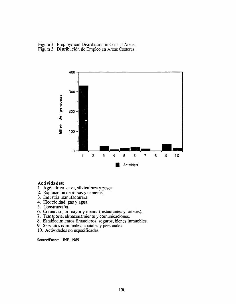
Figure 3. Employment Disnibution in Coastal Areas. Figura 3. Distribuci6n de Empleo en Areas Costeras.
300 Ill Cll c 0 Ill ... G) a. 200 G) ,, Ill G)
::::E 100
2 3 4 5 6
• Actividad
Actividades: 1. Agricultura, caza, silvicultura y pesca. 2. Explotaci6n de minas y cameras. 3. Industria manufacturera. 4. Electricidad, gas y agua. 5. Construcci6n. 6. Comercio ::'Jr mayor y menor (restaurantes y hoteles). 7. Transporte, almacenamiento y comunicaciones.
7
8. Establecimientos financieros, seguros, bienes inmuebles. 9. Servicios comunales, sociales y personales. 10. Actividades nc, especificadas.
Source/Fuente: INE, 1989.
150
8 9 1 0

Figure 4. Economically Active Population in Coasrnl Depanments. Figura 4. Poblacion Economicamente Activa en Deparcamentos Costeros.
Ill as c 0
100 Ill ... G>
Q.
G> "C
rn 50 G>
::::E
2 3 4 5 6 7
• Departamentos
Depanamentos:
I. Izabal. 2. Escuintla. 3. Jutiapa. 4. Santa Rosa. 5. Suchitepequez. 6. Retalhuleu. 7. San Marcos.
Source/FJente: INE, 1989
151

Figure 5. Guatemala: Indicators of Agricultural Prcxiuction Figura 5. Guatemala: lndicadores de la Prcxiucci6n Agricola.
Growth ratt·s
1983 1984 198: 1986 1987a 1983 :984 19"5 1986 1987
Indexes of agricultural production (1980 = 9 6. s 9 8. 0 9 8. 4 9 7. 5 9 9. 2 . I. 7 I. s 0.4 -0.9 I. 8 10 0) Crop farmingb 95.6 98.2 99.2 99.6 -2.4 2.7 1.0 0.4
Stock raising:, 99.9 99.7 97.9 93.6 0.9 -0.2 -1.8 -4.4
Production fo the main crops For export
Coffeec 3,651 3,840 3.904 3,945 4.119 0.4 5.2 I. 7 I. I 4.4
Cottone 1.323 1,348 L.384 893 752 I. 9 2.6 -35.5 -15.8 13.5
Bananasd 13.492 13.538 15,068 15,617 15.835 0.3 11.3 3.6 1.4 211.8
Sugar caned 120 120 121 124 125 0.2 0.6 2.3 I. I 12.0
For domestic consumption Maizec 22.004 25,063 24.173 25,152 25.799 -6.1 13.9 -3.6 4.1 2.6
Beansc 2.019 2.285 2.517 2,647 2.022 -6.4 13.2 10.2 5.2 -23.6
Ricec 995 981 835 804 1.281 -8.6 -1.5 14.8 -3.8 59.5 Indicators of stock-raising production Stocks
Cattle/ 2.276 2,356 3.5 12.8
Slaughtering Cattle/ 316 315 289 350 8.2 -0.4 -8.3 21.1
Other products Milkh 243 248 2.1
17.9 Eggsh 83 90 6.4 8.4
Source/Fuente: ECLAC, on the basis of figures supplied by the Bank of Guatemala.
a-Preliminary figures. b-Qn the basis of figures at l 958 prices. C-Tuousands of quintals. d-Thousands of bunches. e-Millions of quintals. frhousands of head. gMillions of litres. h-Millions of dozens
Source/Fuente: Economic Survey of Latin America and the Caribbean, 1987. Economic Commission for Latin America and the Carihbean. United Nations, Santiago, Chile, 1989.
152

Figure 6a. Guatemala: Main Indicators of Foreign Trade in Goods. Figura 6b. Guatemala: Indicadores Principales de Comercio Exterior.
1981 1982 1%; 1984 1985
Grow1h ra1es Exports 1FOB> Value ·15.0 .94 ·6.7 37 -64 Volume ·98 • J.2 · 3 I 09 0.7 Unir value .5 8 ·8 3 .p 28 .7 0
lmporr <FOB) VJlue 46 ·166 -17 8 II 9 ·R <J
Volume ·U ·14 I ·I I 7 12.7 .n Unir value 82 .3 0 ·68 ·O 7 ·16
Terms of trade · 13 0 ·60 27 2.0 ·61
Indexes ( 1980 = 1001
Purchasing power of expurrs 78.4 72.9 72.5 74.6 706 Volume of expurrs 90 2 R9 I 864 87.I 87.7 Vulume of 1mrurrs %7 83 I 7H 82 7 76.5 Terms of trade 87.0 817 84.0 85.7 80.5
Source: ECLAC. un the b,m ut ult1c,.1 l1gurn • Prelomon.ry logure•
Figure 6b. Guatemala: Exports of Goods, FOB. Figura 6b. Guacemala: Exportaci6n de Bienes, FOB.
1%o
·I I · 17.4 19.6
· 18 8 ·11.8
.7 9
29 2
753 72 5 674
103.9
Molluons of dollars Percenta,i:e Gro,.:rh nre brc:-alJ,,,. n
1984 198~ 1986 1987' 197~ 1980 198/ 1983 1984 198~ 1986
Toul I 1.\2 I 06Q I 044 %t 100.U 1110.0 100.0 ..(,, 7 3.7 -6.4 ·U
Expon\ 10
(.,nrral A .11erica 291 208 185 210 26.-1 29.0 21.8 -4.9 -9.2 -28.7 ·10.8
Expons 10 rest of "'Orfd 841 852 859 7H 73.6 i 1.0 78.2 -7. 5 9.1 1.3 0.8
Trad111onJI 5-i ,_ 652 6~6 ~09 638 ~08 52 8 ·10.I 6.0 138 0.6 Processed coff~ 361 4~2 ~02 m 25 6 .10 ~ 56.~ ·17 6 16.8 2~.2 11.3 Ginned Colton ., ,_ 73 24 21 116 109 2.2 ·29 I 88 ·OJ -66.8 oJnJnas ~~ 71 73 74 ~ .; 29 i.7 ·25 0 2.6 29.1 3.~ Mear 13 10 4 9 26 19 09 .7 I ·18.6 -21.3 ·57.0 ~U.CJI :'I 46 ~2 ~4 18 ,, 4 (1 < ,, 118 I ·25 2 -348 11 ~
Non·rraditional 269 200 202 244 98 20.2 2~.4 ·0.7 16.6 -n.4 1.3 C.:irdamom 100 61 48 40 1.6 3 7 ·LZ 34.4 68.9 ·39.~ •21.4 Perroleum 34 12 2i 19 1.6 2.0 30.2 -43.3 -<>4.7 12~.o
Other 13~ 127 128 18~ 8.2 l~.O 19.2 ·21.8 21.0 -4.9 o.~
Soun:e: ECLAC, on 1he b&.•1s of figurn suppliN by 1he Bink of Guarerruu. "Prniminary figurn.
,~7·
.5 o
122 ·180
41.1 9
H9 4 5
.]I 0
66.8 81 3 910 82 I
1987°
13.3
·12.2
·22.-1 ·30 I ·14 4
0.8 109 ~
~ <
20.i -1~.9
-28.2 44.8
Source/Fuente: Economic Survey of Latin America and the Caribbean, 1987. Economic Commission for Latin America and the Caribbean. United Nations, Santiago, Chile, 1989.
153

Figure 7a. Guatemala: Location of Wetlands and Turtle Hatcheries along the Pacific Coast.
Figura 7a. Guatemala: Localizaci6n de Humedales y Tonugarios en el Literal del Pacifico.
" I I
I
I I
'1 ',
I
\ I
. \ .
'•, I
\ \
I I I . .
\ . I
' RETALHULEU ' \ \
S 'JCHI T C:P EQIJ::
) . \, \) ,':
·: V. I ~ 1 )' \
J '\ J~I i.. r,._- "1' .. . ,'( • i
/ , , . ..:.· \;. .• :.... \ I ,',; ~·. \l (
1 J : ( / ~o; , .. \
II :,f,•,;· I~ ~~ . ' l
' I~ l~J • • ~ ,J ,?I \, : .· ,·' . . ....
~ ;~;· \ I .:ttAMll('llC~;·~: ' / • , · ~ .
/~"' -·' \ . ~· -...-........ ... ~ I C.1 A,N: •' .: .°-:/, :
-...___,. _i... 111111111 '-~.:.:.;· ( l , --._ .,.,,., .. ,,. '\ 1z f I I • '
--~,:-_er,._.,.
'"C!.1,.$:_.·..:..~ U1'1.'1SL ; .. ,1. Ji
Source/Fuente: Perez, A. N. 1991, Estudio del Humedal Montenico de la planicie cost.era del padfico.Escuela de Biologia, Universidad de San Carlos. Guatemala. Inf orme Final.
154
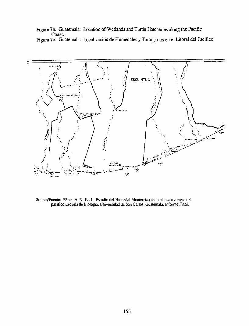
Figure 7b. Guatemala: Location of Wetlands and Tunle Hatcheries along the Pacific Coast.
Figura 7b. Guatemala: Localizaci6n de Humedales y Tortuga.rios en el Literal de! Pacifico .
M; i• .• ; - J.I. i ~
I .' ..... \ ~,....
'\ ' . '· ,· . ... -·' ... . . ESCUINTLA
I
~ ...
Source/Fuente: Perez, A. N. 199 l, Estudio del Humedal Monterrico de la planicie costera del pacifico.Escuela de Biologia, Universidad de San Carlos. Guatemala. lnforme FinaJ.
155

Figure 7c. Guatemala: Location of Wetlands and Tunle Hatcheries along the Pacific Coast.
Figura 7c. Guatemala: Localizaci6n de Humedales y Tortugarios en el Licoral del Pacifico.
·~ --- '-
\ \
I REffRERCIAS
' Limile Inter: .al ---
Limite Oeportomentol
Rios
Poblcdos
Carretero osfcltoda
Bosque de Mangle
TorlurpriOJ :
OIGEBOS @ OIGtSEPE II U~11C A
Source/Fuente: Perez, A. N. 1991, Estudio del Humedal Monterrico de la planicie costera del pacifico.Escuela de Biologia, Universidad de San Carlos. Guatemala. lnforme Final.
156
cc_;

Figure 8. Areas of Shrimp Mariculture. Figura 8. Areas de cultivo de camar6n.
AREA EM PRESA UBICACION HECT..\REAS POTENCIAL
Aguas Marinas Tabuesco, Suchitepeques. 100 300
Acapolon Champcrico, Reta.lhuleu. 100 300
Marpa.sa Champerico, ReL1.lhuleu. 100 350
Mayosal Las Lisas, Sta. Rosa 200 20
Agua Industrias Champcrico, Retalhuleu. 100 264 Mar Azul
Pro mar Sipacate, La Gomera, Escuintla.
Tropimar (o Xelamar) Iztapa, Escuintla. 54
Indwnar Iztapa 40 200
La Chorrera, Retalhuleu. Granjas Marinas Aldl!a Buena Vista 450 100
Salisur Iztapa, Escuintla. 23 30
Agromarinas Acapan, Champerico, Retalhu S.A. leu 13 200
Agromaricultura S .A. Champerico, Retalhuleu, Salinas 22 23 Chiapas Reta.lhuleu
El Mateo San Andres Villa Seca, 12 15 Retalhuleu
Mi Cielo S.A. lzlapa 50
TOTAL 1,264 l, 782
Source/Fuente: DIGESEPE - DITEPESCA, 1990.
157

Figure 9. Fishing Companies: Pacific Coast. Figura 9. Empresas Pesqueras Costa Pacifica.
COST A PACIFICA
EMPRESASPESQUERAS No. de BARCOS
Pesca S.A.
Marbella S.A.
Comarpa
Baja mar
Mary mas
Industrias Maritimas de!
Pacifico
20
12
10
2
2
Carlos Bauer 1
Industrias Shangai 2
Pro mar 4
Pescado de Tony 4
Perla del Mar
Source/Fuente: Fotocopia sin datos.
158
COOPERA TIV AS PESQUERAS
Hawai
Champerico
Copesca
La Corvina
Las Lisas
Marilanclia
No. de BARCOS
4
2
2
2
2
1

Figure 10. Overview of Fish Cacch 1979-1990, in Pounds, Pacifo.: Ocean Figura 10. Resumen de Capcura Pesquera de Diez Aiios Anteriores a la Fecha, Volumen
Libras, Oceano Pacifico.
Aiio :-;o. C•muon Pcscido C.ll.unu L•ngoSL• Cu.col h1b• ,\tucidor Abu Ion L•n,osw Cucuicha C•ngrcjo llacc Chi cno
79 36 .i I 31719 :289373 23-lS I 876
80 .io -l781S7S l-l35 I SS 216S8 -l-l23
81 .io 6172SIO l-lS3068 31-l83 -l29S
82 39 -l54901S l-l671.l) 19-l68 8 3S4
83 41 3602S81 13330·;2 2-l892 61S3
84 33 4998348 IOS2482 I 79S I S 8311
85 39 4219317 :204.i.i9 69071 2888-l
86 S3 2920401 1108245 937-l5 38355 2S38 62 28 1128 IS
87 56 2492093 l-l55873 22207 21083 1755 11 316 93 2883434 93 4
88 54 3453799 l-l24017 27766 11836 4691620 294
89 4759969 2408266 li22 I 5 5 15 8 I 2 604 43 277
90 4143995 9S29S-l 37390 -l963 61 972 98
Source/Fuente: Inspectoria de Pesca, Depto. Pesca Marilima, Direcci6n Tecnica de Pesca y Acuicultura
TO TALES
5425313
6242811
7661356
6043980
4966678
6127092
5521721
4164517
6876964
96093)2
7236544
5140433
DIGESEPE Ministerio de Agricultura, Bolelin estadistico de Pesca, Direcci0n General de Recursos Naturales Renovables Division de Fauna, Depto. de Pesca Maritima. Guatemala, C.A.
159

Figure 11. Guatemala: Value of Exports. Figura 11. Guatemala: Valor de Exportaciones.
., " ... al
-0 c
ui_ ·m :::io
" !!::. 'ts
., " c .2
:I
20
10
0
Shrimp, Fish, and Lobster Camaron, Pescado y Langosta
1984 1985 1986 1987 1988 1989 1990
Ario
Source/Fuente: Banco de Guatemala, Boletin Informalivo, 1988-1990.
160

REFERENCES
Banco de Guatemala, Boletfn Anual, 1984-1990.
Barry, Tom, 1990. Guatemala: A Country Guide. lmer-Hemipheric Educacation Resource Center. New Mexico, USA.
Cazali, Gina Maria, 1988. Inventarios de los pelecipodos de la costa Arlantica de GUATEMALA con enfasis en especies comesrible.Tesis de grado. U niversidad de San Carlos. Guatemala.
Center for Imer.iacional Health Information, 1990. Guaremala population and Health profile, Selected dara. USAID Healrh lnformarion System. Virginia, USA.
CDC/Guatemala/CECON. l Q??. Estud.io renico de! B iotopo de punta de Manabique para proteccion de! tapir. Guatemala.
DITIPESCA, 1991. lnforme de la captura de colas de camaron 1969-1990. Guatemala.
FAO, 1985. Fishery Country Profile. Guatemala.
Godoy, Juan Carlos, 1985. Tierras Humedas, Valor e lmponancia Nacional; una Aproximacion. Escuela de Biologia, Universidad de San Carlos, Guatemala.
INAFOR, 1983. Resultados de la Primera Reunion de Trabajo sobre Manejo de! Manglar. Unidad de proyectos especiales. Guatemala.
INSIVUMEH, 1981. Caracterisricas ffsicas de! agua de mar en los puertos de Santo Tomas de Castilla, San Jose y Chanperico. Seccion de agua Superficial, Ministerio de Comunicacion y Obra publicas. Guatemala.
Lampe, Harlan C. 1986. A Repon on Some Aspecrs of Guatemalan Fisheries. Tne University of Rhode Island. USA.
Lathrop, Guillermo, 1989. Proyecto de Rehabilitacion manejo de! canal de Chiquimulilla, Guatemala. Ministerio de Cooperacion de los Pafses Bajos y Direccion General de Cooperaccion intemacional. Guatemala.
Miller, John D. y colaboradores, 1991. Guatemala: Evaluaccion de! Sector Habitacional. AID/Guatemala.
Perfil, 1984. Perfil Ambiemal de la Republica de Guatemala. URLJAID/ROCAP. 1984.
Perez, A. N. 1991, Estudio de! Humedal Momerrico de la planicie costera de! pacifico.Escuela de Biologfa, U niversidad de San Carlos. Guatemala. lnforme Final.
PRB, 1990. World Population Dara Sheer. Washingron. USA
RENARE, USAID/ROCAP, 1990. Recurses Naturales de Guatemala, Inventario de Politicas. Volumen I, Guatemala. Rodas, Ogden A., 1990. Situacion de! recuso Mangle en Guatemala. II reunion de rrab.:jo sobre el recurse mangle.Guatemala
161 -

SEGEPLAN, 1987. Politicas sectoriales de desarrollo. Guatemala.
UNDP. 1990. Human development Report. New York: Unites Nations.
World Bank,1989. Colloquium on disaster, sustainability and development: A look co the 1990's. Environmencal Working paper No. 23. USA.
World Bank. 1990. Poverty, World Development Report 1990. Oxford lJniversity Press, New York. USA.
World Bank, 1990. World Resources 1990-91, A Guide to the Global Environment. Oxford University Press. New York USA.
162

HONDURAS
Puerto '1arr1os
I ••
• ,
GUATEMALA! ("' I J HONDURAS _.... •• , . .. ' ,/
y··~.. / ·--~bajwla - •• ) j 11
La Union.' .· .. . , .
·'
(Map elaborated by the Coastal Resources Cczuer, using Map~ Hammond Incorporated, ~faplewood, New Jersey.)
PROFILE OF THE
COASTAL RESOURCES OF HONDURAS
November, 1991
This document is an initial attempt to identify the most significant resource management issues affecting the coastal ecosystems of Honduras. This documenr is not a comprehensive summary of all potentially peninent information on the coastal resources of the counrry. We have instead attempted to assess both the social and environmental significance of the issues identified, their possible causes, and possible responses. A draft of this profile was reviewed and modified at a round table organized by the Coastal Resources Center of the Univesity of Rhode Island to which a cross-section of private and public sector representatives were invited. Subsequent meetings to review the document were organized.upon the initiative of the Asociaci6n Hondurefia de Ecologfa.
This profile was prepared by:
Gordon Foer, Coastal Resources Centt>r, The University of Rhode Island Particular assistance was provided by Mirna Marin, Universidad Autonoma de Honduras
This project was commissioned by the U.S. Agency for International Development':; Regional Office for Central America Programs (AIDIROCAP) and AlD!Office of Natural Resources/Bureau for Research and
Deve!flpment (R&D ). The University of Rhode Island's (URI) Coastal Resources Center assumed responsibility for the program through its Cooperative Agreement with AIDIR&D.
164

PROFILE OF THE COASTAL RESOURCES OF HONDURAS
PART I. THE COAST FROM A NATIONAL PERSPECTIVE
A. Definition of the C~Jstal Region
International experience in the management of coastal ecosystems suggests that the boundaries of a coastal zone should be pragmatically defined to include those geographic areas that must be considered when fonnulating management strategies for the selected issues that the program will address. Until the likely focus of a coastal program for Honduras has been identified, the Honduran coastal zone can be broadly defined to include all resources and activities that are present ( l) on, or immediately adjacent to the shoreline, (2) in coastal alluvial plains and small coastal watersheds wherein human activities directly and significantly impact coastal activities and features, and (3) within the EEZ. Honduras is a very mountainous country, and the coastal plains are consequently quite narrow, only broadening around the Ult.la and Aguan Rivers and in the Misquitia region (Figure 1). From a political perspective, if we define coastal territory as the extent of the coastal municipalities, then 45% of national lands and 15% of the national population is coastal (Figures 2 and 3).
8 . Economic Significance of the Coastal Zone.
The Honduran economy is dependent primarily on agricultural products. Bananas produced almost exclu·'ively on coastal alluvial plains on the Atlantic coast, produce approximately one-third of the country's expon revenues. During the first half of this century the Honduran export economy was dominated by foreign fruit and mining companies. Fruit production, dominated by banana plantations along the nonhwest coast, and scattered mining centers, existed within an economy made up primarily of a large peasantry engaged in subsistence agriculture. More recently, coastal fruit production has diversified to include imponant palm oil and cirrus components, and melon and cashew cultivation have also become important coastal crops (Figure 4). The fishing industry, based on the lobster and shrimp fisheries of the north coast, has expanded and now comprises the third largest "agricultural" export providing four percent of the country's total exports in 1988. The shrimp mariculture industry, located around the Gulf of Fonseca, is presently growing explosively - leading to the destruction of mangroves in some cases - and began producing more shrimp than the capture fisheries in 1988. Another major growth industry is coastal tourism centered primarily in the Bay Islands and along the Caribbean coast. In 1990, an estimated 15,000 tourists to the Bay Islands spent approximately 9 million dollars (personal communication, Jose Zelaya).
C. Major Coastal Resources and Ecosystems
The Honduran coastal zone contains a great diversity of resources and ecosystems with a large potential for generating wealth and a good quality of life for Hondurans. All the ecosystem types indicated in Figure 5 play highly important roles as habitats and nursery grounds to a variety of fish and shellfish and as essential habitat for migrating waterfowl. Coastal resources are also imponant as a source of timber and provide important functions in flood control, erosion control, and the self-purification of waters. Until recently, these ecosystem types were considered of marginal significance to both national and local economies and were not severely impacted by human activities. The situation has changed radically since the l 960's and all these ecosystem types are now under rapidly increasing pressure.
165

The \:xcellent agricultural lands that are present within the' 'Coastal region are primarily in large holdings and utilized in large monoculture operations for the production of such expon crops as cotton, bananas, oil palm and cirrus. Such large monocultures are vulnerable to invasions of pl!sts and disease and frequently degrade soil quality, requiring ever larger inputs of fertilizers, herbicides and other chemicals. The beneti ts of such expon-e!iented crops are concenrrated in the hands of a few wealthy landowners and transnational corporations.
Principal Uses of Land in the Coastal Areas of the Gulf of Fonseca
lJso Bosque de mangle Playones Camaroneras Salin eras Pesca artesanal Plantaci6n de wangle Cone total (marigle) Arena Bosque latifoliado Agricultura Matorrales Poblaci6n (area ocupada) TOTAL
Superficie (ha) 46,758 13,757 8,804 1,297 624 111 20 38
3,575 41,822 20,593 1,953
139,545
Fuente: COHDEFOR/AHE, Inventario Forcstal, Manglar dcl sur 1987. Tegucigalpa.
D. Population and Settlement Patterns
Honduras has been experiencing sustained rapid population growth of approximately 3.5 percent annually. This means that the human population doubles every twenty years. The major coastal concentration of native people is along the eastern coast, where the Miskito Indians number approximately 35,000 people, many of whom live in coastal villages where anisanal fisheries make a major conrribution to the local economy. Two Black ethnic groups, the Garifuna or Black Cari bes and the Antillean Blacks, both descendants of imponed laborers, live along the Atlantic coast and on the Bay Islands (Figure 6). The growth of the banana plantations in the early l 900's led to large population increases along the north coast and the development of San Pedro Sula as the second largest city and most important agro-indusrrial center of the counay. Similarly, La Ceiba became the third most important city, and Tela is now one of the major tourist destinations as well as an important petroleum storage facility (PETROTELA). Puerto Cones is the largest pon, containing both a refinery and a free pon zone. According to a study of agricultural production, a}.iproximately one-third of the total working population lives in coastal areas (Figure 7).
PART II. THE COASTAL SlJBAREGIONS
The Honduran coastal region can be subdivided into four distinct regions, each of which has its own unique characteristics in tenns of the ecosystems present, the mix and impact of human activities, and the opportunities and challenges for a coastal resource management program. The Caribbean coasts may be subdivided into three areas, the (A) Northwest and (B) Northeast Mainland Caribbean Coasts and the (C) Bay Islands. The city of Trujillo may be used as a dividing point between the eastern and
166

western Caribbean coasts. The fourth coastal region is (D) the Gulf of Fonseca on the Pacific side of the isthmus.
The Caribbea11 Mainland Coast as a whole is characterized bv long, sandv beaches, coastal lagoons and large concenrrations of mangrove wetlands. Seven~major ·river system that drain approximately 85 percent of the counrry flow into the Caribbean producing i.:in extensive network of fresh and brackish lagoons and riverine estuaries. Extensive deforestation in the watersheds is the major cause of environmental de.gradation throughou this region. Offshore the continental shelf extends an average width of 12 to 28 kilometers from Pueno Cones to Lhe mouth of the Patuca River and then broadens to a maximum of 240 kilometers. The entire continental shelf lies within the Exclusive Economic Zone and comprises a11 area estimated at 49,000 square kilometers or an area equivalent to approximately 40 percent of the land area of Honduras (AID. 1982). The shelf is characterized by many submerged banks and ca yes, primarily between Pueno Cones and Trujillo and from Punta Patuca eastward and these are all important fishing grounds.
The Caribbean coast is prone to the destructive force of hurricanes. During this century the Caribbean coast and Bay Islands have been hit by 13 hurricanes and 8 rropical stonns. In 1974, Hurricane Fifi caused widespread loss of life and propeny damage. The stonn's effects were compounded by the large deforestation of steep slopes which contributed directly to severe flooding along the coastal plain. Caribbean Honduras is home to two black ethnic groups, including between 70,000 (Counce and Davidson, 1989) and 300,()()(] (AID/SECPLAN, 1989: 72) Garifuna who are found in small communities along the entire nonh coast. The majority of these ethnic populations earn their livelihoods directly from coastal resources including fishing and as laborers on coastal banana plantations. The last National Fishing Census ( 1984) estimated 3,250 anisanal fishennen along the nonh coast.
A. The Northwest Caribbean Mainland Coast contains many important coastal lagoons and riverine estuaries some of which have been severely degraded by overfishing, destruction of mangroves, and by pollution from sewage and agrochemicals. Deforestation has altered hydrological regimes and increased siltation. The shorefron t contains many important and growing population centers, tourist resorts and pons. The extensive alluvial plains reaching inland along the Rio Ulua are the center of the counrry's agro-expon production, which in combination with the above mentioned facts, make it especially prone to large scale damage from hurricanes and associated flooding.
B. The Northeast Caribbean Mainland Coast (Mosquitia): Coral reefs, extensive lagoons, wetlands and long barrier beaches in an expansive savannah characterize this area which plays a central role in the health and sustainability of Honduras' fisheries. For the most part, due to it's inaccessability, the area h11.s been Sfl'.ll'ed the combined impacts of deforestation, intensive agriculture, overexploitation of fish and wildlife that has transfonned much of the rest of Honduras' coastal areas. Small settlements dominate the coast, with Brus Laguna and Pueno Lempira being the only ones with more.than one thousand people. Approximately 35,000 - 40,000 Miskito Indians, as well as members of the Pesch, Tawahkas/Sumu and Toiupanes tribes live in isolated areas of la Mosquitia, and about 35,000 Garifuna live along the coast (MOPA WI Annual Repon, 1989). Most of the lobstennen (divers) who crew Honduran industrial fishing boats are from this region. The economy of coastal Mosquitia is still based upon subsistence activities, with only a few "extractive" industries present (all foreign investment) including at least three seafocxi packing plants located in Pueno Lempira, Cauquira and Barra Caratasca, and at least one foreign oil company is about to drill a number of exploratory wells in the region.
167

C. The Bay Island sub-region is dominated by three major islands, Roacan, Guanaja, and Utila and contains numerous smaller islands and cays. These are all "high" islands with on~.y Utila having more than four percent of the land c.:lassified as flat. Until recently the Bay Islands had small populations that lived from fishing and ranching. The tourist industry has grown significantly in recent years and Roatan, the largest of the islands and the most populated, now includes several resons. Roatan is also the center of the Honduran fishing indusoy. Both Roacan and Santa Elena contain significant mangrove wetlands. By far the most imponant feature of the Bay Islands are the coral reefs around and between the islands that make up the southern extension of the barrier reef that extends from nonhern Belize to eastern Honduras. This reef is second in length onlv to the Great Barrier Reef off eastern Australia. It is rich in fisheries, panicularly lobster and shrimp. but also including a variety of finfish species. It is rapidly growing as a major tourist attraction. L'nfonunately, the quality of the reef is already suffering the negative consequences of human activities including siltation from poor land m'.lflagement µractices that clouds the water and cuts off the light essential for the health of coral polyps, damage caused by fishing and damage associated with overuse and misuse by tourists.
D. The Pacific Coast/Gulf of Fonsec:i. Honduras shares the Gulf of Fonseca with the neighbor;ng countries of El Salvador and Nicaragua. The waters of the Gulf under Honduran jurisdiction comprise 1,396 Km2 and provide a livelihood for some 2000 artisanal fishermen according to the last National Fishing Census in 1984, although as many as 5,000 people may divide their time between fishing and small scale agricultural activities (AID/SECPLAN, ! 989). There is no Pacific-based industrial fishing fleet. There has to date been little research on the physical or biological characteristics of the Gulf, and almost norhing is known of its flushing characteristics. As a large, shallow depression, it is susceptible to both pollution and siltation. Currents can be fast, up to 1.5 meters per second, particularly following heavy rains. Tidal currents are also strong since the average tidal range is 3 meters. The Honduran segment of the coast borders a broad coastal plain, 163 kilometers in length, and averaging 40 kilometers in width. The coastline is dominated by approximately 50,000 hectares of mangrove wetlam.!, fed by five major river systems that drain approximately 13 percent of the country. The region is considered ideal for shrimp mariculture production which has led to the rapid and largely uncontrolled conversion of both mud flats and mangroves as well as some agricultural lands into shrimp ponds. Such development is concentrated near the burder with Nicaragua. The major traditional activities in this coastal region are salt production, anisanal fisheries, extraction of bark for tannin, and collection of tunle eggs, molluscs and crabs. The major agricultural activities are sugar cane, melons, cashews, sesame, sorghum, soya and cattle grazing. During the rainy season, the extensive mud flats form temporary, shallow lakes which sustain large populations of fish and shellfish traditionally harvested by the local inhabitants for domestic consumption. Heavy rains occasionally lead to large-scale erosion and associated siltation. The major resource management issues in this region include:
• Pesticides and sedimentation from the Choluteca watershed • Rapid conversion of mangroves to shrimp ponds anci for salt production • Overharvesting of turtle eggs, traditionally favored fish and shellfish species • Increased turbidity and habitat destruction • Difficulties in maintaining the Pueno San Lorenzo navigation channel •Water quality problems associated with urban areas
The Gulf of Fonseca regions, especially the Department of Valle, is one of the nation's most densely populated areas, and is attracting immigrants from other areas of the country while simultaneously others are leaving to seek better opportunities elsewhere. Population growth has been stimulated by agrarian reform, the development of new agro-expon related activities, and by the boom-like growth of the shrimp mariculture industry.
168

PART III. ISSUES AND OPPORTUNITIES FOR A COASTAL RESOURCES MANAGEMENT PROGRAM
ISSUE #1. MARICUL TURE: MAXIMIZI\'G THE BENEFITS OF MARICULTCRE WHILE Ml~IMIZl\'G THE COSTS
Significance and Trends
Shrimp mariculture is an important and, in the last five years, very rapidly growing industry in the Gulf of Fonseca region. The first fann was built in 1973. The industry slowly expanded until the late- l 980s, when foreign and national investors generated a boom that continues today. The industry is being heavily promoted by both the national government and by international assistance agencies as a cenrral feature of a development scrategy for the development of southern Honduras. In 1988 cultured shrimp surpassed shrimp fisheries in production (Figure 8). In 1989, shrimp mariculture produced 2,500 metric tons and employed approximately l ,042 peopll! in 1988, including packers, larvae collectors, etc. (OLDEPESCA/SECPLAN, 1990). RENARE estimated that in 1991, the shrimp mariculture induscry employed approximately 4,269 people on the farms, 1000 larvae collectors and 150 packers. According to The National Association of Honduran Aquaculturists, in 1991 the cultivation of shrimp had generated 25,000 jobs. In 1991,The area under production increased from an estimated 2,000 hectares in 1987 to 4,000 in 1988 and 5,575 in 1990 (ANDAH). Between 1991and1993 another4.l00 hectares are programmed for develcµrnerir. The available data suggests that prcx:luction on the large, "semi-intensive" f..ums is approximately 2000 pounds of shrimp (heads off) per hectare per year in two crops, while approximately 300 pounds per hectare per year are produced by the "extensive", low technology fanm. Eight large shrimp fanns (over 1000 has. e2ch) constitute 70% of the lands permitced, 24 "medium" sized (between 100 and 900 hectares) constitute 28% of concession area. and 25 smaller fanns (less than 70 hectares) constitute 3% of the lands operating under permits, and employ low levels of technology and very limited amounts of capital (SECTUR, cited in A ID/SECPLAN, 1989). Virtually all the shrimp cultivated in Honduras is exported and the foreign exchange benefits of continued expansion can be significant . One study estimates that if the high end estimate of 31,000 hectares are put into production, exports would be in the order of $110 million per year (AID, 1990). However, the development of some fanns has resulted in the destruction of mangroves and loss of access by artisanal fishermen to traditional fishing grounds. This has caused significant social conflict. On the other hand, there are many cases where shrimp fann development has improved access to new areas. Local fishermen's cooperatives have received some assistance for the conscruction and management of shrimp ponds. The technical capability and funding available to such cooperatives, however, is very limited and the prospects for encouraging this fonn of expansion within the induscry seems at this point to be very mcx:lest. Estimates as u .. the numbers of people employed by the industry diverge greatly. There are 3 packing plants, 90% of whose employees are women.
Issues for a Resource Management Strategy
Quality and Completeness of the Database. Data on the total production of shrimp ponds and areas in mariculture are collected by RENA RE and ANDAH (Asociacion Nacional de Acuicultores de Honduras). There are, however, major discrepancies in the data from these two sources. Current est:mates of the total area suitable for conversion to shrimp mariculture ponds varied from 12,280 hectares (AlD/SECPLAN. 1989) to more than 30,000 hectares (Scura, 1987), the differences being attributable primarily to whether certain mangrove areas are included. The higher figure is being used as the basis for a development project being considered by government agencies and the USAID/Honduras
169

Mission (COHDEFOR and TRD studies cited in the draft Honduras Natural Resources Policy Inventory, 1990). Development at this scale would affect approximately 50 percent of the mangrove habitat in the Gulf. The amount of area already converted from mangrove is unclear. Marin ( 1990) indicates that in the Condega area approximately 2.000 hectares of land, ostensibly for shrimp mariculture, have been conceded which are not appropriate for mariculture development. The areas being considered for conversion into ponds are primarily mud flats (playones), with apparently little consideration of their ecological and economic values in their natural, unaltered state.
Impacts of the Postlarvae Fishery. The m:.>..riculturc industry is currently highly dependent upon wild-caught postlarvae as seed for the ponds. In 1989, locally caught postlarvae were insufficient for the ponds then in production and seed was imported. The largest shrimp f anns now import between 25 and 40% of their larvae (personal communication with Ralph Parkman). Water problems (irregular input and extremely variable salinity) has frustrated attempts to operate hatcheries. One expelimental conunercial hatchery is being built in Amapala and feasibility studies are being carried out on the Caribbean coast. Some researchers believe that expansion of the shrimp mariculture industry will inevitably lead to increasing costs of post larvae due to decreased availability of wild supplies and the need to import morr. According to Lahmann ( 1990), citing Dickinson , et al ( 1988), imported larvae cost close to 400% more than wild post larvae, and incr~asing costs will very likely mclce many operations unprofitable. The postlarvae fishery is conducted by approximately 1000 a.rtisanal fishermen. The fishery is lucrative and has the potential of being highly destrUctive since juveniles of a great variety of fish and shellfish are captured and it is common practice not to return undesirable species into the water. By one estimate, for every post-larvae caught, 5 other creatures are damaged or destroyed. As a result, the effects of this fishery on a variety of stocks can be significant and there are conflicts between the industry and those fishermen who believe the declines in local fisheries are a direct result of these activities. There is vinually no data on this fishery and as yet no efforts have been made to manage it or estimate its potential impact.
The capacity of government to regulate and direct the process of shrimp mariculture development is currently very weak. Many farms are being built without the required governmental permits and concessions are being granted without adequate information on the suitability of the site or the likely impacts of conversion into ponds of an area upon local populations or the ecosystem. Since such conversion is in effect an irreversible action, the absence of management tools and procedures is extremely significant and urgently requires attenti0n. Expansion of the industry to the north coast should be planned and managed in an orderly fashion to avoid many of the problems now occuring in the south. Worldwide experience in shrimp mariculture should be brought to Honduras so that mistakes made in southeast Asia and elsewhere in Latin America can be avoided and the social and economic benefits of the industry maximized.
Outlook. Given the apparently large areas around the Gulf that appear to be well suited for mariculture, the early success of the industry, and strong promotion from government and foreign assistance agencies, shrimp mariculture appears to have a promising future in Honduras. Attention should be given, however, to the international shrimp market. A great many countries are working energetically to promote shrimp mariculture There have been significant fluctuations in the price of shrimp in 1990 in Asian markets, where prices fell by 50 percent. The industry also depends upon adequate water quality and stocks of wild caught shrimp that provide both the PLs and the egg-bearing females required by hatcheries. The conservation of mangroves and associated mud flats can bring many benefits, including the protection of critically important nursery habitat for shrimp stocks, habitat for numerous other species important for the livelihoods of local residents. Industry
170
recognizes the major constraint posed by limited post-larvae supplies, and efforts are being undertaken co construct hatcheries. There is investor interest in constructing shrimp farms in the Mosquitia region of the nonh coast, but local conditions make it much more difficult co cultivate shrimp there and no fanm have been built. The Canadian rncernacional Development Agency is planning co fund the conscru1.·cion of an elecoic plant in the Gulf area which should decrease energy costs significantly co fa.nn operators and perhaps conrribure co additional economic and population growth in the area.
ISSUE #2: MANAGING TOLTRISM t;RO\VTH
International tourists co coastal Honduras are amacced primarily to the sandy palm beaches of the North Coast and the coral reefs of the Bay Islands. Infonnation on visitors and average expenditure per courist to the counrry is collected by IHT annually from hotel owners, but is not broken down into a coastal category. Approximately 45% of all visitors to Honduras spend time at coastal sites (Figures 9 and 10). In 1990 between ten and fifteen thousand people visited the Bay Islands (personal communication, Jose Cecilio Zelaya, lHT), spending approximately 7 to 10 million dollars. This number could conceivably double or oiple over a few years if the islands remain attractive . The managed growth of the islands is Il-ITs highest priority, and a project to develop and manage island infrastructure has been initiated with the assistance of the Inter American Development Bank. The primary draw to the islands is their spectacular coral reefs, clear waters and abundant marine life. Unfortunately, consequences of rapid growth are already manifesting themselves. Many coral reefs are deteriorating and some areas are losing their water clarity due co sedimentation. Populations of many fish, lobster, shellfish and cunles are in a state of rapid decline (Clark, 1988).
IHT has targeted three other Nonh Coast areas for tourist development. Around Trujillo and Tela the focus will be on international beach tourism, while Ceiba will be a center for "ecotourism" ventures. In the Gulf of Fonseca, national tourism is centered around several beach areas, which are subjected to incense use during holidays.
Resource Management Issues: Tourism facilities for the enonnous crowds visiting Amapala and Cedeno in the Gulf of Fonseca are minimal and completely ovenaxed. \\'acer is unavailable and there are no sanitary facilities nor more than a few small hotels at these beaches.
Institutional Issues: Despite its mandate to coordinate the permitting process for all coastal development, as well as participate in much of the site design and review and infrastructural planning, at any one time IHT has only 5-10 professionals. As a result, many developments are not adequately screened.
The Bay Islands have been declared a Zona de Conservaci6n Ecologica and several groups are involved in planning the development and conservation of the islands, including a private-public operation, a local affiliate of CON AMA (Comision Nacional del Medio Ambience) and one local NGO. The Inter American Development Bank is considering providing funds to shore up tourism facilities, provide for sewage treamem systems, and otherwise help ameliorate environmental deterioration on Roa.ran. A similar management commission for Amapala is being established. These attempts at local management should be supported. studieci and utilized as models for ocher programs.
Outlook: Despite the incense competition with many ocher Caribbean beach resons, tourism to Honduras' coastal areas can be expected to continue increasing as new facilities are built. Honduras offers unique opportunities for tourists looking for alternatives to the built-uo. luxury complexes in other Caribbean reson areas. By preserving the local
171

character and traditional aspects of reson areas as much as possible, Honduras can avoid many of the social and environmental costs so often associated with tourism development. Recently the Tourism Institute (IHT) has emphasized the development and promotion of ecotourism. particularly in and around existing reser\'es. !HT is also promting tour packages that inlude visits to prote(ted areas that ha\.: biologi(:tl, a.n.:haeologi1..·al and ethnic importance.
ISSUE #3. CONTROLLING THE OVER-EXPLOITATION OF FISHERIES
Significance and Trends: Fishing is an important economic activity in Honduras, although between 1979 and 1988 its overall comribution to the Gross Domestic Product, measurecl. in constant dollars, decreased from 1.7% to .7% (OLDEPESCA/SECPLAN, 1990). In terms of overall value and employment generation, the two most important products by far are lobster and shrimp (Figures 11 and 12), the majority of which is captured by industrial fleets and exported to the U.S. In 1990, fishery exports accounted for US$22.8 million, divided almost equally between shrimp and lobster. Fin fishery resources off the Honduran coast are in general not commercially significant . Cultivated shrimp production has now surpassed the shrimp fishery. The role of fisheries in meeting the Honduran people's need for protein continues to be marginal from a national perspective, but important for many coastal communities, panicularly in the Department of Atlantida (OLDEPESCA/SECPLAN, pg 11 ). Similarly, employment generation provided by fishing activities is fairly low from a national perspective, but vital for many coastal communities. According to one estimate, 12,000 to 15,000 people are dependent on fisheries in one way or another (FAO, 1984).
The industrial sector is limited to the Caribbean with landings principally in the Bay Islands and the mainland ports of Barra de Caratasca, Cauquira and Puerto Lempira, and is focused almost entirely on lobster and shrimp. Industrial fisheries commenced in the 1950s with foreign vessels, mainly flying North American flags, and consolidated in 1960 with the establishment of national ventures with a strong foreign component. There were approximately 4263 industrial fishermen in 1988, and an additional 984 persons were involved in processing (OLDEPESCA/SECPLAN, 1990). The industry grew at an accelerating rate until 1978, when, according to the Merchant Marine, a fleet size of 335 was reached (personal communication, Heri Omar Erazo). There is no industrial fishing sector in the Gulf of Fonseca.
Information on the artisanal sector is poor. FAO estimated that in 1984 that there were approximately 5, 149 small-scale fishermen (FAO, 1986). This apparently does not include the 300,000 or so Garifuna who fish for subsistence. The artisanal fleet consists of approximately 1,500 small vessels, mostly dugout canoes or cayucos, of which only onefourth are outfitted with motors (FAO, 1986). Artisanal fishermen supply local markets. This sector is primarily dependent upon finfish. Along the Atlantic, women comprise the majority of shellfish collectors as well as fish and shellfish marketers while in the Gulf of Fonseca many children actively participate in the collection of mollm:cs and crustaceans.
Major Fishing Grounds and Habitats
Major fishing grounds and habitats are shown in Figure 5. Areas of primary imponance are Rosalind and Gorda Banks and Vivorillo Cays. The lobster fishery is concentrated on the many offshore cays and submerged banks of the northeast Caribbean coast.
The richest shrimp grounds are on tht: wide continental platform off the northeast Caribbean coast in waters of 40 meters or less in-depth. Three shrimp species are exploited commercially: the white shrimp, the spotted pink shrimp, and the brown shrimp. These
172

three species live as adults off the ouier continental shelf. Spawning may be yea:.-round with seasonal peaks. Once eggs hatch, the postlarvae migrate to estuaries where they feed and pas~ juvenile life stages before returning to offshore grounds for spawning. The major juvenile shrimp grounds appear to be the Laguna de Caratasca and adjacent lagoons which are currently in good condition. They shou'.d be protcl'ted to ensure continued productivity. At present, the fishery for b0th shrimp and lobster is closed to the entry of additional vessels. The limit is set at 217, down from a peak of 275 in 1978. In any case, the number is much higher than the 120 boats recommended in several studies for maintaining a maximum sustainable yield. Shrimp boats account for approximately two-thirds of the fleet.
Resource Management Issues
l . Evidence of Declining St"cks
RENARE, as the government organization responsible for management of the fisheries, collects data for stock management, primwi!y from the fishing companies themselves. The figures published by RENARE, the Central Bank, and the Office for the Census and Statistics in SECPLAN frequently disagree. Similarly, there are usually discrepancies between reponed exports and the imponed quantities reponed by the United States, the principal market.
Catch per unit effort has been declining somewhat for shrimp and lobster (Figure 13). Declining catches may be attributed primarily to loss of habitat and overfishing.
Shrimp: After a disastrous year for shrimp in 1979, there has been widespread concern over the condition of the stocks. A moratorium on new entries into the fleet and a closed season from March to June 15 was put in place. Despite these measures catch per unit effort has declined.
Lobster: Despite inconsistencies in statistics, there are indications that the lobster resource has been over-exploited as reponed landings have declined by approximately 50 percent since 1978.
Finfish: Information is scant. Fishermen in the Gulf of Fonseca regularly blame a perceived decline in landed fish on the development of shrimp mariculture in the region. The average annual fish by-catch associated with the shrimp fishery has apparently declined nearly 50% between the periods 1960-80 and 1986 (OLDEPESCNSECPLAN, 1990).
Other: ·"here is no evidence :hat mollusc or crustacean populations are being reduced due to detetioration of nearshore water quality. In the Gulf of Fonseca, one mollusc specie (casco de burro, or Anadara grand.is) and the mangrove oyster (Crassostrea species) are seriously over-exploited. On the Atlantic Coast, the harvesting of snail (Strombus gigas) has led to its virtual elimination.
2. Safety Issues: Each year fishermen drown when their boats capsize. Approximately 1,500 native lobster divers operating off the Mosquito coast have vinually no training and many suffer severe physical problems and even death due to "the bends", poor sanitary conditions at the tank filling stations and the mishandling of equipment, as well as the increased use of drugs and alcohol. 56 divers died between 1976 and 1990 and about 140 are either completely or partially paralyzed due to related accidents, or suffer from respiratory illness related to carrying out their work.
173

3. By-Catch and Wasteage: Less than 20% of the by-catch associated with the shrimp trawl industry is utilized, resulting in wasteage of an estimated 67 million poi..!nds of fish in 1986 (OLDEPESCNSECPLAN). There is a scarcity of fish landing facilities where fish can be properly stored and marketed.
Outlook
The fishing industry will continue to be heavily dependent upon the exploitation of shrimp and lobster, but catches are likely to continue declining if effective management is not forthcoming. FAO-spon<iored exploratory fishing surveys cited four potential resources capable of sustaining additional commercial exploitation: sharks; snapper and grouper complex along with the continental shelf edge; tuna, barracuda, and wahoo; and deep water crustacean resources (AID, 1982, and Corporacion Nacional de Inversiones exploratory fishing survey, 1982). An unanticipated development likely to affect shrimp exports is the passing of the 1989 law in the United States requiring the banning of imports from countries unless they J.dopt programs comparable to those in the U.S. to protect endangered turtles by May 1, 1991; local practices will be reviewed periodically. The regulations will require shrimpers to employ "turtle excluder devices" or TE.D's wh.ich allow turtles to escape the nets. Small vessels must limit their tow times, checking their nets frequently to free turtles before they suffocate. The U.S. is also tightening its monitoring of pesticide and other chemical levels in imported foodstuffs. Increased agricultural production in coastal areas requiring chemical applications will need to be carefully managed to prevent shrimp pond contamination.
ISSUE #4: DEGRADATION OF HABITATS IMPORTANT TO THE ECONOMY AND QUALITY OF LIFE
Significance and Trends
Both the Caribbean and Pacific coasts contain natural habitats which are essential to Honduras' great biological productivity, and upon which many economic activities are either directly or indirectly dependent. Clark, et al. found that 10-60 percent of the coral cover of the reefs around Roa tan Island were alive, but there is much variability from one part of the island to another. The situation is similar on other islands. On Roatan a significant amount of the mortality had occurred sometime in the past, and it is not clear how much was caused by natural or human-induced sources. The lack of published data, Clark, make it difficult to determine trends in the quality of the Roatan reef (Clark, 1988). Honduran mangroves are also under enormous pressure and are disappearing at an accelerating rate. In the Mosquitia region large numbers of refugees from Nicaragua have settled in both upland forest reserves and along the coast and have been a major cause of deforestation. In the Gulf of Fonseca region, in 1988, there were 500 ovens used to produce salt that required approximately 49,000 cubic meters of wood to fuel, much of it mangrove. That same year 324 tons of mangrove bark was removed, sacrificing more than 5,000 trees (AID/SECPLAN, 1989). In 1984, it was estimated that 24,000 cubic meters of mangrove wood was removed for domestic consumption (UNDP, 1991). In recent years the c!e~trUction has further accele~ced with the constrUction of shrimp ponds. As of 1986, approximately 50% of the mangro,•es which existed in the Fonseca region in the 1950's has been eliminated (COHEDFOR/AHC 1987). Given the nutrient poor environment of the Caribbean, the estuaries, lagoons and river mouths have particular importance for HondL1ras' fbheries a1id must be protected. Furthermore, as all of these ecosystems are vital habitat i.'nd food for numerous birds, mammals, fish, molluscs and and other shellfish, their loss implies the loss of many associated species.
174

There have been very few studies of water quality in coastal Honduras. Virtually none of the coastal cities or towns (with the exception of San Pedro Sula) have even primary water treatment systems. The Atlantic coast has seen intens:ve deforestation and a rapid increase in pollution from agro-fertilizers and pesticides. There is also no effective control over industrial pollutants, oil spills or solid waste disposal. The northwestern lagoons are threatened by deforestation, pollution and over-fishing. The lagoons to the east are much less contaminated. Agrochemicals, including organochlorides are reported to have produced high levels in fish and caused human health problems.
ISSUE #5: OVEREXPLOITATION OF WILDLIFE
Significance and Trends
In the last decade there has been indiscriminate hunting along the coast: in 1987 alone this resulted in the export of 175,000 reptiles and 17 ,000 birds. In 1988, 273,000 reptiles and 13,000 crocodile skins, as well as 27 ,000 birds were exported. However, in 1990, Presidential Resolution 001 prohibited the exportation of wild animals and this has reduced their exploitation (AID/SECPLAN, 1989). The collection of turtle eggs for consumption along the Golfo de Fonseca, has resulted in a significant decrease in the numbers of several species of turtle~'.. On the Caribbean coast the cunles themselves are regularly consumed whic!l, combineu with the capture of marine turtles in shrimp trawl nets, is greatly damaging their populations. In the nonhwest lagoons of the Caribbean coast the supply of crabs, fish and turtles cannot meet the demand. In the Gulf of Fonseca, overexploitation has already led to the disappearance of cascos de burro (Anadara grandis) and oysters, and curiles are also disappearing.
PART IV. THE LEGAL AND INSTITUTIONAL FRAMEWORK FOR COASTAL MANAGEMENT
A number of public institutions are currently active in the management of coastal resources. Others are potentially important because of the impact that their activities have or might have in the future of coastal resources or could panicipate if their tasks were modified or clarified. Finally, the Ch .. ation of new entities or the reorganiz'1..ion of present authorities have been suggested to fill in the gaps or deal with weaknesses in the present structure. This section presents a brief profile of the most important agencies related to coastal management, and then offers a list of suggestions on how present authorities might be restructured.
KEY NATIONAL AGENCIES FOR COASTAL MANAGEMENT
Four different agencies have principal roles in reviewing applications and granting pennission for any economic activities or construction proposed for the coastal areas of Honduras: Tourism, (IHT); Renewable Natural Resources (DIGEPESCA, formerly RENARE); National Agrarian Institute (INA); and the Forestry Service (COHDEFOR). The criteria used by each are quite basic - and sometimes impossible to apply - which regularly leads to inconsistent and/or politically driven decisions. One productive step would be to exclude from the decision making process those government entities which do n~t have jurisdiction. This would prevent decisions being made which are in violation of natural resource regulations. There may be other institutions involved in the development of coastal areas, the most imponant being the Municipalities. Several inter-institutional commissions have been formed in the past decade to coordinate management decisions and efforts (Mangrove Commission, 1985; Gulf of Fonseca, 1988; and the Interinstituional Commission for the Protection of Marine Resources, 1982), but quickly became stalled or inactive.
175

IHT (lnstituto Hondurefio de Turismo, formerly' SECTUR)
The Law for the Establishment, Planning and Development of Tourism Zones (Acuerdo No. 312, November 29, 1982) decreed four coastal "tourism zones", covering Honduras' coasts in their entirety, and entrusted IHT with the responsibility of coordinating development and the permit process from high tide to 2 kilometers landward in these areas. IHT has a professional staff of 5-10 people to review and permit all development in tourism zones throughout the country.
The General Directorate for Fisheries and Aquaculture (DIGEPESCA; formerly RENARE)
This agency within the Ministry of Natural Resources is responsible for the management of all living aquatic resources. RENARE has at times effectively implemented the Fisheries Law and the Law for the Exploitation of Marine Natural Resources (which establishes the 200 mile EEZ), its primary mandates, but in recent years it has not adequately enforced them due to lack of human and economic resources. Under these laws, the agency is also charged with protecting mangroves, coral reefs, 1:1goons and all coastal ecosystems. The office dealing with mariculture is now located in Choluteca, while other small field offices dealing with coastal ecosystems are in San Lorenzo, Islas de la Bahia, Puerto Cortes, Sula, Tela, Ceiba, Trujillo, Rio Platano and Puerto Lempira. DIGEPESCA maintains a mariculture training center in San Lorenzo, which it built and operates in cooperation with the Chinese Fishing Mission.
Corporacion Hondureno para el Desarrollo Forestal (COHDEFOR)
COHDEFOR has regulatory authority over all mangroves and forested areas in Honduras, with Regional Offices in San Pedro Sula, La Ceiba and Puerto Lempira, and Operative Units in Puerto Cortez, Tela and Bonito Oriental. The Gulf of Fonseca office is in Choluteca, and an Ir •. ~!·.!menting Unit exists in S:m Lorenzo. COHDEFOR has its own development projects such as the "Development of Broad Leaf Forests" which includes the Islas de la Bahia, and in 1991 it was given authority to manage protected areas and wildlife. It runs a technical training school "National School for Forestry Sciences" (ESNACOFOR) which has classes on the planning and manag, '!ment of the mangrove forests of both coasts. In addition, it runs a Research Center for Broadleaf Tree Species, and administers the National Forest of "Lancetilla" in Tela. In the past several years this agency has developed a more conservation and management oriented perspective, as opposed !o the pronounced bias toward developing and marketing it had in the past. Under its new conservation orientation, COHDEFOR is promoting the protection of small watersheds to protect water supplies in cooperation with the municipalities.
Instituto Nacional Agraria (INA)
Ar:: the agency responsible for addressing land tenancy issues, INA issues permits for agricultural development and provides technical assistance to farmers. It reviews some requests for permits to ::ee if and how they would affect the rights of farmers.
176

Procuraduria General de la Republica
The Procuraduria is the the government entity which has fin3J responsibility for approving or denying concessions in national territories. including coastal areas.
OTHER NATIONAL AGENCIES RELATED TO COASTAL MANAGEMENT
National Commission on the Environment (CONAMA)
CONAMA is a Presidential level office established in 1990 to coordinate environmental and natural resource m:magement in the country at the executive level. Presently it has not addressed coastal issues except by sanctioning a local CONAMA appendage in the Bay Island<; which is working with other local groups to develop management plans for the Islands.
LOCAL AND F!EGIONAL AGENCIES
Municipal Governments
There are 289 Municipal Governments in Honduras which, among other duties, are responsible for upholding the Sanitation Code and its regulations, as well as the Police Law and the Penal Code. The ~1unicipal Governments must sel~ct sites for garbage disposal and receive authori2:ilion from the Bureau of Public Health. In 1991 Congress passed the Municipalities Law which intends to put much more power in the hands of local gove. mnent, although it is not clear to what degree this will actually occur, or what relation the municipalities will have to national lev~I agencies. Few local officials are adequately trained in basic concepts of resource management.
Non-Governmental Organizations
A number of Committees for the Defense of the Environment have been created in Honduras in coastal areas including: Ba)' Ishnds Conservation Association (BICA), Fundacion de Cuero y Salado (FU CSA), Committee for the Defense of the Flora and Fauna of the uulf of Fonseca (CODDEFFAGOLF), the Honduran Ecological Association (AHE), the National Association of Honduran Aquaculturists (ANDAH) and the Association for the Conservation of the EnvironmenL of Southern Honduras (ASCONA).
PART V. INITIAL RECOMMENDATIONS FOR A COASTAL RESOURCES MANAGEMENT STRATEGY
The review of coastal resources, coastal dependent activities and coastal regions makes it clear that resource managl!mcnt issues are closely interrelated and that the mix and relative importance of specific problems and opponunities varies greatly from one region to another. Thus, although the main text of this document has been orgar:ized by issue~. this section on management strategies will take a regional approach.
These regions a.i·e: Region 1: The Western Caribbean Coast extending from the border with Belize to
Trujillo: Region 2: The Mo~quitia Region extending from Trujillo to the Nicaragu:m border, Region 3: Las Islc:s de la Bahia, and the fishing grounds and coral reefs within the
Atlantic EEZ; h.egion 4: The Golfo de Ponseca Region.
177

The limits of regions 1 and 2 do not coicide with depanamental limits. In consideration of the fact that governmental organization is strUctured around deparonents, two alternatives are offered. The first considers the ethnic distribution on the Atlantic and the second takes into consideration the relative development of the zones.
Alternative l. Consideration of ethnic distribution Region l. Coastal municipalities in the Depanment of Cortes (Ladinos) Region 2. Coastal municipalities of the Departments of Atlantida and Colon
(Garifu'1a) Region 3. Coastal zone of the Depanment of Gracias a Dios (Miskitos, Pesch,
Tawahkas/Sumu and Tolupanes) Region 4. The Bay Islands and coral reefs Region 5. The Gulf of Fonseca
Alternative 2. Consideration of the relative development of the zones Region l. Coastal municipalities of the Departments of Cones and Atlantida (very
industrialized anj high population density) Region 2. Coastal municipalities of the Depanment of Colon (relatively little
industry and lm.v population density but subject to increasing development pressures).
Region 3. Coastal z:-ne of the Depanment of Gracias a Dios (little industry and low population density, with moderate development !"r~~ssures).
Region 4. The Bay Islands and coral reefs
From a national perspective the major coastal management issues are:
1. Management of the rapid growth of the shrimo mariculture industry; 2. strategies to achieve a sustainable, socially be eficial, coastal tourism industry; 3. the need for strategies designed to achieve susrninable levels of exploitation of
fishery and wildlife resources. 4. strategies to sustain coastal habitats critical to maintaining a good quality of life; 5. strategie.s to minimize the impacts of huroicanes and coastal flooding. 6. Development of a national oil spill contir.gency plan
This (:ocument was discussed and reviewed in a roundtable discussion attended by technir.ally trained representatives of various governmental and non-governmental organizations. There was unanimous agreement that the area of highest priority for the development of coastal management programs is the Gulf of Fonseca. Similarly, there was agreement that the activities that require most urgent attention are mariculture and the production of salt because of the potential danger of ecosystem degradation and because of the potentially negative social-economic impact that these activities may have on lower income populations.
'2oastal resource management strategies should be designed to directly address:
., the reduction of poveny; •maximizing employment opportunities; •improving the contribution of and benefits to women: • the long term sustainability of use patterns; •interrelationships with other regions and resource management initiatives.
178

More imponant than the specific recommendations of each management strategy is the process by which each one is fonnulated, tested, and refined. This process should have the following characteristics:
- consideration of lhe best available infom1ation on the condition and use of natural resources and Lhe human activities they support:
- each plan must be fonnulated through an open and panicipatory process in each region; all major stakeholders must be identified and involved, and actions should be taken only when adequate concensus on specific measures is attained;
- each plan must focus on a few carefully stle cted issues;
- each plan must be incrementally developed and tested and management and development ideas should be reality-tested quickly so lhat the experience gained can be fed back into the ongoing planning process;
- there must be a strong commitment to the strengthening of locally based institutions involved - both governmental and non-governmental - in the management process;
- the planning process must feature strong public education and training programs.
Recommendations for Central Government
1. The single most imponant action that should be taken in response to the closely coupled problems of poverty and environmental degradation in Honduras is a sustained, strategically designed, public education program. This should have three linked components: infonnal education programs, school programs and a university center for environmental management.
-T,e infonnal education program should focus on the interrelationships between environmental quaE~y and quality of life. The implications of such specific actions as deforestation and misuse of agrochemicals, and for coastal resources, of overfishing ..ind destruction of mangroves should be stressed.
-The school program would require the development of curriculum materials and the training of teachers.
-A university center for environmental management is crucial since environmental management in Honduras can never be effective without a sizeable cadre of locallytrained, motivated professionals. It will be necessary to provide scholarship incentives and funds for research and internships.
2. A second priority is to design and implement a simple, carefully targeted environmental monitoring program. The objectives of resource management strategies, the interrelationships among environme:ntal processes and human patterns of resource utilization and the often rapidly changing condition of ecosystems must be known and widely promulgated \f management strategies are to be effective. Such a monitoring program should combine remote sensing with extensive activiries at the community level designed to involve resource users in the monitoring process. The data collected must be applied directly to: ( 1) evaluate the impacts ot .esource management strategies, (2) periodically review management priorities and, (3) very importantly, develop the public education pr0gram.
179

3. The existing decision-making process and the criteria used by agencies which make resource allocation detenninations must be carefully re-examined. Adjusnnents in the roles and responsibilities of institutions should recognize that reorganization in itself too often results in only marginal improvements. The objective of institutional refonn should be to ensure that the many agencies inevitably involved in the management of coastal regions operate in a collaborative manner, following as simplified and efficient a decision-making process as possible. It is crucial that local levels of government are empowered and trained to make decisi0ns affecting the allocation of natural resources and perform the required balancing among competing interests. This is particularly important given the changes introduced under the new Ley de Municipalidades. Institutional development must recognize that the learning process will be slow, at times painful, and char finding "quick fixes" is highly unlikely. Worldwide experience suggests that the "discovery process" whereby effective institutions emerge is most likely to succeed when decisions regarding permits, concessions, enforcement, ere. are made ar the local level on the basis of detailed resource management plans that have the suppon of major elements of the local population. Four regional planning and decision making entities, one for each coastal region, are recommended for initial consideration. The role of central government should be to provide for overall coherence in policy and the decision-making process, oversight, and a vehicle for the funds and technical assistance that will be required by the regional management entities.
Recommendations for Regional Strategies
Western Caribbean Coast
This region contains imponant coastal lagoons and riverine estuaries many of which have been severely degraded by overfishing, destruction of mangroves, and by pollution from sewage and agrochemicals. Deforestation has changed water flows and increased siltation. The shorefront is densely populated and is prone to large-scale damage by hurricanes and associated flooding.
Priority actions for this region include:
1. A public education program similar to the ones recommended for other coastal programs but targeted upon the characteristics and management issues of this region.
2. A monitoring program targeted upon water quality, documentation of artisanal fisheries (landings, effons, gear utilized, grounds fished), changes to such habitats as mangroves and seagrass beds and shorefront construction.
3. Community based management programs for individua1 lagoons and associated wetlands should be encouraged.
4. Research should be directed at estimating the potential for restoring the productivity of lagoons and encouraging labor-intensive mariculture operations.
Eastern Caribbean Coast (Mosquitia)
The coastal lagoons, barrier spits and associated wetlands in this region must be managed as one entity. It must also be recognized that changes in the intensity of human activities within the watersheds can have drastic effects on these coastal systems This largely unaltered region is of enormous importance since it includes significant natural resources and has as yet been spared the combined impacts of deforestation, intensive agriculture, over-exploitation of fish and wildlife and rapid population growth that characterizr-d tJie rest
180

of the country. The coastal la Boons are known to be an imponant nursery for finfish and shrimp, and are probably essential to sustaining the major commercial fisheries offshore.
The following actions are recommended:
1. Strictly control or prohibit improved access to the region. Increased road access will inevitably result in deforestation, overfishing and conflicts with ethnic populations.
2. Extractive fisheries and mariculcure (production for e.xtemal consumption) should be discouraged in the regions lagoons. Concessions and/or pe1T1its for exrractive activities including mariculture and processing/packing facilities, shout,~ not be permitted until a detailed resource management plan has been developed and endorsed by the local inhabitants.
3. A monitoring program, targeted panicularly on ~he role of lagoons as a major fish and shrimp nursery should be designed and implemented without delay.
4. Establish laws which specifically: a) conrrol ecotourism in Rfo Placano and Patuca to protect the et;osystem and ethnic groups; b) prohibit all activities which might lead to the deterioration of aquatic and terresrrial ecosystems; and c) involve indigenous peoples in the process of protecting and utilizing resources.
The Bay Islands :md Fishing Grounds Within the Atlantic EEZ
Recent growth in tourism and associated infrastructural development in the Bay Islands, in combination with deforestation and overfishing, is leading to degradation of these important reef and island ecosystems. Deforestation and poorly planned and implemented projects are causing sedimentation of the coral reefs.
Priority Actions Include:
1. A public education program focusing upon the importance and proper management of the coral reefs and other island resources to the local and national population.
2. The data-gathering processes for both the industrial and artisanal fisheries based in the islands and operating within the EEZ must be redesigned, sufficiently funded and effectively implemented. Management of the imponant lobster and sruimp fisheries requires believable data on landing, effort and areas fished.
3. Fisheries management strategies must be formulated and implemented if current declines in fisheries and the clear evidence of overharvesting are to be addressed. A top priority is to develop baseline data on the location and condition of such critically important habitats as the offshore coral reefs and seagrass beds. Extensive seagrass beds are known to exist off the Mosquitia region and they are being severely degraded by unconrrolled trawling. The possibilities for utilizing tht! by-catch associated with shrimping should be studied. The following strategies should be condidered:
a) Use bio-economic studies as the basis for regulating the fishing fleet; b) Apply the Fishing Law and other resolutions which protect fishery resources; c) Prevent the shrimp trawl fl~et from fishing within three miles of the coast, classifying
this area as an artisanal fishing zone; d) Apply seasonal closures, backed by scientific investigation, to the coastal lagoons.
181

4. Another urgent priority is to regulate the lobster dive fishery currently carried out largely by completely untrained native Americans from the Mosquitia region. Death and cripvling from "the bends" is common. Adequate training of divers and controls over this highly hazardous activity is urgently needed. Some progress on this issue is being made.
5. Reef management strategies for all of the islands should be designed and enforced. Efforts such ~s those by some hotel owners to place mooring buoys and protect the reefs by employin~, ex-si:;earfishennen and local people should be officially encouraged.
6. Periodic monitoring to track the condition and use of the reefs, shorefront construction, and changes in land use is essential to effectively manage the Islands' development.
7. The recently signed Acuerdo Ministerial No. 2 ":\omlUs Generales para el Control de! Desarrollo de las Islas de La Bahia" should be vigorously implemented and periodically reasse~sed to incorporate new needs. Similarly, if enthusiastically supported, the "Zona de Conservaci6n Ecol6gica de Las Islas de La Bahia", involving the cooperation of government, non-governmental and private sector representatives, could go a long way to achieving appropriate resource management, and become a model for similar progrdl11s in other parts of the country.
Golfo de Fonseca
This region urgently requires a management strategy that addresses the following closely interrelated issues and opportunities:
- extensive deforestation in the upper watershed that has greatly increased erosion of soils and siltation in the nearshore estuaries and made several rivers that fonnally flowed year-round into seasonal rivers.
- agrochemical residues that affect both human health and estuarine populations. - mounting pressures on extensive mangroves caused by a combination of traditional
activities (salt exn-action, bark collection, timber and fuel wood extraction) .:.'nd the very rapid growth of shrimp mariculture.
- conversion of mud flats (playones) into shrimp fanns and likely incursion into associated seasunal lagoons of great importance to traditional fisheries.
- overharvesting of turtle eggs and traditionally favored fish and shellfish species. - difficulties in maintaining navigation channels. - water quality problems associated with urban areas and agricultural runoff. - large scale seasonal influxes of national tourists. - a large, dense and rapidly growing human population, much nf whi.ch lives in great
poverty.
The following actions could provide the basis for an incegrated management strategy:
1. Preparation of detailed maps, based on recent photography and ground truthed, showing playones, mangroves: seasonal lagoons, areas of rapid sedimentation, land use within the watersheds, major roads and settlements, reserves and such special features as tunle nesting sites.
2. Form, under the highest possible auspices, such as Presidential Decree, a Commission composed of all governmental agencies with resource managemeuc :mthority and an Advisory Committee including representatives of private sector groups, and NGO's and charge them to work together to fonnulate a detailed management plan. The plan, using the maps (from Action # 1) should designate areas suitable for shrimp ponds, areas recommended for reserves, areas designated for multiple use, points of public access, etc.
182

Such a zoning plan should be the subject of open discussion and debate at the community I eve I.
3, Acrions 1 and 2 should be accompanied by an energetic public education program d11·ected at promulgating the functions of the ecosystem, the benefits it provides to society, and the implications of existing patterns of mis-use and over-use of natural resources.
4. A program of technical assistance and training should be implemented concurrently to bring to bear worldwide experit!nce in similar environments, including specific techniques of mariculture that can provide maximal employment and produce protein for local consumption.
5. A long-term monitoring program should be designed and implemented to keep track of changes to the ecosystem, the success and failure of management initiatives, and shifts in use patterns. The !'esults of such monitoring should be widely promulgated and featured in public education progr..ims (Action #3).
6. The Commission and Advisory Committee (Action #2) should also develop the procedures, and decision making criteria, by which concessions within intertidal areas will be granted. Full consideration should also be given to greatly increasing the annual fee charg1!d per hectare for concessioned lands. Such fees should be used to support the management program. A moratorium on funher concessions should be considered until such time as a new and effective pem1it process is in place.
7. An environmental impact assessment should be undenaken immediately to detennine the likely effects and possible design alternatives of the "Programa de Embalse y Riesgo en la Cuenca de Choluteca" on coastal areas and ecosystems.
It must be recognized that many of these actions have already been recommended or acted upon to some degree. Tllis suggests that the timing for such initiatives is good. The essential point, however, and the fTlissing ingredient thus far, is that all these actions must· be viewed and implemented as a single, coherent strategy and not as piecemeal actions by various groups acting independently.
183

Participants in the Roundtable Discussion and R·eview of the Draft Honduras Coastal Resources Management Profile, May 17, 1991 Tegucigalpa, Honduras
~ohemy Luna dt: Figueroa Economista Sectorialista en Pesca, Direccion Planifo:ac.:ion Agricola/SECPLAN
Reinaldo Oviedo Tecnico en Perroleo, Refineria Texaco
Heri Omar Erazo Teniente de Navio, Jefe Depto. Adminisrrativo Marina Mercante
Jorge Varela Marquez Biologo, Exec. Dir. CODDEFFAGOLF
Jose Cristobal Vasquez V. Ing. Forestal, ESNACIFOR/COHDEFOR (Corp. Hond. de Forestal)
Raimundo Vasquez B. Lie. Derecho (lawyer), Marina Mercante
Ricardo Matamoros Flores Biologo, Coordinador Acuic.:ultura, Zona Sur RENARE (Recursos Naturales Renovables)
Rosa Duane de Discua Eonomista, Planificador Sector Pesc.:a y Acuic.:ultura REN ARE
Erasmo Sosa L. Biologo Asesor Ecoturismo IHT (lnstituto Hond. de Turismo) Depto de Biologia, Univ. Nacional Autonoma de Honduras (UNAH)
Wilmer Dagen MOPAWI/World Neighbors
Dr. Mirna Marin Univ. Naciona! Autonomo de Honduras
Jose Rigoberto Gonzalez Jefe del Depto. de Planificacion REN ARE
Rafael Calderon, Lisa Villela ECONSULT
Gordon Foer Coastal Resources Center University of Rhode Island
184

Subsequent Roundtable Discussions on the Draft were attended by:
Davi6 Robeno Calix UNAH-DICU
Rafael Calderon BioConsult
Luis Morales Recursos Naturales
Jonathan Espinoza AND AH
Mirna Marin UNAH, Biologia
Jose Cristobal Vasquez V COHDEFOR
Abrahan Reyes Gomez FFAA
Elena FullertG·l de Rivera Asociaci6n Hondureii de Ecologia
Luis Sanniemo C. Insituto Hondureii de Turismo
185

Figure 1. Honduras: Geography. Figura 1. Honduras: Geograffa .
.. :..,~ ...
j - ...
... ---
·i . . I
er.· I ~ 1:< :t;.' Q.£1?/t" ,j
~ '" ·.~~ •1, I ,s" ' •, • ~ ~~ I
, ·f. ~I \1. ~· ... + ::"Q
''I ~·· i'::
, .. , .. : t4 . . ' I
. : ~J
Source/Fuente: Rudolf, James, ed. 1984. Honduras: A Country Study. The American University, Foreign Area Studies, Washington, DC.
186

Figure 2. Honduras: Comparison of Area in Coastal Provinces to the Rest of Honduras. Figura 2. Honduras: Comparaci6n de la Extensi6n de las Provincias Costeras con el Resto
del Territorio Nacional.
42.44%
55.08% • Costa Atlantica • Golk> de Fonseca • Resto de HondllllS
2.48%
Elabor6 M. Marin con datos def Ccnso Nacional de Poblaci6n y Vivicnda, 1988.
Figure 3. Honduras: Percentage Population on Pacific and Atlantic Coasts. Figura 3. Hcnduras: Distribuci6n de la Poblaci6n de las Zonas Costeras.
10.1%
85.20/o
I Costa Atlantlca Golfo de Fonseca
• Resto de Honduras
Elabor6 M. Marin con dalOs de! Censo NacionaJ de Poblaci6n y Vivienda, 1988.
Now: La informaci6n contenida en las figuras 2 y 3 relativa a la Costa Athintica y el Golfo de Fonseca contempla solamente los Municipios Costeros y las Islas de la Bahia. En la Costa At1:1ntica, en el Departamento de Gracias a Dios, el Municipio de Puerto l '!mpira incluye informaci6n de :ireas que no son extrictamente costeras.
187

Figure 4. Honduras: Most Important Crops in Coastal Areas, Compared to the Rest of Honduras.
Figura 4. Honduras: Cultivos Mas Imponantes en las Zonas Costeras en Comparaci6n con el Resto del Pais.
Producto
Pina
Cl trices
Palma Aceitera
Algod6n
Banana
Cafe
Mel6n
Calla
Cacao
0 20 40 60 80 100
Porcentage de area cultlvada
Elaboro M. Marin con datos de la Encucsta Aqricola Nacional, 1989.
120
• Costa Atlantica
B Gelfo de Fonseca
• Resto del Pals
Noia: La infonnaci6n contenida en la figura 4 rclativa a los cultivos costcros, no incluyen los desarrollados en los vallcs de Cort~s y Yoro.
188

·s··-
J
1)"
Figure 5. Honduras: Coastal and Marine Resources. Figura 5. Honduras: Recursos Costeros y Marinos.
'kt'
119• 88'
~•I
•• JI •• '9 •••• • •1••1•~.-..""!""~• ....
di" 86"
i-1
)C )'( >l &11rciln dt coo.1
• 'j .... f'PI., lr"1t11•t•tt
' ... •
~ P•.nc·P•'" A1U1 at C.191 .. °"' 'lfnCJOtll
11fb-t•I ':·•l•(O
11) ...... 1•01
85'
t I l
13°
11.3•
Source/Fuente: Honduras, Perfil Ambienr.al del Pais: Un Estudio de Campo. 1982. JRB Associates, AID.
189

Figure 6. Honduras: Ethnic G,roups. Figura 6. Honduras: Grupos Etnicos.
. ~· ' " ... fllllU
CMOll Iii Lf'IC&i 1wo1oi .,,.,., 1111.ua
~u1ruu\
Ml ~Qui l('.'lt.
OOllAClC>I
l, 100 80,000 19,000 17,000 1~.ooc
'. ,o .. I. 000
lOO,OM ll ,000
--- --·· --- - ---------------------------
Source/Fuente: Perfil Ambiental de Honduras, 1991. AID/SECPLAN/DESFIL, Tegucigalpa.
190

Figure 7. Honduras: Employment Distrib1_jtion. Figura 7. Honduras: Distribuci6n del Empleo Nacional Total.
0.55%
• Ocupacion~ diversu en la Zona Cost.era
• Ocupacionet relacionadu con la Peaca
• Re1to de Hoftduru
65.92%
Elabor6 M. Mariu con datos de la Encuesr.a Agricola Nacional 1989.
Nota: La informaci6n contenida en la figura 7 relacionada con el Departamenro de Omoa incorpora solamente aquellas ocupaciones relacionadas con la Costa y las actividad ponuarias.
Figure 8. Honduras: Shrimp Production: 1979-1989 (Metric Tons). Figura 8. Honduras: Producci6n de Camaron por Actividad: 1979-1989 (TM).
(TM) 5000
-:.! ... 4000 -.. • u 3000 i: - • Prod Pesca • ~ • Prod. Aculcul.
• 2000
• ,, • 'i 1000 c 0 ...
0 1971111180 11181 11182 1983 11184 11185 11186 1118711188 111811
Al'\o
Elabor6 M. Marin con daros del Depto. de Planificacion DIGERENARE.
191

Figure 9. Tourism: Expenditure, Number of Visitors and Sites. Figura 9. Turismo: Gasto, Numero de Visitantes y Sitios.
lngreso Promedio de Visitantes: ............................ 332,217
Gasto Promedio Diario Por Turista:
Visitante Norteamericano
Visitante Centroamericano
Promedio General
Estadio Promedio:
Islas de la Bahia: Resto del pais:
1987
$96.00
80.00
92.00
6.5 dias 3.5 dias.
Areas que son mas Visitadas:
1. Islas de la Bahia* 2. Copan 3. Tegucigalpa 4. San Pedro Sula 5. Tela* 6. LaCeiba* 7. Omoa* 8. Lago de Yojoa 9. Cedeno* 10. Amapala*.
*coastal location
SourcetFuente: Fotocopia sin datos.
192
1988
$100.00
85.00
97.00
1989
$105.00
90.00
102.00
1990
$110.00
95.00
108.00

Figure 10. Honduras: Number of Tourists Visiting Marine and Coastal Areas. Figura 10. Honduras: Contribuci6n de las Zonas Marinas y Costeras al Tourismo.
-GO Cl
:::& -GO ca -GO -.:: :I I-
400
300
200
100
0
• Tur.Cestero
m Tur. Otr. Partes
19831984198519861987198819891090 Ano
Elabor6 M. Marin con datos e infonnaci6n del IHT.
Nota: A pesar que los datos relacionadas con turismo para las zonac; costeras no esta estadisticamente definidos, ~ calcnlaron con base a estimado del lng. Zelaya del IHT.
193

Figure 11. Honduras: Shrimp, Lobster and Fish Production: 1979-1989. (Value in Thousands of Lempiras).
Figura 11. Honduras: Valor de la Producci6n por Especies: 1979-1989. (Miles de Lempiras Cor.stantes).
400000
ID (;amur6n • • Langosta ...
300000 A. E • Escama • .... &I
200000 ,, • .! :I
100000
0-t---r--..,...-...--..,... ..... i--........................ -il~ 1978 1980 1982 1984 1986 1 988 1990
Ano
Elabor6 M. Marin con datos del Depto. de Pesca SECPLAN 1991.
194
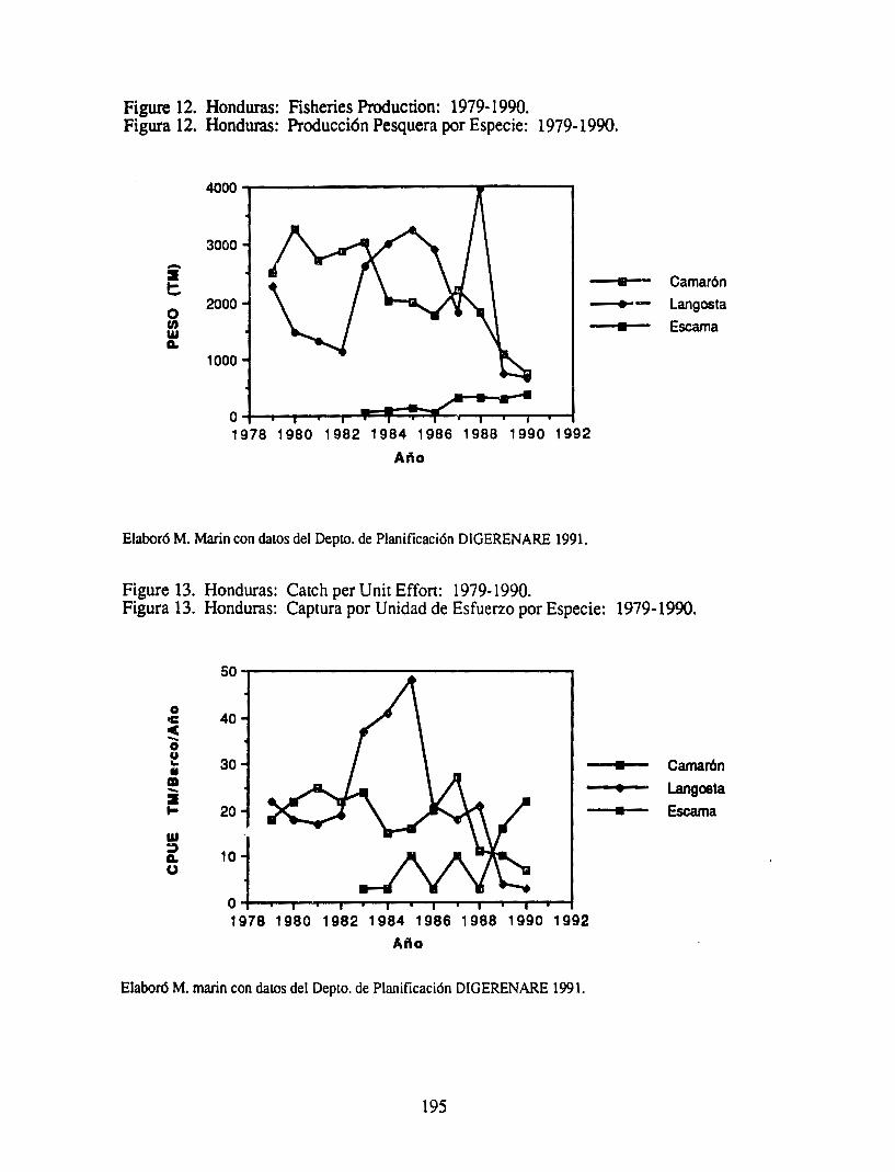
Figure 12. Honduras: Fisheries Production: 1979-1990. Figura 12. Honduras: Producci6n Pesquera por Especie: 1979-1990.
3000
-~ • !::. 2000 --+--
0 UJ w A.
1000
o-'--------._...l~~~C:....w--r--"T"-r----1 1978 1980 1982 1984 1986 1988 1990 1992
Ano
Elabor6 M. Marin con datos del Depto. de Planificaci6n DIGERENARE 1991.
Figure 13. Honduras: Catch per Unit Effon: 1979-1990.
•
Camaron
Langosta
Escama
Figura 13. Honduras: Captura por Unidad de Esfuerzo por Especie: 1979-1990.
0 IC c -0 Q .. • m -~ ... w
40
30
20
~ 10 CJ
o ....... ______ __.__......,,_, ______________ -1
1978 1980 1982 1984 1986 1988 1990 1992 Afto
Elabor6 M. marin con datos del Depto. de Planificaci6n DIGERENARE 1991.
195
• •
Camar6n
Langoeta
Escama
REFERENCES
AID 1982. Honduras: Country Environmental Profile: A Field Study. USAID.
AID/St:CPLAN 1989. Perfil Ambiental de Honduras.
AID 1990. Draft Natural Resources Policy Inventory, 1990. Conducido bajo el Proyecto de Analisis de Politicas Agricolas, Fas~ II. Repone Tecnico No. l l l. USAID.
Castaneda C. y Zoila Matamoros 1990. Analisis Arnbicntal para el Proyecto de Inversion y Desarrollo de Exponaci6n (522-0312). USAID. Tegucigalpa.
Clark, J.R., Allan H. Smith, et al. 1988. Programa de Manejo de Recurses Costeros para las Islas de la Bahia, Honduras. Cuerpo de Paz, Oficina de Enrrenamiento y Programa de Apoyo, Honduras. Julio 1988.
COHDEFOR/AHEffRD. 1987. Inventario Fores-ml, Manglar del Sur, Golfo de Fonseca, AID, VvWF Honduras, 123 p. Tegucigalpa.
CONAMA/PNUD 1991. La Agenda Ambie11tal de Honduras. Comision Nacional del Medio Ambience del Programa de las Naciones Unidas para el Desarrollo. Tegucigalpa, Marzo, 199 l.
CONSUPLANE 1981. Propuesta: Proteccion y Desarrollo de los Manglares del Golfo de Fonseca, Honduras. Secretaria Tecnica, Cons~jo Superior de Planificacion Economica, Tegucigalpa.
Counce, Melanie. y William Davidson, Indians of Ccnrral America in the 1980's. Cultural Survival Quarterly, 1989, Vol. 13 No. 3, pp 38-39.
Dickinson, J.,Vergne, P., Pannier, F. 1988. Study of the Honduran Shrimp Industry. FEPROEXPAAH/AID, Honduras.
FAQ 1986. Fishery Country Profile. Food and Agriculture Organization, FID/CP/HON. Junio 1986.
Lahmann, E. 1990. Algunas Observaciones y Sugerencias en Relacion a la Problematica Camaricultur2JManglares e:n el Golfo de Fonseca, Honduras. CA TIE, Turrialba, Costa Rica. Abril 1990.
Luna, Nohemy y Rigoberto Gonzalez 1990. Segundo Informe Sobre los ?rogresos Realizados en la Ejecucion de la Estrategia para la Ordenacion y Desarrollo de la .Pesca en Honduras. Depto. de Pesca, SECPLAN Y REN ARE, Agosto 1990. Tegucigalpa.
Marin, M .. Resum~n ejecutivo: EvaluaCion del Potend!il de tierras Nacionales Aptas para la Maricultura y los Procediemientos Administrativos en la Adjudicacion de las Mismas. Enero 27, 1990. RENARE.
MOPA WI 1989. Reporte Anual, 1989. Tegucigalpa, Honduras. National Fishing Census 1984. Censo N acional de Pesca.
NOAA/NMFS 1980 La Pesca en Honduras, 1980. Administracion Nacional Oceanica y Atmosferica/Servicio Nacional De Pesca Marina ITA 81-11-040. Departamento de
196

Comercio. Washington, !1C.
OLDEPESCNSECPLAN/DIGERENARE 1990. Dia1mostico del Sector Pesquero de Honduras: 1979-1988. Grupo Tecni::o Interinsrirucional en Economfa y Planificacion Pesquera.
OLDEPESCNSECPLAN 1986.
Omar Erazo, Eri. Personal communication.
Parkman, Ralph. Shrimp Culture, Inc., Miami, Florida.
Scura, E. 1988. Honduras: Recomendaciones de Politica para el Cultivo de Camaron de Exportacion. International Trade Center. UNCT AD/GA TI. Proyecto No. RLN50/21 (Circulacion restringida).
UNDP 1991. Agenda Ambienral de Honduras. Borr.idor. Programa de las Naciones Unidas Para el Desarrollo. Tegucigalpa.
Zelaya, Jose Cecilio. Personal communication. Planificador. Institute Nacional de Turismo.
197

NICARAGUA
.. I
I ·. ~ .. , ~ Belize Cily
J BEL~!griga tP ,, \
, .. ,'..· ,.
•, Puer/o Coriez
C>
Puerto Barrios Trujillo I LA Ceiba
,, .. . . "' • /.• Sain Pedro Sula __ buJo.1..empiat _
GUATEMALA : J I HONDURAS ......-··"'\ :.,.,.,.. ••
--::~ ~-1 • •" •" I
/r. ........... I /.. • • ./ . 1··1 '
_,• Acajuila r. , i LA Un.on• ,•
Puerto Quetzal
: ':. \, I ""'' PU<!r/O Cabezas I
I I I I I I I I
(Map elaboraled by lhe Coastal Resources Center, using Map ~ Hammond Incorporated, Maplewood, New Jersey.)
Previous Po:g~ Blank

PROFILE OF THE
COASTAL RESOURCES OF NICARAGUA
November, 1991
This document is an initial attempt to identify the most significant resource management isues affecting the coastal ecosystems of Nicaragua. This document is not a comprehensive summary of all potentially pertinent infonnation on the coastal resources of the country. We have instead attempted to assess both the social and environmental significance of the issues, identify their possible causes and possible responses. This profile was reviewed and modified at a roundtable to which a cross-section of private and public sector representatives were invited.
This profile was prepared by:
Gordon Foer, Coastal Resources Center, The University of Rhode Island
This project was commissioned by the U.S. Agency for International Development's Rt!gional Office for Central America Programs (AlDIROCAP) and AJDIOjfice of Natural Resources/Bureau for Research and
Development (R&D ). The Universiry of Rhode Island's (URI) Coastal Resources Center assumed responsibility for the program through its Cooperative Agreement with AJDIR&D.
200

PROFILE OF THE COASTAL RESOURCES OF NICARAGUA
PART I. COASTAL RESOURCES FROM A NATIONAL PERSPECTIVE
Introduction
Nicaragua has the smallest population and the largest land area of all the Cenrral American counrries. Located in the cenrral part of the Cenrral American isthmus, it is bordered by Costa Rica to the south, and Honduras to the north. Its Pacific coastline extend. 105 km. by straightline measuremenr, while the Atlantic coastline reaches 450 kms. m · · .'.'.'"CA, et al, 1990). Nicaragua can be chan:.cterized by its agricultural economy, its his tor · 1'
autocratic government, and its imbalance of regional development, i.e., almost al! settlements and econon•lc activities are ~oncenrrated in the western half of the country, which is comprised of valleys and l1)W, rugged mountains.
To the west and south of the central mountain core runs a srring of almost 40 volcanoes stretching northwest to southeast along the Pacific coast. These are surrounded by low plains from the Gulf of Fonseca to the Bay of Salinas which are separated from the central mountains by the great basin, or depression, containing Lakes Managua, Masaya and Nicaragua (8, 157 km2), the largest in Central America. The coastal plain of the Pacific averages 10-15 kms. in width (Figures la and b).
The Eastern half of the country is characterized by low, level plains which, wi~h an average width of 100 kms, are among the widest in Central America. The Atlantic coast is broken by river mouths and deltas and large lagoons, and by coral reefs, islands, cays, and banks that dot Cenrral America's largest continenw.! shelf.
The central mountains form the country's main watershed. Rivers flowing west empty into the Pacihc or the Gulf of Fonseca and are short, with small volumes and intennittent flows. The most important are the Rios Negro, Tamarindo and Estero Real. The eastern rivers are longer and cairy much greater volumes of water. These include the 425 mile long Coco river, flowing 295 miles along the Nicaragua/Honduras border into the Caribbean in the extreme north; the Rio Grande de Matagalpa, emptying into the Caribrean north of Laguna de Perlas, 267 miles east of its source; as well as the San Juan, Prinzapolka, Escondido, Indio and Maiz Rivers.
A. Definition of the Coastal Region
International experience in the management of coastal ecosystems suggests that the limits of the coastal zone should be defined pragmatically to include those geographic areas that must be considered when formulating management strateg!es for the selected i~ues that the program will address. Until the likely focus of a coastal program for Nicaragua has been identified, the Nicaraguan coastal zr.ne can be broadly defined to include all resources and activities that are present (I) on, or immediately adjacent to the shoreline, (2) in coastal alluvial plains and small coastal watersheds wherein humait acfr:ities clire~tly and significantly implct coastal activities and features, and (3) within the EEZ. With these guidelines, the limits of the Nicaraguan Pacific coastal zone might be defined to include the entire Nicaraguan Depression with its large freshwater lakes, as all activities occurring in this area affect and are affected by large water bodies and can be managed using similar techniques and concepts. However, a large portion of the rain falling upon this basin area drains into the lal<es, and ultimately eastward into the f"aribbean, and so will not directly and significantly impact coastal activities and feature~. 1bis document will not focus on the Lake's condition.
201

The Atlantic coastal zone for pragmatic purposes could be defined by the inland extension of mangrove habitat and brackish waters. although activities occuring quite far inland are affecting coastal waters in some instances.
The continental shelf off the Atlantic coast of Nicaragua is the broadest in all of Central America, reaching westward 250 kms. in the n011h to 20 kms. wide near the border with Costa Rica in the south. It deepens quickly to 20-40 m and maintains this general depth to the abrupt shelf edge (UNEP, 1988). The Pacific shelf is much narrower, generally less than 60 kms wide (Diagnostico, 1990).
B. Economic Significance of the Coastal Zon ·
Most of Nicaragua's popJlation is involved in subsistence farming, but the P&dfic coast region is the agro-indHstrial center of the country. The soils of the Pacific coast are volcanic, and about 85% 0f the area is fertile. Most of the country's cotton, sugar, banana, and beef is produced here, on what were formerly large plantations/ranches which were broken up into smaller holdings or cooperatives during the past decade (use Fig III.2, pg 32 "Cifras"). Similarly, the most important industries are located here, as well as the two principal ports and perroleum importing facilities. The Pacific port of Corinto handles most of the countries foreign trade, San Juan del Sur is the second largest, and Puerto Sandino handles all oil imports. Fisheries provide an important source of income to significant numbers of people on both coasts and they can be expected to play an increasingly important role in economii: life and the earning of foreign exchange. The incipient development of shrimp mariculture near the Gulf of Fonseca will stimulate additional activities and has the potential of becoming an important source off .:>reign currency.
The people and products of Nicaragua's Caribbean coast and coastal plain have easier acces~ and closer ties to the markets of the Caribbean and the United States than to Managua and western Nicaragua. As this relatively unexploited area becomes increasingly accessible to migrating populations, it will almost certainly become an important generator of income and employment to larger numbers of people, although the only fertile soils here are found along the natural levees and narrow floodplains of the numerous waterways. Ownership and control over the resources of the region !s a source of long-term conflict between the Miskito, Sumo, Rama, and Garifuna people who have lived here for centuries, and the Spanish, British and Nicaraguan Ladino colonists, and more recently, the large numbers of international "resource pirates operating illegally in coastal waters.
The coasts are popular recreational destinations for Nicaraguans - particularly on the Pacific beaches of Jiquilillo, La Boquita, Pochomil, Poneloya and San Juan del Sur, close to the large population centers - but they have not been important foreign tourist targets. The Nicaraguan government recognizes the coral reefs as a potential tourist attraction, and has initiated efforts to create a large marine park in the Miskito Cays and adja:cent Caribbean coastal lagoons.
C. Major Coastal Resources and Ecosystems
Nicaragua's coastal zone contains a great diversity of resources and ecosystems with a large potential for generating wealth and a good quality of life for the Nicaraguan people. These include the largest remaining stands of coastal forest in the region (tropical pine and broadleaf forests in the Atlantic region), as well as numerous coral reefs, sea grass beds, extensive lagoons, mangrove wetlands and estuaries (Figures la and b). All of these ecosystems play important roles as habitats and nursery grounds to a variety of fish and
202

shellfish and as essential habitat for birds and mammals, including manatee, jaguar, ocelot, tapir, monkeys, etc. They are also imponant as a source of timber, and provide important functions in flood control, erosion control, and the self-purification of waters. Until the l 960's most of these ecosystems were not highly impacted by human activities, but in the past several decades the situation has changed radically and they are experiencing increasing pressures. During the l 980's, the pressure on some coastal resources, i.e., lobster and other fisheries, sea turtles, caimans, manatees and other animals, and sorr.e forests decreased due to the interruption in economic activities caused by the civil war, allowing reestablishment of some communities, but the heavy exploitation and degradation has resumed with the tennination of the war.
There are proven deposits of oil in the Atlantic continental shelf, but these have been only marginally studied.
D. Population and Settlement Patterns
Population infonnation is scant and unreliable in Nicaragua as the last Census was in 1971, and there has been significant internal and external migration over the last decade. Nicaragua has approximately 3,745,000 people (IDB, 1990), projected by the World Bank (IBRD, 1989) to grmi.: at an annual rate of 3.0 percent over the next decade, bringing the population to 5,000,000 by the year 2000 and 9,000,000 by 2025. ----------------------------------- -----------URBAN PO PUL AT I 0 N · --------------------------------------- -------------------
As% or total population
1965 1987 43 58 Source: IBRD, 1989
Average Annual growth rate (percent)
1965-80 4.7
1980-87 4.7
Percent Urban Pop. In Largest City (Managua)
1960 41
1980 47
Western Nicaragua contains the vast majority of the nation's population and most of its wealth. It is ethnically homogeneous but is marked by extremes in the distribution of power and wealth. By 2000 one-third of Nicaragua's total population and over two-thirds of the urban population is expected to reside in the capital. It will then be 13 times the projected size of Leon, the only other urbanized area expected to have over 100,000 people in that year (Rudolph, 1982.). The cities of Managua, Granada and Leon are located within the low-lying basin region of lakes. The western slopes of the central mountains are well settled.
The eastern slopes of the central highlands are currently lightly populated with pioneer agriculturalists and small communities of Indians, but the numbers are growing rapidly and spreading eastward toward the coast and the region inhabited by the Miskitos, Sumo, Rama, and Creole peoples. This region, extending into Honduras, is called Yapti Tasha ("Motherland") by the Indians, and has a population of over 260,000, made up of four territorially-based indigenous nations and Nicaraguan (Ladino) immigrants. The Indians consider Yapti Tasha's land area to he 50,000 km2 and the sea area to contain 60,000 km2 (Figure 2). The autonomy of this region was the cause of the fighting between the indigenous grollps and the FSLN that began in 1981, and the negotiations that began in 1984. These peoples have fiercely defended their territory for centuries against Spanish, British and other would-be occupiers. Today, these lands are divided by the Nicaraguan
203

government into the Southern and Northern Autonomous Regions (RAAS and RAAN), each run by a 45-me,nber elected government.
Population of Yapti Tasba ("motherland,) (includ<?s part of Honduras):
150,000 1,000
Miskito nation Rama nation Ladinos Sumo nation Creole nation
70,000 (inc. 20,000 Sandinista occupation forces) 13,000 30,000
264,000 (Nietschmann, 1989. Note: These numbers include people living in the Honduran part of Yapti Tasha, as well as those living inland).
The Rio Wangki (Rio Coco), which runs along the Nicaragua/Honduras border, has rJstorically been the major population concentration of Miskito communities. The Directorate of Artisanal Fisheries for the RAAS (cited in lNPESCA, 1990) reports a total population of nearly 59,000 in the 20 communities ar.tually situated on the coast in the RAAS in 1989. The large'.it town by far is Bluefields, with 41,000 people, followed by Corn Island with 4, 100. Eight communities in the RAAS have electric plants (Figure 3).
PART II. ISSUES AND OPPORTUNITIES FOR A COASTAL RESOURCES MANAGEMENT PROGRAM
ISSUE #1. DEGRADATION OF HABITATS IMPORTANT TO THE ECONOMY AND QUALITY OF LIFE
Significance and Trends
Both the Caribbean and Pacific coasts contain natural habitats which are essential to Nicaragua's great biological productivity, and upon which many economic activities are either directly or indirectly dependent. The condition of these important resources have not been adequately or consistently monitored, although it is apparent that many have undergone significant degradation. In general, however, much of Nicaragua's coastal resources are intact, particularly on the Atlantic, and the country has the opportunity to prevent the widespread destruction of resources and ecosystems which has occurred in ott:r Central American countries.
In the l 950's and l 960's, cotton production became the basis of the agro-export market economy, displacing coffee, which had accounted for about 50 percent of agricultural exports before 1950. Lands used for cotton cultivation increased more than fifteen-fold -from 10,500 has. to 175,000 has. - between 1950 and 1973 (Swezey, et al, 1986). The cultivation of cotton replaced traditional activities such as ranching and cultivation of basic grains, and displaced tens of thousands of people who moved inland and to the coastline. By the mid l 960's cotton was cultivated on 80 percent of the total arable land of the Pacific coast, or 40 percent of all cultivated land in Nicaragua (cited in Swezey, et al). This led to widespread deforestation, erosion, and biocide contamination of land and water, as cotton production accounts for the majority of pesticide use, and reduced the original vegetation cover by 90% (personal communication, V!ctor Cedeno). Many of these chemicals are very toxic to to humans and animals. During the 1978-79 harvest period, over two hundred and eighty pesticide-related hospitalization or emergency consultations were reponed from San Vicente Hospital in
204

Leon, and very high levels of DDT were found in human milk-fat samples (Swezey, et al, 1986). There are no studies on pesticide levels in commonly eaten fish/shellfish or in coastal waters.
During the past two decades, the disruptive effects of war were a major reason for 600,000 of Nicaragua's 3,500,000 people fleeing to other couna-ies and 400,000 to cities. Another 200,000 relocated out of the most active war zones in the northern pine and hardwood forests and the southern rain forests.
"While Nicaragua's people were suffering from war and impoverishment, the Nicaraguan environment was experiencing some relief from a long history of a!;saults and exploitation. Trade in gold, mahogany, cedar, animal skins, sea tunles, shrimp, and lobster nearly ceased. Forests and grasses grew over the many plantations, state fanns, and ranches that had produced bananas, coffee, cotton, and cattle. Wildlife thrived, and Nicaragua began to regain its rich natural heritage" (Nietschmann, 1990).
Because the war was fought in the countryside, large-scale exploitation of natural resources was nearly impossible. Hunting declined significantly and many animal populations quickly rebounded, including crocodiles, caimans, deer, peccaries, etc. (Figures 4a and b). Jaguars, ocelots, margays, manatees, and river otters also gradually increased in numbers. Deforestarion virrually ceased and even tl~e environmentally damaging gold mines were shut down. In other ways, the war did lead to environmental degradation as new roads, military infrastructure and airfields were constructed and the government conducted extensive training and military maneuvers. Resistance groups set fire tu pine forest and the personnel of several government resourcemanagement projects were killed. According to Nietschmann ( 1990, p. 45), the greatest environmental problems were caused by hundreds of stat~ fanns created by the agrarian reform. For example, mangrove stands in the Estero Real region were felled to establish state banana plantations, causing losses in shrimp farming and fisheries. Eighteen miles of nesting beaches of the Pacific Ridley turtle were destroyed by landslides caused by the Ministry of Agriculture ordered removal of coffee shade-trees in the Carazo region in a futile effort to control a spreading tree fungus.
Data on mangrove cover is inconsistent, although there seems to be better information about the Pacific coast. A 1983 study (Saenger, et al) estimated there were (j(),000 has. of mangroves along the Pacific while IRENA, 1988 estimated 70,000 hectares, '.JJith the best stands found along the north coast and Estero Real. These are under in tense exploitative pressure for fuel wood, tannin, and local construction materials, mainly by small scale extractors. There is no coordination between those who cut mangrove bark for tannin and those who use only the wood, resulting in the waste of mangrove resources (Gutierrez, et al). Although IRENA experts agree that the Pacific contains more mangrove than the Atlantic (Gutierrez, et al), Robinson (1991) states that there are some 83,000 has of mangrove in RAAS alone, representing 54% of all the mangrove in the country. Hurricane Joan knocked down large amounts in 1989, but but the remaining stands are not experiencing significant degradation. There are three protected areas along the Pacific: Estero Padre Ramos, Estero ReaJ., and Isla Juan Venad0 and IRENA is establishing a 29,000 km2 marine reserve along the North Atlantic coast and encompassing the Miskito Cays, with the assistance of several US environmental groups and AID funds.
The Caribbean coastline has a large area of coral reef which varies from small patches and pinnacles to large (tens of meters in diameter), complicated platforms (kilometers wide) and well-defined belts and are distributed across virtually the entire shelf. Most of the coral
205

·cays are used as campsites by turtlemen, lobstennen and recently by Jamaican fishem1en. Research suggests that Nicaragua's nearshore Caribbean waters are naturally subject to considerable sedimentation, but it is regularly suggested that reefs close to the mainland have been affected by heavy siltation caused by distant upstream deforestation and erosion caused by the eastern-advancing agricultural front. The corals around Corn Islands and Man O'\\'ar Cays appear to be !n marginal to good condition. but most corals around the Pearl Cays have been damaged by something, probably prior to Hurrican Joan, and most likely due to river-born sedimentation. The reef adjacent to Big Corn Island has been degraded by runoff/nutrient enrichment nearshore; offshore coral are in bener condition, and Little Corn Island is even better (personal communication, Joe Ryan, July, 1991 ).
Loggerhead turtles have scattered nesting sites along Caribbean coasts and offshore cays. Extensive areas of sea grass exist on continental shelf waters and provide grazing pasture for Green Turtles, which nest on the Caribbean coast and sporadically on the Pacific coast. Hawksbills nest sparsely on both coasts, and 1fe found on many Caribbean cays and reefs; Nicaragua is probably the last refuge for this species in the Caribbean. The Olive Ridley occurs commonly on the Pacific coast and the Leatherback has sparse nesting on both coasts (UNEP, 1988). The Caribbean Conservation Corporation has carried out a tagging effort of nesting female turtles at Tonugero, Costa Rica sinr.e 1954 and demonstrated that almost 90% of these mature turtles spend their lives in the shallow waters of the Miskito Cays.
Water quality around the ports and major coastal settlements has deteriorated du~ to industrial and shipping activities, fish processing plants, and human wastes but there are ( studies documenting actual conditions. Along the Atlantic, the Bahia de Bluefields is by the far the most degraded body of water, owing to the fact that this is the densest and 1argest concentration of people and economic activities. Water wells here have high colifonn levels, and the government has a limited program to distribute chlorine to well owners. The Escondido and Kukra rivers deposit large quantities of sediments into the Bay, diminishing its depth. The Bay averages only one meter in depth and circulation is further restricted by Deer Island which fonns a barrier to the ocean. Prevailing winds and w'1ve action concentrate contaminants along the west side of the Bay where Bluefields is situated. Stern ( 1991) provides the best overall assessment of the environmental issues affecting Bluefields and RAAS. The only important mining activities with potential for negatively affecting coastal areas are the gold mines around Siuna a.1d Bonanza, which contribute mercury and cyanide to nearby river·· :i.r.d air. In certain fonns, these substances can accumulate in the tissues of fish and other animals, eventually damaging or killing them or the creatures which eat them.
Overexploitation of Wildlife: The fighting in the l 980's dramatically curtailed hunting activities, as any person not in uniform and carrying a gun in rural areas was assumed to be a counter-revolutionary. Now that general conflict has ended, guns are plentiful, and people are moving back into areas that had been off limits, thus reinvigorating uncontrolled wildlife explohation (Tropical Conservation Newsbureau, 1990). Species which are most threatened by overexploitation include cuajital (crocodile) and parrots.
IRENA has carried out an Inventory of the most biologically productive marine areas, and is currently conducting inventories of biodiversity of coastal ecosystems, and on areas which should be targeted for conservation.
206

ISSUE #2 DEVELOPING AND MANAGING FISHERIES FOR SUSTAINABLE PRODUCTION
Significance and Trends
Historically, the contribution of the fisheries sector to the Gross National Product (Producto Interno Bruto, or PIB) has been small, but has been increasing gradually since 1964 and has always played a larger role in tenns of contribution ·•o export eamings (Figure 5). In that year fisheries contributed .47% of the PIB, increasing to .67 in 1980, a decline from the peak ye:irs of 1978-79, when it contributed almost a full percentage point. Fisheries have played a relatively more important role in terms of foreign exchange earnings, as approximately 90% or more is exported. The fisheries sector consistently ranks sixth in annual foreign currency earnings, behind coffee, cotton, sugar, meat and non-traditional products, contributing an average .i% of the total annual foreign export earnings, or 29 million dollars in 1980 (peak year), declining to l 0.8 million in 1988 (INPESCA, et al, 1990. Lobster is by far the major product, of which 60 - 70% has been exponed in recent years, followed by shrimp.
INPESCA (1990) reports that of l, 168,000 economically active people in ·che country, 4,963, or .42%, were employed in the fisheries sector in the following manner: a). artisanal fishennen, 3,557, or 71. 7% of the total b). Industrial fishing crew, 400 people; c). Workers in processing plants, 700 people; d). Owners, administrators, researchers, and law enforcement personnel, 300 people.
Given that some 59,000 people live on the Atlantic coast alone, it is likely that significantly more people spend considerable amounts of time fishing for subsistence.
The last investigation on fish consumption in Nicaragua was done in 1984 (Institute Nacional de Estadisticas y Censos). This study indicated a marked preference for meat (7 .8 kilograms/person/year) over fish (2.4 kilograms) over pork (.8 kilograms) with great variation i.n quantities consumed from city to city. Traditionally, snapper (pargo) is the preferred fish, followed by shark, corvina, mackw-el and lastly Lisa, Pez Sierra, bagre and Jure!.
Infonnation on the artisanal fishery sector is poor, but there are active populations on both coasts, comprising 71. 7% of all fishennen. However, it is possible that there total numbers are currently decreasing (personal communication with Sergio Martinez). Artisanal fisheries are particularly imponant in the RAAS, where the population splits its time between agriculture and fishing, and between production for subsistence and marketing. Several international donors are funding the development of anisa.o1al fisheries with apparently little attention paid to management. Fishermen concentrate on a few species and subject them lo intense exploitation when they are present in coastal lagoons.
Industrial fishing: The two major industrial fisheries are for lobster and shrimp. Lobster plants are in Bluefields and Com Island. In the 1980s, tetween l 0 and 25 lobster boats were operating. Shrimp processing plants are in Bluefields. An average of about 18 national shrimp boats operated in the Pacific in the l 980's, while shrimp boats have declined from·lOO in the early 1970's, to 57 in 1980, and in 1990, only 14 were operating. Many foreign boats are operating both legally and illegally in Nicaraguan waters.
Major Fishing Grounds: Until 1971, the only area exploited for !obster on a commercial scale was on Com Island and vicinity, off the Atlantic coast. New grounds of Spiny Lobster were discovered all along the coast, principally in the Miskito Cays, and are
207
. important fishing areas for the coastai Miskito and Corn Island communities. In the Pacific, the major grounds are found from Cosiguina to Aserradores and from Puerto Sandino to Bocana de Tecomapa, south of Huehuete. Langostino is found in high densities between 100 and 300 mts. deep on the slopes of the continental shelf off the coast between San Juan del Sur to Corinto.
Management Issues
1 . Condition of Stocks and Regulatory Measures
The condition of the major fisheries is good. A decline in fishing effort during the l 980's caused a rebound in stock sizes; efforts are now expanding again, and there does not appear to be any pressure of near term overexploitation. ·
Lobster: INPESCA reports that studies carried out in August, 1989 indicate that the lobsters being captured in th~ Atlantic are larger than the minimum size imposed by law, and thus there is no evidence of overexploitation. However, research on this fishery is deficient, particularly for the Pacific. Lobster caught in the Atlantic peaked in the late 1970's when as many as 100 industrial boats were involved and $7 to 10 million worth was exported, and bottomed out in 1987 (INPESCA, et al., 1990). Currently there are about 25 boats operating in the Atlantic. The Pacific Ocean lobster stocks are apparently too limited to support more than artisanal activities, although as much as 300,000 pounds of tails could possibly be extracted annually without ill-effects.
Shrimp: Shrimp caught off the Atlantic has decreased steadily since peaking in the early l 970's. The number of boats involved declined drastically in the l 980's on both coasts. The average catch per boat does not show any strong trends, but stocks seem to be in good condition and there is no evidence of overexploitation. Various evalu~tions indicate a maximum sustainable yield of the Atlantic fishery of 5.5 million pounds of tails, equivalent to the full-time effort of 80-90 fishing boats; presently there are 14 boats operating, catching a total of .5 million pounds. Maximum sustainable yield of Pacific stocks is approximately 1.8 million pounds of tails, or about 30-40 boats worth of effort; there are currently 27 boats operating, capturing .7 million pounds (INPESCA, et al. 1990). Closed season on the Atlantic is during April, May, and October; shrimp fishing on the Pacific has no closed season.
Finfish: Over the past 20 years, commercial fish catches have been declining on both coasts. Only a very small portion is exported. The vast majoriLy of the catch reported at industrial plants is from the the Pacific.
2. Other Issues
Nicaragua is in the process of privatizing its fishing fleet and plants, which, it is expected will result in increased efficiency and activity; steps to regulate the various fisheries will need to be taken. Until now, the fishing fleet has been owned, operatoo and regulated by the government. Another issue is the large number of foreign fishing boats operating illegally in Nicaraguan waters, and extracting substantial quantities of fish and lobs.ter, primarily. Safety of lobster divers is another issue, as these fishennen have little or no equipment and virtually no training; as a result, many suffer severe physical problems from this activity, and sometimes death. Fishermen often lack adequate storage facilities, access to information and basic equipment and supplit:s.
208

Outlook:
There are rich and relatively unexploited fisheries off Nicaragua which offer many O?ponunities and benefits if exploited in a rational manner. In the deep waters of the Pacific O::ean there are unexploited resources of shrimp ilnd langostino with potential for generating foreign currency. Small pelagic species v1ill protably be exploited in greater quantities for the production of animal feeds. Snapper (pargo) is relatively unexploited and can obtain high prices in expon markets. Shrimp rnariculture may also prove to be a promising industry. The large stocks of langostino can potentially be used not only for its meat, but its shell can be used to prcxluce "chiton" (quitina), which can be used in the production of many prcxlucts. The giant sq11id offers the best possibilities for production in the near tenn. As a result of the destruction caused by Hurricane Joan in 1988, Nicaragua -with aid from Norway - has rehabilitated or reconscructed fisheries related facilities on the Atlantic coast and Com Island. ("Diagnostico de la Actividad Pesquera de Nicaragua", INPESCA, 1990). Given the poveny along the Atlantic coast, the concentration of fishing effons on a few species, and the increased economic assistance to artisanal fishennen (including the purchase of traps, boats, nets, ice and processing plants) threats of overfishing t:an emerge rapidly.
ISSUE #3 GUIDING THE DEVELOPMENT OF A SUSTAINABLE MARICUL TURE INDUSTRY
Significance and Trends:
Although shrimp mariculture in Nicaragua is currently minimal, this method may produce even more shrimp than the capture fishery in a relatively short period of time, ff experiences from other countries are any indication. In 1988 there were 170 has. of operating ponds and as of May, 1990 approximately : ,040 hectares were operating while 1,500 has. were in the process of consa·uction, but by some estimates there are 19,000 (INPESCA, 1990) to 39,000 hectares (FAO: TCP/NIC/6759) of lands appropriate for this activity (and some estimates are even higher) along the Pacific coast (28,000 of which are in the Estero Real). There presently are thirteen cooperatives, with a between 40 and l 90 hectares each, for a total of 1000 hectares. Thirty-one private finns have solicited pennits to fann shrimp on 14,000 hectares. In 1990 the first semi-intensive production pond was built. (Saborio, 1991). Once a critical level of technical expertise and investment incentives is reached in Nicaragua, it is likely that production will expand rapidly, although road access in the region is still extremdy limited. Nicaragua would do well to examine closely the mariculture experiences of other countries, evaluating the social and environmental costs which are associated with the industry, as well as the benefits. INPESCA (1990) recognizes some of these potential problems, including: (1) destru<:tion of mangroves and degradation of water quality, with their consequent negative effects on crabs, molluscs, wild larvae supplies of shrimp and many other species, as well as loss of the other uses of mangroves, i.e .. fuel, tannin for leather curing, construction materials, etc. (2) destruction of many small creatures of various species, which are indiscriminately caught along with the shrimp post-larvae in fine nets. INPESCA has made it illegal to capture shrimp larvae within estuaries and permits have been issued for the construction of two laboratories.
The development of shrimp mariculture has resulted in decreased availability of food for domestic consumption in some countries, as virtually all shrimp is exponed to obtain high international market prices, and as areas fonnerly productive for locally consumed species no longer can support these species. Large-scale shrimp mariculture typically has produced very high financial returns and large incomes for a small group of people. On the other hand, shrimp mariculture can earn large sums of foreign currency,
209

create new employment opportunities, and provide incentive for the development of technical capacity and even a sense of stewardship for the environment. It is clear that there are trade-offs to consider, and r careful accounting of these should be undertaken as policies are developed, before a "boom" occurs, to maximize the social benefits and minimize the costs.
Capacity of the government to regulate and direct is currently weak. There are no adequate surveys and maps of the areas truly appropriate for mariculture, and no studies of how to minimize the environmental impact of the industry but FAQ is providing US$167 ,000 to support the planning of m'Uicult:.ire development in the Estero Real. Technical capacity is underdeveloped within government or among interested investors. However, Nicaragua has not yet experienced the enonnous pressure to develop this industry, and is in the enviable position of having other countries experiences to learn from. It is wisely taking a conunon sensical, incremental approach to granting concessions and developing the industry. INPESCA and IRENA have famed an interinstitutional commission to review concession applications and projects for their environmental impact.
Outlook. There are no insurmountable reasons why Nicaragua can't have the success that neighboring Honduras has had in cultivating shrimp, although development and operational costs are reportedly much higher. OLDEPESCA and the EEC are providing financial and technical assistance for mariculture in Nicaragua via PRADEPESCA (Proyecto Regional de Apoyo al Desarrollo Pesquero de! lstmo Centro Americana). Developments in the international shrimp markets should be followed closely as a great many countries are working energetically to promote shrimp maricuiture and there has been a decline in the price of shrimp over the past several years. This is an industry heavily dependent upon high environmental quality, particularly the quality of water, and this must be guarded assiduously. If guided by well-planned and implemented policies, the benefits produced by shrimp mariculture can be maximized.
ISSUE #4 MINIMIZING THE IMPACT OF NATURAL DISASTERS
Storms: During the rainy season eastern Nicaragua is subject to heavy flooding along the upper and middle reaches of all major rivers having good-sized catchment basins. Near the coast, where river courses widen and river banks and natural levees are low, floodwaters spill over onto the floodplains until large sections of the lowland become continuous sheets of water. Riverbank agricultural plots are often heavily damaged, and savanna animals die in considerable numbers during thrse floods. Heavy rains accompanying mid-latitude cyclonic storms may sweep through both eastern and western Nica'1lgua from the north during November through March (Rudolph, 1981). The coast is also subject to destructive tropical hurricanes, panicularly from July through October. The high winds and floods accompanying these storms also may cause considerable destruction of property. Hurricane Joan struck the coast and cays on October 22, 1988, causing more destruction to wildlife a11d natural resources (as well as houses, coconut palms, lobster boats, and infrastructure) than years of war. An estimated 10 percent of Nicaragua's tropical rainforests were blown down along the Atlantic in four hours (Norsworthy and Barry, 1989), or 250,000 Has of broadleaf and mangrove forest, while the summer fire of 1989 destroyed some 80,000 Has along river banks in the RAAS (Robinson, S., 1991). When "Joan" hit Corn Island it destroy~d 95% of the homes, buildings, trees, crops, wells and boats and crippled the fishing industry (Nietschmann, 1989).
Earthquakes: W~stern Nicaragua is subject to earthquakes and volcanic eruptions. Although periodic volcanic eruptions may cause agricultural damage from ash and fumes, eanhquakes are mainly destructive to life and property. Hundreds of shocks occur each
210
year, some of which cause severe damage. The capital city of Managua was virtually destroyed in 1931 and 1972.
ISSUE #5 DEVELOPING AND PROTECTl~G TOURISM POTENTIAL
International tourism is currently a relatively minor activity in Nicaragua and expenditures by foreigners in Nicaragua fell from $US 20 million at the beginning of the decade to less than $US 5 million in 1989 (IDB, 1990). 106,000 tourists visited in 1990 (40% from the US and Costa Rica) for an average of three days and average expenditures of $75 per day (conversation with Judith Acevedo, INTURISMO). However, tourism increased approximately 30% in the first four months of 1991 over 1990.
The potential for ecotourism along the Atlantic coast and cays is theoretically quite significant although the majority of international visitors head to the Pacific beaches. Along the 550 km coastline are found the Miskito Cays in the north, the Pearl and Man of War Cays along the central coast, and the Guano, Pigeon, French, and Rama Cays to the south in addition to long stretches of white, sandy beaches on the mainland. Over the past decade, international visitors came to Nicaragua primarily to witness or participate in the fortification of the Sandinista revolution. Few came primarily to visit the reefs, lagoons, tropical forests and other natural enticements. Nicaragua should recognize that it still has a fair amount of what is becoming an increasingly sought-after and rapidly disappearing "commodity", especially in Central America -- wilderness and pristine environments.
One attempt to attract foreign tourists and their vital foreign exchange in the midst of the turmoil of the Sandinista years was the construction of the luxury Montelimar Hotel (120 employees), in Pochomil, along the Pacific coast not far from Managua. Unfortunately, the tourists never materialized in large numbers and the high expectations are fading, although recently more cirticles about Montelimar have been appearing in international travel magazines. The other two primary tourist centers on the Pacific are Poneloya and San Juan del Sur.
Management Issues: There are few tourism facilities oriented to international visitors in coastal areas and access to the Atlantic region is very limited. INTURISMO maintains 5 tourism centers inluding two along the Pacific (Pochornjl and La Boquita). The Tourism Institute in cooperation with IRENA (Natural Resources Institute) is promoting Ecotourism Corridors and development poles in a Master Plan.
Institutional Issues: The Nicaraguan tourism agency is small and under-funded.
Outlook: Nicaragua is not a major destination for international tourists, and will not be until it is a stable, and safe country with adequate tourism infrastructure, clean water, etc. Nicaragua is diverse enough to offer many things to many different types of travelers.
PART IV THE LEGAL AND INSTITUTIONAL FRAMEWORK FOR COASTAL MANAGEMENT
A number of public institutions are currently active in the management of coastal resources. Others are potentially important because of the impact that their activities have or might have in the future of coastal resources or could panicipate if their tasks were modified or clarified. The creation of new entities or the reorganization of present authorities have been suggested to fill in the gaps or deal with weaknesses in the present structure. This section presents a brief profile of the most important agencies related to coastal management.
211

KEY NATIONAL AGENCIES FOR COASTAL MANAGEMENT
The Ministry of Natural Resources (IRENA)
IRENA has 4 Depanments (Environmental Education, Foresrry, Integrated Management of Watersheds, and Wetlands and Coastal Zones. The latter Depamnent has 67 employees including technical people, park guards, administrators, etc. The total 1991 budget is estimated to be a mere US$600,000, which must support 320 employees and all environmental programs (conversation with Victor Cedeno). IRENA has regional offices which focus their activities on forr.stry issues, and although mangroves are within their purview, relatively little attention is paid to them.
The Nicaraguan Fisheries Corporation (INPESCA)
The Nicaraguan Fisheries Corporation has been a dependency of the Ministry of Commerce (MEIC) since the Corporation's creation in 1988.
Regiones Autonomos del Norte (RAAN) and Region Autonoma del Sur (RAAS)
Together comprising the whole of Mosquitia, negotiations have continued since the creation of these two autonomous regions in 1985 regarding their authority and the precise relationship between them and the central Nicaraguan government. Each of the autonomous regions recently elected autonomous governments. These administrative units will presumably play increasingly important roles in all aspects of Mosquitia development and regultion.
The Navy
The Navy can be called upon to enforce coastal and fishery regulations.
OTHER NATIONAL AGENCIES RELATED TO COAST AL MANAGEMENT
Instituto para el Desarrollo de las Regiones Autonomas (INDERA}
Created in July, 1990 by the central government to support and stimulate the development of the autonomous regions; plan and develop programs and projects in close coordination with the regional governments; negotiate financial and technical assistance agreements; carry out various sectoral studies which will support project!; and programs.
Secretaria de Planificacion y Presupuesto (S.P.P)
This agency prepares country and sector Economic Programs of 1 to 3 years duration, including those affecting coastal areas.
Ministerio de Construccion y Transporte (MCT)
MCT is involved in the planning and construction of transportation networks and housing, and has a lot of influence in the fonnulation of policies, plans, projects concerning infrastructure, ports, roads, etc.
212

LOCAL AND REGIONAL AGENCIES
Centro de Investigacion y Documentacion de la Costa Atlantica
Primarily conducts anthropological and socio-economic studies but has begun working on ecological issues affecting the Atlantic (including marine resources). It has offices in Puerto Cabezas, Bluefields and Managua.
PART V. INITIAL RECOMMENDATIONS FOR A COASTAL RESOURCES MANAGEMENT STRATEGY
The review of coastal resources, coastal dependent advities and coastal regions makes it clear that resource management issues are ciosely interrelated and that the mix and relative importance of specific problem and opportunities varies greatly from one region to another. Thus, although the main text of this document has been organized by Issues, this section on management strategies will take a Regional approach.
A. From a national perspective the major coastal management issues are:
1. strategies to sustain coastal habitats critical to maintaining a good quality of life; 2. the need for strategies designed to achieve sustainab!e levels of exploitation of
fishery and wildlife resources. 3. Management of the rapid growth of the shrimp mariculture industry; 4. strategies to minimize the impacts of hurricanes and coastal flooding. 5. strategies to achieve a sustainable, socially beneficial, coastal tourism industry;
Coastal resource management strategies should be designed to directly address:
• the reduction of poveny; • maximizing employment opponunities; • improving the contribution of and benefits to women; • the long term su:>tainability of use patterns; • interrelationships with other regions and resource management initiatives.
More imponant than the specific recommendations of each management strategy is the process by which each one is formulated, tested, and refined. This process should have the following characteristics:
- consideration of the best available infonnation on the condition and use of natural resources and the human activities they support;
- each plan must be formulated through an open and participatory process in each region; all major stakeholders must be identified and involved and actions taken only when adequate concensus on specific measures is attained;
- each plan must focus on a few carefully selected issues;
- eac:h plan must be incrementally developed and tested and management and development ideas should be reality-tested quickly so that the experience gained can be fed back into the ongoing planning process;
- there must be a strong commitment to the strengthening of locally based institutions involved - both governmental and non-governmental - in the management process;
213
- the planning process must feature strong public educatioo and training programs.
B. Recommendations for Central Government
l. The single most important action that should be taken in response co the closely coupled problems of poverty and environmental degradation in Nicaragua is a sustained, strategically designed, public education program. This should have three linked components: informal education programs, school ~Jrograms and a university center for environmental management.
-The infonnal education program should focus on the interrelationships between environmental quality and quality of life. The implications of such specific actions as deforestation and misuse of agrochemicals, and for coastal resources, of overfishing and destruction of mangroves should be srressed.
-The school program would require the development of curriculum materials and the training of 1eachers.
-A university center for environmental management is crucial since environmental management in Nicaragua can never be effective without a sizeable cadre of locallytrained, motivated professionals. It will be necessary to provide scholarship incentives and funds for research and internships.
2. A second priority is to design and implement a simple, care!ully targeted environmental monitoring program. The objectives of resource management strategies, the interrelationships among environmental processes and hurnan patterns of resource unlization and the often rapidly changing condition of ecosystems must be known and widely promulgated if management strategies are to be effective. Such a monitoring program should corr.bine remote sensing with extensive activities at the community level designed to involve resource users in the monitoring process. The data collected must be applied directly to: l) evaluate the impacts of resource management strategies, 2) periodically review management priorities and, 3) very importantly, develop the public education program.
3. The existing decision-making process and the criteria used by agencies which make resource allocation detenninations must be carefully re-examined. Adjustment'> to the roles and responsibilities of institutions should recognize that reorganization in itself too often results in only marginal improvements. The objective of institutional reform should be to ensure that the many agencies inevitably involved in the management of coastal regions opern.te in a collaborative manner, following as simplified and efficient a decision-making process· as possible. It is crucial that local levels of government are empowl!red and trained to make decisions affecting the allocation of natural resources and perform the required balancing among competing interests. Institutional development must recognize that the learning process will be slow, at times painful, and that finding "quick fixes" is highly unlikely. Worldwide experience suggests that the "discovery process" whereby effective institutions emerge is most likely to succeed when decisions regarding permits, concessions, enforcement, etc. are made a! the local level on the basis of detailed resource management plans that have the support of major elements of the local population. Four regional planning and decision making entities, one for each coastal regions, are recommended for initial consideration. The role of central government should be to provide for overall coherence in policy and the decision-making process, oversight, and a vehicle for the funds and technical assistance that will be required by the regional management entities.
214

C. Recommendations for Regional Strategies
To be successful, management strategies must take into account not only :.he ecological characteristics of a region, but also political, social and economic aspecrs. Nicaragua's rwo coasts clearly are different worlds in renns of all of rhese. The eastern half, comprised principally of indigenous, English and Miskito-speaking groups, has never been effectively incorporated into the national domain, and has remained a thinly populared hinterland whose people and resources have been exploited in a series of boom and busr enterprises by English-speaking foreigners. Under the Sandinisw.s, more concerted artempts were made to effectively integrate this region into the economic and political life of Nicaragua. The western half is mainly Hispanic, much more densely populated, and more deve'ioped economi~ally. The political, social and economic culture of each different group/region must be fully considered and incorporated into natural resource management efforts.
The Autonomc~us Region~ of the Atlantic Coast: RAAS/RAAN
The Atlantic region comains imporrant coasral lagoons and riverine estuaries. Rapidly encroaching agricultural seulement and deforesrarion have increased erosion and led to the siltation of some of these water bodies. The area is also suffering from exte.1sive illegal over-exploitation of shrimp and lobster populations by international "resource pirates", by unknown and uncontrolled harvesting by local fishennen, and by the threat of toxic waste and disposal by foreign companies. The Bahia and City of Bluefields and nearby creeks are used as virtual rrashcans and have been subject to the greatest degradation.
The coastal lagoons, barrier spits and associated wetlands in this region must be managed as one entity. It must also be recognized thar changes in rhe intensity of human activities within the watersheds can have drastic effects on these coastal systems. This largely unaltered region is of enonnous importance since it includes significant natural resources and has as yet been spared the combined impacts of massive deforestation, intensive agriculture, over-exploitation of fish and wildlife and rapid population growth that characterize western Nicaragua. The coastal lagoons are known to be an important nursery for finfish and shrimp, and are probably essential to sustaining the major commercial fisheries offshore. The proposed establishment of the 12,950 km2 Miskito Coast Protected Area will create the largest and biologically richest coastal reserves in Latin America
The following actions are recommended:
1. Strictly control improved access to the region. Increased road access in particular will inevitably result in deforestation, overfishing and conflicts with ethnic populations.
2. Extractive fisheries and mariculture (production for external consumption) should be discouraged in the regions lagoons. Concessions and/or pennits for extractive activities including mariculture and processing/packing facilities, should not be permitted until a detailed resource management plan has been developed and endorsed by the local inhabitants.
3. A public education program similar to the ones recommended for other coastal programs but targeted upon the characteristics and management issues of this region.
4. A monitoring program, targeted particularly on the role of lagoons as a major fish and shrimp nursery, water quality, changes to such habitats as mangroves and seagrass beds, and documentation of artisanal fisheries (landings, efforts, gear utilized, grounds fished), should be designed and implemented without delay.
215

. S. Community based management programs for individual lagoons and associated wetlands should be encouraged.
6. Research should be directed at estimating the potential for restoring/improving the productivity of Bahia de Bluefields and encouraging labor-intensive mariculture operations.
The Cays, Reefs and Fishing Grounds Within the Atlantic EEZ
Future growth in tourism, fishing and associated infrastructure development on the cays and reefs can lead to degradation of these imponant reef and island ecosystems. On the other hand, these same activities depend upon high environmental quality and therefore also might provide incentive for sound management. Deforestation occuring in the interior of the mainland Atlantic regions is increasing ou.;hore sedimentation, and can have potentially devastating consequences on the coral reefs; little is documented on the present condition and trends of these resources.
Priority Actions Include:
1. A public education program focusing upon the imponance and proper management of the coral reefs and other island resources to the local and national population.
2. The data-gathering processes for both the industrial and artisanal fisheries based in the islands and operating within the EEZ must be redesigned, adequately funded and effectively implemented. Management of the imponant lobster and shrimp fisheries requires believable data on landing, effort and areas fished.
3. Fisheries management strategies must be formulated and implemented if current declines in fisheries and the clear evidence of overharvesting are to be addressed. A top priority is to develop baseline data on the location and condition of such critically important habitats as the offshore coral reefs and seagrass beds. Extensive seagrass beds are known to exist off the Mosquitia region and they are being severely degraded by completely uncontrolled trawling.
4. Another urgent priority is to regulate the lobster dive fishery currently carried out iargely by completely untrained native Americans from the Mosquitia region. Death and crippling from "the bends" is common. Adequate training of divers and controls over this highly hazardous activity is urgently needed. Some progress on this issue is being made.
5. Reef management strategies for all of the islands should be designed and enforced. The experiences of Belize and Honduras in managing their reef resources should be studied.
6. Periodic monitoring to track the condition and use of the reefs, shorefront construction, and changes in land use is essential to effectively manage the Islands' development
The Pacific Coast
The Pacific coastal areas from the town of Soledad to the nonh is characterized by many estuaries and mangroves, while to the south the coastline is straight and there are no estuaries. The largest estuary is the Estero Real which empties into the Golfo de Fonseca. Other major estuaries are the Estero Padre Ramos, Estero Aposentillo, Corinto, and Puerto Sandino.
216

·The estuaries urgently require management strategies that address the following closely interrelated issues and opponunities:
- extensive deforestation in the upper watershed that has greatly increased erosion of soils and siltation in ~he nearshore estuaries and made several rivers that fonnally flowed year-round into seasonal rivers.
- agrochemical residues that affect both human health and estuarine populations. - mounting pressures on extensive mangroves caused by a combination of rraditiom\l
activities (salt extraction, bark collection, timber and fuelwood extraction) and the potentially very rapid growth of shrimp mariculture.
- conversion of mud flats (playones) into shrimp fanns and likely incursion into associated seasonal lagoons of great imponance to traditional fisheries
- overharvesting of turtle eggs and traditionally favored fish and shellfish species. - difficulties in maintaining navigation channels. - water quality problems a:;sociated with urban areas, pon activities and agricultural
runoff.
The following actions could provide the basis for an integrated management strategy:
1. Preparation of detailed maps, based on recent photography and ground truthed, showing playones, mangroves, seasonal lagoons, areas of rapid sedimentation, land use within the watersheds, major roads and settlements, reserves and such special features as tunle nesting sites and other imponant habitats.
2. Fonn, under the highest possible auspices, such as Presidential Decree, local Management Commi'isions composed of all governmental agencies with resource management authority and an Advisory Committee including representatives of private sector groups, and NGO's and charge them to work together to fonnulate detailed management plans. The plans, using the maps (from Action # 1), should designate areas suitable for shrimp ponds, areas recommended for reserves, areas designated for multiple use, points of public access, etc. Such a zoning plan should be the subject of open discussion and debate at the community level.
3. Actions I and 2 should be accompanied by an energetic r>ublic education program directed at promulgating the functions of the ecosystem, the benefits it provides to society, and the implications of existing patterns of mis-use and over-use of natural resources.
4. A program of technical assistance and training should be implemented concurrently to bring to bear worldwide experience in similar environments, including specific techniques of mariculture that can provide maximal employment and produce protein for local consumption.
5. A long-tenn monitoring program should be designed and implemented to keep track of changes to these ecosystems, the success and failure of management initiatives, and shifts in use patterns. The results of such monitoring should be widely promulgated and featured in public education programs (Action #3).
6. The Commission and Advisory Committee (Action #2) should also develop the procedures, and decision making criteria, by which concessions within intenidal areas will be granted. Full consideration should also be given to greatly increasing the annual fee charged per hectare for leased lands. Such fees should be used to suppon the management program. A moratorium on further concessions should be considered until such time as a new and effective pennit process is in place.
217
All these actions must be viewed and implemented as a single, coherent strategy and not as piecemeal actions by various groups acting independently. Some of these general ideas are apparently being experimented with in the Estero de Padre Ramos through the Swiss financed "Aprovechamiento de Desa.rrollo Integral Sostenido", which will include anisanal fishery and ecotourism components, mangrove management and reforestation, and iguana hatcheries. Such an integrated project may provide useful lessons which can be applied to other areas.
218

Participants in the Roundtable Discussion to Review the Draft Nicaragua Profile, Managua, Nicaragua, July 12, 1991
Stem Robinson Instituto para el Desarro!lo de las Regiones Autonomas (l!'o.TIERA)
Jaime Barberena YATAMA
Sergio Torres
Ma. Eugenia Espinoza
Ben Bradford Jr. GDTAN-MCT Freme Estadio Nacional
.ludith Acevedo INTURISMO
Carlos Haymes M. UNAN-Managua
Joe Ryan IRENA!JCA
Hector Montin Asociacion Nacional de Acuicultores de Honduras
Jonathan Espinoza Asociacion Nacional de Acuicul~ores de Honduras
Elena Fullenon Asociacion Hondurena de Ecologos
Juan Reyes Chow IND ERA
Ronald Escoto G. CIP-INPESCA
Aldo Hernandez P. CIP-INPESCA
Dr. Jorge Jenkins OPS/OMS, MINSA
Sergio Maninez C. CIP-INPESCA
Alejandro Cotto CIP-INPESCA
219

Juan Jose Montiel R. Asociacion de Biologos y Ecologos de Nicaragua (ABEN) RED Regional de Organizaciones Conservacionistas No-Gubernamentales para el Desarrollo Sostenible de Centroamerica (REDES)
Jaime Alegria F. ABEN
Adalgisa La Forgia University of Rhode Island
Gordon Foer University of Rhode Island
220

Figure la. Nicaragua: Geography and Coastal and Marine Resources. Figura la. Nicaragua: Geograffa y Recursos Costeros y Marinos.
( HONDURAS
l
'------
EL SALVADOR
Pacific Ocean
12
-··-i-elwl......,
-----0 10 20 40Molf1
0 10 20 40 K1lamot1r1
•· .. ·:.-· .. ' . . · .. '• .
\ ~
Source/Fuente: Fudolph, James D. 1982. Nicaragua: A Coumry Study. The American University, Foreign Area Studies, Washington, DC.
221

Figure 1 b. Nicaragua: Geography and Coastal and Marine Resources. Figura 1 b. Nicaragua: Geograffa y Recursos Costeros y Marinos.
,.. --
COSTA RICA
:i.:.~;, ), .. · ~ }~
. ,··
CORN 0 /SU.NOS
Sisur11 Caya 12
.......
Based on infonnation from Robert C. West and John P. Augelli, Middle America: Its Lands and Peoples, Englewood Cliffs, New Jersey, 1966, 428.
Source/Fuente: Rudolph, James D. 1982. Nicaragua: A CounLry Study. The American University. Foreign Area Studies, Washington, DC.
222

Figure 2. Nicaragua: Yapti Tasba Resources. Figura 2. Nicaragua: Recursos de Yapti Tasba.
(R . Cacal --·--., ~ to ,-
"'\ ang~ ·----
------------------------, SHRIMP ," \ ____ , eWospam . __ _,.
,J HYDROELECTRIC I POWER ,-,
GOLD • Banan': .,,·, '\
'\ '\
'\ • Siuna
La Rosita
',HYDROELECTRIC POWER '\
\TROPICAL ' WOODS
\ \
\ TROPICAL -----i WOODS
I
N I C AR A G U A~ I I I I I ~LUErlELDS
Rama f I I
' l TROPICA \ WOOD ' ' ' ' Rio ' San '
• J ' ........ .,,··-·-. uan , "'·-··-·· ' '
LOBSTER FISH
, A/uh.to Ki ka Tara
LOBSTER
PETROLEl:~
SHRIMP I
I I
I SHRIMP I
SHRIMP FISH
---• LOBSTER ' I
• Set Nrt Cayr ' ' ' ' • • I I
FISH LOBSTER Com : , lslan.cU I
, I
, I
I I ,
----
I I
I --·
,/CA R I B B EA N
, ; , , , ,
SEA
• San Juan d1I Norte (Greylown) .. '\
C 0 S T A R I C A '· ..... r-' bqn 11/88
Source/Fuente: The Unknown War: The Miskito Nation, Nicaragua, and the United States. By Bernard Nietschmann. Frf'.edom House, NY, 1989.
Reprinted with Pennission of Freedom House.
223

' .Figure 3. Nicaragua: Estimated Population of Some Coastal Cities and Municipalities. Figura 3. Nicaragua: Poblaci6n Total Estimada en Algunas Ciudades y Municipios de la
Region del Pacifico y Atlantico de Nicaragua.
PACIFICO
Corin to Puerto Morazan El Real San Juan del Sur
ATLANTICO
Puerto Cabezas Cabo Gracias a Dios Prinzapolka Bluefield Corn Island
Source/Fuente: Institute Nicaraguense de Estadisticas y Censo.
224
POBLACION TOTAL
22,220 10,978 6,520
15,506
29,730 4,593
15,243 48,036
5,424

Figure 4a. Nicaragua: Nicaraguan Wars and Wildlife. Figura 4a. Nicaragua: Impactos de la Guerra en la Vida Silvestre de Nicaragua.
_-, ') i ... .1 -·--· \. ----:--
-p.. . ..__
..... :.....--
; I
I ........_
I I I '-,· I "-I
Tropical Forest
Pinc F11rc~l
Suh,islcncc Jnd Commercial Agn.:ullurc
Agncullural Frontier
CJlllc Rand1ing
Gold Mining
Wcstc:m Ex1cn1 of Combal 1981-89
Pro1c:c1ed ·Nalural An:as
Proposed Pro1ec1ed Natur-dl Areas
Indian Na1ions
Erosion from coffee pl•n1>11oru clear c:u1 b:e- rhe S.1ndin15u ~o~emmen1 dotro~ed ndle~· se.l 1unle nes11n~ beaches. The s.ndin1sw claimed 1hey '"""' fighling • coffee rrtt fungus. bul some suspcc:1ed lhe real u11ci. "''l'C lhc pnvate landowners '"ho oppos<d 1hc new go•emrr~-n1.
Calllc ranchin1 rcttaled in lhc face of combat bocaUJC ninchcrs fc>rut 1ha1 herds would be confi.ca1cd 10 feed soldicn on both srdcs Ovcr1_p.wurcland provided nc'" h•bUal$ for wildlife.
Source/Fuenle: Natural History Magazine, November, 1990.
225

Figure 4b. Nicaragua: Nicaraguan Wars and Wildlife. Figura 4b. Nicaragua: Impactos de la Guerra en la Vida Silvestre de Nicaragua.
_:...:- , ... c n .... fU- JtJ .... _
~iht.ary 1r:unm1 a.nd comb;11 mancu""r;. '4 unclud1n1 US. ·a11 Pine .. maneu\ioc~ 111 I! ._
1 Honduru) d&m•scd pine anll scrub forests.
~ii le;;' " - -·--'; : I
-v .. I . .... : ,.,,, .>•
l\licaraguan warsi and Wi,!!!H\~~
.......... ·--~..,. < 4.t~'·
Proposed Puce Pu"' will protect ~.000 squuc: ~ rrules around ~ula10 C..vs and ~.400 M!UUC
_.-°',.c'""">="--- -~ ./~/''miles tn the BOSAWAS ~rdc~ re.''.~~ ' ~ x
/ \ ~ Miskito Cays 1
Reserve / .I
Populauons of lobster, shnmp, fish, and sea run.Jes an the w~1crs llf ~1ca.ngU.A·s conuncnu.I shelf inciuscd dunns the wars of the 1980.. Wtth the end of the 1igh11ng, loc•I fishenncn were Joined by •=els from ne11hbonn1 counU1es lh>t fished 1lle11lly tand someumes 1nfficked 1n drugsl tn ~1c.ar.lguan walcn.
I Coas~J fishuns pre•cntcd hunung and ~.:.:~~~~:>-~-·~ ~-:.' '·'.·: .tllllw.cd populJtlons oi miJn.iitees. 1.·:um1n~ . .tnd : ..:rocod1lcs to i"CCO\o'Cr
'>-:\J _;:_~
... ~7~: ·. :Z·
'~ ___ ..._: i,
r- ·-·. ...... ·.:
-. ·-. -. -... ~-~. ~ . · I ~
j , I .. . k . ,. -.. .J::' ~ .L r"-;,,~ -J -- ·1 ' • .,.. ' tl ,,--•• , .. -
-- . - ~f.· -· . ,., . . 4
_,-·iANAf~;f~~~;~~"~l
Map concept and design: Bernard Nierschmann, Map illustration: Joe LeMonnier
Source/Fuente: Natural History Magazine, November, 1990.
226
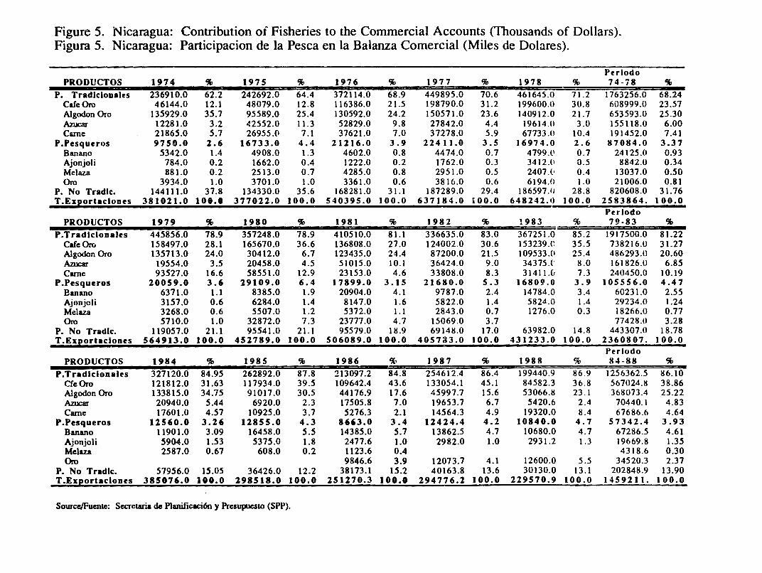
Figure 5. Nicaragua: Contribution of Fisheries to the Commercial Accounts (Thousands of Doilars). Figura 5. Nicaragua: Participacion de la Pesca en la Balanza Comercial (Miles de Dolares).
Perlodo PRODUCTOS 1974 % 1975 % 1976 % 1977 % 1978 % 74-i8 %
P. Tradlclonales 236910.0 62.2 242692.0 64.4 372114.0 68.9 449895.0 70.6 461645.0 71.2 1763256.0 68.24 Cafe Oro 46144.0 12. l 48079.0 12.8 116386.0 21.5 198790.0 31.2 199600.0 30.8 608999.0 23.57 AlgodonOro 135929.0 35.7 95589.0 25.4 130592.0 24.2 150571.0 23.6 140912.0 21.7 653593.0 25.30 A:ruc:ar 12281.0 3.2 42552.0 11.3 52829.0 9.8 27842.0 4.4 19614.0 3.0 155118.0 6.00 Carne 21865.0 5.7 26955.0 7. I 37621.0 7.0 37278.0 5.9 67733 .0 10.4 191452.0 7.41
P.Pesqueros 9750.0 2.6 16733 .o 4.4 21216.0 3.9 22411.0 3.5 16974.0 2.6 8 7084.0 3.37 Banano 5342.0 1.4 4908.0 1.3 4602.0 0.8 4474.0 0.7 4799.l' 0.7 24 l 25.0 0.93 Ajonjoli 784.0 0.2 1662.0 0.4 1222.0 0.2 1762.0 0.3 3412.(1 0.5 8842.0 0.34 Melaz.a 881.0 0.2 2513.0 0.7 4285.0 0.8 2951.0 0.5 2407 .l• 0.4 13037.0 0.50 Oro 3934.0 1.0 3701.0 1.0 3361.0 0.6 3816.0 0.6 6194.0 1.0 21006.0 0.81
P. No Tradlc. 144111.0 37.8 134330.0 35.6 168281.0 31. l 187289.0 29.4 186597.11 28.8 820608.0 31.76 T .Exeortaclones 381021.0 106.0 377022.0 I 00.0 540395.0 I 00.0 637184.0 IOO.O 648242 .0 I 00.0 2583864. I 00.0
Perlodo PRODUCTOS 1979 % 1980 % 1981 % 1982 % !983 % 79-83 %
P.Tradlclonales 445856.0 78.9 357248.0 78.9 410510.0 81.l 336635.0 83.0 367251.0 85.2 1917500.0 81.22 Cafe Oro 158497.0 28.l 165670.0 36.6 136808.0 27.0 124002.0 30.6 153239.C 35.5 738216.0 31.27 Algodon Oro 135713.0 24.0 30412.0 6.7 123435.0 24.4 87200.0 21.5 109533.0 25.4 486293.0 20.60 A:ruc:ar 19554.0 3.5 20458.0 4.5 51015.0 IO.I 36424.0 9.0 34375.(' 8.0 161826.0 6.85 Cune 93527.0 16.6 58551.0 12.9 23153.0 4.6 33808.0 8.3 31411.0 7.3 240450.0 10.19
P.Pesqueros 20059.0 3.6 19109.0 6.4 17899.0 3. I 5 21680.0 5.3 16809.0 3.9 105556.0 4.47 Banano 6371.0 I. I 8385.0 1.9 20904.0 4.1 9787 .0 2.4 14784.0 3 .4 60231.0 2.55 Ajonjoli 3157.0 0.6 6284.0 1.4 8147.0 1.6 5822.0 1.4 5824.0 1.4 29234.0 1.24 Melaza 3268.0 0.6 5507.0 1.2 5372.0 I. I 2843.0 0.7 1276.0 0.3 18266.0 0.77 Oro 5710.0 1.0 32872.0 7.3 23777.0 4.7 15069.0 3.7 77428.0 3.28
P. No Tradlc. 119057.0 21. l 95541.0 21. l 95579.0 18.9 69148.0 17.0 63982.0 14.8 443307.0 18.78 T .Exeortaclones 564913.0 I 00.0 452789.0 I 00.0 506089.0 100.0 405733 .0 I 00.0 431233.0 I 00.0 2360807. I 00.0
Perlodo PRODUCTOS 1984 % 1985 % 1986 % 1987 % 1988 % 84-88 %
P. Tradlclonales 327120.0 84.95 262892.0 87.8 213097.2 84.8 254612.4 86.4 199440.9 86.9 1256362.5 86.10 CfeOro 121812.0 31.63 117934.0 39.5 109642.4 43.6 133054. l 45.l 84582.3 36.8 567024.8 38.86 Algodon Oro 133815.0 34.75 91017.0 30.5 44176.9 17.6 45997.7 15.6 53066.8 23. I 368073.4 25.22 A:ruc:ar 20940.0 5.44 6920.0 2.3 17505.8 7.0 19653.7 6.7 5420.6 2.4 70440. I 4.83 Came 17601.0 4.57 10925.0 3.7 5276.3 2.1 14564.3 4.9 19320.0 8.4 67686.6 4.64
P.Pesqueros 11560.0 3.26 12855.0 4.3 8663.0 3.4 12424.4 4.2 I 0840.0 4.7 57342.4 3.93 Banano 11901.0 3.09 16458.0 5.5 14385.0 5.7 13862.5 4.7 10680.0 4.7 67286.5 4.61 Ajonjoli 5904.0 1.53 5375.0 1.8 2477.6 1.0 2982.0 1.0 2931.2 1.3 19669.8 1.35 Melaza 2587.0 0.67 608.0 0.2 1123.6 0.4 4318.6 0.30 Oro 9846.6 3.9 12073.7 4.1 12600.0 5.5 34520.3 2.37
P. No Tradlc. 57956.0 15.05 36426.0 12.2 38173.l 15.2 40163.8 13.6 30130.0 13. l 202848.9 13.90 T .Exportaclones 385876.0 100.0 298518.0 100.0 251270.3 100.0 294776.2 100.0 229570.9 I 00.0 1459211. I 00.0
Source/Fuente: Secretaria de Planificaci6n y PresupueslO (SPP).

REFERENCES
Acevedo, Judith. INTURISMO. Personal communication, July, 1991.
Cedeno, Victor. IRENA. June, 1991.
Gutierrez, H., C. Jaime Martinez, D. Juarez Juarez, P. Pablo Moreno, C. Otero Ortuno, Oct. 1990. Diagnostico Preliminar de Manglares de Nicaragua. Universidad Nacional Autonoma de Managua, Nicaragua.
IBRD, 1989. World Development Report 1989. International Bank for Reconstruction and Developmenr/The World Bank. Oxford University Press.
IDB, 1990. Economic and Social Progress in Latin America: 1990 Report. InterAmerican Development Bank. John Hopkins University Press, Baltimore, Maryland.
INPESCA, 1990. Diagnostico de la Actividad Pesquera de Nicaragua. Corporacion Nicaraguense de la Pesca, Ministerio de Economia y Comercio, Fondo Nicaraguense de Inversiones, Secretaria de Planificacion y Presupuesto. Managua.
IRENA, 1988. Proyecto para el Manejo Integrado de los Manglares del Pacifico.
IRENA, 1982. Sistema de Area Silvestre Protegida.
Martinez, Sergio. Director, Centro de lnvestigaciones Pesqueros(CIP), Managua, June, 1991.
Nietschmann, Bernard, 1990. Conservation by Conflict in Nicaragua. Natural History Magazine, November, 1990. New York.
Nietschmann, Bernard, 1988. The Unknown War: The Miskito Nation, Nicaragua, and the United States. Freedom House, NY.
Norworthy, K. and Tom Barry, 1989. Nicaragua: A Country Guide. The Interhemispheric Education Resource Center, Albuquerque, New Mexico.
Robinson, Stem, 1991. Diagnostico Preliminar de la S ituacion del Medio Ambiente en la Region Autonoma Sur (RAAS). INDERA, May, 1991.
Rudolph, James D, ed., 1981. Nicaragua: A Country Study. Foreign Areas Studies, The American University. Secretary of the Anny.
Ryan, Joe. University of Maryland. Personal Communication, July 1991.
Saborio, Agnes, 1991. El Cultivo de Camarones en Nicaragua. Paper presented at the Central America Regional Workshop on Coastal Ecosystems Management, Guatemala City, September 24-27, 1991.
Saenger, Hererl, and David, 1983. dted in Gutierrez et al.
Swezey, S., D. Murray, R. Dax!. Nicaragua's Revolution in Pesticide Policy. Environment, January/February, 1986, Vol. 28, No. 1.
228

Tropical Conservation Newsbureau, 1990. Press Release' "Nicaragua's Minister of Natural Resources Sees Environmental Opportunities Amid Political Chaos", December 10, 1990. San Jose, Costa Rica.
UNEP, 1988. Coral Reefs of the World: Volume l, Latin America and che Caribbean. United Nations Environment Programme/International Union for rhe Conservation of Nature and Natural Resources. Ed. Susan Wells. UNEP, Nairobi, Kenya.
229

PANAMA
' '
GUATEMALA :'"'/ J HONDURAS ,...... •• , . . ~
/ -·........ •-' "'•---.. .. ·~cajuila )
La Union·· PIU!rto QIU!tzal
.... . - I''
.. ..
.. ,..-:. . ,· ,, . ••
~ . ., ••
I I I I
I I I ~a I
~ "· I L---~------------~
(Map elaborated by the Coutal Resources Center, using Map~ Hammond Incorporated, Maplewood, New Jeney.)

PROFILE OF THE
COASTAL RESOURCES OF PANAMA
November, 1991
This document is an initial attempt to identify the most significant resource management issues affecting the coastal ecosystems of Panama. This is not a comprehensive summary of all potentially pertinent information on the coastal resources of the country. We have instead attempted to assess both the social and environmental significance of the issues identified, their possible causes, and possible responses. A draft of this paper was reviewed and modified at a roundtable to which a cross-section of private and public sector representatives were invited.
This profile was prepared by:
Jose Vasconez, URl/USAID/Ecuador Coastal Resources Management Project
This project was convnissioned by the U.S. Agency for International Development's Regional Office for Central America Programs (AlDIROCAP) and AID/Office of Natural Resources/Bureau for Research and
Development (R&D). The Universiry of Rhode Island's (URI) Coastal Resources Center assumed responsibility for the program through its Cooperative Agreement with AIDIR&D.
232
PROFILE OF THE COASTAL RESOURCES OF PANAMA
PART I. THE COAST FROM A NATIONAL PERSPECTIVE
A. Definition of the Coastal Region
International expl!rience in the management of coastal ecosystems suggests that the boundaries of a coastal zone should be pragmatically defined to include those geographic areas that must be considered when fonnulating management strategies for the selected issues that the program will address. Because th!! likely focus of a coastal program for Panama has not yet been identi.:ied. the Panamanian coastal zone can be broadly defined to include all resources and activities that are present: (a) on or immediately adjacent to the shoreline, (b) in coastal alluvial plains and small coastal watersheds whein human activities directly and significantly impact coastal activities and features, and (c) within the EEZ.
8. Economic Significance of the Coast
In the Panamanian economy, services occupy first place (75%) in the GNP, industry is in second, (15%), and the primary sectors represent 10% of the GNP. Within the sectors linked with coastal resources, the canal is the most important, both stategically and economically, followed in order of importance by bananas, shrimp, sugar and coffee (Figures l and 2).
Bananas are the number one export product (Figure 3); in 1985 this crop represented 23% ($US 78 million) of the total revenue from exports. The volume produced reached a maximum in 1978 and has declined to the current levels.
In 1981, shrimp represented some $US 42.5 million (Direcci6n General de Recursos Marinos, 1991) reaching $72 million in 1986 before declining to $44.8 million in 1990. Shrimp represents 84% of the total seafood products.
Fisheries production has increased from 118 million kilograms in 1981 to 157 million in 1989, although it decreased in 1990 to 102 million (Direcci6n General de Recursos Marinos, 1991 ). The most important products are anchovy and herring, which are processed to make fish meal and oil.
Traditionally, sugar was the second most important export product in terms of production and generation of revenue. Production rose during the l 970's, then fell to a level of 165,000 tons in 1986 (Panama. A country study, 1986). In economic terms this equaled approximately $US 40 million for the period from 1975 to 1981, increasing to $US 22 million in 1985 alone.
Coffee production grew steadily from 1981 to 1985, from 7 ,000 (Panama. A country study, 1986) to 11,000 tons respectively. It is the third leading export product, indeed, in 1985 contributing 4.6% of the national tom! export revenues, equal to $US 15.6 million.
As far as tourism, the number of foreign visitors has decreased from 297 ,310 ( 1979) to 220, 676 (1983). International tourism contributes approximately 5% (Suman, Daniel, 1987) to the GNP; however, the percentage of revenue from coastal and marine activities is unknown.
Salt proouction is centered in the land around the Bahia de Parita. At least 300 families are dependent on this activity, which produced over 38 million kilograms of salt in 1983
233

' (Suman, 1987). Thousands of people exploit large quantities of mangrove for a variety of activities (Figures 4 and 5).
The most imponant factor in Panama's economy is the Panama Canal, which generated US$327 million in 1987 (Whelan Tensie, 1988), contributing an estimated ~S'c of the GNP. 5% of worldwide maritime commerce (around 12,000 ships) use the canal each year. Since it began operating in 1914, almost 700,000 boats have passed through it. The major users in 1986, according to their identity flags, were Panama, Liberia, Japan, the United States, Greece and the Soviet Union. Each boat passing through the canal requires 52 million gallons of fresh water in order to cross the three levels of locks, which is why water resource management in the watershed is of vital imponance.
C. Major Coastal Resources and Ecosystems
Panama relies on large expanses of coastal ecosystems such as mangroves, coral reefs, estuaries, coastal lagoons, beaches, salt flats and coastal "plains." The mangroves ar~ more prevalent on the Pacific coast, while coral reefs are more common on the Atlantic. Numerous estuaries line both coasts, but the largest ones are those along Pacific Ocean, because of the size of their watersheds and the quantity of fresh water they receive.
The coastal ecosystems are imponant because of their high productivity and biodiversity; they are also the habitat and reproduction area for many species of fish and shellfish. Nevertheless, their fragility requires careful management according to their characteristics in order not to disturb either the ecological processes or the ecosystems themselves.
Mangrove forests are found on both coasts of Panama (Figure 6). The Panamanian isthmus has more than 1,709 km2 of m:rngroves and 188 1an2 of salt flats and salt marshes lD'Croz, 1990). The most irnronant mangrove zones on the Atlantic coast are found on the estuary of the Rio Changui'1 1Jla, in thl.! low lands of the Laguna de Chiriquf (Chiriquf Grande) and on the Golfo de San Blas. Over 300 km2 of freshwater wetlands are located behind the mangrove fringe in the province of Bocas del Toro. The largest expanses on the Pacific coast extend from the Boca de los Espinos (Alajuela) to Boca de Pajaroncito (Sona), the Golfo de Montijo, a section between the Rio de Cana y Tonosi (Tonosi), the Bahia de Parita (Aguadulce) and through the Bahia je Panama to the Golfo de San Miguel. This is the habitat of fish such as sea bass, rooalo, snapper, catfish (bagre) and yellow jack (jurel). There might be a relation between the presence of mangroves and the abundance of the commercially-imponant anchovy c. mysticetus. Coastal shrimp spend their juvenile stage in the estuary from March to May (D'Croz et al, 1990). It is also known that the black iguana is extinct due to the over-exploitation for food by the coastal inhabitants.
The Caribbean coast has more than 250 km of reefs, which are now in a post-climax period; their most active growth period was 2000 years ago (Coral Reefs of the World). Fony-nine species of hard coral have been identified in this area (Poner, 1972). The richest zones are found between Isla Margarim and the Bahia Las Minas (including Punta Galeta), in Bocas del Toro and in the Archipielago of San Blas (Coral Reefs of the World). In the Pacific, there is less diversity in the coral and associated communities because of the decrease in water temperature associated with the seasonal upwellings which occur in the Golfo de Pan1ma. Only 20 species of coral are found here, but they have somr. of the highest growth rates in the world (6 cm./year).
The largest coral developments are found in the western region, specifically in Islas Secas, Contreras, Bahia Honda and Islas Parida near the mouth of the Rfo Chiriquf. Smaller strecthes are located in Taboga, Taboquilla and in the Islas Perlas. The coral reefs are
234

imponant for the sustenance of anisanal fisheries and tourism. The Smithsonian Institute of Tropical Research has maintained a marine laboratory in Punta Galera and a field station in the Archipielago San Blas since 1970.
Until a few years ago, rhe coastal and marine ecosystems were considered to be of marginal importance in the economy and human activity wasn't seriously affecting chem. This siruacion changed in the l 970's; since then, many ecosystems have been capped for different purpo"es. t~1us we have rhe destruction of m:rngroves for the urban expansion of Panama Cicy, in zones near Juan Diaz, and for rhe development of shrimp mariculrure in Punta Chame and in the Bahfa Parica. Pressure from rhe use and exploitation of coastal resources will rend co increase more and more with rime.
We a1"o have co consider chat the extensive monocultures of bananas, sugar cane and coffee which are destined for exponation, are prone co pests and diseases and often exhaust the soil besides. They require ever more fenilizers, weed killers and other agro-chemicals. The: profits from such cultivations are in the hands of few firms and corporations.
D. Population and Settlement Patterns
Panama's population in 1990 was 2,329,329 people (Contraloria General de la Republica, 1991). According to thel990 census, che mosc densely populated areas in the country are Panama, ColOI: and David wich populations of 584,803; 140,908; and 102,678 respectively (Contralorfa General de la Republica, 1991 ). These three cities are found on the coasc and together they coral 36% of Panama's coral population (Figure 7).
More than 88% of the national population lives in the Pacific watersheds; 25% of that total lives in Panama Cicy or in other cities west of che capital which are agricultural centers that have been developed on small coastal plains.
Historical growth indexes show average populacional growth rates of 2.8% for the period from 1930 to 1970 (Boyer, Jeffrey, 1980). The average rate for the period from 1980-1990 was 2.2% (Contraloria General de la Republica, 1991 ); at this rate the population would double approximately every 30 years (Figure 8). The decrease in the growth rate can be attributed to the existence of a government policy for family planning and to the action of private organizations dedicated to reaching about binh control. In spice of chis, the efforts to plan and implement development and management projects have to be very extensive in order co respond co rhe needs of chis rapidly-growing popuLcion and yec still maintain the productivity of the ecosystems.
As for the geographic distribution of the population, che 1990 census showed 49% to be t=rban (Contraloria General de la Republica, 1991) and S 1 % to be rural. It should be emphasized that the demographic growth rates are different; thus we have an urban rate of 2.93% during the period from 1970-1980 and a recorded rural rate of 1. 73% for the same period of time.
The configuration of Panamanian society reflects its geographical position as a transit zone. The inhabitants of the Panama have been subjected to a variety of influences that aren't typical of Latin American countries. The population includes ethnic groups from the Middle East, the Far Ease, Southeast Asia, Europe and Norch America who hii.ve all been attracted by the opportunities for progress associated wich the presence of the Panama Canal.
Blacks from the West Indies, descendents of che Caribbean work~~rs who built the canal, constitute tht: largest minority group. The indigenous tribes, frequently isolated from society, made up only 5% of the population in che l 980's. Within t\~e tribal groups, it is
235

appropriate to distinguish the Kunas, who live on a large territorial expanse of the Archipielago de San Blas and the Caribbean watershed. This group has its own government and administers its territory independently from national government iniciatives.
PART II. COASTAL REGIONS
Panama has an area of 75,650 km2 (Suman, Daniel, 1987) wi·~h 800 kilometers of coastline on the Caribbean Sea, and 1,600 kilometers of coastline on the Pacific Ocean. Without counting its 1,600 islands, Panama has 0.32 kilometers of coastline for every km2 of its territory, the highest percentage of any Latin American country (Sorensen and Brandani, 1987).
As a first approximation, the Panamanian coastal areas can be divided into six separate regions, each with its own environmental characteristics and features, and impacts from human activities, all of which must be consid~red for integrated management. The Caribbean coast can be subdivided into three areas: (a) the Archipielago de San Blas, (b) the Central Zone and (c) the Northern Zone. The Pacific coast can also be subdivided into three regions: (d) the Gulf of Panama, (e) the Azuero Peninsula and (f) the Montijo and Chiriqui Gulfs.
The Caribbean coast extends for some 8<'0 kilometers on the Caribbean Sea. There are few citites on this cr,ast; Colon is the biggest port city and population ceriter in the region. The surf ace temperature of ~he water in the southeastern part of the Caribbean Sea remains constant throughout the year, with an average of 27°C, and tends to stagnate near the shore due to the northeast wind. Because of this, there :ire no upwellings in the bottom waters, which are rich in nutril!nts. The tidal range is small; on few occasions is it more than 50 centimeters and the width of the Continental Shelf often doesn't exceed 25 kilometers.
The Archipielago de San Blas consists of a group of more than 300 coral islands (Suman, Daniel, 1987), which extend somewhat more than 200 kilometers between the Colombian border and the Golfo de San Blas. The coast, protected by coral reefs, has a tendancy to form marshy areas and has a narrow strip of mangroves in Punta Valiente in the west. 'Thriving coral colonies have been identified east of Col6n. In the west and all along the 200 kilometers of the Golfo de Mosquitos, the coast is made up of a succession of small beaches ,,eparated by cliffs.
The Northern Zone is contained between Punta Valiente and The Costa Rican border. This area has more then 50 barrier islands (Archipielago Bocas del Toro), the largest of which is more than 1301crn2. Another notable geogr- 1hical accident is the Laguna Chiriqui , 840 1crn2, which is the biggest lagoon in Panama. Mangroves and bananas are dominant on the~ coasts. Th.! banana plantations on the extensive coastal plain are also important There are grouping and nesting sites for several species of marine birds and tortoises here as well.
The Pacific coast has a length of approximately 1,600 kilometers from the Darien forest in the south to Punta Burica in the north. The oceanographic conditions are different with respect to those of the Caribbean. During the dry season, (January-April) there are upwellings in the Golfo de Panama and the surface waters are displaced from the coast (Forsbergh, 1969. Taken from Suman, Daniel). The water temperature can go down 3 or 4°C from the average recorded during the rainy season (28°C). These upwellings are rich in nutrients and increase the region's primary production. Upwellings like these do not occur in the Golfo de Chiriqui.
236

The continental shelf is extensive; there are zones up to 150 kilometers wide. The Golfo de Chiriqui also has a wide shelf except in the western pan near Punta Burica. which is cut shon by ad-. ~p underwater canyon. Tides range from 3 to 6 meters along rhe entire Pacific COD.SC.
The Gulf of Panama has an area of some 20,00 km2 (Suman, 1987), and the most economically developed region in Panama is found in this coastal zone. The largest estuary in Panama, the San Miguel, is formed by the Tuira and Chucunaque rivers whose watersheds are in the Darien region. Other imponant estuaries are: Bayano, Grande, Santa Maria and Cloce. The mangroves are associated with all of these estuaries. The Las Perlas archipelago, located in the center of the Gulf, is composed of 10 large islands. Near the inlet to the Panama Canal, are the Taboga and Taboguilla islands. The biggest population center is Chitre which counts 35,000 inhabitants (Contraloria General de la Repubiica, 1991 ).
The 100 kilometers of the Azuero Peninsula are mountainous with limited coastal plains. The continental shelf is narrow and ends only a few kilometers from the coast. Punta Chame and Las Tablas (21 ,000 inhabitants) are imponant areas in this zone.
The Montijo and Chiriqui Gulfs make up the third region of the Pacific. They extend from Azuero in the west to the Costa Rican border. The San Pedro and San Pablo rivers empty into the Montijo Gulf and farther westward, the Chiriqui and David rivers discharge their water into the Chiriqui Gulf. All of the noted estuaries are surrounded by mangrove forests. Sandy beaches border the Charco Azul Bay from Coca Brava, the estuary of the David river, to Punta Burica. The majority of the Gulf is surrounded by coastal savannahs which are imponant for the development of livestock and for the cultivation of bananas, sugar and rice. The city of David, which numbers more than 103,000 people, is the most imponant urban center in the Chiriqui Gulf.
There are numerous islands in the Montijo Gulf and east of Chuiqui including Coiba, one of the largest along the Pacific coast of the Americas. Large coral colonies thrive in the waters adjacent to this insular region.
PART III. ISSUES AND OPPORTUNITiES FOR COASTAL RESOURCES MANAGEMENT
Issue #1. Management of Fisheries Resources.
Significance.
This industry is currently based mainly on the herring, anchovy, shrimp and lobster catch in the Pacific Ocean, whereas in the Caribbean, lobster is the only fisheries product.
The U.S. fleet originally began fishing for herring and anchovy in the 1930's only as a supplement to tuna fishing. Fishing specifically for these species grew in the l 950's and now the majority of the catch is exponed. The Bahia de Panama and the Golfo de San Miguel are the. main fishing areas. A major proportion of the product is made into fish meal and fish oil.
The record catch of 250,000 metric tons was established in the 1980's, specifically in 1985. Since then, fishing has decreased to 92,000 tons in 1990 (Direcci6n General de Recursos Marinos, 1991; Figure 9). 85% of the product is exported, while what is left
237

serves to supply the aviculture and porcine etc. industries. For the decade studied, 1987, with 117 million dollars, was the highest earner in monetary tenns; in 1990 the revenue generated was almost 66 million dollars.
The Pacific based shrimp fleet is comprised of 261 working ships (Direcci6n General de Recursos Marinos, 1991) and has sustained production of 5,000 metric tons of shrimp per year in the last decade. In 1985, shrimp exports generated some 38 million dollars.
Lobster is trapped only by artisanal fishennen; because of the volume of the catch, it is of secondary importance. Around 90% of the lobster comes from the Caribbean provinces of San Bla~ and Bocas del Toro. In 1975, the catch was estimated to be 76 meaic tons (NOAA/NMFS, 1977) and in 1984 almost 75 tons was recorded (Suman. Daniel, 1987), which could indicate a stable production.
The fisheries sector emp!oyed 0.9% of the economically active population of the country, approximately 8,400 people, in 1990 (Direcci6n General de Recursos Marinos, 1991). Of them, some 6,500 can be classified as artisanal, and work close to the shore (Pollnac, 1977). Artisanal fishennen meet a significant part of the domestic market's need for fresh fish and they also sell shrimp to processing plants for exportation. In spite of their large numbers, these fishennen catch only 1.7% of the fish and 3.5% of the shrimp. However, molluscs and lobster are caught entirely by anisanal fishennen.
There are more than 15 shrimp processing plants in the country, of which 9 are located in the fishing port of Vacamonte.
Main Fishing Habitats and Grounds
The most important fishing grounds are shown in Figure 1. The banks represent feeding areas of adult herring and anchovy stock. Important fr'hing areas are located in the Bahia de Parita, Bahia de Chame, Bahia de Chorrera, Bahia de Bique, Bahia de Panama and in the Golfo de San Miguel (Boyer Jetfrey, et al, 1980). Schools of these species are very limited in the Caribbean; basically, they are found adjacent to the mouths of rivers.
With regard to shrimp, of the seven kinds whieh are caught off both coasts, six come from the Pacific Ocean. The shrimp species with the greatest commercial value is the white shrimp, which includes three species: Penaeus vannamei, P. stylirostris and P. occidentalis, of which P. occidentalis is the most caught. The areas where the highest concentration of shrimp are found e;.aends from the Golfo de Panama to the Darien region and include the shallow areas near the Coiba Islands and the Golfo de Chiriqui.
The areas where the highest concentration of lobster can be found in the Caribbean include the San Blas and Bocas del Toro regions. In the Pacific, the lobster population is confined to the rocky zones like Isla Parida, San Carlos and the areas adjacent to the Bahia de Muertos.
Issues Related to Resource Management
Reduction of Coastal Fishing Grounds. La Direcci6n de Recursos Marinos exerts efforts to prevent the over-exploitation of lobster, anchovy and white shrimp, the most important species for the national fisheries industry. As a result, the populations close to the coast and the catch per unit of effort have decreased. In 1990, there were 261 shrimp fishing pennits but it is believed necessary to reduce that number still more to maintain current catch levels. The red shrimp populations do not yet seem to be over-exploited.
238

Issue #2. Degradation of Habitats Important to the Economy and the Quality of Life.
Significance and Trends
According to the document entitled "The State of The Environment of the Republic of Panama" (Illueca, Jorge, 1987), close attention must be paid to the rich and varied coastal and marine ecosystems, given their extremt fragilicy. The desrruction of mangroves is reason for general concern, since they support abundant flora and fauna as well as the fisheries industry. The systematic destruction of mangroves for urban development has occurred, for example, in Juan Diaz, east of Pariama City and in Punta Chame, where a large charcoaJ industry and tourist development projects have also drastically altered the environmenL. Shrimp ponds have also led to the destruction of mangroves, as can be seen in the vicinity of Bahfa Parita.
The second critical issue identified in the same document is oil spills, which have caused severe damage in the past decade to the ecology of coastal ecosystems. As an example, the spill of more than 130,000 barrels in April, 1986, of which 70,000 reached the sea, damaged coral reefs and mangroves on the Caribbean coast in the province of Col6n. In the Laguna de Chiriquf, there is chronic low-level hydrocarbon pollution.
The Bahia de Panama is affected by rapid urban growth which has increased rt,, quantities of untreated domestic and indusLrial sewage being dumped into the water, anr altered the physical, chemical and bacteriological condition of the water. It suffices to pi int out that in Panama City alone 130 million gallons of water are consumed each day, a large pan of which is discharged untreated into the bay (Carles Jorge, 1991, Comunicaci6n Personal). Coliform bacteria levels recorded in areas close to Panama City are high.
Coral reefs have also been seriously degraded. The reef located between Col6n and Isla Grande has been seriousiy affected, as was cired earlier, by oil spills. Moreover, in the last few decades, the coral reefs hav.-! been affected by the increase of sedimentation due to agricultural settlements and the deforestation 0f the nearby watersheds. As a result, some of the coral colonies have died. These same factors may be affecting the coral colonies in the Golfo d~ Chiriquf, where there is evidence that herbicides are causing the reefs to die.
A constant problem all along the coast is that the inhabitants dispose of garbage in the sea or in the mangroves, which are considered natural dumps. Other impacts on mangrove ecosystems are listed by province in Figure 10.
Issue #3. Management of a Sustainable Mariculture Industry
Signicance and Trends
Shrimp monoculture began in the 1980's by means of a $20 million lnterAnierican Development Bank project. Since then, growth has been slower than anticipated, but in any case, shrimp exports have increased in recent years. More than 85% of the ponds de.d.icated to shrimp mariculture occupy an area less than 200 hectares (Suman, 1987) which is an indication of the small scale of the activity. Approximately 4,500 hectares of ponds are in production or construction, with the majority being concentrated in the Bahia de Parita and Punta Chame. It is estimated that additional lands appropriate for mariculture may equal l 0,000 hectares.
In 1985, shrimp mariculture represented around 7% of the shrimp production in the country. In 1988, when production peaked at 1,643 metric tons, cultivated shrimp
239

represented almost 30% of total shrimp production, then declined to 893 tons, representing 17%, in 1990 (Direcci6n General de Recursos Marinos, 1991).
In re~cnt years. research and other effons have been made to improve the productivity using everything from extensive to semi-intensive methods of cultivation.
Almost all of the shrimp cultivated in Panama is exported, mostly to Europe.
The construction of shrimp mariculture ponds has in some cases caused the destruction of mangroves. This is a cause of real concern to some Panamanians who understand the need to conserve this highly productive and biologically diverse ecosystem which provides direct benefits to humans as well as animals.
There was much enthusisam in the early years of the shrimp mariculture industry because of its anticipated profitability, but this enthusiasm diminished in proportion to the real management problems that presented themselves. The operation and installation costs were higher than expected; moreover, there were difficulties in finding wild post-larvae in mangrove regions. Some mariculture operations also have serious problems because of water quality. Studies done by the Instituto de Investigaciones Agrfcolas (IDIAP) bdicate that the mortality rate of the post-larvae in the ponds could be due to pesticide residues in the water pumped from the rivers.
The establishment of shrimp mariculture has also caused the loss of access to traditional areas of artisanal fishing.
There are five or six shrimp larvae laboratories in operation. In recent months, Panama has been exporting young post-larvae to Honduras and Ecuador. Pregnant females are also exported to Ecuador.
Issues for a Management Strategy
A consistent database which would permit the preparation of a management plan should be established. Among other information needs are data concerning current production, exact quantity and area of ponds, management systems employed, areas potentially suitable for mariculture, provision of se:!d stock, and water management strategies.
It should be stressed that an agressive expansion of shrimp mariculture shouldn't occur at the expense of further deterioration of valuable coastal ecosystems such as mangroves.
The mariculture ponds depend to a great extent on natural post-larvae. If in the past there has been a lack of seed, it is important to consider that with the expansion of this sector, a larger quanity of post-larvae would be required, which would lead inevitably to an increase . in seed prices.
The way in which wild post-larvae are caught is highly destructive since many juvenile fish, crustaceans and mollusks are caught in the nets and not returned to the sea. As a result of this practice, the populations of various species may be significantly altered.
The government's capacity for directing and regulating shrimp mariculture is weak. Even ~ ..... ~h the first companies obtained their F .operty titles and fulfilled other requirements in advance of beginning operations, the means of operation have not been sufficiently clarified. The pennits granted didn't take into consideration either possible environmental impacts or measures for mitigating and implementing environmental monitoring.
240

The expansion of this industry should be planned and manag~d in such a way as to avoid the problems that already exist in the current establishments and to take advantage of world experience in shrimp mariculture.
Outlook
Shrimp mariculrure will have a good chance if the government promotes the activity and if entrepeneurs decide to invest in improving and enlarging the existing infrastructure. It is necessary to consider the fact that several countries are working to capture the international market. It will also be necessary to rake into account char the product's price has dropped in recent years; however, the return continues to be attractive co entrepeneurs. Finally, an adequate provision of pose-larvae is the key to guaranteeing the sustained growth of the shrimp indusrry. A Panamanian policy with respect to chis could be char new mariculture farms be permitted to open only if they install their own laboratorie5.
Another issue chat should be considered is the feasibility of diversifying coastal bio-aquatic cultivation, which has rerurns comparable to chose of shrimp mariculture, as has been done in Southeast Asia. To char end, a project for experimental mollusk mariculture is being carried out with Spanish financing and technical assistance.
Issue #4. Tourism Management
Significance.
The majority of foreign tourism is linked to the coastal zone. It is necessary to point out that the number of visitors has dropped in recent years, even though the spending per visitor has increased 25% (Figure II). As noted earlier, international tourism contributes 5% of the GDP (1985), bur it is nor known how much coastal and marine tourism generates.
The Pacific coast has many beaches south of Remedios on the Golfo de Chiriqul, south of the Peninsula de Azuero and west of Panama City on the Golfo of Panama. There are both hotels and bungalows lOl..ated near the beaches in the province of Panama. There is also a tourist center which is jointly run by the government and private companies in San Carlos.
A second governmental tourism center was built in Maria Chiquita, east of Colon on the Caribbean coast. It is more difficult to access the beaches and coral reefs in San Blas and Bocas del Toro, but they have great potential. There are five islands which offer tourist installations: Taboga and Contadora in the Golfo de Panama, Isla Grande in Col6n, Isla Col6n in Bocas del Toro and some of the islands in the Archipielago de San Blas (Suman, 1987). Marlin fishing in Darien has grown steadily during the last IO years and now constitutes a necessary rite of passage for spons fishermen from around the world.
The environmental quality of the Panamanian beaches is very good. The high number of sunny days, the surrounding vegetation, rhe white sand of coral origin on 70% of the beaches and the varied coastal and continental ecosystems are among the qualitites which determine the development potential of foreign and domestic tourism.
The development of ecotourism is in the beginning stages and, as was noted, opponunities for Panama are advantagous as compared to ocher countries in the region.
241

Outlook
Panama faces intense competition with the other tourist centers of the Caribbean; however, tourism can be expected to grow in proportion to the construction of new hotels. It is necessary to consider local character and traditions when designing tourist developments in order to diminish, mitigate or avoid negative changes in the social, cultural and environmental fabric.
A pact for the joint development of tourism has been signed with Colombia and Costa Rica; Panama can take advantage of this partnership to strengthen the sector.
In order to begin planning coastal tourism, it is necessary to inventory the resources available, since at the momentthe basic information necessary for the development of this industry is missing.
Issue #5. Ports and Maritime Transportation
Foreign commerce depends to a great extent on maritime transportation. In 1983, Panama counted 13 ports which together moblilized 2,207, 14 7 metric tons of cargo. This corresponded to 97% of the foreign commerce that year. Balboa and Cristobal, located on the southern and northern ends of the canal respectively, handle only international cargo. Together they accoum for 38% of everything which is unloaded in Panamanian ports. Shipping of bananas from the ports of Almirante and Armuelles accounts for another 41 %. Molasses and sugar cane is exported from the port of Agua Dulce, and fisheries products are exported from Vacamonte and Caimito.
Coastal commerce is handled through Panama City, Coco Solo Norte, Vacamonte and La Palma, but it is more important for regions like Darien, San Blas, Bocas de! Toro and las Islas Perlas Negras, which are not accessible by highway.
PART IV. LEGAL AND INSTITUTIONAL FRAMEWORK FOR COASTAL MANAGEMENT
Legal Framework
According to Antony ( 1985), Panamanian legislation referring to coastal resources is sectorial and dispersed thoughout a seri1_.s of legal codes pertaining to numerous institutions. Environmental laws are weak and contradictory; as a result, the majority of coastal resources and environments aren't adequately protected.
Another obstacle is the lack of application of the laws which occurs for various reasons including: lack of will on the part of the relevant authorities, lack of human and financial resources and lack of equipment for the inspectors charged with upholding the laws.
The area extending inland 200 meters from high tide is public domain. The Ministry of Housing, through its Office of Land Titling, is charged with granting concessions, and these are only given for sites without vegetation cover.
Executive Decree #39 ( 1966) is the basis for forestry management. While it doesn't refer specifically to mangroves, Article 34 prohibits the destruction of trees which are within 30 meters of river banks, lagoons and lakes. According to Article 8, forests which regulate the flow of water, prevent erosion and protect unique species of flora and fauna are protected. The majority of mangroves fall within this classification. Moreover, Articles 15 and 16 prohibit the exploitation of wood without permission form the Forestry Service, and this
242

agency doesn't grant pennits to cut mangroves. The maximum penalty for breaking these laws cannot exceed US$100 which is insufficient to guarantee compliance.
Anicle 255 of che Conscicution stipulates char rerrirorial seas, lakes. pons. estuaries, beaches and coastlines are public domain. According co Anicle 32 of Executive Decree #35 a permit is required in order co use these waters. This same Decree establishes water 4uality standards and prohibits throwing garbage, industrial wastes or ocher pollution char could affect public healch or rhe fauna into the oceans and seas.
Law #21 ( 1980) is the first piece of legislation which regulates pollution from boars. Anicle l prohibits peoples on boars and marine or land insrallarions from discharging any son of contaminant inro Panamanian waters. The legislation also extends to Panamanian-registered boats navigating in incemacional waters. Fines of up co $25,000 can be imposed on installations which have defective equipment char causes pollution (Anicle 5). The spilling of toxic substances can resulr in a maximum fine of $200,000.
Other legislation (Executive Decree #17 from 1959) regulates fisheries and grants the President, as advised by rhe Direcci6n de Recursos Marinos, the power co establish fishing seasons. Decree 210 (1965) prohibi cs fishing in estuaries and mangroves. There also exist :!xecutive decrees which establish zones where fishing is prohibited.
The Health Code commissions the Ministry of Health co oversee the essential aspects of environmental sanitation such as prevention of water, air and land pollution. The Department of Environmental Sanitation of chis Minisrry is in charge of implementing these dispositions.
Article 243 of che Constitution stipulates thac the municipalities may regulate sand mining. However, Article 262 of rhe C6digo Fiscal (Law 3 from 1956) prohibits the removal of sand where this would damage bPt!~h property. Anicle 254 of this same document specifies that salt flats cannot be privately owned. They are co be exploited by the government directly or by private companies who have been granted permits.
Key National Agencies for Coastal Resources Management
The administration of the coastal zone in Panama is distributed among various public institutions (Suman, 1987). The coastal zone itself isn't clearly defined, and there is a lack of concise policies for the management of coastal and aquatic resources. The institutions which exercise authority over the coastal zone are dependencies of the national ministeries, autonomous govemment institutions or local groups. Discrepencies between the mandates of public institutions and what they actually do are common.
Ministries of the Central Government
The Ministeries of Commerce and Indusrry; of Agricultural Development; and of Planning and Politcal Economy are those which are most associated with the management of the coastal zone.
The Direcci6n General de Recursos Marinos from the Ministry of Comercio e Industrias (MICI) guides the development of the fishing industry in Panama. The Direcci6n not only keeps catch and export statistics, but also carries out fisheries research and promotes the preservation of bio-aquacic resources. It is a collegiate body which grants licenses to Panamanian and foreign boats: further, ic excablishes the legal framework for the management of fisheries "stocks".
243

The Direccion General de Recursos Minerales, another division of MICI, has authority over the exploration and exploitation of mineral resources. Its jurisdiction is national, and it includes the Continental Shelf. Mine and petroleum companies have to obtain grants from this institution in order to operate.
According to law 21 from 1986,the Instituto Nacional de Recursos Naturales Renovables (INRENARE), was created to manage coastal resources by means of three institutions: the Servicio Forestal, the Depanamento dt Agua and the Depanamento de Parques Nacionales y Vida Silvestre. The Servicio Foresta! protects mangrove forests and related estuaries. The Departamento de Agua grants user pennits, which see that no irrigation or drainage project interferes with water circulation in mangrove areas. The. number of protected areas in Panama, which are administrated by the Depanamento de Parques Nacionales y Vida Silvestre, has increased considerably.
The Direccion Nacional de Acuacultura (DINAC), is another institution of MIDA, created in 1978 to promote aquaculture in the public and private sectors. Its activity has basically been focussed on shrimp mariculture.
The Ministry of Planning and Politcal Economy (Ministerio de Planificaci6n y Polftica Econ6mica - MIPE) coordinates the social and economic development of the country. The Constitution specifies that MIPE take charge of preventing the pollution and degradation of the environment. Recently created, the Comisi6n Nacional del Medio Ambiente (CONAMA), which has been added to MIPE, has the mission of preparing the environmental data necessary for the other ministeries.
The Ministry of Health (Ministerio de Salud) is charged with the work of environmental safety, especially in reference to water, air and land pollution.
Autonomous Governmental Institutions
The following are associated with coastal management:
The National Ports Authority (Autoridad Portuaria Nacional - APN) which coordinates the development of the national harbor system. It is necessary to obtain a license from APN for the construction of marine installations located on the sea, beach, rivers or estuaries. Any construction in an area of 10 meters above the high tide mark must first obtain permission form APN. APN concentrates its activity in the three pons which handle the most cargo in Panama: Balboa, Cristobal, and Coco Solo None.
The National Institute of Water and Sewage (Institute Nacional de Agua y Alcantarillado - IDAAN) is responsible for collecting and treating sewage. In any case, the majority of Panamanian cities discharge untreated sewage into rivers or into the sea.
The Panamanian Tourism lnsitute (Institute Panameno de Turismo - IPA T) promotes the tourist industry. By means of an incentive program for investors, lP AT has tried to develop four panicular tourism areas, including Las Islas de San Blas and the Pacific coast among others.
The Panama Canal Commission (Comisi6n del Canal de Panama), regulates the canal zone. Tne Panamanian and U.S. governments share the administration of the commission. The commission has accepted US federal statutes and US implementation of orders concerning petroleum hydrocarbon pollution. Its responsibilty includes the prevention and clean-up of oil spills in the canal zone.
244

· Local Institutions
Local administration is carried out by the Municipalities; however, their autonomy is limited by the centralized powers of national government. The jurisdiction of the municipalities concerning coastal resources and environments only includes the mining of sand, rocks and coral in the riverbeds and beaches.
PART V. INITIAL RECOMMENDATIONS FOR A COASTAL RESOURCES MANAGEMENT STRATEGY
The review of coastal resources, coastal dependent activities and coastal regions makes it clear that resource management issues are closely interrelated. The Panamanian coastal zone is very extensive, which is why there isn't one overriding critical problem of country-wide concern. Population and settlement patterns, especially the growth of urban c\!nters like Panama City, bring about increasing pressures. There are issues and conflicts pertaining to each panicular activity and to distinguishable geo!,Tfaphic areas.
The state's management is weak with respect to integrated administration and development of coastal resources. While it is true that there are laws and authorities in charge of upholding them, there is also a general lack of knowledge about the nature and scope of these laws by those very people who are supposed to apply them. Similarly, in almost all of the institutions, there aren't enough trained and equipped enforcement officers to guarantee compliance with resource management laws.
FinaPy, many of the activities and projects involved in the development of the continental area ~reatly affect the coastal and estuarine areas, altering the natural conditions which existed. Consequently, it is necessary to improve the degree of coordination between the institutions which work in the inland and coastal zones.
Relative to the concerns noted above, the following approach is proposed to establish a management strategy:
1. From a national perspective the principal management needs are to:
1.1. Establish the administrative measures, training and organization necessary to enable the fisheries sectors to attain sustainable levels of exploitation.
1.2. Define critical coastal habitats and determination of adequate measures to preserve the ecological processes, ecosystems and biodiversity.
1.3. Manage and diversify the mariculture industry to include other coastal and ma.tine bio-aquatic species.
1.4. Design strategies to establish a coastal tourism industry which causes the least possible disturbance to the environmnent while maximizing social benefits for the Panamanian people.
1.5. Develop a set of legal standards concerning coastal buildings, which guarantee their permanent stability and take into account the coastal environment.
1.6. Establish a national contingency plan for oil spills.
245

1.7. Design and implement a broad public education program at all levels to create a civic conscience with respect to coastal resources and the critical role that they will have in Panama's future.
1.8. Establishment of an appropriate interinstitutional cooperation system to guarantee the implementation of a management plan.
The strategies should directly address:
• Long-term sustainability of use patterns •maximizing employment opportunities • Reduction of poverty • Raising the level of citizen participation in planning and implemention • Interrelationships with other regions and resource management initiatives • Improving the contributions of and benefits to women.
More important than th\! specific recommendations of a management strategy is the process by which it is formulated, tested, and refined. This process should have the following characteristics:
- Consideration of the best available information on the condition and use of natural resources and the human activities they support.
- Each plan must be formulated through an open and panicipatory process in each region; all major stakeholders must be identified and involved and action taken only when adequate concensus on specific measures is attained.
- Each plan must focus on a few carefully selected issues.
- Each plan must be incrementally developed and tested and management and development ideas should be reality-tested quickly so that the experience gained can be fed back into the ongoing planning process.
- There must be a strong commitment to the strengthening of locally based institutions involved, both governmental and non-governmental, in the management process.
- The planning process must feature strong public education and training programs.
2. At the regional or local level, the participants at the roundtable discussion in Panama City on July 25 selected several areas which can be considered priorities for any subsequent management iniciative. The recommended areas were:
2.1. The section between ChameuSan Carlos-Farali6n: there is a lot of potential for tourism; the shrimp fleet is based here, and the pressure from various sectors on mangroves is intense.
2.2. Golfo de Parita: the cutting of mangroves is of particular importance, as is the developn:ient of shrimp mariculture.
2.3. Golfo de Chiriqui: mangrove management is especially important; tannin extraction and the use of the wood for construction and expansion of the livestock sector are the the major issues.
246

2.4. Laguna de Chiriqui: the city of Bocas de! Toro is located on this coastal lagoon and the most relevant issues are hydrocarbon pollution, environmental sanitation, and mangrove management.
2.5. Colon: from the Bahfa Las Minas to La Guayra, harbor and urban activity and maritime traffic are the key issues.
2.6. Archipielago de San Blas: the coral reefs are the main ecosystem in the area, and the Kuna Indians live in this area.
2.7. Ciudad de David and the adjacent archipielago: the most developed mangroves in the counrry are located here. Also of interest is the management of the estuary, the largest coral reefs on the Pacific coast, the archeological treasures and the agricultural development in nearby areas.
3. Recommendations for the Central Government.
3.1. The single most important action that should be taken in response to the closely coupled problems of poverty and environmental degradation in Panama is a sustained, strategically designed, public education program. This should have three linked components:
- The informal education program should focus on the interrelationships between environmental quality and quality of life. The implications of such specific actions as over-fishing, destruction of mangroves (coastal areas) and deforestation, and misuse of agrochemicals (hydrographical watersheds), should be stressed.
- The school program would require curriculum materials development and teacher training.
- A university center for environmental management is crucial since environmental management in Panama will be more effective with a sizeable number of well-trained and highly motivated professionals. It will be necessary to provide scholarship incentives and funds for research and internships.
3.2. A second priority is to design and implement a simple, carefully targeted environmental monitoring program. The objectives of resource management strategies, rhe interrelationships among environmental processes and human patterns of resource utilization and the often rapidly changing condition of ecosystems must be known and widely promulgated if management strategies are to be effective. Such a program should combine remote sensing with extensive activities at the community level designed to involve resource users in the monitoring process. The data collected must be applied directly to: (a) evaluate the impacts of resources management strategies; (b) periodically review management priorities; (c) develop the public education program.
3.3. The objective of institutional reform should be to ensure that the many agencies inevitably involved in the management of coastal regions operate in a collaborative manner, following as simplified and efficient a decision-making process as possible. It is crucial :the local levels of government be empowered and trained to make decisions concerning the use of natural resources. Institutional developments must recognize that the learning process will be slow, and that finding "quick fixes" is highly unlikely. Worldwide experience suggests that the process whereby effective institutions emerge is most likely to succeed when decisions regarding permits, concessions, enforcement,
247

etc. are made at the local level on the basis of detailed resource management plans that have the support of major elements of the local population.
The role of central government should Ix to provide for overall coherence in policy and in the decision-making process, and to serve as a vehicle for the funds and tecnical assistance that will be required by the local management entities.
3.4.Establish a coastal resources management program with a minimum of administrative structures that will ensure the political support of the central government, the efficacity of the local administration and the active participation of the community.
248

Participants at Roundtable Discussion to Review the Draft Profile of the Coastal Resources of Panama July, 25, 1991
Julian Chang lnstituto Panameno de Turismo
Jorge Carlos Comision Nacional de Medio Ambiente
Jaime Cornejo Instituto Panameno de Turismo
Manuel Lee Ministerio de Desarrollo Agropecuario (MIDA)
Gustavo J ustines Subdirector General de Recursos Marinos Ministerio de Comercio e lndustria
Vanessa Bernal Direccion Nacional de Acuicultura MIDA
Carlos Vargas L. Instituto Nacional de Recursos Naturales Renovables
Julio Perez R. ANDELAIPP
Catlos Guerra Director de Planificacf on lnstituto Panameno de Turismo
Jose Vasconez Proyecto de Manejo de Recursos Costeros del Ecuador AID!fhe University of Rhode Island/Government of Ecuador
Dionisio Batista Comision Nacional d~l Medio Ambiente (CONAMA)
Gordon Foer The University of Rhode Island
249

Figure 1. Panama: Location of Major Economic Activity. Figura 1. Panama: Ubicaci6n de Principales Actividades Econ6micas .
Pacific
II ,,
.. ,......______ __ --,,
Gu If of Panama
0 c • an
"
·:.: . ..:.::...;-., . ' ··,
Source/Fuente: MedilZ, Sandra W. and Dennis Hanratty, eds., 1989. Panama: A Country Swdy. Federal Research Division. Library of Congress, Washington, DC.
250

'Figure 2. Nicaragua: Expon Products. Figura 2. Nicaragua: Productos de Exponaci6n.
PRODUCTOS DE EXPORTACION ~ Derov1ao1 ael petroleo_..... i]> Anlculos deveat11
Blrnino • Cutrode ;anado vacuno yporcino
~ C1maronH
F1111111e: Bolelfn Panamt en Clfru, 111oe 1983 ~ tlie7.
.... ~ Leche condonuda y evapered•
1: l7 _,-·
~~JJ
) \
0 1 :5,000,000
50 TOO Km
.ep H&rin• de poncado
.• e Ron
\ ,,
~ "
\. i.
··;··
\
\
·, ./
Source/Fuente: Sintesis GeogrMia, Edici6n 2 (Mapa). Republica de Panam4, Ministerio de Obras PUblicas. Instituto Geognifico National ''Tommy Guardia".
251

Figure 3. Panama: Exports of Goods, FOB. Figura 3. Panama: Exportaciones de Bienes, FOB.
Percentage Millions or dollars Brc;li<down Growth Rates
1985 1986 1987a 17., 1987a 1984 1"85 1986 1987a
Totalb 1, 95 9 2 ,412 2 ,5 25 0.6 16.7 23 .1 4.7
Re-exports from free zonesC 1,658 2,085 2, 186 4.1 16.1 25.8 4.8
DomesticC :rn1 327 339 100.0 100.0 -15. I 16.7 8.6 3.7
Main traditional exports 208 192 193 78.6 5 6. 9 ·2 2.2 16.5 -7.7 0.5 Sugar 27 20 17 18.6 5.0 -19.5 -18.2 -25.9 -15.0 Bananas 78 70 86 17 .4 25.4 4.0 -10.3 22.9 Coffee beans 16 30 18 2.9 5.3 -18.8 23. l 87.5 -40.0 Fresh shrimps 60 68 65 12.4 19.2 -3.9 22.4 13.3 -4.4 Beef 0.9 -50.0 Callie I 1 0.3 -50.0 . -100.0 Fish meal 6 3 7 2.9 2.1 -50.0 100.0 -50.0 133 .3 Petrolewn products 20 23.2 -86.5 360.0 -100.0
Main non-tradition al 44 5 1 52 8.3 15.3 5.9 5.6 15 .9 2.0 exports Cocoa beans 3.4
100.00 Callie and horse hides, n.e.s. 6 9 7 0.6 2 .1 81.0 -13 .6 50.0 -22.2 Scrap metal I 1 I 0.3 0.3 -50.0 Clothing 1 1 14 16 2.7 4.7 12.5 22.2 27.3 14.3 Processed shellfish 6 3 1 0.2 0.3 -50.0 -66. 7 Fruit extracts I 2 2 0.4 0.6 50.0 -66.7 100.0 Banana pulp 3 3 3 0.6 0.9 -33.3 50.0 Cocoa buuer and paste 3 3 3 0.2 0.9 100.0 -85.0 Rum 2 2 2 1.1 0.6 -33.3 Uncut tobacco 3 2 4 0.4 1.2 50.00 -33.3 100.0 Medicines 4 5 8 0.4 2.4 100.00 25.0 60.0 Cosmetics 1 2 2 0.3 0.6 100.0 Cardbord bo:<es I 2 2 0.8 0.6 100.0 Footwear l 2 1 0.3 0.3 100.0 -50.0 100.0 -50.0
Other 49 84 94 13. 1 2 7. 7 11. 1 2 7. s 71.4 11. 9
aPreliminary figures. 11Estimates on the basis of thC' balance-of-payments. CEstimates on lhe basis of differentials. "Excludes re-exports of goods cleared I.I. ,ough customs.
From/de: Economic Survey of Latin America and the Caribbean 1987. UN Economic Commission for Latin America and the Caribbean, Santiago, Chile, 1989.
Source/Fuente: ECLAC, on the basis of figures supplied by the Comptroller-General of the Republic, Statistics and Census Office.
252

i
Figure 4. Panama: Estimate of Volume and Surface Area of Mangroves Exploted by Local Populations.
Figura 4. Panama: Estimaci6n de los Volumenes y Superficies de Bosques de Mangle lntervenido para Actividades Forestales Locales en la Republica de Panama.
Lugar de Volwncn de madera Producto Exuacci6n Producci6n/ai\o Prccios rcquerido/ai\o (m3) Superficie Bcneficiarios
<has.)
Chame 75,000 sacos 4 726.071 26.25 has.
Carbon Azuero 43,200 sacos B/.1.00/Saco 2,722.217 15.12 118,200 sacos
Total (1.087 440 kl!) Total- 7,448.288 Total-41.37
2,100,000 l,087 m3 14.26 Astillas de Chiriqui unidadesa B/. l 2.00/millar le ii a 3,417,782 l,766 m3 23.17
unidades
Chiriqui, 9600 qui males 954.07 madera Corteza Golfode consume nacional B/.1.80/quintal 143. l l corteza 66.7
Montijo y Pa ti ta
Varas para hortalizas Azuero 266,000 unid. 0.05/unidad 16,125,695 211.61
Muletillas Chame 8,780 unid. 1.00/unidad 1,895,983 J8.17 Azuero
Source/Fuente: Estrategia Para la Conservaci6n y Ordenamcmo de los Manglares. lnstituto NacionaJ de Recursos Naturals Renovable, Panama, 1987.
253
2060
350
107
375
120

Figure 5. Figura 5.
Types of Industries Utilizing Mangrove for Fuel by Province. Tipos de Industrias Consumidoras de Lena por Provincias.
p R 0 v I ~ c I A s
LOS INDt.:STRIAS COCLE COLO~ CHIRIQt.;I HERRERA SA:'liTOS PA!liiA~A VERAGUAS rI'OTAL
lngenios• 2 . 1 I . I 1
Destilerias• . . 1 3 . . .
Traoiches .. 172 4 253 329 35a 87 261
Panaderias•• 56 5 8 52 65 17 25
Salineras• I . . I 1 . .
Ceramicas .. . . 39 15 11 22
Tejares•• 2 . 6 13 4 . 6
Ladrilleros .. 2 . . 30 5 . 20
Beneficias•• . . . . 4 .
Carboneras .. 13 4 - 5 5 22 .
Re~taurantes .. 8 - . 19 7 . 3
• TOTAL
* Encuestas CATIE-IDIAP. ** Encuestas IRHE. *** Encuestas RENARE-ICAITI.
Source/Fuente: Estrategia Para la Conservaci6n y Ordenamt!nto de los Manglares. lnstituto Nacional de Recursos Naturales Renovables, Panamli, 1987.
254
6
4
1158
228
3
87
3 1
57
4
49
37
1664

Figure 6. Panama: Geography and Coastal and Marine Resources. Figura 6. Panama: Geograffa y Recursos Costeros y Marinos.
·' ~ -. ' ......... ,
)CW•IU
'Pacific Om1n ~ I
.. •• ·~ • lll'f• .... _ ••
... ...... 1 ............. ....
COLOl .. IA
Source/Fuente: Meditz, Sandra W. and Dennis Hanrauy, eds., 1989. Panam4: A Country Swdy. Federal Research Division. Library of Congress, Washington, DC.
255

Figure 7. Panama: Urban Centers with Populations of 5,000 or More: 1980. Figura 7. Panama: Centros t:rbanos de 5.000 y Mas Habhantes: 1980.
I CENTROS-URBANOS OE 5,000 Y MAS HABITANTES: 1980
I ~~"9"'"0'I I 1 .._ .; •
----~ _........._ _,-...._,......,.
. c-.-.ITD'Nll'•!'~ --. .. ( Santoogo .. - 0 .. ' So'*1~
- 0 •'-
~·,."" R-R\.l'V"
-==:-Pa•• h• :i•J.717
... ----.....;-_· ... ) OU.T-
\.
:_L--P-: COl\IOO --00 181Q. Vol. Y, ~ ~ 00
--· DI,_ 00 - y eer-~ Gonorol 00 .. ~
~ \....-. -,""'
u.ooa.ooa
~-~ ~ . : ... .. r .
!-~·\:,._
,...., ·:.,.,... " .... l'.J
\ jV
j "
~ 100Km
Figure 8. Panama: Population Growth in Panama: 1911-2000. Figura 8. Panama: Evolucion de la Poblacion en la Republica: 1911-2000.
EVOLUCION DE LA POBLACION EN LA REPUBLICA: 1911-2000
I
I
HAllTANTlS 1:100000
I DJOOO
z '00000
I
'000000 i t IOOCIOO ~
I :
• 100 000
''" ,..., •MO ,.., ....
-.~os
I 11...,.1e ~l'ltc.10"•,..1H I• 'IOI 11 C11ec.t••M:1t~1 .. t 11Poo••c•O" °'""; .. ~,. (•11cM• ~• · •· ;O"ltrll"C'·• 0•'".,11Ol11 •IOUOllCI
... '"°
Figures 7 & 8 Source/Fuente: Sfmesis Geogn1fia, Edici6n 2 (Mapa). Republica de Panam4, Ministerio de Obras Publicas. Instituto Geografico National "Tommy Guardia".
256

Figure 9. Panama: Indicators of Fishery Production. Figura 9. Panama: Indicadores de Producci6n Pesquera.
1980 1984
h!Jex or fishery production (1970:100) IS 3 .3 136. 9
Shrimps 116.8 111.5 Fish 259.6 194.9 Other"c 10363 10663
Catchc Shrimpsd 5724 5594 Lobsters 453 75 Fish 183000 107612 Fresh 3500 1100 Processed 179000 106500
a.Preliminary figures. b-Mainly conches and other mollusks. C·Tuousands of quintals. d.Tons.
1985 1986
196.4 2 75 .s
144.4 160.3 354.6 256.1 13225 109388
8629 7174 149 460
245539 92873 1100 2800
244100 90800
e-Excludes production from anificial breeding grounds.
l987a
267 .9
146.6 315.0
100538
7170 530
141400 700
140700
Growth rates
1984 1985 1986 1987a
-4.1 43.S 40.3 • 2. 8
-3.3 29.5 11.0 -8.5 -7.5 81.9 -27 .8 23.0 1.3 24.0 727.1 -8.1
-27.8 54.3 -16.9 -0.1 -67.8 98.7 208.7 15.2 -20.2 128.2 -62.2 52.3
-5.0 72.7 47.4 -75.0 -19. 7 129.2 -62.8 55.0
From/de: Economic Survey of Latin America and the Caribbean 1987. UN Economic Commission for Latin America and the Caribbean, Santiago, 1989.
Source/Fuente: ECLAC, on the basis of figures supplied by the Comptroller-General of the Republic, Statistics and Census Office.
257

Figure 10. Panama: Impacts of Human Activities on Mangrove Ecosystems. Figura 10. Panama: Impacto de Otras Actividades Humanas Sobre el Ecosistema Manglar.
Provlncla
Bocas de! Toro
Coe le
Coi6n
Chiriqui
Darien
Herrera
Los Santos
Panama
Veraguas
Actlvldad
Expansi6n agropccuaria. Estanques para cria de camarones, salinera
Expansi6n urbana e industrial, contarninacion arnbiental.
Expansion agricola y ganadera. Estanques para cria de camarones.
Expansi6n agropecuaria. Estanqucs para cria de camarones, salineras
Expansi6n agropecuaria. Estanque para cria de carnarones.
Desarrollo urbano e industrial. Expansion agricola y ganaderia. Estanques para camarones, contarninaci6n ambiental.
Expansi6n agropecuaria.
Observaciones
Poco perturbado
Arrozales, cultivo de la caiia de azucar, Cias. ganaderas, y Cias. carnaroneras (4.292 ha5.) l salinera. Uso excesivo de Agroquimicos.
Ciudad de Colon. Puertas. Derrarnes de petr61eo, paso de navios, Canal de Panama.
Arrozales y pastizaies, contaminaci6n por abuso de Agroquimicos.
Poco penurbado.
Use excesivo de Agroquimicos. Cultivo de sorgo, maiz, arroz. cultivo de carnarones (2,134 has.) y salinera ( 155 has.).
Cultivo de sorgo, maiz y arroz. ganado vacuno, cultivo de camarones (310 has.) y salineras (630 has.).
Ciudad de Panama, area del Bayl\llo, desarrollo turistico (Punta Charne), cultivo de camarones (2,000 has.) Derrames de Petr6leo, paso de navios Canal de Panama. Use de Agroquimicos.
Arrozales y pastizales.
Source/Fuente: Esuategia Para la Conservaci6n y Ordenamiento de los Manglares. lnstituto Nacional de .Recursos Naturales Renovables, Panama, 1987.
258

Figure 11. Panama: Visitors and Tourists: 1970-1990. Figura 11. Panama: Evolucion del Numero de Visitantes y Turi~tas e Ingresos Turisticos:
1970-1990.
In~esos ~a Nlimberde rn illoa~s d~
Arul.s Vjsjtantes Iuristas Balboas
1970 572,502 123,855 78.2
1971 502,070 145,'/45 79.7
1972 506,841 160,887 82.9
1973 595,891 196,796 102.5
1974 596,568 229,395 121.6
1975 599,568 238,988 133.0
1976 589,188 311,229 150.3
1977 619,297 346,157 172.9
1978 633,925 369,744 197.2
1979 569,302 365,162 228.5
1980 536,370 353,764 171.2
1981 509,023 324,490 174.9
1982 481,862 325,293 173.7
1983 419,075 288,800 171.8
1984 427,752 296,259 188.6
1985 473,223 303,653 207.9
1986 472,000 307,601 204.7
1987 421,974 271,183 187.8
1988 290,492 198,863 . 168.4
1989 268,381 192,495 157.4
1990 273,001 212,734 167.0
Turismo: Solucfon Inmediata, IPA T-1990.
Source/Fuente: Sintesis GeogrMica, Edici6n 2 (Mapa). Republica de Panama, Ministerio de Obra.> PUblic.as. lnstituto GeogrMico Nacional "Tommy Guardia".
259

REFERENCES
Antony, C., 1984. Analisis de la Problematica Juridico-Administrativa del Medio Ambiente Panamena. Instituto de Investigacion Agropec:uaria.
Boyer, Jeffrey, et al, 1980. Panama: State of the Environment and Natural Resources. A Field Reconnaissance. Prepared for USAID. International Scienc:e and Technology Institute, Washington, D.C.
Carles, Jorge, 1991. Comunicacion personal.
Contraloria General de la Republica, 1991. Panama en el Dia Mundial de la Poblacion.
D'Croz, L., L. Herrera, C. Miro, R. Anguizola, V. Cedeno, A. Castro, C. Arcia. 1990. Los Manglares de La Republica de Panama: Situacion Actual y Perspectivas. INRF.NARE.
Direccion General de Recursos Marinos. 1991. Estadisticas Pesqueras.
Forsbergh, E.D., 1969. On the climatology, oceanography and fisheries of the Panama Bight. Bull. Inter-Am. Trop. Tuna Com. 14 (2): 1-109.
Giudicelli, 1978. (AID Profile)
Illueca, J. 1987. Estado del Medio Ambiente de la Republica de Panama. Oficina Regional de America Latina y el Caribe, Programa de las Naciones Unidos para el Mcdio Ambiente.
NOAA/NMFS, 1977. (from AID Environmental Profile)
Panama. A country study, 1984. Foreign Area Stuidies, American University. Secretary of the Army.
Pollnac, R.B., 1977. Panamanian Small-Scale Fishermen: Society, Culture and Change. U!liversity of Rhode Island, Kingston.
Porter, J.W., 1972. Ecology and species diversity of coral reefs on opposite sides of the isthmus of Panama. Washington Biological Society Bulletin 2: 89-116.
Sorensen, Jens and Aldo Brandani. 1987. An overview of coastal management efforts in Latin America. Coastal Zone Management Journal 15 (1).
Suman, Daniel, 1987. The Management of Coastal Zone Resources in Panama. Coastal Zone '87.
Tensie, Whelan, 1988. The Panama Canal: Will the Watershed Hold?
UNEP, 1988. Coral Reefs of the World: Volume 1, Latin America and the Caribbean. United Nations Environment Programme/International Union for the Conservation of Nature and Natural Resources. ~d. Susan Wells. UNEP, Nairobi, Kenya.
260

PART 3.
RECOMMENDATIONS
of the
WORK GROUPS
at the
REGIONAL WORKSHOP
on the
MANAGEMENT
of
COASTAL ECOSYSTEMS
in
CENTRAL AMERICA
The following section cuntains the recommendations of the four Work Groups (Watersheds and Estuaries, fisheries and Coastal Habitats, Coastal Tourism and Mariculture) which met in the morning of the next to last day of the Regional Workshop and were presented at a plen~ session.
RECOMMENDATIONS OF THE WORK GROUPS AT THE REGIONAL WORKSHOP ON THE MANAGEMENT OF COASTAL ECOSYSTEMS IN CENTRAL AMERICA
I. WORK GROUP ON WATERSHEDS AND ESTUARIES
A. Current Status of Watersheds and Estuaries Management.
The work group described four characteristics in tht! present situation of the countries of the region:
1. At least five relevant groups are identifiable:
a. Local users, communities, ethnic and users groups. b. Technicians and experts, research agencies, public and private development. c. National government d. International organizations and miscellaneous contributing ager:cies. e. Regional policies and international influence
2. The group noted that there are numerous laws and institutions related to the management of watersheds and estuaries. Although the level of compliance with these laws is not uniform, in general it is slight.
3. Watershed and estuarine planning has been primarily sectorial. Limited to watershed management or soil conservation. There has been little inter-institutional cooperation and coordination.
4. Among the various levels involved in the management of watersheds and estuaries it is the professionals, experts, and research and development institutions that express the most active and consistent concern. The support of national and local governments is inconsistent. Cooperation of international organizations is unknown and does not sufficiently reach the communities. The establishment of regional policies is at an early stage of development.
The mobility of technicians within the government agencies involved in the management of watersheds and estuaries disrupts relations with the communities and resource users, affecting the continuity of projects. The group considers it absolutely essential that the communities themselves be involved in the fcrrnulation and execution of management projects.
B. Projects Currently Being Implemented Within the Region.
There are numerous initiatives in the management of watersheds and estuaries. Some are · currently being implemented, but the majority are programs and projects awaiting financing. A few projects for the management of watersheds and protected areas are binational. Among the diversity of efforts in the region, there appears to be no common priorities or coordination. At the end of this report are some regional watershed and estuarine projects identified by the v10rk group.
C. Specific Priority Objectives.
The group recommends the following objectives for the management of watersheds and estuaries:
262
1. Coordinate planning and management between inland areas and estuarine ecosystems, including existing activities and land uses.
2. Focus management on improving the quality of life in the communities and user groups living within the watersheds and estuarine systems.
3. Create mechanisms which ensure the panicipation of the communities and user groups in the formulation and execution of plans. The projects should strengthen management capabilities of the communities and resource users, supporting local solutions and efforts.
4. Enforce resource laws and coordinate the· actions of the institutions linked to watershed and marine ecosystems.
5. Monitor the impacts of changes in the watersheds on the health of the estuaries.
It is recommended that the above mentioned objectives be considered by the national governments and by the international development organizations. We strongly emphasize the importance of strengthening cooperation and dialogue among the technical teams in the institutions involved in watershed management .
D. Priority Actions.
1. The group identified four areas of regional interest for the management of watersheds and estuaries. The areas proposed are:
• Golfo de Fonseca • Golfo de Honduras • Bocas del Toro • Lempa River Watershed and Estuary
2. The management actions recommended are:
• Collect the most significant infonnation concerning watersheds and estuaries and operate a monitoring system.
• Design and operate a mechanism to resolve users conflicts. •Develop agreements and administrative procedures among the regional govcrnmen~ in relation to coastal resources, such as closed and open seasons.
• Implement programs of technical cooperation which target, for example; people involved in data collecting and resource monitoring and personnel responsiblt" for Public Education programs.
The Work Group recommends that the Central American Commission for Environment and Development (CCAD) be charged with channeling international support for the actions mentioned in the above four areas. In order to facilitate the execution of these measures, each country will have to identify sites and areas in which to initiate pilot projects which will provide the first management experience.
Panama has identified specific sites in the Gulfs of Panama and Chiriqui for mangrove management and is attempting to coordinate the various relevant institutions. By the end of this year, a National Mangrove Commission will be created. It is expected that by 1992 a specific code for the management of mangroves will be formulated. These actions will lead to the fonnulation of ecosystem management plans. From these experiences in
263

' managing mangroves, Panama will consider transformirig the plans into a more comprehensive coastal management program.
PROJECTS CURRENTLY BEING IMPLEMENTED IN THE REGION
Panama
• Strategy for the development of the Bocas del Toro. Implemented by INRENAREIUCN-CATIE.
• Madelena III. Implemented by lNRENARE-CA TIE. Transfer of technology for the growth of multiple use trees, generated in Madelena I and II. Started in August 1991. Includes the canal watershed, the Grande River, the Guabas River, the Villas River, and the San Pablo River.
• Management of the Boyomo River Basin. Planned starting date: 1992. • Reforestation of the Panama Canal Watershed. Executed by ANCON-Intemational
Tropical Timber Organization (OIMT). Starting date: possibly in January 1992. • Management and Conservation of Mangroves. Phase I. Implemented by
INRENARE, Coordinator. OTMT financing agency. Co-implementing agencies: MIDA (Aquaculture), Marine Resources, IUCN, National University, National Geographic Institute and members of the Espave, Santa Ana and Remedios communities. The first phase of the project contemplates the production of basic infonnation (ecology, silviculture, area, population, socio-economic activities), for the preparation of a management plan. Starting date: possibly January, 1992. Duration: 3 years.
Nicaragua
1. Watershed lssues: Integrated Slope Management Project. Duration: 3 years.
•The Pacific Volcano watershed, 2,000 square kilometers. • Environmental Education Program • Fire Prevention and Control • Agroforestry • Soil Conservation • Community Participation • Plantations
2. Coastal: Integrated Mangrove Management.
• Basic biophysical and socio economic studies of mangrove swamp ecosystems. CATIE-UNAN-IRENA.
• Feasibility study for shrimp mariculture within the Gulf of Fonseca.
3. Small watersheds.
Project: Integrated Management of the Malacatoya Watershed. •Education • FAnninglplantations • Soil Conservation
4. National Inventor; of Coastal Ecosystems (IRENA) focusing on wetlands in protected areas.
5. Cayos Perlas Biologic Station Projects.
264
• Investigation of Producr.ivity of the Laguna de Perlas. • Investigation of the Las Perlas coral reefs and cays.
6. Conservation of Marine Turtles. • Investigation • Protection • Environmental Education
7. Plan Playa Project. • Beach clean-up in tourist centers.
Honduras
• LUPE: AID. Prcxiuction and Management. •Cantaloupe and Cashew Production: FPX •Shrimp Mariculture: Taiwan Mission. Training. •Inventory of Cloud Forests: England. •Protection and management of the Cangrejal and Danta Rivers: ALDE/COHDEFOR. • Inventory of Cuero y Salado Refuge: UNDP. Basic data gathering. • Merendon Watershed Protection: PACA. • Choluteca River Irrigation Project, • Nacaome River Irrigation Production. • Tourist development, Islas de la Bahia: BID/PNUD. • Tour:.5m development, Bahia de Trujillo. •Planning and Improvement of Pueno Cones.
Creation of regional commissions in areas where resources are shared and in which environmental problems affect two or more countries. Establishment of regional projects in research, development of human resources, and environmental education.
El Salvador
• Th~ NGO Amigos del Arbol (AMAR) is coordinating a mangrove reforestation project within the Barra de Santiago protected area. They do not receive international suppon.
• AMAR is developing a tunle fanning project to repopulate the country's coasts. No international financing.
• Private businessmen are initiating three small shrimp fanning projects in western El ·Salvador.
• The government is planning to construct a dike to prevent flooding in Puerto Parada in the Bahia de Jiquilisco in eastern El Salvador.
•The government has proposed to impon toxic waste from the United States and use it for landfill in the Gulf on Fonseca, upon which houses will be constructed. For the time being this project is on hold. If executed, this project will have a tremendous impact on the Gulf.
• Returning war refugees are being channeled to various coastal locations. Resettlement in being managed by ACNUR of the United Nations.
265

·Guatemala
•Development of Chiquimulilla Canal. Delayed. •Management and Exploitation of Mangrove, DIGEBOS. • Management of the Platanitos River sub-watershed, near the capital, • A1.1atitlan Lake Project, Lake Commission. • Laguna del Pino Project. •Los Esclavos River Watershed Management. Hydroelecnicity. • Suchiate River Watershed Management. Bi-national. • Samala River Watershed Management. 9. La Paz River Watershed Management. Bi-national.
Research Projects:
• Reproduction of Green Iguanas (Iguana iguana), Institute of Chemical and Biologic Investigations, USAC.
• Aqu~tic fauna associated with mangroves, Institute of Chemical and Biologic Inve5tigai.ions, USAC.
• FuelwC'Od. Proposed. Demonstration areas. • Leaf litter production in the Monterrico mangroves. • Mangrove reforestation. CECON, DlGEBOS, Pacific Naval Base and Panners of
the Americas. Proposed. •Projects for the integrated management of the Chiquimulilla Canal. • Irrigation Project in the area of Ticonlu in the Pacific. •Bamboo Project. Chinese Mission-!NTECOP.
Belize (Partial List)
•Project, Coastal Zone Management Plan. Sponsors: AID, GEF (World Bank), WCI, WWF.
• Maya Mountains Biosphere Reserve Project. Sponsors: AID, CIDA, TEAP and others.
COAST AL PROJECTS SUPPORTED BY AID/WASHINGTON
• Management of Natural Resources along the Miskito Coast, Nicaragua, in coordination with the Caribbean Conservation Corporation, CCC.
• Management of the Hol Chan Marine Reserve, Belize, WWF. • Tortuguero, Costa Rica, with the Caribbean Conservation Corporation. • Endangered Parks, various countries, emphasizing watersheds, with The Nature
Conservancy. • Other projects supponed by AID in each country and by ROCAP/RENARM.
IUCN PROJECTS IN CENTRAL AMERICA
•Marine/Coastal Program, IUCN, regional for Central America. • Strategy for sustainable conservation and development of the Bocas del Toro
Province, Panama. • Strategy for sustainable conservation and development of the Llanuras de
Tortuguero, Costa Rica. • Mangrove Management Project in the Terrada Sierpe, Costa Rica. • Local strategy for sustainable conservation and development, Lancetilla, Punta Sal,
Laguna de los Micos. Honduras.
266

• Local strategy for the conservation and sustainable development of the Lower Tempisquc, Costa Rica.
• Bi-natio"".al project of the La Paz protected areas system. Costa Rica-Nicaragua (SIAPAZ)
•Integration of the cultural and natural heritage in Nakun-Yaxha-Naranjo, Guatemala. • National system and strategy for the Protected Areas of l:J Salvador. • Sustainable development of Pikin Guerrero, Maribios Mountain Range, Nicaragua. • Mangrove Management Project in Estero Real, Nicaragua. •Regional Wetland Program.
267

II. WORK GROUP ON COASTAL TOURISM
A. Trends
1. Tourism development is a political and economic priority for the entire region.
2. In recent years, a decentralization of tourism development from inland to coastal regions has taken place.
3. Coastal tourism, throughout the region, has basically been oriented toward sea-sunbeach, diving, fishing and ecotourism.
4. In general the countries of Central America are in the first stages of coastal tourism development, specifically in the explcratory and project preparation phase.
5. Tuer~~ are some attempts at the regional level to diversify coastal-marine tourism.
6. There exist awareness in both the public and private sectors of the Central American region that it is not possible to compete against the Caribbean for beach tourism.
8. Major Problems and Environmental lmpae:ts.
1. Degradation of w1tersheds has caused a high rate of sedimentation in estuaries, wetlands and coastal areas throughout the region, killing flora and fauna, changing coastal morphology, and degrading the value of coastal touristic resources.
2. Mangr0ves are exploited for wood, and destroyed for the development of mariculture and urban settlements, and expansion of agricultural lands.
3. Major rivers, estuaries and mangrove forests are polluted by solid wastes, waste water and chemical products.
4. Basic infrastructure (roadways, airports, hotels, water supply systems, electricity, telephones, etc.) to suppon tourism development is very limited or r.on-existent.
5. Lack of finance for the development of touristic activities.
6. Lack of qualified personnel in the area of tourism management, especially in the coastal touristic sector.
7. Lack of knowledge of the types, and potential uses of coastal resources for touristic development.
8. Touristic administration is over centralized, preventing the efficient development and control of coastal tourism activities.
9. Coastal tourism development has created shon-term, rapidly inflating land prices, leadi11g to increased speculation.
10. Coastal communities suffer from the impacts of price rises and increasing scarchy of basic products.
268

11. Isolated problems of extraction and desouction of coral by divers and artisans (Honduras).
In Belize, mangrove ecosystems and coastal lagoons have been tilled to provide land fo urban development. There is lack of potable water, which produces over exploitation of wells and ground water resources, causing salt-water intrusion. Also, exploitation of beach sand for construction purposes has caused the deterioration of existing beaches.
In Guatemala, construction of artificial infrastructure without previous impact studies has caused drastic changes in the coastline undermining existing tourist facilities. For example, construction of Puerto Quetzal has contributed to the destruction of the important tourism center "Liquin." Conflicts in land use and activities in sensitive sectors such as the Chiquimulilla Canal.
In El Salvador, accelerated migration of population coward coastal areas, and the development of areas of extreme poverty.
In Honduras, colonization of the Bay Islands has caused the loss of forests, landscape degradation and increases in rates of sedimentation. Intensive extraction of Black Coral and oysters occurs in these islands. Degradation and alteration of coral reefs due to construction of artificial beaches in small tourist complexes. High level of contamination in the Gulf of Fonseca, due to discharges from the Lempa River.
In Costa Rica, generalized cutting of forested areas adjacent to beaches. Destruction of national parks and reserves.
In Panama, Socio-cultural impacts on Caribbean coastal ethnic groups such as the Kuna Indians and others.
12. In Costa Rica, Honduras and Panama, breakdown of traditior.s, increase in prostitution, changes in dress and eating habits as well as introduction of drugs and loss of cultural values.
13. Lack of services and opportunities for domestic coastal tourists which indicates that there is a problem of public accessibility to areas of coastal recreational activities.
14. Tourism legislation at a regional level is obsolete, dissociated from the management of natural resources, and not adjusted to the new perspectives and initiatives for development, i.e., ecotourism.
C. Opportunities
There arc a diversity of coastal areas, many of which have not been altered significantly.
Given the extent and quality of these resources, practically every type of marine-coastal activity can be developed.
Given the existence of many different ecosystems, there is good potential for ecotourism development.
Touri11m and other coastal activities, such as mariculture and fishing, can be simultaneously developed.
269

D. Policies and Actions
1. It is necessary to create national and regional awareness in order to promote and implement il tourism management srrategy, particularly in the following sectors:
• Enforcement Agencies • Public sector in general • Private tourism sector • Coastal communities in particular.
Actions: • High level meeting of directors and technical personnel of Central American
tourism agencies to categorize and establish priorities for the development of coastal tourism within the region. For example, a touristic package could be offered that would include Belize-Guatemala-Honduras.
• Actively promote a Cenrral American agenda for the management of coastal resources, in which tourism is a priority, at the UN Conference on Environment and Development (Brazil, 1992).
2. Plan and prioritize coastal tourism activities within the region.
Actions: • Prepare an inventory of the region's coastal resources which have potential for
touristic development. • Integrate tourism development into a framework which comprehensively
manages coastal resources. • Create a "Data Base" on touristic development in the region. For example,
investment amounts, number of visitors, number of bedrooms, income, expenses, etc.
• Incorporate studies of carrying capacity into planning development of coastal resources which have touristic potential.
3. Diversify current tourism attractions to avoid alteration and destruction of those resources upon which tourist activities depend.
Actions: • Exploit new tourism interests such as adventure tourism, mountaineering,
ethnic-cultural-experiential, and scientific tourism. • Direct investors towards tourism development opportunities. • Develop agreements between tourism and environmental agencies for planning
and regulation of ecotourism.
4. Exchange information among those international agencies involved in management of coastal touristic resources within the region, continually disseminating the infonnation obtained.
Actions: Hold annual meeting of representatives from international institutions to:
i. Establish priorities for regional actions ii. Explain all projects being supported by them and avoid effort
duplication.
270

S. Create the human resources necessary to promote and develop the touristic sector.
Actions: • Provide educational opponunities at a regional and sectoral level, especially
within coastal communities and ethnic groups, targeted at training in tourism development.
• Create careers specializing in coastal and marine tourism in each country. • Train technical personnel at all levels of tourism services.
6. Utilize a ponion of tourism revenues for environmental maintenance and management, and to improve the quality of life within those communities where such tourism activities are taking place.
Actions: •Charge for the right to use resources. • Charge entrance fees. • Voluntary contributions.
7. Coastal communities and ethnic groups, as well as all sectors involved in tourism activities, should participate in tourism planning and development.
Actions: • Involve ethnic groups in the process of tourism development prior to the planning
and definition of specific policies for the projects to be executed. • Promote participation and input from all sectors prior to the establishment of new
policies and laws.
8. Priority Areas for Coastal Tourism Management
a) Reefs: Belize b) Islas de la Bahia, Honduras c) Mosquitia: Nicaragua, Honduras d) Cayos Miskitos: Nicaragua, Costa Rica e) Golfo de Fonseca: £1 Salvador, Honduras, Nicaragua f) Atlantic Coast: Belize, Guatemala, Honduras
9. Priority Areas for Development of National Tourism:
a) Islas de San Blas, Bocas del Toro, Las Perlas Archipelago: Panama b) Golfo de Nicoya, Guanacaste, Pacifico Central, Costa Rica c) Bahia de Jiquilisco, El Salvador d) Canal de Chiquimulilla, Guatemala
E. Current Projects with Potential for Impacting Coastal Marine Tourism Development:
•Regional Protected Area Project. IUCN •Mundo Maya •Paseo Pantera •PAFCA Project, Gulf of Fonseca •Central American Tourism marketing and promotion. European Common Market •Environmental Regulation for the Bay Islands of Honduras. UNDP •Tonuguero Management Project, Costa Rica. •Caribbean Coastal Program, IUCN
271
III. WORK GROUP ON FISHERIES AND COASTAL HABITATS
A. Trends and Options in Coastal Artisanal Fisheries
l. Regarding current understanding of the conditions and characteristics of the artisanal fisheries sector, it was agreed that basic information exists for all countries of the region, as contained in documents prepared by PRODEPESCA, OLDEPESCA, and in analyses by FAO and other regional organizations. However, analysis and evaluation of the resources can hardly be improved if based only upon the available information.
2. The fishing resources of highest economic value along the Pacific Coast, such as coastal shrimp and fin fish, have been overexploited, or are in full exploitation.
3. The Working Group did not analyze indusrrial fisheries, although it did note the existence of conflicts with artisanal fishermen who compete for the same resources in certain areas of the Pacific. This mainly occurs in shrimp fishing, but also when foreign ships operate within the waters of these countries.
4. An on-going trend is the migration of residents from inland to coastal areas, both along the Pacific and the Caribbean. This migration of people from agricultural traditions brings change and new pressures on coastal communities, especially coastal ethnic groups, including changes in fishing practices and in traditional conservation practices for resources which were used for subsistence and not necessarily for commercial purposes.
5. Caribbean fisheries are primarily dependern on lobster (Green or Rock. Lobster, Panalirus species), shrimp, sea snail (Bututo), and coastal fish for local consumption. Some stocks are fully exploited and, as in the case of "Bututo", are in decline. Bututo is a very fragile resource which is strongly affected by sports diving. The "bututo" is very attractive to tourists, is easy to collect, and pressures upon it are thus increasing rapidly. Lobster stocks are also experiencing this pressure, in addition to small scale artisanal fisherman.
6. An important point is that the majority of current coastal fisheries depend upon common resources shared by two or more Central American countries. Only in southern Panama do fisheries resources belong to a single Cenrral American country, or are shared with Colombia.
7. Members of the Working Group emphasized that current fishing laws and administrative nonns do not take into consideration the fact indicated in paragraph 6 above, and therefore it is necessary to take actions to coordinate and complement a.mulgements that ensure control over the above cited fisheries. Should such measures not be taken, the decline in these resources couid cause the ~ollapse of such activities. A case in point are the seasonal closures in lobster fishing, which are different among neighboring countries; consequently, there is year round exploitation of these resources.
8. Artisanal production is destined for local consumption although exportation of such products is increasing. This is the case with lobster, shrimp, bututo, shark fin and fin fish (such as Snapper and Corvina), which are high quality and valuable products in foreign markets.
272
9. As the opportunities for exportation of artisanal products incr~ases, so do fishing effons and the tendency of fishennen to organize themselves in cooperatives. By this means, production costs are reduced and profits increased.
10. A generalized problem is the lack of regulatory enforcement, including seasonal closures, regulatbns on fishi11g practices, the determination of marine-coastal protected areas, pollution control, etc. ln many cases, this lack of enforcement originates in the fact that the regulations are nm realistic, due to the lack of consideration of social and economic factors with~n the most depressed fishing sectors where these rules are applied. The lack of alternate activities for fishennen during ban periods causes social pressures and even confrontations among resource users.
11. The lack of effectiveness i .. the enforcement of laws and rules concerning the conservation of resources eventually leads co lack of credibility of the government fishing administration among communities and business people.
12. The majority of revenues generated by anisanal fisheries do not benefit fishem1en. The work group estimated chat a very low percentage of these revenues remain within fishing communities. Also, it was noled char fisheries do not provide employment for large numbers of people. For example, in Panama only 0.9% of the economically active population corresponds co fisheries, and although Panama has a strong orientation towards service industries, it is typical that only a relatively few people are employed in fishing activities in Central American countries.
13. Regarding the basic statistical information about the artisanal fishing sector, it was indicated that it is necessary to improve the coverage of the information, as well as data management. Some countries, such as Belize, have maintained good records of fishery effons by means of a Licensing system for fishennen and cooperatives, but in general, infonnation about landings is lacking.
14. A topic of special attention should be the "subsistence" fishing that Central American ethnic groups practice. Traditionally, these groups practice a spontaneous system for conservation of natural resources. Their demand for natural resources is increasing, which could lead to a breakdown of these traditional conservation practices.
B. Coastal Habitats
15. The importance of searching for management approaches from the perspective of integrated management and use of coastal resources in shared geographic areas such as the Gulf of Fonseca, was emphasized. Common concerns in these areas are:
• Estuarine fishing • Coastal water quality monitoring • Conservation and protection of important habitats such as mangrove
ecosystems • Tourism • Sports fishing • Coastal agriculture.
16. Regionally, there is great concern regarding conservation of mangrove ecosystems. Even though to date there has not been intensive cutting, in recent years the increase in investments for the construction of shrimp ponds and the expansion of mariculture may signal greater pressure on these imponant coastal ecosystems.
273

This concern is also justified due tJ the fact that realistic quantification of mangroves coverage has not been undertaken in all countries, and there are no strategies for forest management and the protection of whole ecosystems.
l 7. Along the Atlantic Coast, the increase in pressure on coral reefs, coastal lagoons and mangrove ecosystems was noted with concern. Urban expansion, increases in tourism, filling of coraline areas, etc. are reducing important areas of these ecosystems and are jeopardizing coastal water quality.
18. In the region there are coastal areas under protection, including zones for turtle nesting, wetlan-:is. coral, etc. Also, there are programs for the protection of endangered species, such as turtles. Protective norms, however, are not sufficiently observed, and their effectiveness is not known.
C. Coastal Management Approaches
The working group outlined some possible approaches for achieving the integrated management of coastal resources.
19. Select some critical areas in which to initiate integrated management exercises. These specific areas could include habitats of high productivity and ecological interest such as coral reefs, mangrove swamps, coastal lagoons and estuaries. These exercises could include community education, training, coordination of resource users, and administrators, etc. The lessons learned should be continually disseminated so that they can be applied in other areas of the region.
20. In some cases inter-institutional groups could be formed to advise integrated management programs. The work group noted that these groups or commissions could be formed in each country and that they should be given decision-making authority regarding natural resources management. It was mentioned that the individual public officials charged with managing fisheries, for example, are subject to considerable pressures. This situation could be mitigated if critical and/or difficult decisions were instead made by a commission.
21. The search for alternativ~ activities in coastal communities should include diversifying the use of resources as well as increasing profitability and improving the effectiveness of current artisanal fishing activities. Alternative activities could include, for example, support for agricultural development, salt production, handicrafts, crop diversification, etc.
22. The work group considers it necessary to insist that high priority be given to education and training programs at all levels, in order to develop the coastal ·management process.
D. Fisheries Sector Management Projects Currently Under Development.
23. The following projects were mentioned by the work group:
• Regional Support Program for the Development of Fisheries in the Central American Isthmus (PRADEPESCA). This comprises four regioral projects: Marine Research; Mariculture Management; Managemem of Shrimp By-Catch; and Management of Artisanal Fisheries.
• Pilot plan for mangrove management (Manglar Chame), in Panama. International Tropical Timber Organization.
274

• Coastal Zone Management Unit, Belize • Integrated Development of the Canal de Chiq·1imulilla, Guatemala • Program for the Conservation of Marine Turtles (Regional)
275

· IV. WORK GROUP ON MARICULTIJRE
A. Objectives and Policies
1. The central objectives for the management of mariculture in the region should be to put it on a sustainable footing and ensure that mariculture conaibutes directly to improving the quality of life of the communities. Mariculture development should be part of a sustainable economy, contributing to both environmental conservation and social hannony.
2. Promote the development of national policies for mariculture which integrates this activity with other uses of the coastal system. The first challenge of a national policy should be to bring order to the process of the development of the industry. Thus, general schemes should be be developed for preparing integrated management plans for the areas of highest priority.
3. Conduct an analysis of the potential for developing mariculture in the coastal areas of the entire region in order to identify the most appropriate zones and to define how to integrate this activity with the other uses of the coast. This may result in the; zoning of areas with high potential.
4. Initiate exchanges of experiences and the formation of a regional data bank in order to expedite a flow of information about experiences in rational coastal resources management.
5. Promote diversification of mariculture production as a means of balancing production for expon with production of food for local communities.
6. Prevent thP :11rroduction of exotic sp,:cies and promote research which emphasizes the cultivation of native species.
7. Promote training and invesnnent in the intellectual development of the region as an essential part of effons to suppon the development and management of mariculture.
8. Document, evaluate, and share the experiences and lessons learned from the development of mariculture in each country of the region.
Therefore, a conceptual framework must be developed to guide the preparation of integrated management plans in the priority areas.
D. Identifying Geographical Priorities
The work group agreed that the Gulf of Fonseca is the first area in which concrete actions should be taken. The developm~nt of the shrimp mariculture industry is advanced and is causing significant social conflicts; therefore, urgent strategies are needed to promote sustainability in the industry. In Nicaragua, mariculture development is only beginning and policies and systems of control are being developed. The development of mariculture in the ;::'.l Salvador is cun-ently very limited. In Honduras it is recommended that a series of diagnostic actions be undenaken in mapping, policy analysis, public education, etc.
276

Urgent steps should be taken to:
1. Create a high level commission to establish policies and a process 10 bring order to the coastal zone of the Golfo de Fonseca, considering its links to the changes occurring in nearby watersheds ..
2. Map the limits of existing concessions, shrimp farms, protected areas, mangroves, etc.
3. Establish guidelines for multiple use of mangrove ecosystems. 4. Facilitate the construction of shrimp post-larvae laboratories. 5. Review and establish closed seasons for shrimp post-larvae.
Other specific places that require integrated management plans that incorporate the needs of a mariculture industry should be ide111ified through work groups in order to dia~nose the situation in each country of the region. Candidate regions include Punta Chame, Panama, because of its expanses of mangrove and salt flats, and Las Lisas in Guatemala, because of the quantities of post-larvae caught here.
C. Actions
Effons should be focused around carrying out the following actions:
1. Infonnation exchange. It would be very useful to initiate a process for regular exchang~s of exper'ences regarding maricul~ure development rind management between ail the countries of the region. A network of people who are familiar with mariculmre in all of the countries could be cri!ated through study tours, newsletters, etc. This would support the preparation of a mariculture date base and an analysis of the effectiveness of exi·aing regulations and policies. Considering that worldwide production of shrimp will increase notably over the coming decade, the success and sustainability of the industry would be well served by these types of activities, and would help develop the high-level technical and managerial competence which is required. lt is estimated that by the year 2000 China alone will produce more shrimp rhan is currently produced by all countries.
2. After gaining experience in the preparation and implementation of mariculture policies in the Golfo de Fonseca, national policies for managing mariculture should be developed for each country. These policies should confront the problems and opponunities generated by mariculture activities, at the same time attempting to balance the social, econo!iiic and environmental impacts.
It would be important to delineate the legal process that may be appropriate to implement these policies in order to prevent thi: overlapping c,f jurisdictions and legal actions. The management process should invoive the NGO's and the communities that would be affected by the activity. Besides government institutions and representatives of the shrimp industry, the fonnation of a comrr.~ssion of autllorities, leajers and resource users can be the most effective way to promote the implementaiion of these policies.
3. Public Education. Public Educ:ition around mariculture activities should focus on: a. The producers themselves. b. High level political leaders. c. The Environmental NGO's. d. Consumers who do not underst~nd the environmental impacts caused by shrimp
production.
277

e. Education would have to take the place in fonnal as well as infonnal programs, using experiences from the region and other countries where mariculture is important, including south Asia and Ecuador.
4. Training. Training programs should be geared toward the management and regulation of mariculture recognizing it as an activity that competes with other users and that could have a significant impact upon the environment and the society. Training should initially include workshops in the Golfo de Fonseca region.
5. Monitoring. a. Promote the understanding that adequate water quality in the estuaries and coastal
waters is the base for sustainable mariculture. b. It will be very important to create national and regional work groups which
research, monitor and protect water q·.iality in zones of potential mariculmre use. c. lntercalibr2.tion of methods, identification of critical areas, and the creation of data
bases are essential. d. Other monitoring and surveillance actions should look at how the expansion and
productivity of mariculture has induced changes co the ecosystems which directly affect its development.
e. The preparation of base maps of aiJpropriate scales for planning and detailed monitoring is another priority in areas of potential mariculture development.
6. Research. Mariculture research in the region is currently directed only towards the production of shrimp for exportation. Research priority should be directed to diversify not only the cultivated species, but others in order to provide a balance between domestic production and export production.
7. Projects. Some current projects which prom<: ti.! mariculture production are: CEE-OLDEPESCA-PRADEPESCA. Planning: FAQ-TCP-Nicaragua New actions for aquaculture management should take into account that there are already other diversification activities and projects. FAO-AQUILA AECI-Mollusks-Artisanal Fisheries Production-Panama
Environmental management projects: CCE-Golfo-Caribe WWF-Wetlands-CODDEFF AGOLF-Honduras AID-Water Quality-Gelfo de Fonseca IUCN-Three countries-Mangroves and wetlands
278

APPENDICl~S
A. Agenda del Taller Regional
B. Lista del los Participantes del Taller
C. Resoluciones del Taller

Martes 24
Appendix A
AGENDA
TALLER REGIONAL
CENTRO Y AMERICA Y LA COST A Estableciendo una Agenda para el Manejo de
Ecosistemas Costeros en Centro America
8:00 - 9:00 Inscripci6n
Programa de lnauguraci6n
9:00 - a.m. Apertura Sr. Alfred Kaltschmitt, Vice Presidente Junta Directiva, ASINDES
9: 10 - a.m. Presentaci6n de Antecedentes, Objectivos y Estructura del Taller
Gordon Foer, Universidad de Rhode Island
9:25 -: a.m. Bienvenida Arq. Jorge Cabrera, Secretario Ejecutivo Comisi6n Centroamericana de Ambiente y Desarrollo
9:35 - a.m. lnauguraci6n Sra. Irenemaree Castillo Directora Oficina Regional de Programas para Centro America (ROCAP)
9:45 - a.m. "lmportancia, Condici6n y Rumbo en los Recursos Costeros en Centro America"
Sr. Stephen Olsen, Director URIIUSAID Proyec~o de Manejo de Recursos Costeros U niversidad de Rhode Island
10:30- a.m. Coffee Break
11:00 - a.m. "Aplicacion del Proceso de Manejo Costero en el Contexto Latino-Americano''
Sr. Emilio Ochoa, Director Ejecutivo Funcadi6n Pedro Vicente Maldonado, Ecuador
11 :45 - a.m. Discusi6n de Temas
12:00 - p.m. Almuerzo de Inauguraci6n

Panel A: La Degradaci6n de las Cuencas Hidrograjicas y Las Impactos Sobrt los Estuarios
1:30 - p.m. Presidente: Oscar Lucke, Consultor Technico, IUCN-Oficina Regional de Centro America
1:50 - p.m. Dr. Mirna Marin, Universidad Nacional Aut6noma de Honduras: Golfo de Fonseca, Honduras
2:05 - p.m. Manuel Bastarrachea: Canal de Chiquim~ Ulla, Guatemala
2:35 - p.m. Discusi6n
3:30 - p.m. Coffee Break
Panel B: Oportunidades e lmpactos del Turismo Costero
4:00 - p.m. Presidente: Roberto Chaverri, Co-Asociado, Sinergia; Ex Director, Departamento de Recursos Turisticos, Instituto Costarricense de Turismo
4:20 - p.m. Janet Gibson, Director, Coastal Zone Management Programme, Belize
4:35 - p.m. Erasmo Sosa Lopez, Asesor de Ecoturismo, lnstituto Hondureiio de Turismo
4:50 - p.m. Arq. Carlos Alberto Henriquez, Division de Planificaci6n, lnstituto Salvadoreiio de Turismo
5:05 -6:00 - p.m. Discusi6n
7:00- p.m. Cena Presentaci6n Grupo Folklorico de Guatemala
Miercoles 25
Experiencias lnternacionales en el Manejo lntegrado de los Recursos Costeros
8:30 - a.m. Estados Unidos: Stephen Olsen
9: 10 - a.m. Ecuador: Luis Arriaga, Director, USAID/URI/Ecuador Proyecto de Manejo de Recursos Costeros
9:50 - a.m. Discusi6n
10:20 - a.m. Coffee Break
10:40- a.m. Costa Rica: Roberto Chaverri, Ex. Director, Departamento de Recursos Turisticos, Instituto Costarricense de Turismo

11:20 - a.m. Belize: Janet Gibson, Director, Coastal Zone Management Programme
11 :50 - a.m. Discusi6n
12: 15 - p.m. Almuerzo
Panel C: l esquerias y Habitats Costeros
1:45 - p.m.
2:05 - p.m.
2:35 - p.m.
2:50- p.m.
3: 10- p.m.
Presidente: Francisco Guevara Masis, Director de Investigaci6n, Centro de Pesca (CENDEPESCA), El Salvador
Gustavo Justinez, Subdirector General de Recurses Mannes, Panama
Mr. Winston Miller, Director, Marine Division, Programme for Belize, Former Fisheries Administrator, Belize
Discusi6n
Coffee Break
Panel D: Maricultw·a: Estableciendo una lndustria Sostenible
3:30 - p.m. Presidente: Stephen Olsen
3:50 - p.m. Vielka de Ruiz, Direccion Nacional de Acuicultura, Panama
4:05 - p.m. Jonathan Espinoza, Asociaci6n Nacional de Acuicultores de Honduras (ANDAH)
4:20 - p.m. Agnes Saborio, Centro de Investigaci:Sn Pesquera (INPESCA), Nicaragua
4:35 - p.m. Discusi6n
Jueves 26
Grupos de Trabajo Simultaneos: Agendas per Ai!ci6n
8:30 - a.m. Orientaci6n
8:45 - a.m. Cuencas y Estu::trios, Turismo Costero, Pesquerias, Mariculturia
12:30 - p.m. Bus para Antigua, Tarde Libre
") c ,, . ) ;-·. v"

Viernes 27
9:00- a .. m.
9 10- a.m.
Stephen Olsen
Presentacion de Recommendaciones de Acciones de los Grupos de Trabajo
20 minutos cada uno
10:30 - a.m. Discusi6n
11 :30 - a.m. Clausura
12:00 - p.m. Almuerzo
Salidas

Appendix B
LIST OF PARTICIPANTS
CENTRAL AMERICA AND THE COAST: REGIONAL WORKSHOP
ON COAST AL ECOSYSTEMS MANAGEMENT
September 24-27, Guatemala City, Guatemala
Allen, Jeff or Natural Resources Officer US AID/Belize PO Box 817 Tel. 2 31066 Fax 776CXJ, 75200 Belize City, Belize
Amie! Escobar, Leon Anuro 15 Calle 0-38, Zona 1 Tel. 27608 Guatemala
Arriaga M., Luis Proyecto de Manejo de Recursos Costeros Av. Quito sin y P. Solano, Edif. MAG, Piso 20 Tel. 284453 Fax 285038 Guayaquil, Ecuador
Arrivillaga Cortez, Alejandro Escuela de Biologia - U niversidad San Carlos Tel. 769856 Fax 347664 Ciudad Guatemala, Guatemala
Barahona Vargas, Jose Joaquin Procuradurfa General Republica de Costa Rica Tel. 237533 San Jose, Costa Rica
Barillas Recinos, Maria Regina Ruta 6 9-21, Z1lna 4 6to. Nivel T~l. 346872-31825 Ciudad Guatemala, Guatemala
Barrios .. mbrosy, Anabella Eugenia 7a. Av. 6-80, Zona 13 DiGEBOS Tel. 735213 Ciudad Guatemala, Guatemala

Berwick, Nora AID/RDJENR AID SA-18 Room 506 Tel. (703) 875-4539 Fax (703) 875-4639 Washington, DC 20523-1812
Cabrera, Jorge Secretaria Ejecutivo Comisi6n Centroamericano del Ambiente y Desarrollo 7a. A venida 13-0 l, Zona 9 Tel. 343877 Fax 343876 Ciudad Guatemala, Guatemala
Carr, Archie New York Zoological Society/Wildlife Conservation InternationaVPaseo Pantera (NYZS/WCI/Paseo Pantera) 4424 NW 13th. St. Tel. (904) 3 711713 Gainesville, Florida
Castro Wii:iams, Denis Raul Pto. Cabezas Oficina Mikupia 40474 Sovipe 2 1/2 cuadras al sur, Casa No. 25 Managua, Nicaragua
Cedeno Cuevas, V f ctor Instituto de Recursos Naturales Km. 12 1/2 C. Norte, Tel. 31848, 31273, 31274 Fax 31274 Managua, Nicaragua
Chapin, Mac Cultural Survival 110 l N. Highland St. Tel. (703) 243 0230 Fax . (703) 243 6732 Arlington, Virginia 22201
Chavcrri Pattison, Roberto Synergia Apdo. 672-2050 San Pedro, Tel. 532766 Fax 532766 San Jose, Costa Rica
Chinchilla V alenciano, Eduardo Apto. 10,187 Tel 352903 Fax 214340 San Jose l ,000, Costa Rica
· Cifuentes, Miguel 7170CATIE Turrialba, Costa Rica
Cornelius, Steve World Wildlife Fund 1250 Twenty-Fourth St., N.W. tele: (202)293-4800 Washington, DC 20037
del Valle C., Jorge Mario 2a. Av. No. 4-35, Zona 1, 01001 Tel. 21816 Fax 535109 Guatemala
Espinoza Ochoa, Jonathan Asociaci6n Nacional de Acuicultores de Honduras (ANDAH) Ed. Los Jarros, Boulevar Morazan, 4to. Piso No. 406 Tel. 323487, 370094, 820986 Fax 822848-315832 Honduras
Foer, Gordon Coastal Resources Center University of Rhode Island Narragansett Bay Campus Narragansett, Rhode Island 02882 Tel. ( 401) 792-6224/2988 Fax (401) 789-4670 United States
Fullerton, Elena Asociaci6n Hondurena de Ecologia P.O. Box 30,150, Tel. 383862, 383383,422876 Fax 315832 Tegucigalpa, D.C. Honduras
Galvez Marroqufn, Israel Anuro 12 calle 2-04, Zona 9, Edif. Plaza del Sol, Of. 317 Tel. 313247 Ciudad de Guatemala, Guatemala
Garcia, Ricardo ICAm Av. Refonna 4-47, Zona 10, Tel. 310631 al 5 Ciudad de Guatemala, Guatemala
·Gibson, Janet Wildlife Conservation International 3 St. Edward St. Tel. 244015 Fax 274819 Belize City, Belize
Godoy, Juan Carlos IUCN/Guatemala 112 I Zona 7, Tel. 680660 Fax 680660 Ciudad Guatemala, Guatemala
Gore, Peter Torre Olimpica USAID/ El Salvador Tel. 981666 Fax 980885 San Salvador, El Salvador
Guevara, Francisco Centro de Desarrollo Pesquero Tel. 281066 ext 26 y 280034, 280074 Fax 280034 San Salvador, El Salvador
Henriquez, Carlos A. Institute Salvadorefio de Turismo Tel. 228000 - 228455 San Salvador, El Salvador,
Hourigan, Thomas F. AID/Bureau for Latin America and the Caribbean Tel. (202) 647 8085 Fax (202) 647 8098 Washington D.C. 20523, U S A
Justines Arag6n, Gustavo Direcci6n General de Recurses Marinos Apdo. 3318 Tel. 273093, 274691 Fax 273104 Panama
Kline, Keith AID/Guatemala la. Calle 7-6.6, Zona 9 Tel. 320202 Fax 311151 Guatemala
LaForgia, Adalgisa 13400 Banlett St. Rockville, Maryland Tel. (301) 460-1382 United States
Lee Pinto, Glenda Edif. Camara de lndustria 9-21, Zona 4 Tel. 346872 - 7 Fax 323590 Guatemala
L6pez Gd.lvez, Ileana Catalina Edificio T-13, Ciudad Universitaria, Zona 12 Tel. 769844 Fax 347664 Guatemala
L6pez Zepeda, Ernesto Depanamento de Bio\ogia Universidad Nacional de Salvador Ciudad Universitaria, Tel. 254208 Fax 254208 San Salvador, El Salvador
Lucke, Oscar IUCN/ORCA Apto. 91-1009 Tel. 356568 Fax 362733 San Jose, Costa Rica
Marin, Mirna Depto. de Biologia Universidad Nacional Autonoma de Honduras Tel. 223325 - 327718 Fax 327718 Tegucigalpa, D.C., Honduras
Menendez C., Raul 6a. Av. 13-48, Zona 9 Tel. 347375 - 343909 Guatemala
Miller, Winston Programme for Belize P. 0. Box 749 Tel. 2 75616 Belize

Montiel, Juan Jose Asociaci6n de Biologos y Ecologos de Nicaragua (ABEN) Apdo. 2431 Tel. 2 74563 Fax 2 74563 Managua, Nicaragua
Morales de Ruiz, Vielka MIDA-DINAC (Direccion Nacional de Acuicultura) Tel. 511584 Fax 983761 Puerto de Vacamonte, Panama
M0rales Juarez. Roberto 7a. Av. y 13 Calle, Zona 9 Edif. La Cupula, Tel. 343873 Fax 343876 Ciudad de Guatemala, Guatemala
Munduate, Cristian L. Asociacion de Entidades de Desarrollo y de Servicio No Gubernamentales de Guatemala (AS!NDES-ONG) 4a. Aveniad "A", 7-70 Zona 10 Tel. 502 2 363931 Fax 362173 Ciudad de Guatemala, Guatemala
Murillo, Manuel Maria Centro de Investigaciones del Mar (CIMAR) Universidad de Costa Rica Sabanilla de Montes de Oca Tel 506 243710 Fax 506 249-367 San Jose, Costa Rica
Myvett, George Senior Fisheries Officer Fisheries Department Princess Margeret Dr. Tel. 2 445.52 - 2 32623 - 2 32187 Fax 2 32983 Belize City, Belize
Ochoa, Emilio Fundaci6n Pedro Vicente Maldonado Malec6n l 00 ES POL -Tel. 306670 - 308163 - 562835 Fax 307360 Guayaquil, Ecuador

Olsen, Stephen Coastal Resources Center University of Rhode Island Narragansett Bay Campus Narragansett, Rhode Island 02882 Tel. ( 401) 792-6224/2988 Fax (401) 789-4670 United States
Prado Castro, Lucfa Margarita Calle Mariscal 1-59, Zona 10 Tel. 346065 Guatemala
Proano-Leroux, Dario Proyecto de Manejo de Recurses Costeros Apdo. 11 - Ante y Bollvar-Tel. 691412 - 690629 Bahia, Ecuador
Reyes, Isaias 2a. Avenida 0-69, Zona 3, Colonia Bran Tel. 518951 - 500454 Fax 518951 Ciudad de Guatemala, Guatemala
Rodas de la Pena, Julio Tel. 20495 6 041056 Fax 0841057 Ciu~fad 1k Guatemala, Guatemala
Rodriguez Arana, Gennan 7a. Av. 4-35, Zona 1 Tel. 21816 - 532477 Fax 535109 Ciudad de Guatemala, Guatemala
Rojas Prado, Nury Av. Refonna 0-63, Zona 10 Tel. 310904 - 347662 Fax 347664 Ciudad de Guatemala, Guatemala
Rosario, Rafael USAID - Honduras Tel. 323120 - 322684 Tegucigalpa, Honduras
Saborio, Ai;,nes Apdo. A - 278 Tel. 71414 - 23029 - 22588 of. Fax 663899 Managua, Nicaragua

Saito, Claudio AID/ROCAP 5:i. Avenida 9-15, Zona 14 Tel. 346761 Ciudad de Guatemala, Guatemala
Salas, Jorge Albeno IUCN/ORCA Apto. 91-1009 Fecosa, Tel. 356568 Fax 362733 San Jose, Costa Rica
Sherrard, Joseph H. Mississippi State University Tel. (601) 325 3050 Fax (601) 325 3050 Mississippi, United States
Sierra Castillo, Carlos Enrique 4a. Av. 3-25, Zona 1 Tel. 83565 Ciudad de Guatemala, Guatemala
Sosa L6pez, Erasmo Instituto Hondureiio de Turismo Tel. 220096 Fax 382102 Tegucigalpa, Honduras
Varela Marquez, Jorge Comite para la Defensa de la Flora y Fauna del Golfo de Fonseca (CODDEFFAGOLF) No. 1528 Boulevar Los Profesores, Tel. 372655 Of. Comayaguela, Honduras
Valladares Lanuza, Jose M. Naval del Atlantico Tel. 0483102 Fax 0483102 Guatemala
Vargas Lombardo, Carlos Paraiso, Apio. 2016 Tel. 324898 FiiX 324975 Anc6n, Panama,
Villagran Col6n, Juan Carlos 2a. Av. 0-69, Zona 3, Colonia Bran, Tel. 518951 y 500454 Fax 518951Tel. Ciudad de Gmuemala, Guatemala
Williams, JoAnne AID/ROCAP 5a. Avenida 9-15, Zona 14 Tel. 346761 Ciudad de Guatemala,

Appendix C
WORKSHOP RESOLUTIONS
The Honduran Network of Non-Governmental Environmental Organizations, members of REDES-CA, wishes to make the following statements to participants at the regional workshop "Central America and the Coast":
1. We state our total opposition to the irrational use of plagicides which damage our marine, coastal and tt:rrestrial resources. At the same time, we strongly urge that DDT and other illegal chemicals be removed from the entire region.
2. We urge improved monitoring on the part of the relevant authorities to ensure that only appropriate nets are used for the capture of marine species in the Gulf of Fonseca.
3. We condemn the indiscriminate cutting of mangroves in the Central American region.
4. Regarding acquisition and/or concession of mudflats, we recommend that land use decisions and site inspection be carried out in conjunction with representatives of the affected communities.
5. We ask that studies on the carrying capacity of proposed tourism development be taken seriously.
6. We urge that profiles and/or studies be carried out by the people of the communities concerned.
7. We oppose the issue of pennits for the construction of artificial beaches which directly damage the reefs and indirectly damage marine species.
8. Lastly: We manifest our current and future support of our Ecuadorian friends in their search for solutions that help to resolve the social problems caused by the exploitation of their coastal resources; and we congratulate them for the steps they have taken to foster cooperation so as to avoid violence which, rather than resolves issues, only exacerbates the plight of those affected.
Done in Guatemala City, September 26, 1991.

RESOLUTION PROPOSALS
The Central American Commission for Environment and Development (CCAD) and the Regional Network of Non-Governmental Environmental Organizations for the Sustainable Development of Central America (REDES-CA) rropose to the honorable panicipants of the Regional Workshop "Central America and the Coast" the consideration of the following points:
l. Convene, in the shortest time possible, a meeting on the Tri-National Gulf of Fonseca Project, in which all interested panies may attend (governments, NGO's, region:il :rnd international organizations, etc.).
2. Recommend that the preparatory meetings and sessions for EC0-92 (UNCED-92) consider coastal and marine resources as lll"gent themes. Until now, these themes have not received the priority consideration which they merit.
3. Regionalize the closed seasons pertaining to Central American wildlife.
4. Bring the resolutions of this worksh0p to the presidential summit being convened December 12 and 13 in the Republic of Honduras.
Done in Guatemala City, September 26, 1991.