Public Administration, Public Accountability. ModulS ... - ERIC

3452014 Underwater Archaeology Proceedings
The Roman Conquest of Pantelleria Through Recent Underwater Archaeological Investigations: From Discovery to Public Outreach and Public Access to Maritime Cultural Heritage
/HRQDUGR�$EHOOL Massimiliano Secci Pier Giorgio I. Spanu
In 1997 a survey of Pantelleria Island (Sicily) proved that the island was colonized since the 3rd century B.C., when Pantelleria became strategic for controlling the Sicilian channel. In 2011 and 2013, systematic surveys and excavations in Cala Tramontana and Cala Levante identified a Punic anchorage between 50 and 90 m. The discovery of lead anchor stocks and ingots, Punic amphorae and 3,500 Punic bronze coins supported the hypothesis of an anchorage related to the first Roman conquest of the island in 255 B.C. Also, part of the project was the re-establishment of an underwater archaeological trail.
Introduction
The archaeological research carried out off the coast of Pantelleria Island in the last two decades by the Soprintendenza dei Beni Culturali di Trapani and sev-eral other institutions, offered new archaeological data from both terrestrial excavation and underwater survey. The studies were conducted by a group of universities: Università degli Studi di Bologna, Università Suor Orsola Benincasa di Napoli, Università di Greinswald, and Università degli Studi di Sassari, Dipartimento di Scienze della Terra dell’Università la Sapienza di Roma. This paper will focus on the Roman conquest of Pantelleria in the 3rd century B.C., with special con-sideration to the discoveries resulting from underwater survey and excavation at Cala Tramontana and Cala Levante. Archaeological data is analyzed in relation to historical sources to provide a new interpretation of the role played by Pantelleria during the two Punic Wars (Abelli 2012a).
Environmental Overview
Pantelleria Island is the summit of a massive submerged volcano (Bosman et al. 2011). The island is aligned with the main structural trend of the Sicily Channel (Civetta et al. 1984) and is situated in a northwest-southeast di-rection. Since Antiquity, navigation around Pantelleria was challenging due to frequent, forceful winds (Abelli 2007). Mediterranean Sea circulation, combined with the position of the island in the middle of the Sicily Channel at the northwest tip of a deep underwater
trough (Pantelleria Graben), generates strong currents, especially during the summer when evaporation is more intense. The wind is undoubtedly the main atmospheric feature in the area, since it is recorded on the island 337.5 days per year. Dominant winds come either from the north/northwest or the south (Agnesi and Federico 1995). Although adjacent to one another, the two areas considered in this paper, Cala Tramontana and Cala Levante, lie under different wind streams conditions (Figure 1). Cala Tramontana is particularly exposed to storm waves from the east and north, though is sheltered from those from the south and west. Cala Levante, on the other hand, is well protected from northern winds (Abelli 2012b).
Maritime Archaeology at Pantelleria
Apart from climatic considerations, the geomorphol-ogy of Pantelleria provides very little sheltered moorings. Only two harbors, Pantelleria and Scauri, are suitable for this purpose even today. As a result, the seafloor of the island is characterized by the presence of a large number of ancient shipwrecks, most of which date to the Punic and Roman periods. Nevertheless, Pantelleria is located in a strategic position, 38 mi. from Cape Bon in Tunisia and 74 mi. from Lilibeo in Sicily. When the sky is clear, both the Sicilian and Tunisian coasts are visible (Abelli 2007, 2012c).
Especially during the 3rd century B.C. at the time of the First (264–241 B.C.) and Second (218–202 B.C.) Punic Wars, Pantelleria’s unique geographical location is one reason why Roman armies fought Carthage for the

346 Advisory Council on Underwater Archaeology
conquest of Cossyra (Pantelleria, according to Classical sources) and the control of the Sicily Channel. Following their first conquest in 255 B.C., during the First Punic War, a powerful Roman fleet headed by the Consuls Servio Fulvio Petino Nobiliore and Marco Emilio Paolo took definitive control of the island in 217 B.C., during the Second Punic War (Abelli 2012d).
Underwater Archaeological Investigation at Cala Tramontana and Cala Levante
In the summer of 2013, an underwater research program was carried out in Cala Tramontana and Cala Levante, on the eastern coast of Pantelleria. Research consisted of both systematic survey and stratigraphic excavation. Research was funded by Arcus s.p.a. and was conducted, under the scientific direction of the authors, by Pantelleria Ricerche in collaboration with the Soprintendenza del Mare della Regione Siciliana (Sicilian Superintendency of the Sea) and the III° Nucleo Sommozzatori della Capitaneria di Porto di Messina
(3rd Divers Nucleus of the Coast Guard in Messina, Sicily). While remote sensing surveys were carried out between 16 May and 6 June 2013 by the Department of Earth Sciences at the University “La Sapienza” in Rome, the National Centre for Research (CNR) Geological and Geo-engineering Institute and the Departement of Geological, Biological and Environmental Sciences at the University of Bologna. Cala Tramontana is a small bay, 300 m wide and 450 m long, bordered by Punta Rubasacchi to the north, and separated from Cala Levante by Punta Tracino to the south. Cala Levante is bigger in extension than Cala Tramontana and is approx-imately 600 m long, bordered by the Arco dell’Elefante to the south. Seabed mapping preceded archaeological survey and was conducted with a high-resolution multi-beam sonar (Multibeam Reson Seabat 7125 [200-400 kHz, 512 beam], Positioning RTK e POSMV-PPK centimetric accuracy, 17 days acquisition data, 900 Gb data) allowing for the potential detection of even deeper archaeological material through the direct identification of nodal points (Abelli et al. 2013) ( Figure 1).
FIGURE 1. LOCATION OF THE ARCHAEOLOGICAL SITES IN CALA TRAMONTANA AND CALA LEVANTE AND 3D IMAGING OF THE SEAFLOOR (DIPARTIMENTO DI SCIENZE DELLA TERRA - UNIVERSITÀ “LA SAPIENZA” ROMA, 2011-2013).
3472014 Underwater Archaeology Proceedings
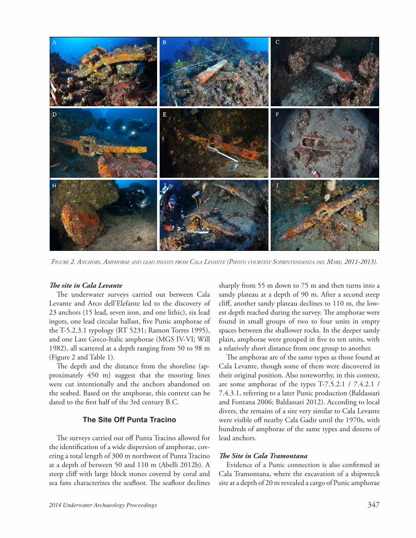
The site in Cala LevanteThe underwater surveys carried out between Cala
Levante and Arco dell’Elefante led to the discovery of 23 anchors (15 lead, seven iron, and one lithic), six lead ingots, one lead circular ballast, five Punic amphorae of the T-5.2.3.1 typology (RT 5231; Ramon Torres 1995), and one Late Greco-Italic amphorae (MGS IV-VI; Will 1982), all scattered at a depth ranging from 50 to 98 m (Figure 2 and Table 1).
The depth and the distance from the shoreline (ap-proximately 450 m) suggest that the mooring lines were cut intentionally and the anchors abandoned on the seabed. Based on the amphorae, this context can be dated to the first half of the 3rd century B.C.
The Site Off Punta Tracino
The surveys carried out off Punta Tracino allowed for the identification of a wide dispersion of amphorae, cov-ering a total length of 300 m northwest of Punta Tracino at a depth of between 50 and 110 m (Abelli 2012b). A steep cliff with large block stones covered by coral and sea fans characterizes the seafloor. The seafloor declines
sharply from 55 m down to 75 m and then turns into a sandy plateau at a depth of 90 m. After a second steep cliff, another sandy plateau declines to 110 m, the low-est depth reached during the survey. The amphorae were found in small groups of two to four units in empty spaces between the shallower rocks. In the deeper sandy plain, amphorae were grouped in five to ten units, with a relatively short distance from one group to another.
The amphorae are of the same types as those found at Cala Levante, though some of them were discovered in their original position. Also noteworthy, in this context, are some amphorae of the types T-7.5.2.1 / 7.4.2.1 / 7.4.3.1, referring to a later Punic production (Baldassari and Fontana 2006; Baldassari 2012). According to local divers, the remains of a site very similar to Cala Levante were visible off nearby Cala Gadir until the 1970s, with hundreds of amphorae of the same types and dozens of lead anchors.
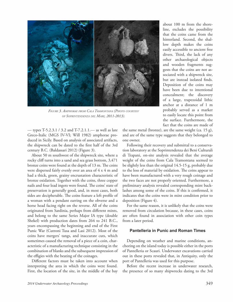
The Site in Cala TramontanaEvidence of a Punic connection is also confirmed at
Cala Tramontana, where the excavation of a shipwreck site at a depth of 20 m revealed a cargo of Punic amphorae
FIGURE 2. ANCHORS, AMPHORAE AND LEAD INGOTS FROM CALA LEVANTE (PHOTO COURTESY SOPRINTENDENZA DEL MARE, 2011-2013).

348 Advisory Council on Underwater Archaeology
ID Rep. Number Type Material Parts Depth (m)
1 1 Anchor Lead Stock -54.82 2 Anchor Lead Stock -663 4 Amphora Ware Complete -504 5 Ingots Lead Complete -525 6 Ballast Lead Complete -65.76 7 Anchor Iron Complete -58.17 8 Amphora Ware Complete -62.88 10 Anchor Iron Complete -74.39 11 Anchor Lead Collar -64.110 12 Anchor Iron Complete -54.211 13 Anchor Lead Stock -59.512 14 Anchor Lead Stock -59.313 15 Anchor Lead Collar -6314 16 Anchor Iron Complete -5015 17 Anchor Lead Stock -62.916 18 Anchor Lead Stock -61.217 19 Anchor Iron Complete -58.218 20 Ingots Lead Complete -6519 21 Amphora Ware Complete -62.820 22 Amphora Ware Fund -6021 23 Amphora (2) Ware Complete -65.622 24 Anchor Lead Stock -64.623 25 Ingots Lead Complete -55.624 26 Anchor Lead Stock -59.425 27 Anchor Iron Stock -59.326 28 Anchor Iron Complete -48.227 29 Anchor Lead Stock -48.328 30 Anchor Lead Stock -72.229 31 Anchor Lead Stock -34.730 32 Anchor Lithic Complete -8231 33 Anchor Lead Stock -77.532 34 Anchor Lead Collar -74.333 35 Anchor Lead Stock -70.8
TABLE 1. LIST OF ARTIFACTS FOUND IM CALA LEVANTE
3492014 Underwater Archaeology Proceedings
— types T-5.2.3.1 / 3.2 and T-7.2.1.1.— as well as late Greco-Italic (MGS IV-VI; Will 1982) amphorae pro-duced in Sicily. Based on analysis of associated artifacts, the shipwreck can be dated to the first half of the 3rd century B.C. (Baldassari 2012) (Figure 3).
About 50 m southwest of the shipwreck site, where a rocky cliff turns into a sand and sea grass bottom, 3,471 bronze coins were found at the depth of 13 m. The coins were dispersed fairly evenly over an area of 4 x 4 m and had a thick, green, grainy encrustation characteristic of bronze oxidation. Together with the coins, three copper nails and four lead ingots were found. The coins’ state of preservation is generally good, and, in most cases, both sides are decipherable. The coins feature a left profile of a woman with a pendant earring on the obverse and a horse head facing right on the reverse. All of the coins originated from Sardinia, perhaps from different mints, and belong to the same Series Major IA type (double Shekel) with production dates from 264 to 241 B.C., years encompassing the beginning and end of the First Punic War (Cutroni Tusa and Lasi 2012). Most of the coins have mergers’ tangs, and inaccurate cuts, which sometimes caused the removal of a piece of a coin, char-acteristic of a manufacturing technique consisting in the combination of blanks and the subsequent impression of the effigies with the beating of the coinages.
Different factors must be taken into account when interpreting the area in which the coins were found. First, the location of the site, in the middle of the bay
about 100 m from the shore-line, excludes the possibility that the coins came from the hinterland. Second, the shal-low depth makes the coins easily accessible to ancient free divers. Third, the lack of any other archaeological objects and wooden fragments sug-gests that the coins are not as-sociated with a shipwreck site, but are instead isolated finds. Deposition of the coins may have been due to intentional concealment; the discovery of a large, trapezoidal lithic anchor at a distance of 1 m probably served as a marker to easily locate this point from the surface. Furthermore, the fact that the coins are made of
the same metal (bronze), are the same weight (ca. 15 g), and are of the same type suggests that they belonged to one owner.
Following their recovery and submittal to a conserva-tion laboratory at the Soprintendenza dei Beni Culturali di Trapani, on-site analysis revealed that the average weight of the coins from Cala Tramontana seemed to be slightly less than the original 14.5-15 g, probably due to the loss of material by oxidation. The coins appear to have been manufactured with a very rough coinage and the two faces are not properly oriented. Furthermore, a preliminary analysis revealed corresponding mint back-lashes among some of the coins. If this is confirmed, it indicates that the coins were in mint condition prior to deposition (Figure 4).
For the same reason, it is unlikely that the coins were removed from circulation because, in these cases, coins are often found in association with other coin types from a later period.
Pantelleria in Punic and Roman Times
Depending on weather and marine conditions, an-choring on the island today is possible either in the ports of Pantelleria or Scauri. Underwater excavations carried out in these ports revealed that, in Antiquity, only the port of Pantelleria was used for this purpose.
Before the recent increase in underwater research, the presence of so many shipwrecks dating to the 3rd
FIGURE 3. AMPHORAE FROM CALA TRAMONTANA (PHOTO COURTESY OF SOPRINTENDENZA DEL MARE, 2011-2013).

350 Advisory Council on Underwater Archaeology
century B.C. around Pantelleria was interpreted to be the result of the significant trade taking place in the Sicily Channel during a period of peace between the First and the Second Punic Wars (Baldassari and Fontana 2002). Several sites discovered in the south central part of the is-land during intensive field survey carried out within the archaeological map of Pantelleria Island, confirmed this belief. Most of these sites show a continuous occupation from the 3rd century B.C. to the A.D. 2nd century, with significant development during the Roman Imperial pe-riod (Mosca 2008). Similarly, stratigraphic excavations conducted at the Acropolis and at the Temple of Lago di Venere confirm that the population of the island appar-ently remained stable during this period (Osanna 2004a, 2004b; Cerasetti 2006; Massa 2006; Schaeffer 2012).
If, on the other hand, several shipwreck sites on the northeast coast are associated with settlements located in the southern part of the island, characterized by con-tinuous occupation, it is difficult to explain the lack of underwater sites dating to after the Roman conquest. It may be that the shelters on the northeast coast were used as anchorage areas when the entrance in the main harbor of Pantelleria was temporarily unavailable. Utilizing these areas as anchorages would, however, put vessels’ safety at risk due to the sudden changes in wind direction, which occur very frequently close to the coast of the island. This alone, however, does not justify the concealment of coins and the deep moorings of Cala Levante.
Site Analysis and Discussion
In order to provide a coherent interpreta-tion of underwater survey results, especially in order to frame findings within the main historical events of the Punic and Roman period, analysis of some key factors, such as site context and composition of ships’ cargoes, is necessary.
The material discovered during the underwater archaeological surveys and excavations is almost entirely dominated by different types of amphorae. No other ma-terials accompanied the amphorae, which would have been a common feature in the mixed cargoes of the period. This may sug-gest that the ships were permanently based at Pantelleria, waiting for the most appro-
priate moment to supply food to besieged Punic cities in southwestern Sicily. The context of the amphorae found during the in-depth survey in Punta Tracino may be the result of intentional “lightening” of boats. This operation was usually performed in case of a breach in the hull, but was also performed when the approach of an enemy required a quick escape.
The coins found in Cala Tramontana cannot be in-terpreted either as the result of trade or as the reserve of a single vessel because, in these cases, the coins would have likely been of different metal, value, and origin. Furthermore, the rough appearance of the dies, the fact that the faces are not properly oriented, and the lack of care in the coinage cutting of appendices, seems to refer to a rough and fast production, a typical feature of the coins minted in times of war. This unusual discovery may be explained as the voluntary concealment of a hoard with the purpose to recover it afterward, possibly due to a dangerous situation such as the approach of an enemy fleet.
The anchors of Cala Levante were also an unusual discovery. Although Cala Tramontana and the nearby Cala Levante are wide and shallow sheltered bays where mooring is the easiest close to shore, the anchors were found far from the coast and at a considerable depth. The vessels were likely stationed intentionally in such a place, ready for a sudden launch. With good weather and marine conditions, the strategic location of Pantelleria allowed vessels to reach the coasts of Sicily in less than eight hours by sailing. Indeed, historical sources indicate that Hannibal Rhodium raided the port of Drepenum
FIGURE 4. THE COINS HOARD FROM CALA TRAMONTANA (PHOTO COURTESY OF SOPRINTENDENZA DEL MARE, 2011).

3512014 Underwater Archaeology Proceedings
(today’s Trapani) from Pantelleria during the first Punic War (Pol., Histories, I, 46, 4).
Archaeological investigations carried out on terrestrial sites across Pantelleria show not only that the island maintained continuity in population size during the 3rd and the 2nd centuries B.C., but also that some areas developed significantly during the early Imperial Roman period. This data contrasts with the results achieved dur-ing the underwater research program, which provided evidence of nine sites dating back to the 3rd century B.C. and only two sites to the later Roman period.
Historical Interpretation
In consideration of the new underwater archaeologi-cal data mentioned above, a brief review of the historical events concerning Pantelleria in the Punic Wars of the 3rd century B.C. based on Classical sources might pro-vide some insight.
In 255 B.C., Consuls Servius Fulvio Petino Nobiliore and Marco Paolo Emilio led a fleet with over 300 Roman ships and, after having destroyed the Carthaginian fleet in the Battle of Capo Ermes, took possession of Pantelleria on their way back to Sicily. The naval vic-tory and conquest of the island were celebrated with a double triumph, one for each Consul (Abelli 2012d). At that time, Carthaginian ships tasked with supplying besieged cities in Sicily were based in Pantelleria (the closest point to Eraclea Minoa), but did so without any form of protection from Roman naval warships (Vacanti 2012a, 2012b, 2012c).
After the overwhelming victory of Capo Ermes, the Roman Consuls were likely waiting for the best weather conditions to make the journey back to Sicily. Once the Carthaginian navy stationed at Pantelleria knew of the return of the Roman fleet, their only choice was to hide their ships. The shelters of the northeastern coast, small in number and size, would have been inadequate for such a large fleet. Moreover, mooring too close to the coast with large cargoes onboard would have made escape from the fast Roman ships, already downwind, nearly impossible. The Carthaginians thus opted for the southeastern coast, hoping that the Roman fleet would pass to the north and, seeing that the port of Pantelleria was empty, proceed northward in direction of Sicily. In case of impending danger, the Carthaginians would have released the anchors, cut the moorings, hoisted the sails, and lightened the load for a quicker escape (Abelli 2012a).
It is possible that, in order to withstand Roman attack, the Carthaginians threw the coins mentioned above into the sea of Cala Tramontana and that they marked the site with a wooden log tied to a lithic anchor so that they could recover the coins later. The several anchors discovered in the Bay of Cala Levante, and also those in the nearby Cala Gadir, are interpreted as evidence of Carthaginian involvement in supplying goods to the be-sieged Sicilian cities. A similar site was found at a depth of 40 m at Levanzo Island, near Capo Grosso, and has been interpreted as the anchorage of the Roman fleet during the Egadi Battle in 241 B.C. (Tusa 2005).
Similar to the first Roman conquest, the Consul Tiberius Sempronius Longus, commander of a fleet of 350 ships, forced what remained of a Carthaginian war-ship fleet to take refuge in the main harbor of Carthage in 217 B.C. On his way towards Africa, he again con-quered the island of Pantelleria, installing a garrison. Based on this historical evidence, sites on the north coast of Pantelleria may yield indications of these events.
Additionally, the first context in the Cala Levante site, consisting of Greco-Italic (MGS IV–VI; Will 1982) amphoras, early Punic amphorae, and the moorings may be related to the first Roman conquest of Pantelleria in 255 B.C. The second context in the Cala Levante site, consisting of late Punic amphorae likely dates to the second Roman conquest of the island in 217 B.C. or the period immediately after. The fact that no weapons or other signs of battle were found may be explained by his-torical sources, according to which the Roman navy, in both cases, had previously decimated the Carthaginian fleet (Pol., Histories, III 96).
The bays of Cala Tramontana and Cala Levante have provided new archaeological data towards the under-standing of historical events related to the Punic wars and have always played a strategic role for Pantelleria since they are the only locations that provide access to the sea with small vessels in almost all weather conditions.
A new avenue of inquiry for archaeological research would be a study of the relationship between the island of Pantelleria and Sardinia. The latter, together with Sicily, was the main focus of both Roman and Carthaginian expansionist goals to possess the two most important granaries of the Central Mediterranean, as well as to control Sardinia’s lead mines of Sardinia.

352 Advisory Council on Underwater Archaeology
Maritime Public Outreach in an Island Context: A Holistic Approach
In addition to the results of the archaeological investigations in Cala Levante and Cala Tramontana mentioned above, there are also a few considerations to consider for the establishment of a structured public interpretive and outreach program for Pantelleria’s mari-time cultural heritage.
The island of Pantelleria has a peculiar, rural land-scape where terraced cultivation — mostly producing wine and capers — dominates the coastal areas where rocky outcrops are less invasive (Abelli 2010:20). The terracing arrangements had its origins in Punic times, continued in Roman times and, to a lesser extent, in the Arabic period. The massive extension that can be seen today originated at the beginning of the 19th century to facilitate the implantation of vineyards. Apart from the town of Pantelleria, the island is defined by a small population density and its cultural landscape is described, apart from both terrestrial and underwater archaeological remains, dating back to prehistoric times (Tusa 2012:15–39; Abelli 2010), by the presence of dammusi (traditional dwellings built of local volcanic stone), lighthouses, and Second World War military for-tified structures (casemates). Small villages and isolated dwellings dot the island, well camouflaged within the surrounding vegetation. The island has an omnipresent heritage, which is made up of a unique combination of natural and anthropic features that provide the land with an incredible ability to narrate its own historical evolution. Interestingly, Pantelleria’s cultural heritage almost instinctively portrays cultural and historical processes, thus offering an outstanding basis to struc-ture and deepen public interpretive and public access programs. The term cultural heritage is here used — in line with the most up-to-date internationally agreed definition of the term — as a cohesion of archaeological, historical, natural, ethnographic, tangible and intangible heritages that, altogether, partake to the disclosure of Pantelleria’s history.
In relation to maritime cultural heritage, the Soprintendenza del Mare (Superintendency of the Sea) has produced many interpretive efforts over the last 20 years, which represents a unique effort within the Italian panorama. Special consideration for Sicilian maritime history has allowed the Superintendency to promote systematic underwater research and to establish many activities devoted to public outreach, awareness-raising, and public access to underwater cultural heritage (Tusa
2009:89–96). Perhaps more than other methods, the in-terpretive efforts that best showcase Sicilian cultural his-tory are the “Itinerari Culturali Subacquei” (Underwater Trails) located throughout the regional territory, includ-ing small islands such as Pantelleria.
To date, the island of Pantelleria has four underwater trails: Punta Li Marsi (A and B), Punta Tre Pietre, Cala Tramontana, and Cala Gadir, here an underwater video system provides a live video feed of the underwater site through the Superintendency website for the non-diving public. Interpreted underwater sites are placed under control of local diving centers that act as a far end control station for the Superintendency, granting trails maintenance while acquiring the right to bring diving visitors on an exclusive basis (see http://www.regione.sicilia.it/beniculturali/archeologiasottomarina/itinerari.htm).
Along the trail in Cala Tramontana, divers encounter a Libyan fishing boat that grounded ashore on a slipway in 2004 and was then relocated 18 m deeper during strong winter storms. The trail continues along a route that guides divers to observe Punic and Greco-Italic amphorae, stone anchors, and millstones located at a maximum depth of 20 m. Most of the artifacts displayed in situ come from the two excavation seasons. Artifacts were recorded in situ, recovered, passed through a conservation treatment and thoroughly studied prior to being re-placed along the trail. Each artifact has its own descriptive tag providing interpretation to divers. Access to the trail is only permitted through an authorized diving center.
Today, all trails located around the island of Pantelleria are enhanced through an explicative guide, underwater tags, and, obviously, through the activity of diving centers who share the story of the area. Public interpretation of these trails is therefore site-specific. A more widespread and structured public interpretation and access system for the island would be a welcomed potential future development.
Pantelleria’s geographical, historical, and cultural characteristics are well adapted to interpretive and public access activities (for both underwater and ter-restrial sites) that would ideally transpose the concepts of landscape archaeology onto public outreach activities. In this direction, archaeological sites — and cultural heritage as a whole — form a diachronic narrative of the island’s history, not as individual entities, but as part of a continuous account. This narrative could promote a far broader story (in terms of representations of heritage), contextualizing each single page (i.e., an individual site or cultural resource) in the book of Pantelleria.

3532014 Underwater Archaeology Proceedings
Again, unique geographical, historical, and cultural characteristics testify that such an approach could be successful in enhancing the understanding, apprecia-tion, and stewardship of the island’s cultural heritage, and also in helping expanding tourism — currently active for two to two and a half months per year (June-August) — too often strictly tied to diving activities and season. For an island with such an important past and where tourism plays a significant role in sustaining local economy, the various forces operating on the island (political, administrative, non-profit, private, commu-nity, and archaeological) should attempt to exploit (in a positive sense of the term) a set of cultural resources that speak loudly about the character of Pantelleria.
To function properly, the public outreach approach suggested here would have two major bases: 1) the abso-lute necessity for collaboration among institutions, pri-vate organizations/enterprises, and communities, bound to the sustainability and efficacy of common efforts (Secci and Spanu 2014), and 2) interpretative and public access activities planning that includes the multifaceted heritage characterizing the island. Pantelleria’s Natural Parks organization, the Superintendencies, the City Council, tourism groups, and private interest groups should convene to compile a structured interpretation of the island. European institutions, funding, and devel-opment rationales have all moved toward this direction elsewhere. Societal challenges brought to the forefront by Europe 2020, and Innovation Union flagship initiatives, and the Horizon 2020 European Framework Program (European Commission 2014a, 2014b, 2014c) require national and local governments to participate, through a broad and collaborative effort, in confronting issues for European citizens that hold significant socio-economic meaning. Although culture and cultural heritage are not explicitly included within the three main pillars of the Horizon 2020 strategy, they are recognized as crosscut-ting themes relevant to each pillar.
The collaboration suggested above could and should address and foster the “value of cultural heritage for society” (CoE 2005a, 2005b) “as a way of transmitting knowledge [and] a factor for human development” (Silvestrini 2012). The Faro Framework Convention on the Value of Cultural Heritage for Society was adopted by the Committee of Ministers at the 941st meeting of the Ministers’ Deputies on 13 October 2004, and opened to signature on 27 October 2005, “setting out principles and broad areas for action which have been agreed between states Party” (CoE 2005a, 2005b). In this framework, Pantelleria is an appropriate case study in which both
archaeological and cultural heritage could play a distinc-tive role in influencing socio-cultural development. This unique opportunity could also actively influence “Europe in a changing world — Inclusive, innovative and reflective societies” (European Commission 2014c; CoE 2014) by tackling cultural memory and identity is-sues through an informed historical reconstruction and public interpretation of the heritage.
Acknowledgments
We would like to thank the Superintendency for the Sea of the Sicilian Region for their continuous support and the Dipartimento di Scienze della Terra at the Università “La Sapienza”, Rome for their valuable sup-port with the remote sensing survey and data process-ing. Moreover, we would like to specify that, although conceived as a uniform paper, paragraphs 1 and 2 were drafted by Pier Giorgio I. Spanu, paragraphs 3-7 by Leonardo Abelli and paragraph 8 by Massimiliano Secci.
References
Abelli, Leonardo2007 I porti e gli approdi di Pantelleria. In Pantelleria 1,
Massimiliano Marazzi and Sebastiano Tusa, editors, pp. 25–39. Gaia Editrice, Salerno, Italy.
2010 Il ruolo di Pantelleria nelle rotte del canale di Sicilia dalla Preistoria al periodo Tardo Antico. Tesi di Dottorato, Università degli Studi di Sassari, Sassari, Italy.
2012a De Cossvrensibus et Poenis Navalem egit – Archeologia subacquea a Pantelleria, Ante quem, Bologna, Italy.
2012b Le indagini archeologiche subacquee: Scavi e prospezioni a Cala Tramontana e Cala Levante. In De Cossvrensibus et Poenis Navalem egit – Archeologia subacquea a Pantelleria, Leonardo Abelli, editor, pp. 147–162. Ante quem, Bologna, Italy.
2012c Pantelleria nelle rotte del Canale di Sicilia: porti approdi e siti sommersi. In De Cossvrensibus et Poenis Navalem egit – Archeologia subacquea a Pantelleria, Leonardo Abelli, editor, pp. 73–94. Ante quem, Bologna, Italy.
2012d Il contesto storico del Canale di Sicilia nel III secolo a.C. In De Cossvrensibus et Poenis Navalem egit – Archeologia subacquea a Pantelleria, Leonardo Abelli, editor, pp. 55–62. Ante quem, Bologna, Italy.

354 Advisory Council on Underwater Archaeology
Abelli, Leonardo, Maria Vittoria Agosto, Daniele Casalbore, Claudia Romagnoli, Alessandro Bosman, Fabrizio Antonioli, Martina Pierdomenico, Andrea Sposato, and Francesco Latino Chiocci
2014 Marine geological and archaeological evidence of a possible pre-Neolithic site in Pantelleria Island, Central Mediterranean Sea. Geological Society, London, Special Publications, First September 19, 2014; doi 10.1144/SP411.6
Agnesi, Valerio and Cinzia Federico1995 Aspetti geografico-fisici e geologici di Pantelleria e
delle Isole Pelagie 330 (Canale di Sicilia). Naturalista siciliano 19:1–22.
Baldassari, Roberta and Sergio Fontana2002 Anfore a Pantelleria – per una storia economica
dell’isola nell’antichità. In L’Africa Romana XIV – Lo spazio marittimo del Mediterraneo occidentale: geografia storica ed econimica – Atti del XIV convegno di studio. Mustapha Khanoussi, Paola Ruggeri, and Cinzia Vismara, editors, pp. 953–989, Sassari 7–10 dicembre 2000, Italy.
2006 Le anfore a Pantelleria tra la prima età punica e l’età romana. In Pantelleria Punica – Saggi critici sui dati archeologici e riflessioni storiche per una nuova generazione di ricerca. Enrico Acquaro and Barbara Cerasetti, editors, pp. 41–62. Ante quem, Bologna, Italy.
Baldassari, Roberta2012 Le anfore da trasporto e la ceramica. In De
Cossvrensibus et Poenis Navalem egit – Archeologia subacquea a Pantelleria, Leonardo Abelli, editor, pp. 191–212. Ante quem, Bologna, Italy.
Bosman, Alessandro, Marilena Calarco, Daniele Casalbore, Aida Maria Conte, Eleonora Martorelli, Andrea Sposato, Francesco Falese, Leonardo Macelloni, Claudia Romagnoli, and Francesco Latino Chiocci
2011 Volcanic Islands: The Tip of Large Submerged Volcanoes That Only Marine Geology May Reveal (examples from W Pontine Archipelago, Ischia, Stromboli and Pantelleria). In Marine Research at CNR, pp. 433–444, Italy.
Cerasetti, Barbara2006 Esplorazioni preliminari. In Pantelleria Punica –
Saggi critici sui dati archeologici e riflessioni storiche per una nuova generazione di ricerca, Enrico Acquaro and Barbara Cerasetti, editors, pp. 139–149. Ante quem, Bologna, Italy.
Council of Europe (CoE)2005a Framework Convention on the Value of Cultural
Heritage for Society. Faro <http://conventions.coe.int/treaty/en/treaties/html/199.htm>. Accessed 27 February 2014.
2005b Explanatory Report. <http://conventions.coe.int/Treaty/EN/Reports/Html/199.htm>. Accessed 27 February 2014.
2014 Europe in a Changing World – Inclusive, Innovative and Reflective Societies. <http://ec.europa.eu/programmes/horizon2020/en/h2020-section/europe-changing-world-inclusive-innovative-and-reflective-societies>. Accessed 27 February 2014.
Civetta, Lucia, Yves Cornette, Gino Mirocle Crisci, Pierre-Yves Gillot, Giovanni Orsi and Célia da Silva Requejo
1984 Geology, Geochronology and Chemical Evolution of the Island of Pantelleria. Geological Magazine 121:541–668.
Cutroni Tusa, Aldida, and Rossella Lasi2012 Il ritrovamento monetale di Cala Tramontana. In
De Cossvrensibus et Poenis Navalem egit – Archeologia subacquea a Pantelleria, Leonardo Abelli, editor, pp. 231–244. Ante Quem, Bologna, Italy.
European Commission (EC)2014a Europe 2020. European Commission, Brussels,
Belgium. <http://ec.europa.eu/europe2020/index_en.htm>. Accessed 27 February 2014.
2014b Innovation Union a Europe 2020 Initiative. European Commission, Brussels, Belgium. <http://ec.europa.eu/research/innovation-union/index_en.cfm?pg=home>. Accessed 27 February 2014.
2014c Horizon 2020 – The EU Framework Program for Research and Innovation. European Commission, Brussels, Belgium. <http://ec.europa.eu/programmes/horizon2020/>. Accessed 27 February 2014.
Massa, Serena2006 Elementi di cronologia, terre sigillate, pareti sottili
e ceramiche comuni. In Pantelleria Punica – Saggi critici sui dati archeologici e riflessioni storiche per una nuova generazione di ricerca, Enrico Acquaro and Barbara Cerasetti, editors, pp. 251–256. Ante quem, Bologna, Italy.
Mosca, Anna Paola2008 Lettura dei dati storici e archeologici. In Pantelleria
II – Contributo per la carta Archeologica di Cossyra, Anna Paola Mosca, editor, pp. 123–126. Editrice Gaia, Salerno, Italy.
Osanna, Massimo2004a Le teste di Pantelleria nel loro contesto di
rinvenimento. InCaesar in der stadt. Die neu entdeckten Marmorbildnisse aus Pantelleria (Exhibiton Catalogue), pp. 40–46. Helms Museum, Hamburg, Germany.

3552014 Underwater Archaeology Proceedings
2004b VorlaufigeErgebnisse. In Caesar in der stadt. Die neu entdeckten Marmorbildnisse aus Pantelleria (Exhibition Catalogue), pp. 12–16. Helms Museum, Hamburg, Germany.
Schaeffer, Thomas2012 L’acropoli di Pantelleria, la fase punica. In De
Cossvrensibus et Poenis Navalem egit – Archeologia subacquea a Pantelleria, Leonardo Abelli, editor, pp. 121–130. Ante quem, Bologna, Italy.
Secci, Massimiliano and Pier Giorgio I. Spanu2014 Critique of Practical Archaeology: Underwater
Cultural Heritage and Best Practices. In EUPLOIA: Implementing Underwater Cultural Heritage ‘Best Practices’ in a Mediterranean Context (Conference Proceedings), Noto, Sicily, Italy.
Silvestrini, Gianluca2012 The Value of Cultural Heritage for Society.
Workshop on “Research Infrastructures for Cultural Heritage and Global Change,” Royal Institute for Cultural Heritage (KIK-IRPA), Parc du Cinquantenaire 1, B-1000 Brussels, Belgium. <http://ec.europa.eu/research/infrastructures/index_en.cfm?pg=workshop_march_2012)>. Accessed 27 February 2014.
Tusa, Sebastiano (editor)2005 Il mare delle Egadi – Storia, Itinerari e Parchi
Archeologici subacquei, pp. 39–40. Officine Grafiche Riunite s.p.a., Palermo, Italy.
Tusa, Sebastiano2009 Research, Protection and Evaluation of Sicilian
and Mediterranean Marine Cultural Heritage. Conservation Science in Cultural Heritage 9, pp. 79–112. Bologna, Italy.
2012 Vent’anni di ricerche archeologiche tra terra e mare nell’isola di Pantelleria. In De Cossvrensibus et Poenis Navalem egit – Archeologia subacquea a Pantelleria, Leonardo Abelli, editor, pp. 15–39. Ante quem, Bologna, Italy.
Vacanti, Claudio2012a La svolta di Drepana. In Guerra per la Sicilia e guerra
della Sicilia – il ruolo delle città siciliane nel primo conflitto punico-romano, Claudio Vacanti, editor, pp. 75–81. Jovene editore, Napoli, Italy.
2012b La flotta del Rodio. In Guerra per la Sicilia e guerra della Sicilia – il ruolo delle città siciliane nel primo conflitto punico-romano, Claudio Vacanti, editor, pp. 82–85. Jovene editore, Napoli, Italy.
2012c Rifornimenti. In Guerra per la Sicilia e guerra della Sicilia – il ruolo delle città siciliane nel primo conflitto punico-romano, Claudio Vacanti, editor, pp. 127–134. Jovene editore, Napoli, Italy.
Leonardo AbelliDipartimento di Storia, Scienze
dell’Uomo e della FormazioneUniversità degli Studi di SassariViale Umberto I07100 SassariPantelleria Ricerche s.c.a.r.l.Via Genova 191017 Pantelleria (TP), [email protected]
Massimiliano SecciDipartimento di Storia, Scienze
dell’Uomo e della FormazioneUniversità degli Studi di SassariViale Umberto I07100 [email protected]
Pier Giorgio I. SpanuDipartimento di Storia, Scienze
dell’Uomo e della FormazioneUniversità degli Studi di SassariViale Umberto I07100 [email protected]
Copyright © 2022 FDOKUMEN