Marine geological and archaeological evidence of a possible pre-Neolithic site in Pantelleria...
15
Geological Society, London, Special Publications Online First September 19, 2014; doi 10.1144/SP411.6 , first published Geological Society, London, Special Publications Chiocci Martina Pierdomenico, Andrea Sposato and Francesco Latino Claudia Romagnoli, Alessandro Bosman, Fabrizio Antonioli, Leonardo Abelli, Maria Vittoria Agosto, Daniele Casalbore, Mediterranean Sea possible pre-Neolithic site in Pantelleria Island, Central Marine geological and archaeological evidence of a service Email alerting new articles cite this article to receive free e-mail alerts when here click request Permission part of this article to seek permission to re-use all or here click Subscribe Collection London, Special Publications or the Lyell to subscribe to Geological Society, here click How to cite First and how to cite articles for further information about Online here click Notes © The Geological Society of London 2014 by guest on September 29, 2014 http://sp.lyellcollection.org/ Downloaded from by guest on September 29, 2014 http://sp.lyellcollection.org/ Downloaded from
Transcript of Marine geological and archaeological evidence of a possible pre-Neolithic site in Pantelleria...
Geological Society, London, Special Publications Online First
September 19, 2014; doi 10.1144/SP411.6, first publishedGeological Society, London, Special Publications
ChiocciMartina Pierdomenico, Andrea Sposato and Francesco LatinoClaudia Romagnoli, Alessandro Bosman, Fabrizio Antonioli, Leonardo Abelli, Maria Vittoria Agosto, Daniele Casalbore, Mediterranean Seapossible pre-Neolithic site in Pantelleria Island, Central Marine geological and archaeological evidence of a
serviceEmail alerting
new articles cite this article to receive free e-mail alerts whenhereclick
requestPermission
part of this article to seek permission to re-use all orhereclick
Subscribe
Collection London, Special Publications or the Lyell
to subscribe to Geological Society,hereclick
How to citeFirst and how to cite articles
for further information about Onlinehereclick
Notes
© The Geological Society of London 2014
by guest on September 29, 2014http://sp.lyellcollection.org/Downloaded from by guest on September 29, 2014http://sp.lyellcollection.org/Downloaded from
Marine geological and archaeological evidence of a possible
pre-Neolithic site in Pantelleria Island, Central Mediterranean Sea
LEONARDO ABELLI1, MARIA VITTORIA AGOSTO2, DANIELE CASALBORE3*,
CLAUDIA ROMAGNOLI4, ALESSANDRO BOSMAN3, FABRIZIO ANTONIOLI5,
MARTINA PIERDOMENICO6, ANDREA SPOSATO3 & FRANCESCO LATINO CHIOCCI6
1Universita degli Studi di Sassari, Piazza D’Armi, 17, 07100 Sassari, Italy
2Pantelleria Ricerche, Pantelleria, Italy
3IGAG-CNR, Roma, Italy
4Dipartimento di Scienze Biologiche, Geologiche e Ambientali,
Universita di Bologna, Bologna, Italy
5ENEA Casaccia Research Centre, 00060 Rome, Italy
6Dipartamento Scienze della Terra, Universita Sapienza, Roma, Italy
*Corresponding author (e-mail: [email protected])
Abstract: Recent underwater archaeological surveys recovered hundreds of flint artefactsbetween depths of 18 and 21 m at Cala Tramontana, a small bay located in the eastern part of Pan-telleria Island. Most of the flint artefacts indicate debitage, and are characterized by cores andflakes without any specific morphology. Different lithic tools were also identified, such as frag-ments of blades, truncations, end-scrapers, points and crested blades. An initial hypothesis isthat this lithic industry represents the oldest traces of human visitation to the island, possiblyrelated to the exploitation of the nearby obsidian source, and favoured because of the shelteredcoastal configuration of Cala Tramontana and Cala Levante with respect to the dominant windsand related storms. However, the present-day coastal setting in the bay is rather inhospitable,with high cliffs and difficult marine access. In contrast, palaeo-landscape reconstructions bymeans of high-resolution multibeam bathymetry reveal the possible presence of a small palaeo-beach in the inner part of the bay when the sea level was 15 m lower than at present. By comparingthis palaeo-sea level with the eustatic curve (and by excluding possible vertical movements), weroughly estimate an age of the lithic industry of 9.6–7.7 cal ka BP.
Pantelleria Island is located in the middle of theSicily Channel, a key position in the MediterraneanSea approximately 70 and 100 km from the Africanand Sicilian coastlines, respectively, at present-daysea level (Fig. 1, inset). If one considers the palaeo-environmental conditions of the sea level at the timeof the Last Glacial Maximum, when the sea levelwas 127 m lower than present day (Lambeck et al.
2011), the distances to the African and Siciliancoastlines decrease to 50 and 30 km, respectively.
Archaeological studies on Pantelleria started inthe nineteenth century (e.g. Cavallari 1874; Orsi1899) but only in the last decade has an importanteffort to understand the timing of human occupa-tion at Pantelleria taken place. Since 1998, archaeo-logical surveys have covered 25% of the islandand the surrounding seafloor, leading to importantarchaeological findings spanning the Chalcolithic–Bronze Age to the late Antique Period (e.g. Abelli2012 and references therein; Tusa 2012). Impressive
results from underwater archaeological researchhave allowed for the documentation of several ship-wrecks and eight main archaeological sites (num-bered polygons in Fig. 1) in water depths ofbetween 5 and 115 m. Underwater research alsochronologically frames the occupation of the twomain marine landings on the island: Pantelleria inthe north and Scauri in the SW (Fig. 1) (Abelli 2007).
More recently, hundreds of flint artefacts werefound at Cala Tramontana, located in the easternsector of the island, at water depths of 18–21 mduring underwater archaeological surveys (Figs 1& 2). This lithic industry could represent the traceof a prehistoric landing place and, perhaps, theoldest example of human visitation to the island.Although no evidence of pre-Chalcolithic humansettlements was found on land, Pantelleria hasbeen frequented from at least the Neolithic Age asone of the source areas (together with Lipari, Pal-marola and Sardinia; see the inset in Fig. 1) of
From: Harff, J., Bailey, G. & Luth, F. (eds) Geology and Archaeology: Submerged Landscapes of the Continental
Shelf. Geological Society, London, Special Publications, 411, http://dx.doi.org/10.1144/SP411.6# The Geological Society of London 2014. Publishing disclaimer: www.geolsoc.org.uk/pub_ethics
by guest on September 29, 2014http://sp.lyellcollection.org/Downloaded from

obsidian throughout the central and westernMediterranean during this period (e.g. Radi 1972;Francaviglia & Piperno 1987; Tykot et al. 2006;Rapisarda 2007). The aim of this paper, focusingon the area of Cala Tramontana, is to define thepalaeoenvironment in which this lithic industrymight have developed through the integrationof: (a) archaeological and geological constraints;(b) the reconstruction of the submerged palaeo-landscape by means of ultra-high-resolution swathbathymetry collected in 2013; and (c) a consider-ation of prehistoric sea levels according to theglacio-isostatic model of Lambeck et al. (2011)and volcano-tectonic uplift derived from geomor-phological indicators.
General setting
The island of Pantelleria represents the upperemerged portion (about 28% of the entire surface)of a large submarine volcanic edifice rising froma water depth of approximately 1200 m (e.g.Bosman et al. 2011). The edifice is elongated in aNW–SE direction, aligned with the main structureof the Sicily Channel (e.g. Civetta et al. 1984). Sub-aerial volcanic activity dates to approximately330 kyr ago, and was characterized by alternatingperiods of less energetic activity (or quiescence)and large explosive eruptions, causing two calderacollapses: the ‘La Vecchia’ caldera, dated to about139–146 kyr ago (Rotolo et al. 2013) and the
Fig. 1. Aerial photograph of Pantelleria Island, with the location of the study area (black box) and other underwaterarcheological surveys (numbered polygons), modified from Abelli (2007). In the inset, the regional setting of the area,with the location of the main obsidian source areas during the Neolithic (Palmarola, Lipari, Sardinia and Pantelleriaislands) indicated.
L. ABELLI ET AL.
by guest on September 29, 2014http://sp.lyellcollection.org/Downloaded from

‘Cinque Denti’ caldera, commonly associated withthe Green Tuff emission 45–50 kyr ago (e.g. Civettaet al. 1984; Mahood & Hildreth 1986). The mostrecent volcanic event occurred in 1891, 5 km offthe island’s NW shore, with a submarine eruption(the ‘Foerstner volcano eruption’) (Washington1909). In the year preceding the 1891 eruption, theNE coastal sector of Pantelleria Island was upliftedto 1.0 m above sea level (e.g. Ricco 1892). Olderuplift events were considered to have occurred epi-sodically due to inflation of the magma chamber,leading to the progressive tilting of the islandtoward the SW (De Guidi & Monaco 2009). DeGuidi & Monaco (2009) also identified a succes-sion of raised palaeo-shorelines along most of theeastern and NE sectors of the island, estimatingmaximum uplift rates up to 5 mm a21 for the last900 years.
The study area for this paper focuses on CalaTramontana on the eastern coast of the island (Figs1 & 2). Cala Tramontana is a small bay, 300 m wideand 450 m long, delimited by steep and activecliffs formed by pyroclastic units and lava flows(Fig. 2). Cala Tramontana is delimited to the northby Punta Rubasacchi, which was formed by Pantel-lerite lava flows emitted from Cuddia Mueggenand dated to approximately 12 kyr ago using the40Ar/39Ar absolute dating method (Scaillet et al.2011). To the south, Cala Tramontana is separatedfrom Cala Levante by the products of the Tramon-tana–Punta Tracino volcanic units (Fig. 2). Theseare mainly made up of welded agglutinates thathave flowed downslope, forming 5–6 m-thick lava-like lobes characterized by arcuate flow ridges
(Stevenson & Wilson 1997). The Punta Tracinoagglutinates have been 14C dated to 7560+90 years ago by Mahood & Hildreth (1986) fromcharcoal fragments found beneath pumice-falldeposits. The inner parts of Cala Tramontana andCala Levante, in addition to pre-Green Tuff pyro-clastic outcrop units, are markedly incised bycliffs (Fig. 2b) and overlaid by the Green Tuff.The lower units predate the ‘La Vecchia’ calderacollapse and date to around 180 kyr ago (Rotoloet al. 2013).
The oceanographic circulation and the positionof the island at the centre of the Sicily Channeland at the NW tip of a deep submarine trough (Pan-telleria Graben) generate strong superficial currents,especially from the months of August–October,when evaporation processes are more intense. Thewind is registered 337.5 days a21 at Pantelleria,and dominant winds come from the north/NW orsouthern directions (Agnesi & Federico 1995). Inparticular, Cala Tramontana is exposed to stormwaves coming from the east and north but is shel-tered from those coming from the south and west(Fig. 2a). It is worth noting that differing condi-tions occur in the adjacent Cala Levante, wherethe bay is sheltered from storm waves comingfrom the north (Fig. 2a).
Data and methods
Bathymetric data for Cala Tramontana wereacquired with a 400 kHz multibeam system dur-ing a cruise performed on a small vessel in May
Fig. 2. (a) Aerial photograph and bathymetry of the study area, with age indications of the main volcanic units(Mahood & Hildreth 1986; Scaillet et al. 2011). (b) Oblique photograph of the study area, showing steep cliffs all alongthe coastlines.
A PRE-NEOLITHIC SITE IN PANTELLERIA
by guest on September 29, 2014http://sp.lyellcollection.org/Downloaded from
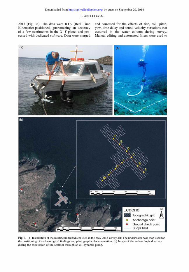
2013 (Fig. 3a). The data were RTK (Real TimeKinematic)-positioned, guaranteeing an accuracyof a few centimetres in the X–Y plane, and pro-cessed with dedicated software. Data were merged
and corrected for the effects of tide, roll, pitch,yaw, time delay and sound velocity variations thatoccurred in the water column during survey.Manual editing and automated filters were used to
Fig. 3. (a) Installation of the multibeam transducer used in the May 2013 survey. (b) The underwater base map used forthe positioning of archaeological findings and photographic documentation. (c) Image of the archaeological surveyduring the excavation of the seafloor through an oil-dynamic pump.
L. ABELLI ET AL.
by guest on September 29, 2014http://sp.lyellcollection.org/Downloaded from
clean noise and spikes in order to obtain very high-resolution digital elevation models (DEMs), withcell sizes varying from a few decimetres at waterdepths of ,50 m to 1 m at depths of 100 m. Atgreater depths, a DEM with a cell size of 5 m wasused; 2006 and 2008 cruises aboard the R/VUrania collected the data at these depths (fordetails see Bosman et al. 2011).
Archaeological surveys began 8 years ago andwere conducted by underwater archaeologists in adepth range of 10–60 m, covering an area ofapproximately 3.5 hectares (Fig. 3b). A series ofcontrol points were fixed on the seabed, along twoperpendicular lines that cross the study area inNW–SE and NE–SW directions. These pointswere positioned through the use of a marker buoy,DGPS (Differential Global Positioning System)and three control points identified through aeropho-togrammetry, providing a georeferenced base mapfor successive underwater operations. The surveyarea was divided into a 20 m square grid, obtainedthrough direct trilateration of vertices and divisibleinto squares of 4 × 4 m and 1 × 1 m. These div-isions allowed for considerable accuracy in iden-tifying the location of the archaeological findings.Each excavation area was delimited by a modularaeronautical aluminium square of 4 × 4 m, withadjustable supports allowing the maintenance ofthe horizontal position despite the irregularities ofthe sea bottom (Fig. 3c). Seafloor excavation wasperformed using an oil-dynamic pump that acti-vates, through high-pressure hoses, another supportpositioned on the seabed (Fig. 3c). This device cre-ates a vortex inside a suction tube, through whichit is possible to remove the sediment and conveyit directly out of the water or into screening bask-ets. Once filled, the latter are retrieved and sievedoutside. Finally, the management of a manualvalve placed on the underwater support allows thediver to either adjust the power of the suction flowor to interrupt it.
In all excavation activities, the most innovativemethods of photographic documentation applied tothe underwater environment (photogrammetry)were used, with recording of spatial data in a geo-graphic information system (GIS) (Agosto 2012b).
Data analysis
Submarine geomorphological setting
of the study area
Morphobathymetric data at Cala Tramontanashow a rough seafloor throughout the bay, withsome lobate structures superficially characterizedby arcuate flow ridges (Fig. 4). The lobate fea-tures represent the penetration into the sea of the
subaerial lava flows of Punta Tracino and PuntaRubasacchi; the rough seafloor of the bay is madeup of a blocky facies caused by rock-fall processesaffecting the subaerial cliff and reworked by waveaction. At Punta Tracino, the lobate features showan evident morphological change at a depth of30–40 m from a rough acoustic facies with arcu-ate ridges to a smoother seafloor (X in Fig. 4). Thecentral part of the bay is characterized by a gentlerand smoother seafloor (sediment-covered), borderedby rocky seafloor at depths ranging between 15 m(internal part) and 65 m (distal part). Some tabular orsemi-circular rough patches rise from the smoothseafloor between water depths of 15 and 30 m,with a relief of 1–1.5 m. Scuba diving investi-gations revealed a sandy and gravelly seafloor corre-sponding to the smooth, central part of the bay,whereas the above-mentioned rough patches corre-spond to seagrass meadows (Fig. 4). In the SE partof Cala Tramontana, a 27 m-long, 6 m-wide and3.5 m-high shipwreck is also present at waterdepths of 20 m (Fig. 4). Three bathymetric profilesorientated perpendicular to the isobaths show anoverall convex slope shape with a slight break atwater depths of approximately 16 m (profiles A, Band C in Fig. 4a, b).
Submarine archeological findings
Archeological surveys recovered 722 lithic artefacts(Agosto 2012a), of which 270 are currently under-going study. These artefacts were largely recoveredduring sieving operations because the suction flowof the pump did not allow for in situ recovery ofsmall archaeological material. The detailed divisionof the seafloor into topographical grid squares,however, enabled evaluation of the position of thelithic material in relation to the reference gridsquares and depths below the seafloor (Fig. 3b).Overall, three main stratigraphic units wereobserved (Fig. 4c). The first occupies the entiretyof the excavation, extending through the first50 cm (US1, 19–19.5 m depth in Fig. 4c) belowthe seafloor. This unit is characterized by sandysediment, and contained fragmented and roundedpottery material, 305 lithic artefacts and somemosaic tiles. Evidence of scratch marks on potterymaterial and flints are occasionally present. Thesecond stratigraphic unit (US2) extends between50 cm and 1 m below US1 (19.5–20 m depth inFig. 4c), and is comprised of sand containingrounded and partially preserved ceramic materialmixed with mosaic tiles and 65 lithic artefacts.The third stratigraphic unit (US3, below 20 mdepth in Fig. 4c) is mainly made up of completeand fractured Punic amphorae (at least nineexamples of T-7.2.1.1.) in a primary position,often supported by seagrass rhizomes. Only seven
A PRE-NEOLITHIC SITE IN PANTELLERIA
by guest on September 29, 2014http://sp.lyellcollection.org/Downloaded from
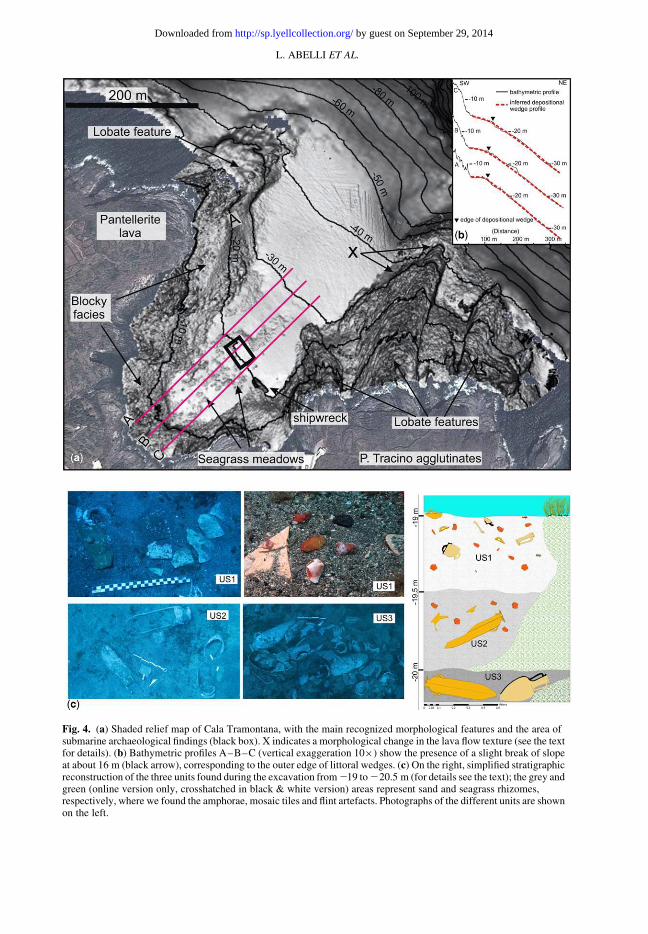
Fig. 4. (a) Shaded relief map of Cala Tramontana, with the main recognized morphological features and the area ofsubmarine archaeological findings (black box). X indicates a morphological change in the lava flow texture (see the textfor details). (b) Bathymetric profiles A–B–C (vertical exaggeration 10×) show the presence of a slight break of slopeat about 16 m (black arrow), corresponding to the outer edge of littoral wedges. (c) On the right, simplified stratigraphicreconstruction of the three units found during the excavation from219 to220.5 m (for details see the text); the grey andgreen (online version only, crosshatched in black & white version) areas represent sand and seagrass rhizomes,respectively, where we found the amphorae, mosaic tiles and flint artefacts. Photographs of the different units are shownon the left.
L. ABELLI ET AL.
by guest on September 29, 2014http://sp.lyellcollection.org/Downloaded from
lithic artefacts were found in this layer, scatteredbetween a few grid squares.
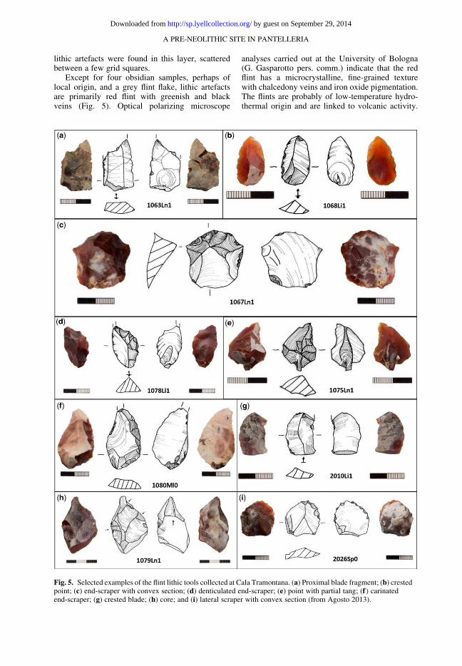
Except for four obsidian samples, perhaps oflocal origin, and a grey flint flake, lithic artefactsare primarily red flint with greenish and blackveins (Fig. 5). Optical polarizing microscope
analyses carried out at the University of Bologna(G. Gasparotto pers. comm.) indicate that the redflint has a microcrystalline, fine-grained texturewith chalcedony veins and iron oxide pigmentation.The flints are probably of low-temperature hydro-thermal origin and are linked to volcanic activity.
Fig. 5. Selected examples of the flint lithic tools collected at Cala Tramontana. (a) Proximal blade fragment; (b) crestedpoint; (c) end-scraper with convex section; (d) denticulated end-scraper; (e) point with partial tang; (f) carinatedend-scraper; (g) crested blade; (h) core; and (i) lateral scraper with convex section (from Agosto 2013).
A PRE-NEOLITHIC SITE IN PANTELLERIA
by guest on September 29, 2014http://sp.lyellcollection.org/Downloaded from
Overall, the flint artefacts suggest a debitage char-acterized by cores and flakes without any spe-cific morphology (Agosto 2013). This low degreeof standardization indicates a simple, highly pro-ductive method of debitage formation that includesknapping of most of the core, no pre-shaping andthe production of flakes with at least one functionaledge. Different lithic tools were also identified: frag-ments of blades, truncations, end-scrapers, pointsand crested blades. Frequently, retouch is direct,continuous and denticulated. Some instances oflithic artefacts without retouch, characterized bysharp edges that suggest their use as tools, alsooccur (Fig. 5).
No flints were found in the subaerial part of thebay, despite the widespread presence of youngerceramics and artefacts in cemented patches at thebase of the cliff.
Discussion
The submarine findings at Cala Tramontana
in the framework of the archeological
studies of Pantelleria
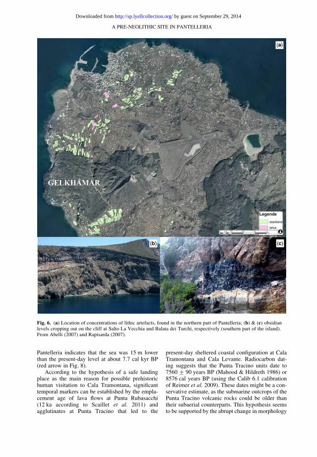
The presence of a lithic industry at Cala Tramontanaat depths of 18–21 m sheds new light on the Island’sprehistory. Until now, terrestrial archaeologicalstudies have not found evidence of human visitationto the island before the Chalcolithic–Bronze Ageapart from a few sites containing some obsidianartefacts. At Punta Fram (Figs 1 & 6), for instance,the lithic industry roughly dates to between theMesolithic and Late Chalcolithic Ages accord-ing to Nicoletti (2012), through a comparison withlithics recognized at other Mediterranean sites. Thedating of this industry is difficult, however, becauseit is in a context without pottery and because there isno other archaeological evidence of this period inPantelleria (Nicoletti 2012). Concentrations of lithicartefacts were mainly found in the northern part ofPantelleria (Fig. 6) (Agosto 2013), an area that ismore suitable for human visitation owing to the pres-ence of a gentle slope down to the sea and a nearbyprimary obsidian source (Gelkhamar; Fig. 6).
Other important obsidian sources, however,were also found in the southern part of the island –such as Balata dei Turchi and Salto la Vecchia,(Fig. 1) – which is difficult to reach by land butnot from the sea. Interestingly, chemical analysisperformed on obsidian artefacts from Pantelleria,Malta and Sicily show that obsidian from Balatadei Turchi was the most frequently used typeof obsidian, together with the pitch-black obsidianof Gelkhamar (Francaviglia 1986; Tykot 1996,2002a; Tykot et al. 2005). As suggested by the dis-covery of Pantelleria obsidian in archaeological
excavations carried out at Skorba (Malta), Pantel-leria has been frequented at least since the end ofthe fifth millennium BC (Evans 1971; Francaviglia& Piperno 1987; Fradkin Anati & Anati 1988;Tykot 1996; Tusa 2012). During the ChalcolithicAge (late fourth millennium BC), Pantelleria obsi-dian also circulated in several sites in North Africa(Camps 1964, 1974; Ammerman et al. 1978) andSicily (Nicoletti 1997), with 40% of cataloguedobsidian sourced to Pantelleria (Tykot 2002b; Rapi-sarda 2007). Moreover, a study by Rapisarda (2007)suggested that the exploitation of Pantelleria obsi-dian could have started earlier than 8.6 kyr ago cor-responding to the eruption of the first obsidian flowsat Lipari (Forni et al. 2013 and references therein).Rapisarda’s hypothesis could explain the discoveryof some lithic artefacts in Sicily that exhibit theoverall characteristics of the Pantelleria obsidianbut do not belong to any of the known obsidianflows on the island. The geomorphological and stra-tigraphic setting of the main Pantelleria obsidiansource at Balata dei Turchi and Salto La Vecchia,made up of stratified horizontal layers of obsidianembedded in a steep cliff created by marine erosion(Fig. 6b, c), led Rapisarda (2007) to hypothesizethe possible occurrence of presently submergedobsidian veins that could have been emerged andexploited during prehistory when the sea levelwas lower than the present day (Lambeck et al.2004, 2011).
The possibility of local visitation to Cala Tra-montana during the Neolithic Period or evenearlier is intriguing, because: (a) this bay, togetherwith the adjacent Cala Levante, could represent asafe landing place on Pantelleria for relativelysmall- and medium-sized boats with respect to thedominant northwesterly and southerly winds, andrelated storms (Fig. 2); and (b) the bay is not farfrom the main obsidian sources located in thesouthern part of the island (Figs 1 & 6). The mainproblem for visitors to the island is the ratherinhospitable present-day coast, with high cliffs andthe lack of a beach creating difficulties for land-ing. Considering that the prehistoric sea level waslower than today, the island’s shores could havebeen more sheltered and suitable for the beachingof boats and human visitation.
Palaeo-landscape reconstructions
The palaeo-landscape at Cala Tramontana waslikely to have been substantially different from thepresent day, possibly enabling the presence of asmall palaeo-beach in the inner part of the baywhen the sea level was 15 m lower (Fig. 7). Takingaccount of eustatic changes corrected for glacio-and hydro-isostatic crustal movements (Lambecket al. 2011), the predicted sea-level curve for
L. ABELLI ET AL.
by guest on September 29, 2014http://sp.lyellcollection.org/Downloaded from
Pantelleria indicates that the sea was 15 m lowerthan the present-day level at about 7.7 cal kyr BP(red arrow in Fig. 8).
According to the hypothesis of a safe landingplace as the main reason for possible prehistorichuman visitation to Cala Tramontana, significanttemporal markers can be established by the empla-cement age of lava flows at Punta Rubasacchi(12 ka according to Scaillet et al. 2011) andagglutinates at Punta Tracino that led to the
present-day sheltered coastal configuration at CalaTramontana and Cala Levante. Radiocarbon dat-ing suggests that the Punta Tracino units date to7560+ 90 years BP (Mahood & Hildreth 1986) or8576 cal years BP (using the Calib 6.1 calibrationof Reimer et al. 2009). These dates might be a con-servative estimate, as the submarine outcrops of thePunta Tracino volcanic rocks could be older thantheir subaerial counterparts. This hypothesis seemsto be supported by the abrupt change in morphology
Fig. 6. (a) Location of concentrations of lithic artefacts, found in the northern part of Pantelleria; (b) & (c) obsidianlevels cropping out on the cliff at Salto La Vecchia and Balata dei Turchi, respectively (southern part of the island).From Abelli (2007) and Rapisarda (2007).
A PRE-NEOLITHIC SITE IN PANTELLERIA
by guest on September 29, 2014http://sp.lyellcollection.org/Downloaded from
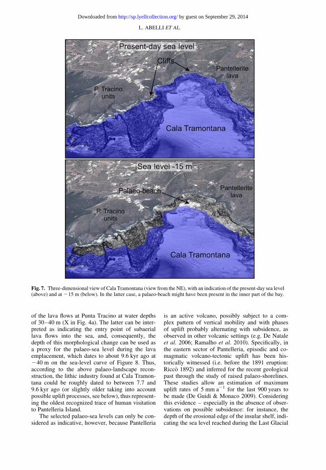
of the lava flows at Punta Tracino at water depthsof 30–40 m (X in Fig. 4a). The latter can be inter-preted as indicating the entry point of subaeriallava flows into the sea, and, consequently, thedepth of this morphological change can be used asa proxy for the palaeo-sea level during the lavaemplacement, which dates to about 9.6 kyr ago at240 m on the sea-level curve of Figure 8. Thus,according to the above palaeo-landscape recon-struction, the lithic industry found at Cala Tramon-tana could be roughly dated to between 7.7 and9.6 kyr ago (or slightly older taking into accountpossible uplift processes, see below), thus represent-ing the oldest recognized trace of human visitationto Pantelleria Island.
The selected palaeo-sea levels can only be con-sidered as indicative, however, because Pantelleria
is an active volcano, possibly subject to a com-plex pattern of vertical mobility and with phasesof uplift probably alternating with subsidence, asobserved in other volcanic settings (e.g. De Nataleet al. 2006; Ramalho et al. 2010). Specifically, inthe eastern sector of Pantelleria, episodic and co-magmatic volcano-tectonic uplift has been his-torically witnessed (i.e. before the 1891 eruption:Ricco 1892) and inferred for the recent geologicalpast through the study of raised palaeo-shorelines.These studies allow an estimation of maximumuplift rates of 5 mm a21 for the last 900 years tobe made (De Guidi & Monaco 2009). Consideringthis evidence – especially in the absence of obser-vations on possible subsidence: for instance, thedepth of the erosional edge of the insular shelf, indi-cating the sea level reached during the Last Glacial
Fig. 7. Three-dimensional view of Cala Tramontana (view from the NE), with an indication of the present-day sea level(above) and at 215 m (below). In the latter case, a palaeo-beach might have been present in the inner part of the bay.
L. ABELLI ET AL.
by guest on September 29, 2014http://sp.lyellcollection.org/Downloaded from
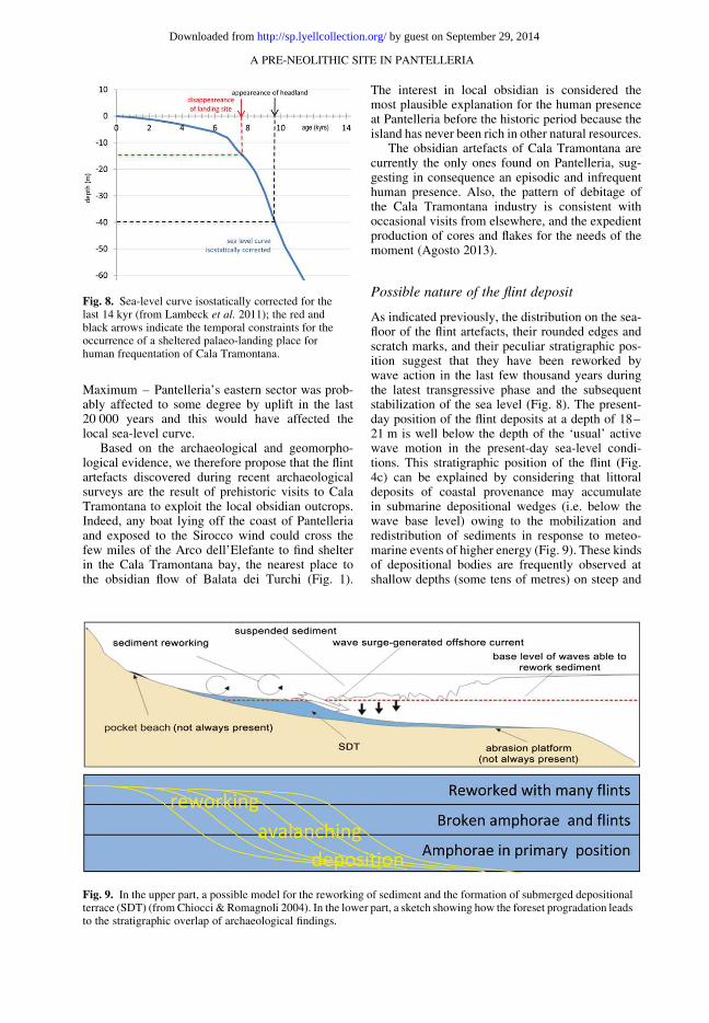
Maximum – Pantelleria’s eastern sector was prob-ably affected to some degree by uplift in the last20 000 years and this would have affected thelocal sea-level curve.
Based on the archaeological and geomorpho-logical evidence, we therefore propose that the flintartefacts discovered during recent archaeologicalsurveys are the result of prehistoric visits to CalaTramontana to exploit the local obsidian outcrops.Indeed, any boat lying off the coast of Pantelleriaand exposed to the Sirocco wind could cross thefew miles of the Arco dell’Elefante to find shelterin the Cala Tramontana bay, the nearest place tothe obsidian flow of Balata dei Turchi (Fig. 1).
The interest in local obsidian is considered themost plausible explanation for the human presenceat Pantelleria before the historic period because theisland has never been rich in other natural resources.
The obsidian artefacts of Cala Tramontana arecurrently the only ones found on Pantelleria, sug-gesting in consequence an episodic and infrequenthuman presence. Also, the pattern of debitage ofthe Cala Tramontana industry is consistent withoccasional visits from elsewhere, and the expedientproduction of cores and flakes for the needs of themoment (Agosto 2013).
Possible nature of the flint deposit
As indicated previously, the distribution on the sea-floor of the flint artefacts, their rounded edges andscratch marks, and their peculiar stratigraphic pos-ition suggest that they have been reworked bywave action in the last few thousand years duringthe latest transgressive phase and the subsequentstabilization of the sea level (Fig. 8). The present-day position of the flint deposits at a depth of 18–21 m is well below the depth of the ‘usual’ activewave motion in the present-day sea-level condi-tions. This stratigraphic position of the flint (Fig.4c) can be explained by considering that littoraldeposits of coastal provenance may accumulatein submarine depositional wedges (i.e. below thewave base level) owing to the mobilization andredistribution of sediments in response to meteo-marine events of higher energy (Fig. 9). These kindsof depositional bodies are frequently observed atshallow depths (some tens of metres) on steep and
Fig. 8. Sea-level curve isostatically corrected for thelast 14 kyr (from Lambeck et al. 2011); the red andblack arrows indicate the temporal constraints for theoccurrence of a sheltered palaeo-landing place forhuman frequentation of Cala Tramontana.
Fig. 9. In the upper part, a possible model for the reworking of sediment and the formation of submerged depositionalterrace (SDT) (fromChiocci & Romagnoli 2004). In the lower part, a sketch showing how the foreset progradation leadsto the stratigraphic overlap of archaeological findings.
A PRE-NEOLITHIC SITE IN PANTELLERIA
by guest on September 29, 2014http://sp.lyellcollection.org/Downloaded from
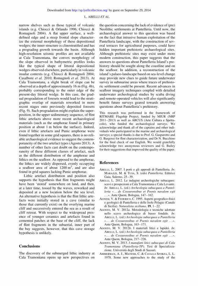
narrow shelves such as those typical of volcanicislands (e.g. Chiocci & Orlando 1996; Chiocci &Romagnoli 2004). A flat upper surface, a well-defined edge and a steep frontal slope character-ize the external morphology of these depositionalwedges; the inner structure is clinostratified and hasa prograding growth towards the basin. Althoughhigh-resolution seismic profiles are not availableat Cala Tramontana, the convex morphology ofthe slope observed in bathymetric profiles lookslike the typical shape of littoral depositionalwedges observed elsewhere, particularly in volcanicinsular contexts (e.g. Chiocci & Romagnoli 2004;Casalbore et al. 2010; Romagnoli et al. 2013). AtCala Tramontana, a slight break of slope can beobserved at a depth of approximately 16 m (Fig. 4b),probably corresponding to the outer edge of thepresent-day littoral wedge. In this case, the grad-ual progradation of foresets would lead to the strati-graphic overlap of materials reworked in morerecent stages onto previously deposited foresets(Fig. 9). Such progradation might explain the super-position, in the upper sedimentary sequence, of flintlithic artefacts above more recent archaeologicalmaterials (such as the amphorae found in primaryposition at about 1 m below the surface). Indeed,even if lithic artefacts and Punic amphorae werefound together in some grid squares, there is no reli-able archaeological evidence to suggest the contem-poraneity of the two artefact types (Agosto 2013). Anumber of other facts cast doubt on the contempo-raneity of these different classes of artefact, suchas the different distribution of the amphorae andlithics on the seafloor. As opposed to the amphorae,the lithics are widely dispersed, evenly occupyinga seafloor area of about 1200 m2, and are alsofound in grid squares lacking Punic amphorae.
Lithic artefact distribution and position alsosupports the hypothesis that flint fragments mighthave been ‘stored’ somewhere on land, and then,at a later time, tossed by the waves, reworked anddeposited at a new location below the sea level.An alternative hypothesis is that the flint lithic arte-facts were initially stored in a cave (similar tothose that currently exist) on the overlying marinecliff and successively entered the sea as a result ofcliff retreat. With respect to the widespread pres-ence of younger ceramics and artefacts found incemented patches at the base of the cliff, the lackof flint fragments in the subaerial, inner part ofthe bay suggests, however, that this cave storagehypothesis is unlikely.
Conclusions
The discovery of the submerged lithic industry atCala Tramontana opens up new perspectives on
the question concerning the lack of evidence of (pre)Neolithic settlements at Pantelleria. Until now, thearchaeological answer to this question was basedon the fact that intrusive human exploitation of thePantelleria landscape, with the construction of sev-eral terraces for agricultural purposes, could havehidden important prehistoric archaeological sites.Although prehistoric sites may exist under moremodern construction, this paper suggests that theanswers to questions about Pantelleria Island’s pre-history should be sought along the coastline and onthe seafloor. In addition, a reconstruction of theisland’s palaeo-landscape based on sea-level changemay provide new clues to guide future underwatersurvey in submarine areas where traces of prehisto-ric settlement could be present. Recent advances inseafloor imagery techniques coupled with detailedunderwater archeological studies by scuba divingand remote-operated vehicles will also significantlybenefit future surveys geared towards answeringquestions about Pantelleria’s prehistory.
This research was performed in the framework ofRITMARE Flagship Project, funded by MIUR (NRP2011–2013) as well as ARCUS (Arte Cultura e Spetta-colo), who funded the archaeological surveys. Weacknowledge and thank all of the captains and other indi-viduals who participated in the marine and archaeologicalsurveys; a special thanks is due to Prof. G. Gasparotto andG. Bargossi for flint characterization, and Dr N. Bucchinofor the final check of our English. We would gratefullyacknowledge two anonymous reviewers and G. Baileyfor their suggestions that improved the quality of the paper.
References
Abelli, L. 2007. I porti e gli approdi di Pantelleria. In:Marazzi, M. & Tusa, S. (eds) Pantelleria. EditriceGaia, Salerno, 25–39.
Abelli, L. 2012. Le indagini archeologiche subacquee:scavi e prospezioni a Cala Tramontana e Cala Levante.In: Abelli, L. (ed.) Archeologia subacquea a Pantel-
leria «. . . de Cossurensibus et Poenis navalem egit
. . .». Ante Quem, Bologna, 147–162.Agnesi, V. & Federico, C. 1995. Aspetti geografico-fisici
e geologici di Pantelleria e delle Isole Pelagie (Canaledi Sicilia). Naturalista siciliano, 19, 1–22.
Agosto, M. V. 2012a. Metodologia e tecniche adottatenello scavo archeologico di basso fondale. In:Abelli, L. (ed.) Archeologia subacquea a Pantelleria
«. . . de Cossurensibus et Poenis navalem egit . . .».Ante Quem, Bologna, 163–171.
Agosto, M. V. 2012b. I materiali litici e lapidei. In:Abelli, L. (ed.) Archeologia subacquea a Pantelleria
«. . . de Cossurensibus et Poenis navalem egit . . .».Ante Quem, Bologna, 217–226.
Agosto, M. V. 2013. I manufatti litici subacquei di CalaTramontana (Pantelleria-TP). Tesi di Specializza-zione. Universita degli Studi di Sassari.
Ammerman, A. J., Matessi, C. & Cavalli Sforza, L. L.1978. Some new approaches to the study of the
L. ABELLI ET AL.
by guest on September 29, 2014http://sp.lyellcollection.org/Downloaded from
obsidian trade in the Mediterranean and adjacent areasin the spatial organization of culture. In: Hodder, I.(ed.) The Spatial Organization of Culture. Universityof Pittsburgh Press, Pittsburgh, PA, 179–196.
Bosman, A., Calarco, M. et al. 2011. Volcanic islands:the tip of large submerged volcanoes that only marinegeology may reveal (examples from W Pontine Archi-pelago, Ischia, Stromboli and Pantelleria). In: Marine
Research at CNR. CNR, Roma, 433–444.Camps, G. 1964. Notes de protohistoire Nord-Africaine.
Libyca, 12, 293–297.Camps, G. 1974. Les Civilisations Prehistorique de
l’Afrique Du Nord et du Sahara. Centre national dela recherche scientifique (CNRS), Paris.
Casalbore, D., Romagnoli, C., Chiocci, F. & Frezza,V. 2010. Morphosedimentary characteristics of thevolcanic apron around Stromboli volcano. Marine
Geology, 269, 132–148.Cavallari, S. 1874. Corografia di Cossura e della sua
necropoli, Corografiaa di un castello ciclopico eparticolari dei Sesi di Pantelleria. Bullettino della
Commissione di Antichita e Belle Arti di Sicilia, 7,23–32.
Chiocci, F. L. &Orlando, L. 1996. Lowstand terraces onTyrrhenian Sea steep continental slopes. Marine
Geology, 134, 127–143.Chiocci, F. L. & Romagnoli, C. 2004. Terrazzi deposi-
zionali sommersi nelle Isole Eolie. Memorie Descrit-
tive della Carta Geologica d’Italia, 58, 81–114.Civetta, L., Cornette, Y., Crisci, G., Gillot, P. Y.,
Orsi, G. & Requejos, C. S. 1984. Geology, geochro-nology and chemical evolution of the island of Pantel-leria. Geological Magazine, 121, 541–668.
De Guidi, G. &Monaco, C. 2009. Late Holocene verticaldeformation along the coast of Pantelleria Island(Sicily Channel, Italy). In: Catto, N. R., Yim, W.W.-S., Antonioli, F. & Yokoyama, Y. (eds) Conti-nental Shelves: Sea Levels and Environments Contri-
butions from 17th INQUA Congress, Cairns; INQUA
Commission on Coastal and Marine Processes, and
International Geoscience Programme Project 526.
Quaternary International, 206, 158–165, http://dx.doi.org/10.1016/j.quaint.2008.08.002
DeNatale, G., Troise, C., Pingue, F.,Mastrolorenzo,G., Pappalardo, L. & Boschi, E. 2006. The CampiFlegrei caldera: unrest mechanisms and hazards. In:Troise, C., De Natale, G. & Kilburn, C. R. J.(eds) Mechanisms of Activity and Unrest at Large
Calderas. Geological Society, London, Special Publi-cations, 269, 25–45.
Evans, J. D. 1971. The Prehistoric Antiquities of the
Maltese Islands. Athlone Press, London.Forni, F., Lucchi, F., Peccerillo, A., Tranne, C. A.,
Rossi, P. L. & Frezzotti, M. L. 2013. Stratigraphyand geological evolution of the Lipari volcaniccomplex (central Aeolian archipelago). In: Lucchi,F., Peccerillo, A., Keller, J., Tranne, C. A. &Rossi, P. L. (eds) Geology of the Aeolian Islands
(Italy). Geological Society, London, Memoirs, 37,213–279.
Fradkin Anati, A. & Anati, E. 1988.Missione a Malta:
ricerche e studi sulla preistoria dell’arcipelago
maltese nel contesto mediterraneo. Editoriale Jaca,Milano.
Francaviglia, V. 1986. Characterization of Mediterra-nean obsidian sources by classical petrochemicalmethods. Preistoria Alpina, 20, 311–332.
Francaviglia, V. & Piperno, M. 1987. La repartition etla provenance de l’obsidienne archeologique de laGrotta dell’Uzzo et de Monte Cofano (Sicile). Revued’Archeometrie, 11, 31–39.
Lambeck, K., Antonioli, F., Purcell, A. & Silenzi, S.2004. Sea level change along the Italian coast for thepast 10 000 yrs. Quaternary Science Reviews, 23,1567–1598.
Lambeck, K., Antonioli, F., Anzidei, M., Ferranti, L.,Leoni, G., Scicchitano, G. & Silenzi, S. 2011. Sealevel change along the Italian coast during the Holo-cene and a projection for the future. In: Antonioli,F., Faivre, S., Ferranti, L. & Monaco, C. (eds)Tectonic Contribution to Relative Sea Level Change.Quaternary International, 232, 250–257.
Mahood, G. A. & Hildreth, W. 1986. Geology ofthe peralkaline volcano at Pantelleria, Strait of Sicily.Bulletin of Vulcanology, 48, 143–172.
Nicoletti, F. 1997. Il commercio preistorico dell’ossidi-ana e il ruolo di Lipari e Pantelleria nel piu anticosistema di scambio. In: Tusa, S. (ed.) Prima Sicilia.
Alle origini della societa siciliana. Albergo dei
Poveri, Palermo, 18 Ottobre–22 Dicembre. Ediprint,Palermo, 258–270.
Nicoletti, F. 2012. L’industria litica di Punta Fram.Una nuova facies preistorica a Pantelleria. In: Dai
ciclopi agli ecisti. Societa e territorio nella Sicilia pre-
istorica e protostorica. Atti della XLI Riunione Scien-
tifica, San Cipirello (PA), 16–19 Novembre 2006.Istituo Italiano di Preistoria e Protostoria, Firenze,557–568.
Orsi, P. 1899. Relazione in merito alla missione archeolo-gica nell’isola di Pantelleria, anno 1894/95. Monu-menti Antichi dei Lincei, 9, coll. 450/540.
Radi, G. 1972. Tracce di un insediamento neolitico nell’i-sola di Lampedusa. Atti della Societa Toscana di
Scienze Naturali, Memorie, Serie A, 79, 197–205.Ramalho, R. S., Helffrich, G., Cosca, M., Vance, D.,
Hoffmann, D. & Schmidt, D. N. 2010. Verticalmovements of ocean island volcanoes: insights froma stationary plate environment. Marine Geology, 275,84–95.
Rapisarda, M. 2007. L’eta dell’ossidiana di Pantel-leria. Atti dell’Accademia Peloritana dei PericolantiClasse di Scienze Fisiche. Matematiche e Naturali,LXXXV, 1–21.
Reimer, P. J., Baillie, M. G. L. et al. 2009. IntCal09 andMarine09 radiocarbon age calibration curves, 0–50 000 years cal BP. Radiocarbon, 51, 1111–1150.
Ricco, A. 1892. Terremoti, sollevamento ed eruzione sot-tomarina a Pantelleria nella seconda meta dell’ottobre1891. Annali Ufficio Centrale Meteorologico e Geodi-
namico Italiano, Ser. II, XIV, 1–31.Romagnoli, C., Casalbore, D., Bosman, A., Braga, R.
& Chiocci, F. L. 2013. Submarine structure ofVulcano volcano (Aeolian Islands) revealed by high-resolution bathymetry and seismo-acoustic data.Marine Geology, 338, 30–45.
Rotolo, S. G., Scaillet, S., La Felice, S. &Vita-Scaillet, G. 2013. A revision of the structureand stratigraphy of pre-Green Tuff ignimbrites at
A PRE-NEOLITHIC SITE IN PANTELLERIA
by guest on September 29, 2014http://sp.lyellcollection.org/Downloaded from
Pantelleria (Strait of Sicily). Journal of Volcanologyand Geothermal Research, 250, 61–74.
Scaillet, S., Rotolo, S. G., La Felice, S. &Vita-Scaillet, G. 2011. High-resolution 40Ar/39Archronostratigraphy of the post-caldera (,20 ka) volca-nic activity at Pantelleria, Sicily Strait. Earth and Pla-netary Science Letters, 309, 280–290.
Stevenson, R. J. & Wilson, L. 1997. Physical volcanol-ogy and eruption dynamics of peralkaline agglutinatesfrom Pantelleria. Journal of Volcanology and Geother-mal Research, 79, 97–122.
Tusa, S. 2012. Vent’anni di ricerche archeologiche traterra e mare nell’isola di Pantelleria. In: Abelli, L.(ed.)Archeologia subacquea a Pantelleria «. . . de Cos-surensibus et Poenis navalem egit . . .». Ante Quem,Bologna, 15–40.
Tykot, R. H. 1996. Obsidian procurement and distributionin the central and western Mediterranean. Journal ofMediterranean Archaeology, 9, 39–82.
Tykot, R. H. 2002a. Geochemical analysis of obsidian andthe reconstruction of trade mechanisms in the EarlyNeolithic period of the Western Mediterranean.In: Jakes, K. A. (ed.) Archaeological Chemistry.
Materials, Methods and Meaning. ACS SymposiumSeries, 831, American Chemical Society, Washington,DC, 169–184.
Tykot, R. H. 2002b. Chemical fingerprinting and sourcetracing of obsidian: the central Mediterranean tradein black gold. Accounts of Chemical Research, 35,618–627.
Tykot, R. H., Setzer, T.,Glascock, M. D. & Speakman,R. J. 2005. Identification and characterization of theobsidian sources on the Island of Palmarola, Italy.Geoarchaeological and Bioarchaeological Studies, 3,107–111.
Tykot, R. H., Iovino, M. R., Martinelli, M. C. &Beyer, L. 2006. Ossidiana da Lipari: le fonti, la distri-buzione, la tipologia e le tracce d’usura. In: Atti delXXXIX Riunione Scientifica dell’Istituto Italiano di
Preistoria e Protostoria: Materie prime e scambi
nella preistoria italiana, Firenze, 25–27 November
2004. Istituo Italiano di Preistoria e Protostoria,Firenze, 592–597.
Washington, H. S. 1909. The submarine eruption of 1831and 1891 near Pantelleria. American Journal of
Science, 27, 131–150.
L. ABELLI ET AL.
by guest on September 29, 2014http://sp.lyellcollection.org/Downloaded from