The precipitation products generation chain for the EUMETSAT Hydrological Satellite Application...
12
The precipitation products generation chain for the EUMETSAT Hydrological Satellite Application Facility at C.N.M.C.A. Francesco Zauli a , Daniele Biron a , Davide Melfi a . a Centro Nazionale di Meteorologia e Climatologia Aeronautica, Via Pratica di Mare, 45 00040, Pomezia (RM), Italy. ABSTRACT The EUMETSAT Satellite Application Facility in support to Hydrology (H-SAF) focuses on development of new geophysical products on precipitation, soil moisture and snow parameters and the utilisation of these parameters in hydrological models, NWP models and water management. The development phase of the H-SAF started in September 2005 under the leadership of Italian Meteorological Service. The “Centro Nazionale di Meteorologia e Climatologia Aeronautica (C.N.M.C.A.)”, the Italian National Weather Centre, that physically hosts the generation chain of precipitation products, carried on activities to reach the final target: development of algorithms, validation of results, implementation of operative procedure to supply the service and to monitor the service performances. The paper shows the architectural status of the H-SAF precipitation group and stress the component of operations. It is shown the full correspondence with the EUMETSAT approved H-SAF documents, in particular the Algorithm Theoretical Design Document (ATDD), where products characteristics are referenced. Are also reported the first results, produced during the first H-SAF Workshop, held in Rome in October 2007, of validation activities performed on version 1 products, and last results of products distribution to beta-users in preparation of distributing version 2. Keywords: hydrology, satellite application facility, hydrological validation, precipitation retrieval, remote sensing, water management. 1. INTRODUCTION EUMETSAT [1], European Agency for the Exploitation of Meteorological Satellites, Darmstadt (D), utilizing specialist expertise from the Member States, established during ’90 Satellite Application Facilities (SAF), dedicated centers of excellence for processing satellite data and form an integral part of the distributed EUMETSAT Application Ground Segment [2]. Each SAF is led by the National Meteorological Service (NMS) of a EUMETSAT Member State in association with a consortium of EUMETSAT Member States and Cooperating States, government bodies and research institutes. The lead NMS is responsible for the management of each complete SAF project. The research, data and services provided by the SAFs complement the standard meteorological products delivered by EUMETSAT’s central facilities in Darmstadt. Fig. 1. EUMETSAT Satellite Application Facilities.
-
Upload
independent -
Category
Documents
-
view
5 -
download
0
Transcript of The precipitation products generation chain for the EUMETSAT Hydrological Satellite Application...

The precipitation products generation chain for the EUMETSAT Hydrological Satellite Application Facility at C.N.M.C.A.
Francesco Zaulia, Daniele Birona, Davide Melfia.
a Centro Nazionale di Meteorologia e Climatologia Aeronautica, Via Pratica di Mare, 45 00040,
Pomezia (RM), Italy.
ABSTRACT
The EUMETSAT Satellite Application Facility in support to Hydrology (H-SAF) focuses on development of new geophysical products on precipitation, soil moisture and snow parameters and the utilisation of these parameters in hydrological models, NWP models and water management. The development phase of the H-SAF started in September 2005 under the leadership of Italian Meteorological Service. The “Centro Nazionale di Meteorologia e Climatologia Aeronautica (C.N.M.C.A.)”, the Italian National Weather Centre, that physically hosts the generation chain of precipitation products, carried on activities to reach the final target: development of algorithms, validation of results, implementation of operative procedure to supply the service and to monitor the service performances. The paper shows the architectural status of the H-SAF precipitation group and stress the component of operations. It is shown the full correspondence with the EUMETSAT approved H-SAF documents, in particular the Algorithm Theoretical Design Document (ATDD), where products characteristics are referenced. Are also reported the first results, produced during the first H-SAF Workshop, held in Rome in October 2007, of validation activities performed on version 1 products, and last results of products distribution to beta-users in preparation of distributing version 2.
Keywords: hydrology, satellite application facility, hydrological validation, precipitation retrieval, remote sensing, water management.
1. INTRODUCTION EUMETSAT [1], European Agency for the Exploitation of Meteorological Satellites, Darmstadt (D), utilizing specialist expertise from the Member States, established during ’90 Satellite Application Facilities (SAF), dedicated centers of excellence for processing satellite data and form an integral part of the distributed EUMETSAT Application Ground Segment [2].
Each SAF is led by the National Meteorological Service (NMS) of a EUMETSAT Member State in association with a consortium of EUMETSAT Member States and Cooperating States, government bodies and research institutes. The lead NMS is responsible for the management of each complete SAF project. The research, data and services provided by the SAFs complement the standard meteorological products delivered by EUMETSAT’s central facilities in Darmstadt.
Fig. 1. EUMETSAT Satellite Application Facilities.

EUMETSAT supervises and coordinates the overall activities of the SAF network and the integration of the SAFs into the various operations within the EUMETSAT Application Ground Segment. It manages and coordinates interfaces among SAFs themselves and between SAFs and other EUMETSAT systems, overseeing the integration of SAFs into the overall ground segment infrastructure. By overseeing the entire network of SAFs, EUMETSAT ensures that services are delivered in the most reliable and cost-effective way.
In September 2005 EUMETSAT started development phase (2005-2010) of the “Satellite Application Facility on support to Operational Hydrology and Water Management (H-SAF)”. H-SAF objective is the development of an infrastructure that bring research into operation, in particular in the field of remote sensing the atmosphere, observing its parameters from space. It focuses on the operative implementation of new geophysical products on precipitation, soil moisture and snow parameters and the utilisation of these parameters in hydrological models, numerical weather prediction (NWP) models and water management applications.
Table. 1. Composition of H-SAF Consortium.
The leadership of H-SAF Consortium is duty of Italian Meteorological Service and the “Centro Nazionale di Meteorologia e Climatologia Aeronautica (C.N.M.C.A.)”, the Italian National Weather Centre [3], physically hosts the generation chain of precipitation products, managing also activities as development of algorithms, validation of results, implementation of operative procedure to supply the service in redundancy and to monitor the service performances. In Table 1 the composition of H-SAF Consortium.
Fig. 2. Centro Nazionale di Meteorologia e Climatologia Aeronautica, Pratica di Mare, Italy.
The overall architecture of H-SAF is based on several data production centres in: Italy, Austria, Finland, Turkey and the European Centre for Medium-range Weather Forecasts (ECMWF) [4], Reading (UK), that collect meteorological and environmental satellites, both operative and from the research, via direct read-out or retransmission services, as

EUMETCast (EUMETSAT Satellite Broadcast) or Internet, and process it. It will be shown the architectural status of the H-SAF precipitation group, in Italy, describing components of operations, and first conclusions on results, as produced during the first H-SAF Workshop, held in Rome in October 2007.
2. H-SAF PRECIPITATION PRODUCTS 2.1 H-SAF products overview.
The main objectives of H-SAF are:
• to provide new satellite-derived products from existing and future satellites with sufficient time and space resolution to satisfy the needs of operational hydrology; identified products are:
a. precipitation (liquid, solid, rate, accumulated), products requirements are summarized in Table 2 and in Table 3, for the backup production;
b. soil moisture (at large-scale, at local-scale, at surface, in the roots region), products requirements are summarized in Table 4;
c. snow parameters (detection, cover, melting conditions, water equivalent), products requirements are summarized in Table 5;
• to perform independent validation of the usefulness of the new products for fighting against floods, landslides, avalanches, and evaluating water resources; the activity includes:
1. downscaling/upscaling modelling from observed/predicted fields to basin level;
2. fusion of satellite-derived measurements with data from radar and raingauge networks;
3. assimilation of satellite-derived products in hydrological models;
4. assessment of the impact of the new satellite-derived products on hydrological applications.
Table. 2. Requirements of H-SAF precipitation products and data sources, operative chain established in Italy.
Table. 3. Backup H-SAF products generated by NWP model, in Italy.
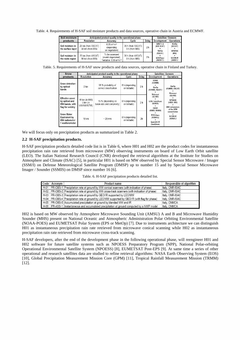
Table. 4. Requirements of H-SAF soil moisture products and data sources, operative chain in Austria and ECMWF.
Table. 5. Requirements of H-SAF snow products and data sources, operative chain in Finland and Turkey.
We will focus only on precipitation products as summarized in Table 2.
2.2 H-SAF precipitation products.
H-SAF precipitation products detailed code list is in Table 6, where H01 and H02 are the product codes for instantaneous precipitation rain rate retrieved from microwave (MW) observing instruments on board of Low Earth Orbit satellite (LEO). The Italian National Research Council (CNR) developed the retrieval algorithms at the Institute for Studies on Atmosphere and Climate (ISAC) [5], in particular H01 is based on MW observed by Special Sensor Microwave / Imager (SSM/I) on Defense Meteorological Satellite Program (DMSP) up to number 15 and by Special Sensor Microwave Imager / Sounder (SSMIS) on DMSP since number 16 [6].
Table. 6. H-SAF precipitation products detailed list.
H02 is based on MW observed by Atmosphere Microwave Sounding Unit (AMSU) A and B and Microwave Humidity Sounder (MHS) present on National Oceanic and Atmospheric Administration Polar Orbiting Environmental Satellite (NOAA-POES) and EUMETSAT Polar System (EPS or MetOp) [7]. Due to instruments architecture we can distinguish H01 as instantaneous precipitation rain rate retrieved from microwave conical scanning while H02 as instantaneous precipitation rain rate retrieved from microwave cross-track scanning.
H-SAF developers, after the end of the development phase in the following operational phase, will reengineer H01 and H02 software for future satellite systems such as NPOESS Preparatory Program (NPP), National Polar-orbiting Operational Environmental Satellite System (NPOESS) [8], EUMETSAT Post-EPS [9]. At same time a series of other operational and research satellites data are studied to refine retrieval algorithms: NASA Earth Observing System (EOS) [10], Global Precipitation Measurement Mission Core (GPM) [11], Tropical Rainfall Measurement Mission (TRMM) [12].

Fig. 3. Instantaneous precipitation rain rate retrieved from microwave (MW) observation, H01 left conical scan instrument,
H02 right cross-track scanning.
H03 and H04 are product codes for instantaneous precipitation rain rate retrieved from blending information produced by microwave (MW) observation, as for H01 and H02, and infrared (IR) observing instruments, the Spinning Enhanced Visible and Infra-Red Imager (SEVIRI) on EUMETSAT Meteosat Second Generation (MSG) satellites [13], on Geostationary Orbit (GEO). The two products, H03 and H04, are designed to provide time continuity and even spatial coverage to the relatively infrequent precipitation observation of LEO instruments processing and calibrating IR observation (frequent over all Earth disk) from GEO platform. H03 calibrate directly by rapid update technique IR images computing lookup table of precipitation based on time-space coincident GEO and LEO information, while H04 generates synthetic LEO-MW observations by morphing technique at different time and space respect real observation exploiting the scene description embedded in GEO-IR images; this product is still under development at CNR-ISAC and first usable product version will be in distribution to users during second version release of other precipitation products.

Fig. 4. Instantaneous H03 precipitation rain rate retrieval from blending of LEO-MW and GEO-IR observation.
H05 consists of accumulation of instantaneous precipitation rain rates from H03 or H04; these two products provide time continuity and even spatial coverage of rain rate estimation. Cumulating instantaneous information, with appropriate algorithm, that could eventually smooth or enhance totals, is performed by assuming constant in the sampling interval the H03 and H04 retrieved value at that time. Junction from preceding to subsequent value is performed by averaging and weighing values to avoid unexpected spikes.
Control of H05 product respect climatological thresholds and raingauge adjustment is performed online in the generating chain; C.N.M.C.A. is the italian Regional Telecommunication Hub (RTH) of World Meteorological Organization (WMO) [14], so global synoptical messages transit in real time at C.N.M.C.A. and H05 generating chain selects a subsets of bulletins to control the generated accumulated precipitation at ground. In case of discrepancies chain software corrects biases or errors. Moreover H05 generation chain performs control on the presence of H03 or H04 products, if something is missing it generates synthetic values to avoid under estimation.
In this way every three hours H05 compute accumulated precipitation at ground in the last 3, 6, 12, 24 hours over all H-SAF scene: 25°W to 45°E and 25°N to 75°N.

Fig. 5. Accumulated H05 precipitation at ground, in the preceding 24 hours, from cumulating H03 and H04 products.
H06 consists of instantaneous precipitation rain rate and accumulated precipitation at ground generated by Numerical Weather Prediction (NWP) model, with the intention of providing spatial and temporal continuity of observed fields to the hydrological community. NWP model is the mesoscale Consortium for Small-scale Modeling over Mediterranean Area (COSMO-ME), a non-hydrostatic regional model operational at C.N.M.C.A. [15]. The COSMO-ME domain covers most of Europe and has a 7 km horizontal grid spacing and 40 vertical levels with a top at about 22 km. COSMO-ME integration is driven by Integrated Forecast System (IFS) boundary conditions and initialised by analysis fields interpolated from the C.N.M.C.A. variational data assimilation system. Some adaptation to COSMO-ME setup will be performed to comply with H-SAF requirements, as enlargement of the integration domain and elevation of the top model layer.
H-SAF products are developed gradually with several release that may be summarized in 1°, 2° and Final, as in Table 7 corresponding year 2008, 2009, 2010.
Table. 7. H-SAF release schedule.

3. ARCHITECTURE OF PRECIPITATION PRODUCTS GENERATING CHAIN 3.1 Reception of satellite data.
Fig. 6. Architecture of precipitation products generating chain.
Reception of satellite data connected to H-SAF precipitation products generation, is based on several systems:
1. Direct Read-out, with fixed (Meteosat) or tracking (NOAA-POES and EPS MetOp) L-band antenna.
2. EUMETCast, the EUMETSAT Satellite Broadcasting system, based on commercial satellite, Ku-band [16].
3. File Transfer Protocol (FTP) over the Internet, for receiving DMSP data from UK Met Office, Exeter.
Following the diagram of the architecture of precipitation products generating chain (H01), in Figure 5, it has to be underlined that DMSP data are not received with Direct Read-out, these satellites dump SSM/I and SSMIS data at S-band frequency of transmission, a receiving capability not present at C.N.M.C.A. This Institute planned, in the past years at the beginning of H-SAF development phase (2005) directly the installation of a twin tracking antenna system, partly already installed and functioning, each one with reception capability of L and X band. It is consolidated that future systems, as NPP, NPOESS, Post-EPS, will transmit data to Direct Read-out users at X frequency, a band already used by current generation of satellite for the complete orbit dump at pole’s station. S-band frequency will be gradually abandoned while having redundant X-band reception capability permits to receive other satellites from now on, for example NASA-EOS system. For this reason DMSP, that will gradually disappear from 2014, data level L1C (calibrated and geo-referenced) are received via FTP from UK Met Office, Exeter, that re-launch global orbit data produced by NOAA, while in 2010 NPP will start to transmit to Direct Read-out users.
Data from NOAA-POES and EUMETSAT-EPS are received both via Direct Read-out and EUMETCast. For the first way over C.N.M.C.A. roof is present a 2.7 meters tracking antenna with dual feed for L and X-band reception. From reception we generate L1C data of AMSU A and B and MHS instruments with ATOVS and AVHRR Preprocessing Package (AAPP), developed by NWP SAF [17]. These data are passed to routines developed from ISAC-CNR for computing instantaneous rain rate at ground from MW brightness temperatures. By means of EUMETCast system (2 Ku antenna plus dedicated workstation), EUMETSAT re-launch acquisitions of NOAA-POES and EUMETSAT-EPS data acquired from several station in the northern hemisphere: the EUMETSAT Advanced Retransmission Service (Figure 6). In this way H02 is produced over all H-SAF domain, instead of only with data downloaded from satellites passing in the range of view of C.N.M.C.A.

Fig. 7. EUMETSAT Advanced Retransmission Service stations.
SEVIRI data from EUMETSAT Meteosat satellite series are received at C.N.M.C.A. by Direct Read-out, and EUMETCast. For Meteosat Direct Read-out there is a 3.7 meters connected to double receiver line, for acquisition of Low Resolution Image Transmission (LRIT) MSG data, while EUMETCast is based on a double Digital Video Broadcasting system (DVB) for acquisition of High Resolution Image Transmission (HRIT) MSG data. H03 and H04 requirements are fulfilled by both type of MSG reception, but normally we maintain HRIT as primary and LRIT as secondary.
3.2 Operational environment.
H-SAF precipitation products generating chains are installed in a twin servers systems: HP ProLiant DL585, 4 Dual-Core Opteron 865 1.8 GHz and 12 GB of DDR SRAM. Server names are SIBILLA and CASSANDRA where run product code 1 to 5 generating chains. H06 production belongs to the same system that runs COSMO, a 192 processor dedicated LINUX cluster. Chain tasks are monitored, 24 hour a day, 7 days a week, by human operator at workstations, ENKIDU and GILGAMESH, COMPAQ DS10, which run Supervisor Monitor Scheduler (SMS) [18], the controlling and application launching system developed at the European Centre for Medium-Range Weather Forecasts (ECMWF), Reading (UK).
Polar satellite signals received in Direct Read-out are replicated in two reception lines, for redundancy, managed by servers DELL PowerEdge 2800 ERCOLE and ATLANTE, 2 Dual-Core Xeon 2.8 GHz 4 GB of DDR SRAM, while LRIT Meteosat data are acquired in the APDM system, a cluster of two HP ES40, 4 Alpha processor 833 MHz, 8 GB of RAM. With 4 DVB EUMETCast stations are managed for the acquisition of EARS data and HRIT Meteosat data, with full redundancy to overcome any possible failure. All recent data are stored in 8 TB RAID 1 library, EFESO, than transferred to a DLT IV Tape Robot for final archive.
The architecture permits reprocess of historical archived data in a parallel off-line installation of software in the system. Due to full redundancy the parallel processing chain, not involved in the on-line production to the users, may be used for reprocess historical data with a new software version, allowing the comparison of results to evaluate performances and improvements of new releases or reconstruct products database elements in case something failed.

Fig. 8. H-SAF architecture and data flow lines.

3.3 First H-SAF Workshop.
The 1st H-SAF Workshop was organised by the Italian Meteorological Service as “H-SAF Host”, the Italian Department of Civil Defence (DPC) as partner of the Met Service for H-SAF coordination, and EUMETSAT. The event took place in Rome, on 16-18 October 2007, and was attended by 80 people from 11 of the 12 members of the H-SAF Consortium, plus EUMETSAT, keynote speakers from USA, LSA-SAF [19] and NWP-SAF while CLM-SAF [20] and the International Precipitation Working Group [21] were represented by other attendees.
The objective of the Workshop was: to assess the status of development of data acquisition and processing chains to generate the H-SAF products; to assess the readiness of a consistent number of products to be distributed as Version-1; to enable extensive validation and build-up the hydrological validation programme. The workshop programme was articulated in four session, with keynote speakers from major research institutes of USA:
1. Session 1: status of preparation of precipitation products;
2. Session 2: status of preparation of soil moisture products;
3. Session 3: status of preparation of snow products;
4. Session 4: the hydrological validation plan.
The Workshop was concluded by discussions in four panels, one each session, to collect advices on the maturity of the products candidate for Version-1 release and to identify outstanding issues to be focused on. The results of the Workshop had a significant role in the Critical Design Review (CDR), 17-18 December 2007, that finally reconsidered H-SAF infrastructure and its readiness for Version-1 distribution. The panel on precipitation was chaired by Luigi De Leonibus on behalf of Massimo Capaldo, head of the Italian Meteorological Service, and Eric A. Smith, from NASA Goddard Space and Flight Centre, Greenbelt, MD. It was noted that, of the 6 precipitation products present in H-SAF engineering documents, 5 are ready or nearly-ready for regular distribution:
1. PR-OBS-1 - Precipitation rate at ground by MW conical scanners (with indication of phase);
2. PR-OBS-2 - Precipitation rate at ground by MW cross-track scanners (with indication of phase);
3. PR-OBS-3 - Precipitation rate at ground by GEO/IR supported by LEO/MW;
4. PR-OBS-5 - Accumulated precipitation at ground by MW+IR and MW only;
5. PR-ASS-1 - Instantaneous and accumulated precipitation at ground computed by a NWP model.
Whereas PR-OBS-4 - Precipitation rate at ground by LEO/MW supported by GEO/IR (with flag for phase) was targeted for Version-2 product release. The panel noted several non-compliance issues as the delay of availability of PROBS-1, approximately two hours due to late availability of SSM/I and SSMIS data currently collected via the UK Met Office. Since this product will eventually drive the calibration of the other satellite products and it is important to seek a mechanism to reduce data latency period.
There was also the discussion if it is appropriate to distribute, on a general basis, products that have not yet been sufficiently validated and/or lack preliminary error characterization, as in the moments of the Workshop, or to simply delay general product distribution until baseline validations and a preliminary error characterization have been completed. The agreed approach was to limit the access to Version-1 products to users internal to the H-SAF project or, for possible external ones, to make selection on a case-by-case basis.
The following Table 8 provides an overview of the situation of precipitation products readiness for Version-1 release at the nominal date of 1st January 2008.

Table. 8. H-SAF precipitation products readiness for Version-1.
4. CONCLUSIONS The EUMETSAT Satellite Application Facility in support to Hydrology (H-SAF) focuses on development of new geophysical products on precipitation, soil moisture and snow parameters and the utilisation of these parameters in hydrological models, NWP models and water management. The development phase of the H-SAF started in September 2005 under the leadership of Italian Meteorological Service that, through the work carried on at C.N.M.C.A., built the part dedicated to precipitation retrieval, establishing production chain from data reception to distribution to final users.
The paper shows that C.N.M.C.A., the Italian National Weather Centre, that physically hosts the generation chain of precipitation products, carried on activities to reach Version-1 readiness through algorithms development, implementation of operative procedure, validation of first results. It is shown the architecture of the H-SAF precipitation group, with the full correspondence with the EUMETSAT approved H-SAF documents, presenting conclusions from the first H-SAF Workshop, held in Rome in October 2007, that gave green light to the starting in distribution of Version-1 precipitation products at the date of 1st January 2008.
REFERENCES
[1] http://www.eumetsat.int/ [2] http://www.eumetsat.int/Home/Main/What_We_Do/SAFs/index.htm?l=en [3] http://www.meteoam.it/ [4] http://www.ecmwf.int/ [5] http://www.isac.cnr.it/ [6] http://www.ngdc.noaa.gov/dmsp/ [7] http://www.eumetsat.int/Home/Main/What_We_Do/Satellites/EUMETSAT_Polar_System/index.htm?l=en [8] http://eic.ipo.noaa.gov/ [9] http://www.eumetsat.int/home/Main/What_We_Do/Satellites/Future_Satellites/Post-EPS/index.htm [10] http://earthobservatory.nasa.gov/ [11] http://gpm.gsfc.nasa.gov/ [12] http://trmm.gsfc.nasa.gov/ [13] http://www.eumetsat.int/HOME/Main/What_We_Do/Satellites/Meteosat_Second_Generation/index.htm [14] http://www.wmo.ch/pages/prog/www/TEM/GTS/gts.html [15] http://www.cosmo-model.org/ [16] http://www.eumetsat.int/HOME/Main/What_We_Do/EUMETCast/index.htm [17] http://www.metoffice.gov.uk/research/interproj/nwpsaf/index.html [18] http://www.ecmwf.int/products/data/software/sms.html [19] http://landsaf.meteo.pt/ [20] http://www.dwd.de/bvbw/appmanager/bvbw/dwdwwwDesktop?_nfpb=true&_pageLabel=_dwdwww_klima_umwelt_datenzentr
en_cmsaf [21] http://www.isac.cnr.it/~ipwg/