
The impact of urban pattern on claiming ‘place’: case studies from Istanbul
15
Full Terms & Conditions of access and use can be found at http://www.tandfonline.com/action/journalInformation?journalCode=tjue20 Download by: [Ayşen Ciravoğlu] Date: 07 October 2015, At: 06:44 International Journal of Urban Sustainable Development ISSN: 1946-3138 (Print) 1946-3146 (Online) Journal homepage: http://www.tandfonline.com/loi/tjue20 The impact of urban pattern on claiming ‘place’: case studies from Istanbul Ayşen Ciravoğlu To cite this article: Ayşen Ciravoğlu (2015) The impact of urban pattern on claiming ‘place’: case studies from Istanbul, International Journal of Urban Sustainable Development, 7:1, 1-14, DOI: 10.1080/19463138.2014.953535 To link to this article: http://dx.doi.org/10.1080/19463138.2014.953535 Published online: 09 Sep 2014. Submit your article to this journal Article views: 127 View related articles View Crossmark data
Transcript of The impact of urban pattern on claiming ‘place’: case studies from Istanbul

Full Terms & Conditions of access and use can be found athttp://www.tandfonline.com/action/journalInformation?journalCode=tjue20
Download by: [Ayşen Ciravoğlu] Date: 07 October 2015, At: 06:44
International Journal of Urban Sustainable Development
ISSN: 1946-3138 (Print) 1946-3146 (Online) Journal homepage: http://www.tandfonline.com/loi/tjue20
The impact of urban pattern on claiming ‘place’:case studies from Istanbul
Ayşen Ciravoğlu
To cite this article: Ayşen Ciravoğlu (2015) The impact of urban pattern on claiming ‘place’:case studies from Istanbul, International Journal of Urban Sustainable Development, 7:1, 1-14,DOI: 10.1080/19463138.2014.953535
To link to this article: http://dx.doi.org/10.1080/19463138.2014.953535
Published online: 09 Sep 2014.
Submit your article to this journal
Article views: 127
View related articles
View Crossmark data

The impact of urban pattern on claiming ‘place’: case studies from Istanbul
Ayşen Ciravoğlu*
Faculty of Architecture, Yıldız Technical University, Istanbul, Turkey
(Received 1 May 2013; accepted 7 August 2014)
The main hypothesis of this study is that, along with other influences, urban pattern (spatial configuration ofneighbourhoods) plays a role in claiming the ‘place’ (developing environmental protective behaviour). Inthis context, three settlements in Istanbul, Turkey, are examined and compared, and the relationship betweenspatial configuration of the neighbourhoods and emergence of a neighbourhood initiative against a possibleenvironmental threat is investigated. The effective protests demonstrated by residents in two of the selectedsettlements, against construction of a third bridge in the first case and against the construction activity in thelast green space of the neighbourhood in the second case was the reason why these particular case studieswere selected. The residents of the third settlement, although exposed to the same environmental damagewith the first settlement, did not openly oppose the proposed interventions. This was therefore selected as acomparison case. In the investigation, using Space Syntax as a method to evaluate the social logic of space,findings from the case studies reveal similarities in the spatial patterns of two of the settlements, in that theyform a neighbourhood integration core that has the potential to support human co-presence and socialencounter, and therefore act as a foundation on which to establish NGO activity which might be referred toas environmentally protective behaviour. The differences in the third analysed settlement, which has thesame socio demographic and natural factors but in which environmental protests were not seen, reveals theimpact of the urban pattern. Therefore, the article presents data on the potential impact of urban pattern, interms of organisation of its open spaces, on raising environmental protective behaviour of its residents.
Keywords: environmental protective behaviour; place; urban pattern; space syntax
1. Introduction
Today, we are witnessing a century where energyand natural resources are running out, excessiveusage of fossil fuels is resulting in too many CO2
emissions, and this situation is eventually leading toclimate change. Even though the problems statedabove are on the agenda of nations, the approach ofpeople towards environmental issues has the poten-tial to affect national politics. Therefore, this paperdeals with environmental awareness by looking atcollective environmental protective behaviour inneighbourhood associations in selected three casesin Istanbul.
1.1. Literature review
According to Maloney et al. (1975), environmen-tal crises not only initiate from technologies usedin production, but also from inappropriate humanbehaviour. Therefore, in order to overcome envir-onmental crisis, besides new technologies,changes in human behaviour should be accom-plished. This will result in a new environmentalethic and a new environmental culture.
Achieving a shift to environmental behaviourhas many dimensions. Goksen et al. (2002),Gustafson (2001), Kasapoğlu and Ecevit (2002),Vorkinn and Riese (2001) search for factors
*Email: [email protected]
International Journal of Urban Sustainable Development, 2015Vol. 7, No. 1, 1–14, http://dx.doi.org/10.1080/19463138.2014.953535
© 2014 Taylor & Francis
Dow
nloa
ded
by [
Aye
n C
irav
olu]
at 0
6:44
07
Oct
ober
201
5

affecting level of environmental concern. Bringingtogether their research, a conclusion can be drawnstating that the influence of the media, geographicproximity, and socio-demographic structure affectthe level of environmental concern of humanbehaviour.
The socio-demographic structure of a certaingroup may have an influence on environmentalawareness. According to current research (Goksenet al. 2002; Nordlund & Garvill 2002; Cottrell2003), gender, age, income, education, urbanisationand political ideology affect environmental con-sciousness. For instance, young people and edu-cated people show more tendencies towardsenvironmental concern. On the other hand, therelationships between environmental awarenessand other demographic values are not yet convin-cing. While it is believed that an increase in incomebrings along higher levels of environmental con-cern, Goksen et al. (2002) object to studies that finda positive correlation between income/social classand environmental awareness. Also, the influenceof the media, cognitive factors and geographicalproximity are variables influencing this (Goksenet al. 2002; Kasapoğlu and Ecevit, 2002).
Even though there is much research on socio-demographic structure for environmental concern,there is limited data on the impact of place onenvironmental behaviour. Pol (2002), Uzzell et al.(2002), Valera and Guardia (2002), Pol et al. (2002),Jimenez-Dominguez and Lopez-Aguilar (2002),Guardia and Pol (2002), Pol and Castrechini(2002) have carried out research on the effect ofplace on environmental behaviour through cognitiveprocesses. Their findings reveal the importance ofurban identity, place attachment and belonging forenvironmental concern. However, there is noresearch on the effect of peculiarities of space onenvironmental awareness. Therefore, this articleaims to find the link between collective awarenessof residents and sense of place.
1.2. Aim and scope of the research
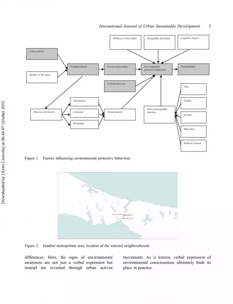
As stated in Figure 1, there are many reasons forenvironmental protective behaviour of residents.
However, this research aims to find out the influ-ence of the urban pattern. The channel in whichthe influence of urban pattern will result in sustain-ability is shaded grey. According to Figure 1, theurban pattern that will create a nest for socialrelationships holds the potential to increase envir-onmental protective behaviour.
Therefore in this research, the connectionsbetween urban pattern and environmental beha-viour aiming to sustain and conserve urban spaceare investigated. The act of claiming the place islooked at through urban activist movements thatcarry a notion of protecting the environment, asthey are an example of collective activities ofconsciousness.
1.3. Selection of case studies
The hypothesis brought forward in the previoussection is tested in three settlements in Istanbul,Turkey. The cases are examined and compared,and the relationship between urban pattern andenvironmental protective behaviour is investi-gated. The case studies selected from a widerange of urban social movements in Istanbul con-sider two factors: (1) being a part of the samegeographic formation and settlement type and (2)being exposed to similar environmental threatsdirected to the neighbourhood. Therefore, threesettlements located in the Bosphorus area ofIstanbul, Arnavutköy, Kuzguncuk and Kandilliwere selected for evaluation (Figure 2).
In two sample neighbourhoods (Arnavutköyand Kuzguncuk) in the presence of a threatwhich included interventions that might harm itsnatural, environmental, social and cultural struc-ture, the emergence of neighbourhood activity wasobserved as it was exposed to public. In the thirdcase (Kandilli), even though the residents wereexposed to the same environmental threat, dispa-rate activity was not observed. Two examples thatcarry positive values in terms of claiming ‘place’gain importance in terms of exhibiting spatialsimilarities; the third settlement, where environ-mental protective behaviour was not observable,gains importance in terms of showing spatial
2 A. Ciravoğlu
Dow
nloa
ded
by [
Aye
n C
irav
olu]
at 0
6:44
07
Oct
ober
201
5
differences. Here, the signs of environmentalawareness are not just a verbal expression butinstead are revealed through urban activist
movements. As is known, verbal expression ofenvironmental consciousness ultimately finds itsplace in practice.
Neighbourhood Social relationships Environmentalprotective behaviour
Urban pattern
Quality of the space
Sustainability
Physiosocial factors Social identityCohesion
Belonging
Satisfaction
Age
Gender
Income
Education
Political choices
Socio-demographicstructure
Geographic proximityInfluence of the media Cognitive factors
Cultural diversity
Figure 1. Factors influencing environmental protective behaviour.
Figure 2. Istanbul metropolitan area; location of the selected neighbourhoods.
International Journal of Urban Sustainable Development 3
Dow
nloa
ded
by [
Aye
n C
irav
olu]
at 0
6:44
07
Oct
ober
201
5

2. General introduction of the method: spacesyntax
In this study, three neighbourhoods were exam-ined to show the impact of urban pattern on theemergence of environmentally conscious beha-viour. In order to evaluate the effect of urbanmorphology on environmental awareness, first itis necessary to interpret urban space. Space Syntaxanalysis, which displays the peculiarities of a spa-tial pattern, presents important findings to under-stand urban morphology.
According to Hillier and Hanson (1984),society must be defined in terms of its real spati-ality, and space must be defined in terms of its realsociality. Displaying the broad theory of the sociallogic of space and spatial logic of the societyforms an important part of the Space Syntax stu-dies. Space Syntax is a method that associatesmorphological and social structure (Peponis2001). According to this method, movement isan important factor that generates spatial structure,and movement depends, in turn, on spatial mor-phology (Penn 2001).
The most important measure of the SpaceSyntax method is spatial integration. This entailsdrawing the longest straight lines (axial lines) thatgo through the streets and open spaces to cover theentire public space of the settlement. Through syn-tax analysis of these lines, integrated spaces in asettlement, where people are most likely to meeteach other, are calculated. As discussed in spacesyntax literature, integration is the key concept in‘reading’ a town in terms of its potential publicness.Integration analysis is made on two levels: first, theradius-n integration, which counts how deep orshallow each line is from every other line, is ana-lysed. Second, radius 3 integration, where howdeep or shallow each line is from all lines up tothree steps away, is analysed. Radius 3 integrationpresents a localised picture of integration, and cantherefore be thought of as local integration. Radius-n integration presents a picture of integration at thelargest scale, and is therefore called global integra-tion. In historical cities, the relationship betweenthese two levels of integration has become a critical
determinant of the part-whole structure of the citiesbecause it governs the degree of natural interfacethere would logically be between more local, there-fore more internal movement, and more global,therefore more in–out and through movement(Hillier 1996).
The concept that defines the correlationbetween local and global spatial measures is intel-ligibility (Hillier 2001; Penn 2001; Read 2005).Intelligibility is a challenging property in an urbansystem.
Since (by definition) urban space at ground levelcannot be seen and experienced all at once, butrequires the observer to move around the systembuilding up a picture of it piece by piece, wemight suspect that intelligibility has somethingto do with the way in which a picture of thewhole urban system can be built up from itsparts, and more specifically, from moving aroundfrom one part to another. (Hillier 1996, p. 129)
An intelligible system is one in which well-con-nected spaces also tend to be well-integratedspaces. An unintelligible system is one wherewell-connected spaces are not well-integrated, sothat what we can see of their connections mis-leads us about the status of that space in thesystem as a whole. (Hillier 1996, p. 129)
As intelligibility can be observed from thecorrelation between connectivity and integration,synergy can be observed from the correlationbetween global integration and local integration.Local and global integration values give us cluesabout the movement of inhabitants and the move-ment of strangers (Hillier 1996).
The application of the space syntax methodwithin this research was realised through usingAxman programme. Axial lines are drawn withina selected dimension, considering the geographicand physical boundaries of the selected neighbour-hoods. As neighbourhoods had very distinct bor-ders, these became the limits of the analysed urbantissue. All of the selected cases are traditionalBosphorus villages, they have the sea (Bosphorus)on one side and green areas on the other two sidesof the neighbourhoods as settlement borders.
4 A. Ciravoğlu
Dow
nloa
ded
by [
Aye
n C
irav
olu]
at 0
6:44
07
Oct
ober
201
5

Therefore, the physical limits of the neighbourhooddefine the buffer zones for the analysis. The borderfor the last side of the settlements was defined tothe extent that the analysed neighbourhood islinked to the adjacent settlement. In order to elim-inate the edge effect, a portion of the adjacentsettlement is included in the analysis. For the syn-tactic analysis, global integration and local integra-tion values were calculated for evaluation andcomparison. Synergy, which is the correlationbetween local and global integration, is looked atin order to constitute key findings of the study. Thelevels of occupancy and pedestrian movement thatthe Space Syntax method predicts can also be readfrom commercial activity in the integrated areas.That is why the correlation between the numberof shops and global integration values are evalu-ated. This served as a control mechanism for theresearch. Moreover, in order to double check find-ings of the space syntax evaluation, semi-structuredindividual interviews with experts who participatedthe NGO activity were conducted. The aim of theinterviews was to collect data on the meaning andimportance of the main streets of studied neigh-bourhoods. In this regard, data collected from twointerviews were used to express the importance ofthe main street according to the residents.
3. Case studies: analysis on Arnavutköy,Kandilli and Kuzguncuk
3.1. On evaluated neighbourhoods
According to the criteria explained above, theArnavutköy Neighbourhood Initiative and the dis-trict of Arnavutköy have been chosen to be thefirst case in this study. The most important activityof the Arnavutköy Neighbourhood Initiative is togenerate public opinion against the construction ofa third motorway bridge1 over the BosphorusStrait because of its negative impacts on the nat-ural and built environment. Experts2 indicate that amotorway bridge on the designated route will notonly encourage vehicle ownership but also ruinthe architectural heritage, destroy the nearby
settlements and, along with noise and pollution,bring many environmental problems.
One of the settlements under the negative influ-ences of the construction of a bridge over theBosphorus is Arnavutköy, the other settlement thatwill be affected, according to the designated route,on the opposite side of the Bosphorus, is Kandilli.According to interviews made during the fieldwork,3 despite the efforts of the residents ofArnavutköy, no contribution in terms of opposingthe construction of the bridge from the residents ofKandilli has been seen. For this reason, facing thesame environmental threat, the settlement ofArnavutköy, in which environmental awareness canbe seen, and the settlement of Kandilli, in which thisawareness is not observable, form the evaluatedneighbourhoods. An evaluation of the settlementswill call attention to the role of space in raisingenvironmental awareness. As both of the settlementsare along the Bosphorus and have a similar histor-ical, natural, geographic and socio-demographicstructure, this feature carries this investigation to animportant way to search for the effects of differentia-tion of place on environmental awareness.
The third evaluated case, Kuzguncuk, which isthought to act as a comparison case, is a settlementon the Bosphorus, similar to Arnavutköy andKandilli in terms of natural, geographic and demo-graphic structure, and showing similarity withArnavutköy in terms of environmental awareness.The Kuzguncuk Association, established withinthe neighbourhood, drew attention to the negativesocial and environmental effects of a primaryschool and hospital construction in a green areacalled Barakalı Bostan which would have even-tually led to building activities in a green area.This has been interpreted as an environmentallyconscious act in the context of this paper.
3.1.1. Arnavutköy
Arnavutköy, a village on the European side of theBosphorus, has a history of more than 1500 years.The settlement was known to be an importantreligious centre in the early Byzantine period.
International Journal of Urban Sustainable Development 5
Dow
nloa
ded
by [
Aye
n C
irav
olu]
at 0
6:44
07
Oct
ober
201
5

The neighbourhood gained in popularity whenConstantius II (337–361) built Hagios MikaelChurch. When Fatih Sultan Mehmet conqueredthe city in 1453, he located Janissaries fromAlbania in the settlement formerly called Hestiai,Promotu and Anaplus, taking the nameArnavutköy – Village of Albanians. In the six-teenth century, it was a popular excursion pointwith orchards and gardens. Until the mid-nine-teenth century the residents were mostly Greeksand Jews. The Muslim population was only 7% atthat time. However, this population ratio has chan-ged over time due to the effects of the first andsecond world wars, and the Cyprus events whichtook place between 1964 and 1974. According tothe population census in 1999, the Muslim/non-Muslim ratio is 93%. There are more than 300civic structures, 5 gardens and 30 trees listed inArnavutköy (Danışman & Üstün 2002).
The settlement gained its current popularitywhen the government announced its plans for amotor highway bridge over the Bosphorus. Sincethis route was seen as an extremely strong possi-bility, Arnavutköy and Kandilli settlements wouldbe profoundly affected by this situation. TheArnavutköy Neighbourhood Initiative was foundedin 1998 when these governmental plans were firstintroduced to the public. The neighbourhoodopposed the plans because it would ruin the char-acter of the area, cause environmental pollutionand eventually not be a solution for transportationproblems in Istanbul as it still depended on cars.
3.1.2. Kandilli
Kandilli is situated on the Asian side of theBosphorus. It was called Echia (Ekhaia) in ancienttimes, Broktoi or Prookhtoi in Byzantium.According to legend, it took its name Kandilli,which means ‘illuminated by oil lamp’, from thesignal lamps used to orient sailors at night. Therewere no known settlements in Kandilli besidesKandilli Gardens until the eighteenth century.Starting from the 1740s, when Sultan Mahmud Ibuilt a shore palace, people started to settle in the
neighbourhood. The residents in the eighteenth cen-tury were elite Ottoman governmental bureaucracy,mostly Muslim, and a small portion of Greeks andArmenians. In the nineteenth century, it became aplace where mostly rich English and French foreign-ers close to the palace and western intellectuals lived.Along with fountains, churches and mosques ofgreat importance, mostly because of its topography,it has many natural beauties and vistas. However,starting from the 1980s, Kandilli has gone through aseries of changes where villas appeared on top of thehills and inside the forests. The slight increase ofpopulation, starting from 1275 in 1955 evolving to2284 in 1965, 1313 in 1975, 1171 in 1990 and finally1500 in 1994, can be interpreted to show that this isstill a protected neighbourhood (Anonymous 1993).Kandilli, even though it has been subject to the samediscussions about a motorway bridge over theBosphorus, does not seem to present a state of orga-nisation against this act.
3.1.3. Kuzguncuk
Kuzguncuk, a village on the Asian side of theBosphorus, whose physical structure was mainlyformed by rowhouses, villas and apartments duringthe second half of the nineteenth and throughout thetwentieth centuries is another settlement subject todemographic changes. The settlement has been pro-tected since 1984 under the Bosphorus law and hasthree churches, two synagogues and a mosque.Until recently, Kuzguncuk was also a settlementwhere the non-Muslim population was high com-pared to the Muslim population. Kuzguncuk is aplace where Sephardic Jews settled when theyarrived in Turkey in 1492. In 1914, there were 70Muslims, 250 Greeks, 1600 Armenians and 400Jews. In 1933, there were 4000 residents mostlyGreeks, also Turks and Armenians (Akın 1993).Starting from the 1930s, departure from the neigh-bourhood began. Until the end of the 1960s,Kuzguncuk still had an important number ofGreek residents. However in 1992, there wereonly 25 Greeks, 17 Jews and 6 Armenians livingin the neighbourhood (Ergun 2004).
6 A. Ciravoğlu
Dow
nloa
ded
by [
Aye
n C
irav
olu]
at 0
6:44
07
Oct
ober
201
5

The Kuzguncuk Association was establishedin 1997 in order to build a transformer in theneighbourhood. However, it gained in popularityin 2000 when the government allowed construc-tion activities on the last orchard of Istanbul,which has a history of 700 years and had beencultivated until 1984. In 1986, a primary schooland in 1992 a hospital were planned in this greenarea. Festive oppositional acts were instigatedagainst this attempt and eventually the governmenthad to step back (Morgül 2004). The orchard isstill a green space located in the heart of theneighbourhood.
3.1.4. Sociodemographic structure of theevaluated settlements
In order to take into account the influence ofsocio-demographic issues, we have to look at thedemographic structure of selected cases:
According to the last population census data(Turkish Statistical Institute 2000), the populationof Arnavutköy is 5068, Kuzguncuk is 4957 andKandilli is 1190. Regarding this population census,in all settlements the population consists of 47%women and 53%men. If we examine the settlementsregarding age, the rate of population under 34 yearsis 48% in Arnavutköy, 51% in Kuzguncuk and 55%in Kandilli. In the demographic structure of theevaluated neighbourhoods regarding the place ofbirth, the residents born in Istanbul are 42% inKandilli, 45% in Kuzguncuk and 47% inArnavutköy. If the state of employment is evaluated,it can be determined that the rate of unemployment is54% in Kuzguncuk, 50% in Arnavutköy and 49% inKandilli. Evaluating the settlements according to thenumber of illiterate residents, the rates are found tobe 5% in Kuzguncuk, 4% in Arnavutköy and 2% inKandilli. The rate of the residents holding a univer-sity degree is 35% in Kuzguncuk, 38% in Kandilli,43% in Arnavutköy; residents holding a master'sdegree are 2% in Kuzguncuk, 4% in Arnavutköy,5% in Kandilli. The proportion of people who havenot gone to any school are 12% in Arnavutköy, 16%in Kandilli and Kuzguncuk.
When we evaluate the data above in terms ofsocio-demographic structure, we can determinethat these three settlements have many similarities.As differences between neighbourhoods are notfound to affect the hypothesis of the paper nega-tively, it could be said that the influence of gender,age and education are found to be negligible. Forinstance, even though the ratio of young peopleand educated people is more in Kandilli, we do notobserve environmental protest in this case. On theother hand, the level of income was a contentiousissue which was not included in this study.
3.2. Analysis of Arnavutköy, Kandilli andKuzguncuk
In this section, with the opportunity that spacesyntax method generates, the three settlementsare evaluated. Here, the urban pattern is analysedin order to see its contribution in implementingsocial relations leading to neighbourhood initia-tives that show a certain level of environmentalconcern. The peculiarities of place over openspaces, potential pedestrian activity and accessibil-ity are investigated here. Axial lines going throughstreets and squares are drawn, global and localintegration cores are calculated and represented,and the results are compared. Below are the resultsof the analysis (Table 1).
3.2.1. Space syntax analysis of Arnavutköy
The results of the Space Syntax analysis ofArnavutköy can be followed from the first row ofFigure 3. The urban pattern of Arnavutköy occursalong the main street heading toward the sea. The
Table 1. Findings of the syntax analysis.
Arnavutköy Kandilli Kuzguncuk
Rn (max) 1.2408 0.4670 1.4790Rn (mean) 0.7628 0.3189 0.8677R3 (max) 4.4813 3.5340 5.1326R3 (mean) 1.8483 1.4035 1.9159Synergy (r2) 0.5630 0.1039 0.5966
International Journal of Urban Sustainable Development 7
Dow
nloa
ded
by [
Aye
n C
irav
olu]
at 0
6:44
07
Oct
ober
201
5

settlement is concentrated around four axes parallelto this main street. The axial map, which representsan area of 1.4 km by 0.8 km consisting of 193 axiallines drawn over the map, can be followed from thesecond image of the first row of Figure 3.
The global and local integration analysis of thesettlement can be seen in the third and fourth imagesof the first row of Figure 3. According to the globalintegration analysis (global/r-n/radius infinity),which visualises integrated areas as red lines, segre-gated areas as blue lines (colour online); the mainaxis in the middle of the settlement heading towardthe sea and the shore road are the most integratedlines with values of 1.2408 and 1.1552. We canobserve from the map that the integration core ofthe settlement is concentrated around these lines.
The aim of local integration evaluation is toorder streets hierarchically with regard to the value
of the nearest three lines in order to visualise otherprobable focal points of the system. Local integra-tion shows how the system is organised not on aglobal scale but within itself. According to thelocal integration analysis (local/r-3/radius 3),which again visualises locally integrated areas asred and segregated areas as blue (colour online),the main axis in the middle of the settlement head-ing toward the sea, with a value of 4.4813, has thehighest local integration value. We can observefrom the map that around this axis the local inte-gration core is formed.
Matching the global and local integration ana-lysis of Arnavutköy shows that the integrationcore of the settlement at a global scale is alsointegrated at the local level. As global integrationgives us clues about the places where outsidersand insiders are most likely to meet each other,
Figure 3. Space Syntax Analysis of Anavutköy, Kandilli and Kuzguncuk.
8 A. Ciravoğlu
Dow
nloa
ded
by [
Aye
n C
irav
olu]
at 0
6:44
07
Oct
ober
201
5

and local integration tells us about the potentialgathering areas where the inhabitants living in thatarea are likely to walk, the places which areintegrated on both global and local levels are thespaces where interaction among residents and citi-zens is most likely to occur. These placesintegrated on global and local levels are ‘intelligi-ble’ spaces where perception of the whole is notlost. The synergy of Arnavutköy can be seen inFigure 4 which shows the correlation betweenlocal and global integration values. Arnavutköyrepresents the property of synergy, as global andlocal integration of axial lines are around averagevalues of the neighbourhood and give a goodoverall correlation of r2 0.5630.
3.2.2. Space syntax analysis of Kandilli
The results of the Space Syntax analysis ofKandilli can be followed from the second row ofFigure 3. As can be seen from the first image inthe second row of Figure 3, the urban centre ofKandilli is situated around the main axis reachingto the pier and the secondary road going to AdileSultan Palace. While around those two axes thesettlement is dense, moving away from the axesthe settlement firstly has a sparse and then a densesetting. Apart from the previous example, inKandilli a natural landscape is in the forefront.The settlement carries a dispersed structure andon the hills there is a different kind of urban
texture constituted by gated communities. Theaxial map, which represents an area of 1.5 km by1.5 km consisting of 371 axial lines4 goingthrough the settlement, can be followed from thesecond image of the second row of Figure 3.
The global and local integration analyses ofthe settlement can be seen in the third and fourthimages of the second row of Figure 3. Eventhough the two settlements are of similar size,the reason that there are more axial lines inKandilli is that the settlement has a more organicstructure. According to the global analysis (glo-bal-Rn), the main axis in the middle of the set-tlement heading toward the pier consists of asequence of several streets on slightly differentalignments and so have slightly different integra-tion values, starting from the pier going up thehills in an order of 0.4149, 0.4280, 0.4411,0.4670. It can be seen that the values increasedeparting from the shore and going through thesettlement. Conclusively, the global analysisstates that integrated areas within this contextdo not follow a straight line as it is scattered bythe organic structure of the urban pattern. Themost important result of the local integrationanalysis is that the spaces that in the formeranalysis were found to be integrated on a globallevel are not integrated on the local level. A streetin the eastern section of the neighbourhood,which in fact was segregated on a global level,is found to be integrated on the local level.
Comparison of global and local analyses ofKandilli shows that integrated areas of settlementon the global level, especially most of the streetsthat connect the neighbourhood to the sea, arefound to be segregated on the local level. In thisregard, it can be said that in Kandilli spaces thathave a high level of synergy are not found. Figure 5,showing the correlation between global and localintegration values, shows that Kandilli does nothave strong synergy. According to the figure, globaland local integration values of lines do not concen-trate on average values of the settlement and show alow correlation value of r2 0.1039.
Integ Rad = 3
Integ Rad = n
1.2408
4.4813
Slope = 0.1868
Intercept 0.41
R∧
2 = 0.5630
Integ Rad = n
Integ Rad = 3
Mean = 0.7628
Mean = 1.8483
Figure 4. Correlation of global and local integrationvalues of Arnavutköy.
International Journal of Urban Sustainable Development 9
Dow
nloa
ded
by [
Aye
n C
irav
olu]
at 0
6:44
07
Oct
ober
201
5

3.2.3. Space syntax analysis of Kuzguncuk
The results of the Space Syntax analysis ofKuzguncuk can be followed from the third rowof Figure 3. As can be seen in the first image in thethird row of Figure 3, Kuzguncuk is orientatedalong a main axis heading toward the sea. Thesettlement is denser along the main road and sec-ondary streets making a 45° angle with this mainaxis. The axial map, which represents an area of1.2 km by 1.4 km and consisting of 190 axial linesdrawn over the map, can be followed from thesecond image of the third row of Figure 3.
The global and local integration analyses ofthe settlement can be seen in the third and fourthimages of the third row of Figure 3. According tothe global analysis (global-Rn), the main axis inthe middle of the settlement heading toward thesea is the most integrated line with a high value of1.4790. Around this line the integration core of thesettlement is constituted. According to the localintegration analysis, the main axis in the middle ofthe settlement heading toward the sea, with a valueof 5.1326, has the highest local integration poten-tial. The map shows that around this axis the localintegration core is formed.
Matching the global and local integration ana-lyses of Kuzguncuk it can be seen that the integra-tion core of the settlement at a global scale is alsointegrated at the local level. As stated before, theplaces which are integrated on both local andglobal levels are the spaces where co-presencebetween residents and citizens is most likely tooccur. These places integrated on local and global
levels show a measure of synergy where percep-tion of the whole is not lost.
The synergy of Kuzguncuk can also be seen inFigure 6, which shows the correlation betweenlocal and global integration values. Kuzguncukrepresents strong synergy as global and local inte-gration of axial lines is around the average valuesof the neighbourhood and gives a good correlationof r2 0.5966. In this context, it can be said that thesynergy measure of Kuzguncuk is more than thatof Arnavutköy.
3.3. Correlation of integration values andcommercial activity of case studyneighbourhoods
Another indication of the levels of occupancy andpedestrian movement (in the sense of motion) thatthe Space Syntax analysis predicts is the amountof commercial activity in the integrated areas.Correlation of integration values and number ofshops may function as a control mechanism of themethod. In this context, a comparative analysiswhich indicates the number of shops in all threeneighbourhoods is given in Table 2. InKuzguncuk, there are 80 shops on the main axiswhere correlation of local and global integrationvalues is highest, and 12 in the streets connectingto the shoreline in Kandilli. The number is 60 inArnavutköy. The Space Syntax analysis resultsshow that the most integrated spaces correspondto those where the number of shops is highest.Moreover, when we examine the statistical
Integ Rad = 3
Integ Rad = n
0.4670
3.5341
Slope = 0.0348
Intercept 0.27
R∧
2 = 0.1039
Integ Rad = n
Integ Rad = 3
Mean = 0.3189
Mean = 1.4035
Figure 5. Correlation of global and local integrationvalues of Kandilli.
Integ Rad = 3
Integ Rad = n
1.4790
5.1326
Slope = 0.2284
Intercept 0.43
R∧
2 = 0.5966
Integ Rad = n
Integ Rad = 3
Mean = 0.8677
Mean = 1.9159
Figure 6. Correlation of global and local integrationvalues of Kuzguncuk.
10 A. Ciravoğlu
Dow
nloa
ded
by [
Aye
n C
irav
olu]
at 0
6:44
07
Oct
ober
201
5

correlation test results of integration values andnumber of shops in the studied neighbourhoods,we observe that p-value is below 0.05 (Table 3).This analysis, which presents a control mechan-ism, is seen to verify the hypothesis of the study.
3.4. Results of the case studies
In this paper, the impact of urban pattern on thepotential levels of pedestrian activity is studiedfor three Bosphorus settlements in Istanbul. Co-presence is a precondition for social interaction;in that sense, potentially busier and livelierspaces may afford the possibility of greater socialsolidarity and potential to claiming ‘place’.Environmental awareness in this sense is definedas showing collective environmentally protectivebehaviour. In this context, spatial peculiarities of
three Bosphorus neighbourhoods sharing a simi-lar socio-demographic background, within whichtwo popular neighbourhood initiatives emergedopposing two environmental threats directed tothe neighbourhood, are researched. Even thoughit has been subject to the same threat, in one ofthe neighbourhoods there seems to be no voiceagainst it. Therefore, the physical peculiarities ofthe settlements were compared in order to findout the potential that space might offer to supportsocial relations and therefore collective beha-viour. Space Syntax is used as a tool to revealthe underlying spatial structures in order to findout their influences on daily behaviour and even-tually point out the places where social interac-tions are more likely to occur in the evaluatedsettlements.
Three neighbourhoods of the Bosphorus ana-lysed by Space Syntax give us clues about urbanspace and environmental behaviour. In this studyexplained in detail above, in Arnavutköy andKuzguncuk settlements, where a sociopolitical actagainst an urban intervention took place, there areintegration cores where both residents of the neigh-bourhood and people living outside of the neigh-bourhood can come together. In Kandilli, where theneighbourhood was subject to a similar environ-mental threat but counter behaviour was notobserved, it is difficult to talk about an integrated
Table 2. Correlation of integration values and numberof shops in Arnavutköy, Kandilli and Kuzguncuk.
Name of theneighbourhood
Number ofshops on themain street
Global integrationvalues of the main
street
Arnavutköy 60 1.2408Kandilli 12 0.4149Kuzguncuk 80 1.4790
Table 3. Statistical correlation test results of integration values and number of shops in Arnavutköy, Kandilli andKuzguncuk.
Statistic Variable X Variable Y
Mean 50.6666666666667 1.0449Biased variance 814.222222222222 0.20790654Biased standard deviation 28.5345794120436 0.455967696224195Covariance 19.461Correlation 0.997168021510851Determination 0.994344063123866T-test 13.2591616576583p-value (2 sided) 0.0479228504424891p-value (1 sided) 0.0239614252212446Degrees of freedom 1Number of observations 3
Note: Test was calculated by Pearson Correlation – Free Statistics Software (Calculator) Wessa (2012).
International Journal of Urban Sustainable Development 11
Dow
nloa
ded
by [
Aye
n C
irav
olu]
at 0
6:44
07
Oct
ober
201
5

area. Moreover, between values of integrated streetsamong neighbourhoods, Arnavutköy andKuzguncuk resemble each other while Kandilli dif-fers enormously. It has been determined that globalintegration cores and local integration cores resem-ble one another in Arnavutköy and Kuzguncuk.However, this is not the case for Kandilli.
These findings suggest that in Kuzguncuk andArnavutköy spatial patterns have the potential forpeople to come together on a local level; inKandilli, the streets which have a high integrationvalue on a global level do not facilitate residents toencounter one another on a local level. In otherwords, even though the most integrated spaces ona global scale may afford the potential for visitorsto enter the neighbourhood through these channels,these spaces do not form a natural gathering pointfor the residents. The street which has the greatestpotential to be integrated on a local level isobserved to be far away from the ‘functional’ centreof the neighbourhood.
Consequently, in Arnavutköy and Kuzguncukwhere environmental protective behaviour wasseen, it has been suggested that there are spacesof similar character where inhabitants (eventhough they have different backgrounds and pointsof view) come together/meet/run across oneanother. On the other hand, in Kandilli, the placesthat people might come together have too manyrestraints; this situation does not enable socialrelationships.
The findings of the Space Syntax Analysiscorrespond to the interviews done in the neigh-bourhood. Interviewers both state the potential ofİcadiye Street (main axis where pedestrian activitytakes place in Kuzguncuk; integrated on both localand global levels) and Beyazgül Street (main axiswhere pedestrian activity takes place inArnavutköy; integrated on both local and globallevels) for coming across/gathering together in theneighbourhood.5 Another evidence is the recordson usage of İcadiye Street and Beyazgül Street:Beyazgül Street starts with a public square; theoppositions conducted by residents ofArnavutköy took place at the square which islocated at the entrance of the neighbourhood and
Beyazgül Street.6 On the other hand, even thoughthe oppositions in Kuzguncuk took place in thebefore mentioned green area of the neighbourhoodwhich is adjacent to İcadiye Street, it is observedthat protests spread to İcadiye Street. For instance,in 2011 (Morgül 2011) İcadiye Street housed anexhibition of scarecrows produced by residents ofKuzguncuk as a symbol for protecting the greenarea of the neighbourhood.
4. Conclusion
This paper searched for an impact of spatial con-figuration of neighbourhoods on human behaviourthat would result in claiming ‘place’ (neighbour-hood). For this, three similar Bosphorus settle-ments were selected. Demographical and socialdata have been evaluated and Space SyntaxAnalyses of the neighbourhoods were made.Looking at the evidence, it can be discussed thatthe formation of the settlement may orient resi-dents to an environmentally protective behaviour.
This research takes it as axiomatic that there isa connection between urban spatial patterns andurban pedestrian movement. Building on thisinformation the paper claims that this certainmovement (publicness of the neighbourhood)deriving from urban morphology has the potentialto enable social relationships and neighbourhoodlife, thus paving a way to claiming the place. It isknown that environmental awareness is affectedby socio-demographic factors, cognitive factors,media, etc. However, this study states that alongwith these factors, differentiation of the urbanpattern might affect the emergence of differentlevels of environmental awareness.
Findings of the research are expected to influ-ence new perspectives in preservation of historicalsettlements and also new methods in urban trans-formation projects and urban interventions con-ducted in Istanbul.
Undoubtedly, this paper does not intend topresent complicated factors of a possible environ-mental collective behaviour. Also, it is not thispaper's claim that urban pattern alone can forceresidents into environmental protective behaviour.
12 A. Ciravoğlu
Dow
nloa
ded
by [
Aye
n C
irav
olu]
at 0
6:44
07
Oct
ober
201
5

Rather, it builds on an idea that place has animpact on spatial behaviour and claims that spatialconfiguration of a certain settlement might have arole in an increase in NGO activities. In otherwords, it is proposed that besides social and poli-tical factors that generate a neighbourhood initia-tive which aim to defend a ‘place’, the urbanpattern of the settlement with its potential builtinto its structure, might have an influence on theabove-mentioned environmental protectivebehaviour.
Even though socio-demographic variableswere taken into account in this study by pickingsimilar cases, the cultural richness of the two caseswhere urban social acts were seen could not beignored. As a further study the relationshipbetween cultural diversity and environmentalawareness might be studied.
AcknowledgementsI am grateful to Prof. Harun Batırbaygil, Prof. ZekiyeAbalı, Prof. Nur Esin as this research has been devel-oped with their criticism. Even more, I owe Assoc. Prof.Deniz Erinsel Önder special appreciation as she intro-duced the Space Syntax method to me and allowed meto use her resources whenever I needed them.
Notes1. Discussions on constructing a third bridge over the
Bosphorus date back to 1997. In 1998, the Ministerof Public Works, Yaşar Topçu, announced that thepossible route was to be between Arnavutköy andKandilli. In 1999, the route was announced asArnavutköy–Vaniköy. In 2002, another possibilityemerged as Arnavutköy–Beylerbeyi. In 2010,the Minister of Transportation, Binali Yıldırım,announced the Poyrazköy–Garipçe route(Anonymous 2010). In 2013, construction of thebridge started following this route.
2. As well as professionals and academics, variouschambers are also against construction of a thirdbridge over the Bosphorus. Istanbul branches of theChamber of Architects, Environmental Engineers,Mapping and Land Surveying Engineers, StructuralEngineers, Pharmacists, Geophysic Engineers,Geology Engineers, Mining Engineers, ForestEngineers, Landscape Architects, AgricultureEngineers made a press statement on 2 July 2009
opposing the possibility of a third bridge over theBosphorus Strait.
3. Interview with Günhan Danışman, 2005, Beşiktaş,İstanbul: Günhan Danışman states that during thepreparation studies of the protest they had givenenormous effort to include people from Kandilli totheir studies. However, their efforts to contact thevillage headman and residents were constantlyrefused.
4. As one of the important parts of the analysis isaccessibility, the inner roads of the gated commu-nities are not regarded as publicly accessible roads;therefore, they are not included in the analysis.
5. Interview with Özden Danışman, 2005,Arnavutköy, İstanbul: Özden Danışman, states theimportance of Beyazgül Street by defining thesocial relationships that are constructed over it.She states that these social relationships are both aspeciality of the neighbourhood and a glue thatsticks people together during the protests in orderto achieve solidarity.
6. Records of protest can be reached in: http://www.bogaziciarnavutkoy.org/index.asp?Bogazici-Arnavutkoy-Dernegi=HaberDetay&Dernek-Haber=96(accessed 8 November 2013).
ReferencesAkın N. 1993. Kuzguncuk. In: Akbayar N, Işın E,
Sakaoğlu N, Tanman B, Koz S, Aksoy B, BaturA, editors. Dünden bugüne Istanbul ansiklopedisi.Volume 5. İstanbul: Türkiye Ekonomik veToplumsal Tarih Vakfı Yayınları; p. 145–146.
Anonymous. 1993. Kandilli. In: Akbayar N, Işın E,Sakaoğlu N, Tanman B, Koz S, Aksoy B, BaturA, editors. Dünden bugüne Istanbul ansiklopedisi.Volume 4. İstanbul: Türkiye Ekonomik veToplumsal Tarih Vakfı Yayınları; p. 408–410.
Anonymous. 2010. Geçmişten Bugüne 3. BoğazKöprüsü [Internet]; [cited 2010 Feb 23]. Availablefrom: http://www.arkitera.com/h44430-gecmisten-bugune-3-bogaz-koprusu-.html
Aytulkasapoglu MA, Ecevit MC. 2002. Attitudes andbehavior toward the environment: the case of LakeBurdur in Turkey. Environ Behav. 34:363–377.
Cottrell S. 2003. Influence of sociodemographics andenvironmental attitudes on general responsibleenvironmental behavior among recreational boaters.Environ Behav. 35:347–375.
Danışman G, Üstün İ. 2002. Yerel Tarihin Gücü:Arnavutköy Semt Girişimi’nin 3. Boğaz KöprüsüProjesine Yerel Tarihiyle Karşı Koyuşu. [Report onWorks of Istanbul Branch of the Chamber ofArchitects of Turkey between 2000–2000] In:
International Journal of Urban Sustainable Development 13
Dow
nloa
ded
by [
Aye
n C
irav
olu]
at 0
6:44
07
Oct
ober
201
5
http://www.bogaziciarnavutkoy.org/index.asp?Bogazici-Arnavutkoy-Dernegi=HaberDetay%26Dernek-Haber=96
http://www.bogaziciarnavutkoy.org/index.asp?Bogazici-Arnavutkoy-Dernegi=HaberDetay%26Dernek-Haber=96

Kızılyaprak Z., A., editor. Tarih Yazımında YeniYaklaşımlar Küreselleşme ve Yerelleşme. Istanbul:Türkiye Ekonomik ve Toplumsal Tarih VakfıYayınları; p.115–124.
Ergun N. 2004. Gentrification in Istanbul. Cities.21:391–405.
Goksen F, Adaman F, Zenginobuz EÜ. 2002. On envir-onmental concern, willingness to pay, and postma-terialist values: evidence from Istanbul. EnvironBehav. 34:616–633.
Guardia J, Pol E. 2002. A critical study of theoreticalmodels of sustainability through structural equationsystems. Environ Behav. 34:137–149.
Gustafson P. 2001. Roots and routes: exploring therelationship between place attachment and mobility.Environ Behav. 33:667–686.
Hillier B. 1996. Space is the machine: a configurationaltheory of architecture. Cambridge: CambridgeUniversity Press.
Hillier B. 2001. A theory of the city as object or, howspatial laws mediate the social construction of urbanspace. In: Proceedings of the 3rd International SpaceSyntax Symposium; 2001 May 7–11. Atlanta (GA):Georgia Institute of Technology; p. 02.1–02.28.
Hillier B, Hanson J. 1984. The social logic of space.Cambridge: Cambridge University Press.
Jimenez-Dominguez B, Lopez-Aguilar R. 2002. Identityand sustainability in two neighborhoods ofGuadalajara, Mexico. Environ Behav. 34:97–110.
Maloney MP, Ward M, Braucht GN. 1975. A revisedscale for the measurement of ecological attitudesand knowledge. American Phychologist. 30:787–790.
Morgül T. 2011. Kuzguncuk’ta Bostan Korkulukları.Radikal J. [Internet]; [cited 2011 Feb 15]. Availablefrom: http://www.radikal.com.tr/yazarlar/tan_morgul/kuzguncukta_bostan_korkuluklari-1040008
Morgül T. 2004. Kuzguncuklular derneği deneyimi. In:Koloğlu Ve D, Aksakoğlu Y, editors. Sivil toplum vedemokrasi seminerleri [Internet]; [cited 2010 Mar 8].Available from: http://stk.bilgi.edu.tr/docs/morgul_sav_2.pdf
Nordlund AM, Garvill J. 2002. Value structures behindproenvironmental behavior. Environ Behav. 34:740–756.
Penn A. 2001. Space syntax and spatial cognition or,why the axial line? In: Proceedings of the 3rdInternational Space Syntax Symposium; 2001 May7–11. Atlanta (GA): Georgia Institute ofTechnology; p. 11.1–11.17.
Peponis J. 2001. Interacting questions and descriptions-how do they look from here? In: Proceedings of the3rd International Space Syntax Symposium; 2001May 7–11. Atlanta (GA): Georgia Institute ofTechnology; p. xiii–xxvi.
Pol E. 2002. The theoretical background of the city-identity-sustainability network. Environ Behav.34:8–25.
Pol E, Moreno E, Guardia J, İniguez L. 2002. Identity,quality of life, and sustainability in an urban suburbof Barcelona: adjustment to the city-identity-sustainability network structural model. EnvironBehav. 34:67–80.
Pol E, Castrechini A. 2002. City-identity-sustainabilityresearch network: final words. Environ Behav.34:150–160.
Read S. 2005. Flat city: a space syntax derived urbanmovement network model. In: Proceedings of the5th International Space Syntax Symposium; 2005Jun 13–17. Delft (Netherlands): TechnicalUniversity of Delft; p. 341–357.
Turkish Statistical Institute. 2000. Population censusdata in Turkey [Internet]. Ankara: TÜİK; [cited2013 Oct 6]. Available from: http://tuikapp.tuik.gov.tr/nufusapp/idari.zul?
Uzzell D, Pol E, ve Badenas D. 2002. Place identifica-tion, social cohesion, and environmental sustainabil-ity. Environ Behav. 34:26–53.
Valera S, Guardia J. 2002. Urban social identity andsustainability: Barcelona’s Olympic Village.Environ Behav. 34:54–66.
Vorkinn M, Riese H. 2001. Environmental concern in alocal context: the significance of place attachment.Environ Behav. 33:249–263.
Wessa P. 2012. Pearson correlation (v1.0.6) in free sta-tistics software (v1.1.23-r7) [Internet]. Office forResearch Development and Education; [cited 2013Nov 8]. Available from: http://www.wessa.net/rwasp_correlation.wasp/
14 A. Ciravoğlu
Dow
nloa
ded
by [
Aye
n C
irav
olu]
at 0
6:44
07
Oct
ober
201
5