The Earliest Map of the Mandan Heartland: Notes on the Jarvis and Mackay 1791 Map
22
255 Plains Anthropologist, Vol. 55, No. 216, pp. 255–276, 2010 W. Raymond Wood, The Earliest Map of the Mandan Heartland: Notes on the Jarvis and Mackay 1791 Map W. Raymond Wood Canadian fur trader Donald Mackay visited and left a description of the Mandans and Hidatsas on the Missouri River in 1781, six years before James MacKay, generally credited with being the first Canadian trader to do so since visits by the La Vérendryes in the mid-1700s. Information from Mackay’s visit was incorporated into the Edward Jarvis and Donald Mackay map of 1791. The details Mackay provided on that manuscript chart reveal new insights into intertribal relations between the Mandans, Hidatsas, and Arikaras and the nomadic groups that surrounded them at the time of his visit. Contempo- rary documents support the hypothesis that the “Shevitoon” Indians depicted on the map may be identified as the Sutaios. Keywords: historical cartography, northern Plains, Cheyennes, Sutaios, “Shevitoons” The great smallpox pandemic that raced across the North American midcontinent in the years 1780 and 1781 turned, to use a phrase from a later epi- demic, the entire region into “one giant graveyard.” Previous tribal populations, their political roles, and locations were affected in the Great Plains from cen- tral Canada to the American Southwest. The mas- sive reduction in Native American populations led to sweeping changes in the social and political lives of every tribe in the region, villagers and nomads alike, and set the stage described by later Euroamerican traders and explorers. The present essay attempts to synthesize those events, hoping that such an overview, while perhaps controversial in part, will elicit new studies of some old ques- tions about the protohistoric northern Plains. One of the rare sources that sheds new light on this period is a map made in 1791 by Edward Jarvis and Donald Mackay at Albany Factory, a Hudson’s Bay Company establishment on Hudson Bay. Today that manuscript chart is housed in the Hudson’s Bay Company Archives, Provincial Ar- chives of Manitoba, in Winnipeg (“A Map of Hudsons Bay and interior Westerly particularly above Albany 1791,” catalog G. 1/13). The chart came to my attention when it was first published in an essay by Richard I. Ruggles in 1984, where it was illustrated in full but at a very reduced scale Plains Anthropologist Journal of the Plains Anthropological Society Volume 55 November 2010 Number 216
Transcript of The Earliest Map of the Mandan Heartland: Notes on the Jarvis and Mackay 1791 Map

255
W. Raymond Wood Earliest Map of the Mandan Heartland
Plains Anthropologist, Vol. 55, No. 216, pp. 255–276, 2010
W. Raymond Wood,
The Earliest Map of the Mandan Heartland:Notes on the Jarvis and Mackay 1791 Map
W. Raymond WoodCanadian fur trader Donald Mackay visited and left a description of the Mandans and Hidatsas on
the Missouri River in 1781, six years before James MacKay, generally credited with being the firstCanadian trader to do so since visits by the La Vérendryes in the mid-1700s. Information from Mackay’svisit was incorporated into the Edward Jarvis and Donald Mackay map of 1791. The details Mackayprovided on that manuscript chart reveal new insights into intertribal relations between the Mandans,Hidatsas, and Arikaras and the nomadic groups that surrounded them at the time of his visit. Contempo-rary documents support the hypothesis that the “Shevitoon” Indians depicted on the map may beidentified as the Sutaios.
Keywords: historical cartography, northern Plains, Cheyennes, Sutaios, “Shevitoons”
The great smallpox pandemic that raced acrossthe North American midcontinent in the years 1780and 1781 turned, to use a phrase from a later epi-demic, the entire region into “one giant graveyard.”Previous tribal populations, their political roles, andlocations were affected in the Great Plains from cen-tral Canada to the American Southwest. The mas-sive reduction in Native American populations ledto sweeping changes in the social and political livesof every tribe in the region, villagers and nomadsalike, and set the stage described by laterEuroamerican traders and explorers. The presentessay attempts to synthesize those events, hopingthat such an overview, while perhaps controversial
in part, will elicit new studies of some old ques-tions about the protohistoric northern Plains.
One of the rare sources that sheds new lighton this period is a map made in 1791 by EdwardJarvis and Donald Mackay at Albany Factory, aHudson’s Bay Company establishment on HudsonBay. Today that manuscript chart is housed in theHudson’s Bay Company Archives, Provincial Ar-chives of Manitoba, in Winnipeg (“A Map ofHudsons Bay and interior Westerly particularlyabove Albany 1791,” catalog G. 1/13). The chartcame to my attention when it was first published inan essay by Richard I. Ruggles in 1984, where itwas illustrated in full but at a very reduced scale
Plains AnthropologistJournal of the Plains Anthropological Society
Volume 55 November 2010 Number 216

256
PLAINS ANTHROPOLOGIST VOL. 55, NO. 216, 2010
(Ruggles 1984:159, Figure 3; see also Ruggles1991:58, Plate 14). It was more recently published ina larger, more legible two-part format (Wood 2001:10,Plate 11). An overview of the map and its historicalbackground by John C. Jackson (1992) drew fur-ther attention to the content of this important chart.
A short section of the Missouri River southand west of the Assiniboine and Souris rivers isdepicted in the southwest corner of this large map(it measures 75 by 54 cm, or 30 by 21 in). This seg-ment reveals the geography of the Mandan andHidatsa homeland as Donald Mackay observed itduring a visit to that region in 1781 (Figure 1). Withthis chart in hand, we now know the source of thesesame details on Aaron Arrowsmith’s great maps of1795 and 1802, for they were copied directly fromthis 1791 chart.
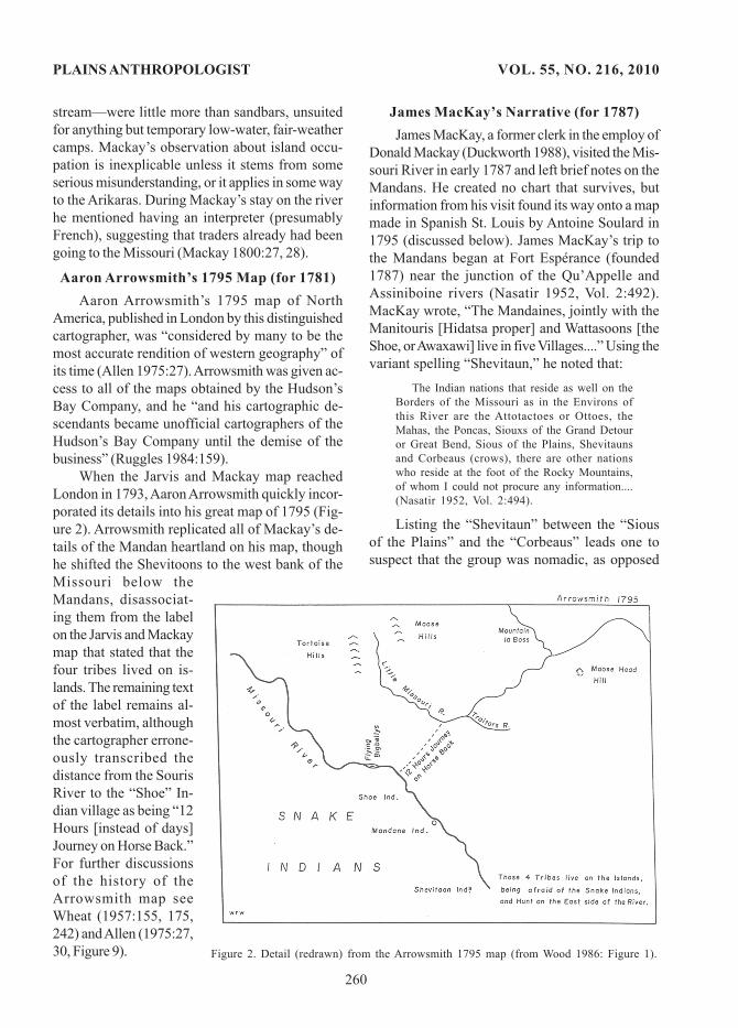
Three features on the 1791 map deserve atten-tion. First, the chart illustrates something of thenature of intertribal relations preced-ing the devastating 1781 smallpox epi-demic on the northern Plains. Second,what is the identity of the enigmaticgroup, the “Shevitoon” Indians, thatappears on it? This name reappears inseveral variant spellings in later chartsand documents. Finally, attention isdirected to the identity and activitiesof the “Snake Nation” that appears onthis map and on some earlier charts ofthe region.
A REVIEW OF THECARTOGRAPHIC
AND NARRATIVE MATERIALOne of the enduring mysteries of
tribal terminology in the northernPlains is the identity of the“Shevitoon” Indians. The group isdepicted on several late eighteenth-century English, French, and Spanishmaps as living on the banks of the Mis-souri River, both above and below thevillages of the Mandan and HidatsaIndians, as well as in the trans-Mis-souri west. I argue here for the hy-pothesis that the name Shevitoon isan alternative term for the Sutaios, anAlgonquian-speaking group that his-
torically merged with the Cheyennes.But who were the eighteenth-century Snakes
in the northern Plains? Were they the Shoshones,as some believe, or is the term one that also alludesto the Teton Lakotas? The Tetons lived west of theMissouri River between the White and the LittleMissouri rivers in the historic period, and consistedof the Hunkpapas, Sans Arcs, Blackfeet, TwoKettles, and Minneconjous, though they were col-lectively known in the early nineteenth century asthe “Saone” (DeMallie 2001:757). The Hunkpapas,Sans Arcs, and Blackfeet were living in the immedi-ate vicinity of the Mandan villages.
It is traditional to identify the word Sioux asmeaning “snake” or “enemy.” W J McGee appar-ently introduced this interpretation in his prelimi-nary sketch of the Siouan Indians, one that remainswidely accepted today (McGee 1897:157–158). YetDouglas Parks derives the name Sioux from the
Figure 1. Detail (redrawn) from the Jarvis and Mackay 1791 map. Originalin the Hudson’s Bay Company Archives, Provincial Archives of Canada,Winnipeg, catalog number G. 1/13.

257
W. Raymond Wood Earliest Map of the Mandan Heartland
early Ottawa Indian appellation na towe ssiwak.When the French adopted this term it was adaptedas Nadousssioux and contracted to Sioux. “Thetranslation of the Ottawa word na towe ssi andhence of Sioux as ‘snake, enemy’ (Hodge 1907–1910, Vol. 1:376, 379, Vol. 2:577) is a misrepresenta-tion based on the alternate meaning of the relatedname *na towe wa; the name Sioux never meant‘snake” (DeMalllie 2001:749; Parks and DeMallie1992:233; see also Goddard 1984:105). Mostsources, however, continue to repeat as dogma the“snake or enemy” designation repeated in Hodge’sHandbook of North American Indians by CyrusThomas, John R. Swanton, and James Mooney.Because the “Snakes” occupy a prominent placeon maps prior to 1797 we must review the carto-graphic and narrative sources on which this nameappears.
It is mandatory, however, to repeat RichardForbis’s 1963 warning that “not all Snakes areShoshonean,” and that “each mention of Snakesmust be examined on its own merits” (Forbis1963:11). He noted, for example, that in August 1800Alexander Henry the Younger mentions a Snakenation in southern Manitoba that “formerly inhab-ited the Lake of the Woods” but that now lived“upon the Assiniboine River about 30 leaguesWest” of the juncture of the Red and Assiniboinerivers. Henry noted that they “may be said to be ofthe same nation as the Crees, but have a differentdialect resembling the Saulteaux [Ojibwa] language”(Coues 1965, Vol. 1:46; Gough 1992, Vol. 1:21).
Peter Pond’s 1785 Map (for 1775 to 1778)The map that Peter Pond published in 1785 is
important because it provides information aboutthe Mandans and their immediate neighbors thatfound its way onto later maps. Pond was an Ameri-can who began his trading career in the Great Lakesarea, but in 1775 he moved to Michilimackinac andthen to the Saskatchewan River in Canada and laterto Lake Athabasca, in northern Alberta andSaskatchewan (Gates 1965:11–16). The southwestpart of Pond’s map is based on material that heaccumulated during his excursion into the upperMississippi River Basin and Canada nearly a de-cade before its publication.
Four copies of Pond’s map are available. Oneis a copy of the manuscript map that Pond pre-
sented to Henry Hamilton, Governor of Quebec, inApril 1785, and that now reposes in the PublicRecord Office, London (Wagner 1955:Map 2). Thepublished engraving is based on that chart (Innis1930:map inside back cover). The map does notshow the Missouri River itself, but a legend in aposition approximating that of the river and theMandans reads:
Here upon the Branches of the Missury / livethe Maundiens, who bring to our / Factory atFort Epinett [Pine], on the Assinipoil / RiverIndian Corn for sale. Our People / go to themwith loaded Horses in twelve Days (Innis 1930:map inside back cover).
Three trading posts are shown on Pond’s mapon the Assiniboine River: Fort Epinett, or Pine Fort(established 1768); an unnamed establishment atPortage la Prairie, between Lake Manitoba and theAssiniboine River that is identifiable as Fort desTrembles (established 1767); and an unnamed postmidway between them. Probably each of them con-tinued in use until 1781, the year that smallpoxspread among northern Plains groups, devastatednative populations, and temporarily disrupted thefur trade. Pond’s remark about the Mandans onthis map “is apparently the earliest documentationof British penetration to the Upper Missouri”(Wheat 1957:176, note 8).
The “Snake Indians” are shown on Pond’s mapsouth of these posts and above the Mandan vil-lages, west of the “Nottowasses or Sious,” desig-nations that clearly identify the Snakes as differingfrom the Sioux. Much the same configuration andlocation for the “Nation du Serpent” is shown onearlier maps, including one by Nicolas Bellin in 1755.The latter chart was perhaps the epitome of Frenchmapping for this region at the time. Bellin had bor-rowed “the best of the La Vérendrye configura-tion” for the Manitoba area (Warkentin and Ruggles1970:118, map on 119). Seven years later, ThomasJeffery probably borrowed the location of the “Na-tion of the Snake” from Bellin for use on his map of1762 (Warkentin and Ruggles 1970:122, map on 123).
The first narrative mention we have of“Snakes” comes from traders in central Canadabeginning in the 1730s. Canadian traders began tohear from the Plains Crees and their neighbors of anumerous and powerful western tribe that we maypresume were the Gens du Serpent of the Vérendrye

258
PLAINS ANTHROPOLOGIST VOL. 55, NO. 216, 2010
brothers. François de la Vérendrye wrote in 1742 –from a location believed to be north of the BlackHills—that these nomadic people were very nu-merous and occupied a very large (though unspeci-fied) territory, and were dedicated raiders, and weresaid to have “completely defeated seventeen vil-lages” (of unspecified ethnicity), killing everyoneexcept young women who were taken as slaves(Smith 1980:107). These Snakes appear to have heldmuch of the country in modern Wyoming and Mon-tana, and they apparently attacked distant tribeson foot—including the Piegan Blackfoot on theforks of the Assiniboine River in Canada as earlyas 1725 to 1730. About 1740, people called theSnakes obtained horses and intensified their raids,becoming ever more aggressive and destructive(Thompson 1916:328–332).
It therefore appears that Pond was drawing onconventional wisdom about the “Snakes” that wasavailable to him and his colleagues in the tradingcommunity. One such figure deserves special men-tion. During Pond’s time on the Upper Mississippihe relates the story of a shadowy figure known asPennesha Gegare, who had gone up the Missourito the Mandans some time before 1778 (Gates1965:38–39), so at least hearsay news of the UpperMissouri was available to Pond. Consequently,much of the information on his map apparently wasbased in part on eyewitness accounts.
A significant Shoshone presence in south-cen-tral Montana and north-central Wyoming is sug-gested by the presence of the “Shield-bearingWarrior motif” in the rock art of these areas. JamesKeyser wrote, “Most examples of the motif date tothe Late Prehistoric or early Historic periods whenthe Shoshone occupied almost the entire” North-western Plains, and their density is greatest in thearea longest occupied by the Shoshone. “The dis-tribution of the motif also coincides with the distri-bution of Intermountain pottery, flat-bottomed ste-atite vessels, and tubular stone pipes, all thoughtto be diagnostic of the Shoshonean occupation onthe Northwestern Plains” (Keyser 1975:209–211,Figures 2 and 3; see also Beckes and Keyser1983:336, Figure 29). He has since softened thesestatements, having come to the conclusion thatwhereas some of the rock art motifs surely are ofShoshonean origin, they also were produced byother groups (James Keyser, personal communica-
tion, February 11, 2010). Though the distributionof this motif is well to the west of the Mandan andHidatsa villages, aggressive Shoshone war partiesclearly could have been a menace to the villagesalong the Missouri.
Jarvis and Mackay’s 1791 Map (for 1781)Donald Mackay, a clerk for the independent
trader John Ross, visited the Mandans from Canadain April 1781. The 1791 map shows Mackay’s trackin 1780–1781 from the Souris River (labeled the“Little Missisouri”) to “The Great Missisouri.” Thetrip was a difficult one, and the track shown on themap is deceptively direct. Mackay and four com-panions were sent by Ross from an unnamed Ca-nadian post in November of 1780 (not in February,as the map states) to visit the Missouri River andthe village Indians. A Cree Indian guided them who,on the prairies after their departure, asked for morepay. Mackay responded by discharging him, andpromptly lost his way on the trackless plains.
His party suffered for three months on theopen prairie, living on bison. They resumed theirway on March 18, and soon met some Indians,probably Assiniboines, near Turtle Mountain whoguided them to the Missouri. Mackay visited aMandan or Hidatsa village (he gives no clue to itsethnicity) on the Missouri, then crossed the riverand marched eight days along the opposite bank inan unspecified direction, giving remarkably littleinformation on his hosts. Despite his difficulties inreaching the river, Mackay remained only a fewdays there, for he was ordered to return to Ross’sfort, where he arrived on April 24, 1781. His memoirthat describes this voyage has yet to be published(Mackay 1800:15–35).
The Jarvis and Mackay map contains a sum-mary of the knowledge that Mackay obtained onthis voyage, though the memoir that Mackay wrotesometime about 1800 unfortunately contains fewdetails relating to either places or native customson the Missouri. His visit predated by six yearsthat of James MacKay (no relation), whose visit tothe Mandans in 1787 usually is acknowledged asthe first to provide a description of that tribe sincethe time of the La Vérendryes in the mid-1700s. Thechart graphically illustrates that nothing was thenknown to Europeans of the geography south ofthe present international boundary save for sketchy

259
W. Raymond Wood Earliest Map of the Mandan Heartland
details on the Mandans and their neighbors.The first known narrative reference to the
Shevitoon is in Donald Mackay’s memoir, in whichhe says that he and four men had been sent “to aNation of Indians who the[y] Call the big Bellys &the Shivitoons the Mandans and Shews” (Mackay1800:15). This reference to the “Shevitoons” em-bedded among village-dwelling groups suggeststhey were not nomadic. The four tribes depicted onthe map on the Missouri are the “Flying big bellyInds.”, the “Shoe Indians,” the “Mandane Inds.”,and the “Shevitoon Inds.” The “Flying big bellies”were the Hidatsa Proper, who lived at the Big Hidatsasite on the Knife River a few miles above its mouth,and the “Shoe” were the Awaxawi subgroup ofHidatsas.
The Hidatsa Proper, Awaxawi Hidatsas, andthe Mandans are shown equally spaced along theMissouri. It is unfortunate that no tributaries of theMissouri are shown on the map to help locate themexactly. However, at this time the “Flying big bel-lies” or the Hidatsa Proper were living near themouth of Knife River. The Awaxawi Hidatsa appearto have been living about midway between theHidatsa Proper and the Mandans at today’sMolander village site, north of the Square Buttes,about halfway between the Big Hidatsa and theMandans, who were then living around the mouthof the Heart River (Wood and Moulton 1981:384).By the same proportional distance, the Shevitoonswould be living downstream not far from the presentNorth and South Dakota boundary in the generalarea once occupied by the Cheyennes. The map istherefore consistent with what we know of the lo-cation of pre-epidemic Hidatsa and Mandan settle-ments and fits exactly the existing body of otherhistorical and archaeological evidence. TheMandan chief Sheheke-shote related this view ofMandan settlement to Lewis and Clark on their re-turn to St. Louis in 1806 (Moulton 1993, Vol. 8:308).
The most curious element on this map, how-ever, is a legend on the left bank of the Missouri,below the Mandans: “Shevitoon Ind. — Here MrDon.d Mackay returned / these 4 tribes live on theIslands being / afraid of the Snakes and hunts onthe East side of the river.” Opposite each of fourethnic labels is an island in the Missouri River, thelower two of them containing a dot that may de-note a camp or village. A legend west of the Mis-
souri claims that country for “The great Tribe ofSnake Indians.” Unfortunately, nothing in theMackay memoir itself sheds the slightest light onany aspect of this curious reference, for the leastplausible location for a sedentary village in thisarea was on an island. Indeed, only three such is-land villages are known in the entire Missouri val-ley in the Dakotas, each of which was occupied byhistoric-period Arikaras on the Missouri River farbelow the Mandan habitat. Each of these islandvillages was mapped and recorded by William Clarkin 1804.
(1) “Lahocat” village, on former Dolphes Is-land (later Lafferty Island), was said to have beenabandoned about 1797 (Moulton 1983, Vol. 1:Map24; and 1987, Vol. 3:143–144, 144, n5). This pali-saded village of 17 lodges also appears on JohnEvans’s Map 5 as “Lahoocatt” (Wood 1981:Figure5). It apparently was occupied by an Arikara sub-group that Pierre-Antoine Tabeau later called the“Laocatas” (Tabeau 1939:125, 127, n85, 128; Corpsof Engineers 1949:Sheet 91).
(2) An “unnamed” village was on former BlueBlanket Island, known to Lewis and Clark as GrouseIsland (Moulton 1983, Vol. 1:Map 25; and 1987, Vol.3:149, 150, n2). A ditch and palisade, oval in plan,encircled this community of 15 to 20 earthlodges;Smithsonian archaeologists briefly investigated itin 1961 (Stephenson 1969; Corps of Engineers1949:Sheet 105).
(3) Sawa-haini village was on former AshleyIsland, between the mouth of the Grand River andthe twin Leavenworth Arikara villages upstream.Clark’s map does not suggest it was fortified. Ac-cording to Sgt. John Ordway it contained about 60compactly-spaced lodges, where “Mr. Tabbo”(Pierre-Antoine Tabeau) was a trader (Moulton1983, Vol. 1:Map 25, 1987, Vol. 3:150–153, 153, n6,1995, Vol. 9:78–79; Corps of Engineers 1949:Sheet107).
No other historical or archaeological sourceshint that the Mandans and Hidatsas occupied is-land villages. Although it is difficult to believe thelegend that Mackay placed on the 1791 map waswholly contrived, nothing provides support for theexistence of such defensive measures. TheMandans and Hidatsas simply could not have de-fended themselves in this manner, because the is-lands in their habitat—unlike those further down-
260
PLAINS ANTHROPOLOGIST VOL. 55, NO. 216, 2010
stream—were little more than sandbars, unsuitedfor anything but temporary low-water, fair-weathercamps. Mackay’s observation about island occu-pation is inexplicable unless it stems from someserious misunderstanding, or it applies in some wayto the Arikaras. During Mackay’s stay on the riverhe mentioned having an interpreter (presumablyFrench), suggesting that traders already had beengoing to the Missouri (Mackay 1800:27, 28).
Aaron Arrowsmith’s 1795 Map (for 1781)Aaron Arrowsmith’s 1795 map of North
America, published in London by this distinguishedcartographer, was “considered by many to be themost accurate rendition of western geography” ofits time (Allen 1975:27). Arrowsmith was given ac-cess to all of the maps obtained by the Hudson’sBay Company, and he “and his cartographic de-scendants became unofficial cartographers of theHudson’s Bay Company until the demise of thebusiness” (Ruggles 1984:159).
When the Jarvis and Mackay map reachedLondon in 1793, Aaron Arrowsmith quickly incor-porated its details into his great map of 1795 (Fig-ure 2). Arrowsmith replicated all of Mackay’s de-tails of the Mandan heartland on his map, thoughhe shifted the Shevitoons to the west bank of theMissouri below theMandans, disassociat-ing them from the labelon the Jarvis and Mackaymap that stated that thefour tribes lived on is-lands. The remaining textof the label remains al-most verbatim, althoughthe cartographer errone-ously transcribed thedistance from the SourisRiver to the “Shoe” In-dian village as being “12Hours [instead of days]Journey on Horse Back.”For further discussionsof the history of theArrowsmith map seeWheat (1957:155, 175,242) and Allen (1975:27,30, Figure 9).
James MacKay’s Narrative (for 1787)James MacKay, a former clerk in the employ of
Donald Mackay (Duckworth 1988), visited the Mis-souri River in early 1787 and left brief notes on theMandans. He created no chart that survives, butinformation from his visit found its way onto a mapmade in Spanish St. Louis by Antoine Soulard in1795 (discussed below). James MacKay’s trip tothe Mandans began at Fort Espérance (founded1787) near the junction of the Qu’Appelle andAssiniboine rivers (Nasatir 1952, Vol. 2:492).MacKay wrote, “The Mandaines, jointly with theManitouris [Hidatsa proper] and Wattasoons [theShoe, or Awaxawi] live in five Villages....” Using thevariant spelling “Shevitaun,” he noted that:
The Indian nations that reside as well on theBorders of the Missouri as in the Environs ofthis River are the Attotactoes or Ottoes, theMahas, the Poncas, Siouxs of the Grand Detouror Great Bend, Sious of the Plains, Shevitaunsand Corbeaus (crows), there are other nationswho reside at the foot of the Rocky Mountains,of whom I could not procure any information....(Nasatir 1952, Vol. 2:494).
Listing the “Shevitaun” between the “Siousof the Plains” and the “Corbeaus” leads one tosuspect that the group was nomadic, as opposed
Figure 2. Detail (redrawn) from the Arrowsmith 1795 map (from Wood 1986: Figure 1).

261
W. Raymond Wood Earliest Map of the Mandan Heartland
to the inference they were villagers based onDonald Mackay’s memoir and map. JamesMacKay’s reference to the Assiniboines elsewherein his narrative (Nasatir 1952, Vol. 2:492) eliminatesthis group as a candidate for the “Shevitaun.”
The Jarvis and Mackay map sheds additionallight on James MacKay’s visit to the Mandans.The legend, “M Jas Mackay & Shaw in 86” ap-pears above the Souris River in an apparent refer-ence to that visit. MacKay’s own account statesthat he visited the Mandans in early 1787, which ofcourse may be the date that he arrived at their vil-lages, not the date he departed for them. He appar-ently left for the Mandans in late 1786 accompa-nied by a man named Shaw—probably Angus Shaw(Le Chat), a contemporary North West Companyemployee. Shaw figured prominently in many ofthe company’s later activities in central Canada,though there is no mention that he ever visited theMandans (Allaire 1987).
Another mention of the “Shiwitoons” is in amemoir written in 1803 by Nicolas de Finiels, aFrenchman who synopsized information that heobtained in St. Louis after his arrival there in 1797.Repeating information that he obtained from oth-ers, he names the little-known groups that “inhabitthe extensive plains and the Rocky Mountains....These are the Hocats [Arikaras], the Cheyennes,the Caninawis [Arapahos], the Shiwitoons, theCrows, and the Sioux of the Grand Detour and theplains” (Finiels 1989:96). Note that his informantsidentified the Cheyennes as distinct and separatefrom the “Shiwitoons.” His phraseology echoesthat of James MacKay, cited above.
The “Hocats” are glossed here as Arikaras inthe belief that the term is a contraction of the word“Lahoocatt,” one of the Arikara island villagesshown on John Evans’s 1796–1797 map and onWilliam Clark’s 1804 chart (Moulton 1983, Vol. 1:Map24). In a footnote in Pierre-Antoine Tabeau’s 1803narrative, Annie H. Abel identifies the “Caninawis”(there are many variant spellings) as the Arapahos(Tabeau 1939:98, n18), an identification that is ac-ceptable to present-day scholars. Both Truteau andEvans mention them as “habitants of the RockyMountains” (Nasatir 1952, Vol. 1:301, 304, 309; Vol.2:496).
Jean Baptiste Truteau’s Journal(for 1794–1796)
Before Jean Baptiste Truteau ascended theMissouri River in June 1794 for the Missouri Com-pany he was told to obtain information on a num-ber of topics. Among them was Item 12: “He shallinform himself concerning the Chionitones[Shoshones]1 who are on the Missouri far abovethe Mandans....” (Nasatir 1952, Vol. 1:245). Phoneti-cally, it seems permissible in this passage to equatethe “Chionitones” with “Shevitaun.” AlthoughNasatir glosses the Chionitones in this passage asthe Shoshone (incorrectly, I believe), he does notso identify them in his index to the book.
Item 14 of Truteau’s instructions then instructshim to “attempt to have friendly relations with theIndians...known under the name Serpientes [i.e.,Snakes]....” Here Nasatir glosses the Serpientes asSnakes, when he had used Shoshone in the previ-ous quote. If the Chionitones were Shoshones, whywas Truteau asked to have friendly relations withthe Serpientes? These passages suggest that the“Serpientes” and the “Chionitones” were separateentities. But how had the St. Louis Spaniards evenheard of the Shevitaun in June 1794? Despite thevariance in spelling, James MacKay himself wasprobably the source. He had arrived in Cahokiafrom Canada by September 1791, and by Octoberhe was listed as a merchant there. He became aSpanish subject and was well known in St. Louis(Danisi and Wood 2004:158).
In his travel account Truteau says of theChetenne: “this nation, which is divided into threebands, or hordes, of which the largest bears thename of Cheyenne, the second is called Ouisy, thethird Chouta….” (Nasatir 1952, 2:379). Ives Goddard(personal communication April 2001) has remindedme that
Truteau mentioned the Sutaios in 1796 asthe “Chouta” (Nasatir 1952, 2:379), togetherwith the Ouisy and Cheyenne. ... “Chouta” ex-actly matches _shó ta_, an alternate Mandanname for the Cheyenne (according to MauricioMixco), which obviously derives from Suttee(Cheyenne só ?taa?e, singular).
Truteau’s statement suggests that the Chey-ennes and the Chouta, or Sutaios were not at thattime living together.

262
PLAINS ANTHROPOLOGIST VOL. 55, NO. 216, 2010
We do not know when the first resident whitetraders began living with the Mandans andHidatsas. Surely visitors to these groups beganarriving not long after the departure of the LaVérendryes, though only hints of their presenceremain. One of the earliest such men to become apermanent resident among the Hidatsas was a mannamed Ménard (spelled at least nine different waysin historical accounts): his first name is lost to his-tory. “Old Ménard” was to become a mine of datafor successive visitors to the Mandans andHidatsas, for no less than eleven contemporaryaccounts refer to him as a source for informationregarding the area. Accounts in six of those sourcessuggest that he arrived between 1778 and 1783 (seethe summary in Wood and Thiessen 1985:43–45).He may have been interviewed by visiting tradersas early as the arrival of Donald Mackay in 1781,and surely he was living there when James MacKaywas there in 1787, though he is not mentioned ei-ther by MacKay or by John Evans during his visitto the Mandans in the winter of 1796–1797.
In Truteau’s description of the Missouri hespeaks of Ménard as having traveled from theHidatsa villages to the Crows on the YellowstoneRiver. The old trader was the source for Truteau’sstatement that “those that roam the banks of theMissouri above its [the Yellowstone’s] outlet...arethe Chiouitounes and the Snake nation of whichwe have only slight knowledge” (Nasatir 1952, Vol.2:381). The term Chiouitounes is phoneticallyequivalent to Shevitoons, since “ou” was used for“w” in eighteenth-century French. In his “State ofthe Indian Nations” Truteau also mentions the “Ser-pent and Chiouitanon nations” (whose numbershe gives as 2,000) that live “Westward to the Yel-low Mountains” (Nasatir 1952, Vol. 2:385). In bothcases the names are separated by “and,” suggest-ing they were different groups, and probably rep-resent the Shoshones and Shevitoons.
Ménard had “assured” Truteau of informationabout the Yellowstone River and, surely, its inhab-itants (Nasatir 1952, Vol. 2:381). Truteau had corre-sponded with Ménard while the latter was at theMandans (Nasatir 1952, Vol. 1:304), so it is possiblethat Ménard’s information on either subject reachedTruteau by these exchange of messages while bothof them were on the Upper Missouri. It is generallyagreed that much of General Georges-Victor Collot’s
information on the Missouri came from Truteau’saccount, so the general and the trader must havemet and exchanged information before Collot’s ex-pulsion from the city as a French spy. Collot’s mapof the Upper Missouri (prepared in 1796 but notpublished until 1826) shows the Cheyennes(Chaguiene N.) above the junction of the Chey-enne River and Cherry Creek in modern ZiebachCounty, South Dakota.
Antoine Soulard’s 1795 MapIn August 1795 Antoine Soulard, Surveyor-
General for Upper Louisiana, produced in St. Louisa map that almost certainly was composed for theexpedition that James MacKay and John ThomasEvans were to lead up the Missouri River for theSpanish Missouri Company that fall (Wood1996:190, 2003:46). The Shevitoons are representedon that map as the “N.[ation] Chivitoune o’chaguine.” This name appears below four villagesymbols north of the upper reaches of the NiobraraRiver (labeled R. agua azul, or Blue Water River),and south of what appears to be the Knife River(Wood 1996:Figure 1, 2001:Plate 12). The “or” link-ing “Chivitoune” with “chaguine” hints that thecoupled terms are either synonyms, or they refer tothe Cheyennes and to one of their subgroups—potentially the Sutaios. In the index to Before Lewisand Clark, Nasatir unambiguously glosses the“Chaguennes” and “Chaguiennes” Indians as theCheyenne Indians. This interpretation places theShevitoons on the Missouri River downriver fromthe Mandans precisely where the Cheyennes andtheir allies, the Sutaios, were living in early histori-cal times.
John Thomas Evans’s 1796–1797 MapThe “Shevitoon” are shown on a map based
on John Evans’s visit to the Mandans in 1796 and1797. James MacKay had sent Evans to theMandans to expel British traders that were tradingillegally in Spanish territory, and to continue onwest to the Pacific coast. A detailed map of Evans’stravels from northeastern Nebraska to the Mandansexists (Wood 1981; 2003:138–151). A supplementto that map, that essentially shows the entire stateof Montana, depicted topography that Evans didnot personally visit, for he did not ascend the Mis-souri above the Mandans. The “Shevitoon” are

263
W. Raymond Wood Earliest Map of the Mandan Heartland
“Chevit—” (Wood 1983:Plate 6). The map in ques-tion was found together with the Indian Office mapthat James MacKay prepared in 1797 or 1798 (Danisiand Wood 2004). If we accept the word of WhiteBull (one of Truman Michelson’s Sutaio informants,born about 1820), the reference to residence on theYellowstone River is plausible. White Bull “saidthat the Sutaios had crossed the Missouri in twogroups, one meeting the Cheyennes at the mouthof the Yellowstone in present Montana, and theother meeting the Cheyennes at the mouth of theCheyenne River in South Dakota....” (Michelsoncited in Moore 1987:232). The Sutaio constitutedfour named bands or villages before they crossedthe Missouri River together and found the Chey-ennes.
Aaron Arrowsmith’s 1802 Map (for 1796)This chart is one of the many revisions that
Arrowsmith made of his 1795 map. On it the cartog-rapher connected the isolated segment of the Up-
Figure 3. Detail (redrawn) from the Evans 1796-1797 map of the upper Missouri (from Wood 1981: Figure 8).
shown on this map north of the mouth of theYellowstone River (Figure 3).
Given the hostile nature of Evans’s confronta-tion with Canadian traders at the Mandans, it isunlikely they provided him with any informationthat was economically or geographically useful. Aresident independent trader (remember that OldMénard was downriver at this time) would havehad less reason to be hostile to the Welshman,though no such trader is either known or mentionedin Evans’s journal. Evans’s map of the Montanaarea, then, had to come from native informants, orfrom James MacKay (via Old Ménard), informationthat MacKay passed on to his Welsh lieutenant.
Another map with French legends made byJames MacKay also is based on the charts thatMacKay and Evans produced of their expedition;it too labels a group near the mouth of theYellowstone in the same position that theShevitoons are shown on Evans’s map. The labelis not fully decipherable, but it appears to read

264
PLAINS ANTHROPOLOGIST VOL. 55, NO. 216, 2010
per Missouri that appeared on the 1795 map withthe lower reaches of the stream. The relevant partof the map has been reproduced in small scale butin readable form (e.g., Allen 1975:Figure 16;Warkentin and Ruggles 1970:Map 53). On it, threevillage locations for the Mandans and Hidatsas areidentified by the label, “Villages of the Tall Indians& Manders,” augmented by a village symboldownriver for a “Pawnee [i.e., Arikara] Village.” Thelatter village, today identified as the Greenshieldarchaeological site, derives its label and locationfrom a map made in February 1798 by David Th-ompson (Wood 1983:Plate 7). This Arikara villageis shown on both charts as being on the wrongside of the river, but its general location is accu-rately depicted, as is the configuration of the ad-joining river.
The “Snake Nation” is depicted west of theMissouri River, and the Mandans and Hidatsas areshown in positions analogous to those on the Jarvisand Mackay map (Figure 4). The most intriguingpart of the map is a label on the east bank of theMissouri downstream from the “Pawnee Village”that reads “Conquered down from this place / bythe Tall [i.e., Hidatsa] Indians & their / Allies Sum-mer of 1797.”
Arrowsmith may have obtained this bit of in-formation from David Thompson, who spent twelvedays among the Mandans and Hidatsas betweenDecember 30, 1797 and January 11, 1798. In an ap-parent reference to this “conquest,” Thompson saidin his field notes on Janu-ary 1, 1798 that the in-habitants of “the greatvillage of the Willow In-dians” were “elated withtheir success of lastSummer” and that “theyhave forgot their manydefeats” (Wood andThiessen 1985:113). Un-fortunately, Thompsondoes not elaborate on thestatement, and there isno mention of the matterin his published journal(Thompson 1916, 1962,2009). Unfortunately, thevictims of this “con-
quest” are not mentioned in any other contempo-rary source.
Nicholas King’s 1803 Map (for 1798)In March 1803, Albert Gallatin asked Nicholas
King in Washington, D.C. to “project a blank map”of the western part of the continent, one that Lewisand Clark surely carried with them on their expedi-tion (Wood 1983:Plate 11). It was without doubtthe most precise cartographic rendition then pos-sible of the area that Lewis and Clark were totraverse (Allen 1975:97–103). The map was basedon a number of earlier charts, including some byAndrew Ellicott, Captain George Vancouver, AaronArrowsmith, Alexander Mackenzie, GuillaumeDelisle, and others. King’s indebtedness to theArrowsmith 1802 map is especially clear, but hisdetail for the Mandan-Hidatsa region was takenbodily from a map made by David Thompson toillustrate his 1798 visit to the Mandans and Hidatsas(Figure 5). Southwest of the Mandans, and strad-dling the Missouri and Little Missouri rivers, Kingadded to his chart the “Snake Nation,” a notationthat seems to derive from the Arrowsmith 1802 map;no such element appears on the Thompson chartor is noted in his journals.
James Pitot’s 1802 MapA map made in New Orleans in 1802 by James
Pitot, bearing unmistakable evidence of borrowingfrom the Soulard 1795 map, shows the “Terre des
Figure 4. Detail (redrawn) from the Arrowsmith 1802 map (from Wood 1986: Figure 14).

265
W. Raymond Wood Earliest Map of the Mandan Heartland
Cheyen” between the middle reaches of the Chey-enne and Cannonball Rivers (J. Pitot 1979:84, 88;Le Gardeur and Pitot 1969:84–85; Wood 1983:Plate10). Directly beneath that label Pitot placed thewords “Chivitoune ou Chaguiene,” followingSoulard’s spelling of the terms. The “ou” linkingthe words implies that “Chaguiene” is a synonymfor the Cheyennes; if so, it is reasonable to believethat “Chivitoune” may refer to the Sutaios, whowere known to Lewis and Clark as the Canenavich,Staetan, or Kites (Grinnell 1962, Vol. 1:31; Moulton1987, Vol. 3:423). As far as I can determine, this isthe only cartographic allusion to the Shevitoons inany phonetic rendition that postdates Evans’s re-turn to St. Louis. Unfortunately, Pitot does notelaborate on Native American entities in his mem-oir (H. Pitot 1968).
SummaryThe weight of evidence, however circumstan-
tial, favors identifying the elusive term Shevitooneither as a synonym for the Cheyennes, or it al-ludes to one of its subgroups, probably the Sutaios.Douglas Parks, however, suggests the Shevitoonbelong to another member of the Algonkian lan-guage family. He believes the Shevitoon may havebeen the Gros Ventres (Fowler and Flannery2001:693), relating this group to the “Chiouitounes”
of Jean Baptiste Truteau(Nasatir 1952, Vol. 1:245),James MacKay’s “Shevi-tauns” (Nasatir 1952, Vol.2:494), and the “Shiveytoon”(Massachusetts HistoricalSociety 1810: 24). Hodge’s(1907–1910, Vol. 2:582) identi-fication of them as theSisseton Dakota is not sup-portable.
The early history andmovements of the Arapahosand Gros Ventres are onlymarginally better than thoseof the Shevitoons. Ethnogra-phers have assumed that theGros Ventres were part of theArapahos as that groupmoved west, and that theArapahos “must have been
west of the Missouri River prior to the beginningof the nineteenth century” (Gussow 1974:70),though where and when the Arapahos crossed thatstream is not known. A decade and more beforeLewis and Clark the group lived in centralSaskatchewan between the Blackfoot in Alberta andthe forks of the Saskatchewan River (Mackenzie1802:87; Umfreville 1790:197). In 1809 AlexanderHenry (1992, Vol. 2:381) wrote that the Arapahoswere “stationed” between the South Saskatchewanand the Missouri, though earlier they had livedbetween the North and South Saskatchewan riv-ers. This range simply is not consistent with thatrecorded for the Shevitoons.
THE NORTHERN PLAINS IN THE EARLYEIGHTEENTH CENTURY
By the early eighteenth century the northernPlains was emerging from the shadows of prehis-tory into an era that was to set the stage for thedynamic tribal movements that characterized its his-torical period. French traders were moving up theMissouri River from its mouth, though few of themreached as far north as the Arikaras until a littlelater. Traders also were reaching out from posts inthe Great Lakes area toward the Upper Mississippivalley, and European trade goods were tricklinginto the region from both north and south.
Figure 5. Detail (redrawn) from the King 1803 map (from Wood 1986: Figure 16).

266
PLAINS ANTHROPOLOGIST VOL. 55, NO. 216, 2010
In early historical times three sedentary vil-lage groups lived along the banks of the MissouriRiver between the mouths of the White and theLittle Missouri rivers: the Mandans, Hidatsas, andArikaras. Nomadic hunters and gatherers sur-rounded these sedentary horticulturists on all sides.To the north and east of the Missouri River werethe Assiniboines, Plains Crees, and Blackfoot, andto the east were the Cheyennes, Sutaios, Arapa-hos, and Tetons, each of which was to expand west-ward and cross the Missouri. The picture is lessclear to the south and west, for only vague storieswere told of these groups to the expanding Euro-peans, and the archaeology of the residents therein the protohistoric period is poorly known. TheCrow must have been living west of the Mandansand Hidatsas in Montana, and to their south wereother pedestrian nomads on the High Plains ofMontana and in western North and South Dakota.
Things were to change rapidly on both banksof the Missouri in the next half-century, much of itstemming from the acquisition of horses byShoshoneans in the central Rocky Mountains.Horses, originating in the Spanish Southwest, prob-ably were obtained through trade or raids on theUtes. These mounted Shoshoneans then expandedaggressively into the bison-rich High Plains, at-tacking the Flatheads and the Kutenais to the north,the Blackfoot and Gros Ventres to the northeast,and the Apaches and others to the east. TheBlackfoot and the Gros Ventres were in the unenvi-able position of being simultaneously attacked fromthe east by pedestrian Crees and Assiniboines whowere equipped with guns obtained from French trad-ers in the Great Lakes area (Shimkin 1986:309).
By 1700 the Shoshones were skilled raiders,and with the acquisition of horses in the mid-1700s,their raids escalated into missions far from theirformer haunts in Wyoming and Montana. Somescholars believe that the Shoshones came to domi-nate much of the country as far north as the SouthSaskatchewan River. If we credit the Jarvis andMackay map, they raided east to the Mandan coun-try on the Missouri River. This does not mean theylived that far to the east, but their war parties werein a position to threaten even the Missouri Valleyvillagers. However far they ranged, they returnedfor the winter to camps in the mountains furtherwest or southwest (Hyde 1959:117–145; Shimkin
1986:309).The earliest European contacts with the
Mandans also brought Frenchmen in contact withthe Shoshones. François de la Vérendrye and hisbrother Louis-Joseph left the Mandan villages onhorseback on April 29, 1742 for a two-month tour ofthe trans-Missouri country. Most scholars believetheir journey encompassed western North andSouth Dakota between the Mandans and the BlackHills, though others believe they may have goneas far west as the Bighorn Mountains. On this tourthey met the “Gens du Serpent,” probably near thenorth rim of the Black Hills. François reported thatthis numerous people were “considered very brave”and “not friendly with any tribe,” and kept up war-fare against their neighbors “from spring to au-tumn” (Burpee 1927:412; Smith 1980:107). It was atheme to be repeated in the region for the next halfcentury.
During their sojourn in the western Dakotasthe La Vérendrye brothers met six differently-namedgroups of nomads. Only the Gens du Serpent canbe confidently identified among them. That theywere Shoshones, and not Dakotas, is supportedby the fact that the elder La Vérendrye was told bythe Assiniboines, as he was approaching theMandan village in 1738, to beware of the Sioux (citedby name, “les sioux”). The remaining five groupsthe brothers mention—if they do indeed representdifferent ethnic units—reveal that this part of thehigh plains was crowded with nomadic huntersdespite the fearsome reputation of the Gens duSerpent (Burpee 1927:321–322, 409–429; Smith1980:52, 53, 117–121).
François makes no specific mention of horsesamong the groups they met west of the Missouri,though he noted that the women slaves the Ser-pents captured on their raids were sold “on theseacoast” for horses and other merchandise (Smith1980:107). Furthermore, a report by one of the twomen that the elder La Vérendrye had left at theMandans in 1738 said that many of the westernIndians came on horses when they arrived to tradeat the Mandan villages (Burpee 1927:366–368; Smith1980:98). Fifty years later all of the village Indiansand their neighbors were using horses (Ewers1955:4–10).
The expansion of the Tetons to the west andthe date that they crossed the Missouri River is

267
W. Raymond Wood Earliest Map of the Mandan Heartland
not known. But surely they crossed the Missouriby 1750, and they may have been living in the east-ern Dakotas long before the arrival of horses. Thispossibility is illustrated by the association of LateWoodland Sandy Lake ceramics with the historicMdewakanton Dakota (Johnson 1985). Sandy Lakepottery (Cooper and Johnson 1964) is found inmany parts of eastern North Dakota, especiallyalong the Red River, and at some sites along theSheyenne and James rivers. If its association withthe Mdewakanton Dakota can be extended to otherDakota groups, there would be good reason to be-lieve that many of the Late Woodland sites in theeastern Dakotas represent a substantial late pre-historic Dakota occupation. In other words, per-haps the Dakota were living year-round in the north-eastern Plains (or visiting them annually) in lateprehistoric times, and therefore were leading a bi-son-hunting “Plains” lifeway well before they ob-tained horses. If so, when the Dakota began toexpand their range westward after obtaining thatanimal, they did so from within the Plains itself, notfrom some “woodland” setting in Minnesota (Wood1985:4).
While no boundaries can be specified, there isno doubt that the Tetons (or the ancestors of thewestern “Sioux”) were living in and exploiting thegrasslands well to the west and southwest of theforested regions of present-day Minnesota by thelate 1600s. As early as 1660 the explorer Pierre Es-prit Radisson (1961:134) referred to the Sioux as“the nation of the Beef” (or nation of the buffalo)because of their dependence on bison. In 1670 LouisHennepin called the Sioux living west of the Mis-sissippi River (the “Sioux of the West”) “The In-habitants of the Meadows.” Hennepin was toldthat these Indians lived in a land of few trees, thatthey often made fires of bison dung, and cookedfood in pottery vessels (Hennepin 1903:223, 226–268).
One traditional line of evidence supports anearly Sioux presence on the Missouri. The wintercount of Battiste Good, a Brule, records that theSioux killed their first bison on horseback in thewinter of 1700–1701; had killed fifteen “Pawnees”(i.e., Arikaras) in 1704–1705; and killed some GrosVentres (Hidatsas) on snowshoes in 1707–1708.Other symbols record that they contacted theArikaras in 1707–1708. The following winter they
returned home from raiding both the Omahas andAssiniboines with horses, and between 1712 and1762 they continued to raid the Arikaras, Hidatsas,Omahas, and Assiniboines (Mallery 1893: 93–325).These entries document that the western Teton wereengaged in widespread warfare against most of theirneighbors along and north of the Missouri, but notagainst those living west of the river. By the time ofthe 1781 smallpox epidemic the Teton had been liv-ing west of the Missouri for many decades, andwere attacking and destroying Mandan villages atthe mouth of the Heart River. There are traditionsthat the Cheyennes were already living west of theMissouri when the first Tetons first arrived, sug-gesting a date for their arrival in the mid-1700s(Hyde 1937:9; Williamson 1872:296).
The Cheyennes Cross the MissouriIn the late eighteenth century some Cheyennes
were living at the Biesterfeldt site, on the bend ofthe Sheyenne River in southeastern North Dakota.There they dwelled in earthlodges and gardened,made pottery, and lived very much like the Arikarason the Missouri River (Wood 1971:49). It is notknown when the Cheyennes from this site and oth-ers first arrived on the Missouri River and settledinto villages near the present North and South Da-kota boundary. These communities neverthelessare well attested in historical documents, includingthose of Lewis and Clark, in the traditions of thetribe itself, and in those of their Dakota neighbors(Grinnell 1962, summarized in Wood 1971:60–68,Figure 16). From the number of their traditional vil-lages on the river it is possible that the Cheyennesescaped the worst ravages of the 1781 epidemic.
The Sutaios spoke a dialect closely related tothat of the Cheyennes, and Cheyenne tradition isemphatic that they crossed the Missouri first, andthat the Sutaio joined them there (Grinnell 1962,Vol. 1:2, 9). The two groups later moved togetheracross the trans-Missouri region and became fullynomadic. At the time of Lewis and Clark they wereliving around the northern, eastern, and southernmargins of the Black Hills. The four Sutaio bandswere later absorbed by the Cheyennes and becameone of their ten bands (Moore 1987:61,Map 1) (Fig-ure 6). By 1850, after the Oregon Trail was activeand the Cheyennes split into northern and south-ern branches, there were only two Sutaio bands,

268
PLAINS ANTHROPOLOGIST VOL. 55, NO. 216, 2010
one with the northeners, the other with thesoutherners. The Southern Sutaio band eventuallytook allotments near Clinton, Oklahoma and de-scendants of the Northern Sutaio band are at Busby,Montana.
Cheyenne villages on the Missouri are not welldated, though most of them were occupied in thelatter half of the eighteenth century. By the time ofLewis and Clark all of them were abandoned, andall references to the group now cite them as horsenomads in the trans-Missouri area. Despite inten-sive search, not one of the traditional Cheyennevillages in the North Dakota-South Dakota bound-ary area is known archaeologically. This archaeo-logical “invisibility” hints that many if not all ofthese communities were tipi encampments whoseinhabitants had abandoned pottery making (Wood
1971:66).As the Cheyennes
moved westward acrosspresent North Dakota theywere funneled into a reach ofthe Missouri River valley thatwas not then occupied by vil-lagers. They were constrainedin their choice of location bythe Mandans to the northnear the Heart River, and bythe Arikaras to the south, liv-ing at and below the mouthof the Cheyenne River and,later, near the Grand River.Though the area the Chey-ennes chose might have beenunoccupied, their residencethere apparently did not sitwell with their neighbors ei-ther to the north or south.Tensions mounted during thetime they lived on the Mis-souri, and after a residence ofabout half a century on thatstream they moved furtherwest. Among their earliestadversaries on the northwest-ern Plains were theShoshones. By the time ofLewis and Clark the tribalconfiguration on the northern
Plains had changed dramatically.
Shoshone Dominance and Reversal:Retreat to the Rockies
By about 1740 the Shoshones dominated theplains of Wyoming and Montana, and neighboringpedestrian tribes became targets of their mountedassaults that destroyed camps and swept womenand children into slavery. Shoshone attacks, how-ever, had an unexpected result: while they broughtthe first horses to the northern Plains, these “warhorses” soon passed on to their enemies in recip-rocal raids mounted by their victims, leading to theireventual reverses.
Five early maps suggest that the Shoshonesranged or raided as far to the east as the westernDakotas in the late eighteenth century, though they
Figure 6. Tribal distribution in 1804, as inferred from the journals of Lewis and Clark.(Reprinted from The Cheyenne Nation: A Social and Demographic History by JohnH. Moore, by permission of the University of Nebraska Press. Copyright © by theUniversity of Nebraska Press).

269
W. Raymond Wood Earliest Map of the Mandan Heartland
are not helpful in pinpointing their location. (1)Nicolas Bellin’s 1755 chart shows the “Nation duSerpent” southwest of Lake Winnipeg. (2) Jeffery’s1762 map shows them west of the “Nadouassis orSioux.” (3) Jonathan Carver’s map, published in1778, was based on his experiences in the UpperMississippi basin between 1766 and 1768. The“Snake” are shown in the angle between theAssiniboine and Red rivers, north of the “MandansR” and northwest of the “Nacdiowessie” (Temple1975:Plate 74). (4) Peter Pond’s 1785 map, reflectingdata from the mid-1770s, depicts the “Snake Indi-ans” south of Pine Fort and west of the “Nottowasesor Sious” (Innis 1930). (5) On Pond’s manuscriptmap of 1787, the “Snake Inds” are shown south ofthe Assiniboine River and southwest of Pine Fort,on a lake associated with the “Red R.,” probablymeaning the Assiniboine River. The Snakes are wellto the northwest of the “Nottowases or Sioux”(Wagner 1955: Map 3). Finally, the narrative of theLa Vérendrye brothers’ trek places the “Gens duSerpent” in 1742 in a location believed to have beennorth of the Black Hills. I believe that all or most ofthese references are to the Shoshone themselves,not to any other group.
Their vague locations on maps are based onhearsay information that traders obtained amongthe Sioux to the west, or from other groups to thenorth. If we take the maps at face value, and acceptthe Snakes as being Shoshones—since the Sioux,contrary to general belief, were not known as“snakes,” we hypothesize that the Shoshones wereraiding the Hidatsas and likely also the Mandansbetween about 1766 and 1779. Fur traders in south-central Canada are more explicit, citing “Snakes” ortheir war parties as being in southwesternSaskatchewan, from the South Saskatchewan Riveron north to the junction of the North SaskatchewanRiver (Cocking 1909:103, 106; Thompson 1916:348;Tomison, in Rich 1951:352), though it may be ar-gued that these latter groups were not necessarilyShoshoneans—some of them may have been Crees,as Forbis (1963:11) warned.
Frank Secoy has pointed out that a coalitionof tribes on the northern Plains—the Blackfoot,Assiniboines, Gros Ventres, Sarsis, and PlainsCrees—became allied against Shoshone incursions.These groups, “instead of merely holding their ownwith the Snake or being on the defensive, embarked
on a powerful, successful offensive” (Secoy1953:51). They successfully evicted the “Snakes”as well as the Kutenais and the Flatheads fromsouth-central Canada. The latter groups, havingfewer guns, were driven west.
The only explicit primary reference to “Snakes”being near the Mandans is on the Jarvis andMackay map and its derivatives—an expressionthat did not otherwise enter the documentary record.By the time Canadian visitors to the villagers be-came common in the 1780s, the Shoshones hadsuffered heavy population losses from smallpoxand had been driven west by other tribes that hadmore ready access to firearms. Lewis and Clark firstmet the Shoshones in the foothills of the RockyMountains (Moulton 1988, Vol. 5:77–79), thoughthey also now lived beyond the Rockies. NicholasBiddle obtained from William Clark in 1810 the ob-servation that “Our Indian woman [Sacagawea] said& it is generally known that the Shoshonees Liatans[Comanches] & other Snakes of the Mountainsformerly lived in the plains on this side & by warwere obliged to take refuge in mount[ain]s” (Jack-son 1962:528).
How seriously may we take this otherwise un-confirmed Shoshone menace to the villagers? Ageneral Shoshone threat is supported by the Gensdu Serpent presence in western North or SouthDakota in the account left by the La Vérendryebrothers, by the Carver and Pond maps, and by theShoshones’ region-wide reputation for hostility. Aflaw in this hypothesis is the rarity of references toShoshone attacks in the traditions held by the threeMissouri River village tribes. Only one Hidatsafolktale hints at such an event—though it is truethat many people prefer not to perpetuate memo-ries of military disasters and lost confrontations.Furthermore, far more Mandans died in the small-pox epidemics than Hidatsas, and perhaps similarMandan stories died with them. The Hidatsa storyof “The Return of Wolf Woman” tells of a timewhen the Shoshones destroyed a Hidatsa villagebuilt on “a very high piece of defensible land “onthe west side of our territory. Only once (the storygoes) did they arrive in the middle of our land. Atthat time they destroyed a village and went back”(Wilkinson 1978:61; see also Bowers 1965:410).
Another version of this tale tells of a Hidatsaleader named Strong Jaw who built a village on the

270
PLAINS ANTHROPOLOGIST VOL. 55, NO. 216, 2010
Little Missouri River that was burned by theShoshones (Bowers 1965:412–413), an event thatmay have taken place at a site known as“Nightwalker’s Butte in the Badlands,” also be-lieved to have been burned (Lippincott 2007:262–265). Alternately, this event may be the one that issaid to have taken place at Shoshone Butte,Maabuksha Nuxpaga Sh (“Snake–people”), justwest of the Killdeer Mountains, in Dunn County.Sometime just before Lewis and Clark theShoshones attacked what is described as a Hidatsahunting camp there while the men were away. Theykilled the women and children except for the fewwho escaped to the crest of this butte and suc-cessfully defended the only path to the top (Garcia1993).
Later, some of the villagers, like the AwaxawiHidatsas, began raiding the Shoshones and eventaking slaves from them in their Rocky Mountainhabitat. Consequently, any Shoshone menace tothe villagers appears to have been short-lived.When the smallpox epidemic subsided in 1782,Shoshone aggressions were over, and they becamevictims of tribes living as far to the east as the RedRiver. John Macdonell’s narrative, written about1797, refers to such activity.
Most of the Red [i.e., Assiniboine] River In-dians go to war during the absence of the Canoesat the grand Portage upon the Rocky MountainSnake Indians or any of the nations at somedistance from their own country upon whichthey first fall (Wood and Thiessen 1985:92).
Their former victims had adopted theShoshones’ secret weapon, horses, and now theyexacted revenge by mounted raids on theShoshones using firearms, which had been deniedthe latter by Spanish policy in the Southwest. Tribesin the northern Plains suffered no lack of guns,obtaining them from Canadian sources. Other tribesjoined the roster of groups at the heels of theShoshones. The Cheyennes and Arapahos movedinto the Black Hills region, and the Crows expandedinto former Shoshone country in central Montana.At the same time, the Blackfoot were pressing themfrom the north (Hultkrantz and Lindberg 2003). Inthe face of this overwhelming pressure theShoshones retreated westward, some of them sobadly mauled by warfare and disease that in 1805François-Antoine Larocque mentions that some
remnant families were living with the Crows (Woodand Thiessen 1985:170).
Donald Mackay’s observation that the“Snakes” forced the village Indians to live on is-lands in the Missouri is flatly implausible. No sub-sequent chart or historical narrative independentof the Jarvis and Mackay map alludes to such apowerful Shoshone presence in western NorthDakota. If we take Mackay’s information at facevalue, however, it seems possible that theShoshones may have been partially responsible—as the Tetons surely were—for the stout defensivefeatures seen at late eighteenth-century Mandan,Hidatsa, and Arikara villages. If a Shoshonean threatdid indeed exist, however, it was short-lived anddid not survive the epidemic of 1781–1782. Afterthat scourge the Tetons continued their attacks onthe Plains villagers, but the Uto-AztecanShoshones were driven into the Rocky Mountainsafter their failed invasion of the northern Plains.
THE 1781–1782 SMALLPOX EPIDEMICON THE NORTHERN PLAINS
The rough outlines of the epidemic that racedacross the northern Plains in the next-to-last de-cade of the eighteenth century are reasonably wellknown. But what was its source? One scenario isthat of Arthur J. Ray, who traced the course of theoutbreak using documentation in the journals ofHudson’s Bay traders along the SaskatchewanRiver, augmented by interviews that David Thomp-son had with witnesses to the event. In this modelthe epidemic began among the Sioux of the UpperMississippi River in 1780, then swept west to theMissouri valley in the summer of 1781. That fall itmoved north to the Assiniboines and Blackfootalong the Assiniboine River, then spread north tothe Plains Crees in early to mid-winter (Ray 1974:105,Figure 35).
Donald Mackay recorded the feasting andother activities that accompanied his arrival on theMissouri in 1781, but he said nothing of nativecustoms save for the fact he was carried into avillage on a robe. But what he did not say may bemore important, for he makes no allusion to small-pox. Consequently, John C. Jackson believes thatthe disease did not reach the Mandans until afterMackay left their villages in April. The epidemicmay have been introduced to the villagers in any

271
W. Raymond Wood Earliest Map of the Mandan Heartland
number of ways, but raids on diseased populationsby war parties has widely entered regional lore asthe means by which it spread. In one case smallpoxis said to have infected the Ojibwas in 1781 afterthey and some of their allies raided a Hidatsa vil-lage and scalped some of its dead and dying mem-bers (Warren 1957:261). In other stories, the dis-ease was reputed to have spread north of the Mis-souri by an Assiniboine raid on the sick and dyingmembers of a Mandan village (Masson 1960, Vol.1:19). Even the Blackfoot have a tradition that thePiegans received smallpox from such a raid on theSnakes (Thompson 1916:336–338). Whether theseaccounts are fact or fiction, they are plausible. Therewere, furthermore, neither European eyewitness norhearsay accounts given them concerning this trag-edy on the Missouri; even Old Ménard was silentconcerning it.
A second and more plausible scenario offersan alternative source of infection, suggesting thatthe disease arrived from the American Southwest.Ann Ramenofsky “traced the source of thisscourge to the Valley of Mexico, where betweenSeptember and December 1779, estimated deathsfrom smallpox ranged between 18,000 and 22,000[Cooper 1965]. The pathogen reached New Mexicopueblos in 1780 [Croix 1781].” In that year and in1781 it resulted in the deaths of some 5,000 Indians,with the highest casualties at Pecos Pueblo andamong the Hopis (Ramenofsky 1987:130). ElizabethFenn’s recent work also supports an ultimate Mexi-can and Southwestern origin for the epidemic (Fenn2001:157–160). Intertribal exchange between NewMexico and the Middle Missouri villagers provideda natural road for smallpox to diffuse into the north-ern Plains, particularly since Pecos itself was oneof the southwestern gateways to the Plains trade.
Both models for diffusion of the pathogen arebased on documentation, and both follow knownpaths of trade to the villagers, who were, after all,major nodes in the region’s trading system. Fur-thermore, the arrival of smallpox in the summer orfall among the Mandans is consistent with the timethat horse nomads arrived from both the easternprairies and the Southwest to attend annual trad-ing rendezvous at the villages (Ewers 1954:7–14).
There are no figures from historical documentsfor the population of the village Indians at the timeof the epidemic, but proxy numbers may be ob-
tained from archaeological data. A set of such fig-ures was calculated by Donald J. Lehmer based onhis estimates of the age of appropriate sites, withvillage populations derived from an ethnographi-cally-derived figure of ten individuals inhabitingeach earthlodge. On the basis of the archaeologi-cal sites known to him in 1968, Lehmer estimatedthat in 1780 the Mandans numbered 6,000; theHidatsas, 5,500; and the Arikaras, 7,500—a total ofabout 19,000 individuals. Twenty-four years later,Lewis and Clark reported a total population for thethree tribes of only 5,950 individuals. This figurewould of course include population growth in theintervening generation, but even so, this denotesthe death of no less than 13,000 individuals—amortality rate of 68 percent (Lehmer 1977:107).
This catastrophic decline in population madeall village Indians vulnerable to attack—and raidsincreasingly came from the Tetons. The Arikaras,drastically reduced in population by smallpox (from32 large villages to two: Nasatir 1952, Vol. 1:299),moved up the Missouri River to villages near theGrand River in north-central South Dakota as theTetons tightened their grip on the Missouri Riverin central South Dakota and placed increasing pres-sure on them. Mandan accounts given to Lewisand Clark mention that at least two of the Mandanvillages near the mouth of the Heart also were “de-stroyed” or “killed” by the Sioux, one of them bythe Sioux and smallpox combined, and in 1804 Clarkmapped another six nearby Mandan villages asbeing abandoned (Moulton 1983, Vol. 1:Maps 27–28).
Until the 1781 epidemic, the Mandans and,probably, the Hidatsas, were supreme on the north-ern Plains. Then they suffered the same fate as theArikaras. William Clark is our authority for this as-sertion; in 1804 he recorded that
maney years ago they lived in Several Vil-lages on the Missourie low down, [near modernBismarck] the Smallpox destroyed the greaterpart of the nation and reduced them to one largeVillage and Some Small ones, all (the) nationsbefore this maladey was affrd. [NB: afraid] ofthem after they were reduced the Sioux and othernations waged war, and killed a great many....(Moulton 1987, Vol. 3:233)
As the Tetons continued westward, they founddesperately weak village Indians in their area of

272
PLAINS ANTHROPOLOGIST VOL. 55, NO. 216, 2010
dominance, and they expanded with increased en-ergy across the Missouri after 1781. They remainedalong the river to plague the villagers until reserva-tion days. These movements and that of smallpoxin 1781–1782 are synopsized in the form of a map(Figure 7).
CONCLUSIONS
The Identity of the Shevitoonand Snake Indians
1. The Shevitoon Indians, or phonetic vari-ants thereof, are found in three locations in con-temporary narratives and on maps relating to theUpper Missouri River: (a) On the banks of the Mis-souri River downstream from the Mandan andHidatsa villages: the Jarvis and Mackay 1791 mapand the Mackay narrative imply they were villageIndians. (b) In the trans-Missouri region betweenthe Niobrara River and the Mandan and Hidatsaheartland, as shown on the Soulard 1795 map. Thesesources imply they were nomadic. (c) North of theMissouri River west of the mouth of the YellowstoneRiver, as shown on the Evans 1796–1797 map, thatalso implies they were nomads. A listing by JamesMacKay suggests they were nomadic, but he givesno hint of their identity. Finiels’s narrative lists themseparate from the Cheyennes, and Truteau’s ac-count reveals them as distinct from the Shoshones.Other contemporary narratives list theAssiniboines, deleting them as potential candidatesfor the Shevitoon.
2. These data are consistent with historicaldocumentation for the Cheyennes. In the late eigh-teenth century the Cheyennes were living alongthe Missouri River near the present North andSouth Dakota boundary. Though the Sutaios wereculturally and linguistically related to the Chey-ennes, and had warred with them earlier, about thistime they became allied with the Cheyennes andmay have crossed the Missouri River with them.The Sutaios later were absorbed by the Cheyennesas the latter moved toward the High Plains intopresent southwestern South Dakota.
3. A plausible hypothesis is that the termShevitoon was applied to one of the Cheyennesubgroups, the Sutaios, since that group had onlyrecently become part of the Cheyennes.
4. Because the Snake Indians are shown onthe Pond 1785 map well to the west of the“Notowasses or Sioux” it is reasonable to concludethat the two groups are not the same. TheShoshones were universally alluded to as Snakesat this time, and occupied much of Wyoming andMontana. The Jarvis and Mackay map that depictsthem immediately west of the Missouri River maybe a cartographic convention, with the Shoshonesattacking the Missouri River village tribes frombases further west. Hidatsa traditions mention theirattack on a Hidatsa village or camp west of theMissouri. The Shoshonean expansion was shortlived and did not survive the smallpox epidemic of1781–1782, when they retired to the Rocky Moun-tains.
Smallpox and its Effect on Intertribal Relations
5. The late-eighteenth century smallpox epi-demic either began among the pueblos in the Ameri-can Southwest in 1780, or on the Upper Missis-sippi River among the Dakotas in the same year; ineither case the end result was the same. It reachedthe Mandans and Hidatsas in 1781, perhaps in thelate spring or summer, and spread to their neigh-bors in the following months.
6. Massive depopulation of the northern Plainsensued. The villagers were reduced to about 5,950individuals; the Assiniboines and Tetons also lostheavily and, though documentation is sparse, theShoshones likewise were devastated. The Chey-ennes and Sutaios seem to have suffered relativelyless.
7. The Shoshones, initially successful as horse-mounted raiders in the northern Plains, found thetables turned on them. Their population depletedby disease, and pursued by the Blackfoot and theirallies who had greater access to guns, theShoshones retreated west across the Plains andtook up residence in the Rocky Mountains of west-central Montana and beyond.
8. In the 24-year span from 1780 to 1804 thepower structure of the region was reversed: TheTetons were less affected by disease than the vil-lagers, and they now became the power brokers onthe northern Plains south of the present interna-tional border. The once-powerful Mandans,

273
W. Raymond Wood Earliest Map of the Mandan Heartland
Hidatsas, and Arikaras were suffered to exist astraders and farmers who supplied corn to the no-madic Tetons who now dominated the northernPlains.
The Mandan and Hidatsa World,1780 to 1804
9. In 1781 the Mandans and Hidatsas werestrong and numerous, numbering perhaps 12,000people, and capable of defending themselves intheir strongly fortified villages. Numerically, theymay have been the most powerful groups on thenorthern Plains, but three expanding and hostilegroups surrounded them. The Tetons were expand-ing westward and had crossed the Missouri, by-passing them; the Assiniboines were pressing themfrom the north; and the Shoshones were attackingthem as well as nomadic groups in the trans-Mis-souri region.
10. The Tetons were themajor enemies of the villag-ers in the historical period,and defensive ditches andpalisades were built againstthem by the Mandans andArikaras. If we accept DonaldMackay’s observation ofShoshone aggression as aworking hypothesis, there isreason to believe that villagefortifications may also haveserved to repel Shoshoneraids.
11. To the south, theCheyennes and the alliedSutaios first occupied theMissouri valley trench in thevacant section between theMandan and Arikara villages.Less affected by the 1781smallpox epidemic than theirmore sedentary neighbors tothe north and south, theycrossed the Missouri and mi-grated to the west and southto the vicinity of the BlackHills, where they were livingin Lewis and Clark’s time.
12. To conclude: the map generated by Jarvisand Mackay is the first to show the Mandan andHidatsa homeland since the maps of the LaVérendryes in the 1730s. It explains the genesis ofcertain data that appear on later maps, raises inter-esting and sometimes enigmatic questions aboutintertribal relations of the time, and illustrates, onceagain, the archaeological and ethnographic valueof a close inspection of early maps of the region.
ACKNOWLEDGMENTSTammy Hannibal, of the Hudson’s Bay Company
Archives, Provincial Archives of Manitoba, Winnipeg,graciously checked Figure 1 to confirm that my transcriptionwas accurate. Readers of earlier drafts of the manuscripthave been helpful and have saved me from embarrassingslips. I am especially indebted to Douglas A. Birk, RaymondJ. DeMallie, Guy Gibbon, Ives Goddard, John C. Jackson,Ann Mary Johnson, James D. Keyser, R. Bruce McMillan,John H. Moore, Thomas D. Thiessen, and Alan R.Woolworth, though I am secure in the belief that not all ofthe above will endorse all of my conclusions.
Figure 7. Conjectural map of the Mandan and Hidatsa world as the 1781 smallpoxepidemic engulfed the northern Plains. The heavy lines depict the dates and spread ofsmallpox; the Dakotas are depicted crossing the Missouri River; the Shoshones havebeen driven back to the west.
274
PLAINS ANTHROPOLOGIST VOL. 55, NO. 216, 2010
REFERENCES CITEDAllaire, Gratien
1987 Angus Shaw. Dictionary of Canadian Biography,Vol. 6:704–705. Toronto: University of TorontoPress.
Allen, John Logan1975 Passage Through the Garden: Lewis and Clark
and the Image of the American Northwest. Universityof Illinois Press, Urbana.
Beckes, Michael R., and James D. Keyser1983 The Prehistory of the Custer National Forest: An
Overview. United States Department of Agriculture,Custer National Forest, Billings, Montana.
Bowers, Alfred W.1965 Hidatsa Social and Ceremonial Organization.
Bureau of American Ethnology Bulletin 194.Smithsonian Institution, Washington, D.C.
Burpee, Lawrence J., editor1927 Journals and Letters of Pierre Gaultier de Varennes
de la Vérendrye and His Sons. Publications of theChamplain Society Vol. 16. The Champlain Society,Toronto.
Cocking, Mathew1909 An Adventurer from Hudson Bay: Journal of
Mathew Cocking from York Factory to the BlackfeetCountry, 1772–1773. Transactions of the RoyalSociety of Canada, 3rd series, Vol. 2. Ottawa.
Collot, Georges-Victor1826 A Journey in North America. 2 vols., one atlas.
Arthur Bertrand, Paris.Cooper, Leland R., and Elden Johnson
1964 Sandy Lake Ware and its Distribution. AmericanAntiquity 29:474–479.
Cooper, D. B.1965 Epidemic Disease in Mexico City 1716–1813.
Institute of Latin American Studies, University ofTexas, Austin.
Corps of Engineers1949 Missouri River (1:24,000), From Gavins Point
near Yankton, South Dakota to Stanton, NorthDakota. 185 sheets and Index sheet. U.S. Army Corpsof Engineers, Omaha, Nebraska.
Coues, Elliott1965 The Manuscript Journals of Alexander Henry and
of David Thompson, 1799–1814. 2 vols. Ross andHaines, Minneapolis.
Croix, C. de1781 Letter to the Governor of New Mexico, September
15. New Mexico Records Center and Archives 831,Santa Fe.
Danisi, Thomas C., and W. Raymond Wood2004 Lewis and Clark’s Route Map: James MacKay’s
Map of the Missouri River. Western HistoricalQuarterly 35 (1):53–72.
DeMallie, Raymond J.2001 Sioux Until 1850. In Plains, edited by Raymond J.
DeMallie, pp. 718–760. Handbook of North AmericanIndians, Vol. 13, Part 2, William C. Sturtevant, generaleditor, Smithsonian Institution, Washington, D.C.
Duckworth, Harry W.1988 The Madness of Donald Mackay. The Beaver 68(3):
25–42.Ewers, John C.
1954 The Indian Trade of the Upper Missouri beforeLewis and Clark: An Interpretation. MissouriHistorical Society Bulletin 10:429–446.
1955 The Horse in Blackfoot Indian Culture. Bureau ofAmerican Ethnology Bulletin 159. SmithsonianInstitution, Washington, D.C.
Fenn, Elizabeth A.2001 Pox Americana: The Great Smallpox Epidemic of
1775–82. Hill and Wang, New York.Finiels, Nicolas de
1989 An Account of Upper Louisiana. University ofMissouri Press, Columbia.
Forbes, Richard G.1963 The Direct Historical Approach in the Prairie
Provinces of Canada. Great Plains Journal 3:9–16.Fowler, Loretta, and Regina Flannery
2001 Gros Ventre. In Plains, edited by Raymond J.DeMallie, pp. 677–694. Handbook of North AmericanIndians, Vol. 13, Part 2, William C. Sturtevant, generaleditor, Smithsonian Institution, Washington, D.C.
Garcia, Louis1993 Hidatsa Place Names. Manuscript on file at Fort
Berthold Indian Reservation, New Town, and StateHistorical Society of North Dakota, Bismarck.
Gates, Charles M., editor1965 Five Fur Traders of the Northwest. Minnesota
Historical Society, St. Paul.Goddard, Ives
1984 The Study of Native North American Ethnonymy.In Naming Systems: 1980 Proceedings of theAmerican Ethnological Society, edited by ElisabethTooker, pp. 95–107. Washington, D.C.: AmericanEthnological Society, Washington, D.C.
Gough, Barry M., editor1992 The Journal of Alexander Henry the Younger, 1799–
1814. The Champlain Society, Toronto.Grinnell, George Bird
1962 The Cheyenne Indians: Their History and Ways ofLife. 2 vols. Yale Cooper Square Publishers, New York.
Gussow, Zachary1974 Cheyenne and Arapaho: Aboriginal Occupation.
In Arapaho-Cheyenne Indians, edited by David AgeeHorr, pp. 31–95. Garland Publishing, New York.
Hennepin, Louis1903 A New Discovery of a Vast Country in America.
Reprinted from 2nd London edition of 1698, editedby Reuben Gold Thwaites. A. C. McClurg, Chicago.
Henry, Alexander1992 The Journal of Alexander Henry the Younger, 1799–
1814, edited by Barry M. Gough. 2 vols. TheChamplain Society, Toronto.
Hodge, Frederick Webb (editor)1907–1910 Handbook of American Indians North of
Mexico. 2 vols. Bureau of American Ethnology,Bulletin 30. Smithsonian Institution, Washington, D.C.
Hultkrantz, Åke, and Christer Lindberg2003 The Last Battles Between Blackfeet and Shoshone

275
W. Raymond Wood Earliest Map of the Mandan Heartland
as Remembered by Shoshone and Trappers. In ThePeople of the Buffalo: The Plains Indians of NorthAmerica, Vol. 1: Military Art, Warfare and Change,edited by Colin F. Taylor and Hugh A. Dempsey, pp.77–82. Tatanka Press, Wyk, Germany.
Hyde, George E.1937 Red Cloud’s Folk: A History of the Oglala Sioux
Indians. University of Oklahoma Press, Norman.1959 Indians of the High Plains. University of Oklahoma
Press, Norman.Innis, Harold A.
1930 Peter Pond, Fur Trader and Adventurer. Irwin andGordon, Toronto.
Jackson, Donald1962 Letters of the Lewis and Clark Expedition With
Related Documents, 1783–1854. University of IllinoisPress, Urbana.
Jackson, John C.1992 Inland From the Bay: Mapping the Fur Trade. The
Beaver 72(1):37–42.Johnson, Elden
1985 The 17th Century Mdewakanton Subsistence Mode.In Archaeology, Ecology and Ethnohistory of thePrairie-Forest Border Zone of Minnesota andManitoba, edited by Janet Spector and Elden Johnson,pp. 154–165. Reprints in Anthropology, Vol. 31. J&LReprint Company, Lincoln, Nebraska.
Keyser, James D.1975 A Shoshonean Origin for the Plains Shield Bearing
Warrior Motif. Plains Anthropologist 20 207–215.Le Gardeur, Jr., René J., and Henry C. Pitot
1969 An Unpublished Memoir of Spanish Louisiana,1796–1802. In Frenchmen and French Ways in theMississippi Valley, edited by John Francis McDermott,pp. 73–86. University of Illinois Press, Urbana.
Lehmer, Donald J.1977 Epidemics among the Indians of the Upper Missouri.
In Selected Writings of Donald J. Lehmer, pp. 105–111. J&L Reprint Company, Lincoln, Nebraska.
Lippincott, Kerry2007 Nightwalker’s Buttes: A Study in the Closing of an
Archaeological Tradition and an Example of HidatsaOral History. In Plains Village Archaeology: Bison-Hunting Farmers in the Central and Northern Plains,edited by Stanley A. Ahler and Marvin Kay, pp. 259–269. University of Utah Press, Salt Lake City.
McGee, W J1897 The Siouan Indians: A Preliminary Sketch. Bureau
of Ethnology, Fifteenth Annual Report, for 1893–1894:157–204. Smithsonian Institution, Washington,D.C.
Mackay, Donaldca. 1800 Narrative by Donald MacKay of Gordon Bush,
Sutherlandshire, Scotland, while a clerk for theHudson’s Bay Company. Manuscript on file at theHudson’s Bay Archives, Provincial Archives ofManitoba, Winnipeg, catalog E.223/1.
Mackenzie, Alexander1802 Voyages from Montreal, on the River St. Laurence,
through the Continent of North America, to the Frozenand Pacific Oceans; in the Years 1789 and 1793. 2nd
edition, T. Cadell and Jun. and W. Davies, London.Mallery, Garrick
1893 Picture-Writing of the American Indians.Smithsonian Institution, Bureau of Ethnology, TenthAnnual Report, for 1888–1889: 7–809. Washington,D.C.
Massachusetts Historical Society1810 Massachusetts Historical Society Collections, 1st
Series, Vol. 3, 24, 1794, Document 1786.Masson, L. R.
1960 Les Bourgeois de la Compagnie du Nord-Ouest. 2vols. Antiquarian Press Ltd, New York.
Michelson, Trumanca. 1920 Michelson Manuscripts, No. 3218, National
Anthropological Archives, Washington, D.C.Moore, John H.
1987 The Cheyenne Nation: A Social and DemographicHistory. University of Nebraska Press, Lincoln.
Moulton, Gary E.1983–2001 The Journals of the Lewis and Clark
Expedition. 12 vols. University of Nebraska Press,Lincoln.
Nasatir, Abraham P.1952 Before Lewis and Clark: Documents Illustrating
the History of the Missouri, 1785–1804. 2 vols. St.Louis Historical Documents Foundation.
Parks, Douglas R., and Raymond J. DeMallie1992 Sioux, Assiniboine, and Stoney Dialects: A
Classification. Anthropological Linguistics 34 (1-4):233–255.
Pitot, Henry Clement1968 James Pitot (1761–1831): A Documentary Study.
Bocage Books, New Orleans.Pitot, James
1979 Observations on the Colony of Louisiana from1796 to 1802. Historic New Orleans Collection, BatonRouge.
Radisson, Pierre Esprit1961 The Explorations of Pierre Esprit Radisson, edited
by Arthur T. Adams. Ross & Haines, Minneapolis.Ramenofsky, Ann F.
1987 Vectors of Death: The Archaeology of EuropeanContact. University of New Mexico Press,Albuquerque.
Ray, Arthur J.1974 Indians in the Fur Trade: Their Role as Hunters,
Trappers and Middlemen in the Lands Southwest ofHudson Bay, 1660–1870. University of TorontoPress, Toronto.
Rich, E. E., editor1951 Cumberland House Journals and Inland Journal,
1775–82, Vol. 14, The Hudson’s Bay Record Society,London.
Ruggles, Richard I.1984 Mapping the Interior Plains of Rupert’s Land by
the Hudson’s Bay Company to 1870. Great PlainsQuarterly 4 (3):152–165.
1991 A Country So Interesting: The Hudson’s BayCompany and Two Centuries of Mapping, 1670–1870.McGill-Queen’s University Press, Montreal.
276
PLAINS ANTHROPOLOGIST VOL. 55, NO. 216, 2010
Secoy, Frank R.1953 Changing Military Patterns on the Great Plains
(17th Century Through Early 19th Century).Monographs of the American Ethnological Society,No. 21.
Shimkin, Demitri R.1986 Eastern Shoshone. In Great Basin, edited by Warren
L. D’Azevedo, pp. 308–335. Handbook of NorthAmerican Indians, Vol. 11, William C. Sturtevant,general editor, Smithsonian Institution, Washington,D.C.
Smith, G. Hubert1980 The Explorations of the La Vérendryes in the
Northern Plains, 1738–43, edited by W. RaymondWood. University of Nebraska Press, Lincoln.
Stephenson, Robert L.1969 Blue Blanket Island (39WW9), An Historic Contact
Site in the Oahe Reservoir Near Mobridge, SouthDakota. Plains Anthropologist 14:1–31.
Tabeau, Pierre-Antoine1939 Tabeau’s Narrative of Loisel’s Expedition to the
Upper Missouri, edited by Annie Heloise Abel.University of Oklahoma Press, Norman.
Temple, Wayne C.1975 Indian Villages of the Illinois Country: Supplement.
Illinois State Museum, Scientific Papers 1. Springfield.Thompson, David
1916 David Thompson’s Narrative of his Explorationsin Western America 1784–1812, edited by J. B. Tyrrell.Publications of the Champlain Society, Vol. 12. TheChamplain Society, Toronto.
1962 David Thompson’s Narrative, 1784–1812, editedby Richard Glover. The Champlain Society, Toronto.
2009 The Writings of David Thompson, Vol. 1, TheTravels, 1850 Version, edited by William E. Moreau.The Champlain Society, Toronto.
Umfreville, Edward1790 The Present State of Hudson’s Bay. Charles Stalker,
London.Wagner, Henry R.
1955 Peter Pond, Fur Trader and Explorer. YaleUniversity Press, New Haven.
Warkentin, John, and Richard I. Ruggles1970 Historical Atlas of Manitoba: A Selection of
Facsimile Maps, Plans, and Sketches from 1612 to1969. Manitoba Historical Society, Winnipeg.
Warren, William W.1957 History of the Ojibway Nation. Ross and Haines,
Minneapolis.Wheat, Carl I.
1957 Mapping the Transmississippi West, Vol. 1, 1540–1804. The Institute of Historical Cartography, SanFrancisco.
Wilkinson, Helen1978 The Return of Wolf Woman. In Earth Lodge Tales
from the Upper Missouri, edited by Douglas R. Parks,Wesley A. Jones, and Robert C. Hollow, pp. 61–67.University of Mary, Bismarck, North Dakota.
Williamson, Thomas S.1872 Who Were the First Men? Collections of the
Minnesota Historical Society, Vol. 1:295–301.Ramaley, Chaney and Company, St. Paul.
Wood, W. Raymond1971 Biesterfeldt: A Post-Contact Coalescent Site on
the Northeastern Plains. Smithsonian Contributionsto Anthropology, No. 15. Washington, D.C.
1981 The John Evans 1796–1797 Map of the MissouriRiver. Great Plains Quarterly 1(1): 39–53.
1983 An Atlas of Early Maps of the American Midwest.Illinois State Museum, Scientific Papers, Vol. 18.Springfield.
1985 The Plains-Lakes Connection: Reflections from aWestern Perspective. In: Archaeology, Ecology andEthnohistory of the Prairie-Forest Border Zone ofMinnesota and Manitoba, edited by Janet Spectorand Elden Johnson, pp. 1–8. Reprints inAnthropology, Vol. 31. J&L Reprint Company,Lincoln, Nebraska.
1986 Historical Cartography of the Upper Knife-HeartRegion. In Ice Glider: Papers in Northern PlainsPrehistory and Ethnohistory. South DakotaArchaeological Society, Special Publication, No. 10.Sioux Falls.
1987 Nicolas de Finiels: Mapping the Mississippi andMissouri Rivers, 1797–1798. Missouri HistoricalReview 81(4): 387–402.
1996 The Missouri River Basin on the 1795 SoulardMap: A Cartographic Landmark. Great PlainsQuarterly 16(3): 183–198.
2001 An Atlas of Early Maps of the American Midwest,Part II. Illinois State Museum, Scientific Papers, Vol.29. Springfield.
2003 Prologue to Lewis and Clark: The Mackay andEvans Expedition. University of Oklahoma Press,Norman.
Wood, W. Raymond, and Gary E. Moulton1981 Prince Maximilian and New Maps of the Missouri
and Yellowstone Rivers by William Clark. WesternHistorical Quarterly 12 (4): 372–386.
Wood, W. Raymond, and Thomas D. Thiessen1985 Early Fur Trade on the Northern Plains. The
American Exploration and Travel Series, No. 68.University of Oklahoma Press, Norman.
NOTES1. The Cheyenne and Sutaio expression “Cheyenne-
hetan” or Cheyenne People, has a similar construction. Asfirst used, this term, from the La/Dakota root meaningred-talkers or foreign-talkers, may have referred both tothe Cheyenne and the Sutaio. Even now, some Dakotasrefer to Plains Crees as “Cheyennes” in their nativelanguage, as well as to the Cheyennes with their imbeddedSutaio. Some Dakotas, at least twenty years ago, were awareof the historical relationship between the Cheyennes andSutaio. The Cheyenne name for themselves, Tsistsistas, isavoided by Da/Lakota speakers because they find the initialTS- sound difficult to pronounce, as do English-speakers(John H. Moore, personal communication, March 29,1010).