Development of THAI Road Safety Map (TRS-Map): Phase 3
51
ASIAN TRANSPORTATION RESEARCH SOCIETY Development of THAI Road Safety Map (TRS-Map): Phase 3 - Development of compiled road safety data and analysis for safety research March 2017 Research Final Report 2016 Project No: 2016-003
-
Upload
khangminh22 -
Category
Documents
-
view
1 -
download
0
Transcript of Development of THAI Road Safety Map (TRS-Map): Phase 3

P.0
ASIAN TRANSPORTATION RESEARCH SOCIETY
Development of THAI Road Safety Map
(TRS-Map): Phase 3 - Development of compiled road
safety data and analysis for safety
research
March 2017
Research Final Report 2016 Project No: 2016-003

Final Report
2015

P.1
Development of THAI Road Safety Map (TRS-Map): Phase 3 - Development of compiled road safety data
and analysis for safety research
902/1 9th Floor, Glas Haus Building, Soi Sukhumvit 25 (Daeng Prasert),
Sukhumvit Road, Klongtoey-Nua, Wattana, Bangkok 10110, Thailand
Tel. (66) 02-661-6248 FAX (66) 02-661-6249
http://www.atransociety.com
Copyright © Asian Transportation Research Society
November, 2008
Printed in Thailand
ASIAN TRANSPORTATION RESEARCH SOCIETY

P.2
Final Report
2016
ASIAN TRANSPORTATION RESEARCH SOCIETY

P.3
Final Report
2016 List of Members
• Project Leader •
Assistant Professor Dr Preda Pichayapan Department of Civil Engineering, Faculty of Engineering, Chiang Mai University, Chiang Mai, Thailand
• Project Members •
Assistant Professor Dr. Manop Kaewmoracharoen
Department of Civil Engineering, Faculty of Engineering, Chiang Mai University, Chiang Mai, Thailand
Dr. Nopadon Kronprasert
Department of Civil Engineering, Faculty of Engineering, Chiang Mai University, Chiang Mai, Thailand Dr. Saroch Boonsiripant Department of Civil Engineering, Faculty of Engineering, Kasetsart University, Bangkok, Thailand Assistant Professor Dr. Thaned Sathiennam Department of Civil Engineering, Faculty of Engineering, Khon Kaen University, Khon Kaen, Thailand Assistant Professor Dr. Paramet Luathep Department of Civil Engineering, Faculty of Engineering, Prince of Songkhla University, Songkhla, Thailand Assistant Professor Dr. Sittha Jaensirisak Department of Civil Engineering, Faculty of Engineering, Ubon Ratchathani University, Ubon Ratchathani, Thailand

P.4
Final Report
2016 • Advisors • Professor Dr. Atsushi Fukuda Department of Transportation Engineering and Socio-Technology, College of Science and Technology, Nihon University, Japan Dr. Tuenjai Fukuda Senior Research Fellow, Department of Transportation Engineering and Socio-Technology, College of Science and Technology, Nihon University, Japan Dr. Witaya Chadbunchachai Trauma Center and Critical Care, Khon Kaen Hospital, Khon Kaen, Thailand Dr. Rungsun Udomsri Chiang Mai University, Chiang Mai, Thailand Professor Dr. Pichai Taneerananon Department of Civil Engineering, Faculty of Engineering, Prince of Songkla University, Songkhla, Thailand Mr. Alaksh Phornprapha Director,A.P. Honda Co.,Ltd., Samutprakan, Thailand
P.5
Final Report
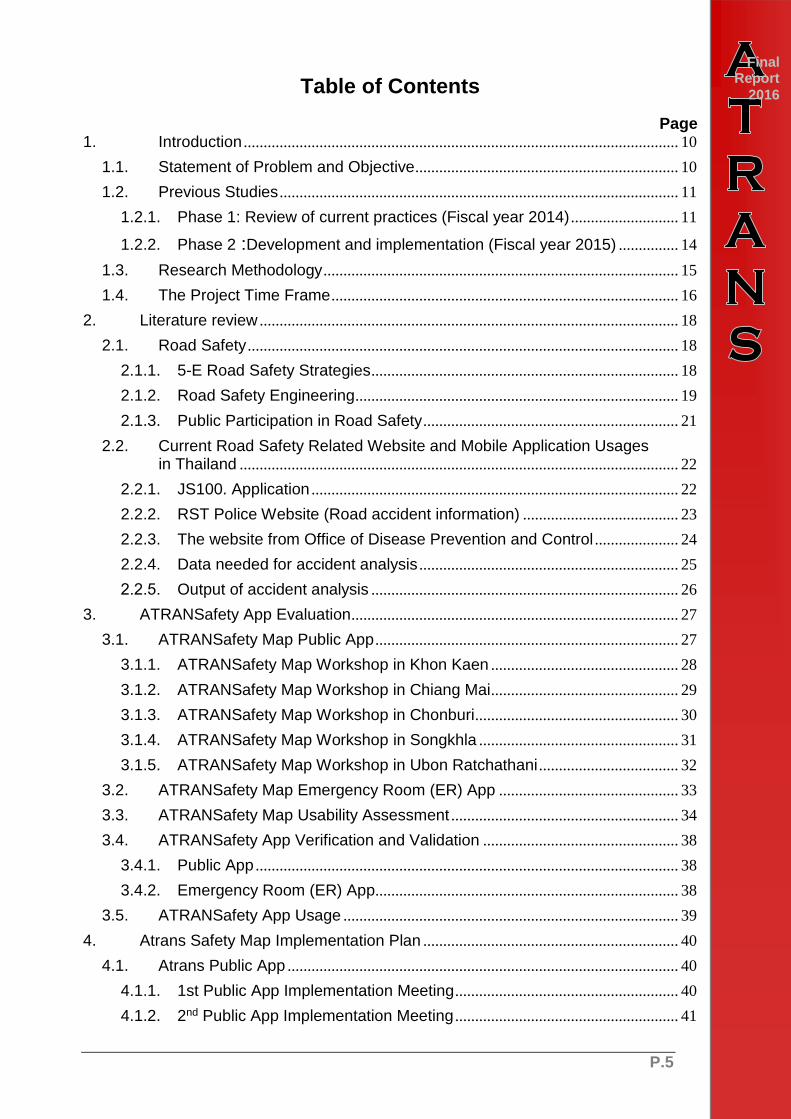
2016 Table of Contents
Page 1. Introduction ............................................................................................................. 10
1.1. Statement of Problem and Objective .................................................................. 10
1.2. Previous Studies .................................................................................................... 11
1.2.1. Phase 1: Review of current practices (Fiscal year 2014) ........................... 11
1.2.2. Phase 2 :Development and implementation (Fiscal year 2015) ............... 14
1.3. Research Methodology ......................................................................................... 15
1.4. The Project Time Frame ....................................................................................... 16
2. Literature review ......................................................................................................... 18
2.1. Road Safety ............................................................................................................ 18
2.1.1. 5-E Road Safety Strategies ............................................................................. 18
2.1.2. Road Safety Engineering ................................................................................. 19
2.1.3. Public Participation in Road Safety ................................................................ 21
2.2. Current Road Safety Related Website and Mobile Application Usages in Thailand .............................................................................................................. 22
2.2.1. JS100. Application ............................................................................................ 22
2.2.2. RST Police Website (Road accident information) ....................................... 23
2.2.3. The website from Office of Disease Prevention and Control ..................... 24
2.2.4. Data needed for accident analysis ................................................................. 25
2.2.5. Output of accident analysis ............................................................................. 26
3. ATRANSafety App Evaluation .................................................................................. 27
3.1. ATRANSafety Map Public App ............................................................................ 27
3.1.1. ATRANSafety Map Workshop in Khon Kaen ............................................... 28
3.1.2. ATRANSafety Map Workshop in Chiang Mai ............................................... 29
3.1.3. ATRANSafety Map Workshop in Chonburi ................................................... 30
3.1.4. ATRANSafety Map Workshop in Songkhla .................................................. 31
3.1.5. ATRANSafety Map Workshop in Ubon Ratchathani ................................... 32
3.2. ATRANSafety Map Emergency Room (ER) App ............................................. 33
3.3. ATRANSafety Map Usability Assessment ......................................................... 34
3.4. ATRANSafety App Verification and Validation ................................................. 38
3.4.1. Public App .......................................................................................................... 38
3.4.2. Emergency Room (ER) App............................................................................ 38
3.5. ATRANSafety App Usage .................................................................................... 39
4. Atrans Safety Map Implementation Plan ................................................................ 40
4.1. Atrans Public App .................................................................................................. 40
4.1.1. 1st Public App Implementation Meeting ........................................................ 40
4.1.2. 2nd Public App Implementation Meeting ........................................................ 41

P.6
Final Report
2016 Table of Contents
Page
4.1.3. Public App Introduction with Chiang Mai Provincial Public Health Office .......................................................................................... 42
4.2. Atrans Emergency (ER) App ............................................................................... 44
5. Conclusion ................................................................................................................... 46
References ................................................................................................................................ 47

P.7
Final Report
2016 List of Tables
Page
Table 1: Basic Information of the Five Study Areas .................................................... 14
Table 2: Schedule of the Project (Phase 3) ................................................................ 17
Table 3: Safety Planning Countermeasures Matrix ..................................................... 20

P.8
Final Report
2016 List of Figures
Page
Figure 1 Evaluation Process (Fiscal year 2016) ................................................................. 11 Figure 2 Map and Location of Five Study Areas ................................................................ 13
Figure 3 System Architecture ................................................................................................ 15 Figure 4 Flow Chart of Usability Testing .............................................................................. 15
Figure 5 The Steps of Hiyari Hatto Approach ..................................................................... 16 Figure 6 Hazardous & Black spot improvement measure ................................................ 21
Figure 7 JS100 Application Interface 1 ................................................................................ 22
Figure 8 JS100 Application Interface 2 ................................................................................ 23 Figure 9 Royal Thai Police RST Website ............................................................................ 24
Figure 10 Flow chart of process ............................................................................................ 28
Figure 11 ATRANSafety Map Workshop in Khon Kaen .................................................... 28
Figure 12 ATRANSafety Map Workshop in Chiang Mai ................................................... 29 Figure 13 ATRANSafety Map Workshop in Chonburi ....................................................... 30
Figure 14 ATRANSafety Map Workshop in Songkhla ....................................................... 31
Figure 15 ATRANSafety Map Workshop in Ubon Ratchathani ........................................ 32 Figure 16 ATRANSafety ER App Test Procedure .............................................................. 33
Figure 17 Atrans Safety Map ER App Training and Testing ............................................ 34 Figure 18 Atrans App Usability Assessment from Chiang Mai Workshop ..................... 35
Figure 19 Atrans App Usability Assessment from Chonburi Workshop ......................... 35 Figure 20 Atrans App Usability Assessment from Songkhla Workshop ......................... 35
Figure 21 Atrans App Usability Assessment from Ubon Ratchatani Workshop ............ 36
Figure 22 Socioeconomic Details of the Participants ........................................................ 37
Figure 23 Black Spot and Hazardous location Knowledge and Perception ................... 38
Figure 24 Amount of reported hazardous spot (Sep-Dec, 2016) in Thailand ................ 39 Figure 25 Atrans Public App Implementation Plan ............................................................ 40
Figure 26 First Implementation Meeting at Chiang Mai Police Center ........................... 41
Figure 27 Second Implementation Meeting at Chiang Mai ETC Traffic Control Center ............................................................................................ 42
Figure 28 1st Introduction and Testing with Chiang Mai Provincial Public Health Office ............................................................................ 43
Figure 29 2nd Introduction and Testing with Chiang Mai Provincial Public Health Office ............................................................................ 43
Figure 30 Emergency Room (ER) App Implementation Plan ........................................... 44
Figure 31 Atrans (ER) App Implementation Meeting with Provincial Administrative Organization ................................................................................. 44
Figure 32 Atrans (ER) App Implementation Meeting with Khon Kaen Municipality ...... 45
Figure 33 Atrans ER App Meeting with Khon Kaen Hospital ........................................... 45

P.9
Final Report
2016 List of Abbreviations
ARMS Accident Report Management System DOH Department of Highways DRR Department of Rural Roads EXAT Expressway Authority of Thailand HAIMS Highway Accident Information Management System ISIS Injury Surveillance Information System MOPH Ministry of Public Health MOT Ministry of Transport POLIS POLice Information System RSC Road Safety Culture RTIIS Road Traffic Injury Information System RTP Royal Thai Police RVP Road Victim Protection Co., Ltd. TRAMS Thailand Road Accident Management Systems WHO World Health Organization

P.10
CHAPTER 1 INTRODUCTION
1. Introduction 1.1. Statement of Problem and Objective
Road traffic accident has been a pressing problem causing fatalities and injuries to Thai citizens for many decades. According to World Health Organization (WHO) Global Status Report in year 2015, Thailand was ranked the second highest fatality rate worldwide. It was estimated that Thailand has a road traffic fatality rate of 36.2 persons per 100,000 populations (WHO, 2015).
In the past, various road safety research and measures were conducted to tackle road safety problems. The development of road safety maps/databases is one of the key steps for safety professionals to understand the bottom of the issues and to efficiently propose measures and actions to correct the safety problems. From the literature, most of the safety maps present the locations where people are being killed, and seriously or slightly injured. Distinctly, the safety map developed by HONDA collects sudden braking information from Inter-Navi system in Honda cars running over Japan, and traffic accident information from all road users. This safety map has been developed from the voice of everyone in the hope and look forward to the world that everyone can live in peace more (www.honda.co.jp/safetymap).
ATRANS launched a 3-year common research project (Year 2014-2016) to tackle road safety problems. The research highlights the development and implementation of road safety map applications to help establish road traffic accident database and identify hazardous locations on road network in Thailand. This ongoing project is divided into three phases as follows: (1) Fiscal year 2014 - Review of current practices, (2) Fiscal year 2015 – Development and implementation, and (3) Fiscal year 2016 - Evaluation process
Phase 1: Review of current practices (Fiscal year 2014)
The effort was made to exploring road traffic safety databases. The literature review showed that various road safety map and databases have been developed under different platforms for different purposes. Among them, the HONDA safety map and database is one of the potential prototypes to develop Thai Safe Applica for this research. Data from the accident scene and insurance source were obtained to develop Black Spot location maps, whereas data and experience from local residents and rescue team were gathered to identify high risk locations (Hiyari map). In this phase, workshops were held in Khon Kaen and Hatyai to collect black spot locations and high risk locations. The data would be used for developing Safety Application in the second phase of the research.
Phase 2: Development and implementation (Fiscal year 2015)
The effort was made to develop the prototypes of the two Mobile Apps to help creating road safety maps and databases, namely ER App and Public App. The ER App is designed for the medical staffs in Emergency Room who are responsible for recording the relevant data from road accident scenes. The Public App is designed for the general people who are willing to help identify hazardous locations in the neighborhood. The team discussed with the potential users such as ER nurses of the Khon Kaen hospital, Khon Kaen Provincial Administrative Organization (PAO), and the Khon Kaen Municipality, and developed road safety indices for data collection, and designed the user interface of the road safety mobile app.

P.11
Final Report
2016 Phase 3: Evaluation process (Fiscal year 2016)
Road accident in Thailand continues to be a common issue that has yet been solved to satisfaction. One of the most successful road safety programs pursued in many developing countries is the increase in awareness of the public and the sustainable safe behavior of road users. The underlying notion is that to increase attention or awareness of individuals, each individual should perceive that road accident is a high risk for himself/herself, his/her family, and the society. If so, with no enforcement their behavior would change to be a safety culture. How to raise awareness that road accident is a high risk and severity for yourself and others is the key issue.
In this phase of the common research project will focus on gaining awareness of the proposed safety apps and attention to their capabilities and usefulness. To make the common research project meet its ultimate goal, this phase underline the objectives of this research as follows.
- To evaluate ATRANS Safety Map Mobile Applications: ER App and Public
App
- To analyze road accident characteristics using data from ATRANS Safety
Map
- To propose implementation plans for ATRANS Safety Map
By implementing the road safety map in Thailand, the researchers expect that individuals and Thai society could realize the risk of traffic accident and raise their awareness on traffic safety.
Figure 1 Evaluation Process (Fiscal year 2016)
1.2. Previous Studies
The research will be separated into three phases corresponding to the research objectives:
1.2.1. Phase 1: Review of current practices (Fiscal year 2014)
In the first phase, existing sources of road safety maps in Thailand and other countries will be reviewed. The review phase consists of four main tasks literature review, preliminary design of Thai road safety map, stakeholder interviews, and revision of preliminary design.

P.12
Final Report
2016 Task 1.1: Literature review
Previous studies and other media related to road safety maps in Thailand and other countries will be reviewed. This will help the researchers to understand the gap of existing road safety map in Thailand and recognize good practices, which can be applied to Thai road safety map.
Task 1.2: Preliminary design of Thai road safety map
In this task, the user interface of Thai road safety map will be preliminarily designed based on good practices from the literature.
Task 1.3: Stakeholder interviews
Stakeholder interviews will be conducted to obtain their current practices and challenges in road safety improvement from local authorities (such as provincial police stations, Bureau of Highways, Bureau of Rural Roads, Provincial Health Offices, and Insurance Network) in five pilot study areas (Figure 1), including Bangkok, Chiang Mai, Khon Kaen, Ubon Ratchathani, and SongKhla.
The basic information of the five cities are presented in Table 1. As shown in Figure 2, each local university will conduct the stakeholder interview in their province. The main purpose of this task is to set up main objectives and outputs of the Thai road safety map that meet objectives of the local authorities and road users. Moreover, the local authorities and road users will be asked to share their idea about the preliminary user interface of Thai road safety map designed in the previous task.
Task 1.4: Revision of preliminary design
From the feedback, the preliminary design will be revised

P.13
Final Report
2016
Figure 2 Map and Location of Five Study Areas

P.14
Final Report
2016 Table 1: Basic Information of the Five Study Areas
Province Area
(Km)2 (1)
Registered Population in 2013 (1)
Density (inh/Km2)(1)
Registered Vehicle in 2013 (2)
Passenger Car/Pick Up
Motorcycle
Chiang Mai 20,107.057 1,666,888 82.90 459,217 731,205
Khon Kaen 10,885.991 1,781,655 163.66 292,925 436,189
Ubon Ratchathani
16,112.650 1,836,523 113.98 199,303 426,392
Bangkok 1,568.737 7,791,252 4,966.58 4,726,891 3,066,088
Songkhla 7,393.889 1,389,890 187.97 313,420 466,145
1.2.2. Phase 2 :Development and Implementation (Fiscal year 2015)
The second phase consists of three key tasks: system development, system testing, and system implementation.
Task 2.1: System development
The computer based system of Thai road safety map will be developed according to the findings and comments from the stakeholder interviews in Phase I. The system comprises of two main parts: user interface and database. The database will be designed such that the database is compatible with most of the existing databases. For the user interface, interactive web page and smartphone application will be designed such that the road safety information can easily accessed and analyzed. As for the database part, a web service will be developed to acquire crash data and exchange information with other data sources. Spatial database management system such as PostgreSQL will be used to handle crash data in relation to geographical information of the road network.
Task 2.2: System testing
The developed road safety map application will be tested in the five pilot study areas. Actual crash data will be periodically. The application will perform initial analyses to provide useful information identified in the previous phase. In this task, the stakeholders will be asked to evaluate the road safety issues based on the information provided by the application. Comments and suggestions from this task will be incorporated into the revised version of the application.
Task 2.3: System implementation
After the evaluation effort, the system will be released for all users. The system will be monitored and maintained by the authority identified in Phase I project.
To propose implementation plans for ATRANS Safety Map, the researchers will request the relevant agencies to appraise for the costs of system maintenance. The outputs of ATRANSafety ER and Public Apps will help display and identify the hazardous locations and their causes of accident. Data from ATRANSafety Public App can be used to recommend the responsible authorities some corrective actions of hazardous locations. Data from ATRANSafety ER App can be used to report accident outcomes and can be integrated with ITEM database of National Institute for

P.15
Final Report
2016 Emergency Medicine, Injury Surveillance (IS) database, and the Medical health service records (43 files) of all local and provincial hospitals.
Figure 3 System Architecture
1.3. Research Methodology
To evaluate ATRANS Safety Map Mobile Applications (ER App and Public App), the researchers apply the Usability Testing survey. The survey will be conducted by testing the Application with potential target users. The functionality and contents of the Application will be assessed. The target users will be monitored and observed how they think, make a decision, and operate the Application. Therefore, the Usability Testing is the process of measure and learn before the improvement of the Application. The Usability Testing is the method for users to test the Application before the system is being fully implemented. After conducting Usability Testing, the technical errors and recommendation will be gathered to make the improvement of the system. The framework of the evaluation process for both ER and Public Apps is shown in Figure 4.
Figure 4 Flow Chart of Usability Testing
To analyze road accident characteristics, the researchers will use data gathered from ATRANS Safety Map to analyze the hazardous locations. The method is called Hiyari-Hatto or “Near-miss”, which is an incident which was prevented just before its actual occurrence to avoid an accident. It is said that frequent near-miss indicates impending serious accidents. The method will be applied to the operation of ATRANSafety Public App. The researchers will develop the connection of “Road safety club” and perform the training courses in 4 provinces of Thailand including Khon Kaen, Chiang Mai, Chonburi, Ubon Ratchathani, and Songkhla. The training will be based on Hiyari-Hatto concept and follow the steps as shown in Figure 5.
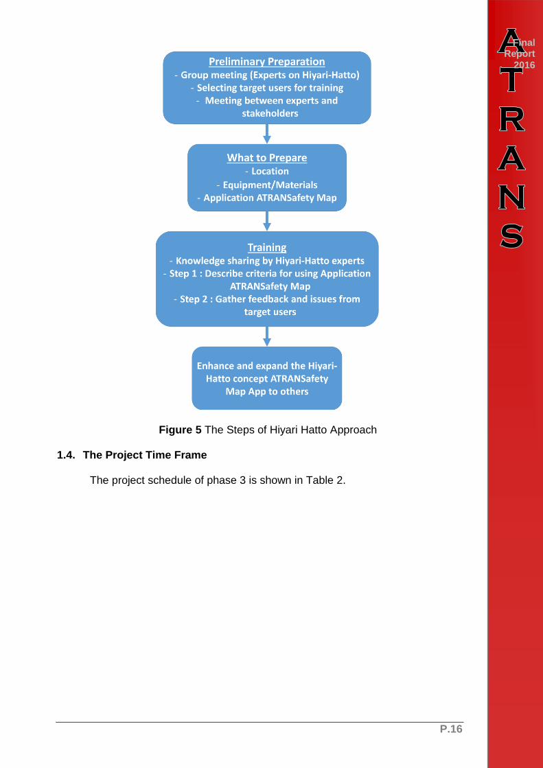
P.16
Final Report
2016
Figure 5 The Steps of Hiyari Hatto Approach
1.4. The Project Time Frame
The project schedule of phase 3 is shown in Table 2.

P.17
Final Report
2016 Table 2: Schedule of the Project (Phase 3)

P.18
Final Report
2016 CHAPTER 2 LITERATURE REVIEW
2. Literature review 2.1. Road Safety
2.1.1. 5-E Road Safety Strategies
The office of traffic safety in Edmonton, Canada (2016) said the 5E’s road safety strategies were used as a guideline in order to dealing with the road accident problem including Enforcement, Education, Engineering, Emergency Medical Service and Evaluation. The details of these strategies are show as follows.
1) Enforcement
Enforcement is a key component of road safety improvement as it reinforces the laws that serve to protect you. The role of enforcement is to prevent an incident, reduce a hazardous and risky of driver behavior by using law enforcement or legislative measures to control and scoping the damage, harm or injuries that involved in road accidents. Moreover this strategy can also help to communicate between drivers or road users to the law enforcement authority: police officer and help to reporting of incidents and operational risks.
2) Education
Education is one of a significant part of 5E’s strategies. The requirement is to understand in behaviors, safety culture and beliefs of the road user. Research, development and implementation of road safety educational program and campaigns to encourage safer road users will be greater emphasized. Based on these findings new education program will be developed along with the evaluation and improvement of an existing program such as driver training and testing, road safety education of children, road safety publicity and also including public relation and participation.
3) Engineering
An engineering study is one of the most efficient way to create a better and safer road and environment, prevent collision, reduces damage and violence by using Road-safety audits or road standard assessment in new road project design and construction along with reducing a level of hazardous in the existing road networks by maintenance, improving design of road (structure, signal, signs), incorporating more knowledge including statistical data: amount of road incident, injuries involved in road accident, hazardous spot in road networks and also create a new safety countermeasures or vehicle safety standard for a safer and better roadway network.
4) Emergency Medical Service
Emergency Medical Service: EMS, it is usually a reactive measure rather than proactive or preventative role. In the other hand, the most important role of EMS is making the crashes more survivable, provide an emergency road assistance, gave the injured a chance to survive.
P.19
Final Report
2016 5) Evaluation
The combination of enforcement, education, engineering, and emergency medical service together, road safety audits criteria will be created to determine and ensure the aims of those all road safety strategies can be achieved. And the criteria will be applied to transportation system plan and will continue to make a safer roadway network and safer driver behavior. Road safety educational initiatives will be monitored and evaluated for effectiveness and continuous improvement.
2.1.2. Road Safety Engineering
There are various component factors involved in occurrence road accident including human, vehicle, road and environment. In order to achieves road safety analysis William Haddon combined these three factors with the three phases in an accident including Pre-Crash, In-Crash and After-Crash in to a relation form which known as Haddon Matrix or Safety Planning Countermeasures Matrix. Inside the matrix, each of nine elements represents a possible focus on road safety in three phases in accident as shown in Table 3.
Peden et al (2004) suggested that Haddon’s Matrix frame work led to advances in understanding of behavioral, road and vehicle related factors that affect the number and severity of causalities in road traffic collision, providing the approach to identify and rectify the major sources of error or design mistake that leads to fatal and severe crashes.
The Haddon’s matrix becoming a widely utilized as a frame work in range of public health and work related road safety as shown in Figure 6.

P.20
Final Report
2016 Table 3: Safety Planning Countermeasures Matrix
Road Users Vehicles Road & Environment
Pre-
Crash
Enforcement &
Education & Campaign
- Over Speeding
- Alcohol/Drugs
use
- Physical
Impairment
- Young Drivers
- Driver License
Vehicle Inspecting
Program
- Breaking System,
Lighting, Tire,
Safety Assist
System
- Inspecting
Agency
Vehicle Standards and
Modifications
- Public buses
- Trucks
Vehicle Visibility
- Reflective
material
- Daytime running
Headlights
- Front-Rear Fog
Lights
Road Engineering
Program
- Road Safety
Audits
- Black Spots /
Hazardous Spots
Treatment
- Traffic
Management
System (e.g.
traffic calming)
- Traffic Control
Devices
- Motorcycle lanes
- Zero pothole
- Accident
Database System
Community Based
Approach
- Public
Participation
- Bottom Up
Approach
In-
Crash
Compliance of Safety
Devices
- Use of Restraints
(Helmet, Seat
belt)
- Child Restraints
(Proper child
seat)
Vehicle and Occupants
Safety Features
- Restraint System
- Interior (Airbags)
- Exterior (Crash
Protection)
Crash Compatibility
- Under run bars
(Truck)
- Bull Bar (Pick-up
truck)
Roadside Hazard
Treatment
- Forgiving Road
Furniture
- Collapsible
Facilities
- Crash Barrier
- Crash Cushion
Post-
Crash
Skill of Paramedics
- First Aid, Initial
proper medical
treatment
- Rescue Skills
- ERP
(Emergency
Response Plan)
Ease of Evacuation
- Vehicle related
eg. door opening,
fuel leakage
- Rescue Tools
Trauma Management
- Rescue work
- Accessibility of
rescue team
- EMS
- Rehabilitation
Program
Source: TANABORIBOON (2003)

P.21
Final Report
2016 1) Hazardous Location
Hazardous location consists of area full of risks, harms, dangerous and possibility of unexpected incident. The difference between Black spot and Hazardous spot is related data and information requirement. Beside a number of accidents, gathered information including traffic volume information and severity index information were used to determine a hazardous location indicator.
2) Black Spot Location
Usually black spots are defined as a highly amount of accidents. In order to define a black spot on the area, statistical data; number of incident were used to analyze and to defining black spot location. In addition, black spot can also describe as a black length, which refer to the dangerous part of the road
Figure 6 Hazardous & Black spot improvement measure Source: Austroad (1988)
2.1.3. Public Participation in Road Safety
There are a various way of public participation to informing a black spot and hazardous spot information such as; telephone, television program, official website, radio station, portable radio device and etc. Now a day, there is more options to get a useful hazardous and black spot information directly from smartphone and tablet users.

P.22
Final Report
2016 By using developed application to facilitate users to inform, monitoring hazardous and black spots improvement.
• Mailing address (post office) • Telephone • Website • Radio stations • Television programs • Portable radio • Etc. (Smart phone application, booklet, leaflet, brochure)
2.2. Current Road Safety Related Website and Mobile Application Usages in Thailand
2.2.1. JS100. Application
JS100 is one of the most famous radio stations on Thailand. Broadcast about road daily traffic incidents, real time traffic conditions, road accidents, news and weather update. JS100 application comes from the cooperation between Viriyah insurance company, N.D.Rubber Co., Ltd. and JS100 radio station in order to provide useful daily news, incidents, traffic and accident information directly to smartphone user. The sample of JS100 application user interface (as shown in Figure 7-8) and details are shown as follows.
• Based on NOSTRA Map System • Real time incident / accident • Location (Coordinates) • Cause and type of accident • Real time traffic information • Road Black Spot and Hazardous Spot.
Figure 7 JS100 Application Interface 1

P.23
Final Report
2016
Figure 8 JS100 Application Interface 2
2.2.2. RST Police Website (Road accident information)
The website operated and managed by police officer from Research, Prevention of Road Accidents Centre in order to assemble road accident database. The sample of website user interface (as shown in Figure 9) and details are shown as follows.
• Location (Coordinates) • Date/Time • Cause of accident • Level of injury • Number of People Involved • Number of death and injured • Damage cost • The website from Office of Disease Prevention and Control • Location (Coordinates) • Date/Time • Level of injury • Number of People Involved • Vehicle type • Using safety equipment • Informing method • Legal penalty • Accidental characteristics

P.24
Final Report
2016
Figure 9 Royal Thai Police RST Website
2.2.3. The website from Office of Disease Prevention and Control
• Location (Coordinates) • Date/Time • Level of injury • Number of People Involved • Vehicle type • Using safety equipment • Informing method • Legal penalty • Accidental characteristics

P.25
Final Report
2016 2.2.4. Data needed for accident analysis
Each accident analysis needs different data depending on the method and
purpose of the analysis. Austroads (1997) recommended the data commonly used for accident analysis including.
A. Accident-related variables 1) Date and time of crash 2) Classification of crash type 3) Geographical location of crash 4) Local government area 5) Speed limit at crash site 6) Road design at crash site 7) Road division 8) Road curvature 9) Road surface 10) Road surface condition 11) Other road features at crash site, e.g. median, bridge, railway crossing 12) Traffic control devices 13) Traffic control function 14) Lighting conditions 15) Weather conditions
B. Vehicle-related variables 1) Vehicle type 2) Model of vehicle 3) Year of vehicle manufacture 4) State of vehicle registration
C. Road user-related variables 1) Road user classification 2) Sex 3) Age 4) Driving status (driver and rider) 5) Seating position (Rider, Pillion passenger, Sidecar passenger, Front right
seat, Front middle seat, Front left seat, Rear right seat, Rear middle seat, Rear left seat, Other)
6) License type 7) Level of personal injury 8) Blood alcohol level 9) Seat belt use 10) Airbag use 11) Helmet use
D. Other related information 1) Brief narrative of crash 2) Sketch of crash
Taneerananon (2008) stated that, in some cases, in-depth crash investigation and analysis are required for better understanding the causes of accident. Works in this area are ongoing and since then a number of Thai universities are conducting similar in-depth study of crashes. A brief summary of the in-depth crash investigation reveals that socio-economic development, level of motorization and alarming rate of road crashes have strong interrelationship in Thailand.

P.26
Final Report
2016 2.2.5. Output of accident analysis
The output of accident analysis can be widely classified by a format of output
into statistical output (accident situation) and geographic output (hazard location). Common outputs of accident analysis are as follows:
Accident situation
o Number of accidents
o Number of casualties
o Number of fatalities
o Deaths per 100,000 population
o Deaths per 10,000 registered motorized vehicles
o Category of accident cause
o Category of driver/rider
o Category of vehicle
o Deaths by type of road user
o Seat-belt use rate
o Helmet wearing rate
o Accident costs
Hazardous location
o Black spot intersection
o Black spot road section
o Black spot area
The output of accident analysis is key information to improve road safety. The
more accuracy of the analysis leads to the safer road. To avoid accident data error, road accident databases are commonly used for collecting accident data.
In Thailand, several government agencies have reported the results from accident analysis, for example, Department of Disaster Prevention and Mitigation (DDPM), Royal Thai Police (RTP), Department of Highways (DOH). ThaiRoads foundation, a non-governmental organization, has also launched the Thailand Road Safety Observatory (called TRSO) to collect traffic accident data and report them since 2009. The database of TRSO includes both primary data (e.g. risk behavior of road users) collected by themselves and secondary data obtain from several government agencies. The results of data analysis can reflect the road safety problem evidently. In addition, the results can be used to generate and synthesize safety related knowledge to enhance the cognitive performance of various road safety agencies in the country. Six major reports of accident data and statistics are presented in their website (http://trso.thairoads.org):
o Accident indices in national level (accident situation, risk group and risk
factor)
o Accident indices in provincial level
o Accident situation map (number of road accidents/victims, accident rate,
severity index, risk group classified by vehicle/sex/user, risk factors)
o Accident situation by province
o Risk behavior (speeding, helmet/seatbelt/headlamp usage, drunk driving,
red light violation)
o Accident situation during New Year and Songkran festivals.
P.27
CHAPTER 3 ATRANSafety Map Evaluation
3. ATRANSafety App Evaluation
The research performed the usability test to evaluate the input and output processes of the ATRANS Safety Map Mobile Applications. To do this, the comparative analyses will be conducted to quantitatively assess the operational performance between the conventional and the proposed technology, whereas the questionnaire surveys will be conducted to qualitatively assess the levels of satisfaction of the users toward the proposed Safety Map Mobile Apps. The feedback obtained from the evaluation process will be used to modify and update the functions of the Safety Map.
3.1. ATRANSafety Map Public App
For the Public App, the Public App will be introduced to the communities in five different regions in Thailand including Khon Kaen, Chiang Mai, Chonburi, Ubon Ratchathani, and Songkhla.
The purpose of ATRANSafety workshop are shown as follows.
To evaluate ATRANS Safety Map Mobile Applications: Public App.
To hearing a suggestions and application using problems to improve application stability.
To create and propose ATRANS safety application implementation plans for target agencies.
The event including introduction, lecture on safety map by Hiyari-Hatto Safety Map Expert : Dr. Tuenjai Fukuda and Atrans safety public application, public meeting and focus group with community’s leader and related municipal officials in study area, the meeting stared on 27 September, 2016 in Khon Kaen province and will be finished on 12 October, 2016 at Ubon Ratchathani.
The participants will join Hiyari Hatto workshop. And during the process, data inputs and result outputs will be collected from either App-based or paper-based and further analyzed. Along with the study, students of Road Safety Club from Khon Kaen University, Chiang Mai University, Ubon Ratchathani University, and Prince of Songkhla University will collaborate with the project testing and using the application.

P.28
Final Report
2016
Figure 10 Flow chart of process
3.1.1. ATRANSafety Map Workshop in Khon Kaen
The 1st ATRANSafety map workshop meeting was held on 27 September, 2016 at Kosa Hotel in Khon Kaen with 38 participants including related municipals official, communities’ leader and representative as shown in Figure 11.
Figure 11 ATRANSafety Map Workshop in Khon Kaen

P.29
Final Report
2016 3.1.2. ATRANSafety Map Workshop in Chiang Mai
The 2nd ATRANSafety map workshop meeting was held on 29 September, 2016 at ATC Traffic Control and Training Centre in Chiang Mai with 26 participants including related municipals official, Traffic engineer and technician, doctor and public health agencies, police officer, community’s leader and representative as shown in Figure 12.
Figure 12 ATRANSafety Map Workshop in Chiang Mai

P.30
Final Report
2016 3.1.3. ATRANSafety Map Workshop in Chonburi
The 3rd ATRANSafety map workshop meeting was held on 4 October, 2016 at Burapha University in Chonburi with 30 participants including Burapha University faculty members, related municipals official, community’s leader and representative as shown in Figure 13.
Figure 13 ATRANSafety Map Workshop in Chonburi

P.31
Final Report
2016 3.1.4. ATRANSafety Map Workshop in Songkhla
The 4th ATRANSafety map workshop meeting was held on 5 October, 2016 at Buri Sriphu Hotel in Hat Yai, Songkhla with 23 participants including faculty members of Prince of Songkhla University, Traffic engineer and technician, emergency and rescue unit, doctor, police officer, related municipals official, community’s leader and representative as shown in Figure 14.
Figure 14 ATRANSafety Map Workshop in Songkhla

P.32
Final Report
2016 3.1.5. ATRANSafety Map Workshop in Ubon Ratchathani
The 5th ATRANSafety map workshop meeting was held on 12 October, 2016 at Warin Chamrap hospital, Ubon Ratchathani with approximately 35 participants including faculty members of Ubon Ratchathani University, doctor and nurse, police officer, related municipals official, community’s leader and representative as shown in Figure 15.
Figure 15 ATRANSafety Map Workshop in Ubon Ratchathani
After the meeting events, there are some suggestions from the participants in order to improve application stability as follows.
Some of the participants require an ability to erase or edit a hazardous spot.
Some of the participants suggest to add more cause of the accident such as some traffic lights will not operate at night or when traffic is very light. And more ability to inform combine type of vehicles
Consideration of aerial photograph on based map
Information accessibility for users in order to export a hazardous spot details directly.

P.33
Final Report
2016 The hazardous icon on safety map should be categorized in type of accident or
danger.
3.2. ATRANSafety Map Emergency Room (ER) App
For the ER App, the ER Safety Map Mobile App will be introduced to the staff in Emergency Room (ER) at Khon Kaen Hospital to use as a tool to collect IS data of the patients. The recording process, data inputs, and result outputs via the conventional method (paper-based and PC-based) and the ER App method will be studied and compared. Questionnaire surveys on users’ satisfactions will be assessed before and after using the ATRANS Safety Map as the procedure shown in Figure 16. Further, ATRANS Safety ER App will be expanded to other hospitals in Khon Kaen.
The Atrans safety map ER (emergency room) app training (ER registry and IS) and user acceptance test was held on April 29 - May 3, May 12 kickoff the meeting with Khon Kaen hospital as shown in Figure 17.
Figure 16 ATRANSafety ER App Test Procedure

P.34
Final Report
2016
Figure 17 Atrans Safety Map ER App Training and Testing
3.3. ATRANSafety Map Usability Assessment
A usability satisfaction survey is considered to be a proper way to understand the user’s point of view on Atrans safety app. The objective of this usability assessment is to compare a satisfaction level between using a traditional Hiyari-Hatto safety map and Atrans safety map public application from the safety map workshop participants and public user’s by using a various criteria (1-7) as following.
• 1st Criteria is hazardous spot utilization
• 2nd Criteria is black spot utilization
• 3rd Criteria is hazardous spot informing convenience
• 4th Criteria is black spot accessing convenience
• 5th Criteria is an accuracy of hazardous & black spot on map
• 6th Criteria is a clarity of hazardous and black spot on the map
• 7th Criteria is hazardous & black spot publicity
In each criteria has a criteria state score from 5 down to 1 as following; 5 = very good, 4 = good, 3 = ok, 2 = poor and 1 = very poor. The result of a criteria state score from 4 provinces including Chinag Mai, Chonburi, Songkhla and Ubonratchatani province as shown in Figure 18 – Figure 21 with the exception of the result from Khonkaen province due to questionnaire revising.

P.35
Final Report
2016
Figure 18 Atrans App Usability Assessment from Chiang Mai Workshop
Figure 19 Atrans App Usability Assessment from Chonburi Workshop
Figure 20 Atrans App Usability Assessment from Songkhla Workshop

P.36
Final Report
2016
Figure 21 Atrans App Usability Assessment from Ubon Ratchatani Workshop
From the five focus group workshop meeting, there are 131 participants in total. The socioeconomic details of the participants are summarized in Figure 22.

P.37
Final Report
2016
Figure 22 Socioeconomic Details of the Participants
Based on the current practices from the participants, Figure 23 shows that 79% of the participant know black spot and hazardous location but only 34% of participants reviewed that they have informed or reported the details of black spot and hazardous location to the responsible agencies.

P.38
Final Report
2016
Figure 23 Black Spot and Hazardous location Knowledge and Perception
3.4. ATRANSafety App Verification and Validation
3.4.1. Public App
First page - Using application tutorial was added to the home screen for first
time user to provide some useful guidelines and information.
Follow up page - Hazardous spots information on the applications display map
now can be accessible.
Black spot location page - Current location button has been added to the map
display screen.
Hazardous spot location page – Now have the ability to add photos from
smart phones camera, Current location button has been added to the map
display screen and works properly and “Other reason tab” from the participant’s
suggestion has been added into cause of accident menu
3.4.2. Emergency Room (ER) App
Server status indication feature - the status icon was added to the home
screen (top right) to show the connection status between the IS application
and the server. The indicator icon is green if the connection is normal. When
the connection with the server is down, the indicator will turn red to notify the
user.
Offline feature - when the tablet cannot connect to the server, the records
will be saved on the tablet. Once the connection is back on, the tablet will
begin to send buffered data to the server again.
Autofill feature - Web Service to retrieve patient information has been
developed to automatically fill in the blue form once the HN has been input by
the data entry person.
Data Attribute Updation - the data attributes such as hospital codes has
been updated to match with the changes from the hospital documents.

P.39
Final Report
2016 Changing Server - the KK hospital requested ATRANS to move the software
and its database from the cloud service to the hospital server to improve the
data query speed.
Work Station Mode - Due to the reliability issue of the internet inside the
Emergency Room, the staff requested that we set up a PC-like environment
to connect to the network using LAN cable. We have purchased an android
box, 20" monitor, keyboard, and mouse. We have also modified that
application such that it can take inputs from keyboard and mouse (as
supposed to touch screen interaction), especially the interaction with the
google map.
3.5. ATRANSafety App Usage
The amount of Atrans safety map public application usage from the pilot introduction in 5 provinces in Thailand, safety map workshop meeting and Atrans safety app implementation meeting (during the period from September – December 2016) are shown in Figure 24.
Figure 24 Amount of reported hazardous spot (Sep-Dec, 2016) in Thailand
84
126
29
55
0
20
40
60
80
100
120
140
Times
Month
Amount of Reported Hazardous Spot (Sep – Dec, 2016) in Thailand
September October November December
P.40
Final Report
2016 CHAPTER 4 IMPLEMENTATION PLAN
4. Atrans Safety Map Implementation Plan
This part of the research focusses on the implementation of Atrans safety map applications to the target user according to the objective of Atrans safety map 3rd year research project (Fiscal year 2016) which is to evaluate Atrans safety map applications in term of usability and aim to publicize the effective applications to responsible agencies. To establish road traffic accident database and identify hazardous locations on road network in Thailand.
The tentative implementation plan will be implemented to focus groups which is the potential agency in order to gain a feedback, suggestions and related information for Atrans safety map improvement, Moreover, the crucial information for future implementation will be proposed such as responsible unit or agencies, budgets, etc. There for, after the completion of the project, Atrans safety map public app will be transmitted to the responsible agencies, such as Ministry of Interior, Ministry of Transport, Royal Thai Police, and Department of Rural Roads, while Atrans safety emergency room (ER) app will be given to Ministry of Public Health.
4.1. Atrans Public App
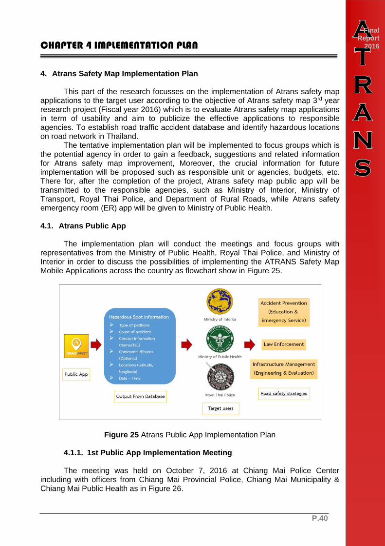
The implementation plan will conduct the meetings and focus groups with representatives from the Ministry of Public Health, Royal Thai Police, and Ministry of Interior in order to discuss the possibilities of implementing the ATRANS Safety Map Mobile Applications across the country as flowchart show in Figure 25.
Figure 25 Atrans Public App Implementation Plan
4.1.1. 1st Public App Implementation Meeting
The meeting was held on October 7, 2016 at Chiang Mai Police Center including with officers from Chiang Mai Provincial Police, Chiang Mai Municipality & Chiang Mai Public Health as in Figure 26.

P.41
Final Report
2016
Figure 26 First Implementation Meeting at Chiang Mai Police Center
4.1.2. 2nd Public App Implementation Meeting
The 2nd meeting was held on November 3, 2016 at ATC Traffic Control Center including participant from Chiang Mai municipality as shown in Figure 27.

P.42
Final Report
2016
Figure 27 Second Implementation Meeting at Chiang Mai ETC Traffic Control Center
4.1.3. Public App Introduction with Chiang Mai Provincial Public Health Office
The introduction meeting of Atrans public app to Chiang Mai provincial public health office, the 1st meeting was held on December 23, 2017 (Network capacity development of the prevention and reduction of road traffic deaths in Chiang Mai conference.) With the cooperation of Chiang Mai Provincial Public Health Office as shown in Figure 28 and the 2nd meeting was held on January 13, 2017 at ATC Traffic Control Center including participant from Chiang Mai municipality, Chiang Mai police and Chiang Mai provincial disease control office 10 as shown in Figure 29.

P.43
Final Report
2016
Figure 28 1st Introduction and Testing with Chiang Mai Provincial Public Health Office
Figure 29 2nd Introduction and Testing with Chiang Mai Provincial Public Health Office
P.44
Final Report
2016 4.2. Atrans Emergency (ER) App
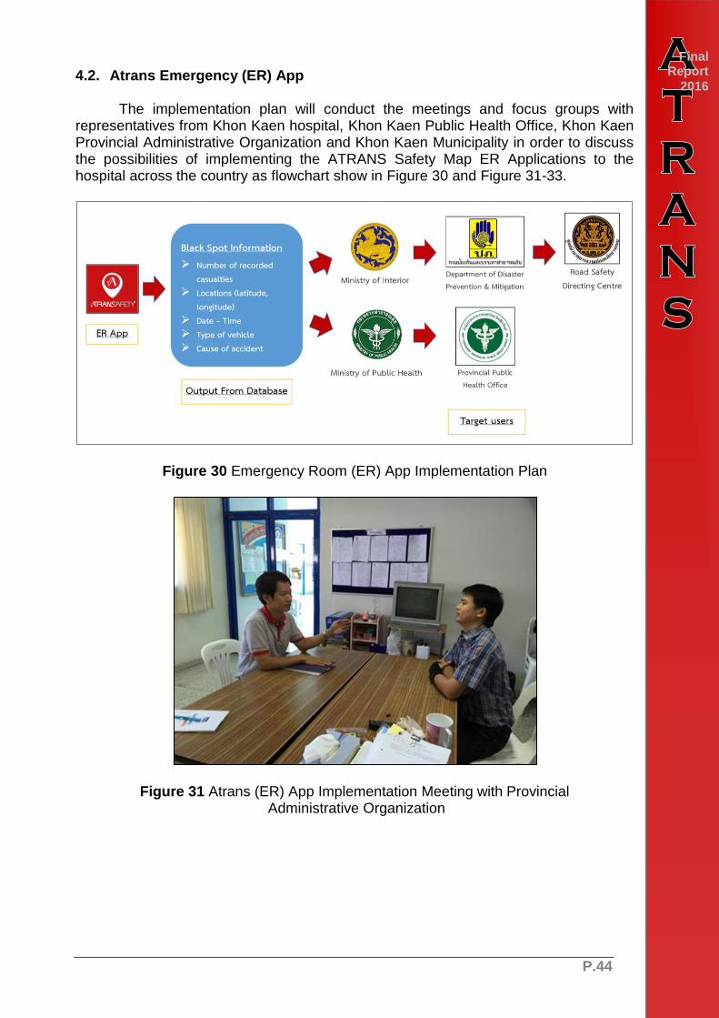
The implementation plan will conduct the meetings and focus groups with representatives from Khon Kaen hospital, Khon Kaen Public Health Office, Khon Kaen Provincial Administrative Organization and Khon Kaen Municipality in order to discuss the possibilities of implementing the ATRANS Safety Map ER Applications to the hospital across the country as flowchart show in Figure 30 and Figure 31-33.
Figure 30 Emergency Room (ER) App Implementation Plan
Figure 31 Atrans (ER) App Implementation Meeting with Provincial Administrative Organization

P.45
Final Report
2016
Figure 32 Atrans (ER) App Implementation Meeting with Khon Kaen Municipality
Figure 33 Atrans ER App Meeting with Khon Kaen Hospital

P.46
Final Report
2016 CHAPTER 5 Conclusion
5. Conclusion
ATRANSafety Map App (Public) was developed and introduced as a tool for public usage. It allowed anyone to easily report accident blackspots and access public blackspots data. At the same time, local authorities were able to use the same data for planning either passive or active approaches. It was also used to increase public awareness on traffic safety in Thailand.
In this phase, the 3rd phase, of the research, several workshops were conducted to gather accident blackspots with high risk of accident from local residents. The Hiyari-Hatto and ATRANSafety Map App workshops were conducted in five provinces in Thailand including Khon Kaen, Chiang Mai, Chonburi, Songkhla and Ubon Ratchathani. The workshop participants included local residents, local accident-related officers from Provincial Polices, Provincial Public Health Offices, and Provincial Municipalities. ATRANSafety Map App were first introduced during the workshop. Then it was used comparing to traditional Hiyari-hatto approach. Variety of app features were suggested during the workshops from different perspectives. At the same times, bug reports had been fixing to improve stability along the project 3rd phase.

P.47
Final Report
2016 References
Austroads (1997) A Minimum Common Dataset for the Reporting of Crashes on
Australian Roads. Austroads Incorporated. Elvik, R. (2007). State-of-the-art approaches to road accident black spot
management and safety analysis of road networks. Report 1 of work package 6 of RIPCORD-ISEREST.
IASP (2004) Identification of Hazard Location and Ranking of Measures to
Improve Safety on Local Rural Roads. Identificazione e Adeguamento delle Strade Pericolose (IASP).
Klungboonkrong, P. (2012) Hazardous Road Location & Identification. Presentation
of Hazardous Road Location & Identification, Sustainable Infrastructure Research and Development Center (SIRDC).
RTIIS (2014) Road Traffic Injury Information System and Human Resource
Development Project. Retrieved on 1st July 2014 from http://k4ds.psu.ac.th/rtiis/. RTIIS.
Taneerananon T. (2006) Safer Roads by Engineering. Prince of Songkla University. Taneerananon T., et. al (2008) Transportation Research Challenges In Thailand
Sub-Project on Thailand road safety. Asian Transportation Research Society (ATRANS).
WHO (2013) Global Status Report on Road Safety 2013: Supporting a Decade of
Action. World Health Organization (WHO).

P.48

P.0
ATRANS
Final Report 2016
Copyright © Asian Transportation Research Society