Rootstock control of scion response to water stress in grapevine
Atkins, P.J., Simmons, I.G. and Roberts, B.K. (1998) People, Land and Time London:
Hodder Arnold ISBN: 0340677147 and 0470236590
http://www.routledge.com/books/details/9780340677148/
CHAPTER 9. THE CONTROL OF WATER
‘God created the world, but the Dutch created Holland’. Popular Dutch saying.
INTRODUCTION
Water has always been of major significance in the both the material and spiritual lives of
people. From the semi-arid thirst of the early civilizations of Mesopotamia to the destructive
floods which regularly reshape Bangladesh today, water has been at the top of the list of
nature’s gifts that must be controlled and exploited. We have seen aspects of this already in
Chapter 3 where the hydraulic hypothesis of urbanism was tested, and in Chapter 4 where
water’s role in agricultural intensification and population growth was explored. In this
Section we will concentrate on wetlands and drainage.
WETLANDS
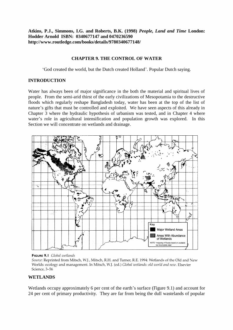
Wetlands occupy approximately 6 per cent of the earth’s surface (Figure 9.1) and account for
24 per cent of primary productivity. They are far from being the dull wastelands of popular

imagination, but form an ecologically important part of the natural landscape which has
persisted longer than the primeval woodland. This was because they were less easily
modified by primitive technologies and they therefore went largely untouched until the early
medieval period. At present, however, they are under threat worldwide.
Wetlands may be divided into marshes (fresh or salt water), dominated by reeds, rushes,
grasses and sedges; and swamps, frequently flooded and dominated by woody plants,
sometimes trees. Some wetlands produce more organic matter than is decomposed and as a
result they have deposits of peat. They are known as bogs when they are comprised of acid
peat, fens when there is neutral or alkaline peat, and mires when the peat is especially thick.
Wetlands are most often found in river floodplains where drainage is impeded and in
waterlogged coastal situations.
There have been sustainable adaptations wetland environments (Chapter 6), for instance the
Marsh Arabs of Iraq, the Cajuns of Louisiana and the Camarguais of Provence, but the
characteristic reaction to wetlands has usually been to drain and utilise them. We may
identify seven major types of wetland modification (L’Vovich 1990). First there is the use of
bog and ill-drained land to create new agricultural resources. This has been very common
around the world (see below for U.K. case study) and is still continuing.
Second, coastal marshes were used for fish farming, for instance the dyke-pond system of the
Pearl River Delta described below, and salt-making in evaporation ponds. Figure 9.2 shows a
mound of salt (sodium chloride) produced at Sahline in Tunisia. Here inspiration was
provided by natural salt lakes (sebhkas) which dry out seasonally leaving deposits of various
salts. China is the largest producer of sea salt using traditional evaporation techniques, with
an output of 13 million tons a year.
Third, coastal reclamation takes a number of forms. One approach is by embankment in
stages, using the natural processes of siltation called warping. A patch of marsh is identified
that is dry at low tide and which is being colonized by salt-tolerant (halophytic) vegetation.
A dyke is built to protect this area from storms and sluice gates are positioned so that water
can be drained at low tide. Silt will collect gradually and create new ground, especially if

helped by artificial silt traps. The freshwater equivalent, is where silt-laden river waters are
deliberately let on to land by controlled flooding.
Another approach is to use polders. These are embanked pieces of land drained in a
relatively short time. Nowadays the creation of an artificial salt marsh is not necessary
because of the use of advanced technologies such as mechanical diggers and pumps. The
polders of the Netherlands are the most impressive. In effect it is a country created from the
sea and the estuaries of the Rhine, Meuse and Scheldt: 40 per cent is below sea level (see
Figure 9.3).
Among the earliest settlers of the coastal marshes of what is now the Netherlands were
groups of herders. They built artificial circular or oval mounds, terpen, to protect their
dwellings and livestock from flooding. These refuges were small at first but were gradually
enlarged in diameter and heightened up to ten metres above sea level. Linking terpen by
causeways was a logical step and it was these simple dykes which by A.D. 1000 were
beginning to alter the hydrological régime of the marshes.
From the eleventh century groups of people, wateringues, were formed to expedite
reclamation, encouraged by abbeys, nobles and, later, by wealthy merchants from the
flourishing industrial towns. Count William the Dyker, of Holland, achieved a great deal in
the thirteenth century, but much of the early progress was set back by the marine floods of

the thirteenth and fourteenth centuries when many dykes were swept away. In 1287 50,000
people drowned between the Zuyder Zee and Dollart in a great flood, and in November 1421
18,000 ha between the Rivers Rhine and Meuse were lost to cultivation and 10,000 people
perished.
The peak of drainage activity between 1600 and 1625 coincided with the golden age of Dutch
history Figure 9.4). By then the principles of reclamation were well known and much of the
country’s prosperity was built on the intensive agriculture of the new lands. Coastal dyking
came first because marine clays are very fertile and do not shrink, and the greater tidal range
in the south (two metres in north Holland, and four metres at the mouth of the Scheldt)
encouraged early reclamation there, especially in Zeeland and Brabant.
Inland lakes and wetlands were more of a challenge. The less stable peat material was
difficult to drain by gravity. Technological innovation was one solution. Improved
windmills, with larger sails which could be rotated into the wind, made lifting water a
practicable possibility. Chains of windmills could pump water up slopes into canals and
onward to the sea.
In the nineteenth and twentieth centuries mechanical pumps have further improved drainage
efficiency and made it possible to contemplate the reclamation of the Zuyder See/IJsselmeer.
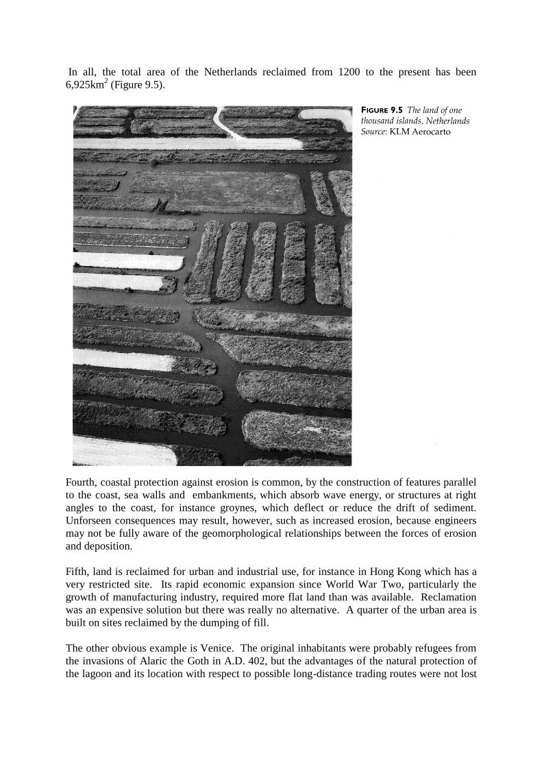
In all, the total area of the Netherlands reclaimed from 1200 to the present has been
6,925km2 (Figure 9.5).
Fourth, coastal protection against erosion is common, by the construction of features parallel
to the coast, sea walls and embankments, which absorb wave energy, or structures at right
angles to the coast, for instance groynes, which deflect or reduce the drift of sediment.
Unforseen consequences may result, however, such as increased erosion, because engineers
may not be fully aware of the geomorphological relationships between the forces of erosion
and deposition.
Fifth, land is reclaimed for urban and industrial use, for instance in Hong Kong which has a
very restricted site. Its rapid economic expansion since World War Two, particularly the
growth of manufacturing industry, required more flat land than was available. Reclamation
was an expensive solution but there was really no alternative. A quarter of the urban area is
built on sites reclaimed by the dumping of fill.
The other obvious example is Venice. The original inhabitants were probably refugees from
the invasions of Alaric the Goth in A.D. 402, but the advantages of the natural protection of
the lagoon and its location with respect to possible long-distance trading routes were not lost
on their descendants who drove piles into the mud and began a process of reclamation and
building which has created one of the world’s great cultural gems at the very margin of early
water control technology (Cosgrove 1990).
Sixth, there is agricultural land with impeded drainage that would not, strictly speaking, be
included in most definitions of wetlands, but which has nevertheless been the focus of much
activity and investment with the objective of bringing it into more productive use. As an
example, one of the most important improvements of agricultural land in England between
1840 and 1900 was the underdrainage of about 20 per cent of the cultivated area. Similar
adaptations were tried earlier with the ridge and furrow systems of medieval Europe (Section
C1) and the drained fields of the pre-Colombian Americas.
The seventh type of human activity is the artificial creation of wetlands, either as a bye-
product of peat cutting as with the Norfolk Broads, the flooding of water meadows to
increase the productivity of grassland, and the creation of artificial lakes for the purpose of
navigation, irrigation or micro-climate modification. A fascinating example of the last
category was the nineteenth century French plan to flood the Shott Djerid in southern Tunisia
(Heffernan 1990).
CASE STUDY: THE DRAINAGE OF THE FENS IN EASTERN ENGLAND
The Fens around the Wash have formed on a clay plain the drainage of which was impeded
by the deposition of river and marine silt and organic peat. It is not entirely flat, some low
hills forming islands which became important for settlement, such as the Isle of Ely.
The sea level has risen and fallen many times. For instance in the Roman period it was lower
and the Fens were then a prosperous agricultural area. A long channel, the Car Dyke, was
even built to reduce the risk of flooding and doubled as a canal for taking produce to the city
of Lincoln. But even in its flooded state marshland had its uses. It may have seemed
inaccessible, a defensive feature exploited by Hereward the Wake in 1071, but its resources
were much appreciated and exploited by neighbouring people (Chapter 6).
Yet there was an incentive to drain the marshes because fen soils are naturally fertile.
Reclamation seems to have begun before 1066 and was well under way by the twelfth
century. Creating embankments was labour-intensive so it was undertaken most readily by
the large monasteries, such as Spalding and Crowland, which had the ability to mobilise the
necessary work force. There is some evidence that peasants were also involved, working
together as whole villages. By winning new land for themselves they were able to prosper
and population increased rapidly.
Large-scale drainage works are evident from the sixteenth century onwards. As Cosgrove
(1990) points out, there were more than economic and technological forces at work. The
change in cultural orientation that we call modernization at this time was changing people’s
view of the world, and scientific reason was applied to bringing the earth more extensively
under human control. In effect hydrology as a technical discipline was brought to bear
widely in Europe to modify rivers by draining their floodplains, dredging their channels and
simplifying their drainage networks, to build embankments and coastal defences again
marine encroachment, and to create new tracts of farm land from formerly useless marsh.
This modern project has culminated in the construction of the Suez and Panama Canals and
water engineering on a large scale in mega projects such as the Aswan Dam.
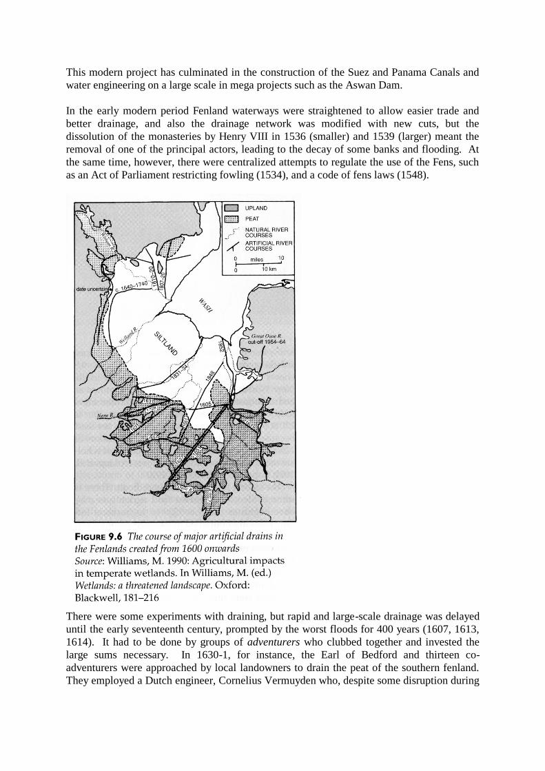
In the early modern period Fenland waterways were straightened to allow easier trade and
better drainage, and also the drainage network was modified with new cuts, but the
dissolution of the monasteries by Henry VIII in 1536 (smaller) and 1539 (larger) meant the
removal of one of the principal actors, leading to the decay of some banks and flooding. At
the same time, however, there were centralized attempts to regulate the use of the Fens, such
as an Act of Parliament restricting fowling (1534), and a code of fens laws (1548).
There were some experiments with draining, but rapid and large-scale drainage was delayed
until the early seventeenth century, prompted by the worst floods for 400 years (1607, 1613,
1614). It had to be done by groups of adventurers who clubbed together and invested the
large sums necessary. In 1630-1, for instance, the Earl of Bedford and thirteen co-
adventurers were approached by local landowners to drain the peat of the southern fenland.
They employed a Dutch engineer, Cornelius Vermuyden who, despite some disruption during
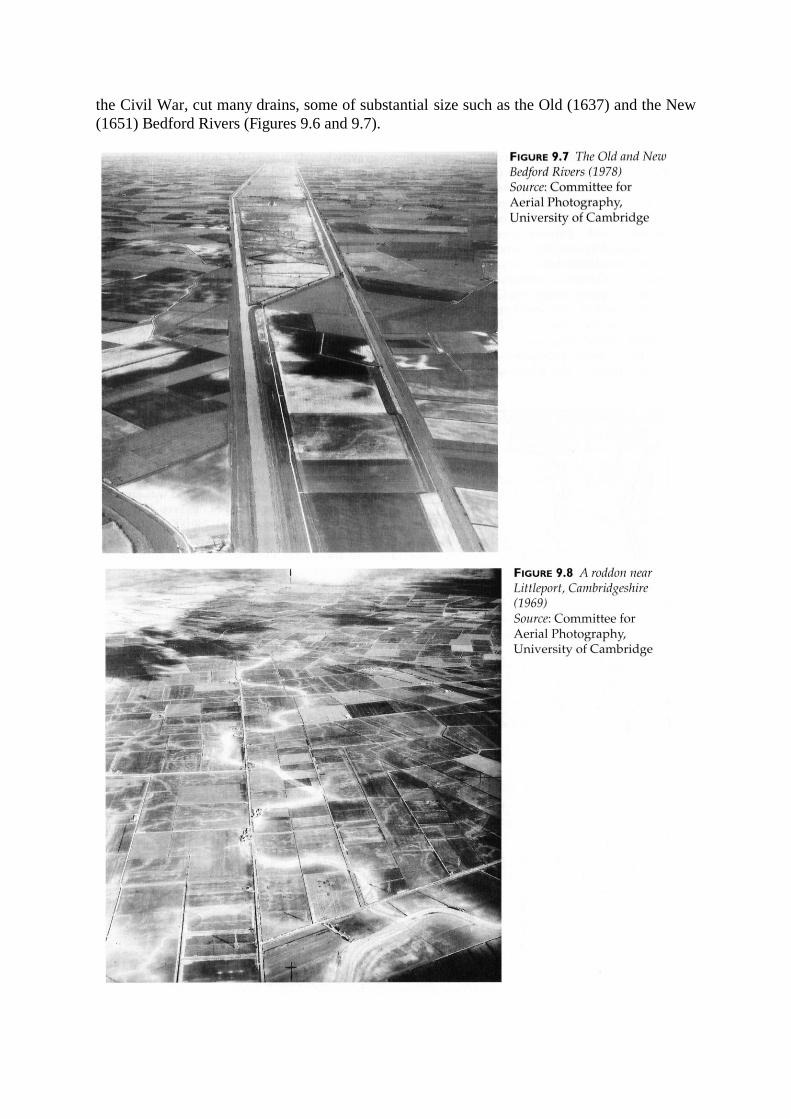
the Civil War, cut many drains, some of substantial size such as the Old (1637) and the New
(1651) Bedford Rivers (Figures 9.6 and 9.7).
There were problems. First, Vermuyden underestimated the technical challenge of his
gravity based system. For instance it was soon found that the Old Bedford River could not
cope with the flow of water and had to be supplemented by a parallel cut, the New Bedford
River. Second, no one anticipated the fact that peat shrinks when it is dry. By 1700 the new
drains were above the level of the peat, increasing the risk of new floods. Third, many of the
locals objected to any drainage. The livelihoods of the fishermen and fowlers were ruined
and sluice gates interfered with the commercial waterways. There were frequent riots, with
people breaking down the banks and filling in channels.
The problems caused by shrinking peat was partially solved by the use of windmills for
pumping from the eighteenth century, and later by steam pumps (1819)(Butlin 1990). The
greatest single project was the drainage of Whittlesey Mere (Cambridgeshire) in the mid
nineteenth century. At the time this was heralded as a great technical achievement, but today
it is seen as one of the greatest disasters to have befallen British nature conservation.
Much new land was created by drainage and the extent of the Fens gradually dwindled from
the original 280,000 hectares to only 855 hectares now left in their natural state.
In the twentieth century further damage to wetlands has been caused by nitrogen enrichment
from fertilizers, leading to eutrophication. Because of incentives from the U.K. government
and the subsidies of the European Union’s Common Agricultural Policy, a lot of marshland
has been drained in recent decades. The peak period was the 1970s and 1980s, with 104,000
hectares of drainage in 1974 alone.
We can still see the old water courses (roddons) from the air (Figure 9.8). Their silt stands
above the level of the shrunken peat. There remains a danger of flooding from storm surges
in the North Sea, such as that which caused loss of life in 1953. The current rise in sea levels
is an additional threat.
The modernist discourse of wetland drainage and modification has in the last two decades
come under sustained fire, however, from the environmentalist movement who have pointed
to the loss of precious habitats and their biodiversity. This green lobby has been
supplemented by the argument from activists in developing countries that large dams and
their associated lakes displace poor farmers and that the newly created stretches of stagnant
of slow flowing water are ideal for the breeding of disease vectors such as the
schistosomiasis carrying snail and the biting flies that spread river blindness. In recent years
a number of hydrological mega projects have been cancelled or shelved because of political
opposition and there is a crisis of confidence now among the water engineers and their
political masters (Cosgrove 1990).
CASE STUDY: RAISED, DRAINED AND SUNKEN FIELDS
An exceptionally interesting method of moisture control amongst those pre-industrial peoples
who possessed no plough was the use of raised, drained and sunken fields. These have
recently received attention from researchers and we now know that they were widespread in
the Americas, sub-Saharan Africa and Oceania. Figure 9.9 shows the current state of our
knowledge in the New World, and this will no doubt be refined as archaeologists and
geographers undertake more field work. The total area identified so far is 270,000 ha but this

is very approximate, not least because of the hotly disputed identification of 128,500 ha in
the Maya region by a group of scholars using remote sensing techniques (Adams et al. 1981;
Pope & Dahlin 1989, 1993).
The dating of these fields is difficult. There is some evidence that raised field agriculture
may have begun as early as 1,850 B.C. in Surinam but they certainly flourished most widely
from about A.D. 600-1500. The Spanish conquistadores did not find them in every location
because local circumstances occasionally led to their abandonment.
Most of the raised field systems have been found in areas where pre-industrial population
densities were high, at or above 300 per km2. In each case they had been preceded in time by
dryland systems, so it seems reasonable to speculate that the construction of raised fields was
a response to an increased demand for food, requiring intensification. Certainly the
remarkable levels of productivity were sufficient to support brilliant civilizations such as the
Tiwanaku of the Titicaca Basin (Kolata 1993).
Could such systems have grown organically? Perhaps in some locations they were the result
of the efforts of individual small farmers, but there is evidence of large-scale planning in the
Basin of Mexico, and at Pulltrouser Swamp, Belize, the hydraulic regime suggests that most
fields could not have functioned until whole system was completed.
The fact that such a successful indigenous agricultural technology has decayed is a matter of
regret and efforts are in hand in several countries to revive and adapt it to modern needs.
Again planning will be needed.
THE VARIETY OF RAISED FIELD FORMS
Riverine situations, including backswamps and other low-lying floodplain terrain where
water tables are high, are relatively common. They are not enclosed, and experience regular
surface flow and periodic inundations. Here raised fields are usually used for drainage
purposes.
In contrast basin depressions, both palustrine and lacustrine, are closed systems with little
flow. Water tables fluctuate in response to the changing balance between evaporation and
subsurface outflow. This sort of environment is found on lake peripheries, and in seasonally
inundated depressions, swamps, marshes and bogs. Here raised fields are used for water
retention.
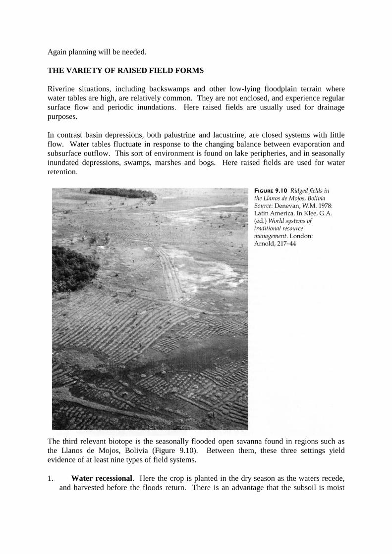
The third relevant biotope is the seasonally flooded open savanna found in regions such as
the Llanos de Mojos, Bolivia (Figure 9.10). Between them, these three settings yield
evidence of at least nine types of field systems.
1. Water recessional. Here the crop is planted in the dry season as the waters recede,
and harvested before the floods return. There is an advantage that the subsoil is moist

and the flood waters keep the weeds down. Water recessional agriculture is a simple
technique requiring little technology. Modern examples include the cultivation of playas,
fertile alluvial soils on sand bars, shores and islands exposed in dry season, and levées
(river bank backslopes).
2. Drained fields. In South America there are drained fields near Lake Titicaca and on
the savannas of western Venezuela. There are also raised fields and ditches running
down natural levées adjacent to rivers channelling overflow water into back swamps,
such as at San Jorge, Colombia.
3. Hydrophytic agro-ecosystems. The use of water-loving plants such as rice, taro is
an obvious wetland adaptation. Many Pacific islands have taro mounds.
4. Ridged fields. Here earth is heaped into linear ridges which have a number of
functions. Among the best examples of ridged fields are those near Lake Titicaca.
5. Chinampas. Mexican chinampas have water held in canals between linear fields.
They are more advanced versions of ridged fields.
6. Planting platforms. The tablones of highland Guatemala are raised planting beds
separated by ditches which are used for both drainage and irrigation. Platform fields are
common in the Pacific.
7. Sunken fields. Examples of one type of sunken field, mahamaes, are found in at least
ten coastal Peruvian valleys. Their origin is uncertain but water management was
certainly involved, either to improve access to the water table or to collect run-off. The
latter function is more likely with the depression fields, Qochas, of the altiplano. Flores
Ochoa (1987) has identified 20,000 qochas of various shapes and sizes, each up to four
metres deep and one hundred metres or more in diameter. As the water recedes they are
planted to potatoes, rotated with quinoa, cañiwa, oats and barley.
8. Linear fields. Andean linear fields have a drainage function. They are found
principally in northern Ecuador and central Colombia, and run downslope at ten to twenty
metre intervals, alternating with ditches. Soil erosion is not a major problem in this
region but the accelerated drainage of those soils with a high clay content would have
prevented slumping. Similar fields are present in Tanzania.
9. Mounds and ridges are also common field types for the control of water, mainly for
the control of upper soil waterlogging in the cultivation of maize, manioc and potatoes.
They are common in Africa and archaeological evidence indicates that they were
extensively used by native north American peoples.
The likely functions of raised fields
An obvious function of a raised field is to facilitate the drainage of excess moisture. There
are other considerations:
As a result of the proximity of the planting surface to water, a perched water table
may be induced if the soil is sufficiently porous. This allows subirrigation of the
plant roots, but the depth of root penetration will be limited by the saturated layer.
Periodically soil must be removed to prevent surface height building up so that
subirrigation become inefficient.
Raised beds are currently popular with modern gardeners because careful soil
preparation means that a well-aerated soil warms more easily, suffers less from
compaction during cultivation, so plant roots can flourish, weeding and harvesting of
root crops involve less effort and drainage is improved.
Raised field hydraulic systems allow management of salts and pH levels by soil

modification and the partitioning of fresh and salt water, for instance by using water
from a river or spring.
Soil erosion is reduced or reversed as sediments are trapped. The soil builds up a
high organic content which facilitates water retention.
Microclimate modification results because the wet soil and water in the swales absorb
heat and release it at night, increasing the surface temperature by 0.5-1.5C. Frost
hazard is reduced and growing seasons lengthened. The surface geometry of the
fields may also have an effect, depending on the orientation of the ridges, because of
exposure to solar radiation.
The soils of raised fields have a high organic content because of mulching with plant
material, human and animal manure, and fertility can be raised with regular
applications of nutrient rich canal muck. Green manure is available in the form of
aquatic plants growing in the ditches.
The ditches are used for fish farming.
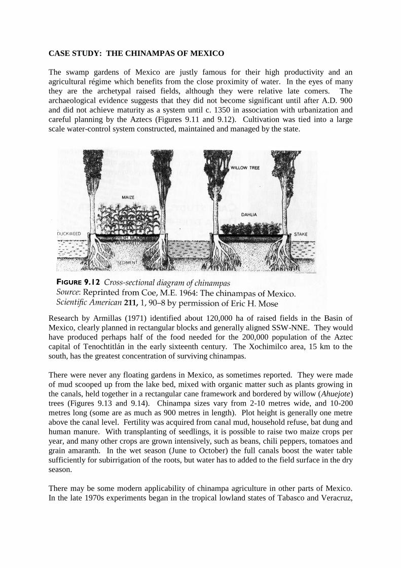
CASE STUDY: THE CHINAMPAS OF MEXICO
The swamp gardens of Mexico are justly famous for their high productivity and an
agricultural régime which benefits from the close proximity of water. In the eyes of many
they are the archetypal raised fields, although they were relative late comers. The
archaeological evidence suggests that they did not become significant until after A.D. 900
and did not achieve maturity as a system until c. 1350 in association with urbanization and
careful planning by the Aztecs (Figures 9.11 and 9.12). Cultivation was tied into a large
scale water-control system constructed, maintained and managed by the state.
Research by Armillas (1971) identified about 120,000 ha of raised fields in the Basin of
Mexico, clearly planned in rectangular blocks and generally aligned SSW-NNE. They would
have produced perhaps half of the food needed for the 200,000 population of the Aztec
capital of Tenochtitlán in the early sixteenth century. The Xochimilco area, 15 km to the
south, has the greatest concentration of surviving chinampas.
There were never any floating gardens in Mexico, as sometimes reported. They were made
of mud scooped up from the lake bed, mixed with organic matter such as plants growing in
the canals, held together in a rectangular cane framework and bordered by willow (Ahuejote)
trees (Figures 9.13 and 9.14). Chinampa sizes vary from 2-10 metres wide, and 10-200
metres long (some are as much as 900 metres in length). Plot height is generally one metre
above the canal level. Fertility was acquired from canal mud, household refuse, bat dung and
human manure. With transplanting of seedlings, it is possible to raise two maize crops per
year, and many other crops are grown intensively, such as beans, chili peppers, tomatoes and
grain amaranth. In the wet season (June to October) the full canals boost the water table
sufficiently for subirrigation of the roots, but water has to added to the field surface in the dry
season.
There may be some modern applicability of chinampa agriculture in other parts of Mexico.
In the late 1970s experiments began in the tropical lowland states of Tabasco and Veracruz,

in a very different environment from the altiplano of the Basin of Mexico. Results have been
generally positive, with crops being produced on swampy land. It is conceivable that this
type of traditional, labour-intensive, and low-tech agriculture might be appropriate to the
needs of people in a variety of tropical and subtropical environments where food production
needs boosting, and where there is currently rural underemployment.

CASE STUDY: THE PEARL RIVER DELTA DYKE-POND SYSTEM
The delta of the Zhujiang (Pearl River) in southern China provides soils which are rich, deep
but ill-drained. The region was a swamp but has gradually been reclaimed by a piecemeal
process of embanking which has given it a unique landscape (Figures 9.15, 9.16 and 9.17).
An area of 800 km2 has been brought into a dyke-pond system which has an integrated
economy of agriculture and aquaculture unlike anywhere else in the world supporting 1.2
million people.

At first many local farmers used their land for rice paddy but over the last 600 years much
has been converted to fish ponds, with sugar cane and mulberry trees growing on the
intervening dykes. The silt which accumulates in the ponds is scooped out two or three times
a year and used as fertilizer on the dykes and in return the pond receives various inputs. Most
of the fish are sold into the market and this one region provides half of the total production of
Guangdong Province and 80 per cent of China’s live exports. The sugar cane and mulberry
trees are also cash crops, the leaves of the latter being used to feed silk worms. Pigs are fed
on sugar cane waste and water hyacinth and their manure is recycled as pond fertilizer.
Vegetables are also grown on the 6-10 metre wide dykes, and mushrooms are cultivated
during the off-season in the silk worm sheds (on pond mud).
In the pond the Grass carp is perhaps the most valued fish. It is voracious, consuming 100-
174 per cent of its own body weight each day in grass, aquatic plants and crop residues. The
other species are complementary feeders, the Bighead carp preferring zooplankton, the Silver
carp phytoplankton, and the Black, Mud and Common carp eat decomposing matter on the
bottom. This fresh water ecosystem is not self-regulating. It needs careful management to
maintain the balance of nutrients and to prevent the build-up of the toxic products of
decomposition and other chemical reactions. Skilled farmers are able to keep the ponds
aerobic, with acceptable levels of pH, and with a good mix of microflora and microfauna.
The fish are fed daily on bean cake, peanut cake, elephant grass, household and crop
residues, and sugar cane waste from the refinery. Pond fertilizer includes pig and human
excrement, and silkworm waste. Tea-seed cake and quicklime are added to adjust the
water’s chemical composition.
This very successful system is in fact rather delicate. The market price of the various

components will shift through time now that the government has liberalized the economy,
and there is no guarantee that all of the sub-systems will remain profitable. The price of silk,
for instance plummeted during the depression of the 1930s. At present there is prosperity and
the dyke-pond system looks a like beautifully adapted and sustainable wetland ecosystem. It
could be replicated in similar environments to good effect, especially since over-fishing is
threatening offshore stocks. But well-meaning planners intervene at their peril. Recent
expansion in the Zhujiang delta has involved reduction of the land-water ratio to 1:4 and this
is insufficient to supply the necessary inputs for the ponds without imports from other parts
of China. Outward linkages imply a reduction in local levels of self-sufficiency and
sustainability.
CONCLUSION
The management of wetland ecosystems has produced some dramatic landscape changes
visually and in environmental terms. Much additional agricultural land has been created,
some of it producing high crop yields because of the fertility of marine and riverine
sediments, but a negative bye-product has been the reduction of biological productivity in
wetlands, which are second only to tropical rainforests in their variety and complexity of
flora and fauna. We have to ask ourselves whether this has been worthwhile, especially
when one considers that there are sustainable and productive wetland land-uses of ancient
pedigree, such as the dyke-pond system or the raised/drained field systems, which do not
demand the elimination of standing water. The modernist approach to producing yet more
dryland arable has been very powerful over the last 500 years but the turn of the millennium
may coincide with its re-evaluation and decline.
FURTHER READING AND REFERENCES
Audrey Lambert’s book on drainage in Holland is still the best account in English, and Darby
(1956, 1983) is the authority of the English Fenland. For wetland fields in the Americas, see
Coe (1964).
Adams, R.E.W., Brown, W.E. & Culbert, T.P. (1981) Radar mapping, archaeology, and
ancient Maya land use, Science 213, 1457-63
Armillas, P. (1971) Gardens on swamps, Science 174, 653-61
Butlin, R.A. (1990) Drainage and land use in the Fenlands and fen-edge of northeast
Cambridgeshire in the seventeenth and eighteenth centuries, pp 54-76 in Cosgrove, D.
& Petts, G. (Eds) Water, engineering and landscape: water control and landscape
transformation in the modern period London: Belhaven
Coe, M.E. (1964) The chinampas of Mexico, Scientific American 211, 90-98
Cosgrove, D. (1990) An elemental division: water control and engineered landscape, pp 1-11
in Cosgrove, D. & Petts, G. (Eds) Water, engineering and landscape: water control
and landscape transformation in the modern period London: Belhaven
Darby, H.C. (1956) The draining of the fens 2nd ed. Cambridge: Cambridge University Press
Darby, H.C. (1983) The changing fenland Cambridge: Cambridge University Press
Flores Ochoa, J.A. (1987) Evidence for the cultivation of Qochas in the Peruvian altiplano,
pp 399-402 in Denevan, W.M., Mathewson, K. & Knapp, G. (Eds) Pre-hispanic
agricultural fields in the Andean region, British Archaeological Reports,
International Series 359

Heffernan, M.J. (1990) Bringing the desert to bloom: French ambitions in the Sahara desert
during the nineteenth century - the strange case of ‘la mer intérieure, pp 94-114 in
Cosgrove, D. & Petts, G. (Eds) Water, engineering and landscape: water control and
landscape transformation in the modern period London: Belhaven
Kolata, A. (1993) The Tiwanaku: portrait of an Andean Civilization Cambridge, MA:
Blackwell
Lambert, A. (1985) The making of the Dutch landscape: an historical geography of the
Netherlands 2nd ed. London: Academic Press
L’Vovich, M.I. & White, G.F. (1990) Use and transformation of terrestrial water systems, pp
235-252 in Turner, B.L. et al. (Eds) The earth as transformed by human action
Cambridge: Cambridge University Press
Pope, K.O. & Dahlin, B.H. (1989) Ancient Maya wetland agriculture: new insights from
ecological and remote sensing research, Journal of Field Archaeology 16, 87-106
Pope, K.O. & Dahlin, B.H. (1993) Radar detection and ecology of ancient Maya canal
systems - reply, Journal of Field Archaeology 20, 379-383
Copyright © 2022 FDOKUMEN