STREAM SEDIMENT SURVEY OF AEROMAGNETIC HIGH ON SHEET 32 KADUNA STATE – NIGERIA
37
STREAM SEDIMENT SURVEY OF AEROMAGNETIC HIGH ON SHEET 32 KADUNA STATE – NIGERIA ND PROJECT REPORT BY MUHAMMAD ADAMU ISAH KPT/COE/MRE/09/0373 THIS PROJECT IS SUBMITTED TO THE DEPARTMENT OF MINERAL RESOURCES ENGINEERING IN PARTIAL FULFILLMENT OF THE REQUIREMENTS FOR THE AWARD OF NATIONAL DIPLOMA IN MINERAL RESOURCES ENGINEERING DEPARTMENT OF MINERAL RESOURCES ENGINEERING SCHOOL OF NATURAL RESOURCES ENGINEERING, COLLEGE OF ENGINEERING, KADUNA POLYTECHNIC KADUNA, NIGERIA AUGUST, 2012
Transcript of STREAM SEDIMENT SURVEY OF AEROMAGNETIC HIGH ON SHEET 32 KADUNA STATE – NIGERIA

STREAM SEDIMENT SURVEYOF AEROMAGNETIC HIGH ON SHEET 32
KADUNA STATE – NIGERIA
ND PROJECT REPORT
BY
MUHAMMAD ADAMU ISAHKPT/COE/MRE/09/0373
THIS PROJECT IS SUBMITTED TO THE DEPARTMENT OFMINERAL RESOURCES ENGINEERING IN PARTIAL
FULFILLMENT OF THE REQUIREMENTS FOR THE AWARD OFNATIONAL DIPLOMA IN MINERAL RESOURCES
ENGINEERING
DEPARTMENT OF MINERAL RESOURCES ENGINEERING
SCHOOL OF NATURAL RESOURCES ENGINEERING,COLLEGE OF ENGINEERING,
KADUNA POLYTECHNICKADUNA, NIGERIA
AUGUST, 2012

DECLARATION
I hereby declare that this project has been done by me,under the supervision of Mr. D.K Gabako, Mr.Abdulrahman and Mr. Abdulmalik, all from the Departmentof Mineral Resources Engineering, Kaduna Polytechnic,Kaduna. I have neither copied someone’s work nor has someonedone it for me. Writers whose works have been referredhave been duly acknowledged.
_________________ _________________
Student’s NameSignature
___________________ Date

APPROVAL PAGE This is to certify that this project is an originalwork undertaken by Muhammad Adamu Isah(KPT/COE/MRE/09/0373) and has been prepared inaccordance with the regulations governing thepreparation and presentation of projects in KadunaPolytechnic.
________________ _______________MR.D.K Gabako Date SUPERVISOR
________________ _______________MR.ABDULRAHMAN Date Co- SUPERVISOR
________________ _______________MR.ABDULMALIK Date Co- Supervisor
________________ _______________ENGR. MUHAMMAD ALI Date HEAD OF DEPARTMENT
________________ _______________

EXTERNAL SUPERVISOR Date

DEDICATION
I dedicated this project to Almighty Allah for makingme to complete my ND program successfully.

ACKNOWLEDGEMENT
All praise due to ALLAH (SWT) in his finite mercies,guided me, put me through and make this programme asuccessful one for me.
My profound gratitude goes to my supervisors Mr D.KGabako, Mr Abdulrahman and Mr Abdulmalik, for findingtime to go through these marks crept of mine and takingvarious valuable comments and effecting constructiveand effective critics which were very useful for thesuccessful completion of this project.
Also I wish to acknowledge the support of Head ofDepartment (HOD) Mineral Resources Engineering Engr.Muhammad Ali and the rest of my lecturers in thedepartment of their consistency in giving out usefulinformation and ideas during the compilation of thisproject.
I must equally appreciate the contribution of myfriends, colleagues and well wishes both and within thecampus for their loyalty and support.

ABSTRACT
This project is aimed at determining economic mineral potential that are responsible for aeromagnetic anomalies around kabala west Kadunametropolis a stream sediment survey of the area was carried out and various minerals were obtained from through panning, drying, sieving, magnetic separation and examination of sample under binocular microscope.
The minerals are identified based on their physical properties (lustre, cleavage, colour, transparency, fracture) the result shows that monazite zircon magnetite were present in the sample. The mineral identified along the stream

channel may give rise to high amount of aeromagnetic anomalies of the study area
CHAPTER ONE
1.0
INTRODUCTION

1.1 BACKGROUND
A casual examination of the aeromagnetic map
covering sheet 32 with Kaduna town at the centre
and its environs shows that the area to the west of
the town is characterized by a number of
aeromagnetic anomalies (fig.1).
Fig. 1. Aeromagnetic map covering Kaduna and
environs (part of sheet 32)

Since these anomalies are caused by a number of
geological factors, one of which is the presence or
otherwise of magnetic minerals which may be
associated with other types of economically useful
minerals, this project has been designed to
establish whether or not some minerals have
contributed to the occurrence of the aeromagnetic
anomalies in the project area.
The theory behind the use of heavy mineral
concentrates relies on the fact that by
concentrating the heavy mineral fraction from the
samples, the dilutant light minerals which may
obscure and anomaly derived from a deposit are
eliminated, providing a clearer picture. This
allows the mineral to be examined under a binocular
microscope Particle shape of mineral grains will
commonly identify distance to source. Very abraded

grains may have travelled a good distance whereas
delicate grains are probably more local.
In some cases more elaborate separations include
separating paramagnetic fractions and sieving to
various particles sizes before analysis.
This may provide further insight into identifying
the sources of the heavy minerals.
Heavy mineral can be identified based on physical
properties. Usually they are first separated from
the majority quartz, pebbles, gravel and remains of
plant decay. Also during panning they are reduced
to the required samples needed. They can be further
separated based on their degree of attraction to a
strong magnetic field (magnetic separator).
1.2 AIMS AND OBJECTIVES OF THE PROJECT
The main aims and objectives of this project
include determination of economic geological
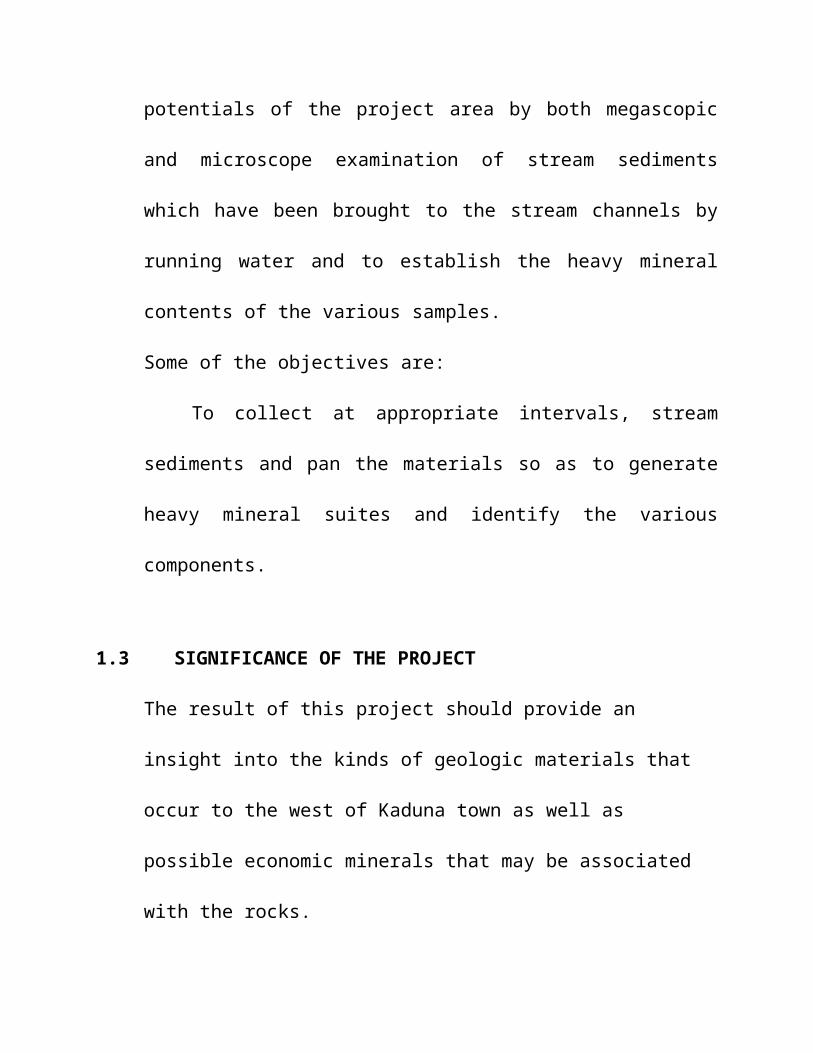
potentials of the project area by both megascopic
and microscope examination of stream sediments
which have been brought to the stream channels by
running water and to establish the heavy mineral
contents of the various samples.
Some of the objectives are:
To collect at appropriate intervals, stream
sediments and pan the materials so as to generate
heavy mineral suites and identify the various
components.
1.3 SIGNIFICANCE OF THE PROJECT
The result of this project should provide an
insight into the kinds of geologic materials that
occur to the west of Kaduna town as well as
possible economic minerals that may be associated
with the rocks.
1.4 SCOPE OF THE PROJECT
The project is restricted to the determination of
heavy minerals in stream sediments derived from
streams that drain the west of Rigasa which
coincides with the southern extreme of the
aeromagnetic high West of Kaduna town. The
determination involves:.
- Collection of stream sediment samples from various
points along the streams that drain the project
area and panning of same to generate a heavy suite
from each spot,
- Drying, Sieving and magnetic separations of the
various samples in the laboratory,

- Observation of the samples under the microscope to
determine the various types of heavy minerals in
each of the samples.
1.5 Location and Accessibility of Project site
Kabala West lies between longitude 10031’09” 120N and
latitude 7019’59” 950E

Fig.2: Topographic map showing Kaduna town and the project site

1.6 Local Geology of Study Area
The study area lies wholly on the gneissic suite of
Nigerian’s Basement complex. Although largely
unexposed, the gneisses are commonly seen beside
the stream channels (fig. 3).

Fig.3: Photograph showing gneiss in the project
area.
The predominant geologic materials through which
the streams meander are essentially laterites
(fig.4).

Fig.4 Photograph showing a section through laterite
in the project is west of Kaduna
CHAPTER TWO
2.0 LITERATURE REVIEW
2.1 Geology of Kaduna State
A Kaduna state lie is predominantly on metamorphic
basement complex of Nigeria (Kogbe, 1989). The
rocks consist essentially of biotite gneisses and
older granites.
In the south eastern corner, younger and older
granitic batholiths are prominent features. Deep

chemical weathering and fluvial erosion, influenced
by the bioclimatic nature of the environment, have
developed the characteristic high undulating plains
with subdued interfluves (Mortimore, 1970). In some
places. The interfluves are capped by high grade
lateritic ironstone especially in the North-West.
However, rocky granitic residuals form inselbergs
of varying sizes and shapes, and constitute the
main local relief (relative relief is less than
150m) here and there with Kufena, Kagoro Hills and
Dutsen Waikudaru Ring complex standing out very
prominently.
The valleys are shallow but wide stretching several
tens of kilometers into the headwater areas with
gentle sloping valley sides, imperceptibly grading
into flat moist to marshy alluviated bottom lands
or floodplains, called “Fadamas” in Hausa.

Although stream valley incisions and dissection of
the high plains are evident in several areas,
especially in the Zaria region, they are due more
to anthropogenic influences and climatic factor
than region geologic instability.
Climate: - Kaduna State experiences a typical
tropical continental climate with distinct seasonal
regimes, oscillating between cool to hot dry and
humid to wet. These two seasons reflect the
influences of tropical continental and equatorial
meantime air masses which sweep over the entire
country (Ebube, 1987)
High storm intensities (ranging from 60mm to 99mm
hr) plus the nature of surface run off building up
the good network of medium sized ever systems. High
evaporation during the dry season, however, creates

water shortage problems especially in Igabi, Giwa,
Soba, Makarfi and Ikara LGAs.
Soils And Vegetation;- Generally, the soils and
vegetation are typical red brown to red yellow
tropical ferruginous soils and savannah grass land
with scattered trees and woody shrubs. The soils in
the up land areas are rich in red clay and sand but
poor in Organic matter (Ebube, 1987)
Granites are also the principal source of the
precious stories and many other. Minerals found
within the younger granites series.
2.3 Mineral Resources of Kaduna state.
The following table shows mineral resources
believed to occur in Kaduna state and their
geologic environments.
Table 1: Solid mineral occurrences of Kaduna state and their geological environments: (After: P.O Oluyide, (1995)
Classificati Types Geological environment

onMetallic minerals
Cassiterite/ Tantalite
Younger granites Pegmatites, Kachia, Kutafu, Jama’a almost restricted to the eastern parts of the state.
Columbite Younger granites Pegmatites; Kaduna, Kachia and Jama’a areas
Wolfranite (ore of tungsten)
Younger granites and ring dykes: banksand Giniya hills
Llmenite Pegmatites and younger granites: Richua Ningshi hills
Rutile Granites (pegmatite); especially southof Raudeggi.
Spinel Pegmatites, younger granites dykes Jama’a area
Iron ore Schists (metasedimentary breaded iron formation BIF): Tsohon Birnin, Fadan –Gwari
Non- metallic l minerals
Talc Metasedimentary rocks shits: zon- zon river zonkwa, Wawaraji, Zaria area.
Clay Residual products weathered Pegmaties and granites: Maraba-Rido, Zaria area.
Sillimanite Schists, Metasediments: Sabon Birnin- Gwari
Kyanite Schists, metasedimentary: sabon birnin- gwari
Calcite/laterite
Superficial deposits: Auchau and many other parts of the state
Stones Granites granite gneiss, Migmatite, quartzite
All over the state
Gold Quartz vein metasediments: Birnin- gwari, Tsibiri, Mai gisheri, Muya and Yelwa.
Precious Gemstones
Amethyst Siliceous veins: Dala, Panmandina, Ikara area
Beryl Pegmatites, Quarternary basalt: sabon birnin- gwari and the eastern parts ofthe state
Topaz Pegmatites, tertiary basalts: Righua,

Ningishi hills and NOK.Tourmaline Pegmatites, Tertiary basalts: Rishua,
Ningishi hills and NOK CHAPTER THREE
3.0 RESEARCH METHODOLGY
3.1 Field Sample Collection
The samples were collected at intervals of 50meter
along the stream channels that drain the area
(fig.5) these materials to some extent represent
those materials that form the underlying geologic
materials that outcrop to the surface pieces of
which are scoured by falling rain drops and moved
by running water into the stream channel. Usually
sediments from active streams, considered best for
sampling purposes, were selected.
Samples are commonly composited, i.e., at a
sampling point, several shovels of the stream
sediments are scooped from the stream bed into a
head pan until about half-way full(approximately

25kg) and panned(see Gabako,2003.). The procedure
is repeated at all sampling points until all the
predetermined points are covered. In each case, the
resulting sample is a mechanical concentrate
consisting essentially of some dark brown to
black grains mixed with some translucent and
transparent types altogether weighing about a
kilogram or less. The sample is appropriately
satched and labelled. At the end of the sampling
program, the samples are then taken to the
laboratory for further separations.
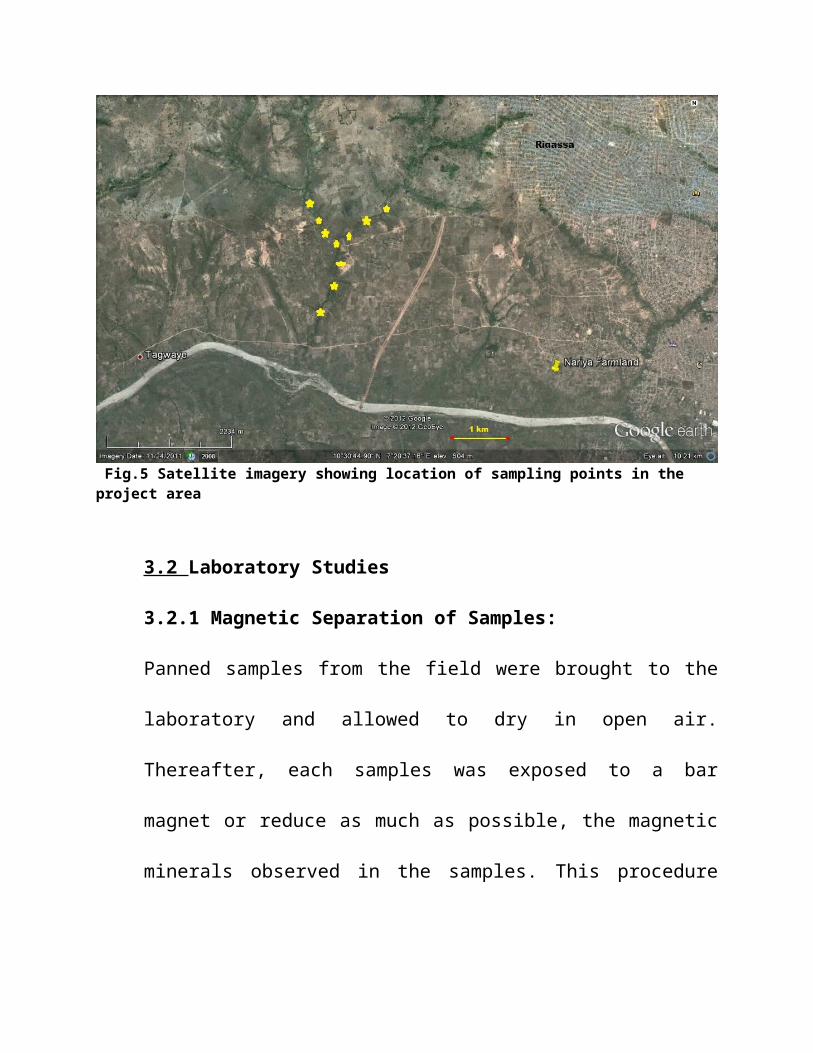
Fig.5 Satellite imagery showing location of sampling points in the project area
3.2 Laboratory Studies
3.2.1 Magnetic Separation of Samples:
Panned samples from the field were brought to the
laboratory and allowed to dry in open air.
Thereafter, each samples was exposed to a bar
magnet or reduce as much as possible, the magnetic
minerals observed in the samples. This procedure

helps to identify the quantity of magnetic minerals
associated with each of the samples.
The separation was effected by placing the
materials on a plain sheet and the magnet gently
moved through the materials. In this way, most of
the magnetite grains were removed leaving only very
few magnetic materials especially those attached to
non magnetic.
3.2.3 Microscopic Studies:
The microscope is the basic instrument for
petrographic examination of all types of mineral
samples. There are a number of different types of
microscopes classified into two main groups:
Biological and Petrographic. The petrographic is
used for study of rocks and minerals. The
microscope used for this investigation is the
binocular microscope.

The microscope consists of the following parts.
Lenses: These are magnifying glasses through which
observation are made. It enables for wide and large
view of the grain sizes.
Light source: The lights are design in the
microscope to provide a light and extense of the
sample. There are two light sources in the
microscope. The light can either be from nude with
the grains placed on the stage and at the top, the
grains are placed on a graph sheet of 1mm as shown
in fig.
Focus knob: is a screw which enable for a clear
focusing of the samples under observation to enable
sharp or blown viewing.
Stage: This is the base of the microscope where
samples are placed for examination.

Eye Piece: The microscope is binocular meaning it
posses two viewing eye piece through which the
mineral are observed.
FIG 6: Photograph Showing a Binocular microscope

FIG 7 Photograph showing the author examining a samples under the
binocular microscope.
Application: The Microscope uses reflected lights
which helps to provide detailed physical
information about the mineral being examined. It is
widely used in mineralogy, economic geology and
mineral beneficiation.

It also helps in identifying ores of mineral as
well as the texture and structure which tell us
about the composition of the various constituents.
It is important because it tells us about the
conditions under which the minerals develops and
processes by which they were deposited.
Procedure for Microscopic studies:
The Binocular microscope is plugged to electricity
supply source in order to power it. The eye piece
is adjusted to fit into the observer’s eye. The
sample is placed on a piece of 1mm graduated graph
paper on the stage and the grains observed; first
using the light from above then later switched to
the light from below the samples. The technique
involved in the analysis of each grain was followed
carefully in identifying the different grains
present. Each types of grain is observed

individually identifying physical properties such
as size, shape, colour, fracture, cleavage, lustre,
form of occurrence and the results recorded as
appropriate..
CHAPTER FOUR
4.0 RESULTS OF THE INVESTIGATION
4.1 General Statement
In this chapter, the results of the investigation
are presented. The presentation is to enable the
reader know the extent to which the work has been

carried out as well as make comparison with results
of similar works elsewhere in Nigeria’s basement
complex. Due to unforeseen circumstance, not all
the samples collected from the fields could be
separated with heavy liquids in order to establish
the finest details of the contents of the stream
mechanical concentrates. Thus only samples
collected from the metasedimentary suite believed
to be of great importance for exploration purposes
were treated. Others were simply examined straight
away.
4.2 Physical Properties and Identification of Minerals
A number of physical properties are used to
identify various minerals grains both in the hand
specimen as well as under the microscope. Some of
these properties include shapes, fracture, luster,
transparency, cleavage (Cornelius, et al, 1969).

Table 2: Table showing results of microscopic study of heavy minerals in the study area.
sampleNo.
Grainshape
Luster Color Transparency Facture Cleavage
Suspected Mineral
1 Triangular
Rectangular
Metallic
Dull/
BlackWhite
OpaqueOpaque
CoincidalCoincoida
l
NonePoor
Iron orequartz
2 Triangular
Triangular
Vitreous
Metallic
YellowBlack
TranslucentOpaque
CoincidalCoincidal
GoodNone
OrthoclaseIron ore
3 RoundRectangul
ar
Metallic
Glassy
BlackWhite
OpaqueOpaque
CoincidalCoincoida
l
NonePoor
MagnetiteQuartz
4 Rectangular
Rectangular
GlassyMetallic
WhiteBlack
OpaqueOpaque
CoincidalHackly
PoorPoor
QuartzMagnetite
5 RoundRound
Vitreous
Metallic
WhiteBlack
OpaqueOpaque
Coincoidal
Coincoidal l
NoneNone
QuartzIron ore
6 RoundRectangul
arAdamantin
eVitreous
Metallic“
Adamantine
Vitreous
Black“
PurpleWhite
Opaque“
TranslucentOpaque
Coincoidal
HacklyCoincoida
l“
NoneGoodPoorNone
Iron oreMagnetiteZirconQuartz
7 RoundRound
Metallic
Glassy
BlackWhite
OpaqueOpaque
Coincoidal
NonePoor
Iron oreQuartz
8 Rectangular
RoundElongated
Metallic
Vitreous
Glassy
BlackWhiteMilky
Opaque““
Coincoidal““’
GoodNoneGood
MagnetiteQuartz
Orthoclase
9 Rectangular
Round
Vitreous
Metallic
WhiteBlack
OpaqueOpaque
Coincoidal
Coincoidal
NoneNone
QuartzIron ore
10 Pentagonal”
Round
Adamantine
PearlyMetallic
PurpleWhiteBlack
GlassyTranslucent
Opaque
Coincoidal“
Coincoidal
PoorNoneNone
ZirconQuartzIron ore
Most of the samples contain Quartz with the specific
gravity of 2.6.
The heavy mineral has a specific gravity of 2.8 which
shows that quartz is categorized under light minerals.
CHAPTER FIVE
5.0 DISCUSSION, CONCLUSION AND RECOMMENDATION
5.1 DISSUSSION
Results of the stream sediment investigation reveal
that mechanical concentrates in the streams of the
areas are essentially magnetite. Mineral grains

suspected to be monazite have also been seen in the
heavy mineral suite under the microscope.
This area if carefully investigated could yield
useful information with regards rare earth elements
if our suspicion of monazite in the area holds.
5.2 CONCLUSION AND RECOMMENDATIONS:
The area around Kabala West has been successfully
investigated. The findings from the investigation
reveal that the area is essentially an older
granitic gneiss terrain which has been extensively
lateralized. Mechanical concentrates from stream
sediments in the area reveal that besides
magnetite, other mineral components could be
present in the gneisses.
It is to the above end that is hereby recommended
that a more extensive panning program be undertaken
of all streams that drain the western axis of

Kaduna town. Perhaps some useful information
pertaining to prolificity of some heavy mineral
concentrations which might have given rise to the
aeromagnetic anomaly in the area might be obtained.
REFERENCES
Rahaman, M.A (1988). Recent Advances in the study of
Basement Complex of
Nigeria. Published by Geological Survey of Nigeria,
Pp.11-33.
Oluyide, P.O (ed.) (1995) Toward Mineral Resources
Development in Kaduna state published Symposium
organized by NMGS Kaduna chapter P 28-32.
Gabako D.K. (1994): Small-Scale Mining in Nigeria; A
Challenge To Mining Engineers and Geoscientists.
Proceedings of 1st National engineering conference,
COE, Kaduna polytechnic, P.52-58.
Garba I. (2002): Late Pan-Africa Tectonics and Origin
of gold Mineralization and Raw Metal Pegmatite in
the Kushaka Schist Belt, North-western Nigeria J.
Mining and Geology, Vol. 38, No. 1-12
Gabako D.K. (2003): Panning: A Neglected Prospecting
and Small-Scale Mining Tool. The Nigeria Journal
of Education Vol. 1, No. 1 P 48-52