AEROMAGNETIC MAPPING OF BASEMENT RELIEF ...
13
DOI: https://dx.doi.org/10.4314/gjpas.v23i2.9 GLOBAL JOURNAL OF PURE AND APPLIED SCIENCES VOL. 23, 2017: 287-299 COPYRIGHT© BACHUDO SCIENCE CO. LTD PRINTED IN NIGERIA ISSN 1118-0579 www.globaljournalseries.com , Email: [email protected] AEROMAGNETIC MAPPING OF BASEMENT RELIEF FEATURES IN PARTS OF LOWER BENUE TROUGH (AFIKPO – UGEP): IMPLICATIONS ON HYDROCARBON PROSPECTIVITY SOUTH – EAST, NIGERIA D . A. OBI AND O. E. OBETEN (Received 18 April 2017; Revision Accepted 19 June 2017) ABSTRACT Two (2) aeromanetic maps on a scale of 1:100,000 covering parts of the Lower Benue Trough (Afikpo sheet 313 and Ugep sheet314) were digitized manually along a total of 70 profiles lines to obtain 5422 data points. The digitized values were contoured to obtain the total magnetic field intensity map of the study area.The merged data was processed and filtered using diferent softwares to perform anomaly separation techniques to obtain the residual fields,petters half width and maximum slope methods were analysed to obtain depths to basements, also lineaments trend and 3-D surface plots were analsed. The results indicate a dominant NE-SW orientation, four faults were also identified mostly at the edges of sediments-basement contacts. The depth to magnetic basement map reveals two identified sub-basins within two structural highs. The Afikpo area has a structural high (afikpo anticlinorium) with depth ranging from 0.8km – 1.8km which is flanked by a depression (graben) 2.0km – 4.0km, this sub-basin extends between Abanwan to Amagu (ebonyi state) and extents to Biakpan (cross river state).also another structural high occurs between Iyamoyong and Okumeritit (cross river state) 0.8km -1.8km as horst, this is flanked by another depression (graben) within the Mkpani – Ugep area (cross river state) 2.0km -3.0 km in sediments thickness. Hydrocarbon prospectivity within the study area should be within the identified Grabens that has shown greater sediments accumulation while the areas identified as horst has less potentials for hydrocarbon prospectively. KEY WORDS: Lineaments, sub-basin, basement, aeromagnetic, digitized. INTRODUCTION Mapping magnetic basement within sedimentary layered rocks is important in oil and gas exploration. Aeromagnetic surveys are applied in mapping magnetic anomalies and correlated with the underground geologic structures, Onuba,et.al (2011), Reeves, (2005). The Afikpo – Ugep area is part of the Lower Benue Trough which lies within latitude 5 o .5’.00’’ – 6 o .o’.00’’N and longitude 7 o .5’.00’’ – 8 o .5’.00’’ E. Major and minor lineaments trend analysis, depth of sediments thickness and subsurface basin configuration was done using potential field softwares from the united states Geological surveys(USGS). Several geophysical work has been done on a regional scale using gravity and magnetic data (Ofoegbu, (1991), Obi, et. al (2008), Ajai, et. al (1991), Obi, et. al (2013), Onuba et. al (2011), and Onuemesi,(1997). Their results collaborates crustal thinning of the Lower Benue Trough. This study which extends from Afikpo towards part of Mamfe basin (Ugep) has not been previously studied in details except on reconnaissance data sets. GEOLOGY OF THE STUDY AREA The oldest rocks within the study area comprise of Precambrian basement rocks of Oban massif (Granite gneisses, banded gneisses, biotite garnet schist, quartz diorite, and porphyritic granites), these rocks are unconformably overlain by the Asu river group (Albian) which comprise of Sand stones, Shales, and Limestones. These unit is overlain by the Eze-Aku Shale unit which inturn is overlain Agwu Shale, Nkporo Shale and Imo Shale. These unit are overlain by Mamu Formation which comprise of coal units, Olade,(1975), Petters, (1978), Benkelil, (1982). These units are futher overlain by a thick Sanstone, Siltstone, and Shale units of Ajali Formation and Nsuka Formations which are futher overlain by the Tertiary Benin Formation mostly made of coastal plain Sandstones. Fig. 1. 287 D. A. Obi, Department of Geology, University of Calabar, Calabar, Cross River State, Nigeria. O. E. Obeten, Department of Geology, University of Calabar, Calabar, Cross River State, Nigeria.
-
Upload
khangminh22 -
Category
Documents
-
view
0 -
download
0
Transcript of AEROMAGNETIC MAPPING OF BASEMENT RELIEF ...

DOI: https://dx.doi.org/10.4314/gjpas.v23i2.9
GLOBAL JOURNAL OF PURE AND APPLIED SCIENCES VOL. 23, 2017: 287-299
COPYRIGHT© BACHUDO SCIENCE CO. LTD PRINTED IN NIGERIA ISSN 1118-0579 www.globaljournalseries.com, Email: [email protected]
AEROMAGNETIC MAPPING OF BASEMENT RELIEF FEATURES IN PARTS OF LOWER BENUE TROUGH (AFIKPO – UGEP): IMPLICATIONS ON HYDROCARBON PROSPECTIVITY SOUTH – EAST, NIGERIA
D . A. OBI AND O. E. OBETEN
(Received 18 April 2017; Revision Accepted 19 June 2017)
ABSTRACT
Two (2) aeromanetic maps on a scale of 1:100,000 covering parts of the Lower Benue Trough (Afikpo sheet 313 and Ugep sheet314) were digitized manually along a total of 70 profiles lines to obtain 5422 data points. The digitized values were contoured to obtain the total magnetic field intensity map of the study area.The merged data was processed and filtered using diferent softwares to perform anomaly separation techniques to obtain the residual fields,petters half width and maximum slope methods were analysed to obtain depths to basements, also lineaments trend and 3-D surface plots were analsed. The results indicate a dominant NE-SW orientation, four faults were also identified mostly at the edges of sediments-basement contacts. The depth to magnetic basement map reveals two identified sub-basins within two structural highs. The Afikpo area has a structural high (afikpo anticlinorium) with depth ranging from 0.8km – 1.8km which is flanked by a depression (graben) 2.0km – 4.0km, this sub-basin extends between Abanwan to Amagu (ebonyi state) and extents to Biakpan (cross river state).also another structural high occurs between Iyamoyong and Okumeritit (cross river state) 0.8km -1.8km as horst, this is flanked by another depression (graben) within the Mkpani – Ugep area (cross river state) 2.0km -3.0 km in sediments thickness. Hydrocarbon prospectivity within the study area should be within the identified Grabens that has shown greater sediments accumulation while the areas identified as horst has less potentials for hydrocarbon prospectively. KEY WORDS: Lineaments, sub-basin, basement, aeromagnetic, digitized. INTRODUCTION Mapping magnetic basement within sedimentary layered rocks is important in oil and gas exploration. Aeromagnetic surveys are applied in mapping magnetic anomalies and correlated with the underground geologic structures, Onuba,et.al (2011), Reeves, (2005). The Afikpo – Ugep area is part of the Lower Benue Trough which lies within latitude 5
o.5’.00’’ – 6
o.o’.00’’N and
longitude 7o.5’.00’’ – 8
o.5’.00’’ E. Major and minor
lineaments trend analysis, depth of sediments thickness and subsurface basin configuration was done using potential field softwares from the united states Geological surveys(USGS). Several geophysical work has been done on a regional scale using gravity and magnetic data (Ofoegbu, (1991), Obi, et. al (2008), Ajai, et. al (1991), Obi, et. al (2013), Onuba et. al (2011), and Onuemesi,(1997). Their results collaborates crustal thinning of the Lower Benue Trough. This study which extends from Afikpo towards part of Mamfe basin (Ugep)
has not been previously studied in details except on reconnaissance data sets. GEOLOGY OF THE STUDY AREA The oldest rocks within the study area comprise of Precambrian basement rocks of Oban massif (Granite gneisses, banded gneisses, biotite garnet schist, quartz diorite, and porphyritic granites), these rocks are unconformably overlain by the Asu river group (Albian) which comprise of Sand stones, Shales, and Limestones. These unit is overlain by the Eze-Aku Shale unit which inturn is overlain Agwu Shale, Nkporo Shale and Imo Shale. These unit are overlain by Mamu Formation which comprise of coal units, Olade,(1975), Petters, (1978), Benkelil, (1982). These units are futher overlain by a thick Sanstone, Siltstone, and Shale units of Ajali Formation and Nsuka Formations which are futher overlain by the Tertiary Benin Formation mostly made of coastal plain Sandstones. Fig. 1.
287
D. A. Obi, Department of Geology, University of Calabar, Calabar, Cross River State, Nigeria.
O. E. Obeten, Department of Geology, University of Calabar, Calabar, Cross River State, Nigeria.

DATA ANALYSIS: Two (2) aeromagnetic maps on a scale of 1:100,000 were used for this analysis both manual and computer processed methods were used in this study.The maps were acquired from the Nigerian Geological Survey Agency in hard copies format and subjected to manual digitization process where data was extracted along flight lines as XYZ values according to the United States Geological Services (USGS) specification on the potential field software version 2.2 (phillips,1997). The digitization was done at 1.0 km intervals to prevent frequency aliasing. The total number of data points
extracted from the two maps was 5422, this data was stored in a file and used in a suite of software programs which include A2XYZ, DETOUR, P2GRD, ADDGRD, JMERGER, and PC-CONTOUR to produce the total magnetic field intensity map of the study area (Fig.2). A coloured version of the total field was produced using SURFER 9.0 software by using the merged data point file which was gridded and colour contoured to highlightmagnetic anomalies for better interpretations Olagundoye (2004), Reeves, (2005). (Fig.3).
288 D . A. OBI AND O. E. OBETEN
Fig. 1:

Fig.2: Total Magnetic Field Intensity Map of the Study area showing positions of major faults (Contoured At 20nT)
F1
F2
F3
F4
6KM
AEROMAGNETIC MAPPING OF BASEMENT RELIEF FEATURES IN PARTS OF LOWER BENUE 289

Fig.3: Coloured version of total magnetic field intensity map of the study area. A total of 17 anomalies within Afikpo area sheet 313and142 within Ugep sheet 314 were analysed for length of anomalies, average width of anomalies, anomalies type, orientations of anomalies, and anomalies amount. The measurements were recorded as frequency distribution of lineaments (Tables 1.0 and 2.0). The normalized lengths show dominant orientations of lineaments trends which was used with the orientations extracted values to plot the rosette digrames which indicate the major and minor lineaments trends Fig.4 and Fig.5. The merged total magnetic field map was subjected to analysis using the software SURFIT to separate the
regional field from the observed field to obtain a residual magnetic field (Fig.6). Also, depth to magnetic basement were computed using the petters half width method and maximum slope method along extracted profile lines (Dobrin and Sarvit 1998). A total of 16 profiles were extracted from the entire maps, the individual profile lines were digitized by by extracting distances (X), against total magnetic field (Z) at equally spaced distances along the flight lines. These parameters were plotted and depths to magnetic basements were extimated from these plots (Fig. 7, 8 , 9, 10). These plots illustrated were only chosen for illustration purposes.
7700
7720
7740
7760
7780
7800
7820
7840
7860
7880
7900
7920
7940
7960
7980
8000
8020
8040
Ugep
Iyamoyong
Abanwan
Afikpo
Biakpan
Amagu
gamma
6km
290 D . A. OBI AND O. E. OBETEN

Fig.4
Fig.5
AEROMAGNETIC MAPPING OF BASEMENT REL
Fig.4: Rose diagrame plot of Ugep area
Fig.5: Rose diagrame plot of Afikpo area
AGNETIC MAPPING OF BASEMENT RELIEF FEATURES IN PARTS OF LOWER BENUE
F FEATURES IN PARTS OF LOWER BENUE 291

Fig.6: Polynomial Residual Map of the Study area.
Table 1.0: Frequency distribution of lineaments in the ugep (sheet 314)
Orientation(
0)
Frequency(
0)
Length (km)
Normal Length (L/LT)
% of Normal Length (L/LT X 100)
1-10/181-190 1 3.3 0.0069 0.69
11-20/191-200 5 22.5 0.0470 4.7
21-30/201-210 4 7.6 0.0158 1.58
31-40/211-220 10 23.2 0.0485 4.85
41-50/221-230 13 36.6 0.0765 7.65
51-60/231-240 22 57.5 0.1202 12.02
61-70/241-250 34 106.2 0.2220 22.2
71-80/251-260 15 37.8 0.0790 7.9
81-90/261-270 11 76.94 0.1608 16.08
91-100/271-280 12 39.6 0.0828 8.28
101-110/281-290 7 26.1 0.0545 5.45
111-120/291-300 3 11.4 0.0238 2.38
121-130/301-310 2 3.8 0.0077 0.79
131-140/311-320 3 11.8 0.0246 2.46
141-150/321-330 - - - -
151-160/331-340 1 13.9 0.0296 2.9
161-170/341-350 - - - -
171-180/351-360 - - - -
TOTAL 143 478.24 0.9993 99.93
6KM
292 D . A. OBI AND O. E. OBETEN

Table 2.0: Frequency distribution of lineaments in the afikpo (sheet 313)
Orientation(
0)
Frequency
Length (km)
Normal length (L/LT)
% of Normal Length (L/LT x 100)
1-10/181-190 - - - -
11-20/191-200 - - - -
21-30/201-210 1 1.3 0.0233 2.33
31-40/211-220 - - - -
41-50/221-230 1 1.5 0.0269 2.69
51-60/231-240 3 9.5 0.1708 17.08
61-70/241-250 1 1.2 0.0215 2.15
71-80/251-260 1 2.5 0.0449 4.49
81-90/261-270 3 6.0 0.1079 10.79
91-100/271-280 1 2.5 0.0449 4.49
101-110/281-290 - - - -
111-120/291-300 - - - -
121-130/301-310 - - - -
131-140/311-320 3 15.3 0.2751 27.51
141-150/321-330 2 6.8 0.1223 12.23
151-160/331-340 1 3.0 0.0539 5.39
161-170/341-350 - - - -
171-180/351-360 1 6.0 0.1079 10.79
TOTAL 18 55.6 0.9994 99.94
Fig.7.0: Magnetic profile line 1.0 depth computation using maximum slope and petters half width methods along Afipko
AEROMAGNETIC MAPPING OF BASEMENT RELIEF FEATURES IN PARTS OF LOWER BENUE 293
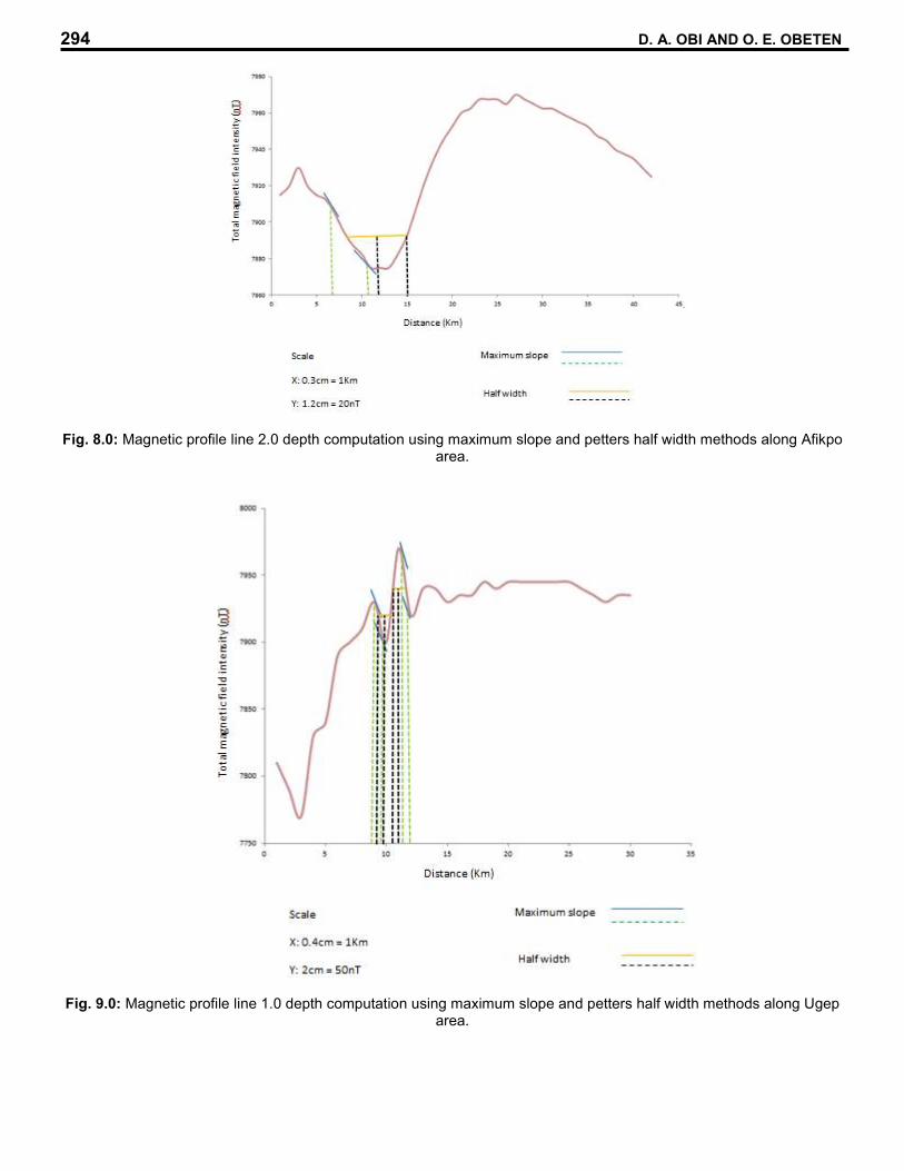
Fig. 8.0: Magnetic profile line 2.0 depth computation using maximum slope and petters half width methods along Afikpo area.
Fig. 9.0: Magnetic profile line 1.0 depth computation using maximum slope and petters half width methods along Ugep area.
294 D. A. OBI AND O. E. OBETEN

Fig. 10: Magnetic profile line 2.0 depth computation using maximum slope and petters half width methods along Ugep area.
Depth to magnetic basement values were generated from the estimated depth values and repositioned in their longitude and latitude coordinates and contoured as depth to magnetic basementmap which reveals horst and graben structures.Two sub-basin are seen aroun Abanwan and Okumeritit flanked by their surrounding structural high marked by shallower depths. (Fig.11). Also,
the merged total magnetic digitized grid file was used in the software SURFER 9.0 to plot a 3-D surface plot which indicates the general magnetic susceptibilities of the area which also indicate horst and graben features, these areas the ealier identified sub-basins and their structural highs. (Fig.12).
AEROMAGNETIC MAPPING OF BASEMENT RELIEF FEATURES IN PARTS OF LOWER BENUE 295

Afikpo
Amagu
Iyamoyong
Biakpan
Abanwan
Ugep Okumunitet
Nko
Nkpani
Akwanu
Fig.11:Depth map derived from manually digitized petter’s half width and maximum slope methods of the study area
296 D . A. OBI AND O. E. OBETEN
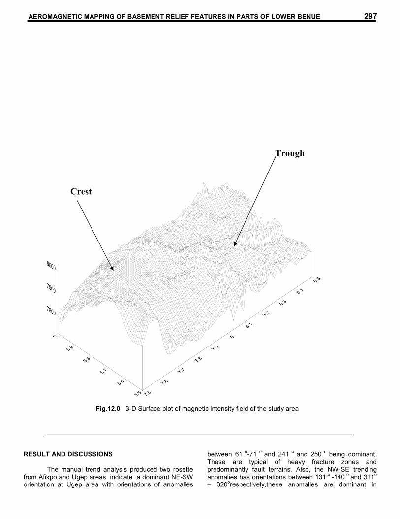
Fig.
RESULT AND DISCUSSIONS The manual trend analysis produced two rosette from Afikpo and Ugep areas indicate a dominant NE-SW orientation at Ugep area with orientations of anomalies
between 61 o
-71 o
and 241 o
and 250 o
being dominant. These are typical of heavy fracture zones and predominantly fault terrains. Also, the NW-SE trending anomalies has orientations between 131
o -140
o and 311
o
– 320orespectively,these anomalies are dominant in
Fig.12.0 3-D Surface plot of magnetic intensity field of the study area
Crest
Trough
AEROMAGNETIC MAPPING OF BASEMENT RELIEF FEATURES IN PARTS OF LOWER BENUE 297

Afikpo which are less fractured and indicate deeper sedimentary rocks piles. Faults are indiated with dotted lines and marked F1 – F4 (Fig.2) using the total magnetic field intensity maps,criterias used include abrupt changes in orientation of contour lines, abrupt changes in amplitude of contours amount and tightness or loose contour lines, fault F1 stretches towards Abanwan and Ugep, F2 stretches towards Afikpo and Ugep, F3 stretches in N-S direction from Afikpo towards Ugep, while F4 lies between Abanwan and Afikpo and stretches towards Biakpan in cross river State.The presence of faults is indicative of the availability of trapping structures for entrapment of possibly generated hydrocarbons.The results from the manual depth analysis (Fig.11.0 and table 3.0) reveals areas with depths considered as thick sediments accumulations (>3.5km) and shallow sediments accumulations (<1.0km),these areas represent horst and graben structures. These results are in agreement with previous work in by many authors around the Nigerian Benue Trough (Ofoegbu, 1991; Obi et. al, 2013; Fairhead, and Okereke 1990). The estimated depths within the study area reveals the highest depth at 4.0km in Abanwan and lowest at 0.8km at Iyamoyong. Also, between Okumiritit and iyamoyong depth ranges between 2.2km to 2.8km, between Abanwan and Biapkan depth ranges are 2.6 km – 3.6 km.The study reveals 2 sub-basins (Fig.11.0), the Abanwan sub-basin in Afikpo area of Ebonyi state which extends to Biakpan areas of Cross River State and the Nkpani sub-basin in Cross river State which forms parts of the Ikom- Mamfe basin. These identified sub-basins has sediments thickness enough to generate hydrocarbons given that all other conditions are favourable. CONCLUSION The study utilized two hard copies aeromagnetic maps which were digitized, processed and analysed for magnetic anomalies trends and depth to source of magnetic anomalies, both manual and computer techniques were employed to obtain the general lineament trends in the NE-SW with minor trends NW-SE. Typical basement relief features such as Horst and Grabens were identified along with faults and magnetic lineament trends. Two sub-basins were identified which has potentials for generating hydrocarbons since the sediment thickness were greater than 3.5km. it’s recommended that further geochemical and geophysical investigations be made within the identified sub-basins for further subsurface basin evaluation. REFERENCES Ajai, C.O and Ajakaiye, D. E., 1981. The origin and peculiarities of Nigeria Benue Trough. Another look from recent gravity data obtained from middle Benue. Techtonophysics,(80): 285-303. Benkhelil, J., 1982. Benue Trough and Benue cahin. Geological magazine, (199): 115-168.
Dobrim, M.B and Sarvit, H., 1988. Introduction to Geophysical Prospecting (4
th ed) New york. MC
Graw Hill Book Company. 488. Fairyhead, J. D and Okereke, C.S., 1990 crustal thining and extension beneath the Benue Trough based on gravity studies. Journal of African Earth Sciences.11, (314): 329-355. Nettleton, L.L., 1971.Elementary Gravity and magnetic for Geologist and Engineer. Society for Expl. Geophysicist Monograph series 1-83 Obi, D.A., Okereke, C.S., Egeh, E.U and Olagundiye, O.O., 2008. Aeromagnetic modeling in evaluating the hydrocarbon potential of the basement of the Calabar Flank south eastern Nigeria. Journal of mining and geology.44, (2):151-160. Obi, D.A., Obi, E. O., and Okiwelu, A. A., 2013. Basinal configuration and intra sediment intrusive as revealed by Aeromagnetic data of south East sector of mamfe basin, Nigeria. Journal of applied Geology and Geophysics issue, (3): 01—8. Ofoegbu, C.O., 1991. Analysis of magnetic data over the Abakaliki Anticlinorium of the lower Benue trough, Nigeria.Geophysics J.R astron soc (79): 813-823 Olade, M. A., 1975. Evolution of Nigeria is Benue trough (Aulacogen) A tectonic, Geological magazine (112): 575-583. Olagundoye, O.O., 2004. Geophysical study of the basin structure of the Anambra frontier Basin, S.E. Nigeria. Ph.d thesis, university of Calabar, Nigeria. Onu, N.N., Opera, A.I and Oparaku, O. I., 2011. Geological Interpretation of aero magnetic data over the lower Benue trough and some adjoining areas. 47
thannual International Conference of
Nigeria Mining and Geosciences, Society (N.M.G.S) programme book of Abstract. P. 43-51. Onwnemesi, A.G., 1997. One Dimensional Spectral analysis of aeromagnetic anomalies and curie depth isotherm in the Anambra basin of Nigeria.J. Geodynamics 23, (2): 126-135. Onumba, L.N., Anudu, G.K., Chiaghanm, O.I and Anakwuba, E.K., 2011. Evaluaiom of aeromagnetic anomalies over Okigwe area, south easthern Nigeria. Research J. Environ and earth sci. 3, (5): 498-507. Phillips, J. D., 1997. Potential field geophysical software for the P.C version 2.2 U.S Geological survey open file report 97, (725): 1-32. Petters, S.W., 1978a. Stratigraphic evolution of the Benue Trough and it is Implication for the upper
298 D. A. OBI AND O. E. OBETEN

Cretaceous Paleogeography of west Africa. Journal of Geology (86): 312-322. Reeves, C., 2005. Aeromagnetic surveys principles, practice and interpretation.www.Geosoft.com
Webring, M., 1985. MINC, A griddling programme based on minimum curvature U.S Geological survey open file Report (81-1224):1-41
AEROMAGNETIC MAPPING OF BASEMENT RELIEF FEATURES IN PARTS OF LOWER BENUE 299