
STREAM SEDIMENT SURVEY OF AEROMAGNETIC HIGH ON SHEET 32 KADUNA STATE – NIGERIA

This article appeared in a journal published by Elsevier. The attachedcopy is furnished to the author for internal non-commercial researchand education use, including for instruction at the authors institution
and sharing with colleagues.
Other uses, including reproduction and distribution, or selling orlicensing copies, or posting to personal, institutional or third party
websites are prohibited.
In most cases authors are permitted to post their version of thearticle (e.g. in Word or Tex form) to their personal website orinstitutional repository. Authors requiring further information
regarding Elsevier’s archiving and manuscript policies areencouraged to visit:
http://www.elsevier.com/authorsrights

Author's personal copy
High resolution aeromagnetic anomaly map of Mount Etna volcano,Southern Italy
F. D'Ajello Caracciolo ⁎, I. Nicolosi, R. Carluccio, S. Chiappini, R. De Ritis, A. Giuntini, V. Materni,A. Messina, M. ChiappiniIstituto Nazionale di Geofisica e Vulcanologia (INGV), Via di Vigna Murata 605, 00143 Roma, Italy
a b s t r a c ta r t i c l e i n f o
Article history:Received 11 July 2013Accepted 26 March 2014Available online 5 April 2014
Keywords:Etna volcanoMagnetic anomaliesAeromagnetismPotential fieldsFry analysis
A high resolution aeromagnetic survey of Mount Etna Volcano was carried out by the Airborne GeophysicsScience Team of Istituto Nazionale di Geofisica e Vulcanologia (INGV), aimed at producing the most detailedmagnetic anomaly map existing so far for this area. Two datasets of the total intensity of the Earth's MagneticField were collected at different altitudes to take into account the huge topographic variations of Etna volcano,that reaches elevations above 3300 m asl. One level was flown at the altitude of 2200 m whereas a second oneover the central part, at about 3500m of altitude. Since the region is characterized by a large presence of stronglymagnetized volcanic products, the survey was carried out acquiring profile lines only, in order to optimize theresources. From the residual magnetic anomaly analysis we inferred two main trending lineaments (−35°Nand 0°N) that are related to regional tectonic stress field and we interpret the main magnetic anomaly as the ef-fect of thickness variation of magnetized volcanic products due to the complex pre-volcanic basement morphol-ogy of Etna.
© 2014 Elsevier B.V. All rights reserved.
1. Introduction
Mount Etna, oneof themost active volcanoes in theworld in a denselypopulated area, is a highly hazard-prone area, due to the volcanic activityand to the active sismogenetic structures triggering tsunami sector col-lapse occurrence (Pareschi et al., 2006). Etna is located in the Easternside of the Sicily region (Fig. 1) and is one of the most studied volcanoes.During the last years, in fact, different parameters are constantly moni-tored, such as long term ground deformation (Monaco et al., 1997;Azzaro, 1999), short term ground deformation (Bonforte et al., 2011),gas geochemistry, and gravimetric and magnetic time variations onground reference stations (Del Negro et al., 2002). Its internal structurewas modeled using geophysical methods like seismic tomography fromarrival times of compressional waves (Aloisi et al., 2002; Chiarabbaet al., 2004; Patanè et al., 2006), from attenuation of seismic waves (DeGori et al., 2005), from 3D gravity model (Schiavone and Loddo, 2007)and some magnetotelluric inversion profiles (Siniscalchi et al., 2012 andreferences therein). The main result of these studies is the discovery ofthe high Vp and high density anomaly body interpreted as a relict intru-sive system related to the earliest central type polygenetic volcanoes(Valle del Bove Supersynthem Branca et al., 2011).
The areawas already covered by lower resolution aeromagnetic datacarried out by ENI Divisione Agip during the 70s (Agip spa, 1981), in theframework of an aeromagnetic mapping of the Italian territory. A
ground-based compilation of the magnetic observations conductedduring the 70s (Chiappini et al., 2002) revealed, inter alia, the need ofhigher resolution measurements.
A small area of 30 × 20 km over the Eastern sector of Etna wassurveyed and modeled by an aeromagnetic method (Rollin et al.,2000) highlighting the presence of highly magnetized intrusive bodynearby Valle del Bove walls.
In May 2012 a high resolution, helicopter-borne aeromagneticcampaign was conducted by the Airborne Geophysics Science Teamof Istituto Nazionale di Geofisica e Vulcanologia (INGV), coveringcompletely all the Etna volcanic province around an area of about60 × 60 km, including both onshore and offshore sectors. In order totake into account high topographic variations of Mount Etna, twosurveys at different constant elevations were acquired to optimize themagnetic signal sampling: survey A was flown at an altitude of 2200 mwhereas B, covering the central portion of Etna volcano, was performedat 3500masl (Fig. 2).We resolved the largest amount ofmagnetic anom-alies over Etna volcanic area acquiring survey lines only rather than sur-vey and tie lines together. In volcanic areas, characterized by extremelyhigh magnetic anomaly intensities, the overall magnetic anomaly fieldcan be obtained by flying at constant altitude (Chiappini et al., 2002;Blanco-Montenegro et al., 2007, 2011; De Ritis et al., 2010); in such acase, tie line correction does not add a significant contribution to dataquality since it deals with values that are orders of magnitude lowerthan the main anomaly. Moreover, due to budgetary constraints, wepreferred to cover the entire Etna volcano province at high resolutionby means of survey lines, rather than doing it on a smaller area with
Journal of Volcanology and Geothermal Research 277 (2014) 36–40
⁎ Corresponding author. Tel.: +39 0651860054; fax: +39 0636915617.E-mail address: [email protected] (F. D'Ajello Caracciolo).
http://dx.doi.org/10.1016/j.jvolgeores.2014.03.0080377-0273/© 2014 Elsevier B.V. All rights reserved.
Contents lists available at ScienceDirect
Journal of Volcanology and Geothermal Research
j ourna l homepage: www.e lsev ie r .com/ locate / jvo lgeores

Author's personal copy
tie lines. We corrected the level errors using accurate diurnal variationdata and applying a small amount of micro-leveling numericalprocedure.
In this paper we present the results of the aeromagnetic dataprocessing and the new high resolution aeromagnetic map of Etna.We discuss the magnetic signature of Etna and the surrounding areas
using a reduction to the pole map and an azimuth analysis of identifiedmagnetic picks.
2. Geological settings
Mount Etna is a large basaltic strato-volcano, characterized by thealternation of effusive and explosive activity. The volcano lies betweenthe Calabro-Peloritan Arc to the north and the carbonate and volcanicrocks of the Hyblean foreland to the south, belonging to the northern-most part of the African plate (Fig. 1) (Bousquet and Lanzafame,2004). Etna is located in an active and complex tectonic framework,where important structural lineaments play a significant role in thedynamic processes of the volcano. Mount Etna, in fact, lies north toGela-Catania foredeep, south-east to the Apennine thrust and is bor-dered to its eastern flank by the Ionian Sea, where the termination ofthe NNW–SSE Malta Escarpment occurs (Bianca et al., 1999; Argnaniand Bonazzi, 2005). This Quaternary volcano rises up to 3300 m andcovers an area about 1250 km2. The beginning of Etna volcanism wasdue to the northward migration of Plio-Pleistocene Hyblean magmaticsources. Branca et al. (2011), on the basis of the stratigraphic data inte-grated with 40Ar/39Ar age determinations of De Beni et al. (2011), sug-gest an updated geological evolution of the Mount Etna stratovolcano.They propose four main eruptive phases. The first one, named BasalTholeiitic Supersynthem, is a fissure type eruption that started on theseafloor and then took place in subaerial environment from about500 to 330 ka; a second intense eruptive phase, influenced by theextensional tectonics of the NNW-trending Timpe fault system (TS)(Branca et al., 2008), started 220 ka, forming a lava shield of theTimpe Supersynthem; 110 ka, during the Valle del Bove Supersynthem,the central type eruption occurred with the construction of theearliest three volcanoes of Tarderia, Rocche and Trifoglietto; finally,the Stratovolcano Supersynthem was characterized by an intenseeffusive and explosive activity of the Ellittico volcano since 57 kaand then by a mostly effusive activity that built the Mongibellovolcano from 15 ka.
Fig. 1. Sicily and Etna main tectonic lineaments. Red lines =main fault systems; red triangle dashed line =main regional thrusts; TS = Timpe Fault System. Yellow box = survey area.
Fig. 2. Etna STRM Dem and survey line profiles. Red = survey A (altitude 2200 m),Blue = survey B (altitude 3500 m).
37F. D'Ajello Caracciolo et al. / Journal of Volcanology and Geothermal Research 277 (2014) 36–40

Author's personal copy
A central conduit is the main feeding system of the present activityof Mount Etna, characterized by summit and flank eruptions. Lateralconduit systems are responsible for other flank eruptions.
3. Data acquisition
The airborne survey was performed using an Aerospatiale SquirrelAS-350 helicopter, during the last two weeks of May 2012. Even if thesolar activity was intense in that period, confirmed by several recordedmagnetic storms, the use of three magnetic base stations allowed areliablemagnetic diurnal variation correction of the entire aeromagneticdataset. The base stations belong to a permanent local network of INGVlocated nearbyMount Etna, used for monitoring real timemagnetic var-iations due to magma–volcanic edifice interactions (Del Negro et al.,2002). The measured dataset was thus reduced to 2012.5 geomagneticepoch. The anomaly values were obtained by subtracting the calculatedmain field component of the Earth's Magnetic Field from each diurnallycorrected survey point using the 11th generation of the InternationalGeomagnetic Reference Field (IGRF) model.
Themagneticmeasurementswere carried out using a cesiumopticalpumped magnetometer located within a towed aerodynamic housingsuspended from the helicopter barycentric hook through a 30 metercable (Fig. 3). Both survey areas were acquired through aeromagneticprofiles +80°N oriented, orthogonally to the main regional structuraldirections (Azzaro et al., 2012) and line spaced 1 km apart for surveyA and 0.5 km for B. Magnetometer sampling rate was set to 10 Hz forthe whole survey, while precise positioningwas guaranteed by a differ-ential corrected GPS (Global Positioning System) system. Since weobserved negligible leveling errors compared to the magnetic anomalyintensities, we applied a small amount of directional cosine filter alongthe flight line direction (micro-leveling numerical procedure). Thismethod appeared to be sufficient to correct the leveling errors of highlymagnetized volcanic areas. A grid node spacing of 250mwas applied tomeasured data and resulting anomalies were plotted into UTM projec-tion using the WGS84 map datum and central meridian of 15°E (zone33N). Fig. 4 shows the gridded anomalies in shaded relief and contourlines, displayed using a non linear intensity color scale.
4. Results
Etna magnetic anomaly, ranging between−800 and above 1000 nTin intensity, is characterized by a dipolar geometry with negative andpositive anomaly values north to south, as expected from a normal
magnetization direction of magnetic sources at the boreal hemisphere.This main characteristic is in agreement with the measured ages ofEtna volcanic products that are all within the present normal polaritymagnetic chron (De Beni et al., 2011). Even if the dipolar magneticpattern is N–S oriented, it is evident that the overall magnetic anomalygeometry defines a clear structural directionNW–SE oriented (Fig. 4), inagreement with the fault rose diagram directions shown in the Etnavolcano tectonic map by Azzaro et al. (2012).
In order to characterize the main structural directions and correlatemagnetic anomalies with their sources, we used a “pattern enhance-ment” analysis to the magnetic anomaly grid after applying the Reduc-tion to the Magnetic Pole transformation (RTP). We have assumed thatthe sourcemagnetization directions were parallel to the present Earth'sMagnetic Field (magnetic Inclination = 53°, magnetic Declination =2.6°). We then applied Blakely's method (Blakely and Simpson, 1986)to the RTP grid to find the peaks of magnetic anomaly. This methodcompares the value of each grid cell with its eight adjacent cells (firstneighbors) and verifies whether it is a cell peak or not. We expect thatif magnetic anomalies are aligned along some structural directions,this can be reflected by the peak geometry. Fig. 5a shows the resultingpeaks calculated by Blakely'smethod. Afterwardswe applied amodifiedFry analysis (Fry, 1979) to calculated anomaly peaks; this method isbasically a visual integration technique. It operates on a list of pointslocated on a “geo-sampled” map plane (in this case the grid peaks re-covered), that can be considered as an initial 2D integer matrix, whoseelements have a value equals to 1 where a point exists, and equals to0 elsewhere. From this matrix and for every point, a rectangular sub-matrix centered on the point itself is extracted. All of the matrices arethen summed together and the resulting 2D histogram is visualized asa false color image, symmetrical about the center point. Any existingtranslated pattern or preferential alignment is thus amplified and canbe revealed as a feature in the final image. Fig. 5b shows the result ofthe modified Fry analysis when applied to peaks calculated on the RTPmagnetic anomaly grid. Clear alignments along the −35°N and 0°Ndirections are observed; aeromagnetic survey profile (flight paths)Fig. 3. Survey configuration: Aerospatiale Squirrel AS350, magnetic sensor and tow cable.
Fig. 4. Shaded relief magnetic anomaly map (total intensity). Isoline spacing= 20 nT. Thearea enclosed by the white box contains survey B.
38 F. D'Ajello Caracciolo et al. / Journal of Volcanology and Geothermal Research 277 (2014) 36–40
Author's personal copy
directions are detected as well, showing a clear peak maxima alignedalong +80°N; this signature could be due to the occurrence of residualleveling errors and to the difference between spatial sampling distancealong survey profiles and their spacing, generating an apparent magneticanomaly along the survey line direction, not always clearly visible withthe usual color scale representation.
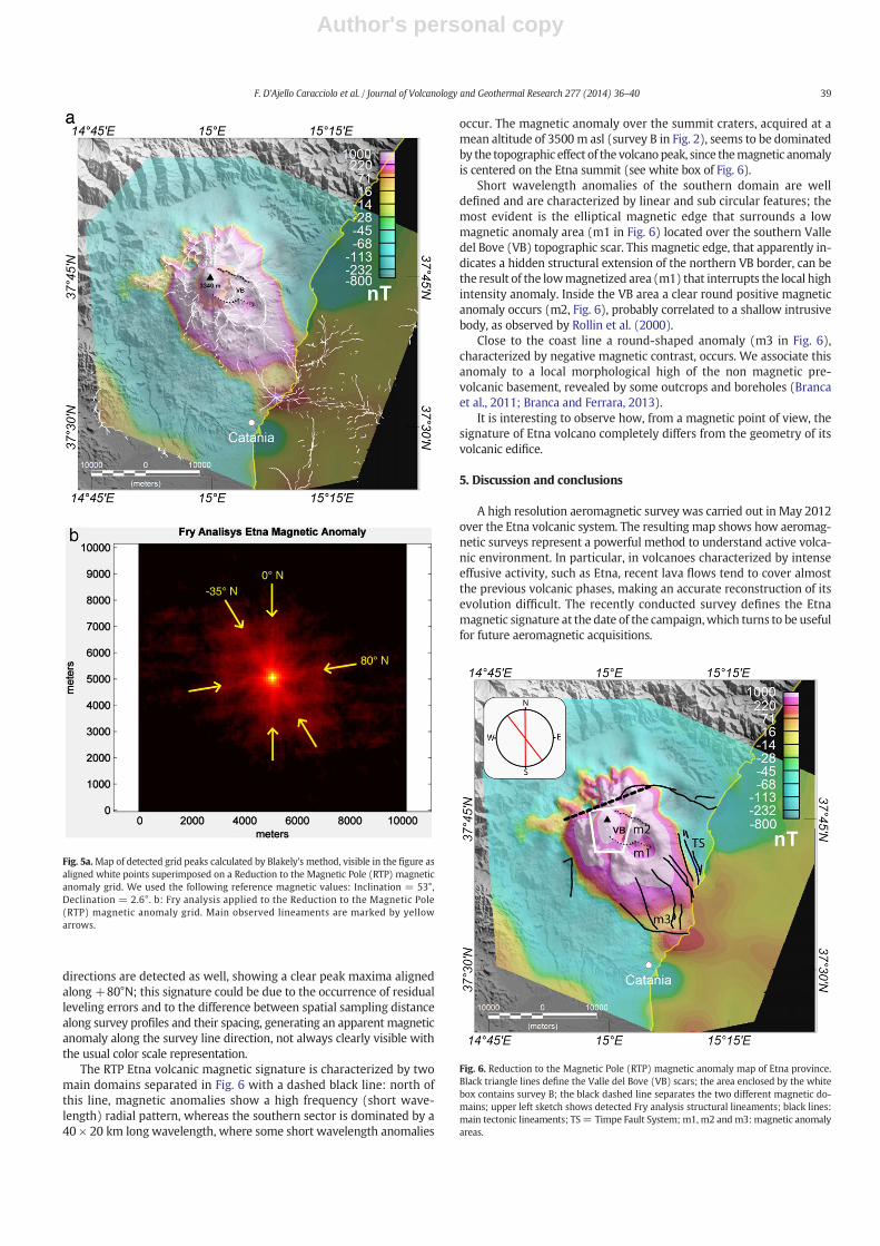
The RTP Etna volcanic magnetic signature is characterized by twomain domains separated in Fig. 6 with a dashed black line: north ofthis line, magnetic anomalies show a high frequency (short wave-length) radial pattern, whereas the southern sector is dominated by a40 × 20 km long wavelength, where some short wavelength anomalies
occur. The magnetic anomaly over the summit craters, acquired at amean altitude of 3500 m asl (survey B in Fig. 2), seems to be dominatedby the topographic effect of the volcanopeak, since themagnetic anomalyis centered on the Etna summit (see white box of Fig. 6).
Short wavelength anomalies of the southern domain are welldefined and are characterized by linear and sub circular features; themost evident is the elliptical magnetic edge that surrounds a lowmagnetic anomaly area (m1 in Fig. 6) located over the southern Valledel Bove (VB) topographic scar. This magnetic edge, that apparently in-dicates a hidden structural extension of the northern VB border, can bethe result of the lowmagnetized area (m1) that interrupts the local highintensity anomaly. Inside the VB area a clear round positive magneticanomaly occurs (m2, Fig. 6), probably correlated to a shallow intrusivebody, as observed by Rollin et al. (2000).
Close to the coast line a round-shaped anomaly (m3 in Fig. 6),characterized by negative magnetic contrast, occurs. We associate thisanomaly to a local morphological high of the non magnetic pre-volcanic basement, revealed by some outcrops and boreholes (Brancaet al., 2011; Branca and Ferrara, 2013).
It is interesting to observe how, from a magnetic point of view, thesignature of Etna volcano completely differs from the geometry of itsvolcanic edifice.
5. Discussion and conclusions
A high resolution aeromagnetic survey was carried out in May 2012over the Etna volcanic system. The resulting map shows how aeromag-netic surveys represent a powerful method to understand active volca-nic environment. In particular, in volcanoes characterized by intenseeffusive activity, such as Etna, recent lava flows tend to cover almostthe previous volcanic phases, making an accurate reconstruction of itsevolution difficult. The recently conducted survey defines the Etnamagnetic signature at the date of the campaign,which turns to be usefulfor future aeromagnetic acquisitions.
Fig. 5a.Map of detected grid peaks calculated by Blakely's method, visible in the figure asaligned white points superimposed on a Reduction to the Magnetic Pole (RTP) magneticanomaly grid. We used the following reference magnetic values: Inclination = 53°,Declination = 2.6°. b: Fry analysis applied to the Reduction to the Magnetic Pole(RTP) magnetic anomaly grid. Main observed lineaments are marked by yellowarrows.
Fig. 6. Reduction to the Magnetic Pole (RTP) magnetic anomaly map of Etna province.Black triangle lines define the Valle del Bove (VB) scars; the area enclosed by the whitebox contains survey B; the black dashed line separates the two different magnetic do-mains; upper left sketch shows detected Fry analysis structural lineaments; black lines:main tectonic lineaments; TS= Timpe Fault System; m1, m2 and m3: magnetic anomalyareas.
39F. D'Ajello Caracciolo et al. / Journal of Volcanology and Geothermal Research 277 (2014) 36–40

Author's personal copy
The most important evidence revealed by the present magneticobservation is that there is no correlation between Etnamagnetic signa-ture and its topographic structure. In fact from theRTP anomaly of Fig. 6,the magnetic anomaly lies mainly in correspondence to the southeastinstable flank of Etna, where the main identified tectonic lineamentsoccur. The magnetic anomaly and tectonic lineaments show a NW–SEtrend as the major regional structures: the Malta Escarpment and theNW/SE lithospheric structure, interpreted by Polonia et al. (2011) asan active Step Fault and source of the major earthquakes in the past,whose northern tip points toward the volcano (Fig. 1). The Step Fault,located at about 70 km east of the Malta Escarpment, is oriented about−30°N, in agreement with the main direction inferred by our modifiedFry analysis.
The present Etna eruptive vents, expression of a central conduitsystem, lie close to the SW–NE oriented contact between two magneticdomains previously described (Fig. 6). The Southern domain is charac-terized by high intensities and long wavelength magnetic anomalies;this major component can be due to the hidden morphology of thepre-volcanic basement, whose complexity has recently been highlight-ed by Branca and Ferrara (2013). The shape of this basement is charac-terized by a wide horseshoe shaped depression in the SE sector, thatseems to correlate with the observed long wavelength magnetic anom-aly; this implies that the magnetic signal is strongly controlled by vari-ations in volcanic unit thickness, that filled this depression. The lowmagnetic anomaly area (m1 in Fig. 6), that interrupts the high anomalyintensities, is located over the Mount Calanna and Tarderia outcrops;Ferlito and Nicotra (2010), interpreted this area as the uppermost por-tion of a volcanic plumbing system, characterized by a highly altereddyke swarm. The magnetic anomaly map described in the presentpaper clearly defines the real extension of the altered sub-volcanicbody, marked by a low magnetic signature; this sub-elliptical magneticfeature overlays the high Vp and density bodywhosemagnetic signatureis not clearly identified.
The origin of the Etna basement depression can be attributed tothe large scale flank instability of the area, as evidenced by morpho-structural setting of the continental margin facing the volcano(Chiocci et al., 2011). The short wavelength magnetic anomaly compo-nent of the southern magnetic domain can be more directly related tolocalmagnetization variations, occurrence of intrusive bodies or discon-tinuities inside volcanic rocks generated by faults. Since our directionalanalysis is more sensitive to this anomaly components, the two identi-fied magnetic anomaly peak orientations (−35°; 0°) reasonably depictthe tectonic lineament directions.
Valle del Bove cliff, as visible in Fig. 6, does not show a strong correla-tionwithmagnetic anomalies, except for a few kilometers of its northernedge. The VB southern edge does not show any magnetic signature, sug-gesting a superficial structure associated to VB topographic depression,mainly caused by gravitational collapses (Borgia et al., 1992).
The Northern magnetic domain, characterized by short wavelengthanomalies associated to superficial magma intrusions, highly differs instyle with respect to the Southern magnetic domain; the observedsectors seem to correlate with general ground deformation modelsrevealed by InSar PS technique and GPS data (Bonforte et al., 2011),showing that the radial deformation and the uplift area occur exactlyover the radial magnetic anomaly pattern of the Northern domain.
Acknowledgements
We are grateful to the Editor in chief Professor J. Neuberg for careful-ly evaluating our paper and two anonymous reviewers for their con-structive comments and helpful suggestions.
References
Agip spa, 1981. Carta Magnetica-Anomalie del Campo magnetico residuo. S. DonatoMilanese, Italy, scale 1/500,000.
Aloisi, M., Cocina, O., Neri, G., Orecchio, B., Provitera, E., 2002. Seismic tomography of thecrust underneath the Etna volcano, Sicily. Phys. Earth Planet. Inter. 134, 139–155.
Argnani, A., Bonazzi, C., 2005. Malta Escarpement fault zone offshore eastern Sicily:Pliocene–Quaternary tectonic evolution based on new multichannel seismic data.Tectonics 24. http://dx.doi.org/10.1029/2004TC001656 (TC4009).
Azzaro, R., 1999. Earthquake surface faulting at Mount Etna volcano (Sicily) and implica-tions for active tectonics. J. Geodyn. 28, 193–213.
Azzaro, R., Branca, S., Gwinner, K., Coltelli, M., 2012. The volcano–tectonic map of Etnavolcano, 1:100.000 scale: an integrated approach based on amorphotectonic analysisfromhigh-resolution DEM constrained by geologic, active faulting and seismotectonicdata. Ital. J. Geosci., 131.
Bianca, M., Monaco, C., Tortorici, L., Cernobori, L., 1999. Quaternary normal faulting insoutheastern Sicily (Italy): a seismic source for the 1693 large earthquake. Geophys.J. Int. 139, 370–394.
Blakely, R.J., Simpson, R.W., 1986. Approximating edges of source bodies from magneticor gravity anomalies. Geophysics 51, 1494–1498.
Blanco-Montenegro, I., De Ritis, R., Chiappini, M., 2007. Imaging and modelling the sub-surface structure of volcanic calderas with high-resolution aeromagnetic data atVulcano (Aeolian Islands, Italy). Bull. Volcanol. http://dx.doi.org/10.1007/s00445-006-0100-7.
Blanco-Montenegro, I., Nicolosi, I., Pignatelli, A., García, A., Chiappini, M., 2011. New evi-dence about the structure and growth of ocean island volcanoes from aeromagneticdata: the case of Tenerife, Canary Islands. J. Geophys. Res. 116. http://dx.doi.org/10.1029/2010JB007646 (B03102).
Bonforte, A., Guglielmino, F., Coltelli, M., Ferretti, A., Puglisi, G., 2011. Structural assess-ment of Mount Etna volcano from Permanent Scatterers analysis. Geochem. Geophys.Geosyst. 12. http://dx.doi.org/10.1029/2010GC003213 (Q02002).
Borgia, A., Ferrari, L., Pasquarè, G., 1992. Importance of gravitational spreading in thetectonic and volcanic evolution of Mount Etna. Nature 357, 231–235.
Bousquet, J.C., Lanzafame, G., 2004. The tectonics and geodynamics of the Mt. Etna: syn-thesis and interpretation of geological and geophysical data. In: Bonaccorso, A., etal. (Eds.), Geophysical Monograph Series, AGU, 143. Mt. Etna: Volcano Laboratory,pp. 29–47.
Branca, S., Ferrara, V., 2013. The morphostructural setting of Mount Etna sedimentarybasement (Italy): implications for the geometry and volume of the volcano and itsflank instability. Tectonophysics 586, 46–64.
Branca, S., Coltelli, M., De Beni, E., Wijbrans, J., 2008. Geological evolution of Mount Etnavolcano (Italy) from earliest products until the first central volcanism (between500 and 100 ka ago) inferred from geochronological and stratigraphic data. Int. J.Earth Sci. 97, 135–152.
Branca, S., Coltelli, M., Groppelli, G., 2011. Geological evolution of a complex basalticstratovolcano: Mount Etna, Italy. Ital. J. Geosci. 130, 306–317 (n 3).
Chiappini, M., Meloni, A., Boschi, E., Faggioni, O., Beverini, N., Carmisciano, C., Marson, I.,2002. Shaded relief magnetic anomaly map of Italy and surrounding marine areas.Ann. Geofis. 43, 983–989.
Chiarabba, C., De Gori, P., Patanè, D., 2004. Mt. Etna: Volcano Laboratory (A. Bonaccorso, S.Calvari, S).
Chiocci, F.L., Coltelli, M., Bosman, A., Cavallaro, D., 2011. Continentalmargin large-scale in-stability controlling the flank sliding of Etna volcano. Earth Planet. Sci. Lett. 305,57–64.
De Beni, E., Branca, S., Coltelli, M., Groppeli, G., Wijbranz, J.R., 2011. 40Ar/39Ar isotopicdating of Etna volcanic succession. Int. J. Earth Sci. 97, 292–305.
De Gori, P., Chiarabba, C., Patanè, D., 2005. Qp structure of Mount Etna: constraints for thephysics of the plumbing system. J. Geophys. Res. 110. http://dx.doi.org/10.1029/2003JB002875 (B05303).
De Ritis, R., Dominici, R., Ventura, G., Nicolosi, I., Chiappini, M., Speranza, F., De Rosa, R.,Donato, P., Sonnino, M., 2010. A buried volcano in the Calabrian Arc (Italy) revealedby high resolution aeromagnetic data. J. Geophys. Res. 115. http://dx.doi.org/10.1029/2009JB007171.
Del Negro, C., Napoli, R., Sicali, A., 2002. Automated system for magnetic monitoring ofactive volcanoes. Bull. Volcanol. 64, 94–99.
Ferlito, C., Nicotra, E., 2010. The dyke swarm of Mount Calanna (Etna, Italy): an exampleof the uppermost portion of a volcanic plumbing system. Bull. Volcanol. 72,1191–1207.
Fry, N., 1979. Random point distributions and strain measurement in rocks. Tectonophysics60, 89–105.
Monaco, C., Tapponier, P., Tortorici, L., Gillot, P.Y., 1997. Late Quaternary slip rates on theAcireale-Piedimonte normal faults and tectonic origin of Mt. Etna (Sicily). EarthPlanet. Sci. Lett. 147, 125–139.
Pareschi, M.T., Boschi, E., Favalli, M., 2006. Lost tsunami. Geophys. Res. Lett. 33. http://dx.doi.org/10.1029/2006GL027790 (L22608).
Patanè, D., Barberi, G., Cocina, O., De Gori, P., Chiarabba, C., 2006. Time-resolvedseismic tomography detects magma intrusions at Mount Etna. Science 313(821), 823.
Polonia, A., Torelli, L., Mussoni, P., Gasperini, L., Artoni, A., Klaeschen, D., 2011. TheCalabrian Arc subduction complex in the Ionian Sea: regional architecture,active deformation, and seismic hazard. Tectonics 30. http://dx.doi.org/10.1029/2010TC002821 (TC5018).
Rollin, P.J., Cassidy, J., Locke, C.A., Rymer, H., 2000. Evolution of the magmatic plumbingsystem at Mt Etna: new evidence from gravity and magnetic data. Terra Nova 12(5), 193–198. http://dx.doi.org/10.1046/j.1365-3121.2000.00285.x.
Schiavone, D., Loddo, M., 2007. 3-D density model of Mt. Etna Volcano (Southern Italy). J.Volcanol. Geotherm. Res. 164, 161–175.
Siniscalchi, A., Tripaldi, S., Neri,M., Balasco,M., Romano, G., Ruch, J., Schiavone, D., 2012. Flankinstability structure of Mt. Etna inferred by a magnetotelluric survey. J. Geophys. Res.117. http://dx.doi.org/10.1029/2011JB008657 (B03216).
40 F. D'Ajello Caracciolo et al. / Journal of Volcanology and Geothermal Research 277 (2014) 36–40
Copyright © 2022 FDOKUMEN