
Neogene-Holocene rift propagation in central Tanzania: Morphostructural and aeromagnetic evidence...
21
For permission to copy, contact [email protected] q 2004 Geological Society of America 490 GSA Bulletin; March/April 2004; v. 116; no. 3/4; p. 490–510; doi: 10.1130/B25202.1; 12 figures. Neogene-Holocene rift propagation in central Tanzania: Morphostructural and aeromagnetic evidence from the Kilombero area Bernard Le Gall ² Laurent Gernigon Joel Rolet UMR-CNRS 6538 ‘Domaines Oce ´aniques,’ Institut Universitaire Europe ´en de la Mer, Place Nicolas Copernic, 29280 Plouzane ´, France Cinthya Ebinger Department of Geology, Royal Holloway, University of London, Egham Hill, Egham, Surrey TW 20 0EX, UK Richard Gloaguen TU Bergakademie Freiberg, Institut fur Geologie, B. von Cotta 2, D-09599 Freiberg, Germany Odd Nilsen Henning Dypvik Department of Geology, University of Oslo, Post Office Box 1047, Blindern N 0316 Oslo, Norway Benoit Deffontaines Institut Morphologie et Environnement Littoral, 35320 Dinard, France Abdul Mruma Department of Geology, University of Dar es Salaam, Post Office Box 35052, Tanzania ABSTRACT Based on field studies supplemented by remote sensing and aeromagnetic data from central Tanzania, a Phanerozoic structural history for the region can be developed and placed in a broader rift context. The major contribution of this work is the recognition of rift morphology over an area lying 400 km beyond the southern termination of the Eastern, or Kenya, Rift. The most promi- nent rift structures occur in the Kilombero region and consist of a wide range of up- lifted basement blocks fringed to the west by an east-facing half-graben that may con- tain 6–8 km of sedimentary strata. Physio- graphic features and river drainage anom- alies suggest that Holocene/Neogene deformation occurs along both rift-parallel and transverse faults, in agreement with the seismogenic character of a number of oblique faults. The present-day rift pattern of the Kilombero extensional province re- ² E-mail: [email protected]. sults from the complete overprinting of an earlier (Karoo) rift basin by Neogene- Holocene faults. The Kilombero rift zone is assumed to connect northward into the cen- tral rift arm (Manyara) of the Eastern Rift via an active transverse fault zone. The pro- posed rift model implies that incipient rift- ing propagates throughout the cold and strong lithosphere of central Tanzania fol- lowing Proterozoic basement weakness zones (N1408E) and earlier Karoo rift structures (north-south). An eventual struc- tural connection of the Kilombero rift zone with the Lake Malawi rift further south is also envisaged and should imply the spatial link of the eastern and western branches of the East African Rift System south of the Tanzanian craton. Keywords: East African Rift, central Tan- zania, Karoo/Cenozoic extensional faulting, satellite imagery, drainage pattern analysis, aeromagnetic data. INTRODUCTION Recent studies have shown that some parts of the East African Rift System transect and/ or reactivate known Permo-Triassic, Creta- ceous, or Paleogene rift basins, but the spatial extent of these earlier rift systems is poorly known throughout east Africa (e.g., Ebinger and Ibrahim, 1994; Hendrie et al., 1994). Ex- isting maps and tectonic compilations of the region rarely differentiate between age of structures, leading to misunderstanding of the geometry and kinematics of the present-day East African Rift System (Kreuser, 1983; Specht and Rosendahl, 1989). Owing to the superposition of structures and sedimentary strata, it is virtually impossible to differentiate between Neogene, reactivated Permo-Triassic, and ancient structures and sedimentary strata without detailed information (Mugisha et al., 1997; Dypvik et al., 1997; Nilsen et al., 1999; Dypvik and Nilsen, 2001). One region that is critical for the problem of polyphase rift patterns is central Tanzania, south of the surface expression of the Eastern
-
Upload
independent -
Category
Documents
-
view
0 -
download
0
Transcript of Neogene-Holocene rift propagation in central Tanzania: Morphostructural and aeromagnetic evidence...
For permission to copy, contact [email protected] 2004 Geological Society of America490
GSA Bulletin; March/April 2004; v. 116; no. 3/4; p. 490–510; doi: 10.1130/B25202.1; 12 figures.
Neogene-Holocene rift propagation in central Tanzania:Morphostructural and aeromagnetic evidence
from the Kilombero area
Bernard Le Gall†
Laurent GernigonJoel RoletUMR-CNRS 6538 ‘Domaines Oceaniques,’ Institut Universitaire Europeen de la Mer, Place Nicolas Copernic, 29280Plouzane, France
Cinthya EbingerDepartment of Geology, Royal Holloway, University of London, Egham Hill, Egham, Surrey TW 20 0EX, UK
Richard GloaguenTU Bergakademie Freiberg, Institut fur Geologie, B. von Cotta 2, D-09599 Freiberg, Germany
Odd NilsenHenning DypvikDepartment of Geology, University of Oslo, Post Office Box 1047, Blindern N 0316 Oslo, Norway
Benoit DeffontainesInstitut Morphologie et Environnement Littoral, 35320 Dinard, France
Abdul MrumaDepartment of Geology, University of Dar es Salaam, Post Office Box 35052, Tanzania
ABSTRACT
Based on field studies supplemented byremote sensing and aeromagnetic data fromcentral Tanzania, a Phanerozoic structuralhistory for the region can be developed andplaced in a broader rift context. The majorcontribution of this work is the recognitionof rift morphology over an area lying 400km beyond the southern termination of theEastern, or Kenya, Rift. The most promi-nent rift structures occur in the Kilomberoregion and consist of a wide range of up-lifted basement blocks fringed to the westby an east-facing half-graben that may con-tain 6–8 km of sedimentary strata. Physio-graphic features and river drainage anom-alies suggest that Holocene/Neogenedeformation occurs along both rift-paralleland transverse faults, in agreement with theseismogenic character of a number ofoblique faults. The present-day rift patternof the Kilombero extensional province re-
†E-mail: [email protected].
sults from the complete overprinting of anearlier (Karoo) rift basin by Neogene-Holocene faults. The Kilombero rift zone isassumed to connect northward into the cen-tral rift arm (Manyara) of the Eastern Riftvia an active transverse fault zone. The pro-posed rift model implies that incipient rift-ing propagates throughout the cold andstrong lithosphere of central Tanzania fol-lowing Proterozoic basement weaknesszones (N1408E) and earlier Karoo riftstructures (north-south). An eventual struc-tural connection of the Kilombero rift zonewith the Lake Malawi rift further south isalso envisaged and should imply the spatiallink of the eastern and western branches ofthe East African Rift System south of theTanzanian craton.
Keywords: East African Rift, central Tan-zania, Karoo/Cenozoic extensional faulting,satellite imagery, drainage pattern analysis,aeromagnetic data.
INTRODUCTION
Recent studies have shown that some partsof the East African Rift System transect and/or reactivate known Permo-Triassic, Creta-ceous, or Paleogene rift basins, but the spatialextent of these earlier rift systems is poorlyknown throughout east Africa (e.g., Ebingerand Ibrahim, 1994; Hendrie et al., 1994). Ex-isting maps and tectonic compilations of theregion rarely differentiate between age ofstructures, leading to misunderstanding of thegeometry and kinematics of the present-dayEast African Rift System (Kreuser, 1983;Specht and Rosendahl, 1989). Owing to thesuperposition of structures and sedimentarystrata, it is virtually impossible to differentiatebetween Neogene, reactivated Permo-Triassic,and ancient structures and sedimentary stratawithout detailed information (Mugisha et al.,1997; Dypvik et al., 1997; Nilsen et al., 1999;Dypvik and Nilsen, 2001).
One region that is critical for the problemof polyphase rift patterns is central Tanzania,south of the surface expression of the Eastern
Geological Society of America Bulletin, March/April 2004 491
NEOGENE–HOLOCENE RIFT PROPAGATION IN CENTRAL TANZANIA
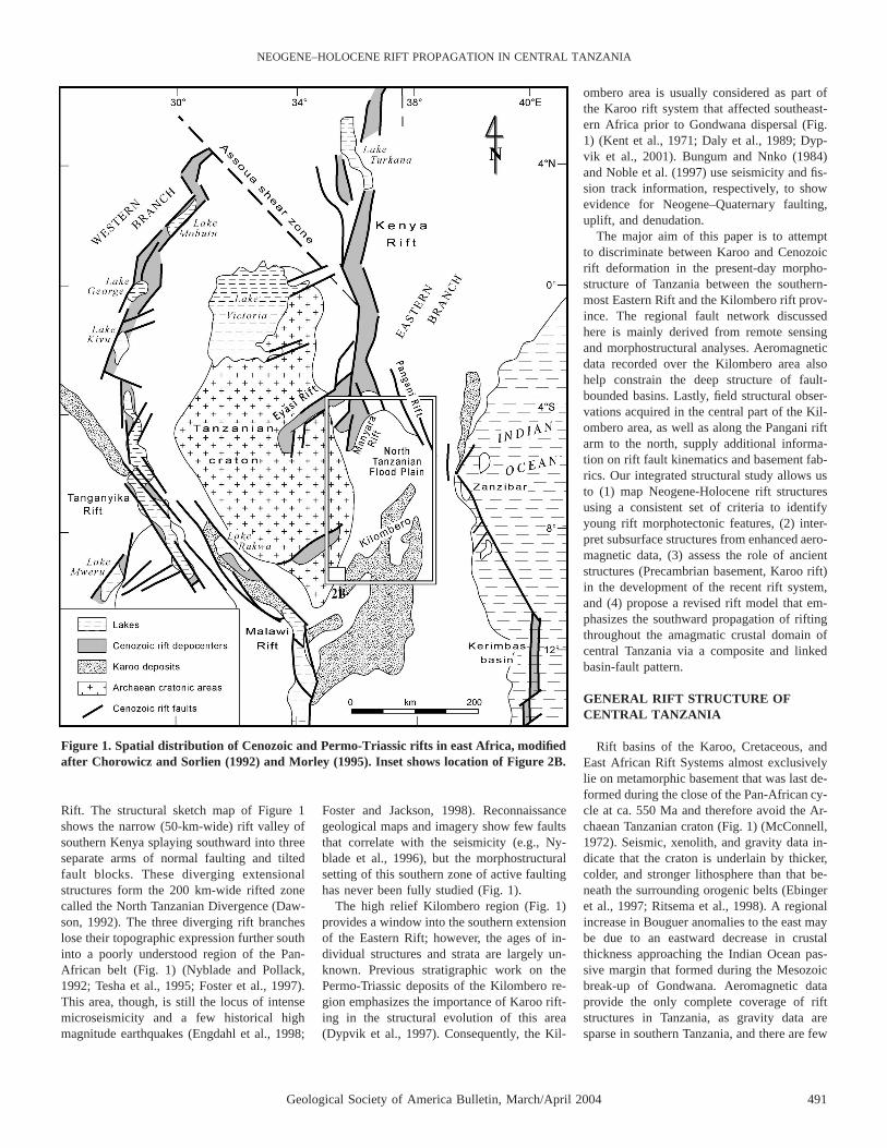
Figure 1. Spatial distribution of Cenozoic and Permo-Triassic rifts in east Africa, modifiedafter Chorowicz and Sorlien (1992) and Morley (1995). Inset shows location of Figure 2B.
Rift. The structural sketch map of Figure 1shows the narrow (50-km-wide) rift valley ofsouthern Kenya splaying southward into threeseparate arms of normal faulting and tiltedfault blocks. These diverging extensionalstructures form the 200 km-wide rifted zonecalled the North Tanzanian Divergence (Daw-son, 1992). The three diverging rift brancheslose their topographic expression further southinto a poorly understood region of the Pan-African belt (Fig. 1) (Nyblade and Pollack,1992; Tesha et al., 1995; Foster et al., 1997).This area, though, is still the locus of intensemicroseismicity and a few historical highmagnitude earthquakes (Engdahl et al., 1998;
Foster and Jackson, 1998). Reconnaissancegeological maps and imagery show few faultsthat correlate with the seismicity (e.g., Ny-blade et al., 1996), but the morphostructuralsetting of this southern zone of active faultinghas never been fully studied (Fig. 1).
The high relief Kilombero region (Fig. 1)provides a window into the southern extensionof the Eastern Rift; however, the ages of in-dividual structures and strata are largely un-known. Previous stratigraphic work on thePermo-Triassic deposits of the Kilombero re-gion emphasizes the importance of Karoo rift-ing in the structural evolution of this area(Dypvik et al., 1997). Consequently, the Kil-
ombero area is usually considered as part ofthe Karoo rift system that affected southeast-ern Africa prior to Gondwana dispersal (Fig.1) (Kent et al., 1971; Daly et al., 1989; Dyp-vik et al., 2001). Bungum and Nnko (1984)and Noble et al. (1997) use seismicity and fis-sion track information, respectively, to showevidence for Neogene–Quaternary faulting,uplift, and denudation.
The major aim of this paper is to attemptto discriminate between Karoo and Cenozoicrift deformation in the present-day morpho-structure of Tanzania between the southern-most Eastern Rift and the Kilombero rift prov-ince. The regional fault network discussedhere is mainly derived from remote sensingand morphostructural analyses. Aeromagneticdata recorded over the Kilombero area alsohelp constrain the deep structure of fault-bounded basins. Lastly, field structural obser-vations acquired in the central part of the Kil-ombero area, as well as along the Pangani riftarm to the north, supply additional informa-tion on rift fault kinematics and basement fab-rics. Our integrated structural study allows usto (1) map Neogene-Holocene rift structuresusing a consistent set of criteria to identifyyoung rift morphotectonic features, (2) inter-pret subsurface structures from enhanced aero-magnetic data, (3) assess the role of ancientstructures (Precambrian basement, Karoo rift)in the development of the recent rift system,and (4) propose a revised rift model that em-phasizes the southward propagation of riftingthroughout the amagmatic crustal domain ofcentral Tanzania via a composite and linkedbasin-fault pattern.
GENERAL RIFT STRUCTURE OFCENTRAL TANZANIA
Rift basins of the Karoo, Cretaceous, andEast African Rift Systems almost exclusivelylie on metamorphic basement that was last de-formed during the close of the Pan-African cy-cle at ca. 550 Ma and therefore avoid the Ar-chaean Tanzanian craton (Fig. 1) (McConnell,1972). Seismic, xenolith, and gravity data in-dicate that the craton is underlain by thicker,colder, and stronger lithosphere than that be-neath the surrounding orogenic belts (Ebingeret al., 1997; Ritsema et al., 1998). A regionalincrease in Bouguer anomalies to the east maybe due to an eastward decrease in crustalthickness approaching the Indian Ocean pas-sive margin that formed during the Mesozoicbreak-up of Gondwana. Aeromagnetic dataprovide the only complete coverage of riftstructures in Tanzania, as gravity data aresparse in southern Tanzania, and there are few
492 Geological Society of America Bulletin, March/April 2004
LE GALL et al.
Geological Society of America Bulletin, March/April 2004 493
NEOGENE–HOLOCENE RIFT PROPAGATION IN CENTRAL TANZANIA
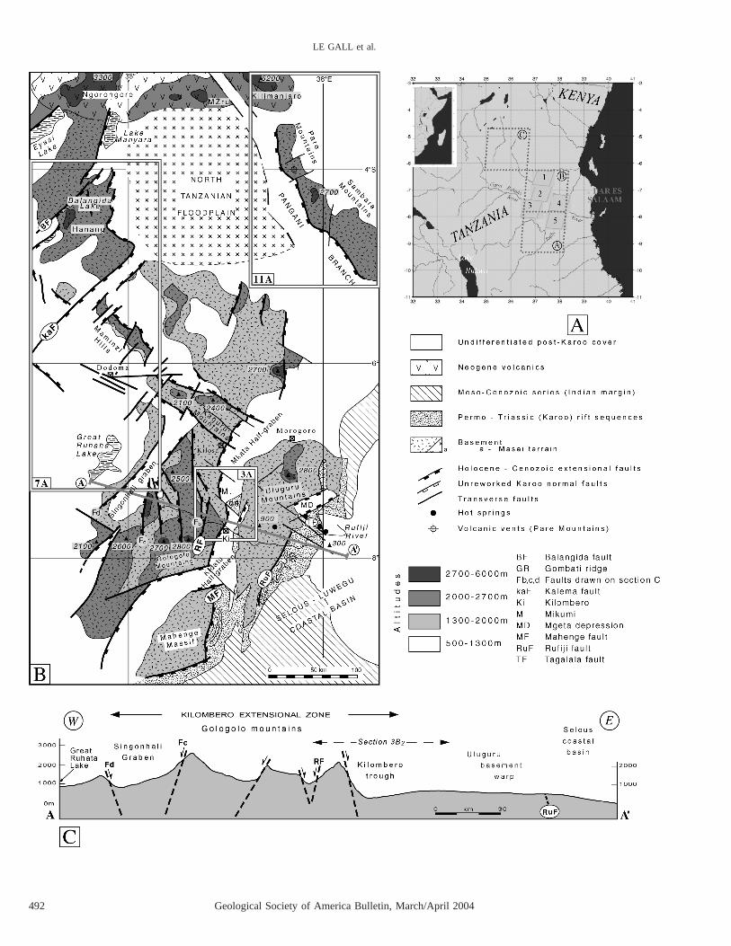
Figure 2. General rift structure of central Tanzania. (A) Location of SPOT (3 6) and LANDSAT MultiSpectral satellite imagery (3 3)used in this work. 1, 2, 3, 4, 5, SPOT images 142–363,2364,2365; 144–363,2366; 143–366; A, B, C, LANDSAT images 22346–06533,21866–06560, 168064. (B) Sketch structural map derived from remote sensing analysis. Cartographic fold-like features in Karoo hangingwall series of Rufiji and Mahenge faults may be related to late Karoo large-scale wrench faulting, as applied by Orpen et al. (1989) toZambezi half-graben. (C) General east-west topographic profile through central Tanzania showing 120-km-wide elevated zone of Kilomberoextensional province. Faults mapped from topographic and high-resolution SPOT imagery are drawn on section. Their depth and dip areapproximate (vertical exaggeration 10:1).N
seismic constraints on crustal structure (Teshaet al., 1997). Estimates of crust and uppermantle structure have been attempted in north-eastern Tanzania from local and global seis-micity data that indicate a crustal thickness of;38 km with little difference between Ar-chaean and Proterozoic lithospheres (Last etal., 1997).
The general surface/subsurface rift config-uration of central Tanzania (Fig. 2) is definedon the basis of digital topographic data (ex-tracted from 1:50,000 sheets) and high-resolution satellite imagery comprising sixSPOT XS scenes and three Landsat Multi-Spectral scenes (see location on Fig. 2A).Most of the major structures are apparent onthe satellite imagery due to the complete lackof Karoo, or younger, syn-rift extrusive vol-canics. On the other hand, the problem of theirage of emplacement still remains acute sinceno datable post-Karoo sedimentary cover isknown to occur in the fault-bounded basinssuch as the Kilombero depression. In addition,there is a lack of extensive field control anddetailed geological maps. However, geomor-phology and drainage patterns provide fruitfulinformation about location and evolution ofHolocene/active fault systems throughout cen-tral Tanzania. Consequently, only indirect cri-teria, such as the morphology of the wholerelief generalized by summit-level maps (Def-fontaines et al., 1991), the physiography ofboth relief and fault scarps, as well as the typeof drainage pattern (Deffontaines and Cho-rowicz, 1991) can be used to estimate the ageof uplift and faulting. Despite these limita-tions, the morphostructural data set used in thepresent work is assumed to provide new con-straints for discriminating the respective roleof Karoo (Permo-Triassic) and Neogene/Ho-locene rift events in the present architecture ofthe Kilombero extensional province and ad-joining areas.
The map in Figure 2B shows the generalstructure of central Tanzania between the di-verging arms of the Eastern Rift and the Kil-ombero area. To the south, it shows an intri-cate morphostructural zone dominated by theKilombero valley that forms an asymmetricaldepression, 30–40-km-wide, extending at
N108E over 200 km from 68309 to 88S. Overmost of its length, it is bounded by elongatecrystalline basement massifs of the Protero-zoic Mozambique belt (Hepworth, 1972; Mu-hongo et al., 1999). To the east, the Kilomberovalley is separated from the undulating plainsof the Selous–Luwegu coastal basin bysmooth relief (generally less than 900 m) ofthe Uluguru basement massif. By contrast, re-lief locally exceeds 2800 m to the west in theGologolo Mountains. To the south, the Kil-ombero trough is linked to transverse N708Edepressions surrounding the Mahenge base-ment range. South, lies the large Selous-Luwegu basin, which is part of the Permo–Triassic Karoo rift system (Fig. 1) (Kent et al.,1971).
To the north, the abrupt termination of theUluguru basement block results in the disap-pearance of the rift morphology in the Moro-goro area. There, flank elevations are only pre-served along the western side of theKilombero valley and then diminish rapidlynorthward into the north Tanzania floodplain(Fig. 2B). High relief persists laterally alonga pronounced transverse topographic ridgethat extends at N1408E from the KaguruMountains and Maminzi Hills up to the south-ern extremity of the Manyara–Balangida riftarm (Fig. 2B). It passes along-strike to thesouthwest, in the Rufiji area, into a zone oftransverse faulting, hence forming the so-called Maminzi–Tagalala fault zone.
Most of the depressed zones in the Kilom-bero area are capped by Plio-Quaternary al-luvium of unknown thickness. The existenceof underlying Meso-Cenozoic sequences isnot evidenced from surface geology. On theother hand, the depressions are probablyfloored at depth by Permo-Triassic rift seriesof Karoo affinities. These terrigenous depositsare locally exposed in the Kilombero valleyby faults bounding the Gombati transverseridge (Stockley, 1936; Spence, 1957; Mulgrewet al., 1966), where a total thickness of;4000–5000 m is recorded (Dypvik et al.,1997; Dypvik et al., 2001). Permo-Triassic riftsequences also lie more extensively furthersouth, east of the Mahenge massif (Fig. 2B),and they display increasing thicknesses as
they approach the Selous-Luwegu deeper ba-sinal area to the south (Hankel, 1987). Karoorift series are also present in the Rufiji areawithin a narrow strip that fringes the Ulugurubasement massif to the east, and it is uncon-formably overlain in the Selous-Luwegu basinby Meso-Cenozoic post-rift thermal subsi-dence strata that were deposited after breakup(Kreuser, 1995).
To get a kinematic overview of the rift sys-tem in central Tanzania, an attempt is made todetermine the spatial and temporal relation-ships between the rift-parallel and transversefault networks. Except for the Kilombero val-ley, and the Gombati ridge, in particular,which have benefited from previous investi-gations (Nilsen et al., 1999; Dypvik and Nil-sen, 2001), most of the structures discussed inthe paper have not been documented as well,and are thus described with a new nomencla-ture. Fault evolution and interaction are dis-cussed first in terms of surface fault patternsin map-view and regional cross-sections andthen in terms of deep structure in the Kilom-bero rift where aeromagnetic records areavailable.
SURFACE FAULT PATTERN
Below we present a general overview of therift fault network and associated structureswithin the Kilombero extensional provinceand the Maminzi–Tagalala fault zone to thenorthwest. Emphasis is put on specific zonessuch as the Gombati transverse ridge that sup-plies new and critical structural and timingconstraints on problems dealing with along-axis segmentation in a Neogene rift super-posed on a Permo–Triassic extensionalsystem.
The Kilombero Rift Zone
The general topographic section of Figure2C clearly shows the asymmetrical morphol-ogy of the Kilombero extensional zone withthe Kilombero trough lying in an external po-sition on the eastern flank of the ;100-km-wide Gologolo uplifted block. The most com-pelling evidence for active deformation in the

494 Geological Society of America Bulletin, March/April 2004
LE GALL et al.
Geological Society of America Bulletin, March/April 2004 495
NEOGENE–HOLOCENE RIFT PROPAGATION IN CENTRAL TANZANIA
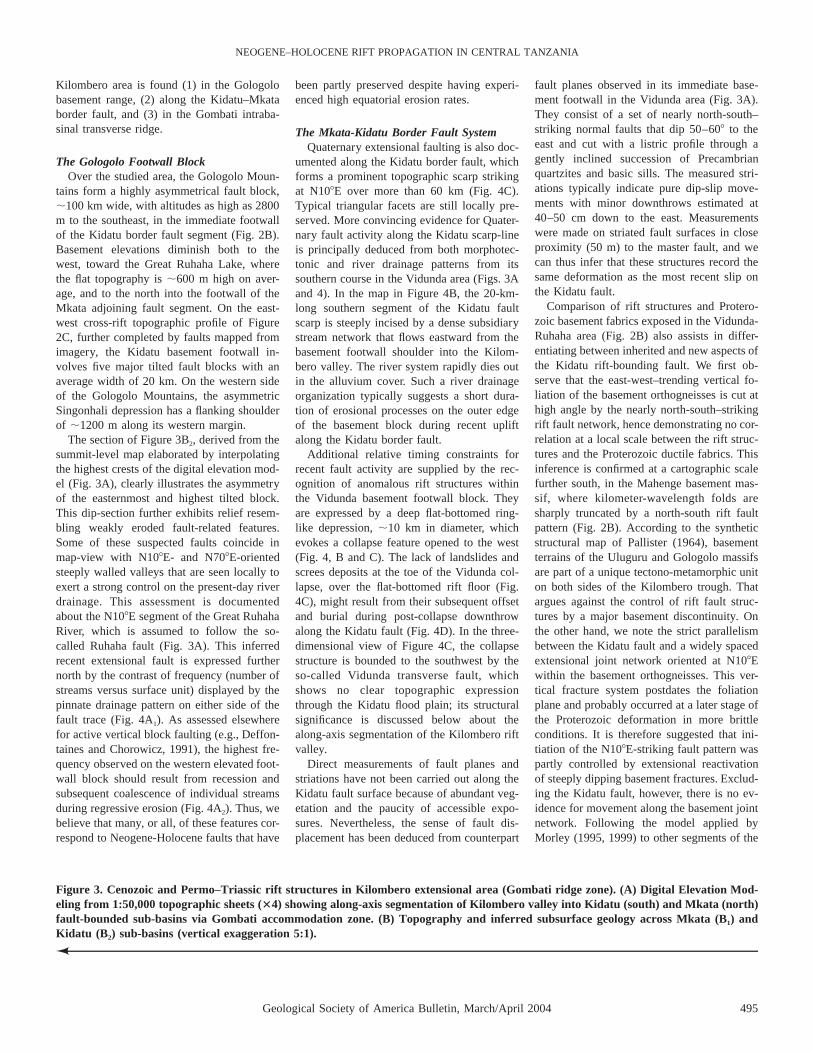
Figure 3. Cenozoic and Permo–Triassic rift structures in Kilombero extensional area (Gombati ridge zone). (A) Digital Elevation Mod-eling from 1:50,000 topographic sheets (34) showing along-axis segmentation of Kilombero valley into Kidatu (south) and Mkata (north)fault-bounded sub-basins via Gombati accommodation zone. (B) Topography and inferred subsurface geology across Mkata (B1) andKidatu (B2) sub-basins (vertical exaggeration 5:1).N
Kilombero area is found (1) in the Gologolobasement range, (2) along the Kidatu–Mkataborder fault, and (3) in the Gombati intraba-sinal transverse ridge.
The Gologolo Footwall BlockOver the studied area, the Gologolo Moun-
tains form a highly asymmetrical fault block,;100 km wide, with altitudes as high as 2800m to the southeast, in the immediate footwallof the Kidatu border fault segment (Fig. 2B).Basement elevations diminish both to thewest, toward the Great Ruhaha Lake, wherethe flat topography is ;600 m high on aver-age, and to the north into the footwall of theMkata adjoining fault segment. On the east-west cross-rift topographic profile of Figure2C, further completed by faults mapped fromimagery, the Kidatu basement footwall in-volves five major tilted fault blocks with anaverage width of 20 km. On the western sideof the Gologolo Mountains, the asymmetricSingonhali depression has a flanking shoulderof ;1200 m along its western margin.
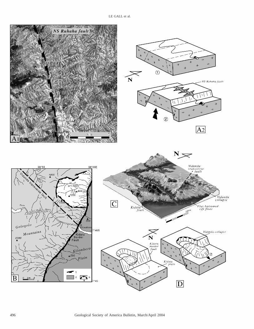
The section of Figure 3B2, derived from thesummit-level map elaborated by interpolatingthe highest crests of the digital elevation mod-el (Fig. 3A), clearly illustrates the asymmetryof the easternmost and highest tilted block.This dip-section further exhibits relief resem-bling weakly eroded fault-related features.Some of these suspected faults coincide inmap-view with N108E- and N708E-orientedsteeply walled valleys that are seen locally toexert a strong control on the present-day riverdrainage. This assessment is documentedabout the N108E segment of the Great RuhahaRiver, which is assumed to follow the so-called Ruhaha fault (Fig. 3A). This inferredrecent extensional fault is expressed furthernorth by the contrast of frequency (number ofstreams versus surface unit) displayed by thepinnate drainage pattern on either side of thefault trace (Fig. 4A1). As assessed elsewherefor active vertical block faulting (e.g., Deffon-taines and Chorowicz, 1991), the highest fre-quency observed on the western elevated foot-wall block should result from recession andsubsequent coalescence of individual streamsduring regressive erosion (Fig. 4A2). Thus, webelieve that many, or all, of these features cor-respond to Neogene-Holocene faults that have
been partly preserved despite having experi-enced high equatorial erosion rates.
The Mkata-Kidatu Border Fault SystemQuaternary extensional faulting is also doc-
umented along the Kidatu border fault, whichforms a prominent topographic scarp strikingat N108E over more than 60 km (Fig. 4C).Typical triangular facets are still locally pre-served. More convincing evidence for Quater-nary fault activity along the Kidatu scarp-lineis principally deduced from both morphotec-tonic and river drainage patterns from itssouthern course in the Vidunda area (Figs. 3Aand 4). In the map in Figure 4B, the 20-km-long southern segment of the Kidatu faultscarp is steeply incised by a dense subsidiarystream network that flows eastward from thebasement footwall shoulder into the Kilom-bero valley. The river system rapidly dies outin the alluvium cover. Such a river drainageorganization typically suggests a short dura-tion of erosional processes on the outer edgeof the basement block during recent upliftalong the Kidatu border fault.
Additional relative timing constraints forrecent fault activity are supplied by the rec-ognition of anomalous rift structures withinthe Vidunda basement footwall block. Theyare expressed by a deep flat-bottomed ring-like depression, ;10 km in diameter, whichevokes a collapse feature opened to the west(Fig. 4, B and C). The lack of landslides andscrees deposits at the toe of the Vidunda col-lapse, over the flat-bottomed rift floor (Fig.4C), might result from their subsequent offsetand burial during post-collapse downthrowalong the Kidatu fault (Fig. 4D). In the three-dimensional view of Figure 4C, the collapsestructure is bounded to the southwest by theso-called Vidunda transverse fault, whichshows no clear topographic expressionthrough the Kidatu flood plain; its structuralsignificance is discussed below about thealong-axis segmentation of the Kilombero riftvalley.
Direct measurements of fault planes andstriations have not been carried out along theKidatu fault surface because of abundant veg-etation and the paucity of accessible expo-sures. Nevertheless, the sense of fault dis-placement has been deduced from counterpart
fault planes observed in its immediate base-ment footwall in the Vidunda area (Fig. 3A).They consist of a set of nearly north-south–striking normal faults that dip 50–608 to theeast and cut with a listric profile through agently inclined succession of Precambrianquartzites and basic sills. The measured stri-ations typically indicate pure dip-slip move-ments with minor downthrows estimated at40–50 cm down to the east. Measurementswere made on striated fault surfaces in closeproximity (50 m) to the master fault, and wecan thus infer that these structures record thesame deformation as the most recent slip onthe Kidatu fault.
Comparison of rift structures and Protero-zoic basement fabrics exposed in the Vidunda-Ruhaha area (Fig. 2B) also assists in differ-entiating between inherited and new aspects ofthe Kidatu rift-bounding fault. We first ob-serve that the east-west–trending vertical fo-liation of the basement orthogneisses is cut athigh angle by the nearly north-south–strikingrift fault network, hence demonstrating no cor-relation at a local scale between the rift struc-tures and the Proterozoic ductile fabrics. Thisinference is confirmed at a cartographic scalefurther south, in the Mahenge basement mas-sif, where kilometer-wavelength folds aresharply truncated by a north-south rift faultpattern (Fig. 2B). According to the syntheticstructural map of Pallister (1964), basementterrains of the Uluguru and Gologolo massifsare part of a unique tectono-metamorphic uniton both sides of the Kilombero trough. Thatargues against the control of rift fault struc-tures by a major basement discontinuity. Onthe other hand, we note the strict parallelismbetween the Kidatu fault and a widely spacedextensional joint network oriented at N108Ewithin the basement orthogneisses. This ver-tical fracture system postdates the foliationplane and probably occurred at a later stage ofthe Proterozoic deformation in more brittleconditions. It is therefore suggested that ini-tiation of the N108E-striking fault pattern waspartly controlled by extensional reactivationof steeply dipping basement fractures. Exclud-ing the Kidatu fault, however, there is no ev-idence for movement along the basement jointnetwork. Following the model applied byMorley (1995, 1999) to other segments of the
496 Geological Society of America Bulletin, March/April 2004
LE GALL et al.

Geological Society of America Bulletin, March/April 2004 497
NEOGENE–HOLOCENE RIFT PROPAGATION IN CENTRAL TANZANIA
Figure 5. Morphostructural evidence for Holocene transverse block faulting in Gombati accommodation fault zone and Mkata Plain.(A) Three-dimensional view extracted from regional elevation model of Figure 3A showing (1) major rift fault network and (2) positivetopographic relief of Gombati transverse fault zone resulting in along-strike segmentation of Kilombero rift valley. (B) Along-striketopographic transect illustrating step-like geometry of axial floodplain on both sides of Gombati ridge (vertical exaggeration 10:1). Alsonote Mzombe transverse graben within Gombati accommodation zone.
Figure 4. Morphostructures and river drainage anomalies assigned to Holocene block faulting in Gologolo basement domain. (A1)Detailed view of SPOT image (142–365) showing two types of pinnate river drainage patterns on both sides of Ruhaha west-facingnormal fault (location on Figure 3A). (A2) Two-stage fault model resulting in marked change of river drainage pattern on uplifted block.(B) Sketch map-view (location on Fig. 3A) of Kidatu fault-line scarp from topographic and remote sensing data set showing sharpcontrast of river drainage patterns on footwall and hanging-wall blocks of fault. The Vidunda footwall collapse imaged on Figure 4Cis also drawn. Summit altitudes in meters. 1. Rift border fault; 2. Rift valley; 3. Uplifted basement footwall, 3a. Vidunda collapse. (C)Three-dimensional view of Kidatu border fault zone in Ruhaha River area showing (1) Vidunda basement collapse, (2) lack of landslidedeposits at toe of collapse structure, and (3) sharp morphology of Kidatu fault-line scarp. Note also pronounced topographic expressionof Vidunda transverse fault. (D) Cartoon illustrating two successive stages of Kidatu fault development and related gravitational andsedimentary processes.N
498 Geological Society of America Bulletin, March/April 2004
LE GALL et al.
East African Rift System, the contrast in dipattitudes between the basement features (ver-tical) and the rift master fault (assumed to be608, on average) can be explained by a pro-gressively smoother trajectory of the exten-sional fault (as displacement increases) byoblique linkage of initially vertical faultsegments.
The Kilombero Half-graben and theGombati Accommodation Zone
The hanging wall of the Mkata–Kidatumaster fault is occupied by the Kilombero val-ley, which shows a typical east-facing half-graben morphology in cross-sections (Fig.3B2). Marked structural changes occur along-strike and are expressed by the northerly en-largement of the rift valley from 20–25 km inthe Kidatu Plain to 40–50 km in the MkataPlain. The resulting left-stepping geometry ofthe western fault scarp via an array ofN1208E-striking transverse faults is also ac-companied by the northerly decrease of foot-wall shoulder elevation from 2800 m in theGologolo Mountains to ;1000 m in the foot-wall of the Mkata border fault (Fig. 3A). Incontrast to its southern counterpart, the hang-ing wall of the Mkata fault is a 20-km-wideand 800-m-high downthrown basement block.This platform steps down eastward into thealluvial deposits of the floodplain. Furthereast, the Kilombero valley passes into the500–800-m-high smooth basement hills of theUluguru basement massif.
The nature of the rift-fill stratigraphy withinthe Kilombero half-graben is not directlyknown because of the lack of subsurface data.The greater uncertainties concern the Ceno-zoic inferred rift-related deposits while someassumptions about the thickness of the under-lying Karoo sequences can be reasonablymade from correlations with the Permo-Triassic series exposed on the Gombati ridge.Though precise thickness estimates are madedifficult because of possible abrupt changes inKaroo stratigraphy along the proto-Kilomberorift half-graben, Karoo rift infill is likely tothicken southward as it approaches theSelous–Luwegu basinal area (Hankel, 1987).Therefore, the 4000–5000-m-thick series mea-sured in the Gombati ridge (Dypvik et al.,1997, 2001) is a minimum estimate for theKidatu sub-basin to the south, where basementtop is assumed to lie at ;7–8 km (see theaeromagnetic data analysis below). In con-trast, thick Karoo rift sediments are unlikelyto occur in the Mkata shallower sub-basin tothe north (see below).
The general westerly dipping attitude of theKaroo basal deposits (Ndeke group) that un-
conformably overlie weathered metamorphicrocks in the Nyakatitu flexural margin to theeast (Fig. 3A) (Spence, 1957; Nilsen et al.,1999) suggests a Karoo sedimentary wedgethickening to the west toward a possibleproto-Kidatu border fault that might have con-trolled the initial Karoo rift half-graben.
Consideration of the total thickness of thesedimentary infill and the respective contri-bution of Holocene, Tertiary, and Karoo stratawill be discussed with aeromagnetic interpre-tations. However, the preservation of Permo–Triassic rift series within the present-dayKilombero half-graben demonstrates its mul-tiphase origin that results from at least twoextensional rifting events, Permo-Triassic (Ka-roo) and Neogene-Holocene in age.
Axial segmentation of the Kilombero riftvalley into two discrete sub-basins is causedby the intervening Gombati transverse ridge,where Karoo strata are largely exposed. Itsmoderate relief, ;350–800-m-high, is bound-ed to the south by the N1208E-striking Mik-umi fault, along which the Kidatu–Mkata bor-der fault system is laterally offset (Fig. 5A).The Mikumi fault is regarded by Nilsen et al.(1999) as a transfer fault linking two similarlyfacing half-grabens with contrasting dimen-sions and probable extension factors. Somenew information is supplied below about faultkinematics in the Gombati accommodationzone.
Field measurements carried out along thewestern part of the Gombati ridge, in theMikumi-Lumango area (Fig. 5A), indicate thatthe general N708E direction of the Permo-Triassic strata locally switches parallel tothe Mikumi fault trace. Their regional carto-graphic inflection on the SPOT image (XS142–365) is indicative of a right-lateral faultdisplacement consistent with the above-mentioned transfer model. However, along-axis topographic profiles drawn from thethree-dimensional map-view of Figure 5Asuggest a more complex fault motion (Fig.5B). The southerly downthrow of the valleyfloor, from 500 m in the Mkata basin to 250m in the Kidatu basin, indicates Holocene(Quaternary) block faulting that induces thestep-down attitude of the Kidatu rift segmentwith regard to the Mkata segment, via theGombati transverse fault zone. It is assumedthat most of the vertical displacement has oc-curred along the N1208E-oriented Mikumifault, so that the Gombati transverse upliftedzone as a whole should have acted as a to-pographic barrier isolating the two originallyconnected Permo-Triassic basins, whichwould have prevented the development of athrough-going axial drainage. The presence of
Karoo strata (Msolwa Group) on either side ofthe Mikumi fault demonstrates that the mag-nitude of the post-Karoo throw does not ex-ceed the total thickness of the faulted strata,which is estimated at 2400 m (Dypvik et al.,1997). The general uplift of the Gombati ac-commodation zone might have also occurredby movement on two rift-parallel faults locat-ed to the east (the Kikoboga and Mshindasistructures), which are easily identified fromtheir linear and sharp topographic expression(Figs. 3A and 5A).
The Karoo strata exposed in the Gombatiridge are cut by a series of N708E-trendingextensional faults depicted on the north-southsection of Figure 5B. The syn- or post-Karooage of this oblique faulting event cannot bedirectly deduced from surface geology. How-ever, the juvenile topography of the resultingscarps, such as those bounding the Mzombegraben, also supports a Neogene-Holoceneage for vertical fault motion in the footwallblock of the Mikumi transverse fault (Fig. 5).
Finally, the surface data set discussed aboveshows no firm evidence for Karoo rift tecton-ics in the present structural arrangement of theGombati transverse ridge, except the high dips(up to 40–608) of the Permo-Triassic se-quence. According to Nilsen et al. (1996),these stratal rotations took place in relationwith roll-over anticlines developed above aKaroo listric growth fault, similarly to hang-ing wall deformation obtained from analoguemodeling (e.g., Ellis and McClay, 1988;McClay, 1996). The postulated south-east–dipping listric fault and its correspondingnorth-west–facing half-graben were supposedto lie as blind structures beneath the Quater-nary cover of the Mkata Plain. However, thepolyphase rift kinematic model mentionedabove is consistent with additional rotation ofinitially inclined Karoo sequences duringyounger fault-block tilting.
East of the Kilombero trough, evidence forHolocene/active extensional faulting is lessclear within the Uluguru and Rufiji areas (Fig.2B). On the satellite imagery, the Ulugurubasement massif only shows evidence forQuaternary faulting in the Morogoro area tothe north (Fig. 2B). In this location, elevationsas high as 2700 m might have partly origi-nated from vertical displacement along trans-verse structures of the Maminzi–Tagalala faultzone. The nearly unfaulted character of theUluguru flexural basement warp is confirmedfurther east along the so-called Rufiji faultzone (Fig. 2B). This latter is seen on theSPOT scenery (XS 144–366) as a sharpN208E-striking fault separating basementrocks from Permo-Triassic sediments of the

Geological Society of America Bulletin, March/April 2004 499
NEOGENE–HOLOCENE RIFT PROPAGATION IN CENTRAL TANZANIA
Figure 6. Holocene transverse faulting in Rufiji area deduced from river drainage anomalies. (A) Sketch structural map showing twoprominent sets of N208E and N708E transverse faults. (B) Detailed view of SPOT imagery (144–366), with location shown in Figure 6A.(C) Structural interpretation showing northwest-southeast–oriented fault network cutting through flat-lying Karoo strata with syste-matical downthrow to southwest. Their Holocene age is supported by cross-cutting relationships between river meanders and faults.Labeled faults are cited in text.
500 Geological Society of America Bulletin, March/April 2004
LE GALL et al.
Geological Society of America Bulletin, March/April 2004 501
NEOGENE–HOLOCENE RIFT PROPAGATION IN CENTRAL TANZANIA
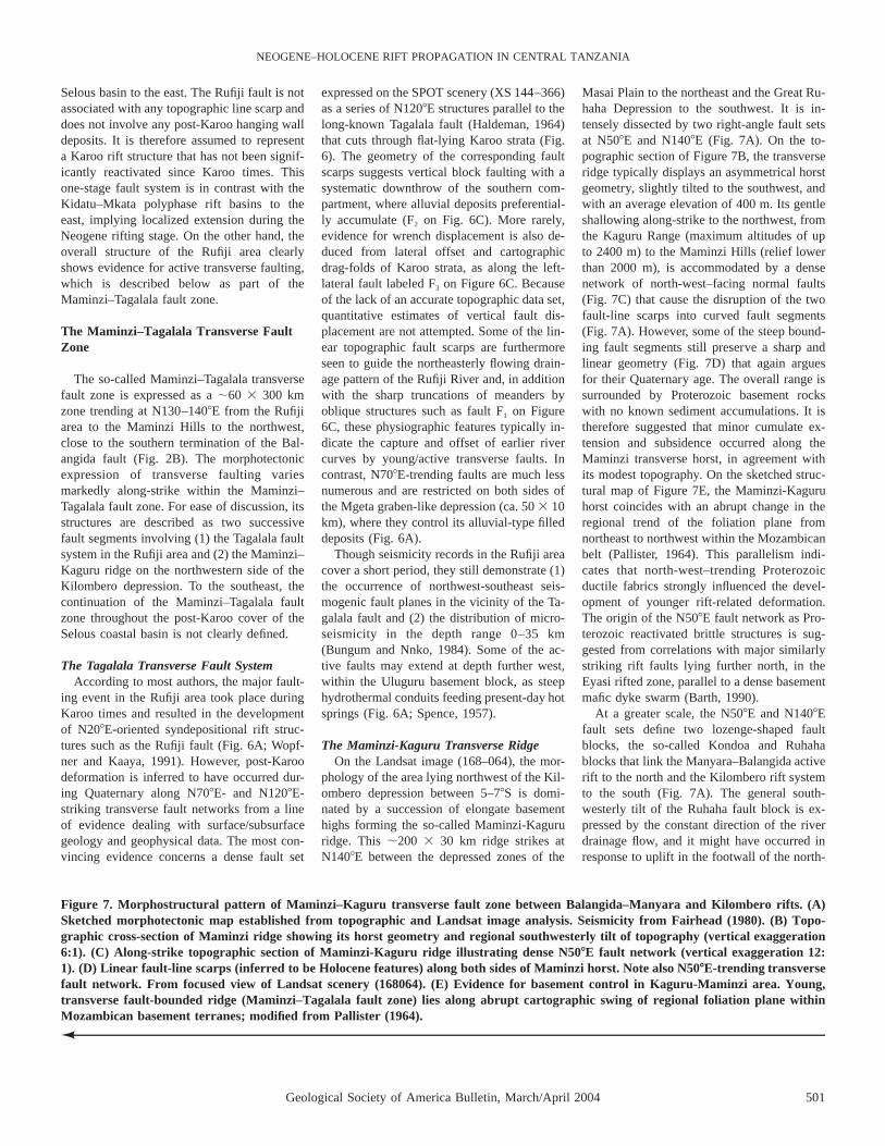
Figure 7. Morphostructural pattern of Maminzi–Kaguru transverse fault zone between Balangida–Manyara and Kilombero rifts. (A)Sketched morphotectonic map established from topographic and Landsat image analysis. Seismicity from Fairhead (1980). (B) Topo-graphic cross-section of Maminzi ridge showing its horst geometry and regional southwesterly tilt of topography (vertical exaggeration6:1). (C) Along-strike topographic section of Maminzi-Kaguru ridge illustrating dense N508E fault network (vertical exaggeration 12:1). (D) Linear fault-line scarps (inferred to be Holocene features) along both sides of Maminzi horst. Note also N508E-trending transversefault network. From focused view of Landsat scenery (168064). (E) Evidence for basement control in Kaguru-Maminzi area. Young,transverse fault-bounded ridge (Maminzi–Tagalala fault zone) lies along abrupt cartographic swing of regional foliation plane withinMozambican basement terranes; modified from Pallister (1964).N
Selous basin to the east. The Rufiji fault is notassociated with any topographic line scarp anddoes not involve any post-Karoo hanging walldeposits. It is therefore assumed to representa Karoo rift structure that has not been signif-icantly reactivated since Karoo times. Thisone-stage fault system is in contrast with theKidatu–Mkata polyphase rift basins to theeast, implying localized extension during theNeogene rifting stage. On the other hand, theoverall structure of the Rufiji area clearlyshows evidence for active transverse faulting,which is described below as part of theMaminzi–Tagalala fault zone.
The Maminzi–Tagalala Transverse FaultZone
The so-called Maminzi–Tagalala transversefault zone is expressed as a ;60 3 300 kmzone trending at N130–1408E from the Rufijiarea to the Maminzi Hills to the northwest,close to the southern termination of the Bal-angida fault (Fig. 2B). The morphotectonicexpression of transverse faulting variesmarkedly along-strike within the Maminzi–Tagalala fault zone. For ease of discussion, itsstructures are described as two successivefault segments involving (1) the Tagalala faultsystem in the Rufiji area and (2) the Maminzi–Kaguru ridge on the northwestern side of theKilombero depression. To the southeast, thecontinuation of the Maminzi–Tagalala faultzone throughout the post-Karoo cover of theSelous coastal basin is not clearly defined.
The Tagalala Transverse Fault SystemAccording to most authors, the major fault-
ing event in the Rufiji area took place duringKaroo times and resulted in the developmentof N208E-oriented syndepositional rift struc-tures such as the Rufiji fault (Fig. 6A; Wopf-ner and Kaaya, 1991). However, post-Karoodeformation is inferred to have occurred dur-ing Quaternary along N708E- and N1208E-striking transverse fault networks from a lineof evidence dealing with surface/subsurfacegeology and geophysical data. The most con-vincing evidence concerns a dense fault set
expressed on the SPOT scenery (XS 144–366)as a series of N1208E structures parallel to thelong-known Tagalala fault (Haldeman, 1964)that cuts through flat-lying Karoo strata (Fig.6). The geometry of the corresponding faultscarps suggests vertical block faulting with asystematic downthrow of the southern com-partment, where alluvial deposits preferential-ly accumulate (F2 on Fig. 6C). More rarely,evidence for wrench displacement is also de-duced from lateral offset and cartographicdrag-folds of Karoo strata, as along the left-lateral fault labeled F3 on Figure 6C. Becauseof the lack of an accurate topographic data set,quantitative estimates of vertical fault dis-placement are not attempted. Some of the lin-ear topographic fault scarps are furthermoreseen to guide the northeasterly flowing drain-age pattern of the Rufiji River and, in additionwith the sharp truncations of meanders byoblique structures such as fault F1 on Figure6C, these physiographic features typically in-dicate the capture and offset of earlier rivercurves by young/active transverse faults. Incontrast, N708E-trending faults are much lessnumerous and are restricted on both sides ofthe Mgeta graben-like depression (ca. 50 3 10km), where they control its alluvial-type filleddeposits (Fig. 6A).
Though seismicity records in the Rufiji areacover a short period, they still demonstrate (1)the occurrence of northwest-southeast seis-mogenic fault planes in the vicinity of the Ta-galala fault and (2) the distribution of micro-seismicity in the depth range 0–35 km(Bungum and Nnko, 1984). Some of the ac-tive faults may extend at depth further west,within the Uluguru basement block, as steephydrothermal conduits feeding present-day hotsprings (Fig. 6A; Spence, 1957).
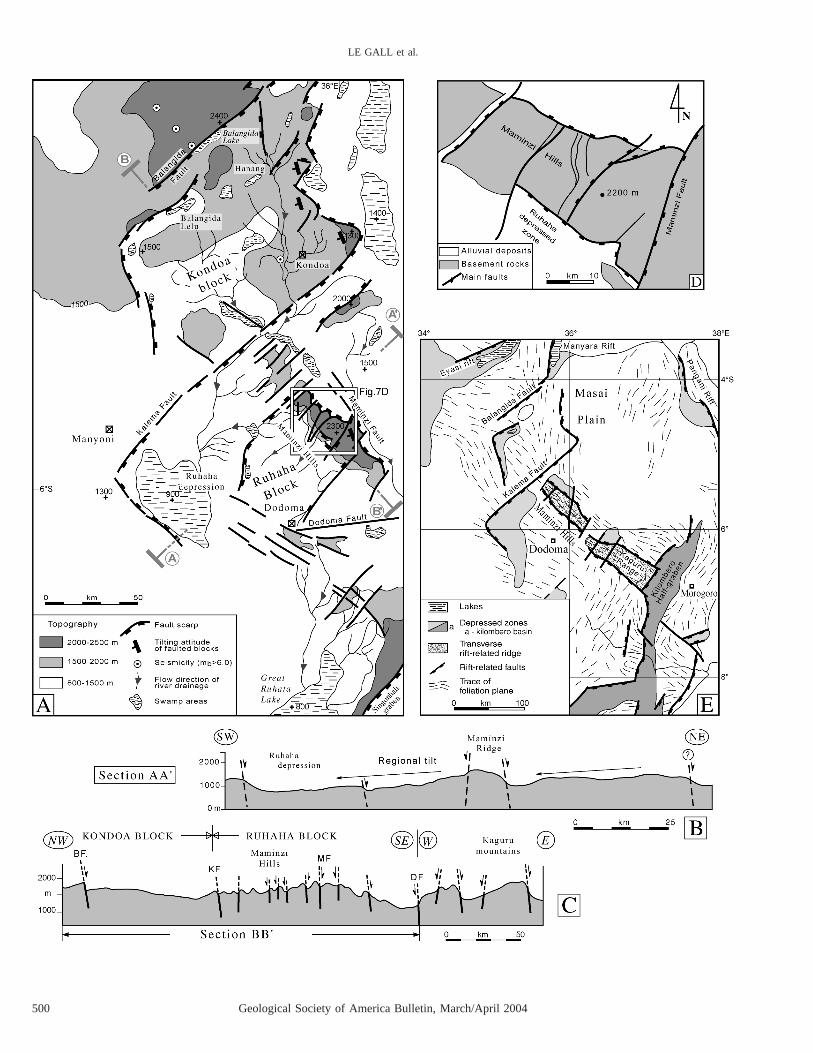
The Maminzi-Kaguru Transverse RidgeOn the Landsat image (168–064), the mor-
phology of the area lying northwest of the Kil-ombero depression between 5–78S is domi-nated by a succession of elongate basementhighs forming the so-called Maminzi-Kagururidge. This ;200 3 30 km ridge strikes atN1408E between the depressed zones of the
Masai Plain to the northeast and the Great Ru-haha Depression to the southwest. It is in-tensely dissected by two right-angle fault setsat N508E and N1408E (Fig. 7A). On the to-pographic section of Figure 7B, the transverseridge typically displays an asymmetrical horstgeometry, slightly tilted to the southwest, andwith an average elevation of 400 m. Its gentleshallowing along-strike to the northwest, fromthe Kaguru Range (maximum altitudes of upto 2400 m) to the Maminzi Hills (relief lowerthan 2000 m), is accommodated by a densenetwork of north-west–facing normal faults(Fig. 7C) that cause the disruption of the twofault-line scarps into curved fault segments(Fig. 7A). However, some of the steep bound-ing fault segments still preserve a sharp andlinear geometry (Fig. 7D) that again arguesfor their Quaternary age. The overall range issurrounded by Proterozoic basement rockswith no known sediment accumulations. It istherefore suggested that minor cumulate ex-tension and subsidence occurred along theMaminzi transverse horst, in agreement withits modest topography. On the sketched struc-tural map of Figure 7E, the Maminzi-Kaguruhorst coincides with an abrupt change in theregional trend of the foliation plane fromnortheast to northwest within the Mozambicanbelt (Pallister, 1964). This parallelism indi-cates that north-west–trending Proterozoicductile fabrics strongly influenced the devel-opment of younger rift-related deformation.The origin of the N508E fault network as Pro-terozoic reactivated brittle structures is sug-gested from correlations with major similarlystriking rift faults lying further north, in theEyasi rifted zone, parallel to a dense basementmafic dyke swarm (Barth, 1990).
At a greater scale, the N508E and N1408Efault sets define two lozenge-shaped faultblocks, the so-called Kondoa and Ruhahablocks that link the Manyara–Balangida activerift to the north and the Kilombero rift systemto the south (Fig. 7A). The general south-westerly tilt of the Ruhaha fault block is ex-pressed by the constant direction of the riverdrainage flow, and it might have occurred inresponse to uplift in the footwall of the north-
502 Geological Society of America Bulletin, March/April 2004
LE GALL et al.
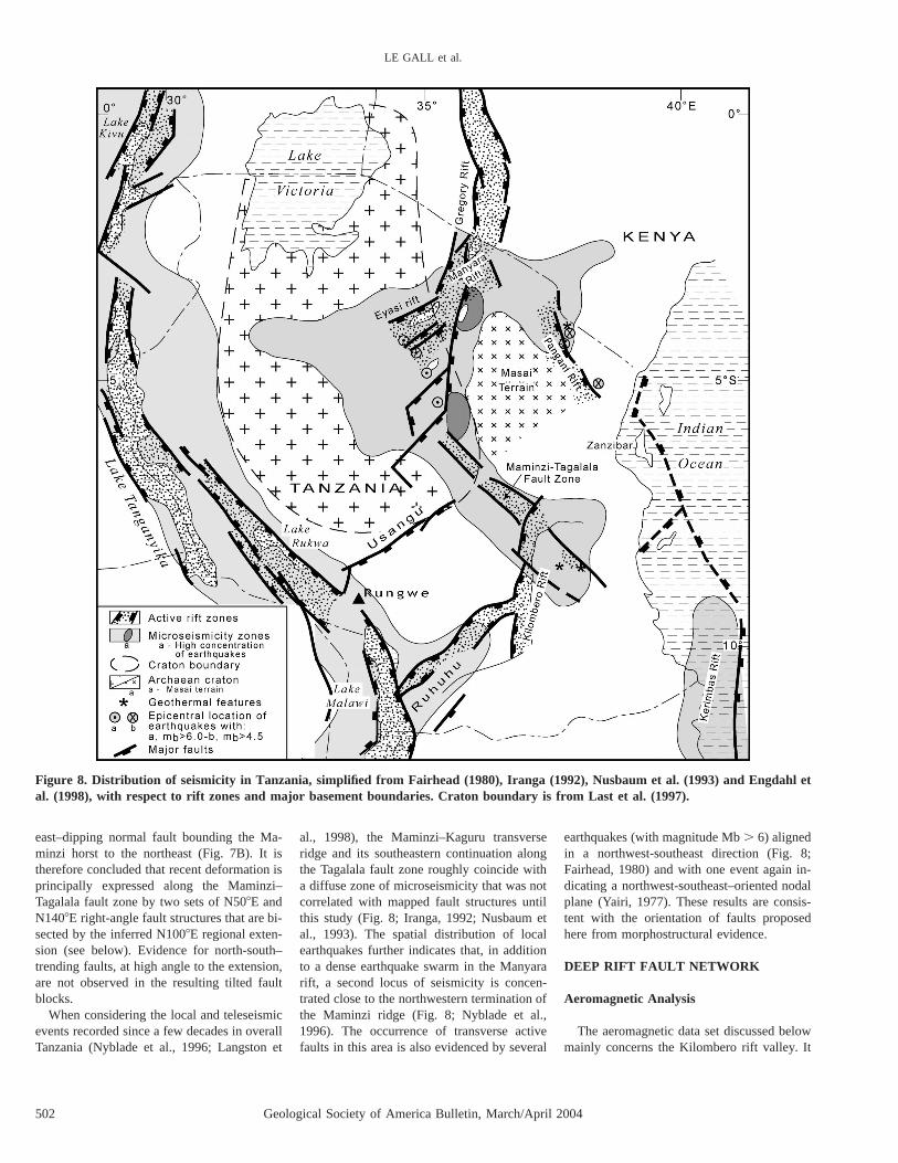
Figure 8. Distribution of seismicity in Tanzania, simplified from Fairhead (1980), Iranga (1992), Nusbaum et al. (1993) and Engdahl etal. (1998), with respect to rift zones and major basement boundaries. Craton boundary is from Last et al. (1997).
east–dipping normal fault bounding the Ma-minzi horst to the northeast (Fig. 7B). It istherefore concluded that recent deformation isprincipally expressed along the Maminzi–Tagalala fault zone by two sets of N508E andN1408E right-angle fault structures that are bi-sected by the inferred N1008E regional exten-sion (see below). Evidence for north-south–trending faults, at high angle to the extension,are not observed in the resulting tilted faultblocks.
When considering the local and teleseismicevents recorded since a few decades in overallTanzania (Nyblade et al., 1996; Langston et
al., 1998), the Maminzi–Kaguru transverseridge and its southeastern continuation alongthe Tagalala fault zone roughly coincide witha diffuse zone of microseismicity that was notcorrelated with mapped fault structures untilthis study (Fig. 8; Iranga, 1992; Nusbaum etal., 1993). The spatial distribution of localearthquakes further indicates that, in additionto a dense earthquake swarm in the Manyararift, a second locus of seismicity is concen-trated close to the northwestern termination ofthe Maminzi ridge (Fig. 8; Nyblade et al.,1996). The occurrence of transverse activefaults in this area is also evidenced by several
earthquakes (with magnitude Mb . 6) alignedin a northwest-southeast direction (Fig. 8;Fairhead, 1980) and with one event again in-dicating a northwest-southeast–oriented nodalplane (Yairi, 1977). These results are consis-tent with the orientation of faults proposedhere from morphostructural evidence.
DEEP RIFT FAULT NETWORK
Aeromagnetic Analysis
The aeromagnetic data set discussed belowmainly concerns the Kilombero rift valley. It
Geological Society of America Bulletin, March/April 2004 503
NEOGENE–HOLOCENE RIFT PROPAGATION IN CENTRAL TANZANIA
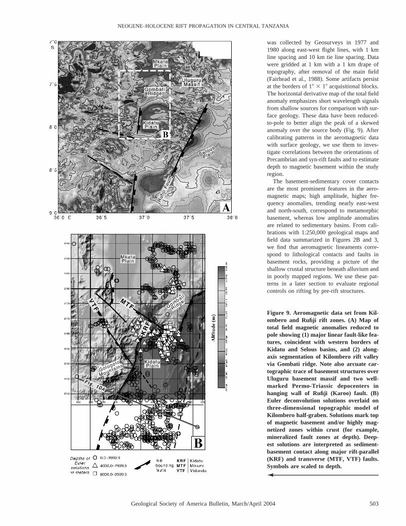
Figure 9. Aeromagnetic data set from Kil-ombero and Rufiji rift zones. (A) Map oftotal field magnetic anomalies reduced topole showing (1) major linear fault-like fea-tures, coincident with western borders ofKidatu and Selous basins, and (2) along-axis segmentation of Kilombero rift valleyvia Gombati ridge. Note also arcuate car-tographic trace of basement structures overUluguru basement massif and two well-marked Permo-Triassic depocenters inhanging wall of Rufiji (Karoo) fault. (B)Euler deconvolution solutions overlaid onthree-dimensional topographic model ofKilombero half-graben. Solutions mark topof magnetic basement and/or highly mag-netized zones within crust (for example,mineralized fault zones at depth). Deep-est solutions are interpreted as sediment-basement contact along major rift-parallel(KRF) and transverse (MTF, VTF) faults.Symbols are scaled to depth.N
was collected by Geosurveys in 1977 and1980 along east-west flight lines, with 1 kmline spacing and 10 km tie line spacing. Datawere gridded at 1 km with a 1 km drape oftopography, after removal of the main field(Fairhead et al., 1988). Some artifacts persistat the borders of 18 3 18 acquisitional blocks.The horizontal derivative map of the total fieldanomaly emphasizes short wavelength signalsfrom shallow sources for comparison with sur-face geology. These data have been reduced-to-pole to better align the peak of a skewedanomaly over the source body (Fig. 9). Aftercalibrating patterns in the aeromagnetic datawith surface geology, we use them to inves-tigate correlations between the orientations ofPrecambrian and syn-rift faults and to estimatedepth to magnetic basement within the studyregion.
The basement-sedimentary cover contactsare the most prominent features in the aero-magnetic maps; high amplitude, higher fre-quency anomalies, trending nearly east-westand north-south, correspond to metamorphicbasement, whereas low amplitude anomaliesare related to sedimentary basins. From cali-brations with 1:250,000 geological maps andfield data summarized in Figures 2B and 3,we find that aeromagnetic lineaments corre-spond to lithological contacts and faults inbasement rocks, providing a picture of theshallow crustal structure beneath alluvium andin poorly mapped regions. We use these pat-terns in a later section to evaluate regionalcontrols on rifting by pre-rift structures.
504 Geological Society of America Bulletin, March/April 2004
LE GALL et al.
The three-dimensional Euler deconvolutiontechnique is used to constrain the subsurfacegeometry of the rift basins and major structuresbounding the rift. Our objective is to examinestructures of considerable depth that bound therift basins or exist within the basement to therift. Therefore, we focus attention on anomalieswith source depths $1 km in this study. TheEuler method provides a rapid semi-automatedmeans of estimating the position and geometryof magnetic sources (Reid et al., 1990). Euler’shomogeneity equation is:
]T ]T ]T(x 2 x ) 1 (y 2 y ) 1 (z 2 z )0 0 0]x ]y ]z
5 N(B 2 T) (1)
where (x0, y0, z0) is the source position whosetotal field T is observed at (x, y, z), and B isthe regional field (Thompson, 1982). N is thestructural index, a measure of the rate ofchange of the anomaly with distance from thesource, which is dependent upon the geometryof the contact (e.g., pipe, step). Several struc-tural indices may be appropriate within thestudy region (Reid et al., 1990).
In our application, we use the analytic sig-nal of the total field anomalies (Roest et al.,1992), substituting the horizontal derivativesin (1) with
1/22 2]T ]T
1 (2)1 2 1 2[ ]]x ]y
The analytical signal allows us to calculatethe Euler solutions without making any as-sumptions as to the direction of magnetizationof the rocks within the study region (Roest etal., 1992). This provides slightly better posi-tioning of solutions over the edges of thesource bodies (Huang, 1996). Grids of analyt-ical signal and vertical derivative were used tosolve Euler’s equation for the four unknownsand their uncertainties, which are expressed asstandard deviations. After trying a range ofdeconvolution window sizes, we chose a 10km 3 10 km grid to improve focusing of so-lutions and resolution (Komba, 1995). Astructural index of 1.0 indicating a steep con-tact (i.e., normal fault) showed the best focus-ing of solutions in the rifted regions. We de-fined an error limit of 10% for the depth (z0)and for the horizontal positions (x0, y0), there-by limiting solutions.
As a test of Euler results, we see that shal-low solutions match lithological contacts andshear zones within basement. Solutions in thedepth range of 1–8 km correlate with subsur-face projections of normal (rift parallel and
transverse) fault segments bounding the basinsas well as basement structures. Below, we ten-tatively distinguish between solutions basedon their orientation, continuity, anddistribution.
Constraints on Basin Depth in theKilombero Extensional Province
Earlier studies of Euler deconvolution in riftbasins suggest that the estimates of depths, in-terpreted as magnetic basement, are maxima(Upcott et al., 1996). In particular, some so-lutions may lie below the basement-sedimentcontact and may mark mineralized zonesalong faults at depth. Magnetic basement tophere is rather correlated with Proterozoic crys-talline basement rocks than with deep Karoolava complexes because of the lack of any vol-canic reworked material in the Permian rift se-quences (Dypvik et al., 1997). Furthermore,there are no circular features in the total fieldor Euler solutions, arguing against subsurfacevolcanic centers.
The distribution of Euler solutions over theKilombero extensional province correlates sat-isfactorily with the surface/subsurface geolo-gy, since the deepest solutions, ranging from2000 to 8000 m, occur in the Kilombero fault-bounded depression and in the Rufiji area(Fig. 9B). If we interpret the increasing depthwith distance relations as the shape of the faultplane, these results suggest a border fault dipof 50–608 (Fig. 10A). The deepest clusters ofsolutions lie along the trace (or the extrapo-lated extent) of the Mikumi and Vidundatransverse faults (Fig. 9B). The Mikumi faultmarks the abrupt transition between (1) a rel-atively shallow (#4000 m) basin to the norththat encompasses the Mkata sub-basin and theGombati ridge, and (2) the Kidatu sub-basinto the south, where depth solutions approach8000 m. Within the Kidatu basin, deepest so-lutions concentrate along the southern side ofthe Mikumi fault and, more surprisingly,along the southeastern extent of the Vidundatransverse fault, which shows no surficial tracethrough the Kidatu valley. The total basementoffset along the Mikumi fault should imply (1)post-Karoo vertical displacement (not exceed-ing 2400 m as stated above) and (2) additionalpre-Karoo extensional movement.
Therefore, the distribution of Euler solu-tions demonstrates the along-axis segmenta-tion of the Kilombero rift valley into three dis-crete transverse half-grabens that step downgradually southward. Within the two sub-basins of the Kidatu trough, basin depths areconsistent with existing stratigraphic con-straints that show up to 5000 m of Karoo stra-
ta in some areas (Dypvik et al., 1997). In con-trast, seismic and gravity data from the Selousarea to the east (Fig. 2B) indicate greater basindepths of 8000 m (Komba, 1995).
Development of the Kidatu sub-basinsshould have also required synchronous faultdisplacement along the corresponding seg-ments of the Kidatu border fault but with adecrease of throw to the south. The fact thatthe footwall elevation to this fault does notdecrease concomitantly suggests some pre-existing topography in the basement foot-wall domain caused by earlier extensional up-lift. The combination of rift-parallel andtransverse-linked fault networks should haveresulted in spoon-shaped sub-basins, as in oth-er parts of the East African Rift System (e.g.,Upcott et al., 1996), although too few gravitydata exist in the region to further confirm theproposed basin depths.
Another important implication of our studyis that the cumulate throw along the main riftborder faults may exceed 5000 to 8000 m.This amount is four to five times greater thanthe present (1500–2000 m) topographic flankuplift, in agreement with estimations of flex-ural models applied elsewhere in East Africa(e.g., Ebinger et al., 1993).
The amount of extension recorded by theKilombero half-graben during Neogene tec-tonics is estimated below about the Kidatusub-basin, where maximum footwall shoulderelevation and increasing floor depth resultfrom higher extensional strain. This estimateis based on (1) deep structural constraints de-rived from aeromagnetic data and (2) the fol-lowing assumptions on the sub-surface basinstructure (Fig. 10):
1. The 8000-m-deep Kidatu half-graben isbelieved to involve at depth a ca. 4000–5000-m-thick section of Permo-Triassic sedimentsthat are, therefore, inferred to be overlain bya ,3000-m-thick post-Karoo rift sequencefilling the basin.
2. The post-Karoo infill complex is likelyto be Neogene in age if regarded as syntec-tonic deposits in the hanging wall of the Ki-datu fault system.
3. In agreement with aeromagnetic model-ing, the Kidatu fault segment is believed toextend at depth with a dip of ca. 50–608 tothe east.
4. Applying the ‘‘antithetic shear model(with a 5 608)’’ of Gibbs (1984) indicates ahorizontal heave of 3.8 km for the base of theNeogene sequence. Since evidence for intra-basinal normal faults are not observed in theKilombero half-graben, most of the resultingextension (estimated to ;13%) is assumed to

Geological Society of America Bulletin, March/April 2004 505
NEOGENE–HOLOCENE RIFT PROPAGATION IN CENTRAL TANZANIA
Figure 10. Interpretative dip cross-section of deepest part (Kidatu sub-basin) of Kilombero trough. (A) Typical polyphase half-grabenarchitecture resulting from Permo-Triassic (Karoo) and Neogene rifting events. Elevations are from 1:50,000 topography maps. Depthof basin floor (8000 m) is derived from aeromagnetic modeling, whereas thickness of Permo-Triassic series (4000–5000 m) is correlatedwith sections exposed in Gombati ridge. Uppermost part of sedimentary fill is therefore completed by ;2000–3000-m-thick Cenozoicseries (not documented at the surface). (B) Estimate of Neogene extension using ‘‘antithetic shear’’ model of Gibbs (1984).
have been accommodated by slip along theKidatu border fault.
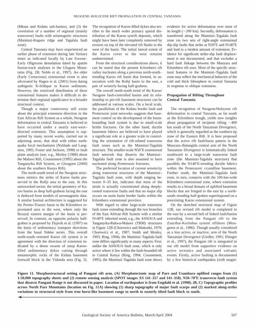
Comparison of the Kilombero fault-boundedbasin with typical profiles across the upliftedflanks of the Eyasi and Manyara rift arms tothe north (Ebinger et al., 1999) shows strongsimilarities in terms of (1) Neogene half-graben morphology (,2–3-km-deep basins)and (2) amount of extension. A similar half-graben system, but with a western-tilted po-larity, is suspected to lie further east, at thefoot of the 1000-m-high Pare–Usambara faultscarp in the Pangani rift arm (Fig. 11).
KINEMATIC RIFT MODEL
The variety of techniques used in the pres-ent work supplies some new insights about the
complex extensional history recorded by cen-tral Tanzania since Karoo times onward. Themain contributions of the work concern: (1)the polyphase origin of the Kilombero fault-bounded basin, which corresponds to a Karooextensional system overprinted by Holocene/Neogene rift deformation, (2) the control onNeogene rift faults exercised by Karoo struc-tures, and (3) the linkage of the rifted zone incentral Tanzania with one rift arm of the NorthTanzanian Divergence via a large-scale activetransverse fault zone.
A Polyphase Rift Setting
The morphological data set from centralTanzania provides a regional view of majorbasement uplifted blocks and extensional bor-
der faults over a ;100 3 200 km diffuse zoneof deformation centered on the Kilomberoarea. The juvenile morphology of most of thefault-related relief in the Kilombero extension-al province supports the post-Karoo age of themajor strain responsible for its present-dayconfiguration. Since post-Karoo synrift sedi-mentary records are not known within the Kil-ombero half-graben, the onset of recent exten-sional faulting is not firmly dated.Nevertheless, active deformation is assumedto have taken place along both rift-parallel andtransverse fault structures in the Kilomberoarea and adjoining regions on the basis of (1)the recognition of fault-controlled river drain-age patterns (Gologolo, Gombati, and Rufijiareas), (2) the involvement of Quaternary al-luvium in step-like morphotectonic settings

506 Geological Society of America Bulletin, March/April 2004
LE GALL et al.
Geological Society of America Bulletin, March/April 2004 507
NEOGENE–HOLOCENE RIFT PROPAGATION IN CENTRAL TANZANIA
Figure 11. Morphostructural setting of Pangani rift arm. (A) Morphotectonic map of Pare and Usambara uplifted ranges from (1)1:50,000 topography sheets and (2) remote sensing analysis (SPOT images XS 141–357 and 141–358). N50–708E transverse fault systemthat dissects Pangani Range is not discussed in paper. Location of earthquakes is from Engdahl et al. (1998). (B, C) Topographic profilesacross North Pare Mountains (location on Fig. 11A) showing (1) sharp topography of major fault scarps and (2) marked along-strikevariations in structural style from true horst-like basement range to north to easterly tilted fault block to south.N
(Mkata and Kidatu sub-basins), and (3) thecorrelation of a number of regional (mainlytransverse) faults with seismogenic structures(Maminzi-Kaguru ridge and Tagalala faultzone).
Central Tanzania may have experienced anearlier phase of extension during late Tertiarytimes as indicated locally by Late Eocene–Early Oligocene denudation dated by apatitefission-track analyses in the Uluguru Moun-tains (Fig. 2B; Noble et al., 1997). An older(Early Cretaceous) extensional event is alsoadvocated by Hagen et al. (2001) from datingauthigenic K-feldspar in Karoo sediments.However, the restricted distribution of theseextensional features makes it difficult to de-termine their regional significance in a broaderstructural context.
Though a major controversy still existsabout the principal extension direction in theEast African Rift System as a whole, Neogenedeformation in central Tanzania is believed tohave occurred under a nearly east-west–directed extension. This assumption is sup-ported by many recent works, carried out inadjoining areas, that deal with either earth-quake focal mechanisms (Nyblade and Lang-ston, 1995; Foster and Jackson, 1998) or faultplane analysis (see, e.g., Morley [1988] aboutthe Malawi Rift, Coussement [1995] about theTanganyika Rift System, or Gloaguen [2000]about the southern Kenya Rift).
The north-south trend of the Neogene struc-tures mimics the strike of Karoo faults pre-served in the Rufiji area to the east. In thisunreworked sector, the initial geometry of Ka-roo basins as deep half-grabens facing the eastis deduced from models of aeromagnetic data.A similar basinal architecture is suggested forthe Permo-Triassic basin in the Kilombero re-juvenated area to the west, where only theflexural eastern margin of the basin is pre-served. In contrast, an opposite polarity half-graben is proposed by Dypvik et al. (1997) onthe basis of sedimentary transport directionsfrom the basal Ndeke series. This overallnorth-south–oriented Karoo rift system is inagreement with the direction of extension in-dicated by a dense swarm of steep Karoo-filled sedimentary dykes cutting throughmetamorphic rocks of the Kidatu basementfootwall block in the Vidunda area (Fig. 3).
The recognition of Karoo-filled dykes also tes-tifies to the much wider primary spatial dis-tribution of the Karoo synrift deposits, whichmight have been later completely removed byerosion on top of the elevated rift flanks to thewest of the basin. The initial lateral extent ofthe Karoo cover to the west remainsundetermined.
From the structural considerations above, itcan be stated that the present Kilombero riftvalley nucleates along a previous north-south–trending Karoo rift basin that formed, in as-sociation with the Rufiji basin to the east, apair of westerly-facing half-grabens.
The overall north-south trend of the Karoo/Neogene fault-controlled basins and its rela-tionship to pre-rift basement structures can beaddressed at various scales. On a local scale,the parallelism of the Kidatu border fault andProterozoic joint networks suggests that base-ment control on the development of the basin-bounding fault system is due to small-scalebrittle fractures. On the other hand, ductilebasement fabrics are believed to have playeda significant role at a greater scale in control-ling the orientation of rift-related transversefault zones such as the Maminzi-Tagalalastructure. The smaller-scale N508E extensionalfault network that dissects the Maminzi–Tagalala fault zone is also assumed to havenucleated along Proterozoic fractures.
The preferred location of current seismicityalong transverse structures of the Maminzi–Tagalala fault zone, with depth ranging be-tween 0–35 km, indicates that most of thestrain is actually concentrated along deeply-rooted transverse faults and that no major slipoccurs on main basin border faults within theKilombero extensional province.
With regard to other large-scale transversefault zones extending through the two branchesof the East African Rift System with a similarN1408E inherited trend, e.g., the ASSOUA andTanganyika-Rukwa-Malawi (TRM) structuresin Figure 12B (Chorowicz and Mukonki, 1979;Chorowicz et al., 1987; Smith and Mosley,1993; Ring, 1994), the Maminzi–Tagalala faultzone differs significantly in many aspects. First,unlike the ASSOUA fault zone, which is onlyactive where it lies within the fault-bounded riftin Central Kenya (Ring, 1994; Coussement,1995), the Maminzi–Tagalala fault zone shows
evidence for active deformation over most ofits length (;200 km). Secondly, deformation istransferred along the Maminzi–Tagalala faultzone via two sets of right-angle extensionaldip-slip faults that strike at N508E and N1408Eand lead to a modest amount of extension. Ev-idence for significant strike-slip fault displace-ment is not documented, and that excludes ahard fault linkage between the Manyara andKilombero rift axes. Most of the specific struc-tural features in the Maminzi–Tagalala faultzone may reflect the mechanical behavior of thecold and thick lithosphere in central Tanzaniain response to oblique extension.
Propagation of Rifting ThroughoutCentral Tanzania
The recognition of Neogene/Holocene riftdeformation in central Tanzania, as far southas the Kilombero trough, yields new insightsabout propagation of incipient rifting ;400km south of the North Tanzanian Divergence,which is generally regarded as the southern tipzone of the Eastern Rift. It is here proposedthat the active rift fault/basin pattern in theManyara–Balangida central arm of the NorthTanzanian Divergence is kinematically linkedsouthward to a large-scale transverse faultzone (the Maminzi-Tagalala structure) thatparallels the N1408E-trending ductile fabricswithin the Proterozoic crystalline basement.Further south, the Maminzi–Tagalala faultzone, in turn, connects with the 100-km-wideKilombero extensional zone, where extensionresults in a broad domain of uplifted basementblocks that are fringed to the east by a north-south–trending half-graben superimposed on apreexisting Karoo extensional system.
On the sketched structural map of Figure12B, our revised rift model is completed tothe east by a second belt of linked fault/basinsextending from the Pangani rift to theZanzibar-Kerimbas system offshore (Mou-genot et al., 1986). Though usually consideredas a less active, or inactive, arm of the NorthTanzanian Divergence (Girdler, 1991; Ebingeret al., 1997), the Pangani rift is integrated inour rift model from supportive evidence onactive tectonics and associated volcanicevents. Firstly, active faulting is documentedby a few historical earthquakes (with magni-

508 Geological Society of America Bulletin, March/April 2004
LE GALL et al.
Figure 12. Revised structural model for Cenozoic rifting in Tanzania. (A) Interpretation of Manyara–Balangida and Kilombero faultzones in terms of two rifted segments spatially linked by transverse faulted zone. Direction of extension is from Jestin et al. (1994). (B)Rift model suggesting structural connection between western and eastern branches of East African Rift System south of Tanzaniancraton. It also illustrates transition from linear and narrow rift in southern Kenya to broad domain of deformation throughout centralTanzania, including onshore (Maminzi/Tagalala-Kilombero) and offshore (Zanzibar-Kerimbas) systems. 1. Cenozoic/active rifts; 2. Cra-tonic nuclei, a. Tanzanian craton; b. Masai terrain.
tude .4; Fig. 8) that show mechanisms of al-most pure normal faulting (Nyblade and Lang-ston, 1995; Engdahl et al., 1998). Extensionaldeformation in the Pare–Usambara mountainblock is also expressed in the field by a seriesof minor, westerly dipping normal faults thatcut through shallowly inclined (208 to theeast), foliated, high-grade metamorphic base-ment rocks. The extensional fault network par-allels the main scarp bounding the range tothe west (Fig. 11), and it is therefore likely to
have formed during Cenozoic rifting. Thesefaults show no indication of oblique or strike-slip motion, hence arguing against the ‘‘intra-cratonic transform’’ model suggested by Cho-rowicz (1989) for the Pangani rift arm in thesoutheastern prolongation of the N1408E-trending ASSOUA fault zone (Fig. 12B).
Secondly, the Pangani seismogenic faultnetwork may have been accompanied by mag-matic processes at depth. That is supported bythe observation of a small volume of extruded
volcanic material in the northern part of thePare Mountains (Ibaya-Shighatini village; seelocation on Fig. 11A). In this area, pyroclasticproducts comprising a mixture of mud andvolcanic tuffs were extruded at the surface inJuly 1998. These pyroclastic deposits are theonly evidence for active magmatic processesalong the Pangani uplifted range. They mayindicate that incipient volcanism actually oc-curs along the easternmost rift arm of theNorth Tanzanian Divergence.

Geological Society of America Bulletin, March/April 2004 509
NEOGENE–HOLOCENE RIFT PROPAGATION IN CENTRAL TANZANIA
The Pangani fault-bounded range and theoffshore Kerimbas-Davie graben system thusshow evidence for active extensional tectonicsin a ;600-km-long belt. However, the tecton-ic link of the onshore/offshore structures inthe Zanzibar area remains to be confirmed(Baker, 1970; Kent et al., 1971). With regardto the overall basement framework, the Pan-gani rift arm and the Maminzi–Tagalala faultzone may also form the boundaries of thenearly unfaulted Masai terrain, which isknown to have acted as a barrier to Cenozoicrifting (Figs. 8 and 12; Ebinger et al., 1997).
Nascent rifting is therefore assumed topropagate southward throughout the amag-matic and strong lithosphere of central Tan-zania along two nearly parallel fault systemsthat form the Maminzi/Tagalala-Kilomberoand the Pangani–Kerimbas extensional belts.Comparing the surface/subsurface basin struc-tures along the two belts from south Kenya tocentral Tanzania shows a marked change instyle of rifting from (1) one narrow and highlyfaulted graben in the Magadi-Natron area to(2) two (or three, if including the Pangani in-ferred basin) closely spaced half-grabens(Manyara and Eyasi) in northern Tanzania,and (3) a pair of widely spaced basins, in-cluding the Kilombero half-graben to the westand the Kerimbas offshore grabens to the east.
During Neogene extension, the southerly-decreasing deformation was probably not suf-ficient to cause the rejuvenation of the RufijiKaroo border fault despite its favorable ori-entation parallel to the north-south–trendingKilombero structures to the west. On the op-posite, the southerly increase of rift basindepths from the Eyasi–Manyara half-grabens(,2–3 km) in northern Tanzania (Foster et al.,1997) to the Kilombero basin (6–8 km, thiswork) contradicts the notion of incipient rift-ing propagating southward. However, this ap-parent contradiction is explained if the poly-phase rift origin of the present Kilomberotrough is assumed.
The nature of crustal structure beneath Tan-zania is only depicted with some confidencein the northernmost part of the country frommodeling wave phase velocities related to te-leseismic earthquakes (Last et al., 1997).These authors propose an average crustalthickness of 36–39 km beneath the early tolate Proterozoic mobile belts surrounding theTanzanian craton (Fig. 12), whereas a substan-tial amount of crustal thinning (2 km) is sus-pected beneath the locus of rifting in the NorthTanzanian Divergence. From correlations withthe Neogene rift basins of the North TanzanianDivergence, a similar amount of crustal thin-ning (;2 km) is likely to have taken place
during Neogene times below part of the Kil-ombero extended zone. However, additionalcrustal thinning might have also occurred be-neath the Kilombero polyphase trough in re-sponse to earlier Karoo rifting.
Lastly, incipient rifting is likely to propa-gate south of the Kilombero extensional do-main through the Ruhuhu area, as suggestedby the number of high magnitude (.5.6)earthquakes and widely spaced extensionalfaults (Iranga, 1992) documented in this area(Fig. 12B). That leads us to envisage the con-nection of the Kilombero extensional zonewith the rift basins of Lake Malawi, via prob-ably reactivated Karoo rift faults. Therefore,the eastern and western branches of the EastAfrican Rift System eventually could be struc-turally linked south of the Tanzanian craton,so that the Tanzanian craton should be totallysurrounded by active rifted arms. However, toaccurately address the issue of cratonic stabil-ity, additional morphostructural studies devot-ed to the Rungwe–Ruhuhu junction areashould be undertaken.
ACKNOWLEDGMENTS
The present work was conducted within the re-search program ‘‘Permian/Triassic Rift Valley Sed-imentation, East Africa—Possible North Sea Ana-log,’’ which was supported by Amerada Hess NorgeAS, Elf Petroleum Norge AS, and Mobil Explora-tion, Inc. Their financial support is gratefully ac-knowledged. Research authorization was providedby the Tanzania Commission for Science and Tech-nology. We are indebted to the authorities of theSelous Game Reserve, Mikumi National Park, Kil-ombero Sugar Company Ltd., and Tanzania Petro-leum Development Corporation for providing logis-tic support during the course of our fieldwork. C.J.Ebinger thanks B. Wheeler for initial work on theaeromagnetic data, A.N. Tesha and K. Komba foraccess to aeromagnetic data, and Charles Kaaya forresearch authorization.
REFERENCES CITED
Baker, B.H., 1970, The structural pattern of the Afro-Arabian rift system in relation to plate tectonics: RoyalSociety of London Philosophical Transactions, SeriesA, v. 267, p. 383–391.
Barth, H., 1990, Provisional geological map of the LakeVictoria goldfields, Tanzania: Hannover, GeologischesJahrbuch Reihe B. Schweizerbart’sche, scale 1:500,000, 1 sheet.
Bungum, H., and Nnko, A.A., 1984, Seismicity and tecton-ics of the Stiegler’s gorge area, Tanzania: Journal ofGeophysical Research, v. 89, p. 1874–1888.
Chorowicz, J., 1989, Transfer and transform fault zones incontinental rifts: Examples in the Afro-Arabian RiftSystem: Implications of crust breaking: Journal of Af-rican Earth Sciences, v. 8, p. 203–214.
Chorowicz, J., and Mukonki, M., 1979, Lineaments an-ciens, zones transformantes recentes et geotectoniquedes fosses de l’Est africain d’apres la teledetection etla microtectonique: Tervuren, Musee Royal Afriquecentrale, Rapport annuel, p. 143–167.
Chorowicz, J., Le Fournier, J., and Vidal, G., 1987, Model
of the rift development in eastern Africa: GeologicalJournal, v. 22, p. 495–513.
Chorowicz, J., and Sorlien, C., 1992, Oblique extensionaltectonics in the Malawi Rift, Africa: Geological So-ciety of America Bulletin, v. 104, p. 1015–1023.
Coussement, C., 1995, Structures transverses et extension in-tracontinentale, Le role des zones de failles d’Assoua etTanganyika-Rukwa-Malawi dans la cinematique neo-gene du systeme de Rift Est-africain [Ph.D. thesis]:Brest, France, University of Brest, 243 p.
Daly, M.C., Chorowicz, J., and Fairhead, J.D., 1989, Riftbasin evolution in Africa: The influence of reactivatedsteep basement shear zones, in Cooper, M.A., andWilliams, G.D., eds., Inversion tectonics: GeologicalSociety [London] Special Publication 44, p. 309–344.
Dawson, J.B., 1992, Neogene tectonics and volcanicity inthe north Tanzania sector of the Gregory Rift valley;contrasts with the Kenya sector: Tectonophysics,v. 204, p. 81–92.
Deffontaines, B., and Chorowicz, J., 1991, Principles ofdrainage basin analysis from multisource data: Appli-cation to the structural analysis of the Zaire Basin:Tectonophysics, v. 194, p. 237–263.
Deffontaines, B., Cadet, J.P., and Fourniguet, J., 1991,L’analyse des surfaces enveloppes appliquee a l’etudemorphostructurale de l’Est de la France: GeodynamicaActa, v. 5, p. 279–292.
Dypvik, H., Nilsen, O., and Kaaya, C., 1997, The Karoo(Permian) succession of the Kilombero Valley, Tan-zania, in Jacob, A.W., Delvaux, D., and Khan, M.A.,eds., Proceedings International Global Change Pro-gram 400 Meeting, Lithospheric structure, evolutionand sedimentation in continental rifts: Communica-tions Dublin Institute Advanced Studies, Series D,Geophysical Bulletin, v. 48, p. 53–56.
Dypvik, H., and Nilsen, O., 2001, The Kilombero Rift Val-ley, Tanzania, in Weiss, R.N., ed., Contributions togeology and paleontology of Gondwana in honour ofHelmut Wopfner: Cologne, University of Cologne,p. 159–174.
Dypvik, H., Hankel, O., Nilsen, O., Kaaya, C., and Kil-embe, E., 2001, The lithostratigraphy of the KarooSupergroup in the Kilombero Rift Valley, Tanzania:Journal of African Earth Sciences, v. 32, p. 451–470.
Ebinger, C.J., and Ibrahim, A., 1994, Multiple episodes ofrifting in east Africa: Geologische Rundschau, v. 83,p. 689–702.
Ebinger, C.J., Deino, A.L., Tesha, A.L., Becker, T., andRing, U., 1993, Tectonic control of rift basin mor-phology: Evolution of the northern Malawi (Nyasa)rift: Journal of Geophysical Research, v. 98,p. 17,821–17,836.
Ebinger, C.J., Poudjom Djomani, Y., Mbede, E., and Foster,A.N., 1997, Rifting Archean lithosphere: The Eyasi-Natron-Manyara rifts, East Africa: Geological Societyof London Journal, v. 154, p. 947–960.
Ebinger, C.J., Jackson, J.A., Foster, A.N., and Hayward,N.J., 1999, Extensional basin geometry and the elasticlithosphere: Royal Society of London PhilosophicalTransactions, Series A, v. 357, p. 741–765.
Ellis, P.G., and McClay, K.R., 1988, Listric extensionalfault systems—results of analogue model experiments:Basin Research, v. 1, p. 55–70.
Engdahl, E.R., van der Hilst, R., and Buland, R., 1998,Global teleseismic earthquake relocation with im-proved travel times and procedures for depth deter-mination: Seismological Society of America Bulletin,v. 88, p. 722–743.
Fairhead, J.D., 1980, The structure of the cross-cutting vol-canic chain of northern Tanzania and its relation to theEast African Rift System: Tectonophysics, v. 65,p. 193–208.
Fairhead, J.D., Reeves, C., Barritt, S., Green, C., and Whal-er, K., 1988, African Magnetic Mapping Project:Commercial report, Leeds, University of Leeds, 82 p.
Foster, A.N., Ebinger, C.J., Mbede, E., and Rex, D., 1997,Tectonic development of the northern Tanzanian sec-tor of the East African Rift System: Geological So-ciety [London] Journal, v. 154, p. 689–700.
Foster, A.N., and Jackson, J.A., 1998, Source parametersof large African earthquakes: Implications for crustal
510 Geological Society of America Bulletin, March/April 2004
LE GALL et al.
rheology and regional kinematics: Geophysical Jour-nal International, v. 134, p. 422–448.
Gibbs, A.D., 1984, Structural evolution of extensional basinmargins: Journal of Structural Geology, v. 141,p. 609–620.
Girdler, R.W., 1991, The Afro-Arabian Rift System—Anoverview: Tectonophysics, v. 197, p. 139–153.
Gloaguen, R., 2000, Analyse quantitative de l’extensioncontinentale par imagerie satellitale optique et radar,Application au rift sud-kenyan [Ph.D. thesis]: Brest,France, University of Brest, 277 p.
Hagen, E., Kelley, S.P., Dypvik, H., Nilsen, O., and Kjol-hamar, B., 2001, Direct dating of authigenic K-fedsparovergrowths from the Kilombero Rift of Tanzania:Geological Society [London] Journal, v. 158,p. 801–807.
Haldeman, E.G., 1964, The geology of the Rufiji Basinwith reference to proposed dam sites: Geological Sur-vey Tanzania Bulletin, v. 33, 10 p.
Hankel, O., 1987, Lithostratigraphic subdivision of the Ka-roo rocks of the Luwegu basin, Tanzania, and theirbiostratigraphic classification based on microflora,fossil wood and vertebrates: Geologische Rundschau,v. 76, p. 539–660.
Hendrie, D.B., Kusznir, N.J., Morley, C.K., and Ebinger,C.J., 1994, Cenozoic extension in northern Kenya: Aquantitative model of rift basin development in theTurkana region, northern Kenya, in Prodehl, C., Kel-ler, G.R., and Khan, M.A., eds., Crustal and uppermantle structure of the Kenya Rift: Tectonophysics,v. 236, p. 409–438.
Hepworth, J.V., 1972, The Mozambique orogenic belt andits foreland in northeast Tanzania; a photogeologicallybased study: Geological Society of London Journal,v. 128, p. 461–500.
Huang, D., 1996, Enhancement of automatic interpretationtechniques for recognising potential field sources[Ph.D. thesis]: Leeds, University of Leeds, 165 p.
Iranga, M.D., 1992, Seismicity of Tanzania: Distribution intime, space, magnitude, and strain release: Tectono-physics, v. 209, p. 313–320.
Jestin, F., Huchon, P., and Gaulier, J.M., 1994, The Somaliplate and the East African Rift System: Present-daykinematics: Geophysical Journal International, v. 116,p. 637–654.
Kent, P.E., Kunt, M.A., and Johnstone, M.A., 1971, The ge-ology and geophysics of coastal Tanzania: Institute ofGeological Sciences, Geophysical Papers, v. 6, 101 p.
Komba, K., 1995, Application of gravity and aeromagneticmethods to the study of sediment thickness and relatedgeological structures over Karoo basins, SE Tanzania[M.S. thesis]: Leeds, University of Leeds, 123 p.
Kreuser, T., 1983, Stratigraphie der Karoo-Becken in Ost-Tanzania: Geologisches Institut der UniversitaetKoeln, Sonderveroeffintlichungen, v. 45, 217 p.
Kreuser, T., 1995, Rift to drift evolution in Permian-Jurassicbasins of east Africa: Geological Society [London]Special Publication 80, p. 297–315.
Langston, C.A., Brazier, R., Nyblade, A.A., and Owens,T.J., 1998, Local magnitude scale and seismicity ratefor Tanzania, East Africa: Seismological Society ofAmerica Bulletin, v. 88, p. 712–721.
Last, R.J., Nyblade, A.A., and Langston, C.A., 1997, Crust-al structure of the East African Plateau from receiverfunctions and Rayleigh wave phase velocities: Journalof Geophysical Research, v. 102, p. 24,469–24,483.
McClay, K., 1996, Holocene advances in analogue mod-elling: Uses in section interpretation and validation, inBuchanan, P.G., and Nieuwland, D.A., eds., Moderndevelopments in structural interpretation, validationand modeling: Geological Society [London] SpecialPublication 99, p. 201–225.
McConnell, R.B., 1972, Geological development of the riftsystem of eastern Africa: Geological Society of Amer-ica Bulletin, v. 83, p. 2549–2572.
Morley, C.K., 1988, Variable extension in Lake Tanganyi-ka: Tectonics, v. 7, p. 785–801.
Morley, C.K., 1995, Developments in the structural geologyof rifts over the last decade and their impact on hy-drocarbon exploration, in Lambiase, J.J., ed., Hydro-carbon habitat in rift basin: Geological Society [Lon-don] Special Publication 80, p. 1–32.
Morley, C.K., 1999, Boundary fault angle, with particularreference to the Lokichar fault, Turkana region, Ken-ya, in Morley, C.K., ed., Geoscience of rift systems—Evolution of east Africa: American Association of Pe-troleum Geologists Publication 44, p. 115–129.
Mougenot, D., Recq, M., Virlogeux, P., and Lepvrier, C.,1986, Seaward extension of the East-African Rift: Na-ture, v. 321, p. 599–603.
Mugisha, F., Ebinger, C.J., Strecker, M., and Pope, D.,1997, Two-stage rifting in the Kenya Rift: Implica-tions for half-graben models: Tectonophysics, v. 278,p. 61–81.
Muhongo, S., Tuisku, P., and Mtoni, Y., 1999, Pan-Africanpressure-temperature evolution of the Merelani area inthe Mozambique Belt, Tanzania: Journal of AfricanEarth Sciences, v. 29, p. 353–365.
Mulgrew, J.R., Jones, H., and Kennedy, D.C., 1966, Geo-logical map quarter degree sheet 200—Doma: Dodo-ma, Tanzania, Mineral Resources Division, scale 1:125,000, 1 sheet.
Nilsen, O., Dypvik, H., Kaaya, C., and Kilembe, E., 1996,Karoo sedimentation and structural development ofthe Kilombero Rift, Tanzania, in Nyambok, I.O., andIchangi D.W., eds., in Proceedings 95th InternationalConference, Geological Society of Africa: Nairobi,Geology for Development within a Sustainable Envi-ronment, p. 97–124.
Nilsen, O., Dypvik, H., Kaaya, C., and Kilembe, E., 1999,Tectono-sedimentary development of the (Permian)Karoo sediments in the Kilombero rift valley, Tanza-nia: Journal of African Earth Sciences, v. 29,p. 393–409.
Noble, W.P., Foster, D.A., and Gleadow, A.J.W., 1997, Thepost-Pan-African thermal and extensional history ofcrystalline basement rocks in eastern Tanzania: Tec-tonophysics, v. 275, p. 331–350.
Nusbaum, R.L., Girdler, R.W., Heirtzler, J.R., Hutt, D.J.,Green, D., Millings, V.E., Schmoll, S., and Shapiro,J., 1993, The distribution of earthquakes and volca-noes along the East African Rift System: Episodes,v. 16, p. 427–432.
Nyblade, A., and Pollack, H., 1992, A gravity model forthe lithosphere in western Kenya and northeasternTanzania: Tectonophysics, v. 212, p. 257–267.
Nyblade, A., Birt, C., Langston, C., Owens, T., and Last,R., 1996, Seismic experiment reveals rifting of cratonin Tanzania: Eos (Transactions, American GeophysicalUnion), v. 77, p. 517–521.
Nyblade, A., and Langston, C.A., 1995, East African earth-quakes below 20 km depth and their implications for
crustal structure: Geophysical Journal International,v. 121, p. 49–62.
Orpen, J.L., Swain, C.J., Nugent, C., and Zhou, P.P., 1989,Wrench-fault and half-graben tectonics in the devel-opment of the Palaeozoic Zambezi Karoo basins inZimbabwe—The lower Zambezi and mid-Zambezibasins respectively—and regional implications: Jour-nal of African Earth Sciences, v. 8, p. 215–229.
Pallister, J.W., 1964, Structural map of Tanganyika: Memoirof the Gelogical Survey of Tanganyika, v. 1, scale 1:2,000,000, 1 sheet.
Reid, A., Allsop, J.M., Granser, H., Miller, A.J., and So-merton, I.W., 1990, Magnetic interpretation in threedimensions using Euler deconvolution: Geophysics,v. 55, p. 80–91.
Ring, U., 1994, The influence of preexisting structure onthe evolution of the Cenozoic Malawi rift (East Afri-can Rift System): Tectonics, v. 13, p. 313–326.
Ritsema, J., Nyblade, A., Owens, T., Langston, C., and Van-decar, J., 1998, Upper mantle seismic velocity struc-ture beneath Tanzania: Implications for the stability ofcratonic roots: Journal of Geophysical Research,v. 103, p. 21,200–21,214.
Roest, W.R., Verhoeff, J., and Pilkington, M., 1992, Mag-netic interpretation using the 3-D analytical signal:Geophysics, v. 57, p. 116–125.
Smith, M., and Mosley, P., 1993, Crustal heterogenity andbasement influence on the development of the KenyaRift, East Africa: Tectonics, v. 12, p. 591–606.
Specht, T.D., and Rosendahl, B.R., 1989, Architecture ofthe Lake Malawi Rift, east Africa: Journal of AfricanEarth Sciences, v. 8, p. 355–382.
Spence, J., 1957, The geology of part of the eastern prov-ince of Tanganyika: Geological Survey of TanganyikaBulletin, v. 28, 62 p.
Stockley, G.M., 1936, A further contribution on the Karoorocks of Tanganyika territory: Geological Society[London] Quarternary Journal, v. 92, p. 1–31.
Tesha, A.L., Doser, D.I., Keller, G.R., and Nyblade, A.A.,1995, Lithospheric structure of northeast and centralTanzania from gravity interpretation [abs.]: Eos(Transactions, American Geophysical Union), v. 76,p. 551.
Tesha, A.L., Nyblade, A., Keller, G., and Doser, D., 1997,Rift localization in suture-thickened crust: Evidencefrom Bouguer gravity anomalies in northeastern Tan-zania, east Africa: Tectonophysics, v. 278,p. 315–328.
Thompson, D.T., 1982, EULDPH: A new technique formaking computer assisted depth estimates from mag-netic data: Geophysics, v. 47, p. 31–37.
Upcott, N.M., Mukasa, R.K., Ebinger, C.J., and Karner,G.D., 1996, Along-axis segmentation and isostasy inthe northern Western rift, Africa: Journal of Geophys-ical Research, v. 101, p. 3247–3268.
Wopfner, H., and Kaaya, C.Z., 1991, Stratigraphy and mor-photectonics of Karoo deposits of the northern SelousBasin, Tanzania: Geological Magazine, v. 128,p. 319–334.
Yairi, K., 1977, Fault pattern of the southern part of theEastern Rift, Tanzania: Report African Studies, Na-goya University, v. 2, p. 39–50.
MANUSCRIPT RECEIVED BY THE SOCIETY 24 JUNE 2002REVISED MANUSCRIPT RECEIVED 25 JUNE 2003MANUSCRIPT ACCEPTED 25 JULY 2003
Printed in the USA