Snake River Basin Differential Delayed Mortality Synthesis FINAL REPORT
Upload
khangminh22Category
view
1download
0
STRATEGIC PLAN FOR INTEGRATEDRIVER BASIN MANAGEMENT (IRBM)IN MALAYSIA
VOLUME 2
A STUDY ON THE STATUS AND ISSUES ON

A STUDY ONTHE STATUS AND ISSUES ON
INTEGRATED RIVER BASINMANAGEMENT (IRBM)
IN MALAYSIA
VOLUME 2

©Academy of Sciences Malaysia 2014
All rights reserved. No part of this publication may be produced, stored in a retrieval system, or transmitted in any form or by any means, electronic, mechanical, photocopying, recording, or otherwise without the prior permission of the Copyright owner.
Published by:Academy of Sciences MalaysiaLevel 20, West Wing, MATRADE Tower,Jalan Sultan Haji Ahmad Shah, off Jalan Tuanku Abdul Halim,50480 Kuala Lumpur, MalaysiaPhone : +6 (03) 6203 0633Fax : +6 (03) 6203 [email protected],my
ASM Position Paper 01/14Endorised: Feb 2014
Perpustakaan Negara Malaysia Cataloguing-in-Publication DataISBN
A STUDY ON THE STATUS AND ISSUES ON INTEGRATED RIVERBASIN MANAGEMENT (IRBM) IN MALAYSIA 2014ASM position paper; 2/2014Bibliography: page 97ISBN 978-983-2915-19-51. Watershed management--Malaysia 2. River engineering--Malaysia3. Watersheds --Malaysia I. Series333.7309595

iii
A STUDY ON THE STATUS AND ISSUES ONINTEGRATED RIVER BASIN MANAGEMENT (IRBM) IN MALAYSIA
CONTENTS
Foreword
Preface
Acknowledgement
Excutive Summary
List of Tables and Figures
List of Acronyms
1.0 INTRODUCTION 1.1 Background 1.2 Scope of Study
1.3 Report Structure 2.0 LITERATURE REVIEW 2.1 Water Resources Management in Malaysia 2.1.1 The Malaysian Water Settings 2.1.2 IWRM Implementation in Malaysia 2.1.3 National Water Resources Policy (2012) and Implementation Strategies
2.1.4 Proposed National Water Resources Legislation (Draft) 2.1.5 Proposed Alignment of Institutional Framework to National Water Resources Policy
2.1.6 Meetings of the National Water Resources Council 2.1.7 The Malaysian Urban Development Planning System 2.1.8 Ground Water Resources Management Strategies 2.1.9 The “Living With Floods (LWF)” Paradigm
2.1.10 Water Pollution Sources and Control 2.1.11 Legislative Approach to Water Quality Management in Malaysia
viii
ix
x
xiii
xvii
xviii
2
2
3
6
6
7
7
9
11
13
13
16
19
21
23
iv
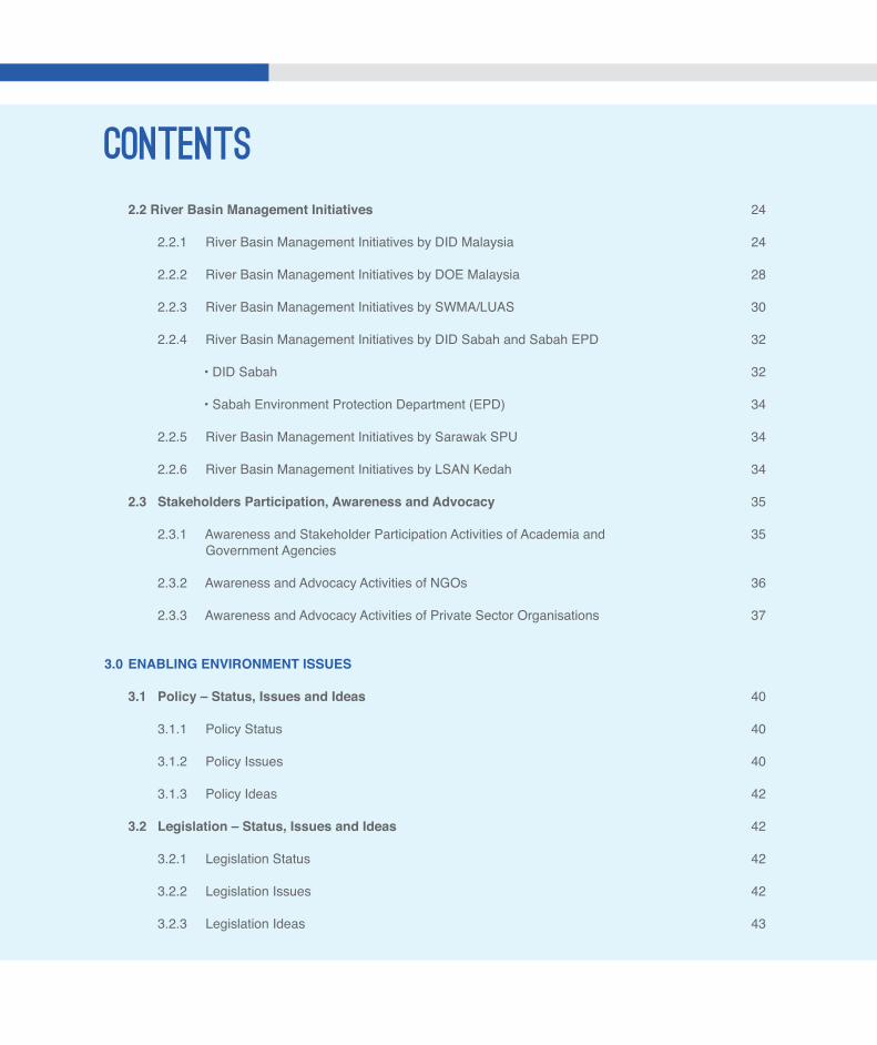
2.2 River Basin Management Initiatives
2.2.1 River Basin Management Initiatives by DID Malaysia 2.2.2 River Basin Management Initiatives by DOE Malaysia 2.2.3 River Basin Management Initiatives by SWMA/LUAS 2.2.4 River Basin Management Initiatives by DID Sabah and Sabah EPD
• DID Sabah
• Sabah Environment Protection Department (EPD)
2.2.5 River Basin Management Initiatives by Sarawak SPU 2.2.6 River Basin Management Initiatives by LSAN Kedah
2.3 Stakeholders Participation, Awareness and Advocacy
2.3.1 Awareness and Stakeholder Participation Activities of Academia and Government Agencies
2.3.2 Awareness and Advocacy Activities of NGOs
2.3.3 Awareness and Advocacy Activities of Private Sector Organisations
3.0 ENABLING ENVIRONMENT ISSUES
3.1 Policy – Status, Issues and Ideas
3.1.1 Policy Status
3.1.2 Policy Issues
3.1.3 Policy Ideas 3.2 Legislation – Status, Issues and Ideas 3.2.1 Legislation Status
3.2.2 Legislation Issues 3.2.3 Legislation Ideas
CONTENTS
24
24
28
30
32
32
34
34
34
35
35
36
37
40
40
40
42
42
42
42
43
v
A STUDY ON THE STATUS AND ISSUES ONINTEGRATED RIVER BASIN MANAGEMENT (IRBM) IN MALAYSIA
3.3 Institution – Status, Issues and Ideas
3.3.1 Institution Status
3.3.2 Institution Issues
3.3.3 Institution Ideas 3.4 Financing – Status, Issues and Ideas
3.4.1 Financing Status
3.4.2 Financing Issues
3.4.3 Financing Ideas
4.0 RIVER BASIN MANAGEMENT ISSUES
4.1 Water Assessment and Allocation – Status, Issues and Ideas
4.1.1 Water Assessment and Allocation Status
4.1.2 Water Assessment and Allocation Issues
4.1.3 Water Assessment and Allocation Ideas
4.2 Pollution Control – Status, Issues and Ideas
4.2.1 Pollution Control Status
4.2.2 Pollution Control Issues
4.2.3 Pollution Control Ideas
4.3 Flood Management – Status, Issues and Ideas
4.3.1 Flood Management Status
4.3.2 Flood Management Issues 4.3.3 Flood Management Ideas
CONTENTS
43
43
46
47
50
50
51
52
54
54
54
55
56
56
57
58
59
59
61
62
vi
4.4 Drought Management – Status, Issues and Ideas
4.4.1 Drought Management Status
4.4.2 Drought Management Issues
4.4.3 Drought Management Ideas
4.5 River Basin and Land Use Planning – Status, Issues and Ideas
4.5.1 River Basin and Landuse Planning Status
4.5.2 River Basin and Landuse Planning Issues
4.5.3 River Basin and Landuse Planning Ideas
4.6 River Basin Information System – Status, Issues and Ideas
4.6.1 River Basin Information System Status
4.6.2 River Basin Information System Issues
4.6.3 River Basin Information System Ideas
4.7 River Basin Monitoring – Status, Issues and Ideas
4.7.1 River Basin Monitoring Status
4.7.2 River Basin Monitoring Issues
4.7.3 River Basin Monitoring Ideas
4.8 Stakeholder Participation – Status, Issues and Ideas
4.8.1 Stakeholder Participation Status 4.8.2 Stakeholder Participation Issues 4.8.3 Stakeholder Participation Ideas
5.0 RECOMMENDATIONS
5.1 Key Limiting Factors
5.2 Strategic Approach
5.3 Strategic Actions
5.3.1 Enabling Environment Issues
CONTENTS66
66
67
67
67
67
68
70
71
71
72
72
73
73
73
74
74
74
76
76
78
78
79
79
vii
A STUDY ON THE STATUS AND ISSUES ONINTEGRATED RIVER BASIN MANAGEMENT (IRBM) IN MALAYSIA
• Policy • Legislation • Institution • Financing
5.3.2 River Basin Management Issues
• Water Assessment and Allocation
• Pollution Control
• Flood Management
• Drought Management
• River Basin and Land Use Planning
• River Basin Information System
• River Basin Monitoring
• Stakeholder Participation REFERENCES
APPENDIX 1 International River Basin Management Perspectives
APPENDIX 2 Key milestones on Malaysia’s progress in IWRM implementation
APPENDIX 3 Key milestones on IWRM implementation by Academia
APPENDIX 4 Key Recommendations from DID IRBM Blue Print Study (2010)
APPENDIX 5 Lembaga Urus Air Selangor : Pengurusan Lembangan Sungai Bersepadu (IRBM) Di Negeri Selangor
APPENDIX 6 Brief Descriptions of River-related Awareness and Advocacy Programmes Implemented by the Global Environmental Centre (GEC)
APPENDIX 7 List of feasibility studies carried out by Jabatan Bekalan Air of the Ministry of Energy, Green Technology and Water
APPENDIX 8 Extract of the NWRC Minutes of Meeting on the IRBM topic
APPENDIX 9 List of papers submitted to NWRC meetings from 2007 to 2013
CONTENTS79
79
79
80
82
82
82
82
84
84
84
85
85
90
97
98
99
103
114
117
119
120

viii
TAN SRI DATUK DR AHMAD TAJUDDIN ALI (FASc)PresidentAcademy of Sciences Malaysia (ASM)
Rivers have always played a very important role in the development of the country. They are the source of water for domestic, industrial and agricultural uses, navigation, power generation, recreation and the environment. Rivers also play an important role in maintaining the ecological balance and as a habitat for the flora and fauna. However, the rapid pace of development over the last four decades has brought about degradation of many of the country’s river systems. The rivers are being silted up, river water quality has deteriorated, potable water shortages are more frequent and the incidences of floods have become relatively common. InsupportoftheGovernment’seffortstoaddressthechallengesofmanagingriverbasins, theAcademyofSciencesMalaysia (ASM)hasprepared thisPositionPaperonthestatusand issueson integratedriverbasinmanagement (IRBM) inMalaysia.Iwould like tocongratulate theASMWaterCommitteeandtheTaskForceon IRBMforproducingthisPositionPaper.BasedonStrategicConsultativeLaboratory(SCL)sessionsonIRBM,thisPositionPaperpresentsthekeylimitingfactorsforsuccessfulimplementationoftheIRBMplanforourriverbasinsalongwithstrategiestoovercomethem. ASM hopes that the input from this Position Paper can catalyse a broader, holistic view through collaborative efforts towards managing our rivers in a more integrated and sustainable manner. ASM hopes that this Position Paper would serve as a useful reference that provides insights towards managing our rivers in a more sustainable manner, through concrete efforts in the short, medium and long term.
ix
A STUDY ON THE STATUS AND ISSUES ONINTEGRATED RIVER BASIN MANAGEMENT (IRBM) IN MALAYSIA
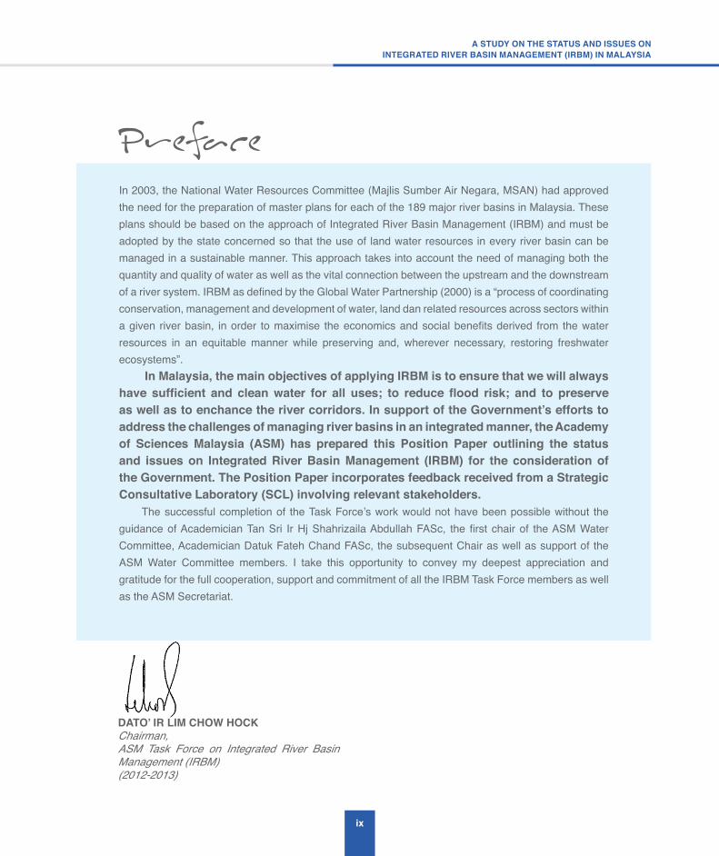
DATO’ IR LIM CHOW HOCKChairman,ASM Task Force on Integrated River Basin Management (IRBM)(2012-2013)
In 2003, the National Water Resources Committee (Majlis Sumber Air Negara, MSAN) had approved the need for the preparation of master plans for each of the 189 major river basins in Malaysia. These plans should be based on the approach of Integrated River Basin Management (IRBM) and must be adopted by the state concerned so that the use of land water resources in every river basin can be managed in a sustainable manner. This approach takes into account the need of managing both the quantity and quality of water as well as the vital connection between the upstream and the downstream of a river system. IRBM as defined by the Global Water Partnership (2000) is a “process of coordinating conservation, management and development of water, land dan related resources across sectors within a given river basin, in order to maximise the economics and social benefits derived from the water resources in an equitable manner while preserving and, wherever necessary, restoring freshwater ecosystems”. In Malaysia, the main objectives of applying IRBM is to ensure that we will always have sufficient and clean water for all uses; to reduce flood risk; and to preserve as well as to enchance the river corridors. In support of the Government’s efforts to address the challenges of managing river basins in an integrated manner, the Academy of Sciences Malaysia (ASM) has prepared this Position Paper outlining the status and issues on Integrated River Basin Management (IRBM) for the consideration of the Government. The Position Paper incorporates feedback received from a Strategic Consultative Laboratory (SCL) involving relevant stakeholders. The successful completion of the Task Force’s work would not have been possible without the guidance of Academician Tan Sri Ir Hj Shahrizaila Abdullah FASc, the first chair of the ASM Water Committee, Academician Datuk Fateh Chand FASc, the subsequent Chair as well as support of the ASM Water Committee members. I take this opportunity to convey my deepest appreciation and gratitude for the full cooperation, support and commitment of all the IRBM Task Force members as well as the ASM Secretariat.

x
ACKNOWLEDGEMENTS
The Academy of Sciences Malaysia (ASM) wishes to acknowledge the contribution of the following towards the Position Paper on “Integrated River Basin Management (IRBM) in Malaysia”:
AdvisorsASM Science, Technology, Innovation Policy Advisory Committee (STIPAC)
Academician Datuk Fateh Chand FAScASM Senior Fellow and Chair of the ASM Water Committee (until July 2015)
AcademicianTanSriDato’IrHjShahrizailaAbdullahFAScASM Senior Fellow and Founding Chair of the ASM Water Committee
Task Force on Integrated River Basin Management (IRBM)
YBhgDato’IrLimChowHockChairmanASM Task Force on Integrated River Basin Management (2012-2013)
En Mohd Said DikonDepartment of Irrigation & Drainage (DID)
Tn Hj Md Khairi SelamatSelangor Waters Management Authority (LUAS)
Mr Wong Chee ChingWater Resources, Drainage and Hydrology Division (BSASH)Ministry of Natural Resources and Environment
Ir Dr Hasnul Mohamad SallehWater Supply Department (JBA)Ministry of Energy, Green Technology and Water
DrZulkifliAbdulRahmanDepartment of Environment (DOE)Ministry of Natural Resources and Environment
DrRahmahElfithriInstitute for Environment and Development (LESTARI)Universiti Kebangsaan Malaysia (UKM)
TnHjMohdYazidAbdullahAgriculture Drainage and Irrigation Division (BPSP)Ministry of Agriculture & Agro-Based Industry
xi
A STUDY ON THE STATUS AND ISSUES ONINTEGRATED RIVER BASIN MANAGEMENT (IRBM) IN MALAYSIA
Dr K KalithasanGlobal Environment Centre (GEC)
Dr Lee JinMyWP, MyCBNet
ASM Analysts and Communication Team
Nitia SamuelSenior Analyst (Science Policy)
P LoganathanPrincipal Analyst
Loh Chia HurAnalyst (Science Policy)
Vinod GangatharanSenior Executive (Science Communication & Information)
Mariatul Kibtiyah Silahudin JarjisExecutive (Science Communication – Editor)
AmirulIkhzanAminZakiExecutive (Science Communication – Publications)
Stakeholders
1. YBhg Datuk Mohd Hashim Abdullah (Secretary General, Ministry of Agriculture and Agro-based Industry)
2. YBhgDato’MustafaKamalBaharuddin (Director General, Department of Agriculture)
3. YBhgDato’AhamadSabkiMahmood (Director General, Department of Fisheries Malaysia)
4. YBhgDatukDrAbdAzizJamaluddin (Director General, Department of Veterinary Services, Ministry of Agriculture and Agro-based Industry)
5. YBhg Datuk Dr Salmiah Ahmad (Director General, Malaysian Rubber Board)
6. YBhgDato’DrSharifHaron (Director General, Malaysian Agricultural Research and Development Institute)
7. YBhg Datuk Franki Anthony Dass (Executive Vice President, Sime Darby Plantation Sdn Bhd)
xii
8. Ir Syed Abdul Hamid Syed Shuib (Director, Division of Irrigation and Agricultural Drainage, Ministry of Agriculture and Agro-based Industry)
9. DrZulkifliHashim (Head of Agronomy & Geospatial Technology Unit, Malaysian Palm Oil Board)
10. Dr Hjh Halimah Muhamad (Head of Analytical Development Quality Unit, Malaysian Palm Oil Board)
11. Tn Hj Ayob Abd Hamid (Deputy Director, Mechanization & Automation Research Centre Malaysian Agricultural Research and Development Institute)
12. YBhgDatukFaizoullAhmad (Chief Director, Lembaga Kemajuan Tanah Persekutuan)
13. YBhgProfessorDato’DrMohamadKadimSuaidi (Vice Chancellor, Universiti Malaysia Sarawak)
14. Professor Dr Peter Mitchell (Dean, Faculty of Science, The University of Nottingham Malaysia Campus)
15. Professor Dr Phang Siew Moi FASc (Director, Institute of Ocean and Earth Sciences, University of Malaya)
16. Dr Zainura Zainon Noor (Chemical Engineering Department, Universiti Teknologi Malaysia)
17. Professor Ir Dr Mohd Amin Mohd Soom (Department of Biological and Agricultural Engineering, Faculty of Engineering, Universiti Putra Malaysia)
18. Professor Madya Dr Mahamad Nor Jaafar (Director, Institute of Sustainable Agrotechnology, University Malaysia Perlis)
19. EnZulkaflyRashid (Department of Fisheries Malaysia)
xiii
A STUDY ON THE STATUS AND ISSUES ONINTEGRATED RIVER BASIN MANAGEMENT (IRBM) IN MALAYSIA
EXECUTIVE SUMMARY
1. BACKGROUND
Malaysia is committed in implementing Integrated Water Resources Management (IWRM) for the sustainable management of the country’s water resources has been adopted since late 1990s. The National Water Resources Policy formally launched in March 2012 further reaffirms its adoption which calls for the balanced development and management of “water as a resource” and “water for livelihood”. The Academy of Sciences Malaysia (ASM), an independent think-tank providing strategic advice to Government on STI matters, has since 2008, been undertaking studies pertaining to the water sector, considered strategic for the country’s economic development. The studies have been overseen by a dedicated ASM Water Committee. One of the studies undertaken by the Academy is this study on Integrated River Basin Management (IRBM), an application of IWRM at the river basin level.
Rivers have always played a very important role in Malaysia’s development as being a source for domestic, industrial and agricultural water supply, navigation, power generation, recreation and the environment. Rivers also play an important role in maintaining the ecological balance and as a habitat for flora and fauna. The rapid pace of development over the last four decades has brought about degradation of many of the country’s river systems. The rivers are being silted up, river water quality has deteriorated, potable water shortages are more frequent and the incidences of floods have become relatively common.
The river basin is defined naturally by its topography and captures all the rain waters that fall within it. Thus, in order to address all the issues related to the rain waters in a basin, for example, competition for their use and the problems caused
by inappropriate land use, there is a need for an integrated approach to the management of the river basin. In assessing the water resources within a basin, there is also a need to also assess the ground water resource related to the basin. The Global Water Partnership has defined Integrated River Basin Management (IRBM) Planning as follows:
“A process of coordinating conservation, management and development of water, land and related resources across sectors within a given river basin, in order to maximise the economic and social benefits derived from water resources in an equitable manner while preserving, and where necessary, restoring freshwater ecosystems.”
In support of the Government’s efforts to address the challenges of managing river basin in an integrated way, ASM has prepared this Position Paper Report on IRBM. The status, issues and recommendations in this Report have also been presented and updated based on the feedbacks received from a Strategic Stakeholders Consultation Workshop.

xiv
2. KEY LIMITING FACTORS ASM has identified the following to be the key limiting factors to address the river basin management issues and IRBM challenges in Malaysia:
a. Lack of a uniform water law to support IRBM implementation
From the review of the current status of the enabling environment to support IRBM implementation in the country and also the key IRBM functions it can be seen that most of the elements of IRBM implementation are already in place. However, what is lacking is a uniform national water law to bring all the components together to support IRBM implementation and to assist the states in enacting complementary state water enactments. For example, the states’ water enactments are necessary to enable local authorities to enforce water resources management compliant land use laws that are essential for effective IRBM implementation.
b. Lack of institutional capacity to implement IRBM implementation
From the review of the current status of the enabling environment to support IRBM implementation in the country and also the key IRBM functions it was also found that there is very weak institutional capacity at the state level to implement IRBM. Since water resources management is under the jurisdiction of the state there is a need to create a state water resources agency to implement the provisions in the proposed state water resources enactment.
c. LackoffinancialsupporttotheStatestoimplement IRBM
Since the states have limited revenue sources the formation of the proposed state water resources agency and also implementation of the proposed state water resources enactment
will need additional funding support from the Federal Government, in addition to whatever revenues that the States may get from the extraction of its water resources.
3. KEY RECOMMENDATIONS
The following are ASM’s key recommendations to address the identified river basin management issues in Malaysia:
1. Policy
• Implementation of the NWR Policy at State-level; and
• Development of Federal/State level partnerships to implement the NWR Policy.
2. Legislation
• Official enactment of the proposed National Water Resources Law; and
• Adoption of the proposed NWR Law by State Legislatures.
3. Institution
• New Federal institutional structure for water governance;
• Revision to the existing Institutional arrangement in all the states;
• Creation of a National Water Resources Management Department (NWRD);
• DID should be realigned to become the proposed NWRD upon the enactment of the proposed draft NWR Law; and
• Alignment of functions and responsibilities with the NWR Policy and proposed NWR Law
xv
A STUDY ON THE STATUS AND ISSUES ONINTEGRATED RIVER BASIN MANAGEMENT (IRBM) IN MALAYSIA
4. Financing
• Federal Government to provide financialallocationsforthe development of IRBM Plans, which have been estimated to cost RM1 million per plan, to facilitate the implementation of IRBM in the 189 river basins in the country, in accordance to priority;
• Financing model for water resources management by the states;
• Pricing model for water resources; and
• Payment for Ecosystem Services (PES)
5. Water Assessment and Allocation
• Ad-hoc studies on water resources Assessment – Need for a systematic
programme of assessment of water resources by river basins and aquifers, which is a responsibility of the Federal Government to support the states in their water resources management;
• Fragmented and non-uniform state legislation governing water allocation – states to adopt similar water allocation rules as in NWR Law; and
• Water allocation is not guided by IWRM principles – Water allocation in a river basin shall be guided by a developed IRBM plan as recommended in item 4 (a) above.
6. Pollution Control
• Control of pollution from sewage effluents
• Control of pollution from SME Manufacturing industries;
• Control of sullage (Grey-Water);
• Control of livestock farming and aquaculture;
• Pollution control from non-sanitary landfill and open dumps;
• Pollution control of sedimentation and siltation;
• Need for review of effluent discharge standards; and
• Need to develop specific river pollution loading capacity standard.
7. Flood Management
• Implement IFM Approach to address increased incidences and cost of flood damages; and
• To legislate and define designated flood protection zones to address the issue of uncontrolled development in flood prone areas.
8. Drought Management
• Management of dry spell (drought-like) conditions in a river basin;
• Reprioritise water allocation in times of drought-like conditions;
• Development of a climate change mitigation and adaptation plan for drought-like conditions;
• River basin and land use planning;
• Uncoordinated land use control at the local authority level – states to adopt the NWR Law after it is enacted;
• Land use control at the local authority level is not guided by a river basin plan. This is to develop IRBM plans for river basin in Malaysia and to create RBMC to coordinate implementation of the IRBM plans. DID Malaysia has identified a priority list of 37;
xvi
• River basins in Malaysia for the development of IRBM plan and has identified 25 river basins for the development of IRBM plans in RMK11 (2016-2020)
• Inadequate technical capacity to monitor the implementation of IRBM master plans – States to set-up State Water Resources Agencies (SWRA); and
• To facilitate the prioritisation of funding allocation for the development of the 189 river basin master plans that have been endorsed by the NWRC, there is a need to develop criteria for the selection and prioritisation of river basins for the development of the master plans.
9. River Basin Information System
• Too much information, lack of useful information products – Set-up River Basin Information Management Unit (RB-IMU) to produce and disseminate information products; and
• Selection and choice of Information Management tools–Adopt appropriate guidelines for the selection of IM tools and standards.
10. River Basin Monitoring
• DID to prepare annual river basin monitoring reports.
11. Stakeholder Participation
• Need to get more public participation in river basin management – RBMC to implement more IWRM awareness Programmes; and
• There is also a need to develop Capacity Building (CB) Programmes to develop the human resources that will be required to staff the SWRA to implement the IRBM master plans effectively. In this regard, additional funding support for IRBM capacity building activities should be provided to DID Malaysia to partner and complement the IRBM-related capacity building efforts that are being carried out by both local and international organisations such as the Malaysian Water Partnership (MyWP), etc.

xvii
A STUDY ON THE STATUS AND ISSUES ONINTEGRATED RIVER BASIN MANAGEMENT (IRBM) IN MALAYSIA
LIST OF TABLES Table 2.1 Flood Statistics (People affected by floods, 2005-2011) 26Table 3.1 Functional Responsibilities of Water Related Agencies/Bodies 56 LIST OF FIGURES Figure 2.1 Spiral Model Roadmap for IWRM Implementation in Malaysia 8Figure 2.2 The Malaysian Development Planning System 16Figure 2.3 Human development activities encroachment into river floodplains 24Figure 2.4 Home Page of DID’s National IWRM Information Repository 34Figure 2.5 TOC from the “National Study for the Effective Implementation of IWRM in Malaysia” showing the list of environmental awareness programme implemented 35Figure 2.6 TOC from the “National Study for the Effective Implementation of IWRM in Malaysia” showing the recommended IWRM awareness programme 35Figure 2.7 Organisational Chart of LSAN Kedah 44Figure 3.1 Separation of Water Resources and Water Services Sector after enactment of WSIA (2006) 57Figure 3.2 Proposed 3-Level Federal institutional structure for water governance 59Figure 4.1 Part V and X from the draft NWR Law 67Figure 4.2 DID’s Public InfoBanjir website 73Figure 4.3 The River Floodplain 74Figure 4.4 Illustration of the Integrated Flood Management (IFM) Approach 75Figure 4.5 LUAS (1999) Enactment, Clause 48 – Establishment of zones of protection 77Figure 4.6 Draft NWR Law, Part VII (Protected water resources area) 78Figure 4.7 Infokemarau website: Drought monitoring via dam water levels 80Figure 4.8 Infokemarau website: Drought monitoring via river discharge 80Figure 4.9 Extract of Clause 9 from the draft NWR Law 84Figure 4.10 Extract of Clause 26 from the LUAS (1999) Enactment 85Figure 4.11 Extract of Part III from the draft NWR Law 85
xviii
ASM Academy of Sciences Malaysia
AWB Artificial Water Bodies
BMP Best Management Practices
BOD Biochemical Oxygen Demand
CAPEX Capital Expenditure
CEPA Communication, Education and Public Awareness
CFS Central Forest Spine
COD Chemical Oxygen Demand
DCMC District Catchment Management Committee
DID Department of Irrigation and Drainage
DMG Department of Mineral and Geosciences
DO Dissolved Oxygen
DOE Department of Environment
EIA Environmental Impact Assessment
EPD Environmental Protection Department
EQA Environmental Quality Act
ESA Environmental Sensitive Areas
ESCP Erosion of Soil and Control Plan
EU European Union
FM Flood Mitigation
GEC Global Environmental Centre
GIS Geographical Information System
LIST OF ACRONYMS

xix
A STUDY ON THE STATUS AND ISSUES ONINTEGRATED RIVER BASIN MANAGEMENT (IRBM) IN MALAYSIA
GPT Gross Pollutant Traps
GWP Global Water Partnership
HMWB Heavily Modified Water Bodies
ICM Integrated Catchment Management
ICZM Integrated Coastal Zone Management
IFM Integrated Flood Management
ILM Integrated Lake Management
INBO International Network of Basin Organisations
IRBM Integrated River Basin Management
ISMP Integrated Shoreline Management Plan
IWK Indah Water Konsortium
IWRM Integrated Water Resources Management
JBA Jabatan Bekalan Air
JICA Japan International Cooperation Agency
JPA Jabatan Perkhidmatan Awam
JPS Jabatan Pengairan dan Saliran
KeTTHA Ministry of Energy, Green Technology and Water
KPKT Ministry of Housing and Local Government
LSANK Lembaga Sumber Air Negeri Kedah
LUAS Lembaga Urus Air Selangor
LWF Living with Floods
MOA Ministry of Agriculture and Agro-based Industry
MSMA Manual Saliran Mesra Alam
MTAG Malaysian Technical Advisory Group
xx
MyWP Malaysian Water Partnership
MyCBNet Malaysian Capacity Building Network
NARBO Network of Asian River Basin Organisations
NGO Non-Government Organisations
NH3N Ammoniacal Nitrogen
NPP National Physical Plan
NPPC National Physical Planning Council
NPS Non-point Polluting Sources
NRE Ministry of Natural Resources and Environment
NRW Non-Revenue Water
NWI National Water Initiative
NWRC National Water Resources Council
NWRD National Water Resources Department
NWRS National Water Resources Study
PAAB Pengurusan Aset Air Berhad /Water Asset Management Company
PES Payment for Ecosystem Services
PWA Project Wira Alam
R&D Research and Development
RBIS River Basin Information System
RBMC River Basin Management Committees
RBMP River Basin Management Plan
RBO River Basin Organisations
RBMU River Basin Management Units

xxi
A STUDY ON THE STATUS AND ISSUES ONINTEGRATED RIVER BASIN MANAGEMENT (IRBM) IN MALAYSIA
ROW Right-of-Way
SAP Special Area Plan
SCL Strategic Consultation Lab
SS Suspended Solids
SPAN Suruhanjaya Pengurusan Air Negara/ National Water Services Commission
SUBA Sub-basin Approach
SWMA Selangor Waters Management Authority
SWRA State Water Resources Agency/State Water Resources Authority
SWRC State Water Resources Council
SWRE Sabah Water Resources Enactment
TCPA Town and Country Planning Act
TCPD Town and Country Planning Department
TOC Table of Contents
TOR Terms of Reference
WDM Water Demand Management
WFD Water Framework Directive
WMO World Meteorological Organisation
WQI Water Quality Index
WRF Water Resources Functional
WRMU Water Resources Management Unit
WSIA Water Services Industry Act
WSM Water Supply Management
WWF World Wide Fund for Nature

xxii

INTRODUCTION 1

2
Rivers have always played a very important role in Malaysia’s development as being a source for domestic, industrial and agricultural water supply, navigation, power generation, recreation and the environment. Rivers also play an important role in maintaining the ecological balance and as a habitat for flora and fauna. The rapid pace of development over the last four decades has brought about degradation of many of the country’s river systems. The rivers are being silted up, river water quality has deteriorated, potable water shortages are more frequent and the incidences of floods have become relatively common. The river basin is defined naturally by its topogtraphy and captures all the rain waters that fall within it. Thus, in order to address all the issues related to the rain waters in a basin, for example, competition for their use and the problems caused by inappropriate land use, there is a need for an integrated approach to the management of the river basin. In 2000, the Global Water Partnership provided a useful definition of Integrated River Basin Management (IRBM) Planning, which is as follows:
“A process of coordinating conservation, management and development of water, land and related resources across sectors within a given river basin, in order to maximise the economic and social benefits derived from water resources in an equitable manner while preserving, and where necessary, restoring freshwater ecosystems.”
1.1 Background
(ASM), under its Sustainable Water Management Programme initiated by the ASM WEHABE Committee on Water, has established a number of Task Forces to address various matters of concern affecting the country’s water sector, among them is the Task Force on Integrated River Basin Management (IRBM). The objectives of the IRBM Task Force are:
a. To oversee a study to prepare a Position Paper report on IRBM in Malaysia together with the strategies that have been proposed to address them;
b. To consult with key stakeholders and get their feedback on the key findings and conclusions in the Position Paper;
c. To prepare an ASM Advisory Report on IRBM for submission to the Government of Malaysia, incorporating
all relevant feedback from the stakeholders, and recommended strategies on the way forward towards its successful implementation nation-wide; and
d. To support the Task Force in its work the ASM has appointed Dr. Lee Jin of GLS Haidro Sdn Bhd to provide consultancy support to the Task Force to carry out the study to achieve the above objectives.
1.2 Scope of Study
The scope of study to achieve the objectives of the Task Force is as follows:
(a) IRBM Position Paper report
1. To review past and current initiatives and programme on IRBM undertaken at state and federal level in Malaysia, and also key regional and international IRBM initiatives, including references to previous studies, reports, and conference/workshop proceedings;
2. To compile, synthesise and summarise the relevant IRBM findings and conclusions in Malaysia;
3. To undertake a gap analysis in relation to item (a) and give recommendations pertaining to the identified key IRBM issues in Malaysia; and
4. To submit a report, including references to all reviewed documents and websites, to ASM addressing items (a), (b) and (c).
(b) IRBM Strategic Consultation Lab (SCL) with key stakeholders
1. To present the key findings and conclusions of the Position Paper report to the stakeholders;
2. To advise the ASM Secretariat on the organisation of the IRBM SCL to get the relevant feedback from the stakeholders; and
3. To review, address and incorporate the relevant feedback from the stakeholders in the final Position Paper report.
3
A STUDY ON THE STATUS AND ISSUES ONINTEGRATED RIVER BASIN MANAGEMENT (IRBM) IN MALAYSIA
(c) ASM Advisory Report on IRBM
Prepare a concise Advisory Report on IRBM to the Government of Malaysia, similar to other ASM Advisory reports, based on the contents in the Final Position paper report
1.3 Report Structure
Chapter 2 provides a literature review covering the following topics, including a review of international river basin management perspectives which is given in Appendix 1:
a. Water Resources and River Basin Management in Malaysia
b. River basin initiatives
c. NGOs and activities related to rivers
Chapter 3 provides a summary of the current status, issues and ideas related to the four aspects of enabling environment to support IRBM implementation in Malaysia, namely (a) policy, (b) legislation, (c) institutional and (d) financing.
Chapter 4 provides a summary of the current status, issues and ideas related to eight key river basin management functions that are necessary for effective implementation of IRBM, such as (a) Water Assessment and Allocation, (b) Pollution Control, (c) Flood Management, (d) Drought Management, (e) River Basin and Landuse Planning, (f) Basin Information Systems, (g) Monitoring, (h) Stakeholder Participation.
Chapter 5 highlights the key limiting factors and recommends the strategic approach as well as coherent strategic actions to support effective implementation of IRBM in Malaysia.

LITERATURE REVIEW

LITERATURE REVIEW 2

6
2.1 Water Resources Management in Malaysia
The following is a summary of the key points highlighting the current status of water resources management in Malaysia as extracted from the literature reviewed. A review of international river basin management perspectives has also been carried out and they are given in Appendix 1:
2.1.1 The Malaysian Water Settings
The following is a summary of key points on the Malaysian water settings. These points were extracted from a paper by Abdullah (2012) at the Malaysia Water Resources Management Forum, Putrajaya, 26-27, November, 2012: 1. The following are key facts relating to the Malaysian
water settings:
a. Land Area - 330, 803 sq. km
b. Population (Increasing) 2010 - 28.9 million, 2020 - 34.1 million, 2050 - 42.1 million
c. GDP Projections (Increasing) by economic sectors
d. Fairly abundant water resources - Annual Rainfall - 973 BCM, Evapotranspiration - 414 BCM, Ground Water Recharge - 63 BCM, Surface Run-off - 496 BCM
e. Consumptive Water Demand (Increasing) - 2010 - 14.8 BCM, 2020 - 17.2 BCM, 2050 - 18.2 BCM
2. The key water management issues are as follows:
a. Temporal and spatial variability of water resources - some “water-stressed’ growth regions (Water deficit States: Perlis, Kedah, Pulau Pinang, Selangor, Melaka)
b. Increased flooding
c. Deteriorating quality of water resources (rivers, lakes and reservoirs, and groundwater)
d. Emerging Climate Change impacts on water resources
e. Fragmented management and growing conflicts among water-use sectors
3. The management of the use of water resources in the country is by water-use sectors. They are as follows:
a. Ministry of Energy, Green Technology and Water (KeTTHA) - Water supply, Sewerage, Hydropower
b. Ministry of Agriculture and Agro-based Industries (MOA) - Agriculture Drainage and Irrigation, Food crops, Livestock, Fisheries, Plantation crops (MP IC)
c. Ministry of Housing and Local Government (KPKT) - Urban drainage, recreation lakes, parks and gardens
4. The burden falls on the Water Resource Managers at basin, state and national levels to be the lead player/champion to implement the IWRM agenda in close consultation with all stakeholders (institutional, private, and community) to achieve the objectives below:
a. To balance development goals and competing water sector users;
b. To maintain database of comprehensive assessment of all water resources (traditional and alternative) and water demand by sectors at local, basin, state and national scales;
c. To have access to decision support systems including use of physical and socio-economic models and techniques for water allocation at various scales;
d. To engage stakeholders to resolve conflicts and broker trade-offs;
e. To allocate and maintain appropriate levels of river environmental flows for ecosystem livelihoods and biodiversity;

7
A STUDY ON THE STATUS AND ISSUES ONINTEGRATED RIVER BASIN MANAGEMENT (IRBM) IN MALAYSIA
f. To undertake R&D Programme pertaining to water security and sustainability; and
g. To develop competent resource managers at all levels through capacity building programme supported by complementary advocacy and awareness programme targeting all stakeholders (users and communities)
5. The major challenge faced is a mindset change among all Water User agencies (public and private) to shift from the current sectoral to integrated management (Think IWRM, Act Sectoral). There is also a need for a cultural shift to seek a viable balance between Water Supply Management (WSM) and Water Demand Management (WDM).
6. The issues and challenges related to non-consumptive water use are mainly related to regulatory and pollution control through appropriate licensing and accompanying regulations, guidelines and enforcement.
7. SPAN reported that Peninsular Malaysia has an average NRW of 36%, with a high of 53.2% (Negri Sembilan) and a low of 16.9% (Penang). SPAN also reported that the NRW reduction for Selangor between 2003 and 2008 is from 43.9% to 33.9% and that the projected NRW reduction is achievable but requires CAPEX and strict enforcement.
8. Agriculture is a major user of water resources and the main stakeholder at the river basin level. Water management for agriculture should account for the complete spectrum from pure rain-fed, via rainwater harvesting, to supplemental or deficit, to full irrigation.
9. There is a need for tradeoffs, especially in ‘closed’ river basins opting for lesser water quality for agricultural purposes when in competition or in conflict with domestic and industrial water supply.
10. There is a need to adopt and implement ILBM in managing lakes and reservoirs developed for agricultural use and in collaboration with other users when they are multipurpose dams.
2.1.2 IWRM Implementation in Malaysia
Figure 2.1 shows a spiral model illustration of IWRM implementation roadmap in Malaysia by Lim, Selamat and Chop (2010). The Figure shows the different stages of progress in IWRM implementation in Malaysia from 1993 to 2010.
Appendix 2 provides a detailed flowchart prepared by Elfithri (2012) on the key milestones in IWRM implementation in Malaysia. Furthermore, Elfithri (2012) has prepared a detailed flowchart of the key milestones in the implementation of IWRM by the Academia in Appendix 3.
2.1.3 National Water Resources Policy (2012) and Implementation Strategies
The following is a summary of key points on the National Water Resources Policy (2012) and its implementation strategies that were extracted from a paper by Mohamad Noor, H (2012), at the Malaysia Water Resources Management Forum, Putrajaya, 26-27, November, 2012:
1. Before the National Water Resources (NWR) Policy was approved by the Cabinet on 22 February 2012 there is no comprehensive and uniform policy on water resources in Malaysia. Water management in Malaysia then was implemented on a sectoral basis. There were no clear policy directions on water resources for effective water resources governance.
2. The NWR Policy has been developed based on the following integrated approaches which have been adopted for current practices and will lead towards better water resources management:
(a) IWRM(b) IRBM (c) ILM(d) ICZM(e) ISMP(f) IFM

8
3. The objectives of the National Water Resources Policy are as follows:
a. To set out the direction and strategies for collective action to ensure the security and sustainability of water resources through integrated and collaborative mechanisms involving all stakeholders at all levels;
b. To provide a means and measures to complement existing policy directions related to water resources so as to ensure its sustainable and equitable use as well as protecting the integrity of the environment, ecosystems and natural heritage;
c. To provide a platform to strengthen water resources intelligence as well as uniform practices through the streamlining of standards, measures, methods and approaches;
d. To set out the means and measures for the adoption of water resources conservation plans at multiple scales to complement and strengthen existing land, resources, physical and other related development plans; and
Figure 2.1 Spiral Model Roadmap for IWRM Implementation in Malaysia
Spiral Model - Roadmap for the Implementation of IWRM
2009/2010 Reviewof NationalWaterResources Study
2009 onwards-Implementation ofIWRM BMP’s (pilot)
2003 - Study onIntegrated catchmentmanagement ofSungai Damansara
1999/2000 -Formation of stateapex organisation(LUAS, Sabah)National Water Vision
1993 - Awareness Program e.g.Love Our River Campaign
2011 - DID to be renamedas Water ResourcesDepartment
2010 - NWR Policy andNWR Law
2001 - Urban StormwaterManagement Manual
1998 - National Water Resources Council
2002 - National SewerageProject & NationalStrategic Plan for SolidWaste Management
2005 - National Study forthe EffectiveImplementation of IWRMin Malaysia
2007 - Water ServiceCommission and WaterService Industry Art
e. To build the capacity of all stakeholders for effective participation and collaboration in water resources governance at multiple scales and levels focusing on developing human resources, science, technology and practice as well as encouraging investments in research, development and innovation.
6. The following are some key points about the 2012 NWR Policy:
a. Develop based on the Integrated Water Resources Management (IWRM) approach;
b. Complements existing water-related policies;
c. Provides the framework for all water-related stakeholders to translate their respective water-related strategic plan into coherent actions;
d. Acts as a comprehensive guide for determining priority in water resources allocations;
e. Enables all policy actions relating to water to be consolidated, complemented and implemented; and

9
A STUDY ON THE STATUS AND ISSUES ONINTEGRATED RIVER BASIN MANAGEMENT (IRBM) IN MALAYSIA
f. Does not specifically address water services but emphasises on water security and sustainability for human and environmental needs.
2.1.4 Proposed National Water Resources Legislation (Draft)
The following is a summary of key points on the proposed National Water Resources Legislation (Draft) that were extracted from a paper by Ramadas (2012), at the Malaysia Water Resources Management Forum, Putrajaya, 26-27, November, 2012:
1. Currently, the various aspects related to IWRM and IRBM approaches are covered under many laws, such as the EQA, Forestry, Geological Survey and Fisheries. There is a need for a holistic water law to implement the IWRM and IRBM principles and approaches in the country.
2. A number of states have enacted state legislation to govern certain aspects related to water resources, e.g. Kedah, Melaka, Negeri Sembilan, Pahang, Sabah, Sarawak and Selangor. The lack of uniformity or consistency between all the state water laws is a cause for concern. The primary objective of the Waters Act 1920 is to ensure greater uniformity in the governance of rivers by all states.
3. The Federal Constitution has defined the jurisdiction of the Federal and State Governments over water resources, which are as follows:
a. States have jurisdiction over water resources and related aspects such as land, forest, agriculture and rivers.
b. The Federal Government has also jurisdiction over the following matters related to water resources:
i. International treaties and agreements;
ii. Transboundary rivers;
iii. Transfer of water (if not resolved between states);
iv. Data and information collection and management;
v. Scientific research; and
vi. Setting of national standards, safety and security.
4. Article 76 of Federal Constitution (Powers of Parliament to make laws) to:
a. Implement any treaty, convention or agreement in any state even if the matter concerned is enumerated in the state List: e.g. Biosafety Act, New Plant Varieties Act;
b. Promote uniformity between two or more states: e.g. Waters Act; Street Drainage and Building Act; Fisheries Act;
The key milestones in the implementation of IWRM in Malaysia are as follows:
1998 Formation of the National Water Resources Council1999 Selangor Waters Management Authority (LUAS) was formed
2004 Ministry of Natural Resources and Environment, and Ministry of Energy, Water and Communications were created
2008 Water Services Industry Act (WSIA) came into effect
2009 Ministry of Energy, Water and Communications was restructured to Ministry of Energy, Green Technology and Water and the National Green Technology Policy was published
2012 National Water Resources Study was formulated
10
c. If requested by any state; and
d. Laws made pursuant to (b) or (c) cannot be enforced in any state unless it is first adopted by the state Legislature. It will then become a State Law and not be considered as a Federal Law.
5. A draft National Water Resources Law was prepared as one of the outputs from the National Water Resources Study (NWRS) completed by Ranhill Consulting Sdn Bhd in 2010-2011.The main outputs from the NWRS were a draft NWR Policy, draft NWR Law, proposed WRM institution set-up and a Master Plan for water resources for the country. The draft National Water Resources Policy has since been accepted by the Government and was officially launched in March 2012.
6. The enactment of the draft NWR Law and proposed institutional reform may take some more time. The following are the three viable options that were considered by all stakeholders for the drafting of the NWR Law:
a. Option 1: Adopt a new water resources law for uniformity by repealing the Waters Act 1920. The new Law will be a model for all states.
b. Option 2: Enact state Laws
c. Option 3: Strengthen Existing Legislation
7. The following are the guiding principles for proposed NWR Law:
a. Pursuant to Article 76(1) of the Federal Constitution, Parliament may adopt a law to ensure uniformity among all states;
b. The Law will be in strict conformity with the jurisdictions of the Federal and State Government as enshrined in the Constitution;
c. The Law shall only come into effect in any State (other than the Federal Territories), after the State legislature adopts the Act and converts it into State law;
d. The Law shall take into account existing enactments in some States on water resources;
e. The Federal Law must be consistent with and shall give effect to the National Water Resources Policy (2012) and proposed Institutional set up; and
f. The Federal Law will leverage on existing State laws (e.g. Land Conservation Act) and other Federal Laws (e.g. EQA) and avoid duplication or conflict with such laws.
8. The following are the proposed contents of the Draft National Water Resources Enactment:
Part 1 - PreliminaryPart 2 - National AdministrationPart 3 - State Administration Part 4 - FinancePart 5 - Use of Water Resources Part 6 - Planning Part 7 - Protected Water Resources Area Part 8 - Control of Water Hazards Part 9 - Control of other Activities Part 10 - Procedures for Licensing, Approvals And
Appeal Part 11 - EnforcementPart 12 - Offences and PenaltiesPart 13 - MiscellaneousPart 14 - Repeal and Savings
9. National Water Resources Enactment Draft:
Part 1 (Preliminary)
1. Cites the relevant Constitutional clauses
2. Provides for application to Peninsular Malaysia and Federal Territories only
3. Act comes into operation on date fixed by Minister
4. Act comes into force in a State upon adoption by the State Legislature

11
A STUDY ON THE STATUS AND ISSUES ONINTEGRATED RIVER BASIN MANAGEMENT (IRBM) IN MALAYSIA
5. Act comes into force in Federal Territories on date fixed by Minister.
6. Interpretation
7. General clause that states that nothing in this Act will reduce or limit the jurisdiction of State Government, or any other Government entity.
Part 2 (National Administration)
1. National Water Resources Council
2. Membership and Functions
3. Director General of Water Resources
4. Functions of DG
Part 3 (State Administration)
1. State Water Resources Council (SWRC) or State Water Resources Authority (SWRA) as body corporate
2. Membership and functions
3. State Water Resources Director
4. Scheme of service
2.1.5 Proposed Alignment of Institutional Framework to National Water Resources Policy
The following is a summary of key points on the proposed alignment of institutional framework to the National Water Resources Policy that were extracted from a paper by Low (2012), at the Malaysia Water Resources Management Forum, Putrajaya, 26-27, November, 2012:
1. The National Water Resources (NWR) Policy was officially launched in March 2012. However, the effective implementation of the NWR Policy will require the streamlining and alignment of the existing institutional framework to support the
implementation of the IWRM policy directions. The proposed streamlined institutional framework shall then be empowered by a National Water Resources Law that will define the powers and responsibilities of the agencies responsible for regulating and implementing water resources management in the country.
2. The following four institutional components that needs to be aligned to support the implementation of the NWR Policy 2012 are as follows:
a. Structure and role of the National Water Resources Council (NWRC)
b. Review of the existing Institutional arrangement in all the States
c. Core functions of a Water Resources Management agency
d. Alignment of functions and responsibilities with the NWR Policy and proposed NWR Law.
3. The following is a brief overview of the National Water Resources Policy (2012):
a. The Policy statement is as follows:
“The security and sustainability of water resources shall be made a national priority to ensure adequate and safe water for all, through sustainable use, conservation and effective management of water resources enabled by a mechanism of shared partnership involving all stakeholders.”
b. The NWR Policy has four Key Core Areas, nine Strategic ‘Thrusts’ and 18 Strategic Targets. It is based on the following three principles:
i. Water Resources Security
ii. Water Resources Sustainability
iii. Partnerships
12
4. To facilitate the implementation of IWRM in Malaysia a draft of the NWR Law, which was prepared as part of the National Water Resources Study 2011. The draft Model NWR Law can be summarised in three parts as follows:
Part 1 - Objective and Jurisdiction (a) To promote uniformity pursuant to Article 76(1)(a) & (b) of the Federal Constitution
(b) Full discretion of States to adopt the Model Law
Part II - Authority and Administration
(a) Establishment of institutional set-up pursuant to the Model Law;
(b) Powers and responsibilities of the National Water Resources Council (NWRC);
(c) Powers and responsibilities of the National Water Resources Department (NWRD);
(d) Powers and responsibilities of the states - SWRA will be established in such State for implementation and enforcement roles ;
(e) Water Resources Fund;
(f) Protection and development of water resources; and
(g) Regulations.
Part III - Implementation
(a) States will be the enforcement body via the SWRA or equivalent;
(b) District and local authorities are empowered to participate in the administration of water resources; and
(c) Proposed institutional framework will also promote self regulation.
5. The history on the formation of the National Water Resources Council (NWRC) as follows:
a. The formation of the NWRC was recommended in the National Water Resources Study conducted by JICA in 1982.
b. The study recognises that there is a need for the NWRC to address the following issues:
i. Institutional arrangements in the water sector are too fragmented.
ii. Water sector agencies operate independently of one another based on their own sectoral legal provisions.
iii. If the practices persisted it could lead to duplication of functions and waste of resources.
iv. Thus, there were calls for reforms in the water sector and for the various water sectors to be more integrated.
6. The roles and functions of NWRC up to 2012 are as follows:
a. Water management on a national basis to ensure long-term sustainability of water supply;
b. Resolution of water resource disputes among states, including the establishment of a mechanism for agreeing of terms;
c. Address legal and other issues needed to allow the increase use of water through inter-basin and inter-state water transfers;
d. Coordinate the implementation of water resources development projects;
e. Advise state governments on the conservation, control and gazettal of water catchments areas; and
f. Water resources data management.

13
A STUDY ON THE STATUS AND ISSUES ONINTEGRATED RIVER BASIN MANAGEMENT (IRBM) IN MALAYSIA
7. In subsequent to the approval of the 2012 National Water Resources Policy, in March 2012 the following additional roles and responsibilities were added to the NWRC:
a. Act as an apex body for water resources governance;
b. Set general policy directions on water resources (planning, development and management);
c. Inter-state matters and state water-related matters requiring advice and recommendations; and
d. All international water-related matters.
8. The institutional arrangement for water resources management in Malaysia up to July 2011 can be categorised into 4 categories. The four categories and the States implementing them are as follows:
(a) Category 1 - Fully developed and implemented (Fully functional with institutional structures addressing most aspects of water resources management) (Selangor (LUAS), Kedah, Sabah, Sarawak);
(b) Category 2 - Developed and/or need refinement and/or to be implemented (All have been mandated by legislation but some aspects of the institutions have yet to be fully functional). (Pahang, Kelantan, Terengganu and Negeri Sembilan);
(c) Category 3 - Service-oriented and industry-based or distribution-based (Development through COPPRI), (Malacca, Johor, Perak, Kelantan, Terengganu, Negeri Sembilan, Penang, Sarawak); and
(d) Category 4 - None of the above or preparations underway (No provisions yet) (Perlis - Syarikat Air Perlis has signed an agreement with PAAB regarding water assets in 2010 and the 3 FederalTerritories - No provisions yet except in Putrajaya):
2.1.6 Meetings of the National Water Resources Council
The NWRC has met eight times since its formation. At the NWRC meeting in 2003 a paper on Integrated River Basin Management (IRBM) was submitted to the NWRC. Appendix 8 provides an extract of the Minutes of Meeting on the IRBM topic, while Appendix 9 provides a list the papers submitted to the NWRC meetings from 2007 to 2013.
2.1.7 The Malaysian Urban Development Planning System
The following is a summary of key points on the Malaysian urban development planning system that were extracted from a paper by Ishak (2012), at the Malaysia Water Resources Management Forum, Putrajaya, 26-27, November, 2012:
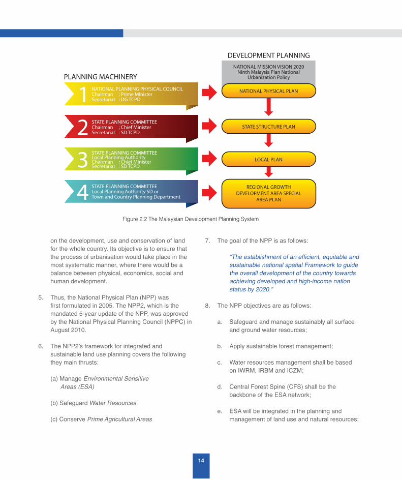
1. The Malaysian urban development planning system consists of several layers. Figure 2.2 gives a schematic illustration of the system. Briefly, at the national level, the development planning is guided by the National Vision 2020, the 10th Malaysia Plan (2011-2015), the National Urbanisation Policy and the National Physical Plan.
2. At the state level, the allocation of financial resources is guided by economic planning, the State Structure Plan and policy/strategic planning objectives. At the lowest local level various Local Plans and Regional Growth Special Area Development Plans are prepared and implemented based on local interpretations of the national policies.
3. The Town and Country Planning Act (TCPA) was enacted in 1976 to facilitate the integrated planning, proper use, conservation and development of land resources in the country. The TCPA 1976 (Act 172) consist of three systems. They are (a) the planning administrative system, (b) the development plan system and (c) the development control system.
4. Section 6B of the TCPA 1976, requires the preparations of the National Physical Plan which provides long-term strategic guidance and directions
14
on the development, use and conservation of land for the whole country. Its objective is to ensure that the process of urbanisation would take place in the most systematic manner, where there would be a balance between physical, economics, social and human development.
5. Thus, the National Physical Plan (NPP) was first formulated in 2005. The NPP2, which is the mandated 5-year update of the NPP, was approved by the National Physical Planning Council (NPPC) in August 2010.
6. The NPP2’s framework for integrated and sustainable land use planning covers the following they main thrusts: (a) Manage Environmental Sensitive Areas (ESA) (b) Safeguard Water Resources (c) Conserve Prime Agricultural Areas
7. The goal of the NPP is as follows:
“The establishment of an efficient, equitable and sustainable national spatial Framework to guide the overall development of the country towards achieving developed and high-income nation status by 2020.”
8. The NPP objectives are as follows:
a. Safeguard and manage sustainably all surface and ground water resources;
b. Apply sustainable forest management;
c. Water resources management shall be based on IWRM, IRBM and ICZM;
d. Central Forest Spine (CFS) shall be the backbone of the ESA network;
e. ESA will be integrated in the planning and management of land use and natural resources;
NATIONAL MISSION VISION 2020 Ninth Malaysia Plan National
Urbanization Policy
DEVELOPMENT PLANNING
PLANNING MACHINERY
NATIONAL PHYSICAL PLAN
STATE STRUCTURE PLAN
LOCAL PLAN
REGIONAL GROWTHDEVELOPMENT AREA SPECIAL
AREA PLAN
1234
NATIONAL PLANNING PHYSICAL COUNCILChairman ; Prime MinisterSecretariat : DG TCPD
STATE PLANNING COMMITTEEChairman ; Chief MinisterSecretariat : SD TCPD
STATE PLANNING COMMITTEELocal Planning AuthorityChairman ; Chief MinisterSecretariat : SD TCPD
STATE PLANNING COMMITTEELocal Planning Authority SD orTown and Country Planning Department
Figure 2.2 The Malaysian Development Planning System
15
A STUDY ON THE STATUS AND ISSUES ONINTEGRATED RIVER BASIN MANAGEMENT (IRBM) IN MALAYSIA
f. Future settlements and infrastructure in coastal zones will be located away in areas that are not vulnerable to rising sea levels and storm surges; and
g. Natural barriers, especially mangroves, forests and peat lands shall be protected and expanded, and further land conversion will no longer be allowed.
9. The NPP2 consists of 41 development policies and includes additional updates to address perceived gaps and issues in the first NPP. The following are the NPP2 policies related to water resources management and adaptation to climate change:
a. NPP22 — Environmentally sensitive area (ESA) shall be integrated in the planning and management of land use and natural resources.
b. NPP24 — Sensitive coastal and marine ecosystems shall be protected and managed in a sustainable manner.
c. NPP25 — Land development in the highlands shall be strictly controlled to safeguard human safety and maintain environmental quality and biodiversity.
d. NPP26 — All surface and ground water resources shall be safeguarded and managed sustainably.
e. NPP27 — Spatial planning framework to include adaptation and mitigation measure for climate change impact.
f. NPP38 — Drainage infrastructure shall be provided in all settlements to eliminate the incidence of major floods, minor floods and pollution.
10. The TCPD have assisted the states in the preparation of their respective State Structure Plans, Local Plans and Special Area Plans.
11. The State Structure Plan consists of a written statement containing policies and general proposal
for the development and use of land in the State. The policies must be set within the current State and National Policies concerning the social and economic well-being of the State and the local citizens. The State Structure Plan is the strategic planning vehicle that translates the national social, economic and physical objectives into physical development strategies and policies for the State or parts of the State, and provides a frameworks for the production of more detailed local land use plans.
12. Section 12 of the TCPA 1976 (Act 172) requires the local planning authority to prepare Local Plan which will describe in detail the policies contained in the Structure Plan. The local planning authority will formulate in such detail as it sees fit, proposals for the development and use of land in the area covered by the district local plan. The Local Plan gives a precise indication of the proposals put forward for the use or development of specific sites, the improvement of communications and management of traffic. Local Plans are also designed to inform property owners, developers and the general public on the use and development of the land.
13. A Special Area Plan (SAP) is a development planning document comprising of detail proposals for implementation. The document is prepared under the provision of TCPA 1976 (Act 172) and contain proposals for special and detailed treatment by development, redevelopment, improvement, conservation or management practice and the nature of the treatment proposed.
14. Many towns in Malaysia were developed around lakes or rivers because they are sources of transportation and energy. Special Area Plan for waterfront development plan have been proposed for such towns.
15. The Federal Department of Town And Country Planning, Peninsular Malaysia (TCPD) has prepared 41 Planning Guidelines. The following are some planning guidelines related to environment management and flood control:
16
(a) Planning Guidelines for Detention Ponds as Part of Open Space;
(b) Planning Guidelines for Coastal Development;
(c) Planning Guidelines for DevelopmentNDoctrine;
(d) Planning Guidelines and Standard for Open Space and Recreational Area; and
(e) Planning Guideline on the Natural Topography in Physical Planning and Development in Accordance with the Town and Country Planning Act 1976 (Act 172).
16. The effective implementation of development control system is supported by planning guidelines. Planning guidetrylines are important for planners and decision makers since they specify in detail what the development policy statement means in practical terms. The Planning guidelines incorporate elements from the various guidelines developed by other government departments, such as DID, JKR, DOE, etc.
2.1.8 Ground Water Resources Management Strategies
The Department of Mineral and Geosciences (DMG) is responsible for the technical management of groundwater resources in Malaysia. Since groundwater resources is an integral part of the water resources in a river basin it has to be managed in an integrated and sustainable way together with surface water resources. The following is a summary of the strategies for the sustainable development, management and use of ground water resources as presented in the latest National Water Resources Study (NWRS) report (DID 2010):
1. The Ministry of Natural Resources and Environment, with the support of the DMG, has prepared a Strategic Plan for the Management of Groundwater Resources in Malaysia, which was endorsed by the National Water Resources Council in August 2008.
2. The Strategic Plan covers six strategies as follows:
a. Legal Augmentation and Enforcement
To reinforce laws related to the management of ground water including the Geological Survey Act (1974) and to ensure all states create and enforce the ground water management aspects in the State Water Enactments
b. Assessment and Development of Resources
To encourage the ground water exploration in the alluvium and hard-rock areas in a systematic and continuous manner. With the available data collected, database and hydrogeological thematic maps can be developed for use in the development plan for ground water exploitation in an efficient manner
c. Monitoring of Ground water
To encourage groundwater monitoring activities for the purpose of evaluating the quantity, quality, the extent of contaminated ground water and land subsidence. Groundwater protection zone has to be established to avoid contamination and sterilisation of aquifers
d. Capacity-building
To do capacity-building for manpower to all agencies through training, purchasing of new equipments and usage of the latest technology. This will improve their skill, expertise and knowledge in the development and management of ground water
e. Promotion and Awareness
To increase the promotional activities among the authorities to the potential of ground water as an additional water source. This will be extended to all users, focusing on the steps to be taken to avoid contamination and excess abstraction of ground water
17
A STUDY ON THE STATUS AND ISSUES ONINTEGRATED RIVER BASIN MANAGEMENT (IRBM) IN MALAYSIA
f. Research and Development
To increase activities of Research and Development to identify effective methods for the development and management of ground water. Also to cultivate smart partnership among research institutions and universities in aspects of ground water development and management
3. The NRE, DMG, universities and other water-related agencies have also prepared the Strategic Action Plan for each of the six strategies in the Strategic Plan, which are as follows:
a. Strategy No. 1 (Legal Augmentation and Enforcement):
i. To review the Geological Survey Act 1974, Akta Alam Sekitar Sekeliling 1974, Kanun Tanah Negara, Akta Perancang Bandar dan Desa and other related Laws and Enactments;
ii. To prepare regulations for the assessment and development of ground water projects/schemes in accordance with relevant Federal Acts and State Enactments;
iii. To enforce existing Laws and Enactments related to ground water, including registration of all ground water development companies by the DMG;
iv. To gazette ground water protection zone/buffer zones;
v. To review all State Water Enactments and Ordinance including those of Sabah and Sarawak, including incorporation of regulations to license all ground water development companies;
vi. To enforce Uniform Building By-Laws regarding domestic, industrial, husbandry waste and seepages from agricultural activities to be directed to waste discharge centres;
vii. To review State Water Enactments to include ground water aspects especially on abstraction quantities, metering, tariff rates, monitoring and protecting the ground water recharge area and ground water aquifers; and
viii. To prepare a mechanism to manage trans-boundary ground water aquifers.
b. Strategy No. 2 (Assessment and Development of Resources):
i. To study the potential of ground water in alluvial basins (there may be more than one aquifer in each basin) and in hard-rock aquifers (similarly, there may be different aquifers in the hard-rock);
ii. To develop and maintain a national hydrogeological data bank;
iii. To expand the ground water facilities to remote areas such as aboriginal villages, long houses, isolated villages, plantation villages and islands;
iv. To implement holistic management of ground water resources through Integrated Water Resources Management (IWRM) principles by introducing conjunctive use of surface and ground water whenever and wherever possible;
v. To upgrade the use of technology in the aspects of assessment and development of ground water; and
vi. To develop a set of Best Management Practices to be followed strictly by all ground water development companies.
c. Strategy No. 3 (Monitoring of Ground Water):
i. To elevate the ground water monitoring activities for the purpose of evaluating the quantity, water quality, pollution, land subsidence, salt water intrusion, industrial

18
exploitation and waste discharge through monitoring of tube-wells from the industry;
ii. To refurbish monitoring station networks;
iii. To create a Monitoring Sub-Committee comprising of relevant agencies;
iv. To create a One-Stop Centre for the ground water monitoring databank; and
v. To create and to follow the ground water standards.
d. Strategy No. 4 (Capacity-building):
i. To restructure the relevant Agencies including the succession plan;
ii. To create ground water syllabus, specialisation and training at schools/universities/agencies;
iii. To provide exposure and seminars for the policy makers and officers;
iv. To provide scholarships for the relevant topics in ground water;
v. To create expert centres/expert groups/sharing expertise;
vi. To encourage work opportunities in the field of ground water;
vii. To introduce a Steering Committee at the federal level, led by NRE (as the Secretariat of the National water Resources Council); and
viii. To give incentives and innovation awards.
e. Strategy No. 5 (Promotion and Awareness):
i. To do promotion through road-shows for the authorities/public/higher learning institutions/agencies;
ii. Promotion/pamphlets/printed and electronic media distribution;
iii. Subsidies for the promotion and awareness programmes; and
iv. Encourage the use of ground water at new buildings/offices/schools/universities.
f. Strategy No. 6 (Research and Development (R&D)):
i. To increase R&D to identify effective methods for the assessment, development and management of ground water;
ii. To increase the R&D cooperation/ smart partnerships with others inside and outside Malaysia;
iii. R&D in ground water modelling of ground water basins, ground water pollution, rehabilitation, buffer zone, recharge, cost studies, treatment plant and others;
iv. Research grants;
v. Incentive and innovation awards;
vi. Patents and commercialisation of R&D; and
vii. Attachment Programmes (R&D). The Academy of Sciences Malaysia has also submitted an advisory report in 2011 (ASM Advisory Report 1/2011) to the Government on the “Strategies for the Sustainable Development and Management of Ground Water Resoureces in Malaysia”. The ASM Report has recommended the following eight strategies for ground water management in Malaysia, which are also in line with those recommended in the NWRS report:
1. Identify and empower a lead Ministry/Agency at Federal level
2. Facilitate states to play a leading role for Ground Water Management
19
A STUDY ON THE STATUS AND ISSUES ONINTEGRATED RIVER BASIN MANAGEMENT (IRBM) IN MALAYSIA
3. Establish a National Ground Water Research Centre under NRE
4. Establish a standing committee on ground water within the purview of the National Water Resources Council (NWRC)
5. Establish ground water management committees at state level
6. Pass appropriate legislation to strengthen existing legal framework
7. Change public perception towards ground water
8. Development of detailed action plans
2.1.9 The “Living With Floods (LWF)” Paradigm
The following is a summary of key points on the “Living with Floods (LWF)” paradigm that were extracted from a paper by Mat Hassan (2012), at the Malaysia Water Resources Management Forum, Putrajaya, 26-27, November, 2012:
1. The economic cost of flood damages and the severity of the social impacts of flood on the lives of flood-affected people have increased over the years. As a result, the Government has been increasing the budget for flood mitigation and flood control projects over the years.
2. In view of the fact that flood is a naturally occurring, rare event that impacts negatively on the lives of people who have choosen to live on the flood plains or the “Right-of-Way (ROW)“ of flood, without learning to adapt to it, there is a need to reassess the way we mitigate the impacts of flooding so that the increasing cost and damage due to floods can be controlled.
3. There is a need to recognise that the severity and frequency of flood are affected by human activities in the flood plains and that there is a need for a paradigm shift in the way we view and manage the impacts of floods on our lives. Hence, it is time that we learn how to live with floods and adopt the “Living With Floods (LWF)” paradigm.
4. When we see flood as a big picture, we can understand and appreciate the positive impacts of flooding and why the negative impacts of flooding occurs. The positive impacts of floods are many and the negative impacts of floods are caused by our lack of understanding of the nature of flood and our need to live with it.
5. The following are four major positive impacts of flood:
a. Flood is good for the rejuvenation of soils in the floodplains. The nutrients in the soil, such as nitrogen, are essential for healthy crop growth during farming. The harvesting of crops, however, removes some of those nutrients from the floodplains such that it will eventually become unusable for farming, unless it is replenished. Thus, flood is a natural process to rejuvenate the soils in a flood plain.
b. Flood is also good for reconnection to the floodplain. Floodplain reconnections are the processes when the areas in floodplains are allowed to perform the natural function of storing and conveying floodwaters.
c. Floodplain reconnections will accomplish three primary objectives: (a) Flood-risk reduction, (b) Increase in floodplain goods and services, and (c) Resiliency to potential climate-change impacts.
d. Flooding is also required to recharge the aquifers that ensure the balance of the water cycle.
6. The negative impacts of flood like what we already know that we spend billions of ringgits every year in flood mitigation and control, however injury and loss of many lives and properties destroyed and damaged by flood, is because we chose to live on the “Right-of-Way (ROW)“ of flood without learning to adapt to it. This is illustrated in Figure 2.3
7. Figure 2.3 shows the low and high water levels in a river, the bank-full width of a river at the high water level, and also the designated flood plain areas and the designated width of a river corridor. It also

20
illustrates the impact on the flood ROW by human encroachment of the flood plain/flood fringe through
filling and construction of river embankments to create a floodway. The effect of the human encroachment into the flood fringe is to increase the 100-year flood level in the floodway.
8. The physical landscape has been formed over thousand of years by natural processes, such as floods. Floods are rare events, and it is not always possible to predict when, where or how big the next flood event will be The flood plains are the flood’s natural “Right-of-Way (ROW)” and encroachments by man have negative consequences when the rare flood event need to “exerts its right to its ROW”!
9. Human activities on a flood plain, which is the natural “Right-of-Way (ROW)” for floods have worsened the flooding situations. The human encroachment into the floodplains affects both the frequency and severity of floods. Extensive land
clearing of the flood plains for agriculture results in the loss of the flood plains and its associated wetlands.
10. The “Living With Floods (LWF)” paradigm is based on the following principles:
a. recognises that it is not possible to completely eliminate floods, due to design limitations, and also the uncertainty of flood events arising from climate change impacts.
b. recognises that the negative impacts of flood can be reduced through an understanding of flood risks, which will enable the flood risk-generation process to be managed in a holistic manner
11. Floods are natural disasters that have been affecting human lives since the beginning of time. In Malaysia, the earliest recorded major flood was back in 1926. The other major floods occurred in 1949 and 1971.
Designated River Corridor
Bankfull width
Bankfullelevation
Highwater level
Floodplain Floodplain
100 YEAR FLOODPLAINFLOOD FRINGE
ENCROACHMENT
FLOOD FRINGEFLOODWAY
Flood elevation forexisting conditions
Flood elevation after completeencroachment of flood fringe
STREAM CHANNEL
Flood Plain Encroachment
ENCROACHMENT

21
A STUDY ON THE STATUS AND ISSUES ONINTEGRATED RIVER BASIN MANAGEMENT (IRBM) IN MALAYSIA
Due to the catastrophic 1971 flood, the Department of Irrigation and Drainage (DID) was given the additional task of managing floods in the country.
12. Table 2.1 shows the national flood statistics on people affected by flood for 2005 to 2011 (Source: Department of Social Welfare (JKM)). The Table shows the states affected by flood, the number of evacuation centres opened, the number of families affected, the number of casualties and also flood victims. The Table highlights the fact that in 2006 and 2010 there were 148,868 and 231,377 flood casualties, respectively.
13. The cost of flood mitigation projects has increased over the years, as can be seen in the total budget spent on flood mitigation projects in the 5-year national development Malaysia Plan below:
(a) Malaysia Plan 2-8 - RM4.30 billion
(b) Malaysia Plan 9 - RM7.60 billion
(c) Malaysia Plan 10 - RM2.10 billion (budget for 2011 and 2012)
14. The “Living With Floods (LWF)” paradigm has been presented to the National Water Resources Council (NWRC) in 2011 as a new approach to managing floods in the country and as a way to mitigate the increasing costs of flood mitigation projects.
2.1.10 Water Pollution Sources and Control
Malaysian rivers are degraded by both point and non-point sources of pollution (Ibarahim & Lee 2004). The major point sources of pollution are sewage treatment plants, agrobased industries, manufacturing industries, sullage or grey-water from commercial and residential premises, and pig farms. Non-point source (or diffused) pollution is largely due to storm run-off after a downpour. Earthworks and land clearing activities contribute to siltation of rivers and can be both point and non-point sources of pollution.
The following are brief descriptions of the pollution sources and their control:
1. Agro-based industries
There was a proliferation of agro-based industries in the early years of post-independence, such as raw natural rubber factories and palm oil mills which were the main causes of river pollution then. The control of pollution from these sources involved a combination of both economic and command-control instruments which has proven to be very successful. The industries did not only invest in pollution control research and development but also made great efforts to comply as rapidly as possible with the stipulated effluent-discharge or land-disposal standards. They were induced to install effective wastewater treatment systems instead of paying the prohibitive effluent-related or pollution fees imposed under the licensing requirements that came into force in 1977. The organic pollutant loads dumped into rivers were reduced by more than 90%.
2. Manufacturing industries
As the country progresses with the development of manufacturing industries a new set of environmental problems emerged. In addition to organic pollutants, the manufacturing industries generate inorganic pollutants, toxic wastes and persistent organic pollutants. Thus, all manufacturing industries are required to install wastewater treatment systems to arrest their water pollutants before they are discharged into rivers. The achievement in controlling the effluent discharges from the manufacturing industries varies from industry to industry. The small and medium scale industries have difficulties in complying with the effluent discharge standards. The constraints cited included financial problems and the lack of space for the construction of wastewater treatment facilities. The manufacturing industries were encouraged to implement alternative options such as cleaner production, waste minimisation and waste reutilisation in order to reduce their water pollution further. Increased efforts to eliminate indiscriminate disposal of toxic wastes and uncontrolled release of persistent organic pollutants were also carried out. The management of toxic wastes is governed by law and is based on the cradle-to-grave concept, e.g. their generation, storage, transportation, treatment and disposal are strictly controlled. An integrated state of-the-art toxic waste treatment and
22
disposal facility has been set up and is in full operation since August 1998 to assist the manufacturing industries in the proper management of their toxic wastes.
3. Sewage Disposal and Sewerage Works
Sewage is a major river pollutant in Malaysia. The initial efforts to control sewage were very much focused on protecting public health but there is now a gradual shift to protect water resources and the natural environment. A private company, Indah Water Konsortium (IWK), was given the concession to manage sewerage works and sewage disposal for Peninsular Malaysia and Labuan in 1994 under the Sewerage Services Act 508 (1993). However, with the enactment of the Water Services Industry Act 655 (2006) the Sewerage Services Act has been annulled, while Act 655 has been enforced for Peninsular Malaysia and Labuan with the formation of the National Water Services Commission (SPAN) in 2008. Under Act 655 all sewerage treatment service providers have to be licensed by SPAN, including IWK.
Under the former Act 508, it was reported by DOE that IWK only managed to serve 86 out of the 144 local authority areas. Furthermore it was reported that the management of sewerage in the 86 local authority areas by IWK was far from holistic since there are sources that do not come under the management of IWK, such as sewage treatment plants in government buildings, private sewage treatment plants, individual septic tanks, sewage from primitive systems and discharges of raw sewage from squatters. Thus, with the enforcement of Act 655 and the regulatory efforts of SPAN requiring all sewerage treatment plant owners to be licensed to operate the treatment plants, or engage SPAN-licensed sewerage treatment plant operators such as IWK, it is hoped that the sewage pollutant loads that are discharged into Malaysian rivers will be reduced and that river water quality will improve.
Besides that, the Secretary-General of the Ministry of Energy, Green Technology and Water has issued a circular reference No. KeTTHA: BPA(S) 28/3 Klt 14(45), dated 9 October 2013 to all ministeries, government departments and agencies to inform them on the requirement to ensure that all sewerage treatment plants of government buildings comply with SPAN’s sewerage treatment services licensing requirement.
In addition, the potential use of treated wastewater effluent as an alternative water source has been discussed in a paper by Kadir, Haniffa, Dorai and Sasidharan of IWK, entitled, “Way forward for the sewerage industry with the concept of sustainability through zero waste management and waste to resource” in ASM’s Strategic Consultation No. 4 on Inter-sector Water Demand Management on 4 July 2013. In the paper, the authors covered the following topics:
a. Wastewater as an alternative water source for non-potable use in Malaysia;
b. Wastewater reuse technology and treatment;
c. Challenges and barriers; and
d. Strategic approach for water reuse initiatives in Malaysia.
4. Sullage (Grey-Water)
An important source of point pollution is sullage or grey-water which originates from residential and commercial premises but is often overlooked. The wastewater can come from places such as kitchen sinks, bathrooms, washing machines, restaurants, wet markets and car washing centres. Sullage becomes a major contributor to urban river water pollution since it contributes organic pollutants, ammoniacal nitrogen and nutrients to the rivers. The urban stream usually does not have enough assimilative capacity to absorb the sullage pollutant loads. At present, sullage is not treated and poses a problem to improving river water quality.
5. Animal Husbandry
Animal husbandry (cattle, pig, chicken, farming, etc.), especially pig farming has a high demand for water and discharges large quantities of wastewater with high organic content into the rivers. Thus, there is a need to ensure that there are designated areas for animal husbandry so as to ensure proper control of their wastewater discharges and also for disease control.
6. Non-point pollution and its control
Non-point pollution is pollution that comes from many

23
A STUDY ON THE STATUS AND ISSUES ONINTEGRATED RIVER BASIN MANAGEMENT (IRBM) IN MALAYSIA
diffused sources and is associated with rainfall moving over and through the ground. As it moves, the run-off picks up and carries away natural and man-made pollutants and deposits them into lakes, rivers and even ground water. This run-off pollution can come from many different land uses covering large areas and is far more difficult to control than pollution from point sources. One of the best ways to control this pollution is to implement best management practices. There are at least three types of run-off pollution in the country, which are as follows:
a. Firstly, agricultural run-off that carries pollutants that originate from activities such as pesticide spraying, fertilising, planting, harvesting, feedlots, cropland, grazing, plowing and irrigation. The run-off will deposit manure, fertilisers, ammonia, pesticides, livestock waste, oil, toxins, soil and sediment. Good agricultural practices are required to manage these activities so that run-off pollutants are minimised.
b. Secondly, forestry run-off associated with activities such as timber harvesting, removal of streamside vegetation, road construction and use in forested areas, and mechanical preparation for tree planting. Good forestry practices are required to minimise soil erosion and siltation, destabilisation of stream banks and disruption of river habitats.
c. Thirdly, urban run-off that will deposit many and high amount of pollutants into rivers and other water bodies. Some of the measures that can be implemented include installing storm water filter to treat drainage and run-off, construction of gross pollutant traps at appropriate places, maintaining vegetation as filters along contours, and constructing wetlands wherever feasible as a good revegetation practice to improve river water quality.
The control of non-point pollution is far from satisfactory, but the problem is not unique to this country. Its control is also a major challenge in other parts of the world including the US and countries in Europe.
7. Erosion and Siltation Control
Rigorous land clearing activities and earthworks for construction purposes have resulted in soil erosion and the dumping of sediments into rivers. Significant
negative impacts on the rivers have occurred not only in the form of siltation but also the loss of river habitats. For the reason, It is necessary to impose control measures on developers to comply with the “Erosion of Soil and Control Plan (ESCP)” required by the Drainage and Irrigation Department and DOE’s “Guidelines for Prevention and Control of Soil Erosion and Siltation”.
2.1.11 Legislative Approach to Water Quality Management in Malaysia
The Department of Environment (DOE) is responsible for enforcing the Environmental Quality Act (1974). The Act was enacted for the abatement and control of pollution and enhancement of the environment, which includes river water quality. The following is a brief description of the successes and challenges in implementing the Act by DOE (2009):
The Environmental Quality Act (1974) has three pieces of subsidiary legislation to support water quality management in Malaysia, which are as follows:
a. Environmental Quality (Prescribed Premises) (Crude Palm Oil) Regulations 1977
b. Environmental Quality (Prescribed Premises) (Raw Natural Rubber) Regulations 1978
c. Environmental Quality (Sewage and Industrial Effluents) Regulations 1979
The three Regulations represent a command and control approach to control the discharge of pollutants into rivers by means of effluent discharge standards. The effluent discharge standard was made much stricter for pollution sources upstream of public water supply intakes than those downstream of such intakes. In addition to making use of the above Regulations to control pollution, additional legislation is also in place to effect prevention of pollution into a river or water body.
The legislative approach in water quality management effected by the Environmental Quality Act (1974) makes use of Section 34A, where a report on impact on the environment resulting from prescribed activities (EIA requirement) is mandatory. Among the prescribed activities or projects that can cause water
24
pollution include airport, housing, industry, mining, petroleum, power generation, resort and recreational development, and waste treatment and disposal facilities. For non-prescribed activities, site suitability evaluation has to be carried out so as to assess the capacity of the area to receive additional pollution load and also their requirement for waste disposal. The Environmental Quality (Sewage and Industrial Effluents) Regulations 1979 also require that written permission be obtained before the construction of any building or carrying out of any work that may result in a new source of effluent or discharge.
Since 1978, DOE has established a river water quality monitoring network to monitor and detect changes in the river water quality and, wherever possible, to identify the pollution sources of rivers. It also serves to support environmental management and planning in the country. There are 1,085 water quality monitoring stations sited within 140 river basins throughout the nation. The monitoring programme includes both the in-situ measurements and laboratory analyses of as many as 30 physico-chemical and biological parameters. In addition, 15 automatic water quality monitoring stations have been installed to detect changes in river water quality on a continuous basis at strategic locations in major river basins. Water quality levels for specific parameters can be transmitted realtime to the DOE.
Between 1998 and 2005, the number of clean rivers has risen from 33 to 80 while polluted rivers remained between nine and 16. Over the same period, the number of polluted rivers, as measured in terms of Biochemical Oxygen Demand (BOD) ranged between 14 and 31 rivers. The organic pollutant originated from agrobased industries, manufacturing industries, sullage, pig farms and sewage. The estimated BOD loads from agro-based industries, manufacturing industries and pig farms were dwarfed by the BOD loads from sewage. This suggests that while industries and pig farms are the major polluters, sewage, nevertheless, remains as a significant polluter whose loading need to be reduced drastically.
In addition to the above challenges, there is a need to address the following challenges:
a. The uniform discharge standard is applicable throughout the country and does not take into
account the assimilative capacity of a river or water body. For better protection, there is a need to develop specific river or stream standards, and for effluent discharge standards to be set accordingly in order to comply with the specific river or stream standards.
b. A number of polluters are not able to comply with the existing effluent discharge standards and there is a necessity to review the standards to be in line with current acceptable international standards and availability of treatment technology. Some State Governments are also requiring palm oil mills to comply with much stricter discharge standards than those imposed by the Federal Government.
2.2 River Basin Management Initiatives
2.2.1 River Basin Management Initiatives by DID Malaysia
The following is a list of key river basin management initiatives carried out by DID Malaysia:
1. River Basin Studies
Malaysia is a Federation of 13 States and three Federal Territories. For administrative purposes the country is divided into 141 Districts; 84 districts in West Malaysia and 54 in East Malaysia and three in the Federal Territories.
There are 2986 river basins in Malaysia, based on the definition that a river basin is defined by the catchment of a river that flows into the sea. However, there are only 189 main river basins in the country, defined as river basins that are greater than 80 squares km. They cover about 95% of the total land area in the country.
In order to facilitate land use management in a river basin by the river basin management perspective DID has completed a number of river basin plans that included flood mitigation master plans since 1998. The river-basin master plans provide a framework for decision-making on land use development within a river basin based on the hydrological perspective.

25
A STUDY ON THE STATUS AND ISSUES ONINTEGRATED RIVER BASIN MANAGEMENT (IRBM) IN MALAYSIA
The National Water Resources Council agreed on 29 July 2003 to the preparation of IRBM plans for all 189 River Basin Management Units (RBMU) in the country. The following is a list of the river basin plans that were completed by DID up till 2010:
1. Pelan Pengurusan Bersepadu Lembangan Sungai Selangor (2002)
2. Master Plan Study on Flood Mitigation and River Management for Sungai Muar Basin (2003)
3. Klang River Basin Environmental Improvement and Flood Mitigation Project (2003)
4. Pelan Pengurusan Bersepadu Lembangan Sungai Langat (2005)
5. Pelan Induk Tebatan Banjir dan Pengurusan Sungai untuk Lembangan Sungai Bernam (2007)
6. Kajian Pelan Induk Tebatan Banjir dan Pengurusan Sungai Kedah/Sungai Anak Bukit, Kedah (2007)
7. Master Plan Study on Flood Mitigation and River Management for the Kerian and Kurau River Basins (2008)
8. River basin masterplan study for Sungai Kedah/Sungai Anak Bukit, Kedah
As part of DID’s IRBM Blueprint Study in 2010 detailed reviews of key completed river basin studies for Sungai Langat, Sungai Kerian, Sungai Muar and Sungai Linggi, have also been carried out. They are given in Volumes 2, 3, 4 and 5 of the IRBM Blueprint Study report, respectively. DID has also completed River Basin Information Systems (RBIS) for the following rivers:
a. Sungai Kuantan
b. Sungai Muar
c. Sungai Putatan/Sungai Moyog
d. Sungai Sarawak
2. Guidelines for an IRBM Plan and RBMC
DID has defined a guideline for the content of an IRBM Plan (Dikon 2010). They are as follows:
a. Key Objectives of IRBM Plan:
i. Ensure Clean Water
ii. Ensure Sufficient Water
iii. Reduce Flood Risks
iv. Enhance Environmental Conservation
b. List of Contents of an IRBM Plan:
i. a statement of the objectives of the plan;
ii. a reference to other policies and plans that impact on the river resources and the water environment;
iii. identification of the water resources of the river basin;
iv. the status of the quantity and quality of the water resources including current condition and development trends;
v. the activities that significantly influence the quantity and quality of the water resources and an assessment of the impacts;
vi. the water quality objectives for the water bodies;
vii. strategies and measures for the protection, conservation, development and use of the water resources and for maintaining or improving the quantity and quality of water and the water environment;
viii. indicators for the achievement of the objectives and the implementation of the measures; and
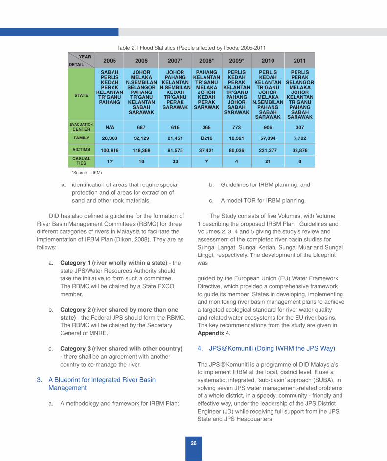
26
ix. identification of areas that require special protection and of areas for extraction of sand and other rock materials.
DID has also defined a guideline for the formation of River Basin Management Committees (RBMC) for three different categories of rivers in Malaysia to facilitate the implementation of IRBM Plan (Dikon, 2008). They are as follows:
a. Category 1 (river wholly within a state) - the state JPS/Water Resources Authority should take the initiative to form such a committee. The RBMC will be chaired by a State EXCO member.
b. Category 2 (river shared by more than one state) - the Federal JPS should form the RBMC. The RBMC will be chaired by the Secretary General of MNRE.
c. Category 3 (river shared with other country) - there shall be an agreement with another country to co-manage the river.
3. A Blueprint for Integrated River Basin Management
a. A methodology and framework for IRBM Plan;
b. Guidelines for IRBM planning; and
c. A model TOR for IRBM planning.
The Study consists of five Volumes, with Volume 1 describing the proposed IRBM Plan Guidelines and Volumes 2, 3, 4 and 5 giving the study’s review and assessment of the completed river basin studies for Sungai Langat, Sungai Kerian, Sungai Muar and Sungai Linggi, respectively. The development of the blueprint was
guided by the European Union (EU) Water Framework Directive, which provided a comprehensive framework to guide its member States in developing, implementing and monitoring river basin management plans to achieve a targeted ecological standard for river water quality and related water ecosystems for the EU river basins. The key recommendations from the study are given in Appendix 4.
4. JPS@Komuniti (Doing IWRM the JPS Way)
The JPS@Komuniti is a programme of DID Malaysia’s to implement IRBM at the local, district level. It use a systematic, integrated, ‘sub-basin’ approach (SUBA), in solving seven JPS water management-related problems of a whole district, in a speedy, community - friendly and effective way, under the leadership of the JPS District Engineer (JD) while receiving full support from the JPS State and JPS Headquarters.
Table 2.1 Flood Statistics (People affected by floods, 2005-2011
STATE
EVACUATIONCENTER
FAMILY
VICTIMS
CASUALTIES
*Source : (JKM)
SABAHPERLISKEDAHPERAK
KELANTANTR’GANUPAHANG
2005YEAR
DETAIL
JOHORMELAKA
N.SEMBILANSELANGORPAHANGTR’GANUKELANTANSABAH
SARAWAK
JOHORPAHANGKELANTANN.SEMBILANKEDAHTR’GANUPERAK
SARAWAK
PAHANGKELANTANTR’GANUMELAKAJOHORKEDAHPERAK
SARAWAK
PERLISKEDAHPERAK
KELANTANTR’GANUPAHANGJOHORSABAH
SARAWAK
PERLISKEDAH
KELANTANTR’GANUJOHORMELAKA
N.SEMBILANPAHANGSABAH
SARAWAK
PERLISPERAK
SELANGORMELAKAJOHOR
KELANTANTR’GANUPAHANGSABAH
SARAWAK
N/A 687 616 365 773 906 307
26,300 32,129 21,451 B216 18,321 57,094 7,782
100,816 148,368 91,575 37,421 80,036 231,377 33,876
17 18 33 7 4 21 8
2006 2007* 2008* 2009* 2010 2011
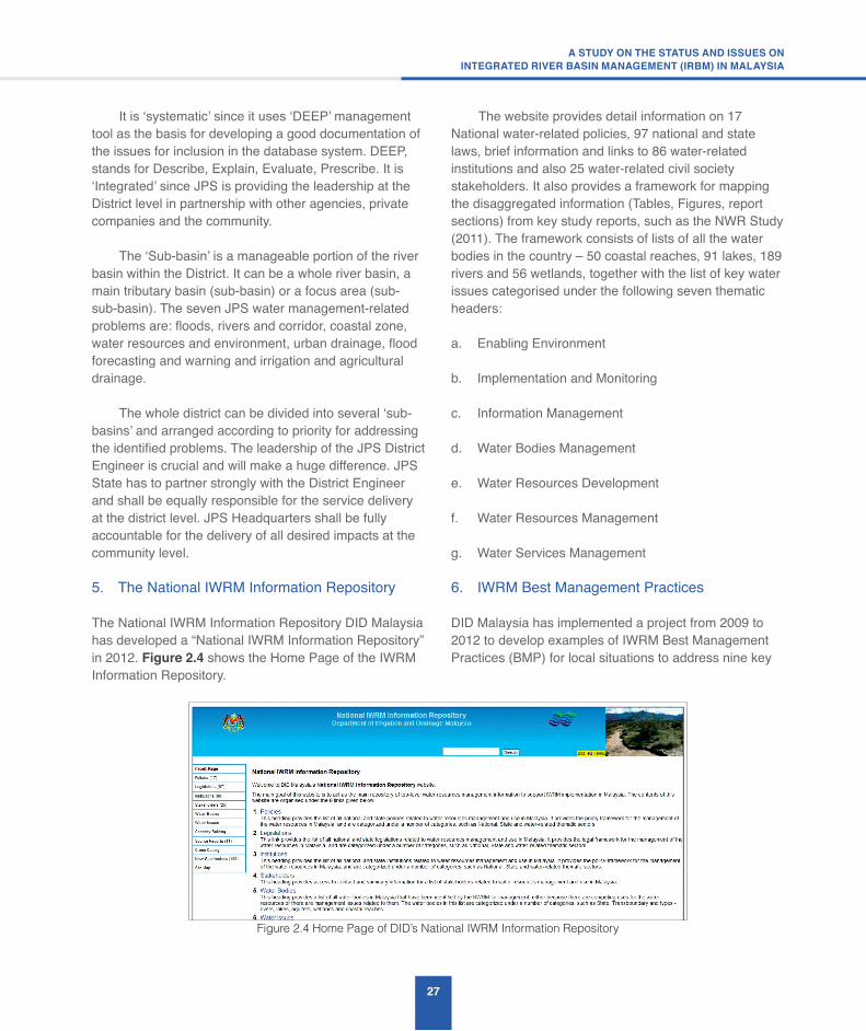
27
A STUDY ON THE STATUS AND ISSUES ONINTEGRATED RIVER BASIN MANAGEMENT (IRBM) IN MALAYSIA
It is ‘systematic’ since it uses ‘DEEP’ management tool as the basis for developing a good documentation of the issues for inclusion in the database system. DEEP, stands for Describe, Explain, Evaluate, Prescribe. It is ‘Integrated’ since JPS is providing the leadership at the District level in partnership with other agencies, private companies and the community.
The ‘Sub-basin’ is a manageable portion of the river basin within the District. It can be a whole river basin, a main tributary basin (sub-basin) or a focus area (sub-sub-basin). The seven JPS water management-related problems are: floods, rivers and corridor, coastal zone, water resources and environment, urban drainage, flood forecasting and warning and irrigation and agricultural drainage.
The whole district can be divided into several ‘sub-basins’ and arranged according to priority for addressing the identified problems. The leadership of the JPS District Engineer is crucial and will make a huge difference. JPS State has to partner strongly with the District Engineer and shall be equally responsible for the service delivery at the district level. JPS Headquarters shall be fully accountable for the delivery of all desired impacts at the community level.
5. The National IWRM Information Repository
The National IWRM Information Repository DID Malaysia has developed a “National IWRM Information Repository” in 2012. Figure 2.4 shows the Home Page of the IWRM Information Repository.
The website provides detail information on 17 National water-related policies, 97 national and state laws, brief information and links to 86 water-related institutions and also 25 water-related civil society stakeholders. It also provides a framework for mapping the disaggregated information (Tables, Figures, report sections) from key study reports, such as the NWR Study (2011). The framework consists of lists of all the water bodies in the country – 50 coastal reaches, 91 lakes, 189 rivers and 56 wetlands, together with the list of key water issues categorised under the following seven thematic headers:
a. Enabling Environment
b. Implementation and Monitoring
c. Information Management
d. Water Bodies Management
e. Water Resources Development
f. Water Resources Management
g. Water Services Management
6. IWRM Best Management Practices
DID Malaysia has implemented a project from 2009 to 2012 to develop examples of IWRM Best Management Practices (BMP) for local situations to address nine key
Figure 2.4 Home Page of DID’s National IWRM Information Repository

28
water management themes in the country. They are ranked in order of importance by stakeholders as follows:
1. River water quality
2. Catchment/Land use management
3. Flooding
4. Institutional arrangement
5. River corridor management
6. Wetlands management
7. Water borne diseases
8. Biodiversity
9. Groundwater
The objectives of the BMP are as follows:
a. create awareness and generate advocacy in IWRM throughout the country;
b. facilitate capacity building among key implementing agencies that are involved in IWRM; and
c. develop and demonstrate Best Management Practices (BMPs) in IWRM that are appropriate to the Malaysian context.
7. Stakeholder Participation and Environmental Awareness Programmes
The “National Study for the Effective Implementation of IWRM in Malaysia” was completed by DID in 2008. Volume II of the Study describes the current environmental awareness in Malaysia together with the list of awareness programmes implemented. It also recommends a list of IWRM awareness programmes to be carried out. Figure 2.5 shows the Table of Contents (TOC) for the environmental awareness Programmes that have been implemented, whereas Figure 2.6 shows the proposed IWRM awareness Programmes recommended for implementation.
2.2.2 River Basin Management Initiatives by DOE Malaysia
The following is a list of key river basin management initiatives carried out by DOE Malaysia:
1. River Basin Studies
DOE has completed a number of river basin plans related to river pollution management and water quality. The following is a list of the plans that were completed up till 2009:
1. Kajian Pencegahan Pencemaran & Peningkatan Kualiti Air Sungai Langat (2001)
Figure 2.6 TOC from the “National Study for the Effective Implementation of IWRM in Malaysia”
showing the recommended IWRM awareness programmes
CHAPTER 6 PROPOSED IWRM AWARENESS Programmes (For Implementation)6.1 INTRODUCTION 6.2 “WATER RESOURCES MONTH” 6.2.1 Programme 1 Activities
6.2.2 Programme 2 Activities
6.3“WATER RESOURCES” EXHIBITS 6.4 “WATER RESOURCES FACILITIES INFORMATION CENTER” 6.4.1 Example 1 : Batu Dam, Gombak, Selangor
6.5 CULTURAL & RELIGIOUS FESTIVALS6.6 MEDIA & MATERIALS 6.6.1 “Water Resources Expeditions”
6.6.2 Television and Radio Broadcast (Talk Shows)
6.6.3 TV Pendidikan (Catch the Culprit)
6.7 LOCAL COMMUNITY INVOLVEMENT THROUGH RIVER ADOPTION 6.7.1 River Adoption in Rural areas
6.7.2 Urban River Adopting Through “River Park”
6.8 PUBLIC “CERAMAH”6.9 Ceramah KEMAS 6.9.1 Religious Ceramah
6.10 INTEGRATED WATER RESOURCES CERAMAH TO SCHOOLS
115116117119119120120121122122126126
127127128129129130131
Figure 2.5 TOC from the “National Study for the Effective Implementation of IWRM in Malaysia”
showing the list of environmental awareness programme simplemented
CHAPTER 3 CURRENT IWRM AWARENESS LEVELS & Programme3.1 INTRODUCTION 3.2 NATIONAL NEEDS ASSESSMENT SURVEY 3.3 CURRENT GENERAL AWARENESS LEVELS IN IWRM 3.4 LONG TERM AWARENESS Programme 3.4.1 “Love Our Rivers” Campaign (Cintailah Sungai Kita)
3.4.2 One State One River (Department of Irrigation & Drainage)
3.4.3 Integrated River Basin Management (Department of
Irrigation & Drainage)
3.4.4 Sekolah Lestari (Department of Environment)
3.4.5 Bandar Lestari (Department of Environment)
3.4.6 Local Agenda 21 Malaysia
3.4.7 National Recycling Campaign
3.4.8 Modernisation Programme of Paddy Irrigation (JPS)
3.4.9 Sewerage Educational Programme for Secondary Schools
(Indah Water Konsortium Sdn. Bhd.)
10101112131517
182020222324
29
A STUDY ON THE STATUS AND ISSUES ONINTEGRATED RIVER BASIN MANAGEMENT (IRBM) IN MALAYSIA
2. Kajian Pencegahan Pencemaran & Peningkatan Kualiti Air Sungai Tebrau Dan Sungai Segget (2002)
3. Kajian Pencegahan Pencemaran & Peningkatan Kualiti Air Sungai Melaka, Melaka (2003)
4. Kajian Pencegahan Pencemaran & Peningkatan Kualiti Air Sungai Cameron Highlands (2004)
5. Kajian Pencegahan Pencemaran & Peningkatan Kualiti Air Batang Rajang, Sarawak (2004)
6. Kajian Pencegahan Pencemaran & Peningkatan Kualiti Air Sungai Merbok, Kedah (2007)
7. Kajian Pencegahan Pencemaran & Peningkatan Kualiti Air Lembangan Sungai Kinabatangan, Sabah (2007)
8. Kajian Pencegahan Pencemaran & Peningkatan Kualiti Air Sungai Sepetang (2008)
9. Kajian Pencegahan Pencemaran & Peningkatan Kualiti Air Sungai Linggi (2008)
10. Kajian Pencegahan Pencemaran & Peningkatan Kualiti Air Lembangan Sungai Kuantan, Pahang (2009)
11. Kajian Inventori Lembangan Sungai Buloh, Selangor (2009)
12. Kajian Inventori Sungai Sarawak, Sarawak (2009)
2. River Water Quality Monitoring
DOE is responsible for river water quality monitoring in Malaysia and has initiated a river water quality monitoring programme in 1978 for 120 of the 189 main rivers in the country (Ibarahim & Lee 2004). The 120 rivers were chosen to be included in the programme based on their beneficial uses and economic importance. A total of 926 river water quality monitoring stations were established within the 120 river basins. The appraisal of the water quality in each river basin is based on the
Water Quality Index (WQI), consisting of parameters such as Dissolved Oxygen (DO), Biochemical Oxygen Demand (BOD), Chemical Oxygen Demand (COD), Ammoniacal Nitrogen (NH3N), Suspended Solids (SS) and pH.
An assessment of the river water quality trend from 1993 to 2003, for the 120 river basins, has been carried out by DOE. It was found that the number of polluted rivers has increased from 7 in 1990 to 13 in 1999, while the number of clean rivers had decreased from 48 in 1990 to 35 in 1999. The results of the analysis revealed that the deterioration of the river water quality in the country was due mainly to the following:
a. discharges of sewage and domestic waste water;
b. animal farming;
c. land clearing and earthworks;
d. agricultural and manufacturing activities
e. domestic waste water;
f. surface run-off from urban areas;
g. discharges from restaurant, wet markets and food courts;
h. pollution from agricultural and land clearing activities; and
i. suspended solids and silts from earthwork and sand mining, which are the main Non-point Polluting Sources (NPS).
3. Pollution Prevention and River Water Quality Improvement Programme
The deteriorating trend of river water quality had prompted DOE to implement a Programme known as the “Pollution Prevention and River Water Quality Improvement Programme” with the objective to rehabilitate rivers with serious pollution problems so as to ultimately meet their beneficial uses. A total of 26 river basins were identified to be included in the Programme,

30
with Sungai Langat, Sungai Segget, Sungai Tebrau, Sungai Melaka, Batang Rajang and the river systems in Cameron Highlands which were selected for initial detailed feasibility studies (Ibrahim & Lee 2004).
The key objectives of the Programme are follows:
a. To identify all the point sources and non-point sources of pollution in the subject river basin and to determine the pollution loads and their impact on water quality of that river;
b. To prepare and to implement plans of action for the rehabilitation and improvement of river water quality from the polluted/slightly polluted category to clean category according to the water quality classification for purposes of potable water supply, recreational activities and tourism; and
c. To conserve and continuously maintain the clean status of river water quality after the rehabilitation and quality improvement works have been completed.
The Programme has four stages of activities, which are as follows:
a. Firstly, a detail study of the river basin in terms of pollution sources and impact on the quality of the water in the basin was carried out.
b. Secondly, based on the findings of the study action plans to reduce, prevent and abate pollution; action plans for enhancement of water quality and the river system for beneficial uses such as water supply, recreational and tourism products are to be formulated.
c. Thirdly, the accepted action plans will be presented to various responsible agencies for funding application and allocation for implementation.
d. Finally, the operational and maintenance plans to ensure conservation and sustainability of the achieved water quality have to be implemented.
The findings from the studies carried out on Sungai Segget, Sungai Tebrau, and Sungai Langat Basins have clearly identified that sewage remains as the main single source of pollution in term of organic pollution loads. Non-point pollution sources and industries are other major contributors to pollution of Sungai Langat. The findings led to the assumption that a similar trend may occur for many other river basins of similar land use within their catchment areas. The Action Plans for the pollution prevention and river water quality improvement of Sungai Langat, Sungai Segget and Sungai Tebrau have been completed in the year 2002.
Among the measures proposed in the Action Plans included: industrial pollution control measures; upgrading of the existing large sewage treatment plants; building of new modern mechanical treatment plants to cater for the increasing number of population; in-stream measures comprising of Gross Pollutant Traps (GPTs) placed at strategic locations to arrest floating solid waste prior to discharge into rivers; legal and institutional measures; as well as environmental awareness campaigns.
2.2.3 River Basin Management Initiatives by SWMA/LUAS
The Selangor Waters Management Authority (SWMA/LUAS) started as a Cabinet Minister’s order in July 1997 which requested the Agricultural Ministry and the Selangor State Government to set up an agency to be responsible for managing river and water sources in an integrated manner by taking the Sungai Selangor as a pilot project with the Thames River in the United Kingdom as a model. Subsequently, the Selangor Waters Management Authority (SWMA/LUAS) SWMA Enactment was approved by the Selangor State Legislative Assembly on 9 April 1999. The SWMA was initiated to promote the river basin management approach as highlighted in page 545 of the 8th Malaysia Plan (2001-2005) - Chapter 19: Environment and Sustainable Resource Management).
31
A STUDY ON THE STATUS AND ISSUES ONINTEGRATED RIVER BASIN MANAGEMENT (IRBM) IN MALAYSIA
The objectives of the SWMA/LUAS are as follows:
a. To ensure the water resources and environmental surrounding is in a manageable and sustainable condition, in order to support the socio-economic development of the progressive state
b. To undertake the function of planning, research, facilitator, coordinator, operation, enforcement, supervision in the development of integrated management of water resources and environment
c. To provide an environment that is conducive for public and private sector participation in the development, utilization and management of water resources and environmental surroundings taking into consideration the interests of the public and the State Government
d. To create the public awareness and the participation of the public on the importance of water resources and in caring and enhancing the quality of water
The SWMA/LUAS Enactment provides the SWMA the following four provisions for river conservation by regulating activities affecting the river and its water resources. which are:
a. Power to gazette for protection
b. Requirement to consult
c. Approval requirement/Permission
d. Power to impose work order Since its formation in 1999 LUAS has managed to implement a number of activities to achieve its objectives. Appendix 5 provides the details on LUAS’s activities and achievements to date. They can be summarised as follows:
1. Institutional Achievements
LUAS is a pioneering institution in river basin management in Malaysia that adopts the Integrated River Basin Management (IRBM) and Integrated Coastal Management (ICM) approach in its implementation. It has gained some international recognition for its activities. For example, LUAS has been selected by the Network for Asian River Basin Organisations (NARBO) to participate in NARBO’s 2013-2014 “River Basin Organisations Performance Benchmarking”.
2. Financial Achievements
LUAS depends on the State and the revenues from its regulatory activities for its finances. The Federal Government has been requested to provide support for LUAS in the implementation of its IRBM activities. Furthermore, LUAS has adopted the concept of “Payment for Environment Services (PES)” in the implementation of IRBM.
3. Development of IRBM Plans for river basins
a. Sungai Selangor IRBM Plan 2007-2012 – Gazetted 10 September 2009;
b. Sungai Selangor IRBM Plan 2013-2017 – The earlier IRBM Plan is now being updated; and
c. Sungai Langat IRBM Plan 2013-2017 – Under preparation
4. GazettementandEnforcementoftheLUASEnactment
a. Gazetted on 9 April, 1999;
b. Implemented on 11 May 2000 (partially) and fully on 22 May 2003;
c. Have developed and gazetted five subsidiary laws under the legal provisions of the Enactment, with two that are currently under preparation or in the process of gazettement; and
32
d. Gazettement of “zones of protection” under Section 48 for planning control of landuse activities within river basins.
5. Adoption and Implementation of Water Resources Policies
a. The National Water Resources Policy has been
endorsed by the National Water Resources Council in 2012. There is a need for each state to translate the policy for adoption and implementation in each state. For the State of Selangor the implementation of the Policy will be monitored by the LUAS Technical Committee that is chaired by the Selangor State Secretary and LUAS as the secretariat.
b. In this regard, the Selangor State Council has adopted on 23 May 2012 LUAS’s Policy paper on river management in the state. Moreover, the LUAS’s Board has approved on 18 June 2013 LUAS’s Policy paper on lake management in the state.
6. Development of river basin information system
a. Development of LUAS’s SCADA system known as the “Integrated Water Resources Information Management System (IWRIMS)” for real time data monitoring at seven dams in the state;
b. Development of LUAS’s GIS system known as E-LUAS for monitoring of activities in river basins;
c. Development of a “Decision Support System (DSS) for Sungai Selangor Basin” to support LUAS in its decision-making on water resources management in the Sungai Selangor basin; and
d. Installation of radar sensor flow equipment at Jalan Raja Muda Musa, Bestari Jaya, Kuala Selangor (in cooperation with DID Malaysia) for the monitoring of river water level and flow for Sungai Selangor.
7. Water source pollution monitoring mechanism
a. Quarterly meeting of the Water Source Pollution Task force consisting of members from different government agencies, with LUAS as the Secretariat;
b. Quarterly meeting of the State’s River Basin Management Committee, with LUAS as the Secretariat; and
c. Meeting of Water Source Emergency Committee to implement integrated action involving emergency stoppage of water treatment plants due to water source pollution or other causes.
8. Other Activities
a. Carry out studies such as monitoring of the firefly population in Sungai Selangor, groundwater feasibility study in Selangor, etc;
b. Carry out joint activities with other government agencies and stakeholders; and
c. Prepare and publish regular State of River reports for Sungai Selangor (2006, 2008, 2011), Sungai Langat (2008, 2011), Sungai Klang (2008, 2011).
2.2.4 River Basin Management Initiatives by DID Sabah and Sabah EPD
DID Sabah
Water resources management in Sabah is governed by the Sabah Water Resources Enactment (SWRE) 1998 (Ationg 2012). The SWRE arises from the recommendation of the Sabah Water Resources Master Plan which was completed in 1994 with technical support from Australia New South Wales’s Department of Water Resources. The motivation for the development of the Master plan arises from the National Water Resources Study completed in 1982 by DID Malaysia with technical assistance from JICA.
The SWRE was endorsed by the Sabah State Legislative Assembly in August 1998 and the role of

33
A STUDY ON THE STATUS AND ISSUES ONINTEGRATED RIVER BASIN MANAGEMENT (IRBM) IN MALAYSIA
“Water Resources Manager” in the SWRE was assigned to DID Sabah, with its Director given the responsibility of the SWRE’s Director of Water Resources. In 2005, the Director of DID Sabah was officially appointed the SWRE Director of Water Resources. The Sabah Water Resources Council chaired by the Chief Minister was established in February 2006.
The following are the key achievements of DID Sabah in the implementation of the SWRE up till 2012:
1. Creation of Water Resources Management Unit (WRMU)
DID Sabah has created a Water Resources Management Unit (WRMU) in 1998 to fulfil its responsibilities as the SWRE’s “Water Resources Manager” and to support its Director in carrying out the functions of the SWRE’s Director of Water Resources. DID Sabah’s WRMU water resources management activities cover the following ten areas:
a. Assessment of applications for water resources related activities
b. Implement catchment management in accordance with Part IV of the Sabah Water Resources Enactment (1998)
c. Develop water resources management policy
d. Develop and maintain a water resources information system
e. Implement education and awareness Programmes
f. Provide technical support to other natural resources management initiatives
g. Support other related institutions
h. River water quality monitoring
i. Prepare project/study proposals related to water resources management
j. Report on the status of the state’s water resources
The effectiveness of the WRMU in implementing the SWRE is affected by its limited human and technical resources. Thus, a proposal for the restructuring of DID Sabah was submitted and approved by Jabatan Perkhidmatan Awam (JPA) Sabah in September 2008. The proposed restructuring plan is now under review by JPA Malaysia.
2. Capacity-building of the Water Resources Management Unit (WRMU)
The WRMU builds the capacity of its staff in water resources management through the following Programmes which is in line with the recommendation of the Sabah Water Resources Master Plan:
• Pilot Study on Integrated Catchment Planning for Sungai Moyog by consultant from Australia
• Capacity Building Project in Integrated Catchment Planning for Sungai Padas with assistance from DANIDA
• Other agency’s related capacity building project
3. WRMU Services to Government Agencies
The WRMU provides assistance to other government agencies through the agencies existing mechanisms to assess applications that are related to water resources activities. The WRMU receives an average of around ten applications per week. The following is a list of the types of assessment carried out by the WRMU:
a. Assessment of land applications involving water cathment areas;
b. Assessment of TOL application for sand and gravel extractions in rivers and sea;
c. Assessment of EIA report on development proposal involving river and shore; and
d. Assessment of EIA report on activities with direct or indirect impacts on water resources.

34
4. WRMU Catchment Management Activities
In accordance with the requirements of Part IV of the Sabah Water Resources Enactment (SWRE) 1998, DID Sabah’s WRMU implements the following catchment management activities:
a. Capacity-building on Integrated Catchment Management (ICM);
b. Established District Catchment Management Committee (DCMC) in 15 Districts;
c. Carried out study on catchment area in 7 districts, with 6 in progress in other catchment areas;
d. Identified catchment issues and proposal to address the issues in 8 districts;and
e. Prepared draft catchment management plan for 5 catchment areas, with 6 in progress in other catchment areas.
Sabah Environment Protection Department (EPD)
The Sabah Environment Protection Department in the Ministry of Tourism, Culture and Environment, Sabah has also carried out the following studies:
a. Impact Study of Palm Oil Mills, Oil Palm Plantations and other Pollutants on the Quality of Selected Rivers in Sabah
b. Guidelines for Minimising Impacts of Oil Palm Plantations and Palm Oil Mills on Quality of Rivers in Sabah
c. Guidelines for Minimising Impacts of Sand Mining on Quality of Rivers in Sabah
d. Guidelines for Minimising Impacts of Riverine Settlements on Quality of Rivers in Sabah
2.2.5 River Basin Management Initiatives by Sarawak SPU
The Sarawak State Planning Unit (SPU) has developed an IWRM Master Plan for the state based on the outputs of the Sarawak IWRM Master Plan Study carried out in 2008/2009. The objective of the IWRM Plan is to provide resources and information to the various State Government Agencies in Sarawak so as to ensure that the Agencies’ decisions affecting water resources management in the state can be made based on the IWRM approach. The SPU has created a dedicated website to share the State’s IWRM Plan (http://www.siwrs.com.my/modules/iwrm/). The IWRM Master Plan covers the following thematic subjects:
a. River navigation
b. Irrigation water demand
c. Hydroelectric power dams
d. Processed hydrometric data
e. Water quality
f. Catchment management
g. Land use study
h. Forestry
i. Population projection
j. Groundwater resources
k. Proposed water resources development plans
l. Potable water demand projections
2.2.6 River Basin Management Initiatives by LSAN Kedah
The Kedah State Water Resources Enactment (2008) was gazetted on 27 March 2008 and was enforced on 1 June 2010. The Lembaga Sumber Air Negeri (LSAN) Kedah was created to implement the provisions of the Enactment. The LSAN Kedah started with 7 full-time staff
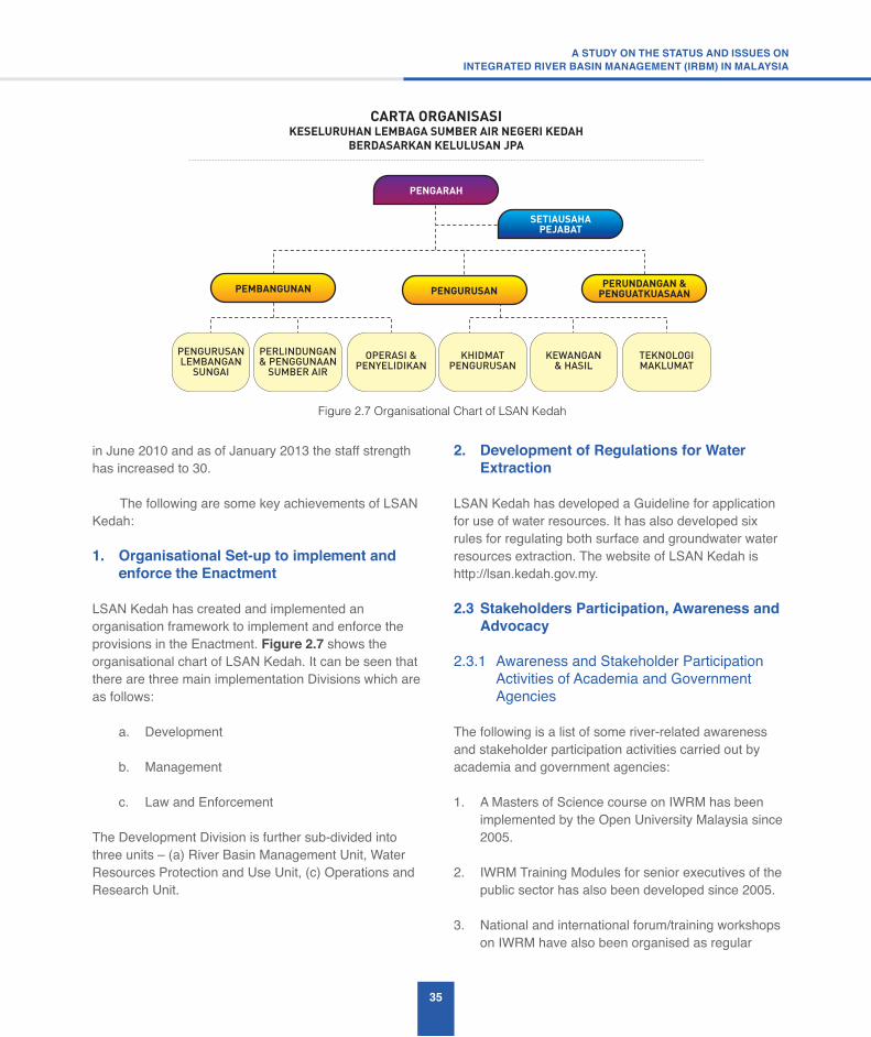
35
A STUDY ON THE STATUS AND ISSUES ONINTEGRATED RIVER BASIN MANAGEMENT (IRBM) IN MALAYSIA
in June 2010 and as of January 2013 the staff strength has increased to 30.
The following are some key achievements of LSAN Kedah:
1. Organisational Set-up to implement and enforce the Enactment
LSAN Kedah has created and implemented an organisation framework to implement and enforce the provisions in the Enactment. Figure 2.7 shows the organisational chart of LSAN Kedah. It can be seen that there are three main implementation Divisions which are as follows:
a. Development
b. Management
c. Law and Enforcement
The Development Division is further sub-divided into three units – (a) River Basin Management Unit, Water Resources Protection and Use Unit, (c) Operations and Research Unit.
2. Development of Regulations for Water Extraction
LSAN Kedah has developed a Guideline for application for use of water resources. It has also developed six rules for regulating both surface and groundwater water resources extraction. The website of LSAN Kedah is http://lsan.kedah.gov.my.
2.3 Stakeholders Participation, Awareness and Advocacy
2.3.1 Awareness and Stakeholder Participation Activities of Academia and Government
Agencies
The following is a list of some river-related awareness and stakeholder participation activities carried out by academia and government agencies:
1. A Masters of Science course on IWRM has been implemented by the Open University Malaysia since 2005.
2. IWRM Training Modules for senior executives of the public sector has also been developed since 2005.
3. National and international forum/training workshops on IWRM have also been organised as regular
Figure 2.7 Organisational Chart of LSAN Kedah
CARTA ORGANISASIKESELURUHAN LEMBAGA SUMBER AIR NEGERI KEDAH
BERDASARKAN KELULUSAN JPA
PENGARAH
PEMBANGUNAN PENGURUSAN
SETIAUSAHAPEJABAT
PERUNDANGAN &PENGUATKUASAAN
PENGURUSANLEMBANGAN
SUNGAI
PERLINDUNGAN& PENGGUNAAN
SUMBER AIR
OPERASI &PENYELIDIKAN
KHIDMATPENGURUSAN
KEWANGAN& HASIL
TEKNOLOGIMAKLUMAT

36
annual events by the universities and government agencies.
4. DID is working with the Global Environment Centre to implement the River Rangers Programme.
5. DOE has also implemented the Wira Alam Programme
6. JKR has also implemented a Public Awareness and Education Programme on Landslides and Slope Safety. The following is a brief description of the Programme.
“The JKR Public Awareness and Education Programme on Landslides and Slope Safety, which ran from 2008 to 2010, was carried out by JKR in an effort to stem the tide of landslides that was occurring throughout the country. The Programme targeted not only the communities in at-risk areas, but the general public, local authorities, state governments, schools, universities, and the media. This multi-pronged approach enabled a holistic approach to landslide risk mitigation, and the strong community participation enabled the initiative to sustain itself long after the government Programme ended. One of the strongest proponents of the Programme were the local authorities, some of which set up dedicated slope engineering units to better manage hazardous slopes within their jurisdiction. These dedicated units enabled local authorities to respond more quickly to reports of signs of landslides by the residents. In turn, an NGO on slope safety was created to educate residents on how to detect valid and legitimate signs of landslides for better quality reporting.”
2.3.2 Awareness and Advocacy Activities of NGOs:
The following is a list of some river-related awareness and advocacy activities implemented by NGOs:
1. Malaysian Water Partnership (MyWP)
MyWP (http://www.mywp.org.my) was formed in November 1997 to promote the participation of all stakeholders, including civil society, in the
water management of the country. The MyWP membership comprises of government agencies and departments, academic institutions and NGOs, including civil society organisations. MyWP implements its agenda on a partnership arrangement with other Government Organisations, Private Institutions and Companies, other NGOs, Academia as well as individuals. Within MyWP the IWRM capacity-building activities is carried out by the Malaysian Capacity Building Network for IWRM (MyCBNet).
2. Global Environmental Centre (GEC)
a. Nenggiri River Basin Conservation Programme
b. Pagoh River Auditing Programme
c. Sungai Klang Rehabilitation – River Ranger Programme
d. Sungai Penchala Rehabilitation Programme
e. Kelana Jaya Lake Rehabilitation Programme
Appendix 6 provide a brief description of the programmes and the following web-links provide details of some of the GEC’s Programmes:
• River Care Programme - River auditing, water auditing and bio-monitoring booklet
• SMART (Start Managing All Resources Today) Ranger – Developed a waste management module
• River Ranger Programme
• GEC & GAB Foundation Water Project: A Handbook in Urban River Management Through Local Community Participation

37
A STUDY ON THE STATUS AND ISSUES ONINTEGRATED RIVER BASIN MANAGEMENT (IRBM) IN MALAYSIA
3. World Wide Fund for Nature (WWF) Malaysia
a. WWF-Malaysia Strategy 2012-2020
b. Environmental Citizenship Study Report - A study based on 6090 respondents from different groups of the population, including teachers, university lecturers, teacher trainers, the media and industry, politicians, government officers, NGOs as well as students and other members of the public
c. Living Waters Programme (2002)
4. Water Watch Penang
a) (http://www.waterwatchpenang.org.) River Walk - Caring for our Rivers Campaign Water Conservation and Educational Programme Adopt a River Project:
b) The following is a list of some other NGOs in Malaysia that are also implementing river-related awareness and advocacy activities:
1. Malaysian Nature Society (MNS)
2. Wetlands International (WI)
3. Malaysian Water Association (MWA)
4. Selangor Water association (SWAN)
5. Environmental Protection Society of Malaysia (EPSM)
6. Environmental Management & Research Association of Malaysia (ENSEARCH)
7. Sahabat Alam Malaysia (SAM)
8. Centre for Environmental Technology and Development (CETDEM)
2.3.3 Awareness and Advocacy Activities of Private Sector Organisations
The following is a list of some river-related awareness and advocacy activities implemented by private sector organsiations:
1. GAB Foundation’s W.A.T.E.R Project (Sungai Way Rehabilitation & Sungai Kinta River Education Project)
2. HSBC (Sungai Pinang River Care Programme)
3. Coca-Cola & Malaysian Nature Society (Water Vision Programme)
4. Indah Water Konsortium (Sewerage Educational Programme for Secondary Schools)
5. Puncak Niaga Sdn Bhd (River Rescue Brigade - Kelab Penyelamat Sungai)

38

ENABLING ENVIRONMENT
ISSUES 3

40
3.1 Policy – Status, Issues and Ideas
3.1.1 Policy Status
Figure 2.1 shows a spiral roadmap of the implementation of the IWRM approach in Malaysia. It shows the historical evolution of the IWRM approach in the country over the past two decades as listed below, culminating in the National Water Resources Policy in 2012.
1. (1993) – Awareness programme, such as “Love our rivers programme”
2. (1998) – Formation of National Water Resources Council
3. (1999/2000) – National Water Vision and the Formation of state apex water resources management organisation in Selangor and Sabah (LUAS, SWRE)
4. (2001) – Urban Stormwater Management Manual (MSMA)
5. (2002) – National sewerage project and National strategic plan for solid waste management
6. (2003) – Study on Integrated Management of Sungai Damansara catchment
7. (2005) – National Study on Effective Implementation of IWRM in Malaysia
8. (2007) – Water Services Industry Act and formation of the National Water Services Commission
9. (2009) – Implementation of IWRM BMP pilot projects
10. (2009/2010) – Review and updating of the 1982 National Water Resources Study
11. (2012) – National Water Resources Policy
Thus, it can be seen that there is a National Water Resources policy to guide the water resources management in the country, in which the IRBM approach in river basins will be guided by IWRM principles. Apart from that, states such as Sabah, Selangor and Kedah
have also enacted specifc water resources management policy and laws to manage the water resources in their respective states based on the IWRM approach.
3.1.2 Policy Issues
The key policy issues are as follows:
a. Implementation of NWR Policy at State-level
With the official endorsement of the NWR Policy by the NWR Council in which each state is represented by their respective chief minister, there is a need now to translate the National Water Resources (NWR)Policyintospecificstate-levelwaterresources policy that will support the integrated management of water resources in each state.
This is because water resources is a state matter as defined in the National Constitution. For states that have enacted specific state-level water resources policies and laws, such as Selangor, Sabah and Kedah, this is not a key issue. However, for those states that do not have any specific state-level water resources management policy there is a need to define their specific state-level water resources management policy that is coherent with the NWR Policy. In turn, this will then provide the basis for the development of the Federal/State level partnerships for the implementation of IWRM compliant approaches in each state, which shall include the implementation of IRBM in each state.
b. Development of Federal/State level partnerships to implement NWR Policy
The NWR Policy has four specific policy core areas, in which Policy Core Area 3: Partnerships, with its two policy Thrusts, Targets and Strategic Actions are reproduced below. There is a need to identify and develop the details of the specific Federal/State level partnerships to facilitate the implementation of IWRM compliant approaches in each state.

41
A STUDY ON THE STATUS AND ISSUES ONINTEGRATED RIVER BASIN MANAGEMENT (IRBM) IN MALAYSIA
Policy Directions for Core Area 3: Partnerships
“Water resources governance requires the collective action of all stakeholders, which does not only include government mandate holders. The central idea here is that, to give effect to integrated approaches already adopted in Malaysia such as the integrated water resources management and integrated river basin management, these integrated approaches must be adopted nationwide, and key to adoption is integrating governance measures. What is important to note here is that through collaboration and partnership, the task of governing water resources can be shared. Effective governance requires structured mechanisms and platforms as well as processes to facilitate involvement and participation. Important too are the processes that provide the means to get involve, participate and collaborate.”
Thrust 7 : Stakeholder Inclusiveness and Engagement
Target 15 : Establishment of mechanisms for formal and informal consultation on matters related to water resources
1. Strategy: Identify stakeholders and clarify roles as well as responsibilities
a. Strategic Action Plan;
b. Identify and profile stakeholders;
c. Identify common objectives, goals and targets for local water resources use and conservation; and
d. Identify and profile roles and responsibilities and options for shared responsibilities and collaboration.
2. Strategy: Develop means and measures for consultation
a. Strategic Action Plan:
b. Identify channels of formal and informal communication networks;
c. Identify options to strengthen collaborations, consultations and stakeholder engagement platforms and processes; and
d. Develop consultation processes in local water plans development for integrated and concerted actions related to sustainable use and conservation of water resources.
Thrust 8 : Shared Water Resources Governance
Target 16 : Develop framework for stakeholder collaboration in water resources governance
Strategy: Determine means, measures and approaches for collaborative governanceStrategic Action Plan:
i. Identify processes and procedures that can be integrated to ensure shared governance of water resources;
ii. Identify options for the formation of formal and informal shared and collaborative partnership platforms;
iii. Identify channels of formal and informal communication networks;
iv. Review and reconcile the prerequisites in adopted and accepted approaches for water resources conservation and management such as IWRM, IRBM, IFM, ILM etc;
v. Identify and implement on pilot basis joint projects that promote accepted approaches for water resources management such as IWRM and IRBM;
vi. Strengthen Programmes on awareness and the need for shared responsibility; and
vii. Identify platforms for resolution of conflicts and competing interests.
42
3.1.3 Policy Ideas
The following are some ideas to address the identified policy issues:
a. Implementation of NWR Policy at State-level
1. DID Malaysia shall conduct state-level dialogues and workshops to create awareness of the NWR Policy so as to identify and develop the specific framework for Federal/State level partnerships to implement the NWR Policy in each State.
2. Arising from such a developed Federal/State level partnership framework the State can then develop its specific state-level water resources management policy that is compliant with the NWR Policy.
b. Development of Federal/State level partnerships to implement NWR Policy
DID Malaysia shall implement the strategic actions for the three strategies identified in the NWR Policy’s Strategic Targets 15 and 16 as listed below:
1. Identify stakeholders and clarify roles as well as responsibilities;
2. Develop means and measures for consultation; and
3. Determine means, measures and approaches for collaborative governance.
3.2 Legislation – Status, Issues and Ideas
3.2.1 Legislation Status
Currently, the various aspects related to IWRM and IRBM approaches are covered under many laws, such as the EQA, Forestry, Geological Survey and Fisheries. There is a need for a holistic water law to implement the IWRM and IRBM principles and approaches in the country. A number of states have enacted State legislation to govern certain aspects related to water resources, e.g. Kedah, Melaka, Negeri Sembilan, Pahang, Sabah, Sarawak and Selangor. The lack of uniformity or
consistency between all the state water laws is a cause for concern. The primary objective of the Waters Act 1920 is to ensure greater uniformity in the governance of rivers by all states.
As part of the review of the NWR Study of 2000, which was completed in 2010, a draft National Water Resources law was developed to complement the National Water Resources policy that was developed. Section 2.1.4 provides a summary of key points on the draft National Water Resources Legislation. The draft National Water Resources Law has been developed as a “model law” for all states. This is to facilitate the adoption of the Law by those states that currently do not have any comprehensive water law to ensure uniformity with the National Water Resources Law.
3.2.2 Legislation Issues
The key legislation issues are as follows:
a. OfficialenactmentofthedraftNationalWater Resources Law
There is a need for the draft National Water Resources Law to be enacted by the national legislature as soon as possible so that the proposed institutional framework for the implementation of the law can be set-up to facilitate the implementation of IWRM compliant policies in the country.
b. OfficialadoptionoftheLawbystatelegislature
The draft National Water Resources Law has been developed based on the following guiding principles so that it can be adopted as a State law upon adoption by the state legislature. Thus, once the National Water Resources Law is enacted there is a need for each state legislature to officially adopt the Law before it can take effect in each state:
1. Pursuant to Article 76(1) of the Federal Constitution, Parliament may adopt a law to ensure uniformity among all states.

43
A STUDY ON THE STATUS AND ISSUES ONINTEGRATED RIVER BASIN MANAGEMENT (IRBM) IN MALAYSIA
2. The Law will be in strict conformity with the jurisdictions of the Federal and State Government as enshrined in the Constitution.
3. The Law shall only come into effect in any State
(other than the Federal Territories), after the State legislature adopts the Act and converts it into State law.
4. The Law shall take into account existing enactments in some States on water resources.
5. The Federal Law must be consistent with and shall give effect to the proposed National Water Resources Policy and Institutional set up.
6. The Federal Law will leverage on existing State laws (e.g. Land Conservation Act) and other Federal laws (e.g. EQA) and avoid duplication or conflict with such laws.
3.2.3 Legislation Ideas
The following are some ideas to address the identified legislation issues:
a. OfficialenactmentofthedraftNationalWaterResources Law
DID Malaysia shall work with the relevant government agency to get the draft National Water Resources Law enacted by the national legislature as soon as possible.
b. OfficialadoptionoftheLawbystatelegislature
DID Malaysia shall work with the relevant state government agency to get the National Water Resources Law adopted by the state legislature, once the Law has been enacted by the national legislature.
3.3 Institution – Status, Issues and Ideas
3.3.1 Institution Status
The Federal Constitution has defined the jurisdiction of the Federal and State Governments over water resources. They are as follows:
a. States have jurisdiction over water resources and related aspects such as land, forest, agriculture and rivers.
b. Federal Government also has jurisdiction over the following matters related to water resources:
i. International treaties and agreements
ii. Transboundary rivers
iii. Transfer of water (if not resolved between states)
iv. Data and information collection and management
v. Scientific research
vi. Setting of national standards, safety and security
Thus, the current institutional status for water resources management in the country can be summarised as follows:
1. Each state is responsible for the management of its own water resources. Thus, some states have created their own state water resources management organisations to manage their water resources, such as Selangor, Sabah and Sarawak. Meanwhile, other states depend on the Federal Government’s water-related technical departments to provide the necessary technical support for the management of their state’s water resources.
2. The key Federal water-related technical departments are as follows:

44
i. Department of Irrigation and Drainage (DID) for the physical management of rivers and coastal water resources.
ii. Department of Environment (DOE) for the management of the water quality of the rivers, lakes, coastal and ground water resources.
iii. Department of Mineral and Geosciences (DMG) for the physical management of ground water resources.
3. To facilitate coordination and uniformity of decision-making on water resources among the states the National Water Resources Council (NWRC) was set-up in 1998. The NWRC was chaired by the Prime Minister until 2009 when it was transferred to the Deputy Prime Minister. The other NWRC members are as follows:
i. Minister of Finance;
ii. Minister of Natural Resources and Environment (MNRE);
iii. Minister of Energy, Green Technology and Water (KeTTHA);
iv. Minister of Works; Minister of Agriculture and Agro-based Industry (MOA);
v. Minister of Federal Territories and Urban Well-being;
vi. Minister of Housing and Local Government (KPKT);
vii. Minister of Plantation Industries and Commodities;
viii. Menteri Besars of Perlis, Kedah, Perak, Selangor, Negeri Sembilan, Johor, Pahang, Terengganu and Kelantan; and
ix. Chief Ministers of Pulau Pinang, Melaka, Sabah and Sarawak.
The roles and functions of the NWRC are as follows:
i. Water management on a national basis to ensure long-term sustainability of water supply;
ii. Resolution of water resource disputes among states, including the establishment of a mechanism for agreeing of terms;
iii. Address legal and other issues needed to allow the increase use of water through inter-basin and inter-state water transfers;
iv. Coordinate the implementation of water resources development projects;
v. Advise State Governments on the conservation, control and gazettal of water catchments areas;
vi. Water resources data management;
vii. Act as an apex body for water resources governance;
viii. Set general policy directions on water resources (planning, development and management);
ix. Inter-State matters and state water-related matters requiring advice and recommendations; and
x. All international water-related matters.
4. The institutional arrangement for water resources management in each state (as of July 2011) can be categorised into four categories, as listed below:
Category 1: Fully developed and implemented (Fully functional with institutional structures addressing most aspects of water resources management) (Selangor (LUAS), Kedah, Sabah, Sarawak)
Category 2: Developed and/or need refinement and/or to be implemented (All have been mandated
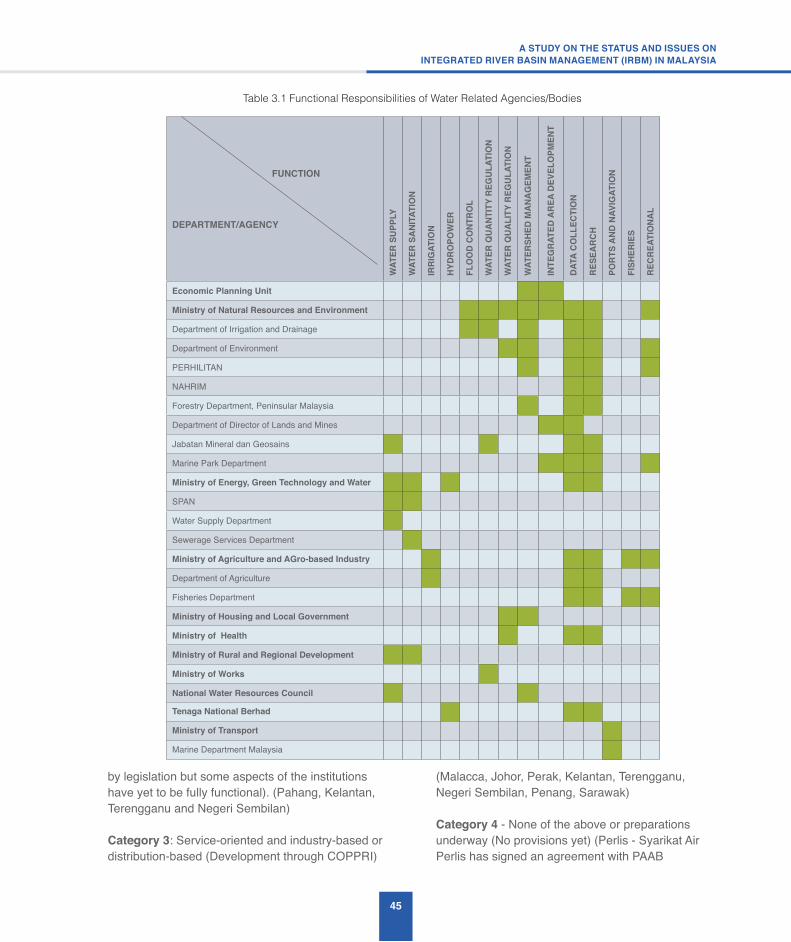
45
A STUDY ON THE STATUS AND ISSUES ONINTEGRATED RIVER BASIN MANAGEMENT (IRBM) IN MALAYSIA
by legislation but some aspects of the institutions have yet to be fully functional). (Pahang, Kelantan, Terengganu and Negeri Sembilan)
Category 3: Service-oriented and industry-based or distribution-based (Development through COPPRI)
(Malacca, Johor, Perak, Kelantan, Terengganu, Negeri Sembilan, Penang, Sarawak)
Category 4 - None of the above or preparations underway (No provisions yet) (Perlis - Syarikat Air Perlis has signed an agreement with PAAB
Table 3.1 Functional Responsibilities of Water Related Agencies/Bodies
FUNCTION
DEPARTMENT/AGENCY
WAT
ER S
UPPL
Y
WAT
ER S
ANIT
ATIO
N
IRRI
GAT
ION
HYDR
OPO
WER
FLO
OD
CONT
ROL
WAT
ER Q
UANT
ITY
REG
ULAT
ION
WAT
ER Q
UALI
TY R
EGUL
ATIO
N
WAT
ERSH
ED M
ANAG
EMEN
T
INTE
GRA
TED
AREA
DEV
ELO
PMEN
T
DATA
CO
LLEC
TIO
N
RESE
ARCH
PORT
S AN
D NA
VIG
ATIO
N
FISH
ERIE
S
RECR
EATI
ONA
L
Economic Planning Unit
Ministry of Natural Resources and Environment
Department of Irrigation and Drainage
Department of Environment
PERHILITAN
NAHRIM
Forestry Department, Peninsular Malaysia
Department of Director of Lands and Mines
Jabatan Mineral dan Geosains
Marine Park Department
Ministry of Energy, Green Technology and Water
SPAN
Water Supply Department
Sewerage Services Department
Ministry of Agriculture and AGro-based Industry
Department of Agriculture
Fisheries Department
Ministry of Housing and Local Government
Ministry of Health
Ministry of Rural and Regional Development
Ministry of Works
National Water Resources Council
Tenaga National Berhad
Ministry of Transport
Marine Department Malaysia

46
regarding water assets in 2010 and the 3 Federal Territories - No provisions yet except in Putrajaya)
5. DID has also developed and implemented the ‘One-State-One-River (1S1R)’ programme to support the implementation of river basin plans in each state. However, due to the current institutional limitations faced by DID the Programme faced a number of institutional challenges to implement the recommended river basin action plans and also could not scale effectively across the state and country.
6. DID has also implemented the JPS@Komuniti Programme within DID as a ‘Bottom-Up’ approach to overcome the current institutional limitations of the ‘Top-Down’ approach to implement the river basin plans. The Programme is an attempt to kick start the implementation of IRBM at the local district level. The Programme requires all DID District offices to identify key sub-basins within their districts, identify the key sub-basin water management issues faced by them, compile the necessary sub-basin information and prepare the sub-basin maps to support their decision-making based on the IRBM perspective.
3.3.2 Institution Issues
The key institutional issues have been identified in the NWRS Study (DID 2010). They involved the four institutional components that need to be aligned
to support the implementation of the National Water Resources (NWR) Policy 2012 and are as follows:
a. New Federal institutional structure for water governance
The NWRC is currently not formalised by legislation. This situation will change when the proposed NWR Law comes into effect. The proposed NWR Law has made provisions to formalise the NWRC with membership, roles and functions clearly defined by law. The NWRC provides a forum for direct Federal-State and inter-State communication on water issues, because all States are represented through their heads of States, who are members in the Council. When fully mandated, the NWRC can be a very effective apex body for water resources management in the country because of the membership in the Council.
b. Revision to the existing Institutional arrangement in all the States
The current institutional arrangement between the Federal and the States in terms of water resources management is fragile in terms of sharing common functions such as data collection, research and training. This situation has led to the non-integration of water resources management in the country. However, the relationship is very strong in terms of development of water projects where the states depend on the Federal Government for funding, expertise and management at the state level.
Figure 3.1 Separation of Water Resources and Water Services Sector after enactment of WSIA (2006)
Water Sector before Water Services Industry Act 2006a
DAM RIVER BALANCINGRESERVOIR
SERVICERESERVOIR CONSUMER
WATERTREATMENT
PLANTCATCHMENT
AREA
WATER SOURCE TREATMENT
STATE LIST FUNCTIONS
DISTRIBUTION
Water Sector after Water Services Industry Act 2008b
DAM RIVER BALANCINGRESERVOIR
SERVICERESERVOIR CONSUMER
WATERTREATMENT
PLANTCATCHMENT
AREA
WATER SOURCE TREATMENT
STATE LIST FUNCTIONS KeTTTHA / SPAN
DISTRIBUTION
Source: DID 2010
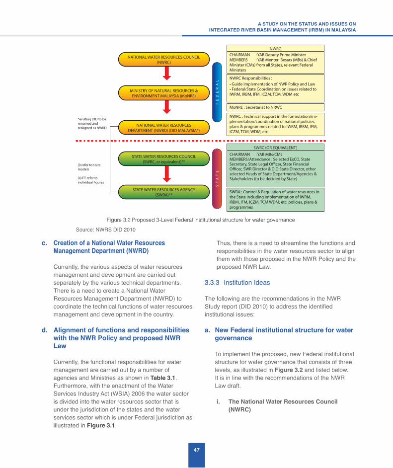
47
A STUDY ON THE STATUS AND ISSUES ONINTEGRATED RIVER BASIN MANAGEMENT (IRBM) IN MALAYSIA
c. Creation of a National Water Resources Management Department (NWRD)
Currently, the various aspects of water resources management and development are carried out separately by the various technical departments. There is a need to create a National Water Resources Management Department (NWRD) to coordinate the technical functions of water resources management and development in the country.
d. Alignment of functions and responsibilities with the NWR Policy and proposed NWR Law
Currently, the functional responsibilities for water management are carried out by a number of agencies and Ministries as shown in Table 3.1. Furthermore, with the enactment of the Water Services Industry Act (WSIA) 2006 the water sector is divided into the water resources sector that is under the jurisdiction of the states and the water services sector which is under Federal jurisdiction as illustrated in Figure 3.1.
Thus, there is a need to streamline the functions and responsibilities in the water resources sector to align them with those proposed in the NWR Policy and the proposed NWR Law.
3.3.3 Institution Ideas
The following are the recommendations in the NWR Study report (DID 2010) to address the identified institutional issues:
a. New Federal institutional structure for water governance
To implement the proposed, new Federal institutional
structure for water governance that consists of three levels, as illustrated in Figure 3.2 and listed below.
It is in line with the recommendations of the NWR Law draft.
i. The National Water Resources Council (NWRC)
Figure 3.2 Proposed 3-Level Federal institutional structure for water governance
NATIONAL WATER RESOURCES COUNCIL(NWRC)
MINISTRY OF NATURAL RESOURCES &ENVIRONMENT MALAYSIA (MoNRE)
NATIONAL WATER RESOURCESDEPARTMENT (NWRD) (DID MALAYSIA*)
STATE WATER RESOURCES COUNCIL(SWRC, cr equivalent)**
STATE WATER RESOURCES AGENCY(SWRA)**
FE
DE
RA
LS
TA
TE
*existing DID to be renamed and realigned as NWRD
(i) refer to state models
(ii) FT refer to individual figures
CHAIRMAN : YAB Deputy Prime MinisterMEMBERS : YAB Menteri Besars (MBs) & Chief Minister (CMs) from all States, relevant Federal Ministers
NWRC
CHAIRMAN : YAB MBs/CMsMEMBERS/Attendance : Selected ExCO, State Secretary, State Legal Officer, State Financial Officer, SWR Director & DID State Director, other selected Heads of State Department/Agencies & Stakeholders (to be decided by State)
SWRC (OR EQUIVALENT)
IWRM, IRBM, IFM, ICZM, TCM, WDM etc
NWRC Responsibilities :
NWRC : Technical support in the formulation/im-plementation/coordination of national policies, plans & programmes related to IWRM, IRBM, IFM, ICZM, TCM, WDM, etc
SWRA : the State including implementation of IWRM, IRBM, IFM, ICZM, TCM WDM, etc, policies, plans & programmes
MoNRE : Secretariat to NRWC
Source: NWRS DID 2010

48
ii. NWR Secretariat (NWRS) – The existing NWR Secretariat is currently co-shared between the MNRE and KeTTHA. Since water resource is part of natural resources it is proposed that the Secretariat be housed only in the MNRE because the MNRE is responsible for natural resources management.
iii. National Water Resources Department (NWRD) – This is a new department that has been proposed to implement the water resources management functions described in the NWR Law.
a. Provide and coordinate national policies on IWRM/IRBM;
b. Provide an avenue for consultation and coordination among various States and stakeholders;
c. Have vested powers to consider, adopt and make recommendations on national policies, plans and Programmes (the three PPPs as defined in the draft NWR LAW);
d. Provide directions to the MNRE, the NWRD and other related bodies on matters pertaining to IWRM/IRBM;
v. Oversee the adoption of the NWR Policy, monitor its implementation and undertake periodic reviews of the Policy’s effectiveness;
e. Consider issues related to inter-state and trans-boundary IWRM matters, and provide advice on issues pertaining to the management of interstate and international trans-boundary catchments, water resources and aquifers;
f. Advise the State and Federal Governments on the transfer and sale of water between States and to other regional and international countries; and
g. Adopt a national programme for research and development on water resources and empower the NWRD to implement the programmes.
b. Revision to the existing Institutional arrangement in all the States
It is proposed that the Federal structure be replicated at the State level as illustrated in Figure 3.2. Thus, at the State level, there can be a corresponding State Water Resources Council (SWRC) and under it, a technical State Water Resources Agency or Department (SWRA/SWRD) or equivalent. The recommendations and functions of the SWRC and SWRA or equivalent are described in Figure 3.2.
Based on the current institutional situation, only five states have an equivalent SWRC. They are Kedah (Kedah Water Management Board); Selangor (Selangor Water Management Authority); Pahang (State Water Regulatory Body); Sabah (Sabah Water Resources Council) and Sarawak (Sarawak Water Resources Council). The rest of the states
have water service agencies and structures, except Perlis, which is still under the line agency of the Water Supply Department, and the three Federal Territories.
The future scenario will depend largely on the enactment of the draft NWR Law and its adoption at the state level, and the States making provisions to establish an appropriate policy-making body such as the SWRC, to be chaired by the Menteri Besar/Chief Minister, and the establishment of SWRA to implement effective water resources management in the states.
c. Creation of a National Water Resources Management Department (NWRD)
DID has been proposed by the stakeholders in the NWR Study’s national Stakeholder Consultation Workshops to be realigned to become the NWRD. Thus, a detailed review of DID’s current functions, and benchmarking of the functions against an ideal Water Resources Functional (WRF) Model have been carried out in the NWR Study to support the realignment of DID to become an effective NWRD in future.
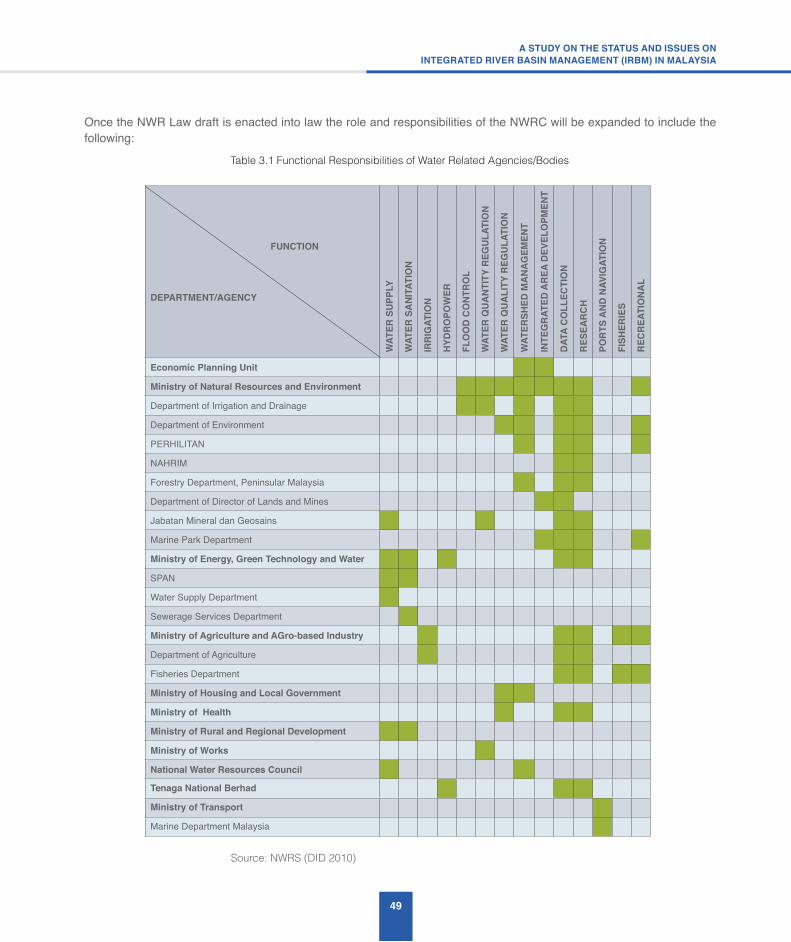
49
A STUDY ON THE STATUS AND ISSUES ONINTEGRATED RIVER BASIN MANAGEMENT (IRBM) IN MALAYSIA
Once the NWR Law draft is enacted into law the role and responsibilities of the NWRC will be expanded to include the following:
Table 3.1 Functional Responsibilities of Water Related Agencies/Bodies
FUNCTION
DEPARTMENT/AGENCY
WAT
ER S
UPPL
Y
WAT
ER S
ANIT
ATIO
N
IRRI
GAT
ION
HYDR
OPO
WER
FLO
OD
CONT
ROL
WAT
ER Q
UANT
ITY
REG
ULAT
ION
WAT
ER Q
UALI
TY R
EGUL
ATIO
N
WAT
ERSH
ED M
ANAG
EMEN
T
INTE
GRA
TED
AREA
DEV
ELO
PMEN
T
DATA
CO
LLEC
TIO
N
RESE
ARCH
PORT
S AN
D NA
VIG
ATIO
N
FISH
ERIE
S
RECR
EATI
ONA
L
Economic Planning Unit
Ministry of Natural Resources and Environment
Department of Irrigation and Drainage
Department of Environment
PERHILITAN
NAHRIM
Forestry Department, Peninsular Malaysia
Department of Director of Lands and Mines
Jabatan Mineral dan Geosains
Marine Park Department
Ministry of Energy, Green Technology and Water
SPAN
Water Supply Department
Sewerage Services Department
Ministry of Agriculture and AGro-based Industry
Department of Agriculture
Fisheries Department
Ministry of Housing and Local Government
Ministry of Health
Ministry of Rural and Regional Development
Ministry of Works
National Water Resources Council
Tenaga National Berhad
Ministry of Transport
Marine Department Malaysia
Source: NWRS (DID 2010)
50
d. Alignment of functions and responsibilities with the NWR Policy and proposed NWR Law
The WRF Model lists the six main functions that the NWRD has to fulfil, namely:
(a) Water Resources Assessment;(b) Water Resources Sustainable Integrated Management(c) Water Resources Allocation and Regulation(d) Water Hazard Management
(e) Water Resources Technical and Scientific Support
(f) Intra-, Inter- and International Technical Water Resources Services
Since DID has been proposed to be restructured to become the NWRD a set of recommendations has been given in the NWR Study for the proposed realignment of DID’s function to implement the above WRF Model functions.
3.4 Financing – Status, Issues and Ideas
3.4.1 Financing Status
Before the enactment of the Water Services Industry Act (WSIA) 2006 each state is responsible for the financing of both the water resources and water services sector, as illustrated in Figure 3.1. However, since the enactment of WSIA the Federal Government is now responsible for managing and financing the water services sector and the state is left with the responsibility to finance and manage the water resources sector. Since water resources belong to the state, each state is now deriving financial revenues from the sale of raw water resources to the Federal water services providers who treat the raw water for sale to the consumers.
More over, since the cost of treating raw water increases with polluted raw water there is a need to ensure that the water resources are properly managed. Thus, there is a need for the Federal Government to provide funding to help the states to improve their level of management of water resources. This means that the financing and pricing models for both raw and treated water are inter-linked and should be considered together.
Malaysia has one of the lowest water tariffs among the newly industrialised nations. It has a graduated or varying water tariff structure. Currently, there is no uniform water tariff in the water services sector in the country. As far as the water service sector is concerned, different states have their own water tariff structures.
The following is a summary of the current financing and pricing model for the water services sector after the implementation of the WSIA Act and also the National Water Services Commission (SPAN) Act in 2006:
a. The WSIA provided the mandate to the Federal Government to manage the water services industry from the treatment of raw water to the discharge of wastewater. SPAN was established to regulate the water services industry and to implement and enforce the provisions of the WSIA.
b. Through the legislative mandate of both the WSIA and SPAN Acts, an institutional structure is put in place, whereby all water operators and water asset owners are regulated by SPAN through a licensing framework.
c. The legislation separates the role of water operators from the water asset owners by creating the Water Asset Management Company (Pengurusan Aset Air Berhad, PAAB) to take over all water services assets owned by the States in exchange for absorbing all their outstanding loans and freeing the service operators to concentrate on service delivery.
d. With the creation of the PAAB, the Federal Government now provides loans only to Sabah and Sarawak for the development of water services infrastructure. The responsibility to finance and develop new water infrastructures in the Peninsular States is now transferred to the PAAB.
e. As a Government-owned company, PAAB is eligible for more favourable financing rates, which can translate into better tariff rates for the consumers. The water infrastructure will be leased to the water operators for operation and maintenance.
f. The separation of ownership from the operation of water infrastructure is aimed at driving the industry

51
A STUDY ON THE STATUS AND ISSUES ONINTEGRATED RIVER BASIN MANAGEMENT (IRBM) IN MALAYSIA
towards financial sustainability as well as better service efficiency.
g. The setting of water service tariffs is based on uniform principles and procedures and is subject to the approval by SPAN.
h. SPAN itself does not promote privatisation of water services but instead promotes the corporatisation of State Water Authorities to enable them to operate as efficient corporate entities and to ensure that revenues generated from water service operations are reinvested back into the water supply sector.
i. SPAN has a Committee where the members are appointed by the Minister of KeTTHA. The Committee consists of the Chairman; the Chief Executive Officer, and not less than eight and not more than 10 other persons, who, in the opinion of the Minister, have experience and have shown capacity and professionalism in matters relating to finance, engineering, business or administration, or have special knowledge and experience.
j. The mandate and responsibilities of SPAN go beyond its regulatory role in the water and sewerage services industry. It has licensing and technical regulatory roles. In terms of water resources and the environment, it has responsibilities to promote protection of the water-courses and the environment, improve the quality of life and the environment through effective and efficient management of the water supply and sewerage service.
There is no similar model for the financing and pricing for the water resources sector. This needs to be developed, in relation to the model for the water services sector, in order to support the implementation of IWRM by the states with adequate funding for the formation of the SWRA and implementation of its regulatory activities.
3.4.2 Financing Issues
With the major restructuring of the water services sector in 2006 through the WSIA the financing and pricing model for the water services sector is now quite well-defined. However, this is not the case for the water resources sector where there is no financing model for
improved water resources management by the states and the water pricing structure for water resources is not developed at all. Thus, the financing issues are as follows:
a. Financing model for water resources management by the states
The success in the implementation of IWRM by all the States depends to a very large extent on the availability of sufficient expertise, manpower and funding. Thus, there is a need for the States to get Federal Government support to implement water resources management projects due to the currently limited revenue they derive from the sale of raw water to the water services providers. A Federal-State funding model needs to be developed to support amongst others, capacity building to ensure that the States water resources are effectively managed.
b. Pricing model for water resources
A financial study has been carried out in the NWR Study (DID 2010) to provide the basis for the pricing mechanism for water resources. The Study highlighted that water resources has economic value just like any other natural resources such as minerals and timber from forests. The Study stated that the economic value of water resources has to include the non-financial components such as the environment, which is often difficult to monetise.
Nevertheless, it is important in the overall water resources pricing mechanism. The water pricing model for the water resources sector will be different from the model for the water services sector. This is because the objectives of the water resources sector is to sustain and conserve the natural water resources environment, whereas the water services sector is to provide a service to water consumers. The different objectives of the two water sub-sectors will have a fundamental effect on the way the economic value of water resources is derived.
52
3.4.3 Financing Ideas
The following are some ideas to address the identified financing issues as recommended in the NWR Study:
a. Financing model for water resources management by the states
The Federal Government should provide support to the State Governments to assist them in setting up the SWRA and to implement water resources management activities. In order for this to take place it will be necessary for each State to first formulate and adopt a State Water Resources Enactment that is consistent with the NWR Policy and the NWR Law. The details of the financing model need to be developed taking into account the pricing model that is adopted for water resources.
b. Pricing model for water resources
The NWR Study (DID 2010) has recommended that a uniform pricing and tariff regime for the water services sector be adopted after taking into consideration the funding requirements for the management activities that are required to sustain water resources and the environment in river basins. Although different states have their own supply and service providers, an equitable uniform price and tariff structure for water supply will be much easier to enforce. Thus, the Study recommends a set of guiding principles for the water pricing that takes into consideration water resources and the environment.
RIVER BASIN MANAGEMENT
ISSUE 4

54
4.1 Water Assessment and Allocation – Status, Issues and Ideas
The issue of water assessment and allocation does not arise in a river basin where water resources are abundant and there are no pressures of increasing and conflicting water demands. However, in river basins where there is water scarcity, or will be in the future, there is a need to regulate the water usage to ensure sustainable, equitable and efficient utilisation of the resource. The regulation of the water resources is normally made through a permit or licensing system, which enable the government or state authorities to allocate the resources taking into account all stakeholder interests, including the environment.
4.1.1 Water Asssessment and Allocation Status
In Malaysia the Federal Constitution gives the states the rights to water resources. Thus, each state makes their own decisions on their water allocation priority and how they regulate and license the withdrawal of both the river and ground water resources. Currently, all states gives priority for water allocation withdrawal for potable water supply, followed by withdrawal for irrigation for paddy crops.
Due to increased threats to water resources from pollution and also water demands arising from industrial and urban development a number of states, such as Kedah, Melaka, Negeri Sembilan, Pahang, Sabah, Sarawak and Selangor have enacted state legislation that deal with various aspects related to the management of water resources in their respective states. Some of the State Water Resources Enactments, like those in Kedah and Selangor, provide wide powers to the state authority or a state regulatory body to manage, control and protect water resources.
With the enactment of the Water Services and Industry Act (WSIA) in 2006 the water services sector is now regulated by the Federal Government and the states are responsible for managing the water resources sector. Thus, all the water supply operators have to apply for a licence and pay to withdraw the raw water from the rivers or ground water for treatment.
The Jabatan Bekalan Air (JBA) of the Ministry of Energy, Green Technology and Water has completed a number of water-related feasibility studies. The following is a list of some of the recent feasibillity studies carried out by JBA. Appendix 7 provides a brief description for each of the feasibility studies:
a. Feasibility Study on Use of Stormwater for Water Supply Augmentation and Integrated Management of Water Supply Sources and Demand Management in Labuan (Final Report 2011)
b. Feasibility Study Report of Alternative Water Supply Scheme For KLIA (Final Report 2010)
c. Kajian bagi Mengenalpasti Langkah Jangka Pendek dan Jangka Panjang bagi Menyelesaikan Masalah Mendapan Sedimen & Sampah di Mukasauk Fasa 1 & 2 LRA Kampung Lawa Gadong, Beaufort, Sabah (Final Report 2013)
d. Feasibility Study on Construction of Sungai Johor Barrage (Draft Final Report Stage 2013)
e. Feasibility Study on Proposed Kahang Dam (Draft Final Report Stage 2013)
4.1.2 Water Assessment and Allocation Issues
The key water assessment and allocation issues are as follows:
a. Fragmented and non-uniform State legislation governing water allocation
The state water resources enactments all differ in jurisdiction, scope and powers. Thus, there are gaps, conflicts and duplication in the enactments with both other Federal and State laws. Thus, there are no standard, consistent, clear and comprehensive guidelines or policies governing water allocation among the States. Even though the states do not need to give up their existing powers over water resources there are significant advantages in terms of Federal technical support to adopt a more consistent water allocation approach

55
A STUDY ON THE STATUS AND ISSUES ONINTEGRATED RIVER BASIN MANAGEMENT (IRBM) IN MALAYSIA
in line with national initiatives to promote greater consistency and uniformity of standards, methods and procedures.
b. Water allocation is not guided by an IRBM Plan and IWRM principles
Currently, the decision-making and approach to water allocation is not guided by a developed IRBM plan and IWRM principles, where the water demands from a river are balanced with other conflicting uses and factors.
4.1.3 Water Assessment and Allocation Ideas
The proposed ideas to address the water assessment and allocation issues are as follows:
a. Fragmented and non-uniform State legislation governing water allocation – States to adopt similar water allocation rules as in NWR Law
It is recommended that the States adopt the proposed NWR Law, where relevant, when it is enacted by the Federal Legislature so that there will be some relative uniformity between the states in the application of the water allocation rules and regulations. Figure 4.1 shows the list of contents in Part V and Part X in the draft NWR Law.
Figure 4.1 Part V and X from the draft NWR Law
PART V
USE OF WATER RESOURCES
22. Responsibility of water resources
23. Control of use of water resources
25. Power of State Director in water resources and its catchment
26. Power to impose charges
27. Rights to water for subsistence purposes
28. Control of wastage of water
29. Extraction of sand and other materials
PART X
PROCEDURES FOR LICENSING, APPROVAL AND APPEAL
45. Application
46. Publiccommentsandobjectionsonsignificantactivities47. Approval48. Contents of a license
49. Security
50. Register of licenses
51. Obligation of licenses
52. Variation of conditions in licences
53. Revocation54. Termination
55. Establishment of Appeal Tribunal
56. Members of the Appeal Tribunal
57. Procedure of appeal Tribunal
58. Secretariat
59. Proceedings
60. Appeal
61. Appeal not stay of action
62. Powers of Appeal Tribunal
63. DecisionsofAppealTribunalfinal
56
b. Water allocation is not guided by IWRM principles – Water allocation in a river basin is guided by a developed IRBM Plan
It is recommended that IRBM plans be developed for important river basins and shall be used by the States to guide their water allocation decision-making. The proposed NWRD shall provide the necessary technical support to the States in the development of the IRBM plans and also the necessary technical advice to the SWRA in making the water allocation decision.
c. Water assessment ideas
The following are some water assessment ideas:
i. To review water assessment data for cases where there is an issue in the planning for water allocation and to adopt the LUAS or Sabah model;
ii. To include environmental flows in the water assessment; and
iii. To include the water resources available in multipurpose reservoirs in the water assessment and to develop cost-sharing mechanisms for the development of such multipurpose dam projects.
d. Water allocation ideas
The following are some water allocation ideas:
i. There is a need for a single state agency to ensure proper coordination and allocation of water resources between dam and river for the river basins within a state. River Basin Committees with representatives from different states shall be created for shared river basins, subject to the legal provisions in the Federal Constitution.
ii. IRBM plan should include the use of alternative water resources within the basin such as the use of recycled water from regional Sewage Treatment Plants for non-potable use,
groundwater for on-site industrial use or potable use with suitable treatment.
4.2 Pollution Control – Status, Issues and Ideas
Water resources management deals with both the maintenance and development of adequate quantities of water of adequate quality. Hence, water resources management cannot be conducted properly without paying due attention to water quality. Managing water pollution is one of the most critical challenges to sustainable management of water resources. Pollution is increasing rapidly with urbanisation, industrialisation and population growth. Thus there is an urgent need to control water pollution.
4.2.1 Pollution Control Status
The Department of Environment (DOE) is responsible for river water quality monitoring in Malaysia and has implemented a river water quality monitoring Programme in 1978 for 120 important rivers in the country. In 2012, the total number of river water quality monitored is 473 with 5,083 manual and 10 continuous stations. The appraisal of the water quality in each river basin is based on the Water Quality Index (WQI) consisting of parameters such as dissolved oxygen (DO), biochemical oxygen demand (BOD), chemical oxygen demand (COD), ammoniacal nitrogen (NH3N), suspended solids (SS) and pH. Due to the deteriorating trend of river water quality over the years the DOE has implemented a Programme known as the “Pollution Prevention and River Water Quality Improvement Programme” with the objective to rehabilitate rivers with serious pollution problems so as to ultimately meet their beneficial uses. Section 2.2.2 provides a brief description of the Programme.
Moreover, DOE is also responsible for enforcing the Environmental Quality Act (EQA 1974). The Act was enacted for the abatement and control of pollution and enhancement of the environment, which includes river water quality. Section 2.1.10 presents a brief description of how DOE is enforcing the EQA to control water pollution in rivers and preserve river water quality. According to the DOE Malaysian rivers are degraded by both point and non-point sources of pollution. The major point sources of pollution in rivers are sewage treatment
57
A STUDY ON THE STATUS AND ISSUES ONINTEGRATED RIVER BASIN MANAGEMENT (IRBM) IN MALAYSIA
plants, agrobased industries, manufacturing industries, sullage or grey-water from commercial and residential premises, and pig farms. Conversely, non-point source (or diffused) pollution is largely due to storm run-off after a downpour. Earthworks and land clearing activities contribute to siltation of rivers and can be both point and non-point sources of pollution.
For instance, rigorous land clearing activities and earthworks for construction purposes have contributed to soil erosion and the dumping of sediments into rivers. Significant negative impacts on the rivers have occurred not only in the form of siltation but also the loss of river habitats. The DID has developed the Manual Saliran Mesra Alam (MSMA) urban stormwater management guidelines to control both urban stormwater quantity and quality. The MSMA requires developers to prepare “Erosion of Soil and Control Plan (ESCP)” for submission to DID for approval. In addition, the DOE has also developed a “Guidelines for Prevention and Control of Soil Erosion and Siltation”.
4.2.2 Pollution Control Issues
The key water pollution control issues are as follows:
a. Controlofpollutionfromsewageeffluents
Sewage is a major river pollutant in Malaysia. The Indah Water Konsortium (IWK) is only responsible for managing sewerage systems in 86 out of 144 local authority areas in the country. The management of sewerage systems in the 86 local authority areas is not comprehensive since there are sources that do not come under IWK’s control, such as private sewage treatment plants, individual septic tanks, sewage from primitive systems and discharges of raw sewage from squatters.
b. Control of pollution from SME Manufacturing industries
The manufacturing industries generate both organic and inorganic pollutants, toxic wastes and persistent organic pollutants. Thus, DOE requires all manufacturing industries to install wastewater treatment systems to treat their effluents to comply with the required effluent standards before they
are discharged into rivers. The achievement in controlling the effluent discharges from the manufacturing industries varies from industry to industry. The Small and Medium scale Enterprise (SME) industries have difficulties in complying with the effluent discharge standards due to financial problems and the lack of space for the construction of wastewater treatment facilities.
c. Control of Sullage (Grey-Water)
Sullage or grey-water is wastewater that comes from places such as kitchen sinks, bathrooms, washing machines, restaurants, wet markets and car washing centres. It is a major contributor to urban river water pollution since it contributes organic pollutants, ammoniacal nitrogen and nutrients to the rivers. The urban stream usually does not have enough assimilative capacity to absorb the sullage pollutant loads. At present, sullage is not treated and poses a problem to improving river water quality.
d. Control of livestock farming and aquaculture
Livestock farming, especially pig farming discharges large quantities of wastewater with high organic content into the rivers. Besides that, with the implementation of the Agro Food Policy the discharges from other livestock, e.g. cattle farm, poultry etc., are expected to increase. Thus, there is a need for designated livestock and pig farming areas to ensure a proper control of their wastewater discharges and also for disease control.
e. Pollutioncontrolfromnon-sanitarylandfill& open dumps
There is a need to control the pollution from non-sanitary landfills and open dumps. Open rubbish dumps that are not designed as sanitary landfills results in leakage of polluted effluents into the groundwater and river systems.
f. Pollution control from non-point sources
There is a need to control the non-point sources of pollution, such as from land clearing. The erosion
58
and sediment transported from the run-off from open land clearing pollute rivers and create river sedimentation problems.
g. Needforreviewofeffluentdischargestandards
There is a need to review the current effluent discharge standards to be in line with current acceptable international standards and availability of treatment technology. There is a need to review the Palm Oil Mill & Rubber Industry effluent discharge standard, especially for those factories located in upstream areas. There is also a need to add more pollutant parameters in the effluent discharge standard.
h. Needtodevelopspecificriverambientwater quality standards
The standard effluent water quality standard is applicable throughout the country and does not take into account the assimilative capacity of a river or water body. For better protection, there is a need to develop specific river or stream ambient water quality standards, and for the effluent discharge standards to be set accordingly in order to comply with the needs of the specific river or stream ambient water quality standards.
4.2.3 Pollution Control Ideas
The proposed ideas to address the pollution control issues are as follows:
a. Controlofpollutionfromsewageeffluents
There is a need for SPAN to work with the relevant State authorities to increase the sewerage coverage areas covered by IWK. There is also a need for local authorities to control the discharge of raw sewage from squatters.
b. Control of pollution from SME Manufacturing industries
There is a need for the relevant Government ministry to provide financial and technical assistance to the
SME industries to comply with the effluent discharge standards.
c. Control of Sullage (Grey-Water)
There is a need for local authorities to ensure that sullage water is treated before it is discharged into rivers by increasing enforcement and conducting awareness Programme among the public. There is also a need to control the creation of the sullage at source.
d. Control of livestock farming and aquaculture
State authorities should designate specific areas for the livestock and pig farming industry so as to ensure proper control of their wastewater discharges and also for disease control.
e. Pollutioncontrolfromnon-sanitarylandfill& open dumps
There is a need to ensure that all landfills are designed as sanitary landfills and that all open rubbish dumps are closed.
f. Pollution control from non-point sources
The DOE and DID has implemented the requirements of Erosion and Sediment Control Plan (ESCP) as part of land development submission. The enforcement and implementation of the ESCP plan requirements will mitigate the negative impacts from non-point sources of pollution. In order to detect pollution sources, especially in non accessible areas, water supply operator such as Badan Kawal Selia Johor has also used drone technology to detect the pollution sources.
g. Needforreviewofeffluentdischargestandards
DOE needs to review the current effluent discharge standards to be in line with current acceptable international standards and availability of treatment technology. Futhermore, there is a need to review the Palm Oil Mill & Rubber Industry effluent
59
A STUDY ON THE STATUS AND ISSUES ONINTEGRATED RIVER BASIN MANAGEMENT (IRBM) IN MALAYSIA
discharge standard, especially for those factories located in upstream areas. There is also a need to add more pollutant parameters in the effluent discharge standard
h. Needtodevelopspecificriverambientwater quality standards
The standard effluent water quality standard is applicable throughout the country and does not take into account the assimilative capacity as well as carrying capacity of a river or water body. The DOE is recommended to consider developing specific river ambient water quality standards for some selected, important rivers.
4.3 Flood Management – Status, Issues and Ideas
Floods occur when the capacity of the natural or man-made drainage system is unable to cope with the volume of water generated by rainfall. Floods can vary in size and duration. The following provides a brief description of the various types of floods:
a. Localised Floods – Floods occurring in small pockets of low-lying areas and often sensitive to small amount of rains.
b. Coastal Floods – Floods that occur on the coastal plains due to tidal effects causing sea water to flow inland and spill over the low lying areas.
c. Urban Floods – Floods in built-up areas such as in cities, townships, commercial and residential areas. Urban floods affect more people and properties per unit area compared to those in agriculture and rural areas.
d. Flashfloods– A flood that rises and falls rapidly with little or no advance warning and usually result from intense rainfall over a relatively small area.
4.3.1 Flood Management Status
There are 189 river systems in Malaysia of which 85 are prone to frequent flooding. Flooding has become a major national issue in Malaysia as Malaysia’s economy and
population grew over the years and developments start to encroach into river corridors and flood plains which results in increased incidences of floods. According to the DID (2009), about 29,720 sq.km or 9% of Malaysia is flood prone and the estimated average annual flood damages in Malaysia is RM915 million per year. The DID is the lead government department that have been entrusted with the technical management of floods in Malaysia. It plans and implements flood mitigation projects around the country, advises Local Authorities, provide flood forecasting services and warnings and is the official custodian of the nation’s hydrological data. The following are the Divisions in DID that have functions related to flood management:
a. Flood Mitigation Division - This is the Division that deals directly with flood issues. Its foremost task is to produce a comprehensive master plan for resolving the national flood problems using structural and nonstructural measures including flood defence (e.g. flood risk and flood hazard maps).
b. Urban Drainage Division - This Division focuses on urban drainage issue and provides advisory services on the use of the Manual Saliran Mesra Alam (MSMA) urban stormwater management guidelines to local authorities.
c. River Division – This Division plans and implements river management, river conservation and rehabilitation Programmes. It also implements public awareness and education campaign on flood management including public participation in river water quality monitoring. It also collects and stores river data and monitor river reserve gazette. The Division also undertakes IRBM studies for some of the river basins in the country.
d. Coastal Division - This Division plans and implements coastal management Programmes, such as erosion control, river mouth improvement and beach restoration Programmes based on the concept of Integrated Shoreline Management Plan (ISMP).
e. Hydrology and Water Resources Division – This Division collects and disseminates hydrological
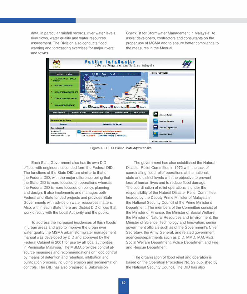
60
data, in particular rainfall records, river water levels, river flows, water quality and water resources assessment. The Division also conducts flood warning and forecasting exercises for major rivers and towns.
Each State Government also has its own DID offices with engineers seconded form the Federal DID. The functions of the State DID are similar to that of the Federal DID, with the major difference being that the State DID is more focused on operations whereas the Federal DID is more focused on policy, planning and design. It also implements and manages both Federal and State funded projects and provides State Governments with advice on water resources matters. Also, within each State there are District DID offices that work directly with the Local Authority and the public.
To address the increased incidences of flash floods in urban areas and also to improve the urban river water quality the MSMA urban stormwater management manual was developed by DID and approved by the Federal Cabinet in 2001 for use by all local authorities in Peninsular Malaysia. The MSMA provides control at-source measures and recommendations on flood control by means of detention and retention, infiltration and purification process, including erosion and sedimentation controls. The DID has also prepared a ‘Submission
Checklist for Stormwater Management in Malaysia’ to assist developers, contractors and consultants on the proper use of MSMA and to ensure better compliance to the measures in the Manual.
The government has also established the Natural Disaster Relief Committee in 1972 with the task of coordinating flood relief operations at the national, state and district levels with the objective to prevent loss of human lives and to reduce flood damage. The coordination of relief operations is under the responsibility of the Natural Disaster Relief Committee headed by the Deputy Prime Minister of Malaysia in the National Security Council of the Prime Minister’s Department. The members of the Committee consist of the Minister of Finance, the Minister of Social Welfare, the Minister of Natural Resources and Environment, the Minister of Science, Technology and Innovation, senior government officials such as of the Government’s Chief Secretary, the Army General, and related government agencies/departments such as DID, MMD, MACRES, Social Welfare Department, Police Department and Fire and Rescue Department.
The organisation of flood relief and operation is based on the Operation Procedure No. 29 published by the National Security Council. The DID has also
Figure 4.2 DID’s Public InfoBanjir website
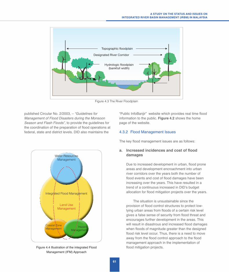
61
A STUDY ON THE STATUS AND ISSUES ONINTEGRATED RIVER BASIN MANAGEMENT (IRBM) IN MALAYSIA
published Circular No. 2/2003, – “Guidelines for Management of Flood Disasters during the Monsoon Season and Flash Floods”, to provide the guidelines for the coordination of the preparation of flood operations at federal, state and district levels. DID also maintains the
“Public InfoBanjir” website which provides real time flood information to the public. Figure 4.2 shows the home page of the website.
4.3.2 Flood Management Issues
The key flood management issues are as follows:
a. Increasedincidencesandcostofflooddamages
Due to increased development in urban, flood prone areas and development encroachment into urban river corridors over the years both the number of flood events and cost of flood damages have been increasing over the years. This have resulted in a trend of a continuous increased in DID’s budget allocation for flood mitigation projects over the years.
The situation is unsustainable since the provision of flood control structures to protect low-lying urban areas from floods of a certain risk level gives a false sense of security from flood threat and encourages further development in the areas. This will result in disastrous and increased flood damages when floods of magnitude greater than the designed flood risk level occur. Thus, there is a need to move away from the flood control approach to the flood management approach in the implementation of flood mitigation projects.
Water Resources Management
Coastal Zone Management Hazard
Management
Land Use Management
Integrated Flood Management
Figure 4.4 Illustration of the integrated Flood Management (IFM) Approach
Designated River Corridor
Topographic floodplain
Hydrologic floodplain(bankfull width)
Figure 4.3 The River Floodplain
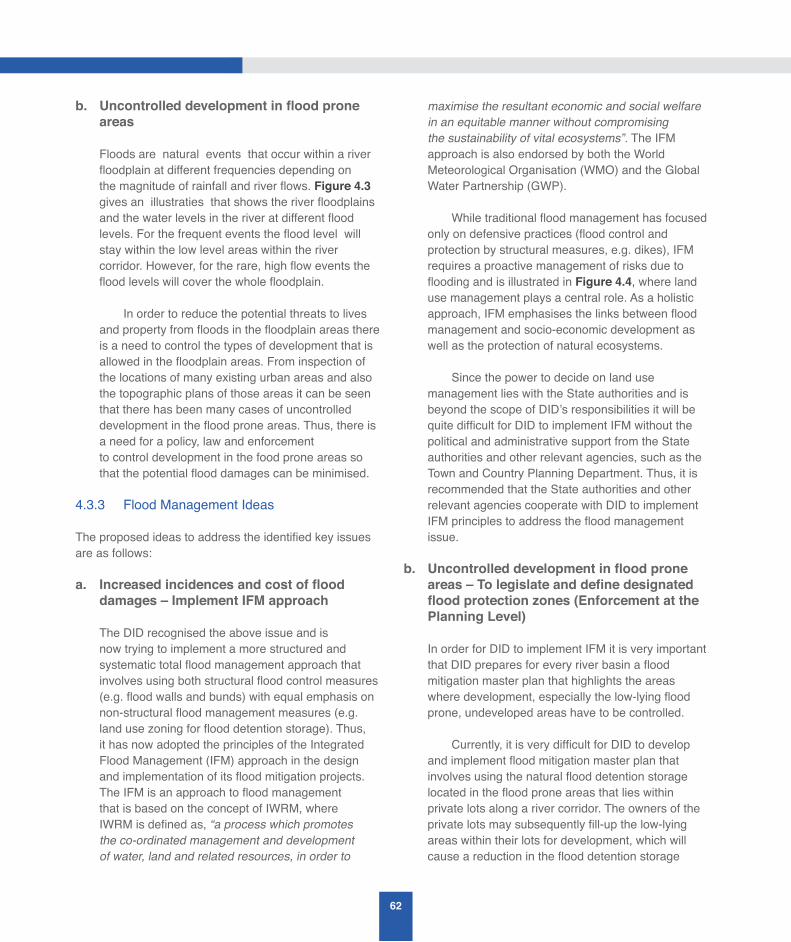
62
b. Uncontrolleddevelopmentinfloodproneareas
Floods are natural events that occur within a river floodplain at different frequencies depending on the magnitude of rainfall and river flows. Figure 4.3 gives an illustraties that shows the river floodplains and the water levels in the river at different flood levels. For the frequent events the flood level will stay within the low level areas within the river corridor. However, for the rare, high flow events the flood levels will cover the whole floodplain.
In order to reduce the potential threats to lives and property from floods in the floodplain areas there is a need to control the types of development that is allowed in the floodplain areas. From inspection of the locations of many existing urban areas and also the topographic plans of those areas it can be seen that there has been many cases of uncontrolled development in the flood prone areas. Thus, there is a need for a policy, law and enforcementto control development in the food prone areas so that the potential flood damages can be minimised.
4.3.3 Flood Management Ideas
The proposed ideas to address the identified key issues are as follows:
a. Increasedincidencesandcostofflooddamages – Implement IFM approach
The DID recognised the above issue and is now trying to implement a more structured and systematic total flood management approach that involves using both structural flood control measures (e.g. flood walls and bunds) with equal emphasis on non-structural flood management measures (e.g. land use zoning for flood detention storage). Thus, it has now adopted the principles of the Integrated Flood Management (IFM) approach in the design and implementation of its flood mitigation projects. The IFM is an approach to flood management that is based on the concept of IWRM, where IWRM is defined as, “a process which promotes the co-ordinated management and development of water, land and related resources, in order to
maximise the resultant economic and social welfare in an equitable manner without compromising the sustainability of vital ecosystems”. The IFM approach is also endorsed by both the World Meteorological Organisation (WMO) and the Global Water Partnership (GWP).
While traditional flood management has focused only on defensive practices (flood control and protection by structural measures, e.g. dikes), IFM requires a proactive management of risks due to flooding and is illustrated in Figure 4.4, where land use management plays a central role. As a holistic approach, IFM emphasises the links between flood management and socio-economic development as well as the protection of natural ecosystems.
Since the power to decide on land use management lies with the State authorities and is beyond the scope of DID’s responsibilities it will be quite difficult for DID to implement IFM without the political and administrative support from the State authorities and other relevant agencies, such as the Town and Country Planning Department. Thus, it is recommended that the State authorities and other relevant agencies cooperate with DID to implement IFM principles to address the flood management issue.
b. Uncontrolleddevelopmentinfloodproneareas–Tolegislateanddefinedesignatedfloodprotectionzones(EnforcementatthePlanning Level)
In order for DID to implement IFM it is very important that DID prepares for every river basin a flood mitigation master plan that highlights the areas where development, especially the low-lying flood prone, undeveloped areas have to be controlled. Currently, it is very difficult for DID to develop and implement flood mitigation master plan that involves using the natural flood detention storage located in the flood prone areas that lies within private lots along a river corridor. The owners of the private lots may subsequently fill-up the low-lying areas within their lots for development, which will cause a reduction in the flood detention storage
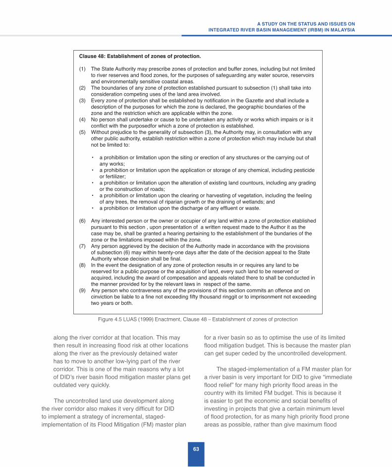
63
A STUDY ON THE STATUS AND ISSUES ONINTEGRATED RIVER BASIN MANAGEMENT (IRBM) IN MALAYSIA
along the river corridor at that location. This may then result in increasing flood risk at other locations along the river as the previously detained water has to move to another low-lying part of the river corridor. This is one of the main reasons why a lot of DID’s river basin flood mitigation master plans get outdated very quickly.
The uncontrolled land use development along the river corridor also makes it very difficult for DID to implement a strategy of incremental, staged-implementation of its Flood Mitigation (FM) master plan
for a river basin so as to optimise the use of its limited flood mitigation budget. This is because the master plan can get super ceded by the uncontrolled development. The staged-implementation of a FM master plan for a river basin is very important for DID to give “immediate flood relief” for many high priority flood areas in the country with its limited FM budget. This is because it is easier to get the economic and social benefits of investing in projects that give a certain minimum level of flood protection, for as many high priority flood prone areas as possible, rather than give maximum flood
Figure 4.5 LUAS (1999) Enactment, Clause 48 – Establishment of zones of protection
Clause48:Establishmentofzonesofprotection.
(1) The State Authority may prescribe zones of protection and buffer zones, including but not limited to river reserves and flood zones, for the purposes of safeguarding any water source, reservoirs and environmentally sensitive coastal areas.
(2) The boundaries of any zone of protection established pursuant to subsection (1) shall take into consideration competing uses of the land area involved.
(3) Every zone of protection shall be established by notification in the Gazette and shall include a description of the purposes for which the zone is declared, the geographic boundaries of the zone and the restriction which are applicable within the zone.
(4) No person shall undertake or cause to be undertaken any activity or works which impairs or is it conflict with the purposedfor which a zone of protection is established.
(5) Without prejudice to the generality of subsection (3), the Authority may, in consultation with any other public authority, establish restriction within a zone of protection which may include but shall not be limited to:
• a prohibition or limitation upon the siting or erection of any structures or the carrying out of any works;
• a prohibition or limitation upon the application or storage of any chemical, including pesticide or fertilizer;
• a prohibition or limitation upon the alteration of existing land countours, including any grading or the construction of roads;
• a prohibition or limitation upon the clearing or harvesting of vegetation, including the feeling of any trees, the removal of riparian growth or the draining of wetlands; and
• a prohibition or limitation upon the discharge of any effluent or waste.
(6) Any interested person or the owner or occupier of any land within a zone of protection etablished pursuant to this section , upon presentation of a written request made to the Author it as the case may be, shall be granted a hearing pertaining to the establishment of the bundaries of the zone or the limitations imposed within the zone.
(7) Any person aggrieved by the decision of the Authority made in accordance with the provisions of subsection (6) may within twenty-one days after the date of the decision appeal to the State Authority whose decision shall be final.
(8) In the event the designation of any zone of protection results in or requires any land to be reserved for a public purpose or the acquisition of land, every such land to be reserved or acquired, including the award of compesation and appeals related there to shall be conducted in the manner provided for by the relevant laws in respect of the same.
(9) Any person who contraveness any of the provisions of this section commits an offence and on cinviction be liable to a fine not exceeding fifty thousand ringgit or to imprisonment not exceeding two years or both.
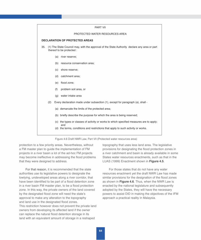
64
protection to a few priority areas. Nevertheless, without a FM master plan to guide the implementation of FM projects in a river basin a lot of the ad-hoc FM projects may become ineffective in addressing the flood problems that they were designed to address.
For that reason, it is recommended that the state authorities use its legislative powers to designate the lowlying, undeveloped areas along a river corridor, that have been identified to be part of a flood detention zone in a river basin FM master plan, to be a flood protection zone. In this way, the private owners of the land covered by the designated flood zone will need the state’s approval to make any alteration to the topography and land use in the designated flood zones. This restriction however does not prevent the private land owners from developing its affected land if the owner can replace the natural flood detention storage in its land with an equivalent amount of storage in a reshaped
topography that uses less land area. The legislative provisions for designating the flood protection zones in a river catchment and basin is already available in some States water resources enactments, such as that in the LUAS (1999) Enactment shown in Figure 4.5.
For those states that do not have any water resources enactment yet the draft NWR Law has made similar provisions for the designation of the flood zones as shown in Figure 4.6. Thus, when the NWR Law is enacted by the national legislature and subsequently adopted by the States, they will have the necessary powers to assist DID in making the objectives of the IFM approach a practical reality in Malaysia.
Figure 4.6 Draft NWR Law, Part VII (Protected water resources area)
PART VII
PROTECTED WATER RESOURCES AREA
DECLARATION OF PROTECTED AREAS
35. (1) The State Council may, with the approval of the State Authority declare any area or part thereof to be protected :
(a) river reserve;
(b) resource conservation area;
(c) shore reserve;
(d) catchment area;
(e) flood zone;
(f) problem soil area, or
(g) water intake area
(2) Every declaration made under subsection (1), except for paragraph (a), shall -
(a) demarcate the limits of the protected area;
(b) briefly describe the purpose for which the area is being reserved;
(c) the types or classes of activity or works to which specified measures are to apply; and(d) the terms, conditions and restrictions that apply to such activity or works.

65
A STUDY ON THE STATUS AND ISSUES ONINTEGRATED RIVER BASIN MANAGEMENT (IRBM) IN MALAYSIA
Station ID State (PDF) Dam Name Purpose /
Agency Last Update Normal Level (m)
Minimum Level (m)
1832480 JHR KOLAM AIR DI EMP. MACHAP W/F (DID) 02/09/2013 - 22:00 16.50 13.10
1931480 JHR KOLAM AIR DI EMP. SEMBRONG W/F (DID) 02/09/2013 - 22:00 10.00 6.00
2030481 JHR SUNGAI BEKOK DI EMP. BEKOK W/F (DID) 02/09/2013 - 22:00 15.50 8.70
5919403 KEL EMPANGAN BUKIT KWONG I/W (DID) 02/09/2013 - 22:01 16.76 12.20
6602481 PLS TIMAH TA SOH DAM I/W/F (DID) 02/09/2013 - 22:30 29.10 25.30
3216490 WLH SUNGAI BATU DI EMP. BATU W/F (DID) 02/09/2013 - 22:45 102.00 79.00
Off-Line Station
2536468 JHR EMPANGAN LABONG I/W (DID) 23/04/2013-16:15 - Offline 8.03 7.01
5907401 KDH EMPANGAN BERIS I/W/F (DID) 23/04/2013-16:30 - Offline 84.00 68.00
2634402 PHG EMPANGAN ANAK ENDAU I/W (DID) 23/04/2013-16:30 - Offline 19.00 12.00
4613401 PRK EMPANGAN ULU KINTA W (LAP) 23/04/2013-15:30 - Offline 240.00 189.80
3018402 SEL EMPANGAN SEMENYIH W (KA SB) 23/04/2013-16:15 - Offline 111.00 84.30
3217480 WLH SG. KELANG DI EMP. GENTING KELANG
W/F (PN SB) 23/04/2013-12:34 - Offline 94.00 84.00
Station ID (Flow
Duration Graph)
Station Name (Graph)
State (PDF)
Last Update
Normal Level (m)
Water Level (m)
(Real-time)
River Flow (m3/s)
Drought Flow For Various Return Periods For 7 Days Low Flow
(m3/s)
2-year 5-year 10-year
20-year
2816441 SUNGAI LANGAT DI DENGKIL SEL 02/09/2013-
22:00 4 3.55 33.49 7.29 4.31 3.15 2.41
3813411 SUNGAI BERNAM DI JAMBATAN SKC SEL 02/09/2013-
22:00 16.5 16.07 24.11 15.79 12.17 10.88 10.12
5206432 SUNGAI KERIAN DI SELAMA PRK 02/09/2013-
21:45 10 9.17 26.54 10.13 6.09 4.21 2.84
4809443 SUNGAI PERAK DI ISKANDAR BRIDGE PRK 02/09/2013-
22:00 32 31.95 150.00 122.65 68.94 45.49 29.16
4911445 SUNGAI PLUS DI KAMPUNG LINTANG PRK 02/09/2013-
22:00 52 53.00 44.11 13.3 9.29 7.41 6.03
3424411 SUNGAI PAHANG DI TEMERLOH (LUBUK PASU) PHG 02/09/2013-
22:00 26 26.02 980.51 165.43 110.86 90.75 78.44
5320443 SUNGAI GALAS DI DABONG KEL 02/09/2013-
22:00 28 27.23 348.84 195.13 101.74 61.48 33.74
5721442 SUNGAI KELANTAN DI KUSIAL KEL 02/09/2013-
22:00 10 8.49 163.28 155.4 98.9 70.5 48.5
5606410 SUNGAI MUDA AT JAMBATAN SYED OMAR KDH 02/09/2013-
12:00 8 8.24 177.94 17.6 10.96 9.33 8.6
2527411 SUNGAI MUAR DI BULOH KASAP JHR 02/09/2013-
22:00 15.5 5.39 26.14 8.05 5.05 4.2 3.2
2030401 SUNGAI BEKOK DI BT. 77 JLN Y.P JHR 02/09/2013-
22:00 5.94 3.15 1.75 1.88 7.31 3.53 1.42
1737451 w JOHOR AT RANTAU PANJANG JHR 02/09/2013-
22:00 4 4.30 57.21 8.14 4.79 3.15 1.9
Off-Line Station
Figure 4.7 Infokemarau website: Drought monitoring via dam water levels
Figure 4.8 Infokemarau website: Drought monitoring via river discharge
66
c. Implement Flood Mapping
In order to inform the public on the flood-prone areas there is a need to implement flood mapping of the flood-prone areas and to disseminate the information to the public.
d. Adopt latest technology in implementing floodwarning
There is a need to adopt the latest technology to forecast flood and provide early warning to communities living in flood-prone areas, such as the use of social media tools such as SMS, Facebook, Twitter, etc. There is also a need to make rainwater harvesting compulsory in existing and future developments.
4.4 Drought Management – Status, Issues and Ideas
Drought is an insidious hazard of nature and is a “creeping phenomenon” with impacts that vary from region to region. Drought originates from a deficiency of rainfall over an extended period of time, resulting in a water shortage for some activity, group, or environmental sector. Its impacts result from the interplay between the natural event (less rainfall than expected) and the demand people place on water supply. Human activities can exacerbate the impacts of drought. Conceptually, a drought can be defined as a protracted period of deficient rainfall resulting in extensive damage to crops and resulting in loss of crop yield. However, for those responsible for making decisions in response of a drought condition an operational definition of drought is necessary to help define the onset, severity, and end of droughts. Thus, to determine the beginning of drought, an operational definition will specify the degree of departure from the average rainfall or some other climatic variable over some time period. This is usually done by comparing the current situation to the historical average, often based on a 30 year period of record.
4.4.1 Drought Management Status
Unlike the situation in arid countries drought is not a major issue in a tropical country like Malaysia with abundant rainfall. However, due to the natural, annual variability of rainfall there maybe some period in some years where there may be a prolonged period of low rainfall which may affect the amount of water stored in the dams to provide for potable and irrigation water supply. Thus, there is a need to monitor the likelihood of drought so that early action can be taken to conserve the water supply so that it can last through a potential drought period. In Malaysia, the DID has instituted a drought monitoring programme since 2001 and has created a website to disseminate information to the public on the potential drought situation in the country. The website is known as “Infokemarau”.
The website used rainfall information from 41 selected rainfall stations to assess the water resources status of Peninsular Malaysia. The percentage deviation of the rainfall from the long term mean (LTM) value of 3-monthly moving rainfall totals is used as the indicator of the potential drought conditions in a water catchment. A negative deviation from the LTM value indicates that the particular region is experiencing a dryer than normal condition and vice versa. The website also defines a “Hydrological drought” as follows:
a. River discharge – A drought situation occurs if the low flow exceed the 5-years Average Recurrence Interval (ARI) continuously for a 3-months period.
b. Dam levels - A drought situation occurs when the water level in a dam is below the alert level, at least 2 or 3 months continuously.
Figure 4.7 shows the Infokemarau’s web page for the drought monitoring via dam water levels and Figure 4.8 shows the web page for the drought monitoring via river discharge.
67
A STUDY ON THE STATUS AND ISSUES ONINTEGRATED RIVER BASIN MANAGEMENT (IRBM) IN MALAYSIA
4.4.2 Drought Management Issues
Since Malaysia has abundant annual rainfall there are no drought-like conditions in Malaysia, such as those found in arid and semi-arid countries. However, there are issues related to periods of long dry spell with water shortages. Thus, there is a need to monitor river low flows and to develop contingency plans to conserve and reallocate water resources during a dry spell period.
4.4.3 Drought Management Ideas
The following are some ideas to manage the dry spell conditions in a river basin:
i. To include in State Water Resources Enactment the power to re-prioritize water allocations under drought conditions. E.g. LUAS enactment Sec 72. General Drought Order;
ii. State should have a drought management plan ranging from water stress to water shortage (drought-like conditions) to extreme conditions of long periods of no rain (drought);
iii. There should be a plan to include the mitigation and adaptation for climate change-impact, such as the risk of climate variability of rain not falling at the desired catchment locations;
iv. There is a need to develop water supply plans that are resilient against water shortages (seasonal dry periods); and
v. There is a need for monitoring plans for drought-like conditions, such as for low river flow, low rainfall, low water supply reservoir levels.
4.5 River Basin and Landuse Planning – Status, Issues and Ideas
River basins are the natural accounting units for water management. However, political and administrative decisions relating to water management are usually made according to jurisdictional boundaries that do not coincide with river basins. Hence, water managers faced the challenge of how to bring together the different actors and stakeholders to contribute to the development
and management of the river basin. Therefore, River basin planning provides an opportunity to address water management problems and prioritise development in a strategic and integrated manner.
A river basin plan is a strategic action plan for the integrated management of the water and related land resources in the basin. It will have details of actions and broad budgets as well as strategic elements to address key water management issues in a basin. The plan will normally be relevant for several years and will facilitate the coordination of specific works by the relevant agencies who shall incorporate the required works into their annual work plans accompanied by specified actions and detailed budgets.
4.5.1 River Basin and Land Use Planning Status
Land use planning in Malaysia is carried out by the Town and Country Planning Department (TCPD) based on a 3-stage urban planning system that is described in Section 2.1.6. At the top level the country’s development is guided by the National Physical Plan which described the macro land use planning for Peninsular Malaysia. This is followed by the State Structure Plan which describes the strategic land use development plan for each state. At the local authority level, Local Plans that define the specific land use at the lot level are also prepared. Furthermore, the TCPD has prepared a series of land use planning guidelines to help planners and local planning authorities implement the objectives of the land use plan.
The National Physical Plan recognises the importance of carrying out water resources management based on the IWRM and IRBM principles, as can be seen in the following stated objectives of the Plan:
a. Water resources management shall be based on IWRM, IRBM and ICZM;
b. Safeguard and manage sustainably all surface and ground water resources; and
c. Natural barriers, especially mangroves, forests and peat lands shall be protected and expanded, and further land conversion will no longer be allowed.
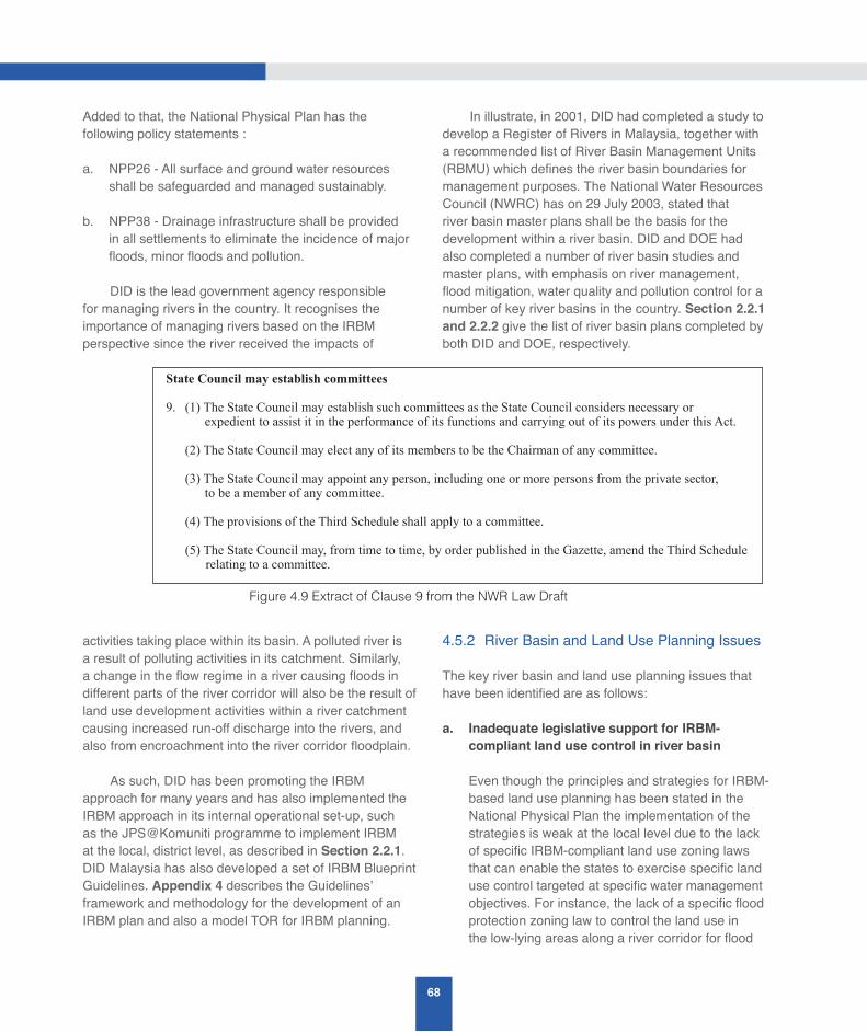
68
Added to that, the National Physical Plan has the following policy statements :
a. NPP26 - All surface and ground water resources shall be safeguarded and managed sustainably.
b. NPP38 - Drainage infrastructure shall be provided in all settlements to eliminate the incidence of major floods, minor floods and pollution.
DID is the lead government agency responsible for managing rivers in the country. It recognises the importance of managing rivers based on the IRBM perspective since the river received the impacts of
activities taking place within its basin. A polluted river is a result of polluting activities in its catchment. Similarly, a change in the flow regime in a river causing floods in different parts of the river corridor will also be the result of land use development activities within a river catchment causing increased run-off discharge into the rivers, and also from encroachment into the river corridor floodplain.
As such, DID has been promoting the IRBM approach for many years and has also implemented the IRBM approach in its internal operational set-up, such as the JPS@Komuniti programme to implement IRBM at the local, district level, as described in Section 2.2.1. DID Malaysia has also developed a set of IRBM Blueprint Guidelines. Appendix 4 describes the Guidelines’ framework and methodology for the development of an IRBM plan and also a model TOR for IRBM planning.
In illustrate, in 2001, DID had completed a study to develop a Register of Rivers in Malaysia, together with a recommended list of River Basin Management Units (RBMU) which defines the river basin boundaries for management purposes. The National Water Resources Council (NWRC) has on 29 July 2003, stated that river basin master plans shall be the basis for the development within a river basin. DID and DOE had also completed a number of river basin studies and master plans, with emphasis on river management, flood mitigation, water quality and pollution control for a number of key river basins in the country. Section 2.2.1 and 2.2.2 give the list of river basin plans completed by both DID and DOE, respectively.
4.5.2 River Basin and Land Use Planning Issues
The key river basin and land use planning issues that have been identified are as follows:
a. Inadequate legislative support for IRBM-compliant land use control in river basin
Even though the principles and strategies for IRBM-based land use planning has been stated in the National Physical Plan the implementation of the strategies is weak at the local level due to the lack of specific IRBM-compliant land use zoning laws that can enable the states to exercise specific land use control targeted at specific water management objectives. For instance, the lack of a specific flood protection zoning law to control the land use in the low-lying areas along a river corridor for flood
Figure 4.9 Extract of Clause 9 from the NWR Law Draft
State Council may establish committees
9. (1) The State Council may establish such committees as the State Council considers necessary or
expedient to assist it in the performance of its functions and carrying out of its powers under this Act.
(2) The State Council may elect any of its members to be the Chairman of any committee.
(3)TheStateCouncilmayappointanyperson,includingoneormorepersonsfromtheprivatesector, to be a member of any committee.
(4)TheprovisionsoftheThirdScheduleshallapplytoacommittee.
(5) The State Council may, from time to time, by order published in the Gazette, amend the Third Schedule
relating to a committee.
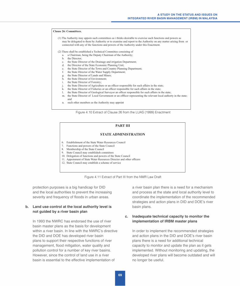
69
A STUDY ON THE STATUS AND ISSUES ONINTEGRATED RIVER BASIN MANAGEMENT (IRBM) IN MALAYSIA
protection purposes is a big handicap for DID and the local authorities to prevent the increasing severity and frequency of floods in urban areas.
b. Land use control at the local authority level is not guided by a river basin plan
In 1993 the NWRC has endorsed the use of river basin master plans as the basis for development within a river basin. In line with the NWRC’s directive the DID and DOE has developed river basin plans to support their respective functions of river management, flood mitigation, water quality and pollution control for a number of key river basins. However, since the control of land use in a river basin is essential to the effective implementation of
a river basin plan there is a need for a mechanism and process at the state and local authority level to coordinate the implementation of the recommended strategies and action plans in DID and DOE’s river basin plans.
c. Inadequate technical capacity to monitor the implementation of IRBM master plans
In order to implement the recommended strategies and action plans in the DID and DOE’s river basin plans there is a need for additional technical capacity to monitor and update the plan as it gets implemented. Without monitoring and updating, the developed river plans will become outdated and will no longer be useful.
Figure 4.10 Extract of Clause 26 from the LUAS (1999) Enactment
Clause 26: Committees.
(1) The Authority may appoin such committees as i thinks desirable to exercise such functions and powers as
may be delegated to them by Authority or to examine and report to the Authority on any matter arising from or
connected with any of the functions and powers of the Authority under this Enactment.
(2) There shall be established a Technical Committee consisting of
a. a Chairman, being the Deputy Chairman of the Authority;
b. the Director;
c. the State Director of the Drainage and irrigation Department;
d. the Director of the State Economic Planning Unit;
e. the State Director of the Town and Country Planning Department;
f. the State Director of the Water Supply Department;
g. the State Director of Lands and Mines;
h. theStateDirectorofEnvironment;i. the State Director of Forestry;
j. theStateDirectorofAgricultureoranofficerresponsibleforsuchaffairsinthestate;k. theStateDirectorofFisheriesoranofficerresponsibleforsuchaffairsinthestate;l. theStateDirectorofGeologicalSurveyoranofficerresponsibleforsuchaffairsinthestate;m. theStateDirectorofLocalGovernmentoranoffficerrepresentingtherelevantlocalauthortyinthestate;
and
n. such other members as the Authority may appoint
Figure 4.11 Extract of Part III from the NWR Law Draft
PART III
STATE ADMINISTRATION
6. Establishment of the State Water Resources Council
7. Functions and powers of the State Council
8. Membership of the State Council
9. State Council may establisheh commitees
10. Delegation of functions and powers of the State Council
11.AppoinmentofStateWaterResourcesDirectorandotherofficers12. StateCouncilmayestablishaschemeofservice

70
d. Loss of river biodiversity
Globally, there is increasing recognition that the biodiversity of freshwater and riverine ecosystems will only be conserved in the long term if their management is integrated with river basin management. Nevertheless, the understanding and practical experience for this is still low among government agencies, private sector and the community in Malaysia. Rivers are frequently chanellised and river bank vegetation removed and replaced with concrete or exotic plants. Management of rivers and their associated basins are fragmented between many different sectors including forestry, fishery, agriculture, plantations,water resources, tourism, urban management and environment.
Riverine biodiversity in Malaysia is of global significance with many rare, threatened and endemic species found in riverine habitats. Most of the rivers are found outside of the formally protected areas and so are affected by a broad range of land use and industrial impacts, as well as direct overexplotation. In Malaysia the rapid pace of development has overstressed the river systems. As a result of the numerous conflicting uses and demands made on the rivers, many of the river’s natural resources including biological diversity and beneficial ecological services have been destroyed or degraded in recent years. One of the factors that lead to rapid degradation of the rivers and its ecosystem is the lack of appropriate institutional frameworks and capacity for integrated river basin management and the lack of institutional focus on the conservation of riverine biodiversity. The current institutional framework is sectoral focus and not interlinked. For instance, the main focus of the DID is primarily on flood mitigation and river engineering while the Department of Fishery focuses on the commercial value of fish production and the Forestry Department focuses on management of forest resources. There is no single river-related government agency which focuses on biodiversity conservation of rivers. Riverine biodiversity conservation as well as the integration
of riverine biodiversity concerns into river basin and wetland management in Malaysia is also hampered by inadequate efforts on biodiversity assessment and monitoring in rivers.
4.5.3 River Basin and Land Use Planning Ideas
The following are the ideas proposed to address the identified issues:
a. Uncoordinated land use control at the local authority level – States to adopt the NWR Law after it is enacted
It is recommended that those states that do not have any Water Resources Management (WRM) law adopt the NWR Law for enforcement of land use control at the local level to support WRM objectives. For those states that already have WRM laws they are recommended to start implementing and enforcing the provisions in their WRM laws.
b. Land use control at the local authority level is not guided by a river basin plan – To create RBMC to coordinate implementation of river basin plan
It is recommended that River Basin Management Committees (RBMC) be created to facilitate the coordination and implementation of the recommended strategies and actions plans in the river basin plans developed by DID and DOE. Section 2.2.1 describes the guideline developed by DID for the formation of the RBMC for three different categories of rivers in Malaysia.
The legislative provisions for the formation of RBMC are given in the NWR Law, and thus can be used by the States to create the RBMC when the NWR Law is adopted for implementation by the states. Figure 4.9 shows an extract of Clause 9 (State Council may establish committee) from the draft NWR Law and Figure 4.10 shows an extract from Clause 26 (Committees) from the LUAS (1999) Enactment.

71
A STUDY ON THE STATUS AND ISSUES ONINTEGRATED RIVER BASIN MANAGEMENT (IRBM) IN MALAYSIA
c. Inadequate technical capacity to monitor the implementation of IRBM master plans – States to set-up State Water Resources Agencies (SWRA)The components of the IRBM master plans with Federal funding can be developed by DID and DOE. The blue-print for the development of an IRBM plan has also been developed by DID and is described in Appendix 4. However, the implementation and enforcement of the developed IRBM plans will have to be carried out by the respective states since land and water resources are under the jurisdiction of the states. Thus, there is a need for states to set up State Water Resources Agencies (SWRA), as recommended in the NWR Study (2010) and shown in Figure 3.2, to monitor the implementation of IRBM plan, and also to work with the proposed Federal National Water Resources Department (NWRD) to update the developed plans.
Figure 4.11 shows an extract of Part III (State Administration) from the NWR Law with the provisions in Clause 11 and Clause 12 for States to appoint a State Water Resources Director and other officers of the proposed SWRA and to establish their schemes of service.
d. Loss of river biodiversity
It is recommended that a strategy and best management practice guidelines for biodiversity conservation in river management be developed. Apart from that, there is a need to enhance the capacity for biodiversity conservation in river management at the national level.
e. Specificideasonlanduseplanningandcontrol
The following is a list of specific landuse planning and control ideas to improve river basin landuse management:
i. Gazetting of river reserve and zoning of flood-prone areas;
ii. Implement the guidelines on development in low-lying areas developed by JPBD;
iii. Infrastructure works done by other government agencies, such as JKR, should take into consideration flood impacts. Thus, JKR should refer to DID and DOE when it is designing its infrastructure works.;
iv. All Government agencies projects should comply with the guidelines developed by DID, DOE, JPBD; and
v. All flood detention ponds should be gazetted in order that the flood detention capacity function can be protected.
4.6 River Basin Information System – Status, Issues and Ideas
IWRM, in the context of a river basin, is about the management of the limited water resources in a river basin for an optimum outcome among different competing water users. Thus, comprehensive, accurate and timely information is necessary for objective planning, decision-making and for gaining support from competing river basin stakeholders. Hence, there is a need for the proposed SWRA to understand the main IWRM issues in a river basin and prioritise the types of information that it needs to collect (separating the essential from the non-essential) to address the identified issues. Deciding on what to report, to whom and how to communicate the report to the relevant stakeholders is the final most important step.
4.6.1 River Basin Information System Status
DID has already developed River Basin Information Systems (RBIS) for four rivers in Malaysia. They are for: (a) Sungai Kuantan, (b) Sungai Muar, (c) Sungai Putatan/Sungai Moyog, and (d) Sungai Sarawak. DOE has also set-up a river water quality monitoring system to monitor the water quality at 926 monitoring stations in 120 river basins in the country. DID has also a Division responsible for collecting and processing hydrological data (such as rainfall and streamflow) in the country. In addition to this, DID has also set-up dedicated websites, such as InfoBanjir and Infokemarau, to provide real-time flood and drought information, respectively, to the public. It has also set-up the National IWRM Information Repository

72
to provide the necessary information support for IWRM implementation in the country.
In addition to the RBIS set-up by DID and DOE, the following are other RBIS set-up by other water management entities:
a. Muda Agricultural Development Authority (MADA)
MADA has set-up an RBIS/SCADA that implements the following functions:
• To control the release of water from its dams
• To control and ensure sufficient irrigation water supply to the paddy field
• Rainfall stations within MADA’s monitoring area.
b. Syarikat Air Darul Aman (SADA)
SADA has a River Information System that monitors the water quality at the water intakes.
c. Syarikat Air Johor (SAJ)
SAJ has a River Information System that monitors the water quality at the water intakes.
d. Water Supply Operators in Selangor
All the water supply operators in Selangor (Puncak Niaga, SPLASH and ABASS) also have River Information System that monitors the water quality at their water intakes.
4.6.2 River Basin Information System Issues
The following are the identified RBIS issues:
a. Too much information, lack of useful information products
Currently, there are numerous, dedicated ICT systems generating different types of information (data, figures, tables, maps) for different uses. However, there is a lack of useful information
products to support river basin stakeholders in decision-making.
b. Selection and choice of Information Management tools
There are numerous tools to support information collection, processing, management and decision-making. It is very important to select the right information management tools to produce the appropriate information products for decision-making. Failure to do so will result in failure of the selected ICT systems to meet its objectives.
c. No coordination in information dissemination for national-level decision-making
There is a lack of coordination in the information collection and dissemination of information for national-level decision-making.
4.6.3 River Basin Information System Ideas
The following are the proposed ideas to address the identified RBIS issues:
a. Too much information, lack of useful information products – Set-up River Basin Information Management Unit (RB-IMU) to produce and disseminate information products
From an inspection of the proposed blue-print for an IRBM plan in Appendix 4 it can be seen that there are a lot of different types of information that needs to be collected, processed and constantly updated to produce an updated IRBM plan. This task can only be carried out effectively if a dedicated River Basin Information Management Unit (RB-IMU) is created and given the responsibility to manage and coordinate the information collection, processing, updating and dissemination of the developed river-basin information products to the relevant river basin stakeholders.
Thus, it is recommended that a RB-IMU be created in the proposed National Water Resources Department (NWRD) to manage the RBIS and the updating of the developed IRBM plan, and to carry out all the necessary information management functions to
73
A STUDY ON THE STATUS AND ISSUES ONINTEGRATED RIVER BASIN MANAGEMENT (IRBM) IN MALAYSIA
support IRBM implementation by the SWRA. It is also recommended that a similar RB-IMU be set-up at the SWRA to work with the Federal RB-IMU in the NWRD to update the IRBM plan, and to produce the relevant information products for their respective river basin stakeholders.
CapNet developed in 2008 a training manual for IWRM in river basin organisation consisting of a ten modules course (See Appendix 1). One of the modules (Module 8) is on “Information Management” in which the details on what the proposed RB-IMU should do to support effective implementation of IRBM are described under the following three topics:
• Information management process
• Information management tools
• Information management outputs
b. Selection and choice of Information Management tools – Adopt appropriate guidelines for the selection of IM tools and standards
It is recommended that appropriate guidelines for the selection of IM tools and standards be made by the proposed RB-IMU. The “Information Management Module” in CapNet’s ten-module training course for river basin organisations described in Appendix 1 provides useful guidelines for the selection and development of ICT systems, and also advice on the appropriate use of modelling and decision support systems. Furthermore, the proposed blue-print for IRBM Plan described in Appendix 4 provides the following advice on the use of GIS and Data Management:
B4. GIS and Data Management
“The use of GIS to support river basin data management is essential. Thus, the development of GIS Data Model based on MS175-2004 standard should be carried out and shall be expanded to include data for biodiversity and other sectors.”
c. No coordination in information dissemination for national-level decision-making
There is a need for an agency, such as a National Water Resources Information Centre, to coordinate the collection, compilation and processing of information so that it can be used to support national-level decision-making. The use of cloud computing infrastructure to support interagency data and information sharing may be possible.
4.7 River Basin Monitoring – Status, Issues and Ideas
For effective water resources management it is essential that monitoring be carried out to assess the availability of water resources, of water quality, water use and pollution discharges in a river basin. Moreover, information management of the monitored data is necessary to ensure that they are analysed and presented in the form of information products that can be used by stakeholders to make decisions.
4.7.1 River Basin Monitoring Status
Currently, DID is responsible for the monitoring of the rainfall and stream flow data that are used in the assessment of water availability in a river basin. DID also monitors the flood and drought situation in river basins. Beside that, published its processed hydrological data for its users.
DOE is also responsible for monitoring the pollution discharges and water quality in the rivers. It also publishes the analysis of the results of its river water quality monitoring in an annual river water quality report. The Ministry of Health also conducts water quality sampling surveys.
The responsibility for monitoring the use of the surface and ground water in a river basin lies with each State that issues the licenses for the water extraction by users:
4.7.2 River Basin Monitoring Issues
The following are the identified river basin monitoring issues:
a. No annual river basin monitoring reports
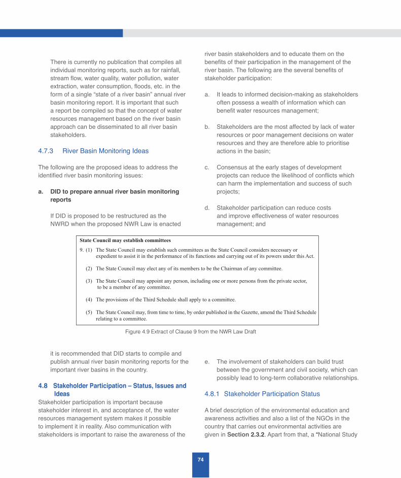
74
There is currently no publication that compiles all individual monitoring reports, such as for rainfall, stream flow, water quality, water pollution, water extraction, water consumption, floods, etc. in the form of a single “state of a river basin” annual river basin monitoring report. It is important that such a report be compiled so that the concept of water resources management based on the river basin approach can be disseminated to all river basin stakeholders.
4.7.3 River Basin Monitoring Ideas
The following are the proposed ideas to address the identified river basin monitoring issues:
a. DID to prepare annual river basin monitoring reports
If DID is proposed to be restructured as the NWRD when the proposed NWR Law is enacted
it is recommended that DID starts to compile and publish annual river basin monitoring reports for the important river basins in the country.
4.8 Stakeholder Participation – Status, Issues and IdeasStakeholder participation is important because stakeholder interest in, and acceptance of, the water resources management system makes it possible to implement it in reality. Also communication with stakeholders is important to raise the awareness of the
river basin stakeholders and to educate them on the benefits of their participation in the management of the river basin. The following are the several benefits of stakeholder participation:
a. It leads to informed decision-making as stakeholders often possess a wealth of information which can benefit water resources management;
b. Stakeholders are the most affected by lack of water resources or poor management decisions on water resources and they are therefore able to prioritise actions in the basin;
c. Consensus at the early stages of development projects can reduce the likelihood of conflicts which can harm the implementation and success of such projects;
d. Stakeholder participation can reduce costs and improve effectiveness of water resources management; and
e. The involvement of stakeholders can build trust between the government and civil society, which can possibly lead to long-term collaborative relationships.
4.8.1 Stakeholder Participation Status
A brief description of the environmental education and awareness activities and also a list of the NGOs in the country that carries out environmental activities are given in Section 2.3.2. Apart from that, a “National Study
Figure 4.9 Extract of Clause 9 from the NWR Law Draft
State Council may establish committees
9. (1) The State Council may establish such committees as the State Council considers necessary or
expedient to assist it in the performance of its functions and carrying out of its powers under this Act.
(2) The State Council may elect any of its members to be the Chairman of any committee.
(3) TheStateCouncilmayappointanyperson,includingoneormorepersonsfromtheprivatesector, to be a member of any committee.
(4) TheprovisionsoftheThirdScheduleshallapplytoacommittee.
(5) The State Council may, from time to time, by order published in the Gazette, amend the Third Schedule
relating to a committee.
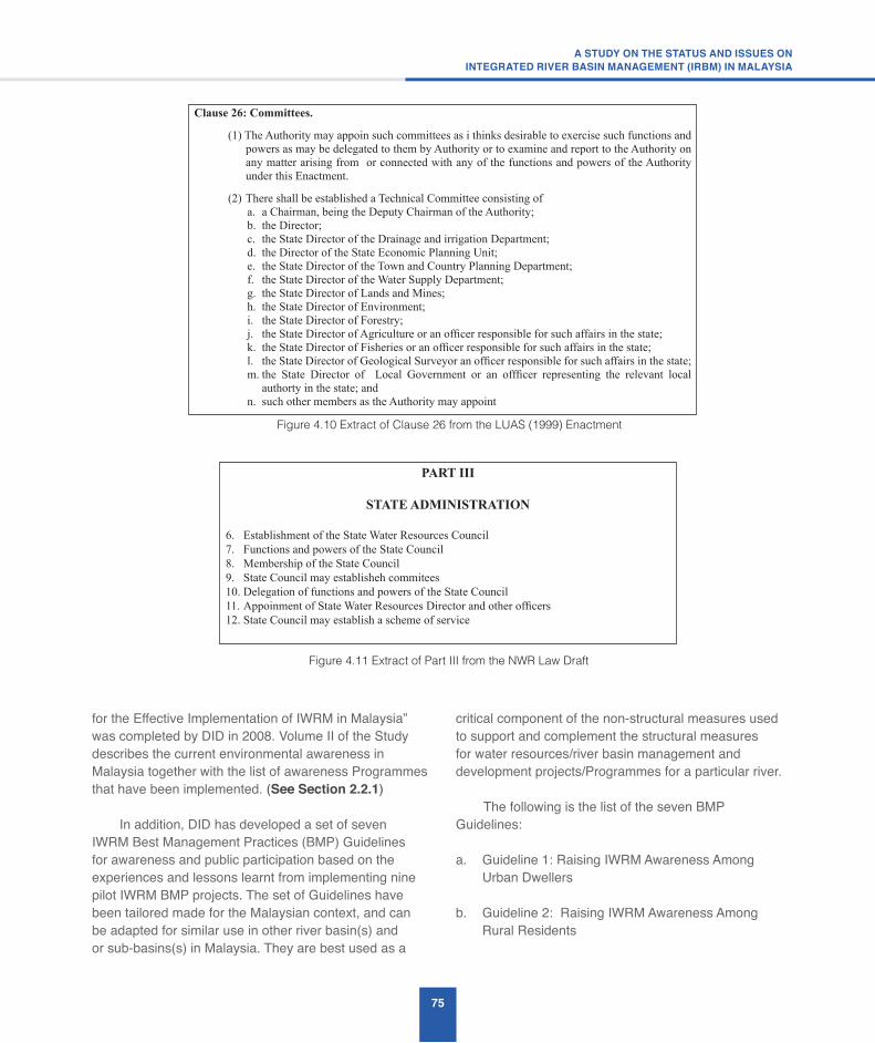
75
A STUDY ON THE STATUS AND ISSUES ONINTEGRATED RIVER BASIN MANAGEMENT (IRBM) IN MALAYSIA
Figure 4.10 Extract of Clause 26 from the LUAS (1999) Enactment
Clause 26: Committees.
(1) The Authority may appoin such committees as i thinks desirable to exercise such functions and
powers as may be delegated to them by Authority or to examine and report to the Authority on
any matter arising from or connected with any of the functions and powers of the Authority
under this Enactment.
(2) There shall be established a Technical Committee consisting of
a. a Chairman, being the Deputy Chairman of the Authority;
b. the Director;
c. the State Director of the Drainage and irrigation Department;
d. the Director of the State Economic Planning Unit;
e. the State Director of the Town and Country Planning Department;
f. the State Director of the Water Supply Department;
g. the State Director of Lands and Mines;
h. theStateDirectorofEnvironment;i. the State Director of Forestry;
j. theStateDirectorofAgricultureoranofficerresponsibleforsuchaffairsinthestate;k. theStateDirectorofFisheriesoranofficerresponsibleforsuchaffairsinthestate;l. theStateDirectorofGeologicalSurveyoranofficerresponsibleforsuchaffairsinthestate;m.the State Director of Local Government or an offficer representing the relevant local
authorty in the state; and
n. such other members as the Authority may appoint
Figure 4.11 Extract of Part III from the NWR Law Draft
PART III
STATE ADMINISTRATION
6. Establishment of the State Water Resources Council
7. Functions and powers of the State Council
8. Membership of the State Council
9. State Council may establisheh commitees
10. Delegation of functions and powers of the State Council
11.AppoinmentofStateWaterResourcesDirectorandotherofficers12.StateCouncilmayestablishaschemeofservice
for the Effective Implementation of IWRM in Malaysia” was completed by DID in 2008. Volume II of the Study describes the current environmental awareness in Malaysia together with the list of awareness Programmes that have been implemented. (See Section 2.2.1)
In addition, DID has developed a set of seven IWRM Best Management Practices (BMP) Guidelines for awareness and public participation based on the experiences and lessons learnt from implementing nine pilot IWRM BMP projects. The set of Guidelines have been tailored made for the Malaysian context, and can be adapted for similar use in other river basin(s) and or sub-basins(s) in Malaysia. They are best used as a
critical component of the non-structural measures used to support and complement the structural measures for water resources/river basin management and development projects/Programmes for a particular river.
The following is the list of the seven BMP Guidelines:
a. Guideline 1: Raising IWRM Awareness Among Urban Dwellers
b. Guideline 2: Raising IWRM Awareness Among Rural Residents
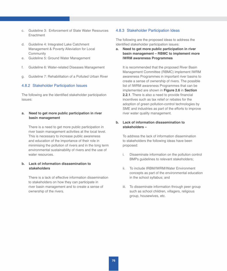
76
c. Guideline 3: Enforcement of State Water Resources Enactment
d. Guideline 4: Integrated Lake Catchment Management & Poverty Alleviation for Local Community
e. Guideline 5: Ground Water Management
f. Guideline 6: Water-related Diseases Management
g. Guideline 7: Rehabilitation of a Polluted Urban River
4.8.2 Stakeholder Participation Issues
The following are the identified stakeholder participation issues: a. Need to get more public participation in river
basin management
There is a need to get more public participation in river basin management activities at the local level. This is necessary to increase public awareness and education of the importance of their role in minimising the pollution of rivers and in the long term environmental sustainability of rivers and the use of water resources.
b. Lack of information disssemination to stakeholders
There is a lack of effective information dissemination to stakeholders on how they can participate in river basin management and to create a sense of ownership of the rivers.
4.8.3 Stakeholder Participation Ideas
The following are the proposed ideas to address the identified stakeholder participation issues:a. Need to get more public participation in river
basin management – RBMC to implement more IWRM awareness Programmes
It is recommended that the proposed River Basin Management Committee (RBMC) implement IWRM awareness Programmes in important river basins to create a sense of ownership of rivers. The possible list of IWRM awareness Programmes that can be implemented are shown in Figure 2.6 in Section 2.2.1. There is also a need to provide financial incentives such as tax relief or rebates for the adoption of green pollution-control technologies by SME and industries as part of the efforts to improve river water quality management.
b. Lack of information disssemination to stakeholders –
To address the lack of information dissemination to stakeholders the following ideas have been proposed:
i. Disseminate information on the pollution control BMPs guidelines to relevant stakeholders;
ii. To include IRBM/IWRM/Water Environment concepts as part of the environmental education in the school syllabus; and
iii. To disseminate information through peer group such as school children, villagers, religious group, housewives, etc.

RECOMMENDATIONS 5
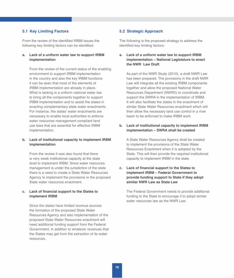
78
5.1 Key Limiting Factors
From the review of the identified IRBM issues the following key limiting factors can be identified:
a. Lack of a uniform water law to support IRBM implementation
From the review of the current status of the enabling environment to support IRBM implementation in the country and also the key IRBM functions it can be seen that most of the elements of IRBM implementation are already in place. What is lacking is a uniform national water law to bring all the components together to support IRBM implementation and to assist the states in enacting complementary state water enactments. For instance, the states’ water enactments are necessary to enable local authorities to enforce water resources management compliant land use laws that are essential for effective IRBM implementation.
b. Lack of institutional capacity to implement IRBM implementation
From the review it was also found that there is very weak institutional capacity at the state level to implement IRBM. Since water resources management is under the jurisdiction of the state there is a need to create a State Water Resources Agency to implement the provisions in the proposed State water resources enactment.
c. LackoffinancialsupporttotheStatestoimplement IRBM
Since the states have limited revenue sources the formation of the proposed State Water Resources Agency and also implementation of the proposed State Water Resources enactment will need additional funding support from the Federal Government, in addition to whatever revenues that the States may get from the extraction of its water resources.
5.2 Strategic Approach
The following is the proposed strategy to address the identified key limiting factors:
a. Lack of a uniform water law to support IRBM implementation – National Legislature to enact the NWR Law Draft
As part of the NWR Study (2010), a draft NWR Law has been prepared. The provisions in the draft NWR Law will integrate all the existing IRBM components together and allow the proposed National Water Resources Department (NWRD) to coordinate and support the SWRA in the implementation of IRBM. It will also facilitate the states in the enactment of similar State Water Resources enactment which will then allow the necessary land use control in a river basin to be enforced to make IRBM work.
b. Lack of institutional capacity to implement IRBM implementation – SWRA shall be created
A State Water Resources Agency shall be created to implement the provisions of the State Water Resources Enactment when it is adopted by the State. This will then provide the required institutional capacity to implement IRBM in the state.
c. LackoffinancialsupporttotheStatestoimplement IRBM – Federal Government to provide funding support to State if they adopt similar NWR Law as State Law
The Federal Government needs to provide additional funding to the State to encourage it to adopt similar water resources law as the NWR Law.
79
A STUDY ON THE STATUS AND ISSUES ONINTEGRATED RIVER BASIN MANAGEMENT (IRBM) IN MALAYSIA
5.3 Strategic Actions
The following is a list of strategic actions that have been proposed to address the identified IRBM issues:
5.3.1 Enabling Environment issues
Policy
1. Implementation of NWR Policy at state-level
DID Malaysia shall conduct state-level dialogues and workshops to create awareness of the NWR Policy so as to identify and develop the specific framework for Federal/State level partnerships to implement the NWR Policy in each state.
Arising from such a developed Federal/State level partnership framework the State can then develop its specific state-level water resources management policy that is compliant with the NWR Policy.
2. Development of Federal/State level partnerships to implement NWR Policy
DID Malaysia shall implement the strategic actions for the three strategies identified in the NWR Policy’s Strategic Targets 15 and 16 as listed below:
a. Strategy: Identify stakeholders and clarify roles as well as responsibilities
b. Strategy: Develop means and measures for consultation
c. Strategy: Determine means, measures and approaches for collaborative governance
Legislation
1. OfficialenactmentofthedraftNationalWaterResources Law
DID Malaysia shall work with the relevant government agency to get the draft National Water Resources Law enacted by the national legislature as soon as possible.
2. OfficialadoptionoftheLawbystatelegislature
DID Malaysia shall work with the relevant state government agency to get the National Water Resources Law adopted by the state legislature, once the Law has been enacted by the national legislature.
Institution
1. New Federal institutional structure for water governance
To implement the proposed, a new Federal institutional structure for water governance that consists of three levels, (as illustrated in Figure 3.2 of Chapter 3) is required. It is in line with the recommendation in the NWR Law draft.
The National Water Resources Council (NWRC)
NWR Secretariat (NWRS) — The existing NWR Secretariat is currently co-shared between the MNRE and KeTTHA. Since water resource is part of natural resources it is proposed that the Secretariat be housed only in the MNRE because the MNRE is responsible for natural resources management.
National Water Resources Department (NWRD) – This is a new department that has been proposed to implement the water resources management functions described in the NWR Law.
2. Revision to the existing Institutional arrangement in all the States
It is proposed that the Federal structure be replicated at the State level as illustrated of Figure 3.2 Chapter 3. Thus, at the State level, there can be a corresponding State Water Resources Council (SWRC) and under it, a technical State Water Resources Agency or Department (SWRA/SWRD) or equivalent. The recommendations and functions of the SWRC and SWRA or equivalent are described in Figure 3.2.
80
3. Creation of a National Water Resources Management Department (NWRD)
DID has been proposed by the stakeholders in the NWR Study’s national Stakeholder Consultation Workshops to be realigned to become the NWRD. Thus, a detailed review of DID’s current functions, and benchmarking of the functions against an ideal Water Resources Functional (WRF) Model have been carried out in the NWR Study to support the realignment of DID to become an effective NWRD in future.
4. Alignment of functions and responsibilities with the NWR Policy and proposed NWR Law
The WRF Model lists the six main functions that the NWRD has to fulfil, which are as follows:
(a) Water Resources Assessment;
(b) Water Resources Sustainable Integrated Management
(c) Water Resources Allocation and Regulation
(d) Water Hazard Management
(e) Water Resources Technical and Scientific Support
(f) Intra-, Inter- and International Technical Water Resources Services
Since DID has been proposed to be restructured to become the NWRD, a set of recommendations has been given in the NWR Study for the proposed realignment of DID’s function to implement the WRF Model functions.
Financing
1. Financing model for water resources management by the States
The Federal Government should provide support to the State Governments to assist them in setting up the SWRA and to implement water resources
management activities. In order for this to take place it will be necessary for each State to first formulate and adopt a State Water Resources Enactment that is consistent with the NWR Policy and the NWR Law. The details of the financing model need to be developed taking into account the pricing model that is adopted for water resources.
2. Pricing model for water resources
The NWR Study (DID 2010) has recommended that a uniform pricing and tariff regime for the water services sector be adopted after taking into consideration the funding requirements for the management activities that are required to sustain water resources and the environment in river basins. Although different states have their own supply and service providers, an equitable uniform price and tariff structure for water supply will be much easier to enforce. Thus, the Study recommends a set of guiding principles for the water pricing that takes into consideration water resources and the environment.
3. Payment for Ecosystem Services (PES)
(From ICUN publication — Payments for Ecosystem Services Legal and Institutional Frameworks)
Experiences from around the world show that appropriate concepts for sustainable freshwater governance have been developed in the past. Two main approaches can be distinguished: the traditional way of command and control, and the use of economic or market-based instruments. The classical way of deterring environmental degradation is to establish a legal norm coupled with a sanction for non-compliance. In fact, Such command and control policy may be effective in controlling pollution from well-defined point sources, e.g. factories or sewage treatment plants.
However, they are less effective in regulating non-point sources of pollution, such as those occurring when numerous upstream landholders dedicate their land to intensive agricultural or other non-sustainable activities. In those cases, downstream water pollution (or scarcity) is the result of the combination of individual actions carried out
81
A STUDY ON THE STATUS AND ISSUES ONINTEGRATED RIVER BASIN MANAGEMENT (IRBM) IN MALAYSIA
by geographically spread out and heterogeneous upstream users. Therefore, economic mechanisms and incentives, especially payments for ecosystem services (PES), are increasingly being proposed as a promissory conservation approach.
Payment for Ecosystem-Services (PES) programmes have been established in a number of places around the globe, and they function at a variety of geographic scale: emerging markets for carbon sequestration credits constitute an international programme; national forest conservation Programmes are operating in Australia, Costa Rica, and Mexico; and the World Bank, among others, has piloted watershed-level initiatives in several countries.
What makes a distinguishos a PES is that in any payment arrangement those who pay are aware that they are paying for an ecosystem service that is valuable to them or to their constituencies and those who receive the payments engage in meaningful and measurable activities to secure the sustainable supply of the ecosystem services in question. There are three types of possible PES schemes – private PES schemes, cap and trade schemes and public PES schemes, which are described below:
(a) Private PES
Private PES are self-organised schemes between private entities which involve:
• Direct payments by service beneficiaries to service providers for the protection or restoration of watershed services;
• Cost-sharing among involved private parties;
• Purchase of land and lease back to former owner with the objective to ensure watershed services originating from the land in question; or
• Purchase of development rights to land which are separated from property rights.
(b) Cap and Trade
Examples of Cap and trade schemes are as follows:
• Establish a cap (an aggregate maximum amount) for water pollution or abstractions;
• Allocate pollution or abstraction permits which divide the allowable overall total among water users; and
• Allow trading of permits between those who do not need permits and those who need more than their allocation.
(c) Public PES
Public PES are government driven schemes which involve public agencies and include user fees, land purchase and granting of rights to use land resources as well as fiscal mechanisms based on taxes and subsidies. Each PES transaction will be unique, depending upon its environment and the stakeholders’ needs. However, PES transactions do share certain characteristics. For instance, because water-related benefits from land management are local (up/down stream), watershed services are generally limited to localized markets. Furthermore, benefits must be measurable, high, and directly attributable to watershed protection actions and costs must not exceed the value of positive assessed impacts.
The following criteria can be identified as common to all PES transactions:
a. Transaction is voluntary and legally-binding
b. Ecosystem service and/or land use to deliver that service is well-defined/valued
c. Minimum of one service buyer/user
d. Minimum of one ecosystem service seller/provider
e. Payments are conditional on continued provision of the ecosystem service by the seller/provider
82
5.3.2 River Basin Management Issues
Water Asssessment and Allocation
1. Fragmented and non-uniform state legislation governing water allocation – states to adopt similar water allocation rules as in NWR Law
It is recommended that the states adopt the proposed NWR Law, where relevant, when it is enacted by the Federal Legislature so that there will be some relative uniformity between the states in the application of the water allocation rules and regulations.
2. Water allocation is not guided by IWRM principles – Water allocation in a river basin shall be guided by a developed IRBM plan
It is recommended that IRBM plans be developed for important river basins and shall be used by the states to guide their water allocation decision-making. The proposed NWRD shall provide the necessary technical support to the states in the development of the IRBM plans and also the necessary technical advice to the SWRA in making the water allocation decision.
Pollution Control
1. Controlofpollutionfromsewageeffluents
There is a need for SPAN to work with the relevant state authorities to increase the sewerage coverage areas covered by IWK. There is also a need for local authorities to control the discharge of raw sewage from squatters.
2. Control of pollution from SME Manufacturing industries
There is a need for the relevant Government ministry to provide financial and technical assistance to the SME industries to comply with the effluent discharge standards.
3. Control of Sullage (Grey-Water)
There is a need for local authorities to ensure that sullage water is treated before it is discharged into rivers by increasing enforcement and conducting awareness Programme among the public.
4. Control of Pig Farming
State authorities should designate specific areas for the pig farming industry so as to ensure proper control of their wastewater discharges and also for disease control.
5. Needforreviewofwaterqualityeffluentstandards
DOE needs to review the current effluent water
quality standards to be in line with current acceptable international standards and availability of treatment technology.
6. Needtodevelopspecificriverambientwaterquality standards
The DOE is recommended to consider developing specific river ambient water quality standards for some selected, important rivers.
Flood Management
1. Increasedincidencesandcostofflooddamages– Implement IFM approach
The DID recognised the above issue and is now trying to implement a more structured and systematic total flood management approach that involves using both structural flood control measures (e.g. flood walls and bunds) with equal emphasis on non-structural flood management measures (e.g. land use zoning for flood detention storage). Thus, it has now adopted the principles of the Integrated Flood Management (IFM) approach in the design and implementation of its flood mitigation projects. While traditional flood management has focused only on defensive practices (flood control and protection by structural measures, e.g. dikes), IFM requires
83
A STUDY ON THE STATUS AND ISSUES ONINTEGRATED RIVER BASIN MANAGEMENT (IRBM) IN MALAYSIA
a proactive management of risks due to flooding, where land use management plays a central role. Since the power to decide on land use management lies with the state authorities and is beyond the scope of DID’s responsibilities it will be difficult for DID to implement IFM without the political and administrative support from the state authorities and other relevant agencies, such as the Town and Country Planning Department. Thus, it is recommended that the state authorities and other relevant agencies cooperate with DID to implement IFM principles to address the flood management issue.
2. Uncontrolleddevelopmentinfloodproneareas–tolegislateanddefinedesignatedfloodprotectionzones
In order for DID to implement IFM it is very important that DID prepares for every river basin a flood mitigation master plan that highlights the areas where development, especially the low-lying flood prone, undeveloped areas have to be controlled. Currently, it is difficult for DID to develop and implement flood mitigation master plan that involves using the natural flood detention storage located in the flood prone areas that lies within private lots along a river corridor. The owners of the private lots may subsequently fill-up the low-lying areas within their lots for development, which will cause a reduction in the flood detention storage along the river corridor at that location. This may then result in increasing flood risk at other locations along the river as the previously detained water has to move to another low-lying part of the river corridor. This is one of the main reasons why a lot of DID’s river basin flood mitigation master plans get outdated very quickly.
The uncontrolled land use development along the river corridor also makes it very difficult for DID to implement a strategy of incremental, staged-implementation of its Flood Mitigation (FM) master plan for a river basin so as to optimise the use of its limited flood mitigation budget. This is because the master plan can get superceded by uncontrolled development. The staged-implementation of an FM
master plan for a river basin is very important for DID to give “immediate flood relief” for many high priority flood areas in the country with its limited FM budget.
This is because it is easier to get the economic and social benefits of investing in projects that give a certain minimum level of flood protection, for as many high priority flood prone areas as possible, rather than give maximum flood protection to a few priority areas. Without an FM master plan to guide the implementation of FM projects in a river basin a lot of the ad hoc FM projects may become ineffective in addressing the flood problems that they were designed to address.
Thus, it is recommended that the state authorities use its legislative powers to designate the low-lying, undeveloped areas along a river corridor, that have been identified to be part of a flood detention zone in a river basin FM master plan, to be a flood protection zone. In this way, the private owners of the land covered by the designated flood zone will need the state’s approval to make any alteration to the topography and land use in the designated flood zones. This restriction however does not prevent the private land owners from developing its affected land if the owner can replace the natural flood detention storage in its land with an equivalent amount of storage in a reshaped topography that uses less land area.
The legislative provisions for designating the flood protection zones in a river catchment and basin is already available in some states water resources enactments, such as that in the LUAS (1999) Enactment. For those states that do not have any water resources enactment yet the draft NWR Law has made similar provisions for the designation of the flood zones. Thus, when the NWR Law is enacted by the national legislature and subsequently adopted by the states, the states will have the necessary powers to assist DID in making the objectives of the IFM approach a practical reality in Malaysia.

84
Drought Management
1. Management of dry spell (drought-like) conditions in a river basin
State should have a drought management plan ranging from water stress to water shortage (drought-like conditions) to extreme conditions of long periods of no rain (drought). Thus, there is a need for monitoring plans for drought-like conditions, such as for low river flow, low rainfall, low water supply reservoir levels.
River Basin and Land Use Planning
1. Uncoordinated land use control at the local authority level – states to adopt the NWR law after it is enacted
It is proposed that those states that do not have any Water Resources Management (WRM) law to adopt the NWR law for enforcement of land use control at the local level to support WRM objectives. For those states that already have WRM laws, they are recommended to start implementing and enforcing the provisions in their WRM laws.
2. Land use control at the local authority level is not guided by a river basin plan – To create RBMC to coordinate implementation of river basin plan
It is recommended that River Basin Management Committees (RBMC) be created to facilitate the coordination and implementation of the recommended strategies and actions plans in the river basin plans developed by DID and DOE. The legislative provisions for the formation of RBMC are given in the NWR Law, and thus can be used by the states to create the RBMC when the NWR Law is adopted for implementation by the states.
3. Inadequate technical capacity to monitor the implementation of IRBM master plans – states to set-up State Water Resources Agencies (SWRA)
The DID and DOE can develop the components of the IRBM master plans with federal funding. The
blue-print for the development of an IRBM plan has also been developed by DID. However, the implementation and enforcement of the developed IRBM plans will have to be carried out by the respective States since land and water resources are under the jurisdiction of the states. Thus, there is a need for states to set up State Water Resources Agencies (SWRA), as recommended in the NWR Study (2010) to monitor the implementation of IRBM plan, and also to work with the proposed Federal National Water Resources Department (NWRD) to update the developed plans.
River Basin Information System
1. Too much information, lack of useful information products – Set-up River Basin Information Management Unit (RB-IMU) to produce and disseminate information products
From an inspection of the proposed blue-print for an IRBM plan it can be seen that there are a lot of different types of information that needs to be collected, processed and constantly updated to produce an updated IRBM plan. This task can only be carried out effectively if a dedicated River Basin Information Management Unit (RB-IMU) is created and given the responsibility to manage and coordinate the information collection, processing, updating and dissemination of the developed river-basin information products to the relevant river basin stakeholders. Thus, it is recommended that a RB-IMU be created in the proposed National Water Resources Department (NWRD) to manage the RBIS and the updating of the developed IRBM plan, and to carry out all the necessary information management functions to support IRBM implementation by the SWRA. It is also suggested that a similar RB-IMU be set-up at the SWRA to work with the Federal RB-IMU in the NWRD to update the IRBM plan, and to produce the relevant information products for their respective river basin stakeholders.
85
A STUDY ON THE STATUS AND ISSUES ONINTEGRATED RIVER BASIN MANAGEMENT (IRBM) IN MALAYSIA
2. Selection and choice of Information Management tools – Adopt appropriate guidelines for the selection of IM tools and standards
It is recommended that appropriate guidelines for the selection of IM tools and standards be made by the proposed RB-IMU. The “Information Management Module” in CapNet’s ten-module training course for river basin organisations provides useful guidelines for the selection and development of ICT systems, and also advice on the appropriate use of modelling and decision support systems. Moreover, the proposed blue-print for IRBM Plan provides the following advice on the use of GIS and Data Management:
B4. GIS and Data Management
“The use of GIS to support river basin data management is essential. Thus, the development of GIS Data Model based on MS175-2004 standard should be carried out and shall be expanded to include data for biodiversity and other sectors.”
River Basin Monitoring
1. DID to prepare annual river basin monitoring reports
Since DID has been proposed to be restructured as the NWRD when the proposed NWR Law is enacted, it is recommended that DID starts to compile and publish annual river basin monitoring reports for the important river basins in the country.
Stakeholder Participation
1. Need to get more public participation in river basin management – RBMC to implement more IWRM awareness programmes
It is recommended that the proposed River Basin Management Committee (RBMC) implement IWRM awareness Programmes in important river basins. The possible lists of IWRM awareness Programmes are shown in Figure 2.6 in Chapter 2.

86

REFERENCES
88
S, Abdullah 2012, ‘Water Resources Users in Malaysia – Issues and Challenges’, in Proceedings of the Malaysia Water Resources Management Forum (MyWRM) 2012, Putrajaya, 26-27, November.
M, Ationg 2012, ‘Water Resources Management in Sabah - Management and Planning for the Future’, in Proceedings of the Malaysia Water Resources Management Forum (MyWRM) 2012, Putrajaya, 26-27, November.
CapNet 2008, ‘Training Manual for IWRM in River Basin Organisation’, CapNet.
H, Daud September-November 2009, ‘Legislative Approach to Water Quality Management in Malaysia’, Ingenieur Magazine, Board of Engineers Malaysia.
DID Malaysia 2008, ‘National Study for the Effective Implementation of IWRM in Malaysia’, Awareness and Advocacy, vol. II .
DID Malaysia 2009, ‘DID Manual – Volume 1 (Flood Management)’, DID.
DID Malaysia 2010, ‘The Study on a Blueprint for Integrated River Basin Management’, DID.
DID Malaysia 2010, ‘Section 6, Volume 3 (Engineering Study), National Water Resources Study’, DID.
Dikon, MS 2008, ‘A way forward towards implementing IRBM’, in DID Malaysia River Basin Management Forum, Melaka, December.
Dikon, MS 2010, ‘IRBM in Malaysia’, in Malaysian Technical Cooperation Programme (MTCP): Fourth International Course on Flood Mitigation and Stormwater Management, n.p.
Global Water Partnership (GWP) and International Network for River Basin Organisations (INBO) 2009, Handbook for IWRM in Basins, GWP.
R, Ibrahim & Lee, CM 2004, ‘Pollution Prevention and River Water Quality Improvement Programme’, in Ingenieur Magazine, Board of Engineers Malaysia, September-November.
Z, Ishak 2012, ‘Urban design for flood management’, in Proceedings of the Malaysia Water Resources Management Forum (MyWRM) 2012, Putrajaya, 26-27, November.
Lim, CH, Selamat, MK & AK, Chop 2010, ‘Integrated Water Resources Management in Malaysia’, Ingenieur Magazine, Board of Engineers Malaysia, September-November.
Low, KS 2012, ‘Alignment of Institutional Framework to the Water Resources Policy’, in Proceedings of the Malaysia Water Resources Management Forum (MyWRM) 2012, Putrajaya, 26-27, November.
AM, Mat Hassan 2012, ‘Living with Floods’, in Proceedings of the Malaysia Water Resources Management Forum (MyWRM) 2012, Putrajaya, 26-27, November.
H, Mohamad Noor 2012, ‘Implementation of the National Water Resources Policy and Implementation Strategies’, in Proceedings of the Malaysia Water Resources Management Forum (MyWRM) 2012, Putrajaya, 26-27, November.
Ramadas, K 2012, ‘Proposed National Water Resources Legislation (Draft)’, in Proceedings of the Malaysia Water Resources Management Forum (MyWRM) 2012, Putrajaya, 26-27, November.
MK, Selamat 2012, ‘Water Resources Management in Selangor - Options for the future’, in Proceedings of the Malaysia Water Resources Management Forum (MyWRM) 2012, Putrajaya, 26-27, November.
AH, Sulaiman 2012, ‘Water Resources Agenda in Malaysia’, in Proceedings of the Malaysia Water Resources Management Forum (MyWRM) 2012, Putrajaya, 26-27, November.
Z, Yusof 2012, ‘Water Education and Awareness’, in Proceedings of the Malaysia Water Resources Management Forum (MyWRM) 2012, Putrajaya, 26-27, November.

APPENDICES

90
APPENDIX 1 - International River Basin Management Perspectives
The following is a summary of the key points covering the international river basin management perspective as extracted from the literature reviewed:
A1. Survey of International River Basin Management Perspectives
DID Malaysia completed a study to prepare an IRBM Blueprint for Malaysia in 2010. As part of the Study a survey was carried out on the different international river basin management perspectives in three different continents – Europe, USA and Australia. The following is a brief summary extracted from the survey:
A1.1 The European Union (EU)Water Framework Directive
The IRBM Blueprint Study considered in detail the approach taken by the European Union (EU) Water Framework Directive since it has considered the widest ranges of approaches and aims to produce a directive that would drive and monitor actual improvement in water quality. Furthermore, the EU is a diverse collection of Nation States with different histories that encompass a wide range of political and administrative arrangements. The similarity of the EU governance system with Malaysia’s Federal/State system of governance and its comprehensive approach resulted in the EU Water Framework Directive being adopted as a reference for the development of Malaysia’s IRBM blueprint. The three phases of EU water policy reflects the evolution of water quality management standards that are similar to Malaysia. Between 1975 and 1980 the main thrust of EU water policy was on the setting of Water Quality Objectives. This produced the EU Surface Water Directive in 1975 and the Drinking Water Directive in 1980. The years 1988 to 1991 saw the adoption of emission limit values and new directives on urban wastewater treatment and nitrates. This period also saw a movement towards the adoption of ecological quality standards in water legislation.
Arising from all the legislative activity on water management by the 1990’s the European water
legislation had become very complicated leading to a demand for integration and harmonisation. Thus, from 1997, a Water Framework Directive was proposed to ensure overall consistency of water policy throughout the European Union. In December 2000, the Water Framework Directive came into force leading to IRBM planning and management in the EU with the following objectives:
i. To expand water protection to all waters; inland and coastal surface waters and groundwater;
ii. To achieve “good status” for all waters by 2015;
iii. To base water management on river basins;
iv. To combine emission limit values with environmental quality standards;
v. To ensure that water prices provide adequate incentives for water users to use water resources efficiently;
vi. To involve citizens to a greater extent; and
vii. To streamline legislation.
The WFD requires Governments to produce River Basin Management plans by which improvements in water quality are achieved. This recognises that achievement of water quality improvements can only be sustained by adopting an integrated approach in terms of administrative arrangements, input from practitioners, monitoring and evaluation and meaningful public consultation. The financial and logistical challenges are fully appreciated and a cyclical approach in plan preparation and reporting was adopted. The cycles are six years in length.
The Guidelines for River Basin Management Plans (RBMPs) using the Principles of the EU Water Framework Directive are as follows:
a. Basin Characterisation
b. Register of protected areas
c. Pressures and Impacts
91
A STUDY ON THE STATUS AND ISSUES ONINTEGRATED RIVER BASIN MANAGEMENT (IRBM) IN MALAYSIA
d. Environmental Objectives
e. Monitoring Networks
f. Economic Analysis
g. Programme of Measures
h. Consultation Process
i. Reporting on Scientific Methodologies
A1.1.1 River Basin Management in the State of Georgia, US
The USA is a Federation of 50 States with separate state legislative assemblies and institutional governance structure. The following is a brief description of river basin management in the state of Georgia, USA. Georgia has the following definition of River Basin Management Planning:
“ ... to develop and implement a river basin planning Programme to protect, enhance and restore the waters of the state of Georgia that will provide for effective monitoring, allocation, use, regulation and management of water resources ...”
The statement lists a variety of goals that requires coordinated planning to provide for water quality, river habitat and recreation in a river basin. The following is an overview of Georgia’s RBMP goals:
• Preserving habitat for the support of healthy aquatic and riparian ecosystems;
• Protecting human health and welfare through prevention of water-borne disease, minimisation of risk from contaminated fish tissue and reduction of risks from flooding;
• Ensuring opportunities for economic growth, development and recreation in the region;
• Georgia recognises that the achievement of the above goals depends on a variety of state and Federal agencies, local governments, business, industry and individual citizens. It fully appreciates
that coordination is difficult and that impacts of actions in one locality by one partner on conditions elsewhere is not always understood or considered;
• The primary source of pollution in Georgia that continues to affect waters results from non-point sources. Key types of non-point source pollution impairing or potentially threatening water quality include erosion and sedimentation, bacteria and oxygen demanding substances from urban and rural nonpoint sources of mercury which accumulates in fish tissue. The Population is growing every year increasing the potential risks from non-point source pollution. Hence, growth is essential to economic health and yet the state realises that growth without proper land use planning and implementation of best management practices to protect streams and rivers can create harmful impacts on the environment. It is viewed that control of non-point sources cannot be controlled by permitting and enforcement but requires cooperative efforts of many partners. The state’s conclusion is that a combination of regulatory and voluntary land management practices will be necessary; and
• In Georgia, the Environment Protection Department (EPD) is responsible for establishing water quality standards, monitoring water quality, permitting and enforcement of point sources. Applicants for new or expanded point source discharges into any surface water must perform an alternative analysis comparing the proposed discharge alternative to a “no-discharge” land application or urban re-use alternative. The application for discharge will only be considered if the less degrading alternatives are determined to be economically or technically infeasible.
A1.1.2 River Basin Management in Australia
Australia adopts the concept of total catchment management seeking to integrate the environmental, economic and social perspectives. For example, in the state of New South Wales the approach is defined in the Catchment Management Act 1989 as:
“ ...the coordinated and sustainable use and management of land, water, vegetation and other
92
resources on a water catchment basis so as to balance resource utilisation and conservation...”
The consequent objectives cover arrangements for coordination, community participation, and sustainability and relate to soil, water and vegetation. Tasks are defined and allocated and include identification of opportunities and threats, targets, options, strategies, actions, proposals and funding.The Australian approach is essentially market based and built on cooperative federalism. Compared to Europe, it is relatively non-interventionist with devolved arrangements for environmental controls. This approach has been largely shaped by its geography and socio-economic (large, resource-rich country with a low population density of 2.3 inhabitants per sq.km). Some important environmental legislation emphasising the importance of ecology has been passed, such as The Environment Protection Act 1974 and the Environmental Protection and Biodiversity Conservation Act 1999. New pressures for global action on climate change, biodiversity conservation and trans-boundary issues have arisen in recent years.
Australia has the National Water Initiative (NWI) which roughly equates to the EU Water Framework Directive in that it deals in an integrated way with both surface and groundwaters. Nonetheless, the NWI is based more on trading for allocation and uses water accounting and metering extensively. There are parallels in the pricing mechanisms with the EU Directive.
A1.1.3 Global Common Principles on IRBM
From the above survey of international IRBM perspectives the following significant common features can be identified:
1. Community participation is seen as a key to successful IRBM implementation, and helps to facilitate the making of difficult decisions.
2. Rapidly growing awareness of the importance of aquatic ecology for its own intrinsic importance, and also as the key means by which progress in improving water quality can be measured.
3. Commitment to the allocation of tasks to achieve the action plans or Programme of measures.
4. Realisation that climate change adaptation strategies are required as part of the Integrated River Basin Management Plans
5. Importance of transboundary issues is fully recognised.
A1.1.4 Adopting the Best IRBM Practice Lessons to Malaysia
Malaysia is similar to Europe prior to the introduction of the WFD in that water quality assessment in Malaysia is based on physico-chemical measurements. The data sets available for the 143 river basins monitored in 2008 for Malaysia indicated that out of 1063 monitoring stations 612 (58%) were found to be clean, 412 (38%) slightly polluted and 39 (4%) polluted. The pollutants tested are Dissolved Oxygen, Biochemical Oxygen Demand, Chemical Oxygen Demand, Ammoniacal Nitrogen, Suspended Solids and pH.
From the results and their spatial distribution it is evident that Malaysia faces the same challenges exhibited by river basins in many parts of Europe. Agriculture creates significant impacts particularly from diffuse pollution. Manufacturing generates major pressures. Livestock farming in Malaysia is as extensive as in Europe and the subsequent problems with ammoniacal nitrogen are widespread. Soil erosion and loss of natural habitats are also common problems. Nitrates and phosphates and the diffuse pathways are also significant water issues.
The WFD pays much attention to Heavily Modified Water Bodies (HMWB) and Artificial Water Bodies (AWB) and how they should be treated in terms of standards. It also takes into account what can reasonably be achieved from an ecological perspective given the importance of the HMWB and AWB, for example for water supply and hydropower. A lesser standard may be adopted and improvement achievable, but it can lead to inconsistency in application between River Basins and States. Most of the lakes in Malaysia are man-made since there is only a few natural lakes. Accordingly, the EU WFD’s work on the best way to treat HMWB and AWB is directly relevant for Malaysia.

93
A STUDY ON THE STATUS AND ISSUES ONINTEGRATED RIVER BASIN MANAGEMENT (IRBM) IN MALAYSIA
Water quality data on Malaysian rivers needs to be supplemented with information on river flow since it is an important component in the assessment of river pollutant loading and in obtaining time distribution data for specific point source effects downstream. There is a need to establish additional river water quality sampling points, as existing sampling arrangements are targeted at ensuring water quality compliance for point sources.
The WFD does not only consider technical aspects but deals with the allocation of responsibilities, legal frameworks and administrative arrangements. It promotes consistency between states without requirings uniformity. The review of the legislation carried out in the IRBM Blueprint study report identifies similar complexities in Malaysia and recommends that achieving sustainable improvement in Malaysian water bodies is best achieved by not relying on significant organisational change but rather on adopting and developing a framework which achieves measurable progress cost effectively, provides equity in allocation of responsibilities amongst stakeholders and achieves consistency in a Federal context.
The advent of the WFD and its daughter directives has also provided the basis for a holistic and risk based approach. This has brought attention to significant issues such as polluted sediments, particularly in harbour and port areas. Sediment is a sink for many types of pollutants including toxic chemicals so further work is required in identifying problem locations. Currently, there is no regime in Malaysia for monitoring the impact of these sediments.
Given the commonality of issues in Malaysia and those faced by the EU states the WFD and its consequent River Basin Management plans provide a powerful means to predict the likely pressures on river basins in Malaysia in the future. It will help identify the likely basin impacts that Malaysia will face in the future so that scarce resources can be targeted effectively and efficiently. It is highly likely that catchment based initiatives in Malaysia will pay significant benefits because of the relative cost effectiveness of the measures and the stakeholder engagement. The existence of the WFD automatically attracts ideas, concepts, solutions and innovations which will provide Malaysia with a cost effective way to acquire knowledge
to support the sustainable delivery of river water quality in Malaysia. The major difference in approach between Malaysia and Europe lies in the formal use of ecological standards. They are certainly more challenging than chemical standards as the level of failure to achieve good ecological status across the EU States testifies. However, the development of ecological standards is important because:
i. It contributes to sustainability.
ii. It supports and enhances biodiversity.
iii. The indicators provide the most meaningful determination of water body health, particularly in terms of long term and lasting benefits and it is not ”a snapshot in time” as with laboratory based testing.
It also promotes community engagement as volunteer involvement can be part of an ecological monitoring programme (unlike chemical testing) and helps in the following ways.
i. It increases awareness and long term commitment.
ii. It promotes recreation, quality of life and aesthetic enjoyment.
iii. Any quick wins are obvious to the citizens.
iv. Species return can generate favourable media attention (e.g. the return of salmon to the Thames).
A1.2 GWP & INBO’s Handbook for IWRM in Basins (2009)
The Global Water Partnership (GWP) and the International Network of Basin Organisations (INBO) developed a handbook for IWRM in basins in 2009. The handbook was written primarily for basin managers and government officials who need to make decisions related to water management in river basins. The handbook articulates the links between the water management challenges in river basins and the IWRM

94
Function Example of activities
Stakeholder participation – Implementing stakeholder participation as a basis for decision making that takes into account the best interests of society and the environment in the development and use of water resources in the basin.
Develop and maintain an active stakeholder participation process through regular consultation activitiesProvide specialist advice and technical assistance to local authorities and other stakeholders in IWRM
Water allocation – Allocating water to major water users and uses, maintaining minimum levels for social and environmental use while addressing equity and development needs of society.
Licensing of water uses including enforcement
Pollution control – Managing pollution using polluter pays principles and appropriate incentives to reduce most important pollution problems and minimise environmental and social impact.
Identify major pollution problemsLicense and manage polluters
Monitoring of water resources, water use and pollution – Implementing effective monitoring systems that provide essential management information and identifying and responding to infringements of laws, regulations and permits.
Carry out hydrological, geographical and socio-economic surveys for the purpose of planning and development of water resourcesDevelop, update and maintain a hydrometric database required for controlling compliance of water use allocation
Information management – Providing essential data necessary to make informed and transparent decisions for development and sustainable management of water resources in the basin.
Define the information outputs that are required by the water managers and different stakeholder groups in a river basinOrganise, coordinate and manage the information management activities so that the water managers and stakeholders get the information they require
Economic and financial management – Applying economic and financial tools for investment, cost recovery and behaviour change to support the goals of equitable access and sustainable benefits to society from water use.
Set fees and charges for water use and pollution
River basin planning – Preparing and regularly updating the Basin Plan incorporating stakeholder views on development and management priorities for the basin.
Conduct situation analysis with stakeholdersAssess future developments in the basin.
Table A1.1 Functions of water resources management in a river basin
responses, suggest ways of setting up or modernising basin organisations to facilitate the adoption of the IWRM approach and provides practical examples of experiences in river, lake and aquifer management.
The key issues of IWRM in basins identified and addressed in the handbook are as follows:
1. Establishing basin management systems
a. Political will and basin management systems
b. Law and policy
c. Water management framework
d. International agreements
95
A STUDY ON THE STATUS AND ISSUES ONINTEGRATED RIVER BASIN MANAGEMENT (IRBM) IN MALAYSIA
2. Roles and types of basin organisations
a. Roles of basin organisations
b. Types of basin organisations
c. Complementary roles of water management bodies in basins
3. Finance
a. Uses of finance
b. Sources of revenue
c. Financing transboundary basins
4. Involving stakeholders
a. Identifying stakeholders
b. Getting stakeholder participation
c. Stakeholder advisory group
5. Strategic long-term planning
a. Identifying issues
b. Setting priorities
c. Models and decision-support tools
d. Identifying management options
e. Assessing risks
6. Basin action plans
a. Developing basin action plans
b. Implementing basin action plans
7. Basin information systems and monitoring
a. Organising collaborative basin information systems
b. Technical aspects and practical information
c. Monitoring and evaluation
8. Communication
a. Raising awareness
b. Education
c. Communication tools
d. Feedback and learning
A1.3 CapNet’s Training Manual for IWRM in River Basin Organisation (2008)
CapNet, developed in 2008 a training manual for IWRM in river basin organisation consisting of a ten modules course. The course was designed to support River Basin Organisations (RBO) in implementing IWRM in river basins. The training is particularly targeted at the staff of RBO. The course was developed based on the recognition that the sustainable management of water resources is an important goal being adopted at national and international level in a bid to address water shortages, inequity, pollution and many other water problems. One of the key changes being adopted follows from the recognition that upstream/downstream effects require management using a basin approach. The manual is structured to address the key water management functions implemented by a RBO.
It is expected that the approach will assist RBOs to identify strong and weak performance areas and take appropriate action to continue progressive improvement in water governance.
Table A1.1 presents the suggested basic functions for water resources management in a river basin. The flood and drought management functions are not addressed in the training course as it is the subject of separate dedicated training courses.
An example of the possible contents for a river basin plan is also provided in CapNet’s RBO Training Manual, is listed below:
96
1. Background
• Rationale, vision for basin water resources management
• Progress for integrated water resources management
• Basin plan objectives
• Plan preparation and process constraints
• Structure of the plan
• Link basin plan to national planning processes and/or plans
2. Basin characterisation
• Give an overview of the baseline conditions in the basin
• Draw out the key features of the catchment that have a bearing on the management of the water resources
• Give an overview on the most urgent issues and prioritisation of the areas of intervention:
a. Legal and institutional environment for WRM in the basin;
b. Land use patterns and impacts;
c. Hydrological and physical characteristics;
d. Water uses and who are the users, how much they use and for what purposes;
e. Conflicts and pressures on water resources;
f. Water availability present and future/ water balances;
g. Socio-economic context, stakeholders;
h. Description of floods and droughts, the frequency of events;
i. Conservation measures, risk and vulnerability analysis;
j. Issues raised by stakeholders during the participation process; and
k. Information management.
3. Strategies
A description of how to achieve the vision, goals, aims and objectives, either with direct reference to the water resources strategy or incorporating the relevant issues into the plan itself
4. Planning Intervention
Describes the activities over time to resolve problems and achieve strategic goal identified that may relate to RBO activities or those of other organisation within the basin
• Water Allocation and Water Use Management • Water Resource Protection
• Catchment Conservation Strategy
• Institutional Development Support
• Water Infrastructure Development
• Monitoring and Information Management
• Financing and Implementation
5. Resource plan
Financial requirements requirement and mobilisation strategy
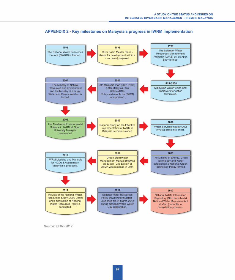
97
A STUDY ON THE STATUS AND ISSUES ONINTEGRATED RIVER BASIN MANAGEMENT (IRBM) IN MALAYSIA
APPENDIX2-KeymilestonesonMalaysia’sprogressinIWRMimplementation
Source: Elfithri 2012
The National Water Resources
Council (NWRC) is formed.
1998
River Basin Master Plans -
(basis for development within a
river basin) prepared.
1998
Malaysian Water Vision and
framework for action
formulated.
1999-2000
The Selangor Water
Resources Management
Authority (LUAS) act as Apex
Body formed.
1999
The Ministry of Energy, Green
Technology and Water
established & National Green
Technology Policy formed.
2009
Water Services Industry ACt
(WSIA) came into effect.
2008The Masters of Environmental
Science in IWRM at Open
University Malaysia
commenced.
2005
National Study on the Effective
Implementation of IWRM in
Malaysia is commissioned.
2005
8th Malaysia Plan (2001-2005)
& 9th Malaysia Plan
(2005-2010)
Policy statements on (WRM)
incorporated.
2001
The Ministry of Natural
Resources and Environment
and the Ministry of Energy,
Water and Communication is
formed.
2004
Urban Stormwater
Management Manual (MSMA)
produced - 2nd Edition of
MSMA was released in 2011.
2009
IWRM Modules and Manuals
for NGOs & Academia in
Malaysia is produced.
2010
National Water Resources
Policy (NWRP) formulated -
Launched on 24 March 2012
during National World Water
Day Celebration.
2012
Review of the National Water
Resources Study (2000-2050)
and Formulation of National
Water Resources Policy is
conducted.
2011
National IWRM Information
Repository (NIR) launched &
National Water Resources Act
drafted (currently in
consultation process).
2012

98
Source: Elfithri 2012
1997-2004 : Research on Ecosystem Health of Langat
Basin (SPELL) was conducted.
2004 : Langat River Basin acknowledged as “Evolving” Basin under UNESCO-IHP
HELP.
2005-2010 : Master of Environmental Science in
IWRM at Open University of .Malaysia (OUM) commenced.
2006 : First PhD in IWRM from the National University of
Malaysia (UKM) graduated.
2007 : IWRM Research Group of UKM formed.
2008 : Sustainable Ecosystem Management Research Group
of UKM was established.
2008-2010 : Research on MyIWRM, what can I do?
Developing Capacity for the Practical Implementation of Integrated Water Resources
Management in Malaysia was Implemented.
2009 : IWRM Modules and Manuals for Developing
Capacity of NGOs in Malaysia was produced..
2009 : IWRM Modules and Manuals for Developing Capacity of Academia in Malaysia was produced.
2010 : IWRM Training for Government Officers in
Malaysia was tconducted.
2012 : Research on Development of a Model for
Water Governance of Selected Urban Areas in LAngat Basin,
Malaysia was carried out.
2012 : Research on Access to Water Information on Langat
Basin : Communicating Environmental Awareness
was initiated.
2012 : Research on Analysis of Watershed Sustainbility Index (WSI) at Catchment Level for
Langat River Basin was conducted.
2013 : River Cleaning Campaign was conducted.
2013 : COllaborative Research on Upscalling MSMA
Ecohydrology Sg Langat was conducted.
2010 : SYmposium on Harmonising Environmental
Considerations with Sustainable Development
.Potential of River Basins was organised.
2010 : Putrajya Lake & Wetlands acknowledged as
“Operational” Demonstration Project under UNESCO-IHP
Ecohydrology.
2011 : Water and Media : Rising Up to the Challenges
was conducted.
2011 : Research on New Approach on Decision Support System (DSS) for sustainable
Langat River Basin MAnagement was carried out.
2011 : Research Water Footprint for Producing Crude Palm Oil Industry in Malaysia
was carried out.
APPENDIX 3 - Key milestones on IWRM implementation by Academia

99
A STUDY ON THE STATUS AND ISSUES ONINTEGRATED RIVER BASIN MANAGEMENT (IRBM) IN MALAYSIA
A1.4 Network of Asian River Basin Organisations (NARBO)
NARBO is the Network of Asian River Basin Organisations and was officially established in February 2004 to promote IWRM in monsoon areas of Asia. The goal of NARBO is to help achieve IWRM in river basins throughout Asia. The objective of NARBO is to strengthen the capacity and effectiveness of RBOs in promoting IWRM and improving water governance, through training and exchange of information and experiences among RBOs, as their associated water sector agencies, and knowledge partner organisations.
The following is a list of the scope of NARBO’s activities:
1. Advocacy, raising awareness, sharing information, good practices and lessons learned on IWRM through - the NARBO web site, publications, case studies, electronic newsletter, guidelines and sourcebooks, and media relations;
2. Capacity-building of RBOs in implementing IWRM and improving water governance through - training courses, workshops, performance benchmarking activities, advisory visits, scholarship programmes, RBO exchange visits, staff exchange programme, and twinning programmes;
3. Technical advice on planning, conservation, development, and the proper and efficient operation and maintenance of water resources facilities;
4. Fostering regional cooperation for improved management of water resources in transboundary river basins; and
5. Fostering regional cooperation for improved management of water resources in transboundary river basins.
NARBO’s membership is open to organisations which implement or promote IWRM, including river basin organisations, National and Federal/ provincial/local governmental organisations, regional and inter-regional knowledge partners and bilateral and multilateral
development cooperation agencies. NARBO currently has 79 members.
APPENDIX 4 – Key Recommendations from DID IRBM Blue Print Study (2010)
A4.1 General recommendations
The delineation of river basins in Malaysia should follow the definition and delineation as described in DID’s study on “Kajian Persempadanan Lembangan Sungai Malaysia” (June, 2009). Thus, the list of river basins given in the National Physical Plan should be updated. A pilot river basin that has the required characteristics to allow for a variety of lessons to be learned for future IRBM plans should be adopted for demonstrating the implementation of the recommended IRBM approach for Malaysia. All key decisions made relating to water management in the country should be fully in documented. In addition, need to expand monitoring arrangements and improve evaluation techniques as a priority early activity and to establish a timetable for delivery based on a 5 year cyclical review. Stakeholder groups should also be consulted to identify the most significant water management issues in each river basin and the existing monitoring records should be reviewed to find correlation with the identified significant issues.
As such, user conflicts should be identified as they provide a first pass at relating pressures in a river basin to impacts. A matrix approach is recommended as it allows for ready analysis and a set of “quick Wins” to build confidence in the methodology. Management objectives for river basins should be selected and a Technical Advisory Group (TAG), consisting of specialists from various disciplines, is recommended to be set-up. Since the work of improving the ecological standards of a river basin is iterative and progressive the work of the TAG should be continuous. Before implementation of a management measure a cost benefit analysis should be carried out.
A4.2 Sectoral recommendations
A4.2.1 Engineering Aspects
(a) Hydrology

100
The monitoring of groundwater and setting of standards for the chemicals to be monitored is important as groundwater becomes a significant water supply source in the future, especially in relation to pollution from agricultural sources.
A database on Artificial and Heavily Modified Water Bodies (AHMWB) should be setup due to the large number of reservoirs and water transfer facilities. In addition, specifically targeted programme to maximise ecological gains from planned development works should be carried out.
Water conservation will be an important tool to address supply/demand issues.Top-level cost benefit analysis on capital expenditure estimates are required to provide guidance for specific River Basins in terms of technical feasibility and proportionate expense in view of the high degree of uncertainty in projections of water quantity and extent of flood zones. As a result, benefit would not be gained from development actions geared to dealing with climate change in the early cycles of planning. However it would be appropriate to develop long term guidance in relation to hydrological analysis for water resources, flooding and low flow considerations.
The “Hydrological Handbook for Malaysia” that is being developed by DID Malaysia should take into account the fact that the long term changes in a river’s hydrology can provide surrogate indicators of the stresses on river biota and their habitats.
Given climate change impacts and the nature of hydrological science further research should be carried out into uncertainty in flood risk assessment. Further work is required on the development of flushing techniques to deal with pollution events. The Source Pathway Receptor Model is recommended to be adopted to achieve cost effectiveness and equitable allocation of costs between stakeholders. Hence, hydrological monitoring network should be expanded and aligned with pollution sampling points. The practice of Integrated River Basin Management planning will ensure greater coordination between land use planning and hydrology.
River Hydraulics
A Malaysian Technical Advisory Group (MTAG) should be established to provide professional guidance on the impacts of sediment loading and solid wastes on aquatic ecosystems through the development of appropriate ecological standards.
Further research on appropriate methodologies to assess environmental flows should be carried out and effective means developed to disseminate them to practitioners. Besides that, a training Programme should be developed for staff engaged in the procurement of construction services and river maintenance Programmes so that ‘soft’ engineering methods in terms of bank protection and slope stability are implemented for the restoration and rehabilitation of aquatic habitats and safeguarding of emergent species. As such, River Awareness and Capacity-building programmes are recommended to promote a paradigm shift in River Corridor Management perspective to achieve the vision of “natural rivers”.
HydroPower
A list of stakeholders related to planned hydropower schemes should be developed as soon as possible so that stakeholder engagement to balance the potentially high ecological cost with the high socio economic benefits that can be derived from small scale hydropower schemes in rural areas can be carried out.
The aim of rigorous application of EIA to all new Hydropower schemes is as follows:
• To take advantage of the refurbishment of old hydropower plants in river basins to adapt the refurbishment works to improve the ecological potential of the river basins through the planned works;
• To develop operating rules for Hydropower plants that control water discharges that are conducive to river ecosystem habitats;
• To identify areas with very high ecological value for protection from Hydropower development; and
101
A STUDY ON THE STATUS AND ISSUES ONINTEGRATED RIVER BASIN MANAGEMENT (IRBM) IN MALAYSIA
• To establish standards and planning requirements for the mandatory provision and maintenance of fish passes or alternative arrangements at all new hydropower plants.
A4.2.2 Scientific Aspects
The aim is To establish an expert group to develop inventories and classify Malaysia’s extensive terrestrial and aquatic wildlife as a basis for the use of bio-indicators in assessing river water quality.
The existing river monitoring networks is inadequate to support IRBM. There is a need to design integrated sampling and monitoring arrangements in terms of frequency, location and analysis, and particularly including flow, so that the objectives of IRBM can be monitored.
There is a significant problem with non-point (diffused) sources of water pollution and eutrophication. Agriculture and aquaculture, mining and manufacturing are the major sources of nutrient loading from fertilisers (phosphorus and nitrogen). Thus, it is recommended that awareness raising, education and incentives for individual farmers carried out initially on a test catchment basis be carried out so that reduced level of fertiliser application and better animal husbandry can be achieved.
A4.2.3 Watershed Planning and Social Impact
(a) Land Use Planning
The current landuse planning system in the country does not effectively take account of the needs of river basins. However the existence of the National Physical Plan Policies (NPP), Regional plans and local plans supplemented by Special Area Plans allows for the plans to incorporate landuse planning priorities developed based on river basin perspective.
The NPP 19 and NPP 22 policies are potentially helpful in achieving integration between land and water as they refer explicitly to protecting surface and groundwater resource and recharge areas. A number of local area plans have not yet been prepared and thus they provide DID an opportunity to introduce river basin
planning priorities into the plans as DID will be consulted as part of the planning process.
(b) Tourism
Tourism bodies should be included in the list of river basin stakeholders. A list of potential sensitive areas in river basins that may be affected by tourism activities should be specifically prepared in terms of the aquatic species that may be affected.
(c) Social Impact Assessment
Social Impact Assessment should be included in the Terms of Reference of all future IRBM plans and the scope of work for Social Impact Assessment should be clearly defined in the Terms of Reference of an IRBM Plan study. The outcomes of the Social Impact Assessment will provide input and feedbacks for evaluating the performance of the IRBM Plan and for further improvement to the Plan, where necessary.
In an IRBM Plan, stakeholder consultation should be carried out as part and parcel of the IRBM plan preparation. There should be a minimum of three stages of stakeholder consultations: firstly, at the inception stage; secondly at the proposal formulation stage; and finally at the final draft stage of the IRBM Plan.
The first stage of consultation should focus on informing the stakeholders on the scope and objectives of the IRBM Plan being prepared. The second stage of consultation is for scoping the key issues, conflict resolutions and initial recommendations for resolution of issues. The final stage of consultation should be aimed at achieving consensus on the recommendations in the IRBM Plan and the identification of follow up actions by the relevant stakeholders.
The IRBM Plan should also establish a medium for information dissemination and to obtain feedback from the stakeholders. A monitoring and evaluation framework should be established for the post-planning stage, i.e. during the implementation phase of an IRBM Plan. The Social Impact Assessment process should be continued into the implementation phase to enable evaluation and further improvements to the IRBM Plan. As such, an IRBM Plan should be a dynamic tool that is continuously

102
reviewed and refined throughout its implementation phase.
(d) Navigation
There is a need to identify river basins that have been heavily modified by river navigation infrastructure so that appropriate measures to address them based on current international best practice can be implemented.
Both commercial and recreational navigation are significant pollution sources. Impacts can be produced from accidental spillage of cargoes to sewage effluent discharge. Thus, enforcement is inevitably necessary and the preparation of boating standards is recommended to address them.
A4.2.4 GIS and Data Management
The use of GIS to support river basin data management is essential. Thus, the development of GIS Data Model based on MS175-2004 standard should be carried out and shall be expanded to include data for biodiversity and other sectors.
A4.2.5 Legal and Institution
The formation of a State Water Resources Board or Council for every state in Peninsular Malaysia is recommended. Its role will be to manage and implement integrated water resources management within the state. Every State should adopt appropriate legislation to allow effective implementation of IRBM in the state. Such legislation may be similar to the LUAS or LSANK enactments in Selangor and Kedah, respectively.
There is a need for the DID to be restructured into a National Water Resources Department (NWRD), with adequate resources, capacity and expertise in all sectors important to IWRM. The NWRD must drive implementation of the National Policy on IWRM, provide support and expert advice to the NWRC and implement the decisions of the latter. It must also be empowered under the law proposed by the National Water Resources Study to carry out its functions mandated under the Federal Constitution. Some of its important roles, besides its current functions, will include:
• Development of standards, classification, procedures and guidelines to assist in the implementation of IWRM and IRBM in the country;
• Propose and assist in the adoption and implementation of best management practices for all sectors related to IWRM and IRBM;
• Coordinate and carry out necessary scientific research and development in IWRM and IRBM related areas;
• Build capacity and provide advice to state authorities for the adoption and implementation of IWRM and IRBM; and
• Undertake Communication, Education and Public Awareness (CEPA) Programmes and assist State authorities in the implementation of CEPA Programmes.
Furthermore, adequate financial resources must be made available for the states to carry out the necessary functions for IRBM on a sustainable basis. The creation of the water resources management authority in a state will enable the state to tap into new and innovative revenue streams arising from the sustainable development and use of water resources. In addition, Federal level taxation with fiscal incentives may be adopted as added incentive for states to manage the water resources in a more sustainable manner. Examples of such approaches are available in the country, such as the licensing of groundwater and licensing of discharges and abstractions.
However, only part of the adoption of a more sustainable financial model is the requirement to implement equitable apportionment of resources in relation to the challenges faced by a state and the nation. The Federal Government, through the NWRC and NWRD, should consider the need to play a more direct and larger role in the equitable allocation and distribution of water resources and particularly when transboundary, inter-state and international issues arise and need resolution
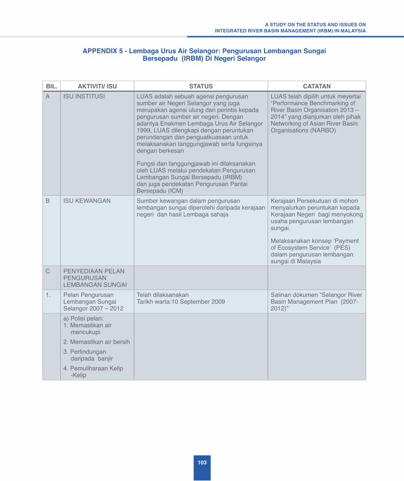
103
A STUDY ON THE STATUS AND ISSUES ONINTEGRATED RIVER BASIN MANAGEMENT (IRBM) IN MALAYSIA
APPENDIX 5 - Lembaga Urus Air Selangor: Pengurusan Lembangan Sungai Bersepadu (IRBM) Di Negeri Selangor
BIL. AKTIVITI/ ISU STATUS CATATANA ISU INSTITUSI LUAS adalah sebuah agensi pengurusan
sumber air Negeri Selangor yang juga merupakan agensi ulung dan perintis kepada pengurusan sumber air negeri. Dengan adantya Enakmen Lembaga Urus Air Selangor 1999, LUAS dilengkapi dengan peruntukan perundangan dan penguatkuasaan untuk melaksanakan tanggungjawab serta fungsinya dengan berkesan
Fungsi dan tanggungjawab ini dilaksanakan oleh LUAS melalui pendekatan Pengurusan Lembangan Sungai Bersepadu (IRBM) dan juga pendekatan Pengurusan Pantai Bersepadu (ICM)
LUAS telah dipilih untuk meyertai “Performance Benchmarking of River Basin Organisation 2013 – 2014” yang dianjurkan oleh pihak Networking of Asian River Basin Organisations (NARBO)
B ISU KEWANGAN Sumber kewangan dalam pengurusan lembangan sungai diperolehi daripada kerajaan negeri dan hasil Lembaga sahaja
Kerajaan Persekutuan di mohon menyalurkan peruntukan kepada Kerajaan Negeri bagi menyokong usaha pengurusan lembangan sungai.
Melaksanakan konsep ‘Payment of Ecosystem Service’ (PES) dalam pengurusan lembangan sungai di Malaysia
C PENYEDIAAN PELAN PENGURUSAN LEMBANGAN SUNGAI
1. Pelan Pengurusan Lembangan Sungai Selangor 2007 – 2012
Telah dilaksanakanTarikh warta:10 September 2009
Salinan dokumen “Selangor River Basin Management Plan (2007-2012)”
a) Polisi pelan:1. Memastikan air
mencukupi2. Memastikan air bersih3. Perlindungan
daripada banjir4. Pemuliharaan Kelip
-Kelip

104
BIL. AKTIVITI/ ISU STATUS CATATANb) Aktiviti Pelan :Polisi 1: Memastikan air mencukupi
1. Pembangunan sistem pengurusan data maklumat LUAS
2. Pembahagian Air (Water Allocation)
3. Pengurusan kemarau
1. Integrated Water Resource Information Management System (IWRIMS)
2. E-LUAS 3. Pembangunan Decision
Support System bagi Lembangan Sungai
1. Melesenkan aktiviti abstraksi sumber air
2. Memperuntukkan sebanyak 300 Mld bagi aliran persekitaran (environmental flow) untuk hidupan kelip – kelip di hilir Sungai Selangor
3. Terdapat beberapa aktiviti di bawah pembahagian air (water allocation) yang masih dalam proses penyediaan seperti :
a) Menyediakan SOP pengairan di Terusan Utama Kuala Selangor bagi kegunaan pertanian dan bekalan air mentah
b) Kajian Kebolehdapatan Sumber Air Bumi Negeri Selangor
c) Kajian peningkatan kadar keperluan bekalan air mentah bagi Negeri Selangor
1. Pelan Tindakan Menangani musim kemarau
2. Pewartaan Sumber air alternatif
3. Pewartaan kawasan tadahan air empangan (tujuh empangan) – Tarikh warta : 2 Disember 2010

105
A STUDY ON THE STATUS AND ISSUES ONINTEGRATED RIVER BASIN MANAGEMENT (IRBM) IN MALAYSIA
BIL. AKTIVITI/ ISU STATUS CATATANPolisi 2: Memastikan air bersih
1. Kawalan Pencemaran
2. Kawalan Kualiti Air
3. Penyerahan Projek Demontrasi IRBM di Bukit Sentosa kepada MDHS dengan kerjasama pihak JPS
1. Pemantauan punca pencemaran sumber air melalui; a) Mesyuarat Pasukan Petugas b) Mesyuarat Jawatankuasa
Pengurusan Lembangan Sungai Negeri Selangor
2. Tindakan bersepadu bagi kes – kes kecemasan yang melibatkan henti tugas di Loji Pembersihan Air melalui Jawatankuasa Kecemasan Pencemaran Sumber Air
1. Pewartaan Peraturan Kemasukan atau Pelepasan Bahan Pencemar (Negeri Selangor) 2012 ( Tarikh warta:19 April 2012)
2. Peraturan – Peraturan Aktiviti Pengubahan Sumber (Selangor 2013)
3. Semakan semula senarai aktiviti, yang dilesenkan termasuk had piawaian parameter termasuk tapak pembuangan sampah (dumping site area) dan perundangan untuk meningkatkan kualiti air kepada kelas II
4. Pewartaan Zon Perlindungan Di Bawah Seksyen 48, Enakmen LUAS 1999 Bagi Rizab Sungai (Sungai Utama) (Rizab 50 Meter Kiri Dan 50 Meter Kanan)
1. Penyerahan projek kepada MDHS dan sumbangan sebanyak RM10,000.00
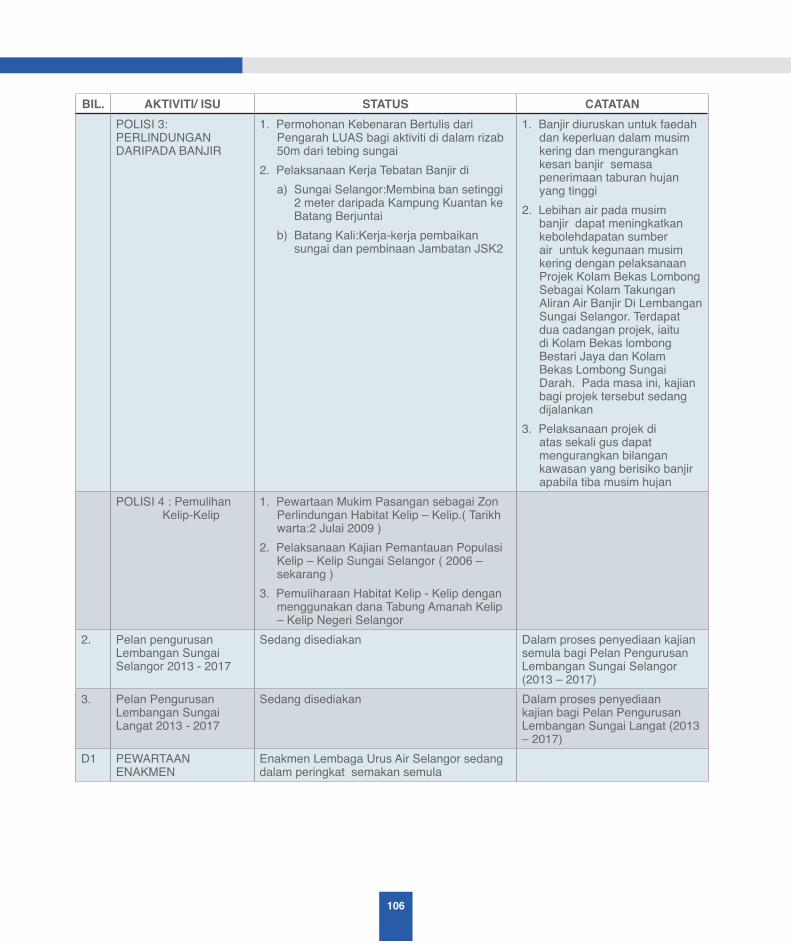
106
BIL. AKTIVITI/ ISU STATUS CATATANPOLISI 3: PERLINDUNGAN DARIPADA BANJIR
1. Permohonan Kebenaran Bertulis dari Pengarah LUAS bagi aktiviti di dalam rizab 50m dari tebing sungai
2. Pelaksanaan Kerja Tebatan Banjir dia) Sungai Selangor:Membina ban setinggi
2 meter daripada Kampung Kuantan ke Batang Berjuntai
b) Batang Kali:Kerja-kerja pembaikan sungai dan pembinaan Jambatan JSK2
1. Banjir diuruskan untuk faedah dan keperluan dalam musim kering dan mengurangkan kesan banjir semasa penerimaan taburan hujan yang tinggi
2. Lebihan air pada musim banjir dapat meningkatkan kebolehdapatan sumber air untuk kegunaan musim kering dengan pelaksanaan Projek Kolam Bekas Lombong Sebagai Kolam Takungan Aliran Air Banjir Di Lembangan Sungai Selangor. Terdapat dua cadangan projek, iaitu di Kolam Bekas lombong Bestari Jaya dan Kolam Bekas Lombong Sungai Darah. Pada masa ini, kajian bagi projek tersebut sedang dijalankan
3. Pelaksanaan projek di atas sekali gus dapat mengurangkan bilangan kawasan yang berisiko banjir apabila tiba musim hujan
POLISI 4 : Pemulihan Kelip-Kelip
1. Pewartaan Mukim Pasangan sebagai Zon Perlindungan Habitat Kelip – Kelip.( Tarikh warta:2 Julai 2009 )
2. Pelaksanaan Kajian Pemantauan Populasi Kelip – Kelip Sungai Selangor ( 2006 – sekarang )
3. Pemuliharaan Habitat Kelip - Kelip dengan menggunakan dana Tabung Amanah Kelip – Kelip Negeri Selangor
2. Pelan pengurusan Lembangan Sungai Selangor 2013 - 2017
Sedang disediakan Dalam proses penyediaan kajian semula bagi Pelan Pengurusan Lembangan Sungai Selangor (2013 – 2017)
3. Pelan Pengurusan Lembangan Sungai Langat 2013 - 2017
Sedang disediakan Dalam proses penyediaan kajian bagi Pelan Pengurusan Lembangan Sungai Langat (2013 – 2017)
D1 PEWARTAAN ENAKMEN
Enakmen Lembaga Urus Air Selangor sedang dalam peringkat semakan semula

107
A STUDY ON THE STATUS AND ISSUES ONINTEGRATED RIVER BASIN MANAGEMENT (IRBM) IN MALAYSIA
BIL. AKTIVITI/ ISU STATUS CATATAN1. Enakmen LEMBAGA
URUS AIR SELANGOR 1999
Enakmen ini telah diluluskan oleh Dewan Undangan Negeri, Selangor, pada 9 April 1999
Enakmen ini telah diisytiharkan ke maklumat umumTarikh permulaan kuat kuasa Enakmen adalah berbeza mengikut bahagiannya.Sila rujuk laman web www.luas.gov.my
2. Penetapan Tarikh Permulaan Kuat kuasa (Sel. P.U 20)
Tarikh warta: 11 Mei 2000
3. Penetapan Tarikh Mula Berkuat kuasa Enakmen LUAS, 1999 (SEL. P.U. 14)
Tarikh warta: 22 Mei 2003
D2 PEWARTAAN UNDANG-UNDANG SUBSIDIARI DI BAWAH ENAKMEN LEMBAGA URUS AIR SELANGOR 1999
Terdapat 11 perundangan yang telah diwartakan dan 4 perundangan sedang dalam tindakan penyediaan dan pewartaan
1. Pemberitahuan Caj Bagi Abstraksi Air Daripada Mana-mana Sumber Air - No.1366
Tarikh warta: 30 Jun 2005 Penetapan kadar caj yang dikenakan kepada pengabstrak sumber air sama ada air bumi mahu pun permukaan di bawah seksyen 44(1) Enakmen LUAS. Sila rujuk laman web www.luas.gov.my
2. Peraturan - peraturan ( Pengkompaunan Kesalahan ) LEMBAGA URUS AIR SELANGOR 2006
Tarikh warta: 9 Mac 2006 Menjelaskan tatacara pengkompaunan kesalahan mengikut Enakmen LUAS 1999 dan pelantikan pegawai yang bertanggungjawab untuk mengkompaun selaras dengan seksyen 112 Enakmen LUASSila rujuk laman web www.luas.gov.my
3. Pelan Pengurusan Lembangan Sungai Selangor 2007-2012 - No.023
Tarikh warta:10 September 2009 Pemberitahuan Umum mengenai polisi dan strategi Pelan Pengurusan Lembagan Sungai Selangor 2007-2012Sila rujuk laman web www.luas.gov.my
4. Pelan Pelaksanaan Strategi Perairan Pantai Pelabuhan - No.024
Tarikh warta:10 September 2009 Pemberitahuan Umum mengenai Pelaksanaan Strategi Perairan Pantai Pelabuhan Klang yang mengandungi pelan tindakanSila rujuk laman web www.luas.gov.my
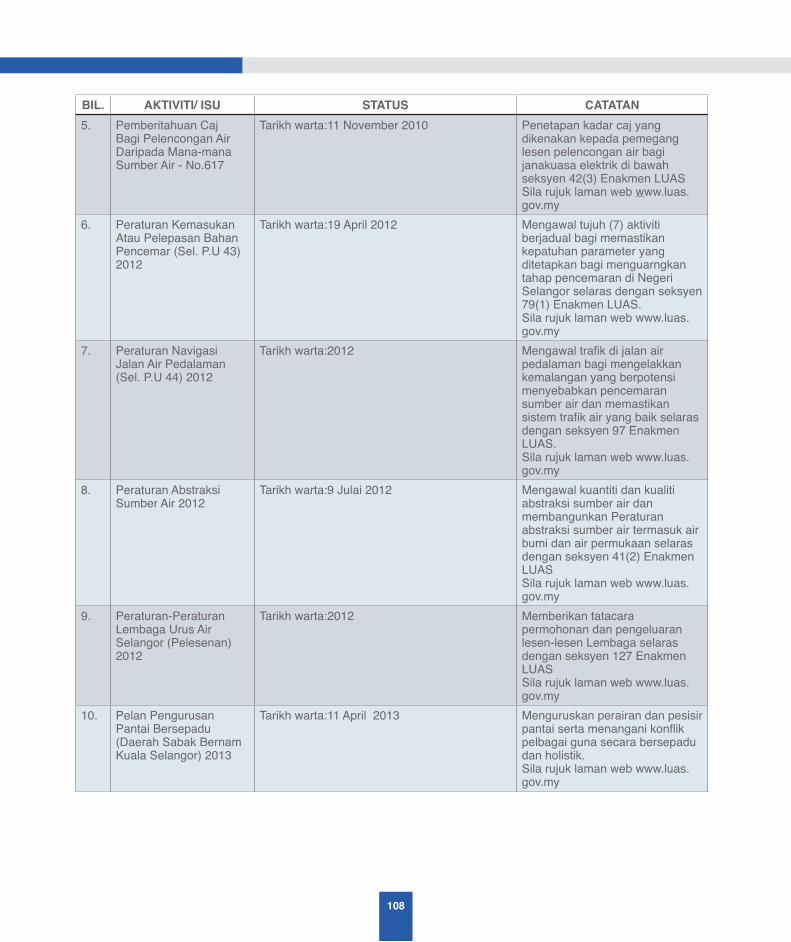
108
BIL. AKTIVITI/ ISU STATUS CATATAN5. Pemberitahuan Caj
Bagi Pelencongan Air Daripada Mana-mana Sumber Air - No.617
Tarikh warta:11 November 2010 Penetapan kadar caj yang dikenakan kepada pemegang lesen pelencongan air bagi janakuasa elektrik di bawah seksyen 42(3) Enakmen LUAS Sila rujuk laman web www.luas.gov.my
6. Peraturan Kemasukan Atau Pelepasan Bahan Pencemar (Sel. P.U 43) 2012
Tarikh warta:19 April 2012 Mengawal tujuh (7) aktiviti berjadual bagi memastikan kepatuhan parameter yang ditetapkan bagi menguarngkan tahap pencemaran di Negeri Selangor selaras dengan seksyen 79(1) Enakmen LUAS. Sila rujuk laman web www.luas.gov.my
7. Peraturan Navigasi Jalan Air Pedalaman (Sel. P.U 44) 2012
Tarikh warta:2012 Mengawal trafik di jalan air pedalaman bagi mengelakkan kemalangan yang berpotensi menyebabkan pencemaran sumber air dan memastikan sistem trafik air yang baik selaras dengan seksyen 97 Enakmen LUAS. Sila rujuk laman web www.luas.gov.my
8. Peraturan Abstraksi Sumber Air 2012
Tarikh warta:9 Julai 2012 Mengawal kuantiti dan kualiti abstraksi sumber air dan membangunkan Peraturan abstraksi sumber air termasuk air bumi dan air permukaan selaras dengan seksyen 41(2) Enakmen LUASSila rujuk laman web www.luas.gov.my
9. Peraturan-Peraturan Lembaga Urus Air Selangor (Pelesenan) 2012
Tarikh warta:2012 Memberikan tatacara permohonan dan pengeluaran lesen-lesen Lembaga selaras dengan seksyen 127 Enakmen LUASSila rujuk laman web www.luas.gov.my
10. Pelan Pengurusan Pantai Bersepadu (Daerah Sabak Bernam Kuala Selangor) 2013
Tarikh warta:11 April 2013 Menguruskan perairan dan pesisir pantai serta menangani konflik pelbagai guna secara bersepadu dan holistik. Sila rujuk laman web www.luas.gov.my

109
A STUDY ON THE STATUS AND ISSUES ONINTEGRATED RIVER BASIN MANAGEMENT (IRBM) IN MALAYSIA
BIL. AKTIVITI/ ISU STATUS CATATAN11. Peraturan – Peraturan
Aktiviti Pengubahan Sumber (Selangor 2013)
Tarikh warta:10 Oktober 2013 Mengawal aktiviti fizikal melibatkan sumber air dan persekitrarannya bagi mengelakkan pencemaran sumber air Sila rujuk laman web www.luas.gov.my
12. Peraturan – Peraturan Pelencongan Air Bagi Penjanaan Elektrik (Selangor 2013)
Dalam proses pewartaan Mengawal aktiviti pelencongan air bagi penjanaan elektrik untuk mengelakkan kesan buruk kepada kuantiti dan kualiti sumber air serta persekitarannya
13. Pelan Tindakan Menangani Kemarau
Dalam proses penyediaan Menyediakan pelan tindakan apabila menghadapi perubahan cuaca musim kering/kemarau
14. Peraturan Aktiviti Rekreasi Sumber Air Negeri Selangor
Dalam proses penyediaan Mengawal aktiviti rekreasi sumber air selaras dengan peruntukan Seksyen 98 (1) Enakmen LUAS 1999
15. Daftar sumber air Dalam proses penyediaan Menyediakan buku daftar rujukan nama – nama sumber air di Selangor yang digazetkan di bawah S.127 Enakmen LUAS 1999. Buku ini boleh digunakan sebagai sumber rujukan sah kepada LUAS dan agensi lain serta boleh digunakan sebagai keterangan di dalam mahkamah
D3 PEWARTAAN ZON PERLINDUNGAN DI BAWAH SEKSYEN 48 ENAKMEN LUAS 1999
Kawalan di peringkat perancangan bagi aktiviti guna tanah dan lembangan sungai melalui Pewartaan Zon Perlindungan di bawah Seksyen 48 Enakmen LUAS 1999
1. Pewartaan Mukim Pasangan sebagai Zon Perlindungan Habitat Kelip – Kelip
Telah dilaksanakanTarikh warta: 2 Julai 2009 dan 29 April 2010
Bertujuan mengawal rizab sungai, zon penampan, dan alam persekitarannya di jajaran tertentu di Sungai Selangor dalam Mukim Pasangan, Daerah Kuala Selangor Sila rujuk laman web www.luas.gov.my
2. Pewartaan Zon Perlindungan kawasan tanah perairan, rizab sungai dan kawasan pantai - No.189
Tarikh warta: 29 April 2010 Sila rujuk laman web www.luas.gov.my
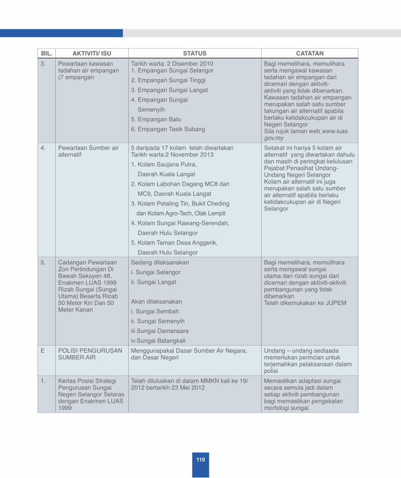
110
BIL. AKTIVITI/ ISU STATUS CATATAN3. Pewartaan kawasan
tadahan air empangan (7 empangan
Tarikh warta: 2 Disember 20101. Empangan Sungai Selangor2. Empangan Sungai Tinggi3. Empangan Sungai Langat4. Empangan Sungai Semenyih5. Empangan Batu6. Empangan Tasik Subang
Bagi memelihara, memulihara serta mengawal kawasan tadahan air empangan dari dicemari dengan aktiviti-aktiviti yang tidak dibenarkan. Kawasan tadahan air empangan merupakan salah satu sumber takungan air alternatif apabila berlaku ketidakcukupan air di Negeri Selangor Sila rujuk laman web www.luas.gov.my
4. Pewartaan Sumber air alternatif
5 daripada 17 kolam telah diwartakan Tarikh warta:2 November 20131. Kolam Saujana Putra, Daerah Kuala Langat2. Kolam Labohan Dagang MC8 dan MC9, Daerah Kuala Langat3. Kolam Petaling Tin, Bukit Cheding
dan Kolam Agro-Tech, Olak Lempit4. Kolam Sungai Rawang-Serendah, Daerah Hulu Selangor5. Kolam Taman Desa Anggerik, Daerah Hulu Selangor
Setakat ini hanya 5 kolam air alternatif yang diwartakan dahulu dan masih di peringkat kelulusan Pejabat Penasihat Undang-Undang Negeri Selangor Kolam air alternatif ini juga merupakan salah satu sumber air alternatif apabila berlaku ketidakcukupan air di Negeri Selangor
5. Cadangan Pewartaan Zon Perlindungan Di Bawah Seksyen 48, Enakmen LUAS 1999 Rizab Sungai (Sungai Utama) Beserta Rizab 50 Meter Kiri Dan 50 Meter Kanan
Sedang dilaksanakani. Sungai Selangorii. Sungai Langat
Akan dilaksanakani. Sungai Sembahii. Sungai Semenyih iii.Sungai Damansaraiv.Sungai Batangkali
Bagi memelihara, memulihara serta mengawal sungai utama dan rizab sungai dari dicemari dengan aktiviti-aktiviti pembangunan yang tidak dibenarkanTelah dikemukakan ke JUPEM
E POLISI PENGURUSAN SUMBER AIR
Menggunapakai Dasar Sumber Air Negara, dan Dasar Negeri
Undang – undang sediaada memerlukan perincian untuk terjemahkan pelaksanaan dalam polisi
1. Kertas Posisi Strategi Pengurusan Sungai Negeri Selangor Selaras dengan Enakmen LUAS 1999
Telah diluluskan di dalam MMKN kali ke 19/ 2012 bertarikh 23 Mei 2012
Memastikan adaptasi sungai secara semula jadi dalam setiap aktiviti pembangunan bagi memastikan pengekalan morfologi sungai
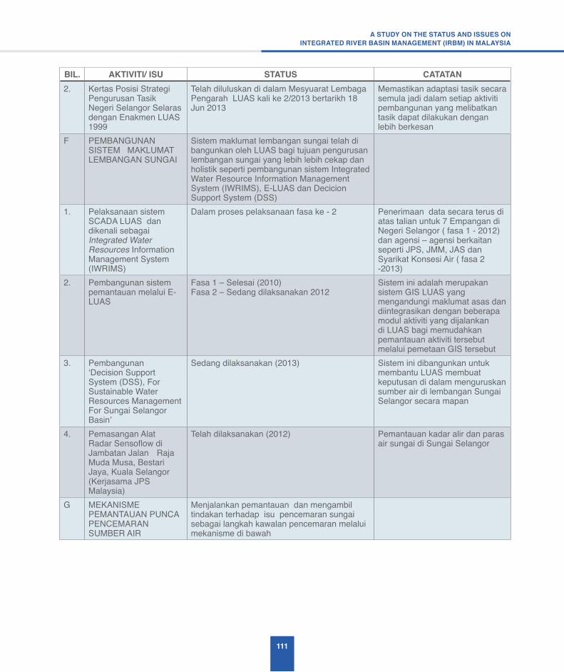
111
A STUDY ON THE STATUS AND ISSUES ONINTEGRATED RIVER BASIN MANAGEMENT (IRBM) IN MALAYSIA
BIL. AKTIVITI/ ISU STATUS CATATAN2. Kertas Posisi Strategi
Pengurusan Tasik Negeri Selangor Selaras dengan Enakmen LUAS 1999
Telah diluluskan di dalam Mesyuarat Lembaga Pengarah LUAS kali ke 2/2013 bertarikh 18 Jun 2013
Memastikan adaptasi tasik secara semula jadi dalam setiap aktiviti pembangunan yang melibatkan tasik dapat dilakukan dengan lebih berkesan
F PEMBANGUNAN SISTEM MAKLUMAT LEMBANGAN SUNGAI
Sistem maklumat lembangan sungai telah di bangunkan oleh LUAS bagi tujuan pengurusan lembangan sungai yang lebih lebih cekap dan holistik seperti pembangunan sistem Integrated Water Resource Information Management System (IWRIMS), E-LUAS dan Decicion Support System (DSS)
1. Pelaksanaan sistem SCADA LUAS dan dikenali sebagai Integrated Water Resources Information Management System (IWRIMS)
Dalam proses pelaksanaan fasa ke - 2 Penerimaan data secara terus di atas talian untuk 7 Empangan di Negeri Selangor ( fasa 1 - 2012) dan agensi – agensi berkaitan seperti JPS, JMM, JAS dan Syarikat Konsesi Air ( fasa 2 -2013)
2. Pembangunan sistem pemantauan melalui E- LUAS
Fasa 1 – Selesai (2010)Fasa 2 – Sedang dilaksanakan 2012
Sistem ini adalah merupakan sistem GIS LUAS yang mengandungi maklumat asas dan diintegrasikan dengan beberapa modul aktiviti yang dijalankan di LUAS bagi memudahkan pemantauan aktiviti tersebut melalui pemetaan GIS tersebut
3. Pembangunan ‘Decision Support System (DSS), For Sustainable Water Resources Management For Sungai Selangor Basin’
Sedang dilaksanakan (2013) Sistem ini dibangunkan untuk membantu LUAS membuat keputusan di dalam menguruskan sumber air di lembangan Sungai Selangor secara mapan
4. Pemasangan Alat Radar Sensoflow di Jambatan Jalan Raja Muda Musa, Bestari Jaya, Kuala Selangor (Kerjasama JPS Malaysia)
Telah dilaksanakan (2012) Pemantauan kadar alir dan paras air sungai di Sungai Selangor
G MEKANISME PEMANTAUAN PUNCA PENCEMARAN SUMBER AIR
Menjalankan pemantauan dan mengambil tindakan terhadap isu pencemaran sungai sebagai langkah kawalan pencemaran melalui mekanisme di bawah
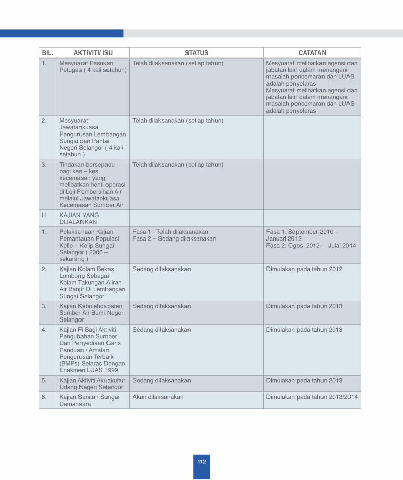
112
BIL. AKTIVITI/ ISU STATUS CATATAN1. Mesyuarat Pasukan
Petugas ( 4 kali setahun)Telah dilaksanakan (setiap tahun) Mesyuarat melibatkan agensi dan
jabatan lain dalam menangani masalah pencemaran dan LUAS adalah penyelarasMesyuarat melibatkan agensi dan jabatan lain dalam menangani masalah pencemaran dan LUAS adalah penyelaras
2. Mesyuarat Jawatankuasa Pengurusan Lembangan Sungai dan Pantai Negeri Selangor ( 4 kali setahun )
Telah dilaksanakan (setiap tahun)
3. Tindakan bersepadu bagi kes – kes kecemasan yang melibatkan henti operasi di Loji Pembersihan Air melalui Jawatankuasa Kecemasan Sumber Air
Telah dilaksanakan (setiap tahun)
H KAJIAN YANG DIJALANKAN
1. Pelaksanaan Kajian Pemantauan Populasi Kelip – Kelip Sungai Selangor ( 2006 – sekarang )
Fasa 1 - Telah dilaksanakanFasa 2 – Sedang dilaksanakan
Fasa 1: September 2010 – Januari 2012Fasa 2: Ogos 2012 – Julai 2014
2. Kajian Kolam Bekas Lombong Sebagai Kolam Takungan Aliran Air Banjir Di Lembangan Sungai Selangor
Sedang dilaksanakan Dimulakan pada tahun 2012
3. Kajian Kebolehdapatan Sumber Air Bumi Negeri Selangor
Sedang dilaksanakan Dimulakan pada tahun 2013
4. Kajian Fi Bagi Aktiviti Pengubahan Sumber Dan Penyediaan Garis Panduan / Amalan Pengurusan Terbaik (BMPs) Selaras Dengan Enakmen LUAS 1999
Sedang dilaksanakan Dimulakan pada tahun 2013
5. Kajian Aktiviti Akuakultur Udang Negeri Selangor
Sedang dilaksanakan Dimulakan pada tahun 2013
6. Kajian Sanitari Sungai Damansara
Akan dilaksanakan Dimulakan pada tahun 2013/2014

113
A STUDY ON THE STATUS AND ISSUES ONINTEGRATED RIVER BASIN MANAGEMENT (IRBM) IN MALAYSIA
BIL. AKTIVITI/ ISU STATUS CATATANI Programme
KERJASAMA DENGAN AGENSI LAIN/ PIHAK BERKEPENTINGAN
Terdapat pelbagai program kerjasama yang telah dijalankan oleh LUAS bersama agensi – agensi lain, badan NGO atau pihak berkepentingan seperti program kesedaran, forum, kajian, dan projek sepanjang tahun. Program tersebut sama ada menggunakan peruntukan kerajaan negeri, LUAS, atau di biayai oleh pihak luar
1. Pemuliharaan Habitat Kelip – Kelip dengan menggunakan dana Tabung Amanah Kelip – Kelip Negeri Selangor
Telah dilaksanakan Projek Kerajaan Negeri Selangor, Frim dan AEON CO. (M) BHD dengan kerjasama LUAS, PTD Kuala Selangor dan MDKS
2. Projek Konservasi Kelip – Kelip Bersama Komuniti Kampung Kuantan, Kuala Selangor
Telah dilaksanakan Projek UKM dan TNB Research dengan kerjasama MDKS dan LUAS
J DOKUMEN YANG DITERBITKAN OLEH LUAS
Dokumen yang diterbitkan mengandungi maklumat pemantauan lembangan sungai dari pelbagai agensi untuk rujukan oleh agensi – agensi kerajaan, badan NGO dan pihak – pihak berkepentingan
Sila rujuk laman web www.luas.gov.my
1. State of River Report Sungai Selangor
Tahun 2006
2. State of River Report Sungai Selangor
Tahun 2008
3. State of River Report Sungai Langat
Tahun 2008
4. State of River Report Sungai Klang
Tahun 2008
5. State of River Report Sungai Selangor
Tahun 2011
6. State of River Report Sungai Langat
Tahun 2011
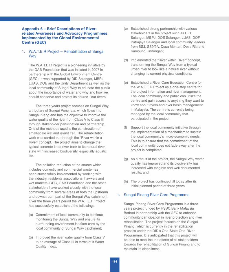
114
Appendix 6 – Brief Descriptions of River-related Awareness and Advocacy Programmes Implemented by the Global Environmental Centre (GEC)
1. W.A.T.E.R Project – Rehabilitation of Sungai Way
The W.A.T.E.R Project is a pioneering initiative by the GAB Foundation that was initiated in 2007 in partnership with the Global Environment Centre (GEC). It was supported by DID Selangor, MBPJ, LUAS, DOE and the Unity Department as well as the local community of Sungai Way to educate the public about the importance of water and why and how we should conserve and protect its source - our rivers.
The three years project focuses on Sungai Way, a tributary of Sungai Penchala, which flows into Sungai Klang and has the objective to improve the water quality of the river from Class V to Class III through stakeholder participation and partnership. One of the methods used is the construction of small-scale wetland island cell. The rehabilitation work was carried out through the “River within a River” concept. The project aims to change the typical concrete-lined river back to its natural river state with increased biodiversity, especially aquatic life.
The pollution reduction at the source which includes domestic and commercial waste has been successfully implemented by working with the industry, residents associations, hawkers and wet markets. GEC, GAB Foundation and the other stakeholders have worked closely with the local community from several areas at both the upstream and downstream part of the Sungai Way catchment. Over the three years period the W.A.T.E.R Project has successfully established the following:
(a) Commitment of local community to continue monitoring the Sungai Way and ensure its surrounding environment is taken-care by the local community of Sungai Way catchment;
(b) Improved the river water quality from Class V to an average of Class III in terms of it Water Quality Index;
(c) Established strong partnership with various stakeholders in the project such as DID Selangor, MBPJ, DOE Selangor, LUAS, DOF Putrajaya Selangor and local community leaders from SS3, SS9/9A, Desa Mentari, Desa Ria and Kampung Lindungan;
(d) Implemented the “River within River” concept, transforming the Sungai Way from a typical urban river to look like a natural river without changing its current physical conditions;
(e) Established a River Care Education Centre for the W.A.T.E.R Project as a one-stop centre for the project information and river management. The local community and public can utilize the centre and gain access to anything they want to know about rivers and river basin management in Malaysia. The centre is currently being managed by the local community that participated in the project;
(f) Support the local community initiative through the implementation of a mechanism to sustain the local community’s micro-economic needs. This is to ensure that the commitment of the local community does not fade away after the project is completed.
(g) As a result of the project, the Sungai Way water quality has improved and its biodiversity has increased with tangible and well-documented results; and
(h) The project has continued till today after its initial planned period of three years.
1. Sungai Pinang River Care Programme
Sungai Pinang River Care Programme is a three years project funded by HSBC Bank Malaysia Berhad in partnership with the GEC to enhance community participation in river protection and river rehabilitation. The project focuses on the Sungai Pinang, which is currently in the rehabilitation process under the DID’s One-State-One-River Programme. It is anticipated that this project will be able to mobilise the efforts of all stakeholders towards the rehabilitation of Sungai Pinang and to maintain its cleanliness.
115
A STUDY ON THE STATUS AND ISSUES ONINTEGRATED RIVER BASIN MANAGEMENT (IRBM) IN MALAYSIA
For the past 15 months, the project in partnership with DID Penang has strengthened and expanded the community river monitoring and protection activities in the Sungai Pinang River Basin by establishing a number of River Ranger groups based in both schools and the local communities. The training of te River Ranger groups was actively initiated in various local projects at both the schools and local communities.
2. Sungai Nenggiri River Basin Conservation Programme (NRCP)
Sungai Nenggiri in Gua Musang, Kelantan is one of the three main tributaries of Sungai Kelantan. The basin is characterised by the thick, tropical rain forest of the Titiwangsa Range. The surrounding environment and biodiversity of the Sungai Nenggiri River Basin is under threat due to development activities and plantation industries up-stream of the river. An integrated river basin management system with strong community engagement has helped to provide an effective mechanism and solution to safeguard the natural resources of the river basin and sustain the income generating opportunities for the local communities. The NRCP was established in 2004, by the Global Environment Centre (GEC) and Titiwangsa Heritage Sdn. Bhd. in collaboration with the local communities from among the indigenous people and the Kelantan State Government. The achievements of the NRCP are as follows:
(a) Set-up of an information/training centre/secretariat office in Gua Musang
(b) Establishment of a fish conservation area covering 30 km of the mainstream and three tributaries of the Nenggiri River
(c) Creation of a local community patrolling group to protect the fish conservation area from illegal fishing
(d) Construction of a field base and visitors camp at Kuala Jenera
(e) Increasing visits to the area by eco-tourism and recreational fishing groups.
3. Sungai Pagoh River Auditing Programme
The Sungai Pagoh River Auditing Programme is a River Education and Awareness Programme developed in 2007 specifically to tackle the flood issues in Pagoh and to prepare the local community for any future flood. Local community capacity building, integrated river basin management, river monitoring, flood mitigation action plan and networking and mobilization of all stakeholders are some of the major focus of the project. With the combination of both ICT and community participation it has become another project milestone in utilizing the local communities to spearhead efforts to reduce the flood risk in Malaysia with the support from the Government.
The project has enhanced the understanding and knowledge of the local community on river ecology and hydrology. It has also identified the root cause and adaptation options to flooding among the key stakeholders so as to help them manage the risks of floods to people, property and the environment by concerted and coordinated action at the river basin level.
4. Kelana Jaya Lake Rehabilitation Programme
The Kelana Jaya Lake is one of the most prominent urban lakes in Selangor, Malaysia. It is located in the Sungai Damansara catchment where the lake was developed into a public park that provides tranquility and enjoyment to the people from all walks of life and from the hustle and bustle of city life. However, the intangible benefits of the lake have been diminished in over the years due to the continuous pollution of the lake by the surrounding area.
As a result, a lake rehabilitation Programme was initiated in 2002. The first phase of the programme involved community awareness and empowering the community to participate in conserving the lakes’ ecosystem and its biodiversity. Consequently, the Programme has managed to generate positive responses from the community, and as a result, the “Friends of Kelana Jaya Park” was established in 2005.
116
In August 2007, the Ministry of Science, Technology and Innovation (MOSTI) under the Innofund Scheme funded the second phase of the Kelana Jaya Lake Rehabilitation Programme known as the ‘Rehabilitation of Kelana Jaya Lake through Community Participation’: This project aims at improving the water quality of one of the lakes (Lake 1) by emphasising on the involvement of the local community in lake management along with the use of an innovative technology called the Ecofan. The project facilitated the active engagement of the local community in pollution prevention and the clean-up of the urban streams and lakes. The water quality was improved through pollution control at the source, improvement of water circulation, reduction of water retention time, and using Ecofan to enhance the organic pollution degradation. Besides that the wetland cell method was also used to treat the water quality of the lakes. At the same time, the local community has been trained to become Park Rangers. The project is still active and the local community participation is still very good, and there is visible progress since the project first began seven years ago.
5. Sungai Klang Rehabilitation – River Ranger Programme
The River Ranger Programme for Sungai Klang was a community-based project undertaken by GEC as part of the Sungai Klang Rehabilitation Project with the Selangor State Government. It has the support from five local authorities – the MBSA, MBPJ, MPK, MPAJ and MPSJ.
The project aims to demonstrate the approach of community-based river basin monitoring. The project has enhanced the awareness, knowledge and skill of the community, including the youth and children on resources management, especially river monitoring knowledge and information sharing. The project has introduced various activities in order to achieve its objectives. The main activity was the River Ranger education and outreach programme. The local community within 21 km of Sungai Klang has been trained, and to date all of the trained zones have established their own River Ranger groups and has taken the initiatives to monitor their nearby rivers, streams and drains.
6. Sungai Penchala Rehabilitation Programme
Sungai Penchala is a 15km river that flows from Bukit Kiara from two main tributaries. Sungai Pencala is unique because it crosses two district boundaries, i.e. the river catchment is located in Kuala Lumpur, but most of the river is located in Petaling Jaya Selangor, before joining with the Sungai Klang. The public is not aware that Sungai Pencala at its upper catchment is clean, free from pollution and full of life as it flows through the secondary forest at Bukit Kiara. Nevertheless, almost 70% of the original river course has been channeled and lined with concrete. This urban river rehabilitation project focused on engaging a large number of different stakeholders among the population of more than 500,000 people living in the Sungai Penchala catchment. Significant progress has been made to enhance the water quality of the upper reaches of Sungai Penchala during the project period through local community action. Under this project, the Global Environment Centre (GEC) and its main project partner stakeholders undertook the following:
(a) Introduced the River Ranger Programme to schools;
(b) Carried out River Mapping – identifying (i) source (ii) tributaries (iii) diversion/channeling (iv) pollution;
(c) Conducted river monitoring activities to create community awareness;
(d) Conducted River Adventure Camp
(e) Put signage along parts of the river to create public awareness on the river rehabilitation Programme;
(f) Created wetland cells to naturally filter sewage from nearby temporary long house settlements;
(g) “Clean Up the World 2005 – Clean Up Sungai Pencala” action Programme;
(h) MBPJ (Local Government at downstream) has been a partner working towards the success of

117
A STUDY ON THE STATUS AND ISSUES ONINTEGRATED RIVER BASIN MANAGEMENT (IRBM) IN MALAYSIA
this Programme and DBKL (Local Government at upstream) has also agreed to form a special committee to spear-head this programme at the upstream segment of the river; and
(i) Managed to turn Bukit Kiara (river source) as an open classroom with DBKL support for river educational Programme especially for the public and school children.
7. SMART Ranger Programme
The SMART (Start Managing All Resources Today) Rangers is an Environmental Education Programme initiated by GEC for school communities to learn about the environment with a focus on natural and non-natural resource management in Malaysia. The SMART Ranger Programme initially began with a focus on solid waste management, where GEC managed to develop a proper system for a recycling Programme, composting, nature craft and waste juice Programme. Through funding from DANIDA, the proper SMART Ranger module has been developed in 2009 by GEC and it is currently implemented in more than 100 schools and communities where it is used to train students on solid waste management.
8. RIVER Ranger Programme
The River Ranger Programme was initially introduced by GEC with the objective to train dedicated individuals to become the “eyes and ears” in river basin management related issues. The overall aim is for the highly trained and knowledgeable river monitoring community to solve their localized river management issues. For the past eight years, GEC has trained various government agencies using the RIVER Ranger module and as a result the Programme has been adopted by many government agencies, including DID.
Appendix 7 – List of feasibility studies carried out by Jabatan Bekalan Air of the Ministry of Energy, Green Technology and Water
1. Feasibility Study on Use of Stormwater for Water Supply Augmentation and Integrated Management of Water Supply Sources and Demand Management in Labuan (Final Report 2011)
(a) To identify feasible stormwater reuse options to augment the yield of existing water supply sources in Labuan
(b) To develop a framework for an integrated water supply management plan for the various water supply sources for Labuan.
The management plan will include preparation of framework for:
• Water demand management in Labuan; and
• Emergency response plan in case of temporary water supply disruption from Sabah.
Conclusion
This study has identified a potential pump refilling scheme (Sungai Kina Benuwa-Bukit Kuda-Bukit Pagar Scheme) involving pumping excess flow in Sungai Kina Benuwa to Bkt. Kuda and Sungai Pagar impounding reservoirs during wet/rainy season and stored it for use during drought. The hydrological study indicates that the proposed refilling scheme has the potential to increase the raw water yield in Labuan by 28.7 MLD which is about two and a half times more than the existing available yield from the river. Water quality and process requirements analyses were also carried out to confirm the treatability of raw water at Sungai Kina Benuwa.
2. Feasibility Study Report of Alternative Water Supply Scheme For KLIA (Final Report 2010)
(a) To evaluate Labu River’s viability to supply raw water to Off River Storage Scheme.
118
(b) The objective of the project is to identify potential sources to be developed as an alternative source of water supply to KLIA. The possibility to utilise this alternative source to cater for the water demand within KLIA vicinit, e.g. Kuala Langat and Sepang should also be considered.
(c) Existing water supply to KLIA, Kuala Langat and Sepang are via 1500mm diameter and 1050m diameter pipelines running parallel from Semenyih WTP. Demand of Kuala Langat and Sepang is also supported by the existing Bkt. Tampoi WTP and Salak Tinggi WTP respectively.
(d) The current water demand for KLIA alone stands at 13.5 MLD with 25 million passenger per annum (mppa). This demand is expected to double by year 2020 with passenger load increases to 50 mppa. The water for Kuala Langat and Sepang is estimated to increase by 66 MLD and 128 MLD respectively from year 2010 to year 2020. Assuming the existing plants (e.g. Semenyih, Bukit Tampoi, Sungai Selangor and Salak Tinggi) are able to continue the current supply quantum, an additional of 100 MLD is needed from an alternative scheme to meet the demand upto year 2014 when Langat 2 is operational.
Conclusion
1. The Sungai Labu Off-river Storage Scheme appears to be the best option as an alternative supply to KLIA and its surrounding areas.
2. It will provide a reliable yield of 105 million liters per day (MLD) from its catchment of 185 km2.
3. With this yield, Sungai Labu Off-river storage scheme will be able to off-load the burden of the overstressed Sungai Semenyih water treatment plant (WTP) by taking over the part of the demand area around KLIA, e.g. Kuala Langat and Sepang.
4. Kajian bagi Mengenalpasti Langkah Jangka Pendek dan Jangka Panjang bagi Menyelesaikan Masalah Mendapan Sedimen & Sampah di Mukasauk Fasa 1
& 2 LRA Kampung Lawa Gadong, Beaufort, Sabah (Final Report 2013):
(a) The river intakes at Kampung Lawa Gadong, with a combined capacity of 76 MLD, are facing heavy sediment and debris loading especially during periods of high river flows, causing shutdown of Phase 1 intake in several occasions. As a result, the Phase 2 intake has to operate on overload capacity with standby pumps to compensate for the shortfall in supply. This is seriously affecting the supply of potable water to the Federal Territory of Labuan which is receiving up to 80% of its water supply from the WTP at Kampung Lawa Gadong.
(b) The preliminary study concluded that the main causes of the sedimentation at the river intakes are primarily due to modifications of local river regime by the river intake construction compounded by lack of grit removal facilities in Phase 1 intake in the face of high sediment load estimated at 5500-11000 tonnes per day from the large expanse of Sungai Padas catchment area up to 8600 sq km (at Beaufort). It was noted that the Phase 1 intake was housed with an undersized grit chamber that did not have sand ejector pumps, while Phase 2 intake was installed with a sand ejector pump which enabled continuous removal of sediments as the raw water is abstracted.
Conclusion
Four options have been identified taking into account a number factors including river morphology and operations of the river intakes, as follows:
(a) Option 1 – Modification to existing river intakes by introduction of sand pumps at intake 1 and band screens at both intakes for removal of debris and localised streamlining to the right river bank upstream of the intake
(b) Option 2 – Construction of a new river intake using River Bank Filtration system
(c) Option 3 – Sediment deflector low weir with a downstream low weir to backup water levels

119
A STUDY ON THE STATUS AND ISSUES ONINTEGRATED RIVER BASIN MANAGEMENT (IRBM) IN MALAYSIA
during low flows combined with Option 1 and 2 above
(d) Option 4 – Straightening of river section upstream of intakes
It is recommended that Option 1 be implemented as Immediate Works with the Long Term Works - either Option 2, Option 3 or Option 4 to be determined by an option study. Initiatives to be involved in the sedimentation management plan of Sungai Padas River Basin shall be made with the Sabah Water Resources Council comprising all the stakeholders. With this, the precise role of KeTTHA through JBA Labuan can be defined and any further involvement can be determined.
3. Feasibility Study on Construction of Sungai Johor Barrage (Draft of Final Report Stage 2013):
To augment existing water resources within the Sungai Johor basin by an estimated 400 MLD, in addition to controlling saline intrusion to ensure existing water intakes are not affected adversely by high saline content raw water.
4. Feasibility Study on Proposed Kahang Dam (Draft of Final Report Stage 2013):
(a) To secure raw water source for Kluang District (134 Mld). Involved feasibility and DEIA Study of Sungai Kahang tributary and its surrounding area
(b) Kahang Dam capacity 21mmc
Appendix 8 - Extract of the NWRC Minutes of Meeting on the IRBM topic
(MSAN Paper No. 5/2003 from Ministry of Agriculture on “Integrated River Basin Management”)
16. The members of the meeting take note that the purpose of this paper is to inform the following:
(i) river basin management shall be carried out in an integrated manner to ensure that the use of land and water resources can be managed in a sustainable manner .
(ii) The Integrated River Basin Management (IRBM) approach takes into account the relationship between the quantity and quality of water as well as the vital connection between the upstream and the downstream of one river system. Therefore, it can bridge the gap the interest of all parties involved as planning and management are based on the importance of environment, economics and humanities; and
(iii) A Master plan of development for each of the 189 major river basins in Malaysia should be prepared and adopted by each state. The cost of the provision is dependent on the size of the basin, which is between RM0.5 million for a small of river basin to RM10-RM15 million to a bigger area of river basin such as the great Rajang River.
(iv) will note that IRBM can be carried out in stages based on the importance of a river basin in terms of economic and social values. If the master plan development is not available and implemented in an integrated manner, the cost of addressing the negative impact can be extremely high; and
(v) Chairman of that Master Plan Development for the Klang Valley will be difficult to be dealt with in an integrated manner because it involves the different political interest in the administration of the Federal Government (Kuala Lumpur) and the State Government of Selangor.
17. The meeting further agrees:
(i) to appoint consultants to undertake a study of the Development of Master Plan for river basins in the Klang Valley.
(ii) so that closer collaboration can be established between the Ministry of Agriculture with local authorities for the management of an integrated river basin
Action : Ministry of Agriculture and State Government
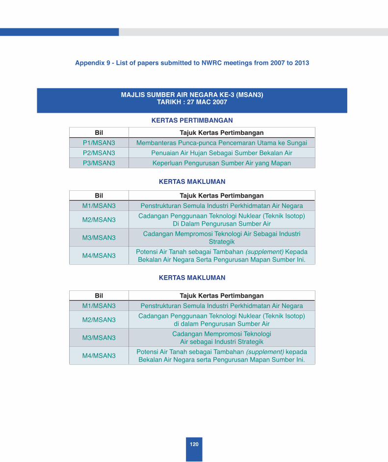
120
Appendix 9 - List of papers submitted to NWRC meetings from 2007 to 2013
KERTAS PERTIMBANGAN
KERTAS MAKLUMAN
KERTAS MAKLUMAN
Bil Tajuk Kertas PertimbanganP1/MSAN3 Membanteras Punca-punca Pencemaran Utama ke SungaiP2/MSAN3 Penuaian Air Hujan Sebagai Sumber Bekalan AirP3/MSAN3 Keperluan Pengurusan Sumber Air yang Mapan
Bil Tajuk Kertas PertimbanganM1/MSAN3 Penstrukturan Semula Industri Perkhidmatan Air Negara
M2/MSAN3 Cadangan Penggunaan Teknologi Nuklear (Teknik Isotop) Di Dalam Pengurusan Sumber Air
M3/MSAN3 Cadangan Mempromosi Teknologi Air Sebagai Industri Strategik
M4/MSAN3 Potensi Air Tanah sebagai Tambahan (supplement) Kepada Bekalan Air Negara Serta Pengurusan Mapan Sumber Ini.
Bil Tajuk Kertas PertimbanganM1/MSAN3 Penstrukturan Semula Industri Perkhidmatan Air Negara
M2/MSAN3 Cadangan Penggunaan Teknologi Nuklear (Teknik Isotop)di dalam Pengurusan Sumber Air
M3/MSAN3 Cadangan Mempromosi TeknologiAir sebagai Industri Strategik
M4/MSAN3 Potensi Air Tanah sebagai Tambahan (supplement) kepada Bekalan Air Negara serta Pengurusan Mapan Sumber Ini.
MAJLIS SUMBER AIR NEGARA KE-3 (MSAN3)TARIKH : 27 MAC 2007
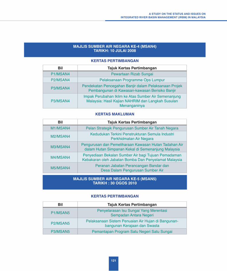
121
A STUDY ON THE STATUS AND ISSUES ONINTEGRATED RIVER BASIN MANAGEMENT (IRBM) IN MALAYSIA
KERTAS PERTIMBANGAN
KERTAS PERTIMBANGAN
KERTAS MAKLUMAN
Bil Tajuk Kertas PertimbanganP1/MSAN4 Pewartaan Rizab SungaiP2/MSAN4 Pelaksanaan Programme Ops Lumpur
P3/MSAN4 Pendekatan Pencegahan Banjir dalam Pelaksanaan Projek Pembangunan di Kawasan-kawasan Berisiko Banjir
P3/MSAN4Impak Perubahan Iklim ke Atas Sumber Air Semenanjung
Malaysia: Hasil Kajian NAHRIM dan Langkah Susulan Menanganinya
Bil Tajuk Kertas Pertimbangan
P1/MSAN5 Penyelarasan Isu Sungai Yang Merentasi Sempadan Antara Negeri
P2/MSAN5 Pelaksanaan Sistem Penuaian Air Hujan di Bangunan-bangunan Kerajaan dan Swasta
P3/MSAN5 Pemantapan Program Satu Negeri Satu Sungai
Bil Tajuk Kertas PertimbanganM1/MSAN4 Pelan Strategik Pengurusan Sumber Air Tanah Negara
M2/MSAN4 Kedudukan Terkini Penstrukturan Semula Industri Perkhidmatan Air Negara
M3/MSAN4 Pengurusan dan Pemeliharaan Kawasan Hutan Tadahan Air dalam Hutan Simpanan Kekal di Semenanjung Malaysia
M4/MSAN4 Penyediaan Bekalan Sumber Air bagi Tujuan Pemadaman Kebakaran oleh Jabatan Bomba Dan Penyelamat Malaysia
M5/MSAN4 Peranan Jabatan Perancangan Bandar dan Desa Dalam Pengurusan Sumber Air
MAJLIS SUMBER AIR NEGARA KE-4 (MSAN4)TARIKH: 10 JULAI 2008
MAJLIS SUMBER AIR NEGARA KE-5 (MSAN5)TARIKH : 30 OGOS 2010
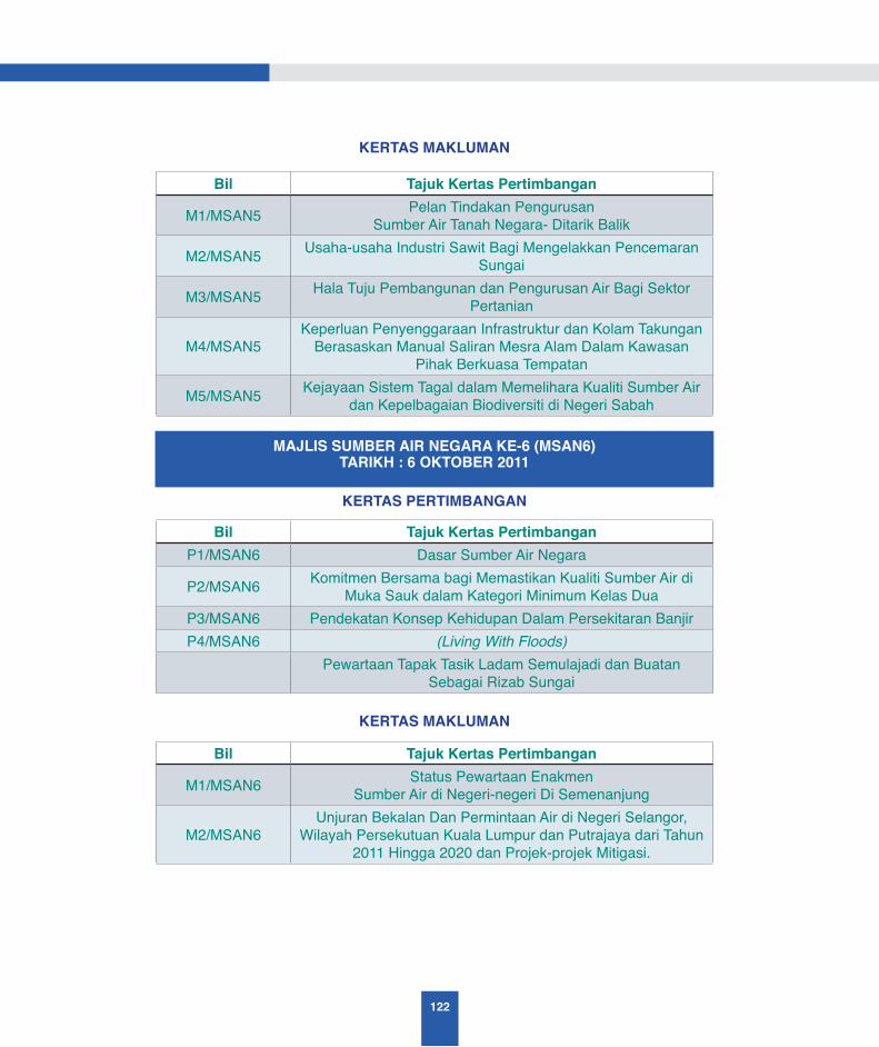
122
KERTAS MAKLUMAN
Bil Tajuk Kertas Pertimbangan
M1/MSAN5 Pelan Tindakan Pengurusan Sumber Air Tanah Negara- Ditarik Balik
M2/MSAN5 Usaha-usaha Industri Sawit Bagi Mengelakkan Pencemaran Sungai
M3/MSAN5 Hala Tuju Pembangunan dan Pengurusan Air Bagi Sektor Pertanian
M4/MSAN5Keperluan Penyenggaraan Infrastruktur dan Kolam Takungan
Berasaskan Manual Saliran Mesra Alam Dalam Kawasan Pihak Berkuasa Tempatan
M5/MSAN5 Kejayaan Sistem Tagal dalam Memelihara Kualiti Sumber Air dan Kepelbagaian Biodiversiti di Negeri Sabah
KERTAS PERTIMBANGAN
KERTAS MAKLUMAN
Bil Tajuk Kertas PertimbanganP1/MSAN6 Dasar Sumber Air Negara
P2/MSAN6 Komitmen Bersama bagi Memastikan Kualiti Sumber Air di Muka Sauk dalam Kategori Minimum Kelas Dua
P3/MSAN6 Pendekatan Konsep Kehidupan Dalam Persekitaran BanjirP4/MSAN6 (Living With Floods)
Pewartaan Tapak Tasik Ladam Semulajadi dan Buatan Sebagai Rizab Sungai
Bil Tajuk Kertas Pertimbangan
M1/MSAN6 Status Pewartaan EnakmenSumber Air di Negeri-negeri Di Semenanjung
M2/MSAN6Unjuran Bekalan Dan Permintaan Air di Negeri Selangor,
Wilayah Persekutuan Kuala Lumpur dan Putrajaya dari Tahun 2011 Hingga 2020 dan Projek-projek Mitigasi.
MAJLIS SUMBER AIR NEGARA KE-6 (MSAN6)TARIKH : 6 OKTOBER 2011

123
A STUDY ON THE STATUS AND ISSUES ONINTEGRATED RIVER BASIN MANAGEMENT (IRBM) IN MALAYSIA
KERTAS PERTIMBANGAN
KERTAS PERTIMBANGAN
KERTAS MAKLUMAN
Bil Tajuk Kertas Pertimbangan
P1/MSAN7 Pemakaian Pelan Strategik Pengurusan Lestari Tasik dan Empangan Air di Malaysia
P2/ MSAN7 Pengurusan Bersepadu Pengambilan Pasir Sungai yang Melibatkan Program Rancangan Tebatan Banjir
Bil Tajuk Kertas PertimbanganP1/MSAN8 Penubuhan Majlis Sumber Air Negeri (MSANg)
P2/ MSAN8Pemakaian Garis Panduan Kawalan Pembangunan
Bersepadu di Zon Pantai untuk Pembangunan di Kawasan Pantai Negara
Bil Tajuk Kertas Pertimbangan
M1/ MSAN7 Kerjasama dan Komitmen Kerajaan Negeri dengan Kerajaan Persekutuan dalam Menangani Isu-Isu Banjir
M2/ MSAN7 Public Infobanjir sebagai Media Penyebaran Maklumat Amaran Awal Banjir kepada Orang Awam
M3/ MSAN7 Pemakaian Manual Saliran Mesra Alam Edisi Kedua Ke Arah Pembangunan Sistem Saliran Lestari
M4/ MSAN7 Penggunaan Stormwater di Hiliran Lembangan Sungai Sebagai Sumber Bekalan Air Terawat
M5/ MSAN7 Penggunaan Larutan Garam (Elektro-Klorinasi) Sebagai Alternatif Kepada Gas Klorin Dalam Rawatan Air Minum
M6/ MSAN7 Prestasi Pemegang Lesen Yang Telah Berhijrah Ke Rejim Pelesenan
M7/ MSAN7Kajian Kawasan Berpotensi Sumber Bekalan Air Bawah Tanah
Menggunakan Imej Satelit Remote Sensing Dan Maklumat Geografi Di Kawasan Lembangan Sungai Muar
MAJLIS SUMBER AIR NEGARA KE-7 (MSAN7)TARIKH : 1 NOVEMBER 2012
MAJLIS SUMBER AIR NEGARA KE-8 (MSAN8)TARIKH : 07 Oktober 2013 (Isnin)


Academy of Sciences MalaysiaLevel 20, West Wing, Matrade Tower,Jalan Sultan Ismail Haji Ahmad Shah,off Jalan Tuanku Abdul Halim,50480 Kuala Lumpur, Malaysia
Phone : +6 (03) 6203 0633Fax : +6 (03) 6203 0634
9151957898329
ISBN 9789832915195
Copyright © 2022 FDOKUMEN