Sub basin water transfer studies in upper Krishna river basin
10
HIND INSTITUTE OF SCIENCE AND TECHNOLOGY ABSTRACT : In India, the Central Water Commission has classified upper Krishna river basins as Upper Krishna (NW) 15A, Upper Krishna (East Yerala) 16A, Upper Krishna East Agrani (16B), and remaining Bhima (downstream of Ujani including Man (18B)). This area is flood prone and necessitates proper water management. In these river basins, as a remedial measure, it is proposed to divert abundant water form river sub-basin 15A to Sub-basin 18B by gravity (diverting water from upper river Krishna to sub-basin of Man to Jath, Atpadi, Talukas of Sangli district and Sangola taluka of Solapur district.) through tunnels. This would be useful in contributing to minimize flood in Krishna basin and also utilization of extra water. It is proposed to divert water to fed existing water resources and small storages in Man sub-basin. This study was carried out by remote sensing and GIS techniques. Using ERDAS, ARC-INFO and Landsat7 imagery a detail topographical studies are carried out along with field survey .It helps to get actual ground levels, high flood levels and topography features to locate inlet and outlet. Satellite imagery substantiated to calculate areas under benefits and economic aspect of the proposal. Key words : Sub basin, Remote sensing, GIS How to cite this Article : Sathe, B.K. and Khire, M.V. (2012). Sub basin water transfer studies in Upper Krishna river basin. Engg. & Tech. in India, 3(1&2) : 24-33. Article Chronicle : Received : 31.11.2011; Revised : 15.12.2011; Accepted : 15.02.2012 INTRODUCTION To maintain quality of life and a steady state of economic growth, it would not be proper to consider problems of floods, drought, urban and rural drinking water needs, irrigation and industrial developments, power supply and pollution control compartmentally. All these problems have to be addressed in an integrated manner for the entire river basin or sub-basin. Sub-basin wise planning is to be accomplished to achieve optimum development of water resources and to realise sustainably beneficial management (Maharashtra Water and Irrigation Commission’s Report, 1996. Both these subjects are quite involved, exhaustive and multidisciplinary. Moreover, there is diversity among the sub-basins in respect of factors such as geographical disposition, climate, rainfall, types of soil, ways of land holding, population, per capita water availability, history of irrigation, current status of irrigation development, unutilised irrigation potential, cropping patterns and agricultural productivity, means of transport, industry and commerce. The planning of respective sub-basins should reflect this diversity. Therefore, planning of water of all sub- basins is not going to be of the same pattern or similar (Kale, 2003). Water availability and its utilisation can only be assessed within the limits of a basin or sub-basin. Several sub-basins encompass extensive drought-prone areas. Large scale water conservation works will be required to be undertaken to reduce the degree of drought-proneness. The present study about water use rights focuses Man sub basin,(18B) which is categorised by the Central Water Commission as highly deficit. In the months of June and July every year due to heavy rainfalls in Sahyadri ranges, Krishna river flows with abundant water and flood passes through Sangli District but at same time Yerala, Agrani and Man which are tributaries of Krishna remain totally dry. Flood situation occurs in Palus, Walva, Shirala, and Miraj Talukas on the banks of Krishna. At the same time water supply ENGINEERING AND TECHNOLOGY IN INDIA t E I RESEARCH ARTICLE Volume 3 | Issue (1) | April, 2012 | 24-33 Address for correspondence : B.K. SATHE, Centre of Studies in Resources Engineering, IIT, BOMBAY (M.S.) INDIA Email: [email protected] Coopted Authors : M.V. KHIRE, Centre of Studies in Resources Engineering, IIT, BOMBAY (M.S.) INDIA MEMBERS OF RESEARCH FORUM Sub basin water transfer studies in upper Krishna river basin B.K. SATHE AND M.V. KHIRE
-
Upload
khangminh22 -
Category
Documents
-
view
0 -
download
0
Transcript of Sub basin water transfer studies in upper Krishna river basin

HIND INSTITUTE OF SCIENCE AND TECHNOLOGY
ABSTRACT : In India, the Central Water Commission has classified upper Krishna river basins as Upper Krishna (NW) 15A, Upper
Krishna (East Yerala) 16A, Upper Krishna East Agrani (16B), and remaining Bhima (downstream of Ujani including Man (18B)). This area
is flood prone and necessitates proper water management. In these river basins, as a remedial measure, it is proposed to divert abundant water
form river sub-basin 15A to Sub-basin 18B by gravity (diverting water from upper river Krishna to sub-basin of Man to Jath, Atpadi, Talukas
of Sangli district and Sangola taluka of Solapur district.) through tunnels. This would be useful in contributing to minimize flood in Krishna
basin and also utilization of extra water. It is proposed to divert water to fed existing water resources and small storages in Man sub-basin.
This study was carried out by remote sensing and GIS techniques. Using ERDAS, ARC-INFO and Landsat7 imagery a detail topographical
studies are carried out along with field survey .It helps to get actual ground levels, high flood levels and topography features to locate inlet and
outlet. Satellite imagery substantiated to calculate areas under benefits and economic aspect of the proposal.
Key words : Sub basin, Remote sensing, GIS
How to cite this Article : Sathe, B.K. and Khire, M.V. (2012). Sub basin water transfer studies in Upper Krishna river basin. Engg. & Tech.
in India, 3(1&2) : 24-33.
Article Chronicle : Received : 31.11.2011; Revised : 15.12.2011; Accepted : 15.02.2012
INTRODUCTION
To maintain quality of life and a steady state of economic
growth, it would not be proper to consider problems of floods,
drought, urban and rural drinking water needs, irrigation and
industrial developments, power supply and pollution control
compartmentally. All these problems have to be addressed in
an integrated manner for the entire river basin or sub-basin.
Sub-basin wise planning is to be accomplished to achieve
optimum development of water resources and to realise
sustainably beneficial management (Maharashtra Water and
Irrigation Commission’s Report, 1996. Both these subjects are
quite involved, exhaustive and multidisciplinary. Moreover,
there is diversity among the sub-basins in respect of factors
such as geographical disposition, climate, rainfall, types of
soil, ways of land holding, population, per capita water
availability, history of irrigation, current status of irrigation
development, unutilised irrigation potential, cropping patterns
and agricultural productivity, means of transport, industry and
commerce. The planning of respective sub-basins should
reflect this diversity. Therefore, planning of water of all sub-
basins is not going to be of the same pattern or similar (Kale,
2003).
Water availability and its utilisation can only be assessed
within the limits of a basin or sub-basin. Several sub-basins
encompass extensive drought-prone areas. Large scale water
conservation works will be required to be undertaken to reduce
the degree of drought-proneness.
The present study about water use rights focuses Man
sub basin,(18B) which is categorised by the Central Water
Commission as highly deficit. In the months of June and July
every year due to heavy rainfalls in Sahyadri ranges, Krishna
river flows with abundant water and flood passes through
Sangli District but at same time Yerala, Agrani and Man which
are tributaries of Krishna remain totally dry.
Flood situation occurs in Palus, Walva, Shirala, and Miraj
Talukas on the banks of Krishna. At the same time water supply
ENGINEERING AND TECHNOLOGY IN INDIA
tE I RESEARCH ARTICLEVolume 3 | Issue (1) | April, 2012 | 24-33
Address for correspondence :
B.K. SATHE, Centre of Studies in Resources Engineering, IIT, BOMBAY
(M.S.) INDIA
Email: [email protected]
Coopted Authors :
M.V. KHIRE, Centre of Studies in Resources Engineering, IIT, BOMBAY
(M.S.) INDIA
MEMBERS OF RESEARCH FORUM
Sub basin water transfer studies in upper Krishna river basin
B.K. SATHE AND M.V. KHIRE

HIND INSTITUTE OF SCIENCE AND TECHNOLOGYEngg. & Tech. in India; 3(1) April, 2012 | 25
for drinking water in Jath, Kavathe Mahankal and Atpadi,
Sangola Talukas is made by water tankers. This diversity is
within radius of 50-100 km. To overcome this, water transfer is
going to benefit the drought-prone area.
The main objectives of the study are underlain by
diverting water from abundant to deficit sub-basins and
assessment of water and its effects on deficit sub-basin.
The study area:
Three tributaries meet the Krishna near Sangli. Warna
meets Krishna near Sangli at Haripur. This spot is also known
as Sangameshwar. Panchganga River meets the Krishna at
Narsobawadi near Sangli. Fig. A. The study area is subdivided
into Upper Krishna West -15A (West-North) and Upper
Krishna15B (West-South) and East -16A (Yerala) and16B
(Agrani) for easy formulation of appropriate water accounting
and planning, in conformity with their respective local features..
The total geographical area of this sub-basin is 15A and 15B,116
sq. km. Upper Krishna (East) is mostly drought prone and
measuring 5,284 sq. km area on the eastern side of Krishna
falls.
talukas
Districts Talukas
Satara : 1) Satara, 2) Mahabaleshwar, 3) Wai, 4)
Jawali, 5) Koregaon,6) Karad, 7) Patan
Sangli: 1) Shirala, 2) Walva, 3) Mira,j 4) Tasgaon,
5) Khanapur
Kolhapur: 1) Shahuwadi, 2) Panhala, 3)
Hatkanangale, 4) Shirol, 5) Karvir, 6)
Radhanagari, 7) Ganganbawada, 8)
Bhudargad, 9) Kagal, 10) Gadhinglaj, 11)
Ajara
15B extends between latitude 15049’ to 16015’N and
longitude 740 0’ to 740 30’E and encompasses the following
talukas.
Districts Talukas
Kolhapur: 1) Chandgad 2) Gadhinglaj 3) Ajara.
Satara : 1) Karad 2) Khatav
Sangli : 1) Khanapur 2) Tasgaon 3) Miraj 4) Jat,
and 5) Kawathemahankal
16A (Yerala) extent of Sub-basin is
Yerala : Latitude 160 40’ to 170 28’ N and Longitude 740 20’
to 750 15’ E and comprises the following talukas
Districts Talukas
Satara : 1) Karad 2) Khatav
Sangli : 1) Khanapur 2) Tasgaon 3) Miraj
16B (Agrani) : Latitude 160 40’ to 170 28’ N and Longitude
Fig. A : Study area
15A extends between latitude 16002’ to 18002’ N and
longitude 73032’ to 74040’ E and comprises of the following
Fig. 2 : B(1) LandSat Image, B(1) Location of tunnel
B.K. SATHE AND M.V. KHIRE
24 - 33

HIND INSTITUTE OF SCIENCE AND TECHNOLOGYEngg. & Tech. in India; 3(1) April, 2012 | 26
740 20’ to 750 15’ E
Districts Talukas
Sangli : 1) Khanapur 2) Tasgaon 3) Miraj 4) Jat
and 5) Kawathemahankal
Most of the area of this sub-basin falls in more than 1200
mm rainfall zone. Normally 85 per cent rainfall occurs during
June to September due to south-west monsoon, 10 per cent
between September and December due to north-east monsoon
and 5 per cent after December. Average annual rainfall in
component basins 15(A) and 15 (B) is 1584 mm and 1907 mm,
respectively. Rainfall decreases from west to east in this sub-
basin. The Yerala and the Agrani have 550mm and 470 mm
average rainfall, respectively.
The main objectives of the study are underlain by
diverting water from high flood to deficit sub-basins and
assessment of water and its effects on flood and deficit sub-
basin.
EXPERIMENTAL PROCEDURE
– The topographical maps of 1:2,50,000 scale
– The Landsat TM digital satellite False Colour Composite
(FCC) February, 1999.
– The land use and soil map of the area with scale 1: 250,000.
– Hydrological and Hydraulic data.
Methodology:
– Various base maps for study area were prepared in GIS
environment
– Land sat 7 TM digital satellite data were used for formation
of FCC and super imposed this image to base maps
prepared.
– Slope maps were analysed and verify to identified the
exact elevations, high flood levels (HFL).
– With the help of remote sensing imagery, location of inlet
and outlet of flood tunnels were identified.
– These all data observed and calculated were verified with
ground truth and field work.
– All detailed flood studies examine the areas through which
floodwater flows.
After the field work is completed the information so
obtained in incorporated in the GIS analysis to analyze and
compile the diverging of flood water and analysis was carried
out to minimize the flood risk.
The planning perspective:
Central Water Commission has categorized the sub basin
on the basis of water availability (Table B).The two rivers -
Yerala and Agrani of this sub-basin rise in a drought prone
area and flow throughout its length through a drought prone
area. The natural average availability of water in this sub-basin
is hardly 217 Mm3. (Table A). The stipulated local water use in
this sub-basin is 80 Mm3.By nature this basin being a deficit
one and has conceived by interbasin transfer of water. This is
planned to be achieved by topographical studies (Fig. C) and
undertaking present schemes and available water.
The proposals:
As the water diversion by lift has not economical as
compared to gravity flow. The various alternatives to connect
Table A : Comparison of sub basin in Sangli and Solapur district (Hydrological, Meteorological, and statistical)
Sr.
No. Description
Upper Krishna
( North West )
Upper Krishna
( East Yerala)
Upper Krishna
( East Agrani)
Remaining Bhima
Down Stream of Ujani
including Man
1. Classification as per Maharashtra Water and
Irrigation Commission
15 A 16 A 16 B 18 B
2. Local name Krishna Yerala Agrani Man
3. Talukas from Sangli district Shirala ,Walawa, Miraj,
Tasgaon, Khanapur
Miraj, Tasgaon,
Khanapur
Miraj, Tasgaon,
Khanapur, Jath,
Kavathe Mahankal
Jath, Atpadi, Sangola
Rainfall in mm
a) Average 1584 569 589 552
b)Maximum 9480 1206 1596 1157
4.
c )Year of max. rainfall 1961 1981 1994 1987
5. Average available water in Mm3 9676 130 87 1607
6. Available water at 75 per cent Dependability 8539 14 11 1254
7. Available water at 50 per cent Dependability 9341 34 29 1729
8. Available water per ha. for 50 per cent 6987 119 252 1657
9. Available water per capita in M3 2195 32 112 907
10. Average G.L. for command area in m. 525 to 600 600 to 700 625 to 850 600 to 750
Note: Water available per ha. and per capita is calculated for total sub basin for Krishna i.e. 15A
SUB BASIN WATER TRANSFER STUDIES IN UPPER KRISHNA RIVER BASIN
24 - 33
HIND INSTITUTE OF SCIENCE AND TECHNOLOGYEngg. & Tech. in India; 3(1) April, 2012 | 27
river sub-basins are examined and the best three alternatives
proposed are;
– Tunnel start point near u/s of Umbraj (Kalgaon Village
7407’14’’E 17028’11’’N) and exit point near Atpadi minor
irrigation tank(MI) (74053’50’’E17023’58’’N) and from exit
point to Dighanchi K.T. Weir on Man river of Sangli
District by natural existing canal.
– Tunnel start point at Tembhu Barrage (74014’3’’E
17016’52’’N) and exit point at Lonarwadi K.T. weir
downstream of Atpadi on Man River
– Tunnel starting point at Tembhu Barrage and exit point
Lonarwadi K.T.weir and lift from Lonarwadi to Atpadi MI
tank.
While studying the alternatives the water availability at
entry point and water requirements at the exit points are
considered to design the tunnel. The river Man joins river
Bhima at Sarkoli village of Pandharpur, downstream of Ujani
dam. Most of the shore of river Bhima downstream of Ujani is
under command of Ujani reservoir. Hence, while evaluating
water requirement the water reservoirs in the command of Ujani
are deleted and only drought prone uncommand area is
considered. It is assumed that 80per cent of storage capacity
of minor irrigation (MI) tanks and K.T. weirs will be feed by this
flood tunnel.
Details of proposal I :
Tunnel from Kalgoan to Atpadi (Krishna river to Man
river through Atpadi MI tank)
In this proposal, the proposed tunnel start point is at
Umbraj (Kalgaon village) with bed level is 587 m (at Kalgaon),
and bed gradient 1:4100. The length of this tunnel works out to
82km from GIS layout. The tunnel opens near Atpadi minor
irrigation.
After tunnel the flood tunnel is divided into three
branches.
Atpadi MI tank to man river through Dighanchi K.T. Weir:
After opening the tunnel at Atpadi, first flood canal i.e.
Dighanchi branch is diverted towards Dighanchi in opposite
direction of Man river and it is ended in Man at Dighanchi KT
weir. This is gravity flow by natural existing channel of 17.30
km length.
Atpadi MI tank to man river through SankhWeir:
This branch not connect to direct Man river.This helps to
fed the water to West side of Man river.This is the second
flood canal in this proposal. This branch is further divided into
three parts.
– Atpadi to Buddhehal MI tank,20 km by natural existing
chanel
– Buddhehal to Jujarpur 11 km by gravity flow
– Jujarpur toSankh by proposed tunnel of 11 km at
Jujarpur and 42 km through open natural chanel.
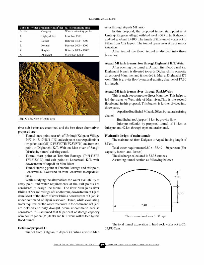
Hydraulic design of main tunnel:
The main tunnel from Kalgaon to Atpadi having length of
82 km.
Total water requirement 0.80 x 138.49 + 30 per cent (For
capacity factor and losses)
The discharge calculated is 33.35 cumecs
Assuming tunnel section as following below :
Table B : Water availability in M3 per ha. of culturable area
Sr. No. Category Water availability per ha.
1. Highly deficit Less than 1500
2. Deficit Between 1500 - 3000
3. Normal Between 3000 - 8000
4. Surplus Between 8000 - 12000
5. Abundant More than 12000
Fig. C : 3D view of study area
2.00
3.70
7.40
The cross-sectional area 31.99 sqm
B.K. SATHE AND M.V. KHIRE
The total tunnel excavation in hard rock works out to 26,
23,180 Cum.
24 - 33
HIND INSTITUTE OF SCIENCE AND TECHNOLOGYEngg. & Tech. in India; 3(1) April, 2012 | 28
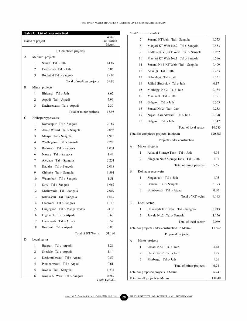
Table C : List of reservoirs feed
Name of project
Water
utilisation
Mcum.
I) Completed projects
A Medium projects
1 Sankh Tal :- Jath 14.87
2 Doddanala Tal :- Jath 6.06
3 Budhihal Tal :- Sangola 19.03
Total of medium projects 39.96
B Minor projects
1 Bhivargi Tal :- Jath 8.62
2 Atpadi Tal :- Atpadi 7.96
3 Kacharewasti Tal :- Atpadi 2.37
Total of minor projects 18.95
C Kolhapur type weirs
1 Kamalapur Tal :- Sangola 2.187
2 Akole Wasud Tal :- Sangola 2.095
3 Manjri Tal :- Sangola 1.913
4 Wadhegaon Tal :- Sangola 2.296
5 Balawadi Tal :- Sangola 1.031
6 Nazare Tal :- Sangola 1.44
7 Alegaon Tal :- Sangola 2.251
8 Kadalas Tal :- Sangola 2.018
9 Chinake Tal :- Sangola 1.391
10 Watambari Tal :- Sangola 1.51
11 Save Tal :- Sangola 1.962
12 Methawade Tal :- Sangola 2.009
13 Khavaspur Tal :- Sangola 1.649
14 Lotewadi Tal :- Sangola 1.118
15 Gunjegaon Tal :- Mangalwedha 24.33
16 Dighanchi Tal :- Atpadi 0.60
17 Lonarwadi Tal :- Atpadi 0.59
18 Koutholi Tal :- Atpadi 0.80
Total of KT Weirs 51.190
D Local sector
1 Banpuri Tal :- Atpadi 1.29
2 Shetfale Tal :- Atpadi 1.14
3 Deshmukhwadi Tal :- Atpadi 0.59
4 Pandharewadi Tal :- Atpadi 0.61
5 Jawala Tal :- Sangola 1.234
6 Jawala KTWeir Tal :- Sangola 0.289
Table Contd….
Contd………… Table C
7 Sonand KTWeir Tal :- Sangola 0.553
8 Manjari KT Weir No.2 Tal :- Sangola 0.553
9 Kadlas ( K.V. ) KT Weir Tal :- Sangola 0.962
10 Manjari KT Weir No.1 Tal :- Sangola 0.596
11 Sonand No 1 KT Weir Tal :- Sangola 0.499
12 Ankalgi Tal :- Jath 0.283
13 Belondagi Tal :- Jath 0.151
14 Jalihal (Budruk ) Tal :- Jath 0.17
15 Morbaggi No 2 Tal :- Jath 0.184
16 Maniknal Tal :- Jath 0.191
17 Balgaon Tal :- Jath 0.365
18 Sonyal No 2 Tal :- Jath 0.283
19 Nigadi Karandewadi Tal :- Jath 0.198
20 Balgaon Tal :- Jath 0.142
Total of local sector 10.283
Total for completed projects in Mcum 120.383
Projects under construction
A Minor Projects
1 Ankalgi Storage Tank Tal :- Jath 4.64
2 Shegaon No 2 Storage Tank Tal :- Jath 1.01
Total of minor projects 5.65
B Kolhapur type weirs
1 Singanhalli Tal :- Jath 1.05
2 Bamani Tal :- Sangola 2.793
3 Bombewadi Tal :- Atpadi 0.30
Total of KT weirs 4.143
C Local sector
1 Udanwadi K.T. weir Tal :- Sangola 0.913
2 Jawala No.2 Tal :- Sangola 1.156
Total of local sector 2.069
Total for projects under construction in Mcum 11.862
Proposed projects
A Minor projects
1 Umadi No.1 Tal :- Jath 3.48
2 Umadi No.2 Tal :- Jath 1.75
3 Morbaggi Tal :- Jath 1.01
Total of minor projects 6.24
Total for proposed projects in Mcum 6.24
Total for all projects in Mcum 138.49
SUB BASIN WATER TRANSFER STUDIES IN UPPER KRISHNA RIVER BASIN
24 - 33

HIND INSTITUTE OF SCIENCE AND TECHNOLOGYEngg. & Tech. in India; 3(1) April, 2012 | 29
Annex I : List of reservoirs to feed by Dighanchi Branch
Name of project
Water
Utilisation
Mcum.
I) Completed projects
A ) Kolhapur type weirs
1. Khavaspur Tal :- Sangola 1.649
2. Lotewadi Tal :- Sangola 1.118
3. Dighanchi Tal :- Atpadi 0.60
4. Koutholi Tal :- Atpadi 0.80
Total of KT weirs 4.167
Total for completed projects in Mcum 4.167
II) Projects under construction
A ) Kolhapur type weirs
1 Bombewadi Tal :- Atpadi 0.30
Total of KT weirs 0.30
Total for projects under construction in Mcum 0.300
Total for all projects in Mcum 4.467
Annex II : List of reservoir to feed by Buddheal Branch
Name of project
Water
utilisation
Mcum.
I) Completed projects
A ) Medium projects
1 Sankh Tal :- Jath 14.87
2 Doddanala Tal :- Jath 6.06
3 Bhuddheal Tal : Sangola 19.03
Total of medium projects 39.96
B ) Minor Projects
1 Bhivargi Tal :- Jath 8.62
Total of minor projects 8.62
C ) Kolhapur type weirs
7 Alegaon Tal :- Sangola 2.251
Total of KT weirs 2.251
D ) Local sector
1. Jawala Tal :- Sangola 1.234
2. Jawala KT Weir Tal :- Sangola 0.289
3. Sonand KT Weir Tal :- Sangola 0.553
4. Sonand No 1 KT Weir Tal :-Sangola 0.499
5. Ankalgi Tal :- Jath 0.283
6. Belondagi Tal :- Jath 0.151
7. Jalihal (Budruk ) Tal :- Jath 0.17
8. Morbaggi No 2 Tal :- Jath 0.184
9. Maniknal Tal :- Jath 0.191
10. Balgaon Tal :- Jath 0.365
11. Sonyal No 2 Tal :- Jath 0.283
12. Nigadi Karandewadi Tal :- Jath 0.198
13. Balgaon Tal :- Jath 0.142
Total of local sector 4.542
Total for completed projects in Mcum 36.343
Projects under construction
B ) Minor projects
1. Ankalgi Storage Tank Tal :- Jath 4.64
2. Shegaon No 2 Storage Tank Tal :Jath 1.01
Total of minor projects 5.65
C ) Kolhapur type weirs
1. Singanhalli Tal :- Jath 1.05
2. Bamani Tal :- Sangola 2.793
Total of KT weirs 3.843
D ) Local sector
1. Udanwadi K.T. weir Tal :- Sangola 0.913
2. Jawala No.2 Tal :- Sangola 1.156
Total of local sector 2.069
Total for projects under construction in Mcum 11.562
Proposed projects
B ) Minor projects
1. Umadi No.1 Tal :- Jath 3.48
2. Umadi No.2 Tal :- Jath 1.75
3. Morbaggi Tal :- Jath 1.01
Total of minor projects 6.24
Total for proposed projects in Mcum 6.24
Total for all projects in Mcum 73.18
Design of Dighanchi branch canal:
Dighanchi, Khavaspur, Lotewadi, Kouthuli and
Bombewadi KT weirs comes under command of this branch.
The total water requirement works out 4.467 Mcum. The
length of branch is 17.5 km. The discharge works out 2.15
cumecs and cross sectional area is 3.25 sqm (Annexture I).
B.K. SATHE AND M.V. KHIRE
Design of Singanhalli Sankh branch canal:
This branch is further divided into four parts
Buddhel canal:
From the storage capacities of reservoirs in command of
this canal .the discharge works out 17.62 cumecs, cross sectional
area 15.84 sqm and length 20 km. (Annexture II).
Jujarpur canal:
From the storage capacities of reservoirs in command of
this canal the discharge works out to 13.55 cumecs, cross
sectional area 12.08 sqm and length 11km.
Jujarpur tunnel:
From the storage capacities of reservoirs in command of
this canal the discharge works out to 13.55, cross sectional
area 13.04 sqm and length 11 km. Total tunnel excavation in
hard rock works out 1,85,735 cum (Annexure III).
Sankh branch:
From the storage capacities of reservoirs in command of
this canal the discharge works out to 13.39 cumecs, cross
sectional area 12.08 sqm and length 49 km.(Annexture IV)
24 - 33

HIND INSTITUTE OF SCIENCE AND TECHNOLOGYEngg. & Tech. in India; 3(1) April, 2012 | 30
Annex III : List of reservoir to feed by Jujarpur canal and tunnel
Name of project
Water
utilisation
Mcum.
I) Completed projects
A ) Medium projects
1 Sankh Tal :- Jath 14.87
2 Doddanala Tal :- Jath 6.06
Total of medium projects 20.93
B ) Minor projects
1 Bhivargi Tal :- Jath 8.62
Total of minor projects 8.62
C ) Kolhapur type weirs
1 Alegaon Tal :- Sangola 2.251
Total of KT weirs 2.251
D ) Local sector
1 Jawala Tal :- Sangola 1.234
2 Jawala KT Weir Tal :- Sangola 0.289
3 Sonand KT Weir Tal :- Sangola 0.553
4 Sonand No 1 KT Weir Tal :- Sangola 0.499
5 Ankalgi Tal :- Jath 0.283
6 Belondagi Tal :- Jath 0.151
7 Jalihal (Budruk ) Tal :- Jath 0.17
8 Morbaggi No 2 Tal :- Jath 0.184
9 Maniknal Tal :- Jath 0.191
10 Balgaon Tal :- Jath 0.365
11 Sonyal No 2 Tal :- Jath 0.283
12 Nigadi Karandewadi Tal :- Jath 0.198
13 Balgaon Tal :- Jath 0.142
Total of local sector 4.542
Total for completed projects in Mcum 36.343
Projects under construction
B ) Minor projects
1 Ankalgi Storage Tank Tal :- Jath 4.64
2 Shegaon No 2 Storage Tank Tal :- Jath 1.01
Total of minor projects 5.65
C ) Kolhapur type weirs
1 Singanhalli Tal :- Jath 1.05
2 Bamani Tal :- Sangola 2.793
Total of KT weirs 3.843
D ) Local sector
1 Udanwadi K.T. weir Tal :- Sangola 0.913
2 Jawala No.2 Tal :- Sangola 1.156
Total of local sector 2.069
Total for projects under construction in Mcum 11.562
Proposed projects
B ) Minor projects
1 Umadi No.1 Tal :- Jath 3.48
2 Umadi No.2 Tal :- Jath 1.75
3 Morbaggi Tal :- Jath 1.01
Total of minor projects 6.24
Total for proposed projects in Mcum 6.24
Total for all projects in Mcum 54.15
Annex IV : List of reservoirs to feed by Sankh canal
Name of project
Water
utilisation
Mcum.
I) Completed projects
A Medium projects
1 Sankh Tal :- Jath 14.87
2 Doddanala Tal :- Jath 6.06
Total of medium projects 20.93
B Minor projects
1 Bhivargi Tal :- Jath 8.62
2 Atpadi Tal :- Atpadi 7.96
Total of minor projects 16.58
C Local sector
1 Ankalgi Tal : Jath 0.283
2 Belondgi Tal : Jath 0.151
3 Jalihal (Budruk) Tal : Jath 0.17
4 Morbaggi No 2 Tal : Jath 0.184
5 Maniknal Tal : Jath 0.191
6 Balgon Tal : Jath 0.365
7 Sonyal No 2 Tal : Jath Tal : Jath 0.283
8 Nigadi Karandewadi Tal : Jath 0.198
9 Balgon Tal : Jath 0.142
Total of local sector 1.967
Total for completed projects in Mcum 39.47
Projects under construction
A Minor projects
1 Ankalgi Storage Tank Tal :- Jath 4.64
Total of Minor projects 4.64
B Local sector
1 Udanwadi K.T. weir Tal :- Sangola 0.913
2 Jawala No.2 Tal :- Sangola 1.156
Total of local sector 2.069
Total for projects under construction in Mcum 7.719
Proposed projects
B Minor projects
1 Umadi No.1 Tal :- Jath 3.48
2 Umadi No.2 Tal :- Jath 1.75
3 Morbaggi Tal :- Jath 1.01
Total of minor projects 6.24
Total for proposed projects in Mcum 6.24
Total for all projects in Mcum 53.43
SUB BASIN WATER TRANSFER STUDIES IN UPPER KRISHNA RIVER BASIN
24 - 33

HIND INSTITUTE OF SCIENCE AND TECHNOLOGYEngg. & Tech. in India; 3(1) April, 2012 | 31
Annex V : List of reservoir to feed by proposal II
Name of project
Water
utilisation
Mcum.
I) Completed projects
A Medium projects
1 Sankh Tal :- Jath 14.87
2 Doddanala Tal :- Jath 6.06
Total of medium projects 20.93
B Minor projects
1 Bhivargi Tal :- Jath 8.62
Total of minor projects 8.62
C Kolhapur type weirs
1 Lonarwadi Tal :- Atpadi 0.59
2 Kamalapur Tal :- Sangola 2.187
3 Akole Wasud Tal :- Sangola 2.095
4 Wadhegaon Tal :- Sangola 2.296
5 Manjri Tal :- Sangola 1.913
6 Balawadi Tal :- Sangola 1.031
7 Nazare Tal :- Sangola 1.44
8 Alegaon Tal :- Sangola 2.251
9 Kadalas Tal :- Sangola 2.018
10 Chinake Tal :- Sangola 1.391
11 Watambari Tal :- Sangola 1.51
12 Save Tal :- Sangola 1.962
13 Methawade Tal :- Sangola 2.009
14 Gunjegaon Tal :- Mangalwedha 24.33
Total of KT weirs 47.023
D Local sector
1 Banpuri Tal :- Atpadi 1.29
2 Shetfale Tal :- Atpadi 1.14
4 Jawala Tal :- Sangola 1.234
5 Jawala KT Weir Tal :- Sangola 0.289
6 Sonand KT Weir Tal :- Sangola 0.553
7 Manjari KT Weir No.2 Tal :- Sangola 0.553
8 Kadlas ( K.V. ) KT Weir Tal :- Sangola 0.962
9 Manjari KT Weir No.1 Tal :- Sangola 0.596
10 Sonand KT Weir No.1 Tal :- Sangola 0.499
11 Ankalgi Tal :- Jath 0.283
12 Belondagi Tal :- Jath 0.151
13 Jalihal (Budruk ) Tal :- Jath 0.17
14 Morbaggi No 2 Tal :- Jath 0.184
15 Maniknal Tal :- Jath 0.191
16 Balgaon Tal :- Jath 0.365
17 Sonyal No 2 Tal :- Jath 0.283
18 Nigadi Karandewadi Tal :- Jath 0.198
19 Balgaon Tal :- Jath 0.142
Total of local sector 9.083
Annexure V contd….
Contd…. Annexurre V
Total for completed projects in Mcum 104.096
II) Projects under construction
B Minor projects
1 Ankalgi Storage Tank Tal :- Jath 4.64
Total of minor projects 4.64
C Kolhapur type weirs
1 Singanhalli Tal :- Jath 1.05
2 Bamani Tal :- Sangola 2.793
Total of KT weirs 3.843
D Local sector
1 Udanwadi K.T. weir Tal :- Sangola 0.913
2 Jawala No.2 Tal :- Sangola 1.156
Total of local sector 2.069
Total for projects under construction in Mcum 10.552
Proposed project
B Minor projects
1 Umadi No.1 Tal :- Jath 3.48
2 Umadi No.2 Tal :- Jath 1.75
3 Morbaggi Tal :- Jath 1.01
Total of minor projects 6.24
Total for proposed projects in Mcum 6.24
Total for all projects in Mcum 102.448
Details of proposal II:
Tunnel form Tembhu Barrage to Lonarwadi (Krishna river to
Man river directly):
In this proposal, the tunnel start point is considered at
upstream of Tembhu Barrage whose F.R.L. is 558 m. The intake
point of tunnel will be 500m u/s of Tembhu LIS intake point.
The tunnel bed level is proposed at 554.85 m. Considering
tunnel gradient 1:2520, length works out to 80 km. The tunnel
opens near Lonarwadi KT weir. The Lonarwadi KT weir is on
river Man having nalla bed level of 523.10 m (FRL. 527.60 m).
From this KT weir, part of flood water will be released in to Man
river and remaining flood water will be diverted through flood
canal towards Singanhalli and then towards Sankh medium
project.
Hydraulic design:
Main tunnel:
Total water requirement 0.80 x 102.45+ 30 per cent (For
Capacity factor and losses)
The discharge calculated 24.66 cumecs
The cross-sectional area 24.83 sqm, length of tunnel 80
km and total excavation in hard rock works out 19,86,400 Cum.
Canals:
The canal is divided in two reaches.
– Lonarwadi to Singanhalli
B.K. SATHE AND M.V. KHIRE
24 - 33

HIND INSTITUTE OF SCIENCE AND TECHNOLOGYEngg. & Tech. in India; 3(1) April, 2012 | 32
– Singanhalli to Sankh
The discharges for first canal is 10.96 Cumec and length
36.00km
The discharge for second canal is 10.71Cumecs and length
is 49.00 km.
Details of proposal III:
Tunnel form Tembhu Barrage to Lonarwadi (Krishna river to
Man river by gravity flow and Man river to Atpadi MI by
Lift):
The proposal I is having intake at Kalgoan, which is at u/
s of Koyana confluence, so it will have lesser water availability
than the proposal II even during floods. In the proposal II, the
outlet of main tunnel opens at Lonarwadi KT weir, which is
located at the end of Atpadi taluka and the major scarcity
command is omitted from benefits.
To overcome these limitations of the above two proposals,
the third proposal has been studied. This proposal is
combination of the proposal I and II. The command area is as
per proposal I and main tunnel alignment is as per proposal II.
The main tunnel is as per proposal II i.e. intake at Tembhu and
outlet at Lonarwadi. But the capacity of tunnel is increased to
match increased command area. The command area is increased
equal to proposal I by providing mini LIS from Lonarwadi to
Atpadi MI tank. Then from Atpadi MI tank the two flood canals
Diganchi branch and Singanhalli Sankh branch are proposed.
The proposals are tabulated in the Table A.
Hydraulic design of main tunnel:
2.00
3.05
6.10
The cross-sectional area 25.37 sqm
Total water Requirement 0.80x138.49+30 per cent (For
Capacity factor and losses)
The discharge is 33.35 cumecs
EXPERIMENTAL FINDINGS AND ANALYSIS
To increase per hectare water availability sub basins 16A,
16B, 18B (i.e. Yerala, Agrani and Man), Government of
Maharashtra is implementing lift Irrigation Schemes namely
Tembhu, Takari and Mhaisal. LIS. The topographical conditions
shows that Agrani and most part of Man sub basins are situated
to 150m above the river Krishna (Fig. C) To divert water from
river Krishna to these sub basins one has to implement the lift
irrigation scheme. Some part of Man sub basin can be reinforced
with water from abundant sub basin 15 A by gravity.
Some part Man sub basin (18B) though is having altitude
of near about of Krishna, but it cannot be connected by open
gravity channels. It has to cross the Mahadeva range hills to
connect these sub basins. The altitude of river Krishna ranges
from 555.00 to 530.00 in Sangli district while the altitude of
Mahadeva range hills is having altitude of 750-850 m. It means,
to connect these two sub basins, one has to do it by lifting or
by means of a tunnel. While connecting these sub basins
through tunnel it crosses the sub basin Nandani and sub basin
Yerala. The clearance between top of tunnel and Nandani river
at crossing is 126.00 m, and Yerala river is 82.00 m . It means it
is not possible to divert water from Krishna to Nandani and
Yerala sub basins by gravity.
In present study, it is proposed to divert abundant water
from sub basin 15 A to Sub basin 18 B by gravity (Diverting
water from proper river Krishna to sub basin of Man to Jath,
Atpadi, Talukas of Sangli district and Sangola taluka of Solapur
district) through tunnels.
It can be seen that the water availability along side of
Krishna river is near about 45 times of water availability in
Yerala Basin and 35 times more of water availability in Man
basin, which is hardly 50 to 100 km away from Krishna river.
The Table A shows reservoirs, MI tanks and KT weirs can be
feed up to Bhima (excluding Ujani command).
Conclusions:
The above three proposals can easily divert water in Man
Description Proposal I Proposal II Proposal III
Intake point
of main
Tunnel
Near Kalgon 500m u/s of
Tembhu intake
point
500m u/s of
Tembhu intake
point
Outlet point
of Tunnel
Near Atpadi
M.I. tank
Near Lonarwadi
K.T.Weir
Near Lonarwadi
K.T.Weir
Quantity of
water to be
diverted
131.79MCM 102.45 MCM 138.49 MCM
SUB BASIN WATER TRANSFER STUDIES IN UPPER KRISHNA RIVER BASIN
2.00
3.00
6.00
24 - 33

HIND INSTITUTE OF SCIENCE AND TECHNOLOGYEngg. & Tech. in India; 3(1) April, 2012 | 33
sub basin which will definitely increase area under irrigation. It
will provide water and reduces the degree of drought-proneness.
The comparison of these proposals are tabulated below:
REFERENCES
Jain, S.K., Singh, R.D., Jain, M.K. and Lohani, A.K. (2005).
Delineation of flood-prone areas using remote sensing techniques:
Water Resources Management, 19 : 333–347.
Kale, V.S. (2003). A Geomorphic effects of monsoon floods on Indian
rivers: Natural Hazards, 28 : 65-84.**************
Prasad, A.K., Vinay Kumar, K., Singh, S. and Singh, R.P. (2006).
Potentiality of multi-sensor satellite data in mapping flood hazard :
Photonirvachak, 34 : 219-231.
Rao, D.V.B., Naidu, C.V. and Rao, B.R. (2001). Trends and
fluctuations of the cyclonic systems over north Indian ocean : Mausam,
52 : 37-46.
Maharashtra Water and Irrigation Commission’s Report (1996).
Vol. I, II and III
B.K. SATHE AND M.V. KHIRE
24 - 33