Status of water quality at Holbox Island, Quintana Roo State, Mexico
17
Status of water quality at Holbox Island, Quintana Roo State, Mexico Kim Chi Tranl*, David Valdesz, Jorge Euan2, Elizabetli Real2, Eloy Gil 3 lKii.ansei Gahirr Lbiii.ersi~; Sclrool o/ Poliq Sludies. 2- 1 Gahterr. Sarida, Hi.ogo 669-1337. Japarl; ~INlrES721'-Merida. Ktri. 6.4iit. Cam Progreso. Menda. 97310, )'itcnta~i. ,Wexico; JLJriii.ersidad A4nrista. Perfirico Norte Tablaje 13941. Can iMerida-Pmgreso, Menda. 97300. Yucatari. Msico *Correspo~idirig nrnlror: E-riinil: [email protected]~jp: Fnc 4-81-795-65-7605 Holbo-T Islartd (ii.itli irs coastal lagooii, Yalalrau hgooii) Iocated iri tlie littoinl zorre at tlre iiortli-easteni tip of tlie YIrcatan Periirisula, Grrlfof Merico, is a relatiCe!v ~wdistrrrbed ecoqxterri tliat is crrrrent!it urider tlireat fmm urrplanned atid Niterisire io-bar1 developinerrt. Altliough orlter ecoqpstenrs iri tliis littoml zone 1iai.e been snrdied to de termiiie tIte basic r-equir-enieiits for sirstainable dei~eloprrient, little irlforniation about Holbo-r Islarid aists. ~ I ~ I S fui; no data conceniing coastal pollutiori iri Ynlahau Lagoorr 1iai.e been prrblislied. '-1s par? of a larger; 011-going strdy, tliis article reports tlie results of ana!i:ses to derennine tlie tempoml arid spatial varia- tions ofstanda~dpl~irical and cheaii~al~arnnieters arid to ei.al~rate tlie relatiorisliips arnorig tlrese pamnteters- Vater arid sedirrierit sarnples collectedfrom 42 statioris duririg hvo seasorls oftlie Fear (miriv and dr? seasoris) wem aria!i=ed usirig staridaqi n~etlrods. nre resirlts indicate tliat, iri general, tlie area is relarive!~: undisnrrbed by liirnian irrJrrerice. Dissolved o.x-,oen conterit ,iras loiver- tlrati 4 iril t* arid tlre percentage ofoqgeii satirratiorr loiiler thari 9Q%, srrggestirig tliat tlie site s~rpporqs higlier corzsurriptiori tlrari productiori ofo.r?:gerr. Nitrogerr is rn~st!i~~r-eser~t hs arrir~ior~ir~rn arid loiv co&ntmtiorts ofrri~ate:'nitrite.'~tdphosphate iridicate tlrat eirtrvphica- ti011 is riot ividespread ir1 tlie ar-ea. Sedirrrerits are rnosr(il san+ contairiirig less tlian 10% o~ariic niatter at irrost statioris. Tlie redo-Y poteritial of sedirnerits ivos iiegative fol. al1 sairtples. Patei. qiralip at statioiis iii tlte pimini- ity of boatirig arid drrnrpirig activities slioiss Iiiglier degradation tlran at otlier statioris ivitlriri tlie lagoort. Tlrese preliniiriar? resirlts provide the opporqirnie to coristnrct a baselirie for coastal water qirality, prior to irnpendirig urban developrrrerit, ar~d iris? seme to deterniirle ivhetlier tlie filtirre naturul arid developmerit prvcesses Iiave inipact o11 tlre coriditions and Iiealtli of coastal ecoqxterris aroirrid Holbox Islarid. Iii addition. becarrse tlie are0 k, as.vet, relatii:e[v ~rridistrrrbed, tlie data reponed here alloiv 11s to take stock of tlie estent to ivhicli orlier sites in tlre Xrcatarr littornl zorie Iiai-e alreadi: beeri degraded by hirrnari dmeloprrient activiries. - . Kqivords: water analysis. sediment analysis, GIS mopping Aquaiic Ecosystem Ilealtli & blanagemrnt. 5(2):173-159.2002 C 2002 AEHMS 14631958/02 SIL00 + .O0 D01: 0.1 OSO!l~6M~8O~!lOO3 1 S75
Transcript of Status of water quality at Holbox Island, Quintana Roo State, Mexico

Status of water quality at Holbox Island, Quintana Roo State, Mexico
Kim Chi Tranl*, David Valdesz, Jorge Euan2, Elizabetli Real2, Eloy Gil3
lKii.ansei Gahirr Lbiii.ersi~; Sclrool o/ Poliq Sludies. 2- 1 Gahterr. Sarida, Hi.ogo 669-1337. Japarl; ~INlrES721'-Merida. Ktri. 6.4iit. Cam Progreso. Menda. 97310, )'itcnta~i. ,Wexico;
JLJriii.ersidad A4nrista. Perfirico Norte Tablaje 13941. Can iMerida-Pmgreso, Menda. 97300. Yucatari. Msico *Correspo~idirig nrnlror: E-riinil: [email protected]~jp: Fnc 4-81-795-65-7605
Holbo-T Islartd (ii.itli irs coastal lagooii, Yalalrau hgooii) Iocated iri tlie littoinl zorre at tlre iiortli-easteni tip of tlie YIrcatan Periirisula, Grrlfof Merico, is a relatiCe!v ~wdistrrrbed ecoqxterri tliat is crrrrent!it urider tlireat fmm urrplanned atid Niterisire io-bar1 developinerrt. Altliough orlter ecoqpstenrs iri tliis littoml zone 1iai.e been snrdied to de termiiie tIte basic r-equir-enieiits for sirstainable dei~eloprrient, little irlforniation about Holbo-r Islarid aists. ~ I ~ I S fui; no data conceniing coastal pollutiori iri Ynlahau Lagoorr 1iai.e been prrblislied. '-1s par? of a larger; 011-going strdy, tliis article reports tlie results of ana!i:ses to derennine tlie tempoml arid spatial varia- tions ofstanda~dpl~irical and cheaii~al~arnnieters arid to ei.al~rate tlie relatiorisliips arnorig tlrese pamnteters- Vater arid sedirrierit sarnples collectedfrom 42 statioris duririg hvo seasorls oftlie Fear (miriv and dr? seasoris) wem aria!i=ed usirig staridaqi n~etlrods. nre resirlts indicate tliat, iri general, tlie area is relarive!~: undisnrrbed by liirnian irrJrrerice. Dissolved o.x-,oen conterit ,iras loiver- tlrati 4 iril t* arid tlre percentage ofoqgeii satirratiorr loiiler thari 9Q%, srrggestirig tliat tlie site s~rpporqs higlier corzsurriptiori tlrari productiori ofo.r?:gerr. Nitrogerr is rn~st!i~~r-eser~t hs arrir~ior~ir~rn arid loiv co&ntmtiorts ofrri~ate:'nitrite.'~tdphosphate iridicate tlrat eirtrvphica- ti011 is riot ividespread ir1 tlie ar-ea. Sedirrrerits are rnosr(il san+ contairiirig less tlian 10% o~ar i i c niatter at irrost statioris. Tlie redo-Y poteritial of sedirnerits ivos iiegative fol. al1 sairtples. Patei. qiralip at statioiis iii tlte pimini- ity of boatirig arid drrnrpirig activities slioiss Iiiglier degradation tlran at otlier statioris ivitlriri tlie lagoort. Tlrese preliniiriar? resirlts provide the opporqirnie to coristnrct a baselirie for coastal water qirality, prior to irnpendirig urban developrrrerit, ar~d iris? seme to deterniirle ivhetlier tlie filtirre naturul arid developmerit prvcesses Iiave inipact o11 tlre coriditions and Iiealtli of coastal ecoqxterris aroirrid Holbox Islarid. Iii addition. becarrse tlie are0 k, as.vet, relatii:e[v ~rridistrrrbed, tlie data reponed here alloiv 11s to take stock of tlie estent to ivhicli orlier sites in tlre Xrcatarr littornl zorie Iiai-e alreadi: beeri degraded by hirrnari dmeloprrient activiries. - .
Kqivords: water analysis. sediment analysis, GIS mopping
Aquaiic Ecosystem Ilealtli & blanagemrnt. 5(2):173-159.2002 C 2002 AEHMS 14631958/02 SIL00 + .O0 D01: 0.1 OSO!l~6M~8O~!lOO3 1 S75

Introduction
Coastal lagoons are bar-built estuaries formed by the build up of a spit or barrier island through sedimen- tation or wave action. i ñey occur al1 over the world in tropical and tempente regions, covering 13% of coastal areas world-wide (Beer, 1997; Kjefie , 1994). Serving as nursery and protective grounds for numero- marine organisms, lagoons ofien sustain human settlements through various activities such as tourism, industry. and físhing. n i e degradation of coastal lapons throu& intensive hurnan activity and over-esploitation of resources has a detrimental effect on the entire coastal environment. The sustainable development of these irnportant areas requires spe- cifíc plaming to ensure sufficient control of natural processes and human activities that can affect the condition and health of coastal ecosystems
In the Mexican state of Quintana Roo, Yalahau Lagoon is one of the few remaining natural biologi- cal reserves that has, thus far, experienced relatively little developrnent Situated at the northeast tip of the Yucatan Peninsula, the lagoon (also known locally as Conil Lagoon) is strongly influenced by both the Gulf of Mesico and the Caribbean Sea, and is patially iso- lated from the open sea by Holbox Island. The lagoon has been part of the Protected Area, "Yum Balam", in the Municipality of Lazaro Cardenas since 1994 and, as such, no program for development exists for the lagoon and its coastal ecosystems..
i ñ e area is a rich nursery for sharks, M i e s , fish, and many other living marine resources. The lagoon bottom supports a wide variety of sea grasses and algae, and the adjacent coastal ecosystems are mangrove wvetlands. The whole region is of a karstic nature with no surface rivers; freshwater discharges are from underground sources that reach the surface through springs called "ojo de aquan or "cenotes" (Capurro, 1989). Until recently, much of tlie activity in the lagoon \vas resmcted to artisan fishing by mem- bers of nearby communities. Increased fore ig inter- est in Holbox Island has substantially affécted activity in the area, including increased constniction (hotels, tounst comrnodities, and so on) and has resulted in a significant nse in land pnces, changes in the lifestyle of local cornmunities, and increasing conflicts arnong tlie vanous stakeholders.
Currently, no plan exists for urban development on Holbox Island. Liale environmental research has been conducted in the area, particularly with regad
to the healtli of ecosystems and the quality of uaten, and the extent of coastal pollution has never been established. With tlie npid and intensive construction that is taking place on the island (essentially for the tourist industry), it is now an urgent matter to estab lish an inte-mted coastal zone management plan for the region.
The principal objective of this study was to estab lish the data necessary for developing such a plan, by detennining the temporal and spatial variations of standard physical and chemical parameters for Holbox Island andyalahau Lazoon, and by evaluating the relationships among these parameters. n i e data provided can be used to consmict a preliminary base- line for coastal water quality. 'I-his study is part of a larger, long-term coastal-pollution-monitoring project where data on water quality and sediment composi- tion have been collected on a continuous basis since 1999 with the airn of monitoring the coastal water quality following rapid and intensive development The data presented in this article are particularly important because they provide a baseline that has been established fiom a relatively undisturbed emi- ronment, prior to intensified development. This wiU enable us to gauge the extent o Í current developmen- tal changes and to assess their future influence on the health of this ecosystem.
Materials and methods
Study area The study atea includes the coastal zones of
Holbox Island and the adjacent Yalahau Lagoon, which are in the Quintana Roo State, northeast of the Yucatan Peninsula (Figure 1). Yalahau Lagoon is located between the fishing cornmunities of Chiquila to the south and Holbox Island to the north, behveen the parallels 21a26' and 21a36' of North latitude and the merídians S7"08' and 87"29' West longitude. This lagoon ends in the Gulf of Mexíqo and is stronzly influenced by the Caribbean Sea. The lagoon is par- tially isolated fiom the ocean by a front coastal fringe h o w n as Holbox Island. The area of Holbox Island is approxhately 75 km2, of elliptic form and runs paral- le1 to the coastline (Jimenez-Sabatini et al., 1998).
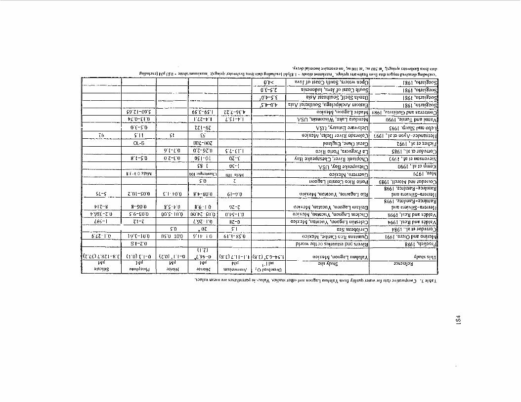
Sampling stations (Figure 2) were established at44 sites on the basis of referente points determined by the local fishing comrnunity (Jimenez-Sabatini et al., 1998). Data were obtained from 42 of these stations (Stations 17 and 18 were not sampled due to logisti-
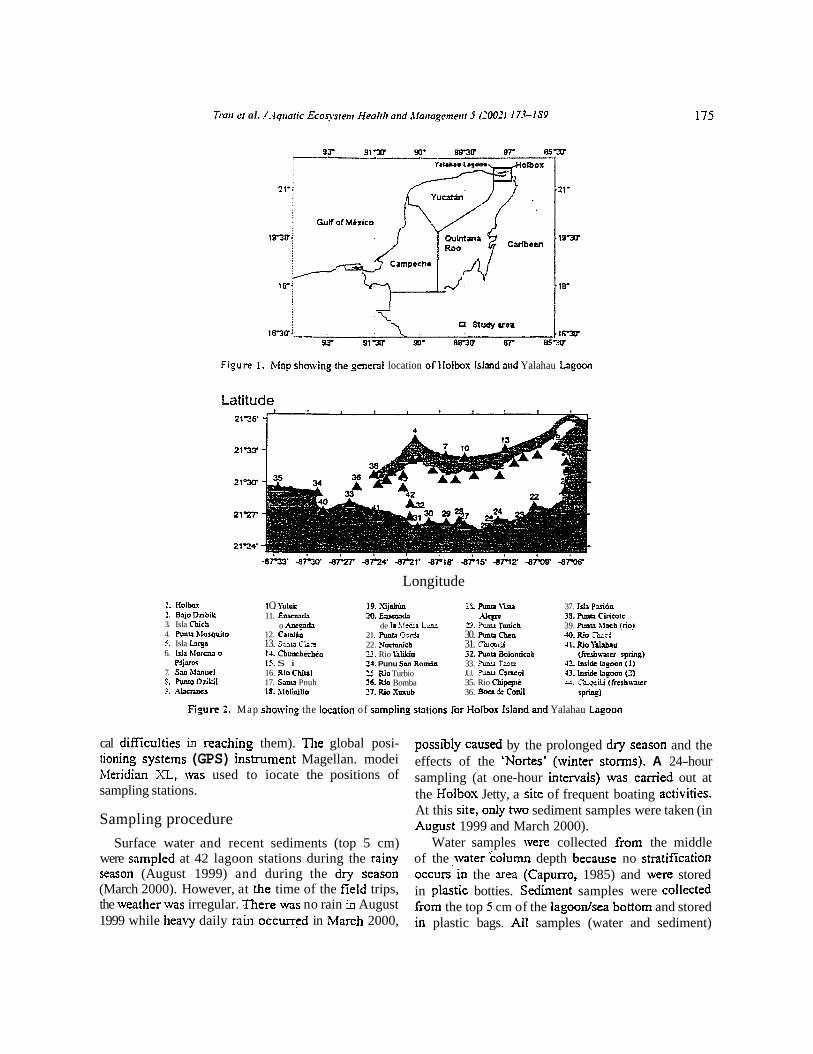
Trarr rr al. !.-lqiraric Econsrent Healrli nnd ,\fariagrme>ir 5 (2003 173-IS9
Fio,ure 1. Mnp showing ihe general location o f Holbox Islmd arid Yalahau Lagoon
Latitude 2 1 9 0
2 1 3 3
2 1 w
21-27-
2124'
Longitude
l. Holbax ?. BHo Dnbik 3. Isla Cñich 4. Punu hlarquiio 5. Isla Lrp 6. Isla hloruu a
Pajyos 7. S= Blyiucl 8. Ruiio D f i l 9. .'U~CMCS
1 O. Yduk 11. E w m &
o Ancp& 12. Caiaíiu 13. Sylw Ckm 14. Chunchechén 15. S i 16. Rlo Chiul 17. S u Pnuh 18. ~ l o r i l o
19. .Xj* ?O. Enrm;r&
de la hlcdia Luu 21. Rmrr Gordr 22. Nvcmnich 2.3. Rio Yamo ?J. Punu San Romin 25. Rio Turbio 16. Rio Bomba 27. Rio Svxub
2% R m a \*m .-
3. Pmea Tmu'ch 30. Rmo Cbcn 31. Chiq~iii 31. Rmu Bolonticíb 33. Rmu TWQ .U. Rinu Canco1 35. Rio cbipcptc 36. Boca dc Conil
37. Isla Pyi6n 3s. Rmla Ciricotc 39. Rmu M x h !no1 .u). Rio thsci 41. Ria Y d h u
(kluaicr r p ~ d 42. Imidc h y m n (1) 43.lIsiCk h p m (2) 44. Cñiqniü (frcshmicr
SP*)
Fio,um t . Map showing the location of sampling staiions for Hoibox Island and Yalahau Logoon
cal dificulties in reachinz them). The global posi- tioning systeins (GPS) instrument Magellan. modei Meridian XL, wvas used to iocate the positions of sampling stations.
Sampling procedure
Surface water and recent sediments (top 5 cm) were sampled at 42 lagoon stations during the rainy season (August 1999) and during the dry season (March 2000). However, at the time of the fíeid trips, the weather was irregular. There was no rain in August 1999 while heaky daily rain occurred in Ivíarch 2000,
possibly caused by the prolonged dry season and the effects of the 'Nortes' (winter storms). A 24-hour sampling (at one-hour intervals) was carried out at the Hoibox Jetty, a site of frequent boating activities. At this site, only two sediment samples were taken (in Aups t 1999 and March 2000).
Water samples wvere collected from the middle of the water column depth because no stratification occurs in the area (Capurro, 1985) and were stored in plastic botties. Sedirnent samples were collected fiom the top 5 cm of the lagoodsea bottom and stored in plastic bags. Al1 samples (water and sediment)

were kept on ice for hansport to the labontory where they were stored at 2' C until analysis. This cold stor- age was necessary to prevent the decomposition of o p n i c material and to avoid other types of interfer- ence, which could affect the results of the chemical analysis.
Water temperature and dissolved oxygen concen- tration were measured in situ with a YSI-SIB meter from the middle of water column depth, and the per- centage of oxygen satuntion \vas calculated accord- ing to Garcia and Gordon (1992). Water transparency was measured using a Secchi disk
Water and sediment anaiyses
The pH of samples (water and sediment) was measured usinz a Beckman Phi-32 pH meter. Salinity of filtered water samples was analysed with a sali- nometcr (Kahlsico RS-9); ammoniurn, nitrite, nitrate, phosphate. and silicate were quantifkd according to standard methods (Strickland and Parsons, 1972) using a Shimadzu UVNIS spectrophotometer.
The redox potential of the sediments was measured using a Beckman Phi-32 pH meter with a platinum electrode. Orsanic content was determined using the dichromate osidation technique. The classifica- tion of sediment ,onins into particle sizes (sand silt: clay) was carried out using the gnnulometric method (Buchanan, 1984).
Geographic Information System (GIS) mapping
The spatial distribution of the continuous water variables in Holbox was estimated from 42 con- trol points where values are known. Tlie desree of spatial continuity based on these control values can be expressed as a variogram. Kriging is an optimal prediction method and uses information fiom a variogram to express trends suggested by the data (Olea. 1999). Spatial distribution of collected data in Yalahau Laeoon and the open sea was modelied by ordinary Kriging provided by the SURFER software package. The input data was in the form of (x,y,z) points to indicate latitude, longitude and values of the physical or chemical data. A linear variogram model was selected to determine the local neighborhood of observations and the weights applied to the observa- tions during the grid node calculation. No drift value
\vas provided for al1 cases. Tlle output estimations were placed on a regular gnd to produce a raster image of 200 by 64 cells. Finally, contour maps of tlie coastal water were elabonted for tempenture, salinity. dissolved oxygen, percent oxygen s a m - tion, pH. silicate, phosphate, ammonia, nitrite, and nitnte. Contour maps of sediments were elabonted for parameten such as percentage of orzanic matte- total nitrogen, total phosphorous, percentage of sand silt and clay, and redox potential.
To determine spatial changes. a simple chanze detection procedure was conducted with the subtrac- tion of interpolated values behveen the two different dates (Dobson et al., 1995). This result was used to assess the magnitude and direction of change in the spatial distribution of a chosen parameter. Differences were calculate using SURFER MATH command to construct a layer of the type C = A - B. whcre A is the interpolated old data (to) layer and B the recent data (t,). It is then expected tliat same areas in A and B with similar halues for these hvo dates will have val- ues close to zero in layer C. Areas with large positive values in C indicate a decrease of the parameter while areas with negative values indicate an increase.
Given that Station 44 is a fieshwater spring, located inland at approximately 5 km fiom the coast its influence on coastal water quality is relatively srnall. Therefore, the results of the pliysico-chemical analyses from this station were not included in s t h - tical calculations, nor in the Kriging interpolation. In contras4 the results from the freshwater spnng at Station 41 were included in al1 statistical calculations? because this spring is located directly on the coast and is C O M ~ C ~ € ! ~ to the coastal water.
Results and discussion
The Secchi disk was clearly visible nt bottom depths for most stations. In the middle of the lagoon where the water deptli is almost 3 m , the Secchi disk was visible at depths of up to about 2.3 m. f i s indicates a high level of water transparency and a low level of suspended sediments in the lagoon.
In general, the physical and chemical parameten measured in Yalahau Lagoon (Tables 1 to 6 ) are similar to those reported for other coastal lagoons in the Yucatan peninsula (Herren-Silveira et al., 1998a: Valdes et al., 1988; Valdes and Real, 1998; Valdes,

Tion LV cl. /.-lqiraric Ecos!wem Heolrh and ,\Iariajenienr 5 (7003 173-189 177
Tabie l . Physico-chemical data for water samola collected in Aueust 1999.
% Ternp. Salinity Oxygen Oxygen Arnrnoniurn Nitrite Nitrate Phosphritc Siliclite
Station 'C % pH rnl 1-' s a t d o n pM ,yM pbl @i PM
31.0 39.53 8.10 31.0 40.21 8.16 31.0 40.33 8.53 31.0 36.78 8.24 31.0 41.30 8.54 30.5 4 2 . 1 8.27 31.0 36.53 874 31.0 43.47 8.18 31.5 45.42 8.32 31.0 36.91 8.23 32.0 44.1 1 8.31 32.0 44.57 8.38 31.0 36.82 8.71 32.5 45.46 8.43 33.0 46.96 8.57 33.0 48-44 8.51 30.0 49.07 5.M 31.5 47.78 8.71 32.0 48.03 8-18 31.5 41.77 8.12 32.0 40.41 8 . Z 32.5 41.67 8.25 32.0 41.12 8.77 34.0 41.97 8.45, 33.0 42.07 8.35 32.5 39.59 8.33 33.0 38.01 8.78 33.0 36.56 8.46 33.0 36.79 8.39 33.0 36.77 8.32 31.0 33.97 8.33 30.5 35.99 8.36 29.5 36.36 8.22 28.0 36.73 8.28 30.8 37.43 8.14 29.0 38.01 8.02 29.0 38.1 1 8.03 31.0 27.27 7.99 25.0 0.00 7.62 32.0 37.99 8.18 31.0 37.77 8.02 N.A. 0.00 7.67 N.A.
5 5 77 87 92 53 71 86 65 91 86 94 9 1 79 88 97
130 39 69 75 72 85 96
1 O7 128 122 115 98
142 123 95 93 88 74 99 61 46 5 7 5 1 13 43 65 N.A. 0.76 44.67
Average 31.3 39.2 8.3 3.5 83 3.7 0.3 1.2 0.2 49.3 Std. Dev. 1.6 7.8 0.2 1 26.5 2.0 0.2 6.0 0 2 40.1 Minimum 25.0 0.0 7.6 0.6 13 1.1 0.0 0.0 0.0 3.8 Mnximurn ' 34.0 49.1 8.6 ' 5.7 1 42' 11.1 1.0 39.4 1.3 128.7
.%m-: Data me no1 provided for Stauons 17 md 18.

175 fin11 a al. /.4qirn/ic Ecoqsfern Heallli arid .IIanagenieril 5 (3002) 173-189
Table 2. Physico-cliemical datn for water sarnples collecred in M m h 7000. - -
Yo Temp. Saiinity Oxygcn Oxygen Amrnonium Nitritc Nimtc Phosphatc Silicatc
Station ' C .60 pH mi 1-' saturation p i~ f PM &M PM
25.7 0.00 7.42 0.20 -1 2.73 29.41 0.00 1 17.42
.4vengc 27.7 35.3 7.9 4.1 9 1 4.0 0.2 1.3 O. 1 21.0 Std. Dev. l .S 5.7 0.2 1.1 26.9 1.7 0.2 6.4 0.1 13.1 Mininlum 25.0 0.0 7.1 0.3 4 1.8 0.0 0.0 0.0 1 7.3 Maximum 3 1.2 40.0 8.3 6.3 144 11.7 1.1 41.9 0.5 97.9

Table 3. Physico-chcmiui dala for sdunent sanloles collecred in A u ~ i 1999. --
Orgmic Tord Total Rrdox Maner Nitrogen Phosphoms Sand Silt Clay poteniial
Shtion (O,&) ( p ~ ~ o l g ') (pnol g ') !'o YO !'o (mv)
58.59 1.76 70 19 I I -194
Avcnge 4.6 85.8 1 3.18 80.83 9.80 3.37 -272.29 Std. Dev. 5.01 39.65 1.44 18.73 9.50 11.18 33.25 Minirnum 0.8 36.06 0.15 55.00 1.00 0.00 -323.00 ~Maximum 26.4 182.23 5.30 99.00 40.00 48.00 -1 77.00


h i i el 01. ;'.fqrtotic Eroqrteni Heohli oiid dloirogenient j (1002) 173-199 18 1
Table 5. Water qu l i t y data for samples collecred from Hoibox Jett). at one-hour intmals in Aueusr 1999. - -
?/o Time Ternp. Salinity O, Oxygen Ammonium Nimte Nitmte Phosphate Silicate
hr 'C YW pH rnl 1-' satuntion pM pM pbl fl fl
24 30.5 40.73 8.43 1.26 30 11.23 0.16 0.01 0.2 1 26.33
Average 30.3 40.23 8.30 257 56 , 10.72 '0.23 0.78 0.14 27.83 StdDev. 1.5 2.11 '0.13 1.73 38.5 6.70 0.09 0.40 0.1 1 2.73 Minimurn 27.0 31.36 8.22 0.42 10 4.09 0.12 0.02 0.00 18.07 Maximum 33.0 41.21 8.64 5.74 137 37.25 0.48 2.01 0.46 29.07
1999). These lagoons typically act as estuaries in the rainy season because they receive ffeshwater (ffom the atmosphere and fiom the continent via ffeshwater springs) that is rich in nitnte and silicate, and poor in oxygen. In the dry period (August 1999), evaporation is greater than precipitation and, a s a result; the salin- ity is comrnonly above the marine values. Exceptions were those stations near the ffeshwater spring, which had slightly lower salinity (Figure 3a). Because of the influence of freshwater, the salinity of the Iagoon was slightly lower than that of the open sea, particularly during the n iny season (Figure 3b). The eastem zone of Yalahau lagoon sliowed the highest salinity, as observed in both seasons at Stations 16 and 19, due to
their _eeographic isolation, which favors limited cur- rent circulation and high evaporation.
i h e pH values were similar to those reported for coastal water in the a r a (Valdes et al., 1988; Herrera-Silveira et al., 1998b). However, the average pH decreased slightly in March 2000, possibly due to the effects of wind and waves, which increase the re-suspension of sediments containing organic mat- ter. Consequently, the degradation of this suspended organic matter produces carbon dioxide, lowering h e water pH. The freshwater spring in ffont of the lagoon mouth (Station 41) had a marked influence on salinity, temperature and pH of ibis zone, causing a decrease in these tluee parameters.

2 1 7 7 -- 23 24
I 2 3 4 5
6 7 8 Y 10 I I 12 13 13 15 16 17 1 S 19 20
A v e q e Srd. Dcv. .Minimurn blaximum
Dissolved osyeen: an important indicator for water quality, was generally low for both seasons but there was no indication of excessive bacteria1 decay: average values of 3.5 m1 1-I (Tablt: 1 ) ana 1.1 rnl 1-I (,Table 2) for August 1999 and tvIarch 2000, respectively, are comparable to values reported for other coastal waters (see Table 7). A low level of dissolved oxygsn aiid low percentages of oxyeen saturatioii were observed at Station 39 in both sea- sons. and are likeiy to be the result of tlie proximity of the village durnp, which rnay deteriorate water quality through excessive bacteria1 decompositioii of organic material fiom garbage. Dissolved oxygen levels were relatively low at Stations l 1 37, and 38, indicating the iiegative impact of humaii activities
(such as boatins, fish cleaning, and picnicking) on tiie quaiity of coastal water. n e lowest values for dissol\led oxygen and for the percentage of oxygen saturation were recorded fiom the fieshwater spring (Figure 4), as may be expected given that this water originates fiom undergound. Dissolved oxygen and tlie percentage of oxygen saturation were lower in August 1999 cornpared to March 2000 ( ~ i p r e Jc), possibly because August is a very hot rnontli with less wind (factors that decrease gas solubility), while March is typically niucli cooler with more n in and iiiglier winus. The average percentage of oxygen saturation was lower than 90%, suggesting that the site supports Iiigher consumption than production of oxygen. However, at some stations, high percenhges
PIVCSB5
Pencil

Figure 3. Spatial distribution of salinity (?&) in ( a ) August 1999 2nd (bt March X O O .
of oxygen saturation (maximum values of >140% for both seasons) indicate tliat oxygen production (pho- tosyntliesis) predominates over osygen consumption (plant respiration at night or bacteria1 decomposition of organic matter).
In most coastal environments thc vast majonty of nitrogen released through d i f i s ion from sediments to overlying water! where it can be assimilated by plants,
is in the reduced form of ammonium, which is gener- ated by the decomposition of organic material. In the presence of oxygen, a portion o f the ammoniurn is oxidized to nitrate, which is also an important nutrient for plants Valdes and Real, 1999). In this study, the nitrogen-f~ued f o m s were present in concciitrations that are normal for coastal lagoons in the Yucatan (see Table 7). A predorninance of reduced (amrnoniurn and
OL-S 001-002 piio19iig 'asno )~:~JIJ
9'1-1'0 0'2-9Z'O 5 'L- t l ' l os!ll OIJO,~ 'CJ~I~XICJ c 1 SR(,[ "lo 13 ~opaur13 8'1-5'0 0'2-['O 05 1 --O 1 OL--.c r(i
a m
=.m
0.03
-mm
4 .m
-87.55 -873 -87.45 -87.43 -87-3 -87.33 -87.15 -87.a) -87.15 4V.10 -.m
C = A-8 \huc C ihc dithum a3.m
k ?& o.'cy-n in Aug 19% B: S ' a y p n in h.h& 2000
Figure 4. Spatial disiribuiion oftl ir prrceniagr o f oxygcn saiunhon in ( a l August 1999 nnd (b) h h c h 2000. ( c ) DiTTcrciice in [he perceniagc o f osygcn sanintion , bci\wen Auyist 1099 and Mnrch 2000.

Trible S. Cornparrinvc Jara for sedirnent Cornposition frorn Yalahau b g w n and otlier studies.
Tilis study Valdes and Red. 1994
11993 1 1 IGESAMP. 1990 1 Havana Bav. Cuba 1 45
~~- , ~~
'comedor et al.. 1985 Gómez-Parm and Foja.
I . , J
Cokley et al., 1993 San Lorenzo Estuary. Canadn 2-12 0.2
[~eirzinger et al.. 1954 Narragansett Bny, Rhode Island, USA 0.24.2 50- 164 Koike and Hattori. 1975 Japanese Coast 40-560 Law et al.. 199 1 Tamar Estuary, England 2.854.16 221-3 14 Bonin et al., 1994 Mediterranean Coast. France 5.2-1 1.3
Ynlahau Lagoon, Mexico Chelem Lagoon. Yucatan. Mexico
IOrnon et al., 1994 l~wai i rna Bav Jauan 1 1 2 3 8 1
--.- ~ - - - - ---.- - I
La Parguera Porto Rico. Cadiz Bay, Spain
O. 1-26.4' 2.2-9.2
'nicm orgnnic rnatter = 3.9 5% bmean total niwgen = 84.72 pmol _o-'
36.06-1 82.23" 17.3-338.7
1.45-3.3 2.72-3.83
I d . I
arnrnonja) over osidized (nitrite and nitnte) forms was observed nt most sites (Tables 1 and 2). Stations 22.38, and 39 had relatively high ammonium concen- trations, suggesting that arnrnonification of organic nitrogen was being camed out at elevated m e s at those sites. At Station 39. the ammonim concentra- tion in March 2000 (1 1.69 pM) was higher than that in August 1999 (7.03 pM). Tilis obsenlation may be due to tlie unusually high precipitation in March 2000 (which is normally the dry season), resulting in high leaching of ammonium-containing substances from the nearby garbage dump.
Nitrate concentrations were eenerally low (G- 1.87 pM), except at Stations 41 and 4 4 where Iiigh concentrations (>39 pM), due to the presence of nitrate-rich freshwater, were observed. Phosphate concentrations were also generally low (Tables 1 nnd 3). Nonetheless. samples from Stations 5 and 10 showed relatively high phosphate concentntions, although not at levels which can induce eutrophica- tion (Valdes and Real, 1999). High silicate concen- trations were recorded from al1 stations. ?he average
3 5 6 2 4 0
Pejrup et al., 1993 Ifiridyb blarsh, Denmark
~ a l u r s for August 1999 and blarch 3000 were 5 1 ar 23 @A, respectively, whicp are normal for this of la= ooon.
High concentrations of ammonium, nitrate: nitrit. and phosphate, factors that generally induce eutrc phication, are absent in the study area. indicating low possibility of eutrophication (Justic et al., 1995 for Yalahau Lagoon. The ammonium concentration reported here are lower than those recorded fron Chesapeake Bay and from other coastal lagoon site in the Yucatan Peninsula (see Table 7), where mor; intensive development has taken place over a mucf longer time-scale. They are also lower than the amrno. nium concentration which could cause eutrophicatior (above 15 m ) (Boyd, 1990). Nitratc levels fiar YaIahau Lagoon (1.87 m max.) were ako much lower than those recorded elsewhere, especially when compared to polluted sites such as Chesapeake Bay. La Parguera, Great Ouse, Colorado River Delta, and Delaware Estuary (see Table 7). Similarly, the phos- phate concentration ofYaIahau Lagoon was low when compared with values from other study sites. The low
3.5-3 .i l I 179-32 1

leirels of tlirse panrncters suggest that coastal \vater quality in thr study are3 Iias not yet been degmded by hurnan acti\.ities.
Sedimrnt i i i thz lacoon is mostly sandy, the awr - ase value of sand contrnt in both samplin, "S \vas above 5096. while silt and clay presented inean \.al- ues near 1096. Stations near the lagoon mouth were rnostly s a n d in others more protected From waves and currents, silt and clay represented near half of the sedirnent.
The organic niatter contcnt of tlir d i n i e n t s (4% avenge) corresponds to the normal levels for coastal lagoons in tlie Yucatan (Valdes and Real. 1994) (Tables 3 aiid 4). Ltvels greater than 1026 are poteiitially hazardous because they indicate an elevated accuinulation of organic matter that may cause excessive bacteria1 decomposition Irading to oxygen depletion (GESMvlP, 1990). Leve1 of organic contents above 10% were seen at stations 23 and 26 with exceptioiially high concentrations obseried at station 74 i126.40h) and staticii 41 (1 7.99'0) in tlie August sampling. Nonetheless. the lzvels recorded are much lower than those froni polluted sites, such as Havana Bay. Cubat or Uwajima Bay, Japan ( s e Table S)' where widespread eutropliication has been reported.
The rneaii values of total nitroeen in sediment (S5 pmol g-1) were in tlie normal range. for coasral lagoons of this type (Valdes and Real. 1994). Seven l stations showed nitrogen concentrations of above 100p-nol g-I, reaching 152 pmol g-l at Station 24, but maximum values were still lower than those reported fmrn other studies (see Tablc 8). Total phospliorus M a s also within the normal range (mean values o f 3.18 and 3.71 prnol g' in Auzust 1999 and March 2000, respectively). However, liigher pliosphate levels (>j pno l g') were observed at Stations 6.37. and 39 (Tables 3 and 4). This may be esplained by the large number of birds lvhich live nearby Station 6 (known locally as "Bird Island"). their excrement possibly affecting the phosphate level of sediments sampled at this site. In contrast. Iiuman activities are likely to be the cause of increasrd pliosphoms at the other two stations because o f intensive picnicking (Station 37) and rscessive dumpiiig (Station 39) activities.
Tlie redox potential of sediments was negative at al1 stations. indicating thar the sediments contained link or no osygen. ln such anoxic conditions, nitro-'
gen f o m s are mainly present in ihe reduced forms of nmnionium and animonia. which are consequently released into the surface water. This explains tlie prtdoiiiinancc of the reduced f o m s (arnrnonium and mimonia) ovtr rlie osidized (nitrite and nitrate) as seen in rhe results of the water analysis (Tables I and 2). The mean redox potential \as -270 mV in A u p s t 1999 and -255 mV in klarch 2000 (Tables 3 and 4). Extreme values of -134 mV (Station 44) and -330 mV (Station 31) are nonetheless within the normal ran_oe for coastal sediments (Valdes and Real, 1999), where denitrification and sulfate reduction are pre- vailing processes for the oxidation of organic matter.
Hourly variations in the physical and chemical p2iame:ers were clearly observed at the Holbox Jetty site (Tables 5 and 6). These variations are mainly the result of photosyntliesis and respintion? @ven that the pH and dissolved oxygen levels increased during the day but decreased at night. The reverse pattem was observed for numenfs.
Concluding remarks
These preliminary data show that the waters jurrounding Holbox Island and particularly within Yalalau Lagoon are relatively unpolluted. Tlie area Iias thus far sufTered little from the detrimental effects of human development activities on the coastal envi- ronment. Tlie trend at Stations 1, 37,35, and 39, how- ever, suggests that increased development and human activities have already affected the water quality. The intensive urban deveiopmrnt and rapid population gowth that the island is currently undergoing, suggest Giat the quality of the coastal water and the health of tlie ecosystems could sooii be jeopardized.
These baseline dara, although preliminary, u41 enable us to monitor the coastal ecosystem during the development of Holbox Island and to evaluate the potential demment to the Yalahau Lagoon and tlie sur- rounding areas. In addition, these data provide for the firsc time comparative values from a relatively unpol- luted site which, when combined with füture data from our on-going studies in the area, will be usefüi for planning the management of this coastal zone area. Furtlierniore. these data allow us to take stock of the extent to which the coastal zone in other areas of the Yucatan Peminsula is already degraded.

This project is funded by the KGU Special Research G n n t s of Kwansei Gakuin University (KGU). Japan, and by Universidad Marista (IJhrf), Merida, Mexico. Chemical analyses were carried out by Labontorio de Quiniica CPiVESTAV-Menda, Mesico. Tlie GIS mapping was done in the Departamento de Recursos del Mar, Manejo Costero, C W E S T A V - Menda. Mexico. n i e authors thank al1 persons and institutes wlio participated in this research. J. C. Seijo and A. Flores are g e a t l y acknowledged for their encoumgement and suppon in facilitating thc project, S. Granados for her help with the analyses. A. Cuevas for his help with the GIS inapping and L. Capurro for his constructive coinments on the manuscnpt. Many thanks are offered to students from UM and KGU. and especially L. Scgovia and iL Caceres. from the Administracion de Recursos Naturales. Universidad Marista for tlieir active in~o lvement in the Eieldtrips and sanipling. We aiso tliank A. Bullock of The Hematolog Journal. Pans. Fnnce.
References
'eer, T. (Ed.). 1997. Em~imrtrrierirol Oceanogmply Second cdiiion. CRC Pras , Inc.. Boca Raion.
Boniii. P.. Rambeloarisoq E., Raymond N., Cliarnalei. A.. Bertnrid J. C.. 1991. Euideiice for denimficaiion in m ~ r i n e scdirneni highly coniarninaied by pcirolcurn products. Mar. Pollu. Bull. 2 S ( 1 ) , 89-95.
Boyd. C. E., 1990. I k rer Qrrolin, in Ponds~for.~qiracrrlri~re. rluburn Univenity. U.S.A.
Buchanan. J. B., 1984. Sedirncni analysis. In: N. A. Holme. A. D. Mclntyre. (Eds.). .4hrliods/or tire S / i r o ~ o/ Afaririe Bertriros. Vol. 3. E c o n d Ed.. pp. 41-65. Blacknell Scieniific Piiblicatioris. Oxlord.
Capurro. F.L.. 1985. Estudio iritrxpl del ecosisiema de Cslcsiún y sus irnplicnciones en lo socioeconómico. Inlorme TCnico. CONACYT. ReT: PCECCNA-02 1479.
Capurro. F. L.. 1989. Estado actual d e las invesiigaciones sobre el uso del ambiente costero. Iii: E.A. Cliavez (Ed.1. Proccrdings of [he uorkshop Australia-Mtxico o n Marine Sciences. Mcsico. pp. 127-132: CINVESTAV, hkrida. \lexico.
Coaklq, J. P., Nagy. E.. Scrodes, J. B.. 1993. Spatial and venical irends in sedimeni-phnsc coniaminanis in ihe upper csiunry of [lis Si. L t r rcnce river.,Estuaries 16(3-8). 653469.
Conuens. F.. Gui i t i r re~ F., 1989. Hidmlogia. nutrientcs y produc- t i \ idlid priniana eii Inguiias cosiens. 3.57-78. In: J. Rosa-Velzz.
F. Gonwlcz-Farias (Eds.), Temas de ocwnognlia h~olbgica en MGxico. Univ. Auto. l3ai~. Calif- Ensnada, bls.
Corredor. J. E.. h.!orell, J.. 1989. .ksessrneni of inorganic nitrocen lluscs acmss tlic sedirnmf-uatrr inierface in a tropical Iagoon. Est. Coast Slielf Sci. ?S. 339-345.
Corredor, J. E.. Morcll, J., Mcndez, A.. 195-1. Dissolved nitmgen phytoplankton bioinass and island efTec& in tlie nonheas- rrm Caribbean Sea. Cxib. J. Sci. 1 O t j - l ) . 129-137.
Corredor. J. E.. h4omll. J., Nieves, F.. Otero. E.. 1985. Estudios dc eurroficacion cn el wosistema marino de la Pargucn. in: Jlernorius del Dirodecinio Siriiposio de Rccirrsos ~Vurirmlcs. Universidad de Pueno Rico. San Juln, Pueno Rico.
Dobson, J. E.. Bricht, E. A.. Frrguwn. R. L.. Field D. \Y., Wood L. L.. Hndd3d K. D.. lrcdale 111. H.. Jenscn. J. R., Klernas. Y V. Onh. R. J., Thornas, J. P., 1992. N0.4A (National Ocunic aiid Atrnosplienc Adrninisiniion) Comiai Cliange Xnaiysis llro$nrn 1 C-C.-\P): GitiriE/oi Rcgioiial Ir~rplerricnrariori. NOAA Tecliniul Rrpon NMFS 123.
Froslich, P. Y.. 1988. Kiiieiic conirol of disolved phospliaie in natunl r i w n and estuaries: A primer on the phosphatc buf i r rneclianisrn. Lininol. Oceancg. 334) . 649468.
Fichez. R., Jickells. T. D., Edrnunds. H. h.!.. 1992. Algal blooms in liigh iurbidity, a resuli of ilic conlliciino, consequcnces oi'turbu- lence on nuirieni cycling iri a sliallo\v iraier cstuary. Esi. Comr. ~h~!f: , : : . '5. : Y ; - 9 2 .
Garcin. H. E., Gordon. L. 1.. 1992. Osygen solubiliiy in smraier. bziier fiiiing equiioiis. Lirnnol. Ocmiiogr. 37. 1307-1 312. '
GESAh,IP (Joini Groiip of Esperis on ihe Scientific Aspecis of ~Marine Polluiion). 1990. IhlOIF.4OILMESCOIWbIOI\VHOI IXEA/UN;UNEP. Review of potentially hannful subsmnccs. Nurrients. Rep. Stud. GESAMP 34. UNESCO (Uniied Naiions Educaiional, Scientific and Culiunl Oiyniwiion).
Gomez-Pam. A., Foja. J. M.. 1991. An operaiive dcfiniiion of aikaliniry m inicntiiial w i e n . Mar. Chcrn. 45, 53-65.
klernlindcz-Ayon, J. M., Galindo-Becr, M. S.. Flores-I3ac.z. B. P.. Alrarez-Borrego. S., 1993. Nuirieni conceninrions are high in ihe iurbid \ \aten ofilie Colondo Rivcr Delta. Esi. Consi. Shelf Sci. 37. 593-602.
Herren-Silveira. J. A., Ramirez-Ramiq J., 1998. Saliniq 2nd nuirienis in ilie coastal lagoons of Yucath. Mtxico. Vedi. Iniernai. Vcrcin. Lirnnol. 26. 1473-I 478.
Herren-Silvcin, J. A., Ramircr J. R.. hIdi \ar . A. J.. 199Sa. O\*en.ic\v and cliancierizaiion of ihe hydrolo~y' and primary producrr cornrnuiiiiirs oi' selected coastal lagoons of Yuuiin. blcxico. Aquai. Ecosys. Heaiili hlanage. 1. 353-372.
Herren-Silvein, J. A., Cornin. F. A,. Lo& S., Sáncheg l., 199Sb. Limnological chancieriwiion oraquaiic ccosysiems iri Yucaian Peninsula (SE Mexico ~Mesico). Veh. Iniernai. Vercin. Lininol.. 16. 1348-1351.
Jimenez-Sabaiini. T., Aguilar-Saluar. F.. Marlinez-Aguilar, J.. Figueroa-kz, R., Apuilar-Cardozo. C.. 1998. A fisliiiip vision on Yalaliau Lrigoon in Holbox a r a . Quintana Roo Staie. h4cxico. In: Publicaiion of Fcdencion Reeional de Sociehda Coopcraii\?s dc la Industria Pcsquera dcl Estado de Quinwrw R w and Iiisiiruio Nacional de la R s w . Mexico.

Iiolic. D.. Rabalais. N. N.. Tumcr. R. E.. 1995. Sioichiorncric
_ numcnt balancc 2nd origiii 01' coaslal euimpliication. hhr. Pollu. Bull. ?O( 1 ). 4l-i6.
Kcmp. \V. M.. Sanipou. P.. Calhy. J.. klaycr. M.. Hennk.cn. K.. +ton. W. R., 1990. Ammoniurn recycline \,enus dcnirrilica- [ion in Clieupmkc Bay sedimenis. Lirnnol. Oceanopr. 35(7): 1545-1563.
Kjcrfvt B. (Edl. 1994. Coasial Loyoorl Processer. Elsevic~ drnsicr&m.
Koike. l.. Hanori, A.. 1975. Denitrification and arnrnonia ronna- [ion in anaerobic coas.cal sedinicnrs. Appl. Environ. Microbiol. 35(2). 275-382.
h v . C. S.. Rees. A. P.. Owcns. N. J. P.. 1991. Tcniponl vanabiliry of dcniirifiwiion in cstuarinc scdimcnis. Esi. Coasi. Sllcli Sci. 33.37-56.
Lcbo. M. E.. Sharp, J. H.. 1993. Disiribution ol~phosphonis along ihc Dclarvare. an urbanized coasial phin aiuary. htunries 16(?). 290-301.
Mec. L. D.. 1979. Coasu1 Lagoons. In: J.P.. Riley, G. Skirrowv. (Eds.). C/iernical Oceariogr-ap/ne. Acadernic Prcss. London.
Merino, M., Otero, L.. 1991. Ailas ambiental costero. Pusno ivlorelos-Quintana Roa Ceniro de Investigaciones de Quinuna Rw.
O l a , R. A.. 1999. Geosraiis~icsjor Erigirieers and Earrli Scieriiisis. Wuwer .4udemic Publisher. Boston, Maswchusetts.
Omori, K., Himno, T.. Takeoka, H.. 1991. The limiiations to o-anic loading on a botiorn o í a coastal ecosystern. Mar. Pollu. Bull. 2S(?L 73-80.
Pcjmp. P.. Barrlioldy. J., Jensen, A.. 1993. Supply and cxchange o i w ie r and nuuients in thc Gcidyb iidal a ra . Denrnark. Esi, Coast. S11eliSci. 36. 22 1-234.
Scitzinger. S. P., Nixon. S. \V.. Pilson. M. E. Q.. 1934. Deninificaiioii and niirous oxide produciion in a coasiál rnarinc ewsystcm. Lirnnol. Oceanogr. 29( 1). 73-83.
Soc~iano. A.. I9S l . The ocwnognphic features oi'Southast Asian \\aicrs. In: L. S. Cliia. C. MacAndrcwvs. (Eds.) . Soiriheasi.isiori Seos: Fmnricrs ,/or Dedopnienr, pp 1 0 4 7 . McGnw-Hill Inimwrional Book Cornpany. Singapom.
Si~\~enson. J. C.. Siavsr. L. \V., 1 993. Water qualiry associated with surviml OT submcrscd aquatic vcgeution along an aiuarinc e n d i c n ~ Estuarirs. I6(2), 3Jó-XI.
Sirickland J. D. H.. Panonr T. R., 1972. .4 Pmcricol Hardbwk o/ Semto~er.lna!i~sis. Bull. Fish. Res. Bd. Can. 167 (SÍrcond Ed.). Onawm. Canada.
Valdes. D. S., 1999. Yucaian gmundwciier-influenccd sysicrns: Ria Leanos Laroon. Yucaian. In: S. V. Srnith. J. l. Manhall. C. J. Crosslmd (Eds.). .\Irnican arid Cc.rrrml.4mcniart Coas~al Lagooii Sysrcrns: Carhon. Mrrogeii. aiid Pliosplionts F l u c r (Regio1101 For*rlrop fn. LOlCZ (Land Ocmn Inicnctions in the Comwl Zonc) Reporis S: Studies No. 13. Tcxcl, Tlic Neiherlaiids, pp. 3 1-35.
Valdes. D.. Rwl. E., 1994. Flujo de amonio, nitriio. nitmto y ioshto a travk de In inieriase sedimento-agua en una laguna tropical. Cicn. Mar. ?O( I ). 65-80.
Valdes, D.. Real, E.. 1998. Vxiations and relaiionships o í salini'y, nuinents and suspend~d solids in Chclern co35wl lagwn ai Yucaian. Mexico. Ind. J. Mar. Sci. 27. 149-156.
Valdes, D., Real, E., 1999. Variation o í nittifiwtion ntes in Chclern hown, Yucainn. Mexico. Ind. J. Mar. Sci. 2s. JZMZS.
Valda. D. S.. Trcjo. J.. Real. E., 1988. Estudio Iiidrologico de I U laguna Celesnin. Yucnrjin, México. dunntc 1985. Cien. Mar. 142). 45-68.
Vanni. hl. J.. Tcrnie, J.. 1990. Seasonal pnnems o i gming and nunicnt liinitation ofphfloplankton in n eutrophic lakc. Lirnnol. Ocanogr. 333) . 697-709.