Meneladani Ketokohan Dan Rahsia Kejayaan Abdul-Rahman bin Auf
Upload
independentCategory
view
1download
0
'·
li~'-i'f
''!'--~:J~,t:;h4;>'>:,- ) . . "'. " .. ':;1CJ.,,{i, . . . .. ' • .. --·· ""'- ·---:-<; '•c'f'~};;,._,, :•
. . ...
GOVERNMENT OF THE PEOPLE'S REPUBLIC OF BANGLADESH GEOLOGICAL SURVEY OF .BANGLADESH
!
STATE OF GEOLOGICAl. ASPECTS IN LAND USE PLANNING IN .BANGLADESH: AN OVER.VIEW
.By
Hujibur Rahman.Khan and
Mir Fazlul Karim
April, 1994
This report is prep.ared ·for Expert Gr.oup ~ieeting, on Geological ·"As-p.ects of Limd ·'use Planning,
Bangko.k," Thaiia.nd, 10-13 Nay, 1994.
.d·:·-'"" ~:.::::;~~~~!:\., • ' [~~.,.~,;'tw.J'!~;.>;:~<:~k{~.~~: ~ :r ., ~:/:~~;~-~;,: ;·, .··. /~':- ,.: .
' .
I I 1: li I j ' i I !i TI
li ~ I l i 'I I I' " I i lj
11 i I

;
STATE OF GEOLOGICAL ASPECTS IN LAND USE PLANNING IN BANGLADESH AN OVERVIEW
ABST.RA.CT
Mujibur Rahman Khan and Mir Fazlul Karim
Bangladesh is one of the densely populated aountry of the world. There are various type of geological hazards in this small landmass which cause serious damage to the lives and property of the country every year. The geological hazards like floods, erosion, landslides, subsidence and earthquake are disc1Jssed in this paper. It is necessary to identify the geological aspects in mitigation of these hazards for an effective land use planning and development. The possible relationships between the hazards and geological processes are delineated in this paper.
INTRODUCTION
The landmass occupied by Bangladesh has a rich historical and natural background. There are numbP-r of locations of ancient civilization which date back thousands of years. Jt would not be exaggerated if it is said that. tlie concept of land use planning existed here even during Buddhist r11les in 7th Century A.D. The archaeological relicts of Paharpur, Mohastan Garh and HainamatiJ.,almai are good examples of land use planning in th~ past (Islam, 1966). A11 unearthed layout of a ruined monastery shows an i••teresting array of its periplteral bou11dary in · Mainamati-Lalmaj (Khan, lflfl3). The rhombic boundary was planned and designed eiLher t:o compensate shearing forces genera.ted during earthquake and tectonic movements or it was a result of past earthquakes.
1'he present Bangladesh is one of the most densely populated country in the world. The population is increasing so rapidly (Fig. 1) that it has been almost doubled in last 25 years. The country will require more land to accommodate ·this ever grm<ing population. The only possible way to increase the area of the country is by reclaiming land from Bay of Bengal (Rahman et al., 1992 and Alam and Rahman, 1982), In this regard the existing geological processes acting on the ongoing deltaic progradation will be an advantageotts condition. But before that the available land of the country has to be effectively used, and for this an intelligent land use planning involving g.eo-scientific processes has to be done.
The ecoJJomy of the country is mainly dependent 011 the agricult1Jral resources. Hare than 80 percent of the population is engaged
- in farming and lives in rural areas and fights with various geological hazards described in this paper.
After the independence in 1971, a rapid development work in Bangladesh which led to a sudden population influx urban areas. The population of Dhaka city is increased
1
started in t.he
from 1.2
r "'--""------)

u~o.o
,0
I
'f~.
I ,_ ...
.-- ~ i
.,- . _ ...... J_ ... ·;_ .. - -_ ·r ·>'·
Fig. 1. Population projection of Bangladesh upto 2000 A.D.
to about 7 millions in last twenty years.Consequently the urban area bulged to about 500 sq km from 150 sq km. The other cities like Chittagong, Khu1na and Rajshahi are also expanding in the similar way. It is expect~d that the expansion will continue and the urban people will face severe natural and man made hazards.
Besides urbanization, a considerable increase has also been taken place in the industrial sectors. The increase of industries in and around the urban areas has caused increase in generation of industrial wastes resulting environmental pollution (Karim and Haider, 1994).
Increase i11 population, expan~ion of urban area, ii1crease of agricultural land, decrease of forests (deforestation) and slow growth in industrial sectors, all together have brought a signifi.cant change in the total environment' of the country. In addi ·tion
tci . these the.re are various pat ural and mart· made hazards which have. focused public attentlori on environmental protection. The natural hazards ... such ,as. flo.ods, .• erosion, unstable soils (for· foundation)' landslides lind earthquakes are termed here as geological hazards becaus~ directly or indirectly these all are influenced by geological processes. The time has come that geological aspects should be considered in land use planning and development. For doing so, it is necessary to have thematic maps on distribution and intensity of geological hazards.
Physiography and existing ~and use pattern
The physiographic conditiori and surface gradient (Fig. 2) of the country is influenced ··by t:he subsurface geology. The subsurface geology is control lee! .by' the regional tectonic movement of Indian
~ subcontirtent. A comparison between the tectonic features (Alam et al. , 1990) as shown in the generalized tectonic map (Fig .. 3) and
2
. ' . '·' ~ . . ~ . :o •. '•· ,,. .; ,._,.

.. ~···
0 !10 100 KILOMITftll. 1-1---'-' - .. ·.--1': 0 to MILii
, 10 CONtOUR IN MITRII. P.:-"':"1 .
PO .. EST$
Fig. 2 : Generalised physoigraphic map of Bangladesh showing different gradie11t zones in tile 'plains.
physiographic division of Bangladesh (Fig, 2) indicates a close relationship. 'l'he alignment of gradient zones and the di.rectoion of the slopes are almost parallel to the tectonic elements 1vhich .is the surface expression of the subsurface baseme.nl:..
3

. -· ~,. .. o~· 0
21
26°
SHILLONG MASSIF
-2! f 0 ;.. 0
I ~ Ill ~ c: :0 ~~ ~ ~r .. 2! :r
22
I ~t I I \ :0 "'t I G
I .. ~t \ -t. -s. Gl '"r ,
!<\ 'r· "' ~ Ul
' 21°
~0 I
Jo tiUl.ES.
Fig. 3 : Gener.nl:i zed tectonjc. map of Ba.ngladesh nnd <-tdjoini ng at·eas ( After, Alam, et nl., UJ90).
Topographically about 80 percent of Bangladesh is a plain except 12 percent low hills in the east and north east percent terraces in the central parts (Table 1).
.land, and 8
Once these hills in the east and north (Fig, 2) were covered with densely distributed tropical forests which have been erased through time. The forest cover in 1980 was 14 percent whereas in 1R93 it has been reduced to 10 percer1t (Table 2). Almost the ent,it·e pla-in laud is used for agJ.'"icuJ t.ura.l ptJrposes, an estimate indicates t.haL in 1971 the total cropped area of Bangladesh was 55 per·cenL ( 79,200 sq km) which has inc t·eased to fl2 percent in 1990. The larger part of the plain .land is inundated eve.ry year during monsoo11 rain fall.
4
~ I
I I I I
I i l'i
il i l
I
i I

Table 1 : Natural distribution of land and its usability.
Element Area in sq km
a. Plain land 113895 (Mostly flood plain and deltaic plain)
b~ Terrace 12025
c. Hills 18079
Area covered in peT·eenL
79.0
12.7
AgriculLttre, source of peat, sill/clay and forest development.
Urban areas, Agrj_culture, Forest. Industries.
Forest, Agriculture and source of construction sand.
Tab1e - 2: Present .land use distribution in Bangladesh.
Land use
Agriculture
Forests
Rivers
lvaterbody
Urban & Industt'ial ar·ea
Villages & others
Area in sq km
89280
14400
4800
2000
2880
30639
Area covered in percent
62.0
10.0
3 . s
1. 4
2.0
21.3
The courl-LJ'Y is drained by intricate river systems a1nong which the .Brahmaputra. (tJamuna), Padma (Ganges) and Negbna are ntn.jor. The total length of these rivers is about 22,155 km wldch covers an area of aiJout. 4,800 sq km.
An estimated 9
amount of 2.4 x 10 metric Lons of sed imen Ls .is (i
r~f.-trried inLo Lhe plains through an anr1urd HaLer fJ.o\-<1 of 1.5 x. 10 cubic meter per second (Khan, UJ88 and .Rahman et nl., 1 !192). The new sediments every year rejuvenate the fertility of agricultural land.
EVALUATION OF GEOLOGICAL HAZARDS
The natural landscape of Ban,gladesh can distincLly be described as a pl.ain land ha.ving strips of lo1.v hiLls in t.he eastern a.nd r1orth eaHtern parts and a vast coastal plai.rts itl t.he Hottth. The
5
/

(l ,,
geological environment is controlJ.ed by a wide range of degradational and aggradational geomorphological processes. Directly or indirectly these p~ocesses have changed the geology of Bengal basin. This involves a complex interplay of the tectonic move-
Table - ::1: DisLril>uLion of geological lHlzards in cliffercent geoJ·ogical er1vironment of Da11gladesh.
/---------~----------------------------------------------------------\
Geological haza.rds
Geological environment ~-------------------------------------------------~----' I 0
: Piedmont Flood Coastal Terrace Hills Valleys: plain plain plain
:-------------:------------------------------------------------------: ' I I I I I
I I
y N N y y y F :
Flash Flood
l :---------:------------------------------------------------------: 0
0
d s
: Annual : N Y Y Y N Y Flood :
'---------'-------------------------------------------------------' I I I
: Tidal N Y Y N N N : : Ji'lood ; :---:---------:------------------------------------------------------:
E : Bank : Y Y Y N N N : r / Erosion : : 0 :---------:------------------------------------------------------
8 : Scour : Y Y Y N N Y : i :---------:------------------------------------------------------: o : Soi 1. Y Y Y Y Y N n Erosion
:-------------:-------~------------------------~---------------------: Earthqt1ake : Y Y Y Y Y Y :
:~------------:------------------------------------------------------: : I,iquefaction: N Y Y N N Y : :-------------:------------------------------------------------------: l L : Debris : N N N N Y N : : a flow i : : 11 :---------:------------------------------------------------------:
: d : Slope : N N N Y Y Y s / failure : : 1 :---------:------------------------------------------------------:· i : Sand : Y Y N N Y Y : d : flow : :
: e ; ·-------~------·------------------------------------------------------· I ' ' : Subsj_detlce N Y Y N N N : :-------------:---------------------------------·---------------------: I SwelLing : N N N Y Y Y : : . soils : :-------------:------------------------------------------------------: : Water : N Y Y Y Y Y
Jogging l \------·--------------------------------------------~-----------------/
Y = Considerettion of geological hazards is r.equired. N = Geological Hazards may be ignored.)

Table - 4 Distribution of significant geological hazards i11 the major cities of Bangladesh.
/--------~-----------------------------------------------------------\ Geological hazards ' ' ' ' ' ' ' '
:------------------------------------------------------· City !Water Swelling Subsi- SofL soils Land- IT.rosion
:logging soJ.J.s dence & col1.ltps~ s.li.rlc :-------------:------------------------------------------------------: Dhaka Y Y N Y N N :-------------:------------------------------------------------------: Cbittagung Y N N Y Y Y :-------------:------------------------------------------------------: Rajshahi : Y Y N Y N Y
' :-------------:------------------------------------------------------: : Khu1na Y N Y '{ N N \--------------------------------------------------------------------/ ments that caused the rise of Himalayas and global climatic changes, occtlrred during t.he Pleistocene Ice Age. The present geologica.l str1lC:ture and depositional pattern of the basin is a res11lt.:. of tecton.i.c activity as described by Curray and Moore (1974). The evidences of neotectonic activities can clearly be postulated from tbe description given by Bakr (1977) about the changes of drainage pattern and flows in Brahmanbaria-Noakhali (Tippers Surface in Fig. 2). Bakr (1977) describes that the upliftment of Chandina Dell.aic Plain in Early l<ecent Age had badly affected the environment due tp gradual decrease of water supply through Lhe rivers.
Due to prevailing complex geological processes a vax·iety of geological l1azards occurred in this part of the·world. The potential geological hazards identified in different geomorphological units are summarised in Table 3.
The hazards in ·the plain land are flood, river bank erosion, scouring, soil erosion or degradation of tidal plain and liquefaction. Among these flood and river bank erosion are most serious. Huge amount of national annual budget is spent in construction of flood control embankments a11d hydraulic structures. The hazards in the coastal region are similar but in addition to these cyclones and storm surges cause serio11s destr11ct.ion. The lc:.J.ndslides, erosion a.nd slope f.rdlures are common geologic:al l1a~ar·ds in Lite hilly and te1:race areas.
The .signif.ictt.nt geological hazards of the urban ar-ea.s are s1nnma.rj.~~ecl in Table 4. ln places these hazards are triggered by human activities taken for urban developments.
F1_ood
The authors believe that floods or annual .i.nutHlat.ions are essential part of tl1e geological processes acting on Lhe surface of the eounl:ry. If Lhere 1vould have not been any inundation in this country, the socio-economic structure would have been different. It is a part of eulture of Bangladesh. !Jut some years floods cause devastation in the c.ounl:ry and bec.ome Lhe Lop .1 i.';4L hH.v.ard.
7
I! I' I I I " !I II
II

There are four types of flood in Bangladesl1 - the monsoon flood, flash fl.ood, coastal or tidal flood and rni11 flood.
The monsoon floods are annu4l floods and may inundate about 80 percent of the country with water depth of 0.30-2.0 m. The duration of flood or inundation at nJaxlniutn water level may exceed a monioh. The floods of 1987 and 1988 are monsoon flood. The 1987 flood was medium size flood (10 years rE~tur11 pertocl) a.nd Lhe 1~)88 flood was the biggest (70 years return period).
Flash floods may occur at any time of the year, excepi; the winter time, in the northern and eastern part of Uw country. The flash flood prone areas are the regloiJS along or· near the fooL l1ills of Megl1alaya and Cltittagong !•ills.
Coastal or tidal floods - The lmv Udal flood plain and estuaries in the coastal regions are severely affected, tidal surges alongwith cyclones and hurricane.
The most devastating tidal bores hit Bangladesh in Apr·il 29, 1991 which was ranked second in "The Top Ten Environmental SGries for 1991'' (AGID NEWS, Feb-May, 1992). Another devastation took place on November 12, 1970 by a combination of typhoon winds and high tide.
Rain floods are local and short in duration and may occur anywhere in Bangladesh. Rain floods cause serious problem in the urban areas by waterlogging d11e l~o drainage cor1gestion. The filled up low areas, depressions and shallow valleys and construction of roads and embankments in urban ;r-egion frequently cause congestion to rain flood water flow. An expensJ.ve storm sewerage project is under construction in Dhaka city- to mitig·ate .losses due Lo such water logging,
River bank erosion
The river bank erosion is 011e of the severe geological f1azards in Bangladesh which has a serious socio-econoJnic impact. Like floods, this has also become a part of culture of rural people. Some times river erosiOil makes thousands of people homeless.
The type, distribution and intensity of river bank erosion vary with respect to the flooding conditions, stages of river flow and subsurface geological environment (Rl-t.hman et a.J.., 1~190). G-enerally severe erosional activities along the bin.k of the G-anges (Pa.dma.), Brahmaputra (Ja.muna) and Meghna rivers t.ake place during the runoff of monsoon flood water. Tl1e erosional pattern in the upper regime of Bangladesh is different than that of the coastal regiOil. Ir1 1~he coastal regions the bar1k erosions ax·e not a]_ways caused by flood water. In this region severe bank eros:ion and scot1rir1g ·talce place during winter time due to changes jn tide water level. The erosions are not t.hat devastating like flood water erosion but the coast.al rivers often swallow villages after villages.
8

Coastal floods al!lld erosion
The coastal flat of Bangladesh is a part of' gradually developl.ng deltaic front of' Brahmaputra-Ganges delta. It is a tide dominated delta where the broad expansion is taking place by tidally deposited sedimellts. These deposits overlap the seaward sloping of deltaic plain a~d interfingers with slightly highe;· distributary levees. The flat surfaced wedge of sediments i.s coul'.i.nuousJ.y· beJ.ng lHl j 1 L upward t.o compensate t.hr~ st.ructura.l loHering a.nd sediment compaction of the Bengal Basin. A comparative study of the ,J. H.ennell 's map of Bengal and Bihar ( 1979), pres<Jnt. Bangladesll map and remote sensing images indic:ai~e ·that in the last two hundred years the delta is extended to the sout!JeasterJJ part ( Alam, 1982). Yet L.he cyclones .i.n the coastal areas at·e so devastating nal:.ur·al hazat·d that one can hitrdly imagine the dynamic impact of the rol.l..i.ng wave of' wind and water unless survived from such annihilation. During the cyclones of April 29, 1991 t.iclal bores washed away the 3 meters high embankment along t!Je coastal plains of Chitta.gong (Karim, M.F. and Haider, M.J • .1891).
Salinity and groundwater pollution
The paictern and efficiency of land use are not only dependent on geomorphology but also on availability of water and its qualit.i.es. Intrusion of saline water in the southern region of Bangladesh is a common hydrological hazard. The southern d.i.stricts of Bangladesh face acute probl<Jm for fresh water for both the agricultural and house hold purposes. The movement and flow of surface and ground water are controlled by surface topography·, subsurface geological structures and physical properties of sediments. l•'or heing a deltaic landmass the subsurface strata are interfingered in the coastal region,
Landslides and slope failures
.Landslides, debris flow, earth slump, sand flow and slope failures are common in the hills of Gh:lttagong, Chittagong Hill •rra.cts and S,ylhet. In 1993 a wide spread landslides and slope failures were reported and investigated (Karim, 1993). The landslides i11 Ghittagong city of August, 1992 and March, 1994 caused death of twenty people. The landslides in 1993 at. H.angamati and Banclarban 11r:ea severely damaged the roads and road cuts d.i.srupting communical",ion for about two weeks. ThE.'! geologjcD .. l inv(-~sl.:.iga
tion of Lllese landslides indicates that t.ilese occur Lhr·ough Lhe pre-existing fractures and bedding planes~ It is interesting to note LhRI:. the devastations IVhich took place .i.n Ghitl.agong ciLy (1992 ru1d 1994) are located in the potential hazardous zones mapp<Jd by Lhe Geological Survey of Bangladesh.
Subsidence, soil collapse and swelling soils
Except tlte hilly regioJts and Pleistocene terraces Bangladesh is formed of unconsolidated sediments laid mighty rivers of Ganges ( Padma), Bra.hmaput.ra ( ,Jamuna) The soila ln tl•e north and nort!J western parL, Tista
the entire dowll by the anrl. HP.ghna. Fan region

in f igu r:P. 2 a.r:e composed of loose to mod era tel y com_pac ted sand. The flood plalJls of the active rivers and old deltaic lobes are formed of soft silt and sand, and soft silt and clay in the coasl:.al and young deltaic regions (Ganges delta region in Fig 2). The deposits are normally consolidated and susceptible to subsidence a.nd collapse.
The Pleistocene terraces are fonned of overconsolidated soils where number of urban areas have been developed (including the Dha.l~a city). 'rhere are some soils in these terrace~ wJd ch have swelling characteristics, 'rhe sweJ llng effect of the soils cause severe damages to the light engineering structures. The extents (both vertical and spatial) of these deposits are related to weathering conditions and water level fluctt1ation of the past and present.
The ever incren.sing urban population tvill u.ltimat:.ely move from the terraces to the low flood plains and tldal plain region. If proper at::.tention is not given during expansion of lll'bn.n areas thE'! engineering sl:.rticl..ut·es will face severe geolog.i.cnl ha:.::;.::u·ds re_l_n.L-ed Lo subsidence and soil collapse as seen in flood prol:.ecLion embankment~ around the Dhaka city (Asaduzzaman et al., 1990 and Khondoker nnd Chowdhury 1 19 9 2),
Earthquake and liquefaction
T_he his tory of eart·hquakes in BangJ.a.desh and .snrround i ng areas (GSB, 197B; Hossain, 1988; Asaduzzaman et al., 1990 and Karim et al., 1990) indicates that most serious earthquakes have occurred in this landmass. It is believed that the country is nee-tectonically active for being located .near the Himalayas. The Himalayan range is seismically most active zone of Asia. Through a long geological time (Permian to Recent) the basement of Bengal basin, below a thick sedimentary cover, has been severely faulted and fractured. Rahman (1987) identified that most of rivers of Bangladesh are tectonically controlled. The faults and tectonic elements are covered under recent surficial deposits (Alam et al., 1990). A comparative study bet~ee.n the well defined structural elements and past earthquakes (Rahman and Karim, 1993) indicates that the past earthquakes are structurally controlled and for' ln.nd tlse planning or geotechnica.l engineering purposes geologica] invest:.iga.t.ion of tectonic el0.ment.s is necessary ·to eva.lttate or assess t.he seis111ic hazards.
The authors believe that the deltaic deposits (upto the depth of 0
10 m) of Bangladesh below the latitude 24 are strongly susceptible to liquefaction (Karim et al., 1990).
GJE:OLOGICAL ASPECTS IN HAZARD MITIGATION
Thematic geological mapping can be used as an effectjve tool for land use planning and land development. The simplest examples are t.he hiLL cul.l:.ings in Chittagong hilly area <-rhere land devPlopers cut the hills 1<ithout "onsidering the geo l.ogi.cal stcu<'Lure of the
10
strata. These people· even ignore the dipping attitude of the strata and create death trap along the foot hills. On Lhe other l1and the concept of cut and fill of the valleys also can be managed thl'Ollgh simple geological knowledge.
McCall ( l9Al) and Yudhbir (1991) have discussed that the earth science and geol~echnical data can provide beLLr:~J.· Nay in ma.kJng correct decision and land use planning. There is no doubt that the theme of Environmental Geological Mapping (E:OM), c'!une from Europe and USA can effectively be applied in land use planning of Bangladesh. The geological haza.rds discussed jn t!ds paper are part of geological processes acl.ing on this complex landmass. The geological maps and report are to be prodttced in such a way that the geological information can be used for planning and development purposes.
The recent floods in BaJtgladesh, India (ULtar P~adesh), Nepal (Rautabat), United StaLes (Illinois), C!Li.na, Cl<n·many and Egypt indicate Umt floods are world whle hazard. After the floods of 1987 and 19H8 in Bangladesh 1nany scj_en1.isL, ~r1gii1eers and socioeconomists eame forward with neN ideas a.nd PJ.'"oposa.J. s on flood protection to minimize the losses inct1rred by floods. The World Bank has planned a 15 billion liS dolJ.ar flood proLection programme, though it was criticized by different liS a11d E11ropean experts (Serrill, 1993).
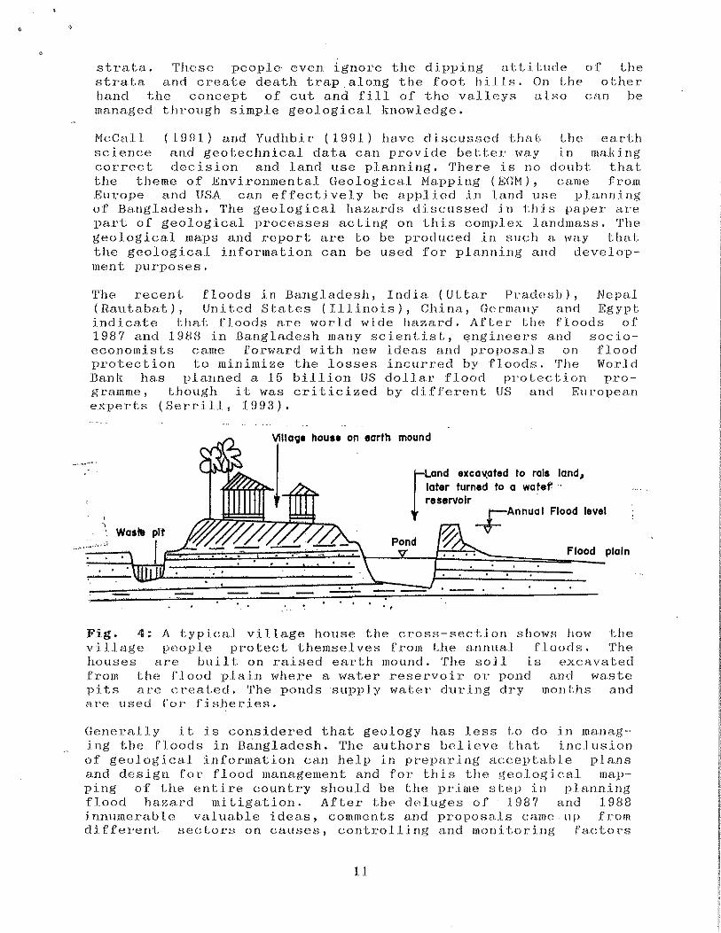
house on earth mound
..
[
Land excal(ated to rals land, later turned to a water · reservoir ·
+Annual Flood level
Flood plain
Fig. 4: A typical village house the cross-sect.ion shows how U1e village reopJ.e protect Utemselves from Lhe a.nnua1 floods. The houses are built on raised earth mound. The soil i.s exc>tvaterl from the flo<>d plai11 wl1ere a water reservoir or pond and waste pits aee cr-eat.ed. 'rhe ponds ·supp]y water d-uri11g dry monLhs and a.re tlsed ror· fisJleries.
Generally it. is considered that geology has Jess l.o do in manEtg-ing the floods in Bingladesh. The authors helieve that inclusion of geological information ca.n help in preparing :-lCCBpLa.b l.e p.l a.ns and design fot' flood management and for this the geolo,gi cal mapping of the entire country should be the pr.ime stoep in planning flood haza~d mitigation. After thP d0luges of 1987 and 1988 innumerable valuable ideas, comments and proposals came -llj) from different sectors on causes, controlljng and monitoring fa.ct .. ors
11
i i I 'I
I I il i I !
I
I ~ I 'I I I l l tl
' 1

of floods. Among these the proposals with the concepts to live with flood and to take benefits of flood boon are jtadged consistent to the geological processes. The rural people are accepting floods siJJce they started living in this landmass. Knowingly or ttnkJtowingly tile village people l1ave cotlsidered the impact of geological processes like ei·osiotl, sedimenta.tion and river siJifting in desigt1ing their houses. The J'igure 4 sl1ows a cross-section of a typi ca.l vLLlage house in a floodprone area. Though the concept is simple, it is very much consisLerrt fqr flood ha~ard adaptation in the flood plains.
Const:ruction of embankments and hydraulic structures are common for flood protection and water resource managemen L. Unfo etunately many of these projects are either failed or boomeranged. The failu.res of the embankments are due to overtopped waLer level, poor design and construction practice or for not considering Lhe geological conditions. This is understood by Lhe geoscientists that the design and construction of embankments are not always the primary cause of failures. In fact problem lies elsewheee, prior Lo des i..guin,g nnd .imp.lenu:nd-Jation, a Jon~; run plann] ng has Lo be there iitvolvirtg model rutalysis c:onsistent to Ll1e gecllogical environments. The geological environment should consist of both regional and local information.
Flash flooding is very common in the north-eastern and eastern part of t.he country. In the month of March, 1994 an early flash flood caused deposition of sand blanket (flow sheet) along the foothills of ceastern hills in Camilla. The sand flow damaged thousands of acres of paddy field in a single flash. Recently flash floods have become a regular incident in Lhe cities of Dhaka and Chit.tagong. In the same month a flash flood in Chittagong City caused death of seven persons after a ftd.lnre of an earth dam (valley fill). These urban flash floods are occurred due to filling up of natural drainage \vays.
Apparen Lly i L may be seen that cyclones have. no thing to do with geology. But st.udy of the storm surge run up and run off pattern through various geomorphic facets can reduce loss of lives and properties. The geolog icaJ. mapping in the coastal. ar·eas has already hee11 started by the Geological Survey of Bangladesh. This reqtlires international cooperation to be more methodical (Il.au, 1992).
The movenH~nt-. a.nd flow of surface and grou.nd \Vater are controlled by surface topography, subsurface geological structures and physical properties of sediments. Besides this there is a possibility that. at places the strata are displaced, distorted or discontinued by fractures or faults originated during tcectonic movement and deltaic subsiderice. Recently the Geological Survey of Bangladesh wi Lh its available technical faci.li Lies, is preparing a map of Bangladesh delineating faults and lineations with their impact on gt~ound water accumu1a.Lion and movement. The st11dy indicates tl1at the potentiality of ground water resource can be assessed t·.llrough detail geological mapping with st.rucLund emphasis.
12

The river erosions are matter of surface hydrology and engineered ignoring geological background. ·In Bangladesh a huge effort is given to train the river flow to mitigate river erosion hazards. For a long term engineering protection plan it is necessary to assess the hazard by giving importance to both geological and hydrological aspects. At different occasions crash projects are taken with the concept - ''save for the time beir•g''. The geological nm.ps and reports prepared by the Geological Survey of Bang.la.desh conta.ln local and regional information on river·bank erosions which can be effectively utilized for long Lerm pl.ann.ing for river training and embankment designing.
For an effective land use planning in the hilly regions of Bangladesh a detailed large scale geological mapping (at least 1:10,000) programme is necessary. The studies indicate that the severity of erosion (mass movement), landslide and slope failure l'tLsolul;ely dependen·t on geological structures such as nal;ore of folding, inclinatioJa, interbedding, faults, joints, foliation and composition. A study indicates that the stability of slopes atad
60
40
Boka Bil
A A A'
Lower· Tip am A 11
II II liB a Upper Tipam 8 II Iii A
II IIA A
Oupi1'ilo 00 •
oo · 0 o o • · o o · .o•o •
Oiliing • : 0 0 0
II ~ liB A
• II
co ,,,'\ .5 • o 0 &o'O' - oooo ,'C-... '6. !\fiddle c o •( 'ra•-,:;D:;;ih~il\9::::. =-----.
·:t·; 2 Tiparn o co · ..::t:~t." 0 ,,, Dupi · Tlla c . c 0 · ·,o~ li Upper Tip am
c c ,<J.~ c Middle Tipam ,'Co• a Lower Tipam
. ..t A Boka Bil ~~· L---------~
20 40 60 80 Slope In degrees
Fig. 5: The stability of the geologieal formations in the Chittagong hilly region. The plots of heights of the .hills verslls the slopes indieates that older the geological formations higher the stabiliLy of the hills.
height of LlH' hills are related to the age of Lhe formations, t..he figure 5 sl1ows that ''older the formatio11 higher the stabilities
13

: ~ .-
of LJ1e slopes 11• The .lands.l:ides, s.lope failures, d.ebr.is _flo~v or
mass movement are the part of geological proccsse.s acting in t.he h_illy cn•ea.
These hazardous geological processes did not get mneh attenLion for invesLigation or exploration as their occurrences were not frequent i11 the past. On the other side many of tl1ese remained unnoticed for oecurring in the remote hilly area. I1v J'ecer1t years U1e freqrrency of landslides and slope failures lra.s j ncreased due to human interactions for expansion of urban a.rea, communication development a.nd deforestation (Karim et al., 1990 and Karim and Haider, 1991).
The susceptibi.Jity of soils to subsidence, swell.ing, collapse and liquefaction is dependent cin the physlco-mecltanical properties of the geological deposits. The geological maps represenL the extent and environment of the deposits from which planr1ers can easily avoid or :improve the worse part for proper land u Li I i zat ion.
DATA AVAILABILITY
Ina.deqt1a.te and inaccurate information can Jead t.o <;a.Last.rophi.c planning or decision and to untold hardship. The Geological Survey of Bangladesh is gathering information and data through exploratory methods on geology, engineering geology and natural environment of the country. So far the organization has completed the geological mapping of an area of about 45,742 sq km which is only 31 percent of the country. There are about 300 geological reports prepared by the professional of this organization. Among these ortly 23 numbers are published at~ the rest aJ'e yet to be published (ESCAP, 1991).
From the year 1985 the Geological Survey of Bangladesh has Laken a national programme to map unco.nsolidated sediments in t·.he plain land and consequently arranged in-offiee training programme. 'I'hte objeetive was to map the entire eountry with Lhe geologicaJ informa.tion easily understood and used by ·Lhe nongeologiHts, planners and other users.
BangJ adf~sh faces an acute shortage of resources fot' tlevelopmPnL. Due Lo this it is necessary to utilize the avallable resourees effectively. In order to ensure effective uti1i%ation of .scarce res(lUJ'ces the land use planni11g p1·ocess s}tottl.d it1tegrate socioeconom.ic and earth sc.ience data. wi t...h emphasis on geo.moephology·, geology H .. nd geotechnical be.ha.vior of geo] ogical deposits or soils. ¥or tf1is accessibility to geological dHta should be relaxed and the reports and professional papers are requ i. red to be published urgently for rapid dissemination.
CONC:LIJJSION
Bangladesh is a densely populated eountry. The huge population living i11 ti1Js landmass ofte11 hj_t by severe geoJ.ogic;al hazards. Tl1e identified gecllogical hazards are floods, riv<~r bn11k Pt'(Jsion, coastal erosion, salinity and ground water pollu1cion, landslides
14
i I I I
I, I il I I l I ~ jl

and slope failures, subsidence and sHelling of terrace soils and earLhqua .. ke. These geological hazards often ctuJse severe damage to the .lives and p t.'opert ies of the coun L ry.
For an effective land use planning, preparation of J.arge sc.:d e thematic maps containing infor1nation on the geological ltaza~ds in the exisLirJg geological eiiVironmerl·t is IJecesAary.
A rapid publication system and easy accessibility to the geological data would create interest among the planners, engineers and otl1ers in corlsidering the hazardous geol.ogical processes for an effective land use planning.
REFERENCES
AGID News tists 1992.
(1992); News Letter of The Associatio11 for International Development. No. 69/70 Bangkok, Thailand. p. 12.
of GeoscienFebruary-Hay
Alam, N. K., and Rahman, N. ( 1982); A study on the land nccretion in the Bny of Bengal and suggestion to accelerate the process . .Journal of Geology, Vol.l, Bangladesh Geologica.l Society, Dhaka, p. 69-73.
Alam, M.K., Hassan, A.ILM.S., Khan, H. R., and Whit.ney, J. W. ( 1990); Geological Map of Bangladesh, Published by the Geological Survey of Bangladesh, Dhaka. (Scale 1:1 000 000).
Asaduzzaman, nee ring inl;ernal p. 1-87.
A.T.H., Geology
report
Nasreen, N. and Olsen, H.ll'. (1990); Engiof Dhaka City, Bangladesh. Unpublished
of Geological Survey of Bangladesh, Dhaka,
Bakr, M.A. (1977); Quaternary geomorphic evolution of t.he Brahm.anbari.a-Noakhal i area, Comilla E-tnd Noakhal i di str ict,s, Bangladesh. Records of the Geological Survey of Bangladesh, Vol.l, part 2, pp. 1-48.
Committee elf Experts on Eartftqltake Ha.zard Mini~izn.tion (1979); ~cismi.c Zoning Hap of Bangladesh o.nd Outline of n CoclP fnc J<:arthquake Resist<wt Design of Structures. F_inn.l lleport. Geological Survey of Bangladesh, pp. 1-42.
Curray, J. n. and Moore, D.G., 1!l74; Sedimentary and i;octonic processes in the Bengal Deep Sea Fan and Geosyncline. In: C.A. Burk and C.L. Drake (eels). The geology of continental margins, Springer - Verlag, p. 617-627.
ESCAP, 19Hl; Geology of for Jjand-use Planning in Tropical DelaLas: Gr:e.rlLer Dhaka City ( Keraniganj Upazila), Hnngladesl1, Atlas (>f Urban Geology v.5, Economic and So(:ial Commission for Asia and the Pacific, Bangkok, pp. 1-33.
15
I I I
I I I II
I i i i I I I

t '
Hossain, K. K. (1988); TocLonlc Significance anrl OC<'-HJT~~.Ilc.es in .Bangladesh. Journa.l. of Bang] .::u:lesh ilociel.y, Dhaka. v. 7. p. 1-11.
earl· .. hqua.ke Geo1 og ica.l
lslam, N. {ed.), 1966; .East Pakistan Annual Vol. IV, Y{·~ar Rook of Record and Reference on East Pakistar1. The Tcmpset Pttblical.i.olls, Chil;tagong (Bangla.d<"sh). pp. l-'1!10.
Karim, ~1. F. (1893); ,\note on spot invest.igat:i.on of landslides in Lhe R.angamal:.i and .Bandarban distr-icts, ChitLagong Hil.1 Tracts, Banglad,,s]}, \Jnpublislwd repoeL of '!.he Ueolog.icRl Survey of Bangladesh, pp. 1-7.
Karim, M. F., Haider, M. J., Chowdhury, M. and Kabi.r, S. (1993); Engineer-ing Geomorphology for ground improvement in part-s of Dhalta city and Tongi area. In; Proc. of .First HangJ adeshJapan joint Geotectonical Semir•ar on Grottrld Improvemer1t, 23-24, .January, 1993, Engineers Institute, D.lu:dta, pp. 18:1~194.
Karim, H. F., Ahmed, s. and Olsen, H.lv. (1990); En,gineet'jng Geolo,gicaJ Geology of Chittagong City. Unpublished report,
Su1:vey of Bangladesh, pp. 1-158.
Kadm, N. 1•'. and Haider, N.J. (199.1); Erosional Hazards i..t1 Chittagong CiLy, Bangladesh. In: Proc. of ~Vorlu:d1op on Soil Erosion and Debris Flow Control, RTPESA-UNDP-UNESCO-LIPT, Yogyokarta, Indonesia, p. 13-24.
Karim, ~!.F. and Haider, M.J. (1994); Impac:t of geo-eng.ineering mapp:i11g 011 Was·te Hanagement of Greater Dha.l<a City (Paper to be published in the proc. of First International Co11gress on Environmental Geotechnics, Alberta, Canada. 1.0-15 J11ly, 1994). p. 1-6.
Khan, F. A. recenL ment of
(1963); Hainamati- A preliminary report on the arc:haeological excavation in East Pakistan. DepartArchaeology, Government of Pakistan, pp. 1-38.
.Khan, M. A. H. ( 1.988); Problem and prospects of irrigation and f.lood control in .Bangladesh. J,ncl'.urP note for' fl.igher Admini.strr.d.jon a.nd Devt.:!lopment Course of Senior Officials, P"ublic Admirl.i.sLrative Training Centre, Savar, Dha.ka. pp. 1-15.
IO'wndoker, fi..A. ( 1987), Origin of elevated Barind Hadhupllr area, Bengal Basin; Result of neoteci~onic activities. Bangladesh ,), Geology, Vol. 6, p. 1-9.
Khonda.ker, H. A.M. and Chowdhut·y, J. IJ, (199:n; 1\ffect of Dhaka City FJ.ood Pro taction Embankment upon sur-face wa.Ler drainage systeto arld environment. IFCDR, Ba11gla.desh lfr1iversity of Engineering & Technology, Dhaka. pp. 1-7..:1.
HcCa.ll, G. ~J .H. Napping Laming,
(1990); The 'alternative' earth science Illllppi.ng for planning and developmenL. In: Stow, TJ.A.V. &. D.J.C. (Eels.), Geoscience in Development. A.A.
lG
i I ! I ~ I,
I ii i' ,j II il ii I' i ' i I
I I,
II

).
Ba.LI<c"na/HotLerdam/Brookfielcl, 1991. p. 271-278
H.a.hman, A. (lfl87J; Geology of Madhyapara, Dinajpur THstr:icL, BarJgladesll. Records of i:l1e Geological Sttrvey of F\nt1gladesh, v.ci, pt. 2, Dhaka. pp. 1-61.
ll.ahman, A., f\saduzzaman, A.T.M. and Olsen, W.H. (1B~JO), F:ngi.rwering lleology of Ra,ishahi. Unpublished interned_ report of Geolog.iea.l SurvE_~y of Bangladesh, Dhaka, p. J.-84.
H.aJ1man, A. and Karim, M.F. (1992); Geol.ogic.:-t.l SLet1ctures and their control over pasL eart.hqua.kes in .Ba . .n,g.l adesh and their uses in geoLechnica.l engineering purposes ( Abstr:act). VITI Geological ConfEn'ence, Bangladesh Geological. Societ-.y.
H.ahman, tl., ~Janwur, A. and Alam, K.H. (1!192); D:ifw.ster prevention in eoasl.al belL (Part I, IT and III). The Nm'i Nation ( 19-21, November·, 19H2), Dhaka..
Rau, ,J, L. (19n:{); Environment..n.J and u.ebnn gcolog;v .in r~angJa.desh: T.lH~ roJ l., oi' Lhe Geological Survey in f'fi Ligating Lhe risks from geologic hazards. Mission Report, UN, Science, Technology, Energy, Environment and Natural H.eso••rces Division, DESD. Bangkok, Thailand, pp. 1-122.
Serrill, M.S. (199:1); The limits of floods. In: TINE, Ul9:1. p. 28-30.
August 9,
Yudhbir (1H90); Geotechnique for development. In: Stow, D.A.\1, &. .Laming, D.J.C. (Eels.), Geoscience jn Development .. A.A. Balkema/Rotterdam/Brookfield, 1991. p. 137-158
17
I I· I
I I li II
I i i 'I 'I
I I I
I II
il 1 ' l
I
Copyright © 2022 FDOKUMEN